holocene sedimentary records from lake borsog, eastern shore of lake khuvsgul, mongolia, and their...
TRANSCRIPT

This article appeared in a journal published by Elsevier. The attachedcopy is furnished to the author for internal non-commercial researchand education use, including for instruction at the authors institution
and sharing with colleagues.
Other uses, including reproduction and distribution, or selling orlicensing copies, or posting to personal, institutional or third party
websites are prohibited.
In most cases authors are permitted to post their version of thearticle (e.g. in Word or Tex form) to their personal website orinstitutional repository. Authors requiring further information
regarding Elsevier’s archiving and manuscript policies areencouraged to visit:
http://www.elsevier.com/copyright
Author's personal copy
Holocene sedimentary records from Lake Borsog, eastern shore of Lake Khuvsgul,Mongolia, and their paleoenvironmental implications
A. Orkhonselenge a,1, S.K. Krivonogov b,c,*, K. Mino a, K. Kashiwaya a, I.Y. Safonova b,c, M. Yamamoto a,K. Kashima d, T. Nakamura e, J.Y. Kim b
a Institute of Nature and Environmental Technology, Kanazawa University, Kanazawa 920-1192, JapanbKorea Institute of Geoscience and Mineral Resources, Daejeon 305-350, South Koreac Institute of Geology and Mineralogy, Siberian Branch of the Russian Academy of Sciences, Novosibirsk 630090, RussiadDepartment of Earth and Planetary Sciences, Kyushu University, Fukuoka 812-8581, JapaneCenter for Chronological Research, Nagoya University, Nagoya 464-8602, Japan
a r t i c l e i n f o
Article history:Available online 30 March 2012
a b s t r a c t
This paper presents new sedimentological, geochronological and diatom data from a 13-m core ofsediment from Lake Borsog, a former bay of Lake Khuvsgul (also known as Hovsgol and Khubsugul) innorthwestern Mongolia. Lake Borsog was separated from Khuvsgul during the early stages of a post-glacial transgression and possesses a high-resolution record of the Holocene. The data show threeshort events of higher-rate sedimentation at 7.4e7.1, 4.8e4.5, and 1.0e0.9 ka cal. BP, which are possiblyrelated to lake level drops, reduction of lake area, progradation of the delta of the Borsog River andhigher erosion of the exposed lake shores. The drops in lake level match the previously documenteddrops of the level of Lake Khuvsgul at ca. 7.2e7.0, 4.5e4.1 and 2.1e0.5 ka cal. BP, suggesting continuedmutually-related and climatically-controlled evolution of both lakes after their separation.
� 2012 Elsevier Ltd and INQUA. All rights reserved.
1. Introduction
Mongolia is located in the center of the Eurasian continent, andtherefore it is a key region for paleoclimatic and paleoenvironmentalstudies. The region hosts the SiberianeMongolian (Central Asian)winter anticyclone, which interacts with westerly and monsoonatmospheric circulations. Northern Mongolia is a climatic dividebetween relatively humid Siberia and arid Central Asia. The topog-raphy of this region is responsible for long winters and permafrostdevelopment (Sodnom and Yanshin, 1990). Permafrost has existedsince initial glaciation and reached its peak during the LGM (Owenet al., 1998; Bertran et al., 2003). The modern processes of perma-frost aggradation/degradation strongly affect basin landscapes andsediment transportation patterns. During the Holocene, thepermafrost expanded and retreated in response to climatic changes(Goulden et al., 2006). Therefore, northern Mongolia can holdimportant proxies of Holocene environmental changes.
Relatively few proxy series of acceptable quality reflectingHolocene climate changes and landscape evolution have been
obtained for Mongolia. Tree-ring data from central and westernMongolia have been used to reconstruct the climatic changesduring the last 1.7 ka, and show a warm period during the last1000 years (D’Arrigo et al., 2001; Jacoby et al., 2003). Additionaldata reflect the effects of variable stream flow of the Selenga River,which is the largest river in Mongolia and is partly fed by the waterfrom Lake Khuvsgul (alternatively spelled as Hovsgol and Khub-sugul). During the last ca. 350 years, these variations are correlatedwith the Pacific Decadal Oscillation (Davi et al., 2006).
Holocene climatic proxies for Mongolia have been obtainedfrom several lakes. Alternating dry and wet periods were recon-structed from the lake level changes in lakes Hoton, Uvs and TelmeninwesternMongolia (Grunert et al., 2000; Tarasov et al., 2000; Pecket al., 2002; Fowell et al., 2003; Rudaya et al., 2009), Ugii in centralMongolia (Schwanghart et al., 2009; Wang et al., 2011), and Doodand Gun in northern Mongolia (Dorofeyuk and Tarasov, 1998; Fenget al., 2005) (Fig. 1A). These data were partly summarized in Anet al. (2008), who suggested that the early Holocene was warmand humid, the early-mid Holocene was highly humid, the middleHolocene was arid, and the late Holocene was humid, with coldintervals.
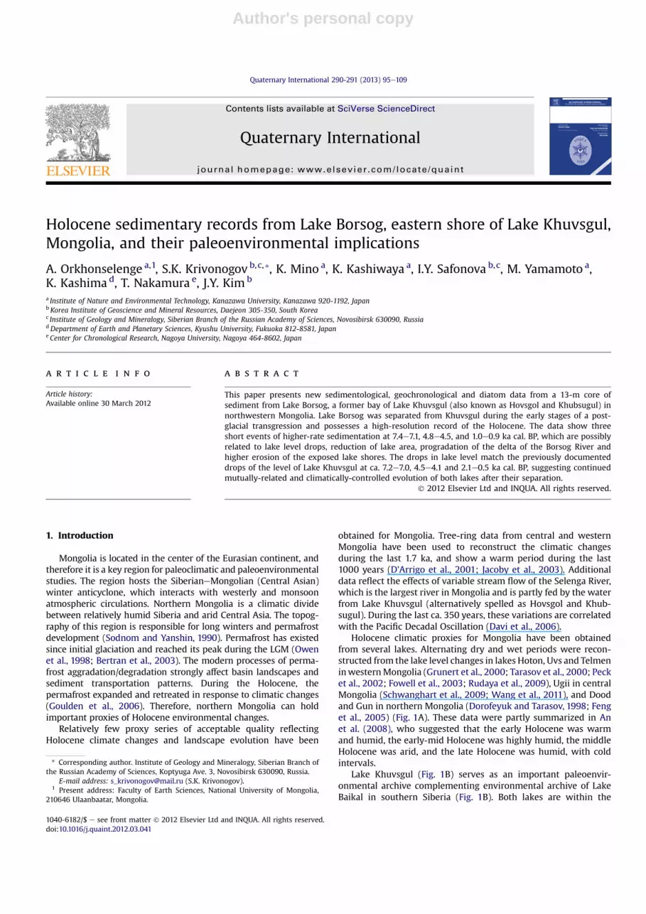
Lake Khuvsgul (Fig. 1B) serves as an important paleoenvir-onmental archive complementing environmental archive of LakeBaikal in southern Siberia (Fig. 1B). Both lakes are within the
* Corresponding author. Institute of Geology and Mineralogy, Siberian Branch ofthe Russian Academy of Sciences, Koptyuga Ave. 3, Novosibirsk 630090, Russia.
E-mail address: [email protected] (S.K. Krivonogov).1 Present address: Faculty of Earth Sciences, National University of Mongolia,
210646 Ulaanbaatar, Mongolia.
Contents lists available at SciVerse ScienceDirect
Quaternary International
journal homepage: www.elsevier .com/locate/quaint
1040-6182/$ e see front matter � 2012 Elsevier Ltd and INQUA. All rights reserved.doi:10.1016/j.quaint.2012.03.041
Quaternary International 290-291 (2013) 95e109
Author's personal copy
tectonically active Baikal Rift Zone and contain long, low-resolutionsedimentary records. Their sediments were drilled during severalnational and international drilling projects and revealed long-termclimatic and environmental changes for the last 10 Ma for Baikal
(Minoura, 2000; Kuzmin et al., 2001; Kashiwaya, 2003;Derevyanko, 2008) and the last 1 Ma for Khuvsgul (Fedotov et al.,2004a, 2007; Prokopenko et al., 2007, 2009; Hovsgol., 2009).However, the investigation of short-term events is of special
Fig. 1. A. Locations of Lake Borsog and other lakes mentioned in the text. B. Topography of Lake Khuvsgul and its catchment: 1 e Lake Khuvsgul in the last glacial time (100 m leveldrop); 2 e modern outline; 3 e the Ulhen Sair alluvial fan, which controls the level of Lake Khuvsgul; 4 e directions of river-flow; 5 e boreholes; 6 e Lake Borsog and itssurroundings as mapped in Fig. 3; 7 e villages. C. Schematic section along Line aebec indicating structural and tectonic features described in Section 2.
A. Orkhonselenge et al. / Quaternary International 290-291 (2013) 95e10996
Author's personal copy
importance, and is necessary for the reconstruction of the Holoceneand Late Pleistocene history. Such investigations require archives ofhigher temporal resolution.
Lake Khuvsgul is not suitable for studies of the latest environ-mental changes, due to the lack of higher resolution sedimentaryrecords. The Holocene sediments of the lake accumulated at a rate of0.4e6.7 cm/ky (Nakamura et al., 2003; Nara et al., 2005; Prokopenkoet al., 2005), which is insufficient for detailed reconstruction.Nevertheless, the rate of sedimentation in Lake Khuvsgul was 4e7times higher during the glacial time than during the Holocene(Watanabe et al., 2009). This is related to climate-driven lake levelchanges and erosion-related variation of clastic material supply(Kashiwayaet al., 2010). TheHolocenepaleoclimatic proxiesobtainedin Lake Khuvsgul indicate higher precipitation/runoff and diatomproductivity from 11 to 7 ka cal. BP, and a warmer period of reducedforest vegetation at 6e3.5 ka cal. BP (Prokopenko et al., 2005, 2007).
The level of Lake Khuvsgul has changed several times. Its drop to100 m during Late Pleistocene glaciation is indicated by seismicdata (Fedotov et al., 2002, 2007), bottom and coastal morphology(Zolotarev et al., 1989; Krivonogov et al., 2003), and sedimentology(Fedotov et al., 2004b; Prokopenko et al., 2005). In early post-glacialtime, after the onset of interglacial conditions, the level of the lakewas restored. The Holocene level of the lake fluctuatedwith smallermagnitudes of several metres (Dorofeyuk and Tarasov, 1998;Krivonogov et al., 2003; Krivonogov, 2006).
A good example of a high-resolution sedimentary archive fromsouthern Siberia is Lake Kotokel, which is located at the easternshore of Lake Baikal (Fig. 1A) and provides an environmental recordof the last 50 ka (Bezrukova et al., 2008, 2010; Shichi et al., 2009;Tarasov et al., 2009). The sediments of Lake Kotokel are mainly ofbiogenic origin (sapropels), and accumulated during the Holoceneat a rate of 0.5e0.8 m/ky, making environmental reconstructions ata centennial level possible.
Lake Borsog is situated along the eastern shore of Lake Khuvsgul(Fig. 1). This paper presents the detailed results of sedimentologicalstudy of Lake Borsog, which were briefly discussed inOrkhonselenge et al. (2011), and new diatom data. These datacontribute to a better understanding of the climate and hydrolog-ical regimes and sediment transportation and accumulation in theLake Khuvsgul basin and drainage area.
2. Geomorphological setting
Themodern topography of the Lake Khuvsgul area formed in thelate Miocene. Later erosion was controlled by the opening of theKhuvsgul rift during the Pliocene (Zorin et al., 1989). The Khuvsgulrift is a typical asymmetric half-graben. Its western side is boundedby the Bayan-Zurkhiin and Hordolyn-Sardag Ranges, which havedome-blocked structures. Its eastern side is a relatively low hillyarea, which is tilted to the west and covered by basaltic flows(Zolotarev et al., 1982) (Fig. 1C). Evidence for the tilting comes fromthe oblique position of the basaltic flows, which erupted, accordingto different estimates, from 30 to 8 Maago (Ivanenko et al., 1989;Rasskazov et al., 2003). In places, the basaltic flows extend beneaththe Lake Khuvsgul shoreline, suggesting recent subsidence of theeastern coast (Zolotarev et al., 1982).
These structural features were responsible for the formation ofthe modern relief including the drainage network of the easterncoast of the lake. The U-shaped and wide valleys of the riversflowing into Lake Khuvsgul have smoothed topographies. Theriverbed longitudinal profiles are close to equilibrium. The streamsobviously underfit the valleys, suggesting long development intectonically less-active conditions.
The river valleys commonly do not possess terraces and alluvialdeposits form relatively wide floodplains. The floodplains are cut
into the slope and aeolian sediments of the valleys, and form river-side scarps of different heights. Formerly, they were regarded asriver terraces (Zolotarev et al., 1982), but Krivonogov et al. (2003)showed that they are not, except for a MIS 3 proluvial terrace andan older buried river terrace in the lower reaches of the Hanh River,which drains the piedmont of the Khamar-Daban Ridge, unlikeother rivers of the eastern coast (Fig. 1).
The structure of the lower reaches of the eastern-coastal valleysreflects the latest Late Pleistocene to Holocene development of LakeKhuvsgul and its adjacent areas. Lake Khuvsgul dramaticallydropped during glaciation, and its shoreline retreated by severalkilometers, disturbing drainage and sediment transportation. Thestreams draining the eastern shore were downcut into their lowercourses to compensate for the changes in their longitudinalprofiles. The aeolian and slope processes became stronger due tothe climatically-driven decrease in precipitation/runoff, degrada-tion of vegetation, and expansion of permafrost. As soon as the lakereturned to its high level during the LGM termination and lateglacial (Prokopenko et al., 2005), the valleys were flooded to formestuaries (Rogozin, 1993).
The range of Holocene fluctuations of the lake level, which alsomodified the streams in their lower reaches, wasmuch smaller. A 5mdecrease at ca. 7.4e6.2 ka cal. BP is recorded by the peat layer in thebottom sediments of Hatgal Bay (Dorofeyuk and Tarasov, 1998), and2e3 m rises of the lake level are marked by coastal landforms(Krivonogov et al., 2003). The highest level of Lake Khuvsgul sincethe post-glacial transgression is marked by the Ulhen Sair proluvial/alluvial fan (Fig. 1), which probably formed during the Ice Age(Krivonogov et al., 2003), when the lake level was low. The fanmaintained the lake level at 6 m higher than present, and wassubsequentlyerodedby theEgiinRiverduring theHolocene.However,the precise timingof all these events is still unclear. Themodernwaterbalance of Lake Khuvsgul is positive (Batsukh et al., 1976), and thepattern of water discharge keeps the lake level at 1645 m a.s.l.
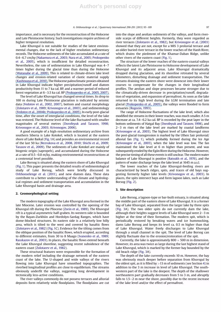
The lower reaches of the Lake Khuvsgul-feeding rivers arecharacterized by beach ridges, spits, and traces of old bays sug-gesting formerly higher lake levels (Krivonogov et al., 2003). Inplaces, the spits intersect bays and form lagoon lakes, such as LakeBorsog (Fig. 2).
3. Site description
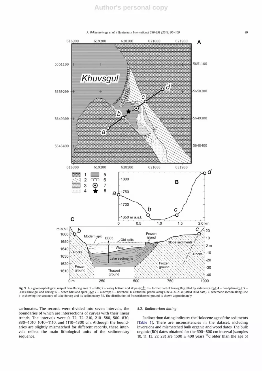
Lake Borsog, a lagoon-type or bar-built estuary, is situated alongthe middle part of the eastern shore of Lake Khuvsgul. It is a formerbay of Lake Khuvsgul, separated from the larger lake by three spits(Fig. 3A). The two older spits do not currently dam the lake,although their heights suggest levels of Lake Khuvsgul were 2e3 mhigher at the time of their formation. The modern spit, which isperiodically restored by breaking waves and ice hummocking,dams Lake Borsog and keeps its level ca. 0.5 m higher than thatof Lake Khuvsgul. Water freely discharges to Lake Khuvsgulthrough a small channel in the spit. The level of Lake Borsog canslightly fluctuate due to the erosion/restoration of the spit.
Currently, the lake is approximately 800 � 500 m in dimension.However, its areawas twice as large during the last highest stand ofLake Khuvsgul, which is marked by the former bay bounded by theold beach ridge (Fig. 3A).
The depth of the lake currently exceeds 10 m. However, the baywas obviously much deeper before separation from Khuvsgul bythe oldest spit, as it is filled by>13m of sediments (see Section 4) inaddition to the 3 m increase in level of Lake Khuvsgul. The south-western part of the lake is the deepest. The depth of the shallowernortheastern part gradually decreases from 5 to 3 m, and abruptlyfalls to 1.5e2 m near the shore, possibly due to the recent increaseof the lake level and/or the effect of permafrost.
A. Orkhonselenge et al. / Quaternary International 290-291 (2013) 95e109 97
Author's personal copy
The shores of the lake and a part of its bottom are frozen.Permafrost is present on the lake bottom several tens of metresfrom the northern shore. The depth to the frozen layer is ca. 3 m,and it is covered by a thin layer of soft sediments. In the northernpart of the lake, the bottom sediments were displaced upwards bypermafrost and form a ca. 4 m high frozen island (Fig. 3A, C). Theisland is separated from the shore by a trench formed due tothermal erosion. The sedimentary sequence exposed at the lake-side wall of the island is silty peat. A sample taken at a depth of4 m from the surface yielded a 14C age of 4510 � 40 BP (Krivonogovet al., 2003).
The lake is fed by the Borsog River. The bottom of the rivervalley is filled by slope sediments in the lower reaches (Fig. 3A, C)and by boggy floodplain deposits in the upper reaches. Permafrostis typical of the whole valley. With negative average annualtemperatures (Bogoyavlensky, 1989), the climate is cold enough toretain permafrost, which is typical of the whole valley. The totalannual precipitation is 300e600 mm with 60e70% occurringbetween June and August. The water discharge through the BorsogRiver increases after heavy rains, which may cause flooding andtransportation of large masses of peat and silt into the lake. Themelting of permafrost contributes to this process by supplyingmore water and making sediments unstable and susceptible toerosion.
4. Materials and methods
A 13-m long core (BB03) was drilled using a Livingston-typecorer in July 2004 at a point with coordinates N 50�59009.500, E100�42040.700 and water depth of 9.1 m (Fig. 3). The sediments werepacked into plastic liners 200 cm long and 3.6 cm in diameter. Ashorter 7 m long core (BB04) was taken at the same place usinga modified Livingston thin-wall pipe corer, and columns of sedi-ments 180 cm long and 8 cm in diameter were collected. Thisdrilling technique obtained continuous cores: seven lots for BB03and four lots for BB04. The cores were split into two halves andshared between research institutions in Russia and Japan. Half ofthe BB03 core was subsampled at 1 cm intervals and examined forthe physicalechemical properties at Kanazawa University and fordiatoms at Kyushu University.
Mesoscopically, the clay to silt sediments of the core showlaminated structures. Laminae of different colors are irregularlyseparated by 2e3 mm thick bands of fine-grained sand. The core
possesses variable lamination, making its visual division into layersproblematic. The lithological units used in this paper have beenrecognized by the following methods.
Water content, density, and grain size of the sediment wereanalyzed to determine mineral, organic, carbonate and biogenicsilica fractions. The content of water was measured directly bydrying a given amount of the sediment (Lambe andWhitman,1969;Dingman, 2002). The grain particle density was analyzed usinga Micrometrics analyzer AccuPyc1330 using helium as a carrier gas(Thompson and Isaacs, 1967; Gustafson and Hall, 1972; Chang,1987). The grain size was measured with a laser diffractionparticle size analyzer Shimadzu SALD 2200J in two modes: in thewhole sediment sample and in the mineral fraction remaining afterthe successive removal of biogenic and authigenic fractions. Thepercentages of sediment components were estimated for 50 mgsamples by their chemical dissolution in the following order:biogenic silica (BiSi), plant organic matter (OM), and carbonates.The BiSi measurement routine followed the spectrophotometricmethod (Mortloch and Froelich, 1989): OM was dissolved in 30%H2O2 and carbonates in 10% HCl. The insoluble mineral residue wasused in grain size analysis.
The diatom productivity was evaluated for samples selected at10 cm intervals using smear glass slides light microscopy tech-nology (Round, 1957). The number of diatom frustules was countedunder a glass coverslip until the total exceeded 500 (taking intoaccount frustule fragmentation) followed by identification ofdiatom genera.
The age of the sediments is constrained by 28 14C dates obtainedby Accelerator Mass Spectrometry at the Nagoya University Chro-nological Center. The dated material was bulk organic matter, plantremnants, and wood fragments.
5. Results
5.1. Sediment structure and lithological boundaries
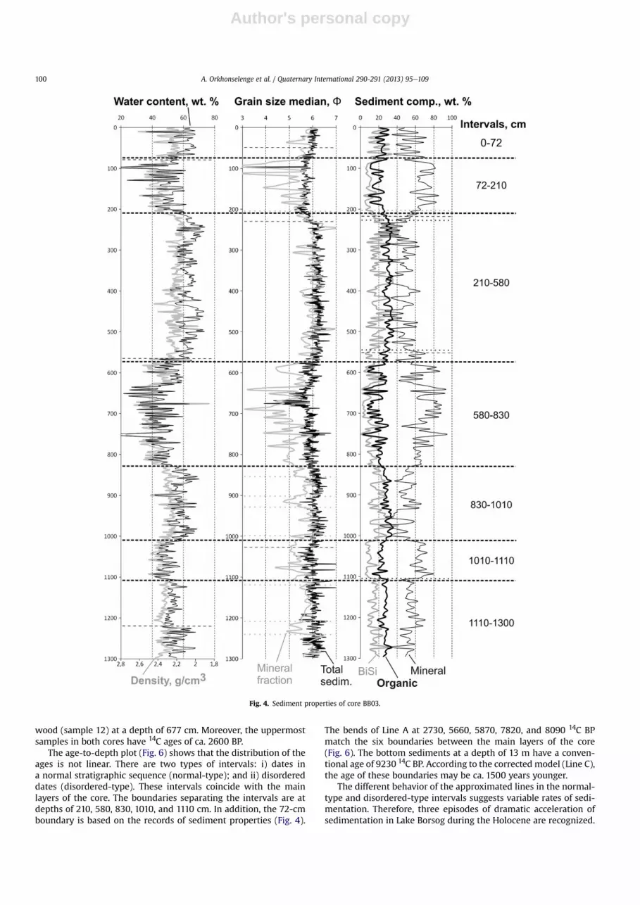
The plots in Fig. 4 clearly show that the sediment propertiesdepend on the content of the mineral fraction. The intervals withhigher percentages of the mineral fraction are characterized bysmaller grain size and higher sediment density. This suggests thatthe mineral fraction of the sediment is mostly silt and clay. Thecurves of biogenic components (BiSi and OM) and HCl solublecarbonates (Fig. 5) are similar, suggesting a biogenic origin of
Fig. 2. A general view of Lake Borsog. Photo by S.K. Krivonogov (from north to south). For geomorphological details see Fig. 3.
A. Orkhonselenge et al. / Quaternary International 290-291 (2013) 95e10998
Author's personal copy
carbonates. The records were divided into seven intervals, theboundaries of which are intersections of curves with their lineartrends. The intervals were 0e72, 72e210, 210e580, 580e830,830e1010, 1010e1110, and 1110e1300 cm. Although the bound-aries are slightly mismatched for different records, these inter-vals reflect the main lithological units of the sedimentarysequence.
5.2. Radiocarbon dating
Radiocarbon dating indicates the Holocene age of the sediments(Table 1). There are inconsistencies in the dataset, includinginversions and mismatched bulk organic and wood dates. The bulkorganic (BO) dates obtained for the 600e800 cm interval (samples10, 11, 13, 27, 28) are 1500 � 400 years 14C older than the age of
Fig. 3. A, a geomorphological map of Lake Borsog area. 1 e hills; 2 e valley bottom and slopes (Q43); 3 e former part of Borsog Bay filled by sediments (Q4); 4 e floodplain (Q4); 5 e
Lakes Khuvsgul and Borsog; 6 e beach bars and spits (Q4); 7 e outcrop; 8 e borehole. B, altitudinal profile along Line aebeced (SRTM DEM data). C, schematic section along Linebec showing the structure of Lake Borsog and its sedimentary fill. The distribution of frozen/thawed ground is shown approximately.
A. Orkhonselenge et al. / Quaternary International 290-291 (2013) 95e109 99
Author's personal copy
wood (sample 12) at a depth of 677 cm. Moreover, the uppermostsamples in both cores have 14C ages of ca. 2600 BP.
The age-to-depth plot (Fig. 6) shows that the distribution of theages is not linear. There are two types of intervals: i) dates ina normal stratigraphic sequence (normal-type); and ii) disordereddates (disordered-type). These intervals coincide with the mainlayers of the core. The boundaries separating the intervals are atdepths of 210, 580, 830, 1010, and 1110 cm. In addition, the 72-cmboundary is based on the records of sediment properties (Fig. 4).
The bends of Line A at 2730, 5660, 5870, 7820, and 8090 14C BPmatch the six boundaries between the main layers of the core(Fig. 6). The bottom sediments at a depth of 13 m have a conven-tional age of 9230 14C BP. According to the corrected model (Line C),the age of these boundaries may be ca. 1500 years younger.
The different behavior of the approximated lines in the normal-type and disordered-type intervals suggests variable rates of sedi-mentation. Therefore, three episodes of dramatic acceleration ofsedimentation in Lake Borsog during the Holocene are recognized.
Fig. 4. Sediment properties of core BB03.
A. Orkhonselenge et al. / Quaternary International 290-291 (2013) 95e109100

Author's personal copy
The dataset inconsistencies and the age model are discussed indetail in Sections 6.1 and 6.2.
5.3. Diatoms
Similarity of the curves in Fig. 5 (right panel) suggests thatdiatoms were the main, if not the only, source of biogenic silica in
the lake. In addition, the main excursions of the diatom abundancecurve generally fit the boundaries between the main sedimentaryunits (Figs. 4 and 5). The concentration of diatoms varies from 3000to 12,000 frustules/mg.
The diatom assemblage includes 21 genera. The dominantgenera are Aulacoseira (up to 85%), Tabellaria (up to 70%), Cocco-neis (up to 40%), and Cyclotella (up to 40%). The less abundant
Fig. 5. Biota-related components in core BB03.
A. Orkhonselenge et al. / Quaternary International 290-291 (2013) 95e109 101
Author's personal copy
diatoms (below 10%) are Rhopalodia, Diploneis, Stauroneis, andCymatopleura.
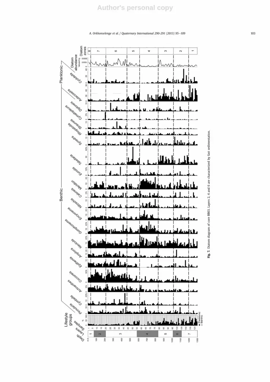
Eight local diatom assemblage zones were defined, based ondiatom abundance and dominant taxa (Fig. 7). Zones 1 and 2 arecharacterized by lower diatom abundances and contain mostlyplanktonic Cyclotella and meroplanktonic Aulacoseira, the latter isdominant in Zone 1. Zone 3 is characterized by medium-to-highdiatom abundances and increased Aulacoseira and Tabellaria. Zone
4 indicates a reduced amount of diatoms and shows a gradual shiftfrom planktonic to benthic and epiphytic forms. In general, zones1e4 are characterized by increased amounts of Navicula, Gompho-nema, Encyonema, Nitzschia, Caloneis, and Meridion. Zone 5 isdominated by meroplanktonic Aulacoseira and benthic Tabellaria.Zones 6 8 are dominated by benthic diatoms, including Achnanthes,Cocconeis, Epithemia, and Amphora. Zone 6 contains more diatomscompared to Zones 7 and 8. Zone 8 contains a higher amount ofplanktonic diatoms and, among benthic, is characterized by a higherpercentage of Navicula and a lower concentration of Cocconeis.
Themostenvironmentally important featuresof thediatomrecordare: 1) general decrease of planktonic and increase of benthic diatomsfrom the bottom to the top of the core, suggesting a decreasing depthof the lake due to its filling by sediments; and 2) presence of benthos-enriched intervals reflecting several episodes of abrupt shallowing ofthe lake, which coincide with the intervals of drastically increasedrates of sedimentation (Layers 6, 4, and 2 in Fig. 7).
6. Discussion
6.1. Age constraints
A shift in age determinations to older values is a commonproblem for Lake Khuvsgul and Baikal sediments. In Lake Khuvsgul,14C ages of bulk organic are 0.4e4 ka older than those of woodfragments (Watanabe et al., 2009) and the ages of its surfacesediments average at ca. 0.5 ka (Prokopenko et al., 2005). The age ofBaikal surface sediments ranges from 0.47 to 1.22 ka, and the age oftrapped suspended algae is 0.61 ka (Colman et al., 1996). The olderages of Baikal and Khuvsgul surface sediments were attributed tothe input of terrestrial organics and to the re-suspension of previ-ously deposited algal carbon (Colman et al., 1996), and wereconsidered as a lake reservoir effect (Prokopenko et al., 2005). If so,the dates obtained from deeper layers of sediments in both lakesalso require reservoir effect correction.
The Borsog sediments contain 10e35% plant organics (Fig. 5)suggesting delivery of re-deposited terrestrial organic material bystreams (see Section 3). The dated BO samples contain a mixture of
Fig. 6. The age-to-depth model for Lake Borsog sedimentation based on the 14C ages of cores BB03 and BB04. Line A is a piecewise linear approximation of the ages of bulk organicsamples. Line A1 is a linear trend of Line A. Line B is a model built through two age points: zero and wood sample (no. 12 in Table 2). Line C e the most probable model based on theages of the bulk organic samples corrected to the age of the wood sample. Sedimentation: S e slow, F e fast.
Table 1Results of 14C dating of cores BB03 and BB04.
Sample no. Depth, cm aMaterial Lab no. (NUTA2) Age, 14C BP
BB03 core1 2.4 BO 13426 2560 � 302 5.9 BO 14357 3030 � 353 60.4 BO 14358 3770 � 354 103.0 BO 13427 3010 � 355 150.3 BO 13428 2760 � 306 208.0 BO 13431 2750 � 307 330.3 BO 12783 3830 � 358 432.8 BO 12784 4710 � 359 546.4 BO 12785 5960 � 3510 624.6 BO 12432 5940 � 3511 641.2 PR 12859 5210 � 3512 677.2 W 12860 4080 � 3013 737.4 BO 12876 5870 � 4014 842.5 BO 12787 6120 � 3515 940.8 BO 12788 7040 � 4016 1020.6 BO 14359 8210 � 4017 1040.2 BO 12789 7880 � 4018 1103.4 BO 14360 7970 � 4519 1147.7 BO 12791 8330 � 4020 1260.7 BO 12792 8980 � 45BB04 core21 1.2 BO 14361 2620 � 3522 132.5 BO 10023 2590 � 2523 284.6 BO 10024 3450 � 2524 386.1 BO 10025 4000 � 2525 525.7 BO 10027 5300 � 3026 646.5 BO 10028 5130 � 2527 687.9 BO 14365 5500 � 4028 710.2 BO 10029 5240 � 25
a BO e bulk organic; PR e plant remnants; W e wood.
A. Orkhonselenge et al. / Quaternary International 290-291 (2013) 95e109102
Author's personal copy
Fig.
7.Diatom
diag
ram
ofco
reBB
03.L
ayers2,
4an
d6arech
aracterize
dby
fast
sedimen
tation
.
A. Orkhonselenge et al. / Quaternary International 290-291 (2013) 95e109 103
Author's personal copy
coeval and older humic fractions, which could have shifted the agesto older values. For corrections, the dates obtained from plantmacrofossils are consideredmore reliable than those obtained frombulk organics (e.g., McGeehin et al., 2001).
As it is difficult to evaluate the degree of BO contamination andtherefore the correctness of each date, the trends indicated by thewhole BO dataset were used. For correction, the only availablewood date (Table 1, sample 12) was used, which is1500 � 400 14C years younger than the BO dates at the same level(see Section 5.2). Line B in Fig. 6 connects the zero point and the agepoint of sample 12. Line B is parallel to Line A, and therefore thecorrection appears valid and is referenced to zero in the correctedage model, i.e., Line C.
Table 2 shows the corrected ages of the main lithologicalboundaries of Lake Borsog sediments, which are used for discussingenvironmental and climatic changes. This age model cannot definethe age of the 72 cm boundary, because the whole 0e210 cminterval is of the disordered-type.
6.2. Reasons of fast sedimentation
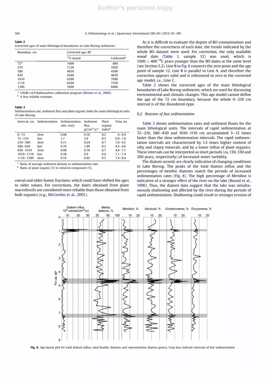
Table 3 shows sedimentation rates and sediment fluxes for themain lithological units. The intervals of rapid sedimentation at72e210, 580e830 and 1010e1110 cm accumulated 3e12 timesfaster than the slow sedimentation intervals. The rapid sedimen-tation intervals are characterized by 1.5 times higher content ofsilty and clayey minerals, and by a lower influx of plant organics.These intervals can be interpreted as short periods (ca. 130, 330 and260 years, respectively) of increased water turbidity.
The diatom records are clearly indicative of changing conditionsin Lake Borsog. The peaks of the total diatom influx and thepercentages of benthic diatoms match the periods of increasedsedimentation rates (Fig. 8). The high percentage of Meridion isindicative of a stronger effect of the river on the lake (Round et al.,1990). Thus, the diatom data suggest that the lake was simulta-neously shallowing and affected by the river during the periods ofrapid sedimentation. Shallowing could result in stronger erosion of
Table 2Corrected ages of main lithological boundaries in Lake Borsog sediments.
Boundary, cm Corrected age, BP
14C-based Calibrateda
72b 1000 890210 1120 1020580 4020 4500830 4240 48301010 6200 70901110 6430 73501300 7600 8400
a CALIB v.6.0 Radiocarbon calibration program (Reimer et al., 2009).b A less reliable estimate.
Table 3Sedimentation rate, sediment flux and plant organic index for main lithological unitsof Lake Borsog.
Interval, cm Sedimentation Sedimentationrate, cm/y
Sedimentflux,g/(cm2*y)a
Plantorganicindexb
Time, ka
0e72 slow 0.08 0.18 0.5 0e0.972e210 fast 1.1 2.6 0.3 0.9e1.0210e580 slow 0.11 0.24 0.7 1.0e4.5580e830 fast 0.76 1.86 0.3 4.5e4.8830e1010 slow 0.08 0.18 0.7 4.8e7.11010e1110 fast 0.38 0.9 0.4 7.1e7.41110e1300 slow 0.18 0.42 0.5 7.4e8.4
a Ratio of average sediment density to sedimentation rate.b Ratio of plant organic (%) to mineral component (%).
Fig. 8. Age-based plot for total diatom influx, total benthic diatoms and representative diatom genera. Gray bars indicate intervals of fast sedimentation.
A. Orkhonselenge et al. / Quaternary International 290-291 (2013) 95e109104

Author's personal copy
the lake shores. The effect of Borsog River on the lake resulted fromthe expansion of the river delta. These two processes increased thesediment flux into the lake.
6.3. Synchronized level changes in Lakes Borsog and Khuvsgul
The pebble spit separating Lake Borsog keeps its level 0.5 mhigher than that of Lake Khuvsgul. The outflow water of Lake Bor-sog can easily erode the spit, and both lakes would be expected tohave the same level. The level in Lake Borsog cannot significantlychange without a respective change in Lake Khuvsgul. Thereforethe recorded periods of shallow water in Lake Borsog at ca. 7.4e7.1,4.8e4.5 and 1.0e0.9 ka cal. BP (Tables 2 and 3; Figs. 6and 8) suggestrespective drops in the level of Lake Khuvsgul.
6.4. The level of Lake Khuvsgul during the Holocene
The level of Lake Khuvsgul considerably increased in response toglacial termination. The highest level during the Holocenewas þ6 m compared to the present one. The value of 6 m is theheight of the pre-Holocene Ulhen Sair fan cone at the southern endof the lake (Fig. 1), above which the Egiin River flows out of the lake(see Section 2). Lake Khuvsgul probably reached its highest level inearly post-glacial time, and since then the level has been decreasing
and irregularly fluctuating within a few metres (Krivonogov et al.,2003). The lake level depends on two mutually-related factors:the continuing incision of the Egiin River outlet and the periodicrestoration of the Ulhen Sair fan. Both factors are climaticallycontrolled: increased precipitation led to stronger erosion of theoutlet on one hand, and contributed to the damming by the sedi-ment accumulated in the fan (sediment pulses) on the other hand.
The Holocene level changes of Lake Khuvsgul are recorded in theshore landforms (Krivonogov et al., 2003) and in the sediments,which reflect several stages of lake shallowing (Tarasov et al., 1996;Dorofeyuk and Tarasov, 1998) (Fig. 9A, B). The recent lake standshave been historically documented since the end of the 19thcentury (Tomilov and Dashidorz, 1965; Marinov, 1967) and hydro-metrically documented since 1963 (Kumagai et al., 2006) (Fig. 9C).
More evidence for significant rises of Lake Khuvsgul level duringthe last ca. 150 years comes from a small rocky island, 23 m long,11 mwide and 2e3 m high, which was situated near the lake shorein front of Hanh Village (e.g., Peretolchin, 1903) (Fig. 1). The islandwas covered by water during the early 20th century, although theyear of its complete disappearance is unknown (Murzaev, 1952;Kuznetsov, 1959; Kuznetsov et al., 1973). This 3 m rise of the lakelevel probably proceeded incrementally rather than suddenly.
The increases of the lake level due to sedimentary pulses on theUlhen Sair fan are episodic and therefore correlate with the phases
Fig. 9. A, relative (coded) changes of lake Khuvsgul water levels inferred from the Hatgal Bay sedimentary core data (Tarasov et al., 1996). B, absolute changes of Lake Khuvsgulwater levels inferred from the Hatgal Bay core (Tarasov et al., 1996; Dorofeyuk and Tarasov, 1998) and from geomorphological data (Krivonogov et al., 2003). The gray bars indicatethe intervals of fast sedimentation in Lake Borsog. C, the 1963e2003 record of the annual levels of Lake Khuvsgul (Kumagai et al., 2006).
A. Orkhonselenge et al. / Quaternary International 290-291 (2013) 95e109 105
Author's personal copy
of high precipitation (Rogozin, 1993). The torrents, which carrystones andmud into Lake Khuvsgul, affect the Egiin River outlet andoccur approximately every 7 years along the western shore andevery 10e11 years along the eastern shore (Batsukh et al., 1976).Sedimentary pulses significantly changed the level of Lake Khuvs-gul in 1886 (Cherkasov et al., 1972) and in 1971 (Rogozin andYakimov, 1977). The hydrometric data show that significant, up to60 cm, rises of the level occurred in 1973e1977 and 1982e1987(Kumagai et al., 2006) (Fig. 9C). The data cited by Kumagai et al.(2006) are the annually averaged values, whereas the annual fluc-tuation of Lake Khuvsgul levels is within 80 cm (Batsukh et al.,1976).
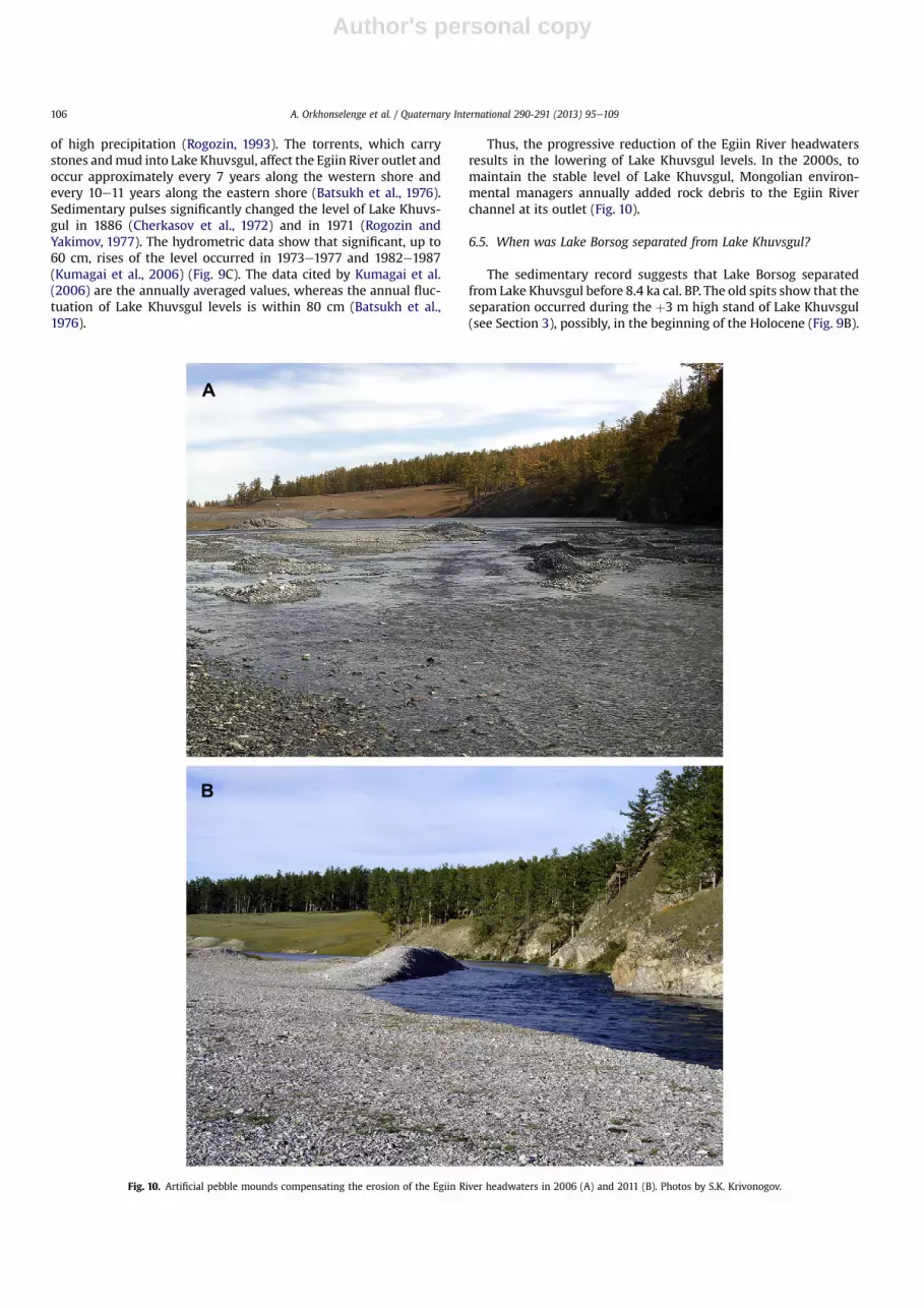
Thus, the progressive reduction of the Egiin River headwatersresults in the lowering of Lake Khuvsgul levels. In the 2000s, tomaintain the stable level of Lake Khuvsgul, Mongolian environ-mental managers annually added rock debris to the Egiin Riverchannel at its outlet (Fig. 10).
6.5. When was Lake Borsog separated from Lake Khuvsgul?
The sedimentary record suggests that Lake Borsog separatedfrom Lake Khuvsgul before 8.4 ka cal. BP. The old spits show that theseparation occurred during the þ3 m high stand of Lake Khuvsgul(see Section 3), possibly, in the beginning of the Holocene (Fig. 9B).
Fig. 10. Artificial pebble mounds compensating the erosion of the Egiin River headwaters in 2006 (A) and 2011 (B). Photos by S.K. Krivonogov.
A. Orkhonselenge et al. / Quaternary International 290-291 (2013) 95e109106
Author's personal copy
More precise timing of this event could be obtained by futuremulti-disciplinary studies.
6.6. Climatic implications
The patterns of climate-related level changes of other lakes sit-uated at latitudes close to that of Lake Khuvsgul are variable. Forexample, in Late Glacial time, Lake Uvs, a closed lake, was 40 mhigher than now and dramatically decreased during the Holocene,with several drops ca. 10.7e9.3, 6.3, 5.2 and 3.2 ka cal. BP. Theminimal level of Lake Uvs (�7 to �5 m) occurred ca.3.2e1.0 ka cal. BP, and later the lake rose to its present level (Grunertet al., 2000). The pollen data obtained from Lake Telmen indicatea relatively dry period of 7.5e4.5, a wet period of 4.5e1.6, and anfluctuating dry towet period from1.6 ka cal. BP to the present. At ca.1.6e1.2 ka cal. BP there was a short dry period, after which thehumidity increased in response to the Medieval Warm Epoch(1.2e0.4 ka BP) and the following Little Ice Age (0.4 ka BP to present)(Fowell et al., 2003). Another example is Lake Gun,whichwas lowat10.7e7.7, high at 7.7e2.2, and low again at 2.2e1.5 ka cal. BP (Fenget al., 2005). Proxies of Lake Ugii indicate a slightly higher mois-ture supply at ca. 10e8 ka cal. BP compared to the present time, andLake Ugii was considerably larger in the middle Holocene (ca.8e4 ka cal. BP) but shallower at ca. 4e2.8 ka cal. BP due to increasedaridity. During the last 2 ka the level of Lake Ugii rose as a result ofincreased moisture supply (Schwanghart et al., 2009). In addition,a period of dry climate occurred in Lake Ugii at ca. 6.6e3.3 ka cal. BP(Wang et al., 2011). Thus, the diverse data obtained on severallocalities suggest either dry or humid climate in the middle Holo-cene. However, both appear valid if Holocene climate was variablein different areas of Central Asia, which could be dominated by theWesterly or Pacific patterns of atmospheric circulation (e.g., Chenet al., 2008; Rudaya et al., 2009).
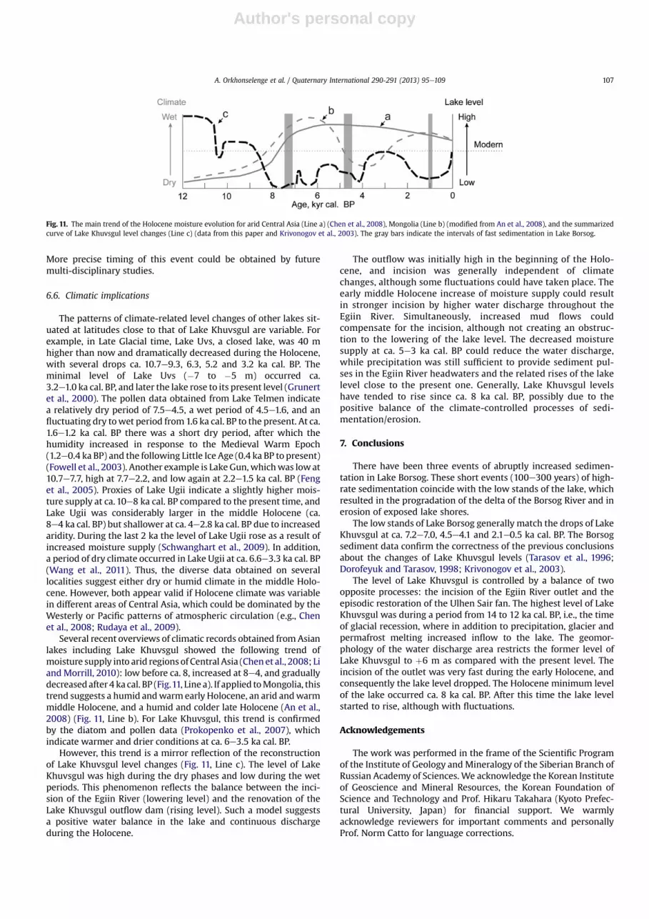
Several recent overviews of climatic records obtained from Asianlakes including Lake Khuvsgul showed the following trend ofmoisture supply into arid regionsof Central Asia (Chenet al., 2008; LiandMorrill, 2010): low before ca. 8, increased at 8e4, and graduallydecreasedafter4 ka cal. BP (Fig.11, Line a). If applied toMongolia, thistrend suggests a humid andwarm early Holocene, an arid andwarmmiddle Holocene, and a humid and colder late Holocene (An et al.,2008) (Fig. 11, Line b). For Lake Khuvsgul, this trend is confirmedby the diatom and pollen data (Prokopenko et al., 2007), whichindicate warmer and drier conditions at ca. 6e3.5 ka cal. BP.
However, this trend is a mirror reflection of the reconstructionof Lake Khuvsgul level changes (Fig. 11, Line c). The level of LakeKhuvsgul was high during the dry phases and low during the wetperiods. This phenomenon reflects the balance between the inci-sion of the Egiin River (lowering level) and the renovation of theLake Khuvsgul outflow dam (rising level). Such a model suggestsa positive water balance in the lake and continuous dischargeduring the Holocene.
The outflow was initially high in the beginning of the Holo-cene, and incision was generally independent of climatechanges, although some fluctuations could have taken place. Theearly middle Holocene increase of moisture supply could resultin stronger incision by higher water discharge throughout theEgiin River. Simultaneously, increased mud flows couldcompensate for the incision, although not creating an obstruc-tion to the lowering of the lake level. The decreased moisturesupply at ca. 5e3 ka cal. BP could reduce the water discharge,while precipitation was still sufficient to provide sediment pul-ses in the Egiin River headwaters and the related rises of the lakelevel close to the present one. Generally, Lake Khuvsgul levelshave tended to rise since ca. 8 ka cal. BP, possibly due to thepositive balance of the climate-controlled processes of sedi-mentation/erosion.
7. Conclusions
There have been three events of abruptly increased sedimen-tation in Lake Borsog. These short events (100e300 years) of high-rate sedimentation coincide with the low stands of the lake, whichresulted in the progradation of the delta of the Borsog River and inerosion of exposed lake shores.
The low stands of Lake Borsog generally match the drops of LakeKhuvsgul at ca. 7.2e7.0, 4.5e4.1 and 2.1e0.5 ka cal. BP. The Borsogsediment data confirm the correctness of the previous conclusionsabout the changes of Lake Khuvsgul levels (Tarasov et al., 1996;Dorofeyuk and Tarasov, 1998; Krivonogov et al., 2003).
The level of Lake Khuvsgul is controlled by a balance of twoopposite processes: the incision of the Egiin River outlet and theepisodic restoration of the Ulhen Sair fan. The highest level of LakeKhuvsgul was during a period from 14 to 12 ka cal. BP, i.e., the timeof glacial recession, where in addition to precipitation, glacier andpermafrost melting increased inflow to the lake. The geomor-phology of the water discharge area restricts the former level ofLake Khuvsgul to þ6 m as compared with the present level. Theincision of the outlet was very fast during the early Holocene, andconsequently the lake level dropped. The Holocene minimum levelof the lake occurred ca. 8 ka cal. BP. After this time the lake levelstarted to rise, although with fluctuations.
Acknowledgements
The work was performed in the frame of the Scientific Programof the Institute of Geology and Mineralogy of the Siberian Branch ofRussian Academy of Sciences. We acknowledge the Korean Instituteof Geoscience and Mineral Resources, the Korean Foundation ofScience and Technology and Prof. Hikaru Takahara (Kyoto Prefec-tural University, Japan) for financial support. We warmlyacknowledge reviewers for important comments and personallyProf. Norm Catto for language corrections.
Fig. 11. The main trend of the Holocene moisture evolution for arid Central Asia (Line a) (Chen et al., 2008), Mongolia (Line b) (modified from An et al., 2008), and the summarizedcurve of Lake Khuvsgul level changes (Line c) (data from this paper and Krivonogov et al., 2003). The gray bars indicate the intervals of fast sedimentation in Lake Borsog.
A. Orkhonselenge et al. / Quaternary International 290-291 (2013) 95e109 107
Author's personal copy
References
An, C.B., Chen, F.H., Barton, L., 2008. Holocene environmental changes in Mongolia:a review. Global and Planetary Change 63, 283e289.
Batsukh, A., Shumeev, V.P., Cherkasov, A.E., Samarin, A.V., 1976. Surface water andthe water balance of the Khubsugul. In: Natural Conditions and Resources ofTrans-Khubsugulia in the MPR. Nedra, Moscow, pp. 185e206 (in Russian).
Bertran, P., Fontugne, M., Jaubert, J., 2003. Permafrost aggradation followed bybrutal degradation during the Upper Pleniglacial in Mongolia: the probableresponse to the H2 Heinrich Event at 21 ka BP. Permafrost and PeriglacialProcesses 14, 1e9.
Bezrukova, E.V., Krivonogov, S.K., Takahara, H., Letunova, P.P., Shichi, K.,Abzaeva, A.A., Kulagina, N.V., Zabelina, Yu.S., 2008. Lake Kotokel as a stratotypefor the late glacial and Holocene in southeastern Siberia. Doklady EarthSciences 420 (1), 248e253.
Bezrukova, E.V., Tarasov, P.E., Solovieva, N., Krivonogov, S.K., Riedel, F., 2010. Lastglacialeinterglacial vegetation and environmental dynamics in southern Sibe-ria: chronology, forcing and feedbacks. Palaeogeography, Palaeoclimatology,Palaeoecology 296, 185e198.
Bogoyavlensky, B.A., 1989. Atlas of Lake Hovsgol. GUGK, Moscow (in Russian).Chang, C.S., 1987. Measuring density and porosity of grain kernels using a gas
pycnometer. Cereal Chemistry 65 (1), 13e15.Chen, F., Yu, Z., Yang, M., Ito, E., Wang, S., Madsen, D.B., Huang, X., Zhao, Y., Sato, T.,
Birks, H.J.B., Boomer, J., Chen, J., An, C., Wunnemann, B., 2008. Holocenemoisture evolution in arid Central Asia and its off-phase relationship with Asianmonsoon history. Quaternary Science Reviews 27, 351e364.
Cherkasov, A.E., Shumeev, V.P., Batsukh, N., 1972. Hydrogeological regime of riversin the Khubsugul basin. In: Natural conditions and resources of Trans-Khub-sugulia, Irkutsk e Ulaanbaatar, pp. 74e86 (in Russian).
Colman, S.M., Jones, G.A., Rubin, M., King, J.W., Peck, J.A., Orem, W.H., 1996. AMSradiocarbon analyses from Lake Baikal, Siberia: challenges of dating sedimentsfrom a large, oligotrophic lake. Quaternary Science Reviews 15, 669e684.
D’Arrigo, R.D., Jacoby, G.C., Frank, D., Pederson, N., Cook, E.R., Buckley, B.M.,Nachin, B., Mijiddorj, R., Dugarjav, Ch, 2001. 1738 years of Mongolian temper-ature variability inferred from a tree-ring record of Siberian pine. GeophysicalResearch Letters 28 (3), 543e546.
Davi, N.K., Jacoby, G.C., Curtis, A.E., Baatarbileg, N., 2006. Extension of droughtrecords for central-Asia using tree-rings; west central Mongolia. Journal ofClimate 19, 288e299.
Derevyanko, A.P. (Ed.), 2008. Late Cenozoic Global and Regional Environmental andClimate Changes in Siberia. SB RAS Publishers, Novosibirsk (in Russian).
Dingman, S.L., 2002. Physical Hydrology. Prentice-Hall, Inc., Upper Saddle River,New Jersey.
Dorofeyuk, N.I., Tarasov, P.E., 1998. Vegetation and lake levels of northern Mongoliasince 12,500 yr B.P. based on the pollen and diatom records. Stratigraphy andGeological Correlation 6 (1), 70e83.
Fedotov, A.P., De Batist, M., Shapron, E., De Ryker, K., Pouls, T., 2002. Seismicprofiling of the sediments of Lake Khubsugul. Doklady Earth Sciences 382,261e263.
Fedotov, A.P., Kazansky, A.Yu., Tomurhuu, D., Matasova, G.G., Ziborova, G.A.,Zheleznyakova, T.O., Vorobyova, S.S., Phedorin, M.A., Goldberg, E.L.,Oyunchimeg, Ts., Narantsetseg, Ts., Vologina, E.G., Yuldashev, A.A., Kalugin, I.A.,Tomurtogoo, O., Grachev, M.A., 2004a. A 1 My record of paleoclimates from lakeKhubsugul, Mongolia. EOS Transactions 85, 387e390.
Fedotov, A.P., Chebykin, E.P., Semenov, M.Y., Vorobyova, S.S., Osipov, E.Y.,Golobokova, L.P., Pogodaeva, T.V., Zheleznyakova, T.O., Grachev, M.A.,Tomurhuu, D., Oyunchimeg, Ts., Narantsetseg, Ts., Tomurtogoo, O., Dolgikh, P.T.,Arsenyuk, M.I., De Batist, M., 2004b. Changes in the volume and salinity of LakeKhubsugul (Mongolia) in response to global climate changes in the upperPleistocene and the Holocene. Palaeogeography, Palaeoclimatology, Palae-oecology 209, 245e257.
Fedotov, A.P., Phedorin, M.A., De Batist, M., Ziborova, G.A., Kazansky, A.Y.,Semenov, M.Y., Matasova, G.G., Khabuev, A.V., Kugakolov, S.A., Rodyakin, S.V.,Krapivina, S.M., Pouls, T., 2007. A 450-ka long record of glaciation in NorthernMongolia based on studies at Lake Khubsugul: high-resolution reflectionseismic data and grain-size variations in cored sediments. Journal of Paleo-limnology 39, 335e348.
Feng, Z.D., Wang, W.G., Guo, L.L., Khosbayar, P., Narantsetseg, T., Jull, A.J.T., An, C.B.,Li, X.Q., Zhang, H.C., Ma, Y.Z., 2005. Lacustrine and eolian records of Holoceneclimate changes in the Mongolian Plateau: preliminary results. QuaternaryInternational 136, 25e32.
Fowell, S.J., Hansen, B.C.S., Peck, J.A., Khosbayar, P., Ganbold, E., 2003. Mid to lateHolocene climate evolution of the Lake Telmen basin, North Central Mongolia,based on palynological data. Quaternary Research 59, 353e363.
Goulden, C.E., Tomurtogoo, O., Karabanov, E., 2006. The geological history andpaleogeography of Lake Hovsgol, Mongolia. In: Goulden, C.E., Sitnikova, T.,Gelhaus, J., Bazartseren, B. (Eds.), The Geology, Biodiversity and Ecology of LakeHovsgol (Mongolia). Backhuys Publishers, Leiden, pp. 1e20.
Grunert, J., Lehmkuhl, F., Walther, M., 2000. Paleoclimatic evolution of the Uvs Nuurbasin and adjacent areas (Western Mongolia). Quaternary International 65e66,171e192.
Gustafson, R.J., Hall, G.E., 1972. Density and porosity changes of shelled corn duringdrying. Transactions of American Society of Agricultural Engineers 15 (3),523e525.
Hovsgol Drilling Project Members, 2009. Sedimentary record from Lake Hovsgol,NW Mongolia: results from the HDP-04 and HDP-06 drill cores. QuaternaryInternational 205, 21e37.
Ivanenko, V.V., Karpenko, M.I., Jashina, R.M., Andreeva, E.D., Ashikhmina, N.A., 1989.New data on the potassiumeargon age of the basalts of the west board of theKhubsugul rift (MPR). Doklady of the USSR Academy of Sciences 309 (4),915e930 (in Russian).
Jacoby, G., Pederson, N., D’Arrigo, R., 2003. Temperature and precipitation inMongolia based on dendroclimatic investigations. Chinese Science Bulletin 48(14), 1474e1479.
Kashiwaya, K. (Ed.), 2003. Long Continental Records from Lake Baikal. Springer-Verlag, Tokyo.
Kashiwaya, K., Ochiai, S., Sumino, G., Tsukamoto, T., Szyniszewska, A.,Yamamoto, M., Sakaguchi, A., Hasebe, N., Sakai, H., Watanabe, T., Kawai, T., 2010.Climato-hydrological fluctuations printed in long lacustrine records in LakeHövsgöl, Mongolia. Quaternary International 219 (1e2), 178e187.
Krivonogov, S.K., 2006. Late Cenozoic history of Lake Hovsgol area. In:Goulden, C.E., Sitnikova, T., Gelhaus, J., Bazartseren, B. (Eds.), The Geology,Biodiversity and Ecology of Lake Hovsgol (Mongolia). Backhuys Publishers,Leiden, pp. 21e40.
Krivonogov, S.K., Bezrukova, E.V., Takahara, H., Riedel, F., 2003. The Hovsgol Lake inthe Late Pleistocene and Holocene: on-land geologic evidences for the changeof its level. In: Kashivaya, K. (Ed.), Long Continental Records from Lake Baikal.Springer-Verlag, Tokyo, pp. 187e206.
Kumagai, M., Urabe, J., Goulden, C.E., Soninkhishig, N., Hadbaatar, D., Tsujimura, S.,Hayami, Y., Sekino, T., Maruo, M., 2006. Recent rise in water level at LakeHovsgol, Mongolia. In: Goulden, C.E., Sitnikova, T., Gelhaus, J., Bazartseren, B.(Eds.), The Geology, Biodiversity and Ecology of Lake Hovsgol (Mongolia).Backhuys Publishers, Leiden, pp. 77e92.
Kuzmin, M.I., Karabanov, E.B., Kawai, T., Williams, D., Bychinsky, V.A., Kerber, E.V.,Kravchinsky, V.A., Bezrukova, E.V., Prokopenko, A.A., Geletii, V.F.,Kalmychkov, G.V., Goreglyad, A.V., Antipin, V.S., Khomutova, M.Yu.,Soshina, N.M., Ivanov, E.V., Khursevich, G.K., Tkachenko, L.L., Solotchina, E.P.,Ioshida, N., Gvozdkov, A.N., 2001. Deep drilling on Lake Baikal: main results.Russian Geology and Geophysics 42 (1), 3e28.
Kuznetsov, N.T., 1959. Gydrography of the Rivers of Mongolian Peoples Republic.USSR Academy of Sciences Publishing House, Moscow (in Russian).
Kuznetsov, G.A., Kulakov, V.S., Suldin, V.A., Bessolitsyn, A.E., Damdindjav, V.,Zolotko, L.A., Plotnikov, N.K., 1973. Structure of the Khubsugul Lake depression.In: Natural Conditions and Resources of Trans-Khubsugulia, Irkutsk e Ulaan-baatar, pp. 19e33 (in Russian).
Lambe, T.W., Whitman, R.V., 1969. Soil Mechanics. John Wiley & Sons, New-York.Li, Y., Morrill, C., 2010. Multiple factors causing Holocene lake-level change in
monsoonal and arid central Asia as identified by model experiments. ClimateDynamics 35 (6), 1119e1132.
Marinov, N.A., 1967. The Khubsugul (Kosogol) Lake depression in the NorthMongolia. In: Materials of the Commission on the Study of the UndergroundWater of Siberia and Far East, Issue III. USSR Academy of Sciences Publishinghouse, Moscow, pp. 186e196 (in Russian).
McGeehin, J., Burr, G.S., Jull, A.J.T., Reines, D., Gosse, J., Davis, P.T., Muhs, D.,Southon, J.R., 2001. Stepped-combustion 14C dating of sediment: a comparisonwith established techniques. Radiocarbon 43 (2A), 255e261.
Minoura, K. (Ed.), 2000. Lake Baikal. A Mirror in Time and Space for UnderstandingGlobal Change Processes. Elsevier, Amsterdam.
Mortloch, R., Froelich, P., 1989. A simple method for the rapid determination ofbiogenic opal in pelagic marine sediments. Deep-Sea Research 36, 1415e1426.
Murzaev, E.M., 1952. Mongolian People’s Republic. Physical-Geographic Description.Geografgiz, Moscow (in Russian).
Nakamura, T., Oda, T., Tanaka, A., Horiuchi, K., 2003. High Precision 14C Age Esti-mation of Bottom Sediments of Lake Baikal and Lake Hovsgol by AMS. GekkanChikyu Special No. 42. Kaiyoushuppan, Tokyo, 20e31 pp. (In Japanese).
Nara, F., Tani, N., Soma, Y., Soma, M., Naraoka, H., Watanabe, T., Horiuchi, K., Kawai, T.,Oda, T., Nakamura, T., 2005. Response of phytoplankton productivity to climatechange recorded by sedimentary photosynthetic pigments in Lake Hovsgol(Mongolia) for the last 23,000 years. Quaternary International 136, 71e81.
Orkhonselenge, A., Mino, K., Kashiwaya, K., Krivonogov, S., Yamamoto, T.,Sakaguchi, A., Nakamura, T., 2011. Holocene hydro-environmental changes innorthern Mongolia inferred from lacustrine sediments in Borsog Bay of LakeKhuvsgul. Journal of Earth Environment 2 (3), 457e461.
Owen, L.A., Richards, B., Rhodes, E.J., Cunningham, W.D., Windley, B.F.,Badamgarav, J., Dorjnamjaa, D., 1998. Relic permafrost structures in the Gobi ofMongolia: age and significance. Journal of Quaternary Science 13, 539e547.
Peck, J.A., Khosbayar, P., Fowell, S.J., Pearce, R.B., Ariunbileg, S., Hansen, B.C.S.,Soninkhishig, N., 2002. Mid to Late Holocene climate change in north centralMongolia as recorded in the sediments of Lake Telmen. Palaeogeography,Palaeoclimatology, Palaeoecology 83, 135e153.
Peretolchin, S.P., 1903. Physical-geographic studies of the Kosogol Lake. Transactionsof the Naturalists Society of the Imperial Kazan University 37 (6) (in Russian).
Prokopenko, A.A., Kuzmin, M.I., Williams, D.F., Gelety, V.F., Kalmychkov, G.V.,Gvozdkov, A.N., Solotchin, P.A., 2005. Basin-wide sedimentation changes anddeglacial lake-level rise in Lake Hovsgol basin, NW Mongolia. QuaternaryInternational 136, 59e69.
Prokopenko, A.A., Khursevich, G.K., Bezrukova, E.V., Kuzmin, M.I., Boes, X.,Williams, D.F., Fedenya, S.A., Kulagina, N.V., Letunova, P.P., Abzaeva, A.A., 2007.Paleoenvironmental proxy records from Lake Hovsgol, Mongolia, and
A. Orkhonselenge et al. / Quaternary International 290-291 (2013) 95e109108
Author's personal copy
a synthesis of Holocene climate change in the Lake Baikal watershed. Quater-nary Research 68, 2e17.
Prokopenko, A.A., Khursevich, G.K., Kuzmin, M.I., 2009. Productivity cycles in LakeHovsgol, NW Mongolia, during the last 1 Ma and the age model of the HDP-04drill core record. Quaternary International 205, 111e125.
Rasskazov, S.V., Luhr, J.F., Bowring, S.A., Ivanov, A.V., Brandt, I.S., Brandt, S.B.,Demonterova, E.I., Boven, A.A., Kunk, M., Housh, T., Dungan, M.A., 2003.Cenozoic volcanism in the Baikal Rift System: evidence for formation of theBaikal and Khubsugul basins due to thermal impacts on the lithosphere andcollision-derived tectonic stress. Berliner Palaobiologie Abhandlungen 4,33e48.
Reimer, P.J., Baillie, M.G.L., Bard, E., Bayliss, A., Beck, J.W., Bertrand, C., Blackwell, P.J.,Buck, C.E., Burr, G., Cutler, K.B., Damon, P.E., Edwards, R.L., Fairbanks, R.J.,Friedrich, M., Guilderson, T.P., Hugheon, K.A., Kromer, B., McCormac, F.G.,Manning, S., Ramsey, C.B., Reimer, R.W., Remmele, S., Southon, J.R., Stuiver, M.,Talamo, S., Taylor, F.W., van der Plicht, J., Weyhenmeyer, C.E., 2009. IntCal09 andMarine09 radiocarbon age calibration curves, 0e50,000 years cal BP. Radio-carbon 51 (4), 1111e1150.
Rogozin, A.A., 1993. Shore Zone of the Baikal and Khubsugul: Morphology,Dynamics and the Development History. Nauka, Novosibirsk (in Russian).
Rogozin, A.A., Yakimov, A.A., 1977. Activization of banks erosion in the Khubsugul.In: Natural Conditions and Resources of Some Regions of the MPR, Irkutsk, pp.9e11 (in Russian).
Round, F.E., 1957. The late-glacial and postglacial diatom succession in the Kentmerevalley deposit. New Phytologist 56, 98e126.
Round, F.E., Crawford, R.M., Mann, D.G., 1990. The Diatoms: Biology andMorphology of the Genera. Cambridge University Press, Cambridge.
Rudaya, N., Tarasov, P., Dorofeyuk, N., Solovieva, N., Kalugin, I., Andreev, A., Daryin, A.,Diekmann, B., Riedel, F., Narantsetseg, T., Wagner, M., 2009. Holocene environ-ments and climate in the Mongolian Altai reconstructed from the Hoton-Nurpollen and diatom records: a step towards better understanding climatedynamics in Central Asia. Quaternary Science Reviews 28 (5e6), 540e554.
Schwanghart, W., Frechen, M., Kuhn, N.J., Schütt, B., 2009. Holocene environmentalchanges in the Ugii Nuur basin, Mongolia. Palaeogeography, Palaeoclimatology,Palaeoecology 279, 160e171.
Shichi, K., Takahara, H., Krivonogov, S.K., Bezrukova, E.V., Kashiwaya, K.,Takehara, A., Nakamura, T., 2009. Late Pleistocene and Holocene vegetation andclimate records from Lake Kotokel, central Baikal region. Quaternary Interna-tional 205 (1e2), 98e110.
Sodnom, N., Yanshin, A.L. (Eds.), 1990. National Atlas of Mongolia. Moscow, UlanBator (in Russian).
Tarasov, P.E., Pushenko, M.Ya., Harrison, S.P., Saarse, L., Andreev, A.A.,Aleshinskaya, Z.V., Davydova, N.N., Dorofeyuk, N.I., Efremov, Yu.V., Elina, G.A.,Elovicheva, Ya.K., Filimonova, L.V., Gunova, V.S., Khomutova, V.I., Kvavadze, E.V.,Neustrueva, I.Yu., Pisareva, V.V., Sevastyanov, D.V., Shelekhova, T.S.,Subetto, D.A., Uspenskaya, O.N., Zernitskaya, V.P., 1996. Lake Status Recordsfrom the Former Soviet Union and Mongolia. Documentation of the SecondVersion of the Data Base. NOAA Paleoclimatology Publications Series Report 5.NOAA/NGDC Paleoclimatology Program, Boulder.
Tarasov, P., Dorofeyuk, N., Metel’tseva, E., 2000. Holocene vegetation and climatechanges in Hoton-Nur basin, northwest Mongolia. Boreas 29, 117e126.
Tarasov, P.E., Bezrukova, E.V., Krivonogov, S.K., 2009. Late Glacial and Holocenechanges in vegetation cover and climate in southern Siberia derived from a 15ka long pollen record from Lake Kotokel. Climate of the Past 5, 285e295.
Thompson, R.A., Isaacs, G.W., 1967. Porosity determinations of grains and seeds withan air comparison pycnometer. Transactions of American Society of AgriculturalEngineers 10, 693e696.
Tomilov, A.A., Dashidorz, A., 1965. The Khubsugul Lake and capabilities of its usagein fish industry. In: Lymnologic Study of the Baikal and Some Lakes of Mongolia.Transactions of the Institute of Limnology, vol. 6 (26), pp. 164e180 (in Russian).
Wang, W., Ma, Y., Feng, Z., Narantsetseg, Ts., Liu, K.-B., Zhai, X., 2011. A prolonged drymid-Holocene climate revealed by pollen and diatom records from Lake UgiiNuur in central Mongolia. Quaternary International 229 (1e2), 74e83.
Watanabe, T., Nakamura, T., Nara, F.W., Kakegawa, T., Horiuchi, K., Senda, R., Oda, T.,Nishimura, M., Matsumoto, G.I., 2009. High-time resolution AMS 14C data setsfor Lake Baikal and Lake Hovsgol sediment cores: changes in radiocarbon ageand sedimentation rates during the transition from the last glacial to theHolocene. Quaternary International 205, 12e20.
Zolotarev, A.G., Kulakov, V.S., Khilko, S.D., 1982. Khubsugul upland. In: Geomor-phology of Mongolian People Republic. Proceedings of Join Soviet-MongolianScientific-Research Geological Expedition, vol. 28. Nauka, Moscow,pp. 109e122 (in Russian).
Zolotarev, A.G., Mangazeev, V.Y., Demin, A.A., 1989. Relief of Lake Hovsgol basin.Geomorphology of lake bottom. In: Bogoyavlensky, B.A. (Ed.), Atlas of LakeHovsgol. GUGK, Moscow, p. 112 (in Russian).
Zorin, Yu. A., Tumtanov, E.Kh., Arvisbaatar, N., 1989. Structure of Cenozoic basins ofthe Prekhubsugul region from gravity data. Geology and Geophysics 10,130e136 (in Russian).
A. Orkhonselenge et al. / Quaternary International 290-291 (2013) 95e109 109