handbook - chimu adventures
TRANSCRIPT

© E
Be
ll
HANDBOOKANTARCTICA AND SUBANTARCTIC ISLANDS

2 WWW.HERITAGE-EXPEDITIONS.COM
HANDBOOK
CONTENTSSUBANTARCTIC ISLANDS 4SUBANTARCTIC MINIMUM IMPACT CODE 4ANTIPODES ISLANDS 5 GEOLOGY 5 HISTORY 6 FLORA 6 FAUNA 6 Antipodes Island Parakeet 6 Reischek’s Parakeet 7 Erect-crested Penguin 7AUCKLAND ISLANDS 8 GEOLOGY 8 HISTORY 9 The Vigorous Enderby 9 Founding of a Whaling Settlement 10 Failure of the Colony 10 Final view of the Colony 11 Shipwrecks 11 FLORA 14 FAUNA 14 New Zealand (Hooker’s) Sea Lion 14 Wandering Albatross 15 Yellow-eyed Penguin 16BOUNTY ISLANDS 16 GEOLOGY 16 HISTORY 17 William Bligh of the Bounty 17 FLORA 18 FAUNA 18 Bounty Island Shag 18 Salvin’s Albatross 19CAMPBELL ISLAND 19 GEOLOGY 19 HISTORY 20 FLORA 21 Sub-Alpine Zone 21 Lower Alpine Zone 22 Upper Alpine Zone 22
FAUNA 22 Campbell Island Teal 22 Giant Petrel 23 Southern Rockhopper Penguin 24 Southern Royal Albatross 24 Subantarctic Snipe 24 Rat Eradication Project 25 Legend of the ‘French Princess’ 25CHATHAM ISLANDS 26 GEOLOGY 27 HISTORY 27 FLORA 28 Chatham Island Wetlands 29 FAUNA 30 Birds 30 Taiko 30 Chatham Island Black Robin 31 Native Grey Warbler (Riroriro) 32 Shore Plover 32MACQUARIE ISLAND 33 GEOLOGY 33 HISTORY 34 Hospitality Russian Style – Admiral Bellingshausen 34 FLORA 35 Coastal Terraces Vegetation 35 Coastal Zone Vegetation 36 The Plateau Uplands 37 FAUNA 37 Southern Elephant Seal 38 Leopard Seal 39 King Penguin 39 Royal Penguin 40 Macquarie Eradication Project 41THE SNARES 41 GEOLOGY 42 HISTORY 42 FLORA 42

ANTARCTICA AND SUBANTARCTIC ISLANDS
WWW.HERITAGE-EXPEDITIONS.COM 3
FAUNA 43 Snares Crested Penguin and the Snares Island Project 43 Sooty Shearwater 44 Snares Island Tomtit 44 New Zealand Fur Seals 45WHALES IN NEW ZEALAND 45 Blue Whale 46 Fin Whale 46 Southern Right Whale 47 Humpback Whale 47 Sperm Whale 48 Orca 48ALBATROSS 49 Morphology and Flight 49 Diet 50 Breeding 51 Threats to Albatross 52 Fisheries by-catch 52 Drift Nets 52 Marine Pollution 52ANTARCTICA 53 ANTARCTIC VISITOR GUIDELINES 54 Protect Antarctic Wildlife 54 Respect Protected Areas 54 RespectScientificResearch 54 Be Safe 54 Keep Antarctica Pristine 55 GEOLOGY 55 Geology of Present Day Antarctica 55 HISTORY 56 EARLY ROSS SEA EXPLORERS 57 Henrik Bull 58 Carsten Egeberg Borchgrevink 58 Roald Amuldsen 59 Norwegian Antarctic (Fram) Expedition 1910-1912 60
Robert Falcon Scott 60 National Antarctic (Discovery) Expedition 1901-1904 60 British Antarctic (Terra Nova) Expedition 1910-1913 61 Journey to the Pole 62 Last March 62 Nobu Shirase 63 Japanese Antarctic Expedition 1910-12 63 Lieutenant Aeneas Mackintosh 63 Imperial Trans-Antarctic Expedition 1914-1917 63 Sir Ernest Shackleton 63 Nimrod Expedition 63 Sir Douglas Mawson 65 Richard Byrd 67 Sir Edmund Hillary 68 FLORA 68 Lichens 68 Mosses 69 Algae 69 Fungi 69 FAUNA 69 ANTARCTIC TREATY 70 Research 72 CARBON CYCLE 72 Antarctica’s role in the Carbon Cycle 73 Global Warming 73 Antarctic Ozone Depletion 74 Mining in Antarctica 74 Impact of Visitors 74 Impact of Sealing and Whaling 75 Seals 75 Whales 75
Printed by Heritage Expeditions June 2015
WWW.HERITAGE-EXPEDITIONS.COM 3

4 WWW.HERITAGE-EXPEDITIONS.COM
HANDBOOK
SUBANTARCTIC ISLANDSThe Subantarctic Islands lie to the south and east of New Zealand, in the great Southern Ocean that encircles Antarctica. They are all in the cool temperate or Subantarctic zone and are home to some of the most abundant and diverse wildlife seen on the planet. These islands not only play an important role in the Southern Ocean ecosystem, they also have a rich human history –- from their discovery around 200 years ago, through aneraofexploitation,untilfinallytoday,whentheyaretreasured for their intrinsic value as wild and beautiful places.
There are six islands, The Snares, Bounty Islands, Antipodes, Auckland Islands, Campbell Island and Macquarie Island. When you compare the total number of indigenous plants and the number of seabirds found on these islands, with similar groups of islands in the Southern Ocean, for example the Indian Ocean and the SouthAtlanticthereissignificantlymorespeciesontheseislands.Simplyput,theislandsoftheSouthPacificaretinyoceanic havens for an abundance of wildlife, the likes of which is seen in very few other places around the world.
The islands are all ‘World Heritage’ sites and are afforded the highest protection as nature reserves by the New Zealand and Australian Governments that administer them. Tourism is allowed but only under special license and numbers are restricted to minimise impact and to ensure a world class wilderness and wildlife experience. You will not be disappointed.
SUBANTARCTIC MINIMUM IMPACT CODENew Zealand’s Subantarctic Islands remain one of the few relatively pristine groups of islands left in the world. Marine mammals and birds show little fear of human visitors while a huge range of native vegetation flourishes,unhinderedbyintroducedcompetitors.
The Department of Conservation, which manages the islands, is working to ensure these time capsules of natural history are maintained in their natural state. This means ensuring that the distributions, numbers and interactions of indigenous plant and animal species are not detrimentally affected by human’s past and present activities.
The following rules and regulations have been implemented in order to allow nature tourism to the islands with minimum risk and disturbance to the environment. All the New Zealand and Subantarctic Island groups are national nature reserves and entry is by permit only.
Tourist visit entry permits are issued on the condition that the group is accompanied by a Department of Conservation representative. The representative’s role is to oversee visitor activities to ensure they have no detrimental effects on the ecology of the islands.
Tourist landings are not permitted on The Snares, Bounty and Antipodes groups and unmodified or near pristine islands in the Auckland and Campbell Island groups.
These islands are free of rats and the accidental introduction of rodents would decimate insect and bird populations, and cause extinctions. An appreciation of these islands can be gained from cruising off the coast in rubber boats.
The Department of Conservation permits landing at designated sites on the following groups.Within the Auckland Island group on the main island (Auckland Islands) and Enderby Island only. Within the Campbell Island group only the main island (Campbell Island). The Department of Conservation representative has the right to refuse entry or change the landing site on the island for such reason as: risk of disturbing breeding animals, poor weather conditions, sensitivity of the environment.
Animal (e.g. rodents, wasps) and plant (e.g. seeds, soil) quarantine procedures are strictly enforced with all tourist visits to ensure that there are no accidental introductions of new pests, plants or pathogens which coulddramaticallyaffecttheuniquefaunaandflora

ANTARCTICA AND SUBANTARCTIC ISLANDS
WWW.HERITAGE-EXPEDITIONS.COM 5
of the islands. It is also necessary to be on guard against the spread of aliens between islands and within islands groups. All footwear and clothing must be thoroughly checked and cleaned before and following each separate island visit. All gear must not be packed until immediately prior to landing and must be sealed against rodent entry.
No plant, animal or rock should be deliberately disturbed or removed. No collecting of specimens or souvenirs is permitted during visits to the islands. This includes historical evidence of human presence in the Subantarctic.
Norubbishofanykind(e.g.orangepeels,tissues,filmpackages) may be left on the island. Rubbish takes a long time to break down, attracts rodents and spoils the natural appearance of the site.No avian food products (e.g. chicken or eggs) are permitted ashore due to risk of spreading disease to birds.
The individual space of all wildlife must be respected at all times. Visitors must:• Giveallanimalstherightofway.Wildanimals,
particularly seals, are extremely sensitive to movement and a person’s height above the ground in relation to their size.
• Getnocloserthanfivemetrestoallwildlife.Remember the Subantarctic summer is the animals’ time for courting, mating, nesting and rearing young. Approaching too closely may cause parents to abandon young, leaving them vulnerable to predators.
• Donottouchanywildlife.Suchactioncanjeopardisethe bond between parent and offspring.
• Keepnoisetoaminimum.Disturbanceofnestingseabirds can lead to exposure of eggs to chilling, sunlight and predators.
• Keeptoformedtracksandboardwalkswhereprovided to minimise damage to fragile peat soils and plants. Smoking is not permitted on the islands.
• Peatsoilsanddryvegetationduringsummercancreateconditionsofhighfirerisk.
• Notoiletsareprovidedatanyvisitorsitefortouristpurposes.
Accidental introduction of animal or plant pests have the potential to devastate these fragile islands communities. Continued protection is part of the Heritage Expeditions ship programme. Boot washing with appropriate biological disinfectant, cleaning of equipment, including walking sticks and tripods between sites and especially islands are necessary to ensure continued island diversity is not compromised.
ANTIPODES ISLANDSThe Antipodes Islands lie 870km (540mi.) to the south-east of New Zealand. The group consists of one main island, Antipodes Island, of 60sq.km (23sq.mi.), Bollons Island of two square kilometres (0.7sq mi.) to the north, and numerous small islets and stacks. The highest point is Mount Galloway at 402m (1,318ft.), also the group’s most recently active volcano. Ecologically, they are part of the Antipodes – Subantarctic Islands tundra eco-region. The island group was originally called the ‘Penantipodes’, meaning next to the antipodes, because it is almost on the opposite side of the world from London. The name has been shortened to ‘Antipodes’.
GEOLOGY
Entirely volcanic of origin, only a few fragments of underlying basement granite have been found in the Antipodes. The main island was formed during two volcanic periods and is overlain by ash and basaltic lavaflows,whichslopetoitscentre,formingspectacularand inaccessible cliffs peaking at 366m (1,200ft.) and encircling the island. These are especially dramatic on the east and west coasts. The central volcanic cone is Quaternary and there are similar volcanic vents at Crater Bay, Leeward Islets, the Windward Islets, as well as Bollons. There is a prominent raised beach around most of the coastline.
WWW.HERITAGE-EXPEDITIONS.COM 5

6 WWW.HERITAGE-EXPEDITIONS.COM
HANDBOOK
HISTORY
Theislandgroupwasfirstchartedin1800byCaptainHenry Waterhouse of the British ship HMS Reliance. In 1803 Waterhouse’s brother-in-law George Bass applied to GovernorKingofNewSouthWalesforafishingmonopolyfor an area extending from a line bisecting southern New Zealand from Dusky Sound to the Otago Harbour, to cover all the lands and seas to the south, including the Antipodes Islands, probably because he knew the latter were home to large populations of fur seals. Bass sailed from Sydney to the south that year and was never heard of again. However, his information led to a sealing boom at the islands from 1805 to 1807. At one time eighty men were present. A pitched battle between American and British-led gangs resulted in a single cargo of more than 80,000 skins – one of the greatest ever shipped from Australasia. It was sold in Canton for one pound sterling a skin, a multimillion dollar return in modern terms. Prominent Sydney merchants like Simeon Lord, Henry Kable and James Underwood were engaged in the trade as well as the Americans Daniel Whitney and Owen Folger Smith. William Stewart, who claimed to have charted Stewart Island, was present during the boom, as was William Tucker, the man who started a retail trade in preserved Maori heads. Aft.er 1807, sealing was occasional and cargoes small, no doubt because the animals had been all but exterminated.
FLORA
TheAntipodesgrouphassignificantlylessrainfallthanforinstance the Auckland Islands, no doubt a factor in sparse flora.79speciesofvascularplantshavebeenidentified,ofwhichfiveareendemicand70areindigenousvascular plants. Four introduced plant species are all very localised, being restricted to the areas of greatest humandisturbance.Theflorarepresentsabiogeographicmelting pot, beyond the endemic species, 5% of the floraissharedwithonlytheChathamIslands,afurther18% of species are found only in the Subantarctic Islands ofNewZealand,and55%ofthefloraissharedwiththe New Zealand mainland (the remaining 10% occur on two or more of those broad geographic regions). Vegetation is almost entirely tussock grassland dominated by Poa Litorosa, but is often lush and, due to lack of frequent grazing, in good condition. Littoral tussocks are particularly large and dense, reaching two metres, but on exposed sectors of the coast or in areas that have been heavily burrowed by seabirds, are interspersed with ferns and several megaherb species. Localised bogs are largely free of tussock grass and contain Anisotome antipoda, Stilbocarpa polaris and patches of Coprosma perpusilla and Hymenophyllum multifidum. At higher elevations, the fern Polystichum vestitum, often on a rhizome pedesta, is an important constituent of
grasslands. Sheltered areas may have dense stands of Stilbocarpa polaris and patches of Coprosma rugosa subsp. antipoda; the latter as well as two congeneric species are the only woody plants to occur on the island group, and in places they form near-impenetrable clumps. Where giant petrels have enriched the ground and areas of seepage occur, the endemic herb Senecio radiolatus subsp. antipoda is abundant. Lower plants, lichens (17 sp.), liverworts (37 sp.) and mosses (21 sp.), essentiallydoublethetotalfloristicdiversityoftheisland.
FAUNA
The islands are home to numerous bird species including the endemic Antipodes Snipe, Antipodes Island Parakeet and the Antipodean Albatross. The island group is also home to two thirds of the world population of Erect-crested Penguin. The Antipodes are the world’s principal breeding area for the sexually dimorphic Antipodean Albatross. There is a small colony of Black-browed Albatross, with Light-mantled Sooty Albatross breeding largely on the main island’s coastal cliffs.
Other breeding seabirds include the Northern Giant Petrel, which often attack the penguins and scavenge the eggs and chicks of other seabirds. Grey, White-chinned, Soft-plumaged and White-headed Petrels are widespread.
Among land birds, the island is the breeding ground for one of the world’s rarest: the Antipodes Island Parakeet. The islands also support endemic populations of Red-crowned Parakeet and New Zealand Snipe. Scattered breeders include Subantarctic Skuas, Kelp and Red-billed Gulls and Antarctic Tern, while the New Zealand Pipit is abundant.
Antipodes Island ParakeetThe largest of the genus, the Antipodes Island Parakeet, Cyanoramphus unicolour, was recognised as far back as 1831 when a specimen was captured and brought to England, to live out its days in the Zoological Society’s gardens. After it died, its skin was preserved in the British Museum. According to Oliver, it was this bird which Edward Lear portrayed in his famous folio monograph published in 1832, ‘Illustrations of the Family of Psittacidae, or Parrots’. In March, 1886, the species was rediscovered by Captain Fairchild of the government steamer Stella, at Antipodes Island. On a later visit, the crew obtained a number of them and brought them to the mainland alive. They were apparently easily run down and caught by hand. Buller related how readily theytooktoconfinementeventhoughcapturedasadults.

ANTARCTICA AND SUBANTARCTIC ISLANDS
WWW.HERITAGE-EXPEDITIONS.COM 7
This parakeet is common on the main island and Bollons Island, and occurs in small numbers on Leeward, Inner Windward and Archway Islets. In 1978, the population was estimated at 2,000 to 3,000 birds. Population trends are unknown, but numbers are likely stable. It is found throughout the island habitats, but is most common in tall, tussock grassland and sedges. These plants form the bulk of its diet, which is supplemented with seeds, berriesandflowers.Theparakeetsarealsoknowntofossick around colonies of Rockhopper and Erect-crested Penguins for scraps of fat left on skua-killed penguin and petrel carcasses. The parakeet nests in underground burrows, often more than one metre long, in tussock orsedge.Incaptivity,clutchesnumberfiveorsixbirds,butonlyonetothreefledgedyoungaregenerallyeverseen with adults in the wild. The young start breeding at one year and the birds may be quite long-lived – two recaptures from Antipodes Island were each at least 10-years-old.
Accidental introduction of predators such as rats, cats and mustelids is a clear potential threat to the Antipodes Island Parakeet. The islands are nature reserves, and landing is strictly by permit only. In 1907, 12 birds were released on Kapiti Island, they survived for approximately 20 years. The species is widely held in private aviaries and adapts readily to captivity. A captive management plan has been put in place to safeguard the species.
Reischek’s ParakeetReischek’s Parakeet, Cyanoramphus hochstetteri, is a smallgreenparrotconfinedtoAntipodesIsland.Thecommon name commemorates pioneering naturalist and collector Andreas Reischek, who collected specimens in 1888. Reischek named it Platycercus hochstetteri for the son of his friend, Austrian geologist Ferdinand von Hochstetter, who created a geological survey of New Zealand.
Reischek’s Parakeet was previously considered to be a subspecies of the Red-crowned Parakeet C. novaezelandiae, which it resembles in appearance, but it was later lumped with the Macquarie Island Parakeet in a 2001 paper by Wee Ming Boon and others, following an examination of the molecular systematics of the genus which found that many of the Red-crowned Parakeet subspecies should be elevated to full species.
Reischek’sParakeetfeedsontussockflowers,leaves,seeds,berriesandinvertebratessuchasflylarvaein penguin guano. It also scavenges the carcasses of petrels and albatross. Though the population of Reischek’s Parakeet is healthy, its limited distribution makes it potentially vulnerable to events such as the
accidental introduction of rodents to its island home. It is listed as ‘range restricted’ in the New Zealand ThreatenedSpeciesclassification.
Erect-crested PenguinThe Erect-crested Penguin, Eudyptes sclateri, is endemic to New Zealand, and breeds on the Bounty and Antipodes Islands. It is a medium to small, yellow-crested black-and-white penguin, standing 50 to 70cm (20 to 28in.) and weighing 2.7 to 5.2kg (6 to 11½lb.). It has bluish black to jet black upper parts and white under parts, and a broad, bright yellow eyebrow-stripe which extends over the eye to form a short, erect crest.
The Erect-crested Penguin has been poorly studied and little information about the species has emerged in past decades. They nest in large colonies on rocky terrain. A study of diet has never been completed but judging from its long foraging trips, like other crested penguins it probablylivesmainlyonpelagiccrustaceansandfish.Numbering approximately 154,000 birds, this penguin is currently endangered due to population decline and a small breeding range restricted to two locations.
Whendry,theErect-crestedPenguinisidentifiablebytheupright yellow feather plumes of its crest. Erect-crested Penguins have a distinct gular pouch, a more parallel bill, and the yellow supercilium attaches higher on the bill than in Snares and Fiordland Penguins. It is extremely difficulttoidentifyatseabecausethefeatherplumesdroop down when sodden. Immature penguins have a pale yellow supercilium without the long plumes, and a mottled grey throat. They can be distinguished from other crested penguins by the lower supercilium, their size and the gular pouch.
Erect-crested Penguins breed on rocky slopes bordering the shore. Some build nests, but most lay their eggs on the bare rock. After a long courtship period, two eggs arelaidbutthefirst,muchsmaller,A-eggisinvariablylost,in most cases on the same day or before the B-egg has been laid.

8 WWW.HERITAGE-EXPEDITIONS.COM
HANDBOOK
with huge sea caves on the western and southern sides. The eastern coast shows the effects of glaciation while deep fjords provide sheltered anchorages. On average, it rains 27 days per month, the winds usually blow harder than 60km/h, and temperatures rarely climb above 15°C (59F).
GEOLOGY
The islands are dominated by two partially dissected basaltic volcanoes dating from the Miocene period (12 to 23 million years ago). These rest on older lava rocks, principally 15 to 23 million years old, within a depression that has been locally exposed by erosion. Many reminders of the group’s volcanic origin and history are evident,particularlythemanylavaandbasaltflowsonthe island shores. There are some fossiliferous sediments
AUCKLAND ISLANDSSevenhundredandtwenty-fivekm(450mi.)southofNewZealand, the Auckland Islands are but an isolated speck in the Southern Ocean. They are rich in wildlife – as they are a refuge for thousands of birds and sea lions – and in history, with a colourful past of shipwrecks, lost treasure and settlement attempts.
The Auckland Islands cover some 570sq.km (220sq.mi.). There are several islands in the group, but the main island is the largest, at some 39km (24mi.) long and 5 to 40km (3 to 25mi.) wide. Other islands in the group include Adams Island to the South, Enderby and Rose Islands off the north-east tip of the main island and Disappointment Island off the west coast. All islands are of volcanic origin and are characterised by high precipitous cliffs

ANTARCTICA AND SUBANTARCTIC ISLANDS
WWW.HERITAGE-EXPEDITIONS.COM 9
and infossiliferous granites, dating from 95 to 100 million years ago at Tagua Bay and Camp Cove, and the entire group appears grounded on a basement of biotite granite dated at 95 million years old.
HISTORY
AbrahamBristowwasthefirstpersontodiscovertheislands, on August 18, 1806, naming them after Lord Auckland. The islands were originally plotted incorrectly on maritime charts some 35mi. out of position. This, combined with the fact that navigation in the South Pacificwasaveryapproximateart,usuallyhinderedbypoor visibility and bad weather, caused many ships to run up against the sheer basaltic cliffs on the western coastline. There are many harrowing stories of survival by castaways from ships such as the Invercauld – where 19 of 25 crew members got to shore, but only three survived the following weeks, by turning to cannibalism to stay alive; and the Grafton, where the captain made the mistake of sheltering from a storm in Carnley Harbour – unfortunately, the geography of the harbour concentrated the fury of the storm like a wind-tunnel, driving the Grafton ashore. The shipwreck situation eventually became so bad that for a time each island was checked twice a year for castaways.
Since the islands were discovered, several attempts have been made to farm and cultivate the land. The poor nature of the soil and extreme weather conditions have made permanent settlement impossible. Perhaps the most famous attempt at settlement was the Hardwicke Settlement (1848 to 1852), created by the South Seas Whaling and Fishing Company. Two hundred settlers came out from Britain in response to a glowing advertising campaign, resulting in the shortest-lived attempt to establish a British colony, lasting a total of 2 years, 9 months. The director of the settlement was given the title of Lieutenant Governor by the British Parliament – creating, in the Auckland Islands, a colony with the same status (at the time) as Canada, Australia and New Zealand.
The Vigorous EnderbyOnce Samuel Enderby passed away, the great London-basedwhalingfirmSamuel Enderby & Sons became known as Enderby Brothers, consisting of Charles, Henry, and George Enderby. Charles Enderby was a Fellow of the Royal Society; one of the original members, and for several years a Council Member of the Royal Geographical Society, and a Fellow of the Linnaean Society. Like his father, Charles Enderby instructed his captains to lose no opportunity for exploration and discovery. Not only were the masters of whaling vessels so directed, but more than once ships were sent out largely, if not wholly, for the purpose of discovery.
Aboutthistime,1838,whalefishingasaBritishindustrybegan to decline. The Americans had come to monopolise the trade. According to Bullen, Englishmen had never been at home in whaling as were the Americans, who employed many hundreds of ships in thewhalefishery.Englandnowhadtobuywhaleoil,with British whalers being unable to supply all that was required.
In 1846, Charles Enderby received a letter written on behalf of several men connected with British shipping interests who had become alarmed at this decline in the whaling industry, and at the consequent dependence of Britain on foreign nations for whale oil. Believing that on such matters there was no more competent authority than Enderby, they asked him to suggest some method of reviving the whaling industry. In response, Enderby laboured to re-establish the British Southern Whale Fishery, and in this he was successful.
In the following year, 1847, the Crown granted him the Auckland Islands in recognition of their having been discovered by one of his father’s captains – Abraham Bristow – and also for other services rendered under the firm’sauspicesinthefarsouth.Enderby’sintentionwasto make the Auckland Islands a whaling base, and he published a pamphlet stating his reasons for so doing, and also showed the advantages that the islands offered to settlers. In proof of his faith in the enterprise, he proposed going himself to superintend establishing the settlement. “I proceed to the colony,” he said, “with the full support of Her Majesty’s Government, and the assurance from the Admiralty that a vessel of war will visit the islands once in every month. The interests of the general body of the settlers, will, therefore, be amply protected.” It was proposed to use not the usual expensive ships of large tonnage, but vessels suitable for bringing the oil from the whaling grounds to the base at Auckland Islands, from whence it would be re-shipped to England or elsewhere in other vessels “freighted for the purpose in adjacent colonies.” Thus there would always be ships on the whaling grounds, or else returning from thence with produce to the station; “always supplies of oil awaiting shipment to England, and always full cargoes on the way thither.” Already the islands were much frequented by whaling vessels for the purposes of refittingandwhenwaitingfortheseasontobegin.
Though of quite secondary importance, colonisation of the islands was expected to proceed along with the establishment of the whaling station; but it would be a whaling colony, the land being cultivated to supply its needs. Such, in brief, was Charles Enderby’s plan.
10 WWW.HERITAGE-EXPEDITIONS.COM
HANDBOOK
In general, Enderby’s proposition met with approval; it was also adversely criticised. A writer in the London Times of November, 1848 strongly condemned the Auckland Islands as a site for a whaling station. Otago was suggested as a much better situation. Enderby was referred to sarcastically as ‘Lord of the Auckland Isles.’ The Times, in commenting on this letter, said that Mr Enderby had been offered facilities for carrying out his scheme, in Australia, Van Diemen’s Land, and New Zealand; and it was only a belief in the peculiar fitnessoftheAucklandIslandswhichhadledtotheirbeing chosen. In view of subsequent events, it should benotedthatCharlesEnderbyhadbeeninfluencedby the opinion of important men who had visited the islands particularly that of Sir James Clark Ross, who, in 1840, stayed there for three weeks. Ross, in speaking of Enderby’s proposal, said: “In the whole range of the vast Southern Ocean, no spot could be found combining so completely the essential requirements of a whaling station.”
PendingthefinalisationoftheAucklandIslandscheme,Enderby wrote to Sir Henry Pelly – Governor of the Hudson Bay Company – suggesting that Vancouver Island should be made a branch station for the whaling ships from Auckland Island. If this plan were affected, the colonisation of Vancouver Island would be assured. Furthermore, a British possession would reap the advantages attendant on the visits of whaling ships; some of which might be employed in trading to India, China,JapanandotherplacesinthePacificOcean,thus extending British commerce, as also connecting British interests in those seas.
The Enderby Brothers handed over their grant of the Auckland Islands to the British Southern Whale Fishery Company, and as Charles Enderby had been appointed Lieutenant Governor of the islands, the company deputed him to act as their commissioner there. By the middle of 1849 arrangements for launching the enterprise were completed. Prior to his departure from England a public dinner was held in Enderby’s honour, with many men of note in attendance.
Founding of the Whaling SettlementInAugust1849,thefirstshipsleft.Englandtofoundthe whaling colony at Auckland Island, bringing with them the Lieutenant Governor, medical men, clerks, a surveyor, a storekeeper, bricklayers, masons, agriculturalists, labourers and 16 women and 14 children. Arriving at their destination the following December, work was commenced at once. A 12 room house provided for Enderby by the company was set up; also about 25 other houses and a store. In due time whaling operations began.
The settlement had been established for some ten months when Enderby wrote to Earl Grey, stating that all on the island (72 in number) were enjoying good health. The fact that gooseberry and currant plants, brought from Hobart Town, were coming into leaf in June, showed that the season had not been as rigorous as had been expected.
In June of the following year Enderby wrote to the Directors of the Southern Whale Fishery Company, telling them that it was his intention to embark on the Black Dog for New Zealand, one object of the visit being to confer with the Bishop on the subject of engaging a clergyman to reside as Chaplain at Port Ross; and also to obtain the services of a medical man who would assist him (Enderby) as secretary in place of Mr King, who had resigned. The Commissioner also stated that 12 persons were about to leave the islands; that the number remaining would be 95; and to provide animal food for these would require 12 sheep weekly. While in New Zealand he would try to buy 300 sheep; failing to do this on reasonable terms, he would proceed to Two Fold Bay, on the east coast of New Holland.
Enderby arrived at Auckland, New Zealand, on August 29, sailing later for Australia, where he secured the sheep and also such stores as he deemed necessary. He left. Sydney for Port Ross on October 16.
Enderby’s estimate of the amount of stores necessary for the small colony could have been extravagant. Dr Dakin mentions that in looking through some old letters of Robert Towns – a Sydney ship owner, and also a kind of agent for the London Company – he noted that Towns expressed surprise at the quantities of stores ordered, stating that he couldn’t “think of sending a tithe of the order.”
Failure of the ColonyTheDirectorsoftheCompanyweredissatisfiedwiththe reports of matters concerning the settlement and decided to send Mr George Dundas, a director, and Mr T. R. Preston, secretary of the Company, to visit the Auckland Islands and investigate affairs. In December 1851, Dundas and Preston, furnished with full powers to act as special commissioners, arrived at Port Ross. As a result of the inquiry, Enderby resigned his position as chief commissioner to the Company but refused to leave his house, considering it to be his residence as Lieutenant Governor. However, the house was the property of the Company, and the Commissioners ordered some of the furniture to be removed from it, and later compelled Enderby to accompany them when they left the island on board the Black Dog. According to Enderby, they threatened to put him in irons if he refused to go with them.

ANTARCTICA AND SUBANTARCTIC ISLANDS
WWW.HERITAGE-EXPEDITIONS.COM 11
Immediately upon the arrival of the Black Dog at Wellington, Enderby brought an action for trespass against Messrs, Dundas and Preston. The case – which occupied three days – was heard before Mr Justice Stephen.TheWellingtonIndependent,afterbrieflyreporting the case, concluded: “The judge ordered that in both cases each party should pay their own costs.”
Enderby appealed to Sir George Grey. Sir George pitied him and showed him much kindness, but felt he had no jurisdiction over Enderby’s quarrel with the commissioners. Later, Enderby wrote to the Secretary of State for the Colonies, seeking redress, but without getting any satisfactory result, as the trouble was entirely between himself and the Company. The Company accused Enderby of mismanagement, while he complained that the mode of managing the Company’saffairsandofconductingthefisheryhadnot been carried out according to the plans he had submitted to the public.
The whaling settlement at Auckland Island was a complete failure – a failure which caused great disappointment both at home and in the colonies; whaling in the South Seas being considered a trade of national importance. Toward the end of August 1852, the Earl of Hardwicke arrived at Otago, bringing the remnants of the Southern Whale Fishery’s staff, crews, and property, including the Governor’s house, which was offered for sale. The Otago Witness ran an article which expressed regret, but not surprise, at the abandonment of the settlement. Some portions of Mr Enderby’s plan were considered well worth adopting, but it was a mistake to have chosen the Auckland Islands as a site in order to prevent the desertion of crews. The result had been that the men regarded the island as a prison. Whales were plentiful enough, but the difficultiesattendingtheircaptureweresogreat,owingto the boisterous weather, that scarcely any oil was obtained.
To many people in Sydney the failure of the scheme brought no surprise; the site was not considered a good choice, and the attempt to colonise was folly. It was said that £30,000 had been spent on buildings and improvements at Port Ross, whereas Port Jackson, Newcastle, or Port Stephen would have entailed no more than £2,000 for the erection of a store and dwellings for the labourers. And instead of a Chief Commissioner, who as Lieutenant-Governor required a staff, the seven or eight ships employed could have been managed by any Sydney merchant with the help of an extra clerk. Never again would the Southern Whale Fishery be likely to form a base south of Otago.
Final view of the ColonyThe evacuation of the settlement was carried out under the supervision of the HMS Fantôme, anchored at Port Ross.R.E.Malone–anofficeronboardtheship–wrotean account of affairs in connection with the Company, which, he said, had been misled and had lost heavily. Enderby had at least not over-rated the health of the colonists, for, according to Malone, though for the greater part of the year the weather was wet and windy, the colonists presented a thriving appearance; proof that the climate was healthy. The cattle, too, were in good condition.
In the month of June herbage was springing up in all directions, but it grew only to be stunted by the wind. The farms were failures, nothing growing to any size – the turnips resembled miserable radishes. Malone also notes that three horses, brought to the islands from Sydney, had been useless owing to the swampy nature of the ground.
There had also been discontent among the whalers. Shortly after the Fantôme’s arrival at the islands, the Hardwicke returned from a four month forage with hardly any whale oil, and the ship’s company in a deplorable state from rebellion, sickness and shortage of food. The captain said he had been beating off the island for three weeks, unable to get to the anchorage.
Fromallaccounts,CharlesEnderbywasnotfittedforthetask of governing a colony, planning its food supply and managing a whaling station. Like many other enterprises, the Southern Whale Fishery colony at Auckland Island failed,chieflythroughmiscalculation.
SHIPWRECKS
1833 – Unidentified WreckWreckage found in the vicinity of the North West Cape of Auckland Island proved beyond doubt that one or perhaps two large vessels had recently been wrecked there. The wreckage was discovered by a party of sealers from the Caroline stationed on the island. Some suggested that it was the Rifleman. A ship with that name sailed from Hobart in 1825 with a cargo of wool, and that commodity was found among the wreckage. But it seems highly unlikely that the wreckage would come ashore as late as 1833.
Jan 3, 1864 – The GraftonThe Grafton had sailed from Sydney to Campbell Island on a prospecting trip. When this failed, the master decided to return to Sydney via the Auckland Islands inthehopeoffindingsomeseals.TheyanchoredinCarnley Harbour on December 31, 1863, unfortunately for them in a very exposed place. During a gale which

12 WWW.HERITAGE-EXPEDITIONS.COM
HANDBOOK
lasted for two days, the anchor ropes parted and the vesselwasdrivenontoarockyshore.Thefivemenallreached the shore safely. When the storm abated they were able to salvage a good amount of gear and food from the wreck. The men were to live here at a place called Epigwatt for 19 months, during which time they spent most of their energies in gathering food and firewoodtoensuretheirsurvival.Itbecameobviousthatif they were to be rescued they would have to do it themselves. So they constructed a boat for the purpose by enlarging the ship’s dinghy. Then three of the men setoutforNewZealand.Forfivedaystheybattledhighseas and winds. On the morning of the sixth day they reached Port Adventure on Stewart Island. An appeal was launched and enough funds secured to enable the Flying Scud to return to the Auckland Islands to pick up the remaining two members.
May 10, 1864 – The InvercauldWhen bound from Melbourne to Callao in ballast, the Invercauld struck the north-west corner of the Auckland Islands. The weather at the time was extremely rough. Sixofthecrewweredrownedandofthe19officersandmen to reach the shore, all but three died before the survivors were rescued on May 20, 1865. The survivors had very little food apart from roots and a species of limpet. Fortunately there was a good supply of water and this, along with the meagre food, sustained them for some months. The only shelter they had was a crude hut made from pieces of timber collected from the wreck. One of the stewards had saved a box of matches and theywereabletolightafire.
Thepartysplitupandfivemenjourneyedtothenextbay, where they found traces of human occupation. Here they made a raft and concentrated on collecting food, as by this time the majority of the party were dying from starvation. By the end of August, 186, three and a half months after the wreck only three of the 19 castaways had survived. These three then built a boat and rowed to Enderby Island. Here they fared fairly well, havingsufficienttoeatandhavingbuiltahuttomakethemselves as comfortable as possible. On May 20 1865, one year and 10 days after their ship was wrecked, the men were rescued by the Peruvian ship Julian, bound from Macao to Callao with Chinese emigrants.
May 14, 1866 – General GrantOf her complement of 61 passengers and a crew of 22, only 15 people made it to shore from the wreck of the General Grant.Ofthese,foursacrificedtheirlivesinadesperate attempt to reach New Zealand by boat and obtain assistance, while one of the seamen died after a short illness. It was not until November 21, 1867 that the 10 survivors where rescued – after 18 months of hardship and privation.
The General Grant sailed from Melbourne on May 4, 1866, bound for London. She made good progress until the night of May 13 when land was sighted lying dead ahead. The wind was light but the seas choppy and the ship had hardly any steerage. At about 1am the vessel crashed into the towering cliffs. After this, the vessel drifted slowly astern for about half a mile where she struck again. Finally the vessel drifted into a cave about 250yd. deep, all masts with the exception of the main were broken off. The main mast struck the top of the cave as the tide rose and had the effect of pushing the ship under. At dawn, attempts were made to launch the boats but by this time the sea and wind were growing more chaotic. In the chaos and confusion that followed, only two boats with 15 persons successfully managed to get clear of the breakers. These two small boats sought shelter in the lee of Disappointment Island for two days before making it to Port Ross on Auckland Island. All their energies there were spent in improving their lot. A rough hut they had found was improved and considerable time was spent sewing clothes from the many seal skins they had collected. The hope of rescue was always uppermost in their minds and they sent ‘messengers’ – rudely carved miniature ships about three feet in length – with messages engraved upon them.
In January 1867 four of the survivors set out for New Zealand in one of the boats. It was a desperate attempt, with no compass or charts: ‘they sailed into the unknown and the unknown took them to itself, and they were never more known to mankind.’
The energies of the 11 remaining on the island where consumed just in surviving. In August one of the sailors, McLellan, took ill and died. When attempts to attract a passing ship failed, the remaining 10 people resolved to shift to Enderby Island where a better lookout station could be established. On November 21, 1867 the whaling brig Amherst sailed into Port Ross, ending many months of hardship.
In the manifest of the General Grant it was shown that she carried two boxes containing 2,576oz. of gold. Furthermore it was stated that there was in the cargo a few tons of spelter, or zinc, and it was held by some that a good part of what was entered as spelter was really gold. Among those drowned on the General Grant were a number of gold miners and they were reputedly carrying large quantities of gold with them. Many attempts have been made to salvage this gold.
March 20, 1887 – The Derry CastleThe weather was thick on the night of March 20, 1887 when the barque Derry Castle ran aground on the northern tip of Enderby Island. The ship broke up quickly

ANTARCTICA AND SUBANTARCTIC ISLANDS
WWW.HERITAGE-EXPEDITIONS.COM 13
and of the 23 crew members, only eight managed to scramble ashore. The survivors found a small hut on the islandbutwerewithoutfoodandfire.Afirewaslaterlit by exploding the cap of a revolver cartridge which one of the survivors found in his pocket. After being on the island for 92 days, and having been able to see a castaway depot across the water in Port Ross, the survivors found an old axe head buried in the sand. With this they fashioned a punt and two of the men successfully sailed/paddled to the castaway depot, returning with provisions and clothes. Within a few days all of the survivors were established at the Port Ross depot. Here they remained until July 19, when the steamer Awarua put into Port Ross while on a sealing cruise.
March 19, 1891 – CompadreThe Compadre sailed from Calcutta on January 22, 1891, bound for Chile with a load of sacks. On March 16 the captaindiscoveredafireintheafterhold.Allattemptstoextinguishthefirefailed,sotheshipwasbatteneddown and a course was set for Bluff – the nearest port. On March 19, the Auckland Islands were sighted. A tremendous wave broke over the ship, sweeping the decks of everything moveable as well as bursting the cabin–thusgivingairtothefire.Furtherattemptstoextinguishthefirefailed,andwithnohopeofsavingthe ship she was run aground. All the crew managed to scramble ashore but one seaman died during the night, presumably from exposure. The crew found the government provision depot and sustained life until they were rescued on June 30.
1895 – The Stoneleigh or Mary AliceOn October 19, 1895 the government steamer Hinemoa returned from a trip to the Auckland Islands and the captain reported that a large and evidently quite new iron ship had been wrecked on the north-east corner of Enderby Island. The coastline was littered with wreckage from the ship but nothing was found to indicate its name. All hands were evidently lost, as no trace could be found of human beings. There was some debate in the shipping worldastowhatshipitactuallywas.Nofinaldecisionwas reached, but it was determined likely to be either the Stoneleigh or the Mary Alice.
February 10, 1905 – AnjouThe Anjou was bound from Sydney to England with a cargo of wheat when it ran ashore in thick fog, at night near Cape Bristow on the Auckland Islands’ rugged westcoast.Thelifeboatswerelaunchedatfirstlightandafter a laborious row of 10mi. against strong currents, all boats succeeded in making Carnley Harbour. The 22 crew members eventually reached the castaway depot in Camp Cove where they were rescued the following month by the government steamer, Hinemoa.
March 6, 1907 – DundonaldThe Dundonald sailed from Sydney on February 7, 1907, bound for England with a cargo of 32,700 bags of wheat. She had been out a fortnight when she encountered thick weather that did not lift. The captain estimated his position on March 6 as 40mi. north-west of the Auckland Islands, but this was incorrect and at midnight land was sighted ahead of the vessel. Attempts were made to beat off the shore, but this failed and the Dundonald crashed onto the rocks beneath towering cliffs. Under the circumstances launching the boats was useless, and as the sloop settled the crew were forced toclimbtherigging.Whenthelongnightfinallyendeditwas discovered that 19 of the crew of 28 had survived, the remainder having perished during the night. Among those that perished were the captain and his 16-year-old son. The survivors clinging to the rigging along the cliff all evidently made it to land and discovered that they had wrecked on Disappointment Island – 11km (7mi.) away across a rough stretch of water from the main Auckland Islands and the castaway depot. Disappointment Island is little more than 1½mi. wide and about 3km (2mi.) long. One and half weeks after the ship was wrecked, the mate Jabzee Peters died and was buried on the island, later to be exhumed and buried in Erebus Cove, Auckland Island. Nothing but the sails were recovered from the wreck. Fortunately for the survivors, one of the sailors had 11 wax vestas with which they were able tolightafire.Thesetwoarticles,thematchesandthesails, ensured the men’s survival and their escape from Disappointment Island.
After 4½ months on Disappointment Island, a quantity of wood was found and it was decided to construct a boatwiththisandavailablecanvas.Thefirstpartytoattempt the crossing reached the main island, but got discouraged with the impenetrable forest and returned to Disappointment Island.
A second attempt was made with a new boat, their flimsycrafthavingbeenwreckedwhilelandingonAuckland Island, and they had little choice but to findthecastawaydepot,whichtheydidafteralongoverland journey. Once the depot had been found theirfirstconcernwastorescuetheircomradesonDisappointment Island. After making a sail for the dinghy, they sailed to Disappointment Island and ferriedthemorefitsurvivorstothemainland,whothenwalked overland to Port Ross. Only the weak and frail made the journey by boat. The men recovered rapidly with the good food and comfort provided by the castawaydepot,andfiveweeksaftertheyhadmovedoff Disappointment Island they were rescued by the Hinemoa.

14 WWW.HERITAGE-EXPEDITIONS.COM
HANDBOOK
FLORA
Despite hostile weather, the Auckland Islands are home to many species of plants and animals not found anywhere else in the world. The Auckland Islands havetherichestvascularfloraofalltheSubantarcticIslands – 235 taxa have been recorded, of which 202 are native. The island has the southernmost forests in the New Zealand region, dominated by Southern Rata, Metrosideros umbellata,aredfloweringmyrtle.Treefernsalso reach their southern limit here.
The Auckland Islands have a distinct altitudinal zonation in the vegetation, which may be summarised as follows: In the salt spray zone there is often a herb turf. Above this, in exposed sites, there is a band of tussock land. Higher up, in more sheltered areas, especially in the north and east, the island sports a dwarfed forest dominated by Southern Rata, a species that produces animpressiveshowofredwheninfullflower.Up-slopestillfurther, the forest gives way to a very dense sub-alpine shrubland zone, often forming a mosaic with open herb-moor vegetation. The moor is one of the most diverse communities on the islands, with a mixture of dwarfed woody species, herbs, tussocks, ferns and mosses. The alpine tops of the islands support an extensive tussock landscape.
FAUNA
Over 120 species of bird have been observed on an around the Auckland Islands. Because land masses are infrequent in the Southern Ocean, these islands are a vital breeding ground for nearly 40 species of seabirds, many of which will not have touched land since their last breeding season.
The albatross and their small cousins, the mollymawks, are the most easily recognised of the seabirds. Seven species frequent the islands, including the well-known Royal Albatross, with a wingspan in excess of 11ft.
Several species of penguin, including the solitary Yellow-eyed Penguin and the Rockhopper Penguin, are found on the islands. Crested Penguins breed and moult ashore, but then abandon their breeding islands for about four months during the winter. Where they go has never been determined. In addition, the islands host populations of petrels, gulls, terns and predatory skuas.
Because the Auckland Islands contain a large variety of habitats, they have the largest range of land birds of all the Subantarctic Islands. Thirteen species, including the New Zealand Falcon and the Tui are found on Auckland Island. Many land birds have evolved into forms that are not found elsewhere – the Auckland Islands Teal is now flightless,unliketheirgeneticancestors,theAustralian
Chestnut Teal. The islands are also home to the greatest number of Wandering Albatross and Shy Albatross in the world and forms the breeding ground of 95 percent of the New Zealand (Hooker’s) Sea Lion population.
The Auckland Islands also have a long history of introduced species. Rabbits, goats, cattle, cats, rats, mice and pigs were introduced in the early 1800s and were destructive to the natural ecosystem. Sea lion pups fell into the remains of rabbit warrens and albatross breeding grounds are destroyed by pigs. Rabbits and cattle were eradicated by the Department of Conservation in 1990, and pigs will be eradicated as soon as a viable method of eradication is settled upon.
New Zealand (Hooker’s) Sea LionNew Zealand (Hooker’s) Sea Lions are the rarest and currentlythemostendangeredofthefivespeciesofsealion in the world. They have a very limited distribution and range, and can be found breeding at only a handful of sites in the Auckland Island group. They also breed in small numbers on Campbell Island and Stewart Island, but 95 percent of pup production occurs on the Auckland Islands. This species is endemic to southern New Zealand, with a population estimated to be between 11,600 and 15,200.
As with all otariids (fur seals and sea lions), the New Zealand, (or Hooker’s) Sea Lion has marked sexual dimorphism. Mature males are blackish in colour with well-developed black manes reaching to the shoulders. Females are lighter, varying from buff to creamy grey withdarkerpigmentationaroundthemuzzleandflippers.Pups of both sexes are chocolate brown with paler areas around the head. Juvenile males can resemble adult femalesincolourandsizeintheirfirstyear.Inthepast,they were hunted for their hides and the oil rendered from their thick, insulating blubber.
Adult male sea lions grow to at least 450kg (1,000lb.) and overthreemetres(10ft.)inlength.Thesebehemothsfightaggressively for the favour of females during the mating season. Females grow to 160kg (350lb.) and two metres (6ft.) in length. Sea lions favour sandy beaches as haul outareas.Onwarmsummerdaystheywillflicksandoverthemselves to try to keep cool. Females with pups will often move well inland using vegetation for shelter.
Squid have been shown to be an important dietary component for sea lions in the Subantarctic Islands, but not for sea lions in the mainland region. Other prey species include teleosts, elasmobranchs, octopus and various other invertebrates. Sea lions have also been reported to occasionally prey upon fur seals, elephant seals, penguins and various seabirds.

ANTARCTICA AND SUBANTARCTIC ISLANDS
WWW.HERITAGE-EXPEDITIONS.COM 15
New Zealand (Hooker’s) Sea Lions may travel up to 175km (109mi.) from the coast to feed. They regularly dive to 250m (820ft.) when foraging for food, and can reach up to 600m (1970ft.) in depth. Most dives last fourorfiveminutes.Divingisalmostcontinuouswhenat sea, with female New Zealand (Hooker’s) Sea Lions diving deeper, longer and covering a greater area and distance in a single foraging trip than any other fur seal or sea lion species.
Females appear to be benthic feeders with high foragingsitefidelity.Lactatingindividualsforageacrossthe edge of the continental shelf, usually within 100km (60mi.) of breeding sites. Research indicates that New Zealand (Hooker’s) Sea Lions in the Auckland Islands may be operating at their physiological limits when foraging – a factor that may have prevented population growth at this site.
Although age of sexual maturity is unknown, it is believed that females mature as early as four years old. Life expectancy is similarly unclear, but some research has shown maximum ages of 23 years for males and 18 years for females. Males are able to hold a territory from eight to nine years of age.
Breeding occurs over the summer months, a time when males are highly territorial and aggressive. Females form harems of up to 25 and are attended by a single dominant bull. Challenger and bachelor bulls remain around the periphery and occasionally challenge the dominant bull. In the Auckland Islands males occupy a beach in late November and pregnant females congregate at nearby haul outs. Several days prior to giving birth to a single pup, females move to a breeding beach.
PuppingbeginsinthefirstweekofDecemberandmaylast until the third week in January, at which time the remaining bulls disperse and the harems breaks up. Pups are born on the beach, but are moved by their mothers to nearby vegetation after about six weeks. The females then spend the next year alternating between foraging trips to sea and periods on land suckling their pups. Pups form pods near the periphery of harems while their mothers are at sea.
Pups are dependent on their mothers for milk and protectionforthefirstyearoftheirlives.Whilemothersare at sea feeding, pups are particularly vulnerable to disturbance, so please keep your distance. Females give birth to a single pup every one to two years.
Wandering AlbatrossThe Wandering Albatross, Diomedea exulans, is from the family Diomedeidae, meaning the great albatross. The
Wandering Albatross is the largest member of the genus Diomedea. It has a circumpolar range throughout the SouthernOcean.Itwasthefirstspeciesofalbatrosstobedescribed, and was long considered the same species as the Tristan Albatross and the Antipodean Albatross. In fact, a few authors still consider them all subspecies of the same species. Together with the Amsterdam Albatross, it forms the Wandering Albatross species complex. It is also one of the best known and most studied species of bird in the world.
The Wandering Albatross has the largest wingspan of any living bird, an average of 3.1m (10.2ft.). The longest-wingedexamplesverifiedhavebeenabout3.7m (12ft.), but probably erroneous reports of as much as 5.3m (17½ft.) are known. As a result of its wingspan, it is capable of remaining in the air without beating its wings for several hours at a time, travelling 22m for every metre of drop (or 72ft. for every 3.2ft.). The length of the Albatross’ body is about 1.35m (4.4ft.) with females being slightly smaller than males. They typically weigh from 6 to 12kg (13 to 26lb.). Immature birds have been recorded weighingasmuchas16.1kg(35lb.)duringtheirfirstflights.Plumage varies with age, but adults have white bodies with black and white wings. Males have whiter wings than females with just the tips and trailing edges of the wings black. They also show a faint peach spot on the side of the head. The Wandering Albatross is the whitest of the Wandering Albatross species complex, the other species having a great deal more brown and black on the wings and body as breeding adults, very closely resembling immature Wandering Albatross. The large bill is pink, as are the feet.
TheWanderingAlbatrossfeedonsquid,smallfishandonanimalrefusethatfloatsonthesea,eatingtosuchexcessattimesthattheyareunabletoflyandresthelplessly on the water.
They only lay one egg. It is white, with a few spots, and about 10cm (4in.) long. At breeding time they occupy loose colonies on isolated island groups in the Southern Ocean such as the Crozet Islands, South Georgia, Campbell Island, Auckland Islands, Marion Island, Prince Edward Island, Kerguelen and Macquarie Island. Their nests are large cones built of vegetation that are one metre (3ft.) wide at the base and half a metre (1½ft.) wide at the apex.
Sailors used to capture the birds for their long wing bones, which they manufactured into tobacco-pipe stems. The early explorers of the Southern Ocean cheered themselves with the companionship of the albatross in their dreary solitudes; and the evil fate of him who shot the ‘bird of good omen’ with his crossbow is familiar to readers of Coleridge’s ‘The Rime of the

16 WWW.HERITAGE-EXPEDITIONS.COM
HANDBOOK
Ancient Mariner’. The metaphor of ‘an albatross around his neck’ also comes from the poem and indicates an unwanted burden causing anxiety or hindrance. In the days of sail, albatross often accompanied a ship for days, not merely following it, but wheeling in wide circles around it without ever being observed to land on the water.Itcontinueditsflight,apparentlynevertiring,intempestuous as well as moderate weather.
Yellow-eyed PenguinThe Yellow-eyed Penguin, Megadyptes antipodes or Hoiho, is native to New Zealand. Previously thought to be closely related to the Little Penguin Eudyptula minor, molecular research has shown that it is in fact more closely related to penguins of the genus Eudyptes. Like most other penguins, it is mainly piscivorous.
The Yellow-eyed Penguin usually nests in forest or scrub, among Native Flax, Phormium tenax and lupin Lupinus arboreus, on slopes or gullies or the shore itself, facing the sea. These areas are generally sited in small bays or on the headland areas of larger bays. It is found in New Zealand, on the south-east coast of South Island, Foveaux Strait and Stewart Island/Rakiura, and Auckland and Campbell Islands.
The Yellow-eyed Penguin is currently endangered, with an estimated population of 4,000. It is considered one of the world’s rarest penguin species. Main threats include habitat degradation, introduced predators, as well as environmental changes. It may be the most ancient of all living penguins.
In spring 2004, a previously unknown disease killed off 60 percent of Yellow-eyed penguin chicks on the Otago Peninsula and in North Otago. The disease has been linked to an infection of Corynebacterium, a genus of bacteria that also causes diphtheria in humans. It has recently been described as diphtheritic stomatitis. However, it seems as if this is just a secondary infection. The primary pathogen remains unknown. A similar problem has affected the Stewart Island population.
The Yellow-eyed Penguin generally forages 7 to 13km (4 to 8mi.) offshore, travelling on average 17km (11mi.) away from the nesting site. Birds leave the colony at dawn and return the same evening during chick rearing, although they may spend two to three days at sea at other times. Average depth dived is 34m (112ft.).
The Yellow-eyed Penguin pursues prey in 20 to 60m (65 to 200ft.) dives. Around 90 percent of the Yellow-eyed Penguin’sdietismadeupoffish;withcephalopodssuch as the arrow squid Nototodarus sloanii making up the remainder. Fish species consumed include the blue
cod Parapercis colias, red cod Pseudophycis bachus, opalfishHemerocoetes monopterygius, and New Zealand blueback sprat Sprattus antipodum, all between 2 and 32cm (1 to 13in.) in length. Cephalopods make up almost half (49 percent) of the diet of immature birds.
Whether or not Yellow-eyed Penguins are colonial nesters is a matter of on going debate. Most Antarctic penguin species nest in large, high-density aggregations. In contrast, Yellow-eyed Penguins do not nest within sight of each other. They come ashore in groups of four to six or more individuals, then disperse along tracks to individual nesting sites out of sight from each other. The consensus among New Zealand penguin workers is that Yellow-eyed Penguin nesting areas are best referred to as ‘habitats’ rather than ‘colonies’.
BOUNTY ISLANDSThe Bounty Islands are the barest, bleakest and most desolate of New Zealand’s outlying islands, some 650km east of Stewart Island. The whole chain is only 5km (3mi.) across at its longest axis, and comprises three subgroups: by far the largest is the Main Group to the north-west; then the Centre Group and the East Group. The total area is only 1.35sq.km (½sq.mi.), and the highest point is 73m (240ft.) above sea level.
GEOLOGY
Like The Snares, these islands are non-volcanic and consist entirely of basement biotite granite, with occasionalfinergrainedvariations,whichdatefromtheearly Jurassic period (180 to 190 million years ago) and have no obvious correlations with rocks in nearby groups. They appear to be distantly related to those of Thurston Island in West Antarctica.
ANTARCTICA AND SUBANTARCTIC ISLANDS
WWW.HERITAGE-EXPEDITIONS.COM 17
HISTORY
Captain William Bligh of the Bounty discovered and named the Bounty Islands in 1788. It was only in the early 1800s that they had any appeal to visitors. Sealers marooned their gangs there on the most inhospitable of bare rock terrain, without any natural vegetation and without a permanent fresh water supply. The vast seal population was soon almost completely destroyed, and the survivors today seem to be building up in numbers only very slowly.
William Bligh of the BountyVice-Admiral William Bligh (September 9, 1754 to December7,1817)wasanofficeroftheBritishRoyalNavy and a colonial administrator. He is best known as the ‘Captain Bligh’ of Mutiny on the Bounty fame, where the literature chronicled, in part, the real history.
The mutiny was against his command, and he is well remembered for the remarkable voyage he made to Timor in the Bounty’s launch after being set adrift by the mutineers – an extraordinary feat of navigation and survival against all odds by any informed measure. Many years after the Bounty mutiny, Bligh was appointed Governor of New South Wales in Australia, with a mandate to clean up the corrupt rum trade of the New South Wales Corps.
Bligh was born in Saint Tudy, near Bodminin, England. He signed up for the Royal Navy in 1761 at the age of seven, in the same town. It was common practice to sign on as a ‘young gentleman’ simply in order to rack up the required years of service for quick promotion. In 1770, at the age of 16, he joined HMS Hunter as an able seaman, the term being used only because there was no vacancy for a midshipman. He became a midshipman early in the following year. In September 1771, Bligh was transferred to the Crescent and remained on that ship for three years.
In 1776, Bligh was selected by Captain James Cook for the position of Sailing Master on the Resolution and accompanied Cook in July 1776 on his third and fatal voyagetothePacific.HereachedEnglandagainatthe end of 1780 and was able to give further details of Cook’s last voyage.
Bligh married Elizabeth Betham, the daughter of a Customs Collector, while stationed in Douglas, Isle of Man, on 4 February, 1781 at the age of 26. The wedding took place at nearby Onchan. A few days later, he was appointed to serve on HMS Belle Poule as its master. Soon after this, in August 1781, he fought in the Battle of Dogger Bank under Admiral Parker. For the next 18 months, he was a lieutenant on various ships. He also fought with Lord Howe at Gibraltar in 1782.
Between 1783 and 1787, Bligh was a captain in the merchant service. In 1787 he was selected as Commander of the Bounty. Bligh would eventually rise to the rank of Vice Admiral in the Royal Navy. In 1787, he took command of the Bounty. In order to win a premium offeredbytheRSA,hefirstsailedtoTahititoobtainbreadfruit trees, then set course for the Caribbean, where breadfruit was wanted for experiments – to see whether it would be a successful food crop for slaves there. The Bounty never reached the Caribbean, as mutiny broke out on board shortly after leaving Tahiti.
ThevoyagetoTahitiwasdifficult.Aftertryingunsuccessfully for a month to round Cape Horn, the Bountywasfinallydefeatedbythenotoriouslystormyweather and forced to take the long way around the Cape of Good Hope. That delay resulted in a further delayinTahiti,astheshiphadtowaitfivemonthsforthebreadfruit plants to mature enough to be transported. The Bounty departed Tahiti in April 1789.
Since it was only rated as a cutter, the Bounty had no officersotherthanBlighhimself,whowasthenonlya Lieutenant; a very small crew; and no Marines to provide protection from hostile inhabitants during stops or to enforce security on board ship. To allow longer uninterrupted sleeps, Bligh divided his crew into three watches instead of two and placed his protégé Fletcher Christian – rated as a Master’s Mate – in charge of one of the watches. The mutiny, which broke out during the return voyage on April 28, 1789, was led by Christian and supported by a third of the crew, who had seized firearmsduringChristian’snightwatchandthensurprisedand bound Bligh in his cabin.
Despite being in the majority, none of those loyal to Bligh seemedtohaveputupanysignificantstruggleoncethey saw Bligh bound, and the ship was taken without bloodshed. The mutineers provided Bligh and the 18 of his crew who remained loyal with a 7m (23ft.) launch, a sextant and a pocket watch, four cutlasses and food and water for a few days, but no charts or compass. The boat was so heavily loaded that the sides were only a few inches above the water. The launch could not hold all of the loyal crew members, so four were detained on the Bounty by the mutineers for their useful skills; they were later released at Tahiti.
Tahiti was upwind from Bligh’s initial position, and was the obvious destination for the mutineers. Many of the loyalists claimed to have heard the mutineers’ cry “Huzzah for Otaheite!” as the Bounty pulled away. Other than Tahiti, Timor was the nearest European outpost. BlighandhiscrewmadeforTofuafirst,inordertoobtainsupplies. There they were attacked by hostile natives, andacrewmanwaskilled.AfterfleeingTofua,Bligh

18 WWW.HERITAGE-EXPEDITIONS.COM
HANDBOOK
didn’t dare stop at the Fiji islands, as he had no weapons for defence and expected further hostile receptions.
Blighhadconfidenceinhisnavigationalskills,whichhehad perfected under the instruction of Captain Cook. Hisfirstresponsibilitywastosurviveandgetwordofthemutiny to British vessels that could pursue the mutineers as soon as possible. Thus he undertook the seemingly-impossible 6701km (3618n.m.) voyage to Timor. In this remarkable act of seamanship, Bligh succeeded in reaching Timor after a 47 day voyage, with the only casualty being the crewman killed on Tofua. Ironically, several of the men who survived this ordeal with him soon died of sickness, possibly malaria, in the pestilential Dutch East Indies port of Batavia, as they waited for transport to Britain.
To this day, the reasons for the mutiny are a subject of considerable debate. Some believe that Bligh was a cruel tyrant whose abuse of the crew led crewmembers to feel that they had no choice but to take the ship from Bligh. Others believe that the crew, inexperienced and unused to the rigours of the sea and, after having been exposed to freedom and sexual excess on the island of Tahiti, refused to return to the ‘Jack Tar’ existence of a seaman. They were led by a weak Fletcher Christian and were only too happy to be free from Bligh’s acid tongue. They believe that the crew took the ship from Bligh so that they could return to a life of comfort and pleasure on Tahiti. Bligh eventually returned to London, arriving in March 1790.
The Bounty’s log shows that Bligh resorted to punishment relatively sparingly. He scolded when other captains would have whipped and whipped when other captains would have hanged. He was an educated man, deeply interested in science, convinced that good diet and sanitation were necessary for the welfare of his crew. He took a great interest in his crew’s exercise, was very careful about the quality of their food, and insisted upon the Bounty being kept very clean. He tried (unsuccessfully) to check the spread of venereal disease amongthem.Theflawinthisotherwiseenlightenednavalofficerwas,asJ.C.Beagleholewrote:“[Blighmade] dogmatic judgements which he felt himself entitled to make; he saw fools about him too easily... thin-skinnedvanitywashiscursethroughlife...[Bligh]never learnt that you do not make friends of men by insulting them.”
PopularfictionoftenconfusesBlighwithEdwardEdwardsof HMS Pandora, who was sent on the Royal Navy’s expeditiontotheSouthPacifictofindthemutineersandbring them to trial. Edwards was allegedly every bit the cruel man that Bligh was accused of being; the 14 men
thathecapturedwereconfinedinacramped18’x11’x 5’ 8” (5.5 x 3.35 x 1.72m) wooden cell on the Pandora’s quarterdeck. When the Pandora ran aground on the Great Barrier Reef, four of the prisoners and 31 of the crew were killed. The prisoners would have all perished had not William Moulter, a bosun’s mate, unlocked their cage before jumping off the sinking vessel.
In October 1790, Bligh was honourably acquitted at the court-martial inquiring the loss of the Bounty. Shortly thereafter, a narrative of the mutiny on board HMS Bounty was published. Of the 10 surviving prisoners eventually brought home in spite of the Pandora’s loss, four were acquitted due to Bligh’s testimony that they were non-mutineers that Bligh was obliged to leave on the Bounty due to lack of space in the launch. Two others were convicted because, while not participating in the mutiny, they were passive and did not resist. They subsequently received royal pardons. One was convicted but excused on a technicality. The remaining three were convicted and hanged.
FLORA
The Bounty Islands’ only species of vascular plants are a few individuals of Cook’s scurvy grass which were recently discovered on two of the islands, and appear to have been subsequently lost during high winter wave action.
FAUNA
One of the world’s only two colonies of Erect-crested Penguin is found here, as well as the world’s principal colony of Salvin’s Albatross. One of the rarest cormorants, the Bounty Shag, is easily observed but entirely restricted to this barren group. Petrel’s and Fulmar Prions are also common nesters, while the Subantarctic Skua, Kelp and Red-billed Gulls and Antarctic Tern also breed here.
Bounty Island ShagIn 2008, the Bounty Island Shag, Phalacrocorax ranfurlyi, was recorded on the IUCN Red List Category as vulnerable. This is because it has a very small population and breeding range, rendering it susceptible to genetic effectsandhumanimpacts.Ifpopulationfluctuationsare shown to be extreme, or if there is any population decline, it may warrant upgrading the listing to critically endangered.
The shag averages 71cm (28in.) in height and is a large, black-and-white cormorant. It has a black head, hind neck, lower back, rump, and upper tail coverts, all with a metallic blue sheen. White underparts can be seen above its pink feet. White patches on the wings appear as a bar when wings are folded.

ANTARCTICA AND SUBANTARCTIC ISLANDS
WWW.HERITAGE-EXPEDITIONS.COM 19
In 1978, 569 pairs were observed on 11 islands. In 1997, a repeat census was attempted, but proved very difficultbecauseitwasnotpossibletoland.However,colonies were noted on 13 islands, and 120 nests and 368 birds were counted. The islands were surveyed again from land in 2005 when 618 individuals were counted. Although it is not known whether differences in the estimates are due to differing survey methods, differences in peak breeding times between years or a true change in numbers, comparison with other species surveyed at the same time suggest that the growth trend isgenuine.However,thepopulationislikelytofluctuatemarkedly as a result of weather conditions which affect feeding.
The shag breeds mostly on narrow cliff-side ledges, with nests often as little as one metre (3.3ft.) apart, and feeds onfish,snails,squid,isopodsandcrabs.
Salvin’s AlbatrossSalvin’s Albatross, Thalassarche salvini, ranges across the Southern Ocean. A medium-sized mollymawk in the albatross family, it was long considered to be a subspecies of the Shy Albatross. However molecular analysis has shown that it and the closely related Chatham Albatross (also considered to be a subspecies of the Shy Albatross) are actually sister taxon, and more distantly related to the Shy. All three are now widely regarded to be separate species. The Salvin Albatross was named by Lord Lionel Walter Rothschild for the distinguished ornithologist, Osbert Salvin.
The Salvin’s Albatross has a grey head, mantle and back with a white rump and underside. Its bill is pale grey with a yellow ridge and tip. It can be distinguished from the Chatham Albatross by its larger size and grey bill and from the Shy Albatross by the greyer head. Such differencescanbedifficulttopickoutatsea.However,and this explains the under-representation of this species in at-sea surveys.
The Salvin’s Albatross breed colonially on three disparate island groups in the Southern Ocean: the Crozet Islands in the Indian Ocean and the Bounty Islands and The Snares to the south of New Zealand. A single egg is laid in September and incubated by both parents until early November.Chicksfledgeafterabout4months.Atseathey range from South Africa across to Australia and as far east as the coast of South America. The world population is currently estimated to be around 65,000 birds, which suggests a decline in the species since earlier studies, although differences in methods make directcomparisonsdifficult.
CAMPBELL ISLANDCampbell Island, the most southerly of the New Zealand Subantarctic Islands, lies on the Campbell Plateau – a submerged portion of the New Zealand continental landmass. Campbell Island is located 700km (435mi.) south of New Zealand’s South Island and 270km (170mi.) south-east of Auckland Island. The 115sq.km (44sq.mi.) island is shaped somewhat like a giant bird, measuring 16km (10mi.) east to west and 15km (9mi.) north to south. The island is the highly eroded remnants of an ancient volcano last active several million years ago. The largest of the offshore islands include Dent Island, Jacquemart Island,andÎledeJeanetteMarie.Othersignificantislands include Survey Island, Monowai Island, Wasp Island and the Hook Keys.
GEOLOGY
Campbell Island is thought to have been formed, for the most part, by a shield volcano whose periodic eruptions covered about two-thirds of the surface. On the west coast, there are thick layers of ash with pyroclastic inclusions. Numerous basaltic dykes intrude into sedimentary rock. The west coast has high cliffs with numerous caves and arches formed by marine erosion, while the effects of glaciation can be seen on the east side of the island.
High and rugged in the south (up to 570m or 1,867ft.), Campbell Island slopes off more gently to the north where smoothed ridges and open valleys suggest considerable recent glaciation. The east coast is broken by the two long, narrow, sheltered inlets of Perseverance and North East Harbours; the former, almost severs the island in two. Off the cliffed coasts of the west and south are several little rocky islets. The geological structure of the island is rather complex. There are some scattered

20 WWW.HERITAGE-EXPEDITIONS.COM
HANDBOOK
sedimentary beds, but most of the surface rocks are nearly horizontal sheets of lava and scoria, with older coarse-grained gabbros in the rugged south-west.
The basement rocks are composed partly of schist, probably of lower Palaeozoic age (dating from 640 million years ago). This crops out at the base of the cliff west of Northwest Bay and on the lower foreshore at the head of Perseverance Harbour. Unconformably overlying the schist is a Cretaceous sequence of sandstone, conglomerate and carbonaceous mudstone. These are followed in turn by Tertiary period Tucker Cove Limestone, about 170m (560ft.) thick and exposed near sea level where it has been domed upward by movement at the central part of the volcano. The Shoal Point Formation is a marine fossiliferous deposit of re-worked volcanic sediment. It is comprised of yellow-green tufts and dark coarse-grained breccia overlies the Tucker Cove Limestone to crop out extensively in western and central areas. Grey gabbro and Menhir gabbro of the Miocene age extends north to Northwest Bay.
Nearly two-thirds of the island is covered by volcanic flowswhichalwaysoverlietheShoalPointFormation.Theflowseruptedfromthecentre,northofNorthwestBay,nowremovedbymarineerosion.Individualflowsusuallydip at 1 to 4 degrees, and vary from 1 to 50mm (1/64th of an inch to 2in.) in thickness. Together they have a total thickness probably in excess of 300m (985ft.) (Adams et al. 1979). Beeman Hill appears to constitute the neck of a subsidiary cone.
The island was subjected to the action of ice during the Pleistocene era 2 million years ago, but there are differing opinions as to the origins of the glacial landforms. On the evidence of the glacial troughs and cirques, Fleming (1977) suggests that permanent snow and ice accumulated to about 160m (525ft.). Beggs (1980) notes that the topography is not as steep as in classical glacial terrain and that there is no obvious source area for large valley glaciers. He suggests that periglacial processes may have been the principal agentsoflandsculpting.Moraine,fluvoglacialsediment,and raised beach deposits are found covering limited areas of the island.
Thereisapronouncedtopographicinfluenceonsoildevelopment.Deeppeatoccupiesflatandgentlysloping areas, but on steeper surfaces the mineral content of the soil increases and the peat mantle is generally less than 2m (6½ft.) thick. The mass movement of peat, especially over impervious bedding planes in the sedimentary rocks, is widespread and conspicuous. Other forms of erosion include deep-seated slumps, and in isolated areas, tunnel gully erosion and scree erosion. Wind erosion, however, is the most extensive form as
revealed by blowout scars, especially on exposed ridges and spurs at higher altitudes. The soft, weakly consolidated peat is easily destroyed and this exposes the drier surface layer of soil to erosion by wind and water.
HISTORY
Campbell Island was discovered in January 1810 by Captain Frederick Hasselburg of the sealing brig Perseverance. Hasselburg named the island after his employers Robert Campbell and Co. of Sydney. On a later visit that year Captain Hasselburg, along with a woman called Elizabeth Farr and a young boy called George Allwright, were drowned when their jollyboat capsized in Perseverance Harbour. A man named Jas Bloodworth pulled the body of Elizabeth Farr ashore, and she was probably buried in a cove at the head of the harbour.
When a new sealing ground was discovered, the findwasusuallykeptsecret,foronceitswhereaboutsbecame known the unregulated slaughter that followed quicklyreducedsealnumberstoanunprofitablelevel.Little is therefore known of sealing visits to Campbell Island. Around this time, sealing activity was declining in the Subantarctic region, but the taking of skins continued sporadically until about 1830. The New Zealand Government’s efforts to conserve seals by patrolling during the closed season failed because of the remoteness of the islands and the resourcefulness of the poachers.
After the initial sealing period there followed a period of exploration into the region south of the 60th parallel. In 1838 Balleny and Freeman, in the Eliza Scott and the Sabrina respectively, set out to explore the eastern sector of this region. They used the Subantarctic Islands as stepping stones, taking sealskins and oil to offset expenses, and water and wood to prolong the voyage. They visited Campbell Island from January 10 to 17, 1839. Onthefirstday,Freemanfoundfourpeoplewhohadbeen left on the island four years earlier by a sealing ship. The extent to which the seal population had diminished was witnessed by the fact that this party had collected only 170 skins.
In the 19th century some exploratory expeditions were sponsored by governments, often as a result of the petitionsofscientificandlearnedsocieties.Themembersof two such expeditions spent some time on Campbell Island.ThefirstofthesewastheBritishJamesClarkRossexpedition of 1840 to 1842. The expedition’s objective was to identify whether or not the islands were once part of a main continent, or whether they had been created by isolated uplift and volcanic events. Two of

ANTARCTICA AND SUBANTARCTIC ISLANDS
WWW.HERITAGE-EXPEDITIONS.COM 21
the scientists accompanying Ross, Hooker and Lyall, compiledthefirstplantandanimalinventoriesforCampbell Island.
The second expedition was sponsored by the Government of France, with the goal of observing the trajectory of Venus. In 1873, a preparatory expedition under Captain J. Jacquemart on board the frigate Vire spent almost a month at the island. The ship returned with the main expedition party, led by A. Bouquet de la Gyre, in 1874 and remained for three months. Although Venus was only glimpsed momentarily as it began to crossthesun,theotherscientificfindingsofthepartymade the expedition a success. One member of this expedition, M. Duris, died of typhoid fever on the island and was buried on the point opposite Venus Cove.
From 1868 to 1923, both British Navy and New Zealand Government vessels made periodic visits to Campbell Island to service a castaway depot at Depot Point, Perseverance Harbour, one of several erected on the Subantarctic Islands.
Sheep, goats and pigs had been liberated at various times prior to 1895 with the intention of providing sustenance to the shipwrecked, but none of these animals survived for very long. Fires had been started occasionally by accident or by design and rats had been reported as well established on the main island by 1874. However, it was after 1895 that large-scale modificationoftheisland’svegetationwasprecipitatedby the establishment of a farm when it was leased to J. Gordon for a term of 21 years. Sheep were re-introduced at that time. Twelve years later, in 1907, 10 scientists from the Philosophical Institute of Canterbury’s Subantarctic Islands Expedition spent 8 days on the island. They were thefirstscientificgrouptorecordtheeffectofsheepgrazing on the vegetation.
Since the islands’ discovery in 1810, whalers were well aware of the Campbell Islands’ close proximity to routes used by whales making their annual winter migration to the north. The last of the shore whaling stations was located at Northwest Bay and operated from 1909 to 1916 in conjunction with the management of the sheep run. The whalers’ tow boat was lost in 1913, after which few whales were caught.
The farming era lasted until 1931. The original and renewed leases had changed hands a number of times and an unreliable transport system, accidents and a worldwiderecessionfinallymadefarmingeconomicallyunviable. The farmers withdrew and left about 4,000 sheep and between 20 to 30 cattle unattended on the island. In 1937 the second lease expired and was not renewed.
During World War II a coastguard station was operated at Tucker Cove on the north shore of Perseverance Harbour. After the war, the facilities were used as a meteorological station until 1958, when a new one was established at Beeman Cove, just a few hundred metres further east. This station was manned permanently until 1995 when a fully automatic station was established. Today, human presence is limited to periodic visits by research and conservation expeditions.
FLORA
The vegetation of Campbell Island is predominantly tussockgrassland,shrub-landandherbfield.Dracophyllum cockayneanum, Coprosma ciliata and Myrsine divaricate approach tree size – 5m or 16½ft. – in sheltered places. Limited tree growth results from high winds combined with cool temperatures. One introduced specimen of Picea (spruce) grows on the island and reaches about 9.25m (measured in 2011) or 30⅓ ft in height.
For ecological description, Meurk (1977) divides the vegetation into three super-oceanic altitudinal zones: the upper alpine, lower alpine and subalpine. Within these zones he also recognises several intra-zonal communities and some induced states. The most extensive associations are described below.
Sub-Alpine ZoneThis zone is characterised by a dwarf forest of Dracophyllum scoparium and Dracophyllum cockayneanum, with Coprosma species and Myrsine, which in places attains a height of 5m (16½ft).
Tall ferns, Polystichum vestitum and Histiopteris incisa, provide a lower middle stratum – about 1m (3.3ft.) high – in glades and bush margins. The ground layer comprises herbs such as Epilobium pedunculare, Stellaria decipiens subsp. decipiens and Uncinia species, as well as the mosses Ptychomnion densifolium and Acrocladium auriculatum. Epiphytic lichens (Pseudocyphellaria species, Sphaerophorus species and Psoroma species), mosses (e.g. Macromitrium longirostre), liverworts and the ferns Notogrammitis angustifolia subsp. angustifolia and Hymenophyllum minimum are also present. The abundance of Myrsine and Coprosma seedlings along with the lack of Dracophyllum juveniles suggest that a true steady state has not yet been reached.
Other associations recognised within this zone are:i) Poa tall tussock grassland. This is found on steep, windy slopes along the west coast and harbour shorelines. It can consist of nearly pure Poa litorosa, but Bulbinella rossii, Polystichum vestitum, Epilobium pedunculare, Stellaria decipiens, subsp. decipiens, Acaena minor var. antarctica and Cardamine corymbosa are among the many sporadic associates.
22 WWW.HERITAGE-EXPEDITIONS.COM
HANDBOOK
ii)Talltussock/megaherbfield.Becauseofthehighlypalatable nature of the dominant plants i.e. Poa foliosa, Stilbocarpa polaris and Anisotome latifolia, 85 years of sheep grazing has greatly restricted the distribution of this association. With the removal of the sheep and the rats themegaherbandmegatussockfieldsarespreading.iii) Littoral/rock association. This tightly integrated association with a clear internal zonation is found either within the splash zone or on coastal cliff crests. Littoral lichens and the moss Muelleriella crassifolia, vascular plants such as Crassula moschata, Isolepis cernuus and Colobanthus muscoides are found above brown and red seaweeds and blue-green algae. Inland of this band, Poa foliosa can be found.iv) Salt marsh vegetation of Puccinellia chathamica, Leptinella plumosa and Crassula moschata is found on theupperreachesoftidalflatsintheharbours.
Lower Alpine ZoneChionochloa tall tussock grassland is now largely confinedtotheeasternextremitiesoftheisland,North East Harbour Valley, Beeman Hill, the island off Ramp Point at the eastern end of Penguin Bay, and some coastal cliffs. In its most developed phase Chionochloa antarctica is accompanied only by other tall species such as Polystichum vestitum (a fern), Pleurophyllum speciosum, and scattered shrubs. Smaller herbs are sparse and show the effects of lack of light. Dracophyllum scoparium and D. cockayneanum may dominate up to about 180m (590ft) above sea level in sheltered areas. This association has greatly increased its range since the 1940s by invading tussock meadows made vulnerable through the burning and grazing of Chionochloa tall tussock vegetation.
Other associations include rock and ledge vegetation; Chionochloa/cushion bog ‘lanes’ (linear strips); as well as raised cushion bogs which develop around drainage patterns; Coprosma/Myrsineshrubflush;tallsedgeswamp; tarn and riparian associations; pioneer mixed herbfieldonpeatslips;andassociationsformednaturallyin conjunction with bird and seal colonies.
Upper Alpine ZoneThetallrush/herbfieldassociationpredominatesinthehigh alpine mosaic of vegetation. It is dominated by the rushes Marsippospermum gracile and Bulbinella rossii (seasonally) but a wide range of grasses, forbs, lichens and bryophytes form a dense underturf. The bronzy green of most parts of the island above 300m (985ft.) is due to the dominant plants of this association. With the removal of grazing animals Pleurophyllum speciosum, Anisotome antipoda and dwarfed Stilbocarpa polaris are more common components of this association.
Other associations within this zone include that of the fellfieldandbluffsdominatedbylichensandmosseswithvascular plants on sheltered ledges; wet cushion bog, cushion and mat species such as Isolepis aucklandicus, Centrolepis pallida, Coprosma perpusilla var. subantarctica and Phyllachne colensoiandwet-flushedshort rushland characterised by the rush Rostkovia magellanica and Juncus scheuchzerioides at lower altitudes.
FAUNA
The number of Rockhopper Penguins has declined 94 percent since the late 1950s, when the population was estimated at 1.6 million breeders. This crash is attributed to the lack of food caused by a southward shift of the nutrient-rich Convergence Zone. The island remains, however, an important breeding ground for Yellow-eyed Penguins.
Campbell Island is of importance for breeding tubenoses, among them several globally threatened species of albatross. It holds almost the entire population of Southern Royal Albatross and is the sole nesting ground for Campbell Albatross. A relict, but apparently highly stable population of Antipodean Albatross also uses the island. Completing the albatross are Light-mantled Sooty Albatross, which are widespread on coasts and offshore islets.
The Sooty Shearwater, once found in great numbers, has been greatly reduced due to rat predation. The now globally threatened White-chinned Petrel can be seen among the offshore islands. The outer islands, which are free from rat predation, hold a wide array of birdlife.
This New Zealand region is particularly rich in cormorant taxa and the archipelago is home to the endemic Campbell Shag and Campbell Teal.
Campbell Island TealThe Campbell Island Teal, Anas nesiotis, is a small, flightless,nocturnalspeciesofdabblingduckofthegenus Anas endemic to the Campbell Island group. ItissometimesconsideredconspecificwiththeBrownTeal. The plumage is similar to that of the Auckland Teal – dark sepia with the head and back tinged with green iridescence, and a chestnut breast on the male, with the female dark brown all over. Its natural habitat is tussock grassland dominated by Poa tussock grass, ferns and megaherbs. The species also uses the burrows and pathways of petrel species that nest on the islands. They are apparently territorial in the wild, and probably feed on amphipods and insects.

ANTARCTICA AND SUBANTARCTIC ISLANDS
WWW.HERITAGE-EXPEDITIONS.COM 23
This teal is critically endangered, with a wild population of possibly less than 50 birds. Once found on Campbell Island, it was driven to extinction there by the introduction of Norway Rats which ate eggs and chicks. For a while it was presumed extinct. In 1975 it was rediscovered on Dent Island, a small (23ha or 57ac.) islet near Campbell that had remained rat-free. The population was so small that a single event could have driven it to complete extinction; to prevent this from happening 11 individuals were taken into captivity by the Department of Conservation for captive breeding at the Mount Bruce Wildlife Centre in 1984, and the rest followed in 1990. They were also put on the list of critically endangered species in 1979.
Captivebreedingwasinitiallyverydifficulttoaccomplish,as no studies on the behaviour of the species had been carried out in the wild and experiments with a range of techniques to encourage breeding were undertaken. Success came in 1994 when Daisy, the only wild origin femaletoeverlayeggsincaptivity,finallyacceptedamate. Subsequently, breeding has occurred every year – wild origin males contributed genes by pairing with captive raised females.
A small population of 25 captive-bred individuals was releasedonCodfishIslandin1999and2000–alreadyintensively managed and pest-free as an important habitatforthecriticallyendangeredKakapo.Inthefinalphase of the ecological restoration of Campbell Island (cattle, sheep and cats had already been removed), the world’s largest rat eradication campaign was undertaken by helicopter drops of more than 120 tonnes of poisoned bait over the entirety of the island’s 11,331ha (28,000ac.) area in 2001. This operation successfully removed what was estimated to be the world’s densest population of Norway Rats (200,000) from Campbell Island,whichwasofficiallydeclaredratfreein2003.FiftyCampbell Island Teal – a mix of captive-bred and wild-acclimatisedanimals(fromCodfish)–werereintroducedto Campbell Island in mid 2004 after an absence of more than a century. Subsequent monitoring in 2005 showed that the majority of these birds are now thriving in their ancestral homeland.
Giant PetrelThe giant petrels are two large seabirds from the genus Macronectes.Longconsideredtobeconspecific–theywere not established as separate species until 1966 – the two species, the Southern Giant Petrel, M. giganteus and Northern Giant Petrel, M. halli, are the largest members of the petrel family, Procellariidae. They are considered, along with the two fulmars, to form a distinct sub-group within the petrels. Both species are restricted to the Southern Hemisphere, and though their ranges overlap
greatly, notably in South Georgia, the Southern Giant Petrel nests further south, with colonies on Antarctica. Giant petrels are aggressive predators and scavengers, which has led to the other common name they have earned, ‘the Stinker’. The whalers used to call them gluttons.
Giant petrels earn their name. The Southern Giant Petrel is slightly larger at 3.8 to 8kg (8.4 to 17.6lb.), 180 to 210cm (71 to 83in.) across the wings and 86 to 100cm (33 to 40in.) tall. The Northern Giant Petrel is 3 to 5kg (6.6 to 11lb.), 150 to 210cm (60 to 83in.) across the wings and 80 to95cm(30to38in.)tall.Superficially,theyresemblethealbatross and are the only procellarids who can equal them in size. They can be told apart from the albatross by their bill; the two tube nostrils are joined together on the top of the bill, unlike albatross, whose nostrils are separated and on each side of the bill. The petrels are also much darker and more mottled brown (except for the Southern white morph) and have a more hunch-backed look.
The Southern and Northern Giant Petrels are harder to tell from each other, possessing similar long pale orange bills and uniform mottled grey plumage (except for 15 percent of Southern Giant Petrels, which as morphs are almost completely white). The bill tip of M. halli is reddish-pink and that of M. giganteus is pale green, appearing slightly darker and lighter than the rest of the bill, respectively. Also, the underside of older M. halli is paler and more uniform than M. giganteus, the latter showing a contrast between paler head and neck and darker belly. Classic examples of Northern Giant Petrel are identifiableatsomerange.Unfortunately,youngbirdsof both species are all dark and very hard to distinguish unless bill tip colour can be seen. Some relatively young Northern Giant Petrels can appear to be paler on the head, suggesting Southern Giant Petrel – thus this species ishardertoconfirm.
Giant petrels are highly opportunistic feeders, and uniquely for procellarids they will feed on land as well as atsea;infacttheyfindmostoftheirfoodnearthecoast.On land they feed on carrion, particularly that of seals and penguins.
They are also the only petrel capable of walking well. They also display their dominance over carcasses with a ‘sealmaster posture’: the head and the wings are held outstretched, the head pointing at the opponent and the wingtips pointing slightly back; the tail is raised to a vertical position. They are also capable of killing other seabirds, even those as large as an albatross, which they kill either by battering them to death (most commonly chicks of other species during the breeding season) or drowning.Atseatheyfeedonkrill,squidandfish,often

24 WWW.HERITAGE-EXPEDITIONS.COM
HANDBOOK
attendingfishingfleetsinhopesofpickingupoffal.
The Southern Giant Petrel is more likely to form loose colonies than the Northern. Both species lay a single egg in a rough nest built up off the ground and about 50cm (20in.) high. The egg is incubated for about 60 days, and once hatched the chick is brooded for three weeks.Chicksfledgeafteraboutfourmonthsbutdonotachieve sexual maturity for another six to seven years afterfledging.
Southern Rockhopper PenguinThe Southern Rockhopper Penguin, Eudyptes chrysocome, occurs in the Subantarctic waters of the WesternPacificandIndianOceans,aswellasaroundthe southern coasts of South America.
Southern Rockhopper Penguins have a global population of roughly one million pairs. About two-thirds of the global population belongs to E. c. chrysocome which breeds on the Falkland Islands and on islands off Argentina and Southern Chile. These include most significantlyIsladelosEstados,theIldefonsoIslands,theDiego Ramírez Islands and Isla Noir. E. c. filholi breeds on the Prince Edward Islands, the Crozet Islands, the Kerguelen Islands, Heard Island, Macquarie Island, Campbell Island, the Auckland Islands and the Antipodes Islands. Outside the breeding season, the birds can be found roaming the waters offshore of their colonies.
Thesepenguinsfeedonkrill,squid,octopus,fish,molluscs,plankton,cuttlefishandcrustaceans.Thebreedingcolonies are located from sea level to clifftop, and sometimesinland.TheIUCNclassifiestheSouthernRockhopper Penguin as a vulnerable species; the population has declined by about one-third in the last 30 years. However, the Northern Rockhopper’s population is only a fraction of that of the Southern Rockhopper, and consequently the status of the latter is unchanged by the taxonomic split.
As noted above, Rockhopper Penguins are the most familiar to the general public of all the crested penguins. Their breeding colonies, namely those around South America, today attract many tourists who enjoy watching the birds’ antics. Historically, the same islands were popular stopover and replenishing sites for whalers and other seafarers since at least the early 18th century. It is hardly surprising that almost all crested penguins depicted in movies, books and so on are ultimately based on Eudyptes chrysocome chrysocome.
Southern Royal AlbatrossThe Southern Royal Albatross, Diomedea epomophora, is the second-largest albatross, behind the Wandering Albatross. It has an average wingspan of almost 3m
(10ft.), a length of 123cm (49in.) and a weight of 8.5kg (18.8lb.).
ItwasonceconsideredconspecificwiththeNorthernRoyal Albatross Diomedea sanfordi as the Royal Albatross. The two species can be told apart at sea by the plumage of the wings on adults. The Southern Royal Albatross has large areas of white going down the wings, as opposed to the Northern Royal Albatross, which has entirely black wings. They are the whitest of all the albatross, with black wing tips and trailing edges when fully mature. They also lack the peach spot on the side of the head that Wandering Albatross have. Their legs areflesh-coloured,andtheirbillispinkwithblackcuttingedges, creating a black line along the middle. The black line is a diagnostic difference from Wandering Albatross, but the bill is also paler and the white patterning on the wingsisfiner–‘frosty’ratherthan‘blotchy’andwiththewhite spreading from the leading edge rather than out from the middle of the wing as birds mature – though some have small white spots in the middle of the wing.
Subantarctic SnipeThe New Zealand Snipe, Coenocorypha aucklandica, also known as the Subantarctic Snipe, is endemic to New Zealand. The nominate race is found on the Auckland Islands, excluding the main island. Other subspecies include C. a. huegeli which is found on the Snares Islands, and C. a. meinertzhagenae which is found on theAntipodesIslands.TheintroductionofthePacificRatRattus exulans probably caused the extinction of the species from mainland New Zealand around 1,000 years ago, but the North Island and South Island subspecies managed to survive on offshore islands, the last refuge being Little Barrier Island, until the 1870s (Miskelly, 1988) and Big South Cape Island until 1964.
The Maori have legends about the hokioi or hakawai, a mythical bird which was only heard and never seen. Supposedly a giant bird of prey, this image was influencedbytalesofthethenextinctHaast’sEagleandthe loud noises attributed to the hokioi. However, Miskelly (1987; see also Galbreath & Miskelly, 1988) demonstrated that the tiny New Zealand Snipe was responsible for producing the loud rushing or screaming heard at night timeduringitsmatingflight,similartotheCommonSnipe’s ‘winnowing’ and entirely out of proportion in loudness to the bird’s diminutive size. The snipe’s diet is made up principally of soil-dwelling invertebrates including larvae and pupae, reached by probing the ground to the full length of their bill.
The Subantarctic Snipe is noted for its elaborate courtship displays. It nests within cover, laying two pale brown, variably marked eggs. Incubation takes approximately 22 days, and once born, the chicks are fed by both

ANTARCTICA AND SUBANTARCTIC ISLANDS
WWW.HERITAGE-EXPEDITIONS.COM 25
parentsfortwotothreeweeks.Thechickisabletoflywithin 30 days, and is completely independent within 65 days.
Rat Eradication ProjectIn June 2001 the New Zealand Department of Conservation embarked on the world’s most ambitious rodent eradication project. The plan was to completely eradicate 11,300ha (27,900ac.) Campbell Island of the Norwegian Rat which had been accidentally introduced shortly after the island’s discovery in 1810. The rats had decimated the island’s wildlife, driving three land birds to extinction and ridding the main island of several more seabirds.
Theprojectinvolved19persons,twoships,fivehelicopters and 120 tonnes of cereal pellets laced with rat poison. It was completed at a total cost of $2.6 million. Today it is deemed successful with resurgent vegetation and wildlife.
Legend of the ‘French Princess’This legend of the exiled princess, of which there are several versions, all highly romantic, is associated with heather plants that grow on the island, in all probability
introduced by an early whaler or sealer. According to thelegend,astonefireplace,ashell-pavedpathwaytothenearbywater’sedge,araggedstandofflaxbushes– at one time evidently a neatly planted windbreak – and some straggling heather plants identify the remains of the lonely home of an exiled lady of noble birth who is described usually as ‘the French princess’ or ‘the Jacobite princess’. About 10 years after the Napoleonic Wars had ended, this ‘princess’ is said to have been involved in a plot which threatened to overthrow the then French monarchy. One version says that she was a daughter of Bonnie Prince Charlie, but this account is perhaps the least credible, because that daughter died in France. Another version states that the exiled princess was betrothed to a Scottish nobleman who laid claim to the thrones of England, Scotland and France. For some reason it was desirable to send her out of harm’s way. She was therefore sent overseas in the care of a sea captain who eventually put her ashore at Campbell Island. A small sod hut was built for her at Camp Cove and there, it is said, she was found dead of starvation a year later. Near the hut was found a patch of Scottish heather which, according to the legend, was planted by the princess to remind her of her lover.
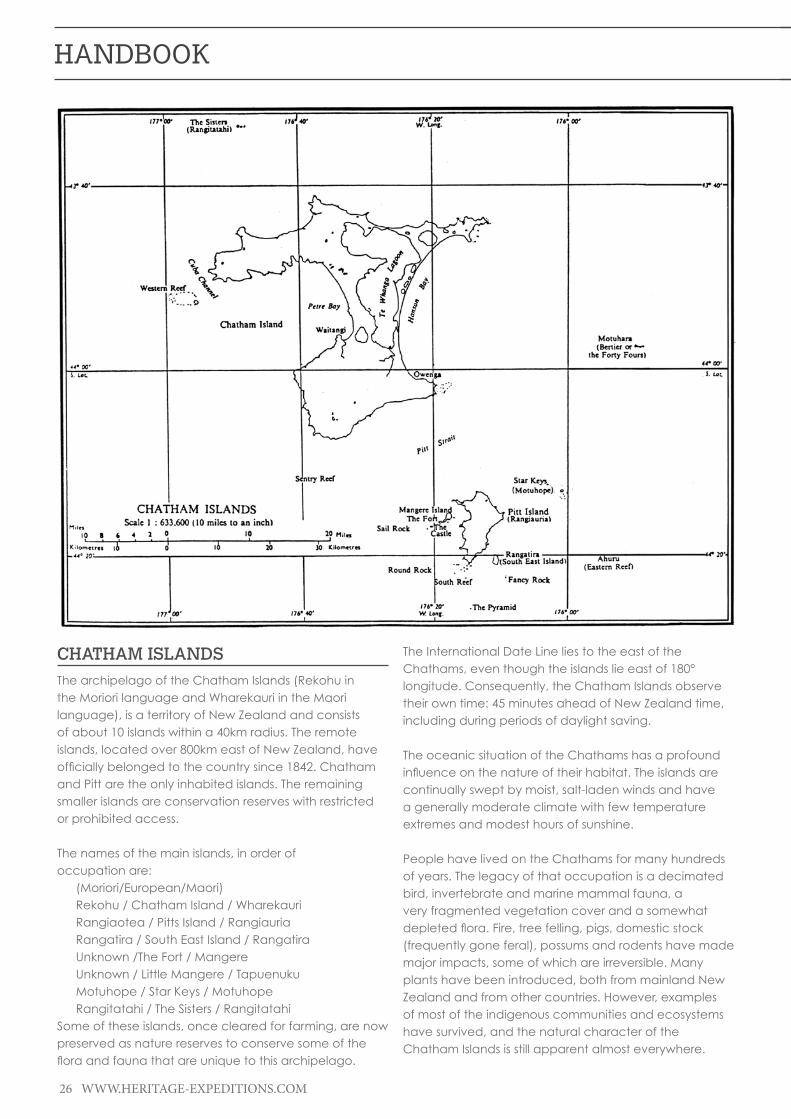
26 WWW.HERITAGE-EXPEDITIONS.COM
HANDBOOK
CHATHAM ISLANDSThe archipelago of the Chatham Islands (Rekohu in the Moriori language and Wharekauri in the Maori language), is a territory of New Zealand and consists of about 10 islands within a 40km radius. The remote islands, located over 800km east of New Zealand, have officiallybelongedtothecountrysince1842.Chathamand Pitt are the only inhabited islands. The remaining smaller islands are conservation reserves with restricted or prohibited access.
The names of the main islands, in order of occupation are: (Moriori/European/Maori) Rekohu / Chatham Island / Wharekauri Rangiaotea / Pitts Island / Rangiauria Rangatira / South East Island / Rangatira Unknown /The Fort / Mangere Unknown / Little Mangere / Tapuenuku Motuhope / Star Keys / Motuhope Rangitatahi / The Sisters / Rangitatahi Some of these islands, once cleared for farming, are now preserved as nature reserves to conserve some of the floraandfaunathatareuniquetothisarchipelago.
The International Date Line lies to the east of the Chathams, even though the islands lie east of 180° longitude. Consequently, the Chatham Islands observe their own time: 45 minutes ahead of New Zealand time, including during periods of daylight saving.
The oceanic situation of the Chathams has a profound influenceonthenatureoftheirhabitat.Theislandsarecontinually swept by moist, salt-laden winds and have a generally moderate climate with few temperature extremes and modest hours of sunshine.
People have lived on the Chathams for many hundreds of years. The legacy of that occupation is a decimated bird, invertebrate and marine mammal fauna, a very fragmented vegetation cover and a somewhat depletedflora.Fire,treefelling,pigs,domesticstock(frequently gone feral), possums and rodents have made major impacts, some of which are irreversible. Many plants have been introduced, both from mainland New Zealand and from other countries. However, examples of most of the indigenous communities and ecosystems have survived, and the natural character of the Chatham Islands is still apparent almost everywhere.
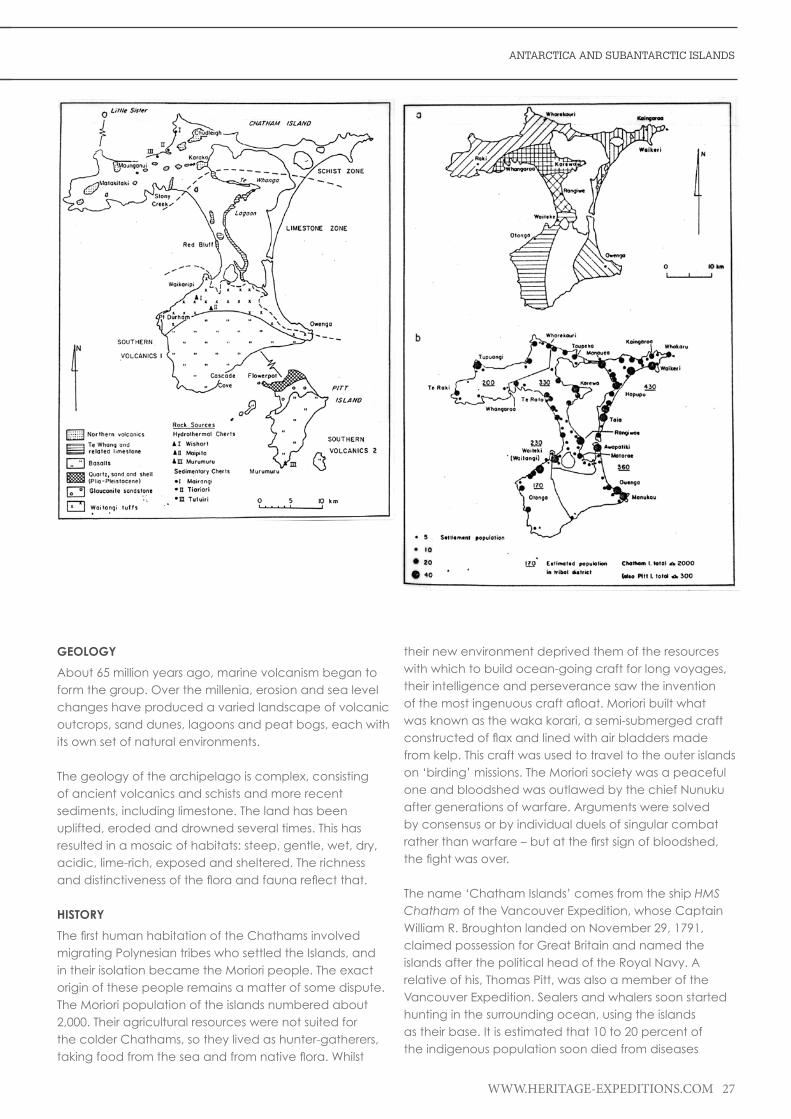
ANTARCTICA AND SUBANTARCTIC ISLANDS
WWW.HERITAGE-EXPEDITIONS.COM 27
GEOLOGY
About 65 million years ago, marine volcanism began to form the group. Over the millenia, erosion and sea level changes have produced a varied landscape of volcanic outcrops, sand dunes, lagoons and peat bogs, each with its own set of natural environments.
The geology of the archipelago is complex, consisting of ancient volcanics and schists and more recent sediments, including limestone. The land has been uplifted, eroded and drowned several times. This has resulted in a mosaic of habitats: steep, gentle, wet, dry, acidic, lime-rich, exposed and sheltered. The richness anddistinctivenessofthefloraandfaunareflectthat.
HISTORY
ThefirsthumanhabitationoftheChathamsinvolvedmigrating Polynesian tribes who settled the Islands, and in their isolation became the Moriori people. The exact origin of these people remains a matter of some dispute. The Moriori population of the islands numbered about 2,000. Their agricultural resources were not suited for the colder Chathams, so they lived as hunter-gatherers, takingfoodfromtheseaandfromnativeflora.Whilst
their new environment deprived them of the resources with which to build ocean-going craft for long voyages, their intelligence and perseverance saw the invention ofthemostingenuouscraftafloat.Morioribuiltwhatwas known as the waka korari, a semi-submerged craft constructedofflaxandlinedwithairbladdersmadefrom kelp. This craft was used to travel to the outer islands on ‘birding’ missions. The Moriori society was a peaceful one and bloodshed was outlawed by the chief Nunuku after generations of warfare. Arguments were solved by consensus or by individual duels of singular combat ratherthanwarfare–butatthefirstsignofbloodshed,thefightwasover.
The name ‘Chatham Islands’ comes from the ship HMS Chatham of the Vancouver Expedition, whose Captain William R. Broughton landed on November 29, 1791, claimed possession for Great Britain and named the islands after the political head of the Royal Navy. A relative of his, Thomas Pitt, was also a member of the Vancouver Expedition. Sealers and whalers soon started hunting in the surrounding ocean, using the islands as their base. It is estimated that 10 to 20 percent of the indigenous population soon died from diseases

28 WWW.HERITAGE-EXPEDITIONS.COM
HANDBOOK
introduced by foreigners. The sealing and whaling industriesceasedactivitiesabout1861,whilefishingremained as a major economic activity.
On November 19, 1835, a British ship carrying 500 Maori armed with guns, clubs and axes arrived, followed by another ship on December 5, 1835 with a further 400 Maori. They proceeded to massacre the Moriori and enslave the survivors. A Moriori survivor recalled: ‘The Maori commenced to kill us like sheep... we were terrified,fledtothebush,concealedourselvesinholesunderground, and in any place to escape our enemies. It was of no avail; we were discovered and killed – men, women and children indiscriminately’. A Maori conquerorjustifiedtheiractionsasfollows:“Wetookpossession...in accordance with our customs and we caught all the people. Not one escaped....”
After the invasion, Moriori were forbidden to marry Moriori, nor to have children with each other. All became slaves of the Ngati Tama and Ngati Mutunga invaders. Many died from despair, and many Moriori women had children to their Maori masters. A small number of Moriori women eventually married either Maori or European men. Some were taken from the Chathams and never returned.
An all-male group of German Lutheran missionaries arrived in 1843. When a group of women were sent out to join them three years later, several marriages ensued and many members of the present-day population can trace their ancestry back to the missionary families.
The Moriori numbers fell to 101. Most of the Maori eventually left the Chathams by 1870. It was Solomon’s grandfather, the chief of the Rauru tribe, who convinced theMorioritoremainpacifistduringtheinvasionoftheirland. Tame Horomona Rehe Solomon, known as Tommy Solomon, the last full blooded Moriori, died in 1933.
TheChathamIslandswerethelastislandsinthePacificto be settled by people. Residents today are descended from Moriori, Maori and Europeans, and their distinctive cultureisreflectedinthemanysignificantarchaeologicaland historical sites. There are various wahi tapu and burial sites, as well as remnants of European settlement relating to whaling and farming. Evidence of Moriori occupationincludestheinternationallysignificantMorioritree carvings (rakau momori) at J. M. Barker (Hapupu) National Historic Reserve.
FLORA
Most of the land is fern or pasture-covered, although there are some areas of forest. Of interest are the introduced macrocarpa trees, with branches trailing
almost horizontally in the lee of the wind. The islands are generally hilly, Pitt more so than Chatham, although the highest point, at 299m (981ft), is located on a plateau near the southernmost point of the main island of Rekohu. This island is dotted with numerous lakes and lagoons, notably the large Te Whanga Lagoon. Other lakes on Chatham include Huro and Rangitahi. Rekohu has a number of streams including Te Awainanga and Tuku.
The Chatham Islands form a complex archipelago well to the east of the New Zealand mainland. They have been isolated for more than 80 million years – long enough to develop many plants found nowhere else. These include forest trees, several giant herbs and seaweeds. Even thelocalflax(Phormium ‘Chathams’) is different. A total of 902 taxa have been recognised on the Chathams, including hybrids, and 27 informally recognised species. Of 400 indigenous plant species, 41 (including three hybrid combinations) are endemic to the Chatham Islands. An additional 13 of the 27 informally recognised species may also be endemic to the islands. Most well-known of the island endemics are the Chatham Island Forget-me-not Myosotidium hortensia, the Chatham Island Sow Thistle Embergeria grandifolia, Rautini Brachyglottis huntii, Chatham Islands Kakaha Astelia chathamica and Soft Speargrass Aciphylla dieffenbachii. Significantly,bothMyosotidium and Embergeria are endemic monotypic genera, meaning that both genera have only a single representative in the world, on the Chatham Islands.
The plants of the Chathams show a much higher proportionofcolouredflowersthaninmainlandNewZealand. Examples are the Chatham Island Forget-me-not Myosotidium hortensia (blue), Linen Flax Linum monogynum var. chathamicum (blue), Chatham Island Geranium Geranium traversii (pink), Swamp Aster Olearia semidentata (mauve), keketerehe O. chathamica (purple), and the Giant Sowthistle Embergeria grandifolia (purple).
The leaves of the Chathams’ species are also often fleshierandtreesbiggerthantheirNewZealandcounterparts. The Chathams’ plants do not generally show juvenile forms.
Plants have colonised the Chathams in the past from both the northern and southern parts of the New Zealand region.SpecieswithnorthernaffinitiesincludeChathamIslands Nikau (possibly related to Rhopalostylis baueri subspecieswithaffinitytothepalmsofNorfolkIslandandthe Kermadec Islands), Kowhai (Sophora chathamica, also found in western North Island) and the three Hebe species: H. barkeri, H. dieffenbachi, and H. chathamica.

ANTARCTICA AND SUBANTARCTIC ISLANDS
WWW.HERITAGE-EXPEDITIONS.COM 29
Those with a southern or Subantarctic connection include Swamp Heath (Dracophyllum scoparium, found also on Campbell Island), Keketerehe, closely related to a shrub daisy of Fiordland and Stewart Island) and Rautini (closely related to Brachyglottis stewartiae of The Snares, Solander Islands and small islands in Foveaux Strait).
The oceanic setting of the Chatham Islands has had aprofoundinfluenceontheplantlife.Windssweepthe islands, bringing gales, salt spray, cloudy skies, frequent showers and occasional blasts of cold air. But temperature extremes, droughts, frosts and snow are rare. Annual sunshine hours are about half those of the sunny parts of the New Zealand mainland.
Plants have adapted to these conditions in many ways. Some, such as Tarahinau (Dracophyllum arboreum), have wind-resistant needle leaves. Protective leaf and twig furriness is a feature of the tree and shrub daisies, and the indigenous trees have the remarkable ability to layer themselves after having been blown over.
Other species have developed giant leaves. Examples of these include megaherbs such as the Chatham Islands Forget-me-not Myosotidium hortensi and Giant Sowthistle Embergeria grandifolia. Gigantism is also evident among trees and shrubs. Chatham Islands Karamu Coprosma chathamica, which grows into a forest tree, is by far the largest species in a genus of shrubs. Tree Koromiko Hebe barkeri is also the largest of its genus, and Akeake Olearia traversii is one of the largest tree daisies on earth. Button Daisy Leptinella featherstonii is a woody shrub – all other members of its genus are creeping herbs. These significantenlargementsmaybeduetotheclimate,long isolation and high soil fertility.
Megaherbs,theButtonDaisyandfleshyherbssuchasCook’s scurvy grass Lepidium oleraceum evolved and thrived in soils made highly fertile through the effects of millions of sea birds inhabiting the islands. The decline in the abundance of these plants is partly due to the loss of seabirds. The cool humid overcast climate has alsoinfluencedtheplantsoftheChathamsinotherways. Tree ferns predominate in the forests, where they provide germination sites on their trunks for seedlings offoresttrees,aswellasfilmyfernsandorchids.Peathas developed as a result of thousands of years of accumulated plant matter, mostly from sphagnum moss and the rain of Tarahinau needles.
People have lived in the Chathams for many hundreds of years and many plants have been introduced. ThemostsignificantintroducedtreeisKarakaorKopiCorynocarpus laevigatus, brought centuries ago from mainland New Zealand by Moriori. It was cultivated in groves, eventually becoming widespread and self-
perpetuating in the forests. The kernel/seed of Kopi is highly toxic if eaten raw, but was an important source of carbohydrate when prepared appropriately. Moriori people also used the live trunks of Kopi trees for often ornate carvings, often with bird or humanoid forms, it is believed these dendroglyphs may have been used as a sort of portal for spiritualism.
Other mainland New Zealand plants brought more recently and now well established include Cabbage Tree,TreeFuchsia,Tutu,Karamuandflaxes.Moresinister are weeds from other countries, Gorse, Broom, Selaginella, Old Man’s Beard, Sweet Briar, Cotoneaster, Elderberry and Himalayan Honeysuckle are all a worry. Worse though is Chilean Guava, also known locally as Cranberry,whichseemssuperblyadaptedtoflourishinChatham Island peatlands, progressively elbowing out the indigenous vegetation unless controlled.
Chatham Island WetlandsWetlands on the Chatham Islands are extensive and diverse, containing around 8.5 percent of New Zealand’s threatenedfreshwaterfish.
Although the annual rainfall is relatively low at 500–1500mm (20 to 59in.) for Waitangi, the land is of low relief, rising to just 299m (981ft.), and with gently rolling slopes, so that drainage is poor. Peat development is encouraged by the climate, as it is cloudy, cool, coastal, humid, and windy. About 60 percent of the land surface is covered with peat (to about 10m (33ft.) deep in places) or peaty soils. Bogs occur on elevated peat surfaces where they are nourished only by rainfall, and are therefore quite infertile. Small valleys carry moving groundwater and a certain amount of nutrients from mineral soils, and these are occupied by fens and swamps.
Lakes, ponds, and pools of many sizes are common, some associated with peatland and others enclosed by sand dunes. These provide further wetland habitats, especially shallow freshwater aquatic habitats with marshes around their margins. Close to the coast, the stronginfluenceofseasaltproducesdistinctivewetlandcommunities: seepages with coastal wetland plants, damp turf vegetation on headlands and on shallow peats overlying rock, and small estuaries with tidal marshes.
The wetland interface between land and sea is especially well represented around the margin of Te Whanga, a huge shallow coastal lagoon that occupies a fifthoftheareaofChathamIsland.TeWhangaisvaluedasasourceoffreshwaterfishsuchasInangaandPatiki,as well as swan eggs and cockles. Its marginal zones of mudflats,shellridges,saltmarshturfandrushlandsare

30 WWW.HERITAGE-EXPEDITIONS.COM
HANDBOOK
important for many coastal, freshwater, and migrant wading birds.
Habitat degradation has contributed to the extinction of some bird species associated with freshwater habitats including Brown Teal, Chatham Island Fernbird, and Chatham Island Rail. Game birds such as Black Swan and ducks are present on several bodies of water.
Many Chatham Islands wetlands have been affected byfire,livestock–especiallycattle,sheepandpigs–and wild animals, but compared with mainland New Zealand they are less impacted by nutrient enrichment and weeds. The freshwater aquatic habitats of lakes and rivers, for example, have so far escaped invasion by the many potentially troublesome aquatic weeds.
FAUNA
The Chatham Islands are home to a number of endemic birds. The most famous species on the islands are the Magenta Petrel and the Black Robin, both of which came perilously close to extinction before being saved through conservation efforts. Other endemic species are the Chatham Island Oystercatcher, the Chatham Gerygone (Grey Warbler) the Parea or Chatham Islands Pigeon, Forbes’ Parakeet, the Chatham Islands Snipe and the Shore Plover. Several species are extinct, including the three endemic species of rail, Chatham Islands Raven and the Chatham Islands Fernbird.
Of the 24 species of seabird which breed on the Chatham Islands, six of them are New Zealand’s most threatened seabirds, while several species have already become extinct in the islands following human settlement. The Chatham Island Taiko is now regarded as the world’s rarest seabird and is classed as a critically endangered endemic with a total population of 100 to 140 birds and only 6 known nesting burrows.
In the past, the Chatham Islands swarmed with animal life. Marine birds and mammals came ashore to breed or roost, bringing nutrients to enrich the soil. The forests were alive with bird and invertebrate life. Waterways supported hugenumbersofwetlandbirdsandfish.Theshorewasatreasuretroveofshellfish,crustaceans,fishandbirds. Harvesting, large-scale clearance of vegetation (especially forest) for farming, and human-imported animals have taken a large toll on the wildlife.
Rats, mice, pigs, possums, hedgehogs, cats and dogs consumed innumerable indigenous animals and their food supplies. Cattle, sheep, goats, pigs, horses and possums have reduced the complex indigenous vegetation cover to scattered fragments. These animals are now controlled in most areas of the Chathams, which are protected.
BirdsSeveral bird species have become extinct since humans arrived at the Chatham Islands. They include a penguin, aswan,severalducks,severalflightlessrails,afernbirdand a bellbird.
Endemic seabirds that have survived include Toroa (Northern Royal Albatross), which also breeds at Taiaroa Head near Dunedin; Chatham Island Taiko (now confinedtoonetinypopulation);Torea(ChathamIslandOystercatcher) found around the shores; Chatham Island Shag and Pitt Island Shag, and Chatham Petrel. TheChathamPetrelwasconfinedtoRangatiraIslanduntil 2002 to 2005, when the New Zealand Department of Conservation began to establish a second population on Pitt Island. More recently, in April 2008, 43 chicks were movedfromRangatiraIslandtoartificialburrowswithinthe Sweetwater Conservation Covenant in the south of themainChathamIsland.Thiswasthefirstreturnofanendangered bird species to the main Chatham Island, made possible by landowners Liz and Bruce Tuanui, and the Taiko Trust, who predator-proof fenced the two and a half-hectare Sweetwater Covenant with the aim of restoring seabirds to the site. This includes the critically endangered Chatham Island Taiko which was successfullytransferredthereforthefirsttimein2007.
Surviving endemic land birds include Parea (Chatham Island Pigeon), Chatham Island Sarbler, Forbes’ Parakeet, Chatham Island Snipe, Chatham Island Tui, Chatham Island Tomtit and Black Robin. None of these birds are common and recovery programmes are underway for the most threatened of them.
Many seabird species are still quite common around the Chatham Islands. Buller’s Mollymawk, prions, skuas, Sooty Shearwaters, storm-petrels and Little (Blue) Penguins are most likely to be seen at sea. Around the coasts, those most frequently seen include the Black-backed Gull, Red-billed Gull, White-fronted Tern, shags and skuas. Banded Dotterel and Pipit are often found on shore as well.
Te Whanga Lagoon and the freshwater lakes and swamps of Chatham Island provide extensive habitat for wetland birds. Most common are Black Swan, Black Shag, Mallard and Grey Ducks, Pukeko, Welcome Swallow, Pied Stilt and various migratory waders. In open country, meaning farmland, bracken and shrubland, introducedfinchesandsongbirdsarecommon,asareHarrier, Spur-winged Plover and Buff Weka.
Weka, imported from Canterbury (where they are now extinct) around 1905, have proliferated to such an extent that they are regarded as something of a pest at times, and are also a favourite seasonal menu item.

ANTARCTICA AND SUBANTARCTIC ISLANDS
WWW.HERITAGE-EXPEDITIONS.COM 31
Birds of the forests include the Kakariki (Red-crowned Parakeet), Parea, Chatham Island Warbler and Chatham Island Fantail. Chatham Island Tui and ChathamIslandTomtitarenowconfinedtoPittIsland,although a few Tuis visit the main Chatham Island.
TaikoThe Chatham Island Taiko, Pterodroma magentae, endemic to the Chatham Islands, has a population estimated to number less than 150 birds. It was in fact believed to be extinct for almost a century, until its rediscovery by David Crockett in 1978. Nearly 10 years later,in1987,thefirstTaikoburrowwasdiscoveredinsouthern Chatham Island. The arrival of mammalian predators, particularly cats, pigs, and rodents, the introduction of Weka and the loss of forest habitat are likely to have been the main causes of decline within the last 100 years. Stray dogs and trampling of burrows by domestic and feral stock are likely to have been additional threats. The key present-day threat to Taiko continues to be predation from cats, pigs, Weka and rodents during the Taiko breeding season.
TaikoisoneofthelargerGadflyPetrelsweighingbetween 500 and 600g (17½ and 21lb.) and has a wingspan of around one metre (3.3ft.). The plumage is black with a white breast. The Taiko is an ocean wanderer, spending its entire life at sea and feeding inthesubtropicalwatersoftheSouthPacificOceanbetween the Chatham Islands and South America. It returns to land only to breed. Current population estimates range between 120 and 150 individuals, with only 14 known breeding pairs. The New Zealand Government’s Department of Conservation classes the Taiko as category A – the highest priority for conservation management. The IUCN Red List Categories (IUCN 1994) also ranks Taiko as critically endangered.
The breeding grounds are located in dense forest in the south-west of the main island. Sub-fossil and historical evidence suggests that they once bred in huge numbers in the southwest of the island. Once Europeans arrived along with introduced mammalian predators, however, the Taiko all but disappeared within 100 years.
Taiko,likeallGadflyPetrels,areveryvocalbothintheair and on the ground, and have a large repertoire of calls. Common to many species is a ‘ti-ti’ call; other calls include long, low frequency moans and persistent churring sounds.
Morethanothertubenoses,GadflyPetrelswilloftenrespond to human imitations of their calls. This has become a very useful technique for encouraging some of the more endangered species such as the Bermuda Petrel and the Galápagos Petrel to sites where they can
be better protected. This technique is also planned for use with the Taiko.
Breeding takes place during the Southern Hemisphere summer, from September until May. Adults return in late September to clean out and prepare their burrows. Taiko are a burrowing petrel that can construct burrows up to 5m (16½ft.) in length which the male excavates. The end of the burrow opens into a nest chamber where the chickwillspendthefirst105daysofitslifeafterhatching.The breeding pair will use the same burrow each year and usually mate for life with the same partner. A single white egg is laid around the end of November or beginning of December. Both parents share incubation over a period of 55 days. Once the chick hatches, usually around the middle of January, both parents will feed it for approximately 105 days until the chick is ready tofledge.Whenthechickisfinallyready,itwillclimba tree in the dense forest and then launch itself for the fivekilometreflighttothecoastandoutintotheSouthPacificOcean.TheTaikochickswillthenremainatseafor seven or eight years until they are ready to return to theChathamIslands,findamateandbreed.
Chatham Island Black RobinThe recovery of the Chatham Islands Black Robin from the brink of extinction is an internationally renowned conservation success story.
This little black bird is only found on the Chatham Islands. Numbers continue to increase, but because it stillhassuchasmallpopulationitisclassifiedascriticallyendangered. The Black Robin can live to be 13 years old and it grows to 15cm high. It eats insects such as cockroaches and Weta, as well as grubs and worms.
Black Robins often pair for life. Females usually lay two eggs and often re-lay if a clutch is lost. All the Black Robins alive are descended from that last breeding pair, named ‘Old Blue,’ and ‘Old Yellow.’
Black Robins live in woody vegetation beneath the canopy of trees. They spend a lot of time in the lower branches of the forest in order to shelter from the strong winds that buffet the Chatham Islands group. They also likeforaginginthedeeplayersoflitterfoundonflatareasoftheforestfloor.TheyarecurrentlylocatedonSouth East Island and Mangere Island in the Chatham Islands group. Attempts are being made to establish another population in a fenced covenant on Pitt Island. In1972,wildlifeofficerscouldfindonly18BlackRobinsliving on Little Mangere Island. In 1976 there were a mere seven birds left. These were all moved to Mangere Island where 120,000 trees had been planted to provide better shelter. By 1980 a further two birds had died and none had bred.

32 WWW.HERITAGE-EXPEDITIONS.COM
HANDBOOK
The outlook was bleak, but a dedicated team of New Zealand Wildlife Service staff took the daring step of cross-fostering eggs and young to another species to boost productivity. The last breeding pair, named Old Blue and Old Yellow, and a foster species, the Chatham Island Tits, ended up saving the Black Robin from extinction. The fostering programme used to save the Black Robin was such a fantastic success that it has been used as a case model on how to save endangered birds around the world. With the Black Robin population now well established on Mangere and South East Islands, the Department of Conservation is attempting to establish a third population in a predator-free area of Pitt Island. There are even hopes that the Black Robin may one day be returned to its ancestral home, Little Mangere, where the vegetation is slowly regenerating. Today the population stands at around 250.
Native Grey Warbler (Riroriro)The Native Grey Warbler or Riroriro, Gerygone igata, and the endemic Chatham Island Warbler, Gerygone albofrontata, are New Zealand’s only members of the Australasian family Pardalotidae. They sing a delicate and complex trill, which Maori took as a seasonal reminder to plant their crops. The Grey Warbler weighs 6.5g (0.23lb.); the Chatham Island species weighs 9g (0.32lb.). Grey warblers have adapted well to human changes to the landscape, but Chatham Island Warblers prefer undisturbed sites.
The females of both species build enclosed pear-shaped nests with side entrance holes, usually hanging from a branch. They lay four white eggs with reddish speckles, each nearly one-quarter of the mother’s body weight, in seven days. The males defend the territory while the females incubate the eggs alone. Then males help feed the chicks while females prepare to lay a second clutch.
A Shining Cuckoo may lay an egg in the Warbler’s secondclutch.TheCuckoochicktypicallyhatchesfirstand expels the warbler’s eggs or chicks. It is fed by the apparentlyunsuspectingwarbleruntilitfledges.Bothspecies mainly eat invertebrates and some small fruits. They glean food from leaves, and sometimes the Grey Warbler hovers beside branches to catch prey.
Shore PloverRangatira Island in the Chathams was, until recently, the last home of the endangered Shore Plover, Thinornis novaeseelandiae, down to only 130 birds in the wild by the 1990s. In 1991, 14 of these small wading birds were hatched from eggs taken from the Chatham Islands and transferred to the National Wildlife Centre (NWC). Incredibly, only a year later, the birds paired and bred at one year old, thus beginning the captive breeding programme. In 1994, the firstreleasesofcaptive-bredploverintothewildwere
trialled, with transfers to Motuora Island in the Hauraki Gulf. A total of 75 birds were produced in captivity and released there over the following 5 years.
Unfortunately the programme was not successful in establishing a new Shore Plover population, with released birds dispersing from the predator-free island to neighbouring estuaries and beaches where they were probably killed by predators. This is a highly mobile species, and it was thought that the birds were being scared off the island by resident Morepork. Another predator-free island was sought – one that also lacked avian predators. A suitable privately owned island off the east coast was found in 1998. Now all the young Shore Plover raised at NWC are released here and the island has a very healthy population, thought to be self-sustaining. While some of the birds have dispersed, enough have stayed to make the project a success. With one wild Shore Plover population established, attention now turns to another suitable safe island haven uponwhichtoreleasethenextfiveyears’worthofprogeny.
The Shore Plover is a small member of the plover/dotterel family (Charadriidae). The head is black in males, brown in females. Both have a white band across the forehead. The bill is orange with a dark tip. They can be noisy, making loud, ringing calls, especially in aggression towards neighbours. The alarm call is a loud, repetitive ringing ‘ching’, which is sustained until the threat has passed. They are strongly territorial during the breeding season, but in winter they mayroostandfeedinflocks.TheShorePlovernestsfrommid-October to January, with both the male and female incubating. Nests are hidden under thick vegetation, or in holes or crevices amongst boulders and driftwood. They lay two to three dark blotchy eggs, which are incubated for 28 days.Thechicksfledgeatapproximately35daysofage.
The New Zealand Shore Plover was once widespread around the New Zealand coastline and the Chatham Islands, but by the 1880s, Shore Plover were restricted to the Chatham Islands only. Introduced predatory mammals such as cats and rats are thought to have caused their extinction on the New Zealand mainland.
After the introduction of cats to the Chathams, shore plover remained only on predator-free Rangatira Island, otherwise known as South East Island, and Western Reef in the Chathams group. The population there is approximately 120 birds – which makes the Shore Plover one of the rarest shore birds in the world.
Shore plover live on coastal rocky wave platforms, sandy and rocky beaches, saltmeadows and river mouths. They feed on small crustaceans (copepods, ostracods, amphipods, isopods), spiders, molluscs (gastropods, bivalves), insects and their larvae.

ANTARCTICA AND SUBANTARCTIC ISLANDS
WWW.HERITAGE-EXPEDITIONS.COM 33
MACQUARIE ISLANDMacquarie Island is an Australian Subantarctic Island with an area of 12,875ha (31,814ac.). It is 34km (21mi.) long and up to 5km (3mi.) wide, and is located 1500km (930mi.) south-east of Hobart, Tasmania. The island is a nature reserve managed by the Tasmanian Government through the Parks and Wildlife Service (PWS). The PWS also manages the island as a World Heritage Site on behalf of the Australian Government. The Australian Government Antarctic Division maintains a research station on the island, and the Bureau of Meteorology collect weather data, including upper air soundings. Macquarie Island was declared a Wildlife Sanctuary in 1933, a State Nature Reserve in 1972, and a UNESCO Biosphere Reserve in 1977. It was listed in the Register of CriticalHabitatin2002.Thevariousdesignationsreflectthe importance of the reserve and the natural and cultural values it embodies. In 1999 the ocean around Macquarie Island became an Australian Marine Park.
GEOLOGY
Macquarie Island is uniquely formed and part of a 750mi. long ridge created about 600,000 years ago by a rift in the earth’s crust subsequently closing and extruding molten rock right up to the surface. The result
could be compared to the squeezing of a toothpaste tube, resulting in molten rock from the earth’s mantle 5 to 6.5km(3to4mi.)belowtheoceanfloorrisingtobecomeexposed on the surface. It is the only known place on earth where this has occurred, and there has been no previous or subsequent volcanic activity. The island is still rising rapidly. Because of its geology, the island was designated a World Heritage Site in 1977.
Macquarie Island probably began as a spreading ridge under the sea with the formation of new oceanic crust somewhere between 11 and 30 million years ago. At some stage the spreading halted and the crust began to compress, squeezing rocks from deep within the mantle upwards like toothpaste from a tube. As the ridge grew it eventually became exposed above the ocean’s surface about 600,000 years ago.
Macquarie has a number of special features. Firstly, there are no other Subantarctic Islands which have been squeezed upwards from the oceanic crust to form an island like this. Most Subantarctic Islands, including Heard Island, initially developed as underwater volcanoes. Some are now exposed above the sea as a result of the accumulation of layers of lava. Prince Edward Island, the McDonald Islands and Iles Crozet also formed from submarine volcanoes, while Auckland and Campbell Islands have volcanic origins but they were previously attached to continents and the continental crust.
Secondly, the rocks of Macquarie Island which are in their original (oceanic) geological setting are far less deformed than similar rocks elsewhere. For example, the Troodus complex of Cyprus, the Semail complex of Iman and the Bay of Islands complex of Newfoundland, although geologically similar to Macquarie Island, are more deformed. These rocks have also been ‘welded’ to continental-type rocks, a process in which the rocks are squashed, stretched or both.
There is still considerable geological debate over whether the rocks in the complexes actually originated from the oceanic crust. Some geologists feel that they have formed in entirely different ways, such as the caseofthevolcanicislandsaroundthePacificRimwhere oceanic crust is being forced, or subducted, below the adjacent continent. Macquarie Island is in a totally different geological setting to these islands, but is considered to be very close to its original oceanic setting. It has not been forced up against the edge of a continent.
As the geological origin of the island differs from that of other Subantarctic Islands, so does its landscape and the processes shaping it. The major difference is that most of
34 WWW.HERITAGE-EXPEDITIONS.COM
HANDBOOK
the Macquarie landscape has been formed by marine erosion processes such as wave erosion as it has risen above sea level. In contrast, many of the volcanic islands tend to develop in major explosive events when growth above sea level is very rapid and the only erosive effects occur around the coastal perimeter. It has also been argued that unlike other Subantarctic Islands, whose landscapes have been molded by ice, Macquarie has not been glaciated.
In the last 600 to 700 thousand years, Macquarie has emerged above sea level and recent estimates suggest that since about 6,000 years ago it has been rising at an average rate of about 0.8mm per year. Evidence that the island has risen above the sea surface is provided by numerous old beaches or areas eroded by waves at altitudes ranging from 6m to 400m (20 to 1300ft.). The otherlargeinfluenceontheshapeofMacquarieIslandhas been the extensive faulting which also contributes to earthquake activity. Macquarie Island experiences an earthquake of 7.5 on the Richter scale once every decade. There are many large and active faults which have shaped the coast, created fault-dammed lakes and controlled the location of major landforms. Earthquakes trigger major landslip events, the scars of which cover many slopes.
One of the more intriguing aspects of Macquarie Island is the general lack of creeks and river. Some lakes lack inflowingoroutflowingcreeks.Thisappearstobedueto the highly fractured nature of the bedrock or the way in which the bedrock dips or slants. This results in water percolating quickly through the rock, perhaps ultimately re-emerging on the shore platform which skirts parts of the island. These lakes are exceedingly boggy. The bogs are composed of peat reported to be up to 6m deep and are thought to have formed over the last 5,000 to 7,000 years. This would suggest a very fast rate of organic accumulation or slow rate of decomposition in comparison to peats in other parts of the world. Rates are never constant, but on average it appears as if the lowland bogs on Macquarie have developed at about 10 times the rate of many other peatland areas in the world.
HISTORY
On July 11, 1810, Frederick Hasselborough discovered Macquarie Island, naming it after Lachlan Macquarie, then the Governor of New South Wales. The island lies about halfway between Tasmania and the Antarctic continent. Its highest point is Mount Hamilton, which rises up to 433m (1420ft.).
Sealers inhabited the island periodically throughout the 19th century, exterminating the fur seals and
greatly reducing the elephant seal population. In 1870, gangs came to exploit the King and Royal Penguins’ populations also for oil. The original elephant seal population of about 93,000 to 110,000 animals was reduced by 70 percent as a result of these operations. The visitors also brought exotic mammals which eventually caused the extermination of two endemic subspecies of land birds.
Hospitality Russian Style – Admiral BellingshausenAdmiral Thaddeus Bellingshausen, commander of the Vostok and the Mirnyi,madeascientificvoyageto the South Seas between 1819 and 1821, and circumnavigated Antarctica. Bellingshausen visited Macquarie Island late in 1820. By then water supplies on the vessels were getting low, so some of Bellingshausen’s crew rowed ashore with barrels to try to collect water.
While the Russian sailors were ashore, a party of sealers rowed out to the Vostok. These men, who were from Port Jackson, had been on Macquarie Island for more than six months.Theyhadfilledalltheirbarrelswithelephantsealoil and had been unable to work for the last four months. Their provisions were also running short. To the sealers’ great delight, Bellingshausen offered them biscuits, butter and grog.
The sealers became more talkative and helpful after a good feed and a drink or two, and told the Russians wheretheycouldfindfreshwater.Theyevenofferedtohelpfilltheships’waterbarrels.TheRussianswhorowedashorewereastonishedtofindthatthepenguinsandseals on Macquarie Island were not afraid of them. They reported that penguins did not get out of their way and ‘had to be pushed aside’.
A Mr Zavodovski shot a sea elephant, and he was amazed that the other animals opened their mouths to roar, and then fell asleep again. Without moving from one spot, another crew member, Mr Demidov, shot 20 ‘Egmont hens’ or petrels. The shore party collected a ‘furry’ penguin, several adult penguins, as well as some eggs, grasses, stones, young sea elephant hides, blubber, various species of gulls and a parrot.
While the sealers were aboard the Vostok, a large elephant seal or ‘sea elephant’ covered with blood swam past the ship. This seal was, most likely, the seal shot by Mr Zavodovski. Bellingshausen wanted to chase the wounded seal in the ship’s boat, but the sealers told him that it would be impossible to kill in the water and besides, he could take his choice from the seals on the shore.

ANTARCTICA AND SUBANTARCTIC ISLANDS
WWW.HERITAGE-EXPEDITIONS.COM 35
That evening the Vostok and Mirnyi sailed north-northeast along the coast of Macquarie Island in search of water. At around ten o’clock that night, the crews of both vessels felt two violent shocks. Bellingshausen who was aboard the Vostok, worried that the vessel might have been wrecked on a reef. He checked the water depth, but found the ship was not close to the bottom. He then thought that the Vostok might have struck a sleeping whale or touched an underwater ridge. It was only after the crew of the Mirnyi told him that they too had felt the shocks that Bellingshausen realised that they had experienced an earthquake. Bellingshausen went ashore inarowboatwiththreeotherofficersand,withthekeeneye of the naturalist, observed the rather miserable lifestyle of the sealers:
‘The foreman of the sealers invited us to his hut, which was 20 feet long by 10 feet broad. Inside it was lined with skins of seals, and the outside was covered with a kind of grass which grows on the island. At one end there was a small hearth, and a lamp was kept always alight. On the hearth, as wood and coal were unobtainable, there was burning a piece of sea-elephant blubber and melted fat was used for lamp. Beside the hearth was a bedstead. Provisions were stored at the other end of the hut. Inside it was so black and dark from the smoke that the smouldering light from the lamp and from the holes in the wall over which bladders were stretched scarcely lit the interior of the hut, and until we got accustomed to the light the sealers had to lead us by the hand. They eat carrion and penguins’ eggs. Their flesh tastes like blackcock and is very good to eat.’
Bellingshausen noted that the sealers were living on seabirds,theflippersofyoungseaelephants,eggsofpenguins and other birds, and the Macquarie Island cabbage. He wrote:
‘The so-called ‘wild cabbage’, undoubtedly an effective remedy, grows abundantly over the whole island. It is distinguished from the other vegetation by the darkness of its foliage. It has broad leaves growing horizontally with slight indentations at the edges, dark on top and light underneath. The stalk is about a foot high, and, like the leaves, is hairy. The flower on the central stalk is white like a cauliflower. The greater part of the root, which is about 2 inch in thickness, lies on the surface of the ground and its thin suckers grow into the earth. The roots resemble cabbage in flavour. The sealers scrape the stalks and roots, cut them up very fine and make soup of them. We took a lot of these cabbages with us and preserved them for the use of the crew, the roots being pickled for the officers’ mess. From the preserved cabbage we made a very tasty shtshi (Russian cabbage soup), and we were sorry that we had not prepared more.’
Bellingshausen observed a sealer club an elephant seal with a club that was 4ft. long and 2in. thick. The end was bell-shaped, 4 or 5in. (10 to 12cm) in diameter and bound with iron and studded with sharp nails. After clubbing the seal, the sealer slit its throat with a knife, saying: ‘It is a pity to see the poor animal suffer’. The sealers speared larger elephant seals through the heart after they had been clubbed:
‘Having killed the sleeping animals, the men cut off the blubber with a knife, and put it in a boiler, placed on stones and with room for a fire beneath it, which they kindle with lumps of the same fat. The oil from the boilers is then poured into barrels. Part of it is sent to New South Wales, and the remainder is shipped to Britain, where it commands a very remunerative price’
OneoftheRussianofficersleftbehindadogwhichthesealers adopted as a pet. Bellingshausen also reported seeing some small parakeets. The Russians went back to their ships with a haul of two albatross, 20 dead parrots and one live parrot. The sealers offered these to Bellingshausen and happily accepted three bottles of rum in exchange.
Bellingshausen delayed his departure from Macquarie Island because he wanted to wait for a skin of a large sea elephant that the sealers had promised to deliver. He eventually sent a crewman to row ashore and talk to the sealers. Bellingshausen had expected this sailor to return with barrels of water, but instead he returned with a supply of elephant seal fat that he had exchanged for three bottles of rum.
The wind was freshening when the sealers rowed out in a whaleboat and delivered the seal skin to the Mirnyi. This was a dangerous deed, because a mist had sprungupandafinerainmeantthatvisibilitywaspoor.Bellingshausen gave the sealers a compass and showed them the course they should follow when returning to shore. They loaded the sealers’ rowboat with extra provisions and rum, and the sealers rowed back to shore, no doubt very gladdened by the Russians’ hospitality.
FLORA
Coastal Terraces VegetationThe beach slope/raised coastal terraces of Macquarie Island occupy the region between the coastal zone and the coastal slopes. They support several different vegetation formations, quite different from those found on sandy or stony beaches. Much of the underlying soil consists of peats.

36 WWW.HERITAGE-EXPEDITIONS.COM
HANDBOOK
The composition of the vegetation in this area is determined by drainage, the height of the water table and water run off from the coastal slopes and plateau uplands. Animal disturbance may also have an effect on thefloraofthisregion.
In areas of good drainage grow mixed stands of Poa foliosa and Stilbocarpa Polaris – the Macquarie Island Cabbage. Poa foliosa is also found bordering the edges of streams that run across the region. In areas where runofffromthecoastalslopesaccumulatesinflushlines, communities of the reed Juncus scheuchzerioides, Montia fontana and the moss Breutelia pendula can be found.
If drainage is not good, or the water table is close to the surface of the soil, a ‘feather bed’ community develops. This community is a quaking-mire and is typically dominated by mosses and liverworts. Pleurophyllum hookeri can also be found growing in these mire communities, often in rows.
Shortgrasslandgenerallyoccursinareasinfluencedby animals. These areas are dominated by Festuca contracta, occasionally along with Luzula crinita and Agrostis magellanica.
One of the most extensive community types in the raised coastalterracesisherbfield.Thiscanoccurinarangeofvarying environmental conditions, but most commonly occurs on well-drained soils where the water table is a little below the soil surface. Major plant species growing in these areas are Poa foliosa, Stilbocarpa polaris and Pleurophyllum hookeri, along with mosses, lichens, liverworts and other small vascular plants.
Animals abound in this region. Areas of Poa foliosa/Stilbocarpa polaris provide refuge for elephant seal pups after weaning and adult seals after moulting. They are also common breeding sites for Northern and Southern Giant Petrels and Gentoo Penguins.
Trampling and destruction of vegetation by animals like elephant seals, and increased nutrient levels owing to bird and mammal defecation and urination can cause significantlocalchangestothevegetation,asdidrabbitgrazing pre-eradication, causing some areas to be converted to short grassland. Bird, and formerly mouse, rat and rabbit burrowing has an effect as well.
Stilbocarpa polaris, the Macquarie Island Cabbage, is one of only two plants on the island to have conspicuous flowerheads(theotherisPleurophyllum hookeri), and can grow up to a metre in height. The cabbage only occasionally grows from seed (in the past mice and
rats ate large quantities of its seed) and more often regenerates from a tough, underground rhizome. The plant was used by early inhabitants of the island, including sealers, expeditioners and scientists as a vitamin C source. The stems, leaves and rhizomes of the plant can all be consumed by humans.
Coastal Zone VegetationThe coastal zone communities on Macquarie Island are part of an active shoreline, constantly battered by waves and strong winds. Storms are common and sea spray ensures a steady deposition of salt, which is partly offset by the frequent light rain. These communities extend from the water’s edge to above the extreme high water mark. The two main coastal zone communities are those on rocky shorelines and those on beaches of sand, gravel or cobbles.
In a typical coastal zone community on rocky shorelines, beds of kelp and marine algae are found in the intertidal areas, forming an algal zone. Above the high water mark, a lichen-dominated zone exists. During stormy weather this area is subject to inundation by the sea. The lichens Verrucaria, Xanthoria, Turgidosculum (Mastodia), Lecanora and the moss Muelleriella crassifolia are typically found in this area. Above this lichen-dominated zone, moss and lichen species mix with tufts of the grass Puccinellia macquariensis and cushions of Colobanthus muscoides. During exceptionally stormy weather this zone may also be affected by waves.
Sandy and gravel beaches generally do not support any vegetation. Several vascular plants grow above the high water mark on cobble beaches, principally Cotula plumosa, Poa annua and Callitriche antarctica. The rocks may also support a number of crustable lichen species. Well above the high water mark, the beaches are covered by a tall tussock grassland of Poa foliosa. These tussocks may reach heights of 2m or more.
Rock stacks often rise above the shoreline or the water itself. These stacks are usually capped by grass tussocks and other vegetation, which provide nesting sites for birds.
The composition and structure of coastal zone communities is determined by several factors: the topography of the coast, which determines the extent to which the shoreline is exposed to waves and wind; whether a beach is present, and its structure; and the surrounding vegetation composition and amount of animal disturbance present.
The most notable impacts are caused by the 3 to 4 million animals, principally birds and seals, which

ANTARCTICA AND SUBANTARCTIC ISLANDS
WWW.HERITAGE-EXPEDITIONS.COM 37
populate this region at various times of the year. After weaning, elephant seal pups often retreat from the exposed beach to the shelter of the tussock grass communities. Moulting seals use tussock communities for shelter and to rub off their peeling skin. Consequently many tussocks are damaged by seals as they lie, trample, and rub themselves against them. Fur seals prefer rocky areas as haul out sites. Penguin colonies (andsealstoalesserextent)dramaticallyinfluencenutrient levels in the areas they inhabit, due to the effects of their dung and urination. One tussock grass, Poa cookii, is found mainly close to penguin colonies and may either tolerate or require more nutrients.
The Plateau UplandsThe plateau uplands are the most extensive zone on Macquarie Island, sitting atop the island and running its entire length. A broad range of plant communities can be found there. These are tall tussock grassland, shortgrassland,herbfields,mireinshelteredsites,andfeldmark in exposed areas.
Composition and structure of the plant communities of the plateau uplands is determined by exposure to wind, drainage and soil depth. In addition, historical animal disturbance may have had a modifying effect on the vegetation.
Tall tussock grassland dominated by Poa foliosa can be found in sheltered and relatively exposed situations on the plateau. The tussocks are smaller than those found at lower altitudes and often form a low sward rather than tussock.
Short grassland communities dominated by Festuca contracta or Agrostis magellanica and Luzula crinita are quite widespread.
Threetypesofherbfieldarepresentintheregion.Thosedominated by Acaena sp. were in the past primarily determinedbytheinfluenceofrabbitgrazing;thefur of rabbits and the feathers of burrow-nesting birds assist in dispersing the hooked seeds. Those dominated by Pleurophyllum hookeri and Stilbocarpa polaris grow on gully sides and in sheltered, well-drained sites. Communities dominated by the cushion-forming Azorella macquariensis and by Pleurophyllum hookeri are relatively widespread in sheltered feldmark sites.
If the water table is high and drainage is poor, a mire community may form. Typical plant species occurring in mires in the plateau uplands are Agrostis magellanica, Ranunculus biternatus, Juncus scheuchzeroides and the mosses Breutelia pendula and Bryum laevigatum.
The most extensive plant community occurring in the plateau uplands is the feldmark community, which occupies 45 percent of the island’s surface. Feldmark vegetation on Macquarie Island is comprised of dwarffloweringplants,mosses,lichens,liverwortsandasignificantamountofbareground.Thedominant vascular plant is the cushion plant Azorella macquariensis. Feldmark communities often form into patterns of alternating stripes of vegetation and bare ground, particularly on windward slopes. This striping effect is sometimes associated with terracing, particularly on leeward or sheltered slopes.
The main factors which impact this region are wind exposure and frost action in the soil. This area is typically considered to be the windiest on the island. Upland grasslands are also an important habitat for burrow-nesting petrels, and in the past rabbits and mice, each of which has or had an effect on the area.
Terraces are a component of the upland feldmark vegetation on Macquarie Island. Terraces are alternating bands of vegetation and gravel in a step/stair arrangement. They occur on slopes and tend to be more common on the eastern side of the island, in the lee of the prevailing winds. The vegetation forms theriserandthegraveltheflattreadoftheterraces.On windward terraced slopes, this trend is reversed. This is most likely due to the fact that the terraces on the windward (western) side of the island are wind formed, whereas those on the leeward (eastern) side of the islandareformedbysolifluctionprocesses,whichisthemovement of soil due to the action of ice forming and pushing soil down-slope.
FAUNA
The island is home to over 200,000 pairs of King Penguins and an estimated 3,000,000 Royal Penguins. In addition, there are Rockhopper and Gentoo Penguins and albatross including Wandering, Black-Browed, Grey-Headed and Light-mantled Sooty Albatross.
The island is a breeding ground for elephant seals. In the past, the fur seals here were virtually eliminated through harvesting. Oil rendering of elephant seals and Royal Penguins reduced their numbers to the point where the venturewasnolongerprofitable.
The indigenous fur seal, species unknown, was virtually exterminated within 10 years of the island being discovered. The remaining indigenous mammals are all marine, comprising whales and seals, and include Southern Right Whale, Balaena glacialis, rare sightings of Sperm Whale, Physeter macrocephalus, Orca Orcinus orca, the most common whale observed at Macquarie

38 WWW.HERITAGE-EXPEDITIONS.COM
HANDBOOK
Island,andtheLong-finnedPilotWhaleGlobicephala melaena. Other positive whale records include the Southern Bottlenose Whale Hyperoodon planifrons and Cuvier’s Beaked Whale Ziphius cavirostris.
The Southern Elephant Seal Mirounga leonina population at Macquarie Island numbered 110,000 during the mid-1950s (Carrick and Ingham, 1962). New Zealand Fur Seal Arctocephalus forsteri, Subantarctic Fur Seal A. tropicalis and Antarctic fur seal A. gazella are also found. New Zealand (Hooker’s) Sea Lion Phocarctos hookeri and Leopard Seal Hydrurga leptonyx visit each winter and spring. Weddell Seal Leptonychotes weddelli and Crabeater Seal Lobodon carcinophagus are very rare visitors from the south.
Southern Elephant SealThe Southern Elephant Seal, Mirounga leonina, is one of two species of elephant seal. It is not only the most massive pinniped, but also the largest member of the order Carnivora to ever have lived. The seal gets its name from its great size and the large proboscis of the adult males, which is used to make extraordinarily loud roaring noises, especially during the mating season.
There is a great sexual dimorphism in size, with the males being much larger than the females. While the females average about 680kg (1,500lb) and 3m (10ft) long, the bulls grow to around 3,600kg (8,000lb) and 6.30m (21ft) long. The record bull, shot in Possession Bay, South Georgia in 1913, was 5,000kg (11,000lb) and 6.9m (22½ft) long.
Southern Elephant Seals are primarily found in Antarctica and other Subantarctic Islands near the Arctic Polar Front. South Georgia is home to the largest of these populations, this one being more than half the entire species’population.Significantpopulationsarefoundat Macquarie Island, Heard Island, and the Kerguelen
Islands. Some births have been reported in New Zealand, Australia and South Africa. Wandering individuals have been seen as far north as the equator. These seals were heavily exploited during the 19th and early 20th centuries by sealers after their oil. Their numbers have since recovered and now it is not uncommon for them to be seen in Southern Oceanic regions. The population size of Southern Elephant Seals is estimated to be roughly 600,000 individuals.
Elephant seals feed in deep water and can dive to great depths – up to 1,700m (5,577ft.). Dives lasting up to two hours have been recorded. They feed on cephalopodssuchassquidandcuttlefish,andonlargefishincludingsmalldeep-watersharks.Whenatsea,theyspend a high proportion of their time underwater, and they only need to spend a few minutes on the surface betweendives.Theelephantseal’sonlysignificantpredator is the Orca.
After their near extinction due to hunting in the 19th century and subsequent recovery, the populations now standing at roughly 600,000 seems to be declining. The reasons for this are unclear, but it may simply be that once protection from hunting was established, the species recovered so fast that it overshot its equilibrium numbers. Most of the Southern Elephant Seal’s important breeding sites are now protected by international treaty, as UNESCO World Heritage Sites, or by national legislation.
Southern Elephant Seals breed from August to November. The bulls arrive many weeks before the females do and claim territories through loud roars, bodypositions,andcombatfighting.LikeitscousintheNorthern Elephant Seal, this species is highly polygynous, and the most successful (alpha) males can have harems of up to 60 females. Beta males are also present and have smaller harems. The least successful males have no harems, but will go so far as to try to seduce an alpha or beta male’s females when the male is not looking. An elephant seal must stay in his territory to defend it, which could mean months without eating and having to live on its accumulated blubber.
Southern Elephant Seal pups are born up to 10 days after the females come to shore and are nursed for up to 23 days. After that, the pups are left to fend for themselves while the females mate with the harem’s male to produce a new pup. The weaned pup may leave the beach and teach itself how to feed. Overcrowded beaches are dangerous for pups, as they are often crushed to death.

ANTARCTICA AND SUBANTARCTIC ISLANDS
WWW.HERITAGE-EXPEDITIONS.COM 39
Leopard SealThe Leopard Seal, Hydrurga leptonyx, is the second-largest species of seal in the Antarctic, after the Southern Elephant Seal, and is near the top of the Antarctic food chain. It is most common in the Southern Hemisphere along the coast of Antarctica and on most Subantarctic Islands. Along with all of the other earless seals, the Leopard Seal belongs to the family Phocidae, and is the only species in the genus Hydrurga.
The Leopard Seal is large and muscular, with a dark grey back and light grey on its stomach. Its throat is whitish with the black spots that give the seal its common name. Females are generally larger than the males. The bulls are 2.5m (8.2ft.) to 3.2m (10½ft.) ion length and weigh between 200kg (441lb.) and 453.5kg (1,000lb.), while cows are between 2.4m (7.9ft.) and 3.4m (11.2ft.) in length and weigh between 225kg (495lb.) and 591kg (1,303lb.). It can live twenty-six years, possibly more. Orcas are its only natural predators.
Compared to most phocids, the Leopard Seal is highly evolved for its role as keystone predator. Although it is a true seal and swims with its hind limbs, it has powerful and highly developed forelimbs similar to those of sea lions, giving it a similar manoeuvrability – a classic example of convergent evolution. Like these eared seals, the Leopard Seal is a shallow water hunter and does not dive deep like the other seals of the Antarctic (the Weddell Seal, the Ross Seal and the two species of elephant seal) which can all dive to several hundred metres in search of squid. The Leopard Seal has an unusually loose jaw that can open more than 160 degrees, allowing it to bite larger prey.
The Leopard Seal lives in the cold waters surrounding Antarctica. During the summer months, it hunts among the pack ice surrounding the continent, spending almost all of its time in the water. In the winter, it ranges north to the Subantarctic Islands. Occasionally, individuals may be spotted on the southern coasts of South America, Australia, and New Zealand, and as far north as the Cook Islands. Juveniles are more often found in the north.
The Leopard Seal is a solitary creature. They come together in small groups only when it is time to mate. The female digs a hole in the ice and, after a nine-month gestation period, gives birth to a single pup during the Antarctic summer. She protects the pup until it is able to fend for itself.
The Leopard Seal is bold, powerful and curious. In thewater,thereisafinelinebetweencuriosityandpredatory behaviour, and it may ‘play’ with penguins that it does not intend to eat. It has canine teeth 2.5cm (1in.) long and feeds on a wide variety of creatures. Smaller seals probably eat krill for the most part, but also squidandfish.LargerLeopardSealsprobablyswitchto feeding on King and Emperor Penguins, and, less frequently, other seals such as the Crabeater Seal. Its senses of eyesight and smell are highly developed. These senses, coupled with a streamlined body that enables the seal to move swiftly through the water, ensures that it is a formidable predator.
When hunting penguins, the Leopard Seal patrols the waters near the edges of the ice, almost completely submerged, waiting for birds to enter the ocean. It kills the swimming bird by grabbing its feet, then shaking the penguin vigorously and beating its body against the surface of the water repeatedly until the penguin is dead. Previous reports stating that the leopard seal skins its prey prior to feeding have been found to be incorrect. Lacking the teeth necessary to slice its prey into manageable pieces, it shakes its prey from side to side in order to tear and rip it into smaller pieces.
In 2003, a Leopard Seal dragged a snorkelling biologist underwatertoherdeathinwhatwasidentifiedasthefirstknownhumanfatalityfromaLeopardSeal.However, numerous examples of aggressive behaviour, stalking, and attacks on humans had been previously documented. The Leopard Seal has previously shown a particular predilection for attacking the black, torpedo-shapedpontoonsofrigidinflatableboats,necessitatingtheoutfittingofresearchcraftwithspecialprotectiveguards to prevent them from being punctured.
King PenguinThe King Penguin, Aptenodytes patagonicus, is the second-largest species of penguin at about 90cm (3 ft.) tall and 11 to 16 kg (24 to 35lb.) in weight, second only to the Emperor Penguin. There are two subspecies – A. p. patagonicus and A. p. halli. Patagonicus is found in the South Atlantic, and halli is found elsewhere.
KingPenguinseatsmallfish–mainlylanternfish–andsquid, and rely less than most Southern Ocean predators
40 WWW.HERITAGE-EXPEDITIONS.COM
HANDBOOK
on krill and other crustaceans. On foraging trips, they repeatedly dive to over 100m (350ft.), often over 200m (700ft.). This is far deeper than penguins other than their closest relative, the larger Emperor Penguin. Like all penguin species, the King Penguin has a streamlined body which minimises drag while swimming, andwingsthathavebecomestiff,flatflippers.Thereis little difference in plumage between the male and female, although the latter are slightly smaller. The upper parts are steel blue-grey, darkening to black on the head, sharply delineated from the pale underparts; the belly has white to orange colouring on the upper breast with bright orange ear patches. The 12 to 13cm long (4¾ to 5in.) black bill is long and slender, and curved downwards. The lower mandible bears a striking pink or orange-coloured mandibular plate.
An immature King Penguin will have yellow rather than orange-tinged markings, and grey tips to its black-brown feathers. It moults into adult plumage aft.er reachingtwoyearsofage.Thechickisfirstcoveredwithbrown-grey down before moulting into a thick, woolly brown coat borne until around 10 to 12 months of age. Their mandibular plates are black until they moult into immature plumage.
King Penguins have adapted well to the extreme living conditions of the Subantarctic. The Penguins have four layers of feathering to keep them warm. The outer layers of feathers are oiled and waterproof, not unlike the feathering of a duck. The inner three layers are down feathers; very effective insulation. A chick is born withouttheoilyouterlayer,andthereforecannotfishuntil maturity. Like most penguins, the King Penguin is able to drink salt water because of its supraorbital gland whichfiltersexcesssaltfromthebloodstreambywayofa capillary just above the penguin’s eyes. The excess salt is then expelled through the penguin’s nose in the form of salty brine.
On Macquarie Island, King Penguins are generally only successful at reproducing one year in two, or two years in three in a triennial pattern. The reproductive cycle runs from September to November, as birds return to colonies for a prenuptial moult. Those that were unsuccessful in breeding the previous season will often arrive earlier. They then return to the sea for three weeks before coming ashore in November or December. The female Penguin lays one pyriform (pear-shaped) white egg weighing 300g (10½lb). It is initially soft and whitish, but hardens and darkens to a pale greenish colour. It measures around 10 x 7cm (4 x 3in.). The egg is incubated for around 55 days with both birds sharing incubation in shift
of 6-18 days each. Hatching may take up to two to three days to complete, and chicks are born semi-altricial and nidicolous. In other words, they have only a thin covering of down and are entirely dependent on their parents for food and warmth. The young chick is brooded in what is called the guard phase, spending its time balanced on its parents’ feet and sheltered by its pouch. During this time, the parents alternate every three to seven days, with one incubating while the other forages. This period lasts for 30 to 40 days before the chicks form crèches – a group of many chicks together. A penguin can leaveitschickatacrèchewhileitfishes,asafewadultpenguins stay behind to look after them. Other varieties of penguins also practice this method of communal care for offspring.
By April the chicks are almost fully grown, but lose weight in fasting over the winter months, gaining it again during spring beginning in September. Fledging then takes place in late spring/early summer.
Royal PenguinThe Royal Penguin, Eudyptes schlegeli, inhabits the waters surrounding Antarctica. Royals look very much like Macaroni Penguins, but have a white face and chin instead of the Macaronis’ black visage. They are about 70cm (28in.) long and weigh about 6kg (13lb.). Royal Penguins breed only on Macquarie Island and, like other penguins, spend much of their time at sea, where they are assumed to be pelagic.
There is some controversy over whether Royal Penguins are a sub-species of Macaroni Penguins. Individuals of the two groups have been known to interbreed, though this is a relatively rare occurrence.
Krill,fishandsmallamountsofsquidmakeuptheRoyalPenguin’s diet. The breeding season begins in September with laying starting in October. It builds its nest by making a shallow hole in the sand or in a weeded area and putting plants and stones inside the nest. Two eggs are most often laid, however only one survives. The egg is kept warm by both parents for 35 days. This is done by rotating 12 day shifts. After hatching, the male watches out for the chick for 10 to 20 days and the female brings food for both of them. Around 20 days, the chick will form a home for warmth and safety. The parents continue to feed it two to three times a day. When the chick is about 65 days old it will have its adult feathers and goes off on its own.
Royal Penguins are not considered threatened; historically they were harvested for their oil. Between 1870 and 1919 the government of Tasmania issuing licences

ANTARCTICA AND SUBANTARCTIC ISLANDS
WWW.HERITAGE-EXPEDITIONS.COM 41
for hunting them, with an average 150,000 penguins (both Royal and King) being taken each year. Since the end of penguin hunting on Macquarie, the numbers have climbed to 850,000 pairs.
Macquarie Eradication ProjectIn recent years, rabbit damage to vegetation on MacquarieIslandhasincreasedsignificantly.Thisisresulting in serious vegetation changes and is impacting burrowing seabirds that require vegetation cover around their breeding habitat. In 2006 landslides – at least partially caused by rabbit grazing – were responsible for the deaths of penguins and damage to visitor boardwalks on the island.
Rodentsarealsohavingasignificantimpactontheisland, with ship rats in particular eating the eggs and chicks of burrow-nesting petrels. With no vegetation on the island higher than tussock grass, all species must breed on or in the ground. Mice and rats are also predators of invertebrate species.
Winter 2013 marks two years since the completion of aerial baiting on Macquarie Island. Rabbit hunting teams have been deployed to the island over the past few years; they have been searching the island for rabbit signs since May 2012, covering thousands of kilometres in their search.
As outlined in the operational plan, a check will be made for rodent presence using rodent detection dogs. To implement this work, two of the New Zealand’s Department of Conservation’s foremost rodent dog handlers will join the 2013 rabbit hunting team, together withtheircertifiedrodentdetectiondogs.Theyhavemany years of experience between them in searching islands for rodent presence after an eradication program, from Raoul Island in the sub-tropical Kermadec Islands, to sub-Antarctic Campbell Island.
Their task on Macquarie is to scour the island to determine whether rodents are present or not. It’s a big ask as there are endless nooks and crannies where a surviving rodent could be living, especially amongst the boulderfieldsinandaroundpenguincolonies.Thetwoyear post-baiting period is primarily to give any rodent survivors a chance to breed up to the point where there is a higher probability of detecting these individuals. The 2011 and 2012 hunting teams have also been keeping an eye out for rodents in the course of their rabbit huntingwork,withnoconfirmedsignfoundtodate.Azerofindbytherodentdetectionteamattheirendoftheirworkshouldprovideconfidencefortheteamtodeclare the island free of rats and mice – a major goal of the project.
THE SNARESThe Snares consist of one main island (North East Island) surrounded by several smaller islands and rocks (e.g. Broughton Island, Alert Stack, the Daption Islands in the north), and a group of islands that are known as the Western Chain. The islands of the Western Chain all carry Maori names: Tahi (one); Rua (two); Toru (three); Wha (four)andfinallyRima(five).
All of The Snares island group are bordered by steep cliffs, except for a few eastern parts. The climate is mainly influencedbyawarmcurrentcominginfromAustraliaand the mean annual temperature is a mild, at 11°C or 52F. Rainfall is about 1200mm or 47in. per year.
The Snares are part of the New Zealand Subantarctic World Heritage Site, and are a nature reserve under the Reserves Act of 1977, with landing only by permit. Extreme precautions are taken to prevent non-indigenous plant or animal infestation. Access is only for research, and tourists can only view wildlife by boat.

42 WWW.HERITAGE-EXPEDITIONS.COM
HANDBOOK
GEOLOGY
The Snares island group is formed of basement granite and metamorphic rocks. Soils are mostly blanket peat, up to 8m (26ft.) thick. The coastline has the normal featuresofexposedislandscomposedofunstratifiedrocks. On the west coast of North East Island, the cliffs rise nearly vertical to a height of 350m (1,150ft.). The eastern cliffs are not as high, and in one location are so low that a boat landing can be made – this is called Boat Harbour. A small stream enters at the head of this cove, suggesting that it is the submerged portion of a stream valley eroded when the level of the land was somewhat higher than now. The surface is entirely covered with peat to an average depth of two metres (6½ft).Thesmallersouth-westportionisalmostflatandappears to be an old plain of marine erosion indicating a former lower level of the land.
HISTORY
Curiously, the island group was discovered on November 23, 1791 independently by two ships: HMS Discovery under Captain George Vancouver and HMS Chatham commanded by Lieutenant William R. Broughton, both of the Vancouver Expedition. Vancouver named the islands ‘The Snares’ because he considered them a shipping hazard. An islet east of the Western Chain bears the name Vancouver Rock, and the second-largest island is named after Lieutenant Broughton. The islands were already known to the Maori, who called one of the larger islands Te Taniwha (‘The sea-monster’). Unlike other Subantarctic Islands that were greatly affected by the whaling and sealing industry in the 19th century, The Snares remain one of the last pristine areas in New Zealand.
The Snares are the only Subantarctic Island group that is free from any introduced terrestrial mammals (e.g. rats, rabbits) apart from humans, of course. And, in the past, even humans seldom showed up, which was different from the other islands that were either used as whaling or sealing bases, or as farming grounds. The Snares were never inhabited by humans… not voluntarily anyhow….
During the middle of the 19th century a sealer’s ship sailed from Australia southwards, en route to the rich sealing grounds of the Subantarctic. Somewhere on the Tasman Sea, four stowaways were discovered in the bowels of the ship, which proved to be a bunch of convicts that had escaped from an Australian prison. Back in the old days, sealers were made out of tough material themselves and so, to avoid any delays, the four convicts were simply integrated into the sealing gang. Unfortunately, shortly after the discovery of the four, the sealers realized that their food supplies where about to run short. So the captain made the decision
that the four convicts might as well take care of the seal population on the nearby Snares Islands while the rest of the crew would carry on to reach their destination further south. “We’ll be back in a couple of weeks and pick you and your booty up again. How’s that?” asked the captain. The four convicts, funnily enough, were thrilled and landed equipped with sealing batons and trypots (for boiling seal blubber) on The Snares. I suppose they even waved happily as the sealer disappeared on the horizon, before the four started their bloody work….
Five years later, a different sealer made a stopover on The Snares. The crew was surprised when all of a sudden three bearded, ragged-looking men stumbled out of the bush. Generously, they were taken to the New Zealand mainland, where their story caused some stir. Apparently, one of the four went mad while on the islands. The other three decided he would be better off if they threw him over a steep cliff edge. The New Zealand courts, however, did not share their opinion and charged all three with murder.
FLORA
Deep, dry peat soils cover almost the entire landscape. Theysupportforest,scrub,grasslandorherbfields.Inpoorly drained valleys and on plateaus, deep raised bogs have formed, with tussock or cushion bog vegetation.
The Snares are remarkable in that their vegetation is essentiallyunmodifiedbyhumansoralienanimals.Thetallshrub daisy Olearia lyallii dominates scrub and low forest on The Snares. Known as Muttonbird Scrub, and climbing tofivemetres(16½ft.)tall,itsinteriorisamassofsprawlingstems and roots, riddled with petrel (Muttonbird) burrows. A second large tree-daisy, Brachyglottis stewartiae, can be abundant around the coast of the islands.
There are two distinct meadow formations; one where Poa foliosa is dominant, and the other where Poa litorosa is prevalent. The Poa foliosa meadows stand out conspicuously, with their penetrating green appearance. The plants grow in close formation with the broad leaves drooping. Stilbocarpa robusta grows occasionally as an isolated specimen, whereas in other areas of the island, it is found mixed with Asplenium and Blechnum ferns. These communities occupy the hollows and sheltered locations. Where the westerly wind strikes with full force and damages these meadows, they are succeeded by Poa litorosa. The endemic megaherb, the Snares Islands Anisotome Anisotome acutifolia, is limited to ahandful of small patches on the main island.
Located in the coastal areas are many vivid green cushions of Colobanthus muscoides. Rock crevices are

ANTARCTICA AND SUBANTARCTIC ISLANDS
WWW.HERITAGE-EXPEDITIONS.COM 43
filledwiththesucculentCrassula moshata, which forms bright green mats on the adjacent peaty ground.
FAUNA
Because of the complete absence of terrestrial mammals, The Snares form an intact habitat for birds and seals (which have recovered from sealing days). Seabirds use virtually every square metre on the islands for nesting and resting. Sooty Shearwaters, or Titi, are by far the most numerous species, with up to 5 million birds populating The Snares in the summer months. The islands’ peat soils are literally undermined with Titi burrows. At dusk, thousandsofTiti’sfilltheairbeforetheelegantgliders(whose landing capabilities are shockingly bad) crash through the canopy to reach their nests.
The second most numerous seabird species are Common Diving-Petrels,orKuaka,thatfindtheirsouthernlimitofdistribution on The Snares. In total, three albatross species breed on the islands. The most colourful and numerous of the three, at 18,000 individuals, is Buller’s Albatross. Other coastal seabirds include Antarctic terns, skuas and Black-backed (or Dominican) Gulls.
The Snares Crested Penguin breeds – as its common name suggests – only on The Snares islands. The total population consists of about 60,000 individuals dispersed in approximately 100 different colonies. These spread or contract according to the number of penguins in them each season. Where penguins breed, the vegetation dies, but recovers as a colony slowly shifts its position during the years.
Two species of marine mammal occur on The Snares: the New Zealand Fur Seal and the New Zealand (Hooker’s) Sea Lion.
Snares Crested Penguin and the Snares Island ProjectOne of The Snares islands’ endemic animal species is the Snares Crested Penguin, Eudyptes robustus. An estimated 23,000 to 26,000 pairs breed on North East Island and Broughton Island. A recent census indicated stable if not slightly increasing numbers.
Despite that, the IUCN (International Union for Conservation of Nature and Natural Resources) considers the Snares Crested Penguin a ‘vulnerable’ species and lists it accordingly in the ‘red list’ of threatened species.BeingconfinedtojustTheSnaresasitsonlybreeding site makes the penguin susceptible to many natural perturbations (e.g. changes in prey abundance, biotoxins that often come along with plankton blooms, climatic effects like the El Niño and La Niña phenomena) or human-induced catastrophic events (e.g. oil spills, competitionwithfisheries).
In order to be prepared for conservation actions in the event of an emergency, there is a need to understand at least the basic biology of the Snares Crested Penguin. And this is exactly what The Snares Islands Project sets out to achieve. The project is planned as a long-term study and aims to understand the population dynamics in Snares Crested Penguins. To learn about the variability of the penguins’ reproductive outcome, it is necessary to observe the breeding success over the next few years (how many eggs are laid each season, how many of these eggs produce chicks and how many of the chicks survivetoeventuallyfledge).
Another facet researchers examine is the phenomenon known as ‘brood reduction’ in crested penguins. All of the six crested penguin species generally lay two eggs, but most of the time only one chick survives. However,theoddthingisthatthefirstegglaidisalwayssmaller than the second egg (‘egg dimorphism’). And although the second egg quite often is laid up to six dayslaterthanthefirstegg,itisusuallyfirsttohatcha chick. Some reports indicate that crested penguins sometimesdeliberatelyremovethefirsteggfromtheirnest. Considering this, the question arises why crested penguins ‘waste’ a lot of energy to produce egg numberoneinthefirstplace…coulditbethattheyoccupy a position – from an evolutionary viewpoint – somewhere between Emperor and King Penguins, who only lay one egg, and the other penguin species, who always lay two eggs?
Snares Crested Penguin has a broad crest extending from the beak to the back of the head. It has a thicker, heavier bill which is underlined with white skin and a broad crest growing from the beak over the top to thebackofthehead.Itcanbesomewhatdifficulttodistinguish the Snares Crested Penguin from some of the other crested penguins, especially while they are at sea. The Snares Crested Penguin does not have the white cheek feathers found on the Fiordland Crested Penguin. Also, its crest is not as erect as that of the Erect-Crested Penguin and less elaborate than that of the Rockhopper Penguin. Male and female ‘Snares’ are monomorphic anditcanbedifficulttodifferentiatethesexeswithoutbehavioural clues.
Thesepenguinseatavarietyfish,squidandkrillwhichpopulate the warm waters of southern New Zealand. As most penguin species do, they feed by shallow pursuit diving,usingtheirwebbedfeetandstrongflipperstopropel them through the water at speeds up to 24km (15mi.) per hour. Snares Crested Penguin colonies range in size from 10 to 1,200 nests. The male returns to the nesting area in August to build a mounded nest bowl from stones, earth, sticks and vegetation. The Snares

44 WWW.HERITAGE-EXPEDITIONS.COM
HANDBOOK
CrestedPenguinisveryterritorial,fightingovernestingareas for about a month. The female arrives after the male, and the eggs are laid between late September and early October.
Ten days after the eggs are laid, the male breaks his six-week fast and goes to sea to feed for 12 days while the female incubates. When he returns, she breaks her 39 day fast and goes to sea for 10 days. The chicks hatch after 31 to 37 days. The male guards the chicks after they hatch and the female forages every day, returning to feed them but not her mate. After about 20 days both parents forage and feed the young daily, however, in most cases one chick has died by this stage. While the parents are at sea during the day, chicks are in a crèche, protected by juveniles and non-breeding adults.
Fledging occurs after about 75 days when the new members of the family take to the sea to immediately start fending for themselves, preying on krill, squid and smallfish.Afledglingwillgrowtoa3.4kg,55cm(7½lb.,21½in.) adult, but will not breed until it is 6-years-old.
Sooty ShearwaterThe Sooty Shearwater, Puffinus griseus, is a medium to large shearwater in the seabird family Procellariidae. In New Zealand it is also known by its Māori name Tītī or Muttonbird, like the Wedge-tailed Shearwater and the Australian Short-tailed Shearwater.
This bird is 40-50cm (16 to 20in.) in length with a 95-110cm (37½ to 43in.) wingspan. It has the typically ‘shearing’flightofthegenus,dippingfromsidetosideon stiff wings with few wing beats, the wingtips almost touchingthewater.Itsflightispowerfulanddirect,withwings held stiff and straight, giving the impression of a verysmallalbatross.Thisshearwaterisidentifiablebyitsdark plumage which is responsible for its name. In poor viewing conditions it looks all black, but in good light it shows as dark chocolate-brown with a silvery strip along thecentreoftheunderwing.InthePacificpartofitsrange, other all-dark large shearwaters are found, but in the Atlantic, it is the only such bird.
The Sooty Shearwater is a spectacular long-distance migrant, following a circular route, travelling north up thewesternsideofthePacificandAtlanticOceansat the end of the nesting season between March and May, reaching subarctic waters in June or July where they cross from west to east. They then return south down the eastern side of either ocean in September or October, reaching the breeding colonies in November. Theydonotmigrateasaflock,butratherassingleindividuals, associating only opportunistically; in 1906 for
example, two were shot near Guadalupe Island off Baja California (Mexico) several weeks before the bulk of the population would pass by.
TheSootyShearwaterfeedsonfishandsquid.Itcandiveup to 68m (225ft.) deep for food, but more commonly takes surface food, in particular often following whales tocatchfishdisturbedbythem.Itwillalsofollowfishingboatstotakefishscrapsthrownoverboard.Itbreedsin huge colonies, and the female lays one white egg. These shearwaters nest in burrows lined with plant material which are used only at night to avoid predation by large gulls.
The Sooty Shearwater was a very common bird around thesouthernNewZealandcoast,circlinginflocksof hundreds of birds about any school of herring. But by 2004 it had declined to less than 5 percent of 1980 numbers. About half a million per annum are slaughtered for food with juveniles being taken from the burrows as a food source. Customary practice was to break their wings and stuff their feet though a slash in the wing so that they would stay alive for some time and not deteriorate. They were then packed into carry bags made from giant kelp. They have been exterminated on the mainland, but some survive on outlying southern islands where they are relentlessly pursued. They migrate totheNorthPacificinwinterandreturninSeptember.
Snares Island TomtitThe tiny Snares Island Tomtit, Petroica dannefaerdi, is a member of the passerine (perching bird) order. Passerines have four toes – three pointing forward and one back. Tendons running down the back of each leg draw the claws into a curled position when the bird bends its leg, so they grip a twig or branch easily.
The tomtit is one of four species of the genus Petroica found in New Zealand, the ancestors of which colonised from Australia. The species was once thought to have been descended from the Scarlet Robin, although more recent research has questioned this. It seems likely that there were two colonisation events, with the North Island Robin and the South Island Robin descended from one event and the Black Robin and tomtit from another.
Therearefivesubspeciesofthetomtit,eachspeciesbeing restricted to each of the following islands or island groups: North Island, South Island, The Snares, Chatham IslandsandtheAucklandIslands.Fourofthesefivesubspecies have been elevated to full species in the past (the Chatham subspecies was retained with the South Island Tomtit), but genetic studies have shown that these subspecies diverged relatively recently.

ANTARCTICA AND SUBANTARCTIC ISLANDS
WWW.HERITAGE-EXPEDITIONS.COM 45
The tomtit is a small bird at 13cm and 11g (5in. and 0.4lb.) with a large head and a short bill. The Snares Island subspecies is entirely black, and is known as the Black Tit. The tomtit is mostly an insectivore, feeding on small invertebrates such as beetles, caterpillars, spiders, moths, Weta,earthwormsandflies.Fruitistakenduringthewinter and autumn. Most subspecies feed in vegetation, waiting on a perch and watching for prey. Insects are also gleaned from branches and leaves. The Snares subspecies feeds on the ground as well, in a similar fashion to the New Zealand Robin.
New Zealand Fur SealsNew Zealand Fur Seals, Arctocephalus forsteri, Kekeno, are the most common seals in New Zealand waters. They are renowned for their swimming ability are very good swimmers and weaned pups will turn up almost anywhere around New Zealand. A Fur Seal pup tagged on the west coast of South Island has even been recorded in Australia. On land they sometimes become disoriented and have been found in unusual places such as backyards, drains and streets.
In New Zealand, minimum estimates of the population are 50,000 to 60,000, but this is almost certainly an underestimate. Recent work in Otago has shown there was a population increase of 25 percent per year between 1982 and 1994 and surveys in 1995 indicated this was continuing. A similar rate of increase has been noted in the Nelson/Marlborough region and also in the Subantarctic Bounty Islands. Fur seals recommenced breeding on the North Island in 1991. In Australia the latest estimates are 30,000 to 35,000 individuals, with an annual increase of 16 to 19 percent.
Although there are no estimates of population growth available for Southland, a nationwide survey in the 1970s showed that fur seals in Southland accounted for over 40 percent of the total New Zealand population, or 70 percent if the Subantarctic Islands are included.
Kekeno feed mainly on squid and small mid-water fish,butalsotakelargerspeciessuchasCongerEels,Barracuda, Jack Mackerel and Hoki, mostly off the continental shelf in depths greater than 22m (72ft.). The New Zealand Fur Seal dives deeper and longer than any other fur seal.
Most of their prey species follow a vertical migration, i.e. they come near the surface in the middle of the night, and sink back to deeper depths during the day. The seals appear to follow these migrations when they forage. Their summer foraging is concentrated over the continental shelf, or near the slope. They will dive
continuously from sundown to sunrise. In autumn and winter, they dive much deeper, with many dives deeper than 100m (330ft.). At least some females dive deeper than 240m (780ft.), and satellite tracking shows that they may forage up to 200km (124mi.) beyond the continental slope in water deeper than 1,000m (3280ft.).
Kekeno spend a lot of their time on rocky shores, at sites called haul outs. Every year, these sociable animals return to the same area for the breeding season. Females reach sexual maturity between four and six years and will give birth to a single pup more or less every year until their death at on average 14 to 17 years. Females mate six to eight days after the birth of their pup, evenbeforetheirfirstforagingtrip.Delayedimplantationmeans the egg is fertilised, but does not implant in the uterine wall for another 3 months. Gestation is therefore about 9 months, even though the female is mated 360 days before she gives birth.
The breeding season is from mid-November to mid-January. Pups are suckled for about 300 days, though some will continue to suckle into their second year. Females alternate foraging trips (periods of one to 20 days at sea) to feed, with attendance periods (one to two days), where they are at the rookery to suckle the pup. After weaning, pups disperse.
WHALES IN NEW ZEALANDWhales belong to the group of mammals called cetaceans, which also includes dolphins and porpoises. Most people call the larger cetacean whales and the smaller ones dolphins. However, some species that we call whales actually belong to the dolphin family. In NewZealandtherearefivesuchwhales:theKillerWhale(Orca),Short-finnedPilotWhale,Long-finnedPilotWhale,False Killer Whale and Melon-headed Whales.
Almost half the world’s approximately 80 species of cetaceans can be found in New Zealand’s waters. This is not surprising, as New Zealand controls the fourth largest marine territory in the world, its waters are rich with foods that these mammals need, and it is on the migratory path of the largest whales.
Of the 38 cetaceans known to inhabit New Zealand waters, 22 are whales, but only a half dozen are relatively common. Some species, such as Sperm Whales, are highly visible and attract thousands of tourists to towns like Kaikoura. Others, such as Beaked Whales, are rarely seen and are known only because they beach themselves when injured or ill.

46 WWW.HERITAGE-EXPEDITIONS.COM
HANDBOOK
All whales are long and streamlined. They lack external hind limbs but have powerful tails that provide propulsion. They often lift their tails above the surface beforediving–anactionknownasfluking.
Whales also have a layer of fat under the skin – blubber – which can be up to 50cm (20in.) thick. Blubber stores energy and insulates the whale from the cold in deep water. It is thought that whales live for 30 to 80 years.
Whales evolved from land-based mammals. At some point they became aquatic, but like all mammals they still breathe air, give birth to live young and feed their calves with milk. New Zealand has a fossil record of early baleen whales going back 35 million years.
There are two types of whale: baleen and toothed. Baleen whales have long bristle-fringed plates, known as baleen, which are made of keratin (a protein also found inhumanhairandfingernails)andfixedtotheroofofthemouth. These sieve the minute crustaceans, such as krill, that they feed on. Baleen whales have two blowholes. And unlike some other whales, they do not use echolocation (emitting sounds to locate solid objects).
Baleen whales include the largest animals ever known. Greatest of all is the Blue Whale; the heaviest ever recorded was a female of 190 tonnes. Baleen whales migrate through New Zealand waters on their way south to feed on krill, which are abundant in the Southern Ocean. Of the world’s 13 species of baleen whales, eight are known in New Zealand, but only two, the Southern Right Whale and Bryde’s Whale, breed in New Zealand waters.
Toothed whales have teeth, rather than baleen, andasingleblowhole.Theyfindtheirpreythroughecholocation, emitting a series of clicks that travel through the water until they meet an object and are reflectedback.Byusingarangeoffrequencies,thewhale can make a detailed examination of the object. Some scientists have suggested that the clicks may stun the prey. Toothed whales include Sperm Whales, which are relatively common around New Zealand, and the much rarer Beaked Whales, which have a small head with a beak and a bulging forehead.
Blue Whale
The Blue Whale, Balaenoptera musculus, is the largest animal ever to live. On average, adults weigh between 100 and 120 metric tonnes, and males are 23m (75ft.) long, while females are 24m (79ft.) long. The whale’s heart weighs 2 tonnes and pumps about 270 litres (71gal.)witheachbeat.Achildcouldfitinsidetheaorta (the blood vessel leaving the heart), and the main
arteries are the diameter of sewer pipes. Even when the Blue Whale is under the greatest strain, its heart rate is no more than 20 beats per minute (bpm) – compared with a human resting rate of 60–80 bpm.
On a diet of over 200 litres (53gal.) of milk a day, a whale calf puts on 90kg (200lb.) daily, and by weaning time eight months after birth, it can weigh more than 20 tonnes. An adult was once found to have 1 tonne of food, mainly krill, in its stomach.
Blue Whales are a mottled blue-grey and acquire a yellowish sheen from algae on their skins, explaining their common name ‘sulfur-bottoms’. Their tiny dorsal finissetfarbackonthebody.Theyhavetheloudestvoice underwater of all animals, and their low frequency sounds travel hundreds of kilometre.
The whales were plentiful until the end of the 19th century because their speed, 30km or 18½mph, gave them the edge on non-motorized chaser boats. Hunted relentlessly in the 20th century, their numbers have plummeted. There are estimated to be fewer than 2,000 in the Southern Hemisphere. On their migration between the summer feeding grounds in the Antarctic and the equatorial waters where they spend the winter, blue whales used to swim through Cook Strait, and during the 19th and 20th centuries, Tory Channel whalers would sometimes kill one. Blue whales still migrate past the New Zealand coasts, but are rarely seen close to shore.
Fin Whale
The Fin Whale, Balaenoptera physalus, is named for its prominentdorsalfin,andisrareinNewZealandwaters.The second longest of the whales at an average 20m (65ft.), the Fin Whale has an asymmetrical colour scheme as its right jaw, but not its left, is white. It is believed that they live up to 80 years.
The Fin Whale produces the lowest frequency sound in nature – below the range of human hearing – but it can be heard by other Fin Whales thousands of kilometre away. In the 1960s, when United States Navy personnel firstheardthewhales’deepmoans,theycouldnotbelieve they were animal sounds.
The Fin Whale is also remarkable for its long migration and its speed. It travels as far as 20,000km (12,500mi.) each year from the Antarctic to the tropics to mate and to calve. Known as the ‘greyhound of the oceans’, it is noted for its stamina. One whale averaged 17km per hour (10½mph) over 3,700km (3,000mi.).
The Southern Hemisphere population is estimated to be about 20,000 – a fraction of its pre-whaling numbers.

ANTARCTICA AND SUBANTARCTIC ISLANDS
WWW.HERITAGE-EXPEDITIONS.COM 47
From the 1950s to the 1970s, Soviet whalers killed 720,000 in the Southern Ocean region. Japanese whaling continues to impact on this species today.
Southern Right Whale
The Southern Right Whale, Eubalaena australis, is the baleen whale most closely associated with New Zealand because it used to come inshore to sheltered harbours in order to mate and calve. Other species of baleen whales were usually seen further out to sea as they migrated between their Antarctic feeding grounds and breeding grounds in warmer latitudes.
Southern Right Whales used to occur as far north as the Kermadec Islands, along New Zealand’s coasts, and as far south as the Subantarctic Auckland Islands and Campbell Island. Today they are rarely sighted around the mainland.
The storm-tossed Auckland Islands and Campbell Island, respectively 500 and 700km (310 to 445mi.) south of New Zealand, are the strongholds of the Southern Right Whale. Every winter the whales come to give birth and mate there. Since the Second World War, when coastwatchers were stationed on Campbell Island, reports of small numbers of Right Whales have been common. Although there are more whales at the AucklandIslands,thefirstinklingofasizeablepopulationonly came in the early 1980s when a yachtsman spotted at least 75 there.
Where the whales go from October to May is a mystery. It is believed they head for rich feeding grounds – most likely in the Southern Ocean – to build up their reserves for the winter, when feeding is less of a priority.
The Right Whale is a large, stocky, black whale, 15 to 18m(50to60ft.)longwithbroadflippers.Itslackofadorsalfinmakesiteasytoidentify.Thearchedupperjawis covered in callosities – crusty outgrowths of skin which are often made white by infestations of whale lice. It also has a unique blow, with the water rising in two columns to form a ‘V’ 5m (16½ft.) high.
Right Whales were the most vulnerable of all the baleen whales: slow-paced swimmers, travelling no more than 9km (6mi.) per hour, they were easy to catch; they supplied larger quantities of oil than other species; whenharpoonedtheyfloatedratherthansank;andtheirbaleen(‘whalebone’)wasvaluable,asitisfineandflexibleandwasusedforarangeofitemssuchas corsets, umbrella ribs and riding crops. For all these reasons, early whalers described the species as ‘the right whale’. Hunting decimated their numbers – only the Blue Whale suffered a greater population decline.
Before whaling, there were estimated to be 10,000 Southern Right Whales in the whole New Zealand region. In the 2000s there were probably about 250 (mostly around the Auckland and Campbell Islands). But around New Zealand’s mainland the few sightings made since the late 1990s suggest that there are fewer than 30 Right Whales in the population. The low numbers persist despite protection since 1935, perhaps because females only calve every three years.
Humpback Whale
TheHumpback’sscientificnameisMegaptera novaeangliae. Megaptera means ‘big wing’. This refers toitsflippers,thelargestappendagesofanyanimal–upto 5m (16½ft.) long and about a third of its length. The name ‘humpback’ came from whalers who noticed that, just before diving, this whale arched its back more thanothers,exaggeratingthehumparounditsdorsalfin.
Humpbacks are black with variable white markings ontheundersideofthetailfluke.Thesemarkings,likeflakingwhitepaint,areuniquetoeachwhale.Thelargeflippersareusuallywhite.Theheadisknobblywithprotuberances, and the whale’s jaw and throat grooves are often encrusted with barnacles.
These whales do a good deal of acrobatic clowning – flipperslappingandleapingoutofthewatertosplashdown on their backs. The males also produce the longest and most varied songs in the animal world – a complex sequence of whistles, rumbles, groans, moans and clicks, which can last for 20 minutes and be repeated over and over.
Humpbackshavedevelopedafish-catchingtechniqueknown as bubble netting. They swim beneath a school of fishand,spirallinground,releaseastringofbubblesfromtheirblowhole.Theseformanetaroundthefish,andthewhales then rise through the centre to surface, open-mouthed, catching their feast.
They are occasionally seen off the New Zealand coast, swimming between the Antarctic, where they spend the summer feeding on krill, and the tropics, especially Tonga, where they breed in winter. They often used to travel north along the east coast of New Zealand and back southwards down the west coast, sometimes passing through Cook Strait.
In the 20th century whalers caught over 200,000 Humpbacks in the Southern Hemisphere. Illegal Soviet whaling from the 1950s to 1970s reduced the estimated stock number by a quarter. Between 1911 and 1964 New Zealand whalers, most of them based around Cook Strait, killed over 5,000 Humpbacks.
48 WWW.HERITAGE-EXPEDITIONS.COM
HANDBOOK
Since the end of Humpback whaling the numbers have only slowly increased, despite big increases in Australian waters. However, in 2004, 35 were seen over a two-week period in Cook Strait.
Sperm Whale
The Sperm Whale, Physeter macrocephalus, is often pictured in 19th century images of whaling, and was made famous by Herman Melville in his novel Moby Dick. In terms of survival, this species is one of the more successful; it has survived for millions of years and remains one of the most numerous of the large whales.
The Sperm Whale has a huge square head, with a small underslung jaw. Its skin is dark grey to dark brown and corrugated.Inplaceofadorsalfin,ithasahumpandaseriesofknuckles.Ithastriangularflukeswhichitraisesbefore diving. The blowhole is off to the left and when the whale blows, the blast shoots forward at a 45º angle.
The Sperm Whale is by far the largest of the toothed whales, and the size difference between males and females is much more marked than in any other whale species. Males are about 18m (60ft.) long and weigh 32–45 metric tonnes, and are up to 40 percent longer and 300 percent heavier than females. The Sperm Whale’s brain weighs almost 10kg (22lb.), and is the heaviest of any animal.
Sperm Whales are found at Kaikoura in the South Island, to the west of Stewart Island, off East Cape and North Cape, and in pockets to the west of New Zealand. In the 19th century the major hunting grounds were north-east of New Zealand near the Kermadec Islands.
The Sperm Whale captures its prey by diving deep into the ocean’s trenches. It reaches depths of 3,000m (9,800ft.), descending at a rate of over 100m (330ft.) a minute. The whale can stay there up to an hour and, in thedark,finditspreybyecholocation.Onsurfacing,thewhale takes 45–50 breaths to re-oxygenate.
The social behaviour of Sperm Whales is unusual. Females and males live mostly separate lives. Small groups of up to 50 closely related whales, usually consisting of several females and immature whales of both sexes, live together for up to 10 years. Their need for co-operation is vital, when a cow spends an hour away onadeepfishingexpedition,hervulnerablecalfrequiresbabysitting. Young males leave the whale nursery school at between 7 and 10 years of age to form bachelor schools before starting to breed at about 25. As adults, the males become increasingly solitary and begin to feed in Antarctic waters.
The Sperm Whale was named by the early whalers who discovered whitish oil in the whale’s head and thoughtthefluidlookedlikesemen.Itispossiblethatthisspermaceti oil helps to focus the sound emitted during echolocation, and to stun the whale’s prey.
Orca
Although there are estimated to be fewer than 200 Orcas, Orcinas orca, living in New Zealand waters, there issignificantawarenessofthesesleek,torpedo-shapedmammals. Despite the fact they are predators of large marinemammalsaswellasfish,theyhaveneverbeenrecorded attacking humans.
Orcas are also known as ‘Killer Whales’, but while they may be killers, they are not true whales. They belong to the dolphin family Delphinidae, of which they are the largest member. They are called whales because they are a comparable size to many of the smaller whales. Males are 7 to 8m (23 to 26ft.) long, weighing up to 5.5 tonnes; and females are smaller, around 6m (20ft.) long, weighing up to 3.6 tonnes. Males have a distinctive erect dorsalfinupto1.8m(6ft.)tall,whereasthefinoffemalesis half that height and more curved.
Orcas become sexually mature at 10 to 15 years. Calvesaretypicallybornatfive-yearintervals,followinga 17-month gestation period. The lifespan of males averages 29 years but can reach 50 to 60 years, whereas for females 50 years is the average, and 80 to 90 years is the outer limit.
Orcas are found in all oceans of the world, particularly in cooler temperate and Polar Regions. Until the 1990s, little was known about Orcas in New Zealand waters. Scientists did not even know whether any were resident around the coast, or whether they simply passed through when migrating to breeding or feeding areas elsewhere.
As a result of preliminary DNA analysis by New Zealander Ingrid Visser, it is now established that there are probably three resident Orca populations in New Zealand: one off the North Island, one off the South Island, and a third group that spends its time in both regions. Between 1992 and 1999, Visser has counted a total of 167 individual Orcas around New Zealand. It is not yet known whether these separate groups interbreed. Nor is it clear whether some arrive from outside the New Zealand region, but this is possible; animals in pods seen off the Bay of Islands in 1997 and Whangarei in 2001 had the slate grey colouring of Antarctic Orcas, rather than the jet black pigmentation associated with New Zealand ones.

ANTARCTICA AND SUBANTARCTIC ISLANDS
WWW.HERITAGE-EXPEDITIONS.COM 49
Orcas form long-term social groups known as pods. The typical pod size of New Zealand Orcas, at around two to four, is smaller than elsewhere.
InNewZealand,Orcasdonothaveaconfinedhomepatch, but move around from season to season. The places you are most likely to see them are off the Bay of Plenty, East Cape and Hawke’s Bay regions in June, and again from October to December. This contrasts with regions such as British Columbia (Canada) or Washington State (USA), where they tend to stay in one place.
Orcas are totally protected in New Zealand waters under the Marine Mammals Protection Act of 1978, administered by the Department of Conservation.
Compared to those elsewhere, New Zealand Orcas have an unusual diet. Although like other Orcas they consume avarietyoffoodsuchasfish,squid,dolphins,sharksandseals, they are the only group known to eat Stingrays, Eagle Rays and Electric Rays.
Cruising the shallow waters in harbours such as Kaipara, Tauranga, Whangarei and Waitemata, Orcas forage alongthemuddyorsandyfloor,seizingraysbytheheador tail tip in order to avoid the barb halfway along the tail. Sometimes they blow bubbles at them, possibly to frighten them into moving.
Eating such prey is dangerous. A young female Orca was found dead in the Hauraki Gulf with two Stingray spines inside her. She died either because of blood loss from the spines penetrating her body, or because she was poisoned by them.
Orcas eat larger prey than rays. Off Kaikoura in the South Island, 2m long Dusky Dolphins gather in their hundreds to feed in the nutrient-rich waters, occasionally becoming the Orcas’ quarry. Seven separate incidents of Orca attacks on Dusky Dolphin pods were observed over 11 days in November 1995.
New Zealand Orcas are well travelled and long lived. Onefemale,firstidentifiedin1977,hasbeenseenatsites between the Bay of Islands and Kaikaura, and on the west coast at Kaipara Harbour. Orcas can swim as far as 150km (93mi.) a day, and two males were logged making the return trip from Auckland to Kaikoura, a distance of 2,000km (1,250mi.), in two months. Orcas are capable of accelerating to impressive bursts of speed, exceeding 30km or 18½mph.
Orcas are regularly seen at Macquarie Island and in Antarctic waters, especially along the ice edges of the Ross Sea.
ALBATROSSUntil recently, scientists recognised 14 different species of albatross, but new research using DNA technology hasconfirmedasmanyas24.Ofthe21speciesofalbatross recognised by the IUCN, 19 are threatened with extinction. Numbers of albatross have declined in the past due to harvesting for feathers, but today the albatross are threatened by introduced species such as rats and feral cats that attack eggs, chicks and nesting adults;bypollution;byaseriousdeclineinfishstocksinmanyregionslargelyduetooverfishing;andbylong-linefishing.Long-linefisheriesposethegreatestthreat,asfeeding birds are attracted to the bait, become hooked on the lines, and drown.
Albatross, of the biological family Diomedeidae, are large seabirds allied to the procellariids, Storm-Petrels and Diving-Petrels in the order Procellariiformes (the tubenoses). They range widely in the Southern Ocean andtheNorthPacific.TheyareabsentfromtheNorthAtlantic, although fossil remains show they once occurred there too and occasional vagrants still turn up.Albatrossareamongstthelargestofflyingbirds,and the Great Albatross (genus Diomedea) have the largest wingspans of any extant birds. The albatross are usually regarded as falling into four genera, but there is disagreement over the number of species. The four genera are the Great Albatross (Diomedea), the Mollymawks (Thalassarche),theNorthPacificAlbatross(Phoebastria), and the Sooty Albatross or ‘Sooties (Phoebetria).Ofthefourgenera,theNorthPacificAlbatross are considered to be a sister taxon to the Great Albatross, while the Sooty Albatross are considered closer to the Mollymawks.
Fourteen varieties of albatross breed in the New Zealand region; more than anywhere else in the world. Several are extremely rare, like the Chatham Islands Mollymawk, which breeds only on one tiny island in the Chatham Islands. New Zealand’s albatross include two species of Royal Albatross, the largest of all the albatross. The Northern Royal Albatross breeds on the Chatham Islands and at Taiaroa Head on the Otago Peninsula – one of only two places in the world where albatross breed on the mainland. The southern species breeds on the Subantarctic Auckland and Campbell Islands. These island groups are among the world’s most important seabird sanctuaries.
Morphology and Flight
The albatross are the largest of the Procellariiformes. The bill is large, strong and sharp-edged, the upper mandible terminating in a large hook. This bill is composed of several horny plates, and along the sides are the two

50 WWW.HERITAGE-EXPEDITIONS.COM
HANDBOOK
‘tubes’; long nostrils that give the order its former name. The tubes of all albatross are along the sides of the bill, unlike the rest of the Procellariiformes where the tubes run along the top of the bill. These tubes give the albatross an acute sense of smell – an unusual ability for birds. Like other Procellariiformes, they use this olfactory ability while foraging in order to locate potential food sources. The feet have no hind toe and the three anterior toes are completely webbed. The legs are strong for Procellariiformes, a characteristic they share only with Giant Petrels. The adult plumage of most of the albatross is usually some variation of dark upper wing and back with white undersides, often compared to that of a gull. The Southern Royal Albatross is almost completely white except for the ends and trailing edges of the wings in fully mature males, while the Amsterdam Albatross has an almost juvenile-like breeding plumage with a great deal of brown, particularly a strong brown band around the chest. Several species of mollymawks and North Pacificalbatrosshavefacemarkingslikeeyepatches,or have grey or yellow on the head and nape. Three albatross species, the Black-footed Albatross and the two Sooty Albatross, vary completely from the usual patterns and are almost entirely dark brown (or dark grey in places in the case of the Light-mantled Sooty Albatross). Albatross take several years to get their full adult breeding plumage.
The wingspans of the largest Great Albatross (genus Diomedea) are the largest of any bird, exceeding 340cm (over 11ft.). The other species’ wingspans are considerably smaller. The wings are stiff and cambered, with thickened, streamlined leading edges. Albatross travel huge distances using two techniques common among many long-winged seabirds: dynamic and slope soaring. Dynamic soaring enables birds to minimise effort by gliding across wave fronts, gaining energy from the vertical wind gradient. Slope soaring is more straightforward: the albatross turns to the wind, gaining height, from where it can then glide back down to the sea. Albatross have high glide ratios; around 22:1 to 23:1, meaning that for every metre they drop, they can travel forward 22m. They are aided in soaring by a shoulder-lock – a sheet of tendon that locks the wing when fully extended, allowing the wing to be kept outstretched without any muscle expenditure – a morphological adaptation they share with the giant petrels.
Albatross combine these soaring techniques with the use of predictable weather systems. Albatross in the Southern Hemisphereflyingnorthfromtheircolonieswilltakeaclockwiseroute,andthoseflyingsouthwillflycounter-clockwise. Albatross are so well adapted to this lifestyle
thattheirheartrateswhileflyingareclosetotheirbasalheartratewhenresting.Theefficiencyissuchthatthemost energetically demanding aspect of a foraging trip is not the distance covered, but the landings, take-offs and hunting they undertake having found a food source. This efficientlong-distancetravellingunderliesthealbatross’ssuccess as a long-distance forager, covering great distances and expending little energy looking for patchily distributedfoodsources.Theiradaptationtoglidingflightmakes them dependent on wind and waves, however, astheirlongwingsareill-suitedtopoweredflightandmost species lack the muscles and energy to undertake sustainedflappingflight.Albatrossincalmseasareforcedto rest on the ocean’s surface until the wind picks up again. They also sleep while resting on the surface (and not while on the wing as is sometimes thought). The North PacificAlbatrosscanuseaflightstyleknownasflap-gliding,wherethebirdprogressesbyburstsofflappingfollowed by gliding. When taking off, albatross need to take a run up to allow enough air to move under the wing to provide lift off.
DietThe albatross diet is predominantly made up of cephalopods,fishandcrustaceans,althoughtheywillalso scavenge carrion and feed on other zooplankton. It should be noted that for most species, a comprehensive understanding of diet is only known for the breeding season, when the albatross regularly return to land and study is possible. The importance of each of these food sources varies from species to species, and even from population to population; some concentrate on squid alone,otherstakemorekrillorfish.Ofthetwoalbatrossspecies found in Hawaii, one, the Black-footed Albatross, takesmostlyfishwhiletheLaysanAlbatrossfeedsonsquid.
The use of data loggers at sea that record ingestion of water against time (providing a likely time of feeding) suggest that albatross predominantly feed during the day. Analysis of the squid beaks regurgitated by albatross has shown that many of the squid eaten are too large to have been caught alive, and include mid-water species likely to be beyond the reach of albatross. This suggests that, for some species (like the Wandering Albatross) scavenged squid may be an important part of the diet.The source of these dead squid is a matter of debate. Somecertainlycomesfromsquidfisheries,butinnatureit primarily comes from the die-off that occurs after squid spawning and the vomit of squid-eating whales (Sperm Whales, Pilot Whales and Southern Bottlenose Whales). The diet of other species, like the Black-browed Albatross or the Grey-headed Albatross, is rich with smaller species of squid that tend to sink after death, and scavenging is not assumed to play a large role in their diet.

ANTARCTICA AND SUBANTARCTIC ISLANDS
WWW.HERITAGE-EXPEDITIONS.COM 51
Until recently it was thought that albatross were predominantly surface feeders, swimming at the surface andsnappingupsquidandfishpushedtothesurfacebycurrents, predators or death. The deployment of capillary depth recorders, which record the maximum dive depth undertaken by a bird (between attaching it to a bird and recovering it when it returns to land), has shown that while some species, like the Wandering Albatross, do not dive deeper than a metre (3.3ft.), some species, like the Light-mantled Sooty Albatross, have a mean diving depth of almost 5m (16½ft.) and can dive as deep as 12.5m (41ft.). In addition to surface feeding and diving, they have now also been observed plunge-diving from the air to snatch prey.
BreedingAlbatross are colonial, usually nesting on isolated islands; where colonies are on larger landmasses, they are found on exposed headlands with good approaches from the sea in several directions, like the colony on the Otago Peninsula in Dunedin, New Zealand. Colonies vary from the very dense aggregations favoured by the Mollymawks (Black-browed Albatross colonies on the Falkland Islands have densities of 70 nests per 100sq.m or 1,080sq.ft.) to the much looser groups and widely spaced individual nests favoured by the Sooty and Great Albatross.
All albatross colonies are on islands that historically were free of land mammals. Albatross are highly philopatric, meaning they will usually return to their natal colony to breed. This tendency to return to their point of origin to breed is so strong that a study of Laysan Albatross showed that the average distance between hatching site and the site where a bird established its own territory was 22m (72ft.).
Like most seabirds, albatross are K-selected with regard to their life history, meaning they live much longer than other birds. They delay breeding for longer, and invest more effort into fewer young. Most species of albatross survive upwards of 50 years, with the oldest recorded being a Northern Royal Albatross that was ringed as an adult and survived for another 51 years, giving it an estimated age of 61. Given that most albatross ringing projects are considerably younger than that, it is thought likely that other species will prove to live that long and even longer.
Albatrossreachsexualmaturityslowly,afteraboutfiveyears, but even once they have reached maturity, they will not begin to breed for another couple of years (even up to 10 years for some species). Young non-breeders will attend a colony prior to beginning to breed, spending many years practising the elaborate breeding rituals
and ‘dances’ that the family is famous for. Birds arriving backatthecolonyforthefirsttimealreadyhavethe stereotyped behaviours that compose albatross language, but can neither ‘read’ that behaviour as exhibited by other birds nor respond appropriately. After a period of trial and error learning, the young birds learn the syntax and perfect the dances. This language is mastered more rapidly if the younger birds are around older birds.
The repertoire of breeding behaviour involves synchronised performances of various actions such as preening, pointing, calling, bill clacking, staring and combinations of such behaviours (like the sky-call). When abirdfirstreturnstothecolonyitwilldancewithmanypartners, but after a number of years the number of birds an individual will interact with drops, until one partner is chosen and a pair is formed. They then continue to perfect an individual language that will eventually be unique to that one pair. Having established a pair bond that will last for life, however, most of that dance will never be used ever again.
Albatross are believed to undertake these elaborate and painstaking rituals in order to ensure that the appropriate partner has been chosen and to perfect partner recognition, as egg laying and chick rearing is a huge investment. Even species that can complete an egg-laying cycle in under a year seldom lay eggs in consecutive years. The Great Albatross (like the Wandering Albatross) take over a year to raise a chick fromlayingtofledging.Albatrosslayasingleeggina breeding season; if the egg is lost to predators or accidentally broken, then no further breeding attempts are made that year. The ‘divorce’ of a pair is a rare occurrence, usually only happening after several years of breeding failure.
All the Southern Albatross create large nests for their egg,whereasthethreespeciesintheNorthPacificmake more rudimentary nests. The Waved Albatross, on the other hand, makes no nest and will even move its egg around the pair’s territory, as much as 50m (165ft.), sometimes causing it to lose the egg. In all albatross species, both parents incubate the egg in stints that last between one day and three weeks. Incubation lasts around 70 to 80 days (longer for the larger albatross), the longest incubation period of any bird. It can be a physically demanding process, with the adult losing as much as 83g (3lb.) of body weight a day.
After hatching, the chick is brooded and guarded for three weeks until it is large enough to defend and thermoregulate itself. During this period the parents feed the chick small meals when they relieve each other

52 WWW.HERITAGE-EXPEDITIONS.COM
HANDBOOK
from duty. After the brooding period is over, the chick is fed at regular intervals by both parents. The parents adopt alternative patterns of short and long foraging trips, providing meals that weigh around 12 percent of their body weight (around 600g or 21lb.). The meals arecomposedoffreshsquid,fishandkrill,aswellasstomach oil, an energy-rich food that is lighter to carry than undigested prey items. This oil is created by most tubenoses from digested prey in a stomach organ known as a proventriculus, and gives the birds their distinctive musty smell.
Albatrosschickstakealongtimetofledge.Inthecase of the Great Albatross, they can take up to 280 days; even for the smaller albatross, it takes anywhere between 140 and 170 days. Like many seabirds, albatross chicks will gain enough weight to be heavier than their parents,andpriortofledgingtheyusethesereservesto build up their bodies (particularly by growing their flightfeathers).Albatrosschicksfledgeontheirownatapproximately the same weight as their parents, and receive no further help from them, as parents return to thenestafterfledging,unawarethattheirchickhasleft.Studies of juveniles dispersing at sea have suggested innate migration behaviour and a genetically coded navigation route, which helps young birds when they are firstoutatsea.
Threats to AlbatrossTheir naturally low productivity, combined with changes in climate and habitat conditions as well as certain fishingpractices,makestheseseabirdsvulnerable.TheNorthern Royal Albatross, for example, has declined to such an extent that it is now listed as endangered.
Albatross are fast dying out; it has been reported within the last few years that up to 1,000,000 albatross are killedperyearmainlybybeingcaughtonfishermen’slong lines, though some countries like South Africa, are trying to prevent this. The worst sufferer is the Black-browed Albatross from the Falkland Islands, whose feedinggroundscoincidewithlong-linefishinggroundswhere a thousand albatross a day have been reported killed. Large numbers are also killed by New Zealand tuna-fishingboatsaswellaslongliners.JapanesetunalonglinersfishingunderlicenceinNewZealandwatersreported killing an average of 904 per year between 1988 and 1989.
BirdLifeInternationalclassifiestwospeciesofalbatrossas critically endangered; three endangered; and 12 species as vulnerable. We can expect that as usual really stringent protection will be brought in when they are extinct. We seem hell bent on creating a pretty dull world for ourselves!
A recent study showed that 96 percent of some albatross gutcontentwasthebycatchofthetrawlerfleets.Trawlerswantonlythehigh-pricedfish,e.g.OrangeRoughy,whichhasbeenfishedtoextinction,andnowToothfish.OtherlowerpricedfishsuchasDogfish,Lingetc. are thrown over the side by the thousands of tons. Other trawlers concentrate on the albatross’ main diet, the squid. This total disruption of the food chain means that the survival of the albatross in any more than token numbers is in considerable doubt. The OSSA, based in Sydney, reports a kill of 144,000 albatross and 400,000 petrels by long-liners in Australian waters since 1996.
Fisheries by-catchAlbatross feed by searching the sea surface for dead squidandfish.Manyalbatrosshavelearntthatfishingvessels offer an easy food source and follow them, feedingonfishbaitandscraps.Usuallytheytakethebaitwithout coming to any harm, but occasionally they get caught on a hook and are taken down with the line and drowned.
Whilemostfishingboatscatchverysmallnumbersofalbatross, scientists are concerned that because many hundredsoffishingboatsaresettinglinesaroundtheworld, the total numbers caught may be having an impact on some populations. Fishermen do not want to catch seabirds, and in New Zealand money collected as alevyfromthefishingindustryisbeingusedtodevelopnew ways of preventing them from getting caught. A new underwater setting device (a funnel) holds some promise as a solution.
Drift NetsDrift nets have taken a huge toll on seabirds. In 1990, it was estimated that a million seabirds were drowned indriftnetseachyear.AConventionprohibitingfishingwithlongdriftnetsintheSouthPacificwassignedinNewZealand in 1989 and entered into force in 1991, paving the way for the adoption in 1991 of a United Nations resolution calling for a global moratorium on long drift nets on the high seas.
Marine PollutionOil spills and rubbish dumped at sea are hazards for seabirds. Thousands of seabirds die in the Northern Hemisphere each year from swallowing small pieces of plastic.

ANTARCTICA AND SUBANTARCTIC ISLANDS
WWW.HERITAGE-EXPEDITIONS.COM 53
ANTARCTICATheAntarcticCircleisoneofthefivemajorcircles(orparallels) of latitude that mark maps of the Earth. As of 2000, it lays at latitude 66° 33’ 39” (or 66.56083°) south of the equator. The area south of the Antarctic Circle is known as the Antarctic, and the zone immediately to the north is called the Southern Temperate Zone. The equivalent line of latitude in the Northern Hemisphere is the Arctic Circle.
Every place south of the Antarctic Circle experiences a period of twenty-four hours’ continuous daylight at least once per year, and a period of twenty-four hours’ continuous night time at least once per year. That is to say, there is at least one whole day during which the sun does not set, and at least one whole day during which the sun does not rise. On the Antarctic Circle these events occur, in principle, exactly once per year, at the December solstice and June solstice respectively. This happens because the earth’s axis is tilted by approximately 23.5 degrees, relative to ecliptic (the plane of the earth’s orbit around the sun). At the June solstice the Southern Hemisphere is tilted away from the Sun to its maximum extent, and the region of permanent darkness reaches its northern limit; at the December
solstice the Southern Hemisphere is tilted towards the Sun to its maximum extent, and the region of permanent sunlight reaches its northern limit.
In practice, several other factors affect the appearance of continuous day or night. The most important of these are atmospheric refraction, the altitude of the observer above sea level, mirages, and the fact that the sun is a disc rather than a point. Mirages on the Antarctic continent tend to be even more spectacular than in Arctic regions, creating, for example, a series of apparent sunsets and sunrises while in reality the sun remains under the horizon. Due to gradual changes in the tilt of the Earth’s axis, the Antarctic Circle is slowly moving.
On average, Antarctica is the coldest, driest and windiest continent, and has the highest average elevation of all the continents. Since there is little precipitation, except at the coasts, the interior of the continent is technically the largest desert in the world. There are no permanent human residents. Only cold-adapted plants and animals survive there, including penguins, fur seals, mosses, lichen, and many types of algae.
Antarctica is colder than the Arctic for two reasons. First, much of the continent is more than 3km (2mi.) above sea level, and temperature decreases with elevation. Second, the Arctic Ocean covers the north polar zone: the ocean’s relative warmth is transferred through the icepack and prevents temperatures in the Arctic regions from reaching the extremes typical of the land surface of Antarctica.
Given the latitude, long periods of constant darkness or constant sunlight create climates unfamiliar to human beings in much of the rest of the world. The Aurora Australis, commonly known as the Southern Lights, is a glow observed in the night sky near the South Pole, created by plasma-packed solar winds that pass by the Earth. Another unique spectacle is diamond dust – a ground-level cloud composed of tiny ice crystals. It generally forms under otherwise clear or nearly clear skies, so people sometimes also refer to it as clear-sky precipitation. A sun dog, a frequent atmospheric optical phenomenon, is a bright ‘spot’ beside the true sun.
The name Antarctica is a romanized version of the Greek compound word Antarktika, meaning ‘Opposite of the Arctic’. Although myths and speculation about a Terra Australis (‘Southern Land’) date back to antiquity, the firstconfirmedsightingofthecontinentiscommonlyattributed to the 1820 Russian expedition of Mikhail Lazarev and Fabian Gottlieb von Bellingshausen.

54 WWW.HERITAGE-EXPEDITIONS.COM
HANDBOOK
However, the continent remained largely neglected for the rest of the 19th century because of its hostile environment,lackofresources,andisolation.Thefirstformal use of the name ‘Antarctica’ as a continental name was in the 1890s and is attributed to the Scottish cartographer John George Bartholomew.
ANTARCTIC VISITOR GUIDELINES
Recommendation XVIII-1, adopted at the Antarctic Treaty Meeting, Kyoto, 1994.
Activities in the Antarctic are governed by the Antarctic Treaty of 1959 and associated agreements, referred to collectively as the Antarctic Treaty System. The Treaty established Antarctica as a zone of peace and science.
In 1991, the Antarctic Treaty Consultative Parties adopted the Protocol on Environmental Protection to the Antarctic Treaty, which designates the Antarctic as a natural reserve. The Protocol sets out environmental principles, procedures and obligations for the comprehensive protection of the Antarctic environment, and its dependent and associated ecosystems. The Consultative Parties have agreed that, pending its entry into force, as far as possible and in accordance with their legal system, the provisions of the Protocol should be applied as appropriate.
The Environmental Protocol applies to tourism and non-governmental activities, as well as governmental activities in the Antarctic Treaty Area. It is intended to ensure that these activities, do not have adverse impactsontheAntarcticenvironment,oronitsscientificand aesthetic values.
This Guidance for Visitors to the Antarctic is intended to ensure that all visitors are aware of, and are therefore able to comply with, the Treaty and the Protocol. Visitors are, of course, bound by national laws and regulations applicable to activities in the Antarctic.
Protect Antarctic WildlifeTaking or harmful interference with Antarctic wildlife is prohibited except in accordance with a permit issued by a national authority.
• Donotuseaircraft,vessels,smallboats,orothermeans of transport in ways that disturb wildlife, either at sea or on land.
• Donotfeed,touch,orhandlebirdsorseals,orapproach or photograph them in ways that cause them to alter their behavior. Special care is needed when animals are breeding or molting.
• Donotdamageplants,forexamplebywalking,driving, or landing on extensive moss beds or lichen-
covered scree slopes.• Donotusegunsorexplosives.Keepnoisetothe
minimum to avoid frightening wildlife.• Donotbringnon-nativeplantsoranimalsintothe
Antarctic such as live poultry, pet dogs and cats or house plants.
Respect Protected AreasA variety of areas in the Antarctic have been afforded special protection because of their particular ecological,scientific,historicorothervalues.Entryintocertain areas may be prohibited except in accordance with a permit issued by an appropriate national authority. Activities in and near designated Historic Sites and Monuments and certain other areas may be subject to special restrictions.
• Knowthelocationsofareasthathavebeenaffordedspecial protection and any restrictions regarding entry and activities that can be carried out in and near them.
• Observeapplicablerestrictions.• Donotdamage,remove,ordestroyHistoricSitesor
Monuments or any artifacts associated with them.
Respect Scientific ResearchDonotinterferewithscientificresearch,facilitiesorequipment.
• ObtainpermissionbeforevisitingAntarcticscienceandsupportfacilities;reconfirmarrangements24-72 hours before arrival; and comply with the rules regarding such visits.
• Donotinterferewith,orremove,scientificequipmentor marker posts, and do not disturb experimental studysites,fieldcampsorsupplies.
Be SafeBe prepared for severe and changeable weather and ensure that your equipment and clothing meet Antarctic standards. Remember that the Antarctic environment is inhospitable, unpredictable, and potentially dangerous.
• Knowyourcapabilities,thedangersposedbytheAntarctic environment, and act accordingly. Plan activities with safety in mind at all times.
• Keepasafedistancefromallwildlife,bothonlandand at sea.
• Takenoteof,andacton,theadviceandinstructionsfrom your leaders; do not stray from your group.
• Donotwalkontoglaciersorlargesnowfieldswithoutthe proper equipment and experience; there is a real danger of falling into hidden crevasses.
• Donotexpectarescueservice.Self-sufficiencyisincreased and risks reduced by sound planning,

ANTARCTICA AND SUBANTARCTIC ISLANDS
WWW.HERITAGE-EXPEDITIONS.COM 55
quality equipment, and trained personnel.• Donotenteremergencyrefuges(exceptin
emergencies). If you use equipment or food from a refuge, inform the nearest research station or national authority once the emergency is over.
• Respectanysmokingrestrictions,particularlyaroundbuildings, and take great care to safeguard against thedangeroffire.Thisisarealhazardinthedryenvironment of Antarctica.
Keep Antarctica PristineAntarctica remains relatively pristine, the largest wilderness area on Earth. It has not yet been subjected to large scale human perturbations. Please keep it that way.
• Donotdisposeoflitterorgarbageonland.Openburning is prohibited.
• Donotdisturborpollutelakesorstreams.Anymaterials discarded at sea must be disposed of properly.
• Donotpaintorengravenamesorgraffitionrocksorbuildings.
• Donotcollectortakeawaybiologicalorgeologicalspecimens or man-made artifacts as a souvenir, including rocks, bones, eggs, fossils, and parts or contents of buildings.
• Donotdefaceorvandalizebuildings,whetheroccupied, abandoned, or unoccupied, or emergency refuges.
GEOLOGY
Antarctica was part of the supercontinent Gondwana more than 170 million years ago. Over time, Gondwana gradually broke apart. Antarctica as we know it today was formed around 25 million years ago.
During the Cambrian Period, Gondwana had a mild climate. West Antarctica was partially in the Northern Hemisphere, and during this period large amounts of sandstone, limestone and shale were deposited. EastAntarcticawasattheequator,whereseafloorinvertebratesandtrilobitesflourishedinthetropicalseas. By the start of the Devonian Period (416 million years ago), Gondwana was in more southern latitudes and the climate was cooler, though fossils of land plants are known from this time. Sand and silt were laid down in what is now the Ellsworth, Horlick and Pensacola Mountains. Glaciation began at the end of the Devonian Period (360 million years ago) as Gondwana became centered on the South Pole and the climate cooled, thoughfloraremained.DuringthePermianPeriod,theplant life became dominated by fern-like plants such as Glossopteris, which grew in swamps. Over time these swamps became deposits of coal in the Transantarctic
Mountains. Towards the end of the Permian Period, continued warming led to a dry, hot climate over much of Gondwana.
As a result of continued warming, the polar ice caps melted and much of Gondwana became a desert. In East Antarctica, the seed fern established itself, and great quantities of sandstone and shale were laid down. The Antarctic Peninsula began to form during the Jurassic Period (206–146 million years ago), and islands gradually rose out of the ocean. Ginkgo trees and cycads were plentiful during this period, as were reptiles such as Lystrosaurus. In West Antarctica, coniferous forests dominated through the entire Cretaceous Period (146–65 million years ago), though Southern Beech began to take over at the end of this Period. Ammonites were common in the seas around Antarctica, and dinosaurs were also present, though only two Antarctic dinosaur genera (Cryolophosaurus, from the Hanson Formation, and Antarctopelta) have been described to date. It was during this period that Gondwana began to break up.
Africa separated from Antarctica around 160 million years ago, followed by the Indian subcontinent during the early Cretaceous (about 125 million years ago). About 65 million years ago, Antarctica (then connected to Australia) still had a tropical to subtropical climate, complete with marsupial fauna. About 40 million years ago Australia-New Guinea separated from Antarctica, and latitudinal current began to isolate Antarctica from Australia.Andsothefirsticebegantoappear.Around23million years ago, the Drake Passage opened between Antarctica and South America, which resulted in the Antarctic Circumpolar Current. The ice spread, replacing the forests that then covered the continent. Since about 15 million years ago, the continent has been mostly covered with ice, with the Antarctic ice cap reaching its present extent around 6 million years ago.
Geology of Present Day AntarcticaThe geological study of Antarctica has been greatly hindered by the fact that nearly the entire continent is permanently covered with a thick layer of ice. However, new techniques such as remote sensing, ground-penetrating radar and satellite imagery have begun to reveal the structures beneath the ice.
Geologically, West Antarctica closely resembles the Andes mountain range of South America. The Antarctic Peninsula was formed by uplift and metamorphism of sea bed sediments during the late Paleozoic and the early Mesozoic Periods. This sediment uplift was accompanied by igneous intrusions and volcanism. The most common rocks in West Antarctica are andesite
56 WWW.HERITAGE-EXPEDITIONS.COM
HANDBOOK
and rhyolite volcanics formed during the Jurassic period. There is also evidence of volcanic activity, even aft.er the ice sheet had formed, in Marie Byrd Land and Alexander Island. The only anomalous area of West Antarctica is the Ellsworth Mountains region, where the stratigraphy resembles that of the eastern part of the continent.
East Antarctica is geologically quite varied and dates from the Precambrian Era, with some rocks formed more than 3 billion years ago. It is composed of a metamorphic and igneous platform which is the basis of the continental shield. On top of this base are various modern rocks, such as sandstones, limestones, coal and shales laid down during the Devonian and Jurassic Periods to form the Transantarctic Mountains. In coastal areas such as the Shackleton Range and Victoria Land some faulting has occurred.
The main known mineral resource on the Continent is coal.ItwasfirstrecordedneartheBeardmoreGlacierby Frank Wild on the Nimrod Expedition, and now low-grade coal is known to exist across many parts of the Transantarctic Mountains. The Prince Charles Mountains containsignificantdepositsofironore.Themostvaluableresources of Antarctica lie offshore, namely the oil andnaturalgasfieldsfoundintheRossSeain1973.Exploitation of these is banned until the year 2048.
HISTORY
Belief in the existence of a Terra Australis incognita — a vast continent in the far south of the globe to ‘balance’ the northern lands of Europe, Asia and North Africa – had existed since the times of Ptolemy in the 1st century A.D. He suggested the idea to preserve the symmetry of all known landmasses in the world. Depictions of a large southern landmass were common in maps such as the early 16th century Turkish Piri Reis map. Even in the late 17th century, after explorers had found that South America and Australia were not part of the fabled ‘Antarctica’, geographers believed that the continent was much larger than it actually is.
European maps continued to show this hypothetical land until Captain James Cook’s ships, HMS Resolution and HMS Adventure, crossed the Antarctic Circle on January 1773, in December 1773 and again in January 1774. Cook in fact came within about 120km (75mi.) of the Antarctic coast before retreating in the face of fieldiceinJanuary1773.Thefirstconfirmedsightingof Antarctica can be narrowed down to the crews of ships captained by three individuals. According to various organisations (the National Science Foundation, NASA, the University of California, San Diego, and other sources), ships captained by three men sighted
Antarctica in 1820: Fabian Gottlieb von Bellingshausen (a captainintheRussianImperialNavy),EdwardBransfield(a captain in the Royal Navy), and Nathaniel Palmer (an American sealer out of Stonington, Connecticut). Von Bellingshausen saw Antarctica on January 27 1820, three daysbeforeBransfieldsightedland,andtenmonthsbefore Palmer sighted it in November 1820. On that day the two-ship expedition led by Von Bellingshausen and Mikhail Petrovich Lazarev reached a point within 32km (20mi.)oftheAntarcticmainlandandsawicefields.ThefirstdocumentedlandingonmainlandAntarcticawasby the American sealer John Davis in Western Antarctica on February 7, 1821, although some historians dispute this claim.
In December 1839, as part of the United States Exploring Expedition of 1838–42 conducted by the United States Navy (sometimes called the ‘Ex. Ex.’, or ‘the Wilkes Expedition’), an expedition sailed from Sydney, Australia into the Antarctic Ocean, as it was then known, and reported the discovery ‘of an Antarctic continent west of the Balleny Islands’. That part of Antarctica was later named ‘Wilkes Land’, a name it maintains to this day.
In 1841, explorer James Clark Ross entered what is now known as the Ross Sea and discovered Ross Island (both of which were named for him). He sailed along a huge wall of ice that was later named the Ross Ice Shelf. Mount Erebus and Mount Terror are named after two ships from his expedition: HMS Erebus and HMS Terror.
During an expedition led by Ernest Shackleton in 1908 (theofficialdatesare1907-1909),partiesunderT.W.EdgeworthDavidbecamethefirsttoclimbMountErebus and to reach the South Magnetic Pole. Douglas Mawson, who assumed the leadership of the Magnetic Pole party on their perilous return, went on to lead several expeditions until retiring in 1931. In addition, Shackleton himself and three other members of his expedition made severalfirstsbetweenDecember1908andFebruary1909:
• ThefirstascentoftheactivevolcanoMt.Erebus (3794m; 12,448ft)
• PublicationofAuroraAustralis,thefirstbooktobeprinted in Antarctica
• Introductionoffirstmotorisedtransport–theArrol-Johnston motor car
• TheSouthernPartysledgingrecordtowithin98nautical miles of the Geographic South Pole
• AttainmentoftheSouthMagneticPole• FirsthumanstocompleteafulltraverseoftheRossIce
Shelf• ThefirsttotraversetheTransantarcticMountainRange
(via the Beardmore Glacier)• ThefirsttosetfootontheSouthPolarPlateau
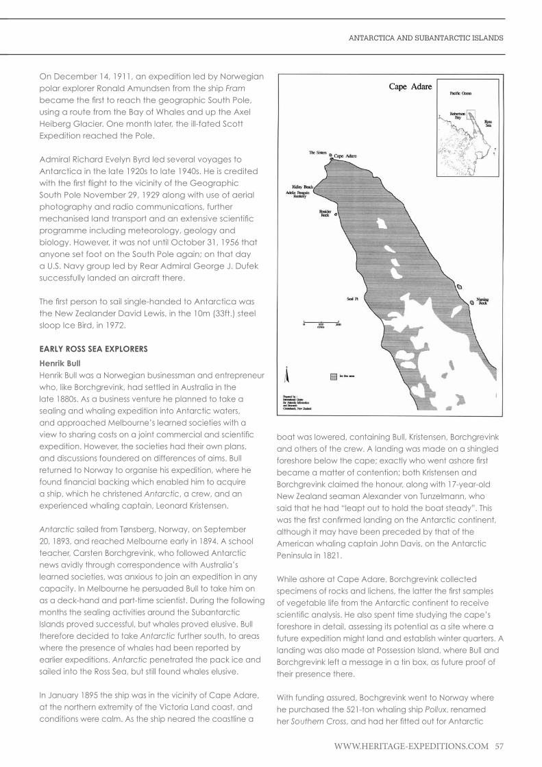
ANTARCTICA AND SUBANTARCTIC ISLANDS
WWW.HERITAGE-EXPEDITIONS.COM 57
On December 14, 1911, an expedition led by Norwegian polar explorer Ronald Amundsen from the ship Fram becamethefirsttoreachthegeographicSouthPole,using a route from the Bay of Whales and up the Axel Heiberg Glacier. One month later, the ill-fated Scott Expedition reached the Pole.
Admiral Richard Evelyn Byrd led several voyages to Antarctica in the late 1920s to late 1940s. He is credited withthefirstflighttothevicinityoftheGeographicSouth Pole November 29, 1929 along with use of aerial photography and radio communications, further mechanisedlandtransportandanextensivescientificprogramme including meteorology, geology and biology. However, it was not until October 31, 1956 that anyone set foot on the South Pole again; on that day a U.S. Navy group led by Rear Admiral George J. Dufek successfully landed an aircraft there.
Thefirstpersontosailsingle-handedtoAntarcticawasthe New Zealander David Lewis, in the 10m (33ft.) steel sloop Ice Bird, in 1972.
EARLY ROSS SEA EXPLORERS
Henrik BullHenrik Bull was a Norwegian businessman and entrepreneur who, like Borchgrevink, had settled in Australia in the late 1880s. As a business venture he planned to take a sealing and whaling expedition into Antarctic waters, and approached Melbourne’s learned societies with a viewtosharingcostsonajointcommercialandscientificexpedition. However, the societies had their own plans, and discussions foundered on differences of aims. Bull returned to Norway to organise his expedition, where he foundfinancialbackingwhichenabledhimtoacquirea ship, which he christened Antarctic, a crew, and an experienced whaling captain, Leonard Kristensen.
Antarctic sailed from Tønsberg, Norway, on September 20, 1893, and reached Melbourne early in 1894. A school teacher, Carsten Borchgrevink, who followed Antarctic news avidly through correspondence with Australia’s learned societies, was anxious to join an expedition in any capacity. In Melbourne he persuaded Bull to take him on as a deck-hand and part-time scientist. During the following months the sealing activities around the Subantarctic Islands proved successful, but whales proved elusive. Bull therefore decided to take Antarctic further south, to areas where the presence of whales had been reported by earlier expeditions. Antarctic penetrated the pack ice and sailed into the Ross Sea, but still found whales elusive.
In January 1895 the ship was in the vicinity of Cape Adare, at the northern extremity of the Victoria Land coast, and conditions were calm. As the ship neared the coastline a
boat was lowered, containing Bull, Kristensen, Borchgrevink and others of the crew. A landing was made on a shingled foreshorebelowthecape;exactlywhowentashorefirstbecame a matter of contention; both Kristensen and Borchgrevink claimed the honour, along with 17-year-old New Zealand seaman Alexander von Tunzelmann, who said that he had “leapt out to hold the boat steady”. This wasthefirstconfirmedlandingontheAntarcticcontinent,although it may have been preceded by that of the American whaling captain John Davis, on the Antarctic Peninsula in 1821.
While ashore at Cape Adare, Borchgrevink collected specimensofrocksandlichens,thelatterthefirstsamplesof vegetable life from the Antarctic continent to receive scientificanalysis.Healsospenttimestudyingthecape’sforeshore in detail, assessing its potential as a site where a future expedition might land and establish winter quarters. A landing was also made at Possession Island, where Bull and Borchgrevink left a message in a tin box, as future proof of their presence there.
With funding assured, Bochgrevink went to Norway where he purchased the 521-ton whaling ship Pollux, renamed her Southern Cross,andhadherfittedoutforAntarctic

58 WWW.HERITAGE-EXPEDITIONS.COM
HANDBOOK
service. He paid particular attention to the installation of what in his expedition account he described as “our splendidengines”,whichwerefittedinNorwaybecause“a big strike of mechanics made it impossible to get the workfinisheduptothetimeinBritain”.Hedescribesvariouscomponent parts, all executed to the standards of the Norwegian Veritas, Norway’s premier shipping organisation. Afterthecrewandscientificstaffhadbeenassembled,Southern Cross sailed from London in August 1898 and, following a stopover in Australia, arrived at Cape Adare on February 17 1899. Here, on the site which Borchgrevink haddescribedtotheCongress,thefirstshorebaseontheAntarctic continent was set up and named ‘Camp Ridley in honour of Borchgrevink’s mother. On March 2 the ship departed, leaving a shore party of ten, assorted provisions and equipment, and 70 dogs, to spend the winter in their isolated quarters.
Louis Bernacchi, the party’s Australian physicist, was later to write “in many respects, Borchgrevink was not a good leader”. He was no autocrat, but as polar historian Ranulph Fiennes recorded, in the absence of a framework of hierarchy a state of ‘democratic anarchy’ prevailed, with ‘dirt, discord and inactivity’ the order of the day. As time progressed, tempers wore thin; there was nervous irritation and boredom. There were accidents: a candle left burning causedextensivefiredamage,andonanotheroccasionseveral members of the party were almost asphyxiated by fumes from the stove. Borchgrevink did attempt to establish somesortofroutine,andscientificworkwascarriedonthroughout, but as he wrote himself, in reference to the general lack of fellowship: “The silence roars in one’s ears”. Moreover, Borchgrevink was not a trained scientist, and his inability to handle apparatus or make observations wasaconcerntohisscientificstaff.Tofurtherdampenmorale, the group’s zoologist, Nikolai Hansen, fell ill, failed to respond to treatment, and died on October 14. When winterfinallyendedandsledgingactivitybecamepossible,Borchgrevink’s assumptions about the ease of passage into the South Victoria Land interior proved false; the glaciated mountain ranges around Cape Adare precluded any inlandexploration,confiningthepartytoarestrictedareaaround the cape and Robertson Bay.
With the return of the Southern Cross at the end of January 1900, Borchgrevink was anxious to get away from Cape Adare, so the camp was abandoned. According to Borchgrevink,sufficientfuelandprovisionswasleftthatcould have lasted another year. Southern Cross sailed southward,followingtheVictoriaLandcoastlineandfinallyreaching the Great Ice Barrier discovered by Sir James Clark Ross during his 1839 to 1843 voyages. Borchgrevink noted that the Barrier had receded southwards by some 48km (30mi.) from the location reported by Ross. An inlet in the Barrier edge was discovered, which in later years was to
become known as the Bay of Whales. Here, on February 16, 1900 Borchgrevink, the Englishman William Colbeck and the Samidog-handlerPerSavioascendedtheBarrier(thefirstsuch ascent) with dogs and sledges, and travelled 16km (10mi.) south, to create a new Farthest South record at 78°50’S. Southern Cross visited other Ross Sea islands before turning northwards, reaching New Zealand on April 1, and arriving back in England on 6 June 1900.
Carsten Egeberg BorchgrevinkCarsten Egeberg Borchgrevink (December 1, 1864 to April 21, 1934) was an Anglo-Norwegian polar explorer who in 1898 to 1900 led the Southern Cross Expedition to the Antarctic, at the beginning of the Heroic Age of Antarctic Exploration. Borchgrevink was thus the precursor of Robert Falcon Scott, Ernest Shackleton, Roald Amundsen and all the other great names associated with this Age. He had been introduced to the world of exploration when he joinedawhalingexpeditionin1894,duringwhichhebrieflysetfootontheAntarcticcontinent,claimingtobethefirstto do so.
Hisownexpedition,whichwasBritish-financedandsailedundertheBritishflag,wasthefirsttoover-winterontheAntarctic Continent. Borchgrevink took his ship Southern Cross as far south as the Great Ice Barrier, unvisited since the expedition of Sir James Ross nearly sixty years previously. Here he discovered the inlet which later became known as the Bay of Whales, where he ascended the Barrier and, with two companions, sledged about 16km or 10mi. south to set a new Farthest South record at 78°50’S. On its return to England, the expedition was received with only moderate interest, despite its achievements. Reports suggested chaotic organisation and lack of leadership. What’s more, the English edition of Borchgrevink’s expedition account, published in 1901, was perceived as boastful, journalistic and unreliable.
After his experiences with the Southern Cross, Borchgrevink abandoned polar exploration. His only subsequent expedition was to the West Indies, in 1902, to study the effects of volcanic activity. Thereafter he settled in Oslo with his British wife and four children, leading a life outside the limelight. During these years his polar work was recognised and honoured in America, Denmark and Austria, and in 1912 he received a handsome tribute to his pioneering activities from Roald Amundsen, conqueror of the South Pole. However, it was not until 1930 that Britain’s Royal Geographical Society paid him due recognition through the award of its Patron’s Medal, admitting that justice had not been done at the time to the work of the Southern Cross expedition. The year previously, the Norwegian Parliament had awarded him an annual pension.

ANTARCTICA AND SUBANTARCTIC ISLANDS
WWW.HERITAGE-EXPEDITIONS.COM 59
Roald AmuldsenRoaldAmundsenwasthefirstmantoleadasuccessfulexpedition to the South Pole, famously arriving about a month before Scott and his party, who set out at around the same time. Amundsen’s party was well organised and well prepared. Their primary goal was to reach the pole, rather thanScott’stwinambitionsofexplorationandscientificdiscovery.
Roald Amundsen originally began a career studying medicine at the University of Christiana (now the University ofOslo),butdroppedoutinordertogotosea.HisfirstAntarctic trip was in 1899 on the Belgica expedition when he wasoneofthefirstpartiesevertooverwinterinAntarctica:the ship became trapped in the pack ice and drifted until it broke out the following spring. He established his credentials on this trip as a leader, ice master and as a resourceful expeditionary.
AmundsenledhisfirstpolarexpeditionintheArcticfrom1903 to 1906 in the Gjoa, successfully traversing the ‘North West Passage’, a extraordinary achievement in a tiny ship that came after a century of attempts and the loss of literally hundreds of lives.
The next major expedition was to drift over the North Pole with the pack ice in the ship Fram built for the fellow Norwegian explorer Nansen (regarded as being the father of polar travel, both North and South). The Fram was an unusual ship, unlike many polar exploratory ships that started life as merchantmen, coal ships, or the like, the Fram was designed and built for polar travel. It was a round-bottomed ship that was about a third as wide as it was long. The idea behind this shape is that it would be immune to the perils of being stuck in pack ice. Other ships stuck in pack would succumb to the immense pressures on them and becrushed,leavingtheoccupantsstrandedonfloatingseasonal ice with no ship. The Fram was different in that she would respond to the sideways pressure by being pushed upwards, rising out of the pack to sit above the ice in the way that many small and relatively weak boats had regularly been seen to do when frozen in forming sea ice in the Norwegian Fjords in winter time. The Fram performed perfectly in this manner.
Before the expedition set off to drift over the North Pole, news reached Amundsen of Peary’s attainment of their goal. Plans were hastily changed and Amundsen set out to leadthepartythatwouldfirstreachtheSouthPoleinstead.Amundsen left Christiana, Norway in August 1910 with provisions for two years and nearly a 100 Greenland sled dogs. These last were to be the key in his team’s subsequent success in reaching the South Pole ahead of Scott and his man-haul party.
Such was the secrecy of Amundsen’s plans that it was not until a month after leaving Norway, when their ship had reached Madeira that Amundsen told his crew of the revised goal of Antarctica and the South Pole. Until this point, they were all of the impression that they were to head north for the Arctic.
The Fram and Amundsen’s party reached Antarctica and land fall at the Bay of Whales on January 14, 1911 where a winter base was established. Depots were established between then and April when the sun set for the long Antarctic winter night – depots of stores that would be used in the push to reach the South Pole the following spring.
The winter passed in orderly industriousness while the party prepared equipment and stores for the polar journey, as well as settling into winter routines to maintain morale and make sure that the men were kept occupied. Amundsen had enduredadifficultenforcedwinterontheBelgica over 10 years before and understood the importance of preparation for winter and of maintaining spirits, particularly during the dark days of winter.
By late winter/early spring the sun had reappeared, sledges were ready for the push to the pole and dogs and men were prepared. The weather, however, was a constant source of frustration. Everything was in place and ready, but the weather could turn at the last moment, meaning a cancelled trip. When Amundsen and his team eventually set off, there were eight men with sledges pulled by 86 dogs. Thefirstattemptwashaltedbyweatherthatbecamemuchcolder than expected, forcing the team to return to the winter base.
Intheend,ateamoffivemensetoff,eachwithasledgepulled by 13 dogs. They made good progress, feeding the dogs on seal meat and blubber that had been brought with them. The men’s rations were meagre in quality, but sufficientinquantity.
Plansweremadeforthefinalpushtothepole.Dogswouldbe systematically shot and fed to the remainder. They struggled on against poor weather, blizzards and bad snow conditions which took their toll on both dogs and men.
At 3p.m. on Friday December 14, 1911, the party arrived at the South Pole. They had been concerned that Scott may have beaten them to the prize. They erected a small tent and placed inside it a letter and then set off back to their winterbase.Theyarrived39dayslaterwithallfivemenand11 dogs ‘hale and hearty’. The party that had reached theSouthPolefirstwas:RoaldAmundsen,OlavOlavsonBjaaland, Hilmer Hanssen, Sverre H. Hassel and Oscar Wisting.

60 WWW.HERITAGE-EXPEDITIONS.COM
HANDBOOK
Amundsen was much troubled in later years by accusations of ungentlemanly conduct and being unsporting in the manner in which he arrived in Antarctica to ‘race’ Scott to the pole without giving any prior notice of intention. These accusations were made all the more painful because he and his team survived, while Scott and his party all perished.
While Amundsen continued his explorations in the Arctic, hebecamemoreandmoreinterestedinflyingandairship travel. He disappeared without trace in 1928 while searching for the survivors of an airship crash in the Arctic.
Norwegian Antarctic (Fram) Expedition 1910-1912Led by Nansen’s famous ship Fram at the Bay of Whales it left an indentation (no longer there) on the Ross Ice Shelf. A hut named Framheim (also no longer there) was erected and Amundsen paid particular attention to early placement of supply depots. This paid off and with the advantage of nearly 100 dogs, he was successful in leading the man party whichreachedforthefirsttime,theGeographicSouthPoleon 14 December 1911. Scott’s party arrived one month later.
Robert Falcon ScottRobert Falcon Scott was born on June 6, 1868, the third childoffiveandeldersonofJohnEdwardandHannah(née Cuming) Scott of Stoke Damerel, near Devonport, Devon.Robertwaseducatedfirstinthenurseryathome,then for four years at a local day school before being sent to Stubbington House School, Hampshire – a cramming establishment that prepared candidates for the entrance examinations to the naval training ship HMS Britannia at Dartmouth. Having passed these exams, Scott, aged 13, began his naval career in 1881, as a cadet.
National Antarctic (Discovery) Expedition 1901-1904TheBritishNationalAntarcticExpedition,asitwasofficiallyknown until its association with the ship Discovery, was a joint enterprise of the Royal Geographical Society and the Royal Society. It represented a long-cherished dream of Admiral Sir Albert Hastings Markham, a member of the Ship Committee for the expedition, and it required the deployment of all of his considerable skills and cunning to bring it to fruition under naval command and largely staffed by naval personnel. The indefatigable cousin Clements (later Sir) Robert Markham, an explorer, geographer andnavalofficer,wasalsoaCommitteememberandrecommended Scott’s appointment as Commander of the expedition.
ScottmaynothavebeenMarkham’sfirstchoiceasleader but, having decided on him, his support remained constant. There were committee battles over the scope of Scott’s responsibilities, with the Royal Society pressing to put a scientist in charge of the expedition’s program while Scott merely commanded the ship. Eventually, however,
Markham’s view prevailed. Scott was promoted to the naval rank of Commander before Discovery sailed for the Antarctic on July 31, 1901.
Despite an almost total lack of Antarctic or Arctic experience within the 50-strong party, there was very little special training in equipment or techniques before the ship set sail. Dogs were taken, as were skis, but hardly anyone knew how to use them. Professionalism was considered less praiseworthy, in Markham’s view, than ‘unforced aptitude’, andScottmayhavebeeninfluencedbyMarkham’sbelief.InthefirstofthetwofullyearswhichDiscovery spent in the ice, this insouciance was severely tested, as the expedition struggled to meet the challenges of the unfamiliar terrain. The expedition was not a quest for the Pole, but a long march south was a major objective. This march, undertaken by Scott, Shackleton and Edward Wilson, was a physical ordeal which took them to a latitude of 82°17’S, approximately 800km (500mi.) from the Pole, followed by a harrowing journey home which brought about Shackleton’s physical collapse.
The second year showed improvements in technique and achievement, culminating in Scott’s western journey, which led to the discovery of the Polar Plateau, and which has been described by one writer as “one of the great polar journeys”.Thescientificresultsoftheexpeditionincludedimportantbiological,zoologicalandgeologicalfindings:• ThefirstoftheDryValleys• ThePolarPlateau• ThefirstEmperorpenguincolonySome of the meteorological and magnetic readings, however, were later criticised as amateurish and inaccurate.
At the end of the expedition it took the combined efforts of two relief ships and liberal use of explosives to free Discovery from the ice. The British Admiralty said the ship was to be abandoned if it was unable to be freed. In the end it was the weather (rather than use of explosives and ice saws) that enabled the ship to be released from its two-year icy mooring.Nevertheless,Scottcouldfeelsatisfiedthathewasreturning in good order, with much to show for his efforts. In contrast to his naivety at the expedition’s commencement, he was now a seasoned Antarctic traveller, although with many of his prejudices intact. He remained unconvinced thatdogsandskiswerethekeystoefficienticetravel,and continued to laud the British preference for man-hauling (the practice of propelling sledges by manpower, unassisted by animals), a view he maintained until very late in his Antarctic career. His insistence on Royal Navy formalities made for uneasy relations with the Merchant Navy members of the expedition, most of who departed withthefirstreliefshipinMarch1903.However,thequestionofScott’srelationshipwithErnestShackleton,ThirdOfficer

ANTARCTICA AND SUBANTARCTIC ISLANDS
WWW.HERITAGE-EXPEDITIONS.COM 61
on Discovery and later his polar rival, has been muddied by speculation. The claim that it was personal animosity on Scott’s part, rather than Shackleton’s physical breakdown, that resulted in the latter being sent home on the supply ship in January 1903 seems largely to have been concocted by Scott’s second-in-command, Albert Armitage. There would be tensions later between Scott and Shackleton, when their polar ambitions clashed, but mutual civilities were always preserved.
British Antarctic (Terra Nova) Expedition 1910-1913It was the expressed hope of the Royal Geographical Society that the Terra NovaExpeditionwouldbe“scientificprimarily, with exploration and the Pole as secondary objects” but, unlike the Discovery Expedition, neither they nor the Royal Society were in charge this time. In his expedition prospectus Scott stated plainly that its main objective was “to reach the South Pole, and to secure for the British Empire the honour of this achievement”. Later claims that the race to the pole was lost because Scottrefusedtocompromisethescientificprogramaresomewhat undermined by this unequivocal announcement; Scott had, as Markham observed, been “bitten by the Pole mania”.Scotttookscientificworkseriously,ashisDiscovery record shows, but despite having ‘the largest and most
efficientscientificstaffthateverleft.England’;Scotthadmade it clear that, on this second expedition, the priority lay withthePole,andwithgettingtherefirst.
Scott, now with the title of Captain did not of course know that he would be in a race for the Pole until he received Amundsen’s telegram in Melbourne, in October 1910. Before this he had set about fashioning the expedition according to his own preferences, without the restraints of a joint committee. In the decisions that he made with regard to the expedition’s methods of travel on the ice he showed that his prejudices against dogs had not faded. They were to be merely one element in a complicated transport strategy that also involved horses and motor sledges and much man-hauling. Scott knew nothing of horses, but felt that as they had seemingly served Shackleton well, he ought to use them. Dog expert Cecil Meares was going to Siberia to select the dogs, and Scott ordered that, while he was there, he should deal with the purchase of Manchurian ponies. Meares was not an experienced horse-dealer, and the ponies he chose proved mostly of poor quality and ill-suited to prolonged Antarctic work. Meanwhile Scott spent time in France and Norway, testing motor-sledges, and recruited Bernard Day, from Shackleton’s expedition, as his motor expert.
The expedition itself suffered a series of early misfortunes, whichhamperedthefirstseason’sworkandimpairedpreparations for the main polar march. On its journey from New Zealand to the Antarctic, Terra Nova was trapped in pack ice for 20 days, far longer than other ships had experienced, which meant a late-season arrival and less time for preparatory work before the Antarctic winter. One of the motor sledges was lost during its unloading from the ship, disappearing through the sea ice. Deteriorating weather conditions and weak, unacclimatised ponies affected the initial depot-laying journey to the extent that the main supply point, One Ton Depot, was laid 55km (35mi.) north of its planned location at 80°S. Six ponies died during this journey. The expedition also learned of the ominous presence of Amundsen, who was camped with a large contingent of dogs in the Bay of Whales.
Despite these trials, Scott refused to amend his schedule to deal with the Amundsen threat. While acknowledging that the Norwegian’s base was closer to the pole and that his experience as a sledge driver was formidable, Scott still had the advantage of travelling over a known route (that pioneered by Shackleton). During the 1911 winter his confidenceincreasedtotheextentofrecording,afterthereturn of the Cape Crozier party from their winter journey that “I feel sure we are as near perfection as experience can direct”.
With establishment of the main party at Cape Evans on Ross Island in 1911, the Terra Nova left six men led by Lieutenant Victor Campbell, at Cape Adare in North Victoria Land. Here

62 WWW.HERITAGE-EXPEDITIONS.COM
HANDBOOK
they erected a prefabricated hut in which they wintered over. The following summer the men were collected and taken further south to Terra Nova Bay. For the remainder of the summer geology and surveying was undertaken. However, when the ship because of heavy pack ice was unable to collect the party, the men were forced to excavate ice for a cave to provide emergency shelter and here spent nearly 200 days before they sledged down the coast and back to Cape Evans.
Journey to the PoleThe march south began on November 1, 1911, a complex caravan of mixed transport groups (motors, dogs, horses), with loaded sledges, travelling at different rates, all designedtosupportafinalgroupoffourmenwhowouldmake a dash for the Pole. Scott had earlier outlined his plans for the southern journey to the entire shore party, withoutbeingspecificastopreciseroles–nooneknew,forinstance,whowouldformthefinalpolarteam.Therewascontinuing uncertainty about how he proposed to use the dogs, a variety of different orders being issued which left it unclearwhethertheyweretobesavedforfuturescientificjourneys, or were to assist the polar party on their return journey. The consequence was that his subordinates back at base were confused and uncertain as to how they should
act, and failed to use the dogs in a concerted attempt to relieve the returning polar party when the need arose.
The southbound party continued, steadily reducing in size as support teams turned back. By January 4, 1912 the last two four-man groups had reached 87°34’S. Scott announced hisdecision:fivemen(himself,EdwardWilson,H.R.Bowers,Laurence Oates and Edgar Evans) would go forward, the other three (Teddy Evans, William Lashly and Tom Crean) would return. The chosen group marched on, reaching the PoleonJanuary17,1912,onlytofindthatAmundsenhadprecededthembyfiveweeks.Scott’sanguishispalpablefrom his diary: “The worst has happened”; “All the day dreams must go”; “Great God! This is an awful place”
Last MarchThedeflatedpartybeganthe1,300km(800mi.)returnjourney on January 19. “I’m afraid the return journey is going to be dreadfully tiring and monotonous”, wrote Scott on the next day. However, the party made good progress despite poor weather, and had completed the Polar Plateau stage of their journey, approximately 500km (300mi.) by February 7. During the following days the 160km (100mi.) descent of the Beardmore Glacier saw the increasing decline of Edgar Evans, whose condition Scott had noted with concern as early as January 23. A fall on 4 February had left. Evans ‘dull and incapable’, and on February 17, after a further fall, he died near the glacier foot. From then on, with 650km (400mi.) still to travel across the Ross Ice Shelf, the party’s prospects steadily worsened, as in deteriorating weather, handicapped by frostbite, snow-blindness, hunger and exhaustion, they struggled northward.
On March 16, Oates, whose condition was aggravated by an old war-wound to the extent that he was barely able to travel, voluntarily left the tent and walked to his death, in thefainthopethatthissacrificewouldsavetheothers.Scottwrote that Oates’ last words were, “I am just going outside and may be some time.” After walking a further 30km (20mi.),thethreeremainingmenmadetheirfinalcamponMarch 19, 17km or 11mi. short of One Ton Depot, but 38km (24mi.) beyond the original intended location of the depot. Thenextdayafierceblizzardpreventedthemfrommakingany progress.
During the next nine days, as their supplies ran out, with frozenfingers,littlelight,andstormsstillragingoutsidethetent,Scottwrotehisfinalwords,saveforafinalpoignantentry on March 29. He left letters to Wilson’s mother, Bowers’s mother, a string of notables including his former commander Sir George Egerton, his own mother and his wife. He also wrote his ‘Message To The Public’, primarily a defence of the expedition’s organisation and conduct in which the party’s failure is adduced to weather and other misfortunes, but ending on an inspirational note, with these words:

ANTARCTICA AND SUBANTARCTIC ISLANDS
WWW.HERITAGE-EXPEDITIONS.COM 63
We took risks, we knew we took them; things have come out against us, and therefore we have no cause for complaint, but bow to the will of Providence, determined still to do our best to the last [...] Had we lived, I should have had a tale to tell of the hardihood, endurance, and courage of my companions which would have stirred the heart of every Englishman. These rough notes and our dead bodies must tell the tale, but surely, surely, a great rich country like ours will see that those who are dependent on us are properly provided for.
Scott is presumed to have died on March 29, 1912, possibly a day later. The positions of the bodies in the tent, when it was discovered eight months later, suggested that Scott was the last of the three to die.
Nobu ShiraseBornin1861,NobuShirase’sfirstexposuretoexplorationcame on an expedition to the Kuril Islands, north of Japan, in 1893. He was an unknown lieutenant in the army when his struggles to organize a Japanese expedition to Antarctica began. Fighting both government and public ridicule, success only arrived when the support of Count Okuma, a nobleman and former Premier of Japan, was gained.
Japanese Antarctic Expedition 1910-12In 1910-11 Nobu Shirase with the ship Kainan-Maru, failed to penetrate the Ross Sea pack ice and returned to Sydney Australia for the winter. The following season Shirase returned when some sledging and meteorological observations were made on the Ross Ice Shelf and his men met Amundsen.
Lieutenant Aeneas MackintoshBorn on 1 July 1879 in Tirhut, India, Aeneas Lionel Acton Mackintosh joined the Merchant Navy in 1894. Serving in the skysail yard ships Cromdale and Mount Stewart he advancedtothirdofficer.In1899,hewasappointedjuniorofficerinRMS Victoria of the P & O Company, obtaining his firstofficer’sandmaster’scertificates.
Mackintosh was granted leave to join the British Antarctic Expedition, 1907-1909 (leader Ernest Henry Shackleton), asnavigatorandsecondofficerofNimrod on her initial voyage to Lyttelton, New Zealand, and later as a member of the shore staff. While unloading stores at McMurdo Sound, he lost his right eye in an accident and returned in Nimrod to New Zealand for medical treatment before rejoining the shore party in January 1908. In 1914 he joined theImperialTrans-AntarcticExpedition[asleaderRossSeaParty] 1914 - 1916 (leader Weddell Sea Party Ernest Henry Shackleton).
Imperial Trans-Antarctic Expedition 1914-1917The Ross Sea party led by Lieutenant Aeneas Mackintosh had the responsibility of laying depots over the Ross Ice Shelf to support the proposed crossing made from the Weddell Sea by Sir Ernest Shackleton. Unbeknown to Mackintosh’s party, Shackleton’s ship the Endurance was crushed by ice and sank in the Weddell Sea. The Ross Sea party also ended up in trouble when their support ship Aurora previously used by Mawson, was blown away from Cape Evans leaving ten men marooned. In the 1915-16 summer the depots were laid however this cost the lives of three men including Mackintosh. The seven survivors were rescued by Aurora with Shackleton on board in January 1917.
Sir Ernest ShackletonNimrod ExpeditionErnestShackletonledhisfirstexpeditiontoAntarcticaonthe Nimrod. One of the objectives of the Nimrod Expedition was to reach the South Pole. It was the second time that hetried,thefirstbeingwithRobertScottontheDiscovery Expedition in 1902. On that occasion he had come to within 770km (480mi.) of the Pole. This time the distance was reduced, but the Pole was still to elude Shackleton.
Originally a Yorkshire family, the Shackletons had moved to County Kildare in Ireland where Ernest was born on February 15, 1874. His father hoped for Ernest to enter the fieldofmedicine,thoughErnesthadotherideas;attheage

64 WWW.HERITAGE-EXPEDITIONS.COM
HANDBOOK
of16hejoinedhisfirstshipsailingoutofLiverpool.Hetooknaturally to a life at sea and progressed through the ranks. Bythetimehewas24hewasqualifiedtocommandaBritish ship anywhere she might be.
In the summer of 1900, Shackleton volunteered for the National Antarctic Expedition that Robert Falcon Scott was in the process of arranging. He was accepted as third lieutenant in charge of holds, stores, provisions and deep sea water analysis. He left on this expedition in 1901, the Discovery Expedition.
This was not a successful voyage for Shackleton, as he became ill with scurvy and though he wished to remain in the south, he had to be taken back home earlier than planned on the relief ship Morning. Shackleton was chosen to as leader of an expedition to leave for Antarctica in 1907 aboard the ship Nimrod–notthefirstchoiceofship,butaswith many Antarctic expeditions, one dictated by budget. The Nimrod sailed initially for New Zealand on August 7, 1907.
From New Zealand, the Nimrod was towed by another vessel, Koonya, in order to save coal that would be used at a great rate once the ship met pack ice. Douglas Mawson, an Australian geologist, had secured a place on the expedition and the subsequent journey to the South magnetic pole. On January 14 1908, the iceberg was sightedforthefirsttime,andshortlyafterwardsKoonya cast her line off and Nimrod sailed free and was then on her own.
By necessity rather than design, Nimrod entered McMurdo Sound, the original landing place – the Bay of Whales – being too congested with heavy pack ice and icebergs. She anchored to the sea ice edge some 25km (16mi.) from where the hut was to be erected at Cape Royds and preparations were made for unloading. But unloading was delayed to allow the ice to break up further back towards Hut Point. By February 3 the ice had indeed broken back to Cape Royds and so the Nimrod was fastened alongside the ice foot and unloading began. Shackleton had brought ponies for transport and a motor car especially adapted for Antarctic conditions. The ponies did not fare well on the journey and were in poor condition; one had been injured and had to be shot during the journey, and another was shot on arrival. Some of the ponies died at Cape Royds from eating volcanic gravel. In the end out of 15 ponies obtained for the expedition, only four were available for the southern journey. The temperature was now consistently cold and below -20°C (-4F). Nimrod left the landing party and headed back towards New Zealand on February 22.
Scientificreadingandobservationsbeganimmediately,particularly meteorological and biological of the seas
through cracks in the ice. A party of six succeeded in thefirstascentofthe4,023m(13,200ft.)nearbyvolcanoMount Erebus. The men on the base then embarked on the mundane chores of winter life, livening them with distractions wherever possible, but in the main life slowed andchoresfilledthetimeavailable,thecoldandwindmaking even simple activities much more involved and time consuming. There were also, of course, tensions to be expected of such disparate characters living closely together.
Come the spring, the plans for sledging parties conceived over the winter were put into action. Shackleton, Adams, Marshall and Wild would head south for the Pole.
Another party led by Edgeworth David (aged 50 at the time), with Mackay and Mawson, would set out to reach the southern magnetic pole, itself a 2,025km (1,260mi.) journey. This latter party had no experience of Antarctic exploration at all and did not have the help of dogs or ponies. They did, however, have the motor car taken on the expedition and used it to establish two depots, 10 and 15mi. from the winter base. Ironically the car overheated and the men had to wait in the cold for it to cool down again before it would run. They set out on September 25 1908 and were soon running out of food, having to ration themselves quite strictly by early November. They soon learnt the lessons of Antarctica from brushes with disaster as each of the men and the sledge fell or nearly fell into ever-present crevasses. Snow blindness, sunburn and frostbite made travellingallthemoredifficult,butbyJanuary151909theyreached the southern magnetic pole. Photographs were duly taken and the Union Flag hoisted.
On the return journey, they worked out that to reach the arranged depot and signal the Nimrod on time, they had to cover 17mi. (27km) per day from January 17 to February 5. They were within a mile of the depot on February 5 when the Nimrod was heard signalling with a gun. By that afternoon, they were aboard the ship and luxuriating in tea,foodandtheirfirstbathssinceSeptember.Davidfeltthat had they had dogs, they could have completed the 1,260mi. (2,025km) in half the time.
The polar party led by Shackleton left on October 29 1908, afineday.OnlythosewhohaveexperiencedAntarcticafirsthandcanappreciatethefeelingofexhilarationandexcitementthatsettingoutonajourneyonafinedayinthe Antarctic spring can give.
They had ponies on this journey, but they became weak and caused as many problems as they helped solve. Adams was kicked under the knee, exposing the bone onthefirstdayout.Rationswereveryshortandthemen soon became very hungry. The weakest pony was

ANTARCTICA AND SUBANTARCTIC ISLANDS
WWW.HERITAGE-EXPEDITIONS.COM 65
shot on November 21, some of the meat eaten and the rest cached. On November 26 they passed the furthest point south that Robert Scott reached in 1902 – a trip that Shackleton was also on. A further two ponies were shot soon afterwards, freeing up some of the food – the men began eating pony maize.
Christmas was celebrated with some carefully held-back treats: plum pudding, brandy, cigars and a spoonful of crème de menthe each. By December 27, the party was on the polar plateau at an altitude of 3,100m (10,200ft.) with the wind against them, suffering from a lack of food and with hands and feet almost on the point of frostbite. Shackleton was aware of the worsening situation, knowing that they only had a limited time in the light of their rations and physical state. They battled southwards into blizzards; sometimes the blizzards kept them in their sleeping bags all day. On January 9 they reached their furthest point south at 88°23’S,just156km(97mi.)fromthepole.Aflagwasplantedand photographs taken, then they turned around and began to head for home.
On the journey back, the wind that they had battled against was behind them, so they mounted a sail on the sledge and rushed across the ice, making up to 47km (29mi.) per day. They were able to obtain food from the depots they had cached on the outward journey, including the meat from the ponies, and so by contrast to earlier weeks were well fedandrelativelycontent.TheyreachedHutPointtofinda note saying that the Nimrod was sheltering nearby. They burned a magnetic hut by the Scott’s Discovery to provide a signal that summoned the Nimrod, and they were soon safe aboard. They had walked over 2,700km – more than 1,700mi..
Sir Douglas MawsonDouglas Mawson was an Australian by adoption who was offered a place on Scott’s Terra Nova Expedition. He turned down the offer in order to lead the Australasian Antarctic Expedition of 1911 to 1914, sailing on the Aurora.
Though less prestigious than the Terra Nova Expedition, the Australasian Antarctic Expedition was a wide-ranging scientificandexploratoryexpeditiontopreviouslyunknownand unvisited regions of the Antarctic Continent. It included a dramatic sledging journey that Mawson undertook with two companions – of which he was the only survivor – against the odds and in appalling conditions. This is one of the most heroic and epic tales of Antarctic exploration.
Douglas Mawson was born in Yorkshire and moved to Australia as a boy. He studied geology at Sydney University and was appointed as a lecturer at Adelaide University in 1905. He had been a part of Shackleton’s Nimrod Expedition of 1907 to 1909 and had successfully reached the magnetic southpolealongadifficultroute.
Mawson was planning to chart a 3,200km (2,000mi.) stretch of Antarctic coastline directly south of Australia. The expedition was supported by the Australian Association for theAdvancementofScience,whichcontributedsignificantfinancialbacking.Theothermembersoftheexpeditionwere largely from Australian and New Zealand universities. The ship used was the Aurora, originally built in Dundee and boughtfromNewfoundland;shewasrefittedinLondonbefore sailing to Hobart where the team members would board her.
The plans for the Australasian Antarctic Expedition were ambitiousandfar-rangingintermsofgatheringscientificdata, but did not involve any attempt to reach the South Pole. Oceanic surveying was planned; in particular a survey of Macquarie Island some 1,370km (850mi.) south-east of Hobart. The ship would then head for the Antarctic mainland where a hut would be built and equipped for a party to spend a year; another party would then be dropped off along the coast and picked up the following year.
The Aurora departed for Macquarie Island from Hobart on December 2, 1911. As was common at this time for crews of wooden sailing ships with auxiliary engine power, the rough seascausedanxieties.Thefirstnightthewindrosetoafullgale. Large quantities of deck cargo began moving around, and the crew had their work cut out to secure the lashings in the teeth of the storm. A plug in one of the fresh water tanks was washed away and seawater rushed in, causing the drinking water supply to be rationed.
Rough weather continued for the next few days and a huge wave carried away one side of the bridge, fortunately without any loss of life. Eventually the weather abated and on December 11 Macquarie Island was sighted. At the northern end of the island they came across the crew of a recently wrecked ship, Clyde, who were later returned to civilisation by the auxiliary vessel, Toroa. Establishing a base onMacquarieIslandwasthefirstobjectiveoftheexpedition.A base hut and wireless station were soon erected, with men left to man it, and the Aurora sailed again for the south on December 23.
On January 7, 1912, they reached a place that Mawson named Commonwealth Bay. The ship lowered a boat and rowed towards shore. This was an area full of wildlife, with Weddell Seals and Adelie Penguins, the latter in their thousands. This was the only point on the Antarctic Continent that anyone had stood on in a distance of about 3,200km (2,000mi.); it was named Cape Denison and became the centre of operations for the expedition. The Aurora was unloaded and work began on the building of huts. The Aurora had to leave as soon as she could to drop anotherfieldparty,theeight-man‘Westernparty’ledbyFrank Wild, some 2,500km (1,500mi.) further along the coast.

66 WWW.HERITAGE-EXPEDITIONS.COM
HANDBOOK
The winds grew in strength as the short Antarctic summer came to an end, and by February anything that was not tied down was blown away. When the men left the safety ofthehuts,wearingcrampons–metal‘claws’thatfittedonto the bottom of their boots – was vital. Without them, they would have been in real danger. Calm days or even calm periods were so rare that ordinary outdoor activities hadtobeconductedinfiercewinds.ThroughMarchandApril, the wind often gusted over 160km (100mph) and occasionally to over 320km (200mph). The wind was to dominate the mens’ lives in this place.
Mawson and two companions attempted to make an exploratory journey at the end of February, but they managed only nine kilometres (5½mi.) before they thought better of the weather conditions and turned back to base. One of the projects of the expedition was to build a radio mast, a job started on April 4 but not completed until September 1 due to the weather. On October 13 the whole system was blown down, but not before signals were successfully sent to the Aurora and to Macquarie Island.
The long dark winter days were passed in routine and preparation work for the sledging season to come. In August, a party of three led by Mawson struggled out and managed only nine kilometres (5½mi.) before digging an ice shelter for a supply depot, christened Aladdin’s Cave and later topped up with supplies. Other sledging parties set out when the weather was more in their favour, and one such managed only four kilometres (2½mi.) before returning, though one covered 80km (50mi.) before returning, frostbitten and exhausted.
ByNovembertheweatherhadimproved,andfiveseparate sledging parties were planned. Mawson led what was to be the ‘Far Eastern Trek’. He instructed each of the fivepartiesleavingthebasetobebackbyJanuary15inorder to meet the Aurora, which would be waiting for them.
Mawson set out on November 10 with two companions, Mertz and Ninnis, with a sledge pulled by a team of dogs. They made reasonable progress for the conditions, being at times held down for up to three days by blizzards. While crossinganicefieldonDecember14,Mertzwasinfronton skis, signalling that a snow-covered crevasse, one of many encountered, was to be crossed. Such crevasses are hazardous, as the snow bridges covering them can be strong or fragile; they are crossed at right angles so that as little time as possible is spent trusting to the unknown strength.Mertzcrossedfirst,thenMawson,whoalsomadeit safely, but then Mertz called out as the third man, Ninnis, his sledge and all of the dogs disappeared from sight. They had broken through the snow bridge and fallen into the crevasse below.
Mawson and Mertz rushed to the edge of the crevasse and stared down into a deep, gaping hole. About 150ft. below on a ridge was a dog, whining, its back seemingly broken. Beneath this was only the dark open void of the crevasse. Mertz and Mawson called into the depths for over three hours. They gathered all the rope they had but still could not even reach as far as the dog. As well as the loss of their companion Ninnis, they had also lost the sledge, the six fittestdogs,mostoftheindispensablesupplies,thetent,andmost of the food and spare clothing. The remaining sledge had only 10 days of rations for the two men and nothing for the six dogs; they were over 500km (315mi.) from the main base at Cape Denison.
They did however have a spare tent cover, but no inner tent or poles, and they had the cooker with some fuel. They had laid no depots on the outward journey, as they had expected to take an easier route back to Cape Denison. Some days earlier, they had discarded a sledge in order to travel lighter. They now made their way back to this and reassessed their equipment, disposing of everything non-essential.
They improvised a tent by draping the spare tent cover over skisandsledgestruts.Thedogswerefedworn-outfinneskoboots, mitts and rawhide straps. The day after Ninnis was lost, December 15, the weakest dog was killed to feed to the others and the men. This pattern was continued over thenext10daysuntilthefinaldogcollapsed.Stringyandtough though the meat was, every scrap was eaten, even including the paws, which were stewed to make them more edible. Ten days later, on Christmas Day, they were still 260km (160mi.) from the base. They travelled very slowly, managing to struggle on only a few miles per day. Their diet was one of dog meat; they were saving the meagre sledging rations as long as possible.
“For hours I lay in the bag, rolling over in my mind all that lay behind and the chance of the future. I seemed to stand alone on the wide shores of the world...My physical condition was such that I felt I might collapse at any moment...Several of my toes commenced to blacken and fester near the tips and the nails worked loose. There appeared to be little hope...It was easy to sleep on in the bag, and the weather was cruel outside”. Mawson
On January 7, Mertz passed away, Mawson wrote in his diary‘Deathduetoexposurefinallybringingonafever,result of weather exposure & want of food’.
Mawson continued to walk back to the base; on January 17 he fell down a crevasse and was only saved by his manhaul harness attached to the loaded sledge. He laboured upwards to free himself only to reach the lip and
ANTARCTICA AND SUBANTARCTIC ISLANDS
WWW.HERITAGE-EXPEDITIONS.COM 67
fall back in. Eventually he managed to struggle back to the surface and escape from the crevasse, but was completely exhausted by the procedure. He was now taking around two hours merely to set up camp at the end of the day.
On January 29, almost completely out of supplies, Mawson spotted a snow cairn built by a search party only a few hours previously. There was food at the cairn, and as he ate he read a note telling that the Aurora was waiting and Aladdin’s Cave was only 37km (23mi.) away. It still took him three more days – February 1 – to reach Aladdin’s Cave. The weather turned once again, and he remained there for a further week before he could set off for Cape Denison.
As Mawson reached Cape Denison, he saw a departing speck on the horizon – the Aurora leaving Antarctica for the season. Six men, however, had remained behind to continue the search for Mawson, Mertz and Ninnis. He was greeted as though saved from the dead, which was not far from the truth. They tried to recall the Aurora by radio, but ice conditions prevented her from returning, and the seven men at Cape Denison resigned themselves to another winterofblizzardsandconfinement.
They were well stocked with supplies, however, and even made a sledge journey the following spring. On December 12 the Aurora returned. By December 24, 1913, their two-year expedition was over and on February 5, 1914 the ship set sail for Australia.
It was later found that Mertz and Mawson had been suffering the effects of vitamin A poisoning after eating Husky dogs livers. The Australasian Antarctic Expedition istodayregardedasoneofthegreatestpolarscientificexpeditions of all times because of the detailed observations made in magnetism, geology, biology and meteorology.
Douglas Mawson was appointed Professor of Geology in 1920, retired in 1952 and died in 1958, the last leader of the heroic era of Antarctic exploration.
Richard ByrdIn1928,ByrdbeganhisfirstexpeditiontotheAntarctic.It involved two ships and three airplanes: a Ford Trimotor called Floyd Bennett (named after the recently deceased pilot of Byrd’s previous expeditions); a Fokker called The Stars and Stripes; and a Fairchild called Virginia (Byrd’s birth state). A base camp named ‘Little America’ wasconstructedontheRossIceShelfandscientificexpeditions by dog-sled, snowmobile, and airplane began. Photographic expeditions and geological surveys were undertaken for the duration of that summer, and constant radio communications were maintained with the outsideworld.Aftertheirfirstwinter,theirexpeditionswere
resumed,andonNovember29,1929,thefamousflighttothe South Pole and back was launched. Byrd, along with pilot Bernt Balchen, co-pilot/radioman Harold June, and photographerAshleyMcKinley,flewtheFordTrimotortothe South Pole and back in 18 hours, 41 minutes. They had difficultygainingenoughaltitude,andtheyhadtodumpempty gas tanks, as well as their emergency supplies, in order to achieve the altitude of the Polar Plateau. However, theflightwassuccessful,anditenteredByrdintothehistorybooks. After a further summer of exploration, the expedition returned to North America on June 18, 1930.
Byrd undertook four more expeditions to Antarctica: from 1933 to 1935, 1939 to 1940, 1946 to 1947 and 1955 to 1956. In betweenexpeditions,hewasaseniorofficerintheUnitedStates Navy, mostly serving as a consultant to the U.S.N. high commanders during World War II.
On his second expedition to Antarctica, in 1934, Byrd spent fivewintermonthsaloneoperatingameteorologicalstation, Advance Base, from which he narrowly escaped with his life after suffering carbon monoxide poisoning from a poorly-ventilated stove. Unusual radio transmissions from Byrdfinallybegantoalarmthemenatthebasecamp,who then attempted to go see what the trouble was. Thefirsttwotripswerefailuresduetodarkness,snowandmechanical troubles. Finally, Dr Thomas Poulter, E.J. Demas and Amory Waite arrived at Advance Base, where they found Byrd in poor physical health. The men remained there until October 12, when an airplane from the base camp came to pick up Dr Poulter and Byrd. The rest of the men returned to base camp with the tractor. This expedition is described by Byrd in his autobiography Alone. It is also commemorated in a U.S. postage stamp issued at the time, and a considerable amount of mail using it was sent from Byrd’s base at Little America, which was powered by a Jacobs Wind 2.5 kilowatt wind generator. A souvenir sheet was also issued later.
In late 1938, Byrd visited Hamburg and was invited to participate in the 1938/1939 German ‘Neuschwabenland’ Antarctic Expedition, but declined.
Byrd’sthirdexpeditionwasthefirstoneonwhichhehadtheofficialbackingoftheU.S.Government.Theprojectincluded extensive geology, biology and meteorology studies, as well as exploration. Within a few months, in March1940,ByrdwasrecalledtoactivedutyintheOfficeof the Chief of Naval Operations. The expedition continued in Antarctica without him. From 1942 to 1945 he headed importantmissionstothePacific,includingsurveysofremoteislandsforairfields.Ononeassignmenthevisitedthe front in Europe. He was repeatedly cited for meritorious service.
68 WWW.HERITAGE-EXPEDITIONS.COM
HANDBOOK
Thefourthandfinalexpedition,OperationHighjump,was the largest Antarctic expedition to date. Conspiracy theorists specialising in alleged Aryan or Nazi activities in Antarctica have extensively speculated about this mission. In 1946, U.S. Navy Secretary James Forrestal assembled a huge amphibious naval force for an Antarctic expedition expectedtolastsixtoeightmonths.BesidestheflagshipMount Olympus and the aircraft carrier Philippine Sea, there were thirteen U.S. Navy support ships, six helicopters, six flyingboats,twoseaplanetenders,submarineand15otheraircraft. The total number of personnel involved was over 4,000. The armada arrived in the Ross Sea on December 31 1946, and made aerial explorations of an area half the size of the United States, recording ten new mountain ranges. The major area covered was the eastern coastline of Antarctica, from 150 degrees east to the Greenwich Meridian. The expedition was terminated abruptly at the end of February 1947, six months early, with the entire remaining armada returning immediately to the United States. The early termination of the mission was never explained.
As part of the multinational collaboration for the International Geophysical Year (IGY) from 1957 to 1958, Byrd commanded the U.S. Navy Operation Deep Freeze I in 1955-56, which established permanent Antarctic bases at McMurdo Sound, the Kainan Bay, and the South Pole.
Sir Edmund HillaryIn January 1957 New Zealand’s Scott Base was built three kilometres (two miles) south of the United States base later named McMurdo Station, which was previously established to provide logistic support for science. Scott Base served as a station for the International Geophysical Year (IGY) 1957-58 and to support the depot laying for Sir Vivian Fuchs Commonwealth Trans-Antarctic Expedition 1955-58. Sir Edmund Hillary was Leader at Scott Base and Dr Trevor Hatherton the leader of the IGY party.
FLORA
The climate of Antarctica does not permit extensive vegetation. A combination of freezing temperatures, poor soil quality, lack of moisture and lack of sunlight inhibittheflourishingofplants.Asaresult,plantlifeislimited to mostly mosses and liverworts. The autotrophic communityismadeupofmostlyprotists.ThefloraoftheContinent largely consists of lichens, bryophytes, algae, and fungi. Growth generally occurs in the summer, and only for a few weeks at most.
There are more than 200 species of lichens and about 50 species of bryophytes, such as mosses. Seven hundred species of algae exist, most of which are phytoplankton. Multicoloured snow algae and diatoms are especially abundant in the coastal regions during the summer.
Only two native vascular plants, the Antarctic hair grass Deschampsia antarctica and a cushion-forming pearlwort, Colobanthus quitensis, survive south of 56°S. They occur in small clumps near the shore of the west coast of the Antarctic Peninsula. This is in marked contrast totheArcticregions,wherenearly100floweringplantsare found at 84°N. Both plants can tolerate very cold and dry conditions. They continue to function at freezing point, when the rate at which they convert sunlight into chemical energy drops to about 30 to 40 percent of that reached during the most favourable conditions.
LichensOf all the plants, lichens are best adapted to survive in the harsh polar climate. Some lichens have even been found only about 400km (250mi.) from the South Pole. Lichens have proliferated in Antarctica mainly because thereislittlecompetitionfrommossesorfloweringplantsand because of their high tolerance for drought and cold. The peculiarity of lichens is that they are not one homogeneous organism but a symbiosis of two different partners: a fungus and an alga. The fungus part ‘feeds’ the alga with water and nutritious salt and gives the lichen its shape and reproductive structure. With this ideal ‘job-sharing’, lichens can survive the harshest conditions. Far from the world of highly developed plants, lichens are the pioneers of vegetation.
Lichens aren’t only frugal and robust; they also endure because of their high tolerance of frost. In an experiment, Some lichens survived a bath of liquid nitrogen at -195°C (-320F).
Lichens employ the same strategy on icy rock as do plants in the sands of the Sahara: they form an ‘oasis’. Their only chance of survival is to settle in an area with a damp microclimate. What stops lichens from spreading over the whole of Antarctica is not so much the extreme cold as the lack of water. This is why they settle in recesses and cracks between rocks rather than out in the bright sunshine. Lichens like the scanty soils created by weathered rocks. They often quicken the conversion of rocktosoilwithasecretionofacid.Snowflakesfallingintocrevices melt on the dark lichens, which absorb the vital liquid.
Especially unfavourable conditions exist in the ‘dry valley’ of East Antarctica, where extreme cold and low snowfall meet. But even there, scientists have found a dark cover on the north side of some rocks, which proved to be lichens. Under the microscope it was shown that the lichens penetrate the outer layer of the rock. With their dark colour, the lichens absorb more light. This strategy enables them to scrape a humble living in a very high southern latitude.

ANTARCTICA AND SUBANTARCTIC ISLANDS
WWW.HERITAGE-EXPEDITIONS.COM 69
A lichen often seen is Usnea sphacelata, which looks like a small forest of bonsai. The largest even grow to a height of somecm. Their yearly growth phase is only about 120 day per year, so they only grow between 0.01 and 1mm (the merest fraction of an inch) per year. But they live very long: an age of 200 years is not unusual; the record is about 4,500 years.
MossesOnly a small number of moss species are found in Antarctica.Extensivefieldsoccurinafewplacesonthiscontinent, but these are rarely more than 100mm (4in.) deep, even in the most favorable areas where there is shelter and plenty of water. Short moss turf and cushion moss is found most frequently in sandy and gravelly soils. No extensive peat formations are to be found anywhere.
Mosses, like lichens, gather in colonies that allow them to collect and retain more water. They also lose less by evaporation and show a marked ability to use water rapidly whenever it becomes available. Mosses have also become well adapted to the almost continuous light during the long days of a polar summer. One Antarctic moss, Bryum argenteum, produces more energy by photosynthesis in low light at 5°C (41F) than it does at 15°C (59F), or higher. Photosynthesis can start within a few hours of thawing after a prolonged period of freezing, and almost immediately following shorter periods.
AlgaeMore than 300 species of non-marine algae have been found in Antarctica. These very simple plants take many diverse forms and a few have become adapted to livingindifficultpolarenvironments.Blue-greenandother algae are found growing in damp sand and gravel around lakes and tarns, along meltwater streams or in low-lying areas where snowdrifts or seepage may collect. Some, Prasiola crispa, can tolerate high levels of nutrients and are found near bird colonies. Others – the snow algae – may form extensive and spectacular red, yellow or green patches in areas of permanent snow. Recent studies have shown that some blue-green algae live inside rocks in dry valleys. They are commonly found under stones, particularly light-colored quartz stones, where the microclimate is more favourable than in the surrounding sand or soil. Together with lichens, they are the only living things in a barren landscape.
FungiFungi have been studied very little. Several mushrooms have been found on the west coast of the Antarctic Peninsula, and on the South Shetland Islands. A few of the fungi found in Antarctica are unique to the continent. The majority, however, are also found in most temperate areas.
FAUNA
Land fauna is nearly completely invertebrate. Invertebrate life includes microscopic mites, lice, nematodes, tardigrades, rotifers, krill and springtails. Atjust12mm(½in.)insize,theflightlessmidgeBelgica antarctica is the largest purely terrestrial animal in Antarctica.Duetotheextremecold,thebodyfluidsoftiny mites and midges in Antarctica contain glycerol, an antifreeze liquid that protects them from solidifying when temperatures plummet to as low as -34°C (-30F). There are only three birds that breed exclusively in Antarctica – one is the Snow Petrel, which has been seen at the South Pole.
Varieties of Antarctic marine animals exist and rely, directly or indirectly, on phytoplankton. Antarctic sea life includes penguins, Blue Whales, Orcas and fur seals. The Emperor Penguin is the only penguin that breeds during the winter in Antarctica, while the Adélie Penguin breeds farther south than any other. The Rockhopper Penguin has distinctive feathers around the eyes, giving the appearance of elaborate eyelashes. King, Chinstrap and Gentoo Penguins also breed in the Antarctic.
The Antarctic Fur Seal was very heavily hunted for its pelt in the 18th and 19th centuries by sealers from the United States and the United Kingdom. The Weddell Seal, a ‘true seal’, is named after Sir James Weddell, commander of British sealing expeditions in the Weddell Sea. Antarctic Krill, which congregates in large schools, is the keystone species of the ecosystem of the Southern Ocean, and is an important food for whales and sealsincludingLeopardSeals,furseals,squid,icefish,penguins, albatross and many other birds.
The passing of the Antarctic Conservation Act in the U.S. brought several restrictions to U.S. activity on the Continent. The introduction of alien plants or animals can bring a criminal penalty, as can the extraction ofanyindigenousspecies.Theoverfishingofkrill,which plays a pivotal role in the Antarctic ecosystem, ledofficialstoenactregulationsonfishing.TheConvention for the Conservation of Antarctic Marine Living Resources (CCAMLR), a treaty that came into force in 1980, requires that regulations managing all SouthernOceanfisheriesconsiderpotentialeffectson the entire Antarctic ecosystem. Despite these new acts,unregulatedandillegalfishing,particularlyofPatagonianToothfish(marketedasChileanSeaBassintheU.S.),remainsaseriousproblem.TheillegalfishingofToothfishhasbeenincreasing,withestimatesof32,000tonnes (35,300 short tons) in 2000.
There are about 85 different types of crustaceans that resemble small shrimp or lobster located in the ocean

70 WWW.HERITAGE-EXPEDITIONS.COM
HANDBOOK
under the name ‘krill’. Ranging in size from a centimetre (a third of an inch) in length to 14cm (5½in), krill feed on phytoplankton at night at the water’s surface. This small is the basis of the food chain for almost all of the animals of the Antarctic. Nutrient-rich detritus, also known as marine snow, falls through the ocean water and is a major source of food for animals in the ocean below. The detritus is made up of dead plants and animals as well as waste and crustacean shells, bound together with mucus produced by many animals in the ocean. Most detritus particles are between 1 and 2mm (a tiny fraction of an inch) in size, although some can be several metres large. Theclimateoftheplanetcanbeinfluencedbythecarbon sink provided by this detritus.
In the Antarctic, most detritus consists of algae products and is produced between November and February, due to the sunlight availability and nutrients provided by upwelling. During the algae bloom, the amount of detritus produced is at a peak and krill feeding on the algae produce waste that will be eaten by animals below. Over millions of years, this process has resulted in the transport of vast quantities of algal materials to the sediment layer in Antarctica. Sediments deposited over millions of years can be studied by geological oceanographers using sediment cores to understand how populations of organisms change over time. When the change is caused by factors like temperature, circulation patterns, or nutrient levels in the ocean environment, it is possible to collect clues from sediment cores. In addition to the study of the Earth’s history, scientists are also studying the greenhouse effect, which may eventually melt polar ice. Polar ice melt will cause major climatic changes and can cause problems in the polar ecosystem. Parts of the Western Antarctic ice sheets are being studied carefully as indicators for global warming effects. If one of these melts, there would be a dramatic increase in the worlds sea level.
Other animals living in Antarctica include penguins, seals, and whales. Penguins are found wild only in the Southern Hemisphere, and there are many species living in Antarctica. The most common seals found in this region are the Weddell (named after the explorer), the Ross, Crab Eater, Leopard, Southern Elephant, and the Antarctic Fur Seal. Southern baleen and toothed whales are also found here.
Several seabirds make the Antarctic their home, including 24 species of petrel, small seabirds that dart over the water and nest in rocks along the shore. Examples include the albatross (a gliding bird with long, narrow wings that may live up to 40 years), the Southern Giant Fulmar, Dove Prion, and Snow Petrel. Shore birds that feed in the shallow waters near the shoreline include
the Blue-eyed Cormorant, the Dominican Gull and the Brown Skua, which eats the eggs and young of other birds.TheArcticTernistheworld’sbestlong-distanceflyer,because it raises its young in the Arctic but spends the rest of the year in the Antarctic, a distance of over 16,090km (10,000 mi.).
Of all the animals, penguins are the primary inhabitants of Antarctica. Believed to have evolved 40 to 50 million years ago, they have oily feathers that provide a waterproof coat and a thick layer of fat for insulation. Penguins’ bones are solid, not hollow like those of most birds. While solidbonespreventpenguinsfromflying,theymakeit easier for penguins to dive into the water for food. Because predators cannot live in the brutally cold climate, penguinsdonotneedtofly;thus,theirwingshaveevolvedoverthecenturiestoresembleflippersorpaddles.
Seven of the 18 known species of penguins live on the Antarctic: the Adélie and Emperor (both considered true Antarctic penguins because they live on the continent), the Chinstrap, Gentoo, Macaroni, Rockhopper, and King Penguins. The Adélie is the most plentiful penguin and can be found over the widest area of the Continent. They spend their winters on the pack ice away from land, returning in October to nest in large rookeries or colonies along the rocky coasts. The Emperor Penguin is the largest species of penguin; it is the only Antarctic bird never to set foot on land, breeding on sea ice attached to the mainland.
Emperor Penguins are 1.2m (4ft.) tall and can weigh up to 45kg (100lb.). They are the hardiest of all the animals that inhabit the Antarctic, staying throughout the year while other birds head north to escape the brutal winter. They breed on the ice surface during the winter months because their immense size requires a longer incubation period. This schedule also ensures that chicks will hatch in July or early spring in the Antarctic, providing the most days for the chicks to put on weight before the next winter’s cold arrives. Because the Emperor Penguin is one of the few species that lives on Antarctica year-round, researchers believe it could serve as an indicator to measure the health of the Antarctic ecosystem.
ANTARCTIC TREATY
Antarctica has no government and belongs to no country. Various countries claim areas of it, but while some have mutually recognized each other’s claims, no other countries recognize such claims. The area between 90°W and 150°W is the only part of Antarctica not claimed by any country as of yet.
Since 1959, new claims on Antarctica have been suspended and the continent is considered politically

ANTARCTICA AND SUBANTARCTIC ISLANDS
WWW.HERITAGE-EXPEDITIONS.COM 71
neutral. Its status is regulated by the 1959 Antarctic Treaty and other related agreements, collectively called the Antarctic Treaty System. For the purposes of the Treaty System,Antarcticaisdefinedasalllandandiceshelvessouth of 60°S. The treaty was signed by twelve countries, including the Soviet Union (and later Russia), the United Kingdom, Argentina, Chile and the United States. It set Antarcticaasideasascientificpreserve,establishedfreedomofscientificinvestigation,environmentalprotection, and banned military activity on the Continent–thefirstarmscontrolagreementestablishedduring the Cold War.
The Treaty began with the Washington Conference on Antarctica, which met from October 15 to December 1 1959.NoinsurmountableconflictsorissuesdividedtheConference, and negotiations culminated in a treaty signed by all 12 nations on December 1 1959. Approved bytheU.S.Senate,U.S.ratificationwasdepositedAugust 18 1960, and the Treaty entered into force on June231961,whentheformalratificationsofalltheparticipating nations had been received. There are now 24 Contracting Parties entitled to participate in these meetings: the original 12 signatory states plus Brazil, China, Germany, Finland, India, Italy, Republic of Korea, Peru, Poland, Spain, Sweden, and Uruguay.
In 1983, the Antarctic Treaty Parties began negotiations on a convention to regulate mining in Antarctica. A coalition of international organizations launched a public pressure campaign to prevent any mineral development in the region, led largely by Greenpeace Internationalwhichestablisheditsownscientificstation – World Park Base – in the Ross Sea region and conducted annual expeditions to document the environmental impact of human activities on the Continent. In 1988, the Convention on the Regulation of Antarctic Mineral Resources (CRAMRA) was adopted. The following year, however, Australia and France announced that they would not ratify the Convention, rendering it dead for all intents and purposes. Instead, they proposed that a comprehensive regime to protect the Antarctic environment be negotiated in its place. As other countries jumped on board, the Protocol on Environmental Protection to the Antarctic Treaty (the ‘Madrid Protocol’) was negotiated and on January 14 1998 it entered into force. The Madrid Protocol bans all mining activities in Antarctica, designating the continent as a ‘natural reserve devoted to peace and science’.
The countries participating as members of the Antarctic Treaty have territorial interests in the Antarctic Continent, but the Treaty’s provisions do not allow them to make claims while it is in force. The Treaty prohibits any military activity in Antarctica, such as the establishment of
militarybasesandfortifications,thecarryingoutofmilitarymanoeuvres, or the testing of any type of weapon. Military personnel and equipment are permitted only for scientificresearchorotherpeacefulpurposes.Theonlydocumented military manoeuvre on land was Operation NINETY, undertaken by the Argentine military. The United States military issues the Antarctica Service Medal to military members or civilians who perform research duty in Antarctica. The medal includes a ‘wintered over’ bar issued to those who remain on the Continent for two complete six-month seasons.
The Treaty has 12 major articles. They are: 1. No military use shall be made of Antarctica, though
military personnel and equipment may be used for peaceful purposes
2. Therewillbecompletefreedomofscientificinvestigation.
3. Antarctic Treaty Nations will exchange plans for theirscientificprograms,scientificdatawillbefreelyavailable and scientists will be exchanged between expeditions where practical.
4. No activities under the Treaty will affect claims to sovereignty of any part of Antarctica made by any nation. All territorial claims are put aside for the duration of the Treaty.
5. Nuclear explosions and nuclear waste disposal are banned from Antarctica.
6. The Treaty applies to all land and ice shelves south of 60°S, but not to the seas.
7. All Antarctic stations and all ships and aircraft supplying Antarctica shall be open to inspectors from any Treaty Nation.
8. Observers and exchange scientists shall be under the jurisdiction of their own country regardless of which national station they may visit. National laws do not apply to stations or areas, but only to the citizens of those countries.
9. Treaty Nations will meet to consider ways of furthering the principles and objectives of the Treaty. Attendance at these meetings shall be limited to those countries thatareengagedinsubstantialscientificresearchactivity in Antarctica. Unanimous approval will be necessary for any new measures to become effective (i.e. everyone has to agree).
10. All Treaty Nations will try to ensure that no one carries out any activity in Antarctica that is against the Treaty.
11. Any dispute by Treaty Nations, if not settled by agreement, shall be determined by the International Court of Justice.
12.TheTreatymaybemodifiedatanytimebyunanimousagreement. After 30 years any consultative Party may call for a conference to review the operation of the Treaty.TheTreatymaybemodifiedatthisconferenceby a majority decision.

72 WWW.HERITAGE-EXPEDITIONS.COM
HANDBOOK
The Treaty, translated into English, French, Russian and Spanish, was signed on December 1, 1959 by 12 states and entered into force on June 23, 1961.
ResearchEach year in Antarctica, scientists from 27 different nations conduct experiments not reproducible in any other place in the world. In the summer more than 4,000 scientists congregate in research stations; this number decreases to nearly 1,000 in the winter. McMurdo Station, an American research facility, is capable of housing more than 1,200 scientists.
Researchers include biologists, geologists, oceanographers, physicists, astronomers, glaciologists and meteorologists. Geologists tend to study plate tectonics, meteorites from outer space, and resources from the breakup of the super-continent Gondwanaland. Glaciologists in Antarctica are concerned with the study of the history and dynamics offloatingice,seasonalsnow,glaciers,andicesheets.Biologists, in addition to examining the wildlife, are interested in how harsh temperatures and the presence of people affect adaptation and survival strategies in a wide variety of organisms. Medical physicians
have made discoveries concerning the spreading of viruses and the body’s response to extreme seasonal temperatures. Astrophysicists at Amundsen-Scott South Pole Station study the celestial dome and cosmic microwave background radiation. Many astronomical observations are better made from the interior of Antarctica than from most surface locations because of the high elevation. The elevation, coupled with low temperature, results in a thin atmosphere with a minimum of water vapor and absence of light pollution, thus allowing for a clearer view of space than anywhere else on Earth. Antarctic ice serves as both the shield and the detection medium for the largest neutrino telescope in the world at Amundsen-Scott station.
Since the 1970s, the ozone layer has been an important focus of study in the atmosphere above Antarctica. In 1985, three British Scientists working on data they had gathered at Halley Station on the Brunt Ice Shelf discovered the existence of a hole in this layer. In 1998, NASA satellite data showed that the Antarctic ozone hole was the largest on record, covering 27 million square kilometre (10 million square miles). It was eventually determined that the destruction of the ozone was causedbychlorofluorocarbonsemittedbyhumanproducts. With the ban of CFCs in the Montreal Protocol of 1989, it is believed that the ozone hole will close up overthenextfiftyyears.
CARBON CYCLE
The current unprecedented increase in atmospheric carbon dioxide is a result of the burning of fossil fuels since the advent of the industrial revolution round about 1700 AD. This extra release of carbon dioxide into the atmosphere that was previously locked away in a carbon sink is not a part of any natural cycle and is the reason for the current worries about climate change.
At various times in the history of the earth, different parts of the carbon cycle have had different levels of importance and the amount held in sinks and movement between them has varied enormously. For instance, in the carboniferous period extending from 360 million years ago to 299 million years ago, carbon dioxide was being captured by trees and tree-like plants and laid down in conditions without oxygen that would eventually become the coal deposits that the earth has today. In the very early atmosphere of the earth over 4 billion years ago there were very high levels of CO2 and temperatures that may have been as high as 70°C, as the earth cooled and theoceansformed,sothiscarbonwasfirstlydissolvedinthe oceans and then laid down as carbonate rocks.
In between the early atmosphere and the present day, atmosphericcarbondioxidehasfluctuatedconsiderably

ANTARCTICA AND SUBANTARCTIC ISLANDS
WWW.HERITAGE-EXPEDITIONS.COM 73
and so has the temperature of the earth. At times the equator has been almost uninhabitable for most plants and animals on land due to high temperatures, while the poles have been very productive. At other times, the equator has been tropical and lush as it is now, while the poles are ice-bound and barren. It is not just carbon dioxide that has had this effect on the climate, though it hasasignificantparttoplay.Sunspotsandthepositionof the earth in space relative to the sun (the Milankovitch cycles) follow cycles and affect the amount of solar radiation reaching the earth and so the temperature and climate. Other factors such as volcanic activity andthereflectivityofthesurfaceduetosnow/icecover have their effects too. So understanding why the temperaturefluctuatedatanyparticulartimeinthepastis not straightforward.
Antarctica’s role in the Carbon CycleAntarctica is involved in the carbon cycle in the ways that other ecosystems in the world are, notably in the absorption of carbon dioxide by plants (in Antarctica, these are overwhelmingly phytoplankton in the oceans), the production of carbon dioxide by the respiration of plants and animals, and also the decay of dead plants and animals. This great body of water has a major role to play in sequestering anthropogenic carbon dioxide. To start with, gases dissolve more readily in cold water than they do in warm water, so cold Antarctic waters can hold more of the dissolved gas. Also, oceanic water upwelling around the Antarctic continent brings with it large amounts of dissolved minerals which, along with long hours of daylight in the austral summer, leads to the huge blooms of phytoplankton that drive the very rich marine ecosystem. There is also a huge amount of water around Antarctica that cools and sinks, some of it the same water that upwelled when it had less carbon dioxide dissolved in it. Upon exposure to higher levels of atmospheric carbon dioxide, this water takes in more than it previously held and carries it to the ocean depths, thus removing anthropogenic carbon dioxide from the atmosphere as it form ‘Antarctic Bottom Water’.
The archetypal Antarctic animal (at least to biologists) is krill Euphausia superba; this is the source of food for all sorts of animals such as whales, seals, penguins and a wholehostofbirds.Krillfeedonphytoplanktonbyfilter-feeding at the surface where the phytoplankton is found, which puts them at danger from predation. It has long been known that krill migrate to the surface and then to deeper levels in the ocean when not feeding to put themselves out of the line of danger unnecessarily.
Recent research has shown that rather than making the surface/deep cycle once every 24 hours as had been previously thought, the krill are doing so up to three
times a day. They swim to the surface (krill naturally sink unless swimming) to feed and then when they are full, allow themselves to slowly sink out of the danger zone (they actually ‘parachute’ down by spreading out their swimming and feeding appendages).
Thisissignificant,aswhenthekrillsinktheypassbelowthelevel of the mixed surface layer of the sea to the region where little or no mixing takes place with surface layers. As they pass to this layer, they release faeces which rather than becoming recycled by decomposers and being part of the surface carbon cycle, become sequestered in the ocean depths and so are less likely to quickly be released back into the atmosphere.
It is estimated that 23 million tonnes of carbon are locked away below the mixed layer by krill in this way every year. This is an extra 8 percent of sequestration on a global scale of all sources, or the annual equivalent carbon output of about 35 million cars.
Global WarmingMost of the Antarctic Continent’s icy mass has so far proven largely impervious to climate change, being situated on solid rock; its deep interior is actually growing in volume. The Antarctic contribution to sea-level rise has long been a matter of debate. A recent report by the U.K. based Centre for Polar Observation and Modelling suggests that Antarctica has provided, at most, a negligible component of observed sea-level rise – indeed, a survey of 72 percent of the Antarctic ice suggests an attributable short-term lowering of global sea levels by 0.08mm (the merest fraction of an inch) per year.
However, Antarctica’s periphery has been warming up, particularly on the Antarctic Peninsula and in Pine Island Bay, which together are contributing to a rise in sea levels. In 2003 the Larsen-B ice shelf collapsed. This was initially thought to be purely the result of global warming, but is now believed to be the result of complex natural processes in addition to global warming. Between February 8 and March 28, 2008, about 570sq.km (220sq.mi.) of ice from the Wilkins Ice Shelf in Western Antarctica collapsed, putting the remaining 15,000sq.km (5,800sq.mi.) of the ice shelf at risk. The ice is being held back by a ‘thread’ of ice about 6km (3.7mi.) wide. According to NASA,themostsignificantAntarcticmeltinginthepast30years occurred in 2005, when a mass of ice comparable in sizetoCaliforniabrieflymeltedandrefroze;thismayhaveresulted from temperatures rising to as high as 5°C (41F).
In contrast to the break up of some ice shelves, the amount of sea ice (ice formed by freezing ocean water) around Antarctica has remained stable, or even increased some, over the past 30 years. The average

74 WWW.HERITAGE-EXPEDITIONS.COM
HANDBOOK
extent of Antarctic sea ice in one month can differ by as much as 1 million square kilometre (385sq.mi.) from the long-term average for that month. The area covered by Antarctic sea ice has shown a small increasing trend (0.8 percent per decade). The sea ice concentration of Antarctica in June 2008 is virtually the same as that in June 1979.
Antarctic Ozone DepletionOzone is a gas made of oxygen atoms. Usually oxygen atoms hang around in pairs – this is the sort of oxygen that we breathe and that helps things to burn. However, oxygen will sometimes form a molecule with three atoms; this is what we call ozone: O2 – two oxygen atoms – ordinary oxygenO3 – three oxygen atoms – ozone
Ozone has the particularly useful characteristic of being able to absorb large quantities of ultraviolet (UV) light, thus protecting us from the most harmful of the sun’s radiation. There is a large ozone hole over Antarctica which was detected by scientists in 1973 and continues to grow to this day. This hole is attributed to the emission ofchlorofluorocarbons,orCFCs,intotheatmosphere,which decomposes the ozone into other gasses. The ozone hole is caused by the effect of pollutants in the atmosphere destroying stratospheric ozone.
During the Antarctic winter, something special happens to the Antarctic weather that aids in creating the ozone hole. Firstly, strong winds blowing around the Continent form. These are known as the ‘polar vortex’ and they isolate the air over Antarctica from the rest of the world. Secondly, special clouds form called Polar Stratospheric Clouds. Clouds don’t normally form in the stratosphere, and these turn out to have the effect of concentrating the pollutants that break down the ozone, thereby speeding the process up. By the time spring arrives and the sun comes back after the long polar night, the ozone levels are severely depleted around the Antarctic continent, causing the ‘ozone hole’. Unfortunately, there follows a particularly long period of high sunshine and long days, which worsens the effect of the ozone hole.
Jonathan Shanklin, one of the original discoverers of the ozone hole, shares the following:
“The 2005 hole is larger and deeper than the holes that formed when the discovery was made, but the situation would be much worse if the Montreal Protocol had not come into force. This agreement shows us that global action by governments to stop the release of ozone depleting chemicals really can help society to successfully mitigate a global environmental problem. We are still experiencing large losses of Antarctic ozone each spring because CFCs and other chemicals live for
a long time in our atmosphere. However, the ban ensures that we will see an improvement in the future. We now need to take similar actions to control greenhouse gasses; otherwise we will bequeath future generations a significantly different climate from that of today.”
Mining in AntarcticaThere has never been any commercial mining in Antarctica, there are no current plans to mine in Antarctica, and mining is currently completely banned by the Antarctic Treaty. To date, there are no known future plans by any of the Antarctic Treaty nations to reverse this decision.
When the original Antarctic Treaty was signed in 1959, the exploitation of resources was not discussed at all for fear of jeopardising the Treaty. In the 1980s the issue was raised again, and led eventually to the Protocol on Environmental Protection to the Antarctic Treaty (an addition to the treaty).
The Madrid Protocol banning mining was signed in 1991 by the signatories to the Antarctic Treaty; this is up for review in 2041. The Madrid Protocol became law in January 1998. It sets out the principles under which environmental protection in Antarctica is to be regulated. This includes a ban on all commercial miningforatleastfiftyyears.Thoughitmightsoundlikean impressive piece of regulatory legislation, before it became law it was quite clear that there was no real commercial interest in mining or oil exploration in Antarctica for the foreseeable future.
Antarctica’s weather, ice and distance from any industrialized areas mean that mineral extraction would be extremely expensive and also extremely dangerous. The icebergs that drift around the continent frequently grindintotheoceanfloorlikebillion-(ortrillion-)tonneploughs. Pack ice can be blown miles in a day and transportation even in the relatively ice-free summer months is far from assured.
Impact of VisitorsSmall-scale ‘expedition tourism’ has existed since 1957 and is currently subject to Antarctic Treaty and Environmental Protocol provisions, but in effect self-regulated by the International Association of Antarctica Tour Operators (IAATO). Not all vessels associated with Antarctic tourism are members of IAATO, but IAATO members account for 95 percent of tourist activity. Travel is largely by small or medium-sized ship, focusingonspecificsceniclocationswithaccessibleconcentrations of iconic wildlife. A total of 37,506 tourists visited during the 2006-2007 Austral summer, with nearly all of them arriving on commercial ships. The number
ANTARCTICA AND SUBANTARCTIC ISLANDS
WWW.HERITAGE-EXPEDITIONS.COM 75
is predicted to increase to over 80,000 by 2010. There has been some recent concern over the potential adverse environmental and ecosystem effects caused bytheinfluxofvisitors.Acallforstricterregulationsforships and a tourism quota have been made by some environmentalists and scientists. The primary response by Antarctic Treaty Parties has been to develop, through their Committee for Environmental Protection and in partnership with IAATO, ‘site use guidelines’ setting landing limits and closed or restricted zones on the morefrequentlyvisitedsites.Antarcticsightseeingflights(which did not land) operated out of Australia and New Zealand until the fatal crash of Air New Zealand Flight 901 in 1979 on Mount Erebus, which killed all 257 aboard. Qantasresumedcommercialover-flightstoAntarcticafrom Australia in the mid-1990s.
Impact of Sealing and WhalingThe hunt for whales and seals was the reason for the initial exploration of Antarctica. Reports of abundant stocks drew the adventurous from the early 19th century onwards. Before long there were major crashes in the populations of some wildlife. The Antarctic Fur Seal, for example, was almost totally wiped out at many locations by 1830, leading to a decline in the sealing industry, although it continued on a smaller scale well into the 20th century.
SealsSome exploratory research into the viability of a recommencement of sealing was carried out in the 1960s, although it never did start again. The Convention for the Conservation of Antarctic Seals (CCAS) was initiated in response to this in order to avoid repeated over-exploitation and the disastrous effects on seal stocks. The CCAS established rules for commercial sealing with permissible catch limits for some species such as Crabeater, Leopard and Weddell Seals. A zoning system was also drawn up with closed hunting
seasons. Total protection was given for the very rare Ross Seal, and also for the Southern Elephant Seal and certain species of fur seal. No commercial sealing has been carried out in Antarctica since the 1950s. Seals were killed in order to provide food for dog teams that were stationed in Antarctica up to the point where the dogteamswerefinallyremovedduetoworriesthatthedisease of canine distemper might spread to seals.
WhalesThe story of Antarctic whaling is one of greed and excess.Oncethemostprofitablespeciesofwhalehad been hunted to a point of great scarcity, the next species was hunted until it too was very rare, then the nextandsoon.TheAntarcticwhalefisheryhasbeendescribed as being more like mining than a sustainable fishery.
The International Whaling Commission (IWC) was set up to attempt to regulate the industry to a position of sustainability (where catches are balanced by production), but has widely been thought to have failed. The only thing that eventually drove many companies outofthewhalingbusinesswasafallinprofitsduetoalack of whales when there weren’t many left to kill any more.
The IWC did, however, have some impact. In the 1960s Blue and Humpback Whales were fully protected, protection that was then extended to Fin and Sei Whales in the 1970s. In 1986 the IWC suspended all commercial whaling.
Commercial whaling has all but stopped worldwide, but some nations, particularly Japan, continue to take whalesundertheguiseofa‘scientifictake’-takingwhalesforscientificresearchreasons.Thesescientificallycaught whales end up in restaurants and one whale can have a $1,000,000 market value at the restaurant table.
If you have any comments, questions or suggestions regarding our supplementary notes for Heritage Expeditions itineraries, we would be glad to hear them. Please do get in touch.

Freephone: 0800 262 8873 (within NZ) 1800 143585 (within Australia) 1866 285 7884 (within USA/Canada)
Antarctic House , 53B Montreal Street, P.O. Box 7218, Christchurch 8240, New Zealand.
Tel +64 3 365 3500, Fax +64 3 365 1300. [email protected] www.heritage-expeditions.com
Back cover photos: Emperor Penguins by Heritage Expeditions; Pleurophyllum speciosum in flower by N Russ; Red-crowned Parakeet by A Russ;
Hooker Sea Lion by Heritage Expeditions; Royal Penguins by A Russ; Elephant Seal pup by A Russ.
EXPEDITION CRUISING IN ANTARCTICA AND SUBANTARCTIC ISLANDS