ground effects induced by the 2012 seismic sequence in emilia: implications for seismic hazard...
TRANSCRIPT

697
Ground effects induced by the 2012 seismic sequence in Emilia:implications for seismic hazard assessment in the Po Plain
Pio Di Manna1,*, Luca Guerrieri1, Luigi Piccardi2, Eutizio Vittori1, Doriano Castaldini3,Andrea Berlusconi4, Livio Bonadeo4, Valerio Comerci1, Francesca Ferrario4, Roberto Gambillara4,Franz Livio4, Mauro Lucarini1, Alessandro Maria Michetti4
1 ISPRA, Servizio Geologico d'Italia, Roma, Italy2 Istituto di Geoscienze e Georisorse, CNR, Firenze, Italy3 Università di Modena e Reggio Emilia, Dipartimento di Scienze Chimiche e Geologiche, Modena, Italy4 Università dell'Insubria, Dipartimento di Scienza e Alta Tecnologia, Como, Italy
ANNALS OF GEOPHYSICS, 55, 4, 2012; doi: 10.4401/ag-6143
1. IntroductionSince May 16, 2012, a seismic sequence has affected a
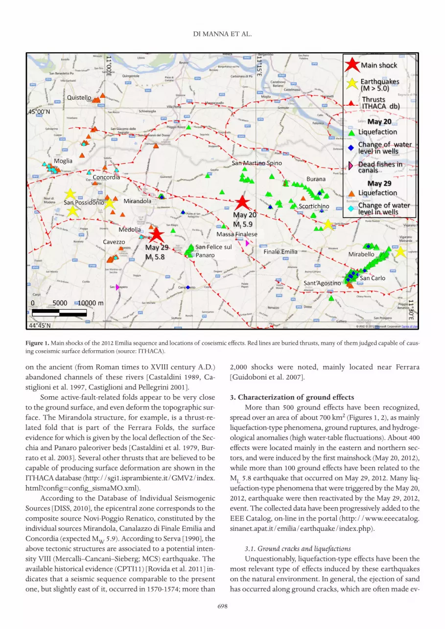
wide portion of the Emilia Region (northern Italy), chieflyfor the Modena and Ferrara Provinces. The first mainshock(ML 5.9; focal depth, ca. 6 km) occurred on May 20, 2012,with the epicenter located a few kilometers north of FinaleEmilia. A second main shock (ML 5.8; focal depth, ca. 10 km)occurred on May 29, 2012, about 12 km west of the firstearthquake, with the epicenter near Medolla (Figure 1). Theseismic sequence has been characterized by five other ML ≥5events, and more than 2,300 aftershocks of lower magnitude,until the end July 2012. The distribution of the aftershocksidentifies a WNW-ESE-trending zone ca. 40 km long that ischaracterized by NNE-SSW nearly pure compression, as in-dicated by the focal mechanisms [e.g., QRCMT 2012].
This report focuses on the many ground effects that wereinduced by this seismic sequence, as mainly cracks, liquefac-tion-type phenomena, and hydrological anomalies. The aimis to provide a complete representation of such effects, to:
– illustrate their type, size and areal distribution;– identify the zones in the affected area that were most
prone to the occurrence of ground effects (i.e., more sus-ceptible to local geological instability in the case of earth-quake occurrence);
– carry out an independent assessment of the intensi-ties of the earthquakes through the ESI 2007 intensity scale[Guerrieri and Vittori 2007], which is based only on coseismiceffects on the natural environment.
Indeed, the intensity assessment based only on the 'tra-ditional' scales is somewhat problematic for hazard estimates,due to the significant variability of damage to residential
buildings and to special and monumental constructions (e.g.,churches, towers, bell towers, old farms and barns, industrialsheds), which depends on the geological substratum, themorphological setting, and the construction type. Environ-mental effects might therefore provide essential informationfor the characterizing of this sequence, because they only de-pend on the local geological (s.l.) structure. Moreover, theyallow a comparison with historical accounts of earthquakeground effects in the Po Plain.
2. Geological framework The subsurface geology of the epicentral area is marked
by the presence of compressional structures of the Apenninesthat are covered by marine and continental clastic deposits ofthe Po Plain. Several Quaternary thrusts are indicated by adense network of seismic lines [e.g., Pieri and Groppi 1981,Cassano et al. 1986, Fantoni and Franciosi 2009]. Strati-graphic, morphological, geodetic and seismic evidence indi-cate a still-active convergence of northeast-verging Apenninesand south-verging southern Alps structures [e.g., Serva 1990,Castiglioni et al. 1997, Boccaletti et al. 2004, Toscani et al.2009, Boccaletti et al. 2011, Comerci et al. 2012, Michetti et al.2012, and references therein]. This evidence has been con-firmed by earthquake focal mechanisms [Frepoli and Amato1997] and other stress indicators [Montone et al. 2004].
The geomorphological framework is characterized bya complex drainage and paleo-drainage pattern of the localrivers (the Po, Secchia, Panaro and Reno rivers), which hasbeen strongly influenced by the active tectonics and climate,and by the human modifications introduced in the last cen-turies. Several localities in the epicentral region are located
Article historyReceived July 23, 2012; accepted August 28, 2012.Subject classification:ESI 2007scale, Coseismic effects, Macroseismic intensity, Seismic hazard, Liquefaction-type phenomena.
2012 EMILIA EARTHQUAKES
on the ancient (from Roman times to XVIII century A.D.)abandoned channels of these rivers [Castaldini 1989, Ca-stiglioni et al. 1997, Castiglioni and Pellegrini 2001].
Some active-fault-related folds appear to be very closeto the ground surface, and even deform the topographic sur-face. The Mirandola structure, for example, is a thrust-re-lated fold that is part of the Ferrara Folds, the surfaceevidence for which is given by the local deflection of the Sec-chia and Panaro paleoriver beds [Castaldini et al. 1979, Bur-rato et al. 2003]. Several other thrusts that are believed to becapable of producing surface deformation are shown in theITHACA database (http://sgi1.isprambiente.it/GMV2/index.html?config=config_sismaMO.xml).
According to the Database of Individual SeismogenicSources [DISS, 2010], the epicentral zone corresponds to thecomposite source Novi-Poggio Renatico, constituted by theindividual sources Mirandola, Canalazzo di Finale Emilia andConcordia (expected MW 5.9). According to Serva [1990], theabove tectonic structures are associated to a potential inten-sity VIII (Mercalli–Cancani–Sieberg; MCS) earthquake. Theavailable historical evidence (CPTI11) [Rovida et al. 2011] in-dicates that a seismic sequence comparable to the presentone, but slightly east of it, occurred in 1570-1574; more than
2,000 shocks were noted, mainly located near Ferrara[Guidoboni et al. 2007].
3. Characterization of ground effectsMore than 500 ground effects have been recognized,
spread over an area of about 700 km2 (Figures 1, 2), as mainlyliquefaction-type phenomena, ground ruptures, and hydroge-ological anomalies (high water-table fluctuations). About 400effects were located mainly in the eastern and northern sec-tors, and were induced by the first mainshock (May 20, 2012),while more than 100 ground effects have been related to theML 5.8 earthquake that occurred on May 29, 2012. Many liq-uefaction-type phenomena that were triggered by the May 20,2012, earthquake were then reactivated by the May 29, 2012,event. The collected data have been progressively added to theEEE Catalog, on-line in the portal (http://www.eeecatalog.sinanet.apat.it/emilia/earthquake/index.php).
3.1. Ground cracks and liquefactions Unquestionably, liquefaction-type effects have been the
most relevant type of effects induced by these earthquakeson the natural environment. In general, the ejection of sandhas occurred along ground cracks, which are often made ev-
DI MANNA ET AL.
698
Figure 1. Main shocks of the 2012 Emilia sequence and locations of coseismic effects. Red lines are buried thrusts, many of them judged capable of caus-ing coseismic surface deformation (source: ITHACA).
699
ident by alignments of emission points. The zone with the most evident and widespread effects
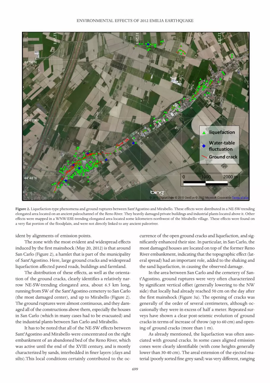
induced by the first mainshock (May 20, 2012) is that aroundSan Carlo (Figure 2), a hamlet that is part of the municipalityof Sant'Agostino. Here, large ground cracks and widespreadliquefaction affected paved roads, buildings and farmland.
The distribution of these effects, as well as the orienta-tion of the ground cracks, clearly identifies a relatively nar-row NE-SW-trending elongated area, about 6.5 km long,running from SW of the Sant'Agostino cemetery to San Carlo(the most damaged center), and up to Mirabello (Figure 2).The ground ruptures were almost continuous, and they dam-aged all of the constructions above them, especially the housesin San Carlo (which in many cases had to be evacuated) andthe industrial plants between San Carlo and Mirabello.
It has to be noted that all of the NE-SW effects betweenSant'Agostino and Mirabello were concentrated on the rightembankment of an abandoned bed of the Reno River, whichwas active until the end of the XVIII century, and is mostlycharacterized by sands, interbedded in finer layers (clays andsilts).This local conditions certainly contributed to the oc-
currence of the open ground cracks and liquefaction, and sig-nificantly enhanced their size. In particular, in San Carlo, themost damaged houses are located on top of the former RenoRiver embankment, indicating that the topographic effect (lat-eral spread) had an important role, added to the shaking andthe sand liquefaction, in causing the observed damage.
In the area between San Carlo and the cemetery of San-t'Agostino, ground ruptures were very often characterizedby significant vertical offset (generally lowering to the NWside) that locally had already reached 50 cm on the day afterthe first mainshock (Figure 3a). The opening of cracks wasgenerally of the order of several centimeters, although oc-casionally they were in excess of half a meter. Repeated sur-veys have shown a clear post-seismic evolution of groundcracks in terms of increase of throw (up to 60 cm) and open-ing of ground cracks (more than 1 m).
As already mentioned, the liquefaction was often asso-ciated with ground cracks. In some cases aligned emissioncones were clearly identifiable (with cone heights generallylower than 30-40 cm). The areal extension of the ejected ma-terial (poorly sorted fine grey sand) was very different, ranging
ENVIRONMENTAL EFFECTS OF 2012 EMILIA EARTHQUAKE
Figure 2. Liquefaction-type phenomena and ground ruptures between Sant'Agostino and Mirabello. These effects were distributed in a NE-SW-trendingelongated area located on an ancient paleochannel of the Reno River. They heavily damaged private buildings and industrial plants located above it. Othereffects were mapped in a WNW-ESE-trending elongated area located some kilometers northwest of the Mirabello village. These effects were found ona very flat portion of the floodplain, and were not directly linked to any ancient paleoriver.

from a few square meters up to many hundreds of square me-ters, depending on the amount of emitted water and the localslope angle. Commonly, the grain size of the sand gets finer,up to a clayey silt, moving upwards in the emission cones.
It is of note that at San Felice sul Panaro at the conflu-ence between the south-north-trending Panaro and the west-to-east trending Secchia paleorivers, the most common effectwas the ejection of copious sand from water wells. Such ef-fects were roughly aligned in the SW-NE direction, and wereparticularly frequent in the urban area. Most of these werereactivated by the May 29, 2012, main event.
Nevertheless, liquefaction and ground cracks were alsofound in other areas of the Po River flood plain that were notrelated to ancient streams. Among these, aligned WNW-ESEtrending ground cracks with associated widespread lique-faction were found northwest of Mirabello. Other similarfeatures were found near Scortichino (Obici locality), Buranaand San Martino Spino (Figure 3b, c).
Widespread liquefaction-type effects and ground crackswere produced also by the second mainshock (May 29, 2012).In particular, large ground ruptures with emission of sandwere documented mainly in the Cavezzo, San Possidonio,Moglia and Quistello territorial municipalities (Figure 3d, e).
Such phenomena were particularly frequent in Moglia,
where, according to eyewitnesses, the occurrence of sand emis-sion has to be related to the two strong aftershocks (M ca. 5.1)that occurred on May 29, 2012, at about 1 p.m. At Cavezzo, ina zone that is characterized by a paleochannel of the SecchiaRiver, ground cracks with associated liquefaction-type effectsthat were arranged in prevalently N50-60E, en-echelon, 20-30-m-long segments showed noticeable continuity with a generalNE-SW trend for about 1 km. Nevertheless, this alignment ismuch less evident than that between San Carlo and Mirabellothat was related to the May 20, 2012, mainshock.
In some localities (e.g., San Martino Spino, Uccivello[near Cavezzo], Sant'Agostino) the bed of artificial channelsshowed uplift, bulging and cracks, as an effect of sand injec-tion under the bottom of the channel. This type of phe-nomenon was observed also at San Carlo, where the floor ofthe church was strongly deformed. Moreover, at Moglia, abulge of up to 70 cm in height and 4 m in length was ob-served in a private garden.
Finally, an extensive network of fractures was mappedon the road that runs along the southern bank of the CanaleDiversivo, between San Possidonio and Mirandola. The frac-tures are the effects of the widespread landslides that in-volved the inner portion of the right bank of the canal for alength of about 1 km.
DI MANNA ET AL.
700
Figure 3. Ground ruptures and associated liquefaction-type phenomena at San Carlo (a), Scortichino (b), Burana (c), Cavezzo (d) and San Possidonio(e). Ejection of copious sand from a water well at San Carlo (f ).

701
3.2. Hydrological anomalies In the epicentral area, local people observed a relevant
increase in the most superficial water-table level of their waterwells (from 3-4 m, up to 8-9 m), generally immediately afterthe mainshock, but reportedly even hours before in someplaces. Very often, liquefied sand was ejected out of wells,and sometimes from the well itself, or often following pathson the outer face of the casing, most likely associated withliquefaction (Figure 3f ). In some cases, the outflow of water,associated or not with sand ejection, continued for hours afterthe earthquake. In some instances, notably warm water wasemitted from wells. Also, the smell of H2S was sometimesnoted, reportedly occurring also many days before the event.
For the May 29, 2012, mainshock, the emission of hotwater from ground cracks and water wells was recorded at SanPossidonio and Moglia. Furthermore, beginning a few days be-fore the onset of the seismic sequence, an anomalous activitywas noted in some mud volcanoes located at the margin of theModena and Reggio-Emilia Apennines, which are about 40 kmfrom the epicentral area. In particular, this phenomenon wasobserved at Regnano, Nirano, Ospitaletto and Puianello. Suchmud volcanoes, locally named 'salse', are built by the emissionof sodium-chloride water mixed with mud driven to surfaceby methane (and sometimes liquid hydrocarbons) alongground discontinuities [Capozzi et al. 1994, Martinelli 1999].
3.3. Other environmental effects According to eyewitness accounts, coseismic earthquake
lights were observed at San Felice sul Panaro, Cavezzo, Fi-nale Emilia, Quistello and Massa Finalese. In the last of theselocations, the time delay of this effect from the first earth-quake was 1 min to 2 min. This kind of phenomena wererecorded in the occasion of the seismic swarm of December23, 2008 (mainshock, ML 5.1) in the Parma Apennines [Straser2009]. Furthermore, the large amount of dead fish, due to as-phyxia (at least 30 quintals in total in the epicentral area), ap-pears to be related to some peculiar environmental effectfrom the subsoil, most likely as emissions of gases and/or hotwater; e.g., putrefaction gases might have been released fromnear-surface swamp beds very rich in organic matter.
3.4. ESI intensity assessmentAlthough our surveys are probably still incomplete, the
information that has been gained from them is certainly rep-resentative of the most significant ground effects, and there-fore adequate to define a preliminary macroseismic intensityfield (Figure 4) based on the ESI 2007 scale [Guerrieri andVittori 2007]. This is a recently developed seismic intensityscale that is entirely based on the characteristics and size ofearthquake-induced environmental effects, and it has beentested with several modern historical and paleoearthquakes
ENVIRONMENTAL EFFECTS OF 2012 EMILIA EARTHQUAKE
Figure 4. ESI local intensities (based on the characteristics of the surveyed ground effects) and inferred isoseismals.

[e.g., Reicherter et al. 2009, and references therein, Lalindeand Sanchez 2007, Lekkas 2010].
The total area where ground effects occurred is in theorder of 300 km2 to 400 km2 for each event. This indicatesthat the ESI epicentral intensity of the two mainshocks isVIII. Furthermore, ESI local intensity values in excess of VIII,possibly reaching the IX degree, were recorded in two local-ities (San Carlo and Mirabello), based on the size and lengthof the ground ruptures and the areal distribution of the liq-uefaction, which shows the specific vulnerability of the nat-ural environment at a local scale.
Comparing the ESI local intensity values with themacroseismic intensity evaluations (MCS) [Galli et al. 2012]based on the pattern of damage to buildings, it is evidentthat: (i) the epicentral intensity evaluations are comparable;and (ii) where available, environmental effects can be a bet-ter tool for local intensity assessment, as they are independ-ent of the type of construction, but are governed directly bythe true geological (s.l.) site conditions.
For these reasons, a macroseismic intensity field that in-tegrates ESI and MCS intensity evaluations represents a bet-ter tool to characterize this event in the framework ofseismic-hazard assessment of the Po Plain area. In this per-spective, the Emilia 2012 event should be regarded as a rela-tively minor event compared to the 'reference earthquake' ofthe Po Plain, which, as demonstrated by the 1117 Verona and1222 Brescia earthquakes [e.g., Serva 1990, Michetti et al.2012], should be expected to be characterized by an intensityI0 of IX to X degrees, in either the macroseismic scales orthose of the ESI 2007.
4. Final remarksThe most common type of ground effect that occurred
in the epicentral area of the Emilia 2012 seismic sequencewas the liquefaction-type phenomena, which were charac-terized by the ejection of sand from ground fractures andwells. These phenomena were not randomly distributed, butappear to be concentrated along alignments that can be fol-lowed even for kilometers. This is the case of the impressiveset of SW-NE fractures, which were widely connected to lat-eral spread between the cemetery of Sant'Agostino andMirabello. These caused extensive damage to houses, infra-structure and industrial plants. This alignment followed theright margin of an abandoned and suspended river bed, rel-ative to a former course of the Reno River between SanCarlo and Mirabello. Thus, all of the effects along this align-ment can be interpreted as secondary effects driven not onlyby the local stratigraphic characteristics of the subsoil (sandsinterbedded by clays and silts), but also by the local recentgeomorphological evolution, dominated by a complex net-work of paleo-drainage and abandoned streams. A less-evi-dent alignment is observable also in the distribution of theeffects induced by the May 29, 2012, event near Cavezzo,
which was related to an ancient bed of the Secchia River.Other alignments that were roughly oriented east-west
were identified in completely flat areas of the Po flood plain(e.g., west of Mirabello and west of Bondeno). These align-ments cannot be directly explained with the local influenceof paleo-drainage. Instead, their origin might be linked to thepresence of east-west-trending tectonic discontinuities thatcharacterize the very shallow subsoil of the area. The coseis-mic reactivation of these tectonic structures might have fa-cilitated the occurrence of sand ejection up to the surface.
The distribution of ground effects is suggestive of twoevents of intensity VIII on the ESI 2007 scale, even if themaximum intensity might have been even higher (IX?) inSan Carlo and Mirabello. Nevertheless, the estimated inten-sity of the Emilia 2012 earthquakes is slightly less than thatrecorded in the Po Plain area in historical times (I0 IX to X),and therefore should not be considered the 'reference earth-quake' for this area.
Acknowledgements. The Authors wish to thank the colleagues ofthe EMERGEO Working Group, CNR – IAMC, the Department of CivilProtection and the Geological, Seismic and Soil Survey of RegioneEmilia-Romagna for their collaboration in geological data exchange andfield discussions.
ReferencesBoccaletti, M., M. Bonini, G. Corti, P. Gasperini, L. Martelli,
L. Piccardi, P. Severi and G. Vannucci (2004). Carta si-smotettonica della Regione Emili-Romagna, Scala1:250000, S.EL.CA., Firenze.
Boccaletti, M., G. Corti and L. Martelli (2011). Recent andactive tectonics of the external zone of the northernApennines (Italy), Int. J. Earth Sci. 100, 1331-1348; doi:10.1007/s00531-010-0545-y.
Burrato, P., F. Ciucci and G. Valensise (2003). An inventory ofriver anomalies in the Po Plain, northern Italy: evidencefor active blind thrust faulting, Annals of Geophysics,46 (5), 865-882.
Capozzi, R., V. Menato and E. Rabbi (1994). Manifestazionisuperficiali di fluidi ed evoluzione tettonica recente delmargine Appenninico Emiliano-Romagnolo: indaginepreliminare, Atti Ticinensi di Scienze della Terra, seriespeciale, 1, 247-254.
Cassano, E., L. Anelli, R. Fichera and V. Cappelli (1986). Pia-nura Padana. Interpretazione integrata di dati geofisici egeologici, Proc. 73˚ Meeting Società Geologica Italiana(Rome, September 29 - October 4 1986), 27 pp.
Castaldini, D. (1989). Geomorfologia della bassa PianuraPadana modenese e dei territori limitrofi, In: Mirandola ele valli, immagini e documenti, Tipografia Golinelli, Mi-randola, 25-37.
Castaldini, D., G. Gasperi, M. Panizza and M. Pellegrini(1979). Neotettonica dei Fogli 74 (Reggio nell'Emilia)(p.p.) e 75 (Mirandola) nell'intervallo da 18.000 B.P. all'
DI MANNA ET AL.
702

703
Attuale (interv. V), CNR Progetto Finalizzato Geodi-namica, Nuovi contributi alla realizzazione della CartaNeotettonica di Italia, Pubblicazione 251, 317-332.
Castiglioni, G.B., et al. (1997). Carta geomorfologica dellaPia-nura Padana alla scala 1:250.000, S.EL.CA., Firenze.
Castiglioni, G.B., and G.B. Pellegrini (2001). Note illustrativedella carta geomorfologica della Pianura Padana/ Illu-strative notes of the geomorphological map of the PoPlain, Supplement to Geogr. Fis. Din. Quat., IV.
Comerci, V., A.M. Blumetti, P. Di Manna, D. Fiorenza, L.Guerrieri, M. Lucarini, L. Serva and E. Vittori (2012). IlProgetto ITHACA e le Faglie Capaci della PianuraPadana, Ingegneria Sismica, Special volume "Rischio Sis-mico in Pianura Padana", in press.
DISS Working Group (2010). Database of Individual Seis-mogenic Sources (DISS), version 3.1.1: A compilation ofpotential sources for earthquakes larger than M 5.5 inItaly and the surrounding areas, Istituto Nazionale diGeofisica e Vulcanologia; http://diss.rm.ingv.it/diss/
Fantoni, R., and R. Franciosi (2009). Mesozoic extension andCenozoic compression in the Po Plain and the Adriaticforeland, Rendiconti online Soc. Geol. It., 9, 28-31.
Frepoli, A., and A. Amato (1997). Contemporaneous exten-sion and compression in the northern Apennines fromearthquake fault-plane solutions, Geophys. J. Int., 129,368-388; doi:10.1111/j.1365-246X.1997.tb01589.x.
Galli, P., S. Castenetto and E. Peronace (2012). Terremotodell'Emilia, Maggio 2012. Rilievo macrosismico speditivo,Dipartimento della Protezione Civile Nazionale, Roma,26 pp.; http://www.protezionecivile.gov.it/resources/cms/documents/TerremotoEmiliaMCS.pdf
Guidoboni, E., G. Ferrari, D. Mariotti, A. Comastri, G.Tarabusi and G. Valensise (2007). Catalogue of StrongEarthquakes in Italy from 461 B.C. to 1997 and in theMediterranean Area, from 760 B.C. to 1500, An AdvancedLaboratory of Historical Seismology; http://storing.ingv.it/cfti4med/
Guerrieri, L., and E. Vittori, eds. (2007). Intensity Scale ESI2007, Memorie Descrittive Carta Geologica. d'Italia, vol.74, Servizio Geologico d'Italia – Dipartimento Difesa delSuolo, APAT, Roma, 53 pp.
Lalinde, C.P., and J.A. Sanchez (2007). Earthquake and envi-ronmental effects in Colombia in the last 35 years,INQUA Scale Project, B. Seismol. Soc. Am., 97, 646-654.
Lekkas, E.L. (2010). The 12 May 2008 Mw 7.9 Wenchuan,China, earthquake: macroseismic intensity assessmentusing the EMS-98 and ESI 2007 scales and their correla-tion with the geological structure, B. Seismol. Soc. Am.,100, 2791-2804; doi:10.1785/0120090244.
Martinelli, G. (1999). Mud volcanoes of Italy: a review, Gior-nale di geologia, 61, 107-113.
Michetti, A.M., F. Giardina, F. Livio, K. Mueller, L. Serva,G. Sileo, E. Vittori, R. Devoti, F. Riguzzi, C. Carcano,
S. Rogledi, L. Bonadeo, F. Brunamonte and G. Fioraso(2012). Active compressional tectonics, Quaternary capa-ble faults and the seismic landscape of the Po Plain(northern Italy), Annals of Geophysics, in press; doi:10.4401/ag-5462.
Montone, P., M.T. Mariucci, S. Pondrelli and A. Amato(2004). An improved stress map for Italy and surroundingregions (central Mediterranean), J. Geophys. Res., 109,B10410, 22 pp.; doi:10.1029/2003JB002703.
Pieri, M., and G. Groppi (1981). Subsurface geological struc-ture of the Po Plain (Italy), C.N.R., Progetto FinalizzatoGeodinamica, Pubblicazione 414, 1-13.
QRCMT (2012). Quick Regional Centroid Moment Tensor,INGV-Bologna; http://autorcmt.bo.ingv.it/quicks.html
Reicherter, K., A.M. Michetti and P.G. Silva Barroso (2009).Palaeoseismology: historical and prehistorical records ofearthquake ground effects for seismic hazard assessment– introduction; In: K. Reicherter, A.M. Michetti and P.G.Silva (eds.), Palaeoseismology: Historical and Prehistori-cal Records of Earthquake Ground Effects for SeismicHazard Assessment, The Geological Society, London,Special Publications, 316, 1-10; doi:10.1144/SP316.9 0305-8719/09/.
Rovida, A., R. Camassi, P. Gasperini and M. Stucchi, eds.(2011). CPTI11, the 2011 version of the Parametric Cata-logue of Italian Earthquakes, Milano/Bologna; http://emidius.mi.ingv.it/CPTI
Serva, L. (1990). Il ruolo delle Scienze della Terra nelle ana-lisi di sicurezza di un sito per alcune tipologie di impiantiindustriali: il terremoto di riferimento per il sito di Via-dana (Mn), B. Soc. Geol. Ital., 109, 375-411.
Straser, V. (2009). A 'Jackpot' for the Forecast of Earthquakes.The Seismic Swarm in the North-Western Apennines,December 2008, New Concepts In Global TectonicsNewsletter, No. 51, 4-13.
Toscani, G., P. Burrato, D. Di Bucci, S. Seno and G. Valensise(2009). Plio-Quaternary tectonic evolution of the north-ern Apennines thrust fronts (Bologna-Ferrara section,Italy): seismotectonic implications, It. J. Geosci. (B. Soc.Geol. Ital.), 128, 605-613; doi:10.3301.IJG2009.128.2.605.
*Corresponding author: Pio Di Manna,ISPRA, Servizio Geologico d'Italia, Roma, Italy;email: [email protected].
© 2012 by the Istituto Nazionale di Geofisica e Vulcanologia. All rightsreserved.
ENVIRONMENTAL EFFECTS OF 2012 EMILIA EARTHQUAKE