godda, jharkhand - silk industry, bhagaiya
TRANSCRIPT


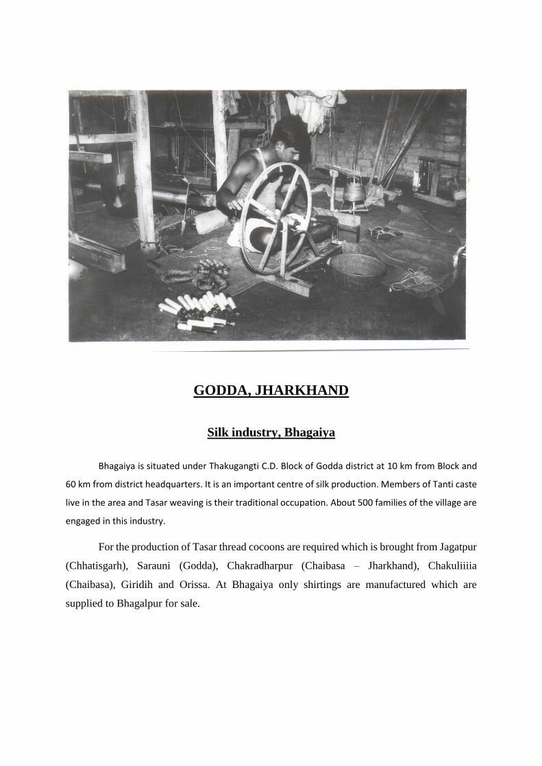
GODDA, JHARKHAND
Silk industry, Bhagaiya
Bhagaiya is situated under Thakugangti C.D. Block of Godda district at 10 km from Block and
60 km from district headquarters. It is an important centre of silk production. Members of Tanti caste
live in the area and Tasar weaving is their traditional occupation. About 500 families of the village are
engaged in this industry.
For the production of Tasar thread cocoons are required which is brought from Jagatpur
(Chhatisgarh), Sarauni (Godda), Chakradharpur (Chaibasa – Jharkhand), Chakuliiiia
(Chaibasa), Giridih and Orissa. At Bhagaiya only shirtings are manufactured which are
supplied to Bhagalpur for sale.

Content
Pages
Foreword xi-xiii
Preface xiv-xv
Acknowledgements xvi-xvii
History and the scope of the District Census Hand Book 3-5
Brief History of the District 6-21
Analytical Note 24-66
Village and Town Directory
Brief Note on Village and Town Directory 68-72
SECTION-I Village Directory
(a) List of Village merged in towns and outgrowths at 2011 Census. --
(b) C. D. Block Maps (showing Tahsil boundary as per instruction issued by Map
Division 74-136
(c) Alphabetical list of Villages along with location code 2001 and 2011. 74-136
(d) CD Block wise Village Directory in prescribed format 138-981
(e) Appendices to Village Directory 984-1036
Appendix –I: Summary showing total number of villages having Educational,
Medical and other amenities in villages – C.D. Block level. 984-988
Appendix –I A: Villages by number of Primary Schools. 988
Appendix –I B: Villages by Primary, Middle and Secondary Schools. 989
Appendix –I C: Villages with different sources of drinking water facilities available 989
Appendix –II: Villages with 5,000 and above population which do not have
one or more amenities available 990
Appendix –III: Land utilization data in respect of Census town/non-municipal towns. --
Appendix –IV: C.D. block wise list of inhabited villages where no amenity other than
Drinking water facility is available. 991-993
Appendix –V: Summary showing number of Villages not having Scheduled Caste
Population 993
Appendix –VI: Summary showing number of Villages not having Scheduled Tribe
Population. 993
Appendix –VII A : List of villages according to the proportion of the Scheduled
Castes to the total population by ranges. 994-1034
Appendix – VII B : List of villages according to the proportion of the Scheduled
Tribe to the total population by ranges. 1035-1076
Appendix – VIII : Number of villages under each Gram Panchayat (C.D. block wise) ---
Section II – Town Directory 1078-1086
(a) Town Directory Statement I – Status and Growth History 1082
(b) Town Directory Statement II – Physical aspects and location of towns, 2009 1082-1083
(c) Town Directory Statement III – Civic and other amenities, 2009 1082-1083
(d) Town Directory Statement IV – Medical Facilities, 2009 1084
(e) Town Directory Statement V – Educational, Recreational and Cultural facilities, 2009 1085
(f) Town Directory Statement VI – Industry and banking, 2009 1086
(g) Town Directory Statement VII – Civic and other amenities in slums, 2009 --
(h) Appendix to Town Directory- Towns showing their outgrowth with population --
----------------------------------------------
xi
FOREWORD
The District Census Handbook (DCHB) is an important publication of the Census
Organization since 1951. It contains both Census and non Census data of urban and
rural areas for each District. The Census data provide information on demographic
and socio-economic characteristics of population at the lowest administrative unit i.e.
of each Village and Town and ward of the District. The Primary Census Abstract (PCA)
part of this publication contains Census data including data on household amenities
collected during 1st.phase of the Census i.e. House Listing and Housing Census. The
non Census data presented in the DCHB is in the form of Village Directory and Town
Directory contain information on various infrastructure facilities available in the village
and town viz; education, medical, drinking water, communication and transport, post
and telegraph, electricity, banking, and other miscellaneous facilities. Later on, the
Telegraph Services were closed by the Government of India on 15th. July, 2013. The
data of DCHB are of considerable importance in the context of planning and
development at the grass-root level.
2. In the 1961 Census, DCHB provided a descriptive account of the District,
administrative statistics, Census tables and Village and Town Directory including
Primary Census Abstract. This pattern was changed in 1971 Census and the DCHB
was published in three parts: Part-A related to Village and Town Directory, Part-B to
Village and Town PCA and Part-C comprised analytical report, administrative
statistics, District Census tables and certain analytical tables based on PCA and
amenity data in respect of Villages. The 1981 Census DCHB was published in two
parts: Part-A contained Village and Town Directory and Part-B the PCA of Village and
Town including the SCs and STs PCA up to Tahsil/Town levels. New features along
with restructuring of the formats of Village and Town Directory were added. In Village
Directory, all amenities except electricity were brought together and if any amenity was
not available in the referent Village, the distance in broad ranges from the nearest
place having such an amenity, was given.
3. The pattern of 1981 Census was followed by and large for the DCHB of 1991
Census except the format of PCA. It was restructured. Nine-fold industrial
classification of main workers was given against the four-fold industrial classification
presented in the 1981 Census. In addition, sex wise population in 0-6 age group was
included in the PCA for the first time with a view to enable the data users to compile
more realistic literacy rate as all children below 7 years of age had been treated as
illiterate at the time of 1991 Census. One of the important innovations in the 1991
Census was the Community Development Block (CD Block) level presentation of
Village Directory and PCA data instead of the traditional Tahsil/Taluk/PS level
presentation.
xii
4. As regards DCHB of 2001 Census, the scope of Village Directory was improved
by including some other amenities like banking, recreational and cultural facilities,
newspapers & magazines and `most important commodity’ manufactured in a Village
in addition to prescribed facilities of earlier Censuses. In Town Directory, the
statement on Slums was modified and its coverage was enlarged by including details
on all slums instead of ‘notified slums’.
5. The scope and coverage of Village Directory of 2011 DCHB has been widened
by including a number of new amenities in addition to those of 2001. These newly
added amenities are: Pre-Primary School, Engineering College, Medical College,
Management Institute, Polytechnic, Non-formal Training Centre, Special School
for Disabled, Community Health Centre, Veterinary Hospital, Mobile Health Clinic,
Medical Practitioner with MBBS Degree, Medical Practitioner with no degree,
Traditional Practitioner and faith Healer, Medicine Shop, Community Toilet, Rural
Sanitary Mart or Sanitary Hardware Outlet in the Village, Community Bio- gas, Sub
Post Office, Village Pin Code, Public Call Office, Mobile Phone Coverage, Internet
Cafes/ Common Service Centre, Private Courier Facility, Auto/Modified Autos, Taxis
and Vans, Tractors, Cycle-pulled Rickshaws, Carts driven by Animals, Village
connected to National Highway, State Highway, Major District Road, and Other District
Road, Availability of Water Bounded Macadam Roads in Village, ATM, Self-Help
Group, Public Distribution System(PDS) Shop, Mandis/Regular Market, Weekly Haat,
Agricultural Marketing Society, Nutritional Centers (ICDS), Anganwadi Centre, ASHA
(Accredited Social Health Activist), Sports Field, Public Library, Public Reading Room,
Assembly Polling station, Birth & Death Registration Office. In the Town Directory,
seven Statements containing the details and the data of each Town have been
presented viz.; (i)-Status and Growth History of Towns,(ii)- Physical Aspects and
Location of Towns, (iii)-Civic and other Amenities, (iv)-Medical Facilities, (v)-
Educational, Recreational & Cultural Facilities, (vi)- Industry & Banking, and (vii)-
Civic & other amenities in Slums respectively. CD Block wise data of Village Directory
and Village PCA have been presented in DCHB of 2011 Census as presented in earlier
Census.
6. The data of DCHB 2011 Census have been presented in two parts, Part-A contains
Village and Town Directory and Part-B contains Village and Town wise Primary
Census Abstract. Both the Parts have been published in separate volumes in 2011
Census.
7. The Village and Town level amenities data have been collected, compiled and
computerized under the supervision of Sri Sunil Kumar Barnwal, Director of Census
Operation, Jharkhand. The task of Planning, Designing and Co-ordination of this
publication was carried out by Dr. Pratibha Kumari, Assistant Registrar General (SS)
under the guidance & supervision of Dr. R.C.Sethi, Ex-Addl. RGI and Shri Deepak
Rastogi present Addl.RGI. Shri A.P. Singh, Deputy Registrar General, (Map) provided
xiii
the technical guidance in the preparation of maps. Shri A.K. Arora, Joint Director of
Data Processing Division under the overall supervision of Shri M.S.Thapa, Addl.
Director (EDP) provided full cooperation in preparation of record structure for
digitization and validity checking of Village and Town Directory data and the
programme for the generation of Village Directory and Town Directory including
various analytical inset tables as well as Primary Census Abstract (PCA). The work of
preparation of DCHB, 2011 Census has been monitored in the Social Studies Division.
I am thankful to all of them and others who have contributed to bring out this publication
in time.
(C. Chandramouli)
Registrar General &
Census Commissioner, India
New Delhi.
Dated:- 16-06-2014
xiv
Preface
he history of the publication of District Census Handbooks goes back to the 1951 Census
and since then these are printed after every Census because of their wide ranging utility.
Census after Census much innovations/modifications have taken place in the District Census
Handbooks in terms of coverage and contents of population data. This is the very useful and
valuable district level publication brought out by the Census Organisation on behalf of the
State Government. It, inter-alia, provides data/information on some of the basic demographic
and socio-economic characteristics and availability of certain important civic
amenities/facilities in each village and town of the respective districts. This publication has,
proved to be of immense utility to the planners, administrators, academicians and researchers.
It is hoped that this publication will serve the purpose of the ever increasing demand for the
micro-level data in this era for planning development.
The present volume of the District Census Handbook Part –A (village and town directories amenities) and Part-B (Primary Census Abstract) of 2011 Census has been made more informative and exhaustive in terms of coverage and content. The content of Village Directory has been broadened by including a number of new amenities in addition to those of 2001. These newly added amenities are: Pre-Primary School, Engineering College, Medical College, Management Institute, Polytechnic, Non-formal Training Centre, Special School for Disabled, Community Health Centre, Veterinary Hospital, Mobile Health Clinic, Medical Practitioner with MBBS Degree, Medical Practitioner with no degree, Traditional Practitioner and faith Healer, Medicine Shop, Community Toilet, Rural Sanitary Mart or Sanitary Hardware Outlet in the Village, Community Bio- gas, Sub Post Office, Village Pin Code, Public Call Office, Mobile Phone Coverage, Internet Cafe/ Common Service Centre, Private Courier Facility, Auto/Modified Autos, Taxis and Vans, Tractors, Cycle-pulled Rickshaws, Carts driven by Animals, Village connected to National Highway, State Highway, Major District Road, and Other District Road, Availability of Water Bounded Macadam Roads in Village, ATM, Self-Help Group, Public Distribution System(PDS) Shop, Mandis/Regular Market, Weekly Haat, Agricultural Marketing Society, Nutritional Centers (ICDS), Anganwadi Centre, ASHA/SAHIYA in Jharkhand, Sports Field, Public Library, Public Reading Room, Assembly Polling station, Birth & Death Registration Office. In the Town Directory, seven Statements containing the details and the data of each Town have been presented viz.; (i)-Status and Growth History of Towns,(ii)- Physical Aspects and Location of Towns, (iii)-Civic and other Amenities, (iv)-Medical Facilities, (v)-Educational, Recreational & Cultural Facilities, (vi)- Industry & Banking, and (vii)- Civic & other amenities in Slums respectively. CD Block wise data of Village Directory and Village PCA have been presented in DCHB of 2011 Census as presented in earlier Census. The various basic amenities available in the villages and towns are analysed in depth with the help of a number of cross-classified inset tables and statements.
It is worthwhile to mention that the District Census Handbooks of the Census of India, 2011 are being made available in electronic format also in addition to printed volumes keeping in view the demand of data users.
The District Census Handbooks are brought out in two parts, viz. (i) part A containing the village and town directories and (ii) part B – village and town-wise primary Census Abstracts pertaining to general population. It also contains the District Primary Census Abstracts for Scheduled Castes and the Scheduled Tribes Population.
The village and town level amenity data have been collected through the Block
Development Officers and the Vice Chairmen/Executive Officers of the Municipalities and
Notified Area Committees who functioned as Charge Officer under the District/Sub-divisional
level Officers.
T
xv
The analytical note has been prepared on the basis of the inset tables generated from the computerized data of Village Directory, Town Directory and Village/Urban Primary Census Abstract. It takes note of the social, economic and demographic changes which have taken place in the districts during the decade. District and C.D. Block Maps containing useful information on many items have also been included in this volume.
This publication is a joint venture of the State Government and the Census organisation. We are grateful to the State Government agencies for their co-operation in collection of such a huge volume of data. We would like to make a special mention of the warm and whole hearted co-operation which was throughout extended by the Deputy Commissioner, the Sub-divisional Officers, the District Census Officers and the Block Development Officers.
In this office Shri Subhash Chandra Tripathi, Joint Director, Shri Priyatosh Amist, Deputy Director, Shri Dinesh Kumar, Deputy Director, Dr. Satyendra Kumar Gupta, Assistant Director, Dr. Bhim Raj Hansdah, Assistant Director and Shri Sant Ram, Assistant Director supervised the project at different stages. In this voluminous job valuable assistance was rendered by Shri Pradeep Kumar, Ram Bhaskar Dwivedi, Manoj Kumar and Birendra Prasad Singh, Statistical Investigators Grade-II, who were responsible for supervision from beginning to end under guidance of Shri Sant Ram, Assistant Director. Dr. Bhim Raj Hansdah, Assistant Director has also been associated to monitor the digitization, scrutiny and validity work of Village Directory and Town Directory data. Shri Pradeep Kumar, Ram Bhaskar Dwivedi, Manoj Kumar and Birendra Prasad Singh, Statistical Investigators Grade-II, prepared the analytical notes on inset tables based on the data of Village Directory, Town Directory and Primary Census Abstracts under the guidance of Shri Priyatosh Amist, Deputy Director, Dr. Satyendra Kumar Gupta, Assistant Director, Dr. Bhim Raj Hansdah, Assistant Director and Shri Sant Ram, Assistant Director as teams were formed for validity and final preparation of District Census Hand Book of Census of India 2011 and over all monitoring work was under the guidance of Shri Priyatosh Amist, Deputy Director under the supervision of Dr. Prathiba Kumari, Assistant Registrar General (SS), India. Districts and C.D. Blocks Maps were prepared in Map Section under the supervision of Sri Mukut Guria Research officer (Map) with help of Sri Jitendra Saini, Geographer and Sri Indra Kant Mishra Sr. Drawing Assistant. Sri Niraj Kumar Sahu and Sri Tanwir Anjum, Compilers typed the manuscript and prepared the tables. Printing In-charge of RGI and DCO helped in getting the volume printed in-house.
This Directorate is highly indebted to Sri C. Chandramouli, Registrar General and
Census Commissioner, India under whose guidance it has been rare privilege to strive for results. We are equally indebted to Dr. Prathiba Kumari, Assistant Registrar General (SS) for spontaneous help and encouragement at different stages of the work of this project with guidance. We are also thankful to Sri M.S. Thapa, Additional. Director, Sri A.K. Arora, Joint Director and Sri Ramesh Kumar, Deputy Director of EDP Division, who scrutinized the manuscript and database of PCA data as well as village and town directory and guided for release of DCHB Part-A & B in electronic form.
Sh. Sunil Kumar Barnwal
Ranchi Directorate of Census Operations, Jharkhand

xvi
Acknowledgements
List of Officers/Officials involved in preparation of DCHB’s Census of 2011
in the Directorate of Census Operations, Jharkhand, Ranchi
Sl.No. Name Designation
1. Sri Subhash Chandra Tripathi Joint Director
2. Sri Priyatosh Amist Deputy Director
3. Sri Dinesh Kumar Deputy Director
4. Sri Gopal Mahto Assistant Director
5. Dr. Satyendra Kumar Gupta Assistant Director
6. Dr. Bhim Raj Hansdah Assistant Director
7. Sri Sant Ram Assistant Director
8. Sri P. Behra Assistant Director (DCC)
9. Sri M. Guria Research Officer (Map)
10. Smt. Beena Kujur Statistical Investigator Grade I
D.C.H.B. Section
11. Sri Ram Bhaskar Dwivedi Statistical Investigator Grade II
12. Sri Pradeep Kumar Statistical Investigator Grade II
13. Sri Manoj Kumar Statistical Investigator Grade II
14. Sri Birendra Prasad Singh Statistical Investigator Grade II
15. Sri Niraj Kumar Sahu Compiler
16. Sri Santhosh Prasad Compiler
17. Sri Nandlal Pd. Raut Compiler
18. Sri Satendra Kumar Compiler
Sl.No. Name Designation
19. Sri Ashutosh Kumar Bisi Statistical Investigator Grade II
20 Sri Murari Mohan Statistical Investigator Grade II
21. Sri Akhilesh Kumar Statistical Investigator Grade II
22. Sri Chandra Bhushan Kumar Statistical Investigator Grade II
23. Sri Rajeshwar Prasad Statistical Investigator Grade II
24. Sri Naval Kishor Prasad Sr. Compiler
25. Sri Sashi Bhusan Prasad Sr. Compiler
26. Sri Harendra Prasad Sinha Sr. Compiler
27. Sri Bhaiya Girish Kumar Sr. Compiler
28. Sri Anil Choudhary Compiler

xvii
29. Sri Jagarnath Choudhary Compiler
30. Sri Vijay Kumar Compiler
31. Sri Sadique Hussain Compiler
32. Sri Deepak Kumar Compiler
33. Sri Mulchand Mehta Compiler
34. Sri Tanwir Anjum Compiler
35. Sri Rajnish Kumar Compiler
36. Sri Baidyanath Kumar Compiler
Map Section
37. Sri Jitendra Saini Geographer
38. Sri Indrakant Mishra Senior Drawing Assistant
DCC Section
39. Sri Pyarelal Khandait DEO
40. Mrs. Kiran Tigga DEO
41. Mrs. Sushma Manjula Minz DEO
42. Sri Ashish Kumar Sr. Consultant
43. Sri Uttam Kumar Sr. Consultant
44. Sri Pankaj Kumar Sr. Consultant
45. Sri Gyan Kr. Mahto Jr. Consultant
--------------------------------------

1
ANALYTICAL NOTE
2
DISTRICT GODDA
3
HISTORY AND SCOPE OF THE DISTRITCT CENSUS HANDBOOK
The need of data at the grass root level for the administrative and planning purposes
at sub micro level as well as academic studies prompted the innovation of District Census
Handbook. District Census Handbook is a unique publication from the Census organization
which provides most authentic details of census and non-census information from village and
town level to district level. The District Census Handbook was firstly introduced during the
1951 Census. It contains both census and non census data of urban as well as rural areas for
each district. The census data contain several demographic and socio-economic
characteristics of the lowest administrative unit i.e. of each village and town and ward of the
district. The non census data comprise of data on availability of various civic amenities and
infrastructural facilities etc. at the town and village level which constitute Village Directory and
Town Directory part of the DCHB. The data of DCHB are of considerable importance in the
context of planning and development at grass-root level.
In 1961 census DCHB provided a descriptive account of the district, administrative
statistics, census tables and village and town directory including Primary Census Abstract.
This pattern was changed in 1971 Census and the DCHB was published in three parts: Part-
A related to village and town directory, Part-B to village and town PCA and Part-C comprised
analytical report, administrative statistics, district census tables and certain analytical tables
based on PCA and amenity data in respect of villages. The 1981 census DCHB was published
in two parts: Part-A contained village and town directory and Part-B the PCA of village and
town including the SCs and STs PCA up to tahsil/town levels. New features along with
restructuring of the formats of village and town directory were added into it. In Village
Directory, all amenities except electricity were brought together and if any amenity was not
available in the referent village, the distance in broad ranges from the nearest place having
such an amenity, was given.
The pattern of 1981 census was followed by and large for the DCHB of 1991 Census
except the format of PCA. It was restructured. Nine-fold industrial classification of main
workers was given against the four-fold industrial classification presented in the 1981 census.
In addition, sex wise population in 0-6 age group was included in the PCA for the first time
with a view to enable the data users to compile more realistic literacy rate as all children below
7 years of age had been treated as illiterate at the time of 1991 census. One of the important
innovations in the 1991 census was the Community Development Block (CD Block) level
4
presentation of village directory and PCA data instead of the traditional tahsil/taluk/PS level
presentation.
As regards DCHB of 2001 Census, the scope of Village Directory was improved by
including some other amenities like banking, recreational and cultural facilities, newspapers
& magazines and `most important commodity’ manufactured in a village in addition to
prescribed facilities of earlier censuses. In Town Directory, the statement on Slums was
modified and its coverage was enlarged by including details on all slums instead of ‘notified
slums’.
The scope and coverage of Village Directory of 2011 DCHB has been widened by
including a number of new amenities in addition to those of 2001. In the Town Directory,
seven Statements containing the details and the data of each town have been presented viz.;
(i)-Status and Growth History of towns,(ii)- Physical Aspects and Location of Towns, (iii)-Civic
and other Amenities, (iv)-Medical Facilities, (v)-Educational, Recreational & Cultural Facilities,
(vi)- Industry & Banking, and (vii)- Civic & other amenities in Slums respectively. CD Block
wise data of Village Directory and Village PCA have been presented in DCHB of 2011 census
as presented in earlier census. The data of DCHB 2011 Census have been presented in two
parts, Part-A contains Village and Town Directory and Part-B contains Village and Town wise
Primary Census Abstract. Both the Parts have been published in separate volumes in 2011
Census.
5
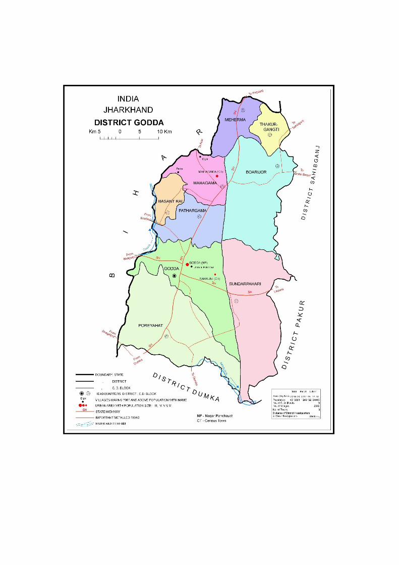
Brief history of the districts
The district of Godda was created on 17th May,1983 out of old Santhal Pargana district
which was upgraded to the level of division. Present Santhal Pargana division comprises 5
districts, viz., Godd, Dumka, Deoghar, Sahebganj and Pakur. Godda(M), the only one town of
the district, is the headquarters of Godda district and Godda subdivision.
Godda district is surrounded by districts of Bhagalpur (Bihar) in north, Dumka
(Jharkhand) in south, Pakur (Jharkhand) and Sahibganj in east and Dumka (Jharkhand) and
Bhagalpur (Bihar) in west. It lies between 24.8167° N latitude (N) and 87.2167° longitude (E)
within northern hemisphere. With respect to population and area the rank of district amongst
the districts of state are 12th and 18th respectively. Tribals like Santals, Paharias and Lohras
make a sizeable chunk of the population of the district. Being tribal dominated its culture and
creed is unique. This district is covered with mountains, rivers and forests. Its natural
phenomena are fascinating and rare.
The history of Godda district is inseparable from the history of parent district of Santhal
Pargana. Santhal Pargana was created as a separate district in the year 1855 by transferring
out portions of Bhagalpur and Birbhum districts. The entire area comprising present divisions
of Santhal Pargana, Hazaribag, Munger and Bhagalpur was termed as Jungleterry (Jungle
Terai) by the English on assumption of Diwani in 1765.
Earlier History.
There is evidence that this area is inhabited since very early times. As per records
the Malers or Sauria Paharias were early settlers of the area who still inhabit the Rajmahal
hills. Till the visit of Hiuen-Tsang, a Chinese traveller, who visited India about 645 A.D. during
the reign of King Harshavardhan (606-647 A.D.) little is known about the history of this area.
Medieval periods.
Malik Ikhtiaruddin-bin-Bakhtiar Khilji marched to Bengal and Assam through
Teliagarhi pass. He captured Bihar and its king Lakshman Sen fled away to Cooch Bihar. He
made Deoghar, which was then called “Deogarh”, his capital in 1201 A.D.
On 12th July,1576 the battle of Rajmahal (Sahebganj district) was fought and the
foundation of the Mughal rule in Bengal laid. Mansigh, who was appointed the Viceroy of
Bengal by Akbar, made Rajmahal the capital of Bengal in 1592. It continued to be the seat of
the Mughal Viceroy upto 1660 and a mint-town till 1661.
6
British Period.
In 1757 Clive defeated Siraj-ud-Daulah, Nawab of Bengal in battle of Plassey. The
victory at Plassey gave the British control over the then Bengal which contained the present
Santhal Pargana division. In Santhal Pargana division British were up against a band of simple
but determined opponents, the Paharias, who were great lovers of freedom and could not
tolerate any intruders in their homeland. Warren Hastings organized in 1772 a special cops.
of 800 men to curb the Paharias. Augustus Cleveland introduced the system of trial cases by
an assembly Chiefs. This system received further sanction by Regulation-I of 1796 which
made it obligatory on the Magistrate to commit all important cases for trial by assembly of
Chiefs. This show of self-rule continued till 1827 when hill-men were declared amenable to
ordinary courts of law, though they still enjoyed the privilege to settle petty disputes. Santhals
were encouraged to clear the jungle and settle. The internal set-up of the administrative
system could not ensure proper justice to the common man and there was a deep underlying
discontent among the simple minded but excitable Santhals.
Santhal Rebellion of 1855.
Research of N.K. Verma established that Santhals were Indus Valley people. They
were a simple, hardy and industrious people. They, therefore, fell an easy prey to the
unscrupulous hillmen and nan-Santhal traders. Baniyas and Mahajans made heavy exaction
from the innocent Santhals and there was no check on them. The Naib Sazawals, assistants
of the English Superintendent, were very oppressive. The police was equally corrupt. Besides,
there was the Kamiauti system. It was a system of repayment of a debt by physical labour. In
practice, however, the debtor worked in many cases for a generation or two and yet the loan,
no matter how small, could not be repaid.
The Santhals felt unhappy and insecure. Their discontent was all the more pronounced
vis- a- vis- other tribemen, who were outside the clutches of Mahajans and Banias, earned
handsome wages in the forests which were being cleared for the rail lines to be laid. The
growing discontent led to the Santhal feud, better known as the Santhal Rebellion of 1855.The
basic reason for this catastrophe was the economic privation of Santhals resulting from the
permanent settlement.
They got leaders in Sidhu, Kanhu, Chand and Bhairab- four brothers of village
Bhagnadihi, near Barhait. They declared themselves to be the messengers of Jahar-era, the
celebrated deity of the Santhals. Kanhu was killed in action whereas Sidhu was arrested and
hanged at Barhait.
The foreign rulers took the Santhal insurrection as a challenge to their authority and
made no effort to understand and appreciate the reasons of Santhal discontent. As the English
tried to arrest the SAnthals and there by protect the dikus whom the Santhals had branded as
their exploiter and enemy. The trouble spread over a large area covering the present Santhal
7
Pargana division, Birbhum, Bankura and Hazaribag districts. A large number of troops were
put into action and all sorts of atrocities were resorted to. Marrtial law was proclaimed on the
10th November,1855 and with ruthless hands, the British Government succeeded in
suppressing the rebellion by December,1855. The Santhals were beaten but the courage and
resolve exhibited by them during the uprising left their impress on the British rulers. They
realised that if the government wanted to rule over the area their reasonable demands be met.
A separate district was created by Act XXXVII of 1855 with the name, Santhal Pargana,
perhaps to appease the Santhals. Steps were taken to redress the grievances of the Santhals
and to gave them a homeland with a sense of security. The Santhal Hul or Rebellion
anticipated the movement of 1857.
The 1857 Movement.
The fire of 1857 movement was so high that every nook and corner of India felt its
impact.
The 1857 movement touched the present Santhal Pargana division though the
Santhals were too crippled to rise again and so shortly after the Hul (Rebellion). The Sepoys
of the 5th Irregular Cavalry stationed at Rohini revolted and Adjutant to Sir Norman Leslie was
killed, and commandant Major Macdonald and Dr. Grant were both wounded on the 8th
June,1857. In June,1857, the 5th Irregular Regiment at Bhagalpur also revolted and marched
on to Rohini where they were joined by the comrades of their regiment. From Rohini they
proceeded to Bounsi, where the 32nd Native Infantry was stationed. But the untimely leakage
and forewarning to the British Officers foiled the attempts of the sepoys, and nothing
noteworthy happened in the districts of Dumka, Deoghar, Pakur, Sahibganj and Godda.
Santhal Pargana not being immune from patriotic fervour played its role in the country's
struggle for freedom from 1921 onwards. The decision of Indian National Congress to boycott
the Simon Commission and the Commotion aroused by it, had its repurcussion all over India.
Even in the hills and forests of Santhal Pargana, there was a patriot named Lambodar
Mukherjee moving and arousing the people. He brought to the tribals glimpses of the outside
world, so securely closed by the British, with the help of lantern slides. He became an eye-
sore to the then Deputy Commissioner E.S. Hoernle and the Commissioner, M.G. Hallett, both
of whom pleaded strongly for his arrest even without evidence, on account of his 'seditious
propaganda' against the Government.
The district played its role in the Salt Satyagraha and the Civil Disobedience Movement
of 1930 and in the boycott of foreign Liquors and clothes. The Individual Satyagrah of 1940-
41 spread to this district also and dozen of people offered Satyagrah and got arrested. The
1942 Movement also spread to Santhal Pargana and on the 11th of Augaust,1942, on which
day a procession was taken out at Deoghar and hartal was observed. On the 12th August, a
procession was taken out at Godda and soon the entire division was aflame. Thus the division
of Santhal Pargana marched hand- in- hand with other parts of the State in the struggle for
country's freedom.
8
Post Independence Period.
With the rest of countrymen Dumka district as a part of old Santhal Pargana district
also awoke to freedom on the mid- night of 14th August,1947 when British finally left the Indian
sub-continent. But the major portion of Governmental activities meant to uplift tribals
percolates to implementing agencies. Exaction of tribals by baniyas and dikus continued by
tactful modus-operandi. In the mid of their ignorance and poverty proselytising (religious
conversion) activities of churches are slowly going on. The Jharkhand movement of more
empowerment and statehood led by Jharkhand Mukti Morcha was their hope and aspirations.
To counter the Jharkhand Movement and lessen its credit a seed of Vananchal movement
had been sown. As fruitation of movement of separate statehood Jharkhand Area council was
formed in 1996 which finally got statehood as Jharkhand state (a smaller version than
originally speculated) on 15th November,2000 with 18 districts of erstwhile Bihar.
Administrative setup
The district of Dumka possesses one subdivision, viz., Godda 8 C.D. Blocks and one
town. The district is in Santhal Pargana division which is in turn, under Jharkhand state (which
has four divisions, e.g., North Chotanagpur, South Chotanagpur, Santhal Pargana and
Palamu and was came out from erstwhile Bihar state on 15th November,2000).
The administrative units of the district are as below:
Name of Sub-Division Name of C.D. Blocks Name of Town with Civic status
1. Godda. 1) Meherma 1) Godda (M)
2) Thakur Gangti
3) Boarijor
4) Mahagama
5) Pathargama
6) Godda
7) Poreyahat
There are total no. of 2304 villages in the Godda district. The total no. of Panchayats
are ………………………………….
The district administration is headed by the Deputy Commissioner. He belongs to I.A.S.
cadre. He is assisted by a lot of officers mostly belonging to officials of Bihar Public Service

9
Commission. The official’s cadre has not been separated (after separation of Jharkhand state
from erstwhile Bihar state). Police Administration is looked after by the superintendent of the
police (S.P.). He is also assisted by no. of officers like Assistant Superintendents of Police,
Deputy Superintendent of Police, Inspector of Police, etc.
Physical Aspects.
Godda district is a part of Hazaribag platean. The entire region is formed of undulating
surface. This region is replete with scattered hillocks covered with forests.
Climate
The district comes under tropical monsoon region. The climate of this district is
salubrious as it is surrounded by forests and mountains. Here people got comparatively more
heat in summer, more rains in the rainy season and extreme cold in the winter season.
Drainage.
Mines and Minerals.
The gaeological formation in the district consists of Archaean gneiss, which is known
as Bengal gneiss, and is famous for its heterogeneous formation. According to W.W. Hunter”
coal and iron ore are found in almost all parts of the Santhal Pargana (division). But at present
there is no iron mine in the district worth- mentioning. Poor quality of iron ores are found in
some hilly regions and are used by local smiths called Kols. The coal is its main mineral while
china-clay, granite and stone (usable for building, road and bridge) are also found in this
district.
Forest, Flora & Fauna
The country once known for its thick and extensive forests is now bereft of much of its
jungle wealth. There has been large scale destinection of forests in the past few years. Jungles
on plains have almost been cleared and hills also have become naked except in the Damin-
I- Koh area and on tops of high hills, where also they are getting thinner. The area under forest
is much more below the standard set under the National Forest Policy. The Forest Department
have undertaken afforestation.
The most common tree of the district is sal (shorea robusta). Some teak of inferior variety is also found. Other trees found are jack- fruit, murga, simal, bamboo, asan, arjun and satsal. Here herbs are also found in forests and mountains. There are many kinds of animals and birds available here. Specially, the cows, the ox, the buffalo, the goat, the pig, the hen, and the duck are seen everywhere in this district. There are some wild animals like tigers and bears though rarely seen in the forest. The peacock is also seen during rainy season. Transport.
Roads: There is a net-work of good roads in the district. Both the subdivisional
headquarters are connected with the district headquarters by black topped all weather roads.
No important place in the district is unconnected by a good metalled road. There is road link
10
with Calcutta through Jamtara. The Jamtara Dumka Sahibganj road provides a link with
Assam after ferry across the Ganges and is quite busy.
Railways Airways.
Trade and Commerce.
The Chief center of whole-sale business in the district is Godda. Wholesals trading in foodgrains is mostly carried on in Godda. The number of hats is quite high in the district. The hats are held once or twice a week. The hat is a primary market for the tribals who purchase grains and other commodities of day-to-day consumption. The most important commodity manufactured, imported and exported in town is as
below:-
Manufactured Exported Imported
1) Godda - Rice Sugar
Electricity & Power.
Electricity is generated in Masanjore but it does not provide electricity to the district.
The district receives most of the power supply from Damodar Valley Corporation. All the towns
of the district have electricity. In the rural areas, however, the pace of electrification is
comparatively low. The district receives most of its power supply from the Bihar Electricity
Board through the Damodar Valley Corporation. All the towns of the district have electricity. In
the rural areas, however, the pace of electrification is comparatively low.
Land use pattern
Irrigational facilities
(ii) Census concepts
Building: A ‘Building’ is generally a single structure on the ground. Usually a structure will have four walls and a roof. Sometimes it is made up of more than one component unit which are used or likely to be used as dwellings (residences) or establishments such as shops, business houses, offices, factories, workshops, work sheds, Schools, places of entertainment, places of worship, godowns, stores etc. It is also possible that building which have component units may be used for a combination of purposes such as shop-cum-residence, workshop-cum-residence, office-cum-residence etc. But in some areas the very nature of construction of houses is such that there may not be any wall. Such is the case of conical structures where entrance is also provided but they may not have any walls. Therefore, such of the conical structures are also treated as separate buildings.
Pucca houses: Houses, the walls and roof of which are made of permanent materials. The material of walls can be any one from the following, namely, Stones (duly packed with lime or cement mortar), G.I/metal/ asbestos sheets, Burnt bricks, Cement bricks, Concrete. Roof may be made of from any one of the following materials, namely, Machine-made tiles, Cement tiles, Burnt bricks, Cement bricks, Stone, Slate, G.I/Metal/Asbestos sheets, Concrete. Such houses are treated as Pucca house.
11
Kutcha houses: Houses in which both walls and roof are made of materials, which have to be replaced frequently. Walls may be made from any one of the following temporary materials, namely, grass, Unburnt bricks, bamboos, mud, grass, reeds, thatch, plastic /polythene, loosed packed stone, etc. Such houses are treated as Kutcha house.
Dwelling Room: A room is treated as a dwelling room if it has walls with a doorway and a roof and should be wide and long enough for a person to sleep in, i.e. it should have a length of not less than 2 meters and a breadth of at least 1.5 meters and a height of 2 meters. A dwelling room would include living room, bedroom, dining room, drawing room, study room, servant’s room and other habitable rooms. Kitchen, bathroom, latrine, store room, passageway and verandah which are not normally usable for living are not considered as dwelling rooms. A room, used for multipurpose such as sleeping, sitting, dining, storing, cooking, etc., is regarded as a dwelling room. In a situation where a census house is used as a shop or office., etc., and the household also stays in it then the room is not considered as a dwelling room. But if a garage or servant quarter is used by a servant and if she/ he also lives in it as a separate household then this has been considered as a dwelling room available to the servant’s household. Tent or conical shaped hut if used for living by any household is also considered as dwelling room. A dwelling room, which is shared by more than one household, has not been counted for any of them. If two households have a dwelling room each but in addition also share a common dwelling room, then the common room has not been counted for either of the households.
Census House : A ‘census house’ is a building or part of a building used or recognized as a separate unit because of having a separate main entrance from the road or common courtyard or staircase, etc. It may be occupied or vacant. It may be used for residential or non- residential purpose or both. If a building has a number of Flats or Blocks/Wings, which are independent of one another having separate entrances of their own from the road or a common staircase or a common courtyard leading to a main gate, these are considered as a separate Census house.
Village: The basic unit for rural areas is the revenue village, which has definite surveyed boundaries. The revenue village may comprise of one or more hamlets but the entire village is treated as one unit for presentation of data. In un surveyed areas, like villages within forest areas, each habitation area with locally recognized boundaries is treated as one village.
Rural-Urban area: The data in the census are presented separately for rural and urban areas. The unit of classification in this regard is ‘town’ for urban areas and ‘village’ for rural areas. The urban area comprises two types of towns viz; Statutory towns and Census towns. In the Census of India 2011, the definition of urban area adopted is as follows:
(a) Statutory Towns : All places with a municipality, corporation, cantonment board or notified town area committee, etc are known as statutory towns.
(b) Census owns: All other places satisfying the following three criteria simultaneously are treated as Census Towns.
i) A minimum population of 5,000;
12
ii) At least 75 per cent of male working population engaged in non-agricultural pursuits; and
iii) A density of population of at least 400 per sq. km. (1,000 per sq. mile)
For identification of places which would qualify to be classified as ‘urban’ all villages, which, as per the 2001 Census had a population of 4,000 and above, a population density of 400 persons per sq. km. and having at least 75 per cent of male working population engaged in non-agricultural activity were considered. To work out the proportion of male working population referred to above against b) (ii), the data relating to main workers were taken into account. In addition the above stated towns, urban areas also constitutes of OGs which are the parts of UAs.
Urban Agglomeration: An Urban Agglomeration is a continuous urban spread constituting a town and its adjoining urban outgrowths (OGs) or two or more physically contiguous towns together with or without urban outgrowths of such towns. In some cases, railway colonies, university campuses, port areas, military camps etc; may come up near a statutory town outside its statutory limits but within the revenue limits of a village or villages contiguous to the town. Each such individual area by itself may not satisfy the minimum population limit to qualify it to be treated as an independent urban unit but may qualify to be clubbed with the exiting town as their continuous urban spread (i.e., an Out Growth). Each such town together with its outgrowth(s) is treated as an integrated urban area and is designated as an ‘urban agglomeration’. For the purpose of delineation of Urban Agglomerations during Census of India 2011, following criteria has been adopted:
(a) The core town or at least one of the constituent towns of an urban agglomeration should necessarily be a statutory town; and
(b) The total population of an Urban Agglomeration (i.e. all the constituents put together) should not be less than 20,000 as per the 2001 Census. In varying local conditions, there were similar other combinations which have been treated as urban agglomerations satisfying the basic condition of contiguity. Out Growth (OG): The outgrowth is a viable unit such as a village or a hamlet or an enumeration block and clearly identifiable in terms of its boundaries and location. While determining the outgrowth of a town, it has been ensured that it possesses the urban features in terms of infrastructure and amenities such as pucca roads, electricity, taps, drainage system for disposal of waste water etc., educational institutions, post offices, medical facilities, banks etc and physically contiguous with the core town of the UA.
City: Towns with population of 100,000 and above are called cities.
Household: A ‘household’ is usually a group of persons who normally live together and take their meals from a common kitchen unless the exigencies of work prevent any of them from doing so. Persons in a household may be related or unrelated or a mix of both. However, if a group of unrelated persons live in a census house but do not take their meals from the common kitchen, then they are not constituent of a common household. Each such person was to be treated as a separate household. The important link in finding out whether it was a household or not was a common kitchen/common cooking. There may be one member households, two member households or multi-member households. Institutional Household: A group of unrelated persons who live in an institution and take their meals from a common kitchen is called an Institutional Household. Examples of Institutional Households are boarding houses, messes, hostels, hotels, rescue homes, observation homes, beggars homes, jails, ashrams, old age homes, children homes, orphanages, etc. To make the definition more clearly perceptible to the enumerators at the Census 2011, it was
13
specifically mentioned that this category or households would cover only those households where a group of unrelated persons live in an institution and share a common kitchen. Houseless household : Households who do not live in buildings or census houses but live in the open or roadside, pavements, in hume pipes, under flyovers and staircases, or in the open in places of worship, mandaps, railway platforms, etc., are treated as Houseless Households. Scheduled Caste and Scheduled Tribes:-
The list of SCs and STs applicable in the State/UT is given hereunder:- Scheduled Castes : 1. Bantar 2. Bauri 3. Bhogta 4. Bhuiya 5. Chamar,Mochi 6. Chaupal 7. Dabgar 8. Dhobi 9. Dom,Dhanger 10. Dusadh,Dhari,Dharhi 11. Ghasi 12. Halalkhor 13. Hari,Mehtar,Bhangi 14. Kanjar 15. Kurariyar 16. Lalbegi 17. Musahar 18. Nat 19. Pan,Swasi 20. Pasi 21. Rajwar 22. Turi Scheduled Tribes : 1. Asur 2. Baiga 3. Banjara 4. Bathudi 5. Bedia 6. Binjhia 7. Birhor 8. Birjia 9. Chero 10. Chik Baraik 11. Gond 12. Gorait 13. Ho 14. Karmali 15. Kharia 16. Kharwar 17. Khond 18. Kisan 19. Kora 20. Korwa 21. Lohara,Lohra 22. Mahli 23. Mal Paharia
14
24. Munda 25. Oraon 26. Parhiya 27. Santal 28. Sauria Paharia 29. Savar 30. Bhumij 31. Kawar
32. Kol Language and Mother tongue: As per the census concept, each language is a group of mother tongues. The census questionnaire collects information on the mother tongue of each person. Mother tongue is the language spoken in childhood by the person’s mother to the person. If the mother died in infancy, the language mainly spoken in the person’s home in childhood will be the mother tongue. In the case of infants and deaf mutes, the language usually spoken by the mother is considered as mother tongue. It is not necessary that the language spoken as mother tongue should have a script. The mother tongues returned by the respondents in census are classified and grouped under appropriate languages according to their linguistic characteristics.
Literate: A person aged 7 years and above who can both read and write with understanding in any language is taken as literate. A person who can only read but cannot write is not literate. It is not necessary that to be considered as literate, a person should have received any formal education or passed any minimum educational standard. Literacy could have been achieved through adult literacy classes or through any non-formal educational system. People who are blind and can read in Braille are treated as literates.
Literacy rate: Literacy rate of the population is defined as the percentage of literates in the age-group seven years and above. For different age-groups the percentage of literates in that age-group gives the literacy rate.
Educational level: The highest level of education a person has completed.
Work: Work is defined as participation in any economically productive activity with or without compensation, wages or profit. Such participation may be physical and/or mental in nature. Work involves not only actual work but also includes effective supervision and direction of work. It even includes part time help or unpaid work on farm, family enterprise or in any other economic activity. All persons engaged in ‘work’ as defined above are workers. The main point to note is that the activity should be economically productive. Reference period for determining a person as worker and non-worker is one year preceding the date of enumeration.
Main worker: A person who has worked for major part of the reference period (i.e. six months or more during the last one year preceding the date of enumeration) in any economically productive activity is termed as ‘Main worker’.
Marginal worker: A person who worked for 3 months or less but less than six months of the reference period (i.e. in the last one year preceding the date of enumeration) in any economic activity is termed as ‘Marginal worker’.
Non-worker: A person who has not worked at all in any economically productive activity during the reference period (i.e. last one year preceding the date of enumeration) is termed as ‘Non worker’.
Cultivator: For purposes of the Census, a person is classified as cultivator if he or she is engaged in cultivation of land owned or from government or from private persons or institutions for payment in money, kind or share. Cultivation also includes effective supervision or direction
15
in cultivation. Cultivation involves ploughing, sowing, harvesting and production of cereals and millet crops such as wheat, paddy, jowar, bajra, ragi, etc., and other crops such as sugarcane, tobacco, ground-nuts, tapioca, etc., and pulses, raw jute and kindred fiber crop, cotton, cinchona and other medicinal plants, fruit growing, vegetable growing or keeping orchards or groves, etc. Cultivation does not include the plantation crops like– tea, coffee, rubber, coconut and betel nuts (areca). The workers engaged in Plantation crops are recorded under “other workers”.
Agricultural labourer: A person who works on another person’s land for wages in cash or kind or share is regarded as an agricultural labourer. She/he has no risk in the cultivation, but merely works on another person’s land for wages. An agricultural labourer has no right of lease or contract on land on which she/he works.
Household industry worker: Household industry is defined as an industry conducted by one or more members of the household at home or within the village in rural areas and only within the precincts of the house where the household lives in urban areas. The larger proportion of workers in household industry should consist of members of the household. The industry should not be run on the scale of a registered factory which would qualify or has to be registered under the Indian Factories Act and should be engaged in manufacturing, processing, servicing and repairs of goods. The activity relate to production, processing, servicing, repairing or making and selling of goods. It does not include professions such as a pleader, Doctor, Musician, Dancer, Waterman, Astrologer, Dhobi, Barber, etc. or merely trade or business, even if such professions, trade or services are run at home by members of the household.
Other worker: A person, who has been engaged in some economic activity during the last year of reference period but not as a cultivator or agricultural labourer or worker in Household Industry. The type of workers that come under this category include all government servants, municipal employees, teachers, factory workers, plantation workers, those engaged in trade, commerce, business, transport, banking, mining, construction, political or social work, priests, entertainment artists, etc. In fact, all those workers other than cultivators or agricultural labourers or household industry workers are ‘Other Workers’.
Work participation rate: Percentage of Workers (Main + Marginal) to total population.
Population density: Population density is the number of persons inhabited per square kilometer of the area.
Age: Age is measured in terms of the completed number of years.
Sex Ratio: Number of females per 1,000 males in a population.
(iii) Non-Census Concepts
Improved drinking water :
If the household had access to drinking water supplied from a tap, hand pump, tube well or well (protected or covered) situated within or outside the premises, it is considered as having access to improved drinking water. It may be mentioned that such uniform definition may not be valid across all states.
System of sewerage :
16
Generally, a sewerage system would mean a network of mains and branches of underground conduits for the conveyance of sewerage to the point of disposal. Sewers that carry only household and industrial wastage are called separate sewers; those that carry storm water from roofs, streets and other surfaces are known as storm water drains, while those carrying both sewage and storm water are called combined sewers. However, in some towns which are not provided with such underground sewerage system, it is served by open surface drain, box drain, sylk pattern drain, etc., in these towns.
Type of latrine and Method of disposal of night soil :
There are three prevalent systems of disposal of human wastes, viz. (i) underground
sewerage,
(ii) sanitary water flush latrines with individual disposal systems, like septic tank, leaching cess
pool and collecting well, and (iii) dry type of latrines with manual scavenging.
The system of underground sewerage provides for the street sewerage with which are
connected the sanitary latrines constructed in the houses having water closets and fitted with
flushing cistern (or hand flushing). Through this sewer the faecal matter is transported without
the need for scavenging. This system generally exists in cities and big towns.
Where the streets sewer does not exist these sanitary water flush latrines are connected
to a local septic tank with a sub-soil dispersion system or a leaching pit. Here the liquid wastes
from the water closet is disposed of locally in leaching pit, a septic tank with a soil dispersion
system is constructed. This dispersion requires an optimum travel through the pores of the
soil which renders the harmful liquid bacterially innocuous by the slow process of filtration
through the soil traversed.
Where the soil is impermeable, collecting wells are constructed and the sanitary water
flush latrines are connected with them. These wells are cleaned at periodic intervals by a
suitable device. The dry type of latrines are of service type latrines from where human excreta
is removed by scavengers from house to house, in most cases carrying it on their heads or
shoulders or in baskets with handle or wheel barrows. These are then collected in bullock
carts or trucks or tractors and trolleys for being carried to the dumping grounds.
Fertility :
In demography, the word fertility is used in relation to the actual production of children or
occurrence of births specially live births. Fertility is a measure of rate at which population adds
to itself by births and normally assessed by relating the number of births to a full or part of the
population, such as number of married women or number of women of child bearing age. The
definitions of the terminology used in computing different fertility rates are mentioned below :
Crude birth rate(CBR) :
Ratio of the number of live births in a year to the mid year population, normally expressed per 1,000 population.
Number of live births during the year
CBR = ——————————————— × 1,000 Mid –year Population
Crude death rate(CDR) :
Ratio of the number of deaths in a year to the mid year population, normally expressed per 1,000 population.
Number of deaths during the year
17
CDR = ———————————————— × 1,000 Mid-year Population
Natural growth rate :
Growth rate is obtained as the difference between crude birth rate and crude death rate in the absence of migration.
Age specific fertility rate (ASFR) :
Number of live births in a year to female population in any specified age group normally expressed per 1,000 women.
Number of live births in a particular age-group
ASFR= ————————————————— × 1,000 €- Mid-year female population of the
same age-group
Age specific marital fertility rate (ASMFR) :
Number of live births in a year to married female population in any specified age group normally expressed per 1,000 married women.
Number of live births in a particular age-group
ASMFR = ———————————————— × 1,000 Mid-year married female population
of the same age-group General fertility rate (GFR) :
Number of live births per 1000 women in the reproductive age-group (15-49) years in a given year.
Number of live births in a year GFR = ————————————————— × 1,000
Mid-year female population in the age-group (15-49) years
General marital fertility rate (GMFR) :
Number of live births per 1000 married women in reproductive age-group (15-49) years in a given year.
Number of live births in a year GMFR = ———————————————— × 1,000
Mid-year married female population in the age-group (15-49) years.
Total fertility rate (TFR):
It is obtained as the total of the age specific fertility rates (number of children born per woman of the particular age) for the entire reproductive age span. It provides the average number of children that will be born to a woman under the fertility levels indicated by the age specific fertility rates assuming that there is no mortality of women till the completion of reproductive period.
45-49 TFR = 5 x ∑ ASFR
15-19 ——————— 1,000
Total marital fertility rate (TMFR) :
18
Average number of children that would be born to a married woman if she experiences the current fertility pattern throughout her reproductive span (15-49) years assuming that there is no mortality of women till the completion of reproductive period.
45-49 TMFR= 5 x ∑ ASMFR
15-19 ——————————
1,000 Age-specific mortality rate (ASMR) :
Number of deaths in a particular age and sex group per 1,000 population of the same age group.
Number of deaths in a particular age-group
ASMR = ———————————————— × 1,000 Mid-year population of the same
age-group q1 :
Probability of dying between birth and age1. This can be used as approximate value of Infant Mortality Rate (IMR) which gives the ratio of number of deaths in a year of children aged less than one year to the number of births in that year.
q2 :
Probability of dying between birth and age 2.
q5 :
Probability of dying between birth and age 5. This indicator is also known as Under Five Mortality Rate (U5MR). Infant mortality rate (IMR) : Ratio of the number of infant deaths (deaths of children below one year) in a year to the number of live births in that year.
Number of infant deaths during the year
IMR = ———————————————— × 1,000 Number of live births during
the year Infant mortality rate comprises of two parts, viz., Neo-natal mortality rate and Post neo-natal mortality rate. The neo-natal mortality rate also comprises of two parts viz., Early neo-natal mortality rate and late neo-natal mortality rate. These are defined as :
Neo-natal mortality rate (NMR) :
Number of infants dying within the first month of life (28 days or under ) in a year per 1,000 live births of the same year.
Number of infant deaths aged 28 days or under during the year
NMR= ————————————————— × 1,000 Number of live births during the year
Early neo-natal mortality rate :
Number of infant deaths of less than 7 days During the year
= —————————————————— × 1,000 Number of live births during the year
Late neo-natal mortality rate : Number of infant deaths of 7 days to
19
less than 29 days during the year = —————————————————— × 1,000
Number of live births during the year Post neo-natal mortality rate (PNMR) :
Number of deaths of 29 days to less than one year during the year
= —————————————————— × 1,000 Number of live births during the year
Peri-natal mortality rate (PMR) :
Number of still births plus deaths within 1st week of delivery per 1,000 births in a year.
Number of still births and infant deaths of less than 7 days during the year
PMR = ————————————————— × 1,000 Number of live births and still births
during the year Still birth rate (SBR) :
Number of still births during the year
= ————————————————— × 1,000 Number of live births and still births
during the year Maternal mortality rate (MMR) : Number of deaths of women in the age group 15-49 while pregnant or within 42 days of termination of pregnancy from any cause related to pregnancy and child birth per 1,00,000 live births in a given
year. Number of maternal deaths to women in the age group 15-49
MMR = —————————————— × 1,00,000 Number of live birth
Eligible couple (Couples per 1000 population) :
Number of currently married females in the age group15-44 years per 1000 persons of all ages.
Child woman ratio (0-4) :
Number of children in the age group 0-4 years per 1000 women in the age group 15-49 years.
Child woman ratio (5-9) :
Number of children in the age group 5-9 years per 1000 women in the age group 15-49 years.
Migration :
Migration is the third component of population change, the other two being mortality and fertility.
A person is considered as a migrant by place of birth if the place in which he/she is enumerated during the census is other than the place of his/her birth.
Similarly a person is considered as a migrant by place of last residence if the place in which he/she is enumerated during the census is other than his/her place of immediate last residence outside the village or town and not simply in another house or locality in the same village or town.
Certain aspects concerning temporary movement/migration of people has been explained below as these are important components concerning migration :
20
(i) Migration of persons in search of job is high in the country. In many cases such migrants are only seasonal in nature. People migrate to other places for work in a particular season and come back again to their usual place of residence after three or four months. All such workers are treated as migrants. Similarly, if a person moved to any other place for attending short term vocational or educational course that lasted for only few months of a year, she/he too were considered as a migrant.
(ii) Where a person had merely gone out to another place or had been shifting from one place to another purely on tour, pilgrimage, visit to hospital for treatment or for temporary business purposes, such persons are not deemed to have had another residence different from the place where she/he or her/his family normally resides. She/he is not considered as migrant.
(iii) A woman temporarily moves into a hospital or to her parents or other relative’s house for delivery and if the hospital or the parents/relatives houses is in a place different from usual place of residence, the place where the hospital or parents/relative’s house is the place of last residence of the child but not of the mother.
A new response category ‘Moved after birth’ was added in Census of India 2001 in the question on ‘reasons for migration’ to bring out additional migration patterns. Natural calamities or distress migration as a reason for migration for last residence migrants included in 1991 Census, is covered under category of ‘Others’. The reason for migration has been determined as applicable at the time of migration and not in reference to any point of time after that. For example, if a person had moved from the place of her/his last residence for the purpose of education and subsequently at some point of time got employment there only, the reason for migration would be ‘education’ and not ‘work/employment’.
Internal and International migration :
The migrational movements are of three types (i) Migration within the state itself with its components (a) Migration within the district of enumeration (intra district migration) (b) Migration from one district of state to another district of state (inter district migration), (ii) Migration from one state to another State of the country (inter-state migration), (iii) Migration from one country to another country. The first two streams together constitute internal migration, while the last type of movement is called international migration.The present name of the country, state or district and not the name by which they were known at the time of her/his birth or last residence were recorded.
Rural-Urban components of migration :
Rural or Urban status in respect of migrants have been determined as applicable at the time of migration and not with reference to any point of time after that. The flow of migrants consists of four streams viz. rural to rural, rural to urban, urban to rural and urban to urban.
Civic status of urban units: Civic Status of a town/city is determined on the basis of Civic Administrative Authority of the town e.g., Municipal Corporation / Corporation, Municipal Committee / Municipal council, Municipality etc.
Size class of U.A./town:
Size-class of UA/Town is based on the population size of the UA/City/Town. UAs./Towns with 1,00,000 and above population are classified as Class I UAs./towns. These Class I UAs/Towns are now further sub classified in to seven sub classes namely M1 to M7 depending on the population size of UA/City/Town. These are M7(5,000,000 and above); M6 (2,000,000 to 4,999,999); M5 (1,000,000-1,999,999) M4 (500,000-999,999); M3(300,000-499,999), M2 (200,000-299,999) & M1 (100,000-199,999) towns with 50,000 to 99,999 population are classified as Class II towns, 20,000 to 49,999 population are Class III towns, population with 10,000-19,999 are Class IV towns, population with 5000 and 9999 are Class V towns and towns with less than 5000 population are Class VI towns.
21
Slum area : The Slum Areas (Improvement and Clearance) Act, 1956, which was enacted by the Central Government defined slums as (a) Areas where buildings are in any respect unfit for human habitation; or (b) are by reasons of dilapidation, overcrowding, faulty arrangement and design of such buildings, narrowness or faulty arrangement of streets, lack of ventilation, light or sanitation facilities, or any combination of these factors, are detrimental to safety, health or morals.
Mega city : The concept of ‘Mega city’ is a recent phenomenon in the Urban Sociology and is defined in term of metropolitan city in the form of large size, problem of management of civic amenities and capacity to absorb the relatively high growth of population. Indian Census in 1991 treated the population size of 5 million and above as the cutoff point to identify a place as the mega city. Whereas, for the purpose of inclusion in Centrally Sponsored Scheme for Infrastructure Development in Mega cities the Ministry of Urban Affairs and employment, Department of Urban Development adopted the criteria of 4 million and above population as per 1991 Census for Mega Cities. In 2001 Census, cities with 10 millions and above population have been treated as Mega cities and the same criteria of population has been adopted in 2011 census. Note on Religion data of Godda district during Census-2011:-
The total population of the Godda district during 2011 Census is 1313551 in which Hindu- 937126,
Muslim- 289182, Christan- 37795, Sikh- 97, Buddhist- 128, Jain- 115, Other religion- 47067 and
religion not stated- 2041 are consisted.
Note on Mother Tongue of earlier Census :-
Spoken language, which is medium of conversation with the mother of children is called his mother
tongue. Mother tongue is an important attribute of population. The Census of India has been the
richest source of language data collected and published during the successive decennial censuses
over a century. During 2001 census, as in the previous censuses, the mother tongue as returned
by each individual was collected. In Giridih district three most populous Mother Tongue are Hindi
(603295) , Santali (203186) and Urdu(152275) the least populous Mother Tongue are KANNADA,
ASSAMESE and MANIPURI having 4,1and 1 population respectively.
Note on Schedule Castes/Schedule Tribes of Census-2011 :-
SC
The population of the Schedule Castes in gathers distirict of Godda was 115567 according to
2011 Census. Numerically the five most prominent SCs in the district were
(i)Chamar,Mochi(45819), (ii) Dusadh, Dhari, Dharhi (16937) (iii) Dom, Dhangad (12716). (iv) Bhuiya (10296), and (v) Musahar (10155) and While Dabgar, Kurariar, Lalbegi, Bhogta and
Chaupal schedule cast having very less population in the Giridih district i.e.only 17, 3, 3, 1 and 1
respectively.
ST
The population of the Schedule Tribes in the district of Godda during 2011 Census was 279208. Numerically the five important STs were namely (i)Santal(224068) (ii) Mal Paharia, Kumarbhag Paharia (16183),(III) Sauria Paharia (13688) (iV) Oraon, Dhangar (Oraon) (8631) (v) Lohra, (4501) while Asur, Agaria, Chik Baraik, Gorait, Karmali and Korwa cast having very less population i.e. 2, 1, 1, 1 and 1 respectively.
(iv) 2011 Census Findings–Population and its Distribution
The district of Godda is the one of the district of Jharkhand State. The present Godda district with a population of 1313551 according to 2011 Census, is divided into 13 Community Development
Blocks comprising villages 2302 (inhabited- 1688, uninhabited - 614) and 3 town (statutory – 1, CT-
2). With 3.98 percent of the total population of the State comprised within the district, Godda is a big sized district and ranks 12th in the state in order of population. The population of males and females are 677927 and 635624 with density of population in 2011 is 580 (per sq. km.) of the
22
district. Proportion of rural and urban population: 2011 of Godda district are 95.1 (rural) and 4.90 (urban).
Table 1 to 45 presented below are based on Primary Census Abstract, Village Directory, Town Directory and Houses and Households Amenities data of 2011 Census which give insight into the colour and texture of the population in the district.
Brief analysis of PCA table 1 to 35

23
24
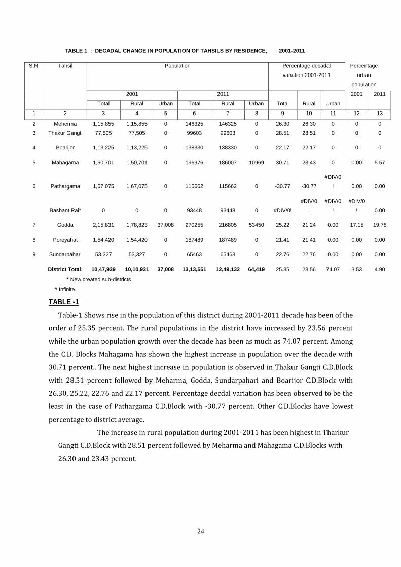
TABLE 1 : DECADAL CHANGE IN POPULATION OF TAHSILS BY RESIDENCE, 2001-2011
S.N. Tahsil Population Percentage decadal
variation 2001-2011
Percentage
urban
population
2001 2011 2001 2011
Total Rural Urban Total Rural Urban Total Rural Urban
1 2 3 4 5 6 7 8 9 10 11 12 13
2 Meherma 1,15,855 1,15,855 0 146325 146325 0 26.30 26.30 0 0 0
3 Thakur Gangti 77,505 77,505 0 99603 99603 0 28.51 28.51 0 0 0
4 Boarijor 1,13,225 1,13,225 0 138330 138330 0 22.17 22.17 0 0 0
5 Mahagama 1,50,701 1,50,701 0 196976 186007 10969 30.71 23.43 0 0.00 5.57
6 Pathargama 1,67,075 1,67,075 0 115662 115662 0 -30.77 -30.77
#DIV/0
! 0.00 0.00
Bashant Rai* 0 0 0 93448 93448 0 #DIV/0!
#DIV/0
!
#DIV/0
!
#DIV/0
! 0.00
7 Godda 2,15,831 1,78,823 37,008 270255 216805 53450 25.22 21.24 0.00 17.15 19.78
8 Poreyahat 1,54,420 1,54,420 0 187489 187489 0 21.41 21.41 0.00 0.00 0.00
9 Sundarpahari 53,327 53,327 0 65463 65463 0 22.76 22.76 0.00 0.00 0.00
District Total: 10,47,939 10,10,931 37,008 13,13,551 12,49,132 64,419 25.35 23.56 74.07 3.53 4.90
* New created sub-districts
# Infinite.
TABLE -1
Table-1 Shows rise in the population of this district during 2001-2011 decade has been of the
order of 25.35 percent. The rural populations in the district have increased by 23.56 percent
while the urban population growth over the decade has been as much as 74.07 percent. Among
the C.D. Blocks Mahagama has shown the highest increase in population over the decade with
30.71 percent.. The next highest increase in population is observed in Thakur Gangti C.D.Block
with 28.51 percent followed by Meharma, Godda, Sundarpahari and Boarijor C.D.Block with
26.30, 25.22, 22.76 and 22.17 percent. Percentage decdal variation has been observed to be the
least in the case of Pathargama C.D.Block with -30.77 percent. Other C.D.Blocks have lowest
percentage to district average.
The increase in rural population during 2001-2011 has been highest in Tharkur
Gangti C.D.Block with 28.51 percent followed by Meharma and Mahagama C.D.Blocks with
26.30 and 23.43 percent.
25
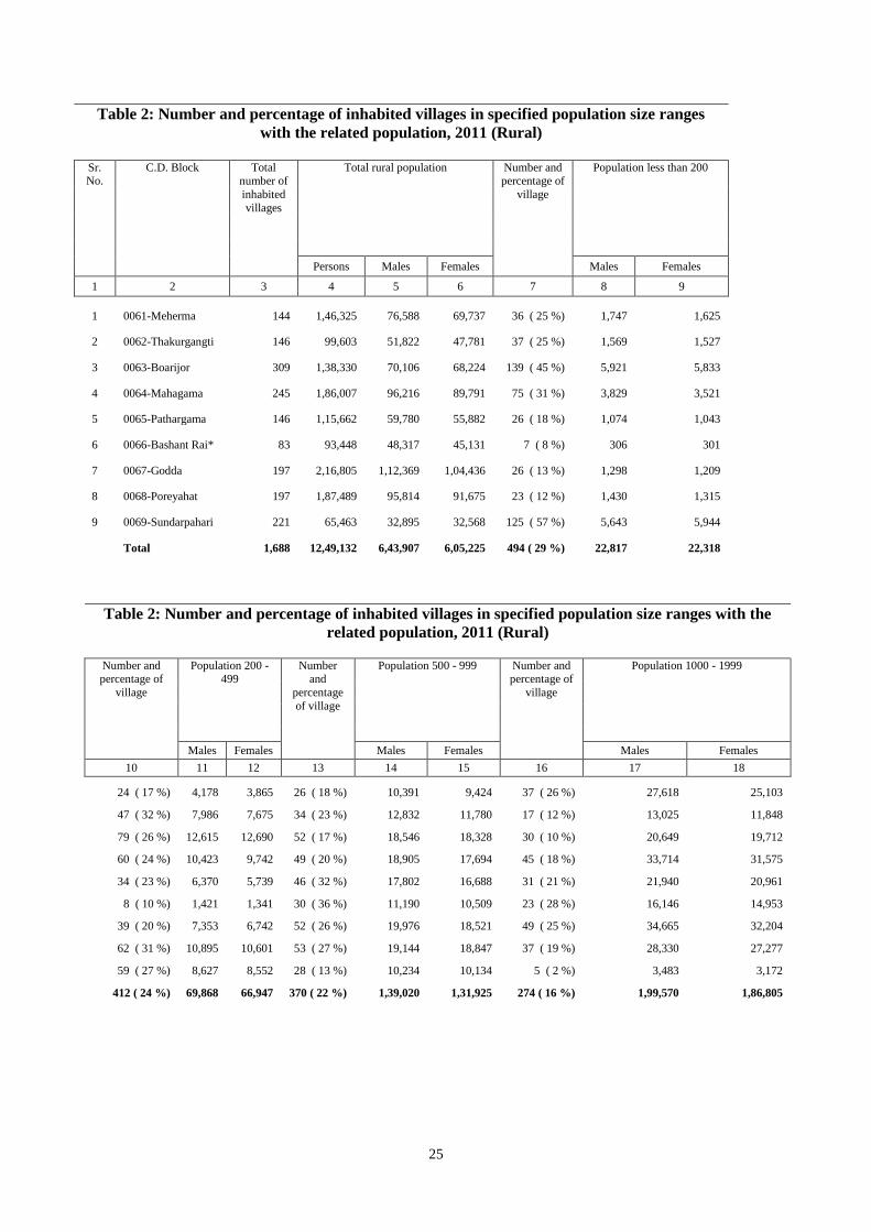
Table 2: Number and percentage of inhabited villages in specified population size ranges
with the related population, 2011 (Rural)
Sr. No.
C.D. Block Total number of
inhabited
villages
Total rural population Number and percentage of
village
Population less than 200
Persons Males Females Males Females
1 2 3 4 5 6 7 8 9
1 0061-Meherma 144 1,46,325 76,588 69,737 36 ( 25 %) 1,747 1,625
2 0062-Thakurgangti 146 99,603 51,822 47,781 37 ( 25 %) 1,569 1,527
3 0063-Boarijor 309 1,38,330 70,106 68,224 139 ( 45 %) 5,921 5,833
4 0064-Mahagama 245 1,86,007 96,216 89,791 75 ( 31 %) 3,829 3,521
5 0065-Pathargama 146 1,15,662 59,780 55,882 26 ( 18 %) 1,074 1,043
6 0066-Bashant Rai* 83 93,448 48,317 45,131 7 ( 8 %) 306 301
7 0067-Godda 197 2,16,805 1,12,369 1,04,436 26 ( 13 %) 1,298 1,209
8 0068-Poreyahat 197 1,87,489 95,814 91,675 23 ( 12 %) 1,430 1,315
9 0069-Sundarpahari 221 65,463 32,895 32,568 125 ( 57 %) 5,643 5,944
Total 1,688 12,49,132 6,43,907 6,05,225 494 ( 29 %) 22,817 22,318
Table 2: Number and percentage of inhabited villages in specified population size ranges with the
related population, 2011 (Rural)
Number and percentage of
village
Population 200 - 499
Number and
percentage
of village
Population 500 - 999 Number and percentage of
village
Population 1000 - 1999
Males Females Males Females Males Females
10 11 12 13 14 15 16 17 18
24 ( 17 %) 4,178 3,865 26 ( 18 %) 10,391 9,424 37 ( 26 %) 27,618 25,103
47 ( 32 %) 7,986 7,675 34 ( 23 %) 12,832 11,780 17 ( 12 %) 13,025 11,848
79 ( 26 %) 12,615 12,690 52 ( 17 %) 18,546 18,328 30 ( 10 %) 20,649 19,712
60 ( 24 %) 10,423 9,742 49 ( 20 %) 18,905 17,694 45 ( 18 %) 33,714 31,575
34 ( 23 %) 6,370 5,739 46 ( 32 %) 17,802 16,688 31 ( 21 %) 21,940 20,961
8 ( 10 %) 1,421 1,341 30 ( 36 %) 11,190 10,509 23 ( 28 %) 16,146 14,953
39 ( 20 %) 7,353 6,742 52 ( 26 %) 19,976 18,521 49 ( 25 %) 34,665 32,204
62 ( 31 %) 10,895 10,601 53 ( 27 %) 19,144 18,847 37 ( 19 %) 28,330 27,277
59 ( 27 %) 8,627 8,552 28 ( 13 %) 10,234 10,134 5 ( 2 %) 3,483 3,172
412 ( 24 %) 69,868 66,947 370 ( 22 %) 1,39,020 1,31,925 274 ( 16 %) 1,99,570 1,86,805
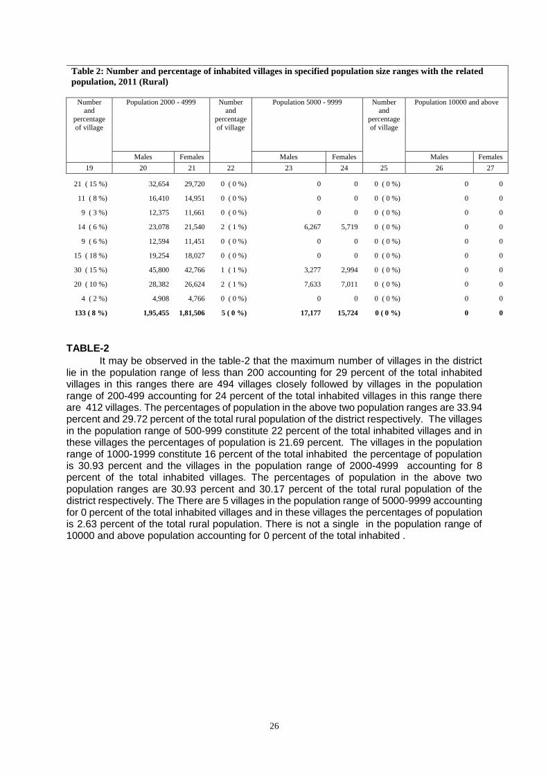
26
Table 2: Number and percentage of inhabited villages in specified population size ranges with the related
population, 2011 (Rural)
Number
and
percentage
of village
Population 2000 - 4999 Number and
percentage
of village
Population 5000 - 9999 Number and
percentage
of village
Population 10000 and above
Males Females Males Females Males Females
19 20 21 22 23 24 25 26 27
21 ( 15 %) 32,654 29,720 0 ( 0 %) 0 0 0 ( 0 %) 0 0
11 ( 8 %) 16,410 14,951 0 ( 0 %) 0 0 0 ( 0 %) 0 0
9 ( 3 %) 12,375 11,661 0 ( 0 %) 0 0 0 ( 0 %) 0 0
14 ( 6 %) 23,078 21,540 2 ( 1 %) 6,267 5,719 0 ( 0 %) 0 0
9 ( 6 %) 12,594 11,451 0 ( 0 %) 0 0 0 ( 0 %) 0 0
15 ( 18 %) 19,254 18,027 0 ( 0 %) 0 0 0 ( 0 %) 0 0
30 ( 15 %) 45,800 42,766 1 ( 1 %) 3,277 2,994 0 ( 0 %) 0 0
20 ( 10 %) 28,382 26,624 2 ( 1 %) 7,633 7,011 0 ( 0 %) 0 0
4 ( 2 %) 4,908 4,766 0 ( 0 %) 0 0 0 ( 0 %) 0 0
133 ( 8 %) 1,95,455 1,81,506 5 ( 0 %) 17,177 15,724 0 ( 0 %) 0 0
TABLE-2
It may be observed in the table-2 that the maximum number of villages in the district lie in the population range of less than 200 accounting for 29 percent of the total inhabited villages in this ranges there are 494 villages closely followed by villages in the population range of 200-499 accounting for 24 percent of the total inhabited villages in this range there are 412 villages. The percentages of population in the above two population ranges are 33.94 percent and 29.72 percent of the total rural population of the district respectively. The villages in the population range of 500-999 constitute 22 percent of the total inhabited villages and in these villages the percentages of population is 21.69 percent. The villages in the population range of 1000-1999 constitute 16 percent of the total inhabited the percentage of population is 30.93 percent and the villages in the population range of 2000-4999 accounting for 8 percent of the total inhabited villages. The percentages of population in the above two population ranges are 30.93 percent and 30.17 percent of the total rural population of the district respectively. The There are 5 villages in the population range of 5000-9999 accounting for 0 percent of the total inhabited villages and in these villages the percentages of population is 2.63 percent of the total rural population. There is not a single in the population range of 10000 and above population accounting for 0 percent of the total inhabited .
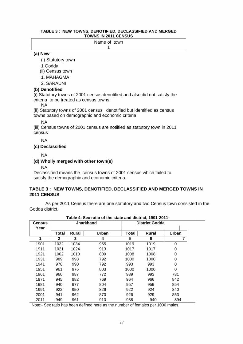
27
TABLE 3 : NEW TOWNS, DENOTIFIED, DECLASSIFIED AND MERGED TOWNS IN 2011 CENSUS
Name of town 1
(a) New
(i) Statutory town
1 Godda (ii) Census town
1. MAHAGMA
2. SARAUNI
(b) Denotified (i) Statutory towns of 2001 census denotified and also did not satisfy the criteria to be treated as census towns NA (ii) Statutory towns of 2001 census denotified but identified as census towns based on demographic and economic criteria
NA (iii) Census towns of 2001 census are notiified as statutory town in 2011 census
NA
(c) Declassified
NA
(d) Wholly merged with other town(s)
NA Declassified means the census towns of 2001 census which failed to satisfy the demographic and economic criteria.
TABLE 3 : NEW TOWNS, DENOTIFIED, DECLASSIFIED AND MERGED TOWNS IN
2011 CENSUS
As per 2011 Census there are one statutory and two Census town consisted in the
Godda district.
Table 4: Sex ratio of the state and district, 1901-2011
Census
Year
Jharkhand District Godda
Total Rural Urban Total Rural Urban
1 2 3 4 5 6 7
1901 1032 1034 955 1019 1019 0
1911 1021 1024 913 1017 1017 0
1921 1002 1010 809 1008 1008 0
1931 989 998 792 1000 1000 0
1941 978 990 792 993 993 0
1951 961 976 803 1000 1000 0
1961 960 987 772 989 993 781
1971 945 982 769 964 966 842
1981 940 977 804 957 959 854
1991 922 950 826 922 924 840
2001 941 962 870 926 929 853
2011 949 961 910 938 940 894
Note:- Sex ratio has been defined here as the number of females per 1000 males.
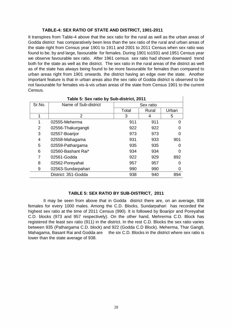
28
TABLE-4: SEX RATIO OF STATE AND DISTRICT, 1901-2011
It transpires from Table-4 above that the sex ratio for the rural as well as the urban areas of
Godda district has comparatively been less than the sex ratio of the rural and urban areas of
the state right from Census year 1901 to 1911 and 2001 to 2011 Census when sex ratio was
found to be, by and large, favourable for females. During 1901 to1931 and 1951 Census year
we observe favourable sex ratio. After 1961 census sex ratio had shown downward trend
both for the state as well as the district. The sex ratio in the rural areas of the district as well
as of the state has always being found to be more favourable for females than compared to
urban areas right from 1901 onwards. the district having an edge over the state. Another
important feature is that in urban areas also the sex ratio of Godda district is observed to be
not favourable for females vis-à-vis urban areas of the state from Census 1901 to the current
Census.
Table 5: Sex ratio by Sub-district, 2011
Sr.No. Name of Sub-district Sex ratio
Total Rural Urban
1 2 3 4 5
1 02555-Meherma 911 911 0
2 02556-Thakurgangti 922 922 0
3 02557-Boarijor 973 973 0
4 02558-Mahagama 931 933 901
5 02559-Pathargama 935 935 0
6 02560-Bashant Rai* 934 934 0
7 02561-Godda 922 929 892
8 02562-Poreyahat 957 957 0
9 02563-Sundarpahari 990 990 0
District: 351-Godda 938 940 894
TABLE 5: SEX RATIO BY SUB-DISTRICT, 2011
It may be seen from above that in Godda district there are, on an average, 938
females for every 1000 males. Among the C.D. Blocks, Sundarpahari has recorded the
highest sex ratio at the time of 2011 Census (990). It is followed by Boarijor and Poreyahat
C.D. blocks (973 and 957 respectively). On the other hand, Mehrerma C.D. Block has
registered the least sex ratio (911) in the district. In the rest C.D. Blocks the sex ratio varies
between 935 (Pathargama C.D. block) and 922 (Godda C.D Block). Meherma, Thar Gangti,
Mahagama, Basant Rai and Godda are the six C.D. Blocks in the district where sex ratio is
lower than the state average of 938.
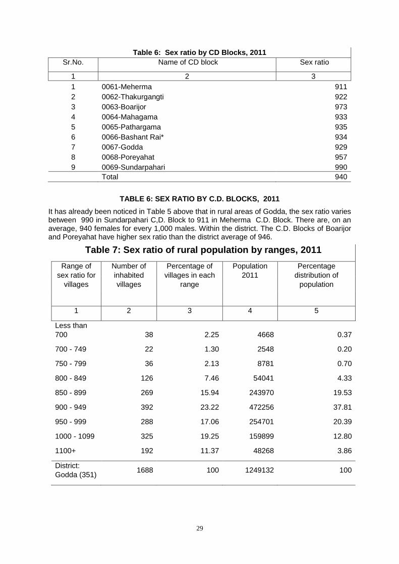
29
Table 6: Sex ratio by CD Blocks, 2011
Sr.No. Name of CD block Sex ratio
1 2 3
1 0061-Meherma 911
2 0062-Thakurgangti 922
3 0063-Boarijor 973
4 0064-Mahagama 933
5 0065-Pathargama 935
6 0066-Bashant Rai* 934
7 0067-Godda 929
8 0068-Poreyahat 957
9 0069-Sundarpahari 990
Total 940
TABLE 6: SEX RATIO BY C.D. BLOCKS, 2011
It has already been noticed in Table 5 above that in rural areas of Godda, the sex ratio varies between 990 in Sundarpahari C,D. Block to 911 in Meherma C.D. Block. There are, on an average, 940 females for every 1,000 males. Within the district. The C.D. Blocks of Boarijor and Poreyahat have higher sex ratio than the district average of 946.
Table 7: Sex ratio of rural population by ranges, 2011
Range of
sex ratio for
villages
Number of
inhabited
villages
Percentage of
villages in each
range
Population
2011
Percentage
distribution of
population
1 2 3 4 5
Less than
700 38 2.25 4668 0.37
700 - 749 22 1.30 2548 0.20
750 - 799 36 2.13 8781 0.70
800 - 849 126 7.46 54041 4.33
850 - 899 269 15.94 243970 19.53
900 - 949 392 23.22 472256 37.81
950 - 999 288 17.06 254701 20.39
1000 - 1099 325 19.25 159899 12.80
1100+ 192 11.37 48268 3.86
District:
Godda (351) 1688 100 1249132 100
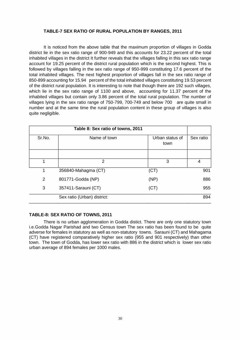
30
TABLE-7 SEX RATIO OF RURAL POPULATION BY RANGES, 2011
It is noticed from the above table that the maximum proportion of villages in Godda
district lie in the sex ratio range of 900-949 and this accounts for 23.22 percent of the total
inhabited villages in the district It further reveals that the villages falling in this sex ratio range
account for 19.25 percent of the district rural population which is the second highest. This is
followed by villages falling in the sex ratio range of 950-999 constituting 17.6 percent of the
total inhabited villages. The next highest proportion of villages fall in the sex ratio range of
850-899 accounting for 15.94 percent of the total inhabited villages constituting 19.53 percent
of the district rural population. It is interesting to note that though there are 192 such villages,
which lie in the sex ratio range of 1100 and above, accounting for 11.37 percent of the
inhabited villages but contain only 3.86 percent of the total rural population. The number of
villages lying in the sex ratio range of 750-799, 700-749 and below 700 are quite small in
number and at the same time the rural population content in these group of villages is also
quite negligible.
Table 8: Sex ratio of towns, 2011
Sr.No. Name of town Urban status of
town
Sex ratio
1 2 3 4
1 356840-Mahagma (CT) (CT) 901
2 801771-Godda (NP) (NP) 886
3 357411-Sarauni (CT) (CT) 955
Sex ratio (Urban) district: 894
TABLE-8: SEX RATIO OF TOWNS, 2011
There is no urban agglomeration in Godda distict. There are only one statutory town i.e.Godda Nagar Parishad and two Census town The sex ratio has been found to be quite adverse for females in statutory as well as non-statutory towns. Sarauni (CT) and Mahagama (CT) have registered comparatively higher sex ratio (955 and 901 respectively) than other town. The town of Godda, has lower sex ratio with 886 in the district which is lower sex ratio urban average of 894 females per 1000 males.
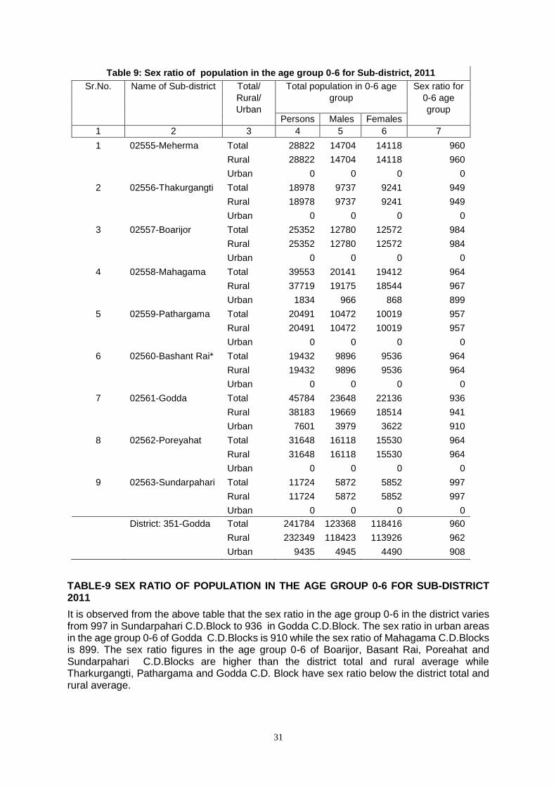
31
Table 9: Sex ratio of population in the age group 0-6 for Sub-district, 2011
Sr.No. Name of Sub-district Total/
Rural/
Urban
Total population in 0-6 age
group
Sex ratio for
0-6 age
group Persons Males Females
1 2 3 4 5 6 7
1 02555-Meherma Total 28822 14704 14118 960
Rural 28822 14704 14118 960
Urban 0 0 0 0
2 02556-Thakurgangti Total 18978 9737 9241 949
Rural 18978 9737 9241 949
Urban 0 0 0 0
3 02557-Boarijor Total 25352 12780 12572 984
Rural 25352 12780 12572 984
Urban 0 0 0 0
4 02558-Mahagama Total 39553 20141 19412 964
Rural 37719 19175 18544 967
Urban 1834 966 868 899
5 02559-Pathargama Total 20491 10472 10019 957
Rural 20491 10472 10019 957
Urban 0 0 0 0
6 02560-Bashant Rai* Total 19432 9896 9536 964
Rural 19432 9896 9536 964
Urban 0 0 0 0
7 02561-Godda Total 45784 23648 22136 936
Rural 38183 19669 18514 941
Urban 7601 3979 3622 910
8 02562-Poreyahat Total 31648 16118 15530 964
Rural 31648 16118 15530 964
Urban 0 0 0 0
9 02563-Sundarpahari Total 11724 5872 5852 997
Rural 11724 5872 5852 997
Urban 0 0 0 0
District: 351-Godda Total 241784 123368 118416 960
Rural 232349 118423 113926 962
Urban 9435 4945 4490 908
TABLE-9 SEX RATIO OF POPULATION IN THE AGE GROUP 0-6 FOR SUB-DISTRICT 2011
It is observed from the above table that the sex ratio in the age group 0-6 in the district varies from 997 in Sundarpahari C.D.Block to 936 in Godda C.D.Block. The sex ratio in urban areas in the age group 0-6 of Godda C.D.Blocks is 910 while the sex ratio of Mahagama C.D.Blocks is 899. The sex ratio figures in the age group 0-6 of Boarijor, Basant Rai, Poreahat and Sundarpahari C.D.Blocks are higher than the district total and rural average while Tharkurgangti, Pathargama and Godda C.D. Block have sex ratio below the district total and rural average.
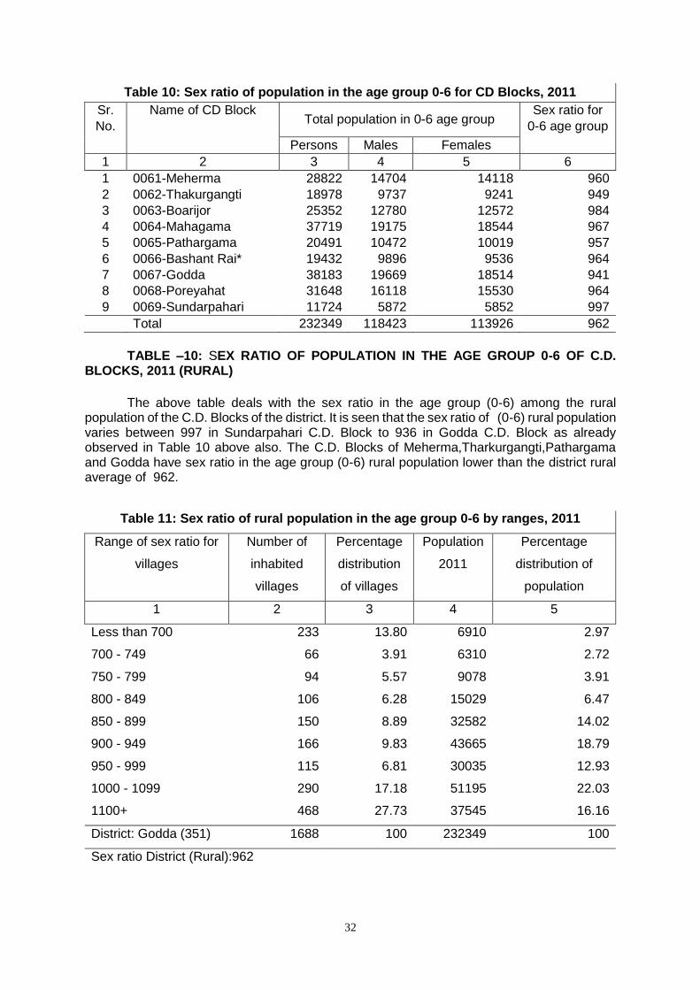
32
Table 10: Sex ratio of population in the age group 0-6 for CD Blocks, 2011
Sr.
No.
Name of CD Block Total population in 0-6 age group
Sex ratio for
0-6 age group
Persons Males Females
1 2 3 4 5 6
1 0061-Meherma 28822 14704 14118 960
2 0062-Thakurgangti 18978 9737 9241 949
3 0063-Boarijor 25352 12780 12572 984
4 0064-Mahagama 37719 19175 18544 967
5 0065-Pathargama 20491 10472 10019 957
6 0066-Bashant Rai* 19432 9896 9536 964
7 0067-Godda 38183 19669 18514 941
8 0068-Poreyahat 31648 16118 15530 964
9 0069-Sundarpahari 11724 5872 5852 997
Total 232349 118423 113926 962
TABLE –10: SEX RATIO OF POPULATION IN THE AGE GROUP 0-6 OF C.D. BLOCKS, 2011 (RURAL)
The above table deals with the sex ratio in the age group (0-6) among the rural population of the C.D. Blocks of the district. It is seen that the sex ratio of (0-6) rural population varies between 997 in Sundarpahari C.D. Block to 936 in Godda C.D. Block as already observed in Table 10 above also. The C.D. Blocks of Meherma,Tharkurgangti,Pathargama and Godda have sex ratio in the age group (0-6) rural population lower than the district rural average of 962.
Table 11: Sex ratio of rural population in the age group 0-6 by ranges, 2011
Range of sex ratio for
villages
Number of
inhabited
villages
Percentage
distribution
of villages
Population
2011
Percentage
distribution of
population
1 2 3 4 5
Less than 700 233 13.80 6910 2.97
700 - 749 66 3.91 6310 2.72
750 - 799 94 5.57 9078 3.91
800 - 849 106 6.28 15029 6.47
850 - 899 150 8.89 32582 14.02
900 - 949 166 9.83 43665 18.79
950 - 999 115 6.81 30035 12.93
1000 - 1099 290 17.18 51195 22.03
1100+ 468 27.73 37545 16.16
District: Godda (351) 1688 100 232349 100
Sex ratio District (Rural):962
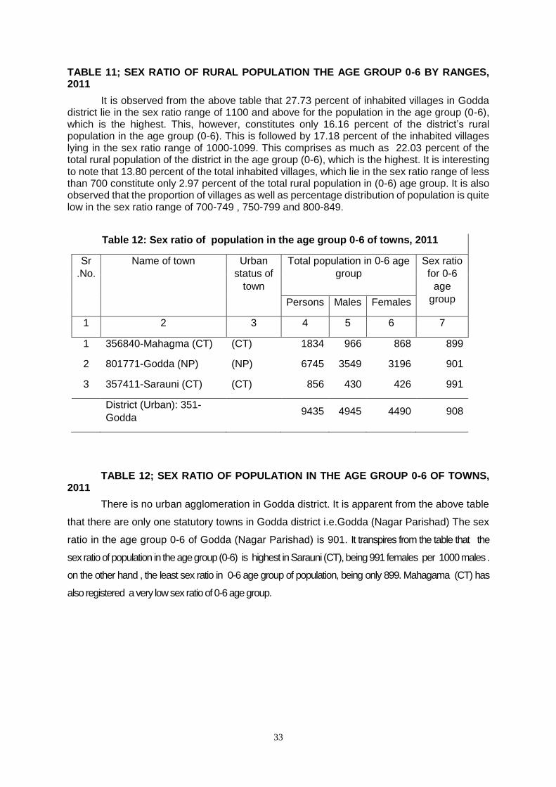
33
TABLE 11; SEX RATIO OF RURAL POPULATION THE AGE GROUP 0-6 BY RANGES, 2011
It is observed from the above table that 27.73 percent of inhabited villages in Godda district lie in the sex ratio range of 1100 and above for the population in the age group (0-6), which is the highest. This, however, constitutes only 16.16 percent of the district’s rural population in the age group (0-6). This is followed by 17.18 percent of the inhabited villages lying in the sex ratio range of 1000-1099. This comprises as much as 22.03 percent of the total rural population of the district in the age group (0-6), which is the highest. It is interesting to note that 13.80 percent of the total inhabited villages, which lie in the sex ratio range of less than 700 constitute only 2.97 percent of the total rural population in (0-6) age group. It is also observed that the proportion of villages as well as percentage distribution of population is quite low in the sex ratio range of 700-749 , 750-799 and 800-849.
Table 12: Sex ratio of population in the age group 0-6 of towns, 2011
Sr
.No.
Name of town Urban
status of
town
Total population in 0-6 age
group
Sex ratio
for 0-6
age
group Persons Males Females
1 2 3 4 5 6 7
1 356840-Mahagma (CT) (CT) 1834 966 868 899
2 801771-Godda (NP) (NP) 6745 3549 3196 901
3 357411-Sarauni (CT) (CT) 856 430 426 991
District (Urban): 351-
Godda 9435 4945 4490 908
TABLE 12; SEX RATIO OF POPULATION IN THE AGE GROUP 0-6 OF TOWNS, 2011
There is no urban agglomeration in Godda district. It is apparent from the above table
that there are only one statutory towns in Godda district i.e.Godda (Nagar Parishad) The sex
ratio in the age group 0-6 of Godda (Nagar Parishad) is 901. It transpires from the table that the
sex ratio of population in the age group (0-6) is highest in Sarauni (CT), being 991 females per 1000 males .
on the other hand , the least sex ratio in 0-6 age group of population, being only 899. Mahagama (CT) has
also registered a very low sex ratio of 0-6 age group.
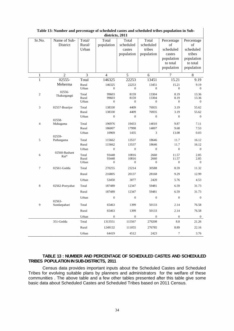
34
Table 13: Number and percentage of scheduled castes and scheduled tribes population in Sub-
districts, 2011
Sr.No. Name of Sub-
District
Total/
Rural/
Urban
Total
population
Total
scheduled
castes
population
Total
scheduled
tribes
population
Percentage
of
scheduled
castes
population
to total
population
Percentage
of
scheduled
tribes
population
to total
population
1 2 3 4 5 6 7 8
1 02555-
Meherma
Total 146325 22253 13451 15.21 9.19
Rural 146325 22253 13451 15.21 9.19
Urban 0 0 0 0 0
2 02556-
Thakurgangti Total 99603 8159 13304 8.19 13.36 Rural 99603 8159 13304 8.19 13.36
Urban 0 0 0 0 0
3 02557-Boarijor Total 138330 4409 76935 3.19 55.62
Rural 138330 4409 76935 3.19 55.62
Urban 0 0 0 0 0
4
02558-
Mahagama Total 196976 19433 14010 9.87 7.11
Rural 186007 17998 14007 9.68 7.53
Urban 10969 1435 3 13.08 0.03
5
02559-
Pathargama Total 115662 13537 18646 11.7 16.12
Rural 115662 13537 18646 11.7 16.12
Urban 0 0 0 0 0
6 02560-Bashant
Rai* Total 93448 10816 2660 11.57 2.85 Rural 93448 10816 2660 11.57 2.85
Urban 0 0 0 0 0
7 02561-Godda Total 270255 23214 30588 8.59 11.32
Rural 216805 20137 28168 9.29 12.99
Urban 53450 3077 2420 5.76 4.53
8 02562-Poreyahat Total 187489 12347 59481 6.59 31.73
Rural 187489 12347 59481 6.59 31.73
Urban 0 0 0 0 0
9 02563-Sundarpahari Total 65463 1399 50133 2.14 76.58
Rural 65463 1399 50133 2.14 76.58
Urban 0 0 0 0 0
351-Godda Total 1313551 115567 279208 8.8 21.26
Rural 1249132 111055 276785 8.89 22.16
Urban 64419 4512 2423 7 3.76
TABLE 13 : NUMBER AND PERCENTAGE OF SCHEDULED CASTES AND SCHEDULED TRIBES POPULATION IN SUB-DISTRICTS, 2011
Census data provides important inputs about the Scheduled Castes and Scheduled Tribes for evolving suitable plans by planners and administrators for the welfare of these communities . The above table and a few other tables presented after this table give some basic data about Scheduled Castes and Scheduled Tribes based on 2011 Census.
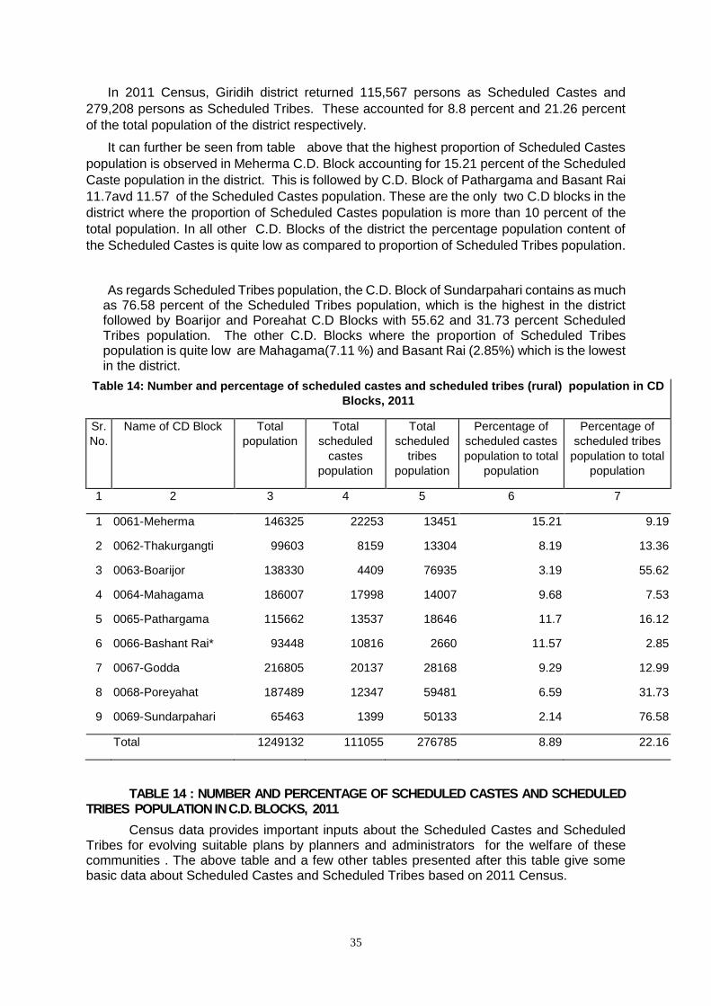
35
In 2011 Census, Giridih district returned 115,567 persons as Scheduled Castes and
279,208 persons as Scheduled Tribes. These accounted for 8.8 percent and 21.26 percent
of the total population of the district respectively.
It can further be seen from table above that the highest proportion of Scheduled Castes
population is observed in Meherma C.D. Block accounting for 15.21 percent of the Scheduled
Caste population in the district. This is followed by C.D. Block of Pathargama and Basant Rai
11.7avd 11.57 of the Scheduled Castes population. These are the only two C.D blocks in the
district where the proportion of Scheduled Castes population is more than 10 percent of the
total population. In all other C.D. Blocks of the district the percentage population content of
the Scheduled Castes is quite low as compared to proportion of Scheduled Tribes population.
As regards Scheduled Tribes population, the C.D. Block of Sundarpahari contains as much as 76.58 percent of the Scheduled Tribes population, which is the highest in the district followed by Boarijor and Poreahat C.D Blocks with 55.62 and 31.73 percent Scheduled Tribes population. The other C.D. Blocks where the proportion of Scheduled Tribes population is quite low are Mahagama(7.11 %) and Basant Rai (2.85%) which is the lowest in the district.
Table 14: Number and percentage of scheduled castes and scheduled tribes (rural) population in CD
Blocks, 2011
Sr.
No.
Name of CD Block Total
population
Total
scheduled
castes
population
Total
scheduled
tribes
population
Percentage of
scheduled castes
population to total
population
Percentage of
scheduled tribes
population to total
population
1 2 3 4 5 6 7
1 0061-Meherma 146325 22253 13451 15.21 9.19
2 0062-Thakurgangti 99603 8159 13304 8.19 13.36
3 0063-Boarijor 138330 4409 76935 3.19 55.62
4 0064-Mahagama 186007 17998 14007 9.68 7.53
5 0065-Pathargama 115662 13537 18646 11.7 16.12
6 0066-Bashant Rai* 93448 10816 2660 11.57 2.85
7 0067-Godda 216805 20137 28168 9.29 12.99
8 0068-Poreyahat 187489 12347 59481 6.59 31.73
9 0069-Sundarpahari 65463 1399 50133 2.14 76.58
Total 1249132 111055 276785 8.89 22.16
TABLE 14 : NUMBER AND PERCENTAGE OF SCHEDULED CASTES AND SCHEDULED TRIBES POPULATION IN C.D. BLOCKS, 2011
Census data provides important inputs about the Scheduled Castes and Scheduled Tribes for evolving suitable plans by planners and administrators for the welfare of these communities . The above table and a few other tables presented after this table give some basic data about Scheduled Castes and Scheduled Tribes based on 2011 Census.
36
In 2011 Census, Godda district returned 111,055 persons as Scheduled Castes and
276,785 persons as Scheduled Tribes. These accounted for 8.89 percent and 22.16 percent
of the total population of the district respectively.
It can further be seen from table above that the highest proportion of Scheduled Castes
population is observed in Meherma C.D. Block accounting for 15.21 percent of the Scheduled
Caste population in the district. This is followed by C.D. Block of Pathargama,Basant Rai,
Mahagama and Godda with 11.7, 11.57, 9.68 and 9.29 percent of the Scheduled Castes
population. These are the only four C.D blocks in the district where the proportion of
Scheduled Castes population is more than 9 percent of the total population. In all other C.D.
Blocks of the district except Mahagama and Basant Rai the percentage population content of
the Scheduled Castes is quite low as compared to proportion of Scheduled Tribes population.
As regards Scheduled Tribes population, the C.D. Block of Sundarpahari contains as much as 76.58 percent of the Scheduled Tribes population, which is the highest in the district followed by Boarijor, Poreahat and Pathargama C.D Blocks with 55.62, 31.73 and 16.12 percent Scheduled Tribes population. The other C.D. Blocks where the proportion of Scheduled Tribes population is quite low are Thargangti (13.36 %), Godda (12.99%), Meherma (9.19%), Mahagama (7.53%) and Basant Rai (2.85%).
Table 15: Proportion of scheduled castes population to total population in villages, 2011
Percentage range of scheduled castes population to total
population
Number of villages
Percentage Scheduled castes
population
Percentage
1 2 3 4 5
NIL 880 52.13 0 0.00 Less than 5 259 15.34 7269 6.55 5 - 10 198 11.73 18955 17.07 11 - 20 176 10.43 32648 29.40 21 - 30 76 4.50 22299 20.08 31 - 40 32 1.90 9873 8.89 41 - 50 21 1.24 7179 6.46 51 - 75 28 1.66 7926 7.14 76 and above 18 1.07 4906 4.42
District: Godda(351) 1688 100.00 111055 100.00
TABLE 15 : PROPORTION OF SCHEDULED CASTES POPULATION TO TOTAL
POPULATION IN VILLAGES, 2011
The above Table furnishes information regarding distribution of villages according to
percentage range of Scheduled Cates population to total population.
It is apparent from the Table that there are 880 villages accounting for as much as 52.13
percent of the inhabited villages in the district where there is no Scheduled Castes population
at all.
There are 259 villages which lie in the Scheduled Castes percentage range of less
than 5.0 percent accounting for 15.34 percent of the inhabited villages in the district comprising
6.55 percent of the Scheduled Castes population where as 198 villages are such which lie in
the Scheduled Castes percentage range 5-10 (constituting 11.73 % of the inhabited villages)
and comprise as much as 17.07 percent of Scheduled Castes population in the district. It may
be interesting noted that there are 176 villages lying in the percentage range of 11-20 and
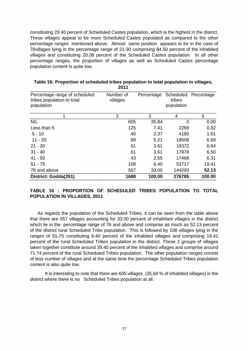
37
constituting 29.40 percent of Scheduled Castes population, which is the highest in the district.
These villages appear to be more Scheduled Castes populated as compared to the other
percentage ranges mentioned above. Almost same position appears to be in the case of
76villages lying in the percentage range of 21-30 comprising 84.50 percent of the inhabited
villages and constituting 20.08 percent of the Scheduled Castes population. In all other
percentage ranges, the proportion of villages as well as Scheduled Castes percentage
population content is quite low.
Table 16: Proportion of scheduled tribes population to total population in villages, 2011
Percentage range of scheduled tribes population to total population
Number of villages
Percentage Scheduled tribes
population
Percentage
1 2 3 4 5
NIL 605 35.84 0 0.00
Less than 5 125 7.41 2269 0.82
5 - 10 40 2.37 4180 1.51
11 - 20 88 5.21 18508 6.69
21 - 30 61 3.61 18372 6.64
31 - 40 61 3.61 17978 6.50
41 - 50 43 2.55 17468 6.31
51 - 75 108 6.40 53717 19.41
76 and above 557 33.00 144293 52.13
District: Godda(351) 1688 100.00 276785 100.00
TABLE 16 : PROPORTION OF SCHEDULED TRIBES POPULATION TO TOTAL
POPULATION IN VILLAGES, 2011
As regards the population of the Scheduled Tribes, it can be seen from the table above
that there are 557 villages accounting for 33.00 percent of inhabitant villages in the district
which lie in the percentage range of 76 and above and comprise as much as 52.13 percent
of the district rural Scheduled Tribe population. This is followed by 108 villages lying in the
ranges of 51-75 constituting 6.40 percent of the inhabited villages and comprising 19.41
percent of the rural Scheduled Tribes population in the district. These 2 groups of villages
taken together constitute around 39.40 percent of the inhabited villages and comprise around
71.74 percent of the rural Scheduled Tribes population. The other population ranges consist
of less number of villages and at the same time the percentage Scheduled Tribes population
content is also quite low.
It is interesting to note that there are 605 villages (35.84 % of inhabited villages) in the
district where there is no Scheduled Tribes population at all.
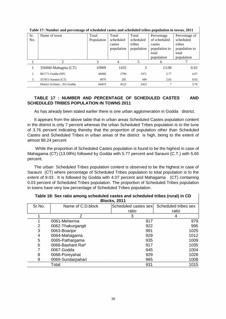
38
Table 17: Number and percentage of scheduled castes and scheduled tribes population in towns, 2011
Sr.
No.
Name of town Total
Population
Total
scheduled
castes
population
Total
scheduled
tribes
population
Percentage
of scheduled
castes
population to
total
population
Percentage of
scheduled
tribes
population to
total
population
1 2 3 4 5 6 7
1 356840-Mahagma (CT) 10969 1435 3 13.08 0.03
2 801771-Godda (NP) 48480 2796 1971 5.77 4.07
3 357411-Sarauni (CT) 4970 281 449 5.65 9.03
District (Urban) : 351-Godda 64419 4512 2423 7 3.76
TABLE 17 : NUMBER AND PERCENTAGE OF SCHEDULED CASTES AND
SCHEDULED TRIBES POPULATION IN TOWNS 2011
As has already been stated earlier there is one urban agglomeration in Godda district.
It appears from the above table that in urban areas Scheduled Castes population content
in the district is only 7 percent whereas the urban Scheduled Tribes population is to the tune
of 3.76 percent indicating thereby that the proportion of population other than Scheduled
Castes and Scheduled Tribes in urban areas of the district is high, being to the extent of
almost 89.24 percent
While the proportion of Scheduled Castes population is found to be the highest in case of
Mahagama (CT) (13.08%) followed by Godda with 5.77 percent and Sarauni (C.T.) with 5.65
percent.
The urban Scheduled Tribes population content is observed to be the highest in case of
Sarauni (CT) where percentage of Scheduled Tribes population to total population is to the
extent of 9.03 . It is followed by Godda with 4.07 percent and Mahagama (CT) containing
0.03 percent of Scheduled Tribes population. The proportion of Scheduled Tribes population
in towns have very low percentage of Scheduled Tribes population.
Table 18: Sex ratio among scheduled castes and scheduled tribes (rural) in CD Blocks, 2011
Sr.No. Name of C.D.block Scheduled castes sex ratio
Scheduled tribes sex ratio
1 2 3 4
1 0061-Meherma 917 979 2 0062-Thakurgangti 922 995 3 0063-Boarijor 991 1025 4 0064-Mahagama 929 1012 5 0065-Pathargama 935 1009 6 0066-Bashant Rai* 917 1035 7 0067-Godda 945 1004 8 0068-Poreyahat 929 1028 9 0069-Sundarpahari 965 1008
Total 931 1015
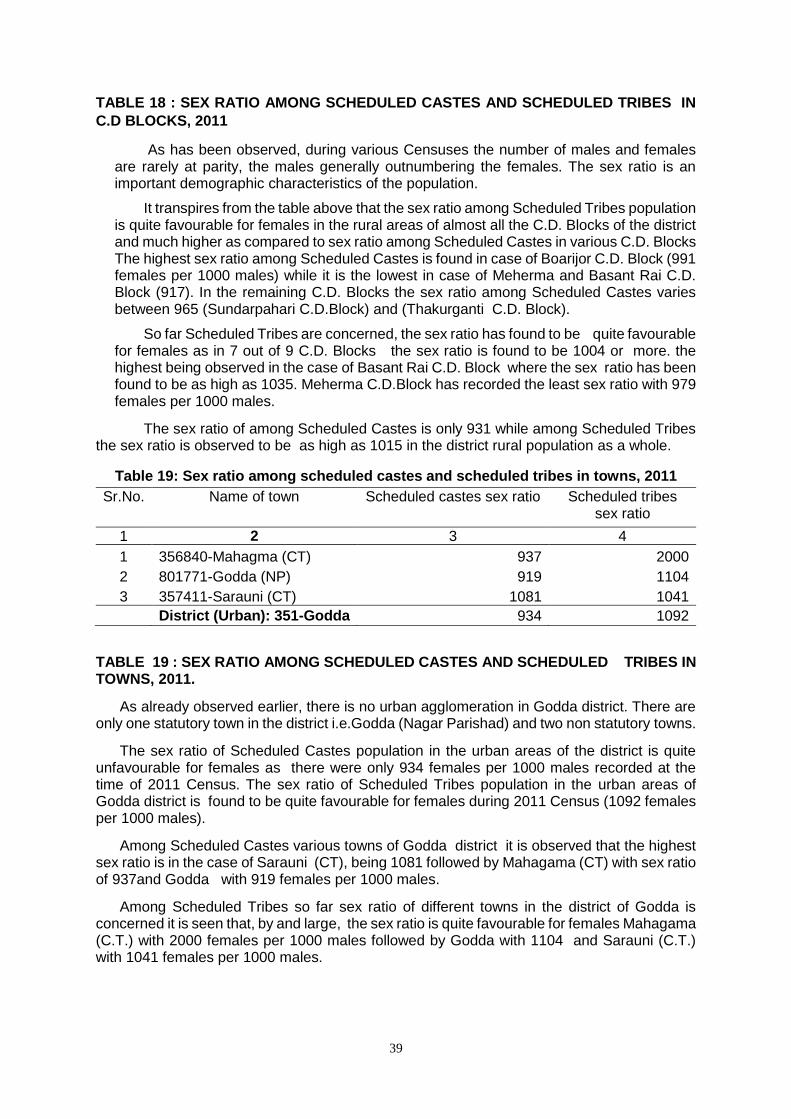
39
TABLE 18 : SEX RATIO AMONG SCHEDULED CASTES AND SCHEDULED TRIBES IN
C.D BLOCKS, 2011
As has been observed, during various Censuses the number of males and females are rarely at parity, the males generally outnumbering the females. The sex ratio is an important demographic characteristics of the population.
It transpires from the table above that the sex ratio among Scheduled Tribes population is quite favourable for females in the rural areas of almost all the C.D. Blocks of the district and much higher as compared to sex ratio among Scheduled Castes in various C.D. Blocks The highest sex ratio among Scheduled Castes is found in case of Boarijor C.D. Block (991 females per 1000 males) while it is the lowest in case of Meherma and Basant Rai C.D. Block (917). In the remaining C.D. Blocks the sex ratio among Scheduled Castes varies between 965 (Sundarpahari C.D.Block) and (Thakurganti C.D. Block).
So far Scheduled Tribes are concerned, the sex ratio has found to be quite favourable for females as in 7 out of 9 C.D. Blocks the sex ratio is found to be 1004 or more. the highest being observed in the case of Basant Rai C.D. Block where the sex ratio has been found to be as high as 1035. Meherma C.D.Block has recorded the least sex ratio with 979 females per 1000 males.
The sex ratio of among Scheduled Castes is only 931 while among Scheduled Tribes the sex ratio is observed to be as high as 1015 in the district rural population as a whole.
Table 19: Sex ratio among scheduled castes and scheduled tribes in towns, 2011
Sr.No. Name of town Scheduled castes sex ratio Scheduled tribes sex ratio
1 2 3 4
1 356840-Mahagma (CT) 937 2000
2 801771-Godda (NP) 919 1104
3 357411-Sarauni (CT) 1081 1041
District (Urban): 351-Godda 934 1092
TABLE 19 : SEX RATIO AMONG SCHEDULED CASTES AND SCHEDULED TRIBES IN TOWNS, 2011.
As already observed earlier, there is no urban agglomeration in Godda district. There are only one statutory town in the district i.e.Godda (Nagar Parishad) and two non statutory towns.
The sex ratio of Scheduled Castes population in the urban areas of the district is quite unfavourable for females as there were only 934 females per 1000 males recorded at the time of 2011 Census. The sex ratio of Scheduled Tribes population in the urban areas of Godda district is found to be quite favourable for females during 2011 Census (1092 females per 1000 males).
Among Scheduled Castes various towns of Godda district it is observed that the highest sex ratio is in the case of Sarauni (CT), being 1081 followed by Mahagama (CT) with sex ratio of 937and Godda with 919 females per 1000 males.
Among Scheduled Tribes so far sex ratio of different towns in the district of Godda is concerned it is seen that, by and large, the sex ratio is quite favourable for females Mahagama (C.T.) with 2000 females per 1000 males followed by Godda with 1104 and Sarauni (C.T.) with 1041 females per 1000 males.
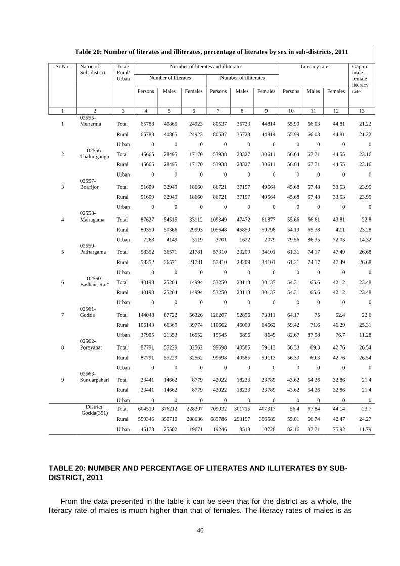
40
Table 20: Number of literates and illiterates, percentage of literates by sex in sub-districts, 2011
Sr.No. Name of
Sub-district Total/ Rural/
Urban
Number of literates and illiterates Literacy rate Gap in male-
female
literacy rate
Number of literates Number of illiterates
Persons Males Females Persons Males Females Persons Males Females
1 2 3 4 5 6 7 8 9 10 11 12 13
1
02555-
Meherma Total 65788 40865 24923 80537 35723 44814 55.99 66.03 44.81 21.22
Rural 65788 40865 24923 80537 35723 44814 55.99 66.03 44.81 21.22
Urban 0 0 0 0 0 0 0 0 0 0
2 02556-
Thakurgangti Total 45665 28495 17170 53938 23327 30611 56.64 67.71 44.55 23.16
Rural 45665 28495 17170 53938 23327 30611 56.64 67.71 44.55 23.16
Urban 0 0 0 0 0 0 0 0 0 0
3 02557-Boarijor Total 51609 32949 18660 86721 37157 49564 45.68 57.48 33.53 23.95
Rural 51609 32949 18660 86721 37157 49564 45.68 57.48 33.53 23.95
Urban 0 0 0 0 0 0 0 0 0 0
4
02558-
Mahagama Total 87627 54515 33112 109349 47472 61877 55.66 66.61 43.81 22.8
Rural 80359 50366 29993 105648 45850 59798 54.19 65.38 42.1 23.28
Urban 7268 4149 3119 3701 1622 2079 79.56 86.35 72.03 14.32
5
02559-
Pathargama Total 58352 36571 21781 57310 23209 34101 61.31 74.17 47.49 26.68
Rural 58352 36571 21781 57310 23209 34101 61.31 74.17 47.49 26.68
Urban 0 0 0 0 0 0 0 0 0 0
6 02560-
Bashant Rai* Total 40198 25204 14994 53250 23113 30137 54.31 65.6 42.12 23.48
Rural 40198 25204 14994 53250 23113 30137 54.31 65.6 42.12 23.48
Urban 0 0 0 0 0 0 0 0 0 0
7 02561-Godda Total 144048 87722 56326 126207 52896 73311 64.17 75 52.4 22.6
Rural 106143 66369 39774 110662 46000 64662 59.42 71.6 46.29 25.31
Urban 37905 21353 16552 15545 6896 8649 82.67 87.98 76.7 11.28
8
02562-
Poreyahat Total 87791 55229 32562 99698 40585 59113 56.33 69.3 42.76 26.54
Rural 87791 55229 32562 99698 40585 59113 56.33 69.3 42.76 26.54
Urban 0 0 0 0 0 0 0 0 0 0
9
02563-
Sundarpahari Total 23441 14662 8779 42022 18233 23789 43.62 54.26 32.86 21.4
Rural 23441 14662 8779 42022 18233 23789 43.62 54.26 32.86 21.4
Urban 0 0 0 0 0 0 0 0 0 0
District:
Godda(351) Total 604519 376212 228307 709032 301715 407317 56.4 67.84 44.14 23.7
Rural 559346 350710 208636 689786 293197 396589 55.01 66.74 42.47 24.27
Urban 45173 25502 19671 19246 8518 10728 82.16 87.71 75.92 11.79
TABLE 20: NUMBER AND PERCENTAGE OF LITERATES AND ILLITERATES BY SUB-
DISTRICT, 2011
From the data presented in the table it can be seen that for the district as a whole, the
literacy rate of males is much higher than that of females. The literacy rates of males is as
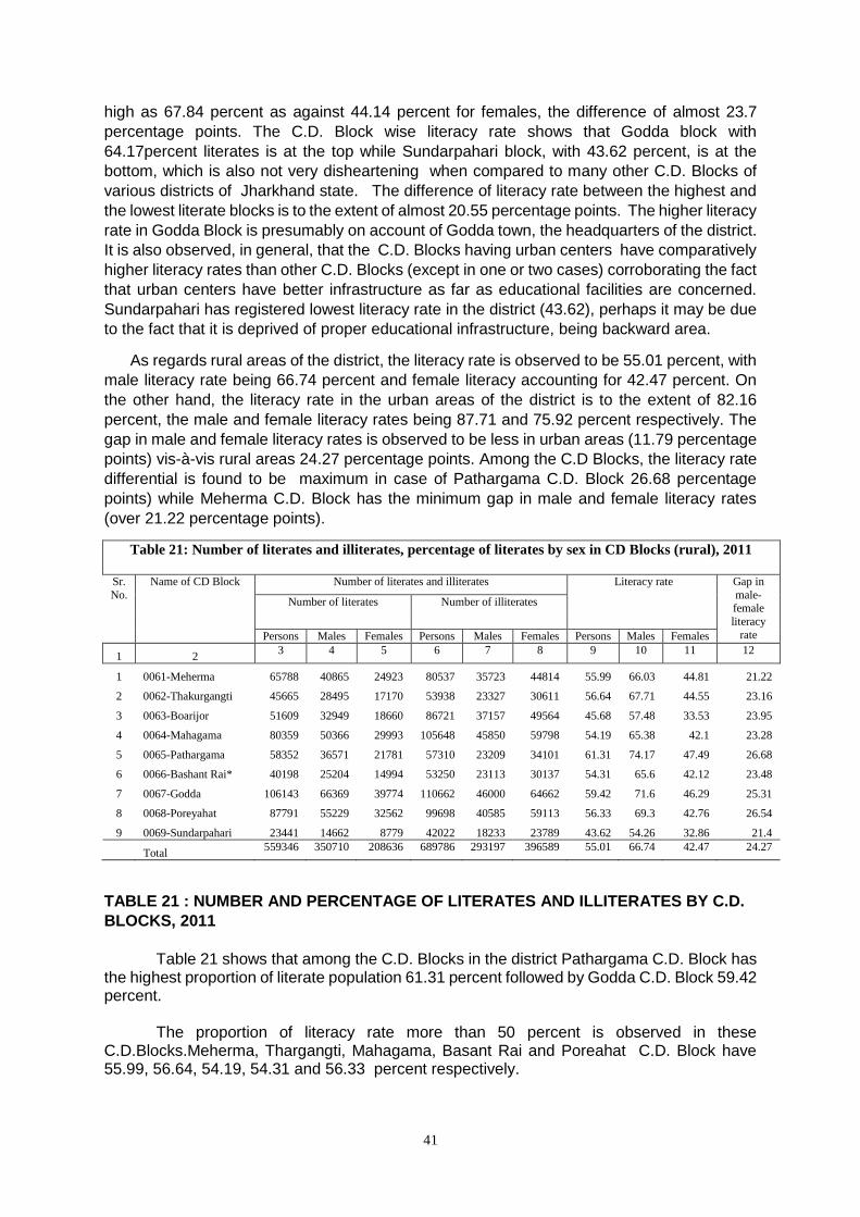
41
high as 67.84 percent as against 44.14 percent for females, the difference of almost 23.7
percentage points. The C.D. Block wise literacy rate shows that Godda block with
64.17percent literates is at the top while Sundarpahari block, with 43.62 percent, is at the
bottom, which is also not very disheartening when compared to many other C.D. Blocks of
various districts of Jharkhand state. The difference of literacy rate between the highest and
the lowest literate blocks is to the extent of almost 20.55 percentage points. The higher literacy
rate in Godda Block is presumably on account of Godda town, the headquarters of the district.
It is also observed, in general, that the C.D. Blocks having urban centers have comparatively
higher literacy rates than other C.D. Blocks (except in one or two cases) corroborating the fact
that urban centers have better infrastructure as far as educational facilities are concerned.
Sundarpahari has registered lowest literacy rate in the district (43.62), perhaps it may be due
to the fact that it is deprived of proper educational infrastructure, being backward area.
As regards rural areas of the district, the literacy rate is observed to be 55.01 percent, with
male literacy rate being 66.74 percent and female literacy accounting for 42.47 percent. On
the other hand, the literacy rate in the urban areas of the district is to the extent of 82.16
percent, the male and female literacy rates being 87.71 and 75.92 percent respectively. The
gap in male and female literacy rates is observed to be less in urban areas (11.79 percentage
points) vis-à-vis rural areas 24.27 percentage points. Among the C.D Blocks, the literacy rate
differential is found to be maximum in case of Pathargama C.D. Block 26.68 percentage
points) while Meherma C.D. Block has the minimum gap in male and female literacy rates
(over 21.22 percentage points).
Table 21: Number of literates and illiterates, percentage of literates by sex in CD Blocks (rural), 2011
Sr.
No.
Name of CD Block Number of literates and illiterates Literacy rate Gap in
male-female
literacy
rate
Number of literates Number of illiterates
Persons Males Females Persons Males Females Persons Males Females
1 2 3 4 5 6 7 8 9 10 11 12
1 0061-Meherma 65788 40865 24923 80537 35723 44814 55.99 66.03 44.81 21.22
2 0062-Thakurgangti 45665 28495 17170 53938 23327 30611 56.64 67.71 44.55 23.16
3 0063-Boarijor 51609 32949 18660 86721 37157 49564 45.68 57.48 33.53 23.95
4 0064-Mahagama 80359 50366 29993 105648 45850 59798 54.19 65.38 42.1 23.28
5 0065-Pathargama 58352 36571 21781 57310 23209 34101 61.31 74.17 47.49 26.68
6 0066-Bashant Rai* 40198 25204 14994 53250 23113 30137 54.31 65.6 42.12 23.48
7 0067-Godda 106143 66369 39774 110662 46000 64662 59.42 71.6 46.29 25.31
8 0068-Poreyahat 87791 55229 32562 99698 40585 59113 56.33 69.3 42.76 26.54
9 0069-Sundarpahari 23441 14662 8779 42022 18233 23789 43.62 54.26 32.86 21.4
Total 559346 350710 208636 689786 293197 396589 55.01 66.74 42.47 24.27
TABLE 21 : NUMBER AND PERCENTAGE OF LITERATES AND ILLITERATES BY C.D.
BLOCKS, 2011
Table 21 shows that among the C.D. Blocks in the district Pathargama C.D. Block has the highest proportion of literate population 61.31 percent followed by Godda C.D. Block 59.42 percent. The proportion of literacy rate more than 50 percent is observed in these C.D.Blocks.Meherma, Thargangti, Mahagama, Basant Rai and Poreahat C.D. Block have 55.99, 56.64, 54.19, 54.31 and 56.33 percent respectively.
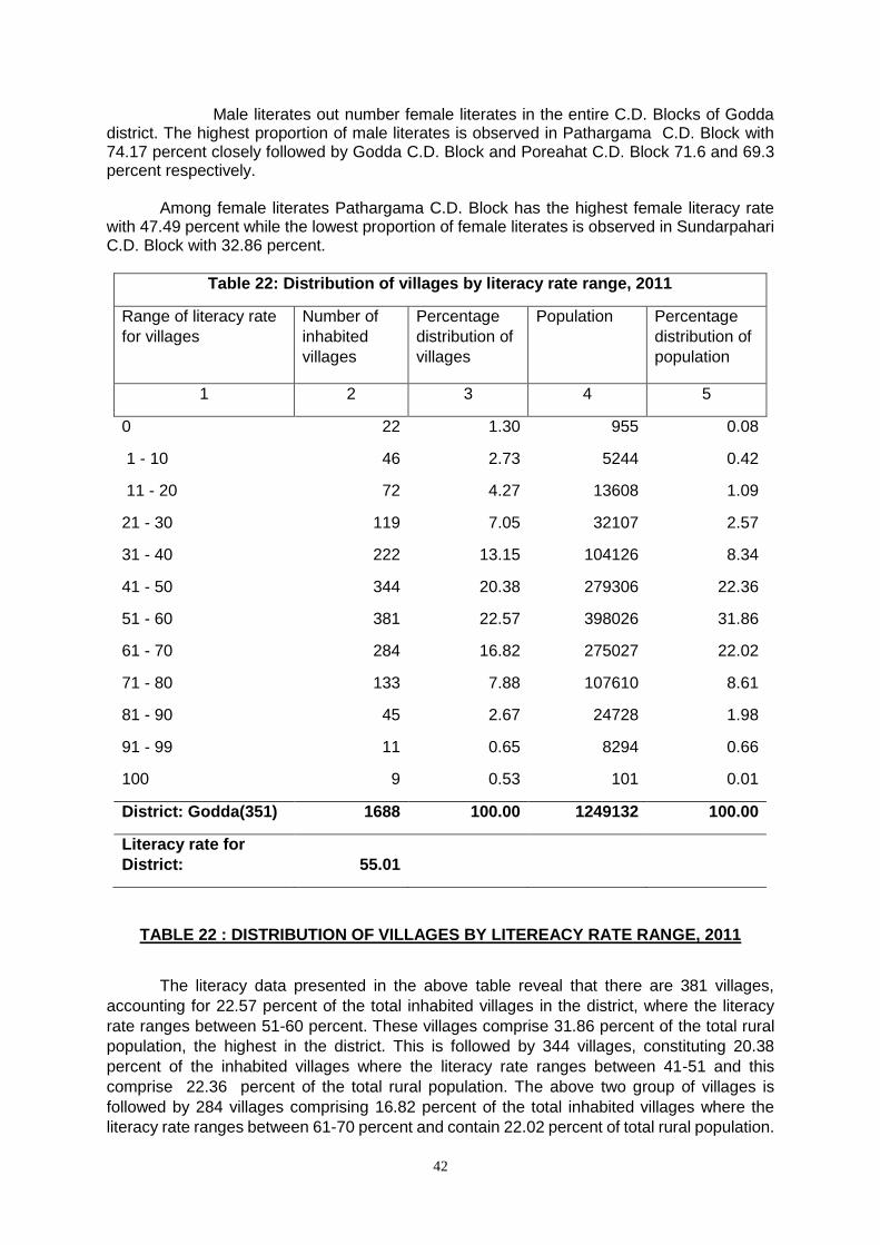
42
Male literates out number female literates in the entire C.D. Blocks of Godda district. The highest proportion of male literates is observed in Pathargama C.D. Block with 74.17 percent closely followed by Godda C.D. Block and Poreahat C.D. Block 71.6 and 69.3 percent respectively. Among female literates Pathargama C.D. Block has the highest female literacy rate with 47.49 percent while the lowest proportion of female literates is observed in Sundarpahari C.D. Block with 32.86 percent.
Table 22: Distribution of villages by literacy rate range, 2011
Range of literacy rate
for villages
Number of
inhabited
villages
Percentage
distribution of
villages
Population Percentage
distribution of
population
1 2 3 4 5
0 22 1.30 955 0.08
1 - 10 46 2.73 5244 0.42
11 - 20 72 4.27 13608 1.09
21 - 30 119 7.05 32107 2.57
31 - 40 222 13.15 104126 8.34
41 - 50 344 20.38 279306 22.36
51 - 60 381 22.57 398026 31.86
61 - 70 284 16.82 275027 22.02
71 - 80 133 7.88 107610 8.61
81 - 90 45 2.67 24728 1.98
91 - 99 11 0.65 8294 0.66
100 9 0.53 101 0.01
District: Godda(351) 1688 100.00 1249132 100.00
Literacy rate for
District: 55.01
TABLE 22 : DISTRIBUTION OF VILLAGES BY LITEREACY RATE RANGE, 2011
The literacy data presented in the above table reveal that there are 381 villages,
accounting for 22.57 percent of the total inhabited villages in the district, where the literacy
rate ranges between 51-60 percent. These villages comprise 31.86 percent of the total rural
population, the highest in the district. This is followed by 344 villages, constituting 20.38
percent of the inhabited villages where the literacy rate ranges between 41-51 and this
comprise 22.36 percent of the total rural population. The above two group of villages is
followed by 284 villages comprising 16.82 percent of the total inhabited villages where the
literacy rate ranges between 61-70 percent and contain 22.02 percent of total rural population.
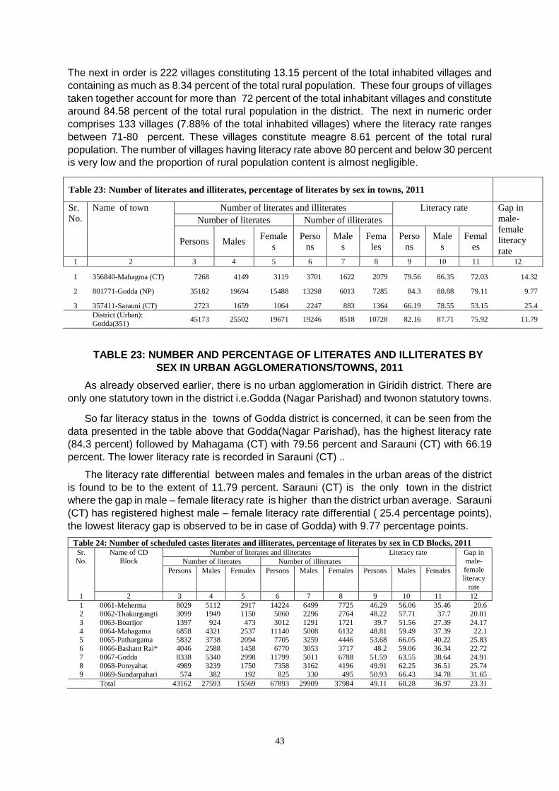
43
The next in order is 222 villages constituting 13.15 percent of the total inhabited villages and
containing as much as 8.34 percent of the total rural population. These four groups of villages
taken together account for more than 72 percent of the total inhabitant villages and constitute
around 84.58 percent of the total rural population in the district. The next in numeric order
comprises 133 villages (7.88% of the total inhabited villages) where the literacy rate ranges
between 71-80 percent. These villages constitute meagre 8.61 percent of the total rural
population. The number of villages having literacy rate above 80 percent and below 30 percent
is very low and the proportion of rural population content is almost negligible.
Table 23: Number of literates and illiterates, percentage of literates by sex in towns, 2011
Sr.
No.
Name of town Number of literates and illiterates Literacy rate Gap in
male-
female
literacy
rate
Number of literates Number of illiterates
Persons Males Female
s
Perso
ns
Male
s
Fema
les
Perso
ns
Male
s
Femal
es
1 2 3 4 5 6 7 8 9 10 11 12
1 356840-Mahagma (CT) 7268 4149 3119 3701 1622 2079 79.56 86.35 72.03 14.32
2 801771-Godda (NP) 35182 19694 15488 13298 6013 7285 84.3 88.88 79.11 9.77
3 357411-Sarauni (CT) 2723 1659 1064 2247 883 1364 66.19 78.55 53.15 25.4
District (Urban):
Godda(351) 45173 25502 19671 19246 8518 10728 82.16 87.71 75.92 11.79
TABLE 23: NUMBER AND PERCENTAGE OF LITERATES AND ILLITERATES BY
SEX IN URBAN AGGLOMERATIONS/TOWNS, 2011
As already observed earlier, there is no urban agglomeration in Giridih district. There are
only one statutory town in the district i.e.Godda (Nagar Parishad) and twonon statutory towns.
So far literacy status in the towns of Godda district is concerned, it can be seen from the
data presented in the table above that Godda(Nagar Parishad), has the highest literacy rate
(84.3 percent) followed by Mahagama (CT) with 79.56 percent and Sarauni (CT) with 66.19
percent. The lower literacy rate is recorded in Sarauni (CT) ..
The literacy rate differential between males and females in the urban areas of the district
is found to be to the extent of 11.79 percent. Sarauni (CT) is the only town in the district
where the gap in male – female literacy rate is higher than the district urban average. Sarauni
(CT) has registered highest male – female literacy rate differential ( 25.4 percentage points),
the lowest literacy gap is observed to be in case of Godda) with 9.77 percentage points.
Table 24: Number of scheduled castes literates and illiterates, percentage of literates by sex in CD Blocks, 2011 Sr.
No.
Name of CD
Block
Number of literates and illiterates Literacy rate Gap in
male-
female literacy
rate
Number of literates Number of illiterates
Persons Males Females Persons Males Females Persons Males Females
1 2 3 4 5 6 7 8 9 10 11 12
1 0061-Meherma 8029 5112 2917 14224 6499 7725 46.29 56.06 35.46 20.6 2 0062-Thakurgangti 3099 1949 1150 5060 2296 2764 48.22 57.71 37.7 20.01
3 0063-Boarijor 1397 924 473 3012 1291 1721 39.7 51.56 27.39 24.17
4 0064-Mahagama 6858 4321 2537 11140 5008 6132 48.81 59.49 37.39 22.1 5 0065-Pathargama 5832 3738 2094 7705 3259 4446 53.68 66.05 40.22 25.83
6 0066-Bashant Rai* 4046 2588 1458 6770 3053 3717 48.2 59.06 36.34 22.72
7 0067-Godda 8338 5340 2998 11799 5011 6788 51.59 63.55 38.64 24.91 8 0068-Poreyahat 4989 3239 1750 7358 3162 4196 49.91 62.25 36.51 25.74
9 0069-Sundarpahari 574 382 192 825 330 495 50.93 66.43 34.78 31.65
Total 43162 27593 15569 67893 29909 37984 49.11 60.28 36.97 23.31
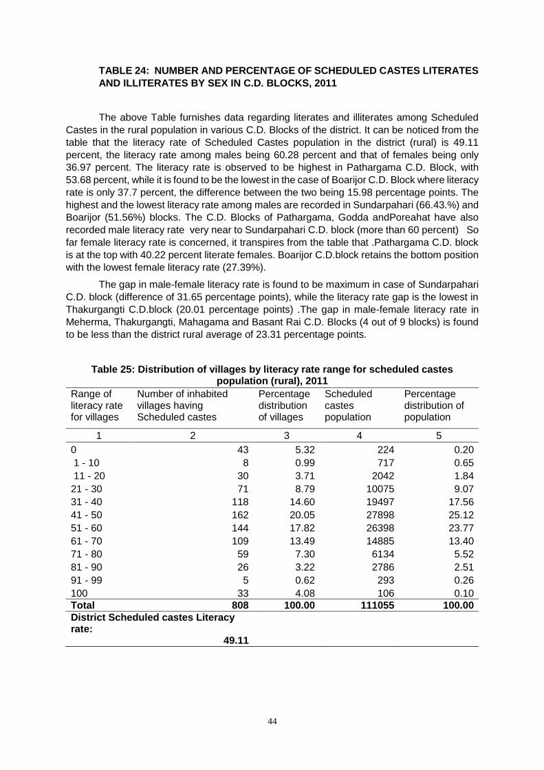
44
TABLE 24: NUMBER AND PERCENTAGE OF SCHEDULED CASTES LITERATES
AND ILLITERATES BY SEX IN C.D. BLOCKS, 2011
The above Table furnishes data regarding literates and illiterates among Scheduled
Castes in the rural population in various C.D. Blocks of the district. It can be noticed from the
table that the literacy rate of Scheduled Castes population in the district (rural) is 49.11
percent, the literacy rate among males being 60.28 percent and that of females being only
36.97 percent. The literacy rate is observed to be highest in Pathargama C.D. Block, with
53.68 percent, while it is found to be the lowest in the case of Boarijor C.D. Block where literacy
rate is only 37.7 percent, the difference between the two being 15.98 percentage points. The
highest and the lowest literacy rate among males are recorded in Sundarpahari (66.43.%) and
Boarijor (51.56%) blocks. The C.D. Blocks of Pathargama, Godda andPoreahat have also
recorded male literacy rate very near to Sundarpahari C.D. block (more than 60 percent) So
far female literacy rate is concerned, it transpires from the table that .Pathargama C.D. block
is at the top with 40.22 percent literate females. Boarijor C.D.block retains the bottom position
with the lowest female literacy rate (27.39%).
The gap in male-female literacy rate is found to be maximum in case of Sundarpahari
C.D. block (difference of 31.65 percentage points), while the literacy rate gap is the lowest in
Thakurgangti C.D.block (20.01 percentage points) .The gap in male-female literacy rate in
Meherma, Thakurgangti, Mahagama and Basant Rai C.D. Blocks (4 out of 9 blocks) is found
to be less than the district rural average of 23.31 percentage points.
Table 25: Distribution of villages by literacy rate range for scheduled castes population (rural), 2011
Range of literacy rate for villages
Number of inhabited villages having Scheduled castes
Percentage distribution of villages
Scheduled castes population
Percentage distribution of population
1 2 3 4 5
0 43 5.32 224 0.20
1 - 10 8 0.99 717 0.65
11 - 20 30 3.71 2042 1.84
21 - 30 71 8.79 10075 9.07
31 - 40 118 14.60 19497 17.56
41 - 50 162 20.05 27898 25.12
51 - 60 144 17.82 26398 23.77
61 - 70 109 13.49 14885 13.40
71 - 80 59 7.30 6134 5.52
81 - 90 26 3.22 2786 2.51
91 - 99 5 0.62 293 0.26
100 33 4.08 106 0.10
Total 808 100.00 111055 100.00
District Scheduled castes Literacy rate:
49.11
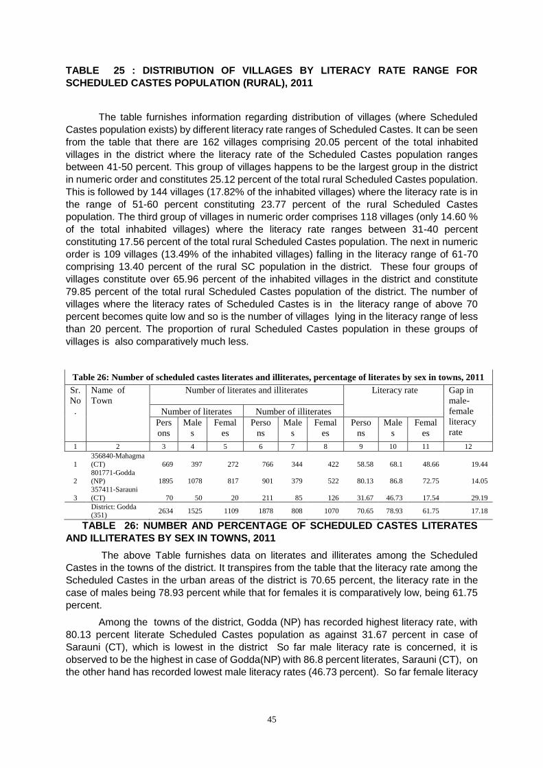
45
TABLE 25 : DISTRIBUTION OF VILLAGES BY LITERACY RATE RANGE FOR
SCHEDULED CASTES POPULATION (RURAL), 2011
The table furnishes information regarding distribution of villages (where Scheduled
Castes population exists) by different literacy rate ranges of Scheduled Castes. It can be seen
from the table that there are 162 villages comprising 20.05 percent of the total inhabited
villages in the district where the literacy rate of the Scheduled Castes population ranges
between 41-50 percent. This group of villages happens to be the largest group in the district
in numeric order and constitutes 25.12 percent of the total rural Scheduled Castes population.
This is followed by 144 villages (17.82% of the inhabited villages) where the literacy rate is in
the range of 51-60 percent constituting 23.77 percent of the rural Scheduled Castes
population. The third group of villages in numeric order comprises 118 villages (only 14.60 %
of the total inhabited villages) where the literacy rate ranges between 31-40 percent
constituting 17.56 percent of the total rural Scheduled Castes population. The next in numeric
order is 109 villages (13.49% of the inhabited villages) falling in the literacy range of 61-70
comprising 13.40 percent of the rural SC population in the district. These four groups of
villages constitute over 65.96 percent of the inhabited villages in the district and constitute
79.85 percent of the total rural Scheduled Castes population of the district. The number of
villages where the literacy rates of Scheduled Castes is in the literacy range of above 70
percent becomes quite low and so is the number of villages lying in the literacy range of less
than 20 percent. The proportion of rural Scheduled Castes population in these groups of
villages is also comparatively much less.
Table 26: Number of scheduled castes literates and illiterates, percentage of literates by sex in towns, 2011
Sr.
No
.
Name of
Town
Number of literates and illiterates Literacy rate Gap in
male-
female
literacy
rate
Number of literates Number of illiterates
Pers
ons
Male
s
Femal
es
Perso
ns
Male
s
Femal
es
Perso
ns
Male
s
Femal
es
1 2 3 4 5 6 7 8 9 10 11 12
1
356840-Mahagma
(CT) 669 397 272 766 344 422 58.58 68.1 48.66 19.44
2 801771-Godda (NP) 1895 1078 817 901 379 522 80.13 86.8 72.75 14.05
3
357411-Sarauni
(CT) 70 50 20 211 85 126 31.67 46.73 17.54 29.19
District: Godda (351)
2634 1525 1109 1878 808 1070 70.65 78.93 61.75 17.18
TABLE 26: NUMBER AND PERCENTAGE OF SCHEDULED CASTES LITERATES
AND ILLITERATES BY SEX IN TOWNS, 2011
The above Table furnishes data on literates and illiterates among the Scheduled
Castes in the towns of the district. It transpires from the table that the literacy rate among the
Scheduled Castes in the urban areas of the district is 70.65 percent, the literacy rate in the
case of males being 78.93 percent while that for females it is comparatively low, being 61.75
percent.
Among the towns of the district, Godda (NP) has recorded highest literacy rate, with
80.13 percent literate Scheduled Castes population as against 31.67 percent in case of
Sarauni (CT), which is lowest in the district So far male literacy rate is concerned, it is
observed to be the highest in case of Godda(NP) with 86.8 percent literates, Sarauni (CT), on
the other hand has recorded lowest male literacy rates (46.73 percent). So far female literacy
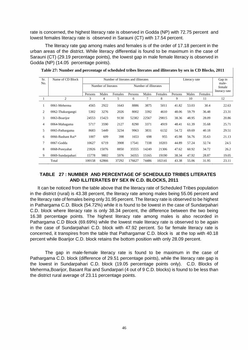
46
rate is concerned, the highest literacy rate is observed in Godda (NP) with 72.75 percent and
lowest females literacy rate is observed in Sarauni (CT) with 17.54 percent.
The literacy rate gap among males and females is of the order of 17.18 percent in the
urban areas of the district. While literacy differential is found to be maximum in the case of
Sarauni (CT) (29.19 percentage points), the lowest gap in male female literacy is observed in
Godda (NP) (14.05 percentage points).
Table 27: Number and percentage of scheduled tribes literates and illiterates by sex in CD Blocks, 2011
Sr. No.
Name of CD Block Number of literates and illiterates Literacy rate Gap in male-
female literacy rate
Number of literates Number of illiterates
Persons Males Females Persons Males Females Persons Males Females
1 2 3 4 5 6 7 8 9 10 11 12
1 0061-Meherma 4565 2922 1643 8886 3875 5011 41.82 53.03 30.4 22.63
2 0062-Thakurgangti 5302 3276 2026 8002 3392 4610 48.06 59.79 36.48 23.31
3 0063-Boarijor 24553 15423 9130 52382 22567 29815 38.36 48.95 28.09 20.86
4 0064-Mahagama 5717 3590 2127 8290 3371 4919 48.41 61.39 35.68 25.71
5 0065-Pathargama 8683 5449 3234 9963 3831 6132 54.72 69.69 40.18 29.51
6 0066-Bashant Rai* 1007 609 398 1653 698 955 45.98 56.76 35.63 21.13
7 0067-Godda 10627 6719 3908 17541 7338 10203 44.89 57.24 32.74 24.5
8 0068-Poreyahat 23926 15076 8850 35555 14249 21306 47.62 60.92 34.72 26.2
9 0069-Sundarpahari 15778 9802 5976 34355 15165 19190 38.34 47.92 28.87 19.05
Total 100158 62866 37292 176627 74486 102141 43.38 55.06 31.95 23.11
TABLE 27 : NUMBER AND PERCENTAGE OF SCHEDULED TRIBES LITERATES
AND ILLITERATES BY SEX IN C.D. BLOCKS, 2011
It can be noticed from the table above that the literacy rate of Scheduled Tribes population
in the district (rural) is 43.38 percent, the literacy rate among males being 55.06 percent and
the literacy rate of females being only 31.95 percent. The literacy rate is observed to be highest
in Pathargama C.D. Block (54.72%) while it is found to be lowest in the case of Sundarpahari
C.D. block where literacy rate is only 38.34 percent, the difference between the two being
16.38 percentage points. The highest literacy rate among males is also recorded in
Pathargama C.D Block (69.69%) while the lowest male literacy rate is observed to be again
in the case of Sundarpahari C.D. block with 47.92 percent. So far female literacy rate is
concerned, it transpires from the table that Pathargamar C.D. block is at the top with 40.18
percent while Boarijor C.D. block retains the bottom position with only 28.09 percent.
The gap in male-female literacy rate is found to be maximum in the case of
Pathargama C.D. block (difference of 29.51 percentage points), while the literacy rate gap is
the lowest in Sundarpahari C.D. block (19.05 percentage points only). C.D. Blocks of
Meherma,Boarijor, Basant Rai and Sundarpari (4 out of 9 C.D. blocks) is found to be less than
the district rural average of 23.11 percentage points.
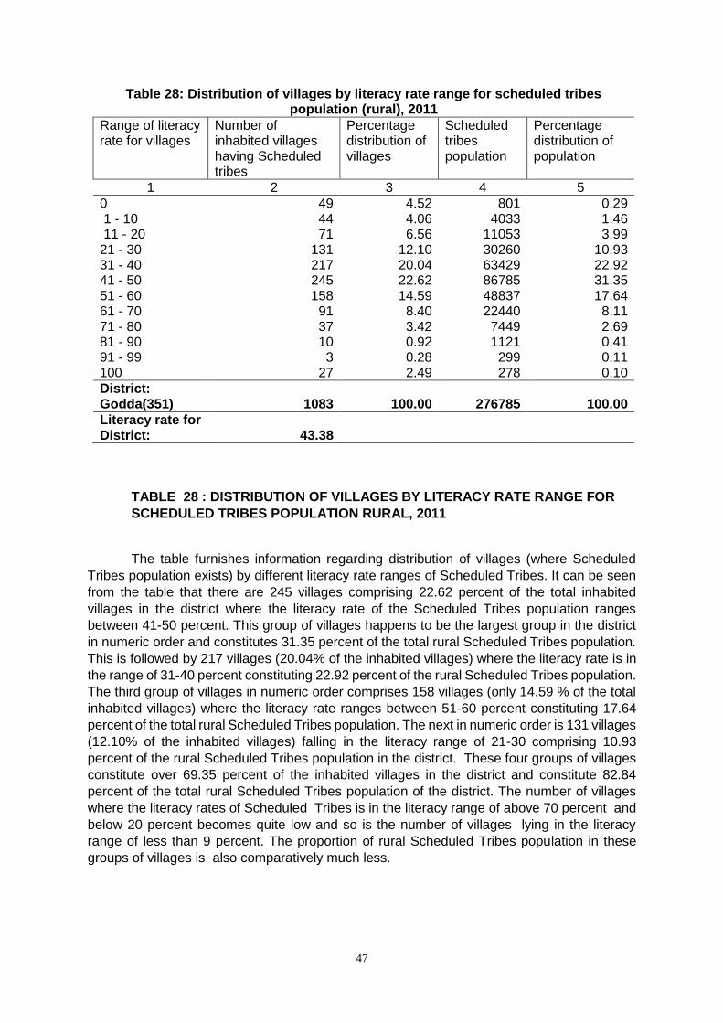
47
Table 28: Distribution of villages by literacy rate range for scheduled tribes population (rural), 2011
Range of literacy rate for villages
Number of inhabited villages having Scheduled tribes
Percentage distribution of villages
Scheduled tribes population
Percentage distribution of population
1 2 3 4 5
0 49 4.52 801 0.29 1 - 10 44 4.06 4033 1.46 11 - 20 71 6.56 11053 3.99 21 - 30 131 12.10 30260 10.93 31 - 40 217 20.04 63429 22.92 41 - 50 245 22.62 86785 31.35 51 - 60 158 14.59 48837 17.64 61 - 70 91 8.40 22440 8.11 71 - 80 37 3.42 7449 2.69 81 - 90 10 0.92 1121 0.41 91 - 99 3 0.28 299 0.11 100 27 2.49 278 0.10
District: Godda(351) 1083 100.00 276785 100.00
Literacy rate for District: 43.38
TABLE 28 : DISTRIBUTION OF VILLAGES BY LITERACY RATE RANGE FOR
SCHEDULED TRIBES POPULATION RURAL, 2011
The table furnishes information regarding distribution of villages (where Scheduled
Tribes population exists) by different literacy rate ranges of Scheduled Tribes. It can be seen
from the table that there are 245 villages comprising 22.62 percent of the total inhabited
villages in the district where the literacy rate of the Scheduled Tribes population ranges
between 41-50 percent. This group of villages happens to be the largest group in the district
in numeric order and constitutes 31.35 percent of the total rural Scheduled Tribes population.
This is followed by 217 villages (20.04% of the inhabited villages) where the literacy rate is in
the range of 31-40 percent constituting 22.92 percent of the rural Scheduled Tribes population.
The third group of villages in numeric order comprises 158 villages (only 14.59 % of the total
inhabited villages) where the literacy rate ranges between 51-60 percent constituting 17.64
percent of the total rural Scheduled Tribes population. The next in numeric order is 131 villages
(12.10% of the inhabited villages) falling in the literacy range of 21-30 comprising 10.93
percent of the rural Scheduled Tribes population in the district. These four groups of villages
constitute over 69.35 percent of the inhabited villages in the district and constitute 82.84
percent of the total rural Scheduled Tribes population of the district. The number of villages
where the literacy rates of Scheduled Tribes is in the literacy range of above 70 percent and
below 20 percent becomes quite low and so is the number of villages lying in the literacy
range of less than 9 percent. The proportion of rural Scheduled Tribes population in these
groups of villages is also comparatively much less.
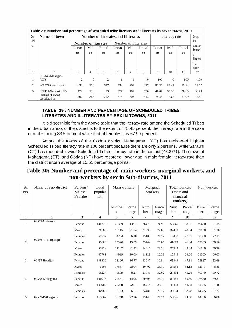
48
Table 29: Number and percentage of scheduled tribe literates and illiterates by sex in towns, 2011
Sr
.N
o.
Name of town Number of Literates and Illiterates Literacy rate Gap
in
male-
femal
e
litera
cy
rate
Number of literates Number of illiterates
Perso
ns
Mal
es
Femal
es
Perso
ns
Mal
es
Femal
es
Perso
ns
Mal
es
Femal
es
1 2 3 4 5 6 7 8 9 10 11 12
1 356840-Mahagma (CT) 2 0 2 1 1 0 100 0 100 -100
2 801771-Godda (NP) 1433 736 697 538 201 337 81.37 87.41 75.84 11.57
3 357411-Sarauni (CT) 172 119 53 277 101 176 46.87 65.38 28.65 36.73
District (Urban):
Godda(351) 1607 855 752 816 303 513 75.45 83.5 67.99 15.51
TABLE 29 : NUMBER AND PERCENTAGE OF SCHEDULED TRIBES
LITERATES AND ILLITERATES BY SEX IN TOWNS, 2011
It is discernible from the above table that the literacy rate among the Scheduled Tribes
in the urban areas of the district is to the extent of 75.45 percent, the literacy rate in the case
of males being 83.5 percent while that of females it is 67.99 percent.
Among the towns of the Godda district, Mahagama (CT) has registered highest
Scheduled Tribes literacy rate of 100 percent because there are only 2 persons, while Sarauni
(CT) has recorded lowest Scheduled Tribes literacy rate in the district (46.87%). The town of
Mahagama (CT) and Godda (NP) have recorded lower gap in male female literacy rate than
the district urban average of 15.51 percentage points.
Table 30: Number and percentage of main workers, marginal workers, and
non-workers by sex in Sub-districts, 2011
Sr.
No.
Name of Sub-district Persons/
Males/
Females
Total
populat
ion
Main workers Marginal
workers
Total workers
(main and
marginal
morkers)
Non workers
Numbe
r
Perce
ntage
Num
ber
Perce
ntage
Num
ber
Perce
ntage
Num
ber
Perce
ntage
1 2 3 4 5 6 7 8 9 10 11 12
1 02555-Meherma
Persons 146325 20369 13.92 36476 24.93 56845 38.85 89480 61.15
Males 76588 16115 21.04 21293 27.80 37408 48.84 39180 51.16
Females 69737 4254 6.10 15183 21.77 19437 27.87 50300 72.13
2 02556-Thakurgangti
Persons 99603 15926 15.99 25744 25.85 41670 41.84 57933 58.16
Males 51822 11107 21.43 14615 28.20 25722 49.64 26100 50.36
Females 47781 4819 10.09 11129 23.29 15948 33.38 31833 66.62
3 02557-Boarijor Persons 138330 23196 16.77 42247 30.54 65443 47.31 72887 52.69
Males 70106 17557 25.04 20402 29.10 37959 54.15 32147 45.85
Females 68224 5639 8.27 21845 32.02 27484 40.28 40740 59.72
4 02558-Mahagama Persons 196976 29451 14.95 50695 25.74 80146 40.69 116830 59.31
Males 101987 23268 22.81 26214 25.70 49482 48.52 52505 51.48
Females 94989 6183 6.51 24481 25.77 30664 32.28 64325 67.72
5 02559-Pathargama Persons 115662 25748 22.26 25148 21.74 50896 44.00 64766 56.00
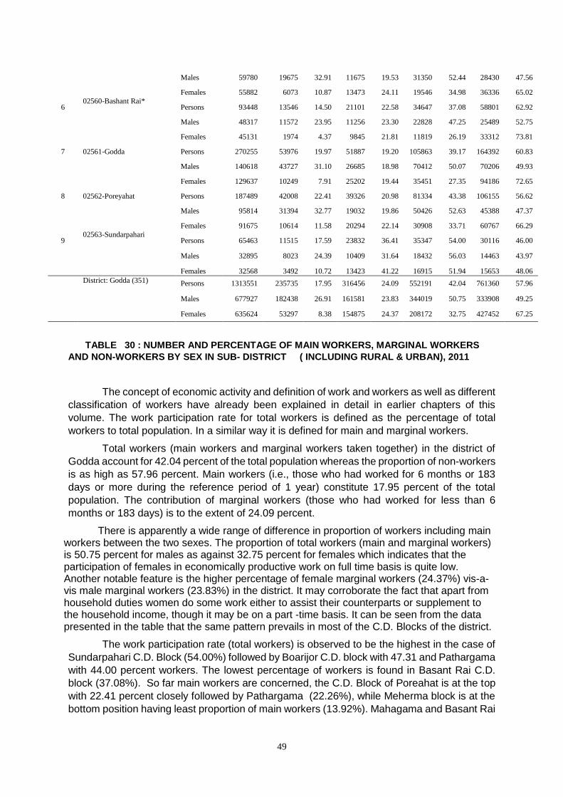
49
Males 59780 19675 32.91 11675 19.53 31350 52.44 28430 47.56
Females 55882 6073 10.87 13473 24.11 19546 34.98 36336 65.02
6 02560-Bashant Rai*
Persons 93448 13546 14.50 21101 22.58 34647 37.08 58801 62.92
Males 48317 11572 23.95 11256 23.30 22828 47.25 25489 52.75
Females 45131 1974 4.37 9845 21.81 11819 26.19 33312 73.81
7 02561-Godda Persons 270255 53976 19.97 51887 19.20 105863 39.17 164392 60.83
Males 140618 43727 31.10 26685 18.98 70412 50.07 70206 49.93
Females 129637 10249 7.91 25202 19.44 35451 27.35 94186 72.65
8 02562-Poreyahat Persons 187489 42008 22.41 39326 20.98 81334 43.38 106155 56.62
Males 95814 31394 32.77 19032 19.86 50426 52.63 45388 47.37
Females 91675 10614 11.58 20294 22.14 30908 33.71 60767 66.29
9 02563-Sundarpahari
Persons 65463 11515 17.59 23832 36.41 35347 54.00 30116 46.00
Males 32895 8023 24.39 10409 31.64 18432 56.03 14463 43.97
Females 32568 3492 10.72 13423 41.22 16915 51.94 15653 48.06
District: Godda (351) Persons 1313551 235735 17.95 316456 24.09 552191 42.04 761360 57.96
Males 677927 182438 26.91 161581 23.83 344019 50.75 333908 49.25
Females 635624 53297 8.38 154875 24.37 208172 32.75 427452 67.25
TABLE 30 : NUMBER AND PERCENTAGE OF MAIN WORKERS, MARGINAL WORKERS
AND NON-WORKERS BY SEX IN SUB- DISTRICT ( INCLUDING RURAL & URBAN), 2011
The concept of economic activity and definition of work and workers as well as different
classification of workers have already been explained in detail in earlier chapters of this
volume. The work participation rate for total workers is defined as the percentage of total
workers to total population. In a similar way it is defined for main and marginal workers.
Total workers (main workers and marginal workers taken together) in the district of
Godda account for 42.04 percent of the total population whereas the proportion of non-workers
is as high as 57.96 percent. Main workers (i.e., those who had worked for 6 months or 183
days or more during the reference period of 1 year) constitute 17.95 percent of the total
population. The contribution of marginal workers (those who had worked for less than 6
months or 183 days) is to the extent of 24.09 percent.
There is apparently a wide range of difference in proportion of workers including main workers between the two sexes. The proportion of total workers (main and marginal workers) is 50.75 percent for males as against 32.75 percent for females which indicates that the participation of females in economically productive work on full time basis is quite low. Another notable feature is the higher percentage of female marginal workers (24.37%) vis-a-vis male marginal workers (23.83%) in the district. It may corroborate the fact that apart from household duties women do some work either to assist their counterparts or supplement to the household income, though it may be on a part -time basis. It can be seen from the data presented in the table that the same pattern prevails in most of the C.D. Blocks of the district.
The work participation rate (total workers) is observed to be the highest in the case of
Sundarpahari C.D. Block (54.00%) followed by Boarijor C.D. block with 47.31 and Pathargama
with 44.00 percent workers. The lowest percentage of workers is found in Basant Rai C.D.
block (37.08%). So far main workers are concerned, the C.D. Block of Poreahat is at the top
with 22.41 percent closely followed by Pathargama (22.26%), while Meherma block is at the
bottom position having least proportion of main workers (13.92%). Mahagama and Basant Rai
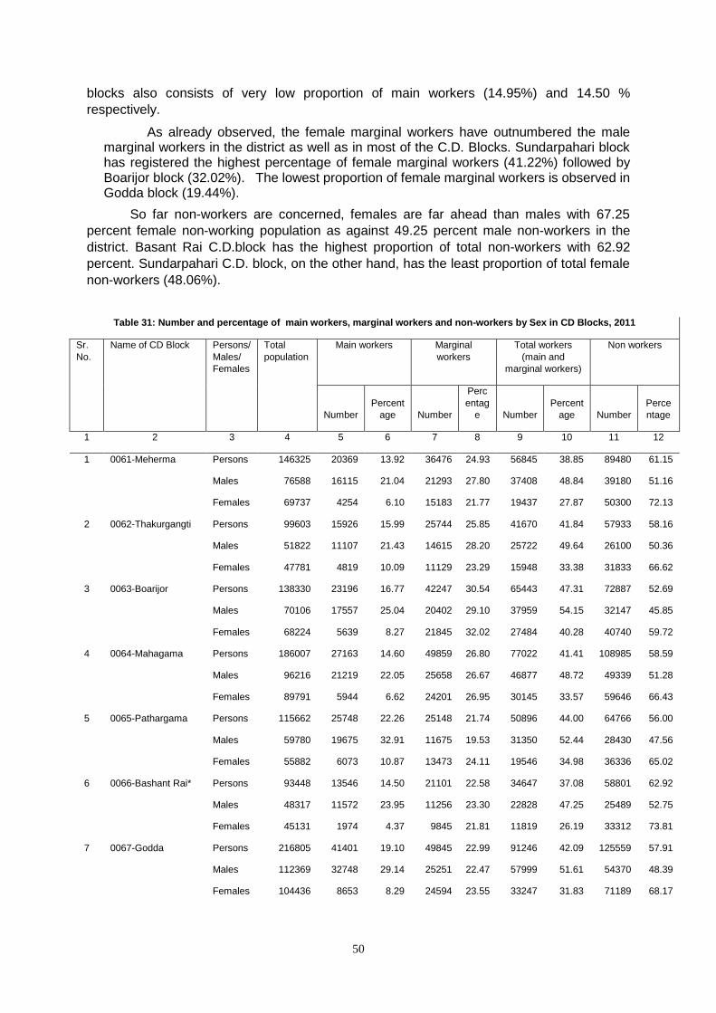
50
blocks also consists of very low proportion of main workers (14.95%) and 14.50 %
respectively.
As already observed, the female marginal workers have outnumbered the male marginal workers in the district as well as in most of the C.D. Blocks. Sundarpahari block has registered the highest percentage of female marginal workers (41.22%) followed by Boarijor block (32.02%). The lowest proportion of female marginal workers is observed in Godda block (19.44%).
So far non-workers are concerned, females are far ahead than males with 67.25
percent female non-working population as against 49.25 percent male non-workers in the
district. Basant Rai C.D.block has the highest proportion of total non-workers with 62.92
percent. Sundarpahari C.D. block, on the other hand, has the least proportion of total female
non-workers (48.06%).
Table 31: Number and percentage of main workers, marginal workers and non-workers by Sex in CD Blocks, 2011
Sr.
No.
Name of CD Block Persons/
Males/
Females
Total
population
Main workers Marginal
workers
Total workers
(main and
marginal workers)
Non workers
Number
Percent
age Number
Perc
entag
e Number
Percent
age Number
Perce
ntage
1 2 3 4 5 6 7 8 9 10 11 12
1 0061-Meherma Persons 146325 20369 13.92 36476 24.93 56845 38.85 89480 61.15
Males 76588 16115 21.04 21293 27.80 37408 48.84 39180 51.16
Females 69737 4254 6.10 15183 21.77 19437 27.87 50300 72.13
2 0062-Thakurgangti Persons 99603 15926 15.99 25744 25.85 41670 41.84 57933 58.16
Males 51822 11107 21.43 14615 28.20 25722 49.64 26100 50.36
Females 47781 4819 10.09 11129 23.29 15948 33.38 31833 66.62
3 0063-Boarijor Persons 138330 23196 16.77 42247 30.54 65443 47.31 72887 52.69
Males 70106 17557 25.04 20402 29.10 37959 54.15 32147 45.85
Females 68224 5639 8.27 21845 32.02 27484 40.28 40740 59.72
4 0064-Mahagama Persons 186007 27163 14.60 49859 26.80 77022 41.41 108985 58.59
Males 96216 21219 22.05 25658 26.67 46877 48.72 49339 51.28
Females 89791 5944 6.62 24201 26.95 30145 33.57 59646 66.43
5 0065-Pathargama Persons 115662 25748 22.26 25148 21.74 50896 44.00 64766 56.00
Males 59780 19675 32.91 11675 19.53 31350 52.44 28430 47.56
Females 55882 6073 10.87 13473 24.11 19546 34.98 36336 65.02
6 0066-Bashant Rai* Persons 93448 13546 14.50 21101 22.58 34647 37.08 58801 62.92
Males 48317 11572 23.95 11256 23.30 22828 47.25 25489 52.75
Females 45131 1974 4.37 9845 21.81 11819 26.19 33312 73.81
7 0067-Godda Persons 216805 41401 19.10 49845 22.99 91246 42.09 125559 57.91
Males 112369 32748 29.14 25251 22.47 57999 51.61 54370 48.39
Females 104436 8653 8.29 24594 23.55 33247 31.83 71189 68.17
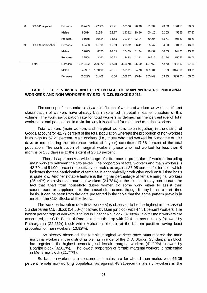
51
8 0068-Poreyahat Persons 187489 42008 22.41 39326 20.98 81334 43.38 106155 56.62
Males 95814 31394 32.77 19032 19.86 50426 52.63 45388 47.37
Females 91675 10614 11.58 20294 22.14 30908 33.71 60767 66.29
9 0069-Sundarpahari Persons 65463 11515 17.59 23832 36.41 35347 54.00 30116 46.00
Males 32895 8023 24.39 10409 31.64 18432 56.03 14463 43.97
Females 32568 3492 10.72 13423 41.22 16915 51.94 15653 48.06
Total Persons 1249132 220872 17.68 313578 25.10 534450 42.79 714682 57.21
Males 643907 169410 26.31 159591 24.78 329001 51.09 314906 48.91
Females 605225 51462 8.50 153987 25.44 205449 33.95 399776 66.05
TABLE 31 : NUMBER AND PERCENTAGE OF MAIN WORKERS, MARGINAL
WORKERS AND NON-WORKERS BY SEX IN C.D. BLOCKS 2011
The concept of economic activity and definition of work and workers as well as different
classification of workers have already been explained in detail in earlier chapters of this
volume. The work participation rate for total workers is defined as the percentage of total
workers to total population. In a similar way it is defined for main and marginal workers.
Total workers (main workers and marginal workers taken together) in the district of
Godda account for 42.79 percent of the total population whereas the proportion of non-workers
is as high as 57.21 percent. Main workers (i.e., those who had worked for 6 months or 183
days or more during the reference period of 1 year) constitute 17.68 percent of the total
population. The contribution of marginal workers (those who had worked for less than 6
months or 183 days) is to the extent of 25.10 percent.
There is apparently a wide range of difference in proportion of workers including main workers between the two sexes. The proportion of total workers and main workers is 42.79 and 51.09 percent respectively for males as against 33.95 percent for females which indicates that the participation of females in economically productive work on full time basis is quite low. Another notable feature is the higher percentage of female marginal workers (25.44%) vis-a-vis male marginal workers (24.78%) in the district. It may corroborate the fact that apart from household duties women do some work either to assist their counterparts or supplement to the household income, though it may be on a part -time basis. It can be seen from the data presented in the table that the same pattern prevails in most of the C.D. Blocks of the district.
The work participation rate (total workers) is observed to be the highest in the case of
Sundarpahari C.D. Block (54.00%) followed by Boarijor block with 47.31 percent workers. The
lowest percentage of workers is found in Basant Rai block (37.08%). So far main workers are
concerned, the C.D. Block of Poreahat is at the top with 22.41 percent closely followed by
Pathargama (22.26%) block while Meherma block is at the bottom position having least
proportion of main workers (13.92%).
As already observed, the female marginal workers have outnumbered the male marginal workers in the district as well as in most of the C.D. Blocks. Sundarpahari block has registered the highest percentage of female marginal workers (41.22%) followed by Boarijor block (32.02%). The lowest proportion of female marginal workers is noticeable in Meherma block (21.77%).
So far non-workers are concerned, females are far ahead than males with 66.05
percent female non-working population as against 48.91percent male non-workers in the
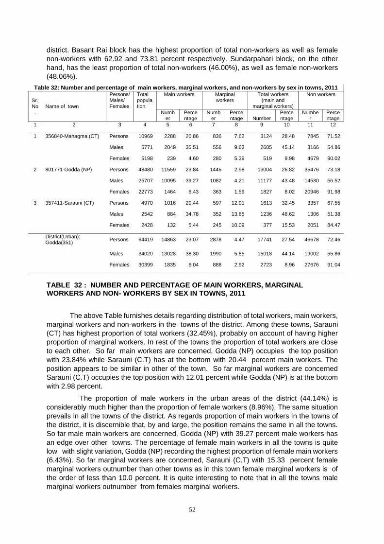
52
district. Basant Rai block has the highest proportion of total non-workers as well as female
non-workers with 62.92 and 73.81 percent respectively. Sundarpahari block, on the other
hand, has the least proportion of total non-workers (46.00%), as well as female non-workers
(48.06%).
Table 32: Number and percentage of main workers, marginal workers, and non-workers by sex in towns, 2011
Sr. No.
Name of town
Persons/ Males/ Females
Total population
Main workers Marginal workers
Total workers (main and
marginal workers)
Non workers
Number
Percentage
Number
Percentage Number
Percentage
Number
Percentage
1 2 3 4 5 6 7 8 9 10 11 12
1 356840-Mahagma (CT) Persons 10969 2288 20.86 836 7.62 3124 28.48 7845 71.52
Males 5771 2049 35.51 556 9.63 2605 45.14 3166 54.86
Females 5198 239 4.60 280 5.39 519 9.98 4679 90.02
2 801771-Godda (NP) Persons 48480 11559 23.84 1445 2.98 13004 26.82 35476 73.18
Males 25707 10095 39.27 1082 4.21 11177 43.48 14530 56.52
Females 22773 1464 6.43 363 1.59 1827 8.02 20946 91.98
3 357411-Sarauni (CT) Persons 4970 1016 20.44 597 12.01 1613 32.45 3357 67.55
Males 2542 884 34.78 352 13.85 1236 48.62 1306 51.38
Females 2428 132 5.44 245 10.09 377 15.53 2051 84.47
District(Urban): Godda(351)
Persons 64419 14863 23.07 2878 4.47 17741 27.54 46678 72.46
Males 34020 13028 38.30 1990 5.85 15018 44.14 19002 55.86
Females 30399 1835 6.04 888 2.92 2723 8.96 27676 91.04
TABLE 32 : NUMBER AND PERCENTAGE OF MAIN WORKERS, MARGINAL WORKERS AND NON- WORKERS BY SEX IN TOWNS, 2011
The above Table furnishes details regarding distribution of total workers, main workers,
marginal workers and non-workers in the towns of the district. Among these towns, Sarauni
(CT) has highest proportion of total workers (32.45%), probably on account of having higher
proportion of marginal workers. In rest of the towns the proportion of total workers are close
to each other. So far main workers are concerned, Godda (NP) occupies the top position
with 23.84% while Sarauni (C.T) has at the bottom with 20.44 percent main workers. The
position appears to be similar in other of the town. So far marginal workers are concerned
Sarauni (C.T) occupies the top position with 12.01 percent while Godda (NP) is at the bottom
with 2.98 percent.
The proportion of male workers in the urban areas of the district (44.14%) is
considerably much higher than the proportion of female workers (8.96%). The same situation
prevails in all the towns of the district. As regards proportion of main workers in the towns of
the district, it is discernible that, by and large, the position remains the same in all the towns.
So far male main workers are concerned, Godda (NP) with 39.27 percent male workers has
an edge over other towns. The percentage of female main workers in all the towns is quite
low with slight variation, Godda (NP) recording the highest proportion of female main workers
(6.43%). So far marginal workers are concerned, Sarauni (C.T) with 15.33 percent female
marginal workers outnumber than other towns as in this town female marginal workers is of
the order of less than 10.0 percent. It is quite interesting to note that in all the towns male
marginal workers outnumber from females marginal workers.
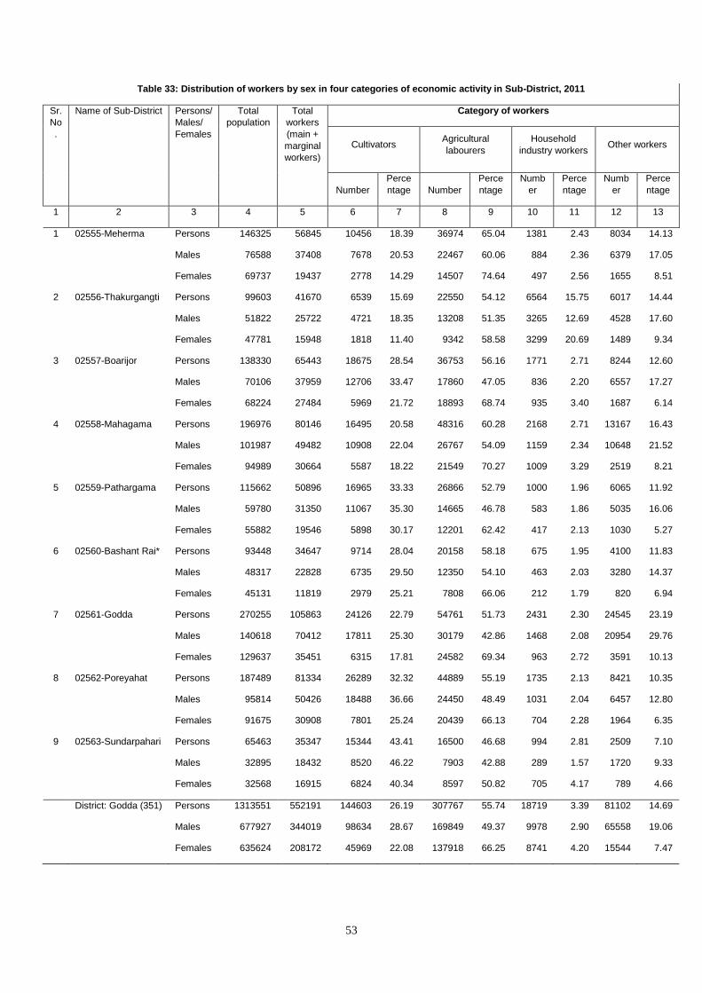
53
Table 33: Distribution of workers by sex in four categories of economic activity in Sub-District, 2011
Sr.
No
.
Name of Sub-District Persons/
Males/
Females
Total
population
Total
workers
(main +
marginal
workers)
Category of workers
Cultivators Agricultural
labourers
Household
industry workers Other workers
Number
Perce
ntage Number
Perce
ntage
Numb
er
Perce
ntage
Numb
er
Perce
ntage
1 2 3 4 5 6 7 8 9 10 11 12 13
1 02555-Meherma Persons 146325 56845 10456 18.39 36974 65.04 1381 2.43 8034 14.13
Males 76588 37408 7678 20.53 22467 60.06 884 2.36 6379 17.05
Females 69737 19437 2778 14.29 14507 74.64 497 2.56 1655 8.51
2 02556-Thakurgangti Persons 99603 41670 6539 15.69 22550 54.12 6564 15.75 6017 14.44
Males 51822 25722 4721 18.35 13208 51.35 3265 12.69 4528 17.60
Females 47781 15948 1818 11.40 9342 58.58 3299 20.69 1489 9.34
3 02557-Boarijor Persons 138330 65443 18675 28.54 36753 56.16 1771 2.71 8244 12.60
Males 70106 37959 12706 33.47 17860 47.05 836 2.20 6557 17.27
Females 68224 27484 5969 21.72 18893 68.74 935 3.40 1687 6.14
4 02558-Mahagama Persons 196976 80146 16495 20.58 48316 60.28 2168 2.71 13167 16.43
Males 101987 49482 10908 22.04 26767 54.09 1159 2.34 10648 21.52
Females 94989 30664 5587 18.22 21549 70.27 1009 3.29 2519 8.21
5 02559-Pathargama Persons 115662 50896 16965 33.33 26866 52.79 1000 1.96 6065 11.92
Males 59780 31350 11067 35.30 14665 46.78 583 1.86 5035 16.06
Females 55882 19546 5898 30.17 12201 62.42 417 2.13 1030 5.27
6 02560-Bashant Rai* Persons 93448 34647 9714 28.04 20158 58.18 675 1.95 4100 11.83
Males 48317 22828 6735 29.50 12350 54.10 463 2.03 3280 14.37
Females 45131 11819 2979 25.21 7808 66.06 212 1.79 820 6.94
7 02561-Godda Persons 270255 105863 24126 22.79 54761 51.73 2431 2.30 24545 23.19
Males 140618 70412 17811 25.30 30179 42.86 1468 2.08 20954 29.76
Females 129637 35451 6315 17.81 24582 69.34 963 2.72 3591 10.13
8 02562-Poreyahat Persons 187489 81334 26289 32.32 44889 55.19 1735 2.13 8421 10.35
Males 95814 50426 18488 36.66 24450 48.49 1031 2.04 6457 12.80
Females 91675 30908 7801 25.24 20439 66.13 704 2.28 1964 6.35
9 02563-Sundarpahari Persons 65463 35347 15344 43.41 16500 46.68 994 2.81 2509 7.10
Males 32895 18432 8520 46.22 7903 42.88 289 1.57 1720 9.33
Females 32568 16915 6824 40.34 8597 50.82 705 4.17 789 4.66
District: Godda (351) Persons 1313551 552191 144603 26.19 307767 55.74 18719 3.39 81102 14.69
Males 677927 344019 98634 28.67 169849 49.37 9978 2.90 65558 19.06
Females 635624 208172 45969 22.08 137918 66.25 8741 4.20 15544 7.47
54
TABLE 33 : DISTRIBUTION OF WORKERS BY SEX IN FOUR CATEGORIES OF
ECONOMIC ACTIVITY IN SUB- DISTRICTS, 2011
The relative importance of the main spheres of economic activity may be gauged from
the pattern of distribution of workers (main + marginal) according to the broad four fold
classification namely, cultivators, agricultural labourers, household industry workers and other
workers. The economic activity in the district is primarily dependent on agriculture which is
supported by the fact that the cultivators (26.19%) and agricultural labourers (55.74%)
together constitute 81.93 per cent of the total workers of the district. The primary sector i.e.,
the agricultural sector has absorbed around two-third of the total workers of the district. Other
workers (persons engaged in various types of activities other than cultivation, agricultural work
and household industry work) are also in good number as their proportion to total workers in
the district is to the extent of 18.07 percent. Household industry workers are meagre 3.39
percent of the total workers. By and large, the same situation prevails in majority of the C.D.
Blocks of the district. Godda C.D. block has recorded higher proportion of “other
workers”(23.19%) presumably on account of Go town, the headquarters of the district . This
is followed by Mahagama C.D. block where the proportion of other workers is to the extent of
16.43 percent to the total workers.
It can further be seen that household industry workers constitute comparatively small
proportion (3.39%) in the district of Godda. Female household industry workers are slightly
more than the male household industry workers (4.20% as against 2.90%) in the district. In
Thakurgangti C.D. block the proportion of female household industry workers is the highest in
the district with 20.69 percent. It may be interesting to note that the percentage of female
household industry workers is comparatively much lower than the proportion of other
categories of female workers.
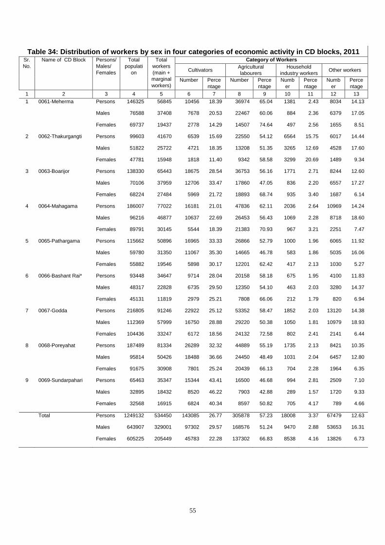
55
Table 34: Distribution of workers by sex in four categories of economic activity in CD blocks, 2011
Sr.
No.
Name of CD Block Persons/
Males/
Females
Total
populati
on
Total
workers
(main +
marginal
workers)
Category of Workers
Cultivators Agricultural
labourers
Household
industry workers Other workers
Number Perce
ntage
Number Perce
ntage
Numb
er
Perce
ntage
Numb
er
Perce
ntage
1 2 3 4 5 6 7 8 9 10 11 12 13
1 0061-Meherma Persons 146325 56845 10456 18.39 36974 65.04 1381 2.43 8034 14.13
Males 76588 37408 7678 20.53 22467 60.06 884 2.36 6379 17.05
Females 69737 19437 2778 14.29 14507 74.64 497 2.56 1655 8.51
2 0062-Thakurgangti Persons 99603 41670 6539 15.69 22550 54.12 6564 15.75 6017 14.44
Males 51822 25722 4721 18.35 13208 51.35 3265 12.69 4528 17.60
Females 47781 15948 1818 11.40 9342 58.58 3299 20.69 1489 9.34
3 0063-Boarijor Persons 138330 65443 18675 28.54 36753 56.16 1771 2.71 8244 12.60
Males 70106 37959 12706 33.47 17860 47.05 836 2.20 6557 17.27
Females 68224 27484 5969 21.72 18893 68.74 935 3.40 1687 6.14
4 0064-Mahagama Persons 186007 77022 16181 21.01 47836 62.11 2036 2.64 10969 14.24
Males 96216 46877 10637 22.69 26453 56.43 1069 2.28 8718 18.60
Females 89791 30145 5544 18.39 21383 70.93 967 3.21 2251 7.47
5 0065-Pathargama Persons 115662 50896 16965 33.33 26866 52.79 1000 1.96 6065 11.92
Males 59780 31350 11067 35.30 14665 46.78 583 1.86 5035 16.06
Females 55882 19546 5898 30.17 12201 62.42 417 2.13 1030 5.27
6 0066-Bashant Rai* Persons 93448 34647 9714 28.04 20158 58.18 675 1.95 4100 11.83
Males 48317 22828 6735 29.50 12350 54.10 463 2.03 3280 14.37
Females 45131 11819 2979 25.21 7808 66.06 212 1.79 820 6.94
7 0067-Godda Persons 216805 91246 22922 25.12 53352 58.47 1852 2.03 13120 14.38
Males 112369 57999 16750 28.88 29220 50.38 1050 1.81 10979 18.93
Females 104436 33247 6172 18.56 24132 72.58 802 2.41 2141 6.44
8 0068-Poreyahat Persons 187489 81334 26289 32.32 44889 55.19 1735 2.13 8421 10.35
Males 95814 50426 18488 36.66 24450 48.49 1031 2.04 6457 12.80
Females 91675 30908 7801 25.24 20439 66.13 704 2.28 1964 6.35
9 0069-Sundarpahari Persons 65463 35347 15344 43.41 16500 46.68 994 2.81 2509 7.10
Males 32895 18432 8520 46.22 7903 42.88 289 1.57 1720 9.33
Females 32568 16915 6824 40.34 8597 50.82 705 4.17 789 4.66
Total Persons 1249132 534450 143085 26.77 305878 57.23 18008 3.37 67479 12.63
Males 643907 329001 97302 29.57 168576 51.24 9470 2.88 53653 16.31
Females 605225 205449 45783 22.28 137302 66.83 8538 4.16 13826 6.73
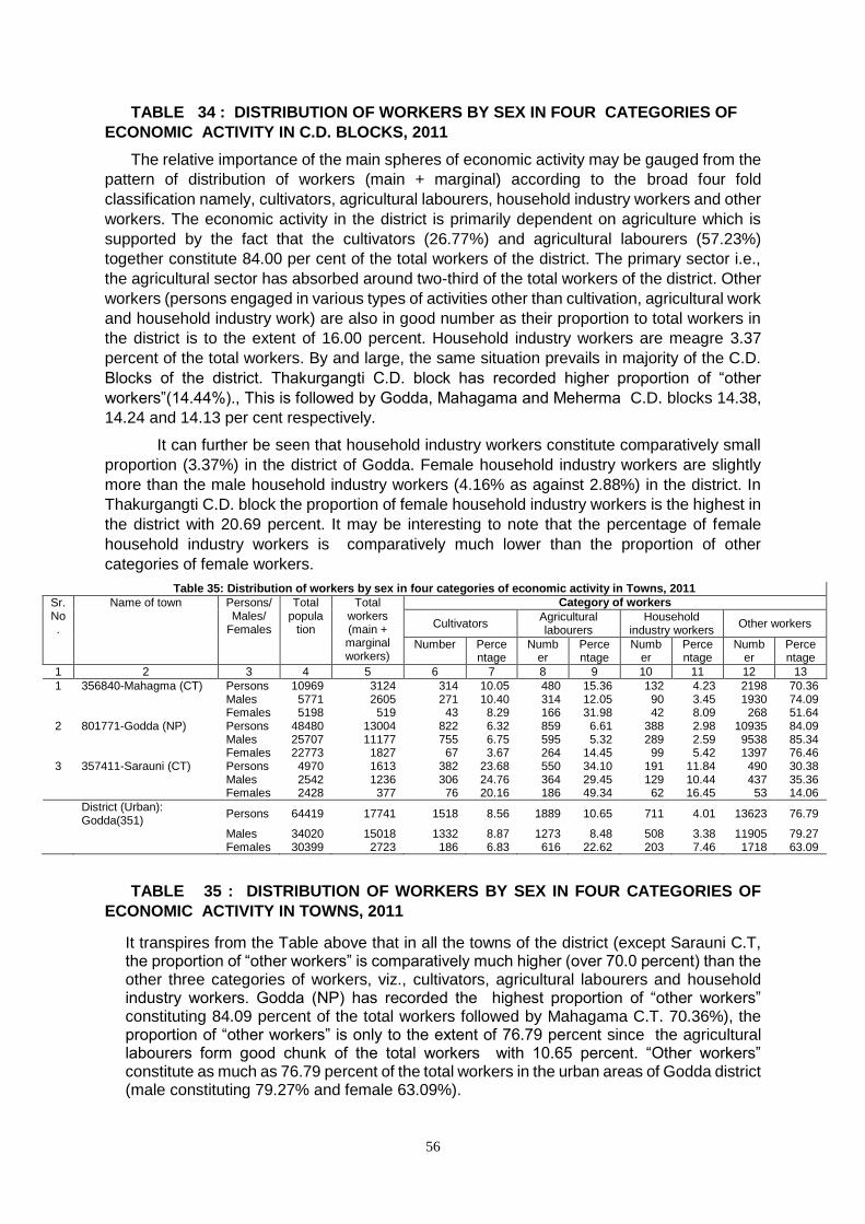
56
TABLE 34 : DISTRIBUTION OF WORKERS BY SEX IN FOUR CATEGORIES OF
ECONOMIC ACTIVITY IN C.D. BLOCKS, 2011
The relative importance of the main spheres of economic activity may be gauged from the
pattern of distribution of workers (main + marginal) according to the broad four fold
classification namely, cultivators, agricultural labourers, household industry workers and other
workers. The economic activity in the district is primarily dependent on agriculture which is
supported by the fact that the cultivators (26.77%) and agricultural labourers (57.23%)
together constitute 84.00 per cent of the total workers of the district. The primary sector i.e.,
the agricultural sector has absorbed around two-third of the total workers of the district. Other
workers (persons engaged in various types of activities other than cultivation, agricultural work
and household industry work) are also in good number as their proportion to total workers in
the district is to the extent of 16.00 percent. Household industry workers are meagre 3.37
percent of the total workers. By and large, the same situation prevails in majority of the C.D.
Blocks of the district. Thakurgangti C.D. block has recorded higher proportion of “other
workers”(14.44%)., This is followed by Godda, Mahagama and Meherma C.D. blocks 14.38,
14.24 and 14.13 per cent respectively.
It can further be seen that household industry workers constitute comparatively small
proportion (3.37%) in the district of Godda. Female household industry workers are slightly
more than the male household industry workers (4.16% as against 2.88%) in the district. In
Thakurgangti C.D. block the proportion of female household industry workers is the highest in
the district with 20.69 percent. It may be interesting to note that the percentage of female
household industry workers is comparatively much lower than the proportion of other
categories of female workers.
Table 35: Distribution of workers by sex in four categories of economic activity in Towns, 2011
Sr. No.
Name of town Persons/ Males/
Females
Total popula
tion
Total workers (main + marginal workers)
Category of workers
Cultivators Agricultural labourers
Household industry workers
Other workers
Number Percentage
Number
Percentage
Number
Percentage
Number
Percentage
1 2 3 4 5 6 7 8 9 10 11 12 13
1 356840-Mahagma (CT) Persons 10969 3124 314 10.05 480 15.36 132 4.23 2198 70.36 Males 5771 2605 271 10.40 314 12.05 90 3.45 1930 74.09 Females 5198 519 43 8.29 166 31.98 42 8.09 268 51.64 2 801771-Godda (NP) Persons 48480 13004 822 6.32 859 6.61 388 2.98 10935 84.09
Males 25707 11177 755 6.75 595 5.32 289 2.59 9538 85.34 Females 22773 1827 67 3.67 264 14.45 99 5.42 1397 76.46 3 357411-Sarauni (CT) Persons 4970 1613 382 23.68 550 34.10 191 11.84 490 30.38
Males 2542 1236 306 24.76 364 29.45 129 10.44 437 35.36 Females 2428 377 76 20.16 186 49.34 62 16.45 53 14.06
District (Urban): Godda(351)
Persons 64419 17741 1518 8.56 1889 10.65 711 4.01 13623 76.79
Males 34020 15018 1332 8.87 1273 8.48 508 3.38 11905 79.27 Females 30399 2723 186 6.83 616 22.62 203 7.46 1718 63.09
TABLE 35 : DISTRIBUTION OF WORKERS BY SEX IN FOUR CATEGORIES OF
ECONOMIC ACTIVITY IN TOWNS, 2011
It transpires from the Table above that in all the towns of the district (except Sarauni C.T, the proportion of “other workers” is comparatively much higher (over 70.0 percent) than the other three categories of workers, viz., cultivators, agricultural labourers and household industry workers. Godda (NP) has recorded the highest proportion of “other workers” constituting 84.09 percent of the total workers followed by Mahagama C.T. 70.36%), the proportion of “other workers” is only to the extent of 76.79 percent since the agricultural labourers form good chunk of the total workers with 10.65 percent. “Other workers” constitute as much as 76.79 percent of the total workers in the urban areas of Godda district (male constituting 79.27% and female 63.09%).
57
Females engaged as agricultural labourers are found to be the highest in case of Sarauni (C.T) with 49.34 percent. Mahagama (C.T) have also registered higher proportion of female agricultural labourers (over 30.0%). The proportion of cultivators and household industry workers is quite low in various towns of the district with varying percentages among males and females.
Brief analysis of VD/TD table 36 to 45:-
Table 36: Distribution of villages according to availability of different amenities, 2011
Sr. No. Name of CD
Block
Number
of
inhabited
villages
Type of amenity available
Education Medical Drinking
water
Post office#
1 2 3 4 5 6 7 1 0061-Meherma 144 85 ( 59.03) 52 ( 36.11) 144 ( 100) 22 ( 15.28) 2 0062-Thakurgangti 146 91 ( 62.33) 8 ( 5.48) 146 ( 100) 28 ( 19.18)
3 0063-Boarijor 309 184 ( 59.55) 113 ( 36.57) 287 ( 92.88) 26 ( 8.41)
4 0064-Mahagama 245 128 ( 52.24) 56 ( 22.86) 189 ( 77.14) 39 ( 15.92) 5 0065-Pathargama 146 99 ( 67.81) 23 ( 15.75) 119 ( 81.51) 21 ( 14.38)
6 0066-Bashant Rai* 83 57 ( 68.67) 31 ( 37.35) 65 ( 78.31) 19 ( 22.89)
7 0067-Godda 197 146 ( 74.11) 38 ( 19.29) 162 ( 82.23) 43 ( 21.83) 8 0068-Poreyahat 197 166 ( 84.26) 32 ( 16.24) 181 ( 91.88) 34 ( 17.26)
9 0069-Sundarpahari 221 115 ( 52.04) 17 ( 7.69) 178 ( 80.54) 17 ( 7.69)
Total 1688 1071 ( 63.45) 370 ( 21.92) 1471 ( 87.14) 249 ( 14.75)
Table 36: Distribution of villages according to availability of different amenities, 2011
Type of amenity available
Telephone * Transport
communications $
Banks@ Agricultural
credit societies
Approach by
pucca road
Power supply
8 9 10 11 12 13
62 ( 43.06) 26 ( 18.06) 7 ( 4.86) 7 ( 4.86) 100 ( 69.44) 48 ( 33.33)
73 ( 50) 41 ( 28.08) 4 ( 2.74) 0 ( 0) 109 ( 74.66) 29 ( 19.86)
141 ( 45.63) 38 ( 12.3) 8 ( 2.59) 4 ( 1.29) 253 ( 81.88) 25 ( 8.09)
75 ( 30.61) 55 ( 22.45) 6 ( 2.45) 1 ( 0.41) 173 ( 70.61) 100 ( 40.82)
65 ( 44.52) 22 ( 15.07) 6 ( 4.11) 6 ( 4.11) 111 ( 76.03) 65 ( 44.52)
35 ( 42.17) 21 ( 25.3) 6 ( 7.23) 3 ( 3.61) 58 ( 69.88) 26 ( 31.33)
71 ( 36.04) 30 ( 15.23) 9 ( 4.57) 16 ( 8.12) 158 ( 80.2) 99 ( 50.25)
89 ( 45.18) 44 ( 22.34) 8 ( 4.06) 3 ( 1.52) 180 ( 91.37) 64 ( 32.49)
83 ( 37.56) 9 ( 4.07) 2 ( 0.9) 2 ( 0.9) 159 ( 71.95) 9 ( 4.07)
694 ( 41.11) 286 ( 16.94) 56 ( 3.32) 42 ( 2.49) 1301 ( 77.07) 465 ( 27.55)
Note:- Percentages are given in brackets.
# Post office includes post office, telegraph office and Post and telegraph office.
$ Transport communication includes bus service, rail facility and navigable waterways.
@ Bank includes Commercial Bank and Cooperative Bank.
* Telephone includes Telephone,PCO and Mobile.
58
TABLE 36 : DISTRIBUTION OF VILLAGES ACCORDING TO AVAILABILITY OF DIFFERENT AMENITIES, 2011
This table and a few tables presented hereafter are based on the infrastructure data presented in the Village Directory of this volume.
The above table gives the distribution of villages according to the availability of different
amenities in the district.
Educational amenity - There are as many as 1071 villages accounting for 63.44 percent
of the total number of inhabited villages (1688) in the district where educational facility is
available. The situation regarding schooling facilities is observed to be the highest in Poreahat
C.D. block (84.26%) followed by Godda (74.11%),Basant Rai (68.67%) and Pathargama
(67.81 %) C.D. blocks. The proportion of villages having educational facility in rest of the
blocks varies between 52.04 percent (Sundarpahari C.D. block ) and 62.33 percent
(Thakurgangti C.D. block).
Medical amenity – Medical facilities of some or other type are available only in 370
villages (21.92 % of the total villages) which is quite low from any standard. Among the C.D.
Blocks, Basant Rai has the largest proportion of villages with medical facility, the percentage
being 37.35 . It is followed by Boarijor with 36.57 and Meherma with 36.11 percent. The other
C.D. Blocks where medical facility is available in more than 15 percent of villages are
Mahagama (22.86%), Godda (19.29%), Poreahat (16.24%) and Pathargama (15.75%). In rest
of the blocks the proportion of villages having some or other type of medical facilities is
observed to be below 15 percent of the total villages. The lowest proportion of villages having
medical facilities is observed in the case of Thakurgangti C.D. block with 5.48 percent followed
by Sundarpahari (7.69%).
drinking water – So far drinking water facility is concerned, it is quite heartening to note
that one or other type of such facility is existing in1471 villages constituting 87.14 percent of
the inhabited villages in the district. Among the C.D. Blocks, Meherma, Thakurgangti, Boarijor
and Preahat (4out of 9 C.D. Blocks) are such where 90.0 percent or more proportion of
villages have drinking water facility, the highest being in case of Meherma and Thakurgangti
block (100%). In Mahagama C.D. Block, on the other hand, only 77.14 percent of villages
have the privilege of having any kind of drinking water facility, which is the minimum in the
district and comparatively much lower than other C.D. Blocks.
Post Office – As regards rural areas of the district, the facility of Post and Telegraph Office
is available in only 249 villages constituting 14.75 percent of the total inhabited villages in the
district. Basant Rai C.D. Block has the maximum number of villages having postal facility
(22.89%) in the district. The C.D. Blocks where more than 15 percent of villages have Postal
facility are Godda (21.83%), Thakurgangti (19.18%), Poreahat (17.26%), Mahagama
(15.92%) and Meherma (15.28%). The situation is also not satisfactory in case of Boarijor,
Pathargama, and Sundarpari Blocks where less than 15.0 percent of villages are enjoying this
facility.
Telephone - The availability of telephone facility in the villages is not satisfactorily 694
villages constituting 41.11 percent of the total inhabited villages have access to this facility.
Among the C.D. Blocks, Thakurgangti block has the maximum number of villages having
telephone facility (50.0%) in the district closely followed by Boarijor with 45.63% and Poreahat
C.D. Block with 45.18 percent. The position in these three blocks appears to be, by and large,
satisfactory when compared to situation existing in other blocks. In other C.D. Blocks
telephone facility is found to be available between 30.6 – 44.52 percent villages.
59
Transport communication - Transport communication facilities are available only in 286 villages in the district (16.94%). Majority of villages are not connected with any sort of transport means, as is evident from the data presented in the table. Thakurgangti C.D. Block has the highest proportion of villages (28.08.%) which are connected by bus or rail or navigable river/canal services, etc., although this block lags behind on many other counts. This is followed by Basant Rai (25.3%) Mahagama (22.45%) and Preahat (22.34%) C.D. Blocks. These four blocks are also backward in many sense as compared to other blocks. Apart from the above mentioned 4 blocks.the proportion of villages having transport communication facilities is less than 26 percent, the least proportion of villages being in case of Sundarpahari block where only 9 out of 221 villages (4.07%) is connected by any transport means.
Bank - Banking facility is available only in 56 villages comprising 3.32 percent of the
inhabited villages in the district. The C.D. blocks of Meherms,Pathargama, Basant Rai, Godda
and Poreahat have around 4.0 percent of the villages where banking facility exists. In as many
as 4 blocks in the district, the banking facility is found to exist in less than even 3.0 percent of
the total villages as can be noticed from table above.
Agricultural Credit Societies - Agricultural Credit Societies are available in only 42
villages constituting meager 2.49 percent of the inhabited villages in the district. Godda C.D.
Block has the largest number of villages having agricultural credit facilities (8.12%) followed
by Meherma (4.86 %), and Pathargama (4.11%). The other C.D. Blocks have less than4.0
percent of the villages where any agriculture credit society exists.
Approach by Pucca road – Approach road facility is the nerve system of any place. They
act as a pull factor for the development and upliftment of the area. Roads may be of any kind
but pucca road facilitates movement of transport easily and swiftly. It is discernable from the
table that this facility is available in 1301 villages constituting 77.07 percent of the inhabited
villages in the district. Among C.D. Blocks, Poreahat (91.37%) having pucca approach road
facility and is at the top of the list. In other C.D. Blocks it is not less than 69.0%, the position
in other C.D. Blocks is so good.
Power Supply – The position of electrification of the villages in the district is not very
satisfactory as only 465 villages constituting 27.55 percent of the total number of inhabited
villages in the district have access to power supply facility. Among the C.D. Blocks, Godda
has the largest number of electrified villages with 50.25 percent followed by Pathargama block
with 44.52 percent villages having power supply facility. These two are the only blocks in the
district where more than 44.0 percent of the villages enjoy the facility of power supply. while
Sundarpahari block has less than 5.0 percent of the villages to their credit enjoying this
facility.
Table 37: Number and percentage of rural population served by different amenities, 2011
Sr.
No.
Name of CD
Block
Total population
of inhabited
villages
Type of amenity available
Education Medical Drinking water Post office#
1 2 3 4 5 6 7
1 0061-Meherma 146325 90629 ( 61.94) 62257 ( 42.55) 146325 ( 100) 28216 ( 19.28)
2 0062-Thakurgangti 99603 59547 ( 59.78) 3969 ( 3.98) 99603 ( 100) 16705 ( 16.77)
3 0063-Boarijor 138330 105696 ( 76.41) 58412 ( 42.23) 133819 ( 96.74) 22408 ( 16.2)
4 0064-Mahagama 186007 104864 ( 56.38) 52981 ( 28.48) 144365 ( 77.61) 38061 ( 20.46)
5 0065-Pathargama 115662 80167 ( 69.31) 17972 ( 15.54) 90815 ( 78.52) 12643 ( 10.93)
6 0066-Bashant Rai* 93448 63164 ( 67.59) 34673 ( 37.1) 73922 ( 79.1) 22818 ( 24.42)
7 0067-Godda 216805 155860 ( 71.89) 38703 ( 17.85) 175063 ( 80.75) 45571 ( 21.02)
8 0068-Poreyahat 187489 153260 ( 81.74) 38330 ( 20.44) 164252 ( 87.61) 37258 ( 19.87)
9 0069-Sundarpahari 65463 44709 ( 68.3) 9006 ( 13.76) 57922 ( 88.48) 11890 ( 18.16)
Total 1249132 857896 ( 68.68) 316303 (
25.32) 1086086 ( 86.95) 235570 ( 18.86)
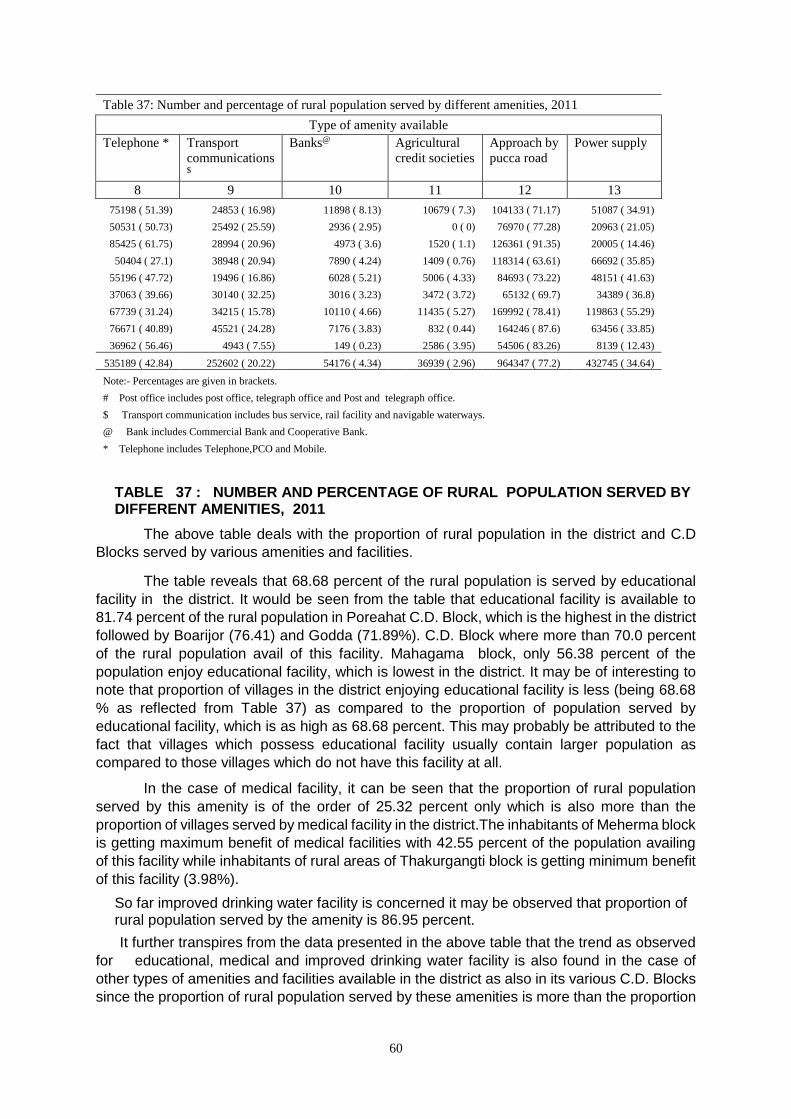
60
Table 37: Number and percentage of rural population served by different amenities, 2011
Type of amenity available
Telephone * Transport
communications $
Banks@ Agricultural
credit societies
Approach by
pucca road
Power supply
8 9 10 11 12 13
75198 ( 51.39) 24853 ( 16.98) 11898 ( 8.13) 10679 ( 7.3) 104133 ( 71.17) 51087 ( 34.91)
50531 ( 50.73) 25492 ( 25.59) 2936 ( 2.95) 0 ( 0) 76970 ( 77.28) 20963 ( 21.05)
85425 ( 61.75) 28994 ( 20.96) 4973 ( 3.6) 1520 ( 1.1) 126361 ( 91.35) 20005 ( 14.46)
50404 ( 27.1) 38948 ( 20.94) 7890 ( 4.24) 1409 ( 0.76) 118314 ( 63.61) 66692 ( 35.85)
55196 ( 47.72) 19496 ( 16.86) 6028 ( 5.21) 5006 ( 4.33) 84693 ( 73.22) 48151 ( 41.63)
37063 ( 39.66) 30140 ( 32.25) 3016 ( 3.23) 3472 ( 3.72) 65132 ( 69.7) 34389 ( 36.8)
67739 ( 31.24) 34215 ( 15.78) 10110 ( 4.66) 11435 ( 5.27) 169992 ( 78.41) 119863 ( 55.29)
76671 ( 40.89) 45521 ( 24.28) 7176 ( 3.83) 832 ( 0.44) 164246 ( 87.6) 63456 ( 33.85)
36962 ( 56.46) 4943 ( 7.55) 149 ( 0.23) 2586 ( 3.95) 54506 ( 83.26) 8139 ( 12.43)
535189 ( 42.84) 252602 ( 20.22) 54176 ( 4.34) 36939 ( 2.96) 964347 ( 77.2) 432745 ( 34.64)
Note:- Percentages are given in brackets.
# Post office includes post office, telegraph office and Post and telegraph office.
$ Transport communication includes bus service, rail facility and navigable waterways.
@ Bank includes Commercial Bank and Cooperative Bank.
* Telephone includes Telephone,PCO and Mobile.
TABLE 37 : NUMBER AND PERCENTAGE OF RURAL POPULATION SERVED BY DIFFERENT AMENITIES, 2011
The above table deals with the proportion of rural population in the district and C.D
Blocks served by various amenities and facilities.
The table reveals that 68.68 percent of the rural population is served by educational
facility in the district. It would be seen from the table that educational facility is available to
81.74 percent of the rural population in Poreahat C.D. Block, which is the highest in the district
followed by Boarijor (76.41) and Godda (71.89%). C.D. Block where more than 70.0 percent
of the rural population avail of this facility. Mahagama block, only 56.38 percent of the
population enjoy educational facility, which is lowest in the district. It may be of interesting to
note that proportion of villages in the district enjoying educational facility is less (being 68.68
% as reflected from Table 37) as compared to the proportion of population served by
educational facility, which is as high as 68.68 percent. This may probably be attributed to the
fact that villages which possess educational facility usually contain larger population as
compared to those villages which do not have this facility at all.
In the case of medical facility, it can be seen that the proportion of rural population
served by this amenity is of the order of 25.32 percent only which is also more than the
proportion of villages served by medical facility in the district.The inhabitants of Meherma block
is getting maximum benefit of medical facilities with 42.55 percent of the population availing
of this facility while inhabitants of rural areas of Thakurgangti block is getting minimum benefit
of this facility (3.98%).
So far improved drinking water facility is concerned it may be observed that proportion of rural population served by the amenity is 86.95 percent.
It further transpires from the data presented in the above table that the trend as observed
for educational, medical and improved drinking water facility is also found in the case of
other types of amenities and facilities available in the district as also in its various C.D. Blocks
since the proportion of rural population served by these amenities is more than the proportion
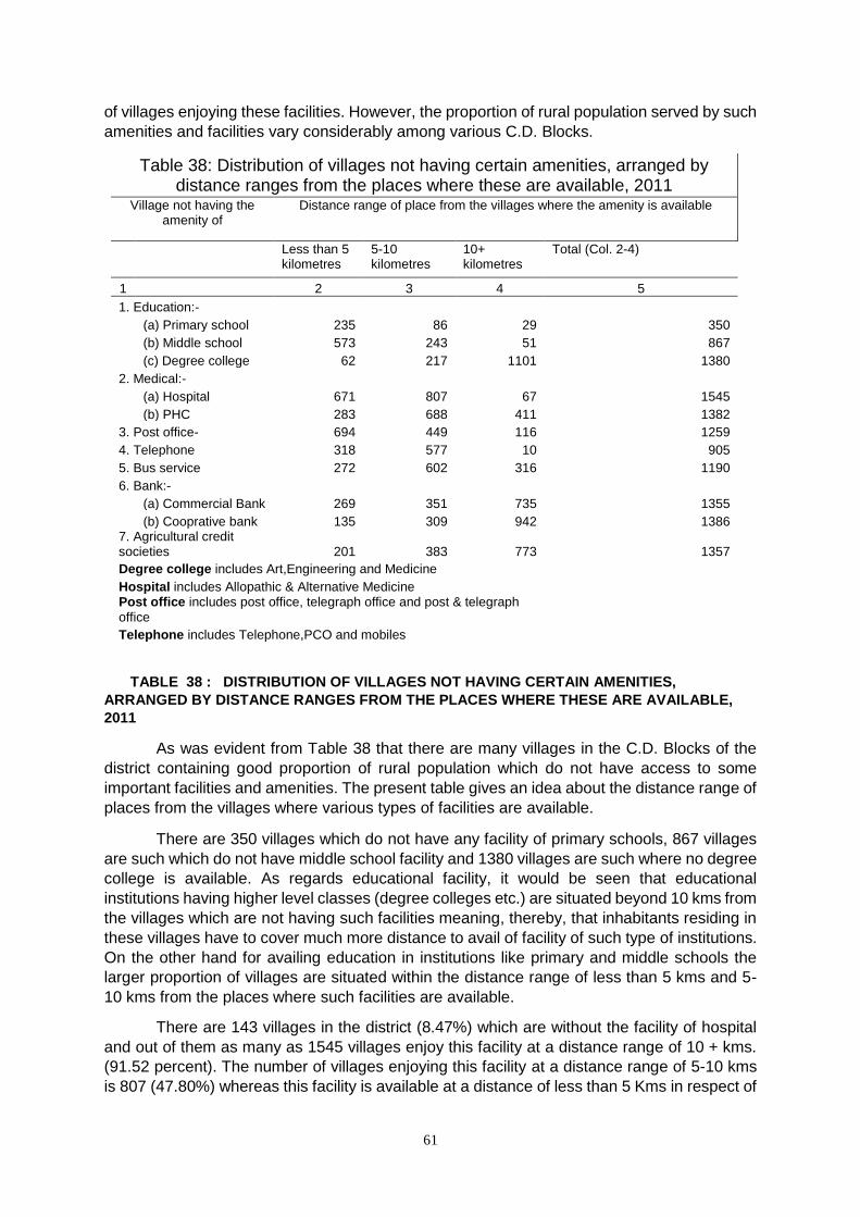
61
of villages enjoying these facilities. However, the proportion of rural population served by such
amenities and facilities vary considerably among various C.D. Blocks.
Table 38: Distribution of villages not having certain amenities, arranged by distance ranges from the places where these are available, 2011
Village not having the amenity of
Distance range of place from the villages where the amenity is available
Less than 5 kilometres
5-10 kilometres
10+ kilometres
Total (Col. 2-4)
1 2 3 4 5
1. Education:-
(a) Primary school 235 86 29 350
(b) Middle school 573 243 51 867
(c) Degree college 62 217 1101 1380
2. Medical:-
(a) Hospital 671 807 67 1545
(b) PHC 283 688 411 1382
3. Post office- 694 449 116 1259
4. Telephone 318 577 10 905
5. Bus service 272 602 316 1190
6. Bank:-
(a) Commercial Bank 269 351 735 1355
(b) Cooprative bank 135 309 942 1386 7. Agricultural credit societies 201 383 773 1357
Degree college includes Art,Engineering and Medicine
Hospital includes Allopathic & Alternative Medicine Post office includes post office, telegraph office and post & telegraph
office
Telephone includes Telephone,PCO and mobiles
TABLE 38 : DISTRIBUTION OF VILLAGES NOT HAVING CERTAIN AMENITIES,
ARRANGED BY DISTANCE RANGES FROM THE PLACES WHERE THESE ARE AVAILABLE,
2011
As was evident from Table 38 that there are many villages in the C.D. Blocks of the
district containing good proportion of rural population which do not have access to some
important facilities and amenities. The present table gives an idea about the distance range of
places from the villages where various types of facilities are available.
There are 350 villages which do not have any facility of primary schools, 867 villages
are such which do not have middle school facility and 1380 villages are such where no degree
college is available. As regards educational facility, it would be seen that educational
institutions having higher level classes (degree colleges etc.) are situated beyond 10 kms from
the villages which are not having such facilities meaning, thereby, that inhabitants residing in
these villages have to cover much more distance to avail of facility of such type of institutions.
On the other hand for availing education in institutions like primary and middle schools the
larger proportion of villages are situated within the distance range of less than 5 kms and 5-
10 kms from the places where such facilities are available.
There are 143 villages in the district (8.47%) which are without the facility of hospital
and out of them as many as 1545 villages enjoy this facility at a distance range of 10 + kms.
(91.52 percent). The number of villages enjoying this facility at a distance range of 5-10 kms
is 807 (47.80%) whereas this facility is available at a distance of less than 5 Kms in respect of
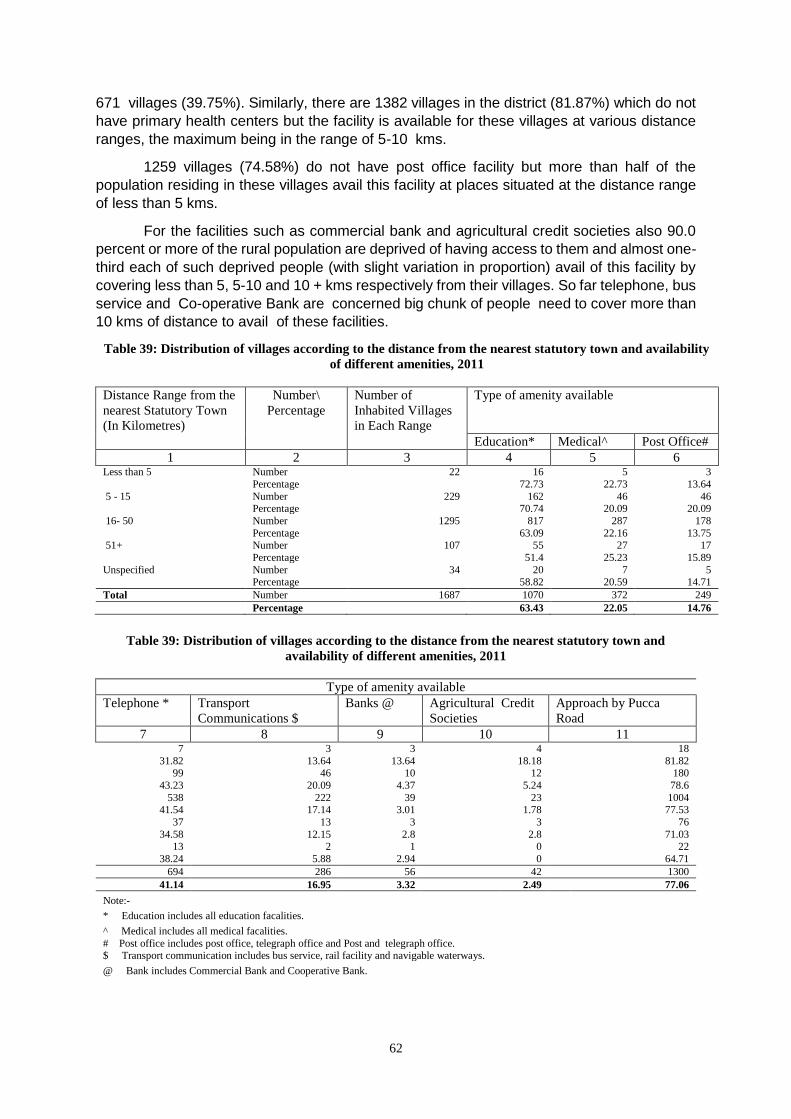
62
671 villages (39.75%). Similarly, there are 1382 villages in the district (81.87%) which do not
have primary health centers but the facility is available for these villages at various distance
ranges, the maximum being in the range of 5-10 kms.
1259 villages (74.58%) do not have post office facility but more than half of the
population residing in these villages avail this facility at places situated at the distance range
of less than 5 kms.
For the facilities such as commercial bank and agricultural credit societies also 90.0
percent or more of the rural population are deprived of having access to them and almost one-
third each of such deprived people (with slight variation in proportion) avail of this facility by
covering less than 5, 5-10 and 10 + kms respectively from their villages. So far telephone, bus
service and Co-operative Bank are concerned big chunk of people need to cover more than
10 kms of distance to avail of these facilities.
Table 39: Distribution of villages according to the distance from the nearest statutory town and availability
of different amenities, 2011
Distance Range from the
nearest Statutory Town
(In Kilometres)
Number\
Percentage
Number of
Inhabited Villages
in Each Range
Type of amenity available
Education* Medical^ Post Office#
1 2 3 4 5 6 Less than 5 Number 22 16 5 3
Percentage 72.73 22.73 13.64
5 - 15 Number 229 162 46 46 Percentage 70.74 20.09 20.09
16- 50 Number 1295 817 287 178
Percentage 63.09 22.16 13.75 51+ Number 107 55 27 17
Percentage 51.4 25.23 15.89
Unspecified Number 34 20 7 5 Percentage 58.82 20.59 14.71
Total Number 1687 1070 372 249
Percentage 63.43 22.05 14.76
Table 39: Distribution of villages according to the distance from the nearest statutory town and
availability of different amenities, 2011
Type of amenity available
Telephone * Transport
Communications $
Banks @ Agricultural Credit
Societies
Approach by Pucca
Road
7 8 9 10 11 7 3 3 4 18
31.82 13.64 13.64 18.18 81.82 99 46 10 12 180
43.23 20.09 4.37 5.24 78.6
538 222 39 23 1004 41.54 17.14 3.01 1.78 77.53
37 13 3 3 76
34.58 12.15 2.8 2.8 71.03 13 2 1 0 22
38.24 5.88 2.94 0 64.71
694 286 56 42 1300
41.14 16.95 3.32 2.49 77.06
Note:-
* Education includes all education facalities.
^ Medical includes all medical facalities. # Post office includes post office, telegraph office and Post and telegraph office. $ Transport communication includes bus service, rail facility and navigable waterways.
@ Bank includes Commercial Bank and Cooperative Bank.
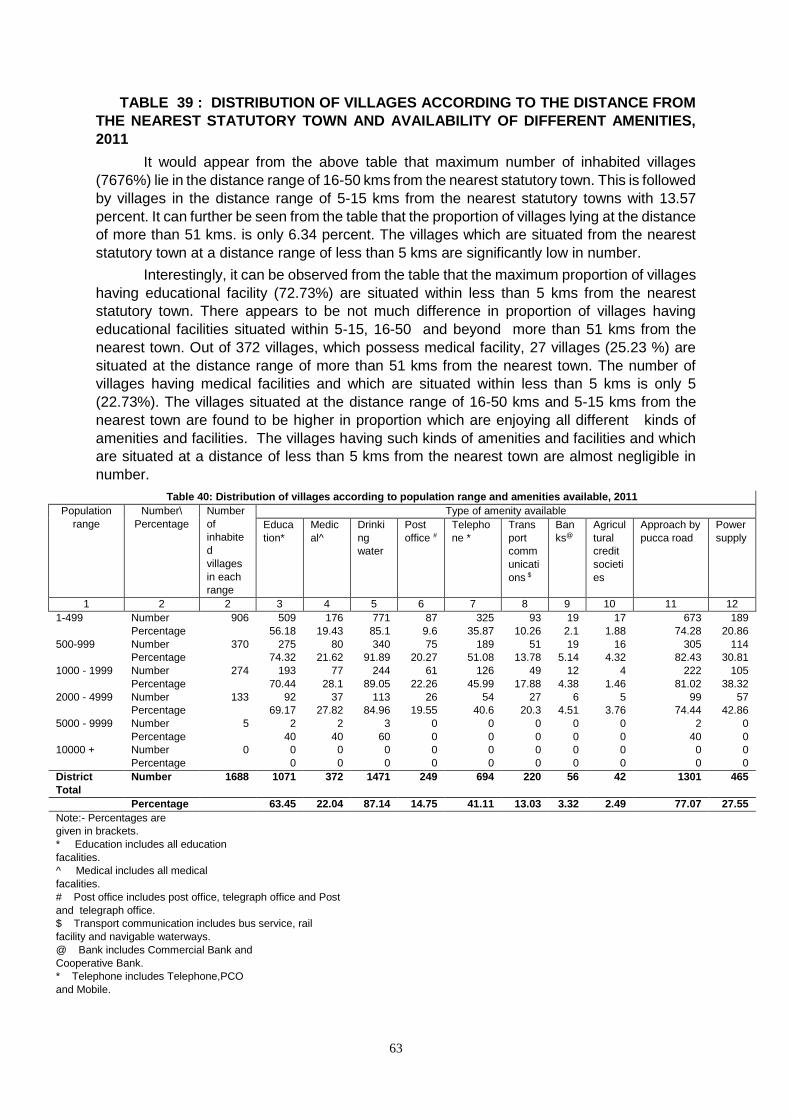
63
TABLE 39 : DISTRIBUTION OF VILLAGES ACCORDING TO THE DISTANCE FROM
THE NEAREST STATUTORY TOWN AND AVAILABILITY OF DIFFERENT AMENITIES,
2011
It would appear from the above table that maximum number of inhabited villages
(7676%) lie in the distance range of 16-50 kms from the nearest statutory town. This is followed
by villages in the distance range of 5-15 kms from the nearest statutory towns with 13.57
percent. It can further be seen from the table that the proportion of villages lying at the distance
of more than 51 kms. is only 6.34 percent. The villages which are situated from the nearest
statutory town at a distance range of less than 5 kms are significantly low in number.
Interestingly, it can be observed from the table that the maximum proportion of villages
having educational facility (72.73%) are situated within less than 5 kms from the nearest
statutory town. There appears to be not much difference in proportion of villages having
educational facilities situated within 5-15, 16-50 and beyond more than 51 kms from the
nearest town. Out of 372 villages, which possess medical facility, 27 villages (25.23 %) are
situated at the distance range of more than 51 kms from the nearest town. The number of
villages having medical facilities and which are situated within less than 5 kms is only 5
(22.73%). The villages situated at the distance range of 16-50 kms and 5-15 kms from the
nearest town are found to be higher in proportion which are enjoying all different kinds of
amenities and facilities. The villages having such kinds of amenities and facilities and which
are situated at a distance of less than 5 kms from the nearest town are almost negligible in
number.
Table 40: Distribution of villages according to population range and amenities available, 2011
Population
range
Number\
Percentage
Number
of
inhabite
d
villages
in each
range
Type of amenity available
Educa
tion*
Medic
al^
Drinki
ng
water
Post
office #
Telepho
ne *
Trans
port
comm
unicati
ons $
Ban
ks@
Agricul
tural
credit
societi
es
Approach by
pucca road
Power
supply
1 2 2 3 4 5 6 7 8 9 10 11 12
1-499 Number 906 509 176 771 87 325 93 19 17 673 189
Percentage 56.18 19.43 85.1 9.6 35.87 10.26 2.1 1.88 74.28 20.86
500-999 Number 370 275 80 340 75 189 51 19 16 305 114
Percentage 74.32 21.62 91.89 20.27 51.08 13.78 5.14 4.32 82.43 30.81
1000 - 1999 Number 274 193 77 244 61 126 49 12 4 222 105
Percentage 70.44 28.1 89.05 22.26 45.99 17.88 4.38 1.46 81.02 38.32
2000 - 4999 Number 133 92 37 113 26 54 27 6 5 99 57
Percentage 69.17 27.82 84.96 19.55 40.6 20.3 4.51 3.76 74.44 42.86
5000 - 9999 Number 5 2 2 3 0 0 0 0 0 2 0
Percentage 40 40 60 0 0 0 0 0 40 0
10000 + Number 0 0 0 0 0 0 0 0 0 0 0
Percentage 0 0 0 0 0 0 0 0 0 0
District
Total
Number 1688 1071 372 1471 249 694 220 56 42 1301 465
Percentage 63.45 22.04 87.14 14.75 41.11 13.03 3.32 2.49 77.07 27.55
Note:- Percentages are
given in brackets.
* Education includes all education
facalities.
^ Medical includes all medical
facalities.
# Post office includes post office, telegraph office and Post
and telegraph office.
$ Transport communication includes bus service, rail
facility and navigable waterways.
@ Bank includes Commercial Bank and
Cooperative Bank.
* Telephone includes Telephone,PCO
and Mobile.
64
TABLE 40 : DISTRIBUTION OF VILLAGES ACCORDING TO POPULATION RANGE AND
AMENITIES AVAILABLE, 2011
The above table shows that the maximum number of villages, i.e., 906 (53.57%) in the
district fall in the population range of less than 500, followed by 370 villages (18.18%) in the
population range of 500-999. It is seen that the next in numeric order is 274 villages, lying in
the population range of 1000-1999 and constituting over 16.23 percent of the total inhabited
villages in the district. The proportion of villages lying in higher population ranges is
significantly low which implies that small and medium sized villages are more in number in the
district of Godda. It is also a fact that the villages of Jharkhand state are, in general, sparsely
populated.
It further transpires from the table that larger proportion of villages having various types
of amenities and facilities, by and large, lie in those population ranges where number of
villages are comparatively more in number.
Table 41: Distribution of villages according to land use, 2011
Sr.
No.
Name of CD Block Number of
inhabited
villages
Total area
(in Hectares)
Percentage of
cultivable area
to total area
Percentage of
irrigated area to total
cultivable area
1 2 3 4 5 6
1 0061-Meherma 144 11507.85 75.77 26.66
2 0062-Thakurgangti 146 7804.90 75.46 15.72
3 0063-Boarijor 309 35108.37 49.32 8.71
4 0064-Mahagama 245 14522.83 57.05 27.28
5 0065-Pathargama 146 14589.23 74.70 11.52
6 0066-Bashant Rai* 83 8244.57 66.78 7.70
7 0067-Godda 197 32450.59 43.83 18.86
8 0068-Poreyahat 197 46266.29 48.43 31.98
9 0069-Sundarpahari 221 39253.11 21.42 8.47
Total 1688 209747.74 48.46 18.95
Note:- Culativable area= irrigated area + unirrigated area
TABLE 41 : DISTRIBUTION OF VILLAGES ACCORDING TO LAND USE, 2011
The above table furnishes information regarding the percentage of cultivable area as also the
proportion of irrigated area to total cultivable area in the district and its various C.D. Blocks.
It can be seen from the data presented in the table that 48.46 percent of the total area
of the district is utilized for cultivation (cultivable area) and of this only 18.95 percent of the
area is found to be irrigated. Among the C.D. Blocks, the highest proportion of cultivable area
is observed in Meherma (75.77%) Thakurgangti (75.46%) and Pathargana (74.70%) C.D.
Blocks with more than 70.0 percent cultivable area. The lowest cultivable area is found in
Sundarpahari C.D. Block (21.42%).
The highest proportion of irrigated area to total cultivable area is found in Poreahat C.D. Block (31.98%), followed byMahagama (27.28%), Meherma (26.66%) and Godda (18.86%) C.D. Blocks. The least proportion of irrigated area is found in Basant Rai C.D. Block with only 7.70 percent, closely followed by Boarijor (8.71%) and Sundarpahari (8.47 %) C.D. Blocks which indicates that the villages in -this block are deprived of minimum required irrigational facilities. In other C.D. Blocks also the irrigation facilities are found to be very inadequate as the percentage of irrigated area lie between 9- 17 percent only.
65
Table 42: Schools/ colleges per 10,000 population in towns, 2011
Sr.
No.
Name of the town Type of educational institution
Primary Middle Secondary /
matriculation
Senior
secondary
College
1 2 3 4 5 6 7
1 356840-Mahagma (CT) 1.82 1.82 1.82 0.00 0.00
2 801771-Godda (NP) 7.01 5.16 1.24 1.03 0.00
3 357411-Sarauni (CT) 4.02 2.01 2.01 2.01 0.00
Total 5.90 4.35 1.40 0.93 0.00
TABLE 42 : SCHOOLS/ COLLEGES PER 10,000 POPULATION IN TOWNS , 2011
The above table gives the details of different categories of educational institutions per ten thousand population in the towns of the district. It would be seen from the above table that institutions like secondary/matriculation level school and Senior secondary account for an average of 1.40 and 0.93 institution per ten thousand population respectively in the urban areas of the district. As regards secondary/matriculation level schools, there are on an average, 2.01 schools per ten thousand population in Sarauni (C.T.), middle school are found to be the maximum in the case of Godda (NP) (5.16) followed by Sarauni (CT) (2.01). Again Godda (NP) has the highest number of primary schools in the district with an average of 7.01 percent such schools per ten thousand population. The average number of primary schools in the urban areas of the district is 5.90 percent per ten thousand population
Table 43: Number of beds in medical institutions in towns, 2011
Sr. No.
Name of the town Number of beds in medical institutions per 10,000 population
1 2 3
1 356840-Mahagma (CT) 27.35
2 801771-Godda (NP) 16.09
3 357411-Sarauni (CT) 0.00
Total 16.77
TABLE 43 : NUMBER OF BEDS IN MEDICAL INSTITUTIONS PER 10,000 POPULATION
IN TOWNS, 2011
The above table furnishes information regarding availability of beds in medical institutions
per 10,000 population in the towns of Godda District.
The average number of beds in medical institutions per 10,000 population for the
urban areas of Godda district works out to 16.77 percent. The availability of beds in the medical
institutions is higher in case of JMahagama (CT), with 27.35 percent beds per 10,000
population, which is far ahead as compared to all other towns of the district. Godda (NP.), the
district headquarters town, has only 16.09 percent beds per 10,000 population which may
probably be due to the fact that Godda, the headquarters town, is considerably much more
populated than all other towns of the district.
66
Table 45: Most important commodity manufactured in towns, 2011
Sr. No. Name of the town Name of three most important
commodities manufactured
1 2 3
1 356840-Mahagma (CT)
2 801771-Godda (NP) Patta Plate (pattal), Furniture
3 357411-Sarauni (CT)
TABLE 45 : MOST IMPORTANT COMMODITY MANUFACTURED IN TOWNS, 2011
The above table gives information regarding most important commodities
manufactured in the towns of the district. In Godda town, the most important commodities
manufactured are Patta Plate (Pattal) It can be observed from the table above that in other
towns there is no any kind of commodity manufactured in the town.
Social and Cultural Events and Natural and Administrative Development.
The Godda district has witnessed two great events of far-reaching consequences as
an outcome of long drawn Jharkhand movement, e.g.
(i) creation of Jharkhand Autonomous Council in 1996 and (ii) creation of Jharkhand state out
of composite Bihar state on 15th November, 2000. Creation of Jharkhand state finally replaced
the Jharkhand Autonomous Council. With the creation of Jharkhand state (with 18 districts
and 4 divisions) the state capital for district shifted from Patna to Ranchi. Impact of modernity
and urbanization is making impact in remote hinterland of the district. There is no memorable
and remarkable happenings in this district during last decade.
Brief Description of places of Religious, Historical and Archaeological Importance in
the Villages and Places of Tourist Interest in the Towns of The District.
Godda
Godda town is headquarter of present district and subdivision. It was sub-divisional
headquarters of old Santhal Pargana district. It is hub of the trade and commerce.
Bhagaiya.
It is famous for Tasar Weaving Centre.
………………………………..
67
Village and Town Directory
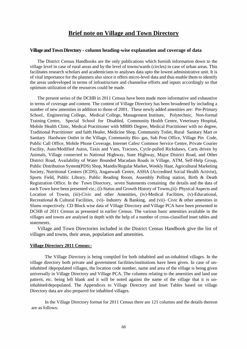
68
Brief note on Village and Town Directory
Village and Town Directory - column heading-wise explanation and coverage of data
The District Census Handbooks are the only publications which furnish information down to the
village level in case of rural areas and by the level of towns/wards (circles) in case of urban areas. This
facilitates research scholars and academicians to analyses data upto the lowest administrative unit. It is
of vital importance for the planners also since it offers micro-level data and thus enable them to identify
the areas undeveloped in terms of infrastructure and channelise efforts and inputs accordingly so that
optimum utilization of the resources could be made.
The present series of the DCHB in 2011 Census have been made more informative and exhaustive
in terms of coverage and content. The content of Village Directory has been broadened by including a
number of new amenities in addition to those of 2001. These newly added amenities are: Pre-Primary
School, Engineering College, Medical College, Management Institute, Polytechnic, Non-formal
Training Centre, Special School for Disabled, Community Health Centre, Veterinary Hospital,
Mobile Health Clinic, Medical Practitioner with MBBS Degree, Medical Practitioner with no degree,
Traditional Practitioner and faith Healer, Medicine Shop, Community Toilet, Rural Sanitary Mart or
Sanitary Hardware Outlet in the Village, Community Bio- gas, Sub Post Office, Village Pin Code,
Public Call Office, Mobile Phone Coverage, Internet Cafes/ Common Service Centre, Private Courier
Facility, Auto/Modified Autos, Taxis and Vans, Tractors, Cycle-pulled Rickshaws, Carts driven by
Animals, Village connected to National Highway, State Highway, Major District Road, and Other
District Road, Availability of Water Bounded Macadam Roads in Village, ATM, Self-Help Group,
Public Distribution System(PDS) Shop, Mandis/Regular Market, Weekly Haat, Agricultural Marketing
Society, Nutritional Centers (ICDS), Anganwadi Centre, ASHA (Accredited Social Health Activist),
Sports Field, Public Library, Public Reading Room, Assembly Polling station, Birth & Death
Registration Office. In the Town Directory, seven Statements containing the details and the data of
each Town have been presented viz.; (i)-Status and Growth History of Towns,(ii)- Physical Aspects and
Location of Towns, (iii)-Civic and other Amenities, (iv)-Medical Facilities, (v)-Educational,
Recreational & Cultural Facilities, (vi)- Industry & Banking, and (vii)- Civic & other amenities in
Slums respectively. CD Block wise data of Village Directory and Village PCA have been presented in
DCHB of 2011 Census as presented in earlier Census. The various basic amenities available in the
villages and towns are analysed in depth with the help of a number of cross-classified inset tables and
statements.
Village and Town Directories included in the District Census Handbook give the list of
villages and towns, their areas, population and amenities.
Village Directory 2011 Census:-
The Village Directory is being compiled for both inhabited and un-inhabited villages. In the
village directory both private and government facilities/institutions have been given. In case of un-
inhabited /depopulated villages, the location code number, name and area of the village is being given
universally in Village Directory and Village PCA. The columns relating to the amenities and land use
pattern, etc. being left blank and it will be noted against the name of the village that it is un-
inhabited/depopulated. The Appendices to Village Directory and Inset Tables based on village
Directory data are also prepared for inhabited villages.
In the Village Directory format for 2011 Census there are 121 columns and the details thereon
are as follows:
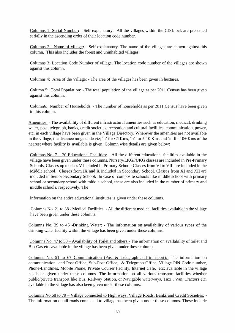
69
Columns 1: Serial Number: - Self explanatory. All the villages within the CD block are presented
serially in the ascending order of their location code number.
Columns 2: Name of village: - Self explanatory. The name of the villages are shown against this
column. This also includes the forest and uninhabited villages.
Columns 3: Location Code Number of village. The location code number of the villages are shown
against this column.
Columns 4: Area of the Village: - The area of the villages has been given in hectares.
Column 5: Total Population: - The total population of the village as per 2011 Census has been given
against this column.
Column6: Number of Households: - The number of households as per 2011 Census have been given
in this column.
Amenities: - The availability of different infrastructural amenities such as education, medical, drinking
water, post, telegraph, banks, credit societies, recreation and cultural facilities, communication, power,
etc. in each village have been given in the Village Directory. Wherever the amenities are not available
in the village, the distance range code viz; ‘a’ for <5 Kms, ‘b’ for 5-10 Kms and ‘c’ for 10+ Kms of the
nearest where facility is available is given. Column wise details are given below:
Columns No. 7 – 20 Educational Facilities: - All the different educational facilities available in the
village have been given under these columns. Nursery/LKG//UKG classes are included in Pre-Primary
Schools, Classes up to class V included in Primary School; Classes from VI to VIII are included in the
Middle school. Classes from IX and X included in Secondary School. Classes from XI and XII are
included in Senior Secondary School. In case of composite schools like middle school with primary
school or secondary school with middle school, these are also included in the number of primary and
middle schools, respectively. The
Information on the entire educational institutes is given under these columns.
Columns No. 21 to 38 - Medical Facilities: - All the different medical facilities available in the village
have been given under these columns.
Columns No. 39 to 46 -Drinking Water: - The information on availability of various types of the
drinking water facility within the village has been given under these columns.
Columns No. 47 to 50 – Availability of Toilet and others:- The information on availability of toilet and
Bio-Gas etc. available in the village has been given under these columns.
Columns No. 51 to 67 Communication (Post & Telegraph and transport):- The information on
communication and Post Office, Sub-Post Office, & Telegraph Office, Village PIN Code number,
Phone-Landlines, Mobile Phone, Private Courier Facility, Internet Café, etc; available in the village
has been given under these columns. The information on all various transport facilities whether
public/private transport like Bus, Railway Station, or Navigable waterways, Taxi , Van, Tractors etc.
available in the village has also been given under these columns.
Columns No.68 to 79 – Village connected to High ways, Village Roads, Banks and Credit Societies: -
The information on all roads connected to village has been given under these columns. These include
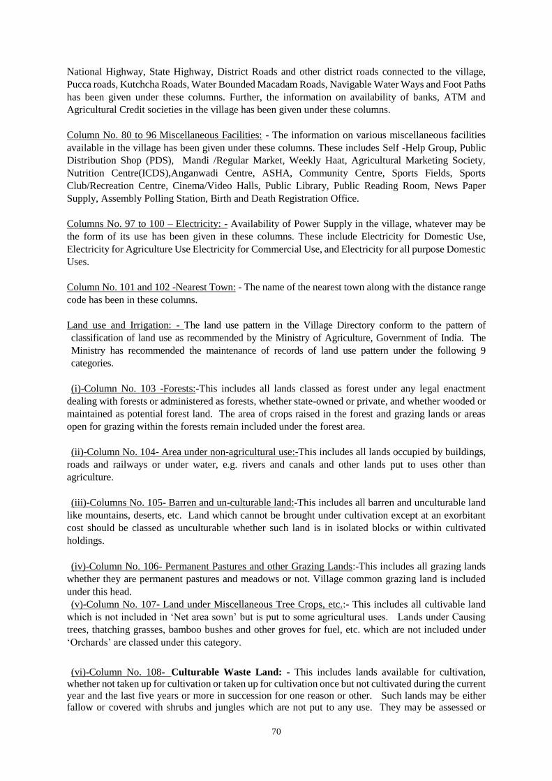
70
National Highway, State Highway, District Roads and other district roads connected to the village,
Pucca roads, Kutchcha Roads, Water Bounded Macadam Roads, Navigable Water Ways and Foot Paths
has been given under these columns. Further, the information on availability of banks, ATM and
Agricultural Credit societies in the village has been given under these columns.
Column No. 80 to 96 Miscellaneous Facilities: - The information on various miscellaneous facilities
available in the village has been given under these columns. These includes Self -Help Group, Public
Distribution Shop (PDS), Mandi /Regular Market, Weekly Haat, Agricultural Marketing Society,
Nutrition Centre(ICDS),Anganwadi Centre, ASHA, Community Centre, Sports Fields, Sports
Club/Recreation Centre, Cinema/Video Halls, Public Library, Public Reading Room, News Paper
Supply, Assembly Polling Station, Birth and Death Registration Office.
Columns No. 97 to 100 – Electricity: - Availability of Power Supply in the village, whatever may be
the form of its use has been given in these columns. These include Electricity for Domestic Use,
Electricity for Agriculture Use Electricity for Commercial Use, and Electricity for all purpose Domestic
Uses.
Column No. 101 and 102 -Nearest Town: - The name of the nearest town along with the distance range
code has been in these columns.
Land use and Irrigation: - The land use pattern in the Village Directory conform to the pattern of
classification of land use as recommended by the Ministry of Agriculture, Government of India. The
Ministry has recommended the maintenance of records of land use pattern under the following 9
categories.
(i)-Column No. 103 -Forests:-This includes all lands classed as forest under any legal enactment
dealing with forests or administered as forests, whether state-owned or private, and whether wooded or
maintained as potential forest land. The area of crops raised in the forest and grazing lands or areas
open for grazing within the forests remain included under the forest area.
(ii)-Column No. 104- Area under non-agricultural use:-This includes all lands occupied by buildings,
roads and railways or under water, e.g. rivers and canals and other lands put to uses other than
agriculture.
(iii)-Columns No. 105- Barren and un-culturable land:-This includes all barren and unculturable land
like mountains, deserts, etc. Land which cannot be brought under cultivation except at an exorbitant
cost should be classed as unculturable whether such land is in isolated blocks or within cultivated
holdings.
(iv)-Column No. 106- Permanent Pastures and other Grazing Lands:-This includes all grazing lands
whether they are permanent pastures and meadows or not. Village common grazing land is included
under this head.
(v)-Column No. 107- Land under Miscellaneous Tree Crops, etc.:- This includes all cultivable land
which is not included in ‘Net area sown’ but is put to some agricultural uses. Lands under Causing
trees, thatching grasses, bamboo bushes and other groves for fuel, etc. which are not included under
‘Orchards’ are classed under this category.
(vi)-Column No. 108- Culturable Waste Land: - This includes lands available for cultivation,
whether not taken up for cultivation or taken up for cultivation once but not cultivated during the current
year and the last five years or more in succession for one reason or other. Such lands may be either
fallow or covered with shrubs and jungles which are not put to any use. They may be assessed or
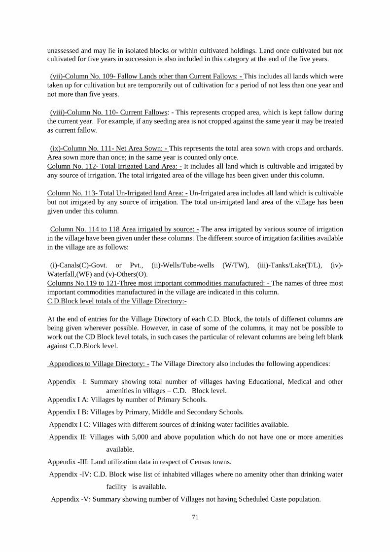
71
unassessed and may lie in isolated blocks or within cultivated holdings. Land once cultivated but not
cultivated for five years in succession is also included in this category at the end of the five years.
(vii)-Column No. 109- Fallow Lands other than Current Fallows: - This includes all lands which were
taken up for cultivation but are temporarily out of cultivation for a period of not less than one year and
not more than five years.
(viii)-Column No. 110- Current Fallows: - This represents cropped area, which is kept fallow during
the current year. For example, if any seeding area is not cropped against the same year it may be treated
as current fallow.
(ix)-Column No. 111- Net Area Sown: - This represents the total area sown with crops and orchards.
Area sown more than once; in the same year is counted only once.
Column No. 112- Total Irrigated Land Area: - It includes all land which is cultivable and irrigated by
any source of irrigation. The total irrigated area of the village has been given under this column.
Column No. 113- Total Un-Irrigated land Area: - Un-Irrigated area includes all land which is cultivable
but not irrigated by any source of irrigation. The total un-irrigated land area of the village has been
given under this column.
Column No. 114 to 118 Area irrigated by source: - The area irrigated by various source of irrigation
in the village have been given under these columns. The different source of irrigation facilities available
in the village are as follows:
(i)-Canals(C)-Govt. or Pvt., (ii)-Wells/Tube-wells (W/TW), (iii)-Tanks/Lake(T/L), (iv)-
Waterfall,(WF) and (v)-Others(O).
Columns No.119 to 121-Three most important commodities manufactured: - The names of three most
important commodities manufactured in the village are indicated in this column.
C.D.Block level totals of the Village Directory:-
At the end of entries for the Village Directory of each C.D. Block, the totals of different columns are
being given wherever possible. However, in case of some of the columns, it may not be possible to
work out the CD Block level totals, in such cases the particular of relevant columns are being left blank
against C.D.Block level.
Appendices to Village Directory: - The Village Directory also includes the following appendices:
Appendix –I: Summary showing total number of villages having Educational, Medical and other
amenities in villages – C.D. Block level.
Appendix I A: Villages by number of Primary Schools.
Appendix I B: Villages by Primary, Middle and Secondary Schools.
Appendix I C: Villages with different sources of drinking water facilities available.
Appendix II: Villages with 5,000 and above population which do not have one or more amenities
available.
Appendix -III: Land utilization data in respect of Census towns.
Appendix -IV: C.D. Block wise list of inhabited villages where no amenity other than drinking water
facility is available.
Appendix -V: Summary showing number of Villages not having Scheduled Caste population.
72
Appendix -VI: Summary showing number of Villages not having Scheduled Tribe population.
Appendix -VII A: List of villages according to the proportion of the Scheduled Castes to the total
population by ranges.
Appendix- VII B: List of villages according to the proportion of the Scheduled Tribes to the total
population by ranges.
Appendix -VIII: Number of villages under each Gram Panchayat (C.D. block wise).
73
CD BLOCK WISE MAP AND LOCATION CODE
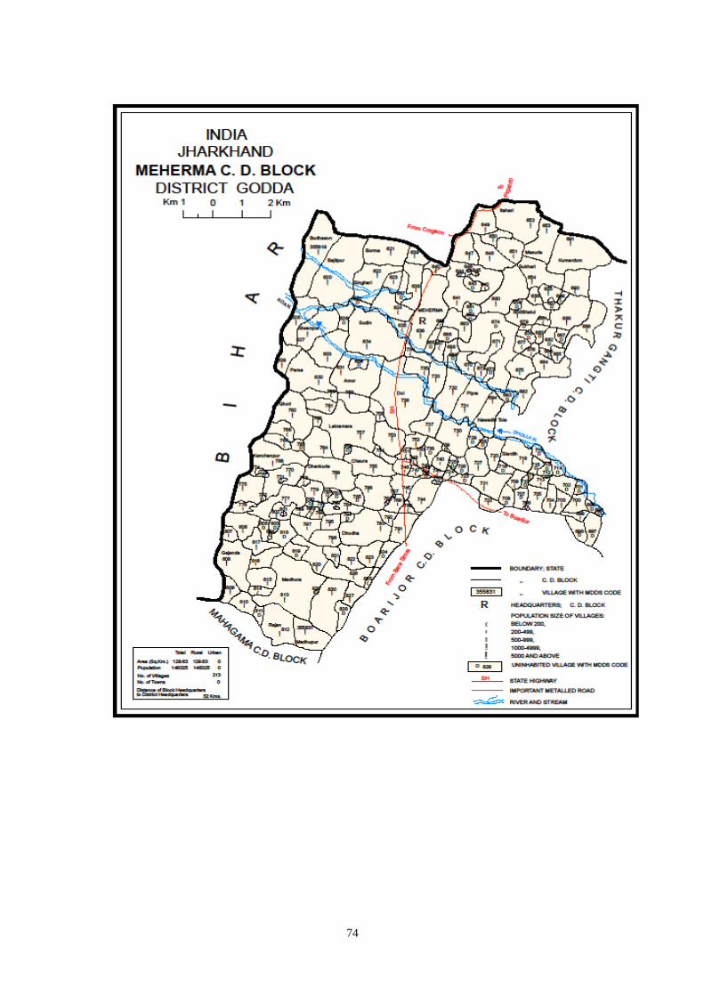
74
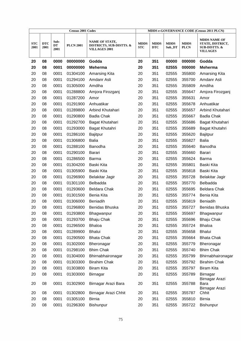
75
Census 2001 Codes MDDS e-GOVERNANCE CODE (Census 2011 PLCN)
STC
2001
DTC
2001
Sub-
DT
2001
PLCN 2001
NAME OF STATE,
DISTRICTS, SUB-DISTTS. &
VILLAGES 2001
MDDS
STC
MDDS
DTC
MDDS
Sub_DT
MDDS
PLCN
MDDS NAME OF
STATE, DISTRICT,
SUB-DISTTS. &
VILLAGES
20 08 0000 00000000 Godda 20 351 00000 000000 Godda
20 08 0001 00000000 Meherma 20 351 02555 000000 Meherma
20 08 0001 01304100 Amarsing Kita 20 351 02555 355800 Amarsing Kita
20 08 0001 01294100 Amdanr Asli 20 351 02555 355700 Amdanr Asli
20 08 0001 01305000 Amdiha 20 351 02555 355809 Amdiha
20 08 0001 01288800 Amjora Firozganj 20 351 02555 355647 Amjora Firozganj
20 08 0001 01287200 Amor 20 351 02555 355631 Amor
20 08 0001 01291900 Anhuatikar 20 351 02555 355678 Anhuatikar
20 08 0001 01289800 Arbind Khutahari 20 351 02555 355657 Arbind Khutahari
20 08 0001 01290800 Badla Chak 20 351 02555 355667 Badla Chak
20 08 0001 01292700 Bagat Khutahari 20 351 02555 355686 Bagat Khutahari
20 08 0001 01293000 Bagat Khutahri 20 351 02555 355689 Bagat Khutahri
20 08 0001 01286100 Bajitpur 20 351 02555 355620 Bajitpur
20 08 0001 01306800 Balia 20 351 02555 355827 Balia
20 08 0001 01288100 Banodha 20 351 02555 355640 Banodha
20 08 0001 01290100 Barari 20 351 02555 355660 Barari
20 08 0001 01286500 Barma 20 351 02555 355624 Barma
20 08 0001 01304200 Baski Kita 20 351 02555 355801 Baski Kita
20 08 0001 01305900 Baski Kita 20 351 02555 355818 Baski Kita
20 08 0001 01296900 Belakitar Jagir 20 351 02555 355728 Belakitar Jagir
20 08 0001 01301100 Belbadda 20 351 02555 355770 Belbadda
20 08 0001 01293600 Beldara Chak 20 351 02555 355695 Beldara Chak
20 08 0001 01301500 Benia Kita 20 351 02555 355774 Benia Kita
20 08 0001 01306000 Beniadih 20 351 02555 355819 Beniadih
20 08 0001 01296800 Benidas Bhuska 20 351 02555 355727 Benidas Bhuska
20 08 0001 01293800 Bhagwanpur 20 351 02555 355697 Bhagwanpur
20 08 0001 01293700 Bhaju Chak 20 351 02555 355696 Bhaju Chak
20 08 0001 01296500 Bhaloa 20 351 02555 355724 Bhaloa
20 08 0001 01289900 Bhalui 20 351 02555 355658 Bhalui
20 08 0001 01290500 Bhata Chak 20 351 02555 355664 Bhata Chak
20 08 0001 01302000 Bheronagar 20 351 02555 355779 Bheronagar
20 08 0001 01298100 Bhim Chak 20 351 02555 355740 Bhim Chak
20 08 0001 01304000 Bhirnabhaironagar 20 351 02555 355799 Bhirnabhaironagar
20 08 0001 01303300 Birahim Chak 20 351 02555 355792 Birahim Chak
20 08 0001 01303800 Biram Kita 20 351 02555 355797 Biram Kita
20 08 0001 01303000 Birnagar 20 351 02555 355789 Birnagar
20 08 0001 01302900 Birnagar Arazi Bara 20 351 02555 355788 Birnagar Arazi Bara
20 08 0001 01302800 Birnagar Arazi Chhit 20 351 02555 355787 Birnagar Arazi Chhit
20 08 0001 01305100 Birnia 20 351 02555 355810 Birnia
20 08 0001 01296300 Bishunpur 20 351 02555 355722 Bishunpur
76
20 08 0001 01296600 Bisu Chak 20 351 02555 355725 Bisu Chak
20 08 0001 01286200 Borma 20 351 02555 355621 Borma
20 08 0001 01286000 Budhason 20 351 02555 355619 Budhason
20 08 0001 01290400 Champa 20 351 02555 355663 Champa
20 08 0001 01294300 Chandpur 20 351 02555 355702 Chandpur
20 08 0001 01299600 Chaura 20 351 02555 355755 Chaura
20 08 0001 01297000 Chetni Chak 20 351 02555 355729 Chetni Chak
20 08 0001 01301300 Chhagraha 20 351 02555 355772 Chhagraha
20 08 0001 01301400 Chhagraha 20 351 02555 355773 Chhagraha
20 08 0001 01301700 Chhagraha 20 351 02555 355776 Chhagraha
20 08 0001 01300700 Chhaman Kita 20 351 02555 355766 Chhaman Kita
20 08 0001 01298500 Chhant Daria Chak 20 351 02555 355744 Chhant Daria Chak
20 08 0001 01292300 Chhota And Bara Mangarh 20 351 02555 355682
Chhota And Bara Mangarh
20 08 0001 01292500 Chhota And Bara Mangarh 20 351 02555 355684
Chhota And Bara Mangarh
20 08 0001 01300200 Chitarsen Bahira 20 351 02555 355761 Chitarsen Bahira
20 08 0001 01290000 Chitu Chak 20 351 02555 355659 Chitu Chak
20 08 0001 01305700 Dalahi 20 351 02555 355816 Dalahi
20 08 0001 01298600 Daria Chak 20 351 02555 355745 Daria Chak
20 08 0001 01300500 Dariapur 20 351 02555 355764 Dariapur
20 08 0001 01297400 Dasu Chakla 20 351 02555 355733 Dasu Chakla
20 08 0001 01295100 Debi Chak 20 351 02555 355710 Debi Chak
20 08 0001 01289200 Dhamri Gopalram 20 351 02555 355651 Dhamri Gopalram
20 08 0001 01289100 Dhamri Saheb 20 351 02555 355650 Dhamri Saheb
20 08 0001 01301000 Dhankuria 20 351 02555 355769 Dhankuria
20 08 0001 01303600 Dharampur 20 351 02555 355795 Dharampur
20 08 0001 01303400 Dhodha 20 351 02555 355793 Dhodha
20 08 0001 01307000 Dhurbidih 20 351 02555 355829 Dhurbidih
20 08 0001 01295200 Dogachhi 20 351 02555 355711 Dogachhi
20 08 0001 01297700 Doi 20 351 02555 355736 Doi
20 08 0001 01291400 Doman Chak 20 351 02555 355673 Doman Chak
20 08 0001 01291100 Domanchak 20 351 02555 355670 Domanchak
20 08 0001 01291200 Dudhi Chak 20 351 02555 355671 Dudhi Chak
20 08 0001 01292100 Dukhari Kita 20 351 02555 355680 Dukhari Kita
20 08 0001 01292400 Dukhari Kita 20 351 02555 355683 Dukhari Kita
20 08 0001 01292200 Dulum Khutahari 20 351 02555 355681 Dulum Khutahari
20 08 0001 01306200 Dumaria 20 351 02555 355821 Dumaria
20 08 0001 01297500 Dwarka Kita 20 351 02555 355734 Dwarka Kita
20 08 0001 01289600 Fazilkhutahar 20 351 02555 355655 Fazilkhutahar
20 08 0001 01304900 Gajanda 20 351 02555 355808 Gajanda
20 08 0001 01297900 Gangaldo 20 351 02555 355738 Gangaldo
20 08 0001 01296100 Gauri Chak 20 351 02555 355720 Gauri Chak
20 08 0001 01302500 Gausi Chak 20 351 02555 355784 Gausi Chak
20 08 0001 01299200 Gausipartabpur 20 351 02555 355751 Gausipartabpur
20 08 0001 01291000 Ghasi Chak Mal 20 351 02555 355669 Ghasi Chak Mal
77
20 08 0001 01302200 Ghasi Kita 20 351 02555 355781 Ghasi Kita
20 08 0001 01302300 Ghasi Kita 20 351 02555 355782 Ghasi Kita
20 08 0001 01290900 Ghasichak 20 351 02555 355668 Ghasichak
20 08 0001 01300300 Ghori 20 351 02555 355762 Ghori
20 08 0001 01298700 Ghori Chak 20 351 02555 355746 Ghori Chak
20 08 0001 01290700 Ghuram Chak 20 351 02555 355666 Ghuram Chak
20 08 0001 01306700 Gobardhanpur 20 351 02555 355826 Gobardhanpur
20 08 0001 01289000 Gobindpur 20 351 02555 355649 Gobindpur
20 08 0001 01293300 Harchandpur 20 351 02555 355692 Harchandpur
20 08 0001 01297800 Haripur 20 351 02555 355737 Haripur
20 08 0001 01288400 Hira Kita 20 351 02555 355643 Hira Kita
20 08 0001 01287800 Hulukpur 20 351 02555 355637 Hulukpur
20 08 0001 01288000 Hulukpur 20 351 02555 355639 Hulukpur
20 08 0001 01302400 Inarman Kita 20 351 02555 355783 Inarman Kita
20 08 0001 01289300 Itahari 20 351 02555 355652 Itahari
20 08 0001 01304800 Jagan Kita 20 351 02555 355807 Jagan Kita
20 08 0001 01292800 Jalala Chak 20 351 02555 355687 Jalala Chak
20 08 0001 01303700 Jarwar Kita 20 351 02555 355796 Jarwar Kita
20 08 0001 01296700 Jhagraha 20 351 02555 355726 Jhagraha
20 08 0001 01288700 Jitamal Kita 20 351 02555 355646 Jitamal Kita
20 08 0001 01288300 Jitmal Kita 20 351 02555 355642 Jitmal Kita
20 08 0001 01288600 Jitmal Kita 20 351 02555 355645 Jitmal Kita
20 08 0001 01300400 Jitu Chak 20 351 02555 355763 Jitu Chak
20 08 0001 01298200 Kabi Chak 20 351 02555 355741 Kabi Chak
20 08 0001 01305500 Kalianpur 20 351 02555 355814 Kalianpur
20 08 0001 01306500 Kalidaha 20 351 02555 355824 Kalidaha
20 08 0001 01306300 Kamal Chak 20 351 02555 355822 Kamal Chak
20 08 0001 01299400 Kamardiha 20 351 02555 355753 Kamardiha
20 08 0001 01299300 Kamargawan 20 351 02555 355752 Kamargawan
20 08 0001 01300900 Kanchanpur 20 351 02555 355768 Kanchanpur
20 08 0001 01295300 Kandar Chak 20 351 02555 355712 Kandar Chak
20 08 0001 01297600 Karar Chakla 20 351 02555 355735 Karar Chakla
20 08 0001 01291300 Kasba 20 351 02555 355672 Kasba
20 08 0001 01291500 Kasba 20 351 02555 355674 Kasba
20 08 0001 01291700 Kasba 20 351 02555 355676 Kasba
20 08 0001 01298800 Kasmir Chak 20 351 02555 355747 Kasmir Chak
20 08 0001 01293900 Katmdanr 20 351 02555 355698 Katmdanr
20 08 0001 01296000 Khaira Chak 20 351 02555 355719 Khaira Chak
20 08 0001 01305200 Khaira Patkia 20 351 02555 355811 Khaira Patkia
20 08 0001 01287000 Kharthi 20 351 02555 355629 Kharthi
20 08 0001 01286900 Khiraundhi 20 351 02555 355628 Khiraundhi
20 08 0001 01287400 Khirondha 20 351 02555 355633 Khirondha
20 08 0001 01294700 Kishungari Chak 20 351 02555 355706 Kishungari Chak
20 08 0001 01294000 Kita Kalamdanr 20 351 02555 355699 Kita Kalamdanr
20 08 0001 01286400 Kolbadda 20 351 02555 355623 Kolbadda
20 08 0001 01301200 Kotibari 20 351 02555 355771 Kotibari
78
20 08 0001 01301800 Kukra Milik 20 351 02555 355777 Kukra Milik
20 08 0001 01293200 Kumardom 20 351 02555 355691 Kumardom
20 08 0001 01301900 Kurkra Milik 20 351 02555 355778 Kurkra Milik
20 08 0001 01304300 Kurkraha Khas 20 351 02555 355802 Kurkraha Khas
20 08 0001 01294200 Lachmipur 20 351 02555 355701 Lachmipur
20 08 0001 01299800 Lakramara 20 351 02555 355757 Lakramara
20 08 0001 01306600 Leoabhujani 20 351 02555 355825 Leoabhujani
20 08 0001 01303200 Lilatori 20 351 02555 355791 Lilatori
20 08 0001 01307100 Lohachinta 20 351 02555 355830 Lohachinta
20 08 0001 01298900 Loknath Kita 20 351 02555 355748 Loknath Kita
20 08 0001 01299000 Loknath Kita 20 351 02555 355749 Loknath Kita
20 08 0001 01304600 Madhupur 20 351 02555 355805 Madhupur
20 08 0001 01307200 Madhupur 20 351 02555 355831 Madhupur
20 08 0001 01305400 Madhura 20 351 02555 355813 Madhura
20 08 0001 01292000 Madhurai Bagicha 20 351 02555 355679 Madhurai Bagicha
20 08 0001 01290300 Mahadeb Kita 20 351 02555 355662 Mahadeb Kita
20 08 0001 01298300 Mahesh Kita Partabpur 20 351 02555 355742 Mahesh Kita Partabpur
20 08 0001 01293400 Maheshdiri 20 351 02555 355693 Maheshdiri
20 08 0001 01298400 Maheshkita Partabpur 20 351 02555 355743 Maheshkita Partabpur
20 08 0001 01297100 Mahuadih 20 351 02555 355730 Mahuadih
20 08 0001 01291600 Majhagain 20 351 02555 355675 Majhagain
20 08 0001 01299900 Majhgain 20 351 02555 355758 Majhgain
20 08 0001 01292600 Mania Chak 20 351 02555 355685 Mania Chak
20 08 0001 01303500 Manikpur 20 351 02555 355794 Manikpur
20 08 0001 01306100 Marpa 20 351 02555 355820 Marpa
20 08 0001 01289400 Masuria 20 351 02555 355653 Masuria
20 08 0001 01300600 Mathi Chak 20 351 02555 355765 Mathi Chak
20 08 0001 01295700 Mathu Chak 20 351 02555 355716 Mathu Chak
20 08 0001 01293100 Meghchatar 20 351 02555 355690 Meghchatar
20 08 0001 01306400 Meghnath 20 351 02555 355823 Meghnath
20 08 0001 01287700 Mehrma 20 351 02555 355636 Mehrma
20 08 0001 01302600 Mosana Chak 20 351 02555 355785 Mosana Chak
20 08 0001 01303900 Mukra Milik 20 351 02555 355798 Mukra Milik
20 08 0001 01287300 Nadiawan 20 351 02555 355632 Nadiawan
20 08 0001 01288500 Narain Chak 20 351 02555 355644 Narain Chak
20 08 0001 01293500 Nawadih Tola 20 351 02555 355694 Nawadih Tola
20 08 0001 01302100 Niamat Kita 20 351 02555 355780 Niamat Kita
20 08 0001 01300000 Nima 20 351 02555 355759 Nima
20 08 0001 01304400 Nurdi Kita 20 351 02555 355803 Nurdi Kita
20 08 0001 01290600 Padam Chak 20 351 02555 355665 Padam Chak
20 08 0001 01287900 Pahar Khand 20 351 02555 355638 Pahar Khand
20 08 0001 01304700 Parbal Kita 20 351 02555 355806 Parbal Kita
20 08 0001 01287100 Parsa 20 351 02555 355630 Parsa
20 08 0001 01299100 Partabpur 20 351 02555 355750 Partabpur
20 08 0001 01294600 Partappur Jagir 20 351 02555 355705 Partappur Jagir

79
20 08 0001 01294500 Partappur Mal 20 351 02555 355704 Partappur Mal
20 08 0001 01288900 Pati Chak 20 351 02555 355648 Pati Chak
20 08 0001 01306900 Pharkia 20 351 02555 355828 Pharkia
20 08 0001 01299700 Phudulia Kita 20 351 02555 355756 Phudulia Kita
20 08 0001 01297200 Pipra 20 351 02555 355731 Pipra
20 08 0001 01296400 Raghudas Bhuska 20 351 02555 355723 Raghudas Bhuska
20 08 0001 01304500 Raghunath Kita 20 351 02555 355804 Raghunath Kita
20 08 0001 01305300 Rajan 20 351 02555 355812 Rajan
20 08 0001 01294400 Rasti Kar 20 351 02555 355703 Rasti Kar
20 08 0001 01291800 Sadi Chak 20 351 02555 355677 Sadi Chak
20 08 0001 01303100 Saharpur 20 351 02555 355790 Saharpur
20 08 0001 01294800 Sahi Chak 20 351 02555 355707 Sahi Chak
20 08 0001 01301600 Sahi Chak 20 351 02555 355775 Sahi Chak
20 08 0001 01290200 Sangarua 20 351 02555 355661 Sangarua
20 08 0001 01288200 Sankarpur 20 351 02555 355641 Sankarpur
20 08 0001 01295800 Sanolimor 20 351 02555 355717 Sanolimor
20 08 0001 01295500 Sapnia 20 351 02555 355714 Sapnia
20 08 0001 01295600 Sapta Chak 20 351 02555 355715 Sapta Chak
20 08 0001 01294900 Sarangdhar 20 351 02555 355708 Sarangdhar
20 08 0001 01297300 Sauri Chak 20 351 02555 355732 Sauri Chak
20 08 0001 01295900 Siardih 20 351 02555 355718 Siardih
20 08 0001 01302700 Singarpur 20 351 02555 355786 Singarpur
20 08 0001 01286300 Singhari 20 351 02555 355622 Singhari
20 08 0001 01295000 Sirampur 20 351 02555 355709 Sirampur
20 08 0001 01286600 Sirsingh Kita 20 351 02555 355625 Sirsingh Kita
20 08 0001 01286800 Siwanpur 20 351 02555 355627 Siwanpur
20 08 0001 01289700 Sobhapur 20 351 02555 355656 Sobhapur
20 08 0001 01298000 Sokha Chak 20 351 02555 355739 Sokha Chak
20 08 0001 01305600 Sonaguji 20 351 02555 355815 Sonaguji
20 08 0001 01287500 Sudin 20 351 02555 355634 Sudin
20 08 0001 01289500 Sukhari 20 351 02555 355654 Sukhari
20 08 0001 01300800 Suphal Kita 20 351 02555 355767 Suphal Kita
20 08 0001 01292900 Tarkharwa 20 351 02555 355688 Tarkharwa
20 08 0001 01295400 Tazi Chak 20 351 02555 355713 Tazi Chak
20 08 0001 01287600 Teliadih 20 351 02555 355635 Teliadih
20 08 0001 01305800 Tetaria 20 351 02555 355817 Tetaria
20 08 0001 01296200 Tularam Bhuska 20 351 02555 355721 Tularam Bhuska
20 08 0001 01286700 Tulsi Kita 20 351 02555 355626 Tulsi Kita
20 08 0001 01300100 Udaipur Bahera 20 351 02555 355760 Udaipur Bahera
20 08 0001 01299500 Udhua Chak 20 351 02555 355754 Udhua Chak
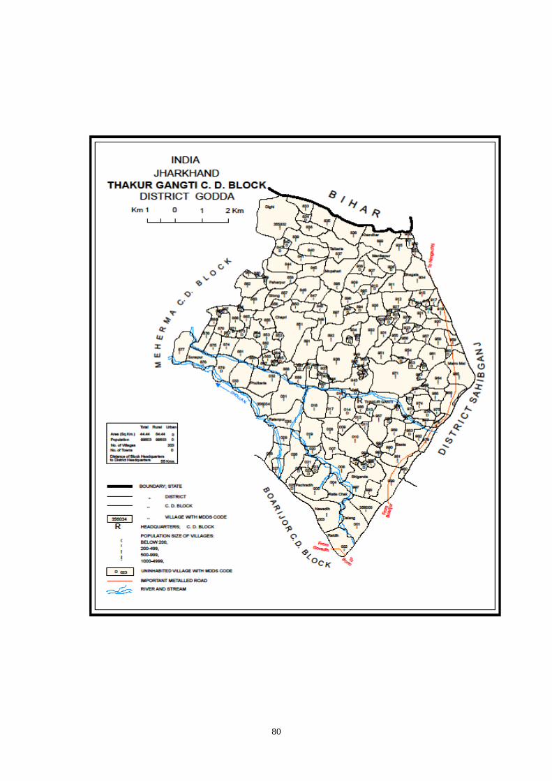
80

81
Census 2001 Codes
MDDS e-GOVERNANCE CODE (Census 2011 PLCN)
STC
2001
DTC
2001
Sub-
DT
2001
PLCN 2001
NAME OF STATE,
DISTRICTS, SUB-
DISTTS. &
VILLAGES 2001
MDDS
STC
MDDS
DTC
MDDS
Sub_DT
MDDS
PLCN
MDDS NAME OF
STATE, DISTRICT,
SUB-DISTTS. &
VILLAGES
20 08 0000 00000000 Godda 20 351 00000 000000 Godda
20 08 0000 00000000 Thakurgangti 20 351 02556 000000 Thakurgangti
20 08 0002 01310000 Akilkita 20 351 02556 355859 Akilkita
20 08 0002 01319900 Amarpur 20 351 02556 355958 Amarpur
20 08 0002 01325700 Antadih 20 351 02556 356016 Antadih
20 08 0002 01324000 Asakhapar 20 351 02556 355999 Asakhapar
20 08 0002 01308300 Babutaluk 20 351 02556 355842 Babutaluk
20 08 0002 01311000 Badura Kita 20 351 02556 355869 Badura Kita
20 08 0002 01321300 Baghakol 20 351 02556 355972 Baghakol
20 08 0002 01308100 Baghjhakhra 20 351 02556 355840 Baghjhakhra
20 08 0002 01326900 Bahadur Chak 20 351 02556 356028 Bahadur Chak
20 08 0002 01326800 Baheradih 20 351 02556 356027 Baheradih
20 08 0002 01315500 Bahoriabagaicha 20 351 02556 355914 Bahoriabagaicha
20 08 0002 01309100 Baijani 20 351 02556 355850 Baijani
20 08 0002 01314900 Baiju Khutahari 20 351 02556 355908 Baiju Khutahari
20 08 0002 01312800 Baiju Kita 20 351 02556 355887 Baiju Kita
20 08 0002 01317200 Bamania 20 351 02556 355931 Bamania
20 08 0002 01316700 Bandar Kita 20 351 02556 355926 Bandar Kita
20 08 0002 01324700 Baniadih 20 351 02556 356006 Baniadih
20 08 0002 01326400 Bansbhita 20 351 02556 356023 Bansbhita
20 08 0002 01308900 Banskola 20 351 02556 355848 Banskola
20 08 0002 01316200 Bara Manian(Kalan) 20 351 02556 355921
Bara Manian(Kalan)
20 08 0002 01316000 Baraia Chak 20 351 02556 355919 Baraia Chak
20 08 0002 01317100 Bardia Chak 20 351 02556 355930 Bardia Chak
20 08 0002 01322300 Bariasirsa 20 351 02556 355982 Bariasirsa
20 08 0002 01318100 Barkurua 20 351 02556 355940 Barkurua
20 08 0002 01322200 Basta 20 351 02556 355981 Basta
20 08 0002 01320700 Belatikar 20 351 02556 355966 Belatikar
20 08 0002 01314500 Bhagaia 20 351 02556 355904 Bhagaia
20 08 0002 01313700 Bhagwakol 20 351 02556 355896 Bhagwakol
20 08 0002 01317000 Bhalwa Chak 20 351 02556 355929 Bhalwa Chak
20 08 0002 01326200 Bharsing Parbara 20 351 02556 356021 Bharsing Parbara
20 08 0002 01323300 Bhatkhoria 20 351 02556 355992 Bhatkhoria
20 08 0002 01311100 Bhatu Kita 20 351 02556 355870 Bhatu Kita
20 08 0002 01312400 Bhekhari Kita 20 351 02556 355883 Bhekhari Kita
20 08 0002 01323800 Bhiganda 20 351 02556 355997 Bhiganda
20 08 0002 01321500 Bhuska 20 351 02556 355974 Bhuska
20 08 0002 01320100 Bhuslia 20 351 02556 355960 Bhuslia
20 08 0002 01318600 Bihari 20 351 02556 355945 Bihari
20 08 0002 01310100 Bikram Kita 20 351 02556 355860 Bikram Kita
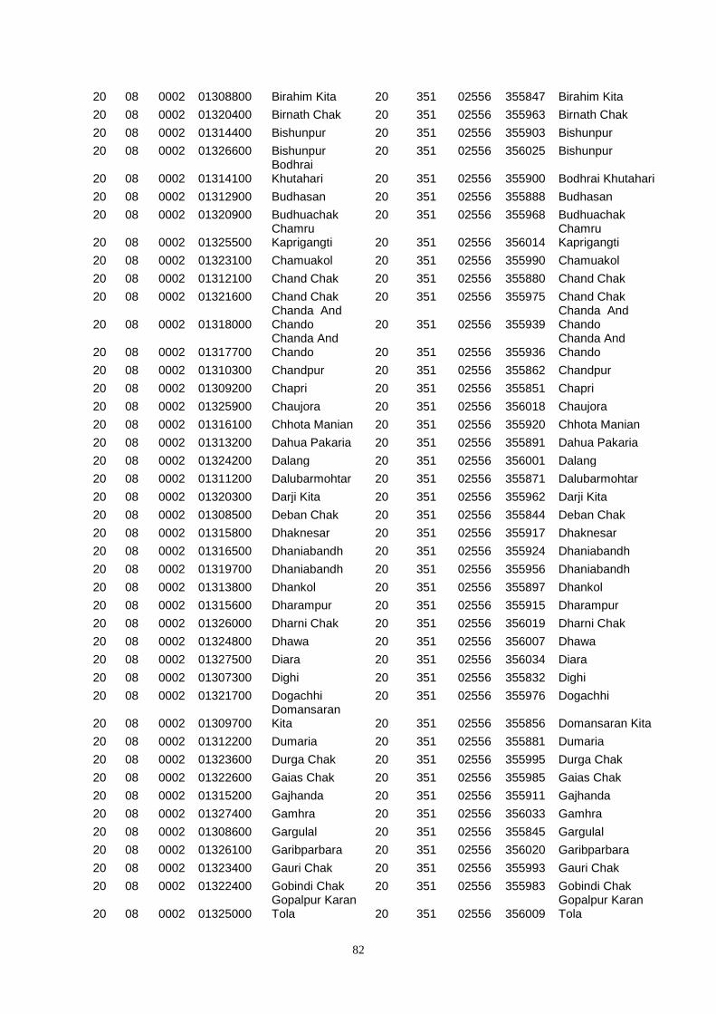
82
20 08 0002 01308800 Birahim Kita 20 351 02556 355847 Birahim Kita
20 08 0002 01320400 Birnath Chak 20 351 02556 355963 Birnath Chak
20 08 0002 01314400 Bishunpur 20 351 02556 355903 Bishunpur
20 08 0002 01326600 Bishunpur 20 351 02556 356025 Bishunpur
20 08 0002 01314100 Bodhrai Khutahari 20 351 02556 355900 Bodhrai Khutahari
20 08 0002 01312900 Budhasan 20 351 02556 355888 Budhasan
20 08 0002 01320900 Budhuachak 20 351 02556 355968 Budhuachak
20 08 0002 01325500 Chamru Kaprigangti 20 351 02556 356014
Chamru Kaprigangti
20 08 0002 01323100 Chamuakol 20 351 02556 355990 Chamuakol
20 08 0002 01312100 Chand Chak 20 351 02556 355880 Chand Chak
20 08 0002 01321600 Chand Chak 20 351 02556 355975 Chand Chak
20 08 0002 01318000 Chanda And Chando 20 351 02556 355939
Chanda And Chando
20 08 0002 01317700 Chanda And Chando 20 351 02556 355936
Chanda And Chando
20 08 0002 01310300 Chandpur 20 351 02556 355862 Chandpur
20 08 0002 01309200 Chapri 20 351 02556 355851 Chapri
20 08 0002 01325900 Chaujora 20 351 02556 356018 Chaujora
20 08 0002 01316100 Chhota Manian 20 351 02556 355920 Chhota Manian
20 08 0002 01313200 Dahua Pakaria 20 351 02556 355891 Dahua Pakaria
20 08 0002 01324200 Dalang 20 351 02556 356001 Dalang
20 08 0002 01311200 Dalubarmohtar 20 351 02556 355871 Dalubarmohtar
20 08 0002 01320300 Darji Kita 20 351 02556 355962 Darji Kita
20 08 0002 01308500 Deban Chak 20 351 02556 355844 Deban Chak
20 08 0002 01315800 Dhaknesar 20 351 02556 355917 Dhaknesar
20 08 0002 01316500 Dhaniabandh 20 351 02556 355924 Dhaniabandh
20 08 0002 01319700 Dhaniabandh 20 351 02556 355956 Dhaniabandh
20 08 0002 01313800 Dhankol 20 351 02556 355897 Dhankol
20 08 0002 01315600 Dharampur 20 351 02556 355915 Dharampur
20 08 0002 01326000 Dharni Chak 20 351 02556 356019 Dharni Chak
20 08 0002 01324800 Dhawa 20 351 02556 356007 Dhawa
20 08 0002 01327500 Diara 20 351 02556 356034 Diara
20 08 0002 01307300 Dighi 20 351 02556 355832 Dighi
20 08 0002 01321700 Dogachhi 20 351 02556 355976 Dogachhi
20 08 0002 01309700 Domansaran Kita 20 351 02556 355856 Domansaran Kita
20 08 0002 01312200 Dumaria 20 351 02556 355881 Dumaria
20 08 0002 01323600 Durga Chak 20 351 02556 355995 Durga Chak
20 08 0002 01322600 Gaias Chak 20 351 02556 355985 Gaias Chak
20 08 0002 01315200 Gajhanda 20 351 02556 355911 Gajhanda
20 08 0002 01327400 Gamhra 20 351 02556 356033 Gamhra
20 08 0002 01308600 Gargulal 20 351 02556 355845 Gargulal
20 08 0002 01326100 Garibparbara 20 351 02556 356020 Garibparbara
20 08 0002 01323400 Gauri Chak 20 351 02556 355993 Gauri Chak
20 08 0002 01322400 Gobindi Chak 20 351 02556 355983 Gobindi Chak
20 08 0002 01325000 Gopalpur Karan Tola 20 351 02556 356009
Gopalpur Karan Tola
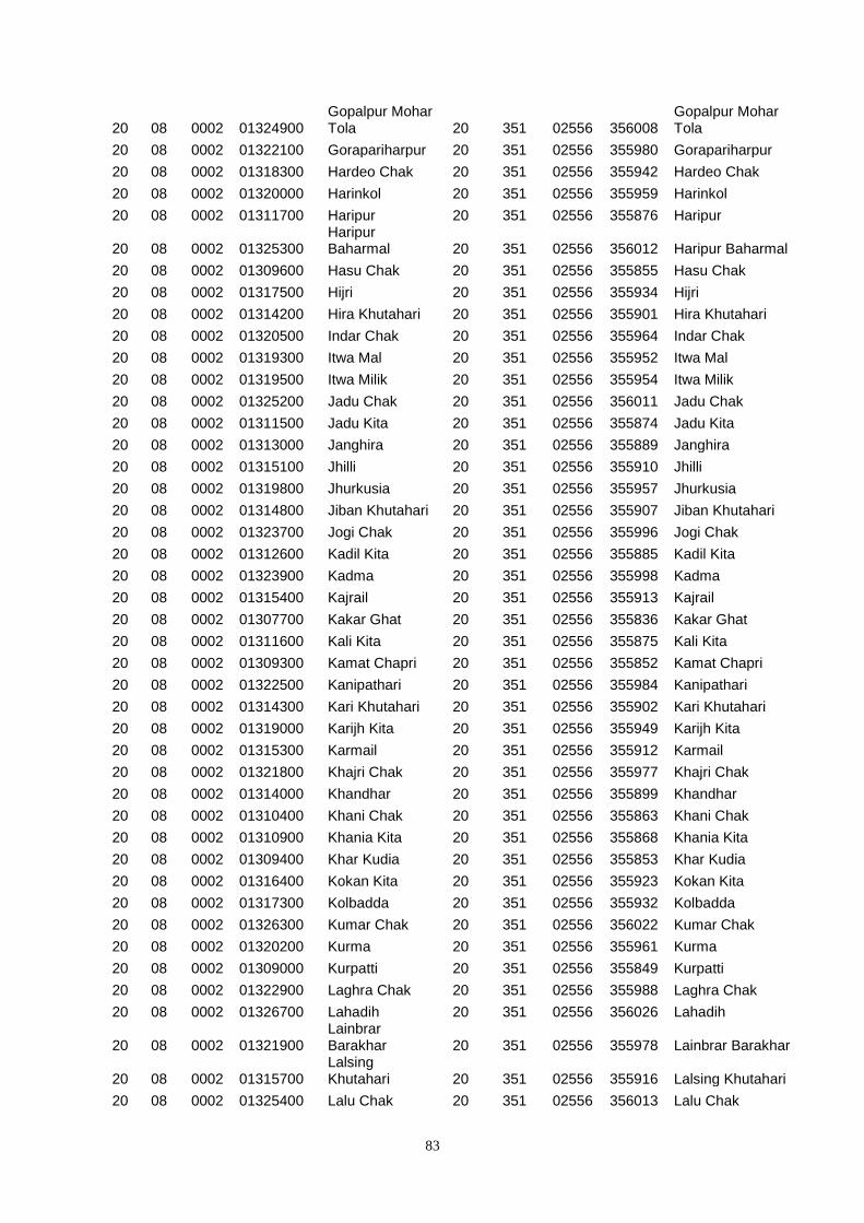
83
20 08 0002 01324900 Gopalpur Mohar Tola 20 351 02556 356008
Gopalpur Mohar Tola
20 08 0002 01322100 Gorapariharpur 20 351 02556 355980 Gorapariharpur
20 08 0002 01318300 Hardeo Chak 20 351 02556 355942 Hardeo Chak
20 08 0002 01320000 Harinkol 20 351 02556 355959 Harinkol
20 08 0002 01311700 Haripur 20 351 02556 355876 Haripur
20 08 0002 01325300 Haripur Baharmal 20 351 02556 356012 Haripur Baharmal
20 08 0002 01309600 Hasu Chak 20 351 02556 355855 Hasu Chak
20 08 0002 01317500 Hijri 20 351 02556 355934 Hijri
20 08 0002 01314200 Hira Khutahari 20 351 02556 355901 Hira Khutahari
20 08 0002 01320500 Indar Chak 20 351 02556 355964 Indar Chak
20 08 0002 01319300 Itwa Mal 20 351 02556 355952 Itwa Mal
20 08 0002 01319500 Itwa Milik 20 351 02556 355954 Itwa Milik
20 08 0002 01325200 Jadu Chak 20 351 02556 356011 Jadu Chak
20 08 0002 01311500 Jadu Kita 20 351 02556 355874 Jadu Kita
20 08 0002 01313000 Janghira 20 351 02556 355889 Janghira
20 08 0002 01315100 Jhilli 20 351 02556 355910 Jhilli
20 08 0002 01319800 Jhurkusia 20 351 02556 355957 Jhurkusia
20 08 0002 01314800 Jiban Khutahari 20 351 02556 355907 Jiban Khutahari
20 08 0002 01323700 Jogi Chak 20 351 02556 355996 Jogi Chak
20 08 0002 01312600 Kadil Kita 20 351 02556 355885 Kadil Kita
20 08 0002 01323900 Kadma 20 351 02556 355998 Kadma
20 08 0002 01315400 Kajrail 20 351 02556 355913 Kajrail
20 08 0002 01307700 Kakar Ghat 20 351 02556 355836 Kakar Ghat
20 08 0002 01311600 Kali Kita 20 351 02556 355875 Kali Kita
20 08 0002 01309300 Kamat Chapri 20 351 02556 355852 Kamat Chapri
20 08 0002 01322500 Kanipathari 20 351 02556 355984 Kanipathari
20 08 0002 01314300 Kari Khutahari 20 351 02556 355902 Kari Khutahari
20 08 0002 01319000 Karijh Kita 20 351 02556 355949 Karijh Kita
20 08 0002 01315300 Karmail 20 351 02556 355912 Karmail
20 08 0002 01321800 Khajri Chak 20 351 02556 355977 Khajri Chak
20 08 0002 01314000 Khandhar 20 351 02556 355899 Khandhar
20 08 0002 01310400 Khani Chak 20 351 02556 355863 Khani Chak
20 08 0002 01310900 Khania Kita 20 351 02556 355868 Khania Kita
20 08 0002 01309400 Khar Kudia 20 351 02556 355853 Khar Kudia
20 08 0002 01316400 Kokan Kita 20 351 02556 355923 Kokan Kita
20 08 0002 01317300 Kolbadda 20 351 02556 355932 Kolbadda
20 08 0002 01326300 Kumar Chak 20 351 02556 356022 Kumar Chak
20 08 0002 01320200 Kurma 20 351 02556 355961 Kurma
20 08 0002 01309000 Kurpatti 20 351 02556 355849 Kurpatti
20 08 0002 01322900 Laghra Chak 20 351 02556 355988 Laghra Chak
20 08 0002 01326700 Lahadih 20 351 02556 356026 Lahadih
20 08 0002 01321900 Lainbrar Barakhar 20 351 02556 355978 Lainbrar Barakhar
20 08 0002 01315700 Lalsing Khutahari 20 351 02556 355916 Lalsing Khutahari
20 08 0002 01325400 Lalu Chak 20 351 02556 356013 Lalu Chak
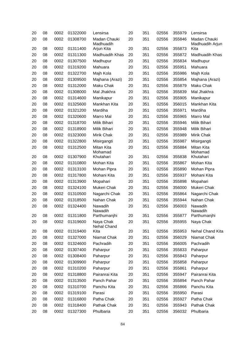
84
20 08 0002 01322000 Lensirsa 20 351 02556 355979 Lensirsa
20 08 0002 01308700 Madan Chauki 20 351 02556 355846 Madan Chauki
20 08 0002 01311400 Madhuadih Arjun Kita 20 351 02556 355873
Madhuadih Arjun Kita
20 08 0002 01311300 Madhuadih Khas 20 351 02556 355872 Madhuadih Khas
20 08 0002 01307500 Madhupur 20 351 02556 355834 Madhupur
20 08 0002 01319200 Mahuara 20 351 02556 355951 Mahuara
20 08 0002 01322700 Majh Kola 20 351 02556 355986 Majh Kola
20 08 0002 01309500 Majhana (Arazi) 20 351 02556 355854 Majhana (Arazi)
20 08 0002 01312000 Maku Chak 20 351 02556 355879 Maku Chak
20 08 0002 01308000 Mal Jhakhra 20 351 02556 355839 Mal Jhakhra
20 08 0002 01314600 Manikapur 20 351 02556 355905 Manikapur
20 08 0002 01325600 Mankhan Kita 20 351 02556 356015 Mankhan Kita
20 08 0002 01321200 Mardiha 20 351 02556 355971 Mardiha
20 08 0002 01320600 Marro Mal 20 351 02556 355965 Marro Mal
20 08 0002 01318700 Milik Bihari 20 351 02556 355946 Milik Bihari
20 08 0002 01318900 Milik Bihari 20 351 02556 355948 Milik Bihari
20 08 0002 01323000 Mirik Chak 20 351 02556 355989 Mirik Chak
20 08 0002 01322800 Misirgangti 20 351 02556 355987 Misirgangti
20 08 0002 01312500 Mitan Kita 20 351 02556 355884 Mitan Kita
20 08 0002 01307900 Mohamad Khutahari 20 351 02556 355838
Mohamad Khutahari
20 08 0002 01310800 Mohan Kita 20 351 02556 355867 Mohan Kita
20 08 0002 01313100 Mohan Pipra 20 351 02556 355890 Mohan Pipra
20 08 0002 01317800 Mohani Kita 20 351 02556 355937 Mohani Kita
20 08 0002 01313900 Mopahari 20 351 02556 355898 Mopahari
20 08 0002 01324100 Mukeri Chak 20 351 02556 356000 Mukeri Chak
20 08 0002 01310500 Nagarchi Chak 20 351 02556 355864 Nagarchi Chak
20 08 0002 01318500 Nahan Chak 20 351 02556 355944 Nahan Chak
20 08 0002 01324400 Nawadih 20 351 02556 356003 Nawadih
20 08 0002 01311800 Nawadih Parthumanjhi 20 351 02556 355877
Nawadih Parthumanjhi
20 08 0002 01319600 Naya Chak 20 351 02556 355955 Naya Chak
20 08 0002 01319400 Nehal Chand Kita 20 351 02556 355953 Nehal Chand Kita
20 08 0002 01327000 Niamat Chak 20 351 02556 356029 Niamat Chak
20 08 0002 01324600 Pachradih 20 351 02556 356005 Pachradih
20 08 0002 01307400 Paharpur 20 351 02556 355833 Paharpur
20 08 0002 01308400 Paharpur 20 351 02556 355843 Paharpur
20 08 0002 01309900 Paharpur 20 351 02556 355858 Paharpur
20 08 0002 01310200 Paharpur 20 351 02556 355861 Paharpur
20 08 0002 01318800 Pairanrai Kita 20 351 02556 355947 Pairanrai Kita
20 08 0002 01313500 Panch Pahar 20 351 02556 355894 Panch Pahar
20 08 0002 01310700 Panchu Kita 20 351 02556 355866 Panchu Kita
20 08 0002 01319100 Parasi 20 351 02556 355950 Parasi
20 08 0002 01316800 Patha Chak 20 351 02556 355927 Patha Chak
20 08 0002 01318400 Pathak Chak 20 351 02556 355943 Pathak Chak
20 08 0002 01327300 Phulbaria 20 351 02556 356032 Phulbaria
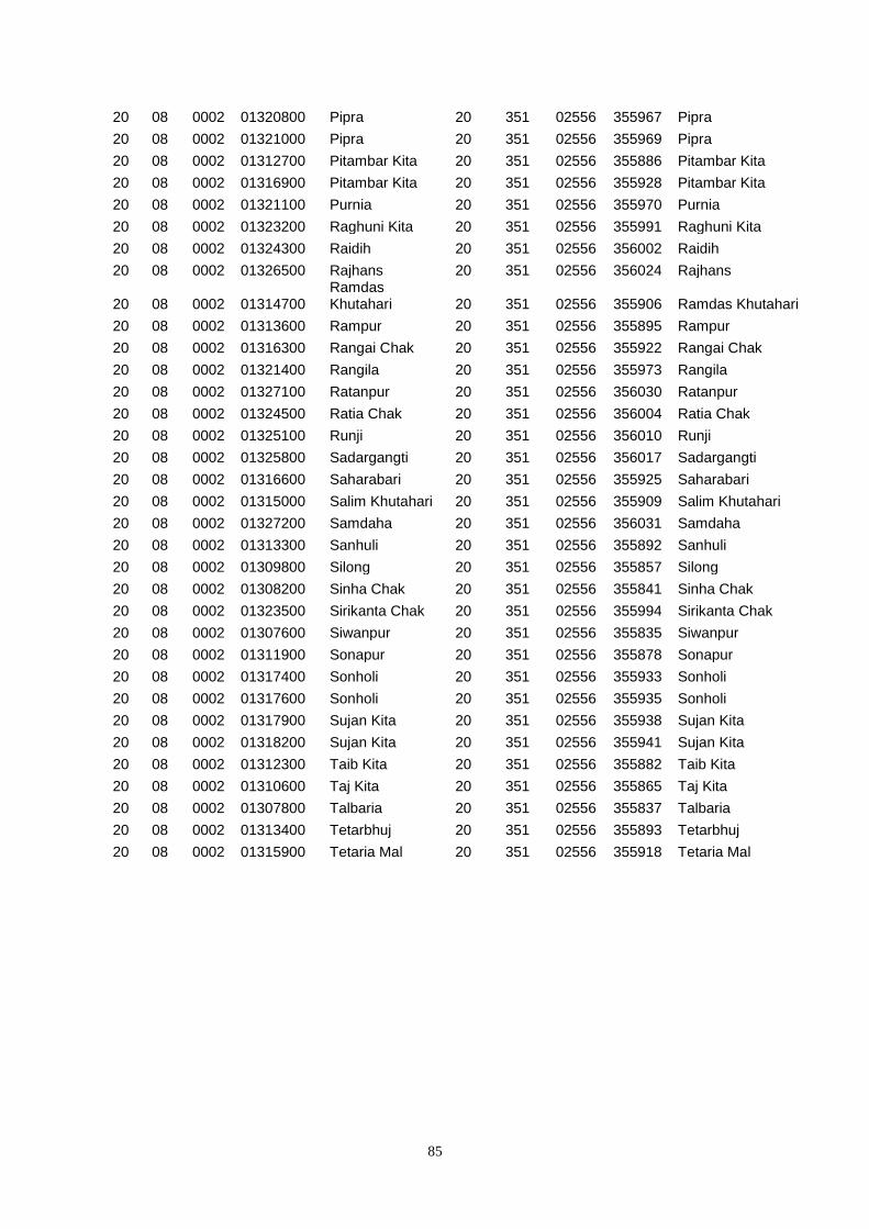
85
20 08 0002 01320800 Pipra 20 351 02556 355967 Pipra
20 08 0002 01321000 Pipra 20 351 02556 355969 Pipra
20 08 0002 01312700 Pitambar Kita 20 351 02556 355886 Pitambar Kita
20 08 0002 01316900 Pitambar Kita 20 351 02556 355928 Pitambar Kita
20 08 0002 01321100 Purnia 20 351 02556 355970 Purnia
20 08 0002 01323200 Raghuni Kita 20 351 02556 355991 Raghuni Kita
20 08 0002 01324300 Raidih 20 351 02556 356002 Raidih
20 08 0002 01326500 Rajhans 20 351 02556 356024 Rajhans
20 08 0002 01314700 Ramdas Khutahari 20 351 02556 355906 Ramdas Khutahari
20 08 0002 01313600 Rampur 20 351 02556 355895 Rampur
20 08 0002 01316300 Rangai Chak 20 351 02556 355922 Rangai Chak
20 08 0002 01321400 Rangila 20 351 02556 355973 Rangila
20 08 0002 01327100 Ratanpur 20 351 02556 356030 Ratanpur
20 08 0002 01324500 Ratia Chak 20 351 02556 356004 Ratia Chak
20 08 0002 01325100 Runji 20 351 02556 356010 Runji
20 08 0002 01325800 Sadargangti 20 351 02556 356017 Sadargangti
20 08 0002 01316600 Saharabari 20 351 02556 355925 Saharabari
20 08 0002 01315000 Salim Khutahari 20 351 02556 355909 Salim Khutahari
20 08 0002 01327200 Samdaha 20 351 02556 356031 Samdaha
20 08 0002 01313300 Sanhuli 20 351 02556 355892 Sanhuli
20 08 0002 01309800 Silong 20 351 02556 355857 Silong
20 08 0002 01308200 Sinha Chak 20 351 02556 355841 Sinha Chak
20 08 0002 01323500 Sirikanta Chak 20 351 02556 355994 Sirikanta Chak
20 08 0002 01307600 Siwanpur 20 351 02556 355835 Siwanpur
20 08 0002 01311900 Sonapur 20 351 02556 355878 Sonapur
20 08 0002 01317400 Sonholi 20 351 02556 355933 Sonholi
20 08 0002 01317600 Sonholi 20 351 02556 355935 Sonholi
20 08 0002 01317900 Sujan Kita 20 351 02556 355938 Sujan Kita
20 08 0002 01318200 Sujan Kita 20 351 02556 355941 Sujan Kita
20 08 0002 01312300 Taib Kita 20 351 02556 355882 Taib Kita
20 08 0002 01310600 Taj Kita 20 351 02556 355865 Taj Kita
20 08 0002 01307800 Talbaria 20 351 02556 355837 Talbaria
20 08 0002 01313400 Tetarbhuj 20 351 02556 355893 Tetarbhuj
20 08 0002 01315900 Tetaria Mal 20 351 02556 355918 Tetaria Mal

86
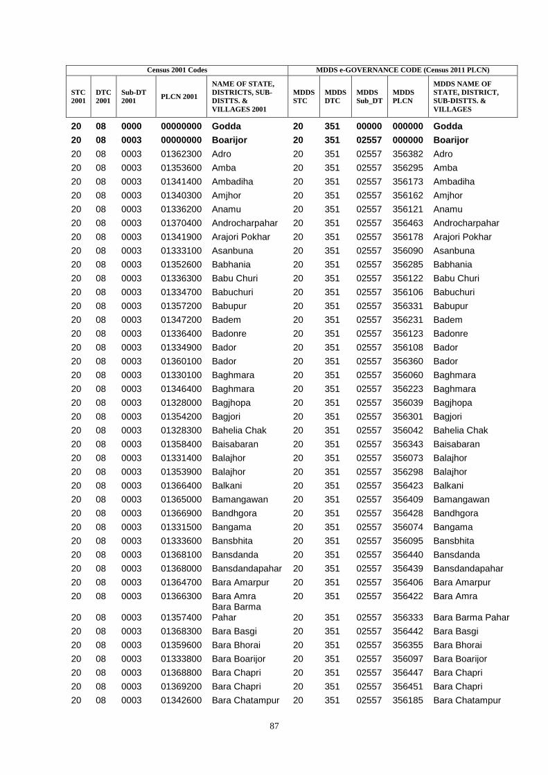
87
Census 2001 Codes MDDS e-GOVERNANCE CODE (Census 2011 PLCN)
STC
2001
DTC
2001
Sub-DT
2001 PLCN 2001
NAME OF STATE,
DISTRICTS, SUB-
DISTTS. &
VILLAGES 2001
MDDS
STC
MDDS
DTC
MDDS
Sub_DT
MDDS
PLCN
MDDS NAME OF
STATE, DISTRICT,
SUB-DISTTS. &
VILLAGES
20 08 0000 00000000 Godda 20 351 00000 000000 Godda
20 08 0003 00000000 Boarijor 20 351 02557 000000 Boarijor
20 08 0003 01362300 Adro 20 351 02557 356382 Adro
20 08 0003 01353600 Amba 20 351 02557 356295 Amba
20 08 0003 01341400 Ambadiha 20 351 02557 356173 Ambadiha
20 08 0003 01340300 Amjhor 20 351 02557 356162 Amjhor
20 08 0003 01336200 Anamu 20 351 02557 356121 Anamu
20 08 0003 01370400 Androcharpahar 20 351 02557 356463 Androcharpahar
20 08 0003 01341900 Arajori Pokhar 20 351 02557 356178 Arajori Pokhar
20 08 0003 01333100 Asanbuna 20 351 02557 356090 Asanbuna
20 08 0003 01352600 Babhania 20 351 02557 356285 Babhania
20 08 0003 01336300 Babu Churi 20 351 02557 356122 Babu Churi
20 08 0003 01334700 Babuchuri 20 351 02557 356106 Babuchuri
20 08 0003 01357200 Babupur 20 351 02557 356331 Babupur
20 08 0003 01347200 Badem 20 351 02557 356231 Badem
20 08 0003 01336400 Badonre 20 351 02557 356123 Badonre
20 08 0003 01334900 Bador 20 351 02557 356108 Bador
20 08 0003 01360100 Bador 20 351 02557 356360 Bador
20 08 0003 01330100 Baghmara 20 351 02557 356060 Baghmara
20 08 0003 01346400 Baghmara 20 351 02557 356223 Baghmara
20 08 0003 01328000 Bagjhopa 20 351 02557 356039 Bagjhopa
20 08 0003 01354200 Bagjori 20 351 02557 356301 Bagjori
20 08 0003 01328300 Bahelia Chak 20 351 02557 356042 Bahelia Chak
20 08 0003 01358400 Baisabaran 20 351 02557 356343 Baisabaran
20 08 0003 01331400 Balajhor 20 351 02557 356073 Balajhor
20 08 0003 01353900 Balajhor 20 351 02557 356298 Balajhor
20 08 0003 01366400 Balkani 20 351 02557 356423 Balkani
20 08 0003 01365000 Bamangawan 20 351 02557 356409 Bamangawan
20 08 0003 01366900 Bandhgora 20 351 02557 356428 Bandhgora
20 08 0003 01331500 Bangama 20 351 02557 356074 Bangama
20 08 0003 01333600 Bansbhita 20 351 02557 356095 Bansbhita
20 08 0003 01368100 Bansdanda 20 351 02557 356440 Bansdanda
20 08 0003 01368000 Bansdandapahar 20 351 02557 356439 Bansdandapahar
20 08 0003 01364700 Bara Amarpur 20 351 02557 356406 Bara Amarpur
20 08 0003 01366300 Bara Amra 20 351 02557 356422 Bara Amra
20 08 0003 01357400 Bara Barma Pahar 20 351 02557 356333 Bara Barma Pahar
20 08 0003 01368300 Bara Basgi 20 351 02557 356442 Bara Basgi
20 08 0003 01359600 Bara Bhorai 20 351 02557 356355 Bara Bhorai
20 08 0003 01333800 Bara Boarijor 20 351 02557 356097 Bara Boarijor
20 08 0003 01368800 Bara Chapri 20 351 02557 356447 Bara Chapri
20 08 0003 01369200 Bara Chapri 20 351 02557 356451 Bara Chapri
20 08 0003 01342600 Bara Chatampur 20 351 02557 356185 Bara Chatampur
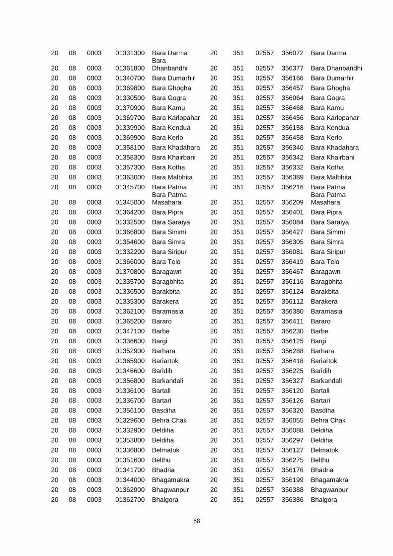
88
20 08 0003 01331300 Bara Darma 20 351 02557 356072 Bara Darma
20 08 0003 01361800 Bara Dhanbandhi 20 351 02557 356377 Bara Dhanbandhi
20 08 0003 01340700 Bara Dumarhir 20 351 02557 356166 Bara Dumarhir
20 08 0003 01369800 Bara Ghogha 20 351 02557 356457 Bara Ghogha
20 08 0003 01330500 Bara Gogra 20 351 02557 356064 Bara Gogra
20 08 0003 01370900 Bara Kamu 20 351 02557 356468 Bara Kamu
20 08 0003 01369700 Bara Karlopahar 20 351 02557 356456 Bara Karlopahar
20 08 0003 01339900 Bara Kendua 20 351 02557 356158 Bara Kendua
20 08 0003 01369900 Bara Kerlo 20 351 02557 356458 Bara Kerlo
20 08 0003 01358100 Bara Khadahara 20 351 02557 356340 Bara Khadahara
20 08 0003 01358300 Bara Khairbani 20 351 02557 356342 Bara Khairbani
20 08 0003 01357300 Bara Kotha 20 351 02557 356332 Bara Kotha
20 08 0003 01363000 Bara Malbhita 20 351 02557 356389 Bara Malbhita
20 08 0003 01345700 Bara Patma 20 351 02557 356216 Bara Patma
20 08 0003 01345000 Bara Patma Masahara 20 351 02557 356209
Bara Patma Masahara
20 08 0003 01364200 Bara Pipra 20 351 02557 356401 Bara Pipra
20 08 0003 01332500 Bara Saraiya 20 351 02557 356084 Bara Saraiya
20 08 0003 01366800 Bara Simmi 20 351 02557 356427 Bara Simmi
20 08 0003 01354600 Bara Simra 20 351 02557 356305 Bara Simra
20 08 0003 01332200 Bara Siripur 20 351 02557 356081 Bara Siripur
20 08 0003 01366000 Bara Telo 20 351 02557 356419 Bara Telo
20 08 0003 01370800 Baragawn 20 351 02557 356467 Baragawn
20 08 0003 01335700 Baragbhita 20 351 02557 356116 Baragbhita
20 08 0003 01336500 Barakbita 20 351 02557 356124 Barakbita
20 08 0003 01335300 Barakera 20 351 02557 356112 Barakera
20 08 0003 01362100 Baramasia 20 351 02557 356380 Baramasia
20 08 0003 01365200 Bararo 20 351 02557 356411 Bararo
20 08 0003 01347100 Barbe 20 351 02557 356230 Barbe
20 08 0003 01336600 Bargi 20 351 02557 356125 Bargi
20 08 0003 01352900 Barhara 20 351 02557 356288 Barhara
20 08 0003 01365900 Bariartok 20 351 02557 356418 Bariartok
20 08 0003 01346600 Baridih 20 351 02557 356225 Baridih
20 08 0003 01356800 Barkandali 20 351 02557 356327 Barkandali
20 08 0003 01336100 Bartali 20 351 02557 356120 Bartali
20 08 0003 01336700 Bartari 20 351 02557 356126 Bartari
20 08 0003 01356100 Basdiha 20 351 02557 356320 Basdiha
20 08 0003 01329600 Behra Chak 20 351 02557 356055 Behra Chak
20 08 0003 01332900 Beldiha 20 351 02557 356088 Beldiha
20 08 0003 01353800 Beldiha 20 351 02557 356297 Beldiha
20 08 0003 01336800 Belmatok 20 351 02557 356127 Belmatok
20 08 0003 01351600 Belthu 20 351 02557 356275 Belthu
20 08 0003 01341700 Bhadria 20 351 02557 356176 Bhadria
20 08 0003 01344000 Bhagamakra 20 351 02557 356199 Bhagamakra
20 08 0003 01362900 Bhagwanpur 20 351 02557 356388 Bhagwanpur
20 08 0003 01362700 Bhalgora 20 351 02557 356386 Bhalgora
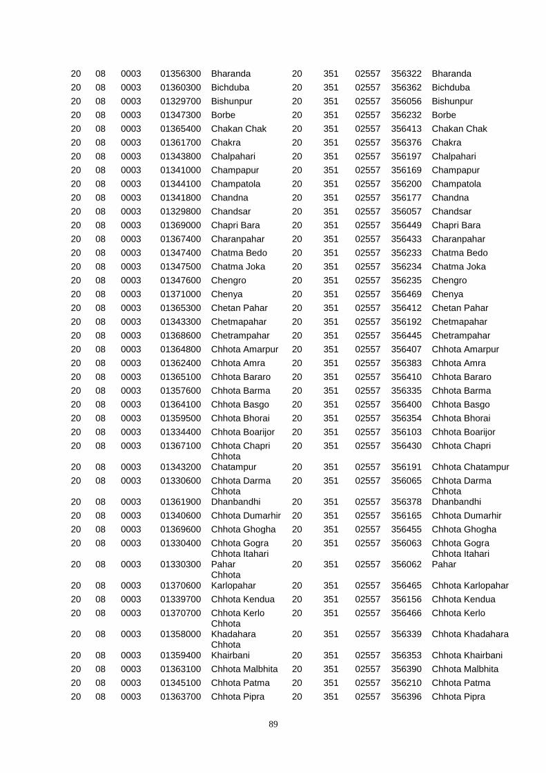
89
20 08 0003 01356300 Bharanda 20 351 02557 356322 Bharanda
20 08 0003 01360300 Bichduba 20 351 02557 356362 Bichduba
20 08 0003 01329700 Bishunpur 20 351 02557 356056 Bishunpur
20 08 0003 01347300 Borbe 20 351 02557 356232 Borbe
20 08 0003 01365400 Chakan Chak 20 351 02557 356413 Chakan Chak
20 08 0003 01361700 Chakra 20 351 02557 356376 Chakra
20 08 0003 01343800 Chalpahari 20 351 02557 356197 Chalpahari
20 08 0003 01341000 Champapur 20 351 02557 356169 Champapur
20 08 0003 01344100 Champatola 20 351 02557 356200 Champatola
20 08 0003 01341800 Chandna 20 351 02557 356177 Chandna
20 08 0003 01329800 Chandsar 20 351 02557 356057 Chandsar
20 08 0003 01369000 Chapri Bara 20 351 02557 356449 Chapri Bara
20 08 0003 01367400 Charanpahar 20 351 02557 356433 Charanpahar
20 08 0003 01347400 Chatma Bedo 20 351 02557 356233 Chatma Bedo
20 08 0003 01347500 Chatma Joka 20 351 02557 356234 Chatma Joka
20 08 0003 01347600 Chengro 20 351 02557 356235 Chengro
20 08 0003 01371000 Chenya 20 351 02557 356469 Chenya
20 08 0003 01365300 Chetan Pahar 20 351 02557 356412 Chetan Pahar
20 08 0003 01343300 Chetmapahar 20 351 02557 356192 Chetmapahar
20 08 0003 01368600 Chetrampahar 20 351 02557 356445 Chetrampahar
20 08 0003 01364800 Chhota Amarpur 20 351 02557 356407 Chhota Amarpur
20 08 0003 01362400 Chhota Amra 20 351 02557 356383 Chhota Amra
20 08 0003 01365100 Chhota Bararo 20 351 02557 356410 Chhota Bararo
20 08 0003 01357600 Chhota Barma 20 351 02557 356335 Chhota Barma
20 08 0003 01364100 Chhota Basgo 20 351 02557 356400 Chhota Basgo
20 08 0003 01359500 Chhota Bhorai 20 351 02557 356354 Chhota Bhorai
20 08 0003 01334400 Chhota Boarijor 20 351 02557 356103 Chhota Boarijor
20 08 0003 01367100 Chhota Chapri 20 351 02557 356430 Chhota Chapri
20 08 0003 01343200 Chhota Chatampur 20 351 02557 356191 Chhota Chatampur
20 08 0003 01330600 Chhota Darma 20 351 02557 356065 Chhota Darma
20 08 0003 01361900 Chhota Dhanbandhi 20 351 02557 356378
Chhota Dhanbandhi
20 08 0003 01340600 Chhota Dumarhir 20 351 02557 356165 Chhota Dumarhir
20 08 0003 01369600 Chhota Ghogha 20 351 02557 356455 Chhota Ghogha
20 08 0003 01330400 Chhota Gogra 20 351 02557 356063 Chhota Gogra
20 08 0003 01330300 Chhota Itahari Pahar 20 351 02557 356062
Chhota Itahari Pahar
20 08 0003 01370600 Chhota Karlopahar 20 351 02557 356465 Chhota Karlopahar
20 08 0003 01339700 Chhota Kendua 20 351 02557 356156 Chhota Kendua
20 08 0003 01370700 Chhota Kerlo 20 351 02557 356466 Chhota Kerlo
20 08 0003 01358000 Chhota Khadahara 20 351 02557 356339 Chhota Khadahara
20 08 0003 01359400 Chhota Khairbani 20 351 02557 356353 Chhota Khairbani
20 08 0003 01363100 Chhota Malbhita 20 351 02557 356390 Chhota Malbhita
20 08 0003 01345100 Chhota Patma 20 351 02557 356210 Chhota Patma
20 08 0003 01363700 Chhota Pipra 20 351 02557 356396 Chhota Pipra
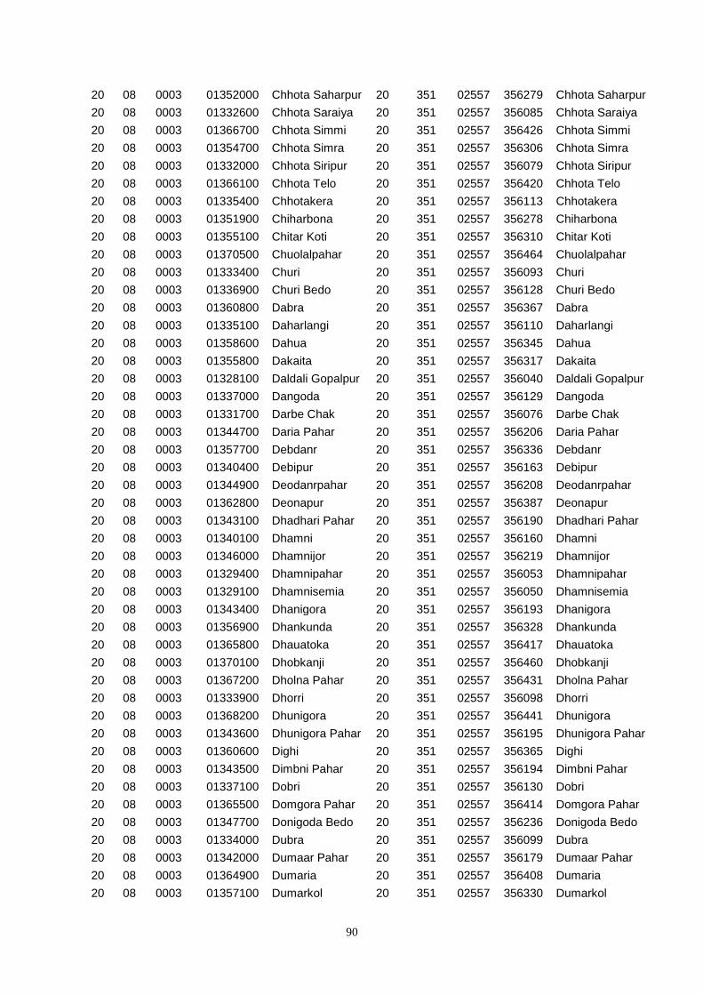
90
20 08 0003 01352000 Chhota Saharpur 20 351 02557 356279 Chhota Saharpur
20 08 0003 01332600 Chhota Saraiya 20 351 02557 356085 Chhota Saraiya
20 08 0003 01366700 Chhota Simmi 20 351 02557 356426 Chhota Simmi
20 08 0003 01354700 Chhota Simra 20 351 02557 356306 Chhota Simra
20 08 0003 01332000 Chhota Siripur 20 351 02557 356079 Chhota Siripur
20 08 0003 01366100 Chhota Telo 20 351 02557 356420 Chhota Telo
20 08 0003 01335400 Chhotakera 20 351 02557 356113 Chhotakera
20 08 0003 01351900 Chiharbona 20 351 02557 356278 Chiharbona
20 08 0003 01355100 Chitar Koti 20 351 02557 356310 Chitar Koti
20 08 0003 01370500 Chuolalpahar 20 351 02557 356464 Chuolalpahar
20 08 0003 01333400 Churi 20 351 02557 356093 Churi
20 08 0003 01336900 Churi Bedo 20 351 02557 356128 Churi Bedo
20 08 0003 01360800 Dabra 20 351 02557 356367 Dabra
20 08 0003 01335100 Daharlangi 20 351 02557 356110 Daharlangi
20 08 0003 01358600 Dahua 20 351 02557 356345 Dahua
20 08 0003 01355800 Dakaita 20 351 02557 356317 Dakaita
20 08 0003 01328100 Daldali Gopalpur 20 351 02557 356040 Daldali Gopalpur
20 08 0003 01337000 Dangoda 20 351 02557 356129 Dangoda
20 08 0003 01331700 Darbe Chak 20 351 02557 356076 Darbe Chak
20 08 0003 01344700 Daria Pahar 20 351 02557 356206 Daria Pahar
20 08 0003 01357700 Debdanr 20 351 02557 356336 Debdanr
20 08 0003 01340400 Debipur 20 351 02557 356163 Debipur
20 08 0003 01344900 Deodanrpahar 20 351 02557 356208 Deodanrpahar
20 08 0003 01362800 Deonapur 20 351 02557 356387 Deonapur
20 08 0003 01343100 Dhadhari Pahar 20 351 02557 356190 Dhadhari Pahar
20 08 0003 01340100 Dhamni 20 351 02557 356160 Dhamni
20 08 0003 01346000 Dhamnijor 20 351 02557 356219 Dhamnijor
20 08 0003 01329400 Dhamnipahar 20 351 02557 356053 Dhamnipahar
20 08 0003 01329100 Dhamnisemia 20 351 02557 356050 Dhamnisemia
20 08 0003 01343400 Dhanigora 20 351 02557 356193 Dhanigora
20 08 0003 01356900 Dhankunda 20 351 02557 356328 Dhankunda
20 08 0003 01365800 Dhauatoka 20 351 02557 356417 Dhauatoka
20 08 0003 01370100 Dhobkanji 20 351 02557 356460 Dhobkanji
20 08 0003 01367200 Dholna Pahar 20 351 02557 356431 Dholna Pahar
20 08 0003 01333900 Dhorri 20 351 02557 356098 Dhorri
20 08 0003 01368200 Dhunigora 20 351 02557 356441 Dhunigora
20 08 0003 01343600 Dhunigora Pahar 20 351 02557 356195 Dhunigora Pahar
20 08 0003 01360600 Dighi 20 351 02557 356365 Dighi
20 08 0003 01343500 Dimbni Pahar 20 351 02557 356194 Dimbni Pahar
20 08 0003 01337100 Dobri 20 351 02557 356130 Dobri
20 08 0003 01365500 Domgora Pahar 20 351 02557 356414 Domgora Pahar
20 08 0003 01347700 Donigoda Bedo 20 351 02557 356236 Donigoda Bedo
20 08 0003 01334000 Dubra 20 351 02557 356099 Dubra
20 08 0003 01342000 Dumaar Pahar 20 351 02557 356179 Dumaar Pahar
20 08 0003 01364900 Dumaria 20 351 02557 356408 Dumaria
20 08 0003 01357100 Dumarkol 20 351 02557 356330 Dumarkol
91
20 08 0003 01367800 Dumarpahar 20 351 02557 356437 Dumarpahar
20 08 0003 01369500 Dumarpahar 20 351 02557 356454 Dumarpahar
20 08 0003 01333300 Dumbari 20 351 02557 356092 Dumbari
20 08 0003 01337200 Dumberi Bedo 20 351 02557 356131 Dumberi Bedo
20 08 0003 01337300 Dumberi Joka 20 351 02557 356132 Dumberi Joka
20 08 0003 01371100 Dumli 20 351 02557 356470 Dumli
20 08 0003 01353400 Dumra 20 351 02557 356293 Dumra
20 08 0003 01357900 Dumria 20 351 02557 356338 Dumria
20 08 0003 01357000 Dumriya 20 351 02557 356329 Dumriya
20 08 0003 01355300 Duwarighat Telgama 20 351 02557 356312
Duwarighat Telgama
20 08 0003 01347800 Ejgoga 20 351 02557 356237 Ejgoga
20 08 0003 01331900 Ekdanrghat 20 351 02557 356078 Ekdanrghat
20 08 0003 01365600 Elkar Pahar 20 351 02557 356415 Elkar Pahar
20 08 0003 01337400 Gadgandi 20 351 02557 356133 Gadgandi
20 08 0003 01361600 Gadial 20 351 02557 356375 Gadial
20 08 0003 01347900 Gamari 20 351 02557 356238 Gamari
20 08 0003 01363300 Gamhar Pahar 20 351 02557 356392 Gamhar Pahar
20 08 0003 01337500 Gandiyamo 20 351 02557 356134 Gandiyamo
20 08 0003 01327700 Garantia 20 351 02557 356036 Garantia
20 08 0003 01366600 Garbhu Tola 20 351 02557 356425 Garbhu Tola
20 08 0003 01355000 Ghat Nima 20 351 02557 356309 Ghat Nima
20 08 0003 01354800 Ghat Simra 20 351 02557 356307 Ghat Simra
20 08 0003 01354000 Ghatiari 20 351 02557 356299 Ghatiari
20 08 0003 01348000 Goari 20 351 02557 356239 Goari
20 08 0003 01348100 Godam 20 351 02557 356240 Godam
20 08 0003 01337600 Godni 20 351 02557 356135 Godni
20 08 0003 01360700 Gopali 20 351 02557 356366 Gopali
20 08 0003 01352400 Gopalpur 20 351 02557 356283 Gopalpur
20 08 0003 01329500 Goradih 20 351 02557 356054 Goradih
20 08 0003 01353000 Gorakhpur 20 351 02557 356289 Gorakhpur
20 08 0003 01352700 Gori Chak 20 351 02557 356286 Gori Chak
20 08 0003 01352200 Goriya 20 351 02557 356281 Goriya
20 08 0003 01359100 Hahajor 20 351 02557 356350 Hahajor
20 08 0003 01368700 Hanidhoni 20 351 02557 356446 Hanidhoni
20 08 0003 01359000 Haripur 20 351 02557 356349 Haripur
20 08 0003 01358200 Harkata 20 351 02557 356341 Harkata
20 08 0003 01344800 Harla Bathan 20 351 02557 356207 Harla Bathan
20 08 0003 01361400 Harra 20 351 02557 356373 Harra
20 08 0003 01356400 Harrakha 20 351 02557 356323 Harrakha
20 08 0003 01351700 Hethbandha 20 351 02557 356276 Hethbandha
20 08 0003 01329200 Hijri 20 351 02557 356051 Hijri
20 08 0003 01355500 Hijukita 20 351 02557 356314 Hijukita
20 08 0003 01328500 Issar Chak 20 351 02557 356044 Issar Chak
20 08 0003 01330200 Itahari 20 351 02557 356061 Itahari
20 08 0003 01348200 Itkro Bedo 20 351 02557 356241 Itkro Bedo
92
20 08 0003 01360000 Jaggora 20 351 02557 356359 Jaggora
20 08 0003 01366200 Jajotola Barhua 20 351 02557 356421 Jajotola Barhua
20 08 0003 01333700 Jamunajharna 20 351 02557 356096 Jamunajharna
20 08 0003 01371200 Jandi 20 351 02557 356471 Jandi
20 08 0003 01348300 Jani Bedo 20 351 02557 356242 Jani Bedo
20 08 0003 01348400 Jani Maqo 20 351 02557 356243 Jani Maqo
20 08 0003 01345400 Jania Pahar 20 351 02557 356213 Jania Pahar
20 08 0003 01329000 Janlokundi 20 351 02557 356049 Janlokundi
20 08 0003 01337700 Japani 20 351 02557 356136 Japani
20 08 0003 01337800 Japita 20 351 02557 356137 Japita
20 08 0003 01348500 Jaria 20 351 02557 356244 Jaria
20 08 0003 01354100 Jata Kuti 20 351 02557 356300 Jata Kuti
20 08 0003 01329300 Jirli 20 351 02557 356052 Jirli
20 08 0003 01331800 Joborampur 20 351 02557 356077 Joborampur
20 08 0003 01353100 Jojosimra 20 351 02557 356290 Jojosimra
20 08 0003 01337900 Jola 20 351 02557 356138 Jola
20 08 0003 01361000 Jolopahari 20 351 02557 356369 Jolopahari
20 08 0003 01348600 Jonia 20 351 02557 356245 Jonia
20 08 0003 01346500 Jullo 20 351 02557 356224 Jullo
20 08 0003 01347000 Juniya Tola 20 351 02557 356229 Juniya Tola
20 08 0003 01358500 Jurgura 20 351 02557 356344 Jurgura
20 08 0003 01344300 Kairasol 20 351 02557 356202 Kairasol
20 08 0003 01362200 Kajribhita 20 351 02557 356381 Kajribhita
20 08 0003 01345300 Kajro 20 351 02557 356212 Kajro
20 08 0003 01331000 Kaldigra 20 351 02557 356069 Kaldigra
20 08 0003 01328900 Kamaldori 20 351 02557 356048 Kamaldori
20 08 0003 01352300 Kamardiha 20 351 02557 356282 Kamardiha
20 08 0003 01371300 Kamugoda 20 351 02557 356472 Kamugoda
20 08 0003 01367900 Kamugora 20 351 02557 356438 Kamugora
20 08 0003 01332800 Kandaniya 20 351 02557 356087 Kandaniya
20 08 0003 01348800 Karag 20 351 02557 356247 Karag
20 08 0003 01338000 Karakdoni 20 351 02557 356139 Karakdoni
20 08 0003 01367600 Karampahar 20 351 02557 356435 Karampahar
20 08 0003 01369400 Karamtanr 20 351 02557 356453 Karamtanr
20 08 0003 01335500 Karamtola 20 351 02557 356114 Karamtola
20 08 0003 01348900 Kariam 20 351 02557 356248 Kariam
20 08 0003 01348700 Karji 20 351 02557 356246 Karji
20 08 0003 01329900 Karmatanr 20 351 02557 356058 Karmatanr
20 08 0003 01352800 Karua 20 351 02557 356287 Karua
20 08 0003 01338100 Kasamu 20 351 02557 356140 Kasamu
20 08 0003 01349000 Katal 20 351 02557 356249 Katal
20 08 0003 01346100 Katalpahari 20 351 02557 356220 Katalpahari
20 08 0003 01363400 Katar Pahar 20 351 02557 356393 Katar Pahar
20 08 0003 01338200 Katengi 20 351 02557 356141 Katengi
20 08 0003 01338400 Katenri Joka 20 351 02557 356143 Katenri Joka
20 08 0003 01338300 Katenribedo 20 351 02557 356142 Katenribedo
93
20 08 0003 01345800 Katikbhita 20 351 02557 356217 Katikbhita
20 08 0003 01328600 Kendua 20 351 02557 356045 Kendua
20 08 0003 01354300 Kendua 20 351 02557 356302 Kendua
20 08 0003 01367500 Keriapahar 20 351 02557 356434 Keriapahar
20 08 0003 01370200 Kerikuria 20 351 02557 356461 Kerikuria
20 08 0003 01341200 Kero 20 351 02557 356171 Kero
20 08 0003 01367000 Kesarogora 20 351 02557 356429 Kesarogora
20 08 0003 01359800 Kesgoria 20 351 02557 356357 Kesgoria
20 08 0003 01371400 Keto(Keraya) 20 351 02557 356473 Keto(Keraya)
20 08 0003 01332300 Khairbani 20 351 02557 356082 Khairbani
20 08 0003 01351500 Khairbani 20 351 02557 356274 Khairbani
20 08 0003 01335900 Khatangi 20 351 02557 356118 Khatangi
20 08 0003 01331100 Khejuria 20 351 02557 356070 Khejuria
20 08 0003 01343000 Kilo 20 351 02557 356189 Kilo
20 08 0003 01349100 Kilo Bedo 20 351 02557 356250 Kilo Bedo
20 08 0003 01349200 Kilo Maqo 20 351 02557 356251 Kilo Maqo
20 08 0003 01364600 Kisma 20 351 02557 356405 Kisma
20 08 0003 01363500 Kisma Pahar 20 351 02557 356394 Kisma Pahar
20 08 0003 01330700 Kolhua 20 351 02557 356066 Kolhua
20 08 0003 01349300 Kombita 20 351 02557 356252 Kombita
20 08 0003 01333000 Kortia 20 351 02557 356089 Kortia
20 08 0003 01338500 Kukmano 20 351 02557 356144 Kukmano
20 08 0003 01364400 Kukur Pahari 20 351 02557 356403 Kukur Pahari
20 08 0003 01353300 Kurkutiya 20 351 02557 356292 Kurkutiya
20 08 0003 01349400 Kuro Maqo 20 351 02557 356253 Kuro Maqo
20 08 0003 01341600 Kusbila 20 351 02557 356175 Kusbila
20 08 0003 01364500 Kuschilia Pahar 20 351 02557 356404 Kuschilia Pahar
20 08 0003 01353200 Kusma 20 351 02557 356291 Kusma
20 08 0003 01345900 Kuspisa 20 351 02557 356218 Kuspisa
20 08 0003 01349500 Kuspiso 20 351 02557 356254 Kuspiso
20 08 0003 01341300 Kusumghati 20 351 02557 356172 Kusumghati
20 08 0003 01358700 Kusumghati 20 351 02557 356346 Kusumghati
20 08 0003 01349600 Kutam 20 351 02557 356255 Kutam
20 08 0003 01335800 Kutni 20 351 02557 356117 Kutni
20 08 0003 01327800 Lakrakol 20 351 02557 356037 Lakrakol
20 08 0003 01334600 Lakrakol 20 351 02557 356105 Lakrakol
20 08 0003 01355600 Lalmatia 20 351 02557 356315 Lalmatia
20 08 0003 01352500 Lawabhujani 20 351 02557 356284 Lawabhujani
20 08 0003 01345200 Letra Tola 20 351 02557 356211 Letra Tola
20 08 0003 01349700 Letragoda 20 351 02557 356256 Letragoda
20 08 0003 01342700 Lilabhita 20 351 02557 356186 Lilabhita
20 08 0003 01341500 Lilatari 20 351 02557 356174 Lilatari
20 08 0003 01351400 Lilatari 20 351 02557 356273 Lilatari
20 08 0003 01358900 Lilatari 20 351 02557 356348 Lilatari
20 08 0003 01340900 Liti 20 351 02557 356168 Liti
20 08 0003 01355900 Lohandiya 20 351 02557 356318 Lohandiya
94
20 08 0003 01356000 Lohandiya Bazar 20 351 02557 356319 Lohandiya Bazar
20 08 0003 01362600 Lohatamba And Agoia 20 351 02557 356385
Lohatamba And Agoia
20 08 0003 01332400 Losinghna 20 351 02557 356083 Losinghna
20 08 0003 01358800 Lutibahiar 20 351 02557 356347 Lutibahiar
20 08 0003 01371500 Mada 20 351 02557 356474 Mada
20 08 0003 01368900 Madarpahar 20 351 02557 356448 Madarpahar
20 08 0003 01360500 Madgigora 20 351 02557 356364 Madgigora
20 08 0003 01369300 Madgigora 20 351 02557 356452 Madgigora
20 08 0003 01370300 Madgigora 20 351 02557 356462 Madgigora
20 08 0003 01343900 Madomasi 20 351 02557 356198 Madomasi
20 08 0003 01361500 Mahuabathan 20 351 02557 356374 Mahuabathan
20 08 0003 01334500 Mahuakol 20 351 02557 356104 Mahuakol
20 08 0003 01334100 Mahula 20 351 02557 356100 Mahula
20 08 0003 01338600 Mahwari Bedo 20 351 02557 356145 Mahwari Bedo
20 08 0003 01338700 Mahwari Joka 20 351 02557 356146 Mahwari Joka
20 08 0003 01330800 Malbhita 20 351 02557 356067 Malbhita
20 08 0003 01363600 Malbhita Tola 20 351 02557 356395 Malbhita Tola
20 08 0003 01338800 Maligoda 20 351 02557 356147 Maligoda
20 08 0003 01334300 Mangra 20 351 02557 356102 Mangra
20 08 0003 01332700 Manikpur 20 351 02557 356086 Manikpur
20 08 0003 01342900 Manko 20 351 02557 356188 Manko
20 08 0003 01333200 Marcha 20 351 02557 356091 Marcha
20 08 0003 01349800 Marchi 20 351 02557 356257 Marchi
20 08 0003 01356500 Mariya Chak 20 351 02557 356324 Mariya Chak
20 08 0003 01344600 Marni Pahar 20 351 02557 356205 Marni Pahar
20 08 0003 01330000 Marpa 20 351 02557 356059 Marpa
20 08 0003 01338900 Masandumi 20 351 02557 356148 Masandumi
20 08 0003 01367700 Masanpahar 20 351 02557 356436 Masanpahar
20 08 0003 01349900 Matubera 20 351 02557 356258 Matubera
20 08 0003 01345600 Matubera Masaharpahar 20 351 02557 356215
Matubera Masaharpahar
20 08 0003 01334200 Meghi 20 351 02557 356101 Meghi
20 08 0003 01339000 Merdade 20 351 02557 356149 Merdade
20 08 0003 01335600 Meredele 20 351 02557 356115 Meredele
20 08 0003 01371600 Moremo 20 351 02557 356475 Moremo
20 08 0003 01365700 Moter Pahar 20 351 02557 356416 Moter Pahar
20 08 0003 01339100 Muchra 20 351 02557 356150 Muchra
20 08 0003 01335000 Muchuradaldali 20 351 02557 356109 Muchuradaldali
20 08 0003 01340800 Mungra 20 351 02557 356167 Mungra
20 08 0003 01339200 Muri(Mundi) 20 351 02557 356151 Muri(Mundi)
20 08 0003 01340200 Narainpur 20 351 02557 356161 Narainpur
20 08 0003 01355400 Nima Kalan 20 351 02557 356313 Nima Kalan
20 08 0003 01339300 Orbot 20 351 02557 356152 Orbot
20 08 0003 01344500 Pachro 20 351 02557 356204 Pachro
20 08 0003 01354500 Paharpur 20 351 02557 356304 Paharpur
20 08 0003 01356200 Paharpur 20 351 02557 356321 Paharpur
95
20 08 0003 01330900 Pairgora 20 351 02557 356068 Pairgora
20 08 0003 01371700 Pakarbera 20 351 02557 356476 Pakarbera
20 08 0003 01359900 Pakaria 20 351 02557 356358 Pakaria
20 08 0003 01344200 Pakriya Pahar 20 351 02557 356201 Pakriya Pahar
20 08 0003 01343700 Palma Pahar 20 351 02557 356196 Palma Pahar
20 08 0003 01339400 Panchrukhi 20 351 02557 356153 Panchrukhi
20 08 0003 01359200 Panchrukhi 20 351 02557 356351 Panchrukhi
20 08 0003 01370000 Pandaripahar 20 351 02557 356459 Pandaripahar
20 08 0003 01350000 Pandeni 20 351 02557 356259 Pandeni
20 08 0003 01334800 Parsiya 20 351 02557 356107 Parsiya
20 08 0003 01350100 Patma Joka 20 351 02557 356260 Patma Joka
20 08 0003 01350200 Perkuria 20 351 02557 356261 Perkuria
20 08 0003 01361300 Phulbaria 20 351 02557 356372 Phulbaria
20 08 0003 01361200 Piaram 20 351 02557 356371 Piaram
20 08 0003 01363800 Pipra Hill 20 351 02557 356397 Pipra Hill
20 08 0003 01335200 Pokhariya 20 351 02557 356111 Pokhariya
20 08 0003 01336000 Puriabadar 20 351 02557 356119 Puriabadar
20 08 0003 01350400 Puro Bedo 20 351 02557 356263 Puro Bedo
20 08 0003 01350300 Puro Maqo 20 351 02557 356262 Puro Maqo
20 08 0003 01350500 Pusurkuriya Bedo 20 351 02557 356264 Pusurkuriya Bedo
20 08 0003 01350600 Pusurkuriya Joka 20 351 02557 356265 Pusurkuriya Joka
20 08 0003 01328800 Raharbaria 20 351 02557 356047 Raharbaria
20 08 0003 01340500 Rajabhita 20 351 02557 356164 Rajabhita
20 08 0003 01342500 Rajapokhar 20 351 02557 356184 Rajapokhar
20 08 0003 01342200 Rajapokhar Jagir 20 351 02557 356181 Rajapokhar Jagir
20 08 0003 01342300 Rajapokhar Jagir 20 351 02557 356182 Rajapokhar Jagir
20 08 0003 01342400 Rajapokhar Jagir 20 351 02557 356183 Rajapokhar Jagir
20 08 0003 01328400 Rajbandh 20 351 02557 356043 Rajbandh
20 08 0003 01328700 Ramkol 20 351 02557 356046 Ramkol
20 08 0003 01355700 Rangamatia 20 351 02557 356316 Rangamatia
20 08 0003 01359300 Rangamatia 20 351 02557 356352 Rangamatia
20 08 0003 01356700 Ranidih 20 351 02557 356326 Ranidih
20 08 0003 01346800 Ratanpur 20 351 02557 356227 Ratanpur
20 08 0003 01361100 Raydih 20 351 02557 356370 Raydih
20 08 0003 01360900 Rohari Naryanpur 20 351 02557 356368 Rohari Naryanpur
20 08 0003 01346900 Rohra 20 351 02557 356228 Rohra
20 08 0003 01353500 Sabejora 20 351 02557 356294 Sabejora
20 08 0003 01351300 Saharpur 20 351 02557 356272 Saharpur
20 08 0003 01331600 Sakrikita Rampur 20 351 02557 356075 Sakrikita Rampur
20 08 0003 01364300 Salem Tok 20 351 02557 356402 Salem Tok
20 08 0003 01356600 Saraumi 20 351 02557 356325 Saraumi
20 08 0003 01368400 Satbera 20 351 02557 356443 Satbera
20 08 0003 01368500 Satbera 20 351 02557 356444 Satbera
20 08 0003 01328200 Seharo Chak 20 351 02557 356041 Seharo Chak
20 08 0003 01351800 Shamapokhar 20 351 02557 356277 Shamapokhar
96
20 08 0003 01339800 Shampur 20 351 02557 356157 Shampur
20 08 0003 01353700 Shampur 20 351 02557 356296 Shampur
20 08 0003 01346700 Sijua 20 351 02557 356226 Sijua
20 08 0003 01327900 Sijuakol 20 351 02557 356038 Sijuakol
20 08 0003 01332100 Siripur Bazar 20 351 02557 356080 Siripur Bazar
20 08 0003 01354900 Suarmari 20 351 02557 356308 Suarmari
20 08 0003 01366500 Sundai 20 351 02557 356424 Sundai
20 08 0003 01344400 Sundar Tola 20 351 02557 356203 Sundar Tola
20 08 0003 01339500 Sundariya 20 351 02557 356154 Sundariya
20 08 0003 01357800 Surla 20 351 02557 356337 Surla
20 08 0003 01331200 Talbaria 20 351 02557 356071 Talbaria
20 08 0003 01333500 Talbaria 20 351 02557 356094 Talbaria
20 08 0003 01346200 Talbona 20 351 02557 356221 Talbona
20 08 0003 01359700 Taljhari 20 351 02557 356356 Taljhari
20 08 0003 01339600 Tamilgoda 20 351 02557 356155 Tamilgoda
20 08 0003 01342800 Tamlia Amdanda 20 351 02557 356187 Tamlia Amdanda
20 08 0003 01369100 Tamlipahar 20 351 02557 356450 Tamlipahar
20 08 0003 01350700 Tamlipatta 20 351 02557 356266 Tamlipatta
20 08 0003 01360200 Taratikar 20 351 02557 356361 Taratikar
20 08 0003 01364000 Tatgora 20 351 02557 356399 Tatgora
20 08 0003 01357500 Tatkunda 20 351 02557 356334 Tatkunda
20 08 0003 01346300 Telaibera 20 351 02557 356222 Telaibera
20 08 0003 01355200 Telgama 20 351 02557 356311 Telgama
20 08 0003 01341100 Telo 20 351 02557 356170 Telo
20 08 0003 01360400 Telodhuni 20 351 02557 356363 Telodhuni
20 08 0003 01367300 Telotok 20 351 02557 356432 Telotok
20 08 0003 01350800 Tesro 20 351 02557 356267 Tesro
20 08 0003 01363900 Tetarbhita 20 351 02557 356398 Tetarbhita
20 08 0003 01362000 Tetardiha 20 351 02557 356379 Tetardiha
20 08 0003 01345500 Tetarganji Pahar 20 351 02557 356214 Tetarganji Pahar
20 08 0003 01354400 Tetaria 20 351 02557 356303 Tetaria
20 08 0003 01342100 Tetariya 20 351 02557 356180 Tetariya
20 08 0003 01363200 Tikrigora 20 351 02557 356391 Tikrigora
20 08 0003 01350900 Tisro 20 351 02557 356268 Tisro
20 08 0003 01351000 Todmari 20 351 02557 356269 Todmari
20 08 0003 01351100 Tokam 20 351 02557 356270 Tokam
20 08 0003 01351200 Tokkuriya 20 351 02557 356271 Tokkuriya
20 08 0003 01352100 Tulsipur 20 351 02557 356280 Tulsipur
20 08 0003 01362500 Tulsipur 20 351 02557 356384 Tulsipur
20 08 0003 01340000 Uparbandha 20 351 02557 356159 Uparbandha
20 08 0003 01327600 Urkusia 20 351 02557 356035 Urkusia
97
98
Census 2001 Codes MDDS e-GOVERNANCE CODE (Census 2011 PLCN)
STC
2001
DTC
2001
Sub-
DT
2001
PLCN 2001
NAME OF STATE,
DISTRICTS, SUB-
DISTTS. & VILLAGES
2001
MDDS
STC
MDDS
DTC
MDDS
Sub_DT
MDDS
PLCN
MDDS NAME OF
STATE, DISTRICT,
SUB-DISTTS. &
VILLAGES
20 08 0000 00000000 Godda 20 351 00000 000000 Godda
20 08 0004 00000000 Mahagama 20 351 02558 000000 Mahagama
20 08 0004 01392400 Afzal Kita 20 351 02558 356683 Afzal Kita
20 08 0004 01400800 Akasni 20 351 02558 356766 Akasni
20 08 0004 01376000 Alimahamadpur 20 351 02558 356519 Alimahamadpur
20 08 0004 01381800 Alola 20 351 02558 356577 Alola
20 08 0004 01405800 Amarpur 20 351 02558 356816 Amarpur
20 08 0004 01406600 Amdiha 20 351 02558 356824 Amdiha
20 08 0004 01381200 Andhara Kita 20 351 02558 356571 Andhara Kita
20 08 0004 01391300 Anjna 20 351 02558 356672 Anjna
20 08 0004 01394000 Asanand Kita 20 351 02558 356699 Asanand Kita
20 08 0004 01396700 Asanbani 20 351 02558 356726 Asanbani
20 08 0004 01395600 Aslulahsamra 20 351 02558 356715 Aslulahsamra
20 08 0004 01388000 Asmantikar 20 351 02558 356639 Asmantikar
20 08 0004 01380100 Asota 20 351 02558 356560 Asota
20 08 0004 01398600 Babupur Ghat 20 351 02558 356745 Babupur Ghat
20 08 0004 01398300 Babupur Mal 20 351 02558 356742 Babupur Mal
20 08 0004 01378100 Baghakol 20 351 02558 356540 Baghakol
20 08 0004 01389600 Baghakol 20 351 02558 356655 Baghakol
20 08 0004 01385400 Bagjori 20 351 02558 356613 Bagjori
20 08 0004 01398100 Bahalia Kita 20 351 02558 356740 Bahalia Kita
20 08 0004 01376500 Baija Chak 20 351 02558 356524 Baija Chak
20 08 0004 01408000 Baijnathpur 20 351 02558 356838 Baijnathpur
20 08 0004 01375200 Bairia Chak 20 351 02558 356511 Bairia Chak
20 08 0004 01375400 Bairia Kita 20 351 02558 356513 Bairia Kita
20 08 0004 01378500 Bairia Kita 20 351 02558 356544 Bairia Kita
20 08 0004 01373400 Baje Kita 20 351 02558 356493 Baje Kita
20 08 0004 01373800 Baje Kita 20 351 02558 356497 Baje Kita
20 08 0004 01374600 Baje Kita 20 351 02558 356505 Baje Kita
20 08 0004 01378300 Baje Kita 20 351 02558 356542 Baje Kita
20 08 0004 01378400 Baje Kita 20 351 02558 356543 Baje Kita
20 08 0004 01380000 Baje Kita 20 351 02558 356559 Baje Kita
20 08 0004 01374100 Bakanpur 20 351 02558 356500 Bakanpur
20 08 0004 01395100 Bakwa Chak 20 351 02558 356710 Bakwa Chak
20 08 0004 01385600 Balachini 20 351 02558 356615 Balachini
20 08 0004 01400700 Balachini Kita 20 351 02558 356765 Balachini Kita
20 08 0004 01401400 Balia Ghat 20 351 02558 356772 Balia Ghat
20 08 0004 01401500 Balia Kurmi Kita 20 351 02558 356773 Balia Kurmi Kita
20 08 0004 01379100 Banjpur 20 351 02558 356550 Banjpur
20 08 0004 01380700 Bansbara 20 351 02558 356566 Bansbara
20 08 0004 01402600 Bansbhita 20 351 02558 356784 Bansbhita
20 08 0004 01406400 Bansipur 20 351 02558 356822 Bansipur
20 08 0004 01392000 Baradbara 20 351 02558 356679 Baradbara
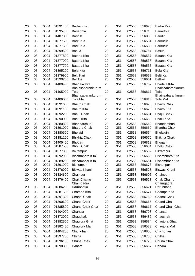
99
20 08 0004 01391400 Barhe Kita 20 351 02558 356673 Barhe Kita
20 08 0004 01395700 Bariartola 20 351 02558 356716 Bariartola
20 08 0004 01407800 Baridih 20 351 02558 356836 Baridih
20 08 0004 01377500 Barkurua 20 351 02558 356534 Barkurua
20 08 0004 01377600 Barkurua 20 351 02558 356535 Barkurua
20 08 0004 01399500 Basua 20 351 02558 356754 Basua
20 08 0004 01377800 Batana Kita 20 351 02558 356537 Batana Kita
20 08 0004 01377900 Batana Kita 20 351 02558 356538 Batana Kita
20 08 0004 01377700 Bataua Kita 20 351 02558 356536 Bataua Kita
20 08 0004 01395200 Bela Kita 20 351 02558 356711 Bela Kita
20 08 0004 01379900 Belti Kari 20 351 02558 356558 Belti Kari 20 08 0004 01390200 Beltikri 20 351 02558 356661 Beltikri
20 08 0004 01400400 Bhadaia Kita 20 351 02558 356762 Bhadaia Kita
20 08 0004 01405900 Bhainsabarankurum Tola 20 351 02558 356817
Bhainsabarankurum Tola
20 08 0004 01406000 Bhainsabarankurum Tola Mal 20 351 02558 356818
Bhainsabarankurum Tola Mal
20 08 0004 01391600 Bhairo Chak 20 351 02558 356675 Bhairo Chak
20 08 0004 01391100 Bhairo Kita 20 351 02558 356670 Bhairo Kita
20 08 0004 01392200 Bhaju Chak 20 351 02558 356681 Bhaju Chak
20 08 0004 01390000 Bhalu Kita 20 351 02558 356659 Bhalu Kita
20 08 0004 01380300 Bhandarchua 20 351 02558 356562 Bhandarchua 20 08 0004 01391000 Bhartha Chak 20 351 02558 356669 Bhartha Chak
20 08 0004 01380500 Bhelaidih 20 351 02558 356564 Bhelaidih
20 08 0004 01381100 Bhikhia Chak 20 351 02558 356570 Bhikhia Chak
20 08 0004 01405400 Bhogan 20 351 02558 356812 Bhogan 20 08 0004 01387500 Bholu Chak 20 351 02558 356634 Bholu Chak
20 08 0004 01377300 Bikrampur 20 351 02558 356532 Bikrampur
20 08 0004 01392900 Bisambhara Kita 20 351 02558 356688 Bisambhara Kita
20 08 0004 01389200 Bishambhar Kita 20 351 02558 356651 Bishambhar Kita 20 08 0004 01391900 Bishunpur 20 351 02558 356678 Bishunpur
20 08 0004 01376900 Biswas Khani 20 351 02558 356528 Biswas Khani
20 08 0004 01384600 Chainpur 20 351 02558 356605 Chainpur
20 08 0004 01376400 Chak Chamu 20 351 02558 356523 Chak Chamu
20 08 0004 01386200 Chamgadra Darunbatia 20 351 02558 356621
Chamgadra Darunbatia
20 08 0004 01381500 Champa Kita 20 351 02558 356574 Champa Kita
20 08 0004 01397300 Chanai Chak 20 351 02558 356732 Chanai Chak
20 08 0004 01390600 Chand Chak 20 351 02558 356665 Chand Chak
20 08 0004 01385800 Chand Chak Ghat 20 351 02558 356617 Chand Chak Ghat
20 08 0004 01404000 Chansar 20 351 02558 356798 Chansar
20 08 0004 01373000 Chauchak 20 351 02558 356489 Chauchak
20 08 0004 01382500 Chaujora Ghat 20 351 02558 356584 Chaujora Ghat
20 08 0004 01382400 Chaujora Mal 20 351 02558 356583 Chaujora Mal
20 08 0004 01404200 Chichohari 20 351 02558 356800 Chichohari
20 08 0004 01397700 Chilha 20 351 02558 356736 Chilha
20 08 0004 01396100 Chuna Chak 20 351 02558 356720 Chuna Chak
20 08 0004 01390800 Dahara 20 351 02558 356667 Dahara
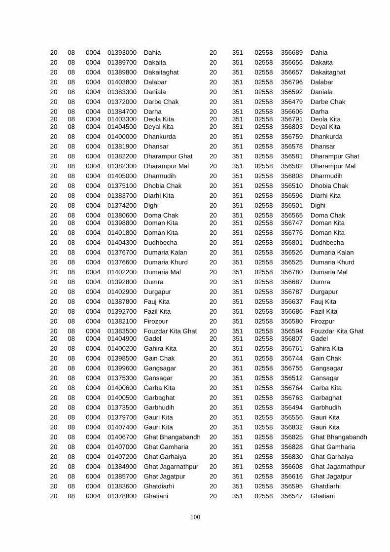
100
20 08 0004 01393000 Dahia 20 351 02558 356689 Dahia
20 08 0004 01389700 Dakaita 20 351 02558 356656 Dakaita
20 08 0004 01389800 Dakaitaghat 20 351 02558 356657 Dakaitaghat
20 08 0004 01403800 Dalabar 20 351 02558 356796 Dalabar
20 08 0004 01383300 Daniala 20 351 02558 356592 Daniala
20 08 0004 01372000 Darbe Chak 20 351 02558 356479 Darbe Chak
20 08 0004 01384700 Darha 20 351 02558 356606 Darha 20 08 0004 01403300 Deola Kita 20 351 02558 356791 Deola Kita 20 08 0004 01404500 Deyal Kita 20 351 02558 356803 Deyal Kita
20 08 0004 01400000 Dhankurda 20 351 02558 356759 Dhankurda
20 08 0004 01381900 Dhansar 20 351 02558 356578 Dhansar
20 08 0004 01382200 Dharampur Ghat 20 351 02558 356581 Dharampur Ghat
20 08 0004 01382300 Dharampur Mal 20 351 02558 356582 Dharampur Mal
20 08 0004 01405000 Dharmudih 20 351 02558 356808 Dharmudih
20 08 0004 01375100 Dhobia Chak 20 351 02558 356510 Dhobia Chak
20 08 0004 01383700 Diarhi Kita 20 351 02558 356596 Diarhi Kita
20 08 0004 01374200 Dighi 20 351 02558 356501 Dighi
20 08 0004 01380600 Doma Chak 20 351 02558 356565 Doma Chak 20 08 0004 01398800 Doman Kita 20 351 02558 356747 Doman Kita
20 08 0004 01401800 Doman Kita 20 351 02558 356776 Doman Kita
20 08 0004 01404300 Dudhbecha 20 351 02558 356801 Dudhbecha
20 08 0004 01376700 Dumaria Kalan 20 351 02558 356526 Dumaria Kalan
20 08 0004 01376600 Dumaria Khurd 20 351 02558 356525 Dumaria Khurd
20 08 0004 01402200 Dumaria Mal 20 351 02558 356780 Dumaria Mal
20 08 0004 01392800 Dumra 20 351 02558 356687 Dumra
20 08 0004 01402900 Durgapur 20 351 02558 356787 Durgapur
20 08 0004 01387800 Fauj Kita 20 351 02558 356637 Fauj Kita
20 08 0004 01392700 Fazil Kita 20 351 02558 356686 Fazil Kita
20 08 0004 01382100 Firozpur 20 351 02558 356580 Firozpur
20 08 0004 01383500 Fouzdar Kita Ghat 20 351 02558 356594 Fouzdar Kita Ghat 20 08 0004 01404900 Gadel 20 351 02558 356807 Gadel
20 08 0004 01400200 Gahira Kita 20 351 02558 356761 Gahira Kita
20 08 0004 01398500 Gain Chak 20 351 02558 356744 Gain Chak
20 08 0004 01399600 Gangsagar 20 351 02558 356755 Gangsagar
20 08 0004 01375300 Gansagar 20 351 02558 356512 Gansagar
20 08 0004 01400600 Garba Kita 20 351 02558 356764 Garba Kita
20 08 0004 01400500 Garbaghat 20 351 02558 356763 Garbaghat
20 08 0004 01373500 Garbhudih 20 351 02558 356494 Garbhudih
20 08 0004 01379700 Gauri Kita 20 351 02558 356556 Gauri Kita
20 08 0004 01407400 Gauri Kita 20 351 02558 356832 Gauri Kita
20 08 0004 01406700 Ghat Bhangabandh 20 351 02558 356825 Ghat Bhangabandh
20 08 0004 01407000 Ghat Gamharia 20 351 02558 356828 Ghat Gamharia
20 08 0004 01407200 Ghat Garhaiya 20 351 02558 356830 Ghat Garhaiya
20 08 0004 01384900 Ghat Jagarnathpur 20 351 02558 356608 Ghat Jagarnathpur
20 08 0004 01385700 Ghat Jagatpur 20 351 02558 356616 Ghat Jagatpur
20 08 0004 01383600 Ghatdiarhi 20 351 02558 356595 Ghatdiarhi
20 08 0004 01378800 Ghatiani 20 351 02558 356547 Ghatiani
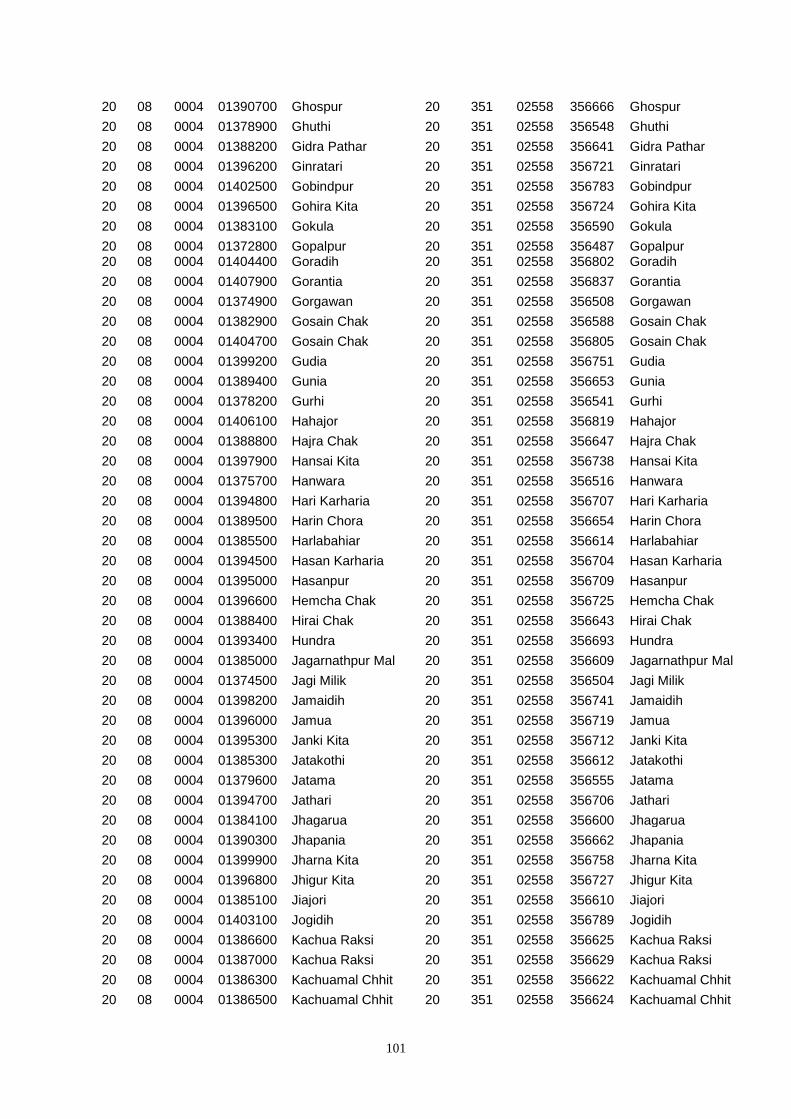
101
20 08 0004 01390700 Ghospur 20 351 02558 356666 Ghospur
20 08 0004 01378900 Ghuthi 20 351 02558 356548 Ghuthi
20 08 0004 01388200 Gidra Pathar 20 351 02558 356641 Gidra Pathar
20 08 0004 01396200 Ginratari 20 351 02558 356721 Ginratari
20 08 0004 01402500 Gobindpur 20 351 02558 356783 Gobindpur
20 08 0004 01396500 Gohira Kita 20 351 02558 356724 Gohira Kita
20 08 0004 01383100 Gokula 20 351 02558 356590 Gokula
20 08 0004 01372800 Gopalpur 20 351 02558 356487 Gopalpur 20 08 0004 01404400 Goradih 20 351 02558 356802 Goradih
20 08 0004 01407900 Gorantia 20 351 02558 356837 Gorantia
20 08 0004 01374900 Gorgawan 20 351 02558 356508 Gorgawan
20 08 0004 01382900 Gosain Chak 20 351 02558 356588 Gosain Chak
20 08 0004 01404700 Gosain Chak 20 351 02558 356805 Gosain Chak
20 08 0004 01399200 Gudia 20 351 02558 356751 Gudia
20 08 0004 01389400 Gunia 20 351 02558 356653 Gunia
20 08 0004 01378200 Gurhi 20 351 02558 356541 Gurhi
20 08 0004 01406100 Hahajor 20 351 02558 356819 Hahajor
20 08 0004 01388800 Hajra Chak 20 351 02558 356647 Hajra Chak
20 08 0004 01397900 Hansai Kita 20 351 02558 356738 Hansai Kita
20 08 0004 01375700 Hanwara 20 351 02558 356516 Hanwara
20 08 0004 01394800 Hari Karharia 20 351 02558 356707 Hari Karharia
20 08 0004 01389500 Harin Chora 20 351 02558 356654 Harin Chora
20 08 0004 01385500 Harlabahiar 20 351 02558 356614 Harlabahiar
20 08 0004 01394500 Hasan Karharia 20 351 02558 356704 Hasan Karharia
20 08 0004 01395000 Hasanpur 20 351 02558 356709 Hasanpur
20 08 0004 01396600 Hemcha Chak 20 351 02558 356725 Hemcha Chak
20 08 0004 01388400 Hirai Chak 20 351 02558 356643 Hirai Chak
20 08 0004 01393400 Hundra 20 351 02558 356693 Hundra
20 08 0004 01385000 Jagarnathpur Mal 20 351 02558 356609 Jagarnathpur Mal
20 08 0004 01374500 Jagi Milik 20 351 02558 356504 Jagi Milik
20 08 0004 01398200 Jamaidih 20 351 02558 356741 Jamaidih
20 08 0004 01396000 Jamua 20 351 02558 356719 Jamua
20 08 0004 01395300 Janki Kita 20 351 02558 356712 Janki Kita
20 08 0004 01385300 Jatakothi 20 351 02558 356612 Jatakothi
20 08 0004 01379600 Jatama 20 351 02558 356555 Jatama
20 08 0004 01394700 Jathari 20 351 02558 356706 Jathari
20 08 0004 01384100 Jhagarua 20 351 02558 356600 Jhagarua
20 08 0004 01390300 Jhapania 20 351 02558 356662 Jhapania
20 08 0004 01399900 Jharna Kita 20 351 02558 356758 Jharna Kita
20 08 0004 01396800 Jhigur Kita 20 351 02558 356727 Jhigur Kita
20 08 0004 01385100 Jiajori 20 351 02558 356610 Jiajori
20 08 0004 01403100 Jogidih 20 351 02558 356789 Jogidih
20 08 0004 01386600 Kachua Raksi 20 351 02558 356625 Kachua Raksi
20 08 0004 01387000 Kachua Raksi 20 351 02558 356629 Kachua Raksi
20 08 0004 01386300 Kachuamal Chhit 20 351 02558 356622 Kachuamal Chhit
20 08 0004 01386500 Kachuamal Chhit 20 351 02558 356624 Kachuamal Chhit
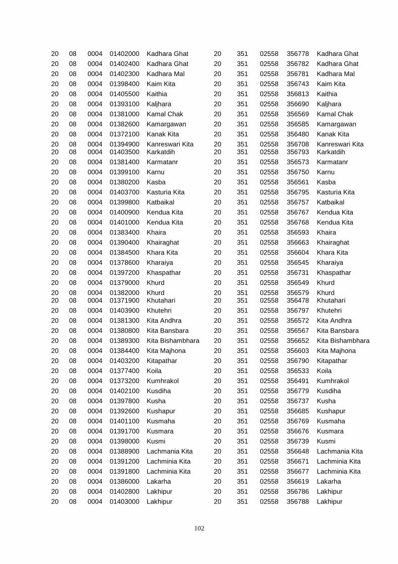
102
20 08 0004 01402000 Kadhara Ghat 20 351 02558 356778 Kadhara Ghat
20 08 0004 01402400 Kadhara Ghat 20 351 02558 356782 Kadhara Ghat
20 08 0004 01402300 Kadhara Mal 20 351 02558 356781 Kadhara Mal
20 08 0004 01398400 Kaim Kita 20 351 02558 356743 Kaim Kita
20 08 0004 01405500 Kaithia 20 351 02558 356813 Kaithia
20 08 0004 01393100 Kaljhara 20 351 02558 356690 Kaljhara
20 08 0004 01381000 Kamal Chak 20 351 02558 356569 Kamal Chak
20 08 0004 01382600 Kamargawan 20 351 02558 356585 Kamargawan
20 08 0004 01372100 Kanak Kita 20 351 02558 356480 Kanak Kita
20 08 0004 01394900 Kanreswari Kita 20 351 02558 356708 Kanreswari Kita 20 08 0004 01403500 Karkatdih 20 351 02558 356793 Karkatdih
20 08 0004 01381400 Karmatanr 20 351 02558 356573 Karmatanr
20 08 0004 01399100 Karnu 20 351 02558 356750 Karnu
20 08 0004 01380200 Kasba 20 351 02558 356561 Kasba
20 08 0004 01403700 Kasturia Kita 20 351 02558 356795 Kasturia Kita
20 08 0004 01399800 Katbaikal 20 351 02558 356757 Katbaikal
20 08 0004 01400900 Kendua Kita 20 351 02558 356767 Kendua Kita
20 08 0004 01401000 Kendua Kita 20 351 02558 356768 Kendua Kita
20 08 0004 01383400 Khaira 20 351 02558 356593 Khaira
20 08 0004 01390400 Khairaghat 20 351 02558 356663 Khairaghat
20 08 0004 01384500 Khara Kita 20 351 02558 356604 Khara Kita
20 08 0004 01378600 Kharaiya 20 351 02558 356545 Kharaiya
20 08 0004 01397200 Khaspathar 20 351 02558 356731 Khaspathar
20 08 0004 01379000 Khurd 20 351 02558 356549 Khurd
20 08 0004 01382000 Khurd 20 351 02558 356579 Khurd 20 08 0004 01371900 Khutahari 20 351 02558 356478 Khutahari
20 08 0004 01403900 Khutehri 20 351 02558 356797 Khutehri
20 08 0004 01381300 Kita Andhra 20 351 02558 356572 Kita Andhra
20 08 0004 01380800 Kita Bansbara 20 351 02558 356567 Kita Bansbara
20 08 0004 01389300 Kita Bishambhara 20 351 02558 356652 Kita Bishambhara
20 08 0004 01384400 Kita Majhona 20 351 02558 356603 Kita Majhona
20 08 0004 01403200 Kitapathar 20 351 02558 356790 Kitapathar
20 08 0004 01377400 Koila 20 351 02558 356533 Koila
20 08 0004 01373200 Kumhrakol 20 351 02558 356491 Kumhrakol
20 08 0004 01402100 Kusdiha 20 351 02558 356779 Kusdiha
20 08 0004 01397800 Kusha 20 351 02558 356737 Kusha
20 08 0004 01392600 Kushapur 20 351 02558 356685 Kushapur
20 08 0004 01401100 Kusmaha 20 351 02558 356769 Kusmaha
20 08 0004 01391700 Kusmara 20 351 02558 356676 Kusmara
20 08 0004 01398000 Kusmi 20 351 02558 356739 Kusmi
20 08 0004 01388900 Lachmania Kita 20 351 02558 356648 Lachmania Kita
20 08 0004 01391200 Lachminia Kita 20 351 02558 356671 Lachminia Kita
20 08 0004 01391800 Lachminia Kita 20 351 02558 356677 Lachminia Kita
20 08 0004 01386000 Lakarha 20 351 02558 356619 Lakarha
20 08 0004 01402800 Lakhipur 20 351 02558 356786 Lakhipur
20 08 0004 01403000 Lakhipur 20 351 02558 356788 Lakhipur
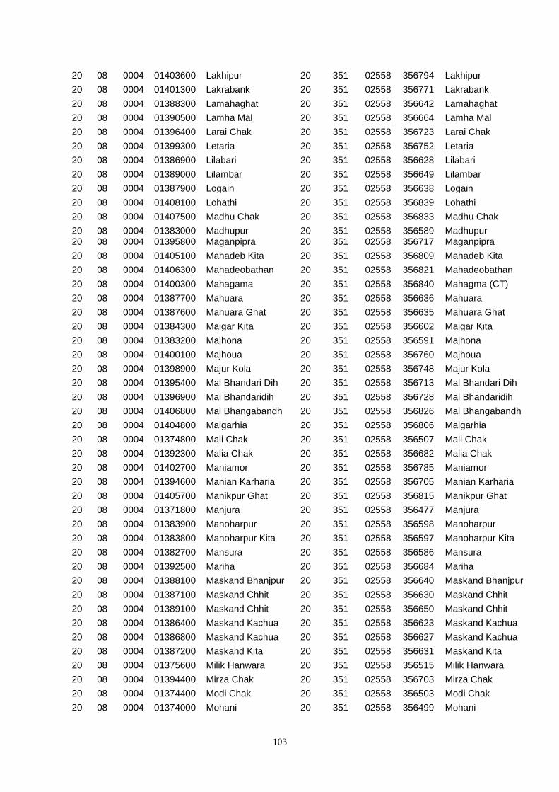
103
20 08 0004 01403600 Lakhipur 20 351 02558 356794 Lakhipur
20 08 0004 01401300 Lakrabank 20 351 02558 356771 Lakrabank
20 08 0004 01388300 Lamahaghat 20 351 02558 356642 Lamahaghat
20 08 0004 01390500 Lamha Mal 20 351 02558 356664 Lamha Mal
20 08 0004 01396400 Larai Chak 20 351 02558 356723 Larai Chak
20 08 0004 01399300 Letaria 20 351 02558 356752 Letaria
20 08 0004 01386900 Lilabari 20 351 02558 356628 Lilabari
20 08 0004 01389000 Lilambar 20 351 02558 356649 Lilambar
20 08 0004 01387900 Logain 20 351 02558 356638 Logain
20 08 0004 01408100 Lohathi 20 351 02558 356839 Lohathi
20 08 0004 01407500 Madhu Chak 20 351 02558 356833 Madhu Chak
20 08 0004 01383000 Madhupur 20 351 02558 356589 Madhupur 20 08 0004 01395800 Maganpipra 20 351 02558 356717 Maganpipra
20 08 0004 01405100 Mahadeb Kita 20 351 02558 356809 Mahadeb Kita
20 08 0004 01406300 Mahadeobathan 20 351 02558 356821 Mahadeobathan
20 08 0004 01400300 Mahagama 20 351 02558 356840 Mahagma (CT)
20 08 0004 01387700 Mahuara 20 351 02558 356636 Mahuara
20 08 0004 01387600 Mahuara Ghat 20 351 02558 356635 Mahuara Ghat
20 08 0004 01384300 Maigar Kita 20 351 02558 356602 Maigar Kita
20 08 0004 01383200 Majhona 20 351 02558 356591 Majhona
20 08 0004 01400100 Majhoua 20 351 02558 356760 Majhoua
20 08 0004 01398900 Majur Kola 20 351 02558 356748 Majur Kola
20 08 0004 01395400 Mal Bhandari Dih 20 351 02558 356713 Mal Bhandari Dih
20 08 0004 01396900 Mal Bhandaridih 20 351 02558 356728 Mal Bhandaridih
20 08 0004 01406800 Mal Bhangabandh 20 351 02558 356826 Mal Bhangabandh
20 08 0004 01404800 Malgarhia 20 351 02558 356806 Malgarhia
20 08 0004 01374800 Mali Chak 20 351 02558 356507 Mali Chak
20 08 0004 01392300 Malia Chak 20 351 02558 356682 Malia Chak
20 08 0004 01402700 Maniamor 20 351 02558 356785 Maniamor
20 08 0004 01394600 Manian Karharia 20 351 02558 356705 Manian Karharia
20 08 0004 01405700 Manikpur Ghat 20 351 02558 356815 Manikpur Ghat
20 08 0004 01371800 Manjura 20 351 02558 356477 Manjura
20 08 0004 01383900 Manoharpur 20 351 02558 356598 Manoharpur
20 08 0004 01383800 Manoharpur Kita 20 351 02558 356597 Manoharpur Kita
20 08 0004 01382700 Mansura 20 351 02558 356586 Mansura
20 08 0004 01392500 Mariha 20 351 02558 356684 Mariha
20 08 0004 01388100 Maskand Bhanjpur 20 351 02558 356640 Maskand Bhanjpur
20 08 0004 01387100 Maskand Chhit 20 351 02558 356630 Maskand Chhit
20 08 0004 01389100 Maskand Chhit 20 351 02558 356650 Maskand Chhit
20 08 0004 01386400 Maskand Kachua 20 351 02558 356623 Maskand Kachua
20 08 0004 01386800 Maskand Kachua 20 351 02558 356627 Maskand Kachua
20 08 0004 01387200 Maskand Kita 20 351 02558 356631 Maskand Kita
20 08 0004 01375600 Milik Hanwara 20 351 02558 356515 Milik Hanwara
20 08 0004 01394400 Mirza Chak 20 351 02558 356703 Mirza Chak
20 08 0004 01374400 Modi Chak 20 351 02558 356503 Modi Chak
20 08 0004 01374000 Mohani 20 351 02558 356499 Mohani
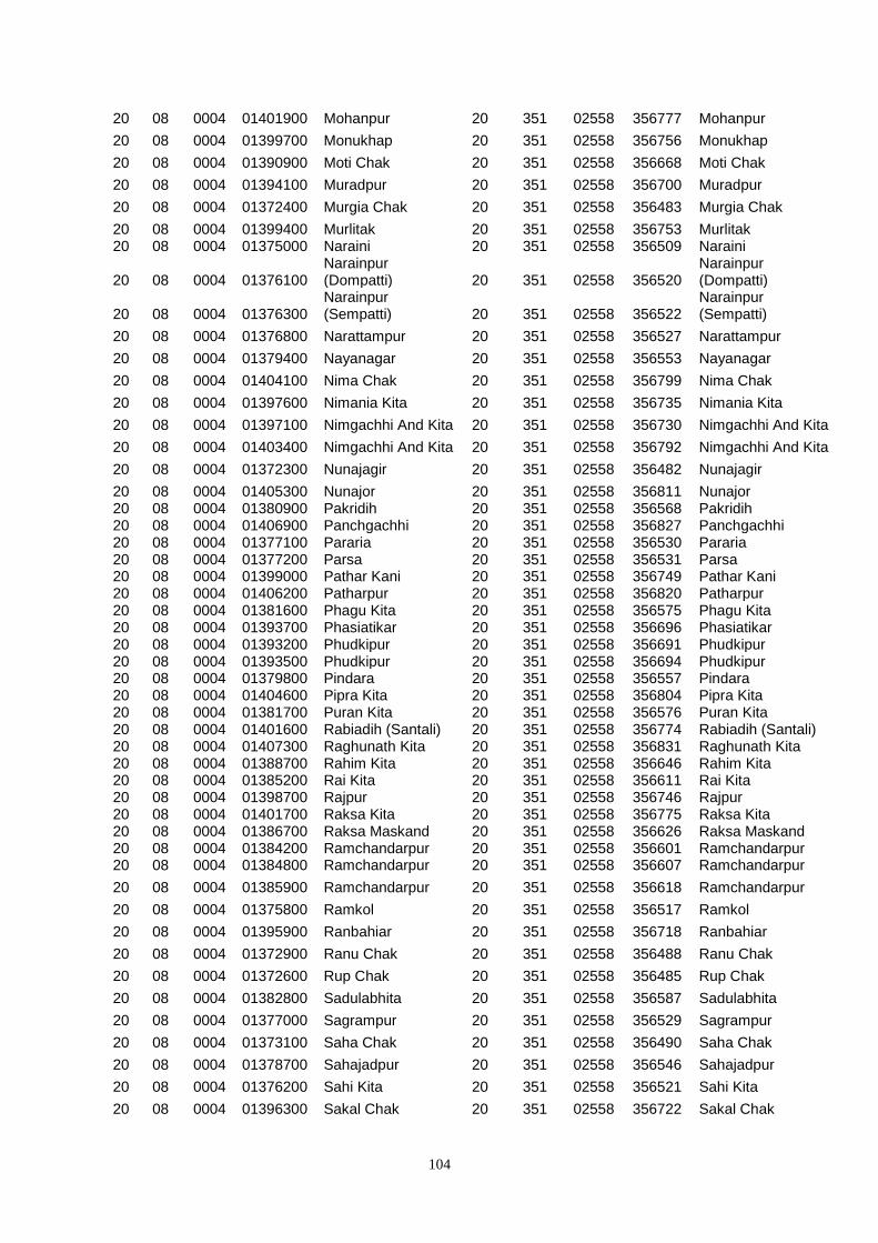
104
20 08 0004 01401900 Mohanpur 20 351 02558 356777 Mohanpur
20 08 0004 01399700 Monukhap 20 351 02558 356756 Monukhap
20 08 0004 01390900 Moti Chak 20 351 02558 356668 Moti Chak
20 08 0004 01394100 Muradpur 20 351 02558 356700 Muradpur
20 08 0004 01372400 Murgia Chak 20 351 02558 356483 Murgia Chak
20 08 0004 01399400 Murlitak 20 351 02558 356753 Murlitak 20 08 0004 01375000 Naraini 20 351 02558 356509 Naraini
20 08 0004 01376100 Narainpur (Dompatti) 20 351 02558 356520
Narainpur (Dompatti)
20 08 0004 01376300 Narainpur (Sempatti) 20 351 02558 356522
Narainpur (Sempatti)
20 08 0004 01376800 Narattampur 20 351 02558 356527 Narattampur
20 08 0004 01379400 Nayanagar 20 351 02558 356553 Nayanagar
20 08 0004 01404100 Nima Chak 20 351 02558 356799 Nima Chak
20 08 0004 01397600 Nimania Kita 20 351 02558 356735 Nimania Kita
20 08 0004 01397100 Nimgachhi And Kita 20 351 02558 356730 Nimgachhi And Kita
20 08 0004 01403400 Nimgachhi And Kita 20 351 02558 356792 Nimgachhi And Kita
20 08 0004 01372300 Nunajagir 20 351 02558 356482 Nunajagir
20 08 0004 01405300 Nunajor 20 351 02558 356811 Nunajor 20 08 0004 01380900 Pakridih 20 351 02558 356568 Pakridih 20 08 0004 01406900 Panchgachhi 20 351 02558 356827 Panchgachhi 20 08 0004 01377100 Pararia 20 351 02558 356530 Pararia 20 08 0004 01377200 Parsa 20 351 02558 356531 Parsa 20 08 0004 01399000 Pathar Kani 20 351 02558 356749 Pathar Kani 20 08 0004 01406200 Patharpur 20 351 02558 356820 Patharpur 20 08 0004 01381600 Phagu Kita 20 351 02558 356575 Phagu Kita 20 08 0004 01393700 Phasiatikar 20 351 02558 356696 Phasiatikar 20 08 0004 01393200 Phudkipur 20 351 02558 356691 Phudkipur 20 08 0004 01393500 Phudkipur 20 351 02558 356694 Phudkipur 20 08 0004 01379800 Pindara 20 351 02558 356557 Pindara 20 08 0004 01404600 Pipra Kita 20 351 02558 356804 Pipra Kita 20 08 0004 01381700 Puran Kita 20 351 02558 356576 Puran Kita 20 08 0004 01401600 Rabiadih (Santali) 20 351 02558 356774 Rabiadih (Santali) 20 08 0004 01407300 Raghunath Kita 20 351 02558 356831 Raghunath Kita 20 08 0004 01388700 Rahim Kita 20 351 02558 356646 Rahim Kita 20 08 0004 01385200 Rai Kita 20 351 02558 356611 Rai Kita 20 08 0004 01398700 Rajpur 20 351 02558 356746 Rajpur 20 08 0004 01401700 Raksa Kita 20 351 02558 356775 Raksa Kita 20 08 0004 01386700 Raksa Maskand 20 351 02558 356626 Raksa Maskand 20 08 0004 01384200 Ramchandarpur 20 351 02558 356601 Ramchandarpur 20 08 0004 01384800 Ramchandarpur 20 351 02558 356607 Ramchandarpur
20 08 0004 01385900 Ramchandarpur 20 351 02558 356618 Ramchandarpur
20 08 0004 01375800 Ramkol 20 351 02558 356517 Ramkol
20 08 0004 01395900 Ranbahiar 20 351 02558 356718 Ranbahiar
20 08 0004 01372900 Ranu Chak 20 351 02558 356488 Ranu Chak
20 08 0004 01372600 Rup Chak 20 351 02558 356485 Rup Chak
20 08 0004 01382800 Sadulabhita 20 351 02558 356587 Sadulabhita
20 08 0004 01377000 Sagrampur 20 351 02558 356529 Sagrampur
20 08 0004 01373100 Saha Chak 20 351 02558 356490 Saha Chak
20 08 0004 01378700 Sahajadpur 20 351 02558 356546 Sahajadpur
20 08 0004 01376200 Sahi Kita 20 351 02558 356521 Sahi Kita
20 08 0004 01396300 Sakal Chak 20 351 02558 356722 Sakal Chak
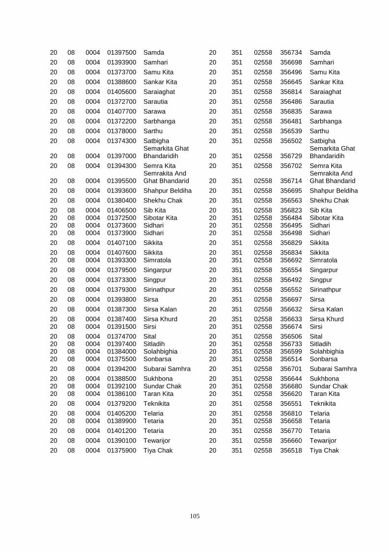
105
20 08 0004 01397500 Samda 20 351 02558 356734 Samda
20 08 0004 01393900 Samhari 20 351 02558 356698 Samhari
20 08 0004 01373700 Samu Kita 20 351 02558 356496 Samu Kita
20 08 0004 01388600 Sankar Kita 20 351 02558 356645 Sankar Kita
20 08 0004 01405600 Saraiaghat 20 351 02558 356814 Saraiaghat
20 08 0004 01372700 Sarautia 20 351 02558 356486 Sarautia
20 08 0004 01407700 Sarawa 20 351 02558 356835 Sarawa
20 08 0004 01372200 Sarbhanga 20 351 02558 356481 Sarbhanga
20 08 0004 01378000 Sarthu 20 351 02558 356539 Sarthu
20 08 0004 01374300 Satbigha 20 351 02558 356502 Satbigha
20 08 0004 01397000 Semarkita Ghat Bhandaridih 20 351 02558 356729
Semarkita Ghat Bhandaridih
20 08 0004 01394300 Semra Kita 20 351 02558 356702 Semra Kita
20 08 0004 01395500 Semrakita And Ghat Bhandarid 20 351 02558 356714
Semrakita And Ghat Bhandarid
20 08 0004 01393600 Shahpur Beldiha 20 351 02558 356695 Shahpur Beldiha
20 08 0004 01380400 Shekhu Chak 20 351 02558 356563 Shekhu Chak
20 08 0004 01406500 Sib Kita 20 351 02558 356823 Sib Kita 20 08 0004 01372500 Sibotar Kita 20 351 02558 356484 Sibotar Kita 20 08 0004 01373600 Sidhari 20 351 02558 356495 Sidhari 20 08 0004 01373900 Sidhari 20 351 02558 356498 Sidhari
20 08 0004 01407100 Sikkita 20 351 02558 356829 Sikkita
20 08 0004 01407600 Sikkita 20 351 02558 356834 Sikkita 20 08 0004 01393300 Simratola 20 351 02558 356692 Simratola
20 08 0004 01379500 Singarpur 20 351 02558 356554 Singarpur
20 08 0004 01373300 Singpur 20 351 02558 356492 Singpur
20 08 0004 01379300 Sirinathpur 20 351 02558 356552 Sirinathpur
20 08 0004 01393800 Sirsa 20 351 02558 356697 Sirsa
20 08 0004 01387300 Sirsa Kalan 20 351 02558 356632 Sirsa Kalan
20 08 0004 01387400 Sirsa Khurd 20 351 02558 356633 Sirsa Khurd 20 08 0004 01391500 Sirsi 20 351 02558 356674 Sirsi
20 08 0004 01374700 Sital 20 351 02558 356506 Sital 20 08 0004 01397400 Sitladih 20 351 02558 356733 Sitladih 20 08 0004 01384000 Solahbighia 20 351 02558 356599 Solahbighia 20 08 0004 01375500 Sonbarsa 20 351 02558 356514 Sonbarsa
20 08 0004 01394200 Subarai Samhra 20 351 02558 356701 Subarai Samhra
20 08 0004 01388500 Sukhbona 20 351 02558 356644 Sukhbona 20 08 0004 01392100 Sundar Chak 20 351 02558 356680 Sundar Chak 20 08 0004 01386100 Taran Kita 20 351 02558 356620 Taran Kita
20 08 0004 01379200 Teknikita 20 351 02558 356551 Teknikita
20 08 0004 01405200 Telaria 20 351 02558 356810 Telaria 20 08 0004 01389900 Tetaria 20 351 02558 356658 Tetaria
20 08 0004 01401200 Tetaria 20 351 02558 356770 Tetaria
20 08 0004 01390100 Tewarijor 20 351 02558 356660 Tewarijor
20 08 0004 01375900 Tiya Chak 20 351 02558 356518 Tiya Chak

106
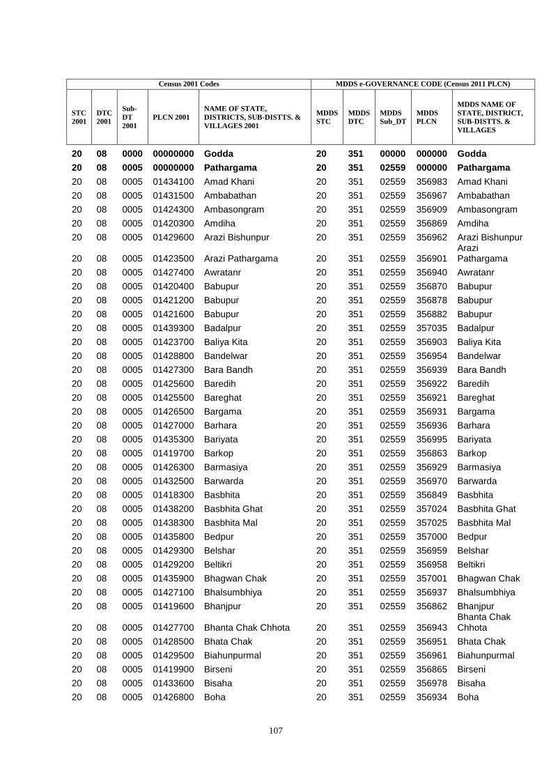
107
Census 2001 Codes MDDS e-GOVERNANCE CODE (Census 2011 PLCN)
STC
2001
DTC
2001
Sub-
DT
2001
PLCN 2001
NAME OF STATE,
DISTRICTS, SUB-DISTTS. &
VILLAGES 2001
MDDS
STC
MDDS
DTC
MDDS
Sub_DT
MDDS
PLCN
MDDS NAME OF
STATE, DISTRICT,
SUB-DISTTS. &
VILLAGES
20 08 0000 00000000 Godda 20 351 00000 000000 Godda
20 08 0005 00000000 Pathargama 20 351 02559 000000 Pathargama
20 08 0005 01434100 Amad Khani 20 351 02559 356983 Amad Khani
20 08 0005 01431500 Ambabathan 20 351 02559 356967 Ambabathan
20 08 0005 01424300 Ambasongram 20 351 02559 356909 Ambasongram
20 08 0005 01420300 Amdiha 20 351 02559 356869 Amdiha
20 08 0005 01429600 Arazi Bishunpur 20 351 02559 356962 Arazi Bishunpur
20 08 0005 01423500 Arazi Pathargama 20 351 02559 356901 Arazi Pathargama
20 08 0005 01427400 Awratanr 20 351 02559 356940 Awratanr
20 08 0005 01420400 Babupur 20 351 02559 356870 Babupur
20 08 0005 01421200 Babupur 20 351 02559 356878 Babupur
20 08 0005 01421600 Babupur 20 351 02559 356882 Babupur
20 08 0005 01439300 Badalpur 20 351 02559 357035 Badalpur
20 08 0005 01423700 Baliya Kita 20 351 02559 356903 Baliya Kita
20 08 0005 01428800 Bandelwar 20 351 02559 356954 Bandelwar
20 08 0005 01427300 Bara Bandh 20 351 02559 356939 Bara Bandh
20 08 0005 01425600 Baredih 20 351 02559 356922 Baredih
20 08 0005 01425500 Bareghat 20 351 02559 356921 Bareghat
20 08 0005 01426500 Bargama 20 351 02559 356931 Bargama
20 08 0005 01427000 Barhara 20 351 02559 356936 Barhara
20 08 0005 01435300 Bariyata 20 351 02559 356995 Bariyata
20 08 0005 01419700 Barkop 20 351 02559 356863 Barkop
20 08 0005 01426300 Barmasiya 20 351 02559 356929 Barmasiya
20 08 0005 01432500 Barwarda 20 351 02559 356970 Barwarda
20 08 0005 01418300 Basbhita 20 351 02559 356849 Basbhita
20 08 0005 01438200 Basbhita Ghat 20 351 02559 357024 Basbhita Ghat
20 08 0005 01438300 Basbhita Mal 20 351 02559 357025 Basbhita Mal
20 08 0005 01435800 Bedpur 20 351 02559 357000 Bedpur
20 08 0005 01429300 Belshar 20 351 02559 356959 Belshar
20 08 0005 01429200 Beltikri 20 351 02559 356958 Beltikri
20 08 0005 01435900 Bhagwan Chak 20 351 02559 357001 Bhagwan Chak
20 08 0005 01427100 Bhalsumbhiya 20 351 02559 356937 Bhalsumbhiya
20 08 0005 01419600 Bhanjpur 20 351 02559 356862 Bhanjpur
20 08 0005 01427700 Bhanta Chak Chhota 20 351 02559 356943 Bhanta Chak Chhota
20 08 0005 01428500 Bhata Chak 20 351 02559 356951 Bhata Chak
20 08 0005 01429500 Biahunpurmal 20 351 02559 356961 Biahunpurmal
20 08 0005 01419900 Birseni 20 351 02559 356865 Birseni
20 08 0005 01433600 Bisaha 20 351 02559 356978 Bisaha
20 08 0005 01426800 Boha 20 351 02559 356934 Boha
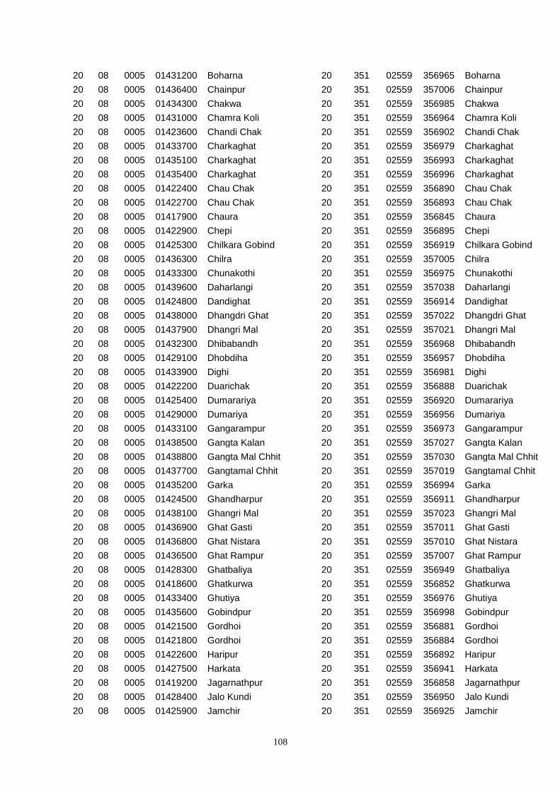
108
20 08 0005 01431200 Boharna 20 351 02559 356965 Boharna
20 08 0005 01436400 Chainpur 20 351 02559 357006 Chainpur
20 08 0005 01434300 Chakwa 20 351 02559 356985 Chakwa
20 08 0005 01431000 Chamra Koli 20 351 02559 356964 Chamra Koli
20 08 0005 01423600 Chandi Chak 20 351 02559 356902 Chandi Chak
20 08 0005 01433700 Charkaghat 20 351 02559 356979 Charkaghat
20 08 0005 01435100 Charkaghat 20 351 02559 356993 Charkaghat
20 08 0005 01435400 Charkaghat 20 351 02559 356996 Charkaghat
20 08 0005 01422400 Chau Chak 20 351 02559 356890 Chau Chak
20 08 0005 01422700 Chau Chak 20 351 02559 356893 Chau Chak
20 08 0005 01417900 Chaura 20 351 02559 356845 Chaura
20 08 0005 01422900 Chepi 20 351 02559 356895 Chepi
20 08 0005 01425300 Chilkara Gobind 20 351 02559 356919 Chilkara Gobind
20 08 0005 01436300 Chilra 20 351 02559 357005 Chilra
20 08 0005 01433300 Chunakothi 20 351 02559 356975 Chunakothi
20 08 0005 01439600 Daharlangi 20 351 02559 357038 Daharlangi
20 08 0005 01424800 Dandighat 20 351 02559 356914 Dandighat
20 08 0005 01438000 Dhangdri Ghat 20 351 02559 357022 Dhangdri Ghat
20 08 0005 01437900 Dhangri Mal 20 351 02559 357021 Dhangri Mal
20 08 0005 01432300 Dhibabandh 20 351 02559 356968 Dhibabandh
20 08 0005 01429100 Dhobdiha 20 351 02559 356957 Dhobdiha
20 08 0005 01433900 Dighi 20 351 02559 356981 Dighi
20 08 0005 01422200 Duarichak 20 351 02559 356888 Duarichak
20 08 0005 01425400 Dumarariya 20 351 02559 356920 Dumarariya
20 08 0005 01429000 Dumariya 20 351 02559 356956 Dumariya
20 08 0005 01433100 Gangarampur 20 351 02559 356973 Gangarampur
20 08 0005 01438500 Gangta Kalan 20 351 02559 357027 Gangta Kalan
20 08 0005 01438800 Gangta Mal Chhit 20 351 02559 357030 Gangta Mal Chhit
20 08 0005 01437700 Gangtamal Chhit 20 351 02559 357019 Gangtamal Chhit
20 08 0005 01435200 Garka 20 351 02559 356994 Garka
20 08 0005 01424500 Ghandharpur 20 351 02559 356911 Ghandharpur
20 08 0005 01438100 Ghangri Mal 20 351 02559 357023 Ghangri Mal
20 08 0005 01436900 Ghat Gasti 20 351 02559 357011 Ghat Gasti
20 08 0005 01436800 Ghat Nistara 20 351 02559 357010 Ghat Nistara
20 08 0005 01436500 Ghat Rampur 20 351 02559 357007 Ghat Rampur
20 08 0005 01428300 Ghatbaliya 20 351 02559 356949 Ghatbaliya
20 08 0005 01418600 Ghatkurwa 20 351 02559 356852 Ghatkurwa
20 08 0005 01433400 Ghutiya 20 351 02559 356976 Ghutiya
20 08 0005 01435600 Gobindpur 20 351 02559 356998 Gobindpur
20 08 0005 01421500 Gordhoi 20 351 02559 356881 Gordhoi
20 08 0005 01421800 Gordhoi 20 351 02559 356884 Gordhoi
20 08 0005 01422600 Haripur 20 351 02559 356892 Haripur
20 08 0005 01427500 Harkata 20 351 02559 356941 Harkata
20 08 0005 01419200 Jagarnathpur 20 351 02559 356858 Jagarnathpur
20 08 0005 01428400 Jalo Kundi 20 351 02559 356950 Jalo Kundi
20 08 0005 01425900 Jamchir 20 351 02559 356925 Jamchir
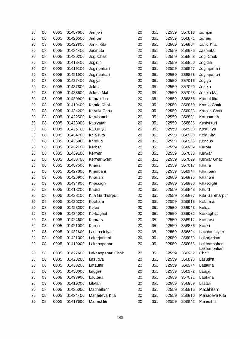
109
20 08 0005 01437600 Jamjori 20 351 02559 357018 Jamjori
20 08 0005 01420500 Jamua 20 351 02559 356871 Jamua
20 08 0005 01423800 Janki Kita 20 351 02559 356904 Janki Kita
20 08 0005 01434400 Jasmata 20 351 02559 356986 Jasmata
20 08 0005 01420200 Jogi Chak 20 351 02559 356868 Jogi Chak
20 08 0005 01418400 Jogidih 20 351 02559 356850 Jogidih
20 08 0005 01419100 Joginpahari 20 351 02559 356857 Joginpahari
20 08 0005 01421900 Joginpahari 20 351 02559 356885 Joginpahari
20 08 0005 01437400 Jogiya 20 351 02559 357016 Jogiya
20 08 0005 01437800 Jokela 20 351 02559 357020 Jokela
20 08 0005 01438600 Jokela Mal 20 351 02559 357028 Jokela Mal
20 08 0005 01420900 Kamaldiha 20 351 02559 356875 Kamaldiha
20 08 0005 01419400 Kamla Chak 20 351 02559 356860 Kamla Chak
20 08 0005 01424200 Karaila Chak 20 351 02559 356908 Karaila Chak
20 08 0005 01422500 Karubandh 20 351 02559 356891 Karubandh
20 08 0005 01423000 Kasiyatari 20 351 02559 356896 Kasiyatari
20 08 0005 01425700 Kasturiya 20 351 02559 356923 Kasturiya
20 08 0005 01434700 Kela Kita 20 351 02559 356989 Kela Kita
20 08 0005 01426000 Kendua 20 351 02559 356926 Kendua
20 08 0005 01432400 Kerbar 20 351 02559 356969 Kerbar
20 08 0005 01439100 Kerwar 20 351 02559 357033 Kerwar
20 08 0005 01438700 Kerwar Ghat 20 351 02559 357029 Kerwar Ghat
20 08 0005 01437500 Khaira 20 351 02559 357017 Khaira
20 08 0005 01427800 Khairbani 20 351 02559 356944 Khairbani
20 08 0005 01426900 Khariani 20 351 02559 356935 Khariani
20 08 0005 01434800 Khasdighi 20 351 02559 356990 Khasdighi
20 08 0005 01418200 Khurd 20 351 02559 356848 Khurd
20 08 0005 01423100 Kita Gardharpur 20 351 02559 356897 Kita Gardharpur
20 08 0005 01425200 Kobhara 20 351 02559 356918 Kobhara
20 08 0005 01428200 Kolua 20 351 02559 356948 Kolua
20 08 0005 01434000 Korkaghat 20 351 02559 356982 Korkaghat
20 08 0005 01424600 Kumarsi 20 351 02559 356912 Kumarsi
20 08 0005 01421000 Kureri 20 351 02559 356876 Kureri
20 08 0005 01422800 Lachhminiyan 20 351 02559 356894 Lachhminiyan
20 08 0005 01421300 Lakarjorimal 20 351 02559 356879 Lakarjorimal
20 08 0005 01419000 Lakhanpahari 20 351 02559 356856 Lakhanpahari
20 08 0005 01427600 Lakhanpahari Chhit 20 351 02559 356942 Lakhanpahari Chhit
20 08 0005 01423200 Lasutiya 20 351 02559 356898 Lasutiya
20 08 0005 01433200 Latauna 20 351 02559 356974 Latauna
20 08 0005 01433000 Laugai 20 351 02559 356972 Laugai
20 08 0005 01438900 Lautana 20 351 02559 357031 Lautana
20 08 0005 01419300 Lilatari 20 351 02559 356859 Lilatari
20 08 0005 01425000 Machhitanr 20 351 02559 356916 Machhitanr
20 08 0005 01424400 Mahadeva Kita 20 351 02559 356910 Mahadeva Kita
20 08 0005 01417600 Maheshliti 20 351 02559 356842 Maheshliti
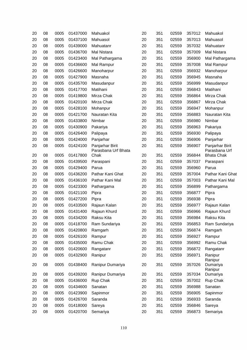
110
20 08 0005 01437000 Mahuakol 20 351 02559 357012 Mahuakol
20 08 0005 01437100 Mahuasol 20 351 02559 357013 Mahuasol
20 08 0005 01439000 Mahuatanr 20 351 02559 357032 Mahuatanr
20 08 0005 01436700 Mal Nistara 20 351 02559 357009 Mal Nistara
20 08 0005 01423400 Mal Pathargama 20 351 02559 356900 Mal Pathargama
20 08 0005 01436600 Mal Rampur 20 351 02559 357008 Mal Rampur
20 08 0005 01426600 Manoharpur 20 351 02559 356932 Manoharpur
20 08 0005 01427900 Masnaha 20 351 02559 356945 Masnaha
20 08 0005 01435700 Masudanpur 20 351 02559 356999 Masudanpur
20 08 0005 01417700 Matihani 20 351 02559 356843 Matihani
20 08 0005 01419800 Mirza Chak 20 351 02559 356864 Mirza Chak
20 08 0005 01420100 Mirza Chak 20 351 02559 356867 Mirza Chak
20 08 0005 01428100 Mohanpur 20 351 02559 356947 Mohanpur
20 08 0005 01421700 Nauratan Kita 20 351 02559 356883 Nauratan Kita
20 08 0005 01433800 Nimbar 20 351 02559 356980 Nimbar
20 08 0005 01430900 Pakariya 20 351 02559 356963 Pakariya
20 08 0005 01426400 Palipaya 20 351 02559 356930 Palipaya
20 08 0005 01424000 Panjarhar 20 351 02559 356906 Panjarhar
20 08 0005 01424100 Panjarhar Birit 20 351 02559 356907 Panjarhar Birit
20 08 0005 01417800 Parasbana Urf Bhata Chak 20 351 02559 356844
Parasbana Urf Bhata Chak
20 08 0005 01439500 Paraspani 20 351 02559 357037 Paraspani
20 08 0005 01429400 Parua 20 351 02559 356960 Parua
20 08 0005 01436200 Pathar Kani Ghat 20 351 02559 357004 Pathar Kani Ghat
20 08 0005 01436100 Pathar Kani Mal 20 351 02559 357003 Pathar Kani Mal
20 08 0005 01423300 Pathargama 20 351 02559 356899 Pathargama
20 08 0005 01421100 Pipra 20 351 02559 356877 Pipra
20 08 0005 01427200 Pipra 20 351 02559 356938 Pipra
20 08 0005 01433500 Rajaun Kalan 20 351 02559 356977 Rajaun Kalan
20 08 0005 01431400 Rajaun Khurd 20 351 02559 356966 Rajaun Khurd
20 08 0005 01434200 Raksu Kita 20 351 02559 356984 Raksu Kita
20 08 0005 01418700 Ram Sundariya 20 351 02559 356853 Ram Sundariya
20 08 0005 01420800 Ramgarh 20 351 02559 356874 Ramgarh
20 08 0005 01426100 Rampur 20 351 02559 356927 Rampur
20 08 0005 01435000 Ramu Chak 20 351 02559 356992 Ramu Chak
20 08 0005 01420600 Rangatanr 20 351 02559 356872 Rangatanr
20 08 0005 01432900 Ranipur 20 351 02559 356971 Ranipur
20 08 0005 01438400 Ranipur Dumariya 20 351 02559 357026 Ranipur Dumariya
20 08 0005 01439200 Ranipur Dumariya 20 351 02559 357034 Ranipur Dumariya
20 08 0005 01436000 Rup Chak 20 351 02559 357002 Rup Chak
20 08 0005 01434600 Sanatan 20 351 02559 356988 Sanatan
20 08 0005 01423900 Sapinmor 20 351 02559 356905 Sapinmor
20 08 0005 01426700 Saranda 20 351 02559 356933 Saranda
20 08 0005 01418000 Sareya 20 351 02559 356846 Sareya
20 08 0005 01420700 Semariya 20 351 02559 356873 Semariya
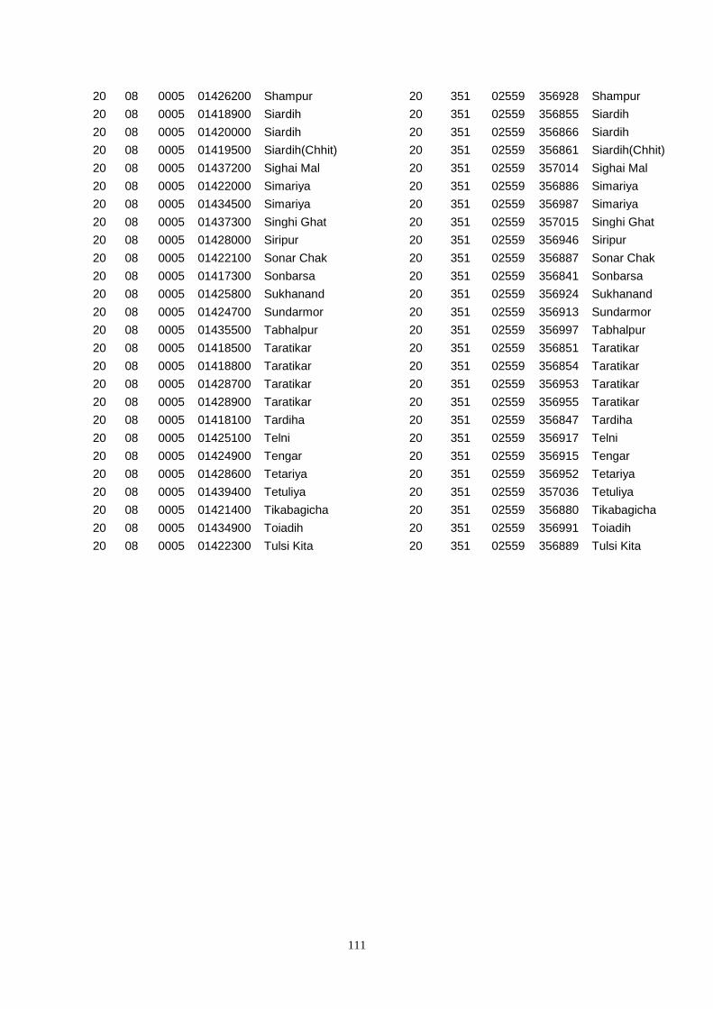
111
20 08 0005 01426200 Shampur 20 351 02559 356928 Shampur
20 08 0005 01418900 Siardih 20 351 02559 356855 Siardih
20 08 0005 01420000 Siardih 20 351 02559 356866 Siardih
20 08 0005 01419500 Siardih(Chhit) 20 351 02559 356861 Siardih(Chhit)
20 08 0005 01437200 Sighai Mal 20 351 02559 357014 Sighai Mal
20 08 0005 01422000 Simariya 20 351 02559 356886 Simariya
20 08 0005 01434500 Simariya 20 351 02559 356987 Simariya
20 08 0005 01437300 Singhi Ghat 20 351 02559 357015 Singhi Ghat
20 08 0005 01428000 Siripur 20 351 02559 356946 Siripur
20 08 0005 01422100 Sonar Chak 20 351 02559 356887 Sonar Chak
20 08 0005 01417300 Sonbarsa 20 351 02559 356841 Sonbarsa
20 08 0005 01425800 Sukhanand 20 351 02559 356924 Sukhanand
20 08 0005 01424700 Sundarmor 20 351 02559 356913 Sundarmor
20 08 0005 01435500 Tabhalpur 20 351 02559 356997 Tabhalpur
20 08 0005 01418500 Taratikar 20 351 02559 356851 Taratikar
20 08 0005 01418800 Taratikar 20 351 02559 356854 Taratikar
20 08 0005 01428700 Taratikar 20 351 02559 356953 Taratikar
20 08 0005 01428900 Taratikar 20 351 02559 356955 Taratikar
20 08 0005 01418100 Tardiha 20 351 02559 356847 Tardiha
20 08 0005 01425100 Telni 20 351 02559 356917 Telni
20 08 0005 01424900 Tengar 20 351 02559 356915 Tengar
20 08 0005 01428600 Tetariya 20 351 02559 356952 Tetariya
20 08 0005 01439400 Tetuliya 20 351 02559 357036 Tetuliya
20 08 0005 01421400 Tikabagicha 20 351 02559 356880 Tikabagicha
20 08 0005 01434900 Toiadih 20 351 02559 356991 Toiadih
20 08 0005 01422300 Tulsi Kita 20 351 02559 356889 Tulsi Kita
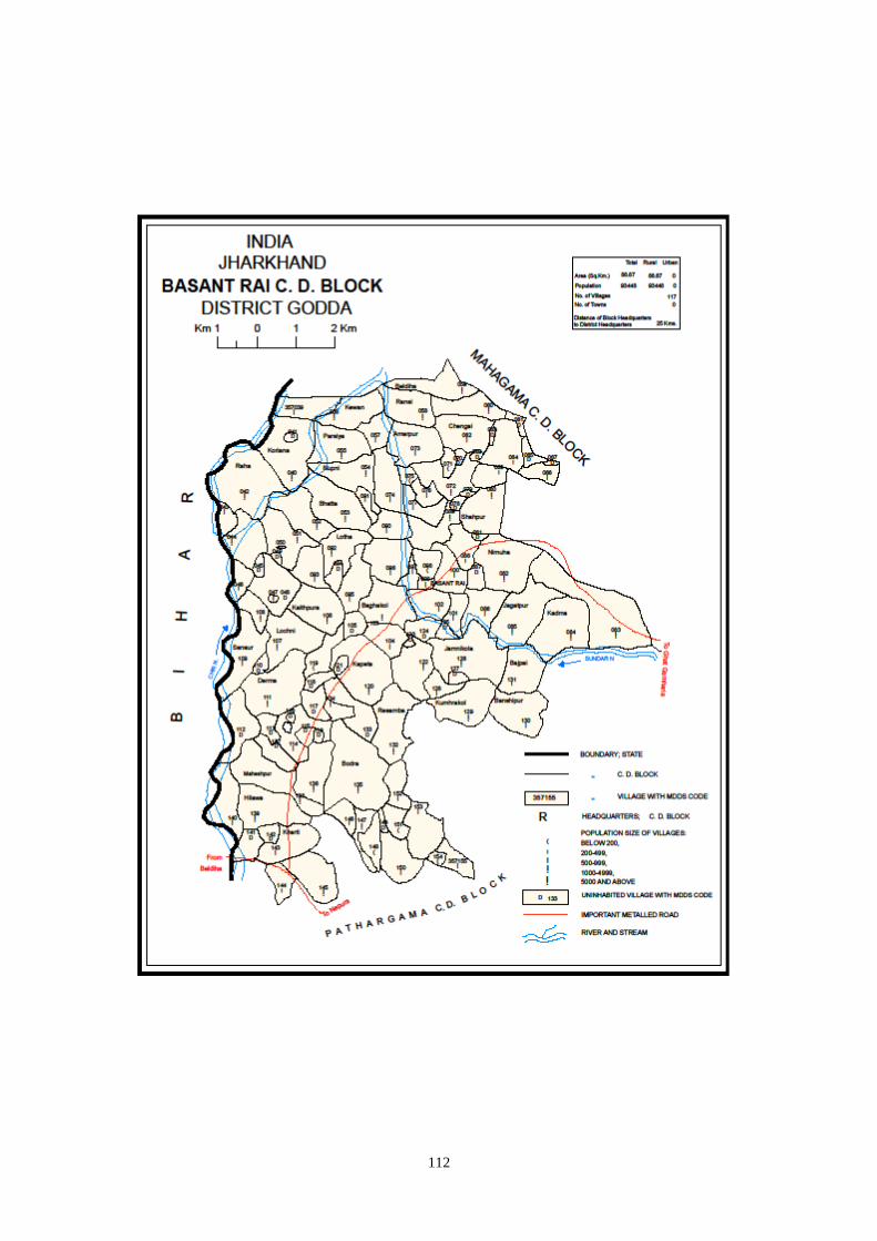
112

113
Census 2001 Codes MDDS e-GOVERNANCE CODE (Census 2011 PLCN)
STC
2001
DTC
2001
Sub-
DT
2001
PLCN 2001
NAME OF STATE,
DISTRICTS, SUB-
DISTTS. &
VILLAGES 2001
MDDS
STC
MDDS
DTC
MDDS
Sub_DT
MDDS
PLCN
MDDS NAME OF STATE,
DISTRICT, SUB-DISTTS.
& VILLAGES
20 08 0000 00000000 Godda 20 351 00000 000000 Godda
20 08 0000 00000000 Bashant Rai* 20 351 02560 000000 Bashant Rai*
20 08 0005 01413400 Aichamor 20 351 02560 357091 Aichamor
20 08 0005 01411600 Amarpur 20 351 02560 357073 Amarpur
20 08 0005 01431300 Amarpur Ghal 20 351 02560 357145 Amarpur Ghal
20 08 0005 01409200 Arazi Dhapra 20 351 02560 357049 Arazi Dhapra
20 08 0005 01411400 Arazi Kaithiya 20 351 02560 357071 Arazi Kaithiya
20 08 0005 01430700 Arazi Kharti 20 351 02560 357142 Arazi Kharti
20 08 0005 01408400 Arazi Koriana 20 351 02560 357041 Arazi Koriana
20 08 0005 01408800 Arazi Maheshtikri 20 351 02560 357045 Arazi Maheshtikri
20 08 0005 01409000 Arazi Majar Buzurg 20 351 02560 357047 Arazi Majar Buzurg
20 08 0005 01416600 Arazi Pakariya 20 351 02560 357123 Arazi Pakariya
20 08 0005 01431900 Arazi Surniya Ghat 20 351 02560 357149 Arazi Surniya Ghat
20 08 0005 01408600 Bade 20 351 02560 357043 Bade
20 08 0005 01414600 Baghakol 20 351 02560 357103 Baghakol
20 08 0005 01417500 Bajpai 20 351 02560 357131 Bajpai
20 08 0005 01411700 Baniyadih 20 351 02560 357074 Baniyadih
20 08 0005 01417400 Banshipur 20 351 02560 357130 Banshipur
20 08 0005 01430200 Barhaiya 20 351 02560 357137 Barhaiya
20 08 0005 01429900 Barhampur 20 351 02560 357134 Barhampur
20 08 0005 01431100 Barhara 20 351 02560 357144 Barhara
20 08 0005 01414100 Basan Sarai Gadal 20 351 02560 357098 Basan Sarai Gadal
20 08 0005 01414000 Basantpur 20 351 02560 357097 Basantpur
20 08 0005 01414200 Basantrai 20 351 02560 357099 Basantrai
20 08 0005 01414500 Baskhoriya 20 351 02560 357102 Baskhoriya
20 08 0005 01414400 Bela Kita 20 351 02560 357101 Bela Kita
20 08 0005 01410200 Beldiha 20 351 02560 357059 Beldiha
20 08 0005 01409600 Bhatta 20 351 02560 357053 Bhatta
20 08 0005 01429800 Bhira 20 351 02560 357133 Bhira
20 08 0005 01413800 Bisambhar Chak 20 351 02560 357095 Bisambhar Chak
20 08 0005 01410300 Bishundas Chak 20 351 02560 357060 Bishundas Chak
20 08 0005 01430000 Bodra 20 351 02560 357135 Bodra
20 08 0005 01430500 Chanai Chak 20 351 02560 357140 Chanai Chak
20 08 0005 01412200 Chaurgonar Kita 20 351 02560 357079 Chaurgonar Kita
20 08 0005 01410500 Chengai 20 351 02560 357062 Chengai
20 08 0005 01410600 Chengai Kita 20 351 02560 357063 Chengai Kita
20 08 0005 01415600 Chutiyan 20 351 02560 357113 Chutiyan
20 08 0005 01432600 Goddaa Jagir 20 351 02560 357153 Goddaa Jagir
20 08 0005 01415400 Derma 20 351 02560 357111 Derma
20 08 0005 01415500 Deshbarag 20 351 02560 357112 Deshbarag
114
20 08 0005 01432100 Dewgharamal 20 351 02560 357151 Dewgharamal
20 08 0005 01409400 Dhapra 20 351 02560 357051 Dhapra
20 08 0005 01409300 Dhapra Kita 20 351 02560 357050 Dhapra Kita
20 08 0005 01432800 Gangti Jagir 20 351 02560 357155 Gangti Jagir
20 08 0005 01432700 Gangti Kita 20 351 02560 357154 Gangti Kita
20 08 0005 01415300 Gathaur 20 351 02560 357110 Gathaur
20 08 0005 01410700 Ghat Lachhimipur 20 351 02560 357064 Ghat Lachhimipur
20 08 0005 01416000 Gobindpur Kita 20 351 02560 357117 Gobindpur Kita
20 08 0005 01412000 Gopi Chak 20 351 02560 357077 Gopi Chak
20 08 0005 01408200 Gorgawan 20 351 02560 357039 Gorgawan
20 08 0005 01411900 Gouri Kita 20 351 02560 357076 Gouri Kita
20 08 0005 01411000 Hafta Kitaghat 20 351 02560 357067 Hafta Kitaghat
20 08 0005 01414700 Harganman 20 351 02560 357104 Harganman
20 08 0005 01430400 Hilawa 20 351 02560 357139 Hilawa
20 08 0005 01416700 Jadu Chak 20 351 02560 357124 Jadu Chak
20 08 0005 01412800 Jagatpur 20 351 02560 357085 Jagatpur
20 08 0005 01416900 Jamnikola 20 351 02560 357126 Jamnikola
20 08 0005 01413600 Jhapaniya 20 351 02560 357093 Jhapaniya
20 08 0005 01412700 Kadma 20 351 02560 357084 Kadma
20 08 0005 01411500 Kaithiya 20 351 02560 357072 Kaithiya
20 08 0005 01414900 Kaithpura 20 351 02560 357106 Kaithpura
20 08 0005 01411200 Kakelachaur 20 351 02560 357069 Kakelachaur
20 08 0005 01416300 Kapeta 20 351 02560 357120 Kapeta
20 08 0005 01417000 Kapra Chak 20 351 02560 357127 Kapra Chak
20 08 0005 01416400 Karu Chak 20 351 02560 357121 Karu Chak
20 08 0005 01409900 Kewan 20 351 02560 357056 Kewan
20 08 0005 01410400 Kharauni Jagarnathpur 20 351 02560 357061
Kharauni Jagarnathpur
20 08 0005 01410800 Kharauni Jagarnathpur 20 351 02560 357065
Kharauni Jagarnathpur
20 08 0005 01430800 Kharti 20 351 02560 357143 Kharti
20 08 0005 01411800 Kita Baniyadih 20 351 02560 357075 Kita Baniyadih
20 08 0005 01413100 Kita Kendua 20 351 02560 357088 Kita Kendua
20 08 0005 01414800 Kola Kita 20 351 02560 357105 Kola Kita
20 08 0005 01413900 Kolhadda 20 351 02560 357096 Kolhadda
20 08 0005 01408300 Koriana 20 351 02560 357040 Koriana
20 08 0005 01417200 Kumhrakol 20 351 02560 357129 Kumhrakol
20 08 0005 01413000 Lalman Kita 20 351 02560 357087 Lalman Kita
20 08 0005 01415000 Lochni 20 351 02560 357107 Lochni
20 08 0005 01413500 Lotha 20 351 02560 357092 Lotha
20 08 0005 01411100 Mahadew Kita 20 351 02560 357068 Mahadew Kita
20 08 0005 01430300 Maheshpur 20 351 02560 357138 Maheshpur
20 08 0005 01408700 Maheshtikri 20 351 02560 357044 Maheshtikri
20 08 0005 01408900 Majar Khurd 20 351 02560 357046 Majar Khurd
20 08 0005 01413700 Majra Kol 20 351 02560 357094 Majra Kol
20 08 0005 01409100 Manjar Buzurg 20 351 02560 357048 Manjar Buzurg
115
20 08 0005 01412900 Mansha Bishunpur 20 351 02560 357086 Mansha Bishunpur
20 08 0005 01412600 Medni Chak 20 351 02560 357083 Medni Chak
20 08 0005 01413300 Mokal Chak 20 351 02560 357090 Mokal Chak
20 08 0005 01410900 Nakta 20 351 02560 357066 Nakta
20 08 0005 01412500 Nimuha 20 351 02560 357082 Nimuha
20 08 0005 01415100 Pachua Kita 20 351 02560 357108 Pachua Kita
20 08 0005 01416500 Pakariya 20 351 02560 357122 Pakariya
20 08 0005 01416800 Paradharichak 20 351 02560 357125 Paradharichak
20 08 0005 01410000 Parbatta 20 351 02560 357057 Parbatta
20 08 0005 01409800 Parsiya 20 351 02560 357055 Parsiya
20 08 0005 01432200 Phasiya 20 351 02560 357152 Phasiya
20 08 0005 01432000 Phulwariya 20 351 02560 357150 Phulwariya
20 08 0005 01411300 Pindar Kita 20 351 02560 357070 Pindar Kita
20 08 0005 01412100 Piprachaur 20 351 02560 357078 Piprachaur
20 08 0005 01408500 Raha 20 351 02560 357042 Raha
20 08 0005 01415700 Rampur 20 351 02560 357114 Rampur
20 08 0005 01415900 Rampur Arazi 20 351 02560 357116 Rampur Arazi
20 08 0005 01415800 Rampur Mokarri 20 351 02560 357115 Rampur Mokarri
20 08 0005 01410100 Ransi 20 351 02560 357058 Ransi
20 08 0005 01429700 Resamba 20 351 02560 357132 Resamba
20 08 0005 01409700 Rupni 20 351 02560 357054 Rupni
20 08 0005 01409500 Sahoro 20 351 02560 357052 Sahoro
20 08 0005 01415200 Sanaur 20 351 02560 357109 Sanaur
20 08 0005 01413200 Sankhi 20 351 02560 357089 Sankhi
20 08 0005 01414300 Sankhi Khurd 20 351 02560 357100 Sankhi Khurd
20 08 0005 01412400 Sarkunda Kita 20 351 02560 357081 Sarkunda Kita
20 08 0005 01412300 Shahpur 20 351 02560 357080 Shahpur
20 08 0005 01416200 Shampur 20 351 02560 357119 Shampur
20 08 0005 01416100 Shampur Gobindpur 20 351 02560 357118 Shampur Gobindpur
20 08 0005 01417100 Surai Kita 20 351 02560 357128 Surai Kita
20 08 0005 01431600 Surniya Ghat Mal 20 351 02560 357146 Surniya Ghat Mal
20 08 0005 01431700 Surniya Mal Ghat 20 351 02560 357147 Surniya Mal Ghat
20 08 0005 01430100 Susti 20 351 02560 357136 Susti
20 08 0005 01431800 Tofil Surniya 20 351 02560 357148 Tofil Surniya
20 08 0005 01430600 Urkusiya 20 351 02560 357141 Urkusiya
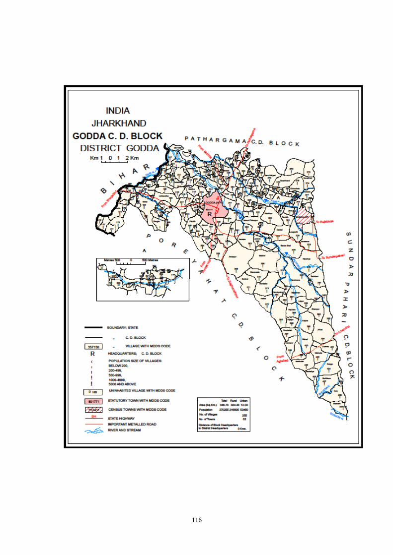
116
117
Census 2001 Codes MDDS e-GOVERNANCE CODE (Census 2011 PLCN)
STC
2001
DTC
2001
Sub-
DT
2001
PLCN 2001
NAME OF STATE,
DISTRICTS, SUB-DISTTS.
& VILLAGES 2001
MDDS
STC
MDDS
DTC
MDDS
Sub_DT
MDDS
PLCN
MDDS NAME OF
STATE, DISTRICT,
SUB-DISTTS. &
VILLAGES
20 08 0000 00000000 Godda 20 351 00000 000000 Godda
20 08 0006 00000000 Godda 20 351 02561 000000 Godda
20 08 0006 01444400 Algajora 20 351 02561 357203 Algajora
20 08 0006 01461100 Amarpur 20 351 02561 357369 Amarpur
20 08 0006 01440800 Amdanr 20 351 02561 357167 Amdanr
20 08 0006 01448600 Amdiha 20 351 02561 357245 Amdiha
20 08 0006 01453600 Amghata 20 351 02561 357294 Amghata
20 08 0006 01463700 Amjora 20 351 02561 357395 Amjora
20 08 0006 01441500 Amlo 20 351 02561 357174 Amlo
20 08 0006 01447800 Arwara 20 351 02561 357237 Arwara
20 08 0006 01441400 Baijnathpur 20 351 02561 357173 Baijnathpur
20 08 0006 01446500 Baliya 20 351 02561 357224 Baliya
20 08 0006 01461700 Banka Ghat 20 351 02561 357375 Banka Ghat
20 08 0006 01446300 Bansipur 20 351 02561 357222 Bansipur
20 08 0006 01447000 Bara 20 351 02561 357229 Bara
20 08 0006 01451100 Bara Kaliyani 20 351 02561 357270 Bara Kaliyani
20 08 0006 01442900 Barachaur 20 351 02561 357188 Barachaur
20 08 0006 01446100 Barahara 20 351 02561 357220 Barahara
20 08 0006 01461200 Baramasia 20 351 02561 357370 Baramasia
20 08 0006 01448500 Barhauna 20 351 02561 357244 Barhauna
20 08 0006 01462200 Baristanr 20 351 02561 357380 Baristanr
20 08 0006 01447900 Basarhi 20 351 02561 357238 Basarhi
20 08 0006 01462900 Belbathan 20 351 02561 357387 Belbathan
20 08 0006 01446000 Beldiha 20 351 02561 357219 Beldiha
20 08 0006 01458200 Bengbahiyar 20 351 02561 357340 Bengbahiyar
20 08 0006 01452100 Betiyabahiyar 20 351 02561 357280 Betiyabahiyar
20 08 0006 01449100 Bhadrahi Mal 20 351 02561 357250 Bhadrahi Mal
20 08 0006 01461900 Bhalpahari 20 351 02561 357377 Bhalpahari
20 08 0006 01456800 Bhandar Koli 20 351 02561 357326 Bhandar Koli
20 08 0006 01440900 Bharthikita 20 351 02561 357168 Bharthikita
20 08 0006 01458100 Bhatdiha 20 351 02561 357339 Bhatdiha
20 08 0006 01465200 Bhawani 20 351 02561 357410 Bhawani
20 08 0006 01444700 Bhawanipur 20 351 02561 357206 Bhawanipur
20 08 0006 01460300 Bilari 20 351 02561 357361 Bilari
20 08 0006 01462800 Birbal Tola 20 351 02561 357386 Birbal Tola
20 08 0006 01444800 Bishunpur 20 351 02561 357207 Bishunpur
20 08 0006 01454500 Bishunpur 20 351 02561 357303 Bishunpur
20 08 0006 01455600 Bishunpur 20 351 02561 357314 Bishunpur
20 08 0006 01441600 Bohoriya 20 351 02561 357175 Bohoriya
20 08 0006 01441700 Bokha 20 351 02561 357176 Bokha
118
20 08 0006 01447700 Burhi Salempur 20 351 02561 357236 Burhi Salempur
20 08 0006 01464900 Burhikura 20 351 02561 357407 Burhikura
20 08 0006 01448100 Chakwa 20 351 02561 357240 Chakwa
20 08 0006 01447400 Chandarpur 20 351 02561 357233 Chandarpur
20 08 0006 01446900 Chapri 20 351 02561 357228 Chapri
20 08 0006 01452700 Charkakol Ghat 20 351 02561 357285 Charkakol Ghat
20 08 0006 01454100 Charkakol Ghat 20 351 02561 357299 Charkakol Ghat
20 08 0006 01440500 Chhota Harakita 20 351 02561 357164 Chhota Harakita
20 08 0006 01451000 Chhota Kaliyani 20 351 02561 357269 Chhota Kaliyani
20 08 0006 01449300 Chilauna 20 351 02561 357252 Chilauna
20 08 0006 01451700 Chinadhab 20 351 02561 357276 Chinadhab
20 08 0006 01457600 Daldali 20 351 02561 357334 Daldali
20 08 0006 01440000 Dalpatpur 20 351 02561 357159 Dalpatpur
20 08 0006 01464600 Danga 20 351 02561 357404 Danga
20 08 0006 01449700 Dara Chak 20 351 02561 357256 Dara Chak
20 08 0006 01440600 Darghatta 20 351 02561 357165 Darghatta
20 08 0006 01440700 Darghatti 20 351 02561 357166 Darghatti
20 08 0006 01444100 Devpur 20 351 02561 357200 Devpur
20 08 0006 01459600 Dharmudih 20 351 02561 357354 Dharmudih
20 08 0006 01462500 Dhokal Tola 20 351 02561 357383 Dhokal Tola
20 08 0006 01441200 Dholi Chak 20 351 02561 357171 Dholi Chak
20 08 0006 01448300 Diyara 20 351 02561 357242 Diyara
20 08 0006 01439900 Dodhari 20 351 02561 357158 Dodhari
20 08 0006 01445500 Dokabandh 20 351 02561 357214 Dokabandh
20 08 0006 01445000 Dubrajpur 20 351 02561 357209 Dubrajpur
20 08 0006 01465100 Dulu 20 351 02561 357409 Dulu
20 08 0006 01440400 Dumariya 20 351 02561 357163 Dumariya
20 08 0006 01449500 Dumariya Mal 20 351 02561 357254 Dumariya Mal
20 08 0006 01464300 Dumma 20 351 02561 357401 Dumma
20 08 0006 01442100 Dusadhi Kola 20 351 02561 357180 Dusadhi Kola
20 08 0006 01451600 Gaechhand 20 351 02561 357275 Gaechhand
20 08 0006 01449000 Galapahar 20 351 02561 357249 Galapahar
20 08 0006 01442800 Gangta 20 351 02561 357187 Gangta
20 08 0006 01441800 Gangta Phasiya 20 351 02561 357177 Gangta Phasiya
20 08 0006 01448900 Garbana 20 351 02561 357248 Garbana
20 08 0006 01440300 Garurakita 20 351 02561 357162 Garurakita
20 08 0006 01449200 Ghat Bhadrahi 20 351 02561 357251 Ghat Bhadrahi
20 08 0006 01450100 Ghat Dhamsain 20 351 02561 357260 Ghat Dhamsain
20 08 0006 01450200 Ghat Dhamsain 20 351 02561 357261 Ghat Dhamsain
20 08 0006 01453700 Ghat Dumariya 20 351 02561 357295 Ghat Dumariya
20 08 0006 01455800 Ghat Dumariya 20 351 02561 357316 Ghat Dumariya
20 08 0006 01449800 Ghat Gorsanda 20 351 02561 357257 Ghat Gorsanda
20 08 0006 01460400 Ghat Jamuni 20 351 02561 357362 Ghat Jamuni
20 08 0006 01460600 Ghat Jhilua 20 351 02561 357364 Ghat Jhilua
20 08 0006 01460800 Ghat Jopnadih 20 351 02561 357366 Ghat Jopnadih
20 08 0006 01456500 Ghat Paharpur 20 351 02561 357323 Ghat Paharpur
119
20 08 0006 01457100 Ghat Paharpur 20 351 02561 357329 Ghat Paharpur
20 08 0006 01457300 Ghat Paharpur 20 351 02561 357331 Ghat Paharpur
20 08 0006 01457800 Ghat Paharpur 20 351 02561 357336 Ghat Paharpur
20 08 0006 01459000 Gorhighat Chhit 20 351 02561 357348 Gorhighat Chhit
20 08 0006 01456700 Gorka Kita 20 351 02561 357325 Gorka Kita
20 08 0006 01445100 Gurguri 20 351 02561 357210 Gurguri
20 08 0006 01457000 Haripur 20 351 02561 357328 Haripur
20 08 0006 01465000 Haripur 20 351 02561 357408 Haripur
20 08 0006 01456900 Harlal Tola 20 351 02561 357327 Harlal Tola
20 08 0006 01446200 Harpati Chak 20 351 02561 357221 Harpati Chak
20 08 0006 01463800 Hijaljor 20 351 02561 357396 Hijaljor
20 08 0006 01462700 Jainagar Piprajoria 20 351 02561 357385 Jainagar Piprajoria
20 08 0006 01448400 Jaipur 20 351 02561 357243 Jaipur
20 08 0006 01462300 Jalgar 20 351 02561 357381 Jalgar
20 08 0006 01464700 Jamkudar 20 351 02561 357405 Jamkudar
20 08 0006 01459200 Jamua 20 351 02561 357350 Jamua
20 08 0006 01457700 Jamuni Paharpur 20 351 02561 357335 Jamuni Paharpur
20 08 0006 01463300 Jhagarahi 20 351 02561 357391 Jhagarahi
20 08 0006 01442600 Jharkata 20 351 02561 357185 Jharkata
20 08 0006 01463600 Jhilua 20 351 02561 357394 Jhilua
20 08 0006 01461400 Kadwa 20 351 02561 357372 Kadwa
20 08 0006 01439700 Kaithpujha 20 351 02561 357156 Kaithpujha
20 08 0006 01452600 Kajradah 20 351 02561 357284 Kajradah
20 08 0006 01453900 Kajradah 20 351 02561 357297 Kajradah
20 08 0006 01447300 Kakana 20 351 02561 357232 Kakana
20 08 0006 01463400 Kalhajor Kalan 20 351 02561 357392 Kalhajor Kalan
20 08 0006 01464100 Kalhajor Khurd 20 351 02561 357399 Kalhajor Khurd
20 08 0006 01455700 Kalyani Kita 20 351 02561 357315 Kalyani Kita
20 08 0006 01458900 Kanadih Chhit 20 351 02561 357347 Kanadih Chhit
20 08 0006 01448800 Kanhwara 20 351 02561 357247 Kanhwara
20 08 0006 01459100 Kanidih Chhit 20 351 02561 357349 Kanidih Chhit
20 08 0006 01464500 Karam Tola 20 351 02561 357403 Karam Tola
20 08 0006 01464000 Karanpur 20 351 02561 357398 Karanpur
20 08 0006 01453300 Karhariya Ghat 20 351 02561 357291 Karhariya Ghat
20 08 0006 01455100 Karhariya Ghat 20 351 02561 357309 Karhariya Ghat
20 08 0006 01453000 Karhariya Mal 20 351 02561 357288 Karhariya Mal
20 08 0006 01453500 Karhariya Mal 20 351 02561 357293 Karhariya Mal
20 08 0006 01443000 Karikado 20 351 02561 357189 Karikado
20 08 0006 01452000 Karmatanr 20 351 02561 357279 Karmatanr
20 08 0006 01451400 Karudih 20 351 02561 357273 Karudih
20 08 0006 01456400 Kasba Godda 20 351 02561 357322 Kasba Godda
20 08 0006 01457200 Kasba Godda 20 351 02561 357330 Kasba Godda
20 08 0006 01454700 Kathaun 20 351 02561 357305 Kathaun
20 08 0006 01445400 Kathra 20 351 02561 357213 Kathra
20 08 0006 01451500 Kauadhab 20 351 02561 357274 Kauadhab
120
20 08 0006 01458600 Kauribahiyar Ghat 20 351 02561 357344 Kauribahiyar Ghat
20 08 0006 01458700 Kauribahiyar Mal 20 351 02561 357345 Kauribahiyar Mal
20 08 0006 01458500 Kauribahiyarmal Chhit 20 351 02561 357343 Kauribahiyarmal Chhit
20 08 0006 01450300 Khaira Mal 20 351 02561 357262 Khaira Mal
20 08 0006 01441300 Khatnahi 20 351 02561 357172 Khatnahi
20 08 0006 01456200 Kita Gawar 20 351 02561 357320 Kita Gawar
20 08 0006 01455000 Kita Gorgawan 20 351 02561 357308 Kita Gorgawan
20 08 0006 01456300 Kita Gorgawan 20 351 02561 357321 Kita Gorgawan
20 08 0006 01454900 Kita Parariya Ghat 20 351 02561 357307 Kita Parariya Ghat
20 08 0006 01453800 Kita Pelgarhi Dhopahari 20 351 02561 357296
Kita Pelgarhi Dhopahari
20 08 0006 01455900 Kita Shampur 20 351 02561 357317 Kita Shampur
20 08 0006 01456100 Kita Thathar 20 351 02561 357319 Kita Thathar
20 08 0006 01445300 Kitabuidi 20 351 02561 357212 Kitabuidi
20 08 0006 01453100 Kubji Ghat 20 351 02561 357289 Kubji Ghat
20 08 0006 01441100 Kumar Kund 20 351 02561 357170 Kumar Kund
20 08 0006 01459800 Kumardih 20 351 02561 357356 Kumardih
20 08 0006 01444200 Kumarreri 20 351 02561 357201 Kumarreri
20 08 0006 01463900 Kundadah 20 351 02561 357397 Kundadah
20 08 0006 01446400 Kurma 20 351 02561 357223 Kurma
20 08 0006 01459300 Kurman Ghat 20 351 02561 357351 Kurman Ghat
20 08 0006 01459500 Kurman Mal 20 351 02561 357353 Kurman Mal
20 08 0006 01452500 Kurmi Chak 20 351 02561 357283 Kurmi Chak
20 08 0006 01456000 Kusmain Ghat Chhit 20 351 02561 357318 Kusmain Ghat Chhit
20 08 0006 01454300 Kusmainimal 20 351 02561 357301 Kusmainimal
20 08 0006 01455200 Kusmani Ghat 20 351 02561 357310 Kusmani Ghat
20 08 0006 01442000 Kusmara 20 351 02561 357179 Kusmara
20 08 0006 01456600 Kutni Pathar 20 351 02561 357324 Kutni Pathar
20 08 0006 01454600 Kutnipathar 20 351 02561 357304 Kutnipathar
20 08 0006 01447100 Lacchmipur 20 351 02561 357230 Lacchmipur
20 08 0006 01443200 Lachhanpur 20 351 02561 357191 Lachhanpur
20 08 0006 01460700 Lachhmi 20 351 02561 357365 Lachhmi
20 08 0006 01463100 Lalpur 20 351 02561 357389 Lalpur
20 08 0006 01459400 Lamhati Kar 20 351 02561 357352 Lamhati Kar
20 08 0006 01461800 Langradih 20 351 02561 357376 Langradih
20 08 0006 01443600 Lohbandha 20 351 02561 357195 Lohbandha
20 08 0006 01450600 Lukluki Ghat 20 351 02561 357265 Lukluki Ghat
20 08 0006 01450500 Lukluki Mal 20 351 02561 357264 Lukluki Mal
20 08 0006 01448200 Machhiya Samarda Urf Lalpur 20 351 02561 357241
Machhiya Samarda Urf Lalpur
20 08 0006 01452800 Mahugariya 20 351 02561 357286 Mahugariya
20 08 0006 01441000 Majhdiha 20 351 02561 357169 Majhdiha
20 08 0006 01460900 Majhdiha 20 351 02561 357367 Majhdiha
20 08 0006 01461000 Makhni 20 351 02561 357368 Makhni
121
20 08 0006 01445600 Makunddih 20 351 02561 357215 Makunddih
20 08 0006 01445700 Makunddin (Santoli) 20 351 02561 357216 Makunddin (Santoli)
20 08 0006 01450000 Mal Dhamsain 20 351 02561 357259 Mal Dhamsain
20 08 0006 01453400 Mal Domuria 20 351 02561 357292 Mal Domuria
20 08 0006 01449900 Mal Gorsanda 20 351 02561 357258 Mal Gorsanda
20 08 0006 01442200 Maldiha 20 351 02561 357181 Maldiha
20 08 0006 01452400 Malhra 20 351 02561 357282 Malhra
20 08 0006 01441900 Malipalgajia 20 351 02561 357178 Malipalgajia
20 08 0006 01464400 Malmala 20 351 02561 357402 Malmala
20 08 0006 01448000 Malni 20 351 02561 357239 Malni
20 08 0006 01455500 Manjwara Ghat 20 351 02561 357313 Manjwara Ghat
20 08 0006 01444900 Manpur 20 351 02561 357208 Manpur
20 08 0006 01457500 Markhan 20 351 02561 357333 Markhan
20 08 0006 01458400 Maruabaran 20 351 02561 357342 Maruabaran
20 08 0006 01454200 Masudanpur 20 351 02561 357300 Masudanpur
20 08 0006 01457400 Mohanpur 20 351 02561 357332 Mohanpur
20 08 0006 01446600 Molnakita 20 351 02561 357225 Molnakita
20 08 0006 01442400 Motia 20 351 02561 357183 Motia
20 08 0006 01459900 Murlidih Kita 20 351 02561 357357 Murlidih Kita
20 08 0006 01462600 Nandupahari 20 351 02561 357384 Nandupahari
20 08 0006 01444000 Nankhil 20 351 02561 357199 Nankhil
20 08 0006 01449600 Naya Chak 20 351 02561 357255 Naya Chak
20 08 0006 01443100 Nayabad 20 351 02561 357190 Nayabad
20 08 0006 01447200 Nepura 20 351 02561 357231 Nepura
20 08 0006 01446800 Nilkanthpur 20 351 02561 357227 Nilkanthpur
20 08 0006 01462100 Nipaniya 20 351 02561 357379 Nipaniya
20 08 0006 01461500 Nonbatta 20 351 02561 357373 Nonbatta
20 08 0006 01457900 Nonmati 20 351 02561 357337 Nonmati
20 08 0006 01450400 Pachrukhi 20 351 02561 357263 Pachrukhi
20 08 0006 01458800 Pairdih 20 351 02561 357346 Pairdih
20 08 0006 01445800 Pakariya Mal 20 351 02561 357217 Pakariya Mal
20 08 0006 01445900 Pakarya Ghat 20 351 02561 357218 Pakarya Ghat
20 08 0006 01447600 Panch Kathi 20 351 02561 357235 Panch Kathi
20 08 0006 01460500 Pandaha 20 351 02561 357363 Pandaha
20 08 0006 01460000 Pandubathan 20 351 02561 357358 Pandubathan
20 08 0006 01440200 Parara 20 351 02561 357161 Parara
20 08 0006 01447500 Parariya 20 351 02561 357234 Parariya
20 08 0006 01454800 Parariya Mal 20 351 02561 357306 Parariya Mal
20 08 0006 01444600 Parasi 20 351 02561 357205 Parasi
20 08 0006 01448700 Parsa 20 351 02561 357246 Parsa
20 08 0006 01450800 Pathariya Ghat 20 351 02561 357267 Pathariya Ghat
20 08 0006 01450700 Pathariya Mal 20 351 02561 357266 Pathariya Mal
20 08 0006 01450900 Pathariya Mal 20 351 02561 357268 Pathariya Mal
20 08 0006 01460200 Pathra 20 351 02561 357360 Pathra
20 08 0006 01451200 Pathriya Mal 20 351 02561 357271 Pathriya Mal
122
20 08 0006 01453200 Pathwara 20 351 02561 357290 Pathwara
20 08 0006 01446700 Patpur 20 351 02561 357226 Patpur
20 08 0006 01442700 Patwa 20 351 02561 357186 Patwa
20 08 0006 01451900 Pelgarhi Dhopahari 20 351 02561 357278 Pelgarhi Dhopahari
20 08 0006 01459700 Punsiya 20 351 02561 357355 Punsiya
20 08 0006 01463000 Raj Daha 20 351 02561 357388 Raj Daha
20 08 0006 01454000 Rajpura 20 351 02561 357298 Rajpura
20 08 0006 01443900 Ramla Dikwani 20 351 02561 357198 Ramla Dikwani
20 08 0006 01443800 Ramla Santali 20 351 02561 357197 Ramla Santali
20 08 0006 01442500 Rampur 20 351 02561 357184 Rampur
20 08 0006 01449400 Rampur 20 351 02561 357253 Rampur
20 08 0006 01452300 Ranidih 20 351 02561 357281 Ranidih
20 08 0006 01455300 Ratanpur 20 351 02561 357311 Ratanpur
20 08 0006 01452900 Ratrati 20 351 02561 357287 Ratrati
20 08 0006 01445200 Reni 20 351 02561 357211 Reni
20 08 0006 01458300 Rupiyamal 20 351 02561 357341 Rupiyamal
20 08 0006 01451300 Sabaijor 20 351 02561 357272 Sabaijor
20 08 0006 01464200 Sahari 20 351 02561 357400 Sahari
20 08 0006 01463500 Saharpur 20 351 02561 357393 Saharpur
20 08 0006 01444300 Saidapur 20 351 02561 357202 Saidapur
20 08 0006 01462400 Sandmara 20 351 02561 357382 Sandmara
20 08 0006 01452200 Sarauni 20 351 02561 357411 Sarauni (CT)
20 08 0006 01460100 Sarkanda 20 351 02561 357359 Sarkanda
20 08 0006 01458000 Sarotiya 20 351 02561 357338 Sarotiya
20 08 0006 01454400 Sasan 20 351 02561 357302 Sasan
20 08 0006 01439800 Saurpachisa 20 351 02561 357157 Saurpachisa
20 08 0006 01463200 Shampur 20 351 02561 357390 Shampur
20 08 0006 01464800 Siarkatiya 20 351 02561 357406 Siarkatiya
20 08 0006 01443500 Sikatia 20 351 02561 357194 Sikatia
20 08 0006 01442300 Simariya 20 351 02561 357182 Simariya
20 08 0006 01444500 Sinhpur 20 351 02561 357204 Sinhpur
20 08 0006 01440100 Sirsi 20 351 02561 357160 Sirsi
20 08 0006 01461300 Sonjhar 20 351 02561 357371 Sonjhar
20 08 0006 01462000 Sundarmor 20 351 02561 357378 Sundarmor
20 08 0006 01443300 Susunia 20 351 02561 357192 Susunia
20 08 0006 01443400 Tabalpur 20 351 02561 357193 Tabalpur
20 08 0006 01455400 Tarwari 20 351 02561 357312 Tarwari
20 08 0006 01461600 Teldiha 20 351 02561 357374 Teldiha
20 08 0006 01451800 Tilobadar 20 351 02561 357277 Tilobadar
20 08 0006 01443700 Tuka 20 351 02561 357196 Tuka
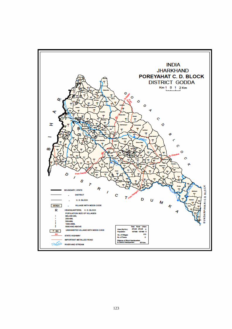
123
124
Census 2001 Codes MDDS e-GOVERNANCE CODE (Census 2011 PLCN)
STC
2001
DTC
2001
Sub-DT
2001 PLCN 2001
NAME OF STATE,
DISTRICTS, SUB-
DISTTS. & VILLAGES
2001
MDDS
STC
MDDS
DTC
MDDS
Sub_DT
MDDS
PLCN
MDDS NAME OF STATE,
DISTRICT, SUB-DISTTS.
& VILLAGES
20 08 0000 00000000 Godda 20 351 00000 000000 Godda
20 08 0007 00000000 Poreyahat 20 351 02562 000000 Poreyahat
20 08 0007 01484000 Agiabandh 20 351 02562 357599 Agiabandh
20 08 0007 01480300 Akasi 20 351 02562 357562 Akasi
20 08 0007 01473800 Akhra 20 351 02562 357497 Akhra
20 08 0007 01484800 Ambadiha 20 351 02562 357607 Ambadiha
20 08 0007 01478900 Amduma 20 351 02562 357548 Amduma
20 08 0007 01480200 Amgachhi 20 351 02562 357561 Amgachhi
20 08 0007 01470900 Amjora 20 351 02562 357468 Amjora
20 08 0007 01465700 Amra Kamat 20 351 02562 357416 Amra Kamat
20 08 0007 01465900 Amra Kanauli 20 351 02562 357418 Amra Kanauli
20 08 0007 01465800 Amra Mochora Kamat 20 351 02562 357417
Amra Mochora Kamat
20 08 0007 01466000 Amra Mochora Kamat 20 351 02562 357419
Amra Mochora Kamat
20 08 0007 01472200 Amwar (Santali) 20 351 02562 357481 Amwar (Santali)
20 08 0007 01472300 Amwar(Dikuani) 20 351 02562 357482 Amwar(Dikuani)
20 08 0007 01465400 Andadih 20 351 02562 357413 Andadih
20 08 0007 01471500 Arazi Kita Sahuri 20 351 02562 357474 Arazi Kita Sahuri
20 08 0007 01467100 Asarimadhuri 20 351 02562 357430 Asarimadhuri
20 08 0007 01486200 Asna 20 351 02562 357621 Asna
20 08 0007 01474100 Baghakol 20 351 02562 357500 Baghakol
20 08 0007 01484300 Baghmara 20 351 02562 357602 Baghmara
20 08 0007 01484900 Baghmara Purabtola 20 351 02562 357608 Baghmara Purabtola
20 08 0007 01482000 Baghmunda 20 351 02562 357579 Baghmunda
20 08 0007 01466500 Baksara 20 351 02562 357424 Baksara
20 08 0007 01470800 Balathar 20 351 02562 357467 Balathar
20 08 0007 01466400 Baliya Kita 20 351 02562 357423 Baliya Kita
20 08 0007 01469600 Balua 20 351 02562 357455 Balua
20 08 0007 01478600 Bandhaghat 20 351 02562 357545 Bandhaghat
20 08 0007 01483500 Banjhi 20 351 02562 357594 Banjhi
20 08 0007 01485200 Bankati 20 351 02562 357611 Bankati
20 08 0007 01483000 Bansmati 20 351 02562 357589 Bansmati
20 08 0007 01482800 Bansmuri 20 351 02562 357587 Bansmuri
20 08 0007 01483100 Bara 20 351 02562 357590 Bara
20 08 0007 01472100 Bara Chapar 20 351 02562 357480 Bara Chapar
20 08 0007 01481400 Baramasiya 20 351 02562 357573 Baramasiya
20 08 0007 01470300 Barga Chhahariyari 20 351 02562 357462 Barga Chhahariyari
20 08 0007 01471200 Bargaon 20 351 02562 357471 Bargaon
20 08 0007 01471700 Barkabaiso 20 351 02562 357476 Barkabaiso
20 08 0007 01468000 Basantpur 20 351 02562 357439 Basantpur
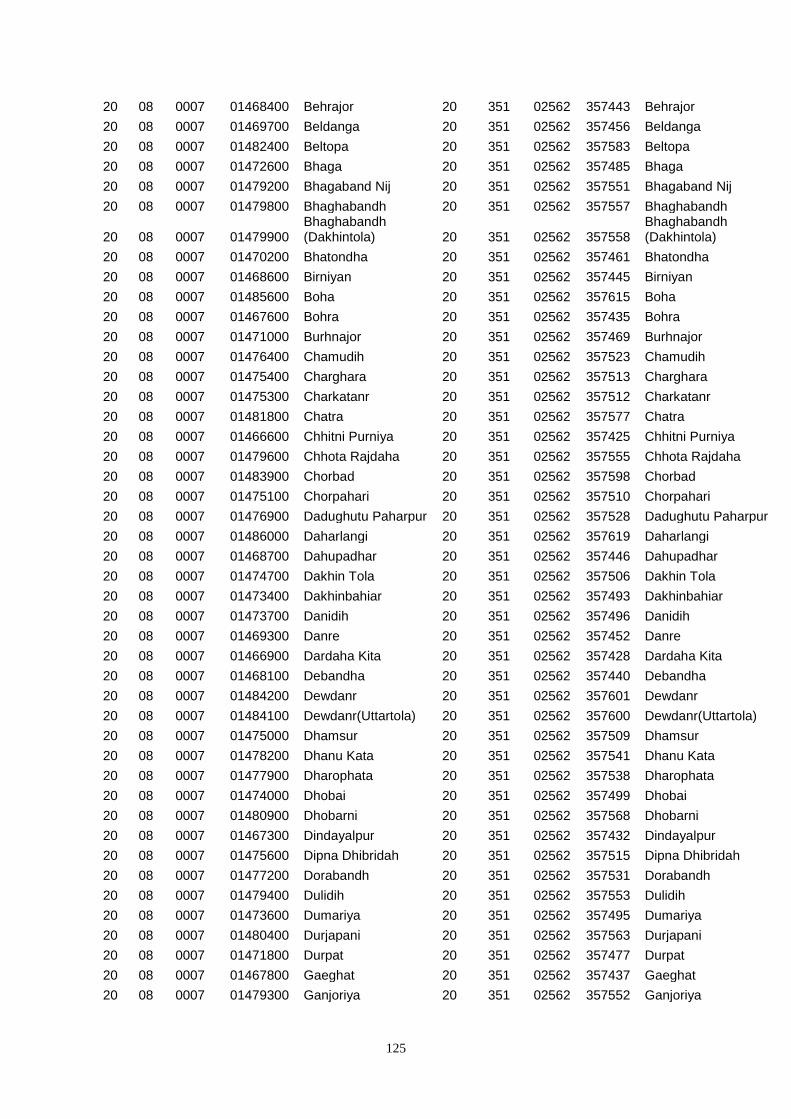
125
20 08 0007 01468400 Behrajor 20 351 02562 357443 Behrajor
20 08 0007 01469700 Beldanga 20 351 02562 357456 Beldanga
20 08 0007 01482400 Beltopa 20 351 02562 357583 Beltopa
20 08 0007 01472600 Bhaga 20 351 02562 357485 Bhaga
20 08 0007 01479200 Bhagaband Nij 20 351 02562 357551 Bhagaband Nij
20 08 0007 01479800 Bhaghabandh 20 351 02562 357557 Bhaghabandh
20 08 0007 01479900 Bhaghabandh (Dakhintola) 20 351 02562 357558
Bhaghabandh (Dakhintola)
20 08 0007 01470200 Bhatondha 20 351 02562 357461 Bhatondha
20 08 0007 01468600 Birniyan 20 351 02562 357445 Birniyan
20 08 0007 01485600 Boha 20 351 02562 357615 Boha
20 08 0007 01467600 Bohra 20 351 02562 357435 Bohra
20 08 0007 01471000 Burhnajor 20 351 02562 357469 Burhnajor
20 08 0007 01476400 Chamudih 20 351 02562 357523 Chamudih
20 08 0007 01475400 Charghara 20 351 02562 357513 Charghara
20 08 0007 01475300 Charkatanr 20 351 02562 357512 Charkatanr
20 08 0007 01481800 Chatra 20 351 02562 357577 Chatra
20 08 0007 01466600 Chhitni Purniya 20 351 02562 357425 Chhitni Purniya
20 08 0007 01479600 Chhota Rajdaha 20 351 02562 357555 Chhota Rajdaha
20 08 0007 01483900 Chorbad 20 351 02562 357598 Chorbad
20 08 0007 01475100 Chorpahari 20 351 02562 357510 Chorpahari
20 08 0007 01476900 Dadughutu Paharpur 20 351 02562 357528 Dadughutu Paharpur
20 08 0007 01486000 Daharlangi 20 351 02562 357619 Daharlangi
20 08 0007 01468700 Dahupadhar 20 351 02562 357446 Dahupadhar
20 08 0007 01474700 Dakhin Tola 20 351 02562 357506 Dakhin Tola
20 08 0007 01473400 Dakhinbahiar 20 351 02562 357493 Dakhinbahiar
20 08 0007 01473700 Danidih 20 351 02562 357496 Danidih
20 08 0007 01469300 Danre 20 351 02562 357452 Danre
20 08 0007 01466900 Dardaha Kita 20 351 02562 357428 Dardaha Kita
20 08 0007 01468100 Debandha 20 351 02562 357440 Debandha
20 08 0007 01484200 Dewdanr 20 351 02562 357601 Dewdanr
20 08 0007 01484100 Dewdanr(Uttartola) 20 351 02562 357600 Dewdanr(Uttartola)
20 08 0007 01475000 Dhamsur 20 351 02562 357509 Dhamsur
20 08 0007 01478200 Dhanu Kata 20 351 02562 357541 Dhanu Kata
20 08 0007 01477900 Dharophata 20 351 02562 357538 Dharophata
20 08 0007 01474000 Dhobai 20 351 02562 357499 Dhobai
20 08 0007 01480900 Dhobarni 20 351 02562 357568 Dhobarni
20 08 0007 01467300 Dindayalpur 20 351 02562 357432 Dindayalpur
20 08 0007 01475600 Dipna Dhibridah 20 351 02562 357515 Dipna Dhibridah
20 08 0007 01477200 Dorabandh 20 351 02562 357531 Dorabandh
20 08 0007 01479400 Dulidih 20 351 02562 357553 Dulidih
20 08 0007 01473600 Dumariya 20 351 02562 357495 Dumariya
20 08 0007 01480400 Durjapani 20 351 02562 357563 Durjapani
20 08 0007 01471800 Durpat 20 351 02562 357477 Durpat
20 08 0007 01467800 Gaeghat 20 351 02562 357437 Gaeghat
20 08 0007 01479300 Ganjoriya 20 351 02562 357552 Ganjoriya
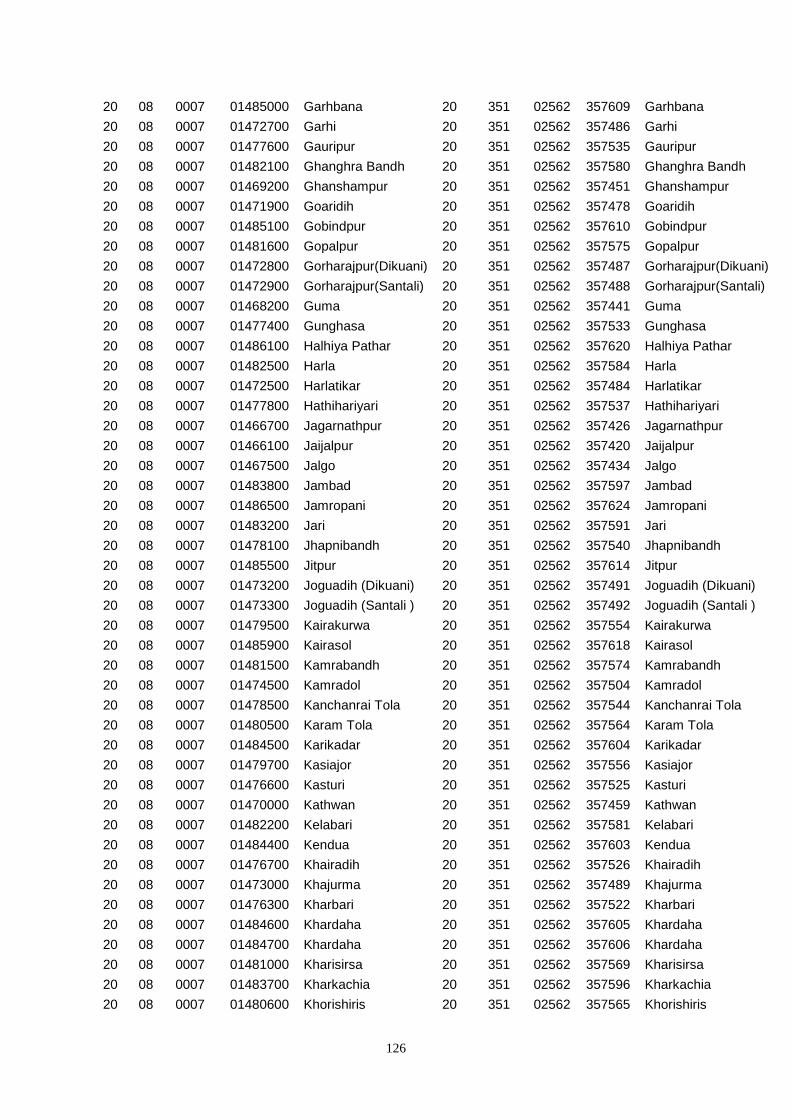
126
20 08 0007 01485000 Garhbana 20 351 02562 357609 Garhbana
20 08 0007 01472700 Garhi 20 351 02562 357486 Garhi
20 08 0007 01477600 Gauripur 20 351 02562 357535 Gauripur
20 08 0007 01482100 Ghanghra Bandh 20 351 02562 357580 Ghanghra Bandh
20 08 0007 01469200 Ghanshampur 20 351 02562 357451 Ghanshampur
20 08 0007 01471900 Goaridih 20 351 02562 357478 Goaridih
20 08 0007 01485100 Gobindpur 20 351 02562 357610 Gobindpur
20 08 0007 01481600 Gopalpur 20 351 02562 357575 Gopalpur
20 08 0007 01472800 Gorharajpur(Dikuani) 20 351 02562 357487 Gorharajpur(Dikuani)
20 08 0007 01472900 Gorharajpur(Santali) 20 351 02562 357488 Gorharajpur(Santali)
20 08 0007 01468200 Guma 20 351 02562 357441 Guma
20 08 0007 01477400 Gunghasa 20 351 02562 357533 Gunghasa
20 08 0007 01486100 Halhiya Pathar 20 351 02562 357620 Halhiya Pathar
20 08 0007 01482500 Harla 20 351 02562 357584 Harla
20 08 0007 01472500 Harlatikar 20 351 02562 357484 Harlatikar
20 08 0007 01477800 Hathihariyari 20 351 02562 357537 Hathihariyari
20 08 0007 01466700 Jagarnathpur 20 351 02562 357426 Jagarnathpur
20 08 0007 01466100 Jaijalpur 20 351 02562 357420 Jaijalpur
20 08 0007 01467500 Jalgo 20 351 02562 357434 Jalgo
20 08 0007 01483800 Jambad 20 351 02562 357597 Jambad
20 08 0007 01486500 Jamropani 20 351 02562 357624 Jamropani
20 08 0007 01483200 Jari 20 351 02562 357591 Jari
20 08 0007 01478100 Jhapnibandh 20 351 02562 357540 Jhapnibandh
20 08 0007 01485500 Jitpur 20 351 02562 357614 Jitpur
20 08 0007 01473200 Joguadih (Dikuani) 20 351 02562 357491 Joguadih (Dikuani)
20 08 0007 01473300 Joguadih (Santali ) 20 351 02562 357492 Joguadih (Santali )
20 08 0007 01479500 Kairakurwa 20 351 02562 357554 Kairakurwa
20 08 0007 01485900 Kairasol 20 351 02562 357618 Kairasol
20 08 0007 01481500 Kamrabandh 20 351 02562 357574 Kamrabandh
20 08 0007 01474500 Kamradol 20 351 02562 357504 Kamradol
20 08 0007 01478500 Kanchanrai Tola 20 351 02562 357544 Kanchanrai Tola
20 08 0007 01480500 Karam Tola 20 351 02562 357564 Karam Tola
20 08 0007 01484500 Karikadar 20 351 02562 357604 Karikadar
20 08 0007 01479700 Kasiajor 20 351 02562 357556 Kasiajor
20 08 0007 01476600 Kasturi 20 351 02562 357525 Kasturi
20 08 0007 01470000 Kathwan 20 351 02562 357459 Kathwan
20 08 0007 01482200 Kelabari 20 351 02562 357581 Kelabari
20 08 0007 01484400 Kendua 20 351 02562 357603 Kendua
20 08 0007 01476700 Khairadih 20 351 02562 357526 Khairadih
20 08 0007 01473000 Khajurma 20 351 02562 357489 Khajurma
20 08 0007 01476300 Kharbari 20 351 02562 357522 Kharbari
20 08 0007 01484600 Khardaha 20 351 02562 357605 Khardaha
20 08 0007 01484700 Khardaha 20 351 02562 357606 Khardaha
20 08 0007 01481000 Kharisirsa 20 351 02562 357569 Kharisirsa
20 08 0007 01483700 Kharkachia 20 351 02562 357596 Kharkachia
20 08 0007 01480600 Khorishiris 20 351 02562 357565 Khorishiris
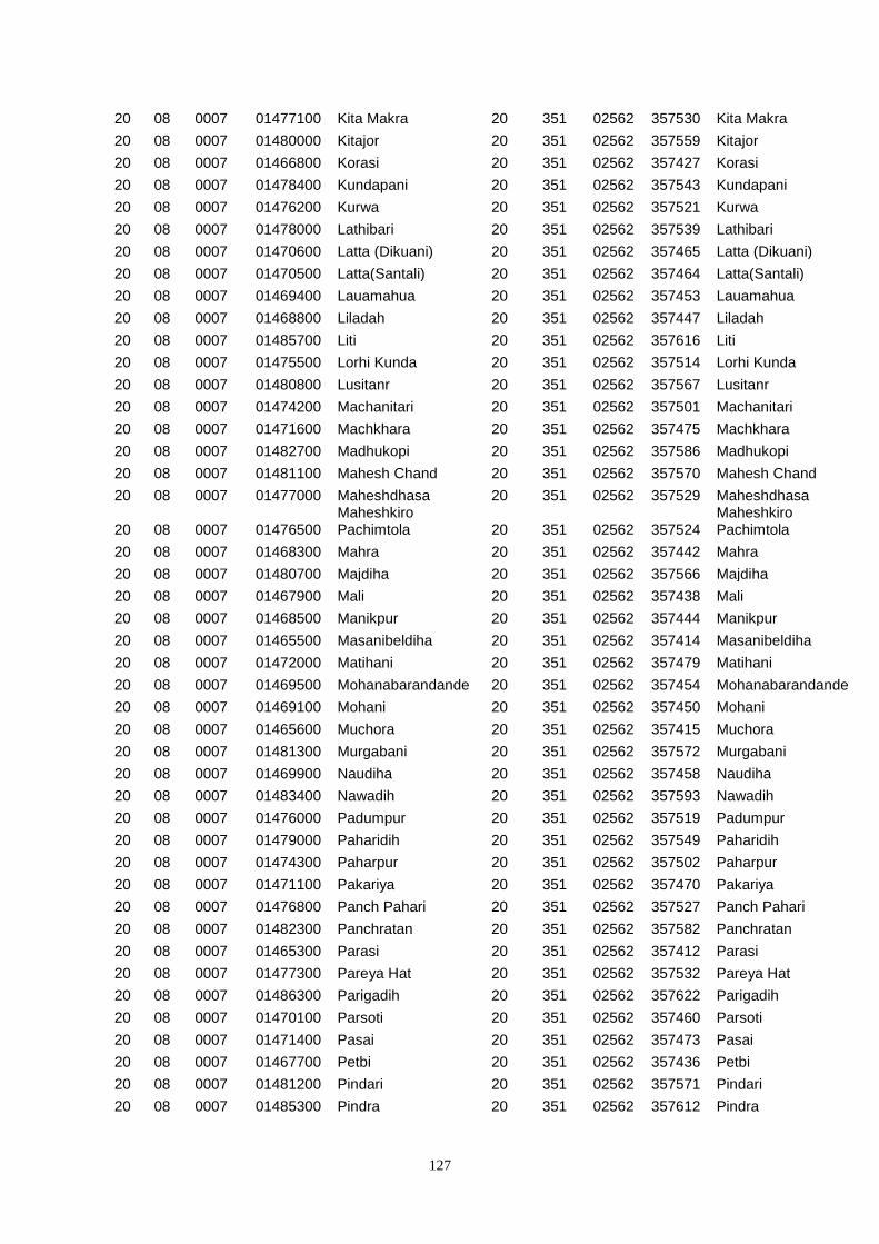
127
20 08 0007 01477100 Kita Makra 20 351 02562 357530 Kita Makra
20 08 0007 01480000 Kitajor 20 351 02562 357559 Kitajor
20 08 0007 01466800 Korasi 20 351 02562 357427 Korasi
20 08 0007 01478400 Kundapani 20 351 02562 357543 Kundapani
20 08 0007 01476200 Kurwa 20 351 02562 357521 Kurwa
20 08 0007 01478000 Lathibari 20 351 02562 357539 Lathibari
20 08 0007 01470600 Latta (Dikuani) 20 351 02562 357465 Latta (Dikuani)
20 08 0007 01470500 Latta(Santali) 20 351 02562 357464 Latta(Santali)
20 08 0007 01469400 Lauamahua 20 351 02562 357453 Lauamahua
20 08 0007 01468800 Liladah 20 351 02562 357447 Liladah
20 08 0007 01485700 Liti 20 351 02562 357616 Liti
20 08 0007 01475500 Lorhi Kunda 20 351 02562 357514 Lorhi Kunda
20 08 0007 01480800 Lusitanr 20 351 02562 357567 Lusitanr
20 08 0007 01474200 Machanitari 20 351 02562 357501 Machanitari
20 08 0007 01471600 Machkhara 20 351 02562 357475 Machkhara
20 08 0007 01482700 Madhukopi 20 351 02562 357586 Madhukopi
20 08 0007 01481100 Mahesh Chand 20 351 02562 357570 Mahesh Chand
20 08 0007 01477000 Maheshdhasa 20 351 02562 357529 Maheshdhasa
20 08 0007 01476500 Maheshkiro Pachimtola 20 351 02562 357524
Maheshkiro Pachimtola
20 08 0007 01468300 Mahra 20 351 02562 357442 Mahra
20 08 0007 01480700 Majdiha 20 351 02562 357566 Majdiha
20 08 0007 01467900 Mali 20 351 02562 357438 Mali
20 08 0007 01468500 Manikpur 20 351 02562 357444 Manikpur
20 08 0007 01465500 Masanibeldiha 20 351 02562 357414 Masanibeldiha
20 08 0007 01472000 Matihani 20 351 02562 357479 Matihani
20 08 0007 01469500 Mohanabarandande 20 351 02562 357454 Mohanabarandande
20 08 0007 01469100 Mohani 20 351 02562 357450 Mohani
20 08 0007 01465600 Muchora 20 351 02562 357415 Muchora
20 08 0007 01481300 Murgabani 20 351 02562 357572 Murgabani
20 08 0007 01469900 Naudiha 20 351 02562 357458 Naudiha
20 08 0007 01483400 Nawadih 20 351 02562 357593 Nawadih
20 08 0007 01476000 Padumpur 20 351 02562 357519 Padumpur
20 08 0007 01479000 Paharidih 20 351 02562 357549 Paharidih
20 08 0007 01474300 Paharpur 20 351 02562 357502 Paharpur
20 08 0007 01471100 Pakariya 20 351 02562 357470 Pakariya
20 08 0007 01476800 Panch Pahari 20 351 02562 357527 Panch Pahari
20 08 0007 01482300 Panchratan 20 351 02562 357582 Panchratan
20 08 0007 01465300 Parasi 20 351 02562 357412 Parasi
20 08 0007 01477300 Pareya Hat 20 351 02562 357532 Pareya Hat
20 08 0007 01486300 Parigadih 20 351 02562 357622 Parigadih
20 08 0007 01470100 Parsoti 20 351 02562 357460 Parsoti
20 08 0007 01471400 Pasai 20 351 02562 357473 Pasai
20 08 0007 01467700 Petbi 20 351 02562 357436 Petbi
20 08 0007 01481200 Pindari 20 351 02562 357571 Pindari
20 08 0007 01485300 Pindra 20 351 02562 357612 Pindra
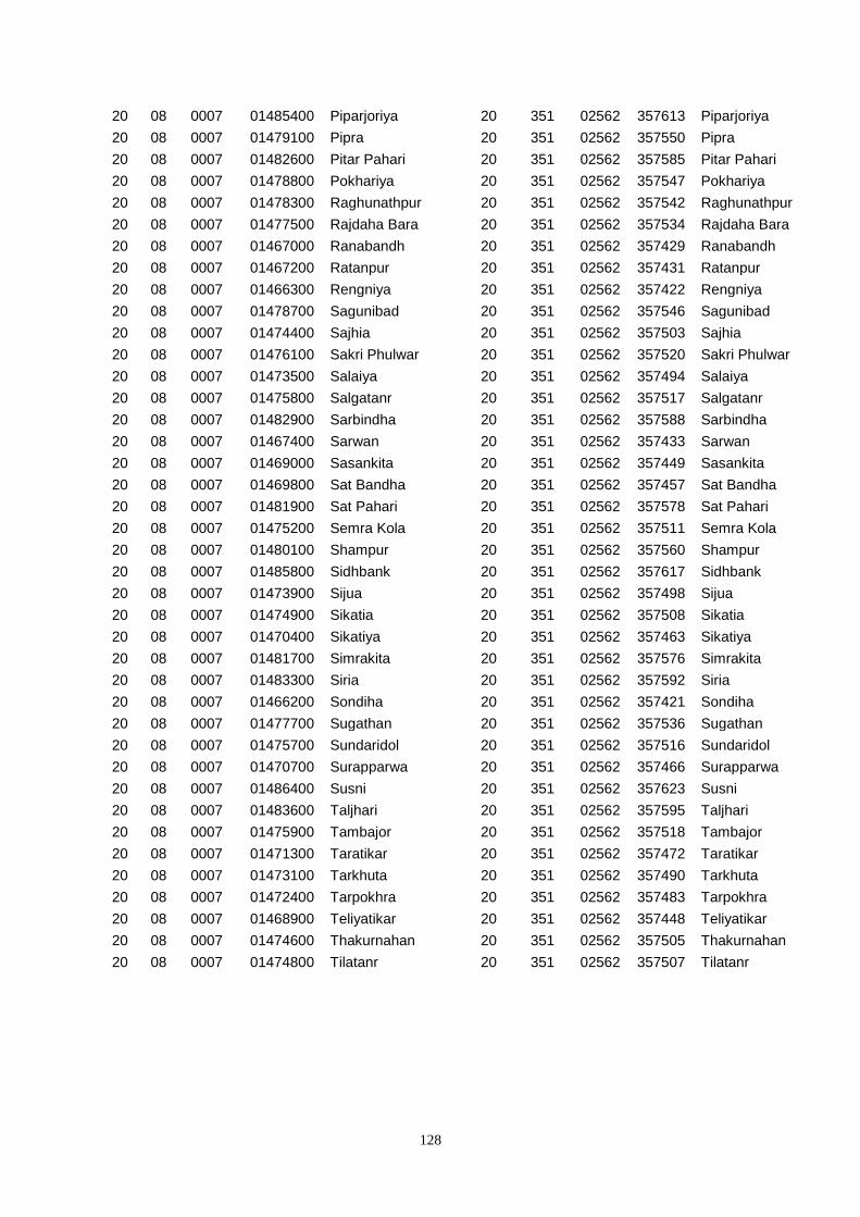
128
20 08 0007 01485400 Piparjoriya 20 351 02562 357613 Piparjoriya
20 08 0007 01479100 Pipra 20 351 02562 357550 Pipra
20 08 0007 01482600 Pitar Pahari 20 351 02562 357585 Pitar Pahari
20 08 0007 01478800 Pokhariya 20 351 02562 357547 Pokhariya
20 08 0007 01478300 Raghunathpur 20 351 02562 357542 Raghunathpur
20 08 0007 01477500 Rajdaha Bara 20 351 02562 357534 Rajdaha Bara
20 08 0007 01467000 Ranabandh 20 351 02562 357429 Ranabandh
20 08 0007 01467200 Ratanpur 20 351 02562 357431 Ratanpur
20 08 0007 01466300 Rengniya 20 351 02562 357422 Rengniya
20 08 0007 01478700 Sagunibad 20 351 02562 357546 Sagunibad
20 08 0007 01474400 Sajhia 20 351 02562 357503 Sajhia
20 08 0007 01476100 Sakri Phulwar 20 351 02562 357520 Sakri Phulwar
20 08 0007 01473500 Salaiya 20 351 02562 357494 Salaiya
20 08 0007 01475800 Salgatanr 20 351 02562 357517 Salgatanr
20 08 0007 01482900 Sarbindha 20 351 02562 357588 Sarbindha
20 08 0007 01467400 Sarwan 20 351 02562 357433 Sarwan
20 08 0007 01469000 Sasankita 20 351 02562 357449 Sasankita
20 08 0007 01469800 Sat Bandha 20 351 02562 357457 Sat Bandha
20 08 0007 01481900 Sat Pahari 20 351 02562 357578 Sat Pahari
20 08 0007 01475200 Semra Kola 20 351 02562 357511 Semra Kola
20 08 0007 01480100 Shampur 20 351 02562 357560 Shampur
20 08 0007 01485800 Sidhbank 20 351 02562 357617 Sidhbank
20 08 0007 01473900 Sijua 20 351 02562 357498 Sijua
20 08 0007 01474900 Sikatia 20 351 02562 357508 Sikatia
20 08 0007 01470400 Sikatiya 20 351 02562 357463 Sikatiya
20 08 0007 01481700 Simrakita 20 351 02562 357576 Simrakita
20 08 0007 01483300 Siria 20 351 02562 357592 Siria
20 08 0007 01466200 Sondiha 20 351 02562 357421 Sondiha
20 08 0007 01477700 Sugathan 20 351 02562 357536 Sugathan
20 08 0007 01475700 Sundaridol 20 351 02562 357516 Sundaridol
20 08 0007 01470700 Surapparwa 20 351 02562 357466 Surapparwa
20 08 0007 01486400 Susni 20 351 02562 357623 Susni
20 08 0007 01483600 Taljhari 20 351 02562 357595 Taljhari
20 08 0007 01475900 Tambajor 20 351 02562 357518 Tambajor
20 08 0007 01471300 Taratikar 20 351 02562 357472 Taratikar
20 08 0007 01473100 Tarkhuta 20 351 02562 357490 Tarkhuta
20 08 0007 01472400 Tarpokhra 20 351 02562 357483 Tarpokhra
20 08 0007 01468900 Teliyatikar 20 351 02562 357448 Teliyatikar
20 08 0007 01474600 Thakurnahan 20 351 02562 357505 Thakurnahan
20 08 0007 01474800 Tilatanr 20 351 02562 357507 Tilatanr
129
130
Census 2001 Codes MDDS e-GOVERNANCE CODE (Census 2011 PLCN)
ST
C
200
1
DT
C
200
1
Sub-
DT
2001
PLCN 2001
NAME OF STATE,
DISTRICTS, SUB-
DISTTS. &
VILLAGES 2001
MD
DS
STC
MD
DS
DTC
MDDS
Sub_DT
MDDS
PLCN
MDDS NAME OF
STATE,
DISTRICT, SUB-
DISTTS. &
VILLAGES
20 08 0000 00000000 Godda 20 351 00000 000000 Godda
20 08 0000 00000000 Sundarpahari 20 351 02563 000000 Sundarpahari
20 08 0008 01489900 Adro 20 351 02563 357658 Adro
20 08 0008 01509200 Adro 20 351 02563 357851 Adro
20 08 0008 01498400 Alkito(Katon) 20 351 02563 357743 Alkito(Katon)
20 08 0008 01498500 Ambar 20 351 02563 357744 Ambar
20 08 0008 01501900 Ambardoni 20 351 02563 357778 Ambardoni
20 08 0008 01495900 Amjora 20 351 02563 357718 Amjora
20 08 0008 01490000 Ammaqo 20 351 02563 357659 Ammaqo
20 08 0008 01505600 Angbali 20 351 02563 357815 Angbali
20 08 0008 01504800 Asantari 20 351 02563 357807 Asantari
20 08 0008 01515600 Asripara 20 351 02563 357915 Asripara
20 08 0008 01514900 Babupur 20 351 02563 357908 Babupur
20 08 0008 01514800 Baigani 20 351 02563 357907 Baigani
20 08 0008 01513700 Bajrajogusami 20 351 02563 357896 Bajrajogusami
20 08 0008 01509300 Balami 20 351 02563 357852 Balami
20 08 0008 01498600 Bandaretoke(Madgi) 20 351 02563 357745
Bandaretoke(Madgi)
20 08 0008 01514400 Bankati 20 351 02563 357903 Bankati
20 08 0008 01486600 Bansjori 20 351 02563 357625 Bansjori
20 08 0008 01486700 Bansjori Jagir 20 351 02563 357626 Bansjori Jagir
20 08 0008 01505700 Banspahari 20 351 02563 357816 Banspahari
20 08 0008 01513000 Bara Dangapara 20 351 02563 357889
Bara Dangapara
20 08 0008 01501200 Bara Dhamni 20 351 02563 357771 Bara Dhamni
20 08 0008 01504600 Bara Haripur 20 351 02563 357805 Bara Haripur
20 08 0008 01496400 Bara Kalhajor 20 351 02563 357723 Bara Kalhajor
20 08 0008 01508600 Bara Paktari 20 351 02563 357845 Bara Paktari
20 08 0008 01508900 Bara Palma 20 351 02563 357848 Bara Palma
20 08 0008 01500900 Bara Puro 20 351 02563 357768 Bara Puro
20 08 0008 01507600 Bara Sabai Kundi 20 351 02563 357835
Bara Sabai Kundi
20 08 0008 01506600 Bara Sinddri 20 351 02563 357825 Bara Sinddri
20 08 0008 01512900 Barai 20 351 02563 357888 Barai
20 08 0008 01497900 Barajolo 20 351 02563 357738 Barajolo
20 08 0008 01515000 Bargo 20 351 02563 357909 Bargo
20 08 0008 01505300 Bariyarpur 20 351 02563 357812 Bariyarpur
20 08 0008 01512500 Barmasia 20 351 02563 357884 Barmasia
20 08 0008 01487600 Barnadi 20 351 02563 357635 Barnadi
20 08 0008 01487700 Barnadi Jagir 20 351 02563 357636 Barnadi Jagir
20 08 0008 01502000 Bat 20 351 02563 357779 Bat
20 08 0008 01490100 Bedotok 20 351 02563 357660 Bedotok
20 08 0008 01514200 Belpahari 20 351 02563 357901 Belpahari
131
20 08 0008 01490200 Berago(Telalkuria) 20 351 02563 357661
Berago(Telalkuria)
20 08 0008 01489200 Bhaluka 20 351 02563 357651 Bhaluka
20 08 0008 01490300 Bilamaqo(Basgo) 20 351 02563 357662
Bilamaqo(Basgo)
20 08 0008 01488100 Bishunpur 20 351 02563 357640 Bishunpur
20 08 0008 01502100 Bitakepu 20 351 02563 357780 Bitakepu
20 08 0008 01512600 Bokrabandh 20 351 02563 357885 Bokrabandh
20 08 0008 01504300 Borwa 20 351 02563 357802 Borwa
20 08 0008 01490400 Chacham 20 351 02563 357663 Chacham
20 08 0008 01490500 Chalgoda(Madgi) 20 351 02563 357664
Chalgoda(Madgi)
20 08 0008 01509500 Chamar Bedo 20 351 02563 357854 Chamar Bedo
20 08 0008 01509400 Chamdade 20 351 02563 357853 Chamdade
20 08 0008 01508300 Chamer 20 351 02563 357842 Chamer
20 08 0008 01498700 Champa 20 351 02563 357746 Champa
20 08 0008 01504100 Chandna 20 351 02563 357800 Chandna
20 08 0008 01506200 Chandraydih 20 351 02563 357821 Chandraydih
20 08 0008 01490600 Chaparom 20 351 02563 357665 Chaparom
20 08 0008 01509600 Charchari 20 351 02563 357855 Charchari
20 08 0008 01498800 Charmaka 20 351 02563 357747 Charmaka
20 08 0008 01487200 Chatra 20 351 02563 357631 Chatra
20 08 0008 01498900 Chetamu (Jirik) 20 351 02563 357748 Chetamu (Jirik)
20 08 0008 01509700 Chewo (Tetria) 20 351 02563 357856 Chewo (Tetria)
20 08 0008 01508500 Chhatmi 20 351 02563 357844 Chhatmi
20 08 0008 01507900 Chhota Adro 20 351 02563 357838 Chhota Adro
20 08 0008 01513300 Chhota Dangapara 20 351 02563 357892
Chhota Dangapara
20 08 0008 01501000 Chhota Dhamni 20 351 02563 357769
Chhota Dhamni
20 08 0008 01488400 Chhota Ghatiari 20 351 02563 357643
Chhota Ghatiari
20 08 0008 01505400 Chhota Haripur 20 351 02563 357813 Chhota Haripur
20 08 0008 01496200 Chhota Kalhajor 20 351 02563 357721
Chhota Kalhajor
20 08 0008 01509000 Chhota Paktari 20 351 02563 357849 Chhota Paktari
20 08 0008 01508700 Chhota Palma 20 351 02563 357846 Chhota Palma
20 08 0008 01501300 Chhota Puro 20 351 02563 357772 Chhota Puro
20 08 0008 01507700 Chhota Sabai Kundi 20 351 02563 357836
Chhota Sabai Kundi
20 08 0008 01507000 Chhota Sindari 20 351 02563 357829 Chhota Sindari
20 08 0008 01490700 Chuclalo 20 351 02563 357666 Chuclalo
20 08 0008 01490800 Churi 20 351 02563 357667 Churi
20 08 0008 01497600 Dahubera 20 351 02563 357735 Dahubera
20 08 0008 01515700 Dalkundi 20 351 02563 357916 Dalkundi
20 08 0008 01513100 Damakol 20 351 02563 357890 Damakol
20 08 0008 01505000 Damruhat 20 351 02563 357809 Damruhat
132
20 08 0008 01499000 Dande(Salpahar) 20 351 02563 357749
Dande(Salpahar)
20 08 0008 01491000 Dandi Kuriya 20 351 02563 357669 Dandi Kuriya
20 08 0008 01499100 Dando 20 351 02563 357750 Dando
20 08 0008 01509800 Dando 20 351 02563 357857 Dando
20 08 0008 01515900 Daribo 20 351 02563 357918 Daribo
20 08 0008 01502200 Daukuriya 20 351 02563 357781 Daukuriya
20 08 0008 01499200 Dawgoda 20 351 02563 357751 Dawgoda
20 08 0008 01499300 Dawgoda 20 351 02563 357752 Dawgoda
20 08 0008 01501100 Dhamni Bazar 20 351 02563 357770 Dhamni Bazar
20 08 0008 01500600 Dhankuti 20 351 02563 357765 Dhankuti
20 08 0008 01498100 Dhaupahari 20 351 02563 357740 Dhaupahari
20 08 0008 01500700 Dhawadangal 20 351 02563 357766 Dhawadangal
20 08 0008 01488200 Dhunigora 20 351 02563 357641 Dhunigora
20 08 0008 01489600 Dighibathan 20 351 02563 357655 Dighibathan
20 08 0008 01495700 Domdih 20 351 02563 357716 Domdih
20 08 0008 01502300 Donigoda 20 351 02563 357782 Donigoda
20 08 0008 01490900 Donigoda Katan 20 351 02563 357668
Donigoda Katan
20 08 0008 01504700 Dulu 20 351 02563 357806 Dulu
20 08 0008 01513500 Dumarpalampara 20 351 02563 357894
Dumarpalampara
20 08 0008 01507500 Dumartari 20 351 02563 357834 Dumartari
20 08 0008 01491200 Dumberi(Kajri) 20 351 02563 357671 Dumberi(Kajri)
20 08 0008 01491100 Dumer(Palem) 20 351 02563 357670 Dumer(Palem)
20 08 0008 01499400 Dumeri(Dumar) 20 351 02563 357753 Dumeri(Dumar)
20 08 0008 01505100 Dumki 20 351 02563 357810 Dumki
20 08 0008 01509900 Dumli 20 351 02563 357858 Dumli
20 08 0008 01501400 Gadidih 20 351 02563 357773 Gadidih
20 08 0008 01497400 Gamarbera 20 351 02563 357733 Gamarbera
20 08 0008 01491300 Gamaro 20 351 02563 357672 Gamaro
20 08 0008 01497300 Gamaro 20 351 02563 357732 Gamaro
20 08 0008 01491400 Gamaro(Sonpahar) 20 351 02563 357673
Gamaro(Sonpahar)
20 08 0008 01499500 Gambaritoke 20 351 02563 357754 Gambaritoke
20 08 0008 01499600 Gambaritoke 20 351 02563 357755 Gambaritoke
20 08 0008 01505800 Gamharia 20 351 02563 357817 Gamharia
20 08 0008 01491500 Gandarama 20 351 02563 357674 Gandarama
20 08 0008 01510000 Gandiyamo 20 351 02563 357859 Gandiyamo
20 08 0008 01506300 Gardi 20 351 02563 357822 Gardi
20 08 0008 01508800 Gargawan 20 351 02563 357847 Gargawan
20 08 0008 01491600 Gari Bedo 20 351 02563 357675 Gari Bedo
20 08 0008 01510100 Garsingla 20 351 02563 357860 Garsingla
20 08 0008 01510200 Garsingla (Malikundi) 20 351 02563 357861
Garsingla (Malikundi)
20 08 0008 01499700 Gelago(Basgo) 20 351 02563 357756 Gelago(Basgo)
20 08 0008 01506400 Ghaghri 20 351 02563 357823 Ghaghri
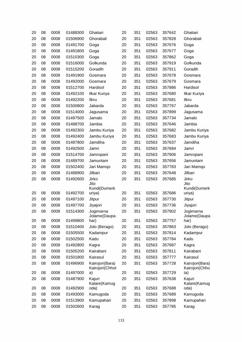
133
20 08 0008 01488300 Ghatiari 20 351 02563 357642 Ghatiari
20 08 0008 01506900 Ghorabali 20 351 02563 357828 Ghorabali
20 08 0008 01491700 Goga 20 351 02563 357676 Goga
20 08 0008 01491800 Goga 20 351 02563 357677 Goga
20 08 0008 01510300 Goga 20 351 02563 357862 Goga
20 08 0008 01516000 Golkunda 20 351 02563 357919 Golkunda
20 08 0008 01515200 Goradih 20 351 02563 357911 Goradih
20 08 0008 01491900 Gosmara 20 351 02563 357678 Gosmara
20 08 0008 01492000 Gosmara 20 351 02563 357679 Gosmara
20 08 0008 01512700 Hardisol 20 351 02563 357886 Hardisol
20 08 0008 01492100 Ilkar Kuriya 20 351 02563 357680 Ilkar Kuriya
20 08 0008 01492200 Ilkru 20 351 02563 357681 Ilkru
20 08 0008 01500800 Jabarda 20 351 02563 357767 Jabarda
20 08 0008 01514000 Jagusama 20 351 02563 357899 Jagusama
20 08 0008 01497500 Jamalo 20 351 02563 357734 Jamalo
20 08 0008 01488700 Jambia 20 351 02563 357646 Jambia
20 08 0008 01492300 Jambu Kuriya 20 351 02563 357682 Jambu Kuriya
20 08 0008 01492400 Jambu Kuriya 20 351 02563 357683 Jambu Kuriya
20 08 0008 01487800 Jamdiha 20 351 02563 357637 Jamdiha
20 08 0008 01492500 Jamri 20 351 02563 357684 Jamri
20 08 0008 01514700 Jamropani 20 351 02563 357906 Jamropani
20 08 0008 01489700 Jamuntanr 20 351 02563 357656 Jamuntanr
20 08 0008 01502400 Jari Mamqo 20 351 02563 357783 Jari Mamqo
20 08 0008 01488900 Jilbari 20 351 02563 357648 Jilbari
20 08 0008 01492600 Jirko 20 351 02563 357685 Jirko
20 08 0008 01492700
Jito Kundi(Dumerkuriya) 20 351 02563 357686
Jito Kundi(Dumerkuriya)
20 08 0008 01497100 Jitpur 20 351 02563 357730 Jitpur
20 08 0008 01497700 Jiyajori 20 351 02563 357736 Jiyajori
20 08 0008 01514300 Jogimarna 20 351 02563 357902 Jogimarna
20 08 0008 01499800 Jolame(Daupahar) 20 351 02563 357757
Jolame(Daupahar)
20 08 0008 01510400 Jolo (Berago) 20 351 02563 357863 Jolo (Berago)
20 08 0008 01505500 Kadampur 20 351 02563 357814 Kadampur
20 08 0008 01502500 Kadu 20 351 02563 357784 Kadu
20 08 0008 01492800 Kagra 20 351 02563 357687 Kagra
20 08 0008 01505200 Kairabani 20 351 02563 357811 Kairabani
20 08 0008 01501800 Kairasul 20 351 02563 357777 Kairasul
20 08 0008 01496900 Kairojori(Bara) 20 351 02563 357728 Kairojori(Bara)
20 08 0008 01497000 Kairojori(Chhota) 20 351 02563 357729
Kairojori(Chhota)
20 08 0008 01487900 Kajuri 20 351 02563 357638 Kajuri
20 08 0008 01492900 Kalare(Kamugoda) 20 351 02563 357688
Kalare(Kamugoda)
20 08 0008 01493000 Kamugoda 20 351 02563 357689 Kamugoda
20 08 0008 01513900 Kamupahari 20 351 02563 357898 Kamupahari
20 08 0008 01502600 Karag 20 351 02563 357785 Karag
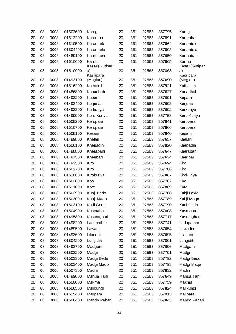
134
20 08 0008 01503600 Karag 20 351 02563 357795 Karag
20 08 0008 01513200 Karamba 20 351 02563 357891 Karamba
20 08 0008 01510500 Karamtok 20 351 02563 357864 Karamtok
20 08 0008 01504400 Karamtola 20 351 02563 357803 Karamtola
20 08 0008 01489100 Karmatanr 20 351 02563 357650 Karmatanr
20 08 0008 01510600 Karmu 20 351 02563 357865 Karmu
20 08 0008 01510900 Kasari(Gutipara) 20 351 02563 357868
Kasari(Gutipara)
20 08 0008 01493100 Kasripara (Moglan) 20 351 02563 357690
Kasripara (Moglan)
20 08 0008 01516200 Kathaldih 20 351 02563 357921 Kathaldih
20 08 0008 01486800 Kauadhab 20 351 02563 357627 Kauadhab
20 08 0008 01493200 Kepam 20 351 02563 357691 Kepam
20 08 0008 01493400 Kerjuria 20 351 02563 357693 Kerjuria
20 08 0008 01493300 Kerkuriya 20 351 02563 357692 Kerkuriya
20 08 0008 01499900 Kero Kuriya 20 351 02563 357758 Kero Kuriya
20 08 0008 01508200 Keropara 20 351 02563 357841 Keropara
20 08 0008 01510700 Keropara 20 351 02563 357866 Keropara
20 08 0008 01508100 Kesam 20 351 02563 357840 Kesam
20 08 0008 01489800 Khelari 20 351 02563 357657 Khelari
20 08 0008 01506100 Khepadih 20 351 02563 357820 Khepadih
20 08 0008 01488800 Kherabani 20 351 02563 357647 Kherabani
20 08 0008 01487500 Kheribari 20 351 02563 357634 Kheribari
20 08 0008 01493500 Kiro 20 351 02563 357694 Kiro
20 08 0008 01502700 Kiro 20 351 02563 357786 Kiro
20 08 0008 01510800 Kirokuriya 20 351 02563 357867 Kirokuriya
20 08 0008 01502800 Koa 20 351 02563 357787 Koa
20 08 0008 01511000 Kote 20 351 02563 357869 Kote
20 08 0008 01502900 Kubji Bedo 20 351 02563 357788 Kubji Bedo
20 08 0008 01503000 Kubji Maqo 20 351 02563 357789 Kubji Maqo
20 08 0008 01503100 Kudi Goda 20 351 02563 357790 Kudi Goda
20 08 0008 01504900 Kusmaha 20 351 02563 357808 Kusmaha
20 08 0008 01495800 Kusumghati 20 351 02563 357717 Kusumghati
20 08 0008 01498200 Ladapathar 20 351 02563 357741 Ladapathar
20 08 0008 01489500 Lawadih 20 351 02563 357654 Lawadih
20 08 0008 01493600 Liladoni 20 351 02563 357695 Liladoni
20 08 0008 01504200 Longidih 20 351 02563 357801 Longidih
20 08 0008 01493700 Madgam 20 351 02563 357696 Madgam
20 08 0008 01503200 Madgi 20 351 02563 357791 Madgi
20 08 0008 01503300 Madgi Bedo 20 351 02563 357792 Madgi Bedo
20 08 0008 01503400 Madgi Maqo 20 351 02563 357793 Madgi Maqo
20 08 0008 01507300 Madni 20 351 02563 357832 Madni
20 08 0008 01489000 Mahua Tanr 20 351 02563 357649 Mahua Tanr
20 08 0008 01500000 Makma 20 351 02563 357759 Makma
20 08 0008 01506500 Malikundi 20 351 02563 357824 Malikundi
20 08 0008 01515400 Malipara 20 351 02563 357913 Malipara
20 08 0008 01508400 Mando Pahari 20 351 02563 357843 Mando Pahari
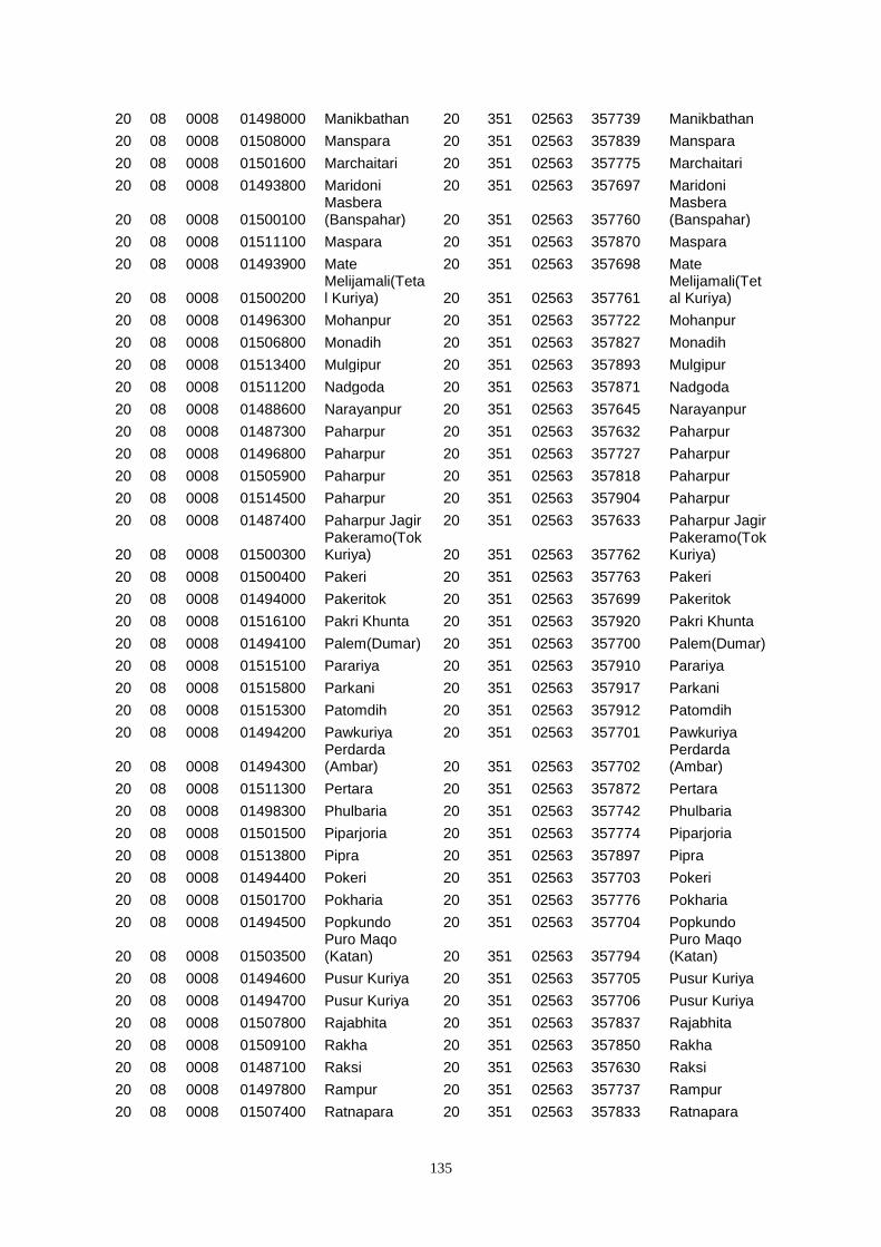
135
20 08 0008 01498000 Manikbathan 20 351 02563 357739 Manikbathan
20 08 0008 01508000 Manspara 20 351 02563 357839 Manspara
20 08 0008 01501600 Marchaitari 20 351 02563 357775 Marchaitari
20 08 0008 01493800 Maridoni 20 351 02563 357697 Maridoni
20 08 0008 01500100 Masbera (Banspahar) 20 351 02563 357760
Masbera (Banspahar)
20 08 0008 01511100 Maspara 20 351 02563 357870 Maspara
20 08 0008 01493900 Mate 20 351 02563 357698 Mate
20 08 0008 01500200 Melijamali(Tetal Kuriya) 20 351 02563 357761
Melijamali(Tetal Kuriya)
20 08 0008 01496300 Mohanpur 20 351 02563 357722 Mohanpur
20 08 0008 01506800 Monadih 20 351 02563 357827 Monadih
20 08 0008 01513400 Mulgipur 20 351 02563 357893 Mulgipur
20 08 0008 01511200 Nadgoda 20 351 02563 357871 Nadgoda
20 08 0008 01488600 Narayanpur 20 351 02563 357645 Narayanpur
20 08 0008 01487300 Paharpur 20 351 02563 357632 Paharpur
20 08 0008 01496800 Paharpur 20 351 02563 357727 Paharpur
20 08 0008 01505900 Paharpur 20 351 02563 357818 Paharpur
20 08 0008 01514500 Paharpur 20 351 02563 357904 Paharpur
20 08 0008 01487400 Paharpur Jagir 20 351 02563 357633 Paharpur Jagir
20 08 0008 01500300 Pakeramo(Tok Kuriya) 20 351 02563 357762
Pakeramo(Tok Kuriya)
20 08 0008 01500400 Pakeri 20 351 02563 357763 Pakeri
20 08 0008 01494000 Pakeritok 20 351 02563 357699 Pakeritok
20 08 0008 01516100 Pakri Khunta 20 351 02563 357920 Pakri Khunta
20 08 0008 01494100 Palem(Dumar) 20 351 02563 357700 Palem(Dumar)
20 08 0008 01515100 Parariya 20 351 02563 357910 Parariya
20 08 0008 01515800 Parkani 20 351 02563 357917 Parkani
20 08 0008 01515300 Patomdih 20 351 02563 357912 Patomdih
20 08 0008 01494200 Pawkuriya 20 351 02563 357701 Pawkuriya
20 08 0008 01494300 Perdarda (Ambar) 20 351 02563 357702
Perdarda (Ambar)
20 08 0008 01511300 Pertara 20 351 02563 357872 Pertara
20 08 0008 01498300 Phulbaria 20 351 02563 357742 Phulbaria
20 08 0008 01501500 Piparjoria 20 351 02563 357774 Piparjoria
20 08 0008 01513800 Pipra 20 351 02563 357897 Pipra
20 08 0008 01494400 Pokeri 20 351 02563 357703 Pokeri
20 08 0008 01501700 Pokharia 20 351 02563 357776 Pokharia
20 08 0008 01494500 Popkundo 20 351 02563 357704 Popkundo
20 08 0008 01503500 Puro Maqo (Katan) 20 351 02563 357794
Puro Maqo (Katan)
20 08 0008 01494600 Pusur Kuriya 20 351 02563 357705 Pusur Kuriya
20 08 0008 01494700 Pusur Kuriya 20 351 02563 357706 Pusur Kuriya
20 08 0008 01507800 Rajabhita 20 351 02563 357837 Rajabhita
20 08 0008 01509100 Rakha 20 351 02563 357850 Rakha
20 08 0008 01487100 Raksi 20 351 02563 357630 Raksi
20 08 0008 01497800 Rampur 20 351 02563 357737 Rampur
20 08 0008 01507400 Ratnapara 20 351 02563 357833 Ratnapara
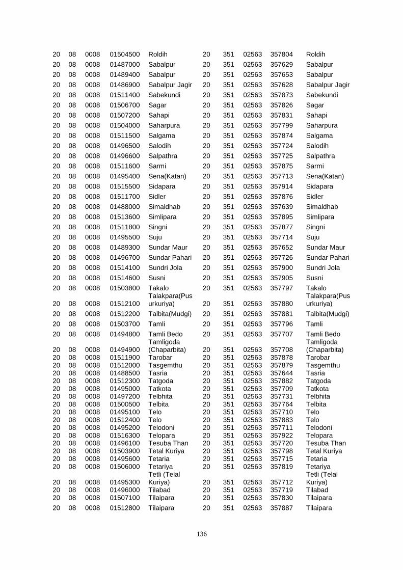
136
20 08 0008 01504500 Roldih 20 351 02563 357804 Roldih
20 08 0008 01487000 Sabalpur 20 351 02563 357629 Sabalpur
20 08 0008 01489400 Sabalpur 20 351 02563 357653 Sabalpur
20 08 0008 01486900 Sabalpur Jagir 20 351 02563 357628 Sabalpur Jagir
20 08 0008 01511400 Sabekundi 20 351 02563 357873 Sabekundi
20 08 0008 01506700 Sagar 20 351 02563 357826 Sagar
20 08 0008 01507200 Sahapi 20 351 02563 357831 Sahapi
20 08 0008 01504000 Saharpura 20 351 02563 357799 Saharpura
20 08 0008 01511500 Salgama 20 351 02563 357874 Salgama
20 08 0008 01496500 Salodih 20 351 02563 357724 Salodih
20 08 0008 01496600 Salpathra 20 351 02563 357725 Salpathra
20 08 0008 01511600 Sarmi 20 351 02563 357875 Sarmi
20 08 0008 01495400 Sena(Katan) 20 351 02563 357713 Sena(Katan)
20 08 0008 01515500 Sidapara 20 351 02563 357914 Sidapara
20 08 0008 01511700 Sidler 20 351 02563 357876 Sidler
20 08 0008 01488000 Simaldhab 20 351 02563 357639 Simaldhab
20 08 0008 01513600 Simlipara 20 351 02563 357895 Simlipara
20 08 0008 01511800 Singni 20 351 02563 357877 Singni
20 08 0008 01495500 Suju 20 351 02563 357714 Suju
20 08 0008 01489300 Sundar Maur 20 351 02563 357652 Sundar Maur
20 08 0008 01496700 Sundar Pahari 20 351 02563 357726 Sundar Pahari
20 08 0008 01514100 Sundri Jola 20 351 02563 357900 Sundri Jola
20 08 0008 01514600 Susni 20 351 02563 357905 Susni
20 08 0008 01503800 Takalo 20 351 02563 357797 Takalo
20 08 0008 01512100 Talakpara(Pusurkuriya) 20 351 02563 357880
Talakpara(Pusurkuriya)
20 08 0008 01512200 Talbita(Mudgi) 20 351 02563 357881 Talbita(Mudgi)
20 08 0008 01503700 Tamli 20 351 02563 357796 Tamli
20 08 0008 01494800 Tamli Bedo 20 351 02563 357707 Tamli Bedo
20 08 0008 01494900 Tamligoda (Chaparbita) 20 351 02563 357708
Tamligoda (Chaparbita)
20 08 0008 01511900 Tarobar 20 351 02563 357878 Tarobar 20 08 0008 01512000 Tasgemthu 20 351 02563 357879 Tasgemthu 20 08 0008 01488500 Tasria 20 351 02563 357644 Tasria 20 08 0008 01512300 Tatgoda 20 351 02563 357882 Tatgoda 20 08 0008 01495000 Tatkota 20 351 02563 357709 Tatkota 20 08 0008 01497200 Telbhita 20 351 02563 357731 Telbhita 20 08 0008 01500500 Telbita 20 351 02563 357764 Telbita 20 08 0008 01495100 Telo 20 351 02563 357710 Telo 20 08 0008 01512400 Telo 20 351 02563 357883 Telo 20 08 0008 01495200 Telodoni 20 351 02563 357711 Telodoni 20 08 0008 01516300 Telopara 20 351 02563 357922 Telopara 20 08 0008 01496100 Tesuba Than 20 351 02563 357720 Tesuba Than 20 08 0008 01503900 Tetal Kuriya 20 351 02563 357798 Tetal Kuriya 20 08 0008 01495600 Tetaria 20 351 02563 357715 Tetaria 20 08 0008 01506000 Tetariya 20 351 02563 357819 Tetariya
20 08 0008 01495300 Tetli (Telal Kuriya) 20 351 02563 357712
Tetli (Telal Kuriya)
20 08 0008 01496000 Tilabad 20 351 02563 357719 Tilabad 20 08 0008 01507100 Tilaipara 20 351 02563 357830 Tilaipara
20 08 0008 01512800 Tilaipara 20 351 02563 357887 Tilaipara
137
CD BLOCK WISE VILLAGE DIRECTORY
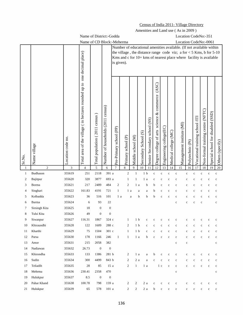
Name of District:-Godda Location CodeNo:-351
Name of CD Block:-Meherma Location CodeNo:-0061
Pre
-Pri
mar
y s
cho
ol
(PP
)
Pri
mar
y s
cho
ol
(P)
Mid
dle
sch
oo
l (M
)
Sec
on
dar
y S
cho
ol
(S)
Sen
ior
Sec
on
dar
y s
cho
ol
(SS
)
Deg
ree
coll
ege
of
arts
sc
ien
ce &
co
mm
erce
(A
SC
)
En
gin
eeri
ng
co
lleg
e(E
C)
Med
ical
co
lleg
e (M
C)
Man
agem
ent
inst
itu
te (
MI)
Po
lyte
chn
ic (
Pt)
Vo
cati
on
al t
rain
ing
sch
oo
l /I
TI
No
n-f
orm
al t
rain
ing
cen
tre
(NF
TC
)
Sp
ecia
l sc
ho
ol
for
dis
able
d (
SS
D)
Oth
ers
(sp
ecif
y)
1 2 3 4 5 6 7 8 9 10 11 12 13 14 15 16 17 18 19 20
1 Budhason 355619 251 2118 391 a 2 1 1 b c c c c c c c c c
2 Bajitpur 355620 320 3877 693 a 1 1 1 a c c c c c c c c c
3 Borma 355621 217 2489 484 2 2 1 a b b c c c c c c c c
4 Singhari 355622 161.83 4191 721 1 1 a a a b c c c c c c c c
5 Kolbadda 355623 36 516 101 1 a a b b b c c c c c c c c
6 Barma 355624 6 93 22 c c c c c
7 Sirsingh Kita 355625 18 0 0
8 Tulsi Kita 355626 49 0 0
9 Siwanpur 355627 116.31 1867 324 c 1 1 b c c c c c c c c c c
10 Khiraundhi 355628 122 1609 288 c 2 1 b c c c c c c c c c c
11 Kharthi 355629 75 1504 301 c 1 1 b c c c c c c c c c c
12 Parsa 355630 178 1166 246 1 1 1 a b c c c c c c c c c
13 Amor 355631 215 2058 382 c c c
14 Nadiawan 355632 26.73 0 0
15 Khirondha 355633 133 1386 281 b 2 1 a a b c c c c c c c c
16 Sudin 355634 300 4499 843 b 2 2 a a c c c c c c c c c
17 Teliadih 355635 28 85 15 a 2 1 1 a 1 c c c c c c c c
18 Mehrma 355636 230.41 2358 470 c c
19 Hulukpur 355637 8.5 0 0
20 Pahar Khand 355638 100.78 798 159 a 2 2 2 a c c c c c c c c c
21 Hulukpur 355639 65 578 101 a 2 2 2 a b c c c c c c c c
Lo
cati
on
co
de
no
.
Nam
e v
illa
ge
Sr.
No
.Census of India 2011- Village Directory
Amenities and Land use ( As in 2009 )
Number of educational amenities available. (If not available within
the village , the distance range code viz; a for < 5 Kms, b for 5-10
Kms and c for 10+ kms of nearest place where facility is available
is given).
Nu
mb
er o
f h
ou
seh
old
s (2
01
1 c
ensu
s)
To
tal
po
pu
lati
on
( 2
01
1 c
ensu
s )
To
tal
area
of
the
vil
lag
e (
in h
ecta
res
rou
nd
ed u
p t
o
on
e d
ecim
al p
lace
)
136
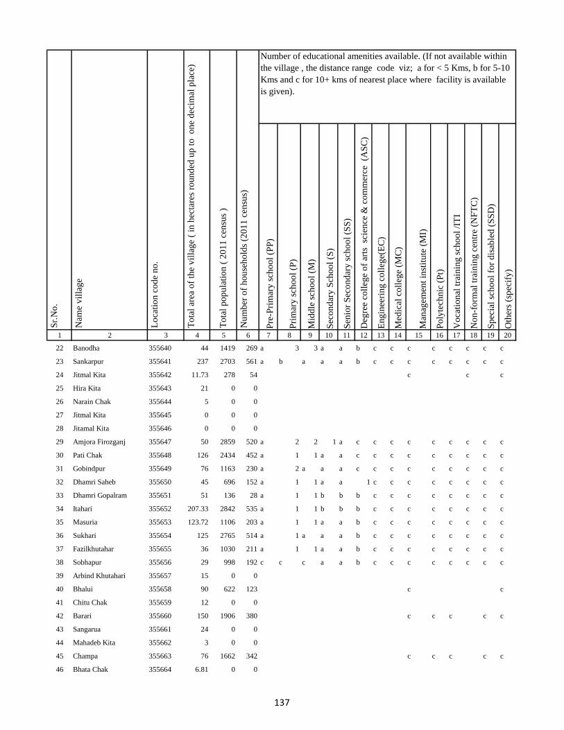
Pre
-Pri
mar
y s
cho
ol
(PP
)
Pri
mar
y s
cho
ol
(P)
Mid
dle
sch
oo
l (M
)
Sec
on
dar
y S
cho
ol
(S)
Sen
ior
Sec
on
dar
y s
cho
ol
(SS
)
Deg
ree
coll
ege
of
arts
sc
ien
ce &
co
mm
erce
(A
SC
)
En
gin
eeri
ng
co
lleg
e(E
C)
Med
ical
co
lleg
e (M
C)
Man
agem
ent
inst
itu
te (
MI)
Po
lyte
chn
ic (
Pt)
Vo
cati
on
al t
rain
ing
sch
oo
l /I
TI
No
n-f
orm
al t
rain
ing
cen
tre
(NF
TC
)
Sp
ecia
l sc
ho
ol
for
dis
able
d (
SS
D)
Oth
ers
(sp
ecif
y)
1 2 3 4 5 6 7 8 9 10 11 12 13 14 15 16 17 18 19 20
Lo
cati
on
co
de
no
.
Nam
e v
illa
ge
Sr.
No
.Number of educational amenities available. (If not available within
the village , the distance range code viz; a for < 5 Kms, b for 5-10
Kms and c for 10+ kms of nearest place where facility is available
is given).
Nu
mb
er o
f h
ou
seh
old
s (2
01
1 c
ensu
s)
To
tal
po
pu
lati
on
( 2
01
1 c
ensu
s )
To
tal
area
of
the
vil
lag
e (
in h
ecta
res
rou
nd
ed u
p t
o
on
e d
ecim
al p
lace
)
22 Banodha 355640 44 1419 269 a 3 3 a a b c c c c c c c c
23 Sankarpur 355641 237 2703 561 a b a a a b c c c c c c c c
24 Jitmal Kita 355642 11.73 278 54 c c c
25 Hira Kita 355643 21 0 0
26 Narain Chak 355644 5 0 0
27 Jitmal Kita 355645 0 0 0
28 Jitamal Kita 355646 0 0 0
29 Amjora Firozganj 355647 50 2859 520 a 2 2 1 a c c c c c c c c c
30 Pati Chak 355648 126 2434 452 a 1 1 a a c c c c c c c c c
31 Gobindpur 355649 76 1163 230 a 2 a a a c c c c c c c c c
32 Dhamri Saheb 355650 45 696 152 a 1 1 a a 1 c c c c c c c c
33 Dhamri Gopalram 355651 51 136 28 a 1 1 b b b c c c c c c c c
34 Itahari 355652 207.33 2842 535 a 1 1 b b b c c c c c c c c
35 Masuria 355653 123.72 1106 203 a 1 1 a a b c c c c c c c c
36 Sukhari 355654 125 2765 514 a 1 a a a b c c c c c c c c
37 Fazilkhutahar 355655 36 1030 211 a 1 1 a a b c c c c c c c c
38 Sobhapur 355656 29 998 192 c c c a a b c c c c c c c c
39 Arbind Khutahari 355657 15 0 0
40 Bhalui 355658 90 622 123 c c
41 Chitu Chak 355659 12 0 0
42 Barari 355660 150 1906 380 c c c c c
43 Sangarua 355661 24 0 0
44 Mahadeb Kita 355662 3 0 0
45 Champa 355663 76 1662 342 c c c c c
46 Bhata Chak 355664 6.81 0 0
137
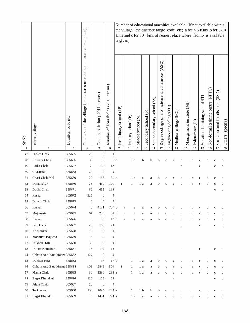
Pre
-Pri
mar
y s
cho
ol
(PP
)
Pri
mar
y s
cho
ol
(P)
Mid
dle
sch
oo
l (M
)
Sec
on
dar
y S
cho
ol
(S)
Sen
ior
Sec
on
dar
y s
cho
ol
(SS
)
Deg
ree
coll
ege
of
arts
sc
ien
ce &
co
mm
erce
(A
SC
)
En
gin
eeri
ng
co
lleg
e(E
C)
Med
ical
co
lleg
e (M
C)
Man
agem
ent
inst
itu
te (
MI)
Po
lyte
chn
ic (
Pt)
Vo
cati
on
al t
rain
ing
sch
oo
l /I
TI
No
n-f
orm
al t
rain
ing
cen
tre
(NF
TC
)
Sp
ecia
l sc
ho
ol
for
dis
able
d (
SS
D)
Oth
ers
(sp
ecif
y)
1 2 3 4 5 6 7 8 9 10 11 12 13 14 15 16 17 18 19 20
Lo
cati
on
co
de
no
.
Nam
e v
illa
ge
Sr.
No
.Number of educational amenities available. (If not available within
the village , the distance range code viz; a for < 5 Kms, b for 5-10
Kms and c for 10+ kms of nearest place where facility is available
is given).
Nu
mb
er o
f h
ou
seh
old
s (2
01
1 c
ensu
s)
To
tal
po
pu
lati
on
( 2
01
1 c
ensu
s )
To
tal
area
of
the
vil
lag
e (
in h
ecta
res
rou
nd
ed u
p t
o
on
e d
ecim
al p
lace
)
47 Padam Chak 355665 28 0 0
48 Ghuram Chak 355666 32 2 1 c 1 a b b b c c c c c b c c
49 Badla Chak 355667 30 182 42 c c c c
50 Ghasichak 355668 24 0 0
51 Ghasi Chak Mal 355669 20 166 31 c 1 c a a b c c c c c b c c
52 Domanchak 355670 73 460 101 1 1 1 a a b c c c c c b c c
53 Dudhi Chak 355671 60 655 118 c c
54 Kasba 355672 325 0 0
55 Doman Chak 355673 0 0 0
56 Kasba 355674 0 4121 787 b a a a a b c c c c c b c c
57 Majhagain 355675 67 236 35 b a a a a a c c c c c b c c
58 Kasba 355676 0 85 17 b a a a a b c c c c c b c c
59 Sadi Chak 355677 23 163 29 c c c c
60 Anhuatikar 355678 19 0 0
61 Madhurai Bagicha 355679 8 0 0
62 Dukhari Kita 355680 36 0 0
63 Dulum Khutahari 355681 15 102 18 c c c c
64 Chhota And Bara Mangarh355682 127 0 0
65 Dukhari Kita 355683 4 97 17 b 1 1 a a b c c c c c b c c
66 Chhota And Bara Mangarh355684 4.05 2846 509 1 1 1 a a b c c c c c c c c
67 Mania Chak 355685 30 1590 285 a 1 1 a a a c c c c c c c c
68 Bagat Khutahari 355686 110 122 26 c c c
69 Jalala Chak 355687 13 0 0
70 Tarkharwa 355688 139 1025 203 a 1 1 b b b c c c c c c c c
71 Bagat Khutahri 355689 0 1461 274 a 1 a a a a c c c c c c c c
138
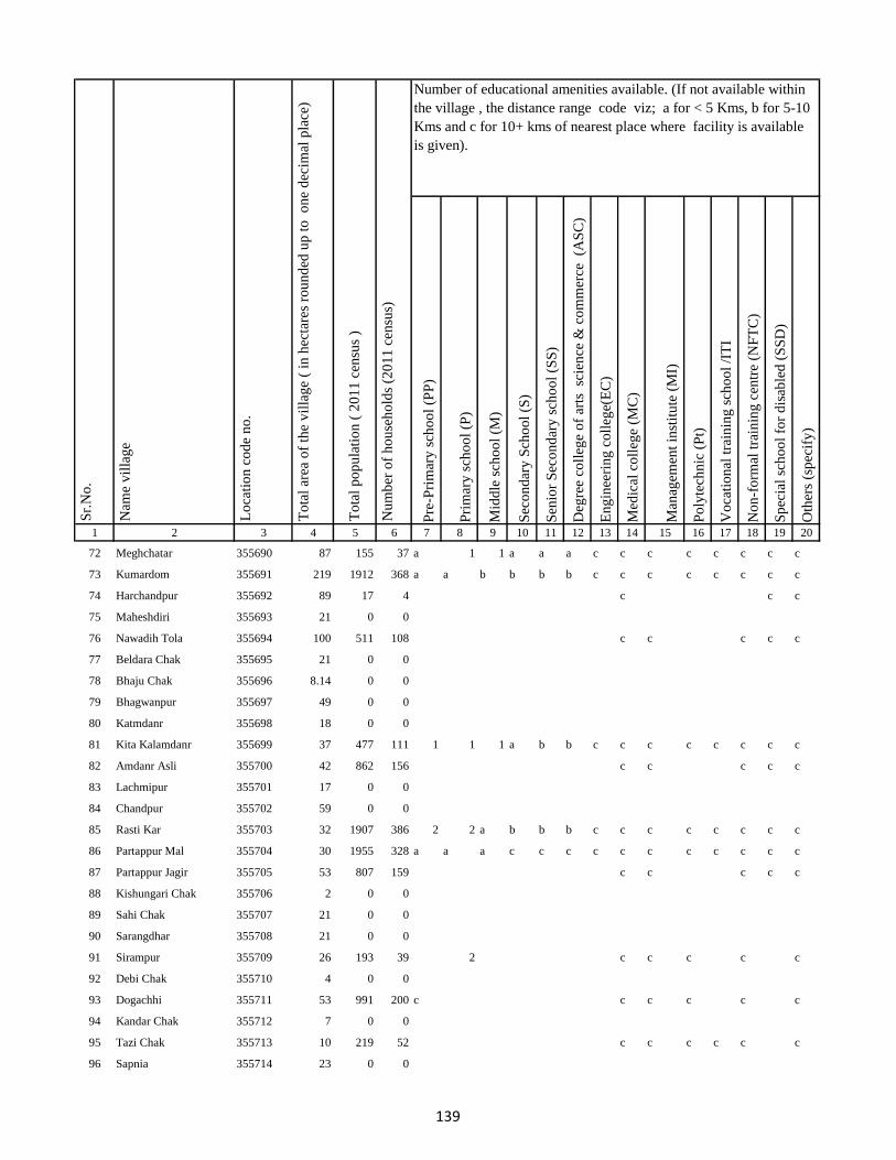
Pre
-Pri
mar
y s
cho
ol
(PP
)
Pri
mar
y s
cho
ol
(P)
Mid
dle
sch
oo
l (M
)
Sec
on
dar
y S
cho
ol
(S)
Sen
ior
Sec
on
dar
y s
cho
ol
(SS
)
Deg
ree
coll
ege
of
arts
sc
ien
ce &
co
mm
erce
(A
SC
)
En
gin
eeri
ng
co
lleg
e(E
C)
Med
ical
co
lleg
e (M
C)
Man
agem
ent
inst
itu
te (
MI)
Po
lyte
chn
ic (
Pt)
Vo
cati
on
al t
rain
ing
sch
oo
l /I
TI
No
n-f
orm
al t
rain
ing
cen
tre
(NF
TC
)
Sp
ecia
l sc
ho
ol
for
dis
able
d (
SS
D)
Oth
ers
(sp
ecif
y)
1 2 3 4 5 6 7 8 9 10 11 12 13 14 15 16 17 18 19 20
Lo
cati
on
co
de
no
.
Nam
e v
illa
ge
Sr.
No
.Number of educational amenities available. (If not available within
the village , the distance range code viz; a for < 5 Kms, b for 5-10
Kms and c for 10+ kms of nearest place where facility is available
is given).
Nu
mb
er o
f h
ou
seh
old
s (2
01
1 c
ensu
s)
To
tal
po
pu
lati
on
( 2
01
1 c
ensu
s )
To
tal
area
of
the
vil
lag
e (
in h
ecta
res
rou
nd
ed u
p t
o
on
e d
ecim
al p
lace
)
72 Meghchatar 355690 87 155 37 a 1 1 a a a c c c c c c c c
73 Kumardom 355691 219 1912 368 a a b b b b c c c c c c c c
74 Harchandpur 355692 89 17 4 c c c
75 Maheshdiri 355693 21 0 0
76 Nawadih Tola 355694 100 511 108 c c c c c
77 Beldara Chak 355695 21 0 0
78 Bhaju Chak 355696 8.14 0 0
79 Bhagwanpur 355697 49 0 0
80 Katmdanr 355698 18 0 0
81 Kita Kalamdanr 355699 37 477 111 1 1 1 a b b c c c c c c c c
82 Amdanr Asli 355700 42 862 156 c c c c c
83 Lachmipur 355701 17 0 0
84 Chandpur 355702 59 0 0
85 Rasti Kar 355703 32 1907 386 2 2 a b b b c c c c c c c c
86 Partappur Mal 355704 30 1955 328 a a a c c c c c c c c c c c
87 Partappur Jagir 355705 53 807 159 c c c c c
88 Kishungari Chak 355706 2 0 0
89 Sahi Chak 355707 21 0 0
90 Sarangdhar 355708 21 0 0
91 Sirampur 355709 26 193 39 2 c c c c c
92 Debi Chak 355710 4 0 0
93 Dogachhi 355711 53 991 200 c c c c c c
94 Kandar Chak 355712 7 0 0
95 Tazi Chak 355713 10 219 52 c c c c c c
96 Sapnia 355714 23 0 0
139
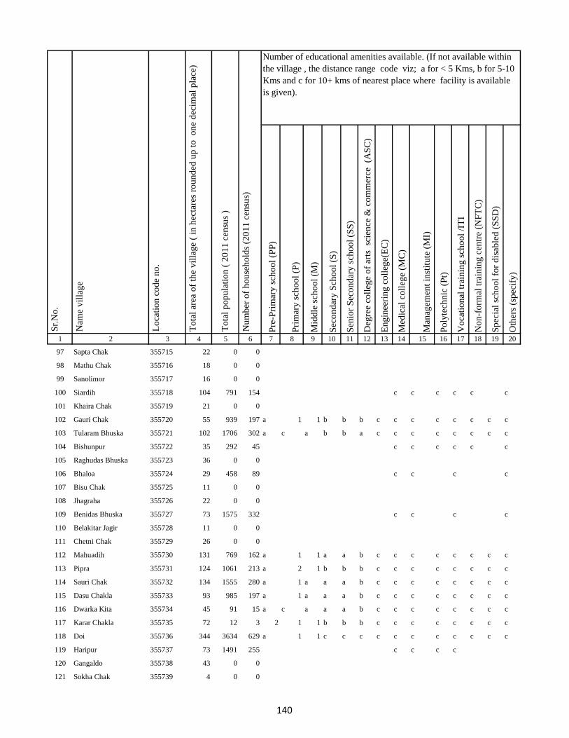
Pre
-Pri
mar
y s
cho
ol
(PP
)
Pri
mar
y s
cho
ol
(P)
Mid
dle
sch
oo
l (M
)
Sec
on
dar
y S
cho
ol
(S)
Sen
ior
Sec
on
dar
y s
cho
ol
(SS
)
Deg
ree
coll
ege
of
arts
sc
ien
ce &
co
mm
erce
(A
SC
)
En
gin
eeri
ng
co
lleg
e(E
C)
Med
ical
co
lleg
e (M
C)
Man
agem
ent
inst
itu
te (
MI)
Po
lyte
chn
ic (
Pt)
Vo
cati
on
al t
rain
ing
sch
oo
l /I
TI
No
n-f
orm
al t
rain
ing
cen
tre
(NF
TC
)
Sp
ecia
l sc
ho
ol
for
dis
able
d (
SS
D)
Oth
ers
(sp
ecif
y)
1 2 3 4 5 6 7 8 9 10 11 12 13 14 15 16 17 18 19 20
Lo
cati
on
co
de
no
.
Nam
e v
illa
ge
Sr.
No
.Number of educational amenities available. (If not available within
the village , the distance range code viz; a for < 5 Kms, b for 5-10
Kms and c for 10+ kms of nearest place where facility is available
is given).
Nu
mb
er o
f h
ou
seh
old
s (2
01
1 c
ensu
s)
To
tal
po
pu
lati
on
( 2
01
1 c
ensu
s )
To
tal
area
of
the
vil
lag
e (
in h
ecta
res
rou
nd
ed u
p t
o
on
e d
ecim
al p
lace
)
97 Sapta Chak 355715 22 0 0
98 Mathu Chak 355716 18 0 0
99 Sanolimor 355717 16 0 0
100 Siardih 355718 104 791 154 c c c c c c
101 Khaira Chak 355719 21 0 0
102 Gauri Chak 355720 55 939 197 a 1 1 b b b c c c c c c c c
103 Tularam Bhuska 355721 102 1706 302 a c a b b a c c c c c c c c
104 Bishunpur 355722 35 292 45 c c c c c c
105 Raghudas Bhuska 355723 36 0 0
106 Bhaloa 355724 29 458 89 c c c c
107 Bisu Chak 355725 11 0 0
108 Jhagraha 355726 22 0 0
109 Benidas Bhuska 355727 73 1575 332 c c c c
110 Belakitar Jagir 355728 11 0 0
111 Chetni Chak 355729 26 0 0
112 Mahuadih 355730 131 769 162 a 1 1 a a b c c c c c c c c
113 Pipra 355731 124 1061 213 a 2 1 b b b c c c c c c c c
114 Sauri Chak 355732 134 1555 280 a 1 a a a b c c c c c c c c
115 Dasu Chakla 355733 93 985 197 a 1 a a a b c c c c c c c c
116 Dwarka Kita 355734 45 91 15 a c a a a b c c c c c c c c
117 Karar Chakla 355735 72 12 3 2 1 1 b b b c c c c c c c c
118 Doi 355736 344 3634 629 a 1 1 c c c c c c c c c c c
119 Haripur 355737 73 1491 255 c c c c
120 Gangaldo 355738 43 0 0
121 Sokha Chak 355739 4 0 0
140
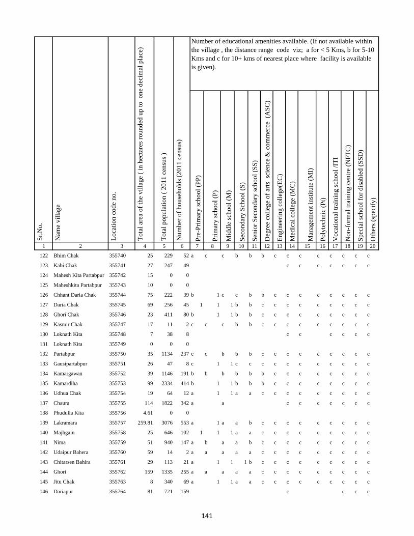
Pre
-Pri
mar
y s
cho
ol
(PP
)
Pri
mar
y s
cho
ol
(P)
Mid
dle
sch
oo
l (M
)
Sec
on
dar
y S
cho
ol
(S)
Sen
ior
Sec
on
dar
y s
cho
ol
(SS
)
Deg
ree
coll
ege
of
arts
sc
ien
ce &
co
mm
erce
(A
SC
)
En
gin
eeri
ng
co
lleg
e(E
C)
Med
ical
co
lleg
e (M
C)
Man
agem
ent
inst
itu
te (
MI)
Po
lyte
chn
ic (
Pt)
Vo
cati
on
al t
rain
ing
sch
oo
l /I
TI
No
n-f
orm
al t
rain
ing
cen
tre
(NF
TC
)
Sp
ecia
l sc
ho
ol
for
dis
able
d (
SS
D)
Oth
ers
(sp
ecif
y)
1 2 3 4 5 6 7 8 9 10 11 12 13 14 15 16 17 18 19 20
Lo
cati
on
co
de
no
.
Nam
e v
illa
ge
Sr.
No
.Number of educational amenities available. (If not available within
the village , the distance range code viz; a for < 5 Kms, b for 5-10
Kms and c for 10+ kms of nearest place where facility is available
is given).
Nu
mb
er o
f h
ou
seh
old
s (2
01
1 c
ensu
s)
To
tal
po
pu
lati
on
( 2
01
1 c
ensu
s )
To
tal
area
of
the
vil
lag
e (
in h
ecta
res
rou
nd
ed u
p t
o
on
e d
ecim
al p
lace
)
122 Bhim Chak 355740 25 229 52 a c c b b b c c c c c c c c
123 Kabi Chak 355741 27 247 49 c c c c c c c
124 Mahesh Kita Partabpur 355742 15 0 0
125 Maheshkita Partabpur 355743 10 0 0
126 Chhant Daria Chak 355744 75 222 39 b 1 c c b b c c c c c c c c
127 Daria Chak 355745 69 256 45 1 1 1 b b c c c c c c c c c
128 Ghori Chak 355746 23 411 80 b 1 1 b b c c c c c c c c c
129 Kasmir Chak 355747 17 11 2 c c c b b c c c c c c c c c
130 Loknath Kita 355748 7 38 8 c c c c c c
131 Loknath Kita 355749 0 0 0
132 Partabpur 355750 35 1134 237 c c b b b c c c c c c c c c
133 Gausipartabpur 355751 26 47 8 c 1 1 c c c c c c c c c c c
134 Kamargawan 355752 39 1146 191 b b b b b b c c c c c c c c
135 Kamardiha 355753 99 2334 414 b 1 1 b b b c c c c c c c c
136 Udhua Chak 355754 19 64 12 a 1 1 a a c c c c c c c c c
137 Chaura 355755 114 1822 342 a a c c c c c c c
138 Phudulia Kita 355756 4.61 0 0
139 Lakramara 355757 259.81 3076 553 a 1 a a b c c c c c c c c c
140 Majhgain 355758 25 646 102 1 1 1 a a c c c c c c c c c
141 Nima 355759 51 940 147 a b a a b c c c c c c c c c
142 Udaipur Bahera 355760 59 14 2 a a a a a c c c c c c c c c
143 Chitarsen Bahira 355761 29 113 21 a 1 1 1 b c c c c c c c c c
144 Ghori 355762 159 1335 255 a a a a a c c c c c c c c c
145 Jitu Chak 355763 8 340 69 a 1 1 a a c c c c c c c c c
146 Dariapur 355764 81 721 159 c c c c
141
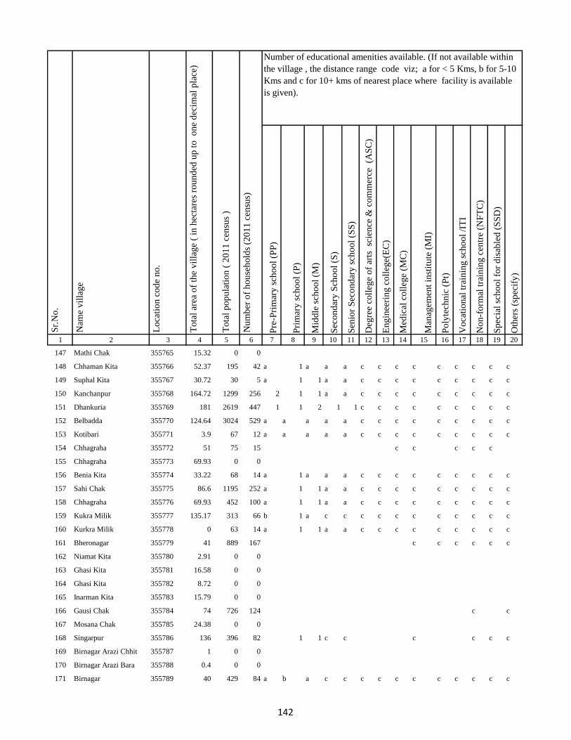
Pre
-Pri
mar
y s
cho
ol
(PP
)
Pri
mar
y s
cho
ol
(P)
Mid
dle
sch
oo
l (M
)
Sec
on
dar
y S
cho
ol
(S)
Sen
ior
Sec
on
dar
y s
cho
ol
(SS
)
Deg
ree
coll
ege
of
arts
sc
ien
ce &
co
mm
erce
(A
SC
)
En
gin
eeri
ng
co
lleg
e(E
C)
Med
ical
co
lleg
e (M
C)
Man
agem
ent
inst
itu
te (
MI)
Po
lyte
chn
ic (
Pt)
Vo
cati
on
al t
rain
ing
sch
oo
l /I
TI
No
n-f
orm
al t
rain
ing
cen
tre
(NF
TC
)
Sp
ecia
l sc
ho
ol
for
dis
able
d (
SS
D)
Oth
ers
(sp
ecif
y)
1 2 3 4 5 6 7 8 9 10 11 12 13 14 15 16 17 18 19 20
Lo
cati
on
co
de
no
.
Nam
e v
illa
ge
Sr.
No
.Number of educational amenities available. (If not available within
the village , the distance range code viz; a for < 5 Kms, b for 5-10
Kms and c for 10+ kms of nearest place where facility is available
is given).
Nu
mb
er o
f h
ou
seh
old
s (2
01
1 c
ensu
s)
To
tal
po
pu
lati
on
( 2
01
1 c
ensu
s )
To
tal
area
of
the
vil
lag
e (
in h
ecta
res
rou
nd
ed u
p t
o
on
e d
ecim
al p
lace
)
147 Mathi Chak 355765 15.32 0 0
148 Chhaman Kita 355766 52.37 195 42 a 1 a a a c c c c c c c c c
149 Suphal Kita 355767 30.72 30 5 a 1 1 a a c c c c c c c c c
150 Kanchanpur 355768 164.72 1299 256 2 1 1 a a c c c c c c c c c
151 Dhankuria 355769 181 2619 447 1 1 2 1 1 c c c c c c c c c
152 Belbadda 355770 124.64 3024 529 a a a a a c c c c c c c c c
153 Kotibari 355771 3.9 67 12 a a a a a c c c c c c c c c
154 Chhagraha 355772 51 75 15 c c c c c
155 Chhagraha 355773 69.93 0 0
156 Benia Kita 355774 33.22 68 14 a 1 a a a c c c c c c c c c
157 Sahi Chak 355775 86.6 1195 252 a 1 1 a a c c c c c c c c c
158 Chhagraha 355776 69.93 452 100 a 1 1 a a c c c c c c c c c
159 Kukra Milik 355777 135.17 313 66 b 1 a c c c c c c c c c c c
160 Kurkra Milik 355778 0 63 14 a 1 1 a a c c c c c c c c c
161 Bheronagar 355779 41 889 167 c c c c c c
162 Niamat Kita 355780 2.91 0 0
163 Ghasi Kita 355781 16.58 0 0
164 Ghasi Kita 355782 8.72 0 0
165 Inarman Kita 355783 15.79 0 0
166 Gausi Chak 355784 74 726 124 c c
167 Mosana Chak 355785 24.38 0 0
168 Singarpur 355786 136 396 82 1 1 c c c c c c
169 Birnagar Arazi Chhit 355787 1 0 0
170 Birnagar Arazi Bara 355788 0.4 0 0
171 Birnagar 355789 40 429 84 a b a c c c c c c c c c c c
142
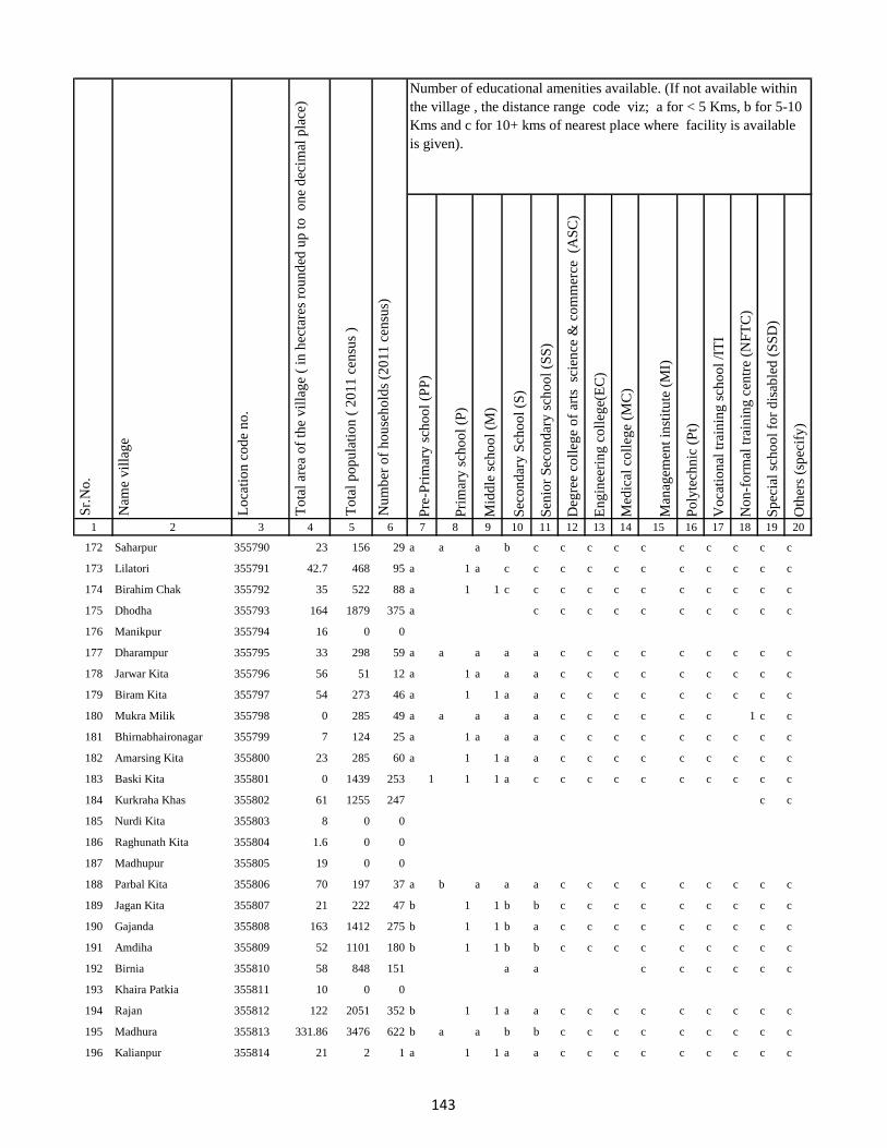
Pre
-Pri
mar
y s
cho
ol
(PP
)
Pri
mar
y s
cho
ol
(P)
Mid
dle
sch
oo
l (M
)
Sec
on
dar
y S
cho
ol
(S)
Sen
ior
Sec
on
dar
y s
cho
ol
(SS
)
Deg
ree
coll
ege
of
arts
sc
ien
ce &
co
mm
erce
(A
SC
)
En
gin
eeri
ng
co
lleg
e(E
C)
Med
ical
co
lleg
e (M
C)
Man
agem
ent
inst
itu
te (
MI)
Po
lyte
chn
ic (
Pt)
Vo
cati
on
al t
rain
ing
sch
oo
l /I
TI
No
n-f
orm
al t
rain
ing
cen
tre
(NF
TC
)
Sp
ecia
l sc
ho
ol
for
dis
able
d (
SS
D)
Oth
ers
(sp
ecif
y)
1 2 3 4 5 6 7 8 9 10 11 12 13 14 15 16 17 18 19 20
Lo
cati
on
co
de
no
.
Nam
e v
illa
ge
Sr.
No
.Number of educational amenities available. (If not available within
the village , the distance range code viz; a for < 5 Kms, b for 5-10
Kms and c for 10+ kms of nearest place where facility is available
is given).
Nu
mb
er o
f h
ou
seh
old
s (2
01
1 c
ensu
s)
To
tal
po
pu
lati
on
( 2
01
1 c
ensu
s )
To
tal
area
of
the
vil
lag
e (
in h
ecta
res
rou
nd
ed u
p t
o
on
e d
ecim
al p
lace
)
172 Saharpur 355790 23 156 29 a a a b c c c c c c c c c c
173 Lilatori 355791 42.7 468 95 a 1 a c c c c c c c c c c c
174 Birahim Chak 355792 35 522 88 a 1 1 c c c c c c c c c c c
175 Dhodha 355793 164 1879 375 a c c c c c c c c c c
176 Manikpur 355794 16 0 0
177 Dharampur 355795 33 298 59 a a a a a c c c c c c c c c
178 Jarwar Kita 355796 56 51 12 a 1 a a a c c c c c c c c c
179 Biram Kita 355797 54 273 46 a 1 1 a a c c c c c c c c c
180 Mukra Milik 355798 0 285 49 a a a a a c c c c c c 1 c c
181 Bhirnabhaironagar 355799 7 124 25 a 1 a a a c c c c c c c c c
182 Amarsing Kita 355800 23 285 60 a 1 1 a a c c c c c c c c c
183 Baski Kita 355801 0 1439 253 1 1 1 a c c c c c c c c c c
184 Kurkraha Khas 355802 61 1255 247 c c
185 Nurdi Kita 355803 8 0 0
186 Raghunath Kita 355804 1.6 0 0
187 Madhupur 355805 19 0 0
188 Parbal Kita 355806 70 197 37 a b a a a c c c c c c c c c
189 Jagan Kita 355807 21 222 47 b 1 1 b b c c c c c c c c c
190 Gajanda 355808 163 1412 275 b 1 1 b a c c c c c c c c c
191 Amdiha 355809 52 1101 180 b 1 1 b b c c c c c c c c c
192 Birnia 355810 58 848 151 a a c c c c c c
193 Khaira Patkia 355811 10 0 0
194 Rajan 355812 122 2051 352 b 1 1 a a c c c c c c c c c
195 Madhura 355813 331.86 3476 622 b a a b b c c c c c c c c c
196 Kalianpur 355814 21 2 1 a 1 1 a a c c c c c c c c c
143
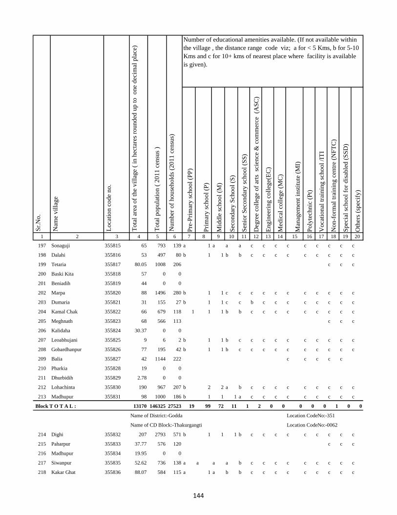
Pre
-Pri
mar
y s
cho
ol
(PP
)
Pri
mar
y s
cho
ol
(P)
Mid
dle
sch
oo
l (M
)
Sec
on
dar
y S
cho
ol
(S)
Sen
ior
Sec
on
dar
y s
cho
ol
(SS
)
Deg
ree
coll
ege
of
arts
sc
ien
ce &
co
mm
erce
(A
SC
)
En
gin
eeri
ng
co
lleg
e(E
C)
Med
ical
co
lleg
e (M
C)
Man
agem
ent
inst
itu
te (
MI)
Po
lyte
chn
ic (
Pt)
Vo
cati
on
al t
rain
ing
sch
oo
l /I
TI
No
n-f
orm
al t
rain
ing
cen
tre
(NF
TC
)
Sp
ecia
l sc
ho
ol
for
dis
able
d (
SS
D)
Oth
ers
(sp
ecif
y)
1 2 3 4 5 6 7 8 9 10 11 12 13 14 15 16 17 18 19 20
Lo
cati
on
co
de
no
.
Nam
e v
illa
ge
Sr.
No
.Number of educational amenities available. (If not available within
the village , the distance range code viz; a for < 5 Kms, b for 5-10
Kms and c for 10+ kms of nearest place where facility is available
is given).
Nu
mb
er o
f h
ou
seh
old
s (2
01
1 c
ensu
s)
To
tal
po
pu
lati
on
( 2
01
1 c
ensu
s )
To
tal
area
of
the
vil
lag
e (
in h
ecta
res
rou
nd
ed u
p t
o
on
e d
ecim
al p
lace
)
197 Sonaguji 355815 65 793 139 a 1 a a a c c c c c c c c c
198 Dalahi 355816 53 497 80 b 1 1 b b c c c c c c c c c
199 Tetaria 355817 80.05 1008 206 c c c
200 Baski Kita 355818 57 0 0
201 Beniadih 355819 44 0 0
202 Marpa 355820 88 1496 280 b 1 1 c c c c c c c c c c c
203 Dumaria 355821 31 155 27 b 1 1 c c b c c c c c c c c
204 Kamal Chak 355822 66 679 118 1 1 1 b b c c c c c c c c c
205 Meghnath 355823 68 566 113 c c c
206 Kalidaha 355824 30.37 0 0
207 Leoabhujani 355825 9 6 2 b 1 1 b c c c c c c c c c c
208 Gobardhanpur 355826 77 195 42 b 1 1 b c c c c c c c c c c
209 Balia 355827 42 1144 222 c c c c c
210 Pharkia 355828 19 0 0
211 Dhurbidih 355829 2.78 0 0
212 Lohachinta 355830 190 967 207 b 2 2 a b c c c c c c c c c
213 Madhupur 355831 98 1000 186 b 1 1 1 a c c c c c c c c c
Block T O T A L : 13170 146325 27523 19 99 72 11 1 2 0 0 0 0 0 1 0 0
Name of District:-Godda Location CodeNo:-351
Name of CD Block:-Thakurgangti Location CodeNo:-0062
214 Dighi 355832 207 2793 571 b 1 1 1 b c c c c c c c c c
215 Paharpur 355833 37.77 576 120 c c c
216 Madhupur 355834 19.95 0 0
217 Siwanpur 355835 52.62 736 138 a a a a b c c c c c c c c c
218 Kakar Ghat 355836 88.07 584 115 a 1 a b b c c c c c c c c c
144
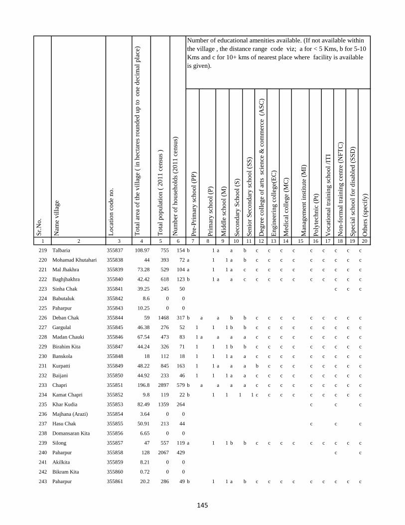
Pre
-Pri
mar
y s
cho
ol
(PP
)
Pri
mar
y s
cho
ol
(P)
Mid
dle
sch
oo
l (M
)
Sec
on
dar
y S
cho
ol
(S)
Sen
ior
Sec
on
dar
y s
cho
ol
(SS
)
Deg
ree
coll
ege
of
arts
sc
ien
ce &
co
mm
erce
(A
SC
)
En
gin
eeri
ng
co
lleg
e(E
C)
Med
ical
co
lleg
e (M
C)
Man
agem
ent
inst
itu
te (
MI)
Po
lyte
chn
ic (
Pt)
Vo
cati
on
al t
rain
ing
sch
oo
l /I
TI
No
n-f
orm
al t
rain
ing
cen
tre
(NF
TC
)
Sp
ecia
l sc
ho
ol
for
dis
able
d (
SS
D)
Oth
ers
(sp
ecif
y)
1 2 3 4 5 6 7 8 9 10 11 12 13 14 15 16 17 18 19 20
Lo
cati
on
co
de
no
.
Nam
e v
illa
ge
Sr.
No
.Number of educational amenities available. (If not available within
the village , the distance range code viz; a for < 5 Kms, b for 5-10
Kms and c for 10+ kms of nearest place where facility is available
is given).
Nu
mb
er o
f h
ou
seh
old
s (2
01
1 c
ensu
s)
To
tal
po
pu
lati
on
( 2
01
1 c
ensu
s )
To
tal
area
of
the
vil
lag
e (
in h
ecta
res
rou
nd
ed u
p t
o
on
e d
ecim
al p
lace
)
219 Talbaria 355837 108.97 755 154 b 1 a a b c c c c c c c c c
220 Mohamad Khutahari 355838 44 393 72 a 1 1 a b c c c c c c c c c
221 Mal Jhakhra 355839 73.28 529 104 a 1 1 a c c c c c c c c c c
222 Baghjhakhra 355840 42.42 618 123 b 1 a a c c c c c c c c c c
223 Sinha Chak 355841 39.25 245 50 c c c
224 Babutaluk 355842 8.6 0 0
225 Paharpur 355843 10.25 0 0
226 Deban Chak 355844 59 1468 317 b a a b b c c c c c c c c c
227 Gargulal 355845 46.38 276 52 1 1 1 b b c c c c c c c c c
228 Madan Chauki 355846 67.54 473 83 1 a a a a c c c c c c c c c
229 Birahim Kita 355847 44.24 326 71 1 1 1 b b c c c c c c c c c
230 Banskola 355848 18 112 18 1 1 1 a a c c c c c c c c c
231 Kurpatti 355849 48.22 845 163 1 1 a a a b c c c c c c c c
232 Baijani 355850 44.92 233 46 1 1 1 a a c c c c c c c c c
233 Chapri 355851 196.8 2897 579 b a a a a c c c c c c c c c
234 Kamat Chapri 355852 9.8 119 22 b 1 1 1 1 c c c c c c c c c
235 Khar Kudia 355853 82.49 1359 264 c c c
236 Majhana (Arazi) 355854 3.64 0 0
237 Hasu Chak 355855 50.91 213 44 c c c
238 Domansaran Kita 355856 6.65 0 0
239 Silong 355857 47 557 119 a 1 1 b b c c c c c c c c c
240 Paharpur 355858 128 2067 429 c c
241 Akilkita 355859 8.21 0 0
242 Bikram Kita 355860 0.72 0 0
243 Paharpur 355861 20.2 286 49 b 1 1 a b c c c c c c c c c
145
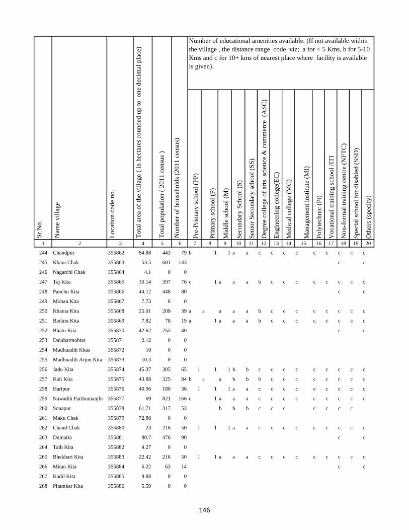
Pre
-Pri
mar
y s
cho
ol
(PP
)
Pri
mar
y s
cho
ol
(P)
Mid
dle
sch
oo
l (M
)
Sec
on
dar
y S
cho
ol
(S)
Sen
ior
Sec
on
dar
y s
cho
ol
(SS
)
Deg
ree
coll
ege
of
arts
sc
ien
ce &
co
mm
erce
(A
SC
)
En
gin
eeri
ng
co
lleg
e(E
C)
Med
ical
co
lleg
e (M
C)
Man
agem
ent
inst
itu
te (
MI)
Po
lyte
chn
ic (
Pt)
Vo
cati
on
al t
rain
ing
sch
oo
l /I
TI
No
n-f
orm
al t
rain
ing
cen
tre
(NF
TC
)
Sp
ecia
l sc
ho
ol
for
dis
able
d (
SS
D)
Oth
ers
(sp
ecif
y)
1 2 3 4 5 6 7 8 9 10 11 12 13 14 15 16 17 18 19 20
Lo
cati
on
co
de
no
.
Nam
e v
illa
ge
Sr.
No
.Number of educational amenities available. (If not available within
the village , the distance range code viz; a for < 5 Kms, b for 5-10
Kms and c for 10+ kms of nearest place where facility is available
is given).
Nu
mb
er o
f h
ou
seh
old
s (2
01
1 c
ensu
s)
To
tal
po
pu
lati
on
( 2
01
1 c
ensu
s )
To
tal
area
of
the
vil
lag
e (
in h
ecta
res
rou
nd
ed u
p t
o
on
e d
ecim
al p
lace
)
244 Chandpur 355862 84.88 443 79 b 1 1 a a c c c c c c c c c
245 Khani Chak 355863 53.5 681 143 c c
246 Nagarchi Chak 355864 4.1 0 0
247 Taj Kita 355865 30.14 397 76 c 1 a a a b c c c c c c c c
248 Panchu Kita 355866 44.12 448 80 c c
249 Mohan Kita 355867 7.73 0 0
250 Khania Kita 355868 25.01 209 39 a a a a a b c c c c c c c c
251 Badura Kita 355869 7.82 78 19 a 1 a a a b c c c c c c c c
252 Bhatu Kita 355870 42.62 255 40 c c
253 Dalubarmohtar 355871 2.12 0 0
254 Madhuadih Khas 355872 10 0 0
255 Madhuadih Arjun Kita 355873 10.3 0 0
256 Jadu Kita 355874 45.37 305 65 1 1 1 b b c c c c c c c c c
257 Kali Kita 355875 43.88 325 84 b a a b b b c c c c c c c c
258 Haripur 355876 40.96 180 36 1 1 1 a a c c c c c c c c c
259 Nawadih Parthumanjhi 355877 69 821 166 c 1 a a a c c c c c c c c c
260 Sonapur 355878 61.71 317 53 b b b c c c c c c c
261 Maku Chak 355879 72.86 0 0
262 Chand Chak 355880 23 216 50 1 1 1 a a c c c c c c c c c
263 Dumaria 355881 80.7 476 90 c c
264 Taib Kita 355882 4.27 0 0
265 Bhekhari Kita 355883 22.42 216 50 1 1 a a a c c c c c c c c c
266 Mitan Kita 355884 6.22 63 14 c c
267 Kadil Kita 355885 9.88 0 0
268 Pitambar Kita 355886 5.59 0 0
146
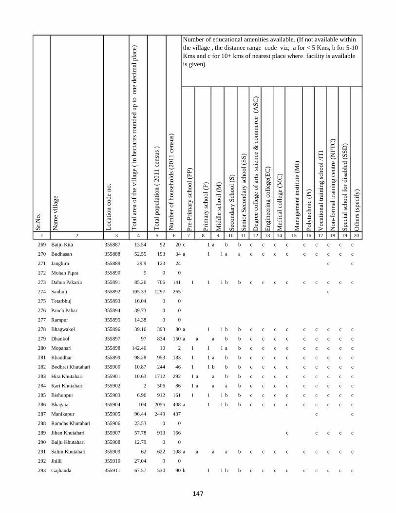
Pre
-Pri
mar
y s
cho
ol
(PP
)
Pri
mar
y s
cho
ol
(P)
Mid
dle
sch
oo
l (M
)
Sec
on
dar
y S
cho
ol
(S)
Sen
ior
Sec
on
dar
y s
cho
ol
(SS
)
Deg
ree
coll
ege
of
arts
sc
ien
ce &
co
mm
erce
(A
SC
)
En
gin
eeri
ng
co
lleg
e(E
C)
Med
ical
co
lleg
e (M
C)
Man
agem
ent
inst
itu
te (
MI)
Po
lyte
chn
ic (
Pt)
Vo
cati
on
al t
rain
ing
sch
oo
l /I
TI
No
n-f
orm
al t
rain
ing
cen
tre
(NF
TC
)
Sp
ecia
l sc
ho
ol
for
dis
able
d (
SS
D)
Oth
ers
(sp
ecif
y)
1 2 3 4 5 6 7 8 9 10 11 12 13 14 15 16 17 18 19 20
Lo
cati
on
co
de
no
.
Nam
e v
illa
ge
Sr.
No
.Number of educational amenities available. (If not available within
the village , the distance range code viz; a for < 5 Kms, b for 5-10
Kms and c for 10+ kms of nearest place where facility is available
is given).
Nu
mb
er o
f h
ou
seh
old
s (2
01
1 c
ensu
s)
To
tal
po
pu
lati
on
( 2
01
1 c
ensu
s )
To
tal
area
of
the
vil
lag
e (
in h
ecta
res
rou
nd
ed u
p t
o
on
e d
ecim
al p
lace
)
269 Baiju Kita 355887 13.54 92 20 c 1 a b b c c c c c c c c c
270 Budhasan 355888 52.55 193 34 a 1 1 a a c c c c c c c c c
271 Janghira 355889 29.9 123 24 c c
272 Mohan Pipra 355890 9 0 0
273 Dahua Pakaria 355891 85.26 706 141 1 1 1 b b c c c c c c c c c
274 Sanhuli 355892 105.33 1297 265 c
275 Tetarbhuj 355893 16.04 0 0
276 Panch Pahar 355894 39.73 0 0
277 Rampur 355895 14.38 0 0
278 Bhagwakol 355896 39.16 393 80 a 1 1 b b c c c c c c c c c
279 Dhankol 355897 97 834 150 a a a b b c c c c c c c c c
280 Mopahari 355898 142.46 10 2 1 1 1 a b c c c c c c c c c
281 Khandhar 355899 98.28 953 183 1 1 a b b c c c c c c c c c
282 Bodhrai Khutahari 355900 10.87 244 46 1 1 b b b c c c c c c c c c
283 Hira Khutahari 355901 10.63 1712 292 1 a a b b c c c c c c c c c
284 Kari Khutahari 355902 2 506 86 1 a a a b c c c c c c c c c
285 Bishunpur 355903 6.96 912 161 1 1 1 b b c c c c c c c c c
286 Bhagaia 355904 104 2055 408 a 1 1 b b c c c c c c c c c
287 Manikapur 355905 96.44 2449 437 c c
288 Ramdas Khutahari 355906 23.53 0 0
289 Jiban Khutahari 355907 57.78 913 166 c c c c c
290 Baiju Khutahari 355908 12.79 0 0
291 Salim Khutahari 355909 62 622 108 a a a a b c c c c c c c c c
292 Jhilli 355910 27.04 0 0
293 Gajhanda 355911 67.57 530 90 b 1 1 b b c c c c c c c c c
147
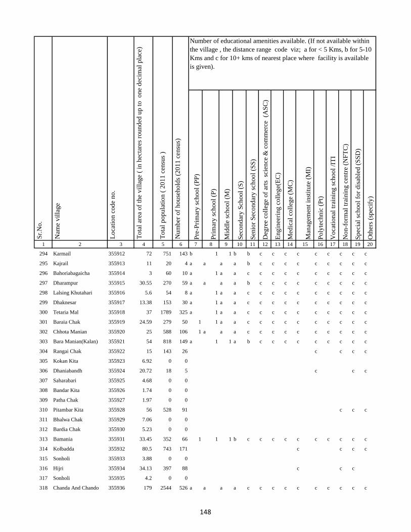
Pre
-Pri
mar
y s
cho
ol
(PP
)
Pri
mar
y s
cho
ol
(P)
Mid
dle
sch
oo
l (M
)
Sec
on
dar
y S
cho
ol
(S)
Sen
ior
Sec
on
dar
y s
cho
ol
(SS
)
Deg
ree
coll
ege
of
arts
sc
ien
ce &
co
mm
erce
(A
SC
)
En
gin
eeri
ng
co
lleg
e(E
C)
Med
ical
co
lleg
e (M
C)
Man
agem
ent
inst
itu
te (
MI)
Po
lyte
chn
ic (
Pt)
Vo
cati
on
al t
rain
ing
sch
oo
l /I
TI
No
n-f
orm
al t
rain
ing
cen
tre
(NF
TC
)
Sp
ecia
l sc
ho
ol
for
dis
able
d (
SS
D)
Oth
ers
(sp
ecif
y)
1 2 3 4 5 6 7 8 9 10 11 12 13 14 15 16 17 18 19 20
Lo
cati
on
co
de
no
.
Nam
e v
illa
ge
Sr.
No
.Number of educational amenities available. (If not available within
the village , the distance range code viz; a for < 5 Kms, b for 5-10
Kms and c for 10+ kms of nearest place where facility is available
is given).
Nu
mb
er o
f h
ou
seh
old
s (2
01
1 c
ensu
s)
To
tal
po
pu
lati
on
( 2
01
1 c
ensu
s )
To
tal
area
of
the
vil
lag
e (
in h
ecta
res
rou
nd
ed u
p t
o
on
e d
ecim
al p
lace
)
294 Karmail 355912 72 751 143 b 1 1 b b c c c c c c c c c
295 Kajrail 355913 11 20 4 a a a a b c c c c c c c c c
296 Bahoriabagaicha 355914 3 60 10 a 1 a a c c c c c c c c c c
297 Dharampur 355915 30.55 270 59 a a a a b c c c c c c c c c
298 Lalsing Khutahari 355916 5.6 54 8 a 1 a a c c c c c c c c c c
299 Dhaknesar 355917 13.38 153 30 a 1 a a c c c c c c c c c c
300 Tetaria Mal 355918 37 1789 325 a 1 a a c c c c c c c c c c
301 Baraia Chak 355919 24.59 279 50 1 1 a a c c c c c c c c c c
302 Chhota Manian 355920 25 588 106 1 a a a c c c c c c c c c c
303 Bara Manian(Kalan) 355921 54 818 149 a 1 1 a b c c c c c c c c c
304 Rangai Chak 355922 15 143 26 c c c c
305 Kokan Kita 355923 6.92 0 0
306 Dhaniabandh 355924 20.72 18 5 c c c
307 Saharabari 355925 4.68 0 0
308 Bandar Kita 355926 1.74 0 0
309 Patha Chak 355927 1.97 0 0
310 Pitambar Kita 355928 56 528 91 c c c
311 Bhalwa Chak 355929 7.06 0 0
312 Bardia Chak 355930 5.23 0 0
313 Bamania 355931 33.45 352 66 1 1 1 b c c c c c c c c c c
314 Kolbadda 355932 80.5 743 171 c c c c
315 Sonholi 355933 3.88 0 0
316 Hijri 355934 34.13 397 88 c c c
317 Sonholi 355935 4.2 0 0
318 Chanda And Chando 355936 179 2544 526 a a a a c c c c c c c c c c
148
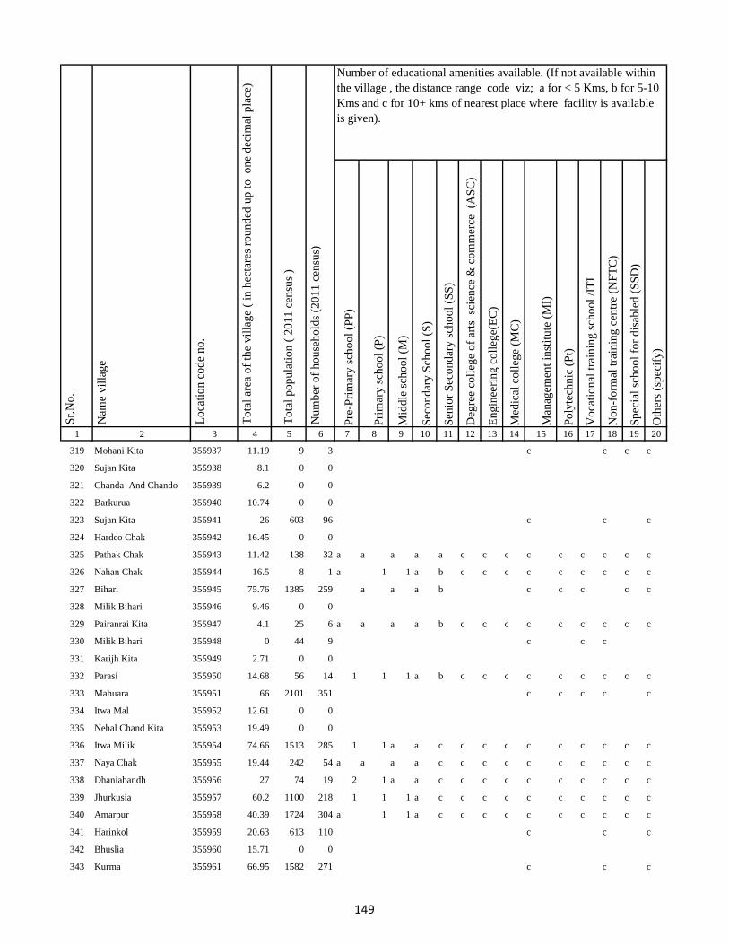
Pre
-Pri
mar
y s
cho
ol
(PP
)
Pri
mar
y s
cho
ol
(P)
Mid
dle
sch
oo
l (M
)
Sec
on
dar
y S
cho
ol
(S)
Sen
ior
Sec
on
dar
y s
cho
ol
(SS
)
Deg
ree
coll
ege
of
arts
sc
ien
ce &
co
mm
erce
(A
SC
)
En
gin
eeri
ng
co
lleg
e(E
C)
Med
ical
co
lleg
e (M
C)
Man
agem
ent
inst
itu
te (
MI)
Po
lyte
chn
ic (
Pt)
Vo
cati
on
al t
rain
ing
sch
oo
l /I
TI
No
n-f
orm
al t
rain
ing
cen
tre
(NF
TC
)
Sp
ecia
l sc
ho
ol
for
dis
able
d (
SS
D)
Oth
ers
(sp
ecif
y)
1 2 3 4 5 6 7 8 9 10 11 12 13 14 15 16 17 18 19 20
Lo
cati
on
co
de
no
.
Nam
e v
illa
ge
Sr.
No
.Number of educational amenities available. (If not available within
the village , the distance range code viz; a for < 5 Kms, b for 5-10
Kms and c for 10+ kms of nearest place where facility is available
is given).
Nu
mb
er o
f h
ou
seh
old
s (2
01
1 c
ensu
s)
To
tal
po
pu
lati
on
( 2
01
1 c
ensu
s )
To
tal
area
of
the
vil
lag
e (
in h
ecta
res
rou
nd
ed u
p t
o
on
e d
ecim
al p
lace
)
319 Mohani Kita 355937 11.19 9 3 c c c c
320 Sujan Kita 355938 8.1 0 0
321 Chanda And Chando 355939 6.2 0 0
322 Barkurua 355940 10.74 0 0
323 Sujan Kita 355941 26 603 96 c c c
324 Hardeo Chak 355942 16.45 0 0
325 Pathak Chak 355943 11.42 138 32 a a a a a c c c c c c c c c
326 Nahan Chak 355944 16.5 8 1 a 1 1 a b c c c c c c c c c
327 Bihari 355945 75.76 1385 259 a a a b c c c c c
328 Milik Bihari 355946 9.46 0 0
329 Pairanrai Kita 355947 4.1 25 6 a a a a b c c c c c c c c c
330 Milik Bihari 355948 0 44 9 c c c
331 Karijh Kita 355949 2.71 0 0
332 Parasi 355950 14.68 56 14 1 1 1 a b c c c c c c c c c
333 Mahuara 355951 66 2101 351 c c c c c
334 Itwa Mal 355952 12.61 0 0
335 Nehal Chand Kita 355953 19.49 0 0
336 Itwa Milik 355954 74.66 1513 285 1 1 a a c c c c c c c c c c
337 Naya Chak 355955 19.44 242 54 a a a a c c c c c c c c c c
338 Dhaniabandh 355956 27 74 19 2 1 a a c c c c c c c c c c
339 Jhurkusia 355957 60.2 1100 218 1 1 1 a c c c c c c c c c c
340 Amarpur 355958 40.39 1724 304 a 1 1 a c c c c c c c c c c
341 Harinkol 355959 20.63 613 110 c c c
342 Bhuslia 355960 15.71 0 0
343 Kurma 355961 66.95 1582 271 c c c
149

Pre
-Pri
mar
y s
cho
ol
(PP
)
Pri
mar
y s
cho
ol
(P)
Mid
dle
sch
oo
l (M
)
Sec
on
dar
y S
cho
ol
(S)
Sen
ior
Sec
on
dar
y s
cho
ol
(SS
)
Deg
ree
coll
ege
of
arts
sc
ien
ce &
co
mm
erce
(A
SC
)
En
gin
eeri
ng
co
lleg
e(E
C)
Med
ical
co
lleg
e (M
C)
Man
agem
ent
inst
itu
te (
MI)
Po
lyte
chn
ic (
Pt)
Vo
cati
on
al t
rain
ing
sch
oo
l /I
TI
No
n-f
orm
al t
rain
ing
cen
tre
(NF
TC
)
Sp
ecia
l sc
ho
ol
for
dis
able
d (
SS
D)
Oth
ers
(sp
ecif
y)
1 2 3 4 5 6 7 8 9 10 11 12 13 14 15 16 17 18 19 20
Lo
cati
on
co
de
no
.
Nam
e v
illa
ge
Sr.
No
.Number of educational amenities available. (If not available within
the village , the distance range code viz; a for < 5 Kms, b for 5-10
Kms and c for 10+ kms of nearest place where facility is available
is given).
Nu
mb
er o
f h
ou
seh
old
s (2
01
1 c
ensu
s)
To
tal
po
pu
lati
on
( 2
01
1 c
ensu
s )
To
tal
area
of
the
vil
lag
e (
in h
ecta
res
rou
nd
ed u
p t
o
on
e d
ecim
al p
lace
)
344 Darji Kita 355962 5.64 0 0
345 Birnath Chak 355963 11.73 0 0
346 Indar Chak 355964 67.12 1543 274 a 2 1 1 c c c c c c c c c c
347 Marro Mal 355965 89 4477 863 a 1 a a c c c c c c c c c c
348 Belatikar 355966 55 722 151 a 1 a a c c c c c c c c c c
349 Pipra 355967 48 479 87 a 1 1 a c c c c c c c c c c
350 Budhuachak 355968 16.9 1618 328 a a a a c c c c c c c c c c
351 Pipra 355969 6.08 70 17 a a a a c c c c c c c c c c
352 Purnia 355970 20.13 201 38 a 1 1 1 b c c c c c c c c c
353 Mardiha 355971 232 3407 760 a 1 1 a c c c c c c c c c c
354 Baghakol 355972 9.37 344 85 1 1 a a c c c c c c c c c c
355 Rangila 355973 26.34 187 36 a 1 a a c c c c c c c c c c
356 Bhuska 355974 28.54 67 16 a 1 a a c c c c c c c c c c
357 Chand Chak 355975 17.79 261 54 c c c
358 Dogachhi 355976 26.05 0 0
359 Khajri Chak 355977 61.54 1221 285 a 1 a a c c c c c c c c c c
360 Lainbrar Barakhar 355978 8.13 462 88 a 1 a a c c c c c c c c c c
361 Lensirsa 355979 8.54 433 80 a a a a b c c c c c c c c c
362 Gorapariharpur 355980 7.76 13 4 1 1 1 1 b c c c c c c c c c
363 Basta 355981 107.91 1368 268 a 1 a a c c c c c c c c c c
364 Bariasirsa 355982 20.91 153 32 c c c
365 Gobindi Chak 355983 17.24 0 0
366 Kanipathari 355984 5 0 0
367 Gaias Chak 355985 21 0 0
368 Majh Kola 355986 73.77 188 35 1 1 4 a b c c c c c c c c c
150
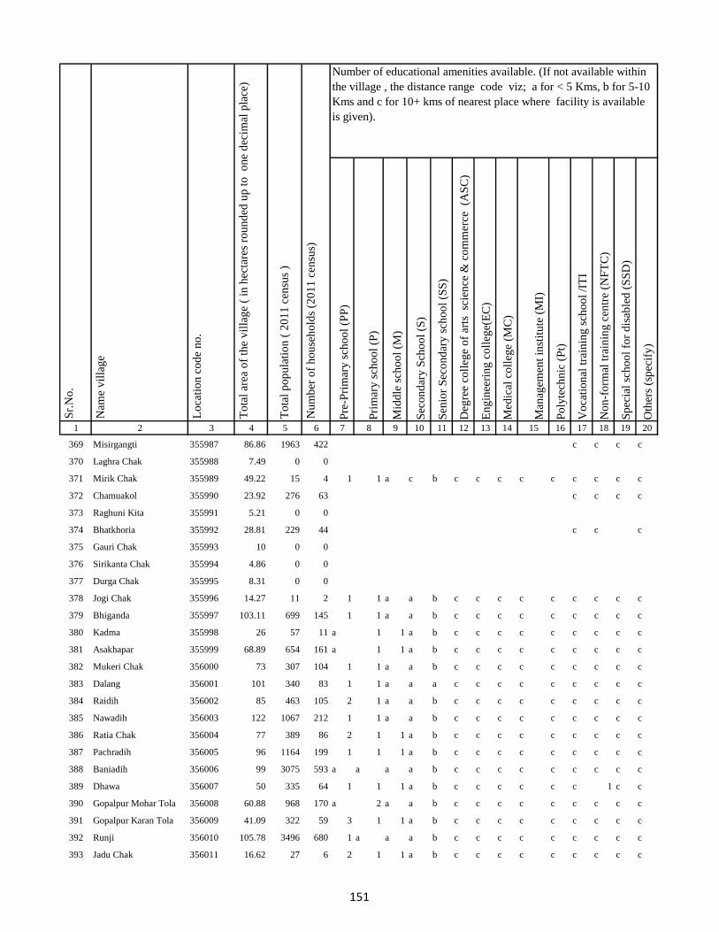
Pre
-Pri
mar
y s
cho
ol
(PP
)
Pri
mar
y s
cho
ol
(P)
Mid
dle
sch
oo
l (M
)
Sec
on
dar
y S
cho
ol
(S)
Sen
ior
Sec
on
dar
y s
cho
ol
(SS
)
Deg
ree
coll
ege
of
arts
sc
ien
ce &
co
mm
erce
(A
SC
)
En
gin
eeri
ng
co
lleg
e(E
C)
Med
ical
co
lleg
e (M
C)
Man
agem
ent
inst
itu
te (
MI)
Po
lyte
chn
ic (
Pt)
Vo
cati
on
al t
rain
ing
sch
oo
l /I
TI
No
n-f
orm
al t
rain
ing
cen
tre
(NF
TC
)
Sp
ecia
l sc
ho
ol
for
dis
able
d (
SS
D)
Oth
ers
(sp
ecif
y)
1 2 3 4 5 6 7 8 9 10 11 12 13 14 15 16 17 18 19 20
Lo
cati
on
co
de
no
.
Nam
e v
illa
ge
Sr.
No
.Number of educational amenities available. (If not available within
the village , the distance range code viz; a for < 5 Kms, b for 5-10
Kms and c for 10+ kms of nearest place where facility is available
is given).
Nu
mb
er o
f h
ou
seh
old
s (2
01
1 c
ensu
s)
To
tal
po
pu
lati
on
( 2
01
1 c
ensu
s )
To
tal
area
of
the
vil
lag
e (
in h
ecta
res
rou
nd
ed u
p t
o
on
e d
ecim
al p
lace
)
369 Misirgangti 355987 86.86 1963 422 c c c c
370 Laghra Chak 355988 7.49 0 0
371 Mirik Chak 355989 49.22 15 4 1 1 a c b c c c c c c c c c
372 Chamuakol 355990 23.92 276 63 c c c c
373 Raghuni Kita 355991 5.21 0 0
374 Bhatkhoria 355992 28.81 229 44 c c c
375 Gauri Chak 355993 10 0 0
376 Sirikanta Chak 355994 4.86 0 0
377 Durga Chak 355995 8.31 0 0
378 Jogi Chak 355996 14.27 11 2 1 1 a a b c c c c c c c c c
379 Bhiganda 355997 103.11 699 145 1 1 a a b c c c c c c c c c
380 Kadma 355998 26 57 11 a 1 1 a b c c c c c c c c c
381 Asakhapar 355999 68.89 654 161 a 1 1 a b c c c c c c c c c
382 Mukeri Chak 356000 73 307 104 1 1 a a b c c c c c c c c c
383 Dalang 356001 101 340 83 1 1 a a a c c c c c c c c c
384 Raidih 356002 85 463 105 2 1 a a b c c c c c c c c c
385 Nawadih 356003 122 1067 212 1 1 a a b c c c c c c c c c
386 Ratia Chak 356004 77 389 86 2 1 1 a b c c c c c c c c c
387 Pachradih 356005 96 1164 199 1 1 1 a b c c c c c c c c c
388 Baniadih 356006 99 3075 593 a a a a b c c c c c c c c c
389 Dhawa 356007 50 335 64 1 1 1 a b c c c c c c 1 c c
390 Gopalpur Mohar Tola 356008 60.88 968 170 a 2 a a b c c c c c c c c c
391 Gopalpur Karan Tola 356009 41.09 322 59 3 1 1 a b c c c c c c c c c
392 Runji 356010 105.78 3496 680 1 a a a b c c c c c c c c c
393 Jadu Chak 356011 16.62 27 6 2 1 1 a b c c c c c c c c c
151
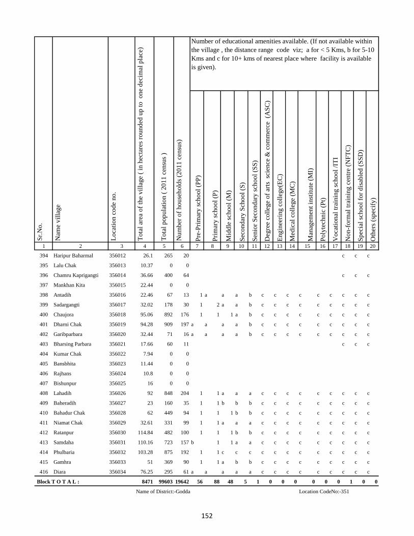
Pre
-Pri
mar
y s
cho
ol
(PP
)
Pri
mar
y s
cho
ol
(P)
Mid
dle
sch
oo
l (M
)
Sec
on
dar
y S
cho
ol
(S)
Sen
ior
Sec
on
dar
y s
cho
ol
(SS
)
Deg
ree
coll
ege
of
arts
sc
ien
ce &
co
mm
erce
(A
SC
)
En
gin
eeri
ng
co
lleg
e(E
C)
Med
ical
co
lleg
e (M
C)
Man
agem
ent
inst
itu
te (
MI)
Po
lyte
chn
ic (
Pt)
Vo
cati
on
al t
rain
ing
sch
oo
l /I
TI
No
n-f
orm
al t
rain
ing
cen
tre
(NF
TC
)
Sp
ecia
l sc
ho
ol
for
dis
able
d (
SS
D)
Oth
ers
(sp
ecif
y)
1 2 3 4 5 6 7 8 9 10 11 12 13 14 15 16 17 18 19 20
Lo
cati
on
co
de
no
.
Nam
e v
illa
ge
Sr.
No
.Number of educational amenities available. (If not available within
the village , the distance range code viz; a for < 5 Kms, b for 5-10
Kms and c for 10+ kms of nearest place where facility is available
is given).
Nu
mb
er o
f h
ou
seh
old
s (2
01
1 c
ensu
s)
To
tal
po
pu
lati
on
( 2
01
1 c
ensu
s )
To
tal
area
of
the
vil
lag
e (
in h
ecta
res
rou
nd
ed u
p t
o
on
e d
ecim
al p
lace
)
394 Haripur Baharmal 356012 26.1 265 20 c c c
395 Lalu Chak 356013 10.37 0 0
396 Chamru Kaprigangti 356014 36.66 400 64 c c c
397 Mankhan Kita 356015 22.44 0 0
398 Antadih 356016 22.46 67 13 1 a a a b c c c c c c c c c
399 Sadargangti 356017 32.02 178 30 1 2 a a b c c c c c c c c c
400 Chaujora 356018 95.06 892 176 1 1 1 a b c c c c c c c c c
401 Dharni Chak 356019 94.28 909 197 a a a a b c c c c c c c c c
402 Garibparbara 356020 32.44 71 16 a a a a b c c c c c c c c c
403 Bharsing Parbara 356021 17.66 60 11 c c c
404 Kumar Chak 356022 7.94 0 0
405 Bansbhita 356023 11.44 0 0
406 Rajhans 356024 10.8 0 0
407 Bishunpur 356025 16 0 0
408 Lahadih 356026 92 848 204 1 1 a a a c c c c c c c c c
409 Baheradih 356027 23 160 35 1 1 b b b c c c c c c c c c
410 Bahadur Chak 356028 62 449 94 1 1 1 b b c c c c c c c c c
411 Niamat Chak 356029 32.61 331 99 1 1 a a a c c c c c c c c c
412 Ratanpur 356030 114.84 482 100 1 1 1 b b c c c c c c c c c
413 Samdaha 356031 110.16 723 157 b 1 1 a a c c c c c c c c c
414 Phulbaria 356032 103.28 875 192 1 1 c c c c c c c c c c c c
415 Gamhra 356033 51 369 90 1 1 a b b c c c c c c c c c
416 Diara 356034 76.25 295 61 a a a a a c c c c c c c c c
Block T O T A L : 8471 99603 19642 56 88 48 5 1 0 0 0 0 0 0 1 0 0
Name of District:-Godda Location CodeNo:-351
152

Pre
-Pri
mar
y s
cho
ol
(PP
)
Pri
mar
y s
cho
ol
(P)
Mid
dle
sch
oo
l (M
)
Sec
on
dar
y S
cho
ol
(S)
Sen
ior
Sec
on
dar
y s
cho
ol
(SS
)
Deg
ree
coll
ege
of
arts
sc
ien
ce &
co
mm
erce
(A
SC
)
En
gin
eeri
ng
co
lleg
e(E
C)
Med
ical
co
lleg
e (M
C)
Man
agem
ent
inst
itu
te (
MI)
Po
lyte
chn
ic (
Pt)
Vo
cati
on
al t
rain
ing
sch
oo
l /I
TI
No
n-f
orm
al t
rain
ing
cen
tre
(NF
TC
)
Sp
ecia
l sc
ho
ol
for
dis
able
d (
SS
D)
Oth
ers
(sp
ecif
y)
1 2 3 4 5 6 7 8 9 10 11 12 13 14 15 16 17 18 19 20
Lo
cati
on
co
de
no
.
Nam
e v
illa
ge
Sr.
No
.Number of educational amenities available. (If not available within
the village , the distance range code viz; a for < 5 Kms, b for 5-10
Kms and c for 10+ kms of nearest place where facility is available
is given).
Nu
mb
er o
f h
ou
seh
old
s (2
01
1 c
ensu
s)
To
tal
po
pu
lati
on
( 2
01
1 c
ensu
s )
To
tal
area
of
the
vil
lag
e (
in h
ecta
res
rou
nd
ed u
p t
o
on
e d
ecim
al p
lace
)
Name of CD Block:-Boarijor Location CodeNo:-0063
417 Urkusia 356035 14 10 2 a 1 a a a c c c c c c c c c
418 Garantia 356036 52 391 74 a 1 a a a c c c c c c c c c
419 Lakrakol 356037 28 53 14 c 1 a b c c c c c c c c c c
420 Sijuakol 356038 81 640 121 c 1 a a c c c c c c c c c c
421 Bagjhopa 356039 31 187 40 a 1 1 a b c c c c c c c c c
422 Daldali Gopalpur 356040 167 979 202 c a a c c c c c c c b c c c
423 Seharo Chak 356041 12 0 0
424 Bahelia Chak 356042 25 310 63 b 1 a b b c c c c c b c c c
425 Rajbandh 356043 95 728 147 b 1 a b b c c c c c c c c c
426 Issar Chak 356044 49 380 84 b 1 1 c c c c c c c c c c c
427 Kendua 356045 171 922 185 c 2 2 b c c c c c c c c c c
428 Ramkol 356046 131 1122 210 c 1 1 c c c c c c c c c c c
429 Raharbaria 356047 49 129 26 1 2 2 b b c c c c c a c c c
430 Kamaldori 356048 42 265 55 a 1 1 c c c c c c c b c c c
431 Janlokundi 356049 26 76 18 b 1 a b c c c c c c b c c c
432 Dhamnisemia 356050 185 754 158 b 1 a a b c c c c c b c c c
433 Hijri 356051 113 502 113 1 2 2 c c c c c c c b c c c
434 Jirli 356052 342 1952 444 b a a b c c c c c c b c c c
435 Dhamnipahar 356053 164 70 14 b 1 1 b b c c c c c b c c c
436 Goradih 356054 215 1773 382 c
437 Behra Chak 356055 12 0 0
438 Bishunpur 356056 50 360 79 a 1 1 b b c c c c c b c c c
439 Chandsar 356057 70 291 66 b 1 a a a c c c c c c c c c
440 Karmatanr 356058 73 281 58 b a a b b c c c c c c c c c
153

Pre
-Pri
mar
y s
cho
ol
(PP
)
Pri
mar
y s
cho
ol
(P)
Mid
dle
sch
oo
l (M
)
Sec
on
dar
y S
cho
ol
(S)
Sen
ior
Sec
on
dar
y s
cho
ol
(SS
)
Deg
ree
coll
ege
of
arts
sc
ien
ce &
co
mm
erce
(A
SC
)
En
gin
eeri
ng
co
lleg
e(E
C)
Med
ical
co
lleg
e (M
C)
Man
agem
ent
inst
itu
te (
MI)
Po
lyte
chn
ic (
Pt)
Vo
cati
on
al t
rain
ing
sch
oo
l /I
TI
No
n-f
orm
al t
rain
ing
cen
tre
(NF
TC
)
Sp
ecia
l sc
ho
ol
for
dis
able
d (
SS
D)
Oth
ers
(sp
ecif
y)
1 2 3 4 5 6 7 8 9 10 11 12 13 14 15 16 17 18 19 20
Lo
cati
on
co
de
no
.
Nam
e v
illa
ge
Sr.
No
.Number of educational amenities available. (If not available within
the village , the distance range code viz; a for < 5 Kms, b for 5-10
Kms and c for 10+ kms of nearest place where facility is available
is given).
Nu
mb
er o
f h
ou
seh
old
s (2
01
1 c
ensu
s)
To
tal
po
pu
lati
on
( 2
01
1 c
ensu
s )
To
tal
area
of
the
vil
lag
e (
in h
ecta
res
rou
nd
ed u
p t
o
on
e d
ecim
al p
lace
)
441 Marpa 356059 21 158 37 b 2 2 b b c c c c c c c c c
442 Baghmara 356060 441.41 2907 610 b 1 1 1 c c c c c c c c c c
443 Itahari 356061 252 1314 263 c a a a c c c c c c b c c c
444 Chhota Itahari Pahar 356062 182 245 44 b a a b b c c c c c c c c c
445 Chhota Gogra 356063 45 51 13 b a a b b c c c c c c c c c
446 Bara Gogra 356064 69 57 14 b 1 a b b c c c c c c c c c
447 Chhota Darma 356065 119 680 143 b 1 a b b c c c c c 1 c c c
448 Kolhua 356066 196 646 163 b 1 b b b c c c c c c c c c
449 Malbhita 356067 47 97 19 b 1 b b b c c c c c c c c c
450 Pairgora 356068 64 42 9 b 1 a b b c c c c c c c c c
451 Kaldigra 356069 40 47 10 a 1 1 c a c c c c c b c c c
452 Khejuria 356070 198 797 176 a a a c a c c c c c b c c c
453 Talbaria 356071 20 107 25 b 1 1 b b c c c c c c c c c
454 Bara Darma 356072 130 474 102 b a a b b c c c c c c c c c
455 Balajhor 356073 123 527 109 b 1 1 b b c c c c c c c c c
456 Bangama 356074 117 541 122 b 1 1 b b c c c c c c c c c
457 Sakrikita Rampur 356075 84 753 124 a b b b c c c c c c c c c
458 Darbe Chak 356076 21.62 0 0
459 Joborampur 356077 46 416 76 b 1 a b b c c c c c c c c c
460 Ekdanrghat 356078 36 302 58 b 1 b b b c c c c c c c c c
461 Chhota Siripur 356079 73 480 106 b 1 1 b b c c c c c c c c c
462 Siripur Bazar 356080 4.98 1263 264 b 2 b b b c c c c c c c c c
463 Bara Siripur 356081 289 1777 351 a a a a a c c c c c c c c c
464 Khairbani 356082 19 79 16 a 1 a b b c c c c c c c c c
465 Losinghna 356083 126 663 126 a 1 a b b c c c c c c c c c
154
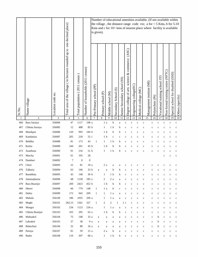
Pre
-Pri
mar
y s
cho
ol
(PP
)
Pri
mar
y s
cho
ol
(P)
Mid
dle
sch
oo
l (M
)
Sec
on
dar
y S
cho
ol
(S)
Sen
ior
Sec
on
dar
y s
cho
ol
(SS
)
Deg
ree
coll
ege
of
arts
sc
ien
ce &
co
mm
erce
(A
SC
)
En
gin
eeri
ng
co
lleg
e(E
C)
Med
ical
co
lleg
e (M
C)
Man
agem
ent
inst
itu
te (
MI)
Po
lyte
chn
ic (
Pt)
Vo
cati
on
al t
rain
ing
sch
oo
l /I
TI
No
n-f
orm
al t
rain
ing
cen
tre
(NF
TC
)
Sp
ecia
l sc
ho
ol
for
dis
able
d (
SS
D)
Oth
ers
(sp
ecif
y)
1 2 3 4 5 6 7 8 9 10 11 12 13 14 15 16 17 18 19 20
Lo
cati
on
co
de
no
.
Nam
e v
illa
ge
Sr.
No
.Number of educational amenities available. (If not available within
the village , the distance range code viz; a for < 5 Kms, b for 5-10
Kms and c for 10+ kms of nearest place where facility is available
is given).
Nu
mb
er o
f h
ou
seh
old
s (2
01
1 c
ensu
s)
To
tal
po
pu
lati
on
( 2
01
1 c
ensu
s )
To
tal
area
of
the
vil
lag
e (
in h
ecta
res
rou
nd
ed u
p t
o
on
e d
ecim
al p
lace
)
466 Bara Saraiya 356084 47 1117 198 a 1 a b a c c c c c c c c c
467 Chhota Saraiya 356085 12 488 85 b 1 1 b b c c c c c c c c c
468 Manikpur 356086 120 993 184 b 1 b b b c c c c c c c c c
469 Kandaniya 356087 205 218 55 c 1 b c c c c c c c c c c c
470 Beldiha 356088 81 173 43 1 1 1 b b c c c c c c c c c
471 Kortia 356089 160 201 45 b 1 b b b c c c c c c c c c
472 Asanbuna 356090 91 216 51 b 1 1 b b c c c c c c c c c
473 Marcha 356091 61 105 28 c c c
474 Dumbari 356092 7 0 0
475 Churi 356093 22 81 18 a 2 a a a c c c c c c c c c
476 Talbaria 356094 63 146 33 b a a b b c c c c c c c c c
477 Bansbhita 356095 43 148 30 b 1 1 b b c c c c c c c c c
478 Jamunajharna 356096 68 1158 185 a 2 2 a a c c c c c c c c c
479 Bara Boarijor 356097 200 2423 452 b 1 b b b c c c c c c c c c
480 Dhorri 356098 66 779 148 1 1 a b c c c c c c c c c c
481 Dubra 356099 172 943 209 1 1 1 a a c c c c c c c c c
482 Mahula 356100 186 1055 209 a 1 1 a a c c c c c c c c c
483 Meghi 356101 262.13 1561 327 1 2 2 1 1 c c c c c c c c c
484 Mangra 356102 234 1123 234 a 1 1 a a c c c c c c c c c
485 Chhota Boarijor 356103 105 295 63 a 1 b b b c c c c c c c c c
486 Mahuakol 356104 75 148 33 a a a a a c c c c c b c c c
487 Lakrakol 356105 37 38 9 a a a a a c c c c c b c c c
488 Babuchuri 356106 32 88 16 a a a a a c c c c c b c c c
489 Parsiya 356107 81 59 15 a 2 a b a c c c c c c c c c
490 Bador 356108 110 307 68 a 1 1 b b c c c c c c c c c
155
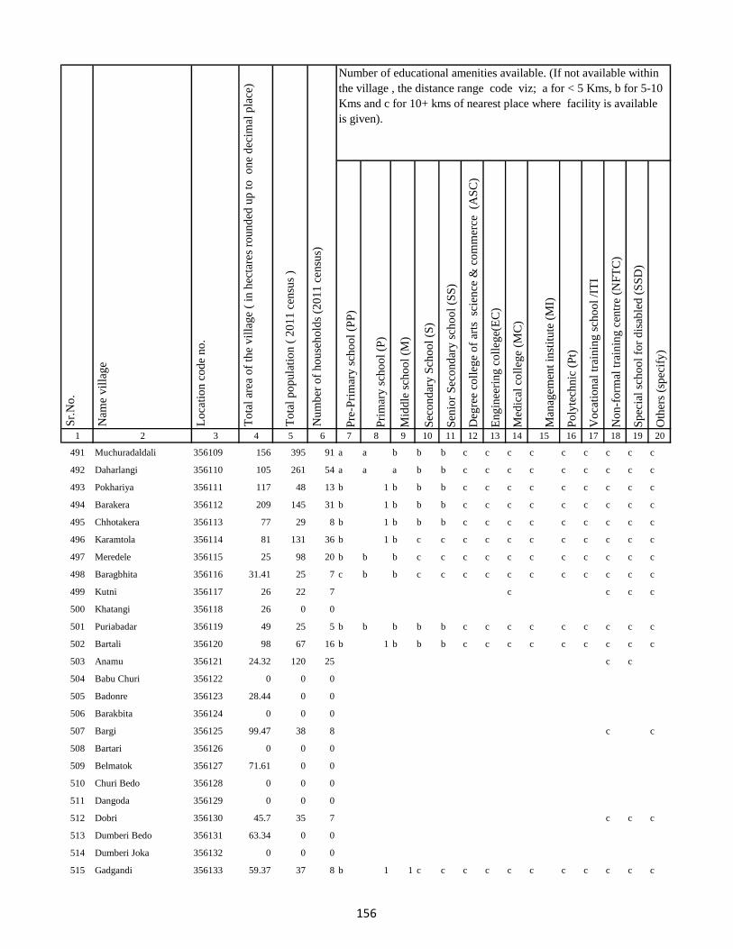
Pre
-Pri
mar
y s
cho
ol
(PP
)
Pri
mar
y s
cho
ol
(P)
Mid
dle
sch
oo
l (M
)
Sec
on
dar
y S
cho
ol
(S)
Sen
ior
Sec
on
dar
y s
cho
ol
(SS
)
Deg
ree
coll
ege
of
arts
sc
ien
ce &
co
mm
erce
(A
SC
)
En
gin
eeri
ng
co
lleg
e(E
C)
Med
ical
co
lleg
e (M
C)
Man
agem
ent
inst
itu
te (
MI)
Po
lyte
chn
ic (
Pt)
Vo
cati
on
al t
rain
ing
sch
oo
l /I
TI
No
n-f
orm
al t
rain
ing
cen
tre
(NF
TC
)
Sp
ecia
l sc
ho
ol
for
dis
able
d (
SS
D)
Oth
ers
(sp
ecif
y)
1 2 3 4 5 6 7 8 9 10 11 12 13 14 15 16 17 18 19 20
Lo
cati
on
co
de
no
.
Nam
e v
illa
ge
Sr.
No
.Number of educational amenities available. (If not available within
the village , the distance range code viz; a for < 5 Kms, b for 5-10
Kms and c for 10+ kms of nearest place where facility is available
is given).
Nu
mb
er o
f h
ou
seh
old
s (2
01
1 c
ensu
s)
To
tal
po
pu
lati
on
( 2
01
1 c
ensu
s )
To
tal
area
of
the
vil
lag
e (
in h
ecta
res
rou
nd
ed u
p t
o
on
e d
ecim
al p
lace
)
491 Muchuradaldali 356109 156 395 91 a a b b b c c c c c c c c c
492 Daharlangi 356110 105 261 54 a a a b b c c c c c c c c c
493 Pokhariya 356111 117 48 13 b 1 b b b c c c c c c c c c
494 Barakera 356112 209 145 31 b 1 b b b c c c c c c c c c
495 Chhotakera 356113 77 29 8 b 1 b b b c c c c c c c c c
496 Karamtola 356114 81 131 36 b 1 b c c c c c c c c c c c
497 Meredele 356115 25 98 20 b b b c c c c c c c c c c c
498 Baragbhita 356116 31.41 25 7 c b b c c c c c c c c c c c
499 Kutni 356117 26 22 7 c c c c
500 Khatangi 356118 26 0 0
501 Puriabadar 356119 49 25 5 b b b b b c c c c c c c c c
502 Bartali 356120 98 67 16 b 1 b b b c c c c c c c c c
503 Anamu 356121 24.32 120 25 c c
504 Babu Churi 356122 0 0 0
505 Badonre 356123 28.44 0 0
506 Barakbita 356124 0 0 0
507 Bargi 356125 99.47 38 8 c c
508 Bartari 356126 0 0 0
509 Belmatok 356127 71.61 0 0
510 Churi Bedo 356128 0 0 0
511 Dangoda 356129 0 0 0
512 Dobri 356130 45.7 35 7 c c c
513 Dumberi Bedo 356131 63.34 0 0
514 Dumberi Joka 356132 0 0 0
515 Gadgandi 356133 59.37 37 8 b 1 1 c c c c c c c c c c c
156
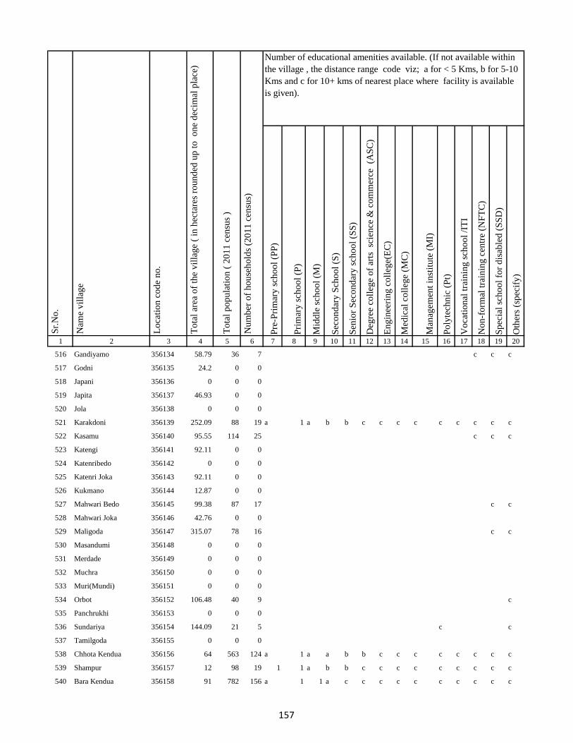
Pre
-Pri
mar
y s
cho
ol
(PP
)
Pri
mar
y s
cho
ol
(P)
Mid
dle
sch
oo
l (M
)
Sec
on
dar
y S
cho
ol
(S)
Sen
ior
Sec
on
dar
y s
cho
ol
(SS
)
Deg
ree
coll
ege
of
arts
sc
ien
ce &
co
mm
erce
(A
SC
)
En
gin
eeri
ng
co
lleg
e(E
C)
Med
ical
co
lleg
e (M
C)
Man
agem
ent
inst
itu
te (
MI)
Po
lyte
chn
ic (
Pt)
Vo
cati
on
al t
rain
ing
sch
oo
l /I
TI
No
n-f
orm
al t
rain
ing
cen
tre
(NF
TC
)
Sp
ecia
l sc
ho
ol
for
dis
able
d (
SS
D)
Oth
ers
(sp
ecif
y)
1 2 3 4 5 6 7 8 9 10 11 12 13 14 15 16 17 18 19 20
Lo
cati
on
co
de
no
.
Nam
e v
illa
ge
Sr.
No
.Number of educational amenities available. (If not available within
the village , the distance range code viz; a for < 5 Kms, b for 5-10
Kms and c for 10+ kms of nearest place where facility is available
is given).
Nu
mb
er o
f h
ou
seh
old
s (2
01
1 c
ensu
s)
To
tal
po
pu
lati
on
( 2
01
1 c
ensu
s )
To
tal
area
of
the
vil
lag
e (
in h
ecta
res
rou
nd
ed u
p t
o
on
e d
ecim
al p
lace
)
516 Gandiyamo 356134 58.79 36 7 c c c
517 Godni 356135 24.2 0 0
518 Japani 356136 0 0 0
519 Japita 356137 46.93 0 0
520 Jola 356138 0 0 0
521 Karakdoni 356139 252.09 88 19 a 1 a b b c c c c c c c c c
522 Kasamu 356140 95.55 114 25 c c c
523 Katengi 356141 92.11 0 0
524 Katenribedo 356142 0 0 0
525 Katenri Joka 356143 92.11 0 0
526 Kukmano 356144 12.87 0 0
527 Mahwari Bedo 356145 99.38 87 17 c c
528 Mahwari Joka 356146 42.76 0 0
529 Maligoda 356147 315.07 78 16 c c
530 Masandumi 356148 0 0 0
531 Merdade 356149 0 0 0
532 Muchra 356150 0 0 0
533 Muri(Mundi) 356151 0 0 0
534 Orbot 356152 106.48 40 9 c
535 Panchrukhi 356153 0 0 0
536 Sundariya 356154 144.09 21 5 c c
537 Tamilgoda 356155 0 0 0
538 Chhota Kendua 356156 64 563 124 a 1 a a b b c c c c c c c c
539 Shampur 356157 12 98 19 1 1 a b b c c c c c c c c c
540 Bara Kendua 356158 91 782 156 a 1 1 a c c c c c c c c c c
157
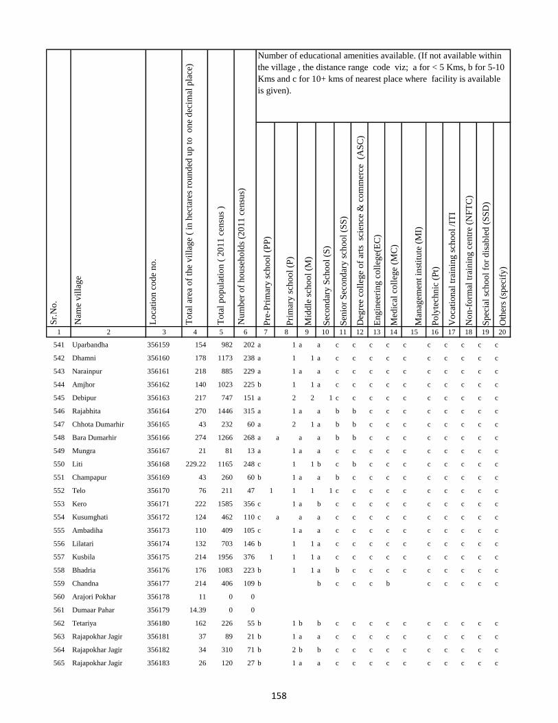
Pre
-Pri
mar
y s
cho
ol
(PP
)
Pri
mar
y s
cho
ol
(P)
Mid
dle
sch
oo
l (M
)
Sec
on
dar
y S
cho
ol
(S)
Sen
ior
Sec
on
dar
y s
cho
ol
(SS
)
Deg
ree
coll
ege
of
arts
sc
ien
ce &
co
mm
erce
(A
SC
)
En
gin
eeri
ng
co
lleg
e(E
C)
Med
ical
co
lleg
e (M
C)
Man
agem
ent
inst
itu
te (
MI)
Po
lyte
chn
ic (
Pt)
Vo
cati
on
al t
rain
ing
sch
oo
l /I
TI
No
n-f
orm
al t
rain
ing
cen
tre
(NF
TC
)
Sp
ecia
l sc
ho
ol
for
dis
able
d (
SS
D)
Oth
ers
(sp
ecif
y)
1 2 3 4 5 6 7 8 9 10 11 12 13 14 15 16 17 18 19 20
Lo
cati
on
co
de
no
.
Nam
e v
illa
ge
Sr.
No
.Number of educational amenities available. (If not available within
the village , the distance range code viz; a for < 5 Kms, b for 5-10
Kms and c for 10+ kms of nearest place where facility is available
is given).
Nu
mb
er o
f h
ou
seh
old
s (2
01
1 c
ensu
s)
To
tal
po
pu
lati
on
( 2
01
1 c
ensu
s )
To
tal
area
of
the
vil
lag
e (
in h
ecta
res
rou
nd
ed u
p t
o
on
e d
ecim
al p
lace
)
541 Uparbandha 356159 154 982 202 a 1 a a c c c c c c c c c c
542 Dhamni 356160 178 1173 238 a 1 1 a c c c c c c c c c c
543 Narainpur 356161 218 885 229 a 1 a a c c c c c c c c c c
544 Amjhor 356162 140 1023 225 b 1 1 a c c c c c c c c c c
545 Debipur 356163 217 747 151 a 2 2 1 c c c c c c c c c c
546 Rajabhita 356164 270 1446 315 a 1 a a b b c c c c c c c c
547 Chhota Dumarhir 356165 43 232 60 a 2 1 a b b c c c c c c c c
548 Bara Dumarhir 356166 274 1266 268 a a a a b b c c c c c c c c
549 Mungra 356167 21 81 13 a 1 a a c c c c c c c c c c
550 Liti 356168 229.22 1165 248 c 1 1 b c b c c c c c c c c
551 Champapur 356169 43 260 60 b 1 a a b c c c c c c c c c
552 Telo 356170 76 211 47 1 1 1 1 c c c c c c c c c c
553 Kero 356171 222 1585 356 c 1 a b c c c c c c c c c c
554 Kusumghati 356172 124 462 110 c a a a c c c c c c c c c c
555 Ambadiha 356173 110 409 105 c 1 a a c c c c c c c c c c
556 Lilatari 356174 132 703 146 b 1 1 a c c c c c c c c c c
557 Kusbila 356175 214 1956 376 1 1 1 a c c c c c c c c c c
558 Bhadria 356176 176 1083 223 b 1 1 a b c c c c c c c c c
559 Chandna 356177 214 406 109 b b c c c b c c c c c
560 Arajori Pokhar 356178 11 0 0
561 Dumaar Pahar 356179 14.39 0 0
562 Tetariya 356180 162 226 55 b 1 b b c c c c c c c c c c
563 Rajapokhar Jagir 356181 37 89 21 b 1 a a c c c c c c c c c c
564 Rajapokhar Jagir 356182 34 310 71 b 2 b b c c c c c c c c c c
565 Rajapokhar Jagir 356183 26 120 27 b 1 a a c c c c c c c c c c
158
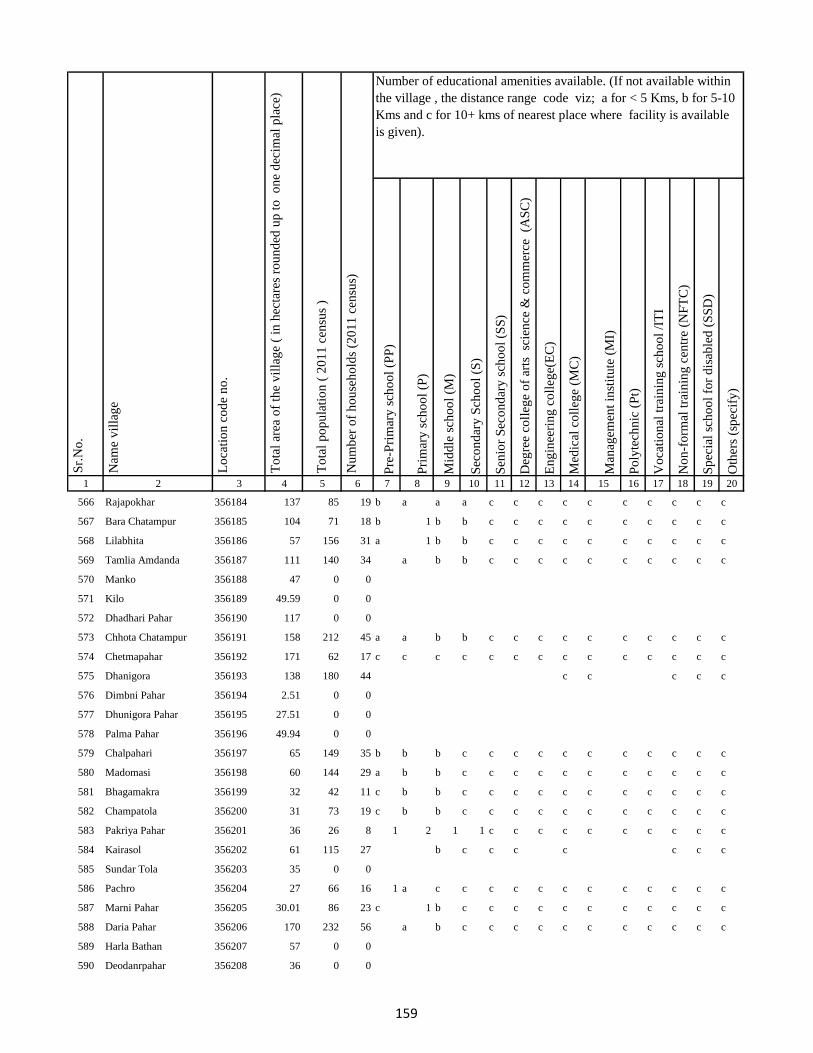
Pre
-Pri
mar
y s
cho
ol
(PP
)
Pri
mar
y s
cho
ol
(P)
Mid
dle
sch
oo
l (M
)
Sec
on
dar
y S
cho
ol
(S)
Sen
ior
Sec
on
dar
y s
cho
ol
(SS
)
Deg
ree
coll
ege
of
arts
sc
ien
ce &
co
mm
erce
(A
SC
)
En
gin
eeri
ng
co
lleg
e(E
C)
Med
ical
co
lleg
e (M
C)
Man
agem
ent
inst
itu
te (
MI)
Po
lyte
chn
ic (
Pt)
Vo
cati
on
al t
rain
ing
sch
oo
l /I
TI
No
n-f
orm
al t
rain
ing
cen
tre
(NF
TC
)
Sp
ecia
l sc
ho
ol
for
dis
able
d (
SS
D)
Oth
ers
(sp
ecif
y)
1 2 3 4 5 6 7 8 9 10 11 12 13 14 15 16 17 18 19 20
Lo
cati
on
co
de
no
.
Nam
e v
illa
ge
Sr.
No
.Number of educational amenities available. (If not available within
the village , the distance range code viz; a for < 5 Kms, b for 5-10
Kms and c for 10+ kms of nearest place where facility is available
is given).
Nu
mb
er o
f h
ou
seh
old
s (2
01
1 c
ensu
s)
To
tal
po
pu
lati
on
( 2
01
1 c
ensu
s )
To
tal
area
of
the
vil
lag
e (
in h
ecta
res
rou
nd
ed u
p t
o
on
e d
ecim
al p
lace
)
566 Rajapokhar 356184 137 85 19 b a a a c c c c c c c c c c
567 Bara Chatampur 356185 104 71 18 b 1 b b c c c c c c c c c c
568 Lilabhita 356186 57 156 31 a 1 b b c c c c c c c c c c
569 Tamlia Amdanda 356187 111 140 34 a b b c c c c c c c c c c
570 Manko 356188 47 0 0
571 Kilo 356189 49.59 0 0
572 Dhadhari Pahar 356190 117 0 0
573 Chhota Chatampur 356191 158 212 45 a a b b c c c c c c c c c c
574 Chetmapahar 356192 171 62 17 c c c c c c c c c c c c c c
575 Dhanigora 356193 138 180 44 c c c c c
576 Dimbni Pahar 356194 2.51 0 0
577 Dhunigora Pahar 356195 27.51 0 0
578 Palma Pahar 356196 49.94 0 0
579 Chalpahari 356197 65 149 35 b b b c c c c c c c c c c c
580 Madomasi 356198 60 144 29 a b b c c c c c c c c c c c
581 Bhagamakra 356199 32 42 11 c b b c c c c c c c c c c c
582 Champatola 356200 31 73 19 c b b c c c c c c c c c c c
583 Pakriya Pahar 356201 36 26 8 1 2 1 1 c c c c c c c c c c
584 Kairasol 356202 61 115 27 b c c c c c c c
585 Sundar Tola 356203 35 0 0
586 Pachro 356204 27 66 16 1 a c c c c c c c c c c c c
587 Marni Pahar 356205 30.01 86 23 c 1 b c c c c c c c c c c c
588 Daria Pahar 356206 170 232 56 a b c c c c c c c c c c c
589 Harla Bathan 356207 57 0 0
590 Deodanrpahar 356208 36 0 0
159
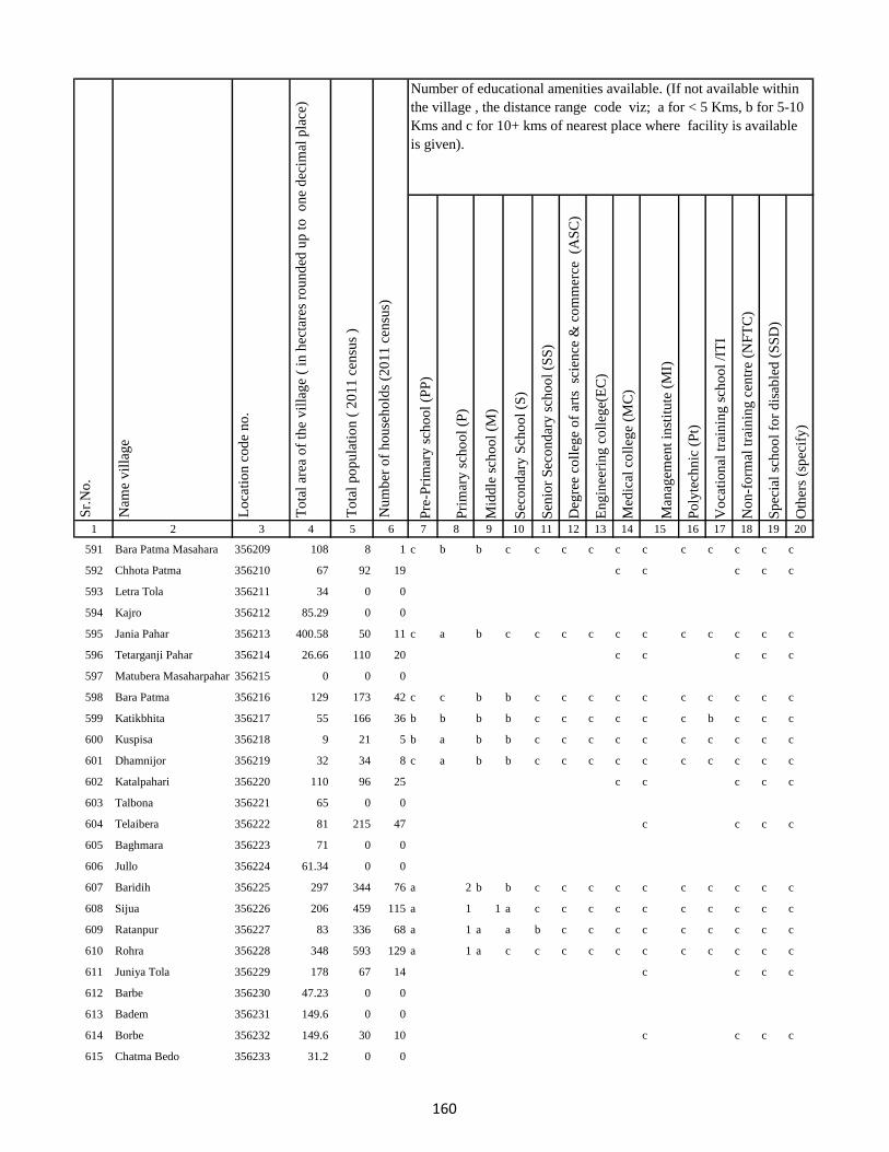
Pre
-Pri
mar
y s
cho
ol
(PP
)
Pri
mar
y s
cho
ol
(P)
Mid
dle
sch
oo
l (M
)
Sec
on
dar
y S
cho
ol
(S)
Sen
ior
Sec
on
dar
y s
cho
ol
(SS
)
Deg
ree
coll
ege
of
arts
sc
ien
ce &
co
mm
erce
(A
SC
)
En
gin
eeri
ng
co
lleg
e(E
C)
Med
ical
co
lleg
e (M
C)
Man
agem
ent
inst
itu
te (
MI)
Po
lyte
chn
ic (
Pt)
Vo
cati
on
al t
rain
ing
sch
oo
l /I
TI
No
n-f
orm
al t
rain
ing
cen
tre
(NF
TC
)
Sp
ecia
l sc
ho
ol
for
dis
able
d (
SS
D)
Oth
ers
(sp
ecif
y)
1 2 3 4 5 6 7 8 9 10 11 12 13 14 15 16 17 18 19 20
Lo
cati
on
co
de
no
.
Nam
e v
illa
ge
Sr.
No
.Number of educational amenities available. (If not available within
the village , the distance range code viz; a for < 5 Kms, b for 5-10
Kms and c for 10+ kms of nearest place where facility is available
is given).
Nu
mb
er o
f h
ou
seh
old
s (2
01
1 c
ensu
s)
To
tal
po
pu
lati
on
( 2
01
1 c
ensu
s )
To
tal
area
of
the
vil
lag
e (
in h
ecta
res
rou
nd
ed u
p t
o
on
e d
ecim
al p
lace
)
591 Bara Patma Masahara 356209 108 8 1 c b b c c c c c c c c c c c
592 Chhota Patma 356210 67 92 19 c c c c c
593 Letra Tola 356211 34 0 0
594 Kajro 356212 85.29 0 0
595 Jania Pahar 356213 400.58 50 11 c a b c c c c c c c c c c c
596 Tetarganji Pahar 356214 26.66 110 20 c c c c c
597 Matubera Masaharpahar 356215 0 0 0
598 Bara Patma 356216 129 173 42 c c b b c c c c c c c c c c
599 Katikbhita 356217 55 166 36 b b b b c c c c c c b c c c
600 Kuspisa 356218 9 21 5 b a b b c c c c c c c c c c
601 Dhamnijor 356219 32 34 8 c a b b c c c c c c c c c c
602 Katalpahari 356220 110 96 25 c c c c c
603 Talbona 356221 65 0 0
604 Telaibera 356222 81 215 47 c c c c
605 Baghmara 356223 71 0 0
606 Jullo 356224 61.34 0 0
607 Baridih 356225 297 344 76 a 2 b b c c c c c c c c c c
608 Sijua 356226 206 459 115 a 1 1 a c c c c c c c c c c
609 Ratanpur 356227 83 336 68 a 1 a a b c c c c c c c c c
610 Rohra 356228 348 593 129 a 1 a c c c c c c c c c c c
611 Juniya Tola 356229 178 67 14 c c c c
612 Barbe 356230 47.23 0 0
613 Badem 356231 149.6 0 0
614 Borbe 356232 149.6 30 10 c c c c
615 Chatma Bedo 356233 31.2 0 0
160
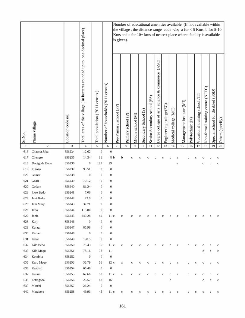
Pre
-Pri
mar
y s
cho
ol
(PP
)
Pri
mar
y s
cho
ol
(P)
Mid
dle
sch
oo
l (M
)
Sec
on
dar
y S
cho
ol
(S)
Sen
ior
Sec
on
dar
y s
cho
ol
(SS
)
Deg
ree
coll
ege
of
arts
sc
ien
ce &
co
mm
erce
(A
SC
)
En
gin
eeri
ng
co
lleg
e(E
C)
Med
ical
co
lleg
e (M
C)
Man
agem
ent
inst
itu
te (
MI)
Po
lyte
chn
ic (
Pt)
Vo
cati
on
al t
rain
ing
sch
oo
l /I
TI
No
n-f
orm
al t
rain
ing
cen
tre
(NF
TC
)
Sp
ecia
l sc
ho
ol
for
dis
able
d (
SS
D)
Oth
ers
(sp
ecif
y)
1 2 3 4 5 6 7 8 9 10 11 12 13 14 15 16 17 18 19 20
Lo
cati
on
co
de
no
.
Nam
e v
illa
ge
Sr.
No
.Number of educational amenities available. (If not available within
the village , the distance range code viz; a for < 5 Kms, b for 5-10
Kms and c for 10+ kms of nearest place where facility is available
is given).
Nu
mb
er o
f h
ou
seh
old
s (2
01
1 c
ensu
s)
To
tal
po
pu
lati
on
( 2
01
1 c
ensu
s )
To
tal
area
of
the
vil
lag
e (
in h
ecta
res
rou
nd
ed u
p t
o
on
e d
ecim
al p
lace
)
616 Chatma Joka 356234 12.62 0 0
617 Chengro 356235 14.34 36 8 b b c c c c c c c c c c c c
618 Donigoda Bedo 356236 0 129 29 c c c c
619 Ejgoga 356237 93.51 0 0
620 Gamari 356238 0 0 0
621 Goari 356239 70.12 0 0
622 Godam 356240 81.24 0 0
623 Itkro Bedo 356241 7.06 0 0
624 Jani Bedo 356242 23.9 0 0
625 Jani Maqo 356243 37.71 0 0
626 Jaria 356244 113.84 0 0
627 Jonia 356245 249.28 49 11 c c c c c c c c c c c c c c
628 Karji 356246 0 0 0
629 Karag 356247 85.98 0 0
630 Kariam 356248 0 0 0
631 Katal 356249 190.5 0 0
632 Kilo Bedo 356250 75.43 35 11 c c c c c c c c c c c c c c
633 Kilo Maqo 356251 78.16 38 11 c c c
634 Kombita 356252 0 0 0
635 Kuro Maqo 356253 35.79 56 12 c a c c c c c c c c c c c c
636 Kuspiso 356254 66.46 0 0
637 Kutam 356255 62.66 53 11 c a c c c c c c c c c c c c
638 Letragoda 356256 26.57 83 16 c c c c
639 Marchi 356257 26.24 0 0
640 Matubera 356258 49.93 45 11 c c c c c c c c c c c c c c
161

Pre
-Pri
mar
y s
cho
ol
(PP
)
Pri
mar
y s
cho
ol
(P)
Mid
dle
sch
oo
l (M
)
Sec
on
dar
y S
cho
ol
(S)
Sen
ior
Sec
on
dar
y s
cho
ol
(SS
)
Deg
ree
coll
ege
of
arts
sc
ien
ce &
co
mm
erce
(A
SC
)
En
gin
eeri
ng
co
lleg
e(E
C)
Med
ical
co
lleg
e (M
C)
Man
agem
ent
inst
itu
te (
MI)
Po
lyte
chn
ic (
Pt)
Vo
cati
on
al t
rain
ing
sch
oo
l /I
TI
No
n-f
orm
al t
rain
ing
cen
tre
(NF
TC
)
Sp
ecia
l sc
ho
ol
for
dis
able
d (
SS
D)
Oth
ers
(sp
ecif
y)
1 2 3 4 5 6 7 8 9 10 11 12 13 14 15 16 17 18 19 20
Lo
cati
on
co
de
no
.
Nam
e v
illa
ge
Sr.
No
.Number of educational amenities available. (If not available within
the village , the distance range code viz; a for < 5 Kms, b for 5-10
Kms and c for 10+ kms of nearest place where facility is available
is given).
Nu
mb
er o
f h
ou
seh
old
s (2
01
1 c
ensu
s)
To
tal
po
pu
lati
on
( 2
01
1 c
ensu
s )
To
tal
area
of
the
vil
lag
e (
in h
ecta
res
rou
nd
ed u
p t
o
on
e d
ecim
al p
lace
)
641 Pandeni 356259 76.94 0 0
642 Patma Joka 356260 54.32 10 3 c c c c c
643 Perkuria 356261 26.32 0 0
644 Puro Maqo 356262 38 31 7 c c c c c c c c c c c c c c
645 Puro Bedo 356263 23.92 71 13 a c c c c c c c c c c
646 Pusurkuriya Bedo 356264 39.9 0 0
647 Pusurkuriya Joka 356265 39.9 0 0
648 Tamlipatta 356266 58.82 0 0
649 Tesro 356267 57.73 0 0
650 Tisro 356268 56.38 0 0
651 Todmari 356269 37.79 0 0
652 Tokam 356270 46.46 0 0
653 Tokkuriya 356271 48 23 7 c 1 a a b c c c c c c c c c
654 Saharpur 356272 4 10 4 c 1 1 a b c c c c c c c c c
655 Lilatari 356273 47 754 154 c 1 1 a b c c c c c c c c c
656 Khairbani 356274 103 1030 187 b 1 a a b c c c c c c c c c
657 Belthu 356275 77 612 131 b 1 a a b c c c c c c c c c
658 Hethbandha 356276 137 521 114 b 1 a b b c c c c c c c c c
659 Shamapokhar 356277 96 534 114 b 1 a b b c c c c c c c c c
660 Chiharbona 356278 94 409 105 b a b b c c c c c c c c c
661 Chhota Saharpur 356279 0 0 0
662 Tulsipur 356280 64 486 96 a 1 1 b b c c c c c c c c c
663 Goriya 356281 60 583 109 a a a b b c c c c c c c c c
664 Kamardiha 356282 44 449 84 c a a b c c c c c c c c c c
665 Gopalpur 356283 44 299 59 b 1 1 b b c c c c c c c c c
162
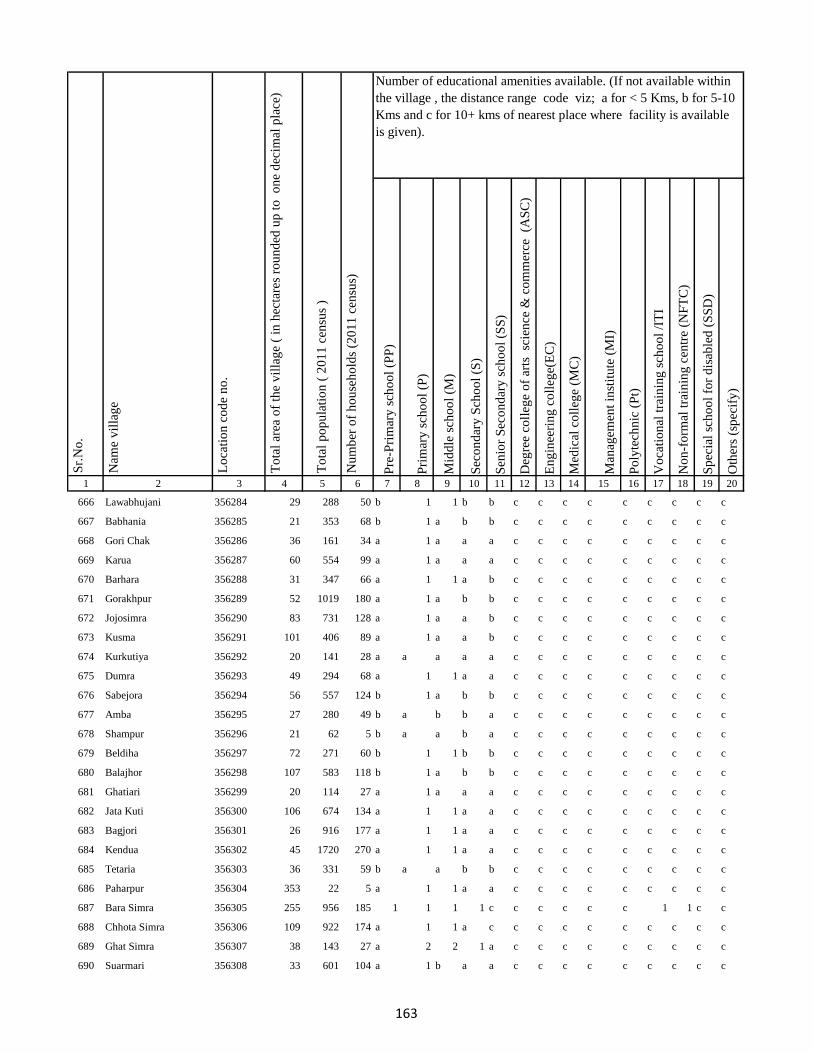
Pre
-Pri
mar
y s
cho
ol
(PP
)
Pri
mar
y s
cho
ol
(P)
Mid
dle
sch
oo
l (M
)
Sec
on
dar
y S
cho
ol
(S)
Sen
ior
Sec
on
dar
y s
cho
ol
(SS
)
Deg
ree
coll
ege
of
arts
sc
ien
ce &
co
mm
erce
(A
SC
)
En
gin
eeri
ng
co
lleg
e(E
C)
Med
ical
co
lleg
e (M
C)
Man
agem
ent
inst
itu
te (
MI)
Po
lyte
chn
ic (
Pt)
Vo
cati
on
al t
rain
ing
sch
oo
l /I
TI
No
n-f
orm
al t
rain
ing
cen
tre
(NF
TC
)
Sp
ecia
l sc
ho
ol
for
dis
able
d (
SS
D)
Oth
ers
(sp
ecif
y)
1 2 3 4 5 6 7 8 9 10 11 12 13 14 15 16 17 18 19 20
Lo
cati
on
co
de
no
.
Nam
e v
illa
ge
Sr.
No
.Number of educational amenities available. (If not available within
the village , the distance range code viz; a for < 5 Kms, b for 5-10
Kms and c for 10+ kms of nearest place where facility is available
is given).
Nu
mb
er o
f h
ou
seh
old
s (2
01
1 c
ensu
s)
To
tal
po
pu
lati
on
( 2
01
1 c
ensu
s )
To
tal
area
of
the
vil
lag
e (
in h
ecta
res
rou
nd
ed u
p t
o
on
e d
ecim
al p
lace
)
666 Lawabhujani 356284 29 288 50 b 1 1 b b c c c c c c c c c
667 Babhania 356285 21 353 68 b 1 a b b c c c c c c c c c
668 Gori Chak 356286 36 161 34 a 1 a a a c c c c c c c c c
669 Karua 356287 60 554 99 a 1 a a a c c c c c c c c c
670 Barhara 356288 31 347 66 a 1 1 a b c c c c c c c c c
671 Gorakhpur 356289 52 1019 180 a 1 a b b c c c c c c c c c
672 Jojosimra 356290 83 731 128 a 1 a a b c c c c c c c c c
673 Kusma 356291 101 406 89 a 1 a a b c c c c c c c c c
674 Kurkutiya 356292 20 141 28 a a a a a c c c c c c c c c
675 Dumra 356293 49 294 68 a 1 1 a a c c c c c c c c c
676 Sabejora 356294 56 557 124 b 1 a b b c c c c c c c c c
677 Amba 356295 27 280 49 b a b b a c c c c c c c c c
678 Shampur 356296 21 62 5 b a a b a c c c c c c c c c
679 Beldiha 356297 72 271 60 b 1 1 b b c c c c c c c c c
680 Balajhor 356298 107 583 118 b 1 a b b c c c c c c c c c
681 Ghatiari 356299 20 114 27 a 1 a a a c c c c c c c c c
682 Jata Kuti 356300 106 674 134 a 1 1 a a c c c c c c c c c
683 Bagjori 356301 26 916 177 a 1 1 a a c c c c c c c c c
684 Kendua 356302 45 1720 270 a 1 1 a a c c c c c c c c c
685 Tetaria 356303 36 331 59 b a a b b c c c c c c c c c
686 Paharpur 356304 353 22 5 a 1 1 a a c c c c c c c c c
687 Bara Simra 356305 255 956 185 1 1 1 1 c c c c c c 1 1 c c
688 Chhota Simra 356306 109 922 174 a 1 1 a c c c c c c c c c c
689 Ghat Simra 356307 38 143 27 a 2 2 1 a c c c c c c c c c
690 Suarmari 356308 33 601 104 a 1 b a a c c c c c c c c c
163

Pre
-Pri
mar
y s
cho
ol
(PP
)
Pri
mar
y s
cho
ol
(P)
Mid
dle
sch
oo
l (M
)
Sec
on
dar
y S
cho
ol
(S)
Sen
ior
Sec
on
dar
y s
cho
ol
(SS
)
Deg
ree
coll
ege
of
arts
sc
ien
ce &
co
mm
erce
(A
SC
)
En
gin
eeri
ng
co
lleg
e(E
C)
Med
ical
co
lleg
e (M
C)
Man
agem
ent
inst
itu
te (
MI)
Po
lyte
chn
ic (
Pt)
Vo
cati
on
al t
rain
ing
sch
oo
l /I
TI
No
n-f
orm
al t
rain
ing
cen
tre
(NF
TC
)
Sp
ecia
l sc
ho
ol
for
dis
able
d (
SS
D)
Oth
ers
(sp
ecif
y)
1 2 3 4 5 6 7 8 9 10 11 12 13 14 15 16 17 18 19 20
Lo
cati
on
co
de
no
.
Nam
e v
illa
ge
Sr.
No
.Number of educational amenities available. (If not available within
the village , the distance range code viz; a for < 5 Kms, b for 5-10
Kms and c for 10+ kms of nearest place where facility is available
is given).
Nu
mb
er o
f h
ou
seh
old
s (2
01
1 c
ensu
s)
To
tal
po
pu
lati
on
( 2
01
1 c
ensu
s )
To
tal
area
of
the
vil
lag
e (
in h
ecta
res
rou
nd
ed u
p t
o
on
e d
ecim
al p
lace
)
691 Ghat Nima 356309 13 273 45 a 1 a a a c c c c c c c c c
692 Chitar Koti 356310 81 945 170 a a a a a c c c c c c c c c
693 Telgama 356311 171.88 431 85 a 1 1 a c c c c c c c c c c
694 Duwarighat Telgama 356312 47 668 142 a 1 1 a a c c c c c c c c c
695 Nima Kalan 356313 137 2776 492 a 1 a a a c c c c c c c c c
696 Hijukita 356314 69 897 151 1 2 2 1 c c c c c c c c c c
697 Lalmatia 356315 52 1208 193 a 1 1 1 c c c c c c c c c c
698 Rangamatia 356316 101 292 63 a 3 1 1 a c c c c c c c c c
699 Dakaita 356317 118 2904 518 3 2 2 a a c c c c c c c c c
700 Lohandiya 356318 116 2042 405 2 3 3 a a c c c c c c c c c
701 Lohandiya Bazar 356319 7.19 2569 448 a 1 1 1 a c c c c c c c c c
702 Basdiha 356320 146 2416 468 a 1 1 a b c c c c c c c c c
703 Paharpur 356321 130 556 135 a 1 a b b c c c c c c c c c
704 Bharanda 356322 80 399 92 a 1 1 a c c c c c c c c c c
705 Harrakha 356323 210 1111 249 c c c
706 Mariya Chak 356324 21 0 0
707 Saraumi 356325 70 0 0
708 Ranidih 356326 175 1013 187 a b b a b c c c c c c c c c
709 Barkandali 356327 44 232 45 a 1 1 a b c c c c c c c c c
710 Dhankunda 356328 236 784 171 b 1 1 a b c c c c c c c c c
711 Dumriya 356329 158 1523 268 b 2 a a b c c c c c c c c c
712 Dumarkol 356330 142 519 119 b 1 1 b b c c c c c c c c c
713 Babupur 356331 383.69 1856 433 b 1 b b c c c c c c c c c c
714 Bara Kotha 356332 159 155 41 b a b c c c c c c c c c c c
715 Bara Barma Pahar 356333 35 55 13 b 1 b b c c c c c c c c c c
164

Pre
-Pri
mar
y s
cho
ol
(PP
)
Pri
mar
y s
cho
ol
(P)
Mid
dle
sch
oo
l (M
)
Sec
on
dar
y S
cho
ol
(S)
Sen
ior
Sec
on
dar
y s
cho
ol
(SS
)
Deg
ree
coll
ege
of
arts
sc
ien
ce &
co
mm
erce
(A
SC
)
En
gin
eeri
ng
co
lleg
e(E
C)
Med
ical
co
lleg
e (M
C)
Man
agem
ent
inst
itu
te (
MI)
Po
lyte
chn
ic (
Pt)
Vo
cati
on
al t
rain
ing
sch
oo
l /I
TI
No
n-f
orm
al t
rain
ing
cen
tre
(NF
TC
)
Sp
ecia
l sc
ho
ol
for
dis
able
d (
SS
D)
Oth
ers
(sp
ecif
y)
1 2 3 4 5 6 7 8 9 10 11 12 13 14 15 16 17 18 19 20
Lo
cati
on
co
de
no
.
Nam
e v
illa
ge
Sr.
No
.Number of educational amenities available. (If not available within
the village , the distance range code viz; a for < 5 Kms, b for 5-10
Kms and c for 10+ kms of nearest place where facility is available
is given).
Nu
mb
er o
f h
ou
seh
old
s (2
01
1 c
ensu
s)
To
tal
po
pu
lati
on
( 2
01
1 c
ensu
s )
To
tal
area
of
the
vil
lag
e (
in h
ecta
res
rou
nd
ed u
p t
o
on
e d
ecim
al p
lace
)
716 Tatkunda 356334 81 108 26 b a b c c c c c c c c c c c
717 Chhota Barma 356335 30 35 10 b 1 a b b c c c c c c c c c
718 Debdanr 356336 174 46 11 b 1 b b b c c c c c c c c c
719 Surla 356337 233 94 22 1 1 1 b b c c c c c c c c c
720 Dumria 356338 255 1078 249 a 1 b b b c c c c c c c c c
721 Chhota Khadahara 356339 30 513 104 a a a b b c c c c c c c c c
722 Bara Khadahara 356340 9 0 0
723 Harkata 356341 176 547 124 b 1 a b b c c c c c c c c c
724 Bara Khairbani 356342 155.8 214 61 a 1 a b c c c c c c c c c c
725 Baisabaran 356343 70 153 40 b 1 b c c c c c c c c c c c
726 Jurgura 356344 310 430 97 b 1 1 b b c c c c c c c c c
727 Dahua 356345 184 1847 403 b 3 2 b c c c c c c c c c c
728 Kusumghati 356346 288 2137 481 b 1 1 b b c c c c c c c c c
729 Lutibahiar 356347 142 289 69 b 1 a b b c c c c c c c c c
730 Lilatari 356348 203 672 149 b 1 a b b c c c c c c c c c
731 Haripur 356349 201 268 62 b 1 a b b c c c c c c c c c
732 Hahajor 356350 200 302 73 b a b c c c c c c c c c c c
733 Panchrukhi 356351 92 4 2 c c c c c c
734 Rangamatia 356352 53 0 0
735 Chhota Khairbani 356353 127 0 0
736 Chhota Bhorai 356354 36 147 32 a 1 1 b b c c c c c c c c c
737 Bara Bhorai 356355 407.29 3862 669 b 2 a b b c c c c c c c c c
738 Taljhari 356356 137 679 150 b a a c c c c c c c c c c c
739 Kesgoria 356357 436 83 26 b b b b c c c c c c c c c c
740 Pakaria 356358 84 174 38 c b b b c c c c c c c c c c
165

Pre
-Pri
mar
y s
cho
ol
(PP
)
Pri
mar
y s
cho
ol
(P)
Mid
dle
sch
oo
l (M
)
Sec
on
dar
y S
cho
ol
(S)
Sen
ior
Sec
on
dar
y s
cho
ol
(SS
)
Deg
ree
coll
ege
of
arts
sc
ien
ce &
co
mm
erce
(A
SC
)
En
gin
eeri
ng
co
lleg
e(E
C)
Med
ical
co
lleg
e (M
C)
Man
agem
ent
inst
itu
te (
MI)
Po
lyte
chn
ic (
Pt)
Vo
cati
on
al t
rain
ing
sch
oo
l /I
TI
No
n-f
orm
al t
rain
ing
cen
tre
(NF
TC
)
Sp
ecia
l sc
ho
ol
for
dis
able
d (
SS
D)
Oth
ers
(sp
ecif
y)
1 2 3 4 5 6 7 8 9 10 11 12 13 14 15 16 17 18 19 20
Lo
cati
on
co
de
no
.
Nam
e v
illa
ge
Sr.
No
.Number of educational amenities available. (If not available within
the village , the distance range code viz; a for < 5 Kms, b for 5-10
Kms and c for 10+ kms of nearest place where facility is available
is given).
Nu
mb
er o
f h
ou
seh
old
s (2
01
1 c
ensu
s)
To
tal
po
pu
lati
on
( 2
01
1 c
ensu
s )
To
tal
area
of
the
vil
lag
e (
in h
ecta
res
rou
nd
ed u
p t
o
on
e d
ecim
al p
lace
)
741 Jaggora 356359 84 76 14 c b b b c c c c c c c c c c
742 Bador 356360 61 33 9 b a a c c c c c c c b c c c
743 Taratikar 356361 37 0 0
744 Bichduba 356362 73 37 11 a 1 a b c c c c c c c c c c
745 Telodhuni 356363 104 172 41 a a a b c c c c c c c c c c
746 Madgigora 356364 22 65 15 b 1 a b c c c c c c c c c c
747 Dighi 356365 104 163 37 a a a b c c c c c c c c c c
748 Gopali 356366 123 106 20 a 1 a b c c c c c c c c c c
749 Dabra 356367 106 306 71 a 1 a b b c c c c c c c c c
750 Rohari Naryanpur 356368 101 295 68 a 1 a b c c c c c c c c c c
751 Jolopahari 356369 155 144 37 c c c c c
752 Raydih 356370 56 0 0
753 Piaram 356371 274 729 170 b 2 2 b b c c c c c c c c c
754 Phulbaria 356372 152 758 169 b 1 a b b c c c c c c c c c
755 Harra 356373 113 159 47 a a a b b c c c c c c c c c
756 Mahuabathan 356374 274 353 87 b 1 a a c c c c c c c c c c
757 Gadial 356375 215 287 62 b 1 a b b c c c c c c c c c
758 Chakra 356376 283 284 64 1 1 1 a a c c c c c c c c c
759 Bara Dhanbandhi 356377 187 1044 249 a a a a a c c c c c c c c c
760 Chhota Dhanbandhi 356378 75 74 17 c b b c c c c c c c c c c c
761 Tetardiha 356379 347 397 87 c c c c c
762 Baramasia 356380 30 0 0
763 Kajribhita 356381 58 91 22 b 1 a a c c c c c c c c c c
764 Adro 356382 328 604 141 a 1 a a c c c c c c c c c c
765 Chhota Amra 356383 54 217 44 a 1 1 c c c c c c c c c c c
166
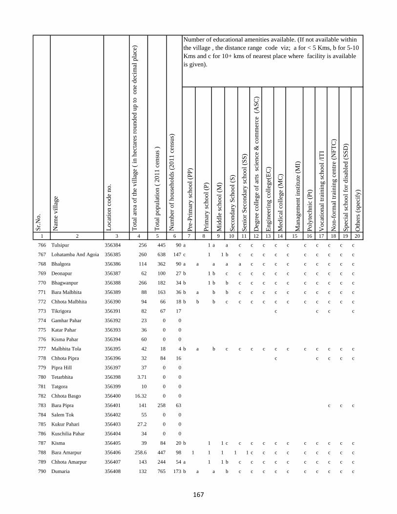
Pre
-Pri
mar
y s
cho
ol
(PP
)
Pri
mar
y s
cho
ol
(P)
Mid
dle
sch
oo
l (M
)
Sec
on
dar
y S
cho
ol
(S)
Sen
ior
Sec
on
dar
y s
cho
ol
(SS
)
Deg
ree
coll
ege
of
arts
sc
ien
ce &
co
mm
erce
(A
SC
)
En
gin
eeri
ng
co
lleg
e(E
C)
Med
ical
co
lleg
e (M
C)
Man
agem
ent
inst
itu
te (
MI)
Po
lyte
chn
ic (
Pt)
Vo
cati
on
al t
rain
ing
sch
oo
l /I
TI
No
n-f
orm
al t
rain
ing
cen
tre
(NF
TC
)
Sp
ecia
l sc
ho
ol
for
dis
able
d (
SS
D)
Oth
ers
(sp
ecif
y)
1 2 3 4 5 6 7 8 9 10 11 12 13 14 15 16 17 18 19 20
Lo
cati
on
co
de
no
.
Nam
e v
illa
ge
Sr.
No
.Number of educational amenities available. (If not available within
the village , the distance range code viz; a for < 5 Kms, b for 5-10
Kms and c for 10+ kms of nearest place where facility is available
is given).
Nu
mb
er o
f h
ou
seh
old
s (2
01
1 c
ensu
s)
To
tal
po
pu
lati
on
( 2
01
1 c
ensu
s )
To
tal
area
of
the
vil
lag
e (
in h
ecta
res
rou
nd
ed u
p t
o
on
e d
ecim
al p
lace
)
766 Tulsipur 356384 256 445 90 a 1 a a c c c c c c c c c c
767 Lohatamba And Agoia 356385 260 638 147 c 1 1 b c c c c c c c c c c
768 Bhalgora 356386 114 362 90 a a a a a c c c c c c c c c
769 Deonapur 356387 62 100 27 b 1 b c c c c c c c c c c c
770 Bhagwanpur 356388 266 182 34 b 1 b b c c c c c c c c c c
771 Bara Malbhita 356389 88 163 36 b a b b c c c c c c c c c c
772 Chhota Malbhita 356390 94 66 18 b b b c c c c c c c c c c c
773 Tikrigora 356391 82 67 17 c c c c
774 Gamhar Pahar 356392 23 0 0
775 Katar Pahar 356393 36 0 0
776 Kisma Pahar 356394 60 0 0
777 Malbhita Tola 356395 42 18 4 b a b c c c c c c c c c c c
778 Chhota Pipra 356396 32 84 16 c c c c c
779 Pipra Hill 356397 37 0 0
780 Tetarbhita 356398 3.71 0 0
781 Tatgora 356399 10 0 0
782 Chhota Basgo 356400 16.32 0 0
783 Bara Pipra 356401 141 258 63 c c c
784 Salem Tok 356402 55 0 0
785 Kukur Pahari 356403 27.2 0 0
786 Kuschilia Pahar 356404 34 0 0
787 Kisma 356405 39 84 20 b 1 1 c c c c c c c c c c c
788 Bara Amarpur 356406 258.6 447 98 1 1 1 1 1 c c c c c c c c c
789 Chhota Amarpur 356407 143 244 54 a 1 1 b c c c c c c c c c c
790 Dumaria 356408 132 765 173 b a a b c c c c c c c c c c
167

Pre
-Pri
mar
y s
cho
ol
(PP
)
Pri
mar
y s
cho
ol
(P)
Mid
dle
sch
oo
l (M
)
Sec
on
dar
y S
cho
ol
(S)
Sen
ior
Sec
on
dar
y s
cho
ol
(SS
)
Deg
ree
coll
ege
of
arts
sc
ien
ce &
co
mm
erce
(A
SC
)
En
gin
eeri
ng
co
lleg
e(E
C)
Med
ical
co
lleg
e (M
C)
Man
agem
ent
inst
itu
te (
MI)
Po
lyte
chn
ic (
Pt)
Vo
cati
on
al t
rain
ing
sch
oo
l /I
TI
No
n-f
orm
al t
rain
ing
cen
tre
(NF
TC
)
Sp
ecia
l sc
ho
ol
for
dis
able
d (
SS
D)
Oth
ers
(sp
ecif
y)
1 2 3 4 5 6 7 8 9 10 11 12 13 14 15 16 17 18 19 20
Lo
cati
on
co
de
no
.
Nam
e v
illa
ge
Sr.
No
.Number of educational amenities available. (If not available within
the village , the distance range code viz; a for < 5 Kms, b for 5-10
Kms and c for 10+ kms of nearest place where facility is available
is given).
Nu
mb
er o
f h
ou
seh
old
s (2
01
1 c
ensu
s)
To
tal
po
pu
lati
on
( 2
01
1 c
ensu
s )
To
tal
area
of
the
vil
lag
e (
in h
ecta
res
rou
nd
ed u
p t
o
on
e d
ecim
al p
lace
)
791 Bamangawan 356409 86 132 34 b b c c c c c c
792 Chhota Bararo 356410 7.31 0 0
793 Bararo 356411 147 246 51 c a b b c c c c c c c c c c
794 Chetan Pahar 356412 23.41 29 6 c c c c c
795 Chakan Chak 356413 13.05 0 0
796 Domgora Pahar 356414 8.56 0 0
797 Elkar Pahar 356415 22.09 0 0
798 Moter Pahar 356416 167 110 29 c c c c
799 Dhauatoka 356417 27 0 0
800 Bariartok 356418 18.62 0 0
801 Bara Telo 356419 181 376 88 a a a c c c c c c c c c c c
802 Chhota Telo 356420 55 106 19 a a a c c c c c c c c c c c
803 Jajotola Barhua 356421 50 58 12 c 1 a c c c c c c c c c c c
804 Bara Amra 356422 157 245 49 1 1 b c c c c c c c c c c c
805 Balkani 356423 215 299 72 a a a c c c c c c c c c c c
806 Sundai 356424 97 122 24 1 1 b c c c c c c c c c c c
807 Garbhu Tola 356425 77 145 32 c 1 b b c c c c c c c c c c
808 Chhota Simmi 356426 90 236 44 a a b c c c c c c c c c c c
809 Bara Simmi 356427 74 206 46 a 1 b b c c c c c c c c c c
810 Bandhgora 356428 46 29 5 b b c c c c c c c c c c c c
811 Kesarogora 356429 44 31 4 c b b b c c c c c c c c c c
812 Chhota Chapri 356430 112 132 26 c b b b c c c c c c c c c c
813 Dholna Pahar 356431 59 38 9 c 1 a b c c c c c c c c c c
814 Telotok 356432 83 216 39 c c c c
815 Charanpahar 356433 17.76 0 0
168

Pre
-Pri
mar
y s
cho
ol
(PP
)
Pri
mar
y s
cho
ol
(P)
Mid
dle
sch
oo
l (M
)
Sec
on
dar
y S
cho
ol
(S)
Sen
ior
Sec
on
dar
y s
cho
ol
(SS
)
Deg
ree
coll
ege
of
arts
sc
ien
ce &
co
mm
erce
(A
SC
)
En
gin
eeri
ng
co
lleg
e(E
C)
Med
ical
co
lleg
e (M
C)
Man
agem
ent
inst
itu
te (
MI)
Po
lyte
chn
ic (
Pt)
Vo
cati
on
al t
rain
ing
sch
oo
l /I
TI
No
n-f
orm
al t
rain
ing
cen
tre
(NF
TC
)
Sp
ecia
l sc
ho
ol
for
dis
able
d (
SS
D)
Oth
ers
(sp
ecif
y)
1 2 3 4 5 6 7 8 9 10 11 12 13 14 15 16 17 18 19 20
Lo
cati
on
co
de
no
.
Nam
e v
illa
ge
Sr.
No
.Number of educational amenities available. (If not available within
the village , the distance range code viz; a for < 5 Kms, b for 5-10
Kms and c for 10+ kms of nearest place where facility is available
is given).
Nu
mb
er o
f h
ou
seh
old
s (2
01
1 c
ensu
s)
To
tal
po
pu
lati
on
( 2
01
1 c
ensu
s )
To
tal
area
of
the
vil
lag
e (
in h
ecta
res
rou
nd
ed u
p t
o
on
e d
ecim
al p
lace
)
816 Keriapahar 356434 0 32 6 c c c c
817 Karampahar 356435 10.32 0 0
818 Masanpahar 356436 7.52 0 0
819 Dumarpahar 356437 12.35 0 0
820 Kamugora 356438 56.55 0 0
821 Bansdandapahar 356439 16.32 0 0
822 Bansdanda 356440 193 386 87 c c c c c
823 Dhunigora 356441 16 0 0
824 Bara Basgi 356442 3.27 0 0
825 Satbera 356443 68 150 31 a b c c c c c c
826 Satbera 356444 23 0 0
827 Chetrampahar 356445 35 0 0
828 Hanidhoni 356446 43 0 0
829 Bara Chapri 356447 99 340 74 b b b c c c c c c c c c c c
830 Madarpahar 356448 45 0 0
831 Chapri Bara 356449 51 117 24 b b b c c c c c c c c c c c
832 Tamlipahar 356450 24 0 0
833 Bara Chapri 356451 51 0 0
834 Madgigora 356452 70.8 0 0
835 Karamtanr 356453 19 0 0
836 Dumarpahar 356454 36 0 0
837 Chhota Ghogha 356455 17.87 0 0
838 Bara Karlopahar 356456 16.54 0 0
839 Bara Ghogha 356457 33.15 0 0
840 Bara Kerlo 356458 168 377 84 c c c c
169
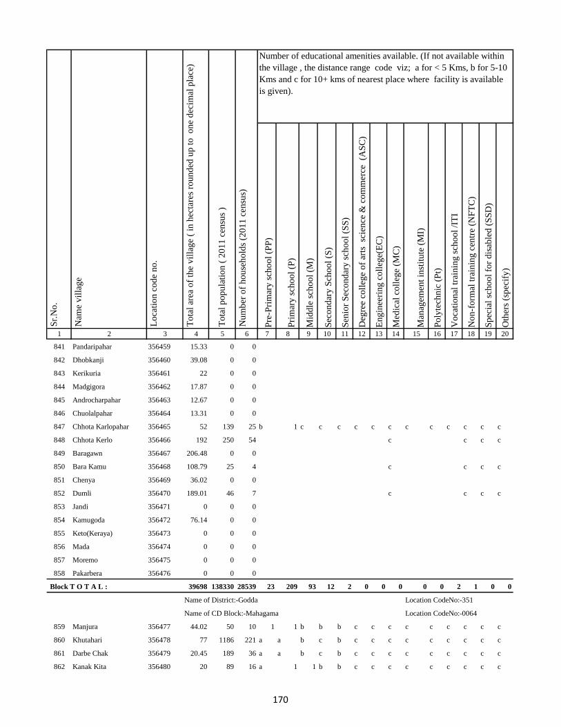
Pre
-Pri
mar
y s
cho
ol
(PP
)
Pri
mar
y s
cho
ol
(P)
Mid
dle
sch
oo
l (M
)
Sec
on
dar
y S
cho
ol
(S)
Sen
ior
Sec
on
dar
y s
cho
ol
(SS
)
Deg
ree
coll
ege
of
arts
sc
ien
ce &
co
mm
erce
(A
SC
)
En
gin
eeri
ng
co
lleg
e(E
C)
Med
ical
co
lleg
e (M
C)
Man
agem
ent
inst
itu
te (
MI)
Po
lyte
chn
ic (
Pt)
Vo
cati
on
al t
rain
ing
sch
oo
l /I
TI
No
n-f
orm
al t
rain
ing
cen
tre
(NF
TC
)
Sp
ecia
l sc
ho
ol
for
dis
able
d (
SS
D)
Oth
ers
(sp
ecif
y)
1 2 3 4 5 6 7 8 9 10 11 12 13 14 15 16 17 18 19 20
Lo
cati
on
co
de
no
.
Nam
e v
illa
ge
Sr.
No
.Number of educational amenities available. (If not available within
the village , the distance range code viz; a for < 5 Kms, b for 5-10
Kms and c for 10+ kms of nearest place where facility is available
is given).
Nu
mb
er o
f h
ou
seh
old
s (2
01
1 c
ensu
s)
To
tal
po
pu
lati
on
( 2
01
1 c
ensu
s )
To
tal
area
of
the
vil
lag
e (
in h
ecta
res
rou
nd
ed u
p t
o
on
e d
ecim
al p
lace
)
841 Pandaripahar 356459 15.33 0 0
842 Dhobkanji 356460 39.08 0 0
843 Kerikuria 356461 22 0 0
844 Madgigora 356462 17.87 0 0
845 Androcharpahar 356463 12.67 0 0
846 Chuolalpahar 356464 13.31 0 0
847 Chhota Karlopahar 356465 52 139 25 b 1 c c c c c c c c c c c c
848 Chhota Kerlo 356466 192 250 54 c c c c
849 Baragawn 356467 206.48 0 0
850 Bara Kamu 356468 108.79 25 4 c c c c
851 Chenya 356469 36.02 0 0
852 Dumli 356470 189.01 46 7 c c c c
853 Jandi 356471 0 0 0
854 Kamugoda 356472 76.14 0 0
855 Keto(Keraya) 356473 0 0 0
856 Mada 356474 0 0 0
857 Moremo 356475 0 0 0
858 Pakarbera 356476 0 0 0
Block T O T A L : 39698 138330 28539 23 209 93 12 2 0 0 0 0 0 2 1 0 0
Name of District:-Godda Location CodeNo:-351
Name of CD Block:-Mahagama Location CodeNo:-0064
859 Manjura 356477 44.02 50 10 1 1 b b b c c c c c c c c c
860 Khutahari 356478 77 1186 221 a a b c b c c c c c c c c c
861 Darbe Chak 356479 20.45 189 36 a a b c b c c c c c c c c c
862 Kanak Kita 356480 20 89 16 a 1 1 b b c c c c c c c c c
170
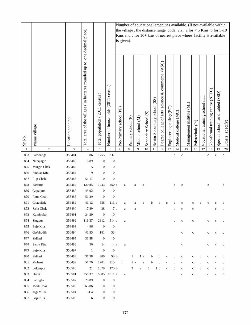
Pre
-Pri
mar
y s
cho
ol
(PP
)
Pri
mar
y s
cho
ol
(P)
Mid
dle
sch
oo
l (M
)
Sec
on
dar
y S
cho
ol
(S)
Sen
ior
Sec
on
dar
y s
cho
ol
(SS
)
Deg
ree
coll
ege
of
arts
sc
ien
ce &
co
mm
erce
(A
SC
)
En
gin
eeri
ng
co
lleg
e(E
C)
Med
ical
co
lleg
e (M
C)
Man
agem
ent
inst
itu
te (
MI)
Po
lyte
chn
ic (
Pt)
Vo
cati
on
al t
rain
ing
sch
oo
l /I
TI
No
n-f
orm
al t
rain
ing
cen
tre
(NF
TC
)
Sp
ecia
l sc
ho
ol
for
dis
able
d (
SS
D)
Oth
ers
(sp
ecif
y)
1 2 3 4 5 6 7 8 9 10 11 12 13 14 15 16 17 18 19 20
Lo
cati
on
co
de
no
.
Nam
e v
illa
ge
Sr.
No
.Number of educational amenities available. (If not available within
the village , the distance range code viz; a for < 5 Kms, b for 5-10
Kms and c for 10+ kms of nearest place where facility is available
is given).
Nu
mb
er o
f h
ou
seh
old
s (2
01
1 c
ensu
s)
To
tal
po
pu
lati
on
( 2
01
1 c
ensu
s )
To
tal
area
of
the
vil
lag
e (
in h
ecta
res
rou
nd
ed u
p t
o
on
e d
ecim
al p
lace
)
863 Sarbhanga 356481 86 1755 337 c c c c c
864 Nunajagir 356482 5.89 0 0
865 Murgia Chak 356483 5 0 0
866 Sibotar Kita 356484 9 0 0
867 Rup Chak 356485 51.17 0 0
868 Sarautia 356486 120.85 1943 350 a a a a c c c c
869 Gopalpur 356487 43.92 0 0
870 Ranu Chak 356488 51.39 0 0
871 Chauchak 356489 41.12 558 113 a a a a b c c c c c c c c c
872 Saha Chak 356490 17.89 38 7 a a a c c c c c
873 Kumhrakol 356491 24.29 0 0
874 Singpur 356492 116.37 2912 514 a a c c c c c c
875 Baje Kita 356493 4.96 0 0
876 Garbhudih 356494 41.55 181 33 c c c c c
877 Sidhari 356495 31.58 0 0
878 Samu Kita 356496 36 14 4 a a c c c c
879 Baje Kita 356497 1 0 0
880 Sidhari 356498 31.58 300 53 b 1 1 a b c c c c c c c c c
881 Mohani 356499 51.76 1201 215 1 1 a a b c c c c c c c c c
882 Bakanpur 356500 21 1079 175 b 3 2 1 1 c c c c c c c c c
883 Dighi 356501 359.32 5885 1011 a a c c c c c
884 Satbigha 356502 20.89 0 0
885 Modi Chak 356503 63.06 0 0
886 Jagi Milik 356504 4.4 0 0
887 Baje Kita 356505 6 0 0
171
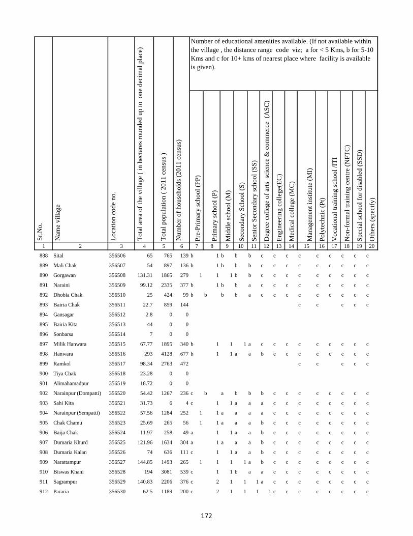
Pre
-Pri
mar
y s
cho
ol
(PP
)
Pri
mar
y s
cho
ol
(P)
Mid
dle
sch
oo
l (M
)
Sec
on
dar
y S
cho
ol
(S)
Sen
ior
Sec
on
dar
y s
cho
ol
(SS
)
Deg
ree
coll
ege
of
arts
sc
ien
ce &
co
mm
erce
(A
SC
)
En
gin
eeri
ng
co
lleg
e(E
C)
Med
ical
co
lleg
e (M
C)
Man
agem
ent
inst
itu
te (
MI)
Po
lyte
chn
ic (
Pt)
Vo
cati
on
al t
rain
ing
sch
oo
l /I
TI
No
n-f
orm
al t
rain
ing
cen
tre
(NF
TC
)
Sp
ecia
l sc
ho
ol
for
dis
able
d (
SS
D)
Oth
ers
(sp
ecif
y)
1 2 3 4 5 6 7 8 9 10 11 12 13 14 15 16 17 18 19 20
Lo
cati
on
co
de
no
.
Nam
e v
illa
ge
Sr.
No
.Number of educational amenities available. (If not available within
the village , the distance range code viz; a for < 5 Kms, b for 5-10
Kms and c for 10+ kms of nearest place where facility is available
is given).
Nu
mb
er o
f h
ou
seh
old
s (2
01
1 c
ensu
s)
To
tal
po
pu
lati
on
( 2
01
1 c
ensu
s )
To
tal
area
of
the
vil
lag
e (
in h
ecta
res
rou
nd
ed u
p t
o
on
e d
ecim
al p
lace
)
888 Sital 356506 65 765 139 b 1 b b b c c c c c c c c c
889 Mali Chak 356507 54 897 136 b 1 b b b c c c c c c c c c
890 Gorgawan 356508 131.31 1865 279 1 1 1 b b c c c c c c c c c
891 Naraini 356509 99.12 2335 377 b 1 b b a c c c c c c c c c
892 Dhobia Chak 356510 25 424 99 b b b b a c c c c c c c c c
893 Bairia Chak 356511 22.7 859 144 c c c c c
894 Gansagar 356512 2.8 0 0
895 Bairia Kita 356513 44 0 0
896 Sonbarsa 356514 7 0 0
897 Milik Hanwara 356515 67.77 1895 340 b 1 1 1 a c c c c c c c c c
898 Hanwara 356516 293 4128 677 b 1 1 a a b c c c c c c c c
899 Ramkol 356517 98.34 2763 472 c c c c c
900 Tiya Chak 356518 23.28 0 0
901 Alimahamadpur 356519 18.72 0 0
902 Narainpur (Dompatti) 356520 54.42 1267 236 c b a b b b c c c c c c c c
903 Sahi Kita 356521 31.73 6 4 c 1 1 a a a c c c c c c c c
904 Narainpur (Sempatti) 356522 57.56 1284 252 1 1 a a a a c c c c c c c c
905 Chak Chamu 356523 25.69 265 56 1 1 a a a b c c c c c c c c
906 Baija Chak 356524 11.97 258 49 a 1 1 a a b c c c c c c c c
907 Dumaria Khurd 356525 121.96 1634 304 a 1 a a a b c c c c c c c c
908 Dumaria Kalan 356526 74 636 111 c 1 1 a a b c c c c c c c c
909 Narattampur 356527 144.85 1493 265 1 1 1 1 a b c c c c c c c c
910 Biswas Khani 356528 194 3081 539 c 1 1 b a a c c c c c c c c
911 Sagrampur 356529 140.83 2206 376 c 2 1 1 1 a c c c c c c c c
912 Pararia 356530 62.5 1189 200 c 2 1 1 1 1 c c c c c c c c
172
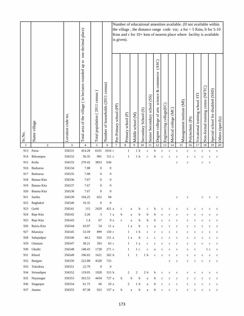
Pre
-Pri
mar
y s
cho
ol
(PP
)
Pri
mar
y s
cho
ol
(P)
Mid
dle
sch
oo
l (M
)
Sec
on
dar
y S
cho
ol
(S)
Sen
ior
Sec
on
dar
y s
cho
ol
(SS
)
Deg
ree
coll
ege
of
arts
sc
ien
ce &
co
mm
erce
(A
SC
)
En
gin
eeri
ng
co
lleg
e(E
C)
Med
ical
co
lleg
e (M
C)
Man
agem
ent
inst
itu
te (
MI)
Po
lyte
chn
ic (
Pt)
Vo
cati
on
al t
rain
ing
sch
oo
l /I
TI
No
n-f
orm
al t
rain
ing
cen
tre
(NF
TC
)
Sp
ecia
l sc
ho
ol
for
dis
able
d (
SS
D)
Oth
ers
(sp
ecif
y)
1 2 3 4 5 6 7 8 9 10 11 12 13 14 15 16 17 18 19 20
Lo
cati
on
co
de
no
.
Nam
e v
illa
ge
Sr.
No
.Number of educational amenities available. (If not available within
the village , the distance range code viz; a for < 5 Kms, b for 5-10
Kms and c for 10+ kms of nearest place where facility is available
is given).
Nu
mb
er o
f h
ou
seh
old
s (2
01
1 c
ensu
s)
To
tal
po
pu
lati
on
( 2
01
1 c
ensu
s )
To
tal
area
of
the
vil
lag
e (
in h
ecta
res
rou
nd
ed u
p t
o
on
e d
ecim
al p
lace
)
913 Parsa 356531 414.28 6101 1016 c 1 1 b c b c c c c c c c c
914 Bikrampur 356532 50.35 991 151 c 1 1 b c b c c c c c c c c
915 Koila 356533 270.42 3853 636 c c c c
916 Barkurua 356534 7.08 0 0
917 Barkurua 356535 7.08 0 0
918 Bataua Kita 356536 7.67 0 0
919 Batana Kita 356537 7.67 0 0
920 Batana Kita 356538 7.67 0 0
921 Sarthu 356539 104.25 652 94 c c c c c
922 Baghakol 356540 16.35 0 0
923 Gurhi 356541 115 2429 421 a c a b c b c c c c c c c c
924 Baje Kita 356542 3.26 3 1 a b a b b b c c c c c c c c
925 Baje Kita 356543 1.4 67 9 a c a b b b c c c c c c c c
926 Bairia Kita 356544 43.97 54 11 a 1 a b c a c c c c c c c c
927 Kharaiya 356545 53.59 899 150 c 1 1 b c c c c c c c c c c
928 Sahajadpur 356546 44.2 926 151 a 1 a b c c c c c c c c c c
929 Ghatiani 356547 58.21 393 63 c 1 1 a c c c c c c c c c c
930 Ghuthi 356548 148.43 1728 271 c 1 1 c c a c c c c c 1 c c
931 Khurd 356549 106.03 1621 262 b 1 1 1 b c c c c c c c c c
932 Banjpur 356550 222.88 4328 725 c c c c c c c
933 Teknikita 356551 22.79 0 0
934 Sirinathpur 356552 119.05 1928 313 b 2 2 2 b b c c c c c c c c
935 Nayanagar 356553 363.53 4434 727 a b b b a b c c c c c c c c
936 Singarpur 356554 61.75 66 10 a 2 1 b a b c c c c c c c c
937 Jatama 356555 87.38 922 157 a b a b a b c c c c c c c c
173
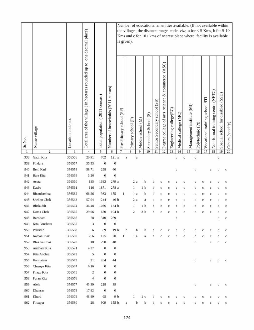
Pre
-Pri
mar
y s
cho
ol
(PP
)
Pri
mar
y s
cho
ol
(P)
Mid
dle
sch
oo
l (M
)
Sec
on
dar
y S
cho
ol
(S)
Sen
ior
Sec
on
dar
y s
cho
ol
(SS
)
Deg
ree
coll
ege
of
arts
sc
ien
ce &
co
mm
erce
(A
SC
)
En
gin
eeri
ng
co
lleg
e(E
C)
Med
ical
co
lleg
e (M
C)
Man
agem
ent
inst
itu
te (
MI)
Po
lyte
chn
ic (
Pt)
Vo
cati
on
al t
rain
ing
sch
oo
l /I
TI
No
n-f
orm
al t
rain
ing
cen
tre
(NF
TC
)
Sp
ecia
l sc
ho
ol
for
dis
able
d (
SS
D)
Oth
ers
(sp
ecif
y)
1 2 3 4 5 6 7 8 9 10 11 12 13 14 15 16 17 18 19 20
Lo
cati
on
co
de
no
.
Nam
e v
illa
ge
Sr.
No
.Number of educational amenities available. (If not available within
the village , the distance range code viz; a for < 5 Kms, b for 5-10
Kms and c for 10+ kms of nearest place where facility is available
is given).
Nu
mb
er o
f h
ou
seh
old
s (2
01
1 c
ensu
s)
To
tal
po
pu
lati
on
( 2
01
1 c
ensu
s )
To
tal
area
of
the
vil
lag
e (
in h
ecta
res
rou
nd
ed u
p t
o
on
e d
ecim
al p
lace
)
938 Gauri Kita 356556 20.91 702 121 a a a c c c c
939 Pindara 356557 35.53 0 0
940 Belti Kari 356558 58.71 298 60 c c c c c
941 Baje Kita 356559 3.26 0 0
942 Asota 356560 135 1683 279 a 2 a b b c c c c c c c c c
943 Kasba 356561 116 1871 278 a 1 1 b b c c c c c c c c c
944 Bhandarchua 356562 66.26 933 155 1 1 a b b c c c c c c c c c
945 Shekhu Chak 356563 57.04 244 46 b 2 a a a c c c c c c c c c
946 Bhelaidih 356564 36.48 1086 174 b 1 1 b b c c c c c c c c c
947 Doma Chak 356565 29.06 670 104 b 2 2 b b c c c c c c c c c
948 Bansbara 356566 78 1340 259 c c c
949 Kita Bansbara 356567 3 0 0
950 Pakridih 356568 6 89 19 b b b b b c c c c c c c c c
951 Kamal Chak 356569 33.6 125 20 1 1 a a b c c c c c c c c c
952 Bhikhia Chak 356570 18 290 48 c c c c
953 Andhara Kita 356571 4.37 0 0
954 Kita Andhra 356572 5 0 0
955 Karmatanr 356573 21 264 44 c c c c
956 Champa Kita 356574 6.16 0 0
957 Phagu Kita 356575 2 0 0
958 Puran Kita 356576 4 0 0
959 Alola 356577 43.39 228 39 c c c c
960 Dhansar 356578 17.82 0 0
961 Khurd 356579 48.89 65 9 b 1 1 c b c c c c c c c c c
962 Firozpur 356580 28 909 155 b a b b b c c c c c c c c c
174
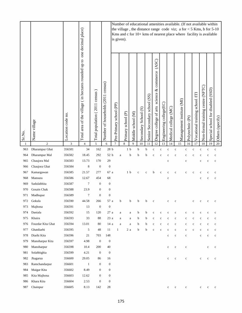
Pre
-Pri
mar
y s
cho
ol
(PP
)
Pri
mar
y s
cho
ol
(P)
Mid
dle
sch
oo
l (M
)
Sec
on
dar
y S
cho
ol
(S)
Sen
ior
Sec
on
dar
y s
cho
ol
(SS
)
Deg
ree
coll
ege
of
arts
sc
ien
ce &
co
mm
erce
(A
SC
)
En
gin
eeri
ng
co
lleg
e(E
C)
Med
ical
co
lleg
e (M
C)
Man
agem
ent
inst
itu
te (
MI)
Po
lyte
chn
ic (
Pt)
Vo
cati
on
al t
rain
ing
sch
oo
l /I
TI
No
n-f
orm
al t
rain
ing
cen
tre
(NF
TC
)
Sp
ecia
l sc
ho
ol
for
dis
able
d (
SS
D)
Oth
ers
(sp
ecif
y)
1 2 3 4 5 6 7 8 9 10 11 12 13 14 15 16 17 18 19 20
Lo
cati
on
co
de
no
.
Nam
e v
illa
ge
Sr.
No
.Number of educational amenities available. (If not available within
the village , the distance range code viz; a for < 5 Kms, b for 5-10
Kms and c for 10+ kms of nearest place where facility is available
is given).
Nu
mb
er o
f h
ou
seh
old
s (2
01
1 c
ensu
s)
To
tal
po
pu
lati
on
( 2
01
1 c
ensu
s )
To
tal
area
of
the
vil
lag
e (
in h
ecta
res
rou
nd
ed u
p t
o
on
e d
ecim
al p
lace
)
963 Dharampur Ghat 356581 34 162 28 b 1 b b b c c c c c c c c c
964 Dharampur Mal 356582 18.45 292 52 b a b b b c c c c c c c c c
965 Chaujora Mal 356583 13.73 170 29 c c c c c
966 Chaujora Ghat 356584 8 0 0
967 Kamargawan 356585 21.57 277 67 a 1 b c c b c c c c c c c c
968 Mansura 356586 12.67 454 68 c c c c
969 Sadulabhita 356587 7 0 0
970 Gosain Chak 356588 23.9 0 0
971 Madhupur 356589 7 0 0
972 Gokula 356590 44.58 266 57 a b b b b c c c c c c c
973 Majhona 356591 13 0 0
974 Daniala 356592 15 120 27 a a a b b c c c c c c c c c
975 Khaira 356593 33 88 23 a a a b b c c c c c c c c c
976 Fouzdar Kita Ghat 356594 13.01 80 14 a a a b b c c c c c c c c c
977 Ghatdiarhi 356595 5 48 11 1 2 a b b c c c c c c c c c
978 Diarhi Kita 356596 21 703 148 c c c c c c
979 Manoharpur Kita 356597 4.98 0 0
980 Manoharpur 356598 10.4 200 40 c c c c c
981 Solahbighia 356599 4.21 0 0
982 Jhagarua 356600 29.05 86 16 c c c c c c
983 Ramchandarpur 356601 1 0 0
984 Maigar Kita 356602 8.49 0 0
985 Kita Majhona 356603 12.62 0 0
986 Khara Kita 356604 2.53 0 0
987 Chainpur 356605 8.13 142 28 c c c c c c
175
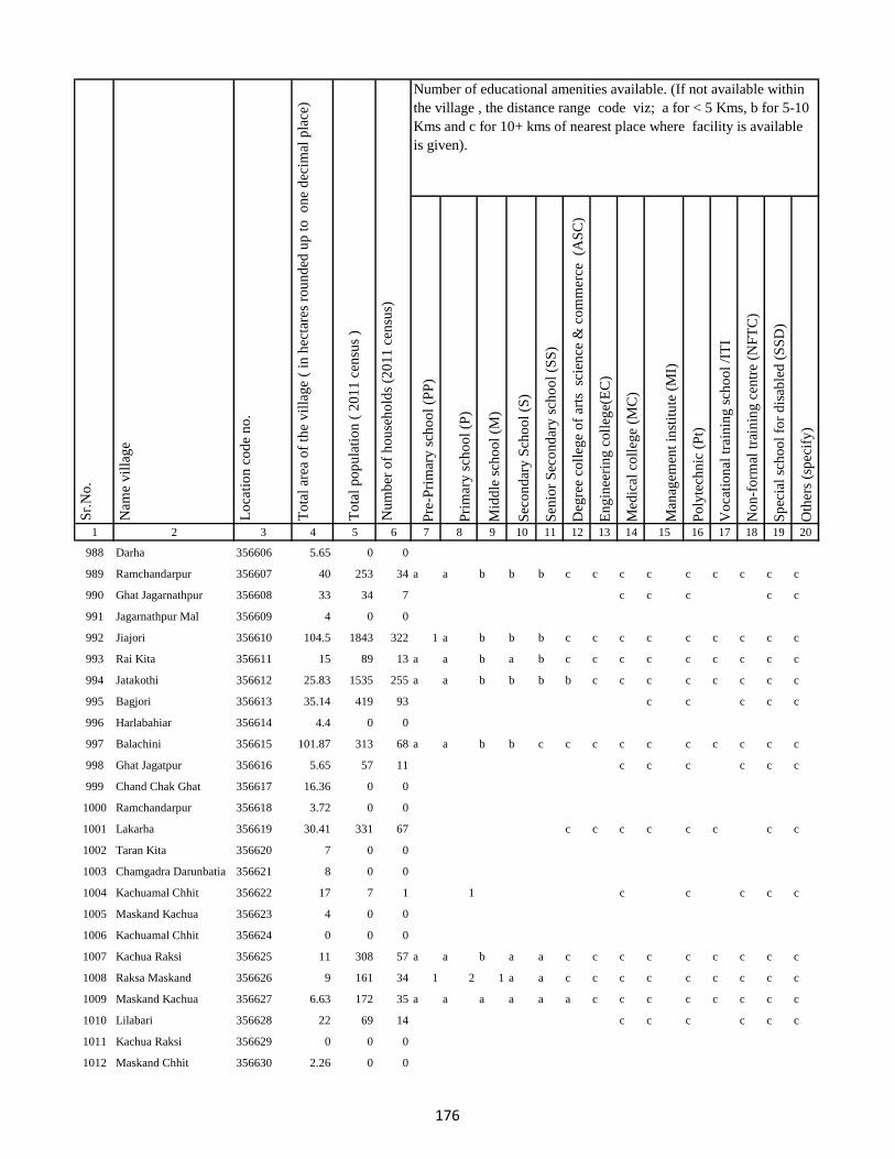
Pre
-Pri
mar
y s
cho
ol
(PP
)
Pri
mar
y s
cho
ol
(P)
Mid
dle
sch
oo
l (M
)
Sec
on
dar
y S
cho
ol
(S)
Sen
ior
Sec
on
dar
y s
cho
ol
(SS
)
Deg
ree
coll
ege
of
arts
sc
ien
ce &
co
mm
erce
(A
SC
)
En
gin
eeri
ng
co
lleg
e(E
C)
Med
ical
co
lleg
e (M
C)
Man
agem
ent
inst
itu
te (
MI)
Po
lyte
chn
ic (
Pt)
Vo
cati
on
al t
rain
ing
sch
oo
l /I
TI
No
n-f
orm
al t
rain
ing
cen
tre
(NF
TC
)
Sp
ecia
l sc
ho
ol
for
dis
able
d (
SS
D)
Oth
ers
(sp
ecif
y)
1 2 3 4 5 6 7 8 9 10 11 12 13 14 15 16 17 18 19 20
Lo
cati
on
co
de
no
.
Nam
e v
illa
ge
Sr.
No
.Number of educational amenities available. (If not available within
the village , the distance range code viz; a for < 5 Kms, b for 5-10
Kms and c for 10+ kms of nearest place where facility is available
is given).
Nu
mb
er o
f h
ou
seh
old
s (2
01
1 c
ensu
s)
To
tal
po
pu
lati
on
( 2
01
1 c
ensu
s )
To
tal
area
of
the
vil
lag
e (
in h
ecta
res
rou
nd
ed u
p t
o
on
e d
ecim
al p
lace
)
988 Darha 356606 5.65 0 0
989 Ramchandarpur 356607 40 253 34 a a b b b c c c c c c c c c
990 Ghat Jagarnathpur 356608 33 34 7 c c c c c
991 Jagarnathpur Mal 356609 4 0 0
992 Jiajori 356610 104.5 1843 322 1 a b b b c c c c c c c c c
993 Rai Kita 356611 15 89 13 a a b a b c c c c c c c c c
994 Jatakothi 356612 25.83 1535 255 a a b b b b c c c c c c c c
995 Bagjori 356613 35.14 419 93 c c c c c
996 Harlabahiar 356614 4.4 0 0
997 Balachini 356615 101.87 313 68 a a b b c c c c c c c c c c
998 Ghat Jagatpur 356616 5.65 57 11 c c c c c c
999 Chand Chak Ghat 356617 16.36 0 0
1000 Ramchandarpur 356618 3.72 0 0
1001 Lakarha 356619 30.41 331 67 c c c c c c c c
1002 Taran Kita 356620 7 0 0
1003 Chamgadra Darunbatia 356621 8 0 0
1004 Kachuamal Chhit 356622 17 7 1 1 c c c c c
1005 Maskand Kachua 356623 4 0 0
1006 Kachuamal Chhit 356624 0 0 0
1007 Kachua Raksi 356625 11 308 57 a a b a a c c c c c c c c c
1008 Raksa Maskand 356626 9 161 34 1 2 1 a a c c c c c c c c c
1009 Maskand Kachua 356627 6.63 172 35 a a a a a a c c c c c c c c
1010 Lilabari 356628 22 69 14 c c c c c c
1011 Kachua Raksi 356629 0 0 0
1012 Maskand Chhit 356630 2.26 0 0
176

Pre
-Pri
mar
y s
cho
ol
(PP
)
Pri
mar
y s
cho
ol
(P)
Mid
dle
sch
oo
l (M
)
Sec
on
dar
y S
cho
ol
(S)
Sen
ior
Sec
on
dar
y s
cho
ol
(SS
)
Deg
ree
coll
ege
of
arts
sc
ien
ce &
co
mm
erce
(A
SC
)
En
gin
eeri
ng
co
lleg
e(E
C)
Med
ical
co
lleg
e (M
C)
Man
agem
ent
inst
itu
te (
MI)
Po
lyte
chn
ic (
Pt)
Vo
cati
on
al t
rain
ing
sch
oo
l /I
TI
No
n-f
orm
al t
rain
ing
cen
tre
(NF
TC
)
Sp
ecia
l sc
ho
ol
for
dis
able
d (
SS
D)
Oth
ers
(sp
ecif
y)
1 2 3 4 5 6 7 8 9 10 11 12 13 14 15 16 17 18 19 20
Lo
cati
on
co
de
no
.
Nam
e v
illa
ge
Sr.
No
.Number of educational amenities available. (If not available within
the village , the distance range code viz; a for < 5 Kms, b for 5-10
Kms and c for 10+ kms of nearest place where facility is available
is given).
Nu
mb
er o
f h
ou
seh
old
s (2
01
1 c
ensu
s)
To
tal
po
pu
lati
on
( 2
01
1 c
ensu
s )
To
tal
area
of
the
vil
lag
e (
in h
ecta
res
rou
nd
ed u
p t
o
on
e d
ecim
al p
lace
)
1013 Maskand Kita 356631 14 0 0
1014 Sirsa Kalan 356632 22.95 193 43 c c c c c
1015 Sirsa Khurd 356633 12 0 0
1016 Bholu Chak 356634 7 0 0
1017 Mahuara Ghat 356635 3.28 57 10 a 1 a a a c c c c c b c c c
1018 Mahuara 356636 81.58 733 136 c c c c
1019 Fauj Kita 356637 1.42 0 0
1020 Logain 356638 134.86 4199 643 2 c c c c c
1021 Asmantikar 356639 16.64 0 0
1022 Maskand Bhanjpur 356640 39.01 261 38 c c c c c
1023 Gidra Pathar 356641 6.15 0 0
1024 Lamahaghat 356642 51.25 0 0
1025 Hirai Chak 356643 24 0 0
1026 Sukhbona 356644 12.45 0 0
1027 Sankar Kita 356645 8.98 0 0
1028 Rahim Kita 356646 16.02 105 21 c c c
1029 Hajra Chak 356647 4.29 0 0
1030 Lachmania Kita 356648 2.67 0 0
1031 Lilambar 356649 23 28 8 c c c c
1032 Maskand Chhit 356650 3.79 0 0
1033 Bishambhar Kita 356651 2.92 19 5 a a a a a c c c c c c c c c
1034 Kita Bishambhara 356652 7 6 1 a a a a a c c c c c c c c c
1035 Gunia 356653 8 25 5 a 1 1 a c c c c c c c c c c
1036 Harin Chora 356654 22.18 172 34 a a a a b c c c c c c c c c
1037 Baghakol 356655 7.67 1373 392 a 1 a a a c c c c c c c c c
177

Pre
-Pri
mar
y s
cho
ol
(PP
)
Pri
mar
y s
cho
ol
(P)
Mid
dle
sch
oo
l (M
)
Sec
on
dar
y S
cho
ol
(S)
Sen
ior
Sec
on
dar
y s
cho
ol
(SS
)
Deg
ree
coll
ege
of
arts
sc
ien
ce &
co
mm
erce
(A
SC
)
En
gin
eeri
ng
co
lleg
e(E
C)
Med
ical
co
lleg
e (M
C)
Man
agem
ent
inst
itu
te (
MI)
Po
lyte
chn
ic (
Pt)
Vo
cati
on
al t
rain
ing
sch
oo
l /I
TI
No
n-f
orm
al t
rain
ing
cen
tre
(NF
TC
)
Sp
ecia
l sc
ho
ol
for
dis
able
d (
SS
D)
Oth
ers
(sp
ecif
y)
1 2 3 4 5 6 7 8 9 10 11 12 13 14 15 16 17 18 19 20
Lo
cati
on
co
de
no
.
Nam
e v
illa
ge
Sr.
No
.Number of educational amenities available. (If not available within
the village , the distance range code viz; a for < 5 Kms, b for 5-10
Kms and c for 10+ kms of nearest place where facility is available
is given).
Nu
mb
er o
f h
ou
seh
old
s (2
01
1 c
ensu
s)
To
tal
po
pu
lati
on
( 2
01
1 c
ensu
s )
To
tal
area
of
the
vil
lag
e (
in h
ecta
res
rou
nd
ed u
p t
o
on
e d
ecim
al p
lace
)
1038 Dakaita 356656 29.5 124 23 c c c c c c c
1039 Dakaitaghat 356657 2.98 0 0
1040 Tetaria 356658 23 0 0
1041 Bhalu Kita 356659 13.43 248 47 a a a a a c c c c c c c c c
1042 Tewarijor 356660 19.56 31 7 1 1 1 a a c c c c c c c c c
1043 Beltikri 356661 102 1307 265 c c c c c c
1044 Jhapania 356662 15.25 0 0
1045 Khairaghat 356663 10.38 0 0
1046 Lamha Mal 356664 9.34 0 0
1047 Chand Chak 356665 70.27 7 1 b a a b b b c c c c c c c c
1048 Ghospur 356666 56.39 137 24 c c c c c c
1049 Dahara 356667 8.98 0 0
1050 Moti Chak 356668 72 196 37 1 1 a c c c c c c c c c c c
1051 Bhartha Chak 356669 31 302 49 c 1 a c c c c c c c c 1 c c
1052 Bhairo Kita 356670 7.81 154 29 c c c c c c
1053 Lachminia Kita 356671 7 0 0
1054 Anjna 356672 231.72 1151 195 c c c c c
1055 Barhe Kita 356673 15.35 0 0
1056 Sirsi 356674 57 851 138 c 1 1 1 b c c c c c c c c c
1057 Bhairo Chak 356675 48.15 904 163 1 1 1 b b c c c c c c c c c
1058 Kusmara 356676 83.25 1575 277 c c c c c
1059 Lachminia Kita 356677 14 0 0
1060 Bishunpur 356678 103.12 1114 196 c 1 b b b c c c c c c c c c
1061 Baradbara 356679 117.36 747 126 c 1 1 b b c c c c c c c c c
1062 Sundar Chak 356680 56.44 682 104 c 2 b b b c c c c c c c c c
178
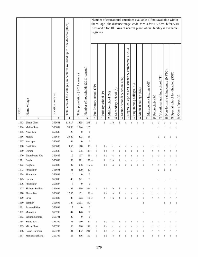
Pre
-Pri
mar
y s
cho
ol
(PP
)
Pri
mar
y s
cho
ol
(P)
Mid
dle
sch
oo
l (M
)
Sec
on
dar
y S
cho
ol
(S)
Sen
ior
Sec
on
dar
y s
cho
ol
(SS
)
Deg
ree
coll
ege
of
arts
sc
ien
ce &
co
mm
erce
(A
SC
)
En
gin
eeri
ng
co
lleg
e(E
C)
Med
ical
co
lleg
e (M
C)
Man
agem
ent
inst
itu
te (
MI)
Po
lyte
chn
ic (
Pt)
Vo
cati
on
al t
rain
ing
sch
oo
l /I
TI
No
n-f
orm
al t
rain
ing
cen
tre
(NF
TC
)
Sp
ecia
l sc
ho
ol
for
dis
able
d (
SS
D)
Oth
ers
(sp
ecif
y)
1 2 3 4 5 6 7 8 9 10 11 12 13 14 15 16 17 18 19 20
Lo
cati
on
co
de
no
.
Nam
e v
illa
ge
Sr.
No
.Number of educational amenities available. (If not available within
the village , the distance range code viz; a for < 5 Kms, b for 5-10
Kms and c for 10+ kms of nearest place where facility is available
is given).
Nu
mb
er o
f h
ou
seh
old
s (2
01
1 c
ensu
s)
To
tal
po
pu
lati
on
( 2
01
1 c
ensu
s )
To
tal
area
of
the
vil
lag
e (
in h
ecta
res
rou
nd
ed u
p t
o
on
e d
ecim
al p
lace
)
1063 Bhaju Chak 356681 118.17 1495 248 1 1 1 b b c c c c c c c c c
1064 Malia Chak 356682 56.08 1044 167 c c c c
1065 Afzal Kita 356683 20 0 0
1066 Mariha 356684 28.49 403 56 c c c c
1067 Kushapur 356685 44 0 0
1068 Fazil Kita 356686 9.55 118 19 1 1 a c c c c c c c c c c c
1069 Dumra 356687 60 695 119 1 1 a c c c c c c c c c c c
1070 Bisambhara Kita 356688 12 167 29 1 1 a c c c c c c c c c c c
1071 Dahia 356689 59 911 178 a 1 1 a b c c c c c c c c c
1072 Kaljhara 356690 82 956 162 a 1 a a c c c c c c c c c c
1073 Phudkipur 356691 31 299 67 c c c
1074 Simratola 356692 10 0 0
1075 Hundra 356693 40 321 69 c c c c
1076 Phudkipur 356694 3 0 0
1077 Shahpur Beldiha 356695 149 1699 334 1 1 b b b c c c c c c c c c
1078 Phasiatikar 356696 17.05 151 22 a 1 a a b c c c c c c c c c
1079 Sirsa 356697 39 573 100 c 2 1 b b c c c c c c c c c
1080 Samhari 356698 187 2561 447 c c c c
1081 Asanand Kita 356699 7 0 0
1082 Muradpur 356700 47 446 87 c c c c
1083 Subarai Samhra 356701 29 0 0
1084 Semra Kita 356702 33 160 30 1 1 a c c c c c c c c c c c
1085 Mirza Chak 356703 63 826 142 1 1 a c c c c c c c c c c c
1086 Hasan Karharia 356704 81 1482 216 1 1 a c c c c c c c c c c c
1087 Manian Karharia 356705 68 856 160 1 1 a c c c c c c c c c c c
179

Pre
-Pri
mar
y s
cho
ol
(PP
)
Pri
mar
y s
cho
ol
(P)
Mid
dle
sch
oo
l (M
)
Sec
on
dar
y S
cho
ol
(S)
Sen
ior
Sec
on
dar
y s
cho
ol
(SS
)
Deg
ree
coll
ege
of
arts
sc
ien
ce &
co
mm
erce
(A
SC
)
En
gin
eeri
ng
co
lleg
e(E
C)
Med
ical
co
lleg
e (M
C)
Man
agem
ent
inst
itu
te (
MI)
Po
lyte
chn
ic (
Pt)
Vo
cati
on
al t
rain
ing
sch
oo
l /I
TI
No
n-f
orm
al t
rain
ing
cen
tre
(NF
TC
)
Sp
ecia
l sc
ho
ol
for
dis
able
d (
SS
D)
Oth
ers
(sp
ecif
y)
1 2 3 4 5 6 7 8 9 10 11 12 13 14 15 16 17 18 19 20
Lo
cati
on
co
de
no
.
Nam
e v
illa
ge
Sr.
No
.Number of educational amenities available. (If not available within
the village , the distance range code viz; a for < 5 Kms, b for 5-10
Kms and c for 10+ kms of nearest place where facility is available
is given).
Nu
mb
er o
f h
ou
seh
old
s (2
01
1 c
ensu
s)
To
tal
po
pu
lati
on
( 2
01
1 c
ensu
s )
To
tal
area
of
the
vil
lag
e (
in h
ecta
res
rou
nd
ed u
p t
o
on
e d
ecim
al p
lace
)
1088 Jathari 356706 26 281 48 1 1 1 c c c c c c c c c c c
1089 Hari Karharia 356707 57 1593 245 c c c c
1090 Kanreswari Kita 356708 3.05 0 0
1091 Hasanpur 356709 40 262 50 a a a c c c c c c c c c c c
1092 Bakwa Chak 356710 22 188 29 a a a c c c c c c c c c c c
1093 Bela Kita 356711 10 0 0
1094 Janki Kita 356712 20 155 33 1 1 1 1 1 c c c c c c c c c
1095 Mal Bhandari Dih 356713 62 1112 202 1 1 a b c c c c c c c c c c
1096 Semrakita And Ghat Bhandarid356714 77 104 16 b a a c c c c c c c c c c c
1097 Aslulahsamra 356715 41 319 51 a a a c c c c c c c c c c c
1098 Bariartola 356716 55 296 54 a 1 a c c c c c c c c c c c
1099 Maganpipra 356717 141 733 126 a a a c c c c c c c c c c c
1100 Ranbahiar 356718 69 101 22 c c c c c
1101 Jamua 356719 39 0 0
1102 Chuna Chak 356720 89 470 89 1 1 1 c a c c c c c c c c c
1103 Ginratari 356721 21.92 145 26 1 1 a c c c c c c c c c c c
1104 Sakal Chak 356722 65.55 1080 167 1 1 a c c c c c c c c c c c
1105 Larai Chak 356723 8.96 41 7 c c c c
1106 Gohira Kita 356724 3.92 0 0
1107 Hemcha Chak 356725 49.12 564 90 c c c c
1108 Asanbani 356726 21.86 0 0
1109 Jhigur Kita 356727 35.03 0 0
1110 Mal Bhandaridih 356728 4.5 0 0
1111 Semarkita Ghat Bhandaridih356729 28.5 1660 330 c c c c c
1112 Nimgachhi And Kita 356730 13.2 0 0
180
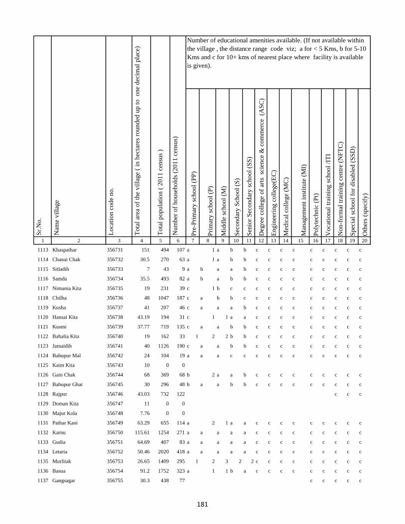
Pre
-Pri
mar
y s
cho
ol
(PP
)
Pri
mar
y s
cho
ol
(P)
Mid
dle
sch
oo
l (M
)
Sec
on
dar
y S
cho
ol
(S)
Sen
ior
Sec
on
dar
y s
cho
ol
(SS
)
Deg
ree
coll
ege
of
arts
sc
ien
ce &
co
mm
erce
(A
SC
)
En
gin
eeri
ng
co
lleg
e(E
C)
Med
ical
co
lleg
e (M
C)
Man
agem
ent
inst
itu
te (
MI)
Po
lyte
chn
ic (
Pt)
Vo
cati
on
al t
rain
ing
sch
oo
l /I
TI
No
n-f
orm
al t
rain
ing
cen
tre
(NF
TC
)
Sp
ecia
l sc
ho
ol
for
dis
able
d (
SS
D)
Oth
ers
(sp
ecif
y)
1 2 3 4 5 6 7 8 9 10 11 12 13 14 15 16 17 18 19 20
Lo
cati
on
co
de
no
.
Nam
e v
illa
ge
Sr.
No
.Number of educational amenities available. (If not available within
the village , the distance range code viz; a for < 5 Kms, b for 5-10
Kms and c for 10+ kms of nearest place where facility is available
is given).
Nu
mb
er o
f h
ou
seh
old
s (2
01
1 c
ensu
s)
To
tal
po
pu
lati
on
( 2
01
1 c
ensu
s )
To
tal
area
of
the
vil
lag
e (
in h
ecta
res
rou
nd
ed u
p t
o
on
e d
ecim
al p
lace
)
1113 Khaspathar 356731 151 494 107 a 1 a b b c c c c c c c c c
1114 Chanai Chak 356732 30.5 270 63 a 1 a b b c c c c c c c c c
1115 Sitladih 356733 7 43 9 a b a a b c c c c c c c c c
1116 Samda 356734 35.5 493 82 a b a b b c c c c c c c c c
1117 Nimania Kita 356735 19 231 39 c 1 b c c c c c c c c c c c
1118 Chilha 356736 48 1047 187 c a b b c c c c c c c c c c
1119 Kusha 356737 41 207 46 c a a a b c c c c c c c c c
1120 Hansai Kita 356738 43.19 194 31 c 1 1 a a c c c c c c c c c
1121 Kusmi 356739 37.77 719 135 c a a b b c c c c c c c c c
1122 Bahalia Kita 356740 19 162 33 1 2 2 b b c c c c c c c c c
1123 Jamaidih 356741 40 1126 190 c a a b b c c c c c c c c c
1124 Babupur Mal 356742 24 104 19 a a a c c c c c c c c c c c
1125 Kaim Kita 356743 10 0 0
1126 Gain Chak 356744 68 369 68 b 2 a a b c c c c c c c c c
1127 Babupur Ghat 356745 30 296 48 b a a b b c c c c c c c c c
1128 Rajpur 356746 43.03 732 122 c c c
1129 Doman Kita 356747 11 0 0
1130 Majur Kola 356748 7.76 0 0
1131 Pathar Kani 356749 63.29 655 114 a 2 1 a a c c c c c c c c c
1132 Karnu 356750 115.61 1254 271 a a a a a c c c c c c c c c
1133 Gudia 356751 64.69 407 83 a a a a a c c c c c c c c c
1134 Letaria 356752 50.46 2020 418 a a a a a c c c c c c c c c
1135 Murlitak 356753 26.65 1409 295 1 2 3 2 2 c c c c c c c c c
1136 Basua 356754 91.2 1752 323 a 1 1 b a c c c c c c c c c
1137 Gangsagar 356755 30.3 438 77 c c c c c
181

Pre
-Pri
mar
y s
cho
ol
(PP
)
Pri
mar
y s
cho
ol
(P)
Mid
dle
sch
oo
l (M
)
Sec
on
dar
y S
cho
ol
(S)
Sen
ior
Sec
on
dar
y s
cho
ol
(SS
)
Deg
ree
coll
ege
of
arts
sc
ien
ce &
co
mm
erce
(A
SC
)
En
gin
eeri
ng
co
lleg
e(E
C)
Med
ical
co
lleg
e (M
C)
Man
agem
ent
inst
itu
te (
MI)
Po
lyte
chn
ic (
Pt)
Vo
cati
on
al t
rain
ing
sch
oo
l /I
TI
No
n-f
orm
al t
rain
ing
cen
tre
(NF
TC
)
Sp
ecia
l sc
ho
ol
for
dis
able
d (
SS
D)
Oth
ers
(sp
ecif
y)
1 2 3 4 5 6 7 8 9 10 11 12 13 14 15 16 17 18 19 20
Lo
cati
on
co
de
no
.
Nam
e v
illa
ge
Sr.
No
.Number of educational amenities available. (If not available within
the village , the distance range code viz; a for < 5 Kms, b for 5-10
Kms and c for 10+ kms of nearest place where facility is available
is given).
Nu
mb
er o
f h
ou
seh
old
s (2
01
1 c
ensu
s)
To
tal
po
pu
lati
on
( 2
01
1 c
ensu
s )
To
tal
area
of
the
vil
lag
e (
in h
ecta
res
rou
nd
ed u
p t
o
on
e d
ecim
al p
lace
)
1138 Monukhap 356756 2.74 0 0
1139 Katbaikal 356757 5 0 0
1140 Jharna Kita 356758 4.68 66 10 1 a a b a c c c c c c 1 c c
1141 Dhankurda 356759 32.61 465 81 c c c c c c
1142 Majhoua 356760 9 0 0
1143 Gahira Kita 356761 4 0 0
1144 Bhadaia Kita 356762 6 0 0
1145 Garbaghat 356763 4 0 0
1146 Garba Kita 356764 4.52 0 0
1147 Balachini Kita 356765 6 0 0
1148 Akasni 356766 47 67 14 a b a b b c c c c c c c c c
1149 Kendua Kita 356767 2 139 24 c c c c c
1150 Kendua Kita 356768 51.36 0 0
1151 Kusmaha 356769 8.32 0 0
1152 Tetaria 356770 18.82 1027 189 a b a b a c c c c c c c c c
1153 Lakrabank 356771 8 443 95 a 1 a b a c c c c c c c c c
1154 Balia Ghat 356772 3.68 102 24 a 1 1 1 a c c c c c c c c c
1155 Balia Kurmi Kita 356773 25.92 529 114 a 1 1 b a b c c c c c c c c
1156 Rabiadih (Santali) 356774 34.45 602 123 a b b b a b c c c c c c c c
1157 Raksa Kita 356775 39.93 278 47 a 1 b b a b c c c c c c c c
1158 Doman Kita 356776 26.23 129 21 b 1 b b b b c c c c b c c c
1159 Mohanpur 356777 81.32 1934 341 a 1 2 a a a a c c a a c c c
1160 Kadhara Ghat 356778 2.76 0 0
1161 Kusdiha 356779 10.4 161 29 b 1 b b b c c c b c b b c c
1162 Dumaria Mal 356780 3.36 31 6 b 1 b b b c c c b c b b c c
182
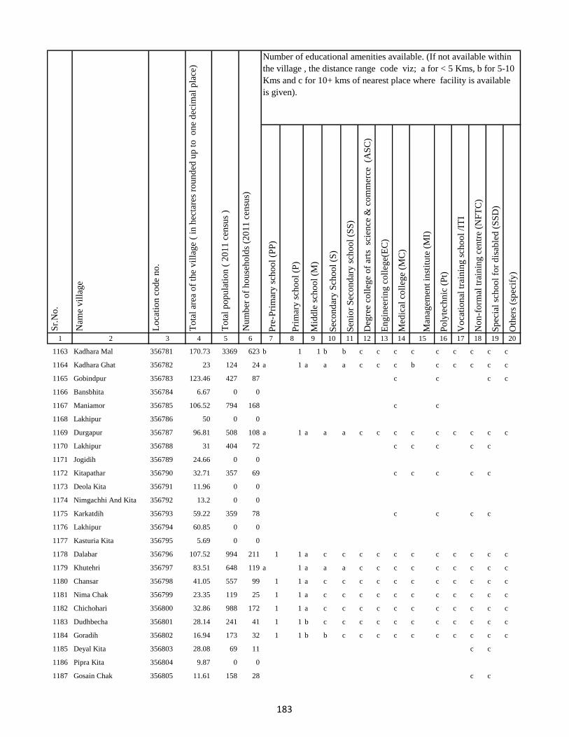
Pre
-Pri
mar
y s
cho
ol
(PP
)
Pri
mar
y s
cho
ol
(P)
Mid
dle
sch
oo
l (M
)
Sec
on
dar
y S
cho
ol
(S)
Sen
ior
Sec
on
dar
y s
cho
ol
(SS
)
Deg
ree
coll
ege
of
arts
sc
ien
ce &
co
mm
erce
(A
SC
)
En
gin
eeri
ng
co
lleg
e(E
C)
Med
ical
co
lleg
e (M
C)
Man
agem
ent
inst
itu
te (
MI)
Po
lyte
chn
ic (
Pt)
Vo
cati
on
al t
rain
ing
sch
oo
l /I
TI
No
n-f
orm
al t
rain
ing
cen
tre
(NF
TC
)
Sp
ecia
l sc
ho
ol
for
dis
able
d (
SS
D)
Oth
ers
(sp
ecif
y)
1 2 3 4 5 6 7 8 9 10 11 12 13 14 15 16 17 18 19 20
Lo
cati
on
co
de
no
.
Nam
e v
illa
ge
Sr.
No
.Number of educational amenities available. (If not available within
the village , the distance range code viz; a for < 5 Kms, b for 5-10
Kms and c for 10+ kms of nearest place where facility is available
is given).
Nu
mb
er o
f h
ou
seh
old
s (2
01
1 c
ensu
s)
To
tal
po
pu
lati
on
( 2
01
1 c
ensu
s )
To
tal
area
of
the
vil
lag
e (
in h
ecta
res
rou
nd
ed u
p t
o
on
e d
ecim
al p
lace
)
1163 Kadhara Mal 356781 170.73 3369 623 b 1 1 b b c c c c c c c c c
1164 Kadhara Ghat 356782 23 124 24 a 1 a a a c c c b c c c c c
1165 Gobindpur 356783 123.46 427 87 c c c c
1166 Bansbhita 356784 6.67 0 0
1167 Maniamor 356785 106.52 794 168 c c
1168 Lakhipur 356786 50 0 0
1169 Durgapur 356787 96.81 508 108 a 1 a a a c c c c c c c c c
1170 Lakhipur 356788 31 404 72 c c c c c
1171 Jogidih 356789 24.66 0 0
1172 Kitapathar 356790 32.71 357 69 c c c c c
1173 Deola Kita 356791 11.96 0 0
1174 Nimgachhi And Kita 356792 13.2 0 0
1175 Karkatdih 356793 59.22 359 78 c c c c
1176 Lakhipur 356794 60.85 0 0
1177 Kasturia Kita 356795 5.69 0 0
1178 Dalabar 356796 107.52 994 211 1 1 a c c c c c c c c c c c
1179 Khutehri 356797 83.51 648 119 a 1 a a a c c c c c c c c c
1180 Chansar 356798 41.05 557 99 1 1 a c c c c c c c c c c c
1181 Nima Chak 356799 23.35 119 25 1 1 a c c c c c c c c c c c
1182 Chichohari 356800 32.86 988 172 1 1 a c c c c c c c c c c c
1183 Dudhbecha 356801 28.14 241 41 1 1 b c c c c c c c c c c c
1184 Goradih 356802 16.94 173 32 1 1 b b c c c c c c c c c c
1185 Deyal Kita 356803 28.08 69 11 c c
1186 Pipra Kita 356804 9.87 0 0
1187 Gosain Chak 356805 11.61 158 28 c c
183
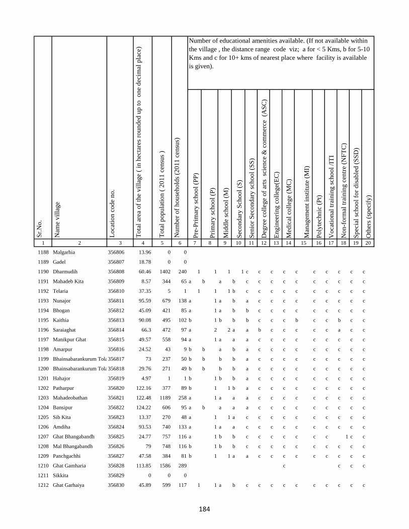
Pre
-Pri
mar
y s
cho
ol
(PP
)
Pri
mar
y s
cho
ol
(P)
Mid
dle
sch
oo
l (M
)
Sec
on
dar
y S
cho
ol
(S)
Sen
ior
Sec
on
dar
y s
cho
ol
(SS
)
Deg
ree
coll
ege
of
arts
sc
ien
ce &
co
mm
erce
(A
SC
)
En
gin
eeri
ng
co
lleg
e(E
C)
Med
ical
co
lleg
e (M
C)
Man
agem
ent
inst
itu
te (
MI)
Po
lyte
chn
ic (
Pt)
Vo
cati
on
al t
rain
ing
sch
oo
l /I
TI
No
n-f
orm
al t
rain
ing
cen
tre
(NF
TC
)
Sp
ecia
l sc
ho
ol
for
dis
able
d (
SS
D)
Oth
ers
(sp
ecif
y)
1 2 3 4 5 6 7 8 9 10 11 12 13 14 15 16 17 18 19 20
Lo
cati
on
co
de
no
.
Nam
e v
illa
ge
Sr.
No
.Number of educational amenities available. (If not available within
the village , the distance range code viz; a for < 5 Kms, b for 5-10
Kms and c for 10+ kms of nearest place where facility is available
is given).
Nu
mb
er o
f h
ou
seh
old
s (2
01
1 c
ensu
s)
To
tal
po
pu
lati
on
( 2
01
1 c
ensu
s )
To
tal
area
of
the
vil
lag
e (
in h
ecta
res
rou
nd
ed u
p t
o
on
e d
ecim
al p
lace
)
1188 Malgarhia 356806 13.96 0 0
1189 Gadel 356807 18.78 0 0
1190 Dharmudih 356808 60.46 1402 240 1 1 1 1 c c c c c c c c c c
1191 Mahadeb Kita 356809 8.57 344 65 a b a b c c c c c c c c c c
1192 Telaria 356810 37.35 5 1 1 1 1 b c c c c c c c c c c
1193 Nunajor 356811 95.59 679 138 a 1 a b a c c c c c c c c c
1194 Bhogan 356812 45.09 421 85 a 1 a b b c c c c c c c c c
1195 Kaithia 356813 90.08 495 102 b 1 b b b c c c b c c b c c
1196 Saraiaghat 356814 66.3 472 97 a 2 2 a a b c c c c c a c c
1197 Manikpur Ghat 356815 49.57 558 94 a 1 a a a c c c c c c c c c
1198 Amarpur 356816 24.52 43 9 b b a b a c c c c c c c c c
1199 Bhainsabarankurum Tola356817 73 237 50 b b b b a c c c c c c c c c
1200 Bhainsabarankurum Tola Mal356818 29.76 271 49 b b b b a c c c c c c c c c
1201 Hahajor 356819 4.97 1 1 b 1 b b a c c c c c c c c c
1202 Patharpur 356820 122.16 377 89 b 1 1 b a c c c c c c c c c
1203 Mahadeobathan 356821 122.48 1189 258 a 1 a a a c c c c c c c c c
1204 Bansipur 356822 124.22 606 95 a b a a a c c c c c c c c c
1205 Sib Kita 356823 13.37 270 48 a 1 1 a c c c c c c c c c c
1206 Amdiha 356824 93.53 740 133 a 1 a a c c c c c c c c c c
1207 Ghat Bhangabandh 356825 24.77 757 116 a 1 b b c c c c c c c 1 c c
1208 Mal Bhangabandh 356826 79 748 116 b 1 b b c c c c c c c c c c
1209 Panchgachhi 356827 47.58 384 81 b 1 1 a a c c c c c c c c c
1210 Ghat Gamharia 356828 113.85 1586 289 c c c c
1211 Sikkita 356829 0 0 0
1212 Ghat Garhaiya 356830 45.89 599 117 1 1 a b c c c c c c c c c c
184
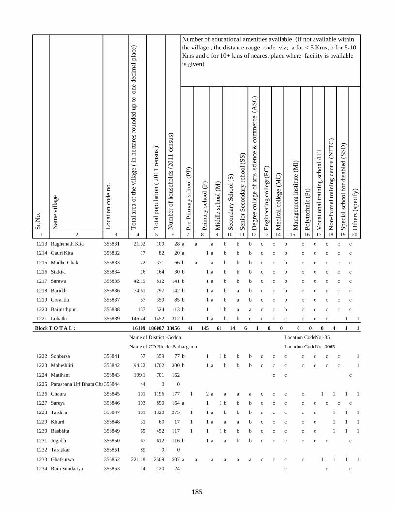
Pre
-Pri
mar
y s
cho
ol
(PP
)
Pri
mar
y s
cho
ol
(P)
Mid
dle
sch
oo
l (M
)
Sec
on
dar
y S
cho
ol
(S)
Sen
ior
Sec
on
dar
y s
cho
ol
(SS
)
Deg
ree
coll
ege
of
arts
sc
ien
ce &
co
mm
erce
(A
SC
)
En
gin
eeri
ng
co
lleg
e(E
C)
Med
ical
co
lleg
e (M
C)
Man
agem
ent
inst
itu
te (
MI)
Po
lyte
chn
ic (
Pt)
Vo
cati
on
al t
rain
ing
sch
oo
l /I
TI
No
n-f
orm
al t
rain
ing
cen
tre
(NF
TC
)
Sp
ecia
l sc
ho
ol
for
dis
able
d (
SS
D)
Oth
ers
(sp
ecif
y)
1 2 3 4 5 6 7 8 9 10 11 12 13 14 15 16 17 18 19 20
Lo
cati
on
co
de
no
.
Nam
e v
illa
ge
Sr.
No
.Number of educational amenities available. (If not available within
the village , the distance range code viz; a for < 5 Kms, b for 5-10
Kms and c for 10+ kms of nearest place where facility is available
is given).
Nu
mb
er o
f h
ou
seh
old
s (2
01
1 c
ensu
s)
To
tal
po
pu
lati
on
( 2
01
1 c
ensu
s )
To
tal
area
of
the
vil
lag
e (
in h
ecta
res
rou
nd
ed u
p t
o
on
e d
ecim
al p
lace
)
1213 Raghunath Kita 356831 21.92 109 28 a a a b b b c c b c c c c c
1214 Gauri Kita 356832 17 82 20 a 1 a b b b c c b c c c c c
1215 Madhu Chak 356833 22 371 66 b a a b b b c c b c c c c c
1216 Sikkita 356834 16 164 30 b 1 a b b b c c b c c c c c
1217 Sarawa 356835 42.19 812 141 b 1 a b b b c c b c c c c c
1218 Baridih 356836 74.61 797 142 b 1 a b a b c c b c c c c c
1219 Gorantia 356837 57 359 85 b 1 a b a b c c b c c c c c
1220 Baijnathpur 356838 137 524 113 b 1 1 b a a c c b c c c c c
1221 Lohathi 356839 146.44 1452 312 b 1 a b b c c c c c c c 1 1
Block T O T A L : 16109 186007 33056 41 145 61 14 6 1 0 0 0 0 0 4 1 1
Name of District:-Godda Location CodeNo:-351
Name of CD Block:-Pathargama Location CodeNo:-0065
1222 Sonbarsa 356841 57 359 77 b 1 1 b b b c c c c c c c 1
1223 Maheshliti 356842 94.22 1702 300 b 1 a b b b c c c c c c c 1
1224 Matihani 356843 109.1 701 162 c c c
1225 Parasbana Urf Bhata Chak356844 44 0 0
1226 Chaura 356845 101 1196 177 1 2 a a a a c c c c 1 1 1 1
1227 Sareya 356846 103 890 164 a 1 1 b b b c c c c c c c c
1228 Tardiha 356847 181 1320 275 1 1 a b b b c c c c c 1 1 1
1229 Khurd 356848 31 60 17 1 1 a a a b c c c c c 1 1 1
1230 Basbhita 356849 69 452 117 1 1 1 b b b c c c c c 1 1 1
1231 Jogidih 356850 67 612 116 b 1 a a b b c c c c c c c
1232 Taratikar 356851 89 0 0
1233 Ghatkurwa 356852 221.18 2509 507 a a a a a a c c c c 1 1 1 1
1234 Ram Sundariya 356853 14 120 24 c c c
185
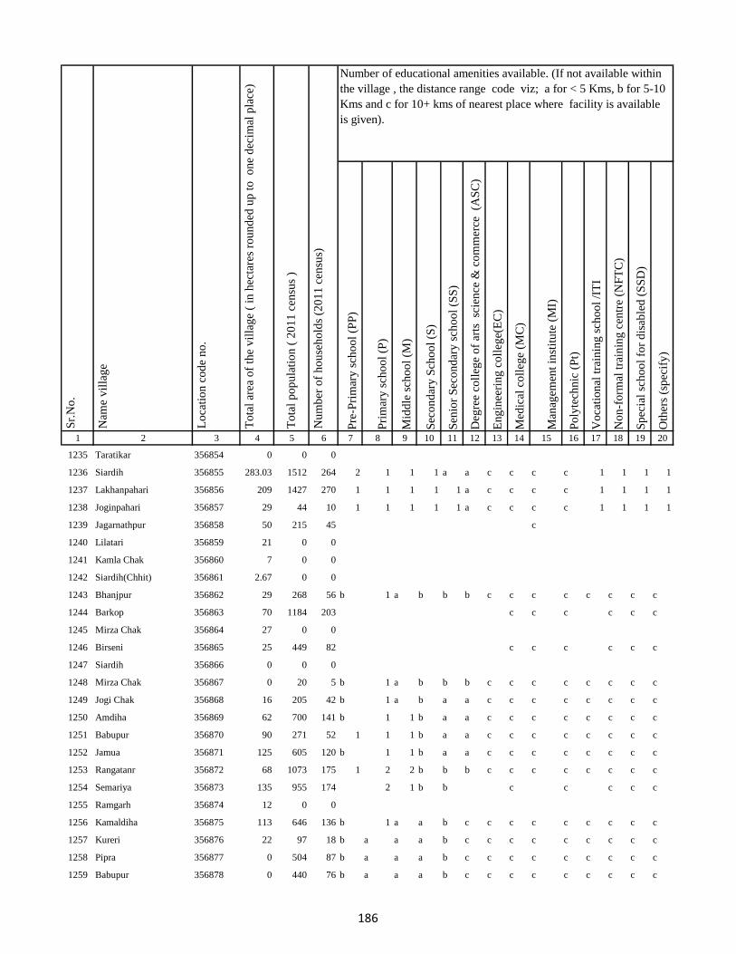
Pre
-Pri
mar
y s
cho
ol
(PP
)
Pri
mar
y s
cho
ol
(P)
Mid
dle
sch
oo
l (M
)
Sec
on
dar
y S
cho
ol
(S)
Sen
ior
Sec
on
dar
y s
cho
ol
(SS
)
Deg
ree
coll
ege
of
arts
sc
ien
ce &
co
mm
erce
(A
SC
)
En
gin
eeri
ng
co
lleg
e(E
C)
Med
ical
co
lleg
e (M
C)
Man
agem
ent
inst
itu
te (
MI)
Po
lyte
chn
ic (
Pt)
Vo
cati
on
al t
rain
ing
sch
oo
l /I
TI
No
n-f
orm
al t
rain
ing
cen
tre
(NF
TC
)
Sp
ecia
l sc
ho
ol
for
dis
able
d (
SS
D)
Oth
ers
(sp
ecif
y)
1 2 3 4 5 6 7 8 9 10 11 12 13 14 15 16 17 18 19 20
Lo
cati
on
co
de
no
.
Nam
e v
illa
ge
Sr.
No
.Number of educational amenities available. (If not available within
the village , the distance range code viz; a for < 5 Kms, b for 5-10
Kms and c for 10+ kms of nearest place where facility is available
is given).
Nu
mb
er o
f h
ou
seh
old
s (2
01
1 c
ensu
s)
To
tal
po
pu
lati
on
( 2
01
1 c
ensu
s )
To
tal
area
of
the
vil
lag
e (
in h
ecta
res
rou
nd
ed u
p t
o
on
e d
ecim
al p
lace
)
1235 Taratikar 356854 0 0 0
1236 Siardih 356855 283.03 1512 264 2 1 1 1 a a c c c c 1 1 1 1
1237 Lakhanpahari 356856 209 1427 270 1 1 1 1 1 a c c c c 1 1 1 1
1238 Joginpahari 356857 29 44 10 1 1 1 1 1 a c c c c 1 1 1 1
1239 Jagarnathpur 356858 50 215 45 c
1240 Lilatari 356859 21 0 0
1241 Kamla Chak 356860 7 0 0
1242 Siardih(Chhit) 356861 2.67 0 0
1243 Bhanjpur 356862 29 268 56 b 1 a b b b c c c c c c c c
1244 Barkop 356863 70 1184 203 c c c c c c
1245 Mirza Chak 356864 27 0 0
1246 Birseni 356865 25 449 82 c c c c c c
1247 Siardih 356866 0 0 0
1248 Mirza Chak 356867 0 20 5 b 1 a b b b c c c c c c c c
1249 Jogi Chak 356868 16 205 42 b 1 a b a a c c c c c c c c
1250 Amdiha 356869 62 700 141 b 1 1 b a a c c c c c c c c
1251 Babupur 356870 90 271 52 1 1 1 b a a c c c c c c c c
1252 Jamua 356871 125 605 120 b 1 1 b a a c c c c c c c c
1253 Rangatanr 356872 68 1073 175 1 2 2 b b b c c c c c c c c
1254 Semariya 356873 135 955 174 2 1 b b c c c c c
1255 Ramgarh 356874 12 0 0
1256 Kamaldiha 356875 113 646 136 b 1 a a b c c c c c c c c c
1257 Kureri 356876 22 97 18 b a a a b c c c c c c c c c
1258 Pipra 356877 0 504 87 b a a a b c c c c c c c c c
1259 Babupur 356878 0 440 76 b a a a b c c c c c c c c c
186

Pre
-Pri
mar
y s
cho
ol
(PP
)
Pri
mar
y s
cho
ol
(P)
Mid
dle
sch
oo
l (M
)
Sec
on
dar
y S
cho
ol
(S)
Sen
ior
Sec
on
dar
y s
cho
ol
(SS
)
Deg
ree
coll
ege
of
arts
sc
ien
ce &
co
mm
erce
(A
SC
)
En
gin
eeri
ng
co
lleg
e(E
C)
Med
ical
co
lleg
e (M
C)
Man
agem
ent
inst
itu
te (
MI)
Po
lyte
chn
ic (
Pt)
Vo
cati
on
al t
rain
ing
sch
oo
l /I
TI
No
n-f
orm
al t
rain
ing
cen
tre
(NF
TC
)
Sp
ecia
l sc
ho
ol
for
dis
able
d (
SS
D)
Oth
ers
(sp
ecif
y)
1 2 3 4 5 6 7 8 9 10 11 12 13 14 15 16 17 18 19 20
Lo
cati
on
co
de
no
.
Nam
e v
illa
ge
Sr.
No
.Number of educational amenities available. (If not available within
the village , the distance range code viz; a for < 5 Kms, b for 5-10
Kms and c for 10+ kms of nearest place where facility is available
is given).
Nu
mb
er o
f h
ou
seh
old
s (2
01
1 c
ensu
s)
To
tal
po
pu
lati
on
( 2
01
1 c
ensu
s )
To
tal
area
of
the
vil
lag
e (
in h
ecta
res
rou
nd
ed u
p t
o
on
e d
ecim
al p
lace
)
1260 Lakarjorimal 356879 7 121 26 b a a a a c c c c c c c c c
1261 Tikabagicha 356880 7 14 3 b a a a b b c c c c c c c c
1262 Gordhoi 356881 13 166 37 b 1 a a a b c c c c c c c c
1263 Babupur 356882 0 270 44 c c c c c c
1264 Nauratan Kita 356883 2.06 0 0
1265 Gordhoi 356884 26.96 37 11 b a a a a b c c c c c c c c
1266 Joginpahari 356885 0 68 13 c c c c c
1267 Simariya 356886 0 0 0
1268 Sonar Chak 356887 88 2021 394 b 1 1 b a a c c c c c c c c
1269 Duarichak 356888 28 1150 238 c 1 1 b b b c c c c c c c c
1270 Tulsi Kita 356889 68 2949 595 c c c c c c
1271 Chau Chak 356890 15 0 0
1272 Karubandh 356891 12 0 0
1273 Haripur 356892 40 0 0
1274 Chau Chak 356893 0 0 0
1275 Lachhminiyan 356894 5 0 0
1276 Chepi 356895 16 0 0
1277 Kasiyatari 356896 119 551 116 c a a b a a c c c c c c c c
1278 Kita Gardharpur 356897 10 275 63 1 1 a b a a c c c c c c c c
1279 Lasutiya 356898 30 455 95 c 8 3 2 1 a c c c c c c c c
1280 Pathargama 356899 62 3490 683 c c c c c c
1281 Mal Pathargama 356900 4 0 0
1282 Arazi Pathargama 356901 1.33 0 0
1283 Chandi Chak 356902 13 414 86 c 1 1 b b b c c c c c c c c
1284 Baliya Kita 356903 16 146 33 c c c c c c
187
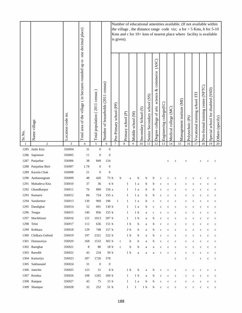
Pre
-Pri
mar
y s
cho
ol
(PP
)
Pri
mar
y s
cho
ol
(P)
Mid
dle
sch
oo
l (M
)
Sec
on
dar
y S
cho
ol
(S)
Sen
ior
Sec
on
dar
y s
cho
ol
(SS
)
Deg
ree
coll
ege
of
arts
sc
ien
ce &
co
mm
erce
(A
SC
)
En
gin
eeri
ng
co
lleg
e(E
C)
Med
ical
co
lleg
e (M
C)
Man
agem
ent
inst
itu
te (
MI)
Po
lyte
chn
ic (
Pt)
Vo
cati
on
al t
rain
ing
sch
oo
l /I
TI
No
n-f
orm
al t
rain
ing
cen
tre
(NF
TC
)
Sp
ecia
l sc
ho
ol
for
dis
able
d (
SS
D)
Oth
ers
(sp
ecif
y)
1 2 3 4 5 6 7 8 9 10 11 12 13 14 15 16 17 18 19 20
Lo
cati
on
co
de
no
.
Nam
e v
illa
ge
Sr.
No
.Number of educational amenities available. (If not available within
the village , the distance range code viz; a for < 5 Kms, b for 5-10
Kms and c for 10+ kms of nearest place where facility is available
is given).
Nu
mb
er o
f h
ou
seh
old
s (2
01
1 c
ensu
s)
To
tal
po
pu
lati
on
( 2
01
1 c
ensu
s )
To
tal
area
of
the
vil
lag
e (
in h
ecta
res
rou
nd
ed u
p t
o
on
e d
ecim
al p
lace
)
1285 Janki Kita 356904 31 0 0
1286 Sapinmor 356905 11 0 0
1287 Panjarhar 356906 38 849 154 c c c c c c
1288 Panjarhar Birit 356907 1.78 0 0
1289 Karaila Chak 356908 21 0 0
1290 Ambasongram 356909 48 420 73 b b a b b b c c c c c c c c
1291 Mahadeva Kita 356910 37 36 6 b 1 1 a b b c c c c c c c c
1292 Ghandharpur 356911 76 899 156 a 1 1 a b b c c c c c c c c
1293 Kumarsi 356912 84 724 155 a 1 1 a b b c c c c c c c c
1294 Sundarmor 356913 130 969 196 1 1 1 a b c c c c c c c c c
1295 Dandighat 356914 52 691 130 b 1 1 a b c c c c c c c c c
1296 Tengar 356915 140 856 155 b 1 1 b a c c c c c c c c c
1297 Machhitanr 356916 122 1013 207 b 1 1 b a b c c c c c c c c
1298 Telni 356917 112 636 151 b 1 b b a b c c c c c c c c
1299 Kobhara 356918 129 748 157 b 2 b b a b c c c c c c c c
1300 Chilkara Gobind 356919 197 2321 522 b 1 b b a b c c c c c c c c
1301 Dumarariya 356920 168 1533 302 b c b b a b c c c c c c c c
1302 Bareghat 356921 8 80 18 b c b b a a c c c c c c c c
1303 Baredih 356922 43 234 50 b 1 b a a a c c c c c c c c
1304 Kasturiya 356923 187 1726 378 c c c c c
1305 Sukhanand 356924 31 0 0
1306 Jamchir 356925 123 31 8 b 1 b b a b c c c c c c c c
1307 Kendua 356926 108 1265 260 b 1 1 b a b c c c c c c c c
1308 Rampur 356927 43 75 15 b 1 1 a b b c c c c c c c c
1309 Shampur 356928 32 252 51 b 1 1 1 b b c c c c c c c c
188
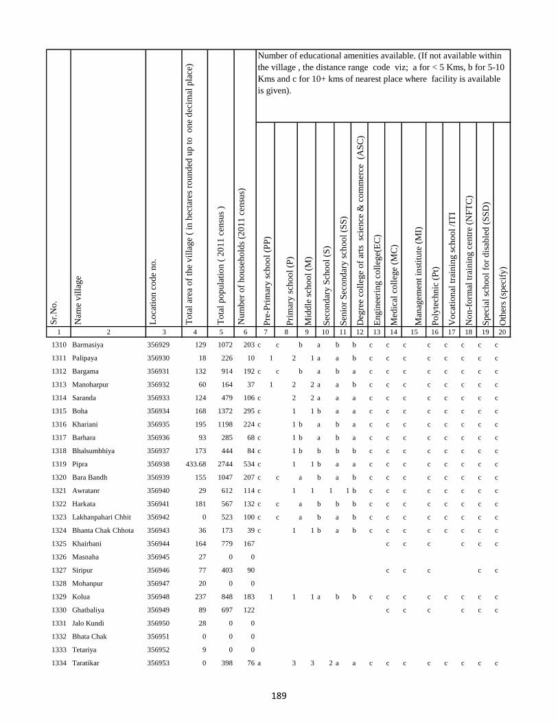
Pre
-Pri
mar
y s
cho
ol
(PP
)
Pri
mar
y s
cho
ol
(P)
Mid
dle
sch
oo
l (M
)
Sec
on
dar
y S
cho
ol
(S)
Sen
ior
Sec
on
dar
y s
cho
ol
(SS
)
Deg
ree
coll
ege
of
arts
sc
ien
ce &
co
mm
erce
(A
SC
)
En
gin
eeri
ng
co
lleg
e(E
C)
Med
ical
co
lleg
e (M
C)
Man
agem
ent
inst
itu
te (
MI)
Po
lyte
chn
ic (
Pt)
Vo
cati
on
al t
rain
ing
sch
oo
l /I
TI
No
n-f
orm
al t
rain
ing
cen
tre
(NF
TC
)
Sp
ecia
l sc
ho
ol
for
dis
able
d (
SS
D)
Oth
ers
(sp
ecif
y)
1 2 3 4 5 6 7 8 9 10 11 12 13 14 15 16 17 18 19 20
Lo
cati
on
co
de
no
.
Nam
e v
illa
ge
Sr.
No
.Number of educational amenities available. (If not available within
the village , the distance range code viz; a for < 5 Kms, b for 5-10
Kms and c for 10+ kms of nearest place where facility is available
is given).
Nu
mb
er o
f h
ou
seh
old
s (2
01
1 c
ensu
s)
To
tal
po
pu
lati
on
( 2
01
1 c
ensu
s )
To
tal
area
of
the
vil
lag
e (
in h
ecta
res
rou
nd
ed u
p t
o
on
e d
ecim
al p
lace
)
1310 Barmasiya 356929 129 1072 203 c c b a b b c c c c c c c c
1311 Palipaya 356930 18 226 10 1 2 1 a a b c c c c c c c c
1312 Bargama 356931 132 914 192 c c b a b a c c c c c c c c
1313 Manoharpur 356932 60 164 37 1 2 2 a a b c c c c c c c c
1314 Saranda 356933 124 479 106 c 2 2 a a a c c c c c c c c
1315 Boha 356934 168 1372 295 c 1 1 b a a c c c c c c c c
1316 Khariani 356935 195 1198 224 c 1 b a b a c c c c c c c c
1317 Barhara 356936 93 285 68 c 1 b a b a c c c c c c c c
1318 Bhalsumbhiya 356937 173 444 84 c 1 b b b b c c c c c c c c
1319 Pipra 356938 433.68 2744 534 c 1 1 b a a c c c c c c c c
1320 Bara Bandh 356939 155 1047 207 c c a b a b c c c c c c c c
1321 Awratanr 356940 29 612 114 c 1 1 1 1 b c c c c c c c c
1322 Harkata 356941 181 567 132 c c a b b b c c c c c c c c
1323 Lakhanpahari Chhit 356942 0 523 100 c c a b a b c c c c c c c c
1324 Bhanta Chak Chhota 356943 36 173 39 c 1 1 b a b c c c c c c c c
1325 Khairbani 356944 164 779 167 c c c c c c
1326 Masnaha 356945 27 0 0
1327 Siripur 356946 77 403 90 c c c c c
1328 Mohanpur 356947 20 0 0
1329 Kolua 356948 237 848 183 1 1 1 a b b c c c c c c c c
1330 Ghatbaliya 356949 89 697 122 c c c c c c
1331 Jalo Kundi 356950 28 0 0
1332 Bhata Chak 356951 0 0 0
1333 Tetariya 356952 9 0 0
1334 Taratikar 356953 0 398 76 a 3 3 2 a a c c c c c c c c
189

Pre
-Pri
mar
y s
cho
ol
(PP
)
Pri
mar
y s
cho
ol
(P)
Mid
dle
sch
oo
l (M
)
Sec
on
dar
y S
cho
ol
(S)
Sen
ior
Sec
on
dar
y s
cho
ol
(SS
)
Deg
ree
coll
ege
of
arts
sc
ien
ce &
co
mm
erce
(A
SC
)
En
gin
eeri
ng
co
lleg
e(E
C)
Med
ical
co
lleg
e (M
C)
Man
agem
ent
inst
itu
te (
MI)
Po
lyte
chn
ic (
Pt)
Vo
cati
on
al t
rain
ing
sch
oo
l /I
TI
No
n-f
orm
al t
rain
ing
cen
tre
(NF
TC
)
Sp
ecia
l sc
ho
ol
for
dis
able
d (
SS
D)
Oth
ers
(sp
ecif
y)
1 2 3 4 5 6 7 8 9 10 11 12 13 14 15 16 17 18 19 20
Lo
cati
on
co
de
no
.
Nam
e v
illa
ge
Sr.
No
.Number of educational amenities available. (If not available within
the village , the distance range code viz; a for < 5 Kms, b for 5-10
Kms and c for 10+ kms of nearest place where facility is available
is given).
Nu
mb
er o
f h
ou
seh
old
s (2
01
1 c
ensu
s)
To
tal
po
pu
lati
on
( 2
01
1 c
ensu
s )
To
tal
area
of
the
vil
lag
e (
in h
ecta
res
rou
nd
ed u
p t
o
on
e d
ecim
al p
lace
)
1335 Bandelwar 356954 93 1469 267 a 1 a a c c c c c
1336 Taratikar 356955 0 0 0
1337 Dumariya 356956 51 387 79 b 1 1 b b a c c c c c c c c
1338 Dhobdiha 356957 95 502 116 b 1 1 b b b c c c c c c c c
1339 Beltikri 356958 86 1887 318 c 3 1 b b c c c c c c c c c
1340 Belshar 356959 66 155 28 c 1 a a c c c c c c c c c c
1341 Parua 356960 156 2288 452 c c c c c c
1342 Biahunpurmal 356961 27 0 0
1343 Arazi Bishunpur 356962 11 0 0
1344 Pakariya 356963 89 846 160 c c c c c c
1345 Chamra Koli 356964 6 0 0
1346 Boharna 356965 24 744 130 a c b b c c c c c c c c c c
1347 Rajaun Khurd 356966 81 998 179 a 1 1 a b c c c c c c c c c
1348 Ambabathan 356967 200 500 83 a 1 a a c c c c c c c c c c
1349 Dhibabandh 356968 98.93 571 130 a 1 1 1 b c c c c c c c c c
1350 Kerbar 356969 234 1207 271 a 1 a b b c c c c c c c c c
1351 Barwarda 356970 86 309 65 b 1 1 a b c c c c c c c c c
1352 Ranipur 356971 70 2883 461 b 1 1 a a c c c c c c c c c
1353 Laugai 356972 181 1670 367 b 1 1 a a c c c c c c c c c
1354 Gangarampur 356973 127 695 132 1 1 1 a c a c c c c c c c c
1355 Latauna 356974 184 981 196 c 1 a a c c c c c c c c c c
1356 Chunakothi 356975 184 566 112 c 1 1 b c c c c c c c c c c
1357 Ghutiya 356976 154 450 101 c 1 1 b c c c c c c c c c c
1358 Rajaun Kalan 356977 211 1133 236 c 3 1 b c c c c c c c c c c
1359 Bisaha 356978 463.2 2840 580 c b a b c c c c c c c c c c
190

Pre
-Pri
mar
y s
cho
ol
(PP
)
Pri
mar
y s
cho
ol
(P)
Mid
dle
sch
oo
l (M
)
Sec
on
dar
y S
cho
ol
(S)
Sen
ior
Sec
on
dar
y s
cho
ol
(SS
)
Deg
ree
coll
ege
of
arts
sc
ien
ce &
co
mm
erce
(A
SC
)
En
gin
eeri
ng
co
lleg
e(E
C)
Med
ical
co
lleg
e (M
C)
Man
agem
ent
inst
itu
te (
MI)
Po
lyte
chn
ic (
Pt)
Vo
cati
on
al t
rain
ing
sch
oo
l /I
TI
No
n-f
orm
al t
rain
ing
cen
tre
(NF
TC
)
Sp
ecia
l sc
ho
ol
for
dis
able
d (
SS
D)
Oth
ers
(sp
ecif
y)
1 2 3 4 5 6 7 8 9 10 11 12 13 14 15 16 17 18 19 20
Lo
cati
on
co
de
no
.
Nam
e v
illa
ge
Sr.
No
.Number of educational amenities available. (If not available within
the village , the distance range code viz; a for < 5 Kms, b for 5-10
Kms and c for 10+ kms of nearest place where facility is available
is given).
Nu
mb
er o
f h
ou
seh
old
s (2
01
1 c
ensu
s)
To
tal
po
pu
lati
on
( 2
01
1 c
ensu
s )
To
tal
area
of
the
vil
lag
e (
in h
ecta
res
rou
nd
ed u
p t
o
on
e d
ecim
al p
lace
)
1360 Charkaghat 356979 0 38 5 c 2 1 a c c c c c c c c c c
1361 Nimbar 356980 117 582 105 c b a b c c c c c c c c c c
1362 Dighi 356981 162 877 171 c 2 2 1 1 c c c c c c c c c
1363 Korkaghat 356982 123 1994 397 c 1 1 a c c c c c c c c c c
1364 Amad Khani 356983 22 84 19 c c c c c
1365 Raksu Kita 356984 9.64 0 0
1366 Chakwa 356985 101 495 82 c c c c c
1367 Jasmata 356986 43 0 0
1368 Simariya 356987 126 912 157 c 1 1 a c c c c c c c c c c
1369 Sanatan 356988 127.38 1682 295 a a c c c c c
1370 Kela Kita 356989 2.36 0 0
1371 Khasdighi 356990 39 0 0
1372 Toiadih 356991 5 0 0
1373 Ramu Chak 356992 34 0 0
1374 Charkaghat 356993 131 1156 202 b 1 a a b b c c c c c c c c
1375 Garka 356994 20 172 41 b 1 1 a b b c c c c c c c c
1376 Bariyata 356995 38 211 42 c c c c
1377 Charkaghat 356996 26.8 0 0
1378 Tabhalpur 356997 46 61 13 b a a a b b c c c c c c c
1379 Gobindpur 356998 45 0 0
1380 Masudanpur 356999 13 391 82 c c c c c
1381 Bedpur 357000 27 0 0
1382 Bhagwan Chak 357001 125 493 116 a 1 1 a b c c c c c c c c c
1383 Rup Chak 357002 81 992 188 a 1 a a b b c c c c c c c c
1384 Pathar Kani Mal 357003 149 683 144 c c c c
191

Pre
-Pri
mar
y s
cho
ol
(PP
)
Pri
mar
y s
cho
ol
(P)
Mid
dle
sch
oo
l (M
)
Sec
on
dar
y S
cho
ol
(S)
Sen
ior
Sec
on
dar
y s
cho
ol
(SS
)
Deg
ree
coll
ege
of
arts
sc
ien
ce &
co
mm
erce
(A
SC
)
En
gin
eeri
ng
co
lleg
e(E
C)
Med
ical
co
lleg
e (M
C)
Man
agem
ent
inst
itu
te (
MI)
Po
lyte
chn
ic (
Pt)
Vo
cati
on
al t
rain
ing
sch
oo
l /I
TI
No
n-f
orm
al t
rain
ing
cen
tre
(NF
TC
)
Sp
ecia
l sc
ho
ol
for
dis
able
d (
SS
D)
Oth
ers
(sp
ecif
y)
1 2 3 4 5 6 7 8 9 10 11 12 13 14 15 16 17 18 19 20
Lo
cati
on
co
de
no
.
Nam
e v
illa
ge
Sr.
No
.Number of educational amenities available. (If not available within
the village , the distance range code viz; a for < 5 Kms, b for 5-10
Kms and c for 10+ kms of nearest place where facility is available
is given).
Nu
mb
er o
f h
ou
seh
old
s (2
01
1 c
ensu
s)
To
tal
po
pu
lati
on
( 2
01
1 c
ensu
s )
To
tal
area
of
the
vil
lag
e (
in h
ecta
res
rou
nd
ed u
p t
o
on
e d
ecim
al p
lace
)
1385 Pathar Kani Ghat 357004 15 0 0
1386 Chilra 357005 148 1637 356 a 1 a a b c c c c c c c c c
1387 Chainpur 357006 97 1130 242 b 1 1 1 b b c c c c c c c c
1388 Ghat Rampur 357007 233.43 589 111 a 1 1 1 b b c c c c c c c c
1389 Mal Rampur 357008 63.02 958 183 a 1 1 a b b c c c c c c c c
1390 Mal Nistara 357009 44 878 152 a b b a b b c c c c c c c c
1391 Ghat Nistara 357010 55 446 84 c c c c c c
1392 Ghat Gasti 357011 17 0 0
1393 Mahuakol 357012 24 0 0
1394 Mahuasol 357013 72 307 67 c 1 1 b b c c c c c c c c c
1395 Sighai Mal 357014 87 820 144 b 2 b b b b c c c c c c c c
1396 Singhi Ghat 357015 68 387 80 b 1 1 b b b c c c c c c c c
1397 Jogiya 357016 38 321 60 b 1 1 c c c c c c c c c c c
1398 Khaira 357017 158 1301 254 b 1 a a c c c c c c c c c c
1399 Jamjori 357018 124 790 145 1 c c c c c c
1400 Gangtamal Chhit 357019 0 0 0
1401 Jokela 357020 72 450 84 c 1 a b c c c c c c c c c c
1402 Dhangri Mal 357021 62 5 1 c 1 a b c c c c c c c c c c
1403 Dhangdri Ghat 357022 20 248 42 c c c c c
1404 Ghangri Mal 357023 0 0 0
1405 Basbhita Ghat 357024 8 0 0
1406 Basbhita Mal 357025 128 1291 218 a 1 a b c c c c c c c c c c
1407 Ranipur Dumariya 357026 103 0 0
1408 Gangta Kalan 357027 47 1494 271 a 1 a b c c c c c c c c
1409 Jokela Mal 357028 75 0 0
192
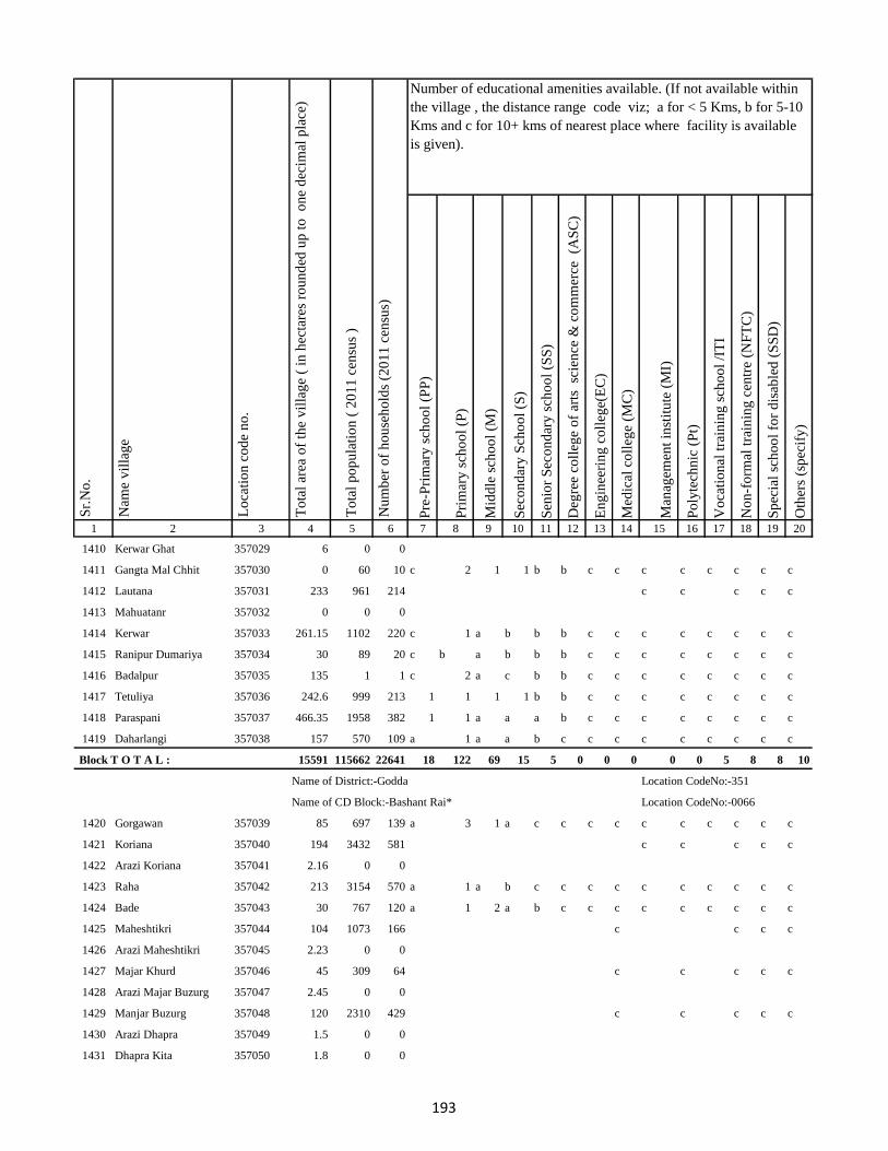
Pre
-Pri
mar
y s
cho
ol
(PP
)
Pri
mar
y s
cho
ol
(P)
Mid
dle
sch
oo
l (M
)
Sec
on
dar
y S
cho
ol
(S)
Sen
ior
Sec
on
dar
y s
cho
ol
(SS
)
Deg
ree
coll
ege
of
arts
sc
ien
ce &
co
mm
erce
(A
SC
)
En
gin
eeri
ng
co
lleg
e(E
C)
Med
ical
co
lleg
e (M
C)
Man
agem
ent
inst
itu
te (
MI)
Po
lyte
chn
ic (
Pt)
Vo
cati
on
al t
rain
ing
sch
oo
l /I
TI
No
n-f
orm
al t
rain
ing
cen
tre
(NF
TC
)
Sp
ecia
l sc
ho
ol
for
dis
able
d (
SS
D)
Oth
ers
(sp
ecif
y)
1 2 3 4 5 6 7 8 9 10 11 12 13 14 15 16 17 18 19 20
Lo
cati
on
co
de
no
.
Nam
e v
illa
ge
Sr.
No
.Number of educational amenities available. (If not available within
the village , the distance range code viz; a for < 5 Kms, b for 5-10
Kms and c for 10+ kms of nearest place where facility is available
is given).
Nu
mb
er o
f h
ou
seh
old
s (2
01
1 c
ensu
s)
To
tal
po
pu
lati
on
( 2
01
1 c
ensu
s )
To
tal
area
of
the
vil
lag
e (
in h
ecta
res
rou
nd
ed u
p t
o
on
e d
ecim
al p
lace
)
1410 Kerwar Ghat 357029 6 0 0
1411 Gangta Mal Chhit 357030 0 60 10 c 2 1 1 b b c c c c c c c c
1412 Lautana 357031 233 961 214 c c c c c
1413 Mahuatanr 357032 0 0 0
1414 Kerwar 357033 261.15 1102 220 c 1 a b b b c c c c c c c c
1415 Ranipur Dumariya 357034 30 89 20 c b a b b b c c c c c c c c
1416 Badalpur 357035 135 1 1 c 2 a c b b c c c c c c c c
1417 Tetuliya 357036 242.6 999 213 1 1 1 1 b b c c c c c c c c
1418 Paraspani 357037 466.35 1958 382 1 1 a a a b c c c c c c c c
1419 Daharlangi 357038 157 570 109 a 1 a a b c c c c c c c c c
Block T O T A L : 15591 115662 22641 18 122 69 15 5 0 0 0 0 0 5 8 8 10
Name of District:-Godda Location CodeNo:-351
Name of CD Block:-Bashant Rai* Location CodeNo:-0066
1420 Gorgawan 357039 85 697 139 a 3 1 a c c c c c c c c c c
1421 Koriana 357040 194 3432 581 c c c c c
1422 Arazi Koriana 357041 2.16 0 0
1423 Raha 357042 213 3154 570 a 1 a b c c c c c c c c c c
1424 Bade 357043 30 767 120 a 1 2 a b c c c c c c c c c
1425 Maheshtikri 357044 104 1073 166 c c c c
1426 Arazi Maheshtikri 357045 2.23 0 0
1427 Majar Khurd 357046 45 309 64 c c c c c
1428 Arazi Majar Buzurg 357047 2.45 0 0
1429 Manjar Buzurg 357048 120 2310 429 c c c c c
1430 Arazi Dhapra 357049 1.5 0 0
1431 Dhapra Kita 357050 1.8 0 0
193
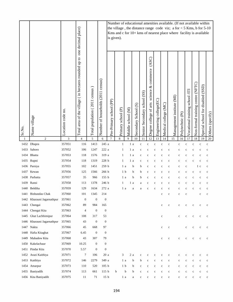
Pre
-Pri
mar
y s
cho
ol
(PP
)
Pri
mar
y s
cho
ol
(P)
Mid
dle
sch
oo
l (M
)
Sec
on
dar
y S
cho
ol
(S)
Sen
ior
Sec
on
dar
y s
cho
ol
(SS
)
Deg
ree
coll
ege
of
arts
sc
ien
ce &
co
mm
erce
(A
SC
)
En
gin
eeri
ng
co
lleg
e(E
C)
Med
ical
co
lleg
e (M
C)
Man
agem
ent
inst
itu
te (
MI)
Po
lyte
chn
ic (
Pt)
Vo
cati
on
al t
rain
ing
sch
oo
l /I
TI
No
n-f
orm
al t
rain
ing
cen
tre
(NF
TC
)
Sp
ecia
l sc
ho
ol
for
dis
able
d (
SS
D)
Oth
ers
(sp
ecif
y)
1 2 3 4 5 6 7 8 9 10 11 12 13 14 15 16 17 18 19 20
Lo
cati
on
co
de
no
.
Nam
e v
illa
ge
Sr.
No
.Number of educational amenities available. (If not available within
the village , the distance range code viz; a for < 5 Kms, b for 5-10
Kms and c for 10+ kms of nearest place where facility is available
is given).
Nu
mb
er o
f h
ou
seh
old
s (2
01
1 c
ensu
s)
To
tal
po
pu
lati
on
( 2
01
1 c
ensu
s )
To
tal
area
of
the
vil
lag
e (
in h
ecta
res
rou
nd
ed u
p t
o
on
e d
ecim
al p
lace
)
1432 Dhapra 357051 116 1413 245 a 1 1 a c c c c c c c c c c
1433 Sahoro 357052 106 1247 222 a 1 1 a c c c c c c c c c c
1434 Bhatta 357053 118 1576 319 a 1 1 a c c c c c c c c c c
1435 Rupni 357054 118 1319 228 b 1 1 a c c c c c c c c c c
1436 Parsiya 357055 102 1451 259 b 1 a b b c c c c c c 1 c c
1437 Kewan 357056 125 1566 266 b 1 b b b c c c c c c c c c
1438 Parbatta 357057 35 966 155 b 1 a b b c c c c c c c c c
1439 Ransi 357058 113 1378 246 b 1 1 a a c c c c c c c c c
1440 Beldiha 357059 129 1634 272 a 1 a a a c c c c c c c c c
1441 Bishundas Chak 357060 101 1345 214 c c c c c c
1442 Kharauni Jagarnathpur 357061 0 0 0
1443 Chengai 357062 89 984 165 c c c c c c c
1444 Chengai Kita 357063 4 0 0
1445 Ghat Lachhimipur 357064 108 317 53 c c c c c c
1446 Kharauni Jagarnathpur 357065 43 0 0
1447 Nakta 357066 45 668 97 c c c c c c
1448 Hafta Kitaghat 357067 6.45 0 0
1449 Mahadew Kita 357068 43 307 79 c c c c c c c
1450 Kakelachaur 357069 10.25 0 0
1451 Pindar Kita 357070 5.57 0 0
1452 Arazi Kaithiya 357071 7 106 20 a 3 2 a c c c c c c c c c c
1453 Kaithiya 357072 146 2279 349 a 1 a b b c c c c c c c c c
1454 Amarpur 357073 110 520 105 b 1 b b c c c c c c c c c c
1455 Baniyadih 357074 113 661 115 b b b b c c c c c c c c c c
1456 Kita Baniyadih 357075 11 71 15 b 1 a a c c c c c c c c c c
194
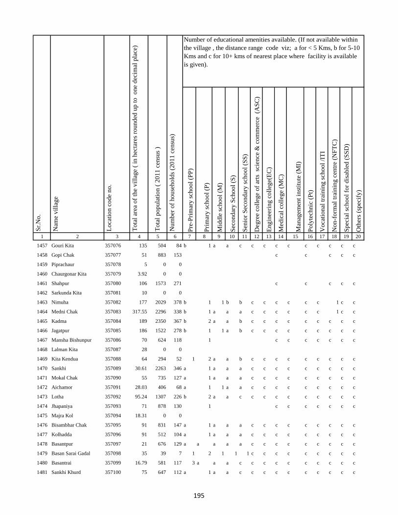
Pre
-Pri
mar
y s
cho
ol
(PP
)
Pri
mar
y s
cho
ol
(P)
Mid
dle
sch
oo
l (M
)
Sec
on
dar
y S
cho
ol
(S)
Sen
ior
Sec
on
dar
y s
cho
ol
(SS
)
Deg
ree
coll
ege
of
arts
sc
ien
ce &
co
mm
erce
(A
SC
)
En
gin
eeri
ng
co
lleg
e(E
C)
Med
ical
co
lleg
e (M
C)
Man
agem
ent
inst
itu
te (
MI)
Po
lyte
chn
ic (
Pt)
Vo
cati
on
al t
rain
ing
sch
oo
l /I
TI
No
n-f
orm
al t
rain
ing
cen
tre
(NF
TC
)
Sp
ecia
l sc
ho
ol
for
dis
able
d (
SS
D)
Oth
ers
(sp
ecif
y)
1 2 3 4 5 6 7 8 9 10 11 12 13 14 15 16 17 18 19 20
Lo
cati
on
co
de
no
.
Nam
e v
illa
ge
Sr.
No
.Number of educational amenities available. (If not available within
the village , the distance range code viz; a for < 5 Kms, b for 5-10
Kms and c for 10+ kms of nearest place where facility is available
is given).
Nu
mb
er o
f h
ou
seh
old
s (2
01
1 c
ensu
s)
To
tal
po
pu
lati
on
( 2
01
1 c
ensu
s )
To
tal
area
of
the
vil
lag
e (
in h
ecta
res
rou
nd
ed u
p t
o
on
e d
ecim
al p
lace
)
1457 Gouri Kita 357076 135 504 84 b 1 a a c c c c c c c c c c
1458 Gopi Chak 357077 51 883 153 c c c c c
1459 Piprachaur 357078 5 0 0
1460 Chaurgonar Kita 357079 3.92 0 0
1461 Shahpur 357080 106 1573 271 c c c c c
1462 Sarkunda Kita 357081 10 0 0
1463 Nimuha 357082 177 2029 378 b 1 1 b b c c c c c c 1 c c
1464 Medni Chak 357083 317.55 2296 338 b 1 a a a c c c c c c 1 c c
1465 Kadma 357084 189 2350 367 b 2 a a b c c c c c c c c c
1466 Jagatpur 357085 186 1522 278 b 1 1 a b c c c c c c c c c
1467 Mansha Bishunpur 357086 70 624 118 1 c c c c c c c
1468 Lalman Kita 357087 28 0 0
1469 Kita Kendua 357088 64 294 52 1 2 a a b c c c c c c c c c
1470 Sankhi 357089 30.61 2263 346 a 1 a a a c c c c c c c c c
1471 Mokal Chak 357090 55 735 127 a 1 a a a c c c c c c c c c
1472 Aichamor 357091 28.03 406 68 a 1 1 a a c c c c c c c c c
1473 Lotha 357092 95.24 1307 226 b 2 a a c c c c c c c c c c
1474 Jhapaniya 357093 71 878 130 1 c c c c c c c
1475 Majra Kol 357094 18.31 0 0
1476 Bisambhar Chak 357095 91 831 147 a 1 a a a c c c c c c c c c
1477 Kolhadda 357096 91 512 104 a 1 a a a c c c c c c c c c
1478 Basantpur 357097 21 676 129 a a a a a c c c c c c c c c
1479 Basan Sarai Gadal 357098 35 39 7 1 2 1 1 1 c c c c c c c c c
1480 Basantrai 357099 16.79 581 117 3 a a a c c c c c c c c c c
1481 Sankhi Khurd 357100 75 647 112 a 1 a a c c c c c c c c c c
195
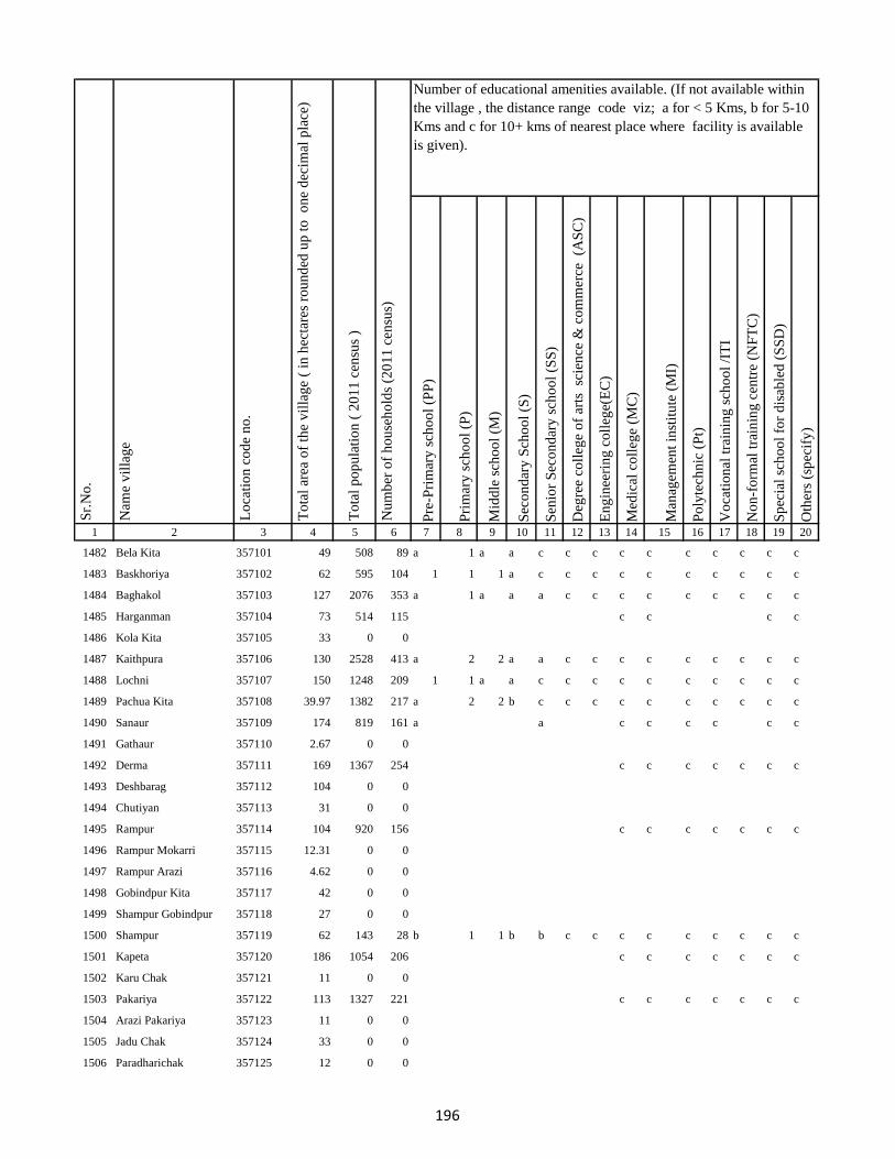
Pre
-Pri
mar
y s
cho
ol
(PP
)
Pri
mar
y s
cho
ol
(P)
Mid
dle
sch
oo
l (M
)
Sec
on
dar
y S
cho
ol
(S)
Sen
ior
Sec
on
dar
y s
cho
ol
(SS
)
Deg
ree
coll
ege
of
arts
sc
ien
ce &
co
mm
erce
(A
SC
)
En
gin
eeri
ng
co
lleg
e(E
C)
Med
ical
co
lleg
e (M
C)
Man
agem
ent
inst
itu
te (
MI)
Po
lyte
chn
ic (
Pt)
Vo
cati
on
al t
rain
ing
sch
oo
l /I
TI
No
n-f
orm
al t
rain
ing
cen
tre
(NF
TC
)
Sp
ecia
l sc
ho
ol
for
dis
able
d (
SS
D)
Oth
ers
(sp
ecif
y)
1 2 3 4 5 6 7 8 9 10 11 12 13 14 15 16 17 18 19 20
Lo
cati
on
co
de
no
.
Nam
e v
illa
ge
Sr.
No
.Number of educational amenities available. (If not available within
the village , the distance range code viz; a for < 5 Kms, b for 5-10
Kms and c for 10+ kms of nearest place where facility is available
is given).
Nu
mb
er o
f h
ou
seh
old
s (2
01
1 c
ensu
s)
To
tal
po
pu
lati
on
( 2
01
1 c
ensu
s )
To
tal
area
of
the
vil
lag
e (
in h
ecta
res
rou
nd
ed u
p t
o
on
e d
ecim
al p
lace
)
1482 Bela Kita 357101 49 508 89 a 1 a a c c c c c c c c c c
1483 Baskhoriya 357102 62 595 104 1 1 1 a c c c c c c c c c c
1484 Baghakol 357103 127 2076 353 a 1 a a a c c c c c c c c c
1485 Harganman 357104 73 514 115 c c c c
1486 Kola Kita 357105 33 0 0
1487 Kaithpura 357106 130 2528 413 a 2 2 a a c c c c c c c c c
1488 Lochni 357107 150 1248 209 1 1 a a c c c c c c c c c c
1489 Pachua Kita 357108 39.97 1382 217 a 2 2 b c c c c c c c c c c
1490 Sanaur 357109 174 819 161 a a c c c c c c
1491 Gathaur 357110 2.67 0 0
1492 Derma 357111 169 1367 254 c c c c c c c
1493 Deshbarag 357112 104 0 0
1494 Chutiyan 357113 31 0 0
1495 Rampur 357114 104 920 156 c c c c c c c
1496 Rampur Mokarri 357115 12.31 0 0
1497 Rampur Arazi 357116 4.62 0 0
1498 Gobindpur Kita 357117 42 0 0
1499 Shampur Gobindpur 357118 27 0 0
1500 Shampur 357119 62 143 28 b 1 1 b b c c c c c c c c c
1501 Kapeta 357120 186 1054 206 c c c c c c c
1502 Karu Chak 357121 11 0 0
1503 Pakariya 357122 113 1327 221 c c c c c c c
1504 Arazi Pakariya 357123 11 0 0
1505 Jadu Chak 357124 33 0 0
1506 Paradharichak 357125 12 0 0
196

Pre
-Pri
mar
y s
cho
ol
(PP
)
Pri
mar
y s
cho
ol
(P)
Mid
dle
sch
oo
l (M
)
Sec
on
dar
y S
cho
ol
(S)
Sen
ior
Sec
on
dar
y s
cho
ol
(SS
)
Deg
ree
coll
ege
of
arts
sc
ien
ce &
co
mm
erce
(A
SC
)
En
gin
eeri
ng
co
lleg
e(E
C)
Med
ical
co
lleg
e (M
C)
Man
agem
ent
inst
itu
te (
MI)
Po
lyte
chn
ic (
Pt)
Vo
cati
on
al t
rain
ing
sch
oo
l /I
TI
No
n-f
orm
al t
rain
ing
cen
tre
(NF
TC
)
Sp
ecia
l sc
ho
ol
for
dis
able
d (
SS
D)
Oth
ers
(sp
ecif
y)
1 2 3 4 5 6 7 8 9 10 11 12 13 14 15 16 17 18 19 20
Lo
cati
on
co
de
no
.
Nam
e v
illa
ge
Sr.
No
.Number of educational amenities available. (If not available within
the village , the distance range code viz; a for < 5 Kms, b for 5-10
Kms and c for 10+ kms of nearest place where facility is available
is given).
Nu
mb
er o
f h
ou
seh
old
s (2
01
1 c
ensu
s)
To
tal
po
pu
lati
on
( 2
01
1 c
ensu
s )
To
tal
area
of
the
vil
lag
e (
in h
ecta
res
rou
nd
ed u
p t
o
on
e d
ecim
al p
lace
)
1507 Jamnikola 357126 214 3227 520 c c c c c c
1508 Kapra Chak 357127 12 0 0
1509 Surai Kita 357128 38 618 113 b 1 a b a c c c c c c c c c
1510 Kumhrakol 357129 128.38 1014 147 b 1 a b b c c c c c c c c c
1511 Banshipur 357130 124 882 119 b 1 a b b c c c c c c c c c
1512 Bajpai 357131 105 426 82 b 1 a a c c c c c c c c c c
1513 Resamba 357132 134 1618 265 c c c c c c c
1514 Bhira 357133 32 0 0
1515 Barhampur 357134 91 2458 402 b 1 a b b c c c c c c c c c
1516 Bodra 357135 276 1386 237 b 1 1 1 b c c c c c c c c c
1517 Susti 357136 98 2503 434 b b c c c c c c c c
1518 Barhaiya 357137 62 0 0
1519 Maheshpur 357138 163 1147 200 b 1 1 a c c c c c c c c c c
1520 Hilawa 357139 164 2348 388 b 1 1 b c c c c c c c c c c
1521 Chanai Chak 357140 113 968 178 c c c c c
1522 Urkusiya 357141 28 0 0
1523 Arazi Kharti 357142 10.21 0 0
1524 Kharti 357143 109 695 123 b 1 a a c c c c c c c c c c
1525 Barhara 357144 46 386 68 b 1 1 a c c c c c c c c c c
1526 Amarpur Ghal 357145 102 2028 364 1 a a a b b c c c c c c c c
1527 Surniya Ghat Mal 357146 56 317 57 1 1 1 a b b c c c c c c c c
1528 Surniya Mal Ghat 357147 32 1152 218 1 1 a a b b c c c c c c c c
1529 Tofil Surniya 357148 34 157 42 c c c c c c c
1530 Arazi Surniya Ghat 357149 0 0 0
1531 Phulwariya 357150 91 585 104 a a a a c c c c c c c c c c
197
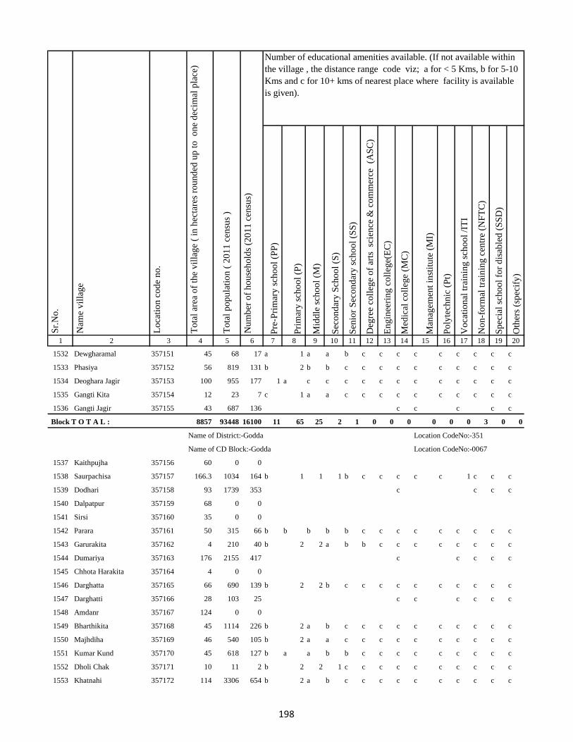
Pre
-Pri
mar
y s
cho
ol
(PP
)
Pri
mar
y s
cho
ol
(P)
Mid
dle
sch
oo
l (M
)
Sec
on
dar
y S
cho
ol
(S)
Sen
ior
Sec
on
dar
y s
cho
ol
(SS
)
Deg
ree
coll
ege
of
arts
sc
ien
ce &
co
mm
erce
(A
SC
)
En
gin
eeri
ng
co
lleg
e(E
C)
Med
ical
co
lleg
e (M
C)
Man
agem
ent
inst
itu
te (
MI)
Po
lyte
chn
ic (
Pt)
Vo
cati
on
al t
rain
ing
sch
oo
l /I
TI
No
n-f
orm
al t
rain
ing
cen
tre
(NF
TC
)
Sp
ecia
l sc
ho
ol
for
dis
able
d (
SS
D)
Oth
ers
(sp
ecif
y)
1 2 3 4 5 6 7 8 9 10 11 12 13 14 15 16 17 18 19 20
Lo
cati
on
co
de
no
.
Nam
e v
illa
ge
Sr.
No
.Number of educational amenities available. (If not available within
the village , the distance range code viz; a for < 5 Kms, b for 5-10
Kms and c for 10+ kms of nearest place where facility is available
is given).
Nu
mb
er o
f h
ou
seh
old
s (2
01
1 c
ensu
s)
To
tal
po
pu
lati
on
( 2
01
1 c
ensu
s )
To
tal
area
of
the
vil
lag
e (
in h
ecta
res
rou
nd
ed u
p t
o
on
e d
ecim
al p
lace
)
1532 Dewgharamal 357151 45 68 17 a 1 a a b c c c c c c c c c
1533 Phasiya 357152 56 819 131 b 2 b b c c c c c c c c c c
1534 Deoghara Jagir 357153 100 955 177 1 a c c c c c c c c c c c c
1535 Gangti Kita 357154 12 23 7 c 1 a a c c c c c c c c c c
1536 Gangti Jagir 357155 43 687 136 c c c c c
Block T O T A L : 8857 93448 16100 11 65 25 2 1 0 0 0 0 0 0 3 0 0
Name of District:-Godda Location CodeNo:-351
Name of CD Block:-Godda Location CodeNo:-0067
1537 Kaithpujha 357156 60 0 0
1538 Saurpachisa 357157 166.3 1034 164 b 1 1 1 b c c c c c 1 c c c
1539 Dodhari 357158 93 1739 353 c c c c
1540 Dalpatpur 357159 68 0 0
1541 Sirsi 357160 35 0 0
1542 Parara 357161 50 315 66 b b b b b c c c c c c c c c
1543 Garurakita 357162 4 210 40 b 2 2 a b b c c c c c c c c
1544 Dumariya 357163 176 2155 417 c c c c c
1545 Chhota Harakita 357164 4 0 0
1546 Darghatta 357165 66 690 139 b 2 2 b c c c c c c c c c c
1547 Darghatti 357166 28 103 25 c c c c c c
1548 Amdanr 357167 124 0 0
1549 Bharthikita 357168 45 1114 226 b 2 a b c c c c c c c c c c
1550 Majhdiha 357169 46 540 105 b 2 a a c c c c c c c c c c
1551 Kumar Kund 357170 45 618 127 b a a b b c c c c c c c c c
1552 Dholi Chak 357171 10 11 2 b 2 2 1 c c c c c c c c c c
1553 Khatnahi 357172 114 3306 654 b 2 a b c c c c c c c c c c
198
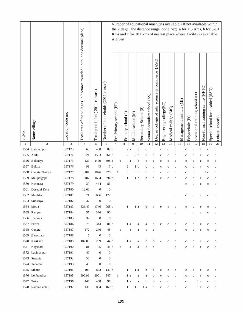
Pre
-Pri
mar
y s
cho
ol
(PP
)
Pri
mar
y s
cho
ol
(P)
Mid
dle
sch
oo
l (M
)
Sec
on
dar
y S
cho
ol
(S)
Sen
ior
Sec
on
dar
y s
cho
ol
(SS
)
Deg
ree
coll
ege
of
arts
sc
ien
ce &
co
mm
erce
(A
SC
)
En
gin
eeri
ng
co
lleg
e(E
C)
Med
ical
co
lleg
e (M
C)
Man
agem
ent
inst
itu
te (
MI)
Po
lyte
chn
ic (
Pt)
Vo
cati
on
al t
rain
ing
sch
oo
l /I
TI
No
n-f
orm
al t
rain
ing
cen
tre
(NF
TC
)
Sp
ecia
l sc
ho
ol
for
dis
able
d (
SS
D)
Oth
ers
(sp
ecif
y)
1 2 3 4 5 6 7 8 9 10 11 12 13 14 15 16 17 18 19 20
Lo
cati
on
co
de
no
.
Nam
e v
illa
ge
Sr.
No
.Number of educational amenities available. (If not available within
the village , the distance range code viz; a for < 5 Kms, b for 5-10
Kms and c for 10+ kms of nearest place where facility is available
is given).
Nu
mb
er o
f h
ou
seh
old
s (2
01
1 c
ensu
s)
To
tal
po
pu
lati
on
( 2
01
1 c
ensu
s )
To
tal
area
of
the
vil
lag
e (
in h
ecta
res
rou
nd
ed u
p t
o
on
e d
ecim
al p
lace
)
1554 Baijnathpur 357173 63 488 82 c 2 a b c c c c c c c c c c
1555 Amlo 357174 224 1503 261 c 2 2 b c c c c c c c c c c
1556 Bohoriya 357175 139 1469 308 a a a b c c c c c c c c c c
1557 Bokha 357176 99 43 7 b 2 1 b c c c c c c c c c c
1558 Gangta Phasiya 357177 107 1826 370 1 3 3 b b c c c c c b 1 c c
1559 Malipalgajia 357178 187 1684 294 b 1 1 b b c c c c c c c c c
1560 Kusmara 357179 39 444 81 c c c c c
1561 Dusadhi Kola 357180 12.66 0 0
1562 Maldiha 357181 71 656 172 c c c c c c
1563 Simariya 357182 37 0 0
1564 Motia 357183 526.49 4746 968 b 1 1 a b b c c c c c c c c
1565 Rampur 357184 55 396 90 c c c c c
1566 Jharkata 357185 32 0 0
1567 Patwa 357186 73 343 81 b 1 a a a b c c c c c c c c
1568 Gangta 357187 172 246 48 a a a c c c c c c c c
1569 Barachaur 357188 5 0 0
1570 Karikado 357189 107.89 209 44 b 1 a a b b c c c c c c c c
1571 Nayabad 357190 81 195 44 c a a a c c c c c c c c
1572 Lachhanpur 357191 40 0 0
1573 Susunia 357192 56 0 0
1574 Tabalpur 357193 43 0 0
1575 Sikatia 357194 109 853 145 b 1 1 a b b c c c c c c c c
1576 Lohbandha 357195 292.99 2901 547 1 1 a a a b c c c c c c c c
1577 Tuka 357196 146 468 97 b 1 a a b b c c c c 1 c c c
1578 Ramla Santali 357197 138 834 160 b 1 1 1 a c c c c c 1 c c c
199
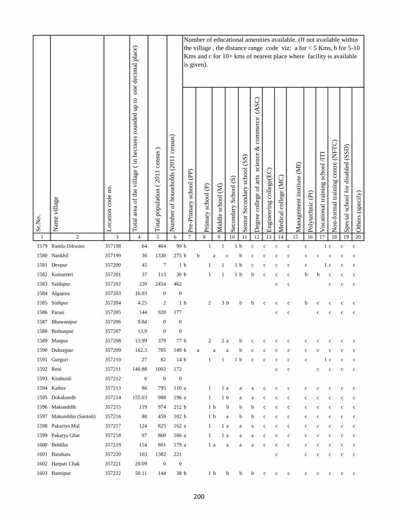
Pre
-Pri
mar
y s
cho
ol
(PP
)
Pri
mar
y s
cho
ol
(P)
Mid
dle
sch
oo
l (M
)
Sec
on
dar
y S
cho
ol
(S)
Sen
ior
Sec
on
dar
y s
cho
ol
(SS
)
Deg
ree
coll
ege
of
arts
sc
ien
ce &
co
mm
erce
(A
SC
)
En
gin
eeri
ng
co
lleg
e(E
C)
Med
ical
co
lleg
e (M
C)
Man
agem
ent
inst
itu
te (
MI)
Po
lyte
chn
ic (
Pt)
Vo
cati
on
al t
rain
ing
sch
oo
l /I
TI
No
n-f
orm
al t
rain
ing
cen
tre
(NF
TC
)
Sp
ecia
l sc
ho
ol
for
dis
able
d (
SS
D)
Oth
ers
(sp
ecif
y)
1 2 3 4 5 6 7 8 9 10 11 12 13 14 15 16 17 18 19 20
Lo
cati
on
co
de
no
.
Nam
e v
illa
ge
Sr.
No
.Number of educational amenities available. (If not available within
the village , the distance range code viz; a for < 5 Kms, b for 5-10
Kms and c for 10+ kms of nearest place where facility is available
is given).
Nu
mb
er o
f h
ou
seh
old
s (2
01
1 c
ensu
s)
To
tal
po
pu
lati
on
( 2
01
1 c
ensu
s )
To
tal
area
of
the
vil
lag
e (
in h
ecta
res
rou
nd
ed u
p t
o
on
e d
ecim
al p
lace
)
1579 Ramla Dikwani 357198 64 464 90 b 1 1 1 b c c c c c 1 c c c
1580 Nankhil 357199 36 1330 275 b b a c b c c c c c c c c c
1581 Devpur 357200 45 7 1 b 1 1 1 b c c c c c 1 c c c
1582 Kumarreri 357201 37 113 30 b 1 1 1 b b c c c b b c c c
1583 Saidapur 357202 220 2454 462 c c c c c
1584 Algajora 357203 16.03 0 0
1585 Sinhpur 357204 4.25 2 1 b 2 3 b b b c c c b c c c c
1586 Parasi 357205 144 920 177 c c c c c c
1587 Bhawanipur 357206 9.84 0 0
1588 Bishunpur 357207 13.9 0 0
1589 Manpur 357208 13.99 379 77 b 2 2 a b c c c c c c c c c
1590 Dubrajpur 357209 162.3 705 149 b a a a b c c c c c c c c c
1591 Gurguri 357210 27 82 14 b 1 1 1 b c c c c c 1 c c c
1592 Reni 357211 140.88 1002 172 c c c c c c
1593 Kitabuidi 357212 6 0 0
1594 Kathra 357213 86 795 110 a 1 1 a a a c c c c c c c c
1595 Dokabandh 357214 155.03 988 196 a 1 1 b a a c c c c c c c c
1596 Makunddih 357215 119 974 212 b 1 b b b b c c c c c c c c
1597 Makunddin (Santoli) 357216 80 459 102 b 1 b a b b c c c c c c c c
1598 Pakariya Mal 357217 124 825 162 a 1 1 a a a c c c c c c c c
1599 Pakarya Ghat 357218 97 860 166 a 1 1 a a a c c c c c c c c
1600 Beldiha 357219 154 801 179 a 1 a a a a c c c c c c c c
1601 Barahara 357220 103 1382 221 c c c c c c
1602 Harpati Chak 357221 20.09 0 0
1603 Bansipur 357222 50.11 144 38 b 1 b b b b c c c c c c c c
200
Pre
-Pri
mar
y s
cho
ol
(PP
)
Pri
mar
y s
cho
ol
(P)
Mid
dle
sch
oo
l (M
)
Sec
on
dar
y S
cho
ol
(S)
Sen
ior
Sec
on
dar
y s
cho
ol
(SS
)
Deg
ree
coll
ege
of
arts
sc
ien
ce &
co
mm
erce
(A
SC
)
En
gin
eeri
ng
co
lleg
e(E
C)
Med
ical
co
lleg
e (M
C)
Man
agem
ent
inst
itu
te (
MI)
Po
lyte
chn
ic (
Pt)
Vo
cati
on
al t
rain
ing
sch
oo
l /I
TI
No
n-f
orm
al t
rain
ing
cen
tre
(NF
TC
)
Sp
ecia
l sc
ho
ol
for
dis
able
d (
SS
D)
Oth
ers
(sp
ecif
y)
1 2 3 4 5 6 7 8 9 10 11 12 13 14 15 16 17 18 19 20
Lo
cati
on
co
de
no
.
Nam
e v
illa
ge
Sr.
No
.Number of educational amenities available. (If not available within
the village , the distance range code viz; a for < 5 Kms, b for 5-10
Kms and c for 10+ kms of nearest place where facility is available
is given).
Nu
mb
er o
f h
ou
seh
old
s (2
01
1 c
ensu
s)
To
tal
po
pu
lati
on
( 2
01
1 c
ensu
s )
To
tal
area
of
the
vil
lag
e (
in h
ecta
res
rou
nd
ed u
p t
o
on
e d
ecim
al p
lace
)
1604 Kurma 357223 96.46 476 97 b 1 1 b b b c c c c c c c c
1605 Baliya 357224 42.9 155 35 b 3 3 b a b c c c c c c c c
1606 Molnakita 357225 61.38 392 88 b 2 3 b a b c c c c c c c c
1607 Patpur 357226 26 352 73 b 2 a b a b c c c c c c c c
1608 Nilkanthpur 357227 61 356 69 a 2 a c c c c c c c c c c c
1609 Chapri 357228 67 698 137 a 2 a a b b c c c c c c c c
1610 Bara 357229 105 264 42 a 2 a a b b c c c c c c c c
1611 Lacchmipur 357230 37.6 183 38 a 3 3 a b b c c c c c c c c
1612 Nepura 357231 84.86 1127 203 a 3 3 b b b c c c c c c c c
1613 Kakana 357232 27.63 189 38 c c c c c c c
1614 Chandarpur 357233 27.16 0 0
1615 Parariya 357234 5.73 0 0
1616 Panch Kathi 357235 36.84 128 20 c c c c c c
1617 Burhi Salempur 357236 12.22 0 0
1618 Arwara 357237 14.11 0 0
1619 Basarhi 357238 134 988 170 a 3 3 2 a b c c c c c c c c
1620 Malni 357239 39.79 802 155 b 3 a b a b c c c c c c c c
1621 Chakwa 357240 47 560 100 b 2 2 b a b c c c c c c c c
1622 Machhiya Samarda Urf Lalpur357241 81 3027 517 b 3 2 b b b c c c c c c c c
1623 Diyara 357242 64 1018 185 b a a b b b c c c c c c c c
1624 Jaipur 357243 25.61 32 5 a 2 1 a a b c c c c c c c c
1625 Barhauna 357244 205 2315 442 a 2 2 a a b c c c c c c c c
1626 Amdiha 357245 86.71 398 71 a 3 a b a b c c c c c c c c
1627 Parsa 357246 138.8 748 125 a 2 2 b a b c c c c c c c c
1628 Kanhwara 357247 169 2685 483 a a a b a b c c c c c c c c
201
Pre
-Pri
mar
y s
cho
ol
(PP
)
Pri
mar
y s
cho
ol
(P)
Mid
dle
sch
oo
l (M
)
Sec
on
dar
y S
cho
ol
(S)
Sen
ior
Sec
on
dar
y s
cho
ol
(SS
)
Deg
ree
coll
ege
of
arts
sc
ien
ce &
co
mm
erce
(A
SC
)
En
gin
eeri
ng
co
lleg
e(E
C)
Med
ical
co
lleg
e (M
C)
Man
agem
ent
inst
itu
te (
MI)
Po
lyte
chn
ic (
Pt)
Vo
cati
on
al t
rain
ing
sch
oo
l /I
TI
No
n-f
orm
al t
rain
ing
cen
tre
(NF
TC
)
Sp
ecia
l sc
ho
ol
for
dis
able
d (
SS
D)
Oth
ers
(sp
ecif
y)
1 2 3 4 5 6 7 8 9 10 11 12 13 14 15 16 17 18 19 20
Lo
cati
on
co
de
no
.
Nam
e v
illa
ge
Sr.
No
.Number of educational amenities available. (If not available within
the village , the distance range code viz; a for < 5 Kms, b for 5-10
Kms and c for 10+ kms of nearest place where facility is available
is given).
Nu
mb
er o
f h
ou
seh
old
s (2
01
1 c
ensu
s)
To
tal
po
pu
lati
on
( 2
01
1 c
ensu
s )
To
tal
area
of
the
vil
lag
e (
in h
ecta
res
rou
nd
ed u
p t
o
on
e d
ecim
al p
lace
)
1629 Garbana 357248 167 2429 485 b 2 a a a c c c c c 1 1 c c
1630 Galapahar 357249 104.54 800 159 b 2 2 a b c c c c c 1 c c c
1631 Bhadrahi Mal 357250 76.05 1393 252 b 2 2 b a c c c c c 1 c c c
1632 Ghat Bhadrahi 357251 17.52 412 79 b 2 1 b b b c c c c c c c c
1633 Chilauna 357252 175 1769 315 b 1 1 b b b c c c c c c c c
1634 Rampur 357253 82 768 138 b 1 1 b b b c c c c c c c c
1635 Dumariya Mal 357254 82 987 189 b a a b b b c c c c c c c c
1636 Naya Chak 357255 16 22 6 b 1 1 1 b b c c c c c c c c
1637 Dara Chak 357256 101 1121 212 b 1 1 b b b c c c c c c c c
1638 Ghat Gorsanda 357257 84 2492 478 b a a a b b c c c c c c c c
1639 Mal Gorsanda 357258 10 0 0
1640 Mal Dhamsain 357259 85 0 0
1641 Ghat Dhamsain 357260 81 0 0
1642 Ghat Dhamsain 357261 131 1183 228 c a a a c c c c c c c c c c
1643 Khaira Mal 357262 25 0 0
1644 Pachrukhi 357263 120 3927 680 b a a a b b c c c c c c c c
1645 Lukluki Mal 357264 15 0 0
1646 Lukluki Ghat 357265 46 757 143 a 2 c c c c c c c c c c c
1647 Pathariya Mal 357266 4 0 0
1648 Pathariya Ghat 357267 145.64 1177 236 c c c c
1649 Pathariya Mal 357268 0 0 0
1650 Chhota Kaliyani 357269 82 999 215 b 1 b c c c c c c c c c c c
1651 Bara Kaliyani 357270 314 1670 315 b b b b c c c c c c c c c c
1652 Pathriya Mal 357271 38 534 109 2 2 b b b c c c c c c c c c
1653 Sabaijor 357272 328.71 1187 246 1 2 a b c c c c c c c c c c
202
Pre
-Pri
mar
y s
cho
ol
(PP
)
Pri
mar
y s
cho
ol
(P)
Mid
dle
sch
oo
l (M
)
Sec
on
dar
y S
cho
ol
(S)
Sen
ior
Sec
on
dar
y s
cho
ol
(SS
)
Deg
ree
coll
ege
of
arts
sc
ien
ce &
co
mm
erce
(A
SC
)
En
gin
eeri
ng
co
lleg
e(E
C)
Med
ical
co
lleg
e (M
C)
Man
agem
ent
inst
itu
te (
MI)
Po
lyte
chn
ic (
Pt)
Vo
cati
on
al t
rain
ing
sch
oo
l /I
TI
No
n-f
orm
al t
rain
ing
cen
tre
(NF
TC
)
Sp
ecia
l sc
ho
ol
for
dis
able
d (
SS
D)
Oth
ers
(sp
ecif
y)
1 2 3 4 5 6 7 8 9 10 11 12 13 14 15 16 17 18 19 20
Lo
cati
on
co
de
no
.
Nam
e v
illa
ge
Sr.
No
.Number of educational amenities available. (If not available within
the village , the distance range code viz; a for < 5 Kms, b for 5-10
Kms and c for 10+ kms of nearest place where facility is available
is given).
Nu
mb
er o
f h
ou
seh
old
s (2
01
1 c
ensu
s)
To
tal
po
pu
lati
on
( 2
01
1 c
ensu
s )
To
tal
area
of
the
vil
lag
e (
in h
ecta
res
rou
nd
ed u
p t
o
on
e d
ecim
al p
lace
)
1654 Karudih 357273 164 471 90 c 3 a b c c c c c c c c c c
1655 Kauadhab 357274 191 1057 219 1 2 a b c c c c c c c c c c
1656 Gaechhand 357275 386 2054 447 c 1 1 1 c c c c c c c c c c
1657 Chinadhab 357276 243 1882 384 c 2 a a b c c c c c 1 c c c
1658 Tilobadar 357277 152.02 1064 213 1 1 1 a c c c c c c c c c c
1659 Pelgarhi Dhopahari 357278 100 1123 220 c 1 1 a c c c c c c c c c c
1660 Karmatanr 357279 92.48 901 177 c c c c c c
1661 Betiyabahiyar 357280 3.73 0 0
1662 Ranidih 357281 204 2507 481 c 1 a b b c c c c c 1 c c c
1663 Malhra 357282 34.42 1252 261 c 1 1 1 b c c c c c 1 c c c
1664 Kurmi Chak 357283 94 2247 474 c c c c c c c
1665 Kajradah 357284 93.1 0 0
1666 Charkakol Ghat 357285 73.3 873 192 c c c c c c
1667 Mahugariya 357286 28.53 0 0
1668 Ratrati 357287 26.53 456 95 c 1 a a b c c c c c c c c c
1669 Karhariya Mal 357288 71.43 728 143 c 1 a a c c c c c c c c c c
1670 Kubji Ghat 357289 109.71 452 76 c 1 a a c c c c c c c c c c
1671 Pathwara 357290 33 560 113 c b a a c c c c c c c c c c
1672 Karhariya Ghat 357291 25 89 19 c 1 1 b c c c c c c 1 c c c
1673 Mal Domuria 357292 14.77 301 64 c c c c c c c
1674 Karhariya Mal 357293 25.58 0 0
1675 Amghata 357294 60.13 0 0
1676 Ghat Dumariya 357295 13.03 0 0
1677 Kita Pelgarhi Dhopahari 357296 0 229 42 1 a a b c c c c c c c c c c
1678 Kajradah 357297 95 509 107 c 2 a b b c c c c c c c c c
203

Pre
-Pri
mar
y s
cho
ol
(PP
)
Pri
mar
y s
cho
ol
(P)
Mid
dle
sch
oo
l (M
)
Sec
on
dar
y S
cho
ol
(S)
Sen
ior
Sec
on
dar
y s
cho
ol
(SS
)
Deg
ree
coll
ege
of
arts
sc
ien
ce &
co
mm
erce
(A
SC
)
En
gin
eeri
ng
co
lleg
e(E
C)
Med
ical
co
lleg
e (M
C)
Man
agem
ent
inst
itu
te (
MI)
Po
lyte
chn
ic (
Pt)
Vo
cati
on
al t
rain
ing
sch
oo
l /I
TI
No
n-f
orm
al t
rain
ing
cen
tre
(NF
TC
)
Sp
ecia
l sc
ho
ol
for
dis
able
d (
SS
D)
Oth
ers
(sp
ecif
y)
1 2 3 4 5 6 7 8 9 10 11 12 13 14 15 16 17 18 19 20
Lo
cati
on
co
de
no
.
Nam
e v
illa
ge
Sr.
No
.Number of educational amenities available. (If not available within
the village , the distance range code viz; a for < 5 Kms, b for 5-10
Kms and c for 10+ kms of nearest place where facility is available
is given).
Nu
mb
er o
f h
ou
seh
old
s (2
01
1 c
ensu
s)
To
tal
po
pu
lati
on
( 2
01
1 c
ensu
s )
To
tal
area
of
the
vil
lag
e (
in h
ecta
res
rou
nd
ed u
p t
o
on
e d
ecim
al p
lace
)
1679 Rajpura 357298 44.55 1028 188 c c c c c c
1680 Charkakol Ghat 357299 73.3 0 0
1681 Masudanpur 357300 5 0 0
1682 Kusmainimal 357301 16 0 0
1683 Sasan 357302 9.05 0 0
1684 Bishunpur 357303 18.48 0 0
1685 Kutnipathar 357304 76.6 414 78 c 1 1 b c c c c c c c c c c
1686 Kathaun 357305 60 2080 412 c a a c c c c c c c c c c c
1687 Parariya Mal 357306 26 58 13 a a a b b c c c c c c c c c
1688 Kita Parariya Ghat 357307 12.56 6 1 c c c c c c
1689 Kita Gorgawan 357308 16.02 0 0
1690 Karhariya Ghat 357309 88 0 0
1691 Kusmani Ghat 357310 100.85 793 133 a 3 b b c c c c c c c c c c
1692 Ratanpur 357311 27.48 1431 292 a 2 b b c c c c c c c c c c
1693 Tarwari 357312 82.38 716 117 a 2 1 c c c c c c c c c c c
1694 Manjwara Ghat 357313 139 2068 401 2 2 b c c c c c c c c c c c
1695 Bishunpur 357314 30 361 62 a b b c c c c c c c c c c c
1696 Kalyani Kita 357315 5 296 47 2 2 b c c c c c c c c c c c
1697 Ghat Dumariya 357316 61 1243 213 c c c c c c c
1698 Kita Shampur 357317 40.91 0 0
1699 Kusmain Ghat Chhit 357318 15 0 0
1700 Kita Thathar 357319 31 0 0
1701 Kita Gawar 357320 28 0 0
1702 Kita Gorgawan 357321 16.02 598 109 c c c c c c c
1703 Kasba Godda 357322 32 0 0
204

Pre
-Pri
mar
y s
cho
ol
(PP
)
Pri
mar
y s
cho
ol
(P)
Mid
dle
sch
oo
l (M
)
Sec
on
dar
y S
cho
ol
(S)
Sen
ior
Sec
on
dar
y s
cho
ol
(SS
)
Deg
ree
coll
ege
of
arts
sc
ien
ce &
co
mm
erce
(A
SC
)
En
gin
eeri
ng
co
lleg
e(E
C)
Med
ical
co
lleg
e (M
C)
Man
agem
ent
inst
itu
te (
MI)
Po
lyte
chn
ic (
Pt)
Vo
cati
on
al t
rain
ing
sch
oo
l /I
TI
No
n-f
orm
al t
rain
ing
cen
tre
(NF
TC
)
Sp
ecia
l sc
ho
ol
for
dis
able
d (
SS
D)
Oth
ers
(sp
ecif
y)
1 2 3 4 5 6 7 8 9 10 11 12 13 14 15 16 17 18 19 20
Lo
cati
on
co
de
no
.
Nam
e v
illa
ge
Sr.
No
.Number of educational amenities available. (If not available within
the village , the distance range code viz; a for < 5 Kms, b for 5-10
Kms and c for 10+ kms of nearest place where facility is available
is given).
Nu
mb
er o
f h
ou
seh
old
s (2
01
1 c
ensu
s)
To
tal
po
pu
lati
on
( 2
01
1 c
ensu
s )
To
tal
area
of
the
vil
lag
e (
in h
ecta
res
rou
nd
ed u
p t
o
on
e d
ecim
al p
lace
)
1704 Ghat Paharpur 357323 65.28 0 0
1705 Kutni Pathar 357324 0 24 4 c c c c c c c
1706 Gorka Kita 357325 78 0 0
1707 Bhandar Koli 357326 17 1412 283 b 3 a b b c c c c c b c c c
1708 Harlal Tola 357327 164 584 108 b 2 2 1 1 c c c c c b c c c
1709 Haripur 357328 20 1240 244 b 2 b b b c c c c c c c c c
1710 Ghat Paharpur 357329 23 1618 289 b 2 2 b b c c c c c 1 c c c
1711 Kasba Godda 357330 132 222 43 c c c c c c
1712 Ghat Paharpur 357331 19 0 0
1713 Mohanpur 357332 103 731 163 c 1 1 c c c c c c c c c c c
1714 Markhan 357333 431 3220 623 c 1 a a b c c c c c c c c c
1715 Daldali 357334 330 1712 367 1 4 1 1 b b c c c c c c c c
1716 Jamuni Paharpur 357335 582 6271 1232 c c c c c
1717 Ghat Paharpur 357336 0 0 0
1718 Nonmati 357337 64 641 119 a 1 1 a b a c c c c c c c c
1719 Sarotiya 357338 204 1038 189 a 1 1 a b a c c c c c c c c
1720 Bhatdiha 357339 124 3873 771 a a a a a a c c c c c c c c
1721 Bengbahiyar 357340 19 91 14 a 1 a a a a c c c c c c c c
1722 Rupiyamal 357341 50 1505 247 a a a a a a c c c c c c c c
1723 Maruabaran 357342 63 103 27 b a a b b b c c c c c c c c
1724 Kauribahiyarmal Chhit 357343 0 0 0
1725 Kauribahiyar Ghat 357344 160 1476 297 b b a b b b c c c c c c c c
1726 Kauribahiyar Mal 357345 203 1272 261 b 1 b b b b c c c c c c c c
1727 Pairdih 357346 75 2303 396 a 1 1 a a a c c c c c c c c
1728 Kanadih Chhit 357347 259 920 185 a a a a a a c c c c c c c c
205

Pre
-Pri
mar
y s
cho
ol
(PP
)
Pri
mar
y s
cho
ol
(P)
Mid
dle
sch
oo
l (M
)
Sec
on
dar
y S
cho
ol
(S)
Sen
ior
Sec
on
dar
y s
cho
ol
(SS
)
Deg
ree
coll
ege
of
arts
sc
ien
ce &
co
mm
erce
(A
SC
)
En
gin
eeri
ng
co
lleg
e(E
C)
Med
ical
co
lleg
e (M
C)
Man
agem
ent
inst
itu
te (
MI)
Po
lyte
chn
ic (
Pt)
Vo
cati
on
al t
rain
ing
sch
oo
l /I
TI
No
n-f
orm
al t
rain
ing
cen
tre
(NF
TC
)
Sp
ecia
l sc
ho
ol
for
dis
able
d (
SS
D)
Oth
ers
(sp
ecif
y)
1 2 3 4 5 6 7 8 9 10 11 12 13 14 15 16 17 18 19 20
Lo
cati
on
co
de
no
.
Nam
e v
illa
ge
Sr.
No
.Number of educational amenities available. (If not available within
the village , the distance range code viz; a for < 5 Kms, b for 5-10
Kms and c for 10+ kms of nearest place where facility is available
is given).
Nu
mb
er o
f h
ou
seh
old
s (2
01
1 c
ensu
s)
To
tal
po
pu
lati
on
( 2
01
1 c
ensu
s )
To
tal
area
of
the
vil
lag
e (
in h
ecta
res
rou
nd
ed u
p t
o
on
e d
ecim
al p
lace
)
1729 Gorhighat Chhit 357348 437.07 0 0
1730 Kanidih Chhit 357349 0 0 0
1731 Jamua 357350 196 1755 345 a 1 1 a b a c c c c c c c c
1732 Kurman Ghat 357351 103 1011 218 a 1 b a b a c c c c c c c c
1733 Lamhati Kar 357352 30 187 40 a 1 1 b b a c c c c 1 c c c
1734 Kurman Mal 357353 41 146 34 a 1 1 b b a c c c c 1 c c c
1735 Dharmudih 357354 318 868 159 b 1 1 b b a c c c c 1 c c c
1736 Punsiya 357355 132 1487 294 b 1 1 b b a c c c c 1 c c c
1737 Kumardih 357356 64 395 76 b 1 b b c b c c c c c c c c
1738 Murlidih Kita 357357 66 626 127 b 2 1 b c b c c c c 1 c c c
1739 Pandubathan 357358 282 1652 291 2 2 1 b c b c c c c c c c c
1740 Sarkanda 357359 375.97 4012 708 b 2 c b c b c c c c c c c c
1741 Pathra 357360 172 1940 363 b 2 c b c b c c c c c c c c
1742 Bilari 357361 180.05 2212 478 b 1 1 a b b c c c c c c c c
1743 Ghat Jamuni 357362 80.47 537 94 a 2 1 a b c c c c c c c c c
1744 Pandaha 357363 312 3682 744 1 b a a b c c c c c c c c c
1745 Ghat Jhilua 357364 37.38 313 56 1 1 1 b c c c c c c c c c c
1746 Lachhmi 357365 294 1376 261 a 1 a a b b c c c c c c c c
1747 Ghat Jopnadih 357366 39.25 264 54 a 1 a a c c c c c c c c c c
1748 Majhdiha 357367 166 1145 233 a 4 1 a b b c c c c c c c c
1749 Makhni 357368 744 4186 861 a 4 1 a c c c c c c c c c c
1750 Amarpur 357369 1124.9 4777 1012 a 1 1 a c c c c c c c c c c
1751 Baramasia 357370 300.51 1252 251 b 1 1 b c c c c c c c c c c
1752 Sonjhar 357371 418 709 170 1 1 1 a c c c c c c c c c c
1753 Kadwa 357372 356 1481 328 b 4 1 a c c c c c c c c c c
206
Pre
-Pri
mar
y s
cho
ol
(PP
)
Pri
mar
y s
cho
ol
(P)
Mid
dle
sch
oo
l (M
)
Sec
on
dar
y S
cho
ol
(S)
Sen
ior
Sec
on
dar
y s
cho
ol
(SS
)
Deg
ree
coll
ege
of
arts
sc
ien
ce &
co
mm
erce
(A
SC
)
En
gin
eeri
ng
co
lleg
e(E
C)
Med
ical
co
lleg
e (M
C)
Man
agem
ent
inst
itu
te (
MI)
Po
lyte
chn
ic (
Pt)
Vo
cati
on
al t
rain
ing
sch
oo
l /I
TI
No
n-f
orm
al t
rain
ing
cen
tre
(NF
TC
)
Sp
ecia
l sc
ho
ol
for
dis
able
d (
SS
D)
Oth
ers
(sp
ecif
y)
1 2 3 4 5 6 7 8 9 10 11 12 13 14 15 16 17 18 19 20
Lo
cati
on
co
de
no
.
Nam
e v
illa
ge
Sr.
No
.Number of educational amenities available. (If not available within
the village , the distance range code viz; a for < 5 Kms, b for 5-10
Kms and c for 10+ kms of nearest place where facility is available
is given).
Nu
mb
er o
f h
ou
seh
old
s (2
01
1 c
ensu
s)
To
tal
po
pu
lati
on
( 2
01
1 c
ensu
s )
To
tal
area
of
the
vil
lag
e (
in h
ecta
res
rou
nd
ed u
p t
o
on
e d
ecim
al p
lace
)
1754 Nonbatta 357373 530.87 3175 714 b 1 a a c c c c c c c c c c
1755 Teldiha 357374 255 1778 343 b 1 1 a c c c c c c c c c c
1756 Banka Ghat 357375 554.08 3092 631 b 2 2 a c c c c c c c c c c
1757 Langradih 357376 292 2299 426 b 1 a c c c c c c c c c c c
1758 Bhalpahari 357377 32.12 359 77 b 1 1 b c c c c c c c c c c
1759 Sundarmor 357378 560 2464 490 b 1 1 a c c c c c c c c c c
1760 Nipaniya 357379 759 2703 586 b 1 a b c c c c c c c c c c
1761 Baristanr 357380 318 433 96 c c c c c c c
1762 Jalgar 357381 30.05 0 0
1763 Sandmara 357382 988 3175 614 c c c c c c c
1764 Dhokal Tola 357383 98.33 0 0
1765 Nandupahari 357384 186 265 51 b 2 b a c c c c c c c c c c
1766 Jainagar Piprajoria 357385 537 1187 281 b 1 a a c c c c c c c c c c
1767 Birbal Tola 357386 86 156 25 b 2 1 a c c c c c c c c c c
1768 Belbathan 357387 309 922 187 1 2 a b b c c c c c c c c c
1769 Raj Daha 357388 342 493 106 c c c c c c
1770 Lalpur 357389 252 0 0
1771 Shampur 357390 321 373 86 a 2 b c c c c c c c c c c c
1772 Jhagarahi 357391 33.98 113 19 a 1 b c c c c c c c c c c c
1773 Kalhajor Kalan 357392 164.04 270 60 1 1 b c c c c c c c c c c c
1774 Saharpur 357393 226 125 45 2 2 a a c c c c c c c c c c
1775 Jhilua 357394 542 826 208 1 2 a a c c c c c c c c c c
1776 Amjora 357395 434 553 114 2 2 a a c c c c c c c c c c
1777 Hijaljor 357396 166 263 44 2 2 a b c c c c c c c c c c
1778 Kundadah 357397 302 505 99 1 1 1 b c c c c c c c c c c
207
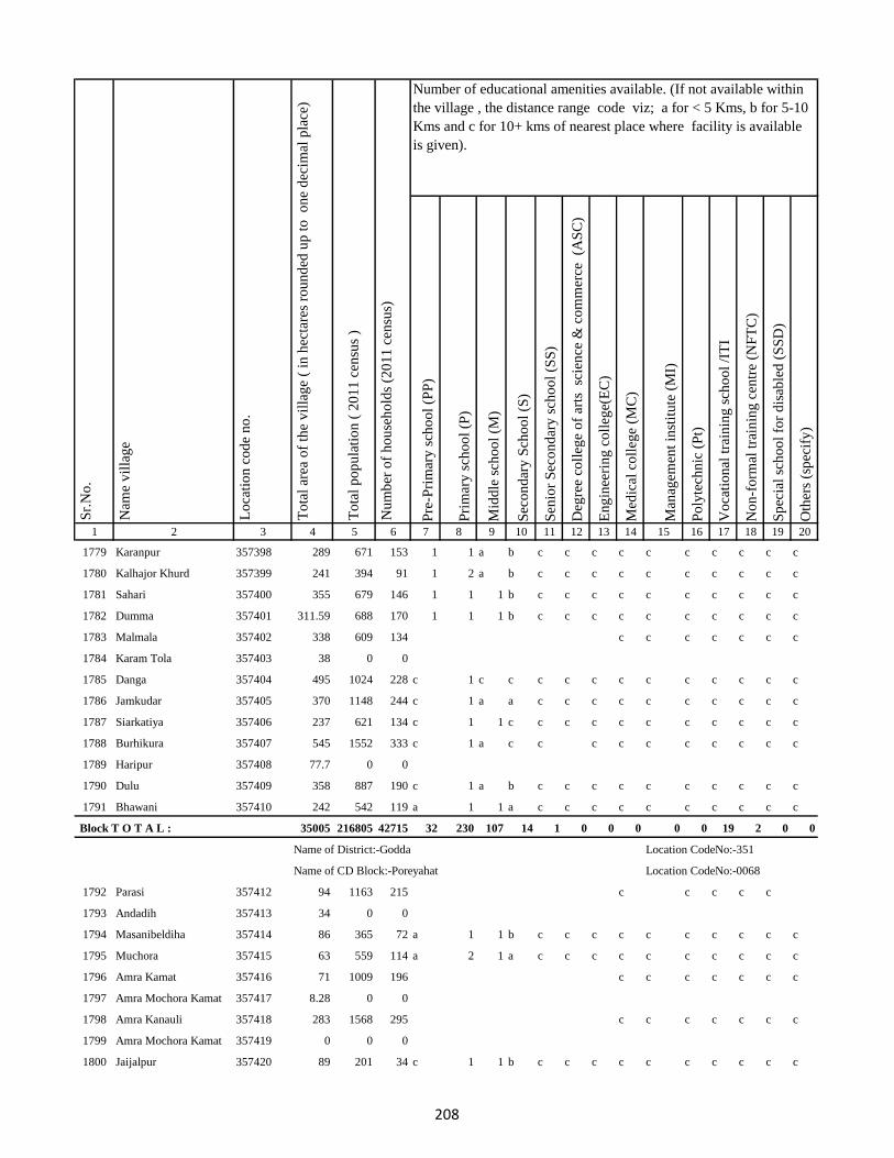
Pre
-Pri
mar
y s
cho
ol
(PP
)
Pri
mar
y s
cho
ol
(P)
Mid
dle
sch
oo
l (M
)
Sec
on
dar
y S
cho
ol
(S)
Sen
ior
Sec
on
dar
y s
cho
ol
(SS
)
Deg
ree
coll
ege
of
arts
sc
ien
ce &
co
mm
erce
(A
SC
)
En
gin
eeri
ng
co
lleg
e(E
C)
Med
ical
co
lleg
e (M
C)
Man
agem
ent
inst
itu
te (
MI)
Po
lyte
chn
ic (
Pt)
Vo
cati
on
al t
rain
ing
sch
oo
l /I
TI
No
n-f
orm
al t
rain
ing
cen
tre
(NF
TC
)
Sp
ecia
l sc
ho
ol
for
dis
able
d (
SS
D)
Oth
ers
(sp
ecif
y)
1 2 3 4 5 6 7 8 9 10 11 12 13 14 15 16 17 18 19 20
Lo
cati
on
co
de
no
.
Nam
e v
illa
ge
Sr.
No
.Number of educational amenities available. (If not available within
the village , the distance range code viz; a for < 5 Kms, b for 5-10
Kms and c for 10+ kms of nearest place where facility is available
is given).
Nu
mb
er o
f h
ou
seh
old
s (2
01
1 c
ensu
s)
To
tal
po
pu
lati
on
( 2
01
1 c
ensu
s )
To
tal
area
of
the
vil
lag
e (
in h
ecta
res
rou
nd
ed u
p t
o
on
e d
ecim
al p
lace
)
1779 Karanpur 357398 289 671 153 1 1 a b c c c c c c c c c c
1780 Kalhajor Khurd 357399 241 394 91 1 2 a b c c c c c c c c c c
1781 Sahari 357400 355 679 146 1 1 1 b c c c c c c c c c c
1782 Dumma 357401 311.59 688 170 1 1 1 b c c c c c c c c c c
1783 Malmala 357402 338 609 134 c c c c c c c
1784 Karam Tola 357403 38 0 0
1785 Danga 357404 495 1024 228 c 1 c c c c c c c c c c c c
1786 Jamkudar 357405 370 1148 244 c 1 a a c c c c c c c c c c
1787 Siarkatiya 357406 237 621 134 c 1 1 c c c c c c c c c c c
1788 Burhikura 357407 545 1552 333 c 1 a c c c c c c c c c c
1789 Haripur 357408 77.7 0 0
1790 Dulu 357409 358 887 190 c 1 a b c c c c c c c c c c
1791 Bhawani 357410 242 542 119 a 1 1 a c c c c c c c c c c
Block T O T A L : 35005 216805 42715 32 230 107 14 1 0 0 0 0 0 19 2 0 0
Name of District:-Godda Location CodeNo:-351
Name of CD Block:-Poreyahat Location CodeNo:-0068
1792 Parasi 357412 94 1163 215 c c c c c
1793 Andadih 357413 34 0 0
1794 Masanibeldiha 357414 86 365 72 a 1 1 b c c c c c c c c c c
1795 Muchora 357415 63 559 114 a 2 1 a c c c c c c c c c c
1796 Amra Kamat 357416 71 1009 196 c c c c c c c
1797 Amra Mochora Kamat 357417 8.28 0 0
1798 Amra Kanauli 357418 283 1568 295 c c c c c c c
1799 Amra Mochora Kamat 357419 0 0 0
1800 Jaijalpur 357420 89 201 34 c 1 1 b c c c c c c c c c c
208
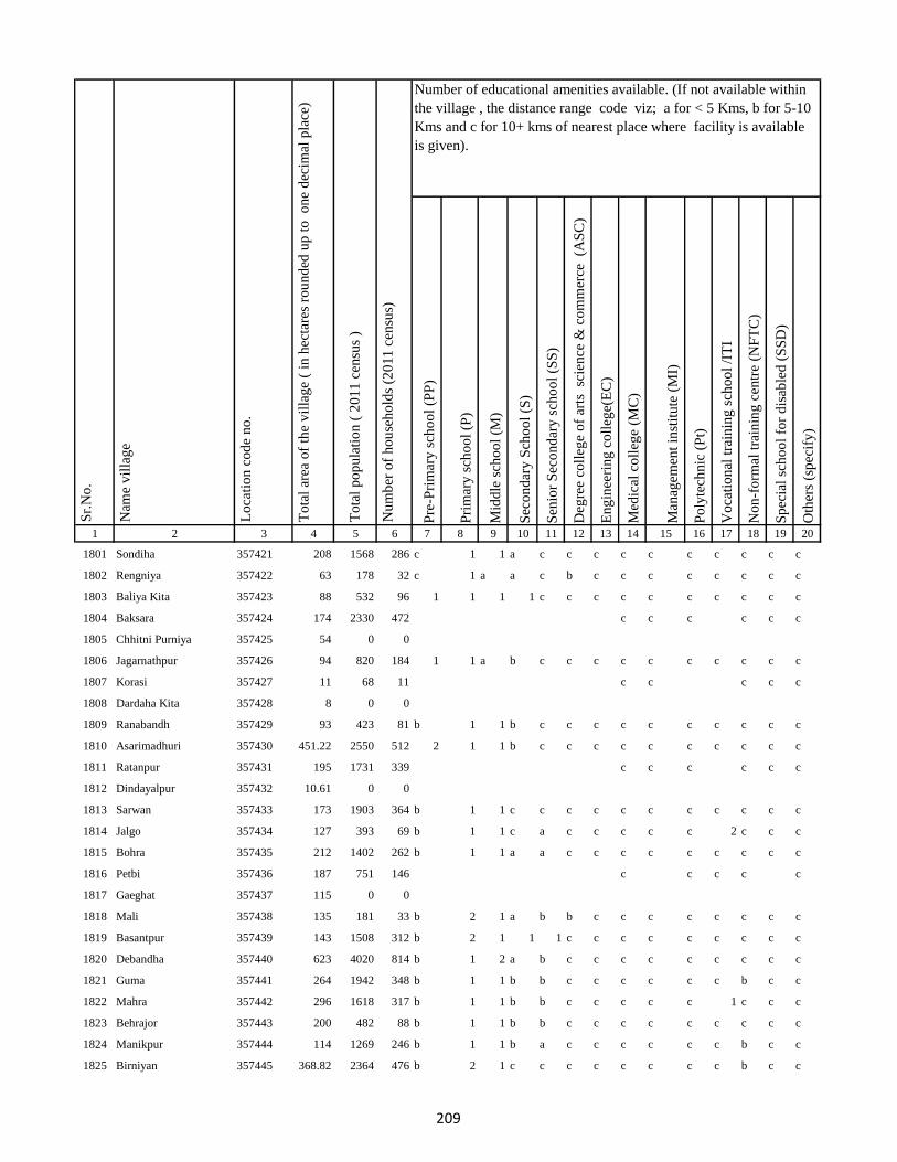
Pre
-Pri
mar
y s
cho
ol
(PP
)
Pri
mar
y s
cho
ol
(P)
Mid
dle
sch
oo
l (M
)
Sec
on
dar
y S
cho
ol
(S)
Sen
ior
Sec
on
dar
y s
cho
ol
(SS
)
Deg
ree
coll
ege
of
arts
sc
ien
ce &
co
mm
erce
(A
SC
)
En
gin
eeri
ng
co
lleg
e(E
C)
Med
ical
co
lleg
e (M
C)
Man
agem
ent
inst
itu
te (
MI)
Po
lyte
chn
ic (
Pt)
Vo
cati
on
al t
rain
ing
sch
oo
l /I
TI
No
n-f
orm
al t
rain
ing
cen
tre
(NF
TC
)
Sp
ecia
l sc
ho
ol
for
dis
able
d (
SS
D)
Oth
ers
(sp
ecif
y)
1 2 3 4 5 6 7 8 9 10 11 12 13 14 15 16 17 18 19 20
Lo
cati
on
co
de
no
.
Nam
e v
illa
ge
Sr.
No
.Number of educational amenities available. (If not available within
the village , the distance range code viz; a for < 5 Kms, b for 5-10
Kms and c for 10+ kms of nearest place where facility is available
is given).
Nu
mb
er o
f h
ou
seh
old
s (2
01
1 c
ensu
s)
To
tal
po
pu
lati
on
( 2
01
1 c
ensu
s )
To
tal
area
of
the
vil
lag
e (
in h
ecta
res
rou
nd
ed u
p t
o
on
e d
ecim
al p
lace
)
1801 Sondiha 357421 208 1568 286 c 1 1 a c c c c c c c c c c
1802 Rengniya 357422 63 178 32 c 1 a a c b c c c c c c c c
1803 Baliya Kita 357423 88 532 96 1 1 1 1 c c c c c c c c c c
1804 Baksara 357424 174 2330 472 c c c c c c
1805 Chhitni Purniya 357425 54 0 0
1806 Jagarnathpur 357426 94 820 184 1 1 a b c c c c c c c c c c
1807 Korasi 357427 11 68 11 c c c c c
1808 Dardaha Kita 357428 8 0 0
1809 Ranabandh 357429 93 423 81 b 1 1 b c c c c c c c c c c
1810 Asarimadhuri 357430 451.22 2550 512 2 1 1 b c c c c c c c c c c
1811 Ratanpur 357431 195 1731 339 c c c c c c
1812 Dindayalpur 357432 10.61 0 0
1813 Sarwan 357433 173 1903 364 b 1 1 c c c c c c c c c c c
1814 Jalgo 357434 127 393 69 b 1 1 c a c c c c c 2 c c c
1815 Bohra 357435 212 1402 262 b 1 1 a a c c c c c c c c c
1816 Petbi 357436 187 751 146 c c c c c
1817 Gaeghat 357437 115 0 0
1818 Mali 357438 135 181 33 b 2 1 a b b c c c c c c c c
1819 Basantpur 357439 143 1508 312 b 2 1 1 1 c c c c c c c c c
1820 Debandha 357440 623 4020 814 b 1 2 a b c c c c c c c c c
1821 Guma 357441 264 1942 348 b 1 1 b b c c c c c c b c c
1822 Mahra 357442 296 1618 317 b 1 1 b b c c c c c 1 c c c
1823 Behrajor 357443 200 482 88 b 1 1 b b c c c c c c c c c
1824 Manikpur 357444 114 1269 246 b 1 1 b a c c c c c c b c c
1825 Birniyan 357445 368.82 2364 476 b 2 1 c c c c c c c c b c c
209

Pre
-Pri
mar
y s
cho
ol
(PP
)
Pri
mar
y s
cho
ol
(P)
Mid
dle
sch
oo
l (M
)
Sec
on
dar
y S
cho
ol
(S)
Sen
ior
Sec
on
dar
y s
cho
ol
(SS
)
Deg
ree
coll
ege
of
arts
sc
ien
ce &
co
mm
erce
(A
SC
)
En
gin
eeri
ng
co
lleg
e(E
C)
Med
ical
co
lleg
e (M
C)
Man
agem
ent
inst
itu
te (
MI)
Po
lyte
chn
ic (
Pt)
Vo
cati
on
al t
rain
ing
sch
oo
l /I
TI
No
n-f
orm
al t
rain
ing
cen
tre
(NF
TC
)
Sp
ecia
l sc
ho
ol
for
dis
able
d (
SS
D)
Oth
ers
(sp
ecif
y)
1 2 3 4 5 6 7 8 9 10 11 12 13 14 15 16 17 18 19 20
Lo
cati
on
co
de
no
.
Nam
e v
illa
ge
Sr.
No
.Number of educational amenities available. (If not available within
the village , the distance range code viz; a for < 5 Kms, b for 5-10
Kms and c for 10+ kms of nearest place where facility is available
is given).
Nu
mb
er o
f h
ou
seh
old
s (2
01
1 c
ensu
s)
To
tal
po
pu
lati
on
( 2
01
1 c
ensu
s )
To
tal
area
of
the
vil
lag
e (
in h
ecta
res
rou
nd
ed u
p t
o
on
e d
ecim
al p
lace
)
1826 Dahupadhar 357446 370 1495 313 b 1 1 a c c c c c c c b c c
1827 Liladah 357447 542 3412 660 1 2 a a c c c c c c c c c c
1828 Teliyatikar 357448 128 482 97 c c c c b c c
1829 Sasankita 357449 27 0 0
1830 Mohani 357450 351 1861 398 a 1 b b a c c c c c c c c c
1831 Ghanshampur 357451 91 841 167 5 3 2 1 1 c c c c c c b c c
1832 Danre 357452 889.94 8325 1592 c c c c b c c
1833 Lauamahua 357453 28 0 0
1834 Mohanabarandande 357454 0 0 0
1835 Balua 357455 131 492 96 a 1 a c c c c c c c c b c c
1836 Beldanga 357456 271 1215 260 a 1 a c c c c c c c c c c c
1837 Sat Bandha 357457 374 998 218 c 2 1 b c c c c c c c c c c
1838 Naudiha 357458 922.99 3296 656 b 4 2 a b b c c c c c c c c
1839 Kathwan 357459 693.17 2823 556 b 2 1 b b b c c c c c c c c
1840 Parsoti 357460 550.01 1573 350 1 3 1 b b b c c c c c c c c
1841 Bhatondha 357461 879.73 3348 715 1 1 a a a c c c c c c c c c
1842 Barga Chhahariyari 357462 719.37 2189 481 a 1 1 b b c c c c c c c c c
1843 Sikatiya 357463 221 678 147 a a a b b c c c c c c c c c
1844 Latta(Santali) 357464 140 448 109 a 1 1 b b c c c c c c c c c
1845 Latta (Dikuani) 357465 100 1168 227 a 1 a c b c c c c c c c c c
1846 Surapparwa 357466 160.4 627 127 a 1 1 b b b c c c c c c c c
1847 Balathar 357467 172 665 132 b 1 a c c c c c c c c c c c
1848 Amjora 357468 121 709 135 a 1 a c c c c c c c c c c c
1849 Burhnajor 357469 71 191 37 b a a c c c c c c c c c c c
1850 Pakariya 357470 26 12 2 b 1 a b c c c c c c c c c c
210

Pre
-Pri
mar
y s
cho
ol
(PP
)
Pri
mar
y s
cho
ol
(P)
Mid
dle
sch
oo
l (M
)
Sec
on
dar
y S
cho
ol
(S)
Sen
ior
Sec
on
dar
y s
cho
ol
(SS
)
Deg
ree
coll
ege
of
arts
sc
ien
ce &
co
mm
erce
(A
SC
)
En
gin
eeri
ng
co
lleg
e(E
C)
Med
ical
co
lleg
e (M
C)
Man
agem
ent
inst
itu
te (
MI)
Po
lyte
chn
ic (
Pt)
Vo
cati
on
al t
rain
ing
sch
oo
l /I
TI
No
n-f
orm
al t
rain
ing
cen
tre
(NF
TC
)
Sp
ecia
l sc
ho
ol
for
dis
able
d (
SS
D)
Oth
ers
(sp
ecif
y)
1 2 3 4 5 6 7 8 9 10 11 12 13 14 15 16 17 18 19 20
Lo
cati
on
co
de
no
.
Nam
e v
illa
ge
Sr.
No
.Number of educational amenities available. (If not available within
the village , the distance range code viz; a for < 5 Kms, b for 5-10
Kms and c for 10+ kms of nearest place where facility is available
is given).
Nu
mb
er o
f h
ou
seh
old
s (2
01
1 c
ensu
s)
To
tal
po
pu
lati
on
( 2
01
1 c
ensu
s )
To
tal
area
of
the
vil
lag
e (
in h
ecta
res
rou
nd
ed u
p t
o
on
e d
ecim
al p
lace
)
1851 Bargaon 357471 68 624 118 b 1 a b b c c c c c c c c c
1852 Taratikar 357472 89 553 99 2 1 1 b b c c c c c c c c c
1853 Pasai 357473 653 3997 742 1 1 a b b c c c c c c c c c
1854 Arazi Kita Sahuri 357474 39 131 32 1 1 1 b c c c c c c c c c c
1855 Machkhara 357475 243 1819 355 c c c c c
1856 Barkabaiso 357476 41 0 0
1857 Durpat 357477 283 2956 578 a 1 a a b c c c c c c c c c
1858 Goaridih 357478 112 246 52 a 1 1 a a c c c c c c c c c
1859 Matihani 357479 197 710 158 a a a a a c c c c c c c c c
1860 Bara Chapar 357480 105 415 101 3 3 a a a c c c c c c c c c
1861 Amwar (Santali) 357481 456 2560 525 1 1 a a a c c c c c c c c c
1862 Amwar(Dikuani) 357482 90 192 47 a a a b b c c c c c c c c c
1863 Tarpokhra 357483 21 5 1 1 1 a b b c c c c c c c c c
1864 Harlatikar 357484 123 461 81 a 1 a b b c c c c c c c c c
1865 Bhaga 357485 128 291 55 a 1 a b b c c c c c c c c c
1866 Garhi 357486 234 766 147 c 2 c c c c c c c c c c c c
1867 Gorharajpur(Dikuani) 357487 177 704 134 c 1 1 c c c c c c c c c c c
1868 Gorharajpur(Santali) 357488 334 1352 289 c 1 c c c c c c c c c c c c
1869 Khajurma 357489 156 377 79 a 2 1 c c c c c c c c c c c
1870 Tarkhuta 357490 370 1837 361 a a a b c c c c c c c c c c
1871 Joguadih (Dikuani) 357491 50 321 58 1 a a b c c c c c c c c c c
1872 Joguadih (Santali ) 357492 49 276 56 1 1 1 b c c c c c c c c c c
1873 Dakhinbahiar 357493 98 535 103 1 1 a b c c c c c c c c c c
1874 Salaiya 357494 114 1179 250 a a a b c c c c c c c c c c
1875 Dumariya 357495 55 281 50 1 1 a b c c c c c c c c c c
211
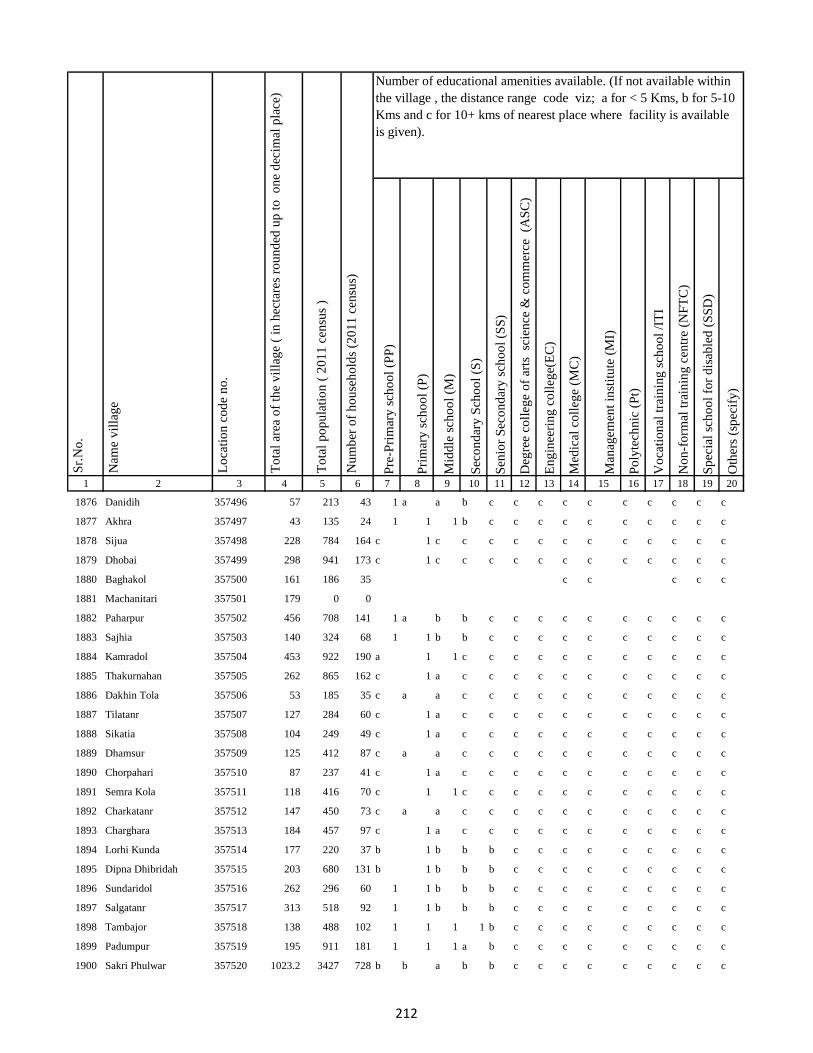
Pre
-Pri
mar
y s
cho
ol
(PP
)
Pri
mar
y s
cho
ol
(P)
Mid
dle
sch
oo
l (M
)
Sec
on
dar
y S
cho
ol
(S)
Sen
ior
Sec
on
dar
y s
cho
ol
(SS
)
Deg
ree
coll
ege
of
arts
sc
ien
ce &
co
mm
erce
(A
SC
)
En
gin
eeri
ng
co
lleg
e(E
C)
Med
ical
co
lleg
e (M
C)
Man
agem
ent
inst
itu
te (
MI)
Po
lyte
chn
ic (
Pt)
Vo
cati
on
al t
rain
ing
sch
oo
l /I
TI
No
n-f
orm
al t
rain
ing
cen
tre
(NF
TC
)
Sp
ecia
l sc
ho
ol
for
dis
able
d (
SS
D)
Oth
ers
(sp
ecif
y)
1 2 3 4 5 6 7 8 9 10 11 12 13 14 15 16 17 18 19 20
Lo
cati
on
co
de
no
.
Nam
e v
illa
ge
Sr.
No
.Number of educational amenities available. (If not available within
the village , the distance range code viz; a for < 5 Kms, b for 5-10
Kms and c for 10+ kms of nearest place where facility is available
is given).
Nu
mb
er o
f h
ou
seh
old
s (2
01
1 c
ensu
s)
To
tal
po
pu
lati
on
( 2
01
1 c
ensu
s )
To
tal
area
of
the
vil
lag
e (
in h
ecta
res
rou
nd
ed u
p t
o
on
e d
ecim
al p
lace
)
1876 Danidih 357496 57 213 43 1 a a b c c c c c c c c c c
1877 Akhra 357497 43 135 24 1 1 1 b c c c c c c c c c c
1878 Sijua 357498 228 784 164 c 1 c c c c c c c c c c c c
1879 Dhobai 357499 298 941 173 c 1 c c c c c c c c c c c c
1880 Baghakol 357500 161 186 35 c c c c c
1881 Machanitari 357501 179 0 0
1882 Paharpur 357502 456 708 141 1 a b b c c c c c c c c c c
1883 Sajhia 357503 140 324 68 1 1 b b c c c c c c c c c c
1884 Kamradol 357504 453 922 190 a 1 1 c c c c c c c c c c c
1885 Thakurnahan 357505 262 865 162 c 1 a c c c c c c c c c c c
1886 Dakhin Tola 357506 53 185 35 c a a c c c c c c c c c c c
1887 Tilatanr 357507 127 284 60 c 1 a c c c c c c c c c c c
1888 Sikatia 357508 104 249 49 c 1 a c c c c c c c c c c c
1889 Dhamsur 357509 125 412 87 c a a c c c c c c c c c c c
1890 Chorpahari 357510 87 237 41 c 1 a c c c c c c c c c c c
1891 Semra Kola 357511 118 416 70 c 1 1 c c c c c c c c c c c
1892 Charkatanr 357512 147 450 73 c a a c c c c c c c c c c c
1893 Charghara 357513 184 457 97 c 1 a c c c c c c c c c c c
1894 Lorhi Kunda 357514 177 220 37 b 1 b b b c c c c c c c c c
1895 Dipna Dhibridah 357515 203 680 131 b 1 b b b c c c c c c c c c
1896 Sundaridol 357516 262 296 60 1 1 b b b c c c c c c c c c
1897 Salgatanr 357517 313 518 92 1 1 b b b c c c c c c c c c
1898 Tambajor 357518 138 488 102 1 1 1 1 b c c c c c c c c c
1899 Padumpur 357519 195 911 181 1 1 1 a b c c c c c c c c c
1900 Sakri Phulwar 357520 1023.2 3427 728 b b a b b c c c c c c c c c
212
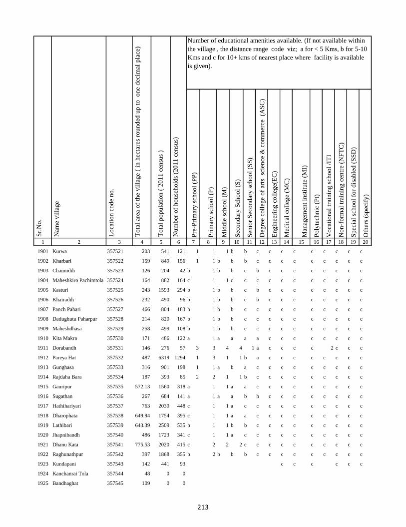
Pre
-Pri
mar
y s
cho
ol
(PP
)
Pri
mar
y s
cho
ol
(P)
Mid
dle
sch
oo
l (M
)
Sec
on
dar
y S
cho
ol
(S)
Sen
ior
Sec
on
dar
y s
cho
ol
(SS
)
Deg
ree
coll
ege
of
arts
sc
ien
ce &
co
mm
erce
(A
SC
)
En
gin
eeri
ng
co
lleg
e(E
C)
Med
ical
co
lleg
e (M
C)
Man
agem
ent
inst
itu
te (
MI)
Po
lyte
chn
ic (
Pt)
Vo
cati
on
al t
rain
ing
sch
oo
l /I
TI
No
n-f
orm
al t
rain
ing
cen
tre
(NF
TC
)
Sp
ecia
l sc
ho
ol
for
dis
able
d (
SS
D)
Oth
ers
(sp
ecif
y)
1 2 3 4 5 6 7 8 9 10 11 12 13 14 15 16 17 18 19 20
Lo
cati
on
co
de
no
.
Nam
e v
illa
ge
Sr.
No
.Number of educational amenities available. (If not available within
the village , the distance range code viz; a for < 5 Kms, b for 5-10
Kms and c for 10+ kms of nearest place where facility is available
is given).
Nu
mb
er o
f h
ou
seh
old
s (2
01
1 c
ensu
s)
To
tal
po
pu
lati
on
( 2
01
1 c
ensu
s )
To
tal
area
of
the
vil
lag
e (
in h
ecta
res
rou
nd
ed u
p t
o
on
e d
ecim
al p
lace
)
1901 Kurwa 357521 203 541 121 1 1 1 b b c c c c c c c c c
1902 Kharbari 357522 159 849 156 1 1 b b b c c c c c c c c c
1903 Chamudih 357523 126 204 42 b 1 b b c b c c c c c c c c
1904 Maheshkiro Pachimtola 357524 164 882 164 c 1 1 c c c c c c c c c c c
1905 Kasturi 357525 243 1593 294 b 1 b b c b c c c c c c c c
1906 Khairadih 357526 232 490 96 b 1 b b c b c c c c c c c c
1907 Panch Pahari 357527 466 804 183 b 1 b b c c c c c c c c c c
1908 Dadughutu Paharpur 357528 214 820 167 b 1 b b c c c c c c c c c c
1909 Maheshdhasa 357529 258 499 108 b 1 b b c c c c c c c c c c
1910 Kita Makra 357530 171 486 122 a 1 a a a a c c c c c c c c
1911 Dorabandh 357531 146 276 57 3 3 4 4 1 a c c c c 2 c c c
1912 Pareya Hat 357532 487 6319 1294 1 3 1 1 b a c c c c c c c c
1913 Gunghasa 357533 316 901 198 1 1 a b a c c c c c c c c c
1914 Rajdaha Bara 357534 187 393 85 2 2 1 1 b c c c c c c c c c
1915 Gauripur 357535 572.13 1560 318 a 1 1 a a c c c c c c c c c
1916 Sugathan 357536 267 684 141 a 1 a a b b c c c c c c c c
1917 Hathihariyari 357537 763 2030 448 c 1 1 a c c c c c c c c c c
1918 Dharophata 357538 649.94 1754 395 c 1 1 a a c c c c c c c c c
1919 Lathibari 357539 643.39 2509 535 b 1 1 b b c c c c c c c c c
1920 Jhapnibandh 357540 486 1723 341 c 1 1 a c c c c c c c c c c
1921 Dhanu Kata 357541 775.53 2020 415 c 2 2 2 c c c c c c c c c c
1922 Raghunathpur 357542 397 1868 355 b 2 b b b c c c c c c c c c
1923 Kundapani 357543 142 441 93 c c c c c c
1924 Kanchanrai Tola 357544 48 0 0
1925 Bandhaghat 357545 109 0 0
213
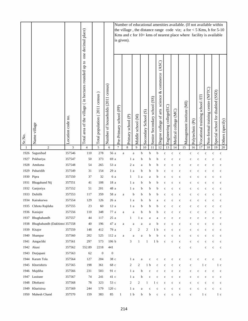
Pre
-Pri
mar
y s
cho
ol
(PP
)
Pri
mar
y s
cho
ol
(P)
Mid
dle
sch
oo
l (M
)
Sec
on
dar
y S
cho
ol
(S)
Sen
ior
Sec
on
dar
y s
cho
ol
(SS
)
Deg
ree
coll
ege
of
arts
sc
ien
ce &
co
mm
erce
(A
SC
)
En
gin
eeri
ng
co
lleg
e(E
C)
Med
ical
co
lleg
e (M
C)
Man
agem
ent
inst
itu
te (
MI)
Po
lyte
chn
ic (
Pt)
Vo
cati
on
al t
rain
ing
sch
oo
l /I
TI
No
n-f
orm
al t
rain
ing
cen
tre
(NF
TC
)
Sp
ecia
l sc
ho
ol
for
dis
able
d (
SS
D)
Oth
ers
(sp
ecif
y)
1 2 3 4 5 6 7 8 9 10 11 12 13 14 15 16 17 18 19 20
Lo
cati
on
co
de
no
.
Nam
e v
illa
ge
Sr.
No
.Number of educational amenities available. (If not available within
the village , the distance range code viz; a for < 5 Kms, b for 5-10
Kms and c for 10+ kms of nearest place where facility is available
is given).
Nu
mb
er o
f h
ou
seh
old
s (2
01
1 c
ensu
s)
To
tal
po
pu
lati
on
( 2
01
1 c
ensu
s )
To
tal
area
of
the
vil
lag
e (
in h
ecta
res
rou
nd
ed u
p t
o
on
e d
ecim
al p
lace
)
1926 Sagunibad 357546 110 278 56 a a a b b b c c c c c c c c
1927 Pokhariya 357547 50 373 69 a 1 a b b b c c c c c c c c
1928 Amduma 357548 54 265 53 a 2 a a b b c c c c c c c c
1929 Paharidih 357549 31 154 29 a 1 a b b b c c c c c c c c
1930 Pipra 357550 37 32 6 a 1 1 a a b c c c c c c c c
1931 Bhagaband Nij 357551 41 108 18 a 1 a b b b c c c c c c c c
1932 Ganjoriya 357552 51 201 48 a 1 a b b b c c c c c c c c
1933 Dulidih 357553 117 359 58 a a b b b b c c c c c c c c
1934 Kairakurwa 357554 129 126 26 a 1 a b b a c c c c c c c c
1935 Chhota Rajdaha 357555 23 60 12 a 1 a b b b c c c c c c c c
1936 Kasiajor 357556 110 348 77 a a a b b b c c c c c c c c
1937 Bhaghabandh 357557 44 117 25 a 1 1 a a a c c c c c c c c
1938 Bhaghabandh (Dakhintola)357558 40 196 47 a a a a a b c c c c c c c c
1939 Kitajor 357559 148 412 79 a 2 2 2 1 b c c c c c c c c
1940 Shampur 357560 202 525 112 a a a a b b c c c c c c c c
1941 Amgachhi 357561 297 573 106 b 3 1 1 1 b c c c c c c c c
1942 Akasi 357562 552.89 2218 441 c c c c c
1943 Durjapani 357563 62 0 0
1944 Karam Tola 357564 127 204 38 c 1 a a c c c c c c c c c c
1945 Khorishiris 357565 198 361 68 c 2 2 1 b c c c c c 1 c 1 c
1946 Majdiha 357566 231 503 91 c 1 a b c c c c c c c c c c
1947 Lusitanr 357567 74 241 41 c 1 a b c c c c c c c c c c
1948 Dhobarni 357568 78 323 53 c 2 2 1 1 c c c c c c c c c
1949 Kharisirsa 357569 244 579 120 c 1 a a c c c c c c c c c c
1950 Mahesh Chand 357570 159 383 85 1 1 b b b c c c c c 1 c 1 c
214
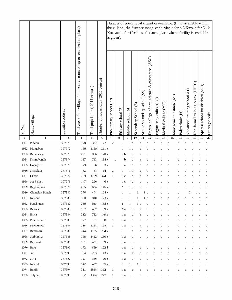
Pre
-Pri
mar
y s
cho
ol
(PP
)
Pri
mar
y s
cho
ol
(P)
Mid
dle
sch
oo
l (M
)
Sec
on
dar
y S
cho
ol
(S)
Sen
ior
Sec
on
dar
y s
cho
ol
(SS
)
Deg
ree
coll
ege
of
arts
sc
ien
ce &
co
mm
erce
(A
SC
)
En
gin
eeri
ng
co
lleg
e(E
C)
Med
ical
co
lleg
e (M
C)
Man
agem
ent
inst
itu
te (
MI)
Po
lyte
chn
ic (
Pt)
Vo
cati
on
al t
rain
ing
sch
oo
l /I
TI
No
n-f
orm
al t
rain
ing
cen
tre
(NF
TC
)
Sp
ecia
l sc
ho
ol
for
dis
able
d (
SS
D)
Oth
ers
(sp
ecif
y)
1 2 3 4 5 6 7 8 9 10 11 12 13 14 15 16 17 18 19 20
Lo
cati
on
co
de
no
.
Nam
e v
illa
ge
Sr.
No
.Number of educational amenities available. (If not available within
the village , the distance range code viz; a for < 5 Kms, b for 5-10
Kms and c for 10+ kms of nearest place where facility is available
is given).
Nu
mb
er o
f h
ou
seh
old
s (2
01
1 c
ensu
s)
To
tal
po
pu
lati
on
( 2
01
1 c
ensu
s )
To
tal
area
of
the
vil
lag
e (
in h
ecta
res
rou
nd
ed u
p t
o
on
e d
ecim
al p
lace
)
1951 Pindari 357571 178 332 72 2 1 1 b b b c c c c c c c c
1952 Murgabani 357572 186 1159 211 c 1 1 b b b c c c c c c c c
1953 Baramasiya 357573 261 866 170 c 1 b b b c c c c c c c c c
1954 Kamrabandh 357574 187 713 134 c b b b b c c c c c c c c c
1955 Gopalpur 357575 79 6 3 c 1 a c c c c c c c c c c c
1956 Simrakita 357576 82 61 14 2 1 1 b b b c c c c c c c c
1957 Chatra 357577 289 1709 324 1 1 c b b b c c c c c c c c
1958 Sat Pahari 357578 147 266 46 c 1 c c c c c c c c c c c c
1959 Baghmunda 357579 265 634 145 c 2 1 b c c c c c c c c c c
1960 Ghanghra Bandh 357580 276 494 104 c 1 1 1 1 c c c c c 2 1 c c
1961 Kelabari 357581 390 810 173 c 1 1 1 1 c c c c c c c c c
1962 Panchratan 357582 236 635 135 c 2 1 1 c c c c c c c c c c
1963 Beltopa 357583 197 467 99 a 2 a a b c c c c c c c c c
1964 Harla 357584 312 782 149 a 1 a a b c c c c c c c c c
1965 Pitar Pahari 357585 127 181 30 1 1 a b b c c c c c c c c c
1966 Madhukopi 357586 218 1118 198 1 1 a b b c c c c c c c c c
1967 Bansmuri 357587 244 1185 254 c 1 1 a c c c c c c c c c c
1968 Sarbindha 357588 358 1432 280 c 1 a a c c c c c c c c c c
1969 Bansmati 357589 191 421 89 c 1 a a c c c c c c c c c c
1970 Bara 357590 172 659 122 b 1 a a c c c c c c c c c c
1971 Jari 357591 94 203 43 c 1 a a c c c c c c c c c c
1972 Siria 357592 127 346 70 c 1 a a c c c c c c c c c c
1973 Nawadih 357593 142 427 65 c 1 1 1 c c c c c c c c c c
1974 Banjhi 357594 311 1818 362 1 1 a c c c c c c c c c c c
1975 Taljhari 357595 82 1394 247 1 1 a c c c c c c c c c c c
215

Pre
-Pri
mar
y s
cho
ol
(PP
)
Pri
mar
y s
cho
ol
(P)
Mid
dle
sch
oo
l (M
)
Sec
on
dar
y S
cho
ol
(S)
Sen
ior
Sec
on
dar
y s
cho
ol
(SS
)
Deg
ree
coll
ege
of
arts
sc
ien
ce &
co
mm
erce
(A
SC
)
En
gin
eeri
ng
co
lleg
e(E
C)
Med
ical
co
lleg
e (M
C)
Man
agem
ent
inst
itu
te (
MI)
Po
lyte
chn
ic (
Pt)
Vo
cati
on
al t
rain
ing
sch
oo
l /I
TI
No
n-f
orm
al t
rain
ing
cen
tre
(NF
TC
)
Sp
ecia
l sc
ho
ol
for
dis
able
d (
SS
D)
Oth
ers
(sp
ecif
y)
1 2 3 4 5 6 7 8 9 10 11 12 13 14 15 16 17 18 19 20
Lo
cati
on
co
de
no
.
Nam
e v
illa
ge
Sr.
No
.Number of educational amenities available. (If not available within
the village , the distance range code viz; a for < 5 Kms, b for 5-10
Kms and c for 10+ kms of nearest place where facility is available
is given).
Nu
mb
er o
f h
ou
seh
old
s (2
01
1 c
ensu
s)
To
tal
po
pu
lati
on
( 2
01
1 c
ensu
s )
To
tal
area
of
the
vil
lag
e (
in h
ecta
res
rou
nd
ed u
p t
o
on
e d
ecim
al p
lace
)
1976 Kharkachia 357596 306 1732 317 a 1 a a b c c c c c c c c c
1977 Jambad 357597 198 626 134 a 2 1 a a c c c c c c c c c
1978 Chorbad 357598 264 1418 283 1 2 1 1 c c c c c c c c c c
1979 Agiabandh 357599 233 812 177 a 1 a a c c c c c c c c c c
1980 Dewdanr(Uttartola) 357600 30 62 11 1 1 1 1 c c c c c c c c c c
1981 Dewdanr 357601 362 2188 470 a 3 1 a a c c c c c c c c c
1982 Baghmara 357602 416 2310 460 a 1 a a b c c c c c c c c c
1983 Kendua 357603 144 231 51 1 1 a c c c c c c c c c c c
1984 Karikadar 357604 419 903 193 1 1 b b b c c c c c c c c c
1985 Khardaha 357605 147 178 35 b 1 1 b b c c c c c c c c c
1986 Khardaha 357606 109 322 63 a 1 a a b c c c c c c c c c
1987 Ambadiha 357607 202 452 107 a 1 a a a c c c c c c c c c
1988 Baghmara Purabtola 357608 190 522 123 a 1 a a c c c c c c c c c c
1989 Garhbana 357609 181 537 114 a 1 1 a c c c c c c c c c c
1990 Gobindpur 357610 267 886 191 1 1 1 b b c c c c c c c c c
1991 Bankati 357611 221 518 120 b 1 1 b c c c c c c c c c c
1992 Pindra 357612 539 2459 463 b 1 a b b c c c c c c c c c
1993 Piparjoriya 357613 99 201 39 b 3 1 a c c c c c c c c c c
1994 Jitpur 357614 299 1244 242 b 1 1 b c c c c c c c c c c
1995 Boha 357615 405 874 185 1 2 a b c c c c c c c c c c
1996 Liti 357616 377.52 631 120 c 2 2 1 c c c c c c c c c c
1997 Sidhbank 357617 820 1485 312 c 1 1 c c c c c c c c c c c
1998 Kairasol 357618 372 897 187 c 1 1 b c c c c c c c c c c
1999 Daharlangi 357619 129 217 41 c a a b c c c c c c c c c c
2000 Halhiya Pathar 357620 152 339 75 c 1 1 b c c c c c c c c c c
216
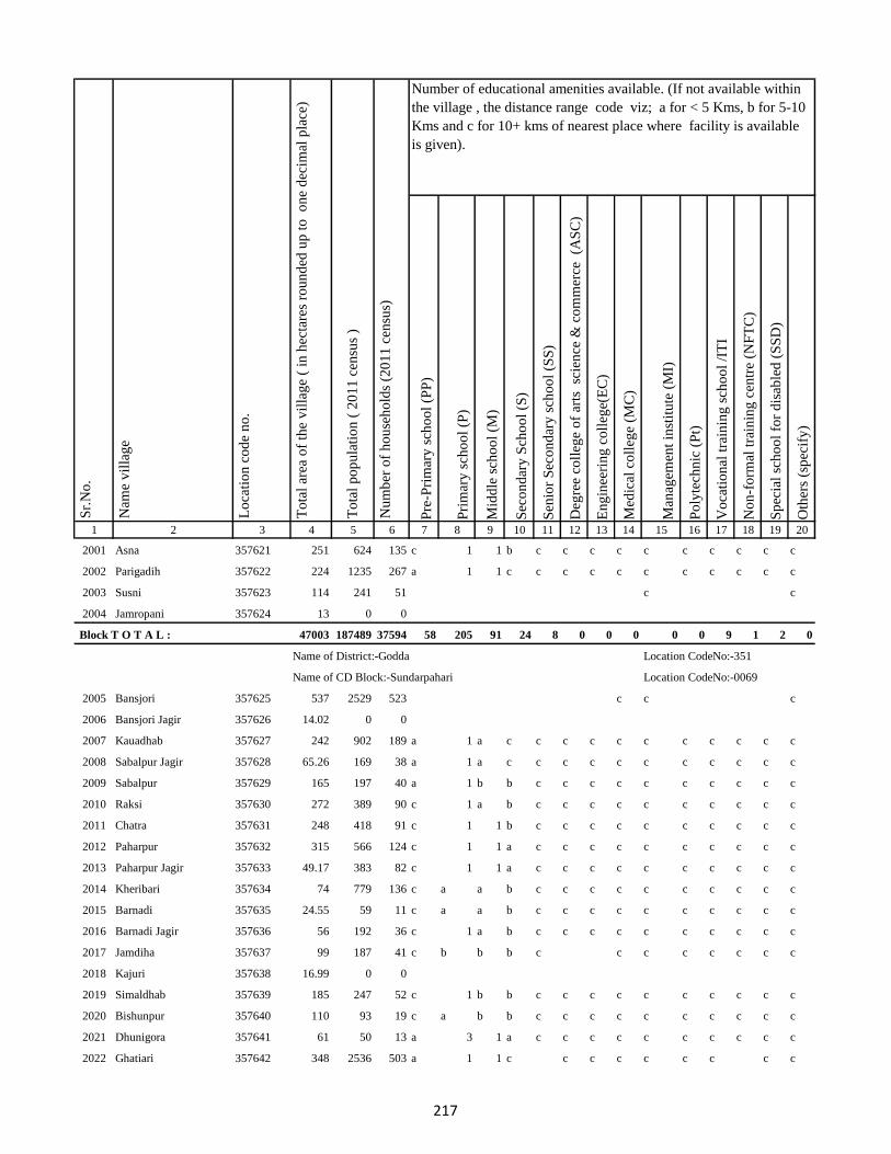
Pre
-Pri
mar
y s
cho
ol
(PP
)
Pri
mar
y s
cho
ol
(P)
Mid
dle
sch
oo
l (M
)
Sec
on
dar
y S
cho
ol
(S)
Sen
ior
Sec
on
dar
y s
cho
ol
(SS
)
Deg
ree
coll
ege
of
arts
sc
ien
ce &
co
mm
erce
(A
SC
)
En
gin
eeri
ng
co
lleg
e(E
C)
Med
ical
co
lleg
e (M
C)
Man
agem
ent
inst
itu
te (
MI)
Po
lyte
chn
ic (
Pt)
Vo
cati
on
al t
rain
ing
sch
oo
l /I
TI
No
n-f
orm
al t
rain
ing
cen
tre
(NF
TC
)
Sp
ecia
l sc
ho
ol
for
dis
able
d (
SS
D)
Oth
ers
(sp
ecif
y)
1 2 3 4 5 6 7 8 9 10 11 12 13 14 15 16 17 18 19 20
Lo
cati
on
co
de
no
.
Nam
e v
illa
ge
Sr.
No
.Number of educational amenities available. (If not available within
the village , the distance range code viz; a for < 5 Kms, b for 5-10
Kms and c for 10+ kms of nearest place where facility is available
is given).
Nu
mb
er o
f h
ou
seh
old
s (2
01
1 c
ensu
s)
To
tal
po
pu
lati
on
( 2
01
1 c
ensu
s )
To
tal
area
of
the
vil
lag
e (
in h
ecta
res
rou
nd
ed u
p t
o
on
e d
ecim
al p
lace
)
2001 Asna 357621 251 624 135 c 1 1 b c c c c c c c c c c
2002 Parigadih 357622 224 1235 267 a 1 1 c c c c c c c c c c c
2003 Susni 357623 114 241 51 c c
2004 Jamropani 357624 13 0 0
Block T O T A L : 47003 187489 37594 58 205 91 24 8 0 0 0 0 0 9 1 2 0
Name of District:-Godda Location CodeNo:-351
Name of CD Block:-Sundarpahari Location CodeNo:-0069
2005 Bansjori 357625 537 2529 523 c c c
2006 Bansjori Jagir 357626 14.02 0 0
2007 Kauadhab 357627 242 902 189 a 1 a c c c c c c c c c c c
2008 Sabalpur Jagir 357628 65.26 169 38 a 1 a c c c c c c c c c c c
2009 Sabalpur 357629 165 197 40 a 1 b b c c c c c c c c c c
2010 Raksi 357630 272 389 90 c 1 a b c c c c c c c c c c
2011 Chatra 357631 248 418 91 c 1 1 b c c c c c c c c c c
2012 Paharpur 357632 315 566 124 c 1 1 a c c c c c c c c c c
2013 Paharpur Jagir 357633 49.17 383 82 c 1 1 a c c c c c c c c c c
2014 Kheribari 357634 74 779 136 c a a b c c c c c c c c c c
2015 Barnadi 357635 24.55 59 11 c a a b c c c c c c c c c c
2016 Barnadi Jagir 357636 56 192 36 c 1 a b c c c c c c c c c c
2017 Jamdiha 357637 99 187 41 c b b b c c c c c c c c
2018 Kajuri 357638 16.99 0 0
2019 Simaldhab 357639 185 247 52 c 1 b b c c c c c c c c c c
2020 Bishunpur 357640 110 93 19 c a b b c c c c c c c c c c
2021 Dhunigora 357641 61 50 13 a 3 1 a c c c c c c c c c c
2022 Ghatiari 357642 348 2536 503 a 1 1 c c c c c c c c c
217

Pre
-Pri
mar
y s
cho
ol
(PP
)
Pri
mar
y s
cho
ol
(P)
Mid
dle
sch
oo
l (M
)
Sec
on
dar
y S
cho
ol
(S)
Sen
ior
Sec
on
dar
y s
cho
ol
(SS
)
Deg
ree
coll
ege
of
arts
sc
ien
ce &
co
mm
erce
(A
SC
)
En
gin
eeri
ng
co
lleg
e(E
C)
Med
ical
co
lleg
e (M
C)
Man
agem
ent
inst
itu
te (
MI)
Po
lyte
chn
ic (
Pt)
Vo
cati
on
al t
rain
ing
sch
oo
l /I
TI
No
n-f
orm
al t
rain
ing
cen
tre
(NF
TC
)
Sp
ecia
l sc
ho
ol
for
dis
able
d (
SS
D)
Oth
ers
(sp
ecif
y)
1 2 3 4 5 6 7 8 9 10 11 12 13 14 15 16 17 18 19 20
Lo
cati
on
co
de
no
.
Nam
e v
illa
ge
Sr.
No
.Number of educational amenities available. (If not available within
the village , the distance range code viz; a for < 5 Kms, b for 5-10
Kms and c for 10+ kms of nearest place where facility is available
is given).
Nu
mb
er o
f h
ou
seh
old
s (2
01
1 c
ensu
s)
To
tal
po
pu
lati
on
( 2
01
1 c
ensu
s )
To
tal
area
of
the
vil
lag
e (
in h
ecta
res
rou
nd
ed u
p t
o
on
e d
ecim
al p
lace
)
2023 Chhota Ghatiari 357643 12.69 0 0
2024 Tasria 357644 537 1131 213 b 1 a b c c c c c c c c c c
2025 Narayanpur 357645 181 199 41 c c c
2026 Jambia 357646 97 0 0
2027 Kherabani 357647 251 298 56 b a b b c c c c c c c c c c
2028 Jilbari 357648 192 80 19 a 1 1 a c c c c c c c c c c
2029 Mahua Tanr 357649 450 2201 436 1 1 1 1 c c c c c c c c c c
2030 Karmatanr 357650 325 1403 255 a 1 1 c c c c c c c c c c c
2031 Bhaluka 357651 188 513 119 a 1 1 c c c c c c c c c c c
2032 Sundar Maur 357652 450 1180 246 c a c c c c c c c c c c c c
2033 Sabalpur 357653 180 45 10 c a b c c c c c c c c c c c
2034 Lawadih 357654 32.82 40 11 c 1 1 c c c c c c c c c c c
2035 Dighibathan 357655 310 256 51 a a b c c c c c c c c c c c
2036 Jamuntanr 357656 60 46 11 c c c c c c c c c c c c c c
2037 Khelari 357657 147.53 0 0
2038 Adro 357658 12.59 11 2 c c c c c
2039 Ammaqo 357659 7.27 0 0
2040 Bedotok 357660 98.44 0 0
2041 Berago(Telalkuria) 357661 33.27 0 0
2042 Bilamaqo(Basgo) 357662 78.39 107 21 b a b c c c c c c c c c c c
2043 Chacham 357663 43.09 117 25 c b c c c c c c c c c c c c
2044 Chalgoda(Madgi) 357664 120.29 31 7 c c c c
2045 Chaparom 357665 38.33 0 0
2046 Chuclalo 357666 0 0 0
2047 Churi 357667 95.29 0 0
218
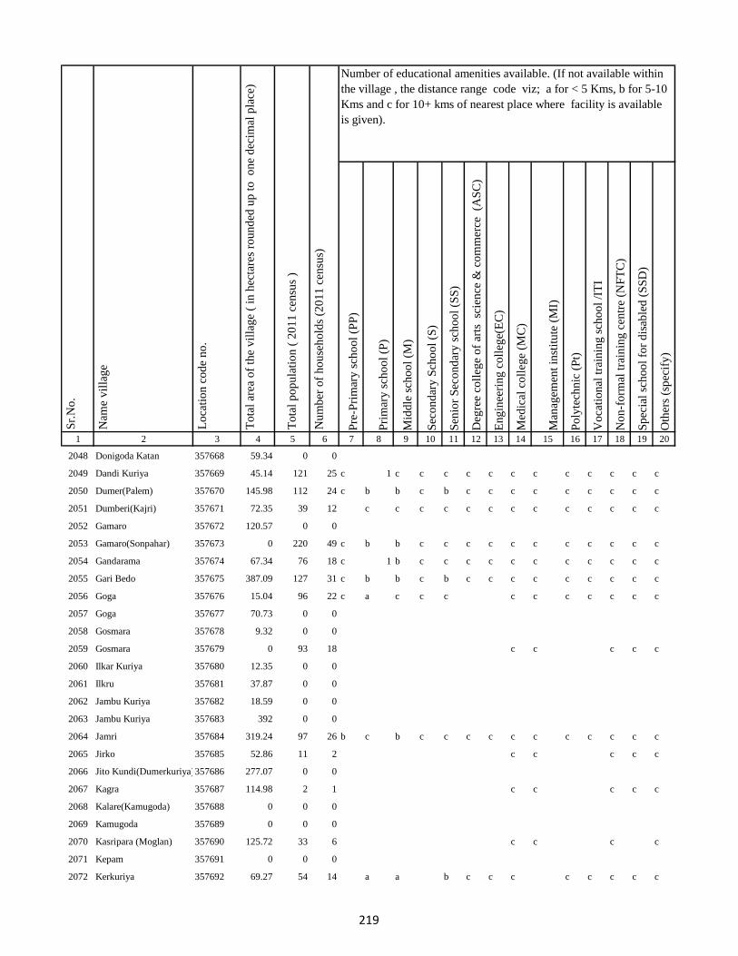
Pre
-Pri
mar
y s
cho
ol
(PP
)
Pri
mar
y s
cho
ol
(P)
Mid
dle
sch
oo
l (M
)
Sec
on
dar
y S
cho
ol
(S)
Sen
ior
Sec
on
dar
y s
cho
ol
(SS
)
Deg
ree
coll
ege
of
arts
sc
ien
ce &
co
mm
erce
(A
SC
)
En
gin
eeri
ng
co
lleg
e(E
C)
Med
ical
co
lleg
e (M
C)
Man
agem
ent
inst
itu
te (
MI)
Po
lyte
chn
ic (
Pt)
Vo
cati
on
al t
rain
ing
sch
oo
l /I
TI
No
n-f
orm
al t
rain
ing
cen
tre
(NF
TC
)
Sp
ecia
l sc
ho
ol
for
dis
able
d (
SS
D)
Oth
ers
(sp
ecif
y)
1 2 3 4 5 6 7 8 9 10 11 12 13 14 15 16 17 18 19 20
Lo
cati
on
co
de
no
.
Nam
e v
illa
ge
Sr.
No
.Number of educational amenities available. (If not available within
the village , the distance range code viz; a for < 5 Kms, b for 5-10
Kms and c for 10+ kms of nearest place where facility is available
is given).
Nu
mb
er o
f h
ou
seh
old
s (2
01
1 c
ensu
s)
To
tal
po
pu
lati
on
( 2
01
1 c
ensu
s )
To
tal
area
of
the
vil
lag
e (
in h
ecta
res
rou
nd
ed u
p t
o
on
e d
ecim
al p
lace
)
2048 Donigoda Katan 357668 59.34 0 0
2049 Dandi Kuriya 357669 45.14 121 25 c 1 c c c c c c c c c c c c
2050 Dumer(Palem) 357670 145.98 112 24 c b b c b c c c c c c c c c
2051 Dumberi(Kajri) 357671 72.35 39 12 c c c c c c c c c c c c c
2052 Gamaro 357672 120.57 0 0
2053 Gamaro(Sonpahar) 357673 0 220 49 c b b c c c c c c c c c c c
2054 Gandarama 357674 67.34 76 18 c 1 b c c c c c c c c c c c
2055 Gari Bedo 357675 387.09 127 31 c b b c b c c c c c c c c c
2056 Goga 357676 15.04 96 22 c a c c c c c c c c c c
2057 Goga 357677 70.73 0 0
2058 Gosmara 357678 9.32 0 0
2059 Gosmara 357679 0 93 18 c c c c c
2060 Ilkar Kuriya 357680 12.35 0 0
2061 Ilkru 357681 37.87 0 0
2062 Jambu Kuriya 357682 18.59 0 0
2063 Jambu Kuriya 357683 392 0 0
2064 Jamri 357684 319.24 97 26 b c b c c c c c c c c c c c
2065 Jirko 357685 52.86 11 2 c c c c c
2066 Jito Kundi(Dumerkuriya)357686 277.07 0 0
2067 Kagra 357687 114.98 2 1 c c c c c
2068 Kalare(Kamugoda) 357688 0 0 0
2069 Kamugoda 357689 0 0 0
2070 Kasripara (Moglan) 357690 125.72 33 6 c c c c
2071 Kepam 357691 0 0 0
2072 Kerkuriya 357692 69.27 54 14 a a b c c c c c c c c
219
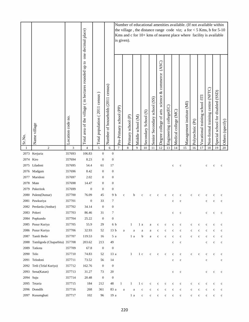
Pre
-Pri
mar
y s
cho
ol
(PP
)
Pri
mar
y s
cho
ol
(P)
Mid
dle
sch
oo
l (M
)
Sec
on
dar
y S
cho
ol
(S)
Sen
ior
Sec
on
dar
y s
cho
ol
(SS
)
Deg
ree
coll
ege
of
arts
sc
ien
ce &
co
mm
erce
(A
SC
)
En
gin
eeri
ng
co
lleg
e(E
C)
Med
ical
co
lleg
e (M
C)
Man
agem
ent
inst
itu
te (
MI)
Po
lyte
chn
ic (
Pt)
Vo
cati
on
al t
rain
ing
sch
oo
l /I
TI
No
n-f
orm
al t
rain
ing
cen
tre
(NF
TC
)
Sp
ecia
l sc
ho
ol
for
dis
able
d (
SS
D)
Oth
ers
(sp
ecif
y)
1 2 3 4 5 6 7 8 9 10 11 12 13 14 15 16 17 18 19 20
Lo
cati
on
co
de
no
.
Nam
e v
illa
ge
Sr.
No
.Number of educational amenities available. (If not available within
the village , the distance range code viz; a for < 5 Kms, b for 5-10
Kms and c for 10+ kms of nearest place where facility is available
is given).
Nu
mb
er o
f h
ou
seh
old
s (2
01
1 c
ensu
s)
To
tal
po
pu
lati
on
( 2
01
1 c
ensu
s )
To
tal
area
of
the
vil
lag
e (
in h
ecta
res
rou
nd
ed u
p t
o
on
e d
ecim
al p
lace
)
2073 Kerjuria 357693 106.83 0 0
2074 Kiro 357694 8.23 0 0
2075 Liladoni 357695 54.4 61 17 c c c c c
2076 Madgam 357696 8.42 0 0
2077 Maridoni 357697 2.02 0 0
2078 Mate 357698 14.47 0 0
2079 Pakeritok 357699 0 0 0
2080 Palem(Dumar) 357700 76.09 45 9 b c b c c c c c c c c c c c
2081 Pawkuriya 357701 0 33 7 c c c c c
2082 Perdarda (Ambar) 357702 34.14 0 0
2083 Pokeri 357703 86.46 31 7 c c c c c
2084 Popkundo 357704 25.22 0 0
2085 Pusur Kuriya 357705 55.9 29 6 b 1 1 a a c c c c c c c c c
2086 Pusur Kuriya 357706 32.93 52 13 b a a a a c c c c c c c c c
2087 Tamli Bedo 357707 119.53 16 5 a 1 a b a c c c c c c c c c
2088 Tamligoda (Chaparbita) 357708 203.62 213 49 c c c c c
2089 Tatkota 357709 67.8 0 0
2090 Telo 357710 74.83 52 13 a 1 1 c c c c c c c c c c c
2091 Telodoni 357711 73.52 56 14 c c c c
2092 Tetli (Telal Kuriya) 357712 162.76 0 0
2093 Sena(Katan) 357713 31.27 73 20 c c c c c
2094 Suju 357714 20.48 0 0
2095 Tetaria 357715 184 212 48 1 1 1 c c c c c c c c c c c
2096 Domdih 357716 268 361 83 a a a c c c c c c c c c c c
2097 Kusumghati 357717 102 96 19 a 1 a c c c c c c c c c c c
220
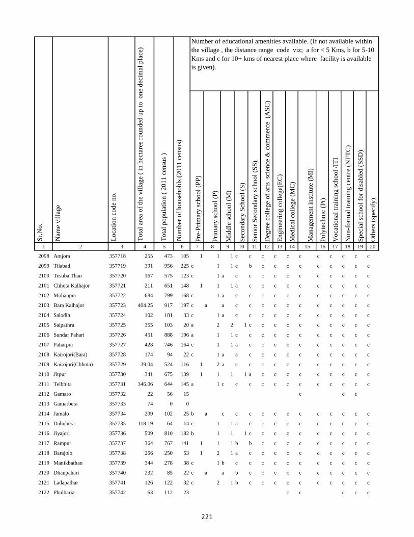
Pre
-Pri
mar
y s
cho
ol
(PP
)
Pri
mar
y s
cho
ol
(P)
Mid
dle
sch
oo
l (M
)
Sec
on
dar
y S
cho
ol
(S)
Sen
ior
Sec
on
dar
y s
cho
ol
(SS
)
Deg
ree
coll
ege
of
arts
sc
ien
ce &
co
mm
erce
(A
SC
)
En
gin
eeri
ng
co
lleg
e(E
C)
Med
ical
co
lleg
e (M
C)
Man
agem
ent
inst
itu
te (
MI)
Po
lyte
chn
ic (
Pt)
Vo
cati
on
al t
rain
ing
sch
oo
l /I
TI
No
n-f
orm
al t
rain
ing
cen
tre
(NF
TC
)
Sp
ecia
l sc
ho
ol
for
dis
able
d (
SS
D)
Oth
ers
(sp
ecif
y)
1 2 3 4 5 6 7 8 9 10 11 12 13 14 15 16 17 18 19 20
Lo
cati
on
co
de
no
.
Nam
e v
illa
ge
Sr.
No
.Number of educational amenities available. (If not available within
the village , the distance range code viz; a for < 5 Kms, b for 5-10
Kms and c for 10+ kms of nearest place where facility is available
is given).
Nu
mb
er o
f h
ou
seh
old
s (2
01
1 c
ensu
s)
To
tal
po
pu
lati
on
( 2
01
1 c
ensu
s )
To
tal
area
of
the
vil
lag
e (
in h
ecta
res
rou
nd
ed u
p t
o
on
e d
ecim
al p
lace
)
2098 Amjora 357718 255 473 105 1 1 1 c c c c c c c c c c c
2099 Tilabad 357719 391 956 225 c 1 1 c b c c c c c c c c c
2100 Tesuba Than 357720 167 575 123 c 1 a c c c c c c c c c c c
2101 Chhota Kalhajor 357721 211 651 148 1 1 1 a c c c c c c c c c c
2102 Mohanpur 357722 684 799 168 c 1 a c c c c c c c c c c c
2103 Bara Kalhajor 357723 404.25 917 197 c a a c c c c c c c c c c c
2104 Salodih 357724 102 181 33 c 1 a c c c c c c c c c c c
2105 Salpathra 357725 355 103 20 a 2 2 1 c c c c c c c c c c
2106 Sundar Pahari 357726 451 888 196 a 1 1 c c c c c c c c c c c
2107 Paharpur 357727 428 746 164 c 1 1 a c c c c c c c c c c
2108 Kairojori(Bara) 357728 174 94 22 c 1 a a c c c c c c c c c c
2109 Kairojori(Chhota) 357729 39.04 524 116 1 2 a c c c c c c c c c c c
2110 Jitpur 357730 341 675 139 1 1 1 1 a c c c c c c c c c
2111 Telbhita 357731 346.06 644 145 a 1 c c c c c c c c c c c c
2112 Gamaro 357732 22 56 15 c c c
2113 Gamarbera 357733 74 0 0
2114 Jamalo 357734 209 102 25 b a c c c c c c c c c c c c
2115 Dahubera 357735 118.19 64 14 c 1 1 a c c c c c c c c c c
2116 Jiyajori 357736 509 810 182 b 1 1 1 c c c c c c c c c c
2117 Rampur 357737 364 767 141 1 1 1 b b c c c c c c c c c
2118 Barajolo 357738 266 250 53 1 2 1 a c c c c c c c c c c
2119 Manikbathan 357739 344 278 38 c 1 b c c c c c c c c c c c
2120 Dhaupahari 357740 232 85 22 c a a b c c c c c c c c c c
2121 Ladapathar 357741 126 122 32 c 2 1 b c c c c c c c c c c
2122 Phulbaria 357742 63 112 23 c c c c c
221
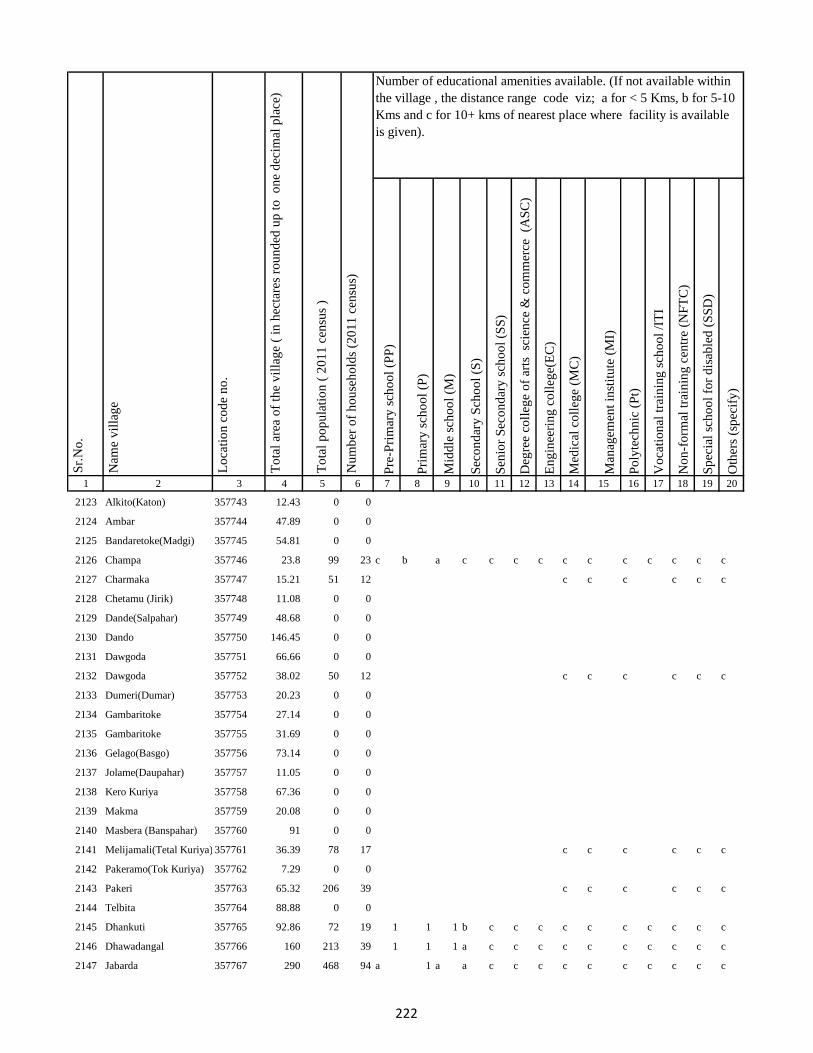
Pre
-Pri
mar
y s
cho
ol
(PP
)
Pri
mar
y s
cho
ol
(P)
Mid
dle
sch
oo
l (M
)
Sec
on
dar
y S
cho
ol
(S)
Sen
ior
Sec
on
dar
y s
cho
ol
(SS
)
Deg
ree
coll
ege
of
arts
sc
ien
ce &
co
mm
erce
(A
SC
)
En
gin
eeri
ng
co
lleg
e(E
C)
Med
ical
co
lleg
e (M
C)
Man
agem
ent
inst
itu
te (
MI)
Po
lyte
chn
ic (
Pt)
Vo
cati
on
al t
rain
ing
sch
oo
l /I
TI
No
n-f
orm
al t
rain
ing
cen
tre
(NF
TC
)
Sp
ecia
l sc
ho
ol
for
dis
able
d (
SS
D)
Oth
ers
(sp
ecif
y)
1 2 3 4 5 6 7 8 9 10 11 12 13 14 15 16 17 18 19 20
Lo
cati
on
co
de
no
.
Nam
e v
illa
ge
Sr.
No
.Number of educational amenities available. (If not available within
the village , the distance range code viz; a for < 5 Kms, b for 5-10
Kms and c for 10+ kms of nearest place where facility is available
is given).
Nu
mb
er o
f h
ou
seh
old
s (2
01
1 c
ensu
s)
To
tal
po
pu
lati
on
( 2
01
1 c
ensu
s )
To
tal
area
of
the
vil
lag
e (
in h
ecta
res
rou
nd
ed u
p t
o
on
e d
ecim
al p
lace
)
2123 Alkito(Katon) 357743 12.43 0 0
2124 Ambar 357744 47.89 0 0
2125 Bandaretoke(Madgi) 357745 54.81 0 0
2126 Champa 357746 23.8 99 23 c b a c c c c c c c c c c c
2127 Charmaka 357747 15.21 51 12 c c c c c c
2128 Chetamu (Jirik) 357748 11.08 0 0
2129 Dande(Salpahar) 357749 48.68 0 0
2130 Dando 357750 146.45 0 0
2131 Dawgoda 357751 66.66 0 0
2132 Dawgoda 357752 38.02 50 12 c c c c c c
2133 Dumeri(Dumar) 357753 20.23 0 0
2134 Gambaritoke 357754 27.14 0 0
2135 Gambaritoke 357755 31.69 0 0
2136 Gelago(Basgo) 357756 73.14 0 0
2137 Jolame(Daupahar) 357757 11.05 0 0
2138 Kero Kuriya 357758 67.36 0 0
2139 Makma 357759 20.08 0 0
2140 Masbera (Banspahar) 357760 91 0 0
2141 Melijamali(Tetal Kuriya) 357761 36.39 78 17 c c c c c c
2142 Pakeramo(Tok Kuriya) 357762 7.29 0 0
2143 Pakeri 357763 65.32 206 39 c c c c c c
2144 Telbita 357764 88.88 0 0
2145 Dhankuti 357765 92.86 72 19 1 1 1 b c c c c c c c c c c
2146 Dhawadangal 357766 160 213 39 1 1 1 a c c c c c c c c c c
2147 Jabarda 357767 290 468 94 a 1 a a c c c c c c c c c c
222

Pre
-Pri
mar
y s
cho
ol
(PP
)
Pri
mar
y s
cho
ol
(P)
Mid
dle
sch
oo
l (M
)
Sec
on
dar
y S
cho
ol
(S)
Sen
ior
Sec
on
dar
y s
cho
ol
(SS
)
Deg
ree
coll
ege
of
arts
sc
ien
ce &
co
mm
erce
(A
SC
)
En
gin
eeri
ng
co
lleg
e(E
C)
Med
ical
co
lleg
e (M
C)
Man
agem
ent
inst
itu
te (
MI)
Po
lyte
chn
ic (
Pt)
Vo
cati
on
al t
rain
ing
sch
oo
l /I
TI
No
n-f
orm
al t
rain
ing
cen
tre
(NF
TC
)
Sp
ecia
l sc
ho
ol
for
dis
able
d (
SS
D)
Oth
ers
(sp
ecif
y)
1 2 3 4 5 6 7 8 9 10 11 12 13 14 15 16 17 18 19 20
Lo
cati
on
co
de
no
.
Nam
e v
illa
ge
Sr.
No
.Number of educational amenities available. (If not available within
the village , the distance range code viz; a for < 5 Kms, b for 5-10
Kms and c for 10+ kms of nearest place where facility is available
is given).
Nu
mb
er o
f h
ou
seh
old
s (2
01
1 c
ensu
s)
To
tal
po
pu
lati
on
( 2
01
1 c
ensu
s )
To
tal
area
of
the
vil
lag
e (
in h
ecta
res
rou
nd
ed u
p t
o
on
e d
ecim
al p
lace
)
2148 Bara Puro 357768 277 925 175 1 1 1 1 c c c c c c c c c c
2149 Chhota Dhamni 357769 156 1450 260 a 1 1 1 c c c c c c c c c c
2150 Dhamni Bazar 357770 3.97 884 196 1 1 a a c c c c c c c c c c
2151 Bara Dhamni 357771 217 2408 536 a 1 a b c c c c c c c c c c
2152 Chhota Puro 357772 217 356 84 a 1 a b b c c c c c c c c c
2153 Gadidih 357773 102 104 20 1 a a b a c c c c c c c c c
2154 Piparjoria 357774 49.44 134 33 a 1 1 b a c c c c c c c c c
2155 Marchaitari 357775 124 239 55 1 1 1 1 a c c c c c c c c c
2156 Pokharia 357776 89 271 56 1 1 1 1 a c c c c c c c c c
2157 Kairasul 357777 208 448 99 c c c c c c c c c c c c c c
2158 Ambardoni 357778 0 0 0
2159 Bat 357779 51.94 79 16 c a c c c c c c c c c c c c
2160 Bitakepu 357780 59.85 63 19 c c c c c c
2161 Daukuriya 357781 0 0 0
2162 Donigoda 357782 37.66 46 10 a c c c c c c c c c c c c c
2163 Jari Mamqo 357783 0 28 8 a c c c c c c c c c c c c c
2164 Kadu 357784 0 68 17 b b c c c c c c c c
2165 Karag 357785 16.98 0 0
2166 Kiro 357786 8.46 0 0
2167 Koa 357787 118.33 60 15 b 1 b b c c c c c c c c c c
2168 Kubji Bedo 357788 60.35 67 19 b b b b c c c c c c c c c c
2169 Kubji Maqo 357789 0 0 0
2170 Kudi Goda 357790 29.27 75 20 b b b b c c c c c c c b c c
2171 Madgi 357791 0 47 10 b b b b b b c c c c b b c c
2172 Madgi Bedo 357792 0 42 10 b a b b c c c c c c c c c c
223

Pre
-Pri
mar
y s
cho
ol
(PP
)
Pri
mar
y s
cho
ol
(P)
Mid
dle
sch
oo
l (M
)
Sec
on
dar
y S
cho
ol
(S)
Sen
ior
Sec
on
dar
y s
cho
ol
(SS
)
Deg
ree
coll
ege
of
arts
sc
ien
ce &
co
mm
erce
(A
SC
)
En
gin
eeri
ng
co
lleg
e(E
C)
Med
ical
co
lleg
e (M
C)
Man
agem
ent
inst
itu
te (
MI)
Po
lyte
chn
ic (
Pt)
Vo
cati
on
al t
rain
ing
sch
oo
l /I
TI
No
n-f
orm
al t
rain
ing
cen
tre
(NF
TC
)
Sp
ecia
l sc
ho
ol
for
dis
able
d (
SS
D)
Oth
ers
(sp
ecif
y)
1 2 3 4 5 6 7 8 9 10 11 12 13 14 15 16 17 18 19 20
Lo
cati
on
co
de
no
.
Nam
e v
illa
ge
Sr.
No
.Number of educational amenities available. (If not available within
the village , the distance range code viz; a for < 5 Kms, b for 5-10
Kms and c for 10+ kms of nearest place where facility is available
is given).
Nu
mb
er o
f h
ou
seh
old
s (2
01
1 c
ensu
s)
To
tal
po
pu
lati
on
( 2
01
1 c
ensu
s )
To
tal
area
of
the
vil
lag
e (
in h
ecta
res
rou
nd
ed u
p t
o
on
e d
ecim
al p
lace
)
2173 Madgi Maqo 357793 39.49 25 9 b 1 b c c c c c c c c c c c
2174 Puro Maqo (Katan) 357794 64.25 80 16 c c c c
2175 Karag 357795 0 0 0
2176 Tamli 357796 0 0 0
2177 Takalo 357797 0 0 0
2178 Tetal Kuriya 357798 0 0 0
2179 Saharpura 357799 114 46 13 1 3 2 1 c c c c c c c c c c
2180 Chandna 357800 657 1491 309 a 1 1 a c c c c c c c c c c
2181 Longidih 357801 249 665 143 a 1 1 a c c c c c c c c c c
2182 Borwa 357802 601 852 192 a a a a c c c c c c c c c c
2183 Karamtola 357803 42.46 174 42 a a a a c c c c c c c c c c
2184 Roldih 357804 47.84 47 15 b 1 b b c c c c c c c c c c
2185 Bara Haripur 357805 102 248 54 b b b b c c c c c c c c c c
2186 Dulu 357806 45 19 5 c c c c c
2187 Asantari 357807 42 0 0
2188 Kusmaha 357808 647 710 149 a 1 1 c c c c c c c c c c c
2189 Damruhat 357809 218 640 132 a a a c c c c c c c c c c c
2190 Dumki 357810 63 113 22 a a a c c c c c c c c c c c
2191 Kairabani 357811 17 68 17 a 1 a c c c c c c c c c c c
2192 Bariyarpur 357812 228 421 96 b b b b c c c c c c c c c c
2193 Chhota Haripur 357813 169 250 55 b 1 b b c c c c c c c c c c
2194 Kadampur 357814 260 451 91 a 1 a a c c c c c c c c c c
2195 Angbali 357815 169 306 75 c c c c
2196 Banspahari 357816 64.24 0 0
2197 Gamharia 357817 62 0 0
224

Pre
-Pri
mar
y s
cho
ol
(PP
)
Pri
mar
y s
cho
ol
(P)
Mid
dle
sch
oo
l (M
)
Sec
on
dar
y S
cho
ol
(S)
Sen
ior
Sec
on
dar
y s
cho
ol
(SS
)
Deg
ree
coll
ege
of
arts
sc
ien
ce &
co
mm
erce
(A
SC
)
En
gin
eeri
ng
co
lleg
e(E
C)
Med
ical
co
lleg
e (M
C)
Man
agem
ent
inst
itu
te (
MI)
Po
lyte
chn
ic (
Pt)
Vo
cati
on
al t
rain
ing
sch
oo
l /I
TI
No
n-f
orm
al t
rain
ing
cen
tre
(NF
TC
)
Sp
ecia
l sc
ho
ol
for
dis
able
d (
SS
D)
Oth
ers
(sp
ecif
y)
1 2 3 4 5 6 7 8 9 10 11 12 13 14 15 16 17 18 19 20
Lo
cati
on
co
de
no
.
Nam
e v
illa
ge
Sr.
No
.Number of educational amenities available. (If not available within
the village , the distance range code viz; a for < 5 Kms, b for 5-10
Kms and c for 10+ kms of nearest place where facility is available
is given).
Nu
mb
er o
f h
ou
seh
old
s (2
01
1 c
ensu
s)
To
tal
po
pu
lati
on
( 2
01
1 c
ensu
s )
To
tal
area
of
the
vil
lag
e (
in h
ecta
res
rou
nd
ed u
p t
o
on
e d
ecim
al p
lace
)
2198 Paharpur 357818 199 385 96 b 1 b c c c c c c c c c c c
2199 Tetariya 357819 133 219 47 a a a c c c c c c c c c c c
2200 Khepadih 357820 99 174 38 b b b c c c c c c c c c c c
2201 Chandraydih 357821 140 102 23 b 1 b c c c c c c c c c c c
2202 Gardi 357822 80 69 17 b a b c c c c c c c c c c c
2203 Ghaghri 357823 141 97 21 a a b c c c c c c c c c c c
2204 Malikundi 357824 129 32 8 1 1 1 c c c c c c c c c c c
2205 Bara Sinddri 357825 919 912 190 a 2 a a c c c c c c c c c c
2206 Sagar 357826 342 499 116 a 2 a b c c c c c c c c c c
2207 Monadih 357827 177 234 56 b b b b c c c c c c c c c c
2208 Ghorabali 357828 63.7 96 24 b 2 b b c c c c c c c c c c
2209 Chhota Sindari 357829 118 94 22 1 1 1 c c c c c c c c c c c
2210 Tilaipara 357830 193 302 64 b 1 c c c c c c c c c c c c
2211 Sahapi 357831 387 250 54 1 1 b c c c c c c c c c c c
2212 Madni 357832 288 284 60 a a a b c c c c c c c c c c
2213 Ratnapara 357833 23.22 92 19 a 1 b b c c c c c c c c c c
2214 Dumartari 357834 187.58 124 26 a a b c c c c c c c c c
2215 Bara Sabai Kundi 357835 73.13 0 0
2216 Chhota Sabai Kundi 357836 73.27 253 47 a 1 a c c c c c c c c c c c
2217 Rajabhita 357837 229.45 239 51 a b b c c c c c c c c c c c
2218 Chhota Adro 357838 39.51 55 12 b a b c c c c c c c c c c c
2219 Manspara 357839 143.08 201 39 1 b c c c c c c c c c c c c
2220 Kesam 357840 18.74 123 33 c c c c
2221 Keropara 357841 8.41 0 0
2222 Chamer 357842 147.25 287 60 c a c c c c c c c c c c c c
225

Pre
-Pri
mar
y s
cho
ol
(PP
)
Pri
mar
y s
cho
ol
(P)
Mid
dle
sch
oo
l (M
)
Sec
on
dar
y S
cho
ol
(S)
Sen
ior
Sec
on
dar
y s
cho
ol
(SS
)
Deg
ree
coll
ege
of
arts
sc
ien
ce &
co
mm
erce
(A
SC
)
En
gin
eeri
ng
co
lleg
e(E
C)
Med
ical
co
lleg
e (M
C)
Man
agem
ent
inst
itu
te (
MI)
Po
lyte
chn
ic (
Pt)
Vo
cati
on
al t
rain
ing
sch
oo
l /I
TI
No
n-f
orm
al t
rain
ing
cen
tre
(NF
TC
)
Sp
ecia
l sc
ho
ol
for
dis
able
d (
SS
D)
Oth
ers
(sp
ecif
y)
1 2 3 4 5 6 7 8 9 10 11 12 13 14 15 16 17 18 19 20
Lo
cati
on
co
de
no
.
Nam
e v
illa
ge
Sr.
No
.Number of educational amenities available. (If not available within
the village , the distance range code viz; a for < 5 Kms, b for 5-10
Kms and c for 10+ kms of nearest place where facility is available
is given).
Nu
mb
er o
f h
ou
seh
old
s (2
01
1 c
ensu
s)
To
tal
po
pu
lati
on
( 2
01
1 c
ensu
s )
To
tal
area
of
the
vil
lag
e (
in h
ecta
res
rou
nd
ed u
p t
o
on
e d
ecim
al p
lace
)
2223 Mando Pahari 357843 176 218 47 c a c c c c c c c c c c c c
2224 Chhatmi 357844 85.11 61 12 c a c c c c c c c c c c c c
2225 Bara Paktari 357845 204.89 278 60 b a b c c c c c c c c c c c
2226 Chhota Palma 357846 52.42 70 17 b a b c c c c c c c c c c c
2227 Gargawan 357847 53.35 116 29 b 1 b c c c c c c c c c c c
2228 Bara Palma 357848 197 306 67 b a b c c c c c c c c c c c
2229 Chhota Paktari 357849 92.21 76 18 b a b c c c c c c c c c c c
2230 Rakha 357850 147 121 28 b 1 b c c c c c c c c c c c
2231 Adro 357851 0 44 11 b a b c c c c c c c c c c c
2232 Balami 357852 51.44 196 38 b a b c c c c c c c c c c c
2233 Chamdade 357853 103.44 140 29 b a c c c c c c c c c c c c
2234 Chamar Bedo 357854 97.96 89 22 b a b c c c c c c c c c c c
2235 Charchari 357855 141.47 160 39 b 1 b c c c c c c c c c c c
2236 Chewo (Tetria) 357856 159.37 172 33 1 1 1 c c c c c c c c c c c
2237 Dando 357857 367.24 239 62 b a b c c c c c c c c c c c
2238 Dumli 357858 125 139 32 c c c
2239 Gandiyamo 357859 55 0 0
2240 Garsingla 357860 31 66 15 b 1 1 c c c c c c c c c c c
2241 Garsingla (Malikundi) 357861 108.57 247 51 c a b c c c c c c c c c c c
2242 Goga 357862 60.52 0 0
2243 Jolo (Berago) 357863 572.93 270 55 c b b c c c c c c c c c c
2244 Karamtok 357864 28.18 0 0
2245 Karmu 357865 27.48 0 0
2246 Keropara 357866 8.41 0 0
2247 Kirokuriya 357867 64.08 0 0
226
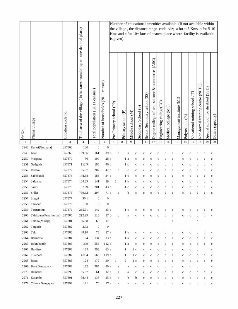
Pre
-Pri
mar
y s
cho
ol
(PP
)
Pri
mar
y s
cho
ol
(P)
Mid
dle
sch
oo
l (M
)
Sec
on
dar
y S
cho
ol
(S)
Sen
ior
Sec
on
dar
y s
cho
ol
(SS
)
Deg
ree
coll
ege
of
arts
sc
ien
ce &
co
mm
erce
(A
SC
)
En
gin
eeri
ng
co
lleg
e(E
C)
Med
ical
co
lleg
e (M
C)
Man
agem
ent
inst
itu
te (
MI)
Po
lyte
chn
ic (
Pt)
Vo
cati
on
al t
rain
ing
sch
oo
l /I
TI
No
n-f
orm
al t
rain
ing
cen
tre
(NF
TC
)
Sp
ecia
l sc
ho
ol
for
dis
able
d (
SS
D)
Oth
ers
(sp
ecif
y)
1 2 3 4 5 6 7 8 9 10 11 12 13 14 15 16 17 18 19 20
Lo
cati
on
co
de
no
.
Nam
e v
illa
ge
Sr.
No
.Number of educational amenities available. (If not available within
the village , the distance range code viz; a for < 5 Kms, b for 5-10
Kms and c for 10+ kms of nearest place where facility is available
is given).
Nu
mb
er o
f h
ou
seh
old
s (2
01
1 c
ensu
s)
To
tal
po
pu
lati
on
( 2
01
1 c
ensu
s )
To
tal
area
of
the
vil
lag
e (
in h
ecta
res
rou
nd
ed u
p t
o
on
e d
ecim
al p
lace
)
2248 Kasari(Gutipara) 357868 130 0 0
2249 Kote 357869 189.86 161 39 b b b c c c c c c c c c c c
2250 Maspara 357870 50 100 26 b 1 a c c c c c c c c c c c
2251 Nadgoda 357871 112.9 195 40 c 1 c c c c c c c c c c c c
2252 Pertara 357872 105.97 207 47 c b c c c c c c c c c c c c
2253 Sabekundi 357873 148.38 183 34 a 1 c c c c c c c c c c c c
2254 Salgama 357874 104.89 141 29 1 1 b c c c c c c c c c c c
2255 Sarmi 357875 157.69 201 43 b 1 c c c c c c c c c c c c
2256 Sidler 357876 790.62 297 71 b b b c c c c c c c c c c c
2257 Singni 357877 30.1 0 0
2258 Tarobar 357878 100 0 0
2259 Tasgemthu 357879 285.51 142 35 b 1 c c c c c c c c c c c c
2260 Talakpara(Pusurkuriya) 357880 212.29 113 27 b b b c c c c c c c c c c c
2261 Talbita(Mudgi) 357881 96.88 60 17 c c
2262 Tatgoda 357882 2.72 0 0
2263 Telo 357883 48.18 78 17 a 1 b c c c c c c c c c c c
2264 Barmasia 357884 164 134 33 a 1 a c c c c c c c c c c c
2265 Bokrabandh 357885 379 555 112 a 1 a c c c c c c c c c c c
2266 Hardisol 357886 185 298 63 a 1 1 c c c c c c c c c c c
2267 Tilaipara 357887 411.4 563 119 b 1 1 c c c c c c c c c c c
2268 Barai 357888 124 172 29 1 2 2 c c c c c c c c c c c
2269 Bara Dangapara 357889 192 385 89 a a a c c c c c c c c c c c
2270 Damakol 357890 55.67 61 12 a a a c c c c c c c c c c c
2271 Karamba 357891 98.44 133 25 b b b b c c c c c c c c c c
2272 Chhota Dangapara 357892 121 70 17 a a b c c c c c c c c c c c
227

Pre
-Pri
mar
y s
cho
ol
(PP
)
Pri
mar
y s
cho
ol
(P)
Mid
dle
sch
oo
l (M
)
Sec
on
dar
y S
cho
ol
(S)
Sen
ior
Sec
on
dar
y s
cho
ol
(SS
)
Deg
ree
coll
ege
of
arts
sc
ien
ce &
co
mm
erce
(A
SC
)
En
gin
eeri
ng
co
lleg
e(E
C)
Med
ical
co
lleg
e (M
C)
Man
agem
ent
inst
itu
te (
MI)
Po
lyte
chn
ic (
Pt)
Vo
cati
on
al t
rain
ing
sch
oo
l /I
TI
No
n-f
orm
al t
rain
ing
cen
tre
(NF
TC
)
Sp
ecia
l sc
ho
ol
for
dis
able
d (
SS
D)
Oth
ers
(sp
ecif
y)
1 2 3 4 5 6 7 8 9 10 11 12 13 14 15 16 17 18 19 20
Lo
cati
on
co
de
no
.
Nam
e v
illa
ge
Sr.
No
.Number of educational amenities available. (If not available within
the village , the distance range code viz; a for < 5 Kms, b for 5-10
Kms and c for 10+ kms of nearest place where facility is available
is given).
Nu
mb
er o
f h
ou
seh
old
s (2
01
1 c
ensu
s)
To
tal
po
pu
lati
on
( 2
01
1 c
ensu
s )
To
tal
area
of
the
vil
lag
e (
in h
ecta
res
rou
nd
ed u
p t
o
on
e d
ecim
al p
lace
)
2273 Mulgipur 357893 44 0 0
2274 Dumarpalampara 357894 146 262 58 b 1 1 b c c c c c c c c c c
2275 Simlipara 357895 149 106 29 b b b b c c c c c c c c c c
2276 Bajrajogusami 357896 220 126 26 b 1 1 c c c c c c c c c c c
2277 Pipra 357897 159 208 43 b 1 b c c c c c c c c c c c
2278 Kamupahari 357898 168 164 34 b a b c c c c c c c c c c c
2279 Jagusama 357899 77 9 2 b 1 b c c c c c c c c c c c
2280 Sundri Jola 357900 458 231 73 b 1 b c c c c c c c c c c c
2281 Belpahari 357901 173 263 62 b 1 b c c c c c c c c c c c
2282 Jogimarna 357902 215 187 41 a a a c c c c c c c c c c c
2283 Bankati 357903 58 68 14 a 1 a a c c c c c c c c c c
2284 Paharpur 357904 254 243 50 a 2 2 c c c c c c c c c c c
2285 Susni 357905 403 785 141 a 1 a c c c c c c c c c c c
2286 Jamropani 357906 233 265 56 a 1 a c c c c c c c c c c c
2287 Baigani 357907 272 535 118 b a b c c c c c c c c c c c
2288 Babupur 357908 213 14 4 b 1 b c c c c c c c c c c c
2289 Bargo 357909 179 111 28 b b b c c c c c c c c c c c
2290 Parariya 357910 224 167 40 a 1 1 c c c c c c c c c c c
2291 Goradih 357911 550.92 630 145 a 1 a c c c c c c c c c c c
2292 Patomdih 357912 209 321 77 b b b c c c c c c c c c c c
2293 Malipara 357913 240.14 152 36 b 1 b c c c c c c c c c c c
2294 Sidapara 357914 183 173 40 b 1 a c c c c c c c c c c c
2295 Asripara 357915 61.68 44 14 b b a c c c c c c c c c c c
2296 Dalkundi 357916 137 203 48 b b a c c c c c c c c c c c
2297 Parkani 357917 105.65 172 38 1 b b c c c c c c c c c c c
228
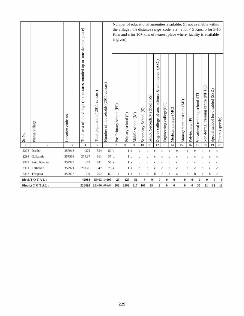
Pre
-Pri
mar
y s
cho
ol
(PP
)
Pri
mar
y s
cho
ol
(P)
Mid
dle
sch
oo
l (M
)
Sec
on
dar
y S
cho
ol
(S)
Sen
ior
Sec
on
dar
y s
cho
ol
(SS
)
Deg
ree
coll
ege
of
arts
sc
ien
ce &
co
mm
erce
(A
SC
)
En
gin
eeri
ng
co
lleg
e(E
C)
Med
ical
co
lleg
e (M
C)
Man
agem
ent
inst
itu
te (
MI)
Po
lyte
chn
ic (
Pt)
Vo
cati
on
al t
rain
ing
sch
oo
l /I
TI
No
n-f
orm
al t
rain
ing
cen
tre
(NF
TC
)
Sp
ecia
l sc
ho
ol
for
dis
able
d (
SS
D)
Oth
ers
(sp
ecif
y)
1 2 3 4 5 6 7 8 9 10 11 12 13 14 15 16 17 18 19 20
Lo
cati
on
co
de
no
.
Nam
e v
illa
ge
Sr.
No
.Number of educational amenities available. (If not available within
the village , the distance range code viz; a for < 5 Kms, b for 5-10
Kms and c for 10+ kms of nearest place where facility is available
is given).
Nu
mb
er o
f h
ou
seh
old
s (2
01
1 c
ensu
s)
To
tal
po
pu
lati
on
( 2
01
1 c
ensu
s )
To
tal
area
of
the
vil
lag
e (
in h
ecta
res
rou
nd
ed u
p t
o
on
e d
ecim
al p
lace
)
2298 Daribo 357918 272 324 80 b 1 a a c c c c c c c c c c
2299 Golkunda 357919 274.37 161 37 b 1 b c c c c c c c c c c c
2300 Pakri Khunta 357920 171 241 59 a 1 a c c c c c c c c c c c
2301 Kathaldih 357921 288.76 347 75 a 1 a c c c c c c c c c c c
2302 Telopara 357922 191 297 62 1 1 a a b b c c a a b a b c
Block T O T A L : 42988 65463 14005 25 125 51 9 0 0 0 0 0 0 0 0 0 0
District T O T A L : 226892 1E+06 ##### 283 1288 617 106 25 3 0 0 0 0 35 21 11 11
229
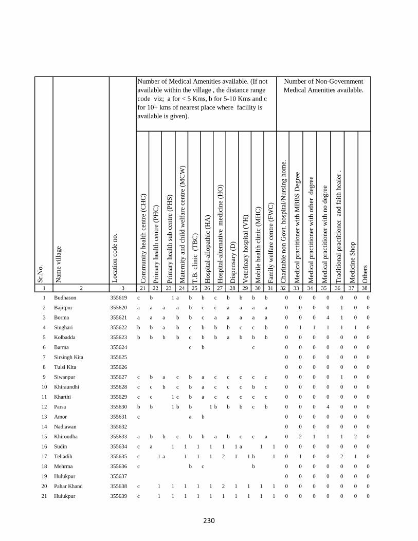
1 2 3
1 Budhason 355619
2 Bajitpur 355620
3 Borma 355621
4 Singhari 355622
5 Kolbadda 355623
6 Barma 355624
7 Sirsingh Kita 355625
8 Tulsi Kita 355626
9 Siwanpur 355627
10 Khiraundhi 355628
11 Kharthi 355629
12 Parsa 355630
13 Amor 355631
14 Nadiawan 355632
15 Khirondha 355633
16 Sudin 355634
17 Teliadih 355635
18 Mehrma 355636
19 Hulukpur 355637
20 Pahar Khand 355638
21 Hulukpur 355639
Lo
cati
on
co
de
no
.
Nam
e v
illa
ge
Sr.
No
.
Co
mm
un
ity
hea
lth
cen
tre
(CH
C)
Pri
mar
y h
ealt
h c
entr
e (P
HC
)
Pri
mar
y h
ealt
h s
ub
cen
tre
(PH
S)
Mat
ern
ity
an
d c
hil
d w
elfa
re c
entr
e (M
CW
)
T.B
. cl
inic
(T
BC
)
Ho
spit
al-a
llo
pat
hic
(H
A)
Ho
spit
al-a
lter
nat
ive
med
icin
e (H
O)
Dis
pen
sary
(D
)
Vet
erin
ary
ho
spit
al (
VH
)
Mo
bil
e h
ealt
h c
lin
ic (
MH
C)
Fam
ily
wel
fare
cen
tre
(FW
C)
Ch
arit
able
no
n G
ov
t. h
osp
ital
/Nu
rsin
g h
om
e.
Med
ical
pra
ctit
ion
er w
ith
MB
BS
Deg
ree
Med
ical
pra
ctit
ion
er w
ith
oth
er
deg
ree
Med
ical
pra
ctit
ion
er w
ith
no
deg
ree
Tra
dit
ion
al p
ract
itio
ner
an
d f
aith
hea
ler
.
Med
icin
e S
ho
p
Oth
ers
21 22 23 24 25 26 27 28 29 30 31 32 33 34 35 36 37 38
c b 1 a b b c b b b b 0 0 0 0 0 0 0
a a a a b c c a a a a 0 0 0 0 1 0 0
a a a b b c a a a a a 0 0 0 4 1 0 0
b b a b c b b b c c b 0 1 1 1 1 1 0
b b b b c b b a b b b 0 0 0 0 0 0 0
c b c 0 0 0 0 0 0 0
0 0 0 0 0 0 0
0 0 0 0 0 0 0
c b a c b a c c c c c 0 0 0 0 1 0 0
c c b c b a c c c b c 0 0 0 0 0 0 0
c c 1 c b a c c c c c 0 0 0 0 0 0 0
b b 1 b b 1 b b b c b 0 0 0 4 0 0 0
c a b 0 0 0 0 0 0 0
0 0 0 0 0 0 0
a b b c b b a b c c a 0 2 1 1 1 2 0
c a 1 1 1 1 1 1 a 1 1 0 0 0 0 0 0 0
c 1 a 1 1 1 2 1 1 b 1 0 1 0 0 2 1 0
c b c b 0 0 0 0 0 0 0
0 0 0 0 0 0 0
c 1 1 1 1 1 2 1 1 1 1 0 0 0 0 0 0 0
c 1 1 1 1 1 1 1 1 1 1 0 0 0 0 0 0 0
Census of India 2011- Village Directory
Amenities and Land use ( As in 2009 )
Number of Non-Government
Medical Amenities available.
Number of Medical Amenities available. (If not
available within the village , the distance range
code viz; a for < 5 Kms, b for 5-10 Kms and c
for 10+ kms of nearest place where facility is
available is given).
230

1 2 3
Lo
cati
on
co
de
no
.
Nam
e v
illa
ge
Sr.
No
.
22 Banodha 355640
23 Sankarpur 355641
24 Jitmal Kita 355642
25 Hira Kita 355643
26 Narain Chak 355644
27 Jitmal Kita 355645
28 Jitamal Kita 355646
29 Amjora Firozganj 355647
30 Pati Chak 355648
31 Gobindpur 355649
32 Dhamri Saheb 355650
33 Dhamri Gopalram 355651
34 Itahari 355652
35 Masuria 355653
36 Sukhari 355654
37 Fazilkhutahar 355655
38 Sobhapur 355656
39 Arbind Khutahari 355657
40 Bhalui 355658
41 Chitu Chak 355659
42 Barari 355660
43 Sangarua 355661
44 Mahadeb Kita 355662
45 Champa 355663
46 Bhata Chak 355664
Co
mm
un
ity
hea
lth
cen
tre
(CH
C)
Pri
mar
y h
ealt
h c
entr
e (P
HC
)
Pri
mar
y h
ealt
h s
ub
cen
tre
(PH
S)
Mat
ern
ity
an
d c
hil
d w
elfa
re c
entr
e (M
CW
)
T.B
. cl
inic
(T
BC
)
Ho
spit
al-a
llo
pat
hic
(H
A)
Ho
spit
al-a
lter
nat
ive
med
icin
e (H
O)
Dis
pen
sary
(D
)
Vet
erin
ary
ho
spit
al (
VH
)
Mo
bil
e h
ealt
h c
lin
ic (
MH
C)
Fam
ily
wel
fare
cen
tre
(FW
C)
Ch
arit
able
no
n G
ov
t. h
osp
ital
/Nu
rsin
g h
om
e.
Med
ical
pra
ctit
ion
er w
ith
MB
BS
Deg
ree
Med
ical
pra
ctit
ion
er w
ith
oth
er
deg
ree
Med
ical
pra
ctit
ion
er w
ith
no
deg
ree
Tra
dit
ion
al p
ract
itio
ner
an
d f
aith
hea
ler
.
Med
icin
e S
ho
p
Oth
ers
21 22 23 24 25 26 27 28 29 30 31 32 33 34 35 36 37 38
Number of Non-Government
Medical Amenities available.
Number of Medical Amenities available. (If not
available within the village , the distance range
code viz; a for < 5 Kms, b for 5-10 Kms and c
for 10+ kms of nearest place where facility is
available is given).
b b b c b a b b c b b 0 0 0 0 0 0 0
c b a c b a b b b b b 0 0 0 0 0 0 0
a a b a 0 0 0 0 0 0 0
0 0 0 0 0 0 0
0 0 0 0 0 0 0
0 0 0 0 0 0 0
0 0 0 0 0 0 0
c a a c a b b 2 b b a 0 0 0 0 0 0 0
c b b c a c b a b a a 0 0 0 0 0 0 0
c a b 1 a c c b b a b 0 0 0 0 0 0 0
a a a c b b a a a c b 0 0 0 0 0 0 0
b b b b b b b b b b a 0 0 0 0 0 0 0
c b a b c b b b b c b 0 0 0 0 0 0 0
a a 1 b a b a a a c b 0 0 0 0 0 0 0
a a a b c b b b a c a 0 0 0 0 0 0 0
b a a b c a a b a c a 0 0 0 0 0 0 0
b a a b c a b a b b b 0 0 4 1 1 0 0
0 0 0 0 0 0 0
c b c c 0 0 0 0 0 0 0
0 0 0 0 0 0 0
c b b b b b 0 0 0 0 0 0 0
0 0 0 0 0 0 0
0 0 0 0 0 0 0
b a a c b 0 0 0 0 0 0 0
0 0 0 0 0 0 0
231

1 2 3
Lo
cati
on
co
de
no
.
Nam
e v
illa
ge
Sr.
No
.
47 Padam Chak 355665
48 Ghuram Chak 355666
49 Badla Chak 355667
50 Ghasichak 355668
51 Ghasi Chak Mal 355669
52 Domanchak 355670
53 Dudhi Chak 355671
54 Kasba 355672
55 Doman Chak 355673
56 Kasba 355674
57 Majhagain 355675
58 Kasba 355676
59 Sadi Chak 355677
60 Anhuatikar 355678
61 Madhurai Bagicha 355679
62 Dukhari Kita 355680
63 Dulum Khutahari 355681
64 Chhota And Bara Mangarh355682
65 Dukhari Kita 355683
66 Chhota And Bara Mangarh355684
67 Mania Chak 355685
68 Bagat Khutahari 355686
69 Jalala Chak 355687
70 Tarkharwa 355688
71 Bagat Khutahri 355689
Co
mm
un
ity
hea
lth
cen
tre
(CH
C)
Pri
mar
y h
ealt
h c
entr
e (P
HC
)
Pri
mar
y h
ealt
h s
ub
cen
tre
(PH
S)
Mat
ern
ity
an
d c
hil
d w
elfa
re c
entr
e (M
CW
)
T.B
. cl
inic
(T
BC
)
Ho
spit
al-a
llo
pat
hic
(H
A)
Ho
spit
al-a
lter
nat
ive
med
icin
e (H
O)
Dis
pen
sary
(D
)
Vet
erin
ary
ho
spit
al (
VH
)
Mo
bil
e h
ealt
h c
lin
ic (
MH
C)
Fam
ily
wel
fare
cen
tre
(FW
C)
Ch
arit
able
no
n G
ov
t. h
osp
ital
/Nu
rsin
g h
om
e.
Med
ical
pra
ctit
ion
er w
ith
MB
BS
Deg
ree
Med
ical
pra
ctit
ion
er w
ith
oth
er
deg
ree
Med
ical
pra
ctit
ion
er w
ith
no
deg
ree
Tra
dit
ion
al p
ract
itio
ner
an
d f
aith
hea
ler
.
Med
icin
e S
ho
p
Oth
ers
21 22 23 24 25 26 27 28 29 30 31 32 33 34 35 36 37 38
Number of Non-Government
Medical Amenities available.
Number of Medical Amenities available. (If not
available within the village , the distance range
code viz; a for < 5 Kms, b for 5-10 Kms and c
for 10+ kms of nearest place where facility is
available is given).
0 0 0 0 0 0 0
b b a b b b b b c b b 0 0 0 0 0 1 0
a a b c b 0 0 0 0 0 0 0
0 0 0 0 0 0 0
b b b b b a a b b b b 0 0 0 0 0 0 0
b b a b b b a a c b a 0 0 0 0 0 1 0
a b c b 0 0 0 0 0 0 0
0 0 0 0 0 0 0
0 0 0 0 0 0 0
b b b b b a b c b b a 0 0 0 0 0 0 0
b a a b a b b c b b b 0 0 0 0 0 0 0
b b a b c c b c b a b 0 0 0 0 0 0 0
a c b b c 0 0 0 0 0 0 0
0 0 0 0 0 0 0
0 0 0 0 0 0 0
0 0 0 0 0 0 0
a b b b c 0 0 0 0 0 0 0
0 0 0 0 0 0 0
b a a b b a b b a b b 0 0 0 0 0 0 0
b b a b b a b b a c b 0 0 0 0 0 0 0
b b a b b a a b b c b 0 0 0 0 0 0 0
b b a 0 0 0 0 0 0 0
0 0 0 0 0 0 0
b b a b b b a b b c a 0 0 0 0 0 0 0
b b a b b b b b b b b 0 0 0 0 0 0 0
232

1 2 3
Lo
cati
on
co
de
no
.
Nam
e v
illa
ge
Sr.
No
.
72 Meghchatar 355690
73 Kumardom 355691
74 Harchandpur 355692
75 Maheshdiri 355693
76 Nawadih Tola 355694
77 Beldara Chak 355695
78 Bhaju Chak 355696
79 Bhagwanpur 355697
80 Katmdanr 355698
81 Kita Kalamdanr 355699
82 Amdanr Asli 355700
83 Lachmipur 355701
84 Chandpur 355702
85 Rasti Kar 355703
86 Partappur Mal 355704
87 Partappur Jagir 355705
88 Kishungari Chak 355706
89 Sahi Chak 355707
90 Sarangdhar 355708
91 Sirampur 355709
92 Debi Chak 355710
93 Dogachhi 355711
94 Kandar Chak 355712
95 Tazi Chak 355713
96 Sapnia 355714
Co
mm
un
ity
hea
lth
cen
tre
(CH
C)
Pri
mar
y h
ealt
h c
entr
e (P
HC
)
Pri
mar
y h
ealt
h s
ub
cen
tre
(PH
S)
Mat
ern
ity
an
d c
hil
d w
elfa
re c
entr
e (M
CW
)
T.B
. cl
inic
(T
BC
)
Ho
spit
al-a
llo
pat
hic
(H
A)
Ho
spit
al-a
lter
nat
ive
med
icin
e (H
O)
Dis
pen
sary
(D
)
Vet
erin
ary
ho
spit
al (
VH
)
Mo
bil
e h
ealt
h c
lin
ic (
MH
C)
Fam
ily
wel
fare
cen
tre
(FW
C)
Ch
arit
able
no
n G
ov
t. h
osp
ital
/Nu
rsin
g h
om
e.
Med
ical
pra
ctit
ion
er w
ith
MB
BS
Deg
ree
Med
ical
pra
ctit
ion
er w
ith
oth
er
deg
ree
Med
ical
pra
ctit
ion
er w
ith
no
deg
ree
Tra
dit
ion
al p
ract
itio
ner
an
d f
aith
hea
ler
.
Med
icin
e S
ho
p
Oth
ers
21 22 23 24 25 26 27 28 29 30 31 32 33 34 35 36 37 38
Number of Non-Government
Medical Amenities available.
Number of Medical Amenities available. (If not
available within the village , the distance range
code viz; a for < 5 Kms, b for 5-10 Kms and c
for 10+ kms of nearest place where facility is
available is given).
b b a b b b c b b b b 0 0 0 0 0 0 0
b b a b a a b b b b b 0 0 0 0 0 0 0
b c b b 0 0 0 0 0 0 0
0 0 0 0 0 0 0
b c c c b b a b b a 0 2 2 2 2 2 2
0 0 0 0 0 0 0
0 0 0 0 0 0 0
0 0 0 0 0 0 0
0 0 0 0 0 0 0
b b a b a a b b c b b 0 0 0 2 0 0 0
b c c c b b a b c a 0 2 2 2 2 2 2
0 0 0 0 0 0 0
0 0 0 0 0 0 0
c a b b a b a b b b b 0 0 5 4 0 0 0
b b b b b b c b c c b 0 0 0 0 0 0 0
b b b c c 0 0 0 0 0 0 0
0 0 0 0 0 0 0
0 0 0 0 0 0 0
0 0 0 0 0 0 0
a a b b c 0 0 5 4 0 0 0
0 0 0 0 0 0 0
c b b b b b 0 0 0 0 0 0 0
0 0 0 0 0 0 0
a b a b a c 0 0 0 0 0 0 0
0 0 0 0 0 0 0
233

1 2 3
Lo
cati
on
co
de
no
.
Nam
e v
illa
ge
Sr.
No
.
97 Sapta Chak 355715
98 Mathu Chak 355716
99 Sanolimor 355717
100 Siardih 355718
101 Khaira Chak 355719
102 Gauri Chak 355720
103 Tularam Bhuska 355721
104 Bishunpur 355722
105 Raghudas Bhuska 355723
106 Bhaloa 355724
107 Bisu Chak 355725
108 Jhagraha 355726
109 Benidas Bhuska 355727
110 Belakitar Jagir 355728
111 Chetni Chak 355729
112 Mahuadih 355730
113 Pipra 355731
114 Sauri Chak 355732
115 Dasu Chakla 355733
116 Dwarka Kita 355734
117 Karar Chakla 355735
118 Doi 355736
119 Haripur 355737
120 Gangaldo 355738
121 Sokha Chak 355739
Co
mm
un
ity
hea
lth
cen
tre
(CH
C)
Pri
mar
y h
ealt
h c
entr
e (P
HC
)
Pri
mar
y h
ealt
h s
ub
cen
tre
(PH
S)
Mat
ern
ity
an
d c
hil
d w
elfa
re c
entr
e (M
CW
)
T.B
. cl
inic
(T
BC
)
Ho
spit
al-a
llo
pat
hic
(H
A)
Ho
spit
al-a
lter
nat
ive
med
icin
e (H
O)
Dis
pen
sary
(D
)
Vet
erin
ary
ho
spit
al (
VH
)
Mo
bil
e h
ealt
h c
lin
ic (
MH
C)
Fam
ily
wel
fare
cen
tre
(FW
C)
Ch
arit
able
no
n G
ov
t. h
osp
ital
/Nu
rsin
g h
om
e.
Med
ical
pra
ctit
ion
er w
ith
MB
BS
Deg
ree
Med
ical
pra
ctit
ion
er w
ith
oth
er
deg
ree
Med
ical
pra
ctit
ion
er w
ith
no
deg
ree
Tra
dit
ion
al p
ract
itio
ner
an
d f
aith
hea
ler
.
Med
icin
e S
ho
p
Oth
ers
21 22 23 24 25 26 27 28 29 30 31 32 33 34 35 36 37 38
Number of Non-Government
Medical Amenities available.
Number of Medical Amenities available. (If not
available within the village , the distance range
code viz; a for < 5 Kms, b for 5-10 Kms and c
for 10+ kms of nearest place where facility is
available is given).
0 0 0 0 0 0 0
0 0 0 0 0 0 0
0 0 0 0 0 0 0
b b b b a b 0 0 0 0 0 0 0
0 0 0 0 0 0 0
b b a a b a c b b b b 0 0 0 0 0 0 0
b b a b a a b b b b b 0 0 0 0 0 0 0
b a b b a a a 0 0 0 0 0 0 0
0 0 0 0 0 0 0
b a b c b b 0 0 0 0 0 0 0
0 0 0 0 0 0 0
0 0 0 0 0 0 0
b b b b c c c 0 0 0 0 0 0 0
0 0 0 0 0 0 0
0 0 0 0 0 0 0
a b a b a b a b b c b 0 0 0 0 2 0 0
a 1 a 1 b 1 1 b c c c 0 0 0 1 2 1 0
b b b a b b a b c c a 0 0 0 2 2 0 0
b b a b b b b b c b b 0 0 0 2 1 0 0
b a b b b b c b c c b 0 0 0 2 2 0 0
b b b b b 1 c 3 b c b 0 0 0 2 2 1 0
b b a b b a b b b b a 0 0 0 0 0 0 0
b a a b b b b a 0 0 0 0 0 0 0
0 0 0 0 0 0 0
0 0 0 0 0 0 0
234

1 2 3
Lo
cati
on
co
de
no
.
Nam
e v
illa
ge
Sr.
No
.
122 Bhim Chak 355740
123 Kabi Chak 355741
124 Mahesh Kita Partabpur 355742
125 Maheshkita Partabpur 355743
126 Chhant Daria Chak 355744
127 Daria Chak 355745
128 Ghori Chak 355746
129 Kasmir Chak 355747
130 Loknath Kita 355748
131 Loknath Kita 355749
132 Partabpur 355750
133 Gausipartabpur 355751
134 Kamargawan 355752
135 Kamardiha 355753
136 Udhua Chak 355754
137 Chaura 355755
138 Phudulia Kita 355756
139 Lakramara 355757
140 Majhgain 355758
141 Nima 355759
142 Udaipur Bahera 355760
143 Chitarsen Bahira 355761
144 Ghori 355762
145 Jitu Chak 355763
146 Dariapur 355764
Co
mm
un
ity
hea
lth
cen
tre
(CH
C)
Pri
mar
y h
ealt
h c
entr
e (P
HC
)
Pri
mar
y h
ealt
h s
ub
cen
tre
(PH
S)
Mat
ern
ity
an
d c
hil
d w
elfa
re c
entr
e (M
CW
)
T.B
. cl
inic
(T
BC
)
Ho
spit
al-a
llo
pat
hic
(H
A)
Ho
spit
al-a
lter
nat
ive
med
icin
e (H
O)
Dis
pen
sary
(D
)
Vet
erin
ary
ho
spit
al (
VH
)
Mo
bil
e h
ealt
h c
lin
ic (
MH
C)
Fam
ily
wel
fare
cen
tre
(FW
C)
Ch
arit
able
no
n G
ov
t. h
osp
ital
/Nu
rsin
g h
om
e.
Med
ical
pra
ctit
ion
er w
ith
MB
BS
Deg
ree
Med
ical
pra
ctit
ion
er w
ith
oth
er
deg
ree
Med
ical
pra
ctit
ion
er w
ith
no
deg
ree
Tra
dit
ion
al p
ract
itio
ner
an
d f
aith
hea
ler
.
Med
icin
e S
ho
p
Oth
ers
21 22 23 24 25 26 27 28 29 30 31 32 33 34 35 36 37 38
Number of Non-Government
Medical Amenities available.
Number of Medical Amenities available. (If not
available within the village , the distance range
code viz; a for < 5 Kms, b for 5-10 Kms and c
for 10+ kms of nearest place where facility is
available is given).
b b b a b b b b a b b 0 0 0 0 0 0 0
c c b a b b c a 0 0 0 0 0 0 0
0 0 0 0 0 0 0
0 0 0 0 0 0 0
b a a c c c b b a b c 0 0 0 0 0 0 0
c c a c c b b b a a b 0 0 0 0 0 0 0
b b a b c b b b b b b 0 0 0 0 0 0 0
b a b b c a a c b b a 0 0 0 0 0 0 0
b c a a b b b a 0 0 0 0 0 0 0
0 0 0 0 0 0 0
b b a b c b a b a c b 0 0 0 0 0 0 0
b c a a c c b b c b c 0 0 0 0 2 0 0
b a a b c a c b b b c 0 0 1 2 1 2 0
b a a a c a b b c a c 0 0 1 2 1 2 0
a c 1 c b c b b c b c 0 0 0 0 0 0 0
b a a a b a a b c c b 0 0 0 0 0 0 0
0 0 0 0 0 0 0
a a a a a a a b b c a 0 0 1 2 1 2 0
a b 1 b b b b b c c b 0 0 0 2 0 0 0
b b a b b a b b c b b 0 0 0 0 0 0 0
b a a a b b b b c c b 0 0 0 0 0 0 0
b a a a b c b b c c a 0 0 0 0 0 0 0
b a a a a c a b b b a 0 1 2 1 2 2 0
b a a a b b b b b b a 0 0 1 2 1 2 0
b b b b b b b b 0 0 0 0 0 0 0
235

1 2 3
Lo
cati
on
co
de
no
.
Nam
e v
illa
ge
Sr.
No
.
147 Mathi Chak 355765
148 Chhaman Kita 355766
149 Suphal Kita 355767
150 Kanchanpur 355768
151 Dhankuria 355769
152 Belbadda 355770
153 Kotibari 355771
154 Chhagraha 355772
155 Chhagraha 355773
156 Benia Kita 355774
157 Sahi Chak 355775
158 Chhagraha 355776
159 Kukra Milik 355777
160 Kurkra Milik 355778
161 Bheronagar 355779
162 Niamat Kita 355780
163 Ghasi Kita 355781
164 Ghasi Kita 355782
165 Inarman Kita 355783
166 Gausi Chak 355784
167 Mosana Chak 355785
168 Singarpur 355786
169 Birnagar Arazi Chhit 355787
170 Birnagar Arazi Bara 355788
171 Birnagar 355789
Co
mm
un
ity
hea
lth
cen
tre
(CH
C)
Pri
mar
y h
ealt
h c
entr
e (P
HC
)
Pri
mar
y h
ealt
h s
ub
cen
tre
(PH
S)
Mat
ern
ity
an
d c
hil
d w
elfa
re c
entr
e (M
CW
)
T.B
. cl
inic
(T
BC
)
Ho
spit
al-a
llo
pat
hic
(H
A)
Ho
spit
al-a
lter
nat
ive
med
icin
e (H
O)
Dis
pen
sary
(D
)
Vet
erin
ary
ho
spit
al (
VH
)
Mo
bil
e h
ealt
h c
lin
ic (
MH
C)
Fam
ily
wel
fare
cen
tre
(FW
C)
Ch
arit
able
no
n G
ov
t. h
osp
ital
/Nu
rsin
g h
om
e.
Med
ical
pra
ctit
ion
er w
ith
MB
BS
Deg
ree
Med
ical
pra
ctit
ion
er w
ith
oth
er
deg
ree
Med
ical
pra
ctit
ion
er w
ith
no
deg
ree
Tra
dit
ion
al p
ract
itio
ner
an
d f
aith
hea
ler
.
Med
icin
e S
ho
p
Oth
ers
21 22 23 24 25 26 27 28 29 30 31 32 33 34 35 36 37 38
Number of Non-Government
Medical Amenities available.
Number of Medical Amenities available. (If not
available within the village , the distance range
code viz; a for < 5 Kms, b for 5-10 Kms and c
for 10+ kms of nearest place where facility is
available is given).
0 0 0 0 0 0 0
b c a c c b c b b c a 0 0 0 0 0 0 0
b c a c c b b b a b c 0 0 0 0 0 0 0
c c a c c a b b b b c 0 0 0 0 0 0 0
c c 1 c c a a b b a c 0 0 0 0 0 1 0
b b a b c a a b a c b 0 0 0 0 0 0 0
b b b b c b b b a b b 0 0 0 0 0 0 0
c c b c b a c a 0 0 0 0 0 0 0
0 0 0 0 0 0 0
b c a b c b a b c b b 0 0 0 0 0 1 0
b c a c c b a b c b b 0 0 0 0 0 1 0
b c a c c a b b c a c 0 0 0 0 0 1 0
b a a c c c a b c a c 0 0 0 0 0 0 0
b c a c c b c b c c c 0 0 0 0 0 0 0
b b b b b c 0 0 0 0 0 0 0
0 0 0 0 0 0 0
0 0 0 0 0 0 0
0 0 0 0 0 0 0
0 0 0 0 0 0 0
a b b 0 0 0 0 0 0 0
0 0 0 0 0 0 0
a a a c c c c c c c a 0 0 0 0 0 2 0
0 0 0 0 0 0 0
0 0 0 0 0 0 0
b b a c c c a c c c b 0 0 0 0 0 0 0
236

1 2 3
Lo
cati
on
co
de
no
.
Nam
e v
illa
ge
Sr.
No
.
172 Saharpur 355790
173 Lilatori 355791
174 Birahim Chak 355792
175 Dhodha 355793
176 Manikpur 355794
177 Dharampur 355795
178 Jarwar Kita 355796
179 Biram Kita 355797
180 Mukra Milik 355798
181 Bhirnabhaironagar 355799
182 Amarsing Kita 355800
183 Baski Kita 355801
184 Kurkraha Khas 355802
185 Nurdi Kita 355803
186 Raghunath Kita 355804
187 Madhupur 355805
188 Parbal Kita 355806
189 Jagan Kita 355807
190 Gajanda 355808
191 Amdiha 355809
192 Birnia 355810
193 Khaira Patkia 355811
194 Rajan 355812
195 Madhura 355813
196 Kalianpur 355814
Co
mm
un
ity
hea
lth
cen
tre
(CH
C)
Pri
mar
y h
ealt
h c
entr
e (P
HC
)
Pri
mar
y h
ealt
h s
ub
cen
tre
(PH
S)
Mat
ern
ity
an
d c
hil
d w
elfa
re c
entr
e (M
CW
)
T.B
. cl
inic
(T
BC
)
Ho
spit
al-a
llo
pat
hic
(H
A)
Ho
spit
al-a
lter
nat
ive
med
icin
e (H
O)
Dis
pen
sary
(D
)
Vet
erin
ary
ho
spit
al (
VH
)
Mo
bil
e h
ealt
h c
lin
ic (
MH
C)
Fam
ily
wel
fare
cen
tre
(FW
C)
Ch
arit
able
no
n G
ov
t. h
osp
ital
/Nu
rsin
g h
om
e.
Med
ical
pra
ctit
ion
er w
ith
MB
BS
Deg
ree
Med
ical
pra
ctit
ion
er w
ith
oth
er
deg
ree
Med
ical
pra
ctit
ion
er w
ith
no
deg
ree
Tra
dit
ion
al p
ract
itio
ner
an
d f
aith
hea
ler
.
Med
icin
e S
ho
p
Oth
ers
21 22 23 24 25 26 27 28 29 30 31 32 33 34 35 36 37 38
Number of Non-Government
Medical Amenities available.
Number of Medical Amenities available. (If not
available within the village , the distance range
code viz; a for < 5 Kms, b for 5-10 Kms and c
for 10+ kms of nearest place where facility is
available is given).
b b a c c c a c c b b 0 0 0 0 0 0 0
b b a b b b b b b b a 0 0 0 0 0 0 0
a a a c c c c c c b c 0 0 0 0 0 3 0
c c 1 c c c c c b c 0 0 1 0 0 1 0
0 0 0 0 0 0 0
b c a b b a b b b a c 0 0 0 0 0 0 0
b c a b b b b b a b c 0 0 0 0 0 0 0
b b b c b a a b a b c 0 0 0 0 0 0 0
b c a c a c a b c a c 0 0 0 0 0 0 0
b c a a b b a b b a c 0 0 0 0 0 0 0
b a a c b b b b c a c 0 0 1 3 0 0 0
b b b c b b b b c b c 0 0 0 0 0 0 0
b c b b b c b 0 0 0 0 0 0 0
0 0 0 0 0 0 0
0 0 0 0 0 0 0
0 0 0 0 0 0 0
b b a c c b b b c b b 0 0 0 0 0 0 0
b b a c c a c 1 c c a 0 1 0 0 0 0 0
c b b c c b c b c c a 0 0 0 0 0 0 0
b b b b c a b b b c b 0 0 0 0 0 0 0
b c a b b b c b 0 0 0 0 0 0 0
0 0 0 0 0 0 0
b c a c c c b b b c c 0 2 2 2 2 2 0
b b b b c c b b b c c 0 0 0 0 0 0 0
b a a c c a a c a b c 0 0 0 0 0 0 0
237

1 2 3
Lo
cati
on
co
de
no
.
Nam
e v
illa
ge
Sr.
No
.
197 Sonaguji 355815
198 Dalahi 355816
199 Tetaria 355817
200 Baski Kita 355818
201 Beniadih 355819
202 Marpa 355820
203 Dumaria 355821
204 Kamal Chak 355822
205 Meghnath 355823
206 Kalidaha 355824
207 Leoabhujani 355825
208 Gobardhanpur 355826
209 Balia 355827
210 Pharkia 355828
211 Dhurbidih 355829
212 Lohachinta 355830
213 Madhupur 355831
Block T O T A L :
214 Dighi 355832
215 Paharpur 355833
216 Madhupur 355834
217 Siwanpur 355835
218 Kakar Ghat 355836
Co
mm
un
ity
hea
lth
cen
tre
(CH
C)
Pri
mar
y h
ealt
h c
entr
e (P
HC
)
Pri
mar
y h
ealt
h s
ub
cen
tre
(PH
S)
Mat
ern
ity
an
d c
hil
d w
elfa
re c
entr
e (M
CW
)
T.B
. cl
inic
(T
BC
)
Ho
spit
al-a
llo
pat
hic
(H
A)
Ho
spit
al-a
lter
nat
ive
med
icin
e (H
O)
Dis
pen
sary
(D
)
Vet
erin
ary
ho
spit
al (
VH
)
Mo
bil
e h
ealt
h c
lin
ic (
MH
C)
Fam
ily
wel
fare
cen
tre
(FW
C)
Ch
arit
able
no
n G
ov
t. h
osp
ital
/Nu
rsin
g h
om
e.
Med
ical
pra
ctit
ion
er w
ith
MB
BS
Deg
ree
Med
ical
pra
ctit
ion
er w
ith
oth
er
deg
ree
Med
ical
pra
ctit
ion
er w
ith
no
deg
ree
Tra
dit
ion
al p
ract
itio
ner
an
d f
aith
hea
ler
.
Med
icin
e S
ho
p
Oth
ers
21 22 23 24 25 26 27 28 29 30 31 32 33 34 35 36 37 38
Number of Non-Government
Medical Amenities available.
Number of Medical Amenities available. (If not
available within the village , the distance range
code viz; a for < 5 Kms, b for 5-10 Kms and c
for 10+ kms of nearest place where facility is
available is given).
b b b c b a a b b c b 0 0 0 0 0 0 0
b b a c b b b b b c c 0 1 1 2 1 1 0
a b a b b a b a 0 0 0 0 0 0 0
0 0 0 0 0 0 0
0 0 0 0 0 0 0
a b 1 c c b a b b b b 0 0 0 0 0 0 0
b b a c c b a b c b a 0 0 0 0 0 0 0
a a b c c b b b c a a 0 0 0 0 0 3 0
b a a b b a 0 0 0 0 0 0 0
0 0 0 0 0 0 0
a a b c c b c b c a b 0 0 0 0 0 0 0
b b a c c b b b c b a 0 0 0 0 0 3 0
c c b c c a b b c b c 0 2 2 2 2 2 0
0 0 0 0 0 0 0
0 0 0 0 0 0 0
b b b c b a a b b c c 0 0 0 0 0 0 0
b b a c b b b b a b b 0 0 0 0 0 0 0
0 4 12 6 4 7 7 10 3 3 4 0 15 33 54 36 43 4
b b b c b c b b a c b 0 0 0 0 0 0 0
b b b b c c a 0 0 0 0 0 0 0
0 0 0 0 0 0 0
b a a c b b a a c c b 0 0 0 0 0 0 0
b b b b b b b b c b a 0 0 0 0 0 0 0
238

1 2 3
Lo
cati
on
co
de
no
.
Nam
e v
illa
ge
Sr.
No
.
219 Talbaria 355837
220 Mohamad Khutahari 355838
221 Mal Jhakhra 355839
222 Baghjhakhra 355840
223 Sinha Chak 355841
224 Babutaluk 355842
225 Paharpur 355843
226 Deban Chak 355844
227 Gargulal 355845
228 Madan Chauki 355846
229 Birahim Kita 355847
230 Banskola 355848
231 Kurpatti 355849
232 Baijani 355850
233 Chapri 355851
234 Kamat Chapri 355852
235 Khar Kudia 355853
236 Majhana (Arazi) 355854
237 Hasu Chak 355855
238 Domansaran Kita 355856
239 Silong 355857
240 Paharpur 355858
241 Akilkita 355859
242 Bikram Kita 355860
243 Paharpur 355861
Co
mm
un
ity
hea
lth
cen
tre
(CH
C)
Pri
mar
y h
ealt
h c
entr
e (P
HC
)
Pri
mar
y h
ealt
h s
ub
cen
tre
(PH
S)
Mat
ern
ity
an
d c
hil
d w
elfa
re c
entr
e (M
CW
)
T.B
. cl
inic
(T
BC
)
Ho
spit
al-a
llo
pat
hic
(H
A)
Ho
spit
al-a
lter
nat
ive
med
icin
e (H
O)
Dis
pen
sary
(D
)
Vet
erin
ary
ho
spit
al (
VH
)
Mo
bil
e h
ealt
h c
lin
ic (
MH
C)
Fam
ily
wel
fare
cen
tre
(FW
C)
Ch
arit
able
no
n G
ov
t. h
osp
ital
/Nu
rsin
g h
om
e.
Med
ical
pra
ctit
ion
er w
ith
MB
BS
Deg
ree
Med
ical
pra
ctit
ion
er w
ith
oth
er
deg
ree
Med
ical
pra
ctit
ion
er w
ith
no
deg
ree
Tra
dit
ion
al p
ract
itio
ner
an
d f
aith
hea
ler
.
Med
icin
e S
ho
p
Oth
ers
21 22 23 24 25 26 27 28 29 30 31 32 33 34 35 36 37 38
Number of Non-Government
Medical Amenities available.
Number of Medical Amenities available. (If not
available within the village , the distance range
code viz; a for < 5 Kms, b for 5-10 Kms and c
for 10+ kms of nearest place where facility is
available is given).
b b a c a c b c c c c 0 0 0 0 0 0 0
b 1 1 c b c a b c c c 0 0 0 0 0 0 0
c 1 1 b b c c c b b c 0 0 0 0 0 0 0
c b b c b a b b c c c 0 0 0 0 0 0 0
b b a a b b c c c 0 0 0 0 0 0 0
0 0 0 0 0 0 0
0 0 0 0 0 0 0
b b a c b c b b b b c 0 0 0 0 0 0 0
b a a c a b c b b b c 0 0 0 0 0 0 0
b b b c c b b b b b b 0 0 0 0 0 0 0
b b a b a b a b b a b 0 0 0 0 0 0 0
b b b b a b a b b b a 0 0 0 0 0 0 0
b b b b b a b b a b a 0 0 0 0 0 0 0
b b a b a b a b b a b 0 0 0 0 0 0 0
b b a c a b a b b b c 0 0 0 0 0 0 0
a b b b a b b b a b c 0 0 0 0 0 0 0
b a b a c b a a b 0 0 0 0 0 0 0
0 0 0 0 0 0 0
a b a b b b c a 0 0 0 0 0 0 0
0 0 0 0 0 0 0
b b b c b b b b b c b 0 0 0 0 0 0 0
b b a c a 0 0 0 0 0 0 0
0 0 0 0 0 0 0
0 0 0 0 0 0 0
b b a c b b b b b b c 0 0 0 0 0 0 0
239

1 2 3
Lo
cati
on
co
de
no
.
Nam
e v
illa
ge
Sr.
No
.
244 Chandpur 355862
245 Khani Chak 355863
246 Nagarchi Chak 355864
247 Taj Kita 355865
248 Panchu Kita 355866
249 Mohan Kita 355867
250 Khania Kita 355868
251 Badura Kita 355869
252 Bhatu Kita 355870
253 Dalubarmohtar 355871
254 Madhuadih Khas 355872
255 Madhuadih Arjun Kita 355873
256 Jadu Kita 355874
257 Kali Kita 355875
258 Haripur 355876
259 Nawadih Parthumanjhi 355877
260 Sonapur 355878
261 Maku Chak 355879
262 Chand Chak 355880
263 Dumaria 355881
264 Taib Kita 355882
265 Bhekhari Kita 355883
266 Mitan Kita 355884
267 Kadil Kita 355885
268 Pitambar Kita 355886
Co
mm
un
ity
hea
lth
cen
tre
(CH
C)
Pri
mar
y h
ealt
h c
entr
e (P
HC
)
Pri
mar
y h
ealt
h s
ub
cen
tre
(PH
S)
Mat
ern
ity
an
d c
hil
d w
elfa
re c
entr
e (M
CW
)
T.B
. cl
inic
(T
BC
)
Ho
spit
al-a
llo
pat
hic
(H
A)
Ho
spit
al-a
lter
nat
ive
med
icin
e (H
O)
Dis
pen
sary
(D
)
Vet
erin
ary
ho
spit
al (
VH
)
Mo
bil
e h
ealt
h c
lin
ic (
MH
C)
Fam
ily
wel
fare
cen
tre
(FW
C)
Ch
arit
able
no
n G
ov
t. h
osp
ital
/Nu
rsin
g h
om
e.
Med
ical
pra
ctit
ion
er w
ith
MB
BS
Deg
ree
Med
ical
pra
ctit
ion
er w
ith
oth
er
deg
ree
Med
ical
pra
ctit
ion
er w
ith
no
deg
ree
Tra
dit
ion
al p
ract
itio
ner
an
d f
aith
hea
ler
.
Med
icin
e S
ho
p
Oth
ers
21 22 23 24 25 26 27 28 29 30 31 32 33 34 35 36 37 38
Number of Non-Government
Medical Amenities available.
Number of Medical Amenities available. (If not
available within the village , the distance range
code viz; a for < 5 Kms, b for 5-10 Kms and c
for 10+ kms of nearest place where facility is
available is given).
b b b b c c b b a c c 0 0 0 0 0 0 0
b b b a c c 0 0 0 0 0 0 0
0 0 0 0 0 0 0
b b b b b a a c b c c 0 0 0 0 0 0 0
c b b a b c c c 0 0 0 0 0 0 0
0 0 0 0 0 0 0
b b a b b c c b c b b 0 0 0 0 0 0 0
b a a b b b c b c b b 0 0 0 0 0 0 0
c b b b b b b a 0 0 0 0 0 0 0
0 0 0 0 0 0 0
0 0 0 0 0 0 0
0 0 0 0 0 0 0
b b b b b b b b c b c 0 0 0 0 0 0 0
b b b b b b a b b a b 0 0 0 0 0 0 0
b b a b b b a b b b b 0 0 0 0 0 0 0
b b a b b a b b b b a 0 0 0 0 0 0 0
b b b b b b b b a b 0 0 0 0 0 0 0
0 0 0 0 0 0 0
b b a b b a b b a c a 0 0 0 0 0 0 0
b b b a b b b c 0 0 0 0 0 0 0
0 0 0 0 0 0 0
b b a b b a b b a c c 0 0 0 0 0 0 0
b a a c c 0 0 0 0 0 0 0
0 0 0 0 0 0 0
0 0 0 0 0 0 0
240

1 2 3
Lo
cati
on
co
de
no
.
Nam
e v
illa
ge
Sr.
No
.
269 Baiju Kita 355887
270 Budhasan 355888
271 Janghira 355889
272 Mohan Pipra 355890
273 Dahua Pakaria 355891
274 Sanhuli 355892
275 Tetarbhuj 355893
276 Panch Pahar 355894
277 Rampur 355895
278 Bhagwakol 355896
279 Dhankol 355897
280 Mopahari 355898
281 Khandhar 355899
282 Bodhrai Khutahari 355900
283 Hira Khutahari 355901
284 Kari Khutahari 355902
285 Bishunpur 355903
286 Bhagaia 355904
287 Manikapur 355905
288 Ramdas Khutahari 355906
289 Jiban Khutahari 355907
290 Baiju Khutahari 355908
291 Salim Khutahari 355909
292 Jhilli 355910
293 Gajhanda 355911
Co
mm
un
ity
hea
lth
cen
tre
(CH
C)
Pri
mar
y h
ealt
h c
entr
e (P
HC
)
Pri
mar
y h
ealt
h s
ub
cen
tre
(PH
S)
Mat
ern
ity
an
d c
hil
d w
elfa
re c
entr
e (M
CW
)
T.B
. cl
inic
(T
BC
)
Ho
spit
al-a
llo
pat
hic
(H
A)
Ho
spit
al-a
lter
nat
ive
med
icin
e (H
O)
Dis
pen
sary
(D
)
Vet
erin
ary
ho
spit
al (
VH
)
Mo
bil
e h
ealt
h c
lin
ic (
MH
C)
Fam
ily
wel
fare
cen
tre
(FW
C)
Ch
arit
able
no
n G
ov
t. h
osp
ital
/Nu
rsin
g h
om
e.
Med
ical
pra
ctit
ion
er w
ith
MB
BS
Deg
ree
Med
ical
pra
ctit
ion
er w
ith
oth
er
deg
ree
Med
ical
pra
ctit
ion
er w
ith
no
deg
ree
Tra
dit
ion
al p
ract
itio
ner
an
d f
aith
hea
ler
.
Med
icin
e S
ho
p
Oth
ers
21 22 23 24 25 26 27 28 29 30 31 32 33 34 35 36 37 38
Number of Non-Government
Medical Amenities available.
Number of Medical Amenities available. (If not
available within the village , the distance range
code viz; a for < 5 Kms, b for 5-10 Kms and c
for 10+ kms of nearest place where facility is
available is given).
b b b b b b b b b c c 0 0 0 0 0 0 0
b b b b b b b b b c c 0 0 0 0 0 0 0
b a b c 0 0 0 0 0 0 0
0 0 0 0 0 0 0
b b b b b a a b b c b 0 0 0 0 0 0 0
a b b b b a b a 0 0 0 0 0 0 0
0 0 0 0 0 0 0
0 0 0 0 0 0 0
0 0 0 0 0 0 0
b b b b c b a b c b b 0 0 0 0 0 0 0
b b a b c a b b c a a 0 0 0 0 0 0 0
c c a c c a b b c b c 0 0 0 0 0 0 0
c c b c c b a b c b c 0 0 0 0 0 0 0
c c a c c c c b b a c 0 0 0 0 0 0 0
b b b b c b b b c b b 0 0 0 0 0 0 0
b b a b c b b b c b b 0 0 0 0 0 0 0
c c 1 c c c a b c a c 0 0 0 0 0 0 0
c c b c c c a c c a c 0 0 0 0 0 0 0
b c b b b c 0 0 0 0 0 0 0
0 0 0 0 0 0 0
b b b b b b c b 0 0 0 0 0 0 0
0 0 0 0 0 0 0
b b b b b a b b c c 0 0 0 0 0 0 0
0 0 0 0 0 0 0
b b a b b b a b b b c 0 0 0 0 0 0 0
241

1 2 3
Lo
cati
on
co
de
no
.
Nam
e v
illa
ge
Sr.
No
.
294 Karmail 355912
295 Kajrail 355913
296 Bahoriabagaicha 355914
297 Dharampur 355915
298 Lalsing Khutahari 355916
299 Dhaknesar 355917
300 Tetaria Mal 355918
301 Baraia Chak 355919
302 Chhota Manian 355920
303 Bara Manian(Kalan) 355921
304 Rangai Chak 355922
305 Kokan Kita 355923
306 Dhaniabandh 355924
307 Saharabari 355925
308 Bandar Kita 355926
309 Patha Chak 355927
310 Pitambar Kita 355928
311 Bhalwa Chak 355929
312 Bardia Chak 355930
313 Bamania 355931
314 Kolbadda 355932
315 Sonholi 355933
316 Hijri 355934
317 Sonholi 355935
318 Chanda And Chando 355936
Co
mm
un
ity
hea
lth
cen
tre
(CH
C)
Pri
mar
y h
ealt
h c
entr
e (P
HC
)
Pri
mar
y h
ealt
h s
ub
cen
tre
(PH
S)
Mat
ern
ity
an
d c
hil
d w
elfa
re c
entr
e (M
CW
)
T.B
. cl
inic
(T
BC
)
Ho
spit
al-a
llo
pat
hic
(H
A)
Ho
spit
al-a
lter
nat
ive
med
icin
e (H
O)
Dis
pen
sary
(D
)
Vet
erin
ary
ho
spit
al (
VH
)
Mo
bil
e h
ealt
h c
lin
ic (
MH
C)
Fam
ily
wel
fare
cen
tre
(FW
C)
Ch
arit
able
no
n G
ov
t. h
osp
ital
/Nu
rsin
g h
om
e.
Med
ical
pra
ctit
ion
er w
ith
MB
BS
Deg
ree
Med
ical
pra
ctit
ion
er w
ith
oth
er
deg
ree
Med
ical
pra
ctit
ion
er w
ith
no
deg
ree
Tra
dit
ion
al p
ract
itio
ner
an
d f
aith
hea
ler
.
Med
icin
e S
ho
p
Oth
ers
21 22 23 24 25 26 27 28 29 30 31 32 33 34 35 36 37 38
Number of Non-Government
Medical Amenities available.
Number of Medical Amenities available. (If not
available within the village , the distance range
code viz; a for < 5 Kms, b for 5-10 Kms and c
for 10+ kms of nearest place where facility is
available is given).
b b a b b b b b b c c 0 0 0 0 0 0 0
b b b b b b b b a c c 0 0 0 0 0 0 0
b b b b b b b b a c b 0 0 0 0 0 0 0
b b a b b b b b a c b 0 0 0 0 0 0 0
b b a b b b b b b c b 0 0 0 0 0 0 0
b b b b b b b 1 b b b 0 0 0 0 0 0 0
b b a b b b b b b b a 0 0 0 0 0 0 0
b a a b b b b b b b c 0 0 0 0 0 0 0
c a b b b b b b b b c 0 0 0 0 0 0 0
c a a b b a a b b b c 0 0 0 0 0 0 0
c b b a b b a b 0 0 0 0 0 0 0
0 0 0 0 0 0 0
b b c a c a b c 0 0 0 0 0 0 0
0 0 0 0 0 0 0
0 0 0 0 0 0 0
0 0 0 0 0 0 0
b c b a c b b 0 0 0 0 0 0 0
0 0 0 0 0 0 0
0 0 0 0 0 0 0
b b a b c b b c b c c 0 0 0 0 0 0 0
b c b b c b c 0 0 0 0 0 0 0
0 0 0 0 0 0 0
a c a a c c c 0 0 0 0 0 0 0
0 0 0 0 0 0 0
b b a b c a a b b c b 0 0 0 0 0 0 0
242

1 2 3
Lo
cati
on
co
de
no
.
Nam
e v
illa
ge
Sr.
No
.
319 Mohani Kita 355937
320 Sujan Kita 355938
321 Chanda And Chando 355939
322 Barkurua 355940
323 Sujan Kita 355941
324 Hardeo Chak 355942
325 Pathak Chak 355943
326 Nahan Chak 355944
327 Bihari 355945
328 Milik Bihari 355946
329 Pairanrai Kita 355947
330 Milik Bihari 355948
331 Karijh Kita 355949
332 Parasi 355950
333 Mahuara 355951
334 Itwa Mal 355952
335 Nehal Chand Kita 355953
336 Itwa Milik 355954
337 Naya Chak 355955
338 Dhaniabandh 355956
339 Jhurkusia 355957
340 Amarpur 355958
341 Harinkol 355959
342 Bhuslia 355960
343 Kurma 355961
Co
mm
un
ity
hea
lth
cen
tre
(CH
C)
Pri
mar
y h
ealt
h c
entr
e (P
HC
)
Pri
mar
y h
ealt
h s
ub
cen
tre
(PH
S)
Mat
ern
ity
an
d c
hil
d w
elfa
re c
entr
e (M
CW
)
T.B
. cl
inic
(T
BC
)
Ho
spit
al-a
llo
pat
hic
(H
A)
Ho
spit
al-a
lter
nat
ive
med
icin
e (H
O)
Dis
pen
sary
(D
)
Vet
erin
ary
ho
spit
al (
VH
)
Mo
bil
e h
ealt
h c
lin
ic (
MH
C)
Fam
ily
wel
fare
cen
tre
(FW
C)
Ch
arit
able
no
n G
ov
t. h
osp
ital
/Nu
rsin
g h
om
e.
Med
ical
pra
ctit
ion
er w
ith
MB
BS
Deg
ree
Med
ical
pra
ctit
ion
er w
ith
oth
er
deg
ree
Med
ical
pra
ctit
ion
er w
ith
no
deg
ree
Tra
dit
ion
al p
ract
itio
ner
an
d f
aith
hea
ler
.
Med
icin
e S
ho
p
Oth
ers
21 22 23 24 25 26 27 28 29 30 31 32 33 34 35 36 37 38
Number of Non-Government
Medical Amenities available.
Number of Medical Amenities available. (If not
available within the village , the distance range
code viz; a for < 5 Kms, b for 5-10 Kms and c
for 10+ kms of nearest place where facility is
available is given).
b b a b b b b 0 0 0 0 0 0 0
0 0 0 0 0 0 0
0 0 0 0 0 0 0
0 0 0 0 0 0 0
b b b a c c 0 0 0 0 0 0 0
0 0 0 0 0 0 0
b b a b c a b b b b b 0 0 0 0 0 0 0
b a b a b c b b a b b 0 0 0 0 0 0 0
a a b a b b a b a b c 0 0 0 0 0 0 0
0 0 0 0 0 0 0
a b a a b b b b b b a 0 0 0 0 0 0 0
b b a a b b a b 0 0 0 0 0 0 0
0 0 0 0 0 0 0
b a a a b a b b a b c 0 0 0 0 0 0 0
b b b c a b a c 0 0 0 0 0 0 0
0 0 0 0 0 0 0
0 0 0 0 0 0 0
b b b b b b a b b b c 0 0 0 0 0 0 0
b b b b b b b b b a b 0 0 0 0 0 0 0
b a a b c a c b b a b 0 0 0 0 0 0 0
c a a b c a b b b c b 0 0 0 0 0 0 0
c a a b c a b c b b b 0 0 0 0 0 0 0
c c c a c a 0 0 0 0 0 0 0
0 0 0 0 0 0 0
b b a a b c c 0 0 0 0 0 0 0
243

1 2 3
Lo
cati
on
co
de
no
.
Nam
e v
illa
ge
Sr.
No
.
344 Darji Kita 355962
345 Birnath Chak 355963
346 Indar Chak 355964
347 Marro Mal 355965
348 Belatikar 355966
349 Pipra 355967
350 Budhuachak 355968
351 Pipra 355969
352 Purnia 355970
353 Mardiha 355971
354 Baghakol 355972
355 Rangila 355973
356 Bhuska 355974
357 Chand Chak 355975
358 Dogachhi 355976
359 Khajri Chak 355977
360 Lainbrar Barakhar 355978
361 Lensirsa 355979
362 Gorapariharpur 355980
363 Basta 355981
364 Bariasirsa 355982
365 Gobindi Chak 355983
366 Kanipathari 355984
367 Gaias Chak 355985
368 Majh Kola 355986
Co
mm
un
ity
hea
lth
cen
tre
(CH
C)
Pri
mar
y h
ealt
h c
entr
e (P
HC
)
Pri
mar
y h
ealt
h s
ub
cen
tre
(PH
S)
Mat
ern
ity
an
d c
hil
d w
elfa
re c
entr
e (M
CW
)
T.B
. cl
inic
(T
BC
)
Ho
spit
al-a
llo
pat
hic
(H
A)
Ho
spit
al-a
lter
nat
ive
med
icin
e (H
O)
Dis
pen
sary
(D
)
Vet
erin
ary
ho
spit
al (
VH
)
Mo
bil
e h
ealt
h c
lin
ic (
MH
C)
Fam
ily
wel
fare
cen
tre
(FW
C)
Ch
arit
able
no
n G
ov
t. h
osp
ital
/Nu
rsin
g h
om
e.
Med
ical
pra
ctit
ion
er w
ith
MB
BS
Deg
ree
Med
ical
pra
ctit
ion
er w
ith
oth
er
deg
ree
Med
ical
pra
ctit
ion
er w
ith
no
deg
ree
Tra
dit
ion
al p
ract
itio
ner
an
d f
aith
hea
ler
.
Med
icin
e S
ho
p
Oth
ers
21 22 23 24 25 26 27 28 29 30 31 32 33 34 35 36 37 38
Number of Non-Government
Medical Amenities available.
Number of Medical Amenities available. (If not
available within the village , the distance range
code viz; a for < 5 Kms, b for 5-10 Kms and c
for 10+ kms of nearest place where facility is
available is given).
0 0 0 0 0 0 0
0 0 0 0 0 0 0
b b b b c b b b b c b 0 0 0 0 0 0 0
a a a a b a b b a c c 0 0 0 0 0 0 0
b b b b b c a b b b c 0 0 0 0 0 0 0
a a a a c b b b a b a 0 0 0 0 0 0 0
b b b b c b b b b b b 0 0 0 0 0 0 0
b b a b c b a b b a b 0 0 0 0 0 0 0
b b 1 b c a c b b b a 0 0 0 0 0 0 0
b b a b c a b b b c b 0 0 0 0 0 0 0
b a a a b a b b a a a 0 0 0 0 0 0 0
b b b b b c a b b b c 0 0 0 0 0 0 0
b b b b c b a b b b c 0 0 0 0 0 0 0
b a b b a c 0 0 0 0 0 0 0
0 0 0 0 0 0 0
a a a a a b b b a b c 0 0 0 0 0 0 0
a a a a a a a c a b b 0 0 0 0 0 0 0
b c a a a a a b a c b 0 0 0 0 0 0 0
b c a a a a b b a c b 0 0 0 0 0 0 0
a a a a a c a b a b b 0 0 0 0 0 0 0
b b b a 0 0 0 0 0 0 0
0 0 0 0 0 0 0
0 0 0 0 0 0 0
0 0 0 0 0 0 0
b a b a a c b b a c b 0 0 0 0 0 0 0
244

1 2 3
Lo
cati
on
co
de
no
.
Nam
e v
illa
ge
Sr.
No
.
369 Misirgangti 355987
370 Laghra Chak 355988
371 Mirik Chak 355989
372 Chamuakol 355990
373 Raghuni Kita 355991
374 Bhatkhoria 355992
375 Gauri Chak 355993
376 Sirikanta Chak 355994
377 Durga Chak 355995
378 Jogi Chak 355996
379 Bhiganda 355997
380 Kadma 355998
381 Asakhapar 355999
382 Mukeri Chak 356000
383 Dalang 356001
384 Raidih 356002
385 Nawadih 356003
386 Ratia Chak 356004
387 Pachradih 356005
388 Baniadih 356006
389 Dhawa 356007
390 Gopalpur Mohar Tola 356008
391 Gopalpur Karan Tola 356009
392 Runji 356010
393 Jadu Chak 356011
Co
mm
un
ity
hea
lth
cen
tre
(CH
C)
Pri
mar
y h
ealt
h c
entr
e (P
HC
)
Pri
mar
y h
ealt
h s
ub
cen
tre
(PH
S)
Mat
ern
ity
an
d c
hil
d w
elfa
re c
entr
e (M
CW
)
T.B
. cl
inic
(T
BC
)
Ho
spit
al-a
llo
pat
hic
(H
A)
Ho
spit
al-a
lter
nat
ive
med
icin
e (H
O)
Dis
pen
sary
(D
)
Vet
erin
ary
ho
spit
al (
VH
)
Mo
bil
e h
ealt
h c
lin
ic (
MH
C)
Fam
ily
wel
fare
cen
tre
(FW
C)
Ch
arit
able
no
n G
ov
t. h
osp
ital
/Nu
rsin
g h
om
e.
Med
ical
pra
ctit
ion
er w
ith
MB
BS
Deg
ree
Med
ical
pra
ctit
ion
er w
ith
oth
er
deg
ree
Med
ical
pra
ctit
ion
er w
ith
no
deg
ree
Tra
dit
ion
al p
ract
itio
ner
an
d f
aith
hea
ler
.
Med
icin
e S
ho
p
Oth
ers
21 22 23 24 25 26 27 28 29 30 31 32 33 34 35 36 37 38
Number of Non-Government
Medical Amenities available.
Number of Medical Amenities available. (If not
available within the village , the distance range
code viz; a for < 5 Kms, b for 5-10 Kms and c
for 10+ kms of nearest place where facility is
available is given).
a b c b c b 0 0 0 0 0 0 0
0 0 0 0 0 0 0
c a b a a b b b a c c 0 0 0 0 0 0 0
b a b b c 0 0 0 0 0 0 0
0 0 0 0 0 0 0
b a a b c b 0 0 0 0 0 0 0
0 0 0 0 0 0 0
0 0 0 0 0 0 0
0 0 0 0 0 0 0
c c b a b b b c b b c 0 0 0 0 0 0 0
c c a a b b b b a b c 0 0 0 0 0 0 0
c c a a b a a b a b c 0 0 0 0 0 0 0
c c b b b a a b c a b 0 0 0 0 0 0 0
c c a b a a a b b b b 0 0 0 0 0 0 0
c c b b a c b b c b b 0 0 0 0 0 0 0
c c a a b b c b c a b 0 0 0 0 0 0 0
c c a b b a c b c b a 0 0 0 0 0 0 0
c c a a b a b b c b c 0 0 0 0 0 0 0
c c 1 a b a b b b a c 0 0 0 0 0 0 0
c a a a b b b b c a c 0 0 0 0 0 0 0
a a a a b a b b c c b 0 0 0 0 0 0 0
c a b a c a b b c b b 0 0 0 0 0 0 0
c c b a c a a 2 c c c 0 0 0 0 0 0 0
c a a a c a a b b c c 0 0 0 0 0 0 0
c a a b c c b b b c b 0 0 0 0 0 0 0
245
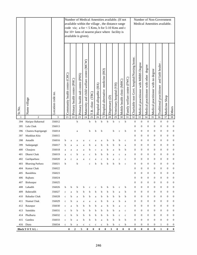
1 2 3
Lo
cati
on
co
de
no
.
Nam
e v
illa
ge
Sr.
No
.
394 Haripur Baharmal 356012
395 Lalu Chak 356013
396 Chamru Kaprigangti 356014
397 Mankhan Kita 356015
398 Antadih 356016
399 Sadargangti 356017
400 Chaujora 356018
401 Dharni Chak 356019
402 Garibparbara 356020
403 Bharsing Parbara 356021
404 Kumar Chak 356022
405 Bansbhita 356023
406 Rajhans 356024
407 Bishunpur 356025
408 Lahadih 356026
409 Baheradih 356027
410 Bahadur Chak 356028
411 Niamat Chak 356029
412 Ratanpur 356030
413 Samdaha 356031
414 Phulbaria 356032
415 Gamhra 356033
416 Diara 356034
Block T O T A L :
Co
mm
un
ity
hea
lth
cen
tre
(CH
C)
Pri
mar
y h
ealt
h c
entr
e (P
HC
)
Pri
mar
y h
ealt
h s
ub
cen
tre
(PH
S)
Mat
ern
ity
an
d c
hil
d w
elfa
re c
entr
e (M
CW
)
T.B
. cl
inic
(T
BC
)
Ho
spit
al-a
llo
pat
hic
(H
A)
Ho
spit
al-a
lter
nat
ive
med
icin
e (H
O)
Dis
pen
sary
(D
)
Vet
erin
ary
ho
spit
al (
VH
)
Mo
bil
e h
ealt
h c
lin
ic (
MH
C)
Fam
ily
wel
fare
cen
tre
(FW
C)
Ch
arit
able
no
n G
ov
t. h
osp
ital
/Nu
rsin
g h
om
e.
Med
ical
pra
ctit
ion
er w
ith
MB
BS
Deg
ree
Med
ical
pra
ctit
ion
er w
ith
oth
er
deg
ree
Med
ical
pra
ctit
ion
er w
ith
no
deg
ree
Tra
dit
ion
al p
ract
itio
ner
an
d f
aith
hea
ler
.
Med
icin
e S
ho
p
Oth
ers
21 22 23 24 25 26 27 28 29 30 31 32 33 34 35 36 37 38
Number of Non-Government
Medical Amenities available.
Number of Medical Amenities available. (If not
available within the village , the distance range
code viz; a for < 5 Kms, b for 5-10 Kms and c
for 10+ kms of nearest place where facility is
available is given).
b b b b b b c b 0 0 0 0 0 0 0
0 0 0 0 0 0 0
a b b b b c b 0 0 0 0 0 0 0
0 0 0 0 0 0 0
b a a a c a a b b b c 0 0 0 0 0 0 0
b a a a b a b b b b a 0 0 0 0 0 0 0
a a a a b c a b a b b 0 0 0 0 0 0 0
a c b a c b b b a c a 0 0 0 0 0 0 0
a c a a c a c b a c c 0 0 0 0 0 0 0
b b c b b b b b c 0 0 0 0 0 0 0
0 0 0 0 0 0 0
0 0 0 0 0 0 0
0 0 0 0 0 0 0
0 0 0 0 0 0 0
b b b b c c b b b c b 0 0 0 0 0 0 0
c a b b b b b b b a b 0 0 0 0 0 0 0
c b a b b a b b b b b 0 0 0 0 0 0 0
c b a a a a b b a b a 0 0 0 0 0 0 0
c a b b b b a b b a c 0 0 0 0 0 0 0
c b b b b b b b b a c 0 0 0 0 0 0 0
c b b b b b b b b c c 0 0 0 0 0 0 0
c b a b b b a b b b b 0 0 0 0 0 0 0
c b a c c c c b b c b 0 0 0 0 1 0 0
0 2 5 0 0 0 0 3 0 0 0 0 0 0 0 1 0 0
246

1 2 3
Lo
cati
on
co
de
no
.
Nam
e v
illa
ge
Sr.
No
.
417 Urkusia 356035
418 Garantia 356036
419 Lakrakol 356037
420 Sijuakol 356038
421 Bagjhopa 356039
422 Daldali Gopalpur 356040
423 Seharo Chak 356041
424 Bahelia Chak 356042
425 Rajbandh 356043
426 Issar Chak 356044
427 Kendua 356045
428 Ramkol 356046
429 Raharbaria 356047
430 Kamaldori 356048
431 Janlokundi 356049
432 Dhamnisemia 356050
433 Hijri 356051
434 Jirli 356052
435 Dhamnipahar 356053
436 Goradih 356054
437 Behra Chak 356055
438 Bishunpur 356056
439 Chandsar 356057
440 Karmatanr 356058
Co
mm
un
ity
hea
lth
cen
tre
(CH
C)
Pri
mar
y h
ealt
h c
entr
e (P
HC
)
Pri
mar
y h
ealt
h s
ub
cen
tre
(PH
S)
Mat
ern
ity
an
d c
hil
d w
elfa
re c
entr
e (M
CW
)
T.B
. cl
inic
(T
BC
)
Ho
spit
al-a
llo
pat
hic
(H
A)
Ho
spit
al-a
lter
nat
ive
med
icin
e (H
O)
Dis
pen
sary
(D
)
Vet
erin
ary
ho
spit
al (
VH
)
Mo
bil
e h
ealt
h c
lin
ic (
MH
C)
Fam
ily
wel
fare
cen
tre
(FW
C)
Ch
arit
able
no
n G
ov
t. h
osp
ital
/Nu
rsin
g h
om
e.
Med
ical
pra
ctit
ion
er w
ith
MB
BS
Deg
ree
Med
ical
pra
ctit
ion
er w
ith
oth
er
deg
ree
Med
ical
pra
ctit
ion
er w
ith
no
deg
ree
Tra
dit
ion
al p
ract
itio
ner
an
d f
aith
hea
ler
.
Med
icin
e S
ho
p
Oth
ers
21 22 23 24 25 26 27 28 29 30 31 32 33 34 35 36 37 38
Number of Non-Government
Medical Amenities available.
Number of Medical Amenities available. (If not
available within the village , the distance range
code viz; a for < 5 Kms, b for 5-10 Kms and c
for 10+ kms of nearest place where facility is
available is given).
c a a c c c b b b 1 c 0 0 0 0 1 0 0
c a a a a a b c b 1 c 0 0 0 0 1 0 0
c a a a b c a b b c a 0 0 0 0 0 0 0
c b a a b b a b a b b 0 0 0 0 0 0 0
c c b b b b b b a c a 0 0 0 0 1 0 0
c b b c b b c b c c c 0 0 0 0 1 0 0
0 0 0 0 0 0 0
c b a b b a a b c c c 0 0 0 0 1 0 0
c b a c b a a b c c c 0 0 0 0 0 0 0
c b a c a c b b c b c 0 0 0 0 0 0 0
c b a b b b a b c b b 0 0 0 0 0 0 0
c b b a b a a b b b b 0 0 0 0 0 0 0
c c a c b b b b c b b 0 0 0 0 1 0 0
c c a c a b c b c b b 0 0 0 0 1 0 0
c c a c b a c b c 1 a 0 0 0 0 1 0 0
c b b b b a b b c b c 0 0 0 0 0 0 0
c c a c b a b b b b c 0 0 0 0 1 0 0
c c a c a c b b b a c 0 0 0 0 1 0 0
c a a b c b a b b b b 0 0 0 0 0 0 0
b a a a b b b 0 0 0 0 0 0 0
0 0 0 0 0 0 0
b b b b b b b b a a c 0 0 0 0 1 0 0
a a a a a a b a b c a 0 0 0 0 1 0 0
c b a b a b b b b b b 0 0 0 0 0 0 0
247

1 2 3
Lo
cati
on
co
de
no
.
Nam
e v
illa
ge
Sr.
No
.
441 Marpa 356059
442 Baghmara 356060
443 Itahari 356061
444 Chhota Itahari Pahar 356062
445 Chhota Gogra 356063
446 Bara Gogra 356064
447 Chhota Darma 356065
448 Kolhua 356066
449 Malbhita 356067
450 Pairgora 356068
451 Kaldigra 356069
452 Khejuria 356070
453 Talbaria 356071
454 Bara Darma 356072
455 Balajhor 356073
456 Bangama 356074
457 Sakrikita Rampur 356075
458 Darbe Chak 356076
459 Joborampur 356077
460 Ekdanrghat 356078
461 Chhota Siripur 356079
462 Siripur Bazar 356080
463 Bara Siripur 356081
464 Khairbani 356082
465 Losinghna 356083
Co
mm
un
ity
hea
lth
cen
tre
(CH
C)
Pri
mar
y h
ealt
h c
entr
e (P
HC
)
Pri
mar
y h
ealt
h s
ub
cen
tre
(PH
S)
Mat
ern
ity
an
d c
hil
d w
elfa
re c
entr
e (M
CW
)
T.B
. cl
inic
(T
BC
)
Ho
spit
al-a
llo
pat
hic
(H
A)
Ho
spit
al-a
lter
nat
ive
med
icin
e (H
O)
Dis
pen
sary
(D
)
Vet
erin
ary
ho
spit
al (
VH
)
Mo
bil
e h
ealt
h c
lin
ic (
MH
C)
Fam
ily
wel
fare
cen
tre
(FW
C)
Ch
arit
able
no
n G
ov
t. h
osp
ital
/Nu
rsin
g h
om
e.
Med
ical
pra
ctit
ion
er w
ith
MB
BS
Deg
ree
Med
ical
pra
ctit
ion
er w
ith
oth
er
deg
ree
Med
ical
pra
ctit
ion
er w
ith
no
deg
ree
Tra
dit
ion
al p
ract
itio
ner
an
d f
aith
hea
ler
.
Med
icin
e S
ho
p
Oth
ers
21 22 23 24 25 26 27 28 29 30 31 32 33 34 35 36 37 38
Number of Non-Government
Medical Amenities available.
Number of Medical Amenities available. (If not
available within the village , the distance range
code viz; a for < 5 Kms, b for 5-10 Kms and c
for 10+ kms of nearest place where facility is
available is given).
b b a b a b a b a c b 0 0 0 0 0 0 0
b b 1 b b a a c a c a 0 0 0 0 0 0 0
b b a c c c a b a c b 0 0 0 0 1 0 0
b b a b b b b b b c a 0 0 0 0 0 0 0
b b b b b b c b b b c 0 0 0 0 0 0 0
b b a b b b c b b c c 0 0 0 0 0 0 0
b c a c c a b b b c c 0 0 0 0 0 0 0
b b b b b a b b b b c 0 0 0 0 1 0 0
c b a b b a b b b c c 0 0 0 0 1 0 0
b b 1 b a c b b b c b 0 0 0 0 1 0 0
a a 1 b b b b b a b b 0 0 0 0 0 0 0
b a a b b a a b b b b 0 0 0 0 0 0 0
b b a b b b a b b b b 0 0 0 0 0 0 0
b b b b b b b b a b a 0 0 0 0 0 0 0
b b b b a a b b a b c 0 0 0 0 0 0 0
b b b b b a b b c a c 0 0 0 0 1 0 0
b b b b b a b b b b c 0 0 0 0 0 0 0
0 0 0 0 0 0 0
b b a b b b a b c a b 0 0 0 0 0 0 0
b b a b b a b c c b c 0 0 0 0 0 0 0
b 1 1 b b 1 a 1 c b c 0 0 0 0 0 0 0
c c a c a c b b b a c 0 0 0 0 0 0 0
a a b a b b c b c a a 0 0 0 0 0 0 0
b b a b b a b b c c a 0 0 0 0 1 0 0
b b a b b a b b c b b 0 0 0 0 0 0 0
248

1 2 3
Lo
cati
on
co
de
no
.
Nam
e v
illa
ge
Sr.
No
.
466 Bara Saraiya 356084
467 Chhota Saraiya 356085
468 Manikpur 356086
469 Kandaniya 356087
470 Beldiha 356088
471 Kortia 356089
472 Asanbuna 356090
473 Marcha 356091
474 Dumbari 356092
475 Churi 356093
476 Talbaria 356094
477 Bansbhita 356095
478 Jamunajharna 356096
479 Bara Boarijor 356097
480 Dhorri 356098
481 Dubra 356099
482 Mahula 356100
483 Meghi 356101
484 Mangra 356102
485 Chhota Boarijor 356103
486 Mahuakol 356104
487 Lakrakol 356105
488 Babuchuri 356106
489 Parsiya 356107
490 Bador 356108
Co
mm
un
ity
hea
lth
cen
tre
(CH
C)
Pri
mar
y h
ealt
h c
entr
e (P
HC
)
Pri
mar
y h
ealt
h s
ub
cen
tre
(PH
S)
Mat
ern
ity
an
d c
hil
d w
elfa
re c
entr
e (M
CW
)
T.B
. cl
inic
(T
BC
)
Ho
spit
al-a
llo
pat
hic
(H
A)
Ho
spit
al-a
lter
nat
ive
med
icin
e (H
O)
Dis
pen
sary
(D
)
Vet
erin
ary
ho
spit
al (
VH
)
Mo
bil
e h
ealt
h c
lin
ic (
MH
C)
Fam
ily
wel
fare
cen
tre
(FW
C)
Ch
arit
able
no
n G
ov
t. h
osp
ital
/Nu
rsin
g h
om
e.
Med
ical
pra
ctit
ion
er w
ith
MB
BS
Deg
ree
Med
ical
pra
ctit
ion
er w
ith
oth
er
deg
ree
Med
ical
pra
ctit
ion
er w
ith
no
deg
ree
Tra
dit
ion
al p
ract
itio
ner
an
d f
aith
hea
ler
.
Med
icin
e S
ho
p
Oth
ers
21 22 23 24 25 26 27 28 29 30 31 32 33 34 35 36 37 38
Number of Non-Government
Medical Amenities available.
Number of Medical Amenities available. (If not
available within the village , the distance range
code viz; a for < 5 Kms, b for 5-10 Kms and c
for 10+ kms of nearest place where facility is
available is given).
a a a b a c a b c c a 0 0 0 0 1 0 0
b b a b c b a b b c c 0 0 0 0 0 0 0
b b a b a b a b b c c 0 0 0 0 0 0 0
b b a b a b b b b c c 0 0 0 0 0 0 0
b b b b b a b b b b c 0 0 0 0 0 0 0
b b a b a a b b b c c 0 0 0 0 0 0 0
b b b b a a b b a c b 0 0 0 0 1 0 0
a c a b b b 0 0 0 0 0 0 0
0 0 0 0 0 0 0
b b b b b a b b a c b 0 0 0 0 0 0 0
c a a a b b a b a b a 0 0 0 0 0 0 0
b b b b b b c b a b c 0 0 0 0 0 0 0
c 1 a b b a b c b b c 0 0 0 0 0 3 0
b b a b b a b b b b c 0 0 0 0 0 0 0
a a 1 a b a a b b b b 0 0 0 0 0 0 0
a a b a a c a b a a b 0 0 0 0 0 0 0
a a a a a b b b a b c 0 0 0 0 1 0 0
a 1 a 1 b 1 c b a b c 0 0 0 0 0 0 0
a a a 1 a a b b a a a 0 0 0 0 0 0 0
b b a 1 a a a b b b b 0 0 0 0 1 0 0
c a a 1 b c a b a a a 0 0 0 0 0 0 0
a a a 1 b b b b a a a 0 0 0 0 0 0 0
c a b 1 b b a b a a a 0 0 0 0 0 0 0
b b a 1 c b a b b b a 0 0 0 0 0 0 0
b b a 1 a a b b b b b 0 0 0 0 0 0 0
249

1 2 3
Lo
cati
on
co
de
no
.
Nam
e v
illa
ge
Sr.
No
.
491 Muchuradaldali 356109
492 Daharlangi 356110
493 Pokhariya 356111
494 Barakera 356112
495 Chhotakera 356113
496 Karamtola 356114
497 Meredele 356115
498 Baragbhita 356116
499 Kutni 356117
500 Khatangi 356118
501 Puriabadar 356119
502 Bartali 356120
503 Anamu 356121
504 Babu Churi 356122
505 Badonre 356123
506 Barakbita 356124
507 Bargi 356125
508 Bartari 356126
509 Belmatok 356127
510 Churi Bedo 356128
511 Dangoda 356129
512 Dobri 356130
513 Dumberi Bedo 356131
514 Dumberi Joka 356132
515 Gadgandi 356133
Co
mm
un
ity
hea
lth
cen
tre
(CH
C)
Pri
mar
y h
ealt
h c
entr
e (P
HC
)
Pri
mar
y h
ealt
h s
ub
cen
tre
(PH
S)
Mat
ern
ity
an
d c
hil
d w
elfa
re c
entr
e (M
CW
)
T.B
. cl
inic
(T
BC
)
Ho
spit
al-a
llo
pat
hic
(H
A)
Ho
spit
al-a
lter
nat
ive
med
icin
e (H
O)
Dis
pen
sary
(D
)
Vet
erin
ary
ho
spit
al (
VH
)
Mo
bil
e h
ealt
h c
lin
ic (
MH
C)
Fam
ily
wel
fare
cen
tre
(FW
C)
Ch
arit
able
no
n G
ov
t. h
osp
ital
/Nu
rsin
g h
om
e.
Med
ical
pra
ctit
ion
er w
ith
MB
BS
Deg
ree
Med
ical
pra
ctit
ion
er w
ith
oth
er
deg
ree
Med
ical
pra
ctit
ion
er w
ith
no
deg
ree
Tra
dit
ion
al p
ract
itio
ner
an
d f
aith
hea
ler
.
Med
icin
e S
ho
p
Oth
ers
21 22 23 24 25 26 27 28 29 30 31 32 33 34 35 36 37 38
Number of Non-Government
Medical Amenities available.
Number of Medical Amenities available. (If not
available within the village , the distance range
code viz; a for < 5 Kms, b for 5-10 Kms and c
for 10+ kms of nearest place where facility is
available is given).
c 1 a b b a c b a a a 0 0 0 0 1 0 0
c b a b b a c b a a c 0 0 0 0 1 0 0
b b b b b c b b c c c 0 0 0 0 1 0 0
b b b c b b b b b b c 0 0 0 0 0 0 0
b b b b b a b b c c c 0 0 0 0 0 0 0
c b a b a b a b c c c 0 0 0 0 0 0 0
c c b b b b a b c c b 0 0 0 0 0 0 0
c c a b b a a c c c b 0 0 0 0 0 0 0
a b b b b 0 0 0 0 0 0 0
0 0 0 0 0 0 0
b b a b b c b b c c a 0 0 0 0 1 0 0
c b b b b b a b c b c 0 2 2 2 2 2 0
a a c c c 0 0 0 0 0 0 0
0 0 0 0 0 0 0
0 0 0 0 0 0 0
0 0 0 0 0 0 0
c b b c 0 0 0 0 0 0 0
0 0 0 0 0 0 0
0 0 0 0 0 0 0
0 0 0 0 0 0 0
0 0 0 0 0 0 0
b a b 0 0 0 0 0 0 0
0 0 0 0 0 0 0
0 0 0 0 0 0 0
c c b b c c b c b b c 0 0 0 0 0 0 0
250

1 2 3
Lo
cati
on
co
de
no
.
Nam
e v
illa
ge
Sr.
No
.
516 Gandiyamo 356134
517 Godni 356135
518 Japani 356136
519 Japita 356137
520 Jola 356138
521 Karakdoni 356139
522 Kasamu 356140
523 Katengi 356141
524 Katenribedo 356142
525 Katenri Joka 356143
526 Kukmano 356144
527 Mahwari Bedo 356145
528 Mahwari Joka 356146
529 Maligoda 356147
530 Masandumi 356148
531 Merdade 356149
532 Muchra 356150
533 Muri(Mundi) 356151
534 Orbot 356152
535 Panchrukhi 356153
536 Sundariya 356154
537 Tamilgoda 356155
538 Chhota Kendua 356156
539 Shampur 356157
540 Bara Kendua 356158
Co
mm
un
ity
hea
lth
cen
tre
(CH
C)
Pri
mar
y h
ealt
h c
entr
e (P
HC
)
Pri
mar
y h
ealt
h s
ub
cen
tre
(PH
S)
Mat
ern
ity
an
d c
hil
d w
elfa
re c
entr
e (M
CW
)
T.B
. cl
inic
(T
BC
)
Ho
spit
al-a
llo
pat
hic
(H
A)
Ho
spit
al-a
lter
nat
ive
med
icin
e (H
O)
Dis
pen
sary
(D
)
Vet
erin
ary
ho
spit
al (
VH
)
Mo
bil
e h
ealt
h c
lin
ic (
MH
C)
Fam
ily
wel
fare
cen
tre
(FW
C)
Ch
arit
able
no
n G
ov
t. h
osp
ital
/Nu
rsin
g h
om
e.
Med
ical
pra
ctit
ion
er w
ith
MB
BS
Deg
ree
Med
ical
pra
ctit
ion
er w
ith
oth
er
deg
ree
Med
ical
pra
ctit
ion
er w
ith
no
deg
ree
Tra
dit
ion
al p
ract
itio
ner
an
d f
aith
hea
ler
.
Med
icin
e S
ho
p
Oth
ers
21 22 23 24 25 26 27 28 29 30 31 32 33 34 35 36 37 38
Number of Non-Government
Medical Amenities available.
Number of Medical Amenities available. (If not
available within the village , the distance range
code viz; a for < 5 Kms, b for 5-10 Kms and c
for 10+ kms of nearest place where facility is
available is given).
b b 0 0 0 0 0 0 0
0 0 0 0 0 0 0
0 0 0 0 0 0 0
0 0 0 0 0 0 0
0 0 0 0 0 0 0
b b a b a a b c b c a 0 0 0 0 0 0 0
b a c a b b c b 0 0 0 0 0 0 0
0 0 0 0 0 0 0
0 0 0 0 0 0 0
0 0 0 0 0 0 0
0 0 0 0 0 0 0
b b a a b c c c 0 0 0 0 0 0 0
0 0 0 0 0 0 0
b c a a b c c b 0 0 0 0 0 0 0
0 0 0 0 0 0 0
0 0 0 0 0 0 0
0 0 0 0 0 0 0
0 0 0 0 0 0 0
a a b c b c 0 0 0 0 0 0 0
0 0 0 0 0 0 0
a b b b a c 0 0 0 0 0 0 0
0 0 0 0 0 0 0
c b a c c c c b b b b 0 0 0 0 0 0 0
b b a b b b b 1 b a c 0 0 0 4 0 1 0
a b b b b b b b b b c 0 0 0 0 0 0 0
251

1 2 3
Lo
cati
on
co
de
no
.
Nam
e v
illa
ge
Sr.
No
.
541 Uparbandha 356159
542 Dhamni 356160
543 Narainpur 356161
544 Amjhor 356162
545 Debipur 356163
546 Rajabhita 356164
547 Chhota Dumarhir 356165
548 Bara Dumarhir 356166
549 Mungra 356167
550 Liti 356168
551 Champapur 356169
552 Telo 356170
553 Kero 356171
554 Kusumghati 356172
555 Ambadiha 356173
556 Lilatari 356174
557 Kusbila 356175
558 Bhadria 356176
559 Chandna 356177
560 Arajori Pokhar 356178
561 Dumaar Pahar 356179
562 Tetariya 356180
563 Rajapokhar Jagir 356181
564 Rajapokhar Jagir 356182
565 Rajapokhar Jagir 356183
Co
mm
un
ity
hea
lth
cen
tre
(CH
C)
Pri
mar
y h
ealt
h c
entr
e (P
HC
)
Pri
mar
y h
ealt
h s
ub
cen
tre
(PH
S)
Mat
ern
ity
an
d c
hil
d w
elfa
re c
entr
e (M
CW
)
T.B
. cl
inic
(T
BC
)
Ho
spit
al-a
llo
pat
hic
(H
A)
Ho
spit
al-a
lter
nat
ive
med
icin
e (H
O)
Dis
pen
sary
(D
)
Vet
erin
ary
ho
spit
al (
VH
)
Mo
bil
e h
ealt
h c
lin
ic (
MH
C)
Fam
ily
wel
fare
cen
tre
(FW
C)
Ch
arit
able
no
n G
ov
t. h
osp
ital
/Nu
rsin
g h
om
e.
Med
ical
pra
ctit
ion
er w
ith
MB
BS
Deg
ree
Med
ical
pra
ctit
ion
er w
ith
oth
er
deg
ree
Med
ical
pra
ctit
ion
er w
ith
no
deg
ree
Tra
dit
ion
al p
ract
itio
ner
an
d f
aith
hea
ler
.
Med
icin
e S
ho
p
Oth
ers
21 22 23 24 25 26 27 28 29 30 31 32 33 34 35 36 37 38
Number of Non-Government
Medical Amenities available.
Number of Medical Amenities available. (If not
available within the village , the distance range
code viz; a for < 5 Kms, b for 5-10 Kms and c
for 10+ kms of nearest place where facility is
available is given).
b b a b b b a b a b b 0 0 0 0 0 0 0
c c a c c c a c b a a 0 0 0 0 0 0 0
c c a b c c b c b a b 0 0 0 0 0 0 0
c c a c c c c a a c a 0 0 0 1 0 0 0
c c 1 c c 1 1 1 a b 1 0 1 1 4 0 0 0
b c a b c c a c a c c 0 0 0 0 0 0 0
b b b b b b a b b c c 0 0 0 0 0 0 0
b b b b b b b b b c c 0 0 0 0 0 0 0
c c 1 1 c c a c c c c 0 0 0 0 0 0 0
b b a b b a a c c b b 0 0 0 0 0 0 0
b a a c b c b b c c b 0 0 0 0 0 0 0
c c a c a a c b b c b 0 0 0 0 0 0 0
b c b b a c c b b a b 0 0 0 0 0 0 0
b c a b b b b b a c a 0 0 0 0 0 0 0
b c a c a c b b a c c 0 0 0 0 0 0 0
c a a c a a b b c b c 0 0 0 0 0 0 0
c c a c b b a b b b c 0 0 0 3 0 0 0
c a a c b a a b c b b 0 0 0 0 0 0 0
c b c b b a b c b b 0 0 0 0 0 0 0
0 0 0 0 0 0 0
0 0 0 0 0 0 0
c c 1 c b a b b b b c 0 0 0 0 0 0 0
a c 1 b b a a b c b a 0 0 0 0 0 0 0
c c 1 a a a a b c a b 0 0 0 0 0 0 0
a c 1 b a a a b c b a 0 0 0 0 0 0 0
252

1 2 3
Lo
cati
on
co
de
no
.
Nam
e v
illa
ge
Sr.
No
.
566 Rajapokhar 356184
567 Bara Chatampur 356185
568 Lilabhita 356186
569 Tamlia Amdanda 356187
570 Manko 356188
571 Kilo 356189
572 Dhadhari Pahar 356190
573 Chhota Chatampur 356191
574 Chetmapahar 356192
575 Dhanigora 356193
576 Dimbni Pahar 356194
577 Dhunigora Pahar 356195
578 Palma Pahar 356196
579 Chalpahari 356197
580 Madomasi 356198
581 Bhagamakra 356199
582 Champatola 356200
583 Pakriya Pahar 356201
584 Kairasol 356202
585 Sundar Tola 356203
586 Pachro 356204
587 Marni Pahar 356205
588 Daria Pahar 356206
589 Harla Bathan 356207
590 Deodanrpahar 356208
Co
mm
un
ity
hea
lth
cen
tre
(CH
C)
Pri
mar
y h
ealt
h c
entr
e (P
HC
)
Pri
mar
y h
ealt
h s
ub
cen
tre
(PH
S)
Mat
ern
ity
an
d c
hil
d w
elfa
re c
entr
e (M
CW
)
T.B
. cl
inic
(T
BC
)
Ho
spit
al-a
llo
pat
hic
(H
A)
Ho
spit
al-a
lter
nat
ive
med
icin
e (H
O)
Dis
pen
sary
(D
)
Vet
erin
ary
ho
spit
al (
VH
)
Mo
bil
e h
ealt
h c
lin
ic (
MH
C)
Fam
ily
wel
fare
cen
tre
(FW
C)
Ch
arit
able
no
n G
ov
t. h
osp
ital
/Nu
rsin
g h
om
e.
Med
ical
pra
ctit
ion
er w
ith
MB
BS
Deg
ree
Med
ical
pra
ctit
ion
er w
ith
oth
er
deg
ree
Med
ical
pra
ctit
ion
er w
ith
no
deg
ree
Tra
dit
ion
al p
ract
itio
ner
an
d f
aith
hea
ler
.
Med
icin
e S
ho
p
Oth
ers
21 22 23 24 25 26 27 28 29 30 31 32 33 34 35 36 37 38
Number of Non-Government
Medical Amenities available.
Number of Medical Amenities available. (If not
available within the village , the distance range
code viz; a for < 5 Kms, b for 5-10 Kms and c
for 10+ kms of nearest place where facility is
available is given).
a c a b b c b b c b c 0 0 0 0 0 0 0
c c b c c c c b b a c 0 0 0 0 0 0 0
b b a b b c c c b a c 0 0 0 0 0 0 0
c c b c c c b c b c c 0 0 0 0 0 0 0
0 0 0 0 0 0 0
0 0 0 0 0 0 0
0 0 0 0 0 0 0
c c a b b c b a b c b 0 1 2 2 2 1 0
c c a c c c a c b c b 0 0 0 0 0 1 0
c a a b a 0 0 0 0 0 0 0
0 0 0 0 0 0 0
0 0 0 0 0 0 0
0 0 0 0 0 0 0
b b b a b c b c c c b 0 0 0 0 0 0 0
b b a b a c a c b c b 0 0 0 0 1 0 0
b b a a a c a b b b c 0 0 0 0 1 0 0
c b a b b c b b a b c 0 0 0 0 1 0 0
b c b b b c a b a b a 0 0 0 0 0 0 0
c c c c b c b b c b b 0 0 0 0 0 0 0
0 0 0 0 0 0 0
b b a a a c b b c a c 0 0 0 0 0 0 0
b b b b c c b b c b c 0 0 0 0 0 0 0
c c b c b c a b c b c 0 0 0 0 0 0 0
0 0 0 0 0 0 0
0 0 0 0 0 0 0
253

1 2 3
Lo
cati
on
co
de
no
.
Nam
e v
illa
ge
Sr.
No
.
591 Bara Patma Masahara 356209
592 Chhota Patma 356210
593 Letra Tola 356211
594 Kajro 356212
595 Jania Pahar 356213
596 Tetarganji Pahar 356214
597 Matubera Masaharpahar 356215
598 Bara Patma 356216
599 Katikbhita 356217
600 Kuspisa 356218
601 Dhamnijor 356219
602 Katalpahari 356220
603 Talbona 356221
604 Telaibera 356222
605 Baghmara 356223
606 Jullo 356224
607 Baridih 356225
608 Sijua 356226
609 Ratanpur 356227
610 Rohra 356228
611 Juniya Tola 356229
612 Barbe 356230
613 Badem 356231
614 Borbe 356232
615 Chatma Bedo 356233
Co
mm
un
ity
hea
lth
cen
tre
(CH
C)
Pri
mar
y h
ealt
h c
entr
e (P
HC
)
Pri
mar
y h
ealt
h s
ub
cen
tre
(PH
S)
Mat
ern
ity
an
d c
hil
d w
elfa
re c
entr
e (M
CW
)
T.B
. cl
inic
(T
BC
)
Ho
spit
al-a
llo
pat
hic
(H
A)
Ho
spit
al-a
lter
nat
ive
med
icin
e (H
O)
Dis
pen
sary
(D
)
Vet
erin
ary
ho
spit
al (
VH
)
Mo
bil
e h
ealt
h c
lin
ic (
MH
C)
Fam
ily
wel
fare
cen
tre
(FW
C)
Ch
arit
able
no
n G
ov
t. h
osp
ital
/Nu
rsin
g h
om
e.
Med
ical
pra
ctit
ion
er w
ith
MB
BS
Deg
ree
Med
ical
pra
ctit
ion
er w
ith
oth
er
deg
ree
Med
ical
pra
ctit
ion
er w
ith
no
deg
ree
Tra
dit
ion
al p
ract
itio
ner
an
d f
aith
hea
ler
.
Med
icin
e S
ho
p
Oth
ers
21 22 23 24 25 26 27 28 29 30 31 32 33 34 35 36 37 38
Number of Non-Government
Medical Amenities available.
Number of Medical Amenities available. (If not
available within the village , the distance range
code viz; a for < 5 Kms, b for 5-10 Kms and c
for 10+ kms of nearest place where facility is
available is given).
b a a b b b b b c b b 0 0 0 0 0 0 0
b c c b b c b b 0 0 0 0 0 0 0
0 0 0 0 0 0 0
0 0 0 0 0 0 0
c a a b b a a b b c a 0 0 0 0 0 0 0
b b b b b b b c 0 0 0 0 0 0 0
0 0 0 0 0 0 0
b c a c c a a c b c c 0 0 0 0 1 0 0
b c a b b a c b b c b 0 0 0 0 0 0 0
b b a b b a b c a c b 0 0 0 0 0 0 0
b c b c b a b c b b c 0 0 0 0 0 0 0
b c a a b c c 0 0 0 0 0 0 0
0 0 0 0 0 0 0
a a c b a b 0 0 0 0 0 0 0
0 0 0 0 0 0 0
0 0 0 0 0 0 0
b a a c b a a c b b c 0 0 0 0 0 0 0
b c a c a c a b b b c 0 0 0 0 0 0 0
b c a c a c b b a b c 0 0 0 0 0 0 0
b b b c b c a b a b c 0 0 0 0 0 0 0
b b b c b b 0 0 0 0 0 0 0
0 0 0 0 0 0 0
0 0 0 0 0 0 0
c b a c b b c b b 0 0 0 0 0 0 0
0 0 0 0 0 0 0
254

1 2 3
Lo
cati
on
co
de
no
.
Nam
e v
illa
ge
Sr.
No
.
616 Chatma Joka 356234
617 Chengro 356235
618 Donigoda Bedo 356236
619 Ejgoga 356237
620 Gamari 356238
621 Goari 356239
622 Godam 356240
623 Itkro Bedo 356241
624 Jani Bedo 356242
625 Jani Maqo 356243
626 Jaria 356244
627 Jonia 356245
628 Karji 356246
629 Karag 356247
630 Kariam 356248
631 Katal 356249
632 Kilo Bedo 356250
633 Kilo Maqo 356251
634 Kombita 356252
635 Kuro Maqo 356253
636 Kuspiso 356254
637 Kutam 356255
638 Letragoda 356256
639 Marchi 356257
640 Matubera 356258
Co
mm
un
ity
hea
lth
cen
tre
(CH
C)
Pri
mar
y h
ealt
h c
entr
e (P
HC
)
Pri
mar
y h
ealt
h s
ub
cen
tre
(PH
S)
Mat
ern
ity
an
d c
hil
d w
elfa
re c
entr
e (M
CW
)
T.B
. cl
inic
(T
BC
)
Ho
spit
al-a
llo
pat
hic
(H
A)
Ho
spit
al-a
lter
nat
ive
med
icin
e (H
O)
Dis
pen
sary
(D
)
Vet
erin
ary
ho
spit
al (
VH
)
Mo
bil
e h
ealt
h c
lin
ic (
MH
C)
Fam
ily
wel
fare
cen
tre
(FW
C)
Ch
arit
able
no
n G
ov
t. h
osp
ital
/Nu
rsin
g h
om
e.
Med
ical
pra
ctit
ion
er w
ith
MB
BS
Deg
ree
Med
ical
pra
ctit
ion
er w
ith
oth
er
deg
ree
Med
ical
pra
ctit
ion
er w
ith
no
deg
ree
Tra
dit
ion
al p
ract
itio
ner
an
d f
aith
hea
ler
.
Med
icin
e S
ho
p
Oth
ers
21 22 23 24 25 26 27 28 29 30 31 32 33 34 35 36 37 38
Number of Non-Government
Medical Amenities available.
Number of Medical Amenities available. (If not
available within the village , the distance range
code viz; a for < 5 Kms, b for 5-10 Kms and c
for 10+ kms of nearest place where facility is
available is given).
0 0 0 0 0 0 0
b b a b c a b b b b c 0 2 2 2 2 2 0
b b c b b b c a c 0 0 0 0 0 0 0
0 0 0 0 0 0 0
0 0 0 0 0 0 0
0 0 0 0 0 0 0
0 0 0 0 0 0 0
0 0 0 0 0 0 0
0 0 0 0 0 0 0
0 0 0 0 0 0 0
0 0 0 0 0 0 0
b c c c b a a c a c b 0 0 0 0 0 0 0
0 0 0 0 0 0 0
0 0 0 0 0 0 0
0 0 0 0 0 0 0
0 0 0 0 0 0 0
a b a b b c b c a b c 0 0 0 0 0 0 0
c c b b b c 0 0 0 0 0 0 0
0 0 0 0 0 0 0
c c c c a c b c b b b 0 0 0 0 0 0 0
0 0 0 0 0 0 0
b a a b a c a c a a b 0 0 0 0 1 0 0
b b a c b a 0 0 0 0 0 0 0
0 0 0 0 0 0 0
b c c c a c b b c a c 0 0 0 0 0 0 0
255

1 2 3
Lo
cati
on
co
de
no
.
Nam
e v
illa
ge
Sr.
No
.
641 Pandeni 356259
642 Patma Joka 356260
643 Perkuria 356261
644 Puro Maqo 356262
645 Puro Bedo 356263
646 Pusurkuriya Bedo 356264
647 Pusurkuriya Joka 356265
648 Tamlipatta 356266
649 Tesro 356267
650 Tisro 356268
651 Todmari 356269
652 Tokam 356270
653 Tokkuriya 356271
654 Saharpur 356272
655 Lilatari 356273
656 Khairbani 356274
657 Belthu 356275
658 Hethbandha 356276
659 Shamapokhar 356277
660 Chiharbona 356278
661 Chhota Saharpur 356279
662 Tulsipur 356280
663 Goriya 356281
664 Kamardiha 356282
665 Gopalpur 356283
Co
mm
un
ity
hea
lth
cen
tre
(CH
C)
Pri
mar
y h
ealt
h c
entr
e (P
HC
)
Pri
mar
y h
ealt
h s
ub
cen
tre
(PH
S)
Mat
ern
ity
an
d c
hil
d w
elfa
re c
entr
e (M
CW
)
T.B
. cl
inic
(T
BC
)
Ho
spit
al-a
llo
pat
hic
(H
A)
Ho
spit
al-a
lter
nat
ive
med
icin
e (H
O)
Dis
pen
sary
(D
)
Vet
erin
ary
ho
spit
al (
VH
)
Mo
bil
e h
ealt
h c
lin
ic (
MH
C)
Fam
ily
wel
fare
cen
tre
(FW
C)
Ch
arit
able
no
n G
ov
t. h
osp
ital
/Nu
rsin
g h
om
e.
Med
ical
pra
ctit
ion
er w
ith
MB
BS
Deg
ree
Med
ical
pra
ctit
ion
er w
ith
oth
er
deg
ree
Med
ical
pra
ctit
ion
er w
ith
no
deg
ree
Tra
dit
ion
al p
ract
itio
ner
an
d f
aith
hea
ler
.
Med
icin
e S
ho
p
Oth
ers
21 22 23 24 25 26 27 28 29 30 31 32 33 34 35 36 37 38
Number of Non-Government
Medical Amenities available.
Number of Medical Amenities available. (If not
available within the village , the distance range
code viz; a for < 5 Kms, b for 5-10 Kms and c
for 10+ kms of nearest place where facility is
available is given).
0 0 0 0 0 0 0
b b c b b c b b 0 0 0 0 0 0 0
0 0 0 0 0 0 0
b c a b b b a b b a c 0 0 0 0 0 0 0
a c b c a a b b c c c 0 0 0 0 0 0 0
0 0 0 0 0 0 0
0 0 0 0 0 0 0
0 0 0 0 0 0 0
0 0 0 0 0 0 0
0 0 0 0 0 0 0
0 0 0 0 0 0 0
0 0 0 0 0 0 0
c a a b a a a b b c a 0 0 0 0 0 0 0
c a a a b c b b a b b 0 0 0 0 1 0 0
c a a b b a b b b c a 0 0 0 0 0 0 0
c c a c b a b b b c c 0 0 0 0 0 0 0
c c a c c a b a a b c 0 0 0 0 0 0 0
c c a c b c a b a 1 c 0 4 2 2 1 1 0
c c a c b c b b a 1 c 0 4 2 2 1 0 0
c c b c b c b c b b c 0 0 0 0 0 0 0
0 0 0 0 0 0 0
b c a a c b c b c a b 0 0 0 0 0 0 0
b c a b a b b b c b b 0 0 0 0 0 0 0
a c a c b a b b c b b 0 0 0 0 0 0 0
a c b c a b a b c a a 0 0 0 0 0 0 0
256

1 2 3
Lo
cati
on
co
de
no
.
Nam
e v
illa
ge
Sr.
No
.
666 Lawabhujani 356284
667 Babhania 356285
668 Gori Chak 356286
669 Karua 356287
670 Barhara 356288
671 Gorakhpur 356289
672 Jojosimra 356290
673 Kusma 356291
674 Kurkutiya 356292
675 Dumra 356293
676 Sabejora 356294
677 Amba 356295
678 Shampur 356296
679 Beldiha 356297
680 Balajhor 356298
681 Ghatiari 356299
682 Jata Kuti 356300
683 Bagjori 356301
684 Kendua 356302
685 Tetaria 356303
686 Paharpur 356304
687 Bara Simra 356305
688 Chhota Simra 356306
689 Ghat Simra 356307
690 Suarmari 356308
Co
mm
un
ity
hea
lth
cen
tre
(CH
C)
Pri
mar
y h
ealt
h c
entr
e (P
HC
)
Pri
mar
y h
ealt
h s
ub
cen
tre
(PH
S)
Mat
ern
ity
an
d c
hil
d w
elfa
re c
entr
e (M
CW
)
T.B
. cl
inic
(T
BC
)
Ho
spit
al-a
llo
pat
hic
(H
A)
Ho
spit
al-a
lter
nat
ive
med
icin
e (H
O)
Dis
pen
sary
(D
)
Vet
erin
ary
ho
spit
al (
VH
)
Mo
bil
e h
ealt
h c
lin
ic (
MH
C)
Fam
ily
wel
fare
cen
tre
(FW
C)
Ch
arit
able
no
n G
ov
t. h
osp
ital
/Nu
rsin
g h
om
e.
Med
ical
pra
ctit
ion
er w
ith
MB
BS
Deg
ree
Med
ical
pra
ctit
ion
er w
ith
oth
er
deg
ree
Med
ical
pra
ctit
ion
er w
ith
no
deg
ree
Tra
dit
ion
al p
ract
itio
ner
an
d f
aith
hea
ler
.
Med
icin
e S
ho
p
Oth
ers
21 22 23 24 25 26 27 28 29 30 31 32 33 34 35 36 37 38
Number of Non-Government
Medical Amenities available.
Number of Medical Amenities available. (If not
available within the village , the distance range
code viz; a for < 5 Kms, b for 5-10 Kms and c
for 10+ kms of nearest place where facility is
available is given).
a c a b b b a b b b c 0 0 0 0 0 0 0
b c a b a b b b b b c 0 0 0 0 0 0 0
b c b c a b c b a a c 0 0 0 0 0 0 0
b b a b b b b b b b b 0 0 0 0 0 0 0
b c b c b b a b c 1 b 0 0 0 0 0 0 0
b c 1 a b a a b b a c 0 0 0 0 0 1 0
b c a b b c b b c a c 0 0 0 0 0 0 0
b c a a a a a b b c a 0 0 0 0 0 1 0
c c a a c b a b b b b 0 0 2 0 0 0 0
c c a a b b b b a c a 0 0 0 0 0 0 0
b c a b c a c b a c c 0 0 0 0 0 0 0
a c a c c b c b c c c 0 0 0 0 0 0 0
c c b c b b b b b c c 0 0 0 0 0 0 0
a c 1 c c b b b c b c 0 0 0 0 0 0 0
b b b b c b b b c 1 c 0 0 0 0 0 0 0
b b a b a b a b c 1 b 0 0 0 0 1 0 0
a a a a b b a a c b b 0 1 1 1 1 0 0
a c a b b a a b b c b 0 0 0 0 0 0 0
a a a a b c b a c c b 0 0 0 0 0 0 0
b b a b c b b a c b a 0 0 0 0 0 0 0
b a a a b c b c c b c 0 0 0 0 0 0 0
b b b b b c a b c b c 0 0 0 0 0 0 0
b a a a a a a b b b c 0 0 0 0 0 0 0
b b a b b b a b b 1 b 0 0 0 0 0 0 0
b b a b b b b b b a b 0 0 0 0 0 0 0
257
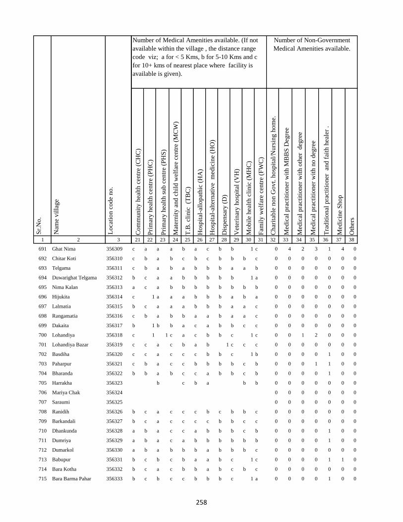
1 2 3
Lo
cati
on
co
de
no
.
Nam
e v
illa
ge
Sr.
No
.
691 Ghat Nima 356309
692 Chitar Koti 356310
693 Telgama 356311
694 Duwarighat Telgama 356312
695 Nima Kalan 356313
696 Hijukita 356314
697 Lalmatia 356315
698 Rangamatia 356316
699 Dakaita 356317
700 Lohandiya 356318
701 Lohandiya Bazar 356319
702 Basdiha 356320
703 Paharpur 356321
704 Bharanda 356322
705 Harrakha 356323
706 Mariya Chak 356324
707 Saraumi 356325
708 Ranidih 356326
709 Barkandali 356327
710 Dhankunda 356328
711 Dumriya 356329
712 Dumarkol 356330
713 Babupur 356331
714 Bara Kotha 356332
715 Bara Barma Pahar 356333
Co
mm
un
ity
hea
lth
cen
tre
(CH
C)
Pri
mar
y h
ealt
h c
entr
e (P
HC
)
Pri
mar
y h
ealt
h s
ub
cen
tre
(PH
S)
Mat
ern
ity
an
d c
hil
d w
elfa
re c
entr
e (M
CW
)
T.B
. cl
inic
(T
BC
)
Ho
spit
al-a
llo
pat
hic
(H
A)
Ho
spit
al-a
lter
nat
ive
med
icin
e (H
O)
Dis
pen
sary
(D
)
Vet
erin
ary
ho
spit
al (
VH
)
Mo
bil
e h
ealt
h c
lin
ic (
MH
C)
Fam
ily
wel
fare
cen
tre
(FW
C)
Ch
arit
able
no
n G
ov
t. h
osp
ital
/Nu
rsin
g h
om
e.
Med
ical
pra
ctit
ion
er w
ith
MB
BS
Deg
ree
Med
ical
pra
ctit
ion
er w
ith
oth
er
deg
ree
Med
ical
pra
ctit
ion
er w
ith
no
deg
ree
Tra
dit
ion
al p
ract
itio
ner
an
d f
aith
hea
ler
.
Med
icin
e S
ho
p
Oth
ers
21 22 23 24 25 26 27 28 29 30 31 32 33 34 35 36 37 38
Number of Non-Government
Medical Amenities available.
Number of Medical Amenities available. (If not
available within the village , the distance range
code viz; a for < 5 Kms, b for 5-10 Kms and c
for 10+ kms of nearest place where facility is
available is given).
c a a a b a c b b 1 c 0 4 2 3 1 4 0
c b a b c b c b b b c 0 0 0 0 0 0 0
c b a b a b b b a a b 0 0 0 0 0 0 0
b c a a b b b b b 1 a 0 0 0 0 0 0 0
a c a b b b b b b b b 0 0 0 0 0 0 0
c 1 a a a b b b a b a 0 0 0 0 0 0 0
b c a a a b b b a a c 0 0 0 0 0 0 0
c b a b b a a b a a c 0 0 0 0 0 0 0
b 1 b b a c a b b c c 0 0 0 0 0 0 0
c 1 1 c a c b b c 1 c 0 0 1 2 0 0 0
c c a c b a b 1 c c c 0 0 0 0 0 0 0
c c a c c c b b c 1 b 0 0 0 0 1 0 0
c b a c c b b b b c b 0 0 0 1 1 0 0
b b a b c c a b b c b 0 0 0 0 1 0 0
b c b a b b 0 0 0 0 0 0 0
0 0 0 0 0 0 0
0 0 0 0 0 0 0
b c a c c c b c b b c 0 0 0 0 0 0 0
b c a c c c c b b c c 0 0 0 0 0 0 0
a b a c c a b b b c b 0 0 0 0 1 0 0
a b a c a b b b b b b 0 0 0 0 1 0 0
a b a b b b a b b b c 0 0 0 0 0 0 0
b c b c b a a b c 1 c 0 0 0 0 1 1 0
b c a c b b a b c b c 0 0 0 0 0 0 0
b c b c c b b b c 1 a 0 0 0 0 1 0 0
258

1 2 3
Lo
cati
on
co
de
no
.
Nam
e v
illa
ge
Sr.
No
.
716 Tatkunda 356334
717 Chhota Barma 356335
718 Debdanr 356336
719 Surla 356337
720 Dumria 356338
721 Chhota Khadahara 356339
722 Bara Khadahara 356340
723 Harkata 356341
724 Bara Khairbani 356342
725 Baisabaran 356343
726 Jurgura 356344
727 Dahua 356345
728 Kusumghati 356346
729 Lutibahiar 356347
730 Lilatari 356348
731 Haripur 356349
732 Hahajor 356350
733 Panchrukhi 356351
734 Rangamatia 356352
735 Chhota Khairbani 356353
736 Chhota Bhorai 356354
737 Bara Bhorai 356355
738 Taljhari 356356
739 Kesgoria 356357
740 Pakaria 356358
Co
mm
un
ity
hea
lth
cen
tre
(CH
C)
Pri
mar
y h
ealt
h c
entr
e (P
HC
)
Pri
mar
y h
ealt
h s
ub
cen
tre
(PH
S)
Mat
ern
ity
an
d c
hil
d w
elfa
re c
entr
e (M
CW
)
T.B
. cl
inic
(T
BC
)
Ho
spit
al-a
llo
pat
hic
(H
A)
Ho
spit
al-a
lter
nat
ive
med
icin
e (H
O)
Dis
pen
sary
(D
)
Vet
erin
ary
ho
spit
al (
VH
)
Mo
bil
e h
ealt
h c
lin
ic (
MH
C)
Fam
ily
wel
fare
cen
tre
(FW
C)
Ch
arit
able
no
n G
ov
t. h
osp
ital
/Nu
rsin
g h
om
e.
Med
ical
pra
ctit
ion
er w
ith
MB
BS
Deg
ree
Med
ical
pra
ctit
ion
er w
ith
oth
er
deg
ree
Med
ical
pra
ctit
ion
er w
ith
no
deg
ree
Tra
dit
ion
al p
ract
itio
ner
an
d f
aith
hea
ler
.
Med
icin
e S
ho
p
Oth
ers
21 22 23 24 25 26 27 28 29 30 31 32 33 34 35 36 37 38
Number of Non-Government
Medical Amenities available.
Number of Medical Amenities available. (If not
available within the village , the distance range
code viz; a for < 5 Kms, b for 5-10 Kms and c
for 10+ kms of nearest place where facility is
available is given).
b c a c b b b b c 1 b 0 0 0 0 1 0 0
b b a b b b b b b b a 0 0 0 0 0 0 0
b c a c c b b b c 1 c 0 0 0 0 0 1 0
c b 1 b c b a b b a c 0 0 0 0 1 0 0
c b a b c a b b b a c 0 0 0 0 0 0 0
c b b b c c b b b a c 0 0 0 0 0 0 0
0 0 0 0 0 0 0
a b b b b a c b b b b 0 0 0 0 0 0 0
c c a b c c b b c b b 0 0 0 0 0 0 0
a c a c b b b b c b b 0 0 0 0 0 0 0
b b a b b c a b b 1 b 0 0 0 0 0 0 0
c c a b b b a c b a a 0 1 1 3 1 4 0
b b b b a c b b a c c 0 0 0 0 0 0 0
c b a c b c c b a b c 0 0 0 0 1 0 0
b b a b c a b b c 1 c 0 0 0 0 0 0 0
b b b b c b a b b c b 0 0 0 0 0 0 0
c c a c c b a b c c b 0 0 0 0 1 0 0
c a b c c c 0 0 0 0 0 0 0
0 0 0 0 0 0 0
0 0 0 0 0 0 0
c c b c c b c b b c c 0 1 2 2 2 1 0
b b b b c b b a c a b 0 0 0 0 0 0 0
c c a c b b c b c c c 0 0 0 0 0 0 0
c c a c b b c c c c c 0 0 0 0 1 0 0
c c a c b a c c c b c 0 2 2 2 1 2 0
259

1 2 3
Lo
cati
on
co
de
no
.
Nam
e v
illa
ge
Sr.
No
.
741 Jaggora 356359
742 Bador 356360
743 Taratikar 356361
744 Bichduba 356362
745 Telodhuni 356363
746 Madgigora 356364
747 Dighi 356365
748 Gopali 356366
749 Dabra 356367
750 Rohari Naryanpur 356368
751 Jolopahari 356369
752 Raydih 356370
753 Piaram 356371
754 Phulbaria 356372
755 Harra 356373
756 Mahuabathan 356374
757 Gadial 356375
758 Chakra 356376
759 Bara Dhanbandhi 356377
760 Chhota Dhanbandhi 356378
761 Tetardiha 356379
762 Baramasia 356380
763 Kajribhita 356381
764 Adro 356382
765 Chhota Amra 356383
Co
mm
un
ity
hea
lth
cen
tre
(CH
C)
Pri
mar
y h
ealt
h c
entr
e (P
HC
)
Pri
mar
y h
ealt
h s
ub
cen
tre
(PH
S)
Mat
ern
ity
an
d c
hil
d w
elfa
re c
entr
e (M
CW
)
T.B
. cl
inic
(T
BC
)
Ho
spit
al-a
llo
pat
hic
(H
A)
Ho
spit
al-a
lter
nat
ive
med
icin
e (H
O)
Dis
pen
sary
(D
)
Vet
erin
ary
ho
spit
al (
VH
)
Mo
bil
e h
ealt
h c
lin
ic (
MH
C)
Fam
ily
wel
fare
cen
tre
(FW
C)
Ch
arit
able
no
n G
ov
t. h
osp
ital
/Nu
rsin
g h
om
e.
Med
ical
pra
ctit
ion
er w
ith
MB
BS
Deg
ree
Med
ical
pra
ctit
ion
er w
ith
oth
er
deg
ree
Med
ical
pra
ctit
ion
er w
ith
no
deg
ree
Tra
dit
ion
al p
ract
itio
ner
an
d f
aith
hea
ler
.
Med
icin
e S
ho
p
Oth
ers
21 22 23 24 25 26 27 28 29 30 31 32 33 34 35 36 37 38
Number of Non-Government
Medical Amenities available.
Number of Medical Amenities available. (If not
available within the village , the distance range
code viz; a for < 5 Kms, b for 5-10 Kms and c
for 10+ kms of nearest place where facility is
available is given).
c c a c a c c c b b c 0 0 0 0 0 0 0
c c c c b c c c b b c 0 0 0 0 1 0 0
0 0 0 0 0 0 0
c c a c c c c c b b b 0 0 0 0 0 0 0
c c a c c b c c b a a 0 0 0 0 1 0 0
c c a c c c c c a b c 0 0 0 0 0 0 0
c c a c c b c c b b c 0 0 0 0 0 0 0
b a b b c a a c b a c 0 0 0 0 0 0 0
b b a b c b b b a a c 0 0 0 0 1 0 0
b b a b b b c b a b c 0 0 0 0 0 0 0
b b b a c b a b b 0 0 0 0 0 0 0
0 0 0 0 0 0 0
c b 1 1 b b b b b a b 0 0 0 0 0 0 0
b b a b b b b b c c b 0 0 0 0 1 0 0
b b b b b b a b b b a 0 0 0 0 1 0 0
b c a b b b a b b c c 0 0 0 0 0 0 0
a b a b b b a b b c c 0 0 0 0 0 0 0
b c a c a a b b a c c 0 0 0 0 1 0 0
b c a c b c b b a c b 0 0 0 0 0 0 0
b c a c a c b b c b b 0 0 0 0 1 0 0
b a b a b b c c 0 0 0 0 0 0 0
0 0 0 0 0 0 0
b c a c c c a b c a a 0 0 0 0 1 0 0
b c b c c c b b c c b 0 2 2 2 1 2 0
b b a a c c c b c c a 0 0 0 0 0 0 0
260

1 2 3
Lo
cati
on
co
de
no
.
Nam
e v
illa
ge
Sr.
No
.
766 Tulsipur 356384
767 Lohatamba And Agoia 356385
768 Bhalgora 356386
769 Deonapur 356387
770 Bhagwanpur 356388
771 Bara Malbhita 356389
772 Chhota Malbhita 356390
773 Tikrigora 356391
774 Gamhar Pahar 356392
775 Katar Pahar 356393
776 Kisma Pahar 356394
777 Malbhita Tola 356395
778 Chhota Pipra 356396
779 Pipra Hill 356397
780 Tetarbhita 356398
781 Tatgora 356399
782 Chhota Basgo 356400
783 Bara Pipra 356401
784 Salem Tok 356402
785 Kukur Pahari 356403
786 Kuschilia Pahar 356404
787 Kisma 356405
788 Bara Amarpur 356406
789 Chhota Amarpur 356407
790 Dumaria 356408
Co
mm
un
ity
hea
lth
cen
tre
(CH
C)
Pri
mar
y h
ealt
h c
entr
e (P
HC
)
Pri
mar
y h
ealt
h s
ub
cen
tre
(PH
S)
Mat
ern
ity
an
d c
hil
d w
elfa
re c
entr
e (M
CW
)
T.B
. cl
inic
(T
BC
)
Ho
spit
al-a
llo
pat
hic
(H
A)
Ho
spit
al-a
lter
nat
ive
med
icin
e (H
O)
Dis
pen
sary
(D
)
Vet
erin
ary
ho
spit
al (
VH
)
Mo
bil
e h
ealt
h c
lin
ic (
MH
C)
Fam
ily
wel
fare
cen
tre
(FW
C)
Ch
arit
able
no
n G
ov
t. h
osp
ital
/Nu
rsin
g h
om
e.
Med
ical
pra
ctit
ion
er w
ith
MB
BS
Deg
ree
Med
ical
pra
ctit
ion
er w
ith
oth
er
deg
ree
Med
ical
pra
ctit
ion
er w
ith
no
deg
ree
Tra
dit
ion
al p
ract
itio
ner
an
d f
aith
hea
ler
.
Med
icin
e S
ho
p
Oth
ers
21 22 23 24 25 26 27 28 29 30 31 32 33 34 35 36 37 38
Number of Non-Government
Medical Amenities available.
Number of Medical Amenities available. (If not
available within the village , the distance range
code viz; a for < 5 Kms, b for 5-10 Kms and c
for 10+ kms of nearest place where facility is
available is given).
b c a c c c c c b b c 0 0 0 0 1 0 0
c 1 a b b c b c c b c 0 0 0 0 0 0 0
a c a c b c b b c b c 0 0 0 0 0 0 0
b c a c b c b b c b c 0 0 0 0 1 0 0
b c a b c c b b c b c 0 1 2 2 2 1 2
a c a b c c b b b a b 0 1 2 2 2 1 0
b b b a b c a b b b b 0 0 0 0 0 0 0
b b a b b b b 0 0 0 0 0 0 0
0 0 0 0 0 0 0
0 0 0 0 0 0 0
0 0 0 0 0 0 0
b b b b c c b b b b c 0 0 0 0 0 0 0
c a b b b c 0 0 0 0 0 0 0
0 0 0 0 0 0 0
0 0 0 0 0 0 0
0 0 0 0 0 0 0
0 0 0 0 0 0 0
c b c 0 0 0 0 0 0 0
0 0 0 0 0 0 0
0 0 0 0 0 0 0
0 0 0 0 0 0 0
b c a c c c a c b b c 0 0 0 0 0 0 0
b c b c c c a c a c c 0 0 0 0 1 0 0
b b a b c c b c a c a 0 0 0 0 0 0 0
a c a c c c b b c b b 0 0 0 0 1 0 0
261

1 2 3
Lo
cati
on
co
de
no
.
Nam
e v
illa
ge
Sr.
No
.
791 Bamangawan 356409
792 Chhota Bararo 356410
793 Bararo 356411
794 Chetan Pahar 356412
795 Chakan Chak 356413
796 Domgora Pahar 356414
797 Elkar Pahar 356415
798 Moter Pahar 356416
799 Dhauatoka 356417
800 Bariartok 356418
801 Bara Telo 356419
802 Chhota Telo 356420
803 Jajotola Barhua 356421
804 Bara Amra 356422
805 Balkani 356423
806 Sundai 356424
807 Garbhu Tola 356425
808 Chhota Simmi 356426
809 Bara Simmi 356427
810 Bandhgora 356428
811 Kesarogora 356429
812 Chhota Chapri 356430
813 Dholna Pahar 356431
814 Telotok 356432
815 Charanpahar 356433
Co
mm
un
ity
hea
lth
cen
tre
(CH
C)
Pri
mar
y h
ealt
h c
entr
e (P
HC
)
Pri
mar
y h
ealt
h s
ub
cen
tre
(PH
S)
Mat
ern
ity
an
d c
hil
d w
elfa
re c
entr
e (M
CW
)
T.B
. cl
inic
(T
BC
)
Ho
spit
al-a
llo
pat
hic
(H
A)
Ho
spit
al-a
lter
nat
ive
med
icin
e (H
O)
Dis
pen
sary
(D
)
Vet
erin
ary
ho
spit
al (
VH
)
Mo
bil
e h
ealt
h c
lin
ic (
MH
C)
Fam
ily
wel
fare
cen
tre
(FW
C)
Ch
arit
able
no
n G
ov
t. h
osp
ital
/Nu
rsin
g h
om
e.
Med
ical
pra
ctit
ion
er w
ith
MB
BS
Deg
ree
Med
ical
pra
ctit
ion
er w
ith
oth
er
deg
ree
Med
ical
pra
ctit
ion
er w
ith
no
deg
ree
Tra
dit
ion
al p
ract
itio
ner
an
d f
aith
hea
ler
.
Med
icin
e S
ho
p
Oth
ers
21 22 23 24 25 26 27 28 29 30 31 32 33 34 35 36 37 38
Number of Non-Government
Medical Amenities available.
Number of Medical Amenities available. (If not
available within the village , the distance range
code viz; a for < 5 Kms, b for 5-10 Kms and c
for 10+ kms of nearest place where facility is
available is given).
a b c b b b c a 0 0 0 0 0 0 0
0 0 0 0 0 0 0
a a a a b c a b c b c 0 0 0 0 0 0 0
b b b b c b c 0 0 0 0 0 0 0
0 0 0 0 0 0 0
0 0 0 0 0 0 0
0 0 0 0 0 0 0
b c b b c a b 0 0 0 0 0 0 0
0 0 0 0 0 0 0
0 0 0 0 0 0 0
b b b b c a a b b a a 0 0 0 0 0 0 0
b c a a b b b b b b c 0 0 0 0 0 0 0
b c a c b b c b b b c 0 0 0 0 0 0 0
b c a c b a b b b a c 0 0 0 0 0 0 0
a b a a b b a b b a b 0 0 0 0 0 0 0
a b a b b b a b a c b 0 0 0 0 0 0 0
a c a b b b b b b b c 0 0 0 0 0 0 0
b c b c b b a c b c c 0 0 0 0 0 0 0
b c a c b b c c a c a 0 0 0 0 0 0 0
b b a c b b c c a c b 0 0 0 0 0 0 0
b c a c a a c c a c a 0 0 0 0 1 0 0
c c a c b c c c b b c 0 0 0 0 1 0 0
a c a c a c c c b c c 0 0 0 0 0 0 0
b a b b c c 0 0 0 0 0 0 0
0 0 0 0 0 0 0
262

1 2 3
Lo
cati
on
co
de
no
.
Nam
e v
illa
ge
Sr.
No
.
816 Keriapahar 356434
817 Karampahar 356435
818 Masanpahar 356436
819 Dumarpahar 356437
820 Kamugora 356438
821 Bansdandapahar 356439
822 Bansdanda 356440
823 Dhunigora 356441
824 Bara Basgi 356442
825 Satbera 356443
826 Satbera 356444
827 Chetrampahar 356445
828 Hanidhoni 356446
829 Bara Chapri 356447
830 Madarpahar 356448
831 Chapri Bara 356449
832 Tamlipahar 356450
833 Bara Chapri 356451
834 Madgigora 356452
835 Karamtanr 356453
836 Dumarpahar 356454
837 Chhota Ghogha 356455
838 Bara Karlopahar 356456
839 Bara Ghogha 356457
840 Bara Kerlo 356458
Co
mm
un
ity
hea
lth
cen
tre
(CH
C)
Pri
mar
y h
ealt
h c
entr
e (P
HC
)
Pri
mar
y h
ealt
h s
ub
cen
tre
(PH
S)
Mat
ern
ity
an
d c
hil
d w
elfa
re c
entr
e (M
CW
)
T.B
. cl
inic
(T
BC
)
Ho
spit
al-a
llo
pat
hic
(H
A)
Ho
spit
al-a
lter
nat
ive
med
icin
e (H
O)
Dis
pen
sary
(D
)
Vet
erin
ary
ho
spit
al (
VH
)
Mo
bil
e h
ealt
h c
lin
ic (
MH
C)
Fam
ily
wel
fare
cen
tre
(FW
C)
Ch
arit
able
no
n G
ov
t. h
osp
ital
/Nu
rsin
g h
om
e.
Med
ical
pra
ctit
ion
er w
ith
MB
BS
Deg
ree
Med
ical
pra
ctit
ion
er w
ith
oth
er
deg
ree
Med
ical
pra
ctit
ion
er w
ith
no
deg
ree
Tra
dit
ion
al p
ract
itio
ner
an
d f
aith
hea
ler
.
Med
icin
e S
ho
p
Oth
ers
21 22 23 24 25 26 27 28 29 30 31 32 33 34 35 36 37 38
Number of Non-Government
Medical Amenities available.
Number of Medical Amenities available. (If not
available within the village , the distance range
code viz; a for < 5 Kms, b for 5-10 Kms and c
for 10+ kms of nearest place where facility is
available is given).
a b c a c c 0 0 0 0 0 0 0
0 0 0 0 0 0 0
0 0 0 0 0 0 0
0 0 0 0 0 0 0
0 0 0 0 0 0 0
0 0 0 0 0 0 0
b b b b b c b c 0 0 0 0 0 0 0
0 0 0 0 0 0 0
0 0 0 0 0 0 0
b b c b b b c b b 0 0 0 0 0 0 0
0 0 0 0 0 0 0
0 0 0 0 0 0 0
0 0 0 0 0 0 0
a c b c b a b b b c 0 0 0 0 0 0 0
0 0 0 0 0 0 0
a c b c a a b b b a b 0 0 0 0 0 0 0
0 0 0 0 0 0 0
0 0 0 0 0 0 0
0 0 0 0 0 0 0
0 0 0 0 0 0 0
0 0 0 0 0 0 0
0 0 0 0 0 0 0
0 0 0 0 0 0 0
0 0 0 0 0 0 0
b c b c b 0 0 0 0 0 0 0
263
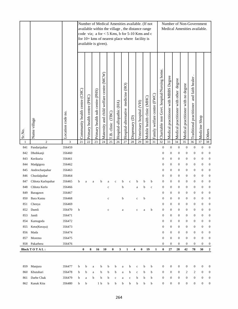
1 2 3
Lo
cati
on
co
de
no
.
Nam
e v
illa
ge
Sr.
No
.
841 Pandaripahar 356459
842 Dhobkanji 356460
843 Kerikuria 356461
844 Madgigora 356462
845 Androcharpahar 356463
846 Chuolalpahar 356464
847 Chhota Karlopahar 356465
848 Chhota Kerlo 356466
849 Baragawn 356467
850 Bara Kamu 356468
851 Chenya 356469
852 Dumli 356470
853 Jandi 356471
854 Kamugoda 356472
855 Keto(Keraya) 356473
856 Mada 356474
857 Moremo 356475
858 Pakarbera 356476
Block T O T A L :
859 Manjura 356477
860 Khutahari 356478
861 Darbe Chak 356479
862 Kanak Kita 356480
Co
mm
un
ity
hea
lth
cen
tre
(CH
C)
Pri
mar
y h
ealt
h c
entr
e (P
HC
)
Pri
mar
y h
ealt
h s
ub
cen
tre
(PH
S)
Mat
ern
ity
an
d c
hil
d w
elfa
re c
entr
e (M
CW
)
T.B
. cl
inic
(T
BC
)
Ho
spit
al-a
llo
pat
hic
(H
A)
Ho
spit
al-a
lter
nat
ive
med
icin
e (H
O)
Dis
pen
sary
(D
)
Vet
erin
ary
ho
spit
al (
VH
)
Mo
bil
e h
ealt
h c
lin
ic (
MH
C)
Fam
ily
wel
fare
cen
tre
(FW
C)
Ch
arit
able
no
n G
ov
t. h
osp
ital
/Nu
rsin
g h
om
e.
Med
ical
pra
ctit
ion
er w
ith
MB
BS
Deg
ree
Med
ical
pra
ctit
ion
er w
ith
oth
er
deg
ree
Med
ical
pra
ctit
ion
er w
ith
no
deg
ree
Tra
dit
ion
al p
ract
itio
ner
an
d f
aith
hea
ler
.
Med
icin
e S
ho
p
Oth
ers
21 22 23 24 25 26 27 28 29 30 31 32 33 34 35 36 37 38
Number of Non-Government
Medical Amenities available.
Number of Medical Amenities available. (If not
available within the village , the distance range
code viz; a for < 5 Kms, b for 5-10 Kms and c
for 10+ kms of nearest place where facility is
available is given).
0 0 0 0 0 0 0
0 0 0 0 0 0 0
0 0 0 0 0 0 0
0 0 0 0 0 0 0
0 0 0 0 0 0 0
0 0 0 0 0 0 0
b a a b a c b c b b b 0 0 0 0 0 0 0
c b a b c 0 0 0 0 0 0 0
0 0 0 0 0 0 0
c b c b 0 0 0 0 0 0 0
0 0 0 0 0 0 0
b c a c a b 0 0 0 0 0 0 0
0 0 0 0 0 0 0
0 0 0 0 0 0 0
0 0 0 0 0 0 0
0 0 0 0 0 0 0
0 0 0 0 0 0 0
0 0 0 0 0 0 0
0 8 16 10 0 3 1 4 0 19 1 0 27 28 42 78 30 2
b b a b b b a b c b b 0 0 0 0 0 0 0
b b a b b b a b c b b 0 0 0 2 2 0 0
b a b b b c a c b b b 0 0 0 0 0 0 0
b b 1 b b b b b b b b 0 0 0 0 0 0 0
264

1 2 3
Lo
cati
on
co
de
no
.
Nam
e v
illa
ge
Sr.
No
.
863 Sarbhanga 356481
864 Nunajagir 356482
865 Murgia Chak 356483
866 Sibotar Kita 356484
867 Rup Chak 356485
868 Sarautia 356486
869 Gopalpur 356487
870 Ranu Chak 356488
871 Chauchak 356489
872 Saha Chak 356490
873 Kumhrakol 356491
874 Singpur 356492
875 Baje Kita 356493
876 Garbhudih 356494
877 Sidhari 356495
878 Samu Kita 356496
879 Baje Kita 356497
880 Sidhari 356498
881 Mohani 356499
882 Bakanpur 356500
883 Dighi 356501
884 Satbigha 356502
885 Modi Chak 356503
886 Jagi Milik 356504
887 Baje Kita 356505
Co
mm
un
ity
hea
lth
cen
tre
(CH
C)
Pri
mar
y h
ealt
h c
entr
e (P
HC
)
Pri
mar
y h
ealt
h s
ub
cen
tre
(PH
S)
Mat
ern
ity
an
d c
hil
d w
elfa
re c
entr
e (M
CW
)
T.B
. cl
inic
(T
BC
)
Ho
spit
al-a
llo
pat
hic
(H
A)
Ho
spit
al-a
lter
nat
ive
med
icin
e (H
O)
Dis
pen
sary
(D
)
Vet
erin
ary
ho
spit
al (
VH
)
Mo
bil
e h
ealt
h c
lin
ic (
MH
C)
Fam
ily
wel
fare
cen
tre
(FW
C)
Ch
arit
able
no
n G
ov
t. h
osp
ital
/Nu
rsin
g h
om
e.
Med
ical
pra
ctit
ion
er w
ith
MB
BS
Deg
ree
Med
ical
pra
ctit
ion
er w
ith
oth
er
deg
ree
Med
ical
pra
ctit
ion
er w
ith
no
deg
ree
Tra
dit
ion
al p
ract
itio
ner
an
d f
aith
hea
ler
.
Med
icin
e S
ho
p
Oth
ers
21 22 23 24 25 26 27 28 29 30 31 32 33 34 35 36 37 38
Number of Non-Government
Medical Amenities available.
Number of Medical Amenities available. (If not
available within the village , the distance range
code viz; a for < 5 Kms, b for 5-10 Kms and c
for 10+ kms of nearest place where facility is
available is given).
b b b c b b b a a 0 0 0 0 0 0 0
0 0 0 0 0 0 0
0 0 0 0 0 0 0
0 0 0 0 0 0 0
0 0 0 0 0 0 0
b b a b b b b c b 0 0 0 0 0 0 0
0 0 0 0 0 0 0
0 0 0 0 0 0 0
a b a a b b b b a b c 0 0 0 0 0 0 0
a b b b b b b c c 0 0 0 0 0 0 0
0 0 0 0 0 0 0
b b b b a b b a 0 0 0 0 0 0 0
0 0 0 0 0 0 0
b b b a c b a c c 0 0 0 0 0 0 0
0 0 0 0 0 0 0
b b b a b b b b 0 0 0 0 0 0 0
0 0 0 0 0 0 0
c b 1 b a b b b c b b 0 0 0 0 0 0 0
a a a b b c a b c b c 0 0 0 0 1 1 0
b a 1 b a b a b c a a 0 0 0 0 0 0 0
b b b b b b b c 0 0 0 0 0 0 0
0 0 0 0 0 0 0
0 0 0 0 0 0 0
0 0 0 0 0 0 0
0 0 0 0 0 0 0
265

1 2 3
Lo
cati
on
co
de
no
.
Nam
e v
illa
ge
Sr.
No
.
888 Sital 356506
889 Mali Chak 356507
890 Gorgawan 356508
891 Naraini 356509
892 Dhobia Chak 356510
893 Bairia Chak 356511
894 Gansagar 356512
895 Bairia Kita 356513
896 Sonbarsa 356514
897 Milik Hanwara 356515
898 Hanwara 356516
899 Ramkol 356517
900 Tiya Chak 356518
901 Alimahamadpur 356519
902 Narainpur (Dompatti) 356520
903 Sahi Kita 356521
904 Narainpur (Sempatti) 356522
905 Chak Chamu 356523
906 Baija Chak 356524
907 Dumaria Khurd 356525
908 Dumaria Kalan 356526
909 Narattampur 356527
910 Biswas Khani 356528
911 Sagrampur 356529
912 Pararia 356530
Co
mm
un
ity
hea
lth
cen
tre
(CH
C)
Pri
mar
y h
ealt
h c
entr
e (P
HC
)
Pri
mar
y h
ealt
h s
ub
cen
tre
(PH
S)
Mat
ern
ity
an
d c
hil
d w
elfa
re c
entr
e (M
CW
)
T.B
. cl
inic
(T
BC
)
Ho
spit
al-a
llo
pat
hic
(H
A)
Ho
spit
al-a
lter
nat
ive
med
icin
e (H
O)
Dis
pen
sary
(D
)
Vet
erin
ary
ho
spit
al (
VH
)
Mo
bil
e h
ealt
h c
lin
ic (
MH
C)
Fam
ily
wel
fare
cen
tre
(FW
C)
Ch
arit
able
no
n G
ov
t. h
osp
ital
/Nu
rsin
g h
om
e.
Med
ical
pra
ctit
ion
er w
ith
MB
BS
Deg
ree
Med
ical
pra
ctit
ion
er w
ith
oth
er
deg
ree
Med
ical
pra
ctit
ion
er w
ith
no
deg
ree
Tra
dit
ion
al p
ract
itio
ner
an
d f
aith
hea
ler
.
Med
icin
e S
ho
p
Oth
ers
21 22 23 24 25 26 27 28 29 30 31 32 33 34 35 36 37 38
Number of Non-Government
Medical Amenities available.
Number of Medical Amenities available. (If not
available within the village , the distance range
code viz; a for < 5 Kms, b for 5-10 Kms and c
for 10+ kms of nearest place where facility is
available is given).
b b a b b b b b b b b 0 0 0 0 0 0 0
b b b b b b a b b a c 0 0 0 1 2 0 0
b c a b b b a b b a c 0 0 0 0 0 0 0
b b a b b a a b b c c 0 0 0 0 0 0 0
b a a a c b b b b b c 0 0 0 0 0 0 0
b b a a b b a c a 0 0 0 0 0 0 0
0 0 0 0 0 0 0
0 0 0 0 0 0 0
0 0 0 0 0 0 0
a a a b a 1 a 1 a b b 0 0 0 0 0 0 0
b a a b b c b c a c b 0 0 0 0 0 0 0
b b a b c b b c b 0 0 0 0 0 0 0
0 0 0 0 0 0 0
0 0 0 0 0 0 0
b b b b b a b b b c c 0 0 0 0 0 0 0
b a b b b b b b a b b 0 0 0 0 0 0 0
b b b a b b b b a b b 0 0 0 0 0 0 0
b b a b b b b b c b b 0 0 0 0 0 0 0
b c b b b b a b b b b 0 0 0 0 0 0 0
c b a b b b a b c b b 0 0 0 0 0 0 0
a c b b a a b b c a c 0 0 1 0 0 0 0
b b a b b b b b c b c 0 0 1 0 0 0 0
b b b b a a b b c b c 0 0 0 0 0 0 0
a b a b b a b b b a c 0 0 0 1 2 0 0
b b 1 1 b b a b c b c 0 0 0 1 1 1 0
266

1 2 3
Lo
cati
on
co
de
no
.
Nam
e v
illa
ge
Sr.
No
.
913 Parsa 356531
914 Bikrampur 356532
915 Koila 356533
916 Barkurua 356534
917 Barkurua 356535
918 Bataua Kita 356536
919 Batana Kita 356537
920 Batana Kita 356538
921 Sarthu 356539
922 Baghakol 356540
923 Gurhi 356541
924 Baje Kita 356542
925 Baje Kita 356543
926 Bairia Kita 356544
927 Kharaiya 356545
928 Sahajadpur 356546
929 Ghatiani 356547
930 Ghuthi 356548
931 Khurd 356549
932 Banjpur 356550
933 Teknikita 356551
934 Sirinathpur 356552
935 Nayanagar 356553
936 Singarpur 356554
937 Jatama 356555
Co
mm
un
ity
hea
lth
cen
tre
(CH
C)
Pri
mar
y h
ealt
h c
entr
e (P
HC
)
Pri
mar
y h
ealt
h s
ub
cen
tre
(PH
S)
Mat
ern
ity
an
d c
hil
d w
elfa
re c
entr
e (M
CW
)
T.B
. cl
inic
(T
BC
)
Ho
spit
al-a
llo
pat
hic
(H
A)
Ho
spit
al-a
lter
nat
ive
med
icin
e (H
O)
Dis
pen
sary
(D
)
Vet
erin
ary
ho
spit
al (
VH
)
Mo
bil
e h
ealt
h c
lin
ic (
MH
C)
Fam
ily
wel
fare
cen
tre
(FW
C)
Ch
arit
able
no
n G
ov
t. h
osp
ital
/Nu
rsin
g h
om
e.
Med
ical
pra
ctit
ion
er w
ith
MB
BS
Deg
ree
Med
ical
pra
ctit
ion
er w
ith
oth
er
deg
ree
Med
ical
pra
ctit
ion
er w
ith
no
deg
ree
Tra
dit
ion
al p
ract
itio
ner
an
d f
aith
hea
ler
.
Med
icin
e S
ho
p
Oth
ers
21 22 23 24 25 26 27 28 29 30 31 32 33 34 35 36 37 38
Number of Non-Government
Medical Amenities available.
Number of Medical Amenities available. (If not
available within the village , the distance range
code viz; a for < 5 Kms, b for 5-10 Kms and c
for 10+ kms of nearest place where facility is
available is given).
b b a a b c a b c b a 0 0 0 1 2 0 0
b b a b b b b b c b c 0 0 0 0 0 0 0
b c a b c a c 0 0 0 0 0 0 0
0 0 0 0 0 0 0
0 0 0 0 0 0 0
0 0 0 0 0 0 0
0 0 0 0 0 0 0
0 0 0 0 0 0 0
b b b a b a c a 0 0 0 0 0 0 0
0 0 0 0 0 0 0
b c b b b b b b b b b 0 0 0 0 0 0 0
b a b b b b b b a c b 0 0 0 0 0 0 0
b c b b b a b b a c b 0 0 0 0 0 0 0
b c a c b b b b a b b 0 0 0 0 0 0 0
b c b c b a a b b c b 0 0 0 0 0 0 0
b c a c b a b b c c c 0 0 0 0 0 0 0
a c a c b b b b c b c 0 0 0 0 0 0 0
b c a c b c a b c b c 0 0 0 0 0 0 0
b b a b a b c b b b b 0 0 0 0 0 0 0
b b b b b 0 0 0 0 0 0 0
0 0 0 0 0 0 0
b a 1 b b c a b b a c 0 0 0 0 0 0 0
b b b b b b a b b b c 0 0 0 0 0 0 0
b a a b b c b b a b c 0 0 0 0 0 0 0
b b b b b b c b a a a 0 0 0 0 0 0 0
267

1 2 3
Lo
cati
on
co
de
no
.
Nam
e v
illa
ge
Sr.
No
.
938 Gauri Kita 356556
939 Pindara 356557
940 Belti Kari 356558
941 Baje Kita 356559
942 Asota 356560
943 Kasba 356561
944 Bhandarchua 356562
945 Shekhu Chak 356563
946 Bhelaidih 356564
947 Doma Chak 356565
948 Bansbara 356566
949 Kita Bansbara 356567
950 Pakridih 356568
951 Kamal Chak 356569
952 Bhikhia Chak 356570
953 Andhara Kita 356571
954 Kita Andhra 356572
955 Karmatanr 356573
956 Champa Kita 356574
957 Phagu Kita 356575
958 Puran Kita 356576
959 Alola 356577
960 Dhansar 356578
961 Khurd 356579
962 Firozpur 356580
Co
mm
un
ity
hea
lth
cen
tre
(CH
C)
Pri
mar
y h
ealt
h c
entr
e (P
HC
)
Pri
mar
y h
ealt
h s
ub
cen
tre
(PH
S)
Mat
ern
ity
an
d c
hil
d w
elfa
re c
entr
e (M
CW
)
T.B
. cl
inic
(T
BC
)
Ho
spit
al-a
llo
pat
hic
(H
A)
Ho
spit
al-a
lter
nat
ive
med
icin
e (H
O)
Dis
pen
sary
(D
)
Vet
erin
ary
ho
spit
al (
VH
)
Mo
bil
e h
ealt
h c
lin
ic (
MH
C)
Fam
ily
wel
fare
cen
tre
(FW
C)
Ch
arit
able
no
n G
ov
t. h
osp
ital
/Nu
rsin
g h
om
e.
Med
ical
pra
ctit
ion
er w
ith
MB
BS
Deg
ree
Med
ical
pra
ctit
ion
er w
ith
oth
er
deg
ree
Med
ical
pra
ctit
ion
er w
ith
no
deg
ree
Tra
dit
ion
al p
ract
itio
ner
an
d f
aith
hea
ler
.
Med
icin
e S
ho
p
Oth
ers
21 22 23 24 25 26 27 28 29 30 31 32 33 34 35 36 37 38
Number of Non-Government
Medical Amenities available.
Number of Medical Amenities available. (If not
available within the village , the distance range
code viz; a for < 5 Kms, b for 5-10 Kms and c
for 10+ kms of nearest place where facility is
available is given).
b b b b b c c 0 0 0 0 0 0 0
0 0 0 0 0 0 0
a b b a a b c b a 0 0 0 0 0 0 0
0 0 0 0 0 0 0
b b a b b b a b c a b 0 0 0 0 0 0 0
a b 1 b a b a b c c b 0 0 0 0 0 0 0
b b a b b b b b b b c 0 0 0 0 0 0 0
b b a b a b c b c c a 0 0 0 0 0 0 0
b b a b b a c b c c c 0 0 0 0 0 0 0
b b a b b b b b c c b 0 0 0 0 0 0 0
b a b b c c b 0 0 0 0 0 0 0
0 0 0 0 0 0 0
b b b b b b a b b c b 0 0 0 0 0 0 0
b b b b b b a b b c b 0 0 0 0 0 0 0
b b a b b c 0 0 0 0 0 0 0
0 0 0 0 0 0 0
0 0 0 0 0 0 0
b a b b b b 0 0 0 0 0 0 0
0 0 0 0 0 0 0
0 0 0 0 0 0 0
0 0 0 0 0 0 0
b b b b b a b c 0 0 0 0 0 0 0
0 0 0 0 0 0 0
b b a b b b c b b b a 0 0 0 0 0 0 0
b b a b b b b b b b c 0 0 0 2 2 0 0
268

1 2 3
Lo
cati
on
co
de
no
.
Nam
e v
illa
ge
Sr.
No
.
963 Dharampur Ghat 356581
964 Dharampur Mal 356582
965 Chaujora Mal 356583
966 Chaujora Ghat 356584
967 Kamargawan 356585
968 Mansura 356586
969 Sadulabhita 356587
970 Gosain Chak 356588
971 Madhupur 356589
972 Gokula 356590
973 Majhona 356591
974 Daniala 356592
975 Khaira 356593
976 Fouzdar Kita Ghat 356594
977 Ghatdiarhi 356595
978 Diarhi Kita 356596
979 Manoharpur Kita 356597
980 Manoharpur 356598
981 Solahbighia 356599
982 Jhagarua 356600
983 Ramchandarpur 356601
984 Maigar Kita 356602
985 Kita Majhona 356603
986 Khara Kita 356604
987 Chainpur 356605
Co
mm
un
ity
hea
lth
cen
tre
(CH
C)
Pri
mar
y h
ealt
h c
entr
e (P
HC
)
Pri
mar
y h
ealt
h s
ub
cen
tre
(PH
S)
Mat
ern
ity
an
d c
hil
d w
elfa
re c
entr
e (M
CW
)
T.B
. cl
inic
(T
BC
)
Ho
spit
al-a
llo
pat
hic
(H
A)
Ho
spit
al-a
lter
nat
ive
med
icin
e (H
O)
Dis
pen
sary
(D
)
Vet
erin
ary
ho
spit
al (
VH
)
Mo
bil
e h
ealt
h c
lin
ic (
MH
C)
Fam
ily
wel
fare
cen
tre
(FW
C)
Ch
arit
able
no
n G
ov
t. h
osp
ital
/Nu
rsin
g h
om
e.
Med
ical
pra
ctit
ion
er w
ith
MB
BS
Deg
ree
Med
ical
pra
ctit
ion
er w
ith
oth
er
deg
ree
Med
ical
pra
ctit
ion
er w
ith
no
deg
ree
Tra
dit
ion
al p
ract
itio
ner
an
d f
aith
hea
ler
.
Med
icin
e S
ho
p
Oth
ers
21 22 23 24 25 26 27 28 29 30 31 32 33 34 35 36 37 38
Number of Non-Government
Medical Amenities available.
Number of Medical Amenities available. (If not
available within the village , the distance range
code viz; a for < 5 Kms, b for 5-10 Kms and c
for 10+ kms of nearest place where facility is
available is given).
b b a b b b b b b a c 0 0 0 2 2 0 0
b b a b b a b b b b a 0 0 0 0 0 0 0
b b b b b b b b b 0 0 0 0 0 0 0
0 0 0 0 0 0 0
b b a b b b a b a a b 0 0 0 0 0 0 0
b a b a b c c c 0 0 0 0 0 0 0
0 0 0 0 0 0 0
0 0 0 0 0 0 0
0 0 0 0 0 0 0
b b b b a b b c c b 0 0 0 0 0 0 0
0 0 0 0 0 0 0
b a b b b b a b b b b 0 0 0 0 0 0 0
b b b b b b b b c c b 0 0 0 0 0 0 0
b b a b b b a b c c c 0 0 0 0 0 0 0
c b b a b b b b c b b 0 0 0 0 0 0 0
b c b c c 0 0 0 0 0 0 0
0 0 0 0 0 0 0
b b a b b 0 0 0 0 0 0 0
0 0 0 0 0 0 0
b a b b b 0 0 0 0 0 0 0
0 0 0 0 0 0 0
0 0 0 0 0 0 0
0 0 0 0 0 0 0
0 0 0 0 0 0 0
b b b b b a b c 0 0 0 0 0 0 0
269

1 2 3
Lo
cati
on
co
de
no
.
Nam
e v
illa
ge
Sr.
No
.
988 Darha 356606
989 Ramchandarpur 356607
990 Ghat Jagarnathpur 356608
991 Jagarnathpur Mal 356609
992 Jiajori 356610
993 Rai Kita 356611
994 Jatakothi 356612
995 Bagjori 356613
996 Harlabahiar 356614
997 Balachini 356615
998 Ghat Jagatpur 356616
999 Chand Chak Ghat 356617
1000 Ramchandarpur 356618
1001 Lakarha 356619
1002 Taran Kita 356620
1003 Chamgadra Darunbatia 356621
1004 Kachuamal Chhit 356622
1005 Maskand Kachua 356623
1006 Kachuamal Chhit 356624
1007 Kachua Raksi 356625
1008 Raksa Maskand 356626
1009 Maskand Kachua 356627
1010 Lilabari 356628
1011 Kachua Raksi 356629
1012 Maskand Chhit 356630
Co
mm
un
ity
hea
lth
cen
tre
(CH
C)
Pri
mar
y h
ealt
h c
entr
e (P
HC
)
Pri
mar
y h
ealt
h s
ub
cen
tre
(PH
S)
Mat
ern
ity
an
d c
hil
d w
elfa
re c
entr
e (M
CW
)
T.B
. cl
inic
(T
BC
)
Ho
spit
al-a
llo
pat
hic
(H
A)
Ho
spit
al-a
lter
nat
ive
med
icin
e (H
O)
Dis
pen
sary
(D
)
Vet
erin
ary
ho
spit
al (
VH
)
Mo
bil
e h
ealt
h c
lin
ic (
MH
C)
Fam
ily
wel
fare
cen
tre
(FW
C)
Ch
arit
able
no
n G
ov
t. h
osp
ital
/Nu
rsin
g h
om
e.
Med
ical
pra
ctit
ion
er w
ith
MB
BS
Deg
ree
Med
ical
pra
ctit
ion
er w
ith
oth
er
deg
ree
Med
ical
pra
ctit
ion
er w
ith
no
deg
ree
Tra
dit
ion
al p
ract
itio
ner
an
d f
aith
hea
ler
.
Med
icin
e S
ho
p
Oth
ers
21 22 23 24 25 26 27 28 29 30 31 32 33 34 35 36 37 38
Number of Non-Government
Medical Amenities available.
Number of Medical Amenities available. (If not
available within the village , the distance range
code viz; a for < 5 Kms, b for 5-10 Kms and c
for 10+ kms of nearest place where facility is
available is given).
0 0 0 0 0 0 0
b b a b b b b b a b a 0 0 0 2 2 0 0
a b b b b b c 0 0 0 0 0 0 0
0 0 0 0 0 0 0
b b a b b a c b b b a 0 0 0 2 2 0 0
b b a b b b b b b b b 0 0 0 2 2 0 0
b b a b b b b b b b b 0 0 0 2 2 0 0
a b b b a b b b b 0 0 0 0 0 0 0
0 0 0 0 0 0 0
b a a b b b b b a a a 0 0 0 0 0 0 0
b b a c b c c c 0 0 0 0 0 0 0
0 0 0 0 0 0 0
0 0 0 0 0 0 0
b b c a a b c c b 0 2 2 2 2 2 2
0 0 0 0 0 0 0
0 0 0 0 0 0 0
b b b a a a a a b b c 0 0 0 0 0 1 0
0 0 0 0 0 0 0
0 0 0 0 0 0 0
b b a c c b b b c b c 0 2 2 1 2 2 0
b c a a a b c a c c c 0 0 0 0 0 0 0
b b a a a b c a b c a 0 0 0 0 0 0 0
b b b b b b b b c 0 0 0 0 0 0 0
0 0 0 0 0 0 0
0 0 0 0 0 0 0
270

1 2 3
Lo
cati
on
co
de
no
.
Nam
e v
illa
ge
Sr.
No
.
1013 Maskand Kita 356631
1014 Sirsa Kalan 356632
1015 Sirsa Khurd 356633
1016 Bholu Chak 356634
1017 Mahuara Ghat 356635
1018 Mahuara 356636
1019 Fauj Kita 356637
1020 Logain 356638
1021 Asmantikar 356639
1022 Maskand Bhanjpur 356640
1023 Gidra Pathar 356641
1024 Lamahaghat 356642
1025 Hirai Chak 356643
1026 Sukhbona 356644
1027 Sankar Kita 356645
1028 Rahim Kita 356646
1029 Hajra Chak 356647
1030 Lachmania Kita 356648
1031 Lilambar 356649
1032 Maskand Chhit 356650
1033 Bishambhar Kita 356651
1034 Kita Bishambhara 356652
1035 Gunia 356653
1036 Harin Chora 356654
1037 Baghakol 356655
Co
mm
un
ity
hea
lth
cen
tre
(CH
C)
Pri
mar
y h
ealt
h c
entr
e (P
HC
)
Pri
mar
y h
ealt
h s
ub
cen
tre
(PH
S)
Mat
ern
ity
an
d c
hil
d w
elfa
re c
entr
e (M
CW
)
T.B
. cl
inic
(T
BC
)
Ho
spit
al-a
llo
pat
hic
(H
A)
Ho
spit
al-a
lter
nat
ive
med
icin
e (H
O)
Dis
pen
sary
(D
)
Vet
erin
ary
ho
spit
al (
VH
)
Mo
bil
e h
ealt
h c
lin
ic (
MH
C)
Fam
ily
wel
fare
cen
tre
(FW
C)
Ch
arit
able
no
n G
ov
t. h
osp
ital
/Nu
rsin
g h
om
e.
Med
ical
pra
ctit
ion
er w
ith
MB
BS
Deg
ree
Med
ical
pra
ctit
ion
er w
ith
oth
er
deg
ree
Med
ical
pra
ctit
ion
er w
ith
no
deg
ree
Tra
dit
ion
al p
ract
itio
ner
an
d f
aith
hea
ler
.
Med
icin
e S
ho
p
Oth
ers
21 22 23 24 25 26 27 28 29 30 31 32 33 34 35 36 37 38
Number of Non-Government
Medical Amenities available.
Number of Medical Amenities available. (If not
available within the village , the distance range
code viz; a for < 5 Kms, b for 5-10 Kms and c
for 10+ kms of nearest place where facility is
available is given).
0 0 0 0 0 0 0
b b b a a b b 0 0 0 0 0 0 0
0 0 0 0 0 0 0
0 0 0 0 0 0 0
a a 1 a a b b a a b a 0 0 0 0 0 0 0
b a b b a a c 0 0 0 0 0 0 0
0 0 0 0 0 0 0
b b a b b 0 0 1 0 0 0 0
0 0 0 0 0 0 0
b b b 0 0 0 0 0 0 0
0 0 0 0 0 0 0
0 0 0 0 0 0 0
0 0 0 0 0 0 0
0 0 0 0 0 0 0
0 0 0 0 0 0 0
b 0 0 0 0 0 0 0
0 0 0 0 0 0 0
0 0 0 0 0 0 0
a 0 0 0 0 0 0 0
0 0 0 0 0 0 0
b b a b b b b c b b c 0 0 0 0 0 0 0
a a a a a b b b b b c 0 0 0 0 0 1 0
a a 1 a a b b b a a c 0 0 0 0 0 0 0
b a a b b b a b a a a 0 0 0 0 0 0 0
b b 1 b b b a b c c c 0 0 0 0 0 0 0
271

1 2 3
Lo
cati
on
co
de
no
.
Nam
e v
illa
ge
Sr.
No
.
1038 Dakaita 356656
1039 Dakaitaghat 356657
1040 Tetaria 356658
1041 Bhalu Kita 356659
1042 Tewarijor 356660
1043 Beltikri 356661
1044 Jhapania 356662
1045 Khairaghat 356663
1046 Lamha Mal 356664
1047 Chand Chak 356665
1048 Ghospur 356666
1049 Dahara 356667
1050 Moti Chak 356668
1051 Bhartha Chak 356669
1052 Bhairo Kita 356670
1053 Lachminia Kita 356671
1054 Anjna 356672
1055 Barhe Kita 356673
1056 Sirsi 356674
1057 Bhairo Chak 356675
1058 Kusmara 356676
1059 Lachminia Kita 356677
1060 Bishunpur 356678
1061 Baradbara 356679
1062 Sundar Chak 356680
Co
mm
un
ity
hea
lth
cen
tre
(CH
C)
Pri
mar
y h
ealt
h c
entr
e (P
HC
)
Pri
mar
y h
ealt
h s
ub
cen
tre
(PH
S)
Mat
ern
ity
an
d c
hil
d w
elfa
re c
entr
e (M
CW
)
T.B
. cl
inic
(T
BC
)
Ho
spit
al-a
llo
pat
hic
(H
A)
Ho
spit
al-a
lter
nat
ive
med
icin
e (H
O)
Dis
pen
sary
(D
)
Vet
erin
ary
ho
spit
al (
VH
)
Mo
bil
e h
ealt
h c
lin
ic (
MH
C)
Fam
ily
wel
fare
cen
tre
(FW
C)
Ch
arit
able
no
n G
ov
t. h
osp
ital
/Nu
rsin
g h
om
e.
Med
ical
pra
ctit
ion
er w
ith
MB
BS
Deg
ree
Med
ical
pra
ctit
ion
er w
ith
oth
er
deg
ree
Med
ical
pra
ctit
ion
er w
ith
no
deg
ree
Tra
dit
ion
al p
ract
itio
ner
an
d f
aith
hea
ler
.
Med
icin
e S
ho
p
Oth
ers
21 22 23 24 25 26 27 28 29 30 31 32 33 34 35 36 37 38
Number of Non-Government
Medical Amenities available.
Number of Medical Amenities available. (If not
available within the village , the distance range
code viz; a for < 5 Kms, b for 5-10 Kms and c
for 10+ kms of nearest place where facility is
available is given).
b b b b b b b b b c 0 0 0 0 0 0 0
0 0 0 0 0 0 0
0 0 0 0 0 0 0
b c b a b b c b c c b 0 0 0 0 0 0 0
b b 1 b b b b b c c b 0 0 0 0 0 0 0
b b b b b b b b b c 0 0 0 0 0 0 0
0 0 0 0 0 0 0
0 0 0 0 0 0 0
0 0 0 0 0 0 0
b c a b b b b b c c b 0 0 0 0 0 0 0
b b b b b b c b 0 0 0 0 0 0 0
0 0 0 0 0 0 0
c b a c c c b b b b b 0 0 0 0 0 0 0
c b a c c c a c b b c 0 0 0 0 0 0 0
c b b b 0 0 0 0 0 0 0
0 0 0 0 0 0 0
c a b a 0 0 0 0 0 0 0
0 0 0 0 0 0 0
b a a b b b b c a b c 0 0 0 0 0 0 0
b b a b b b b b a a c 0 0 0 0 0 0 0
b b b b a b a c 0 0 0 0 0 0 0
0 0 0 0 0 0 0
b b a b b b b b b b c 0 0 0 0 0 0 0
b a b b b b c b b a c 0 0 0 0 0 0 0
b a b b b b b b a a a 0 0 0 0 0 0 0
272
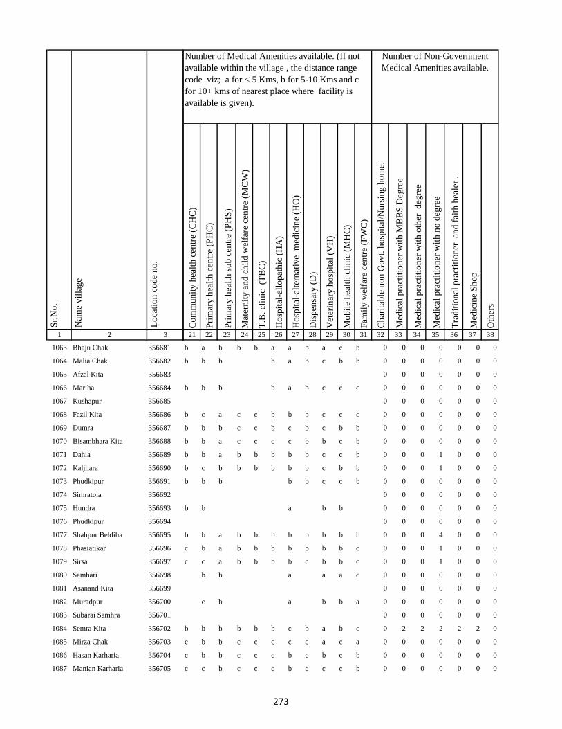
1 2 3
Lo
cati
on
co
de
no
.
Nam
e v
illa
ge
Sr.
No
.
1063 Bhaju Chak 356681
1064 Malia Chak 356682
1065 Afzal Kita 356683
1066 Mariha 356684
1067 Kushapur 356685
1068 Fazil Kita 356686
1069 Dumra 356687
1070 Bisambhara Kita 356688
1071 Dahia 356689
1072 Kaljhara 356690
1073 Phudkipur 356691
1074 Simratola 356692
1075 Hundra 356693
1076 Phudkipur 356694
1077 Shahpur Beldiha 356695
1078 Phasiatikar 356696
1079 Sirsa 356697
1080 Samhari 356698
1081 Asanand Kita 356699
1082 Muradpur 356700
1083 Subarai Samhra 356701
1084 Semra Kita 356702
1085 Mirza Chak 356703
1086 Hasan Karharia 356704
1087 Manian Karharia 356705
Co
mm
un
ity
hea
lth
cen
tre
(CH
C)
Pri
mar
y h
ealt
h c
entr
e (P
HC
)
Pri
mar
y h
ealt
h s
ub
cen
tre
(PH
S)
Mat
ern
ity
an
d c
hil
d w
elfa
re c
entr
e (M
CW
)
T.B
. cl
inic
(T
BC
)
Ho
spit
al-a
llo
pat
hic
(H
A)
Ho
spit
al-a
lter
nat
ive
med
icin
e (H
O)
Dis
pen
sary
(D
)
Vet
erin
ary
ho
spit
al (
VH
)
Mo
bil
e h
ealt
h c
lin
ic (
MH
C)
Fam
ily
wel
fare
cen
tre
(FW
C)
Ch
arit
able
no
n G
ov
t. h
osp
ital
/Nu
rsin
g h
om
e.
Med
ical
pra
ctit
ion
er w
ith
MB
BS
Deg
ree
Med
ical
pra
ctit
ion
er w
ith
oth
er
deg
ree
Med
ical
pra
ctit
ion
er w
ith
no
deg
ree
Tra
dit
ion
al p
ract
itio
ner
an
d f
aith
hea
ler
.
Med
icin
e S
ho
p
Oth
ers
21 22 23 24 25 26 27 28 29 30 31 32 33 34 35 36 37 38
Number of Non-Government
Medical Amenities available.
Number of Medical Amenities available. (If not
available within the village , the distance range
code viz; a for < 5 Kms, b for 5-10 Kms and c
for 10+ kms of nearest place where facility is
available is given).
b a b b b a a b a c b 0 0 0 0 0 0 0
b b b b a b c b b 0 0 0 0 0 0 0
0 0 0 0 0 0 0
b b b b a b c c c 0 0 0 0 0 0 0
0 0 0 0 0 0 0
b c a c c b b b c c c 0 0 0 0 0 0 0
b b b c c b c b c b b 0 0 0 0 0 0 0
b b a c c c c b b c b 0 0 0 0 0 0 0
b b a b b b b b c c b 0 0 0 1 0 0 0
b c b b b b b b c b b 0 0 0 1 0 0 0
b b b b b c c b 0 0 0 0 0 0 0
0 0 0 0 0 0 0
b b a b b 0 0 0 0 0 0 0
0 0 0 0 0 0 0
b b a b b b b b b b b 0 0 0 4 0 0 0
c b a b b b b b b b c 0 0 0 1 0 0 0
c c a b b b b c b b c 0 0 0 1 0 0 0
b b a a a c 0 0 0 0 0 0 0
0 0 0 0 0 0 0
c b a b b a 0 0 0 0 0 0 0
0 0 0 0 0 0 0
b b b b b b c b a b c 0 2 2 2 2 2 0
c b b c c c c c a c a 0 0 0 0 0 0 0
c b b c c c b c b c b 0 0 0 0 0 0 0
c c b c c c b c c c b 0 0 0 0 0 0 0
273

1 2 3
Lo
cati
on
co
de
no
.
Nam
e v
illa
ge
Sr.
No
.
1088 Jathari 356706
1089 Hari Karharia 356707
1090 Kanreswari Kita 356708
1091 Hasanpur 356709
1092 Bakwa Chak 356710
1093 Bela Kita 356711
1094 Janki Kita 356712
1095 Mal Bhandari Dih 356713
1096 Semrakita And Ghat Bhandarid356714
1097 Aslulahsamra 356715
1098 Bariartola 356716
1099 Maganpipra 356717
1100 Ranbahiar 356718
1101 Jamua 356719
1102 Chuna Chak 356720
1103 Ginratari 356721
1104 Sakal Chak 356722
1105 Larai Chak 356723
1106 Gohira Kita 356724
1107 Hemcha Chak 356725
1108 Asanbani 356726
1109 Jhigur Kita 356727
1110 Mal Bhandaridih 356728
1111 Semarkita Ghat Bhandaridih356729
1112 Nimgachhi And Kita 356730
Co
mm
un
ity
hea
lth
cen
tre
(CH
C)
Pri
mar
y h
ealt
h c
entr
e (P
HC
)
Pri
mar
y h
ealt
h s
ub
cen
tre
(PH
S)
Mat
ern
ity
an
d c
hil
d w
elfa
re c
entr
e (M
CW
)
T.B
. cl
inic
(T
BC
)
Ho
spit
al-a
llo
pat
hic
(H
A)
Ho
spit
al-a
lter
nat
ive
med
icin
e (H
O)
Dis
pen
sary
(D
)
Vet
erin
ary
ho
spit
al (
VH
)
Mo
bil
e h
ealt
h c
lin
ic (
MH
C)
Fam
ily
wel
fare
cen
tre
(FW
C)
Ch
arit
able
no
n G
ov
t. h
osp
ital
/Nu
rsin
g h
om
e.
Med
ical
pra
ctit
ion
er w
ith
MB
BS
Deg
ree
Med
ical
pra
ctit
ion
er w
ith
oth
er
deg
ree
Med
ical
pra
ctit
ion
er w
ith
no
deg
ree
Tra
dit
ion
al p
ract
itio
ner
an
d f
aith
hea
ler
.
Med
icin
e S
ho
p
Oth
ers
21 22 23 24 25 26 27 28 29 30 31 32 33 34 35 36 37 38
Number of Non-Government
Medical Amenities available.
Number of Medical Amenities available. (If not
available within the village , the distance range
code viz; a for < 5 Kms, b for 5-10 Kms and c
for 10+ kms of nearest place where facility is
available is given).
c c a c c c b c c c b 0 0 0 0 0 0 0
b b c 0 0 0 0 0 0 0
0 0 0 0 0 0 0
c b a b b b a c b b c 0 0 0 0 0 0 0
c b b c c b a b b b b 0 2 2 2 2 2 0
0 0 0 0 0 0 0
b c a b b b b b a a b 0 0 0 0 0 0 0
c b 1 b b b b b c c b 0 2 2 2 2 2 0
b c a b b b b b b b b 0 0 0 0 0 0 0
b c a b b b a b c c c 0 0 0 0 0 0 0
b a b b b a a b c c b 0 0 0 0 0 0 0
b b a b b b b b c c b 0 0 0 0 0 0 0
b b a b c c 0 0 0 0 0 0 0
0 0 0 0 0 0 0
c b a a c b c b c c c 0 0 0 0 0 0 0
a b b b c b b b c c c 0 0 0 0 0 0 0
a c b c c b b b c b c 0 0 0 0 0 0 0
a c a b c c 0 0 0 0 0 0 0
0 0 0 0 0 0 0
b c a b b b 0 0 0 0 0 0 0
0 0 0 0 0 0 0
0 0 0 0 0 0 0
0 0 0 0 0 0 0
a b c b b b a b c 0 0 0 0 0 0 0
0 0 0 0 0 0 0
274

1 2 3
Lo
cati
on
co
de
no
.
Nam
e v
illa
ge
Sr.
No
.
1113 Khaspathar 356731
1114 Chanai Chak 356732
1115 Sitladih 356733
1116 Samda 356734
1117 Nimania Kita 356735
1118 Chilha 356736
1119 Kusha 356737
1120 Hansai Kita 356738
1121 Kusmi 356739
1122 Bahalia Kita 356740
1123 Jamaidih 356741
1124 Babupur Mal 356742
1125 Kaim Kita 356743
1126 Gain Chak 356744
1127 Babupur Ghat 356745
1128 Rajpur 356746
1129 Doman Kita 356747
1130 Majur Kola 356748
1131 Pathar Kani 356749
1132 Karnu 356750
1133 Gudia 356751
1134 Letaria 356752
1135 Murlitak 356753
1136 Basua 356754
1137 Gangsagar 356755
Co
mm
un
ity
hea
lth
cen
tre
(CH
C)
Pri
mar
y h
ealt
h c
entr
e (P
HC
)
Pri
mar
y h
ealt
h s
ub
cen
tre
(PH
S)
Mat
ern
ity
an
d c
hil
d w
elfa
re c
entr
e (M
CW
)
T.B
. cl
inic
(T
BC
)
Ho
spit
al-a
llo
pat
hic
(H
A)
Ho
spit
al-a
lter
nat
ive
med
icin
e (H
O)
Dis
pen
sary
(D
)
Vet
erin
ary
ho
spit
al (
VH
)
Mo
bil
e h
ealt
h c
lin
ic (
MH
C)
Fam
ily
wel
fare
cen
tre
(FW
C)
Ch
arit
able
no
n G
ov
t. h
osp
ital
/Nu
rsin
g h
om
e.
Med
ical
pra
ctit
ion
er w
ith
MB
BS
Deg
ree
Med
ical
pra
ctit
ion
er w
ith
oth
er
deg
ree
Med
ical
pra
ctit
ion
er w
ith
no
deg
ree
Tra
dit
ion
al p
ract
itio
ner
an
d f
aith
hea
ler
.
Med
icin
e S
ho
p
Oth
ers
21 22 23 24 25 26 27 28 29 30 31 32 33 34 35 36 37 38
Number of Non-Government
Medical Amenities available.
Number of Medical Amenities available. (If not
available within the village , the distance range
code viz; a for < 5 Kms, b for 5-10 Kms and c
for 10+ kms of nearest place where facility is
available is given).
a b a b c b b b b b a 0 0 0 0 0 0 0
b b a b c b b b a b c 0 0 0 0 0 0 0
b b a b c b a b a a c 0 0 0 0 0 0 0
a b a b b b c b a b a 0 2 2 2 2 2 0
c c a c a a b b b c b 0 2 2 2 2 2 0
b b b b c b b b b b b 0 0 0 0 0 0 0
b b a b c b a b b b b 0 0 0 0 0 0 0
a a a a b b a b a a c 0 0 0 0 0 0 0
b b a b a b b b b a a 0 0 0 0 0 0 0
b b a b b b c b b c c 0 0 0 0 0 0 0
b b b b b b b b b b b 0 0 0 0 0 0 0
c b b c c c a b c c b 0 0 0 0 0 0 0
0 0 0 0 0 0 0
b b a b b b b b b c b 0 0 0 0 0 0 0
b c a b b b a b b c b 0 0 0 0 0 0 0
c b b c 0 0 0 0 0 0 0
0 0 0 0 0 0 0
0 0 0 0 0 0 0
a b 1 a a a b a a b a 0 0 0 0 0 0 0
c b a b b a c a b 1 c 0 0 0 0 0 0 0
c 1 a 1 b b 1 c b c c 0 0 0 0 0 0 0
a a b b b b b b a b c 0 0 0 0 0 0 0
b 1 a b a 1 b 1 a b a 0 0 0 0 0 0 0
a b a b b b b b c b c 0 0 0 0 0 0 0
a b b b a b b b c 0 0 0 0 0 0 0
275

1 2 3
Lo
cati
on
co
de
no
.
Nam
e v
illa
ge
Sr.
No
.
1138 Monukhap 356756
1139 Katbaikal 356757
1140 Jharna Kita 356758
1141 Dhankurda 356759
1142 Majhoua 356760
1143 Gahira Kita 356761
1144 Bhadaia Kita 356762
1145 Garbaghat 356763
1146 Garba Kita 356764
1147 Balachini Kita 356765
1148 Akasni 356766
1149 Kendua Kita 356767
1150 Kendua Kita 356768
1151 Kusmaha 356769
1152 Tetaria 356770
1153 Lakrabank 356771
1154 Balia Ghat 356772
1155 Balia Kurmi Kita 356773
1156 Rabiadih (Santali) 356774
1157 Raksa Kita 356775
1158 Doman Kita 356776
1159 Mohanpur 356777
1160 Kadhara Ghat 356778
1161 Kusdiha 356779
1162 Dumaria Mal 356780
Co
mm
un
ity
hea
lth
cen
tre
(CH
C)
Pri
mar
y h
ealt
h c
entr
e (P
HC
)
Pri
mar
y h
ealt
h s
ub
cen
tre
(PH
S)
Mat
ern
ity
an
d c
hil
d w
elfa
re c
entr
e (M
CW
)
T.B
. cl
inic
(T
BC
)
Ho
spit
al-a
llo
pat
hic
(H
A)
Ho
spit
al-a
lter
nat
ive
med
icin
e (H
O)
Dis
pen
sary
(D
)
Vet
erin
ary
ho
spit
al (
VH
)
Mo
bil
e h
ealt
h c
lin
ic (
MH
C)
Fam
ily
wel
fare
cen
tre
(FW
C)
Ch
arit
able
no
n G
ov
t. h
osp
ital
/Nu
rsin
g h
om
e.
Med
ical
pra
ctit
ion
er w
ith
MB
BS
Deg
ree
Med
ical
pra
ctit
ion
er w
ith
oth
er
deg
ree
Med
ical
pra
ctit
ion
er w
ith
no
deg
ree
Tra
dit
ion
al p
ract
itio
ner
an
d f
aith
hea
ler
.
Med
icin
e S
ho
p
Oth
ers
21 22 23 24 25 26 27 28 29 30 31 32 33 34 35 36 37 38
Number of Non-Government
Medical Amenities available.
Number of Medical Amenities available. (If not
available within the village , the distance range
code viz; a for < 5 Kms, b for 5-10 Kms and c
for 10+ kms of nearest place where facility is
available is given).
0 0 0 0 0 0 0
0 0 0 0 0 0 0
b a b b b a b b c b b 0 0 0 0 0 0 0
a b b b b b c b b 0 0 0 0 0 0 0
0 0 0 0 0 0 0
0 0 0 0 0 0 0
0 0 0 0 0 0 0
0 0 0 0 0 0 0
0 0 0 0 0 0 0
0 0 0 0 0 0 0
b b a a b b c b b b b 0 0 0 0 0 0 0
a a b b b b b a b 0 0 0 0 0 0 0
0 0 0 0 0 0 0
0 0 0 0 0 0 0
b a a b b a b b a b c 0 0 0 0 0 0 0
a a a b b b b b b c c 0 2 2 2 2 2 2
a a b c b b a b b c a 0 0 0 0 0 0 0
b a a c b b a b a c c 0 0 0 0 0 0 0
b b a c b b b b a c c 0 0 0 0 0 0 0
b a a a b b b b a b a 0 0 0 0 0 0 0
b b a b b b b b b c b 0 2 2 2 2 2 2
b b b a b b b b b c b 0 2 2 2 2 2 2
0 0 0 0 0 0 0
b b a b b c a b b c c 0 0 0 0 0 0 0
b b a b b b b b b c a 0 2 2 2 2 2 2
276

1 2 3
Lo
cati
on
co
de
no
.
Nam
e v
illa
ge
Sr.
No
.
1163 Kadhara Mal 356781
1164 Kadhara Ghat 356782
1165 Gobindpur 356783
1166 Bansbhita 356784
1167 Maniamor 356785
1168 Lakhipur 356786
1169 Durgapur 356787
1170 Lakhipur 356788
1171 Jogidih 356789
1172 Kitapathar 356790
1173 Deola Kita 356791
1174 Nimgachhi And Kita 356792
1175 Karkatdih 356793
1176 Lakhipur 356794
1177 Kasturia Kita 356795
1178 Dalabar 356796
1179 Khutehri 356797
1180 Chansar 356798
1181 Nima Chak 356799
1182 Chichohari 356800
1183 Dudhbecha 356801
1184 Goradih 356802
1185 Deyal Kita 356803
1186 Pipra Kita 356804
1187 Gosain Chak 356805
Co
mm
un
ity
hea
lth
cen
tre
(CH
C)
Pri
mar
y h
ealt
h c
entr
e (P
HC
)
Pri
mar
y h
ealt
h s
ub
cen
tre
(PH
S)
Mat
ern
ity
an
d c
hil
d w
elfa
re c
entr
e (M
CW
)
T.B
. cl
inic
(T
BC
)
Ho
spit
al-a
llo
pat
hic
(H
A)
Ho
spit
al-a
lter
nat
ive
med
icin
e (H
O)
Dis
pen
sary
(D
)
Vet
erin
ary
ho
spit
al (
VH
)
Mo
bil
e h
ealt
h c
lin
ic (
MH
C)
Fam
ily
wel
fare
cen
tre
(FW
C)
Ch
arit
able
no
n G
ov
t. h
osp
ital
/Nu
rsin
g h
om
e.
Med
ical
pra
ctit
ion
er w
ith
MB
BS
Deg
ree
Med
ical
pra
ctit
ion
er w
ith
oth
er
deg
ree
Med
ical
pra
ctit
ion
er w
ith
no
deg
ree
Tra
dit
ion
al p
ract
itio
ner
an
d f
aith
hea
ler
.
Med
icin
e S
ho
p
Oth
ers
21 22 23 24 25 26 27 28 29 30 31 32 33 34 35 36 37 38
Number of Non-Government
Medical Amenities available.
Number of Medical Amenities available. (If not
available within the village , the distance range
code viz; a for < 5 Kms, b for 5-10 Kms and c
for 10+ kms of nearest place where facility is
available is given).
b b a b b b a b a b c 0 2 2 2 2 2 2
b 1 a 1 b 1 b b a b b 0 0 0 0 0 0 0
b b b c b c b b 0 0 0 0 0 0 0
0 0 0 0 0 0 0
c b a b b b c b b 0 0 0 0 0 0 0
0 0 0 0 0 0 0
a b a b b b a b c b c 0 0 0 0 0 0 0
b b b b a c b 0 0 0 0 0 0 0
0 0 0 0 0 0 0
b b b c 0 0 0 0 0 0 0
0 0 0 0 0 0 0
0 0 0 0 0 0 0
b b a c b 0 0 0 0 0 0 0
0 0 0 0 0 0 0
0 0 0 0 0 0 0
c c a c c b a c b c c 0 0 0 0 0 0 0
c c 1 c c b c c b b c 0 0 0 0 1 0 0
c c a c c c b c b c c 0 0 0 0 0 0 0
c b a b c b b c a c c 0 0 0 0 0 0 0
c c a c c c a c b c c 0 0 0 0 0 0 0
c c a c c c a c b c c 0 0 0 0 0 0 0
c b a b b b b c a b c 0 0 0 0 0 0 0
b b b c b a c c 0 0 0 0 0 0 0
0 0 0 0 0 0 0
b a b a b b a 0 0 0 0 0 0 0
277

1 2 3
Lo
cati
on
co
de
no
.
Nam
e v
illa
ge
Sr.
No
.
1188 Malgarhia 356806
1189 Gadel 356807
1190 Dharmudih 356808
1191 Mahadeb Kita 356809
1192 Telaria 356810
1193 Nunajor 356811
1194 Bhogan 356812
1195 Kaithia 356813
1196 Saraiaghat 356814
1197 Manikpur Ghat 356815
1198 Amarpur 356816
1199 Bhainsabarankurum Tola356817
1200 Bhainsabarankurum Tola Mal356818
1201 Hahajor 356819
1202 Patharpur 356820
1203 Mahadeobathan 356821
1204 Bansipur 356822
1205 Sib Kita 356823
1206 Amdiha 356824
1207 Ghat Bhangabandh 356825
1208 Mal Bhangabandh 356826
1209 Panchgachhi 356827
1210 Ghat Gamharia 356828
1211 Sikkita 356829
1212 Ghat Garhaiya 356830
Co
mm
un
ity
hea
lth
cen
tre
(CH
C)
Pri
mar
y h
ealt
h c
entr
e (P
HC
)
Pri
mar
y h
ealt
h s
ub
cen
tre
(PH
S)
Mat
ern
ity
an
d c
hil
d w
elfa
re c
entr
e (M
CW
)
T.B
. cl
inic
(T
BC
)
Ho
spit
al-a
llo
pat
hic
(H
A)
Ho
spit
al-a
lter
nat
ive
med
icin
e (H
O)
Dis
pen
sary
(D
)
Vet
erin
ary
ho
spit
al (
VH
)
Mo
bil
e h
ealt
h c
lin
ic (
MH
C)
Fam
ily
wel
fare
cen
tre
(FW
C)
Ch
arit
able
no
n G
ov
t. h
osp
ital
/Nu
rsin
g h
om
e.
Med
ical
pra
ctit
ion
er w
ith
MB
BS
Deg
ree
Med
ical
pra
ctit
ion
er w
ith
oth
er
deg
ree
Med
ical
pra
ctit
ion
er w
ith
no
deg
ree
Tra
dit
ion
al p
ract
itio
ner
an
d f
aith
hea
ler
.
Med
icin
e S
ho
p
Oth
ers
21 22 23 24 25 26 27 28 29 30 31 32 33 34 35 36 37 38
Number of Non-Government
Medical Amenities available.
Number of Medical Amenities available. (If not
available within the village , the distance range
code viz; a for < 5 Kms, b for 5-10 Kms and c
for 10+ kms of nearest place where facility is
available is given).
0 0 0 0 0 0 0
0 0 0 0 0 0 0
c c a c b b a b c b a 0 0 0 0 0 0 0
c b a b b b b b b b b 0 0 0 0 0 0 0
b b b b b b b b b b b 0 0 0 0 0 0 0
b b a b b b b b b b b 0 0 0 0 0 0 0
b b a b c b b b b b c 0 0 0 0 0 0 0
b b a b b b c b b a a 0 2 2 2 2 2 2
a a a b b b b b b b c 0 2 2 2 2 2 2
a a b b b b b b b b b 0 2 2 2 2 2 2
b c b c b c b b b a b 0 0 0 0 0 0 0
b b b c b b b b b b b 0 0 0 0 0 0 0
b c a c a b b b a b b 0 0 0 0 0 0 0
b c a c b b a b a a b 0 0 0 0 0 0 0
b a a c b b a c c a c 0 0 0 0 0 0 0
b b a b b b b b b c b 0 0 2 2 2 2 2
a b a c c b c b c b c 0 0 0 0 0 0 0
a b a a c b c b c c c 0 0 0 0 0 0 0
a b b b c b b b c c c 0 0 0 0 0 0 0
b c a b a b b b c c a 0 0 0 0 0 0 0
b b a a b c b b b c c 0 0 0 0 0 0 0
a b a a b b a b c b c 0 0 0 0 0 0 0
a b b b a b c c a 0 0 0 0 0 0 0
0 0 0 0 0 0 0
c b b c c b b b c a b 0 0 0 0 0 0 0
278
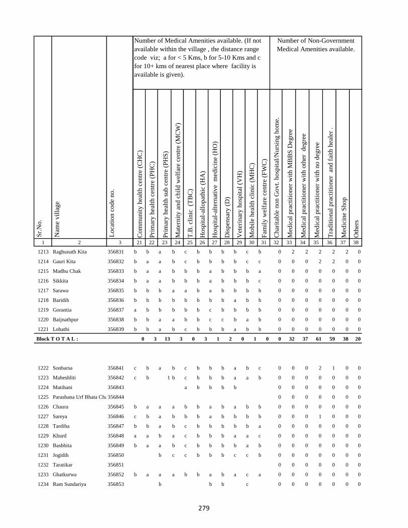
1 2 3
Lo
cati
on
co
de
no
.
Nam
e v
illa
ge
Sr.
No
.
1213 Raghunath Kita 356831
1214 Gauri Kita 356832
1215 Madhu Chak 356833
1216 Sikkita 356834
1217 Sarawa 356835
1218 Baridih 356836
1219 Gorantia 356837
1220 Baijnathpur 356838
1221 Lohathi 356839
Block T O T A L :
1222 Sonbarsa 356841
1223 Maheshliti 356842
1224 Matihani 356843
1225 Parasbana Urf Bhata Chak356844
1226 Chaura 356845
1227 Sareya 356846
1228 Tardiha 356847
1229 Khurd 356848
1230 Basbhita 356849
1231 Jogidih 356850
1232 Taratikar 356851
1233 Ghatkurwa 356852
1234 Ram Sundariya 356853
Co
mm
un
ity
hea
lth
cen
tre
(CH
C)
Pri
mar
y h
ealt
h c
entr
e (P
HC
)
Pri
mar
y h
ealt
h s
ub
cen
tre
(PH
S)
Mat
ern
ity
an
d c
hil
d w
elfa
re c
entr
e (M
CW
)
T.B
. cl
inic
(T
BC
)
Ho
spit
al-a
llo
pat
hic
(H
A)
Ho
spit
al-a
lter
nat
ive
med
icin
e (H
O)
Dis
pen
sary
(D
)
Vet
erin
ary
ho
spit
al (
VH
)
Mo
bil
e h
ealt
h c
lin
ic (
MH
C)
Fam
ily
wel
fare
cen
tre
(FW
C)
Ch
arit
able
no
n G
ov
t. h
osp
ital
/Nu
rsin
g h
om
e.
Med
ical
pra
ctit
ion
er w
ith
MB
BS
Deg
ree
Med
ical
pra
ctit
ion
er w
ith
oth
er
deg
ree
Med
ical
pra
ctit
ion
er w
ith
no
deg
ree
Tra
dit
ion
al p
ract
itio
ner
an
d f
aith
hea
ler
.
Med
icin
e S
ho
p
Oth
ers
21 22 23 24 25 26 27 28 29 30 31 32 33 34 35 36 37 38
Number of Non-Government
Medical Amenities available.
Number of Medical Amenities available. (If not
available within the village , the distance range
code viz; a for < 5 Kms, b for 5-10 Kms and c
for 10+ kms of nearest place where facility is
available is given).
b b a b c b b b b c b 0 2 2 2 2 2 0
b a a b c b b b b c c 0 0 0 2 2 0 0
b a a b b b a b b b a 0 0 0 0 0 0 0
b a a b b b a b b b c 0 0 0 0 0 0 0
b b b a a b a b b b b 0 0 0 0 0 0 0
b b b b b b b b a b b 0 0 0 0 0 0 0
a b b b b b c b b b b 0 0 0 0 0 0 0
b b a a b b c c b a b 0 0 0 0 0 0 0
b b a b c b b b a b b 0 0 0 0 0 0 0
0 3 13 3 0 3 1 2 0 1 0 0 32 37 61 59 38 20
c b a b c b b b a b c 0 0 0 2 1 0 0
c b 1 b c b b b a a b 0 0 0 0 0 0 0
a b b b b 0 0 0 0 0 0 0
0 0 0 0 0 0 0
b a a a b b a b a b b 0 0 0 0 0 0 0
c b a b b b a b b b b 0 0 0 1 0 0 0
b b a b c b b b b b a 0 0 0 0 0 0 0
a a b a c b b b a a c 0 0 0 0 0 0 0
b a a b c b b b b a b 0 0 0 0 0 0 0
b c c b b b c c b 0 0 0 0 0 0 0
0 0 0 0 0 0 0
b a a a b b a b a c a 0 0 0 0 0 0 0
b b b c 0 0 0 0 0 0 0
279

1 2 3
Lo
cati
on
co
de
no
.
Nam
e v
illa
ge
Sr.
No
.
1235 Taratikar 356854
1236 Siardih 356855
1237 Lakhanpahari 356856
1238 Joginpahari 356857
1239 Jagarnathpur 356858
1240 Lilatari 356859
1241 Kamla Chak 356860
1242 Siardih(Chhit) 356861
1243 Bhanjpur 356862
1244 Barkop 356863
1245 Mirza Chak 356864
1246 Birseni 356865
1247 Siardih 356866
1248 Mirza Chak 356867
1249 Jogi Chak 356868
1250 Amdiha 356869
1251 Babupur 356870
1252 Jamua 356871
1253 Rangatanr 356872
1254 Semariya 356873
1255 Ramgarh 356874
1256 Kamaldiha 356875
1257 Kureri 356876
1258 Pipra 356877
1259 Babupur 356878
Co
mm
un
ity
hea
lth
cen
tre
(CH
C)
Pri
mar
y h
ealt
h c
entr
e (P
HC
)
Pri
mar
y h
ealt
h s
ub
cen
tre
(PH
S)
Mat
ern
ity
an
d c
hil
d w
elfa
re c
entr
e (M
CW
)
T.B
. cl
inic
(T
BC
)
Ho
spit
al-a
llo
pat
hic
(H
A)
Ho
spit
al-a
lter
nat
ive
med
icin
e (H
O)
Dis
pen
sary
(D
)
Vet
erin
ary
ho
spit
al (
VH
)
Mo
bil
e h
ealt
h c
lin
ic (
MH
C)
Fam
ily
wel
fare
cen
tre
(FW
C)
Ch
arit
able
no
n G
ov
t. h
osp
ital
/Nu
rsin
g h
om
e.
Med
ical
pra
ctit
ion
er w
ith
MB
BS
Deg
ree
Med
ical
pra
ctit
ion
er w
ith
oth
er
deg
ree
Med
ical
pra
ctit
ion
er w
ith
no
deg
ree
Tra
dit
ion
al p
ract
itio
ner
an
d f
aith
hea
ler
.
Med
icin
e S
ho
p
Oth
ers
21 22 23 24 25 26 27 28 29 30 31 32 33 34 35 36 37 38
Number of Non-Government
Medical Amenities available.
Number of Medical Amenities available. (If not
available within the village , the distance range
code viz; a for < 5 Kms, b for 5-10 Kms and c
for 10+ kms of nearest place where facility is
available is given).
0 0 0 0 0 0 0
b b a b c c b b a c b 0 0 0 0 0 0 0
b a a a b b c b a b b 0 0 0 0 0 0 0
b a a a b b b c a c b 0 0 0 0 0 0 0
b b c 0 0 0 0 0 0 0
0 0 0 0 0 0 0
0 0 0 0 0 0 0
0 0 0 0 0 0 0
b b a b b b b b b b c 0 0 0 0 0 0 0
a b b b b a b c 0 0 0 0 0 0 0
0 0 0 0 0 0 0
b c b b b c b c 0 0 0 0 0 0 0
0 0 0 0 0 0 0
c b a b c b b b c a a 0 0 0 0 0 0 0
c a b b a b b b c b b 0 0 0 0 0 0 0
c b a b b c a b c b b 0 0 0 0 0 0 0
c b a c b b c b c a b 0 0 0 0 0 0 0
c a a c b b b b b b c 0 0 0 0 0 0 0
a b a c c b b b c b a 0 0 0 0 0 0 0
b c b a b c a c 0 0 0 0 0 0 0
0 0 0 0 0 0 0
b a a c c b b b c c b 0 0 0 0 0 0 0
b b a b b b c b b b b 0 0 0 0 0 0 0
b b a a b b b b b c b 0 0 0 0 0 0 0
b b a b a b a b b c b 0 0 0 0 0 0 0
280

1 2 3
Lo
cati
on
co
de
no
.
Nam
e v
illa
ge
Sr.
No
.
1260 Lakarjorimal 356879
1261 Tikabagicha 356880
1262 Gordhoi 356881
1263 Babupur 356882
1264 Nauratan Kita 356883
1265 Gordhoi 356884
1266 Joginpahari 356885
1267 Simariya 356886
1268 Sonar Chak 356887
1269 Duarichak 356888
1270 Tulsi Kita 356889
1271 Chau Chak 356890
1272 Karubandh 356891
1273 Haripur 356892
1274 Chau Chak 356893
1275 Lachhminiyan 356894
1276 Chepi 356895
1277 Kasiyatari 356896
1278 Kita Gardharpur 356897
1279 Lasutiya 356898
1280 Pathargama 356899
1281 Mal Pathargama 356900
1282 Arazi Pathargama 356901
1283 Chandi Chak 356902
1284 Baliya Kita 356903
Co
mm
un
ity
hea
lth
cen
tre
(CH
C)
Pri
mar
y h
ealt
h c
entr
e (P
HC
)
Pri
mar
y h
ealt
h s
ub
cen
tre
(PH
S)
Mat
ern
ity
an
d c
hil
d w
elfa
re c
entr
e (M
CW
)
T.B
. cl
inic
(T
BC
)
Ho
spit
al-a
llo
pat
hic
(H
A)
Ho
spit
al-a
lter
nat
ive
med
icin
e (H
O)
Dis
pen
sary
(D
)
Vet
erin
ary
ho
spit
al (
VH
)
Mo
bil
e h
ealt
h c
lin
ic (
MH
C)
Fam
ily
wel
fare
cen
tre
(FW
C)
Ch
arit
able
no
n G
ov
t. h
osp
ital
/Nu
rsin
g h
om
e.
Med
ical
pra
ctit
ion
er w
ith
MB
BS
Deg
ree
Med
ical
pra
ctit
ion
er w
ith
oth
er
deg
ree
Med
ical
pra
ctit
ion
er w
ith
no
deg
ree
Tra
dit
ion
al p
ract
itio
ner
an
d f
aith
hea
ler
.
Med
icin
e S
ho
p
Oth
ers
21 22 23 24 25 26 27 28 29 30 31 32 33 34 35 36 37 38
Number of Non-Government
Medical Amenities available.
Number of Medical Amenities available. (If not
available within the village , the distance range
code viz; a for < 5 Kms, b for 5-10 Kms and c
for 10+ kms of nearest place where facility is
available is given).
b b b b b b a b b c c 0 0 0 0 0 0 0
b b b b b b b b b c c 0 0 0 0 0 0 0
a a b b b b a b a b c 0 0 0 0 0 0 0
b b c b b b c c 0 0 0 0 0 0 0
0 0 0 0 0 0 0
c a a b c b b b a b c 0 0 0 0 0 0 0
c b a b c b a c c 0 0 0 0 0 0 0
0 0 0 0 0 0 0
c a a b b b b b b b b 0 0 0 0 0 0 0
b b b b b b b b b b b 0 0 0 0 0 0 0
a b c b b b b b b 0 0 0 0 0 0 0
0 0 0 0 0 0 0
0 0 0 0 0 0 0
0 0 0 0 0 0 0
0 0 0 0 0 0 0
0 0 0 0 0 0 0
0 0 0 0 0 0 0
c b a a b b a b c b b 0 0 0 0 0 0 0
c a a a b b a b c b b 0 0 0 0 0 0 0
c 1 a 1 1 1 a 6 1 a 1 0 2 0 2 3 1 0
c b c b b c a 0 0 0 0 0 0 0
0 0 0 0 0 0 0
0 0 0 0 0 0 0
b a a b a b b b c c c 0 0 0 0 0 0 0
b a c b b b c c 0 0 0 0 0 0 0
281

1 2 3
Lo
cati
on
co
de
no
.
Nam
e v
illa
ge
Sr.
No
.
1285 Janki Kita 356904
1286 Sapinmor 356905
1287 Panjarhar 356906
1288 Panjarhar Birit 356907
1289 Karaila Chak 356908
1290 Ambasongram 356909
1291 Mahadeva Kita 356910
1292 Ghandharpur 356911
1293 Kumarsi 356912
1294 Sundarmor 356913
1295 Dandighat 356914
1296 Tengar 356915
1297 Machhitanr 356916
1298 Telni 356917
1299 Kobhara 356918
1300 Chilkara Gobind 356919
1301 Dumarariya 356920
1302 Bareghat 356921
1303 Baredih 356922
1304 Kasturiya 356923
1305 Sukhanand 356924
1306 Jamchir 356925
1307 Kendua 356926
1308 Rampur 356927
1309 Shampur 356928
Co
mm
un
ity
hea
lth
cen
tre
(CH
C)
Pri
mar
y h
ealt
h c
entr
e (P
HC
)
Pri
mar
y h
ealt
h s
ub
cen
tre
(PH
S)
Mat
ern
ity
an
d c
hil
d w
elfa
re c
entr
e (M
CW
)
T.B
. cl
inic
(T
BC
)
Ho
spit
al-a
llo
pat
hic
(H
A)
Ho
spit
al-a
lter
nat
ive
med
icin
e (H
O)
Dis
pen
sary
(D
)
Vet
erin
ary
ho
spit
al (
VH
)
Mo
bil
e h
ealt
h c
lin
ic (
MH
C)
Fam
ily
wel
fare
cen
tre
(FW
C)
Ch
arit
able
no
n G
ov
t. h
osp
ital
/Nu
rsin
g h
om
e.
Med
ical
pra
ctit
ion
er w
ith
MB
BS
Deg
ree
Med
ical
pra
ctit
ion
er w
ith
oth
er
deg
ree
Med
ical
pra
ctit
ion
er w
ith
no
deg
ree
Tra
dit
ion
al p
ract
itio
ner
an
d f
aith
hea
ler
.
Med
icin
e S
ho
p
Oth
ers
21 22 23 24 25 26 27 28 29 30 31 32 33 34 35 36 37 38
Number of Non-Government
Medical Amenities available.
Number of Medical Amenities available. (If not
available within the village , the distance range
code viz; a for < 5 Kms, b for 5-10 Kms and c
for 10+ kms of nearest place where facility is
available is given).
0 0 0 0 0 0 0
0 0 0 0 0 0 0
c b b b b b c 0 0 0 0 0 0 0
0 0 0 0 0 0 0
0 0 0 0 0 0 0
b b a b c b b b b b b 0 0 0 0 0 0 0
b b b b b b b b b c b 0 0 0 0 0 0 0
b a 1 b b b b b a c c 0 0 0 0 0 0 0
b a a b a b b b a b a 0 0 0 0 0 0 0
a a a b b b a b a b c 0 0 0 0 0 0 0
b b a a b b a b b b b 0 0 0 0 0 0 0
b b a b b b b b b b b 0 0 0 0 0 0 0
c a b b c b a b b b b 0 0 0 0 0 0 0
c b a a c b b b a a b 0 0 0 0 0 0 0
c b a a c b c b a b b 0 0 0 0 0 0 0
c a a a a b b b c b c 0 0 0 0 0 0 0
b b a a b c b b b a c 0 0 0 0 0 0 0
a b b a b b a b c b c 0 0 0 0 0 0 0
b b b b b b a b c b c 0 0 0 0 0 0 0
c b c b a b c a a 0 0 0 0 0 0 0
0 0 0 0 0 0 0
c a a a c b b b b c c 0 0 0 0 0 0 0
c b a b c b b b c b a 0 0 0 0 0 0 0
c b a a b b b b c c b 0 0 0 0 0 0 0
c a 1 1 b 1 a b c c b 0 0 0 0 0 0 0
282

1 2 3
Lo
cati
on
co
de
no
.
Nam
e v
illa
ge
Sr.
No
.
1310 Barmasiya 356929
1311 Palipaya 356930
1312 Bargama 356931
1313 Manoharpur 356932
1314 Saranda 356933
1315 Boha 356934
1316 Khariani 356935
1317 Barhara 356936
1318 Bhalsumbhiya 356937
1319 Pipra 356938
1320 Bara Bandh 356939
1321 Awratanr 356940
1322 Harkata 356941
1323 Lakhanpahari Chhit 356942
1324 Bhanta Chak Chhota 356943
1325 Khairbani 356944
1326 Masnaha 356945
1327 Siripur 356946
1328 Mohanpur 356947
1329 Kolua 356948
1330 Ghatbaliya 356949
1331 Jalo Kundi 356950
1332 Bhata Chak 356951
1333 Tetariya 356952
1334 Taratikar 356953
Co
mm
un
ity
hea
lth
cen
tre
(CH
C)
Pri
mar
y h
ealt
h c
entr
e (P
HC
)
Pri
mar
y h
ealt
h s
ub
cen
tre
(PH
S)
Mat
ern
ity
an
d c
hil
d w
elfa
re c
entr
e (M
CW
)
T.B
. cl
inic
(T
BC
)
Ho
spit
al-a
llo
pat
hic
(H
A)
Ho
spit
al-a
lter
nat
ive
med
icin
e (H
O)
Dis
pen
sary
(D
)
Vet
erin
ary
ho
spit
al (
VH
)
Mo
bil
e h
ealt
h c
lin
ic (
MH
C)
Fam
ily
wel
fare
cen
tre
(FW
C)
Ch
arit
able
no
n G
ov
t. h
osp
ital
/Nu
rsin
g h
om
e.
Med
ical
pra
ctit
ion
er w
ith
MB
BS
Deg
ree
Med
ical
pra
ctit
ion
er w
ith
oth
er
deg
ree
Med
ical
pra
ctit
ion
er w
ith
no
deg
ree
Tra
dit
ion
al p
ract
itio
ner
an
d f
aith
hea
ler
.
Med
icin
e S
ho
p
Oth
ers
21 22 23 24 25 26 27 28 29 30 31 32 33 34 35 36 37 38
Number of Non-Government
Medical Amenities available.
Number of Medical Amenities available. (If not
available within the village , the distance range
code viz; a for < 5 Kms, b for 5-10 Kms and c
for 10+ kms of nearest place where facility is
available is given).
c b a a a b b b c c b 0 0 0 0 0 0 0
c a a b b b b b b c c 0 0 0 0 0 0 0
c a b b b b a b b b a 0 0 0 0 0 0 0
b b a b b b c b b c c 0 0 0 0 0 0 0
a a a b c b b b b c b 0 0 0 0 0 0 0
c 1 1 b c b b b b a b 0 0 0 0 0 0 0
b b a b c b a b a c b 0 0 0 0 0 0 0
b b a a a b a b b c b 0 0 0 0 0 0 0
b a 1 b b c b b b b b 0 0 0 0 0 0 0
b a a b b b c b a b c 0 0 0 0 0 0 0
b b a b b b b b a b c 0 0 0 0 0 0 0
a b a a c b a b a b c 0 0 0 0 0 0 0
b b a b c b a b b b c 0 0 0 0 0 0 0
b b b a c b b b b a a 0 0 0 0 0 0 0
c b b b c b a c b b c 0 0 0 0 0 0 0
c b b b b a b c 0 0 0 0 0 0 0
0 0 0 0 0 0 0
c a b b c b 0 0 0 0 0 0 0
0 0 0 0 0 0 0
a b a b b b c b c b b 0 0 0 0 0 0 0
b b b b b c a c 0 0 0 0 0 0 0
0 0 0 0 0 0 0
0 0 0 0 0 0 0
0 0 0 0 0 0 0
c b 1 b c b a b c c b 0 0 0 0 0 0 0
283

1 2 3
Lo
cati
on
co
de
no
.
Nam
e v
illa
ge
Sr.
No
.
1335 Bandelwar 356954
1336 Taratikar 356955
1337 Dumariya 356956
1338 Dhobdiha 356957
1339 Beltikri 356958
1340 Belshar 356959
1341 Parua 356960
1342 Biahunpurmal 356961
1343 Arazi Bishunpur 356962
1344 Pakariya 356963
1345 Chamra Koli 356964
1346 Boharna 356965
1347 Rajaun Khurd 356966
1348 Ambabathan 356967
1349 Dhibabandh 356968
1350 Kerbar 356969
1351 Barwarda 356970
1352 Ranipur 356971
1353 Laugai 356972
1354 Gangarampur 356973
1355 Latauna 356974
1356 Chunakothi 356975
1357 Ghutiya 356976
1358 Rajaun Kalan 356977
1359 Bisaha 356978
Co
mm
un
ity
hea
lth
cen
tre
(CH
C)
Pri
mar
y h
ealt
h c
entr
e (P
HC
)
Pri
mar
y h
ealt
h s
ub
cen
tre
(PH
S)
Mat
ern
ity
an
d c
hil
d w
elfa
re c
entr
e (M
CW
)
T.B
. cl
inic
(T
BC
)
Ho
spit
al-a
llo
pat
hic
(H
A)
Ho
spit
al-a
lter
nat
ive
med
icin
e (H
O)
Dis
pen
sary
(D
)
Vet
erin
ary
ho
spit
al (
VH
)
Mo
bil
e h
ealt
h c
lin
ic (
MH
C)
Fam
ily
wel
fare
cen
tre
(FW
C)
Ch
arit
able
no
n G
ov
t. h
osp
ital
/Nu
rsin
g h
om
e.
Med
ical
pra
ctit
ion
er w
ith
MB
BS
Deg
ree
Med
ical
pra
ctit
ion
er w
ith
oth
er
deg
ree
Med
ical
pra
ctit
ion
er w
ith
no
deg
ree
Tra
dit
ion
al p
ract
itio
ner
an
d f
aith
hea
ler
.
Med
icin
e S
ho
p
Oth
ers
21 22 23 24 25 26 27 28 29 30 31 32 33 34 35 36 37 38
Number of Non-Government
Medical Amenities available.
Number of Medical Amenities available. (If not
available within the village , the distance range
code viz; a for < 5 Kms, b for 5-10 Kms and c
for 10+ kms of nearest place where facility is
available is given).
c b b a b a b c c b 0 0 0 0 0 0 0
0 0 0 0 0 0 0
c a a c b c b b c c b 0 0 0 0 0 0 0
c b a c b b b b b b c 0 0 0 0 0 0 0
c 1 b b c b a b b c b 0 0 0 0 0 0 0
b c 1 a c b a c b c c 0 4 0 0 0 0 0
a b c b a b c 0 0 0 0 0 0 0
0 0 0 0 0 0 0
0 0 0 0 0 0 0
b b b c b b b c 0 0 0 0 0 0 0
0 0 0 0 0 0 0
b a a a b b b b a b a 0 0 0 0 0 0 0
b b a b b b b c a b b 0 0 0 0 0 0 0
c c a c b b b b a b b 0 0 0 0 0 0 0
b b a c c b b b b a b 0 0 0 0 0 0 0
b b b b c b a b b b c 0 0 0 0 0 0 0
b b b a c b a b b b a 0 0 0 0 0 0 0
b b b b a b b b b a c 0 0 0 0 0 0 0
b b a c a b b b a b b 0 0 0 0 0 0 0
b c a c b c b b a b b 0 0 0 0 0 0 0
b c a c b b b b c a b 0 0 0 0 0 0 0
c c a a c b a b b a b 0 0 0 0 0 0 0
c c 1 1 c b a b c c b 0 0 0 0 0 0 0
c b a c c b b b c b c 0 0 0 0 0 0 0
b b a c c b a b c c c 0 0 0 0 0 0 0
284

1 2 3
Lo
cati
on
co
de
no
.
Nam
e v
illa
ge
Sr.
No
.
1360 Charkaghat 356979
1361 Nimbar 356980
1362 Dighi 356981
1363 Korkaghat 356982
1364 Amad Khani 356983
1365 Raksu Kita 356984
1366 Chakwa 356985
1367 Jasmata 356986
1368 Simariya 356987
1369 Sanatan 356988
1370 Kela Kita 356989
1371 Khasdighi 356990
1372 Toiadih 356991
1373 Ramu Chak 356992
1374 Charkaghat 356993
1375 Garka 356994
1376 Bariyata 356995
1377 Charkaghat 356996
1378 Tabhalpur 356997
1379 Gobindpur 356998
1380 Masudanpur 356999
1381 Bedpur 357000
1382 Bhagwan Chak 357001
1383 Rup Chak 357002
1384 Pathar Kani Mal 357003
Co
mm
un
ity
hea
lth
cen
tre
(CH
C)
Pri
mar
y h
ealt
h c
entr
e (P
HC
)
Pri
mar
y h
ealt
h s
ub
cen
tre
(PH
S)
Mat
ern
ity
an
d c
hil
d w
elfa
re c
entr
e (M
CW
)
T.B
. cl
inic
(T
BC
)
Ho
spit
al-a
llo
pat
hic
(H
A)
Ho
spit
al-a
lter
nat
ive
med
icin
e (H
O)
Dis
pen
sary
(D
)
Vet
erin
ary
ho
spit
al (
VH
)
Mo
bil
e h
ealt
h c
lin
ic (
MH
C)
Fam
ily
wel
fare
cen
tre
(FW
C)
Ch
arit
able
no
n G
ov
t. h
osp
ital
/Nu
rsin
g h
om
e.
Med
ical
pra
ctit
ion
er w
ith
MB
BS
Deg
ree
Med
ical
pra
ctit
ion
er w
ith
oth
er
deg
ree
Med
ical
pra
ctit
ion
er w
ith
no
deg
ree
Tra
dit
ion
al p
ract
itio
ner
an
d f
aith
hea
ler
.
Med
icin
e S
ho
p
Oth
ers
21 22 23 24 25 26 27 28 29 30 31 32 33 34 35 36 37 38
Number of Non-Government
Medical Amenities available.
Number of Medical Amenities available. (If not
available within the village , the distance range
code viz; a for < 5 Kms, b for 5-10 Kms and c
for 10+ kms of nearest place where facility is
available is given).
c c 1 c b b b b c c c 0 0 0 0 0 0 0
c a 1 c b b c b b c c 0 0 0 0 0 0 0
c b 1 c a b b b c c a 0 0 0 3 0 2 0
c c a c b b b b c b c 0 0 0 0 0 0 0
b b b a b c c c 0 0 0 0 0 0 0
0 0 0 0 0 0 0
b c b a c b b 0 0 0 0 0 0 0
0 0 0 0 0 0 0
b b a b c b b b b c b 0 0 0 0 0 0 0
b b a b b b b b c 0 0 0 0 0 0 0
0 0 0 0 0 0 0
0 0 0 0 0 0 0
0 0 0 0 0 0 0
0 0 0 0 0 0 0
b b a b c b a b a a b 0 0 0 0 0 0 0
c b 1 c c b c b a b b 0 0 0 0 0 0 0
b c b b b a b b 0 0 0 0 0 0 0
0 0 0 0 0 0 0
b c a b b b a b a b b 0 0 0 0 0 0 0
0 0 0 0 0 0 0
b b b b c 0 0 0 0 0 0 0
0 0 0 0 0 0 0
b b a b b b b b a a a 0 0 2 0 1 0 0
b b a b b b a b c c c 0 0 0 0 0 0 0
a b b b c 0 0 0 0 0 0 0
285

1 2 3
Lo
cati
on
co
de
no
.
Nam
e v
illa
ge
Sr.
No
.
1385 Pathar Kani Ghat 357004
1386 Chilra 357005
1387 Chainpur 357006
1388 Ghat Rampur 357007
1389 Mal Rampur 357008
1390 Mal Nistara 357009
1391 Ghat Nistara 357010
1392 Ghat Gasti 357011
1393 Mahuakol 357012
1394 Mahuasol 357013
1395 Sighai Mal 357014
1396 Singhi Ghat 357015
1397 Jogiya 357016
1398 Khaira 357017
1399 Jamjori 357018
1400 Gangtamal Chhit 357019
1401 Jokela 357020
1402 Dhangri Mal 357021
1403 Dhangdri Ghat 357022
1404 Ghangri Mal 357023
1405 Basbhita Ghat 357024
1406 Basbhita Mal 357025
1407 Ranipur Dumariya 357026
1408 Gangta Kalan 357027
1409 Jokela Mal 357028
Co
mm
un
ity
hea
lth
cen
tre
(CH
C)
Pri
mar
y h
ealt
h c
entr
e (P
HC
)
Pri
mar
y h
ealt
h s
ub
cen
tre
(PH
S)
Mat
ern
ity
an
d c
hil
d w
elfa
re c
entr
e (M
CW
)
T.B
. cl
inic
(T
BC
)
Ho
spit
al-a
llo
pat
hic
(H
A)
Ho
spit
al-a
lter
nat
ive
med
icin
e (H
O)
Dis
pen
sary
(D
)
Vet
erin
ary
ho
spit
al (
VH
)
Mo
bil
e h
ealt
h c
lin
ic (
MH
C)
Fam
ily
wel
fare
cen
tre
(FW
C)
Ch
arit
able
no
n G
ov
t. h
osp
ital
/Nu
rsin
g h
om
e.
Med
ical
pra
ctit
ion
er w
ith
MB
BS
Deg
ree
Med
ical
pra
ctit
ion
er w
ith
oth
er
deg
ree
Med
ical
pra
ctit
ion
er w
ith
no
deg
ree
Tra
dit
ion
al p
ract
itio
ner
an
d f
aith
hea
ler
.
Med
icin
e S
ho
p
Oth
ers
21 22 23 24 25 26 27 28 29 30 31 32 33 34 35 36 37 38
Number of Non-Government
Medical Amenities available.
Number of Medical Amenities available. (If not
available within the village , the distance range
code viz; a for < 5 Kms, b for 5-10 Kms and c
for 10+ kms of nearest place where facility is
available is given).
0 0 0 0 0 0 0
c b a b c c a c c c b 0 0 0 0 0 0 0
b b 1 b b b b b c c b 0 0 3 0 2 1 0
b b 1 b b b b b c c b 0 0 3 0 0 0 0
b b a b b b b b b b c 0 0 0 0 0 0 0
b b a b a b a b c c a 0 0 0 0 0 0 0
b b b b b b c c c 0 0 0 0 0 0 0
0 0 0 0 0 0 0
0 0 0 0 0 0 0
c a a b c b b b b c b 0 0 0 0 0 0 0
c b a b c b b b b b b 0 0 0 0 0 0 0
c a a b c b b b b b b 0 0 0 0 0 0 0
b a b c a b a b b b c 0 0 0 0 0 0 0
c 1 a c b c a b b b c 0 0 0 0 0 0 0
c b c b b a b a b c 0 0 0 0 0 0 0
0 0 0 0 0 0 0
c c a c c b b c b b c 0 0 0 0 0 0 0
c c b c c b b c a b c 0 0 0 0 0 0 0
b b c b a a a 0 0 0 0 0 0 0
0 0 0 0 0 0 0
0 0 0 0 0 0 0
c b a c b b b b b c c 0 0 0 0 0 0 0
0 0 0 0 0 0 0
b b b c c c c b b c c 0 0 0 0 0 0 0
0 0 0 0 0 0 0
286

1 2 3
Lo
cati
on
co
de
no
.
Nam
e v
illa
ge
Sr.
No
.
1410 Kerwar Ghat 357029
1411 Gangta Mal Chhit 357030
1412 Lautana 357031
1413 Mahuatanr 357032
1414 Kerwar 357033
1415 Ranipur Dumariya 357034
1416 Badalpur 357035
1417 Tetuliya 357036
1418 Paraspani 357037
1419 Daharlangi 357038
Block T O T A L :
1420 Gorgawan 357039
1421 Koriana 357040
1422 Arazi Koriana 357041
1423 Raha 357042
1424 Bade 357043
1425 Maheshtikri 357044
1426 Arazi Maheshtikri 357045
1427 Majar Khurd 357046
1428 Arazi Majar Buzurg 357047
1429 Manjar Buzurg 357048
1430 Arazi Dhapra 357049
1431 Dhapra Kita 357050
Co
mm
un
ity
hea
lth
cen
tre
(CH
C)
Pri
mar
y h
ealt
h c
entr
e (P
HC
)
Pri
mar
y h
ealt
h s
ub
cen
tre
(PH
S)
Mat
ern
ity
an
d c
hil
d w
elfa
re c
entr
e (M
CW
)
T.B
. cl
inic
(T
BC
)
Ho
spit
al-a
llo
pat
hic
(H
A)
Ho
spit
al-a
lter
nat
ive
med
icin
e (H
O)
Dis
pen
sary
(D
)
Vet
erin
ary
ho
spit
al (
VH
)
Mo
bil
e h
ealt
h c
lin
ic (
MH
C)
Fam
ily
wel
fare
cen
tre
(FW
C)
Ch
arit
able
no
n G
ov
t. h
osp
ital
/Nu
rsin
g h
om
e.
Med
ical
pra
ctit
ion
er w
ith
MB
BS
Deg
ree
Med
ical
pra
ctit
ion
er w
ith
oth
er
deg
ree
Med
ical
pra
ctit
ion
er w
ith
no
deg
ree
Tra
dit
ion
al p
ract
itio
ner
an
d f
aith
hea
ler
.
Med
icin
e S
ho
p
Oth
ers
21 22 23 24 25 26 27 28 29 30 31 32 33 34 35 36 37 38
Number of Non-Government
Medical Amenities available.
Number of Medical Amenities available. (If not
available within the village , the distance range
code viz; a for < 5 Kms, b for 5-10 Kms and c
for 10+ kms of nearest place where facility is
available is given).
0 0 0 0 0 0 0
b b a b a a b b b b b 0 0 0 0 0 0 0
c b b c b b a 0 0 0 0 0 0 0
0 0 0 0 0 0 0
b b a b b c a c b c b 0 0 0 0 0 0 0
b a a b b b a b b b c 0 0 0 0 0 0 0
b a a a b a b b b c c 0 0 0 0 0 0 0
b b 1 b a c b b a c c 0 0 0 0 0 0 0
b a b b b b b b a c a 0 0 0 3 0 0 0
c a a b b b b b c c c 0 0 1 0 0 0 0
0 4 15 3 1 2 0 6 1 0 1 0 6 9 11 7 4 0
c b 1 a c b a b b b c 0 0 0 0 0 0 0
c b b a a a b c c a 0 0 0 0 0 0 0
0 0 0 0 0 0 0
c c b c c c a b c b b 0 0 0 0 0 0 0
c a b b c c b b c c b 0 0 0 0 0 0 0
c b b b c b b c c 0 0 0 0 0 0 0
0 0 0 0 0 0 0
c b a c b b c b c 0 0 0 0 0 0 0
0 0 0 0 0 0 0
c c b a a a c b b 0 0 0 0 0 0 0
0 0 0 0 0 0 0
0 0 0 0 0 0 0
287
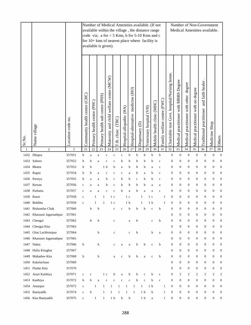
1 2 3
Lo
cati
on
co
de
no
.
Nam
e v
illa
ge
Sr.
No
.
1432 Dhapra 357051
1433 Sahoro 357052
1434 Bhatta 357053
1435 Rupni 357054
1436 Parsiya 357055
1437 Kewan 357056
1438 Parbatta 357057
1439 Ransi 357058
1440 Beldiha 357059
1441 Bishundas Chak 357060
1442 Kharauni Jagarnathpur 357061
1443 Chengai 357062
1444 Chengai Kita 357063
1445 Ghat Lachhimipur 357064
1446 Kharauni Jagarnathpur 357065
1447 Nakta 357066
1448 Hafta Kitaghat 357067
1449 Mahadew Kita 357068
1450 Kakelachaur 357069
1451 Pindar Kita 357070
1452 Arazi Kaithiya 357071
1453 Kaithiya 357072
1454 Amarpur 357073
1455 Baniyadih 357074
1456 Kita Baniyadih 357075
Co
mm
un
ity
hea
lth
cen
tre
(CH
C)
Pri
mar
y h
ealt
h c
entr
e (P
HC
)
Pri
mar
y h
ealt
h s
ub
cen
tre
(PH
S)
Mat
ern
ity
an
d c
hil
d w
elfa
re c
entr
e (M
CW
)
T.B
. cl
inic
(T
BC
)
Ho
spit
al-a
llo
pat
hic
(H
A)
Ho
spit
al-a
lter
nat
ive
med
icin
e (H
O)
Dis
pen
sary
(D
)
Vet
erin
ary
ho
spit
al (
VH
)
Mo
bil
e h
ealt
h c
lin
ic (
MH
C)
Fam
ily
wel
fare
cen
tre
(FW
C)
Ch
arit
able
no
n G
ov
t. h
osp
ital
/Nu
rsin
g h
om
e.
Med
ical
pra
ctit
ion
er w
ith
MB
BS
Deg
ree
Med
ical
pra
ctit
ion
er w
ith
oth
er
deg
ree
Med
ical
pra
ctit
ion
er w
ith
no
deg
ree
Tra
dit
ion
al p
ract
itio
ner
an
d f
aith
hea
ler
.
Med
icin
e S
ho
p
Oth
ers
21 22 23 24 25 26 27 28 29 30 31 32 33 34 35 36 37 38
Number of Non-Government
Medical Amenities available.
Number of Medical Amenities available. (If not
available within the village , the distance range
code viz; a for < 5 Kms, b for 5-10 Kms and c
for 10+ kms of nearest place where facility is
available is given).
b a a c c c b b b b b 0 0 0 0 0 0 0
b b a c c b b b b b c 0 0 0 0 0 0 0
b b 1 b b a b b b a c 0 0 0 0 0 0 0
b b a c c c a b a b c 0 0 0 0 0 0 0
b a a b c b b c b b c 0 0 0 0 0 0 0
c a a b c b b b b a a 0 0 0 0 0 0 0
c a a c c b a b a a c 0 0 0 0 0 0 0
c 1 1 1 c 1 c 1 1 c 1 0 0 0 0 0 0 0
c 1 1 1 c 1 b 1 1 b 1 0 0 0 0 0 0 0
b b c c b b b c b 0 0 0 0 0 0 0
0 0 0 0 0 0 0
b b c a b c b 0 0 0 0 0 0 0
0 0 0 0 0 0 0
b c c b b a 0 0 0 0 0 0 0
0 0 0 0 0 0 0
b b c a a b b c b 0 0 0 0 0 0 0
0 0 0 0 0 0 0
b b a c b b a c b 0 0 0 0 0 0 0
0 0 0 0 0 0 0
0 0 0 0 0 0 0
c c 1 c b a b b c b c 0 2 2 2 2 2 2
b b a c c c c b c b c 0 0 0 0 0 0 0
c 1 1 1 1 1 1 1 1 b 1 0 0 0 0 0 0 0
c b 1 1 1 1 1 1 b b 1 0 0 0 0 0 0 0
c 1 1 1 b b b 1 b a 1 0 0 0 0 0 0 0
288
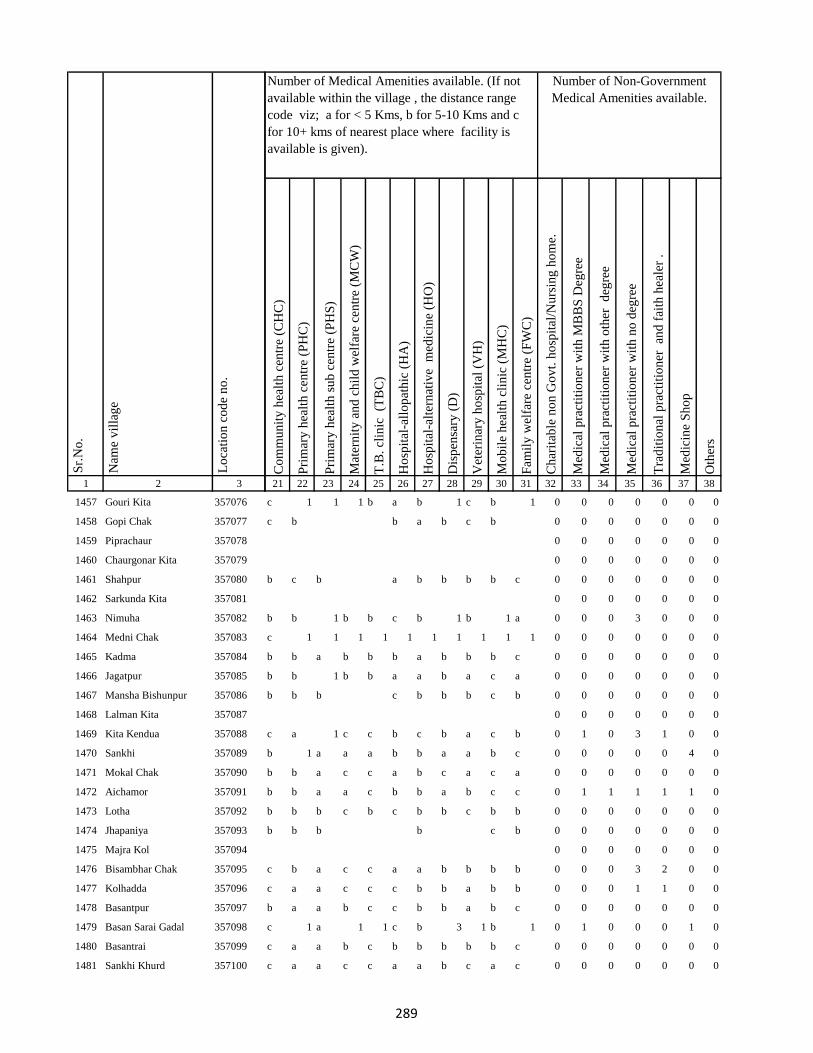
1 2 3
Lo
cati
on
co
de
no
.
Nam
e v
illa
ge
Sr.
No
.
1457 Gouri Kita 357076
1458 Gopi Chak 357077
1459 Piprachaur 357078
1460 Chaurgonar Kita 357079
1461 Shahpur 357080
1462 Sarkunda Kita 357081
1463 Nimuha 357082
1464 Medni Chak 357083
1465 Kadma 357084
1466 Jagatpur 357085
1467 Mansha Bishunpur 357086
1468 Lalman Kita 357087
1469 Kita Kendua 357088
1470 Sankhi 357089
1471 Mokal Chak 357090
1472 Aichamor 357091
1473 Lotha 357092
1474 Jhapaniya 357093
1475 Majra Kol 357094
1476 Bisambhar Chak 357095
1477 Kolhadda 357096
1478 Basantpur 357097
1479 Basan Sarai Gadal 357098
1480 Basantrai 357099
1481 Sankhi Khurd 357100
Co
mm
un
ity
hea
lth
cen
tre
(CH
C)
Pri
mar
y h
ealt
h c
entr
e (P
HC
)
Pri
mar
y h
ealt
h s
ub
cen
tre
(PH
S)
Mat
ern
ity
an
d c
hil
d w
elfa
re c
entr
e (M
CW
)
T.B
. cl
inic
(T
BC
)
Ho
spit
al-a
llo
pat
hic
(H
A)
Ho
spit
al-a
lter
nat
ive
med
icin
e (H
O)
Dis
pen
sary
(D
)
Vet
erin
ary
ho
spit
al (
VH
)
Mo
bil
e h
ealt
h c
lin
ic (
MH
C)
Fam
ily
wel
fare
cen
tre
(FW
C)
Ch
arit
able
no
n G
ov
t. h
osp
ital
/Nu
rsin
g h
om
e.
Med
ical
pra
ctit
ion
er w
ith
MB
BS
Deg
ree
Med
ical
pra
ctit
ion
er w
ith
oth
er
deg
ree
Med
ical
pra
ctit
ion
er w
ith
no
deg
ree
Tra
dit
ion
al p
ract
itio
ner
an
d f
aith
hea
ler
.
Med
icin
e S
ho
p
Oth
ers
21 22 23 24 25 26 27 28 29 30 31 32 33 34 35 36 37 38
Number of Non-Government
Medical Amenities available.
Number of Medical Amenities available. (If not
available within the village , the distance range
code viz; a for < 5 Kms, b for 5-10 Kms and c
for 10+ kms of nearest place where facility is
available is given).
c 1 1 1 b a b 1 c b 1 0 0 0 0 0 0 0
c b b a b c b 0 0 0 0 0 0 0
0 0 0 0 0 0 0
0 0 0 0 0 0 0
b c b a b b b b c 0 0 0 0 0 0 0
0 0 0 0 0 0 0
b b 1 b b c b 1 b 1 a 0 0 0 3 0 0 0
c 1 1 1 1 1 1 1 1 1 1 0 0 0 0 0 0 0
b b a b b b a b b b c 0 0 0 0 0 0 0
b b 1 b b a a b a c a 0 0 0 0 0 0 0
b b b c b b b c b 0 0 0 0 0 0 0
0 0 0 0 0 0 0
c a 1 c c b c b a c b 0 1 0 3 1 0 0
b 1 a a a b b a a b c 0 0 0 0 0 4 0
b b a c c a b c a c a 0 0 0 0 0 0 0
b b a a c b b a b c c 0 1 1 1 1 1 0
b b b c b c b b c b b 0 0 0 0 0 0 0
b b b b c b 0 0 0 0 0 0 0
0 0 0 0 0 0 0
c b a c c a a b b b b 0 0 0 3 2 0 0
c a a c c c b b a b b 0 0 0 1 1 0 0
b a a b c c b b a b c 0 0 0 0 0 0 0
c 1 a 1 1 c b 3 1 b 1 0 1 0 0 0 1 0
c a a b c b b b b b c 0 0 0 0 0 0 0
c a a c c a a b c a c 0 0 0 0 0 0 0
289
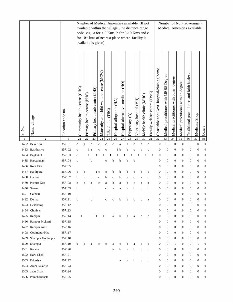
1 2 3
Lo
cati
on
co
de
no
.
Nam
e v
illa
ge
Sr.
No
.
1482 Bela Kita 357101
1483 Baskhoriya 357102
1484 Baghakol 357103
1485 Harganman 357104
1486 Kola Kita 357105
1487 Kaithpura 357106
1488 Lochni 357107
1489 Pachua Kita 357108
1490 Sanaur 357109
1491 Gathaur 357110
1492 Derma 357111
1493 Deshbarag 357112
1494 Chutiyan 357113
1495 Rampur 357114
1496 Rampur Mokarri 357115
1497 Rampur Arazi 357116
1498 Gobindpur Kita 357117
1499 Shampur Gobindpur 357118
1500 Shampur 357119
1501 Kapeta 357120
1502 Karu Chak 357121
1503 Pakariya 357122
1504 Arazi Pakariya 357123
1505 Jadu Chak 357124
1506 Paradharichak 357125
Co
mm
un
ity
hea
lth
cen
tre
(CH
C)
Pri
mar
y h
ealt
h c
entr
e (P
HC
)
Pri
mar
y h
ealt
h s
ub
cen
tre
(PH
S)
Mat
ern
ity
an
d c
hil
d w
elfa
re c
entr
e (M
CW
)
T.B
. cl
inic
(T
BC
)
Ho
spit
al-a
llo
pat
hic
(H
A)
Ho
spit
al-a
lter
nat
ive
med
icin
e (H
O)
Dis
pen
sary
(D
)
Vet
erin
ary
ho
spit
al (
VH
)
Mo
bil
e h
ealt
h c
lin
ic (
MH
C)
Fam
ily
wel
fare
cen
tre
(FW
C)
Ch
arit
able
no
n G
ov
t. h
osp
ital
/Nu
rsin
g h
om
e.
Med
ical
pra
ctit
ion
er w
ith
MB
BS
Deg
ree
Med
ical
pra
ctit
ion
er w
ith
oth
er
deg
ree
Med
ical
pra
ctit
ion
er w
ith
no
deg
ree
Tra
dit
ion
al p
ract
itio
ner
an
d f
aith
hea
ler
.
Med
icin
e S
ho
p
Oth
ers
21 22 23 24 25 26 27 28 29 30 31 32 33 34 35 36 37 38
Number of Non-Government
Medical Amenities available.
Number of Medical Amenities available. (If not
available within the village , the distance range
code viz; a for < 5 Kms, b for 5-10 Kms and c
for 10+ kms of nearest place where facility is
available is given).
c a b c c c a b c b c 0 0 0 0 0 0 0
c 1 a c c 1 b b c b c 0 0 0 0 0 0 0
c 1 1 1 1 1 1 1 1 1 1 0 0 0 0 0 0 0
c b c b b b b 0 0 0 0 0 0 0
0 0 0 0 0 0 0
c b 1 c c b b b c b c 0 0 0 0 0 0 0
b b b c b c b b c a c 0 0 0 0 0 0 0
b b a c a b a b c a a 0 0 0 0 0 0 0
b b c a a b b c c 0 0 0 0 0 0 0
0 0 0 0 0 0 0
b b c c b b b c a 0 0 0 0 0 0 0
0 0 0 0 0 0 0
0 0 0 0 0 0 0
1 1 1 a b b a c b 0 0 0 0 0 0 0
0 0 0 0 0 0 0
0 0 0 0 0 0 0
0 0 0 0 0 0 0
0 0 0 0 0 0 0
b b a c c a c b a c b 0 0 1 0 0 1 0
b b b b c b 0 0 0 0 0 0 0
0 0 0 0 0 0 0
a b b b b 0 0 0 0 0 0 0
0 0 0 0 0 0 0
0 0 0 0 0 0 0
0 0 0 0 0 0 0
290

1 2 3
Lo
cati
on
co
de
no
.
Nam
e v
illa
ge
Sr.
No
.
1507 Jamnikola 357126
1508 Kapra Chak 357127
1509 Surai Kita 357128
1510 Kumhrakol 357129
1511 Banshipur 357130
1512 Bajpai 357131
1513 Resamba 357132
1514 Bhira 357133
1515 Barhampur 357134
1516 Bodra 357135
1517 Susti 357136
1518 Barhaiya 357137
1519 Maheshpur 357138
1520 Hilawa 357139
1521 Chanai Chak 357140
1522 Urkusiya 357141
1523 Arazi Kharti 357142
1524 Kharti 357143
1525 Barhara 357144
1526 Amarpur Ghal 357145
1527 Surniya Ghat Mal 357146
1528 Surniya Mal Ghat 357147
1529 Tofil Surniya 357148
1530 Arazi Surniya Ghat 357149
1531 Phulwariya 357150
Co
mm
un
ity
hea
lth
cen
tre
(CH
C)
Pri
mar
y h
ealt
h c
entr
e (P
HC
)
Pri
mar
y h
ealt
h s
ub
cen
tre
(PH
S)
Mat
ern
ity
an
d c
hil
d w
elfa
re c
entr
e (M
CW
)
T.B
. cl
inic
(T
BC
)
Ho
spit
al-a
llo
pat
hic
(H
A)
Ho
spit
al-a
lter
nat
ive
med
icin
e (H
O)
Dis
pen
sary
(D
)
Vet
erin
ary
ho
spit
al (
VH
)
Mo
bil
e h
ealt
h c
lin
ic (
MH
C)
Fam
ily
wel
fare
cen
tre
(FW
C)
Ch
arit
able
no
n G
ov
t. h
osp
ital
/Nu
rsin
g h
om
e.
Med
ical
pra
ctit
ion
er w
ith
MB
BS
Deg
ree
Med
ical
pra
ctit
ion
er w
ith
oth
er
deg
ree
Med
ical
pra
ctit
ion
er w
ith
no
deg
ree
Tra
dit
ion
al p
ract
itio
ner
an
d f
aith
hea
ler
.
Med
icin
e S
ho
p
Oth
ers
21 22 23 24 25 26 27 28 29 30 31 32 33 34 35 36 37 38
Number of Non-Government
Medical Amenities available.
Number of Medical Amenities available. (If not
available within the village , the distance range
code viz; a for < 5 Kms, b for 5-10 Kms and c
for 10+ kms of nearest place where facility is
available is given).
1 a b b b a c 0 0 0 0 0 0 0
0 0 0 0 0 0 0
b a a c b c a b c b a 0 0 2 0 0 0 0
b b a b c c b b c a c 0 0 0 0 0 0 0
b b a b c b a b c b c 0 0 0 0 0 0 0
b b a b b a b b b b a 0 0 0 2 1 0 0
c c a b 0 0 0 0 0 0 0
0 0 0 0 0 0 0
b 1 a b b b a b c c b 0 0 0 2 2 1 0
b b 1 c c b b 2 c b c 0 0 0 0 0 0 0
1 c c a c 2 b c a 0 0 0 0 0 0 0
0 0 0 0 0 0 0
b a a c c c b c b c b 0 0 0 0 0 0 0
b b a a b b b b b c b 0 0 0 0 0 0 0
b b b b b b b 0 0 0 0 0 0 0
0 0 0 0 0 0 0
0 0 0 0 0 0 0
a b a a b b a b b a c 0 0 0 0 0 0 0
a a 1 b b 1 b 2 a c c 0 0 0 0 0 0 0
b b a b b b b b a c c 0 0 0 0 0 0 0
b c a c c b b b a b c 0 0 0 0 0 0 0
c c b b c a a b b b a 0 0 0 0 0 0 0
b b a b b c 0 0 0 0 0 0 0
0 0 0 0 0 0 0
c c a c c b b b c b a 0 0 0 0 0 0 0
291
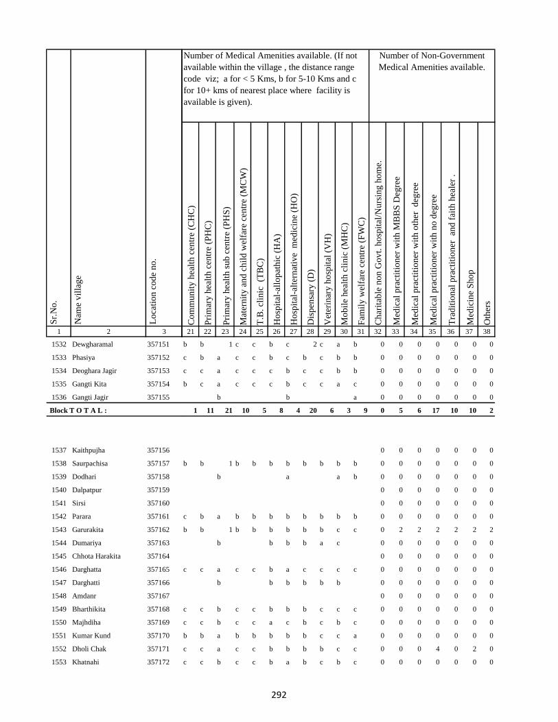
1 2 3
Lo
cati
on
co
de
no
.
Nam
e v
illa
ge
Sr.
No
.
1532 Dewgharamal 357151
1533 Phasiya 357152
1534 Deoghara Jagir 357153
1535 Gangti Kita 357154
1536 Gangti Jagir 357155
Block T O T A L :
1537 Kaithpujha 357156
1538 Saurpachisa 357157
1539 Dodhari 357158
1540 Dalpatpur 357159
1541 Sirsi 357160
1542 Parara 357161
1543 Garurakita 357162
1544 Dumariya 357163
1545 Chhota Harakita 357164
1546 Darghatta 357165
1547 Darghatti 357166
1548 Amdanr 357167
1549 Bharthikita 357168
1550 Majhdiha 357169
1551 Kumar Kund 357170
1552 Dholi Chak 357171
1553 Khatnahi 357172
Co
mm
un
ity
hea
lth
cen
tre
(CH
C)
Pri
mar
y h
ealt
h c
entr
e (P
HC
)
Pri
mar
y h
ealt
h s
ub
cen
tre
(PH
S)
Mat
ern
ity
an
d c
hil
d w
elfa
re c
entr
e (M
CW
)
T.B
. cl
inic
(T
BC
)
Ho
spit
al-a
llo
pat
hic
(H
A)
Ho
spit
al-a
lter
nat
ive
med
icin
e (H
O)
Dis
pen
sary
(D
)
Vet
erin
ary
ho
spit
al (
VH
)
Mo
bil
e h
ealt
h c
lin
ic (
MH
C)
Fam
ily
wel
fare
cen
tre
(FW
C)
Ch
arit
able
no
n G
ov
t. h
osp
ital
/Nu
rsin
g h
om
e.
Med
ical
pra
ctit
ion
er w
ith
MB
BS
Deg
ree
Med
ical
pra
ctit
ion
er w
ith
oth
er
deg
ree
Med
ical
pra
ctit
ion
er w
ith
no
deg
ree
Tra
dit
ion
al p
ract
itio
ner
an
d f
aith
hea
ler
.
Med
icin
e S
ho
p
Oth
ers
21 22 23 24 25 26 27 28 29 30 31 32 33 34 35 36 37 38
Number of Non-Government
Medical Amenities available.
Number of Medical Amenities available. (If not
available within the village , the distance range
code viz; a for < 5 Kms, b for 5-10 Kms and c
for 10+ kms of nearest place where facility is
available is given).
b b 1 c c b c 2 c a b 0 0 0 0 0 0 0
c b a c c b c b c b b 0 0 0 0 0 0 0
c c a c c c b c c b b 0 0 0 0 0 0 0
b c a c c c b c c a c 0 0 0 0 0 0 0
b b a 0 0 0 0 0 0 0
1 11 21 10 5 8 4 20 6 3 9 0 5 6 17 10 10 2
0 0 0 0 0 0 0
b b 1 b b b b b b b b 0 0 0 0 0 0 0
b a a b 0 0 0 0 0 0 0
0 0 0 0 0 0 0
0 0 0 0 0 0 0
c b a b b b b b b b b 0 0 0 0 0 0 0
b b 1 b b b b b b c c 0 2 2 2 2 2 2
b b b b a c 0 0 0 0 0 0 0
0 0 0 0 0 0 0
c c a c c b a c c c c 0 0 0 0 0 0 0
b b b b b b 0 0 0 0 0 0 0
0 0 0 0 0 0 0
c c b c c b b b c c c 0 0 0 0 0 0 0
c c b c c a c b c b c 0 0 0 0 0 0 0
b b a b b b b b c c a 0 0 0 0 0 0 0
c c a c c b b b b c c 0 0 0 4 0 2 0
c c b c c b a b c b c 0 0 0 0 0 0 0
292

1 2 3
Lo
cati
on
co
de
no
.
Nam
e v
illa
ge
Sr.
No
.
1554 Baijnathpur 357173
1555 Amlo 357174
1556 Bohoriya 357175
1557 Bokha 357176
1558 Gangta Phasiya 357177
1559 Malipalgajia 357178
1560 Kusmara 357179
1561 Dusadhi Kola 357180
1562 Maldiha 357181
1563 Simariya 357182
1564 Motia 357183
1565 Rampur 357184
1566 Jharkata 357185
1567 Patwa 357186
1568 Gangta 357187
1569 Barachaur 357188
1570 Karikado 357189
1571 Nayabad 357190
1572 Lachhanpur 357191
1573 Susunia 357192
1574 Tabalpur 357193
1575 Sikatia 357194
1576 Lohbandha 357195
1577 Tuka 357196
1578 Ramla Santali 357197
Co
mm
un
ity
hea
lth
cen
tre
(CH
C)
Pri
mar
y h
ealt
h c
entr
e (P
HC
)
Pri
mar
y h
ealt
h s
ub
cen
tre
(PH
S)
Mat
ern
ity
an
d c
hil
d w
elfa
re c
entr
e (M
CW
)
T.B
. cl
inic
(T
BC
)
Ho
spit
al-a
llo
pat
hic
(H
A)
Ho
spit
al-a
lter
nat
ive
med
icin
e (H
O)
Dis
pen
sary
(D
)
Vet
erin
ary
ho
spit
al (
VH
)
Mo
bil
e h
ealt
h c
lin
ic (
MH
C)
Fam
ily
wel
fare
cen
tre
(FW
C)
Ch
arit
able
no
n G
ov
t. h
osp
ital
/Nu
rsin
g h
om
e.
Med
ical
pra
ctit
ion
er w
ith
MB
BS
Deg
ree
Med
ical
pra
ctit
ion
er w
ith
oth
er
deg
ree
Med
ical
pra
ctit
ion
er w
ith
no
deg
ree
Tra
dit
ion
al p
ract
itio
ner
an
d f
aith
hea
ler
.
Med
icin
e S
ho
p
Oth
ers
21 22 23 24 25 26 27 28 29 30 31 32 33 34 35 36 37 38
Number of Non-Government
Medical Amenities available.
Number of Medical Amenities available. (If not
available within the village , the distance range
code viz; a for < 5 Kms, b for 5-10 Kms and c
for 10+ kms of nearest place where facility is
available is given).
c c b c c b a b c b a 0 0 0 0 0 0 0
c c a c c b a b c b b 0 0 0 0 0 0 0
c c a c c c b b c b b 0 0 0 0 0 0 0
c c a c c c b b b b b 0 2 2 2 2 2 2
c c b c c c b b b a c 0 2 2 2 2 2 2
c b a c b b b b b b a 0 0 0 0 0 0 0
b a b b b c 0 0 0 0 0 0 0
0 0 0 0 0 0 0
b b a b 0 0 0 0 0 0 0
0 0 0 0 0 0 0
b b a b b b c b b b b 0 0 0 0 0 0 0
b b a b 0 0 0 0 0 0 0
0 0 0 0 0 0 0
b b a b b b a b a b c 0 0 0 0 0 0 0
c b b b b a b b a c 0 0 0 0 0 0 0
0 0 0 0 0 0 0
b b a b b b c c b c a 0 0 0 0 0 0 0
c c a c b b b b a b c 0 0 0 0 0 0 0
0 0 0 0 0 0 0
0 0 0 0 0 0 0
0 0 0 0 0 0 0
b a 1 b b a a b c c b 0 0 0 0 0 0 0
b b b b b b a b c b b 0 0 0 0 0 0 0
b b a b b b b b c c c 0 0 0 0 1 0 0
b b 1 b b b c b c c a 0 0 1 4 3 1 0
293

1 2 3
Lo
cati
on
co
de
no
.
Nam
e v
illa
ge
Sr.
No
.
1579 Ramla Dikwani 357198
1580 Nankhil 357199
1581 Devpur 357200
1582 Kumarreri 357201
1583 Saidapur 357202
1584 Algajora 357203
1585 Sinhpur 357204
1586 Parasi 357205
1587 Bhawanipur 357206
1588 Bishunpur 357207
1589 Manpur 357208
1590 Dubrajpur 357209
1591 Gurguri 357210
1592 Reni 357211
1593 Kitabuidi 357212
1594 Kathra 357213
1595 Dokabandh 357214
1596 Makunddih 357215
1597 Makunddin (Santoli) 357216
1598 Pakariya Mal 357217
1599 Pakarya Ghat 357218
1600 Beldiha 357219
1601 Barahara 357220
1602 Harpati Chak 357221
1603 Bansipur 357222
Co
mm
un
ity
hea
lth
cen
tre
(CH
C)
Pri
mar
y h
ealt
h c
entr
e (P
HC
)
Pri
mar
y h
ealt
h s
ub
cen
tre
(PH
S)
Mat
ern
ity
an
d c
hil
d w
elfa
re c
entr
e (M
CW
)
T.B
. cl
inic
(T
BC
)
Ho
spit
al-a
llo
pat
hic
(H
A)
Ho
spit
al-a
lter
nat
ive
med
icin
e (H
O)
Dis
pen
sary
(D
)
Vet
erin
ary
ho
spit
al (
VH
)
Mo
bil
e h
ealt
h c
lin
ic (
MH
C)
Fam
ily
wel
fare
cen
tre
(FW
C)
Ch
arit
able
no
n G
ov
t. h
osp
ital
/Nu
rsin
g h
om
e.
Med
ical
pra
ctit
ion
er w
ith
MB
BS
Deg
ree
Med
ical
pra
ctit
ion
er w
ith
oth
er
deg
ree
Med
ical
pra
ctit
ion
er w
ith
no
deg
ree
Tra
dit
ion
al p
ract
itio
ner
an
d f
aith
hea
ler
.
Med
icin
e S
ho
p
Oth
ers
21 22 23 24 25 26 27 28 29 30 31 32 33 34 35 36 37 38
Number of Non-Government
Medical Amenities available.
Number of Medical Amenities available. (If not
available within the village , the distance range
code viz; a for < 5 Kms, b for 5-10 Kms and c
for 10+ kms of nearest place where facility is
available is given).
b b a b b b c b b a c 0 0 0 0 0 0 0
a b b a b b b b c c b 0 0 0 0 0 0 0
b b 1 b b b b b c c b 0 0 0 0 0 0 0
b b 1 b b b b b c b 1 0 0 0 0 0 0 0
b b b a b c b b 0 0 0 0 0 0 0
0 0 0 0 0 0 0
b b b b b b a b b b c 0 0 0 0 0 0 0
b b b b b 0 0 0 0 0 0 0
0 0 0 0 0 0 0
0 0 0 0 0 0 0
b b b b b b a b a b b 0 0 0 0 0 0 0
b b a b b b a b b a b 0 0 0 0 0 0 0
b b a b b b a b b b b 0 0 1 2 2 0 0
b b a 0 0 0 0 0 0 0
0 0 0 0 0 0 0
b b a b b b c b a b b 0 0 0 0 0 0 0
b b a b b b b b b b b 0 0 0 0 0 0 0
b b b b b b b b b b b 0 0 0 0 0 0 0
b b a b b b b b b b b 0 0 0 0 0 0 0
a a a a a a b a a a a 0 0 0 0 0 0 0
a a a a a a b a a a a 0 0 0 0 0 0 0
a a a a a a a a a a a 0 0 0 0 0 0 0
a 0 0 0 0 0 0 0
0 0 0 0 0 0 0
a a a a a a b a a b a 0 0 0 0 0 0 0
294

1 2 3
Lo
cati
on
co
de
no
.
Nam
e v
illa
ge
Sr.
No
.
1604 Kurma 357223
1605 Baliya 357224
1606 Molnakita 357225
1607 Patpur 357226
1608 Nilkanthpur 357227
1609 Chapri 357228
1610 Bara 357229
1611 Lacchmipur 357230
1612 Nepura 357231
1613 Kakana 357232
1614 Chandarpur 357233
1615 Parariya 357234
1616 Panch Kathi 357235
1617 Burhi Salempur 357236
1618 Arwara 357237
1619 Basarhi 357238
1620 Malni 357239
1621 Chakwa 357240
1622 Machhiya Samarda Urf Lalpur357241
1623 Diyara 357242
1624 Jaipur 357243
1625 Barhauna 357244
1626 Amdiha 357245
1627 Parsa 357246
1628 Kanhwara 357247
Co
mm
un
ity
hea
lth
cen
tre
(CH
C)
Pri
mar
y h
ealt
h c
entr
e (P
HC
)
Pri
mar
y h
ealt
h s
ub
cen
tre
(PH
S)
Mat
ern
ity
an
d c
hil
d w
elfa
re c
entr
e (M
CW
)
T.B
. cl
inic
(T
BC
)
Ho
spit
al-a
llo
pat
hic
(H
A)
Ho
spit
al-a
lter
nat
ive
med
icin
e (H
O)
Dis
pen
sary
(D
)
Vet
erin
ary
ho
spit
al (
VH
)
Mo
bil
e h
ealt
h c
lin
ic (
MH
C)
Fam
ily
wel
fare
cen
tre
(FW
C)
Ch
arit
able
no
n G
ov
t. h
osp
ital
/Nu
rsin
g h
om
e.
Med
ical
pra
ctit
ion
er w
ith
MB
BS
Deg
ree
Med
ical
pra
ctit
ion
er w
ith
oth
er
deg
ree
Med
ical
pra
ctit
ion
er w
ith
no
deg
ree
Tra
dit
ion
al p
ract
itio
ner
an
d f
aith
hea
ler
.
Med
icin
e S
ho
p
Oth
ers
21 22 23 24 25 26 27 28 29 30 31 32 33 34 35 36 37 38
Number of Non-Government
Medical Amenities available.
Number of Medical Amenities available. (If not
available within the village , the distance range
code viz; a for < 5 Kms, b for 5-10 Kms and c
for 10+ kms of nearest place where facility is
available is given).
b b b b b b b b b a b 0 0 0 0 0 0 0
b b a b b b b b b a c 0 0 0 0 0 0 0
b b b b b b a b b c c 0 0 0 0 0 0 0
b b b b b b a b a b c 0 0 0 0 0 0 0
c c a c a b b b a c a 0 0 0 0 0 0 0
b b a b b b a c c c c 0 0 0 0 0 0 0
b b a b b b b b b c c 0 0 0 0 0 0 0
b b b b b b c b c c a 0 0 0 0 0 0 0
b b a b b b b b c b b 0 0 0 0 0 0 0
b a b b b c c b 0 0 0 0 0 0 0
0 0 0 0 0 0 0
0 0 0 0 0 0 0
b b b a b c c a 0 0 0 0 0 0 0
0 0 0 0 0 0 0
0 0 0 0 0 0 0
b b b b b b b b c b b 0 0 0 0 0 0 0
b b a b b b b b b b b 0 0 0 0 0 0 0
b 1 1 b b b a b b b 1 0 0 0 0 0 0 0
b b b b b b b b b b b 0 0 0 0 0 0 0
b b a b b b b b b a c 0 2 2 2 2 2 0
a a a a a b a a b b a 0 0 0 0 0 0 0
b b a b b b c b a b c 0 0 0 0 0 0 0
b b b b b b b b b a c 0 0 0 0 0 0 0
b b b b b a b b b b c 0 0 0 0 0 0 0
b a a c a b a b a b a 0 0 0 0 0 0 0
295

1 2 3
Lo
cati
on
co
de
no
.
Nam
e v
illa
ge
Sr.
No
.
1629 Garbana 357248
1630 Galapahar 357249
1631 Bhadrahi Mal 357250
1632 Ghat Bhadrahi 357251
1633 Chilauna 357252
1634 Rampur 357253
1635 Dumariya Mal 357254
1636 Naya Chak 357255
1637 Dara Chak 357256
1638 Ghat Gorsanda 357257
1639 Mal Gorsanda 357258
1640 Mal Dhamsain 357259
1641 Ghat Dhamsain 357260
1642 Ghat Dhamsain 357261
1643 Khaira Mal 357262
1644 Pachrukhi 357263
1645 Lukluki Mal 357264
1646 Lukluki Ghat 357265
1647 Pathariya Mal 357266
1648 Pathariya Ghat 357267
1649 Pathariya Mal 357268
1650 Chhota Kaliyani 357269
1651 Bara Kaliyani 357270
1652 Pathriya Mal 357271
1653 Sabaijor 357272
Co
mm
un
ity
hea
lth
cen
tre
(CH
C)
Pri
mar
y h
ealt
h c
entr
e (P
HC
)
Pri
mar
y h
ealt
h s
ub
cen
tre
(PH
S)
Mat
ern
ity
an
d c
hil
d w
elfa
re c
entr
e (M
CW
)
T.B
. cl
inic
(T
BC
)
Ho
spit
al-a
llo
pat
hic
(H
A)
Ho
spit
al-a
lter
nat
ive
med
icin
e (H
O)
Dis
pen
sary
(D
)
Vet
erin
ary
ho
spit
al (
VH
)
Mo
bil
e h
ealt
h c
lin
ic (
MH
C)
Fam
ily
wel
fare
cen
tre
(FW
C)
Ch
arit
able
no
n G
ov
t. h
osp
ital
/Nu
rsin
g h
om
e.
Med
ical
pra
ctit
ion
er w
ith
MB
BS
Deg
ree
Med
ical
pra
ctit
ion
er w
ith
oth
er
deg
ree
Med
ical
pra
ctit
ion
er w
ith
no
deg
ree
Tra
dit
ion
al p
ract
itio
ner
an
d f
aith
hea
ler
.
Med
icin
e S
ho
p
Oth
ers
21 22 23 24 25 26 27 28 29 30 31 32 33 34 35 36 37 38
Number of Non-Government
Medical Amenities available.
Number of Medical Amenities available. (If not
available within the village , the distance range
code viz; a for < 5 Kms, b for 5-10 Kms and c
for 10+ kms of nearest place where facility is
available is given).
c 1 a b b b a c a a c 0 0 0 0 1 0 0
a b a b b b b b a a c 0 0 0 1 2 0 0
b b b b b b c b b c a 0 0 0 0 0 0 0
c b a b b b b b b b b 0 0 0 0 0 0 0
b b a b a b a b b c b 0 0 0 0 0 0 0
b b a b b b a b a c b 0 0 0 0 0 0 0
b b b b b b b b a c c 0 0 0 0 0 0 0
b b a b b b a b c c a 0 0 0 0 0 0 0
b b a b b b b b b b c 0 0 0 0 0 0 0
b b b b b b b b c c b 0 0 0 0 0 0 0
0 0 0 0 0 0 0
0 0 0 0 0 0 0
0 0 0 0 0 0 0
c c b c b b c b b c b 0 0 0 0 0 0 0
0 0 0 0 0 0 0
b b b b b b b b c b c 0 0 0 0 0 0 0
0 0 0 0 0 0 0
c c c c c b c c c b 0 0 0 0 0 0 0
0 0 0 0 0 0 0
b b b a c 0 0 0 0 0 0 0
0 0 0 0 0 0 0
c c b c b b c b b b a 0 0 0 0 0 0 0
c b b c b b b b b a c 0 0 0 0 0 0 0
c c a c a b b b a c c 0 0 0 0 0 0 0
c c a c b b b c b c a 0 0 0 0 0 0 0
296

1 2 3
Lo
cati
on
co
de
no
.
Nam
e v
illa
ge
Sr.
No
.
1654 Karudih 357273
1655 Kauadhab 357274
1656 Gaechhand 357275
1657 Chinadhab 357276
1658 Tilobadar 357277
1659 Pelgarhi Dhopahari 357278
1660 Karmatanr 357279
1661 Betiyabahiyar 357280
1662 Ranidih 357281
1663 Malhra 357282
1664 Kurmi Chak 357283
1665 Kajradah 357284
1666 Charkakol Ghat 357285
1667 Mahugariya 357286
1668 Ratrati 357287
1669 Karhariya Mal 357288
1670 Kubji Ghat 357289
1671 Pathwara 357290
1672 Karhariya Ghat 357291
1673 Mal Domuria 357292
1674 Karhariya Mal 357293
1675 Amghata 357294
1676 Ghat Dumariya 357295
1677 Kita Pelgarhi Dhopahari 357296
1678 Kajradah 357297
Co
mm
un
ity
hea
lth
cen
tre
(CH
C)
Pri
mar
y h
ealt
h c
entr
e (P
HC
)
Pri
mar
y h
ealt
h s
ub
cen
tre
(PH
S)
Mat
ern
ity
an
d c
hil
d w
elfa
re c
entr
e (M
CW
)
T.B
. cl
inic
(T
BC
)
Ho
spit
al-a
llo
pat
hic
(H
A)
Ho
spit
al-a
lter
nat
ive
med
icin
e (H
O)
Dis
pen
sary
(D
)
Vet
erin
ary
ho
spit
al (
VH
)
Mo
bil
e h
ealt
h c
lin
ic (
MH
C)
Fam
ily
wel
fare
cen
tre
(FW
C)
Ch
arit
able
no
n G
ov
t. h
osp
ital
/Nu
rsin
g h
om
e.
Med
ical
pra
ctit
ion
er w
ith
MB
BS
Deg
ree
Med
ical
pra
ctit
ion
er w
ith
oth
er
deg
ree
Med
ical
pra
ctit
ion
er w
ith
no
deg
ree
Tra
dit
ion
al p
ract
itio
ner
an
d f
aith
hea
ler
.
Med
icin
e S
ho
p
Oth
ers
21 22 23 24 25 26 27 28 29 30 31 32 33 34 35 36 37 38
Number of Non-Government
Medical Amenities available.
Number of Medical Amenities available. (If not
available within the village , the distance range
code viz; a for < 5 Kms, b for 5-10 Kms and c
for 10+ kms of nearest place where facility is
available is given).
c c a c b a a b b c b 0 1 0 0 0 0 0
b c b c b b a b a c b 0 0 0 0 0 0 0
b b a b b b a b a b b 0 0 0 0 0 0 0
b b a c a b b b a b c 0 0 0 0 0 0 0
c b a c b b b b b a a 0 0 0 0 0 0 0
c a b c b b b b c a c 0 0 0 0 0 0 0
b b b a b c b 0 0 0 0 0 0 0
0 0 0 0 0 0 0
c a a b b b a b b c b 0 0 0 0 0 0 0
c a b b b b b b b c b 0 0 0 0 0 0 0
b b b c b a c b 0 0 0 0 0 0 0
0 0 0 0 0 0 0
b b b b b c b 0 0 0 0 0 0 0
0 0 0 0 0 0 0
b b 1 b b b b b c c c 0 0 0 0 0 0 0
b b a b b b b b c b c 0 0 0 0 0 0 0
b b a b b b b b c c a 0 0 0 0 0 0 0
b a b b a b a b c c c 0 0 0 0 0 0 0
c b b b b b a c b b c 0 0 0 0 0 0 0
b b b b b c b a 0 0 0 0 0 0 0
0 0 0 0 0 0 0
0 0 0 0 0 0 0
0 0 0 0 0 0 0
c c a c b b a b b a c 0 0 0 0 0 0 0
a a a b b a a b b b a 0 0 0 0 0 0 0
297

1 2 3
Lo
cati
on
co
de
no
.
Nam
e v
illa
ge
Sr.
No
.
1679 Rajpura 357298
1680 Charkakol Ghat 357299
1681 Masudanpur 357300
1682 Kusmainimal 357301
1683 Sasan 357302
1684 Bishunpur 357303
1685 Kutnipathar 357304
1686 Kathaun 357305
1687 Parariya Mal 357306
1688 Kita Parariya Ghat 357307
1689 Kita Gorgawan 357308
1690 Karhariya Ghat 357309
1691 Kusmani Ghat 357310
1692 Ratanpur 357311
1693 Tarwari 357312
1694 Manjwara Ghat 357313
1695 Bishunpur 357314
1696 Kalyani Kita 357315
1697 Ghat Dumariya 357316
1698 Kita Shampur 357317
1699 Kusmain Ghat Chhit 357318
1700 Kita Thathar 357319
1701 Kita Gawar 357320
1702 Kita Gorgawan 357321
1703 Kasba Godda 357322
Co
mm
un
ity
hea
lth
cen
tre
(CH
C)
Pri
mar
y h
ealt
h c
entr
e (P
HC
)
Pri
mar
y h
ealt
h s
ub
cen
tre
(PH
S)
Mat
ern
ity
an
d c
hil
d w
elfa
re c
entr
e (M
CW
)
T.B
. cl
inic
(T
BC
)
Ho
spit
al-a
llo
pat
hic
(H
A)
Ho
spit
al-a
lter
nat
ive
med
icin
e (H
O)
Dis
pen
sary
(D
)
Vet
erin
ary
ho
spit
al (
VH
)
Mo
bil
e h
ealt
h c
lin
ic (
MH
C)
Fam
ily
wel
fare
cen
tre
(FW
C)
Ch
arit
able
no
n G
ov
t. h
osp
ital
/Nu
rsin
g h
om
e.
Med
ical
pra
ctit
ion
er w
ith
MB
BS
Deg
ree
Med
ical
pra
ctit
ion
er w
ith
oth
er
deg
ree
Med
ical
pra
ctit
ion
er w
ith
no
deg
ree
Tra
dit
ion
al p
ract
itio
ner
an
d f
aith
hea
ler
.
Med
icin
e S
ho
p
Oth
ers
21 22 23 24 25 26 27 28 29 30 31 32 33 34 35 36 37 38
Number of Non-Government
Medical Amenities available.
Number of Medical Amenities available. (If not
available within the village , the distance range
code viz; a for < 5 Kms, b for 5-10 Kms and c
for 10+ kms of nearest place where facility is
available is given).
b b b b b b b c 0 0 0 0 0 0 0
0 0 0 0 0 0 0
0 0 0 0 0 0 0
0 0 0 0 0 0 0
0 0 0 0 0 0 0
0 0 0 0 0 0 0
c 1 1 c b c a b a c c 0 0 0 0 0 0 0
c c 1 c b c a b a c c 0 0 0 0 0 0 0
c c b c c c a c a c c 0 0 0 0 0 0 0
b b b 0 0 0 0 0 0 0
0 0 0 0 0 0 0
0 0 0 0 0 0 0
a a b c b c b c c c c 0 0 0 0 0 0 0
c a b c b b a b b b c 0 0 0 0 0 0 0
c 1 a c a b b b b b c 0 0 0 0 0 0 0
c b a b b b b b a a c 0 0 0 0 0 0 0
c a a b b b a b a a a 0 0 0 0 0 0 0
c b b b b b c c c c c 0 0 0 0 0 0 0
b b b b b b b c 0 0 0 0 0 0 0
0 0 0 0 0 0 0
0 0 0 0 0 0 0
0 0 0 0 0 0 0
0 0 0 0 0 0 0
b b b c b b b c 0 0 0 0 0 0 0
0 0 0 0 0 0 0
298

1 2 3
Lo
cati
on
co
de
no
.
Nam
e v
illa
ge
Sr.
No
.
1704 Ghat Paharpur 357323
1705 Kutni Pathar 357324
1706 Gorka Kita 357325
1707 Bhandar Koli 357326
1708 Harlal Tola 357327
1709 Haripur 357328
1710 Ghat Paharpur 357329
1711 Kasba Godda 357330
1712 Ghat Paharpur 357331
1713 Mohanpur 357332
1714 Markhan 357333
1715 Daldali 357334
1716 Jamuni Paharpur 357335
1717 Ghat Paharpur 357336
1718 Nonmati 357337
1719 Sarotiya 357338
1720 Bhatdiha 357339
1721 Bengbahiyar 357340
1722 Rupiyamal 357341
1723 Maruabaran 357342
1724 Kauribahiyarmal Chhit 357343
1725 Kauribahiyar Ghat 357344
1726 Kauribahiyar Mal 357345
1727 Pairdih 357346
1728 Kanadih Chhit 357347
Co
mm
un
ity
hea
lth
cen
tre
(CH
C)
Pri
mar
y h
ealt
h c
entr
e (P
HC
)
Pri
mar
y h
ealt
h s
ub
cen
tre
(PH
S)
Mat
ern
ity
an
d c
hil
d w
elfa
re c
entr
e (M
CW
)
T.B
. cl
inic
(T
BC
)
Ho
spit
al-a
llo
pat
hic
(H
A)
Ho
spit
al-a
lter
nat
ive
med
icin
e (H
O)
Dis
pen
sary
(D
)
Vet
erin
ary
ho
spit
al (
VH
)
Mo
bil
e h
ealt
h c
lin
ic (
MH
C)
Fam
ily
wel
fare
cen
tre
(FW
C)
Ch
arit
able
no
n G
ov
t. h
osp
ital
/Nu
rsin
g h
om
e.
Med
ical
pra
ctit
ion
er w
ith
MB
BS
Deg
ree
Med
ical
pra
ctit
ion
er w
ith
oth
er
deg
ree
Med
ical
pra
ctit
ion
er w
ith
no
deg
ree
Tra
dit
ion
al p
ract
itio
ner
an
d f
aith
hea
ler
.
Med
icin
e S
ho
p
Oth
ers
21 22 23 24 25 26 27 28 29 30 31 32 33 34 35 36 37 38
Number of Non-Government
Medical Amenities available.
Number of Medical Amenities available. (If not
available within the village , the distance range
code viz; a for < 5 Kms, b for 5-10 Kms and c
for 10+ kms of nearest place where facility is
available is given).
0 0 0 0 0 0 0
b b b a b c b 0 0 0 0 0 0 0
0 0 0 0 0 0 0
c a b b b b a b b c b 0 0 0 0 2 0 0
c b a b b b a b b b b 0 0 0 0 0 0 0
b b a b b b b b b b b 0 0 0 0 0 0 0
b b a b b b c b b b c 0 0 0 0 3 0 0
b c b b 0 0 0 0 0 0 0
0 0 0 0 0 0 0
c c 1 c c b b c b a c 0 0 0 0 0 0 0
b a a b b a b b b b c 0 0 0 0 0 0 0
b 1 1 b b b a b a b 1 0 1 0 0 0 0 0
b a b a a c 0 0 0 0 0 0 0
0 0 0 0 0 0 0
b b b a b b b c b b c 0 0 0 0 0 0 0
b b b b b b b b b a c 0 0 0 0 0 3 0
a a a a b b b b b a a 0 0 0 0 0 0 0
a a a a b b a b a c b 0 0 0 0 0 0 0
a a a a a b a b a b b 0 0 0 0 0 0 0
b b b b b b a b c c b 0 0 0 0 0 0 0
0 0 0 0 0 0 0
b b 1 b b b c b c c a 0 0 0 0 0 0 0
b b a b b a c b c c c 0 0 0 0 0 0 0
a a b a b b b b c b b 0 0 0 0 0 0 1
a a b a b b b b c c b 0 0 0 0 0 0 0
299

1 2 3
Lo
cati
on
co
de
no
.
Nam
e v
illa
ge
Sr.
No
.
1729 Gorhighat Chhit 357348
1730 Kanidih Chhit 357349
1731 Jamua 357350
1732 Kurman Ghat 357351
1733 Lamhati Kar 357352
1734 Kurman Mal 357353
1735 Dharmudih 357354
1736 Punsiya 357355
1737 Kumardih 357356
1738 Murlidih Kita 357357
1739 Pandubathan 357358
1740 Sarkanda 357359
1741 Pathra 357360
1742 Bilari 357361
1743 Ghat Jamuni 357362
1744 Pandaha 357363
1745 Ghat Jhilua 357364
1746 Lachhmi 357365
1747 Ghat Jopnadih 357366
1748 Majhdiha 357367
1749 Makhni 357368
1750 Amarpur 357369
1751 Baramasia 357370
1752 Sonjhar 357371
1753 Kadwa 357372
Co
mm
un
ity
hea
lth
cen
tre
(CH
C)
Pri
mar
y h
ealt
h c
entr
e (P
HC
)
Pri
mar
y h
ealt
h s
ub
cen
tre
(PH
S)
Mat
ern
ity
an
d c
hil
d w
elfa
re c
entr
e (M
CW
)
T.B
. cl
inic
(T
BC
)
Ho
spit
al-a
llo
pat
hic
(H
A)
Ho
spit
al-a
lter
nat
ive
med
icin
e (H
O)
Dis
pen
sary
(D
)
Vet
erin
ary
ho
spit
al (
VH
)
Mo
bil
e h
ealt
h c
lin
ic (
MH
C)
Fam
ily
wel
fare
cen
tre
(FW
C)
Ch
arit
able
no
n G
ov
t. h
osp
ital
/Nu
rsin
g h
om
e.
Med
ical
pra
ctit
ion
er w
ith
MB
BS
Deg
ree
Med
ical
pra
ctit
ion
er w
ith
oth
er
deg
ree
Med
ical
pra
ctit
ion
er w
ith
no
deg
ree
Tra
dit
ion
al p
ract
itio
ner
an
d f
aith
hea
ler
.
Med
icin
e S
ho
p
Oth
ers
21 22 23 24 25 26 27 28 29 30 31 32 33 34 35 36 37 38
Number of Non-Government
Medical Amenities available.
Number of Medical Amenities available. (If not
available within the village , the distance range
code viz; a for < 5 Kms, b for 5-10 Kms and c
for 10+ kms of nearest place where facility is
available is given).
0 0 0 0 0 0 0
0 0 0 0 0 0 0
b a b b b b b 1 c c b 0 0 0 0 0 0 0
b b a b b b a b c c c 0 0 0 0 0 0 0
a a a a b b a b c b c 0 0 0 0 0 0 0
b b b b b b b b b b c 0 0 0 0 0 0 0
b b 1 b b b b b b b c 0 0 0 0 0 0 0
b a a b b b b b b b a 0 0 0 0 0 0 0
b b a b b b b c b b c 0 0 0 0 0 0 0
b b 1 b a b a b b a c 0 0 0 0 0 0 0
a a a a b a a b a b a 0 0 0 0 0 0 0
b b 1 b b 1 b b b b b 0 0 0 0 0 0 0
a a b b b 1 a b b a b 0 0 0 0 0 0 0
b b 1 b b b b b a b b 0 0 0 0 0 0 0
b 1 1 b b b c b a b c 0 0 0 0 0 0 0
b b a b b b b b a b a 0 0 0 0 0 0 0
b b b b b b b b b a c 0 0 0 0 0 0 0
b b a b b b a b b a b 0 0 0 0 0 0 0
b b a b b b a b b c b 0 0 0 0 0 0 0
b b a b b b a b b b b 0 0 0 0 0 0 0
a a b b a b b b b c b 0 0 0 0 0 0 0
c c a c b b b b b c b 0 0 0 0 0 0 0
b b a b b b b b a c c 0 0 0 0 0 0 0
c b a b b a b b a c b 0 0 0 0 0 0 0
c b 1 b b b a b c b 1 0 0 0 0 0 0 0
300

1 2 3
Lo
cati
on
co
de
no
.
Nam
e v
illa
ge
Sr.
No
.
1754 Nonbatta 357373
1755 Teldiha 357374
1756 Banka Ghat 357375
1757 Langradih 357376
1758 Bhalpahari 357377
1759 Sundarmor 357378
1760 Nipaniya 357379
1761 Baristanr 357380
1762 Jalgar 357381
1763 Sandmara 357382
1764 Dhokal Tola 357383
1765 Nandupahari 357384
1766 Jainagar Piprajoria 357385
1767 Birbal Tola 357386
1768 Belbathan 357387
1769 Raj Daha 357388
1770 Lalpur 357389
1771 Shampur 357390
1772 Jhagarahi 357391
1773 Kalhajor Kalan 357392
1774 Saharpur 357393
1775 Jhilua 357394
1776 Amjora 357395
1777 Hijaljor 357396
1778 Kundadah 357397
Co
mm
un
ity
hea
lth
cen
tre
(CH
C)
Pri
mar
y h
ealt
h c
entr
e (P
HC
)
Pri
mar
y h
ealt
h s
ub
cen
tre
(PH
S)
Mat
ern
ity
an
d c
hil
d w
elfa
re c
entr
e (M
CW
)
T.B
. cl
inic
(T
BC
)
Ho
spit
al-a
llo
pat
hic
(H
A)
Ho
spit
al-a
lter
nat
ive
med
icin
e (H
O)
Dis
pen
sary
(D
)
Vet
erin
ary
ho
spit
al (
VH
)
Mo
bil
e h
ealt
h c
lin
ic (
MH
C)
Fam
ily
wel
fare
cen
tre
(FW
C)
Ch
arit
able
no
n G
ov
t. h
osp
ital
/Nu
rsin
g h
om
e.
Med
ical
pra
ctit
ion
er w
ith
MB
BS
Deg
ree
Med
ical
pra
ctit
ion
er w
ith
oth
er
deg
ree
Med
ical
pra
ctit
ion
er w
ith
no
deg
ree
Tra
dit
ion
al p
ract
itio
ner
an
d f
aith
hea
ler
.
Med
icin
e S
ho
p
Oth
ers
21 22 23 24 25 26 27 28 29 30 31 32 33 34 35 36 37 38
Number of Non-Government
Medical Amenities available.
Number of Medical Amenities available. (If not
available within the village , the distance range
code viz; a for < 5 Kms, b for 5-10 Kms and c
for 10+ kms of nearest place where facility is
available is given).
b b a b c b b b b c b 0 0 0 0 0 0 0
c c a c b b b b c c c 0 0 0 0 0 0 0
c c b c b b a b c b c 0 0 0 0 0 0 1
c a a c a b c c c c c 0 0 0 0 0 0 0
c c a c a b b b c c c 0 0 0 0 0 0 0
c c b c b b b b b b c 0 0 0 0 0 0 0
c c b c c b a b c b a 0 0 0 0 0 0 0
b a b a b c b c 0 0 0 0 0 0 0
0 0 0 0 0 0 0
b b c b c b a 0 0 0 0 0 0 0
0 0 0 0 0 0 0
c c a c c a a b b b b 0 0 0 0 0 0 0
c c a c c b a b b b b 0 2 2 2 2 2 2
c c a c c c b b b a c 0 0 0 0 0 0 0
b a b b a b a b b b a 0 0 0 0 0 0 0
b b b b a b c 0 0 0 0 0 0 0
0 0 0 0 0 0 0
c c a c b b c b b a b 0 2 2 2 2 2 2
c c b c b b c c a c b 0 0 0 0 0 0 0
c b a b b b a b a b b 0 0 0 0 0 0 0
b b a b b b b b a c b 0 0 0 0 0 0 0
b a b b b b c b b c c 0 0 0 0 0 0 0
b b a b b b c b b c c 0 0 0 0 0 0 0
b b b b b a b c b c c 0 0 0 0 0 0 0
b b a b b b b b b b c 0 0 0 0 0 0 0
301

1 2 3
Lo
cati
on
co
de
no
.
Nam
e v
illa
ge
Sr.
No
.
1779 Karanpur 357398
1780 Kalhajor Khurd 357399
1781 Sahari 357400
1782 Dumma 357401
1783 Malmala 357402
1784 Karam Tola 357403
1785 Danga 357404
1786 Jamkudar 357405
1787 Siarkatiya 357406
1788 Burhikura 357407
1789 Haripur 357408
1790 Dulu 357409
1791 Bhawani 357410
Block T O T A L :
1792 Parasi 357412
1793 Andadih 357413
1794 Masanibeldiha 357414
1795 Muchora 357415
1796 Amra Kamat 357416
1797 Amra Mochora Kamat 357417
1798 Amra Kanauli 357418
1799 Amra Mochora Kamat 357419
1800 Jaijalpur 357420
Co
mm
un
ity
hea
lth
cen
tre
(CH
C)
Pri
mar
y h
ealt
h c
entr
e (P
HC
)
Pri
mar
y h
ealt
h s
ub
cen
tre
(PH
S)
Mat
ern
ity
an
d c
hil
d w
elfa
re c
entr
e (M
CW
)
T.B
. cl
inic
(T
BC
)
Ho
spit
al-a
llo
pat
hic
(H
A)
Ho
spit
al-a
lter
nat
ive
med
icin
e (H
O)
Dis
pen
sary
(D
)
Vet
erin
ary
ho
spit
al (
VH
)
Mo
bil
e h
ealt
h c
lin
ic (
MH
C)
Fam
ily
wel
fare
cen
tre
(FW
C)
Ch
arit
able
no
n G
ov
t. h
osp
ital
/Nu
rsin
g h
om
e.
Med
ical
pra
ctit
ion
er w
ith
MB
BS
Deg
ree
Med
ical
pra
ctit
ion
er w
ith
oth
er
deg
ree
Med
ical
pra
ctit
ion
er w
ith
no
deg
ree
Tra
dit
ion
al p
ract
itio
ner
an
d f
aith
hea
ler
.
Med
icin
e S
ho
p
Oth
ers
21 22 23 24 25 26 27 28 29 30 31 32 33 34 35 36 37 38
Number of Non-Government
Medical Amenities available.
Number of Medical Amenities available. (If not
available within the village , the distance range
code viz; a for < 5 Kms, b for 5-10 Kms and c
for 10+ kms of nearest place where facility is
available is given).
b b b a a b b b b c a 0 0 0 0 0 0 0
b a b b b b a b a c c 0 0 0 0 0 0 0
b b 1 b b b a b a b c 0 0 0 0 0 0 0
b a a b b b a b c c a 0 0 0 0 0 0 0
b b b b b b c b 0 0 0 0 0 0 0
0 0 0 0 0 0 0
b b a b b b b b c b b 0 0 0 0 0 0 0
b a a c b b a b c b c 0 0 0 0 0 0 0
a a 1 b a b a 1 c b a 0 0 0 0 0 0 0
a c b c a b a b b b c 0 0 0 0 0 0 0
0 0 0 0 0 0 0
b b a c c a c b c b b 0 0 0 0 0 0 0
b c a c a b c b c b b 0 0 0 0 0 0 0
0 6 21 0 0 2 0 2 0 0 4 0 14 14 23 26 18 12
a b c b c a b 0 0 0 0 0 0 0
0 0 0 0 0 0 0
a a a c a c b c b c c 0 0 0 0 0 0 0
a b b c c c b b b b c 0 0 0 0 0 0 0
a b c b b b b c 0 0 0 0 0 0 0
0 0 0 0 0 0 0
b c a b a a a 0 0 0 0 0 0 0
0 0 0 0 0 0 0
a a a c c c b b b b c 0 0 0 0 0 0 0
302

1 2 3
Lo
cati
on
co
de
no
.
Nam
e v
illa
ge
Sr.
No
.
1801 Sondiha 357421
1802 Rengniya 357422
1803 Baliya Kita 357423
1804 Baksara 357424
1805 Chhitni Purniya 357425
1806 Jagarnathpur 357426
1807 Korasi 357427
1808 Dardaha Kita 357428
1809 Ranabandh 357429
1810 Asarimadhuri 357430
1811 Ratanpur 357431
1812 Dindayalpur 357432
1813 Sarwan 357433
1814 Jalgo 357434
1815 Bohra 357435
1816 Petbi 357436
1817 Gaeghat 357437
1818 Mali 357438
1819 Basantpur 357439
1820 Debandha 357440
1821 Guma 357441
1822 Mahra 357442
1823 Behrajor 357443
1824 Manikpur 357444
1825 Birniyan 357445
Co
mm
un
ity
hea
lth
cen
tre
(CH
C)
Pri
mar
y h
ealt
h c
entr
e (P
HC
)
Pri
mar
y h
ealt
h s
ub
cen
tre
(PH
S)
Mat
ern
ity
an
d c
hil
d w
elfa
re c
entr
e (M
CW
)
T.B
. cl
inic
(T
BC
)
Ho
spit
al-a
llo
pat
hic
(H
A)
Ho
spit
al-a
lter
nat
ive
med
icin
e (H
O)
Dis
pen
sary
(D
)
Vet
erin
ary
ho
spit
al (
VH
)
Mo
bil
e h
ealt
h c
lin
ic (
MH
C)
Fam
ily
wel
fare
cen
tre
(FW
C)
Ch
arit
able
no
n G
ov
t. h
osp
ital
/Nu
rsin
g h
om
e.
Med
ical
pra
ctit
ion
er w
ith
MB
BS
Deg
ree
Med
ical
pra
ctit
ion
er w
ith
oth
er
deg
ree
Med
ical
pra
ctit
ion
er w
ith
no
deg
ree
Tra
dit
ion
al p
ract
itio
ner
an
d f
aith
hea
ler
.
Med
icin
e S
ho
p
Oth
ers
21 22 23 24 25 26 27 28 29 30 31 32 33 34 35 36 37 38
Number of Non-Government
Medical Amenities available.
Number of Medical Amenities available. (If not
available within the village , the distance range
code viz; a for < 5 Kms, b for 5-10 Kms and c
for 10+ kms of nearest place where facility is
available is given).
c 1 1 1 1 1 1 1 1 1 1 0 0 0 0 0 0 0
c b a b b b b b a c b 0 0 0 0 0 0 0
c c 1 1 a 1 a b a c b 0 0 0 0 0 0 0
b b b a b b c b 0 0 0 0 0 0 0
0 0 0 0 0 0 0
c c a b b b a b c c a 0 0 0 0 0 0 0
b b b b b c c 0 0 0 0 0 0 0
0 0 0 0 0 0 0
c a a b a b b b b c b 0 0 0 0 2 1 0
c c a 1 b b b b b c b 0 0 0 0 0 0 0
b b a a b a b b 0 0 0 0 0 0 0
0 0 0 0 0 0 0
c a a b a b a b c b c 0 0 0 0 0 0 0
c b a b a b b b b b c 0 0 0 0 0 0 0
b b a b b b b b c b c 0 0 0 0 0 0 0
b b b b b c a c 0 0 0 0 0 0 0
0 0 0 0 0 0 0
a c a c b b a c c b c 0 0 0 0 0 0 0
c c 1 c b b b b b a c 0 0 0 0 0 0 0
b b 1 b b b b b c b a 0 0 0 0 0 0 0
c c a b b b a b c c b 0 0 0 0 0 0 0
c c b b b b c b c b b 0 0 0 0 0 0 0
c b b c b b b b c b b 0 0 0 0 0 0 0
b c a 1 b a b b b a c 0 0 0 0 0 0 0
c b a b a b a b b a a 0 0 0 0 0 0 0
303

1 2 3
Lo
cati
on
co
de
no
.
Nam
e v
illa
ge
Sr.
No
.
1826 Dahupadhar 357446
1827 Liladah 357447
1828 Teliyatikar 357448
1829 Sasankita 357449
1830 Mohani 357450
1831 Ghanshampur 357451
1832 Danre 357452
1833 Lauamahua 357453
1834 Mohanabarandande 357454
1835 Balua 357455
1836 Beldanga 357456
1837 Sat Bandha 357457
1838 Naudiha 357458
1839 Kathwan 357459
1840 Parsoti 357460
1841 Bhatondha 357461
1842 Barga Chhahariyari 357462
1843 Sikatiya 357463
1844 Latta(Santali) 357464
1845 Latta (Dikuani) 357465
1846 Surapparwa 357466
1847 Balathar 357467
1848 Amjora 357468
1849 Burhnajor 357469
1850 Pakariya 357470
Co
mm
un
ity
hea
lth
cen
tre
(CH
C)
Pri
mar
y h
ealt
h c
entr
e (P
HC
)
Pri
mar
y h
ealt
h s
ub
cen
tre
(PH
S)
Mat
ern
ity
an
d c
hil
d w
elfa
re c
entr
e (M
CW
)
T.B
. cl
inic
(T
BC
)
Ho
spit
al-a
llo
pat
hic
(H
A)
Ho
spit
al-a
lter
nat
ive
med
icin
e (H
O)
Dis
pen
sary
(D
)
Vet
erin
ary
ho
spit
al (
VH
)
Mo
bil
e h
ealt
h c
lin
ic (
MH
C)
Fam
ily
wel
fare
cen
tre
(FW
C)
Ch
arit
able
no
n G
ov
t. h
osp
ital
/Nu
rsin
g h
om
e.
Med
ical
pra
ctit
ion
er w
ith
MB
BS
Deg
ree
Med
ical
pra
ctit
ion
er w
ith
oth
er
deg
ree
Med
ical
pra
ctit
ion
er w
ith
no
deg
ree
Tra
dit
ion
al p
ract
itio
ner
an
d f
aith
hea
ler
.
Med
icin
e S
ho
p
Oth
ers
21 22 23 24 25 26 27 28 29 30 31 32 33 34 35 36 37 38
Number of Non-Government
Medical Amenities available.
Number of Medical Amenities available. (If not
available within the village , the distance range
code viz; a for < 5 Kms, b for 5-10 Kms and c
for 10+ kms of nearest place where facility is
available is given).
c a a b b b a b b c c 0 0 0 0 0 0 0
c c b a b b b b b b b 0 0 0 0 0 0 0
b b b c b b c b 0 0 0 0 0 0 0
0 0 0 0 0 0 0
c b a a c b a b b c b 0 0 0 0 0 0 0
c c 1 b b b a b c c b 0 1 0 0 0 2 0
b b b b b a b c 0 0 0 0 0 0 0
0 0 0 0 0 0 0
0 0 0 0 0 0 0
c 1 b c b a b b b a c 0 0 0 0 0 0 0
c c a c c b c b c c c 0 0 0 0 0 0 0
c c a c a b c b c c a 0 0 0 0 0 0 0
c b b b c b b c b b c 0 0 0 0 0 0 0
b b a b b b b b b b c 0 0 0 0 0 0 0
b 1 1 b a b b b a b a 0 0 0 0 0 1 0
a 1 a a c b a b a b b 0 0 0 0 0 0 0
b b a b c b a b c b b 0 0 0 0 0 0 0
b b b b a b a b b a b 0 0 0 0 0 0 0
b b a b c b b b c b c 0 0 0 0 0 0 0
b b a b c b b b c b a 0 0 0 0 0 0 0
b b a b c b b b c a c 0 0 0 0 0 0 0
c c a c c b a b c c b 0 0 0 0 0 0 0
c c a c c a a b b c b 0 0 0 0 0 0 0
c c a c c b a b c c b 0 0 0 0 0 0 0
c c a c c c b b c c b 0 0 0 0 0 0 0
304

1 2 3
Lo
cati
on
co
de
no
.
Nam
e v
illa
ge
Sr.
No
.
1851 Bargaon 357471
1852 Taratikar 357472
1853 Pasai 357473
1854 Arazi Kita Sahuri 357474
1855 Machkhara 357475
1856 Barkabaiso 357476
1857 Durpat 357477
1858 Goaridih 357478
1859 Matihani 357479
1860 Bara Chapar 357480
1861 Amwar (Santali) 357481
1862 Amwar(Dikuani) 357482
1863 Tarpokhra 357483
1864 Harlatikar 357484
1865 Bhaga 357485
1866 Garhi 357486
1867 Gorharajpur(Dikuani) 357487
1868 Gorharajpur(Santali) 357488
1869 Khajurma 357489
1870 Tarkhuta 357490
1871 Joguadih (Dikuani) 357491
1872 Joguadih (Santali ) 357492
1873 Dakhinbahiar 357493
1874 Salaiya 357494
1875 Dumariya 357495
Co
mm
un
ity
hea
lth
cen
tre
(CH
C)
Pri
mar
y h
ealt
h c
entr
e (P
HC
)
Pri
mar
y h
ealt
h s
ub
cen
tre
(PH
S)
Mat
ern
ity
an
d c
hil
d w
elfa
re c
entr
e (M
CW
)
T.B
. cl
inic
(T
BC
)
Ho
spit
al-a
llo
pat
hic
(H
A)
Ho
spit
al-a
lter
nat
ive
med
icin
e (H
O)
Dis
pen
sary
(D
)
Vet
erin
ary
ho
spit
al (
VH
)
Mo
bil
e h
ealt
h c
lin
ic (
MH
C)
Fam
ily
wel
fare
cen
tre
(FW
C)
Ch
arit
able
no
n G
ov
t. h
osp
ital
/Nu
rsin
g h
om
e.
Med
ical
pra
ctit
ion
er w
ith
MB
BS
Deg
ree
Med
ical
pra
ctit
ion
er w
ith
oth
er
deg
ree
Med
ical
pra
ctit
ion
er w
ith
no
deg
ree
Tra
dit
ion
al p
ract
itio
ner
an
d f
aith
hea
ler
.
Med
icin
e S
ho
p
Oth
ers
21 22 23 24 25 26 27 28 29 30 31 32 33 34 35 36 37 38
Number of Non-Government
Medical Amenities available.
Number of Medical Amenities available. (If not
available within the village , the distance range
code viz; a for < 5 Kms, b for 5-10 Kms and c
for 10+ kms of nearest place where facility is
available is given).
c c a c c c c b c c b 0 0 0 0 0 0 0
b 1 1 b b b c b c b c 0 0 0 0 0 0 0
a b a b a b b b b b b 0 0 0 0 0 0 0
b b a b b b b b b b b 0 0 0 0 0 0 0
b c b b b b 0 0 0 0 0 0 0
0 0 0 0 0 0 0
c a a b b b b c b b c 0 0 0 0 0 0 0
a a a a b b a b a a c 0 0 0 0 0 0 0
a a a a a b a b b a a 0 0 0 0 0 0 0
a a b a b b b b b c c 0 0 0 0 0 0 0
a a a a b a b b a b c 0 0 0 0 0 0 0
c b a a c b b b a c a 0 0 0 0 0 0 0
c b a b a b b b a c b 0 0 0 0 0 0 0
c b b b a b a b b c b 0 0 0 0 0 0 0
c b a b b b a b b c b 0 0 0 0 0 0 0
c c a c b b b b b b c 0 0 0 0 0 0 0
c b a b b b a b b c a 0 0 0 0 0 0 0
c b b b b b b b a c c 0 0 0 0 0 0 0
c b a c b b c b a b b 0 0 0 0 0 0 0
a c a c b b b b c c b 0 0 0 0 0 0 0
a c b c b b b b b c b 0 0 0 0 0 0 0
c c a c b b a c c b b 0 0 0 0 0 0 0
c b a c b b a b c b b 0 0 0 0 0 0 0
c c a c b a a c c b c 0 0 0 0 0 0 0
a b b c a b b c c b c 0 0 0 0 0 0 0
305

1 2 3
Lo
cati
on
co
de
no
.
Nam
e v
illa
ge
Sr.
No
.
1876 Danidih 357496
1877 Akhra 357497
1878 Sijua 357498
1879 Dhobai 357499
1880 Baghakol 357500
1881 Machanitari 357501
1882 Paharpur 357502
1883 Sajhia 357503
1884 Kamradol 357504
1885 Thakurnahan 357505
1886 Dakhin Tola 357506
1887 Tilatanr 357507
1888 Sikatia 357508
1889 Dhamsur 357509
1890 Chorpahari 357510
1891 Semra Kola 357511
1892 Charkatanr 357512
1893 Charghara 357513
1894 Lorhi Kunda 357514
1895 Dipna Dhibridah 357515
1896 Sundaridol 357516
1897 Salgatanr 357517
1898 Tambajor 357518
1899 Padumpur 357519
1900 Sakri Phulwar 357520
Co
mm
un
ity
hea
lth
cen
tre
(CH
C)
Pri
mar
y h
ealt
h c
entr
e (P
HC
)
Pri
mar
y h
ealt
h s
ub
cen
tre
(PH
S)
Mat
ern
ity
an
d c
hil
d w
elfa
re c
entr
e (M
CW
)
T.B
. cl
inic
(T
BC
)
Ho
spit
al-a
llo
pat
hic
(H
A)
Ho
spit
al-a
lter
nat
ive
med
icin
e (H
O)
Dis
pen
sary
(D
)
Vet
erin
ary
ho
spit
al (
VH
)
Mo
bil
e h
ealt
h c
lin
ic (
MH
C)
Fam
ily
wel
fare
cen
tre
(FW
C)
Ch
arit
able
no
n G
ov
t. h
osp
ital
/Nu
rsin
g h
om
e.
Med
ical
pra
ctit
ion
er w
ith
MB
BS
Deg
ree
Med
ical
pra
ctit
ion
er w
ith
oth
er
deg
ree
Med
ical
pra
ctit
ion
er w
ith
no
deg
ree
Tra
dit
ion
al p
ract
itio
ner
an
d f
aith
hea
ler
.
Med
icin
e S
ho
p
Oth
ers
21 22 23 24 25 26 27 28 29 30 31 32 33 34 35 36 37 38
Number of Non-Government
Medical Amenities available.
Number of Medical Amenities available. (If not
available within the village , the distance range
code viz; a for < 5 Kms, b for 5-10 Kms and c
for 10+ kms of nearest place where facility is
available is given).
a a a c b c b c b b c 0 0 0 0 0 0 0
c b a c b c b c c a c 0 0 0 0 0 0 0
c b a a b c b b c b c 0 0 0 0 0 0 0
c b a a b c a b c b a 0 0 0 0 0 0 0
c b b c a c 0 0 0 0 0 0 0
0 0 0 0 0 0 0
c b a c b b a c b b a 0 0 0 0 0 0 0
c b a c a b c b b a b 0 0 0 0 0 0 0
c b a b a b b b b a b 0 0 0 0 0 0 0
c a b b b b b b b c b 0 0 0 0 0 0 0
c a 1 a c b a b a b c 0 0 0 0 0 0 0
c a a b a b a b b c a 0 0 0 0 0 0 0
c b a a a b b b b c c 0 0 0 0 0 0 0
c b a b c b c b a c b 0 0 0 0 0 0 0
c a a b c a b b a c b 0 0 0 0 0 0 0
c b 1 b c b a b a b b 0 0 0 0 0 0 0
c b b b c b a b b c b 0 0 0 0 0 0 0
c b a b c b b b b c b 0 0 0 0 0 0 0
c 1 a b c b a b b b c 0 0 0 0 0 0 0
c a b b c b a b a c c 0 0 0 0 0 0 0
c b a a b b b b a c c 0 0 0 0 0 0 0
b b a a a b c b c b c 0 0 0 0 0 0 0
c b a b c b c b b b a 0 0 0 0 0 0 0
a a a a c b b b c b c 0 0 0 0 0 0 0
b b a b a b b b c b c 0 0 0 0 0 0 0
306
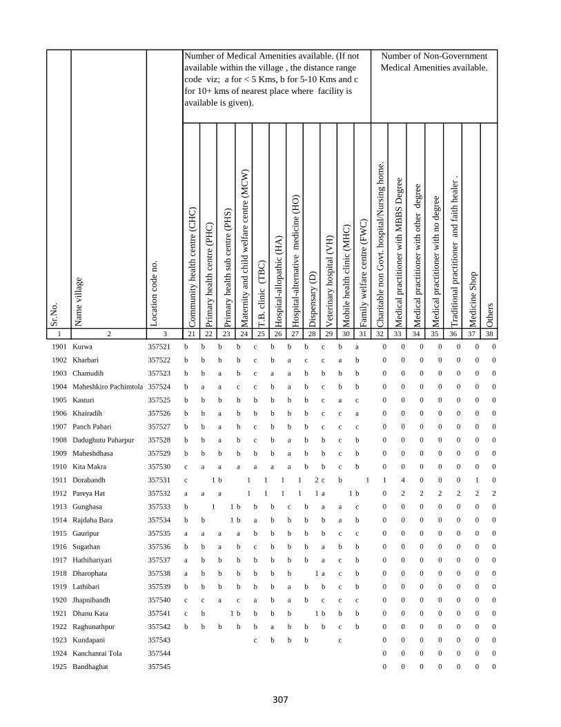
1 2 3
Lo
cati
on
co
de
no
.
Nam
e v
illa
ge
Sr.
No
.
1901 Kurwa 357521
1902 Kharbari 357522
1903 Chamudih 357523
1904 Maheshkiro Pachimtola 357524
1905 Kasturi 357525
1906 Khairadih 357526
1907 Panch Pahari 357527
1908 Dadughutu Paharpur 357528
1909 Maheshdhasa 357529
1910 Kita Makra 357530
1911 Dorabandh 357531
1912 Pareya Hat 357532
1913 Gunghasa 357533
1914 Rajdaha Bara 357534
1915 Gauripur 357535
1916 Sugathan 357536
1917 Hathihariyari 357537
1918 Dharophata 357538
1919 Lathibari 357539
1920 Jhapnibandh 357540
1921 Dhanu Kata 357541
1922 Raghunathpur 357542
1923 Kundapani 357543
1924 Kanchanrai Tola 357544
1925 Bandhaghat 357545
Co
mm
un
ity
hea
lth
cen
tre
(CH
C)
Pri
mar
y h
ealt
h c
entr
e (P
HC
)
Pri
mar
y h
ealt
h s
ub
cen
tre
(PH
S)
Mat
ern
ity
an
d c
hil
d w
elfa
re c
entr
e (M
CW
)
T.B
. cl
inic
(T
BC
)
Ho
spit
al-a
llo
pat
hic
(H
A)
Ho
spit
al-a
lter
nat
ive
med
icin
e (H
O)
Dis
pen
sary
(D
)
Vet
erin
ary
ho
spit
al (
VH
)
Mo
bil
e h
ealt
h c
lin
ic (
MH
C)
Fam
ily
wel
fare
cen
tre
(FW
C)
Ch
arit
able
no
n G
ov
t. h
osp
ital
/Nu
rsin
g h
om
e.
Med
ical
pra
ctit
ion
er w
ith
MB
BS
Deg
ree
Med
ical
pra
ctit
ion
er w
ith
oth
er
deg
ree
Med
ical
pra
ctit
ion
er w
ith
no
deg
ree
Tra
dit
ion
al p
ract
itio
ner
an
d f
aith
hea
ler
.
Med
icin
e S
ho
p
Oth
ers
21 22 23 24 25 26 27 28 29 30 31 32 33 34 35 36 37 38
Number of Non-Government
Medical Amenities available.
Number of Medical Amenities available. (If not
available within the village , the distance range
code viz; a for < 5 Kms, b for 5-10 Kms and c
for 10+ kms of nearest place where facility is
available is given).
b b b b c b b b c b a 0 0 0 0 0 0 0
b b b b c b a c c a b 0 0 0 0 0 0 0
b b a b c a a b b b b 0 0 0 0 0 0 0
b a a c c b a b c b b 0 0 0 0 0 0 0
b b b b b b b b c a c 0 0 0 0 0 0 0
b b a b b b b b c c a 0 0 0 0 0 0 0
b b a b c b b b c c c 0 0 0 0 0 0 0
b b a b c b a b b c b 0 0 0 0 0 0 0
b b b b b b a b b c b 0 0 0 0 0 0 0
c a a a a a a b b c b 0 0 0 0 0 0 0
c 1 b 1 1 1 1 2 c b 1 1 4 0 0 0 1 0
a a a 1 1 1 1 1 a 1 b 0 2 2 2 2 2 2
b 1 1 b b b c b a a c 0 0 0 0 0 0 0
b b 1 b a b b b b a b 0 0 0 0 0 0 0
a a a a b b b b b c c 0 0 0 0 0 0 0
b b a b c b b b a b b 0 0 0 0 0 0 0
a b b b b b b b a c b 0 0 0 0 0 0 0
a b b b b b b 1 a c b 0 0 0 0 0 0 0
b b b b b b a b b c b 0 0 0 0 0 0 0
c c a c a b a b c c c 0 0 0 0 0 0 0
c b 1 b b b b 1 b b b 0 0 0 0 0 0 0
b b b b b a b b b c b 0 0 0 0 0 0 0
c b b b c 0 0 0 0 0 0 0
0 0 0 0 0 0 0
0 0 0 0 0 0 0
307

1 2 3
Lo
cati
on
co
de
no
.
Nam
e v
illa
ge
Sr.
No
.
1926 Sagunibad 357546
1927 Pokhariya 357547
1928 Amduma 357548
1929 Paharidih 357549
1930 Pipra 357550
1931 Bhagaband Nij 357551
1932 Ganjoriya 357552
1933 Dulidih 357553
1934 Kairakurwa 357554
1935 Chhota Rajdaha 357555
1936 Kasiajor 357556
1937 Bhaghabandh 357557
1938 Bhaghabandh (Dakhintola)357558
1939 Kitajor 357559
1940 Shampur 357560
1941 Amgachhi 357561
1942 Akasi 357562
1943 Durjapani 357563
1944 Karam Tola 357564
1945 Khorishiris 357565
1946 Majdiha 357566
1947 Lusitanr 357567
1948 Dhobarni 357568
1949 Kharisirsa 357569
1950 Mahesh Chand 357570
Co
mm
un
ity
hea
lth
cen
tre
(CH
C)
Pri
mar
y h
ealt
h c
entr
e (P
HC
)
Pri
mar
y h
ealt
h s
ub
cen
tre
(PH
S)
Mat
ern
ity
an
d c
hil
d w
elfa
re c
entr
e (M
CW
)
T.B
. cl
inic
(T
BC
)
Ho
spit
al-a
llo
pat
hic
(H
A)
Ho
spit
al-a
lter
nat
ive
med
icin
e (H
O)
Dis
pen
sary
(D
)
Vet
erin
ary
ho
spit
al (
VH
)
Mo
bil
e h
ealt
h c
lin
ic (
MH
C)
Fam
ily
wel
fare
cen
tre
(FW
C)
Ch
arit
able
no
n G
ov
t. h
osp
ital
/Nu
rsin
g h
om
e.
Med
ical
pra
ctit
ion
er w
ith
MB
BS
Deg
ree
Med
ical
pra
ctit
ion
er w
ith
oth
er
deg
ree
Med
ical
pra
ctit
ion
er w
ith
no
deg
ree
Tra
dit
ion
al p
ract
itio
ner
an
d f
aith
hea
ler
.
Med
icin
e S
ho
p
Oth
ers
21 22 23 24 25 26 27 28 29 30 31 32 33 34 35 36 37 38
Number of Non-Government
Medical Amenities available.
Number of Medical Amenities available. (If not
available within the village , the distance range
code viz; a for < 5 Kms, b for 5-10 Kms and c
for 10+ kms of nearest place where facility is
available is given).
b b a b b b a b b c c 0 0 0 0 0 0 0
b b b b b b b b b b c 0 0 0 0 0 0 0
b b b b b b a b b b c 0 0 0 0 0 0 0
b b b b b b b b b b c 0 0 0 0 0 0 0
a a a a b b c b b b c 0 0 0 0 0 0 0
b b a b b b b b b b c 0 0 0 0 0 0 0
b b a b b b b b b a b 0 0 0 0 0 0 0
b b a b b b a b b b c 0 0 0 0 0 0 0
b b a b b b a b b b c 0 0 0 0 0 0 0
b b a b b a a b b a c 0 0 0 0 0 0 0
b b a b a b b b b b c 0 0 0 0 0 0 0
a a a a b c b b b b c 0 0 0 0 0 0 0
a a a a b c b b a a c 0 0 0 0 0 0 0
b a a b b c b b a a a 0 0 0 0 0 0 0
a a 1 b b a a c c c c 0 0 0 0 0 0 0
b b b b c b b b b b c 0 0 0 0 2 0 0
b b b b c c a 0 0 0 0 0 0 0
0 0 0 0 0 0 0
c c a b a c c b c c b 0 0 0 0 0 0 0
c a 1 b a b b 2 c c b 0 0 0 0 0 0 0
c b a c b b b b b b c 0 0 0 0 0 0 0
c c a c c b a b c c a 0 0 0 0 0 0 0
c b b c a b a b c c c 0 0 0 0 0 0 0
c c b a a b b b c b b 0 0 0 0 0 0 0
b b a c b b c b c c b 0 0 0 0 0 0 0
308

1 2 3
Lo
cati
on
co
de
no
.
Nam
e v
illa
ge
Sr.
No
.
1951 Pindari 357571
1952 Murgabani 357572
1953 Baramasiya 357573
1954 Kamrabandh 357574
1955 Gopalpur 357575
1956 Simrakita 357576
1957 Chatra 357577
1958 Sat Pahari 357578
1959 Baghmunda 357579
1960 Ghanghra Bandh 357580
1961 Kelabari 357581
1962 Panchratan 357582
1963 Beltopa 357583
1964 Harla 357584
1965 Pitar Pahari 357585
1966 Madhukopi 357586
1967 Bansmuri 357587
1968 Sarbindha 357588
1969 Bansmati 357589
1970 Bara 357590
1971 Jari 357591
1972 Siria 357592
1973 Nawadih 357593
1974 Banjhi 357594
1975 Taljhari 357595
Co
mm
un
ity
hea
lth
cen
tre
(CH
C)
Pri
mar
y h
ealt
h c
entr
e (P
HC
)
Pri
mar
y h
ealt
h s
ub
cen
tre
(PH
S)
Mat
ern
ity
an
d c
hil
d w
elfa
re c
entr
e (M
CW
)
T.B
. cl
inic
(T
BC
)
Ho
spit
al-a
llo
pat
hic
(H
A)
Ho
spit
al-a
lter
nat
ive
med
icin
e (H
O)
Dis
pen
sary
(D
)
Vet
erin
ary
ho
spit
al (
VH
)
Mo
bil
e h
ealt
h c
lin
ic (
MH
C)
Fam
ily
wel
fare
cen
tre
(FW
C)
Ch
arit
able
no
n G
ov
t. h
osp
ital
/Nu
rsin
g h
om
e.
Med
ical
pra
ctit
ion
er w
ith
MB
BS
Deg
ree
Med
ical
pra
ctit
ion
er w
ith
oth
er
deg
ree
Med
ical
pra
ctit
ion
er w
ith
no
deg
ree
Tra
dit
ion
al p
ract
itio
ner
an
d f
aith
hea
ler
.
Med
icin
e S
ho
p
Oth
ers
21 22 23 24 25 26 27 28 29 30 31 32 33 34 35 36 37 38
Number of Non-Government
Medical Amenities available.
Number of Medical Amenities available. (If not
available within the village , the distance range
code viz; a for < 5 Kms, b for 5-10 Kms and c
for 10+ kms of nearest place where facility is
available is given).
b b b b b b b b b c b 0 0 0 0 0 0 0
c 1 a 1 a b a b b b b 0 0 0 0 0 0 0
b b a b b b a b b b b 0 0 0 0 0 0 0
b a a b b a b b b b c 0 0 0 0 0 0 0
b b a a b b a b b b c 0 0 0 0 0 0 0
b b a b a b a b a b c 0 0 0 0 0 0 0
b b 1 b b b b b b a c 0 0 0 0 0 0 0
c b a c b b c b b b a 0 0 0 0 0 0 0
b b b 1 b b c c a b c 0 0 0 0 0 0 0
b b b c a 1 1 1 b 1 1 0 0 0 0 0 0 0
b b a c c 1 1 1 b 1 1 0 0 0 0 0 0 0
c b a b a b b b b c b 0 0 0 0 0 0 0
c c b c a b a b c c b 0 0 0 0 0 0 0
c c a c b b a b c c b 0 0 0 0 0 0 0
b b a b b b a b b b c 0 0 0 0 0 0 0
c c a c c b b b c c a 0 0 0 0 0 0 0
c c b b a a b b a b c 0 0 0 0 0 0 0
c c a c a b b b b b b 0 0 0 0 0 0 0
c c b c b b a b b a b 0 0 0 0 0 0 0
c c a c b c a b a a b 0 0 0 0 0 0 0
c c a c a c a b a c b 0 0 0 0 0 0 0
c c a b b c b b c b b 0 0 0 0 0 0 0
c c 1 b b c c b b c c 0 0 0 0 0 0 0
c c a c b c c c c c c 0 0 0 0 0 0 0
c c a c a b b c c c c 0 0 0 0 0 0 0
309
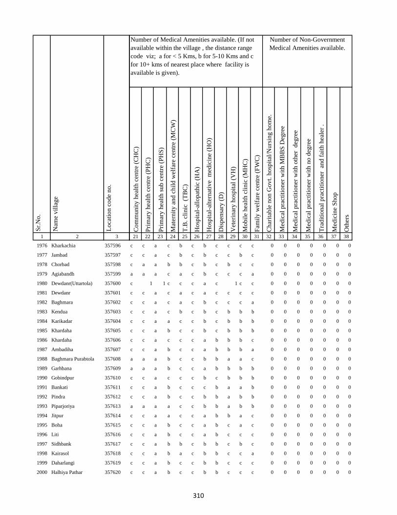
1 2 3
Lo
cati
on
co
de
no
.
Nam
e v
illa
ge
Sr.
No
.
1976 Kharkachia 357596
1977 Jambad 357597
1978 Chorbad 357598
1979 Agiabandh 357599
1980 Dewdanr(Uttartola) 357600
1981 Dewdanr 357601
1982 Baghmara 357602
1983 Kendua 357603
1984 Karikadar 357604
1985 Khardaha 357605
1986 Khardaha 357606
1987 Ambadiha 357607
1988 Baghmara Purabtola 357608
1989 Garhbana 357609
1990 Gobindpur 357610
1991 Bankati 357611
1992 Pindra 357612
1993 Piparjoriya 357613
1994 Jitpur 357614
1995 Boha 357615
1996 Liti 357616
1997 Sidhbank 357617
1998 Kairasol 357618
1999 Daharlangi 357619
2000 Halhiya Pathar 357620
Co
mm
un
ity
hea
lth
cen
tre
(CH
C)
Pri
mar
y h
ealt
h c
entr
e (P
HC
)
Pri
mar
y h
ealt
h s
ub
cen
tre
(PH
S)
Mat
ern
ity
an
d c
hil
d w
elfa
re c
entr
e (M
CW
)
T.B
. cl
inic
(T
BC
)
Ho
spit
al-a
llo
pat
hic
(H
A)
Ho
spit
al-a
lter
nat
ive
med
icin
e (H
O)
Dis
pen
sary
(D
)
Vet
erin
ary
ho
spit
al (
VH
)
Mo
bil
e h
ealt
h c
lin
ic (
MH
C)
Fam
ily
wel
fare
cen
tre
(FW
C)
Ch
arit
able
no
n G
ov
t. h
osp
ital
/Nu
rsin
g h
om
e.
Med
ical
pra
ctit
ion
er w
ith
MB
BS
Deg
ree
Med
ical
pra
ctit
ion
er w
ith
oth
er
deg
ree
Med
ical
pra
ctit
ion
er w
ith
no
deg
ree
Tra
dit
ion
al p
ract
itio
ner
an
d f
aith
hea
ler
.
Med
icin
e S
ho
p
Oth
ers
21 22 23 24 25 26 27 28 29 30 31 32 33 34 35 36 37 38
Number of Non-Government
Medical Amenities available.
Number of Medical Amenities available. (If not
available within the village , the distance range
code viz; a for < 5 Kms, b for 5-10 Kms and c
for 10+ kms of nearest place where facility is
available is given).
c c a c b c b c c c c 0 0 0 0 0 0 0
c c a c b c b c c b c 0 0 0 0 0 0 0
c a a b b c b c b c c 0 0 0 0 0 0 0
a a a c a c b c c c a 0 0 0 0 0 0 0
c 1 1 c c c a c 1 c c 0 0 0 0 0 0 0
c c a c a c a c c c c 0 0 0 0 0 0 0
c c a c a c b c c c a 0 0 0 0 0 0 0
c c a c b c b c b b b 0 0 0 0 0 0 0
c c a a c c b c b b b 0 0 0 0 0 0 0
c c a b c c b c b b b 0 0 0 0 0 0 0
c c a c c c a b b b c 0 0 0 0 0 0 0
c c a b c c a b b b a 0 0 0 0 0 0 0
a a a b c c b b a a c 0 0 0 0 0 0 0
a a a b c c a b b b b 0 0 0 0 0 0 0
c c a c c c b c b b b 0 0 0 0 0 0 0
c c a b c c c b a a b 0 0 0 0 0 0 0
c c a b c c b b a b b 0 0 0 0 0 0 0
a a a a c c b b a b b 0 0 0 0 0 0 0
c c a a c c a b b a c 0 0 0 0 0 0 0
c c a b c c a b c a c 0 0 0 0 0 0 0
c c a b c c a b c c c 0 0 0 0 0 0 0
c c a b b c b b c b c 0 0 0 0 0 0 0
c c a b a c b b c c a 0 0 0 0 0 0 0
c c a b c c b b c c c 0 0 0 0 0 0 0
c c a b c c b b c c c 0 0 0 0 0 0 0
310

1 2 3
Lo
cati
on
co
de
no
.
Nam
e v
illa
ge
Sr.
No
.
2001 Asna 357621
2002 Parigadih 357622
2003 Susni 357623
2004 Jamropani 357624
Block T O T A L :
2005 Bansjori 357625
2006 Bansjori Jagir 357626
2007 Kauadhab 357627
2008 Sabalpur Jagir 357628
2009 Sabalpur 357629
2010 Raksi 357630
2011 Chatra 357631
2012 Paharpur 357632
2013 Paharpur Jagir 357633
2014 Kheribari 357634
2015 Barnadi 357635
2016 Barnadi Jagir 357636
2017 Jamdiha 357637
2018 Kajuri 357638
2019 Simaldhab 357639
2020 Bishunpur 357640
2021 Dhunigora 357641
2022 Ghatiari 357642
Co
mm
un
ity
hea
lth
cen
tre
(CH
C)
Pri
mar
y h
ealt
h c
entr
e (P
HC
)
Pri
mar
y h
ealt
h s
ub
cen
tre
(PH
S)
Mat
ern
ity
an
d c
hil
d w
elfa
re c
entr
e (M
CW
)
T.B
. cl
inic
(T
BC
)
Ho
spit
al-a
llo
pat
hic
(H
A)
Ho
spit
al-a
lter
nat
ive
med
icin
e (H
O)
Dis
pen
sary
(D
)
Vet
erin
ary
ho
spit
al (
VH
)
Mo
bil
e h
ealt
h c
lin
ic (
MH
C)
Fam
ily
wel
fare
cen
tre
(FW
C)
Ch
arit
able
no
n G
ov
t. h
osp
ital
/Nu
rsin
g h
om
e.
Med
ical
pra
ctit
ion
er w
ith
MB
BS
Deg
ree
Med
ical
pra
ctit
ion
er w
ith
oth
er
deg
ree
Med
ical
pra
ctit
ion
er w
ith
no
deg
ree
Tra
dit
ion
al p
ract
itio
ner
an
d f
aith
hea
ler
.
Med
icin
e S
ho
p
Oth
ers
21 22 23 24 25 26 27 28 29 30 31 32 33 34 35 36 37 38
Number of Non-Government
Medical Amenities available.
Number of Medical Amenities available. (If not
available within the village , the distance range
code viz; a for < 5 Kms, b for 5-10 Kms and c
for 10+ kms of nearest place where facility is
available is given).
c c a a c c a b c c a 0 0 0 0 0 0 0
c c a b c c b b c b b 0 0 0 0 0 0 0
c b b c b 0 0 0 0 0 0 0
0 0 0 0 0 0 0
0 10 17 8 3 6 5 10 2 4 4 1 7 2 2 6 7 2
c b c b c 0 0 0 0 0 0 0
0 0 0 0 0 0 0
c b a b c b b b a c c 0 0 0 0 0 0 0
c b a b c b a b c b b 0 0 0 0 0 0 0
c b a a c b a b b b b 0 0 0 0 0 0 0
c c a b c a b c c b b 0 0 0 0 0 0 0
c c a b c b c b c b b 0 0 0 0 0 0 0
c c a b c b b b c b b 0 0 0 0 0 0 0
c c a c c b a b c a c 0 0 0 0 0 0 0
c c a c b b a b b b c 0 0 0 0 0 0 0
c c a c c b b b c b c 0 0 0 0 0 0 0
b c a c a b a b c a c 0 0 0 0 0 0 0
c c b c b c b c c c 0 0 0 0 0 0 0
0 0 0 0 0 0 0
c c a c c b c b b c c 0 0 0 0 0 0 0
c a b b b b a b b b c 0 0 0 0 0 0 0
c b 1 a c a b b b b c 0 0 0 0 0 0 0
c c 1 c b b c b b a a 0 0 0 0 0 0 0
311

1 2 3
Lo
cati
on
co
de
no
.
Nam
e v
illa
ge
Sr.
No
.
2023 Chhota Ghatiari 357643
2024 Tasria 357644
2025 Narayanpur 357645
2026 Jambia 357646
2027 Kherabani 357647
2028 Jilbari 357648
2029 Mahua Tanr 357649
2030 Karmatanr 357650
2031 Bhaluka 357651
2032 Sundar Maur 357652
2033 Sabalpur 357653
2034 Lawadih 357654
2035 Dighibathan 357655
2036 Jamuntanr 357656
2037 Khelari 357657
2038 Adro 357658
2039 Ammaqo 357659
2040 Bedotok 357660
2041 Berago(Telalkuria) 357661
2042 Bilamaqo(Basgo) 357662
2043 Chacham 357663
2044 Chalgoda(Madgi) 357664
2045 Chaparom 357665
2046 Chuclalo 357666
2047 Churi 357667
Co
mm
un
ity
hea
lth
cen
tre
(CH
C)
Pri
mar
y h
ealt
h c
entr
e (P
HC
)
Pri
mar
y h
ealt
h s
ub
cen
tre
(PH
S)
Mat
ern
ity
an
d c
hil
d w
elfa
re c
entr
e (M
CW
)
T.B
. cl
inic
(T
BC
)
Ho
spit
al-a
llo
pat
hic
(H
A)
Ho
spit
al-a
lter
nat
ive
med
icin
e (H
O)
Dis
pen
sary
(D
)
Vet
erin
ary
ho
spit
al (
VH
)
Mo
bil
e h
ealt
h c
lin
ic (
MH
C)
Fam
ily
wel
fare
cen
tre
(FW
C)
Ch
arit
able
no
n G
ov
t. h
osp
ital
/Nu
rsin
g h
om
e.
Med
ical
pra
ctit
ion
er w
ith
MB
BS
Deg
ree
Med
ical
pra
ctit
ion
er w
ith
oth
er
deg
ree
Med
ical
pra
ctit
ion
er w
ith
no
deg
ree
Tra
dit
ion
al p
ract
itio
ner
an
d f
aith
hea
ler
.
Med
icin
e S
ho
p
Oth
ers
21 22 23 24 25 26 27 28 29 30 31 32 33 34 35 36 37 38
Number of Non-Government
Medical Amenities available.
Number of Medical Amenities available. (If not
available within the village , the distance range
code viz; a for < 5 Kms, b for 5-10 Kms and c
for 10+ kms of nearest place where facility is
available is given).
0 0 0 0 0 0 0
c c b c c c b b a c c 0 0 0 0 0 0 0
b b b b a 0 0 0 0 0 0 0
0 0 0 0 0 0 0
c c a c c c a c a c b 0 0 0 0 0 0 0
c c a c c c a c a c b 0 0 0 0 0 0 0
c b b b c b a b a c c 0 0 0 0 0 0 0
c c a a c b b b b b a 0 0 0 0 0 0 0
c b a b c b b b b c c 0 0 0 0 0 0 0
b c a a c b b b b c b 0 0 0 0 0 0 0
b b a b c b a c a b b 0 0 0 0 0 0 0
c b a a c b a b a c b 0 0 0 0 0 0 0
c c a c c a a b c c b 0 0 0 0 0 0 0
c c c c c b b b b b b 0 0 0 0 0 0 0
0 0 0 0 0 0 0
c b c b c b 0 0 0 0 0 0 0
0 0 0 0 0 0 0
0 0 0 0 0 0 0
0 0 0 0 0 0 0
c c b b c b b b c b c 0 0 0 0 0 0 0
c b b b b b b b c b c 0 0 0 0 0 0 0
c b a b c a c 0 0 0 0 0 0 0
0 0 0 0 0 0 0
0 0 0 0 0 0 0
0 0 0 0 0 0 0
312

1 2 3
Lo
cati
on
co
de
no
.
Nam
e v
illa
ge
Sr.
No
.
2048 Donigoda Katan 357668
2049 Dandi Kuriya 357669
2050 Dumer(Palem) 357670
2051 Dumberi(Kajri) 357671
2052 Gamaro 357672
2053 Gamaro(Sonpahar) 357673
2054 Gandarama 357674
2055 Gari Bedo 357675
2056 Goga 357676
2057 Goga 357677
2058 Gosmara 357678
2059 Gosmara 357679
2060 Ilkar Kuriya 357680
2061 Ilkru 357681
2062 Jambu Kuriya 357682
2063 Jambu Kuriya 357683
2064 Jamri 357684
2065 Jirko 357685
2066 Jito Kundi(Dumerkuriya)357686
2067 Kagra 357687
2068 Kalare(Kamugoda) 357688
2069 Kamugoda 357689
2070 Kasripara (Moglan) 357690
2071 Kepam 357691
2072 Kerkuriya 357692
Co
mm
un
ity
hea
lth
cen
tre
(CH
C)
Pri
mar
y h
ealt
h c
entr
e (P
HC
)
Pri
mar
y h
ealt
h s
ub
cen
tre
(PH
S)
Mat
ern
ity
an
d c
hil
d w
elfa
re c
entr
e (M
CW
)
T.B
. cl
inic
(T
BC
)
Ho
spit
al-a
llo
pat
hic
(H
A)
Ho
spit
al-a
lter
nat
ive
med
icin
e (H
O)
Dis
pen
sary
(D
)
Vet
erin
ary
ho
spit
al (
VH
)
Mo
bil
e h
ealt
h c
lin
ic (
MH
C)
Fam
ily
wel
fare
cen
tre
(FW
C)
Ch
arit
able
no
n G
ov
t. h
osp
ital
/Nu
rsin
g h
om
e.
Med
ical
pra
ctit
ion
er w
ith
MB
BS
Deg
ree
Med
ical
pra
ctit
ion
er w
ith
oth
er
deg
ree
Med
ical
pra
ctit
ion
er w
ith
no
deg
ree
Tra
dit
ion
al p
ract
itio
ner
an
d f
aith
hea
ler
.
Med
icin
e S
ho
p
Oth
ers
21 22 23 24 25 26 27 28 29 30 31 32 33 34 35 36 37 38
Number of Non-Government
Medical Amenities available.
Number of Medical Amenities available. (If not
available within the village , the distance range
code viz; a for < 5 Kms, b for 5-10 Kms and c
for 10+ kms of nearest place where facility is
available is given).
0 0 0 0 0 0 0
c b a b b b b b b b b 0 0 0 0 0 0 0
b a a a b b a b b a b 0 0 0 0 0 0 0
c c c c b b a b a a b 0 0 0 0 0 0 0
0 0 0 0 0 0 0
c c a a c b a c b b a 0 0 0 0 0 0 0
c b a a c b b b a c c 0 0 0 0 0 0 0
c b a b c a c b a c b 0 0 0 0 0 0 0
c c c c c b b b a c b 0 0 0 0 0 0 0
0 0 0 0 0 0 0
0 0 0 0 0 0 0
b b a b b c b 0 0 0 0 0 0 0
0 0 0 0 0 0 0
0 0 0 0 0 0 0
0 0 0 0 0 0 0
0 0 0 0 0 0 0
c b b c c b b b c b c 0 0 0 0 0 0 0
c c b a b c b c 0 0 0 0 0 0 0
0 0 0 0 0 0 0
c c b b b c b c 0 0 0 0 0 0 0
0 0 0 0 0 0 0
0 0 0 0 0 0 0
c c b b c b b 0 0 0 0 0 0 0
0 0 0 0 0 0 0
a c c b a b c a b 0 0 0 0 0 0 0
313

1 2 3
Lo
cati
on
co
de
no
.
Nam
e v
illa
ge
Sr.
No
.
2073 Kerjuria 357693
2074 Kiro 357694
2075 Liladoni 357695
2076 Madgam 357696
2077 Maridoni 357697
2078 Mate 357698
2079 Pakeritok 357699
2080 Palem(Dumar) 357700
2081 Pawkuriya 357701
2082 Perdarda (Ambar) 357702
2083 Pokeri 357703
2084 Popkundo 357704
2085 Pusur Kuriya 357705
2086 Pusur Kuriya 357706
2087 Tamli Bedo 357707
2088 Tamligoda (Chaparbita) 357708
2089 Tatkota 357709
2090 Telo 357710
2091 Telodoni 357711
2092 Tetli (Telal Kuriya) 357712
2093 Sena(Katan) 357713
2094 Suju 357714
2095 Tetaria 357715
2096 Domdih 357716
2097 Kusumghati 357717
Co
mm
un
ity
hea
lth
cen
tre
(CH
C)
Pri
mar
y h
ealt
h c
entr
e (P
HC
)
Pri
mar
y h
ealt
h s
ub
cen
tre
(PH
S)
Mat
ern
ity
an
d c
hil
d w
elfa
re c
entr
e (M
CW
)
T.B
. cl
inic
(T
BC
)
Ho
spit
al-a
llo
pat
hic
(H
A)
Ho
spit
al-a
lter
nat
ive
med
icin
e (H
O)
Dis
pen
sary
(D
)
Vet
erin
ary
ho
spit
al (
VH
)
Mo
bil
e h
ealt
h c
lin
ic (
MH
C)
Fam
ily
wel
fare
cen
tre
(FW
C)
Ch
arit
able
no
n G
ov
t. h
osp
ital
/Nu
rsin
g h
om
e.
Med
ical
pra
ctit
ion
er w
ith
MB
BS
Deg
ree
Med
ical
pra
ctit
ion
er w
ith
oth
er
deg
ree
Med
ical
pra
ctit
ion
er w
ith
no
deg
ree
Tra
dit
ion
al p
ract
itio
ner
an
d f
aith
hea
ler
.
Med
icin
e S
ho
p
Oth
ers
21 22 23 24 25 26 27 28 29 30 31 32 33 34 35 36 37 38
Number of Non-Government
Medical Amenities available.
Number of Medical Amenities available. (If not
available within the village , the distance range
code viz; a for < 5 Kms, b for 5-10 Kms and c
for 10+ kms of nearest place where facility is
available is given).
0 0 0 0 0 0 0
0 0 0 0 0 0 0
c b b c b b b c 0 0 0 0 0 0 0
0 0 0 0 0 0 0
0 0 0 0 0 0 0
0 0 0 0 0 0 0
0 0 0 0 0 0 0
b b b c c b a b b c b 0 0 0 0 0 0 0
a b b a c c 0 0 0 0 0 0 0
0 0 0 0 0 0 0
c b b a c c 0 0 0 0 0 0 0
0 0 0 0 0 0 0
c a a b b b c b c c a 0 0 0 0 0 0 0
c b a c c b c b b c c 0 0 0 0 0 0 0
b a a a b b c b b b c 0 0 0 0 0 0 0
a a c a 0 0 0 0 0 0 0
0 0 0 0 0 0 0
c c a c b c c c c b b 0 0 0 0 0 0 0
b b b b 0 0 0 0 0 0 0
0 0 0 0 0 0 0
b c b a 0 0 0 0 0 0 0
0 0 0 0 0 0 0
a a a b c a 1 b c a b 0 0 0 0 0 0 0
a a b b c a b b b b b 0 0 0 0 0 0 0
c a a b c a a b c b b 0 0 0 0 0 0 0
314

1 2 3
Lo
cati
on
co
de
no
.
Nam
e v
illa
ge
Sr.
No
.
2098 Amjora 357718
2099 Tilabad 357719
2100 Tesuba Than 357720
2101 Chhota Kalhajor 357721
2102 Mohanpur 357722
2103 Bara Kalhajor 357723
2104 Salodih 357724
2105 Salpathra 357725
2106 Sundar Pahari 357726
2107 Paharpur 357727
2108 Kairojori(Bara) 357728
2109 Kairojori(Chhota) 357729
2110 Jitpur 357730
2111 Telbhita 357731
2112 Gamaro 357732
2113 Gamarbera 357733
2114 Jamalo 357734
2115 Dahubera 357735
2116 Jiyajori 357736
2117 Rampur 357737
2118 Barajolo 357738
2119 Manikbathan 357739
2120 Dhaupahari 357740
2121 Ladapathar 357741
2122 Phulbaria 357742
Co
mm
un
ity
hea
lth
cen
tre
(CH
C)
Pri
mar
y h
ealt
h c
entr
e (P
HC
)
Pri
mar
y h
ealt
h s
ub
cen
tre
(PH
S)
Mat
ern
ity
an
d c
hil
d w
elfa
re c
entr
e (M
CW
)
T.B
. cl
inic
(T
BC
)
Ho
spit
al-a
llo
pat
hic
(H
A)
Ho
spit
al-a
lter
nat
ive
med
icin
e (H
O)
Dis
pen
sary
(D
)
Vet
erin
ary
ho
spit
al (
VH
)
Mo
bil
e h
ealt
h c
lin
ic (
MH
C)
Fam
ily
wel
fare
cen
tre
(FW
C)
Ch
arit
able
no
n G
ov
t. h
osp
ital
/Nu
rsin
g h
om
e.
Med
ical
pra
ctit
ion
er w
ith
MB
BS
Deg
ree
Med
ical
pra
ctit
ion
er w
ith
oth
er
deg
ree
Med
ical
pra
ctit
ion
er w
ith
no
deg
ree
Tra
dit
ion
al p
ract
itio
ner
an
d f
aith
hea
ler
.
Med
icin
e S
ho
p
Oth
ers
21 22 23 24 25 26 27 28 29 30 31 32 33 34 35 36 37 38
Number of Non-Government
Medical Amenities available.
Number of Medical Amenities available. (If not
available within the village , the distance range
code viz; a for < 5 Kms, b for 5-10 Kms and c
for 10+ kms of nearest place where facility is
available is given).
a a a a c a a b c a b 0 0 0 0 0 0 0
a a a a b 1 b c c b b 0 0 0 0 0 0 0
a a a a b a b b c b c 0 0 0 0 0 0 0
a a a a b a a b b a a 0 0 0 0 0 0 0
b a a b a a a b b a c 0 0 0 0 0 0 0
a a a a c a a b b c c 0 0 0 0 0 0 0
a a a b c a a b b b c 0 0 0 0 0 0 0
c 1 1 a c 1 1 1 b c 1 0 1 0 0 0 2 0
c b a a c c c b a c c 0 0 0 0 0 0 0
c a a b c c c b b c c 0 0 0 0 0 0 0
c a a a c c c b b c a 0 0 0 0 0 0 0
c c a b c c c b a b b 0 0 0 0 0 0 0
b a a b c c c b a c b 0 0 0 0 0 0 0
c c a c c c c b a c b 0 0 0 0 0 0 0
c b b c 0 0 0 0 0 0 0
0 0 0 0 0 0 0
b b a b c b c b b c c 0 0 0 0 0 0 0
c c a a a b c b a b b 0 0 0 0 0 0 0
b b 1 b b b b b a b b 0 0 0 0 0 0 0
b b b b b b b b c b b 0 0 0 0 0 0 0
c c a a a b c c b b b 0 0 0 0 0 0 0
c c b a c b c b c b b 0 0 0 0 0 0 0
c c b b b a c b c a c 0 0 0 0 0 0 0
c c b b c b c b c b c 0 0 0 0 0 0 0
b b b c b c 0 0 0 0 0 0 0
315
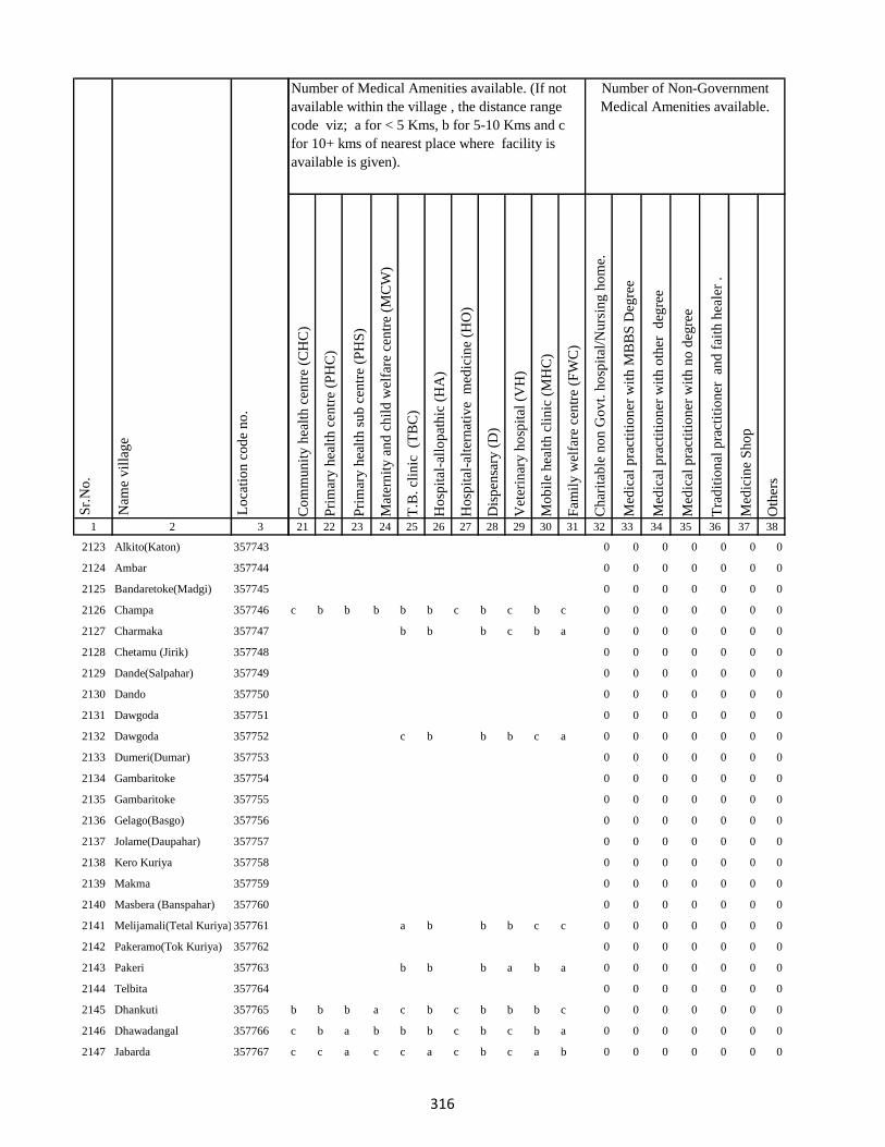
1 2 3
Lo
cati
on
co
de
no
.
Nam
e v
illa
ge
Sr.
No
.
2123 Alkito(Katon) 357743
2124 Ambar 357744
2125 Bandaretoke(Madgi) 357745
2126 Champa 357746
2127 Charmaka 357747
2128 Chetamu (Jirik) 357748
2129 Dande(Salpahar) 357749
2130 Dando 357750
2131 Dawgoda 357751
2132 Dawgoda 357752
2133 Dumeri(Dumar) 357753
2134 Gambaritoke 357754
2135 Gambaritoke 357755
2136 Gelago(Basgo) 357756
2137 Jolame(Daupahar) 357757
2138 Kero Kuriya 357758
2139 Makma 357759
2140 Masbera (Banspahar) 357760
2141 Melijamali(Tetal Kuriya) 357761
2142 Pakeramo(Tok Kuriya) 357762
2143 Pakeri 357763
2144 Telbita 357764
2145 Dhankuti 357765
2146 Dhawadangal 357766
2147 Jabarda 357767
Co
mm
un
ity
hea
lth
cen
tre
(CH
C)
Pri
mar
y h
ealt
h c
entr
e (P
HC
)
Pri
mar
y h
ealt
h s
ub
cen
tre
(PH
S)
Mat
ern
ity
an
d c
hil
d w
elfa
re c
entr
e (M
CW
)
T.B
. cl
inic
(T
BC
)
Ho
spit
al-a
llo
pat
hic
(H
A)
Ho
spit
al-a
lter
nat
ive
med
icin
e (H
O)
Dis
pen
sary
(D
)
Vet
erin
ary
ho
spit
al (
VH
)
Mo
bil
e h
ealt
h c
lin
ic (
MH
C)
Fam
ily
wel
fare
cen
tre
(FW
C)
Ch
arit
able
no
n G
ov
t. h
osp
ital
/Nu
rsin
g h
om
e.
Med
ical
pra
ctit
ion
er w
ith
MB
BS
Deg
ree
Med
ical
pra
ctit
ion
er w
ith
oth
er
deg
ree
Med
ical
pra
ctit
ion
er w
ith
no
deg
ree
Tra
dit
ion
al p
ract
itio
ner
an
d f
aith
hea
ler
.
Med
icin
e S
ho
p
Oth
ers
21 22 23 24 25 26 27 28 29 30 31 32 33 34 35 36 37 38
Number of Non-Government
Medical Amenities available.
Number of Medical Amenities available. (If not
available within the village , the distance range
code viz; a for < 5 Kms, b for 5-10 Kms and c
for 10+ kms of nearest place where facility is
available is given).
0 0 0 0 0 0 0
0 0 0 0 0 0 0
0 0 0 0 0 0 0
c b b b b b c b c b c 0 0 0 0 0 0 0
b b b c b a 0 0 0 0 0 0 0
0 0 0 0 0 0 0
0 0 0 0 0 0 0
0 0 0 0 0 0 0
0 0 0 0 0 0 0
c b b b c a 0 0 0 0 0 0 0
0 0 0 0 0 0 0
0 0 0 0 0 0 0
0 0 0 0 0 0 0
0 0 0 0 0 0 0
0 0 0 0 0 0 0
0 0 0 0 0 0 0
0 0 0 0 0 0 0
0 0 0 0 0 0 0
a b b b c c 0 0 0 0 0 0 0
0 0 0 0 0 0 0
b b b a b a 0 0 0 0 0 0 0
0 0 0 0 0 0 0
b b b a c b c b b b c 0 0 0 0 0 0 0
c b a b b b c b c b a 0 0 0 0 0 0 0
c c a c c a c b c a b 0 0 0 0 0 0 0
316

1 2 3
Lo
cati
on
co
de
no
.
Nam
e v
illa
ge
Sr.
No
.
2148 Bara Puro 357768
2149 Chhota Dhamni 357769
2150 Dhamni Bazar 357770
2151 Bara Dhamni 357771
2152 Chhota Puro 357772
2153 Gadidih 357773
2154 Piparjoria 357774
2155 Marchaitari 357775
2156 Pokharia 357776
2157 Kairasul 357777
2158 Ambardoni 357778
2159 Bat 357779
2160 Bitakepu 357780
2161 Daukuriya 357781
2162 Donigoda 357782
2163 Jari Mamqo 357783
2164 Kadu 357784
2165 Karag 357785
2166 Kiro 357786
2167 Koa 357787
2168 Kubji Bedo 357788
2169 Kubji Maqo 357789
2170 Kudi Goda 357790
2171 Madgi 357791
2172 Madgi Bedo 357792
Co
mm
un
ity
hea
lth
cen
tre
(CH
C)
Pri
mar
y h
ealt
h c
entr
e (P
HC
)
Pri
mar
y h
ealt
h s
ub
cen
tre
(PH
S)
Mat
ern
ity
an
d c
hil
d w
elfa
re c
entr
e (M
CW
)
T.B
. cl
inic
(T
BC
)
Ho
spit
al-a
llo
pat
hic
(H
A)
Ho
spit
al-a
lter
nat
ive
med
icin
e (H
O)
Dis
pen
sary
(D
)
Vet
erin
ary
ho
spit
al (
VH
)
Mo
bil
e h
ealt
h c
lin
ic (
MH
C)
Fam
ily
wel
fare
cen
tre
(FW
C)
Ch
arit
able
no
n G
ov
t. h
osp
ital
/Nu
rsin
g h
om
e.
Med
ical
pra
ctit
ion
er w
ith
MB
BS
Deg
ree
Med
ical
pra
ctit
ion
er w
ith
oth
er
deg
ree
Med
ical
pra
ctit
ion
er w
ith
no
deg
ree
Tra
dit
ion
al p
ract
itio
ner
an
d f
aith
hea
ler
.
Med
icin
e S
ho
p
Oth
ers
21 22 23 24 25 26 27 28 29 30 31 32 33 34 35 36 37 38
Number of Non-Government
Medical Amenities available.
Number of Medical Amenities available. (If not
available within the village , the distance range
code viz; a for < 5 Kms, b for 5-10 Kms and c
for 10+ kms of nearest place where facility is
available is given).
c c a c b b c b c b b 0 0 0 0 0 0 0
c c a c b b c b c b b 0 0 1 0 0 1 0
c c 1 c c b c b b a c 0 0 0 0 0 0 0
c c a c c b c b c b a 0 0 0 0 0 0 0
c c a c b b c b c c c 0 0 0 0 0 0 0
b b a b b b c b c b b 0 0 0 0 0 0 0
b c a c c b c b c b b 0 0 0 0 0 0 0
a b 1 b b b b b b a b 0 0 0 0 0 0 0
b a 1 b a a b b b a b 0 0 0 0 0 0 0
b c c c c c c b b c b 0 0 0 0 0 0 0
0 0 0 0 0 0 0
a b a a c c b b b c c 0 0 0 0 0 0 0
a b b b b c c b a c c 0 0 0 0 0 0 0
0 0 0 0 0 0 0
a b a c c b b b b c a 0 0 0 0 0 0 0
b b a b b b b c a b c 0 0 0 0 0 0 0
b b b a c c 0 0 0 0 0 0 0
0 0 0 0 0 0 0
0 0 0 0 0 0 0
b a a a c b b b b c b 0 0 0 0 0 0 0
b b b b b a b b b c b 0 0 0 0 0 0 0
0 0 0 0 0 0 0
b b a c a b b b a b a 0 0 0 0 0 0 0
b b a b b b b b c b c 0 0 0 0 0 0 0
b b b a b b b b b b b 0 0 0 0 0 0 0
317

1 2 3
Lo
cati
on
co
de
no
.
Nam
e v
illa
ge
Sr.
No
.
2173 Madgi Maqo 357793
2174 Puro Maqo (Katan) 357794
2175 Karag 357795
2176 Tamli 357796
2177 Takalo 357797
2178 Tetal Kuriya 357798
2179 Saharpura 357799
2180 Chandna 357800
2181 Longidih 357801
2182 Borwa 357802
2183 Karamtola 357803
2184 Roldih 357804
2185 Bara Haripur 357805
2186 Dulu 357806
2187 Asantari 357807
2188 Kusmaha 357808
2189 Damruhat 357809
2190 Dumki 357810
2191 Kairabani 357811
2192 Bariyarpur 357812
2193 Chhota Haripur 357813
2194 Kadampur 357814
2195 Angbali 357815
2196 Banspahari 357816
2197 Gamharia 357817
Co
mm
un
ity
hea
lth
cen
tre
(CH
C)
Pri
mar
y h
ealt
h c
entr
e (P
HC
)
Pri
mar
y h
ealt
h s
ub
cen
tre
(PH
S)
Mat
ern
ity
an
d c
hil
d w
elfa
re c
entr
e (M
CW
)
T.B
. cl
inic
(T
BC
)
Ho
spit
al-a
llo
pat
hic
(H
A)
Ho
spit
al-a
lter
nat
ive
med
icin
e (H
O)
Dis
pen
sary
(D
)
Vet
erin
ary
ho
spit
al (
VH
)
Mo
bil
e h
ealt
h c
lin
ic (
MH
C)
Fam
ily
wel
fare
cen
tre
(FW
C)
Ch
arit
able
no
n G
ov
t. h
osp
ital
/Nu
rsin
g h
om
e.
Med
ical
pra
ctit
ion
er w
ith
MB
BS
Deg
ree
Med
ical
pra
ctit
ion
er w
ith
oth
er
deg
ree
Med
ical
pra
ctit
ion
er w
ith
no
deg
ree
Tra
dit
ion
al p
ract
itio
ner
an
d f
aith
hea
ler
.
Med
icin
e S
ho
p
Oth
ers
21 22 23 24 25 26 27 28 29 30 31 32 33 34 35 36 37 38
Number of Non-Government
Medical Amenities available.
Number of Medical Amenities available. (If not
available within the village , the distance range
code viz; a for < 5 Kms, b for 5-10 Kms and c
for 10+ kms of nearest place where facility is
available is given).
b b a b b b b b c b b 0 0 0 0 0 0 0
a b b b b b b b c a b 0 0 0 0 0 0 0
0 0 0 0 0 0 0
0 0 0 0 0 0 0
0 0 0 0 0 0 0
0 0 0 0 0 0 0
b b 1 b c c b b c b c 0 0 0 5 2 1 0
c c a a b c c a c a c 0 0 0 0 0 0 0
c c a c b c b c c a a 0 0 0 2 1 0 0
c c a c b c b c b c c 0 0 0 0 0 0 0
c c a c a c b c b b c 0 0 0 0 0 0 0
c c b c c c 1 c b c a 0 0 0 0 0 0 0
b b a b c c b b b c b 0 0 0 0 0 0 0
c b b c b 0 0 0 0 0 0 0
0 0 0 0 0 0 0
b b a b c b b b b b c 0 0 0 0 0 0 0
b b a b c b b c b c a 0 0 0 0 0 0 0
b a a b c b b b a c c 0 0 0 0 0 0 0
c c b c c b a b a b b 0 0 0 0 0 0 0
c c b c c b b b a c b 0 0 0 0 0 0 0
c c a c c b b b b c b 0 0 0 0 0 0 0
c c a c c a b b c b b 0 0 0 0 0 0 0
b c b b b b 0 0 0 0 0 0 0
0 0 0 0 0 0 0
0 0 0 0 0 0 0
318

1 2 3
Lo
cati
on
co
de
no
.
Nam
e v
illa
ge
Sr.
No
.
2198 Paharpur 357818
2199 Tetariya 357819
2200 Khepadih 357820
2201 Chandraydih 357821
2202 Gardi 357822
2203 Ghaghri 357823
2204 Malikundi 357824
2205 Bara Sinddri 357825
2206 Sagar 357826
2207 Monadih 357827
2208 Ghorabali 357828
2209 Chhota Sindari 357829
2210 Tilaipara 357830
2211 Sahapi 357831
2212 Madni 357832
2213 Ratnapara 357833
2214 Dumartari 357834
2215 Bara Sabai Kundi 357835
2216 Chhota Sabai Kundi 357836
2217 Rajabhita 357837
2218 Chhota Adro 357838
2219 Manspara 357839
2220 Kesam 357840
2221 Keropara 357841
2222 Chamer 357842
Co
mm
un
ity
hea
lth
cen
tre
(CH
C)
Pri
mar
y h
ealt
h c
entr
e (P
HC
)
Pri
mar
y h
ealt
h s
ub
cen
tre
(PH
S)
Mat
ern
ity
an
d c
hil
d w
elfa
re c
entr
e (M
CW
)
T.B
. cl
inic
(T
BC
)
Ho
spit
al-a
llo
pat
hic
(H
A)
Ho
spit
al-a
lter
nat
ive
med
icin
e (H
O)
Dis
pen
sary
(D
)
Vet
erin
ary
ho
spit
al (
VH
)
Mo
bil
e h
ealt
h c
lin
ic (
MH
C)
Fam
ily
wel
fare
cen
tre
(FW
C)
Ch
arit
able
no
n G
ov
t. h
osp
ital
/Nu
rsin
g h
om
e.
Med
ical
pra
ctit
ion
er w
ith
MB
BS
Deg
ree
Med
ical
pra
ctit
ion
er w
ith
oth
er
deg
ree
Med
ical
pra
ctit
ion
er w
ith
no
deg
ree
Tra
dit
ion
al p
ract
itio
ner
an
d f
aith
hea
ler
.
Med
icin
e S
ho
p
Oth
ers
21 22 23 24 25 26 27 28 29 30 31 32 33 34 35 36 37 38
Number of Non-Government
Medical Amenities available.
Number of Medical Amenities available. (If not
available within the village , the distance range
code viz; a for < 5 Kms, b for 5-10 Kms and c
for 10+ kms of nearest place where facility is
available is given).
b c a c c b b b c b c 0 0 0 0 0 0 0
b c a c b b b b c a c 0 0 0 0 0 0 0
b c b c b b a b c b a 0 0 0 0 0 0 0
b a a b c b b b c b c 0 0 0 0 0 0 0
c b a b b b c b b a c 0 0 0 0 0 0 0
c a b a a a c b b b a 0 0 0 0 0 0 0
c c 1 b c c c b a b b 0 0 0 0 0 0 0
c c b c c c c b a a b 0 0 0 0 0 0 0
c c a c c c b b c a b 0 0 0 0 0 0 0
c c a c b c b b b c c 0 0 0 0 0 0 0
c c a c c c a c c b a 0 0 0 0 0 0 0
c b b c c c c b c c c 0 0 0 0 0 0 0
c c 1 c c c c b c c b 0 0 0 0 0 0 0
c c a c c c c b c c b 0 0 0 0 0 0 0
c c b c c c b b b c b 0 0 0 0 0 0 0
c c a c c c c b c b b 0 0 0 0 0 0 0
b b a b b b b b c c b 0 0 0 0 0 0 0
0 0 0 0 0 0 0
b c a c a c c b c b c 0 0 0 0 0 0 0
c c a c b c c b b c c 0 0 0 0 0 0 0
c c a c b c b b b c c 0 0 0 0 0 0 0
c c a c b c c b b b c 0 0 0 0 0 0 0
b b b b 0 0 0 0 0 0 0
0 0 0 0 0 0 0
c c b c c c c b a b c 0 0 0 0 0 0 0
319

1 2 3
Lo
cati
on
co
de
no
.
Nam
e v
illa
ge
Sr.
No
.
2223 Mando Pahari 357843
2224 Chhatmi 357844
2225 Bara Paktari 357845
2226 Chhota Palma 357846
2227 Gargawan 357847
2228 Bara Palma 357848
2229 Chhota Paktari 357849
2230 Rakha 357850
2231 Adro 357851
2232 Balami 357852
2233 Chamdade 357853
2234 Chamar Bedo 357854
2235 Charchari 357855
2236 Chewo (Tetria) 357856
2237 Dando 357857
2238 Dumli 357858
2239 Gandiyamo 357859
2240 Garsingla 357860
2241 Garsingla (Malikundi) 357861
2242 Goga 357862
2243 Jolo (Berago) 357863
2244 Karamtok 357864
2245 Karmu 357865
2246 Keropara 357866
2247 Kirokuriya 357867
Co
mm
un
ity
hea
lth
cen
tre
(CH
C)
Pri
mar
y h
ealt
h c
entr
e (P
HC
)
Pri
mar
y h
ealt
h s
ub
cen
tre
(PH
S)
Mat
ern
ity
an
d c
hil
d w
elfa
re c
entr
e (M
CW
)
T.B
. cl
inic
(T
BC
)
Ho
spit
al-a
llo
pat
hic
(H
A)
Ho
spit
al-a
lter
nat
ive
med
icin
e (H
O)
Dis
pen
sary
(D
)
Vet
erin
ary
ho
spit
al (
VH
)
Mo
bil
e h
ealt
h c
lin
ic (
MH
C)
Fam
ily
wel
fare
cen
tre
(FW
C)
Ch
arit
able
no
n G
ov
t. h
osp
ital
/Nu
rsin
g h
om
e.
Med
ical
pra
ctit
ion
er w
ith
MB
BS
Deg
ree
Med
ical
pra
ctit
ion
er w
ith
oth
er
deg
ree
Med
ical
pra
ctit
ion
er w
ith
no
deg
ree
Tra
dit
ion
al p
ract
itio
ner
an
d f
aith
hea
ler
.
Med
icin
e S
ho
p
Oth
ers
21 22 23 24 25 26 27 28 29 30 31 32 33 34 35 36 37 38
Number of Non-Government
Medical Amenities available.
Number of Medical Amenities available. (If not
available within the village , the distance range
code viz; a for < 5 Kms, b for 5-10 Kms and c
for 10+ kms of nearest place where facility is
available is given).
c c a c c c b b b b c 0 0 0 0 0 0 0
c c b c c c b b b a c 0 0 0 0 0 0 0
c c a c c c b b a b c 0 0 0 0 0 0 0
c a a c b c b b a b c 0 0 0 0 0 0 0
c b a b b c b b a a c 0 0 0 0 0 0 0
c b b b b c b b b b c 0 0 0 0 0 0 0
c b a b a c b b c b c 0 0 0 0 0 0 0
c c a c c c c b c a c 0 0 0 0 0 0 0
c b b a c c b b c a c 0 0 0 0 0 0 0
c b a c c c b b c c c 0 0 0 0 0 0 0
c c b c c c b b c b c 0 0 0 0 0 0 0
c c a c c c b b c c c 0 0 0 0 0 0 0
c c 1 c c c b b c c c 0 0 0 0 0 0 0
c b b c c c a b c c c 0 0 0 0 0 0 0
c c a c c c c c c c c 0 0 0 0 0 0 0
c b b 0 0 0 0 0 0 0
0 0 0 0 0 0 0
c b a b c a c b b c c 0 0 0 0 0 0 0
c c b c c b c b b c 0 0 0 0 0 0 0
0 0 0 0 0 0 0
c c a c b b c b a c a 0 0 0 0 0 0 0
0 0 0 0 0 0 0
0 0 0 0 0 0 0
0 0 0 0 0 0 0
0 0 0 0 0 0 0
320

1 2 3
Lo
cati
on
co
de
no
.
Nam
e v
illa
ge
Sr.
No
.
2248 Kasari(Gutipara) 357868
2249 Kote 357869
2250 Maspara 357870
2251 Nadgoda 357871
2252 Pertara 357872
2253 Sabekundi 357873
2254 Salgama 357874
2255 Sarmi 357875
2256 Sidler 357876
2257 Singni 357877
2258 Tarobar 357878
2259 Tasgemthu 357879
2260 Talakpara(Pusurkuriya) 357880
2261 Talbita(Mudgi) 357881
2262 Tatgoda 357882
2263 Telo 357883
2264 Barmasia 357884
2265 Bokrabandh 357885
2266 Hardisol 357886
2267 Tilaipara 357887
2268 Barai 357888
2269 Bara Dangapara 357889
2270 Damakol 357890
2271 Karamba 357891
2272 Chhota Dangapara 357892
Co
mm
un
ity
hea
lth
cen
tre
(CH
C)
Pri
mar
y h
ealt
h c
entr
e (P
HC
)
Pri
mar
y h
ealt
h s
ub
cen
tre
(PH
S)
Mat
ern
ity
an
d c
hil
d w
elfa
re c
entr
e (M
CW
)
T.B
. cl
inic
(T
BC
)
Ho
spit
al-a
llo
pat
hic
(H
A)
Ho
spit
al-a
lter
nat
ive
med
icin
e (H
O)
Dis
pen
sary
(D
)
Vet
erin
ary
ho
spit
al (
VH
)
Mo
bil
e h
ealt
h c
lin
ic (
MH
C)
Fam
ily
wel
fare
cen
tre
(FW
C)
Ch
arit
able
no
n G
ov
t. h
osp
ital
/Nu
rsin
g h
om
e.
Med
ical
pra
ctit
ion
er w
ith
MB
BS
Deg
ree
Med
ical
pra
ctit
ion
er w
ith
oth
er
deg
ree
Med
ical
pra
ctit
ion
er w
ith
no
deg
ree
Tra
dit
ion
al p
ract
itio
ner
an
d f
aith
hea
ler
.
Med
icin
e S
ho
p
Oth
ers
21 22 23 24 25 26 27 28 29 30 31 32 33 34 35 36 37 38
Number of Non-Government
Medical Amenities available.
Number of Medical Amenities available. (If not
available within the village , the distance range
code viz; a for < 5 Kms, b for 5-10 Kms and c
for 10+ kms of nearest place where facility is
available is given).
0 0 0 0 0 0 0
c c a c b b c b c a b 0 0 0 0 0 0 0
c c b c c b b b b b c 0 0 0 0 0 0 0
c c a b c b c b c b a 0 0 0 0 0 0 0
c b a b b b b b c a c 0 0 0 0 0 0 0
c c b c b b c b c b b 0 0 0 0 0 0 0
c c a c c b c b c b b 0 0 0 0 0 0 0
c b b b b b c b b a b 0 0 0 0 0 0 0
c c a c a a c c b a b 0 0 0 0 0 0 0
0 0 0 0 0 0 0
0 0 0 0 0 0 0
c c b c c c c b b c c 0 0 0 0 0 0 0
c a a b b a c b a c c 0 0 0 0 0 0 0
a c b b b c c 0 0 0 0 0 0 0
0 0 0 0 0 0 0
c c a c a b b b a b a 0 0 0 0 0 0 0
c c a c b b b b a c c 0 0 0 0 0 0 0
c c b c b b a b a c c 0 0 0 0 0 0 0
c c a c b b a b b b a 0 0 0 0 0 0 0
c c a c b a b b c c b 0 0 0 0 0 0 0
c c a c c b b b c c b 0 0 0 0 0 0 0
c c b c c b b b c b b 0 0 0 0 0 0 0
c c a c c b b b c b c 0 0 0 0 0 0 0
b b a a c b c b c b a 0 0 0 0 0 0 0
b b b c c b c b c b c 0 0 0 0 0 0 0
321

1 2 3
Lo
cati
on
co
de
no
.
Nam
e v
illa
ge
Sr.
No
.
2273 Mulgipur 357893
2274 Dumarpalampara 357894
2275 Simlipara 357895
2276 Bajrajogusami 357896
2277 Pipra 357897
2278 Kamupahari 357898
2279 Jagusama 357899
2280 Sundri Jola 357900
2281 Belpahari 357901
2282 Jogimarna 357902
2283 Bankati 357903
2284 Paharpur 357904
2285 Susni 357905
2286 Jamropani 357906
2287 Baigani 357907
2288 Babupur 357908
2289 Bargo 357909
2290 Parariya 357910
2291 Goradih 357911
2292 Patomdih 357912
2293 Malipara 357913
2294 Sidapara 357914
2295 Asripara 357915
2296 Dalkundi 357916
2297 Parkani 357917
Co
mm
un
ity
hea
lth
cen
tre
(CH
C)
Pri
mar
y h
ealt
h c
entr
e (P
HC
)
Pri
mar
y h
ealt
h s
ub
cen
tre
(PH
S)
Mat
ern
ity
an
d c
hil
d w
elfa
re c
entr
e (M
CW
)
T.B
. cl
inic
(T
BC
)
Ho
spit
al-a
llo
pat
hic
(H
A)
Ho
spit
al-a
lter
nat
ive
med
icin
e (H
O)
Dis
pen
sary
(D
)
Vet
erin
ary
ho
spit
al (
VH
)
Mo
bil
e h
ealt
h c
lin
ic (
MH
C)
Fam
ily
wel
fare
cen
tre
(FW
C)
Ch
arit
able
no
n G
ov
t. h
osp
ital
/Nu
rsin
g h
om
e.
Med
ical
pra
ctit
ion
er w
ith
MB
BS
Deg
ree
Med
ical
pra
ctit
ion
er w
ith
oth
er
deg
ree
Med
ical
pra
ctit
ion
er w
ith
no
deg
ree
Tra
dit
ion
al p
ract
itio
ner
an
d f
aith
hea
ler
.
Med
icin
e S
ho
p
Oth
ers
21 22 23 24 25 26 27 28 29 30 31 32 33 34 35 36 37 38
Number of Non-Government
Medical Amenities available.
Number of Medical Amenities available. (If not
available within the village , the distance range
code viz; a for < 5 Kms, b for 5-10 Kms and c
for 10+ kms of nearest place where facility is
available is given).
0 0 0 0 0 0 0
b b a b b b c b c a b 0 0 0 0 0 0 0
c b a b b b c c b b b 0 0 0 0 0 0 0
c c b c a a c b b b b 0 0 0 0 0 0 0
c a b c c c c b a a b 0 0 0 0 0 0 0
c b a b c c c b a c c 0 0 0 0 0 0 0
c c a c c c c b c c c 0 0 0 0 0 0 0
c b b b c c c b b c c 0 0 0 0 0 0 0
c b a a c c c b c c c 0 0 0 0 0 0 0
c b a b c c c b c c a 0 0 0 0 0 0 0
c b a b c b b b c b c 0 0 0 0 0 0 0
c b 1 b c c c b c c c 0 0 0 0 0 0 0
c a b a c c c b b b a 0 0 0 0 0 0 0
c b a b c c c b c b b 0 0 0 0 0 0 0
c a a b c c c b c a b 0 0 0 0 0 0 0
c a b b c c c b c a b 0 0 0 0 0 0 0
c a a b c a c b c c c 0 0 0 0 0 0 0
c c b c b b b b b b a 0 0 0 0 0 0 0
c c a c a b b b b c c 0 0 0 0 0 0 0
c c a c c b c c b c b 0 0 0 0 0 0 0
c a a a c b c b b c b 0 0 0 0 0 0 0
c c b c c b b b b c b 0 0 0 0 0 0 0
c b a b b b b b a b b 0 0 0 0 0 0 0
c b a c c a b b b c b 0 0 0 0 0 0 0
c b b c c b b c b c c 0 0 0 0 0 0 0
322
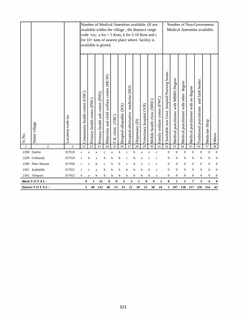
1 2 3
Lo
cati
on
co
de
no
.
Nam
e v
illa
ge
Sr.
No
.
2298 Daribo 357918
2299 Golkunda 357919
2300 Pakri Khunta 357920
2301 Kathaldih 357921
2302 Telopara 357922
Block T O T A L :
District T O T A L :
Co
mm
un
ity
hea
lth
cen
tre
(CH
C)
Pri
mar
y h
ealt
h c
entr
e (P
HC
)
Pri
mar
y h
ealt
h s
ub
cen
tre
(PH
S)
Mat
ern
ity
an
d c
hil
d w
elfa
re c
entr
e (M
CW
)
T.B
. cl
inic
(T
BC
)
Ho
spit
al-a
llo
pat
hic
(H
A)
Ho
spit
al-a
lter
nat
ive
med
icin
e (H
O)
Dis
pen
sary
(D
)
Vet
erin
ary
ho
spit
al (
VH
)
Mo
bil
e h
ealt
h c
lin
ic (
MH
C)
Fam
ily
wel
fare
cen
tre
(FW
C)
Ch
arit
able
no
n G
ov
t. h
osp
ital
/Nu
rsin
g h
om
e.
Med
ical
pra
ctit
ion
er w
ith
MB
BS
Deg
ree
Med
ical
pra
ctit
ion
er w
ith
oth
er
deg
ree
Med
ical
pra
ctit
ion
er w
ith
no
deg
ree
Tra
dit
ion
al p
ract
itio
ner
an
d f
aith
hea
ler
.
Med
icin
e S
ho
p
Oth
ers
21 22 23 24 25 26 27 28 29 30 31 32 33 34 35 36 37 38
Number of Non-Government
Medical Amenities available.
Number of Medical Amenities available. (If not
available within the village , the distance range
code viz; a for < 5 Kms, b for 5-10 Kms and c
for 10+ kms of nearest place where facility is
available is given).
c a a c a b c b a c c 0 0 0 0 0 0 0
c b a b b b c b a c c 0 0 0 0 0 0 0
c c b c b b c b a c c 0 0 0 0 0 0 0
c c a b b b b b b b c 0 0 0 0 0 0 0
b a b b b b b b b b a 0 0 0 0 0 0 0
0 1 12 0 0 2 3 1 0 0 1 0 1 1 7 3 4 0
1 49 132 40 13 33 21 58 12 30 24 1 107 130 217 226 154 42
323
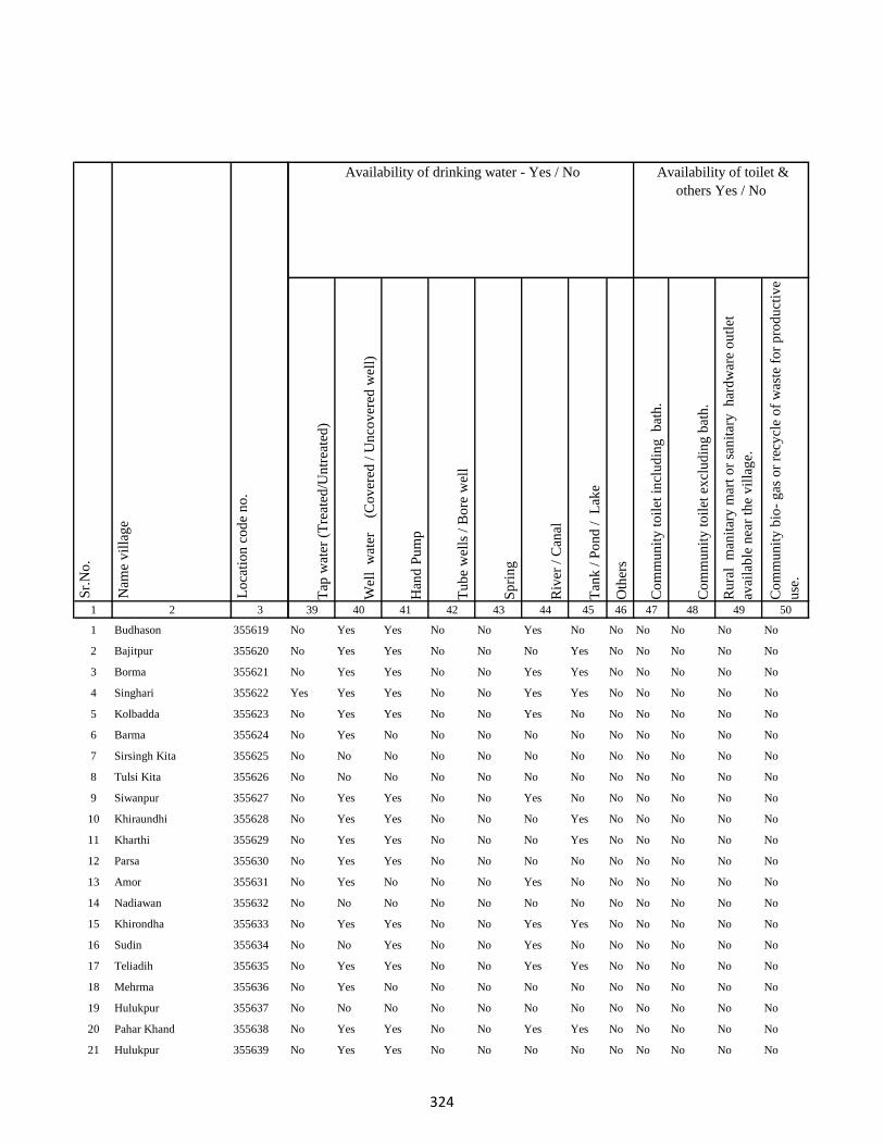
1 2 3
1 Budhason 355619
2 Bajitpur 355620
3 Borma 355621
4 Singhari 355622
5 Kolbadda 355623
6 Barma 355624
7 Sirsingh Kita 355625
8 Tulsi Kita 355626
9 Siwanpur 355627
10 Khiraundhi 355628
11 Kharthi 355629
12 Parsa 355630
13 Amor 355631
14 Nadiawan 355632
15 Khirondha 355633
16 Sudin 355634
17 Teliadih 355635
18 Mehrma 355636
19 Hulukpur 355637
20 Pahar Khand 355638
21 Hulukpur 355639
Lo
cati
on
co
de
no
.
Nam
e v
illa
ge
Sr.
No
.
Tap
wat
er (
Tre
ated
/Un
trea
ted
)
Wel
l w
ater
(Co
ver
ed /
Un
cov
ered
wel
l)
Han
d P
um
p
Tu
be
wel
ls /
Bo
re w
ell
Sp
rin
g
Riv
er /
Can
al
Tan
k /
Po
nd
/
Lak
e
Oth
ers
Co
mm
un
ity
to
ilet
in
clu
din
g
bat
h.
Co
mm
un
ity
to
ilet
ex
clu
din
g b
ath
.
Ru
ral
man
itar
y m
art
or
san
itar
y
har
dw
are
ou
tlet
avai
lab
le n
ear
the
vil
lag
e.
Co
mm
un
ity
bio
- g
as o
r re
cycl
e o
f w
aste
fo
r p
rod
uct
ive
use
.
39 40 41 42 43 44 45 46 47 48 49 50
No Yes Yes No No Yes No No No No No No
No Yes Yes No No No Yes No No No No No
No Yes Yes No No Yes Yes No No No No No
Yes Yes Yes No No Yes Yes No No No No No
No Yes Yes No No Yes No No No No No No
No Yes No No No No No No No No No No
No No No No No No No No No No No No
No No No No No No No No No No No No
No Yes Yes No No Yes No No No No No No
No Yes Yes No No No Yes No No No No No
No Yes Yes No No No Yes No No No No No
No Yes Yes No No No No No No No No No
No Yes No No No Yes No No No No No No
No No No No No No No No No No No No
No Yes Yes No No Yes Yes No No No No No
No No Yes No No Yes No No No No No No
No Yes Yes No No Yes Yes No No No No No
No Yes No No No No No No No No No No
No No No No No No No No No No No No
No Yes Yes No No Yes Yes No No No No No
No Yes Yes No No No No No No No No No
Availability of toilet &
others Yes / No
Availability of drinking water - Yes / No
324
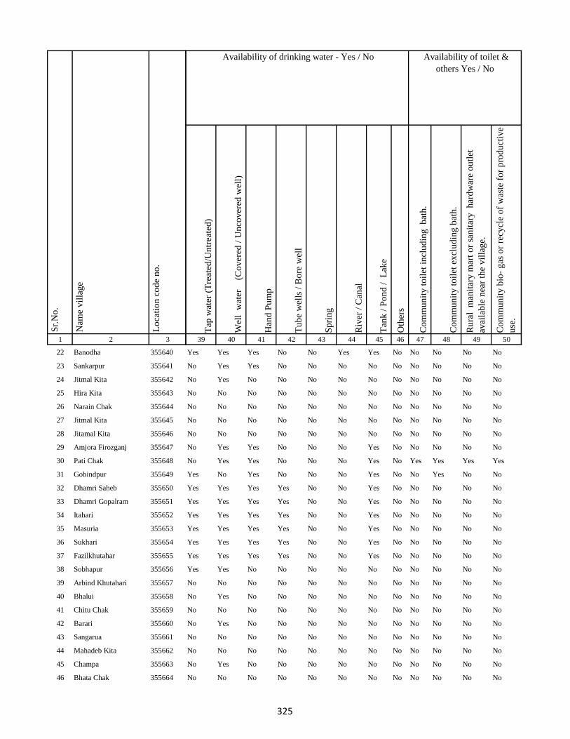
1 2 3
Lo
cati
on
co
de
no
.
Nam
e v
illa
ge
Sr.
No
.
22 Banodha 355640
23 Sankarpur 355641
24 Jitmal Kita 355642
25 Hira Kita 355643
26 Narain Chak 355644
27 Jitmal Kita 355645
28 Jitamal Kita 355646
29 Amjora Firozganj 355647
30 Pati Chak 355648
31 Gobindpur 355649
32 Dhamri Saheb 355650
33 Dhamri Gopalram 355651
34 Itahari 355652
35 Masuria 355653
36 Sukhari 355654
37 Fazilkhutahar 355655
38 Sobhapur 355656
39 Arbind Khutahari 355657
40 Bhalui 355658
41 Chitu Chak 355659
42 Barari 355660
43 Sangarua 355661
44 Mahadeb Kita 355662
45 Champa 355663
46 Bhata Chak 355664
Tap
wat
er (
Tre
ated
/Un
trea
ted
)
Wel
l w
ater
(Co
ver
ed /
Un
cov
ered
wel
l)
Han
d P
um
p
Tu
be
wel
ls /
Bo
re w
ell
Sp
rin
g
Riv
er /
Can
al
Tan
k /
Po
nd
/
Lak
e
Oth
ers
Co
mm
un
ity
to
ilet
in
clu
din
g
bat
h.
Co
mm
un
ity
to
ilet
ex
clu
din
g b
ath
.
Ru
ral
man
itar
y m
art
or
san
itar
y
har
dw
are
ou
tlet
avai
lab
le n
ear
the
vil
lag
e.
Co
mm
un
ity
bio
- g
as o
r re
cycl
e o
f w
aste
fo
r p
rod
uct
ive
use
.
39 40 41 42 43 44 45 46 47 48 49 50
Availability of toilet &
others Yes / No
Availability of drinking water - Yes / No
Yes Yes Yes No No Yes Yes No No No No No
No Yes Yes No No No No No No No No No
No Yes No No No No No No No No No No
No No No No No No No No No No No No
No No No No No No No No No No No No
No No No No No No No No No No No No
No No No No No No No No No No No No
No Yes Yes No No No Yes No No No No No
No Yes Yes No No No Yes No Yes Yes Yes Yes
Yes No Yes No No No Yes No No Yes No No
Yes Yes Yes Yes No No Yes No No No No No
Yes Yes Yes Yes No No Yes No No No No No
Yes Yes Yes Yes No No Yes No No No No No
Yes Yes Yes Yes No No Yes No No No No No
Yes Yes Yes Yes No No Yes No No No No No
Yes Yes Yes Yes No No Yes No No No No No
Yes Yes No No No No No No No No No No
No No No No No No No No No No No No
No Yes No No No No No No No No No No
No No No No No No No No No No No No
No Yes No No No No No No No No No No
No No No No No No No No No No No No
No No No No No No No No No No No No
No Yes No No No No No No No No No No
No No No No No No No No No No No No
325
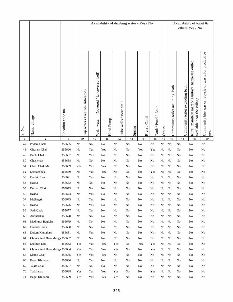
1 2 3
Lo
cati
on
co
de
no
.
Nam
e v
illa
ge
Sr.
No
.
47 Padam Chak 355665
48 Ghuram Chak 355666
49 Badla Chak 355667
50 Ghasichak 355668
51 Ghasi Chak Mal 355669
52 Domanchak 355670
53 Dudhi Chak 355671
54 Kasba 355672
55 Doman Chak 355673
56 Kasba 355674
57 Majhagain 355675
58 Kasba 355676
59 Sadi Chak 355677
60 Anhuatikar 355678
61 Madhurai Bagicha 355679
62 Dukhari Kita 355680
63 Dulum Khutahari 355681
64 Chhota And Bara Mangarh355682
65 Dukhari Kita 355683
66 Chhota And Bara Mangarh355684
67 Mania Chak 355685
68 Bagat Khutahari 355686
69 Jalala Chak 355687
70 Tarkharwa 355688
71 Bagat Khutahri 355689
Tap
wat
er (
Tre
ated
/Un
trea
ted
)
Wel
l w
ater
(Co
ver
ed /
Un
cov
ered
wel
l)
Han
d P
um
p
Tu
be
wel
ls /
Bo
re w
ell
Sp
rin
g
Riv
er /
Can
al
Tan
k /
Po
nd
/
Lak
e
Oth
ers
Co
mm
un
ity
to
ilet
in
clu
din
g
bat
h.
Co
mm
un
ity
to
ilet
ex
clu
din
g b
ath
.
Ru
ral
man
itar
y m
art
or
san
itar
y
har
dw
are
ou
tlet
avai
lab
le n
ear
the
vil
lag
e.
Co
mm
un
ity
bio
- g
as o
r re
cycl
e o
f w
aste
fo
r p
rod
uct
ive
use
.
39 40 41 42 43 44 45 46 47 48 49 50
Availability of toilet &
others Yes / No
Availability of drinking water - Yes / No
No No No No No No No No No No No No
No Yes Yes No No Yes Yes No No No No No
No Yes No No No No No No No No No No
No No No No No No No No No No No No
Yes Yes Yes No No No No No No No No No
No Yes Yes No No No Yes No No No No No
No Yes No No No No No No No No No No
No No No No No No No No No No No No
No No No No No No No No No No No No
No Yes No No No No No No No No No No
No Yes No No No No No No No No No No
No Yes No No No No No No No No No No
No Yes No No No No No No No No No No
No No No No No No No No No No No No
No No No No No No No No No No No No
No No No No No No No No No No No No
No Yes No No No No No No No No No No
No No No No No No No No No No No No
Yes Yes Yes Yes No Yes Yes No No No No No
Yes Yes Yes Yes No No Yes No No No No No
Yes Yes Yes No No No No No No No No No
No Yes No No No No No No No No No No
No No No No No No No No No No No No
Yes Yes Yes Yes No No Yes No No No No No
Yes Yes Yes Yes No No No No No No No No
326

1 2 3
Lo
cati
on
co
de
no
.
Nam
e v
illa
ge
Sr.
No
.
72 Meghchatar 355690
73 Kumardom 355691
74 Harchandpur 355692
75 Maheshdiri 355693
76 Nawadih Tola 355694
77 Beldara Chak 355695
78 Bhaju Chak 355696
79 Bhagwanpur 355697
80 Katmdanr 355698
81 Kita Kalamdanr 355699
82 Amdanr Asli 355700
83 Lachmipur 355701
84 Chandpur 355702
85 Rasti Kar 355703
86 Partappur Mal 355704
87 Partappur Jagir 355705
88 Kishungari Chak 355706
89 Sahi Chak 355707
90 Sarangdhar 355708
91 Sirampur 355709
92 Debi Chak 355710
93 Dogachhi 355711
94 Kandar Chak 355712
95 Tazi Chak 355713
96 Sapnia 355714
Tap
wat
er (
Tre
ated
/Un
trea
ted
)
Wel
l w
ater
(Co
ver
ed /
Un
cov
ered
wel
l)
Han
d P
um
p
Tu
be
wel
ls /
Bo
re w
ell
Sp
rin
g
Riv
er /
Can
al
Tan
k /
Po
nd
/
Lak
e
Oth
ers
Co
mm
un
ity
to
ilet
in
clu
din
g
bat
h.
Co
mm
un
ity
to
ilet
ex
clu
din
g b
ath
.
Ru
ral
man
itar
y m
art
or
san
itar
y
har
dw
are
ou
tlet
avai
lab
le n
ear
the
vil
lag
e.
Co
mm
un
ity
bio
- g
as o
r re
cycl
e o
f w
aste
fo
r p
rod
uct
ive
use
.
39 40 41 42 43 44 45 46 47 48 49 50
Availability of toilet &
others Yes / No
Availability of drinking water - Yes / No
Yes Yes Yes Yes No No Yes No No No No No
Yes Yes Yes Yes No No Yes No No No No No
No Yes No No No No No No No No No No
No No No No No No No No No No No No
Yes Yes No No No Yes Yes No No No No No
No No No No No No No No No No No No
No No No No No No No No No No No No
No No No No No No No No No No No No
No No No No No No No No No No No No
Yes Yes Yes Yes Yes Yes Yes Yes No No No No
Yes Yes No No No Yes No No Yes No No No
No No No No No No No No No No No No
No No No No No No No No No No No No
Yes Yes Yes No No Yes Yes No No No No No
Yes Yes Yes No No No Yes No No No No No
No Yes No No No No No No No No No No
No No No No No No No No No No No No
No No No No No No No No No No No No
No No No No No No No No No No No No
Yes Yes Yes No No Yes Yes No No No No No
No No No No No No No No No No No No
No Yes No No No No No No No No No No
No No No No No No No No No No No No
No Yes No No No No No No No No No No
No No No No No No No No No No No No
327

1 2 3
Lo
cati
on
co
de
no
.
Nam
e v
illa
ge
Sr.
No
.
97 Sapta Chak 355715
98 Mathu Chak 355716
99 Sanolimor 355717
100 Siardih 355718
101 Khaira Chak 355719
102 Gauri Chak 355720
103 Tularam Bhuska 355721
104 Bishunpur 355722
105 Raghudas Bhuska 355723
106 Bhaloa 355724
107 Bisu Chak 355725
108 Jhagraha 355726
109 Benidas Bhuska 355727
110 Belakitar Jagir 355728
111 Chetni Chak 355729
112 Mahuadih 355730
113 Pipra 355731
114 Sauri Chak 355732
115 Dasu Chakla 355733
116 Dwarka Kita 355734
117 Karar Chakla 355735
118 Doi 355736
119 Haripur 355737
120 Gangaldo 355738
121 Sokha Chak 355739
Tap
wat
er (
Tre
ated
/Un
trea
ted
)
Wel
l w
ater
(Co
ver
ed /
Un
cov
ered
wel
l)
Han
d P
um
p
Tu
be
wel
ls /
Bo
re w
ell
Sp
rin
g
Riv
er /
Can
al
Tan
k /
Po
nd
/
Lak
e
Oth
ers
Co
mm
un
ity
to
ilet
in
clu
din
g
bat
h.
Co
mm
un
ity
to
ilet
ex
clu
din
g b
ath
.
Ru
ral
man
itar
y m
art
or
san
itar
y
har
dw
are
ou
tlet
avai
lab
le n
ear
the
vil
lag
e.
Co
mm
un
ity
bio
- g
as o
r re
cycl
e o
f w
aste
fo
r p
rod
uct
ive
use
.
39 40 41 42 43 44 45 46 47 48 49 50
Availability of toilet &
others Yes / No
Availability of drinking water - Yes / No
No No No No No No No No No No No No
No No No No No No No No No No No No
No No No No No No No No No No No No
No Yes No No No Yes Yes No No No No No
No No No No No No No No No No No No
No Yes Yes No No No No No No No No No
No No Yes No No No No No No No No No
No Yes No No No No Yes No No No No No
No No No No No No No No No No No No
No Yes No No No Yes No No No No No No
No No No No No No No No No No No No
No No No No No No No No No No No No
Yes Yes No No No Yes Yes No No No No No
No No No No No No No No No No No No
No No No No No No No No No No No No
No No Yes No No Yes Yes No No No No No
No No Yes No No Yes Yes No No No No No
No Yes Yes No No Yes Yes No No No No No
No No Yes No No Yes Yes No No No No No
No Yes No No No No No No No No No No
No Yes Yes No No Yes Yes No No No No No
No Yes Yes No No No Yes No No No No No
No Yes No No No Yes No No No No No No
No No No No No No No No No No No No
No No No No No No No No No No No No
328

1 2 3
Lo
cati
on
co
de
no
.
Nam
e v
illa
ge
Sr.
No
.
122 Bhim Chak 355740
123 Kabi Chak 355741
124 Mahesh Kita Partabpur 355742
125 Maheshkita Partabpur 355743
126 Chhant Daria Chak 355744
127 Daria Chak 355745
128 Ghori Chak 355746
129 Kasmir Chak 355747
130 Loknath Kita 355748
131 Loknath Kita 355749
132 Partabpur 355750
133 Gausipartabpur 355751
134 Kamargawan 355752
135 Kamardiha 355753
136 Udhua Chak 355754
137 Chaura 355755
138 Phudulia Kita 355756
139 Lakramara 355757
140 Majhgain 355758
141 Nima 355759
142 Udaipur Bahera 355760
143 Chitarsen Bahira 355761
144 Ghori 355762
145 Jitu Chak 355763
146 Dariapur 355764
Tap
wat
er (
Tre
ated
/Un
trea
ted
)
Wel
l w
ater
(Co
ver
ed /
Un
cov
ered
wel
l)
Han
d P
um
p
Tu
be
wel
ls /
Bo
re w
ell
Sp
rin
g
Riv
er /
Can
al
Tan
k /
Po
nd
/
Lak
e
Oth
ers
Co
mm
un
ity
to
ilet
in
clu
din
g
bat
h.
Co
mm
un
ity
to
ilet
ex
clu
din
g b
ath
.
Ru
ral
man
itar
y m
art
or
san
itar
y
har
dw
are
ou
tlet
avai
lab
le n
ear
the
vil
lag
e.
Co
mm
un
ity
bio
- g
as o
r re
cycl
e o
f w
aste
fo
r p
rod
uct
ive
use
.
39 40 41 42 43 44 45 46 47 48 49 50
Availability of toilet &
others Yes / No
Availability of drinking water - Yes / No
No Yes Yes No No No Yes No No No No No
No Yes No No No No Yes No No No No No
No No No No No No No No No No No No
No No No No No No No No No No No No
No Yes Yes No No No Yes No No No No No
No No Yes No No No Yes No No No No No
No Yes Yes No No No Yes No No No No No
No No Yes No No No No No No No No No
No Yes Yes No No No No No No No No No
No No No No No No No No No No No No
No Yes No No No Yes Yes No No No No No
No Yes Yes Yes No No Yes No No No No No
No Yes Yes No No No Yes No No No No No
No Yes Yes No No No Yes No No No No No
No Yes Yes No No Yes Yes No No No No No
No Yes No No No No No No No No No No
No No No No No No No No No No No No
No Yes Yes No No No Yes No No No No No
No Yes Yes No No No Yes No No No No No
No Yes No No No No Yes No No No No No
No No Yes No No No Yes No No No No No
No Yes Yes No No Yes Yes No No No No No
No Yes Yes No No No Yes No No No No No
No Yes Yes Yes No No Yes No No No No No
No Yes No No No No Yes No No No No No
329
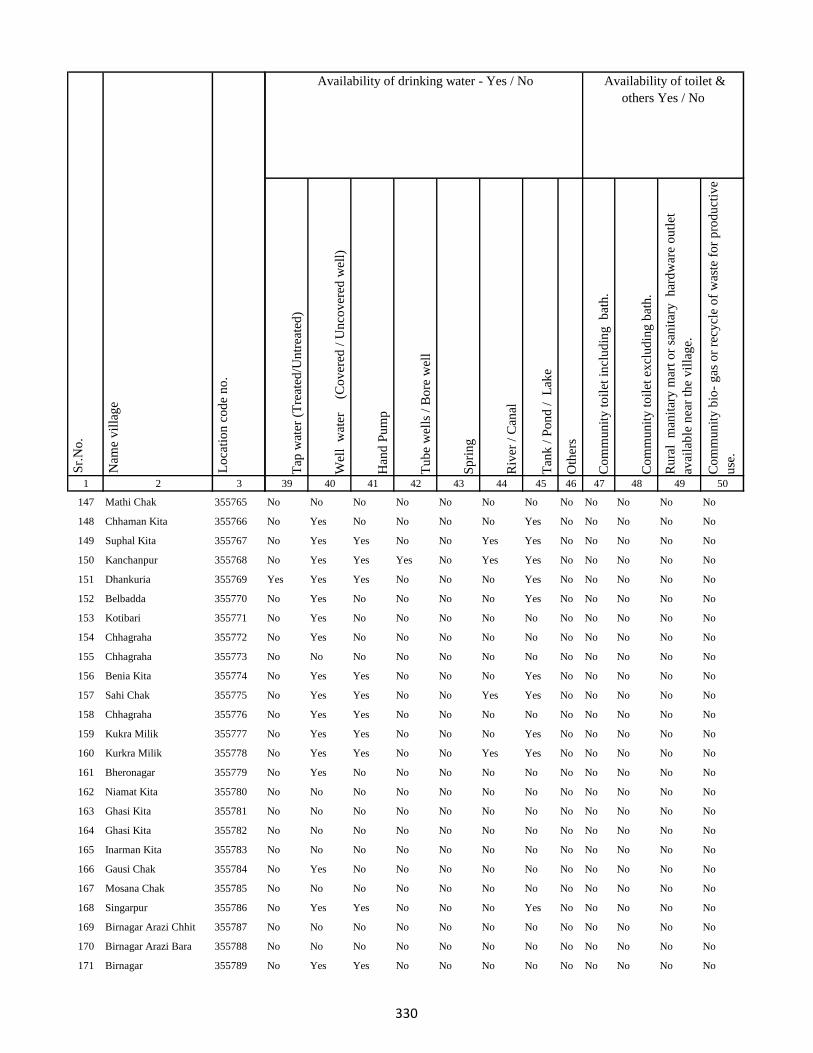
1 2 3
Lo
cati
on
co
de
no
.
Nam
e v
illa
ge
Sr.
No
.
147 Mathi Chak 355765
148 Chhaman Kita 355766
149 Suphal Kita 355767
150 Kanchanpur 355768
151 Dhankuria 355769
152 Belbadda 355770
153 Kotibari 355771
154 Chhagraha 355772
155 Chhagraha 355773
156 Benia Kita 355774
157 Sahi Chak 355775
158 Chhagraha 355776
159 Kukra Milik 355777
160 Kurkra Milik 355778
161 Bheronagar 355779
162 Niamat Kita 355780
163 Ghasi Kita 355781
164 Ghasi Kita 355782
165 Inarman Kita 355783
166 Gausi Chak 355784
167 Mosana Chak 355785
168 Singarpur 355786
169 Birnagar Arazi Chhit 355787
170 Birnagar Arazi Bara 355788
171 Birnagar 355789
Tap
wat
er (
Tre
ated
/Un
trea
ted
)
Wel
l w
ater
(Co
ver
ed /
Un
cov
ered
wel
l)
Han
d P
um
p
Tu
be
wel
ls /
Bo
re w
ell
Sp
rin
g
Riv
er /
Can
al
Tan
k /
Po
nd
/
Lak
e
Oth
ers
Co
mm
un
ity
to
ilet
in
clu
din
g
bat
h.
Co
mm
un
ity
to
ilet
ex
clu
din
g b
ath
.
Ru
ral
man
itar
y m
art
or
san
itar
y
har
dw
are
ou
tlet
avai
lab
le n
ear
the
vil
lag
e.
Co
mm
un
ity
bio
- g
as o
r re
cycl
e o
f w
aste
fo
r p
rod
uct
ive
use
.
39 40 41 42 43 44 45 46 47 48 49 50
Availability of toilet &
others Yes / No
Availability of drinking water - Yes / No
No No No No No No No No No No No No
No Yes No No No No Yes No No No No No
No Yes Yes No No Yes Yes No No No No No
No Yes Yes Yes No Yes Yes No No No No No
Yes Yes Yes No No No Yes No No No No No
No Yes No No No No Yes No No No No No
No Yes No No No No No No No No No No
No Yes No No No No No No No No No No
No No No No No No No No No No No No
No Yes Yes No No No Yes No No No No No
No Yes Yes No No Yes Yes No No No No No
No Yes Yes No No No No No No No No No
No Yes Yes No No No Yes No No No No No
No Yes Yes No No Yes Yes No No No No No
No Yes No No No No No No No No No No
No No No No No No No No No No No No
No No No No No No No No No No No No
No No No No No No No No No No No No
No No No No No No No No No No No No
No Yes No No No No No No No No No No
No No No No No No No No No No No No
No Yes Yes No No No Yes No No No No No
No No No No No No No No No No No No
No No No No No No No No No No No No
No Yes Yes No No No No No No No No No
330
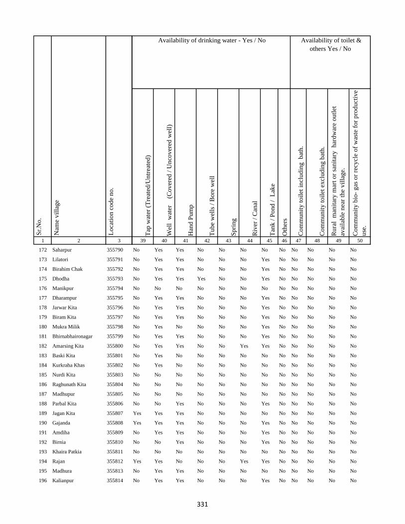
1 2 3
Lo
cati
on
co
de
no
.
Nam
e v
illa
ge
Sr.
No
.
172 Saharpur 355790
173 Lilatori 355791
174 Birahim Chak 355792
175 Dhodha 355793
176 Manikpur 355794
177 Dharampur 355795
178 Jarwar Kita 355796
179 Biram Kita 355797
180 Mukra Milik 355798
181 Bhirnabhaironagar 355799
182 Amarsing Kita 355800
183 Baski Kita 355801
184 Kurkraha Khas 355802
185 Nurdi Kita 355803
186 Raghunath Kita 355804
187 Madhupur 355805
188 Parbal Kita 355806
189 Jagan Kita 355807
190 Gajanda 355808
191 Amdiha 355809
192 Birnia 355810
193 Khaira Patkia 355811
194 Rajan 355812
195 Madhura 355813
196 Kalianpur 355814
Tap
wat
er (
Tre
ated
/Un
trea
ted
)
Wel
l w
ater
(Co
ver
ed /
Un
cov
ered
wel
l)
Han
d P
um
p
Tu
be
wel
ls /
Bo
re w
ell
Sp
rin
g
Riv
er /
Can
al
Tan
k /
Po
nd
/
Lak
e
Oth
ers
Co
mm
un
ity
to
ilet
in
clu
din
g
bat
h.
Co
mm
un
ity
to
ilet
ex
clu
din
g b
ath
.
Ru
ral
man
itar
y m
art
or
san
itar
y
har
dw
are
ou
tlet
avai
lab
le n
ear
the
vil
lag
e.
Co
mm
un
ity
bio
- g
as o
r re
cycl
e o
f w
aste
fo
r p
rod
uct
ive
use
.
39 40 41 42 43 44 45 46 47 48 49 50
Availability of toilet &
others Yes / No
Availability of drinking water - Yes / No
No Yes Yes No No No No No No No No No
No Yes Yes No No No Yes No No No No No
No Yes Yes No No No Yes No No No No No
No Yes Yes Yes No No Yes No No No No No
No No No No No No No No No No No No
No Yes Yes No No No Yes No No No No No
No Yes Yes No No No Yes No No No No No
No Yes Yes No No No Yes No No No No No
No Yes No No No No Yes No No No No No
No Yes Yes No No No Yes No No No No No
No Yes Yes No No Yes Yes No No No No No
No Yes No No No No No No No No No No
No Yes No No No No No No No No No No
No No No No No No No No No No No No
No No No No No No No No No No No No
No No No No No No No No No No No No
No No Yes No No No Yes No No No No No
Yes Yes Yes No No No No No No No No No
Yes Yes Yes No No No Yes No No No No No
No Yes Yes No No No Yes No No No No No
No No Yes No No No Yes No No No No No
No No No No No No No No No No No No
Yes Yes No No No Yes Yes No No No No No
No Yes Yes No No No No No No No No No
No Yes Yes No No No Yes No No No No No
331
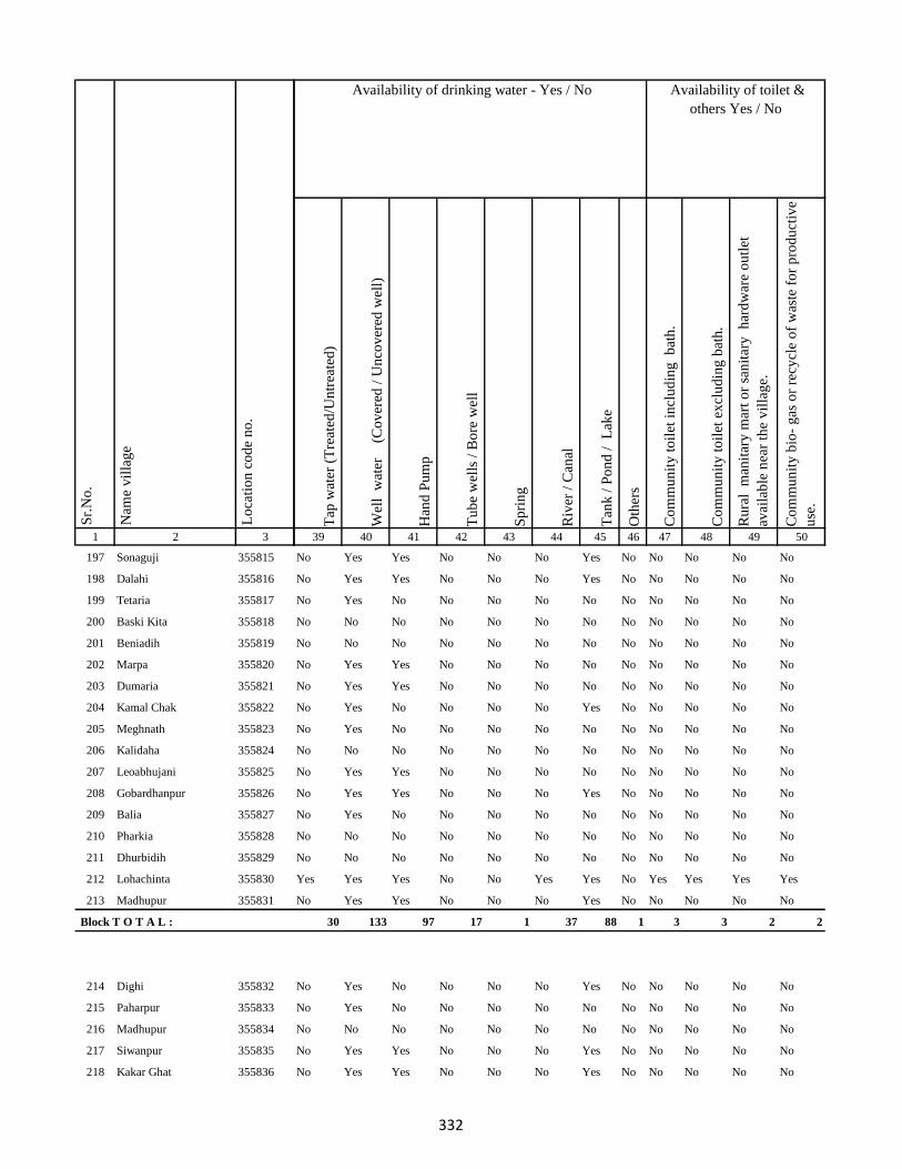
1 2 3
Lo
cati
on
co
de
no
.
Nam
e v
illa
ge
Sr.
No
.
197 Sonaguji 355815
198 Dalahi 355816
199 Tetaria 355817
200 Baski Kita 355818
201 Beniadih 355819
202 Marpa 355820
203 Dumaria 355821
204 Kamal Chak 355822
205 Meghnath 355823
206 Kalidaha 355824
207 Leoabhujani 355825
208 Gobardhanpur 355826
209 Balia 355827
210 Pharkia 355828
211 Dhurbidih 355829
212 Lohachinta 355830
213 Madhupur 355831
Block T O T A L :
214 Dighi 355832
215 Paharpur 355833
216 Madhupur 355834
217 Siwanpur 355835
218 Kakar Ghat 355836
Tap
wat
er (
Tre
ated
/Un
trea
ted
)
Wel
l w
ater
(Co
ver
ed /
Un
cov
ered
wel
l)
Han
d P
um
p
Tu
be
wel
ls /
Bo
re w
ell
Sp
rin
g
Riv
er /
Can
al
Tan
k /
Po
nd
/
Lak
e
Oth
ers
Co
mm
un
ity
to
ilet
in
clu
din
g
bat
h.
Co
mm
un
ity
to
ilet
ex
clu
din
g b
ath
.
Ru
ral
man
itar
y m
art
or
san
itar
y
har
dw
are
ou
tlet
avai
lab
le n
ear
the
vil
lag
e.
Co
mm
un
ity
bio
- g
as o
r re
cycl
e o
f w
aste
fo
r p
rod
uct
ive
use
.
39 40 41 42 43 44 45 46 47 48 49 50
Availability of toilet &
others Yes / No
Availability of drinking water - Yes / No
No Yes Yes No No No Yes No No No No No
No Yes Yes No No No Yes No No No No No
No Yes No No No No No No No No No No
No No No No No No No No No No No No
No No No No No No No No No No No No
No Yes Yes No No No No No No No No No
No Yes Yes No No No No No No No No No
No Yes No No No No Yes No No No No No
No Yes No No No No No No No No No No
No No No No No No No No No No No No
No Yes Yes No No No No No No No No No
No Yes Yes No No No Yes No No No No No
No Yes No No No No No No No No No No
No No No No No No No No No No No No
No No No No No No No No No No No No
Yes Yes Yes No No Yes Yes No Yes Yes Yes Yes
No Yes Yes No No No Yes No No No No No
30 133 97 17 1 37 88 1 3 3 2 2
No Yes No No No No Yes No No No No No
No Yes No No No No No No No No No No
No No No No No No No No No No No No
No Yes Yes No No No Yes No No No No No
No Yes Yes No No No Yes No No No No No
332

1 2 3
Lo
cati
on
co
de
no
.
Nam
e v
illa
ge
Sr.
No
.
219 Talbaria 355837
220 Mohamad Khutahari 355838
221 Mal Jhakhra 355839
222 Baghjhakhra 355840
223 Sinha Chak 355841
224 Babutaluk 355842
225 Paharpur 355843
226 Deban Chak 355844
227 Gargulal 355845
228 Madan Chauki 355846
229 Birahim Kita 355847
230 Banskola 355848
231 Kurpatti 355849
232 Baijani 355850
233 Chapri 355851
234 Kamat Chapri 355852
235 Khar Kudia 355853
236 Majhana (Arazi) 355854
237 Hasu Chak 355855
238 Domansaran Kita 355856
239 Silong 355857
240 Paharpur 355858
241 Akilkita 355859
242 Bikram Kita 355860
243 Paharpur 355861
Tap
wat
er (
Tre
ated
/Un
trea
ted
)
Wel
l w
ater
(Co
ver
ed /
Un
cov
ered
wel
l)
Han
d P
um
p
Tu
be
wel
ls /
Bo
re w
ell
Sp
rin
g
Riv
er /
Can
al
Tan
k /
Po
nd
/
Lak
e
Oth
ers
Co
mm
un
ity
to
ilet
in
clu
din
g
bat
h.
Co
mm
un
ity
to
ilet
ex
clu
din
g b
ath
.
Ru
ral
man
itar
y m
art
or
san
itar
y
har
dw
are
ou
tlet
avai
lab
le n
ear
the
vil
lag
e.
Co
mm
un
ity
bio
- g
as o
r re
cycl
e o
f w
aste
fo
r p
rod
uct
ive
use
.
39 40 41 42 43 44 45 46 47 48 49 50
Availability of toilet &
others Yes / No
Availability of drinking water - Yes / No
No Yes Yes No No No Yes No No No No No
No Yes No No No No Yes No No No No No
No Yes Yes No No No Yes No No No No No
No Yes Yes No No No Yes No No No No No
No Yes No No No No No No No No No No
No No No No No No No No No No No No
No No No No No No No No No No No No
No No Yes No No No No No No No No No
No Yes Yes No No No Yes No No No No No
No Yes Yes No No No Yes No No No No No
No Yes Yes No No No Yes No No No No No
No No Yes No No No No No No No No No
No Yes Yes No No No No No No No No No
No Yes Yes No No No Yes No No No No No
No No Yes No No No No No No No No No
No Yes Yes No No No Yes No No No No No
No Yes No No No No No No No No No No
No No No No No No No No No No No No
No Yes No No No No No No No No No No
No No No No No No No No No No No No
No Yes Yes No No No Yes No No No No No
No Yes No No No No No No No No No No
No No No No No No No No No No No No
No No No No No No No No No No No No
No Yes Yes No No No Yes No Yes No No No
333

1 2 3
Lo
cati
on
co
de
no
.
Nam
e v
illa
ge
Sr.
No
.
244 Chandpur 355862
245 Khani Chak 355863
246 Nagarchi Chak 355864
247 Taj Kita 355865
248 Panchu Kita 355866
249 Mohan Kita 355867
250 Khania Kita 355868
251 Badura Kita 355869
252 Bhatu Kita 355870
253 Dalubarmohtar 355871
254 Madhuadih Khas 355872
255 Madhuadih Arjun Kita 355873
256 Jadu Kita 355874
257 Kali Kita 355875
258 Haripur 355876
259 Nawadih Parthumanjhi 355877
260 Sonapur 355878
261 Maku Chak 355879
262 Chand Chak 355880
263 Dumaria 355881
264 Taib Kita 355882
265 Bhekhari Kita 355883
266 Mitan Kita 355884
267 Kadil Kita 355885
268 Pitambar Kita 355886
Tap
wat
er (
Tre
ated
/Un
trea
ted
)
Wel
l w
ater
(Co
ver
ed /
Un
cov
ered
wel
l)
Han
d P
um
p
Tu
be
wel
ls /
Bo
re w
ell
Sp
rin
g
Riv
er /
Can
al
Tan
k /
Po
nd
/
Lak
e
Oth
ers
Co
mm
un
ity
to
ilet
in
clu
din
g
bat
h.
Co
mm
un
ity
to
ilet
ex
clu
din
g b
ath
.
Ru
ral
man
itar
y m
art
or
san
itar
y
har
dw
are
ou
tlet
avai
lab
le n
ear
the
vil
lag
e.
Co
mm
un
ity
bio
- g
as o
r re
cycl
e o
f w
aste
fo
r p
rod
uct
ive
use
.
39 40 41 42 43 44 45 46 47 48 49 50
Availability of toilet &
others Yes / No
Availability of drinking water - Yes / No
No Yes Yes No No No Yes No No No No No
No Yes No No No No No No No No No No
No No No No No No No No No No No No
No Yes Yes Yes No No Yes No No No No No
No Yes No No No No No No No No No No
No No No No No No No No No No No No
No Yes Yes No No No No No No No No No
No Yes Yes No No No Yes No No No No No
No Yes No No No No No No No No No No
No No No No No No No No No No No No
No No No No No No No No No No No No
No No No No No No No No No No No No
No Yes Yes Yes No Yes Yes No No No No No
No No Yes No No Yes Yes No No No No No
No Yes Yes No No No Yes No No No No No
No Yes Yes No No Yes Yes No No No No No
No Yes Yes No No Yes Yes No No No No No
No No No No No No No No No No No No
No Yes Yes No No No No No No No No No
No Yes No No No No No No No No No No
No No No No No No No No No No No No
No No Yes No No No No No No No No No
No Yes No No No No No No No No No No
No No No No No No No No No No No No
No No No No No No No No No No No No
334

1 2 3
Lo
cati
on
co
de
no
.
Nam
e v
illa
ge
Sr.
No
.
269 Baiju Kita 355887
270 Budhasan 355888
271 Janghira 355889
272 Mohan Pipra 355890
273 Dahua Pakaria 355891
274 Sanhuli 355892
275 Tetarbhuj 355893
276 Panch Pahar 355894
277 Rampur 355895
278 Bhagwakol 355896
279 Dhankol 355897
280 Mopahari 355898
281 Khandhar 355899
282 Bodhrai Khutahari 355900
283 Hira Khutahari 355901
284 Kari Khutahari 355902
285 Bishunpur 355903
286 Bhagaia 355904
287 Manikapur 355905
288 Ramdas Khutahari 355906
289 Jiban Khutahari 355907
290 Baiju Khutahari 355908
291 Salim Khutahari 355909
292 Jhilli 355910
293 Gajhanda 355911
Tap
wat
er (
Tre
ated
/Un
trea
ted
)
Wel
l w
ater
(Co
ver
ed /
Un
cov
ered
wel
l)
Han
d P
um
p
Tu
be
wel
ls /
Bo
re w
ell
Sp
rin
g
Riv
er /
Can
al
Tan
k /
Po
nd
/
Lak
e
Oth
ers
Co
mm
un
ity
to
ilet
in
clu
din
g
bat
h.
Co
mm
un
ity
to
ilet
ex
clu
din
g b
ath
.
Ru
ral
man
itar
y m
art
or
san
itar
y
har
dw
are
ou
tlet
avai
lab
le n
ear
the
vil
lag
e.
Co
mm
un
ity
bio
- g
as o
r re
cycl
e o
f w
aste
fo
r p
rod
uct
ive
use
.
39 40 41 42 43 44 45 46 47 48 49 50
Availability of toilet &
others Yes / No
Availability of drinking water - Yes / No
No Yes Yes No No No Yes No No No No No
No Yes Yes No No No No No No No No No
No Yes No No No No No No No No No No
No No No No No No No No No No No No
No Yes Yes No No Yes Yes No No No No No
No Yes No No No No No No No No No No
No No No No No No No No No No No No
No No No No No No No No No No No No
No No No No No No No No No No No No
No No Yes No No No No No No No No No
No No Yes No No No No No No No No No
No Yes Yes Yes No No No Yes No No No No
No Yes Yes No No No Yes No No No No No
No Yes Yes No No No Yes No No No No No
No Yes Yes No No No Yes No No No No No
No Yes Yes No No No Yes No No No No No
No Yes Yes No No No Yes No No No No No
No Yes Yes No No No Yes No No No No No
No Yes No No No No No No No No No No
No No No No No No No No No No No No
No Yes No No No No No No No No No No
No No No No No No No No No No No No
No Yes No No No No No No No No No No
No No No No No No No No No No No No
No No Yes No No No Yes No No No No No
335
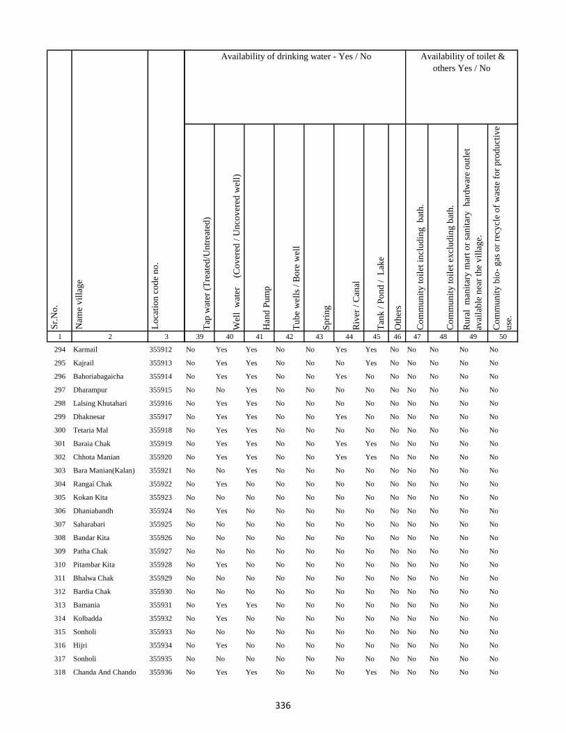
1 2 3
Lo
cati
on
co
de
no
.
Nam
e v
illa
ge
Sr.
No
.
294 Karmail 355912
295 Kajrail 355913
296 Bahoriabagaicha 355914
297 Dharampur 355915
298 Lalsing Khutahari 355916
299 Dhaknesar 355917
300 Tetaria Mal 355918
301 Baraia Chak 355919
302 Chhota Manian 355920
303 Bara Manian(Kalan) 355921
304 Rangai Chak 355922
305 Kokan Kita 355923
306 Dhaniabandh 355924
307 Saharabari 355925
308 Bandar Kita 355926
309 Patha Chak 355927
310 Pitambar Kita 355928
311 Bhalwa Chak 355929
312 Bardia Chak 355930
313 Bamania 355931
314 Kolbadda 355932
315 Sonholi 355933
316 Hijri 355934
317 Sonholi 355935
318 Chanda And Chando 355936
Tap
wat
er (
Tre
ated
/Un
trea
ted
)
Wel
l w
ater
(Co
ver
ed /
Un
cov
ered
wel
l)
Han
d P
um
p
Tu
be
wel
ls /
Bo
re w
ell
Sp
rin
g
Riv
er /
Can
al
Tan
k /
Po
nd
/
Lak
e
Oth
ers
Co
mm
un
ity
to
ilet
in
clu
din
g
bat
h.
Co
mm
un
ity
to
ilet
ex
clu
din
g b
ath
.
Ru
ral
man
itar
y m
art
or
san
itar
y
har
dw
are
ou
tlet
avai
lab
le n
ear
the
vil
lag
e.
Co
mm
un
ity
bio
- g
as o
r re
cycl
e o
f w
aste
fo
r p
rod
uct
ive
use
.
39 40 41 42 43 44 45 46 47 48 49 50
Availability of toilet &
others Yes / No
Availability of drinking water - Yes / No
No Yes Yes No No Yes Yes No No No No No
No Yes Yes No No No Yes No No No No No
No Yes Yes No No Yes No No No No No No
No No Yes No No No No No No No No No
No Yes Yes No No No No No No No No No
No Yes Yes No No Yes No No No No No No
No Yes Yes No No No No No No No No No
No Yes Yes No No Yes Yes No No No No No
No Yes Yes No No Yes Yes No No No No No
No No Yes No No No No No No No No No
No Yes No No No No No No No No No No
No No No No No No No No No No No No
No Yes No No No No No No No No No No
No No No No No No No No No No No No
No No No No No No No No No No No No
No No No No No No No No No No No No
No Yes No No No No No No No No No No
No No No No No No No No No No No No
No No No No No No No No No No No No
No Yes Yes No No No No No No No No No
No Yes No No No No No No No No No No
No No No No No No No No No No No No
No Yes No No No No No No No No No No
No No No No No No No No No No No No
No Yes Yes No No No Yes No No No No No
336
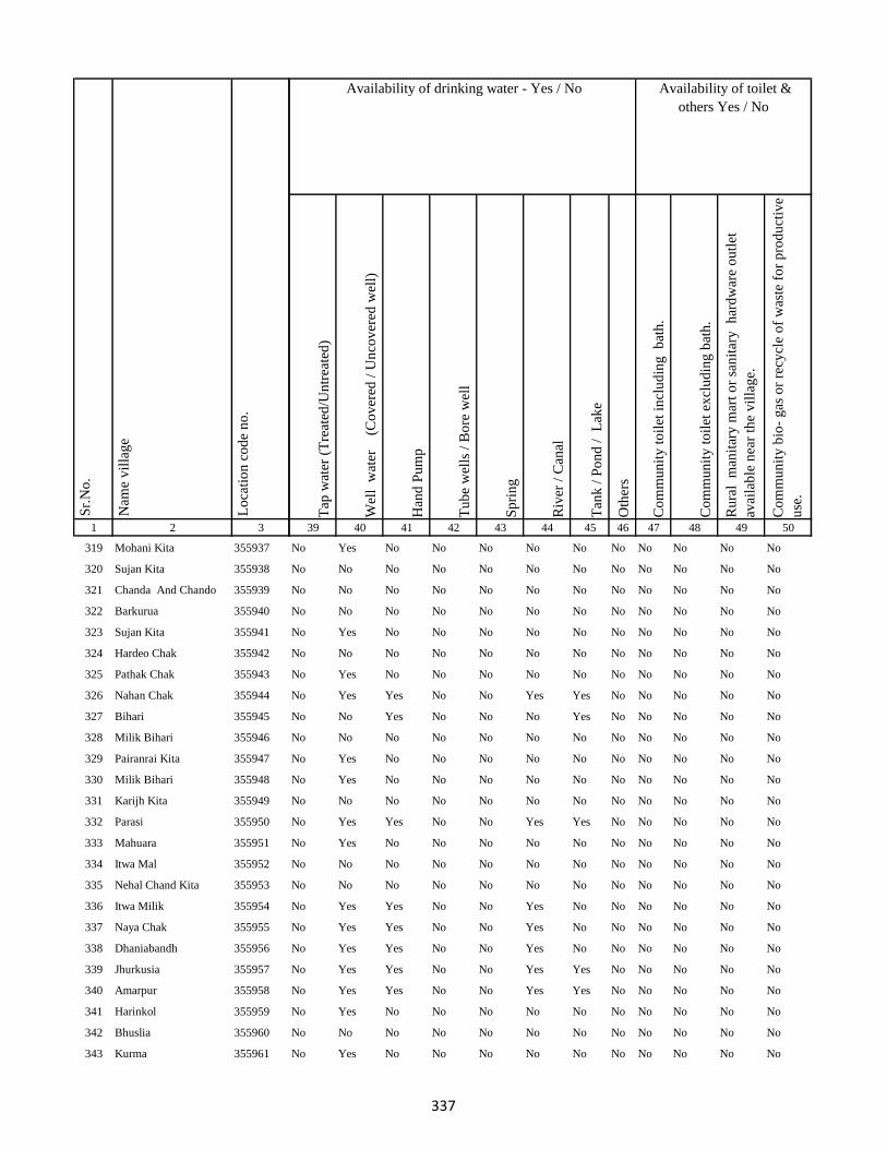
1 2 3
Lo
cati
on
co
de
no
.
Nam
e v
illa
ge
Sr.
No
.
319 Mohani Kita 355937
320 Sujan Kita 355938
321 Chanda And Chando 355939
322 Barkurua 355940
323 Sujan Kita 355941
324 Hardeo Chak 355942
325 Pathak Chak 355943
326 Nahan Chak 355944
327 Bihari 355945
328 Milik Bihari 355946
329 Pairanrai Kita 355947
330 Milik Bihari 355948
331 Karijh Kita 355949
332 Parasi 355950
333 Mahuara 355951
334 Itwa Mal 355952
335 Nehal Chand Kita 355953
336 Itwa Milik 355954
337 Naya Chak 355955
338 Dhaniabandh 355956
339 Jhurkusia 355957
340 Amarpur 355958
341 Harinkol 355959
342 Bhuslia 355960
343 Kurma 355961
Tap
wat
er (
Tre
ated
/Un
trea
ted
)
Wel
l w
ater
(Co
ver
ed /
Un
cov
ered
wel
l)
Han
d P
um
p
Tu
be
wel
ls /
Bo
re w
ell
Sp
rin
g
Riv
er /
Can
al
Tan
k /
Po
nd
/
Lak
e
Oth
ers
Co
mm
un
ity
to
ilet
in
clu
din
g
bat
h.
Co
mm
un
ity
to
ilet
ex
clu
din
g b
ath
.
Ru
ral
man
itar
y m
art
or
san
itar
y
har
dw
are
ou
tlet
avai
lab
le n
ear
the
vil
lag
e.
Co
mm
un
ity
bio
- g
as o
r re
cycl
e o
f w
aste
fo
r p
rod
uct
ive
use
.
39 40 41 42 43 44 45 46 47 48 49 50
Availability of toilet &
others Yes / No
Availability of drinking water - Yes / No
No Yes No No No No No No No No No No
No No No No No No No No No No No No
No No No No No No No No No No No No
No No No No No No No No No No No No
No Yes No No No No No No No No No No
No No No No No No No No No No No No
No Yes No No No No No No No No No No
No Yes Yes No No Yes Yes No No No No No
No No Yes No No No Yes No No No No No
No No No No No No No No No No No No
No Yes No No No No No No No No No No
No Yes No No No No No No No No No No
No No No No No No No No No No No No
No Yes Yes No No Yes Yes No No No No No
No Yes No No No No No No No No No No
No No No No No No No No No No No No
No No No No No No No No No No No No
No Yes Yes No No Yes No No No No No No
No Yes Yes No No Yes No No No No No No
No Yes Yes No No Yes No No No No No No
No Yes Yes No No Yes Yes No No No No No
No Yes Yes No No Yes Yes No No No No No
No Yes No No No No No No No No No No
No No No No No No No No No No No No
No Yes No No No No No No No No No No
337
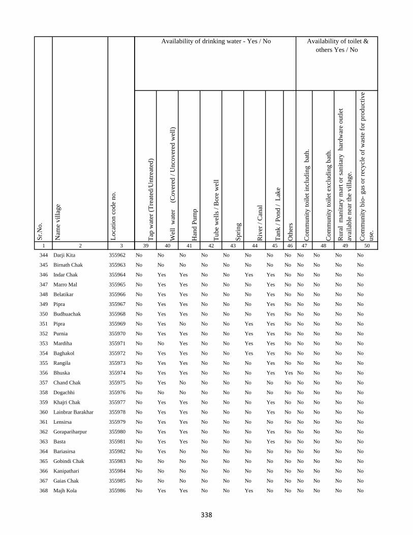
1 2 3
Lo
cati
on
co
de
no
.
Nam
e v
illa
ge
Sr.
No
.
344 Darji Kita 355962
345 Birnath Chak 355963
346 Indar Chak 355964
347 Marro Mal 355965
348 Belatikar 355966
349 Pipra 355967
350 Budhuachak 355968
351 Pipra 355969
352 Purnia 355970
353 Mardiha 355971
354 Baghakol 355972
355 Rangila 355973
356 Bhuska 355974
357 Chand Chak 355975
358 Dogachhi 355976
359 Khajri Chak 355977
360 Lainbrar Barakhar 355978
361 Lensirsa 355979
362 Gorapariharpur 355980
363 Basta 355981
364 Bariasirsa 355982
365 Gobindi Chak 355983
366 Kanipathari 355984
367 Gaias Chak 355985
368 Majh Kola 355986
Tap
wat
er (
Tre
ated
/Un
trea
ted
)
Wel
l w
ater
(Co
ver
ed /
Un
cov
ered
wel
l)
Han
d P
um
p
Tu
be
wel
ls /
Bo
re w
ell
Sp
rin
g
Riv
er /
Can
al
Tan
k /
Po
nd
/
Lak
e
Oth
ers
Co
mm
un
ity
to
ilet
in
clu
din
g
bat
h.
Co
mm
un
ity
to
ilet
ex
clu
din
g b
ath
.
Ru
ral
man
itar
y m
art
or
san
itar
y
har
dw
are
ou
tlet
avai
lab
le n
ear
the
vil
lag
e.
Co
mm
un
ity
bio
- g
as o
r re
cycl
e o
f w
aste
fo
r p
rod
uct
ive
use
.
39 40 41 42 43 44 45 46 47 48 49 50
Availability of toilet &
others Yes / No
Availability of drinking water - Yes / No
No No No No No No No No No No No No
No No No No No No No No No No No No
No Yes Yes No No Yes Yes No No No No No
No Yes Yes No No No Yes No No No No No
No Yes Yes No No No Yes No No No No No
No Yes Yes No No No Yes No No No No No
No Yes Yes No No No Yes No No No No No
No Yes No No No Yes Yes No No No No No
No Yes Yes No No Yes Yes No No No No No
No No Yes No No Yes Yes No No No No No
No Yes Yes No No Yes Yes No No No No No
No Yes Yes No No No Yes No No No No No
No Yes Yes No No No Yes Yes No No No No
No Yes No No No No No No No No No No
No No No No No No No No No No No No
No Yes Yes No No No Yes No No No No No
No Yes Yes No No No Yes No No No No No
No Yes Yes No No No No No No No No No
No Yes Yes No No No Yes No No No No No
No Yes Yes No No No Yes No No No No No
No Yes No No No No No No No No No No
No No No No No No No No No No No No
No No No No No No No No No No No No
No No No No No No No No No No No No
No Yes Yes No No Yes No No No No No No
338
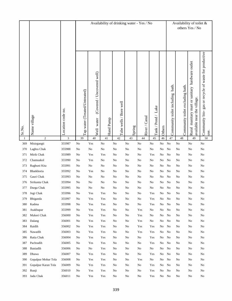
1 2 3
Lo
cati
on
co
de
no
.
Nam
e v
illa
ge
Sr.
No
.
369 Misirgangti 355987
370 Laghra Chak 355988
371 Mirik Chak 355989
372 Chamuakol 355990
373 Raghuni Kita 355991
374 Bhatkhoria 355992
375 Gauri Chak 355993
376 Sirikanta Chak 355994
377 Durga Chak 355995
378 Jogi Chak 355996
379 Bhiganda 355997
380 Kadma 355998
381 Asakhapar 355999
382 Mukeri Chak 356000
383 Dalang 356001
384 Raidih 356002
385 Nawadih 356003
386 Ratia Chak 356004
387 Pachradih 356005
388 Baniadih 356006
389 Dhawa 356007
390 Gopalpur Mohar Tola 356008
391 Gopalpur Karan Tola 356009
392 Runji 356010
393 Jadu Chak 356011
Tap
wat
er (
Tre
ated
/Un
trea
ted
)
Wel
l w
ater
(Co
ver
ed /
Un
cov
ered
wel
l)
Han
d P
um
p
Tu
be
wel
ls /
Bo
re w
ell
Sp
rin
g
Riv
er /
Can
al
Tan
k /
Po
nd
/
Lak
e
Oth
ers
Co
mm
un
ity
to
ilet
in
clu
din
g
bat
h.
Co
mm
un
ity
to
ilet
ex
clu
din
g b
ath
.
Ru
ral
man
itar
y m
art
or
san
itar
y
har
dw
are
ou
tlet
avai
lab
le n
ear
the
vil
lag
e.
Co
mm
un
ity
bio
- g
as o
r re
cycl
e o
f w
aste
fo
r p
rod
uct
ive
use
.
39 40 41 42 43 44 45 46 47 48 49 50
Availability of toilet &
others Yes / No
Availability of drinking water - Yes / No
No Yes No No No No No No No No No No
No No No No No No No No No No No No
No Yes Yes No No No Yes No No No No No
No Yes No No No No No No No No No No
No No No No No No No No No No No No
No Yes No No No No No No No No No No
No No No No No No No No No No No No
No No No No No No No No No No No No
No No No No No No No No No No No No
No Yes Yes No No No Yes No No No No No
No Yes Yes No No No Yes No No No No No
No Yes Yes No No No Yes No No No No No
No Yes Yes No No Yes No No No No No No
No Yes Yes No No Yes No No No No No No
No Yes Yes No No Yes No No No No No No
No Yes Yes No No Yes Yes No No No No No
No Yes Yes No No Yes Yes No No No No No
No Yes Yes No No No Yes No No No No No
No Yes Yes No No No Yes No No No No No
No No Yes No No No No No No No No No
No Yes Yes No No No Yes No No No No No
No Yes Yes No No Yes No No No No No No
No Yes Yes No No No Yes No No No No No
No Yes Yes No No No Yes No No No No No
No Yes Yes No No No Yes No No No No No
339
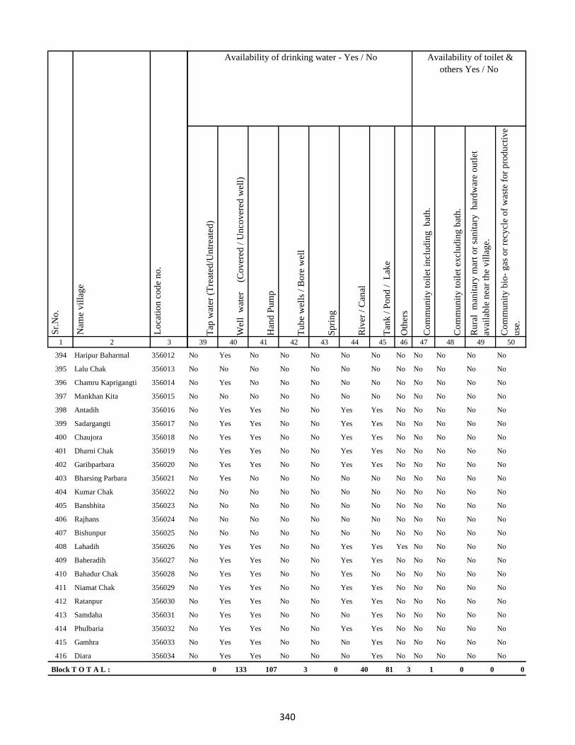
1 2 3
Lo
cati
on
co
de
no
.
Nam
e v
illa
ge
Sr.
No
.
394 Haripur Baharmal 356012
395 Lalu Chak 356013
396 Chamru Kaprigangti 356014
397 Mankhan Kita 356015
398 Antadih 356016
399 Sadargangti 356017
400 Chaujora 356018
401 Dharni Chak 356019
402 Garibparbara 356020
403 Bharsing Parbara 356021
404 Kumar Chak 356022
405 Bansbhita 356023
406 Rajhans 356024
407 Bishunpur 356025
408 Lahadih 356026
409 Baheradih 356027
410 Bahadur Chak 356028
411 Niamat Chak 356029
412 Ratanpur 356030
413 Samdaha 356031
414 Phulbaria 356032
415 Gamhra 356033
416 Diara 356034
Block T O T A L :
Tap
wat
er (
Tre
ated
/Un
trea
ted
)
Wel
l w
ater
(Co
ver
ed /
Un
cov
ered
wel
l)
Han
d P
um
p
Tu
be
wel
ls /
Bo
re w
ell
Sp
rin
g
Riv
er /
Can
al
Tan
k /
Po
nd
/
Lak
e
Oth
ers
Co
mm
un
ity
to
ilet
in
clu
din
g
bat
h.
Co
mm
un
ity
to
ilet
ex
clu
din
g b
ath
.
Ru
ral
man
itar
y m
art
or
san
itar
y
har
dw
are
ou
tlet
avai
lab
le n
ear
the
vil
lag
e.
Co
mm
un
ity
bio
- g
as o
r re
cycl
e o
f w
aste
fo
r p
rod
uct
ive
use
.
39 40 41 42 43 44 45 46 47 48 49 50
Availability of toilet &
others Yes / No
Availability of drinking water - Yes / No
No Yes No No No No No No No No No No
No No No No No No No No No No No No
No Yes No No No No No No No No No No
No No No No No No No No No No No No
No Yes Yes No No Yes Yes No No No No No
No Yes Yes No No Yes Yes No No No No No
No Yes Yes No No Yes Yes No No No No No
No Yes Yes No No Yes Yes No No No No No
No Yes Yes No No Yes Yes No No No No No
No Yes No No No No No No No No No No
No No No No No No No No No No No No
No No No No No No No No No No No No
No No No No No No No No No No No No
No No No No No No No No No No No No
No Yes Yes No No Yes Yes Yes No No No No
No Yes Yes No No Yes Yes No No No No No
No Yes Yes No No Yes No No No No No No
No Yes Yes No No Yes Yes No No No No No
No Yes Yes No No Yes Yes No No No No No
No Yes Yes No No No Yes No No No No No
No Yes Yes No No Yes Yes No No No No No
No Yes Yes No No No Yes No No No No No
No Yes Yes No No No Yes No No No No No
0 133 107 3 0 40 81 3 1 0 0 0
340
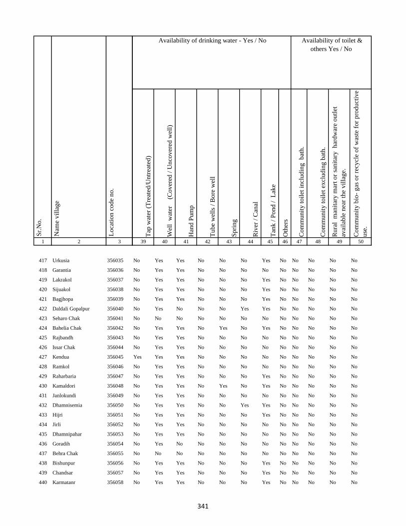
1 2 3
Lo
cati
on
co
de
no
.
Nam
e v
illa
ge
Sr.
No
.
417 Urkusia 356035
418 Garantia 356036
419 Lakrakol 356037
420 Sijuakol 356038
421 Bagjhopa 356039
422 Daldali Gopalpur 356040
423 Seharo Chak 356041
424 Bahelia Chak 356042
425 Rajbandh 356043
426 Issar Chak 356044
427 Kendua 356045
428 Ramkol 356046
429 Raharbaria 356047
430 Kamaldori 356048
431 Janlokundi 356049
432 Dhamnisemia 356050
433 Hijri 356051
434 Jirli 356052
435 Dhamnipahar 356053
436 Goradih 356054
437 Behra Chak 356055
438 Bishunpur 356056
439 Chandsar 356057
440 Karmatanr 356058
Tap
wat
er (
Tre
ated
/Un
trea
ted
)
Wel
l w
ater
(Co
ver
ed /
Un
cov
ered
wel
l)
Han
d P
um
p
Tu
be
wel
ls /
Bo
re w
ell
Sp
rin
g
Riv
er /
Can
al
Tan
k /
Po
nd
/
Lak
e
Oth
ers
Co
mm
un
ity
to
ilet
in
clu
din
g
bat
h.
Co
mm
un
ity
to
ilet
ex
clu
din
g b
ath
.
Ru
ral
man
itar
y m
art
or
san
itar
y
har
dw
are
ou
tlet
avai
lab
le n
ear
the
vil
lag
e.
Co
mm
un
ity
bio
- g
as o
r re
cycl
e o
f w
aste
fo
r p
rod
uct
ive
use
.
39 40 41 42 43 44 45 46 47 48 49 50
Availability of toilet &
others Yes / No
Availability of drinking water - Yes / No
No Yes Yes No No No Yes No No No No No
No Yes Yes No No No No No No No No No
No Yes Yes No No No Yes No No No No No
No Yes Yes No No No Yes No No No No No
No Yes Yes No No No Yes No No No No No
No Yes No No No Yes Yes No No No No No
No No No No No No No No No No No No
No Yes Yes No Yes No Yes No No No No No
No Yes Yes No No No No No No No No No
No Yes Yes No No No No No No No No No
Yes Yes Yes No No No No No No No No No
No Yes Yes No No No No No No No No No
No Yes Yes No No No Yes No No No No No
No Yes Yes No Yes No Yes No No No No No
No Yes Yes No No No No No No No No No
No Yes Yes No No Yes Yes No No No No No
No Yes Yes No No No Yes No No No No No
No Yes Yes No No No No No No No No No
No Yes Yes No No No No No No No No No
No Yes No No No No No No No No No No
No No No No No No No No No No No No
No Yes Yes No No No Yes No No No No No
No Yes Yes No No No Yes No No No No No
No Yes Yes No No No Yes No No No No No
341
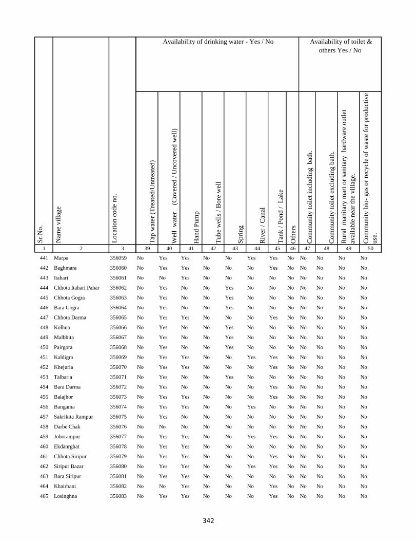
1 2 3
Lo
cati
on
co
de
no
.
Nam
e v
illa
ge
Sr.
No
.
441 Marpa 356059
442 Baghmara 356060
443 Itahari 356061
444 Chhota Itahari Pahar 356062
445 Chhota Gogra 356063
446 Bara Gogra 356064
447 Chhota Darma 356065
448 Kolhua 356066
449 Malbhita 356067
450 Pairgora 356068
451 Kaldigra 356069
452 Khejuria 356070
453 Talbaria 356071
454 Bara Darma 356072
455 Balajhor 356073
456 Bangama 356074
457 Sakrikita Rampur 356075
458 Darbe Chak 356076
459 Joborampur 356077
460 Ekdanrghat 356078
461 Chhota Siripur 356079
462 Siripur Bazar 356080
463 Bara Siripur 356081
464 Khairbani 356082
465 Losinghna 356083
Tap
wat
er (
Tre
ated
/Un
trea
ted
)
Wel
l w
ater
(Co
ver
ed /
Un
cov
ered
wel
l)
Han
d P
um
p
Tu
be
wel
ls /
Bo
re w
ell
Sp
rin
g
Riv
er /
Can
al
Tan
k /
Po
nd
/
Lak
e
Oth
ers
Co
mm
un
ity
to
ilet
in
clu
din
g
bat
h.
Co
mm
un
ity
to
ilet
ex
clu
din
g b
ath
.
Ru
ral
man
itar
y m
art
or
san
itar
y
har
dw
are
ou
tlet
avai
lab
le n
ear
the
vil
lag
e.
Co
mm
un
ity
bio
- g
as o
r re
cycl
e o
f w
aste
fo
r p
rod
uct
ive
use
.
39 40 41 42 43 44 45 46 47 48 49 50
Availability of toilet &
others Yes / No
Availability of drinking water - Yes / No
No Yes Yes No No Yes Yes No No No No No
No Yes Yes No No No Yes No No No No No
No No Yes No No No No No No No No No
No Yes No No Yes No No No No No No No
No Yes No No Yes No No No No No No No
No Yes No No Yes No No No No No No No
No Yes Yes No No No Yes No No No No No
No Yes No No Yes No No No No No No No
No Yes No No Yes No No No No No No No
No Yes No No Yes No No No No No No No
No Yes Yes No No Yes Yes No No No No No
No Yes Yes No No No Yes No No No No No
No Yes No No Yes No No No No No No No
No Yes No No No No Yes No No No No No
No Yes Yes No No No Yes No No No No No
No Yes Yes No No Yes No No No No No No
No Yes No No No No No No No No No No
No No No No No No No No No No No No
No Yes Yes No No Yes Yes No No No No No
No Yes Yes No No No No No No No No No
No Yes Yes No No No Yes No No No No No
No Yes Yes No No Yes Yes No No No No No
No Yes Yes No No No No No No No No No
No No Yes No No No Yes No No No No No
No Yes Yes No No No Yes No No No No No
342

1 2 3
Lo
cati
on
co
de
no
.
Nam
e v
illa
ge
Sr.
No
.
466 Bara Saraiya 356084
467 Chhota Saraiya 356085
468 Manikpur 356086
469 Kandaniya 356087
470 Beldiha 356088
471 Kortia 356089
472 Asanbuna 356090
473 Marcha 356091
474 Dumbari 356092
475 Churi 356093
476 Talbaria 356094
477 Bansbhita 356095
478 Jamunajharna 356096
479 Bara Boarijor 356097
480 Dhorri 356098
481 Dubra 356099
482 Mahula 356100
483 Meghi 356101
484 Mangra 356102
485 Chhota Boarijor 356103
486 Mahuakol 356104
487 Lakrakol 356105
488 Babuchuri 356106
489 Parsiya 356107
490 Bador 356108
Tap
wat
er (
Tre
ated
/Un
trea
ted
)
Wel
l w
ater
(Co
ver
ed /
Un
cov
ered
wel
l)
Han
d P
um
p
Tu
be
wel
ls /
Bo
re w
ell
Sp
rin
g
Riv
er /
Can
al
Tan
k /
Po
nd
/
Lak
e
Oth
ers
Co
mm
un
ity
to
ilet
in
clu
din
g
bat
h.
Co
mm
un
ity
to
ilet
ex
clu
din
g b
ath
.
Ru
ral
man
itar
y m
art
or
san
itar
y
har
dw
are
ou
tlet
avai
lab
le n
ear
the
vil
lag
e.
Co
mm
un
ity
bio
- g
as o
r re
cycl
e o
f w
aste
fo
r p
rod
uct
ive
use
.
39 40 41 42 43 44 45 46 47 48 49 50
Availability of toilet &
others Yes / No
Availability of drinking water - Yes / No
No Yes Yes No No Yes Yes No No No No No
No Yes Yes No No No Yes No No No No No
No Yes Yes No No No No No No No No No
No Yes No No No No Yes No No No No No
No Yes Yes No No No Yes No No No No No
No Yes Yes No Yes No Yes No No No No No
No Yes No No Yes Yes Yes No No No No No
No Yes No No No No No No No No No No
No No No No No No No No No No No No
No No Yes No Yes Yes Yes No No No No No
No Yes Yes No No No Yes No No No No No
No Yes Yes No No Yes No No No No No No
No Yes Yes No No No Yes No No No No No
No Yes Yes No No Yes No No No No No No
No Yes Yes No No Yes Yes No No No No No
No Yes Yes Yes No Yes Yes No No No No No
No Yes Yes No No Yes No No No No No No
No Yes Yes No No No Yes No No No No No
No Yes Yes No Yes No Yes No No No No No
No Yes No No Yes Yes Yes No No No No No
No Yes No No Yes No No No No No No No
No Yes No No No No No No No No No No
No Yes No No No No Yes No No No No No
No Yes No No Yes No Yes No No No No No
No Yes No No Yes Yes Yes No No No No No
343

1 2 3
Lo
cati
on
co
de
no
.
Nam
e v
illa
ge
Sr.
No
.
491 Muchuradaldali 356109
492 Daharlangi 356110
493 Pokhariya 356111
494 Barakera 356112
495 Chhotakera 356113
496 Karamtola 356114
497 Meredele 356115
498 Baragbhita 356116
499 Kutni 356117
500 Khatangi 356118
501 Puriabadar 356119
502 Bartali 356120
503 Anamu 356121
504 Babu Churi 356122
505 Badonre 356123
506 Barakbita 356124
507 Bargi 356125
508 Bartari 356126
509 Belmatok 356127
510 Churi Bedo 356128
511 Dangoda 356129
512 Dobri 356130
513 Dumberi Bedo 356131
514 Dumberi Joka 356132
515 Gadgandi 356133
Tap
wat
er (
Tre
ated
/Un
trea
ted
)
Wel
l w
ater
(Co
ver
ed /
Un
cov
ered
wel
l)
Han
d P
um
p
Tu
be
wel
ls /
Bo
re w
ell
Sp
rin
g
Riv
er /
Can
al
Tan
k /
Po
nd
/
Lak
e
Oth
ers
Co
mm
un
ity
to
ilet
in
clu
din
g
bat
h.
Co
mm
un
ity
to
ilet
ex
clu
din
g b
ath
.
Ru
ral
man
itar
y m
art
or
san
itar
y
har
dw
are
ou
tlet
avai
lab
le n
ear
the
vil
lag
e.
Co
mm
un
ity
bio
- g
as o
r re
cycl
e o
f w
aste
fo
r p
rod
uct
ive
use
.
39 40 41 42 43 44 45 46 47 48 49 50
Availability of toilet &
others Yes / No
Availability of drinking water - Yes / No
No Yes No No Yes No No No No No No No
No Yes No No No No No No No No No No
No Yes No No No No No No No No No No
No No Yes No No No No No No No No No
No Yes No No Yes No No No No No No No
No Yes No No Yes No No No No No No No
No Yes No No Yes No No No No No No No
No Yes No No Yes No No No No No No No
No Yes No No No No No No No No No No
No No No No No No No No No No No No
No Yes No No No No No No No No No No
No Yes No No Yes No No No No No No No
No Yes No No No No No No No No No No
No No No No No No No No No No No No
No No No No No No No No No No No No
No No No No No No No No No No No No
No Yes No No No No No No No No No No
No No No No No No No No No No No No
No No No No No No No No No No No No
No No No No No No No No No No No No
No No No No No No No No No No No No
No Yes No No No No No No No No No No
No No No No No No No No No No No No
No No No No No No No No No No No No
No Yes No No Yes No No No No No No No
344
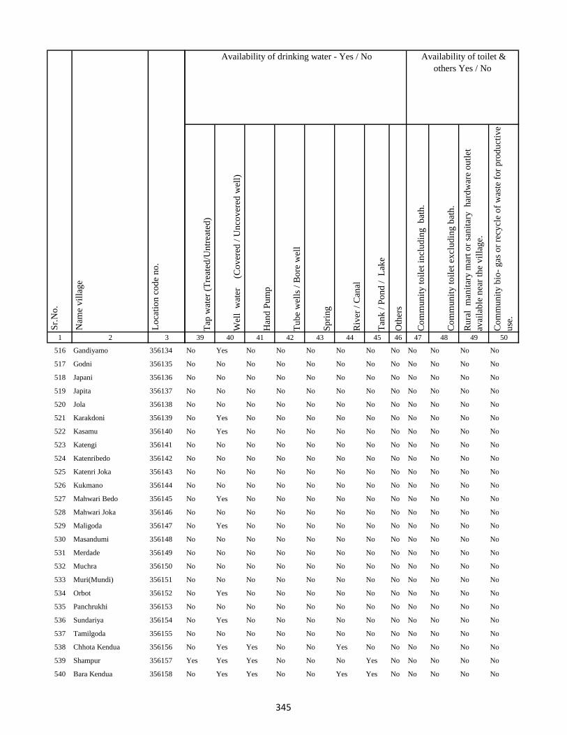
1 2 3
Lo
cati
on
co
de
no
.
Nam
e v
illa
ge
Sr.
No
.
516 Gandiyamo 356134
517 Godni 356135
518 Japani 356136
519 Japita 356137
520 Jola 356138
521 Karakdoni 356139
522 Kasamu 356140
523 Katengi 356141
524 Katenribedo 356142
525 Katenri Joka 356143
526 Kukmano 356144
527 Mahwari Bedo 356145
528 Mahwari Joka 356146
529 Maligoda 356147
530 Masandumi 356148
531 Merdade 356149
532 Muchra 356150
533 Muri(Mundi) 356151
534 Orbot 356152
535 Panchrukhi 356153
536 Sundariya 356154
537 Tamilgoda 356155
538 Chhota Kendua 356156
539 Shampur 356157
540 Bara Kendua 356158
Tap
wat
er (
Tre
ated
/Un
trea
ted
)
Wel
l w
ater
(Co
ver
ed /
Un
cov
ered
wel
l)
Han
d P
um
p
Tu
be
wel
ls /
Bo
re w
ell
Sp
rin
g
Riv
er /
Can
al
Tan
k /
Po
nd
/
Lak
e
Oth
ers
Co
mm
un
ity
to
ilet
in
clu
din
g
bat
h.
Co
mm
un
ity
to
ilet
ex
clu
din
g b
ath
.
Ru
ral
man
itar
y m
art
or
san
itar
y
har
dw
are
ou
tlet
avai
lab
le n
ear
the
vil
lag
e.
Co
mm
un
ity
bio
- g
as o
r re
cycl
e o
f w
aste
fo
r p
rod
uct
ive
use
.
39 40 41 42 43 44 45 46 47 48 49 50
Availability of toilet &
others Yes / No
Availability of drinking water - Yes / No
No Yes No No No No No No No No No No
No No No No No No No No No No No No
No No No No No No No No No No No No
No No No No No No No No No No No No
No No No No No No No No No No No No
No Yes No No No No No No No No No No
No Yes No No No No No No No No No No
No No No No No No No No No No No No
No No No No No No No No No No No No
No No No No No No No No No No No No
No No No No No No No No No No No No
No Yes No No No No No No No No No No
No No No No No No No No No No No No
No Yes No No No No No No No No No No
No No No No No No No No No No No No
No No No No No No No No No No No No
No No No No No No No No No No No No
No No No No No No No No No No No No
No Yes No No No No No No No No No No
No No No No No No No No No No No No
No Yes No No No No No No No No No No
No No No No No No No No No No No No
No Yes Yes No No Yes No No No No No No
Yes Yes Yes No No No Yes No No No No No
No Yes Yes No No Yes Yes No No No No No
345

1 2 3
Lo
cati
on
co
de
no
.
Nam
e v
illa
ge
Sr.
No
.
541 Uparbandha 356159
542 Dhamni 356160
543 Narainpur 356161
544 Amjhor 356162
545 Debipur 356163
546 Rajabhita 356164
547 Chhota Dumarhir 356165
548 Bara Dumarhir 356166
549 Mungra 356167
550 Liti 356168
551 Champapur 356169
552 Telo 356170
553 Kero 356171
554 Kusumghati 356172
555 Ambadiha 356173
556 Lilatari 356174
557 Kusbila 356175
558 Bhadria 356176
559 Chandna 356177
560 Arajori Pokhar 356178
561 Dumaar Pahar 356179
562 Tetariya 356180
563 Rajapokhar Jagir 356181
564 Rajapokhar Jagir 356182
565 Rajapokhar Jagir 356183
Tap
wat
er (
Tre
ated
/Un
trea
ted
)
Wel
l w
ater
(Co
ver
ed /
Un
cov
ered
wel
l)
Han
d P
um
p
Tu
be
wel
ls /
Bo
re w
ell
Sp
rin
g
Riv
er /
Can
al
Tan
k /
Po
nd
/
Lak
e
Oth
ers
Co
mm
un
ity
to
ilet
in
clu
din
g
bat
h.
Co
mm
un
ity
to
ilet
ex
clu
din
g b
ath
.
Ru
ral
man
itar
y m
art
or
san
itar
y
har
dw
are
ou
tlet
avai
lab
le n
ear
the
vil
lag
e.
Co
mm
un
ity
bio
- g
as o
r re
cycl
e o
f w
aste
fo
r p
rod
uct
ive
use
.
39 40 41 42 43 44 45 46 47 48 49 50
Availability of toilet &
others Yes / No
Availability of drinking water - Yes / No
No Yes Yes No No Yes Yes No No No No No
No Yes Yes No No Yes Yes No No No No No
No Yes Yes No No Yes Yes No No No No No
No Yes Yes No No Yes Yes No No No No No
No Yes Yes No No Yes Yes No No No No No
No No Yes No No Yes No No No No No No
No No Yes No No No Yes No No No No No
No No Yes No No No Yes No No No No No
No Yes Yes No No Yes No No No No No No
No Yes Yes No No No No No No No No No
No Yes Yes No No No Yes No No No No No
No No Yes No Yes Yes Yes No No No No No
No Yes Yes No No Yes Yes No No No No No
No Yes Yes No No No Yes No No No No No
No Yes Yes No No No No No No No No No
No No Yes No Yes Yes Yes No No No No No
No Yes Yes No No No Yes No No No No No
No No Yes No Yes Yes Yes No No No No No
No Yes No No No Yes No No No No No No
No No No No No No No No No No No No
No No No No No No No No No No No No
No Yes Yes No No Yes Yes No No No No No
No Yes Yes No No Yes Yes No No No No No
No Yes Yes No No Yes Yes No No No No No
No Yes Yes No No Yes Yes No No No No No
346

1 2 3
Lo
cati
on
co
de
no
.
Nam
e v
illa
ge
Sr.
No
.
566 Rajapokhar 356184
567 Bara Chatampur 356185
568 Lilabhita 356186
569 Tamlia Amdanda 356187
570 Manko 356188
571 Kilo 356189
572 Dhadhari Pahar 356190
573 Chhota Chatampur 356191
574 Chetmapahar 356192
575 Dhanigora 356193
576 Dimbni Pahar 356194
577 Dhunigora Pahar 356195
578 Palma Pahar 356196
579 Chalpahari 356197
580 Madomasi 356198
581 Bhagamakra 356199
582 Champatola 356200
583 Pakriya Pahar 356201
584 Kairasol 356202
585 Sundar Tola 356203
586 Pachro 356204
587 Marni Pahar 356205
588 Daria Pahar 356206
589 Harla Bathan 356207
590 Deodanrpahar 356208
Tap
wat
er (
Tre
ated
/Un
trea
ted
)
Wel
l w
ater
(Co
ver
ed /
Un
cov
ered
wel
l)
Han
d P
um
p
Tu
be
wel
ls /
Bo
re w
ell
Sp
rin
g
Riv
er /
Can
al
Tan
k /
Po
nd
/
Lak
e
Oth
ers
Co
mm
un
ity
to
ilet
in
clu
din
g
bat
h.
Co
mm
un
ity
to
ilet
ex
clu
din
g b
ath
.
Ru
ral
man
itar
y m
art
or
san
itar
y
har
dw
are
ou
tlet
avai
lab
le n
ear
the
vil
lag
e.
Co
mm
un
ity
bio
- g
as o
r re
cycl
e o
f w
aste
fo
r p
rod
uct
ive
use
.
39 40 41 42 43 44 45 46 47 48 49 50
Availability of toilet &
others Yes / No
Availability of drinking water - Yes / No
No Yes No No No No Yes No No No No No
No Yes Yes No No No Yes No No No No No
No Yes Yes No No No Yes No No No No No
No Yes No No Yes No No No No No No No
No No No No No No No No No No No No
No No No No No No No No No No No No
No No No No No No No No No No No No
No Yes No No No Yes Yes No No No No No
No Yes No No Yes No No No No No No No
No Yes No No No No No No No No No No
No No No No No No No No No No No No
No No No No No No No No No No No No
No No No No No No No No No No No No
No Yes No No No No Yes No No No Yes No
No Yes No No Yes No No No No No No No
No Yes No No Yes Yes No No No No No No
No Yes No No Yes No Yes No No No No No
No Yes No No Yes No Yes No No No No No
No Yes No No Yes No Yes No No No No No
No No No No No No No No No No No No
No Yes No No Yes No Yes No No No No No
No Yes No No Yes No No No No No No No
No Yes No No Yes No No No No No No No
No No No No No No No No No No No No
No No No No No No No No No No No No
347
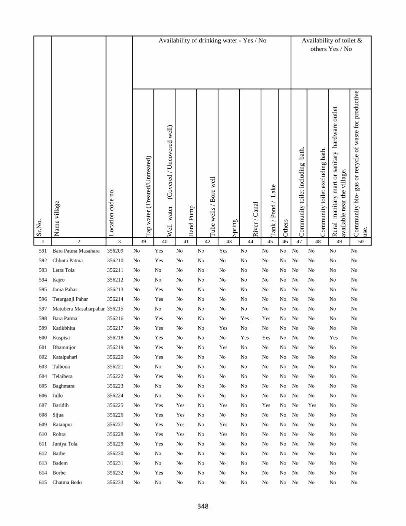
1 2 3
Lo
cati
on
co
de
no
.
Nam
e v
illa
ge
Sr.
No
.
591 Bara Patma Masahara 356209
592 Chhota Patma 356210
593 Letra Tola 356211
594 Kajro 356212
595 Jania Pahar 356213
596 Tetarganji Pahar 356214
597 Matubera Masaharpahar 356215
598 Bara Patma 356216
599 Katikbhita 356217
600 Kuspisa 356218
601 Dhamnijor 356219
602 Katalpahari 356220
603 Talbona 356221
604 Telaibera 356222
605 Baghmara 356223
606 Jullo 356224
607 Baridih 356225
608 Sijua 356226
609 Ratanpur 356227
610 Rohra 356228
611 Juniya Tola 356229
612 Barbe 356230
613 Badem 356231
614 Borbe 356232
615 Chatma Bedo 356233
Tap
wat
er (
Tre
ated
/Un
trea
ted
)
Wel
l w
ater
(Co
ver
ed /
Un
cov
ered
wel
l)
Han
d P
um
p
Tu
be
wel
ls /
Bo
re w
ell
Sp
rin
g
Riv
er /
Can
al
Tan
k /
Po
nd
/
Lak
e
Oth
ers
Co
mm
un
ity
to
ilet
in
clu
din
g
bat
h.
Co
mm
un
ity
to
ilet
ex
clu
din
g b
ath
.
Ru
ral
man
itar
y m
art
or
san
itar
y
har
dw
are
ou
tlet
avai
lab
le n
ear
the
vil
lag
e.
Co
mm
un
ity
bio
- g
as o
r re
cycl
e o
f w
aste
fo
r p
rod
uct
ive
use
.
39 40 41 42 43 44 45 46 47 48 49 50
Availability of toilet &
others Yes / No
Availability of drinking water - Yes / No
No Yes No No Yes No No No No No No No
No Yes No No No No No No No No No No
No No No No No No No No No No No No
No No No No No No No No No No No No
No Yes No No No No No No No No No No
No Yes No No No No No No No No No No
No No No No No No No No No No No No
No Yes No No No Yes Yes No No No No No
No Yes No No Yes No No No No No No No
No Yes No No No Yes Yes No No No Yes No
No Yes No No Yes No No No No No No No
No Yes No No No No No No No No No No
No No No No No No No No No No No No
No Yes No No No No No No No No No No
No No No No No No No No No No No No
No No No No No No No No No No No No
No Yes Yes No Yes No Yes No No Yes No No
No Yes Yes No No No No No No No No No
No Yes Yes No Yes No No No No No No No
No Yes Yes No Yes No No No No No No No
No Yes No No No No No No No No No No
No No No No No No No No No No No No
No No No No No No No No No No No No
No Yes No No No No No No No No No No
No No No No No No No No No No No No
348
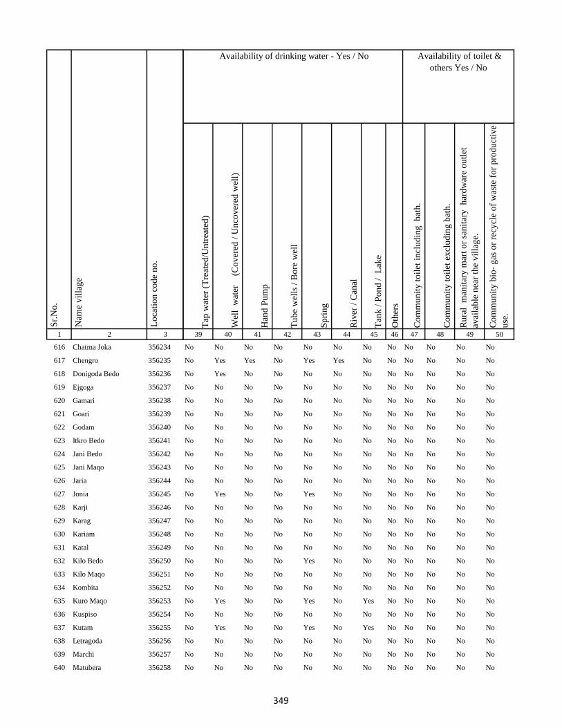
1 2 3
Lo
cati
on
co
de
no
.
Nam
e v
illa
ge
Sr.
No
.
616 Chatma Joka 356234
617 Chengro 356235
618 Donigoda Bedo 356236
619 Ejgoga 356237
620 Gamari 356238
621 Goari 356239
622 Godam 356240
623 Itkro Bedo 356241
624 Jani Bedo 356242
625 Jani Maqo 356243
626 Jaria 356244
627 Jonia 356245
628 Karji 356246
629 Karag 356247
630 Kariam 356248
631 Katal 356249
632 Kilo Bedo 356250
633 Kilo Maqo 356251
634 Kombita 356252
635 Kuro Maqo 356253
636 Kuspiso 356254
637 Kutam 356255
638 Letragoda 356256
639 Marchi 356257
640 Matubera 356258
Tap
wat
er (
Tre
ated
/Un
trea
ted
)
Wel
l w
ater
(Co
ver
ed /
Un
cov
ered
wel
l)
Han
d P
um
p
Tu
be
wel
ls /
Bo
re w
ell
Sp
rin
g
Riv
er /
Can
al
Tan
k /
Po
nd
/
Lak
e
Oth
ers
Co
mm
un
ity
to
ilet
in
clu
din
g
bat
h.
Co
mm
un
ity
to
ilet
ex
clu
din
g b
ath
.
Ru
ral
man
itar
y m
art
or
san
itar
y
har
dw
are
ou
tlet
avai
lab
le n
ear
the
vil
lag
e.
Co
mm
un
ity
bio
- g
as o
r re
cycl
e o
f w
aste
fo
r p
rod
uct
ive
use
.
39 40 41 42 43 44 45 46 47 48 49 50
Availability of toilet &
others Yes / No
Availability of drinking water - Yes / No
No No No No No No No No No No No No
No Yes Yes No Yes Yes No No No No No No
No Yes No No No No No No No No No No
No No No No No No No No No No No No
No No No No No No No No No No No No
No No No No No No No No No No No No
No No No No No No No No No No No No
No No No No No No No No No No No No
No No No No No No No No No No No No
No No No No No No No No No No No No
No No No No No No No No No No No No
No Yes No No Yes No No No No No No No
No No No No No No No No No No No No
No No No No No No No No No No No No
No No No No No No No No No No No No
No No No No No No No No No No No No
No No No No Yes No No No No No No No
No No No No No No No No No No No No
No No No No No No No No No No No No
No Yes No No Yes No Yes No No No No No
No No No No No No No No No No No No
No Yes No No Yes No Yes No No No No No
No No No No No No No No No No No No
No No No No No No No No No No No No
No No No No No No No No No No No No
349

1 2 3
Lo
cati
on
co
de
no
.
Nam
e v
illa
ge
Sr.
No
.
641 Pandeni 356259
642 Patma Joka 356260
643 Perkuria 356261
644 Puro Maqo 356262
645 Puro Bedo 356263
646 Pusurkuriya Bedo 356264
647 Pusurkuriya Joka 356265
648 Tamlipatta 356266
649 Tesro 356267
650 Tisro 356268
651 Todmari 356269
652 Tokam 356270
653 Tokkuriya 356271
654 Saharpur 356272
655 Lilatari 356273
656 Khairbani 356274
657 Belthu 356275
658 Hethbandha 356276
659 Shamapokhar 356277
660 Chiharbona 356278
661 Chhota Saharpur 356279
662 Tulsipur 356280
663 Goriya 356281
664 Kamardiha 356282
665 Gopalpur 356283
Tap
wat
er (
Tre
ated
/Un
trea
ted
)
Wel
l w
ater
(Co
ver
ed /
Un
cov
ered
wel
l)
Han
d P
um
p
Tu
be
wel
ls /
Bo
re w
ell
Sp
rin
g
Riv
er /
Can
al
Tan
k /
Po
nd
/
Lak
e
Oth
ers
Co
mm
un
ity
to
ilet
in
clu
din
g
bat
h.
Co
mm
un
ity
to
ilet
ex
clu
din
g b
ath
.
Ru
ral
man
itar
y m
art
or
san
itar
y
har
dw
are
ou
tlet
avai
lab
le n
ear
the
vil
lag
e.
Co
mm
un
ity
bio
- g
as o
r re
cycl
e o
f w
aste
fo
r p
rod
uct
ive
use
.
39 40 41 42 43 44 45 46 47 48 49 50
Availability of toilet &
others Yes / No
Availability of drinking water - Yes / No
No No No No No No No No No No No No
No No No No No No No No No No No No
No No No No No No No No No No No No
No No No No Yes Yes No No No No No No
No No No No Yes No No No No No No No
No No No No No No No No No No No No
No No No No No No No No No No No No
No No No No No No No No No No No No
No No No No No No No No No No No No
No No No No No No No No No No No No
No No No No No No No No No No No No
No No No No No No No No No No No No
No Yes Yes No No No Yes No No No No No
No Yes Yes No No No Yes No No No No No
No Yes Yes No No No Yes No No No No No
No Yes Yes No No No Yes No No No No No
No Yes Yes No No No Yes No No No No No
No Yes Yes No No No Yes No No No No No
No Yes Yes No No No Yes No No No No No
No No No No No No No No No No No No
No No No No No No No No No No No No
No Yes Yes No No No Yes No No No No No
No Yes Yes No No No Yes No No No No No
No Yes Yes No No No Yes No No No No No
No Yes Yes No No Yes Yes No No No No No
350
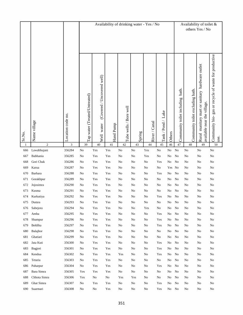
1 2 3
Lo
cati
on
co
de
no
.
Nam
e v
illa
ge
Sr.
No
.
666 Lawabhujani 356284
667 Babhania 356285
668 Gori Chak 356286
669 Karua 356287
670 Barhara 356288
671 Gorakhpur 356289
672 Jojosimra 356290
673 Kusma 356291
674 Kurkutiya 356292
675 Dumra 356293
676 Sabejora 356294
677 Amba 356295
678 Shampur 356296
679 Beldiha 356297
680 Balajhor 356298
681 Ghatiari 356299
682 Jata Kuti 356300
683 Bagjori 356301
684 Kendua 356302
685 Tetaria 356303
686 Paharpur 356304
687 Bara Simra 356305
688 Chhota Simra 356306
689 Ghat Simra 356307
690 Suarmari 356308
Tap
wat
er (
Tre
ated
/Un
trea
ted
)
Wel
l w
ater
(Co
ver
ed /
Un
cov
ered
wel
l)
Han
d P
um
p
Tu
be
wel
ls /
Bo
re w
ell
Sp
rin
g
Riv
er /
Can
al
Tan
k /
Po
nd
/
Lak
e
Oth
ers
Co
mm
un
ity
to
ilet
in
clu
din
g
bat
h.
Co
mm
un
ity
to
ilet
ex
clu
din
g b
ath
.
Ru
ral
man
itar
y m
art
or
san
itar
y
har
dw
are
ou
tlet
avai
lab
le n
ear
the
vil
lag
e.
Co
mm
un
ity
bio
- g
as o
r re
cycl
e o
f w
aste
fo
r p
rod
uct
ive
use
.
39 40 41 42 43 44 45 46 47 48 49 50
Availability of toilet &
others Yes / No
Availability of drinking water - Yes / No
No Yes Yes No No Yes No No No No No No
No Yes Yes No No Yes No No No No No No
No Yes Yes No No No Yes No No No No No
No Yes Yes No No No No Yes No No No No
No Yes Yes No No No Yes No No No No No
No Yes Yes No No No No No No No No No
No Yes Yes No No No No No No No No No
No Yes Yes No No No No No No No No No
No Yes Yes No No No Yes No No No No No
No Yes Yes No No No No No No No No No
No Yes Yes No No Yes No No No No No No
No Yes Yes No No No Yes No No No No No
No Yes Yes No No No Yes No No No No No
No Yes Yes No No No Yes No No No No No
No Yes Yes No No No No No No No No No
No Yes Yes No No No No No No No No No
No Yes Yes No No No Yes No No No No No
No Yes Yes No No No Yes No No No No No
No Yes Yes Yes No No Yes No No No No No
No Yes Yes No No No No No No No No No
No Yes Yes No No No Yes No No No No No
Yes Yes Yes No No No No No No No No No
Yes No No Yes Yes No No No No No No No
No Yes Yes No No No Yes No No No No No
No No Yes No No No Yes No No No No No
351

1 2 3
Lo
cati
on
co
de
no
.
Nam
e v
illa
ge
Sr.
No
.
691 Ghat Nima 356309
692 Chitar Koti 356310
693 Telgama 356311
694 Duwarighat Telgama 356312
695 Nima Kalan 356313
696 Hijukita 356314
697 Lalmatia 356315
698 Rangamatia 356316
699 Dakaita 356317
700 Lohandiya 356318
701 Lohandiya Bazar 356319
702 Basdiha 356320
703 Paharpur 356321
704 Bharanda 356322
705 Harrakha 356323
706 Mariya Chak 356324
707 Saraumi 356325
708 Ranidih 356326
709 Barkandali 356327
710 Dhankunda 356328
711 Dumriya 356329
712 Dumarkol 356330
713 Babupur 356331
714 Bara Kotha 356332
715 Bara Barma Pahar 356333
Tap
wat
er (
Tre
ated
/Un
trea
ted
)
Wel
l w
ater
(Co
ver
ed /
Un
cov
ered
wel
l)
Han
d P
um
p
Tu
be
wel
ls /
Bo
re w
ell
Sp
rin
g
Riv
er /
Can
al
Tan
k /
Po
nd
/
Lak
e
Oth
ers
Co
mm
un
ity
to
ilet
in
clu
din
g
bat
h.
Co
mm
un
ity
to
ilet
ex
clu
din
g b
ath
.
Ru
ral
man
itar
y m
art
or
san
itar
y
har
dw
are
ou
tlet
avai
lab
le n
ear
the
vil
lag
e.
Co
mm
un
ity
bio
- g
as o
r re
cycl
e o
f w
aste
fo
r p
rod
uct
ive
use
.
39 40 41 42 43 44 45 46 47 48 49 50
Availability of toilet &
others Yes / No
Availability of drinking water - Yes / No
No Yes Yes No No No Yes No No No No No
No Yes Yes No No No No No No No No No
No Yes Yes No No No Yes No No No No No
No Yes Yes No No No No No No No No No
No Yes Yes No No No No No No No No No
No Yes Yes No No No No No No No No No
No Yes Yes No No No No No No No No No
No Yes Yes No No No Yes No No No No No
No Yes Yes No No No Yes No No No No No
Yes Yes Yes Yes No No Yes No No No No No
Yes Yes Yes Yes No No Yes No No No No No
No Yes Yes No No No Yes No No No No No
No Yes Yes No No Yes No No No No No No
No Yes Yes No No No Yes No No No No No
No No No No No No No No No No No No
No No No No No No No No No No No No
No No No No No No No No No No No No
No Yes Yes No No No Yes No No No No No
No Yes Yes No No No Yes No No No No No
No Yes Yes No No No Yes No No No No No
No Yes Yes No Yes No No No No No No No
No Yes Yes No No Yes Yes No No No No No
No Yes Yes No Yes No Yes No No No No No
No Yes Yes No Yes No Yes No No No No No
No Yes Yes No Yes No Yes No No No No No
352
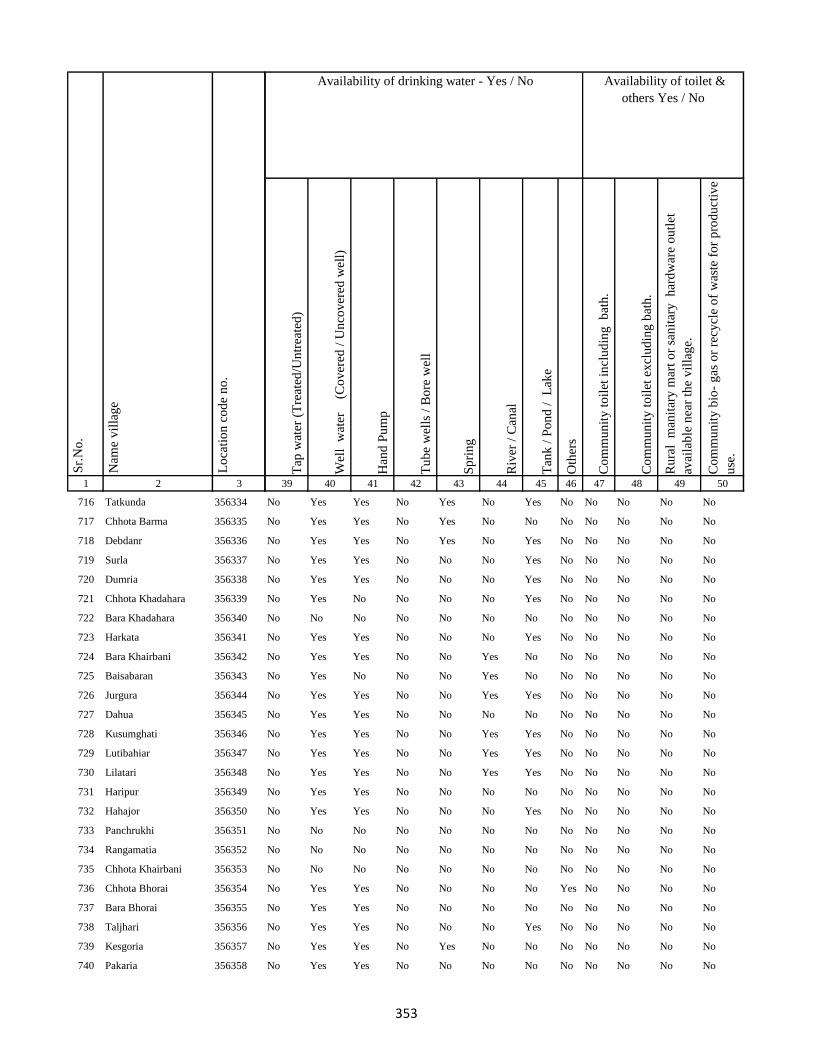
1 2 3
Lo
cati
on
co
de
no
.
Nam
e v
illa
ge
Sr.
No
.
716 Tatkunda 356334
717 Chhota Barma 356335
718 Debdanr 356336
719 Surla 356337
720 Dumria 356338
721 Chhota Khadahara 356339
722 Bara Khadahara 356340
723 Harkata 356341
724 Bara Khairbani 356342
725 Baisabaran 356343
726 Jurgura 356344
727 Dahua 356345
728 Kusumghati 356346
729 Lutibahiar 356347
730 Lilatari 356348
731 Haripur 356349
732 Hahajor 356350
733 Panchrukhi 356351
734 Rangamatia 356352
735 Chhota Khairbani 356353
736 Chhota Bhorai 356354
737 Bara Bhorai 356355
738 Taljhari 356356
739 Kesgoria 356357
740 Pakaria 356358
Tap
wat
er (
Tre
ated
/Un
trea
ted
)
Wel
l w
ater
(Co
ver
ed /
Un
cov
ered
wel
l)
Han
d P
um
p
Tu
be
wel
ls /
Bo
re w
ell
Sp
rin
g
Riv
er /
Can
al
Tan
k /
Po
nd
/
Lak
e
Oth
ers
Co
mm
un
ity
to
ilet
in
clu
din
g
bat
h.
Co
mm
un
ity
to
ilet
ex
clu
din
g b
ath
.
Ru
ral
man
itar
y m
art
or
san
itar
y
har
dw
are
ou
tlet
avai
lab
le n
ear
the
vil
lag
e.
Co
mm
un
ity
bio
- g
as o
r re
cycl
e o
f w
aste
fo
r p
rod
uct
ive
use
.
39 40 41 42 43 44 45 46 47 48 49 50
Availability of toilet &
others Yes / No
Availability of drinking water - Yes / No
No Yes Yes No Yes No Yes No No No No No
No Yes Yes No Yes No No No No No No No
No Yes Yes No Yes No Yes No No No No No
No Yes Yes No No No Yes No No No No No
No Yes Yes No No No Yes No No No No No
No Yes No No No No Yes No No No No No
No No No No No No No No No No No No
No Yes Yes No No No Yes No No No No No
No Yes Yes No No Yes No No No No No No
No Yes No No No Yes No No No No No No
No Yes Yes No No Yes Yes No No No No No
No Yes Yes No No No No No No No No No
No Yes Yes No No Yes Yes No No No No No
No Yes Yes No No Yes Yes No No No No No
No Yes Yes No No Yes Yes No No No No No
No Yes Yes No No No No No No No No No
No Yes Yes No No No Yes No No No No No
No No No No No No No No No No No No
No No No No No No No No No No No No
No No No No No No No No No No No No
No Yes Yes No No No No Yes No No No No
No Yes Yes No No No No No No No No No
No Yes Yes No No No Yes No No No No No
No Yes Yes No Yes No No No No No No No
No Yes Yes No No No No No No No No No
353
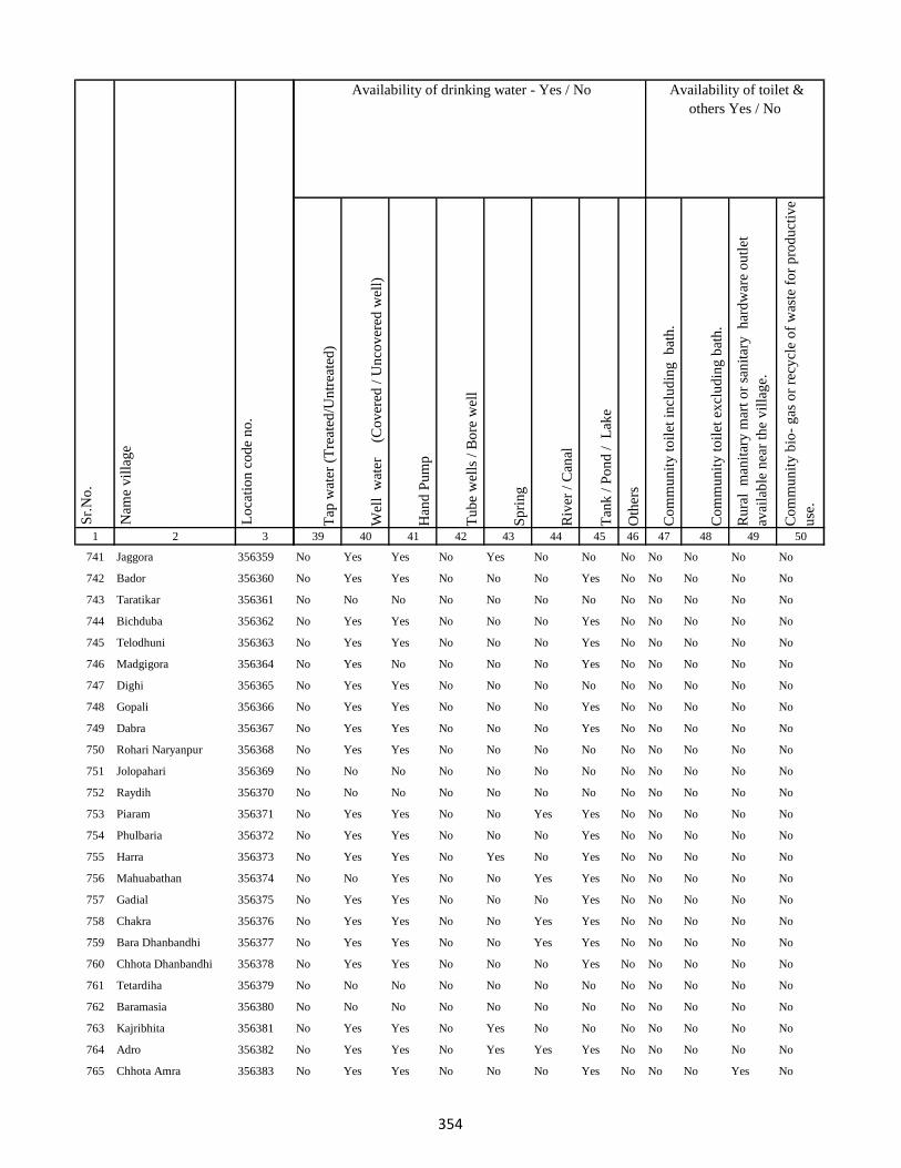
1 2 3
Lo
cati
on
co
de
no
.
Nam
e v
illa
ge
Sr.
No
.
741 Jaggora 356359
742 Bador 356360
743 Taratikar 356361
744 Bichduba 356362
745 Telodhuni 356363
746 Madgigora 356364
747 Dighi 356365
748 Gopali 356366
749 Dabra 356367
750 Rohari Naryanpur 356368
751 Jolopahari 356369
752 Raydih 356370
753 Piaram 356371
754 Phulbaria 356372
755 Harra 356373
756 Mahuabathan 356374
757 Gadial 356375
758 Chakra 356376
759 Bara Dhanbandhi 356377
760 Chhota Dhanbandhi 356378
761 Tetardiha 356379
762 Baramasia 356380
763 Kajribhita 356381
764 Adro 356382
765 Chhota Amra 356383
Tap
wat
er (
Tre
ated
/Un
trea
ted
)
Wel
l w
ater
(Co
ver
ed /
Un
cov
ered
wel
l)
Han
d P
um
p
Tu
be
wel
ls /
Bo
re w
ell
Sp
rin
g
Riv
er /
Can
al
Tan
k /
Po
nd
/
Lak
e
Oth
ers
Co
mm
un
ity
to
ilet
in
clu
din
g
bat
h.
Co
mm
un
ity
to
ilet
ex
clu
din
g b
ath
.
Ru
ral
man
itar
y m
art
or
san
itar
y
har
dw
are
ou
tlet
avai
lab
le n
ear
the
vil
lag
e.
Co
mm
un
ity
bio
- g
as o
r re
cycl
e o
f w
aste
fo
r p
rod
uct
ive
use
.
39 40 41 42 43 44 45 46 47 48 49 50
Availability of toilet &
others Yes / No
Availability of drinking water - Yes / No
No Yes Yes No Yes No No No No No No No
No Yes Yes No No No Yes No No No No No
No No No No No No No No No No No No
No Yes Yes No No No Yes No No No No No
No Yes Yes No No No Yes No No No No No
No Yes No No No No Yes No No No No No
No Yes Yes No No No No No No No No No
No Yes Yes No No No Yes No No No No No
No Yes Yes No No No Yes No No No No No
No Yes Yes No No No No No No No No No
No No No No No No No No No No No No
No No No No No No No No No No No No
No Yes Yes No No Yes Yes No No No No No
No Yes Yes No No No Yes No No No No No
No Yes Yes No Yes No Yes No No No No No
No No Yes No No Yes Yes No No No No No
No Yes Yes No No No Yes No No No No No
No Yes Yes No No Yes Yes No No No No No
No Yes Yes No No Yes Yes No No No No No
No Yes Yes No No No Yes No No No No No
No No No No No No No No No No No No
No No No No No No No No No No No No
No Yes Yes No Yes No No No No No No No
No Yes Yes No Yes Yes Yes No No No No No
No Yes Yes No No No Yes No No No Yes No
354
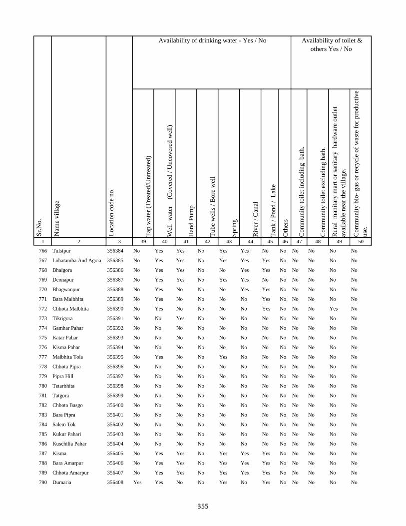
1 2 3
Lo
cati
on
co
de
no
.
Nam
e v
illa
ge
Sr.
No
.
766 Tulsipur 356384
767 Lohatamba And Agoia 356385
768 Bhalgora 356386
769 Deonapur 356387
770 Bhagwanpur 356388
771 Bara Malbhita 356389
772 Chhota Malbhita 356390
773 Tikrigora 356391
774 Gamhar Pahar 356392
775 Katar Pahar 356393
776 Kisma Pahar 356394
777 Malbhita Tola 356395
778 Chhota Pipra 356396
779 Pipra Hill 356397
780 Tetarbhita 356398
781 Tatgora 356399
782 Chhota Basgo 356400
783 Bara Pipra 356401
784 Salem Tok 356402
785 Kukur Pahari 356403
786 Kuschilia Pahar 356404
787 Kisma 356405
788 Bara Amarpur 356406
789 Chhota Amarpur 356407
790 Dumaria 356408
Tap
wat
er (
Tre
ated
/Un
trea
ted
)
Wel
l w
ater
(Co
ver
ed /
Un
cov
ered
wel
l)
Han
d P
um
p
Tu
be
wel
ls /
Bo
re w
ell
Sp
rin
g
Riv
er /
Can
al
Tan
k /
Po
nd
/
Lak
e
Oth
ers
Co
mm
un
ity
to
ilet
in
clu
din
g
bat
h.
Co
mm
un
ity
to
ilet
ex
clu
din
g b
ath
.
Ru
ral
man
itar
y m
art
or
san
itar
y
har
dw
are
ou
tlet
avai
lab
le n
ear
the
vil
lag
e.
Co
mm
un
ity
bio
- g
as o
r re
cycl
e o
f w
aste
fo
r p
rod
uct
ive
use
.
39 40 41 42 43 44 45 46 47 48 49 50
Availability of toilet &
others Yes / No
Availability of drinking water - Yes / No
No Yes Yes No Yes Yes No No No No No No
No Yes Yes No Yes Yes Yes No No No No No
No Yes Yes No No Yes Yes No No No No No
No Yes Yes No Yes Yes No No No No No No
No Yes No No No Yes Yes No No No No No
No Yes No No No No Yes No No No No No
No Yes No No No No Yes No No No Yes No
No No Yes No No No No No No No No No
No No No No No No No No No No No No
No No No No No No No No No No No No
No No No No No No No No No No No No
No Yes No No Yes No No No No No No No
No No No No No No No No No No No No
No No No No No No No No No No No No
No No No No No No No No No No No No
No No No No No No No No No No No No
No No No No No No No No No No No No
No No No No No No No No No No No No
No No No No No No No No No No No No
No No No No No No No No No No No No
No No No No No No No No No No No No
No Yes Yes No Yes Yes Yes No No No No No
No Yes Yes No Yes Yes Yes No No No No No
No Yes Yes No Yes Yes Yes No No No No No
Yes Yes No No Yes No Yes No No No No No
355
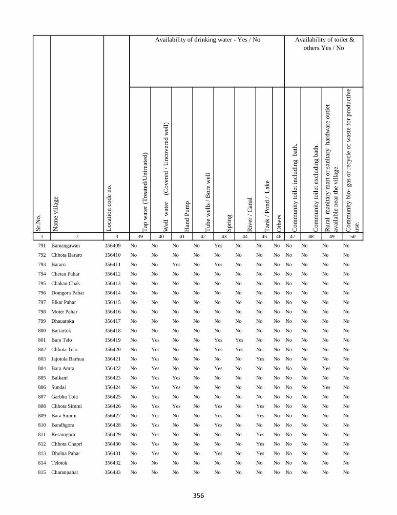
1 2 3
Lo
cati
on
co
de
no
.
Nam
e v
illa
ge
Sr.
No
.
791 Bamangawan 356409
792 Chhota Bararo 356410
793 Bararo 356411
794 Chetan Pahar 356412
795 Chakan Chak 356413
796 Domgora Pahar 356414
797 Elkar Pahar 356415
798 Moter Pahar 356416
799 Dhauatoka 356417
800 Bariartok 356418
801 Bara Telo 356419
802 Chhota Telo 356420
803 Jajotola Barhua 356421
804 Bara Amra 356422
805 Balkani 356423
806 Sundai 356424
807 Garbhu Tola 356425
808 Chhota Simmi 356426
809 Bara Simmi 356427
810 Bandhgora 356428
811 Kesarogora 356429
812 Chhota Chapri 356430
813 Dholna Pahar 356431
814 Telotok 356432
815 Charanpahar 356433
Tap
wat
er (
Tre
ated
/Un
trea
ted
)
Wel
l w
ater
(Co
ver
ed /
Un
cov
ered
wel
l)
Han
d P
um
p
Tu
be
wel
ls /
Bo
re w
ell
Sp
rin
g
Riv
er /
Can
al
Tan
k /
Po
nd
/
Lak
e
Oth
ers
Co
mm
un
ity
to
ilet
in
clu
din
g
bat
h.
Co
mm
un
ity
to
ilet
ex
clu
din
g b
ath
.
Ru
ral
man
itar
y m
art
or
san
itar
y
har
dw
are
ou
tlet
avai
lab
le n
ear
the
vil
lag
e.
Co
mm
un
ity
bio
- g
as o
r re
cycl
e o
f w
aste
fo
r p
rod
uct
ive
use
.
39 40 41 42 43 44 45 46 47 48 49 50
Availability of toilet &
others Yes / No
Availability of drinking water - Yes / No
No No No No Yes No No No No No No No
No No No No No No No No No No No No
No No Yes No Yes No No No No No No No
No No No No No No No No No No No No
No No No No No No No No No No No No
No No No No No No No No No No No No
No No No No No No No No No No No No
No No No No No No No No No No No No
No No No No No No No No No No No No
No No No No No No No No No No No No
No Yes No No Yes Yes No No No No No No
No Yes No No Yes Yes No No No No No No
No Yes No No No No Yes No No No No No
No Yes No No Yes No No No No No Yes No
No Yes Yes No No No No No No No No No
No Yes Yes No No No No No No No Yes No
No Yes No No No No No No No No No No
No Yes Yes No Yes No Yes No No No No No
No Yes No No Yes No Yes No No No No No
No Yes No No Yes No No No No No No No
No Yes No No No No Yes No No No No No
No Yes No No No No Yes No No No No No
No Yes No No Yes No Yes No No No No No
No No No No No No No No No No No No
No No No No No No No No No No No No
356

1 2 3
Lo
cati
on
co
de
no
.
Nam
e v
illa
ge
Sr.
No
.
816 Keriapahar 356434
817 Karampahar 356435
818 Masanpahar 356436
819 Dumarpahar 356437
820 Kamugora 356438
821 Bansdandapahar 356439
822 Bansdanda 356440
823 Dhunigora 356441
824 Bara Basgi 356442
825 Satbera 356443
826 Satbera 356444
827 Chetrampahar 356445
828 Hanidhoni 356446
829 Bara Chapri 356447
830 Madarpahar 356448
831 Chapri Bara 356449
832 Tamlipahar 356450
833 Bara Chapri 356451
834 Madgigora 356452
835 Karamtanr 356453
836 Dumarpahar 356454
837 Chhota Ghogha 356455
838 Bara Karlopahar 356456
839 Bara Ghogha 356457
840 Bara Kerlo 356458
Tap
wat
er (
Tre
ated
/Un
trea
ted
)
Wel
l w
ater
(Co
ver
ed /
Un
cov
ered
wel
l)
Han
d P
um
p
Tu
be
wel
ls /
Bo
re w
ell
Sp
rin
g
Riv
er /
Can
al
Tan
k /
Po
nd
/
Lak
e
Oth
ers
Co
mm
un
ity
to
ilet
in
clu
din
g
bat
h.
Co
mm
un
ity
to
ilet
ex
clu
din
g b
ath
.
Ru
ral
man
itar
y m
art
or
san
itar
y
har
dw
are
ou
tlet
avai
lab
le n
ear
the
vil
lag
e.
Co
mm
un
ity
bio
- g
as o
r re
cycl
e o
f w
aste
fo
r p
rod
uct
ive
use
.
39 40 41 42 43 44 45 46 47 48 49 50
Availability of toilet &
others Yes / No
Availability of drinking water - Yes / No
No No No No No No No No No No No No
No No No No No No No No No No No No
No No No No No No No No No No No No
No No No No No No No No No No No No
No No No No No No No No No No No No
No No No No No No No No No No No No
No No No No No No No No No No No No
No No No No No No No No No No No No
No No No No No No No No No No No No
Yes Yes No No Yes No No No No No No No
No No No No No No No No No No No No
No No No No No No No No No No No No
No No No No No No No No No No No No
No No No No No No No No No No No No
No No No No No No No No No No No No
No No No No No No No No No No No No
No No No No No No No No No No No No
No No No No No No No No No No No No
No No No No No No No No No No No No
No No No No No No No No No No No No
No No No No No No No No No No No No
No No No No No No No No No No No No
No No No No No No No No No No No No
No No No No No No No No No No No No
No No No No No No No No No No No No
357
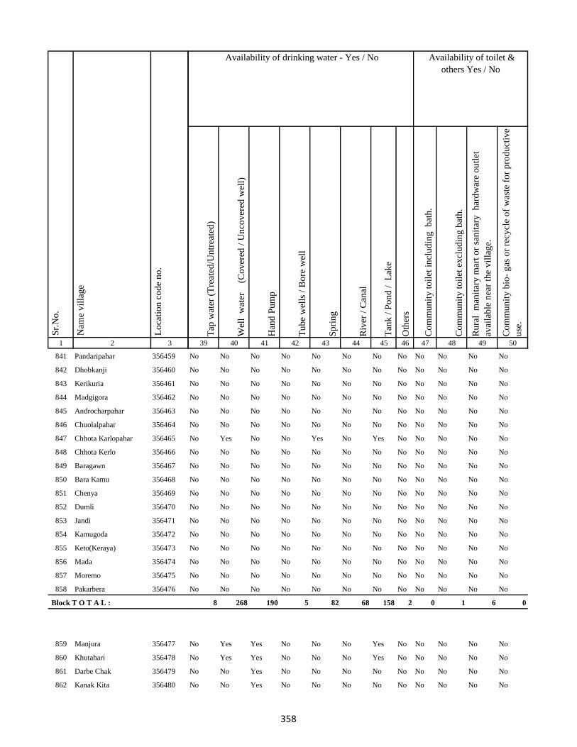
1 2 3
Lo
cati
on
co
de
no
.
Nam
e v
illa
ge
Sr.
No
.
841 Pandaripahar 356459
842 Dhobkanji 356460
843 Kerikuria 356461
844 Madgigora 356462
845 Androcharpahar 356463
846 Chuolalpahar 356464
847 Chhota Karlopahar 356465
848 Chhota Kerlo 356466
849 Baragawn 356467
850 Bara Kamu 356468
851 Chenya 356469
852 Dumli 356470
853 Jandi 356471
854 Kamugoda 356472
855 Keto(Keraya) 356473
856 Mada 356474
857 Moremo 356475
858 Pakarbera 356476
Block T O T A L :
859 Manjura 356477
860 Khutahari 356478
861 Darbe Chak 356479
862 Kanak Kita 356480
Tap
wat
er (
Tre
ated
/Un
trea
ted
)
Wel
l w
ater
(Co
ver
ed /
Un
cov
ered
wel
l)
Han
d P
um
p
Tu
be
wel
ls /
Bo
re w
ell
Sp
rin
g
Riv
er /
Can
al
Tan
k /
Po
nd
/
Lak
e
Oth
ers
Co
mm
un
ity
to
ilet
in
clu
din
g
bat
h.
Co
mm
un
ity
to
ilet
ex
clu
din
g b
ath
.
Ru
ral
man
itar
y m
art
or
san
itar
y
har
dw
are
ou
tlet
avai
lab
le n
ear
the
vil
lag
e.
Co
mm
un
ity
bio
- g
as o
r re
cycl
e o
f w
aste
fo
r p
rod
uct
ive
use
.
39 40 41 42 43 44 45 46 47 48 49 50
Availability of toilet &
others Yes / No
Availability of drinking water - Yes / No
No No No No No No No No No No No No
No No No No No No No No No No No No
No No No No No No No No No No No No
No No No No No No No No No No No No
No No No No No No No No No No No No
No No No No No No No No No No No No
No Yes No No Yes No Yes No No No No No
No No No No No No No No No No No No
No No No No No No No No No No No No
No No No No No No No No No No No No
No No No No No No No No No No No No
No No No No No No No No No No No No
No No No No No No No No No No No No
No No No No No No No No No No No No
No No No No No No No No No No No No
No No No No No No No No No No No No
No No No No No No No No No No No No
No No No No No No No No No No No No
8 268 190 5 82 68 158 2 0 1 6 0
No Yes Yes No No No Yes No No No No No
No Yes Yes No No No Yes No No No No No
No No Yes No No No No No No No No No
No No Yes No No No No No No No No No
358
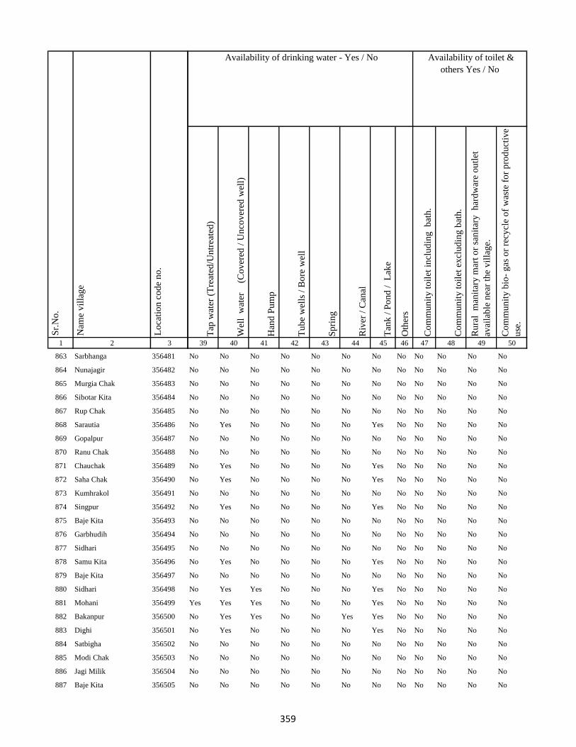
1 2 3
Lo
cati
on
co
de
no
.
Nam
e v
illa
ge
Sr.
No
.
863 Sarbhanga 356481
864 Nunajagir 356482
865 Murgia Chak 356483
866 Sibotar Kita 356484
867 Rup Chak 356485
868 Sarautia 356486
869 Gopalpur 356487
870 Ranu Chak 356488
871 Chauchak 356489
872 Saha Chak 356490
873 Kumhrakol 356491
874 Singpur 356492
875 Baje Kita 356493
876 Garbhudih 356494
877 Sidhari 356495
878 Samu Kita 356496
879 Baje Kita 356497
880 Sidhari 356498
881 Mohani 356499
882 Bakanpur 356500
883 Dighi 356501
884 Satbigha 356502
885 Modi Chak 356503
886 Jagi Milik 356504
887 Baje Kita 356505
Tap
wat
er (
Tre
ated
/Un
trea
ted
)
Wel
l w
ater
(Co
ver
ed /
Un
cov
ered
wel
l)
Han
d P
um
p
Tu
be
wel
ls /
Bo
re w
ell
Sp
rin
g
Riv
er /
Can
al
Tan
k /
Po
nd
/
Lak
e
Oth
ers
Co
mm
un
ity
to
ilet
in
clu
din
g
bat
h.
Co
mm
un
ity
to
ilet
ex
clu
din
g b
ath
.
Ru
ral
man
itar
y m
art
or
san
itar
y
har
dw
are
ou
tlet
avai
lab
le n
ear
the
vil
lag
e.
Co
mm
un
ity
bio
- g
as o
r re
cycl
e o
f w
aste
fo
r p
rod
uct
ive
use
.
39 40 41 42 43 44 45 46 47 48 49 50
Availability of toilet &
others Yes / No
Availability of drinking water - Yes / No
No No No No No No No No No No No No
No No No No No No No No No No No No
No No No No No No No No No No No No
No No No No No No No No No No No No
No No No No No No No No No No No No
No Yes No No No No Yes No No No No No
No No No No No No No No No No No No
No No No No No No No No No No No No
No Yes No No No No Yes No No No No No
No Yes No No No No Yes No No No No No
No No No No No No No No No No No No
No Yes No No No No Yes No No No No No
No No No No No No No No No No No No
No No No No No No No No No No No No
No No No No No No No No No No No No
No Yes No No No No Yes No No No No No
No No No No No No No No No No No No
No Yes Yes No No No Yes No No No No No
Yes Yes Yes No No No Yes No No No No No
No Yes Yes No No Yes Yes No No No No No
No Yes No No No No Yes No No No No No
No No No No No No No No No No No No
No No No No No No No No No No No No
No No No No No No No No No No No No
No No No No No No No No No No No No
359

1 2 3
Lo
cati
on
co
de
no
.
Nam
e v
illa
ge
Sr.
No
.
888 Sital 356506
889 Mali Chak 356507
890 Gorgawan 356508
891 Naraini 356509
892 Dhobia Chak 356510
893 Bairia Chak 356511
894 Gansagar 356512
895 Bairia Kita 356513
896 Sonbarsa 356514
897 Milik Hanwara 356515
898 Hanwara 356516
899 Ramkol 356517
900 Tiya Chak 356518
901 Alimahamadpur 356519
902 Narainpur (Dompatti) 356520
903 Sahi Kita 356521
904 Narainpur (Sempatti) 356522
905 Chak Chamu 356523
906 Baija Chak 356524
907 Dumaria Khurd 356525
908 Dumaria Kalan 356526
909 Narattampur 356527
910 Biswas Khani 356528
911 Sagrampur 356529
912 Pararia 356530
Tap
wat
er (
Tre
ated
/Un
trea
ted
)
Wel
l w
ater
(Co
ver
ed /
Un
cov
ered
wel
l)
Han
d P
um
p
Tu
be
wel
ls /
Bo
re w
ell
Sp
rin
g
Riv
er /
Can
al
Tan
k /
Po
nd
/
Lak
e
Oth
ers
Co
mm
un
ity
to
ilet
in
clu
din
g
bat
h.
Co
mm
un
ity
to
ilet
ex
clu
din
g b
ath
.
Ru
ral
man
itar
y m
art
or
san
itar
y
har
dw
are
ou
tlet
avai
lab
le n
ear
the
vil
lag
e.
Co
mm
un
ity
bio
- g
as o
r re
cycl
e o
f w
aste
fo
r p
rod
uct
ive
use
.
39 40 41 42 43 44 45 46 47 48 49 50
Availability of toilet &
others Yes / No
Availability of drinking water - Yes / No
Yes Yes Yes No No Yes Yes No No No No No
No No Yes No No No No No No No No No
Yes Yes Yes No No No No No No No No No
No Yes Yes No No No No No No No No No
No Yes Yes No No No No No No No No No
No No No No No No No No No No No No
No No No No No No No No No No No No
No No No No No No No No No No No No
No No No No No No No No No No No No
Yes Yes Yes No No Yes Yes No No No No No
No Yes Yes No Yes No No No No No No No
No No No No No No No No No No No No
No No No No No No No No No No No No
No No No No No No No No No No No No
No Yes Yes No No Yes Yes No No No No No
No No Yes No No Yes No No No No No No
No Yes Yes No No Yes No No No No No No
No Yes Yes No No Yes No No No No No No
No Yes Yes No No Yes Yes No No No No No
Yes Yes Yes No No Yes Yes No No No No No
Yes Yes Yes No No Yes Yes No No No No No
Yes Yes Yes No No Yes Yes No No No No No
Yes Yes Yes No No Yes Yes No No No No No
Yes Yes Yes Yes No No Yes No No No No No
Yes Yes Yes No No No Yes No No No No No
360
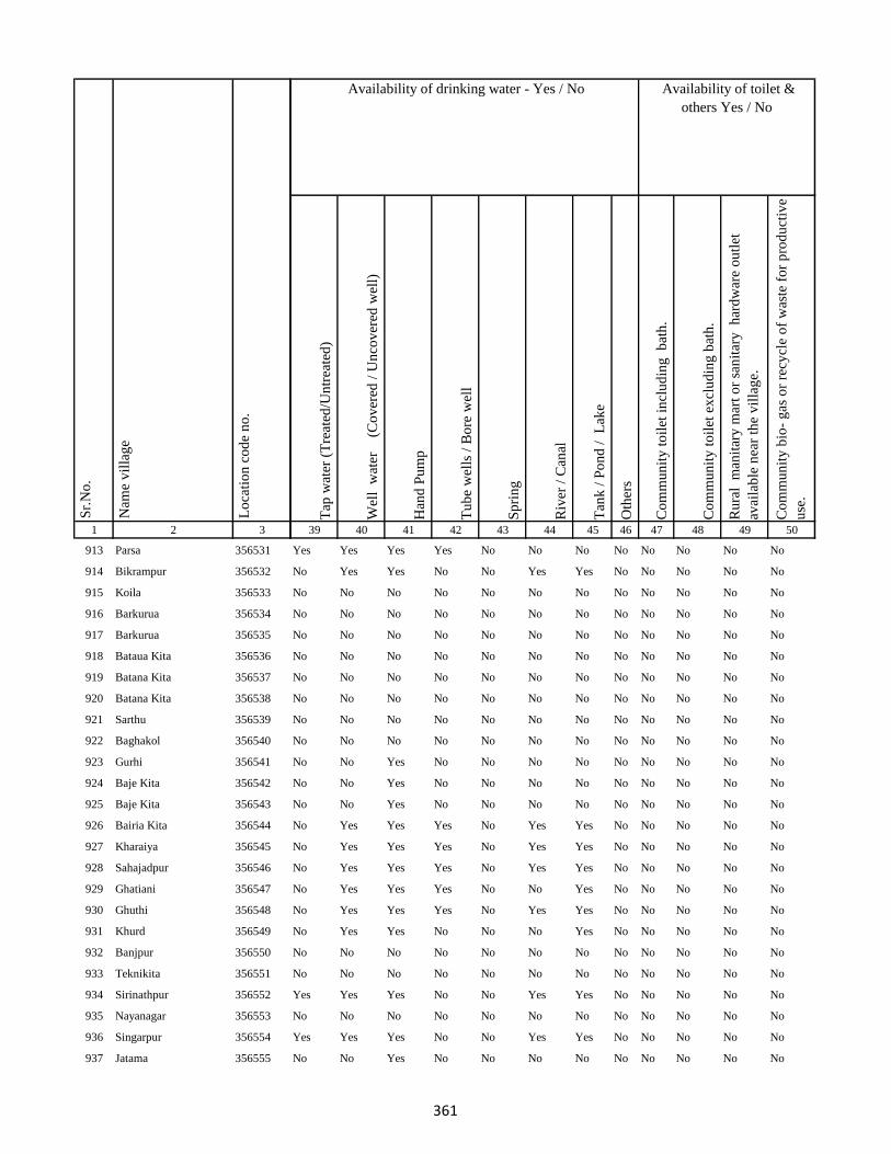
1 2 3
Lo
cati
on
co
de
no
.
Nam
e v
illa
ge
Sr.
No
.
913 Parsa 356531
914 Bikrampur 356532
915 Koila 356533
916 Barkurua 356534
917 Barkurua 356535
918 Bataua Kita 356536
919 Batana Kita 356537
920 Batana Kita 356538
921 Sarthu 356539
922 Baghakol 356540
923 Gurhi 356541
924 Baje Kita 356542
925 Baje Kita 356543
926 Bairia Kita 356544
927 Kharaiya 356545
928 Sahajadpur 356546
929 Ghatiani 356547
930 Ghuthi 356548
931 Khurd 356549
932 Banjpur 356550
933 Teknikita 356551
934 Sirinathpur 356552
935 Nayanagar 356553
936 Singarpur 356554
937 Jatama 356555
Tap
wat
er (
Tre
ated
/Un
trea
ted
)
Wel
l w
ater
(Co
ver
ed /
Un
cov
ered
wel
l)
Han
d P
um
p
Tu
be
wel
ls /
Bo
re w
ell
Sp
rin
g
Riv
er /
Can
al
Tan
k /
Po
nd
/
Lak
e
Oth
ers
Co
mm
un
ity
to
ilet
in
clu
din
g
bat
h.
Co
mm
un
ity
to
ilet
ex
clu
din
g b
ath
.
Ru
ral
man
itar
y m
art
or
san
itar
y
har
dw
are
ou
tlet
avai
lab
le n
ear
the
vil
lag
e.
Co
mm
un
ity
bio
- g
as o
r re
cycl
e o
f w
aste
fo
r p
rod
uct
ive
use
.
39 40 41 42 43 44 45 46 47 48 49 50
Availability of toilet &
others Yes / No
Availability of drinking water - Yes / No
Yes Yes Yes Yes No No No No No No No No
No Yes Yes No No Yes Yes No No No No No
No No No No No No No No No No No No
No No No No No No No No No No No No
No No No No No No No No No No No No
No No No No No No No No No No No No
No No No No No No No No No No No No
No No No No No No No No No No No No
No No No No No No No No No No No No
No No No No No No No No No No No No
No No Yes No No No No No No No No No
No No Yes No No No No No No No No No
No No Yes No No No No No No No No No
No Yes Yes Yes No Yes Yes No No No No No
No Yes Yes Yes No Yes Yes No No No No No
No Yes Yes Yes No Yes Yes No No No No No
No Yes Yes Yes No No Yes No No No No No
No Yes Yes Yes No Yes Yes No No No No No
No Yes Yes No No No Yes No No No No No
No No No No No No No No No No No No
No No No No No No No No No No No No
Yes Yes Yes No No Yes Yes No No No No No
No No No No No No No No No No No No
Yes Yes Yes No No Yes Yes No No No No No
No No Yes No No No No No No No No No
361

1 2 3
Lo
cati
on
co
de
no
.
Nam
e v
illa
ge
Sr.
No
.
938 Gauri Kita 356556
939 Pindara 356557
940 Belti Kari 356558
941 Baje Kita 356559
942 Asota 356560
943 Kasba 356561
944 Bhandarchua 356562
945 Shekhu Chak 356563
946 Bhelaidih 356564
947 Doma Chak 356565
948 Bansbara 356566
949 Kita Bansbara 356567
950 Pakridih 356568
951 Kamal Chak 356569
952 Bhikhia Chak 356570
953 Andhara Kita 356571
954 Kita Andhra 356572
955 Karmatanr 356573
956 Champa Kita 356574
957 Phagu Kita 356575
958 Puran Kita 356576
959 Alola 356577
960 Dhansar 356578
961 Khurd 356579
962 Firozpur 356580
Tap
wat
er (
Tre
ated
/Un
trea
ted
)
Wel
l w
ater
(Co
ver
ed /
Un
cov
ered
wel
l)
Han
d P
um
p
Tu
be
wel
ls /
Bo
re w
ell
Sp
rin
g
Riv
er /
Can
al
Tan
k /
Po
nd
/
Lak
e
Oth
ers
Co
mm
un
ity
to
ilet
in
clu
din
g
bat
h.
Co
mm
un
ity
to
ilet
ex
clu
din
g b
ath
.
Ru
ral
man
itar
y m
art
or
san
itar
y
har
dw
are
ou
tlet
avai
lab
le n
ear
the
vil
lag
e.
Co
mm
un
ity
bio
- g
as o
r re
cycl
e o
f w
aste
fo
r p
rod
uct
ive
use
.
39 40 41 42 43 44 45 46 47 48 49 50
Availability of toilet &
others Yes / No
Availability of drinking water - Yes / No
No Yes No No No No Yes No No No No No
No No No No No No No No No No No No
Yes Yes Yes No No Yes Yes No No No No No
No No No No No No No No No No No No
Yes Yes Yes No No Yes Yes No No No No No
No Yes Yes No No No Yes No No No No No
No Yes Yes No No Yes Yes No No No No No
No Yes Yes No No No No No No No No No
No Yes Yes No No Yes Yes No No No No No
No Yes Yes No No Yes Yes No No No No No
No No No No No No No No No No No No
No No No No No No No No No No No No
No No Yes No No No No No No No No No
No Yes Yes No No Yes Yes No No No No No
No No No No No No No No No No No No
No No No No No No No No No No No No
No No No No No No No No No No No No
No No No No No No No No No No No No
No No No No No No No No No No No No
No No No No No No No No No No No No
No No No No No No No No No No No No
No No No No No No No No No No No No
No No No No No No No No No No No No
No No Yes No No No No No No No No No
No Yes No No No No Yes No No No No No
362
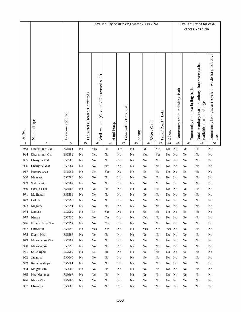
1 2 3
Lo
cati
on
co
de
no
.
Nam
e v
illa
ge
Sr.
No
.
963 Dharampur Ghat 356581
964 Dharampur Mal 356582
965 Chaujora Mal 356583
966 Chaujora Ghat 356584
967 Kamargawan 356585
968 Mansura 356586
969 Sadulabhita 356587
970 Gosain Chak 356588
971 Madhupur 356589
972 Gokula 356590
973 Majhona 356591
974 Daniala 356592
975 Khaira 356593
976 Fouzdar Kita Ghat 356594
977 Ghatdiarhi 356595
978 Diarhi Kita 356596
979 Manoharpur Kita 356597
980 Manoharpur 356598
981 Solahbighia 356599
982 Jhagarua 356600
983 Ramchandarpur 356601
984 Maigar Kita 356602
985 Kita Majhona 356603
986 Khara Kita 356604
987 Chainpur 356605
Tap
wat
er (
Tre
ated
/Un
trea
ted
)
Wel
l w
ater
(Co
ver
ed /
Un
cov
ered
wel
l)
Han
d P
um
p
Tu
be
wel
ls /
Bo
re w
ell
Sp
rin
g
Riv
er /
Can
al
Tan
k /
Po
nd
/
Lak
e
Oth
ers
Co
mm
un
ity
to
ilet
in
clu
din
g
bat
h.
Co
mm
un
ity
to
ilet
ex
clu
din
g b
ath
.
Ru
ral
man
itar
y m
art
or
san
itar
y
har
dw
are
ou
tlet
avai
lab
le n
ear
the
vil
lag
e.
Co
mm
un
ity
bio
- g
as o
r re
cycl
e o
f w
aste
fo
r p
rod
uct
ive
use
.
39 40 41 42 43 44 45 46 47 48 49 50
Availability of toilet &
others Yes / No
Availability of drinking water - Yes / No
No Yes No Yes No No Yes No No No No No
No Yes No No No Yes Yes No No No No No
No No No No No No No No No No No No
No No No No No No No No No No No No
No No Yes No No No No No No No No No
No No No No No No No No No No No No
No No No No No No No No No No No No
No No No No No No No No No No No No
No No No No No No No No No No No No
No No No No No No No No No No No No
No No No No No No No No No No No No
No No Yes No No No No No No No No No
No No Yes No No Yes No No No No No No
No No Yes No No No No No No No No No
No Yes Yes No No Yes Yes Yes No No No No
No No No No No No No No No No No No
No No No No No No No No No No No No
No No No No No No No No No No No No
No No No No No No No No No No No No
No No No No No No No No No No No No
No No No No No No No No No No No No
No No No No No No No No No No No No
No No No No No No No No No No No No
No No No No No No No No No No No No
No No No No No No No No No No No No
363
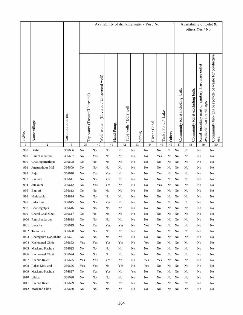
1 2 3
Lo
cati
on
co
de
no
.
Nam
e v
illa
ge
Sr.
No
.
988 Darha 356606
989 Ramchandarpur 356607
990 Ghat Jagarnathpur 356608
991 Jagarnathpur Mal 356609
992 Jiajori 356610
993 Rai Kita 356611
994 Jatakothi 356612
995 Bagjori 356613
996 Harlabahiar 356614
997 Balachini 356615
998 Ghat Jagatpur 356616
999 Chand Chak Ghat 356617
1000 Ramchandarpur 356618
1001 Lakarha 356619
1002 Taran Kita 356620
1003 Chamgadra Darunbatia 356621
1004 Kachuamal Chhit 356622
1005 Maskand Kachua 356623
1006 Kachuamal Chhit 356624
1007 Kachua Raksi 356625
1008 Raksa Maskand 356626
1009 Maskand Kachua 356627
1010 Lilabari 356628
1011 Kachua Raksi 356629
1012 Maskand Chhit 356630
Tap
wat
er (
Tre
ated
/Un
trea
ted
)
Wel
l w
ater
(Co
ver
ed /
Un
cov
ered
wel
l)
Han
d P
um
p
Tu
be
wel
ls /
Bo
re w
ell
Sp
rin
g
Riv
er /
Can
al
Tan
k /
Po
nd
/
Lak
e
Oth
ers
Co
mm
un
ity
to
ilet
in
clu
din
g
bat
h.
Co
mm
un
ity
to
ilet
ex
clu
din
g b
ath
.
Ru
ral
man
itar
y m
art
or
san
itar
y
har
dw
are
ou
tlet
avai
lab
le n
ear
the
vil
lag
e.
Co
mm
un
ity
bio
- g
as o
r re
cycl
e o
f w
aste
fo
r p
rod
uct
ive
use
.
39 40 41 42 43 44 45 46 47 48 49 50
Availability of toilet &
others Yes / No
Availability of drinking water - Yes / No
No No No No No No No No No No No No
No Yes No No No No Yes No No No No No
No No No No No No No No No No No No
No No No No No No No No No No No No
No Yes Yes No No No Yes No No No No No
No No Yes No No No No No No No No No
No Yes Yes No No No Yes No No No No No
No No No No No No No No No No No No
No No No No No No No No No No No No
No No Yes No No No No No No No No No
No No No No No No No No No No No No
No No No No No No No No No No No No
No No No No No No No No No No No No
No Yes Yes Yes No Yes Yes No No No No No
No No No No No No No No No No No No
No No No No No No No No No No No No
Yes Yes Yes Yes No Yes No No No No No No
No No No No No No No No No No No No
No No No No No No No No No No No No
Yes Yes Yes No No Yes Yes No No No No No
Yes Yes No Yes No Yes No No No No No No
No Yes Yes No Yes No Yes No No No No No
No No No No No No No No No No No No
No No No No No No No No No No No No
No No No No No No No No No No No No
364
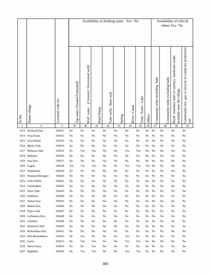
1 2 3
Lo
cati
on
co
de
no
.
Nam
e v
illa
ge
Sr.
No
.
1013 Maskand Kita 356631
1014 Sirsa Kalan 356632
1015 Sirsa Khurd 356633
1016 Bholu Chak 356634
1017 Mahuara Ghat 356635
1018 Mahuara 356636
1019 Fauj Kita 356637
1020 Logain 356638
1021 Asmantikar 356639
1022 Maskand Bhanjpur 356640
1023 Gidra Pathar 356641
1024 Lamahaghat 356642
1025 Hirai Chak 356643
1026 Sukhbona 356644
1027 Sankar Kita 356645
1028 Rahim Kita 356646
1029 Hajra Chak 356647
1030 Lachmania Kita 356648
1031 Lilambar 356649
1032 Maskand Chhit 356650
1033 Bishambhar Kita 356651
1034 Kita Bishambhara 356652
1035 Gunia 356653
1036 Harin Chora 356654
1037 Baghakol 356655
Tap
wat
er (
Tre
ated
/Un
trea
ted
)
Wel
l w
ater
(Co
ver
ed /
Un
cov
ered
wel
l)
Han
d P
um
p
Tu
be
wel
ls /
Bo
re w
ell
Sp
rin
g
Riv
er /
Can
al
Tan
k /
Po
nd
/
Lak
e
Oth
ers
Co
mm
un
ity
to
ilet
in
clu
din
g
bat
h.
Co
mm
un
ity
to
ilet
ex
clu
din
g b
ath
.
Ru
ral
man
itar
y m
art
or
san
itar
y
har
dw
are
ou
tlet
avai
lab
le n
ear
the
vil
lag
e.
Co
mm
un
ity
bio
- g
as o
r re
cycl
e o
f w
aste
fo
r p
rod
uct
ive
use
.
39 40 41 42 43 44 45 46 47 48 49 50
Availability of toilet &
others Yes / No
Availability of drinking water - Yes / No
No No No No No No No No No No No No
No No No No No No No No No No No No
No No No No No No No No No No No No
No No No No No No No No No No No No
No Yes Yes No No Yes Yes No No No No No
No No No No No No No No No No No No
No No No No No No No No No No No No
Yes Yes Yes No No Yes Yes Yes No No No No
No No No No No No No No No No No No
No No No No No No No No No No No No
No No No No No No No No No No No No
No No No No No No No No No No No No
No No No No No No No No No No No No
No No No No No No No No No No No No
No No No No No No No No No No No No
No No No No No No No No No No No No
No No No No No No No No No No No No
No No No No No No No No No No No No
No No No No No No No No No No No No
No No No No No No No No No No No No
No No No No No No No No No No No No
No Yes No No No Yes No No No No No No
No Yes Yes No No Yes Yes No No No No No
No No Yes No No No No No No No No No
No Yes Yes No No Yes Yes No No No No No
365

1 2 3
Lo
cati
on
co
de
no
.
Nam
e v
illa
ge
Sr.
No
.
1038 Dakaita 356656
1039 Dakaitaghat 356657
1040 Tetaria 356658
1041 Bhalu Kita 356659
1042 Tewarijor 356660
1043 Beltikri 356661
1044 Jhapania 356662
1045 Khairaghat 356663
1046 Lamha Mal 356664
1047 Chand Chak 356665
1048 Ghospur 356666
1049 Dahara 356667
1050 Moti Chak 356668
1051 Bhartha Chak 356669
1052 Bhairo Kita 356670
1053 Lachminia Kita 356671
1054 Anjna 356672
1055 Barhe Kita 356673
1056 Sirsi 356674
1057 Bhairo Chak 356675
1058 Kusmara 356676
1059 Lachminia Kita 356677
1060 Bishunpur 356678
1061 Baradbara 356679
1062 Sundar Chak 356680
Tap
wat
er (
Tre
ated
/Un
trea
ted
)
Wel
l w
ater
(Co
ver
ed /
Un
cov
ered
wel
l)
Han
d P
um
p
Tu
be
wel
ls /
Bo
re w
ell
Sp
rin
g
Riv
er /
Can
al
Tan
k /
Po
nd
/
Lak
e
Oth
ers
Co
mm
un
ity
to
ilet
in
clu
din
g
bat
h.
Co
mm
un
ity
to
ilet
ex
clu
din
g b
ath
.
Ru
ral
man
itar
y m
art
or
san
itar
y
har
dw
are
ou
tlet
avai
lab
le n
ear
the
vil
lag
e.
Co
mm
un
ity
bio
- g
as o
r re
cycl
e o
f w
aste
fo
r p
rod
uct
ive
use
.
39 40 41 42 43 44 45 46 47 48 49 50
Availability of toilet &
others Yes / No
Availability of drinking water - Yes / No
No No No No No No No No No No No No
No No No No No No No No No No No No
No No No No No No No No No No No No
No Yes Yes No No Yes Yes No No No No No
No Yes Yes No No Yes Yes No No No No No
No No No No No No No No No No No No
No No No No No No No No No No No No
No No No No No No No No No No No No
No No No No No No No No No No No No
No Yes Yes No No No Yes No No No No No
No No No No No No No No No No No No
No No No No No No No No No No No No
No Yes Yes Yes No Yes Yes No No No No No
No Yes Yes Yes No Yes Yes No No No No No
No No No No No No No No No No No No
No No No No No No No No No No No No
No Yes Yes Yes No Yes No No No No No No
No No No No No No No No No No No No
No Yes Yes Yes No No No No No No No No
No Yes Yes No No No Yes No No No No No
No No No No No Yes Yes No No No No No
No No No No No No No No No No No No
No Yes Yes No No Yes Yes No No No No No
No Yes Yes Yes No No No No No No No No
No Yes Yes Yes No No Yes No No No No No
366

1 2 3
Lo
cati
on
co
de
no
.
Nam
e v
illa
ge
Sr.
No
.
1063 Bhaju Chak 356681
1064 Malia Chak 356682
1065 Afzal Kita 356683
1066 Mariha 356684
1067 Kushapur 356685
1068 Fazil Kita 356686
1069 Dumra 356687
1070 Bisambhara Kita 356688
1071 Dahia 356689
1072 Kaljhara 356690
1073 Phudkipur 356691
1074 Simratola 356692
1075 Hundra 356693
1076 Phudkipur 356694
1077 Shahpur Beldiha 356695
1078 Phasiatikar 356696
1079 Sirsa 356697
1080 Samhari 356698
1081 Asanand Kita 356699
1082 Muradpur 356700
1083 Subarai Samhra 356701
1084 Semra Kita 356702
1085 Mirza Chak 356703
1086 Hasan Karharia 356704
1087 Manian Karharia 356705
Tap
wat
er (
Tre
ated
/Un
trea
ted
)
Wel
l w
ater
(Co
ver
ed /
Un
cov
ered
wel
l)
Han
d P
um
p
Tu
be
wel
ls /
Bo
re w
ell
Sp
rin
g
Riv
er /
Can
al
Tan
k /
Po
nd
/
Lak
e
Oth
ers
Co
mm
un
ity
to
ilet
in
clu
din
g
bat
h.
Co
mm
un
ity
to
ilet
ex
clu
din
g b
ath
.
Ru
ral
man
itar
y m
art
or
san
itar
y
har
dw
are
ou
tlet
avai
lab
le n
ear
the
vil
lag
e.
Co
mm
un
ity
bio
- g
as o
r re
cycl
e o
f w
aste
fo
r p
rod
uct
ive
use
.
39 40 41 42 43 44 45 46 47 48 49 50
Availability of toilet &
others Yes / No
Availability of drinking water - Yes / No
Yes Yes Yes Yes No No Yes No No No No No
No No No No No No No No No No No No
No No No No No No No No No No No No
No No No No Yes Yes Yes No No No No No
No No No No No No No No No No No No
No Yes Yes No No Yes Yes No No No No No
No Yes Yes No No Yes Yes No No No No No
No Yes Yes No No Yes Yes No No No No No
No Yes Yes No No Yes Yes No No No No No
No Yes Yes No No Yes Yes No No No No No
No No No No No No No No No No No No
No No No No No No No No No No No No
No No No No No No No No No No No No
No No No No No No No No No No No No
No Yes Yes No No No Yes No No No No No
No Yes Yes No No Yes Yes No No No No No
No Yes Yes No No Yes Yes No No No No No
No No No No No No No No No No No No
No No No No No No No No No No No No
No No No No No No No No No No No No
No No No No No No No No No No No No
No Yes Yes No No Yes Yes No No No No No
No Yes Yes No No Yes Yes Yes No No No No
No Yes Yes No No Yes Yes No No No No No
No Yes Yes No No Yes Yes No No No No No
367

1 2 3
Lo
cati
on
co
de
no
.
Nam
e v
illa
ge
Sr.
No
.
1088 Jathari 356706
1089 Hari Karharia 356707
1090 Kanreswari Kita 356708
1091 Hasanpur 356709
1092 Bakwa Chak 356710
1093 Bela Kita 356711
1094 Janki Kita 356712
1095 Mal Bhandari Dih 356713
1096 Semrakita And Ghat Bhandarid356714
1097 Aslulahsamra 356715
1098 Bariartola 356716
1099 Maganpipra 356717
1100 Ranbahiar 356718
1101 Jamua 356719
1102 Chuna Chak 356720
1103 Ginratari 356721
1104 Sakal Chak 356722
1105 Larai Chak 356723
1106 Gohira Kita 356724
1107 Hemcha Chak 356725
1108 Asanbani 356726
1109 Jhigur Kita 356727
1110 Mal Bhandaridih 356728
1111 Semarkita Ghat Bhandaridih356729
1112 Nimgachhi And Kita 356730
Tap
wat
er (
Tre
ated
/Un
trea
ted
)
Wel
l w
ater
(Co
ver
ed /
Un
cov
ered
wel
l)
Han
d P
um
p
Tu
be
wel
ls /
Bo
re w
ell
Sp
rin
g
Riv
er /
Can
al
Tan
k /
Po
nd
/
Lak
e
Oth
ers
Co
mm
un
ity
to
ilet
in
clu
din
g
bat
h.
Co
mm
un
ity
to
ilet
ex
clu
din
g b
ath
.
Ru
ral
man
itar
y m
art
or
san
itar
y
har
dw
are
ou
tlet
avai
lab
le n
ear
the
vil
lag
e.
Co
mm
un
ity
bio
- g
as o
r re
cycl
e o
f w
aste
fo
r p
rod
uct
ive
use
.
39 40 41 42 43 44 45 46 47 48 49 50
Availability of toilet &
others Yes / No
Availability of drinking water - Yes / No
No Yes Yes No No Yes Yes No No No No No
No No No No No No No No No No No No
No No No No No No No No No No No No
No Yes Yes No No Yes Yes No No No No No
No Yes Yes No No No Yes No No No No No
No No No No No No No No No No No No
No Yes Yes Yes No Yes Yes No No No No No
No Yes Yes No No Yes Yes No No No No No
No Yes Yes No No No Yes No No No No No
No Yes Yes No No Yes Yes No No No No No
No Yes Yes No No Yes Yes No No No No No
No Yes Yes No No Yes Yes No No No No No
No No No No No No No No No No No No
No No No No No No No No No No No No
Yes Yes Yes Yes No Yes Yes No No No No No
Yes Yes Yes Yes No Yes Yes No No No No No
Yes Yes Yes No No No Yes No No No No No
No No No No No No No No No No No No
No No No No No No No No No No No No
No No No No No No No No No No No No
No No No No No No No No No No No No
No No No No No No No No No No No No
No No No No No No No No No No No No
No No No No No No No No No No No No
No No No No No No No No No No No No
368

1 2 3
Lo
cati
on
co
de
no
.
Nam
e v
illa
ge
Sr.
No
.
1113 Khaspathar 356731
1114 Chanai Chak 356732
1115 Sitladih 356733
1116 Samda 356734
1117 Nimania Kita 356735
1118 Chilha 356736
1119 Kusha 356737
1120 Hansai Kita 356738
1121 Kusmi 356739
1122 Bahalia Kita 356740
1123 Jamaidih 356741
1124 Babupur Mal 356742
1125 Kaim Kita 356743
1126 Gain Chak 356744
1127 Babupur Ghat 356745
1128 Rajpur 356746
1129 Doman Kita 356747
1130 Majur Kola 356748
1131 Pathar Kani 356749
1132 Karnu 356750
1133 Gudia 356751
1134 Letaria 356752
1135 Murlitak 356753
1136 Basua 356754
1137 Gangsagar 356755
Tap
wat
er (
Tre
ated
/Un
trea
ted
)
Wel
l w
ater
(Co
ver
ed /
Un
cov
ered
wel
l)
Han
d P
um
p
Tu
be
wel
ls /
Bo
re w
ell
Sp
rin
g
Riv
er /
Can
al
Tan
k /
Po
nd
/
Lak
e
Oth
ers
Co
mm
un
ity
to
ilet
in
clu
din
g
bat
h.
Co
mm
un
ity
to
ilet
ex
clu
din
g b
ath
.
Ru
ral
man
itar
y m
art
or
san
itar
y
har
dw
are
ou
tlet
avai
lab
le n
ear
the
vil
lag
e.
Co
mm
un
ity
bio
- g
as o
r re
cycl
e o
f w
aste
fo
r p
rod
uct
ive
use
.
39 40 41 42 43 44 45 46 47 48 49 50
Availability of toilet &
others Yes / No
Availability of drinking water - Yes / No
No No Yes No No Yes Yes No No No No No
No No Yes No No Yes Yes No No No No No
No Yes Yes No No Yes Yes No No No No No
No Yes Yes No No Yes Yes No No No No No
No Yes Yes No No No No No No No No No
No Yes Yes No No No Yes No No No No No
No Yes Yes No No Yes Yes No No No No No
No Yes Yes No No No Yes No No No No No
No Yes Yes No No No Yes No No No No No
No Yes Yes No No Yes Yes Yes No No No No
No No Yes No No No No No No No No No
No Yes Yes No No No Yes No No No No No
No No No No No No No No No No No No
No Yes Yes No No Yes Yes No No No No No
No Yes Yes No No Yes Yes No No No No No
No No No No No No No No No No No No
No No No No No No No No No No No No
No No No No No No No No No No No No
No Yes Yes No No Yes Yes No No No No No
Yes Yes Yes No No Yes Yes No No No No No
Yes Yes Yes No No Yes Yes No No No No No
Yes Yes Yes No No Yes Yes Yes No No No No
Yes Yes Yes Yes No No No Yes No No No No
Yes Yes Yes Yes No No No Yes No No No No
No No No No No No No No No No No No
369
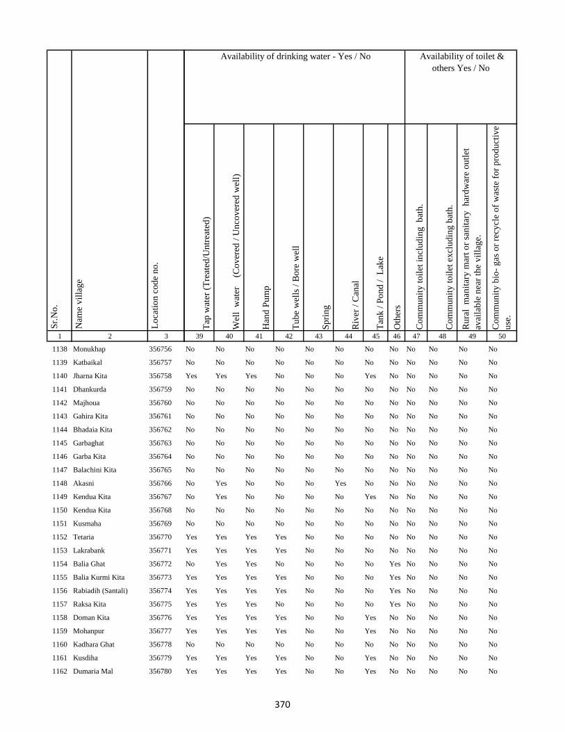
1 2 3
Lo
cati
on
co
de
no
.
Nam
e v
illa
ge
Sr.
No
.
1138 Monukhap 356756
1139 Katbaikal 356757
1140 Jharna Kita 356758
1141 Dhankurda 356759
1142 Majhoua 356760
1143 Gahira Kita 356761
1144 Bhadaia Kita 356762
1145 Garbaghat 356763
1146 Garba Kita 356764
1147 Balachini Kita 356765
1148 Akasni 356766
1149 Kendua Kita 356767
1150 Kendua Kita 356768
1151 Kusmaha 356769
1152 Tetaria 356770
1153 Lakrabank 356771
1154 Balia Ghat 356772
1155 Balia Kurmi Kita 356773
1156 Rabiadih (Santali) 356774
1157 Raksa Kita 356775
1158 Doman Kita 356776
1159 Mohanpur 356777
1160 Kadhara Ghat 356778
1161 Kusdiha 356779
1162 Dumaria Mal 356780
Tap
wat
er (
Tre
ated
/Un
trea
ted
)
Wel
l w
ater
(Co
ver
ed /
Un
cov
ered
wel
l)
Han
d P
um
p
Tu
be
wel
ls /
Bo
re w
ell
Sp
rin
g
Riv
er /
Can
al
Tan
k /
Po
nd
/
Lak
e
Oth
ers
Co
mm
un
ity
to
ilet
in
clu
din
g
bat
h.
Co
mm
un
ity
to
ilet
ex
clu
din
g b
ath
.
Ru
ral
man
itar
y m
art
or
san
itar
y
har
dw
are
ou
tlet
avai
lab
le n
ear
the
vil
lag
e.
Co
mm
un
ity
bio
- g
as o
r re
cycl
e o
f w
aste
fo
r p
rod
uct
ive
use
.
39 40 41 42 43 44 45 46 47 48 49 50
Availability of toilet &
others Yes / No
Availability of drinking water - Yes / No
No No No No No No No No No No No No
No No No No No No No No No No No No
Yes Yes Yes No No No Yes No No No No No
No No No No No No No No No No No No
No No No No No No No No No No No No
No No No No No No No No No No No No
No No No No No No No No No No No No
No No No No No No No No No No No No
No No No No No No No No No No No No
No No No No No No No No No No No No
No Yes No No No Yes No No No No No No
No Yes No No No No Yes No No No No No
No No No No No No No No No No No No
No No No No No No No No No No No No
Yes Yes Yes Yes No No No No No No No No
Yes Yes Yes Yes No No No No No No No No
No Yes Yes No No No No Yes No No No No
Yes Yes Yes Yes No No No Yes No No No No
Yes Yes Yes Yes No No No Yes No No No No
Yes Yes Yes No No No No Yes No No No No
Yes Yes Yes Yes No No Yes No No No No No
Yes Yes Yes Yes No No Yes No No No No No
No No No No No No No No No No No No
Yes Yes Yes Yes No No Yes No No No No No
Yes Yes Yes Yes No No Yes No No No No No
370

1 2 3
Lo
cati
on
co
de
no
.
Nam
e v
illa
ge
Sr.
No
.
1163 Kadhara Mal 356781
1164 Kadhara Ghat 356782
1165 Gobindpur 356783
1166 Bansbhita 356784
1167 Maniamor 356785
1168 Lakhipur 356786
1169 Durgapur 356787
1170 Lakhipur 356788
1171 Jogidih 356789
1172 Kitapathar 356790
1173 Deola Kita 356791
1174 Nimgachhi And Kita 356792
1175 Karkatdih 356793
1176 Lakhipur 356794
1177 Kasturia Kita 356795
1178 Dalabar 356796
1179 Khutehri 356797
1180 Chansar 356798
1181 Nima Chak 356799
1182 Chichohari 356800
1183 Dudhbecha 356801
1184 Goradih 356802
1185 Deyal Kita 356803
1186 Pipra Kita 356804
1187 Gosain Chak 356805
Tap
wat
er (
Tre
ated
/Un
trea
ted
)
Wel
l w
ater
(Co
ver
ed /
Un
cov
ered
wel
l)
Han
d P
um
p
Tu
be
wel
ls /
Bo
re w
ell
Sp
rin
g
Riv
er /
Can
al
Tan
k /
Po
nd
/
Lak
e
Oth
ers
Co
mm
un
ity
to
ilet
in
clu
din
g
bat
h.
Co
mm
un
ity
to
ilet
ex
clu
din
g b
ath
.
Ru
ral
man
itar
y m
art
or
san
itar
y
har
dw
are
ou
tlet
avai
lab
le n
ear
the
vil
lag
e.
Co
mm
un
ity
bio
- g
as o
r re
cycl
e o
f w
aste
fo
r p
rod
uct
ive
use
.
39 40 41 42 43 44 45 46 47 48 49 50
Availability of toilet &
others Yes / No
Availability of drinking water - Yes / No
Yes Yes Yes Yes No No Yes No No No No No
Yes Yes Yes No No Yes Yes No No No No No
No No No No No No No No No No No No
No No No No No No No No No No No No
No No No No No No No No No No No No
No No No No No No No No No No No No
No Yes Yes No No Yes Yes No No No No No
No No No No No No No No No No No No
No No No No No No No No No No No No
No No No No No No No No No No No No
No No No No No No No No No No No No
No No No No No No No No No No No No
No No No No No No No No No No No No
No No No No No No No No No No No No
No No No No No No No No No No No No
Yes Yes Yes Yes No Yes Yes No No No No No
Yes Yes Yes Yes No Yes Yes No No No No No
Yes Yes Yes No No No Yes No No No No No
Yes Yes No Yes No Yes Yes No No No No No
Yes Yes Yes Yes No Yes Yes No No No No No
Yes Yes No Yes No Yes Yes No No No No No
Yes Yes Yes Yes No Yes Yes No No No No No
No No No No No No No No No No No No
No No No No No No No No No No No No
No No No No No No No No No No No No
371
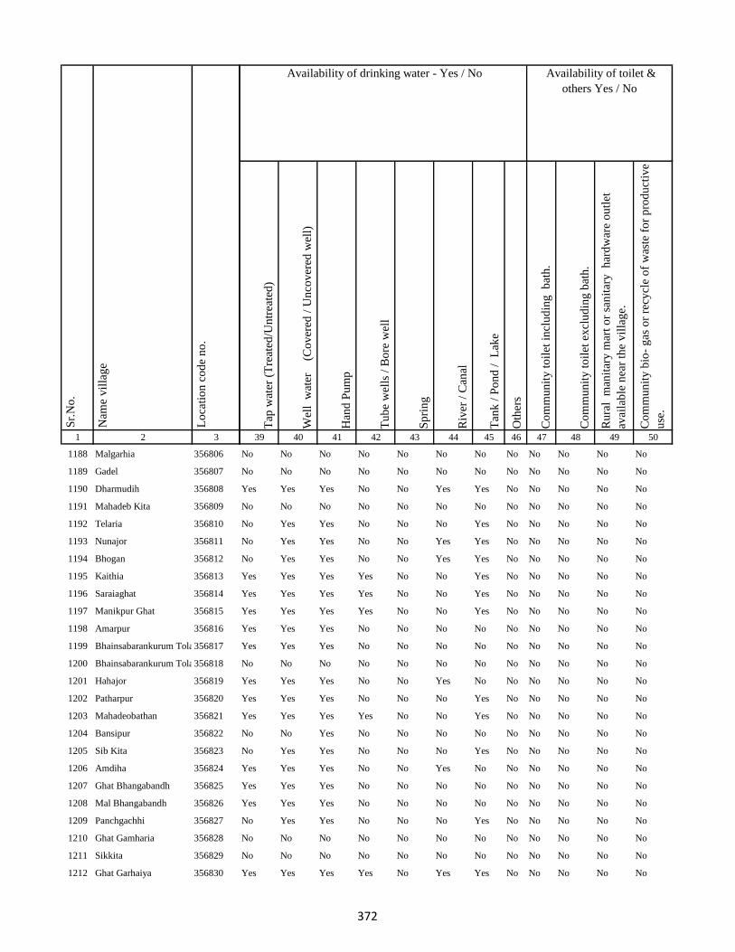
1 2 3
Lo
cati
on
co
de
no
.
Nam
e v
illa
ge
Sr.
No
.
1188 Malgarhia 356806
1189 Gadel 356807
1190 Dharmudih 356808
1191 Mahadeb Kita 356809
1192 Telaria 356810
1193 Nunajor 356811
1194 Bhogan 356812
1195 Kaithia 356813
1196 Saraiaghat 356814
1197 Manikpur Ghat 356815
1198 Amarpur 356816
1199 Bhainsabarankurum Tola356817
1200 Bhainsabarankurum Tola Mal356818
1201 Hahajor 356819
1202 Patharpur 356820
1203 Mahadeobathan 356821
1204 Bansipur 356822
1205 Sib Kita 356823
1206 Amdiha 356824
1207 Ghat Bhangabandh 356825
1208 Mal Bhangabandh 356826
1209 Panchgachhi 356827
1210 Ghat Gamharia 356828
1211 Sikkita 356829
1212 Ghat Garhaiya 356830
Tap
wat
er (
Tre
ated
/Un
trea
ted
)
Wel
l w
ater
(Co
ver
ed /
Un
cov
ered
wel
l)
Han
d P
um
p
Tu
be
wel
ls /
Bo
re w
ell
Sp
rin
g
Riv
er /
Can
al
Tan
k /
Po
nd
/
Lak
e
Oth
ers
Co
mm
un
ity
to
ilet
in
clu
din
g
bat
h.
Co
mm
un
ity
to
ilet
ex
clu
din
g b
ath
.
Ru
ral
man
itar
y m
art
or
san
itar
y
har
dw
are
ou
tlet
avai
lab
le n
ear
the
vil
lag
e.
Co
mm
un
ity
bio
- g
as o
r re
cycl
e o
f w
aste
fo
r p
rod
uct
ive
use
.
39 40 41 42 43 44 45 46 47 48 49 50
Availability of toilet &
others Yes / No
Availability of drinking water - Yes / No
No No No No No No No No No No No No
No No No No No No No No No No No No
Yes Yes Yes No No Yes Yes No No No No No
No No No No No No No No No No No No
No Yes Yes No No No Yes No No No No No
No Yes Yes No No Yes Yes No No No No No
No Yes Yes No No Yes Yes No No No No No
Yes Yes Yes Yes No No Yes No No No No No
Yes Yes Yes Yes No No Yes No No No No No
Yes Yes Yes Yes No No Yes No No No No No
Yes Yes Yes No No No No No No No No No
Yes Yes Yes No No No No No No No No No
No No No No No No No No No No No No
Yes Yes Yes No No Yes No No No No No No
Yes Yes Yes No No No Yes No No No No No
Yes Yes Yes Yes No No Yes No No No No No
No No Yes No No No No No No No No No
No Yes Yes No No No Yes No No No No No
Yes Yes Yes No No Yes No No No No No No
Yes Yes Yes No No No No No No No No No
Yes Yes Yes No No No No No No No No No
No Yes Yes No No No Yes No No No No No
No No No No No No No No No No No No
No No No No No No No No No No No No
Yes Yes Yes Yes No Yes Yes No No No No No
372

1 2 3
Lo
cati
on
co
de
no
.
Nam
e v
illa
ge
Sr.
No
.
1213 Raghunath Kita 356831
1214 Gauri Kita 356832
1215 Madhu Chak 356833
1216 Sikkita 356834
1217 Sarawa 356835
1218 Baridih 356836
1219 Gorantia 356837
1220 Baijnathpur 356838
1221 Lohathi 356839
Block T O T A L :
1222 Sonbarsa 356841
1223 Maheshliti 356842
1224 Matihani 356843
1225 Parasbana Urf Bhata Chak356844
1226 Chaura 356845
1227 Sareya 356846
1228 Tardiha 356847
1229 Khurd 356848
1230 Basbhita 356849
1231 Jogidih 356850
1232 Taratikar 356851
1233 Ghatkurwa 356852
1234 Ram Sundariya 356853
Tap
wat
er (
Tre
ated
/Un
trea
ted
)
Wel
l w
ater
(Co
ver
ed /
Un
cov
ered
wel
l)
Han
d P
um
p
Tu
be
wel
ls /
Bo
re w
ell
Sp
rin
g
Riv
er /
Can
al
Tan
k /
Po
nd
/
Lak
e
Oth
ers
Co
mm
un
ity
to
ilet
in
clu
din
g
bat
h.
Co
mm
un
ity
to
ilet
ex
clu
din
g b
ath
.
Ru
ral
man
itar
y m
art
or
san
itar
y
har
dw
are
ou
tlet
avai
lab
le n
ear
the
vil
lag
e.
Co
mm
un
ity
bio
- g
as o
r re
cycl
e o
f w
aste
fo
r p
rod
uct
ive
use
.
39 40 41 42 43 44 45 46 47 48 49 50
Availability of toilet &
others Yes / No
Availability of drinking water - Yes / No
No Yes Yes No No No No No No No No No
No Yes Yes No No No No No No No No No
No Yes Yes No No No No No No No No No
No Yes Yes No No No No Yes No No No No
Yes Yes Yes No No Yes Yes No No No No No
Yes Yes Yes No No Yes Yes No No No No No
Yes Yes Yes No No Yes Yes No No No No No
Yes Yes Yes Yes No Yes No No No No No No
No Yes Yes No No No Yes No No No No No
64 166 170 44 3 96 135 12 0 0 0 0
No Yes Yes No No Yes Yes No No No No No
No Yes Yes No No Yes Yes No No No No No
No No No No No No No No No No No No
No No No No No No No No No No No No
Yes Yes Yes No No No Yes No No No No No
No Yes Yes No No Yes Yes No No No No No
No Yes Yes No No Yes No No No No Yes No
No Yes Yes No No Yes No No No No Yes No
No Yes Yes Yes No No No No No No Yes No
No Yes Yes No No No Yes No No No No No
No No No No No No No No No No No No
Yes Yes Yes No No No Yes No No No No No
No No No No No No No No No No No No
373

1 2 3
Lo
cati
on
co
de
no
.
Nam
e v
illa
ge
Sr.
No
.
1235 Taratikar 356854
1236 Siardih 356855
1237 Lakhanpahari 356856
1238 Joginpahari 356857
1239 Jagarnathpur 356858
1240 Lilatari 356859
1241 Kamla Chak 356860
1242 Siardih(Chhit) 356861
1243 Bhanjpur 356862
1244 Barkop 356863
1245 Mirza Chak 356864
1246 Birseni 356865
1247 Siardih 356866
1248 Mirza Chak 356867
1249 Jogi Chak 356868
1250 Amdiha 356869
1251 Babupur 356870
1252 Jamua 356871
1253 Rangatanr 356872
1254 Semariya 356873
1255 Ramgarh 356874
1256 Kamaldiha 356875
1257 Kureri 356876
1258 Pipra 356877
1259 Babupur 356878
Tap
wat
er (
Tre
ated
/Un
trea
ted
)
Wel
l w
ater
(Co
ver
ed /
Un
cov
ered
wel
l)
Han
d P
um
p
Tu
be
wel
ls /
Bo
re w
ell
Sp
rin
g
Riv
er /
Can
al
Tan
k /
Po
nd
/
Lak
e
Oth
ers
Co
mm
un
ity
to
ilet
in
clu
din
g
bat
h.
Co
mm
un
ity
to
ilet
ex
clu
din
g b
ath
.
Ru
ral
man
itar
y m
art
or
san
itar
y
har
dw
are
ou
tlet
avai
lab
le n
ear
the
vil
lag
e.
Co
mm
un
ity
bio
- g
as o
r re
cycl
e o
f w
aste
fo
r p
rod
uct
ive
use
.
39 40 41 42 43 44 45 46 47 48 49 50
Availability of toilet &
others Yes / No
Availability of drinking water - Yes / No
No No No No No No No No No No No No
Yes Yes Yes No No No Yes No No No No No
No Yes Yes No No No Yes No No No No No
No No Yes No No No No No No No No No
No No No No No No No No No No No No
No No No No No No No No No No No No
No No No No No No No No No No No No
No No No No No No No No No No No No
No No Yes Yes No No Yes No No No No No
No No No No No No No No No No No No
No No No No No No No No No No No No
No No No No No No No No No No No No
No No No No No No No No No No No No
No Yes Yes No No No No No No No No No
No Yes Yes No No No No No No No No No
No Yes Yes No No No No No No No No No
Yes Yes Yes No No No No No No No No No
No No Yes No No No No No No No No No
No No Yes No No No No No No No No No
No Yes Yes No No Yes No No No No No No
No No No No No No No No No No No No
No Yes Yes No No No No No No No No No
No Yes Yes No No No No No No No No No
No Yes Yes No No No No No No No No No
No Yes Yes No No No No No No No No No
374

1 2 3
Lo
cati
on
co
de
no
.
Nam
e v
illa
ge
Sr.
No
.
1260 Lakarjorimal 356879
1261 Tikabagicha 356880
1262 Gordhoi 356881
1263 Babupur 356882
1264 Nauratan Kita 356883
1265 Gordhoi 356884
1266 Joginpahari 356885
1267 Simariya 356886
1268 Sonar Chak 356887
1269 Duarichak 356888
1270 Tulsi Kita 356889
1271 Chau Chak 356890
1272 Karubandh 356891
1273 Haripur 356892
1274 Chau Chak 356893
1275 Lachhminiyan 356894
1276 Chepi 356895
1277 Kasiyatari 356896
1278 Kita Gardharpur 356897
1279 Lasutiya 356898
1280 Pathargama 356899
1281 Mal Pathargama 356900
1282 Arazi Pathargama 356901
1283 Chandi Chak 356902
1284 Baliya Kita 356903
Tap
wat
er (
Tre
ated
/Un
trea
ted
)
Wel
l w
ater
(Co
ver
ed /
Un
cov
ered
wel
l)
Han
d P
um
p
Tu
be
wel
ls /
Bo
re w
ell
Sp
rin
g
Riv
er /
Can
al
Tan
k /
Po
nd
/
Lak
e
Oth
ers
Co
mm
un
ity
to
ilet
in
clu
din
g
bat
h.
Co
mm
un
ity
to
ilet
ex
clu
din
g b
ath
.
Ru
ral
man
itar
y m
art
or
san
itar
y
har
dw
are
ou
tlet
avai
lab
le n
ear
the
vil
lag
e.
Co
mm
un
ity
bio
- g
as o
r re
cycl
e o
f w
aste
fo
r p
rod
uct
ive
use
.
39 40 41 42 43 44 45 46 47 48 49 50
Availability of toilet &
others Yes / No
Availability of drinking water - Yes / No
No No No No No No No No No No No No
No Yes Yes No No No No No No No No No
No Yes Yes No No No No No No No No No
No No No No No No No No No No No No
No No No No No No No No No No No No
No No Yes No No No No No No No No No
No No No No No No No No No No No No
No No No No No No No No No No No No
No Yes Yes No No No No No No No No No
No Yes Yes No No No No No No No No No
No No No No No No No No No No No No
No No No No No No No No No No No No
No No No No No No No No No No No No
No No No No No No No No No No No No
No No No No No No No No No No No No
No No No No No No No No No No No No
No No No No No No No No No No No No
No No Yes No No No No No No No No No
No Yes Yes No No No No No No No No No
Yes Yes Yes Yes No No Yes No No No Yes No
No No No No No No No No No No No No
No No No No No No No No No No No No
No No No No No No No No No No No No
No Yes Yes No No No No No No No No No
No No No No No No No No No No No No
375
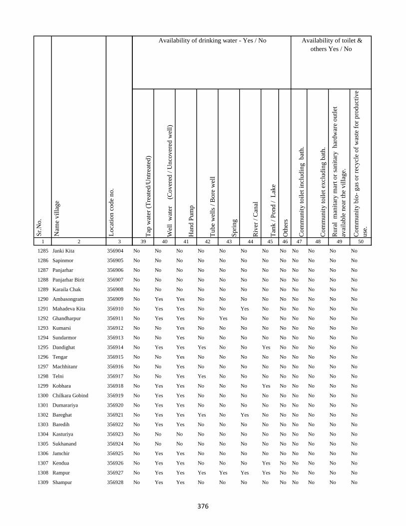
1 2 3
Lo
cati
on
co
de
no
.
Nam
e v
illa
ge
Sr.
No
.
1285 Janki Kita 356904
1286 Sapinmor 356905
1287 Panjarhar 356906
1288 Panjarhar Birit 356907
1289 Karaila Chak 356908
1290 Ambasongram 356909
1291 Mahadeva Kita 356910
1292 Ghandharpur 356911
1293 Kumarsi 356912
1294 Sundarmor 356913
1295 Dandighat 356914
1296 Tengar 356915
1297 Machhitanr 356916
1298 Telni 356917
1299 Kobhara 356918
1300 Chilkara Gobind 356919
1301 Dumarariya 356920
1302 Bareghat 356921
1303 Baredih 356922
1304 Kasturiya 356923
1305 Sukhanand 356924
1306 Jamchir 356925
1307 Kendua 356926
1308 Rampur 356927
1309 Shampur 356928
Tap
wat
er (
Tre
ated
/Un
trea
ted
)
Wel
l w
ater
(Co
ver
ed /
Un
cov
ered
wel
l)
Han
d P
um
p
Tu
be
wel
ls /
Bo
re w
ell
Sp
rin
g
Riv
er /
Can
al
Tan
k /
Po
nd
/
Lak
e
Oth
ers
Co
mm
un
ity
to
ilet
in
clu
din
g
bat
h.
Co
mm
un
ity
to
ilet
ex
clu
din
g b
ath
.
Ru
ral
man
itar
y m
art
or
san
itar
y
har
dw
are
ou
tlet
avai
lab
le n
ear
the
vil
lag
e.
Co
mm
un
ity
bio
- g
as o
r re
cycl
e o
f w
aste
fo
r p
rod
uct
ive
use
.
39 40 41 42 43 44 45 46 47 48 49 50
Availability of toilet &
others Yes / No
Availability of drinking water - Yes / No
No No No No No No No No No No No No
No No No No No No No No No No No No
No No No No No No No No No No No No
No No No No No No No No No No No No
No No No No No No No No No No No No
No Yes Yes No No No No No No No No No
No Yes Yes No No Yes No No No No No No
No Yes Yes No Yes No No No No No No No
No No Yes No No No No No No No No No
No No Yes No No No No No No No No No
No Yes Yes Yes No No Yes No No No No No
No No Yes No No No No No No No No No
No No Yes No No No No No No No No No
No No Yes Yes No No No No No No No No
No Yes Yes No No No Yes No No No No No
No Yes Yes No No No No No No No No No
No Yes Yes No No No No No No No No No
No Yes Yes Yes No Yes No No No No No No
No Yes Yes No No No No No No No No No
No No No No No No No No No No No No
No No No No No No No No No No No No
No Yes Yes No No No No No No No No No
No Yes Yes No No No Yes No No No No No
No Yes Yes Yes Yes Yes Yes No No No No No
No Yes Yes No No No No No No No No No
376
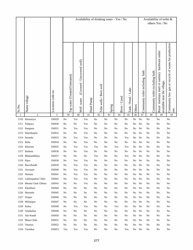
1 2 3
Lo
cati
on
co
de
no
.
Nam
e v
illa
ge
Sr.
No
.
1310 Barmasiya 356929
1311 Palipaya 356930
1312 Bargama 356931
1313 Manoharpur 356932
1314 Saranda 356933
1315 Boha 356934
1316 Khariani 356935
1317 Barhara 356936
1318 Bhalsumbhiya 356937
1319 Pipra 356938
1320 Bara Bandh 356939
1321 Awratanr 356940
1322 Harkata 356941
1323 Lakhanpahari Chhit 356942
1324 Bhanta Chak Chhota 356943
1325 Khairbani 356944
1326 Masnaha 356945
1327 Siripur 356946
1328 Mohanpur 356947
1329 Kolua 356948
1330 Ghatbaliya 356949
1331 Jalo Kundi 356950
1332 Bhata Chak 356951
1333 Tetariya 356952
1334 Taratikar 356953
Tap
wat
er (
Tre
ated
/Un
trea
ted
)
Wel
l w
ater
(Co
ver
ed /
Un
cov
ered
wel
l)
Han
d P
um
p
Tu
be
wel
ls /
Bo
re w
ell
Sp
rin
g
Riv
er /
Can
al
Tan
k /
Po
nd
/
Lak
e
Oth
ers
Co
mm
un
ity
to
ilet
in
clu
din
g
bat
h.
Co
mm
un
ity
to
ilet
ex
clu
din
g b
ath
.
Ru
ral
man
itar
y m
art
or
san
itar
y
har
dw
are
ou
tlet
avai
lab
le n
ear
the
vil
lag
e.
Co
mm
un
ity
bio
- g
as o
r re
cycl
e o
f w
aste
fo
r p
rod
uct
ive
use
.
39 40 41 42 43 44 45 46 47 48 49 50
Availability of toilet &
others Yes / No
Availability of drinking water - Yes / No
No Yes Yes No No No No No No No No No
No No Yes No No No No No No No No No
No Yes Yes No No No No No No No No No
No No Yes No No No No No No No No No
No Yes Yes No No No Yes No No No No No
No No Yes No No No No No No No No No
No Yes Yes Yes No Yes Yes No No No No No
No No Yes No No No No No No No No No
No No No Yes No No Yes No No No No No
No Yes Yes No No No No No No No No No
No Yes Yes No No No No No No No No No
No Yes Yes No No No No No No No No No
No Yes Yes No No No No No No No No No
No Yes Yes No No No No No No No No No
No No Yes No No No No No No No No No
No No No No No No No No No No No No
No No No No No No No No No No No No
No No No No No No No No No No No No
No No No No No No No No No No No No
No Yes Yes No No Yes No No No No No No
No No No No No No No No No No No No
No No No No No No No No No No No No
No No No No No No No No No No No No
No No No No No No No No No No No No
Yes Yes Yes No No No Yes No No No No No
377
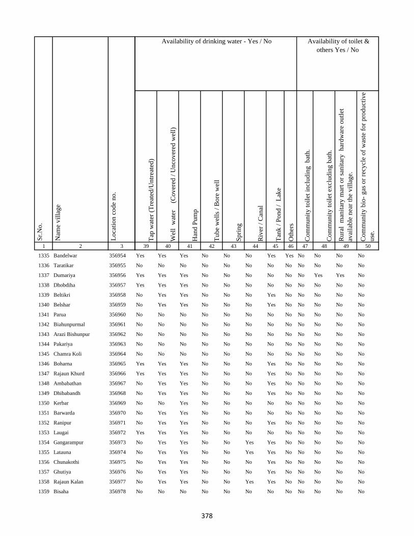
1 2 3
Lo
cati
on
co
de
no
.
Nam
e v
illa
ge
Sr.
No
.
1335 Bandelwar 356954
1336 Taratikar 356955
1337 Dumariya 356956
1338 Dhobdiha 356957
1339 Beltikri 356958
1340 Belshar 356959
1341 Parua 356960
1342 Biahunpurmal 356961
1343 Arazi Bishunpur 356962
1344 Pakariya 356963
1345 Chamra Koli 356964
1346 Boharna 356965
1347 Rajaun Khurd 356966
1348 Ambabathan 356967
1349 Dhibabandh 356968
1350 Kerbar 356969
1351 Barwarda 356970
1352 Ranipur 356971
1353 Laugai 356972
1354 Gangarampur 356973
1355 Latauna 356974
1356 Chunakothi 356975
1357 Ghutiya 356976
1358 Rajaun Kalan 356977
1359 Bisaha 356978
Tap
wat
er (
Tre
ated
/Un
trea
ted
)
Wel
l w
ater
(Co
ver
ed /
Un
cov
ered
wel
l)
Han
d P
um
p
Tu
be
wel
ls /
Bo
re w
ell
Sp
rin
g
Riv
er /
Can
al
Tan
k /
Po
nd
/
Lak
e
Oth
ers
Co
mm
un
ity
to
ilet
in
clu
din
g
bat
h.
Co
mm
un
ity
to
ilet
ex
clu
din
g b
ath
.
Ru
ral
man
itar
y m
art
or
san
itar
y
har
dw
are
ou
tlet
avai
lab
le n
ear
the
vil
lag
e.
Co
mm
un
ity
bio
- g
as o
r re
cycl
e o
f w
aste
fo
r p
rod
uct
ive
use
.
39 40 41 42 43 44 45 46 47 48 49 50
Availability of toilet &
others Yes / No
Availability of drinking water - Yes / No
Yes Yes Yes No No No Yes Yes No No No No
No No No No No No No No No No No No
Yes Yes Yes No No No No No No Yes Yes No
Yes Yes Yes No No No No No No No No No
No Yes Yes No No No Yes No No No No No
No Yes Yes No No No Yes No No No No No
No No No No No No No No No No No No
No No No No No No No No No No No No
No No No No No No No No No No No No
No No No No No No No No No No No No
No No No No No No No No No No No No
Yes Yes Yes No No No Yes No No No No No
Yes Yes Yes No No No Yes No No No No No
No Yes Yes No No No Yes No No No No No
No Yes Yes No No No Yes No No No No No
No No Yes No No No No No No No No No
No Yes Yes No No No No No No No No No
No Yes Yes No No No Yes No No No No No
Yes Yes Yes No No No No No No No No No
No Yes Yes No No Yes Yes No No No No No
No Yes Yes No No Yes Yes No No No No No
No Yes Yes No No No Yes No No No No No
No Yes Yes No No No Yes No No No No No
No Yes Yes No No Yes Yes No No No No No
No No No No No No No No No No No No
378

1 2 3
Lo
cati
on
co
de
no
.
Nam
e v
illa
ge
Sr.
No
.
1360 Charkaghat 356979
1361 Nimbar 356980
1362 Dighi 356981
1363 Korkaghat 356982
1364 Amad Khani 356983
1365 Raksu Kita 356984
1366 Chakwa 356985
1367 Jasmata 356986
1368 Simariya 356987
1369 Sanatan 356988
1370 Kela Kita 356989
1371 Khasdighi 356990
1372 Toiadih 356991
1373 Ramu Chak 356992
1374 Charkaghat 356993
1375 Garka 356994
1376 Bariyata 356995
1377 Charkaghat 356996
1378 Tabhalpur 356997
1379 Gobindpur 356998
1380 Masudanpur 356999
1381 Bedpur 357000
1382 Bhagwan Chak 357001
1383 Rup Chak 357002
1384 Pathar Kani Mal 357003
Tap
wat
er (
Tre
ated
/Un
trea
ted
)
Wel
l w
ater
(Co
ver
ed /
Un
cov
ered
wel
l)
Han
d P
um
p
Tu
be
wel
ls /
Bo
re w
ell
Sp
rin
g
Riv
er /
Can
al
Tan
k /
Po
nd
/
Lak
e
Oth
ers
Co
mm
un
ity
to
ilet
in
clu
din
g
bat
h.
Co
mm
un
ity
to
ilet
ex
clu
din
g b
ath
.
Ru
ral
man
itar
y m
art
or
san
itar
y
har
dw
are
ou
tlet
avai
lab
le n
ear
the
vil
lag
e.
Co
mm
un
ity
bio
- g
as o
r re
cycl
e o
f w
aste
fo
r p
rod
uct
ive
use
.
39 40 41 42 43 44 45 46 47 48 49 50
Availability of toilet &
others Yes / No
Availability of drinking water - Yes / No
No Yes Yes No No No Yes No No No No No
No Yes Yes No No No No No No No No No
No Yes Yes No No Yes Yes No No No No No
No Yes Yes No No Yes No No No No No No
No No No No No No No No No No No No
No No No No No No No No No No No No
No No Yes No No No No No No No No No
No No No No No No No No No No No No
No Yes Yes No No No Yes No No No No No
No No No No No No No No No No No No
No No No No No No No No No No No No
No No No No No No No No No No No No
No No No No No No No No No No No No
No No No No No No No No No No No No
No Yes Yes No No Yes Yes No No No No No
No Yes Yes No No Yes Yes No No No No No
No No No No No No No No No No No No
No No No No No No No No No No No No
No No No No No Yes Yes No No No No No
No No No No No No No No No No No No
No No No No No No No No No No No No
No No No No No No No No No No No No
No Yes Yes No No Yes Yes No No No No No
No Yes Yes No No No Yes No No No No No
No No No No No No No No No No No No
379

1 2 3
Lo
cati
on
co
de
no
.
Nam
e v
illa
ge
Sr.
No
.
1385 Pathar Kani Ghat 357004
1386 Chilra 357005
1387 Chainpur 357006
1388 Ghat Rampur 357007
1389 Mal Rampur 357008
1390 Mal Nistara 357009
1391 Ghat Nistara 357010
1392 Ghat Gasti 357011
1393 Mahuakol 357012
1394 Mahuasol 357013
1395 Sighai Mal 357014
1396 Singhi Ghat 357015
1397 Jogiya 357016
1398 Khaira 357017
1399 Jamjori 357018
1400 Gangtamal Chhit 357019
1401 Jokela 357020
1402 Dhangri Mal 357021
1403 Dhangdri Ghat 357022
1404 Ghangri Mal 357023
1405 Basbhita Ghat 357024
1406 Basbhita Mal 357025
1407 Ranipur Dumariya 357026
1408 Gangta Kalan 357027
1409 Jokela Mal 357028
Tap
wat
er (
Tre
ated
/Un
trea
ted
)
Wel
l w
ater
(Co
ver
ed /
Un
cov
ered
wel
l)
Han
d P
um
p
Tu
be
wel
ls /
Bo
re w
ell
Sp
rin
g
Riv
er /
Can
al
Tan
k /
Po
nd
/
Lak
e
Oth
ers
Co
mm
un
ity
to
ilet
in
clu
din
g
bat
h.
Co
mm
un
ity
to
ilet
ex
clu
din
g b
ath
.
Ru
ral
man
itar
y m
art
or
san
itar
y
har
dw
are
ou
tlet
avai
lab
le n
ear
the
vil
lag
e.
Co
mm
un
ity
bio
- g
as o
r re
cycl
e o
f w
aste
fo
r p
rod
uct
ive
use
.
39 40 41 42 43 44 45 46 47 48 49 50
Availability of toilet &
others Yes / No
Availability of drinking water - Yes / No
No No No No No No No No No No No No
No Yes Yes No No Yes No No No No No No
No Yes Yes No No No No No No No No No
No Yes Yes No No No No No No No No No
No Yes Yes No No No No No No No No No
No No Yes No No No No No No No No No
No No No No No No No No No No No No
No No No No No No No No No No No No
No No No No No No No No No No No No
No Yes Yes No No No Yes No No No No No
No Yes Yes No No No Yes No No No No No
No Yes Yes No No No Yes No No No No No
No Yes Yes No No No Yes No No No No No
No No Yes No No No No No No No No No
No Yes Yes No No No Yes No No No No No
No No No No No No No No No No No No
No Yes Yes No No No Yes No No No No No
No Yes Yes No No No Yes No No No No No
No No No No No No No No No No No No
No No No No No No No No No No No No
No No No No No No No No No No No No
No Yes Yes No No No Yes No No No No No
No No No No No No No No No No No No
No No Yes Yes No No No Yes No No No No
No No No No No No No No No No No No
380

1 2 3
Lo
cati
on
co
de
no
.
Nam
e v
illa
ge
Sr.
No
.
1410 Kerwar Ghat 357029
1411 Gangta Mal Chhit 357030
1412 Lautana 357031
1413 Mahuatanr 357032
1414 Kerwar 357033
1415 Ranipur Dumariya 357034
1416 Badalpur 357035
1417 Tetuliya 357036
1418 Paraspani 357037
1419 Daharlangi 357038
Block T O T A L :
1420 Gorgawan 357039
1421 Koriana 357040
1422 Arazi Koriana 357041
1423 Raha 357042
1424 Bade 357043
1425 Maheshtikri 357044
1426 Arazi Maheshtikri 357045
1427 Majar Khurd 357046
1428 Arazi Majar Buzurg 357047
1429 Manjar Buzurg 357048
1430 Arazi Dhapra 357049
1431 Dhapra Kita 357050
Tap
wat
er (
Tre
ated
/Un
trea
ted
)
Wel
l w
ater
(Co
ver
ed /
Un
cov
ered
wel
l)
Han
d P
um
p
Tu
be
wel
ls /
Bo
re w
ell
Sp
rin
g
Riv
er /
Can
al
Tan
k /
Po
nd
/
Lak
e
Oth
ers
Co
mm
un
ity
to
ilet
in
clu
din
g
bat
h.
Co
mm
un
ity
to
ilet
ex
clu
din
g b
ath
.
Ru
ral
man
itar
y m
art
or
san
itar
y
har
dw
are
ou
tlet
avai
lab
le n
ear
the
vil
lag
e.
Co
mm
un
ity
bio
- g
as o
r re
cycl
e o
f w
aste
fo
r p
rod
uct
ive
use
.
39 40 41 42 43 44 45 46 47 48 49 50
Availability of toilet &
others Yes / No
Availability of drinking water - Yes / No
No No No No No No No No No No No No
Yes Yes Yes No No No Yes No No No No No
No No No No No No No No No No No No
No No No No No No No No No No No No
Yes Yes Yes No No No No No No No No No
No No No No No Yes No No No No No No
No Yes Yes No No No No No No No No No
No Yes Yes No No No No No No No No No
No Yes Yes No No No No No No No No No
No Yes Yes Yes No Yes No No No No No No
14 95 116 11 2 23 48 2 0 1 5 0
No Yes Yes No No No No No No No No No
No No No No No No No No No No No No
No No No No No No No No No No No No
No No Yes No No No No No No No No No
No No Yes No No No No No No No No No
No No No No No No No No No No No No
No No No No No No No No No No No No
No No No No No No No No No No No No
No No No No No No No No No No No No
No No No No No No No No No No No No
No No No No No No No No No No No No
No No No No No No No No No No No No
381
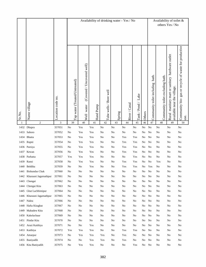
1 2 3
Lo
cati
on
co
de
no
.
Nam
e v
illa
ge
Sr.
No
.
1432 Dhapra 357051
1433 Sahoro 357052
1434 Bhatta 357053
1435 Rupni 357054
1436 Parsiya 357055
1437 Kewan 357056
1438 Parbatta 357057
1439 Ransi 357058
1440 Beldiha 357059
1441 Bishundas Chak 357060
1442 Kharauni Jagarnathpur 357061
1443 Chengai 357062
1444 Chengai Kita 357063
1445 Ghat Lachhimipur 357064
1446 Kharauni Jagarnathpur 357065
1447 Nakta 357066
1448 Hafta Kitaghat 357067
1449 Mahadew Kita 357068
1450 Kakelachaur 357069
1451 Pindar Kita 357070
1452 Arazi Kaithiya 357071
1453 Kaithiya 357072
1454 Amarpur 357073
1455 Baniyadih 357074
1456 Kita Baniyadih 357075
Tap
wat
er (
Tre
ated
/Un
trea
ted
)
Wel
l w
ater
(Co
ver
ed /
Un
cov
ered
wel
l)
Han
d P
um
p
Tu
be
wel
ls /
Bo
re w
ell
Sp
rin
g
Riv
er /
Can
al
Tan
k /
Po
nd
/
Lak
e
Oth
ers
Co
mm
un
ity
to
ilet
in
clu
din
g
bat
h.
Co
mm
un
ity
to
ilet
ex
clu
din
g b
ath
.
Ru
ral
man
itar
y m
art
or
san
itar
y
har
dw
are
ou
tlet
avai
lab
le n
ear
the
vil
lag
e.
Co
mm
un
ity
bio
- g
as o
r re
cycl
e o
f w
aste
fo
r p
rod
uct
ive
use
.
39 40 41 42 43 44 45 46 47 48 49 50
Availability of toilet &
others Yes / No
Availability of drinking water - Yes / No
No Yes Yes No No No No No No No No No
No Yes Yes No No No No No No No No No
No Yes Yes No No Yes Yes No No No No No
No Yes Yes No No Yes Yes No No No No No
No Yes Yes No No Yes Yes No No No No No
No Yes Yes No No Yes Yes No No No No No
Yes Yes Yes No No No Yes No No No No No
No Yes Yes No No Yes Yes No No Yes No No
No No Yes No No Yes Yes No Yes No No No
No No No No No No No No No No No No
No No No No No No No No No No No No
No No No No No No No No No No No No
No No No No No No No No No No No No
No No No No No No No No No No No No
No No No No No No No No No No No No
No No No No No No No No No No No No
No No No No No No No No No No No No
No No No No No No No No No No No No
No No No No No No No No No No No No
No No No No No No No No No No No No
No No Yes No No No No No No No No No
Yes Yes Yes No No Yes Yes No No No No No
No Yes Yes Yes No Yes No No No No No No
No No Yes Yes No Yes No No No No No No
No Yes Yes No No No Yes No No No No No
382

1 2 3
Lo
cati
on
co
de
no
.
Nam
e v
illa
ge
Sr.
No
.
1457 Gouri Kita 357076
1458 Gopi Chak 357077
1459 Piprachaur 357078
1460 Chaurgonar Kita 357079
1461 Shahpur 357080
1462 Sarkunda Kita 357081
1463 Nimuha 357082
1464 Medni Chak 357083
1465 Kadma 357084
1466 Jagatpur 357085
1467 Mansha Bishunpur 357086
1468 Lalman Kita 357087
1469 Kita Kendua 357088
1470 Sankhi 357089
1471 Mokal Chak 357090
1472 Aichamor 357091
1473 Lotha 357092
1474 Jhapaniya 357093
1475 Majra Kol 357094
1476 Bisambhar Chak 357095
1477 Kolhadda 357096
1478 Basantpur 357097
1479 Basan Sarai Gadal 357098
1480 Basantrai 357099
1481 Sankhi Khurd 357100
Tap
wat
er (
Tre
ated
/Un
trea
ted
)
Wel
l w
ater
(Co
ver
ed /
Un
cov
ered
wel
l)
Han
d P
um
p
Tu
be
wel
ls /
Bo
re w
ell
Sp
rin
g
Riv
er /
Can
al
Tan
k /
Po
nd
/
Lak
e
Oth
ers
Co
mm
un
ity
to
ilet
in
clu
din
g
bat
h.
Co
mm
un
ity
to
ilet
ex
clu
din
g b
ath
.
Ru
ral
man
itar
y m
art
or
san
itar
y
har
dw
are
ou
tlet
avai
lab
le n
ear
the
vil
lag
e.
Co
mm
un
ity
bio
- g
as o
r re
cycl
e o
f w
aste
fo
r p
rod
uct
ive
use
.
39 40 41 42 43 44 45 46 47 48 49 50
Availability of toilet &
others Yes / No
Availability of drinking water - Yes / No
No Yes Yes No No Yes Yes No No No No No
No No No No No No No No No No No No
No No No No No No No No No No No No
No No No No No No No No No No No No
No No No No No No No No No No No No
No No No No No No No No No No No No
Yes Yes Yes Yes No Yes Yes Yes No No Yes No
No Yes Yes No No Yes Yes No No No No No
No Yes Yes No No Yes Yes No No No No No
No Yes Yes Yes No No Yes No No No No No
No Yes Yes Yes No No No No No No No No
No No No No No No No No No No No No
No Yes Yes Yes No Yes Yes No No No No No
No Yes Yes No No Yes No No No No No No
No Yes Yes No No Yes No No No No No No
No Yes Yes No No Yes No No No No No No
No Yes Yes No No No No No No No No No
No No No Yes No No No No No No No No
No No No No No No No No No No No No
No Yes Yes No No Yes No No No No No No
No Yes Yes No No Yes No No No No No No
No No Yes No No No No No No No No No
No No Yes No No No No No No No No No
No Yes Yes Yes No No No No No No No No
No No Yes No No Yes No No No No No No
383
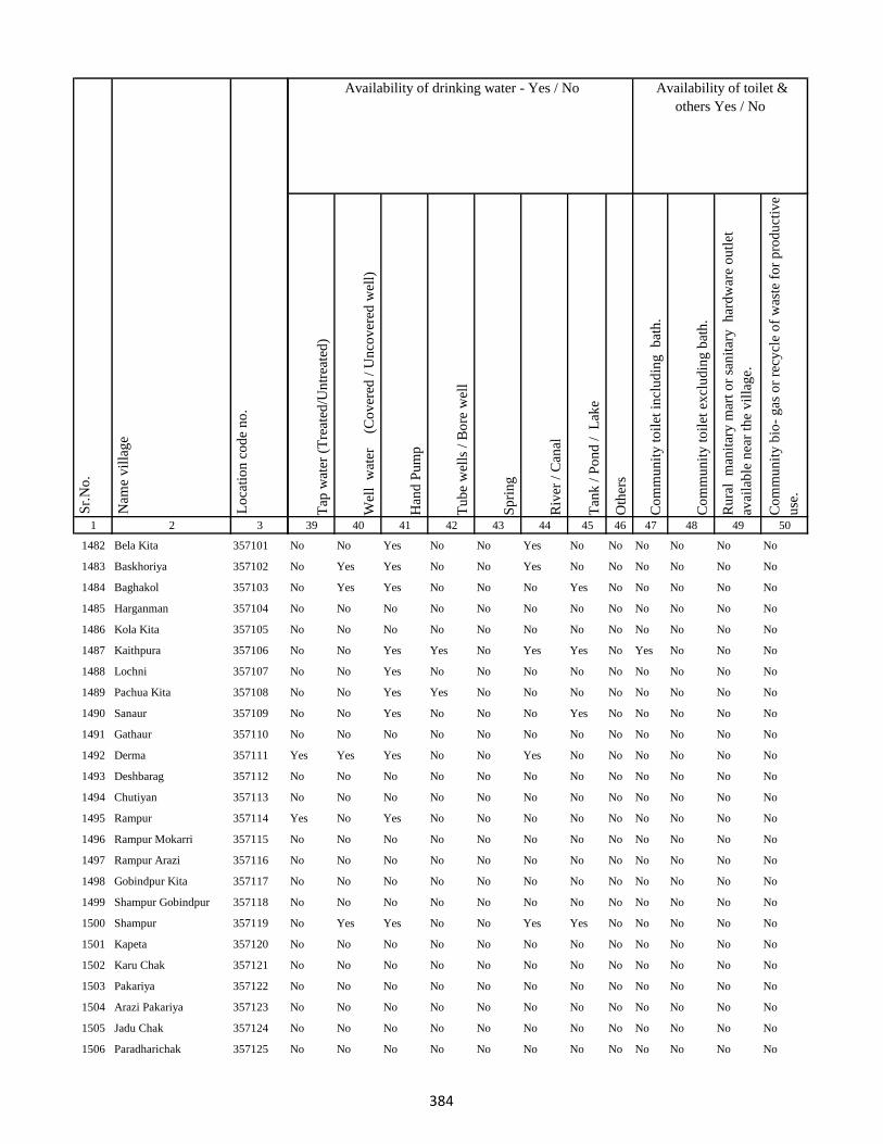
1 2 3
Lo
cati
on
co
de
no
.
Nam
e v
illa
ge
Sr.
No
.
1482 Bela Kita 357101
1483 Baskhoriya 357102
1484 Baghakol 357103
1485 Harganman 357104
1486 Kola Kita 357105
1487 Kaithpura 357106
1488 Lochni 357107
1489 Pachua Kita 357108
1490 Sanaur 357109
1491 Gathaur 357110
1492 Derma 357111
1493 Deshbarag 357112
1494 Chutiyan 357113
1495 Rampur 357114
1496 Rampur Mokarri 357115
1497 Rampur Arazi 357116
1498 Gobindpur Kita 357117
1499 Shampur Gobindpur 357118
1500 Shampur 357119
1501 Kapeta 357120
1502 Karu Chak 357121
1503 Pakariya 357122
1504 Arazi Pakariya 357123
1505 Jadu Chak 357124
1506 Paradharichak 357125
Tap
wat
er (
Tre
ated
/Un
trea
ted
)
Wel
l w
ater
(Co
ver
ed /
Un
cov
ered
wel
l)
Han
d P
um
p
Tu
be
wel
ls /
Bo
re w
ell
Sp
rin
g
Riv
er /
Can
al
Tan
k /
Po
nd
/
Lak
e
Oth
ers
Co
mm
un
ity
to
ilet
in
clu
din
g
bat
h.
Co
mm
un
ity
to
ilet
ex
clu
din
g b
ath
.
Ru
ral
man
itar
y m
art
or
san
itar
y
har
dw
are
ou
tlet
avai
lab
le n
ear
the
vil
lag
e.
Co
mm
un
ity
bio
- g
as o
r re
cycl
e o
f w
aste
fo
r p
rod
uct
ive
use
.
39 40 41 42 43 44 45 46 47 48 49 50
Availability of toilet &
others Yes / No
Availability of drinking water - Yes / No
No No Yes No No Yes No No No No No No
No Yes Yes No No Yes No No No No No No
No Yes Yes No No No Yes No No No No No
No No No No No No No No No No No No
No No No No No No No No No No No No
No No Yes Yes No Yes Yes No Yes No No No
No No Yes No No No No No No No No No
No No Yes Yes No No No No No No No No
No No Yes No No No Yes No No No No No
No No No No No No No No No No No No
Yes Yes Yes No No Yes No No No No No No
No No No No No No No No No No No No
No No No No No No No No No No No No
Yes No Yes No No No No No No No No No
No No No No No No No No No No No No
No No No No No No No No No No No No
No No No No No No No No No No No No
No No No No No No No No No No No No
No Yes Yes No No Yes Yes No No No No No
No No No No No No No No No No No No
No No No No No No No No No No No No
No No No No No No No No No No No No
No No No No No No No No No No No No
No No No No No No No No No No No No
No No No No No No No No No No No No
384
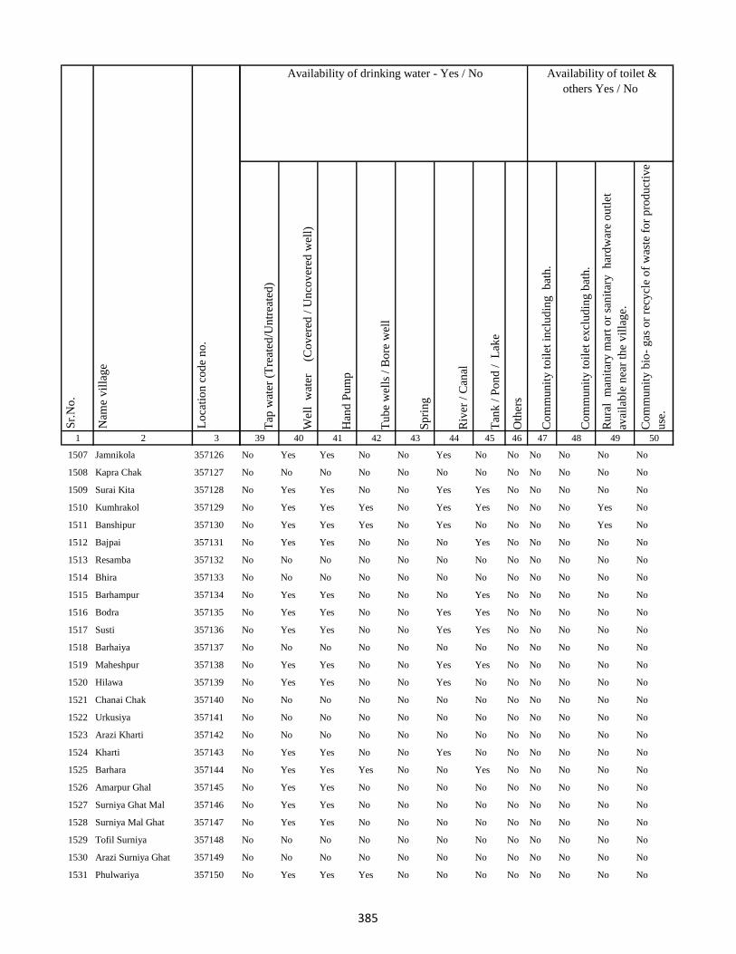
1 2 3
Lo
cati
on
co
de
no
.
Nam
e v
illa
ge
Sr.
No
.
1507 Jamnikola 357126
1508 Kapra Chak 357127
1509 Surai Kita 357128
1510 Kumhrakol 357129
1511 Banshipur 357130
1512 Bajpai 357131
1513 Resamba 357132
1514 Bhira 357133
1515 Barhampur 357134
1516 Bodra 357135
1517 Susti 357136
1518 Barhaiya 357137
1519 Maheshpur 357138
1520 Hilawa 357139
1521 Chanai Chak 357140
1522 Urkusiya 357141
1523 Arazi Kharti 357142
1524 Kharti 357143
1525 Barhara 357144
1526 Amarpur Ghal 357145
1527 Surniya Ghat Mal 357146
1528 Surniya Mal Ghat 357147
1529 Tofil Surniya 357148
1530 Arazi Surniya Ghat 357149
1531 Phulwariya 357150
Tap
wat
er (
Tre
ated
/Un
trea
ted
)
Wel
l w
ater
(Co
ver
ed /
Un
cov
ered
wel
l)
Han
d P
um
p
Tu
be
wel
ls /
Bo
re w
ell
Sp
rin
g
Riv
er /
Can
al
Tan
k /
Po
nd
/
Lak
e
Oth
ers
Co
mm
un
ity
to
ilet
in
clu
din
g
bat
h.
Co
mm
un
ity
to
ilet
ex
clu
din
g b
ath
.
Ru
ral
man
itar
y m
art
or
san
itar
y
har
dw
are
ou
tlet
avai
lab
le n
ear
the
vil
lag
e.
Co
mm
un
ity
bio
- g
as o
r re
cycl
e o
f w
aste
fo
r p
rod
uct
ive
use
.
39 40 41 42 43 44 45 46 47 48 49 50
Availability of toilet &
others Yes / No
Availability of drinking water - Yes / No
No Yes Yes No No Yes No No No No No No
No No No No No No No No No No No No
No Yes Yes No No Yes Yes No No No No No
No Yes Yes Yes No Yes Yes No No No Yes No
No Yes Yes Yes No Yes No No No No Yes No
No Yes Yes No No No Yes No No No No No
No No No No No No No No No No No No
No No No No No No No No No No No No
No Yes Yes No No No Yes No No No No No
No Yes Yes No No Yes Yes No No No No No
No Yes Yes No No Yes Yes No No No No No
No No No No No No No No No No No No
No Yes Yes No No Yes Yes No No No No No
No Yes Yes No No Yes No No No No No No
No No No No No No No No No No No No
No No No No No No No No No No No No
No No No No No No No No No No No No
No Yes Yes No No Yes No No No No No No
No Yes Yes Yes No No Yes No No No No No
No Yes Yes No No No No No No No No No
No Yes Yes No No No No No No No No No
No Yes Yes No No No No No No No No No
No No No No No No No No No No No No
No No No No No No No No No No No No
No Yes Yes Yes No No No No No No No No
385
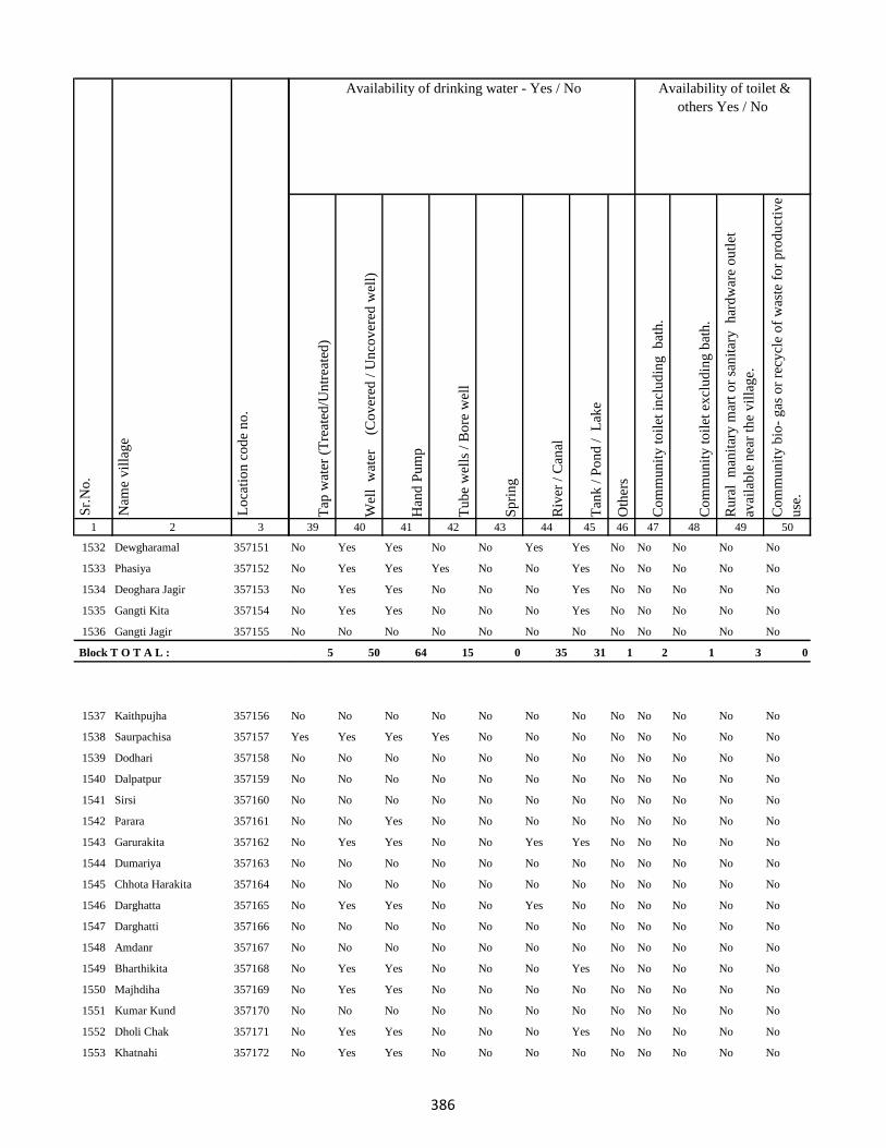
1 2 3
Lo
cati
on
co
de
no
.
Nam
e v
illa
ge
Sr.
No
.
1532 Dewgharamal 357151
1533 Phasiya 357152
1534 Deoghara Jagir 357153
1535 Gangti Kita 357154
1536 Gangti Jagir 357155
Block T O T A L :
1537 Kaithpujha 357156
1538 Saurpachisa 357157
1539 Dodhari 357158
1540 Dalpatpur 357159
1541 Sirsi 357160
1542 Parara 357161
1543 Garurakita 357162
1544 Dumariya 357163
1545 Chhota Harakita 357164
1546 Darghatta 357165
1547 Darghatti 357166
1548 Amdanr 357167
1549 Bharthikita 357168
1550 Majhdiha 357169
1551 Kumar Kund 357170
1552 Dholi Chak 357171
1553 Khatnahi 357172
Tap
wat
er (
Tre
ated
/Un
trea
ted
)
Wel
l w
ater
(Co
ver
ed /
Un
cov
ered
wel
l)
Han
d P
um
p
Tu
be
wel
ls /
Bo
re w
ell
Sp
rin
g
Riv
er /
Can
al
Tan
k /
Po
nd
/
Lak
e
Oth
ers
Co
mm
un
ity
to
ilet
in
clu
din
g
bat
h.
Co
mm
un
ity
to
ilet
ex
clu
din
g b
ath
.
Ru
ral
man
itar
y m
art
or
san
itar
y
har
dw
are
ou
tlet
avai
lab
le n
ear
the
vil
lag
e.
Co
mm
un
ity
bio
- g
as o
r re
cycl
e o
f w
aste
fo
r p
rod
uct
ive
use
.
39 40 41 42 43 44 45 46 47 48 49 50
Availability of toilet &
others Yes / No
Availability of drinking water - Yes / No
No Yes Yes No No Yes Yes No No No No No
No Yes Yes Yes No No Yes No No No No No
No Yes Yes No No No Yes No No No No No
No Yes Yes No No No Yes No No No No No
No No No No No No No No No No No No
5 50 64 15 0 35 31 1 2 1 3 0
No No No No No No No No No No No No
Yes Yes Yes Yes No No No No No No No No
No No No No No No No No No No No No
No No No No No No No No No No No No
No No No No No No No No No No No No
No No Yes No No No No No No No No No
No Yes Yes No No Yes Yes No No No No No
No No No No No No No No No No No No
No No No No No No No No No No No No
No Yes Yes No No Yes No No No No No No
No No No No No No No No No No No No
No No No No No No No No No No No No
No Yes Yes No No No Yes No No No No No
No Yes Yes No No No No No No No No No
No No No No No No No No No No No No
No Yes Yes No No No Yes No No No No No
No Yes Yes No No No No No No No No No
386
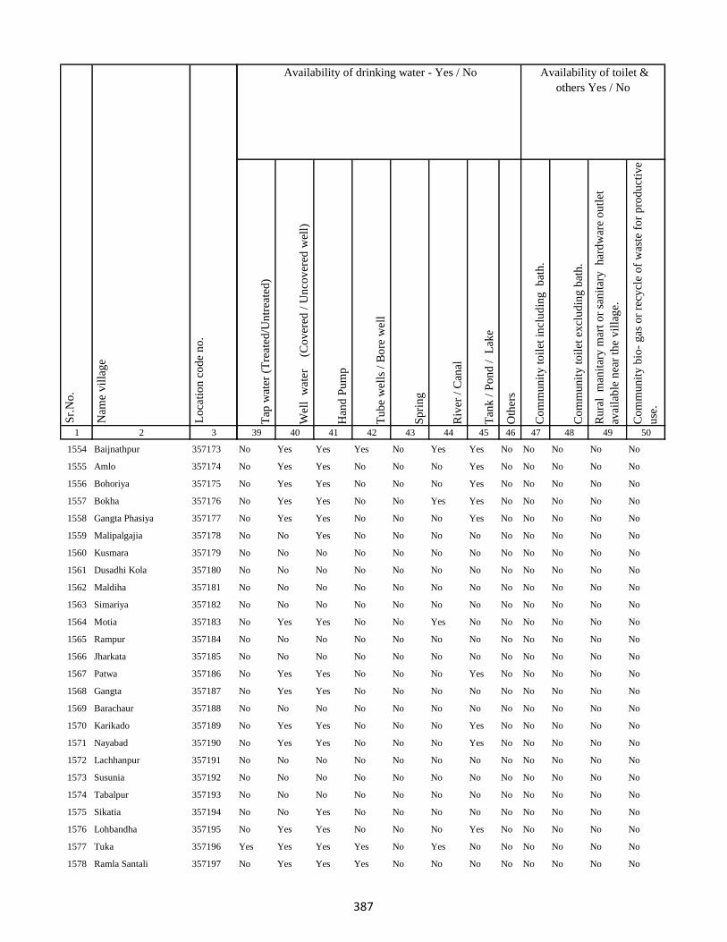
1 2 3
Lo
cati
on
co
de
no
.
Nam
e v
illa
ge
Sr.
No
.
1554 Baijnathpur 357173
1555 Amlo 357174
1556 Bohoriya 357175
1557 Bokha 357176
1558 Gangta Phasiya 357177
1559 Malipalgajia 357178
1560 Kusmara 357179
1561 Dusadhi Kola 357180
1562 Maldiha 357181
1563 Simariya 357182
1564 Motia 357183
1565 Rampur 357184
1566 Jharkata 357185
1567 Patwa 357186
1568 Gangta 357187
1569 Barachaur 357188
1570 Karikado 357189
1571 Nayabad 357190
1572 Lachhanpur 357191
1573 Susunia 357192
1574 Tabalpur 357193
1575 Sikatia 357194
1576 Lohbandha 357195
1577 Tuka 357196
1578 Ramla Santali 357197
Tap
wat
er (
Tre
ated
/Un
trea
ted
)
Wel
l w
ater
(Co
ver
ed /
Un
cov
ered
wel
l)
Han
d P
um
p
Tu
be
wel
ls /
Bo
re w
ell
Sp
rin
g
Riv
er /
Can
al
Tan
k /
Po
nd
/
Lak
e
Oth
ers
Co
mm
un
ity
to
ilet
in
clu
din
g
bat
h.
Co
mm
un
ity
to
ilet
ex
clu
din
g b
ath
.
Ru
ral
man
itar
y m
art
or
san
itar
y
har
dw
are
ou
tlet
avai
lab
le n
ear
the
vil
lag
e.
Co
mm
un
ity
bio
- g
as o
r re
cycl
e o
f w
aste
fo
r p
rod
uct
ive
use
.
39 40 41 42 43 44 45 46 47 48 49 50
Availability of toilet &
others Yes / No
Availability of drinking water - Yes / No
No Yes Yes Yes No Yes Yes No No No No No
No Yes Yes No No No Yes No No No No No
No Yes Yes No No No Yes No No No No No
No Yes Yes No No Yes Yes No No No No No
No Yes Yes No No No Yes No No No No No
No No Yes No No No No No No No No No
No No No No No No No No No No No No
No No No No No No No No No No No No
No No No No No No No No No No No No
No No No No No No No No No No No No
No Yes Yes No No Yes No No No No No No
No No No No No No No No No No No No
No No No No No No No No No No No No
No Yes Yes No No No Yes No No No No No
No Yes Yes No No No No No No No No No
No No No No No No No No No No No No
No Yes Yes No No No Yes No No No No No
No Yes Yes No No No Yes No No No No No
No No No No No No No No No No No No
No No No No No No No No No No No No
No No No No No No No No No No No No
No No Yes No No No No No No No No No
No Yes Yes No No No Yes No No No No No
Yes Yes Yes Yes No Yes No No No No No No
No Yes Yes Yes No No No No No No No No
387

1 2 3
Lo
cati
on
co
de
no
.
Nam
e v
illa
ge
Sr.
No
.
1579 Ramla Dikwani 357198
1580 Nankhil 357199
1581 Devpur 357200
1582 Kumarreri 357201
1583 Saidapur 357202
1584 Algajora 357203
1585 Sinhpur 357204
1586 Parasi 357205
1587 Bhawanipur 357206
1588 Bishunpur 357207
1589 Manpur 357208
1590 Dubrajpur 357209
1591 Gurguri 357210
1592 Reni 357211
1593 Kitabuidi 357212
1594 Kathra 357213
1595 Dokabandh 357214
1596 Makunddih 357215
1597 Makunddin (Santoli) 357216
1598 Pakariya Mal 357217
1599 Pakarya Ghat 357218
1600 Beldiha 357219
1601 Barahara 357220
1602 Harpati Chak 357221
1603 Bansipur 357222
Tap
wat
er (
Tre
ated
/Un
trea
ted
)
Wel
l w
ater
(Co
ver
ed /
Un
cov
ered
wel
l)
Han
d P
um
p
Tu
be
wel
ls /
Bo
re w
ell
Sp
rin
g
Riv
er /
Can
al
Tan
k /
Po
nd
/
Lak
e
Oth
ers
Co
mm
un
ity
to
ilet
in
clu
din
g
bat
h.
Co
mm
un
ity
to
ilet
ex
clu
din
g b
ath
.
Ru
ral
man
itar
y m
art
or
san
itar
y
har
dw
are
ou
tlet
avai
lab
le n
ear
the
vil
lag
e.
Co
mm
un
ity
bio
- g
as o
r re
cycl
e o
f w
aste
fo
r p
rod
uct
ive
use
.
39 40 41 42 43 44 45 46 47 48 49 50
Availability of toilet &
others Yes / No
Availability of drinking water - Yes / No
No Yes Yes Yes No No No No No No No No
No No No No No No No No No No No No
No Yes Yes Yes No No No No No No No No
No Yes Yes No No Yes Yes No No No No No
No No No No No No No No No No No No
No No No No No No No No No No No No
No Yes Yes No No No Yes No No No No No
No No No No No No No No No No No No
No No No No No No No No No No No No
No No No No No No No No No No No No
No Yes Yes No No Yes Yes No No No No No
No Yes Yes No No Yes Yes No No No No No
No Yes Yes Yes No No No No No No No No
No No No No No No No No No No No No
No No No No No No No No No No No No
No Yes Yes No No No Yes No No No No No
No Yes Yes No No No Yes No No No No No
No Yes Yes No No No No No No No No No
No Yes Yes No No No No No No No No No
No Yes Yes No No No No No No No No No
No Yes Yes No No No No No No No No No
No Yes Yes No No No No No No No No No
No No No No No No No No No No No No
No No No No No No No No No No No No
No Yes Yes No No No Yes No No No No No
388

1 2 3
Lo
cati
on
co
de
no
.
Nam
e v
illa
ge
Sr.
No
.
1604 Kurma 357223
1605 Baliya 357224
1606 Molnakita 357225
1607 Patpur 357226
1608 Nilkanthpur 357227
1609 Chapri 357228
1610 Bara 357229
1611 Lacchmipur 357230
1612 Nepura 357231
1613 Kakana 357232
1614 Chandarpur 357233
1615 Parariya 357234
1616 Panch Kathi 357235
1617 Burhi Salempur 357236
1618 Arwara 357237
1619 Basarhi 357238
1620 Malni 357239
1621 Chakwa 357240
1622 Machhiya Samarda Urf Lalpur357241
1623 Diyara 357242
1624 Jaipur 357243
1625 Barhauna 357244
1626 Amdiha 357245
1627 Parsa 357246
1628 Kanhwara 357247
Tap
wat
er (
Tre
ated
/Un
trea
ted
)
Wel
l w
ater
(Co
ver
ed /
Un
cov
ered
wel
l)
Han
d P
um
p
Tu
be
wel
ls /
Bo
re w
ell
Sp
rin
g
Riv
er /
Can
al
Tan
k /
Po
nd
/
Lak
e
Oth
ers
Co
mm
un
ity
to
ilet
in
clu
din
g
bat
h.
Co
mm
un
ity
to
ilet
ex
clu
din
g b
ath
.
Ru
ral
man
itar
y m
art
or
san
itar
y
har
dw
are
ou
tlet
avai
lab
le n
ear
the
vil
lag
e.
Co
mm
un
ity
bio
- g
as o
r re
cycl
e o
f w
aste
fo
r p
rod
uct
ive
use
.
39 40 41 42 43 44 45 46 47 48 49 50
Availability of toilet &
others Yes / No
Availability of drinking water - Yes / No
No Yes Yes No No No Yes No No No No No
No Yes Yes No No No Yes No No No No No
No Yes Yes No No No Yes No No No No No
No Yes Yes No No No Yes No No No No No
No Yes Yes No No No No No No No No No
No Yes Yes No No No No No No No No No
No Yes Yes No No No Yes No No No No No
No Yes Yes No No No Yes No No No No No
No Yes Yes No No No Yes No No No No No
No No No No No No No No No No No No
No No No No No No No No No No No No
No No No No No No No No No No No No
No No No No No No No No No No No No
No No No No No No No No No No No No
No No No No No No No No No No No No
No Yes Yes No No No Yes No No No No No
No Yes Yes No No No Yes No No No No No
No Yes Yes No No No Yes No No No No No
No Yes Yes No No No Yes No No No No No
No Yes Yes No No No Yes No No No No No
No Yes Yes No No Yes Yes No No No No No
No No Yes No No No No No No No No No
No Yes Yes No No No No No No No No No
No Yes Yes No No Yes Yes No No No No No
No Yes Yes No No Yes Yes No No No No No
389

1 2 3
Lo
cati
on
co
de
no
.
Nam
e v
illa
ge
Sr.
No
.
1629 Garbana 357248
1630 Galapahar 357249
1631 Bhadrahi Mal 357250
1632 Ghat Bhadrahi 357251
1633 Chilauna 357252
1634 Rampur 357253
1635 Dumariya Mal 357254
1636 Naya Chak 357255
1637 Dara Chak 357256
1638 Ghat Gorsanda 357257
1639 Mal Gorsanda 357258
1640 Mal Dhamsain 357259
1641 Ghat Dhamsain 357260
1642 Ghat Dhamsain 357261
1643 Khaira Mal 357262
1644 Pachrukhi 357263
1645 Lukluki Mal 357264
1646 Lukluki Ghat 357265
1647 Pathariya Mal 357266
1648 Pathariya Ghat 357267
1649 Pathariya Mal 357268
1650 Chhota Kaliyani 357269
1651 Bara Kaliyani 357270
1652 Pathriya Mal 357271
1653 Sabaijor 357272
Tap
wat
er (
Tre
ated
/Un
trea
ted
)
Wel
l w
ater
(Co
ver
ed /
Un
cov
ered
wel
l)
Han
d P
um
p
Tu
be
wel
ls /
Bo
re w
ell
Sp
rin
g
Riv
er /
Can
al
Tan
k /
Po
nd
/
Lak
e
Oth
ers
Co
mm
un
ity
to
ilet
in
clu
din
g
bat
h.
Co
mm
un
ity
to
ilet
ex
clu
din
g b
ath
.
Ru
ral
man
itar
y m
art
or
san
itar
y
har
dw
are
ou
tlet
avai
lab
le n
ear
the
vil
lag
e.
Co
mm
un
ity
bio
- g
as o
r re
cycl
e o
f w
aste
fo
r p
rod
uct
ive
use
.
39 40 41 42 43 44 45 46 47 48 49 50
Availability of toilet &
others Yes / No
Availability of drinking water - Yes / No
No Yes Yes Yes No No No No No No No No
No Yes Yes Yes No No No No No No No No
No Yes Yes Yes No Yes No No No No No No
No Yes Yes No No Yes No No No No No No
No Yes Yes No No No No No No No No No
No Yes Yes No No No No No No No No No
No Yes Yes No No No No No No No No No
No Yes Yes No No No No No No No No No
No Yes Yes No No No No No No No No No
No No No No No No No No No No No No
No No No No No No No No No No No No
No No No No No No No No No No No No
No No No No No No No No No No No No
No No No No No No No No No No No No
No No No No No No No No No No No No
No No No No No No No No No No No No
No No No No No No No No No No No No
No Yes Yes No No No No No No No No No
No No No No No No No No No No No No
No No No No No No No No No No No No
No No No No No No No No No No No No
Yes Yes Yes Yes No Yes Yes No No No No No
No No Yes No No No No No No No No No
No Yes Yes Yes No No Yes No No No No No
No Yes Yes Yes No No Yes No No No No No
390
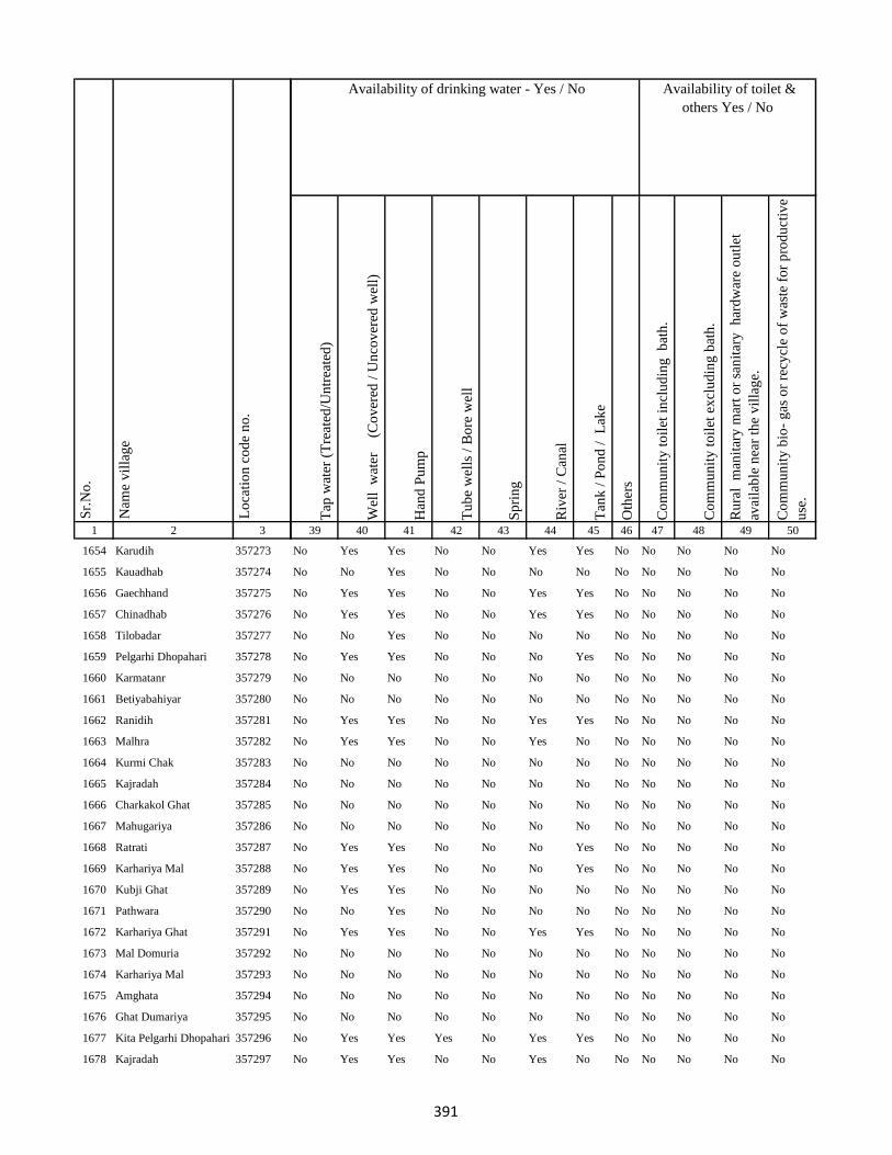
1 2 3
Lo
cati
on
co
de
no
.
Nam
e v
illa
ge
Sr.
No
.
1654 Karudih 357273
1655 Kauadhab 357274
1656 Gaechhand 357275
1657 Chinadhab 357276
1658 Tilobadar 357277
1659 Pelgarhi Dhopahari 357278
1660 Karmatanr 357279
1661 Betiyabahiyar 357280
1662 Ranidih 357281
1663 Malhra 357282
1664 Kurmi Chak 357283
1665 Kajradah 357284
1666 Charkakol Ghat 357285
1667 Mahugariya 357286
1668 Ratrati 357287
1669 Karhariya Mal 357288
1670 Kubji Ghat 357289
1671 Pathwara 357290
1672 Karhariya Ghat 357291
1673 Mal Domuria 357292
1674 Karhariya Mal 357293
1675 Amghata 357294
1676 Ghat Dumariya 357295
1677 Kita Pelgarhi Dhopahari 357296
1678 Kajradah 357297
Tap
wat
er (
Tre
ated
/Un
trea
ted
)
Wel
l w
ater
(Co
ver
ed /
Un
cov
ered
wel
l)
Han
d P
um
p
Tu
be
wel
ls /
Bo
re w
ell
Sp
rin
g
Riv
er /
Can
al
Tan
k /
Po
nd
/
Lak
e
Oth
ers
Co
mm
un
ity
to
ilet
in
clu
din
g
bat
h.
Co
mm
un
ity
to
ilet
ex
clu
din
g b
ath
.
Ru
ral
man
itar
y m
art
or
san
itar
y
har
dw
are
ou
tlet
avai
lab
le n
ear
the
vil
lag
e.
Co
mm
un
ity
bio
- g
as o
r re
cycl
e o
f w
aste
fo
r p
rod
uct
ive
use
.
39 40 41 42 43 44 45 46 47 48 49 50
Availability of toilet &
others Yes / No
Availability of drinking water - Yes / No
No Yes Yes No No Yes Yes No No No No No
No No Yes No No No No No No No No No
No Yes Yes No No Yes Yes No No No No No
No Yes Yes No No Yes Yes No No No No No
No No Yes No No No No No No No No No
No Yes Yes No No No Yes No No No No No
No No No No No No No No No No No No
No No No No No No No No No No No No
No Yes Yes No No Yes Yes No No No No No
No Yes Yes No No Yes No No No No No No
No No No No No No No No No No No No
No No No No No No No No No No No No
No No No No No No No No No No No No
No No No No No No No No No No No No
No Yes Yes No No No Yes No No No No No
No Yes Yes No No No Yes No No No No No
No Yes Yes No No No No No No No No No
No No Yes No No No No No No No No No
No Yes Yes No No Yes Yes No No No No No
No No No No No No No No No No No No
No No No No No No No No No No No No
No No No No No No No No No No No No
No No No No No No No No No No No No
No Yes Yes Yes No Yes Yes No No No No No
No Yes Yes No No Yes No No No No No No
391

1 2 3
Lo
cati
on
co
de
no
.
Nam
e v
illa
ge
Sr.
No
.
1679 Rajpura 357298
1680 Charkakol Ghat 357299
1681 Masudanpur 357300
1682 Kusmainimal 357301
1683 Sasan 357302
1684 Bishunpur 357303
1685 Kutnipathar 357304
1686 Kathaun 357305
1687 Parariya Mal 357306
1688 Kita Parariya Ghat 357307
1689 Kita Gorgawan 357308
1690 Karhariya Ghat 357309
1691 Kusmani Ghat 357310
1692 Ratanpur 357311
1693 Tarwari 357312
1694 Manjwara Ghat 357313
1695 Bishunpur 357314
1696 Kalyani Kita 357315
1697 Ghat Dumariya 357316
1698 Kita Shampur 357317
1699 Kusmain Ghat Chhit 357318
1700 Kita Thathar 357319
1701 Kita Gawar 357320
1702 Kita Gorgawan 357321
1703 Kasba Godda 357322
Tap
wat
er (
Tre
ated
/Un
trea
ted
)
Wel
l w
ater
(Co
ver
ed /
Un
cov
ered
wel
l)
Han
d P
um
p
Tu
be
wel
ls /
Bo
re w
ell
Sp
rin
g
Riv
er /
Can
al
Tan
k /
Po
nd
/
Lak
e
Oth
ers
Co
mm
un
ity
to
ilet
in
clu
din
g
bat
h.
Co
mm
un
ity
to
ilet
ex
clu
din
g b
ath
.
Ru
ral
man
itar
y m
art
or
san
itar
y
har
dw
are
ou
tlet
avai
lab
le n
ear
the
vil
lag
e.
Co
mm
un
ity
bio
- g
as o
r re
cycl
e o
f w
aste
fo
r p
rod
uct
ive
use
.
39 40 41 42 43 44 45 46 47 48 49 50
Availability of toilet &
others Yes / No
Availability of drinking water - Yes / No
No No No No No No No No No No No No
No No No No No No No No No No No No
No No No No No No No No No No No No
No No No No No No No No No No No No
No No No No No No No No No No No No
No No No No No No No No No No No No
No Yes Yes No No No No No No No No No
No Yes Yes No No No No No No No No No
No Yes Yes No No Yes No No No No No No
No No No No No No No No No No No No
No No No No No No No No No No No No
No No No No No No No No No No No No
No Yes Yes No No No No No No No No No
No Yes Yes No No No No No No No No No
No Yes Yes No No Yes No No No No No No
No Yes Yes No No No No No No No No No
No Yes Yes No No No Yes No No No No No
No Yes Yes No No No No No No No No No
No No No No No No No No No No No No
No No No No No No No No No No No No
No No No No No No No No No No No No
No No No No No No No No No No No No
No No No No No No No No No No No No
No No No No No No No No No No No No
No No No No No No No No No No No No
392

1 2 3
Lo
cati
on
co
de
no
.
Nam
e v
illa
ge
Sr.
No
.
1704 Ghat Paharpur 357323
1705 Kutni Pathar 357324
1706 Gorka Kita 357325
1707 Bhandar Koli 357326
1708 Harlal Tola 357327
1709 Haripur 357328
1710 Ghat Paharpur 357329
1711 Kasba Godda 357330
1712 Ghat Paharpur 357331
1713 Mohanpur 357332
1714 Markhan 357333
1715 Daldali 357334
1716 Jamuni Paharpur 357335
1717 Ghat Paharpur 357336
1718 Nonmati 357337
1719 Sarotiya 357338
1720 Bhatdiha 357339
1721 Bengbahiyar 357340
1722 Rupiyamal 357341
1723 Maruabaran 357342
1724 Kauribahiyarmal Chhit 357343
1725 Kauribahiyar Ghat 357344
1726 Kauribahiyar Mal 357345
1727 Pairdih 357346
1728 Kanadih Chhit 357347
Tap
wat
er (
Tre
ated
/Un
trea
ted
)
Wel
l w
ater
(Co
ver
ed /
Un
cov
ered
wel
l)
Han
d P
um
p
Tu
be
wel
ls /
Bo
re w
ell
Sp
rin
g
Riv
er /
Can
al
Tan
k /
Po
nd
/
Lak
e
Oth
ers
Co
mm
un
ity
to
ilet
in
clu
din
g
bat
h.
Co
mm
un
ity
to
ilet
ex
clu
din
g b
ath
.
Ru
ral
man
itar
y m
art
or
san
itar
y
har
dw
are
ou
tlet
avai
lab
le n
ear
the
vil
lag
e.
Co
mm
un
ity
bio
- g
as o
r re
cycl
e o
f w
aste
fo
r p
rod
uct
ive
use
.
39 40 41 42 43 44 45 46 47 48 49 50
Availability of toilet &
others Yes / No
Availability of drinking water - Yes / No
No No No No No No No No No No No No
No No No No No No No No No No No No
No No No No No No No No No No No No
No Yes Yes Yes No Yes No No No No No No
No Yes Yes No No Yes Yes No No No No No
No Yes Yes Yes No No No No No No No No
No Yes Yes Yes No No No No No No No No
No No No No No No No No No No No No
No No No No No No No No No No No No
No Yes Yes No No No No No No No No No
No Yes Yes No No No Yes No No No No No
Yes Yes Yes Yes No Yes Yes No No No No No
No No No No No No No No No No No No
No No No No No No No No No No No No
No Yes Yes No No No No No No No No No
Yes Yes Yes Yes No No Yes No No No No No
No Yes Yes No No No No No No No No No
No Yes Yes No No No No No No No No No
No Yes Yes No No No No No No No No No
No No No No No No No No No No No No
No No No No No No No No No No No No
No Yes Yes No No No No No No No No No
No Yes Yes No No No No No No No No No
No Yes Yes No No No No No No No No No
No No No No No No No No No No No No
393

1 2 3
Lo
cati
on
co
de
no
.
Nam
e v
illa
ge
Sr.
No
.
1729 Gorhighat Chhit 357348
1730 Kanidih Chhit 357349
1731 Jamua 357350
1732 Kurman Ghat 357351
1733 Lamhati Kar 357352
1734 Kurman Mal 357353
1735 Dharmudih 357354
1736 Punsiya 357355
1737 Kumardih 357356
1738 Murlidih Kita 357357
1739 Pandubathan 357358
1740 Sarkanda 357359
1741 Pathra 357360
1742 Bilari 357361
1743 Ghat Jamuni 357362
1744 Pandaha 357363
1745 Ghat Jhilua 357364
1746 Lachhmi 357365
1747 Ghat Jopnadih 357366
1748 Majhdiha 357367
1749 Makhni 357368
1750 Amarpur 357369
1751 Baramasia 357370
1752 Sonjhar 357371
1753 Kadwa 357372
Tap
wat
er (
Tre
ated
/Un
trea
ted
)
Wel
l w
ater
(Co
ver
ed /
Un
cov
ered
wel
l)
Han
d P
um
p
Tu
be
wel
ls /
Bo
re w
ell
Sp
rin
g
Riv
er /
Can
al
Tan
k /
Po
nd
/
Lak
e
Oth
ers
Co
mm
un
ity
to
ilet
in
clu
din
g
bat
h.
Co
mm
un
ity
to
ilet
ex
clu
din
g b
ath
.
Ru
ral
man
itar
y m
art
or
san
itar
y
har
dw
are
ou
tlet
avai
lab
le n
ear
the
vil
lag
e.
Co
mm
un
ity
bio
- g
as o
r re
cycl
e o
f w
aste
fo
r p
rod
uct
ive
use
.
39 40 41 42 43 44 45 46 47 48 49 50
Availability of toilet &
others Yes / No
Availability of drinking water - Yes / No
No No No No No No No No No No No No
No No No No No No No No No No No No
No Yes Yes No No No No No No No No No
No Yes Yes No No No No No No No No No
No Yes Yes No No No Yes No No No No No
No Yes Yes No No No Yes No No No No No
No Yes Yes No No No Yes No No No No No
No Yes Yes No No No Yes No No No No No
No Yes Yes No No No Yes No No No No No
No Yes Yes No No No Yes No No No No No
No Yes Yes No No No Yes No No No No No
No Yes Yes Yes No No Yes No No No No No
No Yes Yes No No Yes No No No No No No
No Yes Yes Yes No Yes Yes No No No No No
Yes Yes Yes Yes No Yes Yes No No No No No
No Yes Yes Yes No Yes Yes No No No No No
No Yes Yes Yes No Yes Yes No No No No No
No Yes Yes No No Yes Yes No No No No No
No Yes Yes No No No No No No No No No
No Yes Yes No No No No No No No No No
No Yes Yes Yes No No Yes No No No No No
No Yes Yes No No Yes Yes No No No No No
No Yes Yes No No Yes Yes No No No No No
No No Yes No No No No No No No No No
No Yes Yes No No Yes Yes No No No No No
394
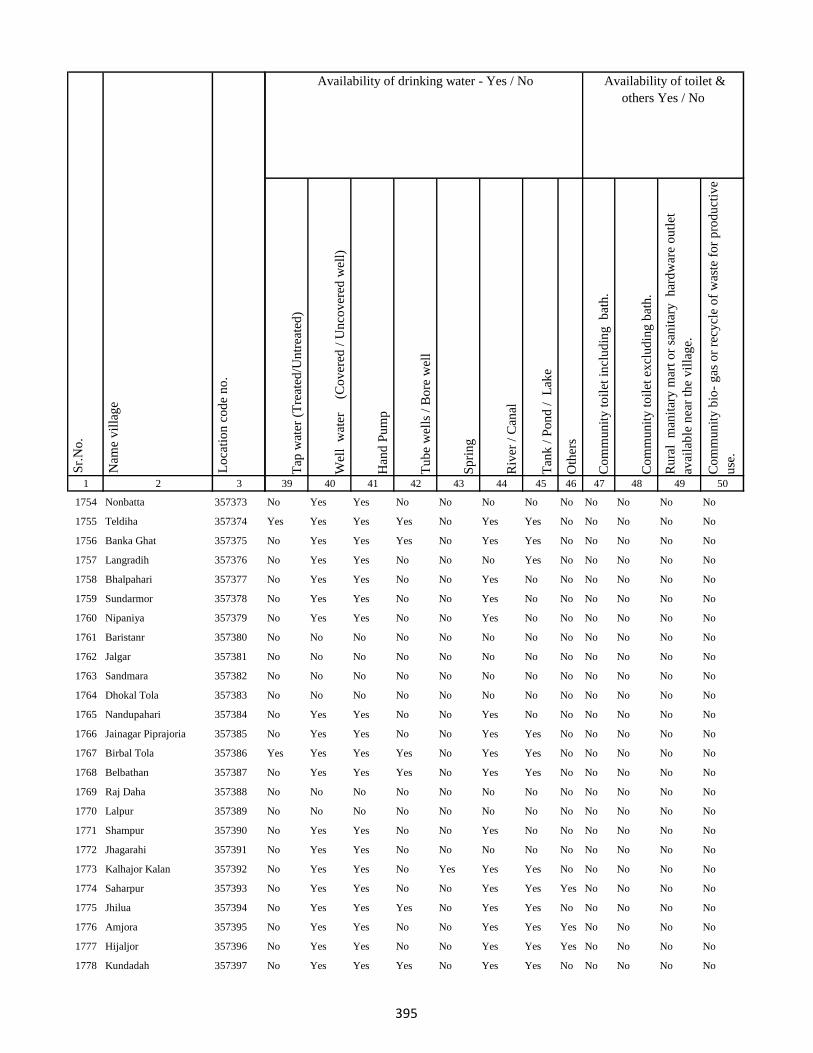
1 2 3
Lo
cati
on
co
de
no
.
Nam
e v
illa
ge
Sr.
No
.
1754 Nonbatta 357373
1755 Teldiha 357374
1756 Banka Ghat 357375
1757 Langradih 357376
1758 Bhalpahari 357377
1759 Sundarmor 357378
1760 Nipaniya 357379
1761 Baristanr 357380
1762 Jalgar 357381
1763 Sandmara 357382
1764 Dhokal Tola 357383
1765 Nandupahari 357384
1766 Jainagar Piprajoria 357385
1767 Birbal Tola 357386
1768 Belbathan 357387
1769 Raj Daha 357388
1770 Lalpur 357389
1771 Shampur 357390
1772 Jhagarahi 357391
1773 Kalhajor Kalan 357392
1774 Saharpur 357393
1775 Jhilua 357394
1776 Amjora 357395
1777 Hijaljor 357396
1778 Kundadah 357397
Tap
wat
er (
Tre
ated
/Un
trea
ted
)
Wel
l w
ater
(Co
ver
ed /
Un
cov
ered
wel
l)
Han
d P
um
p
Tu
be
wel
ls /
Bo
re w
ell
Sp
rin
g
Riv
er /
Can
al
Tan
k /
Po
nd
/
Lak
e
Oth
ers
Co
mm
un
ity
to
ilet
in
clu
din
g
bat
h.
Co
mm
un
ity
to
ilet
ex
clu
din
g b
ath
.
Ru
ral
man
itar
y m
art
or
san
itar
y
har
dw
are
ou
tlet
avai
lab
le n
ear
the
vil
lag
e.
Co
mm
un
ity
bio
- g
as o
r re
cycl
e o
f w
aste
fo
r p
rod
uct
ive
use
.
39 40 41 42 43 44 45 46 47 48 49 50
Availability of toilet &
others Yes / No
Availability of drinking water - Yes / No
No Yes Yes No No No No No No No No No
Yes Yes Yes Yes No Yes Yes No No No No No
No Yes Yes Yes No Yes Yes No No No No No
No Yes Yes No No No Yes No No No No No
No Yes Yes No No Yes No No No No No No
No Yes Yes No No Yes No No No No No No
No Yes Yes No No Yes No No No No No No
No No No No No No No No No No No No
No No No No No No No No No No No No
No No No No No No No No No No No No
No No No No No No No No No No No No
No Yes Yes No No Yes No No No No No No
No Yes Yes No No Yes Yes No No No No No
Yes Yes Yes Yes No Yes Yes No No No No No
No Yes Yes Yes No Yes Yes No No No No No
No No No No No No No No No No No No
No No No No No No No No No No No No
No Yes Yes No No Yes No No No No No No
No Yes Yes No No No No No No No No No
No Yes Yes No Yes Yes Yes No No No No No
No Yes Yes No No Yes Yes Yes No No No No
No Yes Yes Yes No Yes Yes No No No No No
No Yes Yes No No Yes Yes Yes No No No No
No Yes Yes No No Yes Yes Yes No No No No
No Yes Yes Yes No Yes Yes No No No No No
395
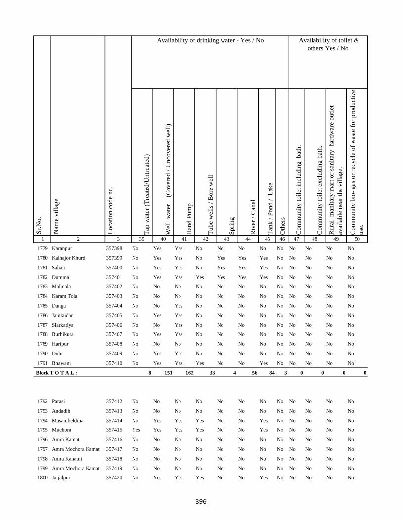
1 2 3
Lo
cati
on
co
de
no
.
Nam
e v
illa
ge
Sr.
No
.
1779 Karanpur 357398
1780 Kalhajor Khurd 357399
1781 Sahari 357400
1782 Dumma 357401
1783 Malmala 357402
1784 Karam Tola 357403
1785 Danga 357404
1786 Jamkudar 357405
1787 Siarkatiya 357406
1788 Burhikura 357407
1789 Haripur 357408
1790 Dulu 357409
1791 Bhawani 357410
Block T O T A L :
1792 Parasi 357412
1793 Andadih 357413
1794 Masanibeldiha 357414
1795 Muchora 357415
1796 Amra Kamat 357416
1797 Amra Mochora Kamat 357417
1798 Amra Kanauli 357418
1799 Amra Mochora Kamat 357419
1800 Jaijalpur 357420
Tap
wat
er (
Tre
ated
/Un
trea
ted
)
Wel
l w
ater
(Co
ver
ed /
Un
cov
ered
wel
l)
Han
d P
um
p
Tu
be
wel
ls /
Bo
re w
ell
Sp
rin
g
Riv
er /
Can
al
Tan
k /
Po
nd
/
Lak
e
Oth
ers
Co
mm
un
ity
to
ilet
in
clu
din
g
bat
h.
Co
mm
un
ity
to
ilet
ex
clu
din
g b
ath
.
Ru
ral
man
itar
y m
art
or
san
itar
y
har
dw
are
ou
tlet
avai
lab
le n
ear
the
vil
lag
e.
Co
mm
un
ity
bio
- g
as o
r re
cycl
e o
f w
aste
fo
r p
rod
uct
ive
use
.
39 40 41 42 43 44 45 46 47 48 49 50
Availability of toilet &
others Yes / No
Availability of drinking water - Yes / No
No Yes Yes No No No No No No No No No
No Yes Yes No Yes Yes Yes No No No No No
No Yes Yes No Yes Yes Yes No No No No No
No Yes Yes Yes Yes Yes Yes No No No No No
No No No No No No No No No No No No
No No No No No No No No No No No No
No No Yes No No No No No No No No No
No Yes Yes No No No No No No No No No
No No Yes No No No No No No No No No
No Yes Yes No No No No No No No No No
No No No No No No No No No No No No
No Yes Yes No No No No No No No No No
No Yes Yes Yes No No Yes No No No No No
8 151 162 33 4 56 84 3 0 0 0 0
No No No No No No No No No No No No
No No No No No No No No No No No No
No Yes Yes Yes No No Yes No No No No No
Yes Yes Yes Yes No No Yes No No No No No
No No No No No No No No No No No No
No No No No No No No No No No No No
No No No No No No No No No No No No
No No No No No No No No No No No No
No Yes Yes Yes No No Yes No No No No No
396

1 2 3
Lo
cati
on
co
de
no
.
Nam
e v
illa
ge
Sr.
No
.
1801 Sondiha 357421
1802 Rengniya 357422
1803 Baliya Kita 357423
1804 Baksara 357424
1805 Chhitni Purniya 357425
1806 Jagarnathpur 357426
1807 Korasi 357427
1808 Dardaha Kita 357428
1809 Ranabandh 357429
1810 Asarimadhuri 357430
1811 Ratanpur 357431
1812 Dindayalpur 357432
1813 Sarwan 357433
1814 Jalgo 357434
1815 Bohra 357435
1816 Petbi 357436
1817 Gaeghat 357437
1818 Mali 357438
1819 Basantpur 357439
1820 Debandha 357440
1821 Guma 357441
1822 Mahra 357442
1823 Behrajor 357443
1824 Manikpur 357444
1825 Birniyan 357445
Tap
wat
er (
Tre
ated
/Un
trea
ted
)
Wel
l w
ater
(Co
ver
ed /
Un
cov
ered
wel
l)
Han
d P
um
p
Tu
be
wel
ls /
Bo
re w
ell
Sp
rin
g
Riv
er /
Can
al
Tan
k /
Po
nd
/
Lak
e
Oth
ers
Co
mm
un
ity
to
ilet
in
clu
din
g
bat
h.
Co
mm
un
ity
to
ilet
ex
clu
din
g b
ath
.
Ru
ral
man
itar
y m
art
or
san
itar
y
har
dw
are
ou
tlet
avai
lab
le n
ear
the
vil
lag
e.
Co
mm
un
ity
bio
- g
as o
r re
cycl
e o
f w
aste
fo
r p
rod
uct
ive
use
.
39 40 41 42 43 44 45 46 47 48 49 50
Availability of toilet &
others Yes / No
Availability of drinking water - Yes / No
No Yes No No No No No No No No No No
No Yes Yes No No No Yes No No No No No
No Yes Yes No No No Yes No No No No No
No No No No No No No No No No No No
No No No No No No No No No No No No
No Yes Yes No No No Yes No No No No No
No No No No No No No No No No No No
No No No No No No No No No No No No
No Yes Yes Yes No Yes Yes No No No No No
No Yes Yes No No No Yes No No No No No
No No No No No No No No No No No No
No No No No No No No No No No No No
No Yes Yes No No No Yes No No No No No
No Yes Yes No No No Yes No No No No No
No Yes Yes No No No Yes No No No No No
No No No No No No No No No No No No
No No No No No No No No No No No No
No Yes Yes No No No Yes No No No No No
No Yes Yes No No Yes Yes No No No No No
No Yes Yes No No No Yes No No No No No
No Yes Yes No No No Yes No No No No No
No No Yes No No Yes Yes No No No No No
No Yes Yes No No Yes Yes No No No No No
No Yes Yes No No Yes Yes No No No No No
No Yes Yes No No No Yes No No No No No
397
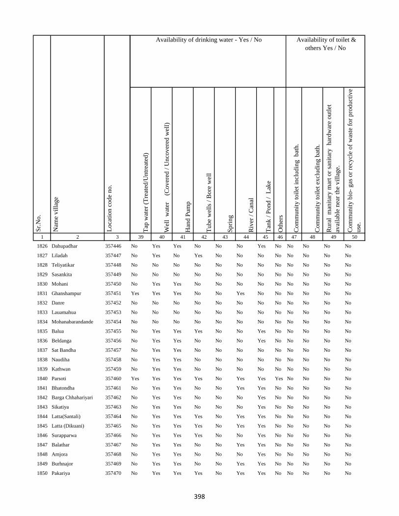
1 2 3
Lo
cati
on
co
de
no
.
Nam
e v
illa
ge
Sr.
No
.
1826 Dahupadhar 357446
1827 Liladah 357447
1828 Teliyatikar 357448
1829 Sasankita 357449
1830 Mohani 357450
1831 Ghanshampur 357451
1832 Danre 357452
1833 Lauamahua 357453
1834 Mohanabarandande 357454
1835 Balua 357455
1836 Beldanga 357456
1837 Sat Bandha 357457
1838 Naudiha 357458
1839 Kathwan 357459
1840 Parsoti 357460
1841 Bhatondha 357461
1842 Barga Chhahariyari 357462
1843 Sikatiya 357463
1844 Latta(Santali) 357464
1845 Latta (Dikuani) 357465
1846 Surapparwa 357466
1847 Balathar 357467
1848 Amjora 357468
1849 Burhnajor 357469
1850 Pakariya 357470
Tap
wat
er (
Tre
ated
/Un
trea
ted
)
Wel
l w
ater
(Co
ver
ed /
Un
cov
ered
wel
l)
Han
d P
um
p
Tu
be
wel
ls /
Bo
re w
ell
Sp
rin
g
Riv
er /
Can
al
Tan
k /
Po
nd
/
Lak
e
Oth
ers
Co
mm
un
ity
to
ilet
in
clu
din
g
bat
h.
Co
mm
un
ity
to
ilet
ex
clu
din
g b
ath
.
Ru
ral
man
itar
y m
art
or
san
itar
y
har
dw
are
ou
tlet
avai
lab
le n
ear
the
vil
lag
e.
Co
mm
un
ity
bio
- g
as o
r re
cycl
e o
f w
aste
fo
r p
rod
uct
ive
use
.
39 40 41 42 43 44 45 46 47 48 49 50
Availability of toilet &
others Yes / No
Availability of drinking water - Yes / No
No Yes Yes No No No Yes No No No No No
No Yes No Yes No No No No No No No No
No No No No No No No No No No No No
No No No No No No No No No No No No
No Yes Yes No No No No No No No No No
Yes Yes Yes No No Yes No No No No No No
No No No No No No No No No No No No
No No No No No No No No No No No No
No No No No No No No No No No No No
No Yes Yes Yes No No Yes No No No No No
No Yes Yes No No No Yes No No No No No
No Yes Yes No No No No No No No No No
No Yes Yes No No No No No No No No No
No Yes Yes No No No No No No No No No
Yes Yes Yes Yes No Yes Yes Yes No No No No
No Yes Yes No No Yes Yes No No No No No
No Yes Yes No No No Yes No No No No No
No Yes Yes No No No Yes No No No No No
No Yes Yes Yes No Yes Yes No No No No No
No Yes Yes Yes No Yes Yes No No No No No
No Yes Yes Yes No No Yes No No No No No
No Yes Yes No No Yes Yes No No No No No
No Yes Yes No No No Yes No No No No No
No Yes Yes No No Yes Yes No No No No No
No Yes Yes Yes No Yes Yes No No No No No
398
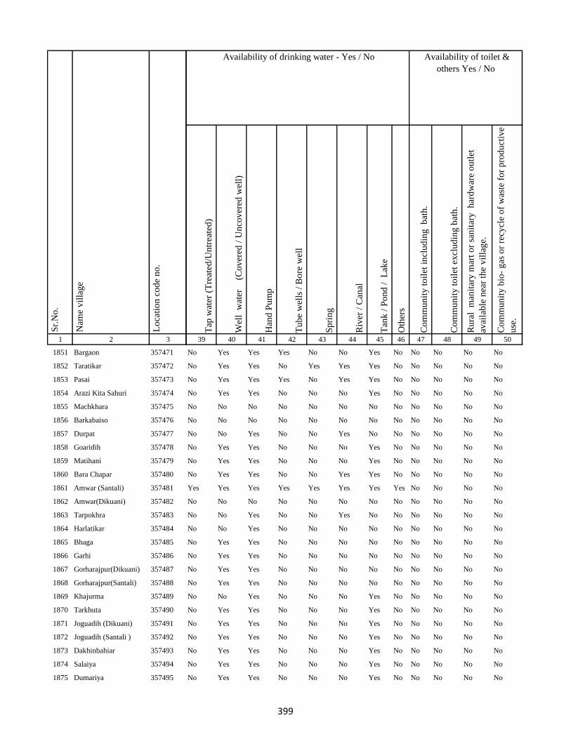
1 2 3
Lo
cati
on
co
de
no
.
Nam
e v
illa
ge
Sr.
No
.
1851 Bargaon 357471
1852 Taratikar 357472
1853 Pasai 357473
1854 Arazi Kita Sahuri 357474
1855 Machkhara 357475
1856 Barkabaiso 357476
1857 Durpat 357477
1858 Goaridih 357478
1859 Matihani 357479
1860 Bara Chapar 357480
1861 Amwar (Santali) 357481
1862 Amwar(Dikuani) 357482
1863 Tarpokhra 357483
1864 Harlatikar 357484
1865 Bhaga 357485
1866 Garhi 357486
1867 Gorharajpur(Dikuani) 357487
1868 Gorharajpur(Santali) 357488
1869 Khajurma 357489
1870 Tarkhuta 357490
1871 Joguadih (Dikuani) 357491
1872 Joguadih (Santali ) 357492
1873 Dakhinbahiar 357493
1874 Salaiya 357494
1875 Dumariya 357495
Tap
wat
er (
Tre
ated
/Un
trea
ted
)
Wel
l w
ater
(Co
ver
ed /
Un
cov
ered
wel
l)
Han
d P
um
p
Tu
be
wel
ls /
Bo
re w
ell
Sp
rin
g
Riv
er /
Can
al
Tan
k /
Po
nd
/
Lak
e
Oth
ers
Co
mm
un
ity
to
ilet
in
clu
din
g
bat
h.
Co
mm
un
ity
to
ilet
ex
clu
din
g b
ath
.
Ru
ral
man
itar
y m
art
or
san
itar
y
har
dw
are
ou
tlet
avai
lab
le n
ear
the
vil
lag
e.
Co
mm
un
ity
bio
- g
as o
r re
cycl
e o
f w
aste
fo
r p
rod
uct
ive
use
.
39 40 41 42 43 44 45 46 47 48 49 50
Availability of toilet &
others Yes / No
Availability of drinking water - Yes / No
No Yes Yes Yes No No Yes No No No No No
No Yes Yes No Yes Yes Yes No No No No No
No Yes Yes Yes No Yes Yes No No No No No
No Yes Yes No No No Yes No No No No No
No No No No No No No No No No No No
No No No No No No No No No No No No
No No Yes No No Yes No No No No No No
No Yes Yes No No No Yes No No No No No
No Yes Yes No No No Yes No No No No No
No Yes Yes No No Yes Yes No No No No No
Yes Yes Yes Yes Yes Yes Yes Yes No No No No
No No No No No No No No No No No No
No No Yes No No Yes No No No No No No
No No Yes No No No No No No No No No
No Yes Yes No No No No No No No No No
No Yes Yes No No No No No No No No No
No Yes Yes No No No No No No No No No
No Yes Yes No No No No No No No No No
No No Yes No No No Yes No No No No No
No Yes Yes No No No Yes No No No No No
No Yes Yes No No No Yes No No No No No
No Yes Yes No No No Yes No No No No No
No Yes Yes No No No Yes No No No No No
No Yes Yes No No No Yes No No No No No
No Yes Yes No No No Yes No No No No No
399

1 2 3
Lo
cati
on
co
de
no
.
Nam
e v
illa
ge
Sr.
No
.
1876 Danidih 357496
1877 Akhra 357497
1878 Sijua 357498
1879 Dhobai 357499
1880 Baghakol 357500
1881 Machanitari 357501
1882 Paharpur 357502
1883 Sajhia 357503
1884 Kamradol 357504
1885 Thakurnahan 357505
1886 Dakhin Tola 357506
1887 Tilatanr 357507
1888 Sikatia 357508
1889 Dhamsur 357509
1890 Chorpahari 357510
1891 Semra Kola 357511
1892 Charkatanr 357512
1893 Charghara 357513
1894 Lorhi Kunda 357514
1895 Dipna Dhibridah 357515
1896 Sundaridol 357516
1897 Salgatanr 357517
1898 Tambajor 357518
1899 Padumpur 357519
1900 Sakri Phulwar 357520
Tap
wat
er (
Tre
ated
/Un
trea
ted
)
Wel
l w
ater
(Co
ver
ed /
Un
cov
ered
wel
l)
Han
d P
um
p
Tu
be
wel
ls /
Bo
re w
ell
Sp
rin
g
Riv
er /
Can
al
Tan
k /
Po
nd
/
Lak
e
Oth
ers
Co
mm
un
ity
to
ilet
in
clu
din
g
bat
h.
Co
mm
un
ity
to
ilet
ex
clu
din
g b
ath
.
Ru
ral
man
itar
y m
art
or
san
itar
y
har
dw
are
ou
tlet
avai
lab
le n
ear
the
vil
lag
e.
Co
mm
un
ity
bio
- g
as o
r re
cycl
e o
f w
aste
fo
r p
rod
uct
ive
use
.
39 40 41 42 43 44 45 46 47 48 49 50
Availability of toilet &
others Yes / No
Availability of drinking water - Yes / No
No Yes Yes No No No Yes No No No No No
No Yes Yes No No No Yes No No No No No
No Yes Yes No No No No No No No No No
Yes Yes Yes No No No No No No No No No
No No No No No No No No No No No No
No No No No No No No No No No No No
No Yes Yes No Yes Yes Yes No No No No No
No Yes Yes No Yes Yes Yes No No No No No
No Yes Yes No Yes Yes Yes No No No No No
No Yes Yes No Yes Yes Yes No No No No No
No Yes Yes No No No Yes No No No No No
No Yes Yes No Yes No Yes No No No No No
No Yes Yes No No Yes Yes No No No No No
No Yes Yes No Yes No Yes No No No No No
No Yes Yes No No Yes Yes No No No No No
No Yes Yes No Yes Yes Yes No No No No No
No Yes Yes No Yes Yes Yes No No No No No
No Yes Yes No No No Yes No No No No No
No Yes Yes No Yes Yes Yes No No No No No
No Yes Yes No Yes Yes Yes No No No No No
Yes Yes Yes No Yes No Yes No No No No No
Yes Yes Yes No No Yes No No No No No No
No Yes Yes No No No No No No No No No
No Yes Yes No No No No No No No No No
Yes No Yes No No Yes Yes No No No No No
400

1 2 3
Lo
cati
on
co
de
no
.
Nam
e v
illa
ge
Sr.
No
.
1901 Kurwa 357521
1902 Kharbari 357522
1903 Chamudih 357523
1904 Maheshkiro Pachimtola 357524
1905 Kasturi 357525
1906 Khairadih 357526
1907 Panch Pahari 357527
1908 Dadughutu Paharpur 357528
1909 Maheshdhasa 357529
1910 Kita Makra 357530
1911 Dorabandh 357531
1912 Pareya Hat 357532
1913 Gunghasa 357533
1914 Rajdaha Bara 357534
1915 Gauripur 357535
1916 Sugathan 357536
1917 Hathihariyari 357537
1918 Dharophata 357538
1919 Lathibari 357539
1920 Jhapnibandh 357540
1921 Dhanu Kata 357541
1922 Raghunathpur 357542
1923 Kundapani 357543
1924 Kanchanrai Tola 357544
1925 Bandhaghat 357545
Tap
wat
er (
Tre
ated
/Un
trea
ted
)
Wel
l w
ater
(Co
ver
ed /
Un
cov
ered
wel
l)
Han
d P
um
p
Tu
be
wel
ls /
Bo
re w
ell
Sp
rin
g
Riv
er /
Can
al
Tan
k /
Po
nd
/
Lak
e
Oth
ers
Co
mm
un
ity
to
ilet
in
clu
din
g
bat
h.
Co
mm
un
ity
to
ilet
ex
clu
din
g b
ath
.
Ru
ral
man
itar
y m
art
or
san
itar
y
har
dw
are
ou
tlet
avai
lab
le n
ear
the
vil
lag
e.
Co
mm
un
ity
bio
- g
as o
r re
cycl
e o
f w
aste
fo
r p
rod
uct
ive
use
.
39 40 41 42 43 44 45 46 47 48 49 50
Availability of toilet &
others Yes / No
Availability of drinking water - Yes / No
No No Yes No No No No No No No No No
Yes Yes Yes No No No No No No No No No
No Yes Yes No No No Yes No No No No No
No Yes Yes No No No Yes No No No No No
No Yes Yes No No No Yes No No No No No
No Yes Yes No No No Yes No No No No No
No Yes Yes No No No Yes No No No No No
No Yes No No No No Yes No No No No No
No Yes No No No No Yes No No No No No
No Yes Yes No No No Yes No No No No No
Yes Yes Yes No No Yes Yes No No No No No
Yes Yes Yes Yes Yes Yes Yes Yes No No No No
No Yes Yes Yes Yes Yes Yes No No No No No
No Yes Yes No No Yes Yes No No No No No
No Yes Yes No No No Yes No No No No No
No Yes Yes Yes No No No Yes No No No No
No Yes Yes No No No Yes No No No No No
No Yes Yes No No No Yes No No No No No
No Yes Yes No No No No No No No No No
No Yes Yes No No No No No No No No No
Yes Yes Yes No No Yes Yes No No No No No
No Yes Yes No No No No No No No No No
No No No No No No No No No No No No
No No No No No No No No No No No No
No No No No No No No No No No No No
401
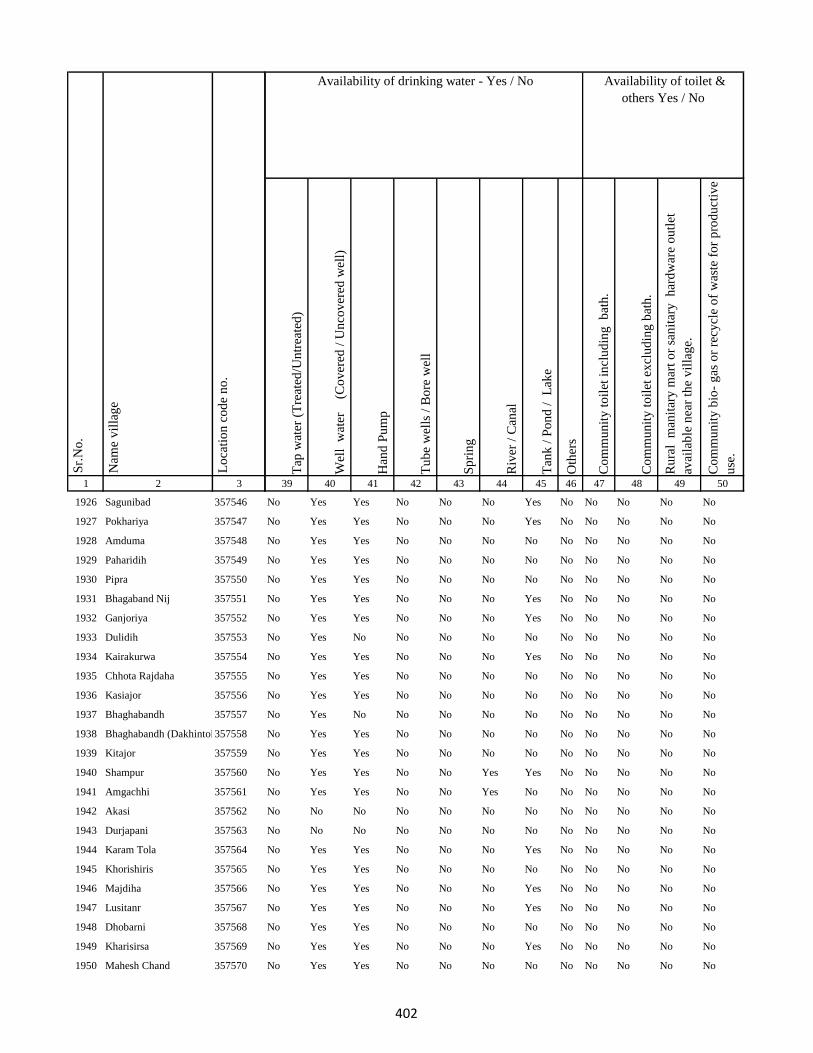
1 2 3
Lo
cati
on
co
de
no
.
Nam
e v
illa
ge
Sr.
No
.
1926 Sagunibad 357546
1927 Pokhariya 357547
1928 Amduma 357548
1929 Paharidih 357549
1930 Pipra 357550
1931 Bhagaband Nij 357551
1932 Ganjoriya 357552
1933 Dulidih 357553
1934 Kairakurwa 357554
1935 Chhota Rajdaha 357555
1936 Kasiajor 357556
1937 Bhaghabandh 357557
1938 Bhaghabandh (Dakhintola)357558
1939 Kitajor 357559
1940 Shampur 357560
1941 Amgachhi 357561
1942 Akasi 357562
1943 Durjapani 357563
1944 Karam Tola 357564
1945 Khorishiris 357565
1946 Majdiha 357566
1947 Lusitanr 357567
1948 Dhobarni 357568
1949 Kharisirsa 357569
1950 Mahesh Chand 357570
Tap
wat
er (
Tre
ated
/Un
trea
ted
)
Wel
l w
ater
(Co
ver
ed /
Un
cov
ered
wel
l)
Han
d P
um
p
Tu
be
wel
ls /
Bo
re w
ell
Sp
rin
g
Riv
er /
Can
al
Tan
k /
Po
nd
/
Lak
e
Oth
ers
Co
mm
un
ity
to
ilet
in
clu
din
g
bat
h.
Co
mm
un
ity
to
ilet
ex
clu
din
g b
ath
.
Ru
ral
man
itar
y m
art
or
san
itar
y
har
dw
are
ou
tlet
avai
lab
le n
ear
the
vil
lag
e.
Co
mm
un
ity
bio
- g
as o
r re
cycl
e o
f w
aste
fo
r p
rod
uct
ive
use
.
39 40 41 42 43 44 45 46 47 48 49 50
Availability of toilet &
others Yes / No
Availability of drinking water - Yes / No
No Yes Yes No No No Yes No No No No No
No Yes Yes No No No Yes No No No No No
No Yes Yes No No No No No No No No No
No Yes Yes No No No No No No No No No
No Yes Yes No No No No No No No No No
No Yes Yes No No No Yes No No No No No
No Yes Yes No No No Yes No No No No No
No Yes No No No No No No No No No No
No Yes Yes No No No Yes No No No No No
No Yes Yes No No No No No No No No No
No Yes Yes No No No No No No No No No
No Yes No No No No No No No No No No
No Yes Yes No No No No No No No No No
No Yes Yes No No No No No No No No No
No Yes Yes No No Yes Yes No No No No No
No Yes Yes No No Yes No No No No No No
No No No No No No No No No No No No
No No No No No No No No No No No No
No Yes Yes No No No Yes No No No No No
No Yes Yes No No No No No No No No No
No Yes Yes No No No Yes No No No No No
No Yes Yes No No No Yes No No No No No
No Yes Yes No No No No No No No No No
No Yes Yes No No No Yes No No No No No
No Yes Yes No No No No No No No No No
402

1 2 3
Lo
cati
on
co
de
no
.
Nam
e v
illa
ge
Sr.
No
.
1951 Pindari 357571
1952 Murgabani 357572
1953 Baramasiya 357573
1954 Kamrabandh 357574
1955 Gopalpur 357575
1956 Simrakita 357576
1957 Chatra 357577
1958 Sat Pahari 357578
1959 Baghmunda 357579
1960 Ghanghra Bandh 357580
1961 Kelabari 357581
1962 Panchratan 357582
1963 Beltopa 357583
1964 Harla 357584
1965 Pitar Pahari 357585
1966 Madhukopi 357586
1967 Bansmuri 357587
1968 Sarbindha 357588
1969 Bansmati 357589
1970 Bara 357590
1971 Jari 357591
1972 Siria 357592
1973 Nawadih 357593
1974 Banjhi 357594
1975 Taljhari 357595
Tap
wat
er (
Tre
ated
/Un
trea
ted
)
Wel
l w
ater
(Co
ver
ed /
Un
cov
ered
wel
l)
Han
d P
um
p
Tu
be
wel
ls /
Bo
re w
ell
Sp
rin
g
Riv
er /
Can
al
Tan
k /
Po
nd
/
Lak
e
Oth
ers
Co
mm
un
ity
to
ilet
in
clu
din
g
bat
h.
Co
mm
un
ity
to
ilet
ex
clu
din
g b
ath
.
Ru
ral
man
itar
y m
art
or
san
itar
y
har
dw
are
ou
tlet
avai
lab
le n
ear
the
vil
lag
e.
Co
mm
un
ity
bio
- g
as o
r re
cycl
e o
f w
aste
fo
r p
rod
uct
ive
use
.
39 40 41 42 43 44 45 46 47 48 49 50
Availability of toilet &
others Yes / No
Availability of drinking water - Yes / No
No Yes Yes No No No Yes No No No No No
No Yes Yes No No No No No No No No No
No Yes Yes No No No No No No No No No
No No No No No No No No No No No No
No Yes No No No Yes Yes No No No No No
No Yes Yes No No No Yes No No No No No
No Yes Yes No No No Yes No No No No No
No Yes Yes No Yes Yes No No No No No No
No Yes Yes Yes No No No No No No No No
No Yes No No No Yes No No No No No No
No Yes Yes No No Yes No No No No No No
No Yes No No No No No No No No No No
No Yes Yes No No No Yes No No No No No
No Yes Yes No No No Yes No No No No No
No Yes Yes No No No Yes No No No No No
No Yes Yes No No No Yes No No No No No
No Yes Yes No No No Yes No No No No No
No Yes Yes No No No Yes No No No No No
No Yes Yes No No No Yes No No No No No
No Yes Yes No No No Yes No No No No No
No Yes Yes No No No Yes No No No No No
No Yes Yes No No No Yes No No No No No
No Yes Yes No No No Yes No No No No No
No Yes Yes No No No Yes No No No No No
No Yes Yes No No No Yes No No No No No
403
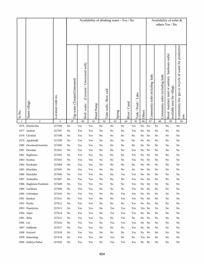
1 2 3
Lo
cati
on
co
de
no
.
Nam
e v
illa
ge
Sr.
No
.
1976 Kharkachia 357596
1977 Jambad 357597
1978 Chorbad 357598
1979 Agiabandh 357599
1980 Dewdanr(Uttartola) 357600
1981 Dewdanr 357601
1982 Baghmara 357602
1983 Kendua 357603
1984 Karikadar 357604
1985 Khardaha 357605
1986 Khardaha 357606
1987 Ambadiha 357607
1988 Baghmara Purabtola 357608
1989 Garhbana 357609
1990 Gobindpur 357610
1991 Bankati 357611
1992 Pindra 357612
1993 Piparjoriya 357613
1994 Jitpur 357614
1995 Boha 357615
1996 Liti 357616
1997 Sidhbank 357617
1998 Kairasol 357618
1999 Daharlangi 357619
2000 Halhiya Pathar 357620
Tap
wat
er (
Tre
ated
/Un
trea
ted
)
Wel
l w
ater
(Co
ver
ed /
Un
cov
ered
wel
l)
Han
d P
um
p
Tu
be
wel
ls /
Bo
re w
ell
Sp
rin
g
Riv
er /
Can
al
Tan
k /
Po
nd
/
Lak
e
Oth
ers
Co
mm
un
ity
to
ilet
in
clu
din
g
bat
h.
Co
mm
un
ity
to
ilet
ex
clu
din
g b
ath
.
Ru
ral
man
itar
y m
art
or
san
itar
y
har
dw
are
ou
tlet
avai
lab
le n
ear
the
vil
lag
e.
Co
mm
un
ity
bio
- g
as o
r re
cycl
e o
f w
aste
fo
r p
rod
uct
ive
use
.
39 40 41 42 43 44 45 46 47 48 49 50
Availability of toilet &
others Yes / No
Availability of drinking water - Yes / No
No Yes Yes No No No Yes No No No No No
No Yes Yes No No No Yes No No No No No
No Yes Yes No No No No No No No No No
No Yes Yes No No No No No No No No No
No Yes Yes No No No No No No No No No
No Yes Yes No No No Yes No No No No No
No Yes Yes No No No Yes No No No No No
No Yes Yes No No No Yes No No No No No
No Yes Yes No No No No No No No No No
No Yes Yes No No No No No No No No No
No Yes Yes No No Yes Yes No No No No No
No Yes Yes No No No Yes No No No No No
No Yes Yes No No No Yes No No No No No
No Yes Yes No No No Yes No No No No No
No Yes Yes No No Yes Yes No No No No No
No Yes Yes No No Yes Yes No No No No No
No Yes Yes No No No Yes No No No No No
No Yes Yes No Yes Yes Yes Yes No No No No
No Yes Yes No Yes Yes Yes No No No No No
No Yes Yes No No Yes No No No No No No
No Yes Yes No Yes Yes Yes No No No No No
No Yes Yes No No No Yes No No No No No
No Yes Yes No No No Yes No No No No No
No Yes Yes No Yes No No Yes No No No No
No Yes Yes No Yes Yes Yes No No No No No
404
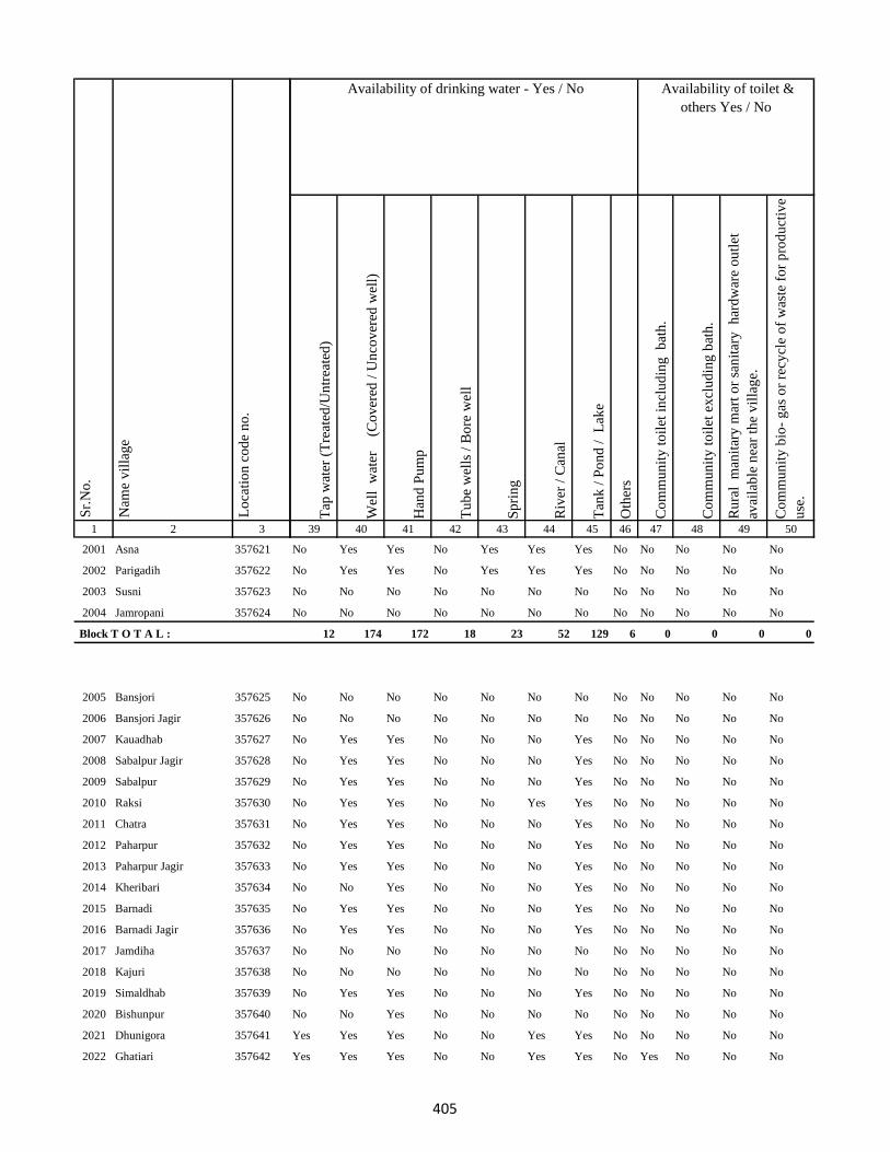
1 2 3
Lo
cati
on
co
de
no
.
Nam
e v
illa
ge
Sr.
No
.
2001 Asna 357621
2002 Parigadih 357622
2003 Susni 357623
2004 Jamropani 357624
Block T O T A L :
2005 Bansjori 357625
2006 Bansjori Jagir 357626
2007 Kauadhab 357627
2008 Sabalpur Jagir 357628
2009 Sabalpur 357629
2010 Raksi 357630
2011 Chatra 357631
2012 Paharpur 357632
2013 Paharpur Jagir 357633
2014 Kheribari 357634
2015 Barnadi 357635
2016 Barnadi Jagir 357636
2017 Jamdiha 357637
2018 Kajuri 357638
2019 Simaldhab 357639
2020 Bishunpur 357640
2021 Dhunigora 357641
2022 Ghatiari 357642
Tap
wat
er (
Tre
ated
/Un
trea
ted
)
Wel
l w
ater
(Co
ver
ed /
Un
cov
ered
wel
l)
Han
d P
um
p
Tu
be
wel
ls /
Bo
re w
ell
Sp
rin
g
Riv
er /
Can
al
Tan
k /
Po
nd
/
Lak
e
Oth
ers
Co
mm
un
ity
to
ilet
in
clu
din
g
bat
h.
Co
mm
un
ity
to
ilet
ex
clu
din
g b
ath
.
Ru
ral
man
itar
y m
art
or
san
itar
y
har
dw
are
ou
tlet
avai
lab
le n
ear
the
vil
lag
e.
Co
mm
un
ity
bio
- g
as o
r re
cycl
e o
f w
aste
fo
r p
rod
uct
ive
use
.
39 40 41 42 43 44 45 46 47 48 49 50
Availability of toilet &
others Yes / No
Availability of drinking water - Yes / No
No Yes Yes No Yes Yes Yes No No No No No
No Yes Yes No Yes Yes Yes No No No No No
No No No No No No No No No No No No
No No No No No No No No No No No No
12 174 172 18 23 52 129 6 0 0 0 0
No No No No No No No No No No No No
No No No No No No No No No No No No
No Yes Yes No No No Yes No No No No No
No Yes Yes No No No Yes No No No No No
No Yes Yes No No No Yes No No No No No
No Yes Yes No No Yes Yes No No No No No
No Yes Yes No No No Yes No No No No No
No Yes Yes No No No Yes No No No No No
No Yes Yes No No No Yes No No No No No
No No Yes No No No Yes No No No No No
No Yes Yes No No No Yes No No No No No
No Yes Yes No No No Yes No No No No No
No No No No No No No No No No No No
No No No No No No No No No No No No
No Yes Yes No No No Yes No No No No No
No No Yes No No No No No No No No No
Yes Yes Yes No No Yes Yes No No No No No
Yes Yes Yes No No Yes Yes No Yes No No No
405
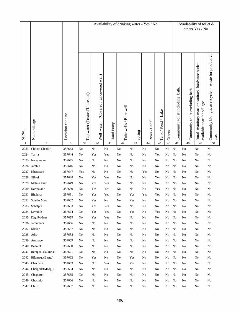
1 2 3
Lo
cati
on
co
de
no
.
Nam
e v
illa
ge
Sr.
No
.
2023 Chhota Ghatiari 357643
2024 Tasria 357644
2025 Narayanpur 357645
2026 Jambia 357646
2027 Kherabani 357647
2028 Jilbari 357648
2029 Mahua Tanr 357649
2030 Karmatanr 357650
2031 Bhaluka 357651
2032 Sundar Maur 357652
2033 Sabalpur 357653
2034 Lawadih 357654
2035 Dighibathan 357655
2036 Jamuntanr 357656
2037 Khelari 357657
2038 Adro 357658
2039 Ammaqo 357659
2040 Bedotok 357660
2041 Berago(Telalkuria) 357661
2042 Bilamaqo(Basgo) 357662
2043 Chacham 357663
2044 Chalgoda(Madgi) 357664
2045 Chaparom 357665
2046 Chuclalo 357666
2047 Churi 357667
Tap
wat
er (
Tre
ated
/Un
trea
ted
)
Wel
l w
ater
(Co
ver
ed /
Un
cov
ered
wel
l)
Han
d P
um
p
Tu
be
wel
ls /
Bo
re w
ell
Sp
rin
g
Riv
er /
Can
al
Tan
k /
Po
nd
/
Lak
e
Oth
ers
Co
mm
un
ity
to
ilet
in
clu
din
g
bat
h.
Co
mm
un
ity
to
ilet
ex
clu
din
g b
ath
.
Ru
ral
man
itar
y m
art
or
san
itar
y
har
dw
are
ou
tlet
avai
lab
le n
ear
the
vil
lag
e.
Co
mm
un
ity
bio
- g
as o
r re
cycl
e o
f w
aste
fo
r p
rod
uct
ive
use
.
39 40 41 42 43 44 45 46 47 48 49 50
Availability of toilet &
others Yes / No
Availability of drinking water - Yes / No
No No No No No No No No No No No No
No Yes Yes No No No Yes No No No No No
No No No No No No No No No No No No
No No No No No No No No No No No No
Yes No No No No Yes No No No No No No
No Yes Yes No No No Yes No No No No No
No Yes Yes No No No No No No No No No
No Yes Yes No No No Yes No No No No No
No Yes Yes No Yes Yes Yes No No No No No
No Yes No No Yes No No No No No No No
No Yes Yes No No No No No No No No No
No Yes Yes No Yes No Yes No No No No No
No Yes Yes No No No No No No No No No
No No No No No No No No No No No No
No No No No No No No No No No No No
No No No No No No No No No No No No
No No No No No No No No No No No No
No No No No No No No No No No No No
No No No No No No No No No No No No
No Yes No No Yes No No No No No No No
No No Yes No Yes No No No No No No No
No No No No No No No No No No No No
No No No No No No No No No No No No
No No No No No No No No No No No No
No No No No No No No No No No No No
406

1 2 3
Lo
cati
on
co
de
no
.
Nam
e v
illa
ge
Sr.
No
.
2048 Donigoda Katan 357668
2049 Dandi Kuriya 357669
2050 Dumer(Palem) 357670
2051 Dumberi(Kajri) 357671
2052 Gamaro 357672
2053 Gamaro(Sonpahar) 357673
2054 Gandarama 357674
2055 Gari Bedo 357675
2056 Goga 357676
2057 Goga 357677
2058 Gosmara 357678
2059 Gosmara 357679
2060 Ilkar Kuriya 357680
2061 Ilkru 357681
2062 Jambu Kuriya 357682
2063 Jambu Kuriya 357683
2064 Jamri 357684
2065 Jirko 357685
2066 Jito Kundi(Dumerkuriya)357686
2067 Kagra 357687
2068 Kalare(Kamugoda) 357688
2069 Kamugoda 357689
2070 Kasripara (Moglan) 357690
2071 Kepam 357691
2072 Kerkuriya 357692
Tap
wat
er (
Tre
ated
/Un
trea
ted
)
Wel
l w
ater
(Co
ver
ed /
Un
cov
ered
wel
l)
Han
d P
um
p
Tu
be
wel
ls /
Bo
re w
ell
Sp
rin
g
Riv
er /
Can
al
Tan
k /
Po
nd
/
Lak
e
Oth
ers
Co
mm
un
ity
to
ilet
in
clu
din
g
bat
h.
Co
mm
un
ity
to
ilet
ex
clu
din
g b
ath
.
Ru
ral
man
itar
y m
art
or
san
itar
y
har
dw
are
ou
tlet
avai
lab
le n
ear
the
vil
lag
e.
Co
mm
un
ity
bio
- g
as o
r re
cycl
e o
f w
aste
fo
r p
rod
uct
ive
use
.
39 40 41 42 43 44 45 46 47 48 49 50
Availability of toilet &
others Yes / No
Availability of drinking water - Yes / No
No No No No No No No No No No No No
No Yes No No No No No No No No No No
No No No No Yes No No No No No No No
No No No No No No No No No No No No
No No No No No No No No No No No No
Yes No No No Yes No No No No No No No
No Yes No No Yes No No No No No No No
No Yes No No Yes No No No No No No No
No Yes No No Yes No Yes No No No No No
No No No No No No No No No No No No
No No No No No No No No No No No No
No No No No No No No No No No No No
No No No No No No No No No No No No
No No No No No No No No No No No No
No No No No No No No No No No No No
No No No No No No No No No No No No
No No No No No No No No No No No No
No No No No No No No No No No No No
No No No No No No No No No No No No
No No No No No No No No No No No No
No No No No No No No No No No No No
No No No No No No No No No No No No
No No No No No No No No No No No No
No No No No No No No No No No No No
No Yes No No Yes No No No No No No No
407

1 2 3
Lo
cati
on
co
de
no
.
Nam
e v
illa
ge
Sr.
No
.
2073 Kerjuria 357693
2074 Kiro 357694
2075 Liladoni 357695
2076 Madgam 357696
2077 Maridoni 357697
2078 Mate 357698
2079 Pakeritok 357699
2080 Palem(Dumar) 357700
2081 Pawkuriya 357701
2082 Perdarda (Ambar) 357702
2083 Pokeri 357703
2084 Popkundo 357704
2085 Pusur Kuriya 357705
2086 Pusur Kuriya 357706
2087 Tamli Bedo 357707
2088 Tamligoda (Chaparbita) 357708
2089 Tatkota 357709
2090 Telo 357710
2091 Telodoni 357711
2092 Tetli (Telal Kuriya) 357712
2093 Sena(Katan) 357713
2094 Suju 357714
2095 Tetaria 357715
2096 Domdih 357716
2097 Kusumghati 357717
Tap
wat
er (
Tre
ated
/Un
trea
ted
)
Wel
l w
ater
(Co
ver
ed /
Un
cov
ered
wel
l)
Han
d P
um
p
Tu
be
wel
ls /
Bo
re w
ell
Sp
rin
g
Riv
er /
Can
al
Tan
k /
Po
nd
/
Lak
e
Oth
ers
Co
mm
un
ity
to
ilet
in
clu
din
g
bat
h.
Co
mm
un
ity
to
ilet
ex
clu
din
g b
ath
.
Ru
ral
man
itar
y m
art
or
san
itar
y
har
dw
are
ou
tlet
avai
lab
le n
ear
the
vil
lag
e.
Co
mm
un
ity
bio
- g
as o
r re
cycl
e o
f w
aste
fo
r p
rod
uct
ive
use
.
39 40 41 42 43 44 45 46 47 48 49 50
Availability of toilet &
others Yes / No
Availability of drinking water - Yes / No
No No No No No No No No No No No No
No No No No No No No No No No No No
No No No No No No No No No No No No
No No No No No No No No No No No No
No No No No No No No No No No No No
No No No No No No No No No No No No
No No No No No No No No No No No No
No No No No No No No No No No No No
No No No No No No No No No No No No
No No No No No No No No No No No No
No No No No No No No No No No No No
No No No No No No No No No No No No
No Yes Yes No Yes No Yes No No No No No
No No No No No No No No No No No No
No Yes No No Yes No No No No No No No
No No No No No No No No No No No No
No No No No No No No No No No No No
No Yes Yes No No No No No No No No No
No No No No No No No No No No No No
No No No No No No No No No No No No
No No No No No No No No No No No No
No No No No No No No No No No No No
No No Yes No No No No No No No No No
No No Yes No No No No No No No No No
No No Yes No No No No No No No No No
408
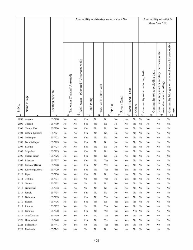
1 2 3
Lo
cati
on
co
de
no
.
Nam
e v
illa
ge
Sr.
No
.
2098 Amjora 357718
2099 Tilabad 357719
2100 Tesuba Than 357720
2101 Chhota Kalhajor 357721
2102 Mohanpur 357722
2103 Bara Kalhajor 357723
2104 Salodih 357724
2105 Salpathra 357725
2106 Sundar Pahari 357726
2107 Paharpur 357727
2108 Kairojori(Bara) 357728
2109 Kairojori(Chhota) 357729
2110 Jitpur 357730
2111 Telbhita 357731
2112 Gamaro 357732
2113 Gamarbera 357733
2114 Jamalo 357734
2115 Dahubera 357735
2116 Jiyajori 357736
2117 Rampur 357737
2118 Barajolo 357738
2119 Manikbathan 357739
2120 Dhaupahari 357740
2121 Ladapathar 357741
2122 Phulbaria 357742
Tap
wat
er (
Tre
ated
/Un
trea
ted
)
Wel
l w
ater
(Co
ver
ed /
Un
cov
ered
wel
l)
Han
d P
um
p
Tu
be
wel
ls /
Bo
re w
ell
Sp
rin
g
Riv
er /
Can
al
Tan
k /
Po
nd
/
Lak
e
Oth
ers
Co
mm
un
ity
to
ilet
in
clu
din
g
bat
h.
Co
mm
un
ity
to
ilet
ex
clu
din
g b
ath
.
Ru
ral
man
itar
y m
art
or
san
itar
y
har
dw
are
ou
tlet
avai
lab
le n
ear
the
vil
lag
e.
Co
mm
un
ity
bio
- g
as o
r re
cycl
e o
f w
aste
fo
r p
rod
uct
ive
use
.
39 40 41 42 43 44 45 46 47 48 49 50
Availability of toilet &
others Yes / No
Availability of drinking water - Yes / No
No Yes Yes No No No No No No No No No
No No Yes No No No No No No No No No
No No Yes No No No No No No No No No
No No Yes No No No No No No No No No
No No Yes No No No No No No No No No
No No Yes No No No No No No No No No
No No Yes No No No No No No No No No
No No Yes No No No No No No No No No
No Yes Yes No No No No No No No No No
No Yes Yes No Yes No Yes No No No No No
No Yes Yes No Yes No Yes No No No No No
No Yes Yes No Yes Yes Yes No No No No No
No Yes Yes No No Yes No No No No No No
No Yes No No Yes No Yes No No No No No
No No No No No No No No No No No No
No No No No No No No No No No No No
No No Yes No No No No No No No No No
No Yes Yes No Yes Yes Yes No No No No No
No Yes Yes No No Yes Yes No No No No No
No Yes No No Yes No Yes No No No No No
No Yes Yes No Yes Yes Yes Yes No No No No
No Yes Yes No Yes Yes Yes No No No No No
No Yes Yes No Yes Yes Yes No No No No No
No Yes No No Yes Yes Yes No No No No No
No No No No No No No No No No No No
409
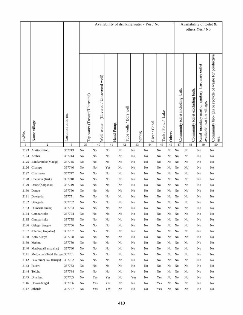
1 2 3
Lo
cati
on
co
de
no
.
Nam
e v
illa
ge
Sr.
No
.
2123 Alkito(Katon) 357743
2124 Ambar 357744
2125 Bandaretoke(Madgi) 357745
2126 Champa 357746
2127 Charmaka 357747
2128 Chetamu (Jirik) 357748
2129 Dande(Salpahar) 357749
2130 Dando 357750
2131 Dawgoda 357751
2132 Dawgoda 357752
2133 Dumeri(Dumar) 357753
2134 Gambaritoke 357754
2135 Gambaritoke 357755
2136 Gelago(Basgo) 357756
2137 Jolame(Daupahar) 357757
2138 Kero Kuriya 357758
2139 Makma 357759
2140 Masbera (Banspahar) 357760
2141 Melijamali(Tetal Kuriya) 357761
2142 Pakeramo(Tok Kuriya) 357762
2143 Pakeri 357763
2144 Telbita 357764
2145 Dhankuti 357765
2146 Dhawadangal 357766
2147 Jabarda 357767
Tap
wat
er (
Tre
ated
/Un
trea
ted
)
Wel
l w
ater
(Co
ver
ed /
Un
cov
ered
wel
l)
Han
d P
um
p
Tu
be
wel
ls /
Bo
re w
ell
Sp
rin
g
Riv
er /
Can
al
Tan
k /
Po
nd
/
Lak
e
Oth
ers
Co
mm
un
ity
to
ilet
in
clu
din
g
bat
h.
Co
mm
un
ity
to
ilet
ex
clu
din
g b
ath
.
Ru
ral
man
itar
y m
art
or
san
itar
y
har
dw
are
ou
tlet
avai
lab
le n
ear
the
vil
lag
e.
Co
mm
un
ity
bio
- g
as o
r re
cycl
e o
f w
aste
fo
r p
rod
uct
ive
use
.
39 40 41 42 43 44 45 46 47 48 49 50
Availability of toilet &
others Yes / No
Availability of drinking water - Yes / No
No No No No No No No No No No No No
No No No No No No No No No No No No
No No No No No No No No No No No No
No No Yes No No No No No No No No No
No No No No No No No No No No No No
No No No No No No No No No No No No
No No No No No No No No No No No No
No No No No No No No No No No No No
No No No No No No No No No No No No
No No No No No No No No No No No No
No No No No No No No No No No No No
No No No No No No No No No No No No
No No No No No No No No No No No No
No No No No No No No No No No No No
No No No No No No No No No No No No
No No No No No No No No No No No No
No No No No No No No No No No No No
No No No No No No No No No No No No
No No No No No No No No No No No No
No No No No No No No No No No No No
No No No No No No No No No No No No
No No No No No No No No No No No No
No Yes Yes No Yes No Yes No No No No No
No Yes Yes No No No Yes No No No No No
No Yes Yes No No No Yes No No No No No
410

1 2 3
Lo
cati
on
co
de
no
.
Nam
e v
illa
ge
Sr.
No
.
2148 Bara Puro 357768
2149 Chhota Dhamni 357769
2150 Dhamni Bazar 357770
2151 Bara Dhamni 357771
2152 Chhota Puro 357772
2153 Gadidih 357773
2154 Piparjoria 357774
2155 Marchaitari 357775
2156 Pokharia 357776
2157 Kairasul 357777
2158 Ambardoni 357778
2159 Bat 357779
2160 Bitakepu 357780
2161 Daukuriya 357781
2162 Donigoda 357782
2163 Jari Mamqo 357783
2164 Kadu 357784
2165 Karag 357785
2166 Kiro 357786
2167 Koa 357787
2168 Kubji Bedo 357788
2169 Kubji Maqo 357789
2170 Kudi Goda 357790
2171 Madgi 357791
2172 Madgi Bedo 357792
Tap
wat
er (
Tre
ated
/Un
trea
ted
)
Wel
l w
ater
(Co
ver
ed /
Un
cov
ered
wel
l)
Han
d P
um
p
Tu
be
wel
ls /
Bo
re w
ell
Sp
rin
g
Riv
er /
Can
al
Tan
k /
Po
nd
/
Lak
e
Oth
ers
Co
mm
un
ity
to
ilet
in
clu
din
g
bat
h.
Co
mm
un
ity
to
ilet
ex
clu
din
g b
ath
.
Ru
ral
man
itar
y m
art
or
san
itar
y
har
dw
are
ou
tlet
avai
lab
le n
ear
the
vil
lag
e.
Co
mm
un
ity
bio
- g
as o
r re
cycl
e o
f w
aste
fo
r p
rod
uct
ive
use
.
39 40 41 42 43 44 45 46 47 48 49 50
Availability of toilet &
others Yes / No
Availability of drinking water - Yes / No
No Yes Yes No No Yes Yes No No No No No
No Yes Yes No No No No No No No No No
No Yes Yes No No Yes Yes No No No No No
No Yes Yes No No No No No No No No No
No Yes Yes No Yes No No No No No No No
No Yes Yes No No No Yes No No No No No
No Yes Yes No No Yes Yes No No No No No
No Yes Yes No No Yes No No No No No No
No Yes Yes No No Yes No No No No No No
No No No No No No No No No No No No
No No No No No No No No No No No No
No No No No Yes No Yes Yes No No No No
No No No No No No No No No No No No
No No No No No No No No No No No No
No No No No No No Yes No No No No No
No No Yes No No No No No No No No No
No No No No Yes No No No No No No No
No No No No No No No No No No No No
No No No No No No No No No No No No
No Yes No No Yes No Yes No No No No No
No No No No Yes Yes No No No No No No
No No No No No No No No No No No No
No No No No No No No No No No No No
No No No Yes Yes Yes No No No No No No
No No Yes No Yes No No No No No No No
411
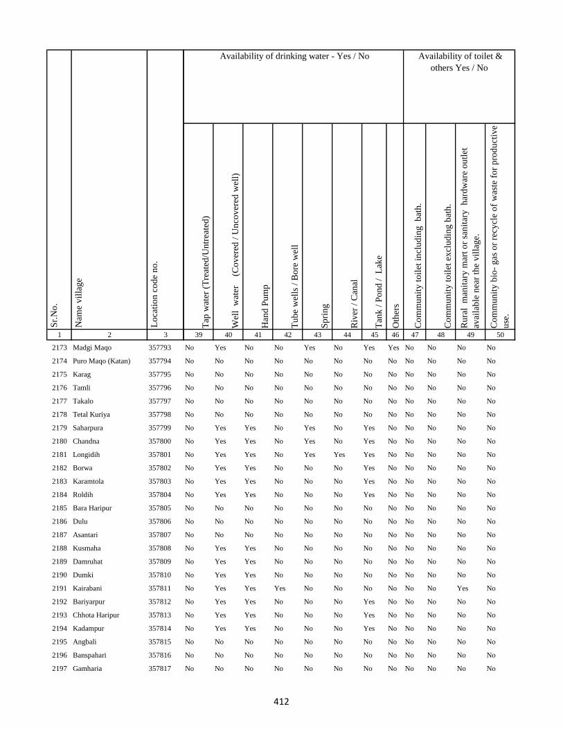
1 2 3
Lo
cati
on
co
de
no
.
Nam
e v
illa
ge
Sr.
No
.
2173 Madgi Maqo 357793
2174 Puro Maqo (Katan) 357794
2175 Karag 357795
2176 Tamli 357796
2177 Takalo 357797
2178 Tetal Kuriya 357798
2179 Saharpura 357799
2180 Chandna 357800
2181 Longidih 357801
2182 Borwa 357802
2183 Karamtola 357803
2184 Roldih 357804
2185 Bara Haripur 357805
2186 Dulu 357806
2187 Asantari 357807
2188 Kusmaha 357808
2189 Damruhat 357809
2190 Dumki 357810
2191 Kairabani 357811
2192 Bariyarpur 357812
2193 Chhota Haripur 357813
2194 Kadampur 357814
2195 Angbali 357815
2196 Banspahari 357816
2197 Gamharia 357817
Tap
wat
er (
Tre
ated
/Un
trea
ted
)
Wel
l w
ater
(Co
ver
ed /
Un
cov
ered
wel
l)
Han
d P
um
p
Tu
be
wel
ls /
Bo
re w
ell
Sp
rin
g
Riv
er /
Can
al
Tan
k /
Po
nd
/
Lak
e
Oth
ers
Co
mm
un
ity
to
ilet
in
clu
din
g
bat
h.
Co
mm
un
ity
to
ilet
ex
clu
din
g b
ath
.
Ru
ral
man
itar
y m
art
or
san
itar
y
har
dw
are
ou
tlet
avai
lab
le n
ear
the
vil
lag
e.
Co
mm
un
ity
bio
- g
as o
r re
cycl
e o
f w
aste
fo
r p
rod
uct
ive
use
.
39 40 41 42 43 44 45 46 47 48 49 50
Availability of toilet &
others Yes / No
Availability of drinking water - Yes / No
No Yes No No Yes No Yes Yes No No No No
No No No No No No No No No No No No
No No No No No No No No No No No No
No No No No No No No No No No No No
No No No No No No No No No No No No
No No No No No No No No No No No No
No Yes Yes No Yes No Yes No No No No No
No Yes Yes No Yes No Yes No No No No No
No Yes Yes No Yes Yes Yes No No No No No
No Yes Yes No No No Yes No No No No No
No Yes Yes No No No Yes No No No No No
No Yes Yes No No No Yes No No No No No
No No No No No No No No No No No No
No No No No No No No No No No No No
No No No No No No No No No No No No
No Yes Yes No No No No No No No No No
No Yes Yes No No No No No No No No No
No Yes Yes No No No No No No No No No
No Yes Yes Yes No No No No No No Yes No
No Yes Yes No No No Yes No No No No No
No Yes Yes No No No Yes No No No No No
No Yes Yes No No No Yes No No No No No
No No No No No No No No No No No No
No No No No No No No No No No No No
No No No No No No No No No No No No
412

1 2 3
Lo
cati
on
co
de
no
.
Nam
e v
illa
ge
Sr.
No
.
2198 Paharpur 357818
2199 Tetariya 357819
2200 Khepadih 357820
2201 Chandraydih 357821
2202 Gardi 357822
2203 Ghaghri 357823
2204 Malikundi 357824
2205 Bara Sinddri 357825
2206 Sagar 357826
2207 Monadih 357827
2208 Ghorabali 357828
2209 Chhota Sindari 357829
2210 Tilaipara 357830
2211 Sahapi 357831
2212 Madni 357832
2213 Ratnapara 357833
2214 Dumartari 357834
2215 Bara Sabai Kundi 357835
2216 Chhota Sabai Kundi 357836
2217 Rajabhita 357837
2218 Chhota Adro 357838
2219 Manspara 357839
2220 Kesam 357840
2221 Keropara 357841
2222 Chamer 357842
Tap
wat
er (
Tre
ated
/Un
trea
ted
)
Wel
l w
ater
(Co
ver
ed /
Un
cov
ered
wel
l)
Han
d P
um
p
Tu
be
wel
ls /
Bo
re w
ell
Sp
rin
g
Riv
er /
Can
al
Tan
k /
Po
nd
/
Lak
e
Oth
ers
Co
mm
un
ity
to
ilet
in
clu
din
g
bat
h.
Co
mm
un
ity
to
ilet
ex
clu
din
g b
ath
.
Ru
ral
man
itar
y m
art
or
san
itar
y
har
dw
are
ou
tlet
avai
lab
le n
ear
the
vil
lag
e.
Co
mm
un
ity
bio
- g
as o
r re
cycl
e o
f w
aste
fo
r p
rod
uct
ive
use
.
39 40 41 42 43 44 45 46 47 48 49 50
Availability of toilet &
others Yes / No
Availability of drinking water - Yes / No
No Yes No Yes No No No No No No Yes No
No Yes Yes Yes No No No No No No Yes No
No Yes Yes Yes No No No No No No Yes No
No Yes Yes No No No No No No No No No
No No Yes No No No No No No No No No
Yes Yes Yes No No No No No No No No No
No Yes Yes No Yes Yes No No No No No No
No Yes Yes No No No Yes No No No No No
No Yes Yes No No No Yes No No No No No
No Yes Yes No No No Yes No No No No No
No Yes Yes No No No Yes No No No No No
No No Yes No Yes Yes Yes No No No No No
No Yes No No Yes No Yes No No No No No
No Yes No No Yes No Yes No No No No No
No No Yes No Yes Yes No No No No No No
No Yes No No Yes No Yes No No No No No
No Yes No No Yes No No No No No No No
No No No No No No No No No No No No
No No Yes No Yes No No No No No No No
No No No No No No No No No No No No
No No Yes No Yes No No No No No No No
No Yes No No Yes No Yes No No No No No
No No No No No No No No No No No No
No No No No No No No No No No No No
No No Yes No Yes No No No No No No No
413

1 2 3
Lo
cati
on
co
de
no
.
Nam
e v
illa
ge
Sr.
No
.
2223 Mando Pahari 357843
2224 Chhatmi 357844
2225 Bara Paktari 357845
2226 Chhota Palma 357846
2227 Gargawan 357847
2228 Bara Palma 357848
2229 Chhota Paktari 357849
2230 Rakha 357850
2231 Adro 357851
2232 Balami 357852
2233 Chamdade 357853
2234 Chamar Bedo 357854
2235 Charchari 357855
2236 Chewo (Tetria) 357856
2237 Dando 357857
2238 Dumli 357858
2239 Gandiyamo 357859
2240 Garsingla 357860
2241 Garsingla (Malikundi) 357861
2242 Goga 357862
2243 Jolo (Berago) 357863
2244 Karamtok 357864
2245 Karmu 357865
2246 Keropara 357866
2247 Kirokuriya 357867
Tap
wat
er (
Tre
ated
/Un
trea
ted
)
Wel
l w
ater
(Co
ver
ed /
Un
cov
ered
wel
l)
Han
d P
um
p
Tu
be
wel
ls /
Bo
re w
ell
Sp
rin
g
Riv
er /
Can
al
Tan
k /
Po
nd
/
Lak
e
Oth
ers
Co
mm
un
ity
to
ilet
in
clu
din
g
bat
h.
Co
mm
un
ity
to
ilet
ex
clu
din
g b
ath
.
Ru
ral
man
itar
y m
art
or
san
itar
y
har
dw
are
ou
tlet
avai
lab
le n
ear
the
vil
lag
e.
Co
mm
un
ity
bio
- g
as o
r re
cycl
e o
f w
aste
fo
r p
rod
uct
ive
use
.
39 40 41 42 43 44 45 46 47 48 49 50
Availability of toilet &
others Yes / No
Availability of drinking water - Yes / No
No No Yes No Yes No No No No No No No
No No Yes No Yes No No No No No No No
No No Yes No Yes No No No No No No No
No No Yes No Yes No No No No No No No
No No Yes No Yes No No No No No No No
No No Yes No Yes No No No No No No No
No No Yes No No No Yes No No No No No
No Yes Yes No Yes No No No No No No No
No No Yes No Yes No No No No No No No
No No Yes No Yes No No No No No No No
No No Yes No Yes No No No No No No No
No No Yes No Yes No No No No No No No
No No Yes No Yes No No No No No No No
No No No No Yes No No No No No No No
No Yes Yes No No No No No No No No No
No No No No No No No No No No No No
No No No No No No No No No No No No
No No Yes No No No No No No No No No
No No No No No No No No No No No No
No No No No No No No No No No No No
No No No No No No No No No No No No
No No No No No No No No No No No No
No No No No No No No No No No No No
No No No No No No No No No No No No
No No No No No No No No No No No No
414

1 2 3
Lo
cati
on
co
de
no
.
Nam
e v
illa
ge
Sr.
No
.
2248 Kasari(Gutipara) 357868
2249 Kote 357869
2250 Maspara 357870
2251 Nadgoda 357871
2252 Pertara 357872
2253 Sabekundi 357873
2254 Salgama 357874
2255 Sarmi 357875
2256 Sidler 357876
2257 Singni 357877
2258 Tarobar 357878
2259 Tasgemthu 357879
2260 Talakpara(Pusurkuriya) 357880
2261 Talbita(Mudgi) 357881
2262 Tatgoda 357882
2263 Telo 357883
2264 Barmasia 357884
2265 Bokrabandh 357885
2266 Hardisol 357886
2267 Tilaipara 357887
2268 Barai 357888
2269 Bara Dangapara 357889
2270 Damakol 357890
2271 Karamba 357891
2272 Chhota Dangapara 357892
Tap
wat
er (
Tre
ated
/Un
trea
ted
)
Wel
l w
ater
(Co
ver
ed /
Un
cov
ered
wel
l)
Han
d P
um
p
Tu
be
wel
ls /
Bo
re w
ell
Sp
rin
g
Riv
er /
Can
al
Tan
k /
Po
nd
/
Lak
e
Oth
ers
Co
mm
un
ity
to
ilet
in
clu
din
g
bat
h.
Co
mm
un
ity
to
ilet
ex
clu
din
g b
ath
.
Ru
ral
man
itar
y m
art
or
san
itar
y
har
dw
are
ou
tlet
avai
lab
le n
ear
the
vil
lag
e.
Co
mm
un
ity
bio
- g
as o
r re
cycl
e o
f w
aste
fo
r p
rod
uct
ive
use
.
39 40 41 42 43 44 45 46 47 48 49 50
Availability of toilet &
others Yes / No
Availability of drinking water - Yes / No
No No No No No No No No No No No No
No No No No No No No No No No No No
No No Yes No Yes No No No No No No No
No Yes No No Yes No No No No No No No
No No No No No No No No No No No No
No Yes Yes No No No No No No No No No
No Yes No No Yes No No No No No No No
No Yes No No Yes No No No No No No No
No No No No No No No No No No No No
No No No No No No No No No No No No
No No No No No No No No No No No No
No Yes Yes No No No No No No No No No
No Yes No No No No No No No No No No
No No No No No No No No No No No No
No No No No No No No No No No No No
No No Yes No No No No No No No No No
No No Yes No Yes No No No No No No No
No No Yes No Yes No No No No No No No
No No Yes No No No No No No No No No
No No Yes No Yes No No No No No No No
No No Yes No Yes Yes No No No No No No
No No Yes No Yes No No No No No No No
No Yes Yes No Yes No No No No No No No
No Yes Yes No Yes No No No No No No No
No No No No Yes No No No No No No No
415

1 2 3
Lo
cati
on
co
de
no
.
Nam
e v
illa
ge
Sr.
No
.
2273 Mulgipur 357893
2274 Dumarpalampara 357894
2275 Simlipara 357895
2276 Bajrajogusami 357896
2277 Pipra 357897
2278 Kamupahari 357898
2279 Jagusama 357899
2280 Sundri Jola 357900
2281 Belpahari 357901
2282 Jogimarna 357902
2283 Bankati 357903
2284 Paharpur 357904
2285 Susni 357905
2286 Jamropani 357906
2287 Baigani 357907
2288 Babupur 357908
2289 Bargo 357909
2290 Parariya 357910
2291 Goradih 357911
2292 Patomdih 357912
2293 Malipara 357913
2294 Sidapara 357914
2295 Asripara 357915
2296 Dalkundi 357916
2297 Parkani 357917
Tap
wat
er (
Tre
ated
/Un
trea
ted
)
Wel
l w
ater
(Co
ver
ed /
Un
cov
ered
wel
l)
Han
d P
um
p
Tu
be
wel
ls /
Bo
re w
ell
Sp
rin
g
Riv
er /
Can
al
Tan
k /
Po
nd
/
Lak
e
Oth
ers
Co
mm
un
ity
to
ilet
in
clu
din
g
bat
h.
Co
mm
un
ity
to
ilet
ex
clu
din
g b
ath
.
Ru
ral
man
itar
y m
art
or
san
itar
y
har
dw
are
ou
tlet
avai
lab
le n
ear
the
vil
lag
e.
Co
mm
un
ity
bio
- g
as o
r re
cycl
e o
f w
aste
fo
r p
rod
uct
ive
use
.
39 40 41 42 43 44 45 46 47 48 49 50
Availability of toilet &
others Yes / No
Availability of drinking water - Yes / No
No No No No No No No No No No No No
No No Yes No Yes No No No No No No No
No No Yes No No No No No No No No No
No Yes Yes No No No No No No No No No
No Yes Yes No No No No No No No Yes No
No No No No No No No No No No No No
No Yes Yes No No No No No No No Yes No
No Yes Yes No No No No No No No No No
No Yes Yes No No No No No No No Yes No
No Yes Yes No No No No No No No Yes No
No Yes Yes Yes Yes Yes Yes No No No No No
No Yes Yes No No No No No No No Yes No
No Yes Yes No No No No No No No Yes No
No Yes Yes No No No No No No No Yes No
No No Yes No No No No No No No Yes No
No Yes No No No No No No No No No No
No Yes Yes No No No No No No No No No
No Yes Yes No No No No No No No No No
No No Yes No No No No No No No No No
No No Yes No No No No No No No No No
No Yes No Yes Yes No No No No No No No
No No Yes No No No No No No No No No
No No Yes No No No No No No No No No
No No Yes No No No No No No No No No
No Yes Yes No No No No No No No No No
416
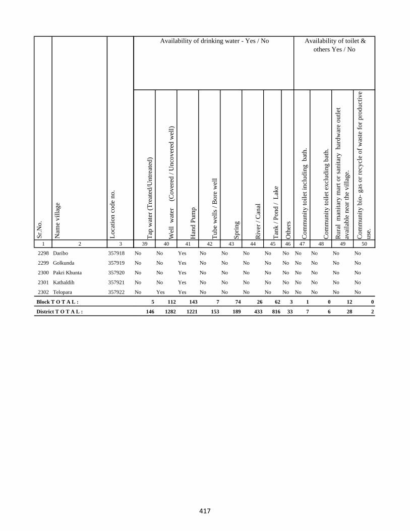
1 2 3
Lo
cati
on
co
de
no
.
Nam
e v
illa
ge
Sr.
No
.
2298 Daribo 357918
2299 Golkunda 357919
2300 Pakri Khunta 357920
2301 Kathaldih 357921
2302 Telopara 357922
Block T O T A L :
District T O T A L :
Tap
wat
er (
Tre
ated
/Un
trea
ted
)
Wel
l w
ater
(Co
ver
ed /
Un
cov
ered
wel
l)
Han
d P
um
p
Tu
be
wel
ls /
Bo
re w
ell
Sp
rin
g
Riv
er /
Can
al
Tan
k /
Po
nd
/
Lak
e
Oth
ers
Co
mm
un
ity
to
ilet
in
clu
din
g
bat
h.
Co
mm
un
ity
to
ilet
ex
clu
din
g b
ath
.
Ru
ral
man
itar
y m
art
or
san
itar
y
har
dw
are
ou
tlet
avai
lab
le n
ear
the
vil
lag
e.
Co
mm
un
ity
bio
- g
as o
r re
cycl
e o
f w
aste
fo
r p
rod
uct
ive
use
.
39 40 41 42 43 44 45 46 47 48 49 50
Availability of toilet &
others Yes / No
Availability of drinking water - Yes / No
No No Yes No No No No No No No No No
No No Yes No No No No No No No No No
No No Yes No No No No No No No No No
No No Yes No No No No No No No No No
No Yes Yes No No No No No No No No No
5 112 143 7 74 26 62 3 1 0 12 0
146 1282 1221 153 189 433 816 33 7 6 28 2
417
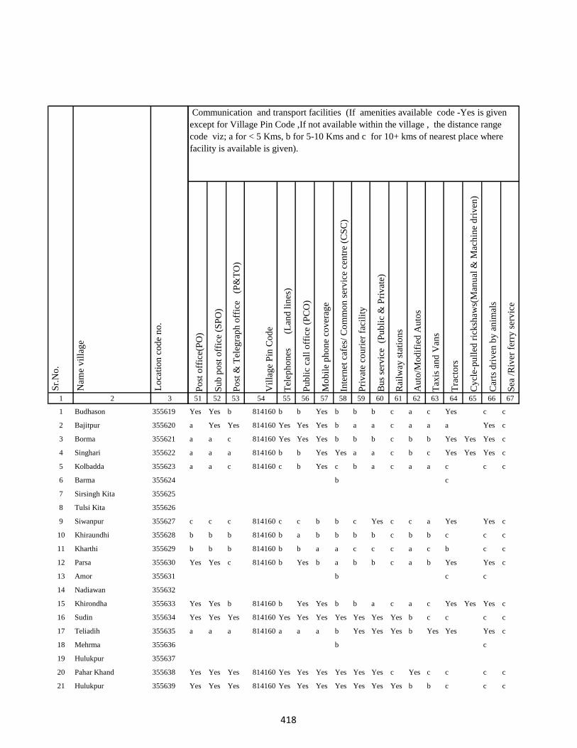
1 2 3
1 Budhason 355619
2 Bajitpur 355620
3 Borma 355621
4 Singhari 355622
5 Kolbadda 355623
6 Barma 355624
7 Sirsingh Kita 355625
8 Tulsi Kita 355626
9 Siwanpur 355627
10 Khiraundhi 355628
11 Kharthi 355629
12 Parsa 355630
13 Amor 355631
14 Nadiawan 355632
15 Khirondha 355633
16 Sudin 355634
17 Teliadih 355635
18 Mehrma 355636
19 Hulukpur 355637
20 Pahar Khand 355638
21 Hulukpur 355639
Lo
cati
on
co
de
no
.
Nam
e v
illa
ge
Sr.
No
.
Po
st o
ffic
e(P
O)
Su
b p
ost
off
ice
(SP
O)
Po
st &
Tel
egra
ph
off
ice
(P
&T
O)
Vil
lag
e P
in C
od
e
Tel
eph
on
es
(Lan
d l
ines
)
Pu
bli
c ca
ll o
ffic
e (P
CO
)
Mo
bil
e p
ho
ne
cov
erag
e
Inte
rnet
caf
es/
Co
mm
on
ser
vic
e ce
ntr
e (C
SC
)
Pri
vat
e co
uri
er f
acil
ity
Bu
s se
rvic
e (
Pu
bli
c &
Pri
vat
e)
Rai
lway
sta
tio
ns
Au
to/M
od
ifie
d A
uto
s
Tax
is a
nd
Van
s
Tra
cto
rs
Cy
cle-
pu
lled
ric
ksh
aws(
Man
ual
& M
ach
ine
dri
ven
)
Car
ts d
riv
en b
y a
nim
als
Sea
/R
iver
fer
ry s
erv
ice
51 52 53 54 55 56 57 58 59 60 61 62 63 64 65 66 67
Yes Yes b 814160 b b Yes b b b c a c Yes c c
a Yes Yes 814160 Yes Yes Yes b a a c a a a Yes c
a a c 814160 Yes Yes Yes b b b c b b Yes Yes Yes c
a a a 814160 b b Yes Yes a a c b c Yes Yes Yes c
a a c 814160 c b Yes c b a c a a c c c
b c
c c c 814160 c c b b c Yes c c a Yes Yes c
b b b 814160 b a b b b b c b b c c c
b b b 814160 b b a a c c c a c b c c
Yes Yes c 814160 b Yes b a b b c a b Yes Yes c
b c c
Yes Yes b 814160 b Yes Yes b b a c a c Yes Yes Yes c
Yes Yes Yes 814160 Yes Yes Yes Yes Yes Yes Yes b c c c c
a a a 814160 a a a b Yes Yes Yes b Yes Yes Yes c
b c
Yes Yes Yes 814160 Yes Yes Yes Yes Yes Yes c Yes c c c c
Yes Yes Yes 814160 Yes Yes Yes Yes Yes Yes Yes b b c c c
Communication and transport facilities (If amenities available code -Yes is given
except for Village Pin Code ,If not available within the village , the distance range
code viz; a for < 5 Kms, b for 5-10 Kms and c for 10+ kms of nearest place where
facility is available is given).
418
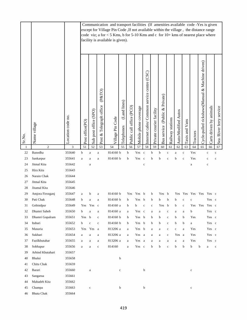
1 2 3
Lo
cati
on
co
de
no
.
Nam
e v
illa
ge
Sr.
No
.
22 Banodha 355640
23 Sankarpur 355641
24 Jitmal Kita 355642
25 Hira Kita 355643
26 Narain Chak 355644
27 Jitmal Kita 355645
28 Jitamal Kita 355646
29 Amjora Firozganj 355647
30 Pati Chak 355648
31 Gobindpur 355649
32 Dhamri Saheb 355650
33 Dhamri Gopalram 355651
34 Itahari 355652
35 Masuria 355653
36 Sukhari 355654
37 Fazilkhutahar 355655
38 Sobhapur 355656
39 Arbind Khutahari 355657
40 Bhalui 355658
41 Chitu Chak 355659
42 Barari 355660
43 Sangarua 355661
44 Mahadeb Kita 355662
45 Champa 355663
46 Bhata Chak 355664
Po
st o
ffic
e(P
O)
Su
b p
ost
off
ice
(SP
O)
Po
st &
Tel
egra
ph
off
ice
(P
&T
O)
Vil
lag
e P
in C
od
e
Tel
eph
on
es
(Lan
d l
ines
)
Pu
bli
c ca
ll o
ffic
e (P
CO
)
Mo
bil
e p
ho
ne
cov
erag
e
Inte
rnet
caf
es/
Co
mm
on
ser
vic
e ce
ntr
e (C
SC
)
Pri
vat
e co
uri
er f
acil
ity
Bu
s se
rvic
e (
Pu
bli
c &
Pri
vat
e)
Rai
lway
sta
tio
ns
Au
to/M
od
ifie
d A
uto
s
Tax
is a
nd
Van
s
Tra
cto
rs
Cy
cle-
pu
lled
ric
ksh
aws(
Man
ual
& M
ach
ine
dri
ven
)
Car
ts d
riv
en b
y a
nim
als
Sea
/R
iver
fer
ry s
erv
ice
51 52 53 54 55 56 57 58 59 60 61 62 63 64 65 66 67
Communication and transport facilities (If amenities available code -Yes is given
except for Village Pin Code ,If not available within the village , the distance range
code viz; a for < 5 Kms, b for 5-10 Kms and c for 10+ kms of nearest place where
facility is available is given).
b a a 814160 b b Yes c b b c a c Yes c c
a a a 814160 b b Yes c b b c b c Yes c c
a c a c
a b a 814160 b Yes Yes b b Yes b Yes Yes Yes Yes Yes c
b a a 814160 b b Yes b b b b b c c Yes c
Yes Yes c 814160 a b b c c Yes b b c Yes Yes Yes c
b a a 814160 a a Yes c a a c a a b Yes c
Yes b c 814160 b b Yes b b b c b b Yes Yes c
b c c 814160 b b Yes b b b c b b a Yes c
Yes Yes a 813206 a a Yes b a a c c a Yes Yes c
a a a 813206 a a Yes a a a c Yes a Yes Yes c
a a a 813206 a a Yes a a a a a a Yes Yes c
a a c 814160 a Yes c b b c b b b b a c
b
a c b c
c b b c
419
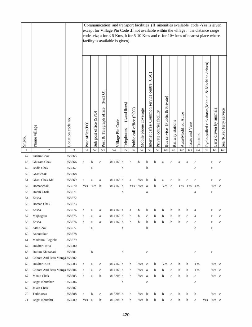
1 2 3
Lo
cati
on
co
de
no
.
Nam
e v
illa
ge
Sr.
No
.
47 Padam Chak 355665
48 Ghuram Chak 355666
49 Badla Chak 355667
50 Ghasichak 355668
51 Ghasi Chak Mal 355669
52 Domanchak 355670
53 Dudhi Chak 355671
54 Kasba 355672
55 Doman Chak 355673
56 Kasba 355674
57 Majhagain 355675
58 Kasba 355676
59 Sadi Chak 355677
60 Anhuatikar 355678
61 Madhurai Bagicha 355679
62 Dukhari Kita 355680
63 Dulum Khutahari 355681
64 Chhota And Bara Mangarh355682
65 Dukhari Kita 355683
66 Chhota And Bara Mangarh355684
67 Mania Chak 355685
68 Bagat Khutahari 355686
69 Jalala Chak 355687
70 Tarkharwa 355688
71 Bagat Khutahri 355689
Po
st o
ffic
e(P
O)
Su
b p
ost
off
ice
(SP
O)
Po
st &
Tel
egra
ph
off
ice
(P
&T
O)
Vil
lag
e P
in C
od
e
Tel
eph
on
es
(Lan
d l
ines
)
Pu
bli
c ca
ll o
ffic
e (P
CO
)
Mo
bil
e p
ho
ne
cov
erag
e
Inte
rnet
caf
es/
Co
mm
on
ser
vic
e ce
ntr
e (C
SC
)
Pri
vat
e co
uri
er f
acil
ity
Bu
s se
rvic
e (
Pu
bli
c &
Pri
vat
e)
Rai
lway
sta
tio
ns
Au
to/M
od
ifie
d A
uto
s
Tax
is a
nd
Van
s
Tra
cto
rs
Cy
cle-
pu
lled
ric
ksh
aws(
Man
ual
& M
ach
ine
dri
ven
)
Car
ts d
riv
en b
y a
nim
als
Sea
/R
iver
fer
ry s
erv
ice
51 52 53 54 55 56 57 58 59 60 61 62 63 64 65 66 67
Communication and transport facilities (If amenities available code -Yes is given
except for Village Pin Code ,If not available within the village , the distance range
code viz; a for < 5 Kms, b for 5-10 Kms and c for 10+ kms of nearest place where
facility is available is given).
b b c 814160 b b b b b a c a a c c c
a b b c c
a a a 814165 b a Yes b b a c b c c c c
Yes Yes b 814160 b Yes Yes a b Yes c Yes Yes Yes Yes c
b a a c
b a a 814160 a a b b b b b b b a c c
b a a 814160 b b b c b b b b c a c c
b a a 814160 b b b b b b b b c c c c
a a b c c
b b c c c
c a c 814160 c b Yes c b Yes c b b Yes Yes c
c a c 814160 c b Yes a b b c b b Yes Yes c
b a b 813206 c b Yes a b b c b b c Yes c
b c c
c b c 813206 b b Yes b b b c b b b Yes c
Yes a b 813206 b b Yes b b b c b b c Yes Yes c
420

1 2 3
Lo
cati
on
co
de
no
.
Nam
e v
illa
ge
Sr.
No
.
72 Meghchatar 355690
73 Kumardom 355691
74 Harchandpur 355692
75 Maheshdiri 355693
76 Nawadih Tola 355694
77 Beldara Chak 355695
78 Bhaju Chak 355696
79 Bhagwanpur 355697
80 Katmdanr 355698
81 Kita Kalamdanr 355699
82 Amdanr Asli 355700
83 Lachmipur 355701
84 Chandpur 355702
85 Rasti Kar 355703
86 Partappur Mal 355704
87 Partappur Jagir 355705
88 Kishungari Chak 355706
89 Sahi Chak 355707
90 Sarangdhar 355708
91 Sirampur 355709
92 Debi Chak 355710
93 Dogachhi 355711
94 Kandar Chak 355712
95 Tazi Chak 355713
96 Sapnia 355714
Po
st o
ffic
e(P
O)
Su
b p
ost
off
ice
(SP
O)
Po
st &
Tel
egra
ph
off
ice
(P
&T
O)
Vil
lag
e P
in C
od
e
Tel
eph
on
es
(Lan
d l
ines
)
Pu
bli
c ca
ll o
ffic
e (P
CO
)
Mo
bil
e p
ho
ne
cov
erag
e
Inte
rnet
caf
es/
Co
mm
on
ser
vic
e ce
ntr
e (C
SC
)
Pri
vat
e co
uri
er f
acil
ity
Bu
s se
rvic
e (
Pu
bli
c &
Pri
vat
e)
Rai
lway
sta
tio
ns
Au
to/M
od
ifie
d A
uto
s
Tax
is a
nd
Van
s
Tra
cto
rs
Cy
cle-
pu
lled
ric
ksh
aws(
Man
ual
& M
ach
ine
dri
ven
)
Car
ts d
riv
en b
y a
nim
als
Sea
/R
iver
fer
ry s
erv
ice
51 52 53 54 55 56 57 58 59 60 61 62 63 64 65 66 67
Communication and transport facilities (If amenities available code -Yes is given
except for Village Pin Code ,If not available within the village , the distance range
code viz; a for < 5 Kms, b for 5-10 Kms and c for 10+ kms of nearest place where
facility is available is given).
b a b 814160 b b Yes c b b c b b Yes Yes c
c b c 814160 a b Yes c b b c b b a Yes c
b b c
c a b b c b b c b a a a c a a c
Yes a Yes 814165 Yes Yes Yes b Yes Yes c Yes Yes Yes Yes Yes c
c a c a c c c b c a a b a a c
b c c 814165 b b Yes b c Yes c b b Yes c c
b b a 814165 b Yes b b b b b c a b Yes Yes c
b b c c c
c a c c b Yes a c b c b c Yes a c c
c a b c c c
a b a c c
421
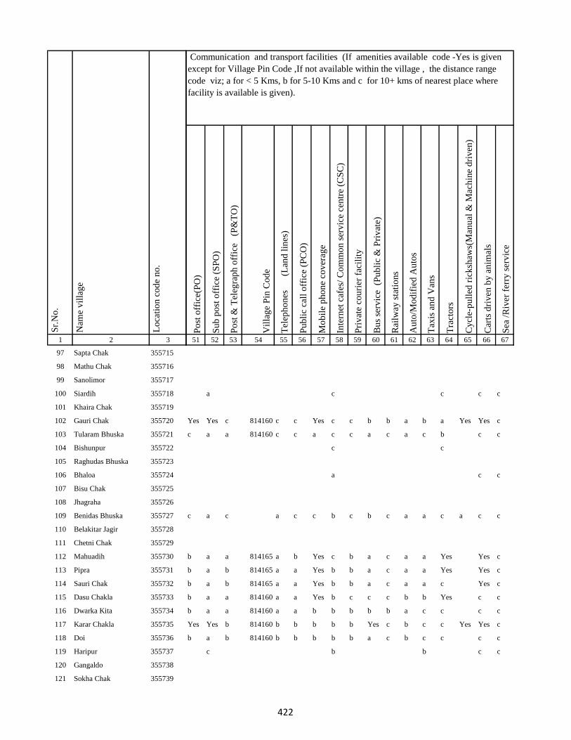
1 2 3
Lo
cati
on
co
de
no
.
Nam
e v
illa
ge
Sr.
No
.
97 Sapta Chak 355715
98 Mathu Chak 355716
99 Sanolimor 355717
100 Siardih 355718
101 Khaira Chak 355719
102 Gauri Chak 355720
103 Tularam Bhuska 355721
104 Bishunpur 355722
105 Raghudas Bhuska 355723
106 Bhaloa 355724
107 Bisu Chak 355725
108 Jhagraha 355726
109 Benidas Bhuska 355727
110 Belakitar Jagir 355728
111 Chetni Chak 355729
112 Mahuadih 355730
113 Pipra 355731
114 Sauri Chak 355732
115 Dasu Chakla 355733
116 Dwarka Kita 355734
117 Karar Chakla 355735
118 Doi 355736
119 Haripur 355737
120 Gangaldo 355738
121 Sokha Chak 355739
Po
st o
ffic
e(P
O)
Su
b p
ost
off
ice
(SP
O)
Po
st &
Tel
egra
ph
off
ice
(P
&T
O)
Vil
lag
e P
in C
od
e
Tel
eph
on
es
(Lan
d l
ines
)
Pu
bli
c ca
ll o
ffic
e (P
CO
)
Mo
bil
e p
ho
ne
cov
erag
e
Inte
rnet
caf
es/
Co
mm
on
ser
vic
e ce
ntr
e (C
SC
)
Pri
vat
e co
uri
er f
acil
ity
Bu
s se
rvic
e (
Pu
bli
c &
Pri
vat
e)
Rai
lway
sta
tio
ns
Au
to/M
od
ifie
d A
uto
s
Tax
is a
nd
Van
s
Tra
cto
rs
Cy
cle-
pu
lled
ric
ksh
aws(
Man
ual
& M
ach
ine
dri
ven
)
Car
ts d
riv
en b
y a
nim
als
Sea
/R
iver
fer
ry s
erv
ice
51 52 53 54 55 56 57 58 59 60 61 62 63 64 65 66 67
Communication and transport facilities (If amenities available code -Yes is given
except for Village Pin Code ,If not available within the village , the distance range
code viz; a for < 5 Kms, b for 5-10 Kms and c for 10+ kms of nearest place where
facility is available is given).
a c c c c
Yes Yes c 814160 c c Yes c c b b a b a Yes Yes c
c a a 814160 c c a c c a c a c b c c
c c
a c c
c a c a c c b c b c a a c a c c
b a a 814165 a b Yes c b a c a a Yes Yes c
b a b 814165 a a Yes b b a c a a Yes Yes c
b a b 814165 a a Yes b b a c a a c Yes c
b a a 814160 a a Yes b c c c b b Yes c c
b a a 814160 a a b b b b b a c c c c
Yes Yes b 814160 b b b b b Yes c b c c Yes Yes c
b a b 814160 b b b b b a c b c c c c
c b b c c
422
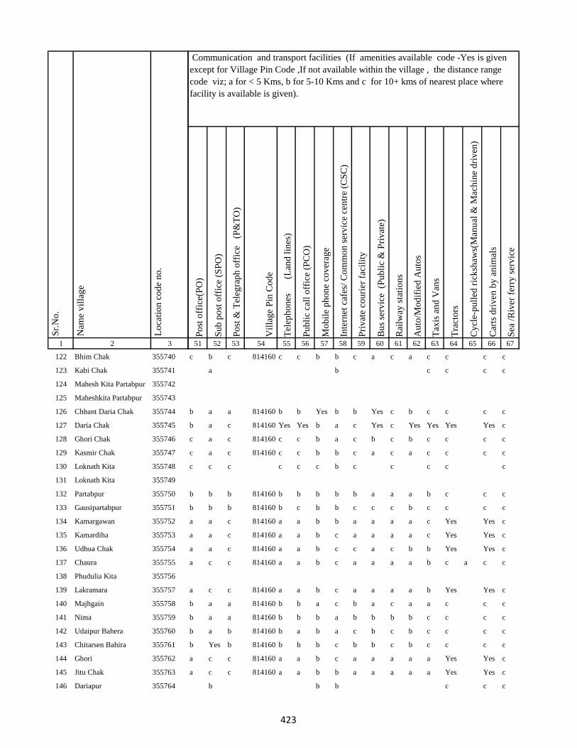
1 2 3
Lo
cati
on
co
de
no
.
Nam
e v
illa
ge
Sr.
No
.
122 Bhim Chak 355740
123 Kabi Chak 355741
124 Mahesh Kita Partabpur 355742
125 Maheshkita Partabpur 355743
126 Chhant Daria Chak 355744
127 Daria Chak 355745
128 Ghori Chak 355746
129 Kasmir Chak 355747
130 Loknath Kita 355748
131 Loknath Kita 355749
132 Partabpur 355750
133 Gausipartabpur 355751
134 Kamargawan 355752
135 Kamardiha 355753
136 Udhua Chak 355754
137 Chaura 355755
138 Phudulia Kita 355756
139 Lakramara 355757
140 Majhgain 355758
141 Nima 355759
142 Udaipur Bahera 355760
143 Chitarsen Bahira 355761
144 Ghori 355762
145 Jitu Chak 355763
146 Dariapur 355764
Po
st o
ffic
e(P
O)
Su
b p
ost
off
ice
(SP
O)
Po
st &
Tel
egra
ph
off
ice
(P
&T
O)
Vil
lag
e P
in C
od
e
Tel
eph
on
es
(Lan
d l
ines
)
Pu
bli
c ca
ll o
ffic
e (P
CO
)
Mo
bil
e p
ho
ne
cov
erag
e
Inte
rnet
caf
es/
Co
mm
on
ser
vic
e ce
ntr
e (C
SC
)
Pri
vat
e co
uri
er f
acil
ity
Bu
s se
rvic
e (
Pu
bli
c &
Pri
vat
e)
Rai
lway
sta
tio
ns
Au
to/M
od
ifie
d A
uto
s
Tax
is a
nd
Van
s
Tra
cto
rs
Cy
cle-
pu
lled
ric
ksh
aws(
Man
ual
& M
ach
ine
dri
ven
)
Car
ts d
riv
en b
y a
nim
als
Sea
/R
iver
fer
ry s
erv
ice
51 52 53 54 55 56 57 58 59 60 61 62 63 64 65 66 67
Communication and transport facilities (If amenities available code -Yes is given
except for Village Pin Code ,If not available within the village , the distance range
code viz; a for < 5 Kms, b for 5-10 Kms and c for 10+ kms of nearest place where
facility is available is given).
c b c 814160 c c b b c a c a c c c c
a b c c c c
b a a 814160 b b Yes b b Yes c b c c c c
b a c 814160 Yes Yes b a c Yes c Yes Yes Yes Yes c
c a c 814160 c c b a c b c b c c c c
c a c 814160 c c b b c a c a c c c c
c c c c c c b c c c c c
b b b 814160 b b b b b a a a b c c c
b b b 814160 b c b b c c c b c c c c
a a c 814160 a a b b a a a a c Yes Yes c
a a c 814160 a a b c a a a a c Yes Yes c
a a c 814160 a a b c c a c b b Yes Yes c
a c c 814160 a a b c a a a a b c a c c
a c c 814160 a a b c a a a a b Yes Yes c
b a a 814160 b b a c b a c a a c c c
b a a 814160 b b b a b b b b c c c c
b a b 814160 b a b a c b c b c c c c
b Yes b 814160 b b b c b b c b c c c c
a c c 814160 a a b c a a a a a Yes Yes c
a c c 814160 a a b b a a a a a Yes Yes c
b b b c c c
423

1 2 3
Lo
cati
on
co
de
no
.
Nam
e v
illa
ge
Sr.
No
.
147 Mathi Chak 355765
148 Chhaman Kita 355766
149 Suphal Kita 355767
150 Kanchanpur 355768
151 Dhankuria 355769
152 Belbadda 355770
153 Kotibari 355771
154 Chhagraha 355772
155 Chhagraha 355773
156 Benia Kita 355774
157 Sahi Chak 355775
158 Chhagraha 355776
159 Kukra Milik 355777
160 Kurkra Milik 355778
161 Bheronagar 355779
162 Niamat Kita 355780
163 Ghasi Kita 355781
164 Ghasi Kita 355782
165 Inarman Kita 355783
166 Gausi Chak 355784
167 Mosana Chak 355785
168 Singarpur 355786
169 Birnagar Arazi Chhit 355787
170 Birnagar Arazi Bara 355788
171 Birnagar 355789
Po
st o
ffic
e(P
O)
Su
b p
ost
off
ice
(SP
O)
Po
st &
Tel
egra
ph
off
ice
(P
&T
O)
Vil
lag
e P
in C
od
e
Tel
eph
on
es
(Lan
d l
ines
)
Pu
bli
c ca
ll o
ffic
e (P
CO
)
Mo
bil
e p
ho
ne
cov
erag
e
Inte
rnet
caf
es/
Co
mm
on
ser
vic
e ce
ntr
e (C
SC
)
Pri
vat
e co
uri
er f
acil
ity
Bu
s se
rvic
e (
Pu
bli
c &
Pri
vat
e)
Rai
lway
sta
tio
ns
Au
to/M
od
ifie
d A
uto
s
Tax
is a
nd
Van
s
Tra
cto
rs
Cy
cle-
pu
lled
ric
ksh
aws(
Man
ual
& M
ach
ine
dri
ven
)
Car
ts d
riv
en b
y a
nim
als
Sea
/R
iver
fer
ry s
erv
ice
51 52 53 54 55 56 57 58 59 60 61 62 63 64 65 66 67
Communication and transport facilities (If amenities available code -Yes is given
except for Village Pin Code ,If not available within the village , the distance range
code viz; a for < 5 Kms, b for 5-10 Kms and c for 10+ kms of nearest place where
facility is available is given).
c a a 814160 b b Yes c c a c c c c c c
c a a 814160 b b Yes b c a c c c Yes Yes c
a a c 814160 a a b b c c c a a c Yes c
c Yes c 814160 a Yes Yes b c Yes c c b Yes Yes c
b a a 814160 b b b b b b b b b c c c
b a a 814160 b b b b c b b a c c c c
a b c c c
c c a 814160 b b Yes b c a c c b c Yes c
c c a 814160 a a Yes b c a c c c c Yes c
c b a 814160 b a Yes b c a c c c c c c
a b c 814160 c c b b c a c b c c Yes c
a a c 814160 a a b b c a c a c Yes Yes c
a a b c c c c
b b c c
a a a 814160 Yes Yes c c c
b a a 814160 b b Yes c c Yes c a c c c c
424
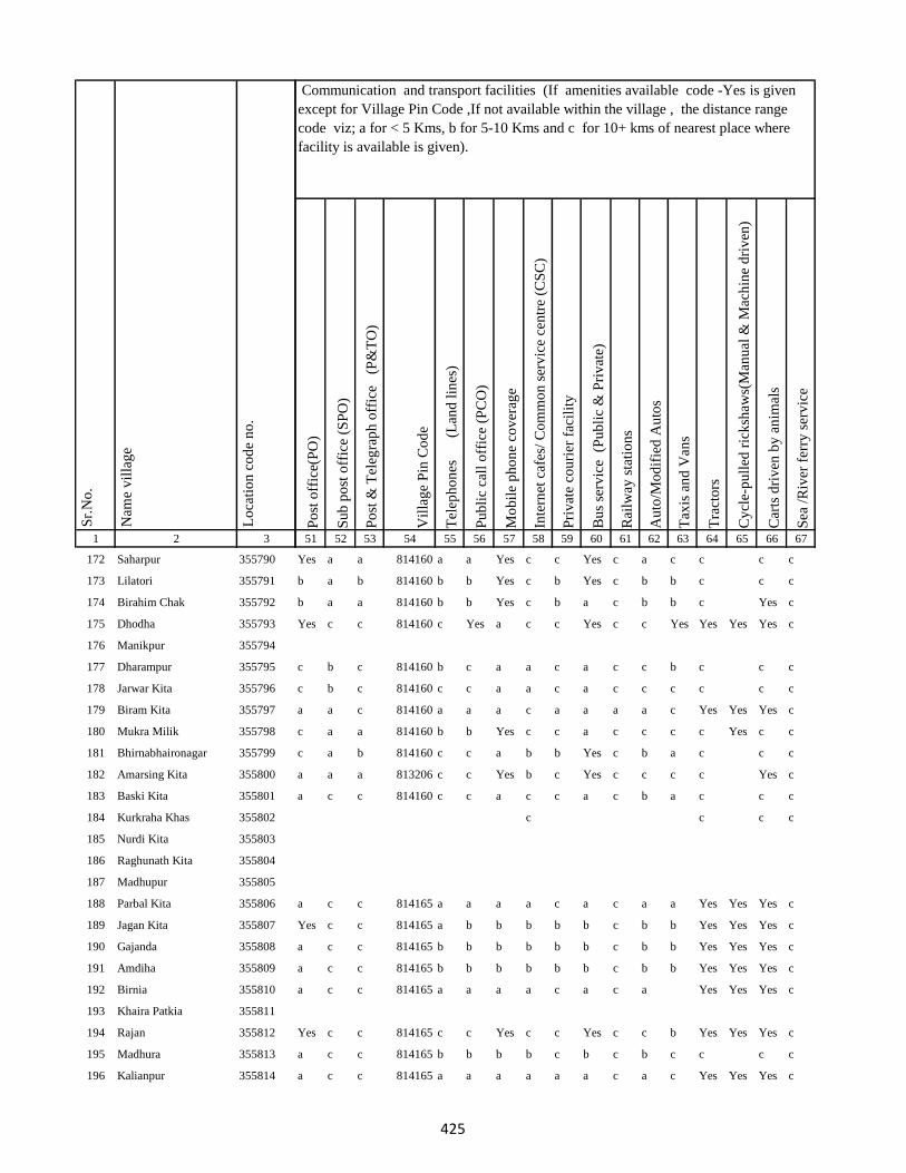
1 2 3
Lo
cati
on
co
de
no
.
Nam
e v
illa
ge
Sr.
No
.
172 Saharpur 355790
173 Lilatori 355791
174 Birahim Chak 355792
175 Dhodha 355793
176 Manikpur 355794
177 Dharampur 355795
178 Jarwar Kita 355796
179 Biram Kita 355797
180 Mukra Milik 355798
181 Bhirnabhaironagar 355799
182 Amarsing Kita 355800
183 Baski Kita 355801
184 Kurkraha Khas 355802
185 Nurdi Kita 355803
186 Raghunath Kita 355804
187 Madhupur 355805
188 Parbal Kita 355806
189 Jagan Kita 355807
190 Gajanda 355808
191 Amdiha 355809
192 Birnia 355810
193 Khaira Patkia 355811
194 Rajan 355812
195 Madhura 355813
196 Kalianpur 355814
Po
st o
ffic
e(P
O)
Su
b p
ost
off
ice
(SP
O)
Po
st &
Tel
egra
ph
off
ice
(P
&T
O)
Vil
lag
e P
in C
od
e
Tel
eph
on
es
(Lan
d l
ines
)
Pu
bli
c ca
ll o
ffic
e (P
CO
)
Mo
bil
e p
ho
ne
cov
erag
e
Inte
rnet
caf
es/
Co
mm
on
ser
vic
e ce
ntr
e (C
SC
)
Pri
vat
e co
uri
er f
acil
ity
Bu
s se
rvic
e (
Pu
bli
c &
Pri
vat
e)
Rai
lway
sta
tio
ns
Au
to/M
od
ifie
d A
uto
s
Tax
is a
nd
Van
s
Tra
cto
rs
Cy
cle-
pu
lled
ric
ksh
aws(
Man
ual
& M
ach
ine
dri
ven
)
Car
ts d
riv
en b
y a
nim
als
Sea
/R
iver
fer
ry s
erv
ice
51 52 53 54 55 56 57 58 59 60 61 62 63 64 65 66 67
Communication and transport facilities (If amenities available code -Yes is given
except for Village Pin Code ,If not available within the village , the distance range
code viz; a for < 5 Kms, b for 5-10 Kms and c for 10+ kms of nearest place where
facility is available is given).
Yes a a 814160 a a Yes c c Yes c a c c c c
b a b 814160 b b Yes c b Yes c b b c c c
b a a 814160 b b Yes c b a c b b c Yes c
Yes c c 814160 c Yes a c c Yes c c Yes Yes Yes Yes c
c b c 814160 b c a a c a c c b c c c
c b c 814160 c c a a c a c c c c c c
a a c 814160 a a a c a a a a c Yes Yes Yes c
c a a 814160 b b Yes c c a c c c c Yes c c
c a b 814160 c c a b b Yes c b a c c c
a a a 813206 c c Yes b c Yes c c c c Yes c
a c c 814160 c c a c c a c b a c c c
c c c c
a c c 814165 a a a a c a c a a Yes Yes Yes c
Yes c c 814165 a b b b b b c b b Yes Yes Yes c
a c c 814165 b b b b b b c b b Yes Yes Yes c
a c c 814165 b b b b b b c b b Yes Yes Yes c
a c c 814165 a a a a c a c a Yes Yes Yes c
Yes c c 814165 c c Yes c c Yes c c b Yes Yes Yes c
a c c 814165 b b b b c b c b c c c c
a c c 814165 a a a a a a c a c Yes Yes Yes c
425
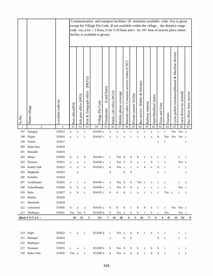
1 2 3
Lo
cati
on
co
de
no
.
Nam
e v
illa
ge
Sr.
No
.
197 Sonaguji 355815
198 Dalahi 355816
199 Tetaria 355817
200 Baski Kita 355818
201 Beniadih 355819
202 Marpa 355820
203 Dumaria 355821
204 Kamal Chak 355822
205 Meghnath 355823
206 Kalidaha 355824
207 Leoabhujani 355825
208 Gobardhanpur 355826
209 Balia 355827
210 Pharkia 355828
211 Dhurbidih 355829
212 Lohachinta 355830
213 Madhupur 355831
Block T O T A L :
214 Dighi 355832
215 Paharpur 355833
216 Madhupur 355834
217 Siwanpur 355835
218 Kakar Ghat 355836
Po
st o
ffic
e(P
O)
Su
b p
ost
off
ice
(SP
O)
Po
st &
Tel
egra
ph
off
ice
(P
&T
O)
Vil
lag
e P
in C
od
e
Tel
eph
on
es
(Lan
d l
ines
)
Pu
bli
c ca
ll o
ffic
e (P
CO
)
Mo
bil
e p
ho
ne
cov
erag
e
Inte
rnet
caf
es/
Co
mm
on
ser
vic
e ce
ntr
e (C
SC
)
Pri
vat
e co
uri
er f
acil
ity
Bu
s se
rvic
e (
Pu
bli
c &
Pri
vat
e)
Rai
lway
sta
tio
ns
Au
to/M
od
ifie
d A
uto
s
Tax
is a
nd
Van
s
Tra
cto
rs
Cy
cle-
pu
lled
ric
ksh
aws(
Man
ual
& M
ach
ine
dri
ven
)
Car
ts d
riv
en b
y a
nim
als
Sea
/R
iver
fer
ry s
erv
ice
51 52 53 54 55 56 57 58 59 60 61 62 63 64 65 66 67
Communication and transport facilities (If amenities available code -Yes is given
except for Village Pin Code ,If not available within the village , the distance range
code viz; a for < 5 Kms, b for 5-10 Kms and c for 10+ kms of nearest place where
facility is available is given).
a c c 814165 c a a a c a c a c c Yes Yes c
a c c 814165 c a a a c a c a b Yes Yes Yes c
c c c
b a b 814160 c c Yes b b b c a c c c c
a a a 814160 c c Yes b b a c b c c Yes c
a a a 814160 c b Yes c c a b a b c c c
a b b b c c c
a c a 814160 c a Yes b b Yes c a c c c c
b b a 814160 c a Yes b b a c a c c Yes c
a b c 814165 c b b b c a c c c Yes c c c
b a a 814165 a b b b c b b a c c Yes Yes c
Yes Yes b 813208 b b Yes a b b c b c Yes Yes c
19 15 5 111 7 14 58 4 5 24 3 6 6 47 23 62 0
c a c 813208 b c Yes a b b c b c c c c
a b b b c c c
c a c 813208 b b Yes b b b c b b c c c
Yes a c 813208 b b Yes b b b c b b c c c
426

1 2 3
Lo
cati
on
co
de
no
.
Nam
e v
illa
ge
Sr.
No
.
219 Talbaria 355837
220 Mohamad Khutahari 355838
221 Mal Jhakhra 355839
222 Baghjhakhra 355840
223 Sinha Chak 355841
224 Babutaluk 355842
225 Paharpur 355843
226 Deban Chak 355844
227 Gargulal 355845
228 Madan Chauki 355846
229 Birahim Kita 355847
230 Banskola 355848
231 Kurpatti 355849
232 Baijani 355850
233 Chapri 355851
234 Kamat Chapri 355852
235 Khar Kudia 355853
236 Majhana (Arazi) 355854
237 Hasu Chak 355855
238 Domansaran Kita 355856
239 Silong 355857
240 Paharpur 355858
241 Akilkita 355859
242 Bikram Kita 355860
243 Paharpur 355861
Po
st o
ffic
e(P
O)
Su
b p
ost
off
ice
(SP
O)
Po
st &
Tel
egra
ph
off
ice
(P
&T
O)
Vil
lag
e P
in C
od
e
Tel
eph
on
es
(Lan
d l
ines
)
Pu
bli
c ca
ll o
ffic
e (P
CO
)
Mo
bil
e p
ho
ne
cov
erag
e
Inte
rnet
caf
es/
Co
mm
on
ser
vic
e ce
ntr
e (C
SC
)
Pri
vat
e co
uri
er f
acil
ity
Bu
s se
rvic
e (
Pu
bli
c &
Pri
vat
e)
Rai
lway
sta
tio
ns
Au
to/M
od
ifie
d A
uto
s
Tax
is a
nd
Van
s
Tra
cto
rs
Cy
cle-
pu
lled
ric
ksh
aws(
Man
ual
& M
ach
ine
dri
ven
)
Car
ts d
riv
en b
y a
nim
als
Sea
/R
iver
fer
ry s
erv
ice
51 52 53 54 55 56 57 58 59 60 61 62 63 64 65 66 67
Communication and transport facilities (If amenities available code -Yes is given
except for Village Pin Code ,If not available within the village , the distance range
code viz; a for < 5 Kms, b for 5-10 Kms and c for 10+ kms of nearest place where
facility is available is given).
c a c 813208 b c Yes b b b c b b c c c
a a c 813208 a b Yes b b c c c c Yes c c
c a c 813208 a b a c b a c c c Yes c c
c a c 813208 a b Yes c b a c c c c Yes Yes c
b c c c c
b a a 813208 b b b c b b b a b c c c
c a c 813208 b b a a c a c c c c Yes Yes c
c a c 813208 a a a a c a c c c c Yes c c
c a c 813208 b a a c b a c c c c Yes c c
a c c 813208 b b b c b Yes c b b c c c
a c c 813208 b b b b b b c c c c c c
Yes Yes c 813208 b b Yes b b Yes c c c Yes Yes c
b b b 813208 b b b c b b c a c c c c
b Yes c 813208 a b b c b Yes c a c Yes Yes c
a c b a c c c
a b b c c c
b Yes c 813208 b b Yes c c b c b c Yes c c
c c c c
c a c 813208 a b Yes c b c c b b Yes c c
427
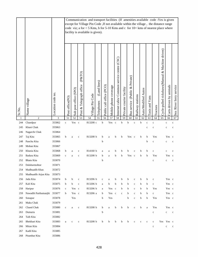
1 2 3
Lo
cati
on
co
de
no
.
Nam
e v
illa
ge
Sr.
No
.
244 Chandpur 355862
245 Khani Chak 355863
246 Nagarchi Chak 355864
247 Taj Kita 355865
248 Panchu Kita 355866
249 Mohan Kita 355867
250 Khania Kita 355868
251 Badura Kita 355869
252 Bhatu Kita 355870
253 Dalubarmohtar 355871
254 Madhuadih Khas 355872
255 Madhuadih Arjun Kita 355873
256 Jadu Kita 355874
257 Kali Kita 355875
258 Haripur 355876
259 Nawadih Parthumanjhi 355877
260 Sonapur 355878
261 Maku Chak 355879
262 Chand Chak 355880
263 Dumaria 355881
264 Taib Kita 355882
265 Bhekhari Kita 355883
266 Mitan Kita 355884
267 Kadil Kita 355885
268 Pitambar Kita 355886
Po
st o
ffic
e(P
O)
Su
b p
ost
off
ice
(SP
O)
Po
st &
Tel
egra
ph
off
ice
(P
&T
O)
Vil
lag
e P
in C
od
e
Tel
eph
on
es
(Lan
d l
ines
)
Pu
bli
c ca
ll o
ffic
e (P
CO
)
Mo
bil
e p
ho
ne
cov
erag
e
Inte
rnet
caf
es/
Co
mm
on
ser
vic
e ce
ntr
e (C
SC
)
Pri
vat
e co
uri
er f
acil
ity
Bu
s se
rvic
e (
Pu
bli
c &
Pri
vat
e)
Rai
lway
sta
tio
ns
Au
to/M
od
ifie
d A
uto
s
Tax
is a
nd
Van
s
Tra
cto
rs
Cy
cle-
pu
lled
ric
ksh
aws(
Man
ual
& M
ach
ine
dri
ven
)
Car
ts d
riv
en b
y a
nim
als
Sea
/R
iver
fer
ry s
erv
ice
51 52 53 54 55 56 57 58 59 60 61 62 63 64 65 66 67
Communication and transport facilities (If amenities available code -Yes is given
except for Village Pin Code ,If not available within the village , the distance range
code viz; a for < 5 Kms, b for 5-10 Kms and c for 10+ kms of nearest place where
facility is available is given).
c Yes c 813208 c b Yes c b b c b c c c c
c c c c
b a c 813208 b b a b b Yes c b b Yes Yes c
b b c c c
b a c 814160 b a a b b b c b b c c c
c a c 813208 b b a b b Yes c b b Yes Yes c
b c c c
b b c 813206 b c a b b b c b b c Yes c
b b c 813206 b a b b b b c b b c Yes c
c Yes c 813206 b a Yes c b b c b b Yes Yes c
b Yes c 813206 a b Yes c c b c b b c Yes c
Yes b Yes b c b b Yes Yes c
c a c 813208 b b a b b b c b a Yes Yes c
b c c c
a c c 813208 b b b b b b c c c c Yes Yes c
c c c
428
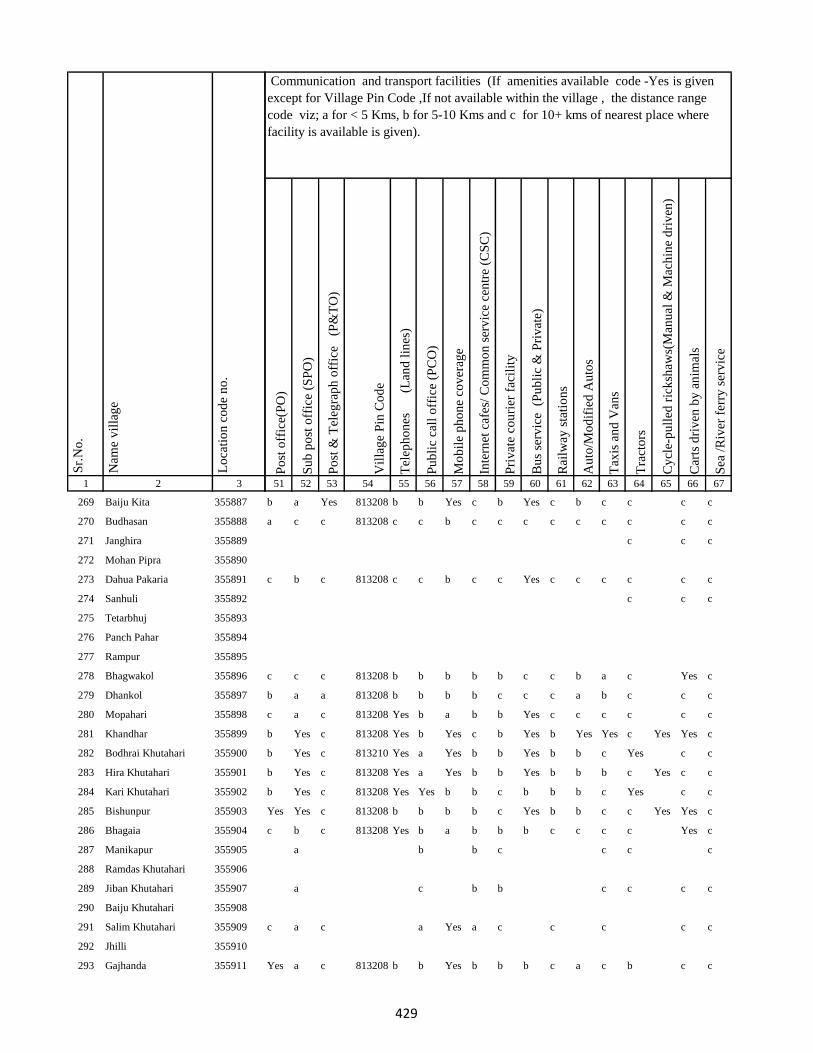
1 2 3
Lo
cati
on
co
de
no
.
Nam
e v
illa
ge
Sr.
No
.
269 Baiju Kita 355887
270 Budhasan 355888
271 Janghira 355889
272 Mohan Pipra 355890
273 Dahua Pakaria 355891
274 Sanhuli 355892
275 Tetarbhuj 355893
276 Panch Pahar 355894
277 Rampur 355895
278 Bhagwakol 355896
279 Dhankol 355897
280 Mopahari 355898
281 Khandhar 355899
282 Bodhrai Khutahari 355900
283 Hira Khutahari 355901
284 Kari Khutahari 355902
285 Bishunpur 355903
286 Bhagaia 355904
287 Manikapur 355905
288 Ramdas Khutahari 355906
289 Jiban Khutahari 355907
290 Baiju Khutahari 355908
291 Salim Khutahari 355909
292 Jhilli 355910
293 Gajhanda 355911
Po
st o
ffic
e(P
O)
Su
b p
ost
off
ice
(SP
O)
Po
st &
Tel
egra
ph
off
ice
(P
&T
O)
Vil
lag
e P
in C
od
e
Tel
eph
on
es
(Lan
d l
ines
)
Pu
bli
c ca
ll o
ffic
e (P
CO
)
Mo
bil
e p
ho
ne
cov
erag
e
Inte
rnet
caf
es/
Co
mm
on
ser
vic
e ce
ntr
e (C
SC
)
Pri
vat
e co
uri
er f
acil
ity
Bu
s se
rvic
e (
Pu
bli
c &
Pri
vat
e)
Rai
lway
sta
tio
ns
Au
to/M
od
ifie
d A
uto
s
Tax
is a
nd
Van
s
Tra
cto
rs
Cy
cle-
pu
lled
ric
ksh
aws(
Man
ual
& M
ach
ine
dri
ven
)
Car
ts d
riv
en b
y a
nim
als
Sea
/R
iver
fer
ry s
erv
ice
51 52 53 54 55 56 57 58 59 60 61 62 63 64 65 66 67
Communication and transport facilities (If amenities available code -Yes is given
except for Village Pin Code ,If not available within the village , the distance range
code viz; a for < 5 Kms, b for 5-10 Kms and c for 10+ kms of nearest place where
facility is available is given).
b a Yes 813208 b b Yes c b Yes c b c c c c
a c c 813208 c c b c c c c c c c c c
c c c
c b c 813208 c c b c c Yes c c c c c c
c c c
c c c 813208 b b b b b c c b a c Yes c
b a a 813208 b b b b c c c a b c c c
c a c 813208 Yes b a b b Yes c c c c c c
b Yes c 813208 Yes b Yes c b Yes b Yes Yes c Yes Yes c
b Yes c 813210 Yes a Yes b b Yes b b c Yes c c
b Yes c 813208 Yes a Yes b b Yes b b b c Yes c c
b Yes c 813208 Yes Yes b b c b b b c Yes c c
Yes Yes c 813208 b b b b c Yes b b c c Yes Yes c
c b c 813208 Yes b a b b b c c c c Yes c
a b b c c c c
a c b b c c c c
c a c a Yes a c c c c c
Yes a c 813208 b b Yes b b b c a c b c c
429
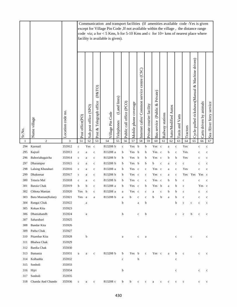
1 2 3
Lo
cati
on
co
de
no
.
Nam
e v
illa
ge
Sr.
No
.
294 Karmail 355912
295 Kajrail 355913
296 Bahoriabagaicha 355914
297 Dharampur 355915
298 Lalsing Khutahari 355916
299 Dhaknesar 355917
300 Tetaria Mal 355918
301 Baraia Chak 355919
302 Chhota Manian 355920
303 Bara Manian(Kalan) 355921
304 Rangai Chak 355922
305 Kokan Kita 355923
306 Dhaniabandh 355924
307 Saharabari 355925
308 Bandar Kita 355926
309 Patha Chak 355927
310 Pitambar Kita 355928
311 Bhalwa Chak 355929
312 Bardia Chak 355930
313 Bamania 355931
314 Kolbadda 355932
315 Sonholi 355933
316 Hijri 355934
317 Sonholi 355935
318 Chanda And Chando 355936
Po
st o
ffic
e(P
O)
Su
b p
ost
off
ice
(SP
O)
Po
st &
Tel
egra
ph
off
ice
(P
&T
O)
Vil
lag
e P
in C
od
e
Tel
eph
on
es
(Lan
d l
ines
)
Pu
bli
c ca
ll o
ffic
e (P
CO
)
Mo
bil
e p
ho
ne
cov
erag
e
Inte
rnet
caf
es/
Co
mm
on
ser
vic
e ce
ntr
e (C
SC
)
Pri
vat
e co
uri
er f
acil
ity
Bu
s se
rvic
e (
Pu
bli
c &
Pri
vat
e)
Rai
lway
sta
tio
ns
Au
to/M
od
ifie
d A
uto
s
Tax
is a
nd
Van
s
Tra
cto
rs
Cy
cle-
pu
lled
ric
ksh
aws(
Man
ual
& M
ach
ine
dri
ven
)
Car
ts d
riv
en b
y a
nim
als
Sea
/R
iver
fer
ry s
erv
ice
51 52 53 54 55 56 57 58 59 60 61 62 63 64 65 66 67
Communication and transport facilities (If amenities available code -Yes is given
except for Village Pin Code ,If not available within the village , the distance range
code viz; a for < 5 Kms, b for 5-10 Kms and c for 10+ kms of nearest place where
facility is available is given).
c Yes c 813208 b c Yes b b Yes c a c Yes c c
c a c 813208 a b Yes b b Yes c b c Yes c c
c a c 813208 b b Yes b b Yes c b b Yes c c
c a c 813208 b b Yes b b b c a c c c c
c a c 813208 a b Yes c c Yes c a c Yes c c
c a c 813208 b b Yes c c Yes c a c Yes Yes Yes c
c a c 813208 b b Yes c c Yes c b b c c c
b b c 813208 a b Yes c b Yes b a b c Yes c
Yes b c 813208 a a Yes c c a c b b c c c
Yes a a 813208 b a b c c b b a b c c c
a b a b b c c c c
a b c b c c b c c
b a c a c c c
a a c 813208 b b Yes b c Yes c a b c c c
c b c
b c c c
c a c 813208 c b b c c a c c c c c c
430
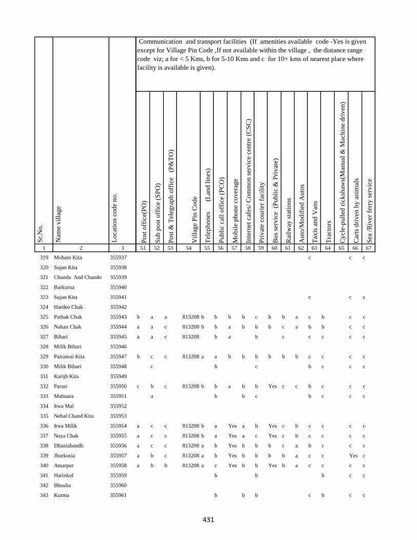
1 2 3
Lo
cati
on
co
de
no
.
Nam
e v
illa
ge
Sr.
No
.
319 Mohani Kita 355937
320 Sujan Kita 355938
321 Chanda And Chando 355939
322 Barkurua 355940
323 Sujan Kita 355941
324 Hardeo Chak 355942
325 Pathak Chak 355943
326 Nahan Chak 355944
327 Bihari 355945
328 Milik Bihari 355946
329 Pairanrai Kita 355947
330 Milik Bihari 355948
331 Karijh Kita 355949
332 Parasi 355950
333 Mahuara 355951
334 Itwa Mal 355952
335 Nehal Chand Kita 355953
336 Itwa Milik 355954
337 Naya Chak 355955
338 Dhaniabandh 355956
339 Jhurkusia 355957
340 Amarpur 355958
341 Harinkol 355959
342 Bhuslia 355960
343 Kurma 355961
Po
st o
ffic
e(P
O)
Su
b p
ost
off
ice
(SP
O)
Po
st &
Tel
egra
ph
off
ice
(P
&T
O)
Vil
lag
e P
in C
od
e
Tel
eph
on
es
(Lan
d l
ines
)
Pu
bli
c ca
ll o
ffic
e (P
CO
)
Mo
bil
e p
ho
ne
cov
erag
e
Inte
rnet
caf
es/
Co
mm
on
ser
vic
e ce
ntr
e (C
SC
)
Pri
vat
e co
uri
er f
acil
ity
Bu
s se
rvic
e (
Pu
bli
c &
Pri
vat
e)
Rai
lway
sta
tio
ns
Au
to/M
od
ifie
d A
uto
s
Tax
is a
nd
Van
s
Tra
cto
rs
Cy
cle-
pu
lled
ric
ksh
aws(
Man
ual
& M
ach
ine
dri
ven
)
Car
ts d
riv
en b
y a
nim
als
Sea
/R
iver
fer
ry s
erv
ice
51 52 53 54 55 56 57 58 59 60 61 62 63 64 65 66 67
Communication and transport facilities (If amenities available code -Yes is given
except for Village Pin Code ,If not available within the village , the distance range
code viz; a for < 5 Kms, b for 5-10 Kms and c for 10+ kms of nearest place where
facility is available is given).
c c c
c c c
b a a 813208 b b b b c b b a c b c c
a a c 813208 b b a b b b c a b b c c
a a c 813208 b a b c c c c c
b c c 813208 a a b b b b b b c c c c
c b c b c c c
c b c 813208 b b a b b Yes c c b c c c
a b b c b c c c
a c c 813208 b a Yes a b Yes c b c c c c
a c c 813208 b a Yes a c Yes c b c c c c
a c c 813208 a b Yes b b b c a b c c c
a b c 813208 a b Yes b b b b a c c Yes c
a b b 813208 a c Yes b b Yes b a c c c c
b b b c c
b b b c b c c
431
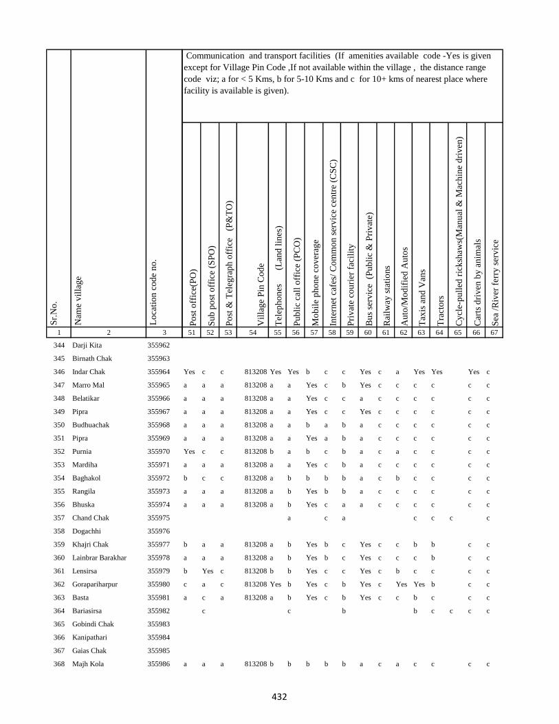
1 2 3
Lo
cati
on
co
de
no
.
Nam
e v
illa
ge
Sr.
No
.
344 Darji Kita 355962
345 Birnath Chak 355963
346 Indar Chak 355964
347 Marro Mal 355965
348 Belatikar 355966
349 Pipra 355967
350 Budhuachak 355968
351 Pipra 355969
352 Purnia 355970
353 Mardiha 355971
354 Baghakol 355972
355 Rangila 355973
356 Bhuska 355974
357 Chand Chak 355975
358 Dogachhi 355976
359 Khajri Chak 355977
360 Lainbrar Barakhar 355978
361 Lensirsa 355979
362 Gorapariharpur 355980
363 Basta 355981
364 Bariasirsa 355982
365 Gobindi Chak 355983
366 Kanipathari 355984
367 Gaias Chak 355985
368 Majh Kola 355986
Po
st o
ffic
e(P
O)
Su
b p
ost
off
ice
(SP
O)
Po
st &
Tel
egra
ph
off
ice
(P
&T
O)
Vil
lag
e P
in C
od
e
Tel
eph
on
es
(Lan
d l
ines
)
Pu
bli
c ca
ll o
ffic
e (P
CO
)
Mo
bil
e p
ho
ne
cov
erag
e
Inte
rnet
caf
es/
Co
mm
on
ser
vic
e ce
ntr
e (C
SC
)
Pri
vat
e co
uri
er f
acil
ity
Bu
s se
rvic
e (
Pu
bli
c &
Pri
vat
e)
Rai
lway
sta
tio
ns
Au
to/M
od
ifie
d A
uto
s
Tax
is a
nd
Van
s
Tra
cto
rs
Cy
cle-
pu
lled
ric
ksh
aws(
Man
ual
& M
ach
ine
dri
ven
)
Car
ts d
riv
en b
y a
nim
als
Sea
/R
iver
fer
ry s
erv
ice
51 52 53 54 55 56 57 58 59 60 61 62 63 64 65 66 67
Communication and transport facilities (If amenities available code -Yes is given
except for Village Pin Code ,If not available within the village , the distance range
code viz; a for < 5 Kms, b for 5-10 Kms and c for 10+ kms of nearest place where
facility is available is given).
Yes c c 813208 Yes Yes b c c Yes c a Yes Yes Yes c
a a a 813208 a a Yes c b Yes c c c c c c
a a a 813208 a a Yes c c a c c c c c c
a a a 813208 a a Yes c c Yes c c c c c c
a a a 813208 a a b a b a c c c c c c
a a a 813208 a a Yes a b a c c c c c c
Yes c c 813208 b a b c b a c a c c c c
a a a 813208 a a Yes c b a c c c c c c
b c c 813208 a b b b b a c b c c c c
a a a 813208 a b Yes b b a c c c c c c
a a a 813208 a b Yes c a a c c c c c c
a c a c c c c
b a a 813208 a b Yes b c Yes c c b b c c
a a a 813208 a b Yes b c Yes c c c b c c
b Yes c 813208 b b Yes c c Yes c b c c c c
c a c 813208 Yes b Yes c b Yes c Yes Yes b c c
a c a 813208 a b Yes c b Yes c c b c c c
c c b b c c c c
a a a 813208 b b b b b a c a c c c c
432
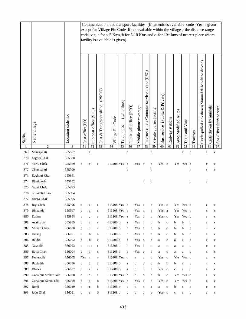
1 2 3
Lo
cati
on
co
de
no
.
Nam
e v
illa
ge
Sr.
No
.
369 Misirgangti 355987
370 Laghra Chak 355988
371 Mirik Chak 355989
372 Chamuakol 355990
373 Raghuni Kita 355991
374 Bhatkhoria 355992
375 Gauri Chak 355993
376 Sirikanta Chak 355994
377 Durga Chak 355995
378 Jogi Chak 355996
379 Bhiganda 355997
380 Kadma 355998
381 Asakhapar 355999
382 Mukeri Chak 356000
383 Dalang 356001
384 Raidih 356002
385 Nawadih 356003
386 Ratia Chak 356004
387 Pachradih 356005
388 Baniadih 356006
389 Dhawa 356007
390 Gopalpur Mohar Tola 356008
391 Gopalpur Karan Tola 356009
392 Runji 356010
393 Jadu Chak 356011
Po
st o
ffic
e(P
O)
Su
b p
ost
off
ice
(SP
O)
Po
st &
Tel
egra
ph
off
ice
(P
&T
O)
Vil
lag
e P
in C
od
e
Tel
eph
on
es
(Lan
d l
ines
)
Pu
bli
c ca
ll o
ffic
e (P
CO
)
Mo
bil
e p
ho
ne
cov
erag
e
Inte
rnet
caf
es/
Co
mm
on
ser
vic
e ce
ntr
e (C
SC
)
Pri
vat
e co
uri
er f
acil
ity
Bu
s se
rvic
e (
Pu
bli
c &
Pri
vat
e)
Rai
lway
sta
tio
ns
Au
to/M
od
ifie
d A
uto
s
Tax
is a
nd
Van
s
Tra
cto
rs
Cy
cle-
pu
lled
ric
ksh
aws(
Man
ual
& M
ach
ine
dri
ven
)
Car
ts d
riv
en b
y a
nim
als
Sea
/R
iver
fer
ry s
erv
ice
51 52 53 54 55 56 57 58 59 60 61 62 63 64 65 66 67
Communication and transport facilities (If amenities available code -Yes is given
except for Village Pin Code ,If not available within the village , the distance range
code viz; a for < 5 Kms, b for 5-10 Kms and c for 10+ kms of nearest place where
facility is available is given).
a c c c c c c
c a c 813208 Yes b Yes b b Yes c Yes Yes c c c
b b c c c
b b c c
c a c 813208 Yes b Yes a b Yes c Yes Yes b c c
c a c 813208 Yes b Yes a b Yes a Yes Yes c c c
c a c 813208 Yes a Yes b c Yes c Yes Yes b c c
c c a 813208 b a Yes b c b c b b c c c
c c c 813208 b b Yes b c b c b b c c c
c b c 813208 b b Yes b b b c b b c c c
c b c 813208 a b Yes b c a c a a c c c
c a c 813208 b b Yes b c a c a a c c c
c a c 813208 a b Yes c b a c a a c c c
Yes a c 813208 Yes c a c b Yes c Yes Yes c c c
c a a 813208 b a b c b b b b c c c c
c a a 813208 b a b c b Yes c c c c c c
c a a 813208 Yes b b c b b c Yes Yes c c c
c a b 813208 Yes b Yes c b Yes c Yes Yes c c c
a c b 813208 b c b a a a c b c c c c
a c b 813208 b b b a a Yes c c c b c c
433
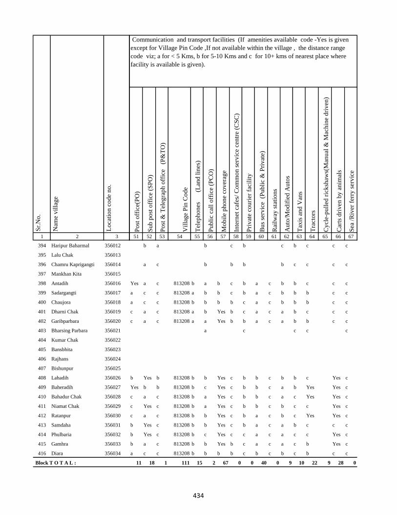
1 2 3
Lo
cati
on
co
de
no
.
Nam
e v
illa
ge
Sr.
No
.
394 Haripur Baharmal 356012
395 Lalu Chak 356013
396 Chamru Kaprigangti 356014
397 Mankhan Kita 356015
398 Antadih 356016
399 Sadargangti 356017
400 Chaujora 356018
401 Dharni Chak 356019
402 Garibparbara 356020
403 Bharsing Parbara 356021
404 Kumar Chak 356022
405 Bansbhita 356023
406 Rajhans 356024
407 Bishunpur 356025
408 Lahadih 356026
409 Baheradih 356027
410 Bahadur Chak 356028
411 Niamat Chak 356029
412 Ratanpur 356030
413 Samdaha 356031
414 Phulbaria 356032
415 Gamhra 356033
416 Diara 356034
Block T O T A L :
Po
st o
ffic
e(P
O)
Su
b p
ost
off
ice
(SP
O)
Po
st &
Tel
egra
ph
off
ice
(P
&T
O)
Vil
lag
e P
in C
od
e
Tel
eph
on
es
(Lan
d l
ines
)
Pu
bli
c ca
ll o
ffic
e (P
CO
)
Mo
bil
e p
ho
ne
cov
erag
e
Inte
rnet
caf
es/
Co
mm
on
ser
vic
e ce
ntr
e (C
SC
)
Pri
vat
e co
uri
er f
acil
ity
Bu
s se
rvic
e (
Pu
bli
c &
Pri
vat
e)
Rai
lway
sta
tio
ns
Au
to/M
od
ifie
d A
uto
s
Tax
is a
nd
Van
s
Tra
cto
rs
Cy
cle-
pu
lled
ric
ksh
aws(
Man
ual
& M
ach
ine
dri
ven
)
Car
ts d
riv
en b
y a
nim
als
Sea
/R
iver
fer
ry s
erv
ice
51 52 53 54 55 56 57 58 59 60 61 62 63 64 65 66 67
Communication and transport facilities (If amenities available code -Yes is given
except for Village Pin Code ,If not available within the village , the distance range
code viz; a for < 5 Kms, b for 5-10 Kms and c for 10+ kms of nearest place where
facility is available is given).
b a b c b c b c c c
a c b b b b c c c c
Yes a c 813208 b a b c b a c b b c c c
a c c 813208 a b b c b a c b b b c c
a c c 813208 b b b b c a c b b b c c
c a c 813208 a b Yes b c a c a b c c c
c a c 813208 a a Yes b b a c a b b c c
a c c c c
b Yes b 813208 b b Yes c b b c b b c Yes c
Yes b b 813208 b c Yes c b b c a b Yes Yes c
c a c 813208 b a Yes c b b c a c Yes Yes c
c Yes c 813208 b a Yes c b b c b c c Yes c
c a c 813208 b b Yes c b a c b c Yes Yes c
b Yes c 813208 b b Yes c b a c a b c c c
b Yes c 813208 b c Yes c c a c a c c Yes c
b a c 813208 b b Yes b c a c a c b Yes c
a c c 813208 b b b b c b c b c b c c
11 18 1 111 15 2 67 0 0 40 0 9 10 22 9 28 0
434
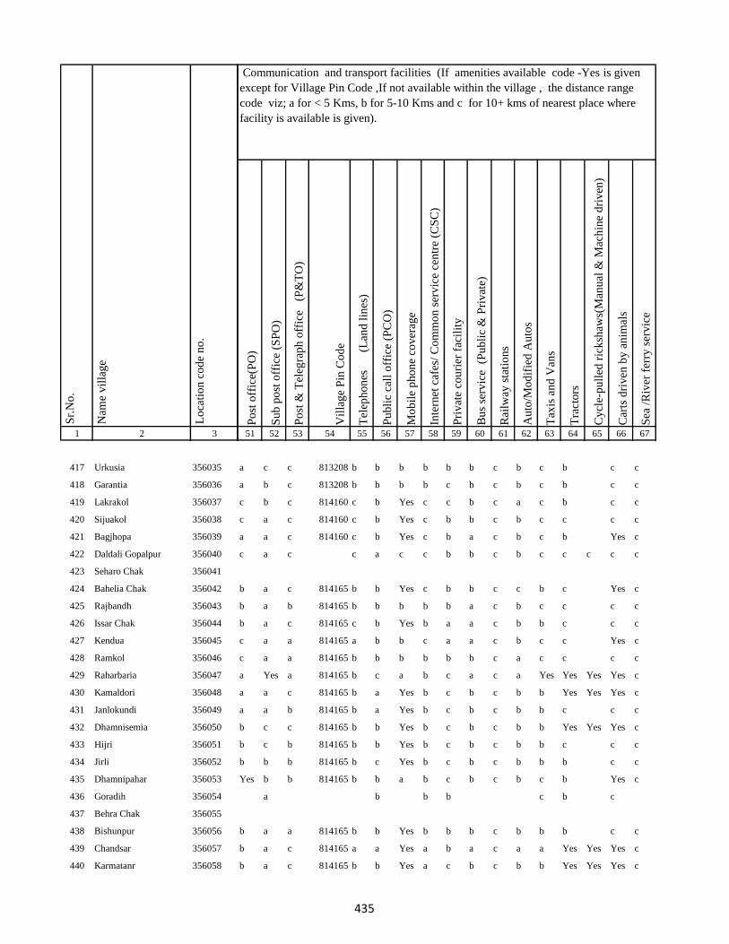
1 2 3
Lo
cati
on
co
de
no
.
Nam
e v
illa
ge
Sr.
No
.
417 Urkusia 356035
418 Garantia 356036
419 Lakrakol 356037
420 Sijuakol 356038
421 Bagjhopa 356039
422 Daldali Gopalpur 356040
423 Seharo Chak 356041
424 Bahelia Chak 356042
425 Rajbandh 356043
426 Issar Chak 356044
427 Kendua 356045
428 Ramkol 356046
429 Raharbaria 356047
430 Kamaldori 356048
431 Janlokundi 356049
432 Dhamnisemia 356050
433 Hijri 356051
434 Jirli 356052
435 Dhamnipahar 356053
436 Goradih 356054
437 Behra Chak 356055
438 Bishunpur 356056
439 Chandsar 356057
440 Karmatanr 356058
Po
st o
ffic
e(P
O)
Su
b p
ost
off
ice
(SP
O)
Po
st &
Tel
egra
ph
off
ice
(P
&T
O)
Vil
lag
e P
in C
od
e
Tel
eph
on
es
(Lan
d l
ines
)
Pu
bli
c ca
ll o
ffic
e (P
CO
)
Mo
bil
e p
ho
ne
cov
erag
e
Inte
rnet
caf
es/
Co
mm
on
ser
vic
e ce
ntr
e (C
SC
)
Pri
vat
e co
uri
er f
acil
ity
Bu
s se
rvic
e (
Pu
bli
c &
Pri
vat
e)
Rai
lway
sta
tio
ns
Au
to/M
od
ifie
d A
uto
s
Tax
is a
nd
Van
s
Tra
cto
rs
Cy
cle-
pu
lled
ric
ksh
aws(
Man
ual
& M
ach
ine
dri
ven
)
Car
ts d
riv
en b
y a
nim
als
Sea
/R
iver
fer
ry s
erv
ice
51 52 53 54 55 56 57 58 59 60 61 62 63 64 65 66 67
Communication and transport facilities (If amenities available code -Yes is given
except for Village Pin Code ,If not available within the village , the distance range
code viz; a for < 5 Kms, b for 5-10 Kms and c for 10+ kms of nearest place where
facility is available is given).
a c c 813208 b b b b b b c b c b c c
a b c 813208 b b b b c b c b c b c c
c b c 814160 c b Yes c c b c a c b c c
c a c 814160 c b Yes c b b c b c c c c
a a c 814160 c b Yes c b a c b c b Yes c
c a c c a c c b b c b c c c c c
b a c 814165 b b Yes c b b c c b c Yes c
b a b 814165 b b b b b a c b c c c c
b a c 814165 c b Yes b a a c b b c c c
c a a 814165 a b b c a a c b c c Yes c
c a a 814165 b b b b b b c a c c c c
a Yes a 814165 b c a b c a c a Yes Yes Yes Yes c
a a c 814165 b a Yes b c b c b b Yes Yes Yes c
a a b 814165 b a Yes b c b c b b c c c
b c c 814165 b b Yes b c b c b b Yes Yes Yes c
b c b 814165 b b Yes b c b c b b c c c
b b b 814165 b c Yes b c b c b b b c c
Yes b b 814165 b b a b c b c b c b Yes c
a b b b c b c
b a a 814165 b b Yes b b b c b b b c c
b a c 814165 a a Yes a b a c a a Yes Yes Yes c
b a c 814165 b b Yes a c b c b b Yes Yes Yes c
435
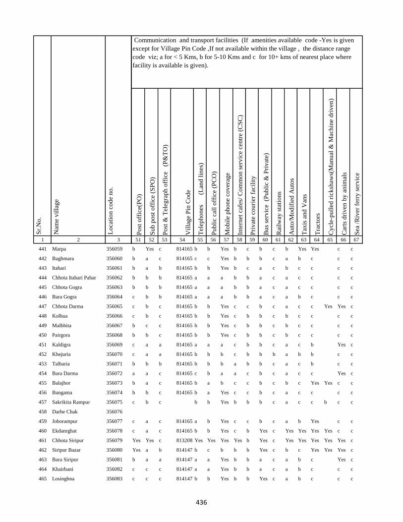
1 2 3
Lo
cati
on
co
de
no
.
Nam
e v
illa
ge
Sr.
No
.
441 Marpa 356059
442 Baghmara 356060
443 Itahari 356061
444 Chhota Itahari Pahar 356062
445 Chhota Gogra 356063
446 Bara Gogra 356064
447 Chhota Darma 356065
448 Kolhua 356066
449 Malbhita 356067
450 Pairgora 356068
451 Kaldigra 356069
452 Khejuria 356070
453 Talbaria 356071
454 Bara Darma 356072
455 Balajhor 356073
456 Bangama 356074
457 Sakrikita Rampur 356075
458 Darbe Chak 356076
459 Joborampur 356077
460 Ekdanrghat 356078
461 Chhota Siripur 356079
462 Siripur Bazar 356080
463 Bara Siripur 356081
464 Khairbani 356082
465 Losinghna 356083
Po
st o
ffic
e(P
O)
Su
b p
ost
off
ice
(SP
O)
Po
st &
Tel
egra
ph
off
ice
(P
&T
O)
Vil
lag
e P
in C
od
e
Tel
eph
on
es
(Lan
d l
ines
)
Pu
bli
c ca
ll o
ffic
e (P
CO
)
Mo
bil
e p
ho
ne
cov
erag
e
Inte
rnet
caf
es/
Co
mm
on
ser
vic
e ce
ntr
e (C
SC
)
Pri
vat
e co
uri
er f
acil
ity
Bu
s se
rvic
e (
Pu
bli
c &
Pri
vat
e)
Rai
lway
sta
tio
ns
Au
to/M
od
ifie
d A
uto
s
Tax
is a
nd
Van
s
Tra
cto
rs
Cy
cle-
pu
lled
ric
ksh
aws(
Man
ual
& M
ach
ine
dri
ven
)
Car
ts d
riv
en b
y a
nim
als
Sea
/R
iver
fer
ry s
erv
ice
51 52 53 54 55 56 57 58 59 60 61 62 63 64 65 66 67
Communication and transport facilities (If amenities available code -Yes is given
except for Village Pin Code ,If not available within the village , the distance range
code viz; a for < 5 Kms, b for 5-10 Kms and c for 10+ kms of nearest place where
facility is available is given).
b Yes c 814165 b b Yes b c b c b Yes Yes c c
b a c 814165 c c Yes b b b c a b c c c
b a b 814165 b b Yes b c a c b c c c c
b b b 814165 a a a b b a c a c c c c
b b b 814165 a a a b b a c a c c c c
c b b 814165 a a a b b a c a b c c c
c b c 814165 b b Yes c c b c a c c Yes Yes c
c b c 814165 b b Yes c b b c b c c c c
b c c 814165 b b Yes c b b c b c c c c
b b c 814165 b b Yes c b b c b c c c c
c a a 814165 a a a c b b c a c b Yes c
c a a 814165 b b b c b b b a b b c c
b b b 814165 b b b a b b c a c b c c
a a c 814165 c b a a c b c a c c Yes c
b a c 814165 b a b c c b c b c Yes Yes c c
b b c 814165 b a Yes c c b c a c c c c
c b c b b Yes b b b c a c c b c c
c a c 814165 a b Yes c c b c a b Yes c c
c a c 814165 b b Yes c b Yes c Yes Yes Yes Yes c c
Yes Yes c 813208 Yes Yes Yes Yes b Yes c Yes Yes Yes Yes Yes c
Yes a b 814147 b c b b b Yes c b c Yes Yes Yes c
b a a 814147 a a Yes b b a c a b c Yes c
c c c 814147 a a Yes b b a c a b c c c
c c c 814147 b b Yes b b Yes c a b c c c
436

1 2 3
Lo
cati
on
co
de
no
.
Nam
e v
illa
ge
Sr.
No
.
466 Bara Saraiya 356084
467 Chhota Saraiya 356085
468 Manikpur 356086
469 Kandaniya 356087
470 Beldiha 356088
471 Kortia 356089
472 Asanbuna 356090
473 Marcha 356091
474 Dumbari 356092
475 Churi 356093
476 Talbaria 356094
477 Bansbhita 356095
478 Jamunajharna 356096
479 Bara Boarijor 356097
480 Dhorri 356098
481 Dubra 356099
482 Mahula 356100
483 Meghi 356101
484 Mangra 356102
485 Chhota Boarijor 356103
486 Mahuakol 356104
487 Lakrakol 356105
488 Babuchuri 356106
489 Parsiya 356107
490 Bador 356108
Po
st o
ffic
e(P
O)
Su
b p
ost
off
ice
(SP
O)
Po
st &
Tel
egra
ph
off
ice
(P
&T
O)
Vil
lag
e P
in C
od
e
Tel
eph
on
es
(Lan
d l
ines
)
Pu
bli
c ca
ll o
ffic
e (P
CO
)
Mo
bil
e p
ho
ne
cov
erag
e
Inte
rnet
caf
es/
Co
mm
on
ser
vic
e ce
ntr
e (C
SC
)
Pri
vat
e co
uri
er f
acil
ity
Bu
s se
rvic
e (
Pu
bli
c &
Pri
vat
e)
Rai
lway
sta
tio
ns
Au
to/M
od
ifie
d A
uto
s
Tax
is a
nd
Van
s
Tra
cto
rs
Cy
cle-
pu
lled
ric
ksh
aws(
Man
ual
& M
ach
ine
dri
ven
)
Car
ts d
riv
en b
y a
nim
als
Sea
/R
iver
fer
ry s
erv
ice
51 52 53 54 55 56 57 58 59 60 61 62 63 64 65 66 67
Communication and transport facilities (If amenities available code -Yes is given
except for Village Pin Code ,If not available within the village , the distance range
code viz; a for < 5 Kms, b for 5-10 Kms and c for 10+ kms of nearest place where
facility is available is given).
c b c 814147 a b Yes b a a c a b c c c
b b b 814147 b c b c a b c b b c c c
b a c 814147 b b Yes b b b c a c b c c
b a a 814147 b b a b c b b a c b c c
b a a 814147 b b b b b Yes c Yes Yes Yes Yes c c
b b b 814147 b b b b b Yes c a b Yes c c
b a a 814147 a a a b b a c a c b c c
b b c c c c c
b Yes a 814147 a a a b c c c b b c Yes c
a c c 814147 c c Yes a b Yes c b c c c c
c a a 814147 a a a a c a b b b c c c
Yes c c 814147 c c Yes b b Yes c a Yes c c c
c b b 814147 b b b b b Yes c b c c c c
c a c 814147 c b Yes b b b c c c c Yes c
c a c 814147 c b a b c b c b c c c c
c a c 814147 c b a b b b Yes b c c c c
a a c 813208 c b Yes b b Yes c b c Yes c c
c a c 813208 c a Yes c b Yes c b Yes Yes Yes c c
b b b 813208 b a b c b b c b c b c c
b a a 813208 a b b c b a c a c Yes c c
a a a 813208 a b Yes c b a c b c a c c
b a a 813208 a b Yes c c a c b b Yes Yes c c
b b b 813208 b b Yes c c c c a c b c c
b b b 813208 b b b a c c c a c b c c
437
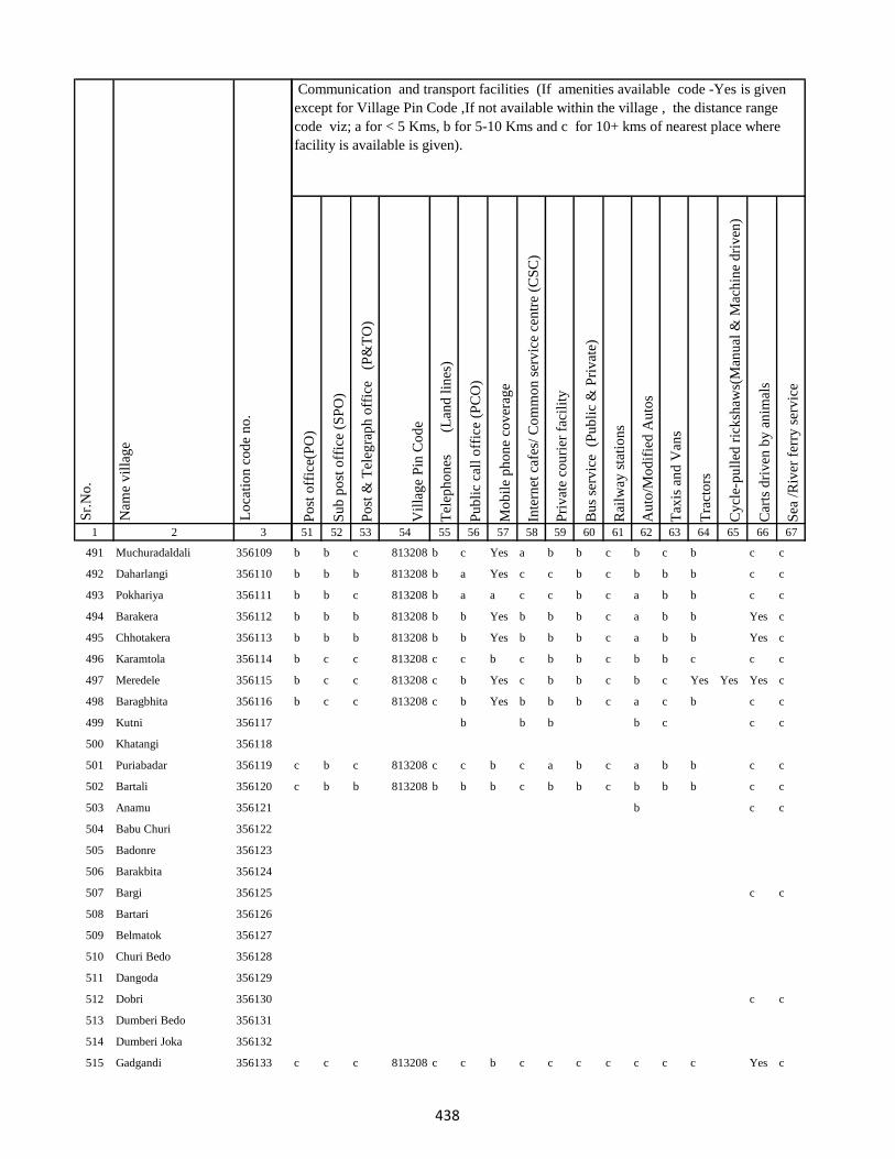
1 2 3
Lo
cati
on
co
de
no
.
Nam
e v
illa
ge
Sr.
No
.
491 Muchuradaldali 356109
492 Daharlangi 356110
493 Pokhariya 356111
494 Barakera 356112
495 Chhotakera 356113
496 Karamtola 356114
497 Meredele 356115
498 Baragbhita 356116
499 Kutni 356117
500 Khatangi 356118
501 Puriabadar 356119
502 Bartali 356120
503 Anamu 356121
504 Babu Churi 356122
505 Badonre 356123
506 Barakbita 356124
507 Bargi 356125
508 Bartari 356126
509 Belmatok 356127
510 Churi Bedo 356128
511 Dangoda 356129
512 Dobri 356130
513 Dumberi Bedo 356131
514 Dumberi Joka 356132
515 Gadgandi 356133
Po
st o
ffic
e(P
O)
Su
b p
ost
off
ice
(SP
O)
Po
st &
Tel
egra
ph
off
ice
(P
&T
O)
Vil
lag
e P
in C
od
e
Tel
eph
on
es
(Lan
d l
ines
)
Pu
bli
c ca
ll o
ffic
e (P
CO
)
Mo
bil
e p
ho
ne
cov
erag
e
Inte
rnet
caf
es/
Co
mm
on
ser
vic
e ce
ntr
e (C
SC
)
Pri
vat
e co
uri
er f
acil
ity
Bu
s se
rvic
e (
Pu
bli
c &
Pri
vat
e)
Rai
lway
sta
tio
ns
Au
to/M
od
ifie
d A
uto
s
Tax
is a
nd
Van
s
Tra
cto
rs
Cy
cle-
pu
lled
ric
ksh
aws(
Man
ual
& M
ach
ine
dri
ven
)
Car
ts d
riv
en b
y a
nim
als
Sea
/R
iver
fer
ry s
erv
ice
51 52 53 54 55 56 57 58 59 60 61 62 63 64 65 66 67
Communication and transport facilities (If amenities available code -Yes is given
except for Village Pin Code ,If not available within the village , the distance range
code viz; a for < 5 Kms, b for 5-10 Kms and c for 10+ kms of nearest place where
facility is available is given).
b b c 813208 b c Yes a b b c b c b c c
b b b 813208 b a Yes c c b c b b b c c
b b c 813208 b a a c c b c a b b c c
b b b 813208 b b Yes b b b c a b b Yes c
b b b 813208 b b Yes b b b c a b b Yes c
b c c 813208 c c b c b b c b b c c c
b c c 813208 c b Yes c b b c b c Yes Yes Yes c
b c c 813208 c b Yes b b b c a c b c c
b b b b c c c
c b c 813208 c c b c a b c a b b c c
c b b 813208 b b b c b b c b b b c c
b c c
c c
c c
c c c 813208 c c b c c c c c c c Yes c
438

1 2 3
Lo
cati
on
co
de
no
.
Nam
e v
illa
ge
Sr.
No
.
516 Gandiyamo 356134
517 Godni 356135
518 Japani 356136
519 Japita 356137
520 Jola 356138
521 Karakdoni 356139
522 Kasamu 356140
523 Katengi 356141
524 Katenribedo 356142
525 Katenri Joka 356143
526 Kukmano 356144
527 Mahwari Bedo 356145
528 Mahwari Joka 356146
529 Maligoda 356147
530 Masandumi 356148
531 Merdade 356149
532 Muchra 356150
533 Muri(Mundi) 356151
534 Orbot 356152
535 Panchrukhi 356153
536 Sundariya 356154
537 Tamilgoda 356155
538 Chhota Kendua 356156
539 Shampur 356157
540 Bara Kendua 356158
Po
st o
ffic
e(P
O)
Su
b p
ost
off
ice
(SP
O)
Po
st &
Tel
egra
ph
off
ice
(P
&T
O)
Vil
lag
e P
in C
od
e
Tel
eph
on
es
(Lan
d l
ines
)
Pu
bli
c ca
ll o
ffic
e (P
CO
)
Mo
bil
e p
ho
ne
cov
erag
e
Inte
rnet
caf
es/
Co
mm
on
ser
vic
e ce
ntr
e (C
SC
)
Pri
vat
e co
uri
er f
acil
ity
Bu
s se
rvic
e (
Pu
bli
c &
Pri
vat
e)
Rai
lway
sta
tio
ns
Au
to/M
od
ifie
d A
uto
s
Tax
is a
nd
Van
s
Tra
cto
rs
Cy
cle-
pu
lled
ric
ksh
aws(
Man
ual
& M
ach
ine
dri
ven
)
Car
ts d
riv
en b
y a
nim
als
Sea
/R
iver
fer
ry s
erv
ice
51 52 53 54 55 56 57 58 59 60 61 62 63 64 65 66 67
Communication and transport facilities (If amenities available code -Yes is given
except for Village Pin Code ,If not available within the village , the distance range
code viz; a for < 5 Kms, b for 5-10 Kms and c for 10+ kms of nearest place where
facility is available is given).
c c
c b b 813208 b b b c c b c a a a c c
c c
b c
c
c c
c c
c a c 814147 b b Yes c b a c b b a c c
b a b 814147 b b b c b b c b b Yes Yes c
c a c 814147 c c b c b b c b b a c c
439
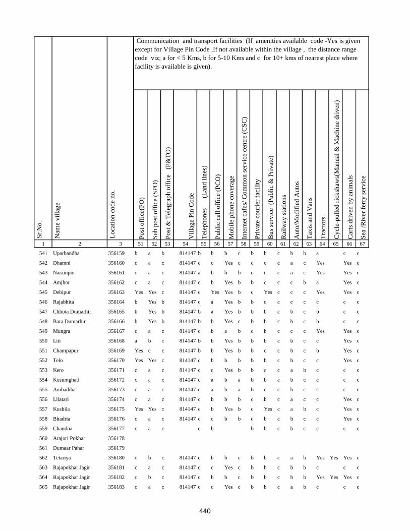
1 2 3
Lo
cati
on
co
de
no
.
Nam
e v
illa
ge
Sr.
No
.
541 Uparbandha 356159
542 Dhamni 356160
543 Narainpur 356161
544 Amjhor 356162
545 Debipur 356163
546 Rajabhita 356164
547 Chhota Dumarhir 356165
548 Bara Dumarhir 356166
549 Mungra 356167
550 Liti 356168
551 Champapur 356169
552 Telo 356170
553 Kero 356171
554 Kusumghati 356172
555 Ambadiha 356173
556 Lilatari 356174
557 Kusbila 356175
558 Bhadria 356176
559 Chandna 356177
560 Arajori Pokhar 356178
561 Dumaar Pahar 356179
562 Tetariya 356180
563 Rajapokhar Jagir 356181
564 Rajapokhar Jagir 356182
565 Rajapokhar Jagir 356183
Po
st o
ffic
e(P
O)
Su
b p
ost
off
ice
(SP
O)
Po
st &
Tel
egra
ph
off
ice
(P
&T
O)
Vil
lag
e P
in C
od
e
Tel
eph
on
es
(Lan
d l
ines
)
Pu
bli
c ca
ll o
ffic
e (P
CO
)
Mo
bil
e p
ho
ne
cov
erag
e
Inte
rnet
caf
es/
Co
mm
on
ser
vic
e ce
ntr
e (C
SC
)
Pri
vat
e co
uri
er f
acil
ity
Bu
s se
rvic
e (
Pu
bli
c &
Pri
vat
e)
Rai
lway
sta
tio
ns
Au
to/M
od
ifie
d A
uto
s
Tax
is a
nd
Van
s
Tra
cto
rs
Cy
cle-
pu
lled
ric
ksh
aws(
Man
ual
& M
ach
ine
dri
ven
)
Car
ts d
riv
en b
y a
nim
als
Sea
/R
iver
fer
ry s
erv
ice
51 52 53 54 55 56 57 58 59 60 61 62 63 64 65 66 67
Communication and transport facilities (If amenities available code -Yes is given
except for Village Pin Code ,If not available within the village , the distance range
code viz; a for < 5 Kms, b for 5-10 Kms and c for 10+ kms of nearest place where
facility is available is given).
b a b 814147 b b b c b b c b b a c c
c a c 814147 c c Yes c c c c a c Yes Yes c
c a c 814147 a b b b c c c a c Yes Yes c
c a c 814147 c b Yes b b c c c b a Yes c
Yes Yes c 814147 c Yes Yes b c Yes c c c Yes Yes c
b Yes b 814147 c a Yes b b c c c c c c c
b Yes b 814147 b a Yes b b b c b c b c c
b Yes b 814147 b b Yes c b b c b c b c c
c a c 814147 c b a b c b c c c Yes Yes c
a b c 814147 b b Yes b b b c b c c Yes c
Yes c c 814147 b b Yes b b c c b c b Yes c
Yes Yes c 814147 c b b b b b c b c c Yes c
c a c 814147 c c Yes b b c c a b c c c
c a c 814147 c a b a b b c b c c c c
c a c 814147 c a b a b c c b c c c c
c a c 814147 c b b b c b c a c c Yes c
Yes Yes c 814147 c b Yes b c Yes c a b c Yes c
c a c 814147 c c b b c b c b c c Yes c
c a c c b b b c b c c c c
c b c 814147 c b b c b b c a b Yes Yes Yes c
c a c 814147 c c Yes c b b c b b c c c
c b c 814147 c b b c b b c b b Yes Yes Yes c
c a c 814147 c c Yes c b b c a b c c c
440
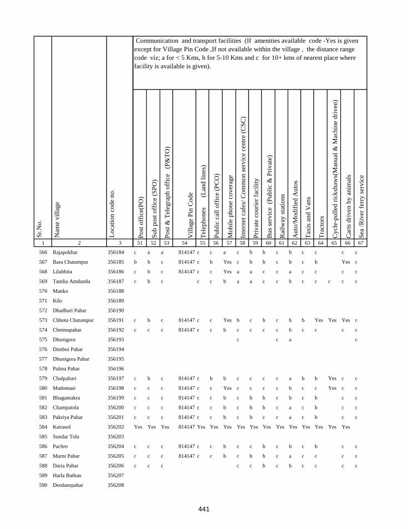
1 2 3
Lo
cati
on
co
de
no
.
Nam
e v
illa
ge
Sr.
No
.
566 Rajapokhar 356184
567 Bara Chatampur 356185
568 Lilabhita 356186
569 Tamlia Amdanda 356187
570 Manko 356188
571 Kilo 356189
572 Dhadhari Pahar 356190
573 Chhota Chatampur 356191
574 Chetmapahar 356192
575 Dhanigora 356193
576 Dimbni Pahar 356194
577 Dhunigora Pahar 356195
578 Palma Pahar 356196
579 Chalpahari 356197
580 Madomasi 356198
581 Bhagamakra 356199
582 Champatola 356200
583 Pakriya Pahar 356201
584 Kairasol 356202
585 Sundar Tola 356203
586 Pachro 356204
587 Marni Pahar 356205
588 Daria Pahar 356206
589 Harla Bathan 356207
590 Deodanrpahar 356208
Po
st o
ffic
e(P
O)
Su
b p
ost
off
ice
(SP
O)
Po
st &
Tel
egra
ph
off
ice
(P
&T
O)
Vil
lag
e P
in C
od
e
Tel
eph
on
es
(Lan
d l
ines
)
Pu
bli
c ca
ll o
ffic
e (P
CO
)
Mo
bil
e p
ho
ne
cov
erag
e
Inte
rnet
caf
es/
Co
mm
on
ser
vic
e ce
ntr
e (C
SC
)
Pri
vat
e co
uri
er f
acil
ity
Bu
s se
rvic
e (
Pu
bli
c &
Pri
vat
e)
Rai
lway
sta
tio
ns
Au
to/M
od
ifie
d A
uto
s
Tax
is a
nd
Van
s
Tra
cto
rs
Cy
cle-
pu
lled
ric
ksh
aws(
Man
ual
& M
ach
ine
dri
ven
)
Car
ts d
riv
en b
y a
nim
als
Sea
/R
iver
fer
ry s
erv
ice
51 52 53 54 55 56 57 58 59 60 61 62 63 64 65 66 67
Communication and transport facilities (If amenities available code -Yes is given
except for Village Pin Code ,If not available within the village , the distance range
code viz; a for < 5 Kms, b for 5-10 Kms and c for 10+ kms of nearest place where
facility is available is given).
c a a 814147 c c a c b b c b c c c c
b b c 814147 c b Yes c b b c b c b Yes c
c b c 814147 c c Yes a a c c a c c c c
c b c c c b a a c c b c c c c c
c b c 814147 c c Yes b c b c b b Yes Yes Yes c
c c c 814147 c c b c c c c b c c c c
c c a c
c b c 814147 c b b c c c c a b b Yes c c
c c c 814147 c c Yes c c c c b c c Yes c c
c c c 814147 c c b c b b c b c b c c
c c c 814147 c c b c b b c a c b c c
c c c 814147 c c b c b c c a c b c c
Yes Yes Yes 814147 Yes Yes Yes Yes Yes Yes Yes Yes Yes Yes Yes Yes
c c c 814147 c c b c c b c b c b c c
c c c 814147 c c b c b b c a c c c c
c c c c c b c b c c c c
441
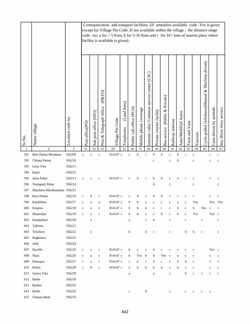
1 2 3
Lo
cati
on
co
de
no
.
Nam
e v
illa
ge
Sr.
No
.
591 Bara Patma Masahara 356209
592 Chhota Patma 356210
593 Letra Tola 356211
594 Kajro 356212
595 Jania Pahar 356213
596 Tetarganji Pahar 356214
597 Matubera Masaharpahar 356215
598 Bara Patma 356216
599 Katikbhita 356217
600 Kuspisa 356218
601 Dhamnijor 356219
602 Katalpahari 356220
603 Talbona 356221
604 Telaibera 356222
605 Baghmara 356223
606 Jullo 356224
607 Baridih 356225
608 Sijua 356226
609 Ratanpur 356227
610 Rohra 356228
611 Juniya Tola 356229
612 Barbe 356230
613 Badem 356231
614 Borbe 356232
615 Chatma Bedo 356233
Po
st o
ffic
e(P
O)
Su
b p
ost
off
ice
(SP
O)
Po
st &
Tel
egra
ph
off
ice
(P
&T
O)
Vil
lag
e P
in C
od
e
Tel
eph
on
es
(Lan
d l
ines
)
Pu
bli
c ca
ll o
ffic
e (P
CO
)
Mo
bil
e p
ho
ne
cov
erag
e
Inte
rnet
caf
es/
Co
mm
on
ser
vic
e ce
ntr
e (C
SC
)
Pri
vat
e co
uri
er f
acil
ity
Bu
s se
rvic
e (
Pu
bli
c &
Pri
vat
e)
Rai
lway
sta
tio
ns
Au
to/M
od
ifie
d A
uto
s
Tax
is a
nd
Van
s
Tra
cto
rs
Cy
cle-
pu
lled
ric
ksh
aws(
Man
ual
& M
ach
ine
dri
ven
)
Car
ts d
riv
en b
y a
nim
als
Sea
/R
iver
fer
ry s
erv
ice
51 52 53 54 55 56 57 58 59 60 61 62 63 64 65 66 67
Communication and transport facilities (If amenities available code -Yes is given
except for Village Pin Code ,If not available within the village , the distance range
code viz; a for < 5 Kms, b for 5-10 Kms and c for 10+ kms of nearest place where
facility is available is given).
c c c 814147 c c b c b b c b c c c c
c c b c c c
c c c 814147 c c b c b b c a c c c c
b c c c
c b c 814147 c c b c b b c c c c c c
c a a 814147 c b b c c c c a c Yes Yes Yes
c a c 814147 c b b b c c c b c b Yes c c
c a c 814147 c b b c c b c b c Yes Yes c
a a c b c c c c
c b b c c b b c c
c a c 814147 c b a c b c c c c c Yes c
c a c 814147 c b Yes b b Yes c a c c c c
c a c 814147 c c b c b c c b b c c c
c b c 814147 c a b b b b c b c c c c
a a c b c c c c
c b c c c c c
442
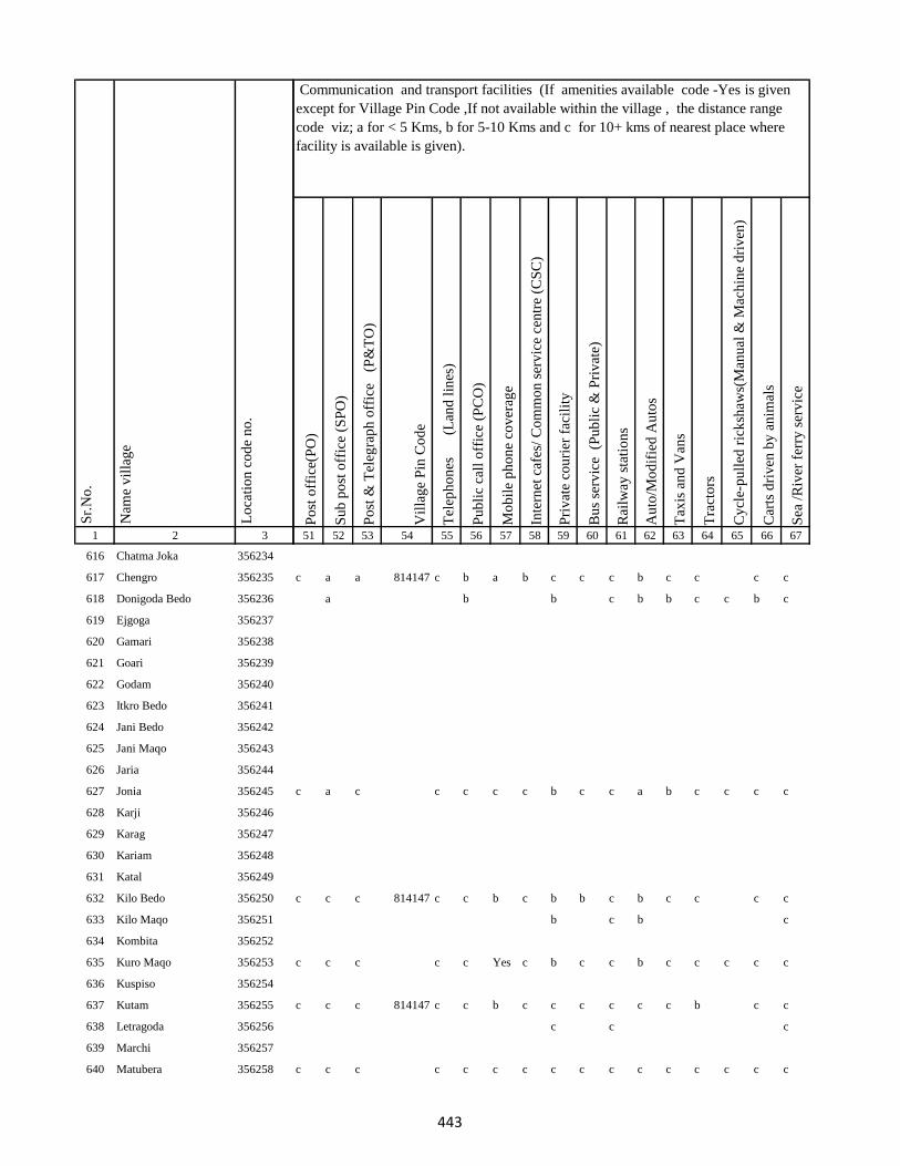
1 2 3
Lo
cati
on
co
de
no
.
Nam
e v
illa
ge
Sr.
No
.
616 Chatma Joka 356234
617 Chengro 356235
618 Donigoda Bedo 356236
619 Ejgoga 356237
620 Gamari 356238
621 Goari 356239
622 Godam 356240
623 Itkro Bedo 356241
624 Jani Bedo 356242
625 Jani Maqo 356243
626 Jaria 356244
627 Jonia 356245
628 Karji 356246
629 Karag 356247
630 Kariam 356248
631 Katal 356249
632 Kilo Bedo 356250
633 Kilo Maqo 356251
634 Kombita 356252
635 Kuro Maqo 356253
636 Kuspiso 356254
637 Kutam 356255
638 Letragoda 356256
639 Marchi 356257
640 Matubera 356258
Po
st o
ffic
e(P
O)
Su
b p
ost
off
ice
(SP
O)
Po
st &
Tel
egra
ph
off
ice
(P
&T
O)
Vil
lag
e P
in C
od
e
Tel
eph
on
es
(Lan
d l
ines
)
Pu
bli
c ca
ll o
ffic
e (P
CO
)
Mo
bil
e p
ho
ne
cov
erag
e
Inte
rnet
caf
es/
Co
mm
on
ser
vic
e ce
ntr
e (C
SC
)
Pri
vat
e co
uri
er f
acil
ity
Bu
s se
rvic
e (
Pu
bli
c &
Pri
vat
e)
Rai
lway
sta
tio
ns
Au
to/M
od
ifie
d A
uto
s
Tax
is a
nd
Van
s
Tra
cto
rs
Cy
cle-
pu
lled
ric
ksh
aws(
Man
ual
& M
ach
ine
dri
ven
)
Car
ts d
riv
en b
y a
nim
als
Sea
/R
iver
fer
ry s
erv
ice
51 52 53 54 55 56 57 58 59 60 61 62 63 64 65 66 67
Communication and transport facilities (If amenities available code -Yes is given
except for Village Pin Code ,If not available within the village , the distance range
code viz; a for < 5 Kms, b for 5-10 Kms and c for 10+ kms of nearest place where
facility is available is given).
c a a 814147 c b a b c c c b c c c c
a b b c b b c c b c
c a c c c c c b c c a b c c c c
c c c 814147 c c b c b b c b c c c c
b c b c
c c c c c Yes c b c c b c c c c c
c c c 814147 c c b c c c c c c b c c
c c c
c c c c c c c c c c c c c c c c
443
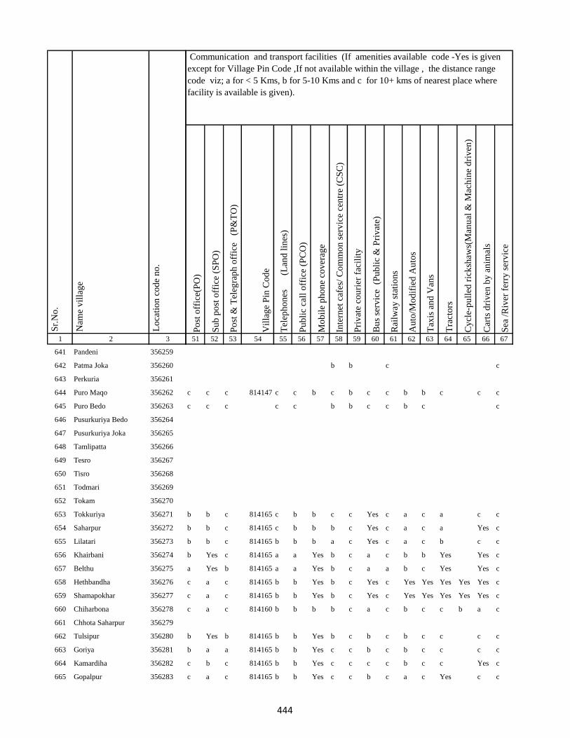
1 2 3
Lo
cati
on
co
de
no
.
Nam
e v
illa
ge
Sr.
No
.
641 Pandeni 356259
642 Patma Joka 356260
643 Perkuria 356261
644 Puro Maqo 356262
645 Puro Bedo 356263
646 Pusurkuriya Bedo 356264
647 Pusurkuriya Joka 356265
648 Tamlipatta 356266
649 Tesro 356267
650 Tisro 356268
651 Todmari 356269
652 Tokam 356270
653 Tokkuriya 356271
654 Saharpur 356272
655 Lilatari 356273
656 Khairbani 356274
657 Belthu 356275
658 Hethbandha 356276
659 Shamapokhar 356277
660 Chiharbona 356278
661 Chhota Saharpur 356279
662 Tulsipur 356280
663 Goriya 356281
664 Kamardiha 356282
665 Gopalpur 356283
Po
st o
ffic
e(P
O)
Su
b p
ost
off
ice
(SP
O)
Po
st &
Tel
egra
ph
off
ice
(P
&T
O)
Vil
lag
e P
in C
od
e
Tel
eph
on
es
(Lan
d l
ines
)
Pu
bli
c ca
ll o
ffic
e (P
CO
)
Mo
bil
e p
ho
ne
cov
erag
e
Inte
rnet
caf
es/
Co
mm
on
ser
vic
e ce
ntr
e (C
SC
)
Pri
vat
e co
uri
er f
acil
ity
Bu
s se
rvic
e (
Pu
bli
c &
Pri
vat
e)
Rai
lway
sta
tio
ns
Au
to/M
od
ifie
d A
uto
s
Tax
is a
nd
Van
s
Tra
cto
rs
Cy
cle-
pu
lled
ric
ksh
aws(
Man
ual
& M
ach
ine
dri
ven
)
Car
ts d
riv
en b
y a
nim
als
Sea
/R
iver
fer
ry s
erv
ice
51 52 53 54 55 56 57 58 59 60 61 62 63 64 65 66 67
Communication and transport facilities (If amenities available code -Yes is given
except for Village Pin Code ,If not available within the village , the distance range
code viz; a for < 5 Kms, b for 5-10 Kms and c for 10+ kms of nearest place where
facility is available is given).
b b c c
c c c 814147 c c b c b c c b b c c c
c c c c c b b c c b c c
b b c 814165 c b b c c Yes c a c a c c
b b c 814165 c b b b c Yes c a c a Yes c
b b c 814165 b b b a c Yes c a c b c c
b Yes c 814165 a a Yes b c a c b b Yes Yes c
a Yes b 814165 a a Yes b c a a b c Yes Yes c
c a c 814165 b b Yes b c Yes c Yes Yes Yes Yes Yes c
c a c 814165 b b Yes b c Yes c Yes Yes Yes Yes Yes c
c a c 814160 b b b b c a c b c c b a c
b Yes b 814165 b b Yes b c b c b c c c c
b a a 814165 b b Yes c c b c b c c c c
c b c 814165 b b Yes c c c c b c c Yes c
c a c 814165 b b Yes c c b c a c Yes c c
444

1 2 3
Lo
cati
on
co
de
no
.
Nam
e v
illa
ge
Sr.
No
.
666 Lawabhujani 356284
667 Babhania 356285
668 Gori Chak 356286
669 Karua 356287
670 Barhara 356288
671 Gorakhpur 356289
672 Jojosimra 356290
673 Kusma 356291
674 Kurkutiya 356292
675 Dumra 356293
676 Sabejora 356294
677 Amba 356295
678 Shampur 356296
679 Beldiha 356297
680 Balajhor 356298
681 Ghatiari 356299
682 Jata Kuti 356300
683 Bagjori 356301
684 Kendua 356302
685 Tetaria 356303
686 Paharpur 356304
687 Bara Simra 356305
688 Chhota Simra 356306
689 Ghat Simra 356307
690 Suarmari 356308
Po
st o
ffic
e(P
O)
Su
b p
ost
off
ice
(SP
O)
Po
st &
Tel
egra
ph
off
ice
(P
&T
O)
Vil
lag
e P
in C
od
e
Tel
eph
on
es
(Lan
d l
ines
)
Pu
bli
c ca
ll o
ffic
e (P
CO
)
Mo
bil
e p
ho
ne
cov
erag
e
Inte
rnet
caf
es/
Co
mm
on
ser
vic
e ce
ntr
e (C
SC
)
Pri
vat
e co
uri
er f
acil
ity
Bu
s se
rvic
e (
Pu
bli
c &
Pri
vat
e)
Rai
lway
sta
tio
ns
Au
to/M
od
ifie
d A
uto
s
Tax
is a
nd
Van
s
Tra
cto
rs
Cy
cle-
pu
lled
ric
ksh
aws(
Man
ual
& M
ach
ine
dri
ven
)
Car
ts d
riv
en b
y a
nim
als
Sea
/R
iver
fer
ry s
erv
ice
51 52 53 54 55 56 57 58 59 60 61 62 63 64 65 66 67
Communication and transport facilities (If amenities available code -Yes is given
except for Village Pin Code ,If not available within the village , the distance range
code viz; a for < 5 Kms, b for 5-10 Kms and c for 10+ kms of nearest place where
facility is available is given).
Yes b c 814165 b b b b b b c b b c Yes c
c b b 814165 b b b b b b c b c c Yes c
c a c 814165 a a a a c b c b b c Yes c
c a a 814165 a a a b b b c b c c c c
c a a 814165 a a a a c b c a c c c c
b a b 814165 b b Yes b b c c b b b Yes c
b a a 814165 b b Yes c b b c b b b c c
b a b 814165 b b Yes c c c c a b b c c
a a a 814165 a a Yes b b a c a c Yes Yes c
a c c 814165 a a Yes b b a c b c Yes Yes c
c c b 814165 b b b b b b b b c c Yes c
c b c 814165 b b Yes c c b c a b c c c
c b c 814165 b b Yes c b b c a c c c c
a a c 814165 b b a b b b c a b Yes Yes c
c a b 814165 b b a c b Yes c b a c c c
c a b 814165 b c b b c Yes c b a Yes Yes c
c a a 814165 a a Yes c c a c a a c Yes c
c a b 814165 b a Yes b b a c b a c Yes Yes c
c a a 814165 a b Yes a c a c b a c c c
c b c 814165 b b Yes b b a c a b c c c
c Yes c 814165 a c Yes b b a c b c c Yes c
a a a 814165 Yes b Yes b a a c b c c Yes Yes c
c a c 814165 Yes Yes Yes b c a c b c b Yes c c
b a c 814165 a Yes Yes c b a c b b b Yes c
b a c 814165 b Yes Yes a b a c b c b c c
445
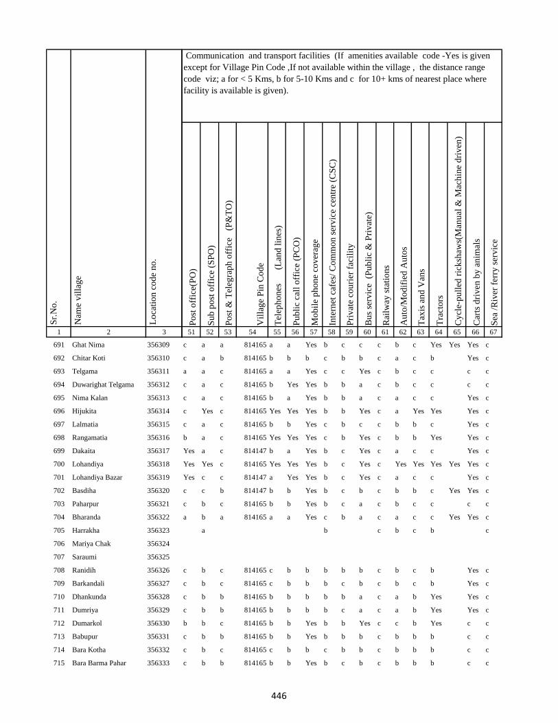
1 2 3
Lo
cati
on
co
de
no
.
Nam
e v
illa
ge
Sr.
No
.
691 Ghat Nima 356309
692 Chitar Koti 356310
693 Telgama 356311
694 Duwarighat Telgama 356312
695 Nima Kalan 356313
696 Hijukita 356314
697 Lalmatia 356315
698 Rangamatia 356316
699 Dakaita 356317
700 Lohandiya 356318
701 Lohandiya Bazar 356319
702 Basdiha 356320
703 Paharpur 356321
704 Bharanda 356322
705 Harrakha 356323
706 Mariya Chak 356324
707 Saraumi 356325
708 Ranidih 356326
709 Barkandali 356327
710 Dhankunda 356328
711 Dumriya 356329
712 Dumarkol 356330
713 Babupur 356331
714 Bara Kotha 356332
715 Bara Barma Pahar 356333
Po
st o
ffic
e(P
O)
Su
b p
ost
off
ice
(SP
O)
Po
st &
Tel
egra
ph
off
ice
(P
&T
O)
Vil
lag
e P
in C
od
e
Tel
eph
on
es
(Lan
d l
ines
)
Pu
bli
c ca
ll o
ffic
e (P
CO
)
Mo
bil
e p
ho
ne
cov
erag
e
Inte
rnet
caf
es/
Co
mm
on
ser
vic
e ce
ntr
e (C
SC
)
Pri
vat
e co
uri
er f
acil
ity
Bu
s se
rvic
e (
Pu
bli
c &
Pri
vat
e)
Rai
lway
sta
tio
ns
Au
to/M
od
ifie
d A
uto
s
Tax
is a
nd
Van
s
Tra
cto
rs
Cy
cle-
pu
lled
ric
ksh
aws(
Man
ual
& M
ach
ine
dri
ven
)
Car
ts d
riv
en b
y a
nim
als
Sea
/R
iver
fer
ry s
erv
ice
51 52 53 54 55 56 57 58 59 60 61 62 63 64 65 66 67
Communication and transport facilities (If amenities available code -Yes is given
except for Village Pin Code ,If not available within the village , the distance range
code viz; a for < 5 Kms, b for 5-10 Kms and c for 10+ kms of nearest place where
facility is available is given).
c a a 814165 a a Yes b c c c b c Yes Yes Yes c
c a b 814165 b b b c b b c a c b Yes c
a a c 814165 a a Yes c c Yes c b c c c c
c a c 814165 b Yes Yes b b a c b c c c c
c a c 814165 b a Yes b b a c a c c Yes c
c Yes c 814165 Yes Yes Yes b b Yes c a Yes Yes Yes c
c a c 814165 b b Yes c b c c b b c Yes c
b a c 814165 Yes Yes Yes c b Yes c b b Yes Yes c
Yes a c 814147 b a Yes b c Yes c a c c Yes c
Yes Yes c 814165 Yes Yes Yes b c Yes c Yes Yes Yes Yes Yes c
Yes c c 814147 a Yes Yes b c Yes c a c c Yes c
c c b 814147 b b Yes b c b c b b c Yes Yes c
c b c 814165 b b Yes b c a c b c c c c
a b a 814165 a a Yes c b a c a c c Yes Yes c
a b c b c b c
c b c 814165 c b b b b b c b c b Yes c
c b c 814165 c b b b c b c b c b Yes c
c b b 814165 b b b b b a c a b Yes Yes c
c b b 814165 b b b b c a c a b Yes Yes c
b b c 814165 b b Yes b b Yes c c b Yes c c
c b b 814165 b b Yes b b b c b b b c c
c b c 814165 c b b c b b c b b b c c
c b b 814165 b b Yes b c b c b b b c c
446
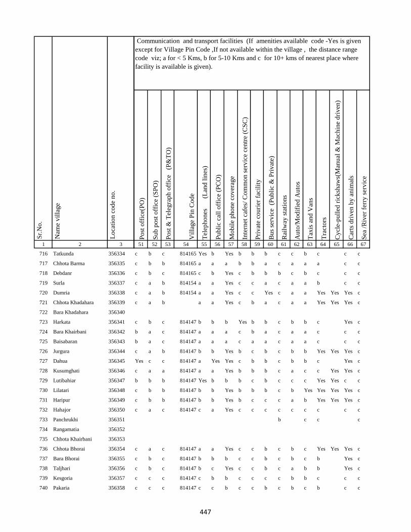
1 2 3
Lo
cati
on
co
de
no
.
Nam
e v
illa
ge
Sr.
No
.
716 Tatkunda 356334
717 Chhota Barma 356335
718 Debdanr 356336
719 Surla 356337
720 Dumria 356338
721 Chhota Khadahara 356339
722 Bara Khadahara 356340
723 Harkata 356341
724 Bara Khairbani 356342
725 Baisabaran 356343
726 Jurgura 356344
727 Dahua 356345
728 Kusumghati 356346
729 Lutibahiar 356347
730 Lilatari 356348
731 Haripur 356349
732 Hahajor 356350
733 Panchrukhi 356351
734 Rangamatia 356352
735 Chhota Khairbani 356353
736 Chhota Bhorai 356354
737 Bara Bhorai 356355
738 Taljhari 356356
739 Kesgoria 356357
740 Pakaria 356358
Po
st o
ffic
e(P
O)
Su
b p
ost
off
ice
(SP
O)
Po
st &
Tel
egra
ph
off
ice
(P
&T
O)
Vil
lag
e P
in C
od
e
Tel
eph
on
es
(Lan
d l
ines
)
Pu
bli
c ca
ll o
ffic
e (P
CO
)
Mo
bil
e p
ho
ne
cov
erag
e
Inte
rnet
caf
es/
Co
mm
on
ser
vic
e ce
ntr
e (C
SC
)
Pri
vat
e co
uri
er f
acil
ity
Bu
s se
rvic
e (
Pu
bli
c &
Pri
vat
e)
Rai
lway
sta
tio
ns
Au
to/M
od
ifie
d A
uto
s
Tax
is a
nd
Van
s
Tra
cto
rs
Cy
cle-
pu
lled
ric
ksh
aws(
Man
ual
& M
ach
ine
dri
ven
)
Car
ts d
riv
en b
y a
nim
als
Sea
/R
iver
fer
ry s
erv
ice
51 52 53 54 55 56 57 58 59 60 61 62 63 64 65 66 67
Communication and transport facilities (If amenities available code -Yes is given
except for Village Pin Code ,If not available within the village , the distance range
code viz; a for < 5 Kms, b for 5-10 Kms and c for 10+ kms of nearest place where
facility is available is given).
c b c 814165 Yes b Yes b b b c c b c c c
c b b 814165 a a a b b a c a a a c c
c b c 814165 c b Yes c b b b c b c c c
c a b 814154 a a Yes c c a c a a b c c
c a b 814154 a a Yes c c Yes c a a Yes Yes Yes c
c a b a a Yes c b a c a a Yes Yes Yes c
c b c 814147 b b b Yes b b c b b c Yes c
b a c 814147 a a a c b a c a a c c c
b a c 814147 a a a c a a c a a c c c
c a b 814147 b b Yes b c b c b b Yes Yes Yes c
Yes c c 814147 a Yes Yes c b b c b b c Yes c
c a a 814147 a a Yes b b b c a c c Yes Yes c
b b b 814147 Yes b b b c b c c c Yes Yes c c
c b b 814147 b b Yes b b b c b Yes Yes Yes Yes c
c b b 814147 b b Yes b c c c a b Yes Yes Yes c
c a c 814147 c a Yes c c c c c c c c c
b c c c
c a c 814147 a a Yes c c b c b c Yes Yes Yes c
c b c 814147 b b b c c b c b c b Yes c
c b c 814147 b c Yes c c b c a b b Yes c
c c c 814147 c b b c c c c b b c c c
c c c 814147 c c b c c b c b c b c c
447
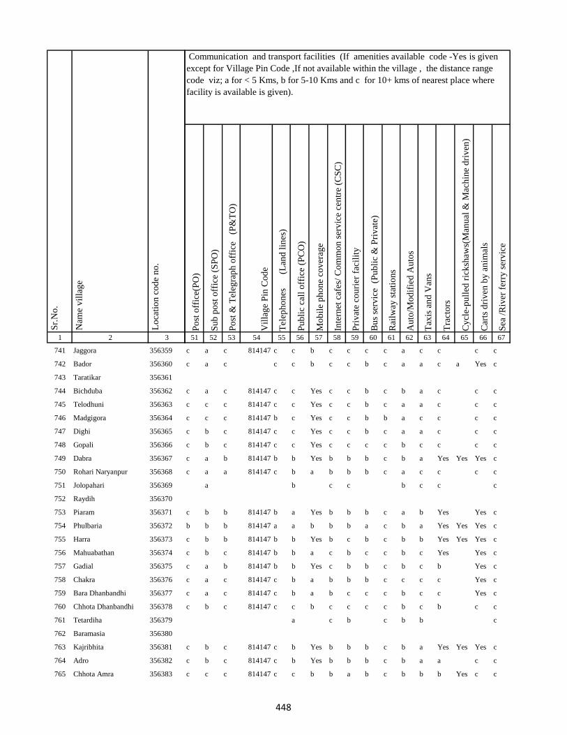
1 2 3
Lo
cati
on
co
de
no
.
Nam
e v
illa
ge
Sr.
No
.
741 Jaggora 356359
742 Bador 356360
743 Taratikar 356361
744 Bichduba 356362
745 Telodhuni 356363
746 Madgigora 356364
747 Dighi 356365
748 Gopali 356366
749 Dabra 356367
750 Rohari Naryanpur 356368
751 Jolopahari 356369
752 Raydih 356370
753 Piaram 356371
754 Phulbaria 356372
755 Harra 356373
756 Mahuabathan 356374
757 Gadial 356375
758 Chakra 356376
759 Bara Dhanbandhi 356377
760 Chhota Dhanbandhi 356378
761 Tetardiha 356379
762 Baramasia 356380
763 Kajribhita 356381
764 Adro 356382
765 Chhota Amra 356383
Po
st o
ffic
e(P
O)
Su
b p
ost
off
ice
(SP
O)
Po
st &
Tel
egra
ph
off
ice
(P
&T
O)
Vil
lag
e P
in C
od
e
Tel
eph
on
es
(Lan
d l
ines
)
Pu
bli
c ca
ll o
ffic
e (P
CO
)
Mo
bil
e p
ho
ne
cov
erag
e
Inte
rnet
caf
es/
Co
mm
on
ser
vic
e ce
ntr
e (C
SC
)
Pri
vat
e co
uri
er f
acil
ity
Bu
s se
rvic
e (
Pu
bli
c &
Pri
vat
e)
Rai
lway
sta
tio
ns
Au
to/M
od
ifie
d A
uto
s
Tax
is a
nd
Van
s
Tra
cto
rs
Cy
cle-
pu
lled
ric
ksh
aws(
Man
ual
& M
ach
ine
dri
ven
)
Car
ts d
riv
en b
y a
nim
als
Sea
/R
iver
fer
ry s
erv
ice
51 52 53 54 55 56 57 58 59 60 61 62 63 64 65 66 67
Communication and transport facilities (If amenities available code -Yes is given
except for Village Pin Code ,If not available within the village , the distance range
code viz; a for < 5 Kms, b for 5-10 Kms and c for 10+ kms of nearest place where
facility is available is given).
c a c 814147 c c b c c c c a c c c c
c a c c c b c c b c a a c a Yes c
c a c 814147 c c Yes c c b c b a c c c
c c c 814147 c c Yes c c b c a a c c c
c c c 814147 b c Yes c c b b a c c c c
c b c 814147 c c Yes c c b c a a c c c
c b c 814147 c c Yes c c c c b c c c c
c a b 814147 b b Yes b b b c b a Yes Yes Yes c
c a a 814147 c b a b b b c a c c c c
a b c c b c c c
c b b 814147 b a Yes b b b c a b Yes Yes c
b b b 814147 a a b b b a c b a Yes Yes Yes c
c b b 814147 b b Yes b c b c b b Yes Yes Yes c
c b c 814147 b b a c b c c b c Yes Yes c
c a b 814147 b b Yes c b b c b c b Yes c
c a c 814147 c b a b b b c c c c Yes c
c a c 814147 c b a b c c c b c c Yes c
c b c 814147 c c b c c c c b c b c c
a c b c b b c
c b c 814147 c b Yes b b b c b a Yes Yes Yes c
c b c 814147 c b Yes b b b c b a a c c
c c c 814147 c c b b a b c b b b Yes c c
448

1 2 3
Lo
cati
on
co
de
no
.
Nam
e v
illa
ge
Sr.
No
.
766 Tulsipur 356384
767 Lohatamba And Agoia 356385
768 Bhalgora 356386
769 Deonapur 356387
770 Bhagwanpur 356388
771 Bara Malbhita 356389
772 Chhota Malbhita 356390
773 Tikrigora 356391
774 Gamhar Pahar 356392
775 Katar Pahar 356393
776 Kisma Pahar 356394
777 Malbhita Tola 356395
778 Chhota Pipra 356396
779 Pipra Hill 356397
780 Tetarbhita 356398
781 Tatgora 356399
782 Chhota Basgo 356400
783 Bara Pipra 356401
784 Salem Tok 356402
785 Kukur Pahari 356403
786 Kuschilia Pahar 356404
787 Kisma 356405
788 Bara Amarpur 356406
789 Chhota Amarpur 356407
790 Dumaria 356408
Po
st o
ffic
e(P
O)
Su
b p
ost
off
ice
(SP
O)
Po
st &
Tel
egra
ph
off
ice
(P
&T
O)
Vil
lag
e P
in C
od
e
Tel
eph
on
es
(Lan
d l
ines
)
Pu
bli
c ca
ll o
ffic
e (P
CO
)
Mo
bil
e p
ho
ne
cov
erag
e
Inte
rnet
caf
es/
Co
mm
on
ser
vic
e ce
ntr
e (C
SC
)
Pri
vat
e co
uri
er f
acil
ity
Bu
s se
rvic
e (
Pu
bli
c &
Pri
vat
e)
Rai
lway
sta
tio
ns
Au
to/M
od
ifie
d A
uto
s
Tax
is a
nd
Van
s
Tra
cto
rs
Cy
cle-
pu
lled
ric
ksh
aws(
Man
ual
& M
ach
ine
dri
ven
)
Car
ts d
riv
en b
y a
nim
als
Sea
/R
iver
fer
ry s
erv
ice
51 52 53 54 55 56 57 58 59 60 61 62 63 64 65 66 67
Communication and transport facilities (If amenities available code -Yes is given
except for Village Pin Code ,If not available within the village , the distance range
code viz; a for < 5 Kms, b for 5-10 Kms and c for 10+ kms of nearest place where
facility is available is given).
c a c 814147 c b Yes b c b c b b Yes Yes Yes c
b b c 814147 c b Yes c b b c b c c Yes c c
c b c 814147 c b a b b b c b c c c c
c a c 814147 c b Yes b c c c b c Yes Yes c
c b c 814147 c c Yes c b b c b b Yes Yes Yes c
c b c 814147 c c Yes b c c c a b Yes Yes Yes c
c c c 814147 c b b b c b c b b b Yes c c
b c c
c c c 814147 c b b c b b c b b c c c
b b b c b c c
b c c c b c
c a c 814147 c c Yes c c c c b c Yes Yes Yes c
c b c 814147 c a Yes c b b c a c Yes Yes Yes c
b b b 814147 c a Yes c b c c c b c c c
c c c 814147 c b a c b b c c c b c c
449
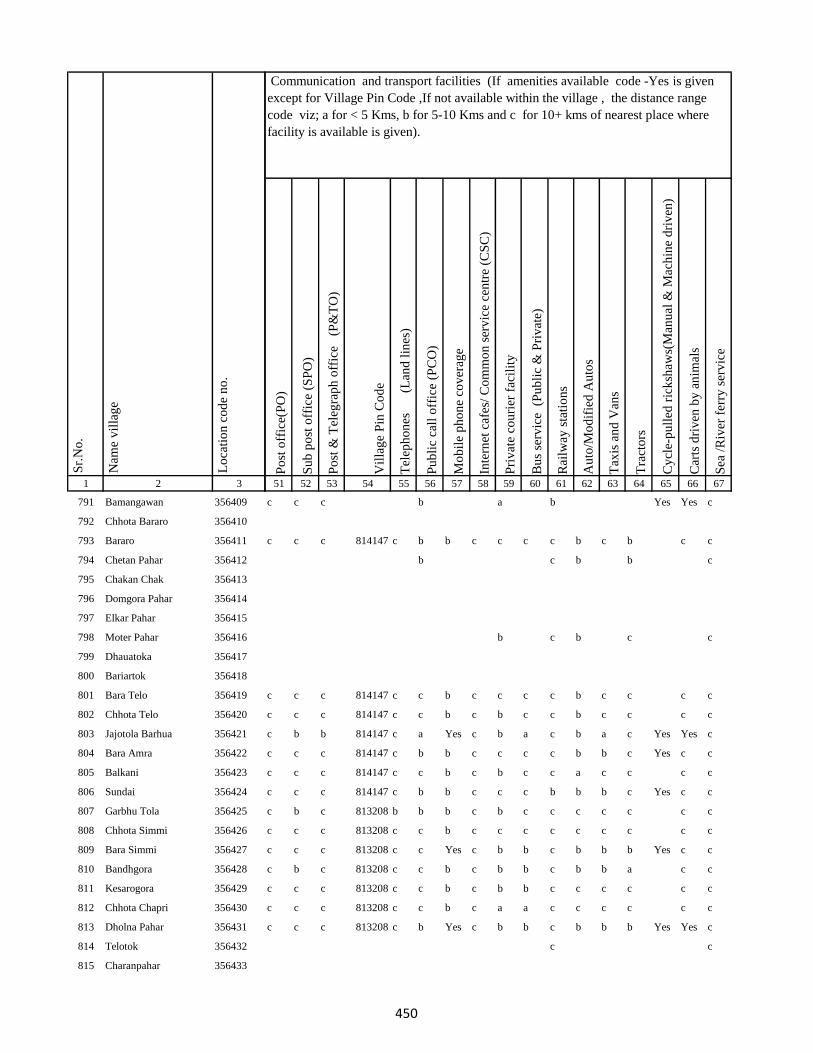
1 2 3
Lo
cati
on
co
de
no
.
Nam
e v
illa
ge
Sr.
No
.
791 Bamangawan 356409
792 Chhota Bararo 356410
793 Bararo 356411
794 Chetan Pahar 356412
795 Chakan Chak 356413
796 Domgora Pahar 356414
797 Elkar Pahar 356415
798 Moter Pahar 356416
799 Dhauatoka 356417
800 Bariartok 356418
801 Bara Telo 356419
802 Chhota Telo 356420
803 Jajotola Barhua 356421
804 Bara Amra 356422
805 Balkani 356423
806 Sundai 356424
807 Garbhu Tola 356425
808 Chhota Simmi 356426
809 Bara Simmi 356427
810 Bandhgora 356428
811 Kesarogora 356429
812 Chhota Chapri 356430
813 Dholna Pahar 356431
814 Telotok 356432
815 Charanpahar 356433
Po
st o
ffic
e(P
O)
Su
b p
ost
off
ice
(SP
O)
Po
st &
Tel
egra
ph
off
ice
(P
&T
O)
Vil
lag
e P
in C
od
e
Tel
eph
on
es
(Lan
d l
ines
)
Pu
bli
c ca
ll o
ffic
e (P
CO
)
Mo
bil
e p
ho
ne
cov
erag
e
Inte
rnet
caf
es/
Co
mm
on
ser
vic
e ce
ntr
e (C
SC
)
Pri
vat
e co
uri
er f
acil
ity
Bu
s se
rvic
e (
Pu
bli
c &
Pri
vat
e)
Rai
lway
sta
tio
ns
Au
to/M
od
ifie
d A
uto
s
Tax
is a
nd
Van
s
Tra
cto
rs
Cy
cle-
pu
lled
ric
ksh
aws(
Man
ual
& M
ach
ine
dri
ven
)
Car
ts d
riv
en b
y a
nim
als
Sea
/R
iver
fer
ry s
erv
ice
51 52 53 54 55 56 57 58 59 60 61 62 63 64 65 66 67
Communication and transport facilities (If amenities available code -Yes is given
except for Village Pin Code ,If not available within the village , the distance range
code viz; a for < 5 Kms, b for 5-10 Kms and c for 10+ kms of nearest place where
facility is available is given).
c c c b a b Yes Yes c
c c c 814147 c b b c c c c b c b c c
b c b b c
b c b c c
c c c 814147 c c b c c c c b c c c c
c c c 814147 c c b c b c c b c c c c
c b b 814147 c a Yes c b a c b a c Yes Yes c
c c c 814147 c b b c c c c b b c Yes c c
c c c 814147 c c b c b c c a c c c c
c c c 814147 c b b c c c b b b c Yes c c
c b c 813208 b b b c b c c c c c c c
c c c 813208 c c b c c c c c c c c c
c c c 813208 c c Yes c b b c b b b Yes c c
c b c 813208 c c b c b b c b b a c c
c c c 813208 c c b c b b c c c c c c
c c c 813208 c c b c a a c c c c c c
c c c 813208 c b Yes c b b c b b b Yes Yes c
c c
450

1 2 3
Lo
cati
on
co
de
no
.
Nam
e v
illa
ge
Sr.
No
.
816 Keriapahar 356434
817 Karampahar 356435
818 Masanpahar 356436
819 Dumarpahar 356437
820 Kamugora 356438
821 Bansdandapahar 356439
822 Bansdanda 356440
823 Dhunigora 356441
824 Bara Basgi 356442
825 Satbera 356443
826 Satbera 356444
827 Chetrampahar 356445
828 Hanidhoni 356446
829 Bara Chapri 356447
830 Madarpahar 356448
831 Chapri Bara 356449
832 Tamlipahar 356450
833 Bara Chapri 356451
834 Madgigora 356452
835 Karamtanr 356453
836 Dumarpahar 356454
837 Chhota Ghogha 356455
838 Bara Karlopahar 356456
839 Bara Ghogha 356457
840 Bara Kerlo 356458
Po
st o
ffic
e(P
O)
Su
b p
ost
off
ice
(SP
O)
Po
st &
Tel
egra
ph
off
ice
(P
&T
O)
Vil
lag
e P
in C
od
e
Tel
eph
on
es
(Lan
d l
ines
)
Pu
bli
c ca
ll o
ffic
e (P
CO
)
Mo
bil
e p
ho
ne
cov
erag
e
Inte
rnet
caf
es/
Co
mm
on
ser
vic
e ce
ntr
e (C
SC
)
Pri
vat
e co
uri
er f
acil
ity
Bu
s se
rvic
e (
Pu
bli
c &
Pri
vat
e)
Rai
lway
sta
tio
ns
Au
to/M
od
ifie
d A
uto
s
Tax
is a
nd
Van
s
Tra
cto
rs
Cy
cle-
pu
lled
ric
ksh
aws(
Man
ual
& M
ach
ine
dri
ven
)
Car
ts d
riv
en b
y a
nim
als
Sea
/R
iver
fer
ry s
erv
ice
51 52 53 54 55 56 57 58 59 60 61 62 63 64 65 66 67
Communication and transport facilities (If amenities available code -Yes is given
except for Village Pin Code ,If not available within the village , the distance range
code viz; a for < 5 Kms, b for 5-10 Kms and c for 10+ kms of nearest place where
facility is available is given).
c a c
b c b c b b c
c c c a b c c a c c Yes c
c c c c b b b b b c b c c c c c
c c c c c b c b c c c b c c c c
b b c c c
451

1 2 3
Lo
cati
on
co
de
no
.
Nam
e v
illa
ge
Sr.
No
.
841 Pandaripahar 356459
842 Dhobkanji 356460
843 Kerikuria 356461
844 Madgigora 356462
845 Androcharpahar 356463
846 Chuolalpahar 356464
847 Chhota Karlopahar 356465
848 Chhota Kerlo 356466
849 Baragawn 356467
850 Bara Kamu 356468
851 Chenya 356469
852 Dumli 356470
853 Jandi 356471
854 Kamugoda 356472
855 Keto(Keraya) 356473
856 Mada 356474
857 Moremo 356475
858 Pakarbera 356476
Block T O T A L :
859 Manjura 356477
860 Khutahari 356478
861 Darbe Chak 356479
862 Kanak Kita 356480
Po
st o
ffic
e(P
O)
Su
b p
ost
off
ice
(SP
O)
Po
st &
Tel
egra
ph
off
ice
(P
&T
O)
Vil
lag
e P
in C
od
e
Tel
eph
on
es
(Lan
d l
ines
)
Pu
bli
c ca
ll o
ffic
e (P
CO
)
Mo
bil
e p
ho
ne
cov
erag
e
Inte
rnet
caf
es/
Co
mm
on
ser
vic
e ce
ntr
e (C
SC
)
Pri
vat
e co
uri
er f
acil
ity
Bu
s se
rvic
e (
Pu
bli
c &
Pri
vat
e)
Rai
lway
sta
tio
ns
Au
to/M
od
ifie
d A
uto
s
Tax
is a
nd
Van
s
Tra
cto
rs
Cy
cle-
pu
lled
ric
ksh
aws(
Man
ual
& M
ach
ine
dri
ven
)
Car
ts d
riv
en b
y a
nim
als
Sea
/R
iver
fer
ry s
erv
ice
51 52 53 54 55 56 57 58 59 60 61 62 63 64 65 66 67
Communication and transport facilities (If amenities available code -Yes is given
except for Village Pin Code ,If not available within the village , the distance range
code viz; a for < 5 Kms, b for 5-10 Kms and c for 10+ kms of nearest place where
facility is available is given).
Yes Yes Yes 814147 Yes Yes Yes Yes Yes Yes Yes Yes Yes Yes Yes Yes c
c c
b c c
c c a c
15 18 2 255 10 13 140 4 2 31 3 8 14 65 58 107 1
b b b 814147 b b b b b b c b c b c c
a b b 814147 b b b b b b c b b c c c
b a a 814147 b b b b c c c b c b c c
Yes a b 814154 b b b c b b c b c c c c
452
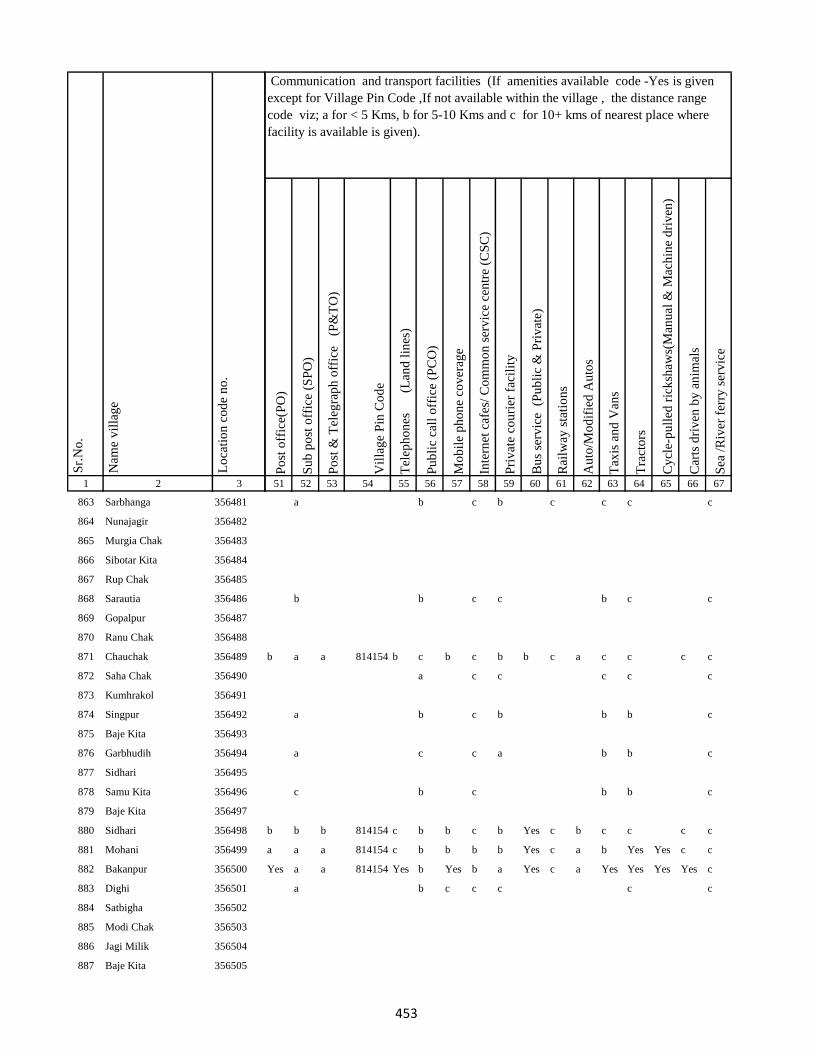
1 2 3
Lo
cati
on
co
de
no
.
Nam
e v
illa
ge
Sr.
No
.
863 Sarbhanga 356481
864 Nunajagir 356482
865 Murgia Chak 356483
866 Sibotar Kita 356484
867 Rup Chak 356485
868 Sarautia 356486
869 Gopalpur 356487
870 Ranu Chak 356488
871 Chauchak 356489
872 Saha Chak 356490
873 Kumhrakol 356491
874 Singpur 356492
875 Baje Kita 356493
876 Garbhudih 356494
877 Sidhari 356495
878 Samu Kita 356496
879 Baje Kita 356497
880 Sidhari 356498
881 Mohani 356499
882 Bakanpur 356500
883 Dighi 356501
884 Satbigha 356502
885 Modi Chak 356503
886 Jagi Milik 356504
887 Baje Kita 356505
Po
st o
ffic
e(P
O)
Su
b p
ost
off
ice
(SP
O)
Po
st &
Tel
egra
ph
off
ice
(P
&T
O)
Vil
lag
e P
in C
od
e
Tel
eph
on
es
(Lan
d l
ines
)
Pu
bli
c ca
ll o
ffic
e (P
CO
)
Mo
bil
e p
ho
ne
cov
erag
e
Inte
rnet
caf
es/
Co
mm
on
ser
vic
e ce
ntr
e (C
SC
)
Pri
vat
e co
uri
er f
acil
ity
Bu
s se
rvic
e (
Pu
bli
c &
Pri
vat
e)
Rai
lway
sta
tio
ns
Au
to/M
od
ifie
d A
uto
s
Tax
is a
nd
Van
s
Tra
cto
rs
Cy
cle-
pu
lled
ric
ksh
aws(
Man
ual
& M
ach
ine
dri
ven
)
Car
ts d
riv
en b
y a
nim
als
Sea
/R
iver
fer
ry s
erv
ice
51 52 53 54 55 56 57 58 59 60 61 62 63 64 65 66 67
Communication and transport facilities (If amenities available code -Yes is given
except for Village Pin Code ,If not available within the village , the distance range
code viz; a for < 5 Kms, b for 5-10 Kms and c for 10+ kms of nearest place where
facility is available is given).
a b c b c c c c
b b c c b c c
b a a 814154 b c b c b b c a c c c c
a c c c c c
a b c b b b c
a c c a b b c
c b c b b c
b b b 814154 c b b c b Yes c b c c c c
a a a 814154 c b b b b Yes c a b Yes Yes c c
Yes a a 814154 Yes b Yes b a Yes c a Yes Yes Yes Yes c
a b c c c c c
453
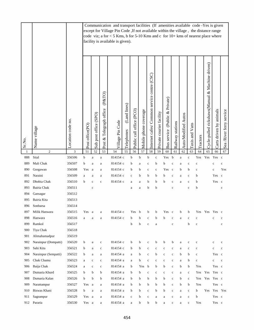
1 2 3
Lo
cati
on
co
de
no
.
Nam
e v
illa
ge
Sr.
No
.
888 Sital 356506
889 Mali Chak 356507
890 Gorgawan 356508
891 Naraini 356509
892 Dhobia Chak 356510
893 Bairia Chak 356511
894 Gansagar 356512
895 Bairia Kita 356513
896 Sonbarsa 356514
897 Milik Hanwara 356515
898 Hanwara 356516
899 Ramkol 356517
900 Tiya Chak 356518
901 Alimahamadpur 356519
902 Narainpur (Dompatti) 356520
903 Sahi Kita 356521
904 Narainpur (Sempatti) 356522
905 Chak Chamu 356523
906 Baija Chak 356524
907 Dumaria Khurd 356525
908 Dumaria Kalan 356526
909 Narattampur 356527
910 Biswas Khani 356528
911 Sagrampur 356529
912 Pararia 356530
Po
st o
ffic
e(P
O)
Su
b p
ost
off
ice
(SP
O)
Po
st &
Tel
egra
ph
off
ice
(P
&T
O)
Vil
lag
e P
in C
od
e
Tel
eph
on
es
(Lan
d l
ines
)
Pu
bli
c ca
ll o
ffic
e (P
CO
)
Mo
bil
e p
ho
ne
cov
erag
e
Inte
rnet
caf
es/
Co
mm
on
ser
vic
e ce
ntr
e (C
SC
)
Pri
vat
e co
uri
er f
acil
ity
Bu
s se
rvic
e (
Pu
bli
c &
Pri
vat
e)
Rai
lway
sta
tio
ns
Au
to/M
od
ifie
d A
uto
s
Tax
is a
nd
Van
s
Tra
cto
rs
Cy
cle-
pu
lled
ric
ksh
aws(
Man
ual
& M
ach
ine
dri
ven
)
Car
ts d
riv
en b
y a
nim
als
Sea
/R
iver
fer
ry s
erv
ice
51 52 53 54 55 56 57 58 59 60 61 62 63 64 65 66 67
Communication and transport facilities (If amenities available code -Yes is given
except for Village Pin Code ,If not available within the village , the distance range
code viz; a for < 5 Kms, b for 5-10 Kms and c for 10+ kms of nearest place where
facility is available is given).
b a a 814154 c b b b c Yes b a c Yes Yes Yes c
b a a 814154 c b a c b b c a c c c c
Yes a a 814154 c b b c c Yes c b b c c Yes
a a a 814154 c c b b b b c a c b Yes c
b c c 814154 c a a b b b c a c b Yes c
c a a b b c c b c
Yes a a 814154 c Yes b b b Yes c b b Yes Yes Yes c
a a a 814154 c b b c b b c a c c c c
b b c a c b c c
b a c 814154 c b b c b b b a c c c c
b a c 814154 c b b c c c c a c c c c
b a a 814154 a a b c b c c b b c Yes c
a c c 814154 a a b c c c c a b c c c
a c c 814154 a b Yes b b b c b b Yes Yes c
b b b 814154 a b b c c c c a c Yes Yes Yes c
b b b 814154 a b b b b b c b c Yes Yes Yes c
Yes a a 814154 a b b b b b c b b Yes Yes c
b a a 814154 a b b c b b c a c b Yes Yes Yes
Yes a a 814154 a c b c a a c a c b Yes c
Yes a a 814154 a a b b b a c a c Yes Yes c
454
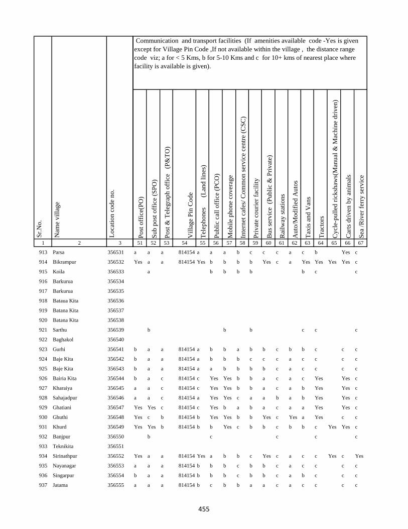
1 2 3
Lo
cati
on
co
de
no
.
Nam
e v
illa
ge
Sr.
No
.
913 Parsa 356531
914 Bikrampur 356532
915 Koila 356533
916 Barkurua 356534
917 Barkurua 356535
918 Bataua Kita 356536
919 Batana Kita 356537
920 Batana Kita 356538
921 Sarthu 356539
922 Baghakol 356540
923 Gurhi 356541
924 Baje Kita 356542
925 Baje Kita 356543
926 Bairia Kita 356544
927 Kharaiya 356545
928 Sahajadpur 356546
929 Ghatiani 356547
930 Ghuthi 356548
931 Khurd 356549
932 Banjpur 356550
933 Teknikita 356551
934 Sirinathpur 356552
935 Nayanagar 356553
936 Singarpur 356554
937 Jatama 356555
Po
st o
ffic
e(P
O)
Su
b p
ost
off
ice
(SP
O)
Po
st &
Tel
egra
ph
off
ice
(P
&T
O)
Vil
lag
e P
in C
od
e
Tel
eph
on
es
(Lan
d l
ines
)
Pu
bli
c ca
ll o
ffic
e (P
CO
)
Mo
bil
e p
ho
ne
cov
erag
e
Inte
rnet
caf
es/
Co
mm
on
ser
vic
e ce
ntr
e (C
SC
)
Pri
vat
e co
uri
er f
acil
ity
Bu
s se
rvic
e (
Pu
bli
c &
Pri
vat
e)
Rai
lway
sta
tio
ns
Au
to/M
od
ifie
d A
uto
s
Tax
is a
nd
Van
s
Tra
cto
rs
Cy
cle-
pu
lled
ric
ksh
aws(
Man
ual
& M
ach
ine
dri
ven
)
Car
ts d
riv
en b
y a
nim
als
Sea
/R
iver
fer
ry s
erv
ice
51 52 53 54 55 56 57 58 59 60 61 62 63 64 65 66 67
Communication and transport facilities (If amenities available code -Yes is given
except for Village Pin Code ,If not available within the village , the distance range
code viz; a for < 5 Kms, b for 5-10 Kms and c for 10+ kms of nearest place where
facility is available is given).
a a a 814154 a a a b c c c a c b Yes c
Yes a a 814154 Yes b b b b Yes c a Yes Yes Yes Yes c
a b b b b b c c
b b b c c c
b a a 814154 a b b a b b c b b c c c
b a a 814154 a b b b c c c a c c c c
b a a 814154 a a b b b b c a c c c c
b a c 814154 c Yes Yes b b a c a c Yes Yes c
a a c 814154 c Yes Yes b b a c a b Yes Yes c
a a c 814154 a Yes Yes c a a b a b Yes Yes c
Yes Yes c 814154 c Yes b a b a c a a Yes Yes c
Yes c b 814154 b Yes Yes b b Yes c Yes a Yes c c
Yes Yes b 814154 b b Yes c b b c b b c Yes Yes c
b c c c c
Yes a a 814154 Yes a b b c Yes c a c c Yes c Yes
a a a 814154 b b b c b b c a c c c c
b a a 814154 b b b c b b c a b c c c
a a a 814154 b c b b a a c a c c c c
455
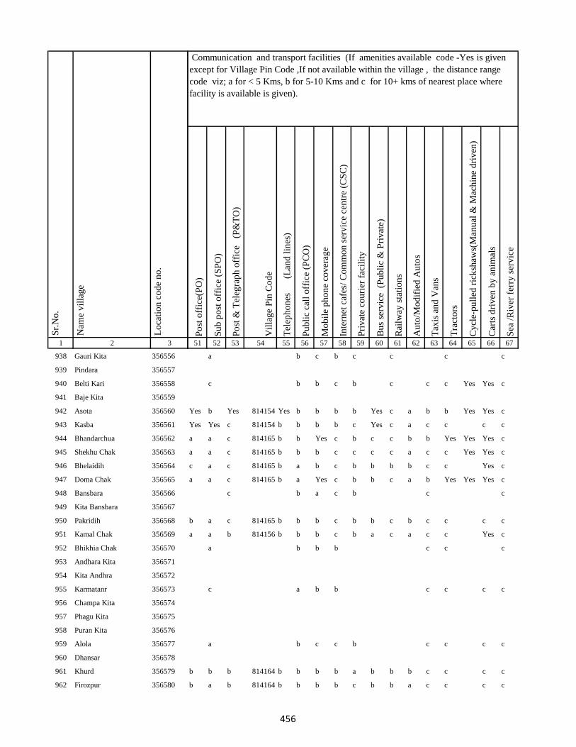
1 2 3
Lo
cati
on
co
de
no
.
Nam
e v
illa
ge
Sr.
No
.
938 Gauri Kita 356556
939 Pindara 356557
940 Belti Kari 356558
941 Baje Kita 356559
942 Asota 356560
943 Kasba 356561
944 Bhandarchua 356562
945 Shekhu Chak 356563
946 Bhelaidih 356564
947 Doma Chak 356565
948 Bansbara 356566
949 Kita Bansbara 356567
950 Pakridih 356568
951 Kamal Chak 356569
952 Bhikhia Chak 356570
953 Andhara Kita 356571
954 Kita Andhra 356572
955 Karmatanr 356573
956 Champa Kita 356574
957 Phagu Kita 356575
958 Puran Kita 356576
959 Alola 356577
960 Dhansar 356578
961 Khurd 356579
962 Firozpur 356580
Po
st o
ffic
e(P
O)
Su
b p
ost
off
ice
(SP
O)
Po
st &
Tel
egra
ph
off
ice
(P
&T
O)
Vil
lag
e P
in C
od
e
Tel
eph
on
es
(Lan
d l
ines
)
Pu
bli
c ca
ll o
ffic
e (P
CO
)
Mo
bil
e p
ho
ne
cov
erag
e
Inte
rnet
caf
es/
Co
mm
on
ser
vic
e ce
ntr
e (C
SC
)
Pri
vat
e co
uri
er f
acil
ity
Bu
s se
rvic
e (
Pu
bli
c &
Pri
vat
e)
Rai
lway
sta
tio
ns
Au
to/M
od
ifie
d A
uto
s
Tax
is a
nd
Van
s
Tra
cto
rs
Cy
cle-
pu
lled
ric
ksh
aws(
Man
ual
& M
ach
ine
dri
ven
)
Car
ts d
riv
en b
y a
nim
als
Sea
/R
iver
fer
ry s
erv
ice
51 52 53 54 55 56 57 58 59 60 61 62 63 64 65 66 67
Communication and transport facilities (If amenities available code -Yes is given
except for Village Pin Code ,If not available within the village , the distance range
code viz; a for < 5 Kms, b for 5-10 Kms and c for 10+ kms of nearest place where
facility is available is given).
a b c b c c c c
c b b c b c c c Yes Yes c
Yes b Yes 814154 Yes b b b b Yes c a b b Yes Yes c
Yes Yes c 814154 b b b b c Yes c a c c c c
a a c 814165 b b Yes c b c c b b Yes Yes Yes c
a a c 814165 b b b c c c c a c c Yes Yes c
c a c 814165 b a b c b b b b c c Yes c
a a c 814165 b a Yes c b b c a b Yes Yes Yes c
c b a c b c c
b a c 814165 b b b c b b c b c c c c
a a b 814156 b b b c b a c a c c Yes c
a b b b c c c
c a b b c c c c
a b c c b c c c c
b b b 814164 b b b b a b b b c c c c
b a b 814164 b b b b c b b a c c c c
456
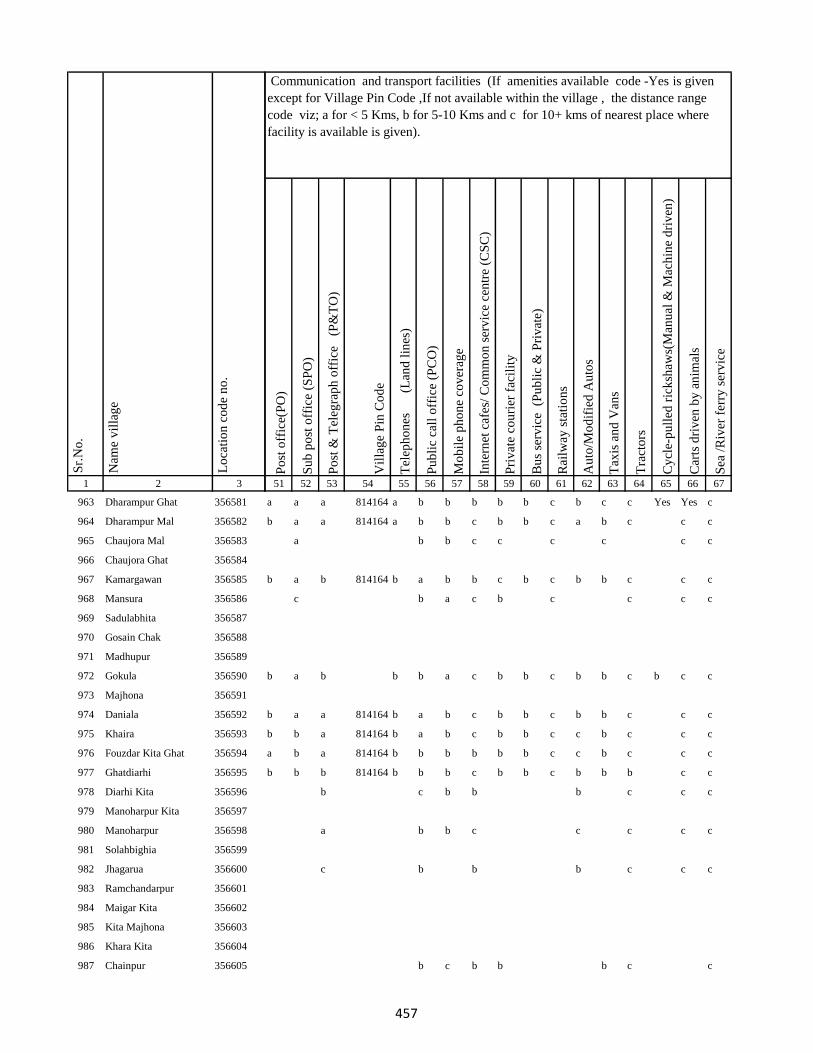
1 2 3
Lo
cati
on
co
de
no
.
Nam
e v
illa
ge
Sr.
No
.
963 Dharampur Ghat 356581
964 Dharampur Mal 356582
965 Chaujora Mal 356583
966 Chaujora Ghat 356584
967 Kamargawan 356585
968 Mansura 356586
969 Sadulabhita 356587
970 Gosain Chak 356588
971 Madhupur 356589
972 Gokula 356590
973 Majhona 356591
974 Daniala 356592
975 Khaira 356593
976 Fouzdar Kita Ghat 356594
977 Ghatdiarhi 356595
978 Diarhi Kita 356596
979 Manoharpur Kita 356597
980 Manoharpur 356598
981 Solahbighia 356599
982 Jhagarua 356600
983 Ramchandarpur 356601
984 Maigar Kita 356602
985 Kita Majhona 356603
986 Khara Kita 356604
987 Chainpur 356605
Po
st o
ffic
e(P
O)
Su
b p
ost
off
ice
(SP
O)
Po
st &
Tel
egra
ph
off
ice
(P
&T
O)
Vil
lag
e P
in C
od
e
Tel
eph
on
es
(Lan
d l
ines
)
Pu
bli
c ca
ll o
ffic
e (P
CO
)
Mo
bil
e p
ho
ne
cov
erag
e
Inte
rnet
caf
es/
Co
mm
on
ser
vic
e ce
ntr
e (C
SC
)
Pri
vat
e co
uri
er f
acil
ity
Bu
s se
rvic
e (
Pu
bli
c &
Pri
vat
e)
Rai
lway
sta
tio
ns
Au
to/M
od
ifie
d A
uto
s
Tax
is a
nd
Van
s
Tra
cto
rs
Cy
cle-
pu
lled
ric
ksh
aws(
Man
ual
& M
ach
ine
dri
ven
)
Car
ts d
riv
en b
y a
nim
als
Sea
/R
iver
fer
ry s
erv
ice
51 52 53 54 55 56 57 58 59 60 61 62 63 64 65 66 67
Communication and transport facilities (If amenities available code -Yes is given
except for Village Pin Code ,If not available within the village , the distance range
code viz; a for < 5 Kms, b for 5-10 Kms and c for 10+ kms of nearest place where
facility is available is given).
a a a 814164 a b b b b b c b c c Yes Yes c
b a a 814164 a b b c b b c a b c c c
a b b c c c c c c
b a b 814164 b a b b c b c b b c c c
c b a c b c c c c
b a b b b a c b b c b b c b c c
b a a 814164 b a b c b b c b b c c c
b b a 814164 b a b c b b c c b c c c
a b a 814164 b b b b b b c c b c c c
b b b 814164 b b b c b b c b b b c c
b c b b b c c c
a b b c c c c c
c b b b c c c
b c b b b c c
457
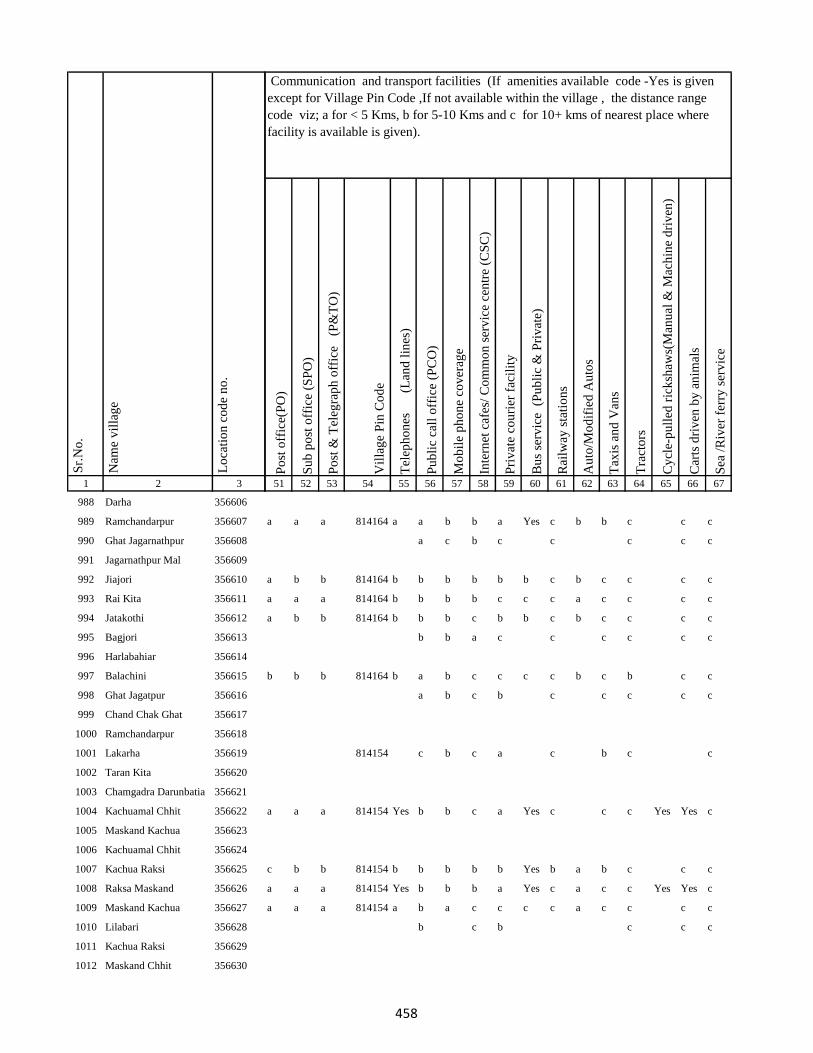
1 2 3
Lo
cati
on
co
de
no
.
Nam
e v
illa
ge
Sr.
No
.
988 Darha 356606
989 Ramchandarpur 356607
990 Ghat Jagarnathpur 356608
991 Jagarnathpur Mal 356609
992 Jiajori 356610
993 Rai Kita 356611
994 Jatakothi 356612
995 Bagjori 356613
996 Harlabahiar 356614
997 Balachini 356615
998 Ghat Jagatpur 356616
999 Chand Chak Ghat 356617
1000 Ramchandarpur 356618
1001 Lakarha 356619
1002 Taran Kita 356620
1003 Chamgadra Darunbatia 356621
1004 Kachuamal Chhit 356622
1005 Maskand Kachua 356623
1006 Kachuamal Chhit 356624
1007 Kachua Raksi 356625
1008 Raksa Maskand 356626
1009 Maskand Kachua 356627
1010 Lilabari 356628
1011 Kachua Raksi 356629
1012 Maskand Chhit 356630
Po
st o
ffic
e(P
O)
Su
b p
ost
off
ice
(SP
O)
Po
st &
Tel
egra
ph
off
ice
(P
&T
O)
Vil
lag
e P
in C
od
e
Tel
eph
on
es
(Lan
d l
ines
)
Pu
bli
c ca
ll o
ffic
e (P
CO
)
Mo
bil
e p
ho
ne
cov
erag
e
Inte
rnet
caf
es/
Co
mm
on
ser
vic
e ce
ntr
e (C
SC
)
Pri
vat
e co
uri
er f
acil
ity
Bu
s se
rvic
e (
Pu
bli
c &
Pri
vat
e)
Rai
lway
sta
tio
ns
Au
to/M
od
ifie
d A
uto
s
Tax
is a
nd
Van
s
Tra
cto
rs
Cy
cle-
pu
lled
ric
ksh
aws(
Man
ual
& M
ach
ine
dri
ven
)
Car
ts d
riv
en b
y a
nim
als
Sea
/R
iver
fer
ry s
erv
ice
51 52 53 54 55 56 57 58 59 60 61 62 63 64 65 66 67
Communication and transport facilities (If amenities available code -Yes is given
except for Village Pin Code ,If not available within the village , the distance range
code viz; a for < 5 Kms, b for 5-10 Kms and c for 10+ kms of nearest place where
facility is available is given).
a a a 814164 a a b b a Yes c b b c c c
a c b c c c c c
a b b 814164 b b b b b b c b c c c c
a a a 814164 b b b b c c c a c c c c
a b b 814164 b b b c b b c b c c c c
b b a c c c c c c
b b b 814164 b a b c c c c b c b c c
a b c b c c c c c
814154 c b c a c b c c
a a a 814154 Yes b b c a Yes c c c Yes Yes c
c b b 814154 b b b b b Yes b a b c c c
a a a 814154 Yes b b b a Yes c a c c Yes Yes c
a a a 814154 a b a c c c c a c c c c
b c b c c c
458

1 2 3
Lo
cati
on
co
de
no
.
Nam
e v
illa
ge
Sr.
No
.
1013 Maskand Kita 356631
1014 Sirsa Kalan 356632
1015 Sirsa Khurd 356633
1016 Bholu Chak 356634
1017 Mahuara Ghat 356635
1018 Mahuara 356636
1019 Fauj Kita 356637
1020 Logain 356638
1021 Asmantikar 356639
1022 Maskand Bhanjpur 356640
1023 Gidra Pathar 356641
1024 Lamahaghat 356642
1025 Hirai Chak 356643
1026 Sukhbona 356644
1027 Sankar Kita 356645
1028 Rahim Kita 356646
1029 Hajra Chak 356647
1030 Lachmania Kita 356648
1031 Lilambar 356649
1032 Maskand Chhit 356650
1033 Bishambhar Kita 356651
1034 Kita Bishambhara 356652
1035 Gunia 356653
1036 Harin Chora 356654
1037 Baghakol 356655
Po
st o
ffic
e(P
O)
Su
b p
ost
off
ice
(SP
O)
Po
st &
Tel
egra
ph
off
ice
(P
&T
O)
Vil
lag
e P
in C
od
e
Tel
eph
on
es
(Lan
d l
ines
)
Pu
bli
c ca
ll o
ffic
e (P
CO
)
Mo
bil
e p
ho
ne
cov
erag
e
Inte
rnet
caf
es/
Co
mm
on
ser
vic
e ce
ntr
e (C
SC
)
Pri
vat
e co
uri
er f
acil
ity
Bu
s se
rvic
e (
Pu
bli
c &
Pri
vat
e)
Rai
lway
sta
tio
ns
Au
to/M
od
ifie
d A
uto
s
Tax
is a
nd
Van
s
Tra
cto
rs
Cy
cle-
pu
lled
ric
ksh
aws(
Man
ual
& M
ach
ine
dri
ven
)
Car
ts d
riv
en b
y a
nim
als
Sea
/R
iver
fer
ry s
erv
ice
51 52 53 54 55 56 57 58 59 60 61 62 63 64 65 66 67
Communication and transport facilities (If amenities available code -Yes is given
except for Village Pin Code ,If not available within the village , the distance range
code viz; a for < 5 Kms, b for 5-10 Kms and c for 10+ kms of nearest place where
facility is available is given).
b b c c c c
a a a 814154 a a Yes c b a c b a c Yes Yes c
a c b b c c
b c b c b c
b c c c c c
b b c c
b c c c
c a a 814154 a a b b b b c a c c c c
a a a 814154 a a b b b c c a b c c c
a a a 814154 a b Yes c a a b a c c Yes Yes c
c b b 814154 a b b c c c c b c c c c
a a a 814154 a c Yes a b a c a b c Yes Yes c
459
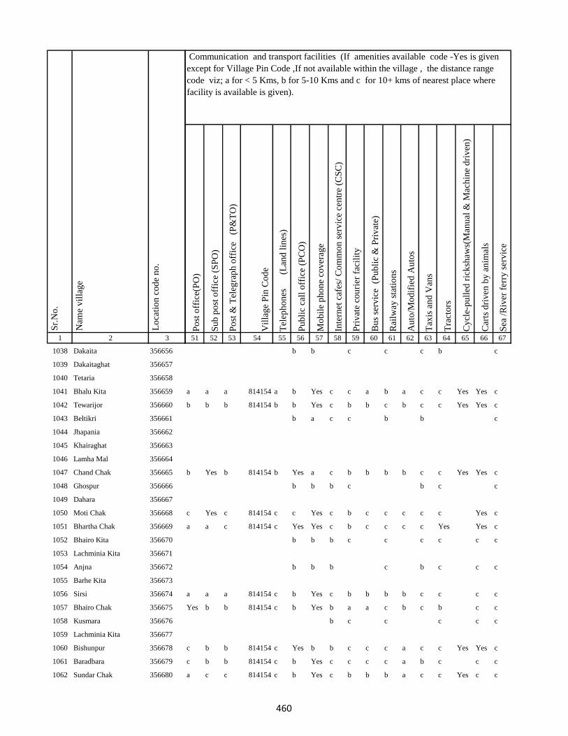
1 2 3
Lo
cati
on
co
de
no
.
Nam
e v
illa
ge
Sr.
No
.
1038 Dakaita 356656
1039 Dakaitaghat 356657
1040 Tetaria 356658
1041 Bhalu Kita 356659
1042 Tewarijor 356660
1043 Beltikri 356661
1044 Jhapania 356662
1045 Khairaghat 356663
1046 Lamha Mal 356664
1047 Chand Chak 356665
1048 Ghospur 356666
1049 Dahara 356667
1050 Moti Chak 356668
1051 Bhartha Chak 356669
1052 Bhairo Kita 356670
1053 Lachminia Kita 356671
1054 Anjna 356672
1055 Barhe Kita 356673
1056 Sirsi 356674
1057 Bhairo Chak 356675
1058 Kusmara 356676
1059 Lachminia Kita 356677
1060 Bishunpur 356678
1061 Baradbara 356679
1062 Sundar Chak 356680
Po
st o
ffic
e(P
O)
Su
b p
ost
off
ice
(SP
O)
Po
st &
Tel
egra
ph
off
ice
(P
&T
O)
Vil
lag
e P
in C
od
e
Tel
eph
on
es
(Lan
d l
ines
)
Pu
bli
c ca
ll o
ffic
e (P
CO
)
Mo
bil
e p
ho
ne
cov
erag
e
Inte
rnet
caf
es/
Co
mm
on
ser
vic
e ce
ntr
e (C
SC
)
Pri
vat
e co
uri
er f
acil
ity
Bu
s se
rvic
e (
Pu
bli
c &
Pri
vat
e)
Rai
lway
sta
tio
ns
Au
to/M
od
ifie
d A
uto
s
Tax
is a
nd
Van
s
Tra
cto
rs
Cy
cle-
pu
lled
ric
ksh
aws(
Man
ual
& M
ach
ine
dri
ven
)
Car
ts d
riv
en b
y a
nim
als
Sea
/R
iver
fer
ry s
erv
ice
51 52 53 54 55 56 57 58 59 60 61 62 63 64 65 66 67
Communication and transport facilities (If amenities available code -Yes is given
except for Village Pin Code ,If not available within the village , the distance range
code viz; a for < 5 Kms, b for 5-10 Kms and c for 10+ kms of nearest place where
facility is available is given).
b b c c c b c
a a a 814154 a b Yes c c a b a c c Yes Yes c
b b b 814154 b b Yes c b b c b c c Yes Yes c
b a c c b b c
b Yes b 814154 b Yes a c b b b b c c Yes Yes c
b b b c b c c
c Yes c 814154 c c Yes c b c c c c c Yes c
a a c 814154 c Yes Yes c b c c c c Yes Yes c
b b b c c c c c c
b b b c b c c c
a a a 814154 c b Yes c b b b b c c c c
Yes b b 814154 c b Yes b a a c b c b c c
b c c c c c
c b b 814154 c Yes b b c c c a c c Yes Yes c
c b b 814154 c b Yes c c c c a b c c c
a c c 814154 c b Yes c b b b a c c Yes c c
460
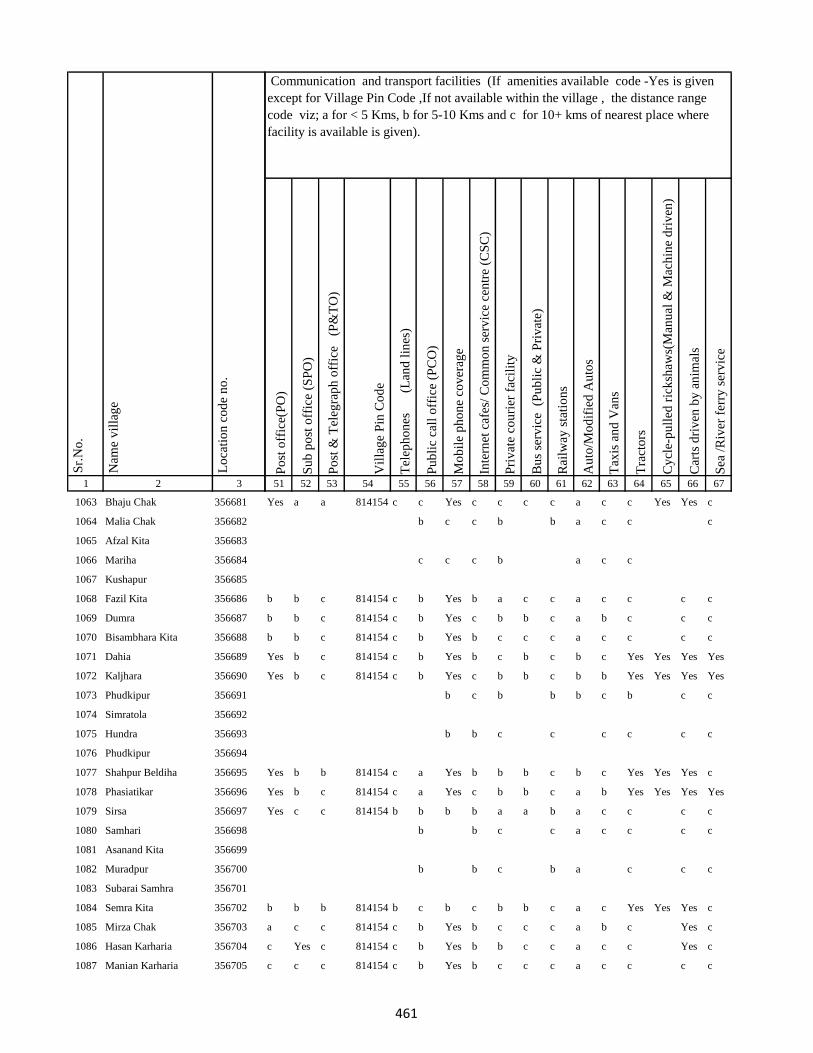
1 2 3
Lo
cati
on
co
de
no
.
Nam
e v
illa
ge
Sr.
No
.
1063 Bhaju Chak 356681
1064 Malia Chak 356682
1065 Afzal Kita 356683
1066 Mariha 356684
1067 Kushapur 356685
1068 Fazil Kita 356686
1069 Dumra 356687
1070 Bisambhara Kita 356688
1071 Dahia 356689
1072 Kaljhara 356690
1073 Phudkipur 356691
1074 Simratola 356692
1075 Hundra 356693
1076 Phudkipur 356694
1077 Shahpur Beldiha 356695
1078 Phasiatikar 356696
1079 Sirsa 356697
1080 Samhari 356698
1081 Asanand Kita 356699
1082 Muradpur 356700
1083 Subarai Samhra 356701
1084 Semra Kita 356702
1085 Mirza Chak 356703
1086 Hasan Karharia 356704
1087 Manian Karharia 356705
Po
st o
ffic
e(P
O)
Su
b p
ost
off
ice
(SP
O)
Po
st &
Tel
egra
ph
off
ice
(P
&T
O)
Vil
lag
e P
in C
od
e
Tel
eph
on
es
(Lan
d l
ines
)
Pu
bli
c ca
ll o
ffic
e (P
CO
)
Mo
bil
e p
ho
ne
cov
erag
e
Inte
rnet
caf
es/
Co
mm
on
ser
vic
e ce
ntr
e (C
SC
)
Pri
vat
e co
uri
er f
acil
ity
Bu
s se
rvic
e (
Pu
bli
c &
Pri
vat
e)
Rai
lway
sta
tio
ns
Au
to/M
od
ifie
d A
uto
s
Tax
is a
nd
Van
s
Tra
cto
rs
Cy
cle-
pu
lled
ric
ksh
aws(
Man
ual
& M
ach
ine
dri
ven
)
Car
ts d
riv
en b
y a
nim
als
Sea
/R
iver
fer
ry s
erv
ice
51 52 53 54 55 56 57 58 59 60 61 62 63 64 65 66 67
Communication and transport facilities (If amenities available code -Yes is given
except for Village Pin Code ,If not available within the village , the distance range
code viz; a for < 5 Kms, b for 5-10 Kms and c for 10+ kms of nearest place where
facility is available is given).
Yes a a 814154 c c Yes c c c c a c c Yes Yes c
b c c b b a c c c
c c c b a c c
b b c 814154 c b Yes b a c c a c c c c
b b c 814154 c b Yes c b b c a b c c c
b b c 814154 c b Yes b c c c a c c c c
Yes b c 814154 c b Yes b c b c b c Yes Yes Yes Yes
Yes b c 814154 c b Yes c b b c b b Yes Yes Yes Yes
b c b b b c b c c
b b c c c c c c
Yes b b 814154 c a Yes b b b c b c Yes Yes Yes c
Yes b c 814154 c a Yes c b b c a b Yes Yes Yes Yes
Yes c c 814154 b b b b a a b a c c c c
b b c c a c c c c
b b c b a c c c
b b b 814154 b c b c b b c a c Yes Yes Yes c
a c c 814154 c b Yes b c c c a b c Yes c
c Yes c 814154 c b Yes b b c c a c c Yes c
c c c 814154 c b Yes b c c c a c c c c
461
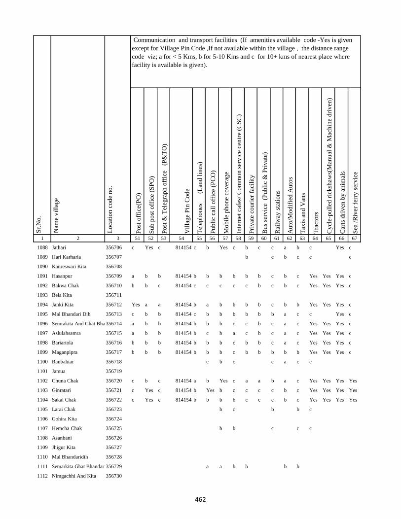
1 2 3
Lo
cati
on
co
de
no
.
Nam
e v
illa
ge
Sr.
No
.
1088 Jathari 356706
1089 Hari Karharia 356707
1090 Kanreswari Kita 356708
1091 Hasanpur 356709
1092 Bakwa Chak 356710
1093 Bela Kita 356711
1094 Janki Kita 356712
1095 Mal Bhandari Dih 356713
1096 Semrakita And Ghat Bhandarid356714
1097 Aslulahsamra 356715
1098 Bariartola 356716
1099 Maganpipra 356717
1100 Ranbahiar 356718
1101 Jamua 356719
1102 Chuna Chak 356720
1103 Ginratari 356721
1104 Sakal Chak 356722
1105 Larai Chak 356723
1106 Gohira Kita 356724
1107 Hemcha Chak 356725
1108 Asanbani 356726
1109 Jhigur Kita 356727
1110 Mal Bhandaridih 356728
1111 Semarkita Ghat Bhandaridih356729
1112 Nimgachhi And Kita 356730
Po
st o
ffic
e(P
O)
Su
b p
ost
off
ice
(SP
O)
Po
st &
Tel
egra
ph
off
ice
(P
&T
O)
Vil
lag
e P
in C
od
e
Tel
eph
on
es
(Lan
d l
ines
)
Pu
bli
c ca
ll o
ffic
e (P
CO
)
Mo
bil
e p
ho
ne
cov
erag
e
Inte
rnet
caf
es/
Co
mm
on
ser
vic
e ce
ntr
e (C
SC
)
Pri
vat
e co
uri
er f
acil
ity
Bu
s se
rvic
e (
Pu
bli
c &
Pri
vat
e)
Rai
lway
sta
tio
ns
Au
to/M
od
ifie
d A
uto
s
Tax
is a
nd
Van
s
Tra
cto
rs
Cy
cle-
pu
lled
ric
ksh
aws(
Man
ual
& M
ach
ine
dri
ven
)
Car
ts d
riv
en b
y a
nim
als
Sea
/R
iver
fer
ry s
erv
ice
51 52 53 54 55 56 57 58 59 60 61 62 63 64 65 66 67
Communication and transport facilities (If amenities available code -Yes is given
except for Village Pin Code ,If not available within the village , the distance range
code viz; a for < 5 Kms, b for 5-10 Kms and c for 10+ kms of nearest place where
facility is available is given).
c Yes c 814154 c b Yes c b c c a b c Yes c
b c b c c c
a b b 814154 b b b b b b c b c Yes Yes Yes c
b b c 814154 c c c c c b c b c Yes Yes Yes c
Yes a a 814154 b a b b b b c b b Yes Yes Yes c
c b b 814154 c b b b b b b a c c Yes c
a b b 814154 b b b c c b c a c Yes Yes Yes c
a b b 814154 b c b a c b c a c Yes Yes Yes c
b b b 814154 b b b c b b c a c Yes Yes Yes c
b b b 814154 b b b c b b b b b Yes Yes Yes c
c b c c a c c
c b c 814154 a b Yes c a a b a c Yes Yes Yes Yes
c Yes c 814154 b Yes b c c c c b c Yes Yes Yes Yes
c Yes c 814154 b b b b c c c b c Yes Yes Yes Yes
b c b b c
b b c c c
a a b b b b
462
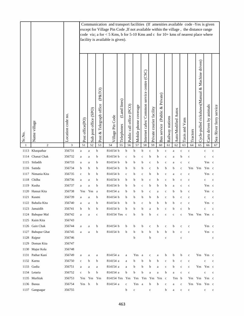
1 2 3
Lo
cati
on
co
de
no
.
Nam
e v
illa
ge
Sr.
No
.
1113 Khaspathar 356731
1114 Chanai Chak 356732
1115 Sitladih 356733
1116 Samda 356734
1117 Nimania Kita 356735
1118 Chilha 356736
1119 Kusha 356737
1120 Hansai Kita 356738
1121 Kusmi 356739
1122 Bahalia Kita 356740
1123 Jamaidih 356741
1124 Babupur Mal 356742
1125 Kaim Kita 356743
1126 Gain Chak 356744
1127 Babupur Ghat 356745
1128 Rajpur 356746
1129 Doman Kita 356747
1130 Majur Kola 356748
1131 Pathar Kani 356749
1132 Karnu 356750
1133 Gudia 356751
1134 Letaria 356752
1135 Murlitak 356753
1136 Basua 356754
1137 Gangsagar 356755
Po
st o
ffic
e(P
O)
Su
b p
ost
off
ice
(SP
O)
Po
st &
Tel
egra
ph
off
ice
(P
&T
O)
Vil
lag
e P
in C
od
e
Tel
eph
on
es
(Lan
d l
ines
)
Pu
bli
c ca
ll o
ffic
e (P
CO
)
Mo
bil
e p
ho
ne
cov
erag
e
Inte
rnet
caf
es/
Co
mm
on
ser
vic
e ce
ntr
e (C
SC
)
Pri
vat
e co
uri
er f
acil
ity
Bu
s se
rvic
e (
Pu
bli
c &
Pri
vat
e)
Rai
lway
sta
tio
ns
Au
to/M
od
ifie
d A
uto
s
Tax
is a
nd
Van
s
Tra
cto
rs
Cy
cle-
pu
lled
ric
ksh
aws(
Man
ual
& M
ach
ine
dri
ven
)
Car
ts d
riv
en b
y a
nim
als
Sea
/R
iver
fer
ry s
erv
ice
51 52 53 54 55 56 57 58 59 60 61 62 63 64 65 66 67
Communication and transport facilities (If amenities available code -Yes is given
except for Village Pin Code ,If not available within the village , the distance range
code viz; a for < 5 Kms, b for 5-10 Kms and c for 10+ kms of nearest place where
facility is available is given).
a a b 814154 b b b b c b c a c c c c
a a b 814154 b c b c b b c a b c c c
a a b 814154 b b b b c b c a c c Yes c
b b b 814154 b b b b c b b b c Yes Yes Yes c
c b b 814154 b c b c b b c a c c Yes c
a a b 814154 b b b b c b c b c c c c
a a b 814154 b b b c b b b a c c Yes c
Yes Yes a 814154 a b b b c a c b b c Yes c
a a b 814154 b b b b b b c b c c c c
a a b 814154 b b b c b b b b c c Yes c
b b b 814154 b b b b a b c b c b c c
a a c 814154 Yes c b b b c c c c Yes Yes Yes c
a a b 814154 b b b b c b c b c c Yes c
a a b 814154 b b b b b b b b c c Yes c
b b c c c
a a a 814154 a a Yes a c a b b b c Yes Yes c
c b b 814154 a a b b b b c b c c c c
a a a 814154 a a b b b a c b c c Yes Yes c
c b b 814154 a b b b a a b a c c c c
Yes Yes Yes 814154 Yes Yes Yes Yes Yes Yes c Yes b Yes Yes Yes c
Yes b b 814154 a c Yes a b b c a c Yes Yes Yes c
b c c b a c c c c
463
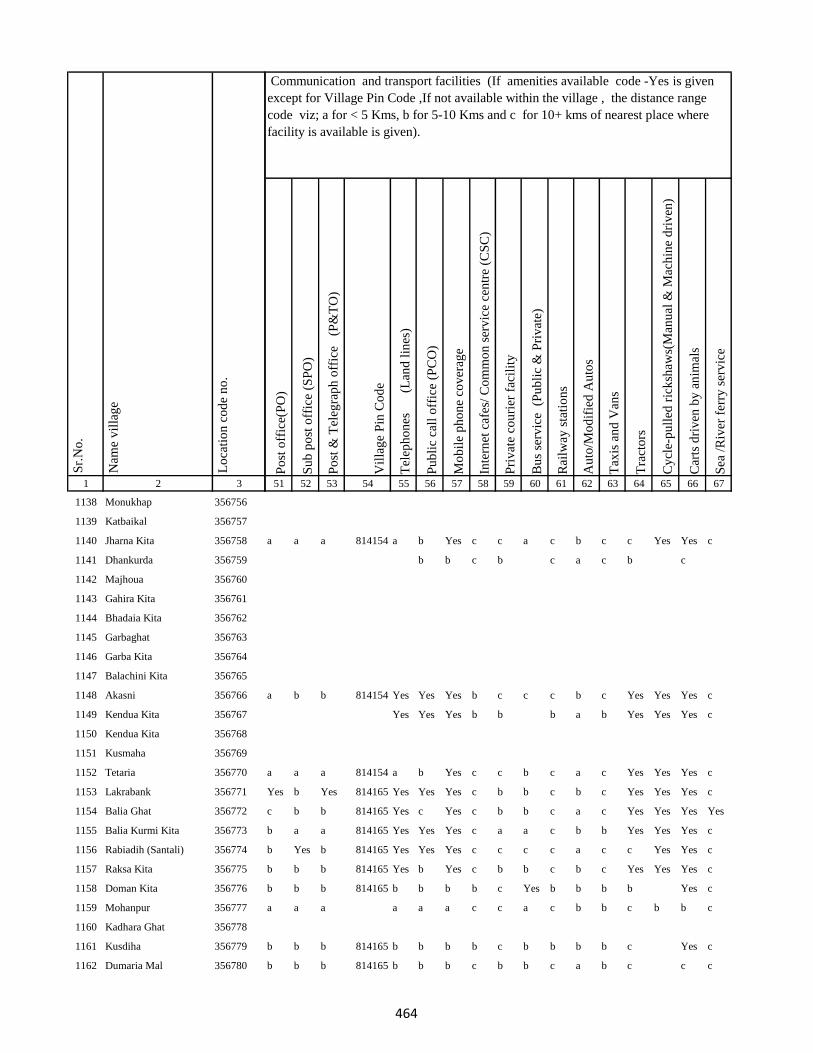
1 2 3
Lo
cati
on
co
de
no
.
Nam
e v
illa
ge
Sr.
No
.
1138 Monukhap 356756
1139 Katbaikal 356757
1140 Jharna Kita 356758
1141 Dhankurda 356759
1142 Majhoua 356760
1143 Gahira Kita 356761
1144 Bhadaia Kita 356762
1145 Garbaghat 356763
1146 Garba Kita 356764
1147 Balachini Kita 356765
1148 Akasni 356766
1149 Kendua Kita 356767
1150 Kendua Kita 356768
1151 Kusmaha 356769
1152 Tetaria 356770
1153 Lakrabank 356771
1154 Balia Ghat 356772
1155 Balia Kurmi Kita 356773
1156 Rabiadih (Santali) 356774
1157 Raksa Kita 356775
1158 Doman Kita 356776
1159 Mohanpur 356777
1160 Kadhara Ghat 356778
1161 Kusdiha 356779
1162 Dumaria Mal 356780
Po
st o
ffic
e(P
O)
Su
b p
ost
off
ice
(SP
O)
Po
st &
Tel
egra
ph
off
ice
(P
&T
O)
Vil
lag
e P
in C
od
e
Tel
eph
on
es
(Lan
d l
ines
)
Pu
bli
c ca
ll o
ffic
e (P
CO
)
Mo
bil
e p
ho
ne
cov
erag
e
Inte
rnet
caf
es/
Co
mm
on
ser
vic
e ce
ntr
e (C
SC
)
Pri
vat
e co
uri
er f
acil
ity
Bu
s se
rvic
e (
Pu
bli
c &
Pri
vat
e)
Rai
lway
sta
tio
ns
Au
to/M
od
ifie
d A
uto
s
Tax
is a
nd
Van
s
Tra
cto
rs
Cy
cle-
pu
lled
ric
ksh
aws(
Man
ual
& M
ach
ine
dri
ven
)
Car
ts d
riv
en b
y a
nim
als
Sea
/R
iver
fer
ry s
erv
ice
51 52 53 54 55 56 57 58 59 60 61 62 63 64 65 66 67
Communication and transport facilities (If amenities available code -Yes is given
except for Village Pin Code ,If not available within the village , the distance range
code viz; a for < 5 Kms, b for 5-10 Kms and c for 10+ kms of nearest place where
facility is available is given).
a a a 814154 a b Yes c c a c b c c Yes Yes c
b b c b c a c b c
a b b 814154 Yes Yes Yes b c c c b c Yes Yes Yes c
Yes Yes Yes b b b a b Yes Yes Yes c
a a a 814154 a b Yes c c b c a c Yes Yes Yes c
Yes b Yes 814165 Yes Yes Yes c b b c b c Yes Yes Yes c
c b b 814165 Yes c Yes c b b c a c Yes Yes Yes Yes
b a a 814165 Yes Yes Yes c a a c b b Yes Yes Yes c
b Yes b 814165 Yes Yes Yes c c c c a c c Yes Yes c
b b b 814165 Yes b Yes c b b c b c Yes Yes Yes c
b b b 814165 b b b b c Yes b b b b Yes c
a a a a a a c c a c b b c b b c
b b b 814165 b b b b c b b b b c Yes c
b b b 814165 b b b c b b c a b c c c
464
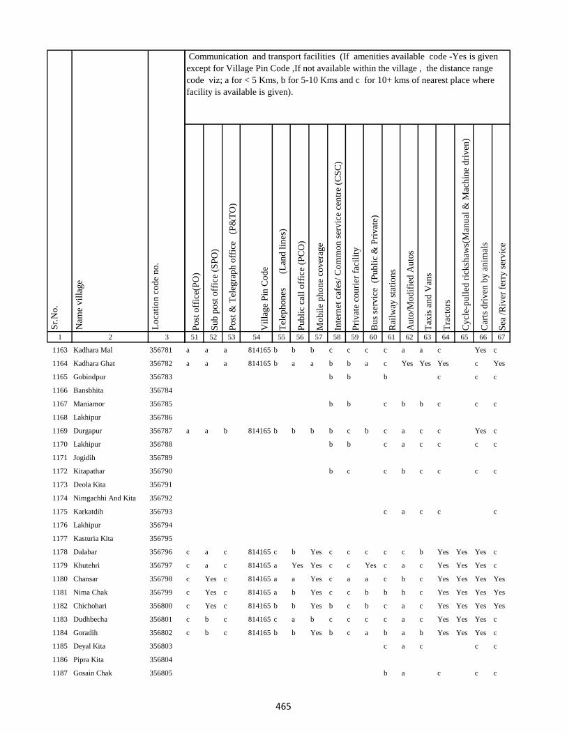
1 2 3
Lo
cati
on
co
de
no
.
Nam
e v
illa
ge
Sr.
No
.
1163 Kadhara Mal 356781
1164 Kadhara Ghat 356782
1165 Gobindpur 356783
1166 Bansbhita 356784
1167 Maniamor 356785
1168 Lakhipur 356786
1169 Durgapur 356787
1170 Lakhipur 356788
1171 Jogidih 356789
1172 Kitapathar 356790
1173 Deola Kita 356791
1174 Nimgachhi And Kita 356792
1175 Karkatdih 356793
1176 Lakhipur 356794
1177 Kasturia Kita 356795
1178 Dalabar 356796
1179 Khutehri 356797
1180 Chansar 356798
1181 Nima Chak 356799
1182 Chichohari 356800
1183 Dudhbecha 356801
1184 Goradih 356802
1185 Deyal Kita 356803
1186 Pipra Kita 356804
1187 Gosain Chak 356805
Po
st o
ffic
e(P
O)
Su
b p
ost
off
ice
(SP
O)
Po
st &
Tel
egra
ph
off
ice
(P
&T
O)
Vil
lag
e P
in C
od
e
Tel
eph
on
es
(Lan
d l
ines
)
Pu
bli
c ca
ll o
ffic
e (P
CO
)
Mo
bil
e p
ho
ne
cov
erag
e
Inte
rnet
caf
es/
Co
mm
on
ser
vic
e ce
ntr
e (C
SC
)
Pri
vat
e co
uri
er f
acil
ity
Bu
s se
rvic
e (
Pu
bli
c &
Pri
vat
e)
Rai
lway
sta
tio
ns
Au
to/M
od
ifie
d A
uto
s
Tax
is a
nd
Van
s
Tra
cto
rs
Cy
cle-
pu
lled
ric
ksh
aws(
Man
ual
& M
ach
ine
dri
ven
)
Car
ts d
riv
en b
y a
nim
als
Sea
/R
iver
fer
ry s
erv
ice
51 52 53 54 55 56 57 58 59 60 61 62 63 64 65 66 67
Communication and transport facilities (If amenities available code -Yes is given
except for Village Pin Code ,If not available within the village , the distance range
code viz; a for < 5 Kms, b for 5-10 Kms and c for 10+ kms of nearest place where
facility is available is given).
a a a 814165 b b b c c c c a a c Yes c
a a a 814165 b a a b b a c Yes Yes Yes c Yes
b b b c c c
b b c b b c c c
a a b 814165 b b b b c b c a c c Yes c
b b c a c c c c
b c c b c c c c
c a c c c
c a c 814165 c b Yes c c c c c b Yes Yes Yes c
c a c 814165 a Yes Yes c c Yes c a c Yes Yes Yes c
c Yes c 814165 a a Yes c a a c b c Yes Yes Yes Yes
c Yes c 814165 a b Yes c c b b b c Yes Yes Yes Yes
c Yes c 814165 b b Yes b c b c a c Yes Yes Yes Yes
c b c 814165 c a b c c c c a c Yes Yes Yes c
c b c 814165 b b Yes b c a b a b Yes Yes Yes c
c a c c c
b a c c c
465
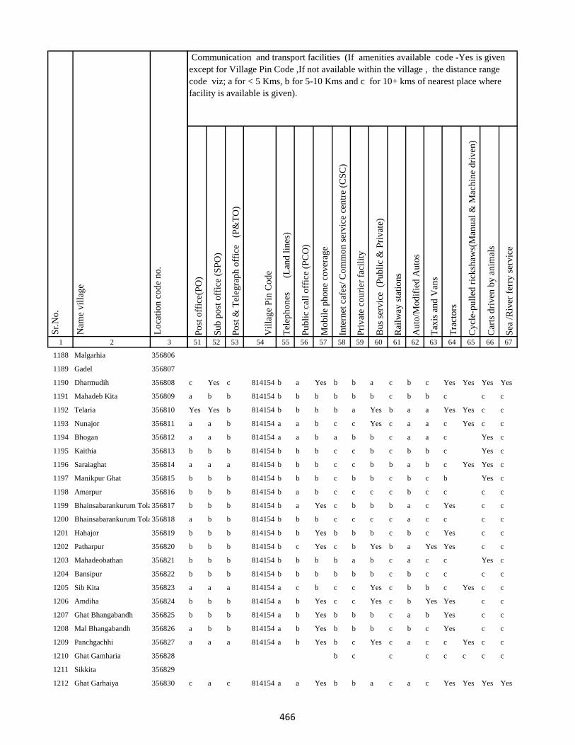
1 2 3
Lo
cati
on
co
de
no
.
Nam
e v
illa
ge
Sr.
No
.
1188 Malgarhia 356806
1189 Gadel 356807
1190 Dharmudih 356808
1191 Mahadeb Kita 356809
1192 Telaria 356810
1193 Nunajor 356811
1194 Bhogan 356812
1195 Kaithia 356813
1196 Saraiaghat 356814
1197 Manikpur Ghat 356815
1198 Amarpur 356816
1199 Bhainsabarankurum Tola356817
1200 Bhainsabarankurum Tola Mal356818
1201 Hahajor 356819
1202 Patharpur 356820
1203 Mahadeobathan 356821
1204 Bansipur 356822
1205 Sib Kita 356823
1206 Amdiha 356824
1207 Ghat Bhangabandh 356825
1208 Mal Bhangabandh 356826
1209 Panchgachhi 356827
1210 Ghat Gamharia 356828
1211 Sikkita 356829
1212 Ghat Garhaiya 356830
Po
st o
ffic
e(P
O)
Su
b p
ost
off
ice
(SP
O)
Po
st &
Tel
egra
ph
off
ice
(P
&T
O)
Vil
lag
e P
in C
od
e
Tel
eph
on
es
(Lan
d l
ines
)
Pu
bli
c ca
ll o
ffic
e (P
CO
)
Mo
bil
e p
ho
ne
cov
erag
e
Inte
rnet
caf
es/
Co
mm
on
ser
vic
e ce
ntr
e (C
SC
)
Pri
vat
e co
uri
er f
acil
ity
Bu
s se
rvic
e (
Pu
bli
c &
Pri
vat
e)
Rai
lway
sta
tio
ns
Au
to/M
od
ifie
d A
uto
s
Tax
is a
nd
Van
s
Tra
cto
rs
Cy
cle-
pu
lled
ric
ksh
aws(
Man
ual
& M
ach
ine
dri
ven
)
Car
ts d
riv
en b
y a
nim
als
Sea
/R
iver
fer
ry s
erv
ice
51 52 53 54 55 56 57 58 59 60 61 62 63 64 65 66 67
Communication and transport facilities (If amenities available code -Yes is given
except for Village Pin Code ,If not available within the village , the distance range
code viz; a for < 5 Kms, b for 5-10 Kms and c for 10+ kms of nearest place where
facility is available is given).
c Yes c 814154 b a Yes b b a c b c Yes Yes Yes Yes
a b b 814154 b b b b b b c b b c c c
Yes Yes b 814154 b b b b a Yes b a a Yes Yes c c
a a b 814154 a a b c c Yes c a a c Yes c c
a a b 814154 a a b a b b c a a c Yes c
b b b 814154 b b b c c b c b b c Yes c
a a a 814154 b b b c c b b a b c Yes Yes c
b b b 814154 b b b c b b c b c b Yes c
b b b 814154 b a b c c c c b c c c c
b b b 814154 b a Yes c b b b a c Yes c c
a b b 814154 b b b c c c c a c c c c
b b b 814154 b b Yes b b b c b c Yes c c
b b b 814154 b c Yes c b Yes b a Yes Yes c c
b b b 814154 b b b b a b c a c c Yes c
b b b 814154 b b b b b b c b c c c c
a a a 814154 a c b c c Yes c b b c Yes c c
b b b 814154 a b Yes c c Yes c b Yes Yes c c
b b b 814154 a b Yes b b b c a b Yes c c
a b b 814154 a b Yes b b b c b c Yes c c
a a a 814154 a b Yes b c Yes c a c c Yes c c
b c c c c c c c
c a c 814154 a a Yes b b a c a c Yes Yes Yes Yes
466
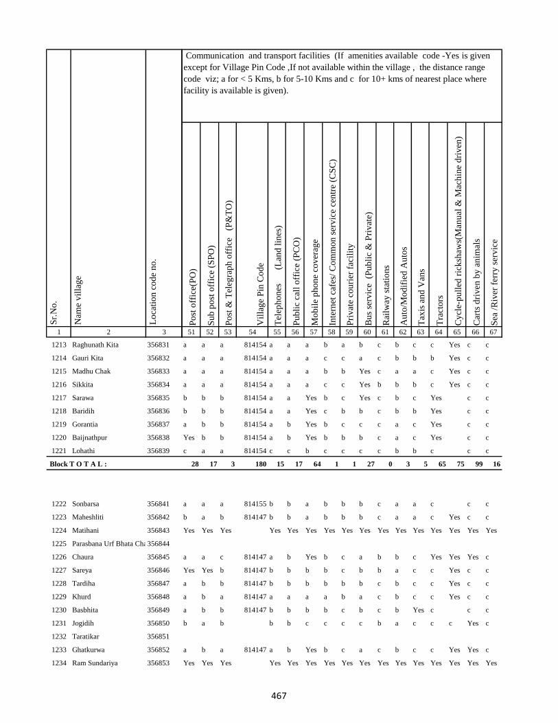
1 2 3
Lo
cati
on
co
de
no
.
Nam
e v
illa
ge
Sr.
No
.
1213 Raghunath Kita 356831
1214 Gauri Kita 356832
1215 Madhu Chak 356833
1216 Sikkita 356834
1217 Sarawa 356835
1218 Baridih 356836
1219 Gorantia 356837
1220 Baijnathpur 356838
1221 Lohathi 356839
Block T O T A L :
1222 Sonbarsa 356841
1223 Maheshliti 356842
1224 Matihani 356843
1225 Parasbana Urf Bhata Chak356844
1226 Chaura 356845
1227 Sareya 356846
1228 Tardiha 356847
1229 Khurd 356848
1230 Basbhita 356849
1231 Jogidih 356850
1232 Taratikar 356851
1233 Ghatkurwa 356852
1234 Ram Sundariya 356853
Po
st o
ffic
e(P
O)
Su
b p
ost
off
ice
(SP
O)
Po
st &
Tel
egra
ph
off
ice
(P
&T
O)
Vil
lag
e P
in C
od
e
Tel
eph
on
es
(Lan
d l
ines
)
Pu
bli
c ca
ll o
ffic
e (P
CO
)
Mo
bil
e p
ho
ne
cov
erag
e
Inte
rnet
caf
es/
Co
mm
on
ser
vic
e ce
ntr
e (C
SC
)
Pri
vat
e co
uri
er f
acil
ity
Bu
s se
rvic
e (
Pu
bli
c &
Pri
vat
e)
Rai
lway
sta
tio
ns
Au
to/M
od
ifie
d A
uto
s
Tax
is a
nd
Van
s
Tra
cto
rs
Cy
cle-
pu
lled
ric
ksh
aws(
Man
ual
& M
ach
ine
dri
ven
)
Car
ts d
riv
en b
y a
nim
als
Sea
/R
iver
fer
ry s
erv
ice
51 52 53 54 55 56 57 58 59 60 61 62 63 64 65 66 67
Communication and transport facilities (If amenities available code -Yes is given
except for Village Pin Code ,If not available within the village , the distance range
code viz; a for < 5 Kms, b for 5-10 Kms and c for 10+ kms of nearest place where
facility is available is given).
a a a 814154 a a a b a b c b c c Yes c c
a a a 814154 a a a c c a c b b b Yes c c
a a a 814154 a a a b b Yes c a a c Yes c c
a a a 814154 a a a c c Yes b b b c Yes c c
b b b 814154 a a Yes b c Yes c b c Yes c c
b b b 814154 a a Yes c b b c b b Yes c c
a b b 814154 a b Yes b c c c a c Yes c c
Yes b b 814154 a b Yes b b b c a c Yes c c
c a a 814154 c c b c c c c b b c c c
28 17 3 180 15 17 64 1 1 27 0 3 5 65 75 99 16
a a a 814155 b b a b b b c a a c c c
b a b 814147 b b a b b b c a a c Yes c c
Yes Yes Yes Yes Yes Yes Yes Yes Yes Yes Yes Yes Yes Yes Yes Yes
a a c 814147 a b Yes b c a b b c Yes Yes Yes c
Yes Yes b 814147 b b b b c b b a c c Yes c c
a b b 814147 b b b b b b c b c c Yes c c
a b a 814147 a a a a b a c b c c Yes c c
a b b 814147 b b b b c b c b Yes c c c
b a b b b c c c c b a c c c Yes c
a b a 814147 a b Yes b c a c b c c Yes Yes c
Yes Yes Yes Yes Yes Yes Yes Yes Yes Yes Yes Yes Yes Yes Yes Yes
467

1 2 3
Lo
cati
on
co
de
no
.
Nam
e v
illa
ge
Sr.
No
.
1235 Taratikar 356854
1236 Siardih 356855
1237 Lakhanpahari 356856
1238 Joginpahari 356857
1239 Jagarnathpur 356858
1240 Lilatari 356859
1241 Kamla Chak 356860
1242 Siardih(Chhit) 356861
1243 Bhanjpur 356862
1244 Barkop 356863
1245 Mirza Chak 356864
1246 Birseni 356865
1247 Siardih 356866
1248 Mirza Chak 356867
1249 Jogi Chak 356868
1250 Amdiha 356869
1251 Babupur 356870
1252 Jamua 356871
1253 Rangatanr 356872
1254 Semariya 356873
1255 Ramgarh 356874
1256 Kamaldiha 356875
1257 Kureri 356876
1258 Pipra 356877
1259 Babupur 356878
Po
st o
ffic
e(P
O)
Su
b p
ost
off
ice
(SP
O)
Po
st &
Tel
egra
ph
off
ice
(P
&T
O)
Vil
lag
e P
in C
od
e
Tel
eph
on
es
(Lan
d l
ines
)
Pu
bli
c ca
ll o
ffic
e (P
CO
)
Mo
bil
e p
ho
ne
cov
erag
e
Inte
rnet
caf
es/
Co
mm
on
ser
vic
e ce
ntr
e (C
SC
)
Pri
vat
e co
uri
er f
acil
ity
Bu
s se
rvic
e (
Pu
bli
c &
Pri
vat
e)
Rai
lway
sta
tio
ns
Au
to/M
od
ifie
d A
uto
s
Tax
is a
nd
Van
s
Tra
cto
rs
Cy
cle-
pu
lled
ric
ksh
aws(
Man
ual
& M
ach
ine
dri
ven
)
Car
ts d
riv
en b
y a
nim
als
Sea
/R
iver
fer
ry s
erv
ice
51 52 53 54 55 56 57 58 59 60 61 62 63 64 65 66 67
Communication and transport facilities (If amenities available code -Yes is given
except for Village Pin Code ,If not available within the village , the distance range
code viz; a for < 5 Kms, b for 5-10 Kms and c for 10+ kms of nearest place where
facility is available is given).
a b b 814147 b b Yes c c b c b c Yes Yes Yes c
a b b 814147 b b b c b b b b b c c c
a b b 814147 b b b c b b c b b c c c
b c a c
a a b 814147 b Yes Yes b b a b b Yes c Yes Yes c
b b b a c a c c c
c a b c b b c c c
b b b 814147 b b b b c c c b c c c c
b b b 814147 b Yes Yes b b b c b c c Yes c
b b b 814147 Yes Yes Yes b c Yes b b c c Yes c c
b c c 814147 b b a b b b c a c c c c
b c c 814147 b b b c c c c a c c c c
b b c 814147 b b Yes b b c b b c b c c
Yes b c b b b b b c b c c Yes c
b b b 814147 b Yes Yes b b b c a c c Yes c c
c b b 814147 b a b c c c c b b c c c
c b b 814147 b a b c c c c a c c c c
b b b 814147 b b b c b b b b c c c c
468
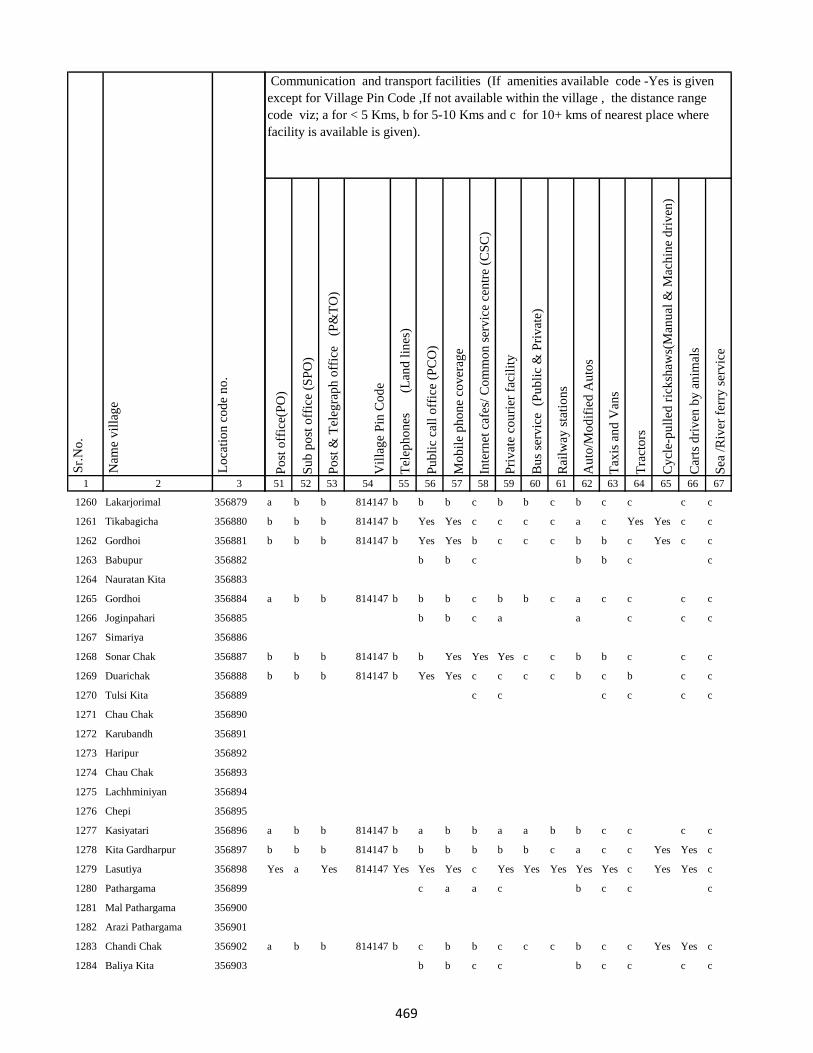
1 2 3
Lo
cati
on
co
de
no
.
Nam
e v
illa
ge
Sr.
No
.
1260 Lakarjorimal 356879
1261 Tikabagicha 356880
1262 Gordhoi 356881
1263 Babupur 356882
1264 Nauratan Kita 356883
1265 Gordhoi 356884
1266 Joginpahari 356885
1267 Simariya 356886
1268 Sonar Chak 356887
1269 Duarichak 356888
1270 Tulsi Kita 356889
1271 Chau Chak 356890
1272 Karubandh 356891
1273 Haripur 356892
1274 Chau Chak 356893
1275 Lachhminiyan 356894
1276 Chepi 356895
1277 Kasiyatari 356896
1278 Kita Gardharpur 356897
1279 Lasutiya 356898
1280 Pathargama 356899
1281 Mal Pathargama 356900
1282 Arazi Pathargama 356901
1283 Chandi Chak 356902
1284 Baliya Kita 356903
Po
st o
ffic
e(P
O)
Su
b p
ost
off
ice
(SP
O)
Po
st &
Tel
egra
ph
off
ice
(P
&T
O)
Vil
lag
e P
in C
od
e
Tel
eph
on
es
(Lan
d l
ines
)
Pu
bli
c ca
ll o
ffic
e (P
CO
)
Mo
bil
e p
ho
ne
cov
erag
e
Inte
rnet
caf
es/
Co
mm
on
ser
vic
e ce
ntr
e (C
SC
)
Pri
vat
e co
uri
er f
acil
ity
Bu
s se
rvic
e (
Pu
bli
c &
Pri
vat
e)
Rai
lway
sta
tio
ns
Au
to/M
od
ifie
d A
uto
s
Tax
is a
nd
Van
s
Tra
cto
rs
Cy
cle-
pu
lled
ric
ksh
aws(
Man
ual
& M
ach
ine
dri
ven
)
Car
ts d
riv
en b
y a
nim
als
Sea
/R
iver
fer
ry s
erv
ice
51 52 53 54 55 56 57 58 59 60 61 62 63 64 65 66 67
Communication and transport facilities (If amenities available code -Yes is given
except for Village Pin Code ,If not available within the village , the distance range
code viz; a for < 5 Kms, b for 5-10 Kms and c for 10+ kms of nearest place where
facility is available is given).
a b b 814147 b b b c b b c b c c c c
b b b 814147 b Yes Yes c c c c a c Yes Yes c c
b b b 814147 b Yes Yes b c c c b b c Yes c c
b b c b b c c
a b b 814147 b b b c b b c a c c c c
b b c a a c c c
b b b 814147 b b Yes Yes Yes c c b b c c c
b b b 814147 b Yes Yes c c c c b c b c c
c c c c c c
a b b 814147 b a b b a a b b c c c c
b b b 814147 b b b b b b c a c c Yes Yes c
Yes a Yes 814147 Yes Yes Yes c Yes Yes Yes Yes Yes c Yes Yes c
c a a c b c c c
a b b 814147 b c b b c c c b c c Yes Yes c
b b c c b c c c c
469
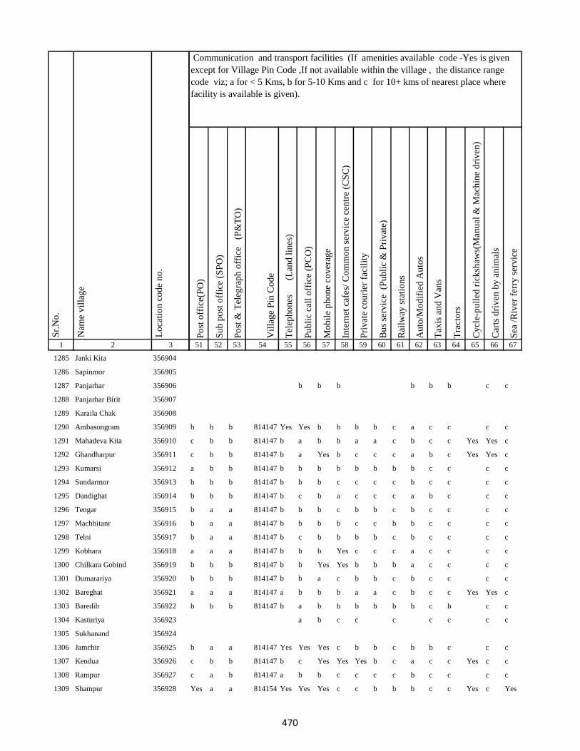
1 2 3
Lo
cati
on
co
de
no
.
Nam
e v
illa
ge
Sr.
No
.
1285 Janki Kita 356904
1286 Sapinmor 356905
1287 Panjarhar 356906
1288 Panjarhar Birit 356907
1289 Karaila Chak 356908
1290 Ambasongram 356909
1291 Mahadeva Kita 356910
1292 Ghandharpur 356911
1293 Kumarsi 356912
1294 Sundarmor 356913
1295 Dandighat 356914
1296 Tengar 356915
1297 Machhitanr 356916
1298 Telni 356917
1299 Kobhara 356918
1300 Chilkara Gobind 356919
1301 Dumarariya 356920
1302 Bareghat 356921
1303 Baredih 356922
1304 Kasturiya 356923
1305 Sukhanand 356924
1306 Jamchir 356925
1307 Kendua 356926
1308 Rampur 356927
1309 Shampur 356928
Po
st o
ffic
e(P
O)
Su
b p
ost
off
ice
(SP
O)
Po
st &
Tel
egra
ph
off
ice
(P
&T
O)
Vil
lag
e P
in C
od
e
Tel
eph
on
es
(Lan
d l
ines
)
Pu
bli
c ca
ll o
ffic
e (P
CO
)
Mo
bil
e p
ho
ne
cov
erag
e
Inte
rnet
caf
es/
Co
mm
on
ser
vic
e ce
ntr
e (C
SC
)
Pri
vat
e co
uri
er f
acil
ity
Bu
s se
rvic
e (
Pu
bli
c &
Pri
vat
e)
Rai
lway
sta
tio
ns
Au
to/M
od
ifie
d A
uto
s
Tax
is a
nd
Van
s
Tra
cto
rs
Cy
cle-
pu
lled
ric
ksh
aws(
Man
ual
& M
ach
ine
dri
ven
)
Car
ts d
riv
en b
y a
nim
als
Sea
/R
iver
fer
ry s
erv
ice
51 52 53 54 55 56 57 58 59 60 61 62 63 64 65 66 67
Communication and transport facilities (If amenities available code -Yes is given
except for Village Pin Code ,If not available within the village , the distance range
code viz; a for < 5 Kms, b for 5-10 Kms and c for 10+ kms of nearest place where
facility is available is given).
b b b b b b c c
b b b 814147 Yes Yes b b b b c a c c c c
c b b 814147 b a b b a a c b c c Yes Yes c
c b b 814147 b a Yes b c c c a b c Yes Yes c
a b b 814147 b b b b b b b b c c c c
b b b 814147 b b b c c c c b c c c c
b b b 814147 b c b a c c c a b c c c
b a a 814147 b b b c b b c b c c c c
b a a 814147 b b b b c c b b c c c c
b a a 814147 b c b b b b c b c c c c
a a a 814147 b b b Yes c c c a c c c c
b b b 814147 b b Yes Yes b b b a c c c c
b b b 814147 b b a c b b c b c c c c
a a a 814147 a b b b a a c b c c Yes Yes c
b b b 814147 b a b b b b b b c b c c
a b c c c c c c c
b a a 814147 Yes Yes Yes c b b c b b c c c
c b b 814147 b c Yes Yes Yes b c a c c Yes c c
c a b 814147 a b b c c c c b c c c c
Yes a a 814154 Yes Yes Yes c c b b b c c Yes c Yes
470
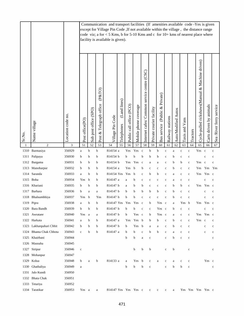
1 2 3
Lo
cati
on
co
de
no
.
Nam
e v
illa
ge
Sr.
No
.
1310 Barmasiya 356929
1311 Palipaya 356930
1312 Bargama 356931
1313 Manoharpur 356932
1314 Saranda 356933
1315 Boha 356934
1316 Khariani 356935
1317 Barhara 356936
1318 Bhalsumbhiya 356937
1319 Pipra 356938
1320 Bara Bandh 356939
1321 Awratanr 356940
1322 Harkata 356941
1323 Lakhanpahari Chhit 356942
1324 Bhanta Chak Chhota 356943
1325 Khairbani 356944
1326 Masnaha 356945
1327 Siripur 356946
1328 Mohanpur 356947
1329 Kolua 356948
1330 Ghatbaliya 356949
1331 Jalo Kundi 356950
1332 Bhata Chak 356951
1333 Tetariya 356952
1334 Taratikar 356953
Po
st o
ffic
e(P
O)
Su
b p
ost
off
ice
(SP
O)
Po
st &
Tel
egra
ph
off
ice
(P
&T
O)
Vil
lag
e P
in C
od
e
Tel
eph
on
es
(Lan
d l
ines
)
Pu
bli
c ca
ll o
ffic
e (P
CO
)
Mo
bil
e p
ho
ne
cov
erag
e
Inte
rnet
caf
es/
Co
mm
on
ser
vic
e ce
ntr
e (C
SC
)
Pri
vat
e co
uri
er f
acil
ity
Bu
s se
rvic
e (
Pu
bli
c &
Pri
vat
e)
Rai
lway
sta
tio
ns
Au
to/M
od
ifie
d A
uto
s
Tax
is a
nd
Van
s
Tra
cto
rs
Cy
cle-
pu
lled
ric
ksh
aws(
Man
ual
& M
ach
ine
dri
ven
)
Car
ts d
riv
en b
y a
nim
als
Sea
/R
iver
fer
ry s
erv
ice
51 52 53 54 55 56 57 58 59 60 61 62 63 64 65 66 67
Communication and transport facilities (If amenities available code -Yes is given
except for Village Pin Code ,If not available within the village , the distance range
code viz; a for < 5 Kms, b for 5-10 Kms and c for 10+ kms of nearest place where
facility is available is given).
a b b 814154 a Yes Yes c b b c a c c Yes c c
b b b 814154 b b b b b b c b c c c c
b b b 814154 b Yes Yes c a a c b b c Yes c c
b b b 814154 a Yes b b c c c b c c Yes Yes Yes
a b b 814154 Yes Yes b c b b c a c c Yes Yes c
Yes b b 814147 a a b c c c c a c c c c
b b b 814147 b a b b c c c b b c Yes Yes c
b a a 814147 b b b b b b c b c c c c
Yes b Yes 814147 b b b c c c c b c c c c
a b b 814147 Yes Yes Yes c b Yes c a Yes b Yes Yes c
b b b 814147 b b b c c Yes c b c c c c
Yes a a 814147 b b Yes c b Yes c a c c Yes Yes c
a b b 814147 a Yes Yes b b b c b c c Yes c c
b b b 814147 b b Yes b a a c b c c c c
c b b 814147 a b b c b b c a c c c c
b b a c c b c c c
c b b b c b c c
b a b 814133 a a Yes b c a c a c c Yes c
a b b b c c b b c c
Yes a a 814147 Yes Yes Yes c c c c a Yes Yes Yes Yes c
471
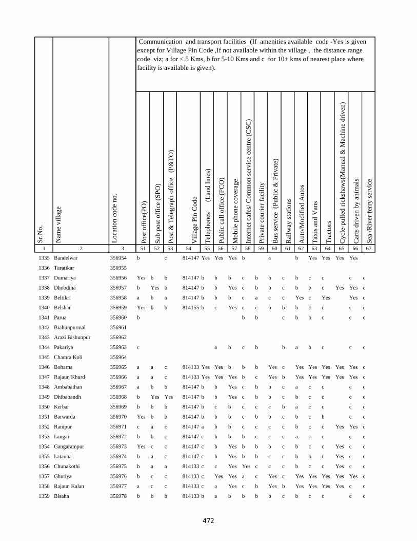
1 2 3
Lo
cati
on
co
de
no
.
Nam
e v
illa
ge
Sr.
No
.
1335 Bandelwar 356954
1336 Taratikar 356955
1337 Dumariya 356956
1338 Dhobdiha 356957
1339 Beltikri 356958
1340 Belshar 356959
1341 Parua 356960
1342 Biahunpurmal 356961
1343 Arazi Bishunpur 356962
1344 Pakariya 356963
1345 Chamra Koli 356964
1346 Boharna 356965
1347 Rajaun Khurd 356966
1348 Ambabathan 356967
1349 Dhibabandh 356968
1350 Kerbar 356969
1351 Barwarda 356970
1352 Ranipur 356971
1353 Laugai 356972
1354 Gangarampur 356973
1355 Latauna 356974
1356 Chunakothi 356975
1357 Ghutiya 356976
1358 Rajaun Kalan 356977
1359 Bisaha 356978
Po
st o
ffic
e(P
O)
Su
b p
ost
off
ice
(SP
O)
Po
st &
Tel
egra
ph
off
ice
(P
&T
O)
Vil
lag
e P
in C
od
e
Tel
eph
on
es
(Lan
d l
ines
)
Pu
bli
c ca
ll o
ffic
e (P
CO
)
Mo
bil
e p
ho
ne
cov
erag
e
Inte
rnet
caf
es/
Co
mm
on
ser
vic
e ce
ntr
e (C
SC
)
Pri
vat
e co
uri
er f
acil
ity
Bu
s se
rvic
e (
Pu
bli
c &
Pri
vat
e)
Rai
lway
sta
tio
ns
Au
to/M
od
ifie
d A
uto
s
Tax
is a
nd
Van
s
Tra
cto
rs
Cy
cle-
pu
lled
ric
ksh
aws(
Man
ual
& M
ach
ine
dri
ven
)
Car
ts d
riv
en b
y a
nim
als
Sea
/R
iver
fer
ry s
erv
ice
51 52 53 54 55 56 57 58 59 60 61 62 63 64 65 66 67
Communication and transport facilities (If amenities available code -Yes is given
except for Village Pin Code ,If not available within the village , the distance range
code viz; a for < 5 Kms, b for 5-10 Kms and c for 10+ kms of nearest place where
facility is available is given).
b c 814147 Yes Yes Yes b a b Yes Yes Yes Yes
Yes b b 814147 b b b c b b c b c c c c
b Yes b 814147 b b Yes c b b c b b c Yes Yes c
a b a 814147 b b b c a c c Yes c Yes Yes c
Yes b b 814155 b c Yes c c b b b c c c c
b b b c b b c c c
c a b c b b a b c c c
a a c 814133 Yes Yes b b b Yes c Yes Yes Yes Yes Yes c
a a c 814133 Yes Yes Yes b c Yes b Yes Yes Yes Yes Yes c
a b b 814147 b b Yes c b b c a c c c c
b Yes Yes 814147 b b Yes c b b c b c c c c
b b b 814147 b c b c c c b a c c c c
Yes b b 814147 b b b c b b c b c b c c
c a c 814147 a b b c c c c b c c Yes Yes c
b b c 814147 c b b b c c c a c c c c
Yes c c 814147 c b Yes b b b c b c c Yes c c
b a c 814147 c b Yes b b c c b b c Yes c c
b a a 814133 c c Yes Yes c c c b c c Yes c c
b c c 814133 c Yes Yes a c Yes c Yes Yes Yes Yes Yes c
a c c 814133 c a Yes c b Yes b Yes Yes Yes Yes c c
b b b 814133 b a b b b b c b c c c c
472
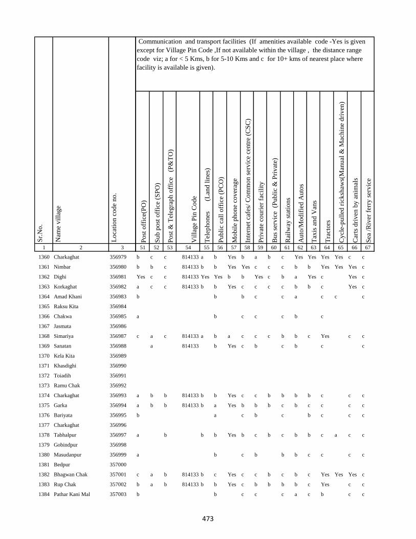
1 2 3
Lo
cati
on
co
de
no
.
Nam
e v
illa
ge
Sr.
No
.
1360 Charkaghat 356979
1361 Nimbar 356980
1362 Dighi 356981
1363 Korkaghat 356982
1364 Amad Khani 356983
1365 Raksu Kita 356984
1366 Chakwa 356985
1367 Jasmata 356986
1368 Simariya 356987
1369 Sanatan 356988
1370 Kela Kita 356989
1371 Khasdighi 356990
1372 Toiadih 356991
1373 Ramu Chak 356992
1374 Charkaghat 356993
1375 Garka 356994
1376 Bariyata 356995
1377 Charkaghat 356996
1378 Tabhalpur 356997
1379 Gobindpur 356998
1380 Masudanpur 356999
1381 Bedpur 357000
1382 Bhagwan Chak 357001
1383 Rup Chak 357002
1384 Pathar Kani Mal 357003
Po
st o
ffic
e(P
O)
Su
b p
ost
off
ice
(SP
O)
Po
st &
Tel
egra
ph
off
ice
(P
&T
O)
Vil
lag
e P
in C
od
e
Tel
eph
on
es
(Lan
d l
ines
)
Pu
bli
c ca
ll o
ffic
e (P
CO
)
Mo
bil
e p
ho
ne
cov
erag
e
Inte
rnet
caf
es/
Co
mm
on
ser
vic
e ce
ntr
e (C
SC
)
Pri
vat
e co
uri
er f
acil
ity
Bu
s se
rvic
e (
Pu
bli
c &
Pri
vat
e)
Rai
lway
sta
tio
ns
Au
to/M
od
ifie
d A
uto
s
Tax
is a
nd
Van
s
Tra
cto
rs
Cy
cle-
pu
lled
ric
ksh
aws(
Man
ual
& M
ach
ine
dri
ven
)
Car
ts d
riv
en b
y a
nim
als
Sea
/R
iver
fer
ry s
erv
ice
51 52 53 54 55 56 57 58 59 60 61 62 63 64 65 66 67
Communication and transport facilities (If amenities available code -Yes is given
except for Village Pin Code ,If not available within the village , the distance range
code viz; a for < 5 Kms, b for 5-10 Kms and c for 10+ kms of nearest place where
facility is available is given).
b c c 814133 a b Yes b a b c Yes Yes Yes Yes c c
b b c 814133 b b Yes Yes c c c b b Yes Yes Yes c
Yes c c 814133 Yes Yes b b Yes c b a Yes c Yes c
a c c 814133 b b Yes c c c c b b c Yes c
b b b c c a c c c
a b c c c b c
c a c 814133 a b a c c c b b c Yes c c
a 814133 b Yes c b c b c c
a b b 814133 b b Yes c c b b b b c c c
a b b 814133 b a Yes b b b c b c c c c
b a c b c b c c c
a b b b Yes b c b c b b c a c c
a b c b b b c c c c
c a b 814133 b c Yes c c b c b c Yes Yes Yes c
b a b 814133 b b Yes c b b b b c Yes c c
b b c c c a c b c c
473
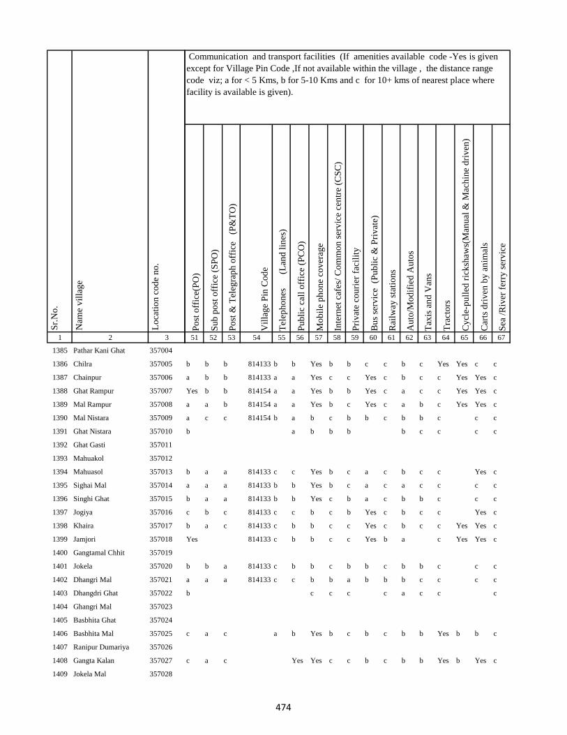
1 2 3
Lo
cati
on
co
de
no
.
Nam
e v
illa
ge
Sr.
No
.
1385 Pathar Kani Ghat 357004
1386 Chilra 357005
1387 Chainpur 357006
1388 Ghat Rampur 357007
1389 Mal Rampur 357008
1390 Mal Nistara 357009
1391 Ghat Nistara 357010
1392 Ghat Gasti 357011
1393 Mahuakol 357012
1394 Mahuasol 357013
1395 Sighai Mal 357014
1396 Singhi Ghat 357015
1397 Jogiya 357016
1398 Khaira 357017
1399 Jamjori 357018
1400 Gangtamal Chhit 357019
1401 Jokela 357020
1402 Dhangri Mal 357021
1403 Dhangdri Ghat 357022
1404 Ghangri Mal 357023
1405 Basbhita Ghat 357024
1406 Basbhita Mal 357025
1407 Ranipur Dumariya 357026
1408 Gangta Kalan 357027
1409 Jokela Mal 357028
Po
st o
ffic
e(P
O)
Su
b p
ost
off
ice
(SP
O)
Po
st &
Tel
egra
ph
off
ice
(P
&T
O)
Vil
lag
e P
in C
od
e
Tel
eph
on
es
(Lan
d l
ines
)
Pu
bli
c ca
ll o
ffic
e (P
CO
)
Mo
bil
e p
ho
ne
cov
erag
e
Inte
rnet
caf
es/
Co
mm
on
ser
vic
e ce
ntr
e (C
SC
)
Pri
vat
e co
uri
er f
acil
ity
Bu
s se
rvic
e (
Pu
bli
c &
Pri
vat
e)
Rai
lway
sta
tio
ns
Au
to/M
od
ifie
d A
uto
s
Tax
is a
nd
Van
s
Tra
cto
rs
Cy
cle-
pu
lled
ric
ksh
aws(
Man
ual
& M
ach
ine
dri
ven
)
Car
ts d
riv
en b
y a
nim
als
Sea
/R
iver
fer
ry s
erv
ice
51 52 53 54 55 56 57 58 59 60 61 62 63 64 65 66 67
Communication and transport facilities (If amenities available code -Yes is given
except for Village Pin Code ,If not available within the village , the distance range
code viz; a for < 5 Kms, b for 5-10 Kms and c for 10+ kms of nearest place where
facility is available is given).
b b b 814133 b b Yes b b c c b c Yes Yes c c
a b b 814133 a a Yes c c Yes c b c c Yes Yes c
Yes b b 814154 a a Yes b b Yes c a c c Yes Yes c
a a b 814154 a a Yes b c Yes c a b c Yes Yes c
a c c 814154 b a b c b b c b b c c c
b a b b b b c c c c
b a a 814133 c c Yes b c a c b c c Yes c
a a a 814133 b b Yes b c a c a c c c c
b a a 814133 b b Yes c b a c b b c c c
c b c 814133 c c b c b Yes c b c c Yes c
b a c 814133 c b b c c Yes c b c c Yes Yes c
Yes 814133 c b b c c Yes b a c Yes Yes c
b b a 814133 c b b c b b c b b c c c
a a a 814133 c c b b a b b b c c c c
b c c c c a c c c
c a c a b Yes b c b c b b Yes b b c
c a c Yes Yes c c b c b b Yes b Yes c
474
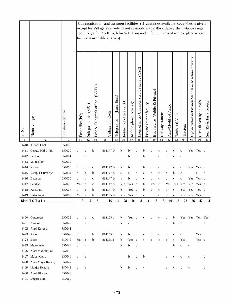
1 2 3
Lo
cati
on
co
de
no
.
Nam
e v
illa
ge
Sr.
No
.
1410 Kerwar Ghat 357029
1411 Gangta Mal Chhit 357030
1412 Lautana 357031
1413 Mahuatanr 357032
1414 Kerwar 357033
1415 Ranipur Dumariya 357034
1416 Badalpur 357035
1417 Tetuliya 357036
1418 Paraspani 357037
1419 Daharlangi 357038
Block T O T A L :
1420 Gorgawan 357039
1421 Koriana 357040
1422 Arazi Koriana 357041
1423 Raha 357042
1424 Bade 357043
1425 Maheshtikri 357044
1426 Arazi Maheshtikri 357045
1427 Majar Khurd 357046
1428 Arazi Majar Buzurg 357047
1429 Manjar Buzurg 357048
1430 Arazi Dhapra 357049
1431 Dhapra Kita 357050
Po
st o
ffic
e(P
O)
Su
b p
ost
off
ice
(SP
O)
Po
st &
Tel
egra
ph
off
ice
(P
&T
O)
Vil
lag
e P
in C
od
e
Tel
eph
on
es
(Lan
d l
ines
)
Pu
bli
c ca
ll o
ffic
e (P
CO
)
Mo
bil
e p
ho
ne
cov
erag
e
Inte
rnet
caf
es/
Co
mm
on
ser
vic
e ce
ntr
e (C
SC
)
Pri
vat
e co
uri
er f
acil
ity
Bu
s se
rvic
e (
Pu
bli
c &
Pri
vat
e)
Rai
lway
sta
tio
ns
Au
to/M
od
ifie
d A
uto
s
Tax
is a
nd
Van
s
Tra
cto
rs
Cy
cle-
pu
lled
ric
ksh
aws(
Man
ual
& M
ach
ine
dri
ven
)
Car
ts d
riv
en b
y a
nim
als
Sea
/R
iver
fer
ry s
erv
ice
51 52 53 54 55 56 57 58 59 60 61 62 63 64 65 66 67
Communication and transport facilities (If amenities available code -Yes is given
except for Village Pin Code ,If not available within the village , the distance range
code viz; a for < 5 Kms, b for 5-10 Kms and c for 10+ kms of nearest place where
facility is available is given).
b b b 814147 b b b c b b c a c c Yes Yes c
c c b b b c b c c c
b c c 814147 b b b b b c c b c c Yes Yes c
a b b 814147 b a a c c c c a b c c c
b c c 814147 b a b c c b c b c c Yes Yes c
Yes c c 814147 b Yes Yes c b Yes c Yes Yes Yes Yes Yes c
b b b 814147 b b Yes c b b c b c Yes Yes Yes c
Yes b b 814155 b Yes Yes c c b c a c Yes Yes Yes c
19 5 5 116 14 28 60 8 6 18 3 10 15 23 56 47 4
b b c 814155 c b Yes b c b c b b Yes Yes Yes Yes
b b b c c a b b c
b b b 814155 c b b c c b c a c c Yes c
Yes b b 814155 c b Yes c c b c b c Yes Yes c
b b b b b b c c
a b b c b a c c c c
c b b b c c b c c c c
475
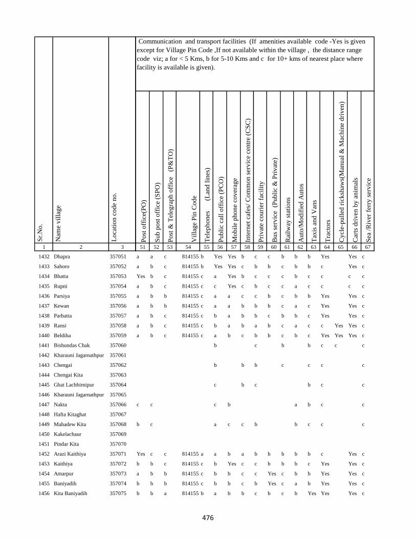
1 2 3
Lo
cati
on
co
de
no
.
Nam
e v
illa
ge
Sr.
No
.
1432 Dhapra 357051
1433 Sahoro 357052
1434 Bhatta 357053
1435 Rupni 357054
1436 Parsiya 357055
1437 Kewan 357056
1438 Parbatta 357057
1439 Ransi 357058
1440 Beldiha 357059
1441 Bishundas Chak 357060
1442 Kharauni Jagarnathpur 357061
1443 Chengai 357062
1444 Chengai Kita 357063
1445 Ghat Lachhimipur 357064
1446 Kharauni Jagarnathpur 357065
1447 Nakta 357066
1448 Hafta Kitaghat 357067
1449 Mahadew Kita 357068
1450 Kakelachaur 357069
1451 Pindar Kita 357070
1452 Arazi Kaithiya 357071
1453 Kaithiya 357072
1454 Amarpur 357073
1455 Baniyadih 357074
1456 Kita Baniyadih 357075
Po
st o
ffic
e(P
O)
Su
b p
ost
off
ice
(SP
O)
Po
st &
Tel
egra
ph
off
ice
(P
&T
O)
Vil
lag
e P
in C
od
e
Tel
eph
on
es
(Lan
d l
ines
)
Pu
bli
c ca
ll o
ffic
e (P
CO
)
Mo
bil
e p
ho
ne
cov
erag
e
Inte
rnet
caf
es/
Co
mm
on
ser
vic
e ce
ntr
e (C
SC
)
Pri
vat
e co
uri
er f
acil
ity
Bu
s se
rvic
e (
Pu
bli
c &
Pri
vat
e)
Rai
lway
sta
tio
ns
Au
to/M
od
ifie
d A
uto
s
Tax
is a
nd
Van
s
Tra
cto
rs
Cy
cle-
pu
lled
ric
ksh
aws(
Man
ual
& M
ach
ine
dri
ven
)
Car
ts d
riv
en b
y a
nim
als
Sea
/R
iver
fer
ry s
erv
ice
51 52 53 54 55 56 57 58 59 60 61 62 63 64 65 66 67
Communication and transport facilities (If amenities available code -Yes is given
except for Village Pin Code ,If not available within the village , the distance range
code viz; a for < 5 Kms, b for 5-10 Kms and c for 10+ kms of nearest place where
facility is available is given).
a a c 814155 b Yes Yes b c c b b b Yes Yes c
a b c 814155 b Yes Yes c b b c b b c Yes c
Yes b c 814155 c a Yes b c c c b c c c c
a b c 814155 c c Yes c b c c a c c c c
a b b 814155 c a a c c b c b b Yes Yes c
a b b 814155 c a a b b b c a c Yes Yes c
a b c 814155 c b a b b c b b c Yes Yes c
a b c 814155 c b a b a b c a c c Yes Yes c
a b c 814155 c a b c b b c b c Yes Yes Yes c
b c b b c c c
b b b c c c c
c b c b c c
c c c b a b c c
b c a c c b b c c c
Yes c c 814155 a a b a b b b b b c Yes c
b b c 814155 c b Yes c c b b b c Yes Yes c
a b b 814155 c b b c c Yes c b b Yes Yes c
b b b 814155 c b b c b Yes c a b Yes Yes c
b b a 814155 b a b b c b c b Yes Yes Yes c
476
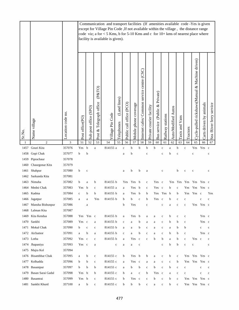
1 2 3
Lo
cati
on
co
de
no
.
Nam
e v
illa
ge
Sr.
No
.
1457 Gouri Kita 357076
1458 Gopi Chak 357077
1459 Piprachaur 357078
1460 Chaurgonar Kita 357079
1461 Shahpur 357080
1462 Sarkunda Kita 357081
1463 Nimuha 357082
1464 Medni Chak 357083
1465 Kadma 357084
1466 Jagatpur 357085
1467 Mansha Bishunpur 357086
1468 Lalman Kita 357087
1469 Kita Kendua 357088
1470 Sankhi 357089
1471 Mokal Chak 357090
1472 Aichamor 357091
1473 Lotha 357092
1474 Jhapaniya 357093
1475 Majra Kol 357094
1476 Bisambhar Chak 357095
1477 Kolhadda 357096
1478 Basantpur 357097
1479 Basan Sarai Gadal 357098
1480 Basantrai 357099
1481 Sankhi Khurd 357100
Po
st o
ffic
e(P
O)
Su
b p
ost
off
ice
(SP
O)
Po
st &
Tel
egra
ph
off
ice
(P
&T
O)
Vil
lag
e P
in C
od
e
Tel
eph
on
es
(Lan
d l
ines
)
Pu
bli
c ca
ll o
ffic
e (P
CO
)
Mo
bil
e p
ho
ne
cov
erag
e
Inte
rnet
caf
es/
Co
mm
on
ser
vic
e ce
ntr
e (C
SC
)
Pri
vat
e co
uri
er f
acil
ity
Bu
s se
rvic
e (
Pu
bli
c &
Pri
vat
e)
Rai
lway
sta
tio
ns
Au
to/M
od
ifie
d A
uto
s
Tax
is a
nd
Van
s
Tra
cto
rs
Cy
cle-
pu
lled
ric
ksh
aws(
Man
ual
& M
ach
ine
dri
ven
)
Car
ts d
riv
en b
y a
nim
als
Sea
/R
iver
fer
ry s
erv
ice
51 52 53 54 55 56 57 58 59 60 61 62 63 64 65 66 67
Communication and transport facilities (If amenities available code -Yes is given
except for Village Pin Code ,If not available within the village , the distance range
code viz; a for < 5 Kms, b for 5-10 Kms and c for 10+ kms of nearest place where
facility is available is given).
Yes b a 814155 a c b b b b c a b c Yes Yes c
b b a b c c b c c c
b c a b b a c b c c c
b a b 814155 b Yes Yes b c Yes c Yes Yes Yes Yes Yes c
Yes b c 814155 a a Yes b c Yes c b c Yes Yes Yes c
c b b 814155 b a Yes b b Yes Yes b b Yes Yes c Yes
a a Yes 814155 b b b c b Yes c b c c c c
a b Yes c c a c c Yes Yes c
Yes Yes c 814155 b a Yes b a a c b c c Yes c
Yes c a 814155 b c a b a a c b b c Yes c
b c c 814155 b a a b c a c a b b c c
a b a 814155 b c a b c a c b b c Yes c
Yes c c 814155 b a Yes c c b b a b c Yes c c
Yes c a c a a c c b b c c c
a b c 814155 c b Yes b b a c b c Yes Yes Yes c
b b c 814155 c a Yes c a a c c b Yes Yes Yes c
b b b 814155 c a b b c b c b c c c c
Yes b b 814155 c b a c b Yes c a c c c c
Yes b c 814155 c b Yes c c b c b c Yes Yes Yes c
a b c 814155 c b b b c a c b c Yes Yes Yes c
477
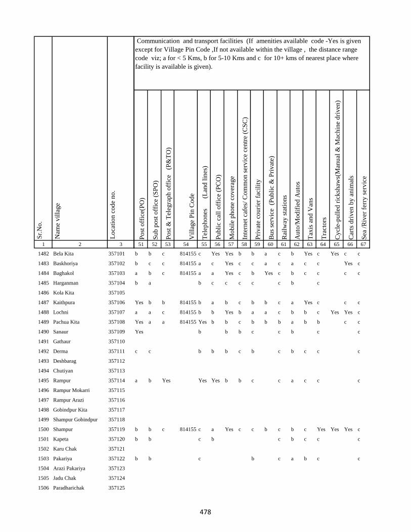
1 2 3
Lo
cati
on
co
de
no
.
Nam
e v
illa
ge
Sr.
No
.
1482 Bela Kita 357101
1483 Baskhoriya 357102
1484 Baghakol 357103
1485 Harganman 357104
1486 Kola Kita 357105
1487 Kaithpura 357106
1488 Lochni 357107
1489 Pachua Kita 357108
1490 Sanaur 357109
1491 Gathaur 357110
1492 Derma 357111
1493 Deshbarag 357112
1494 Chutiyan 357113
1495 Rampur 357114
1496 Rampur Mokarri 357115
1497 Rampur Arazi 357116
1498 Gobindpur Kita 357117
1499 Shampur Gobindpur 357118
1500 Shampur 357119
1501 Kapeta 357120
1502 Karu Chak 357121
1503 Pakariya 357122
1504 Arazi Pakariya 357123
1505 Jadu Chak 357124
1506 Paradharichak 357125
Po
st o
ffic
e(P
O)
Su
b p
ost
off
ice
(SP
O)
Po
st &
Tel
egra
ph
off
ice
(P
&T
O)
Vil
lag
e P
in C
od
e
Tel
eph
on
es
(Lan
d l
ines
)
Pu
bli
c ca
ll o
ffic
e (P
CO
)
Mo
bil
e p
ho
ne
cov
erag
e
Inte
rnet
caf
es/
Co
mm
on
ser
vic
e ce
ntr
e (C
SC
)
Pri
vat
e co
uri
er f
acil
ity
Bu
s se
rvic
e (
Pu
bli
c &
Pri
vat
e)
Rai
lway
sta
tio
ns
Au
to/M
od
ifie
d A
uto
s
Tax
is a
nd
Van
s
Tra
cto
rs
Cy
cle-
pu
lled
ric
ksh
aws(
Man
ual
& M
ach
ine
dri
ven
)
Car
ts d
riv
en b
y a
nim
als
Sea
/R
iver
fer
ry s
erv
ice
51 52 53 54 55 56 57 58 59 60 61 62 63 64 65 66 67
Communication and transport facilities (If amenities available code -Yes is given
except for Village Pin Code ,If not available within the village , the distance range
code viz; a for < 5 Kms, b for 5-10 Kms and c for 10+ kms of nearest place where
facility is available is given).
b b c 814155 c Yes Yes b b a c b Yes c Yes c c
b c c 814155 a c Yes c c a c a c c Yes c
a b c 814155 a a Yes c b Yes c b c c c c
b a b c c c c c b c
Yes b b 814155 b a b c b b c a Yes c c c
a a c 814155 b b Yes b a a c b b c Yes Yes c
Yes a a 814155 Yes b b c b b b a b b c c
Yes b b b c c b c c
c c b b b c b c b c c c
a b Yes Yes Yes b b c c a c c c
b b c 814155 c a Yes c c b c b c Yes Yes Yes c
b b c b c b c c c
b b c b c a b c c
478
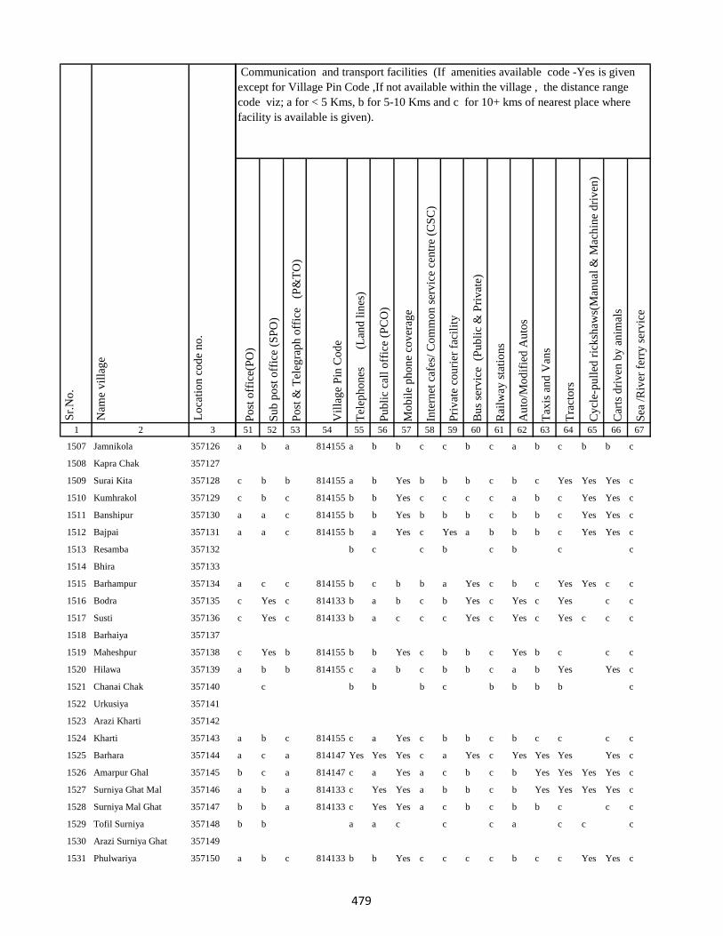
1 2 3
Lo
cati
on
co
de
no
.
Nam
e v
illa
ge
Sr.
No
.
1507 Jamnikola 357126
1508 Kapra Chak 357127
1509 Surai Kita 357128
1510 Kumhrakol 357129
1511 Banshipur 357130
1512 Bajpai 357131
1513 Resamba 357132
1514 Bhira 357133
1515 Barhampur 357134
1516 Bodra 357135
1517 Susti 357136
1518 Barhaiya 357137
1519 Maheshpur 357138
1520 Hilawa 357139
1521 Chanai Chak 357140
1522 Urkusiya 357141
1523 Arazi Kharti 357142
1524 Kharti 357143
1525 Barhara 357144
1526 Amarpur Ghal 357145
1527 Surniya Ghat Mal 357146
1528 Surniya Mal Ghat 357147
1529 Tofil Surniya 357148
1530 Arazi Surniya Ghat 357149
1531 Phulwariya 357150
Po
st o
ffic
e(P
O)
Su
b p
ost
off
ice
(SP
O)
Po
st &
Tel
egra
ph
off
ice
(P
&T
O)
Vil
lag
e P
in C
od
e
Tel
eph
on
es
(Lan
d l
ines
)
Pu
bli
c ca
ll o
ffic
e (P
CO
)
Mo
bil
e p
ho
ne
cov
erag
e
Inte
rnet
caf
es/
Co
mm
on
ser
vic
e ce
ntr
e (C
SC
)
Pri
vat
e co
uri
er f
acil
ity
Bu
s se
rvic
e (
Pu
bli
c &
Pri
vat
e)
Rai
lway
sta
tio
ns
Au
to/M
od
ifie
d A
uto
s
Tax
is a
nd
Van
s
Tra
cto
rs
Cy
cle-
pu
lled
ric
ksh
aws(
Man
ual
& M
ach
ine
dri
ven
)
Car
ts d
riv
en b
y a
nim
als
Sea
/R
iver
fer
ry s
erv
ice
51 52 53 54 55 56 57 58 59 60 61 62 63 64 65 66 67
Communication and transport facilities (If amenities available code -Yes is given
except for Village Pin Code ,If not available within the village , the distance range
code viz; a for < 5 Kms, b for 5-10 Kms and c for 10+ kms of nearest place where
facility is available is given).
a b a 814155 a b b c c b c a b c b b c
c b b 814155 a b Yes b b b c b c Yes Yes Yes c
c b c 814155 b b Yes c c c c a b c Yes Yes c
a a c 814155 b b Yes b b b c b b c Yes Yes c
a a c 814155 b a Yes c Yes a b b b c Yes Yes c
b c c b c b c c
a c c 814155 b c b b a Yes c b c Yes Yes c c
c Yes c 814133 b a b c b Yes c Yes c Yes c c
c Yes c 814133 b a c c c Yes c Yes c Yes c c c
c Yes b 814155 b b Yes c b b c Yes b c c c
a b b 814155 c a b c b b c a b Yes Yes c
c b b b c b b b b c
a b c 814155 c a Yes c b b c b c c c c
a c a 814147 Yes Yes Yes c a Yes c Yes Yes Yes Yes c
b c a 814147 c a Yes a c b c b Yes Yes Yes Yes c
a b a 814133 c Yes Yes a b b c b Yes Yes Yes Yes c
b b a 814133 c Yes Yes a c b c b b c c c
b b a a c c c a c c c
a b c 814133 b b Yes c c c c b c c Yes Yes c
479
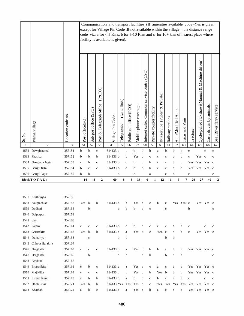
1 2 3
Lo
cati
on
co
de
no
.
Nam
e v
illa
ge
Sr.
No
.
1532 Dewgharamal 357151
1533 Phasiya 357152
1534 Deoghara Jagir 357153
1535 Gangti Kita 357154
1536 Gangti Jagir 357155
Block T O T A L :
1537 Kaithpujha 357156
1538 Saurpachisa 357157
1539 Dodhari 357158
1540 Dalpatpur 357159
1541 Sirsi 357160
1542 Parara 357161
1543 Garurakita 357162
1544 Dumariya 357163
1545 Chhota Harakita 357164
1546 Darghatta 357165
1547 Darghatti 357166
1548 Amdanr 357167
1549 Bharthikita 357168
1550 Majhdiha 357169
1551 Kumar Kund 357170
1552 Dholi Chak 357171
1553 Khatnahi 357172
Po
st o
ffic
e(P
O)
Su
b p
ost
off
ice
(SP
O)
Po
st &
Tel
egra
ph
off
ice
(P
&T
O)
Vil
lag
e P
in C
od
e
Tel
eph
on
es
(Lan
d l
ines
)
Pu
bli
c ca
ll o
ffic
e (P
CO
)
Mo
bil
e p
ho
ne
cov
erag
e
Inte
rnet
caf
es/
Co
mm
on
ser
vic
e ce
ntr
e (C
SC
)
Pri
vat
e co
uri
er f
acil
ity
Bu
s se
rvic
e (
Pu
bli
c &
Pri
vat
e)
Rai
lway
sta
tio
ns
Au
to/M
od
ifie
d A
uto
s
Tax
is a
nd
Van
s
Tra
cto
rs
Cy
cle-
pu
lled
ric
ksh
aws(
Man
ual
& M
ach
ine
dri
ven
)
Car
ts d
riv
en b
y a
nim
als
Sea
/R
iver
fer
ry s
erv
ice
51 52 53 54 55 56 57 58 59 60 61 62 63 64 65 66 67
Communication and transport facilities (If amenities available code -Yes is given
except for Village Pin Code ,If not available within the village , the distance range
code viz; a for < 5 Kms, b for 5-10 Kms and c for 10+ kms of nearest place where
facility is available is given).
b b c 814133 a c b c b a b b c c c c
b b b 814133 b b Yes c c c c a c c Yes c c
c b c 814133 b c b c b c c b c Yes Yes Yes c
b c c 814133 b c b c b c c a c Yes Yes Yes c
b b b c a c b c c
14 4 2 60 3 8 33 0 1 12 1 5 7 29 27 40 2
Yes b b 814133 b b Yes b c b c Yes Yes c Yes Yes c
b b b b b c c b c
c c c 814133 b c b b c c c b b c c c
Yes b b 814133 c a Yes c c Yes c a b c Yes Yes c
c b c b b
c c c 814133 c a Yes b b b c b b Yes Yes Yes c
b c b b b b a b c
c b c 814133 c a Yes b c a c b c Yes Yes Yes c
c c c 814133 c b Yes c b Yes b b c Yes Yes Yes c
a b b 814133 c a b c c b c a b c c c
Yes b b 814133 Yes Yes Yes c c Yes Yes Yes Yes Yes Yes Yes c
a b c 814133 a a Yes b b a c a c Yes Yes Yes c
480
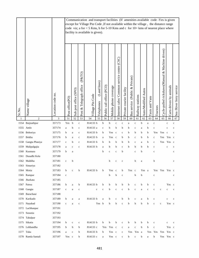
1 2 3
Lo
cati
on
co
de
no
.
Nam
e v
illa
ge
Sr.
No
.
1554 Baijnathpur 357173
1555 Amlo 357174
1556 Bohoriya 357175
1557 Bokha 357176
1558 Gangta Phasiya 357177
1559 Malipalgajia 357178
1560 Kusmara 357179
1561 Dusadhi Kola 357180
1562 Maldiha 357181
1563 Simariya 357182
1564 Motia 357183
1565 Rampur 357184
1566 Jharkata 357185
1567 Patwa 357186
1568 Gangta 357187
1569 Barachaur 357188
1570 Karikado 357189
1571 Nayabad 357190
1572 Lachhanpur 357191
1573 Susunia 357192
1574 Tabalpur 357193
1575 Sikatia 357194
1576 Lohbandha 357195
1577 Tuka 357196
1578 Ramla Santali 357197
Po
st o
ffic
e(P
O)
Su
b p
ost
off
ice
(SP
O)
Po
st &
Tel
egra
ph
off
ice
(P
&T
O)
Vil
lag
e P
in C
od
e
Tel
eph
on
es
(Lan
d l
ines
)
Pu
bli
c ca
ll o
ffic
e (P
CO
)
Mo
bil
e p
ho
ne
cov
erag
e
Inte
rnet
caf
es/
Co
mm
on
ser
vic
e ce
ntr
e (C
SC
)
Pri
vat
e co
uri
er f
acil
ity
Bu
s se
rvic
e (
Pu
bli
c &
Pri
vat
e)
Rai
lway
sta
tio
ns
Au
to/M
od
ifie
d A
uto
s
Tax
is a
nd
Van
s
Tra
cto
rs
Cy
cle-
pu
lled
ric
ksh
aws(
Man
ual
& M
ach
ine
dri
ven
)
Car
ts d
riv
en b
y a
nim
als
Sea
/R
iver
fer
ry s
erv
ice
51 52 53 54 55 56 57 58 59 60 61 62 63 64 65 66 67
Communication and transport facilities (If amenities available code -Yes is given
except for Village Pin Code ,If not available within the village , the distance range
code viz; a for < 5 Kms, b for 5-10 Kms and c for 10+ kms of nearest place where
facility is available is given).
Yes b c 814133 b b b c c a c b a c c c
a b c 814133 a c b b b b c a b c c c
b a c 814133 b b Yes c c b b b b Yes Yes c c
b a c 814133 b a Yes c b b c b b c Yes Yes c
c b c 814133 b b b b b b c a b c Yes Yes c
a c c 814133 b a b b c b b b b c c c
b a b c c b c b c c
c b b c c b a b c
b c b 814133 b b Yes c b Yes c Yes a Yes Yes Yes c
c b b c b b c c
b a b 814133 b b b b b b c b b c Yes c
c a c c c b c c b c a c c c c c
b a a 814133 b a b c b b c a b c c c
c a c Yes b b b c b b b b c c Yes c
b c c 814133 b b b b c b b b b c c c
b b b 814133 c Yes Yes c c a c b b c Yes c
a c b 814133 b b Yes c c Yes Yes a Yes Yes Yes Yes c
Yes c b 814133 c a Yes c c b c b a b Yes Yes c
481

1 2 3
Lo
cati
on
co
de
no
.
Nam
e v
illa
ge
Sr.
No
.
1579 Ramla Dikwani 357198
1580 Nankhil 357199
1581 Devpur 357200
1582 Kumarreri 357201
1583 Saidapur 357202
1584 Algajora 357203
1585 Sinhpur 357204
1586 Parasi 357205
1587 Bhawanipur 357206
1588 Bishunpur 357207
1589 Manpur 357208
1590 Dubrajpur 357209
1591 Gurguri 357210
1592 Reni 357211
1593 Kitabuidi 357212
1594 Kathra 357213
1595 Dokabandh 357214
1596 Makunddih 357215
1597 Makunddin (Santoli) 357216
1598 Pakariya Mal 357217
1599 Pakarya Ghat 357218
1600 Beldiha 357219
1601 Barahara 357220
1602 Harpati Chak 357221
1603 Bansipur 357222
Po
st o
ffic
e(P
O)
Su
b p
ost
off
ice
(SP
O)
Po
st &
Tel
egra
ph
off
ice
(P
&T
O)
Vil
lag
e P
in C
od
e
Tel
eph
on
es
(Lan
d l
ines
)
Pu
bli
c ca
ll o
ffic
e (P
CO
)
Mo
bil
e p
ho
ne
cov
erag
e
Inte
rnet
caf
es/
Co
mm
on
ser
vic
e ce
ntr
e (C
SC
)
Pri
vat
e co
uri
er f
acil
ity
Bu
s se
rvic
e (
Pu
bli
c &
Pri
vat
e)
Rai
lway
sta
tio
ns
Au
to/M
od
ifie
d A
uto
s
Tax
is a
nd
Van
s
Tra
cto
rs
Cy
cle-
pu
lled
ric
ksh
aws(
Man
ual
& M
ach
ine
dri
ven
)
Car
ts d
riv
en b
y a
nim
als
Sea
/R
iver
fer
ry s
erv
ice
51 52 53 54 55 56 57 58 59 60 61 62 63 64 65 66 67
Communication and transport facilities (If amenities available code -Yes is given
except for Village Pin Code ,If not available within the village , the distance range
code viz; a for < 5 Kms, b for 5-10 Kms and c for 10+ kms of nearest place where
facility is available is given).
Yes c b 814133 c b Yes c b b b a b c Yes Yes c
b b b 814133 c a a b c c c b b c c c
Yes Yes Yes 814133 c b Yes c b b c a Yes c Yes Yes c
Yes b b 814133 c c b b c c b Yes a Yes Yes Yes c
c c b c c c a c
b b b 814133 a b Yes b b b b a b Yes Yes Yes c
b a a b b c c b c c c
Yes a b 814133 b b Yes c b b c Yes b Yes Yes c c
b a b 814133 b Yes Yes c c b c Yes b Yes Yes c c
Yes b b 814133 b b Yes c b Yes b b b c Yes Yes c
c b a b b c b b c c
b b b 814133 b a b b b a b b b c Yes c
b Yes b 814133 b b b c c a c b a b Yes c
b c b 814133 b c b c b a c a b c Yes c
b c b 814133 b b b c b a b a b c Yes c
a a a 814133 b a b b a Yes c Yes Yes c Yes Yes c
a a a 814133 b a b c a a c a a c Yes c
a a a 814133 c a a b a a b a a c Yes Yes c
b b c c c c
b b b 814133 c b Yes c c b c Yes c Yes Yes c c
482
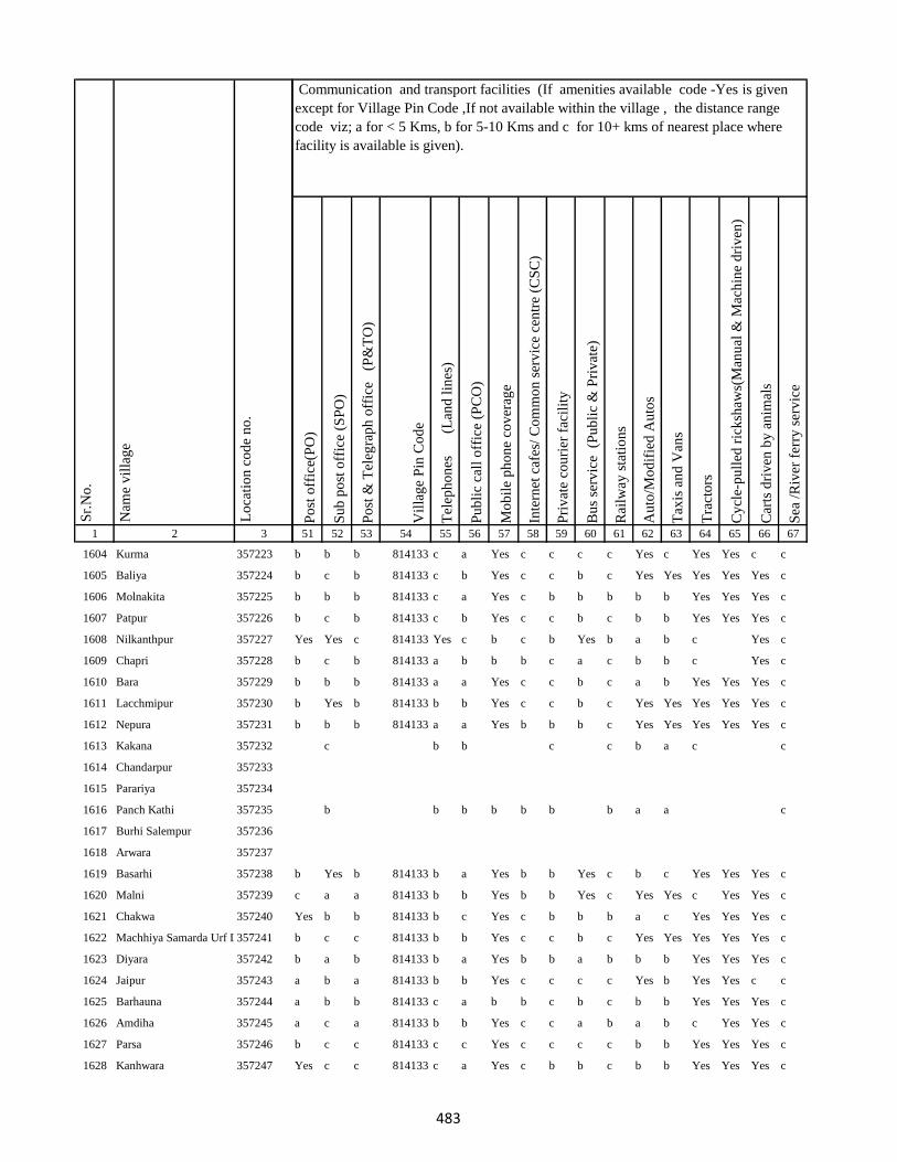
1 2 3
Lo
cati
on
co
de
no
.
Nam
e v
illa
ge
Sr.
No
.
1604 Kurma 357223
1605 Baliya 357224
1606 Molnakita 357225
1607 Patpur 357226
1608 Nilkanthpur 357227
1609 Chapri 357228
1610 Bara 357229
1611 Lacchmipur 357230
1612 Nepura 357231
1613 Kakana 357232
1614 Chandarpur 357233
1615 Parariya 357234
1616 Panch Kathi 357235
1617 Burhi Salempur 357236
1618 Arwara 357237
1619 Basarhi 357238
1620 Malni 357239
1621 Chakwa 357240
1622 Machhiya Samarda Urf Lalpur357241
1623 Diyara 357242
1624 Jaipur 357243
1625 Barhauna 357244
1626 Amdiha 357245
1627 Parsa 357246
1628 Kanhwara 357247
Po
st o
ffic
e(P
O)
Su
b p
ost
off
ice
(SP
O)
Po
st &
Tel
egra
ph
off
ice
(P
&T
O)
Vil
lag
e P
in C
od
e
Tel
eph
on
es
(Lan
d l
ines
)
Pu
bli
c ca
ll o
ffic
e (P
CO
)
Mo
bil
e p
ho
ne
cov
erag
e
Inte
rnet
caf
es/
Co
mm
on
ser
vic
e ce
ntr
e (C
SC
)
Pri
vat
e co
uri
er f
acil
ity
Bu
s se
rvic
e (
Pu
bli
c &
Pri
vat
e)
Rai
lway
sta
tio
ns
Au
to/M
od
ifie
d A
uto
s
Tax
is a
nd
Van
s
Tra
cto
rs
Cy
cle-
pu
lled
ric
ksh
aws(
Man
ual
& M
ach
ine
dri
ven
)
Car
ts d
riv
en b
y a
nim
als
Sea
/R
iver
fer
ry s
erv
ice
51 52 53 54 55 56 57 58 59 60 61 62 63 64 65 66 67
Communication and transport facilities (If amenities available code -Yes is given
except for Village Pin Code ,If not available within the village , the distance range
code viz; a for < 5 Kms, b for 5-10 Kms and c for 10+ kms of nearest place where
facility is available is given).
b b b 814133 c a Yes c c c c Yes c Yes Yes c c
b c b 814133 c b Yes c c b c Yes Yes Yes Yes Yes c
b b b 814133 c a Yes c b b b b b Yes Yes Yes c
b c b 814133 c b Yes c c b c b b Yes Yes Yes c
Yes Yes c 814133 Yes c b c b Yes b a b c Yes c
b c b 814133 a b b b c a c b b c Yes c
b b b 814133 a a Yes c c b c a b Yes Yes Yes c
b Yes b 814133 b b Yes c c b c Yes Yes Yes Yes Yes c
b b b 814133 a a Yes b b b c Yes Yes Yes Yes Yes c
c b b c c b a c c
b b b b b b b a a c
b Yes b 814133 b a Yes b b Yes c b c Yes Yes Yes c
c a a 814133 b b Yes b b Yes c Yes Yes c Yes Yes c
Yes b b 814133 b c Yes c b b b a c Yes Yes Yes c
b c c 814133 b b Yes c c b c Yes Yes Yes Yes Yes c
b a b 814133 b a Yes b b a b b b Yes Yes Yes c
a b a 814133 b b Yes c c c c Yes b Yes Yes c c
a b b 814133 c a b b c b c b b Yes Yes Yes c
a c a 814133 b b Yes c c a b a b c Yes Yes c
b c c 814133 c c Yes c c c c b b Yes Yes Yes c
Yes c c 814133 c a Yes c b b c b b Yes Yes Yes c
483

1 2 3
Lo
cati
on
co
de
no
.
Nam
e v
illa
ge
Sr.
No
.
1629 Garbana 357248
1630 Galapahar 357249
1631 Bhadrahi Mal 357250
1632 Ghat Bhadrahi 357251
1633 Chilauna 357252
1634 Rampur 357253
1635 Dumariya Mal 357254
1636 Naya Chak 357255
1637 Dara Chak 357256
1638 Ghat Gorsanda 357257
1639 Mal Gorsanda 357258
1640 Mal Dhamsain 357259
1641 Ghat Dhamsain 357260
1642 Ghat Dhamsain 357261
1643 Khaira Mal 357262
1644 Pachrukhi 357263
1645 Lukluki Mal 357264
1646 Lukluki Ghat 357265
1647 Pathariya Mal 357266
1648 Pathariya Ghat 357267
1649 Pathariya Mal 357268
1650 Chhota Kaliyani 357269
1651 Bara Kaliyani 357270
1652 Pathriya Mal 357271
1653 Sabaijor 357272
Po
st o
ffic
e(P
O)
Su
b p
ost
off
ice
(SP
O)
Po
st &
Tel
egra
ph
off
ice
(P
&T
O)
Vil
lag
e P
in C
od
e
Tel
eph
on
es
(Lan
d l
ines
)
Pu
bli
c ca
ll o
ffic
e (P
CO
)
Mo
bil
e p
ho
ne
cov
erag
e
Inte
rnet
caf
es/
Co
mm
on
ser
vic
e ce
ntr
e (C
SC
)
Pri
vat
e co
uri
er f
acil
ity
Bu
s se
rvic
e (
Pu
bli
c &
Pri
vat
e)
Rai
lway
sta
tio
ns
Au
to/M
od
ifie
d A
uto
s
Tax
is a
nd
Van
s
Tra
cto
rs
Cy
cle-
pu
lled
ric
ksh
aws(
Man
ual
& M
ach
ine
dri
ven
)
Car
ts d
riv
en b
y a
nim
als
Sea
/R
iver
fer
ry s
erv
ice
51 52 53 54 55 56 57 58 59 60 61 62 63 64 65 66 67
Communication and transport facilities (If amenities available code -Yes is given
except for Village Pin Code ,If not available within the village , the distance range
code viz; a for < 5 Kms, b for 5-10 Kms and c for 10+ kms of nearest place where
facility is available is given).
a b b 814133 c b b c c b c a b Yes Yes Yes c
Yes c b 814133 c a Yes c b b c b a c Yes Yes c
Yes c b 814133 c b Yes c c b c a b b Yes Yes c
b c c 814133 c a Yes c c c c b b Yes Yes Yes c
b b b 814133 c b b c c a c a a c Yes c
b a b 814133 a c b b b a c b a c Yes Yes c
b b b 814133 a b b c c a b a a c Yes c
b c b 814133 b a b c c a c a a c Yes c c
Yes b b 814133 a b b b b Yes c a b c Yes Yes c
b b b 814133 b a b b b a c b b c a a c
c a c c c c c b a c a a c a a c
b Yes b 814133 b b b b c a c b a c Yes Yes c
a a Yes c c Yes Yes c
b b b c c
c c c 814133 c b a b c b b b c c Yes c c
b c c 814133 b a b b c c c a c c c c
b b c 814133 b b b b c c b b c c Yes Yes c
b c c 814156 b c b b b b c a b Yes Yes c
484
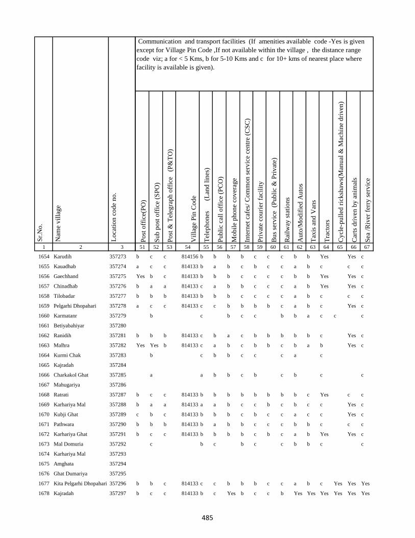
1 2 3
Lo
cati
on
co
de
no
.
Nam
e v
illa
ge
Sr.
No
.
1654 Karudih 357273
1655 Kauadhab 357274
1656 Gaechhand 357275
1657 Chinadhab 357276
1658 Tilobadar 357277
1659 Pelgarhi Dhopahari 357278
1660 Karmatanr 357279
1661 Betiyabahiyar 357280
1662 Ranidih 357281
1663 Malhra 357282
1664 Kurmi Chak 357283
1665 Kajradah 357284
1666 Charkakol Ghat 357285
1667 Mahugariya 357286
1668 Ratrati 357287
1669 Karhariya Mal 357288
1670 Kubji Ghat 357289
1671 Pathwara 357290
1672 Karhariya Ghat 357291
1673 Mal Domuria 357292
1674 Karhariya Mal 357293
1675 Amghata 357294
1676 Ghat Dumariya 357295
1677 Kita Pelgarhi Dhopahari 357296
1678 Kajradah 357297
Po
st o
ffic
e(P
O)
Su
b p
ost
off
ice
(SP
O)
Po
st &
Tel
egra
ph
off
ice
(P
&T
O)
Vil
lag
e P
in C
od
e
Tel
eph
on
es
(Lan
d l
ines
)
Pu
bli
c ca
ll o
ffic
e (P
CO
)
Mo
bil
e p
ho
ne
cov
erag
e
Inte
rnet
caf
es/
Co
mm
on
ser
vic
e ce
ntr
e (C
SC
)
Pri
vat
e co
uri
er f
acil
ity
Bu
s se
rvic
e (
Pu
bli
c &
Pri
vat
e)
Rai
lway
sta
tio
ns
Au
to/M
od
ifie
d A
uto
s
Tax
is a
nd
Van
s
Tra
cto
rs
Cy
cle-
pu
lled
ric
ksh
aws(
Man
ual
& M
ach
ine
dri
ven
)
Car
ts d
riv
en b
y a
nim
als
Sea
/R
iver
fer
ry s
erv
ice
51 52 53 54 55 56 57 58 59 60 61 62 63 64 65 66 67
Communication and transport facilities (If amenities available code -Yes is given
except for Village Pin Code ,If not available within the village , the distance range
code viz; a for < 5 Kms, b for 5-10 Kms and c for 10+ kms of nearest place where
facility is available is given).
b c c 814156 b b b b c c c b b Yes Yes c
a c c 814133 b a b c b c c a b c c c
Yes b c 814133 b b b c c c c b b Yes Yes c
b a a 814133 c a b b c c c a b Yes Yes c
b b b 814133 b b b c c c c a b c c c
a c c 814133 c c b b b b c a b c Yes c
b c b c c b b a c c c
b b b 814133 c b a c b b b b b c Yes c
Yes Yes b 814133 c a b c b b c b a b Yes c
b c b b c c c a c
a a b b c b c b c c
b c c 814133 b b b b b b b b c Yes c c
b a a 814133 a a b c c b c b c c Yes c
c b c 814133 b b b c b c c a c c Yes c
b b b 814133 b a b b c c c b b c c c
b c c 814133 b b b b c b c a b Yes Yes c
c b c b c c b b c c
b b c 814133 c c b b b c c a b c Yes Yes Yes
b c c 814133 b c Yes b c c b Yes Yes Yes Yes Yes Yes
485
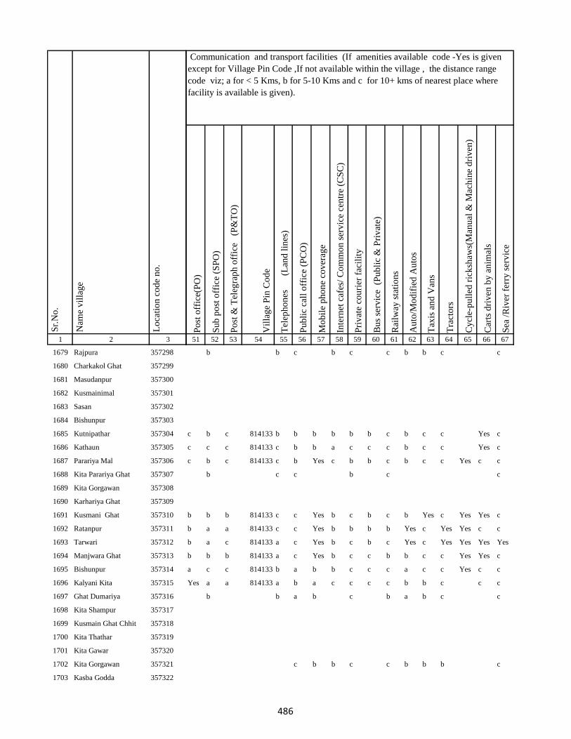
1 2 3
Lo
cati
on
co
de
no
.
Nam
e v
illa
ge
Sr.
No
.
1679 Rajpura 357298
1680 Charkakol Ghat 357299
1681 Masudanpur 357300
1682 Kusmainimal 357301
1683 Sasan 357302
1684 Bishunpur 357303
1685 Kutnipathar 357304
1686 Kathaun 357305
1687 Parariya Mal 357306
1688 Kita Parariya Ghat 357307
1689 Kita Gorgawan 357308
1690 Karhariya Ghat 357309
1691 Kusmani Ghat 357310
1692 Ratanpur 357311
1693 Tarwari 357312
1694 Manjwara Ghat 357313
1695 Bishunpur 357314
1696 Kalyani Kita 357315
1697 Ghat Dumariya 357316
1698 Kita Shampur 357317
1699 Kusmain Ghat Chhit 357318
1700 Kita Thathar 357319
1701 Kita Gawar 357320
1702 Kita Gorgawan 357321
1703 Kasba Godda 357322
Po
st o
ffic
e(P
O)
Su
b p
ost
off
ice
(SP
O)
Po
st &
Tel
egra
ph
off
ice
(P
&T
O)
Vil
lag
e P
in C
od
e
Tel
eph
on
es
(Lan
d l
ines
)
Pu
bli
c ca
ll o
ffic
e (P
CO
)
Mo
bil
e p
ho
ne
cov
erag
e
Inte
rnet
caf
es/
Co
mm
on
ser
vic
e ce
ntr
e (C
SC
)
Pri
vat
e co
uri
er f
acil
ity
Bu
s se
rvic
e (
Pu
bli
c &
Pri
vat
e)
Rai
lway
sta
tio
ns
Au
to/M
od
ifie
d A
uto
s
Tax
is a
nd
Van
s
Tra
cto
rs
Cy
cle-
pu
lled
ric
ksh
aws(
Man
ual
& M
ach
ine
dri
ven
)
Car
ts d
riv
en b
y a
nim
als
Sea
/R
iver
fer
ry s
erv
ice
51 52 53 54 55 56 57 58 59 60 61 62 63 64 65 66 67
Communication and transport facilities (If amenities available code -Yes is given
except for Village Pin Code ,If not available within the village , the distance range
code viz; a for < 5 Kms, b for 5-10 Kms and c for 10+ kms of nearest place where
facility is available is given).
b b c b c c b b c c
c b c 814133 b b b b b b c b c c Yes c
c c c 814133 c b b a c c c b c c Yes c
c b c 814133 c b Yes c b b c b c c Yes c c
b c c b c c
b b b 814133 c c Yes b c b c b Yes c Yes Yes c
b a a 814133 c c Yes b b b b Yes c Yes Yes c c
b a c 814133 a c Yes b c b c Yes c Yes Yes Yes Yes
b b b 814133 a c Yes b c c b b c c Yes Yes c
a c c 814133 b a b b c c c a c c Yes c c
Yes a a 814133 a b a c c c c b b c c c
b b a b c b a b c c
c b b c c b b b c
486
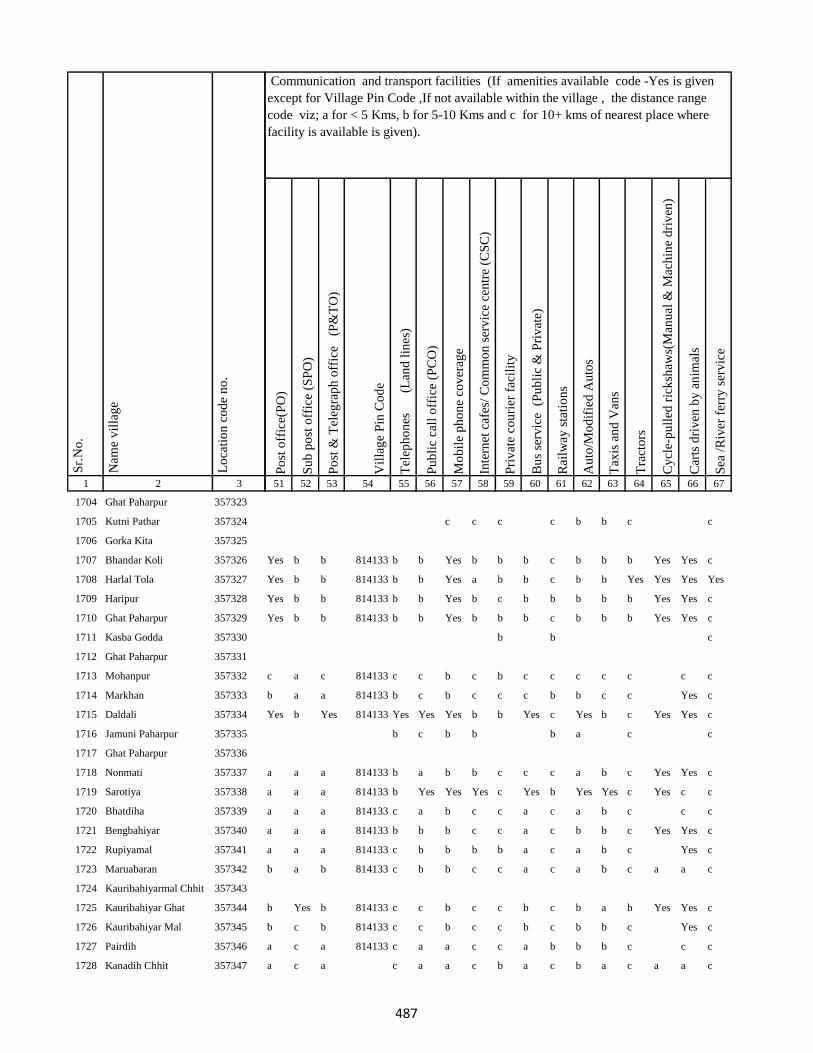
1 2 3
Lo
cati
on
co
de
no
.
Nam
e v
illa
ge
Sr.
No
.
1704 Ghat Paharpur 357323
1705 Kutni Pathar 357324
1706 Gorka Kita 357325
1707 Bhandar Koli 357326
1708 Harlal Tola 357327
1709 Haripur 357328
1710 Ghat Paharpur 357329
1711 Kasba Godda 357330
1712 Ghat Paharpur 357331
1713 Mohanpur 357332
1714 Markhan 357333
1715 Daldali 357334
1716 Jamuni Paharpur 357335
1717 Ghat Paharpur 357336
1718 Nonmati 357337
1719 Sarotiya 357338
1720 Bhatdiha 357339
1721 Bengbahiyar 357340
1722 Rupiyamal 357341
1723 Maruabaran 357342
1724 Kauribahiyarmal Chhit 357343
1725 Kauribahiyar Ghat 357344
1726 Kauribahiyar Mal 357345
1727 Pairdih 357346
1728 Kanadih Chhit 357347
Po
st o
ffic
e(P
O)
Su
b p
ost
off
ice
(SP
O)
Po
st &
Tel
egra
ph
off
ice
(P
&T
O)
Vil
lag
e P
in C
od
e
Tel
eph
on
es
(Lan
d l
ines
)
Pu
bli
c ca
ll o
ffic
e (P
CO
)
Mo
bil
e p
ho
ne
cov
erag
e
Inte
rnet
caf
es/
Co
mm
on
ser
vic
e ce
ntr
e (C
SC
)
Pri
vat
e co
uri
er f
acil
ity
Bu
s se
rvic
e (
Pu
bli
c &
Pri
vat
e)
Rai
lway
sta
tio
ns
Au
to/M
od
ifie
d A
uto
s
Tax
is a
nd
Van
s
Tra
cto
rs
Cy
cle-
pu
lled
ric
ksh
aws(
Man
ual
& M
ach
ine
dri
ven
)
Car
ts d
riv
en b
y a
nim
als
Sea
/R
iver
fer
ry s
erv
ice
51 52 53 54 55 56 57 58 59 60 61 62 63 64 65 66 67
Communication and transport facilities (If amenities available code -Yes is given
except for Village Pin Code ,If not available within the village , the distance range
code viz; a for < 5 Kms, b for 5-10 Kms and c for 10+ kms of nearest place where
facility is available is given).
c c c c b b c c
Yes b b 814133 b b Yes b b b c b b b Yes Yes c
Yes b b 814133 b b Yes a b b c b b Yes Yes Yes Yes
Yes b b 814133 b b Yes b c b b b b b Yes Yes c
Yes b b 814133 b b Yes b b b c b b b Yes Yes c
b b c
c a c 814133 c c b c b c c c c c c c
b a a 814133 b c b c c c b b c c Yes c
Yes b Yes 814133 Yes Yes Yes b b Yes c Yes b c Yes Yes c
b c b b b a c c
a a a 814133 b a b b c c c a b c Yes Yes c
a a a 814133 b Yes Yes Yes c Yes b Yes Yes c Yes c c
a a a 814133 c a b c c a c a b c c c
a a a 814133 b b b c c a c b b c Yes Yes c
a a a 814133 c b b b b a c a b c Yes c
b a b 814133 c b b c c a c a b c a a c
b Yes b 814133 c c b c c b c b a b Yes Yes c
b c b 814133 c c b c c b c b b c Yes c
a c a 814133 c a a c c a b b b c c c
a c a c a a c b a c b a c a a c
487
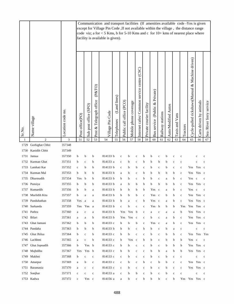
1 2 3
Lo
cati
on
co
de
no
.
Nam
e v
illa
ge
Sr.
No
.
1729 Gorhighat Chhit 357348
1730 Kanidih Chhit 357349
1731 Jamua 357350
1732 Kurman Ghat 357351
1733 Lamhati Kar 357352
1734 Kurman Mal 357353
1735 Dharmudih 357354
1736 Punsiya 357355
1737 Kumardih 357356
1738 Murlidih Kita 357357
1739 Pandubathan 357358
1740 Sarkanda 357359
1741 Pathra 357360
1742 Bilari 357361
1743 Ghat Jamuni 357362
1744 Pandaha 357363
1745 Ghat Jhilua 357364
1746 Lachhmi 357365
1747 Ghat Jopnadih 357366
1748 Majhdiha 357367
1749 Makhni 357368
1750 Amarpur 357369
1751 Baramasia 357370
1752 Sonjhar 357371
1753 Kadwa 357372
Po
st o
ffic
e(P
O)
Su
b p
ost
off
ice
(SP
O)
Po
st &
Tel
egra
ph
off
ice
(P
&T
O)
Vil
lag
e P
in C
od
e
Tel
eph
on
es
(Lan
d l
ines
)
Pu
bli
c ca
ll o
ffic
e (P
CO
)
Mo
bil
e p
ho
ne
cov
erag
e
Inte
rnet
caf
es/
Co
mm
on
ser
vic
e ce
ntr
e (C
SC
)
Pri
vat
e co
uri
er f
acil
ity
Bu
s se
rvic
e (
Pu
bli
c &
Pri
vat
e)
Rai
lway
sta
tio
ns
Au
to/M
od
ifie
d A
uto
s
Tax
is a
nd
Van
s
Tra
cto
rs
Cy
cle-
pu
lled
ric
ksh
aws(
Man
ual
& M
ach
ine
dri
ven
)
Car
ts d
riv
en b
y a
nim
als
Sea
/R
iver
fer
ry s
erv
ice
51 52 53 54 55 56 57 58 59 60 61 62 63 64 65 66 67
Communication and transport facilities (If amenities available code -Yes is given
except for Village Pin Code ,If not available within the village , the distance range
code viz; a for < 5 Kms, b for 5-10 Kms and c for 10+ kms of nearest place where
facility is available is given).
b b b 814133 b c b c b b c b c c c c
b c b 814133 a c b c b b b b c c c c
c b b 814133 b c b b c b c b c c Yes Yes c
b b b 814133 b a b c b b b b b c Yes Yes c
Yes b b 814133 b b b c b b c a b c Yes c c
b b b 814133 b a b b b b b b b c Yes Yes c
b b a 814133 b b b b b Yes c a b c Yes c c
b a a 814133 b b b b c Yes c b b c Yes Yes c
Yes a a 814133 b b a c b Yes c a b c Yes Yes c
Yes Yes a 814133 b c b c c Yes b b b Yes Yes Yes c
a c a 814133 b Yes Yes b c a c a a b Yes Yes c
a a b 814133 b Yes Yes c c b c a b c Yes Yes c
b b b 814133 c b b b c Yes c a b c Yes Yes c
b b b 814133 b b b c b b c b a c c c
b c b 814133 c b b c c b c b b c Yes Yes Yes
a c b 814133 c b Yes c b b c b b b Yes c c
b Yes b 814133 c b b c c b c b b b Yes Yes c
Yes Yes b 814133 c b b c c b b a b b Yes Yes c
b c c 814133 c c b c c b c b c c c c
a b c 814133 c c b c b c b b c c Yes Yes c
a c c 814133 c c b c c b c b c c Yes Yes c
c c c 814133 a c b b c b c b c c c c
c Yes c 814156 a a b c b b b c b Yes Yes Yes c
488

1 2 3
Lo
cati
on
co
de
no
.
Nam
e v
illa
ge
Sr.
No
.
1754 Nonbatta 357373
1755 Teldiha 357374
1756 Banka Ghat 357375
1757 Langradih 357376
1758 Bhalpahari 357377
1759 Sundarmor 357378
1760 Nipaniya 357379
1761 Baristanr 357380
1762 Jalgar 357381
1763 Sandmara 357382
1764 Dhokal Tola 357383
1765 Nandupahari 357384
1766 Jainagar Piprajoria 357385
1767 Birbal Tola 357386
1768 Belbathan 357387
1769 Raj Daha 357388
1770 Lalpur 357389
1771 Shampur 357390
1772 Jhagarahi 357391
1773 Kalhajor Kalan 357392
1774 Saharpur 357393
1775 Jhilua 357394
1776 Amjora 357395
1777 Hijaljor 357396
1778 Kundadah 357397
Po
st o
ffic
e(P
O)
Su
b p
ost
off
ice
(SP
O)
Po
st &
Tel
egra
ph
off
ice
(P
&T
O)
Vil
lag
e P
in C
od
e
Tel
eph
on
es
(Lan
d l
ines
)
Pu
bli
c ca
ll o
ffic
e (P
CO
)
Mo
bil
e p
ho
ne
cov
erag
e
Inte
rnet
caf
es/
Co
mm
on
ser
vic
e ce
ntr
e (C
SC
)
Pri
vat
e co
uri
er f
acil
ity
Bu
s se
rvic
e (
Pu
bli
c &
Pri
vat
e)
Rai
lway
sta
tio
ns
Au
to/M
od
ifie
d A
uto
s
Tax
is a
nd
Van
s
Tra
cto
rs
Cy
cle-
pu
lled
ric
ksh
aws(
Man
ual
& M
ach
ine
dri
ven
)
Car
ts d
riv
en b
y a
nim
als
Sea
/R
iver
fer
ry s
erv
ice
51 52 53 54 55 56 57 58 59 60 61 62 63 64 65 66 67
Communication and transport facilities (If amenities available code -Yes is given
except for Village Pin Code ,If not available within the village , the distance range
code viz; a for < 5 Kms, b for 5-10 Kms and c for 10+ kms of nearest place where
facility is available is given).
b Yes b 814156 b b b c b b c b b c Yes Yes c
Yes Yes c 814133 a a Yes c Yes Yes b c b c Yes Yes c
c b c 814133 b b Yes c b Yes b c b c Yes Yes c
a c c 814133 b Yes Yes c b c c c b c Yes Yes c
b b c 814156 b b a c b c c a b c Yes Yes c
a b c 814156 b c b c b Yes c a b c Yes Yes c
b b c 814156 c c b c c c c b a b Yes Yes c
b c b b c b c c
a c c a c c
c b c 814133 c c b c c b c b c c Yes Yes c
c c c 814133 c c Yes c c b b b c a Yes Yes c
c a c 814133 c c Yes c c b c c c c Yes Yes c
b b c 814153 c b b b c b c b b b Yes Yes c
b c b c
c c c 814153 c c Yes c c b b b b b Yes c
b c c 814156 b c b c c c b b b b Yes Yes c
b c c 814153 c c b c c c c c c Yes Yes Yes c
Yes b b 814153 b Yes Yes b c b c b c c Yes Yes
b c c 814153 c b b b c b c b b b Yes Yes c
Yes b b 814153 b Yes Yes b c b c b c c Yes Yes
Yes b b 814153 b Yes Yes b c b c a c c Yes Yes
b c c 814153 b b Yes a c b c b b Yes Yes Yes c
489
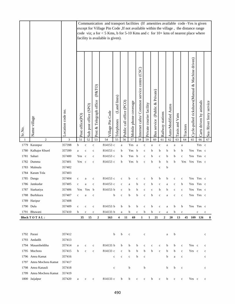
1 2 3
Lo
cati
on
co
de
no
.
Nam
e v
illa
ge
Sr.
No
.
1779 Karanpur 357398
1780 Kalhajor Khurd 357399
1781 Sahari 357400
1782 Dumma 357401
1783 Malmala 357402
1784 Karam Tola 357403
1785 Danga 357404
1786 Jamkudar 357405
1787 Siarkatiya 357406
1788 Burhikura 357407
1789 Haripur 357408
1790 Dulu 357409
1791 Bhawani 357410
Block T O T A L :
1792 Parasi 357412
1793 Andadih 357413
1794 Masanibeldiha 357414
1795 Muchora 357415
1796 Amra Kamat 357416
1797 Amra Mochora Kamat 357417
1798 Amra Kanauli 357418
1799 Amra Mochora Kamat 357419
1800 Jaijalpur 357420
Po
st o
ffic
e(P
O)
Su
b p
ost
off
ice
(SP
O)
Po
st &
Tel
egra
ph
off
ice
(P
&T
O)
Vil
lag
e P
in C
od
e
Tel
eph
on
es
(Lan
d l
ines
)
Pu
bli
c ca
ll o
ffic
e (P
CO
)
Mo
bil
e p
ho
ne
cov
erag
e
Inte
rnet
caf
es/
Co
mm
on
ser
vic
e ce
ntr
e (C
SC
)
Pri
vat
e co
uri
er f
acil
ity
Bu
s se
rvic
e (
Pu
bli
c &
Pri
vat
e)
Rai
lway
sta
tio
ns
Au
to/M
od
ifie
d A
uto
s
Tax
is a
nd
Van
s
Tra
cto
rs
Cy
cle-
pu
lled
ric
ksh
aws(
Man
ual
& M
ach
ine
dri
ven
)
Car
ts d
riv
en b
y a
nim
als
Sea
/R
iver
fer
ry s
erv
ice
51 52 53 54 55 56 57 58 59 60 61 62 63 64 65 66 67
Communication and transport facilities (If amenities available code -Yes is given
except for Village Pin Code ,If not available within the village , the distance range
code viz; a for < 5 Kms, b for 5-10 Kms and c for 10+ kms of nearest place where
facility is available is given).
b c c 814153 c a Yes a c a c a a a Yes c
a c c 814153 c b Yes b c b b b b b Yes Yes c
Yes c c 814153 c b Yes b c b c b b c Yes Yes c
Yes c c 814153 c b Yes b c b b b b Yes Yes Yes c
c b
c a c 814153 c c b c c b b b c c Yes Yes c
c a c 814153 c c a b c b c a c b Yes Yes c
Yes Yes b 814153 b c b b c c b b c c Yes Yes c
c a c b c b b c b c a c c Yes Yes c
c c c 814153 b b b b c b c a b b Yes Yes c
b c c 814133 b a b c b b c a b c c c
35 15 2 163 4 11 69 1 1 21 2 20 13 45 109 126 8
b b c c a b c
a c c 814133 b b b b c c c b b c Yes c c
b c c 814133 c c b b b b c b b c Yes c c
c c c b c b a c c
c b b b b c c
a c c 814133 c b b c c b c b c c Yes c c
490
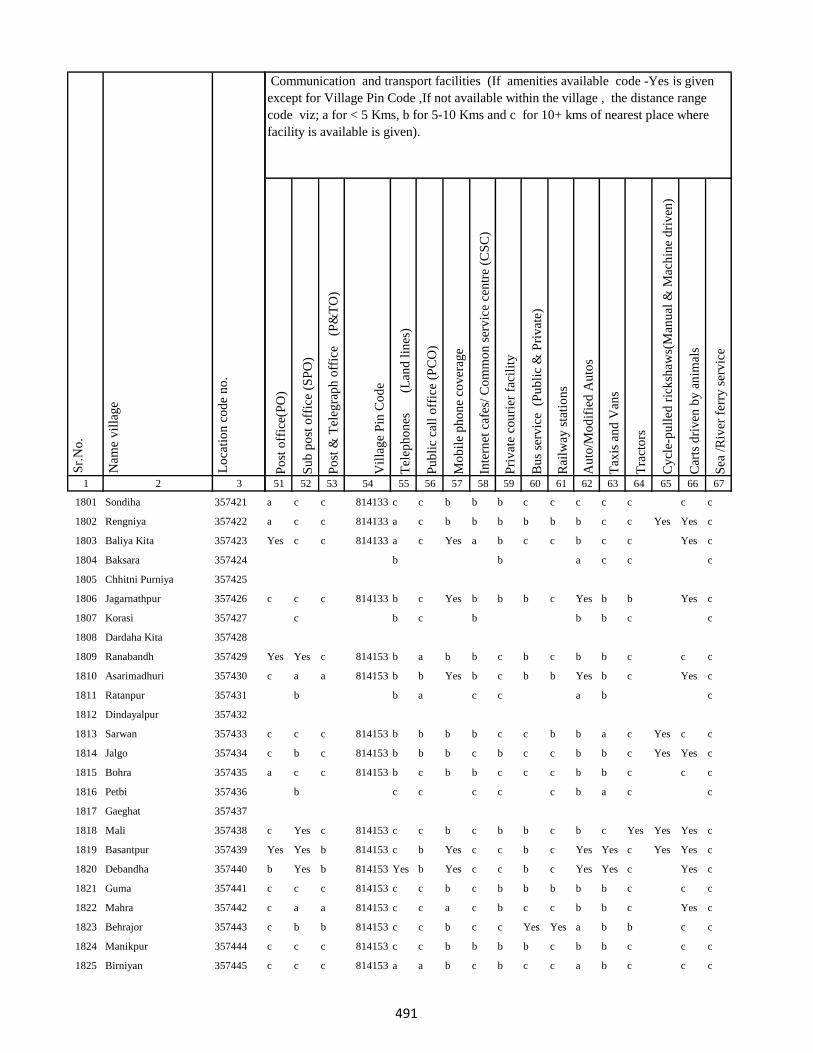
1 2 3
Lo
cati
on
co
de
no
.
Nam
e v
illa
ge
Sr.
No
.
1801 Sondiha 357421
1802 Rengniya 357422
1803 Baliya Kita 357423
1804 Baksara 357424
1805 Chhitni Purniya 357425
1806 Jagarnathpur 357426
1807 Korasi 357427
1808 Dardaha Kita 357428
1809 Ranabandh 357429
1810 Asarimadhuri 357430
1811 Ratanpur 357431
1812 Dindayalpur 357432
1813 Sarwan 357433
1814 Jalgo 357434
1815 Bohra 357435
1816 Petbi 357436
1817 Gaeghat 357437
1818 Mali 357438
1819 Basantpur 357439
1820 Debandha 357440
1821 Guma 357441
1822 Mahra 357442
1823 Behrajor 357443
1824 Manikpur 357444
1825 Birniyan 357445
Po
st o
ffic
e(P
O)
Su
b p
ost
off
ice
(SP
O)
Po
st &
Tel
egra
ph
off
ice
(P
&T
O)
Vil
lag
e P
in C
od
e
Tel
eph
on
es
(Lan
d l
ines
)
Pu
bli
c ca
ll o
ffic
e (P
CO
)
Mo
bil
e p
ho
ne
cov
erag
e
Inte
rnet
caf
es/
Co
mm
on
ser
vic
e ce
ntr
e (C
SC
)
Pri
vat
e co
uri
er f
acil
ity
Bu
s se
rvic
e (
Pu
bli
c &
Pri
vat
e)
Rai
lway
sta
tio
ns
Au
to/M
od
ifie
d A
uto
s
Tax
is a
nd
Van
s
Tra
cto
rs
Cy
cle-
pu
lled
ric
ksh
aws(
Man
ual
& M
ach
ine
dri
ven
)
Car
ts d
riv
en b
y a
nim
als
Sea
/R
iver
fer
ry s
erv
ice
51 52 53 54 55 56 57 58 59 60 61 62 63 64 65 66 67
Communication and transport facilities (If amenities available code -Yes is given
except for Village Pin Code ,If not available within the village , the distance range
code viz; a for < 5 Kms, b for 5-10 Kms and c for 10+ kms of nearest place where
facility is available is given).
a c c 814133 c c b b b c c c c c c c
a c c 814133 a c b b b b b b c c Yes Yes c
Yes c c 814133 a c Yes a b c c b c c Yes c
b b a c c c
c c c 814133 b c Yes b b b c Yes b b Yes c
c b c b b b c c
Yes Yes c 814153 b a b b c b c b b c c c
c a a 814153 b b Yes b c b b Yes b c Yes c
b b a c c a b c
c c c 814153 b b b b c c b b a c Yes c c
c b c 814153 b b b c b c c b b c Yes Yes c
a c c 814153 b c b b c c c b b c c c
b c c c c c b a c c
c Yes c 814153 c c b c b b c b c Yes Yes Yes c
Yes Yes b 814153 c b Yes c c b c Yes Yes c Yes Yes c
b Yes b 814153 Yes b Yes c c b c Yes Yes c Yes c
c c c 814153 c c b c b b b b b c c c
c a a 814153 c c a c b c c b b c Yes c
c b b 814153 c c b c c Yes Yes a b b c c
c c c 814153 c c b b b b c b b c c c
c c c 814153 a a b c b c c a b c c c
491
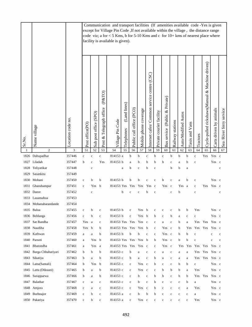
1 2 3
Lo
cati
on
co
de
no
.
Nam
e v
illa
ge
Sr.
No
.
1826 Dahupadhar 357446
1827 Liladah 357447
1828 Teliyatikar 357448
1829 Sasankita 357449
1830 Mohani 357450
1831 Ghanshampur 357451
1832 Danre 357452
1833 Lauamahua 357453
1834 Mohanabarandande 357454
1835 Balua 357455
1836 Beldanga 357456
1837 Sat Bandha 357457
1838 Naudiha 357458
1839 Kathwan 357459
1840 Parsoti 357460
1841 Bhatondha 357461
1842 Barga Chhahariyari 357462
1843 Sikatiya 357463
1844 Latta(Santali) 357464
1845 Latta (Dikuani) 357465
1846 Surapparwa 357466
1847 Balathar 357467
1848 Amjora 357468
1849 Burhnajor 357469
1850 Pakariya 357470
Po
st o
ffic
e(P
O)
Su
b p
ost
off
ice
(SP
O)
Po
st &
Tel
egra
ph
off
ice
(P
&T
O)
Vil
lag
e P
in C
od
e
Tel
eph
on
es
(Lan
d l
ines
)
Pu
bli
c ca
ll o
ffic
e (P
CO
)
Mo
bil
e p
ho
ne
cov
erag
e
Inte
rnet
caf
es/
Co
mm
on
ser
vic
e ce
ntr
e (C
SC
)
Pri
vat
e co
uri
er f
acil
ity
Bu
s se
rvic
e (
Pu
bli
c &
Pri
vat
e)
Rai
lway
sta
tio
ns
Au
to/M
od
ifie
d A
uto
s
Tax
is a
nd
Van
s
Tra
cto
rs
Cy
cle-
pu
lled
ric
ksh
aws(
Man
ual
& M
ach
ine
dri
ven
)
Car
ts d
riv
en b
y a
nim
als
Sea
/R
iver
fer
ry s
erv
ice
51 52 53 54 55 56 57 58 59 60 61 62 63 64 65 66 67
Communication and transport facilities (If amenities available code -Yes is given
except for Village Pin Code ,If not available within the village , the distance range
code viz; a for < 5 Kms, b for 5-10 Kms and c for 10+ kms of nearest place where
facility is available is given).
c c c 814153 a b b c b c b b b c Yes Yes c
b c Yes 814153 b a b b b b c a b c Yes c
c a b c b c b b a c
c b b 814153 b b b c c b c a b c Yes c
c Yes b 814153 Yes Yes Yes Yes c Yes c Yes a c Yes Yes c
c b c c b c c b c c
c b c 814153 b c Yes b c c c b b Yes Yes c
c b c 814153 b c Yes b b c b a c c Yes c
Yes a c 814153 Yes Yes Yes c c a c b a Yes Yes Yes c
Yes b b 814153 Yes Yes Yes b c Yes c b Yes Yes Yes Yes c
a a b 814153 b b b c c Yes c b b c c c
a Yes b 814153 Yes Yes Yes b b Yes c b b c c c
a Yes a 814153 Yes Yes Yes c c Yes c Yes Yes Yes Yes Yes c
b b b 814153 c b a c c a c a a Yes Yes Yes c
b a b 814153 c b a c b a c a a Yes Yes Yes c
b Yes b 814153 c c Yes c b c c b b c Yes c
b a b 814153 c c Yes c c b b b a Yes Yes c
b a b 814153 c c b c b b c b b Yes Yes Yes c
c a c 814153 c c b c b c c c b a Yes c
c a c 814153 c c Yes c b c c c a Yes Yes c
c b c 814153 a c b b b c c c c a Yes c
c b c 814153 a c Yes c c c c c c Yes Yes c
492
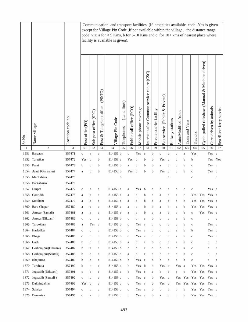
1 2 3
Lo
cati
on
co
de
no
.
Nam
e v
illa
ge
Sr.
No
.
1851 Bargaon 357471
1852 Taratikar 357472
1853 Pasai 357473
1854 Arazi Kita Sahuri 357474
1855 Machkhara 357475
1856 Barkabaiso 357476
1857 Durpat 357477
1858 Goaridih 357478
1859 Matihani 357479
1860 Bara Chapar 357480
1861 Amwar (Santali) 357481
1862 Amwar(Dikuani) 357482
1863 Tarpokhra 357483
1864 Harlatikar 357484
1865 Bhaga 357485
1866 Garhi 357486
1867 Gorharajpur(Dikuani) 357487
1868 Gorharajpur(Santali) 357488
1869 Khajurma 357489
1870 Tarkhuta 357490
1871 Joguadih (Dikuani) 357491
1872 Joguadih (Santali ) 357492
1873 Dakhinbahiar 357493
1874 Salaiya 357494
1875 Dumariya 357495
Po
st o
ffic
e(P
O)
Su
b p
ost
off
ice
(SP
O)
Po
st &
Tel
egra
ph
off
ice
(P
&T
O)
Vil
lag
e P
in C
od
e
Tel
eph
on
es
(Lan
d l
ines
)
Pu
bli
c ca
ll o
ffic
e (P
CO
)
Mo
bil
e p
ho
ne
cov
erag
e
Inte
rnet
caf
es/
Co
mm
on
ser
vic
e ce
ntr
e (C
SC
)
Pri
vat
e co
uri
er f
acil
ity
Bu
s se
rvic
e (
Pu
bli
c &
Pri
vat
e)
Rai
lway
sta
tio
ns
Au
to/M
od
ifie
d A
uto
s
Tax
is a
nd
Van
s
Tra
cto
rs
Cy
cle-
pu
lled
ric
ksh
aws(
Man
ual
& M
ach
ine
dri
ven
)
Car
ts d
riv
en b
y a
nim
als
Sea
/R
iver
fer
ry s
erv
ice
51 52 53 54 55 56 57 58 59 60 61 62 63 64 65 66 67
Communication and transport facilities (If amenities available code -Yes is given
except for Village Pin Code ,If not available within the village , the distance range
code viz; a for < 5 Kms, b for 5-10 Kms and c for 10+ kms of nearest place where
facility is available is given).
c a c 814153 b c Yes c b c c c a Yes Yes c
Yes b b 814153 a Yes b b b Yes c b b b Yes Yes
b b b 814153 b a b b b a b b b c Yes c
a b b 814153 b Yes b b b Yes c b b c Yes c
b b c c
c a a 814153 a a Yes b c b c b c c Yes c
a a a 814153 a a a b c a b a c Yes Yes Yes c
a a a 814153 a a a b c a c b c Yes Yes Yes c
a a a 814153 a a a b b a b a b Yes Yes Yes c
a a a 814153 a a a b c a b b b c Yes Yes c
c c c 814153 b c b c b b c a b c c c
a Yes c 814153 b c Yes c c c c b b c Yes c
c c c 814153 b c Yes c c c c a b b Yes c
c c c 814153 b c Yes c c c c a b c Yes c
b c c 814153 b a b c b c c a b c c c
b a c 814153 b b b c c b c b a c c c
b b c 814153 c a b c c b c b b c c c
b b c 814153 b b Yes c b b b b b c c c
b c c 814153 c b Yes b b Yes c Yes a Yes Yes Yes c
c b c 814153 c b Yes c c b b a c Yes Yes Yes c
c c c 814153 c c Yes c b Yes c Yes Yes Yes Yes Yes c
Yes b c 814153 c c Yes c b Yes c Yes Yes Yes Yes Yes c
c b c 814153 c c Yes c b b b b b Yes Yes Yes c
c a c 814153 c b Yes c b a c b b Yes Yes Yes c
493
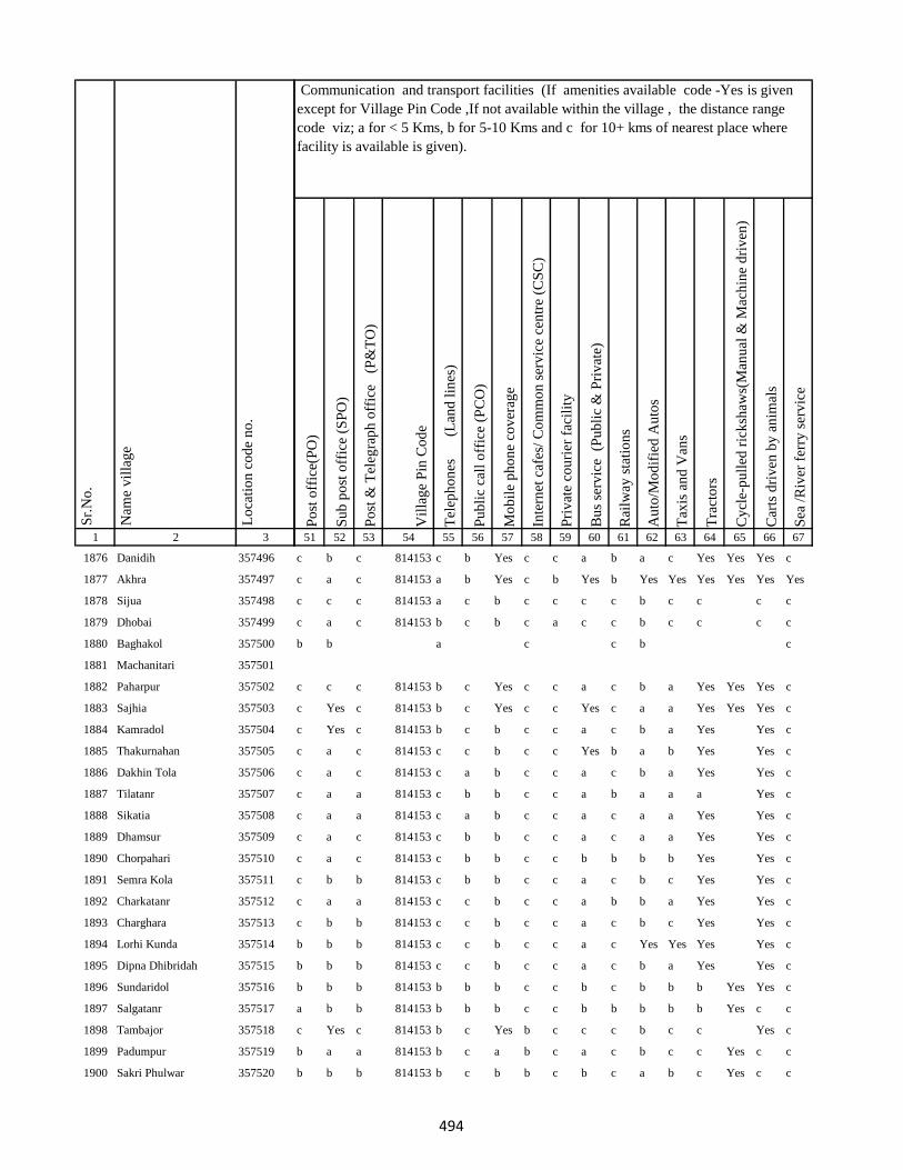
1 2 3
Lo
cati
on
co
de
no
.
Nam
e v
illa
ge
Sr.
No
.
1876 Danidih 357496
1877 Akhra 357497
1878 Sijua 357498
1879 Dhobai 357499
1880 Baghakol 357500
1881 Machanitari 357501
1882 Paharpur 357502
1883 Sajhia 357503
1884 Kamradol 357504
1885 Thakurnahan 357505
1886 Dakhin Tola 357506
1887 Tilatanr 357507
1888 Sikatia 357508
1889 Dhamsur 357509
1890 Chorpahari 357510
1891 Semra Kola 357511
1892 Charkatanr 357512
1893 Charghara 357513
1894 Lorhi Kunda 357514
1895 Dipna Dhibridah 357515
1896 Sundaridol 357516
1897 Salgatanr 357517
1898 Tambajor 357518
1899 Padumpur 357519
1900 Sakri Phulwar 357520
Po
st o
ffic
e(P
O)
Su
b p
ost
off
ice
(SP
O)
Po
st &
Tel
egra
ph
off
ice
(P
&T
O)
Vil
lag
e P
in C
od
e
Tel
eph
on
es
(Lan
d l
ines
)
Pu
bli
c ca
ll o
ffic
e (P
CO
)
Mo
bil
e p
ho
ne
cov
erag
e
Inte
rnet
caf
es/
Co
mm
on
ser
vic
e ce
ntr
e (C
SC
)
Pri
vat
e co
uri
er f
acil
ity
Bu
s se
rvic
e (
Pu
bli
c &
Pri
vat
e)
Rai
lway
sta
tio
ns
Au
to/M
od
ifie
d A
uto
s
Tax
is a
nd
Van
s
Tra
cto
rs
Cy
cle-
pu
lled
ric
ksh
aws(
Man
ual
& M
ach
ine
dri
ven
)
Car
ts d
riv
en b
y a
nim
als
Sea
/R
iver
fer
ry s
erv
ice
51 52 53 54 55 56 57 58 59 60 61 62 63 64 65 66 67
Communication and transport facilities (If amenities available code -Yes is given
except for Village Pin Code ,If not available within the village , the distance range
code viz; a for < 5 Kms, b for 5-10 Kms and c for 10+ kms of nearest place where
facility is available is given).
c b c 814153 c b Yes c c a b a c Yes Yes Yes c
c a c 814153 a b Yes c b Yes b Yes Yes Yes Yes Yes Yes
c c c 814153 a c b c c c c b c c c c
c a c 814153 b c b c a c c b c c c c
b b a c c b c
c c c 814153 b c Yes c c a c b a Yes Yes Yes c
c Yes c 814153 b c Yes c c Yes c a a Yes Yes Yes c
c Yes c 814153 b c b c c a c b a Yes Yes c
c a c 814153 c c b c c Yes b a b Yes Yes c
c a c 814153 c a b c c a c b a Yes Yes c
c a a 814153 c b b c c a b a a a Yes c
c a a 814153 c a b c c a c a a Yes Yes c
c a c 814153 c b b c c a c a a Yes Yes c
c a c 814153 c b b c c b b b b Yes Yes c
c b b 814153 c b b c c a c b c Yes Yes c
c a a 814153 c c b c c a b b a Yes Yes c
c b b 814153 c c b c c a c b c Yes Yes c
b b b 814153 c c b c c a c Yes Yes Yes Yes c
b b b 814153 c c b c c a c b a Yes Yes c
b b b 814153 b b b c c b c b b b Yes Yes c
a b b 814153 b b b c c b b b b b Yes c c
c Yes c 814153 b c Yes b c c c b c c Yes c
b a a 814153 b c a b c a c b c c Yes c c
b b b 814153 b c b b c b c a b c Yes c c
494
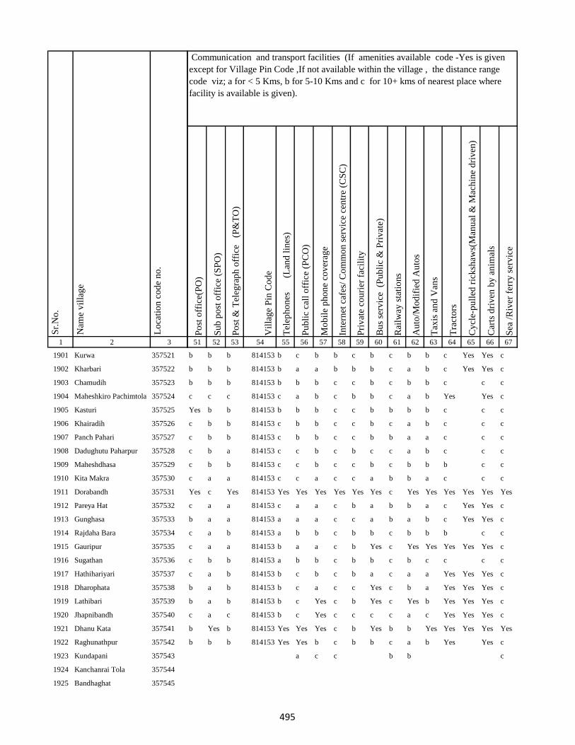
1 2 3
Lo
cati
on
co
de
no
.
Nam
e v
illa
ge
Sr.
No
.
1901 Kurwa 357521
1902 Kharbari 357522
1903 Chamudih 357523
1904 Maheshkiro Pachimtola 357524
1905 Kasturi 357525
1906 Khairadih 357526
1907 Panch Pahari 357527
1908 Dadughutu Paharpur 357528
1909 Maheshdhasa 357529
1910 Kita Makra 357530
1911 Dorabandh 357531
1912 Pareya Hat 357532
1913 Gunghasa 357533
1914 Rajdaha Bara 357534
1915 Gauripur 357535
1916 Sugathan 357536
1917 Hathihariyari 357537
1918 Dharophata 357538
1919 Lathibari 357539
1920 Jhapnibandh 357540
1921 Dhanu Kata 357541
1922 Raghunathpur 357542
1923 Kundapani 357543
1924 Kanchanrai Tola 357544
1925 Bandhaghat 357545
Po
st o
ffic
e(P
O)
Su
b p
ost
off
ice
(SP
O)
Po
st &
Tel
egra
ph
off
ice
(P
&T
O)
Vil
lag
e P
in C
od
e
Tel
eph
on
es
(Lan
d l
ines
)
Pu
bli
c ca
ll o
ffic
e (P
CO
)
Mo
bil
e p
ho
ne
cov
erag
e
Inte
rnet
caf
es/
Co
mm
on
ser
vic
e ce
ntr
e (C
SC
)
Pri
vat
e co
uri
er f
acil
ity
Bu
s se
rvic
e (
Pu
bli
c &
Pri
vat
e)
Rai
lway
sta
tio
ns
Au
to/M
od
ifie
d A
uto
s
Tax
is a
nd
Van
s
Tra
cto
rs
Cy
cle-
pu
lled
ric
ksh
aws(
Man
ual
& M
ach
ine
dri
ven
)
Car
ts d
riv
en b
y a
nim
als
Sea
/R
iver
fer
ry s
erv
ice
51 52 53 54 55 56 57 58 59 60 61 62 63 64 65 66 67
Communication and transport facilities (If amenities available code -Yes is given
except for Village Pin Code ,If not available within the village , the distance range
code viz; a for < 5 Kms, b for 5-10 Kms and c for 10+ kms of nearest place where
facility is available is given).
b b b 814153 b c b b c b c b b c Yes Yes c
b b b 814153 b a a b b b c a b c Yes Yes c
b b b 814153 b b b c c b c b b c c c
c c c 814153 c a b c b b c a b Yes Yes c
Yes b b 814153 b b b c c b b b b c c c
c b b 814153 c b b c c b c a b c c c
c b b 814153 c b b c c b b a a c c c
c b a 814153 c c b c b c c a b c c c
c b b 814153 c c b c c b c b b b c c
c a a 814153 c c a c c a b b a c c c
Yes c Yes 814153 Yes Yes Yes Yes Yes Yes c Yes Yes Yes Yes Yes Yes
c a a 814153 c a a c b a b b a c Yes Yes c
b a a 814153 a a a c c a b a b c Yes Yes c
c a b 814153 a b b c b b c b b b c c
c a a 814153 b a a c b Yes c Yes Yes Yes Yes Yes c
c b b 814153 a b b c b b c b c c c c
c a b 814153 b c b c b a c a a Yes Yes Yes c
b a b 814153 b c a c c Yes c b a Yes Yes Yes c
b a b 814153 b c Yes c b Yes c Yes b Yes Yes Yes c
c a c 814153 b c Yes c c c c a c Yes Yes Yes c
b Yes b 814153 Yes Yes Yes c b Yes b b Yes Yes Yes Yes Yes
b b b 814153 Yes Yes b c b b c a b Yes Yes c
a c c b b c
495
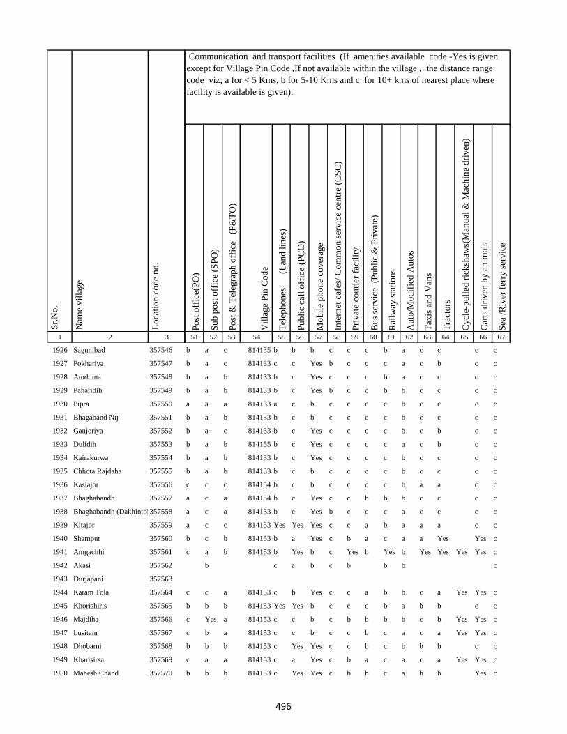
1 2 3
Lo
cati
on
co
de
no
.
Nam
e v
illa
ge
Sr.
No
.
1926 Sagunibad 357546
1927 Pokhariya 357547
1928 Amduma 357548
1929 Paharidih 357549
1930 Pipra 357550
1931 Bhagaband Nij 357551
1932 Ganjoriya 357552
1933 Dulidih 357553
1934 Kairakurwa 357554
1935 Chhota Rajdaha 357555
1936 Kasiajor 357556
1937 Bhaghabandh 357557
1938 Bhaghabandh (Dakhintola)357558
1939 Kitajor 357559
1940 Shampur 357560
1941 Amgachhi 357561
1942 Akasi 357562
1943 Durjapani 357563
1944 Karam Tola 357564
1945 Khorishiris 357565
1946 Majdiha 357566
1947 Lusitanr 357567
1948 Dhobarni 357568
1949 Kharisirsa 357569
1950 Mahesh Chand 357570
Po
st o
ffic
e(P
O)
Su
b p
ost
off
ice
(SP
O)
Po
st &
Tel
egra
ph
off
ice
(P
&T
O)
Vil
lag
e P
in C
od
e
Tel
eph
on
es
(Lan
d l
ines
)
Pu
bli
c ca
ll o
ffic
e (P
CO
)
Mo
bil
e p
ho
ne
cov
erag
e
Inte
rnet
caf
es/
Co
mm
on
ser
vic
e ce
ntr
e (C
SC
)
Pri
vat
e co
uri
er f
acil
ity
Bu
s se
rvic
e (
Pu
bli
c &
Pri
vat
e)
Rai
lway
sta
tio
ns
Au
to/M
od
ifie
d A
uto
s
Tax
is a
nd
Van
s
Tra
cto
rs
Cy
cle-
pu
lled
ric
ksh
aws(
Man
ual
& M
ach
ine
dri
ven
)
Car
ts d
riv
en b
y a
nim
als
Sea
/R
iver
fer
ry s
erv
ice
51 52 53 54 55 56 57 58 59 60 61 62 63 64 65 66 67
Communication and transport facilities (If amenities available code -Yes is given
except for Village Pin Code ,If not available within the village , the distance range
code viz; a for < 5 Kms, b for 5-10 Kms and c for 10+ kms of nearest place where
facility is available is given).
b a c 814135 b b b c c c b a c c c c
b a c 814133 c c Yes b c c c a c b c c
b a b 814133 b c Yes c c c b a c c c c
b a b 814133 b c Yes b c c b b c c c c
a a a 814133 a c b c c c c b c c c c
b a b 814133 b c b c c c c b c c c c
b a c 814133 b c Yes c c c c b c b c c
b a b 814155 b c Yes c c c c a c b c c
b a b 814133 b c Yes c c c c b c c c c
b a b 814133 b c b c c c c b c c c c
c c c 814154 b c b c c c c b a a c c
a c a 814154 b c Yes c c b b b c c c c
a c a 814133 b c Yes b c c c a c c c c
a c c 814153 Yes Yes Yes c c a b a a a c c
b c b 814153 b a Yes c b a c a a Yes Yes c
c a b 814153 b Yes b c Yes b Yes b Yes Yes Yes Yes c
b c a b c b b b c
c c a 814153 c b Yes c c a b b c a Yes Yes c
b b b 814153 Yes Yes b c c c b a b b c c
c Yes a 814153 c c b c b b b b c b Yes Yes c
c b a 814153 c c b c c b c a c a Yes Yes c
b b b 814153 c Yes Yes c c b c b b b c c
c a a 814153 c a Yes c b a c a c a Yes Yes c
b b b 814153 c Yes Yes c b b c a b b Yes c
496
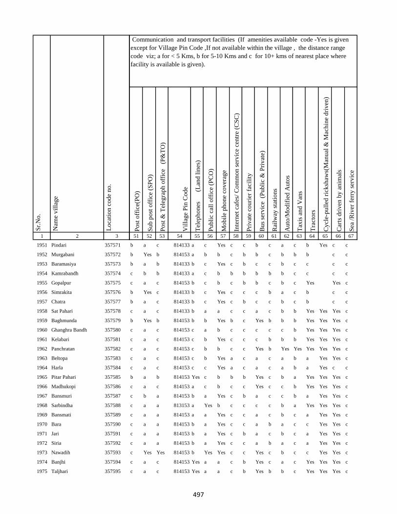
1 2 3
Lo
cati
on
co
de
no
.
Nam
e v
illa
ge
Sr.
No
.
1951 Pindari 357571
1952 Murgabani 357572
1953 Baramasiya 357573
1954 Kamrabandh 357574
1955 Gopalpur 357575
1956 Simrakita 357576
1957 Chatra 357577
1958 Sat Pahari 357578
1959 Baghmunda 357579
1960 Ghanghra Bandh 357580
1961 Kelabari 357581
1962 Panchratan 357582
1963 Beltopa 357583
1964 Harla 357584
1965 Pitar Pahari 357585
1966 Madhukopi 357586
1967 Bansmuri 357587
1968 Sarbindha 357588
1969 Bansmati 357589
1970 Bara 357590
1971 Jari 357591
1972 Siria 357592
1973 Nawadih 357593
1974 Banjhi 357594
1975 Taljhari 357595
Po
st o
ffic
e(P
O)
Su
b p
ost
off
ice
(SP
O)
Po
st &
Tel
egra
ph
off
ice
(P
&T
O)
Vil
lag
e P
in C
od
e
Tel
eph
on
es
(Lan
d l
ines
)
Pu
bli
c ca
ll o
ffic
e (P
CO
)
Mo
bil
e p
ho
ne
cov
erag
e
Inte
rnet
caf
es/
Co
mm
on
ser
vic
e ce
ntr
e (C
SC
)
Pri
vat
e co
uri
er f
acil
ity
Bu
s se
rvic
e (
Pu
bli
c &
Pri
vat
e)
Rai
lway
sta
tio
ns
Au
to/M
od
ifie
d A
uto
s
Tax
is a
nd
Van
s
Tra
cto
rs
Cy
cle-
pu
lled
ric
ksh
aws(
Man
ual
& M
ach
ine
dri
ven
)
Car
ts d
riv
en b
y a
nim
als
Sea
/R
iver
fer
ry s
erv
ice
51 52 53 54 55 56 57 58 59 60 61 62 63 64 65 66 67
Communication and transport facilities (If amenities available code -Yes is given
except for Village Pin Code ,If not available within the village , the distance range
code viz; a for < 5 Kms, b for 5-10 Kms and c for 10+ kms of nearest place where
facility is available is given).
b a c 814133 a c Yes c c b c a c b Yes c c
b Yes b 814153 a b b c b b c b b b c c
b a b 814133 b c Yes c b c c b c c c c
c b b 814133 a c b b b b b b c c c c
c a c 814153 b c b c b b c b c Yes Yes c
b Yes c 814133 b c Yes c c c b a c b c c
b a c 814133 b c Yes c b c c b c b c c
c a c 814133 b a a c c a c b b Yes Yes Yes c
b Yes b 814153 b b Yes b c Yes b b b Yes Yes Yes c
c a c 814153 c a b c c c c c b Yes Yes Yes c
c a c 814153 c b Yes c c c b b b Yes Yes Yes c
c a c 814153 c b b c c Yes b Yes Yes Yes Yes Yes c
c a c 814153 c b Yes a c a c a b a Yes Yes c
c a c 814153 c c Yes a c a c a b a Yes c c
b a b 814153 Yes c b b b Yes c b a Yes Yes Yes c
c a c 814153 a c b c c Yes c c b Yes Yes Yes c
c b a 814153 b a Yes c b a c c b a Yes Yes c
c a a 813153 a Yes b c c c c b a Yes Yes Yes c
c a a 814153 a a Yes c c a c b c a Yes Yes c
c a a 814153 b a Yes c c a b a c c Yes Yes c
c a a 814153 b a Yes c b a c b c a Yes Yes c
c a a 814153 b a Yes c c a b a c a Yes Yes c
c Yes Yes 814153 b Yes Yes c c Yes c b c c Yes Yes c
c a c 814153 Yes a a c b Yes c a c Yes Yes Yes c
c a c 814153 Yes a a c b Yes b b c Yes Yes Yes c
497
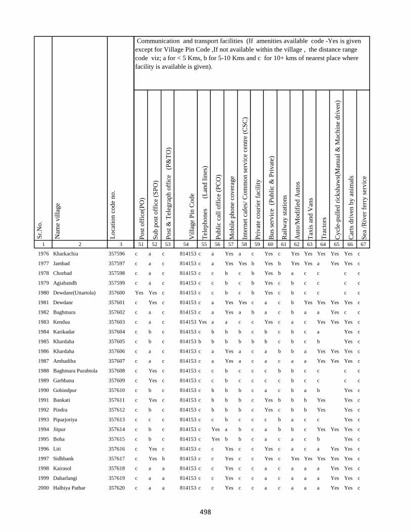
1 2 3
Lo
cati
on
co
de
no
.
Nam
e v
illa
ge
Sr.
No
.
1976 Kharkachia 357596
1977 Jambad 357597
1978 Chorbad 357598
1979 Agiabandh 357599
1980 Dewdanr(Uttartola) 357600
1981 Dewdanr 357601
1982 Baghmara 357602
1983 Kendua 357603
1984 Karikadar 357604
1985 Khardaha 357605
1986 Khardaha 357606
1987 Ambadiha 357607
1988 Baghmara Purabtola 357608
1989 Garhbana 357609
1990 Gobindpur 357610
1991 Bankati 357611
1992 Pindra 357612
1993 Piparjoriya 357613
1994 Jitpur 357614
1995 Boha 357615
1996 Liti 357616
1997 Sidhbank 357617
1998 Kairasol 357618
1999 Daharlangi 357619
2000 Halhiya Pathar 357620
Po
st o
ffic
e(P
O)
Su
b p
ost
off
ice
(SP
O)
Po
st &
Tel
egra
ph
off
ice
(P
&T
O)
Vil
lag
e P
in C
od
e
Tel
eph
on
es
(Lan
d l
ines
)
Pu
bli
c ca
ll o
ffic
e (P
CO
)
Mo
bil
e p
ho
ne
cov
erag
e
Inte
rnet
caf
es/
Co
mm
on
ser
vic
e ce
ntr
e (C
SC
)
Pri
vat
e co
uri
er f
acil
ity
Bu
s se
rvic
e (
Pu
bli
c &
Pri
vat
e)
Rai
lway
sta
tio
ns
Au
to/M
od
ifie
d A
uto
s
Tax
is a
nd
Van
s
Tra
cto
rs
Cy
cle-
pu
lled
ric
ksh
aws(
Man
ual
& M
ach
ine
dri
ven
)
Car
ts d
riv
en b
y a
nim
als
Sea
/R
iver
fer
ry s
erv
ice
51 52 53 54 55 56 57 58 59 60 61 62 63 64 65 66 67
Communication and transport facilities (If amenities available code -Yes is given
except for Village Pin Code ,If not available within the village , the distance range
code viz; a for < 5 Kms, b for 5-10 Kms and c for 10+ kms of nearest place where
facility is available is given).
c a c 814153 c a Yes a c Yes c Yes Yes Yes Yes Yes c
c a c 814153 c a Yes Yes b Yes b Yes Yes a Yes Yes c
c a c 814153 c c b c b Yes b a c c c c
c a c 814153 c c b c b Yes c b c c c c
Yes Yes c 814153 c c b c b Yes c b c c c c
c Yes c 814153 c a Yes Yes c a c b Yes Yes Yes Yes c
c a c 814153 c a Yes a b a c b a a Yes c c
c a c 814153 Yes a a c c Yes c a c Yes Yes Yes c
c b c 814153 c b b b c b c b c a Yes c
c b c 814153 b b b b b b c b c b Yes c
c a c 814153 c a Yes a c a b b a Yes Yes Yes c
c a c 814153 c a Yes a c a c a a Yes Yes Yes c
c Yes c 814153 c c b c c c b b c c c c
c Yes c 814153 c c b c c c c b c c c c
c b c 814153 c b b b c a c b a b Yes c
c Yes c 814153 c b b b c Yes b b b Yes Yes c
c b c 814153 c b b b c Yes c b b Yes Yes c
c c c 814153 c c b c c c b a c c Yes c
c b c 814153 c Yes a b c a b b c Yes Yes Yes c
c b c 814153 c Yes b b c a c a c b Yes c
c Yes c 814153 c c Yes c c Yes c a c a Yes Yes c
c Yes b 814153 c c Yes c c Yes c Yes Yes Yes Yes Yes c
c a a 814153 c c Yes c c a c a a a Yes Yes c
c a a 814153 c c Yes c c a c a a a Yes Yes c
c a a 814153 c c Yes c c a c a a a Yes Yes c
498
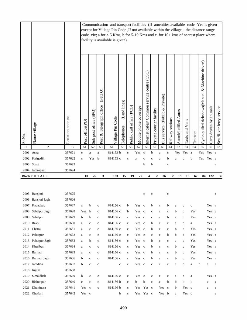
1 2 3
Lo
cati
on
co
de
no
.
Nam
e v
illa
ge
Sr.
No
.
2001 Asna 357621
2002 Parigadih 357622
2003 Susni 357623
2004 Jamropani 357624
Block T O T A L :
2005 Bansjori 357625
2006 Bansjori Jagir 357626
2007 Kauadhab 357627
2008 Sabalpur Jagir 357628
2009 Sabalpur 357629
2010 Raksi 357630
2011 Chatra 357631
2012 Paharpur 357632
2013 Paharpur Jagir 357633
2014 Kheribari 357634
2015 Barnadi 357635
2016 Barnadi Jagir 357636
2017 Jamdiha 357637
2018 Kajuri 357638
2019 Simaldhab 357639
2020 Bishunpur 357640
2021 Dhunigora 357641
2022 Ghatiari 357642
Po
st o
ffic
e(P
O)
Su
b p
ost
off
ice
(SP
O)
Po
st &
Tel
egra
ph
off
ice
(P
&T
O)
Vil
lag
e P
in C
od
e
Tel
eph
on
es
(Lan
d l
ines
)
Pu
bli
c ca
ll o
ffic
e (P
CO
)
Mo
bil
e p
ho
ne
cov
erag
e
Inte
rnet
caf
es/
Co
mm
on
ser
vic
e ce
ntr
e (C
SC
)
Pri
vat
e co
uri
er f
acil
ity
Bu
s se
rvic
e (
Pu
bli
c &
Pri
vat
e)
Rai
lway
sta
tio
ns
Au
to/M
od
ifie
d A
uto
s
Tax
is a
nd
Van
s
Tra
cto
rs
Cy
cle-
pu
lled
ric
ksh
aws(
Man
ual
& M
ach
ine
dri
ven
)
Car
ts d
riv
en b
y a
nim
als
Sea
/R
iver
fer
ry s
erv
ice
51 52 53 54 55 56 57 58 59 60 61 62 63 64 65 66 67
Communication and transport facilities (If amenities available code -Yes is given
except for Village Pin Code ,If not available within the village , the distance range
code viz; a for < 5 Kms, b for 5-10 Kms and c for 10+ kms of nearest place where
facility is available is given).
c a a 814153 b c Yes c b a c Yes Yes a Yes Yes c
c Yes b 814153 c c a c c a b a c b Yes Yes c
b b c c
10 26 3 183 15 19 77 4 2 36 2 19 18 67 84 122 4
c c c c
a b c 814156 c b Yes c b c b a c c Yes c
Yes b c 814156 c b Yes c c c c b c Yes Yes c
b b c 814156 c c Yes c c c b a c Yes Yes c
a c c 814156 c c Yes c b c c a c a Yes c
a c c 814156 c c Yes c b c c b c Yes Yes c
a c c 814156 c c Yes c c c b b c Yes Yes c
a b c 814156 c c Yes c b c c a c Yes Yes c
a c c 814156 c c Yes c b c c b c Yes Yes c
a c c 814156 c c Yes c b c c b c Yes Yes c
b c c 814156 c c Yes c b c c b c Yes Yes c
b c c c c Yes c c c c c c a c a c
b c c 814156 c c Yes c c c c a c a Yes c
c c c 814156 b c b b c c b b b c c c
Yes c c 814156 b c Yes Yes c Yes c b Yes c c c
Yes c b c Yes Yes c Yes b a Yes c c
499
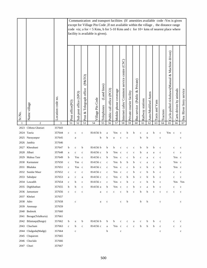
1 2 3
Lo
cati
on
co
de
no
.
Nam
e v
illa
ge
Sr.
No
.
2023 Chhota Ghatiari 357643
2024 Tasria 357644
2025 Narayanpur 357645
2026 Jambia 357646
2027 Kherabani 357647
2028 Jilbari 357648
2029 Mahua Tanr 357649
2030 Karmatanr 357650
2031 Bhaluka 357651
2032 Sundar Maur 357652
2033 Sabalpur 357653
2034 Lawadih 357654
2035 Dighibathan 357655
2036 Jamuntanr 357656
2037 Khelari 357657
2038 Adro 357658
2039 Ammaqo 357659
2040 Bedotok 357660
2041 Berago(Telalkuria) 357661
2042 Bilamaqo(Basgo) 357662
2043 Chacham 357663
2044 Chalgoda(Madgi) 357664
2045 Chaparom 357665
2046 Chuclalo 357666
2047 Churi 357667
Po
st o
ffic
e(P
O)
Su
b p
ost
off
ice
(SP
O)
Po
st &
Tel
egra
ph
off
ice
(P
&T
O)
Vil
lag
e P
in C
od
e
Tel
eph
on
es
(Lan
d l
ines
)
Pu
bli
c ca
ll o
ffic
e (P
CO
)
Mo
bil
e p
ho
ne
cov
erag
e
Inte
rnet
caf
es/
Co
mm
on
ser
vic
e ce
ntr
e (C
SC
)
Pri
vat
e co
uri
er f
acil
ity
Bu
s se
rvic
e (
Pu
bli
c &
Pri
vat
e)
Rai
lway
sta
tio
ns
Au
to/M
od
ifie
d A
uto
s
Tax
is a
nd
Van
s
Tra
cto
rs
Cy
cle-
pu
lled
ric
ksh
aws(
Man
ual
& M
ach
ine
dri
ven
)
Car
ts d
riv
en b
y a
nim
als
Sea
/R
iver
fer
ry s
erv
ice
51 52 53 54 55 56 57 58 59 60 61 62 63 64 65 66 67
Communication and transport facilities (If amenities available code -Yes is given
except for Village Pin Code ,If not available within the village , the distance range
code viz; a for < 5 Kms, b for 5-10 Kms and c for 10+ kms of nearest place where
facility is available is given).
c c c 814156 b a Yes c b b c a b c Yes c c
a b b a c c b b c c
b c b 814156 b b b c c c b b b c c c
a c c 814156 c b Yes c c c b a a c c c
b Yes c 814156 c b Yes c c b c a c c Yes c
c Yes c 814156 c c Yes b b b c a c c Yes c
c Yes c 814156 c c Yes c c b c b c b Yes c
c c c 814156 c c Yes c c b c b b c c c
a c a 814156 c c Yes c b b c b b c c c
c b c 814156 c c Yes c b c c b b c Yes Yes
b b c 814156 a b Yes c c b c a b c c c
c c c a c c c b c b b c c c c c
c a c c b b b c c
b a b 814156 b b b c c a c b b c c c
c b c 814156 c a Yes c c c b b b c c c
c b c c c
500
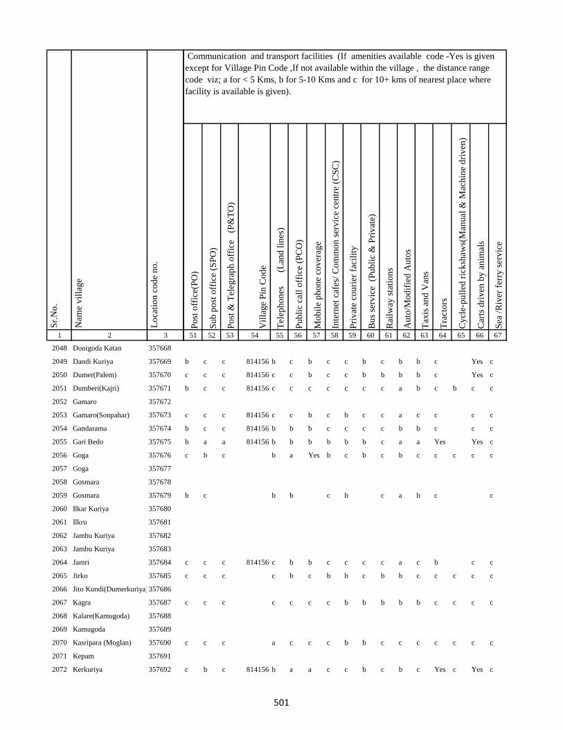
1 2 3
Lo
cati
on
co
de
no
.
Nam
e v
illa
ge
Sr.
No
.
2048 Donigoda Katan 357668
2049 Dandi Kuriya 357669
2050 Dumer(Palem) 357670
2051 Dumberi(Kajri) 357671
2052 Gamaro 357672
2053 Gamaro(Sonpahar) 357673
2054 Gandarama 357674
2055 Gari Bedo 357675
2056 Goga 357676
2057 Goga 357677
2058 Gosmara 357678
2059 Gosmara 357679
2060 Ilkar Kuriya 357680
2061 Ilkru 357681
2062 Jambu Kuriya 357682
2063 Jambu Kuriya 357683
2064 Jamri 357684
2065 Jirko 357685
2066 Jito Kundi(Dumerkuriya)357686
2067 Kagra 357687
2068 Kalare(Kamugoda) 357688
2069 Kamugoda 357689
2070 Kasripara (Moglan) 357690
2071 Kepam 357691
2072 Kerkuriya 357692
Po
st o
ffic
e(P
O)
Su
b p
ost
off
ice
(SP
O)
Po
st &
Tel
egra
ph
off
ice
(P
&T
O)
Vil
lag
e P
in C
od
e
Tel
eph
on
es
(Lan
d l
ines
)
Pu
bli
c ca
ll o
ffic
e (P
CO
)
Mo
bil
e p
ho
ne
cov
erag
e
Inte
rnet
caf
es/
Co
mm
on
ser
vic
e ce
ntr
e (C
SC
)
Pri
vat
e co
uri
er f
acil
ity
Bu
s se
rvic
e (
Pu
bli
c &
Pri
vat
e)
Rai
lway
sta
tio
ns
Au
to/M
od
ifie
d A
uto
s
Tax
is a
nd
Van
s
Tra
cto
rs
Cy
cle-
pu
lled
ric
ksh
aws(
Man
ual
& M
ach
ine
dri
ven
)
Car
ts d
riv
en b
y a
nim
als
Sea
/R
iver
fer
ry s
erv
ice
51 52 53 54 55 56 57 58 59 60 61 62 63 64 65 66 67
Communication and transport facilities (If amenities available code -Yes is given
except for Village Pin Code ,If not available within the village , the distance range
code viz; a for < 5 Kms, b for 5-10 Kms and c for 10+ kms of nearest place where
facility is available is given).
b c c 814156 b c b c c b c b b c Yes c
c c c 814156 c c b c c b b b b c Yes c
b c c 814156 c c c c c c c a b c b c c
c c c 814156 c c b c b c c a c c c c
b c c 814156 b b b c c c c b b c c c
b a a 814156 b b b b b b c a a Yes Yes c
c b c b a Yes b c b c b c c c c c
b c b b c b c a b c c
c c c 814156 c b b c c c c a c b c c
c c c c b c b b c b b c c c c c
c c c c c c c b b b b b c c c c
c c c a c c c b b c c c c c c c
c b c 814156 b a a c c b c b c Yes c Yes c
501
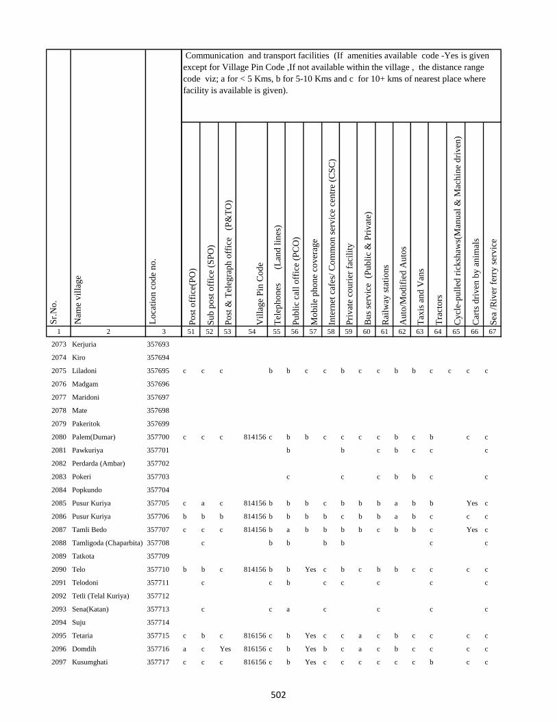
1 2 3
Lo
cati
on
co
de
no
.
Nam
e v
illa
ge
Sr.
No
.
2073 Kerjuria 357693
2074 Kiro 357694
2075 Liladoni 357695
2076 Madgam 357696
2077 Maridoni 357697
2078 Mate 357698
2079 Pakeritok 357699
2080 Palem(Dumar) 357700
2081 Pawkuriya 357701
2082 Perdarda (Ambar) 357702
2083 Pokeri 357703
2084 Popkundo 357704
2085 Pusur Kuriya 357705
2086 Pusur Kuriya 357706
2087 Tamli Bedo 357707
2088 Tamligoda (Chaparbita) 357708
2089 Tatkota 357709
2090 Telo 357710
2091 Telodoni 357711
2092 Tetli (Telal Kuriya) 357712
2093 Sena(Katan) 357713
2094 Suju 357714
2095 Tetaria 357715
2096 Domdih 357716
2097 Kusumghati 357717
Po
st o
ffic
e(P
O)
Su
b p
ost
off
ice
(SP
O)
Po
st &
Tel
egra
ph
off
ice
(P
&T
O)
Vil
lag
e P
in C
od
e
Tel
eph
on
es
(Lan
d l
ines
)
Pu
bli
c ca
ll o
ffic
e (P
CO
)
Mo
bil
e p
ho
ne
cov
erag
e
Inte
rnet
caf
es/
Co
mm
on
ser
vic
e ce
ntr
e (C
SC
)
Pri
vat
e co
uri
er f
acil
ity
Bu
s se
rvic
e (
Pu
bli
c &
Pri
vat
e)
Rai
lway
sta
tio
ns
Au
to/M
od
ifie
d A
uto
s
Tax
is a
nd
Van
s
Tra
cto
rs
Cy
cle-
pu
lled
ric
ksh
aws(
Man
ual
& M
ach
ine
dri
ven
)
Car
ts d
riv
en b
y a
nim
als
Sea
/R
iver
fer
ry s
erv
ice
51 52 53 54 55 56 57 58 59 60 61 62 63 64 65 66 67
Communication and transport facilities (If amenities available code -Yes is given
except for Village Pin Code ,If not available within the village , the distance range
code viz; a for < 5 Kms, b for 5-10 Kms and c for 10+ kms of nearest place where
facility is available is given).
c c c b b c c b c c b b c c c c
c c c 814156 c b b c c c c b c b c c
b b c b c c c
c c c b b c c
c a c 814156 b b b c b b b a b b Yes c
b b b 814156 b b b b c b b a b c c c
c c c 814156 b a b b b b c b b c Yes c
c b b b b c c
b b c 814156 b b Yes c b c b b c c c c
c c b c c c c c
c c a c c c c
c b c 816156 c b Yes c c a c b c c c c
a c Yes 816156 c b Yes b c a c b c c c c
c c c 816156 c b Yes c c c c c c b c c
502
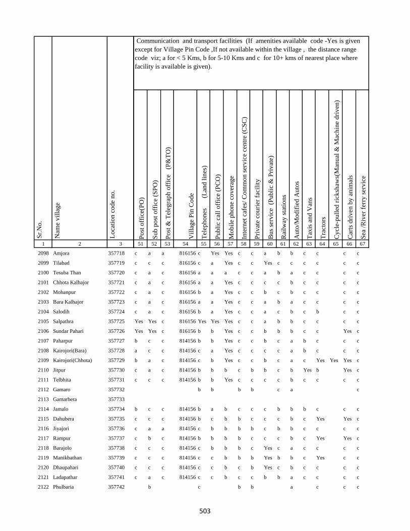
1 2 3
Lo
cati
on
co
de
no
.
Nam
e v
illa
ge
Sr.
No
.
2098 Amjora 357718
2099 Tilabad 357719
2100 Tesuba Than 357720
2101 Chhota Kalhajor 357721
2102 Mohanpur 357722
2103 Bara Kalhajor 357723
2104 Salodih 357724
2105 Salpathra 357725
2106 Sundar Pahari 357726
2107 Paharpur 357727
2108 Kairojori(Bara) 357728
2109 Kairojori(Chhota) 357729
2110 Jitpur 357730
2111 Telbhita 357731
2112 Gamaro 357732
2113 Gamarbera 357733
2114 Jamalo 357734
2115 Dahubera 357735
2116 Jiyajori 357736
2117 Rampur 357737
2118 Barajolo 357738
2119 Manikbathan 357739
2120 Dhaupahari 357740
2121 Ladapathar 357741
2122 Phulbaria 357742
Po
st o
ffic
e(P
O)
Su
b p
ost
off
ice
(SP
O)
Po
st &
Tel
egra
ph
off
ice
(P
&T
O)
Vil
lag
e P
in C
od
e
Tel
eph
on
es
(Lan
d l
ines
)
Pu
bli
c ca
ll o
ffic
e (P
CO
)
Mo
bil
e p
ho
ne
cov
erag
e
Inte
rnet
caf
es/
Co
mm
on
ser
vic
e ce
ntr
e (C
SC
)
Pri
vat
e co
uri
er f
acil
ity
Bu
s se
rvic
e (
Pu
bli
c &
Pri
vat
e)
Rai
lway
sta
tio
ns
Au
to/M
od
ifie
d A
uto
s
Tax
is a
nd
Van
s
Tra
cto
rs
Cy
cle-
pu
lled
ric
ksh
aws(
Man
ual
& M
ach
ine
dri
ven
)
Car
ts d
riv
en b
y a
nim
als
Sea
/R
iver
fer
ry s
erv
ice
51 52 53 54 55 56 57 58 59 60 61 62 63 64 65 66 67
Communication and transport facilities (If amenities available code -Yes is given
except for Village Pin Code ,If not available within the village , the distance range
code viz; a for < 5 Kms, b for 5-10 Kms and c for 10+ kms of nearest place where
facility is available is given).
c a a 816156 c Yes Yes c c a b b c c c c
c c c 816156 c a Yes c c Yes c c c c c c
c a c 816156 a a a c c a b a c c c c
c a c 816156 a a Yes c c c c b c c c c
c a c 816156 b a Yes c c b c b c c c c
c a c 816156 a a Yes c c a b a c c c c
c a c 816156 b a Yes c c a c b c b c c
Yes Yes c 816156 Yes Yes Yes c c a b b c c c c
Yes Yes c 816156 b b Yes c c b b b c c Yes c
b c c 814156 b b Yes c c b c a b c c c
a c c 814156 c a Yes c c c c a b c c c
b a c 814156 c b Yes c c b c a c Yes Yes Yes c
c a c 814156 b b b c b b c b Yes b Yes c
c c c 814156 b b Yes c c c c b c c c c
b b b b c a c
b c c 814156 b a b c c c b b b c c c
c c c 814156 b c b b c c c b c Yes Yes c
c a a 814156 c b b b b c b b c c c c
c b c 814156 b b b b c c c b c Yes Yes c
c c c 814156 c b b b c Yes c a c c c c
c c c 814156 c c b b b Yes b b c Yes c c
c c c 814156 c c b c b Yes c b c c c c
c a c 814156 c c b c c b b a c c c c
b c b b a c c c
503
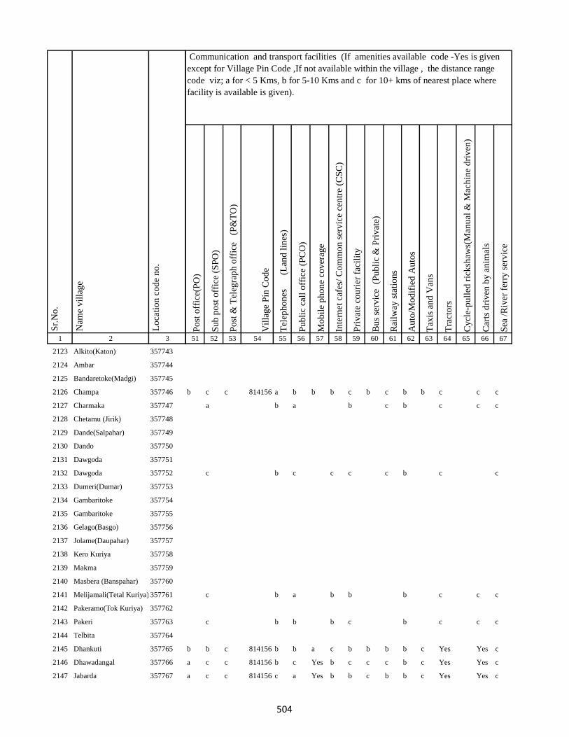
1 2 3
Lo
cati
on
co
de
no
.
Nam
e v
illa
ge
Sr.
No
.
2123 Alkito(Katon) 357743
2124 Ambar 357744
2125 Bandaretoke(Madgi) 357745
2126 Champa 357746
2127 Charmaka 357747
2128 Chetamu (Jirik) 357748
2129 Dande(Salpahar) 357749
2130 Dando 357750
2131 Dawgoda 357751
2132 Dawgoda 357752
2133 Dumeri(Dumar) 357753
2134 Gambaritoke 357754
2135 Gambaritoke 357755
2136 Gelago(Basgo) 357756
2137 Jolame(Daupahar) 357757
2138 Kero Kuriya 357758
2139 Makma 357759
2140 Masbera (Banspahar) 357760
2141 Melijamali(Tetal Kuriya) 357761
2142 Pakeramo(Tok Kuriya) 357762
2143 Pakeri 357763
2144 Telbita 357764
2145 Dhankuti 357765
2146 Dhawadangal 357766
2147 Jabarda 357767
Po
st o
ffic
e(P
O)
Su
b p
ost
off
ice
(SP
O)
Po
st &
Tel
egra
ph
off
ice
(P
&T
O)
Vil
lag
e P
in C
od
e
Tel
eph
on
es
(Lan
d l
ines
)
Pu
bli
c ca
ll o
ffic
e (P
CO
)
Mo
bil
e p
ho
ne
cov
erag
e
Inte
rnet
caf
es/
Co
mm
on
ser
vic
e ce
ntr
e (C
SC
)
Pri
vat
e co
uri
er f
acil
ity
Bu
s se
rvic
e (
Pu
bli
c &
Pri
vat
e)
Rai
lway
sta
tio
ns
Au
to/M
od
ifie
d A
uto
s
Tax
is a
nd
Van
s
Tra
cto
rs
Cy
cle-
pu
lled
ric
ksh
aws(
Man
ual
& M
ach
ine
dri
ven
)
Car
ts d
riv
en b
y a
nim
als
Sea
/R
iver
fer
ry s
erv
ice
51 52 53 54 55 56 57 58 59 60 61 62 63 64 65 66 67
Communication and transport facilities (If amenities available code -Yes is given
except for Village Pin Code ,If not available within the village , the distance range
code viz; a for < 5 Kms, b for 5-10 Kms and c for 10+ kms of nearest place where
facility is available is given).
b c c 814156 a b b b c b c b b c c c
a b a b c b c c c
c b c c c c b c c
c b a b b b c c c
c b b b c b c c c
b b c 814156 b b a c b b b b c Yes Yes c
a c c 814156 b c Yes b c c c b c Yes Yes c
a c c 814156 c a Yes b b c b b c Yes Yes c
504
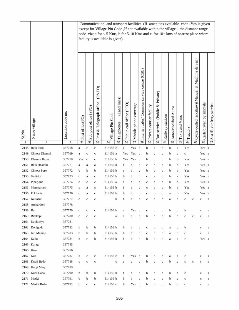
1 2 3
Lo
cati
on
co
de
no
.
Nam
e v
illa
ge
Sr.
No
.
2148 Bara Puro 357768
2149 Chhota Dhamni 357769
2150 Dhamni Bazar 357770
2151 Bara Dhamni 357771
2152 Chhota Puro 357772
2153 Gadidih 357773
2154 Piparjoria 357774
2155 Marchaitari 357775
2156 Pokharia 357776
2157 Kairasul 357777
2158 Ambardoni 357778
2159 Bat 357779
2160 Bitakepu 357780
2161 Daukuriya 357781
2162 Donigoda 357782
2163 Jari Mamqo 357783
2164 Kadu 357784
2165 Karag 357785
2166 Kiro 357786
2167 Koa 357787
2168 Kubji Bedo 357788
2169 Kubji Maqo 357789
2170 Kudi Goda 357790
2171 Madgi 357791
2172 Madgi Bedo 357792
Po
st o
ffic
e(P
O)
Su
b p
ost
off
ice
(SP
O)
Po
st &
Tel
egra
ph
off
ice
(P
&T
O)
Vil
lag
e P
in C
od
e
Tel
eph
on
es
(Lan
d l
ines
)
Pu
bli
c ca
ll o
ffic
e (P
CO
)
Mo
bil
e p
ho
ne
cov
erag
e
Inte
rnet
caf
es/
Co
mm
on
ser
vic
e ce
ntr
e (C
SC
)
Pri
vat
e co
uri
er f
acil
ity
Bu
s se
rvic
e (
Pu
bli
c &
Pri
vat
e)
Rai
lway
sta
tio
ns
Au
to/M
od
ifie
d A
uto
s
Tax
is a
nd
Van
s
Tra
cto
rs
Cy
cle-
pu
lled
ric
ksh
aws(
Man
ual
& M
ach
ine
dri
ven
)
Car
ts d
riv
en b
y a
nim
als
Sea
/R
iver
fer
ry s
erv
ice
51 52 53 54 55 56 57 58 59 60 61 62 63 64 65 66 67
Communication and transport facilities (If amenities available code -Yes is given
except for Village Pin Code ,If not available within the village , the distance range
code viz; a for < 5 Kms, b for 5-10 Kms and c for 10+ kms of nearest place where
facility is available is given).
a c c 814156 c c Yes b b c c b c Yes Yes c
a c c 814156 a Yes Yes c b c c b c c Yes c
Yes c c 814156 b Yes Yes b b c b b b Yes Yes c
a a a 814156 b b b c c b c b b Yes Yes c
b b b 814156 b c b c b b b b b Yes Yes c
c a c 814156 b b b c c a b b a Yes Yes c
c c c 814156 a a b c c c c b b Yes Yes c
c a c 814156 b b b c c b c b b Yes Yes c
c a c 814156 b b b c c b c a b Yes Yes c
c c c b b c c c c b a c c c c c
c c c 814156 b c Yes c c c c b c b c c
c c c a a c c b c b b c c c c c
b b b 814156 b b b c c b b a c b c c
b b b 814156 b b b c c b b a c c c c
b c b 814156 b b b c b b c a c c Yes c
b c c 814156 c b Yes c b b b a c c c c
c c c c c c c b c c b c c c c c
b b b 814156 b b b c b b c b c c c c
b b b 814156 b b b c b c c b c c c c
b c c 814156 c b Yes c b b b b c c c c
505
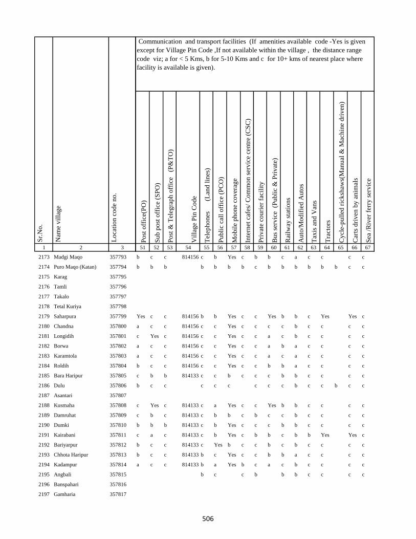
1 2 3
Lo
cati
on
co
de
no
.
Nam
e v
illa
ge
Sr.
No
.
2173 Madgi Maqo 357793
2174 Puro Maqo (Katan) 357794
2175 Karag 357795
2176 Tamli 357796
2177 Takalo 357797
2178 Tetal Kuriya 357798
2179 Saharpura 357799
2180 Chandna 357800
2181 Longidih 357801
2182 Borwa 357802
2183 Karamtola 357803
2184 Roldih 357804
2185 Bara Haripur 357805
2186 Dulu 357806
2187 Asantari 357807
2188 Kusmaha 357808
2189 Damruhat 357809
2190 Dumki 357810
2191 Kairabani 357811
2192 Bariyarpur 357812
2193 Chhota Haripur 357813
2194 Kadampur 357814
2195 Angbali 357815
2196 Banspahari 357816
2197 Gamharia 357817
Po
st o
ffic
e(P
O)
Su
b p
ost
off
ice
(SP
O)
Po
st &
Tel
egra
ph
off
ice
(P
&T
O)
Vil
lag
e P
in C
od
e
Tel
eph
on
es
(Lan
d l
ines
)
Pu
bli
c ca
ll o
ffic
e (P
CO
)
Mo
bil
e p
ho
ne
cov
erag
e
Inte
rnet
caf
es/
Co
mm
on
ser
vic
e ce
ntr
e (C
SC
)
Pri
vat
e co
uri
er f
acil
ity
Bu
s se
rvic
e (
Pu
bli
c &
Pri
vat
e)
Rai
lway
sta
tio
ns
Au
to/M
od
ifie
d A
uto
s
Tax
is a
nd
Van
s
Tra
cto
rs
Cy
cle-
pu
lled
ric
ksh
aws(
Man
ual
& M
ach
ine
dri
ven
)
Car
ts d
riv
en b
y a
nim
als
Sea
/R
iver
fer
ry s
erv
ice
51 52 53 54 55 56 57 58 59 60 61 62 63 64 65 66 67
Communication and transport facilities (If amenities available code -Yes is given
except for Village Pin Code ,If not available within the village , the distance range
code viz; a for < 5 Kms, b for 5-10 Kms and c for 10+ kms of nearest place where
facility is available is given).
b c c 814156 c b Yes c b b c a c c c c
b b b b b b b c b b b b b b c c
Yes c c 814156 b b Yes c c Yes b b c Yes Yes c
a c c 814156 c c Yes c c c c b c c c c
c Yes c 814156 c c Yes c c a c b c c c c
a c c 814156 c c Yes c c a b a c c c c
a c c 814156 c c Yes c c a c a c c c c
b c c 814156 c c Yes c c b b a c c c c
c b b 814133 c c b c c c b b c c c c
b c c c c c c c c b c c b c c
c Yes c 814133 c a Yes c c Yes b b c c c c
c b c 814133 c b b c b c c b c c c c
b b b 814133 c b Yes c c c b b c c c c
c a c 814133 c b Yes c b b c b b Yes Yes c
b c c 814133 c Yes b c c b c b c c c c
b c c 814133 b c Yes c c b b a c c c c
a c c 814133 b a Yes b c a c b c c c c
b c c b b b c c c c
506
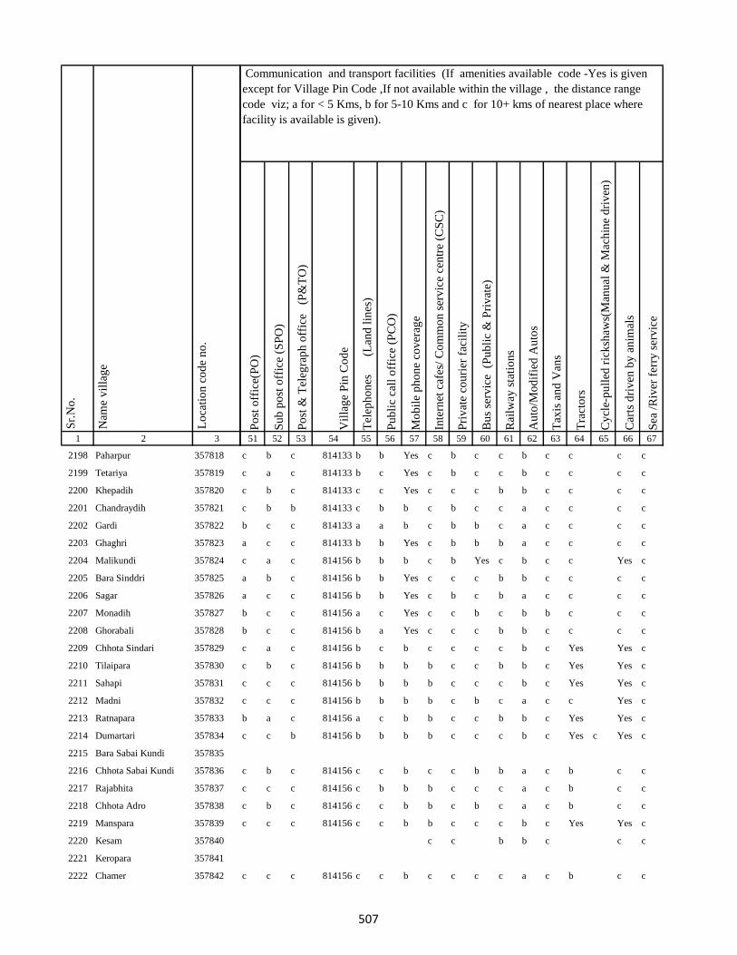
1 2 3
Lo
cati
on
co
de
no
.
Nam
e v
illa
ge
Sr.
No
.
2198 Paharpur 357818
2199 Tetariya 357819
2200 Khepadih 357820
2201 Chandraydih 357821
2202 Gardi 357822
2203 Ghaghri 357823
2204 Malikundi 357824
2205 Bara Sinddri 357825
2206 Sagar 357826
2207 Monadih 357827
2208 Ghorabali 357828
2209 Chhota Sindari 357829
2210 Tilaipara 357830
2211 Sahapi 357831
2212 Madni 357832
2213 Ratnapara 357833
2214 Dumartari 357834
2215 Bara Sabai Kundi 357835
2216 Chhota Sabai Kundi 357836
2217 Rajabhita 357837
2218 Chhota Adro 357838
2219 Manspara 357839
2220 Kesam 357840
2221 Keropara 357841
2222 Chamer 357842
Po
st o
ffic
e(P
O)
Su
b p
ost
off
ice
(SP
O)
Po
st &
Tel
egra
ph
off
ice
(P
&T
O)
Vil
lag
e P
in C
od
e
Tel
eph
on
es
(Lan
d l
ines
)
Pu
bli
c ca
ll o
ffic
e (P
CO
)
Mo
bil
e p
ho
ne
cov
erag
e
Inte
rnet
caf
es/
Co
mm
on
ser
vic
e ce
ntr
e (C
SC
)
Pri
vat
e co
uri
er f
acil
ity
Bu
s se
rvic
e (
Pu
bli
c &
Pri
vat
e)
Rai
lway
sta
tio
ns
Au
to/M
od
ifie
d A
uto
s
Tax
is a
nd
Van
s
Tra
cto
rs
Cy
cle-
pu
lled
ric
ksh
aws(
Man
ual
& M
ach
ine
dri
ven
)
Car
ts d
riv
en b
y a
nim
als
Sea
/R
iver
fer
ry s
erv
ice
51 52 53 54 55 56 57 58 59 60 61 62 63 64 65 66 67
Communication and transport facilities (If amenities available code -Yes is given
except for Village Pin Code ,If not available within the village , the distance range
code viz; a for < 5 Kms, b for 5-10 Kms and c for 10+ kms of nearest place where
facility is available is given).
c b c 814133 b b Yes c b c c b c c c c
c a c 814133 b c Yes c b c c b c c c c
c b c 814133 c c Yes c c c b b c c c c
c b b 814133 c b b c b c c a c c c c
b c c 814133 a a b c b b c a c c c c
a c c 814133 b b Yes c b b b a c c c c
c a c 814156 b b b c b Yes c b c c Yes c
a b c 814156 b b Yes c c c b b c c c c
a c c 814156 b b Yes c b c b a c c c c
b c c 814156 a c Yes c c b c b b c c c
b c c 814156 b a Yes c c c b b c c c c
c a c 814156 b c b c c c c b c Yes Yes c
c b c 814156 b b b b c c b b c Yes Yes c
c c c 814156 b b b b c c c b c Yes Yes c
c c c 814156 b b b b c b c a c c Yes c
b a c 814156 a c b b c c b b c Yes Yes c
c c b 814156 b b b b c c c b c Yes c Yes c
c b c 814156 c c b c c b b a c b c c
c c c 814156 c b b b c c c a c b c c
c b c 814156 c c b b c b c a c b c c
c c c 814156 c c b b c c c b c Yes Yes c
c c b b c c c
c c c 814156 c c b c c c c a c b c c
507
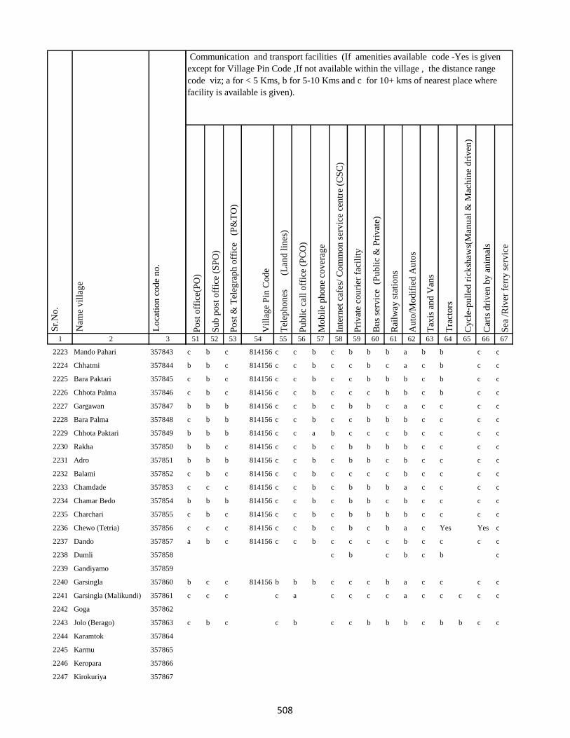
1 2 3
Lo
cati
on
co
de
no
.
Nam
e v
illa
ge
Sr.
No
.
2223 Mando Pahari 357843
2224 Chhatmi 357844
2225 Bara Paktari 357845
2226 Chhota Palma 357846
2227 Gargawan 357847
2228 Bara Palma 357848
2229 Chhota Paktari 357849
2230 Rakha 357850
2231 Adro 357851
2232 Balami 357852
2233 Chamdade 357853
2234 Chamar Bedo 357854
2235 Charchari 357855
2236 Chewo (Tetria) 357856
2237 Dando 357857
2238 Dumli 357858
2239 Gandiyamo 357859
2240 Garsingla 357860
2241 Garsingla (Malikundi) 357861
2242 Goga 357862
2243 Jolo (Berago) 357863
2244 Karamtok 357864
2245 Karmu 357865
2246 Keropara 357866
2247 Kirokuriya 357867
Po
st o
ffic
e(P
O)
Su
b p
ost
off
ice
(SP
O)
Po
st &
Tel
egra
ph
off
ice
(P
&T
O)
Vil
lag
e P
in C
od
e
Tel
eph
on
es
(Lan
d l
ines
)
Pu
bli
c ca
ll o
ffic
e (P
CO
)
Mo
bil
e p
ho
ne
cov
erag
e
Inte
rnet
caf
es/
Co
mm
on
ser
vic
e ce
ntr
e (C
SC
)
Pri
vat
e co
uri
er f
acil
ity
Bu
s se
rvic
e (
Pu
bli
c &
Pri
vat
e)
Rai
lway
sta
tio
ns
Au
to/M
od
ifie
d A
uto
s
Tax
is a
nd
Van
s
Tra
cto
rs
Cy
cle-
pu
lled
ric
ksh
aws(
Man
ual
& M
ach
ine
dri
ven
)
Car
ts d
riv
en b
y a
nim
als
Sea
/R
iver
fer
ry s
erv
ice
51 52 53 54 55 56 57 58 59 60 61 62 63 64 65 66 67
Communication and transport facilities (If amenities available code -Yes is given
except for Village Pin Code ,If not available within the village , the distance range
code viz; a for < 5 Kms, b for 5-10 Kms and c for 10+ kms of nearest place where
facility is available is given).
c b c 814156 c c b c b b b a b b c c
b b c 814156 c c b c c b c a c b c c
c b c 814156 c c b c c b b b c b c c
c b c 814156 c c b c c c b b c b c c
b b b 814156 c c b c b b c a c c c c
c b b 814156 c c b c c b b b c c c c
b b b 814156 c c a b c c c b c c c c
b b c 814156 c c b c b b b b c c c c
b b b 814156 c c b c b b c b c c c c
c b c 814156 c c b c c c c b c c c c
c c c 814156 c c b c b b b a c c c c
b b b 814156 c c b c b b c b c c c c
c b c 814156 c c b c b b b b c c c c
c c c 814156 c c b c b c b a c Yes Yes c
a b c 814156 c c b c c c c b c c c c
c b c b c b c
b c c 814156 b b b c c c b a c c c c
c c c c a c c c c a c c c c c
c b c c b c c b b b c b b c c
508
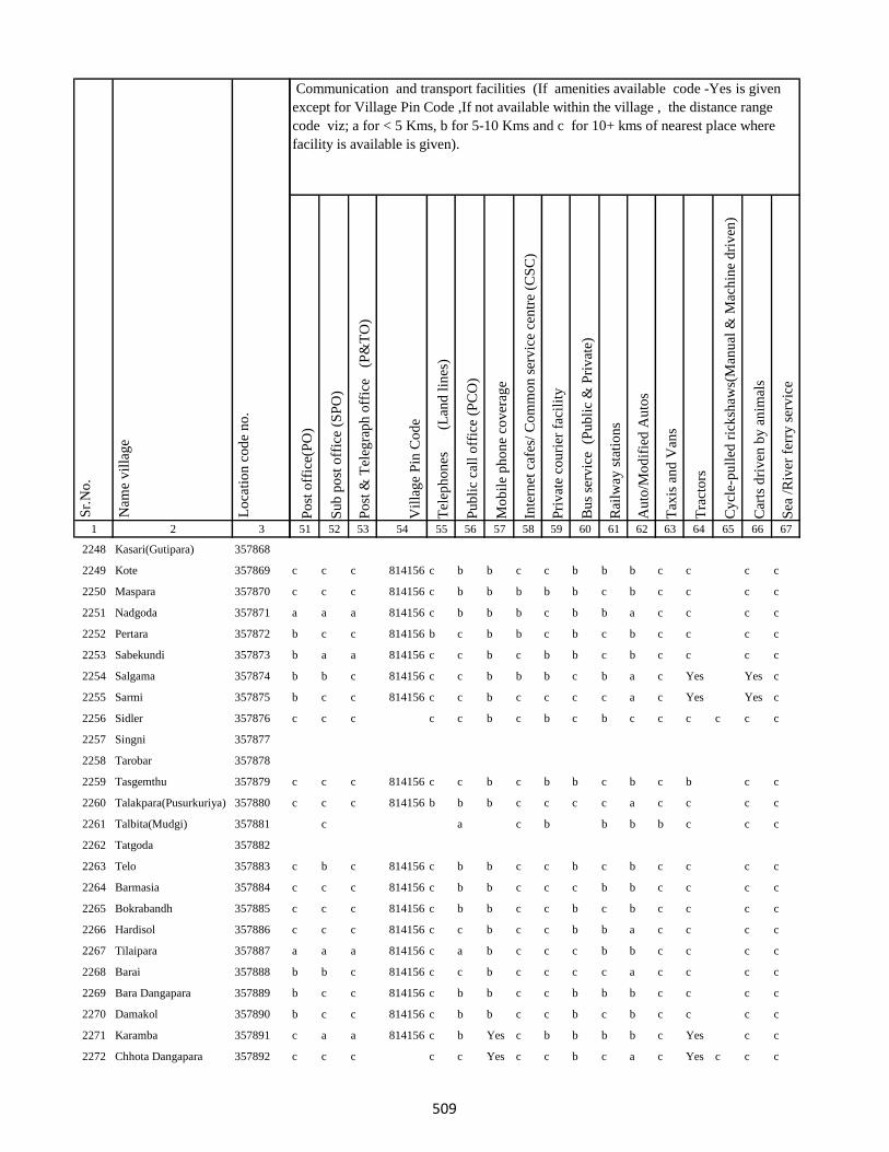
1 2 3
Lo
cati
on
co
de
no
.
Nam
e v
illa
ge
Sr.
No
.
2248 Kasari(Gutipara) 357868
2249 Kote 357869
2250 Maspara 357870
2251 Nadgoda 357871
2252 Pertara 357872
2253 Sabekundi 357873
2254 Salgama 357874
2255 Sarmi 357875
2256 Sidler 357876
2257 Singni 357877
2258 Tarobar 357878
2259 Tasgemthu 357879
2260 Talakpara(Pusurkuriya) 357880
2261 Talbita(Mudgi) 357881
2262 Tatgoda 357882
2263 Telo 357883
2264 Barmasia 357884
2265 Bokrabandh 357885
2266 Hardisol 357886
2267 Tilaipara 357887
2268 Barai 357888
2269 Bara Dangapara 357889
2270 Damakol 357890
2271 Karamba 357891
2272 Chhota Dangapara 357892
Po
st o
ffic
e(P
O)
Su
b p
ost
off
ice
(SP
O)
Po
st &
Tel
egra
ph
off
ice
(P
&T
O)
Vil
lag
e P
in C
od
e
Tel
eph
on
es
(Lan
d l
ines
)
Pu
bli
c ca
ll o
ffic
e (P
CO
)
Mo
bil
e p
ho
ne
cov
erag
e
Inte
rnet
caf
es/
Co
mm
on
ser
vic
e ce
ntr
e (C
SC
)
Pri
vat
e co
uri
er f
acil
ity
Bu
s se
rvic
e (
Pu
bli
c &
Pri
vat
e)
Rai
lway
sta
tio
ns
Au
to/M
od
ifie
d A
uto
s
Tax
is a
nd
Van
s
Tra
cto
rs
Cy
cle-
pu
lled
ric
ksh
aws(
Man
ual
& M
ach
ine
dri
ven
)
Car
ts d
riv
en b
y a
nim
als
Sea
/R
iver
fer
ry s
erv
ice
51 52 53 54 55 56 57 58 59 60 61 62 63 64 65 66 67
Communication and transport facilities (If amenities available code -Yes is given
except for Village Pin Code ,If not available within the village , the distance range
code viz; a for < 5 Kms, b for 5-10 Kms and c for 10+ kms of nearest place where
facility is available is given).
c c c 814156 c b b c c b b b c c c c
c c c 814156 c b b b b b c b c c c c
a a a 814156 c b b b c b b a c c c c
b c c 814156 b c b b c b c b c c c c
b a a 814156 c c b c b b c b c c c c
b b c 814156 c c b b b c b a c Yes Yes c
b c c 814156 c c b c c c c a c Yes Yes c
c c c c c b c b c b c c c c c c
c c c 814156 c c b c b b c b c b c c
c c c 814156 b b b c c c c a c c c c
c a c b b b b c c c
c b c 814156 c b b c c b c b c c c c
c c c 814156 c b b c c c b b c c c c
c c c 814156 c b b c c b c b c c c c
c c c 814156 c c b c c b b a c c c c
a a a 814156 c a b c c c b b c c c c
b b c 814156 c c b c c c c a c c c c
b c c 814156 c b b c c b b b c c c c
b c c 814156 c b b c c b c b c c c c
c a a 814156 c b Yes c b b b b c Yes c c
c c c c c Yes c c b c a c Yes c c c
509
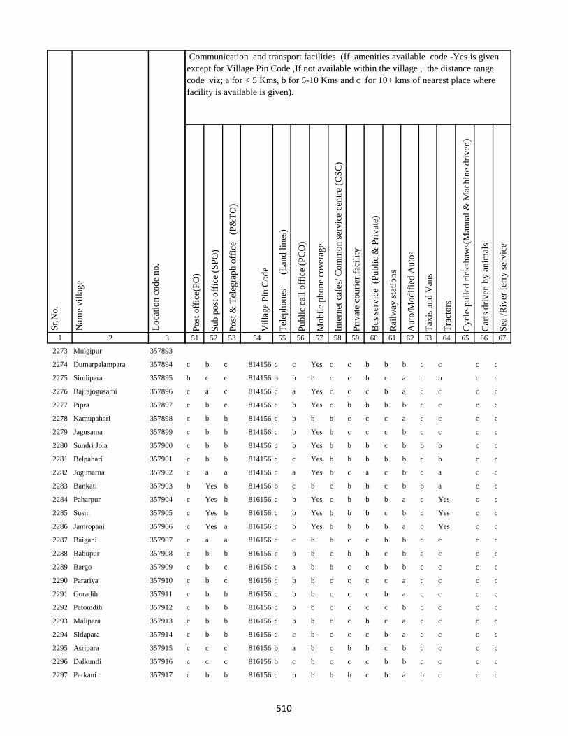
1 2 3
Lo
cati
on
co
de
no
.
Nam
e v
illa
ge
Sr.
No
.
2273 Mulgipur 357893
2274 Dumarpalampara 357894
2275 Simlipara 357895
2276 Bajrajogusami 357896
2277 Pipra 357897
2278 Kamupahari 357898
2279 Jagusama 357899
2280 Sundri Jola 357900
2281 Belpahari 357901
2282 Jogimarna 357902
2283 Bankati 357903
2284 Paharpur 357904
2285 Susni 357905
2286 Jamropani 357906
2287 Baigani 357907
2288 Babupur 357908
2289 Bargo 357909
2290 Parariya 357910
2291 Goradih 357911
2292 Patomdih 357912
2293 Malipara 357913
2294 Sidapara 357914
2295 Asripara 357915
2296 Dalkundi 357916
2297 Parkani 357917
Po
st o
ffic
e(P
O)
Su
b p
ost
off
ice
(SP
O)
Po
st &
Tel
egra
ph
off
ice
(P
&T
O)
Vil
lag
e P
in C
od
e
Tel
eph
on
es
(Lan
d l
ines
)
Pu
bli
c ca
ll o
ffic
e (P
CO
)
Mo
bil
e p
ho
ne
cov
erag
e
Inte
rnet
caf
es/
Co
mm
on
ser
vic
e ce
ntr
e (C
SC
)
Pri
vat
e co
uri
er f
acil
ity
Bu
s se
rvic
e (
Pu
bli
c &
Pri
vat
e)
Rai
lway
sta
tio
ns
Au
to/M
od
ifie
d A
uto
s
Tax
is a
nd
Van
s
Tra
cto
rs
Cy
cle-
pu
lled
ric
ksh
aws(
Man
ual
& M
ach
ine
dri
ven
)
Car
ts d
riv
en b
y a
nim
als
Sea
/R
iver
fer
ry s
erv
ice
51 52 53 54 55 56 57 58 59 60 61 62 63 64 65 66 67
Communication and transport facilities (If amenities available code -Yes is given
except for Village Pin Code ,If not available within the village , the distance range
code viz; a for < 5 Kms, b for 5-10 Kms and c for 10+ kms of nearest place where
facility is available is given).
c b c 814156 c c Yes c c b b b c c c c
b c c 814156 b b b c c b c a c b c c
c a c 814156 c a Yes c c c b a c c c c
c b c 814156 c b Yes c b b b b c c c c
c b b 814156 c b b b c c c a c c c c
c b b 814156 c b Yes b c c c b c c c c
c b b 814156 c b Yes b b b c b b b c c
c b b 814156 c c Yes b b b b b c b c c
c a a 814156 c a Yes b c a c b c a c c
b Yes b 814156 b c b c b b c b b a c c
c Yes b 816156 c b Yes c b b b a c Yes c c
c Yes b 816156 c b Yes b b b c b c Yes c c
c Yes a 816156 c b Yes b b b b a c Yes c c
c a a 816156 c c b b c c b b c c c c
c b b 816156 c b b c b b c b c c c c
c b c 816156 c a b b c c b b c c c c
c b c 816156 c b b c c c c a c c c c
c b b 816156 c b b c c c b a c c c c
c b b 816156 c b b c c c c b c c c c
c b b 816156 c b b c c b c a c c c c
c b b 816156 c c b c c c b a c c c c
c c c 816156 b a b c b b c b c c c c
c c c 816156 b c b c c c b b c c c c
c b b 816156 c b b b b c b a b c c c
510
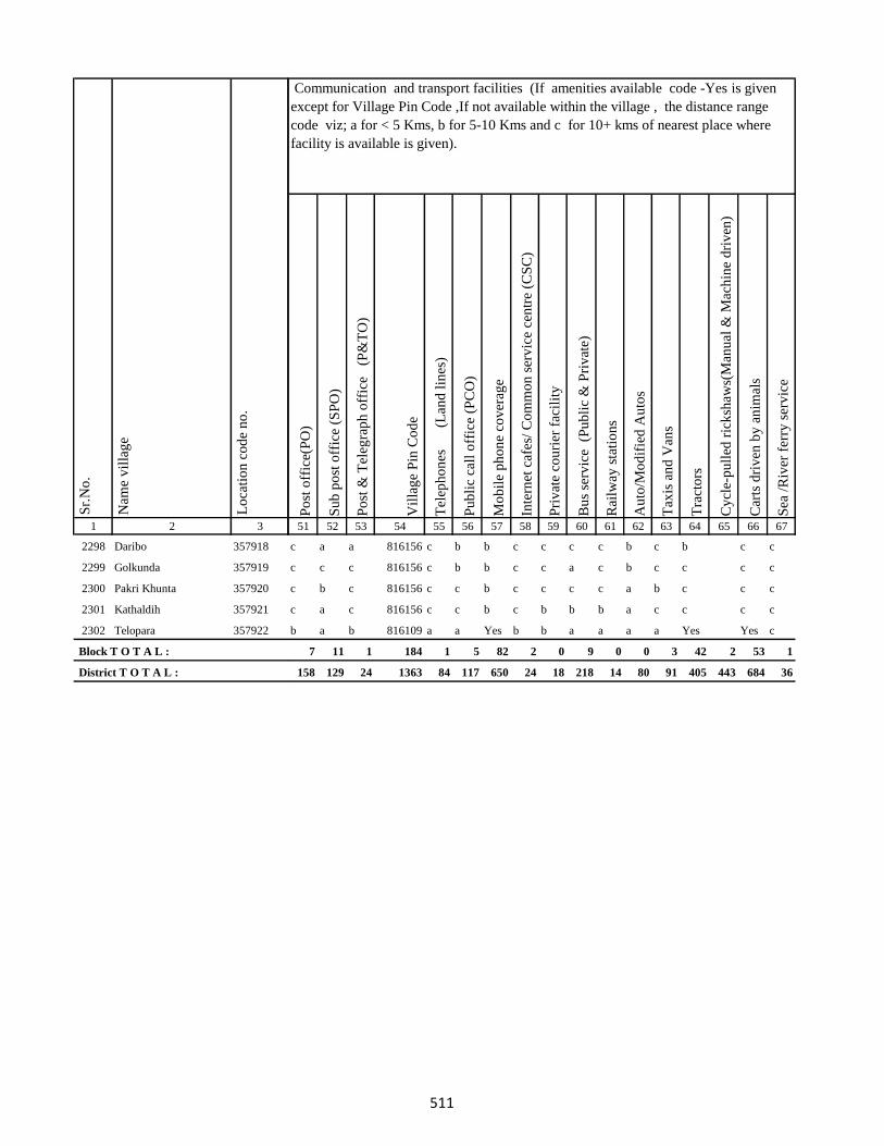
1 2 3
Lo
cati
on
co
de
no
.
Nam
e v
illa
ge
Sr.
No
.
2298 Daribo 357918
2299 Golkunda 357919
2300 Pakri Khunta 357920
2301 Kathaldih 357921
2302 Telopara 357922
Block T O T A L :
District T O T A L :
Po
st o
ffic
e(P
O)
Su
b p
ost
off
ice
(SP
O)
Po
st &
Tel
egra
ph
off
ice
(P
&T
O)
Vil
lag
e P
in C
od
e
Tel
eph
on
es
(Lan
d l
ines
)
Pu
bli
c ca
ll o
ffic
e (P
CO
)
Mo
bil
e p
ho
ne
cov
erag
e
Inte
rnet
caf
es/
Co
mm
on
ser
vic
e ce
ntr
e (C
SC
)
Pri
vat
e co
uri
er f
acil
ity
Bu
s se
rvic
e (
Pu
bli
c &
Pri
vat
e)
Rai
lway
sta
tio
ns
Au
to/M
od
ifie
d A
uto
s
Tax
is a
nd
Van
s
Tra
cto
rs
Cy
cle-
pu
lled
ric
ksh
aws(
Man
ual
& M
ach
ine
dri
ven
)
Car
ts d
riv
en b
y a
nim
als
Sea
/R
iver
fer
ry s
erv
ice
51 52 53 54 55 56 57 58 59 60 61 62 63 64 65 66 67
Communication and transport facilities (If amenities available code -Yes is given
except for Village Pin Code ,If not available within the village , the distance range
code viz; a for < 5 Kms, b for 5-10 Kms and c for 10+ kms of nearest place where
facility is available is given).
c a a 816156 c b b c c c c b c b c c
c c c 816156 c b b c c a c b c c c c
c b c 816156 c c b c c c c a b c c c
c a c 816156 c c b c b b b a c c c c
b a b 816109 a a Yes b b a a a a Yes Yes c
7 11 1 184 1 5 82 2 0 9 0 0 3 42 2 53 1
158 129 24 1363 84 117 650 24 18 218 14 80 91 405 443 684 36
511
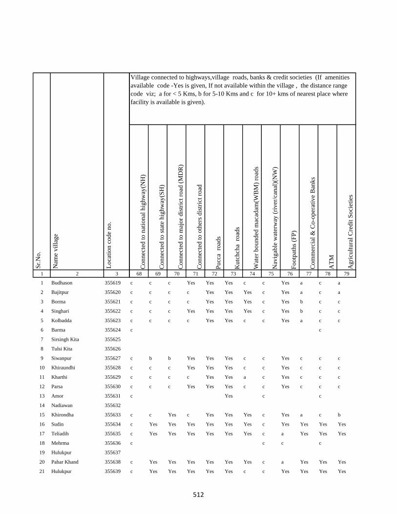
1 2 3
1 Budhason 355619
2 Bajitpur 355620
3 Borma 355621
4 Singhari 355622
5 Kolbadda 355623
6 Barma 355624
7 Sirsingh Kita 355625
8 Tulsi Kita 355626
9 Siwanpur 355627
10 Khiraundhi 355628
11 Kharthi 355629
12 Parsa 355630
13 Amor 355631
14 Nadiawan 355632
15 Khirondha 355633
16 Sudin 355634
17 Teliadih 355635
18 Mehrma 355636
19 Hulukpur 355637
20 Pahar Khand 355638
21 Hulukpur 355639
Lo
cati
on
co
de
no
.
Nam
e v
illa
ge
Sr.
No
.
Co
nn
ecte
d t
o n
atio
nal
hig
hw
ay(N
H)
Co
nn
ecte
d t
o s
tate
hig
hw
ay(S
H)
Co
nn
ecte
d t
o m
ajo
r d
istr
ict
road
(M
DR
)
Co
nn
ecte
d t
o o
ther
s d
istr
ict
road
Pu
cca
ro
ads
Ku
tch
cha
ro
ads
Wat
er b
ou
nd
ed m
acad
am(W
BM
) ro
ads
Nav
igab
le w
ater
way
(ri
ver
/can
al)(
NW
)
Fo
otp
ath
s (F
P)
Co
mm
erci
al &
Co
-op
erat
ive
Ban
ks
AT
M
Ag
ricu
ltu
ral
Cre
dit
So
ciet
ies
68 69 70 71 72 73 74 75 76 77 78 79
c c c Yes Yes Yes c c Yes a c a
c c c c Yes Yes Yes c Yes a c a
c c c c Yes Yes Yes c Yes b c c
c c c Yes Yes Yes Yes c Yes b c c
c c c c Yes Yes c c Yes a c c
c c
c b b Yes Yes Yes c c Yes c c c
c c c Yes Yes Yes c c Yes c c c
c c c c Yes Yes a c Yes c c c
c c c Yes Yes Yes c c Yes c c c
c Yes c c
c c Yes c Yes Yes Yes c Yes a c b
c Yes Yes Yes Yes Yes Yes c Yes Yes Yes Yes
c Yes Yes Yes Yes Yes Yes c a Yes Yes Yes
c c c c
c Yes Yes Yes Yes Yes Yes c a Yes Yes Yes
c Yes Yes Yes Yes Yes c c Yes Yes Yes Yes
Village connected to highways,village roads, banks & credit societies (If amenities
available code -Yes is given, If not available within the village , the distance range
code viz; a for < 5 Kms, b for 5-10 Kms and c for 10+ kms of nearest place where
facility is available is given).
512
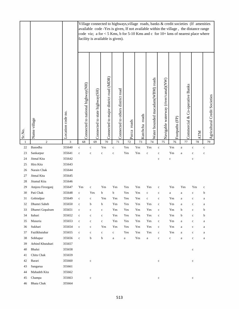
1 2 3
Lo
cati
on
co
de
no
.
Nam
e v
illa
ge
Sr.
No
.
22 Banodha 355640
23 Sankarpur 355641
24 Jitmal Kita 355642
25 Hira Kita 355643
26 Narain Chak 355644
27 Jitmal Kita 355645
28 Jitamal Kita 355646
29 Amjora Firozganj 355647
30 Pati Chak 355648
31 Gobindpur 355649
32 Dhamri Saheb 355650
33 Dhamri Gopalram 355651
34 Itahari 355652
35 Masuria 355653
36 Sukhari 355654
37 Fazilkhutahar 355655
38 Sobhapur 355656
39 Arbind Khutahari 355657
40 Bhalui 355658
41 Chitu Chak 355659
42 Barari 355660
43 Sangarua 355661
44 Mahadeb Kita 355662
45 Champa 355663
46 Bhata Chak 355664
Co
nn
ecte
d t
o n
atio
nal
hig
hw
ay(N
H)
Co
nn
ecte
d t
o s
tate
hig
hw
ay(S
H)
Co
nn
ecte
d t
o m
ajo
r d
istr
ict
road
(M
DR
)
Co
nn
ecte
d t
o o
ther
s d
istr
ict
road
Pu
cca
ro
ads
Ku
tch
cha
ro
ads
Wat
er b
ou
nd
ed m
acad
am(W
BM
) ro
ads
Nav
igab
le w
ater
way
(ri
ver
/can
al)(
NW
)
Fo
otp
ath
s (F
P)
Co
mm
erci
al &
Co
-op
erat
ive
Ban
ks
AT
M
Ag
ricu
ltu
ral
Cre
dit
So
ciet
ies
68 69 70 71 72 73 74 75 76 77 78 79
Village connected to highways,village roads, banks & credit societies (If amenities
available code -Yes is given, If not available within the village , the distance range
code viz; a for < 5 Kms, b for 5-10 Kms and c for 10+ kms of nearest place where
facility is available is given).
c c Yes c Yes Yes Yes c Yes a c c
c c c c Yes Yes c c Yes a c c
c c c
Yes c Yes Yes Yes Yes Yes c Yes Yes Yes c
c Yes b b Yes Yes c c a a c b
c c Yes Yes Yes Yes c c Yes a c a
c b b Yes Yes Yes Yes c Yes a c a
c c c Yes Yes Yes Yes c Yes b c b
c c c Yes Yes Yes Yes c Yes b c b
c c c Yes Yes Yes Yes c Yes a c a
c c Yes Yes Yes Yes Yes c Yes a c a
c c c c Yes Yes Yes c Yes a c a
c b b a a Yes a c c a c a
c
c c c
c c c
513

1 2 3
Lo
cati
on
co
de
no
.
Nam
e v
illa
ge
Sr.
No
.
47 Padam Chak 355665
48 Ghuram Chak 355666
49 Badla Chak 355667
50 Ghasichak 355668
51 Ghasi Chak Mal 355669
52 Domanchak 355670
53 Dudhi Chak 355671
54 Kasba 355672
55 Doman Chak 355673
56 Kasba 355674
57 Majhagain 355675
58 Kasba 355676
59 Sadi Chak 355677
60 Anhuatikar 355678
61 Madhurai Bagicha 355679
62 Dukhari Kita 355680
63 Dulum Khutahari 355681
64 Chhota And Bara Mangarh355682
65 Dukhari Kita 355683
66 Chhota And Bara Mangarh355684
67 Mania Chak 355685
68 Bagat Khutahari 355686
69 Jalala Chak 355687
70 Tarkharwa 355688
71 Bagat Khutahri 355689
Co
nn
ecte
d t
o n
atio
nal
hig
hw
ay(N
H)
Co
nn
ecte
d t
o s
tate
hig
hw
ay(S
H)
Co
nn
ecte
d t
o m
ajo
r d
istr
ict
road
(M
DR
)
Co
nn
ecte
d t
o o
ther
s d
istr
ict
road
Pu
cca
ro
ads
Ku
tch
cha
ro
ads
Wat
er b
ou
nd
ed m
acad
am(W
BM
) ro
ads
Nav
igab
le w
ater
way
(ri
ver
/can
al)(
NW
)
Fo
otp
ath
s (F
P)
Co
mm
erci
al &
Co
-op
erat
ive
Ban
ks
AT
M
Ag
ricu
ltu
ral
Cre
dit
So
ciet
ies
68 69 70 71 72 73 74 75 76 77 78 79
Village connected to highways,village roads, banks & credit societies (If amenities
available code -Yes is given, If not available within the village , the distance range
code viz; a for < 5 Kms, b for 5-10 Kms and c for 10+ kms of nearest place where
facility is available is given).
c Yes Yes c Yes Yes Yes c Yes b c b
c c c
c c c c Yes Yes Yes c Yes b c b
c c Yes Yes Yes Yes Yes c Yes Yes c b
c Yes Yes c c
c c c c c c c c a a c a
c c c c c c c c a a c a
c c c c c c c c a a c a
c c c
c c c
c c c Yes Yes Yes Yes c Yes b c b
c c c Yes Yes Yes Yes c a b c b
c c c c Yes Yes a c Yes b c b
c c
c Yes b Yes Yes Yes Yes c Yes b c b
c c c c Yes Yes Yes c Yes b c b
514

1 2 3
Lo
cati
on
co
de
no
.
Nam
e v
illa
ge
Sr.
No
.
72 Meghchatar 355690
73 Kumardom 355691
74 Harchandpur 355692
75 Maheshdiri 355693
76 Nawadih Tola 355694
77 Beldara Chak 355695
78 Bhaju Chak 355696
79 Bhagwanpur 355697
80 Katmdanr 355698
81 Kita Kalamdanr 355699
82 Amdanr Asli 355700
83 Lachmipur 355701
84 Chandpur 355702
85 Rasti Kar 355703
86 Partappur Mal 355704
87 Partappur Jagir 355705
88 Kishungari Chak 355706
89 Sahi Chak 355707
90 Sarangdhar 355708
91 Sirampur 355709
92 Debi Chak 355710
93 Dogachhi 355711
94 Kandar Chak 355712
95 Tazi Chak 355713
96 Sapnia 355714
Co
nn
ecte
d t
o n
atio
nal
hig
hw
ay(N
H)
Co
nn
ecte
d t
o s
tate
hig
hw
ay(S
H)
Co
nn
ecte
d t
o m
ajo
r d
istr
ict
road
(M
DR
)
Co
nn
ecte
d t
o o
ther
s d
istr
ict
road
Pu
cca
ro
ads
Ku
tch
cha
ro
ads
Wat
er b
ou
nd
ed m
acad
am(W
BM
) ro
ads
Nav
igab
le w
ater
way
(ri
ver
/can
al)(
NW
)
Fo
otp
ath
s (F
P)
Co
mm
erci
al &
Co
-op
erat
ive
Ban
ks
AT
M
Ag
ricu
ltu
ral
Cre
dit
So
ciet
ies
68 69 70 71 72 73 74 75 76 77 78 79
Village connected to highways,village roads, banks & credit societies (If amenities
available code -Yes is given, If not available within the village , the distance range
code viz; a for < 5 Kms, b for 5-10 Kms and c for 10+ kms of nearest place where
facility is available is given).
c b b Yes Yes Yes Yes c Yes b c b
c c c Yes Yes Yes Yes c Yes b c b
c c c
c c a a Yes c c c
c c c c Yes Yes Yes Yes Yes b c b
c c a a Yes Yes Yes c c b
c c Yes Yes Yes Yes c Yes a c c Yes
c c c c Yes Yes c c Yes b b b
c c
c b Yes Yes Yes Yes Yes c c Yes
c c c
c c c
515

1 2 3
Lo
cati
on
co
de
no
.
Nam
e v
illa
ge
Sr.
No
.
97 Sapta Chak 355715
98 Mathu Chak 355716
99 Sanolimor 355717
100 Siardih 355718
101 Khaira Chak 355719
102 Gauri Chak 355720
103 Tularam Bhuska 355721
104 Bishunpur 355722
105 Raghudas Bhuska 355723
106 Bhaloa 355724
107 Bisu Chak 355725
108 Jhagraha 355726
109 Benidas Bhuska 355727
110 Belakitar Jagir 355728
111 Chetni Chak 355729
112 Mahuadih 355730
113 Pipra 355731
114 Sauri Chak 355732
115 Dasu Chakla 355733
116 Dwarka Kita 355734
117 Karar Chakla 355735
118 Doi 355736
119 Haripur 355737
120 Gangaldo 355738
121 Sokha Chak 355739
Co
nn
ecte
d t
o n
atio
nal
hig
hw
ay(N
H)
Co
nn
ecte
d t
o s
tate
hig
hw
ay(S
H)
Co
nn
ecte
d t
o m
ajo
r d
istr
ict
road
(M
DR
)
Co
nn
ecte
d t
o o
ther
s d
istr
ict
road
Pu
cca
ro
ads
Ku
tch
cha
ro
ads
Wat
er b
ou
nd
ed m
acad
am(W
BM
) ro
ads
Nav
igab
le w
ater
way
(ri
ver
/can
al)(
NW
)
Fo
otp
ath
s (F
P)
Co
mm
erci
al &
Co
-op
erat
ive
Ban
ks
AT
M
Ag
ricu
ltu
ral
Cre
dit
So
ciet
ies
68 69 70 71 72 73 74 75 76 77 78 79
Village connected to highways,village roads, banks & credit societies (If amenities
available code -Yes is given, If not available within the village , the distance range
code viz; a for < 5 Kms, b for 5-10 Kms and c for 10+ kms of nearest place where
facility is available is given).
c c c
c c c Yes Yes Yes c c a c c b
c c c Yes Yes Yes Yes c Yes c c b
c c c
c b Yes Yes c
c c a a Yes c c b
c c c c Yes Yes Yes c Yes b b b
c c c c Yes Yes Yes c Yes b c b
c c c c Yes Yes Yes c Yes b c b
c c c c Yes Yes Yes c Yes b c b
c c c c c c c c a b c b
c Yes Yes c Yes c c c Yes b c b
c b b b Yes Yes c c a a c b
c c Yes Yes c c
516
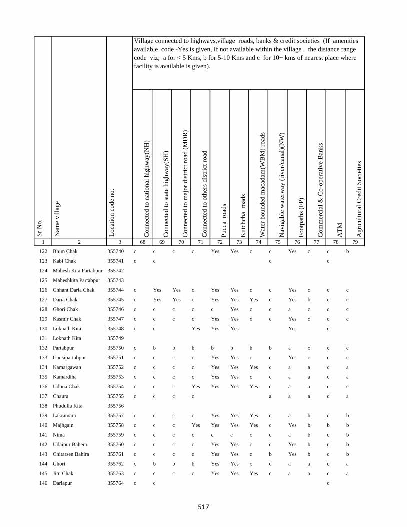
1 2 3
Lo
cati
on
co
de
no
.
Nam
e v
illa
ge
Sr.
No
.
122 Bhim Chak 355740
123 Kabi Chak 355741
124 Mahesh Kita Partabpur 355742
125 Maheshkita Partabpur 355743
126 Chhant Daria Chak 355744
127 Daria Chak 355745
128 Ghori Chak 355746
129 Kasmir Chak 355747
130 Loknath Kita 355748
131 Loknath Kita 355749
132 Partabpur 355750
133 Gausipartabpur 355751
134 Kamargawan 355752
135 Kamardiha 355753
136 Udhua Chak 355754
137 Chaura 355755
138 Phudulia Kita 355756
139 Lakramara 355757
140 Majhgain 355758
141 Nima 355759
142 Udaipur Bahera 355760
143 Chitarsen Bahira 355761
144 Ghori 355762
145 Jitu Chak 355763
146 Dariapur 355764
Co
nn
ecte
d t
o n
atio
nal
hig
hw
ay(N
H)
Co
nn
ecte
d t
o s
tate
hig
hw
ay(S
H)
Co
nn
ecte
d t
o m
ajo
r d
istr
ict
road
(M
DR
)
Co
nn
ecte
d t
o o
ther
s d
istr
ict
road
Pu
cca
ro
ads
Ku
tch
cha
ro
ads
Wat
er b
ou
nd
ed m
acad
am(W
BM
) ro
ads
Nav
igab
le w
ater
way
(ri
ver
/can
al)(
NW
)
Fo
otp
ath
s (F
P)
Co
mm
erci
al &
Co
-op
erat
ive
Ban
ks
AT
M
Ag
ricu
ltu
ral
Cre
dit
So
ciet
ies
68 69 70 71 72 73 74 75 76 77 78 79
Village connected to highways,village roads, banks & credit societies (If amenities
available code -Yes is given, If not available within the village , the distance range
code viz; a for < 5 Kms, b for 5-10 Kms and c for 10+ kms of nearest place where
facility is available is given).
c c c c Yes Yes c c Yes c c b
c c c c
c Yes Yes c Yes Yes c c Yes c c c
c Yes Yes c Yes Yes Yes c Yes b c c
c c c c c Yes c c a c c c
c c c c Yes Yes c c Yes c c c
c c Yes Yes Yes Yes c
c b b b b b b b a c c c
c c c c Yes Yes c c Yes c c c
c c c c Yes Yes Yes c a a c a
c c c c Yes Yes c c a a c a
c c c Yes Yes Yes Yes c a a c c
c c c c a a a c a
c c c c Yes Yes Yes c a b c b
c c c Yes Yes Yes Yes c Yes b b b
c c c c c c c c a b c b
c c c c Yes Yes c c Yes b c b
c c c c Yes Yes c b Yes b c b
c b b b Yes Yes c c a a c a
c c c c Yes Yes Yes c a a c a
c c c
517
1 2 3
Lo
cati
on
co
de
no
.
Nam
e v
illa
ge
Sr.
No
.
147 Mathi Chak 355765
148 Chhaman Kita 355766
149 Suphal Kita 355767
150 Kanchanpur 355768
151 Dhankuria 355769
152 Belbadda 355770
153 Kotibari 355771
154 Chhagraha 355772
155 Chhagraha 355773
156 Benia Kita 355774
157 Sahi Chak 355775
158 Chhagraha 355776
159 Kukra Milik 355777
160 Kurkra Milik 355778
161 Bheronagar 355779
162 Niamat Kita 355780
163 Ghasi Kita 355781
164 Ghasi Kita 355782
165 Inarman Kita 355783
166 Gausi Chak 355784
167 Mosana Chak 355785
168 Singarpur 355786
169 Birnagar Arazi Chhit 355787
170 Birnagar Arazi Bara 355788
171 Birnagar 355789
Co
nn
ecte
d t
o n
atio
nal
hig
hw
ay(N
H)
Co
nn
ecte
d t
o s
tate
hig
hw
ay(S
H)
Co
nn
ecte
d t
o m
ajo
r d
istr
ict
road
(M
DR
)
Co
nn
ecte
d t
o o
ther
s d
istr
ict
road
Pu
cca
ro
ads
Ku
tch
cha
ro
ads
Wat
er b
ou
nd
ed m
acad
am(W
BM
) ro
ads
Nav
igab
le w
ater
way
(ri
ver
/can
al)(
NW
)
Fo
otp
ath
s (F
P)
Co
mm
erci
al &
Co
-op
erat
ive
Ban
ks
AT
M
Ag
ricu
ltu
ral
Cre
dit
So
ciet
ies
68 69 70 71 72 73 74 75 76 77 78 79
Village connected to highways,village roads, banks & credit societies (If amenities
available code -Yes is given, If not available within the village , the distance range
code viz; a for < 5 Kms, b for 5-10 Kms and c for 10+ kms of nearest place where
facility is available is given).
c c c c Yes Yes Yes c Yes a c a
c c c c Yes Yes Yes c Yes a c a
c c c Yes Yes Yes Yes c a a c c
c c c c c Yes Yes c Yes Yes c Yes
c b b b b b b b a a c c
c c c c c c c c a a c c
c c c
c c c c Yes Yes c c Yes a c a
c c c c Yes Yes Yes c Yes a c a
c b b b Yes Yes c c Yes a c a
c b b b Yes Yes Yes c Yes a c a
c c c Yes Yes Yes c c Yes a c c
c c c
c c c
c Yes Yes Yes Yes Yes Yes c
c Yes Yes c Yes Yes Yes c Yes c c c
518
1 2 3
Lo
cati
on
co
de
no
.
Nam
e v
illa
ge
Sr.
No
.
172 Saharpur 355790
173 Lilatori 355791
174 Birahim Chak 355792
175 Dhodha 355793
176 Manikpur 355794
177 Dharampur 355795
178 Jarwar Kita 355796
179 Biram Kita 355797
180 Mukra Milik 355798
181 Bhirnabhaironagar 355799
182 Amarsing Kita 355800
183 Baski Kita 355801
184 Kurkraha Khas 355802
185 Nurdi Kita 355803
186 Raghunath Kita 355804
187 Madhupur 355805
188 Parbal Kita 355806
189 Jagan Kita 355807
190 Gajanda 355808
191 Amdiha 355809
192 Birnia 355810
193 Khaira Patkia 355811
194 Rajan 355812
195 Madhura 355813
196 Kalianpur 355814
Co
nn
ecte
d t
o n
atio
nal
hig
hw
ay(N
H)
Co
nn
ecte
d t
o s
tate
hig
hw
ay(S
H)
Co
nn
ecte
d t
o m
ajo
r d
istr
ict
road
(M
DR
)
Co
nn
ecte
d t
o o
ther
s d
istr
ict
road
Pu
cca
ro
ads
Ku
tch
cha
ro
ads
Wat
er b
ou
nd
ed m
acad
am(W
BM
) ro
ads
Nav
igab
le w
ater
way
(ri
ver
/can
al)(
NW
)
Fo
otp
ath
s (F
P)
Co
mm
erci
al &
Co
-op
erat
ive
Ban
ks
AT
M
Ag
ricu
ltu
ral
Cre
dit
So
ciet
ies
68 69 70 71 72 73 74 75 76 77 78 79
Village connected to highways,village roads, banks & credit societies (If amenities
available code -Yes is given, If not available within the village , the distance range
code viz; a for < 5 Kms, b for 5-10 Kms and c for 10+ kms of nearest place where
facility is available is given).
c Yes Yes c Yes Yes Yes c Yes c c c
c Yes Yes c Yes Yes Yes c Yes c c c
c c c Yes Yes Yes Yes c Yes a c c
c c Yes Yes Yes Yes Yes a Yes c c a
c c c c Yes Yes Yes c Yes a c c
c b Yes Yes Yes Yes Yes c Yes a c c
c c c c Yes Yes Yes c a a c a
c c c c Yes Yes Yes c Yes a c a
c c Yes a Yes Yes Yes c a a c b
c c c c c c Yes Yes a a c a
c c c c Yes Yes Yes c Yes a c a
c b
c c c c Yes Yes c c Yes a c a
c c c Yes Yes Yes Yes c Yes b c b
c c c c Yes Yes Yes c Yes b c b
c c c c Yes Yes Yes c Yes b c b
c c c c c Yes a a a c a
c c c Yes Yes Yes Yes c Yes c c c
c c c c c Yes c b a b c b
c c c c Yes Yes Yes c a a b a
519
1 2 3
Lo
cati
on
co
de
no
.
Nam
e v
illa
ge
Sr.
No
.
197 Sonaguji 355815
198 Dalahi 355816
199 Tetaria 355817
200 Baski Kita 355818
201 Beniadih 355819
202 Marpa 355820
203 Dumaria 355821
204 Kamal Chak 355822
205 Meghnath 355823
206 Kalidaha 355824
207 Leoabhujani 355825
208 Gobardhanpur 355826
209 Balia 355827
210 Pharkia 355828
211 Dhurbidih 355829
212 Lohachinta 355830
213 Madhupur 355831
Block T O T A L :
214 Dighi 355832
215 Paharpur 355833
216 Madhupur 355834
217 Siwanpur 355835
218 Kakar Ghat 355836
Co
nn
ecte
d t
o n
atio
nal
hig
hw
ay(N
H)
Co
nn
ecte
d t
o s
tate
hig
hw
ay(S
H)
Co
nn
ecte
d t
o m
ajo
r d
istr
ict
road
(M
DR
)
Co
nn
ecte
d t
o o
ther
s d
istr
ict
road
Pu
cca
ro
ads
Ku
tch
cha
ro
ads
Wat
er b
ou
nd
ed m
acad
am(W
BM
) ro
ads
Nav
igab
le w
ater
way
(ri
ver
/can
al)(
NW
)
Fo
otp
ath
s (F
P)
Co
mm
erci
al &
Co
-op
erat
ive
Ban
ks
AT
M
Ag
ricu
ltu
ral
Cre
dit
So
ciet
ies
68 69 70 71 72 73 74 75 76 77 78 79
Village connected to highways,village roads, banks & credit societies (If amenities
available code -Yes is given, If not available within the village , the distance range
code viz; a for < 5 Kms, b for 5-10 Kms and c for 10+ kms of nearest place where
facility is available is given).
c b b b Yes Yes Yes c Yes a c a
c c c c Yes Yes Yes c Yes a c a
c c c
c c c Yes Yes Yes Yes c Yes c c c
c c c Yes Yes Yes Yes c Yes c c c
c Yes c Yes Yes Yes Yes c Yes c c c
c
c c Yes Yes Yes Yes Yes c Yes c c c
c c c Yes Yes Yes Yes b Yes b c c
c c c Yes a a a a c c c
c b b Yes Yes Yes Yes Yes Yes b c c
c b b b Yes Yes Yes c a b c c
1 15 24 46 100 106 70 5 79 7 5 7
c c c c Yes Yes Yes c a b c b
c c c
c c c c Yes Yes c c Yes b c c
c c c c Yes Yes c c Yes b c c
520
1 2 3
Lo
cati
on
co
de
no
.
Nam
e v
illa
ge
Sr.
No
.
219 Talbaria 355837
220 Mohamad Khutahari 355838
221 Mal Jhakhra 355839
222 Baghjhakhra 355840
223 Sinha Chak 355841
224 Babutaluk 355842
225 Paharpur 355843
226 Deban Chak 355844
227 Gargulal 355845
228 Madan Chauki 355846
229 Birahim Kita 355847
230 Banskola 355848
231 Kurpatti 355849
232 Baijani 355850
233 Chapri 355851
234 Kamat Chapri 355852
235 Khar Kudia 355853
236 Majhana (Arazi) 355854
237 Hasu Chak 355855
238 Domansaran Kita 355856
239 Silong 355857
240 Paharpur 355858
241 Akilkita 355859
242 Bikram Kita 355860
243 Paharpur 355861
Co
nn
ecte
d t
o n
atio
nal
hig
hw
ay(N
H)
Co
nn
ecte
d t
o s
tate
hig
hw
ay(S
H)
Co
nn
ecte
d t
o m
ajo
r d
istr
ict
road
(M
DR
)
Co
nn
ecte
d t
o o
ther
s d
istr
ict
road
Pu
cca
ro
ads
Ku
tch
cha
ro
ads
Wat
er b
ou
nd
ed m
acad
am(W
BM
) ro
ads
Nav
igab
le w
ater
way
(ri
ver
/can
al)(
NW
)
Fo
otp
ath
s (F
P)
Co
mm
erci
al &
Co
-op
erat
ive
Ban
ks
AT
M
Ag
ricu
ltu
ral
Cre
dit
So
ciet
ies
68 69 70 71 72 73 74 75 76 77 78 79
Village connected to highways,village roads, banks & credit societies (If amenities
available code -Yes is given, If not available within the village , the distance range
code viz; a for < 5 Kms, b for 5-10 Kms and c for 10+ kms of nearest place where
facility is available is given).
c c c c Yes Yes c c Yes b c c
c c c c Yes Yes Yes c Yes c b c
c c c c Yes Yes Yes c Yes c c c
c Yes Yes Yes Yes Yes c c Yes c c c
c c c
c c c c Yes Yes c c Yes b b b
c Yes Yes Yes Yes Yes Yes c Yes b c c
c Yes Yes Yes Yes Yes c c Yes a c c
c c Yes Yes Yes Yes c c Yes a c c
c c c c Yes c c c Yes c c c
c c c c Yes Yes c c Yes c c c
c c Yes Yes Yes Yes Yes c Yes c c c
c b b b Yes Yes c c Yes b c c
c c c c Yes Yes Yes c Yes b c c
c c c b
c c c c
c b b b Yes Yes Yes c Yes b c c
c b c b
c c c c Yes Yes Yes c Yes b b c
521

1 2 3
Lo
cati
on
co
de
no
.
Nam
e v
illa
ge
Sr.
No
.
244 Chandpur 355862
245 Khani Chak 355863
246 Nagarchi Chak 355864
247 Taj Kita 355865
248 Panchu Kita 355866
249 Mohan Kita 355867
250 Khania Kita 355868
251 Badura Kita 355869
252 Bhatu Kita 355870
253 Dalubarmohtar 355871
254 Madhuadih Khas 355872
255 Madhuadih Arjun Kita 355873
256 Jadu Kita 355874
257 Kali Kita 355875
258 Haripur 355876
259 Nawadih Parthumanjhi 355877
260 Sonapur 355878
261 Maku Chak 355879
262 Chand Chak 355880
263 Dumaria 355881
264 Taib Kita 355882
265 Bhekhari Kita 355883
266 Mitan Kita 355884
267 Kadil Kita 355885
268 Pitambar Kita 355886
Co
nn
ecte
d t
o n
atio
nal
hig
hw
ay(N
H)
Co
nn
ecte
d t
o s
tate
hig
hw
ay(S
H)
Co
nn
ecte
d t
o m
ajo
r d
istr
ict
road
(M
DR
)
Co
nn
ecte
d t
o o
ther
s d
istr
ict
road
Pu
cca
ro
ads
Ku
tch
cha
ro
ads
Wat
er b
ou
nd
ed m
acad
am(W
BM
) ro
ads
Nav
igab
le w
ater
way
(ri
ver
/can
al)(
NW
)
Fo
otp
ath
s (F
P)
Co
mm
erci
al &
Co
-op
erat
ive
Ban
ks
AT
M
Ag
ricu
ltu
ral
Cre
dit
So
ciet
ies
68 69 70 71 72 73 74 75 76 77 78 79
Village connected to highways,village roads, banks & credit societies (If amenities
available code -Yes is given, If not available within the village , the distance range
code viz; a for < 5 Kms, b for 5-10 Kms and c for 10+ kms of nearest place where
facility is available is given).
c c c c Yes Yes Yes c Yes b c a
c c c c c
c c c Yes Yes Yes c c Yes a c c
c c c c c
c c c Yes Yes Yes c c Yes b c c
c c c Yes Yes Yes c c Yes a c c
c b c c b
c c c Yes Yes Yes Yes Yes Yes b c c
c c c Yes Yes Yes c c Yes b b c
c c c c Yes Yes Yes c Yes b b c
c b b b Yes Yes c c Yes b c c
c c b a Yes Yes Yes c b c c
c c Yes Yes Yes Yes c c Yes b c c
c c c c c
c b b b Yes Yes Yes c Yes c c c
c b c c c
522

1 2 3
Lo
cati
on
co
de
no
.
Nam
e v
illa
ge
Sr.
No
.
269 Baiju Kita 355887
270 Budhasan 355888
271 Janghira 355889
272 Mohan Pipra 355890
273 Dahua Pakaria 355891
274 Sanhuli 355892
275 Tetarbhuj 355893
276 Panch Pahar 355894
277 Rampur 355895
278 Bhagwakol 355896
279 Dhankol 355897
280 Mopahari 355898
281 Khandhar 355899
282 Bodhrai Khutahari 355900
283 Hira Khutahari 355901
284 Kari Khutahari 355902
285 Bishunpur 355903
286 Bhagaia 355904
287 Manikapur 355905
288 Ramdas Khutahari 355906
289 Jiban Khutahari 355907
290 Baiju Khutahari 355908
291 Salim Khutahari 355909
292 Jhilli 355910
293 Gajhanda 355911
Co
nn
ecte
d t
o n
atio
nal
hig
hw
ay(N
H)
Co
nn
ecte
d t
o s
tate
hig
hw
ay(S
H)
Co
nn
ecte
d t
o m
ajo
r d
istr
ict
road
(M
DR
)
Co
nn
ecte
d t
o o
ther
s d
istr
ict
road
Pu
cca
ro
ads
Ku
tch
cha
ro
ads
Wat
er b
ou
nd
ed m
acad
am(W
BM
) ro
ads
Nav
igab
le w
ater
way
(ri
ver
/can
al)(
NW
)
Fo
otp
ath
s (F
P)
Co
mm
erci
al &
Co
-op
erat
ive
Ban
ks
AT
M
Ag
ricu
ltu
ral
Cre
dit
So
ciet
ies
68 69 70 71 72 73 74 75 76 77 78 79
Village connected to highways,village roads, banks & credit societies (If amenities
available code -Yes is given, If not available within the village , the distance range
code viz; a for < 5 Kms, b for 5-10 Kms and c for 10+ kms of nearest place where
facility is available is given).
c c Yes Yes Yes Yes Yes c Yes b c c
c c c c Yes Yes c c Yes c c c
c c c c c
c c c Yes Yes Yes Yes c Yes b c c
c c c c
c b b b Yes Yes c c Yes c c c
c c c c Yes Yes c c Yes a b c
c c c Yes Yes Yes c c Yes c c c
c Yes Yes Yes Yes Yes Yes c Yes Yes c c
c Yes Yes Yes Yes Yes Yes c Yes Yes c c
c Yes Yes Yes Yes Yes Yes c Yes Yes c c
c Yes Yes Yes Yes Yes Yes c Yes a c c
c b Yes Yes Yes c Yes c Yes c c c
c c c Yes Yes Yes c c Yes c c c
c c c c
c c c c c
c b a a a a c c c
c c Yes Yes Yes Yes c c a c b c
523

1 2 3
Lo
cati
on
co
de
no
.
Nam
e v
illa
ge
Sr.
No
.
294 Karmail 355912
295 Kajrail 355913
296 Bahoriabagaicha 355914
297 Dharampur 355915
298 Lalsing Khutahari 355916
299 Dhaknesar 355917
300 Tetaria Mal 355918
301 Baraia Chak 355919
302 Chhota Manian 355920
303 Bara Manian(Kalan) 355921
304 Rangai Chak 355922
305 Kokan Kita 355923
306 Dhaniabandh 355924
307 Saharabari 355925
308 Bandar Kita 355926
309 Patha Chak 355927
310 Pitambar Kita 355928
311 Bhalwa Chak 355929
312 Bardia Chak 355930
313 Bamania 355931
314 Kolbadda 355932
315 Sonholi 355933
316 Hijri 355934
317 Sonholi 355935
318 Chanda And Chando 355936
Co
nn
ecte
d t
o n
atio
nal
hig
hw
ay(N
H)
Co
nn
ecte
d t
o s
tate
hig
hw
ay(S
H)
Co
nn
ecte
d t
o m
ajo
r d
istr
ict
road
(M
DR
)
Co
nn
ecte
d t
o o
ther
s d
istr
ict
road
Pu
cca
ro
ads
Ku
tch
cha
ro
ads
Wat
er b
ou
nd
ed m
acad
am(W
BM
) ro
ads
Nav
igab
le w
ater
way
(ri
ver
/can
al)(
NW
)
Fo
otp
ath
s (F
P)
Co
mm
erci
al &
Co
-op
erat
ive
Ban
ks
AT
M
Ag
ricu
ltu
ral
Cre
dit
So
ciet
ies
68 69 70 71 72 73 74 75 76 77 78 79
Village connected to highways,village roads, banks & credit societies (If amenities
available code -Yes is given, If not available within the village , the distance range
code viz; a for < 5 Kms, b for 5-10 Kms and c for 10+ kms of nearest place where
facility is available is given).
c c Yes Yes Yes Yes c c a c c c
c c c Yes Yes Yes c c Yes c c c
c Yes Yes Yes Yes Yes c c Yes b c c
c c c c Yes Yes c c Yes b c c
c Yes Yes Yes Yes Yes c c Yes b c c
c Yes Yes Yes Yes Yes Yes c Yes b c c
c c Yes Yes Yes Yes c c Yes b c c
c c Yes Yes Yes Yes c c Yes b b b
c c Yes Yes Yes Yes c c Yes a c b
c c c c Yes Yes c c Yes a c a
c b c c c
c c c c c
c c c c b
c c Yes Yes Yes Yes c c Yes a c b
c c c c
c c
c c c Yes Yes Yes c c Yes a c c
524
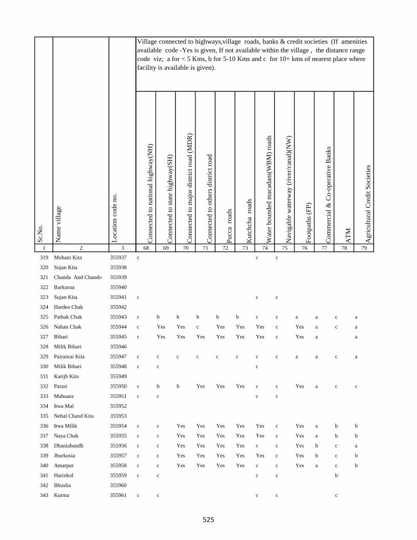
1 2 3
Lo
cati
on
co
de
no
.
Nam
e v
illa
ge
Sr.
No
.
319 Mohani Kita 355937
320 Sujan Kita 355938
321 Chanda And Chando 355939
322 Barkurua 355940
323 Sujan Kita 355941
324 Hardeo Chak 355942
325 Pathak Chak 355943
326 Nahan Chak 355944
327 Bihari 355945
328 Milik Bihari 355946
329 Pairanrai Kita 355947
330 Milik Bihari 355948
331 Karijh Kita 355949
332 Parasi 355950
333 Mahuara 355951
334 Itwa Mal 355952
335 Nehal Chand Kita 355953
336 Itwa Milik 355954
337 Naya Chak 355955
338 Dhaniabandh 355956
339 Jhurkusia 355957
340 Amarpur 355958
341 Harinkol 355959
342 Bhuslia 355960
343 Kurma 355961
Co
nn
ecte
d t
o n
atio
nal
hig
hw
ay(N
H)
Co
nn
ecte
d t
o s
tate
hig
hw
ay(S
H)
Co
nn
ecte
d t
o m
ajo
r d
istr
ict
road
(M
DR
)
Co
nn
ecte
d t
o o
ther
s d
istr
ict
road
Pu
cca
ro
ads
Ku
tch
cha
ro
ads
Wat
er b
ou
nd
ed m
acad
am(W
BM
) ro
ads
Nav
igab
le w
ater
way
(ri
ver
/can
al)(
NW
)
Fo
otp
ath
s (F
P)
Co
mm
erci
al &
Co
-op
erat
ive
Ban
ks
AT
M
Ag
ricu
ltu
ral
Cre
dit
So
ciet
ies
68 69 70 71 72 73 74 75 76 77 78 79
Village connected to highways,village roads, banks & credit societies (If amenities
available code -Yes is given, If not available within the village , the distance range
code viz; a for < 5 Kms, b for 5-10 Kms and c for 10+ kms of nearest place where
facility is available is given).
c c c
c c c
c b b b b b c c a a c a
c Yes Yes c Yes Yes Yes c Yes a c a
c Yes Yes Yes Yes Yes Yes c Yes a a
c c c c c c c c a a c a
c c c
c b b Yes Yes Yes c c Yes a c c
c c c c
c c Yes Yes Yes Yes Yes c Yes a b b
c c Yes Yes Yes Yes Yes c Yes a b b
c c Yes Yes Yes Yes c c Yes b c a
c c Yes Yes Yes Yes Yes c Yes b c b
c c Yes Yes Yes Yes c c Yes a c b
c c c c b
c c c c c
525
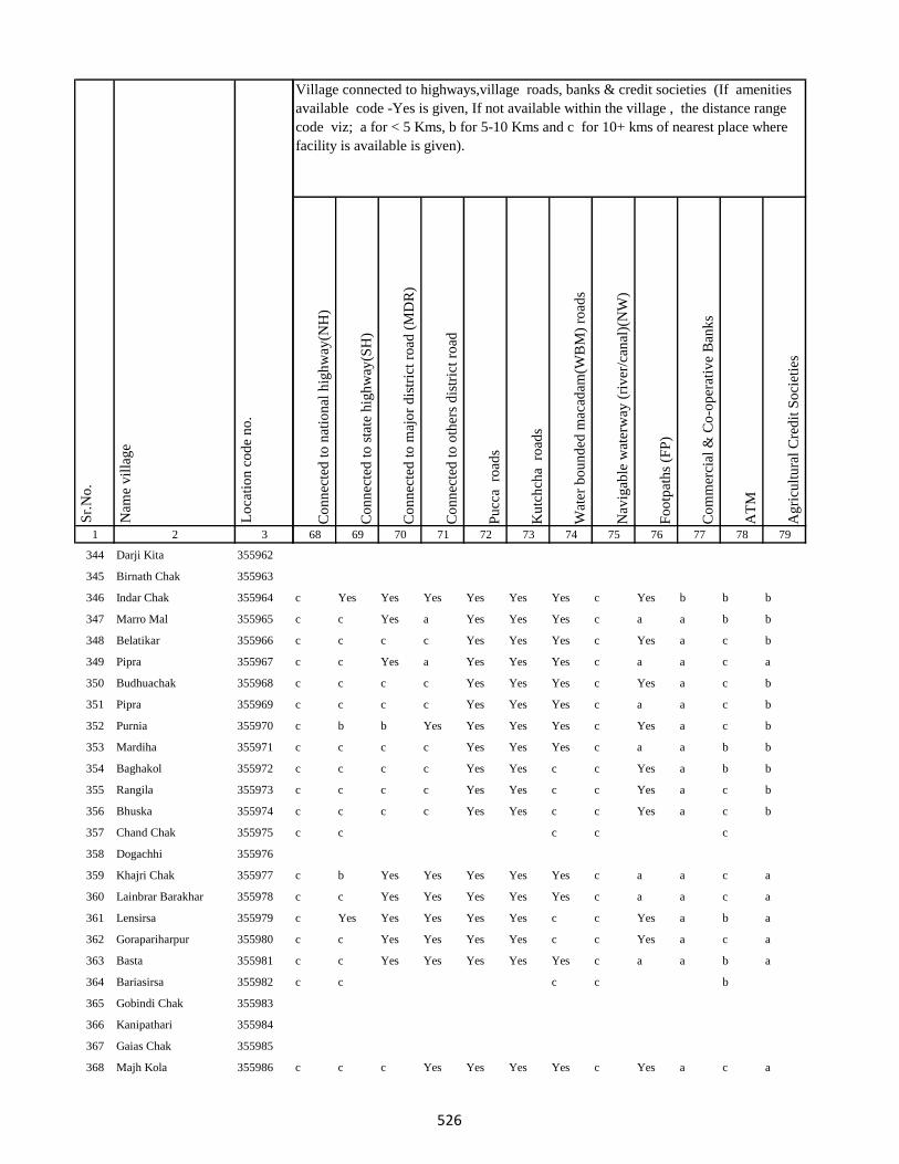
1 2 3
Lo
cati
on
co
de
no
.
Nam
e v
illa
ge
Sr.
No
.
344 Darji Kita 355962
345 Birnath Chak 355963
346 Indar Chak 355964
347 Marro Mal 355965
348 Belatikar 355966
349 Pipra 355967
350 Budhuachak 355968
351 Pipra 355969
352 Purnia 355970
353 Mardiha 355971
354 Baghakol 355972
355 Rangila 355973
356 Bhuska 355974
357 Chand Chak 355975
358 Dogachhi 355976
359 Khajri Chak 355977
360 Lainbrar Barakhar 355978
361 Lensirsa 355979
362 Gorapariharpur 355980
363 Basta 355981
364 Bariasirsa 355982
365 Gobindi Chak 355983
366 Kanipathari 355984
367 Gaias Chak 355985
368 Majh Kola 355986
Co
nn
ecte
d t
o n
atio
nal
hig
hw
ay(N
H)
Co
nn
ecte
d t
o s
tate
hig
hw
ay(S
H)
Co
nn
ecte
d t
o m
ajo
r d
istr
ict
road
(M
DR
)
Co
nn
ecte
d t
o o
ther
s d
istr
ict
road
Pu
cca
ro
ads
Ku
tch
cha
ro
ads
Wat
er b
ou
nd
ed m
acad
am(W
BM
) ro
ads
Nav
igab
le w
ater
way
(ri
ver
/can
al)(
NW
)
Fo
otp
ath
s (F
P)
Co
mm
erci
al &
Co
-op
erat
ive
Ban
ks
AT
M
Ag
ricu
ltu
ral
Cre
dit
So
ciet
ies
68 69 70 71 72 73 74 75 76 77 78 79
Village connected to highways,village roads, banks & credit societies (If amenities
available code -Yes is given, If not available within the village , the distance range
code viz; a for < 5 Kms, b for 5-10 Kms and c for 10+ kms of nearest place where
facility is available is given).
c Yes Yes Yes Yes Yes Yes c Yes b b b
c c Yes a Yes Yes Yes c a a b b
c c c c Yes Yes Yes c Yes a c b
c c Yes a Yes Yes Yes c a a c a
c c c c Yes Yes Yes c Yes a c b
c c c c Yes Yes Yes c a a c b
c b b Yes Yes Yes Yes c Yes a c b
c c c c Yes Yes Yes c a a b b
c c c c Yes Yes c c Yes a b b
c c c c Yes Yes c c Yes a c b
c c c c Yes Yes c c Yes a c b
c c c c c
c b Yes Yes Yes Yes Yes c a a c a
c c Yes Yes Yes Yes Yes c a a c a
c Yes Yes Yes Yes Yes c c Yes a b a
c c Yes Yes Yes Yes c c Yes a c a
c c Yes Yes Yes Yes Yes c a a b a
c c c c b
c c c Yes Yes Yes Yes c Yes a c a
526

1 2 3
Lo
cati
on
co
de
no
.
Nam
e v
illa
ge
Sr.
No
.
369 Misirgangti 355987
370 Laghra Chak 355988
371 Mirik Chak 355989
372 Chamuakol 355990
373 Raghuni Kita 355991
374 Bhatkhoria 355992
375 Gauri Chak 355993
376 Sirikanta Chak 355994
377 Durga Chak 355995
378 Jogi Chak 355996
379 Bhiganda 355997
380 Kadma 355998
381 Asakhapar 355999
382 Mukeri Chak 356000
383 Dalang 356001
384 Raidih 356002
385 Nawadih 356003
386 Ratia Chak 356004
387 Pachradih 356005
388 Baniadih 356006
389 Dhawa 356007
390 Gopalpur Mohar Tola 356008
391 Gopalpur Karan Tola 356009
392 Runji 356010
393 Jadu Chak 356011
Co
nn
ecte
d t
o n
atio
nal
hig
hw
ay(N
H)
Co
nn
ecte
d t
o s
tate
hig
hw
ay(S
H)
Co
nn
ecte
d t
o m
ajo
r d
istr
ict
road
(M
DR
)
Co
nn
ecte
d t
o o
ther
s d
istr
ict
road
Pu
cca
ro
ads
Ku
tch
cha
ro
ads
Wat
er b
ou
nd
ed m
acad
am(W
BM
) ro
ads
Nav
igab
le w
ater
way
(ri
ver
/can
al)(
NW
)
Fo
otp
ath
s (F
P)
Co
mm
erci
al &
Co
-op
erat
ive
Ban
ks
AT
M
Ag
ricu
ltu
ral
Cre
dit
So
ciet
ies
68 69 70 71 72 73 74 75 76 77 78 79
Village connected to highways,village roads, banks & credit societies (If amenities
available code -Yes is given, If not available within the village , the distance range
code viz; a for < 5 Kms, b for 5-10 Kms and c for 10+ kms of nearest place where
facility is available is given).
c c c c b
c b Yes Yes Yes Yes c c Yes a c a
c c c c
c c c c b
c c Yes Yes Yes Yes Yes c Yes a c a
c c Yes Yes Yes Yes c c Yes a b a
c c Yes Yes Yes Yes c c Yes a b a
c b b b Yes Yes c c Yes b c b
c c c c Yes Yes Yes c Yes b c b
c c c Yes Yes Yes Yes c Yes b c b
c c c Yes Yes Yes c c Yes a c a
c c c Yes Yes Yes Yes c Yes b c b
c c c Yes Yes Yes c c Yes a c a
c b Yes Yes Yes c c c a a c a
c b b b Yes Yes c c a c c c
c c c Yes Yes Yes c c Yes a c a
c c c Yes Yes Yes c c Yes a c a
c c c Yes Yes Yes c c Yes a c a
c c c c Yes Yes c c Yes a c a
c c c c Yes Yes Yes c Yes Yes c a
527
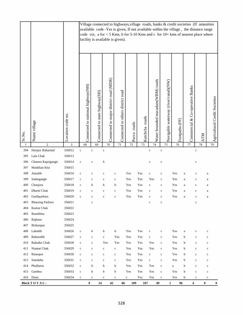
1 2 3
Lo
cati
on
co
de
no
.
Nam
e v
illa
ge
Sr.
No
.
394 Haripur Baharmal 356012
395 Lalu Chak 356013
396 Chamru Kaprigangti 356014
397 Mankhan Kita 356015
398 Antadih 356016
399 Sadargangti 356017
400 Chaujora 356018
401 Dharni Chak 356019
402 Garibparbara 356020
403 Bharsing Parbara 356021
404 Kumar Chak 356022
405 Bansbhita 356023
406 Rajhans 356024
407 Bishunpur 356025
408 Lahadih 356026
409 Baheradih 356027
410 Bahadur Chak 356028
411 Niamat Chak 356029
412 Ratanpur 356030
413 Samdaha 356031
414 Phulbaria 356032
415 Gamhra 356033
416 Diara 356034
Block T O T A L :
Co
nn
ecte
d t
o n
atio
nal
hig
hw
ay(N
H)
Co
nn
ecte
d t
o s
tate
hig
hw
ay(S
H)
Co
nn
ecte
d t
o m
ajo
r d
istr
ict
road
(M
DR
)
Co
nn
ecte
d t
o o
ther
s d
istr
ict
road
Pu
cca
ro
ads
Ku
tch
cha
ro
ads
Wat
er b
ou
nd
ed m
acad
am(W
BM
) ro
ads
Nav
igab
le w
ater
way
(ri
ver
/can
al)(
NW
)
Fo
otp
ath
s (F
P)
Co
mm
erci
al &
Co
-op
erat
ive
Ban
ks
AT
M
Ag
ricu
ltu
ral
Cre
dit
So
ciet
ies
68 69 70 71 72 73 74 75 76 77 78 79
Village connected to highways,village roads, banks & credit societies (If amenities
available code -Yes is given, If not available within the village , the distance range
code viz; a for < 5 Kms, b for 5-10 Kms and c for 10+ kms of nearest place where
facility is available is given).
c c c c c c
c c b c c c
c c c c Yes Yes c c Yes a c a
c c c c Yes Yes Yes c Yes a c a
c b b b Yes Yes c c Yes a c a
c c c c Yes Yes c c Yes a c a
c c c c Yes Yes c c Yes a c a
c c c c
c b b b Yes Yes c c Yes a c c
c c c Yes Yes Yes c c Yes b c c
c c Yes Yes Yes Yes Yes c Yes b c c
c c c c Yes Yes Yes c Yes b c c
c c c c Yes Yes c c Yes b c c
c c c c Yes Yes c c Yes b c c
c b b b Yes Yes Yes c a b c c
c b b b Yes Yes Yes c Yes b c c
c c c c c Yes Yes c Yes b c c
0 14 42 60 109 107 49 1 96 4 0 0
528
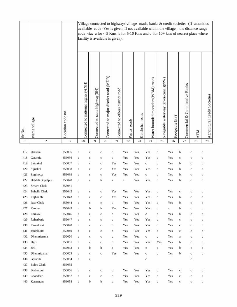
1 2 3
Lo
cati
on
co
de
no
.
Nam
e v
illa
ge
Sr.
No
.
417 Urkusia 356035
418 Garantia 356036
419 Lakrakol 356037
420 Sijuakol 356038
421 Bagjhopa 356039
422 Daldali Gopalpur 356040
423 Seharo Chak 356041
424 Bahelia Chak 356042
425 Rajbandh 356043
426 Issar Chak 356044
427 Kendua 356045
428 Ramkol 356046
429 Raharbaria 356047
430 Kamaldori 356048
431 Janlokundi 356049
432 Dhamnisemia 356050
433 Hijri 356051
434 Jirli 356052
435 Dhamnipahar 356053
436 Goradih 356054
437 Behra Chak 356055
438 Bishunpur 356056
439 Chandsar 356057
440 Karmatanr 356058
Co
nn
ecte
d t
o n
atio
nal
hig
hw
ay(N
H)
Co
nn
ecte
d t
o s
tate
hig
hw
ay(S
H)
Co
nn
ecte
d t
o m
ajo
r d
istr
ict
road
(M
DR
)
Co
nn
ecte
d t
o o
ther
s d
istr
ict
road
Pu
cca
ro
ads
Ku
tch
cha
ro
ads
Wat
er b
ou
nd
ed m
acad
am(W
BM
) ro
ads
Nav
igab
le w
ater
way
(ri
ver
/can
al)(
NW
)
Fo
otp
ath
s (F
P)
Co
mm
erci
al &
Co
-op
erat
ive
Ban
ks
AT
M
Ag
ricu
ltu
ral
Cre
dit
So
ciet
ies
68 69 70 71 72 73 74 75 76 77 78 79
Village connected to highways,village roads, banks & credit societies (If amenities
available code -Yes is given, If not available within the village , the distance range
code viz; a for < 5 Kms, b for 5-10 Kms and c for 10+ kms of nearest place where
facility is available is given).
c c c c Yes Yes Yes c Yes b c c
c c c c Yes Yes Yes c Yes c c c
c c c Yes Yes Yes c c Yes b c b
c c c Yes Yes Yes Yes c Yes b c b
c c c Yes Yes Yes c c Yes b c b
c c b a a Yes Yes c Yes b c b
c c c Yes Yes Yes Yes c Yes c c c
c c c Yes Yes Yes Yes c Yes b c b
c c c c Yes Yes Yes c Yes b c b
c b b Yes Yes Yes Yes c a b c c
c c c c Yes Yes c c Yes b c b
c c c c Yes Yes Yes c Yes c c b
c c c c Yes Yes Yes c Yes c c c
c c c c Yes Yes Yes c Yes c c b
c c c c Yes Yes c c Yes a c b
c c c c Yes Yes Yes Yes Yes b c b
c b b b Yes Yes c c Yes b c b
c c c Yes Yes Yes c c Yes b c b
c c c c
c c c c Yes Yes Yes c Yes c c b
c c c c Yes Yes Yes c Yes c c a
c b b b Yes Yes Yes c Yes c c b
529
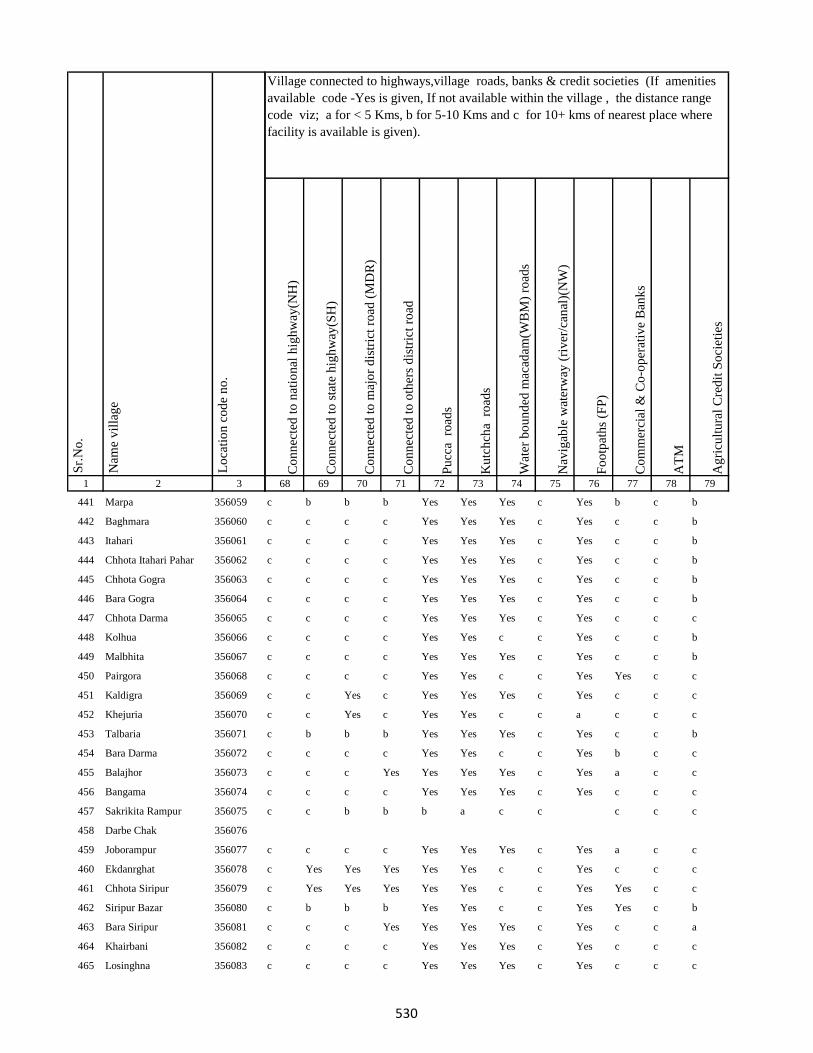
1 2 3
Lo
cati
on
co
de
no
.
Nam
e v
illa
ge
Sr.
No
.
441 Marpa 356059
442 Baghmara 356060
443 Itahari 356061
444 Chhota Itahari Pahar 356062
445 Chhota Gogra 356063
446 Bara Gogra 356064
447 Chhota Darma 356065
448 Kolhua 356066
449 Malbhita 356067
450 Pairgora 356068
451 Kaldigra 356069
452 Khejuria 356070
453 Talbaria 356071
454 Bara Darma 356072
455 Balajhor 356073
456 Bangama 356074
457 Sakrikita Rampur 356075
458 Darbe Chak 356076
459 Joborampur 356077
460 Ekdanrghat 356078
461 Chhota Siripur 356079
462 Siripur Bazar 356080
463 Bara Siripur 356081
464 Khairbani 356082
465 Losinghna 356083
Co
nn
ecte
d t
o n
atio
nal
hig
hw
ay(N
H)
Co
nn
ecte
d t
o s
tate
hig
hw
ay(S
H)
Co
nn
ecte
d t
o m
ajo
r d
istr
ict
road
(M
DR
)
Co
nn
ecte
d t
o o
ther
s d
istr
ict
road
Pu
cca
ro
ads
Ku
tch
cha
ro
ads
Wat
er b
ou
nd
ed m
acad
am(W
BM
) ro
ads
Nav
igab
le w
ater
way
(ri
ver
/can
al)(
NW
)
Fo
otp
ath
s (F
P)
Co
mm
erci
al &
Co
-op
erat
ive
Ban
ks
AT
M
Ag
ricu
ltu
ral
Cre
dit
So
ciet
ies
68 69 70 71 72 73 74 75 76 77 78 79
Village connected to highways,village roads, banks & credit societies (If amenities
available code -Yes is given, If not available within the village , the distance range
code viz; a for < 5 Kms, b for 5-10 Kms and c for 10+ kms of nearest place where
facility is available is given).
c b b b Yes Yes Yes c Yes b c b
c c c c Yes Yes Yes c Yes c c b
c c c c Yes Yes Yes c Yes c c b
c c c c Yes Yes Yes c Yes c c b
c c c c Yes Yes Yes c Yes c c b
c c c c Yes Yes Yes c Yes c c b
c c c c Yes Yes Yes c Yes c c c
c c c c Yes Yes c c Yes c c b
c c c c Yes Yes Yes c Yes c c b
c c c c Yes Yes c c Yes Yes c c
c c Yes c Yes Yes Yes c Yes c c c
c c Yes c Yes Yes c c a c c c
c b b b Yes Yes Yes c Yes c c b
c c c c Yes Yes c c Yes b c c
c c c Yes Yes Yes Yes c Yes a c c
c c c c Yes Yes Yes c Yes c c c
c c b b b a c c c c c
c c c c Yes Yes Yes c Yes a c c
c Yes Yes Yes Yes Yes c c Yes c c c
c Yes Yes Yes Yes Yes c c Yes Yes c c
c b b b Yes Yes c c Yes Yes c b
c c c Yes Yes Yes Yes c Yes c c a
c c c c Yes Yes Yes c Yes c c c
c c c c Yes Yes Yes c Yes c c c
530

1 2 3
Lo
cati
on
co
de
no
.
Nam
e v
illa
ge
Sr.
No
.
466 Bara Saraiya 356084
467 Chhota Saraiya 356085
468 Manikpur 356086
469 Kandaniya 356087
470 Beldiha 356088
471 Kortia 356089
472 Asanbuna 356090
473 Marcha 356091
474 Dumbari 356092
475 Churi 356093
476 Talbaria 356094
477 Bansbhita 356095
478 Jamunajharna 356096
479 Bara Boarijor 356097
480 Dhorri 356098
481 Dubra 356099
482 Mahula 356100
483 Meghi 356101
484 Mangra 356102
485 Chhota Boarijor 356103
486 Mahuakol 356104
487 Lakrakol 356105
488 Babuchuri 356106
489 Parsiya 356107
490 Bador 356108
Co
nn
ecte
d t
o n
atio
nal
hig
hw
ay(N
H)
Co
nn
ecte
d t
o s
tate
hig
hw
ay(S
H)
Co
nn
ecte
d t
o m
ajo
r d
istr
ict
road
(M
DR
)
Co
nn
ecte
d t
o o
ther
s d
istr
ict
road
Pu
cca
ro
ads
Ku
tch
cha
ro
ads
Wat
er b
ou
nd
ed m
acad
am(W
BM
) ro
ads
Nav
igab
le w
ater
way
(ri
ver
/can
al)(
NW
)
Fo
otp
ath
s (F
P)
Co
mm
erci
al &
Co
-op
erat
ive
Ban
ks
AT
M
Ag
ricu
ltu
ral
Cre
dit
So
ciet
ies
68 69 70 71 72 73 74 75 76 77 78 79
Village connected to highways,village roads, banks & credit societies (If amenities
available code -Yes is given, If not available within the village , the distance range
code viz; a for < 5 Kms, b for 5-10 Kms and c for 10+ kms of nearest place where
facility is available is given).
c c c c Yes Yes Yes c Yes c c c
c c c c Yes Yes Yes c Yes c c c
c b b b Yes Yes Yes c Yes c c c
c b b b Yes Yes c c Yes c c c
c c c Yes Yes Yes c c Yes c c c
c c c Yes Yes Yes Yes c Yes b c c
c c c c Yes Yes c c Yes a c c
c c c c
c c c c Yes Yes c c Yes a c a
c c Yes Yes Yes Yes Yes c Yes a c a
c c c c Yes Yes Yes c Yes c c c
c c Yes Yes Yes Yes Yes c Yes Yes c c
c c Yes Yes Yes c Yes c Yes c c c
c c c c Yes Yes Yes c Yes c c c
c Yes c Yes Yes Yes Yes c Yes a c c
c c Yes Yes Yes Yes a Yes Yes a c a
c c Yes Yes Yes Yes Yes c Yes a c a
c Yes Yes Yes Yes Yes b c Yes c c a
c c c c Yes Yes c c Yes b c b
c c c c Yes Yes c c Yes c c a
c c c c Yes Yes Yes c Yes c c a
c b b b Yes Yes Yes c Yes c c a
c c c c Yes Yes c c Yes c c c
c c c c Yes Yes c c Yes c c c
531

1 2 3
Lo
cati
on
co
de
no
.
Nam
e v
illa
ge
Sr.
No
.
491 Muchuradaldali 356109
492 Daharlangi 356110
493 Pokhariya 356111
494 Barakera 356112
495 Chhotakera 356113
496 Karamtola 356114
497 Meredele 356115
498 Baragbhita 356116
499 Kutni 356117
500 Khatangi 356118
501 Puriabadar 356119
502 Bartali 356120
503 Anamu 356121
504 Babu Churi 356122
505 Badonre 356123
506 Barakbita 356124
507 Bargi 356125
508 Bartari 356126
509 Belmatok 356127
510 Churi Bedo 356128
511 Dangoda 356129
512 Dobri 356130
513 Dumberi Bedo 356131
514 Dumberi Joka 356132
515 Gadgandi 356133
Co
nn
ecte
d t
o n
atio
nal
hig
hw
ay(N
H)
Co
nn
ecte
d t
o s
tate
hig
hw
ay(S
H)
Co
nn
ecte
d t
o m
ajo
r d
istr
ict
road
(M
DR
)
Co
nn
ecte
d t
o o
ther
s d
istr
ict
road
Pu
cca
ro
ads
Ku
tch
cha
ro
ads
Wat
er b
ou
nd
ed m
acad
am(W
BM
) ro
ads
Nav
igab
le w
ater
way
(ri
ver
/can
al)(
NW
)
Fo
otp
ath
s (F
P)
Co
mm
erci
al &
Co
-op
erat
ive
Ban
ks
AT
M
Ag
ricu
ltu
ral
Cre
dit
So
ciet
ies
68 69 70 71 72 73 74 75 76 77 78 79
Village connected to highways,village roads, banks & credit societies (If amenities
available code -Yes is given, If not available within the village , the distance range
code viz; a for < 5 Kms, b for 5-10 Kms and c for 10+ kms of nearest place where
facility is available is given).
c c c c Yes Yes Yes c Yes b c b
c b b b Yes Yes c c Yes c c b
c c c c Yes Yes c c Yes c c b
c c c c Yes Yes c c Yes c c b
c c c c Yes Yes c c Yes c c b
c c c c Yes Yes c c Yes c c c
c c c c Yes Yes c c Yes c c c
c b b b b Yes c c a c c c
c b c
c c c c Yes Yes c c Yes c c b
c c c c Yes Yes Yes c Yes c c b
c c c c
c c c c
c c c c
c c c c Yes Yes c c Yes c c c
532

1 2 3
Lo
cati
on
co
de
no
.
Nam
e v
illa
ge
Sr.
No
.
516 Gandiyamo 356134
517 Godni 356135
518 Japani 356136
519 Japita 356137
520 Jola 356138
521 Karakdoni 356139
522 Kasamu 356140
523 Katengi 356141
524 Katenribedo 356142
525 Katenri Joka 356143
526 Kukmano 356144
527 Mahwari Bedo 356145
528 Mahwari Joka 356146
529 Maligoda 356147
530 Masandumi 356148
531 Merdade 356149
532 Muchra 356150
533 Muri(Mundi) 356151
534 Orbot 356152
535 Panchrukhi 356153
536 Sundariya 356154
537 Tamilgoda 356155
538 Chhota Kendua 356156
539 Shampur 356157
540 Bara Kendua 356158
Co
nn
ecte
d t
o n
atio
nal
hig
hw
ay(N
H)
Co
nn
ecte
d t
o s
tate
hig
hw
ay(S
H)
Co
nn
ecte
d t
o m
ajo
r d
istr
ict
road
(M
DR
)
Co
nn
ecte
d t
o o
ther
s d
istr
ict
road
Pu
cca
ro
ads
Ku
tch
cha
ro
ads
Wat
er b
ou
nd
ed m
acad
am(W
BM
) ro
ads
Nav
igab
le w
ater
way
(ri
ver
/can
al)(
NW
)
Fo
otp
ath
s (F
P)
Co
mm
erci
al &
Co
-op
erat
ive
Ban
ks
AT
M
Ag
ricu
ltu
ral
Cre
dit
So
ciet
ies
68 69 70 71 72 73 74 75 76 77 78 79
Village connected to highways,village roads, banks & credit societies (If amenities
available code -Yes is given, If not available within the village , the distance range
code viz; a for < 5 Kms, b for 5-10 Kms and c for 10+ kms of nearest place where
facility is available is given).
c c c c
c b b b Yes Yes c c Yes c c c
c c b
c b c
c c c
c c c
c c
c c c c Yes Yes b c Yes b c b
c c c c Yes Yes Yes c Yes c b b
c b b b Yes Yes Yes b Yes c c b
533

1 2 3
Lo
cati
on
co
de
no
.
Nam
e v
illa
ge
Sr.
No
.
541 Uparbandha 356159
542 Dhamni 356160
543 Narainpur 356161
544 Amjhor 356162
545 Debipur 356163
546 Rajabhita 356164
547 Chhota Dumarhir 356165
548 Bara Dumarhir 356166
549 Mungra 356167
550 Liti 356168
551 Champapur 356169
552 Telo 356170
553 Kero 356171
554 Kusumghati 356172
555 Ambadiha 356173
556 Lilatari 356174
557 Kusbila 356175
558 Bhadria 356176
559 Chandna 356177
560 Arajori Pokhar 356178
561 Dumaar Pahar 356179
562 Tetariya 356180
563 Rajapokhar Jagir 356181
564 Rajapokhar Jagir 356182
565 Rajapokhar Jagir 356183
Co
nn
ecte
d t
o n
atio
nal
hig
hw
ay(N
H)
Co
nn
ecte
d t
o s
tate
hig
hw
ay(S
H)
Co
nn
ecte
d t
o m
ajo
r d
istr
ict
road
(M
DR
)
Co
nn
ecte
d t
o o
ther
s d
istr
ict
road
Pu
cca
ro
ads
Ku
tch
cha
ro
ads
Wat
er b
ou
nd
ed m
acad
am(W
BM
) ro
ads
Nav
igab
le w
ater
way
(ri
ver
/can
al)(
NW
)
Fo
otp
ath
s (F
P)
Co
mm
erci
al &
Co
-op
erat
ive
Ban
ks
AT
M
Ag
ricu
ltu
ral
Cre
dit
So
ciet
ies
68 69 70 71 72 73 74 75 76 77 78 79
Village connected to highways,village roads, banks & credit societies (If amenities
available code -Yes is given, If not available within the village , the distance range
code viz; a for < 5 Kms, b for 5-10 Kms and c for 10+ kms of nearest place where
facility is available is given).
c c c c Yes Yes Yes c Yes c c b
c c c Yes Yes Yes a c Yes c c c
c c c Yes Yes Yes Yes c Yes c c a
c c c c Yes Yes Yes b Yes a c a
c c c Yes Yes Yes c c Yes Yes c Yes
c c c c Yes Yes c c Yes c c c
c c c c Yes Yes c c Yes c c c
c c c c Yes Yes c c Yes c c c
c c c c Yes Yes Yes c Yes c c c
c b b b Yes Yes c c Yes b c c
c c c c Yes Yes c c Yes c c c
c c c Yes Yes Yes Yes c Yes c c c
c c c c Yes Yes c c Yes c c c
c c c c Yes Yes c c Yes c c c
c c c c Yes Yes c c Yes c c c
c b b Yes Yes Yes Yes c Yes c c c
c b b Yes Yes Yes c c Yes a c c
c c c Yes Yes Yes Yes c Yes c c c
c c c Yes Yes c Yes c
c c c Yes Yes Yes Yes c Yes b c b
c c c c Yes Yes c Yes Yes c c c
c c c Yes Yes Yes Yes c Yes b c b
c c c c Yes Yes c Yes Yes c c c
534
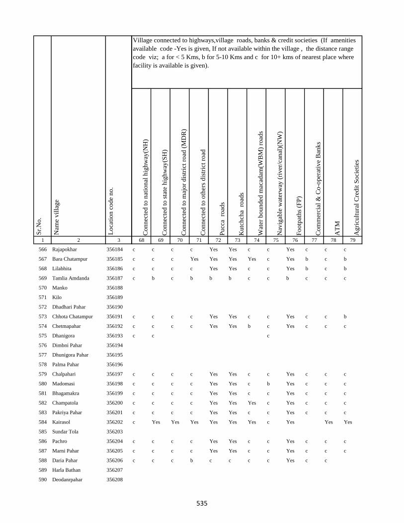
1 2 3
Lo
cati
on
co
de
no
.
Nam
e v
illa
ge
Sr.
No
.
566 Rajapokhar 356184
567 Bara Chatampur 356185
568 Lilabhita 356186
569 Tamlia Amdanda 356187
570 Manko 356188
571 Kilo 356189
572 Dhadhari Pahar 356190
573 Chhota Chatampur 356191
574 Chetmapahar 356192
575 Dhanigora 356193
576 Dimbni Pahar 356194
577 Dhunigora Pahar 356195
578 Palma Pahar 356196
579 Chalpahari 356197
580 Madomasi 356198
581 Bhagamakra 356199
582 Champatola 356200
583 Pakriya Pahar 356201
584 Kairasol 356202
585 Sundar Tola 356203
586 Pachro 356204
587 Marni Pahar 356205
588 Daria Pahar 356206
589 Harla Bathan 356207
590 Deodanrpahar 356208
Co
nn
ecte
d t
o n
atio
nal
hig
hw
ay(N
H)
Co
nn
ecte
d t
o s
tate
hig
hw
ay(S
H)
Co
nn
ecte
d t
o m
ajo
r d
istr
ict
road
(M
DR
)
Co
nn
ecte
d t
o o
ther
s d
istr
ict
road
Pu
cca
ro
ads
Ku
tch
cha
ro
ads
Wat
er b
ou
nd
ed m
acad
am(W
BM
) ro
ads
Nav
igab
le w
ater
way
(ri
ver
/can
al)(
NW
)
Fo
otp
ath
s (F
P)
Co
mm
erci
al &
Co
-op
erat
ive
Ban
ks
AT
M
Ag
ricu
ltu
ral
Cre
dit
So
ciet
ies
68 69 70 71 72 73 74 75 76 77 78 79
Village connected to highways,village roads, banks & credit societies (If amenities
available code -Yes is given, If not available within the village , the distance range
code viz; a for < 5 Kms, b for 5-10 Kms and c for 10+ kms of nearest place where
facility is available is given).
c c c c Yes Yes c c Yes c c c
c c c Yes Yes Yes Yes c Yes b c b
c c c c Yes Yes c c Yes b c b
c b c b b b c c b c c c
c c c c Yes Yes c c Yes c c b
c c c c Yes Yes b c Yes c c c
c c c
c c c c Yes Yes c c Yes c c c
c c c c Yes Yes c b Yes c c c
c c c c Yes Yes c c Yes c c c
c c c c Yes Yes Yes c Yes c c c
c c c c Yes Yes c c Yes c c c
c Yes Yes Yes Yes Yes Yes c Yes Yes Yes
c c c c Yes Yes c c Yes c c c
c c c c Yes Yes c c Yes c c c
c c c b c c c c Yes c c
535
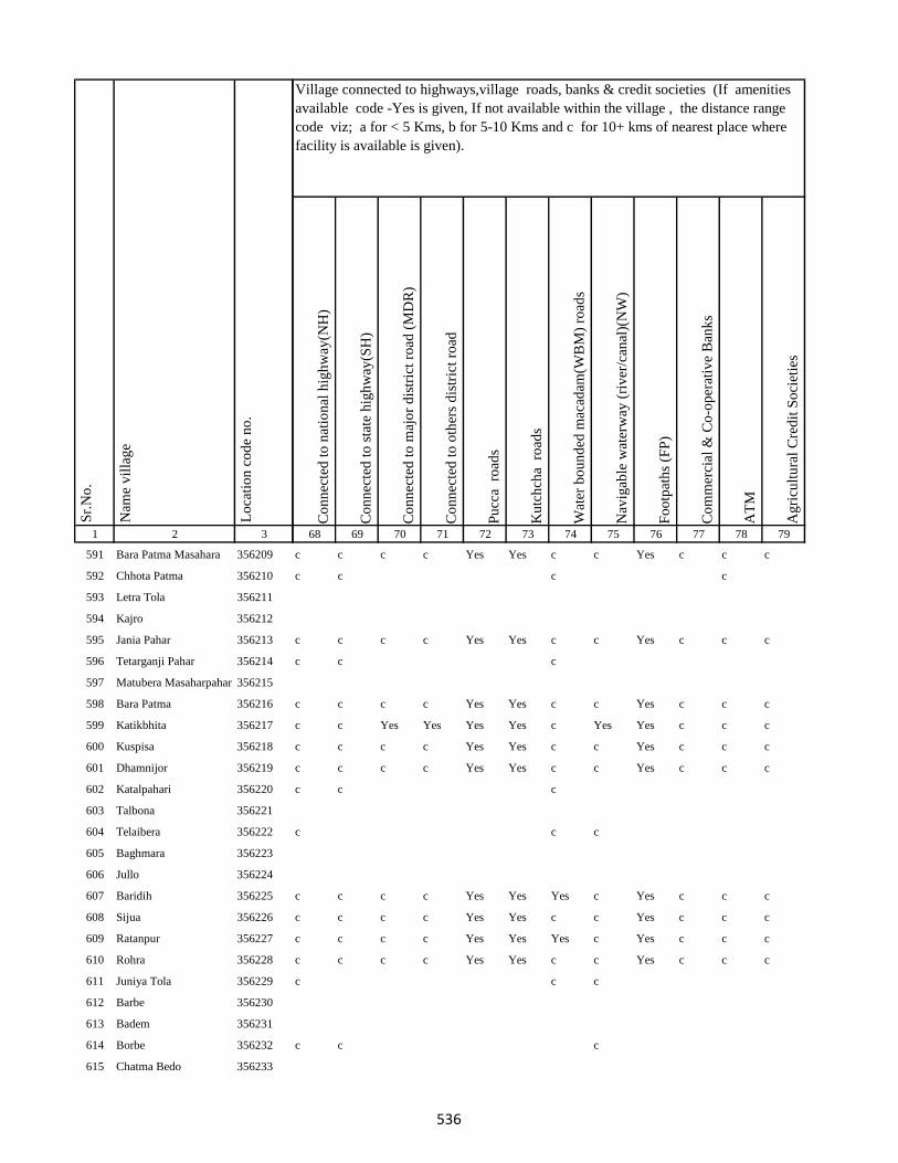
1 2 3
Lo
cati
on
co
de
no
.
Nam
e v
illa
ge
Sr.
No
.
591 Bara Patma Masahara 356209
592 Chhota Patma 356210
593 Letra Tola 356211
594 Kajro 356212
595 Jania Pahar 356213
596 Tetarganji Pahar 356214
597 Matubera Masaharpahar 356215
598 Bara Patma 356216
599 Katikbhita 356217
600 Kuspisa 356218
601 Dhamnijor 356219
602 Katalpahari 356220
603 Talbona 356221
604 Telaibera 356222
605 Baghmara 356223
606 Jullo 356224
607 Baridih 356225
608 Sijua 356226
609 Ratanpur 356227
610 Rohra 356228
611 Juniya Tola 356229
612 Barbe 356230
613 Badem 356231
614 Borbe 356232
615 Chatma Bedo 356233
Co
nn
ecte
d t
o n
atio
nal
hig
hw
ay(N
H)
Co
nn
ecte
d t
o s
tate
hig
hw
ay(S
H)
Co
nn
ecte
d t
o m
ajo
r d
istr
ict
road
(M
DR
)
Co
nn
ecte
d t
o o
ther
s d
istr
ict
road
Pu
cca
ro
ads
Ku
tch
cha
ro
ads
Wat
er b
ou
nd
ed m
acad
am(W
BM
) ro
ads
Nav
igab
le w
ater
way
(ri
ver
/can
al)(
NW
)
Fo
otp
ath
s (F
P)
Co
mm
erci
al &
Co
-op
erat
ive
Ban
ks
AT
M
Ag
ricu
ltu
ral
Cre
dit
So
ciet
ies
68 69 70 71 72 73 74 75 76 77 78 79
Village connected to highways,village roads, banks & credit societies (If amenities
available code -Yes is given, If not available within the village , the distance range
code viz; a for < 5 Kms, b for 5-10 Kms and c for 10+ kms of nearest place where
facility is available is given).
c c c c Yes Yes c c Yes c c c
c c c c
c c c c Yes Yes c c Yes c c c
c c c
c c c c Yes Yes c c Yes c c c
c c Yes Yes Yes Yes c Yes Yes c c c
c c c c Yes Yes c c Yes c c c
c c c c Yes Yes c c Yes c c c
c c c
c c c
c c c c Yes Yes Yes c Yes c c c
c c c c Yes Yes c c Yes c c c
c c c c Yes Yes Yes c Yes c c c
c c c c Yes Yes c c Yes c c c
c c c
c c c
536

1 2 3
Lo
cati
on
co
de
no
.
Nam
e v
illa
ge
Sr.
No
.
616 Chatma Joka 356234
617 Chengro 356235
618 Donigoda Bedo 356236
619 Ejgoga 356237
620 Gamari 356238
621 Goari 356239
622 Godam 356240
623 Itkro Bedo 356241
624 Jani Bedo 356242
625 Jani Maqo 356243
626 Jaria 356244
627 Jonia 356245
628 Karji 356246
629 Karag 356247
630 Kariam 356248
631 Katal 356249
632 Kilo Bedo 356250
633 Kilo Maqo 356251
634 Kombita 356252
635 Kuro Maqo 356253
636 Kuspiso 356254
637 Kutam 356255
638 Letragoda 356256
639 Marchi 356257
640 Matubera 356258
Co
nn
ecte
d t
o n
atio
nal
hig
hw
ay(N
H)
Co
nn
ecte
d t
o s
tate
hig
hw
ay(S
H)
Co
nn
ecte
d t
o m
ajo
r d
istr
ict
road
(M
DR
)
Co
nn
ecte
d t
o o
ther
s d
istr
ict
road
Pu
cca
ro
ads
Ku
tch
cha
ro
ads
Wat
er b
ou
nd
ed m
acad
am(W
BM
) ro
ads
Nav
igab
le w
ater
way
(ri
ver
/can
al)(
NW
)
Fo
otp
ath
s (F
P)
Co
mm
erci
al &
Co
-op
erat
ive
Ban
ks
AT
M
Ag
ricu
ltu
ral
Cre
dit
So
ciet
ies
68 69 70 71 72 73 74 75 76 77 78 79
Village connected to highways,village roads, banks & credit societies (If amenities
available code -Yes is given, If not available within the village , the distance range
code viz; a for < 5 Kms, b for 5-10 Kms and c for 10+ kms of nearest place where
facility is available is given).
c c c c Yes Yes Yes c Yes c c c
c c c c
c c c c c c c c c c
c b b b b b b b a c b c
c c
c c c c Yes Yes a a Yes c c c
c c c c Yes Yes b c Yes c c c
c c c
c c c c c c c c c c c
537

1 2 3
Lo
cati
on
co
de
no
.
Nam
e v
illa
ge
Sr.
No
.
641 Pandeni 356259
642 Patma Joka 356260
643 Perkuria 356261
644 Puro Maqo 356262
645 Puro Bedo 356263
646 Pusurkuriya Bedo 356264
647 Pusurkuriya Joka 356265
648 Tamlipatta 356266
649 Tesro 356267
650 Tisro 356268
651 Todmari 356269
652 Tokam 356270
653 Tokkuriya 356271
654 Saharpur 356272
655 Lilatari 356273
656 Khairbani 356274
657 Belthu 356275
658 Hethbandha 356276
659 Shamapokhar 356277
660 Chiharbona 356278
661 Chhota Saharpur 356279
662 Tulsipur 356280
663 Goriya 356281
664 Kamardiha 356282
665 Gopalpur 356283
Co
nn
ecte
d t
o n
atio
nal
hig
hw
ay(N
H)
Co
nn
ecte
d t
o s
tate
hig
hw
ay(S
H)
Co
nn
ecte
d t
o m
ajo
r d
istr
ict
road
(M
DR
)
Co
nn
ecte
d t
o o
ther
s d
istr
ict
road
Pu
cca
ro
ads
Ku
tch
cha
ro
ads
Wat
er b
ou
nd
ed m
acad
am(W
BM
) ro
ads
Nav
igab
le w
ater
way
(ri
ver
/can
al)(
NW
)
Fo
otp
ath
s (F
P)
Co
mm
erci
al &
Co
-op
erat
ive
Ban
ks
AT
M
Ag
ricu
ltu
ral
Cre
dit
So
ciet
ies
68 69 70 71 72 73 74 75 76 77 78 79
Village connected to highways,village roads, banks & credit societies (If amenities
available code -Yes is given, If not available within the village , the distance range
code viz; a for < 5 Kms, b for 5-10 Kms and c for 10+ kms of nearest place where
facility is available is given).
c c
c c c c Yes Yes c c Yes c c c
c c c c Yes Yes c c Yes c c
c Yes Yes Yes Yes Yes Yes c Yes c c c
c Yes c Yes Yes Yes Yes c Yes c c c
c Yes Yes c Yes Yes Yes c Yes c c c
c b b b Yes Yes Yes c Yes a c b
c c c c Yes Yes Yes c Yes a c b
c Yes Yes Yes Yes Yes Yes c Yes c c b
c Yes Yes Yes Yes Yes Yes c Yes c c b
c c a c a a c c a c c b
c Yes Yes Yes Yes Yes c c Yes c c b
c b b b Yes Yes c c Yes c c b
c c c Yes Yes Yes Yes c Yes c c c
c c c Yes Yes Yes c c Yes c c c
538
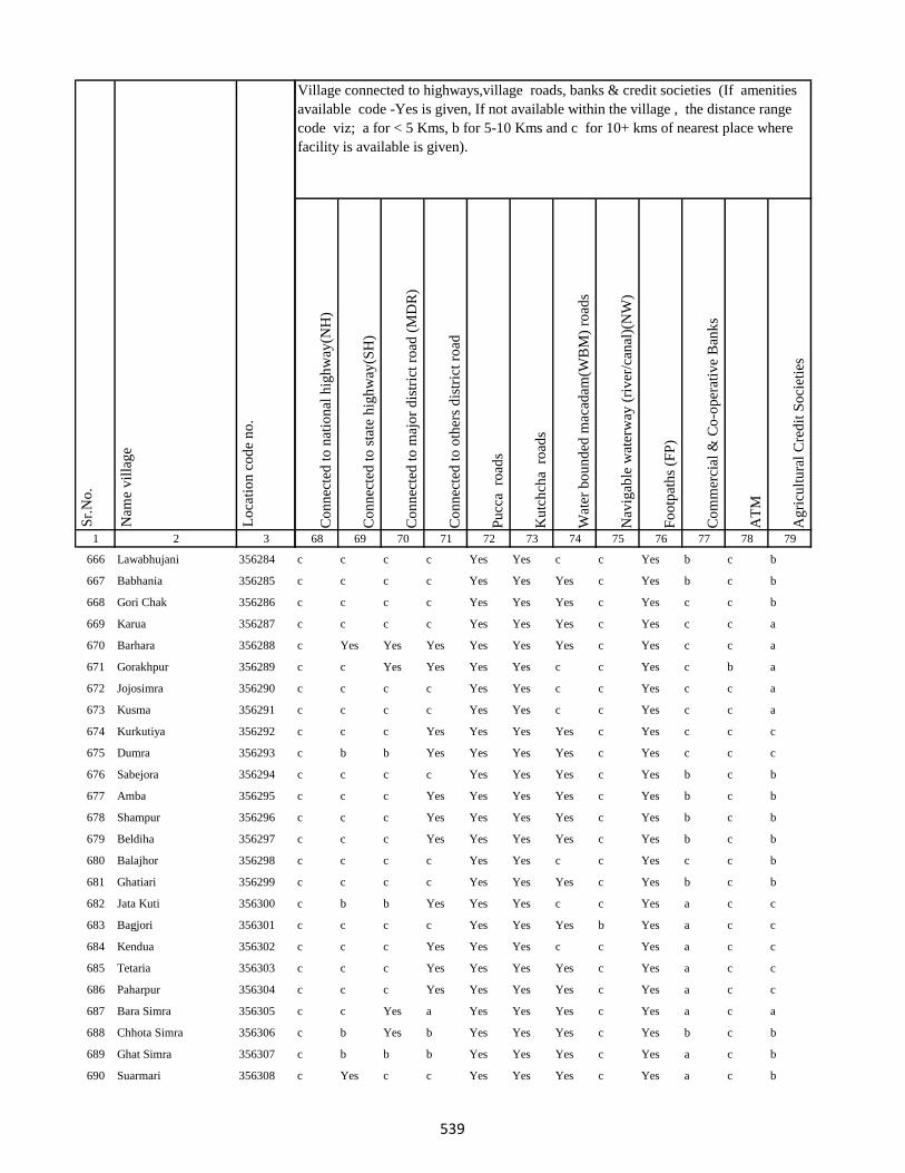
1 2 3
Lo
cati
on
co
de
no
.
Nam
e v
illa
ge
Sr.
No
.
666 Lawabhujani 356284
667 Babhania 356285
668 Gori Chak 356286
669 Karua 356287
670 Barhara 356288
671 Gorakhpur 356289
672 Jojosimra 356290
673 Kusma 356291
674 Kurkutiya 356292
675 Dumra 356293
676 Sabejora 356294
677 Amba 356295
678 Shampur 356296
679 Beldiha 356297
680 Balajhor 356298
681 Ghatiari 356299
682 Jata Kuti 356300
683 Bagjori 356301
684 Kendua 356302
685 Tetaria 356303
686 Paharpur 356304
687 Bara Simra 356305
688 Chhota Simra 356306
689 Ghat Simra 356307
690 Suarmari 356308
Co
nn
ecte
d t
o n
atio
nal
hig
hw
ay(N
H)
Co
nn
ecte
d t
o s
tate
hig
hw
ay(S
H)
Co
nn
ecte
d t
o m
ajo
r d
istr
ict
road
(M
DR
)
Co
nn
ecte
d t
o o
ther
s d
istr
ict
road
Pu
cca
ro
ads
Ku
tch
cha
ro
ads
Wat
er b
ou
nd
ed m
acad
am(W
BM
) ro
ads
Nav
igab
le w
ater
way
(ri
ver
/can
al)(
NW
)
Fo
otp
ath
s (F
P)
Co
mm
erci
al &
Co
-op
erat
ive
Ban
ks
AT
M
Ag
ricu
ltu
ral
Cre
dit
So
ciet
ies
68 69 70 71 72 73 74 75 76 77 78 79
Village connected to highways,village roads, banks & credit societies (If amenities
available code -Yes is given, If not available within the village , the distance range
code viz; a for < 5 Kms, b for 5-10 Kms and c for 10+ kms of nearest place where
facility is available is given).
c c c c Yes Yes c c Yes b c b
c c c c Yes Yes Yes c Yes b c b
c c c c Yes Yes Yes c Yes c c b
c c c c Yes Yes Yes c Yes c c a
c Yes Yes Yes Yes Yes Yes c Yes c c a
c c Yes Yes Yes Yes c c Yes c b a
c c c c Yes Yes c c Yes c c a
c c c c Yes Yes c c Yes c c a
c c c Yes Yes Yes Yes c Yes c c c
c b b Yes Yes Yes Yes c Yes c c c
c c c c Yes Yes Yes c Yes b c b
c c c Yes Yes Yes Yes c Yes b c b
c c c Yes Yes Yes Yes c Yes b c b
c c c Yes Yes Yes Yes c Yes b c b
c c c c Yes Yes c c Yes c c b
c c c c Yes Yes Yes c Yes b c b
c b b Yes Yes Yes c c Yes a c c
c c c c Yes Yes Yes b Yes a c c
c c c Yes Yes Yes c c Yes a c c
c c c Yes Yes Yes Yes c Yes a c c
c c c Yes Yes Yes Yes c Yes a c c
c c Yes a Yes Yes Yes c Yes a c a
c b Yes b Yes Yes Yes c Yes b c b
c b b b Yes Yes Yes c Yes a c b
c Yes c c Yes Yes Yes c Yes a c b
539
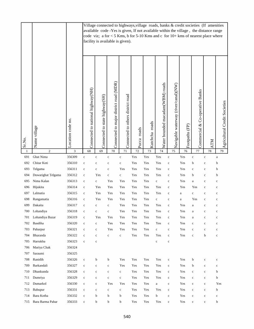
1 2 3
Lo
cati
on
co
de
no
.
Nam
e v
illa
ge
Sr.
No
.
691 Ghat Nima 356309
692 Chitar Koti 356310
693 Telgama 356311
694 Duwarighat Telgama 356312
695 Nima Kalan 356313
696 Hijukita 356314
697 Lalmatia 356315
698 Rangamatia 356316
699 Dakaita 356317
700 Lohandiya 356318
701 Lohandiya Bazar 356319
702 Basdiha 356320
703 Paharpur 356321
704 Bharanda 356322
705 Harrakha 356323
706 Mariya Chak 356324
707 Saraumi 356325
708 Ranidih 356326
709 Barkandali 356327
710 Dhankunda 356328
711 Dumriya 356329
712 Dumarkol 356330
713 Babupur 356331
714 Bara Kotha 356332
715 Bara Barma Pahar 356333
Co
nn
ecte
d t
o n
atio
nal
hig
hw
ay(N
H)
Co
nn
ecte
d t
o s
tate
hig
hw
ay(S
H)
Co
nn
ecte
d t
o m
ajo
r d
istr
ict
road
(M
DR
)
Co
nn
ecte
d t
o o
ther
s d
istr
ict
road
Pu
cca
ro
ads
Ku
tch
cha
ro
ads
Wat
er b
ou
nd
ed m
acad
am(W
BM
) ro
ads
Nav
igab
le w
ater
way
(ri
ver
/can
al)(
NW
)
Fo
otp
ath
s (F
P)
Co
mm
erci
al &
Co
-op
erat
ive
Ban
ks
AT
M
Ag
ricu
ltu
ral
Cre
dit
So
ciet
ies
68 69 70 71 72 73 74 75 76 77 78 79
Village connected to highways,village roads, banks & credit societies (If amenities
available code -Yes is given, If not available within the village , the distance range
code viz; a for < 5 Kms, b for 5-10 Kms and c for 10+ kms of nearest place where
facility is available is given).
c c c c Yes Yes Yes c Yes c c a
c c c c Yes Yes Yes c Yes b c b
c c c Yes Yes Yes Yes c Yes c c b
c Yes c c Yes Yes Yes c Yes b c b
c c Yes Yes Yes Yes c c Yes a c c
c Yes Yes Yes Yes Yes Yes c Yes Yes c c
c Yes Yes Yes Yes Yes Yes c a c c c
c Yes Yes Yes Yes Yes c c a Yes c c
c c c Yes Yes Yes Yes c Yes a c c
c c c Yes Yes Yes Yes c Yes a c c
c Yes Yes Yes Yes Yes Yes c Yes a c c
c c Yes Yes Yes Yes Yes c Yes c c c
c c Yes Yes Yes Yes c c Yes c c c
c c c c Yes Yes Yes c Yes c b c
c c c c
c b b Yes Yes Yes Yes c Yes b c c
c c c Yes Yes Yes Yes c Yes b c c
c c c c Yes Yes Yes c Yes c c b
c c c c Yes Yes Yes c Yes c c b
c c Yes Yes Yes Yes a c Yes c c Yes
c c c c Yes Yes Yes c Yes c c b
c b b b Yes Yes b c Yes c c c
c b b b Yes Yes Yes c Yes c c b
540
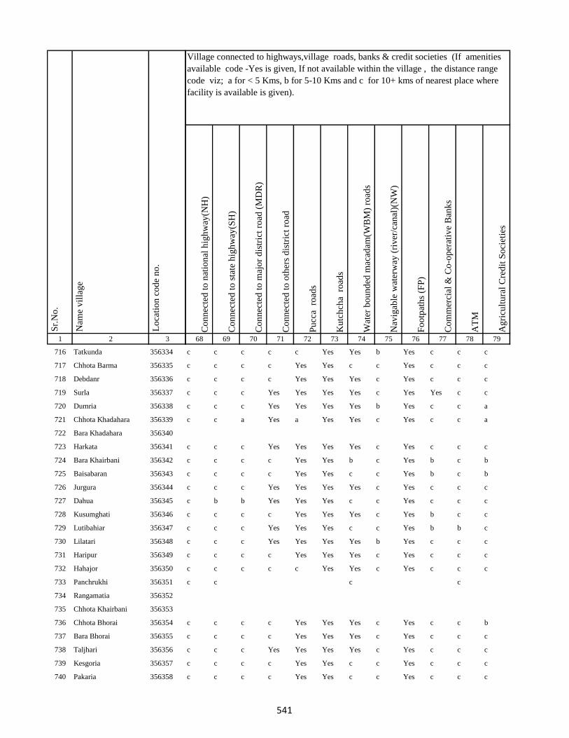
1 2 3
Lo
cati
on
co
de
no
.
Nam
e v
illa
ge
Sr.
No
.
716 Tatkunda 356334
717 Chhota Barma 356335
718 Debdanr 356336
719 Surla 356337
720 Dumria 356338
721 Chhota Khadahara 356339
722 Bara Khadahara 356340
723 Harkata 356341
724 Bara Khairbani 356342
725 Baisabaran 356343
726 Jurgura 356344
727 Dahua 356345
728 Kusumghati 356346
729 Lutibahiar 356347
730 Lilatari 356348
731 Haripur 356349
732 Hahajor 356350
733 Panchrukhi 356351
734 Rangamatia 356352
735 Chhota Khairbani 356353
736 Chhota Bhorai 356354
737 Bara Bhorai 356355
738 Taljhari 356356
739 Kesgoria 356357
740 Pakaria 356358
Co
nn
ecte
d t
o n
atio
nal
hig
hw
ay(N
H)
Co
nn
ecte
d t
o s
tate
hig
hw
ay(S
H)
Co
nn
ecte
d t
o m
ajo
r d
istr
ict
road
(M
DR
)
Co
nn
ecte
d t
o o
ther
s d
istr
ict
road
Pu
cca
ro
ads
Ku
tch
cha
ro
ads
Wat
er b
ou
nd
ed m
acad
am(W
BM
) ro
ads
Nav
igab
le w
ater
way
(ri
ver
/can
al)(
NW
)
Fo
otp
ath
s (F
P)
Co
mm
erci
al &
Co
-op
erat
ive
Ban
ks
AT
M
Ag
ricu
ltu
ral
Cre
dit
So
ciet
ies
68 69 70 71 72 73 74 75 76 77 78 79
Village connected to highways,village roads, banks & credit societies (If amenities
available code -Yes is given, If not available within the village , the distance range
code viz; a for < 5 Kms, b for 5-10 Kms and c for 10+ kms of nearest place where
facility is available is given).
c c c c c Yes Yes b Yes c c c
c c c c Yes Yes c c Yes c c c
c c c c Yes Yes Yes c Yes c c c
c c c Yes Yes Yes Yes c Yes Yes c c
c c c Yes Yes Yes Yes b Yes c c a
c c a Yes a Yes Yes c Yes c c a
c c c Yes Yes Yes Yes c Yes c c c
c c c c Yes Yes b c Yes b c b
c c c c Yes Yes c c Yes b c b
c c c Yes Yes Yes Yes c Yes c c c
c b b Yes Yes Yes c c Yes c c c
c c c c Yes Yes Yes c Yes b c c
c c c Yes Yes Yes c c Yes b b c
c c c Yes Yes Yes Yes b Yes c c c
c c c c Yes Yes Yes c Yes c c c
c c c c c Yes Yes c Yes c c c
c c c c
c c c c Yes Yes Yes c Yes c c b
c c c c Yes Yes Yes c Yes c c c
c c c Yes Yes Yes Yes c Yes c c c
c c c c Yes Yes c c Yes c c c
c c c c Yes Yes c c Yes c c c
541
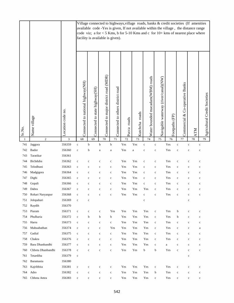
1 2 3
Lo
cati
on
co
de
no
.
Nam
e v
illa
ge
Sr.
No
.
741 Jaggora 356359
742 Bador 356360
743 Taratikar 356361
744 Bichduba 356362
745 Telodhuni 356363
746 Madgigora 356364
747 Dighi 356365
748 Gopali 356366
749 Dabra 356367
750 Rohari Naryanpur 356368
751 Jolopahari 356369
752 Raydih 356370
753 Piaram 356371
754 Phulbaria 356372
755 Harra 356373
756 Mahuabathan 356374
757 Gadial 356375
758 Chakra 356376
759 Bara Dhanbandhi 356377
760 Chhota Dhanbandhi 356378
761 Tetardiha 356379
762 Baramasia 356380
763 Kajribhita 356381
764 Adro 356382
765 Chhota Amra 356383
Co
nn
ecte
d t
o n
atio
nal
hig
hw
ay(N
H)
Co
nn
ecte
d t
o s
tate
hig
hw
ay(S
H)
Co
nn
ecte
d t
o m
ajo
r d
istr
ict
road
(M
DR
)
Co
nn
ecte
d t
o o
ther
s d
istr
ict
road
Pu
cca
ro
ads
Ku
tch
cha
ro
ads
Wat
er b
ou
nd
ed m
acad
am(W
BM
) ro
ads
Nav
igab
le w
ater
way
(ri
ver
/can
al)(
NW
)
Fo
otp
ath
s (F
P)
Co
mm
erci
al &
Co
-op
erat
ive
Ban
ks
AT
M
Ag
ricu
ltu
ral
Cre
dit
So
ciet
ies
68 69 70 71 72 73 74 75 76 77 78 79
Village connected to highways,village roads, banks & credit societies (If amenities
available code -Yes is given, If not available within the village , the distance range
code viz; a for < 5 Kms, b for 5-10 Kms and c for 10+ kms of nearest place where
facility is available is given).
c b b b Yes Yes c c Yes c c c
c b a a Yes a c c Yes c c c
c c c c Yes Yes c c Yes c c c
c c c c Yes Yes c c Yes c c c
c c c c Yes Yes c c Yes c c c
c c c c Yes Yes c c Yes c c c
c c c c Yes Yes c c Yes c c c
c c c c Yes Yes Yes c Yes c c c
c c c c Yes Yes c c Yes c c c
c c c c
c c c Yes Yes Yes Yes c Yes b c c
c b b b Yes Yes Yes c Yes b c c
c c c c Yes Yes Yes c Yes c c c
c c c Yes Yes Yes Yes c Yes c c a
c c c c Yes Yes Yes c Yes c c c
c c c c Yes Yes Yes c Yes c c c
c c c c Yes Yes Yes c a c c c
c c c c Yes Yes b b Yes c c c
c c
c c c c Yes Yes Yes c Yes c c c
c c c c Yes Yes Yes b Yes c c c
c c c c Yes Yes Yes c Yes c c c
542

1 2 3
Lo
cati
on
co
de
no
.
Nam
e v
illa
ge
Sr.
No
.
766 Tulsipur 356384
767 Lohatamba And Agoia 356385
768 Bhalgora 356386
769 Deonapur 356387
770 Bhagwanpur 356388
771 Bara Malbhita 356389
772 Chhota Malbhita 356390
773 Tikrigora 356391
774 Gamhar Pahar 356392
775 Katar Pahar 356393
776 Kisma Pahar 356394
777 Malbhita Tola 356395
778 Chhota Pipra 356396
779 Pipra Hill 356397
780 Tetarbhita 356398
781 Tatgora 356399
782 Chhota Basgo 356400
783 Bara Pipra 356401
784 Salem Tok 356402
785 Kukur Pahari 356403
786 Kuschilia Pahar 356404
787 Kisma 356405
788 Bara Amarpur 356406
789 Chhota Amarpur 356407
790 Dumaria 356408
Co
nn
ecte
d t
o n
atio
nal
hig
hw
ay(N
H)
Co
nn
ecte
d t
o s
tate
hig
hw
ay(S
H)
Co
nn
ecte
d t
o m
ajo
r d
istr
ict
road
(M
DR
)
Co
nn
ecte
d t
o o
ther
s d
istr
ict
road
Pu
cca
ro
ads
Ku
tch
cha
ro
ads
Wat
er b
ou
nd
ed m
acad
am(W
BM
) ro
ads
Nav
igab
le w
ater
way
(ri
ver
/can
al)(
NW
)
Fo
otp
ath
s (F
P)
Co
mm
erci
al &
Co
-op
erat
ive
Ban
ks
AT
M
Ag
ricu
ltu
ral
Cre
dit
So
ciet
ies
68 69 70 71 72 73 74 75 76 77 78 79
Village connected to highways,village roads, banks & credit societies (If amenities
available code -Yes is given, If not available within the village , the distance range
code viz; a for < 5 Kms, b for 5-10 Kms and c for 10+ kms of nearest place where
facility is available is given).
c c c c Yes Yes Yes c Yes c c c
c c c c Yes Yes c Yes Yes c c c
c b b b Yes Yes Yes b Yes c c c
c c c c Yes Yes Yes c Yes c c c
c c c Yes Yes Yes c c Yes c c b
c c c c Yes Yes c c Yes c c c
c c c c Yes Yes c c Yes c c c
c c Yes Yes c c Yes c
c c c c Yes Yes c c Yes c c c
c c c
c c c
c b b b Yes Yes Yes c Yes c c c
c c c c Yes Yes Yes c Yes c c c
c c c c Yes Yes c Yes Yes c c c
c c c Yes Yes Yes Yes c Yes c c c
543
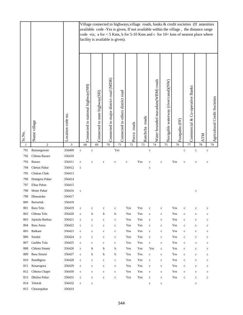
1 2 3
Lo
cati
on
co
de
no
.
Nam
e v
illa
ge
Sr.
No
.
791 Bamangawan 356409
792 Chhota Bararo 356410
793 Bararo 356411
794 Chetan Pahar 356412
795 Chakan Chak 356413
796 Domgora Pahar 356414
797 Elkar Pahar 356415
798 Moter Pahar 356416
799 Dhauatoka 356417
800 Bariartok 356418
801 Bara Telo 356419
802 Chhota Telo 356420
803 Jajotola Barhua 356421
804 Bara Amra 356422
805 Balkani 356423
806 Sundai 356424
807 Garbhu Tola 356425
808 Chhota Simmi 356426
809 Bara Simmi 356427
810 Bandhgora 356428
811 Kesarogora 356429
812 Chhota Chapri 356430
813 Dholna Pahar 356431
814 Telotok 356432
815 Charanpahar 356433
Co
nn
ecte
d t
o n
atio
nal
hig
hw
ay(N
H)
Co
nn
ecte
d t
o s
tate
hig
hw
ay(S
H)
Co
nn
ecte
d t
o m
ajo
r d
istr
ict
road
(M
DR
)
Co
nn
ecte
d t
o o
ther
s d
istr
ict
road
Pu
cca
ro
ads
Ku
tch
cha
ro
ads
Wat
er b
ou
nd
ed m
acad
am(W
BM
) ro
ads
Nav
igab
le w
ater
way
(ri
ver
/can
al)(
NW
)
Fo
otp
ath
s (F
P)
Co
mm
erci
al &
Co
-op
erat
ive
Ban
ks
AT
M
Ag
ricu
ltu
ral
Cre
dit
So
ciet
ies
68 69 70 71 72 73 74 75 76 77 78 79
Village connected to highways,village roads, banks & credit societies (If amenities
available code -Yes is given, If not available within the village , the distance range
code viz; a for < 5 Kms, b for 5-10 Kms and c for 10+ kms of nearest place where
facility is available is given).
c c Yes c c c c
c c c c c Yes c c Yes c c c
c c
c c
c c c c Yes Yes c c Yes c c c
c b b b Yes Yes c c Yes c c c
c c c c Yes Yes c c Yes c c c
c c c c Yes Yes c c Yes c c c
c c c c Yes Yes c c Yes c c c
c c c c Yes Yes c c Yes c c c
c c c c Yes Yes c c Yes c c c
c b b b Yes Yes Yes c Yes c c c
c b b b Yes Yes c c Yes c c c
c c c c Yes Yes c c Yes c c c
c c c c Yes Yes c c Yes c c c
c c c c Yes Yes c c Yes c c c
c c c c Yes Yes c c Yes c c c
c c c c c
544
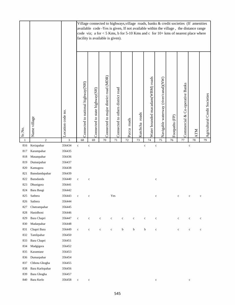
1 2 3
Lo
cati
on
co
de
no
.
Nam
e v
illa
ge
Sr.
No
.
816 Keriapahar 356434
817 Karampahar 356435
818 Masanpahar 356436
819 Dumarpahar 356437
820 Kamugora 356438
821 Bansdandapahar 356439
822 Bansdanda 356440
823 Dhunigora 356441
824 Bara Basgi 356442
825 Satbera 356443
826 Satbera 356444
827 Chetrampahar 356445
828 Hanidhoni 356446
829 Bara Chapri 356447
830 Madarpahar 356448
831 Chapri Bara 356449
832 Tamlipahar 356450
833 Bara Chapri 356451
834 Madgigora 356452
835 Karamtanr 356453
836 Dumarpahar 356454
837 Chhota Ghogha 356455
838 Bara Karlopahar 356456
839 Bara Ghogha 356457
840 Bara Kerlo 356458
Co
nn
ecte
d t
o n
atio
nal
hig
hw
ay(N
H)
Co
nn
ecte
d t
o s
tate
hig
hw
ay(S
H)
Co
nn
ecte
d t
o m
ajo
r d
istr
ict
road
(M
DR
)
Co
nn
ecte
d t
o o
ther
s d
istr
ict
road
Pu
cca
ro
ads
Ku
tch
cha
ro
ads
Wat
er b
ou
nd
ed m
acad
am(W
BM
) ro
ads
Nav
igab
le w
ater
way
(ri
ver
/can
al)(
NW
)
Fo
otp
ath
s (F
P)
Co
mm
erci
al &
Co
-op
erat
ive
Ban
ks
AT
M
Ag
ricu
ltu
ral
Cre
dit
So
ciet
ies
68 69 70 71 72 73 74 75 76 77 78 79
Village connected to highways,village roads, banks & credit societies (If amenities
available code -Yes is given, If not available within the village , the distance range
code viz; a for < 5 Kms, b for 5-10 Kms and c for 10+ kms of nearest place where
facility is available is given).
c c c c c
c c c
c c Yes c c c c
c c c c c c c c c c c
c c c c b b b c c c c
c c c c
545
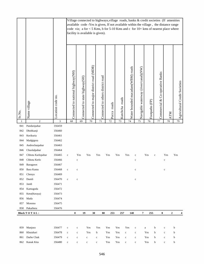
1 2 3
Lo
cati
on
co
de
no
.
Nam
e v
illa
ge
Sr.
No
.
841 Pandaripahar 356459
842 Dhobkanji 356460
843 Kerikuria 356461
844 Madgigora 356462
845 Androcharpahar 356463
846 Chuolalpahar 356464
847 Chhota Karlopahar 356465
848 Chhota Kerlo 356466
849 Baragawn 356467
850 Bara Kamu 356468
851 Chenya 356469
852 Dumli 356470
853 Jandi 356471
854 Kamugoda 356472
855 Keto(Keraya) 356473
856 Mada 356474
857 Moremo 356475
858 Pakarbera 356476
Block T O T A L :
859 Manjura 356477
860 Khutahari 356478
861 Darbe Chak 356479
862 Kanak Kita 356480
Co
nn
ecte
d t
o n
atio
nal
hig
hw
ay(N
H)
Co
nn
ecte
d t
o s
tate
hig
hw
ay(S
H)
Co
nn
ecte
d t
o m
ajo
r d
istr
ict
road
(M
DR
)
Co
nn
ecte
d t
o o
ther
s d
istr
ict
road
Pu
cca
ro
ads
Ku
tch
cha
ro
ads
Wat
er b
ou
nd
ed m
acad
am(W
BM
) ro
ads
Nav
igab
le w
ater
way
(ri
ver
/can
al)(
NW
)
Fo
otp
ath
s (F
P)
Co
mm
erci
al &
Co
-op
erat
ive
Ban
ks
AT
M
Ag
ricu
ltu
ral
Cre
dit
So
ciet
ies
68 69 70 71 72 73 74 75 76 77 78 79
Village connected to highways,village roads, banks & credit societies (If amenities
available code -Yes is given, If not available within the village , the distance range
code viz; a for < 5 Kms, b for 5-10 Kms and c for 10+ kms of nearest place where
facility is available is given).
c Yes Yes Yes Yes Yes Yes c Yes c Yes Yes
c c c
c c c c
c c c
0 19 30 80 253 257 140 7 255 8 2 4
c c Yes Yes Yes Yes Yes c a b c b
c c Yes b Yes Yes c c Yes b c b
c c c c Yes Yes c c Yes b c b
c c c c Yes Yes c c Yes b c b
546

1 2 3
Lo
cati
on
co
de
no
.
Nam
e v
illa
ge
Sr.
No
.
863 Sarbhanga 356481
864 Nunajagir 356482
865 Murgia Chak 356483
866 Sibotar Kita 356484
867 Rup Chak 356485
868 Sarautia 356486
869 Gopalpur 356487
870 Ranu Chak 356488
871 Chauchak 356489
872 Saha Chak 356490
873 Kumhrakol 356491
874 Singpur 356492
875 Baje Kita 356493
876 Garbhudih 356494
877 Sidhari 356495
878 Samu Kita 356496
879 Baje Kita 356497
880 Sidhari 356498
881 Mohani 356499
882 Bakanpur 356500
883 Dighi 356501
884 Satbigha 356502
885 Modi Chak 356503
886 Jagi Milik 356504
887 Baje Kita 356505
Co
nn
ecte
d t
o n
atio
nal
hig
hw
ay(N
H)
Co
nn
ecte
d t
o s
tate
hig
hw
ay(S
H)
Co
nn
ecte
d t
o m
ajo
r d
istr
ict
road
(M
DR
)
Co
nn
ecte
d t
o o
ther
s d
istr
ict
road
Pu
cca
ro
ads
Ku
tch
cha
ro
ads
Wat
er b
ou
nd
ed m
acad
am(W
BM
) ro
ads
Nav
igab
le w
ater
way
(ri
ver
/can
al)(
NW
)
Fo
otp
ath
s (F
P)
Co
mm
erci
al &
Co
-op
erat
ive
Ban
ks
AT
M
Ag
ricu
ltu
ral
Cre
dit
So
ciet
ies
68 69 70 71 72 73 74 75 76 77 78 79
Village connected to highways,village roads, banks & credit societies (If amenities
available code -Yes is given, If not available within the village , the distance range
code viz; a for < 5 Kms, b for 5-10 Kms and c for 10+ kms of nearest place where
facility is available is given).
c c c c c
c c c c c
c c c c c c c c a b c b
c c c c c
c c c c c
c c c c c
c c c c
c c c c Yes Yes c c Yes c c c
c Yes b Yes Yes Yes Yes c Yes c c c
c c Yes Yes Yes Yes Yes c a Yes c b
c c c c Yes c
547

1 2 3
Lo
cati
on
co
de
no
.
Nam
e v
illa
ge
Sr.
No
.
888 Sital 356506
889 Mali Chak 356507
890 Gorgawan 356508
891 Naraini 356509
892 Dhobia Chak 356510
893 Bairia Chak 356511
894 Gansagar 356512
895 Bairia Kita 356513
896 Sonbarsa 356514
897 Milik Hanwara 356515
898 Hanwara 356516
899 Ramkol 356517
900 Tiya Chak 356518
901 Alimahamadpur 356519
902 Narainpur (Dompatti) 356520
903 Sahi Kita 356521
904 Narainpur (Sempatti) 356522
905 Chak Chamu 356523
906 Baija Chak 356524
907 Dumaria Khurd 356525
908 Dumaria Kalan 356526
909 Narattampur 356527
910 Biswas Khani 356528
911 Sagrampur 356529
912 Pararia 356530
Co
nn
ecte
d t
o n
atio
nal
hig
hw
ay(N
H)
Co
nn
ecte
d t
o s
tate
hig
hw
ay(S
H)
Co
nn
ecte
d t
o m
ajo
r d
istr
ict
road
(M
DR
)
Co
nn
ecte
d t
o o
ther
s d
istr
ict
road
Pu
cca
ro
ads
Ku
tch
cha
ro
ads
Wat
er b
ou
nd
ed m
acad
am(W
BM
) ro
ads
Nav
igab
le w
ater
way
(ri
ver
/can
al)(
NW
)
Fo
otp
ath
s (F
P)
Co
mm
erci
al &
Co
-op
erat
ive
Ban
ks
AT
M
Ag
ricu
ltu
ral
Cre
dit
So
ciet
ies
68 69 70 71 72 73 74 75 76 77 78 79
Village connected to highways,village roads, banks & credit societies (If amenities
available code -Yes is given, If not available within the village , the distance range
code viz; a for < 5 Kms, b for 5-10 Kms and c for 10+ kms of nearest place where
facility is available is given).
c c c c Yes Yes Yes c Yes c c c
c c c Yes Yes Yes c c Yes b c b
c c c Yes Yes Yes c c Yes Yes c c
c c c Yes Yes Yes Yes c a b c b
c c c Yes Yes Yes Yes c Yes b c b
c b c c
c c Yes Yes Yes Yes Yes c Yes Yes c c
c c c c Yes Yes c c Yes c c b
c c c c c
c c c c Yes Yes c c Yes c c b
c c c c Yes Yes c c Yes c c b
c c c c Yes Yes c c Yes c c b
c c c c Yes Yes c c Yes c c b
c b b b Yes Yes c c Yes c c b
c c c c Yes Yes c Yes Yes b c b
c c c c Yes Yes Yes Yes Yes b c b
c c c c Yes Yes c c a b c b
c c c c Yes Yes Yes c Yes b c b
c c c c Yes Yes c c Yes a c b
c c c c Yes Yes Yes c Yes a c a
548

1 2 3
Lo
cati
on
co
de
no
.
Nam
e v
illa
ge
Sr.
No
.
913 Parsa 356531
914 Bikrampur 356532
915 Koila 356533
916 Barkurua 356534
917 Barkurua 356535
918 Bataua Kita 356536
919 Batana Kita 356537
920 Batana Kita 356538
921 Sarthu 356539
922 Baghakol 356540
923 Gurhi 356541
924 Baje Kita 356542
925 Baje Kita 356543
926 Bairia Kita 356544
927 Kharaiya 356545
928 Sahajadpur 356546
929 Ghatiani 356547
930 Ghuthi 356548
931 Khurd 356549
932 Banjpur 356550
933 Teknikita 356551
934 Sirinathpur 356552
935 Nayanagar 356553
936 Singarpur 356554
937 Jatama 356555
Co
nn
ecte
d t
o n
atio
nal
hig
hw
ay(N
H)
Co
nn
ecte
d t
o s
tate
hig
hw
ay(S
H)
Co
nn
ecte
d t
o m
ajo
r d
istr
ict
road
(M
DR
)
Co
nn
ecte
d t
o o
ther
s d
istr
ict
road
Pu
cca
ro
ads
Ku
tch
cha
ro
ads
Wat
er b
ou
nd
ed m
acad
am(W
BM
) ro
ads
Nav
igab
le w
ater
way
(ri
ver
/can
al)(
NW
)
Fo
otp
ath
s (F
P)
Co
mm
erci
al &
Co
-op
erat
ive
Ban
ks
AT
M
Ag
ricu
ltu
ral
Cre
dit
So
ciet
ies
68 69 70 71 72 73 74 75 76 77 78 79
Village connected to highways,village roads, banks & credit societies (If amenities
available code -Yes is given, If not available within the village , the distance range
code viz; a for < 5 Kms, b for 5-10 Kms and c for 10+ kms of nearest place where
facility is available is given).
c b b b Yes Yes c c Yes a c a
c c Yes Yes Yes Yes c Yes Yes a c a
c c c c
c c c c
c c c c c c c c a a c c
c c c c Yes Yes c c Yes a c c
c c c c Yes Yes c c Yes a c c
c c c Yes Yes Yes Yes c Yes c c c
c c c Yes Yes Yes Yes c Yes c c c
c c c c Yes Yes Yes c Yes c c c
c c c c Yes Yes Yes c Yes c c c
c c c Yes Yes Yes c c Yes c c b
c c c c Yes Yes Yes c a b c b
c b c c
c c c c Yes Yes c c Yes c c c
c c c c c c c c a b c b
c c c c Yes Yes c c Yes b c b
c c c c Yes Yes c c Yes b c a
549
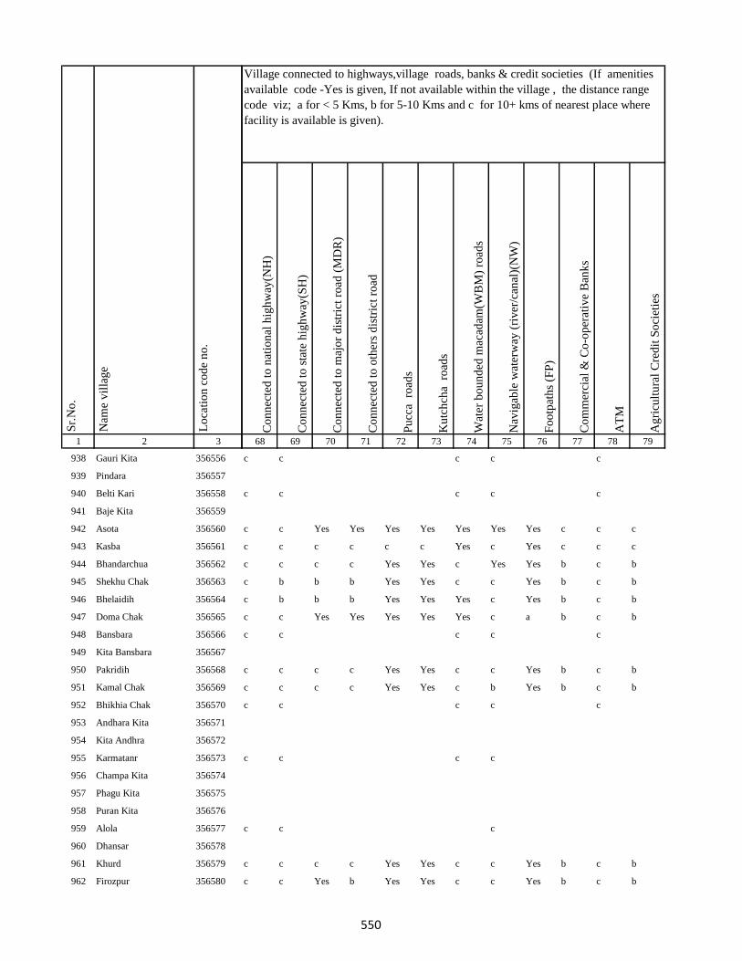
1 2 3
Lo
cati
on
co
de
no
.
Nam
e v
illa
ge
Sr.
No
.
938 Gauri Kita 356556
939 Pindara 356557
940 Belti Kari 356558
941 Baje Kita 356559
942 Asota 356560
943 Kasba 356561
944 Bhandarchua 356562
945 Shekhu Chak 356563
946 Bhelaidih 356564
947 Doma Chak 356565
948 Bansbara 356566
949 Kita Bansbara 356567
950 Pakridih 356568
951 Kamal Chak 356569
952 Bhikhia Chak 356570
953 Andhara Kita 356571
954 Kita Andhra 356572
955 Karmatanr 356573
956 Champa Kita 356574
957 Phagu Kita 356575
958 Puran Kita 356576
959 Alola 356577
960 Dhansar 356578
961 Khurd 356579
962 Firozpur 356580
Co
nn
ecte
d t
o n
atio
nal
hig
hw
ay(N
H)
Co
nn
ecte
d t
o s
tate
hig
hw
ay(S
H)
Co
nn
ecte
d t
o m
ajo
r d
istr
ict
road
(M
DR
)
Co
nn
ecte
d t
o o
ther
s d
istr
ict
road
Pu
cca
ro
ads
Ku
tch
cha
ro
ads
Wat
er b
ou
nd
ed m
acad
am(W
BM
) ro
ads
Nav
igab
le w
ater
way
(ri
ver
/can
al)(
NW
)
Fo
otp
ath
s (F
P)
Co
mm
erci
al &
Co
-op
erat
ive
Ban
ks
AT
M
Ag
ricu
ltu
ral
Cre
dit
So
ciet
ies
68 69 70 71 72 73 74 75 76 77 78 79
Village connected to highways,village roads, banks & credit societies (If amenities
available code -Yes is given, If not available within the village , the distance range
code viz; a for < 5 Kms, b for 5-10 Kms and c for 10+ kms of nearest place where
facility is available is given).
c c c c c
c c c c c
c c Yes Yes Yes Yes Yes Yes Yes c c c
c c c c c c Yes c Yes c c c
c c c c Yes Yes c Yes Yes b c b
c b b b Yes Yes c c Yes b c b
c b b b Yes Yes Yes c Yes b c b
c c Yes Yes Yes Yes Yes c a b c b
c c c c c
c c c c Yes Yes c c Yes b c b
c c c c Yes Yes c b Yes b c b
c c c c c
c c c c
c c c
c c c c Yes Yes c c Yes b c b
c c Yes b Yes Yes c c Yes b c b
550

1 2 3
Lo
cati
on
co
de
no
.
Nam
e v
illa
ge
Sr.
No
.
963 Dharampur Ghat 356581
964 Dharampur Mal 356582
965 Chaujora Mal 356583
966 Chaujora Ghat 356584
967 Kamargawan 356585
968 Mansura 356586
969 Sadulabhita 356587
970 Gosain Chak 356588
971 Madhupur 356589
972 Gokula 356590
973 Majhona 356591
974 Daniala 356592
975 Khaira 356593
976 Fouzdar Kita Ghat 356594
977 Ghatdiarhi 356595
978 Diarhi Kita 356596
979 Manoharpur Kita 356597
980 Manoharpur 356598
981 Solahbighia 356599
982 Jhagarua 356600
983 Ramchandarpur 356601
984 Maigar Kita 356602
985 Kita Majhona 356603
986 Khara Kita 356604
987 Chainpur 356605
Co
nn
ecte
d t
o n
atio
nal
hig
hw
ay(N
H)
Co
nn
ecte
d t
o s
tate
hig
hw
ay(S
H)
Co
nn
ecte
d t
o m
ajo
r d
istr
ict
road
(M
DR
)
Co
nn
ecte
d t
o o
ther
s d
istr
ict
road
Pu
cca
ro
ads
Ku
tch
cha
ro
ads
Wat
er b
ou
nd
ed m
acad
am(W
BM
) ro
ads
Nav
igab
le w
ater
way
(ri
ver
/can
al)(
NW
)
Fo
otp
ath
s (F
P)
Co
mm
erci
al &
Co
-op
erat
ive
Ban
ks
AT
M
Ag
ricu
ltu
ral
Cre
dit
So
ciet
ies
68 69 70 71 72 73 74 75 76 77 78 79
Village connected to highways,village roads, banks & credit societies (If amenities
available code -Yes is given, If not available within the village , the distance range
code viz; a for < 5 Kms, b for 5-10 Kms and c for 10+ kms of nearest place where
facility is available is given).
c c Yes c Yes Yes c Yes Yes b c b
c c c c Yes Yes c c Yes b c b
c c c c
c c c c Yes Yes Yes c Yes b c b
c c c c c
c b b b a b c c b b c b
c c c c Yes Yes c c Yes c c c
c c c c Yes Yes Yes Yes Yes b c b
c c c c Yes Yes Yes c Yes b c b
c c Yes Yes Yes Yes Yes Yes Yes b c b
c c c c
c c c c c
c c c c
c c c c c
551
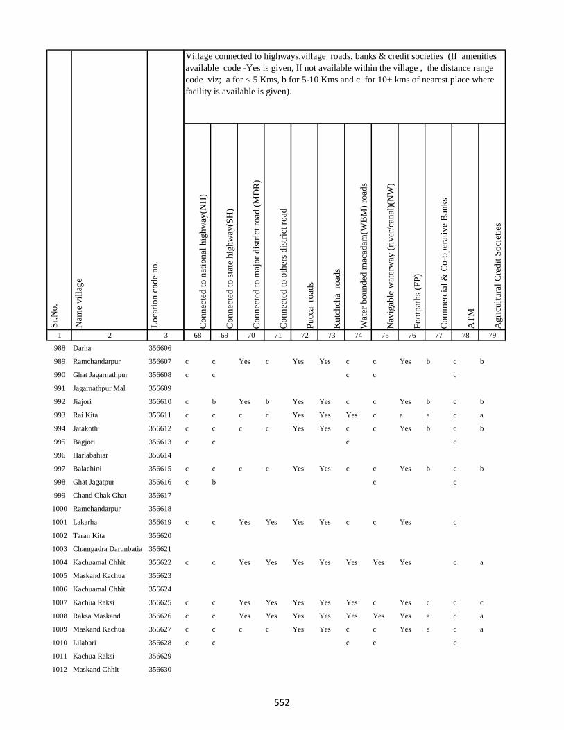
1 2 3
Lo
cati
on
co
de
no
.
Nam
e v
illa
ge
Sr.
No
.
988 Darha 356606
989 Ramchandarpur 356607
990 Ghat Jagarnathpur 356608
991 Jagarnathpur Mal 356609
992 Jiajori 356610
993 Rai Kita 356611
994 Jatakothi 356612
995 Bagjori 356613
996 Harlabahiar 356614
997 Balachini 356615
998 Ghat Jagatpur 356616
999 Chand Chak Ghat 356617
1000 Ramchandarpur 356618
1001 Lakarha 356619
1002 Taran Kita 356620
1003 Chamgadra Darunbatia 356621
1004 Kachuamal Chhit 356622
1005 Maskand Kachua 356623
1006 Kachuamal Chhit 356624
1007 Kachua Raksi 356625
1008 Raksa Maskand 356626
1009 Maskand Kachua 356627
1010 Lilabari 356628
1011 Kachua Raksi 356629
1012 Maskand Chhit 356630
Co
nn
ecte
d t
o n
atio
nal
hig
hw
ay(N
H)
Co
nn
ecte
d t
o s
tate
hig
hw
ay(S
H)
Co
nn
ecte
d t
o m
ajo
r d
istr
ict
road
(M
DR
)
Co
nn
ecte
d t
o o
ther
s d
istr
ict
road
Pu
cca
ro
ads
Ku
tch
cha
ro
ads
Wat
er b
ou
nd
ed m
acad
am(W
BM
) ro
ads
Nav
igab
le w
ater
way
(ri
ver
/can
al)(
NW
)
Fo
otp
ath
s (F
P)
Co
mm
erci
al &
Co
-op
erat
ive
Ban
ks
AT
M
Ag
ricu
ltu
ral
Cre
dit
So
ciet
ies
68 69 70 71 72 73 74 75 76 77 78 79
Village connected to highways,village roads, banks & credit societies (If amenities
available code -Yes is given, If not available within the village , the distance range
code viz; a for < 5 Kms, b for 5-10 Kms and c for 10+ kms of nearest place where
facility is available is given).
c c Yes c Yes Yes c c Yes b c b
c c c c c
c b Yes b Yes Yes c c Yes b c b
c c c c Yes Yes Yes c a a c a
c c c c Yes Yes c c Yes b c b
c c c c
c c c c Yes Yes c c Yes b c b
c b c c
c c Yes Yes Yes Yes c c Yes c
c c Yes Yes Yes Yes Yes Yes Yes c a
c c Yes Yes Yes Yes Yes c Yes c c c
c c Yes Yes Yes Yes Yes Yes Yes a c a
c c c c Yes Yes c c Yes a c a
c c c c c
552
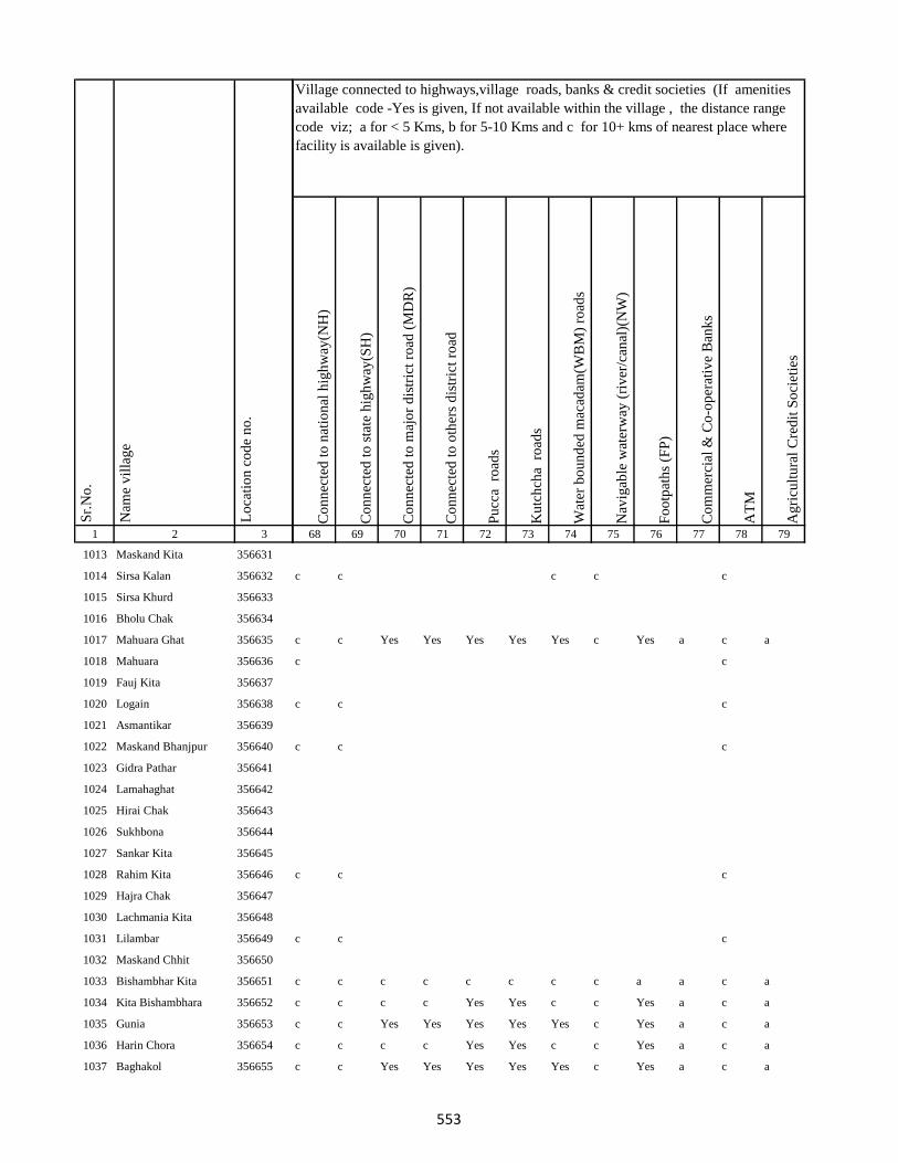
1 2 3
Lo
cati
on
co
de
no
.
Nam
e v
illa
ge
Sr.
No
.
1013 Maskand Kita 356631
1014 Sirsa Kalan 356632
1015 Sirsa Khurd 356633
1016 Bholu Chak 356634
1017 Mahuara Ghat 356635
1018 Mahuara 356636
1019 Fauj Kita 356637
1020 Logain 356638
1021 Asmantikar 356639
1022 Maskand Bhanjpur 356640
1023 Gidra Pathar 356641
1024 Lamahaghat 356642
1025 Hirai Chak 356643
1026 Sukhbona 356644
1027 Sankar Kita 356645
1028 Rahim Kita 356646
1029 Hajra Chak 356647
1030 Lachmania Kita 356648
1031 Lilambar 356649
1032 Maskand Chhit 356650
1033 Bishambhar Kita 356651
1034 Kita Bishambhara 356652
1035 Gunia 356653
1036 Harin Chora 356654
1037 Baghakol 356655
Co
nn
ecte
d t
o n
atio
nal
hig
hw
ay(N
H)
Co
nn
ecte
d t
o s
tate
hig
hw
ay(S
H)
Co
nn
ecte
d t
o m
ajo
r d
istr
ict
road
(M
DR
)
Co
nn
ecte
d t
o o
ther
s d
istr
ict
road
Pu
cca
ro
ads
Ku
tch
cha
ro
ads
Wat
er b
ou
nd
ed m
acad
am(W
BM
) ro
ads
Nav
igab
le w
ater
way
(ri
ver
/can
al)(
NW
)
Fo
otp
ath
s (F
P)
Co
mm
erci
al &
Co
-op
erat
ive
Ban
ks
AT
M
Ag
ricu
ltu
ral
Cre
dit
So
ciet
ies
68 69 70 71 72 73 74 75 76 77 78 79
Village connected to highways,village roads, banks & credit societies (If amenities
available code -Yes is given, If not available within the village , the distance range
code viz; a for < 5 Kms, b for 5-10 Kms and c for 10+ kms of nearest place where
facility is available is given).
c c c c c
c c Yes Yes Yes Yes Yes c Yes a c a
c c
c c c
c c c
c c c
c c c
c c c c c c c c a a c a
c c c c Yes Yes c c Yes a c a
c c Yes Yes Yes Yes Yes c Yes a c a
c c c c Yes Yes c c Yes a c a
c c Yes Yes Yes Yes Yes c Yes a c a
553
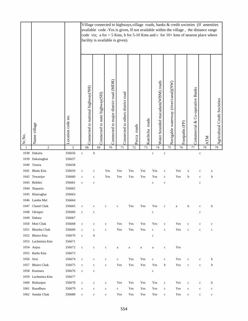
1 2 3
Lo
cati
on
co
de
no
.
Nam
e v
illa
ge
Sr.
No
.
1038 Dakaita 356656
1039 Dakaitaghat 356657
1040 Tetaria 356658
1041 Bhalu Kita 356659
1042 Tewarijor 356660
1043 Beltikri 356661
1044 Jhapania 356662
1045 Khairaghat 356663
1046 Lamha Mal 356664
1047 Chand Chak 356665
1048 Ghospur 356666
1049 Dahara 356667
1050 Moti Chak 356668
1051 Bhartha Chak 356669
1052 Bhairo Kita 356670
1053 Lachminia Kita 356671
1054 Anjna 356672
1055 Barhe Kita 356673
1056 Sirsi 356674
1057 Bhairo Chak 356675
1058 Kusmara 356676
1059 Lachminia Kita 356677
1060 Bishunpur 356678
1061 Baradbara 356679
1062 Sundar Chak 356680
Co
nn
ecte
d t
o n
atio
nal
hig
hw
ay(N
H)
Co
nn
ecte
d t
o s
tate
hig
hw
ay(S
H)
Co
nn
ecte
d t
o m
ajo
r d
istr
ict
road
(M
DR
)
Co
nn
ecte
d t
o o
ther
s d
istr
ict
road
Pu
cca
ro
ads
Ku
tch
cha
ro
ads
Wat
er b
ou
nd
ed m
acad
am(W
BM
) ro
ads
Nav
igab
le w
ater
way
(ri
ver
/can
al)(
NW
)
Fo
otp
ath
s (F
P)
Co
mm
erci
al &
Co
-op
erat
ive
Ban
ks
AT
M
Ag
ricu
ltu
ral
Cre
dit
So
ciet
ies
68 69 70 71 72 73 74 75 76 77 78 79
Village connected to highways,village roads, banks & credit societies (If amenities
available code -Yes is given, If not available within the village , the distance range
code viz; a for < 5 Kms, b for 5-10 Kms and c for 10+ kms of nearest place where
facility is available is given).
c b c c c
c c Yes Yes Yes Yes Yes c Yes a c a
c c Yes Yes Yes Yes Yes c Yes b c b
c c c c c
c c c c Yes Yes Yes c a b c b
c c c c
c c c Yes Yes Yes Yes c Yes c c c
c c c Yes Yes Yes c c Yes c c c
c b c
c c c a a a a c Yes
c c c c Yes Yes c c Yes c c b
c c c Yes Yes Yes Yes b Yes c c b
c c c
c c c Yes Yes Yes Yes c Yes c c b
c c c c Yes Yes Yes c Yes c c c
c c c Yes Yes Yes Yes c Yes c c c
554

1 2 3
Lo
cati
on
co
de
no
.
Nam
e v
illa
ge
Sr.
No
.
1063 Bhaju Chak 356681
1064 Malia Chak 356682
1065 Afzal Kita 356683
1066 Mariha 356684
1067 Kushapur 356685
1068 Fazil Kita 356686
1069 Dumra 356687
1070 Bisambhara Kita 356688
1071 Dahia 356689
1072 Kaljhara 356690
1073 Phudkipur 356691
1074 Simratola 356692
1075 Hundra 356693
1076 Phudkipur 356694
1077 Shahpur Beldiha 356695
1078 Phasiatikar 356696
1079 Sirsa 356697
1080 Samhari 356698
1081 Asanand Kita 356699
1082 Muradpur 356700
1083 Subarai Samhra 356701
1084 Semra Kita 356702
1085 Mirza Chak 356703
1086 Hasan Karharia 356704
1087 Manian Karharia 356705
Co
nn
ecte
d t
o n
atio
nal
hig
hw
ay(N
H)
Co
nn
ecte
d t
o s
tate
hig
hw
ay(S
H)
Co
nn
ecte
d t
o m
ajo
r d
istr
ict
road
(M
DR
)
Co
nn
ecte
d t
o o
ther
s d
istr
ict
road
Pu
cca
ro
ads
Ku
tch
cha
ro
ads
Wat
er b
ou
nd
ed m
acad
am(W
BM
) ro
ads
Nav
igab
le w
ater
way
(ri
ver
/can
al)(
NW
)
Fo
otp
ath
s (F
P)
Co
mm
erci
al &
Co
-op
erat
ive
Ban
ks
AT
M
Ag
ricu
ltu
ral
Cre
dit
So
ciet
ies
68 69 70 71 72 73 74 75 76 77 78 79
Village connected to highways,village roads, banks & credit societies (If amenities
available code -Yes is given, If not available within the village , the distance range
code viz; a for < 5 Kms, b for 5-10 Kms and c for 10+ kms of nearest place where
facility is available is given).
c c c Yes Yes Yes Yes c Yes c c c
c c c c
c c c c b a c c Yes c
c c c c Yes Yes c c Yes c c c
c c c c Yes Yes Yes c Yes c c c
c c c Yes Yes Yes Yes c Yes c c c
c c c Yes Yes Yes Yes Yes Yes c c c
c c c Yes Yes Yes Yes Yes Yes c c c
c c c
c c c
c b b Yes Yes Yes Yes Yes a c c c
c c c Yes Yes Yes Yes Yes Yes c c c
c c c c Yes Yes Yes Yes Yes c c c
c c c
c c
c Yes Yes Yes Yes Yes Yes c a b c b
c c c c Yes Yes Yes c Yes c c c
c c c Yes Yes Yes Yes c Yes c c c
c c c c Yes Yes c c Yes c c c
555

1 2 3
Lo
cati
on
co
de
no
.
Nam
e v
illa
ge
Sr.
No
.
1088 Jathari 356706
1089 Hari Karharia 356707
1090 Kanreswari Kita 356708
1091 Hasanpur 356709
1092 Bakwa Chak 356710
1093 Bela Kita 356711
1094 Janki Kita 356712
1095 Mal Bhandari Dih 356713
1096 Semrakita And Ghat Bhandarid356714
1097 Aslulahsamra 356715
1098 Bariartola 356716
1099 Maganpipra 356717
1100 Ranbahiar 356718
1101 Jamua 356719
1102 Chuna Chak 356720
1103 Ginratari 356721
1104 Sakal Chak 356722
1105 Larai Chak 356723
1106 Gohira Kita 356724
1107 Hemcha Chak 356725
1108 Asanbani 356726
1109 Jhigur Kita 356727
1110 Mal Bhandaridih 356728
1111 Semarkita Ghat Bhandaridih356729
1112 Nimgachhi And Kita 356730
Co
nn
ecte
d t
o n
atio
nal
hig
hw
ay(N
H)
Co
nn
ecte
d t
o s
tate
hig
hw
ay(S
H)
Co
nn
ecte
d t
o m
ajo
r d
istr
ict
road
(M
DR
)
Co
nn
ecte
d t
o o
ther
s d
istr
ict
road
Pu
cca
ro
ads
Ku
tch
cha
ro
ads
Wat
er b
ou
nd
ed m
acad
am(W
BM
) ro
ads
Nav
igab
le w
ater
way
(ri
ver
/can
al)(
NW
)
Fo
otp
ath
s (F
P)
Co
mm
erci
al &
Co
-op
erat
ive
Ban
ks
AT
M
Ag
ricu
ltu
ral
Cre
dit
So
ciet
ies
68 69 70 71 72 73 74 75 76 77 78 79
Village connected to highways,village roads, banks & credit societies (If amenities
available code -Yes is given, If not available within the village , the distance range
code viz; a for < 5 Kms, b for 5-10 Kms and c for 10+ kms of nearest place where
facility is available is given).
c c c Yes Yes Yes Yes c Yes c c c
c c c
c Yes Yes Yes Yes Yes Yes c a b c b
Yes Yes Yes Yes Yes Yes Yes c a c c
c Yes Yes Yes Yes Yes Yes Yes a b c b
c Yes Yes Yes Yes Yes Yes Yes a c c c
c Yes Yes Yes Yes Yes Yes c a b c b
c Yes Yes Yes Yes Yes Yes c a b c b
c Yes Yes Yes Yes Yes Yes Yes a b c b
c Yes Yes Yes Yes Yes Yes b a b b b
c c c
c c Yes Yes Yes Yes c Yes Yes c c c
c b Yes Yes Yes Yes c c Yes c c c
c c c Yes Yes Yes Yes c Yes c c c
c c c c
c c c c
c c c
556
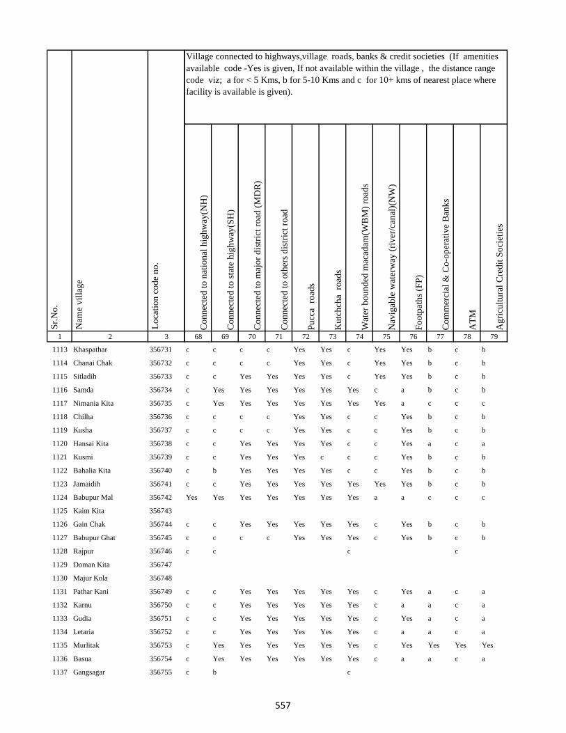
1 2 3
Lo
cati
on
co
de
no
.
Nam
e v
illa
ge
Sr.
No
.
1113 Khaspathar 356731
1114 Chanai Chak 356732
1115 Sitladih 356733
1116 Samda 356734
1117 Nimania Kita 356735
1118 Chilha 356736
1119 Kusha 356737
1120 Hansai Kita 356738
1121 Kusmi 356739
1122 Bahalia Kita 356740
1123 Jamaidih 356741
1124 Babupur Mal 356742
1125 Kaim Kita 356743
1126 Gain Chak 356744
1127 Babupur Ghat 356745
1128 Rajpur 356746
1129 Doman Kita 356747
1130 Majur Kola 356748
1131 Pathar Kani 356749
1132 Karnu 356750
1133 Gudia 356751
1134 Letaria 356752
1135 Murlitak 356753
1136 Basua 356754
1137 Gangsagar 356755
Co
nn
ecte
d t
o n
atio
nal
hig
hw
ay(N
H)
Co
nn
ecte
d t
o s
tate
hig
hw
ay(S
H)
Co
nn
ecte
d t
o m
ajo
r d
istr
ict
road
(M
DR
)
Co
nn
ecte
d t
o o
ther
s d
istr
ict
road
Pu
cca
ro
ads
Ku
tch
cha
ro
ads
Wat
er b
ou
nd
ed m
acad
am(W
BM
) ro
ads
Nav
igab
le w
ater
way
(ri
ver
/can
al)(
NW
)
Fo
otp
ath
s (F
P)
Co
mm
erci
al &
Co
-op
erat
ive
Ban
ks
AT
M
Ag
ricu
ltu
ral
Cre
dit
So
ciet
ies
68 69 70 71 72 73 74 75 76 77 78 79
Village connected to highways,village roads, banks & credit societies (If amenities
available code -Yes is given, If not available within the village , the distance range
code viz; a for < 5 Kms, b for 5-10 Kms and c for 10+ kms of nearest place where
facility is available is given).
c c c c Yes Yes c Yes Yes b c b
c c c c Yes Yes c Yes Yes b c b
c c Yes Yes Yes Yes c Yes Yes b c b
c Yes Yes Yes Yes Yes Yes c a b c b
c Yes Yes Yes Yes Yes Yes Yes a c c c
c c c c Yes Yes c c Yes b c b
c c c c Yes Yes c c Yes b c b
c c Yes Yes Yes Yes c c Yes a c a
c c Yes Yes Yes c c c Yes b c b
c b Yes Yes Yes Yes c c Yes b c b
c c Yes Yes Yes Yes Yes Yes Yes b c b
Yes Yes Yes Yes Yes Yes Yes a a c c c
c c Yes Yes Yes Yes Yes c Yes b c b
c c c c Yes Yes Yes c Yes b c b
c c c c
c c Yes Yes Yes Yes Yes c Yes a c a
c c Yes Yes Yes Yes Yes c a a c a
c c Yes Yes Yes Yes Yes c Yes a c a
c c Yes Yes Yes Yes Yes c a a c a
c Yes Yes Yes Yes Yes Yes c Yes Yes Yes Yes
c Yes Yes Yes Yes Yes Yes c a a c a
c b c
557
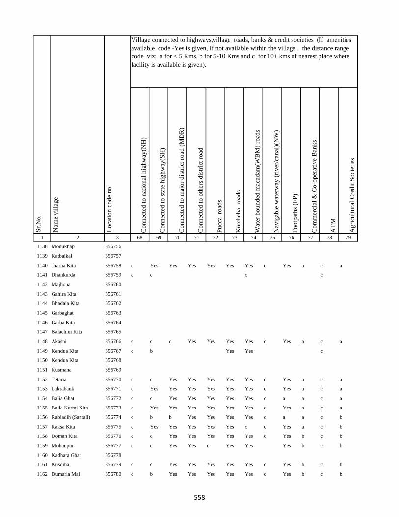
1 2 3
Lo
cati
on
co
de
no
.
Nam
e v
illa
ge
Sr.
No
.
1138 Monukhap 356756
1139 Katbaikal 356757
1140 Jharna Kita 356758
1141 Dhankurda 356759
1142 Majhoua 356760
1143 Gahira Kita 356761
1144 Bhadaia Kita 356762
1145 Garbaghat 356763
1146 Garba Kita 356764
1147 Balachini Kita 356765
1148 Akasni 356766
1149 Kendua Kita 356767
1150 Kendua Kita 356768
1151 Kusmaha 356769
1152 Tetaria 356770
1153 Lakrabank 356771
1154 Balia Ghat 356772
1155 Balia Kurmi Kita 356773
1156 Rabiadih (Santali) 356774
1157 Raksa Kita 356775
1158 Doman Kita 356776
1159 Mohanpur 356777
1160 Kadhara Ghat 356778
1161 Kusdiha 356779
1162 Dumaria Mal 356780
Co
nn
ecte
d t
o n
atio
nal
hig
hw
ay(N
H)
Co
nn
ecte
d t
o s
tate
hig
hw
ay(S
H)
Co
nn
ecte
d t
o m
ajo
r d
istr
ict
road
(M
DR
)
Co
nn
ecte
d t
o o
ther
s d
istr
ict
road
Pu
cca
ro
ads
Ku
tch
cha
ro
ads
Wat
er b
ou
nd
ed m
acad
am(W
BM
) ro
ads
Nav
igab
le w
ater
way
(ri
ver
/can
al)(
NW
)
Fo
otp
ath
s (F
P)
Co
mm
erci
al &
Co
-op
erat
ive
Ban
ks
AT
M
Ag
ricu
ltu
ral
Cre
dit
So
ciet
ies
68 69 70 71 72 73 74 75 76 77 78 79
Village connected to highways,village roads, banks & credit societies (If amenities
available code -Yes is given, If not available within the village , the distance range
code viz; a for < 5 Kms, b for 5-10 Kms and c for 10+ kms of nearest place where
facility is available is given).
c Yes Yes Yes Yes Yes Yes c Yes a c a
c c c c
c c c Yes Yes Yes Yes c Yes a c a
c b Yes Yes c
c c Yes Yes Yes Yes Yes c Yes a c a
c Yes Yes Yes Yes Yes Yes c Yes a c a
c c Yes Yes Yes Yes Yes c a a c a
c Yes Yes Yes Yes Yes Yes c Yes a c a
c b b Yes Yes Yes Yes c a a c b
c Yes Yes Yes Yes Yes c c Yes a c b
c c Yes Yes Yes Yes Yes c Yes b c b
c c Yes Yes c Yes Yes Yes b c b
c c Yes Yes Yes Yes Yes c Yes b c b
c b Yes Yes Yes Yes Yes c Yes b c b
558
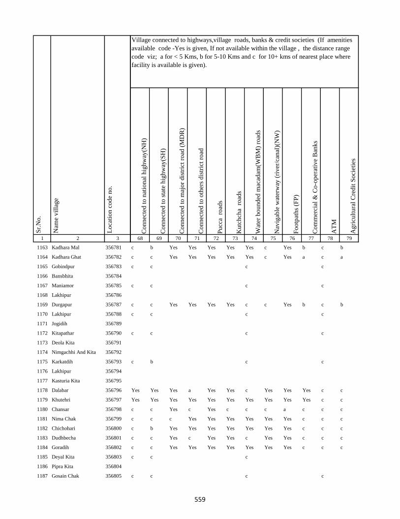
1 2 3
Lo
cati
on
co
de
no
.
Nam
e v
illa
ge
Sr.
No
.
1163 Kadhara Mal 356781
1164 Kadhara Ghat 356782
1165 Gobindpur 356783
1166 Bansbhita 356784
1167 Maniamor 356785
1168 Lakhipur 356786
1169 Durgapur 356787
1170 Lakhipur 356788
1171 Jogidih 356789
1172 Kitapathar 356790
1173 Deola Kita 356791
1174 Nimgachhi And Kita 356792
1175 Karkatdih 356793
1176 Lakhipur 356794
1177 Kasturia Kita 356795
1178 Dalabar 356796
1179 Khutehri 356797
1180 Chansar 356798
1181 Nima Chak 356799
1182 Chichohari 356800
1183 Dudhbecha 356801
1184 Goradih 356802
1185 Deyal Kita 356803
1186 Pipra Kita 356804
1187 Gosain Chak 356805
Co
nn
ecte
d t
o n
atio
nal
hig
hw
ay(N
H)
Co
nn
ecte
d t
o s
tate
hig
hw
ay(S
H)
Co
nn
ecte
d t
o m
ajo
r d
istr
ict
road
(M
DR
)
Co
nn
ecte
d t
o o
ther
s d
istr
ict
road
Pu
cca
ro
ads
Ku
tch
cha
ro
ads
Wat
er b
ou
nd
ed m
acad
am(W
BM
) ro
ads
Nav
igab
le w
ater
way
(ri
ver
/can
al)(
NW
)
Fo
otp
ath
s (F
P)
Co
mm
erci
al &
Co
-op
erat
ive
Ban
ks
AT
M
Ag
ricu
ltu
ral
Cre
dit
So
ciet
ies
68 69 70 71 72 73 74 75 76 77 78 79
Village connected to highways,village roads, banks & credit societies (If amenities
available code -Yes is given, If not available within the village , the distance range
code viz; a for < 5 Kms, b for 5-10 Kms and c for 10+ kms of nearest place where
facility is available is given).
c b Yes Yes Yes Yes Yes c Yes b c b
c c Yes Yes Yes Yes Yes c Yes a c a
c c c c
c c c c
c c Yes Yes Yes Yes c c Yes b c b
c c c c
c c c c
c b c c
Yes Yes Yes a Yes Yes c Yes Yes Yes c c
Yes Yes Yes Yes Yes Yes Yes Yes Yes Yes c c
c c Yes c Yes c c c a c c c
c c c Yes Yes Yes Yes Yes Yes c c c
c b Yes Yes Yes Yes Yes Yes Yes c c c
c c Yes c Yes Yes c Yes Yes c c c
c c Yes Yes Yes Yes Yes Yes Yes c c c
c c c
c c c c
559
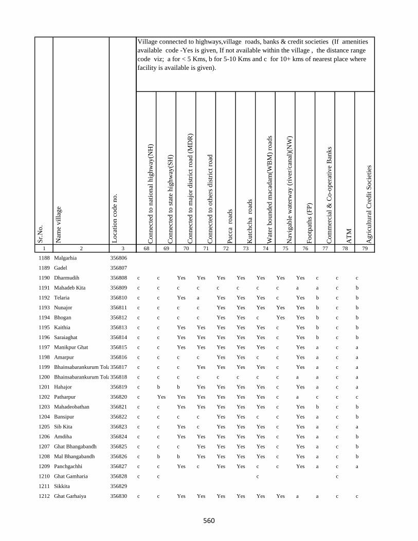
1 2 3
Lo
cati
on
co
de
no
.
Nam
e v
illa
ge
Sr.
No
.
1188 Malgarhia 356806
1189 Gadel 356807
1190 Dharmudih 356808
1191 Mahadeb Kita 356809
1192 Telaria 356810
1193 Nunajor 356811
1194 Bhogan 356812
1195 Kaithia 356813
1196 Saraiaghat 356814
1197 Manikpur Ghat 356815
1198 Amarpur 356816
1199 Bhainsabarankurum Tola356817
1200 Bhainsabarankurum Tola Mal356818
1201 Hahajor 356819
1202 Patharpur 356820
1203 Mahadeobathan 356821
1204 Bansipur 356822
1205 Sib Kita 356823
1206 Amdiha 356824
1207 Ghat Bhangabandh 356825
1208 Mal Bhangabandh 356826
1209 Panchgachhi 356827
1210 Ghat Gamharia 356828
1211 Sikkita 356829
1212 Ghat Garhaiya 356830
Co
nn
ecte
d t
o n
atio
nal
hig
hw
ay(N
H)
Co
nn
ecte
d t
o s
tate
hig
hw
ay(S
H)
Co
nn
ecte
d t
o m
ajo
r d
istr
ict
road
(M
DR
)
Co
nn
ecte
d t
o o
ther
s d
istr
ict
road
Pu
cca
ro
ads
Ku
tch
cha
ro
ads
Wat
er b
ou
nd
ed m
acad
am(W
BM
) ro
ads
Nav
igab
le w
ater
way
(ri
ver
/can
al)(
NW
)
Fo
otp
ath
s (F
P)
Co
mm
erci
al &
Co
-op
erat
ive
Ban
ks
AT
M
Ag
ricu
ltu
ral
Cre
dit
So
ciet
ies
68 69 70 71 72 73 74 75 76 77 78 79
Village connected to highways,village roads, banks & credit societies (If amenities
available code -Yes is given, If not available within the village , the distance range
code viz; a for < 5 Kms, b for 5-10 Kms and c for 10+ kms of nearest place where
facility is available is given).
c c Yes Yes Yes Yes Yes Yes Yes c c c
c c c c c c c c a a c b
c c Yes a Yes Yes Yes c Yes b c b
c c c c Yes Yes Yes Yes Yes b c b
c c c c Yes Yes c Yes Yes b c b
c c Yes Yes Yes Yes Yes c Yes b c b
c c Yes Yes Yes Yes Yes c Yes b c b
c c Yes Yes Yes Yes Yes c Yes a c a
c c c c Yes Yes c c Yes a c a
c c c Yes Yes Yes Yes c Yes a c a
c c c c c c c c a a c a
c b b Yes Yes Yes Yes c Yes a c a
c Yes Yes Yes Yes Yes Yes c a c c c
c c Yes Yes Yes Yes Yes c Yes b c b
c c c c Yes Yes c c Yes a c b
c c Yes c Yes Yes Yes c Yes a c a
c c Yes Yes Yes Yes Yes c Yes a c b
c c c Yes Yes Yes Yes c Yes a c b
c b b Yes Yes Yes Yes c Yes a c b
c c Yes c Yes Yes c c Yes a c a
c c c c
c c Yes Yes Yes Yes Yes Yes a a c c
560

1 2 3
Lo
cati
on
co
de
no
.
Nam
e v
illa
ge
Sr.
No
.
1213 Raghunath Kita 356831
1214 Gauri Kita 356832
1215 Madhu Chak 356833
1216 Sikkita 356834
1217 Sarawa 356835
1218 Baridih 356836
1219 Gorantia 356837
1220 Baijnathpur 356838
1221 Lohathi 356839
Block T O T A L :
1222 Sonbarsa 356841
1223 Maheshliti 356842
1224 Matihani 356843
1225 Parasbana Urf Bhata Chak356844
1226 Chaura 356845
1227 Sareya 356846
1228 Tardiha 356847
1229 Khurd 356848
1230 Basbhita 356849
1231 Jogidih 356850
1232 Taratikar 356851
1233 Ghatkurwa 356852
1234 Ram Sundariya 356853
Co
nn
ecte
d t
o n
atio
nal
hig
hw
ay(N
H)
Co
nn
ecte
d t
o s
tate
hig
hw
ay(S
H)
Co
nn
ecte
d t
o m
ajo
r d
istr
ict
road
(M
DR
)
Co
nn
ecte
d t
o o
ther
s d
istr
ict
road
Pu
cca
ro
ads
Ku
tch
cha
ro
ads
Wat
er b
ou
nd
ed m
acad
am(W
BM
) ro
ads
Nav
igab
le w
ater
way
(ri
ver
/can
al)(
NW
)
Fo
otp
ath
s (F
P)
Co
mm
erci
al &
Co
-op
erat
ive
Ban
ks
AT
M
Ag
ricu
ltu
ral
Cre
dit
So
ciet
ies
68 69 70 71 72 73 74 75 76 77 78 79
Village connected to highways,village roads, banks & credit societies (If amenities
available code -Yes is given, If not available within the village , the distance range
code viz; a for < 5 Kms, b for 5-10 Kms and c for 10+ kms of nearest place where
facility is available is given).
c c c c Yes Yes Yes c Yes b c b
c b b b Yes Yes Yes c Yes b c b
c b Yes c Yes Yes c c Yes b c b
c c c c Yes Yes c c Yes c c c
c c c Yes Yes Yes Yes c Yes b c b
c c c Yes Yes Yes Yes c Yes b c b
c c c Yes Yes Yes Yes c Yes b c b
c c Yes Yes Yes Yes Yes c a a c c
c Yes c c Yes Yes c b Yes b c c
4 23 79 99 173 173 110 34 148 6 1 1
c c c c Yes Yes Yes c a b c Yes
c c c Yes Yes Yes Yes c a b c Yes
Yes Yes Yes Yes Yes Yes Yes Yes Yes Yes Yes Yes
c c c Yes Yes Yes c c Yes b c c
c b b Yes Yes Yes Yes b a b c Yes
c c c c Yes Yes c c Yes b c b
c c c Yes Yes Yes Yes c Yes a c a
c c c Yes Yes Yes Yes c Yes c c b
Yes Yes a a a c c Yes c b
c c Yes Yes Yes Yes c c Yes a c b
c c c
561
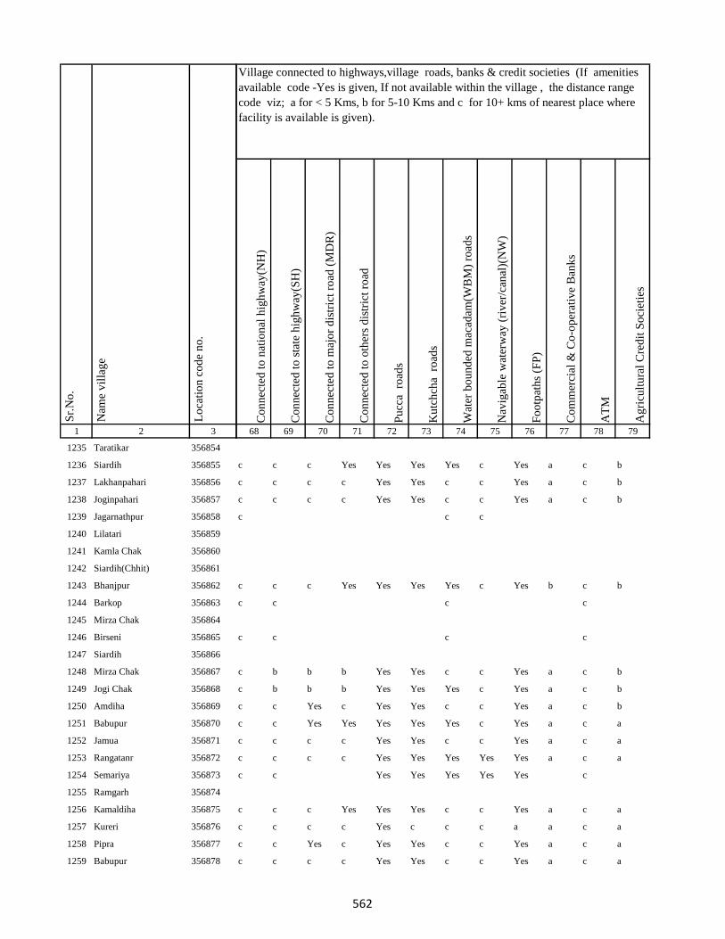
1 2 3
Lo
cati
on
co
de
no
.
Nam
e v
illa
ge
Sr.
No
.
1235 Taratikar 356854
1236 Siardih 356855
1237 Lakhanpahari 356856
1238 Joginpahari 356857
1239 Jagarnathpur 356858
1240 Lilatari 356859
1241 Kamla Chak 356860
1242 Siardih(Chhit) 356861
1243 Bhanjpur 356862
1244 Barkop 356863
1245 Mirza Chak 356864
1246 Birseni 356865
1247 Siardih 356866
1248 Mirza Chak 356867
1249 Jogi Chak 356868
1250 Amdiha 356869
1251 Babupur 356870
1252 Jamua 356871
1253 Rangatanr 356872
1254 Semariya 356873
1255 Ramgarh 356874
1256 Kamaldiha 356875
1257 Kureri 356876
1258 Pipra 356877
1259 Babupur 356878
Co
nn
ecte
d t
o n
atio
nal
hig
hw
ay(N
H)
Co
nn
ecte
d t
o s
tate
hig
hw
ay(S
H)
Co
nn
ecte
d t
o m
ajo
r d
istr
ict
road
(M
DR
)
Co
nn
ecte
d t
o o
ther
s d
istr
ict
road
Pu
cca
ro
ads
Ku
tch
cha
ro
ads
Wat
er b
ou
nd
ed m
acad
am(W
BM
) ro
ads
Nav
igab
le w
ater
way
(ri
ver
/can
al)(
NW
)
Fo
otp
ath
s (F
P)
Co
mm
erci
al &
Co
-op
erat
ive
Ban
ks
AT
M
Ag
ricu
ltu
ral
Cre
dit
So
ciet
ies
68 69 70 71 72 73 74 75 76 77 78 79
Village connected to highways,village roads, banks & credit societies (If amenities
available code -Yes is given, If not available within the village , the distance range
code viz; a for < 5 Kms, b for 5-10 Kms and c for 10+ kms of nearest place where
facility is available is given).
c c c Yes Yes Yes Yes c Yes a c b
c c c c Yes Yes c c Yes a c b
c c c c Yes Yes c c Yes a c b
c c c
c c c Yes Yes Yes Yes c Yes b c b
c c c c
c c c c
c b b b Yes Yes c c Yes a c b
c b b b Yes Yes Yes c Yes a c b
c c Yes c Yes Yes c c Yes a c b
c c Yes Yes Yes Yes Yes c Yes a c a
c c c c Yes Yes c c Yes a c a
c c c c Yes Yes Yes Yes Yes a c a
c c Yes Yes Yes Yes Yes c
c c c Yes Yes Yes c c Yes a c a
c c c c Yes c c c a a c a
c c Yes c Yes Yes c c Yes a c a
c c c c Yes Yes c c Yes a c a
562

1 2 3
Lo
cati
on
co
de
no
.
Nam
e v
illa
ge
Sr.
No
.
1260 Lakarjorimal 356879
1261 Tikabagicha 356880
1262 Gordhoi 356881
1263 Babupur 356882
1264 Nauratan Kita 356883
1265 Gordhoi 356884
1266 Joginpahari 356885
1267 Simariya 356886
1268 Sonar Chak 356887
1269 Duarichak 356888
1270 Tulsi Kita 356889
1271 Chau Chak 356890
1272 Karubandh 356891
1273 Haripur 356892
1274 Chau Chak 356893
1275 Lachhminiyan 356894
1276 Chepi 356895
1277 Kasiyatari 356896
1278 Kita Gardharpur 356897
1279 Lasutiya 356898
1280 Pathargama 356899
1281 Mal Pathargama 356900
1282 Arazi Pathargama 356901
1283 Chandi Chak 356902
1284 Baliya Kita 356903
Co
nn
ecte
d t
o n
atio
nal
hig
hw
ay(N
H)
Co
nn
ecte
d t
o s
tate
hig
hw
ay(S
H)
Co
nn
ecte
d t
o m
ajo
r d
istr
ict
road
(M
DR
)
Co
nn
ecte
d t
o o
ther
s d
istr
ict
road
Pu
cca
ro
ads
Ku
tch
cha
ro
ads
Wat
er b
ou
nd
ed m
acad
am(W
BM
) ro
ads
Nav
igab
le w
ater
way
(ri
ver
/can
al)(
NW
)
Fo
otp
ath
s (F
P)
Co
mm
erci
al &
Co
-op
erat
ive
Ban
ks
AT
M
Ag
ricu
ltu
ral
Cre
dit
So
ciet
ies
68 69 70 71 72 73 74 75 76 77 78 79
Village connected to highways,village roads, banks & credit societies (If amenities
available code -Yes is given, If not available within the village , the distance range
code viz; a for < 5 Kms, b for 5-10 Kms and c for 10+ kms of nearest place where
facility is available is given).
c c c c c c c c a a c a
c b b b Yes Yes c c Yes a c a
c c Yes c Yes Yes c c Yes a c a
c c c c
c c c c Yes Yes c c Yes a c a
c c c c
c b b b Yes Yes c c Yes a c a
c c c c Yes Yes c c Yes a c a
c c c c
c c c c Yes Yes c c Yes b c a
c c c Yes Yes Yes c c Yes b c a
c Yes Yes Yes Yes Yes c c Yes Yes c Yes
c c c c
c c c Yes Yes Yes Yes c Yes b c a
c c c c
563

1 2 3
Lo
cati
on
co
de
no
.
Nam
e v
illa
ge
Sr.
No
.
1285 Janki Kita 356904
1286 Sapinmor 356905
1287 Panjarhar 356906
1288 Panjarhar Birit 356907
1289 Karaila Chak 356908
1290 Ambasongram 356909
1291 Mahadeva Kita 356910
1292 Ghandharpur 356911
1293 Kumarsi 356912
1294 Sundarmor 356913
1295 Dandighat 356914
1296 Tengar 356915
1297 Machhitanr 356916
1298 Telni 356917
1299 Kobhara 356918
1300 Chilkara Gobind 356919
1301 Dumarariya 356920
1302 Bareghat 356921
1303 Baredih 356922
1304 Kasturiya 356923
1305 Sukhanand 356924
1306 Jamchir 356925
1307 Kendua 356926
1308 Rampur 356927
1309 Shampur 356928
Co
nn
ecte
d t
o n
atio
nal
hig
hw
ay(N
H)
Co
nn
ecte
d t
o s
tate
hig
hw
ay(S
H)
Co
nn
ecte
d t
o m
ajo
r d
istr
ict
road
(M
DR
)
Co
nn
ecte
d t
o o
ther
s d
istr
ict
road
Pu
cca
ro
ads
Ku
tch
cha
ro
ads
Wat
er b
ou
nd
ed m
acad
am(W
BM
) ro
ads
Nav
igab
le w
ater
way
(ri
ver
/can
al)(
NW
)
Fo
otp
ath
s (F
P)
Co
mm
erci
al &
Co
-op
erat
ive
Ban
ks
AT
M
Ag
ricu
ltu
ral
Cre
dit
So
ciet
ies
68 69 70 71 72 73 74 75 76 77 78 79
Village connected to highways,village roads, banks & credit societies (If amenities
available code -Yes is given, If not available within the village , the distance range
code viz; a for < 5 Kms, b for 5-10 Kms and c for 10+ kms of nearest place where
facility is available is given).
c b c
c c c c Yes Yes c c Yes a c b
c c c Yes Yes Yes Yes c Yes a c b
c c c Yes Yes Yes Yes c Yes a c Yes
c c c c Yes Yes c c Yes a c b
c b b b Yes Yes c c Yes a c b
c c Yes Yes Yes Yes c c Yes a c b
c c Yes c Yes Yes Yes c Yes a c b
c c c c Yes Yes Yes c Yes a c b
c c c c Yes Yes c c Yes a c b
c c c Yes Yes Yes Yes c Yes a c b
c b b b Yes Yes c c Yes a c b
c b b b Yes Yes c c Yes a c b
c c c c Yes Yes Yes c Yes a c a
c c c c Yes Yes c c Yes a c b
c c c c
c c c c Yes Yes c c Yes a c b
c c c c Yes Yes c c Yes a c b
c c c c Yes Yes Yes c Yes a c b
c c c c Yes Yes c c Yes Yes c b
564

1 2 3
Lo
cati
on
co
de
no
.
Nam
e v
illa
ge
Sr.
No
.
1310 Barmasiya 356929
1311 Palipaya 356930
1312 Bargama 356931
1313 Manoharpur 356932
1314 Saranda 356933
1315 Boha 356934
1316 Khariani 356935
1317 Barhara 356936
1318 Bhalsumbhiya 356937
1319 Pipra 356938
1320 Bara Bandh 356939
1321 Awratanr 356940
1322 Harkata 356941
1323 Lakhanpahari Chhit 356942
1324 Bhanta Chak Chhota 356943
1325 Khairbani 356944
1326 Masnaha 356945
1327 Siripur 356946
1328 Mohanpur 356947
1329 Kolua 356948
1330 Ghatbaliya 356949
1331 Jalo Kundi 356950
1332 Bhata Chak 356951
1333 Tetariya 356952
1334 Taratikar 356953
Co
nn
ecte
d t
o n
atio
nal
hig
hw
ay(N
H)
Co
nn
ecte
d t
o s
tate
hig
hw
ay(S
H)
Co
nn
ecte
d t
o m
ajo
r d
istr
ict
road
(M
DR
)
Co
nn
ecte
d t
o o
ther
s d
istr
ict
road
Pu
cca
ro
ads
Ku
tch
cha
ro
ads
Wat
er b
ou
nd
ed m
acad
am(W
BM
) ro
ads
Nav
igab
le w
ater
way
(ri
ver
/can
al)(
NW
)
Fo
otp
ath
s (F
P)
Co
mm
erci
al &
Co
-op
erat
ive
Ban
ks
AT
M
Ag
ricu
ltu
ral
Cre
dit
So
ciet
ies
68 69 70 71 72 73 74 75 76 77 78 79
Village connected to highways,village roads, banks & credit societies (If amenities
available code -Yes is given, If not available within the village , the distance range
code viz; a for < 5 Kms, b for 5-10 Kms and c for 10+ kms of nearest place where
facility is available is given).
c c c c Yes Yes c c Yes a c b
c c c c Yes Yes c c Yes a c b
c c c c Yes Yes c c Yes a c b
c b b b Yes Yes c c Yes a c b
c c c c Yes Yes Yes c Yes a c c
c c c c Yes Yes c c Yes a c c
c c c Yes Yes Yes Yes c Yes b c c
c c c c Yes Yes c c Yes b c c
c c c c Yes Yes Yes c a b c a
c Yes Yes c Yes Yes c c Yes Yes c c
c b b b Yes c c c Yes c c c
c c c c Yes c c c Yes c c c
c c c c c c c c a b c a
c c c c Yes Yes Yes c Yes b c a
c c c c Yes Yes c c Yes b c a
c c c c
c b c c
c c c c Yes Yes Yes c Yes b c a
c c c c
c c c Yes Yes Yes c c Yes b c a
565
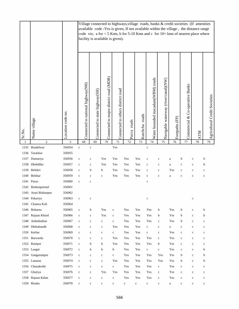
1 2 3
Lo
cati
on
co
de
no
.
Nam
e v
illa
ge
Sr.
No
.
1335 Bandelwar 356954
1336 Taratikar 356955
1337 Dumariya 356956
1338 Dhobdiha 356957
1339 Beltikri 356958
1340 Belshar 356959
1341 Parua 356960
1342 Biahunpurmal 356961
1343 Arazi Bishunpur 356962
1344 Pakariya 356963
1345 Chamra Koli 356964
1346 Boharna 356965
1347 Rajaun Khurd 356966
1348 Ambabathan 356967
1349 Dhibabandh 356968
1350 Kerbar 356969
1351 Barwarda 356970
1352 Ranipur 356971
1353 Laugai 356972
1354 Gangarampur 356973
1355 Latauna 356974
1356 Chunakothi 356975
1357 Ghutiya 356976
1358 Rajaun Kalan 356977
1359 Bisaha 356978
Co
nn
ecte
d t
o n
atio
nal
hig
hw
ay(N
H)
Co
nn
ecte
d t
o s
tate
hig
hw
ay(S
H)
Co
nn
ecte
d t
o m
ajo
r d
istr
ict
road
(M
DR
)
Co
nn
ecte
d t
o o
ther
s d
istr
ict
road
Pu
cca
ro
ads
Ku
tch
cha
ro
ads
Wat
er b
ou
nd
ed m
acad
am(W
BM
) ro
ads
Nav
igab
le w
ater
way
(ri
ver
/can
al)(
NW
)
Fo
otp
ath
s (F
P)
Co
mm
erci
al &
Co
-op
erat
ive
Ban
ks
AT
M
Ag
ricu
ltu
ral
Cre
dit
So
ciet
ies
68 69 70 71 72 73 74 75 76 77 78 79
Village connected to highways,village roads, banks & credit societies (If amenities
available code -Yes is given, If not available within the village , the distance range
code viz; a for < 5 Kms, b for 5-10 Kms and c for 10+ kms of nearest place where
facility is available is given).
c c Yes c
c c Yes Yes Yes Yes c c a b c b
c c Yes Yes Yes Yes c c a c c b
c b b Yes Yes Yes c c Yes c c c
c c c Yes Yes Yes c c a c c c
c c c
c c c c
c b Yes c Yes Yes Yes b Yes b c b
c c Yes c Yes Yes Yes b Yes b c b
c c c c Yes Yes Yes c Yes b c c
c c c Yes Yes Yes c c a c c c
c c c c Yes Yes c c Yes c c c
c c c Yes Yes Yes Yes c Yes c c c
c b b Yes Yes Yes Yes b Yes c c c
c b b b Yes Yes c c Yes c c b
c c c c Yes Yes Yes Yes Yes b c b
c c c Yes Yes Yes Yes Yes Yes b c b
c c c c Yes Yes Yes c Yes c c c
c c Yes Yes Yes Yes Yes c Yes c c c
c c c c Yes Yes Yes c Yes c c c
c c c c c c c c a c c c
566

1 2 3
Lo
cati
on
co
de
no
.
Nam
e v
illa
ge
Sr.
No
.
1360 Charkaghat 356979
1361 Nimbar 356980
1362 Dighi 356981
1363 Korkaghat 356982
1364 Amad Khani 356983
1365 Raksu Kita 356984
1366 Chakwa 356985
1367 Jasmata 356986
1368 Simariya 356987
1369 Sanatan 356988
1370 Kela Kita 356989
1371 Khasdighi 356990
1372 Toiadih 356991
1373 Ramu Chak 356992
1374 Charkaghat 356993
1375 Garka 356994
1376 Bariyata 356995
1377 Charkaghat 356996
1378 Tabhalpur 356997
1379 Gobindpur 356998
1380 Masudanpur 356999
1381 Bedpur 357000
1382 Bhagwan Chak 357001
1383 Rup Chak 357002
1384 Pathar Kani Mal 357003
Co
nn
ecte
d t
o n
atio
nal
hig
hw
ay(N
H)
Co
nn
ecte
d t
o s
tate
hig
hw
ay(S
H)
Co
nn
ecte
d t
o m
ajo
r d
istr
ict
road
(M
DR
)
Co
nn
ecte
d t
o o
ther
s d
istr
ict
road
Pu
cca
ro
ads
Ku
tch
cha
ro
ads
Wat
er b
ou
nd
ed m
acad
am(W
BM
) ro
ads
Nav
igab
le w
ater
way
(ri
ver
/can
al)(
NW
)
Fo
otp
ath
s (F
P)
Co
mm
erci
al &
Co
-op
erat
ive
Ban
ks
AT
M
Ag
ricu
ltu
ral
Cre
dit
So
ciet
ies
68 69 70 71 72 73 74 75 76 77 78 79
Village connected to highways,village roads, banks & credit societies (If amenities
available code -Yes is given, If not available within the village , the distance range
code viz; a for < 5 Kms, b for 5-10 Kms and c for 10+ kms of nearest place where
facility is available is given).
c c c Yes Yes Yes Yes c Yes a c c
c c c Yes Yes Yes c c Yes c c c
c c c c Yes Yes Yes c a Yes c c
c c c c Yes Yes c c Yes a c c
c c c
c Yes Yes c Yes
c c c Yes Yes Yes Yes c a a c a
c c c
c b b Yes Yes Yes Yes c Yes b b b
c b b Yes Yes Yes c c Yes b c b
c c c c c
c c b b a a c c b c b
c c c c c
c b b Yes Yes Yes c c Yes b c b
c c c Yes Yes Yes c c Yes b c b
c c c c
567

1 2 3
Lo
cati
on
co
de
no
.
Nam
e v
illa
ge
Sr.
No
.
1385 Pathar Kani Ghat 357004
1386 Chilra 357005
1387 Chainpur 357006
1388 Ghat Rampur 357007
1389 Mal Rampur 357008
1390 Mal Nistara 357009
1391 Ghat Nistara 357010
1392 Ghat Gasti 357011
1393 Mahuakol 357012
1394 Mahuasol 357013
1395 Sighai Mal 357014
1396 Singhi Ghat 357015
1397 Jogiya 357016
1398 Khaira 357017
1399 Jamjori 357018
1400 Gangtamal Chhit 357019
1401 Jokela 357020
1402 Dhangri Mal 357021
1403 Dhangdri Ghat 357022
1404 Ghangri Mal 357023
1405 Basbhita Ghat 357024
1406 Basbhita Mal 357025
1407 Ranipur Dumariya 357026
1408 Gangta Kalan 357027
1409 Jokela Mal 357028
Co
nn
ecte
d t
o n
atio
nal
hig
hw
ay(N
H)
Co
nn
ecte
d t
o s
tate
hig
hw
ay(S
H)
Co
nn
ecte
d t
o m
ajo
r d
istr
ict
road
(M
DR
)
Co
nn
ecte
d t
o o
ther
s d
istr
ict
road
Pu
cca
ro
ads
Ku
tch
cha
ro
ads
Wat
er b
ou
nd
ed m
acad
am(W
BM
) ro
ads
Nav
igab
le w
ater
way
(ri
ver
/can
al)(
NW
)
Fo
otp
ath
s (F
P)
Co
mm
erci
al &
Co
-op
erat
ive
Ban
ks
AT
M
Ag
ricu
ltu
ral
Cre
dit
So
ciet
ies
68 69 70 71 72 73 74 75 76 77 78 79
Village connected to highways,village roads, banks & credit societies (If amenities
available code -Yes is given, If not available within the village , the distance range
code viz; a for < 5 Kms, b for 5-10 Kms and c for 10+ kms of nearest place where
facility is available is given).
c c c Yes Yes Yes Yes c Yes a c a
c c c Yes Yes Yes c c Yes b c b
c c c Yes Yes Yes c c Yes b c b
c c c Yes Yes Yes c c Yes b c b
c c c c Yes Yes c c Yes b c b
c c c c
c b b b Yes Yes c c Yes b c b
c c c c Yes Yes c c Yes b c b
c c c c Yes Yes c c Yes b c b
c c c c Yes Yes c c Yes a c c
c c c c Yes Yes c c Yes b c c
c Yes c c c c
c b b b b Yes c c Yes c c c
c c c c Yes Yes Yes c Yes c c c
c c c c
c c b b b Yes c c Yes c c c
c b c b b Yes Yes c Yes c c c
568
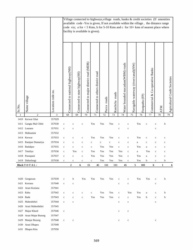
1 2 3
Lo
cati
on
co
de
no
.
Nam
e v
illa
ge
Sr.
No
.
1410 Kerwar Ghat 357029
1411 Gangta Mal Chhit 357030
1412 Lautana 357031
1413 Mahuatanr 357032
1414 Kerwar 357033
1415 Ranipur Dumariya 357034
1416 Badalpur 357035
1417 Tetuliya 357036
1418 Paraspani 357037
1419 Daharlangi 357038
Block T O T A L :
1420 Gorgawan 357039
1421 Koriana 357040
1422 Arazi Koriana 357041
1423 Raha 357042
1424 Bade 357043
1425 Maheshtikri 357044
1426 Arazi Maheshtikri 357045
1427 Majar Khurd 357046
1428 Arazi Majar Buzurg 357047
1429 Manjar Buzurg 357048
1430 Arazi Dhapra 357049
1431 Dhapra Kita 357050
Co
nn
ecte
d t
o n
atio
nal
hig
hw
ay(N
H)
Co
nn
ecte
d t
o s
tate
hig
hw
ay(S
H)
Co
nn
ecte
d t
o m
ajo
r d
istr
ict
road
(M
DR
)
Co
nn
ecte
d t
o o
ther
s d
istr
ict
road
Pu
cca
ro
ads
Ku
tch
cha
ro
ads
Wat
er b
ou
nd
ed m
acad
am(W
BM
) ro
ads
Nav
igab
le w
ater
way
(ri
ver
/can
al)(
NW
)
Fo
otp
ath
s (F
P)
Co
mm
erci
al &
Co
-op
erat
ive
Ban
ks
AT
M
Ag
ricu
ltu
ral
Cre
dit
So
ciet
ies
68 69 70 71 72 73 74 75 76 77 78 79
Village connected to highways,village roads, banks & credit societies (If amenities
available code -Yes is given, If not available within the village , the distance range
code viz; a for < 5 Kms, b for 5-10 Kms and c for 10+ kms of nearest place where
facility is available is given).
c c c Yes Yes Yes c c Yes c c b
c c c c c
c c c Yes Yes Yes c c Yes c c c
c c c c c c c c a c c c
c c c c Yes Yes c c Yes a c c
c Yes c Yes Yes Yes Yes c a Yes c c
c c c Yes Yes Yes Yes c Yes a c c
c c c c Yes Yes Yes c Yes b c b
2 6 15 45 111 111 45 5 103 6 1 6
c b Yes Yes Yes Yes c c Yes Yes c b
c c c c c
c c c c Yes Yes c Yes Yes a c b
c c c Yes Yes Yes c c Yes b c b
c c c c c
c c c
c c c c c
569
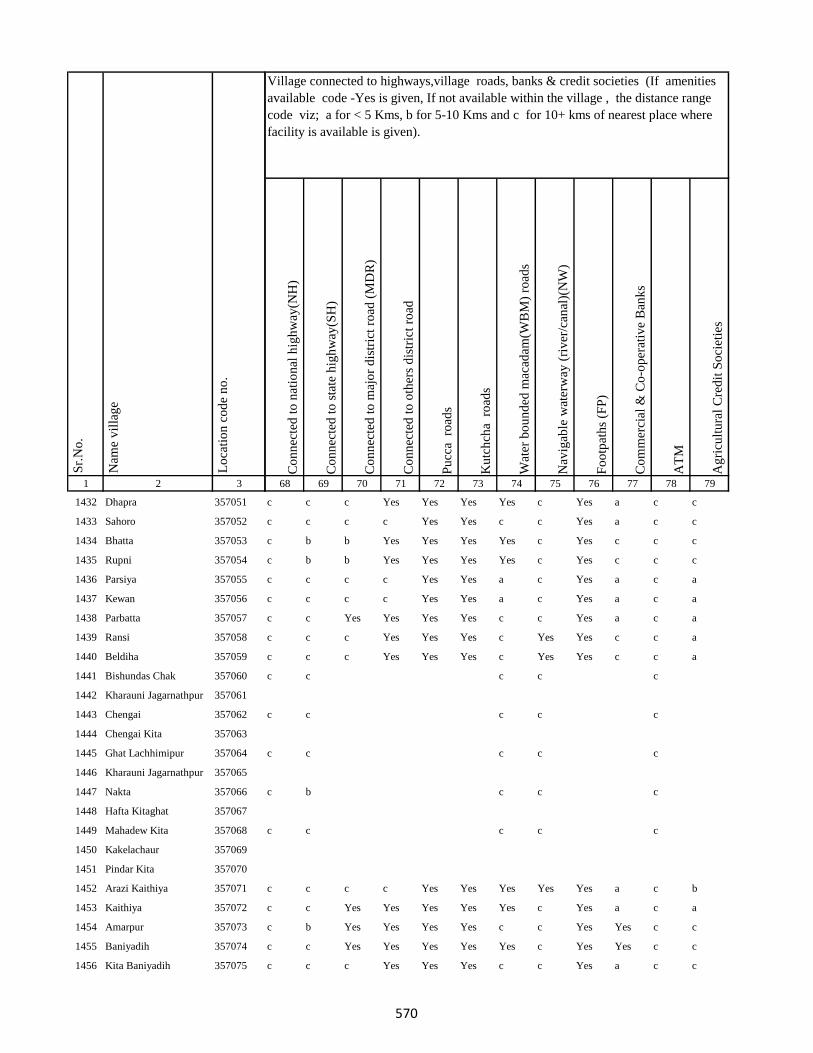
1 2 3
Lo
cati
on
co
de
no
.
Nam
e v
illa
ge
Sr.
No
.
1432 Dhapra 357051
1433 Sahoro 357052
1434 Bhatta 357053
1435 Rupni 357054
1436 Parsiya 357055
1437 Kewan 357056
1438 Parbatta 357057
1439 Ransi 357058
1440 Beldiha 357059
1441 Bishundas Chak 357060
1442 Kharauni Jagarnathpur 357061
1443 Chengai 357062
1444 Chengai Kita 357063
1445 Ghat Lachhimipur 357064
1446 Kharauni Jagarnathpur 357065
1447 Nakta 357066
1448 Hafta Kitaghat 357067
1449 Mahadew Kita 357068
1450 Kakelachaur 357069
1451 Pindar Kita 357070
1452 Arazi Kaithiya 357071
1453 Kaithiya 357072
1454 Amarpur 357073
1455 Baniyadih 357074
1456 Kita Baniyadih 357075
Co
nn
ecte
d t
o n
atio
nal
hig
hw
ay(N
H)
Co
nn
ecte
d t
o s
tate
hig
hw
ay(S
H)
Co
nn
ecte
d t
o m
ajo
r d
istr
ict
road
(M
DR
)
Co
nn
ecte
d t
o o
ther
s d
istr
ict
road
Pu
cca
ro
ads
Ku
tch
cha
ro
ads
Wat
er b
ou
nd
ed m
acad
am(W
BM
) ro
ads
Nav
igab
le w
ater
way
(ri
ver
/can
al)(
NW
)
Fo
otp
ath
s (F
P)
Co
mm
erci
al &
Co
-op
erat
ive
Ban
ks
AT
M
Ag
ricu
ltu
ral
Cre
dit
So
ciet
ies
68 69 70 71 72 73 74 75 76 77 78 79
Village connected to highways,village roads, banks & credit societies (If amenities
available code -Yes is given, If not available within the village , the distance range
code viz; a for < 5 Kms, b for 5-10 Kms and c for 10+ kms of nearest place where
facility is available is given).
c c c Yes Yes Yes Yes c Yes a c c
c c c c Yes Yes c c Yes a c c
c b b Yes Yes Yes Yes c Yes c c c
c b b Yes Yes Yes Yes c Yes c c c
c c c c Yes Yes a c Yes a c a
c c c c Yes Yes a c Yes a c a
c c Yes Yes Yes Yes c c Yes a c a
c c c Yes Yes Yes c Yes Yes c c a
c c c Yes Yes Yes c Yes Yes c c a
c c c c c
c c c c c
c c c c c
c b c c c
c c c c c
c c c c Yes Yes Yes Yes Yes a c b
c c Yes Yes Yes Yes Yes c Yes a c a
c b Yes Yes Yes Yes c c Yes Yes c c
c c Yes Yes Yes Yes Yes c Yes Yes c c
c c c Yes Yes Yes c c Yes a c c
570
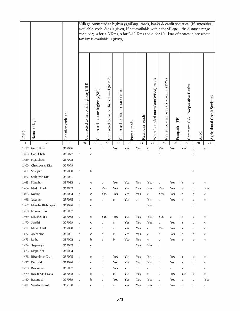
1 2 3
Lo
cati
on
co
de
no
.
Nam
e v
illa
ge
Sr.
No
.
1457 Gouri Kita 357076
1458 Gopi Chak 357077
1459 Piprachaur 357078
1460 Chaurgonar Kita 357079
1461 Shahpur 357080
1462 Sarkunda Kita 357081
1463 Nimuha 357082
1464 Medni Chak 357083
1465 Kadma 357084
1466 Jagatpur 357085
1467 Mansha Bishunpur 357086
1468 Lalman Kita 357087
1469 Kita Kendua 357088
1470 Sankhi 357089
1471 Mokal Chak 357090
1472 Aichamor 357091
1473 Lotha 357092
1474 Jhapaniya 357093
1475 Majra Kol 357094
1476 Bisambhar Chak 357095
1477 Kolhadda 357096
1478 Basantpur 357097
1479 Basan Sarai Gadal 357098
1480 Basantrai 357099
1481 Sankhi Khurd 357100
Co
nn
ecte
d t
o n
atio
nal
hig
hw
ay(N
H)
Co
nn
ecte
d t
o s
tate
hig
hw
ay(S
H)
Co
nn
ecte
d t
o m
ajo
r d
istr
ict
road
(M
DR
)
Co
nn
ecte
d t
o o
ther
s d
istr
ict
road
Pu
cca
ro
ads
Ku
tch
cha
ro
ads
Wat
er b
ou
nd
ed m
acad
am(W
BM
) ro
ads
Nav
igab
le w
ater
way
(ri
ver
/can
al)(
NW
)
Fo
otp
ath
s (F
P)
Co
mm
erci
al &
Co
-op
erat
ive
Ban
ks
AT
M
Ag
ricu
ltu
ral
Cre
dit
So
ciet
ies
68 69 70 71 72 73 74 75 76 77 78 79
Village connected to highways,village roads, banks & credit societies (If amenities
available code -Yes is given, If not available within the village , the distance range
code viz; a for < 5 Kms, b for 5-10 Kms and c for 10+ kms of nearest place where
facility is available is given).
c c c Yes Yes Yes c Yes Yes Yes c c
c c c c
c b c
c c c Yes Yes Yes Yes c Yes b c c
c c Yes Yes Yes Yes Yes Yes Yes b c Yes
c c Yes Yes Yes Yes c Yes Yes c c c
c c c c Yes c Yes c Yes c c c
c c Yes c
c c Yes Yes Yes Yes Yes Yes a c c c
c c c c Yes Yes Yes c Yes a c c
c c c c Yes Yes c Yes Yes a c c
c c c c Yes Yes c c Yes c c c
c b b b Yes Yes c c Yes c c c
c c Yes Yes c
c c c Yes Yes Yes Yes c Yes a c c
c c c Yes Yes Yes Yes c Yes a c c
c c c Yes Yes c c c a a c a
c c c c Yes Yes c c Yes Yes c c
c b b Yes Yes Yes Yes c Yes c c Yes
c c c c Yes Yes Yes c Yes c c a
571

1 2 3
Lo
cati
on
co
de
no
.
Nam
e v
illa
ge
Sr.
No
.
1482 Bela Kita 357101
1483 Baskhoriya 357102
1484 Baghakol 357103
1485 Harganman 357104
1486 Kola Kita 357105
1487 Kaithpura 357106
1488 Lochni 357107
1489 Pachua Kita 357108
1490 Sanaur 357109
1491 Gathaur 357110
1492 Derma 357111
1493 Deshbarag 357112
1494 Chutiyan 357113
1495 Rampur 357114
1496 Rampur Mokarri 357115
1497 Rampur Arazi 357116
1498 Gobindpur Kita 357117
1499 Shampur Gobindpur 357118
1500 Shampur 357119
1501 Kapeta 357120
1502 Karu Chak 357121
1503 Pakariya 357122
1504 Arazi Pakariya 357123
1505 Jadu Chak 357124
1506 Paradharichak 357125
Co
nn
ecte
d t
o n
atio
nal
hig
hw
ay(N
H)
Co
nn
ecte
d t
o s
tate
hig
hw
ay(S
H)
Co
nn
ecte
d t
o m
ajo
r d
istr
ict
road
(M
DR
)
Co
nn
ecte
d t
o o
ther
s d
istr
ict
road
Pu
cca
ro
ads
Ku
tch
cha
ro
ads
Wat
er b
ou
nd
ed m
acad
am(W
BM
) ro
ads
Nav
igab
le w
ater
way
(ri
ver
/can
al)(
NW
)
Fo
otp
ath
s (F
P)
Co
mm
erci
al &
Co
-op
erat
ive
Ban
ks
AT
M
Ag
ricu
ltu
ral
Cre
dit
So
ciet
ies
68 69 70 71 72 73 74 75 76 77 78 79
Village connected to highways,village roads, banks & credit societies (If amenities
available code -Yes is given, If not available within the village , the distance range
code viz; a for < 5 Kms, b for 5-10 Kms and c for 10+ kms of nearest place where
facility is available is given).
c c c c Yes Yes c c Yes c c a
c c Yes Yes Yes Yes c c Yes Yes c Yes
c c c Yes Yes Yes Yes c a b c c
c c c c c
c b b b Yes Yes Yes b a c c a
c c c c Yes Yes c c Yes c c a
c c Yes c Yes Yes c c Yes c c c
c c Yes c c c
c c c c c
c c Yes Yes Yes c c
c c Yes Yes Yes Yes Yes c Yes c c c
c c c
c c c c
572

1 2 3
Lo
cati
on
co
de
no
.
Nam
e v
illa
ge
Sr.
No
.
1507 Jamnikola 357126
1508 Kapra Chak 357127
1509 Surai Kita 357128
1510 Kumhrakol 357129
1511 Banshipur 357130
1512 Bajpai 357131
1513 Resamba 357132
1514 Bhira 357133
1515 Barhampur 357134
1516 Bodra 357135
1517 Susti 357136
1518 Barhaiya 357137
1519 Maheshpur 357138
1520 Hilawa 357139
1521 Chanai Chak 357140
1522 Urkusiya 357141
1523 Arazi Kharti 357142
1524 Kharti 357143
1525 Barhara 357144
1526 Amarpur Ghal 357145
1527 Surniya Ghat Mal 357146
1528 Surniya Mal Ghat 357147
1529 Tofil Surniya 357148
1530 Arazi Surniya Ghat 357149
1531 Phulwariya 357150
Co
nn
ecte
d t
o n
atio
nal
hig
hw
ay(N
H)
Co
nn
ecte
d t
o s
tate
hig
hw
ay(S
H)
Co
nn
ecte
d t
o m
ajo
r d
istr
ict
road
(M
DR
)
Co
nn
ecte
d t
o o
ther
s d
istr
ict
road
Pu
cca
ro
ads
Ku
tch
cha
ro
ads
Wat
er b
ou
nd
ed m
acad
am(W
BM
) ro
ads
Nav
igab
le w
ater
way
(ri
ver
/can
al)(
NW
)
Fo
otp
ath
s (F
P)
Co
mm
erci
al &
Co
-op
erat
ive
Ban
ks
AT
M
Ag
ricu
ltu
ral
Cre
dit
So
ciet
ies
68 69 70 71 72 73 74 75 76 77 78 79
Village connected to highways,village roads, banks & credit societies (If amenities
available code -Yes is given, If not available within the village , the distance range
code viz; a for < 5 Kms, b for 5-10 Kms and c for 10+ kms of nearest place where
facility is available is given).
c c Yes Yes Yes c Yes Yes c c b
c c c c Yes Yes c c Yes b c c
c c Yes Yes Yes Yes Yes c Yes b c b
c c c Yes Yes Yes c Yes Yes b c b
c b b Yes Yes Yes Yes c Yes c c b
c b c c c
c c c Yes Yes Yes Yes c Yes c c c
c c Yes Yes Yes Yes Yes c Yes c c c
c c Yes Yes Yes Yes Yes c Yes c
c c c c Yes Yes c c a a c c
c c c Yes Yes Yes c c Yes c c c
c c c c c
c c Yes Yes Yes Yes c c Yes c c c
c b b Yes Yes Yes c c Yes c c a
c c c Yes Yes Yes c c Yes c c a
c c c Yes Yes Yes c c Yes c c a
c c c Yes Yes Yes Yes c Yes c c a
c c c c c
c c c c Yes Yes c c Yes a c c
573
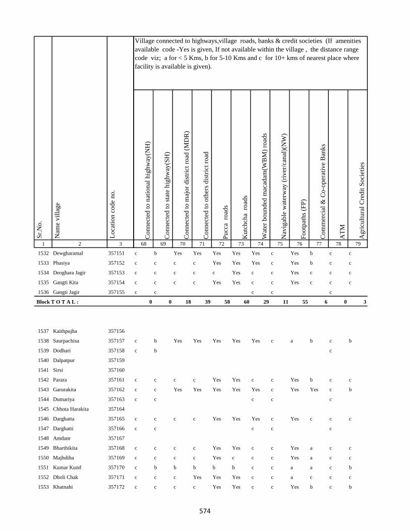
1 2 3
Lo
cati
on
co
de
no
.
Nam
e v
illa
ge
Sr.
No
.
1532 Dewgharamal 357151
1533 Phasiya 357152
1534 Deoghara Jagir 357153
1535 Gangti Kita 357154
1536 Gangti Jagir 357155
Block T O T A L :
1537 Kaithpujha 357156
1538 Saurpachisa 357157
1539 Dodhari 357158
1540 Dalpatpur 357159
1541 Sirsi 357160
1542 Parara 357161
1543 Garurakita 357162
1544 Dumariya 357163
1545 Chhota Harakita 357164
1546 Darghatta 357165
1547 Darghatti 357166
1548 Amdanr 357167
1549 Bharthikita 357168
1550 Majhdiha 357169
1551 Kumar Kund 357170
1552 Dholi Chak 357171
1553 Khatnahi 357172
Co
nn
ecte
d t
o n
atio
nal
hig
hw
ay(N
H)
Co
nn
ecte
d t
o s
tate
hig
hw
ay(S
H)
Co
nn
ecte
d t
o m
ajo
r d
istr
ict
road
(M
DR
)
Co
nn
ecte
d t
o o
ther
s d
istr
ict
road
Pu
cca
ro
ads
Ku
tch
cha
ro
ads
Wat
er b
ou
nd
ed m
acad
am(W
BM
) ro
ads
Nav
igab
le w
ater
way
(ri
ver
/can
al)(
NW
)
Fo
otp
ath
s (F
P)
Co
mm
erci
al &
Co
-op
erat
ive
Ban
ks
AT
M
Ag
ricu
ltu
ral
Cre
dit
So
ciet
ies
68 69 70 71 72 73 74 75 76 77 78 79
Village connected to highways,village roads, banks & credit societies (If amenities
available code -Yes is given, If not available within the village , the distance range
code viz; a for < 5 Kms, b for 5-10 Kms and c for 10+ kms of nearest place where
facility is available is given).
c b Yes Yes Yes Yes Yes c Yes b c c
c c c c Yes Yes Yes c Yes b c c
c c c c c Yes c c Yes c c c
c c c c Yes Yes c c Yes c c c
c c c c c
0 0 18 39 58 60 29 11 55 6 0 3
c b Yes Yes Yes Yes Yes c a b c b
c b c
c c c c Yes Yes c c Yes b c c
c c Yes Yes Yes Yes Yes c Yes Yes c b
c c c c c
c c c c Yes Yes Yes c Yes c c c
c c c c c
c c c c Yes Yes c c Yes a c c
c c c c Yes c c c Yes a c c
c b b b b b c c a a c b
c c c Yes Yes Yes c c a c c c
c c c c Yes Yes c c Yes b c b
574
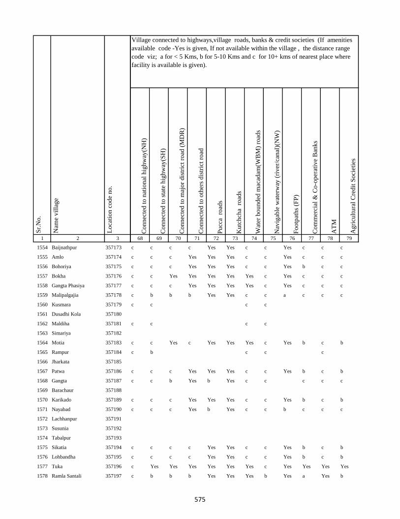
1 2 3
Lo
cati
on
co
de
no
.
Nam
e v
illa
ge
Sr.
No
.
1554 Baijnathpur 357173
1555 Amlo 357174
1556 Bohoriya 357175
1557 Bokha 357176
1558 Gangta Phasiya 357177
1559 Malipalgajia 357178
1560 Kusmara 357179
1561 Dusadhi Kola 357180
1562 Maldiha 357181
1563 Simariya 357182
1564 Motia 357183
1565 Rampur 357184
1566 Jharkata 357185
1567 Patwa 357186
1568 Gangta 357187
1569 Barachaur 357188
1570 Karikado 357189
1571 Nayabad 357190
1572 Lachhanpur 357191
1573 Susunia 357192
1574 Tabalpur 357193
1575 Sikatia 357194
1576 Lohbandha 357195
1577 Tuka 357196
1578 Ramla Santali 357197
Co
nn
ecte
d t
o n
atio
nal
hig
hw
ay(N
H)
Co
nn
ecte
d t
o s
tate
hig
hw
ay(S
H)
Co
nn
ecte
d t
o m
ajo
r d
istr
ict
road
(M
DR
)
Co
nn
ecte
d t
o o
ther
s d
istr
ict
road
Pu
cca
ro
ads
Ku
tch
cha
ro
ads
Wat
er b
ou
nd
ed m
acad
am(W
BM
) ro
ads
Nav
igab
le w
ater
way
(ri
ver
/can
al)(
NW
)
Fo
otp
ath
s (F
P)
Co
mm
erci
al &
Co
-op
erat
ive
Ban
ks
AT
M
Ag
ricu
ltu
ral
Cre
dit
So
ciet
ies
68 69 70 71 72 73 74 75 76 77 78 79
Village connected to highways,village roads, banks & credit societies (If amenities
available code -Yes is given, If not available within the village , the distance range
code viz; a for < 5 Kms, b for 5-10 Kms and c for 10+ kms of nearest place where
facility is available is given).
c c c c Yes Yes c c Yes c c c
c c c Yes Yes Yes c c Yes c c c
c c c Yes Yes Yes c c Yes b c c
c c Yes Yes Yes Yes Yes c Yes c c c
c c c Yes Yes Yes Yes c Yes c c c
c b b b Yes Yes c c a c c c
c c c c
c c c c
c c Yes c Yes Yes Yes c Yes b c b
c b c c c
c c c Yes Yes Yes c c Yes b c b
c c b Yes b Yes c c c c c
c c c Yes Yes Yes c c Yes b c b
c c c Yes b Yes c c b c c c
c c c c Yes Yes c c Yes b c b
c c c c Yes Yes c c Yes b c b
c Yes Yes Yes Yes Yes Yes c Yes Yes Yes Yes
c b b b Yes Yes Yes b Yes a Yes b
575
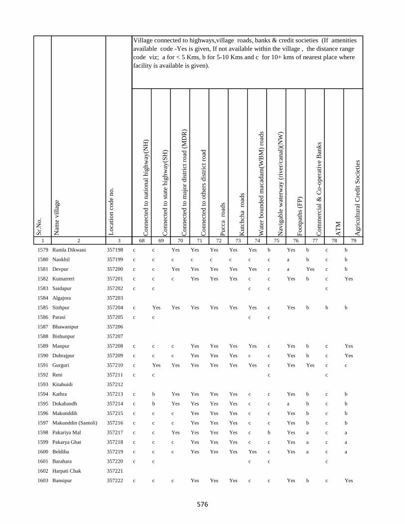
1 2 3
Lo
cati
on
co
de
no
.
Nam
e v
illa
ge
Sr.
No
.
1579 Ramla Dikwani 357198
1580 Nankhil 357199
1581 Devpur 357200
1582 Kumarreri 357201
1583 Saidapur 357202
1584 Algajora 357203
1585 Sinhpur 357204
1586 Parasi 357205
1587 Bhawanipur 357206
1588 Bishunpur 357207
1589 Manpur 357208
1590 Dubrajpur 357209
1591 Gurguri 357210
1592 Reni 357211
1593 Kitabuidi 357212
1594 Kathra 357213
1595 Dokabandh 357214
1596 Makunddih 357215
1597 Makunddin (Santoli) 357216
1598 Pakariya Mal 357217
1599 Pakarya Ghat 357218
1600 Beldiha 357219
1601 Barahara 357220
1602 Harpati Chak 357221
1603 Bansipur 357222
Co
nn
ecte
d t
o n
atio
nal
hig
hw
ay(N
H)
Co
nn
ecte
d t
o s
tate
hig
hw
ay(S
H)
Co
nn
ecte
d t
o m
ajo
r d
istr
ict
road
(M
DR
)
Co
nn
ecte
d t
o o
ther
s d
istr
ict
road
Pu
cca
ro
ads
Ku
tch
cha
ro
ads
Wat
er b
ou
nd
ed m
acad
am(W
BM
) ro
ads
Nav
igab
le w
ater
way
(ri
ver
/can
al)(
NW
)
Fo
otp
ath
s (F
P)
Co
mm
erci
al &
Co
-op
erat
ive
Ban
ks
AT
M
Ag
ricu
ltu
ral
Cre
dit
So
ciet
ies
68 69 70 71 72 73 74 75 76 77 78 79
Village connected to highways,village roads, banks & credit societies (If amenities
available code -Yes is given, If not available within the village , the distance range
code viz; a for < 5 Kms, b for 5-10 Kms and c for 10+ kms of nearest place where
facility is available is given).
c c Yes Yes Yes Yes Yes b Yes b c b
c c c c c c c c a b c b
c c Yes Yes Yes Yes Yes c a Yes c b
c c c Yes Yes Yes c c Yes b c Yes
c c c c c
c Yes Yes Yes Yes Yes Yes c Yes b b b
c c c c
c c c Yes Yes Yes Yes c Yes b c Yes
c c c Yes Yes Yes c c Yes b c Yes
c Yes Yes Yes Yes Yes Yes c Yes Yes c c
c c c c
c b Yes Yes Yes Yes c c Yes b c b
c b Yes Yes Yes Yes c c a b c b
c c c Yes Yes Yes c c Yes b c b
c c c Yes Yes Yes c c Yes b c b
c c Yes Yes Yes Yes c b Yes a c a
c c c Yes Yes Yes c c Yes a c a
c c c Yes Yes Yes Yes c Yes a c a
c c c c c
c c c Yes Yes Yes c c Yes b c Yes
576
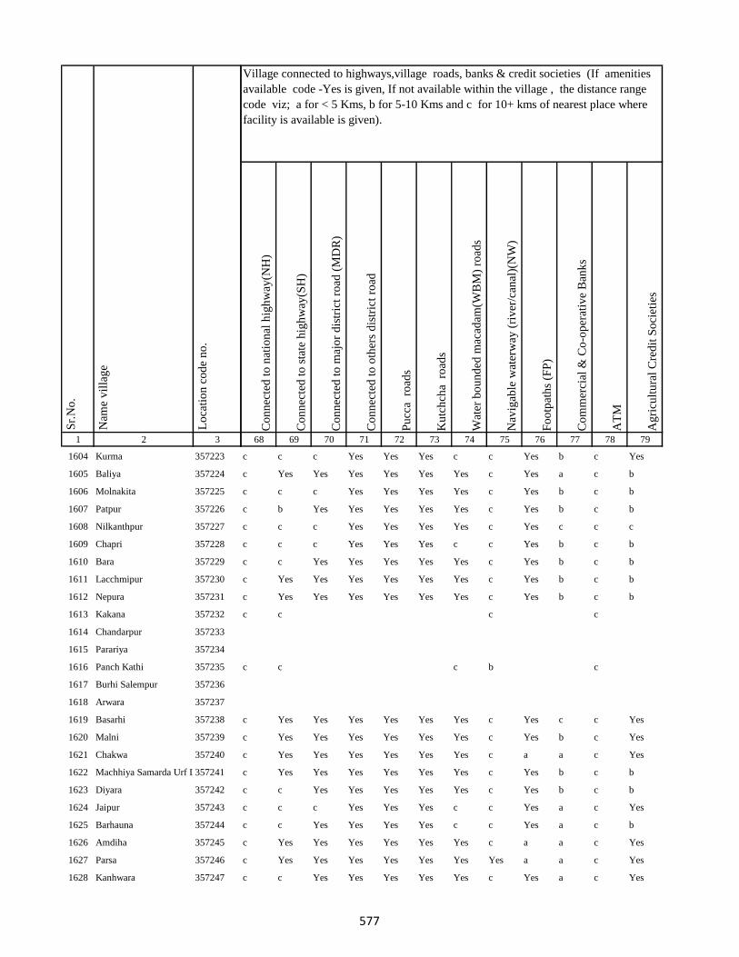
1 2 3
Lo
cati
on
co
de
no
.
Nam
e v
illa
ge
Sr.
No
.
1604 Kurma 357223
1605 Baliya 357224
1606 Molnakita 357225
1607 Patpur 357226
1608 Nilkanthpur 357227
1609 Chapri 357228
1610 Bara 357229
1611 Lacchmipur 357230
1612 Nepura 357231
1613 Kakana 357232
1614 Chandarpur 357233
1615 Parariya 357234
1616 Panch Kathi 357235
1617 Burhi Salempur 357236
1618 Arwara 357237
1619 Basarhi 357238
1620 Malni 357239
1621 Chakwa 357240
1622 Machhiya Samarda Urf Lalpur357241
1623 Diyara 357242
1624 Jaipur 357243
1625 Barhauna 357244
1626 Amdiha 357245
1627 Parsa 357246
1628 Kanhwara 357247
Co
nn
ecte
d t
o n
atio
nal
hig
hw
ay(N
H)
Co
nn
ecte
d t
o s
tate
hig
hw
ay(S
H)
Co
nn
ecte
d t
o m
ajo
r d
istr
ict
road
(M
DR
)
Co
nn
ecte
d t
o o
ther
s d
istr
ict
road
Pu
cca
ro
ads
Ku
tch
cha
ro
ads
Wat
er b
ou
nd
ed m
acad
am(W
BM
) ro
ads
Nav
igab
le w
ater
way
(ri
ver
/can
al)(
NW
)
Fo
otp
ath
s (F
P)
Co
mm
erci
al &
Co
-op
erat
ive
Ban
ks
AT
M
Ag
ricu
ltu
ral
Cre
dit
So
ciet
ies
68 69 70 71 72 73 74 75 76 77 78 79
Village connected to highways,village roads, banks & credit societies (If amenities
available code -Yes is given, If not available within the village , the distance range
code viz; a for < 5 Kms, b for 5-10 Kms and c for 10+ kms of nearest place where
facility is available is given).
c c c Yes Yes Yes c c Yes b c Yes
c Yes Yes Yes Yes Yes Yes c Yes a c b
c c c Yes Yes Yes Yes c Yes b c b
c b Yes Yes Yes Yes Yes c Yes b c b
c c c Yes Yes Yes Yes c Yes c c c
c c c Yes Yes Yes c c Yes b c b
c c Yes Yes Yes Yes Yes c Yes b c b
c Yes Yes Yes Yes Yes Yes c Yes b c b
c Yes Yes Yes Yes Yes Yes c Yes b c b
c c c c
c c c b c
c Yes Yes Yes Yes Yes Yes c Yes c c Yes
c Yes Yes Yes Yes Yes Yes c Yes b c Yes
c Yes Yes Yes Yes Yes Yes c a a c Yes
c Yes Yes Yes Yes Yes Yes c Yes b c b
c c Yes Yes Yes Yes Yes c Yes b c b
c c c Yes Yes Yes c c Yes a c Yes
c c Yes Yes Yes Yes c c Yes a c b
c Yes Yes Yes Yes Yes Yes c a a c Yes
c Yes Yes Yes Yes Yes Yes Yes a a c Yes
c c Yes Yes Yes Yes Yes c Yes a c Yes
577

1 2 3
Lo
cati
on
co
de
no
.
Nam
e v
illa
ge
Sr.
No
.
1629 Garbana 357248
1630 Galapahar 357249
1631 Bhadrahi Mal 357250
1632 Ghat Bhadrahi 357251
1633 Chilauna 357252
1634 Rampur 357253
1635 Dumariya Mal 357254
1636 Naya Chak 357255
1637 Dara Chak 357256
1638 Ghat Gorsanda 357257
1639 Mal Gorsanda 357258
1640 Mal Dhamsain 357259
1641 Ghat Dhamsain 357260
1642 Ghat Dhamsain 357261
1643 Khaira Mal 357262
1644 Pachrukhi 357263
1645 Lukluki Mal 357264
1646 Lukluki Ghat 357265
1647 Pathariya Mal 357266
1648 Pathariya Ghat 357267
1649 Pathariya Mal 357268
1650 Chhota Kaliyani 357269
1651 Bara Kaliyani 357270
1652 Pathriya Mal 357271
1653 Sabaijor 357272
Co
nn
ecte
d t
o n
atio
nal
hig
hw
ay(N
H)
Co
nn
ecte
d t
o s
tate
hig
hw
ay(S
H)
Co
nn
ecte
d t
o m
ajo
r d
istr
ict
road
(M
DR
)
Co
nn
ecte
d t
o o
ther
s d
istr
ict
road
Pu
cca
ro
ads
Ku
tch
cha
ro
ads
Wat
er b
ou
nd
ed m
acad
am(W
BM
) ro
ads
Nav
igab
le w
ater
way
(ri
ver
/can
al)(
NW
)
Fo
otp
ath
s (F
P)
Co
mm
erci
al &
Co
-op
erat
ive
Ban
ks
AT
M
Ag
ricu
ltu
ral
Cre
dit
So
ciet
ies
68 69 70 71 72 73 74 75 76 77 78 79
Village connected to highways,village roads, banks & credit societies (If amenities
available code -Yes is given, If not available within the village , the distance range
code viz; a for < 5 Kms, b for 5-10 Kms and c for 10+ kms of nearest place where
facility is available is given).
c c c c Yes Yes c c Yes a c b
c c Yes Yes Yes Yes Yes c a a c b
c c c c Yes Yes Yes c Yes b c b
c Yes Yes Yes Yes Yes Yes Yes Yes b c b
c c c Yes Yes Yes a c Yes b c b
c b b Yes Yes Yes Yes c Yes b c b
c c c Yes Yes Yes Yes c Yes b c b
c c c Yes Yes Yes Yes c Yes b c b
c c Yes Yes Yes Yes Yes c Yes b c b
c c a Yes a Yes a c Yes a c b
c c a Yes a Yes a c Yes c c c
c c a Yes a Yes a c Yes b c b
c Yes Yes c c c
c c c c
c c c Yes Yes Yes Yes c Yes c c c
c c c c Yes Yes c c Yes b c b
c c Yes Yes Yes Yes Yes c a b c b
c b Yes Yes Yes Yes Yes c a b c b
578
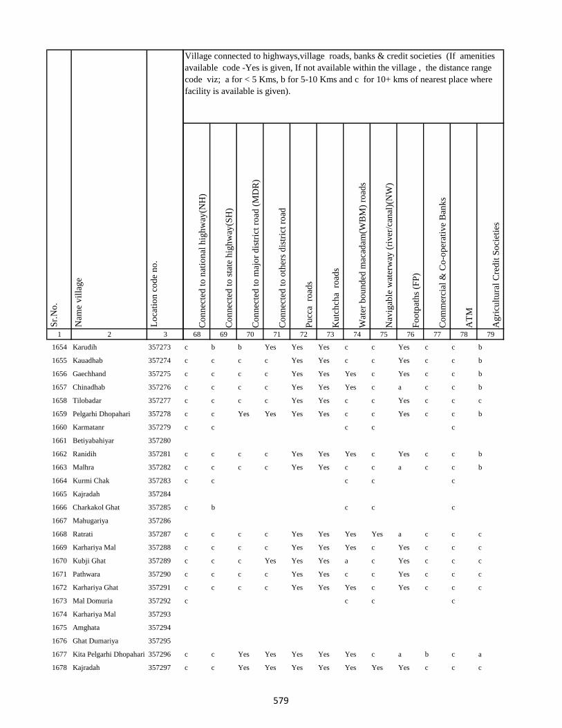
1 2 3
Lo
cati
on
co
de
no
.
Nam
e v
illa
ge
Sr.
No
.
1654 Karudih 357273
1655 Kauadhab 357274
1656 Gaechhand 357275
1657 Chinadhab 357276
1658 Tilobadar 357277
1659 Pelgarhi Dhopahari 357278
1660 Karmatanr 357279
1661 Betiyabahiyar 357280
1662 Ranidih 357281
1663 Malhra 357282
1664 Kurmi Chak 357283
1665 Kajradah 357284
1666 Charkakol Ghat 357285
1667 Mahugariya 357286
1668 Ratrati 357287
1669 Karhariya Mal 357288
1670 Kubji Ghat 357289
1671 Pathwara 357290
1672 Karhariya Ghat 357291
1673 Mal Domuria 357292
1674 Karhariya Mal 357293
1675 Amghata 357294
1676 Ghat Dumariya 357295
1677 Kita Pelgarhi Dhopahari 357296
1678 Kajradah 357297
Co
nn
ecte
d t
o n
atio
nal
hig
hw
ay(N
H)
Co
nn
ecte
d t
o s
tate
hig
hw
ay(S
H)
Co
nn
ecte
d t
o m
ajo
r d
istr
ict
road
(M
DR
)
Co
nn
ecte
d t
o o
ther
s d
istr
ict
road
Pu
cca
ro
ads
Ku
tch
cha
ro
ads
Wat
er b
ou
nd
ed m
acad
am(W
BM
) ro
ads
Nav
igab
le w
ater
way
(ri
ver
/can
al)(
NW
)
Fo
otp
ath
s (F
P)
Co
mm
erci
al &
Co
-op
erat
ive
Ban
ks
AT
M
Ag
ricu
ltu
ral
Cre
dit
So
ciet
ies
68 69 70 71 72 73 74 75 76 77 78 79
Village connected to highways,village roads, banks & credit societies (If amenities
available code -Yes is given, If not available within the village , the distance range
code viz; a for < 5 Kms, b for 5-10 Kms and c for 10+ kms of nearest place where
facility is available is given).
c b b Yes Yes Yes c c Yes c c b
c c c c Yes Yes c c Yes c c b
c c c c Yes Yes Yes c Yes c c b
c c c c Yes Yes Yes c a c c b
c c c c Yes Yes c c Yes c c c
c c Yes Yes Yes Yes c c Yes c c b
c c c c c
c c c c Yes Yes Yes c Yes c c b
c c c c Yes Yes c c a c c b
c c c c c
c b c c c
c c c c Yes Yes Yes Yes a c c c
c c c c Yes Yes Yes c Yes c c c
c c c Yes Yes Yes a c Yes c c c
c c c c Yes Yes c c Yes c c c
c c c c Yes Yes Yes c Yes c c c
c c c c
c c Yes Yes Yes Yes Yes c a b c a
c c Yes Yes Yes Yes Yes Yes Yes c c c
579
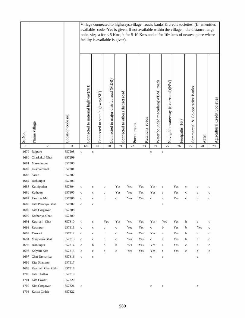
1 2 3
Lo
cati
on
co
de
no
.
Nam
e v
illa
ge
Sr.
No
.
1679 Rajpura 357298
1680 Charkakol Ghat 357299
1681 Masudanpur 357300
1682 Kusmainimal 357301
1683 Sasan 357302
1684 Bishunpur 357303
1685 Kutnipathar 357304
1686 Kathaun 357305
1687 Parariya Mal 357306
1688 Kita Parariya Ghat 357307
1689 Kita Gorgawan 357308
1690 Karhariya Ghat 357309
1691 Kusmani Ghat 357310
1692 Ratanpur 357311
1693 Tarwari 357312
1694 Manjwara Ghat 357313
1695 Bishunpur 357314
1696 Kalyani Kita 357315
1697 Ghat Dumariya 357316
1698 Kita Shampur 357317
1699 Kusmain Ghat Chhit 357318
1700 Kita Thathar 357319
1701 Kita Gawar 357320
1702 Kita Gorgawan 357321
1703 Kasba Godda 357322
Co
nn
ecte
d t
o n
atio
nal
hig
hw
ay(N
H)
Co
nn
ecte
d t
o s
tate
hig
hw
ay(S
H)
Co
nn
ecte
d t
o m
ajo
r d
istr
ict
road
(M
DR
)
Co
nn
ecte
d t
o o
ther
s d
istr
ict
road
Pu
cca
ro
ads
Ku
tch
cha
ro
ads
Wat
er b
ou
nd
ed m
acad
am(W
BM
) ro
ads
Nav
igab
le w
ater
way
(ri
ver
/can
al)(
NW
)
Fo
otp
ath
s (F
P)
Co
mm
erci
al &
Co
-op
erat
ive
Ban
ks
AT
M
Ag
ricu
ltu
ral
Cre
dit
So
ciet
ies
68 69 70 71 72 73 74 75 76 77 78 79
Village connected to highways,village roads, banks & credit societies (If amenities
available code -Yes is given, If not available within the village , the distance range
code viz; a for < 5 Kms, b for 5-10 Kms and c for 10+ kms of nearest place where
facility is available is given).
c c c c
c c c Yes Yes Yes Yes c Yes c c c
c c c Yes Yes Yes Yes c Yes c c c
c c c c Yes Yes c c Yes c c c
c c c
c c Yes Yes Yes Yes Yes Yes Yes b c c
c c c c Yes Yes c b Yes b Yes c
c c c c Yes Yes Yes c Yes b c c
c c c c Yes Yes c c Yes b c c
c b b b Yes Yes Yes c Yes c c c
c c c c Yes Yes Yes c Yes c c c
c c c c c
c c c c
580
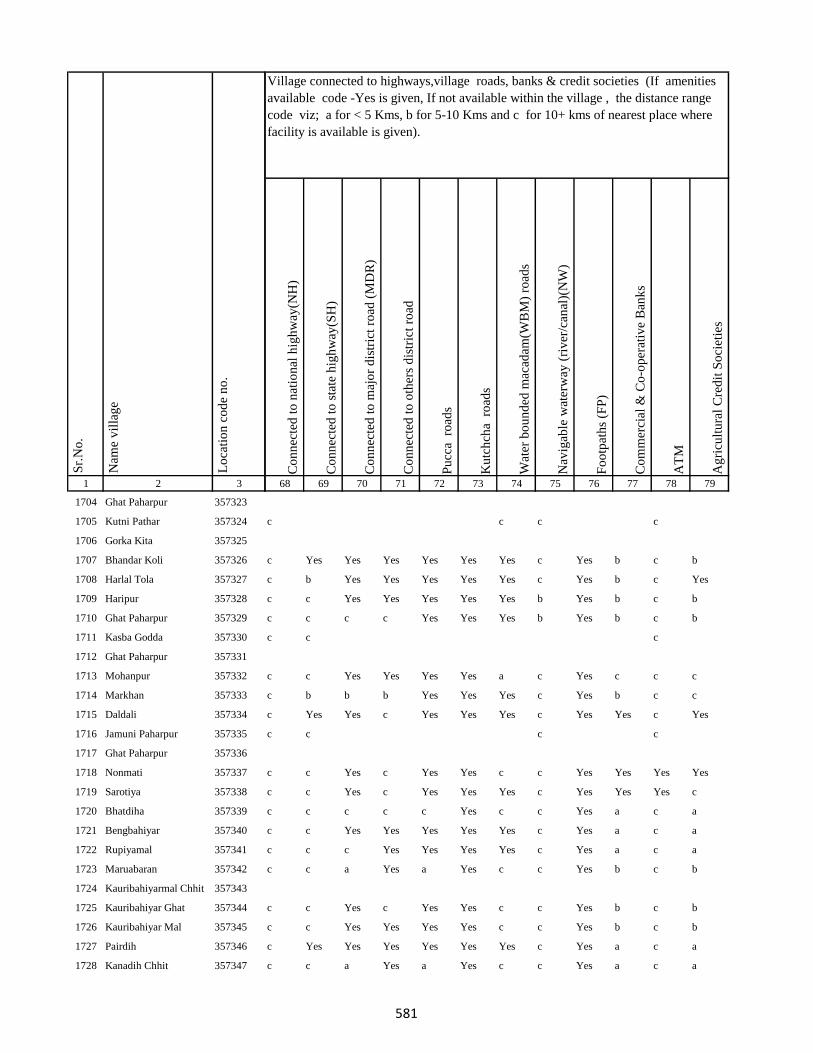
1 2 3
Lo
cati
on
co
de
no
.
Nam
e v
illa
ge
Sr.
No
.
1704 Ghat Paharpur 357323
1705 Kutni Pathar 357324
1706 Gorka Kita 357325
1707 Bhandar Koli 357326
1708 Harlal Tola 357327
1709 Haripur 357328
1710 Ghat Paharpur 357329
1711 Kasba Godda 357330
1712 Ghat Paharpur 357331
1713 Mohanpur 357332
1714 Markhan 357333
1715 Daldali 357334
1716 Jamuni Paharpur 357335
1717 Ghat Paharpur 357336
1718 Nonmati 357337
1719 Sarotiya 357338
1720 Bhatdiha 357339
1721 Bengbahiyar 357340
1722 Rupiyamal 357341
1723 Maruabaran 357342
1724 Kauribahiyarmal Chhit 357343
1725 Kauribahiyar Ghat 357344
1726 Kauribahiyar Mal 357345
1727 Pairdih 357346
1728 Kanadih Chhit 357347
Co
nn
ecte
d t
o n
atio
nal
hig
hw
ay(N
H)
Co
nn
ecte
d t
o s
tate
hig
hw
ay(S
H)
Co
nn
ecte
d t
o m
ajo
r d
istr
ict
road
(M
DR
)
Co
nn
ecte
d t
o o
ther
s d
istr
ict
road
Pu
cca
ro
ads
Ku
tch
cha
ro
ads
Wat
er b
ou
nd
ed m
acad
am(W
BM
) ro
ads
Nav
igab
le w
ater
way
(ri
ver
/can
al)(
NW
)
Fo
otp
ath
s (F
P)
Co
mm
erci
al &
Co
-op
erat
ive
Ban
ks
AT
M
Ag
ricu
ltu
ral
Cre
dit
So
ciet
ies
68 69 70 71 72 73 74 75 76 77 78 79
Village connected to highways,village roads, banks & credit societies (If amenities
available code -Yes is given, If not available within the village , the distance range
code viz; a for < 5 Kms, b for 5-10 Kms and c for 10+ kms of nearest place where
facility is available is given).
c c c c
c Yes Yes Yes Yes Yes Yes c Yes b c b
c b Yes Yes Yes Yes Yes c Yes b c Yes
c c Yes Yes Yes Yes Yes b Yes b c b
c c c c Yes Yes Yes b Yes b c b
c c c
c c Yes Yes Yes Yes a c Yes c c c
c b b b Yes Yes Yes c Yes b c c
c Yes Yes c Yes Yes Yes c Yes Yes c Yes
c c c c
c c Yes c Yes Yes c c Yes Yes Yes Yes
c c Yes c Yes Yes Yes c Yes Yes Yes c
c c c c c Yes c c Yes a c a
c c Yes Yes Yes Yes Yes c Yes a c a
c c c Yes Yes Yes Yes c Yes a c a
c c a Yes a Yes c c Yes b c b
c c Yes c Yes Yes c c Yes b c b
c c Yes Yes Yes Yes c c Yes b c b
c Yes Yes Yes Yes Yes Yes c Yes a c a
c c a Yes a Yes c c Yes a c a
581
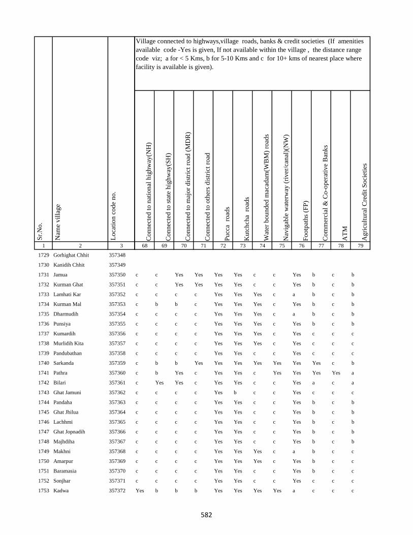
1 2 3
Lo
cati
on
co
de
no
.
Nam
e v
illa
ge
Sr.
No
.
1729 Gorhighat Chhit 357348
1730 Kanidih Chhit 357349
1731 Jamua 357350
1732 Kurman Ghat 357351
1733 Lamhati Kar 357352
1734 Kurman Mal 357353
1735 Dharmudih 357354
1736 Punsiya 357355
1737 Kumardih 357356
1738 Murlidih Kita 357357
1739 Pandubathan 357358
1740 Sarkanda 357359
1741 Pathra 357360
1742 Bilari 357361
1743 Ghat Jamuni 357362
1744 Pandaha 357363
1745 Ghat Jhilua 357364
1746 Lachhmi 357365
1747 Ghat Jopnadih 357366
1748 Majhdiha 357367
1749 Makhni 357368
1750 Amarpur 357369
1751 Baramasia 357370
1752 Sonjhar 357371
1753 Kadwa 357372
Co
nn
ecte
d t
o n
atio
nal
hig
hw
ay(N
H)
Co
nn
ecte
d t
o s
tate
hig
hw
ay(S
H)
Co
nn
ecte
d t
o m
ajo
r d
istr
ict
road
(M
DR
)
Co
nn
ecte
d t
o o
ther
s d
istr
ict
road
Pu
cca
ro
ads
Ku
tch
cha
ro
ads
Wat
er b
ou
nd
ed m
acad
am(W
BM
) ro
ads
Nav
igab
le w
ater
way
(ri
ver
/can
al)(
NW
)
Fo
otp
ath
s (F
P)
Co
mm
erci
al &
Co
-op
erat
ive
Ban
ks
AT
M
Ag
ricu
ltu
ral
Cre
dit
So
ciet
ies
68 69 70 71 72 73 74 75 76 77 78 79
Village connected to highways,village roads, banks & credit societies (If amenities
available code -Yes is given, If not available within the village , the distance range
code viz; a for < 5 Kms, b for 5-10 Kms and c for 10+ kms of nearest place where
facility is available is given).
c c Yes Yes Yes Yes c c Yes b c b
c c Yes Yes Yes Yes c c Yes b c b
c c c c Yes Yes Yes c a b c b
c b b c Yes Yes Yes c Yes b c b
c c c c Yes Yes Yes c a b c b
c c c c Yes Yes Yes c Yes b c b
c c c c Yes Yes Yes c Yes c c c
c c c c Yes Yes Yes c Yes c c c
c c c c Yes Yes c c Yes c c c
c b b Yes Yes Yes Yes Yes Yes Yes c b
c b Yes c Yes Yes c Yes Yes Yes Yes a
c Yes Yes c Yes Yes c c Yes a c a
c c c c Yes b c c Yes c c c
c c c c Yes Yes c c Yes b c b
c c c c Yes Yes c c Yes b c b
c c c c Yes Yes c c Yes b c b
c c c c Yes Yes c c Yes b c b
c c c c Yes Yes c c Yes b c b
c c c c Yes Yes Yes c a b c c
c c c c Yes Yes Yes c Yes b c c
c c c c Yes Yes c c Yes b c c
c c c c Yes Yes c c Yes c c c
Yes b b b Yes Yes Yes Yes a c c c
582
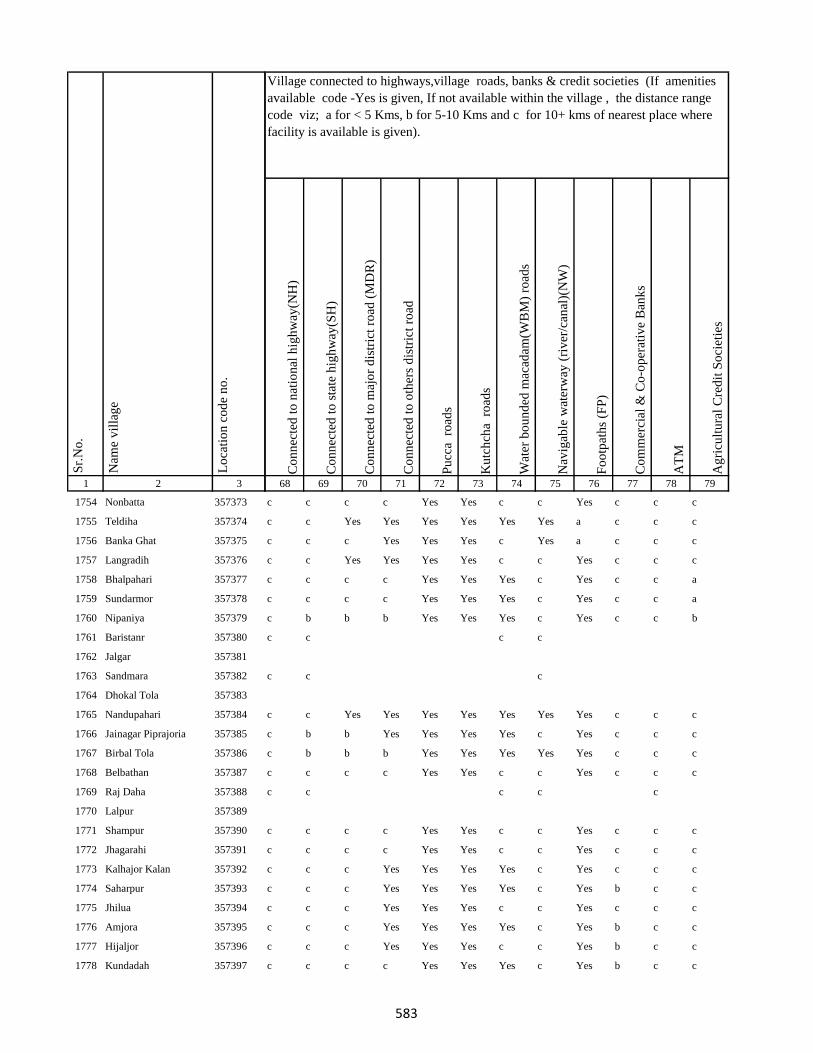
1 2 3
Lo
cati
on
co
de
no
.
Nam
e v
illa
ge
Sr.
No
.
1754 Nonbatta 357373
1755 Teldiha 357374
1756 Banka Ghat 357375
1757 Langradih 357376
1758 Bhalpahari 357377
1759 Sundarmor 357378
1760 Nipaniya 357379
1761 Baristanr 357380
1762 Jalgar 357381
1763 Sandmara 357382
1764 Dhokal Tola 357383
1765 Nandupahari 357384
1766 Jainagar Piprajoria 357385
1767 Birbal Tola 357386
1768 Belbathan 357387
1769 Raj Daha 357388
1770 Lalpur 357389
1771 Shampur 357390
1772 Jhagarahi 357391
1773 Kalhajor Kalan 357392
1774 Saharpur 357393
1775 Jhilua 357394
1776 Amjora 357395
1777 Hijaljor 357396
1778 Kundadah 357397
Co
nn
ecte
d t
o n
atio
nal
hig
hw
ay(N
H)
Co
nn
ecte
d t
o s
tate
hig
hw
ay(S
H)
Co
nn
ecte
d t
o m
ajo
r d
istr
ict
road
(M
DR
)
Co
nn
ecte
d t
o o
ther
s d
istr
ict
road
Pu
cca
ro
ads
Ku
tch
cha
ro
ads
Wat
er b
ou
nd
ed m
acad
am(W
BM
) ro
ads
Nav
igab
le w
ater
way
(ri
ver
/can
al)(
NW
)
Fo
otp
ath
s (F
P)
Co
mm
erci
al &
Co
-op
erat
ive
Ban
ks
AT
M
Ag
ricu
ltu
ral
Cre
dit
So
ciet
ies
68 69 70 71 72 73 74 75 76 77 78 79
Village connected to highways,village roads, banks & credit societies (If amenities
available code -Yes is given, If not available within the village , the distance range
code viz; a for < 5 Kms, b for 5-10 Kms and c for 10+ kms of nearest place where
facility is available is given).
c c c c Yes Yes c c Yes c c c
c c Yes Yes Yes Yes Yes Yes a c c c
c c c Yes Yes Yes c Yes a c c c
c c Yes Yes Yes Yes c c Yes c c c
c c c c Yes Yes Yes c Yes c c a
c c c c Yes Yes Yes c Yes c c a
c b b b Yes Yes Yes c Yes c c b
c c c c
c c c
c c Yes Yes Yes Yes Yes Yes Yes c c c
c b b Yes Yes Yes Yes c Yes c c c
c b b b Yes Yes Yes Yes Yes c c c
c c c c Yes Yes c c Yes c c c
c c c c c
c c c c Yes Yes c c Yes c c c
c c c c Yes Yes c c Yes c c c
c c c Yes Yes Yes Yes c Yes c c c
c c c Yes Yes Yes Yes c Yes b c c
c c c Yes Yes Yes c c Yes c c c
c c c Yes Yes Yes Yes c Yes b c c
c c c Yes Yes Yes c c Yes b c c
c c c c Yes Yes Yes c Yes b c c
583
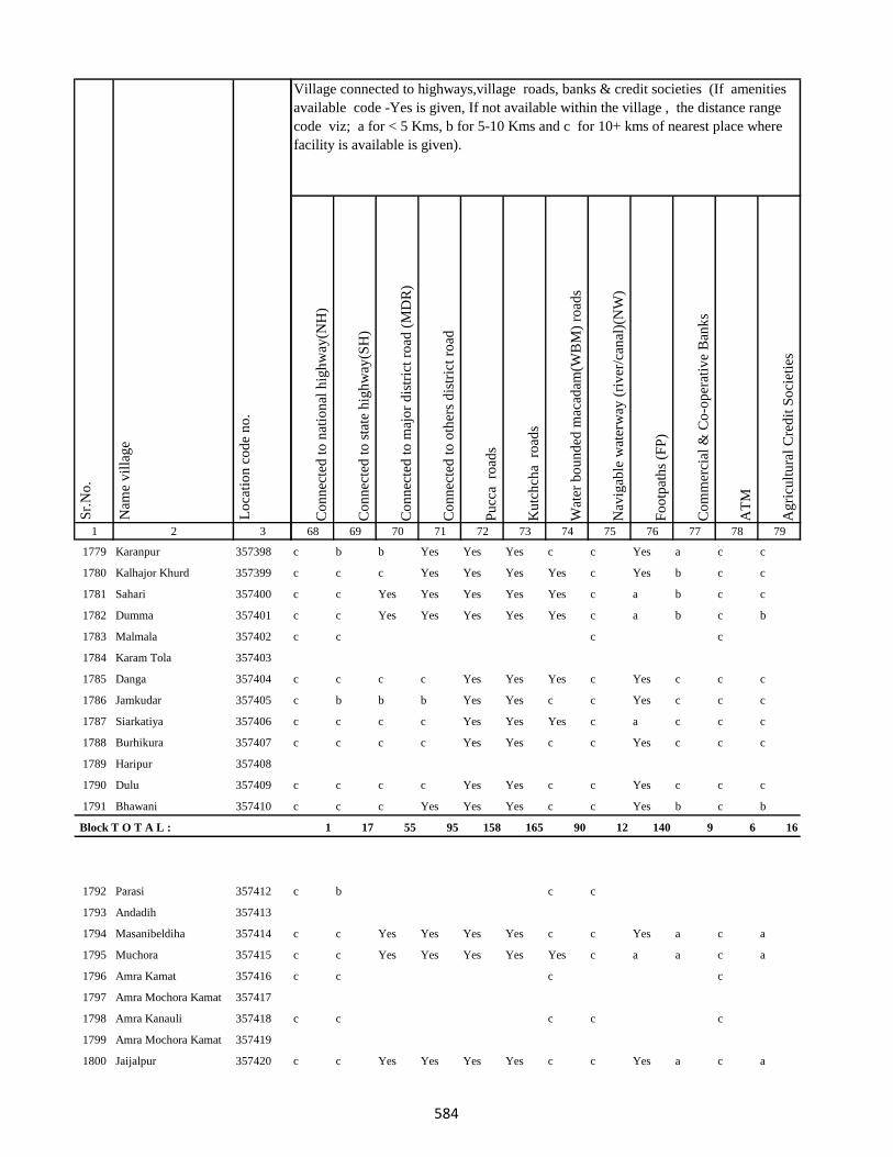
1 2 3
Lo
cati
on
co
de
no
.
Nam
e v
illa
ge
Sr.
No
.
1779 Karanpur 357398
1780 Kalhajor Khurd 357399
1781 Sahari 357400
1782 Dumma 357401
1783 Malmala 357402
1784 Karam Tola 357403
1785 Danga 357404
1786 Jamkudar 357405
1787 Siarkatiya 357406
1788 Burhikura 357407
1789 Haripur 357408
1790 Dulu 357409
1791 Bhawani 357410
Block T O T A L :
1792 Parasi 357412
1793 Andadih 357413
1794 Masanibeldiha 357414
1795 Muchora 357415
1796 Amra Kamat 357416
1797 Amra Mochora Kamat 357417
1798 Amra Kanauli 357418
1799 Amra Mochora Kamat 357419
1800 Jaijalpur 357420
Co
nn
ecte
d t
o n
atio
nal
hig
hw
ay(N
H)
Co
nn
ecte
d t
o s
tate
hig
hw
ay(S
H)
Co
nn
ecte
d t
o m
ajo
r d
istr
ict
road
(M
DR
)
Co
nn
ecte
d t
o o
ther
s d
istr
ict
road
Pu
cca
ro
ads
Ku
tch
cha
ro
ads
Wat
er b
ou
nd
ed m
acad
am(W
BM
) ro
ads
Nav
igab
le w
ater
way
(ri
ver
/can
al)(
NW
)
Fo
otp
ath
s (F
P)
Co
mm
erci
al &
Co
-op
erat
ive
Ban
ks
AT
M
Ag
ricu
ltu
ral
Cre
dit
So
ciet
ies
68 69 70 71 72 73 74 75 76 77 78 79
Village connected to highways,village roads, banks & credit societies (If amenities
available code -Yes is given, If not available within the village , the distance range
code viz; a for < 5 Kms, b for 5-10 Kms and c for 10+ kms of nearest place where
facility is available is given).
c b b Yes Yes Yes c c Yes a c c
c c c Yes Yes Yes Yes c Yes b c c
c c Yes Yes Yes Yes Yes c a b c c
c c Yes Yes Yes Yes Yes c a b c b
c c c c
c c c c Yes Yes Yes c Yes c c c
c b b b Yes Yes c c Yes c c c
c c c c Yes Yes Yes c a c c c
c c c c Yes Yes c c Yes c c c
c c c c Yes Yes c c Yes c c c
c c c Yes Yes Yes c c Yes b c b
1 17 55 95 158 165 90 12 140 9 6 16
c b c c
c c Yes Yes Yes Yes c c Yes a c a
c c Yes Yes Yes Yes Yes c a a c a
c c c c
c c c c c
c c Yes Yes Yes Yes c c Yes a c a
584
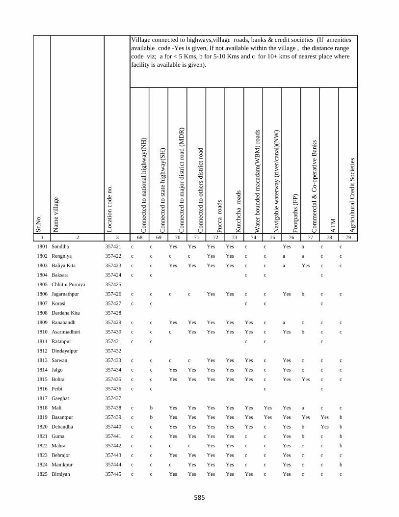
1 2 3
Lo
cati
on
co
de
no
.
Nam
e v
illa
ge
Sr.
No
.
1801 Sondiha 357421
1802 Rengniya 357422
1803 Baliya Kita 357423
1804 Baksara 357424
1805 Chhitni Purniya 357425
1806 Jagarnathpur 357426
1807 Korasi 357427
1808 Dardaha Kita 357428
1809 Ranabandh 357429
1810 Asarimadhuri 357430
1811 Ratanpur 357431
1812 Dindayalpur 357432
1813 Sarwan 357433
1814 Jalgo 357434
1815 Bohra 357435
1816 Petbi 357436
1817 Gaeghat 357437
1818 Mali 357438
1819 Basantpur 357439
1820 Debandha 357440
1821 Guma 357441
1822 Mahra 357442
1823 Behrajor 357443
1824 Manikpur 357444
1825 Birniyan 357445
Co
nn
ecte
d t
o n
atio
nal
hig
hw
ay(N
H)
Co
nn
ecte
d t
o s
tate
hig
hw
ay(S
H)
Co
nn
ecte
d t
o m
ajo
r d
istr
ict
road
(M
DR
)
Co
nn
ecte
d t
o o
ther
s d
istr
ict
road
Pu
cca
ro
ads
Ku
tch
cha
ro
ads
Wat
er b
ou
nd
ed m
acad
am(W
BM
) ro
ads
Nav
igab
le w
ater
way
(ri
ver
/can
al)(
NW
)
Fo
otp
ath
s (F
P)
Co
mm
erci
al &
Co
-op
erat
ive
Ban
ks
AT
M
Ag
ricu
ltu
ral
Cre
dit
So
ciet
ies
68 69 70 71 72 73 74 75 76 77 78 79
Village connected to highways,village roads, banks & credit societies (If amenities
available code -Yes is given, If not available within the village , the distance range
code viz; a for < 5 Kms, b for 5-10 Kms and c for 10+ kms of nearest place where
facility is available is given).
c c Yes Yes Yes Yes c c Yes a c c
c c c c Yes Yes c c a a c c
c c Yes Yes Yes Yes c c a Yes c c
c c c c c
c c c c Yes Yes c c Yes b c c
c c c c c
c c Yes Yes Yes Yes Yes c a c c c
c c c Yes Yes Yes Yes c Yes b c c
c c c c c
c c c c Yes Yes Yes c Yes c c c
c c Yes Yes Yes Yes Yes c Yes c c c
c c Yes Yes Yes Yes Yes c Yes Yes c c
c c c c
c b Yes Yes Yes Yes Yes Yes Yes a c c
c b Yes Yes Yes Yes Yes Yes Yes Yes Yes b
c c Yes Yes Yes Yes Yes c Yes b Yes b
c c Yes Yes Yes Yes c c Yes b c b
c c c c Yes Yes c c Yes c c b
c c Yes Yes Yes Yes c c Yes c c c
c c c Yes Yes Yes c c Yes c c b
c c Yes Yes Yes Yes Yes c Yes c c c
585
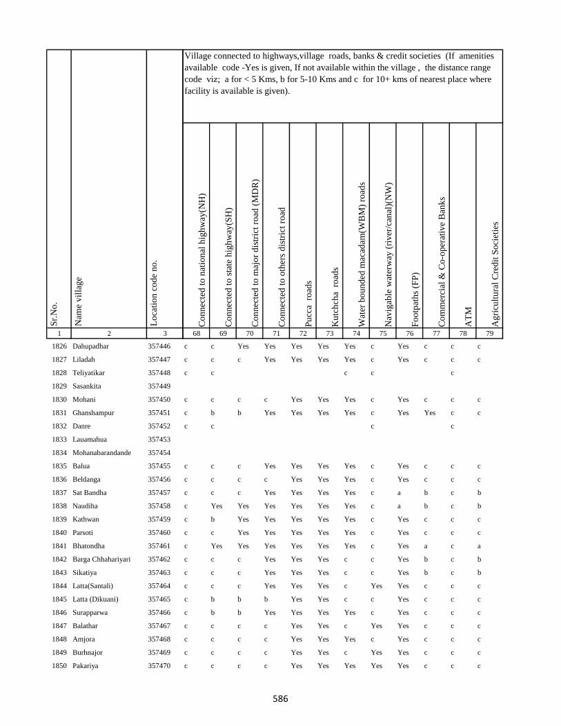
1 2 3
Lo
cati
on
co
de
no
.
Nam
e v
illa
ge
Sr.
No
.
1826 Dahupadhar 357446
1827 Liladah 357447
1828 Teliyatikar 357448
1829 Sasankita 357449
1830 Mohani 357450
1831 Ghanshampur 357451
1832 Danre 357452
1833 Lauamahua 357453
1834 Mohanabarandande 357454
1835 Balua 357455
1836 Beldanga 357456
1837 Sat Bandha 357457
1838 Naudiha 357458
1839 Kathwan 357459
1840 Parsoti 357460
1841 Bhatondha 357461
1842 Barga Chhahariyari 357462
1843 Sikatiya 357463
1844 Latta(Santali) 357464
1845 Latta (Dikuani) 357465
1846 Surapparwa 357466
1847 Balathar 357467
1848 Amjora 357468
1849 Burhnajor 357469
1850 Pakariya 357470
Co
nn
ecte
d t
o n
atio
nal
hig
hw
ay(N
H)
Co
nn
ecte
d t
o s
tate
hig
hw
ay(S
H)
Co
nn
ecte
d t
o m
ajo
r d
istr
ict
road
(M
DR
)
Co
nn
ecte
d t
o o
ther
s d
istr
ict
road
Pu
cca
ro
ads
Ku
tch
cha
ro
ads
Wat
er b
ou
nd
ed m
acad
am(W
BM
) ro
ads
Nav
igab
le w
ater
way
(ri
ver
/can
al)(
NW
)
Fo
otp
ath
s (F
P)
Co
mm
erci
al &
Co
-op
erat
ive
Ban
ks
AT
M
Ag
ricu
ltu
ral
Cre
dit
So
ciet
ies
68 69 70 71 72 73 74 75 76 77 78 79
Village connected to highways,village roads, banks & credit societies (If amenities
available code -Yes is given, If not available within the village , the distance range
code viz; a for < 5 Kms, b for 5-10 Kms and c for 10+ kms of nearest place where
facility is available is given).
c c Yes Yes Yes Yes Yes c Yes c c c
c c c Yes Yes Yes Yes c Yes c c c
c c c c c
c c c c Yes Yes Yes c Yes c c c
c b b Yes Yes Yes Yes c Yes Yes c c
c c c c
c c c Yes Yes Yes Yes c Yes c c c
c c c c Yes Yes Yes c Yes c c c
c c c Yes Yes Yes Yes c a b c b
c Yes Yes Yes Yes Yes Yes c a b c b
c b Yes Yes Yes Yes Yes c Yes c c c
c c Yes Yes Yes Yes Yes c Yes c c c
c Yes Yes Yes Yes Yes Yes c Yes a c a
c c c Yes Yes Yes c c Yes b c b
c c c Yes Yes Yes c c Yes b c b
c c c Yes Yes Yes c Yes Yes c c c
c b b b Yes Yes c c Yes c c c
c b b Yes Yes Yes Yes c Yes c c c
c c c c Yes Yes c Yes Yes c c c
c c c c Yes Yes Yes c Yes c c c
c c c c Yes Yes c Yes Yes c c c
c c c c Yes Yes Yes Yes Yes c c c
586
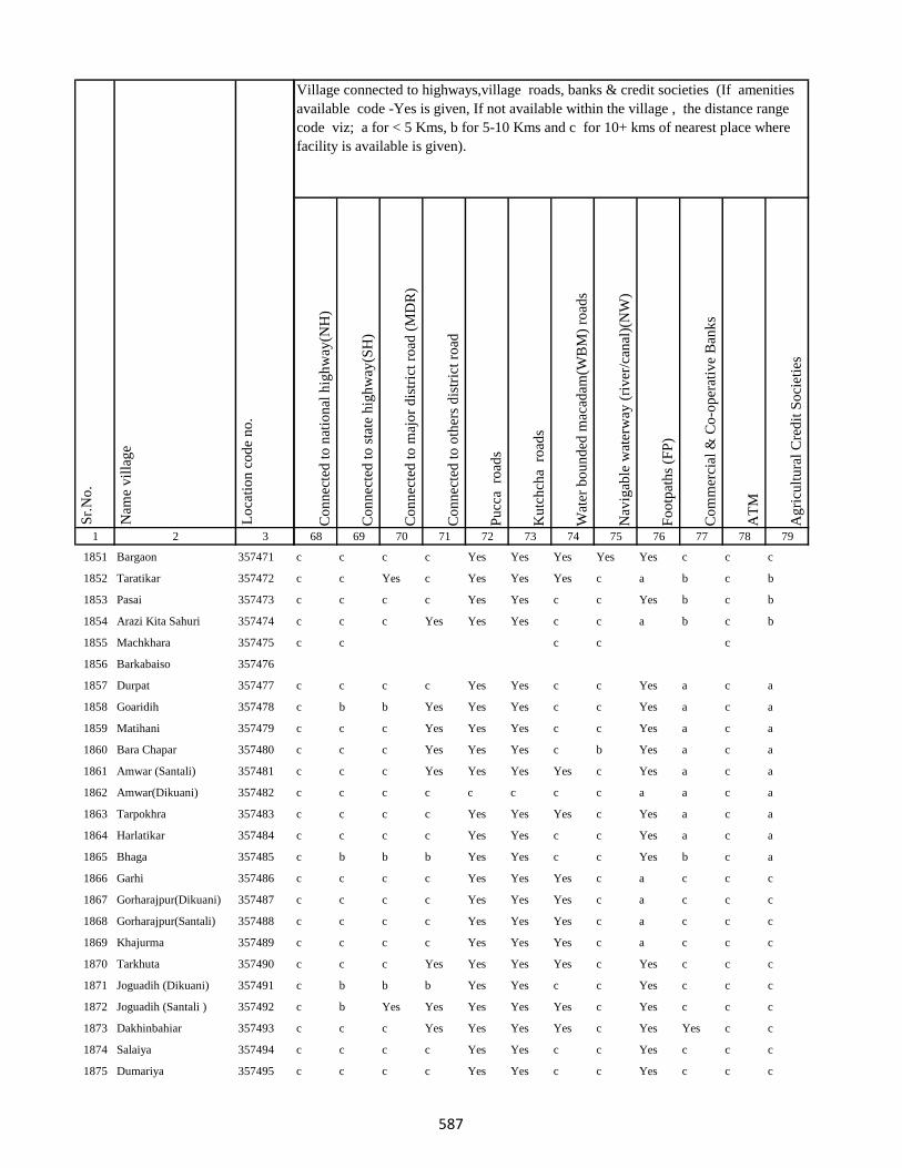
1 2 3
Lo
cati
on
co
de
no
.
Nam
e v
illa
ge
Sr.
No
.
1851 Bargaon 357471
1852 Taratikar 357472
1853 Pasai 357473
1854 Arazi Kita Sahuri 357474
1855 Machkhara 357475
1856 Barkabaiso 357476
1857 Durpat 357477
1858 Goaridih 357478
1859 Matihani 357479
1860 Bara Chapar 357480
1861 Amwar (Santali) 357481
1862 Amwar(Dikuani) 357482
1863 Tarpokhra 357483
1864 Harlatikar 357484
1865 Bhaga 357485
1866 Garhi 357486
1867 Gorharajpur(Dikuani) 357487
1868 Gorharajpur(Santali) 357488
1869 Khajurma 357489
1870 Tarkhuta 357490
1871 Joguadih (Dikuani) 357491
1872 Joguadih (Santali ) 357492
1873 Dakhinbahiar 357493
1874 Salaiya 357494
1875 Dumariya 357495
Co
nn
ecte
d t
o n
atio
nal
hig
hw
ay(N
H)
Co
nn
ecte
d t
o s
tate
hig
hw
ay(S
H)
Co
nn
ecte
d t
o m
ajo
r d
istr
ict
road
(M
DR
)
Co
nn
ecte
d t
o o
ther
s d
istr
ict
road
Pu
cca
ro
ads
Ku
tch
cha
ro
ads
Wat
er b
ou
nd
ed m
acad
am(W
BM
) ro
ads
Nav
igab
le w
ater
way
(ri
ver
/can
al)(
NW
)
Fo
otp
ath
s (F
P)
Co
mm
erci
al &
Co
-op
erat
ive
Ban
ks
AT
M
Ag
ricu
ltu
ral
Cre
dit
So
ciet
ies
68 69 70 71 72 73 74 75 76 77 78 79
Village connected to highways,village roads, banks & credit societies (If amenities
available code -Yes is given, If not available within the village , the distance range
code viz; a for < 5 Kms, b for 5-10 Kms and c for 10+ kms of nearest place where
facility is available is given).
c c c c Yes Yes Yes Yes Yes c c c
c c Yes c Yes Yes Yes c a b c b
c c c c Yes Yes c c Yes b c b
c c c Yes Yes Yes c c a b c b
c c c c c
c c c c Yes Yes c c Yes a c a
c b b Yes Yes Yes c c Yes a c a
c c c Yes Yes Yes c c Yes a c a
c c c Yes Yes Yes c b Yes a c a
c c c Yes Yes Yes Yes c Yes a c a
c c c c c c c c a a c a
c c c c Yes Yes Yes c Yes a c a
c c c c Yes Yes c c Yes a c a
c b b b Yes Yes c c Yes b c a
c c c c Yes Yes Yes c a c c c
c c c c Yes Yes Yes c a c c c
c c c c Yes Yes Yes c a c c c
c c c c Yes Yes Yes c a c c c
c c c Yes Yes Yes Yes c Yes c c c
c b b b Yes Yes c c Yes c c c
c b Yes Yes Yes Yes Yes c Yes c c c
c c c Yes Yes Yes Yes c Yes Yes c c
c c c c Yes Yes c c Yes c c c
c c c c Yes Yes c c Yes c c c
587
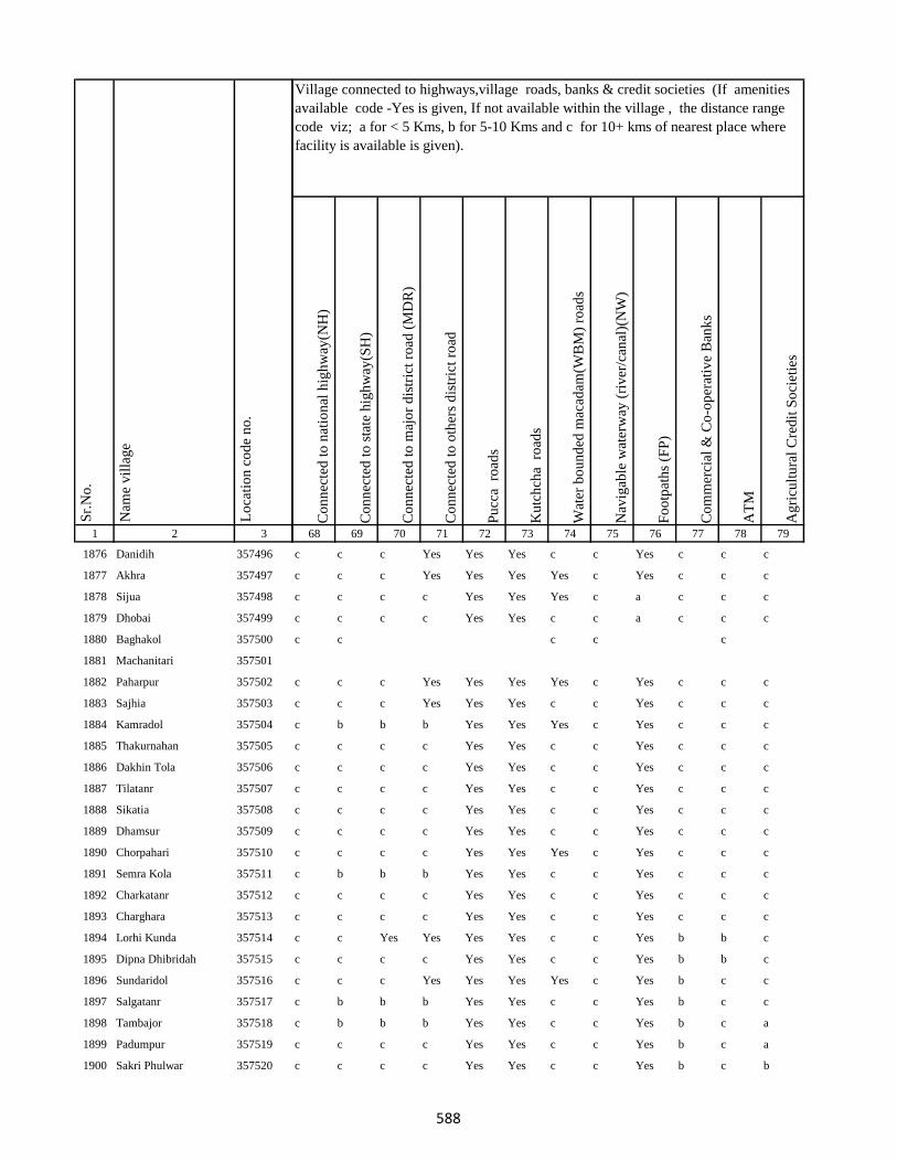
1 2 3
Lo
cati
on
co
de
no
.
Nam
e v
illa
ge
Sr.
No
.
1876 Danidih 357496
1877 Akhra 357497
1878 Sijua 357498
1879 Dhobai 357499
1880 Baghakol 357500
1881 Machanitari 357501
1882 Paharpur 357502
1883 Sajhia 357503
1884 Kamradol 357504
1885 Thakurnahan 357505
1886 Dakhin Tola 357506
1887 Tilatanr 357507
1888 Sikatia 357508
1889 Dhamsur 357509
1890 Chorpahari 357510
1891 Semra Kola 357511
1892 Charkatanr 357512
1893 Charghara 357513
1894 Lorhi Kunda 357514
1895 Dipna Dhibridah 357515
1896 Sundaridol 357516
1897 Salgatanr 357517
1898 Tambajor 357518
1899 Padumpur 357519
1900 Sakri Phulwar 357520
Co
nn
ecte
d t
o n
atio
nal
hig
hw
ay(N
H)
Co
nn
ecte
d t
o s
tate
hig
hw
ay(S
H)
Co
nn
ecte
d t
o m
ajo
r d
istr
ict
road
(M
DR
)
Co
nn
ecte
d t
o o
ther
s d
istr
ict
road
Pu
cca
ro
ads
Ku
tch
cha
ro
ads
Wat
er b
ou
nd
ed m
acad
am(W
BM
) ro
ads
Nav
igab
le w
ater
way
(ri
ver
/can
al)(
NW
)
Fo
otp
ath
s (F
P)
Co
mm
erci
al &
Co
-op
erat
ive
Ban
ks
AT
M
Ag
ricu
ltu
ral
Cre
dit
So
ciet
ies
68 69 70 71 72 73 74 75 76 77 78 79
Village connected to highways,village roads, banks & credit societies (If amenities
available code -Yes is given, If not available within the village , the distance range
code viz; a for < 5 Kms, b for 5-10 Kms and c for 10+ kms of nearest place where
facility is available is given).
c c c Yes Yes Yes c c Yes c c c
c c c Yes Yes Yes Yes c Yes c c c
c c c c Yes Yes Yes c a c c c
c c c c Yes Yes c c a c c c
c c c c c
c c c Yes Yes Yes Yes c Yes c c c
c c c Yes Yes Yes c c Yes c c c
c b b b Yes Yes Yes c Yes c c c
c c c c Yes Yes c c Yes c c c
c c c c Yes Yes c c Yes c c c
c c c c Yes Yes c c Yes c c c
c c c c Yes Yes c c Yes c c c
c c c c Yes Yes c c Yes c c c
c c c c Yes Yes Yes c Yes c c c
c b b b Yes Yes c c Yes c c c
c c c c Yes Yes c c Yes c c c
c c c c Yes Yes c c Yes c c c
c c Yes Yes Yes Yes c c Yes b b c
c c c c Yes Yes c c Yes b b c
c c c Yes Yes Yes Yes c Yes b c c
c b b b Yes Yes c c Yes b c c
c b b b Yes Yes c c Yes b c a
c c c c Yes Yes c c Yes b c a
c c c c Yes Yes c c Yes b c b
588

1 2 3
Lo
cati
on
co
de
no
.
Nam
e v
illa
ge
Sr.
No
.
1901 Kurwa 357521
1902 Kharbari 357522
1903 Chamudih 357523
1904 Maheshkiro Pachimtola 357524
1905 Kasturi 357525
1906 Khairadih 357526
1907 Panch Pahari 357527
1908 Dadughutu Paharpur 357528
1909 Maheshdhasa 357529
1910 Kita Makra 357530
1911 Dorabandh 357531
1912 Pareya Hat 357532
1913 Gunghasa 357533
1914 Rajdaha Bara 357534
1915 Gauripur 357535
1916 Sugathan 357536
1917 Hathihariyari 357537
1918 Dharophata 357538
1919 Lathibari 357539
1920 Jhapnibandh 357540
1921 Dhanu Kata 357541
1922 Raghunathpur 357542
1923 Kundapani 357543
1924 Kanchanrai Tola 357544
1925 Bandhaghat 357545
Co
nn
ecte
d t
o n
atio
nal
hig
hw
ay(N
H)
Co
nn
ecte
d t
o s
tate
hig
hw
ay(S
H)
Co
nn
ecte
d t
o m
ajo
r d
istr
ict
road
(M
DR
)
Co
nn
ecte
d t
o o
ther
s d
istr
ict
road
Pu
cca
ro
ads
Ku
tch
cha
ro
ads
Wat
er b
ou
nd
ed m
acad
am(W
BM
) ro
ads
Nav
igab
le w
ater
way
(ri
ver
/can
al)(
NW
)
Fo
otp
ath
s (F
P)
Co
mm
erci
al &
Co
-op
erat
ive
Ban
ks
AT
M
Ag
ricu
ltu
ral
Cre
dit
So
ciet
ies
68 69 70 71 72 73 74 75 76 77 78 79
Village connected to highways,village roads, banks & credit societies (If amenities
available code -Yes is given, If not available within the village , the distance range
code viz; a for < 5 Kms, b for 5-10 Kms and c for 10+ kms of nearest place where
facility is available is given).
c c c c Yes Yes c c Yes b c b
c c c c Yes Yes c c Yes b c b
c c c c Yes Yes Yes c Yes b c b
c c c c Yes Yes Yes c a c c c
c c c c Yes Yes Yes c Yes a c a
c c c c Yes Yes Yes c a b c b
c c c c Yes Yes Yes c Yes b c b
c c c c Yes Yes Yes c Yes b c b
c c c c Yes Yes Yes c Yes b c b
c b b b Yes Yes c c Yes a c a
c c Yes Yes Yes Yes Yes Yes Yes Yes Yes Yes
c c Yes Yes Yes Yes Yes c Yes a c a
c c c c Yes Yes Yes c Yes a c a
c c c Yes Yes Yes Yes c Yes c c b
c Yes Yes Yes Yes Yes Yes c Yes a c a
c c Yes Yes Yes Yes Yes c a c c b
c b b b Yes Yes Yes c Yes c c c
c c Yes Yes Yes Yes a c a c c c
c Yes Yes Yes Yes Yes Yes c a b b b
c c c c Yes Yes Yes c Yes b c b
c c Yes Yes Yes Yes Yes c Yes Yes c c
c c c c Yes Yes Yes c Yes b c b
c b c c
589
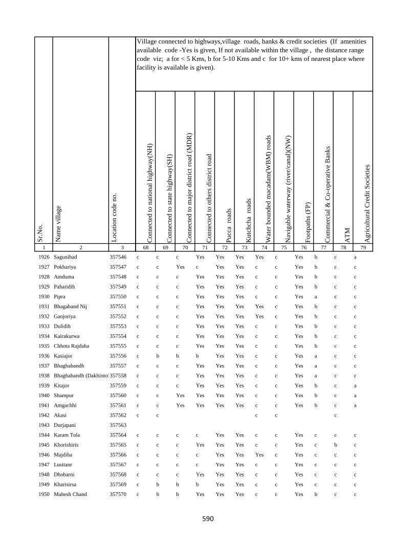
1 2 3
Lo
cati
on
co
de
no
.
Nam
e v
illa
ge
Sr.
No
.
1926 Sagunibad 357546
1927 Pokhariya 357547
1928 Amduma 357548
1929 Paharidih 357549
1930 Pipra 357550
1931 Bhagaband Nij 357551
1932 Ganjoriya 357552
1933 Dulidih 357553
1934 Kairakurwa 357554
1935 Chhota Rajdaha 357555
1936 Kasiajor 357556
1937 Bhaghabandh 357557
1938 Bhaghabandh (Dakhintola)357558
1939 Kitajor 357559
1940 Shampur 357560
1941 Amgachhi 357561
1942 Akasi 357562
1943 Durjapani 357563
1944 Karam Tola 357564
1945 Khorishiris 357565
1946 Majdiha 357566
1947 Lusitanr 357567
1948 Dhobarni 357568
1949 Kharisirsa 357569
1950 Mahesh Chand 357570
Co
nn
ecte
d t
o n
atio
nal
hig
hw
ay(N
H)
Co
nn
ecte
d t
o s
tate
hig
hw
ay(S
H)
Co
nn
ecte
d t
o m
ajo
r d
istr
ict
road
(M
DR
)
Co
nn
ecte
d t
o o
ther
s d
istr
ict
road
Pu
cca
ro
ads
Ku
tch
cha
ro
ads
Wat
er b
ou
nd
ed m
acad
am(W
BM
) ro
ads
Nav
igab
le w
ater
way
(ri
ver
/can
al)(
NW
)
Fo
otp
ath
s (F
P)
Co
mm
erci
al &
Co
-op
erat
ive
Ban
ks
AT
M
Ag
ricu
ltu
ral
Cre
dit
So
ciet
ies
68 69 70 71 72 73 74 75 76 77 78 79
Village connected to highways,village roads, banks & credit societies (If amenities
available code -Yes is given, If not available within the village , the distance range
code viz; a for < 5 Kms, b for 5-10 Kms and c for 10+ kms of nearest place where
facility is available is given).
c c c Yes Yes Yes Yes c Yes b c a
c c Yes c Yes Yes c c Yes b c c
c c c Yes Yes Yes c c Yes b c c
c c c Yes Yes Yes c c Yes b c c
c c c Yes Yes Yes c c Yes a c c
c c c Yes Yes Yes Yes c Yes b c c
c c c Yes Yes Yes Yes c Yes b c c
c c c Yes Yes Yes c c Yes b c c
c c c Yes Yes Yes c c Yes b c c
c c c Yes Yes Yes c c Yes b c c
c b b b Yes Yes c c Yes a c c
c c c Yes Yes Yes c c Yes a c c
c c c Yes Yes Yes c c Yes a c c
c c c Yes Yes Yes c c Yes b c a
c c Yes Yes Yes Yes c c Yes b c a
c c Yes Yes Yes Yes c c Yes b c a
c c c c c
c c c c Yes Yes c c Yes c c c
c c c Yes Yes Yes c c Yes c b c
c c c c Yes Yes Yes c Yes c c c
c c c c Yes Yes c c Yes c c c
c c c Yes Yes Yes c c Yes c c c
c b b b Yes Yes c c Yes c c c
c b b Yes Yes Yes c c Yes b c c
590
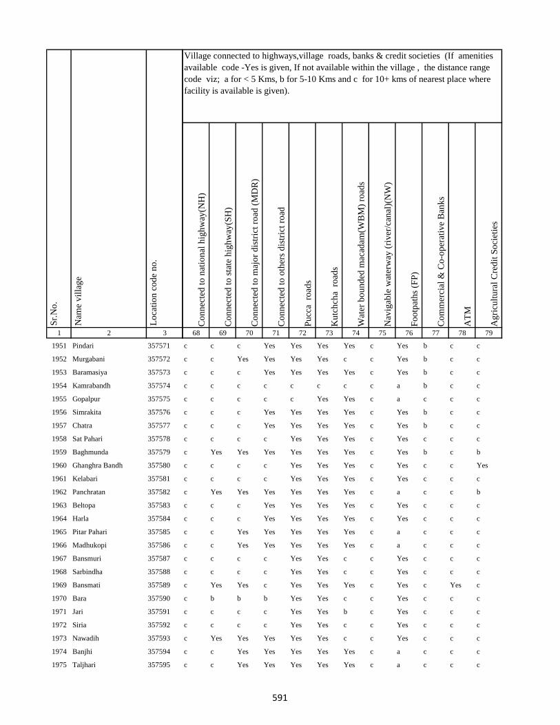
1 2 3
Lo
cati
on
co
de
no
.
Nam
e v
illa
ge
Sr.
No
.
1951 Pindari 357571
1952 Murgabani 357572
1953 Baramasiya 357573
1954 Kamrabandh 357574
1955 Gopalpur 357575
1956 Simrakita 357576
1957 Chatra 357577
1958 Sat Pahari 357578
1959 Baghmunda 357579
1960 Ghanghra Bandh 357580
1961 Kelabari 357581
1962 Panchratan 357582
1963 Beltopa 357583
1964 Harla 357584
1965 Pitar Pahari 357585
1966 Madhukopi 357586
1967 Bansmuri 357587
1968 Sarbindha 357588
1969 Bansmati 357589
1970 Bara 357590
1971 Jari 357591
1972 Siria 357592
1973 Nawadih 357593
1974 Banjhi 357594
1975 Taljhari 357595
Co
nn
ecte
d t
o n
atio
nal
hig
hw
ay(N
H)
Co
nn
ecte
d t
o s
tate
hig
hw
ay(S
H)
Co
nn
ecte
d t
o m
ajo
r d
istr
ict
road
(M
DR
)
Co
nn
ecte
d t
o o
ther
s d
istr
ict
road
Pu
cca
ro
ads
Ku
tch
cha
ro
ads
Wat
er b
ou
nd
ed m
acad
am(W
BM
) ro
ads
Nav
igab
le w
ater
way
(ri
ver
/can
al)(
NW
)
Fo
otp
ath
s (F
P)
Co
mm
erci
al &
Co
-op
erat
ive
Ban
ks
AT
M
Ag
ricu
ltu
ral
Cre
dit
So
ciet
ies
68 69 70 71 72 73 74 75 76 77 78 79
Village connected to highways,village roads, banks & credit societies (If amenities
available code -Yes is given, If not available within the village , the distance range
code viz; a for < 5 Kms, b for 5-10 Kms and c for 10+ kms of nearest place where
facility is available is given).
c c c Yes Yes Yes Yes c Yes b c c
c c Yes Yes Yes Yes c c Yes b c c
c c c Yes Yes Yes Yes c Yes b c c
c c c c c c c c a b c c
c c c c c Yes Yes c a c c c
c c c Yes Yes Yes Yes c Yes b c c
c c c Yes Yes Yes Yes c Yes b c c
c c c c Yes Yes Yes c Yes c c c
c Yes Yes Yes Yes Yes Yes c Yes b c b
c c c c Yes Yes Yes c Yes c c Yes
c c c c Yes Yes Yes c Yes c c c
c Yes Yes Yes Yes Yes Yes c a c c b
c c c Yes Yes Yes Yes c Yes c c c
c c c Yes Yes Yes Yes c Yes c c c
c c Yes Yes Yes Yes Yes c a c c c
c c Yes Yes Yes Yes Yes c a c c c
c c c c Yes Yes c c Yes c c c
c c c c Yes Yes c c Yes c c c
c Yes Yes c Yes Yes Yes c Yes c Yes c
c b b b Yes Yes c c Yes c c c
c c c c Yes Yes b c Yes c c c
c c c c Yes Yes c c Yes c c c
c Yes Yes Yes Yes Yes c c Yes c c c
c c Yes Yes Yes Yes Yes c a c c c
c c Yes Yes Yes Yes Yes c a c c c
591
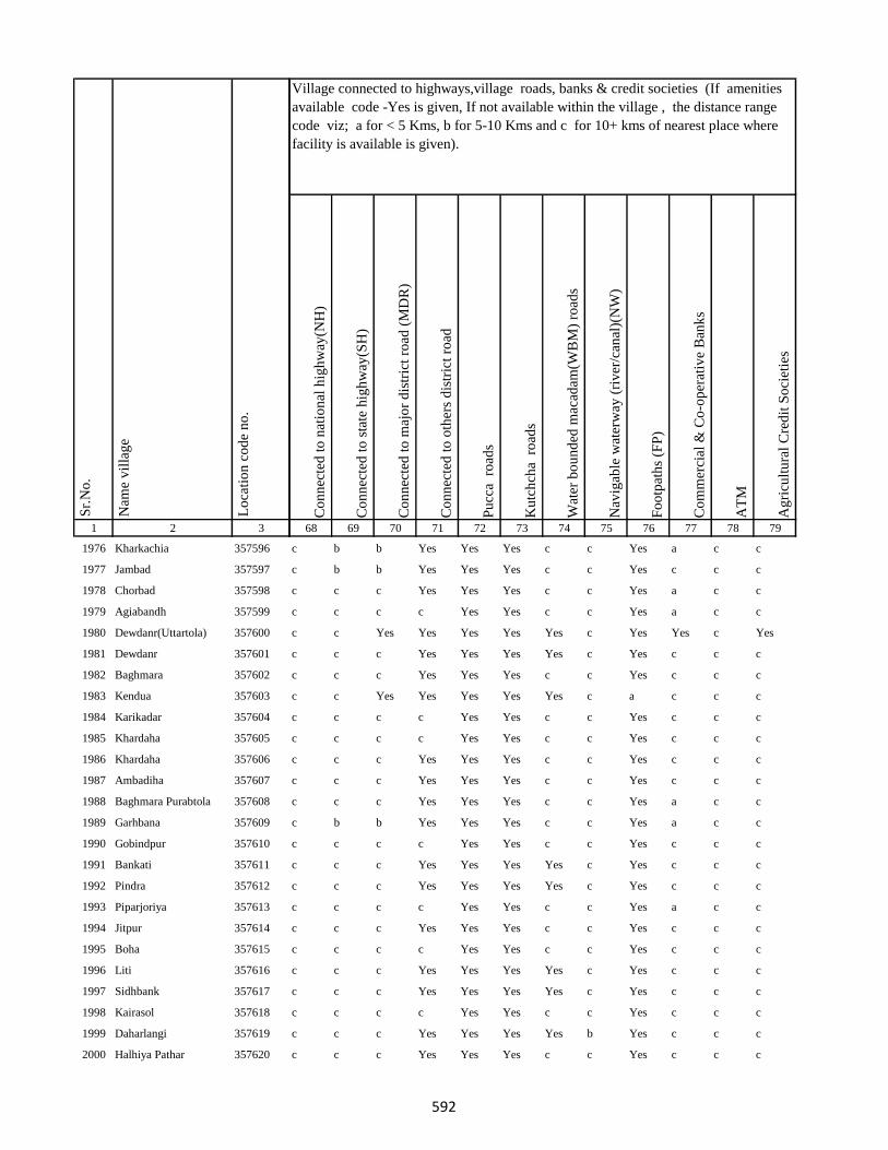
1 2 3
Lo
cati
on
co
de
no
.
Nam
e v
illa
ge
Sr.
No
.
1976 Kharkachia 357596
1977 Jambad 357597
1978 Chorbad 357598
1979 Agiabandh 357599
1980 Dewdanr(Uttartola) 357600
1981 Dewdanr 357601
1982 Baghmara 357602
1983 Kendua 357603
1984 Karikadar 357604
1985 Khardaha 357605
1986 Khardaha 357606
1987 Ambadiha 357607
1988 Baghmara Purabtola 357608
1989 Garhbana 357609
1990 Gobindpur 357610
1991 Bankati 357611
1992 Pindra 357612
1993 Piparjoriya 357613
1994 Jitpur 357614
1995 Boha 357615
1996 Liti 357616
1997 Sidhbank 357617
1998 Kairasol 357618
1999 Daharlangi 357619
2000 Halhiya Pathar 357620
Co
nn
ecte
d t
o n
atio
nal
hig
hw
ay(N
H)
Co
nn
ecte
d t
o s
tate
hig
hw
ay(S
H)
Co
nn
ecte
d t
o m
ajo
r d
istr
ict
road
(M
DR
)
Co
nn
ecte
d t
o o
ther
s d
istr
ict
road
Pu
cca
ro
ads
Ku
tch
cha
ro
ads
Wat
er b
ou
nd
ed m
acad
am(W
BM
) ro
ads
Nav
igab
le w
ater
way
(ri
ver
/can
al)(
NW
)
Fo
otp
ath
s (F
P)
Co
mm
erci
al &
Co
-op
erat
ive
Ban
ks
AT
M
Ag
ricu
ltu
ral
Cre
dit
So
ciet
ies
68 69 70 71 72 73 74 75 76 77 78 79
Village connected to highways,village roads, banks & credit societies (If amenities
available code -Yes is given, If not available within the village , the distance range
code viz; a for < 5 Kms, b for 5-10 Kms and c for 10+ kms of nearest place where
facility is available is given).
c b b Yes Yes Yes c c Yes a c c
c b b Yes Yes Yes c c Yes c c c
c c c Yes Yes Yes c c Yes a c c
c c c c Yes Yes c c Yes a c c
c c Yes Yes Yes Yes Yes c Yes Yes c Yes
c c c Yes Yes Yes Yes c Yes c c c
c c c Yes Yes Yes c c Yes c c c
c c Yes Yes Yes Yes Yes c a c c c
c c c c Yes Yes c c Yes c c c
c c c c Yes Yes c c Yes c c c
c c c Yes Yes Yes c c Yes c c c
c c c Yes Yes Yes c c Yes c c c
c c c Yes Yes Yes c c Yes a c c
c b b Yes Yes Yes c c Yes a c c
c c c c Yes Yes c c Yes c c c
c c c Yes Yes Yes Yes c Yes c c c
c c c Yes Yes Yes Yes c Yes c c c
c c c c Yes Yes c c Yes a c c
c c c Yes Yes Yes c c Yes c c c
c c c c Yes Yes c c Yes c c c
c c c Yes Yes Yes Yes c Yes c c c
c c c Yes Yes Yes Yes c Yes c c c
c c c c Yes Yes c c Yes c c c
c c c Yes Yes Yes Yes b Yes c c c
c c c Yes Yes Yes c c Yes c c c
592
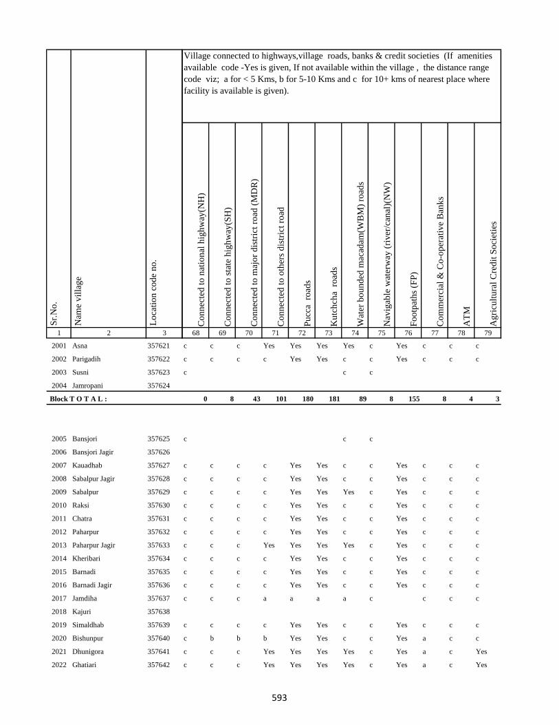
1 2 3
Lo
cati
on
co
de
no
.
Nam
e v
illa
ge
Sr.
No
.
2001 Asna 357621
2002 Parigadih 357622
2003 Susni 357623
2004 Jamropani 357624
Block T O T A L :
2005 Bansjori 357625
2006 Bansjori Jagir 357626
2007 Kauadhab 357627
2008 Sabalpur Jagir 357628
2009 Sabalpur 357629
2010 Raksi 357630
2011 Chatra 357631
2012 Paharpur 357632
2013 Paharpur Jagir 357633
2014 Kheribari 357634
2015 Barnadi 357635
2016 Barnadi Jagir 357636
2017 Jamdiha 357637
2018 Kajuri 357638
2019 Simaldhab 357639
2020 Bishunpur 357640
2021 Dhunigora 357641
2022 Ghatiari 357642
Co
nn
ecte
d t
o n
atio
nal
hig
hw
ay(N
H)
Co
nn
ecte
d t
o s
tate
hig
hw
ay(S
H)
Co
nn
ecte
d t
o m
ajo
r d
istr
ict
road
(M
DR
)
Co
nn
ecte
d t
o o
ther
s d
istr
ict
road
Pu
cca
ro
ads
Ku
tch
cha
ro
ads
Wat
er b
ou
nd
ed m
acad
am(W
BM
) ro
ads
Nav
igab
le w
ater
way
(ri
ver
/can
al)(
NW
)
Fo
otp
ath
s (F
P)
Co
mm
erci
al &
Co
-op
erat
ive
Ban
ks
AT
M
Ag
ricu
ltu
ral
Cre
dit
So
ciet
ies
68 69 70 71 72 73 74 75 76 77 78 79
Village connected to highways,village roads, banks & credit societies (If amenities
available code -Yes is given, If not available within the village , the distance range
code viz; a for < 5 Kms, b for 5-10 Kms and c for 10+ kms of nearest place where
facility is available is given).
c c c Yes Yes Yes Yes c Yes c c c
c c c c Yes Yes c c Yes c c c
c c c
0 8 43 101 180 181 89 8 155 8 4 3
c c c
c c c c Yes Yes c c Yes c c c
c c c c Yes Yes c c Yes c c c
c c c c Yes Yes Yes c Yes c c c
c c c c Yes Yes c c Yes c c c
c c c c Yes Yes c c Yes c c c
c c c c Yes Yes c c Yes c c c
c c c Yes Yes Yes Yes c Yes c c c
c c c c Yes Yes c c Yes c c c
c c c c Yes Yes c c Yes c c c
c c c c Yes Yes c c Yes c c c
c c c a a a a c c c c
c c c c Yes Yes c c Yes c c c
c b b b Yes Yes c c Yes a c c
c c c Yes Yes Yes Yes c Yes a c Yes
c c c Yes Yes Yes Yes c Yes a c Yes
593

1 2 3
Lo
cati
on
co
de
no
.
Nam
e v
illa
ge
Sr.
No
.
2023 Chhota Ghatiari 357643
2024 Tasria 357644
2025 Narayanpur 357645
2026 Jambia 357646
2027 Kherabani 357647
2028 Jilbari 357648
2029 Mahua Tanr 357649
2030 Karmatanr 357650
2031 Bhaluka 357651
2032 Sundar Maur 357652
2033 Sabalpur 357653
2034 Lawadih 357654
2035 Dighibathan 357655
2036 Jamuntanr 357656
2037 Khelari 357657
2038 Adro 357658
2039 Ammaqo 357659
2040 Bedotok 357660
2041 Berago(Telalkuria) 357661
2042 Bilamaqo(Basgo) 357662
2043 Chacham 357663
2044 Chalgoda(Madgi) 357664
2045 Chaparom 357665
2046 Chuclalo 357666
2047 Churi 357667
Co
nn
ecte
d t
o n
atio
nal
hig
hw
ay(N
H)
Co
nn
ecte
d t
o s
tate
hig
hw
ay(S
H)
Co
nn
ecte
d t
o m
ajo
r d
istr
ict
road
(M
DR
)
Co
nn
ecte
d t
o o
ther
s d
istr
ict
road
Pu
cca
ro
ads
Ku
tch
cha
ro
ads
Wat
er b
ou
nd
ed m
acad
am(W
BM
) ro
ads
Nav
igab
le w
ater
way
(ri
ver
/can
al)(
NW
)
Fo
otp
ath
s (F
P)
Co
mm
erci
al &
Co
-op
erat
ive
Ban
ks
AT
M
Ag
ricu
ltu
ral
Cre
dit
So
ciet
ies
68 69 70 71 72 73 74 75 76 77 78 79
Village connected to highways,village roads, banks & credit societies (If amenities
available code -Yes is given, If not available within the village , the distance range
code viz; a for < 5 Kms, b for 5-10 Kms and c for 10+ kms of nearest place where
facility is available is given).
c c c c Yes Yes Yes c Yes c c c
c c c c
c b b b Yes Yes c c Yes b c c
c c c Yes Yes Yes Yes c Yes c c c
c c Yes Yes Yes Yes c c Yes c c c
c c Yes Yes Yes Yes c c Yes c c c
c c Yes Yes Yes Yes Yes c Yes c c c
c c c c Yes Yes c c Yes c c c
c c c c Yes Yes Yes c Yes c c c
c c c c Yes Yes Yes c Yes c c c
c c c c Yes Yes Yes c Yes c c c
c c c c c c c c a c c c
c c c c
c c c c Yes Yes c c Yes c c c
c c c c Yes Yes c c Yes b c c
c c c c
594
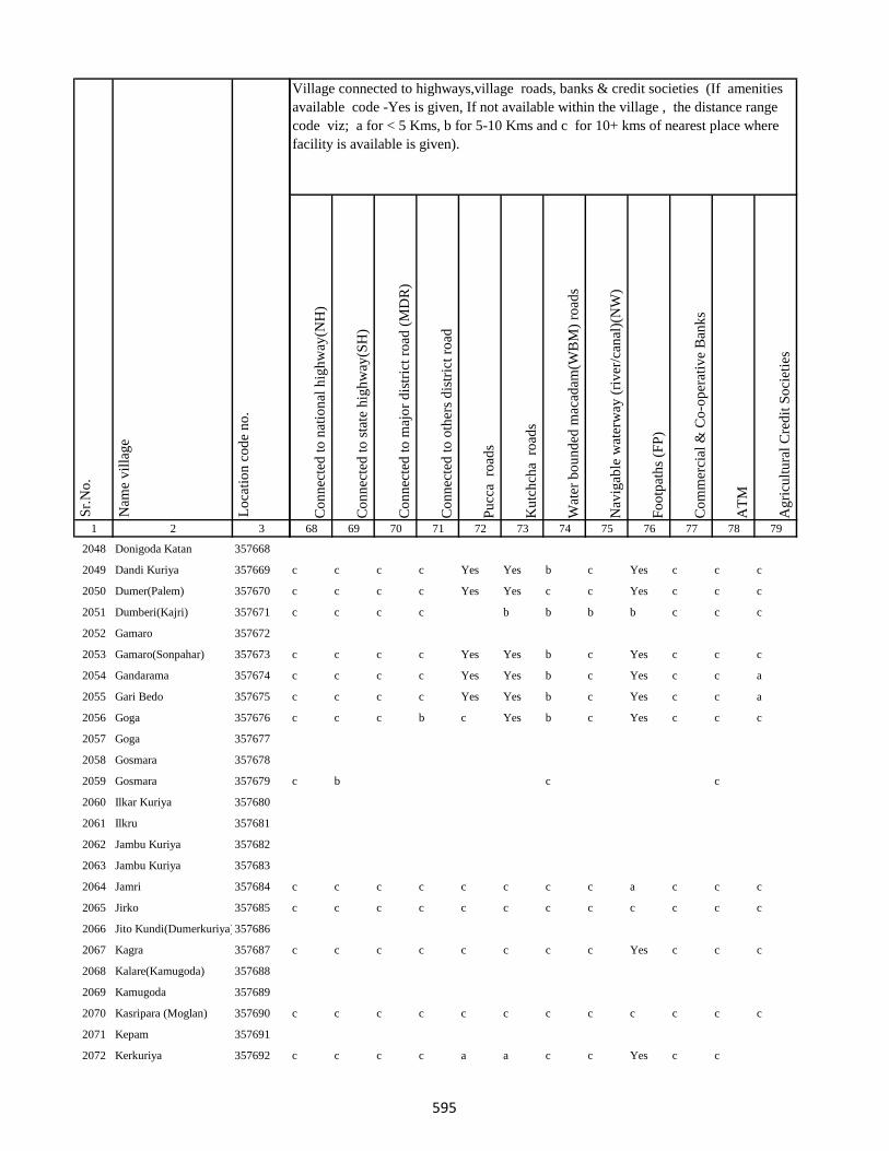
1 2 3
Lo
cati
on
co
de
no
.
Nam
e v
illa
ge
Sr.
No
.
2048 Donigoda Katan 357668
2049 Dandi Kuriya 357669
2050 Dumer(Palem) 357670
2051 Dumberi(Kajri) 357671
2052 Gamaro 357672
2053 Gamaro(Sonpahar) 357673
2054 Gandarama 357674
2055 Gari Bedo 357675
2056 Goga 357676
2057 Goga 357677
2058 Gosmara 357678
2059 Gosmara 357679
2060 Ilkar Kuriya 357680
2061 Ilkru 357681
2062 Jambu Kuriya 357682
2063 Jambu Kuriya 357683
2064 Jamri 357684
2065 Jirko 357685
2066 Jito Kundi(Dumerkuriya)357686
2067 Kagra 357687
2068 Kalare(Kamugoda) 357688
2069 Kamugoda 357689
2070 Kasripara (Moglan) 357690
2071 Kepam 357691
2072 Kerkuriya 357692
Co
nn
ecte
d t
o n
atio
nal
hig
hw
ay(N
H)
Co
nn
ecte
d t
o s
tate
hig
hw
ay(S
H)
Co
nn
ecte
d t
o m
ajo
r d
istr
ict
road
(M
DR
)
Co
nn
ecte
d t
o o
ther
s d
istr
ict
road
Pu
cca
ro
ads
Ku
tch
cha
ro
ads
Wat
er b
ou
nd
ed m
acad
am(W
BM
) ro
ads
Nav
igab
le w
ater
way
(ri
ver
/can
al)(
NW
)
Fo
otp
ath
s (F
P)
Co
mm
erci
al &
Co
-op
erat
ive
Ban
ks
AT
M
Ag
ricu
ltu
ral
Cre
dit
So
ciet
ies
68 69 70 71 72 73 74 75 76 77 78 79
Village connected to highways,village roads, banks & credit societies (If amenities
available code -Yes is given, If not available within the village , the distance range
code viz; a for < 5 Kms, b for 5-10 Kms and c for 10+ kms of nearest place where
facility is available is given).
c c c c Yes Yes b c Yes c c c
c c c c Yes Yes c c Yes c c c
c c c c b b b b c c c
c c c c Yes Yes b c Yes c c c
c c c c Yes Yes b c Yes c c a
c c c c Yes Yes b c Yes c c a
c c c b c Yes b c Yes c c c
c b c c
c c c c c c c c a c c c
c c c c c c c c c c c c
c c c c c c c c Yes c c c
c c c c c c c c c c c c
c c c c a a c c Yes c c
595
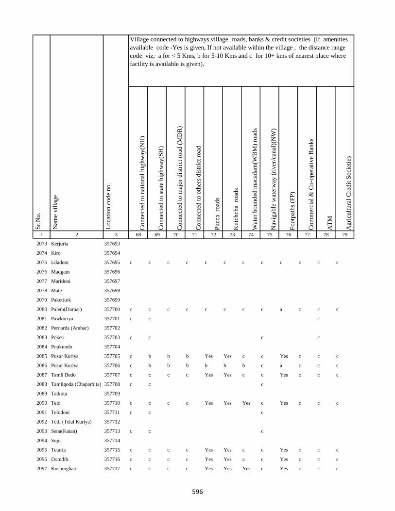
1 2 3
Lo
cati
on
co
de
no
.
Nam
e v
illa
ge
Sr.
No
.
2073 Kerjuria 357693
2074 Kiro 357694
2075 Liladoni 357695
2076 Madgam 357696
2077 Maridoni 357697
2078 Mate 357698
2079 Pakeritok 357699
2080 Palem(Dumar) 357700
2081 Pawkuriya 357701
2082 Perdarda (Ambar) 357702
2083 Pokeri 357703
2084 Popkundo 357704
2085 Pusur Kuriya 357705
2086 Pusur Kuriya 357706
2087 Tamli Bedo 357707
2088 Tamligoda (Chaparbita) 357708
2089 Tatkota 357709
2090 Telo 357710
2091 Telodoni 357711
2092 Tetli (Telal Kuriya) 357712
2093 Sena(Katan) 357713
2094 Suju 357714
2095 Tetaria 357715
2096 Domdih 357716
2097 Kusumghati 357717
Co
nn
ecte
d t
o n
atio
nal
hig
hw
ay(N
H)
Co
nn
ecte
d t
o s
tate
hig
hw
ay(S
H)
Co
nn
ecte
d t
o m
ajo
r d
istr
ict
road
(M
DR
)
Co
nn
ecte
d t
o o
ther
s d
istr
ict
road
Pu
cca
ro
ads
Ku
tch
cha
ro
ads
Wat
er b
ou
nd
ed m
acad
am(W
BM
) ro
ads
Nav
igab
le w
ater
way
(ri
ver
/can
al)(
NW
)
Fo
otp
ath
s (F
P)
Co
mm
erci
al &
Co
-op
erat
ive
Ban
ks
AT
M
Ag
ricu
ltu
ral
Cre
dit
So
ciet
ies
68 69 70 71 72 73 74 75 76 77 78 79
Village connected to highways,village roads, banks & credit societies (If amenities
available code -Yes is given, If not available within the village , the distance range
code viz; a for < 5 Kms, b for 5-10 Kms and c for 10+ kms of nearest place where
facility is available is given).
c c c c c c c c c c c c
c c c c c c c c a c c c
c c c
c c c c
c b b b Yes Yes c c Yes c c c
c b b b b b b c a c c c
c c c c Yes Yes c c Yes c c c
c c c
c c c c Yes Yes Yes c Yes c c c
c c c
c c c
c c c c Yes Yes c c Yes c c c
c c c c Yes Yes a c Yes c c c
c c c c Yes Yes Yes c Yes c c c
596
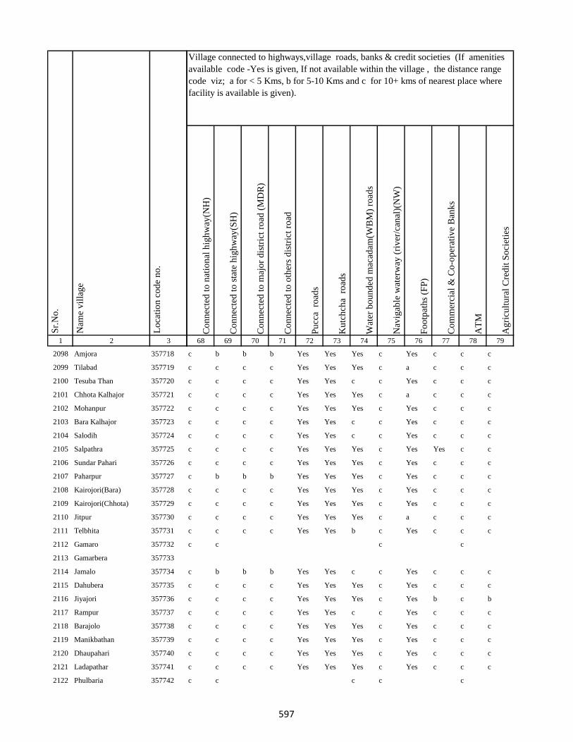
1 2 3
Lo
cati
on
co
de
no
.
Nam
e v
illa
ge
Sr.
No
.
2098 Amjora 357718
2099 Tilabad 357719
2100 Tesuba Than 357720
2101 Chhota Kalhajor 357721
2102 Mohanpur 357722
2103 Bara Kalhajor 357723
2104 Salodih 357724
2105 Salpathra 357725
2106 Sundar Pahari 357726
2107 Paharpur 357727
2108 Kairojori(Bara) 357728
2109 Kairojori(Chhota) 357729
2110 Jitpur 357730
2111 Telbhita 357731
2112 Gamaro 357732
2113 Gamarbera 357733
2114 Jamalo 357734
2115 Dahubera 357735
2116 Jiyajori 357736
2117 Rampur 357737
2118 Barajolo 357738
2119 Manikbathan 357739
2120 Dhaupahari 357740
2121 Ladapathar 357741
2122 Phulbaria 357742
Co
nn
ecte
d t
o n
atio
nal
hig
hw
ay(N
H)
Co
nn
ecte
d t
o s
tate
hig
hw
ay(S
H)
Co
nn
ecte
d t
o m
ajo
r d
istr
ict
road
(M
DR
)
Co
nn
ecte
d t
o o
ther
s d
istr
ict
road
Pu
cca
ro
ads
Ku
tch
cha
ro
ads
Wat
er b
ou
nd
ed m
acad
am(W
BM
) ro
ads
Nav
igab
le w
ater
way
(ri
ver
/can
al)(
NW
)
Fo
otp
ath
s (F
P)
Co
mm
erci
al &
Co
-op
erat
ive
Ban
ks
AT
M
Ag
ricu
ltu
ral
Cre
dit
So
ciet
ies
68 69 70 71 72 73 74 75 76 77 78 79
Village connected to highways,village roads, banks & credit societies (If amenities
available code -Yes is given, If not available within the village , the distance range
code viz; a for < 5 Kms, b for 5-10 Kms and c for 10+ kms of nearest place where
facility is available is given).
c b b b Yes Yes Yes c Yes c c c
c c c c Yes Yes Yes c a c c c
c c c c Yes Yes c c Yes c c c
c c c c Yes Yes Yes c a c c c
c c c c Yes Yes Yes c Yes c c c
c c c c Yes Yes c c Yes c c c
c c c c Yes Yes c c Yes c c c
c c c c Yes Yes Yes c Yes Yes c c
c c c c Yes Yes Yes c Yes c c c
c b b b Yes Yes Yes c Yes c c c
c c c c Yes Yes Yes c Yes c c c
c c c c Yes Yes Yes c Yes c c c
c c c c Yes Yes Yes c a c c c
c c c c Yes Yes b c Yes c c c
c c c c
c b b b Yes Yes c c Yes c c c
c c c c Yes Yes Yes c Yes c c c
c c c c Yes Yes Yes c Yes b c b
c c c c Yes Yes c c Yes c c c
c c c c Yes Yes Yes c Yes c c c
c c c c Yes Yes Yes c Yes c c c
c c c c Yes Yes Yes c Yes c c c
c c c c Yes Yes Yes c Yes c c c
c c c c c
597
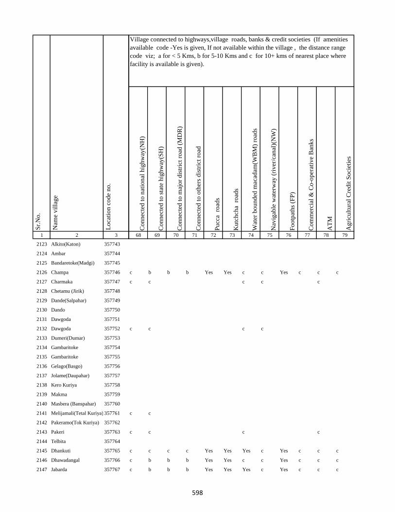
1 2 3
Lo
cati
on
co
de
no
.
Nam
e v
illa
ge
Sr.
No
.
2123 Alkito(Katon) 357743
2124 Ambar 357744
2125 Bandaretoke(Madgi) 357745
2126 Champa 357746
2127 Charmaka 357747
2128 Chetamu (Jirik) 357748
2129 Dande(Salpahar) 357749
2130 Dando 357750
2131 Dawgoda 357751
2132 Dawgoda 357752
2133 Dumeri(Dumar) 357753
2134 Gambaritoke 357754
2135 Gambaritoke 357755
2136 Gelago(Basgo) 357756
2137 Jolame(Daupahar) 357757
2138 Kero Kuriya 357758
2139 Makma 357759
2140 Masbera (Banspahar) 357760
2141 Melijamali(Tetal Kuriya) 357761
2142 Pakeramo(Tok Kuriya) 357762
2143 Pakeri 357763
2144 Telbita 357764
2145 Dhankuti 357765
2146 Dhawadangal 357766
2147 Jabarda 357767
Co
nn
ecte
d t
o n
atio
nal
hig
hw
ay(N
H)
Co
nn
ecte
d t
o s
tate
hig
hw
ay(S
H)
Co
nn
ecte
d t
o m
ajo
r d
istr
ict
road
(M
DR
)
Co
nn
ecte
d t
o o
ther
s d
istr
ict
road
Pu
cca
ro
ads
Ku
tch
cha
ro
ads
Wat
er b
ou
nd
ed m
acad
am(W
BM
) ro
ads
Nav
igab
le w
ater
way
(ri
ver
/can
al)(
NW
)
Fo
otp
ath
s (F
P)
Co
mm
erci
al &
Co
-op
erat
ive
Ban
ks
AT
M
Ag
ricu
ltu
ral
Cre
dit
So
ciet
ies
68 69 70 71 72 73 74 75 76 77 78 79
Village connected to highways,village roads, banks & credit societies (If amenities
available code -Yes is given, If not available within the village , the distance range
code viz; a for < 5 Kms, b for 5-10 Kms and c for 10+ kms of nearest place where
facility is available is given).
c b b b Yes Yes c c Yes c c c
c c c c c
c c c c
c c
c c c c
c c c c Yes Yes Yes c Yes c c c
c b b b Yes Yes c c Yes c c c
c b b b Yes Yes Yes c Yes c c c
598

1 2 3
Lo
cati
on
co
de
no
.
Nam
e v
illa
ge
Sr.
No
.
2148 Bara Puro 357768
2149 Chhota Dhamni 357769
2150 Dhamni Bazar 357770
2151 Bara Dhamni 357771
2152 Chhota Puro 357772
2153 Gadidih 357773
2154 Piparjoria 357774
2155 Marchaitari 357775
2156 Pokharia 357776
2157 Kairasul 357777
2158 Ambardoni 357778
2159 Bat 357779
2160 Bitakepu 357780
2161 Daukuriya 357781
2162 Donigoda 357782
2163 Jari Mamqo 357783
2164 Kadu 357784
2165 Karag 357785
2166 Kiro 357786
2167 Koa 357787
2168 Kubji Bedo 357788
2169 Kubji Maqo 357789
2170 Kudi Goda 357790
2171 Madgi 357791
2172 Madgi Bedo 357792
Co
nn
ecte
d t
o n
atio
nal
hig
hw
ay(N
H)
Co
nn
ecte
d t
o s
tate
hig
hw
ay(S
H)
Co
nn
ecte
d t
o m
ajo
r d
istr
ict
road
(M
DR
)
Co
nn
ecte
d t
o o
ther
s d
istr
ict
road
Pu
cca
ro
ads
Ku
tch
cha
ro
ads
Wat
er b
ou
nd
ed m
acad
am(W
BM
) ro
ads
Nav
igab
le w
ater
way
(ri
ver
/can
al)(
NW
)
Fo
otp
ath
s (F
P)
Co
mm
erci
al &
Co
-op
erat
ive
Ban
ks
AT
M
Ag
ricu
ltu
ral
Cre
dit
So
ciet
ies
68 69 70 71 72 73 74 75 76 77 78 79
Village connected to highways,village roads, banks & credit societies (If amenities
available code -Yes is given, If not available within the village , the distance range
code viz; a for < 5 Kms, b for 5-10 Kms and c for 10+ kms of nearest place where
facility is available is given).
c c c Yes Yes Yes Yes c a c c c
c c c Yes Yes Yes Yes c Yes c c c
c c c Yes Yes Yes Yes c Yes c c c
c c c c Yes Yes Yes c Yes c c c
c c c c Yes Yes c c Yes c c c
c c c c Yes Yes c c Yes c c c
c c c c Yes Yes Yes c a c c c
c c c c Yes Yes Yes c a c c c
c c c c Yes Yes Yes c a c c c
c c a a a a c c Yes c
c b b b Yes Yes c c Yes c c c
c c c c c c c c
c c c c c c c c a c c c
c c c c c c c c a c c c
c c c c b b a Yes c c c
c c c c Yes Yes c c Yes c c c
c c c c c c c c Yes c c c
c b b b b b b c Yes c c c
c c c c Yes Yes c c Yes c c c
c c c c Yes Yes c c Yes c c c
599

1 2 3
Lo
cati
on
co
de
no
.
Nam
e v
illa
ge
Sr.
No
.
2173 Madgi Maqo 357793
2174 Puro Maqo (Katan) 357794
2175 Karag 357795
2176 Tamli 357796
2177 Takalo 357797
2178 Tetal Kuriya 357798
2179 Saharpura 357799
2180 Chandna 357800
2181 Longidih 357801
2182 Borwa 357802
2183 Karamtola 357803
2184 Roldih 357804
2185 Bara Haripur 357805
2186 Dulu 357806
2187 Asantari 357807
2188 Kusmaha 357808
2189 Damruhat 357809
2190 Dumki 357810
2191 Kairabani 357811
2192 Bariyarpur 357812
2193 Chhota Haripur 357813
2194 Kadampur 357814
2195 Angbali 357815
2196 Banspahari 357816
2197 Gamharia 357817
Co
nn
ecte
d t
o n
atio
nal
hig
hw
ay(N
H)
Co
nn
ecte
d t
o s
tate
hig
hw
ay(S
H)
Co
nn
ecte
d t
o m
ajo
r d
istr
ict
road
(M
DR
)
Co
nn
ecte
d t
o o
ther
s d
istr
ict
road
Pu
cca
ro
ads
Ku
tch
cha
ro
ads
Wat
er b
ou
nd
ed m
acad
am(W
BM
) ro
ads
Nav
igab
le w
ater
way
(ri
ver
/can
al)(
NW
)
Fo
otp
ath
s (F
P)
Co
mm
erci
al &
Co
-op
erat
ive
Ban
ks
AT
M
Ag
ricu
ltu
ral
Cre
dit
So
ciet
ies
68 69 70 71 72 73 74 75 76 77 78 79
Village connected to highways,village roads, banks & credit societies (If amenities
available code -Yes is given, If not available within the village , the distance range
code viz; a for < 5 Kms, b for 5-10 Kms and c for 10+ kms of nearest place where
facility is available is given).
c c c c Yes Yes c c Yes c c c
c c b b b b b c b c c c
c c c Yes Yes Yes Yes c Yes Yes c b
c c c c Yes Yes Yes c Yes c c c
c c c c Yes Yes Yes c Yes a c c
c c c c Yes Yes Yes c Yes a c c
c c c c Yes Yes Yes c Yes a c c
c b b b Yes Yes Yes c Yes b c c
c b b b b b b c a c c c
c c c c b b b c b c c c
c c c Yes Yes Yes Yes c Yes c c c
c c c c Yes Yes c c Yes c c c
c c c Yes Yes Yes b c Yes c c c
c c c c Yes Yes a c Yes c c c
c c c c Yes Yes Yes c Yes b c c
c c c c Yes Yes Yes c Yes b c c
c c c c Yes Yes Yes c Yes a c c
c c c c
600

1 2 3
Lo
cati
on
co
de
no
.
Nam
e v
illa
ge
Sr.
No
.
2198 Paharpur 357818
2199 Tetariya 357819
2200 Khepadih 357820
2201 Chandraydih 357821
2202 Gardi 357822
2203 Ghaghri 357823
2204 Malikundi 357824
2205 Bara Sinddri 357825
2206 Sagar 357826
2207 Monadih 357827
2208 Ghorabali 357828
2209 Chhota Sindari 357829
2210 Tilaipara 357830
2211 Sahapi 357831
2212 Madni 357832
2213 Ratnapara 357833
2214 Dumartari 357834
2215 Bara Sabai Kundi 357835
2216 Chhota Sabai Kundi 357836
2217 Rajabhita 357837
2218 Chhota Adro 357838
2219 Manspara 357839
2220 Kesam 357840
2221 Keropara 357841
2222 Chamer 357842
Co
nn
ecte
d t
o n
atio
nal
hig
hw
ay(N
H)
Co
nn
ecte
d t
o s
tate
hig
hw
ay(S
H)
Co
nn
ecte
d t
o m
ajo
r d
istr
ict
road
(M
DR
)
Co
nn
ecte
d t
o o
ther
s d
istr
ict
road
Pu
cca
ro
ads
Ku
tch
cha
ro
ads
Wat
er b
ou
nd
ed m
acad
am(W
BM
) ro
ads
Nav
igab
le w
ater
way
(ri
ver
/can
al)(
NW
)
Fo
otp
ath
s (F
P)
Co
mm
erci
al &
Co
-op
erat
ive
Ban
ks
AT
M
Ag
ricu
ltu
ral
Cre
dit
So
ciet
ies
68 69 70 71 72 73 74 75 76 77 78 79
Village connected to highways,village roads, banks & credit societies (If amenities
available code -Yes is given, If not available within the village , the distance range
code viz; a for < 5 Kms, b for 5-10 Kms and c for 10+ kms of nearest place where
facility is available is given).
c c c c Yes Yes b c Yes c c c
c c c c c c Yes c Yes c c c
c c c c Yes Yes c c Yes c c c
c c c c Yes Yes Yes c Yes c c c
c c c c Yes Yes c c Yes c c c
c c c Yes Yes Yes c c Yes c c c
c b Yes Yes Yes Yes c c a c c c
c c c c Yes Yes Yes c Yes a c c
c c c c Yes Yes Yes c Yes a c c
c c c c Yes Yes Yes c Yes b c c
c c c c Yes Yes Yes c Yes b c c
c c c c Yes Yes c c Yes c c c
c b b b Yes Yes c c Yes c c c
c b b b Yes Yes c c Yes c c c
c c Yes Yes Yes Yes c c Yes c c c
c c c c Yes Yes c c Yes c c c
c c c c Yes Yes Yes c Yes c c c
c c c c Yes Yes Yes c Yes c c c
c c c c c c c c a c c c
c c c c Yes Yes Yes c Yes c c c
c c c c Yes Yes c c Yes c c c
c c c c c c
c c c c Yes Yes b c Yes c c c
601

1 2 3
Lo
cati
on
co
de
no
.
Nam
e v
illa
ge
Sr.
No
.
2223 Mando Pahari 357843
2224 Chhatmi 357844
2225 Bara Paktari 357845
2226 Chhota Palma 357846
2227 Gargawan 357847
2228 Bara Palma 357848
2229 Chhota Paktari 357849
2230 Rakha 357850
2231 Adro 357851
2232 Balami 357852
2233 Chamdade 357853
2234 Chamar Bedo 357854
2235 Charchari 357855
2236 Chewo (Tetria) 357856
2237 Dando 357857
2238 Dumli 357858
2239 Gandiyamo 357859
2240 Garsingla 357860
2241 Garsingla (Malikundi) 357861
2242 Goga 357862
2243 Jolo (Berago) 357863
2244 Karamtok 357864
2245 Karmu 357865
2246 Keropara 357866
2247 Kirokuriya 357867
Co
nn
ecte
d t
o n
atio
nal
hig
hw
ay(N
H)
Co
nn
ecte
d t
o s
tate
hig
hw
ay(S
H)
Co
nn
ecte
d t
o m
ajo
r d
istr
ict
road
(M
DR
)
Co
nn
ecte
d t
o o
ther
s d
istr
ict
road
Pu
cca
ro
ads
Ku
tch
cha
ro
ads
Wat
er b
ou
nd
ed m
acad
am(W
BM
) ro
ads
Nav
igab
le w
ater
way
(ri
ver
/can
al)(
NW
)
Fo
otp
ath
s (F
P)
Co
mm
erci
al &
Co
-op
erat
ive
Ban
ks
AT
M
Ag
ricu
ltu
ral
Cre
dit
So
ciet
ies
68 69 70 71 72 73 74 75 76 77 78 79
Village connected to highways,village roads, banks & credit societies (If amenities
available code -Yes is given, If not available within the village , the distance range
code viz; a for < 5 Kms, b for 5-10 Kms and c for 10+ kms of nearest place where
facility is available is given).
c b b b Yes Yes Yes c Yes c c c
c c c c Yes Yes Yes c Yes c c c
c c c c Yes Yes Yes c Yes c c c
c c c c Yes Yes Yes c Yes c c c
c c c c Yes Yes c c Yes c c c
c c c c Yes Yes c b Yes c c c
c c c c Yes Yes c c Yes c c c
c b b b Yes Yes Yes c Yes c c c
c c c c Yes Yes c c Yes c c c
c c c c Yes Yes Yes c Yes c c c
c c c c Yes Yes c c Yes c c c
c c c c Yes Yes b c Yes c c c
c c c c Yes Yes Yes c Yes c c c
c b b b Yes Yes c c Yes c c c
c b b b Yes Yes c c Yes c c c
c c c c
c c c c Yes Yes c c Yes c c c
c c c c c c c c c c
c c c c c b c c c c
602

1 2 3
Lo
cati
on
co
de
no
.
Nam
e v
illa
ge
Sr.
No
.
2248 Kasari(Gutipara) 357868
2249 Kote 357869
2250 Maspara 357870
2251 Nadgoda 357871
2252 Pertara 357872
2253 Sabekundi 357873
2254 Salgama 357874
2255 Sarmi 357875
2256 Sidler 357876
2257 Singni 357877
2258 Tarobar 357878
2259 Tasgemthu 357879
2260 Talakpara(Pusurkuriya) 357880
2261 Talbita(Mudgi) 357881
2262 Tatgoda 357882
2263 Telo 357883
2264 Barmasia 357884
2265 Bokrabandh 357885
2266 Hardisol 357886
2267 Tilaipara 357887
2268 Barai 357888
2269 Bara Dangapara 357889
2270 Damakol 357890
2271 Karamba 357891
2272 Chhota Dangapara 357892
Co
nn
ecte
d t
o n
atio
nal
hig
hw
ay(N
H)
Co
nn
ecte
d t
o s
tate
hig
hw
ay(S
H)
Co
nn
ecte
d t
o m
ajo
r d
istr
ict
road
(M
DR
)
Co
nn
ecte
d t
o o
ther
s d
istr
ict
road
Pu
cca
ro
ads
Ku
tch
cha
ro
ads
Wat
er b
ou
nd
ed m
acad
am(W
BM
) ro
ads
Nav
igab
le w
ater
way
(ri
ver
/can
al)(
NW
)
Fo
otp
ath
s (F
P)
Co
mm
erci
al &
Co
-op
erat
ive
Ban
ks
AT
M
Ag
ricu
ltu
ral
Cre
dit
So
ciet
ies
68 69 70 71 72 73 74 75 76 77 78 79
Village connected to highways,village roads, banks & credit societies (If amenities
available code -Yes is given, If not available within the village , the distance range
code viz; a for < 5 Kms, b for 5-10 Kms and c for 10+ kms of nearest place where
facility is available is given).
c b b b b b c c a c c c
c c c c Yes Yes Yes c Yes c c c
c c c c Yes Yes c c Yes c c c
c c c c c c c c a c c c
c c c c Yes Yes c c Yes c c c
c c c c Yes Yes c c Yes c c c
c c c c Yes Yes c c Yes c c c
c c c c c Yes Yes c c c c
c c c c Yes Yes c c Yes c c c
c b b b Yes Yes c c Yes c c c
c c c c
c c c c Yes Yes Yes c Yes c c c
c c c c Yes Yes c c Yes c c c
c c c c Yes Yes c c Yes c c c
c b b b Yes Yes c b Yes c c c
c b b b Yes Yes c c Yes c c c
c c c c Yes Yes Yes c a c c c
c c c c Yes Yes Yes c a c c c
c c c c Yes Yes b c Yes c c c
c c c c Yes Yes c c Yes c c c
c c c c a a b c Yes c c c
603

1 2 3
Lo
cati
on
co
de
no
.
Nam
e v
illa
ge
Sr.
No
.
2273 Mulgipur 357893
2274 Dumarpalampara 357894
2275 Simlipara 357895
2276 Bajrajogusami 357896
2277 Pipra 357897
2278 Kamupahari 357898
2279 Jagusama 357899
2280 Sundri Jola 357900
2281 Belpahari 357901
2282 Jogimarna 357902
2283 Bankati 357903
2284 Paharpur 357904
2285 Susni 357905
2286 Jamropani 357906
2287 Baigani 357907
2288 Babupur 357908
2289 Bargo 357909
2290 Parariya 357910
2291 Goradih 357911
2292 Patomdih 357912
2293 Malipara 357913
2294 Sidapara 357914
2295 Asripara 357915
2296 Dalkundi 357916
2297 Parkani 357917
Co
nn
ecte
d t
o n
atio
nal
hig
hw
ay(N
H)
Co
nn
ecte
d t
o s
tate
hig
hw
ay(S
H)
Co
nn
ecte
d t
o m
ajo
r d
istr
ict
road
(M
DR
)
Co
nn
ecte
d t
o o
ther
s d
istr
ict
road
Pu
cca
ro
ads
Ku
tch
cha
ro
ads
Wat
er b
ou
nd
ed m
acad
am(W
BM
) ro
ads
Nav
igab
le w
ater
way
(ri
ver
/can
al)(
NW
)
Fo
otp
ath
s (F
P)
Co
mm
erci
al &
Co
-op
erat
ive
Ban
ks
AT
M
Ag
ricu
ltu
ral
Cre
dit
So
ciet
ies
68 69 70 71 72 73 74 75 76 77 78 79
Village connected to highways,village roads, banks & credit societies (If amenities
available code -Yes is given, If not available within the village , the distance range
code viz; a for < 5 Kms, b for 5-10 Kms and c for 10+ kms of nearest place where
facility is available is given).
c c c c Yes Yes c c Yes c c c
c c c c Yes Yes c c Yes c c c
c c c c Yes Yes Yes c Yes c c c
c c c c Yes Yes c c Yes c c c
c c c c c c c c Yes c c c
c b b b Yes Yes Yes c Yes c c c
c c c c Yes Yes c c Yes c c c
c c c c Yes Yes c c Yes c c c
c c c c Yes Yes Yes b Yes c c b
c c c c Yes Yes Yes c Yes b c b
c c c Yes Yes Yes Yes c Yes c c c
c c c Yes Yes Yes c c Yes c c c
c b b Yes Yes Yes Yes c Yes c c c
c c c c Yes Yes c c Yes c c c
c c c c Yes Yes c c Yes c c c
c c c c Yes Yes c c Yes c c c
c c c c Yes Yes c c Yes c c c
c c c c c c c c Yes c c c
c b b b c c c c Yes c c c
c b b b c c c c Yes c c c
c c c c c c c c Yes c c c
c c c c c c c c Yes c c c
c c c c b b b c Yes c c c
c c c c c c c c Yes c c c
604
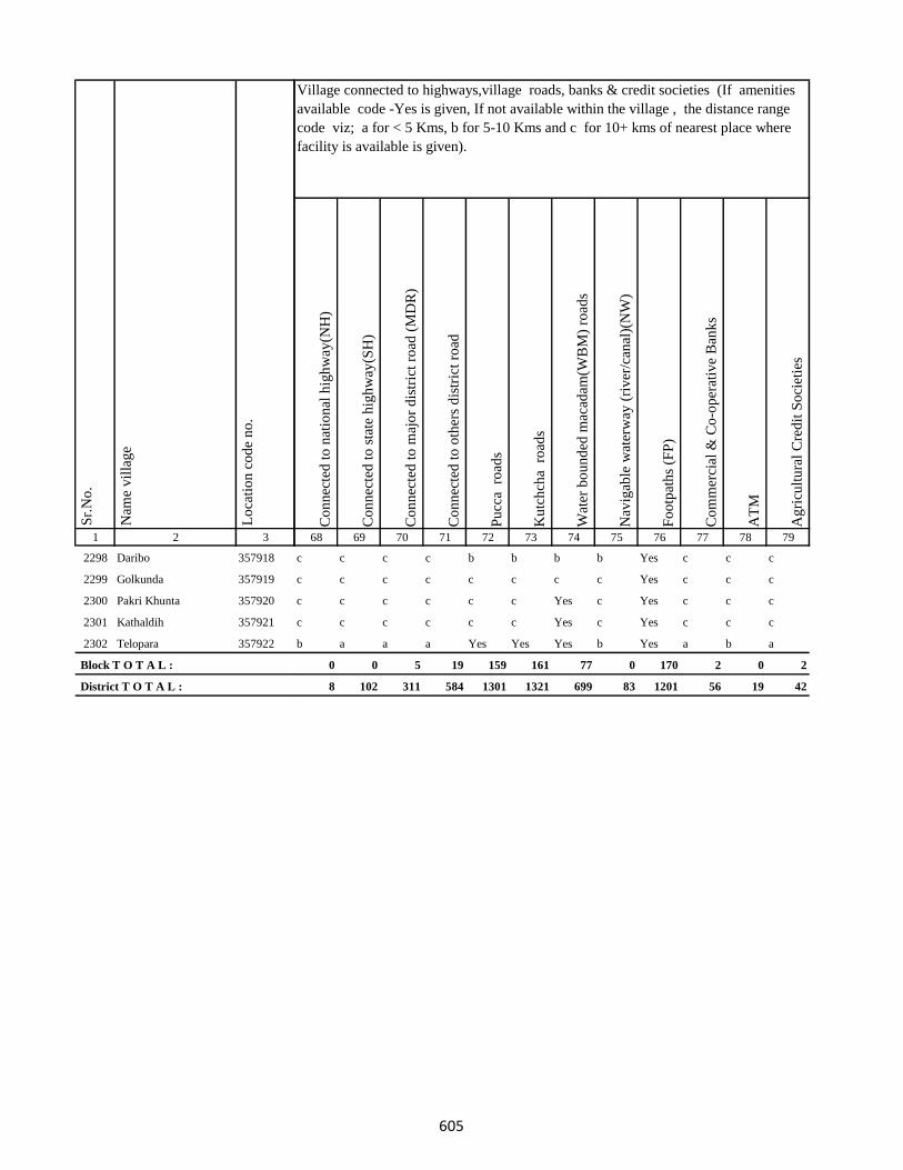
1 2 3
Lo
cati
on
co
de
no
.
Nam
e v
illa
ge
Sr.
No
.
2298 Daribo 357918
2299 Golkunda 357919
2300 Pakri Khunta 357920
2301 Kathaldih 357921
2302 Telopara 357922
Block T O T A L :
District T O T A L :
Co
nn
ecte
d t
o n
atio
nal
hig
hw
ay(N
H)
Co
nn
ecte
d t
o s
tate
hig
hw
ay(S
H)
Co
nn
ecte
d t
o m
ajo
r d
istr
ict
road
(M
DR
)
Co
nn
ecte
d t
o o
ther
s d
istr
ict
road
Pu
cca
ro
ads
Ku
tch
cha
ro
ads
Wat
er b
ou
nd
ed m
acad
am(W
BM
) ro
ads
Nav
igab
le w
ater
way
(ri
ver
/can
al)(
NW
)
Fo
otp
ath
s (F
P)
Co
mm
erci
al &
Co
-op
erat
ive
Ban
ks
AT
M
Ag
ricu
ltu
ral
Cre
dit
So
ciet
ies
68 69 70 71 72 73 74 75 76 77 78 79
Village connected to highways,village roads, banks & credit societies (If amenities
available code -Yes is given, If not available within the village , the distance range
code viz; a for < 5 Kms, b for 5-10 Kms and c for 10+ kms of nearest place where
facility is available is given).
c c c c b b b b Yes c c c
c c c c c c c c Yes c c c
c c c c c c Yes c Yes c c c
c c c c c c Yes c Yes c c c
b a a a Yes Yes Yes b Yes a b a
0 0 5 19 159 161 77 0 170 2 0 2
8 102 311 584 1301 1321 699 83 1201 56 19 42
605
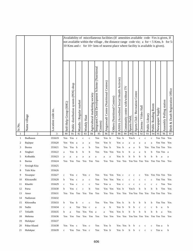
1 2 3
1 Budhason 355619
2 Bajitpur 355620
3 Borma 355621
4 Singhari 355622
5 Kolbadda 355623
6 Barma 355624
7 Sirsingh Kita 355625
8 Tulsi Kita 355626
9 Siwanpur 355627
10 Khiraundhi 355628
11 Kharthi 355629
12 Parsa 355630
13 Amor 355631
14 Nadiawan 355632
15 Khirondha 355633
16 Sudin 355634
17 Teliadih 355635
18 Mehrma 355636
19 Hulukpur 355637
20 Pahar Khand 355638
21 Hulukpur 355639
Lo
cati
on
co
de
no
.
Nam
e v
illa
ge
Sr.
No
.
Sel
f-H
elp
Gro
up
(S
HG
)
Pu
bli
c d
istr
ibu
tio
n s
yst
em (
PD
S)
sho
p
Man
dis
/ R
egu
lar
mar
ket
Wee
kly
Haa
t
Ag
ricu
ltu
ral
mar
ket
ing
so
ciet
y
Inte
gra
ted
Ch
ild
Dev
elo
pm
ent
Sch
eme
(Nu
trit
ion
al
Cen
tres
)
An
gan
wad
i C
entr
e (N
utr
itio
nal
Cen
tres
)
Oth
ers
(Nu
trit
ion
al C
entr
es)
AS
HA
(A
ccre
dit
ed S
oci
al H
ealt
h A
ctiv
ist)
Co
mm
un
ity
cen
tre
wit
h/w
ith
ou
t T
V
Sp
ort
s F
ield
,
Sp
ort
s C
lub
/ R
ecre
atio
n C
entr
e
Cin
ema
/ V
ideo
Hal
l
Pu
bli
c L
ibra
ry
Pu
bli
c R
ead
ing
Ro
om
New
spap
er S
up
ply
Ass
emb
ly P
oll
ing
sta
tio
n
Bir
th &
Dea
th R
egis
trat
ion
Off
ice
80 81 82 83 84 85 86 87 88 89 90 91 92 93 94 95 96 97
Yes Yes c c c Yes Yes b Yes b Yes b c c c Yes Yes Yes
Yes Yes a a a Yes Yes b Yes a a a a a a Yes Yes Yes
Yes Yes b a b Yes Yes b Yes b a a b Yes Yes Yes Yes Yes
a Yes b b b Yes Yes Yes Yes b b a a b b Yes Yes a
a a a a a a a a Yes b b b b b b b a a
Yes Yes Yes Yes Yes Yes Yes Yes Yes Yes Yes Yes Yes Yes Yes Yes Yes Yes
c Yes c Yes c Yes Yes Yes Yes c c c c Yes Yes Yes Yes Yes
b Yes c a c Yes Yes Yes Yes c c c c c c Yes Yes Yes
c Yes c c c Yes Yes a Yes c c c c c c c Yes Yes
b Yes c c b Yes Yes Yes Yes b Yes b b b b b Yes Yes
Yes Yes Yes Yes Yes Yes Yes Yes Yes Yes Yes Yes Yes Yes Yes Yes Yes Yes
b Yes b c c Yes Yes Yes Yes b b b b b b Yes Yes Yes
c a Yes Yes c a a b Yes b b b c c c b a b
b a Yes Yes Yes a a Yes Yes b b b b b b b a Yes
Yes Yes Yes Yes Yes Yes Yes Yes Yes Yes Yes Yes Yes Yes Yes Yes Yes Yes
Yes Yes c Yes c Yes Yes b Yes Yes b b c c c Yes a b
c Yes Yes Yes c Yes Yes b Yes b b b c c c Yes a b
Availability of miscellaneous facilities (If amenities available code -Yes is given, If
not available within the village , the distance range code viz; a for < 5 Kms, b for 5-
10 Kms and c for 10+ kms of nearest place where facility is available is given).
606
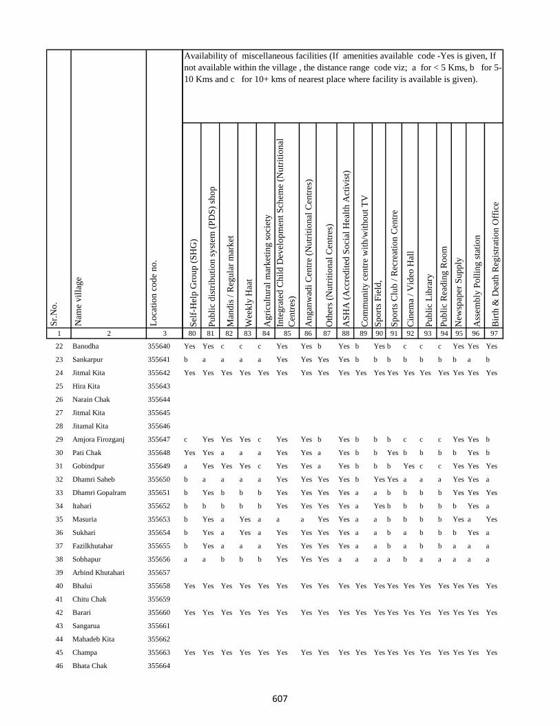
1 2 3
Lo
cati
on
co
de
no
.
Nam
e v
illa
ge
Sr.
No
.
22 Banodha 355640
23 Sankarpur 355641
24 Jitmal Kita 355642
25 Hira Kita 355643
26 Narain Chak 355644
27 Jitmal Kita 355645
28 Jitamal Kita 355646
29 Amjora Firozganj 355647
30 Pati Chak 355648
31 Gobindpur 355649
32 Dhamri Saheb 355650
33 Dhamri Gopalram 355651
34 Itahari 355652
35 Masuria 355653
36 Sukhari 355654
37 Fazilkhutahar 355655
38 Sobhapur 355656
39 Arbind Khutahari 355657
40 Bhalui 355658
41 Chitu Chak 355659
42 Barari 355660
43 Sangarua 355661
44 Mahadeb Kita 355662
45 Champa 355663
46 Bhata Chak 355664
Sel
f-H
elp
Gro
up
(S
HG
)
Pu
bli
c d
istr
ibu
tio
n s
yst
em (
PD
S)
sho
p
Man
dis
/ R
egu
lar
mar
ket
Wee
kly
Haa
t
Ag
ricu
ltu
ral
mar
ket
ing
so
ciet
y
Inte
gra
ted
Ch
ild
Dev
elo
pm
ent
Sch
eme
(Nu
trit
ion
al
Cen
tres
)
An
gan
wad
i C
entr
e (N
utr
itio
nal
Cen
tres
)
Oth
ers
(Nu
trit
ion
al C
entr
es)
AS
HA
(A
ccre
dit
ed S
oci
al H
ealt
h A
ctiv
ist)
Co
mm
un
ity
cen
tre
wit
h/w
ith
ou
t T
V
Sp
ort
s F
ield
,
Sp
ort
s C
lub
/ R
ecre
atio
n C
entr
e
Cin
ema
/ V
ideo
Hal
l
Pu
bli
c L
ibra
ry
Pu
bli
c R
ead
ing
Ro
om
New
spap
er S
up
ply
Ass
emb
ly P
oll
ing
sta
tio
n
Bir
th &
Dea
th R
egis
trat
ion
Off
ice
80 81 82 83 84 85 86 87 88 89 90 91 92 93 94 95 96 97
Availability of miscellaneous facilities (If amenities available code -Yes is given, If
not available within the village , the distance range code viz; a for < 5 Kms, b for 5-
10 Kms and c for 10+ kms of nearest place where facility is available is given).
Yes Yes c c c Yes Yes b Yes b Yes b c c c Yes Yes Yes
b a a a a Yes Yes Yes Yes b b b b b b b a b
Yes Yes Yes Yes Yes Yes Yes Yes Yes Yes Yes Yes Yes Yes Yes Yes Yes Yes
c Yes Yes Yes c Yes Yes b Yes b b b c c c Yes Yes b
Yes Yes a a a Yes Yes a Yes b b Yes b b b b Yes b
a Yes Yes Yes c Yes Yes a Yes b b b Yes c c Yes Yes Yes
b a a a a Yes Yes Yes Yes b Yes Yes a a a Yes Yes a
b Yes b b b Yes Yes Yes Yes a a b b b b Yes Yes Yes
b b b b b Yes Yes Yes Yes a Yes b b b b b Yes a
b Yes a Yes a a a Yes Yes a a b b b b Yes a Yes
b Yes a Yes a Yes Yes Yes Yes a a b a b b b Yes a
b Yes a a a Yes Yes Yes Yes a a b a b b a a a
a a b b b Yes Yes Yes a a a a b a a a a a
Yes Yes Yes Yes Yes Yes Yes Yes Yes Yes Yes Yes Yes Yes Yes Yes Yes Yes
Yes Yes Yes Yes Yes Yes Yes Yes Yes Yes Yes Yes Yes Yes Yes Yes Yes Yes
Yes Yes Yes Yes Yes Yes Yes Yes Yes Yes Yes Yes Yes Yes Yes Yes Yes Yes
607
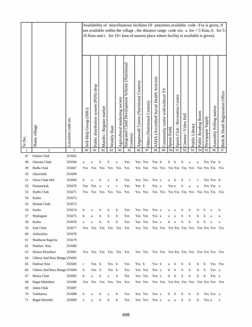
1 2 3
Lo
cati
on
co
de
no
.
Nam
e v
illa
ge
Sr.
No
.
47 Padam Chak 355665
48 Ghuram Chak 355666
49 Badla Chak 355667
50 Ghasichak 355668
51 Ghasi Chak Mal 355669
52 Domanchak 355670
53 Dudhi Chak 355671
54 Kasba 355672
55 Doman Chak 355673
56 Kasba 355674
57 Majhagain 355675
58 Kasba 355676
59 Sadi Chak 355677
60 Anhuatikar 355678
61 Madhurai Bagicha 355679
62 Dukhari Kita 355680
63 Dulum Khutahari 355681
64 Chhota And Bara Mangarh355682
65 Dukhari Kita 355683
66 Chhota And Bara Mangarh355684
67 Mania Chak 355685
68 Bagat Khutahari 355686
69 Jalala Chak 355687
70 Tarkharwa 355688
71 Bagat Khutahri 355689
Sel
f-H
elp
Gro
up
(S
HG
)
Pu
bli
c d
istr
ibu
tio
n s
yst
em (
PD
S)
sho
p
Man
dis
/ R
egu
lar
mar
ket
Wee
kly
Haa
t
Ag
ricu
ltu
ral
mar
ket
ing
so
ciet
y
Inte
gra
ted
Ch
ild
Dev
elo
pm
ent
Sch
eme
(Nu
trit
ion
al
Cen
tres
)
An
gan
wad
i C
entr
e (N
utr
itio
nal
Cen
tres
)
Oth
ers
(Nu
trit
ion
al C
entr
es)
AS
HA
(A
ccre
dit
ed S
oci
al H
ealt
h A
ctiv
ist)
Co
mm
un
ity
cen
tre
wit
h/w
ith
ou
t T
V
Sp
ort
s F
ield
,
Sp
ort
s C
lub
/ R
ecre
atio
n C
entr
e
Cin
ema
/ V
ideo
Hal
l
Pu
bli
c L
ibra
ry
Pu
bli
c R
ead
ing
Ro
om
New
spap
er S
up
ply
Ass
emb
ly P
oll
ing
sta
tio
n
Bir
th &
Dea
th R
egis
trat
ion
Off
ice
80 81 82 83 84 85 86 87 88 89 90 91 92 93 94 95 96 97
Availability of miscellaneous facilities (If amenities available code -Yes is given, If
not available within the village , the distance range code viz; a for < 5 Kms, b for 5-
10 Kms and c for 10+ kms of nearest place where facility is available is given).
a a b b a Yes Yes Yes Yes b b b b a a Yes Yes b
Yes Yes Yes Yes Yes Yes Yes Yes Yes Yes Yes Yes Yes Yes Yes Yes Yes Yes
b a b a b Yes Yes Yes Yes a a b b c c Yes Yes b
Yes Yes a a c Yes Yes b Yes a Yes a b a a Yes Yes a
Yes Yes Yes Yes Yes Yes Yes Yes Yes Yes Yes Yes Yes Yes Yes Yes Yes Yes
b a b b b Yes Yes Yes Yes a a a b b b b a b
b a b b b Yes Yes Yes Yes a a a b b b b a a
a a b b b Yes Yes Yes Yes a b a b b b b a a
Yes Yes Yes Yes Yes Yes Yes Yes Yes Yes Yes Yes Yes Yes Yes Yes Yes Yes
Yes Yes Yes Yes Yes Yes Yes Yes Yes Yes Yes Yes Yes Yes Yes Yes Yes Yes
c Yes b Yes b Yes Yes b Yes b a b b b b b Yes Yes
b Yes b Yes b Yes Yes Yes Yes a b b b b b b Yes a
b a b a b Yes Yes Yes Yes a b b b b b b Yes a
Yes Yes Yes Yes Yes Yes Yes Yes Yes Yes Yes Yes Yes Yes Yes Yes Yes Yes
b a b a b Yes Yes Yes Yes a b b b b b Yes Yes a
a a b b b Yes Yes Yes Yes a a a b b b Yes a a
608
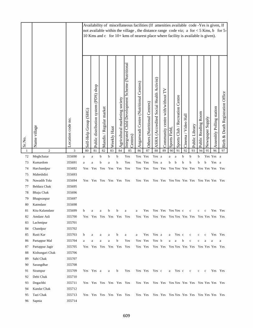
1 2 3
Lo
cati
on
co
de
no
.
Nam
e v
illa
ge
Sr.
No
.
72 Meghchatar 355690
73 Kumardom 355691
74 Harchandpur 355692
75 Maheshdiri 355693
76 Nawadih Tola 355694
77 Beldara Chak 355695
78 Bhaju Chak 355696
79 Bhagwanpur 355697
80 Katmdanr 355698
81 Kita Kalamdanr 355699
82 Amdanr Asli 355700
83 Lachmipur 355701
84 Chandpur 355702
85 Rasti Kar 355703
86 Partappur Mal 355704
87 Partappur Jagir 355705
88 Kishungari Chak 355706
89 Sahi Chak 355707
90 Sarangdhar 355708
91 Sirampur 355709
92 Debi Chak 355710
93 Dogachhi 355711
94 Kandar Chak 355712
95 Tazi Chak 355713
96 Sapnia 355714
Sel
f-H
elp
Gro
up
(S
HG
)
Pu
bli
c d
istr
ibu
tio
n s
yst
em (
PD
S)
sho
p
Man
dis
/ R
egu
lar
mar
ket
Wee
kly
Haa
t
Ag
ricu
ltu
ral
mar
ket
ing
so
ciet
y
Inte
gra
ted
Ch
ild
Dev
elo
pm
ent
Sch
eme
(Nu
trit
ion
al
Cen
tres
)
An
gan
wad
i C
entr
e (N
utr
itio
nal
Cen
tres
)
Oth
ers
(Nu
trit
ion
al C
entr
es)
AS
HA
(A
ccre
dit
ed S
oci
al H
ealt
h A
ctiv
ist)
Co
mm
un
ity
cen
tre
wit
h/w
ith
ou
t T
V
Sp
ort
s F
ield
,
Sp
ort
s C
lub
/ R
ecre
atio
n C
entr
e
Cin
ema
/ V
ideo
Hal
l
Pu
bli
c L
ibra
ry
Pu
bli
c R
ead
ing
Ro
om
New
spap
er S
up
ply
Ass
emb
ly P
oll
ing
sta
tio
n
Bir
th &
Dea
th R
egis
trat
ion
Off
ice
80 81 82 83 84 85 86 87 88 89 90 91 92 93 94 95 96 97
Availability of miscellaneous facilities (If amenities available code -Yes is given, If
not available within the village , the distance range code viz; a for < 5 Kms, b for 5-
10 Kms and c for 10+ kms of nearest place where facility is available is given).
a a b b b Yes Yes Yes Yes a a a b b b Yes Yes a
a a b a b Yes Yes Yes Yes a b b b b b b Yes a
Yes Yes Yes Yes Yes Yes Yes Yes Yes Yes Yes Yes Yes Yes Yes Yes Yes Yes
Yes Yes Yes Yes Yes Yes Yes Yes Yes Yes Yes Yes Yes Yes Yes Yes Yes Yes
b a a b b a a Yes Yes Yes Yes Yes c c c c Yes Yes
Yes Yes Yes Yes Yes Yes Yes Yes Yes Yes Yes Yes Yes Yes Yes Yes Yes Yes
b a a a b a a Yes Yes a a Yes c c c c Yes Yes
a a a a b Yes Yes Yes Yes b a a b c c a a a
Yes Yes Yes Yes Yes Yes Yes Yes Yes Yes Yes Yes Yes Yes Yes Yes Yes Yes
Yes Yes a a b Yes Yes Yes Yes c a Yes c c c c Yes Yes
Yes Yes Yes Yes Yes Yes Yes Yes Yes Yes Yes Yes Yes Yes Yes Yes Yes Yes
Yes Yes Yes Yes Yes Yes Yes Yes Yes Yes Yes Yes Yes Yes Yes Yes Yes Yes
609
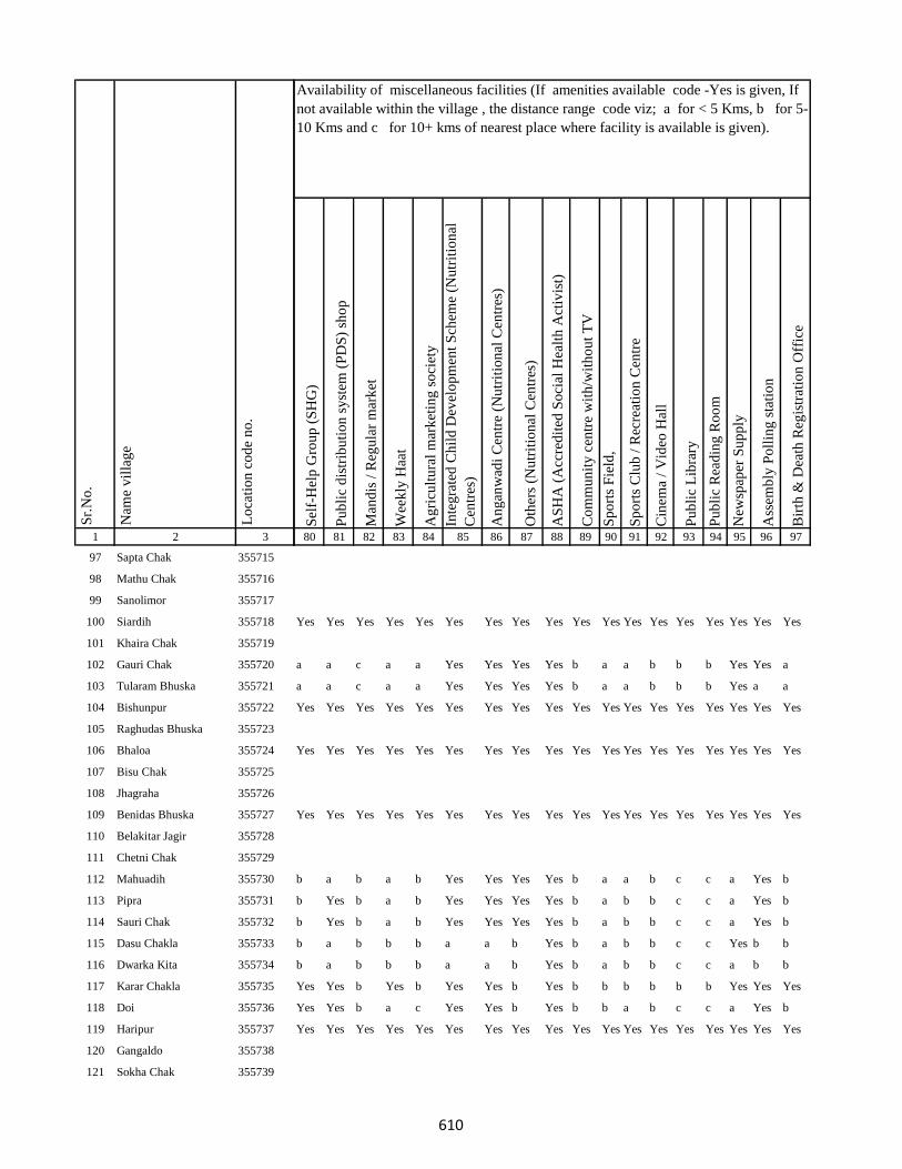
1 2 3
Lo
cati
on
co
de
no
.
Nam
e v
illa
ge
Sr.
No
.
97 Sapta Chak 355715
98 Mathu Chak 355716
99 Sanolimor 355717
100 Siardih 355718
101 Khaira Chak 355719
102 Gauri Chak 355720
103 Tularam Bhuska 355721
104 Bishunpur 355722
105 Raghudas Bhuska 355723
106 Bhaloa 355724
107 Bisu Chak 355725
108 Jhagraha 355726
109 Benidas Bhuska 355727
110 Belakitar Jagir 355728
111 Chetni Chak 355729
112 Mahuadih 355730
113 Pipra 355731
114 Sauri Chak 355732
115 Dasu Chakla 355733
116 Dwarka Kita 355734
117 Karar Chakla 355735
118 Doi 355736
119 Haripur 355737
120 Gangaldo 355738
121 Sokha Chak 355739
Sel
f-H
elp
Gro
up
(S
HG
)
Pu
bli
c d
istr
ibu
tio
n s
yst
em (
PD
S)
sho
p
Man
dis
/ R
egu
lar
mar
ket
Wee
kly
Haa
t
Ag
ricu
ltu
ral
mar
ket
ing
so
ciet
y
Inte
gra
ted
Ch
ild
Dev
elo
pm
ent
Sch
eme
(Nu
trit
ion
al
Cen
tres
)
An
gan
wad
i C
entr
e (N
utr
itio
nal
Cen
tres
)
Oth
ers
(Nu
trit
ion
al C
entr
es)
AS
HA
(A
ccre
dit
ed S
oci
al H
ealt
h A
ctiv
ist)
Co
mm
un
ity
cen
tre
wit
h/w
ith
ou
t T
V
Sp
ort
s F
ield
,
Sp
ort
s C
lub
/ R
ecre
atio
n C
entr
e
Cin
ema
/ V
ideo
Hal
l
Pu
bli
c L
ibra
ry
Pu
bli
c R
ead
ing
Ro
om
New
spap
er S
up
ply
Ass
emb
ly P
oll
ing
sta
tio
n
Bir
th &
Dea
th R
egis
trat
ion
Off
ice
80 81 82 83 84 85 86 87 88 89 90 91 92 93 94 95 96 97
Availability of miscellaneous facilities (If amenities available code -Yes is given, If
not available within the village , the distance range code viz; a for < 5 Kms, b for 5-
10 Kms and c for 10+ kms of nearest place where facility is available is given).
Yes Yes Yes Yes Yes Yes Yes Yes Yes Yes Yes Yes Yes Yes Yes Yes Yes Yes
a a c a a Yes Yes Yes Yes b a a b b b Yes Yes a
a a c a a Yes Yes Yes Yes b a a b b b Yes a a
Yes Yes Yes Yes Yes Yes Yes Yes Yes Yes Yes Yes Yes Yes Yes Yes Yes Yes
Yes Yes Yes Yes Yes Yes Yes Yes Yes Yes Yes Yes Yes Yes Yes Yes Yes Yes
Yes Yes Yes Yes Yes Yes Yes Yes Yes Yes Yes Yes Yes Yes Yes Yes Yes Yes
b a b a b Yes Yes Yes Yes b a a b c c a Yes b
b Yes b a b Yes Yes Yes Yes b a b b c c a Yes b
b Yes b a b Yes Yes Yes Yes b a b b c c a Yes b
b a b b b a a b Yes b a b b c c Yes b b
b a b b b a a b Yes b a b b c c a b b
Yes Yes b Yes b Yes Yes b Yes b b b b b b Yes Yes Yes
Yes Yes b a c Yes Yes b Yes b b a b c c a Yes b
Yes Yes Yes Yes Yes Yes Yes Yes Yes Yes Yes Yes Yes Yes Yes Yes Yes Yes
610

1 2 3
Lo
cati
on
co
de
no
.
Nam
e v
illa
ge
Sr.
No
.
122 Bhim Chak 355740
123 Kabi Chak 355741
124 Mahesh Kita Partabpur 355742
125 Maheshkita Partabpur 355743
126 Chhant Daria Chak 355744
127 Daria Chak 355745
128 Ghori Chak 355746
129 Kasmir Chak 355747
130 Loknath Kita 355748
131 Loknath Kita 355749
132 Partabpur 355750
133 Gausipartabpur 355751
134 Kamargawan 355752
135 Kamardiha 355753
136 Udhua Chak 355754
137 Chaura 355755
138 Phudulia Kita 355756
139 Lakramara 355757
140 Majhgain 355758
141 Nima 355759
142 Udaipur Bahera 355760
143 Chitarsen Bahira 355761
144 Ghori 355762
145 Jitu Chak 355763
146 Dariapur 355764
Sel
f-H
elp
Gro
up
(S
HG
)
Pu
bli
c d
istr
ibu
tio
n s
yst
em (
PD
S)
sho
p
Man
dis
/ R
egu
lar
mar
ket
Wee
kly
Haa
t
Ag
ricu
ltu
ral
mar
ket
ing
so
ciet
y
Inte
gra
ted
Ch
ild
Dev
elo
pm
ent
Sch
eme
(Nu
trit
ion
al
Cen
tres
)
An
gan
wad
i C
entr
e (N
utr
itio
nal
Cen
tres
)
Oth
ers
(Nu
trit
ion
al C
entr
es)
AS
HA
(A
ccre
dit
ed S
oci
al H
ealt
h A
ctiv
ist)
Co
mm
un
ity
cen
tre
wit
h/w
ith
ou
t T
V
Sp
ort
s F
ield
,
Sp
ort
s C
lub
/ R
ecre
atio
n C
entr
e
Cin
ema
/ V
ideo
Hal
l
Pu
bli
c L
ibra
ry
Pu
bli
c R
ead
ing
Ro
om
New
spap
er S
up
ply
Ass
emb
ly P
oll
ing
sta
tio
n
Bir
th &
Dea
th R
egis
trat
ion
Off
ice
80 81 82 83 84 85 86 87 88 89 90 91 92 93 94 95 96 97
Availability of miscellaneous facilities (If amenities available code -Yes is given, If
not available within the village , the distance range code viz; a for < 5 Kms, b for 5-
10 Kms and c for 10+ kms of nearest place where facility is available is given).
b a c b b Yes Yes Yes Yes b b a b c c b a a
Yes Yes Yes Yes Yes Yes Yes Yes Yes Yes Yes Yes Yes Yes Yes Yes Yes Yes
c Yes a a c Yes Yes b Yes b Yes b a c c Yes Yes a
b a b b c Yes Yes Yes Yes c b c c c c b Yes a
b Yes c a a Yes Yes Yes Yes c c c c c c b Yes a
a a c a a Yes Yes Yes Yes c c c c c c b a b
Yes a c a Yes Yes Yes Yes Yes Yes Yes Yes Yes Yes Yes Yes Yes Yes
a a b b a Yes Yes Yes Yes c c c c c c b b b
a a b a c Yes Yes Yes Yes c c c c c c c Yes a
a Yes a c a a a Yes Yes a a a a c c Yes Yes a
a Yes a c c Yes Yes Yes Yes a a a a c c a Yes a
Yes a a a c Yes Yes b Yes c a c c c c a Yes a
a a c c a Yes Yes Yes Yes a a a a c c c Yes c
b a a c c Yes Yes Yes Yes a a a a a a a Yes a
Yes Yes c c c Yes Yes a Yes b b b c c c b Yes a
b a a c c Yes Yes Yes Yes a a b b a a b b a
a a b a b Yes Yes b Yes a a b b b b b a a
a Yes b b b Yes Yes Yes Yes b a b b b b a Yes a
a a a c c a a Yes Yes a a a a c c c a a
a Yes a c c a a Yes Yes a a a a c c c Yes a
Yes Yes Yes Yes Yes Yes Yes Yes Yes Yes Yes Yes Yes Yes Yes Yes Yes Yes
611
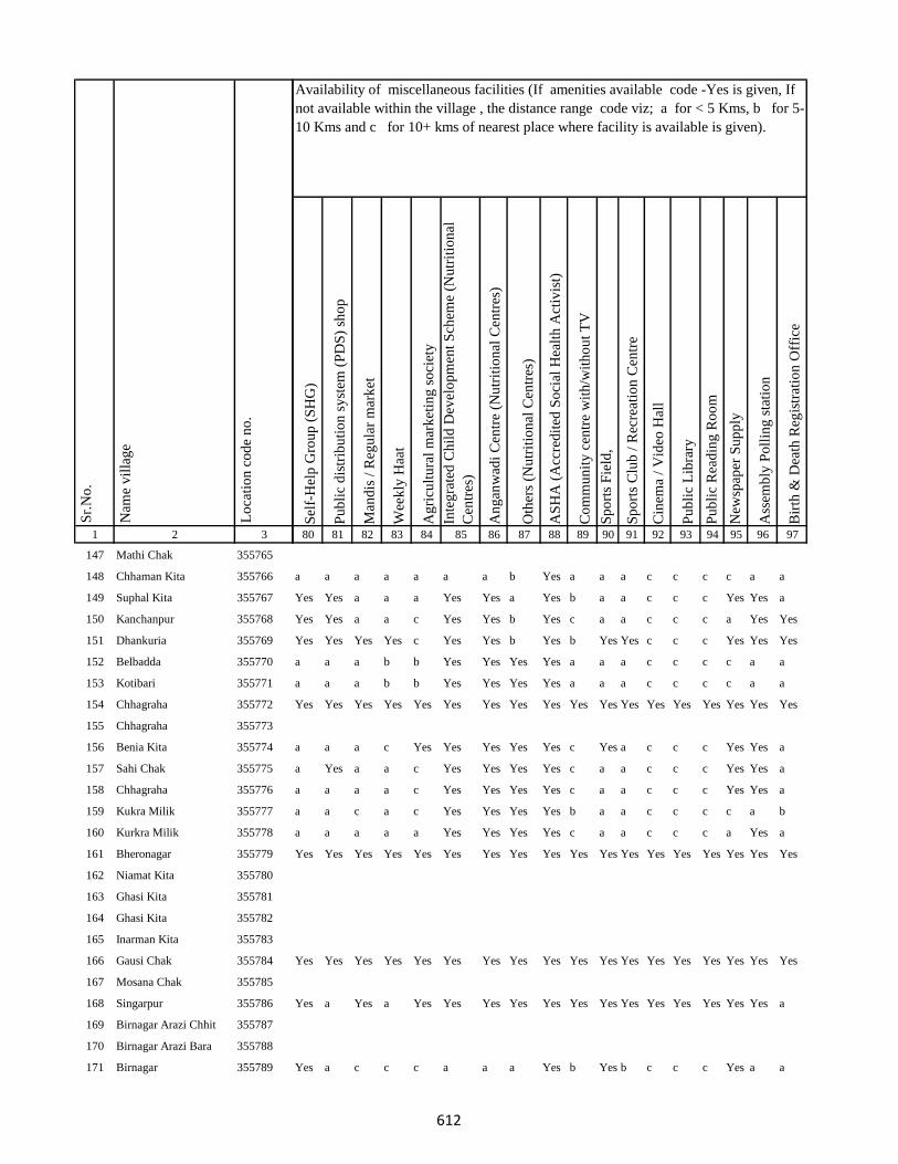
1 2 3
Lo
cati
on
co
de
no
.
Nam
e v
illa
ge
Sr.
No
.
147 Mathi Chak 355765
148 Chhaman Kita 355766
149 Suphal Kita 355767
150 Kanchanpur 355768
151 Dhankuria 355769
152 Belbadda 355770
153 Kotibari 355771
154 Chhagraha 355772
155 Chhagraha 355773
156 Benia Kita 355774
157 Sahi Chak 355775
158 Chhagraha 355776
159 Kukra Milik 355777
160 Kurkra Milik 355778
161 Bheronagar 355779
162 Niamat Kita 355780
163 Ghasi Kita 355781
164 Ghasi Kita 355782
165 Inarman Kita 355783
166 Gausi Chak 355784
167 Mosana Chak 355785
168 Singarpur 355786
169 Birnagar Arazi Chhit 355787
170 Birnagar Arazi Bara 355788
171 Birnagar 355789
Sel
f-H
elp
Gro
up
(S
HG
)
Pu
bli
c d
istr
ibu
tio
n s
yst
em (
PD
S)
sho
p
Man
dis
/ R
egu
lar
mar
ket
Wee
kly
Haa
t
Ag
ricu
ltu
ral
mar
ket
ing
so
ciet
y
Inte
gra
ted
Ch
ild
Dev
elo
pm
ent
Sch
eme
(Nu
trit
ion
al
Cen
tres
)
An
gan
wad
i C
entr
e (N
utr
itio
nal
Cen
tres
)
Oth
ers
(Nu
trit
ion
al C
entr
es)
AS
HA
(A
ccre
dit
ed S
oci
al H
ealt
h A
ctiv
ist)
Co
mm
un
ity
cen
tre
wit
h/w
ith
ou
t T
V
Sp
ort
s F
ield
,
Sp
ort
s C
lub
/ R
ecre
atio
n C
entr
e
Cin
ema
/ V
ideo
Hal
l
Pu
bli
c L
ibra
ry
Pu
bli
c R
ead
ing
Ro
om
New
spap
er S
up
ply
Ass
emb
ly P
oll
ing
sta
tio
n
Bir
th &
Dea
th R
egis
trat
ion
Off
ice
80 81 82 83 84 85 86 87 88 89 90 91 92 93 94 95 96 97
Availability of miscellaneous facilities (If amenities available code -Yes is given, If
not available within the village , the distance range code viz; a for < 5 Kms, b for 5-
10 Kms and c for 10+ kms of nearest place where facility is available is given).
a a a a a a a b Yes a a a c c c c a a
Yes Yes a a a Yes Yes a Yes b a a c c c Yes Yes a
Yes Yes a a c Yes Yes b Yes c a a c c c a Yes Yes
Yes Yes Yes Yes c Yes Yes b Yes b Yes Yes c c c Yes Yes Yes
a a a b b Yes Yes Yes Yes a a a c c c c a a
a a a b b Yes Yes Yes Yes a a a c c c c a a
Yes Yes Yes Yes Yes Yes Yes Yes Yes Yes Yes Yes Yes Yes Yes Yes Yes Yes
a a a c Yes Yes Yes Yes Yes c Yes a c c c Yes Yes a
a Yes a a c Yes Yes Yes Yes c a a c c c Yes Yes a
a a a a c Yes Yes Yes Yes c a a c c c Yes Yes a
a a c a c Yes Yes Yes Yes b a a c c c c a b
a a a a a Yes Yes Yes Yes c a a c c c a Yes a
Yes Yes Yes Yes Yes Yes Yes Yes Yes Yes Yes Yes Yes Yes Yes Yes Yes Yes
Yes Yes Yes Yes Yes Yes Yes Yes Yes Yes Yes Yes Yes Yes Yes Yes Yes Yes
Yes a Yes a Yes Yes Yes Yes Yes Yes Yes Yes Yes Yes Yes Yes Yes a
Yes a c c c a a a Yes b Yes b c c c Yes a a
612
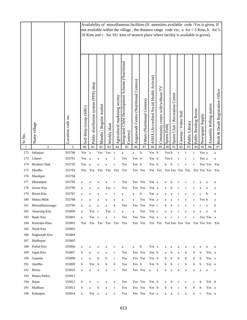
1 2 3
Lo
cati
on
co
de
no
.
Nam
e v
illa
ge
Sr.
No
.
172 Saharpur 355790
173 Lilatori 355791
174 Birahim Chak 355792
175 Dhodha 355793
176 Manikpur 355794
177 Dharampur 355795
178 Jarwar Kita 355796
179 Biram Kita 355797
180 Mukra Milik 355798
181 Bhirnabhaironagar 355799
182 Amarsing Kita 355800
183 Baski Kita 355801
184 Kurkraha Khas 355802
185 Nurdi Kita 355803
186 Raghunath Kita 355804
187 Madhupur 355805
188 Parbal Kita 355806
189 Jagan Kita 355807
190 Gajanda 355808
191 Amdiha 355809
192 Birnia 355810
193 Khaira Patkia 355811
194 Rajan 355812
195 Madhura 355813
196 Kalianpur 355814
Sel
f-H
elp
Gro
up
(S
HG
)
Pu
bli
c d
istr
ibu
tio
n s
yst
em (
PD
S)
sho
p
Man
dis
/ R
egu
lar
mar
ket
Wee
kly
Haa
t
Ag
ricu
ltu
ral
mar
ket
ing
so
ciet
y
Inte
gra
ted
Ch
ild
Dev
elo
pm
ent
Sch
eme
(Nu
trit
ion
al
Cen
tres
)
An
gan
wad
i C
entr
e (N
utr
itio
nal
Cen
tres
)
Oth
ers
(Nu
trit
ion
al C
entr
es)
AS
HA
(A
ccre
dit
ed S
oci
al H
ealt
h A
ctiv
ist)
Co
mm
un
ity
cen
tre
wit
h/w
ith
ou
t T
V
Sp
ort
s F
ield
,
Sp
ort
s C
lub
/ R
ecre
atio
n C
entr
e
Cin
ema
/ V
ideo
Hal
l
Pu
bli
c L
ibra
ry
Pu
bli
c R
ead
ing
Ro
om
New
spap
er S
up
ply
Ass
emb
ly P
oll
ing
sta
tio
n
Bir
th &
Dea
th R
egis
trat
ion
Off
ice
80 81 82 83 84 85 86 87 88 89 90 91 92 93 94 95 96 97
Availability of miscellaneous facilities (If amenities available code -Yes is given, If
not available within the village , the distance range code viz; a for < 5 Kms, b for 5-
10 Kms and c for 10+ kms of nearest place where facility is available is given).
Yes a Yes Yes c a a b Yes b Yes b c c c Yes a a
Yes a a a c Yes Yes b Yes b Yes b c c c Yes a a
Yes a a a c Yes Yes b Yes b b b c c c Yes Yes Yes
Yes Yes Yes Yes Yes Yes Yes Yes Yes Yes Yes Yes Yes Yes Yes Yes Yes Yes
a a a a c Yes Yes Yes Yes a a b c c c a a a
a a a Yes c Yes Yes Yes Yes a a b c c c a a a
a a a c c a a b Yes a a a c c c c b a
a a a a a a a Yes Yes a a a c c c Yes b a
a a a a b Yes Yes Yes Yes c b b c c c c a b
a Yes c Yes c a a Yes Yes c a a c a a a a b
a Yes c a c Yes Yes Yes Yes a a c c c c Yes Yes a
Yes Yes Yes Yes Yes Yes Yes Yes Yes Yes Yes Yes Yes Yes Yes Yes Yes Yes
a a a a c a a b Yes a a a a a a a a a
b a a a c Yes Yes Yes Yes b a b a b b b Yes a
c a b b c Yes Yes Yes Yes b b b b b b b Yes a
b Yes b b b Yes Yes b Yes b b b c b b b Yes a
a a a a c Yes Yes Yes a a a a a a a a a c
b a c a a Yes Yes Yes Yes b a b c c c b Yes b
b a b a c Yes Yes Yes Yes b b b c b b b Yes a
a Yes a a c Yes Yes Yes Yes a a a c a a c Yes a
613
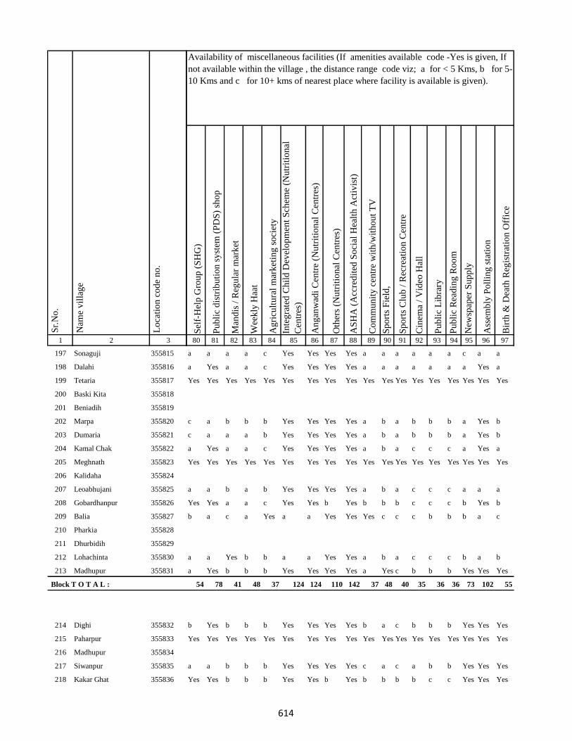
1 2 3
Lo
cati
on
co
de
no
.
Nam
e v
illa
ge
Sr.
No
.
197 Sonaguji 355815
198 Dalahi 355816
199 Tetaria 355817
200 Baski Kita 355818
201 Beniadih 355819
202 Marpa 355820
203 Dumaria 355821
204 Kamal Chak 355822
205 Meghnath 355823
206 Kalidaha 355824
207 Leoabhujani 355825
208 Gobardhanpur 355826
209 Balia 355827
210 Pharkia 355828
211 Dhurbidih 355829
212 Lohachinta 355830
213 Madhupur 355831
Block T O T A L :
214 Dighi 355832
215 Paharpur 355833
216 Madhupur 355834
217 Siwanpur 355835
218 Kakar Ghat 355836
Sel
f-H
elp
Gro
up
(S
HG
)
Pu
bli
c d
istr
ibu
tio
n s
yst
em (
PD
S)
sho
p
Man
dis
/ R
egu
lar
mar
ket
Wee
kly
Haa
t
Ag
ricu
ltu
ral
mar
ket
ing
so
ciet
y
Inte
gra
ted
Ch
ild
Dev
elo
pm
ent
Sch
eme
(Nu
trit
ion
al
Cen
tres
)
An
gan
wad
i C
entr
e (N
utr
itio
nal
Cen
tres
)
Oth
ers
(Nu
trit
ion
al C
entr
es)
AS
HA
(A
ccre
dit
ed S
oci
al H
ealt
h A
ctiv
ist)
Co
mm
un
ity
cen
tre
wit
h/w
ith
ou
t T
V
Sp
ort
s F
ield
,
Sp
ort
s C
lub
/ R
ecre
atio
n C
entr
e
Cin
ema
/ V
ideo
Hal
l
Pu
bli
c L
ibra
ry
Pu
bli
c R
ead
ing
Ro
om
New
spap
er S
up
ply
Ass
emb
ly P
oll
ing
sta
tio
n
Bir
th &
Dea
th R
egis
trat
ion
Off
ice
80 81 82 83 84 85 86 87 88 89 90 91 92 93 94 95 96 97
Availability of miscellaneous facilities (If amenities available code -Yes is given, If
not available within the village , the distance range code viz; a for < 5 Kms, b for 5-
10 Kms and c for 10+ kms of nearest place where facility is available is given).
a a a a c Yes Yes Yes Yes a a a a a a c a a
a Yes a a c Yes Yes Yes Yes a a a a a a a Yes a
Yes Yes Yes Yes Yes Yes Yes Yes Yes Yes Yes Yes Yes Yes Yes Yes Yes Yes
c a b b b Yes Yes Yes Yes a b a b b b a Yes b
c a a a b Yes Yes Yes Yes a b a b b b a Yes b
a Yes a a c Yes Yes Yes Yes a b a c c c a Yes a
Yes Yes Yes Yes Yes Yes Yes Yes Yes Yes Yes Yes Yes Yes Yes Yes Yes Yes
a a b a b Yes Yes Yes Yes a b a c c c a a a
Yes Yes a a c Yes Yes b Yes b b b c c c b Yes b
b a c a Yes a a Yes Yes Yes c c c b b b a c
a a Yes b b a a Yes Yes a b a c c c b a b
a Yes b b b Yes Yes Yes Yes a Yes c b b b Yes Yes Yes
54 78 41 48 37 124 124 110 142 37 48 40 35 36 36 73 102 55
b Yes b b b Yes Yes Yes Yes b a c b b b Yes Yes Yes
Yes Yes Yes Yes Yes Yes Yes Yes Yes Yes Yes Yes Yes Yes Yes Yes Yes Yes
a a b b b Yes Yes Yes Yes c a c a b b Yes Yes Yes
Yes Yes b b b Yes Yes b Yes b b b b c c Yes Yes Yes
614

1 2 3
Lo
cati
on
co
de
no
.
Nam
e v
illa
ge
Sr.
No
.
219 Talbaria 355837
220 Mohamad Khutahari 355838
221 Mal Jhakhra 355839
222 Baghjhakhra 355840
223 Sinha Chak 355841
224 Babutaluk 355842
225 Paharpur 355843
226 Deban Chak 355844
227 Gargulal 355845
228 Madan Chauki 355846
229 Birahim Kita 355847
230 Banskola 355848
231 Kurpatti 355849
232 Baijani 355850
233 Chapri 355851
234 Kamat Chapri 355852
235 Khar Kudia 355853
236 Majhana (Arazi) 355854
237 Hasu Chak 355855
238 Domansaran Kita 355856
239 Silong 355857
240 Paharpur 355858
241 Akilkita 355859
242 Bikram Kita 355860
243 Paharpur 355861
Sel
f-H
elp
Gro
up
(S
HG
)
Pu
bli
c d
istr
ibu
tio
n s
yst
em (
PD
S)
sho
p
Man
dis
/ R
egu
lar
mar
ket
Wee
kly
Haa
t
Ag
ricu
ltu
ral
mar
ket
ing
so
ciet
y
Inte
gra
ted
Ch
ild
Dev
elo
pm
ent
Sch
eme
(Nu
trit
ion
al
Cen
tres
)
An
gan
wad
i C
entr
e (N
utr
itio
nal
Cen
tres
)
Oth
ers
(Nu
trit
ion
al C
entr
es)
AS
HA
(A
ccre
dit
ed S
oci
al H
ealt
h A
ctiv
ist)
Co
mm
un
ity
cen
tre
wit
h/w
ith
ou
t T
V
Sp
ort
s F
ield
,
Sp
ort
s C
lub
/ R
ecre
atio
n C
entr
e
Cin
ema
/ V
ideo
Hal
l
Pu
bli
c L
ibra
ry
Pu
bli
c R
ead
ing
Ro
om
New
spap
er S
up
ply
Ass
emb
ly P
oll
ing
sta
tio
n
Bir
th &
Dea
th R
egis
trat
ion
Off
ice
80 81 82 83 84 85 86 87 88 89 90 91 92 93 94 95 96 97
Availability of miscellaneous facilities (If amenities available code -Yes is given, If
not available within the village , the distance range code viz; a for < 5 Kms, b for 5-
10 Kms and c for 10+ kms of nearest place where facility is available is given).
a a b a c Yes Yes Yes Yes c a c b b b b Yes Yes
a Yes c a c Yes Yes Yes Yes c a c c c c Yes Yes Yes
Yes Yes c a a Yes Yes Yes Yes c Yes c a b b a Yes Yes
Yes Yes c Yes a Yes Yes Yes Yes c a c a b b a Yes Yes
Yes Yes Yes Yes Yes Yes Yes Yes Yes Yes Yes Yes Yes Yes Yes Yes Yes Yes
b a b b a Yes Yes Yes Yes b a c b b b a a b
Yes Yes c Yes a Yes Yes Yes Yes b a c c a a a a b
Yes Yes c Yes c Yes Yes b Yes b b b b c c b a Yes
Yes Yes c a a Yes Yes Yes Yes b a c b b b b Yes Yes
Yes a b b c Yes Yes b Yes b b c c c c b a Yes
Yes a a a c Yes Yes b Yes b c c c c c a a a
Yes Yes b Yes c Yes Yes b Yes Yes Yes b b b b Yes Yes Yes
b a c b a Yes Yes Yes Yes b a c b b b b a a
c Yes c b b Yes Yes b Yes b Yes c b b b Yes Yes Yes
Yes Yes Yes Yes Yes Yes Yes Yes Yes Yes Yes Yes Yes Yes Yes Yes Yes Yes
Yes Yes Yes Yes Yes Yes Yes Yes Yes Yes Yes Yes Yes Yes Yes Yes Yes Yes
a Yes b b b Yes Yes Yes Yes b a c b b b Yes Yes a
Yes Yes Yes Yes Yes Yes Yes Yes Yes Yes Yes Yes Yes Yes Yes Yes Yes Yes
a a b b b Yes Yes Yes Yes b a c b b b Yes Yes Yes
615
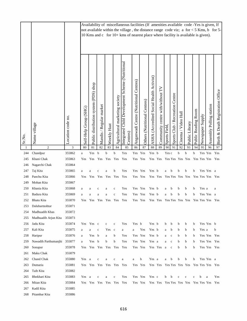
1 2 3
Lo
cati
on
co
de
no
.
Nam
e v
illa
ge
Sr.
No
.
244 Chandpur 355862
245 Khani Chak 355863
246 Nagarchi Chak 355864
247 Taj Kita 355865
248 Panchu Kita 355866
249 Mohan Kita 355867
250 Khania Kita 355868
251 Badura Kita 355869
252 Bhatu Kita 355870
253 Dalubarmohtar 355871
254 Madhuadih Khas 355872
255 Madhuadih Arjun Kita 355873
256 Jadu Kita 355874
257 Kali Kita 355875
258 Haripur 355876
259 Nawadih Parthumanjhi 355877
260 Sonapur 355878
261 Maku Chak 355879
262 Chand Chak 355880
263 Dumaria 355881
264 Taib Kita 355882
265 Bhekhari Kita 355883
266 Mitan Kita 355884
267 Kadil Kita 355885
268 Pitambar Kita 355886
Sel
f-H
elp
Gro
up
(S
HG
)
Pu
bli
c d
istr
ibu
tio
n s
yst
em (
PD
S)
sho
p
Man
dis
/ R
egu
lar
mar
ket
Wee
kly
Haa
t
Ag
ricu
ltu
ral
mar
ket
ing
so
ciet
y
Inte
gra
ted
Ch
ild
Dev
elo
pm
ent
Sch
eme
(Nu
trit
ion
al
Cen
tres
)
An
gan
wad
i C
entr
e (N
utr
itio
nal
Cen
tres
)
Oth
ers
(Nu
trit
ion
al C
entr
es)
AS
HA
(A
ccre
dit
ed S
oci
al H
ealt
h A
ctiv
ist)
Co
mm
un
ity
cen
tre
wit
h/w
ith
ou
t T
V
Sp
ort
s F
ield
,
Sp
ort
s C
lub
/ R
ecre
atio
n C
entr
e
Cin
ema
/ V
ideo
Hal
l
Pu
bli
c L
ibra
ry
Pu
bli
c R
ead
ing
Ro
om
New
spap
er S
up
ply
Ass
emb
ly P
oll
ing
sta
tio
n
Bir
th &
Dea
th R
egis
trat
ion
Off
ice
80 81 82 83 84 85 86 87 88 89 90 91 92 93 94 95 96 97
Availability of miscellaneous facilities (If amenities available code -Yes is given, If
not available within the village , the distance range code viz; a for < 5 Kms, b for 5-
10 Kms and c for 10+ kms of nearest place where facility is available is given).
a Yes b b b Yes Yes Yes Yes b Yes c b b b Yes Yes Yes
Yes Yes Yes Yes Yes Yes Yes Yes Yes Yes Yes Yes Yes Yes Yes Yes Yes Yes
a a c a b Yes Yes Yes Yes b a b b b b Yes Yes a
Yes Yes Yes Yes Yes Yes Yes Yes Yes Yes Yes Yes Yes Yes Yes Yes Yes Yes
a a c a c Yes Yes Yes Yes b a b b b b Yes a a
a a a a c Yes Yes Yes Yes b a b b b b Yes Yes a
Yes Yes Yes Yes Yes Yes Yes Yes Yes Yes Yes Yes Yes Yes Yes Yes Yes Yes
Yes Yes c c c Yes Yes b Yes b b b b b b Yes Yes b
a a c Yes c a a Yes Yes b a b b b b Yes a b
a Yes b a b Yes Yes Yes Yes b a c b b b Yes Yes Yes
a Yes b b b Yes Yes Yes Yes a a c b b b Yes Yes Yes
Yes Yes Yes Yes Yes Yes Yes Yes Yes Yes a c b b b Yes Yes Yes
Yes a c a c a a b Yes a a b b b b Yes Yes a
Yes Yes Yes Yes Yes Yes Yes Yes Yes Yes Yes Yes Yes Yes Yes Yes Yes Yes
Yes a c a c Yes Yes Yes Yes c b b c c c b a Yes
Yes Yes Yes Yes Yes Yes Yes Yes Yes Yes Yes Yes Yes Yes Yes Yes Yes Yes
616
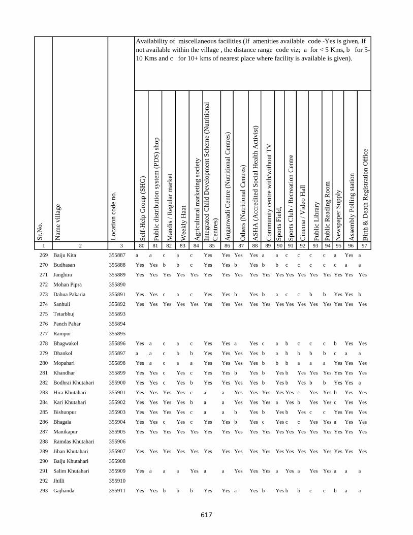
1 2 3
Lo
cati
on
co
de
no
.
Nam
e v
illa
ge
Sr.
No
.
269 Baiju Kita 355887
270 Budhasan 355888
271 Janghira 355889
272 Mohan Pipra 355890
273 Dahua Pakaria 355891
274 Sanhuli 355892
275 Tetarbhuj 355893
276 Panch Pahar 355894
277 Rampur 355895
278 Bhagwakol 355896
279 Dhankol 355897
280 Mopahari 355898
281 Khandhar 355899
282 Bodhrai Khutahari 355900
283 Hira Khutahari 355901
284 Kari Khutahari 355902
285 Bishunpur 355903
286 Bhagaia 355904
287 Manikapur 355905
288 Ramdas Khutahari 355906
289 Jiban Khutahari 355907
290 Baiju Khutahari 355908
291 Salim Khutahari 355909
292 Jhilli 355910
293 Gajhanda 355911
Sel
f-H
elp
Gro
up
(S
HG
)
Pu
bli
c d
istr
ibu
tio
n s
yst
em (
PD
S)
sho
p
Man
dis
/ R
egu
lar
mar
ket
Wee
kly
Haa
t
Ag
ricu
ltu
ral
mar
ket
ing
so
ciet
y
Inte
gra
ted
Ch
ild
Dev
elo
pm
ent
Sch
eme
(Nu
trit
ion
al
Cen
tres
)
An
gan
wad
i C
entr
e (N
utr
itio
nal
Cen
tres
)
Oth
ers
(Nu
trit
ion
al C
entr
es)
AS
HA
(A
ccre
dit
ed S
oci
al H
ealt
h A
ctiv
ist)
Co
mm
un
ity
cen
tre
wit
h/w
ith
ou
t T
V
Sp
ort
s F
ield
,
Sp
ort
s C
lub
/ R
ecre
atio
n C
entr
e
Cin
ema
/ V
ideo
Hal
l
Pu
bli
c L
ibra
ry
Pu
bli
c R
ead
ing
Ro
om
New
spap
er S
up
ply
Ass
emb
ly P
oll
ing
sta
tio
n
Bir
th &
Dea
th R
egis
trat
ion
Off
ice
80 81 82 83 84 85 86 87 88 89 90 91 92 93 94 95 96 97
Availability of miscellaneous facilities (If amenities available code -Yes is given, If
not available within the village , the distance range code viz; a for < 5 Kms, b for 5-
10 Kms and c for 10+ kms of nearest place where facility is available is given).
a a c a c Yes Yes Yes Yes a a c c c c a Yes a
Yes Yes b b c Yes Yes b Yes b b c c c c c a a
Yes Yes Yes Yes Yes Yes Yes Yes Yes Yes Yes Yes Yes Yes Yes Yes Yes Yes
Yes Yes c a c Yes Yes b Yes b a c c b b Yes Yes b
Yes Yes Yes Yes Yes Yes Yes Yes Yes Yes Yes Yes Yes Yes Yes Yes Yes Yes
Yes a c a c Yes Yes a Yes c a b c c c b Yes Yes
a a c b b Yes Yes Yes Yes b a b b b b c a a
Yes a c a a Yes Yes Yes Yes b b b a a a Yes Yes Yes
Yes Yes c Yes c Yes Yes b Yes b Yes b Yes Yes Yes Yes Yes Yes
Yes Yes c Yes b Yes Yes Yes Yes b Yes b Yes b b Yes Yes a
Yes Yes Yes Yes c a a Yes Yes Yes Yes Yes c Yes Yes b Yes Yes
Yes Yes Yes Yes b a a Yes Yes Yes a Yes b Yes Yes c Yes Yes
Yes Yes Yes Yes c a a b Yes b Yes b Yes c c Yes Yes Yes
Yes Yes c Yes c Yes Yes b Yes c Yes c c Yes Yes a Yes Yes
Yes Yes Yes Yes Yes Yes Yes Yes Yes Yes Yes Yes Yes Yes Yes Yes Yes Yes
Yes Yes Yes Yes Yes Yes Yes Yes Yes Yes Yes Yes Yes Yes Yes Yes Yes Yes
Yes a a a Yes a a Yes Yes Yes a Yes a Yes Yes a a a
Yes Yes b b b Yes Yes a Yes b Yes b b c c b a a
617
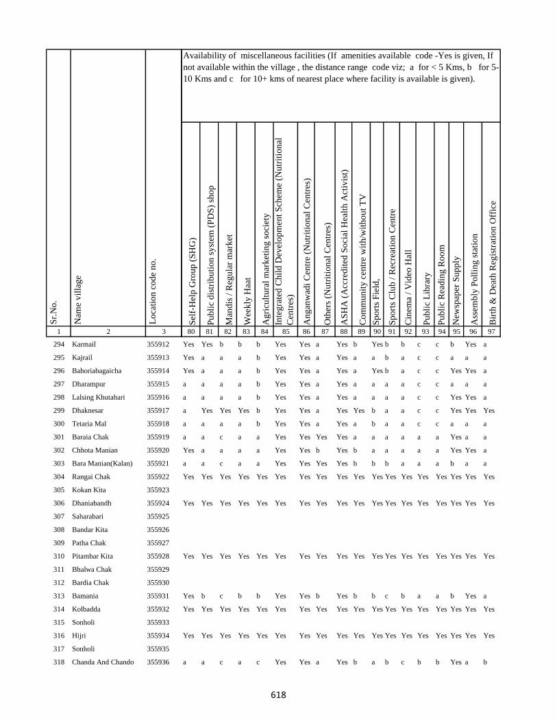
1 2 3
Lo
cati
on
co
de
no
.
Nam
e v
illa
ge
Sr.
No
.
294 Karmail 355912
295 Kajrail 355913
296 Bahoriabagaicha 355914
297 Dharampur 355915
298 Lalsing Khutahari 355916
299 Dhaknesar 355917
300 Tetaria Mal 355918
301 Baraia Chak 355919
302 Chhota Manian 355920
303 Bara Manian(Kalan) 355921
304 Rangai Chak 355922
305 Kokan Kita 355923
306 Dhaniabandh 355924
307 Saharabari 355925
308 Bandar Kita 355926
309 Patha Chak 355927
310 Pitambar Kita 355928
311 Bhalwa Chak 355929
312 Bardia Chak 355930
313 Bamania 355931
314 Kolbadda 355932
315 Sonholi 355933
316 Hijri 355934
317 Sonholi 355935
318 Chanda And Chando 355936
Sel
f-H
elp
Gro
up
(S
HG
)
Pu
bli
c d
istr
ibu
tio
n s
yst
em (
PD
S)
sho
p
Man
dis
/ R
egu
lar
mar
ket
Wee
kly
Haa
t
Ag
ricu
ltu
ral
mar
ket
ing
so
ciet
y
Inte
gra
ted
Ch
ild
Dev
elo
pm
ent
Sch
eme
(Nu
trit
ion
al
Cen
tres
)
An
gan
wad
i C
entr
e (N
utr
itio
nal
Cen
tres
)
Oth
ers
(Nu
trit
ion
al C
entr
es)
AS
HA
(A
ccre
dit
ed S
oci
al H
ealt
h A
ctiv
ist)
Co
mm
un
ity
cen
tre
wit
h/w
ith
ou
t T
V
Sp
ort
s F
ield
,
Sp
ort
s C
lub
/ R
ecre
atio
n C
entr
e
Cin
ema
/ V
ideo
Hal
l
Pu
bli
c L
ibra
ry
Pu
bli
c R
ead
ing
Ro
om
New
spap
er S
up
ply
Ass
emb
ly P
oll
ing
sta
tio
n
Bir
th &
Dea
th R
egis
trat
ion
Off
ice
80 81 82 83 84 85 86 87 88 89 90 91 92 93 94 95 96 97
Availability of miscellaneous facilities (If amenities available code -Yes is given, If
not available within the village , the distance range code viz; a for < 5 Kms, b for 5-
10 Kms and c for 10+ kms of nearest place where facility is available is given).
Yes Yes b b b Yes Yes a Yes b Yes b b c c b Yes a
Yes a a a b Yes Yes a Yes a a b a c c a a a
Yes a a a b Yes Yes a Yes a Yes b a c c Yes Yes a
a a a a b Yes Yes a Yes a a a a c c a a a
a a a a b Yes Yes a Yes a a a a c c Yes Yes a
a Yes Yes Yes b Yes Yes a Yes Yes b a a c c Yes Yes Yes
a a a a b Yes Yes a Yes a b a a c c a a a
a a c a a Yes Yes Yes Yes a a a a a a Yes a a
Yes a a a a Yes Yes b Yes b a a a a a Yes Yes a
a a c a a Yes Yes Yes Yes b b b a a a b a a
Yes Yes Yes Yes Yes Yes Yes Yes Yes Yes Yes Yes Yes Yes Yes Yes Yes Yes
Yes Yes Yes Yes Yes Yes Yes Yes Yes Yes Yes Yes Yes Yes Yes Yes Yes Yes
Yes Yes Yes Yes Yes Yes Yes Yes Yes Yes Yes Yes Yes Yes Yes Yes Yes Yes
Yes b c b b Yes Yes b Yes b b c b a a b Yes a
Yes Yes Yes Yes Yes Yes Yes Yes Yes Yes Yes Yes Yes Yes Yes Yes Yes Yes
Yes Yes Yes Yes Yes Yes Yes Yes Yes Yes Yes Yes Yes Yes Yes Yes Yes Yes
a a c a c Yes Yes a Yes b a b c b b Yes a b
618
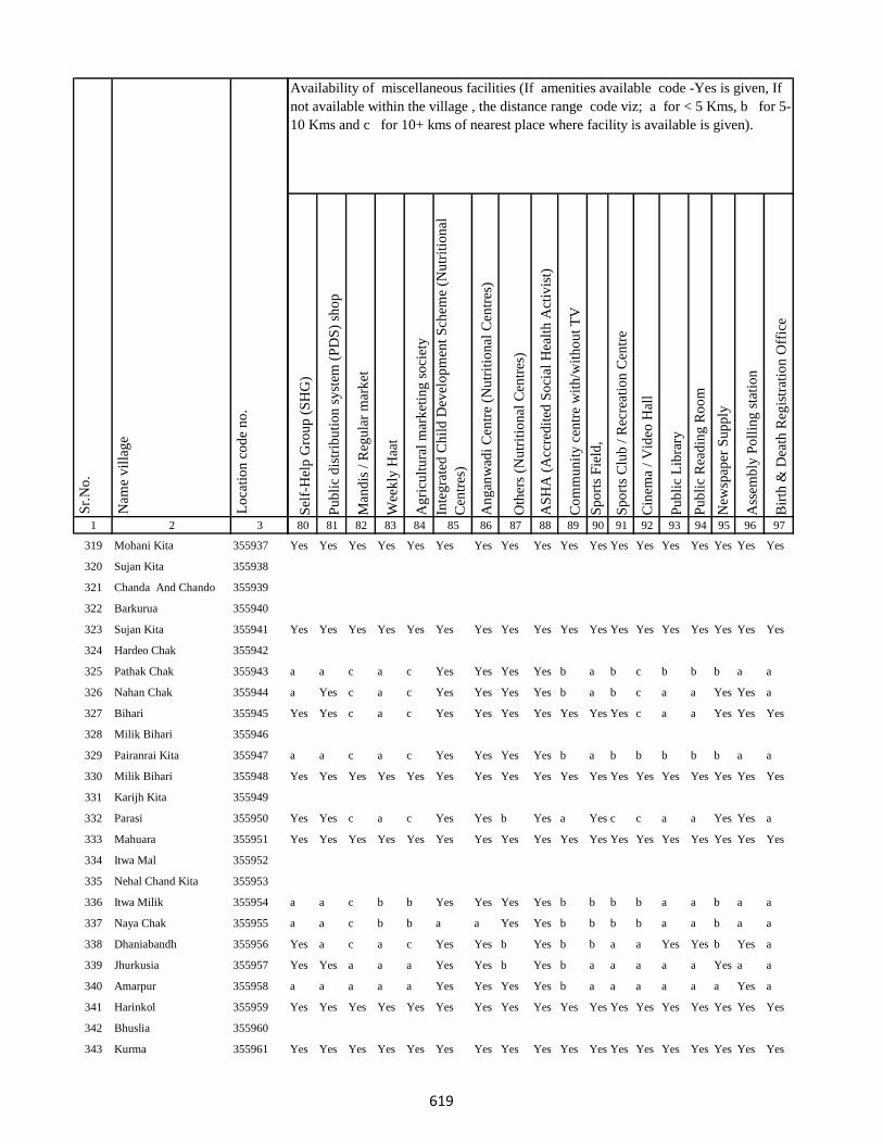
1 2 3
Lo
cati
on
co
de
no
.
Nam
e v
illa
ge
Sr.
No
.
319 Mohani Kita 355937
320 Sujan Kita 355938
321 Chanda And Chando 355939
322 Barkurua 355940
323 Sujan Kita 355941
324 Hardeo Chak 355942
325 Pathak Chak 355943
326 Nahan Chak 355944
327 Bihari 355945
328 Milik Bihari 355946
329 Pairanrai Kita 355947
330 Milik Bihari 355948
331 Karijh Kita 355949
332 Parasi 355950
333 Mahuara 355951
334 Itwa Mal 355952
335 Nehal Chand Kita 355953
336 Itwa Milik 355954
337 Naya Chak 355955
338 Dhaniabandh 355956
339 Jhurkusia 355957
340 Amarpur 355958
341 Harinkol 355959
342 Bhuslia 355960
343 Kurma 355961
Sel
f-H
elp
Gro
up
(S
HG
)
Pu
bli
c d
istr
ibu
tio
n s
yst
em (
PD
S)
sho
p
Man
dis
/ R
egu
lar
mar
ket
Wee
kly
Haa
t
Ag
ricu
ltu
ral
mar
ket
ing
so
ciet
y
Inte
gra
ted
Ch
ild
Dev
elo
pm
ent
Sch
eme
(Nu
trit
ion
al
Cen
tres
)
An
gan
wad
i C
entr
e (N
utr
itio
nal
Cen
tres
)
Oth
ers
(Nu
trit
ion
al C
entr
es)
AS
HA
(A
ccre
dit
ed S
oci
al H
ealt
h A
ctiv
ist)
Co
mm
un
ity
cen
tre
wit
h/w
ith
ou
t T
V
Sp
ort
s F
ield
,
Sp
ort
s C
lub
/ R
ecre
atio
n C
entr
e
Cin
ema
/ V
ideo
Hal
l
Pu
bli
c L
ibra
ry
Pu
bli
c R
ead
ing
Ro
om
New
spap
er S
up
ply
Ass
emb
ly P
oll
ing
sta
tio
n
Bir
th &
Dea
th R
egis
trat
ion
Off
ice
80 81 82 83 84 85 86 87 88 89 90 91 92 93 94 95 96 97
Availability of miscellaneous facilities (If amenities available code -Yes is given, If
not available within the village , the distance range code viz; a for < 5 Kms, b for 5-
10 Kms and c for 10+ kms of nearest place where facility is available is given).
Yes Yes Yes Yes Yes Yes Yes Yes Yes Yes Yes Yes Yes Yes Yes Yes Yes Yes
Yes Yes Yes Yes Yes Yes Yes Yes Yes Yes Yes Yes Yes Yes Yes Yes Yes Yes
a a c a c Yes Yes Yes Yes b a b c b b b a a
a Yes c a c Yes Yes Yes Yes b a b c a a Yes Yes a
Yes Yes c a c Yes Yes Yes Yes Yes Yes Yes c a a Yes Yes Yes
a a c a c Yes Yes Yes Yes b a b b b b b a a
Yes Yes Yes Yes Yes Yes Yes Yes Yes Yes Yes Yes Yes Yes Yes Yes Yes Yes
Yes Yes c a c Yes Yes b Yes a Yes c c a a Yes Yes a
Yes Yes Yes Yes Yes Yes Yes Yes Yes Yes Yes Yes Yes Yes Yes Yes Yes Yes
a a c b b Yes Yes Yes Yes b b b b a a b a a
a a c b b a a Yes Yes b b b b a a b a a
Yes a c a c Yes Yes b Yes b b a a Yes Yes b Yes a
Yes Yes a a a Yes Yes b Yes b a a a a a Yes a a
a a a a a Yes Yes Yes Yes b a a a a a a Yes a
Yes Yes Yes Yes Yes Yes Yes Yes Yes Yes Yes Yes Yes Yes Yes Yes Yes Yes
Yes Yes Yes Yes Yes Yes Yes Yes Yes Yes Yes Yes Yes Yes Yes Yes Yes Yes
619

1 2 3
Lo
cati
on
co
de
no
.
Nam
e v
illa
ge
Sr.
No
.
344 Darji Kita 355962
345 Birnath Chak 355963
346 Indar Chak 355964
347 Marro Mal 355965
348 Belatikar 355966
349 Pipra 355967
350 Budhuachak 355968
351 Pipra 355969
352 Purnia 355970
353 Mardiha 355971
354 Baghakol 355972
355 Rangila 355973
356 Bhuska 355974
357 Chand Chak 355975
358 Dogachhi 355976
359 Khajri Chak 355977
360 Lainbrar Barakhar 355978
361 Lensirsa 355979
362 Gorapariharpur 355980
363 Basta 355981
364 Bariasirsa 355982
365 Gobindi Chak 355983
366 Kanipathari 355984
367 Gaias Chak 355985
368 Majh Kola 355986
Sel
f-H
elp
Gro
up
(S
HG
)
Pu
bli
c d
istr
ibu
tio
n s
yst
em (
PD
S)
sho
p
Man
dis
/ R
egu
lar
mar
ket
Wee
kly
Haa
t
Ag
ricu
ltu
ral
mar
ket
ing
so
ciet
y
Inte
gra
ted
Ch
ild
Dev
elo
pm
ent
Sch
eme
(Nu
trit
ion
al
Cen
tres
)
An
gan
wad
i C
entr
e (N
utr
itio
nal
Cen
tres
)
Oth
ers
(Nu
trit
ion
al C
entr
es)
AS
HA
(A
ccre
dit
ed S
oci
al H
ealt
h A
ctiv
ist)
Co
mm
un
ity
cen
tre
wit
h/w
ith
ou
t T
V
Sp
ort
s F
ield
,
Sp
ort
s C
lub
/ R
ecre
atio
n C
entr
e
Cin
ema
/ V
ideo
Hal
l
Pu
bli
c L
ibra
ry
Pu
bli
c R
ead
ing
Ro
om
New
spap
er S
up
ply
Ass
emb
ly P
oll
ing
sta
tio
n
Bir
th &
Dea
th R
egis
trat
ion
Off
ice
80 81 82 83 84 85 86 87 88 89 90 91 92 93 94 95 96 97
Availability of miscellaneous facilities (If amenities available code -Yes is given, If
not available within the village , the distance range code viz; a for < 5 Kms, b for 5-
10 Kms and c for 10+ kms of nearest place where facility is available is given).
Yes Yes c a b Yes Yes b Yes b b b c c c Yes Yes b
a a a a c Yes Yes Yes Yes a a c c a a a Yes a
a a a a c Yes Yes Yes Yes a a c c a a a Yes a
Yes Yes a a c Yes Yes Yes Yes a a c c a a a Yes Yes
a a a a c Yes Yes Yes Yes a a c c a a a a a
a a a a c Yes Yes Yes Yes a a c c a a a a a
Yes Yes c Yes c Yes Yes a Yes b b b c c c Yes Yes b
a a a a c Yes Yes Yes Yes a a c c a a Yes Yes a
a a a b b Yes Yes Yes Yes a Yes b c a a a a a
a a a c b Yes Yes Yes Yes a b b c c c a Yes a
a a a a c Yes Yes Yes Yes a b b c c c a a a
Yes Yes Yes Yes Yes Yes Yes Yes Yes Yes Yes Yes Yes Yes Yes Yes Yes Yes
a a a a c Yes Yes Yes Yes a a a c c c a a a
a a a a c Yes Yes Yes Yes a a a c a a a a a
a a c a c a a b Yes b b c c c c b Yes a
Yes Yes c Yes a Yes Yes b Yes b b b c c c Yes Yes Yes
a a a a c Yes Yes Yes Yes a a a c a a a a a
Yes Yes Yes Yes Yes Yes Yes Yes Yes Yes Yes Yes Yes Yes Yes Yes Yes Yes
Yes Yes c a c Yes Yes b Yes b Yes b c a a b Yes a
620
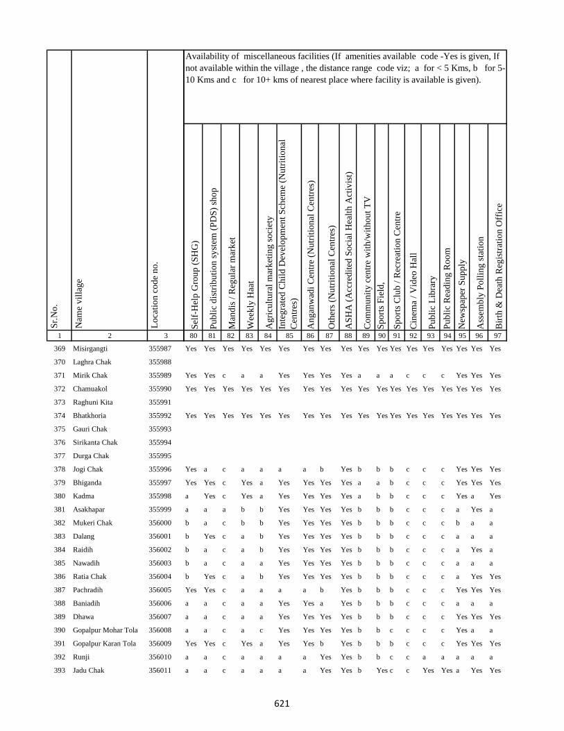
1 2 3
Lo
cati
on
co
de
no
.
Nam
e v
illa
ge
Sr.
No
.
369 Misirgangti 355987
370 Laghra Chak 355988
371 Mirik Chak 355989
372 Chamuakol 355990
373 Raghuni Kita 355991
374 Bhatkhoria 355992
375 Gauri Chak 355993
376 Sirikanta Chak 355994
377 Durga Chak 355995
378 Jogi Chak 355996
379 Bhiganda 355997
380 Kadma 355998
381 Asakhapar 355999
382 Mukeri Chak 356000
383 Dalang 356001
384 Raidih 356002
385 Nawadih 356003
386 Ratia Chak 356004
387 Pachradih 356005
388 Baniadih 356006
389 Dhawa 356007
390 Gopalpur Mohar Tola 356008
391 Gopalpur Karan Tola 356009
392 Runji 356010
393 Jadu Chak 356011
Sel
f-H
elp
Gro
up
(S
HG
)
Pu
bli
c d
istr
ibu
tio
n s
yst
em (
PD
S)
sho
p
Man
dis
/ R
egu
lar
mar
ket
Wee
kly
Haa
t
Ag
ricu
ltu
ral
mar
ket
ing
so
ciet
y
Inte
gra
ted
Ch
ild
Dev
elo
pm
ent
Sch
eme
(Nu
trit
ion
al
Cen
tres
)
An
gan
wad
i C
entr
e (N
utr
itio
nal
Cen
tres
)
Oth
ers
(Nu
trit
ion
al C
entr
es)
AS
HA
(A
ccre
dit
ed S
oci
al H
ealt
h A
ctiv
ist)
Co
mm
un
ity
cen
tre
wit
h/w
ith
ou
t T
V
Sp
ort
s F
ield
,
Sp
ort
s C
lub
/ R
ecre
atio
n C
entr
e
Cin
ema
/ V
ideo
Hal
l
Pu
bli
c L
ibra
ry
Pu
bli
c R
ead
ing
Ro
om
New
spap
er S
up
ply
Ass
emb
ly P
oll
ing
sta
tio
n
Bir
th &
Dea
th R
egis
trat
ion
Off
ice
80 81 82 83 84 85 86 87 88 89 90 91 92 93 94 95 96 97
Availability of miscellaneous facilities (If amenities available code -Yes is given, If
not available within the village , the distance range code viz; a for < 5 Kms, b for 5-
10 Kms and c for 10+ kms of nearest place where facility is available is given).
Yes Yes Yes Yes Yes Yes Yes Yes Yes Yes Yes Yes Yes Yes Yes Yes Yes Yes
Yes Yes c a a Yes Yes Yes Yes a a a c c c Yes Yes Yes
Yes Yes Yes Yes Yes Yes Yes Yes Yes Yes Yes Yes Yes Yes Yes Yes Yes Yes
Yes Yes Yes Yes Yes Yes Yes Yes Yes Yes Yes Yes Yes Yes Yes Yes Yes Yes
Yes a c a a a a b Yes b b b c c c Yes Yes Yes
Yes Yes c Yes a Yes Yes Yes Yes a a b c c c Yes Yes Yes
a Yes c Yes a Yes Yes Yes Yes a b b c c c Yes a Yes
a a a b b Yes Yes Yes Yes b b b c c c a Yes a
b a c b b Yes Yes Yes Yes b b b c c c b a a
b Yes c a b Yes Yes Yes Yes b b b c c c a a a
b a c a b Yes Yes Yes Yes b b b c c c a Yes a
b a c a a Yes Yes Yes Yes b b b c c c a a a
b Yes c a b Yes Yes Yes Yes b b b c c c a Yes Yes
Yes Yes c a a a a b Yes b b b c c c Yes Yes Yes
a a c a a Yes Yes a Yes b b b c c c a a a
a a c a a Yes Yes Yes Yes b b b c c c Yes Yes Yes
a a c a c Yes Yes Yes Yes b b c c c c Yes a a
Yes Yes c Yes a Yes Yes b Yes b b b c c c Yes Yes Yes
a a c a a a a Yes Yes b b c c a a a a a
a a c a a a a Yes Yes b Yes c c Yes Yes a Yes Yes
621
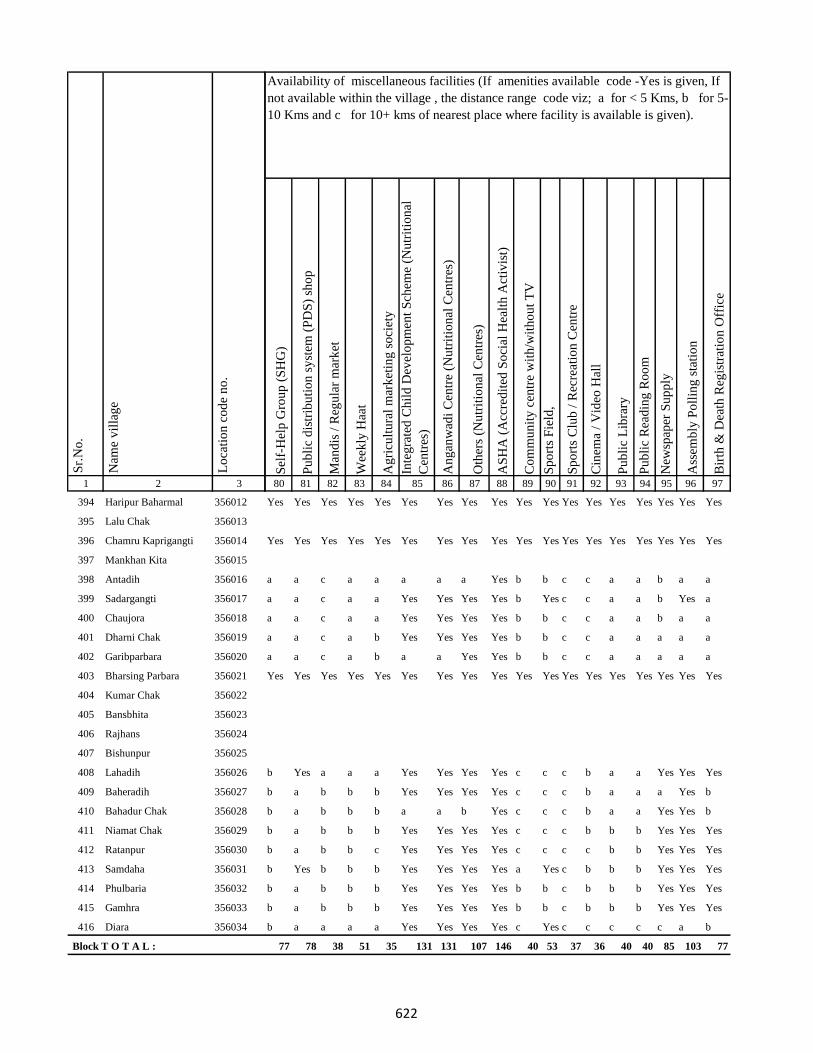
1 2 3
Lo
cati
on
co
de
no
.
Nam
e v
illa
ge
Sr.
No
.
394 Haripur Baharmal 356012
395 Lalu Chak 356013
396 Chamru Kaprigangti 356014
397 Mankhan Kita 356015
398 Antadih 356016
399 Sadargangti 356017
400 Chaujora 356018
401 Dharni Chak 356019
402 Garibparbara 356020
403 Bharsing Parbara 356021
404 Kumar Chak 356022
405 Bansbhita 356023
406 Rajhans 356024
407 Bishunpur 356025
408 Lahadih 356026
409 Baheradih 356027
410 Bahadur Chak 356028
411 Niamat Chak 356029
412 Ratanpur 356030
413 Samdaha 356031
414 Phulbaria 356032
415 Gamhra 356033
416 Diara 356034
Block T O T A L :
Sel
f-H
elp
Gro
up
(S
HG
)
Pu
bli
c d
istr
ibu
tio
n s
yst
em (
PD
S)
sho
p
Man
dis
/ R
egu
lar
mar
ket
Wee
kly
Haa
t
Ag
ricu
ltu
ral
mar
ket
ing
so
ciet
y
Inte
gra
ted
Ch
ild
Dev
elo
pm
ent
Sch
eme
(Nu
trit
ion
al
Cen
tres
)
An
gan
wad
i C
entr
e (N
utr
itio
nal
Cen
tres
)
Oth
ers
(Nu
trit
ion
al C
entr
es)
AS
HA
(A
ccre
dit
ed S
oci
al H
ealt
h A
ctiv
ist)
Co
mm
un
ity
cen
tre
wit
h/w
ith
ou
t T
V
Sp
ort
s F
ield
,
Sp
ort
s C
lub
/ R
ecre
atio
n C
entr
e
Cin
ema
/ V
ideo
Hal
l
Pu
bli
c L
ibra
ry
Pu
bli
c R
ead
ing
Ro
om
New
spap
er S
up
ply
Ass
emb
ly P
oll
ing
sta
tio
n
Bir
th &
Dea
th R
egis
trat
ion
Off
ice
80 81 82 83 84 85 86 87 88 89 90 91 92 93 94 95 96 97
Availability of miscellaneous facilities (If amenities available code -Yes is given, If
not available within the village , the distance range code viz; a for < 5 Kms, b for 5-
10 Kms and c for 10+ kms of nearest place where facility is available is given).
Yes Yes Yes Yes Yes Yes Yes Yes Yes Yes Yes Yes Yes Yes Yes Yes Yes Yes
Yes Yes Yes Yes Yes Yes Yes Yes Yes Yes Yes Yes Yes Yes Yes Yes Yes Yes
a a c a a a a a Yes b b c c a a b a a
a a c a a Yes Yes Yes Yes b Yes c c a a b Yes a
a a c a a Yes Yes Yes Yes b b c c a a b a a
a a c a b Yes Yes Yes Yes b b c c a a a a a
a a c a b a a Yes Yes b b c c a a a a a
Yes Yes Yes Yes Yes Yes Yes Yes Yes Yes Yes Yes Yes Yes Yes Yes Yes Yes
b Yes a a a Yes Yes Yes Yes c c c b a a Yes Yes Yes
b a b b b Yes Yes Yes Yes c c c b a a a Yes b
b a b b b a a b Yes c c c b a a Yes Yes b
b a b b b Yes Yes Yes Yes c c c b b b Yes Yes Yes
b a b b c Yes Yes Yes Yes c c c c b b Yes Yes Yes
b Yes b b b Yes Yes Yes Yes a Yes c b b b Yes Yes Yes
b a b b b Yes Yes Yes Yes b b c b b b Yes Yes Yes
b a b b b Yes Yes Yes Yes b b c b b b Yes Yes Yes
b a a a a Yes Yes Yes Yes c Yes c c c c c a b
77 78 38 51 35 131 131 107 146 40 53 37 36 40 40 85 103 77
622

1 2 3
Lo
cati
on
co
de
no
.
Nam
e v
illa
ge
Sr.
No
.
417 Urkusia 356035
418 Garantia 356036
419 Lakrakol 356037
420 Sijuakol 356038
421 Bagjhopa 356039
422 Daldali Gopalpur 356040
423 Seharo Chak 356041
424 Bahelia Chak 356042
425 Rajbandh 356043
426 Issar Chak 356044
427 Kendua 356045
428 Ramkol 356046
429 Raharbaria 356047
430 Kamaldori 356048
431 Janlokundi 356049
432 Dhamnisemia 356050
433 Hijri 356051
434 Jirli 356052
435 Dhamnipahar 356053
436 Goradih 356054
437 Behra Chak 356055
438 Bishunpur 356056
439 Chandsar 356057
440 Karmatanr 356058
Sel
f-H
elp
Gro
up
(S
HG
)
Pu
bli
c d
istr
ibu
tio
n s
yst
em (
PD
S)
sho
p
Man
dis
/ R
egu
lar
mar
ket
Wee
kly
Haa
t
Ag
ricu
ltu
ral
mar
ket
ing
so
ciet
y
Inte
gra
ted
Ch
ild
Dev
elo
pm
ent
Sch
eme
(Nu
trit
ion
al
Cen
tres
)
An
gan
wad
i C
entr
e (N
utr
itio
nal
Cen
tres
)
Oth
ers
(Nu
trit
ion
al C
entr
es)
AS
HA
(A
ccre
dit
ed S
oci
al H
ealt
h A
ctiv
ist)
Co
mm
un
ity
cen
tre
wit
h/w
ith
ou
t T
V
Sp
ort
s F
ield
,
Sp
ort
s C
lub
/ R
ecre
atio
n C
entr
e
Cin
ema
/ V
ideo
Hal
l
Pu
bli
c L
ibra
ry
Pu
bli
c R
ead
ing
Ro
om
New
spap
er S
up
ply
Ass
emb
ly P
oll
ing
sta
tio
n
Bir
th &
Dea
th R
egis
trat
ion
Off
ice
80 81 82 83 84 85 86 87 88 89 90 91 92 93 94 95 96 97
Availability of miscellaneous facilities (If amenities available code -Yes is given, If
not available within the village , the distance range code viz; a for < 5 Kms, b for 5-
10 Kms and c for 10+ kms of nearest place where facility is available is given).
b a a a a a a Yes Yes c Yes c c c c c a b
b a a a a Yes Yes b Yes b b c c c c c a a
a a c a a Yes Yes Yes Yes b b b c c c c Yes a
a a c a a Yes Yes Yes Yes b a b c c c c b a
a Yes c a a Yes Yes Yes Yes b Yes b c c c a Yes b
b c a a b a a Yes a c a c c c c b b b
a Yes b Yes b Yes Yes b Yes b Yes b b c c a Yes b
a Yes b Yes b Yes Yes b Yes c a b c c c a a a
a Yes b Yes b Yes Yes Yes Yes b Yes b c c c b Yes a
a b b b b Yes Yes Yes Yes b a b c c c b a a
a b b b b Yes Yes Yes Yes b a b c c c b a b
a a a a a Yes Yes Yes Yes b a c c c c c a b
a a b a c Yes Yes Yes Yes c Yes b b c c b Yes b
a a b b b Yes Yes Yes Yes b a c b Yes Yes b Yes b
a Yes b b b Yes Yes Yes Yes b Yes Yes b c c b Yes b
a Yes b a b Yes Yes Yes Yes b Yes c b c c b Yes b
a a b b b Yes Yes Yes Yes b a c b c c b a b
a b b c b Yes Yes Yes Yes b c c b c c b a b
Yes Yes Yes Yes Yes Yes Yes Yes Yes Yes Yes Yes Yes Yes Yes Yes Yes Yes
Yes Yes b b b Yes Yes Yes Yes b b c b c c b Yes b
a a c a a Yes Yes Yes Yes c a a a c c a Yes a
a a a b b Yes Yes Yes Yes b a b b c c b a b
623

1 2 3
Lo
cati
on
co
de
no
.
Nam
e v
illa
ge
Sr.
No
.
441 Marpa 356059
442 Baghmara 356060
443 Itahari 356061
444 Chhota Itahari Pahar 356062
445 Chhota Gogra 356063
446 Bara Gogra 356064
447 Chhota Darma 356065
448 Kolhua 356066
449 Malbhita 356067
450 Pairgora 356068
451 Kaldigra 356069
452 Khejuria 356070
453 Talbaria 356071
454 Bara Darma 356072
455 Balajhor 356073
456 Bangama 356074
457 Sakrikita Rampur 356075
458 Darbe Chak 356076
459 Joborampur 356077
460 Ekdanrghat 356078
461 Chhota Siripur 356079
462 Siripur Bazar 356080
463 Bara Siripur 356081
464 Khairbani 356082
465 Losinghna 356083
Sel
f-H
elp
Gro
up
(S
HG
)
Pu
bli
c d
istr
ibu
tio
n s
yst
em (
PD
S)
sho
p
Man
dis
/ R
egu
lar
mar
ket
Wee
kly
Haa
t
Ag
ricu
ltu
ral
mar
ket
ing
so
ciet
y
Inte
gra
ted
Ch
ild
Dev
elo
pm
ent
Sch
eme
(Nu
trit
ion
al
Cen
tres
)
An
gan
wad
i C
entr
e (N
utr
itio
nal
Cen
tres
)
Oth
ers
(Nu
trit
ion
al C
entr
es)
AS
HA
(A
ccre
dit
ed S
oci
al H
ealt
h A
ctiv
ist)
Co
mm
un
ity
cen
tre
wit
h/w
ith
ou
t T
V
Sp
ort
s F
ield
,
Sp
ort
s C
lub
/ R
ecre
atio
n C
entr
e
Cin
ema
/ V
ideo
Hal
l
Pu
bli
c L
ibra
ry
Pu
bli
c R
ead
ing
Ro
om
New
spap
er S
up
ply
Ass
emb
ly P
oll
ing
sta
tio
n
Bir
th &
Dea
th R
egis
trat
ion
Off
ice
80 81 82 83 84 85 86 87 88 89 90 91 92 93 94 95 96 97
Availability of miscellaneous facilities (If amenities available code -Yes is given, If
not available within the village , the distance range code viz; a for < 5 Kms, b for 5-
10 Kms and c for 10+ kms of nearest place where facility is available is given).
Yes Yes b Yes c Yes Yes b Yes a Yes c b c c b Yes b
a Yes c a c Yes Yes Yes Yes b Yes b c c c c Yes b
b a b a b Yes Yes Yes Yes b a a b c c b a b
a a a a c Yes Yes Yes Yes a a a b c c a a b
a a c a b Yes Yes Yes Yes a a a b c c a a b
a a c Yes b Yes Yes Yes Yes Yes a a b c c a a b
a a b a b Yes Yes Yes Yes c b b c c c Yes Yes b
a b b b b Yes Yes Yes Yes b b b b c c b a b
Yes b b b b Yes Yes Yes Yes b b b b c c b a b
a Yes Yes Yes b Yes Yes Yes Yes b b b c c c b a b
a a b a b Yes Yes Yes Yes c Yes a a c c c a a
b a b b b a a Yes Yes a a a a c c c a a
a a c a b Yes Yes Yes Yes a Yes a b c c a a b
b a c a b a a Yes Yes b a c b c c b a b
Yes b b a a Yes Yes Yes Yes a Yes c a c c b a b
b Yes c b b Yes Yes Yes Yes a b c b c c b Yes b
b c b Yes Yes Yes Yes Yes Yes Yes b Yes b c c b b b
a a a a a a a Yes Yes a a c a c c a Yes b
a a a a a a a Yes Yes a a c a c c a a b
Yes Yes Yes Yes c Yes Yes b Yes Yes a c Yes c c Yes Yes b
c b b b b Yes Yes b Yes b a a b b b b a b
a a a a a Yes Yes Yes Yes a a a a c c a a a
a a c a a Yes Yes Yes Yes a b a a c c b a a
c b c b c Yes Yes b Yes b b b b c c b Yes b
624

1 2 3
Lo
cati
on
co
de
no
.
Nam
e v
illa
ge
Sr.
No
.
466 Bara Saraiya 356084
467 Chhota Saraiya 356085
468 Manikpur 356086
469 Kandaniya 356087
470 Beldiha 356088
471 Kortia 356089
472 Asanbuna 356090
473 Marcha 356091
474 Dumbari 356092
475 Churi 356093
476 Talbaria 356094
477 Bansbhita 356095
478 Jamunajharna 356096
479 Bara Boarijor 356097
480 Dhorri 356098
481 Dubra 356099
482 Mahula 356100
483 Meghi 356101
484 Mangra 356102
485 Chhota Boarijor 356103
486 Mahuakol 356104
487 Lakrakol 356105
488 Babuchuri 356106
489 Parsiya 356107
490 Bador 356108
Sel
f-H
elp
Gro
up
(S
HG
)
Pu
bli
c d
istr
ibu
tio
n s
yst
em (
PD
S)
sho
p
Man
dis
/ R
egu
lar
mar
ket
Wee
kly
Haa
t
Ag
ricu
ltu
ral
mar
ket
ing
so
ciet
y
Inte
gra
ted
Ch
ild
Dev
elo
pm
ent
Sch
eme
(Nu
trit
ion
al
Cen
tres
)
An
gan
wad
i C
entr
e (N
utr
itio
nal
Cen
tres
)
Oth
ers
(Nu
trit
ion
al C
entr
es)
AS
HA
(A
ccre
dit
ed S
oci
al H
ealt
h A
ctiv
ist)
Co
mm
un
ity
cen
tre
wit
h/w
ith
ou
t T
V
Sp
ort
s F
ield
,
Sp
ort
s C
lub
/ R
ecre
atio
n C
entr
e
Cin
ema
/ V
ideo
Hal
l
Pu
bli
c L
ibra
ry
Pu
bli
c R
ead
ing
Ro
om
New
spap
er S
up
ply
Ass
emb
ly P
oll
ing
sta
tio
n
Bir
th &
Dea
th R
egis
trat
ion
Off
ice
80 81 82 83 84 85 86 87 88 89 90 91 92 93 94 95 96 97
Availability of miscellaneous facilities (If amenities available code -Yes is given, If
not available within the village , the distance range code viz; a for < 5 Kms, b for 5-
10 Kms and c for 10+ kms of nearest place where facility is available is given).
a b c a a Yes Yes Yes Yes a a a a c c b a a
a a a a a a a b Yes a a a b c c b a a
a b c b a Yes Yes Yes Yes a b c b c c b b b
a a b b b Yes Yes Yes Yes a b c c c c b a b
a Yes a a b Yes Yes b Yes a b a c c c b Yes b
b a a b b Yes Yes Yes Yes a b a c c c b a b
a b a c c Yes Yes b Yes a b a a c c b b a
Yes Yes Yes Yes Yes Yes Yes Yes Yes Yes Yes Yes Yes Yes Yes Yes Yes Yes
a b a a a Yes Yes Yes Yes c b a a a a a a a
a a a a a Yes Yes Yes Yes c b a b b b a a a
b a a a a a a b Yes c b a b b b a a a
Yes Yes Yes Yes c Yes Yes a Yes b Yes c c c c Yes Yes Yes
c b b b c Yes Yes b Yes b Yes b c c c b a b
Yes Yes c c c Yes Yes b Yes a Yes a a c c a Yes a
Yes Yes c Yes c Yes Yes b Yes b Yes Yes a c c a Yes a
Yes Yes a a c Yes Yes b Yes b Yes c a c c a Yes a
b Yes a a a Yes Yes Yes Yes a Yes c a c c Yes Yes Yes
a a a Yes c Yes Yes Yes Yes a a c Yes c c a Yes a
b b b b b Yes Yes Yes Yes b b b b c c b a b
a a a Yes a Yes Yes Yes Yes a a a a c c a a a
a a a a a Yes Yes Yes Yes a a a a c c a a a
a a a a a Yes Yes Yes Yes a a a a c c a a a
a b c b b Yes Yes Yes Yes b b c b c c b a b
a b c b b Yes Yes Yes Yes b Yes c b c c b a b
625
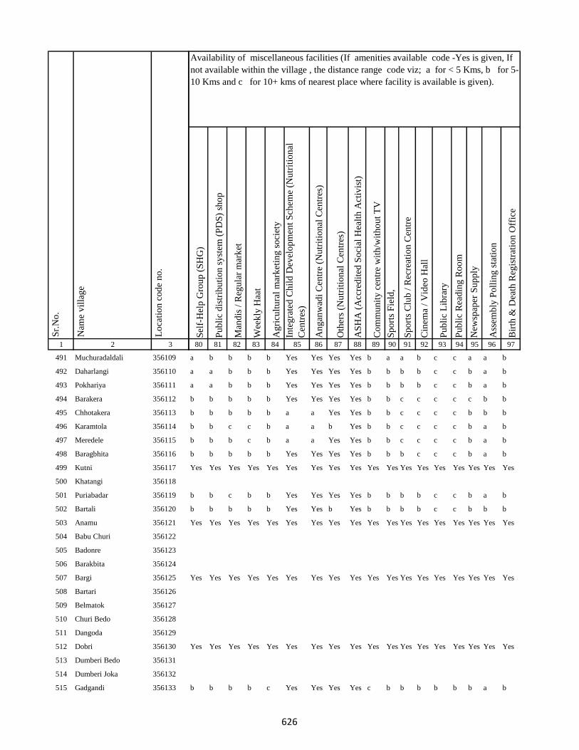
1 2 3
Lo
cati
on
co
de
no
.
Nam
e v
illa
ge
Sr.
No
.
491 Muchuradaldali 356109
492 Daharlangi 356110
493 Pokhariya 356111
494 Barakera 356112
495 Chhotakera 356113
496 Karamtola 356114
497 Meredele 356115
498 Baragbhita 356116
499 Kutni 356117
500 Khatangi 356118
501 Puriabadar 356119
502 Bartali 356120
503 Anamu 356121
504 Babu Churi 356122
505 Badonre 356123
506 Barakbita 356124
507 Bargi 356125
508 Bartari 356126
509 Belmatok 356127
510 Churi Bedo 356128
511 Dangoda 356129
512 Dobri 356130
513 Dumberi Bedo 356131
514 Dumberi Joka 356132
515 Gadgandi 356133
Sel
f-H
elp
Gro
up
(S
HG
)
Pu
bli
c d
istr
ibu
tio
n s
yst
em (
PD
S)
sho
p
Man
dis
/ R
egu
lar
mar
ket
Wee
kly
Haa
t
Ag
ricu
ltu
ral
mar
ket
ing
so
ciet
y
Inte
gra
ted
Ch
ild
Dev
elo
pm
ent
Sch
eme
(Nu
trit
ion
al
Cen
tres
)
An
gan
wad
i C
entr
e (N
utr
itio
nal
Cen
tres
)
Oth
ers
(Nu
trit
ion
al C
entr
es)
AS
HA
(A
ccre
dit
ed S
oci
al H
ealt
h A
ctiv
ist)
Co
mm
un
ity
cen
tre
wit
h/w
ith
ou
t T
V
Sp
ort
s F
ield
,
Sp
ort
s C
lub
/ R
ecre
atio
n C
entr
e
Cin
ema
/ V
ideo
Hal
l
Pu
bli
c L
ibra
ry
Pu
bli
c R
ead
ing
Ro
om
New
spap
er S
up
ply
Ass
emb
ly P
oll
ing
sta
tio
n
Bir
th &
Dea
th R
egis
trat
ion
Off
ice
80 81 82 83 84 85 86 87 88 89 90 91 92 93 94 95 96 97
Availability of miscellaneous facilities (If amenities available code -Yes is given, If
not available within the village , the distance range code viz; a for < 5 Kms, b for 5-
10 Kms and c for 10+ kms of nearest place where facility is available is given).
a b b b b Yes Yes Yes Yes b a a b c c a a b
a a b b b Yes Yes Yes Yes b b b b c c b a b
a a b b b Yes Yes Yes Yes b b b b c c b a b
b b b b b Yes Yes Yes Yes b b c c c c c b b
b b b b b a a Yes Yes b b c c c c b b b
b b c c b a a b Yes b b c c c c b a b
b b b c b a a Yes Yes b b c c c c b a b
b b b b b Yes Yes Yes Yes b b b c c c b a b
Yes Yes Yes Yes Yes Yes Yes Yes Yes Yes Yes Yes Yes Yes Yes Yes Yes Yes
b b c b b Yes Yes Yes Yes b b b b c c b a b
b b b b b Yes Yes b Yes b b b b c c b b b
Yes Yes Yes Yes Yes Yes Yes Yes Yes Yes Yes Yes Yes Yes Yes Yes Yes Yes
Yes Yes Yes Yes Yes Yes Yes Yes Yes Yes Yes Yes Yes Yes Yes Yes Yes Yes
Yes Yes Yes Yes Yes Yes Yes Yes Yes Yes Yes Yes Yes Yes Yes Yes Yes Yes
b b b b c Yes Yes Yes Yes c b b b b b b a b
626

1 2 3
Lo
cati
on
co
de
no
.
Nam
e v
illa
ge
Sr.
No
.
516 Gandiyamo 356134
517 Godni 356135
518 Japani 356136
519 Japita 356137
520 Jola 356138
521 Karakdoni 356139
522 Kasamu 356140
523 Katengi 356141
524 Katenribedo 356142
525 Katenri Joka 356143
526 Kukmano 356144
527 Mahwari Bedo 356145
528 Mahwari Joka 356146
529 Maligoda 356147
530 Masandumi 356148
531 Merdade 356149
532 Muchra 356150
533 Muri(Mundi) 356151
534 Orbot 356152
535 Panchrukhi 356153
536 Sundariya 356154
537 Tamilgoda 356155
538 Chhota Kendua 356156
539 Shampur 356157
540 Bara Kendua 356158
Sel
f-H
elp
Gro
up
(S
HG
)
Pu
bli
c d
istr
ibu
tio
n s
yst
em (
PD
S)
sho
p
Man
dis
/ R
egu
lar
mar
ket
Wee
kly
Haa
t
Ag
ricu
ltu
ral
mar
ket
ing
so
ciet
y
Inte
gra
ted
Ch
ild
Dev
elo
pm
ent
Sch
eme
(Nu
trit
ion
al
Cen
tres
)
An
gan
wad
i C
entr
e (N
utr
itio
nal
Cen
tres
)
Oth
ers
(Nu
trit
ion
al C
entr
es)
AS
HA
(A
ccre
dit
ed S
oci
al H
ealt
h A
ctiv
ist)
Co
mm
un
ity
cen
tre
wit
h/w
ith
ou
t T
V
Sp
ort
s F
ield
,
Sp
ort
s C
lub
/ R
ecre
atio
n C
entr
e
Cin
ema
/ V
ideo
Hal
l
Pu
bli
c L
ibra
ry
Pu
bli
c R
ead
ing
Ro
om
New
spap
er S
up
ply
Ass
emb
ly P
oll
ing
sta
tio
n
Bir
th &
Dea
th R
egis
trat
ion
Off
ice
80 81 82 83 84 85 86 87 88 89 90 91 92 93 94 95 96 97
Availability of miscellaneous facilities (If amenities available code -Yes is given, If
not available within the village , the distance range code viz; a for < 5 Kms, b for 5-
10 Kms and c for 10+ kms of nearest place where facility is available is given).
Yes Yes Yes Yes Yes Yes Yes Yes Yes Yes Yes Yes Yes Yes Yes Yes Yes Yes
a b b b b Yes Yes Yes Yes b b b b c c b a b
Yes Yes Yes Yes Yes Yes Yes Yes Yes Yes Yes Yes Yes Yes Yes Yes Yes Yes
Yes Yes Yes Yes Yes Yes Yes Yes Yes Yes Yes Yes Yes Yes Yes Yes Yes Yes
Yes Yes Yes Yes Yes Yes Yes Yes Yes Yes Yes Yes Yes Yes Yes Yes Yes Yes
Yes Yes Yes Yes Yes Yes Yes Yes Yes Yes Yes Yes Yes Yes Yes Yes Yes Yes
Yes Yes Yes Yes Yes Yes Yes Yes Yes Yes Yes Yes Yes Yes Yes Yes Yes Yes
a b b a a Yes Yes Yes Yes b b b c b b a a b
Yes a a a b Yes Yes b Yes b b b c c c b a b
Yes b c a b Yes Yes a Yes c c c c c c b Yes b
627
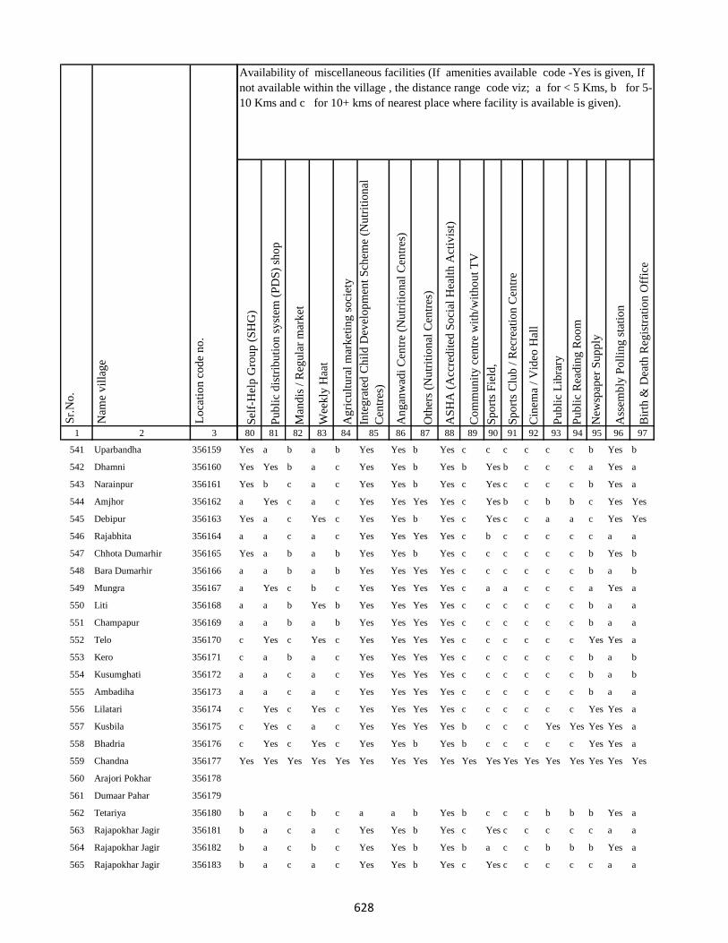
1 2 3
Lo
cati
on
co
de
no
.
Nam
e v
illa
ge
Sr.
No
.
541 Uparbandha 356159
542 Dhamni 356160
543 Narainpur 356161
544 Amjhor 356162
545 Debipur 356163
546 Rajabhita 356164
547 Chhota Dumarhir 356165
548 Bara Dumarhir 356166
549 Mungra 356167
550 Liti 356168
551 Champapur 356169
552 Telo 356170
553 Kero 356171
554 Kusumghati 356172
555 Ambadiha 356173
556 Lilatari 356174
557 Kusbila 356175
558 Bhadria 356176
559 Chandna 356177
560 Arajori Pokhar 356178
561 Dumaar Pahar 356179
562 Tetariya 356180
563 Rajapokhar Jagir 356181
564 Rajapokhar Jagir 356182
565 Rajapokhar Jagir 356183
Sel
f-H
elp
Gro
up
(S
HG
)
Pu
bli
c d
istr
ibu
tio
n s
yst
em (
PD
S)
sho
p
Man
dis
/ R
egu
lar
mar
ket
Wee
kly
Haa
t
Ag
ricu
ltu
ral
mar
ket
ing
so
ciet
y
Inte
gra
ted
Ch
ild
Dev
elo
pm
ent
Sch
eme
(Nu
trit
ion
al
Cen
tres
)
An
gan
wad
i C
entr
e (N
utr
itio
nal
Cen
tres
)
Oth
ers
(Nu
trit
ion
al C
entr
es)
AS
HA
(A
ccre
dit
ed S
oci
al H
ealt
h A
ctiv
ist)
Co
mm
un
ity
cen
tre
wit
h/w
ith
ou
t T
V
Sp
ort
s F
ield
,
Sp
ort
s C
lub
/ R
ecre
atio
n C
entr
e
Cin
ema
/ V
ideo
Hal
l
Pu
bli
c L
ibra
ry
Pu
bli
c R
ead
ing
Ro
om
New
spap
er S
up
ply
Ass
emb
ly P
oll
ing
sta
tio
n
Bir
th &
Dea
th R
egis
trat
ion
Off
ice
80 81 82 83 84 85 86 87 88 89 90 91 92 93 94 95 96 97
Availability of miscellaneous facilities (If amenities available code -Yes is given, If
not available within the village , the distance range code viz; a for < 5 Kms, b for 5-
10 Kms and c for 10+ kms of nearest place where facility is available is given).
Yes a b a b Yes Yes b Yes c c c c c c b Yes b
Yes Yes b a c Yes Yes b Yes b Yes b c c c a Yes a
Yes b c a c Yes Yes b Yes c Yes c c c c b Yes a
a Yes c a c Yes Yes Yes Yes c Yes b c b b c Yes Yes
Yes a c Yes c Yes Yes b Yes c Yes c c a a c Yes Yes
a a c a c Yes Yes Yes Yes c b c c c c c a a
Yes a b a b Yes Yes b Yes c c c c c c b Yes b
a a b a b Yes Yes Yes Yes c c c c c c b a b
a Yes c b c Yes Yes Yes Yes c a a c c c a Yes a
a a b Yes b Yes Yes Yes Yes c c c c c c b a a
a a b a b Yes Yes Yes Yes c c c c c c b a a
c Yes c Yes c Yes Yes Yes Yes c c c c c c Yes Yes a
c a b a c Yes Yes Yes Yes c c c c c c b a b
a a c a c Yes Yes Yes Yes c c c c c c b a b
a a c a c Yes Yes Yes Yes c c c c c c b a a
c Yes c Yes c Yes Yes Yes Yes c c c c c c Yes Yes a
c Yes c a c Yes Yes Yes Yes b c c c Yes Yes Yes Yes a
c Yes c Yes c Yes Yes b Yes b c c c c c Yes Yes a
Yes Yes Yes Yes Yes Yes Yes Yes Yes Yes Yes Yes Yes Yes Yes Yes Yes Yes
b a c b c a a b Yes b c c c b b b Yes a
b a c a c Yes Yes b Yes c Yes c c c c c a a
b a c b c Yes Yes b Yes b a c c b b b Yes a
b a c a c Yes Yes b Yes c Yes c c c c c a a
628

1 2 3
Lo
cati
on
co
de
no
.
Nam
e v
illa
ge
Sr.
No
.
566 Rajapokhar 356184
567 Bara Chatampur 356185
568 Lilabhita 356186
569 Tamlia Amdanda 356187
570 Manko 356188
571 Kilo 356189
572 Dhadhari Pahar 356190
573 Chhota Chatampur 356191
574 Chetmapahar 356192
575 Dhanigora 356193
576 Dimbni Pahar 356194
577 Dhunigora Pahar 356195
578 Palma Pahar 356196
579 Chalpahari 356197
580 Madomasi 356198
581 Bhagamakra 356199
582 Champatola 356200
583 Pakriya Pahar 356201
584 Kairasol 356202
585 Sundar Tola 356203
586 Pachro 356204
587 Marni Pahar 356205
588 Daria Pahar 356206
589 Harla Bathan 356207
590 Deodanrpahar 356208
Sel
f-H
elp
Gro
up
(S
HG
)
Pu
bli
c d
istr
ibu
tio
n s
yst
em (
PD
S)
sho
p
Man
dis
/ R
egu
lar
mar
ket
Wee
kly
Haa
t
Ag
ricu
ltu
ral
mar
ket
ing
so
ciet
y
Inte
gra
ted
Ch
ild
Dev
elo
pm
ent
Sch
eme
(Nu
trit
ion
al
Cen
tres
)
An
gan
wad
i C
entr
e (N
utr
itio
nal
Cen
tres
)
Oth
ers
(Nu
trit
ion
al C
entr
es)
AS
HA
(A
ccre
dit
ed S
oci
al H
ealt
h A
ctiv
ist)
Co
mm
un
ity
cen
tre
wit
h/w
ith
ou
t T
V
Sp
ort
s F
ield
,
Sp
ort
s C
lub
/ R
ecre
atio
n C
entr
e
Cin
ema
/ V
ideo
Hal
l
Pu
bli
c L
ibra
ry
Pu
bli
c R
ead
ing
Ro
om
New
spap
er S
up
ply
Ass
emb
ly P
oll
ing
sta
tio
n
Bir
th &
Dea
th R
egis
trat
ion
Off
ice
80 81 82 83 84 85 86 87 88 89 90 91 92 93 94 95 96 97
Availability of miscellaneous facilities (If amenities available code -Yes is given, If
not available within the village , the distance range code viz; a for < 5 Kms, b for 5-
10 Kms and c for 10+ kms of nearest place where facility is available is given).
b a c a c Yes Yes b Yes c c c c c c c a a
Yes a c b c Yes Yes Yes Yes c Yes c c b b b b b
b a c a c Yes Yes Yes Yes b a c c b b b b a
Yes b c b Yes b b Yes Yes c b c c c c c b b
Yes a b b c Yes Yes Yes Yes b a b c c c b a b
c b c c c Yes Yes b Yes c c c c c c c a a
Yes Yes Yes Yes Yes Yes Yes Yes Yes Yes Yes Yes Yes Yes Yes Yes Yes Yes
c b c c c Yes Yes Yes Yes c b c c c c b b a
c b c b c Yes Yes Yes Yes b c c c c c c a b
c b c b c Yes Yes Yes Yes b b c c c c c a b
c b c b c Yes Yes Yes Yes c b c c c c c a b
c b c b c Yes Yes Yes Yes c b c c c c c Yes b
Yes Yes Yes Yes Yes Yes Yes Yes Yes Yes Yes Yes Yes Yes Yes Yes Yes Yes
c b c b c Yes Yes Yes Yes c b c c c c c a b
Yes b c c c Yes Yes Yes Yes c b c c c c c a b
Yes Yes c c c Yes Yes Yes Yes Yes Yes c c c c Yes Yes c
629
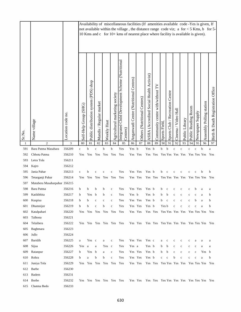
1 2 3
Lo
cati
on
co
de
no
.
Nam
e v
illa
ge
Sr.
No
.
591 Bara Patma Masahara 356209
592 Chhota Patma 356210
593 Letra Tola 356211
594 Kajro 356212
595 Jania Pahar 356213
596 Tetarganji Pahar 356214
597 Matubera Masaharpahar 356215
598 Bara Patma 356216
599 Katikbhita 356217
600 Kuspisa 356218
601 Dhamnijor 356219
602 Katalpahari 356220
603 Talbona 356221
604 Telaibera 356222
605 Baghmara 356223
606 Jullo 356224
607 Baridih 356225
608 Sijua 356226
609 Ratanpur 356227
610 Rohra 356228
611 Juniya Tola 356229
612 Barbe 356230
613 Badem 356231
614 Borbe 356232
615 Chatma Bedo 356233
Sel
f-H
elp
Gro
up
(S
HG
)
Pu
bli
c d
istr
ibu
tio
n s
yst
em (
PD
S)
sho
p
Man
dis
/ R
egu
lar
mar
ket
Wee
kly
Haa
t
Ag
ricu
ltu
ral
mar
ket
ing
so
ciet
y
Inte
gra
ted
Ch
ild
Dev
elo
pm
ent
Sch
eme
(Nu
trit
ion
al
Cen
tres
)
An
gan
wad
i C
entr
e (N
utr
itio
nal
Cen
tres
)
Oth
ers
(Nu
trit
ion
al C
entr
es)
AS
HA
(A
ccre
dit
ed S
oci
al H
ealt
h A
ctiv
ist)
Co
mm
un
ity
cen
tre
wit
h/w
ith
ou
t T
V
Sp
ort
s F
ield
,
Sp
ort
s C
lub
/ R
ecre
atio
n C
entr
e
Cin
ema
/ V
ideo
Hal
l
Pu
bli
c L
ibra
ry
Pu
bli
c R
ead
ing
Ro
om
New
spap
er S
up
ply
Ass
emb
ly P
oll
ing
sta
tio
n
Bir
th &
Dea
th R
egis
trat
ion
Off
ice
80 81 82 83 84 85 86 87 88 89 90 91 92 93 94 95 96 97
Availability of miscellaneous facilities (If amenities available code -Yes is given, If
not available within the village , the distance range code viz; a for < 5 Kms, b for 5-
10 Kms and c for 10+ kms of nearest place where facility is available is given).
c b c b b Yes Yes b Yes b b b c c c c b a
Yes Yes Yes Yes Yes Yes Yes Yes Yes Yes Yes Yes Yes Yes Yes Yes Yes Yes
c b c c c Yes Yes Yes Yes b b c c c c c b b
Yes Yes Yes Yes Yes Yes Yes Yes Yes Yes Yes Yes Yes Yes Yes Yes Yes Yes
b b b b c Yes Yes Yes Yes b b c c c c b a a
b Yes b b c Yes Yes b Yes b b b c c c c a b
b b c c c Yes Yes Yes Yes b b c c c c b a b
b b c b c Yes Yes Yes Yes b Yes b c c c c a b
Yes Yes Yes Yes Yes Yes Yes Yes Yes Yes Yes Yes Yes Yes Yes Yes Yes Yes
Yes Yes Yes Yes Yes Yes Yes Yes Yes Yes Yes Yes Yes Yes Yes Yes Yes Yes
a Yes c a c Yes Yes Yes Yes c a c c c c a a a
Yes a a Yes c Yes Yes a Yes b b b c c c c a a
b Yes b a c Yes Yes Yes Yes b b b c c c c Yes b
b a b b c Yes Yes Yes Yes b c c b c c c a b
Yes Yes Yes Yes Yes Yes Yes Yes Yes Yes Yes Yes Yes Yes Yes Yes Yes Yes
Yes Yes Yes Yes Yes Yes Yes Yes Yes Yes Yes Yes Yes Yes Yes Yes Yes Yes
630
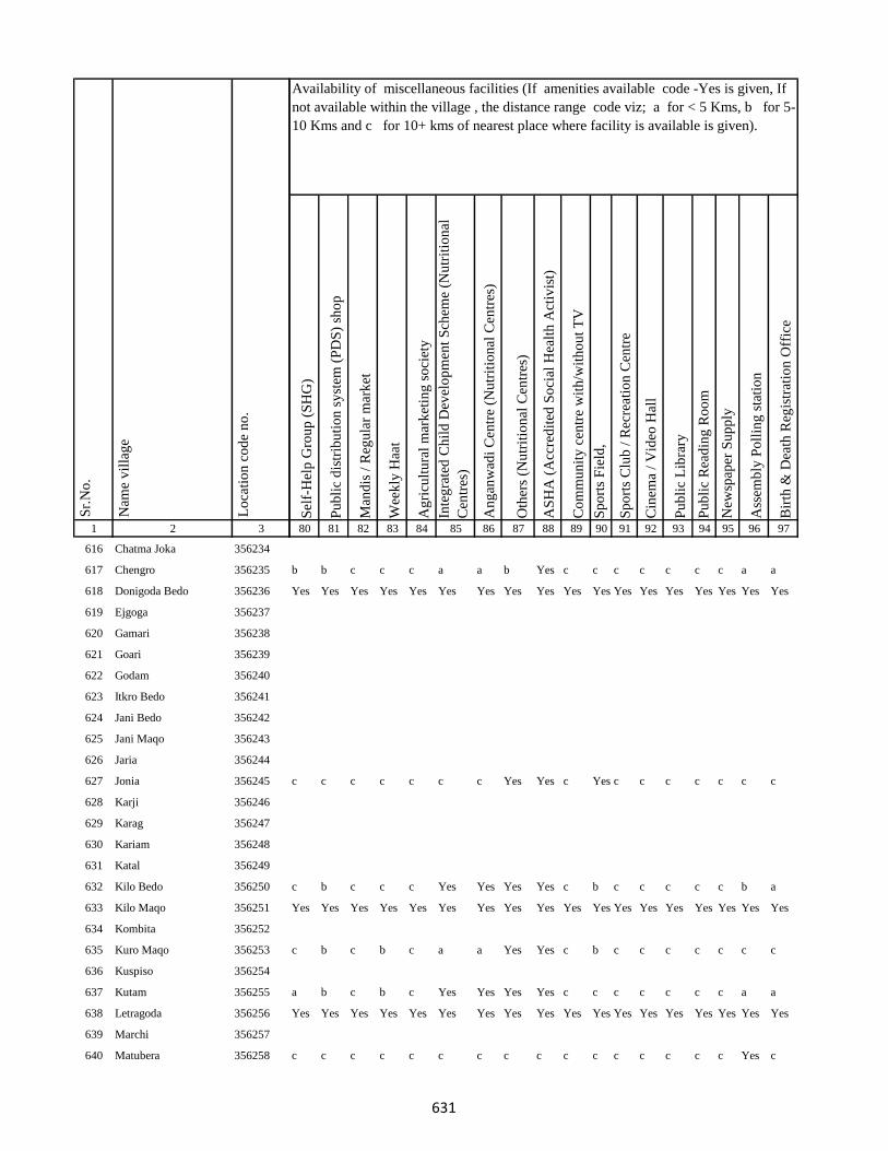
1 2 3
Lo
cati
on
co
de
no
.
Nam
e v
illa
ge
Sr.
No
.
616 Chatma Joka 356234
617 Chengro 356235
618 Donigoda Bedo 356236
619 Ejgoga 356237
620 Gamari 356238
621 Goari 356239
622 Godam 356240
623 Itkro Bedo 356241
624 Jani Bedo 356242
625 Jani Maqo 356243
626 Jaria 356244
627 Jonia 356245
628 Karji 356246
629 Karag 356247
630 Kariam 356248
631 Katal 356249
632 Kilo Bedo 356250
633 Kilo Maqo 356251
634 Kombita 356252
635 Kuro Maqo 356253
636 Kuspiso 356254
637 Kutam 356255
638 Letragoda 356256
639 Marchi 356257
640 Matubera 356258
Sel
f-H
elp
Gro
up
(S
HG
)
Pu
bli
c d
istr
ibu
tio
n s
yst
em (
PD
S)
sho
p
Man
dis
/ R
egu
lar
mar
ket
Wee
kly
Haa
t
Ag
ricu
ltu
ral
mar
ket
ing
so
ciet
y
Inte
gra
ted
Ch
ild
Dev
elo
pm
ent
Sch
eme
(Nu
trit
ion
al
Cen
tres
)
An
gan
wad
i C
entr
e (N
utr
itio
nal
Cen
tres
)
Oth
ers
(Nu
trit
ion
al C
entr
es)
AS
HA
(A
ccre
dit
ed S
oci
al H
ealt
h A
ctiv
ist)
Co
mm
un
ity
cen
tre
wit
h/w
ith
ou
t T
V
Sp
ort
s F
ield
,
Sp
ort
s C
lub
/ R
ecre
atio
n C
entr
e
Cin
ema
/ V
ideo
Hal
l
Pu
bli
c L
ibra
ry
Pu
bli
c R
ead
ing
Ro
om
New
spap
er S
up
ply
Ass
emb
ly P
oll
ing
sta
tio
n
Bir
th &
Dea
th R
egis
trat
ion
Off
ice
80 81 82 83 84 85 86 87 88 89 90 91 92 93 94 95 96 97
Availability of miscellaneous facilities (If amenities available code -Yes is given, If
not available within the village , the distance range code viz; a for < 5 Kms, b for 5-
10 Kms and c for 10+ kms of nearest place where facility is available is given).
b b c c c a a b Yes c c c c c c c a a
Yes Yes Yes Yes Yes Yes Yes Yes Yes Yes Yes Yes Yes Yes Yes Yes Yes Yes
c c c c c c c Yes Yes c Yes c c c c c c c
c b c c c Yes Yes Yes Yes c b c c c c c b a
Yes Yes Yes Yes Yes Yes Yes Yes Yes Yes Yes Yes Yes Yes Yes Yes Yes Yes
c b c b c a a Yes Yes c b c c c c c c c
a b c b c Yes Yes Yes Yes c c c c c c c a a
Yes Yes Yes Yes Yes Yes Yes Yes Yes Yes Yes Yes Yes Yes Yes Yes Yes Yes
c c c c c c c c c c c c c c c c Yes c
631

1 2 3
Lo
cati
on
co
de
no
.
Nam
e v
illa
ge
Sr.
No
.
641 Pandeni 356259
642 Patma Joka 356260
643 Perkuria 356261
644 Puro Maqo 356262
645 Puro Bedo 356263
646 Pusurkuriya Bedo 356264
647 Pusurkuriya Joka 356265
648 Tamlipatta 356266
649 Tesro 356267
650 Tisro 356268
651 Todmari 356269
652 Tokam 356270
653 Tokkuriya 356271
654 Saharpur 356272
655 Lilatari 356273
656 Khairbani 356274
657 Belthu 356275
658 Hethbandha 356276
659 Shamapokhar 356277
660 Chiharbona 356278
661 Chhota Saharpur 356279
662 Tulsipur 356280
663 Goriya 356281
664 Kamardiha 356282
665 Gopalpur 356283
Sel
f-H
elp
Gro
up
(S
HG
)
Pu
bli
c d
istr
ibu
tio
n s
yst
em (
PD
S)
sho
p
Man
dis
/ R
egu
lar
mar
ket
Wee
kly
Haa
t
Ag
ricu
ltu
ral
mar
ket
ing
so
ciet
y
Inte
gra
ted
Ch
ild
Dev
elo
pm
ent
Sch
eme
(Nu
trit
ion
al
Cen
tres
)
An
gan
wad
i C
entr
e (N
utr
itio
nal
Cen
tres
)
Oth
ers
(Nu
trit
ion
al C
entr
es)
AS
HA
(A
ccre
dit
ed S
oci
al H
ealt
h A
ctiv
ist)
Co
mm
un
ity
cen
tre
wit
h/w
ith
ou
t T
V
Sp
ort
s F
ield
,
Sp
ort
s C
lub
/ R
ecre
atio
n C
entr
e
Cin
ema
/ V
ideo
Hal
l
Pu
bli
c L
ibra
ry
Pu
bli
c R
ead
ing
Ro
om
New
spap
er S
up
ply
Ass
emb
ly P
oll
ing
sta
tio
n
Bir
th &
Dea
th R
egis
trat
ion
Off
ice
80 81 82 83 84 85 86 87 88 89 90 91 92 93 94 95 96 97
Availability of miscellaneous facilities (If amenities available code -Yes is given, If
not available within the village , the distance range code viz; a for < 5 Kms, b for 5-
10 Kms and c for 10+ kms of nearest place where facility is available is given).
Yes Yes Yes Yes Yes Yes Yes Yes Yes Yes Yes Yes Yes Yes Yes Yes Yes Yes
c b c c c Yes Yes Yes Yes c c c c c c c b b
Yes Yes c c c Yes Yes Yes Yes Yes Yes c c c c Yes Yes c
c a a a c Yes Yes Yes Yes c c c c c c b a a
c Yes Yes Yes c Yes Yes Yes Yes c c c c c c b Yes a
c a a a c Yes Yes Yes Yes c c c c c c b a a
b a a a a Yes Yes Yes Yes b a a c c c a Yes a
b a a b b Yes Yes Yes Yes b b b c c c b Yes b
Yes a b a b Yes Yes Yes Yes a a a b c c a Yes a
a a b a b Yes Yes Yes Yes a a a b c c a a a
a a b a c a a Yes a c a b b c c b c a
a Yes b Yes b Yes Yes Yes Yes a Yes b c c c b Yes a
a a b a b Yes Yes Yes Yes a a b c c c b a a
b a b a c Yes Yes Yes Yes c a b c c c b a a
a a a a c Yes Yes Yes Yes b a a c c c a a a
632

1 2 3
Lo
cati
on
co
de
no
.
Nam
e v
illa
ge
Sr.
No
.
666 Lawabhujani 356284
667 Babhania 356285
668 Gori Chak 356286
669 Karua 356287
670 Barhara 356288
671 Gorakhpur 356289
672 Jojosimra 356290
673 Kusma 356291
674 Kurkutiya 356292
675 Dumra 356293
676 Sabejora 356294
677 Amba 356295
678 Shampur 356296
679 Beldiha 356297
680 Balajhor 356298
681 Ghatiari 356299
682 Jata Kuti 356300
683 Bagjori 356301
684 Kendua 356302
685 Tetaria 356303
686 Paharpur 356304
687 Bara Simra 356305
688 Chhota Simra 356306
689 Ghat Simra 356307
690 Suarmari 356308
Sel
f-H
elp
Gro
up
(S
HG
)
Pu
bli
c d
istr
ibu
tio
n s
yst
em (
PD
S)
sho
p
Man
dis
/ R
egu
lar
mar
ket
Wee
kly
Haa
t
Ag
ricu
ltu
ral
mar
ket
ing
so
ciet
y
Inte
gra
ted
Ch
ild
Dev
elo
pm
ent
Sch
eme
(Nu
trit
ion
al
Cen
tres
)
An
gan
wad
i C
entr
e (N
utr
itio
nal
Cen
tres
)
Oth
ers
(Nu
trit
ion
al C
entr
es)
AS
HA
(A
ccre
dit
ed S
oci
al H
ealt
h A
ctiv
ist)
Co
mm
un
ity
cen
tre
wit
h/w
ith
ou
t T
V
Sp
ort
s F
ield
,
Sp
ort
s C
lub
/ R
ecre
atio
n C
entr
e
Cin
ema
/ V
ideo
Hal
l
Pu
bli
c L
ibra
ry
Pu
bli
c R
ead
ing
Ro
om
New
spap
er S
up
ply
Ass
emb
ly P
oll
ing
sta
tio
n
Bir
th &
Dea
th R
egis
trat
ion
Off
ice
80 81 82 83 84 85 86 87 88 89 90 91 92 93 94 95 96 97
Availability of miscellaneous facilities (If amenities available code -Yes is given, If
not available within the village , the distance range code viz; a for < 5 Kms, b for 5-
10 Kms and c for 10+ kms of nearest place where facility is available is given).
a a b b c Yes Yes Yes Yes b a b b c c b a a
a a b b c Yes Yes Yes Yes b a b b c c b a a
Yes b a a c Yes Yes b Yes c a a a c c b b b
a a a a a Yes Yes Yes Yes b a b a c c a a b
a Yes Yes a a a a Yes Yes c a c a c c a Yes b
a a a b a Yes Yes Yes Yes c a b b c c b Yes Yes
a a a a a Yes Yes Yes Yes c a b b c c b a a
a a a b a Yes Yes Yes Yes c a b b c c b a a
a Yes a a c Yes Yes Yes Yes c Yes a a c c a a a
a Yes a a c Yes Yes Yes Yes c a a a c c a Yes a
a a b b c Yes Yes Yes Yes b a b b c c b a a
a a b b b Yes Yes Yes Yes b b b c c c b a b
a a b b b Yes Yes Yes Yes a a b c c c b a a
b Yes b b b Yes Yes Yes Yes c Yes b b b b b Yes b
b a b a c a a b Yes b a b b c c b a b
Yes Yes a a a Yes Yes b Yes a a b a c c Yes a b
b a a a c Yes Yes Yes Yes a a a c c c Yes a a
b Yes b b c Yes Yes Yes Yes b a b b c c b Yes a
a a a a c Yes Yes Yes Yes b a a c c c Yes Yes a
a a a a c Yes Yes Yes Yes b a b b c c a a a
a Yes a Yes c Yes Yes Yes Yes b Yes a a c c a Yes a
c a a a a Yes Yes Yes Yes a a a c c c Yes Yes a
c a a a b Yes Yes Yes Yes a a b a c c Yes a a
c a b a b Yes Yes Yes Yes a a a b c c Yes Yes b
c a c a b Yes Yes Yes Yes a a a b c c Yes Yes b
633
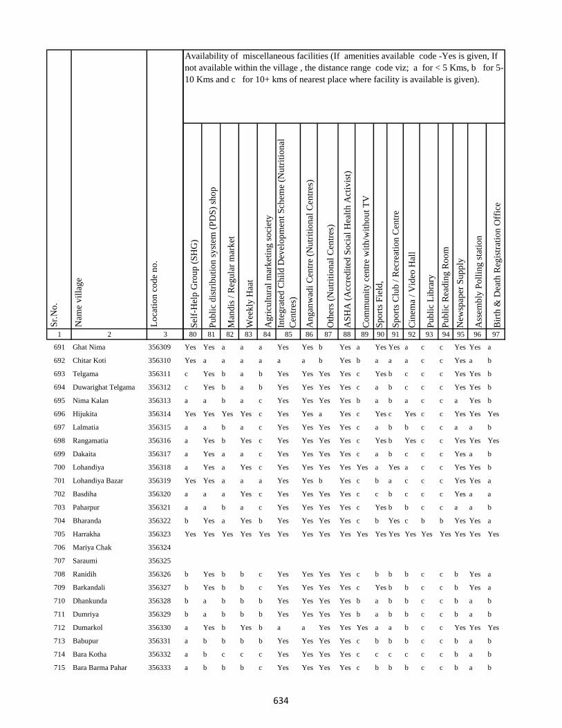
1 2 3
Lo
cati
on
co
de
no
.
Nam
e v
illa
ge
Sr.
No
.
691 Ghat Nima 356309
692 Chitar Koti 356310
693 Telgama 356311
694 Duwarighat Telgama 356312
695 Nima Kalan 356313
696 Hijukita 356314
697 Lalmatia 356315
698 Rangamatia 356316
699 Dakaita 356317
700 Lohandiya 356318
701 Lohandiya Bazar 356319
702 Basdiha 356320
703 Paharpur 356321
704 Bharanda 356322
705 Harrakha 356323
706 Mariya Chak 356324
707 Saraumi 356325
708 Ranidih 356326
709 Barkandali 356327
710 Dhankunda 356328
711 Dumriya 356329
712 Dumarkol 356330
713 Babupur 356331
714 Bara Kotha 356332
715 Bara Barma Pahar 356333
Sel
f-H
elp
Gro
up
(S
HG
)
Pu
bli
c d
istr
ibu
tio
n s
yst
em (
PD
S)
sho
p
Man
dis
/ R
egu
lar
mar
ket
Wee
kly
Haa
t
Ag
ricu
ltu
ral
mar
ket
ing
so
ciet
y
Inte
gra
ted
Ch
ild
Dev
elo
pm
ent
Sch
eme
(Nu
trit
ion
al
Cen
tres
)
An
gan
wad
i C
entr
e (N
utr
itio
nal
Cen
tres
)
Oth
ers
(Nu
trit
ion
al C
entr
es)
AS
HA
(A
ccre
dit
ed S
oci
al H
ealt
h A
ctiv
ist)
Co
mm
un
ity
cen
tre
wit
h/w
ith
ou
t T
V
Sp
ort
s F
ield
,
Sp
ort
s C
lub
/ R
ecre
atio
n C
entr
e
Cin
ema
/ V
ideo
Hal
l
Pu
bli
c L
ibra
ry
Pu
bli
c R
ead
ing
Ro
om
New
spap
er S
up
ply
Ass
emb
ly P
oll
ing
sta
tio
n
Bir
th &
Dea
th R
egis
trat
ion
Off
ice
80 81 82 83 84 85 86 87 88 89 90 91 92 93 94 95 96 97
Availability of miscellaneous facilities (If amenities available code -Yes is given, If
not available within the village , the distance range code viz; a for < 5 Kms, b for 5-
10 Kms and c for 10+ kms of nearest place where facility is available is given).
Yes Yes a a a Yes Yes b Yes a Yes Yes a c c Yes Yes a
Yes a a a a a a b Yes b a a a c c Yes a b
c Yes b a b Yes Yes Yes Yes c Yes b c c c Yes Yes b
c Yes b a b Yes Yes Yes Yes c a b c c c Yes Yes b
a a b a c Yes Yes Yes Yes b a b a c c a Yes b
Yes Yes Yes Yes c Yes Yes a Yes c Yes c Yes c c Yes Yes Yes
a a b a c Yes Yes Yes Yes c a b b c c a a b
a Yes b Yes c Yes Yes Yes Yes c Yes b Yes c c Yes Yes Yes
a Yes a a c Yes Yes Yes Yes c a b c c c Yes a b
a Yes a Yes c Yes Yes Yes Yes Yes a Yes a c c Yes Yes b
Yes Yes a a a Yes Yes b Yes c b a c c c Yes Yes a
a a a Yes c Yes Yes Yes Yes c c b c c c Yes a a
a a b a c Yes Yes Yes Yes c Yes b b c c a a b
b Yes a Yes b Yes Yes Yes Yes c b Yes c b b Yes Yes a
Yes Yes Yes Yes Yes Yes Yes Yes Yes Yes Yes Yes Yes Yes Yes Yes Yes Yes
b Yes b b c Yes Yes Yes Yes c b b b c c b Yes a
b Yes b b c Yes Yes Yes Yes c Yes b b c c b Yes a
b a b b b Yes Yes Yes Yes b a b b c c b a b
b a b b b Yes Yes Yes Yes b a b b c c b a b
a Yes b Yes b a a Yes Yes Yes a a b c c Yes Yes Yes
a b b b b Yes Yes Yes Yes c b b b c c b a b
a b c c c Yes Yes Yes Yes c c c c c c b a b
a b b b c Yes Yes Yes Yes c b b b c c b a b
634

1 2 3
Lo
cati
on
co
de
no
.
Nam
e v
illa
ge
Sr.
No
.
716 Tatkunda 356334
717 Chhota Barma 356335
718 Debdanr 356336
719 Surla 356337
720 Dumria 356338
721 Chhota Khadahara 356339
722 Bara Khadahara 356340
723 Harkata 356341
724 Bara Khairbani 356342
725 Baisabaran 356343
726 Jurgura 356344
727 Dahua 356345
728 Kusumghati 356346
729 Lutibahiar 356347
730 Lilatari 356348
731 Haripur 356349
732 Hahajor 356350
733 Panchrukhi 356351
734 Rangamatia 356352
735 Chhota Khairbani 356353
736 Chhota Bhorai 356354
737 Bara Bhorai 356355
738 Taljhari 356356
739 Kesgoria 356357
740 Pakaria 356358
Sel
f-H
elp
Gro
up
(S
HG
)
Pu
bli
c d
istr
ibu
tio
n s
yst
em (
PD
S)
sho
p
Man
dis
/ R
egu
lar
mar
ket
Wee
kly
Haa
t
Ag
ricu
ltu
ral
mar
ket
ing
so
ciet
y
Inte
gra
ted
Ch
ild
Dev
elo
pm
ent
Sch
eme
(Nu
trit
ion
al
Cen
tres
)
An
gan
wad
i C
entr
e (N
utr
itio
nal
Cen
tres
)
Oth
ers
(Nu
trit
ion
al C
entr
es)
AS
HA
(A
ccre
dit
ed S
oci
al H
ealt
h A
ctiv
ist)
Co
mm
un
ity
cen
tre
wit
h/w
ith
ou
t T
V
Sp
ort
s F
ield
,
Sp
ort
s C
lub
/ R
ecre
atio
n C
entr
e
Cin
ema
/ V
ideo
Hal
l
Pu
bli
c L
ibra
ry
Pu
bli
c R
ead
ing
Ro
om
New
spap
er S
up
ply
Ass
emb
ly P
oll
ing
sta
tio
n
Bir
th &
Dea
th R
egis
trat
ion
Off
ice
80 81 82 83 84 85 86 87 88 89 90 91 92 93 94 95 96 97
Availability of miscellaneous facilities (If amenities available code -Yes is given, If
not available within the village , the distance range code viz; a for < 5 Kms, b for 5-
10 Kms and c for 10+ kms of nearest place where facility is available is given).
a b c b c Yes Yes Yes Yes c c b b c c b a b
a a c a b Yes Yes Yes Yes a a b b c c a a b
b b b b b Yes Yes Yes Yes c b c c c c b a b
Yes Yes b Yes b Yes Yes b Yes Yes Yes Yes a c c a Yes Yes
Yes Yes b Yes b Yes Yes b Yes Yes Yes Yes a c c Yes Yes a
Yes Yes Yes Yes Yes Yes Yes Yes Yes Yes Yes Yes Yes Yes Yes Yes Yes Yes
b a a a c Yes Yes Yes Yes b b b b c c a Yes b
a b c a c Yes Yes Yes Yes c b c c c c a a a
a a c a c Yes Yes Yes Yes c c c c c c a a a
a a b a c Yes Yes Yes Yes b Yes Yes b c c Yes Yes a
a Yes c Yes c Yes Yes Yes Yes b c b c c c Yes Yes b
a a a b c Yes Yes Yes Yes b Yes b c c c b b a
b a a b c Yes Yes Yes Yes b Yes b b c c b a b
Yes a b b c Yes Yes Yes Yes Yes Yes Yes b c c Yes Yes a
a a a a c Yes Yes Yes Yes a a a a c c a a a
a a a a c Yes Yes Yes Yes c a c c c c a a a
Yes Yes Yes Yes Yes Yes Yes Yes Yes Yes Yes Yes Yes Yes Yes Yes Yes Yes
Yes a b a c a a b Yes b b Yes a c c Yes Yes b
Yes b b c c Yes Yes Yes Yes c b b c c c a Yes a
b b b b c Yes Yes b Yes c a b c c c b a a
a b c c c Yes Yes Yes Yes c c c c c c b a b
a b c c c Yes Yes Yes Yes c c c c c c a a b
635
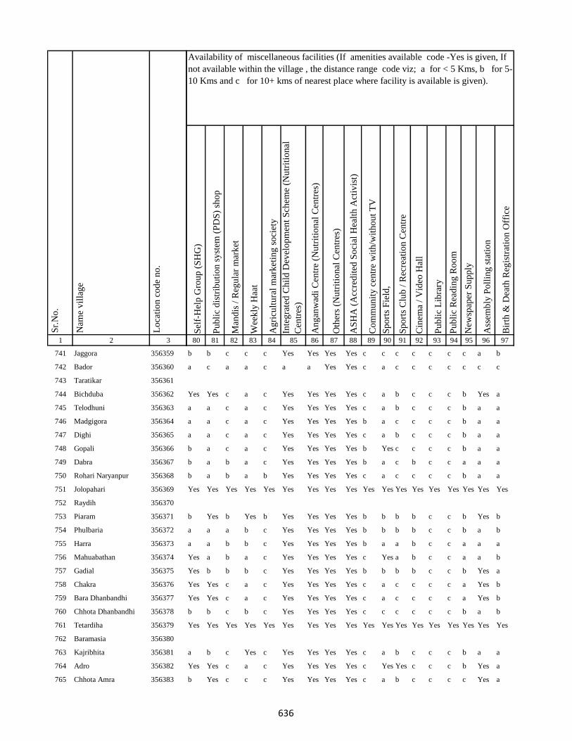
1 2 3
Lo
cati
on
co
de
no
.
Nam
e v
illa
ge
Sr.
No
.
741 Jaggora 356359
742 Bador 356360
743 Taratikar 356361
744 Bichduba 356362
745 Telodhuni 356363
746 Madgigora 356364
747 Dighi 356365
748 Gopali 356366
749 Dabra 356367
750 Rohari Naryanpur 356368
751 Jolopahari 356369
752 Raydih 356370
753 Piaram 356371
754 Phulbaria 356372
755 Harra 356373
756 Mahuabathan 356374
757 Gadial 356375
758 Chakra 356376
759 Bara Dhanbandhi 356377
760 Chhota Dhanbandhi 356378
761 Tetardiha 356379
762 Baramasia 356380
763 Kajribhita 356381
764 Adro 356382
765 Chhota Amra 356383
Sel
f-H
elp
Gro
up
(S
HG
)
Pu
bli
c d
istr
ibu
tio
n s
yst
em (
PD
S)
sho
p
Man
dis
/ R
egu
lar
mar
ket
Wee
kly
Haa
t
Ag
ricu
ltu
ral
mar
ket
ing
so
ciet
y
Inte
gra
ted
Ch
ild
Dev
elo
pm
ent
Sch
eme
(Nu
trit
ion
al
Cen
tres
)
An
gan
wad
i C
entr
e (N
utr
itio
nal
Cen
tres
)
Oth
ers
(Nu
trit
ion
al C
entr
es)
AS
HA
(A
ccre
dit
ed S
oci
al H
ealt
h A
ctiv
ist)
Co
mm
un
ity
cen
tre
wit
h/w
ith
ou
t T
V
Sp
ort
s F
ield
,
Sp
ort
s C
lub
/ R
ecre
atio
n C
entr
e
Cin
ema
/ V
ideo
Hal
l
Pu
bli
c L
ibra
ry
Pu
bli
c R
ead
ing
Ro
om
New
spap
er S
up
ply
Ass
emb
ly P
oll
ing
sta
tio
n
Bir
th &
Dea
th R
egis
trat
ion
Off
ice
80 81 82 83 84 85 86 87 88 89 90 91 92 93 94 95 96 97
Availability of miscellaneous facilities (If amenities available code -Yes is given, If
not available within the village , the distance range code viz; a for < 5 Kms, b for 5-
10 Kms and c for 10+ kms of nearest place where facility is available is given).
b b c c c Yes Yes Yes Yes c c c c c c c a b
a c a a c a a Yes Yes c a c c c c c c c
Yes Yes c a c Yes Yes Yes Yes c a b c c c b Yes a
a a c a c Yes Yes Yes Yes c a b c c c b a a
a a c a c Yes Yes Yes Yes b a c c c c b a a
a a c a c Yes Yes Yes Yes c a b c c c b a a
b a c a c Yes Yes Yes Yes b Yes c c c c b a a
b a b a c Yes Yes Yes Yes b a c b c c a a a
b a b a b Yes Yes Yes Yes c a c c c c b a a
Yes Yes Yes Yes Yes Yes Yes Yes Yes Yes Yes Yes Yes Yes Yes Yes Yes Yes
b Yes b Yes b Yes Yes Yes Yes b b b b c c b Yes b
a a a b c Yes Yes Yes Yes b b b b c c b a b
a a b b c Yes Yes Yes Yes b a a b c c a a a
Yes a b a c Yes Yes Yes Yes c Yes a b c c a a b
Yes b b b c Yes Yes Yes Yes b b b b c c b Yes a
Yes Yes c a c Yes Yes Yes Yes c a c c c c a Yes b
Yes Yes c a c Yes Yes Yes Yes c a c c c c a Yes b
b b c b c Yes Yes Yes Yes c c c c c c b a b
Yes Yes Yes Yes Yes Yes Yes Yes Yes Yes Yes Yes Yes Yes Yes Yes Yes Yes
a b c Yes c Yes Yes Yes Yes c a b c c c b a a
Yes Yes c a c Yes Yes Yes Yes c Yes Yes c c c b Yes a
b Yes c c c Yes Yes Yes Yes c a b c c c c Yes a
636
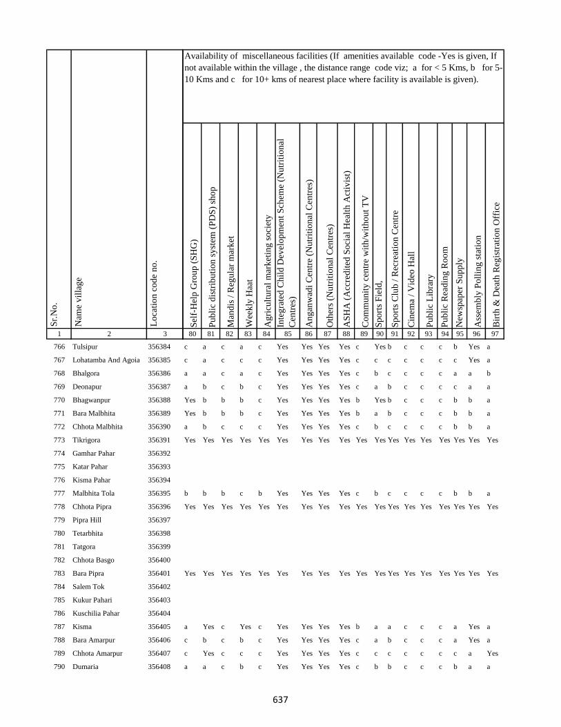
1 2 3
Lo
cati
on
co
de
no
.
Nam
e v
illa
ge
Sr.
No
.
766 Tulsipur 356384
767 Lohatamba And Agoia 356385
768 Bhalgora 356386
769 Deonapur 356387
770 Bhagwanpur 356388
771 Bara Malbhita 356389
772 Chhota Malbhita 356390
773 Tikrigora 356391
774 Gamhar Pahar 356392
775 Katar Pahar 356393
776 Kisma Pahar 356394
777 Malbhita Tola 356395
778 Chhota Pipra 356396
779 Pipra Hill 356397
780 Tetarbhita 356398
781 Tatgora 356399
782 Chhota Basgo 356400
783 Bara Pipra 356401
784 Salem Tok 356402
785 Kukur Pahari 356403
786 Kuschilia Pahar 356404
787 Kisma 356405
788 Bara Amarpur 356406
789 Chhota Amarpur 356407
790 Dumaria 356408
Sel
f-H
elp
Gro
up
(S
HG
)
Pu
bli
c d
istr
ibu
tio
n s
yst
em (
PD
S)
sho
p
Man
dis
/ R
egu
lar
mar
ket
Wee
kly
Haa
t
Ag
ricu
ltu
ral
mar
ket
ing
so
ciet
y
Inte
gra
ted
Ch
ild
Dev
elo
pm
ent
Sch
eme
(Nu
trit
ion
al
Cen
tres
)
An
gan
wad
i C
entr
e (N
utr
itio
nal
Cen
tres
)
Oth
ers
(Nu
trit
ion
al C
entr
es)
AS
HA
(A
ccre
dit
ed S
oci
al H
ealt
h A
ctiv
ist)
Co
mm
un
ity
cen
tre
wit
h/w
ith
ou
t T
V
Sp
ort
s F
ield
,
Sp
ort
s C
lub
/ R
ecre
atio
n C
entr
e
Cin
ema
/ V
ideo
Hal
l
Pu
bli
c L
ibra
ry
Pu
bli
c R
ead
ing
Ro
om
New
spap
er S
up
ply
Ass
emb
ly P
oll
ing
sta
tio
n
Bir
th &
Dea
th R
egis
trat
ion
Off
ice
80 81 82 83 84 85 86 87 88 89 90 91 92 93 94 95 96 97
Availability of miscellaneous facilities (If amenities available code -Yes is given, If
not available within the village , the distance range code viz; a for < 5 Kms, b for 5-
10 Kms and c for 10+ kms of nearest place where facility is available is given).
c a c a c Yes Yes Yes Yes c Yes b c c c b Yes a
c a c c c Yes Yes Yes Yes c c c c c c c Yes a
a a c a c Yes Yes Yes Yes c b c c c c a a b
a b c b c Yes Yes Yes Yes c a b c c c c a a
Yes b b b c Yes Yes Yes Yes b Yes b c c c b b a
Yes b b b c Yes Yes Yes Yes b a b c c c b b a
a b c c c Yes Yes Yes Yes c b c c c c b b a
Yes Yes Yes Yes Yes Yes Yes Yes Yes Yes Yes Yes Yes Yes Yes Yes Yes Yes
b b b c b Yes Yes Yes Yes c b c c c c b b a
Yes Yes Yes Yes Yes Yes Yes Yes Yes Yes Yes Yes Yes Yes Yes Yes Yes Yes
Yes Yes Yes Yes Yes Yes Yes Yes Yes Yes Yes Yes Yes Yes Yes Yes Yes Yes
a Yes c Yes c Yes Yes Yes Yes b a a c c c a Yes a
c b c b c Yes Yes Yes Yes c a b c c c a Yes a
c Yes c c c Yes Yes Yes Yes c c c c c c c a Yes
a a c b c Yes Yes Yes Yes c b b c c c b a a
637

1 2 3
Lo
cati
on
co
de
no
.
Nam
e v
illa
ge
Sr.
No
.
791 Bamangawan 356409
792 Chhota Bararo 356410
793 Bararo 356411
794 Chetan Pahar 356412
795 Chakan Chak 356413
796 Domgora Pahar 356414
797 Elkar Pahar 356415
798 Moter Pahar 356416
799 Dhauatoka 356417
800 Bariartok 356418
801 Bara Telo 356419
802 Chhota Telo 356420
803 Jajotola Barhua 356421
804 Bara Amra 356422
805 Balkani 356423
806 Sundai 356424
807 Garbhu Tola 356425
808 Chhota Simmi 356426
809 Bara Simmi 356427
810 Bandhgora 356428
811 Kesarogora 356429
812 Chhota Chapri 356430
813 Dholna Pahar 356431
814 Telotok 356432
815 Charanpahar 356433
Sel
f-H
elp
Gro
up
(S
HG
)
Pu
bli
c d
istr
ibu
tio
n s
yst
em (
PD
S)
sho
p
Man
dis
/ R
egu
lar
mar
ket
Wee
kly
Haa
t
Ag
ricu
ltu
ral
mar
ket
ing
so
ciet
y
Inte
gra
ted
Ch
ild
Dev
elo
pm
ent
Sch
eme
(Nu
trit
ion
al
Cen
tres
)
An
gan
wad
i C
entr
e (N
utr
itio
nal
Cen
tres
)
Oth
ers
(Nu
trit
ion
al C
entr
es)
AS
HA
(A
ccre
dit
ed S
oci
al H
ealt
h A
ctiv
ist)
Co
mm
un
ity
cen
tre
wit
h/w
ith
ou
t T
V
Sp
ort
s F
ield
,
Sp
ort
s C
lub
/ R
ecre
atio
n C
entr
e
Cin
ema
/ V
ideo
Hal
l
Pu
bli
c L
ibra
ry
Pu
bli
c R
ead
ing
Ro
om
New
spap
er S
up
ply
Ass
emb
ly P
oll
ing
sta
tio
n
Bir
th &
Dea
th R
egis
trat
ion
Off
ice
80 81 82 83 84 85 86 87 88 89 90 91 92 93 94 95 96 97
Availability of miscellaneous facilities (If amenities available code -Yes is given, If
not available within the village , the distance range code viz; a for < 5 Kms, b for 5-
10 Kms and c for 10+ kms of nearest place where facility is available is given).
Yes Yes Yes c Yes Yes Yes Yes Yes Yes Yes Yes Yes Yes Yes Yes Yes Yes
a b c c c Yes Yes Yes Yes c c c c c c c a b
Yes Yes Yes Yes Yes Yes Yes Yes Yes Yes Yes Yes Yes Yes Yes Yes Yes Yes
Yes Yes Yes Yes Yes Yes Yes Yes Yes Yes Yes Yes Yes Yes Yes Yes Yes Yes
c a c c c Yes Yes Yes Yes c c c c c c c a a
c a c c c Yes Yes Yes Yes c c c c c c c a a
c b c Yes c Yes Yes Yes Yes c c Yes c c c Yes a a
c b c c c Yes Yes Yes Yes c b c c c c c b a
c b c a c Yes Yes Yes Yes c a c c c c c a a
b b c c c Yes Yes Yes Yes c Yes c c c c c Yes b
b b b b c Yes Yes b Yes c b b c c c c b b
c b c c c Yes Yes Yes Yes c a c c c c c a a
c b c b c Yes Yes Yes Yes b b c c c c b b a
c b a a b Yes Yes Yes Yes c a c c c c c a a
c b c c c Yes Yes Yes Yes c c c c c c c a a
c b c c c Yes Yes Yes Yes c c c c c c c a a
c b c a c Yes Yes Yes Yes b b Yes c c c b a b
Yes Yes Yes Yes Yes Yes Yes Yes Yes Yes Yes Yes Yes Yes Yes Yes Yes Yes
638
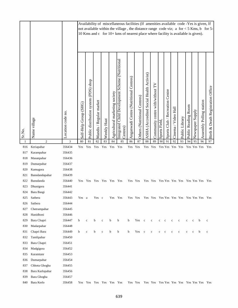
1 2 3
Lo
cati
on
co
de
no
.
Nam
e v
illa
ge
Sr.
No
.
816 Keriapahar 356434
817 Karampahar 356435
818 Masanpahar 356436
819 Dumarpahar 356437
820 Kamugora 356438
821 Bansdandapahar 356439
822 Bansdanda 356440
823 Dhunigora 356441
824 Bara Basgi 356442
825 Satbera 356443
826 Satbera 356444
827 Chetrampahar 356445
828 Hanidhoni 356446
829 Bara Chapri 356447
830 Madarpahar 356448
831 Chapri Bara 356449
832 Tamlipahar 356450
833 Bara Chapri 356451
834 Madgigora 356452
835 Karamtanr 356453
836 Dumarpahar 356454
837 Chhota Ghogha 356455
838 Bara Karlopahar 356456
839 Bara Ghogha 356457
840 Bara Kerlo 356458
Sel
f-H
elp
Gro
up
(S
HG
)
Pu
bli
c d
istr
ibu
tio
n s
yst
em (
PD
S)
sho
p
Man
dis
/ R
egu
lar
mar
ket
Wee
kly
Haa
t
Ag
ricu
ltu
ral
mar
ket
ing
so
ciet
y
Inte
gra
ted
Ch
ild
Dev
elo
pm
ent
Sch
eme
(Nu
trit
ion
al
Cen
tres
)
An
gan
wad
i C
entr
e (N
utr
itio
nal
Cen
tres
)
Oth
ers
(Nu
trit
ion
al C
entr
es)
AS
HA
(A
ccre
dit
ed S
oci
al H
ealt
h A
ctiv
ist)
Co
mm
un
ity
cen
tre
wit
h/w
ith
ou
t T
V
Sp
ort
s F
ield
,
Sp
ort
s C
lub
/ R
ecre
atio
n C
entr
e
Cin
ema
/ V
ideo
Hal
l
Pu
bli
c L
ibra
ry
Pu
bli
c R
ead
ing
Ro
om
New
spap
er S
up
ply
Ass
emb
ly P
oll
ing
sta
tio
n
Bir
th &
Dea
th R
egis
trat
ion
Off
ice
80 81 82 83 84 85 86 87 88 89 90 91 92 93 94 95 96 97
Availability of miscellaneous facilities (If amenities available code -Yes is given, If
not available within the village , the distance range code viz; a for < 5 Kms, b for 5-
10 Kms and c for 10+ kms of nearest place where facility is available is given).
Yes Yes Yes Yes Yes Yes Yes Yes Yes Yes Yes Yes Yes Yes Yes Yes Yes Yes
Yes Yes Yes Yes Yes Yes Yes Yes Yes Yes Yes Yes Yes Yes Yes Yes Yes Yes
Yes a Yes c Yes Yes Yes Yes Yes Yes Yes Yes Yes Yes Yes Yes Yes Yes
b c b c b b b Yes c c c c c c c c b c
b c b c b b b Yes c c c c c c c c b c
Yes Yes Yes Yes Yes Yes Yes Yes Yes Yes Yes Yes Yes Yes Yes Yes Yes Yes
639

1 2 3
Lo
cati
on
co
de
no
.
Nam
e v
illa
ge
Sr.
No
.
841 Pandaripahar 356459
842 Dhobkanji 356460
843 Kerikuria 356461
844 Madgigora 356462
845 Androcharpahar 356463
846 Chuolalpahar 356464
847 Chhota Karlopahar 356465
848 Chhota Kerlo 356466
849 Baragawn 356467
850 Bara Kamu 356468
851 Chenya 356469
852 Dumli 356470
853 Jandi 356471
854 Kamugoda 356472
855 Keto(Keraya) 356473
856 Mada 356474
857 Moremo 356475
858 Pakarbera 356476
Block T O T A L :
859 Manjura 356477
860 Khutahari 356478
861 Darbe Chak 356479
862 Kanak Kita 356480
Sel
f-H
elp
Gro
up
(S
HG
)
Pu
bli
c d
istr
ibu
tio
n s
yst
em (
PD
S)
sho
p
Man
dis
/ R
egu
lar
mar
ket
Wee
kly
Haa
t
Ag
ricu
ltu
ral
mar
ket
ing
so
ciet
y
Inte
gra
ted
Ch
ild
Dev
elo
pm
ent
Sch
eme
(Nu
trit
ion
al
Cen
tres
)
An
gan
wad
i C
entr
e (N
utr
itio
nal
Cen
tres
)
Oth
ers
(Nu
trit
ion
al C
entr
es)
AS
HA
(A
ccre
dit
ed S
oci
al H
ealt
h A
ctiv
ist)
Co
mm
un
ity
cen
tre
wit
h/w
ith
ou
t T
V
Sp
ort
s F
ield
,
Sp
ort
s C
lub
/ R
ecre
atio
n C
entr
e
Cin
ema
/ V
ideo
Hal
l
Pu
bli
c L
ibra
ry
Pu
bli
c R
ead
ing
Ro
om
New
spap
er S
up
ply
Ass
emb
ly P
oll
ing
sta
tio
n
Bir
th &
Dea
th R
egis
trat
ion
Off
ice
80 81 82 83 84 85 86 87 88 89 90 91 92 93 94 95 96 97
Availability of miscellaneous facilities (If amenities available code -Yes is given, If
not available within the village , the distance range code viz; a for < 5 Kms, b for 5-
10 Kms and c for 10+ kms of nearest place where facility is available is given).
b b c c c a a b Yes b b c c c c c b b
Yes Yes Yes Yes Yes Yes Yes Yes Yes Yes Yes Yes Yes Yes Yes Yes Yes Yes
Yes Yes Yes Yes Yes Yes Yes Yes Yes Yes Yes Yes Yes Yes Yes Yes Yes Yes
Yes Yes Yes Yes Yes Yes Yes Yes Yes Yes Yes Yes Yes Yes Yes Yes Yes Yes
87 105 50 76 46 282 282 259 304 54 96 58 48 46 46 79 134 54
b a b b b Yes Yes Yes Yes a b b b b b b a a
a b a b b Yes Yes Yes Yes b b b b b b b b b
b b a b b a a b Yes b b b b b b b a b
b a b b b Yes Yes b Yes b b b c b b b a b
640
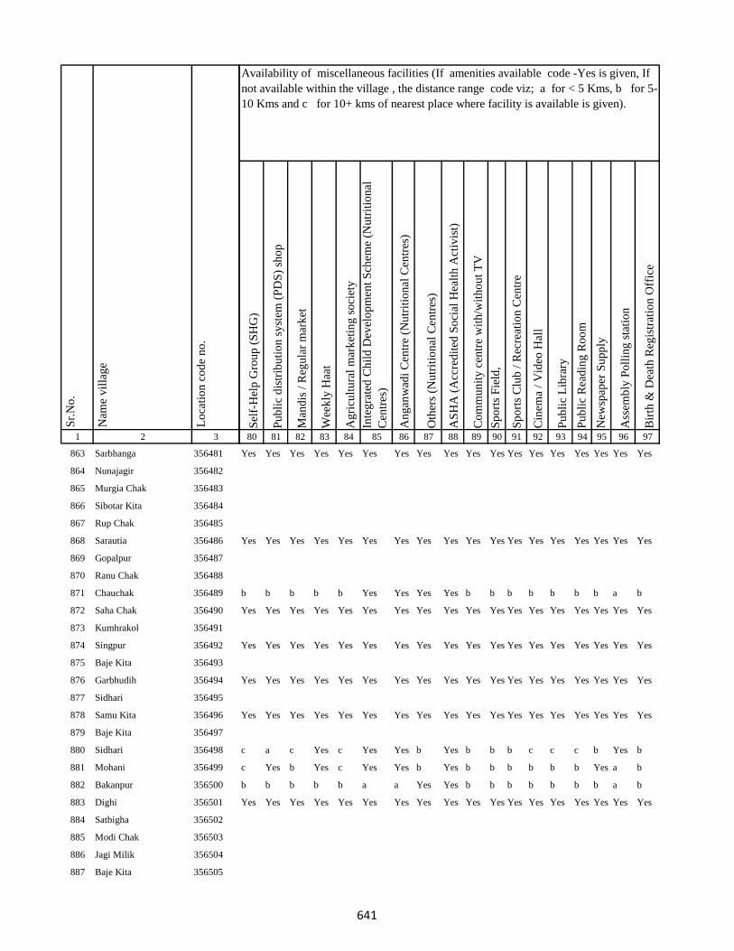
1 2 3
Lo
cati
on
co
de
no
.
Nam
e v
illa
ge
Sr.
No
.
863 Sarbhanga 356481
864 Nunajagir 356482
865 Murgia Chak 356483
866 Sibotar Kita 356484
867 Rup Chak 356485
868 Sarautia 356486
869 Gopalpur 356487
870 Ranu Chak 356488
871 Chauchak 356489
872 Saha Chak 356490
873 Kumhrakol 356491
874 Singpur 356492
875 Baje Kita 356493
876 Garbhudih 356494
877 Sidhari 356495
878 Samu Kita 356496
879 Baje Kita 356497
880 Sidhari 356498
881 Mohani 356499
882 Bakanpur 356500
883 Dighi 356501
884 Satbigha 356502
885 Modi Chak 356503
886 Jagi Milik 356504
887 Baje Kita 356505
Sel
f-H
elp
Gro
up
(S
HG
)
Pu
bli
c d
istr
ibu
tio
n s
yst
em (
PD
S)
sho
p
Man
dis
/ R
egu
lar
mar
ket
Wee
kly
Haa
t
Ag
ricu
ltu
ral
mar
ket
ing
so
ciet
y
Inte
gra
ted
Ch
ild
Dev
elo
pm
ent
Sch
eme
(Nu
trit
ion
al
Cen
tres
)
An
gan
wad
i C
entr
e (N
utr
itio
nal
Cen
tres
)
Oth
ers
(Nu
trit
ion
al C
entr
es)
AS
HA
(A
ccre
dit
ed S
oci
al H
ealt
h A
ctiv
ist)
Co
mm
un
ity
cen
tre
wit
h/w
ith
ou
t T
V
Sp
ort
s F
ield
,
Sp
ort
s C
lub
/ R
ecre
atio
n C
entr
e
Cin
ema
/ V
ideo
Hal
l
Pu
bli
c L
ibra
ry
Pu
bli
c R
ead
ing
Ro
om
New
spap
er S
up
ply
Ass
emb
ly P
oll
ing
sta
tio
n
Bir
th &
Dea
th R
egis
trat
ion
Off
ice
80 81 82 83 84 85 86 87 88 89 90 91 92 93 94 95 96 97
Availability of miscellaneous facilities (If amenities available code -Yes is given, If
not available within the village , the distance range code viz; a for < 5 Kms, b for 5-
10 Kms and c for 10+ kms of nearest place where facility is available is given).
Yes Yes Yes Yes Yes Yes Yes Yes Yes Yes Yes Yes Yes Yes Yes Yes Yes Yes
Yes Yes Yes Yes Yes Yes Yes Yes Yes Yes Yes Yes Yes Yes Yes Yes Yes Yes
b b b b b Yes Yes Yes Yes b b b b b b b a b
Yes Yes Yes Yes Yes Yes Yes Yes Yes Yes Yes Yes Yes Yes Yes Yes Yes Yes
Yes Yes Yes Yes Yes Yes Yes Yes Yes Yes Yes Yes Yes Yes Yes Yes Yes Yes
Yes Yes Yes Yes Yes Yes Yes Yes Yes Yes Yes Yes Yes Yes Yes Yes Yes Yes
Yes Yes Yes Yes Yes Yes Yes Yes Yes Yes Yes Yes Yes Yes Yes Yes Yes Yes
c a c Yes c Yes Yes b Yes b b b c c c b Yes b
c Yes b Yes c Yes Yes b Yes b b b b b b Yes a b
b b b b b a a Yes Yes b b b b b b b a b
Yes Yes Yes Yes Yes Yes Yes Yes Yes Yes Yes Yes Yes Yes Yes Yes Yes Yes
641
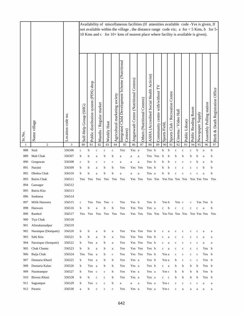
1 2 3
Lo
cati
on
co
de
no
.
Nam
e v
illa
ge
Sr.
No
.
888 Sital 356506
889 Mali Chak 356507
890 Gorgawan 356508
891 Naraini 356509
892 Dhobia Chak 356510
893 Bairia Chak 356511
894 Gansagar 356512
895 Bairia Kita 356513
896 Sonbarsa 356514
897 Milik Hanwara 356515
898 Hanwara 356516
899 Ramkol 356517
900 Tiya Chak 356518
901 Alimahamadpur 356519
902 Narainpur (Dompatti) 356520
903 Sahi Kita 356521
904 Narainpur (Sempatti) 356522
905 Chak Chamu 356523
906 Baija Chak 356524
907 Dumaria Khurd 356525
908 Dumaria Kalan 356526
909 Narattampur 356527
910 Biswas Khani 356528
911 Sagrampur 356529
912 Pararia 356530
Sel
f-H
elp
Gro
up
(S
HG
)
Pu
bli
c d
istr
ibu
tio
n s
yst
em (
PD
S)
sho
p
Man
dis
/ R
egu
lar
mar
ket
Wee
kly
Haa
t
Ag
ricu
ltu
ral
mar
ket
ing
so
ciet
y
Inte
gra
ted
Ch
ild
Dev
elo
pm
ent
Sch
eme
(Nu
trit
ion
al
Cen
tres
)
An
gan
wad
i C
entr
e (N
utr
itio
nal
Cen
tres
)
Oth
ers
(Nu
trit
ion
al C
entr
es)
AS
HA
(A
ccre
dit
ed S
oci
al H
ealt
h A
ctiv
ist)
Co
mm
un
ity
cen
tre
wit
h/w
ith
ou
t T
V
Sp
ort
s F
ield
,
Sp
ort
s C
lub
/ R
ecre
atio
n C
entr
e
Cin
ema
/ V
ideo
Hal
l
Pu
bli
c L
ibra
ry
Pu
bli
c R
ead
ing
Ro
om
New
spap
er S
up
ply
Ass
emb
ly P
oll
ing
sta
tio
n
Bir
th &
Dea
th R
egis
trat
ion
Off
ice
80 81 82 83 84 85 86 87 88 89 90 91 92 93 94 95 96 97
Availability of miscellaneous facilities (If amenities available code -Yes is given, If
not available within the village , the distance range code viz; a for < 5 Kms, b for 5-
10 Kms and c for 10+ kms of nearest place where facility is available is given).
c b c c c Yes Yes a Yes b b b c c c b a b
b b a b b a a a Yes Yes b b b b b b a b
c b c c c a a a Yes b b b c c c b a b
b b a b b Yes Yes Yes Yes b b b c c c c b b
b b a b b a a a Yes a b b c c c c a b
Yes Yes Yes Yes Yes Yes Yes Yes Yes Yes Yes Yes Yes Yes Yes Yes Yes Yes
c Yes Yes Yes c Yes Yes b Yes b Yes b Yes c c Yes Yes b
b b a b b Yes Yes Yes Yes a c b c c c c a b
Yes Yes Yes Yes Yes Yes Yes Yes Yes Yes Yes Yes Yes Yes Yes Yes Yes Yes
b b a b a Yes Yes Yes Yes b c a c c c c a a
b b a b a Yes Yes Yes Yes b c a c c c c a a
b Yes a b a Yes Yes Yes Yes b c a c c c c a a
b b a b a Yes Yes Yes Yes b c a c c c c Yes b
Yes Yes a b c Yes Yes Yes Yes b Yes a c c c c Yes b
b Yes a b b Yes Yes a Yes b Yes a b c c c Yes b
b Yes a b b Yes Yes a Yes b c a b b b b Yes b
b Yes c c b Yes Yes a Yes a Yes c b b b b Yes b
b b c c b Yes Yes a Yes a c c b b b b Yes b
b Yes c c b a a a Yes a Yes c c c c c a a
a b c c c Yes Yes a Yes a Yes c c a a a a a
642

1 2 3
Lo
cati
on
co
de
no
.
Nam
e v
illa
ge
Sr.
No
.
913 Parsa 356531
914 Bikrampur 356532
915 Koila 356533
916 Barkurua 356534
917 Barkurua 356535
918 Bataua Kita 356536
919 Batana Kita 356537
920 Batana Kita 356538
921 Sarthu 356539
922 Baghakol 356540
923 Gurhi 356541
924 Baje Kita 356542
925 Baje Kita 356543
926 Bairia Kita 356544
927 Kharaiya 356545
928 Sahajadpur 356546
929 Ghatiani 356547
930 Ghuthi 356548
931 Khurd 356549
932 Banjpur 356550
933 Teknikita 356551
934 Sirinathpur 356552
935 Nayanagar 356553
936 Singarpur 356554
937 Jatama 356555
Sel
f-H
elp
Gro
up
(S
HG
)
Pu
bli
c d
istr
ibu
tio
n s
yst
em (
PD
S)
sho
p
Man
dis
/ R
egu
lar
mar
ket
Wee
kly
Haa
t
Ag
ricu
ltu
ral
mar
ket
ing
so
ciet
y
Inte
gra
ted
Ch
ild
Dev
elo
pm
ent
Sch
eme
(Nu
trit
ion
al
Cen
tres
)
An
gan
wad
i C
entr
e (N
utr
itio
nal
Cen
tres
)
Oth
ers
(Nu
trit
ion
al C
entr
es)
AS
HA
(A
ccre
dit
ed S
oci
al H
ealt
h A
ctiv
ist)
Co
mm
un
ity
cen
tre
wit
h/w
ith
ou
t T
V
Sp
ort
s F
ield
,
Sp
ort
s C
lub
/ R
ecre
atio
n C
entr
e
Cin
ema
/ V
ideo
Hal
l
Pu
bli
c L
ibra
ry
Pu
bli
c R
ead
ing
Ro
om
New
spap
er S
up
ply
Ass
emb
ly P
oll
ing
sta
tio
n
Bir
th &
Dea
th R
egis
trat
ion
Off
ice
80 81 82 83 84 85 86 87 88 89 90 91 92 93 94 95 96 97
Availability of miscellaneous facilities (If amenities available code -Yes is given, If
not available within the village , the distance range code viz; a for < 5 Kms, b for 5-
10 Kms and c for 10+ kms of nearest place where facility is available is given).
a Yes c c Yes Yes Yes a Yes a c c c b b b Yes a
a Yes c c c Yes Yes a Yes a c c c b b b Yes a
Yes Yes Yes Yes Yes Yes Yes Yes Yes Yes Yes Yes Yes Yes Yes Yes Yes Yes
Yes Yes Yes Yes Yes Yes Yes Yes Yes Yes Yes Yes Yes Yes Yes Yes Yes Yes
b b c c c a a a Yes b c a c b b b a b
b b c c c Yes Yes Yes Yes c c c c b b b a b
b b c c c a a a Yes c c c c b b b a a
Yes a c c c Yes Yes Yes Yes c c c c c c Yes Yes a
Yes a c a c Yes Yes b Yes c c c c c c c Yes a
Yes a c c c Yes Yes Yes Yes c b c c c c c Yes a
Yes a c a c Yes Yes a Yes a a c c c c Yes Yes b
b b c Yes Yes Yes Yes Yes Yes a Yes c c c c Yes Yes b
Yes Yes b Yes b Yes Yes b Yes b b b b b b Yes Yes b
Yes Yes Yes Yes Yes Yes Yes Yes Yes Yes Yes Yes Yes Yes Yes Yes Yes Yes
Yes Yes c Yes Yes Yes Yes a Yes b b Yes c c c b Yes Yes
c b c c a Yes Yes Yes Yes b b b c c c c a b
c b c c a Yes Yes Yes Yes b b b c c c Yes Yes Yes
b b c c a Yes Yes a Yes b b b c c c c a b
643
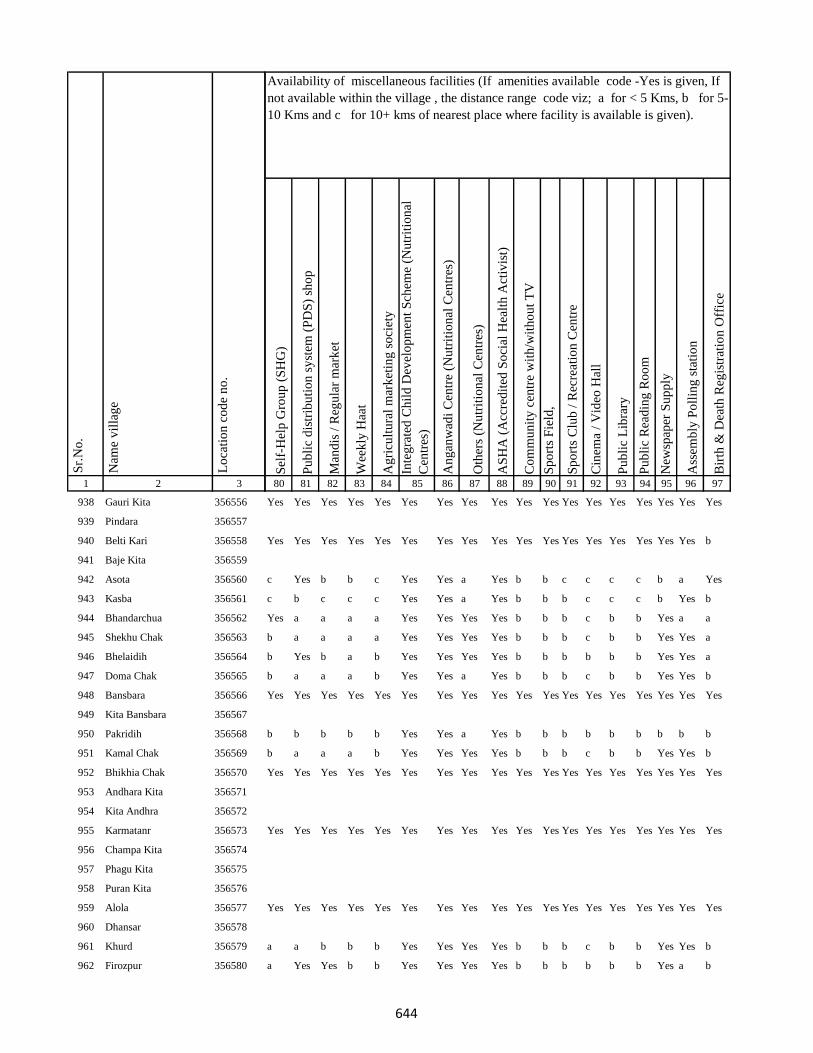
1 2 3
Lo
cati
on
co
de
no
.
Nam
e v
illa
ge
Sr.
No
.
938 Gauri Kita 356556
939 Pindara 356557
940 Belti Kari 356558
941 Baje Kita 356559
942 Asota 356560
943 Kasba 356561
944 Bhandarchua 356562
945 Shekhu Chak 356563
946 Bhelaidih 356564
947 Doma Chak 356565
948 Bansbara 356566
949 Kita Bansbara 356567
950 Pakridih 356568
951 Kamal Chak 356569
952 Bhikhia Chak 356570
953 Andhara Kita 356571
954 Kita Andhra 356572
955 Karmatanr 356573
956 Champa Kita 356574
957 Phagu Kita 356575
958 Puran Kita 356576
959 Alola 356577
960 Dhansar 356578
961 Khurd 356579
962 Firozpur 356580
Sel
f-H
elp
Gro
up
(S
HG
)
Pu
bli
c d
istr
ibu
tio
n s
yst
em (
PD
S)
sho
p
Man
dis
/ R
egu
lar
mar
ket
Wee
kly
Haa
t
Ag
ricu
ltu
ral
mar
ket
ing
so
ciet
y
Inte
gra
ted
Ch
ild
Dev
elo
pm
ent
Sch
eme
(Nu
trit
ion
al
Cen
tres
)
An
gan
wad
i C
entr
e (N
utr
itio
nal
Cen
tres
)
Oth
ers
(Nu
trit
ion
al C
entr
es)
AS
HA
(A
ccre
dit
ed S
oci
al H
ealt
h A
ctiv
ist)
Co
mm
un
ity
cen
tre
wit
h/w
ith
ou
t T
V
Sp
ort
s F
ield
,
Sp
ort
s C
lub
/ R
ecre
atio
n C
entr
e
Cin
ema
/ V
ideo
Hal
l
Pu
bli
c L
ibra
ry
Pu
bli
c R
ead
ing
Ro
om
New
spap
er S
up
ply
Ass
emb
ly P
oll
ing
sta
tio
n
Bir
th &
Dea
th R
egis
trat
ion
Off
ice
80 81 82 83 84 85 86 87 88 89 90 91 92 93 94 95 96 97
Availability of miscellaneous facilities (If amenities available code -Yes is given, If
not available within the village , the distance range code viz; a for < 5 Kms, b for 5-
10 Kms and c for 10+ kms of nearest place where facility is available is given).
Yes Yes Yes Yes Yes Yes Yes Yes Yes Yes Yes Yes Yes Yes Yes Yes Yes Yes
Yes Yes Yes Yes Yes Yes Yes Yes Yes Yes Yes Yes Yes Yes Yes Yes Yes b
c Yes b b c Yes Yes a Yes b b c c c c b a Yes
c b c c c Yes Yes a Yes b b b c c c b Yes b
Yes a a a a Yes Yes Yes Yes b b b c b b Yes a a
b a a a a Yes Yes Yes Yes b b b c b b Yes Yes a
b Yes b a b Yes Yes Yes Yes b b b b b b Yes Yes a
b a a a b Yes Yes a Yes b b b c b b Yes Yes b
Yes Yes Yes Yes Yes Yes Yes Yes Yes Yes Yes Yes Yes Yes Yes Yes Yes Yes
b b b b b Yes Yes a Yes b b b b b b b b b
b a a a b Yes Yes Yes Yes b b b c b b Yes Yes b
Yes Yes Yes Yes Yes Yes Yes Yes Yes Yes Yes Yes Yes Yes Yes Yes Yes Yes
Yes Yes Yes Yes Yes Yes Yes Yes Yes Yes Yes Yes Yes Yes Yes Yes Yes Yes
Yes Yes Yes Yes Yes Yes Yes Yes Yes Yes Yes Yes Yes Yes Yes Yes Yes Yes
a a b b b Yes Yes Yes Yes b b b c b b Yes Yes b
a Yes Yes b b Yes Yes Yes Yes b b b b b b Yes a b
644

1 2 3
Lo
cati
on
co
de
no
.
Nam
e v
illa
ge
Sr.
No
.
963 Dharampur Ghat 356581
964 Dharampur Mal 356582
965 Chaujora Mal 356583
966 Chaujora Ghat 356584
967 Kamargawan 356585
968 Mansura 356586
969 Sadulabhita 356587
970 Gosain Chak 356588
971 Madhupur 356589
972 Gokula 356590
973 Majhona 356591
974 Daniala 356592
975 Khaira 356593
976 Fouzdar Kita Ghat 356594
977 Ghatdiarhi 356595
978 Diarhi Kita 356596
979 Manoharpur Kita 356597
980 Manoharpur 356598
981 Solahbighia 356599
982 Jhagarua 356600
983 Ramchandarpur 356601
984 Maigar Kita 356602
985 Kita Majhona 356603
986 Khara Kita 356604
987 Chainpur 356605
Sel
f-H
elp
Gro
up
(S
HG
)
Pu
bli
c d
istr
ibu
tio
n s
yst
em (
PD
S)
sho
p
Man
dis
/ R
egu
lar
mar
ket
Wee
kly
Haa
t
Ag
ricu
ltu
ral
mar
ket
ing
so
ciet
y
Inte
gra
ted
Ch
ild
Dev
elo
pm
ent
Sch
eme
(Nu
trit
ion
al
Cen
tres
)
An
gan
wad
i C
entr
e (N
utr
itio
nal
Cen
tres
)
Oth
ers
(Nu
trit
ion
al C
entr
es)
AS
HA
(A
ccre
dit
ed S
oci
al H
ealt
h A
ctiv
ist)
Co
mm
un
ity
cen
tre
wit
h/w
ith
ou
t T
V
Sp
ort
s F
ield
,
Sp
ort
s C
lub
/ R
ecre
atio
n C
entr
e
Cin
ema
/ V
ideo
Hal
l
Pu
bli
c L
ibra
ry
Pu
bli
c R
ead
ing
Ro
om
New
spap
er S
up
ply
Ass
emb
ly P
oll
ing
sta
tio
n
Bir
th &
Dea
th R
egis
trat
ion
Off
ice
80 81 82 83 84 85 86 87 88 89 90 91 92 93 94 95 96 97
Availability of miscellaneous facilities (If amenities available code -Yes is given, If
not available within the village , the distance range code viz; a for < 5 Kms, b for 5-
10 Kms and c for 10+ kms of nearest place where facility is available is given).
a a b b b Yes Yes Yes Yes b b b b b b b a b
a b b b b a a a Yes b b b b b b b a b
Yes Yes Yes Yes Yes Yes Yes Yes Yes Yes Yes Yes Yes Yes Yes Yes Yes Yes
Yes b b b c a a a Yes b b c b b b b Yes a
Yes Yes Yes Yes Yes Yes Yes Yes Yes Yes Yes Yes Yes Yes Yes Yes Yes Yes
b a b b b b b Yes b b b b c b b b b b
a a b b b Yes Yes a Yes b b b c b b b a a
a Yes b b b Yes Yes Yes Yes b b b c b b b a b
a a b b b Yes Yes Yes Yes b b b c b b b a b
b Yes b b b Yes Yes Yes Yes b b b b b b b Yes a
Yes Yes Yes Yes Yes Yes Yes Yes Yes Yes Yes Yes Yes Yes Yes Yes Yes Yes
Yes Yes Yes Yes Yes Yes Yes Yes Yes Yes Yes Yes Yes Yes Yes Yes Yes Yes
Yes Yes Yes Yes Yes Yes Yes Yes Yes Yes Yes Yes Yes Yes Yes Yes Yes Yes
Yes Yes Yes Yes Yes Yes Yes Yes Yes Yes Yes Yes Yes Yes Yes Yes Yes Yes
645
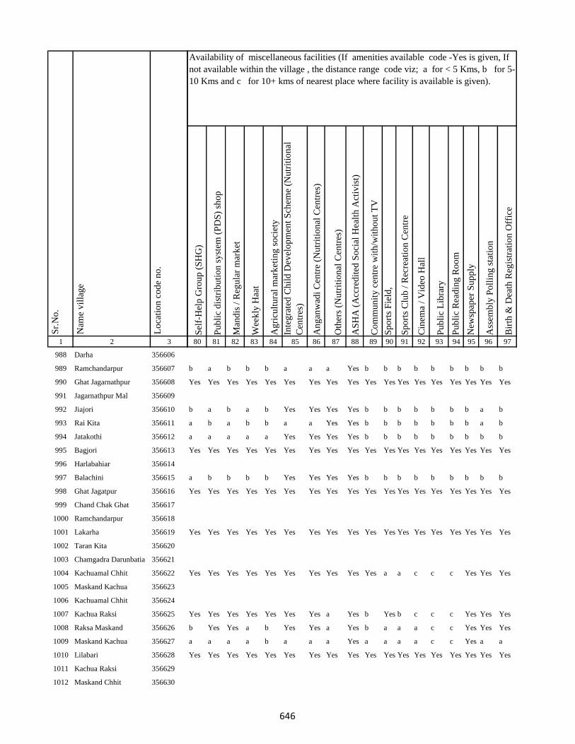
1 2 3
Lo
cati
on
co
de
no
.
Nam
e v
illa
ge
Sr.
No
.
988 Darha 356606
989 Ramchandarpur 356607
990 Ghat Jagarnathpur 356608
991 Jagarnathpur Mal 356609
992 Jiajori 356610
993 Rai Kita 356611
994 Jatakothi 356612
995 Bagjori 356613
996 Harlabahiar 356614
997 Balachini 356615
998 Ghat Jagatpur 356616
999 Chand Chak Ghat 356617
1000 Ramchandarpur 356618
1001 Lakarha 356619
1002 Taran Kita 356620
1003 Chamgadra Darunbatia 356621
1004 Kachuamal Chhit 356622
1005 Maskand Kachua 356623
1006 Kachuamal Chhit 356624
1007 Kachua Raksi 356625
1008 Raksa Maskand 356626
1009 Maskand Kachua 356627
1010 Lilabari 356628
1011 Kachua Raksi 356629
1012 Maskand Chhit 356630
Sel
f-H
elp
Gro
up
(S
HG
)
Pu
bli
c d
istr
ibu
tio
n s
yst
em (
PD
S)
sho
p
Man
dis
/ R
egu
lar
mar
ket
Wee
kly
Haa
t
Ag
ricu
ltu
ral
mar
ket
ing
so
ciet
y
Inte
gra
ted
Ch
ild
Dev
elo
pm
ent
Sch
eme
(Nu
trit
ion
al
Cen
tres
)
An
gan
wad
i C
entr
e (N
utr
itio
nal
Cen
tres
)
Oth
ers
(Nu
trit
ion
al C
entr
es)
AS
HA
(A
ccre
dit
ed S
oci
al H
ealt
h A
ctiv
ist)
Co
mm
un
ity
cen
tre
wit
h/w
ith
ou
t T
V
Sp
ort
s F
ield
,
Sp
ort
s C
lub
/ R
ecre
atio
n C
entr
e
Cin
ema
/ V
ideo
Hal
l
Pu
bli
c L
ibra
ry
Pu
bli
c R
ead
ing
Ro
om
New
spap
er S
up
ply
Ass
emb
ly P
oll
ing
sta
tio
n
Bir
th &
Dea
th R
egis
trat
ion
Off
ice
80 81 82 83 84 85 86 87 88 89 90 91 92 93 94 95 96 97
Availability of miscellaneous facilities (If amenities available code -Yes is given, If
not available within the village , the distance range code viz; a for < 5 Kms, b for 5-
10 Kms and c for 10+ kms of nearest place where facility is available is given).
b a b b b a a a Yes b b b b b b b b b
Yes Yes Yes Yes Yes Yes Yes Yes Yes Yes Yes Yes Yes Yes Yes Yes Yes Yes
b a b a b Yes Yes Yes Yes b b b b b b b a b
a b a b b a a Yes Yes b b b b b b b a b
a a a a a Yes Yes Yes Yes b b b b b b b b b
Yes Yes Yes Yes Yes Yes Yes Yes Yes Yes Yes Yes Yes Yes Yes Yes Yes Yes
a b b b b Yes Yes Yes Yes b b b b b b b b b
Yes Yes Yes Yes Yes Yes Yes Yes Yes Yes Yes Yes Yes Yes Yes Yes Yes Yes
Yes Yes Yes Yes Yes Yes Yes Yes Yes Yes Yes Yes Yes Yes Yes Yes Yes Yes
Yes Yes Yes Yes Yes Yes Yes Yes Yes Yes a a c c c Yes Yes Yes
Yes Yes Yes Yes Yes Yes Yes a Yes b Yes b c c c Yes Yes Yes
b Yes Yes a b Yes Yes a Yes b a a a c c Yes Yes Yes
a a a a b a a a Yes a a a a c c Yes a a
Yes Yes Yes Yes Yes Yes Yes Yes Yes Yes Yes Yes Yes Yes Yes Yes Yes Yes
646
1 2 3
Lo
cati
on
co
de
no
.
Nam
e v
illa
ge
Sr.
No
.
1013 Maskand Kita 356631
1014 Sirsa Kalan 356632
1015 Sirsa Khurd 356633
1016 Bholu Chak 356634
1017 Mahuara Ghat 356635
1018 Mahuara 356636
1019 Fauj Kita 356637
1020 Logain 356638
1021 Asmantikar 356639
1022 Maskand Bhanjpur 356640
1023 Gidra Pathar 356641
1024 Lamahaghat 356642
1025 Hirai Chak 356643
1026 Sukhbona 356644
1027 Sankar Kita 356645
1028 Rahim Kita 356646
1029 Hajra Chak 356647
1030 Lachmania Kita 356648
1031 Lilambar 356649
1032 Maskand Chhit 356650
1033 Bishambhar Kita 356651
1034 Kita Bishambhara 356652
1035 Gunia 356653
1036 Harin Chora 356654
1037 Baghakol 356655
Sel
f-H
elp
Gro
up
(S
HG
)
Pu
bli
c d
istr
ibu
tio
n s
yst
em (
PD
S)
sho
p
Man
dis
/ R
egu
lar
mar
ket
Wee
kly
Haa
t
Ag
ricu
ltu
ral
mar
ket
ing
so
ciet
y
Inte
gra
ted
Ch
ild
Dev
elo
pm
ent
Sch
eme
(Nu
trit
ion
al
Cen
tres
)
An
gan
wad
i C
entr
e (N
utr
itio
nal
Cen
tres
)
Oth
ers
(Nu
trit
ion
al C
entr
es)
AS
HA
(A
ccre
dit
ed S
oci
al H
ealt
h A
ctiv
ist)
Co
mm
un
ity
cen
tre
wit
h/w
ith
ou
t T
V
Sp
ort
s F
ield
,
Sp
ort
s C
lub
/ R
ecre
atio
n C
entr
e
Cin
ema
/ V
ideo
Hal
l
Pu
bli
c L
ibra
ry
Pu
bli
c R
ead
ing
Ro
om
New
spap
er S
up
ply
Ass
emb
ly P
oll
ing
sta
tio
n
Bir
th &
Dea
th R
egis
trat
ion
Off
ice
80 81 82 83 84 85 86 87 88 89 90 91 92 93 94 95 96 97
Availability of miscellaneous facilities (If amenities available code -Yes is given, If
not available within the village , the distance range code viz; a for < 5 Kms, b for 5-
10 Kms and c for 10+ kms of nearest place where facility is available is given).
Yes Yes Yes Yes Yes Yes Yes Yes Yes Yes Yes Yes Yes Yes Yes Yes Yes Yes
a Yes a a a Yes Yes Yes Yes Yes Yes a a a a a Yes Yes
Yes Yes Yes Yes Yes Yes Yes Yes Yes Yes Yes Yes Yes Yes Yes Yes Yes Yes
Yes Yes Yes Yes Yes Yes Yes Yes Yes Yes Yes Yes Yes Yes Yes Yes Yes Yes
Yes Yes Yes Yes Yes Yes Yes Yes Yes Yes Yes Yes Yes Yes Yes Yes Yes Yes
Yes Yes Yes Yes Yes Yes Yes Yes Yes Yes Yes Yes Yes Yes Yes Yes Yes Yes
Yes Yes Yes Yes Yes Yes Yes Yes Yes Yes Yes Yes Yes Yes Yes Yes Yes Yes
c a b b a Yes Yes Yes Yes a a a c b b a a a
a a a a a Yes Yes Yes Yes a a a a c c a a a
a Yes a a a Yes Yes Yes Yes a a a a a a a a Yes
a a a b a Yes Yes Yes Yes a a a a a a a a b
a Yes a a a Yes Yes Yes Yes Yes a a a a a a Yes Yes
647

1 2 3
Lo
cati
on
co
de
no
.
Nam
e v
illa
ge
Sr.
No
.
1038 Dakaita 356656
1039 Dakaitaghat 356657
1040 Tetaria 356658
1041 Bhalu Kita 356659
1042 Tewarijor 356660
1043 Beltikri 356661
1044 Jhapania 356662
1045 Khairaghat 356663
1046 Lamha Mal 356664
1047 Chand Chak 356665
1048 Ghospur 356666
1049 Dahara 356667
1050 Moti Chak 356668
1051 Bhartha Chak 356669
1052 Bhairo Kita 356670
1053 Lachminia Kita 356671
1054 Anjna 356672
1055 Barhe Kita 356673
1056 Sirsi 356674
1057 Bhairo Chak 356675
1058 Kusmara 356676
1059 Lachminia Kita 356677
1060 Bishunpur 356678
1061 Baradbara 356679
1062 Sundar Chak 356680
Sel
f-H
elp
Gro
up
(S
HG
)
Pu
bli
c d
istr
ibu
tio
n s
yst
em (
PD
S)
sho
p
Man
dis
/ R
egu
lar
mar
ket
Wee
kly
Haa
t
Ag
ricu
ltu
ral
mar
ket
ing
so
ciet
y
Inte
gra
ted
Ch
ild
Dev
elo
pm
ent
Sch
eme
(Nu
trit
ion
al
Cen
tres
)
An
gan
wad
i C
entr
e (N
utr
itio
nal
Cen
tres
)
Oth
ers
(Nu
trit
ion
al C
entr
es)
AS
HA
(A
ccre
dit
ed S
oci
al H
ealt
h A
ctiv
ist)
Co
mm
un
ity
cen
tre
wit
h/w
ith
ou
t T
V
Sp
ort
s F
ield
,
Sp
ort
s C
lub
/ R
ecre
atio
n C
entr
e
Cin
ema
/ V
ideo
Hal
l
Pu
bli
c L
ibra
ry
Pu
bli
c R
ead
ing
Ro
om
New
spap
er S
up
ply
Ass
emb
ly P
oll
ing
sta
tio
n
Bir
th &
Dea
th R
egis
trat
ion
Off
ice
80 81 82 83 84 85 86 87 88 89 90 91 92 93 94 95 96 97
Availability of miscellaneous facilities (If amenities available code -Yes is given, If
not available within the village , the distance range code viz; a for < 5 Kms, b for 5-
10 Kms and c for 10+ kms of nearest place where facility is available is given).
Yes Yes Yes Yes Yes Yes Yes Yes Yes Yes Yes Yes Yes Yes Yes Yes Yes Yes
a a a a a Yes Yes Yes Yes Yes a a a a a a Yes Yes
a a b b b Yes Yes Yes Yes Yes Yes b b b b Yes Yes Yes
Yes Yes Yes Yes Yes Yes Yes Yes Yes Yes Yes Yes Yes Yes Yes Yes Yes Yes
Yes Yes b Yes b Yes Yes b Yes b b b b b b b a b
Yes Yes Yes Yes Yes Yes Yes Yes Yes Yes Yes Yes Yes Yes Yes Yes Yes Yes
b b a c c Yes Yes Yes Yes c c c c c c c a a
Yes a c c c Yes Yes Yes Yes c c c c c c Yes Yes b
Yes Yes Yes Yes Yes Yes Yes Yes Yes Yes Yes Yes Yes Yes Yes Yes Yes Yes
Yes Yes Yes Yes Yes Yes Yes Yes Yes Yes Yes Yes Yes Yes Yes Yes Yes Yes
b a c c c Yes Yes Yes Yes b c c c c c c a b
b a c Yes c a a Yes Yes b c c c c c c a b
Yes Yes Yes Yes Yes Yes Yes Yes Yes Yes Yes Yes Yes Yes Yes Yes Yes Yes
a a c c c Yes Yes b Yes b c c c c c b Yes b
a a c c c Yes Yes Yes Yes b c c c c c b a b
a a c c c Yes Yes Yes Yes b c c c c c b Yes Yes
648

1 2 3
Lo
cati
on
co
de
no
.
Nam
e v
illa
ge
Sr.
No
.
1063 Bhaju Chak 356681
1064 Malia Chak 356682
1065 Afzal Kita 356683
1066 Mariha 356684
1067 Kushapur 356685
1068 Fazil Kita 356686
1069 Dumra 356687
1070 Bisambhara Kita 356688
1071 Dahia 356689
1072 Kaljhara 356690
1073 Phudkipur 356691
1074 Simratola 356692
1075 Hundra 356693
1076 Phudkipur 356694
1077 Shahpur Beldiha 356695
1078 Phasiatikar 356696
1079 Sirsa 356697
1080 Samhari 356698
1081 Asanand Kita 356699
1082 Muradpur 356700
1083 Subarai Samhra 356701
1084 Semra Kita 356702
1085 Mirza Chak 356703
1086 Hasan Karharia 356704
1087 Manian Karharia 356705
Sel
f-H
elp
Gro
up
(S
HG
)
Pu
bli
c d
istr
ibu
tio
n s
yst
em (
PD
S)
sho
p
Man
dis
/ R
egu
lar
mar
ket
Wee
kly
Haa
t
Ag
ricu
ltu
ral
mar
ket
ing
so
ciet
y
Inte
gra
ted
Ch
ild
Dev
elo
pm
ent
Sch
eme
(Nu
trit
ion
al
Cen
tres
)
An
gan
wad
i C
entr
e (N
utr
itio
nal
Cen
tres
)
Oth
ers
(Nu
trit
ion
al C
entr
es)
AS
HA
(A
ccre
dit
ed S
oci
al H
ealt
h A
ctiv
ist)
Co
mm
un
ity
cen
tre
wit
h/w
ith
ou
t T
V
Sp
ort
s F
ield
,
Sp
ort
s C
lub
/ R
ecre
atio
n C
entr
e
Cin
ema
/ V
ideo
Hal
l
Pu
bli
c L
ibra
ry
Pu
bli
c R
ead
ing
Ro
om
New
spap
er S
up
ply
Ass
emb
ly P
oll
ing
sta
tio
n
Bir
th &
Dea
th R
egis
trat
ion
Off
ice
80 81 82 83 84 85 86 87 88 89 90 91 92 93 94 95 96 97
Availability of miscellaneous facilities (If amenities available code -Yes is given, If
not available within the village , the distance range code viz; a for < 5 Kms, b for 5-
10 Kms and c for 10+ kms of nearest place where facility is available is given).
a Yes c Yes c a a Yes Yes b c c c c c b Yes Yes
Yes Yes Yes Yes Yes Yes Yes Yes Yes Yes Yes Yes Yes Yes Yes Yes Yes Yes
Yes Yes Yes Yes Yes Yes Yes Yes Yes Yes Yes Yes Yes Yes Yes Yes Yes Yes
Yes b c a c Yes Yes Yes Yes c c c c c c c a a
Yes a c a c Yes Yes b Yes c c c c c c c a a
Yes Yes c a c Yes Yes b Yes c c c c c c c a a
c Yes c b c Yes Yes Yes Yes b Yes c c c c Yes Yes Yes
c Yes c b c Yes Yes Yes Yes b Yes c c c c Yes Yes Yes
Yes Yes Yes Yes Yes Yes Yes Yes Yes Yes Yes Yes Yes Yes Yes Yes Yes Yes
Yes Yes Yes Yes Yes Yes Yes Yes Yes Yes Yes Yes Yes Yes Yes Yes Yes Yes
c Yes c c c a a Yes Yes b c c c c c c a b
c Yes c b c Yes Yes Yes Yes b Yes c c c c Yes Yes Yes
c Yes c b c a a Yes Yes b Yes c c c c Yes Yes Yes
Yes Yes Yes Yes Yes Yes Yes Yes Yes Yes Yes Yes Yes Yes Yes Yes Yes Yes
Yes Yes Yes Yes Yes Yes Yes Yes Yes Yes Yes Yes Yes Yes Yes Yes Yes Yes
b b b b b Yes Yes Yes Yes a c a a a a Yes Yes b
Yes Yes c a c Yes Yes b Yes c c c c c c c a b
Yes a c a c Yes Yes b Yes c c c c c c c a a
Yes b c a c Yes Yes Yes Yes c c c c c c c a a
649

1 2 3
Lo
cati
on
co
de
no
.
Nam
e v
illa
ge
Sr.
No
.
1088 Jathari 356706
1089 Hari Karharia 356707
1090 Kanreswari Kita 356708
1091 Hasanpur 356709
1092 Bakwa Chak 356710
1093 Bela Kita 356711
1094 Janki Kita 356712
1095 Mal Bhandari Dih 356713
1096 Semrakita And Ghat Bhandarid356714
1097 Aslulahsamra 356715
1098 Bariartola 356716
1099 Maganpipra 356717
1100 Ranbahiar 356718
1101 Jamua 356719
1102 Chuna Chak 356720
1103 Ginratari 356721
1104 Sakal Chak 356722
1105 Larai Chak 356723
1106 Gohira Kita 356724
1107 Hemcha Chak 356725
1108 Asanbani 356726
1109 Jhigur Kita 356727
1110 Mal Bhandaridih 356728
1111 Semarkita Ghat Bhandaridih356729
1112 Nimgachhi And Kita 356730
Sel
f-H
elp
Gro
up
(S
HG
)
Pu
bli
c d
istr
ibu
tio
n s
yst
em (
PD
S)
sho
p
Man
dis
/ R
egu
lar
mar
ket
Wee
kly
Haa
t
Ag
ricu
ltu
ral
mar
ket
ing
so
ciet
y
Inte
gra
ted
Ch
ild
Dev
elo
pm
ent
Sch
eme
(Nu
trit
ion
al
Cen
tres
)
An
gan
wad
i C
entr
e (N
utr
itio
nal
Cen
tres
)
Oth
ers
(Nu
trit
ion
al C
entr
es)
AS
HA
(A
ccre
dit
ed S
oci
al H
ealt
h A
ctiv
ist)
Co
mm
un
ity
cen
tre
wit
h/w
ith
ou
t T
V
Sp
ort
s F
ield
,
Sp
ort
s C
lub
/ R
ecre
atio
n C
entr
e
Cin
ema
/ V
ideo
Hal
l
Pu
bli
c L
ibra
ry
Pu
bli
c R
ead
ing
Ro
om
New
spap
er S
up
ply
Ass
emb
ly P
oll
ing
sta
tio
n
Bir
th &
Dea
th R
egis
trat
ion
Off
ice
80 81 82 83 84 85 86 87 88 89 90 91 92 93 94 95 96 97
Availability of miscellaneous facilities (If amenities available code -Yes is given, If
not available within the village , the distance range code viz; a for < 5 Kms, b for 5-
10 Kms and c for 10+ kms of nearest place where facility is available is given).
Yes a c a c Yes Yes b Yes c c c c c c c a a
Yes Yes Yes Yes Yes Yes Yes Yes Yes Yes Yes Yes Yes Yes Yes Yes Yes Yes
b b b a b Yes Yes Yes Yes b b b b b b Yes a b
c Yes c Yes c a a Yes Yes c c c c c c c a c
b b b b b Yes Yes Yes Yes b b b b b b Yes Yes b
c a c c c Yes Yes Yes Yes c c c c c c c a b
b b b b b Yes Yes Yes Yes b b b b b b Yes Yes b
b b b b b Yes Yes Yes Yes b b b b b b Yes a b
b Yes b b b Yes Yes Yes Yes b b b b b b Yes Yes b
b b b b b Yes Yes Yes Yes b b b b b b Yes a b
Yes Yes Yes Yes Yes Yes Yes Yes Yes Yes Yes Yes Yes Yes Yes Yes Yes Yes
b Yes b b b Yes Yes Yes Yes c c c c c c c Yes Yes
c b c c c Yes Yes Yes Yes c c c c c c c Yes a
c Yes c b c Yes Yes Yes Yes c c c c c c c Yes Yes
Yes Yes Yes Yes Yes Yes Yes Yes Yes Yes Yes Yes Yes Yes Yes Yes Yes Yes
Yes Yes Yes Yes Yes Yes Yes Yes Yes Yes Yes Yes Yes Yes Yes Yes Yes Yes
Yes Yes Yes Yes Yes Yes Yes Yes Yes Yes Yes Yes Yes Yes Yes Yes Yes Yes
650
1 2 3
Lo
cati
on
co
de
no
.
Nam
e v
illa
ge
Sr.
No
.
1113 Khaspathar 356731
1114 Chanai Chak 356732
1115 Sitladih 356733
1116 Samda 356734
1117 Nimania Kita 356735
1118 Chilha 356736
1119 Kusha 356737
1120 Hansai Kita 356738
1121 Kusmi 356739
1122 Bahalia Kita 356740
1123 Jamaidih 356741
1124 Babupur Mal 356742
1125 Kaim Kita 356743
1126 Gain Chak 356744
1127 Babupur Ghat 356745
1128 Rajpur 356746
1129 Doman Kita 356747
1130 Majur Kola 356748
1131 Pathar Kani 356749
1132 Karnu 356750
1133 Gudia 356751
1134 Letaria 356752
1135 Murlitak 356753
1136 Basua 356754
1137 Gangsagar 356755
Sel
f-H
elp
Gro
up
(S
HG
)
Pu
bli
c d
istr
ibu
tio
n s
yst
em (
PD
S)
sho
p
Man
dis
/ R
egu
lar
mar
ket
Wee
kly
Haa
t
Ag
ricu
ltu
ral
mar
ket
ing
so
ciet
y
Inte
gra
ted
Ch
ild
Dev
elo
pm
ent
Sch
eme
(Nu
trit
ion
al
Cen
tres
)
An
gan
wad
i C
entr
e (N
utr
itio
nal
Cen
tres
)
Oth
ers
(Nu
trit
ion
al C
entr
es)
AS
HA
(A
ccre
dit
ed S
oci
al H
ealt
h A
ctiv
ist)
Co
mm
un
ity
cen
tre
wit
h/w
ith
ou
t T
V
Sp
ort
s F
ield
,
Sp
ort
s C
lub
/ R
ecre
atio
n C
entr
e
Cin
ema
/ V
ideo
Hal
l
Pu
bli
c L
ibra
ry
Pu
bli
c R
ead
ing
Ro
om
New
spap
er S
up
ply
Ass
emb
ly P
oll
ing
sta
tio
n
Bir
th &
Dea
th R
egis
trat
ion
Off
ice
80 81 82 83 84 85 86 87 88 89 90 91 92 93 94 95 96 97
Availability of miscellaneous facilities (If amenities available code -Yes is given, If
not available within the village , the distance range code viz; a for < 5 Kms, b for 5-
10 Kms and c for 10+ kms of nearest place where facility is available is given).
b a b a b Yes Yes Yes Yes b b b b b b b a b
b a b a b a a Yes Yes b b b b b b b b b
b a b a b Yes Yes Yes Yes b a b b b b b a b
b Yes a a b Yes Yes Yes Yes b a b c c c Yes a b
c Yes Yes Yes c Yes Yes Yes Yes c c c c c c c Yes b
c a b a b Yes Yes Yes Yes b a c b b b c a b
b a b a b Yes Yes Yes Yes b a c b b b b a b
Yes Yes a a a Yes Yes b Yes a a a a a a a Yes a
b a b a a Yes Yes Yes Yes b b b b b b b a b
b Yes b a b Yes Yes Yes Yes b a b b b b b Yes b
b a a a b Yes Yes b Yes b a b b b b b a b
c a c b c a a Yes Yes c c c c c c c a c
b Yes b a b Yes Yes Yes Yes b b b b b b b Yes b
b a b a b Yes Yes Yes Yes b b b b b b b Yes b
Yes Yes Yes Yes Yes Yes Yes Yes Yes Yes Yes Yes Yes Yes Yes Yes Yes Yes
b a a a a Yes Yes Yes Yes Yes a a a a a a Yes Yes
b a a a a Yes Yes Yes Yes b a a a a a b a b
b a a a c a a c Yes b Yes a a a a b a a
Yes Yes a a c Yes Yes b Yes a a a b a a b a b
c b Yes Yes Yes Yes Yes b Yes b Yes Yes Yes Yes Yes Yes Yes b
a a a a c Yes Yes Yes Yes b a a a a a Yes a a
Yes Yes Yes Yes Yes Yes Yes Yes Yes Yes Yes Yes Yes Yes Yes Yes Yes Yes
651

1 2 3
Lo
cati
on
co
de
no
.
Nam
e v
illa
ge
Sr.
No
.
1138 Monukhap 356756
1139 Katbaikal 356757
1140 Jharna Kita 356758
1141 Dhankurda 356759
1142 Majhoua 356760
1143 Gahira Kita 356761
1144 Bhadaia Kita 356762
1145 Garbaghat 356763
1146 Garba Kita 356764
1147 Balachini Kita 356765
1148 Akasni 356766
1149 Kendua Kita 356767
1150 Kendua Kita 356768
1151 Kusmaha 356769
1152 Tetaria 356770
1153 Lakrabank 356771
1154 Balia Ghat 356772
1155 Balia Kurmi Kita 356773
1156 Rabiadih (Santali) 356774
1157 Raksa Kita 356775
1158 Doman Kita 356776
1159 Mohanpur 356777
1160 Kadhara Ghat 356778
1161 Kusdiha 356779
1162 Dumaria Mal 356780
Sel
f-H
elp
Gro
up
(S
HG
)
Pu
bli
c d
istr
ibu
tio
n s
yst
em (
PD
S)
sho
p
Man
dis
/ R
egu
lar
mar
ket
Wee
kly
Haa
t
Ag
ricu
ltu
ral
mar
ket
ing
so
ciet
y
Inte
gra
ted
Ch
ild
Dev
elo
pm
ent
Sch
eme
(Nu
trit
ion
al
Cen
tres
)
An
gan
wad
i C
entr
e (N
utr
itio
nal
Cen
tres
)
Oth
ers
(Nu
trit
ion
al C
entr
es)
AS
HA
(A
ccre
dit
ed S
oci
al H
ealt
h A
ctiv
ist)
Co
mm
un
ity
cen
tre
wit
h/w
ith
ou
t T
V
Sp
ort
s F
ield
,
Sp
ort
s C
lub
/ R
ecre
atio
n C
entr
e
Cin
ema
/ V
ideo
Hal
l
Pu
bli
c L
ibra
ry
Pu
bli
c R
ead
ing
Ro
om
New
spap
er S
up
ply
Ass
emb
ly P
oll
ing
sta
tio
n
Bir
th &
Dea
th R
egis
trat
ion
Off
ice
80 81 82 83 84 85 86 87 88 89 90 91 92 93 94 95 96 97
Availability of miscellaneous facilities (If amenities available code -Yes is given, If
not available within the village , the distance range code viz; a for < 5 Kms, b for 5-
10 Kms and c for 10+ kms of nearest place where facility is available is given).
Yes a a a a Yes Yes b Yes b b a c c c Yes Yes a
Yes Yes Yes Yes Yes Yes Yes Yes Yes Yes Yes Yes Yes Yes Yes Yes Yes Yes
a a a b c Yes Yes Yes Yes a a a b b b b b a
a Yes Yes Yes Yes Yes Yes Yes Yes Yes Yes Yes Yes Yes Yes Yes Yes Yes
a a a b c Yes Yes Yes Yes a a a b b b b b a
a a a b a Yes Yes Yes Yes a a a b b b b b b
a b a b a Yes Yes Yes Yes a a a b b b b a b
a b a b a Yes Yes Yes Yes a b a a a a a a a
a b a b a Yes Yes Yes Yes a b a a a a a Yes a
a Yes a b a Yes Yes Yes Yes a b a a a a a Yes a
b Yes Yes a a Yes Yes b Yes b b c b b b b Yes b
b Yes b b b b b b b Yes b b b b b b Yes b
b Yes a a b Yes Yes Yes Yes b b c b b b b Yes b
b Yes b b b Yes Yes Yes Yes b b c b b b b Yes b
652
1 2 3
Lo
cati
on
co
de
no
.
Nam
e v
illa
ge
Sr.
No
.
1163 Kadhara Mal 356781
1164 Kadhara Ghat 356782
1165 Gobindpur 356783
1166 Bansbhita 356784
1167 Maniamor 356785
1168 Lakhipur 356786
1169 Durgapur 356787
1170 Lakhipur 356788
1171 Jogidih 356789
1172 Kitapathar 356790
1173 Deola Kita 356791
1174 Nimgachhi And Kita 356792
1175 Karkatdih 356793
1176 Lakhipur 356794
1177 Kasturia Kita 356795
1178 Dalabar 356796
1179 Khutehri 356797
1180 Chansar 356798
1181 Nima Chak 356799
1182 Chichohari 356800
1183 Dudhbecha 356801
1184 Goradih 356802
1185 Deyal Kita 356803
1186 Pipra Kita 356804
1187 Gosain Chak 356805
Sel
f-H
elp
Gro
up
(S
HG
)
Pu
bli
c d
istr
ibu
tio
n s
yst
em (
PD
S)
sho
p
Man
dis
/ R
egu
lar
mar
ket
Wee
kly
Haa
t
Ag
ricu
ltu
ral
mar
ket
ing
so
ciet
y
Inte
gra
ted
Ch
ild
Dev
elo
pm
ent
Sch
eme
(Nu
trit
ion
al
Cen
tres
)
An
gan
wad
i C
entr
e (N
utr
itio
nal
Cen
tres
)
Oth
ers
(Nu
trit
ion
al C
entr
es)
AS
HA
(A
ccre
dit
ed S
oci
al H
ealt
h A
ctiv
ist)
Co
mm
un
ity
cen
tre
wit
h/w
ith
ou
t T
V
Sp
ort
s F
ield
,
Sp
ort
s C
lub
/ R
ecre
atio
n C
entr
e
Cin
ema
/ V
ideo
Hal
l
Pu
bli
c L
ibra
ry
Pu
bli
c R
ead
ing
Ro
om
New
spap
er S
up
ply
Ass
emb
ly P
oll
ing
sta
tio
n
Bir
th &
Dea
th R
egis
trat
ion
Off
ice
80 81 82 83 84 85 86 87 88 89 90 91 92 93 94 95 96 97
Availability of miscellaneous facilities (If amenities available code -Yes is given, If
not available within the village , the distance range code viz; a for < 5 Kms, b for 5-
10 Kms and c for 10+ kms of nearest place where facility is available is given).
b Yes b b b Yes Yes Yes Yes b b b b c c b Yes b
a a a a c Yes Yes Yes Yes b Yes b c a a a Yes a
Yes Yes Yes Yes Yes Yes Yes Yes Yes Yes Yes Yes Yes Yes Yes Yes Yes Yes
Yes Yes Yes Yes Yes Yes Yes Yes Yes Yes Yes Yes Yes Yes Yes Yes Yes Yes
b a b a b Yes Yes Yes Yes b b b b b b b a a
Yes Yes Yes Yes Yes Yes Yes Yes Yes Yes Yes Yes Yes Yes Yes Yes Yes Yes
Yes Yes Yes Yes Yes Yes Yes Yes Yes Yes Yes Yes Yes Yes Yes Yes Yes Yes
Yes Yes Yes Yes Yes Yes Yes Yes Yes Yes Yes Yes Yes Yes Yes Yes Yes Yes
c Yes c a c Yes Yes Yes Yes c c c c c c c a a
c Yes c a c Yes Yes Yes Yes c a c c a a c a b
c b b b c Yes Yes Yes Yes c c c c c c c a b
c a c c c Yes Yes Yes Yes c c c c c c c a a
c b b b b Yes Yes Yes Yes c c c c c c c a b
c Yes b c c Yes Yes c Yes c c c c c c c Yes Yes
b b b c b Yes Yes Yes Yes c c c c c c c a a
Yes Yes Yes Yes Yes Yes Yes Yes Yes Yes Yes Yes Yes Yes Yes Yes Yes Yes
Yes Yes Yes Yes Yes Yes Yes Yes Yes Yes Yes Yes Yes Yes Yes Yes Yes Yes
653

1 2 3
Lo
cati
on
co
de
no
.
Nam
e v
illa
ge
Sr.
No
.
1188 Malgarhia 356806
1189 Gadel 356807
1190 Dharmudih 356808
1191 Mahadeb Kita 356809
1192 Telaria 356810
1193 Nunajor 356811
1194 Bhogan 356812
1195 Kaithia 356813
1196 Saraiaghat 356814
1197 Manikpur Ghat 356815
1198 Amarpur 356816
1199 Bhainsabarankurum Tola356817
1200 Bhainsabarankurum Tola Mal356818
1201 Hahajor 356819
1202 Patharpur 356820
1203 Mahadeobathan 356821
1204 Bansipur 356822
1205 Sib Kita 356823
1206 Amdiha 356824
1207 Ghat Bhangabandh 356825
1208 Mal Bhangabandh 356826
1209 Panchgachhi 356827
1210 Ghat Gamharia 356828
1211 Sikkita 356829
1212 Ghat Garhaiya 356830
Sel
f-H
elp
Gro
up
(S
HG
)
Pu
bli
c d
istr
ibu
tio
n s
yst
em (
PD
S)
sho
p
Man
dis
/ R
egu
lar
mar
ket
Wee
kly
Haa
t
Ag
ricu
ltu
ral
mar
ket
ing
so
ciet
y
Inte
gra
ted
Ch
ild
Dev
elo
pm
ent
Sch
eme
(Nu
trit
ion
al
Cen
tres
)
An
gan
wad
i C
entr
e (N
utr
itio
nal
Cen
tres
)
Oth
ers
(Nu
trit
ion
al C
entr
es)
AS
HA
(A
ccre
dit
ed S
oci
al H
ealt
h A
ctiv
ist)
Co
mm
un
ity
cen
tre
wit
h/w
ith
ou
t T
V
Sp
ort
s F
ield
,
Sp
ort
s C
lub
/ R
ecre
atio
n C
entr
e
Cin
ema
/ V
ideo
Hal
l
Pu
bli
c L
ibra
ry
Pu
bli
c R
ead
ing
Ro
om
New
spap
er S
up
ply
Ass
emb
ly P
oll
ing
sta
tio
n
Bir
th &
Dea
th R
egis
trat
ion
Off
ice
80 81 82 83 84 85 86 87 88 89 90 91 92 93 94 95 96 97
Availability of miscellaneous facilities (If amenities available code -Yes is given, If
not available within the village , the distance range code viz; a for < 5 Kms, b for 5-
10 Kms and c for 10+ kms of nearest place where facility is available is given).
b a a a b Yes Yes Yes Yes b b c c c c c a b
b a a a b Yes Yes b Yes b b c c c c b a b
Yes Yes b a b Yes Yes a Yes b b b c c c b a b
Yes b b a b Yes Yes a Yes b b b c c c b b b
Yes Yes b a b Yes Yes a Yes b b b a a a b a b
b Yes a a b Yes Yes Yes Yes b b c b b b b Yes b
b Yes a a b a a c Yes b b b c b b b Yes b
b Yes a a b Yes Yes Yes Yes b b b b b b b Yes b
a a a a b Yes Yes Yes Yes a a b b b b b a b
a a a a b Yes Yes Yes Yes a a b b b b b a b
a a a a b Yes Yes Yes Yes a a b b b b b a a
a a a a b Yes Yes Yes Yes b a b b b b b a a
c Yes c c c a a b Yes b b b c c c Yes Yes b
b Yes a a b Yes Yes Yes Yes b b b c b b b Yes b
b a a a b Yes Yes Yes Yes b b b c b b b a b
Yes b a a a Yes Yes b Yes b a a c c c a a a
b Yes a a b Yes Yes Yes Yes b b b c b b b a b
c a a a b Yes Yes Yes Yes b b b c b b b a b
c a a Yes b Yes Yes Yes Yes c Yes b c b b b Yes b
Yes b a Yes a Yes Yes a Yes b a a c c c a a a
Yes Yes Yes Yes Yes Yes Yes Yes Yes Yes Yes Yes Yes Yes Yes Yes Yes Yes
c b b b c Yes Yes Yes Yes c c c c c c c a a
654
1 2 3
Lo
cati
on
co
de
no
.
Nam
e v
illa
ge
Sr.
No
.
1213 Raghunath Kita 356831
1214 Gauri Kita 356832
1215 Madhu Chak 356833
1216 Sikkita 356834
1217 Sarawa 356835
1218 Baridih 356836
1219 Gorantia 356837
1220 Baijnathpur 356838
1221 Lohathi 356839
Block T O T A L :
1222 Sonbarsa 356841
1223 Maheshliti 356842
1224 Matihani 356843
1225 Parasbana Urf Bhata Chak356844
1226 Chaura 356845
1227 Sareya 356846
1228 Tardiha 356847
1229 Khurd 356848
1230 Basbhita 356849
1231 Jogidih 356850
1232 Taratikar 356851
1233 Ghatkurwa 356852
1234 Ram Sundariya 356853
Sel
f-H
elp
Gro
up
(S
HG
)
Pu
bli
c d
istr
ibu
tio
n s
yst
em (
PD
S)
sho
p
Man
dis
/ R
egu
lar
mar
ket
Wee
kly
Haa
t
Ag
ricu
ltu
ral
mar
ket
ing
so
ciet
y
Inte
gra
ted
Ch
ild
Dev
elo
pm
ent
Sch
eme
(Nu
trit
ion
al
Cen
tres
)
An
gan
wad
i C
entr
e (N
utr
itio
nal
Cen
tres
)
Oth
ers
(Nu
trit
ion
al C
entr
es)
AS
HA
(A
ccre
dit
ed S
oci
al H
ealt
h A
ctiv
ist)
Co
mm
un
ity
cen
tre
wit
h/w
ith
ou
t T
V
Sp
ort
s F
ield
,
Sp
ort
s C
lub
/ R
ecre
atio
n C
entr
e
Cin
ema
/ V
ideo
Hal
l
Pu
bli
c L
ibra
ry
Pu
bli
c R
ead
ing
Ro
om
New
spap
er S
up
ply
Ass
emb
ly P
oll
ing
sta
tio
n
Bir
th &
Dea
th R
egis
trat
ion
Off
ice
80 81 82 83 84 85 86 87 88 89 90 91 92 93 94 95 96 97
Availability of miscellaneous facilities (If amenities available code -Yes is given, If
not available within the village , the distance range code viz; a for < 5 Kms, b for 5-
10 Kms and c for 10+ kms of nearest place where facility is available is given).
a a a a a Yes Yes Yes Yes b b b b b b b a a
b a a a a Yes Yes c Yes b b b b b b b a a
Yes b b Yes b a a b Yes b b b c c c b a b
c b c c c a a b Yes b b b c c c b a b
b Yes b b a Yes Yes Yes Yes b b b b b b b Yes a
b a b b a Yes Yes Yes Yes b b b b b b b b a
b Yes b b a Yes Yes Yes Yes b Yes b b b b b Yes b
c a Yes b a a a Yes Yes b b c c c c c Yes b
c a b a c Yes Yes Yes Yes c b c c c c c a b
92 125 73 81 70 217 217 183 243 72 83 66 66 65 65 100 138 84
Yes b c Yes c a a b Yes b Yes b c c c b a b
a a b a c Yes Yes Yes Yes b a c c c c c a b
Yes Yes Yes Yes Yes Yes Yes Yes Yes Yes Yes Yes Yes Yes Yes Yes Yes Yes
Yes Yes c a c a a b Yes b b b c c c b a a
Yes b c a c a a b Yes b b b c c c b a b
b a b b c Yes Yes Yes Yes b a c c c c c a b
Yes Yes a a b Yes Yes Yes Yes b Yes a a c c b a a
Yes Yes b b c Yes Yes Yes Yes a a b b b b b a b
Yes a b a c Yes Yes Yes b b Yes c b c c b a c
Yes a b a c Yes Yes Yes Yes a a b a b b b a b
Yes Yes Yes Yes Yes Yes Yes Yes Yes Yes Yes Yes Yes Yes Yes Yes Yes Yes
655
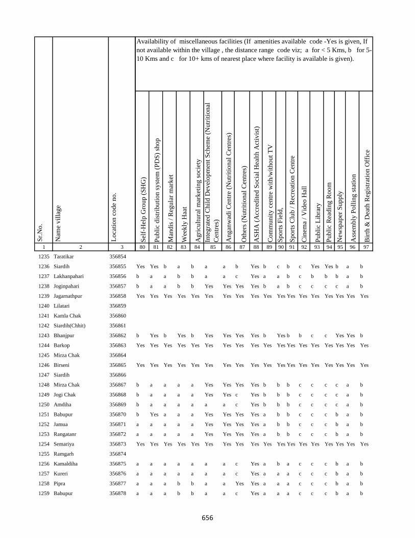
1 2 3
Lo
cati
on
co
de
no
.
Nam
e v
illa
ge
Sr.
No
.
1235 Taratikar 356854
1236 Siardih 356855
1237 Lakhanpahari 356856
1238 Joginpahari 356857
1239 Jagarnathpur 356858
1240 Lilatari 356859
1241 Kamla Chak 356860
1242 Siardih(Chhit) 356861
1243 Bhanjpur 356862
1244 Barkop 356863
1245 Mirza Chak 356864
1246 Birseni 356865
1247 Siardih 356866
1248 Mirza Chak 356867
1249 Jogi Chak 356868
1250 Amdiha 356869
1251 Babupur 356870
1252 Jamua 356871
1253 Rangatanr 356872
1254 Semariya 356873
1255 Ramgarh 356874
1256 Kamaldiha 356875
1257 Kureri 356876
1258 Pipra 356877
1259 Babupur 356878
Sel
f-H
elp
Gro
up
(S
HG
)
Pu
bli
c d
istr
ibu
tio
n s
yst
em (
PD
S)
sho
p
Man
dis
/ R
egu
lar
mar
ket
Wee
kly
Haa
t
Ag
ricu
ltu
ral
mar
ket
ing
so
ciet
y
Inte
gra
ted
Ch
ild
Dev
elo
pm
ent
Sch
eme
(Nu
trit
ion
al
Cen
tres
)
An
gan
wad
i C
entr
e (N
utr
itio
nal
Cen
tres
)
Oth
ers
(Nu
trit
ion
al C
entr
es)
AS
HA
(A
ccre
dit
ed S
oci
al H
ealt
h A
ctiv
ist)
Co
mm
un
ity
cen
tre
wit
h/w
ith
ou
t T
V
Sp
ort
s F
ield
,
Sp
ort
s C
lub
/ R
ecre
atio
n C
entr
e
Cin
ema
/ V
ideo
Hal
l
Pu
bli
c L
ibra
ry
Pu
bli
c R
ead
ing
Ro
om
New
spap
er S
up
ply
Ass
emb
ly P
oll
ing
sta
tio
n
Bir
th &
Dea
th R
egis
trat
ion
Off
ice
80 81 82 83 84 85 86 87 88 89 90 91 92 93 94 95 96 97
Availability of miscellaneous facilities (If amenities available code -Yes is given, If
not available within the village , the distance range code viz; a for < 5 Kms, b for 5-
10 Kms and c for 10+ kms of nearest place where facility is available is given).
Yes Yes b a b a a b Yes b c b c Yes Yes b a b
b a a b b a a c Yes a a b c b b b a b
b a a b b Yes Yes Yes Yes b a b c c c c a b
Yes Yes Yes Yes Yes Yes Yes Yes Yes Yes Yes Yes Yes Yes Yes Yes Yes Yes
b Yes b Yes b Yes Yes Yes Yes b Yes b b c c Yes Yes b
Yes Yes Yes Yes Yes Yes Yes Yes Yes Yes Yes Yes Yes Yes Yes Yes Yes Yes
Yes Yes Yes Yes Yes Yes Yes Yes Yes Yes Yes Yes Yes Yes Yes Yes Yes Yes
b a a a a Yes Yes Yes Yes b b b c c c c a b
b a a a a Yes Yes c Yes b b b c c c c a b
b a a a a a a c Yes b b b c c c c a b
b Yes a a a Yes Yes Yes Yes a b b c c c b a b
a a a a a Yes Yes Yes Yes a b b c c c b a b
a a a a a Yes Yes Yes Yes a b b c c c b a b
Yes Yes Yes Yes Yes Yes Yes Yes Yes Yes Yes Yes Yes Yes Yes Yes Yes Yes
a a a a a a a c Yes a b a c c c b a b
a a a a a a a c Yes a a a c c c b a b
a a a b b a a Yes Yes a a a c c c b a b
a a a b b a a c Yes a a a c c c b a b
656

1 2 3
Lo
cati
on
co
de
no
.
Nam
e v
illa
ge
Sr.
No
.
1260 Lakarjorimal 356879
1261 Tikabagicha 356880
1262 Gordhoi 356881
1263 Babupur 356882
1264 Nauratan Kita 356883
1265 Gordhoi 356884
1266 Joginpahari 356885
1267 Simariya 356886
1268 Sonar Chak 356887
1269 Duarichak 356888
1270 Tulsi Kita 356889
1271 Chau Chak 356890
1272 Karubandh 356891
1273 Haripur 356892
1274 Chau Chak 356893
1275 Lachhminiyan 356894
1276 Chepi 356895
1277 Kasiyatari 356896
1278 Kita Gardharpur 356897
1279 Lasutiya 356898
1280 Pathargama 356899
1281 Mal Pathargama 356900
1282 Arazi Pathargama 356901
1283 Chandi Chak 356902
1284 Baliya Kita 356903
Sel
f-H
elp
Gro
up
(S
HG
)
Pu
bli
c d
istr
ibu
tio
n s
yst
em (
PD
S)
sho
p
Man
dis
/ R
egu
lar
mar
ket
Wee
kly
Haa
t
Ag
ricu
ltu
ral
mar
ket
ing
so
ciet
y
Inte
gra
ted
Ch
ild
Dev
elo
pm
ent
Sch
eme
(Nu
trit
ion
al
Cen
tres
)
An
gan
wad
i C
entr
e (N
utr
itio
nal
Cen
tres
)
Oth
ers
(Nu
trit
ion
al C
entr
es)
AS
HA
(A
ccre
dit
ed S
oci
al H
ealt
h A
ctiv
ist)
Co
mm
un
ity
cen
tre
wit
h/w
ith
ou
t T
V
Sp
ort
s F
ield
,
Sp
ort
s C
lub
/ R
ecre
atio
n C
entr
e
Cin
ema
/ V
ideo
Hal
l
Pu
bli
c L
ibra
ry
Pu
bli
c R
ead
ing
Ro
om
New
spap
er S
up
ply
Ass
emb
ly P
oll
ing
sta
tio
n
Bir
th &
Dea
th R
egis
trat
ion
Off
ice
80 81 82 83 84 85 86 87 88 89 90 91 92 93 94 95 96 97
Availability of miscellaneous facilities (If amenities available code -Yes is given, If
not available within the village , the distance range code viz; a for < 5 Kms, b for 5-
10 Kms and c for 10+ kms of nearest place where facility is available is given).
a a a b b a a c Yes a a a c c c b a b
a a a b b Yes Yes c Yes a a a c c c Yes a b
a a a b b Yes Yes c Yes a a a b c c b a b
Yes Yes Yes Yes Yes Yes Yes Yes Yes Yes Yes Yes Yes Yes Yes Yes Yes Yes
a a b b b Yes Yes Yes Yes a a a b b b b a b
Yes Yes Yes Yes Yes Yes Yes Yes Yes Yes Yes Yes Yes Yes Yes Yes Yes Yes
a a b b b Yes Yes c Yes a a a b b b Yes a b
a a b b b Yes Yes c Yes b b a b b b Yes a b
Yes Yes Yes Yes Yes Yes Yes Yes Yes Yes Yes Yes Yes Yes Yes Yes Yes Yes
a a b b b a a c Yes b b a b b b b a b
Yes Yes c c c Yes Yes a Yes b b b c c c b a b
c Yes Yes Yes Yes Yes Yes Yes Yes Yes Yes b Yes c c Yes Yes Yes
Yes Yes Yes Yes Yes Yes Yes Yes Yes Yes Yes Yes Yes Yes Yes Yes Yes Yes
a a b b b Yes Yes c Yes Yes b a b b b b a b
Yes Yes Yes Yes Yes Yes Yes Yes Yes Yes Yes Yes Yes Yes Yes Yes Yes Yes
657

1 2 3
Lo
cati
on
co
de
no
.
Nam
e v
illa
ge
Sr.
No
.
1285 Janki Kita 356904
1286 Sapinmor 356905
1287 Panjarhar 356906
1288 Panjarhar Birit 356907
1289 Karaila Chak 356908
1290 Ambasongram 356909
1291 Mahadeva Kita 356910
1292 Ghandharpur 356911
1293 Kumarsi 356912
1294 Sundarmor 356913
1295 Dandighat 356914
1296 Tengar 356915
1297 Machhitanr 356916
1298 Telni 356917
1299 Kobhara 356918
1300 Chilkara Gobind 356919
1301 Dumarariya 356920
1302 Bareghat 356921
1303 Baredih 356922
1304 Kasturiya 356923
1305 Sukhanand 356924
1306 Jamchir 356925
1307 Kendua 356926
1308 Rampur 356927
1309 Shampur 356928
Sel
f-H
elp
Gro
up
(S
HG
)
Pu
bli
c d
istr
ibu
tio
n s
yst
em (
PD
S)
sho
p
Man
dis
/ R
egu
lar
mar
ket
Wee
kly
Haa
t
Ag
ricu
ltu
ral
mar
ket
ing
so
ciet
y
Inte
gra
ted
Ch
ild
Dev
elo
pm
ent
Sch
eme
(Nu
trit
ion
al
Cen
tres
)
An
gan
wad
i C
entr
e (N
utr
itio
nal
Cen
tres
)
Oth
ers
(Nu
trit
ion
al C
entr
es)
AS
HA
(A
ccre
dit
ed S
oci
al H
ealt
h A
ctiv
ist)
Co
mm
un
ity
cen
tre
wit
h/w
ith
ou
t T
V
Sp
ort
s F
ield
,
Sp
ort
s C
lub
/ R
ecre
atio
n C
entr
e
Cin
ema
/ V
ideo
Hal
l
Pu
bli
c L
ibra
ry
Pu
bli
c R
ead
ing
Ro
om
New
spap
er S
up
ply
Ass
emb
ly P
oll
ing
sta
tio
n
Bir
th &
Dea
th R
egis
trat
ion
Off
ice
80 81 82 83 84 85 86 87 88 89 90 91 92 93 94 95 96 97
Availability of miscellaneous facilities (If amenities available code -Yes is given, If
not available within the village , the distance range code viz; a for < 5 Kms, b for 5-
10 Kms and c for 10+ kms of nearest place where facility is available is given).
Yes Yes Yes Yes Yes Yes Yes Yes Yes Yes Yes Yes Yes Yes Yes Yes Yes Yes
b b b b b a a c Yes b b a c c c c a b
b b b b b Yes Yes c Yes b b a c c c c Yes b
b Yes b b b Yes Yes c Yes b b a c c c Yes Yes b
b b b b b a a c Yes b b a c c c c a b
b b b b b a a c Yes b b a c c c c a b
b b b b b a a c Yes b b a c c c c a b
b b b b b a a c Yes b b a c c c c a a
b b b b b a a c Yes b b a c c c c a a
b b a a b a a c Yes b b a c c c c a a
b Yes a Yes b Yes Yes Yes Yes b Yes a c c c Yes a a
b b a a b Yes Yes c Yes b b a c c c c a b
b b a a b Yes Yes Yes Yes b b a c c c c a b
Yes b a a b a a c Yes b b a c c c c a b
b b a a b a a c Yes b b b c c c c a b
Yes Yes Yes Yes Yes Yes Yes Yes Yes Yes Yes Yes Yes Yes Yes Yes Yes Yes
b b c c b Yes Yes c Yes b b b c c c c a b
b b b b b Yes Yes c Yes b b b c c c Yes a b
b b b b b a a c Yes b b b c c c c a b
b a b b b Yes Yes c Yes b b b c c c c a b
658
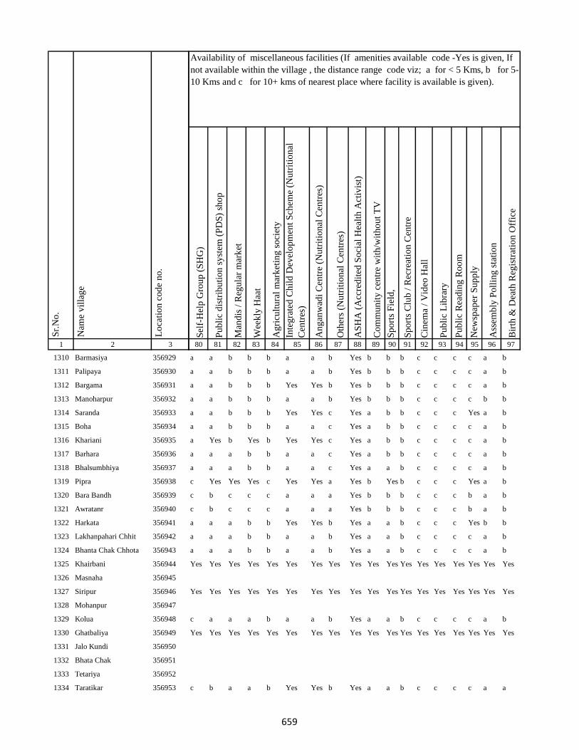
1 2 3
Lo
cati
on
co
de
no
.
Nam
e v
illa
ge
Sr.
No
.
1310 Barmasiya 356929
1311 Palipaya 356930
1312 Bargama 356931
1313 Manoharpur 356932
1314 Saranda 356933
1315 Boha 356934
1316 Khariani 356935
1317 Barhara 356936
1318 Bhalsumbhiya 356937
1319 Pipra 356938
1320 Bara Bandh 356939
1321 Awratanr 356940
1322 Harkata 356941
1323 Lakhanpahari Chhit 356942
1324 Bhanta Chak Chhota 356943
1325 Khairbani 356944
1326 Masnaha 356945
1327 Siripur 356946
1328 Mohanpur 356947
1329 Kolua 356948
1330 Ghatbaliya 356949
1331 Jalo Kundi 356950
1332 Bhata Chak 356951
1333 Tetariya 356952
1334 Taratikar 356953
Sel
f-H
elp
Gro
up
(S
HG
)
Pu
bli
c d
istr
ibu
tio
n s
yst
em (
PD
S)
sho
p
Man
dis
/ R
egu
lar
mar
ket
Wee
kly
Haa
t
Ag
ricu
ltu
ral
mar
ket
ing
so
ciet
y
Inte
gra
ted
Ch
ild
Dev
elo
pm
ent
Sch
eme
(Nu
trit
ion
al
Cen
tres
)
An
gan
wad
i C
entr
e (N
utr
itio
nal
Cen
tres
)
Oth
ers
(Nu
trit
ion
al C
entr
es)
AS
HA
(A
ccre
dit
ed S
oci
al H
ealt
h A
ctiv
ist)
Co
mm
un
ity
cen
tre
wit
h/w
ith
ou
t T
V
Sp
ort
s F
ield
,
Sp
ort
s C
lub
/ R
ecre
atio
n C
entr
e
Cin
ema
/ V
ideo
Hal
l
Pu
bli
c L
ibra
ry
Pu
bli
c R
ead
ing
Ro
om
New
spap
er S
up
ply
Ass
emb
ly P
oll
ing
sta
tio
n
Bir
th &
Dea
th R
egis
trat
ion
Off
ice
80 81 82 83 84 85 86 87 88 89 90 91 92 93 94 95 96 97
Availability of miscellaneous facilities (If amenities available code -Yes is given, If
not available within the village , the distance range code viz; a for < 5 Kms, b for 5-
10 Kms and c for 10+ kms of nearest place where facility is available is given).
a a b b b a a b Yes b b b c c c c a b
a a b b b a a b Yes b b b c c c c a b
a a b b b Yes Yes b Yes b b b c c c c a b
a a b b b a a b Yes b b b c c c c b b
a a b b b Yes Yes c Yes a b b c c c Yes a b
a a b b b a a c Yes a b b c c c c a b
a Yes b Yes b Yes Yes c Yes a b b c c c c a b
a a a b b a a c Yes a b b c c c c a b
a a a b b a a c Yes a a b c c c c a b
c Yes Yes Yes c Yes Yes a Yes b Yes b c c c Yes a b
c b c c c a a a Yes b b b c c c b a b
c b c c c a a a Yes b b b c c c b a b
a a a b b Yes Yes b Yes a a b c c c Yes b b
a a a b b a a b Yes a a b c c c c a b
a a a b b a a b Yes a a b c c c c a b
Yes Yes Yes Yes Yes Yes Yes Yes Yes Yes Yes Yes Yes Yes Yes Yes Yes Yes
Yes Yes Yes Yes Yes Yes Yes Yes Yes Yes Yes Yes Yes Yes Yes Yes Yes Yes
c a a a b a a b Yes a a b c c c c a b
Yes Yes Yes Yes Yes Yes Yes Yes Yes Yes Yes Yes Yes Yes Yes Yes Yes Yes
c b a a b Yes Yes b Yes a a b c c c c a a
659

1 2 3
Lo
cati
on
co
de
no
.
Nam
e v
illa
ge
Sr.
No
.
1335 Bandelwar 356954
1336 Taratikar 356955
1337 Dumariya 356956
1338 Dhobdiha 356957
1339 Beltikri 356958
1340 Belshar 356959
1341 Parua 356960
1342 Biahunpurmal 356961
1343 Arazi Bishunpur 356962
1344 Pakariya 356963
1345 Chamra Koli 356964
1346 Boharna 356965
1347 Rajaun Khurd 356966
1348 Ambabathan 356967
1349 Dhibabandh 356968
1350 Kerbar 356969
1351 Barwarda 356970
1352 Ranipur 356971
1353 Laugai 356972
1354 Gangarampur 356973
1355 Latauna 356974
1356 Chunakothi 356975
1357 Ghutiya 356976
1358 Rajaun Kalan 356977
1359 Bisaha 356978
Sel
f-H
elp
Gro
up
(S
HG
)
Pu
bli
c d
istr
ibu
tio
n s
yst
em (
PD
S)
sho
p
Man
dis
/ R
egu
lar
mar
ket
Wee
kly
Haa
t
Ag
ricu
ltu
ral
mar
ket
ing
so
ciet
y
Inte
gra
ted
Ch
ild
Dev
elo
pm
ent
Sch
eme
(Nu
trit
ion
al
Cen
tres
)
An
gan
wad
i C
entr
e (N
utr
itio
nal
Cen
tres
)
Oth
ers
(Nu
trit
ion
al C
entr
es)
AS
HA
(A
ccre
dit
ed S
oci
al H
ealt
h A
ctiv
ist)
Co
mm
un
ity
cen
tre
wit
h/w
ith
ou
t T
V
Sp
ort
s F
ield
,
Sp
ort
s C
lub
/ R
ecre
atio
n C
entr
e
Cin
ema
/ V
ideo
Hal
l
Pu
bli
c L
ibra
ry
Pu
bli
c R
ead
ing
Ro
om
New
spap
er S
up
ply
Ass
emb
ly P
oll
ing
sta
tio
n
Bir
th &
Dea
th R
egis
trat
ion
Off
ice
80 81 82 83 84 85 86 87 88 89 90 91 92 93 94 95 96 97
Availability of miscellaneous facilities (If amenities available code -Yes is given, If
not available within the village , the distance range code viz; a for < 5 Kms, b for 5-
10 Kms and c for 10+ kms of nearest place where facility is available is given).
Yes Yes Yes a Yes Yes Yes Yes Yes Yes Yes Yes Yes Yes Yes Yes Yes Yes
c Yes b Yes b Yes Yes b Yes b Yes b c c c b Yes b
c Yes b Yes b a a b Yes b Yes b c c c Yes Yes b
c Yes b Yes b Yes Yes Yes Yes b b b c c c Yes a b
c Yes c a b Yes Yes Yes Yes b a c c c c b Yes Yes
Yes Yes Yes Yes Yes Yes Yes Yes Yes Yes Yes Yes Yes Yes Yes Yes Yes Yes
Yes Yes Yes Yes Yes Yes Yes Yes Yes Yes Yes Yes Yes Yes Yes Yes Yes Yes
c a c a b Yes Yes Yes Yes b c c c c c b a b
c a c a b Yes Yes Yes Yes c a b c b b Yes Yes b
c a c a b Yes Yes b Yes c Yes c c c c Yes Yes a
b Yes b a b Yes Yes b Yes c Yes c c c c Yes Yes Yes
b a b a b Yes Yes b Yes b a c c c c c a a
b a b a b a a b Yes b a c c c c c a a
b a b a b a a b Yes b a c c c c c a a
b Yes b a b Yes Yes Yes Yes b a c c c c c a a
b a b a b Yes Yes Yes Yes b a c c b b Yes Yes Yes
b a b a b a a b Yes c c c b b b Yes Yes a
b Yes c a c Yes Yes Yes Yes c Yes c c c c c a b
b Yes c Yes c Yes Yes Yes Yes c Yes c c c c c Yes Yes
c b c c c Yes Yes b Yes b Yes b c c c b a b
b b c a c Yes Yes Yes Yes c b c c c c c a b
660
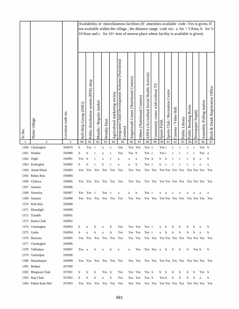
1 2 3
Lo
cati
on
co
de
no
.
Nam
e v
illa
ge
Sr.
No
.
1360 Charkaghat 356979
1361 Nimbar 356980
1362 Dighi 356981
1363 Korkaghat 356982
1364 Amad Khani 356983
1365 Raksu Kita 356984
1366 Chakwa 356985
1367 Jasmata 356986
1368 Simariya 356987
1369 Sanatan 356988
1370 Kela Kita 356989
1371 Khasdighi 356990
1372 Toiadih 356991
1373 Ramu Chak 356992
1374 Charkaghat 356993
1375 Garka 356994
1376 Bariyata 356995
1377 Charkaghat 356996
1378 Tabhalpur 356997
1379 Gobindpur 356998
1380 Masudanpur 356999
1381 Bedpur 357000
1382 Bhagwan Chak 357001
1383 Rup Chak 357002
1384 Pathar Kani Mal 357003
Sel
f-H
elp
Gro
up
(S
HG
)
Pu
bli
c d
istr
ibu
tio
n s
yst
em (
PD
S)
sho
p
Man
dis
/ R
egu
lar
mar
ket
Wee
kly
Haa
t
Ag
ricu
ltu
ral
mar
ket
ing
so
ciet
y
Inte
gra
ted
Ch
ild
Dev
elo
pm
ent
Sch
eme
(Nu
trit
ion
al
Cen
tres
)
An
gan
wad
i C
entr
e (N
utr
itio
nal
Cen
tres
)
Oth
ers
(Nu
trit
ion
al C
entr
es)
AS
HA
(A
ccre
dit
ed S
oci
al H
ealt
h A
ctiv
ist)
Co
mm
un
ity
cen
tre
wit
h/w
ith
ou
t T
V
Sp
ort
s F
ield
,
Sp
ort
s C
lub
/ R
ecre
atio
n C
entr
e
Cin
ema
/ V
ideo
Hal
l
Pu
bli
c L
ibra
ry
Pu
bli
c R
ead
ing
Ro
om
New
spap
er S
up
ply
Ass
emb
ly P
oll
ing
sta
tio
n
Bir
th &
Dea
th R
egis
trat
ion
Off
ice
80 81 82 83 84 85 86 87 88 89 90 91 92 93 94 95 96 97
Availability of miscellaneous facilities (If amenities available code -Yes is given, If
not available within the village , the distance range code viz; a for < 5 Kms, b for 5-
10 Kms and c for 10+ kms of nearest place where facility is available is given).
b Yes c a c Yes Yes Yes Yes c Yes c c c c c Yes b
b b c a c Yes Yes b Yes c Yes c c c c c Yes a
Yes b c a c a a a Yes b b b c c c b a b
b b c b c a a b Yes c b c c c c c a a
Yes Yes Yes Yes Yes Yes Yes Yes Yes Yes Yes Yes Yes Yes Yes Yes Yes Yes
Yes Yes Yes Yes Yes Yes Yes Yes Yes Yes Yes Yes Yes Yes Yes Yes Yes Yes
Yes Yes c Yes c a a b Yes c a a c a a a a a
Yes Yes Yes Yes Yes Yes Yes Yes Yes Yes Yes Yes Yes Yes Yes Yes Yes Yes
b a b a b Yes Yes Yes Yes c a b b b b b a b
b a b a b Yes Yes Yes Yes c a b b b b b a b
Yes Yes Yes Yes Yes Yes Yes Yes Yes Yes Yes Yes Yes Yes Yes Yes Yes Yes
Yes a b a b a a Yes Yes Yes a b b b b Yes b b
Yes Yes Yes Yes Yes Yes Yes Yes Yes Yes Yes Yes Yes Yes Yes Yes Yes Yes
b b b Yes b Yes Yes Yes Yes b b b b b b b Yes b
b b b a b Yes Yes Yes Yes b Yes b b b b b a b
Yes Yes Yes Yes Yes Yes Yes Yes Yes Yes Yes Yes Yes Yes Yes Yes Yes Yes
661
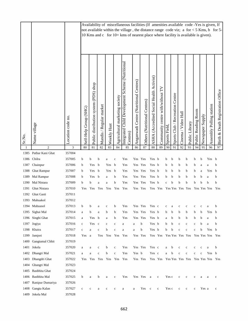
1 2 3
Lo
cati
on
co
de
no
.
Nam
e v
illa
ge
Sr.
No
.
1385 Pathar Kani Ghat 357004
1386 Chilra 357005
1387 Chainpur 357006
1388 Ghat Rampur 357007
1389 Mal Rampur 357008
1390 Mal Nistara 357009
1391 Ghat Nistara 357010
1392 Ghat Gasti 357011
1393 Mahuakol 357012
1394 Mahuasol 357013
1395 Sighai Mal 357014
1396 Singhi Ghat 357015
1397 Jogiya 357016
1398 Khaira 357017
1399 Jamjori 357018
1400 Gangtamal Chhit 357019
1401 Jokela 357020
1402 Dhangri Mal 357021
1403 Dhangdri Ghat 357022
1404 Ghangri Mal 357023
1405 Basbhita Ghat 357024
1406 Basbhita Mal 357025
1407 Ranipur Dumariya 357026
1408 Gangta Kalan 357027
1409 Jokela Mal 357028
Sel
f-H
elp
Gro
up
(S
HG
)
Pu
bli
c d
istr
ibu
tio
n s
yst
em (
PD
S)
sho
p
Man
dis
/ R
egu
lar
mar
ket
Wee
kly
Haa
t
Ag
ricu
ltu
ral
mar
ket
ing
so
ciet
y
Inte
gra
ted
Ch
ild
Dev
elo
pm
ent
Sch
eme
(Nu
trit
ion
al
Cen
tres
)
An
gan
wad
i C
entr
e (N
utr
itio
nal
Cen
tres
)
Oth
ers
(Nu
trit
ion
al C
entr
es)
AS
HA
(A
ccre
dit
ed S
oci
al H
ealt
h A
ctiv
ist)
Co
mm
un
ity
cen
tre
wit
h/w
ith
ou
t T
V
Sp
ort
s F
ield
,
Sp
ort
s C
lub
/ R
ecre
atio
n C
entr
e
Cin
ema
/ V
ideo
Hal
l
Pu
bli
c L
ibra
ry
Pu
bli
c R
ead
ing
Ro
om
New
spap
er S
up
ply
Ass
emb
ly P
oll
ing
sta
tio
n
Bir
th &
Dea
th R
egis
trat
ion
Off
ice
80 81 82 83 84 85 86 87 88 89 90 91 92 93 94 95 96 97
Availability of miscellaneous facilities (If amenities available code -Yes is given, If
not available within the village , the distance range code viz; a for < 5 Kms, b for 5-
10 Kms and c for 10+ kms of nearest place where facility is available is given).
b b b a c Yes Yes Yes Yes b b b b b b b Yes b
b Yes b Yes b Yes Yes Yes Yes b b b b b b a a b
b Yes b Yes b Yes Yes Yes Yes b b b b b b a Yes b
b Yes b a b Yes Yes Yes Yes b b b b b b b a b
b b a a b Yes Yes Yes Yes b c b b b b b b b
Yes Yes Yes Yes Yes Yes Yes Yes Yes Yes Yes Yes Yes Yes Yes Yes Yes Yes
b b a c b Yes Yes Yes Yes c c a c c c c a b
a b a b b Yes Yes Yes Yes b b b b b b b Yes b
a Yes b a b Yes Yes Yes Yes b a b b b b b a b
c Yes c c c a a b Yes b b b c c c b a b
c a c b c a a b Yes b b b c c c b Yes b
Yes a Yes Yes Yes Yes Yes Yes Yes Yes Yes Yes Yes Yes Yes Yes Yes Yes
a a c b c Yes Yes Yes Yes c a b c c c c a b
a a c b c Yes Yes b Yes c a b c c c c Yes b
Yes Yes Yes Yes Yes Yes Yes Yes Yes Yes Yes Yes Yes Yes Yes Yes Yes Yes
b a b a c Yes Yes Yes a c Yes c c c c a a c
c c a c c a a Yes c c Yes c c c c Yes a c
662

1 2 3
Lo
cati
on
co
de
no
.
Nam
e v
illa
ge
Sr.
No
.
1410 Kerwar Ghat 357029
1411 Gangta Mal Chhit 357030
1412 Lautana 357031
1413 Mahuatanr 357032
1414 Kerwar 357033
1415 Ranipur Dumariya 357034
1416 Badalpur 357035
1417 Tetuliya 357036
1418 Paraspani 357037
1419 Daharlangi 357038
Block T O T A L :
1420 Gorgawan 357039
1421 Koriana 357040
1422 Arazi Koriana 357041
1423 Raha 357042
1424 Bade 357043
1425 Maheshtikri 357044
1426 Arazi Maheshtikri 357045
1427 Majar Khurd 357046
1428 Arazi Majar Buzurg 357047
1429 Manjar Buzurg 357048
1430 Arazi Dhapra 357049
1431 Dhapra Kita 357050
Sel
f-H
elp
Gro
up
(S
HG
)
Pu
bli
c d
istr
ibu
tio
n s
yst
em (
PD
S)
sho
p
Man
dis
/ R
egu
lar
mar
ket
Wee
kly
Haa
t
Ag
ricu
ltu
ral
mar
ket
ing
so
ciet
y
Inte
gra
ted
Ch
ild
Dev
elo
pm
ent
Sch
eme
(Nu
trit
ion
al
Cen
tres
)
An
gan
wad
i C
entr
e (N
utr
itio
nal
Cen
tres
)
Oth
ers
(Nu
trit
ion
al C
entr
es)
AS
HA
(A
ccre
dit
ed S
oci
al H
ealt
h A
ctiv
ist)
Co
mm
un
ity
cen
tre
wit
h/w
ith
ou
t T
V
Sp
ort
s F
ield
,
Sp
ort
s C
lub
/ R
ecre
atio
n C
entr
e
Cin
ema
/ V
ideo
Hal
l
Pu
bli
c L
ibra
ry
Pu
bli
c R
ead
ing
Ro
om
New
spap
er S
up
ply
Ass
emb
ly P
oll
ing
sta
tio
n
Bir
th &
Dea
th R
egis
trat
ion
Off
ice
80 81 82 83 84 85 86 87 88 89 90 91 92 93 94 95 96 97
Availability of miscellaneous facilities (If amenities available code -Yes is given, If
not available within the village , the distance range code viz; a for < 5 Kms, b for 5-
10 Kms and c for 10+ kms of nearest place where facility is available is given).
a Yes b a c Yes Yes Yes Yes c a b b b b b a a
Yes Yes Yes Yes Yes Yes Yes Yes Yes Yes Yes Yes Yes Yes Yes Yes Yes Yes
Yes a b a c Yes Yes Yes Yes c a b b b b b a a
a a b a c Yes Yes Yes Yes a a b b b b b a a
a b c a c a a Yes Yes a a b b b b b Yes a
Yes Yes b a c a a a Yes c Yes b c Yes Yes b a b
Yes a c b c a a a Yes c Yes a c c c b a b
Yes Yes c a b Yes Yes Yes Yes a a a b b b Yes Yes b
46 58 31 42 30 99 99 77 143 32 50 29 30 31 31 50 52 34
a Yes c Yes b Yes Yes Yes Yes c Yes b c c c Yes Yes b
Yes Yes Yes Yes Yes Yes Yes Yes Yes Yes Yes Yes Yes Yes Yes Yes Yes Yes
Yes b a a c Yes Yes b Yes b a b c c c b Yes b
b Yes c a b Yes Yes Yes Yes c b b c c c Yes Yes b
Yes Yes Yes Yes Yes Yes Yes Yes Yes Yes Yes Yes Yes Yes Yes Yes Yes Yes
Yes Yes Yes Yes Yes Yes Yes Yes Yes Yes Yes Yes Yes Yes Yes Yes Yes Yes
Yes Yes Yes Yes Yes Yes Yes Yes Yes Yes Yes Yes Yes Yes Yes Yes Yes Yes
663
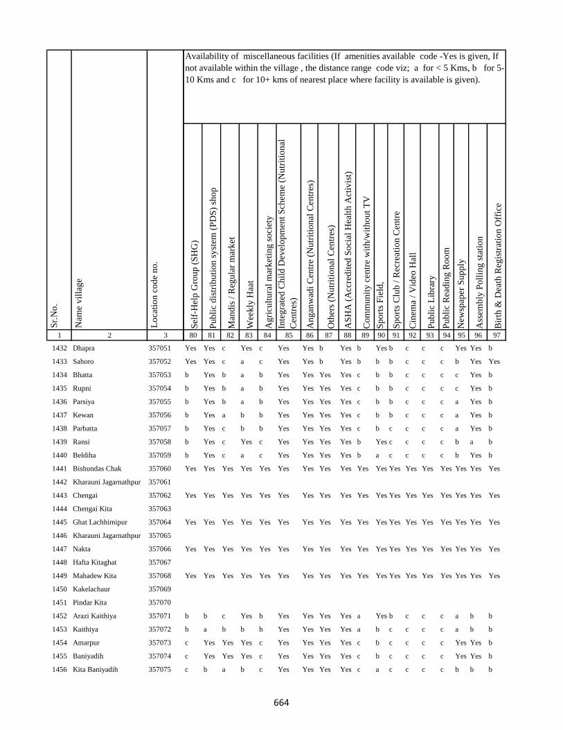
1 2 3
Lo
cati
on
co
de
no
.
Nam
e v
illa
ge
Sr.
No
.
1432 Dhapra 357051
1433 Sahoro 357052
1434 Bhatta 357053
1435 Rupni 357054
1436 Parsiya 357055
1437 Kewan 357056
1438 Parbatta 357057
1439 Ransi 357058
1440 Beldiha 357059
1441 Bishundas Chak 357060
1442 Kharauni Jagarnathpur 357061
1443 Chengai 357062
1444 Chengai Kita 357063
1445 Ghat Lachhimipur 357064
1446 Kharauni Jagarnathpur 357065
1447 Nakta 357066
1448 Hafta Kitaghat 357067
1449 Mahadew Kita 357068
1450 Kakelachaur 357069
1451 Pindar Kita 357070
1452 Arazi Kaithiya 357071
1453 Kaithiya 357072
1454 Amarpur 357073
1455 Baniyadih 357074
1456 Kita Baniyadih 357075
Sel
f-H
elp
Gro
up
(S
HG
)
Pu
bli
c d
istr
ibu
tio
n s
yst
em (
PD
S)
sho
p
Man
dis
/ R
egu
lar
mar
ket
Wee
kly
Haa
t
Ag
ricu
ltu
ral
mar
ket
ing
so
ciet
y
Inte
gra
ted
Ch
ild
Dev
elo
pm
ent
Sch
eme
(Nu
trit
ion
al
Cen
tres
)
An
gan
wad
i C
entr
e (N
utr
itio
nal
Cen
tres
)
Oth
ers
(Nu
trit
ion
al C
entr
es)
AS
HA
(A
ccre
dit
ed S
oci
al H
ealt
h A
ctiv
ist)
Co
mm
un
ity
cen
tre
wit
h/w
ith
ou
t T
V
Sp
ort
s F
ield
,
Sp
ort
s C
lub
/ R
ecre
atio
n C
entr
e
Cin
ema
/ V
ideo
Hal
l
Pu
bli
c L
ibra
ry
Pu
bli
c R
ead
ing
Ro
om
New
spap
er S
up
ply
Ass
emb
ly P
oll
ing
sta
tio
n
Bir
th &
Dea
th R
egis
trat
ion
Off
ice
80 81 82 83 84 85 86 87 88 89 90 91 92 93 94 95 96 97
Availability of miscellaneous facilities (If amenities available code -Yes is given, If
not available within the village , the distance range code viz; a for < 5 Kms, b for 5-
10 Kms and c for 10+ kms of nearest place where facility is available is given).
Yes Yes c Yes c Yes Yes b Yes b Yes b c c c Yes Yes b
Yes Yes c a c Yes Yes b Yes b b b c c c b Yes Yes
b Yes b a b Yes Yes Yes Yes c b b c c c c Yes b
b Yes b a b Yes Yes Yes Yes c b b c c c c Yes b
b Yes b a b Yes Yes Yes Yes c b b c c c a Yes b
b Yes a b b Yes Yes Yes Yes c b b c c c a Yes b
b Yes c b b Yes Yes Yes Yes c b c c c c a Yes b
b Yes c Yes c Yes Yes Yes Yes b Yes c c c c b a b
b Yes c a c Yes Yes Yes Yes b a c c c c b Yes b
Yes Yes Yes Yes Yes Yes Yes Yes Yes Yes Yes Yes Yes Yes Yes Yes Yes Yes
Yes Yes Yes Yes Yes Yes Yes Yes Yes Yes Yes Yes Yes Yes Yes Yes Yes Yes
Yes Yes Yes Yes Yes Yes Yes Yes Yes Yes Yes Yes Yes Yes Yes Yes Yes Yes
Yes Yes Yes Yes Yes Yes Yes Yes Yes Yes Yes Yes Yes Yes Yes Yes Yes Yes
Yes Yes Yes Yes Yes Yes Yes Yes Yes Yes Yes Yes Yes Yes Yes Yes Yes Yes
b b c Yes b Yes Yes Yes Yes a Yes b c c c a b b
b a b b b Yes Yes Yes Yes a b c c c c a b b
c Yes Yes Yes c Yes Yes Yes Yes c b c c c c Yes Yes b
c Yes Yes Yes c Yes Yes Yes Yes c b c c c c Yes Yes b
c b a b c Yes Yes Yes Yes c a c c c c b b b
664

1 2 3
Lo
cati
on
co
de
no
.
Nam
e v
illa
ge
Sr.
No
.
1457 Gouri Kita 357076
1458 Gopi Chak 357077
1459 Piprachaur 357078
1460 Chaurgonar Kita 357079
1461 Shahpur 357080
1462 Sarkunda Kita 357081
1463 Nimuha 357082
1464 Medni Chak 357083
1465 Kadma 357084
1466 Jagatpur 357085
1467 Mansha Bishunpur 357086
1468 Lalman Kita 357087
1469 Kita Kendua 357088
1470 Sankhi 357089
1471 Mokal Chak 357090
1472 Aichamor 357091
1473 Lotha 357092
1474 Jhapaniya 357093
1475 Majra Kol 357094
1476 Bisambhar Chak 357095
1477 Kolhadda 357096
1478 Basantpur 357097
1479 Basan Sarai Gadal 357098
1480 Basantrai 357099
1481 Sankhi Khurd 357100
Sel
f-H
elp
Gro
up
(S
HG
)
Pu
bli
c d
istr
ibu
tio
n s
yst
em (
PD
S)
sho
p
Man
dis
/ R
egu
lar
mar
ket
Wee
kly
Haa
t
Ag
ricu
ltu
ral
mar
ket
ing
so
ciet
y
Inte
gra
ted
Ch
ild
Dev
elo
pm
ent
Sch
eme
(Nu
trit
ion
al
Cen
tres
)
An
gan
wad
i C
entr
e (N
utr
itio
nal
Cen
tres
)
Oth
ers
(Nu
trit
ion
al C
entr
es)
AS
HA
(A
ccre
dit
ed S
oci
al H
ealt
h A
ctiv
ist)
Co
mm
un
ity
cen
tre
wit
h/w
ith
ou
t T
V
Sp
ort
s F
ield
,
Sp
ort
s C
lub
/ R
ecre
atio
n C
entr
e
Cin
ema
/ V
ideo
Hal
l
Pu
bli
c L
ibra
ry
Pu
bli
c R
ead
ing
Ro
om
New
spap
er S
up
ply
Ass
emb
ly P
oll
ing
sta
tio
n
Bir
th &
Dea
th R
egis
trat
ion
Off
ice
80 81 82 83 84 85 86 87 88 89 90 91 92 93 94 95 96 97
Availability of miscellaneous facilities (If amenities available code -Yes is given, If
not available within the village , the distance range code viz; a for < 5 Kms, b for 5-
10 Kms and c for 10+ kms of nearest place where facility is available is given).
Yes Yes a Yes c Yes Yes b Yes c a c c c c b Yes a
Yes Yes Yes Yes Yes Yes Yes Yes Yes Yes Yes Yes Yes Yes Yes Yes Yes Yes
Yes Yes Yes Yes Yes Yes Yes Yes Yes Yes Yes Yes Yes Yes Yes Yes Yes Yes
a Yes b a c a a Yes Yes b Yes a c c c Yes Yes Yes
c Yes b Yes b a a b Yes b Yes Yes b c c b a b
a Yes c a b Yes Yes b Yes a a a b c c Yes Yes b
c b c c c a a a Yes b Yes b c c c b a b
Yes Yes Yes Yes Yes Yes Yes Yes Yes Yes Yes Yes Yes Yes Yes Yes Yes Yes
a Yes c a c Yes Yes Yes Yes b b a c c c c Yes a
Yes a a a a Yes Yes a Yes a a a a a a a a a
b a a Yes a Yes Yes Yes Yes a a a c c c c a a
Yes Yes a a a Yes Yes Yes Yes a a a c c c Yes a a
a a b a a Yes Yes Yes Yes a a c c c c c Yes b
Yes Yes Yes Yes Yes Yes Yes Yes Yes Yes Yes Yes Yes Yes Yes Yes Yes Yes
Yes Yes a a c Yes Yes b Yes c a c c c c b a b
Yes Yes a a c Yes Yes b Yes c a c c c c Yes Yes b
a a b a a Yes Yes Yes Yes a a a c c c c a b
c a c c c a a b Yes b b b c c c b a b
Yes a c c c Yes Yes b Yes b b a c c c Yes Yes b
a a c a a Yes Yes Yes Yes a a a c c c Yes Yes a
665

1 2 3
Lo
cati
on
co
de
no
.
Nam
e v
illa
ge
Sr.
No
.
1482 Bela Kita 357101
1483 Baskhoriya 357102
1484 Baghakol 357103
1485 Harganman 357104
1486 Kola Kita 357105
1487 Kaithpura 357106
1488 Lochni 357107
1489 Pachua Kita 357108
1490 Sanaur 357109
1491 Gathaur 357110
1492 Derma 357111
1493 Deshbarag 357112
1494 Chutiyan 357113
1495 Rampur 357114
1496 Rampur Mokarri 357115
1497 Rampur Arazi 357116
1498 Gobindpur Kita 357117
1499 Shampur Gobindpur 357118
1500 Shampur 357119
1501 Kapeta 357120
1502 Karu Chak 357121
1503 Pakariya 357122
1504 Arazi Pakariya 357123
1505 Jadu Chak 357124
1506 Paradharichak 357125
Sel
f-H
elp
Gro
up
(S
HG
)
Pu
bli
c d
istr
ibu
tio
n s
yst
em (
PD
S)
sho
p
Man
dis
/ R
egu
lar
mar
ket
Wee
kly
Haa
t
Ag
ricu
ltu
ral
mar
ket
ing
so
ciet
y
Inte
gra
ted
Ch
ild
Dev
elo
pm
ent
Sch
eme
(Nu
trit
ion
al
Cen
tres
)
An
gan
wad
i C
entr
e (N
utr
itio
nal
Cen
tres
)
Oth
ers
(Nu
trit
ion
al C
entr
es)
AS
HA
(A
ccre
dit
ed S
oci
al H
ealt
h A
ctiv
ist)
Co
mm
un
ity
cen
tre
wit
h/w
ith
ou
t T
V
Sp
ort
s F
ield
,
Sp
ort
s C
lub
/ R
ecre
atio
n C
entr
e
Cin
ema
/ V
ideo
Hal
l
Pu
bli
c L
ibra
ry
Pu
bli
c R
ead
ing
Ro
om
New
spap
er S
up
ply
Ass
emb
ly P
oll
ing
sta
tio
n
Bir
th &
Dea
th R
egis
trat
ion
Off
ice
80 81 82 83 84 85 86 87 88 89 90 91 92 93 94 95 96 97
Availability of miscellaneous facilities (If amenities available code -Yes is given, If
not available within the village , the distance range code viz; a for < 5 Kms, b for 5-
10 Kms and c for 10+ kms of nearest place where facility is available is given).
a a c a a Yes Yes Yes Yes c a a c c c a a a
a Yes c a a a a Yes Yes c a a c c c a Yes a
c a a a c Yes Yes a Yes Yes a c c c c Yes a a
Yes Yes Yes Yes Yes Yes Yes Yes Yes Yes Yes Yes Yes Yes Yes Yes Yes Yes
a a c Yes a Yes Yes b Yes c a a c c c a a a
a Yes c a a Yes Yes Yes Yes c a c c c c c Yes b
a a c a a Yes Yes b Yes c Yes c c c c c a a
Yes Yes Yes Yes Yes Yes Yes Yes Yes Yes Yes Yes Yes Yes Yes Yes Yes Yes
Yes a Yes Yes Yes Yes Yes Yes Yes Yes Yes Yes Yes Yes Yes Yes Yes Yes
Yes Yes Yes Yes Yes Yes Yes Yes Yes Yes Yes Yes Yes Yes Yes Yes Yes Yes
Yes Yes b a b Yes Yes Yes Yes c b b c c c b Yes b
Yes Yes Yes Yes Yes Yes Yes Yes Yes Yes Yes Yes Yes Yes Yes Yes Yes Yes
Yes Yes Yes Yes Yes Yes Yes Yes Yes Yes Yes Yes Yes Yes Yes Yes Yes Yes
666
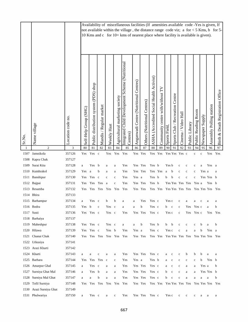
1 2 3
Lo
cati
on
co
de
no
.
Nam
e v
illa
ge
Sr.
No
.
1507 Jamnikola 357126
1508 Kapra Chak 357127
1509 Surai Kita 357128
1510 Kumhrakol 357129
1511 Banshipur 357130
1512 Bajpai 357131
1513 Resamba 357132
1514 Bhira 357133
1515 Barhampur 357134
1516 Bodra 357135
1517 Susti 357136
1518 Barhaiya 357137
1519 Maheshpur 357138
1520 Hilawa 357139
1521 Chanai Chak 357140
1522 Urkusiya 357141
1523 Arazi Kharti 357142
1524 Kharti 357143
1525 Barhara 357144
1526 Amarpur Ghal 357145
1527 Surniya Ghat Mal 357146
1528 Surniya Mal Ghat 357147
1529 Tofil Surniya 357148
1530 Arazi Surniya Ghat 357149
1531 Phulwariya 357150
Sel
f-H
elp
Gro
up
(S
HG
)
Pu
bli
c d
istr
ibu
tio
n s
yst
em (
PD
S)
sho
p
Man
dis
/ R
egu
lar
mar
ket
Wee
kly
Haa
t
Ag
ricu
ltu
ral
mar
ket
ing
so
ciet
y
Inte
gra
ted
Ch
ild
Dev
elo
pm
ent
Sch
eme
(Nu
trit
ion
al
Cen
tres
)
An
gan
wad
i C
entr
e (N
utr
itio
nal
Cen
tres
)
Oth
ers
(Nu
trit
ion
al C
entr
es)
AS
HA
(A
ccre
dit
ed S
oci
al H
ealt
h A
ctiv
ist)
Co
mm
un
ity
cen
tre
wit
h/w
ith
ou
t T
V
Sp
ort
s F
ield
,
Sp
ort
s C
lub
/ R
ecre
atio
n C
entr
e
Cin
ema
/ V
ideo
Hal
l
Pu
bli
c L
ibra
ry
Pu
bli
c R
ead
ing
Ro
om
New
spap
er S
up
ply
Ass
emb
ly P
oll
ing
sta
tio
n
Bir
th &
Dea
th R
egis
trat
ion
Off
ice
80 81 82 83 84 85 86 87 88 89 90 91 92 93 94 95 96 97
Availability of miscellaneous facilities (If amenities available code -Yes is given, If
not available within the village , the distance range code viz; a for < 5 Kms, b for 5-
10 Kms and c for 10+ kms of nearest place where facility is available is given).
Yes Yes c Yes Yes Yes Yes Yes Yes Yes Yes Yes Yes c c c Yes Yes
a Yes b a a Yes Yes Yes Yes b Yes b c c c a Yes a
Yes a b a a Yes Yes Yes Yes Yes a b c c c Yes a a
Yes Yes c c c Yes Yes a Yes b b b c c c Yes Yes b
Yes Yes Yes a c Yes Yes Yes Yes b Yes Yes Yes Yes Yes a Yes b
Yes Yes Yes Yes Yes Yes Yes Yes Yes Yes Yes Yes Yes Yes Yes Yes Yes Yes
a Yes c b b a a Yes Yes c Yes c c a a c a a
Yes b c Yes c a a b Yes c b c c Yes Yes c a b
Yes Yes c Yes c Yes Yes Yes Yes c Yes c c Yes Yes c Yes Yes
Yes Yes c Yes c a a b Yes b b b c c c b a b
Yes Yes c Yes b Yes Yes a Yes c Yes c c a a b Yes a
Yes Yes Yes Yes Yes Yes Yes Yes Yes Yes Yes Yes Yes Yes Yes Yes Yes Yes
a a c a a Yes Yes Yes Yes c a c c b b b a a
Yes Yes Yes c c Yes Yes a Yes b a c c c c b Yes b
a Yes c a a Yes Yes Yes Yes c a c c a a Yes a b
a Yes b a a Yes Yes Yes Yes c b c c a a Yes Yes b
a a b a a Yes Yes Yes Yes c b c c a a a a b
Yes Yes Yes Yes Yes Yes Yes Yes Yes Yes Yes Yes Yes Yes Yes Yes Yes Yes
a Yes c a c Yes Yes Yes Yes c Yes c c c c a a a
667
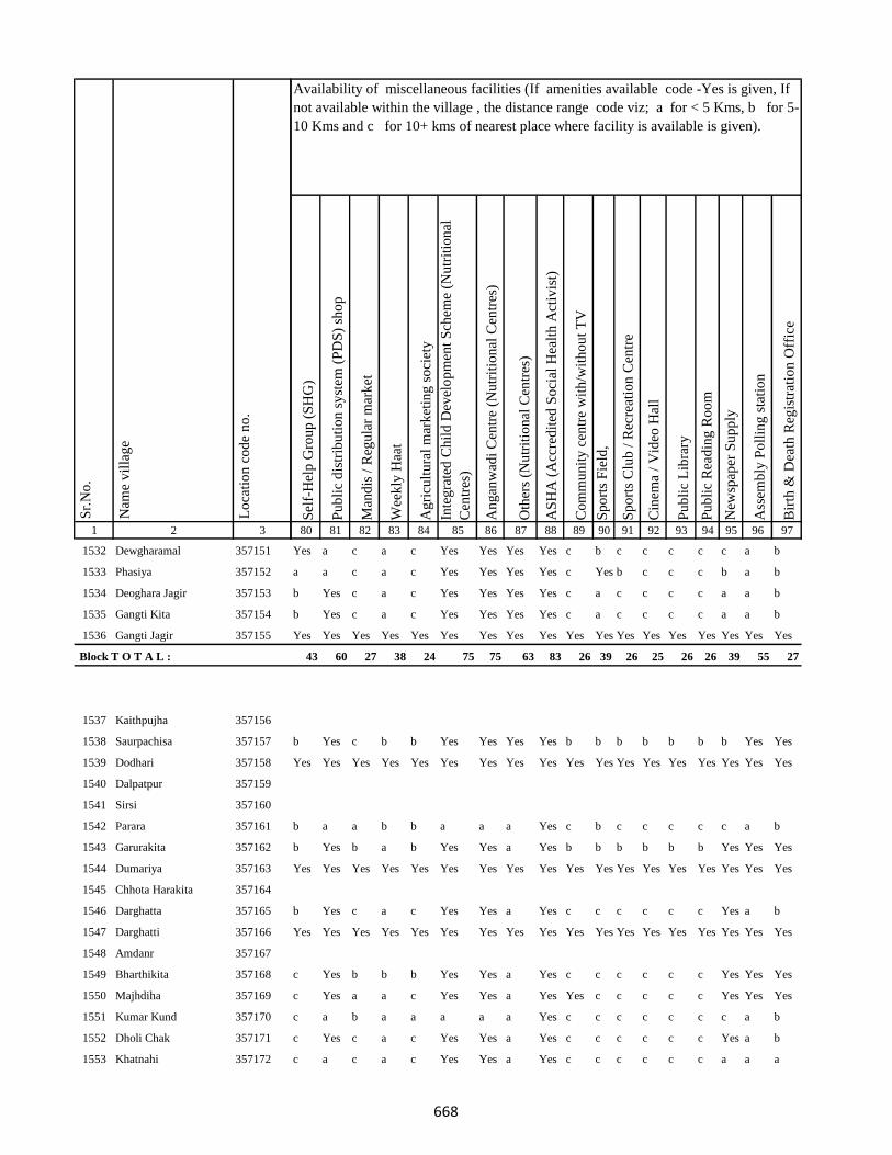
1 2 3
Lo
cati
on
co
de
no
.
Nam
e v
illa
ge
Sr.
No
.
1532 Dewgharamal 357151
1533 Phasiya 357152
1534 Deoghara Jagir 357153
1535 Gangti Kita 357154
1536 Gangti Jagir 357155
Block T O T A L :
1537 Kaithpujha 357156
1538 Saurpachisa 357157
1539 Dodhari 357158
1540 Dalpatpur 357159
1541 Sirsi 357160
1542 Parara 357161
1543 Garurakita 357162
1544 Dumariya 357163
1545 Chhota Harakita 357164
1546 Darghatta 357165
1547 Darghatti 357166
1548 Amdanr 357167
1549 Bharthikita 357168
1550 Majhdiha 357169
1551 Kumar Kund 357170
1552 Dholi Chak 357171
1553 Khatnahi 357172
Sel
f-H
elp
Gro
up
(S
HG
)
Pu
bli
c d
istr
ibu
tio
n s
yst
em (
PD
S)
sho
p
Man
dis
/ R
egu
lar
mar
ket
Wee
kly
Haa
t
Ag
ricu
ltu
ral
mar
ket
ing
so
ciet
y
Inte
gra
ted
Ch
ild
Dev
elo
pm
ent
Sch
eme
(Nu
trit
ion
al
Cen
tres
)
An
gan
wad
i C
entr
e (N
utr
itio
nal
Cen
tres
)
Oth
ers
(Nu
trit
ion
al C
entr
es)
AS
HA
(A
ccre
dit
ed S
oci
al H
ealt
h A
ctiv
ist)
Co
mm
un
ity
cen
tre
wit
h/w
ith
ou
t T
V
Sp
ort
s F
ield
,
Sp
ort
s C
lub
/ R
ecre
atio
n C
entr
e
Cin
ema
/ V
ideo
Hal
l
Pu
bli
c L
ibra
ry
Pu
bli
c R
ead
ing
Ro
om
New
spap
er S
up
ply
Ass
emb
ly P
oll
ing
sta
tio
n
Bir
th &
Dea
th R
egis
trat
ion
Off
ice
80 81 82 83 84 85 86 87 88 89 90 91 92 93 94 95 96 97
Availability of miscellaneous facilities (If amenities available code -Yes is given, If
not available within the village , the distance range code viz; a for < 5 Kms, b for 5-
10 Kms and c for 10+ kms of nearest place where facility is available is given).
Yes a c a c Yes Yes Yes Yes c b c c c c c a b
a a c a c Yes Yes Yes Yes c Yes b c c c b a b
b Yes c a c Yes Yes Yes Yes c a c c c c a a b
b Yes c a c Yes Yes Yes Yes c a c c c c a a b
Yes Yes Yes Yes Yes Yes Yes Yes Yes Yes Yes Yes Yes Yes Yes Yes Yes Yes
43 60 27 38 24 75 75 63 83 26 39 26 25 26 26 39 55 27
b Yes c b b Yes Yes Yes Yes b b b b b b b Yes Yes
Yes Yes Yes Yes Yes Yes Yes Yes Yes Yes Yes Yes Yes Yes Yes Yes Yes Yes
b a a b b a a a Yes c b c c c c c a b
b Yes b a b Yes Yes a Yes b b b b b b Yes Yes Yes
Yes Yes Yes Yes Yes Yes Yes Yes Yes Yes Yes Yes Yes Yes Yes Yes Yes Yes
b Yes c a c Yes Yes a Yes c c c c c c Yes a b
Yes Yes Yes Yes Yes Yes Yes Yes Yes Yes Yes Yes Yes Yes Yes Yes Yes Yes
c Yes b b b Yes Yes a Yes c c c c c c Yes Yes Yes
c Yes a a c Yes Yes a Yes Yes c c c c c Yes Yes Yes
c a b a a a a a Yes c c c c c c c a b
c Yes c a c Yes Yes a Yes c c c c c c Yes a b
c a c a c Yes Yes a Yes c c c c c c a a a
668
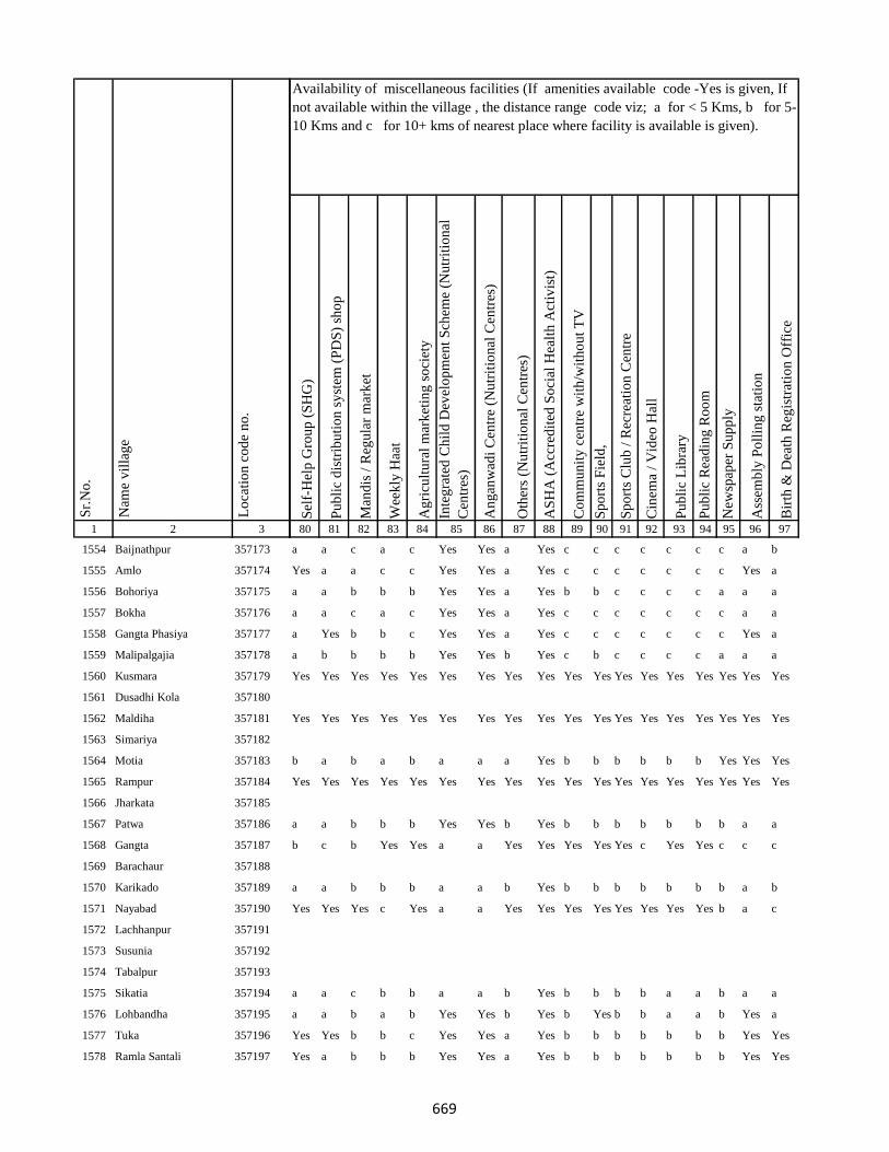
1 2 3
Lo
cati
on
co
de
no
.
Nam
e v
illa
ge
Sr.
No
.
1554 Baijnathpur 357173
1555 Amlo 357174
1556 Bohoriya 357175
1557 Bokha 357176
1558 Gangta Phasiya 357177
1559 Malipalgajia 357178
1560 Kusmara 357179
1561 Dusadhi Kola 357180
1562 Maldiha 357181
1563 Simariya 357182
1564 Motia 357183
1565 Rampur 357184
1566 Jharkata 357185
1567 Patwa 357186
1568 Gangta 357187
1569 Barachaur 357188
1570 Karikado 357189
1571 Nayabad 357190
1572 Lachhanpur 357191
1573 Susunia 357192
1574 Tabalpur 357193
1575 Sikatia 357194
1576 Lohbandha 357195
1577 Tuka 357196
1578 Ramla Santali 357197
Sel
f-H
elp
Gro
up
(S
HG
)
Pu
bli
c d
istr
ibu
tio
n s
yst
em (
PD
S)
sho
p
Man
dis
/ R
egu
lar
mar
ket
Wee
kly
Haa
t
Ag
ricu
ltu
ral
mar
ket
ing
so
ciet
y
Inte
gra
ted
Ch
ild
Dev
elo
pm
ent
Sch
eme
(Nu
trit
ion
al
Cen
tres
)
An
gan
wad
i C
entr
e (N
utr
itio
nal
Cen
tres
)
Oth
ers
(Nu
trit
ion
al C
entr
es)
AS
HA
(A
ccre
dit
ed S
oci
al H
ealt
h A
ctiv
ist)
Co
mm
un
ity
cen
tre
wit
h/w
ith
ou
t T
V
Sp
ort
s F
ield
,
Sp
ort
s C
lub
/ R
ecre
atio
n C
entr
e
Cin
ema
/ V
ideo
Hal
l
Pu
bli
c L
ibra
ry
Pu
bli
c R
ead
ing
Ro
om
New
spap
er S
up
ply
Ass
emb
ly P
oll
ing
sta
tio
n
Bir
th &
Dea
th R
egis
trat
ion
Off
ice
80 81 82 83 84 85 86 87 88 89 90 91 92 93 94 95 96 97
Availability of miscellaneous facilities (If amenities available code -Yes is given, If
not available within the village , the distance range code viz; a for < 5 Kms, b for 5-
10 Kms and c for 10+ kms of nearest place where facility is available is given).
a a c a c Yes Yes a Yes c c c c c c c a b
Yes a a c c Yes Yes a Yes c c c c c c c Yes a
a a b b b Yes Yes a Yes b b c c c c a a a
a a c a c Yes Yes a Yes c c c c c c c a a
a Yes b b c Yes Yes a Yes c c c c c c c Yes a
a b b b b Yes Yes b Yes c b c c c c a a a
Yes Yes Yes Yes Yes Yes Yes Yes Yes Yes Yes Yes Yes Yes Yes Yes Yes Yes
Yes Yes Yes Yes Yes Yes Yes Yes Yes Yes Yes Yes Yes Yes Yes Yes Yes Yes
b a b a b a a a Yes b b b b b b Yes Yes Yes
Yes Yes Yes Yes Yes Yes Yes Yes Yes Yes Yes Yes Yes Yes Yes Yes Yes Yes
a a b b b Yes Yes b Yes b b b b b b b a a
b c b Yes Yes a a Yes Yes Yes Yes Yes c Yes Yes c c c
a a b b b a a b Yes b b b b b b b a b
Yes Yes Yes c Yes a a Yes Yes Yes Yes Yes Yes Yes Yes b a c
a a c b b a a b Yes b b b b a a b a a
a a b a b Yes Yes b Yes b Yes b b a a b Yes a
Yes Yes b b c Yes Yes a Yes b b b b b b b Yes Yes
Yes a b b b Yes Yes a Yes b b b b b b b Yes Yes
669

1 2 3
Lo
cati
on
co
de
no
.
Nam
e v
illa
ge
Sr.
No
.
1579 Ramla Dikwani 357198
1580 Nankhil 357199
1581 Devpur 357200
1582 Kumarreri 357201
1583 Saidapur 357202
1584 Algajora 357203
1585 Sinhpur 357204
1586 Parasi 357205
1587 Bhawanipur 357206
1588 Bishunpur 357207
1589 Manpur 357208
1590 Dubrajpur 357209
1591 Gurguri 357210
1592 Reni 357211
1593 Kitabuidi 357212
1594 Kathra 357213
1595 Dokabandh 357214
1596 Makunddih 357215
1597 Makunddin (Santoli) 357216
1598 Pakariya Mal 357217
1599 Pakarya Ghat 357218
1600 Beldiha 357219
1601 Barahara 357220
1602 Harpati Chak 357221
1603 Bansipur 357222
Sel
f-H
elp
Gro
up
(S
HG
)
Pu
bli
c d
istr
ibu
tio
n s
yst
em (
PD
S)
sho
p
Man
dis
/ R
egu
lar
mar
ket
Wee
kly
Haa
t
Ag
ricu
ltu
ral
mar
ket
ing
so
ciet
y
Inte
gra
ted
Ch
ild
Dev
elo
pm
ent
Sch
eme
(Nu
trit
ion
al
Cen
tres
)
An
gan
wad
i C
entr
e (N
utr
itio
nal
Cen
tres
)
Oth
ers
(Nu
trit
ion
al C
entr
es)
AS
HA
(A
ccre
dit
ed S
oci
al H
ealt
h A
ctiv
ist)
Co
mm
un
ity
cen
tre
wit
h/w
ith
ou
t T
V
Sp
ort
s F
ield
,
Sp
ort
s C
lub
/ R
ecre
atio
n C
entr
e
Cin
ema
/ V
ideo
Hal
l
Pu
bli
c L
ibra
ry
Pu
bli
c R
ead
ing
Ro
om
New
spap
er S
up
ply
Ass
emb
ly P
oll
ing
sta
tio
n
Bir
th &
Dea
th R
egis
trat
ion
Off
ice
80 81 82 83 84 85 86 87 88 89 90 91 92 93 94 95 96 97
Availability of miscellaneous facilities (If amenities available code -Yes is given, If
not available within the village , the distance range code viz; a for < 5 Kms, b for 5-
10 Kms and c for 10+ kms of nearest place where facility is available is given).
Yes Yes c Yes c Yes Yes a Yes b b b b b b b Yes Yes
a a b a a a a b Yes b b b b a a b a a
Yes Yes b b b Yes Yes b Yes b b b b b b Yes Yes Yes
Yes Yes b b b Yes Yes a Yes b Yes b b b b Yes Yes Yes
Yes Yes Yes Yes Yes Yes Yes Yes Yes Yes Yes Yes Yes Yes Yes Yes Yes Yes
a a b b b Yes Yes b Yes b b b b b b b Yes a
Yes Yes Yes Yes Yes Yes Yes Yes Yes Yes Yes Yes Yes Yes Yes Yes Yes Yes
Yes Yes b b b Yes Yes a Yes b Yes b b b b Yes Yes a
Yes Yes b b b a a b Yes b b b b b b Yes Yes a
Yes Yes b b b Yes Yes a Yes b b b b b b b Yes Yes
Yes Yes Yes Yes Yes Yes Yes Yes Yes Yes Yes Yes Yes Yes Yes Yes Yes Yes
a a a a b Yes Yes b Yes b a b b a a b Yes Yes
a b a b b Yes Yes b Yes b a b b a a b Yes a
Yes a b b b Yes Yes a Yes b b b b b b b Yes a
Yes Yes b a b Yes Yes a Yes b b b b b b b Yes a
Yes a a a a Yes Yes a Yes a a a a a a a Yes a
Yes Yes a a a Yes Yes a Yes a a a a a a a Yes a
Yes Yes a a a Yes Yes a Yes a a a a a a a Yes a
Yes Yes Yes Yes Yes Yes Yes Yes Yes Yes Yes Yes Yes Yes Yes Yes Yes Yes
Yes a b b b Yes Yes a Yes b Yes b b b b Yes a a
670

1 2 3
Lo
cati
on
co
de
no
.
Nam
e v
illa
ge
Sr.
No
.
1604 Kurma 357223
1605 Baliya 357224
1606 Molnakita 357225
1607 Patpur 357226
1608 Nilkanthpur 357227
1609 Chapri 357228
1610 Bara 357229
1611 Lacchmipur 357230
1612 Nepura 357231
1613 Kakana 357232
1614 Chandarpur 357233
1615 Parariya 357234
1616 Panch Kathi 357235
1617 Burhi Salempur 357236
1618 Arwara 357237
1619 Basarhi 357238
1620 Malni 357239
1621 Chakwa 357240
1622 Machhiya Samarda Urf Lalpur357241
1623 Diyara 357242
1624 Jaipur 357243
1625 Barhauna 357244
1626 Amdiha 357245
1627 Parsa 357246
1628 Kanhwara 357247
Sel
f-H
elp
Gro
up
(S
HG
)
Pu
bli
c d
istr
ibu
tio
n s
yst
em (
PD
S)
sho
p
Man
dis
/ R
egu
lar
mar
ket
Wee
kly
Haa
t
Ag
ricu
ltu
ral
mar
ket
ing
so
ciet
y
Inte
gra
ted
Ch
ild
Dev
elo
pm
ent
Sch
eme
(Nu
trit
ion
al
Cen
tres
)
An
gan
wad
i C
entr
e (N
utr
itio
nal
Cen
tres
)
Oth
ers
(Nu
trit
ion
al C
entr
es)
AS
HA
(A
ccre
dit
ed S
oci
al H
ealt
h A
ctiv
ist)
Co
mm
un
ity
cen
tre
wit
h/w
ith
ou
t T
V
Sp
ort
s F
ield
,
Sp
ort
s C
lub
/ R
ecre
atio
n C
entr
e
Cin
ema
/ V
ideo
Hal
l
Pu
bli
c L
ibra
ry
Pu
bli
c R
ead
ing
Ro
om
New
spap
er S
up
ply
Ass
emb
ly P
oll
ing
sta
tio
n
Bir
th &
Dea
th R
egis
trat
ion
Off
ice
80 81 82 83 84 85 86 87 88 89 90 91 92 93 94 95 96 97
Availability of miscellaneous facilities (If amenities available code -Yes is given, If
not available within the village , the distance range code viz; a for < 5 Kms, b for 5-
10 Kms and c for 10+ kms of nearest place where facility is available is given).
Yes Yes b b b Yes Yes a Yes b Yes b b b b Yes Yes b
a Yes b a a Yes Yes a Yes b a b b b b Yes Yes b
a Yes b a a Yes Yes a Yes b a b b b b a Yes b
a a b b b Yes Yes a Yes b a b b a a b Yes a
Yes a c a c Yes Yes a Yes c c c c c c c Yes a
Yes a b b b Yes Yes a Yes b b b b b b b Yes a
a a b b b Yes Yes b Yes b a b b b b b Yes a
a Yes b b b Yes Yes Yes Yes b Yes b b Yes Yes Yes Yes Yes
b Yes b b b Yes Yes b Yes b Yes b b Yes Yes Yes Yes a
Yes Yes Yes Yes Yes Yes Yes Yes Yes Yes Yes Yes Yes Yes Yes Yes Yes Yes
Yes Yes Yes Yes Yes Yes Yes Yes Yes Yes Yes Yes Yes Yes Yes Yes Yes Yes
c Yes c c c Yes Yes a Yes b Yes Yes c Yes Yes Yes Yes a
b a b b b Yes Yes b Yes b a b b b b Yes Yes a
b Yes b b b Yes Yes b Yes b Yes b b b b Yes Yes Yes
b Yes b b b Yes Yes a Yes b a b b b b Yes Yes a
b Yes b b b Yes Yes a Yes b a b b b b Yes Yes a
Yes Yes a a a Yes Yes a Yes a Yes a a a a Yes Yes b
b b b b b Yes Yes Yes Yes b b b b b b b b b
b Yes a a a Yes Yes a Yes a a b b b b b Yes b
a a a a a Yes Yes Yes Yes a Yes Yes a Yes Yes Yes Yes Yes
a Yes a b b Yes Yes a Yes b Yes b b b b Yes Yes b
671
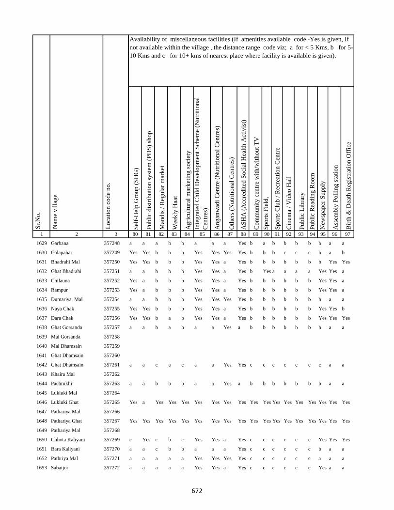
1 2 3
Lo
cati
on
co
de
no
.
Nam
e v
illa
ge
Sr.
No
.
1629 Garbana 357248
1630 Galapahar 357249
1631 Bhadrahi Mal 357250
1632 Ghat Bhadrahi 357251
1633 Chilauna 357252
1634 Rampur 357253
1635 Dumariya Mal 357254
1636 Naya Chak 357255
1637 Dara Chak 357256
1638 Ghat Gorsanda 357257
1639 Mal Gorsanda 357258
1640 Mal Dhamsain 357259
1641 Ghat Dhamsain 357260
1642 Ghat Dhamsain 357261
1643 Khaira Mal 357262
1644 Pachrukhi 357263
1645 Lukluki Mal 357264
1646 Lukluki Ghat 357265
1647 Pathariya Mal 357266
1648 Pathariya Ghat 357267
1649 Pathariya Mal 357268
1650 Chhota Kaliyani 357269
1651 Bara Kaliyani 357270
1652 Pathriya Mal 357271
1653 Sabaijor 357272
Sel
f-H
elp
Gro
up
(S
HG
)
Pu
bli
c d
istr
ibu
tio
n s
yst
em (
PD
S)
sho
p
Man
dis
/ R
egu
lar
mar
ket
Wee
kly
Haa
t
Ag
ricu
ltu
ral
mar
ket
ing
so
ciet
y
Inte
gra
ted
Ch
ild
Dev
elo
pm
ent
Sch
eme
(Nu
trit
ion
al
Cen
tres
)
An
gan
wad
i C
entr
e (N
utr
itio
nal
Cen
tres
)
Oth
ers
(Nu
trit
ion
al C
entr
es)
AS
HA
(A
ccre
dit
ed S
oci
al H
ealt
h A
ctiv
ist)
Co
mm
un
ity
cen
tre
wit
h/w
ith
ou
t T
V
Sp
ort
s F
ield
,
Sp
ort
s C
lub
/ R
ecre
atio
n C
entr
e
Cin
ema
/ V
ideo
Hal
l
Pu
bli
c L
ibra
ry
Pu
bli
c R
ead
ing
Ro
om
New
spap
er S
up
ply
Ass
emb
ly P
oll
ing
sta
tio
n
Bir
th &
Dea
th R
egis
trat
ion
Off
ice
80 81 82 83 84 85 86 87 88 89 90 91 92 93 94 95 96 97
Availability of miscellaneous facilities (If amenities available code -Yes is given, If
not available within the village , the distance range code viz; a for < 5 Kms, b for 5-
10 Kms and c for 10+ kms of nearest place where facility is available is given).
a a a b b a a a Yes b a b b b b b a a
Yes Yes b b b Yes Yes Yes Yes b b b c c c b a b
Yes Yes b b b Yes Yes a Yes b b b b b b b Yes Yes
a a b b b Yes Yes a Yes b Yes a a a a Yes Yes a
Yes a b b b Yes Yes a Yes b b b b b b Yes Yes a
Yes a b b b Yes Yes a Yes b b b b b b Yes Yes a
a a b b b Yes Yes Yes Yes b b b b b b b a a
Yes Yes b b b Yes Yes a Yes b b b b b b Yes Yes b
Yes Yes b a b Yes Yes a Yes b b b b b b Yes Yes Yes
a a b a b a a Yes a b b b b b b b a a
a a c a c a a Yes Yes c c c c c c c a a
a a b b b a a Yes a b b b b b b b a a
Yes a Yes Yes Yes Yes Yes Yes Yes Yes Yes Yes Yes Yes Yes Yes Yes Yes
Yes Yes Yes Yes Yes Yes Yes Yes Yes Yes Yes Yes Yes Yes Yes Yes Yes Yes
c Yes c b c Yes Yes a Yes c c c c c c Yes Yes Yes
a a c b b a a a Yes c c c c c c b a a
a a a a a Yes Yes Yes Yes c c c c c c a a a
a a a a a Yes Yes a Yes c c c c c c Yes a a
672

1 2 3
Lo
cati
on
co
de
no
.
Nam
e v
illa
ge
Sr.
No
.
1654 Karudih 357273
1655 Kauadhab 357274
1656 Gaechhand 357275
1657 Chinadhab 357276
1658 Tilobadar 357277
1659 Pelgarhi Dhopahari 357278
1660 Karmatanr 357279
1661 Betiyabahiyar 357280
1662 Ranidih 357281
1663 Malhra 357282
1664 Kurmi Chak 357283
1665 Kajradah 357284
1666 Charkakol Ghat 357285
1667 Mahugariya 357286
1668 Ratrati 357287
1669 Karhariya Mal 357288
1670 Kubji Ghat 357289
1671 Pathwara 357290
1672 Karhariya Ghat 357291
1673 Mal Domuria 357292
1674 Karhariya Mal 357293
1675 Amghata 357294
1676 Ghat Dumariya 357295
1677 Kita Pelgarhi Dhopahari 357296
1678 Kajradah 357297
Sel
f-H
elp
Gro
up
(S
HG
)
Pu
bli
c d
istr
ibu
tio
n s
yst
em (
PD
S)
sho
p
Man
dis
/ R
egu
lar
mar
ket
Wee
kly
Haa
t
Ag
ricu
ltu
ral
mar
ket
ing
so
ciet
y
Inte
gra
ted
Ch
ild
Dev
elo
pm
ent
Sch
eme
(Nu
trit
ion
al
Cen
tres
)
An
gan
wad
i C
entr
e (N
utr
itio
nal
Cen
tres
)
Oth
ers
(Nu
trit
ion
al C
entr
es)
AS
HA
(A
ccre
dit
ed S
oci
al H
ealt
h A
ctiv
ist)
Co
mm
un
ity
cen
tre
wit
h/w
ith
ou
t T
V
Sp
ort
s F
ield
,
Sp
ort
s C
lub
/ R
ecre
atio
n C
entr
e
Cin
ema
/ V
ideo
Hal
l
Pu
bli
c L
ibra
ry
Pu
bli
c R
ead
ing
Ro
om
New
spap
er S
up
ply
Ass
emb
ly P
oll
ing
sta
tio
n
Bir
th &
Dea
th R
egis
trat
ion
Off
ice
80 81 82 83 84 85 86 87 88 89 90 91 92 93 94 95 96 97
Availability of miscellaneous facilities (If amenities available code -Yes is given, If
not available within the village , the distance range code viz; a for < 5 Kms, b for 5-
10 Kms and c for 10+ kms of nearest place where facility is available is given).
a Yes b a b Yes Yes a Yes c c c c c c Yes a a
c Yes b a a Yes Yes a Yes c c c c c c Yes a a
Yes Yes c Yes c Yes Yes a Yes c c c c c c Yes a a
c a b a a Yes Yes a Yes c c c c c c a Yes Yes
c a b a a Yes Yes b Yes c c c c c c c a a
c a c a c Yes Yes a Yes c Yes c c a a c Yes Yes
Yes Yes Yes Yes Yes Yes Yes Yes Yes Yes Yes Yes Yes Yes Yes Yes Yes Yes
c Yes a a a Yes Yes a Yes c Yes c c b b c Yes a
c a a a a Yes Yes a Yes c c c c b b c a Yes
Yes Yes Yes Yes Yes Yes Yes Yes Yes Yes Yes Yes Yes Yes Yes Yes Yes Yes
Yes Yes Yes Yes Yes Yes Yes Yes Yes Yes Yes Yes Yes Yes Yes Yes Yes Yes
c a c b b Yes Yes a Yes c c c c c c c Yes a
Yes a c a b Yes Yes a Yes c c c c c c c Yes a
Yes a c b c Yes Yes a Yes c a c c c c c Yes a
c a c b b a a a Yes a a c c c c c a a
c Yes c b b a a a Yes a Yes c c c c c a b
Yes Yes Yes Yes Yes Yes Yes Yes Yes Yes Yes Yes Yes Yes Yes Yes Yes Yes
a a a a a Yes Yes Yes Yes a a a a a a a a a
b a c a c a a a Yes c c c c c c Yes Yes a
673
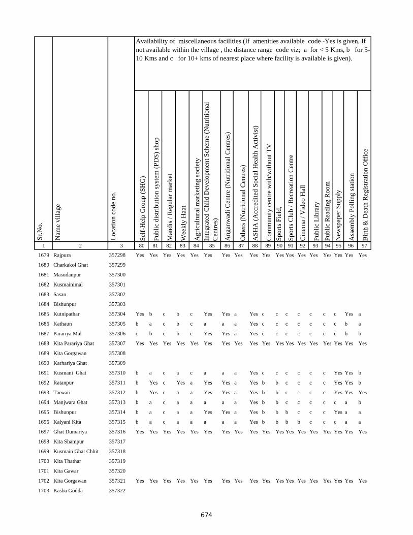
1 2 3
Lo
cati
on
co
de
no
.
Nam
e v
illa
ge
Sr.
No
.
1679 Rajpura 357298
1680 Charkakol Ghat 357299
1681 Masudanpur 357300
1682 Kusmainimal 357301
1683 Sasan 357302
1684 Bishunpur 357303
1685 Kutnipathar 357304
1686 Kathaun 357305
1687 Parariya Mal 357306
1688 Kita Parariya Ghat 357307
1689 Kita Gorgawan 357308
1690 Karhariya Ghat 357309
1691 Kusmani Ghat 357310
1692 Ratanpur 357311
1693 Tarwari 357312
1694 Manjwara Ghat 357313
1695 Bishunpur 357314
1696 Kalyani Kita 357315
1697 Ghat Dumariya 357316
1698 Kita Shampur 357317
1699 Kusmain Ghat Chhit 357318
1700 Kita Thathar 357319
1701 Kita Gawar 357320
1702 Kita Gorgawan 357321
1703 Kasba Godda 357322
Sel
f-H
elp
Gro
up
(S
HG
)
Pu
bli
c d
istr
ibu
tio
n s
yst
em (
PD
S)
sho
p
Man
dis
/ R
egu
lar
mar
ket
Wee
kly
Haa
t
Ag
ricu
ltu
ral
mar
ket
ing
so
ciet
y
Inte
gra
ted
Ch
ild
Dev
elo
pm
ent
Sch
eme
(Nu
trit
ion
al
Cen
tres
)
An
gan
wad
i C
entr
e (N
utr
itio
nal
Cen
tres
)
Oth
ers
(Nu
trit
ion
al C
entr
es)
AS
HA
(A
ccre
dit
ed S
oci
al H
ealt
h A
ctiv
ist)
Co
mm
un
ity
cen
tre
wit
h/w
ith
ou
t T
V
Sp
ort
s F
ield
,
Sp
ort
s C
lub
/ R
ecre
atio
n C
entr
e
Cin
ema
/ V
ideo
Hal
l
Pu
bli
c L
ibra
ry
Pu
bli
c R
ead
ing
Ro
om
New
spap
er S
up
ply
Ass
emb
ly P
oll
ing
sta
tio
n
Bir
th &
Dea
th R
egis
trat
ion
Off
ice
80 81 82 83 84 85 86 87 88 89 90 91 92 93 94 95 96 97
Availability of miscellaneous facilities (If amenities available code -Yes is given, If
not available within the village , the distance range code viz; a for < 5 Kms, b for 5-
10 Kms and c for 10+ kms of nearest place where facility is available is given).
Yes Yes Yes Yes Yes Yes Yes Yes Yes Yes Yes Yes Yes Yes Yes Yes Yes Yes
Yes b c b c Yes Yes a Yes c c c c c c c Yes a
b a c b c a a a Yes c c c c c c c b a
c b c b c Yes Yes a Yes c c c c c c c b b
Yes Yes Yes Yes Yes Yes Yes Yes Yes Yes Yes Yes Yes Yes Yes Yes Yes Yes
b a c a c a a a Yes c c c c c c Yes Yes b
b Yes c Yes a Yes Yes a Yes b b c c c c Yes Yes b
b Yes c a a Yes Yes a Yes b b c c c c Yes Yes Yes
b a c a a a a a Yes b b c c c c c a b
b a c a a Yes Yes a Yes b b b c c c Yes a a
b a c a a a a a Yes b b b b c c c a a
Yes Yes Yes Yes Yes Yes Yes Yes Yes Yes Yes Yes Yes Yes Yes Yes Yes Yes
Yes Yes Yes Yes Yes Yes Yes Yes Yes Yes Yes Yes Yes Yes Yes Yes Yes Yes
674

1 2 3
Lo
cati
on
co
de
no
.
Nam
e v
illa
ge
Sr.
No
.
1704 Ghat Paharpur 357323
1705 Kutni Pathar 357324
1706 Gorka Kita 357325
1707 Bhandar Koli 357326
1708 Harlal Tola 357327
1709 Haripur 357328
1710 Ghat Paharpur 357329
1711 Kasba Godda 357330
1712 Ghat Paharpur 357331
1713 Mohanpur 357332
1714 Markhan 357333
1715 Daldali 357334
1716 Jamuni Paharpur 357335
1717 Ghat Paharpur 357336
1718 Nonmati 357337
1719 Sarotiya 357338
1720 Bhatdiha 357339
1721 Bengbahiyar 357340
1722 Rupiyamal 357341
1723 Maruabaran 357342
1724 Kauribahiyarmal Chhit 357343
1725 Kauribahiyar Ghat 357344
1726 Kauribahiyar Mal 357345
1727 Pairdih 357346
1728 Kanadih Chhit 357347
Sel
f-H
elp
Gro
up
(S
HG
)
Pu
bli
c d
istr
ibu
tio
n s
yst
em (
PD
S)
sho
p
Man
dis
/ R
egu
lar
mar
ket
Wee
kly
Haa
t
Ag
ricu
ltu
ral
mar
ket
ing
so
ciet
y
Inte
gra
ted
Ch
ild
Dev
elo
pm
ent
Sch
eme
(Nu
trit
ion
al
Cen
tres
)
An
gan
wad
i C
entr
e (N
utr
itio
nal
Cen
tres
)
Oth
ers
(Nu
trit
ion
al C
entr
es)
AS
HA
(A
ccre
dit
ed S
oci
al H
ealt
h A
ctiv
ist)
Co
mm
un
ity
cen
tre
wit
h/w
ith
ou
t T
V
Sp
ort
s F
ield
,
Sp
ort
s C
lub
/ R
ecre
atio
n C
entr
e
Cin
ema
/ V
ideo
Hal
l
Pu
bli
c L
ibra
ry
Pu
bli
c R
ead
ing
Ro
om
New
spap
er S
up
ply
Ass
emb
ly P
oll
ing
sta
tio
n
Bir
th &
Dea
th R
egis
trat
ion
Off
ice
80 81 82 83 84 85 86 87 88 89 90 91 92 93 94 95 96 97
Availability of miscellaneous facilities (If amenities available code -Yes is given, If
not available within the village , the distance range code viz; a for < 5 Kms, b for 5-
10 Kms and c for 10+ kms of nearest place where facility is available is given).
Yes Yes Yes Yes Yes Yes Yes Yes Yes Yes Yes Yes Yes Yes Yes Yes Yes Yes
Yes Yes b b Yes Yes Yes Yes Yes b b b b b b b Yes Yes
b Yes b b b Yes Yes b Yes b Yes b b b b Yes Yes a
Yes Yes b b b Yes Yes b Yes b b b b b b b Yes a
Yes Yes b b b Yes Yes b Yes b b b b b b b Yes Yes
Yes Yes Yes Yes Yes Yes Yes Yes Yes Yes Yes Yes Yes Yes Yes Yes Yes Yes
b a c a c a a b Yes c a c c c c Yes Yes Yes
b b a a a a a b Yes b Yes b b b b b Yes a
Yes Yes b Yes b Yes Yes a Yes b Yes b b b b Yes Yes b
Yes Yes Yes Yes Yes Yes Yes Yes Yes Yes Yes Yes Yes Yes Yes Yes Yes Yes
b b a a a Yes Yes b Yes b a c c c c c Yes a
b Yes a a a a a b Yes b a Yes a b b c Yes Yes
a a a a a Yes Yes b Yes a a a a a a a a b
Yes a a a a Yes Yes a Yes a a a a a a a Yes Yes
Yes a a a a Yes Yes b Yes a a a a a a a a a
a a b b b a a Yes a b b b b b b b a a
Yes b c b b a a a Yes b b b b b b b Yes a
Yes b b b b Yes Yes a Yes b b b b b b b Yes Yes
Yes Yes a a a Yes Yes a Yes a a a a a a Yes Yes b
a a a a a a a Yes a a a a a a a a a b
675

1 2 3
Lo
cati
on
co
de
no
.
Nam
e v
illa
ge
Sr.
No
.
1729 Gorhighat Chhit 357348
1730 Kanidih Chhit 357349
1731 Jamua 357350
1732 Kurman Ghat 357351
1733 Lamhati Kar 357352
1734 Kurman Mal 357353
1735 Dharmudih 357354
1736 Punsiya 357355
1737 Kumardih 357356
1738 Murlidih Kita 357357
1739 Pandubathan 357358
1740 Sarkanda 357359
1741 Pathra 357360
1742 Bilari 357361
1743 Ghat Jamuni 357362
1744 Pandaha 357363
1745 Ghat Jhilua 357364
1746 Lachhmi 357365
1747 Ghat Jopnadih 357366
1748 Majhdiha 357367
1749 Makhni 357368
1750 Amarpur 357369
1751 Baramasia 357370
1752 Sonjhar 357371
1753 Kadwa 357372
Sel
f-H
elp
Gro
up
(S
HG
)
Pu
bli
c d
istr
ibu
tio
n s
yst
em (
PD
S)
sho
p
Man
dis
/ R
egu
lar
mar
ket
Wee
kly
Haa
t
Ag
ricu
ltu
ral
mar
ket
ing
so
ciet
y
Inte
gra
ted
Ch
ild
Dev
elo
pm
ent
Sch
eme
(Nu
trit
ion
al
Cen
tres
)
An
gan
wad
i C
entr
e (N
utr
itio
nal
Cen
tres
)
Oth
ers
(Nu
trit
ion
al C
entr
es)
AS
HA
(A
ccre
dit
ed S
oci
al H
ealt
h A
ctiv
ist)
Co
mm
un
ity
cen
tre
wit
h/w
ith
ou
t T
V
Sp
ort
s F
ield
,
Sp
ort
s C
lub
/ R
ecre
atio
n C
entr
e
Cin
ema
/ V
ideo
Hal
l
Pu
bli
c L
ibra
ry
Pu
bli
c R
ead
ing
Ro
om
New
spap
er S
up
ply
Ass
emb
ly P
oll
ing
sta
tio
n
Bir
th &
Dea
th R
egis
trat
ion
Off
ice
80 81 82 83 84 85 86 87 88 89 90 91 92 93 94 95 96 97
Availability of miscellaneous facilities (If amenities available code -Yes is given, If
not available within the village , the distance range code viz; a for < 5 Kms, b for 5-
10 Kms and c for 10+ kms of nearest place where facility is available is given).
a a b a a Yes Yes a Yes b a a a a a a Yes a
a a b a a a a a Yes b a a a a a a Yes a
a a b a a Yes Yes a Yes b a a a a a a a a
a Yes b a a Yes Yes a Yes b a a a a a a Yes a
a b b a a Yes Yes a Yes b a a a a a a Yes a
a Yes b a a Yes Yes c Yes b a a a a a a Yes a
Yes Yes c a c Yes Yes a Yes b a a a a a b a b
Yes Yes c c c a a a Yes b b b c c c b Yes Yes
c Yes c a c Yes Yes a Yes b Yes b c c c b Yes Yes
b b c c c Yes Yes a Yes b b b c c c b a b
a Yes b a a Yes Yes c Yes a Yes Yes a a a a Yes a
Yes Yes b a b Yes Yes c Yes b b b b b b Yes Yes b
c Yes c Yes c Yes Yes b Yes b a a c a a a a a
b b b b b Yes Yes Yes Yes b b b b b b b a b
b b b b b Yes Yes Yes Yes a a b b b b b a b
b b b b b a a c Yes b b b b b b b a b
b b b b b Yes Yes Yes Yes b b b b b b b Yes Yes
b b b b b Yes Yes Yes Yes b b b b b b b Yes Yes
b Yes Yes Yes Yes Yes Yes c Yes b Yes b b b b b Yes Yes
b Yes b b b Yes Yes c Yes b b b b b b b Yes b
b b b b b Yes Yes b Yes b b b b b b b Yes b
b b b b b Yes Yes a Yes b b b b b b b a b
Yes Yes c Yes c Yes Yes a Yes b b c c c c c a b
676

1 2 3
Lo
cati
on
co
de
no
.
Nam
e v
illa
ge
Sr.
No
.
1754 Nonbatta 357373
1755 Teldiha 357374
1756 Banka Ghat 357375
1757 Langradih 357376
1758 Bhalpahari 357377
1759 Sundarmor 357378
1760 Nipaniya 357379
1761 Baristanr 357380
1762 Jalgar 357381
1763 Sandmara 357382
1764 Dhokal Tola 357383
1765 Nandupahari 357384
1766 Jainagar Piprajoria 357385
1767 Birbal Tola 357386
1768 Belbathan 357387
1769 Raj Daha 357388
1770 Lalpur 357389
1771 Shampur 357390
1772 Jhagarahi 357391
1773 Kalhajor Kalan 357392
1774 Saharpur 357393
1775 Jhilua 357394
1776 Amjora 357395
1777 Hijaljor 357396
1778 Kundadah 357397
Sel
f-H
elp
Gro
up
(S
HG
)
Pu
bli
c d
istr
ibu
tio
n s
yst
em (
PD
S)
sho
p
Man
dis
/ R
egu
lar
mar
ket
Wee
kly
Haa
t
Ag
ricu
ltu
ral
mar
ket
ing
so
ciet
y
Inte
gra
ted
Ch
ild
Dev
elo
pm
ent
Sch
eme
(Nu
trit
ion
al
Cen
tres
)
An
gan
wad
i C
entr
e (N
utr
itio
nal
Cen
tres
)
Oth
ers
(Nu
trit
ion
al C
entr
es)
AS
HA
(A
ccre
dit
ed S
oci
al H
ealt
h A
ctiv
ist)
Co
mm
un
ity
cen
tre
wit
h/w
ith
ou
t T
V
Sp
ort
s F
ield
,
Sp
ort
s C
lub
/ R
ecre
atio
n C
entr
e
Cin
ema
/ V
ideo
Hal
l
Pu
bli
c L
ibra
ry
Pu
bli
c R
ead
ing
Ro
om
New
spap
er S
up
ply
Ass
emb
ly P
oll
ing
sta
tio
n
Bir
th &
Dea
th R
egis
trat
ion
Off
ice
80 81 82 83 84 85 86 87 88 89 90 91 92 93 94 95 96 97
Availability of miscellaneous facilities (If amenities available code -Yes is given, If
not available within the village , the distance range code viz; a for < 5 Kms, b for 5-
10 Kms and c for 10+ kms of nearest place where facility is available is given).
b b b b b Yes Yes Yes Yes b b b b b b b Yes Yes
c Yes Yes Yes c Yes Yes b Yes c Yes c c c c c Yes Yes
c b c Yes c Yes Yes b Yes c Yes c c c c c Yes Yes
a a c a c Yes Yes b Yes b a c c a a c Yes a
a Yes c b c Yes Yes b Yes c c c c c c c Yes Yes
Yes Yes c a c Yes Yes a Yes c c c c c c c Yes Yes
a b c b c Yes Yes b Yes c c c c c c c a Yes
Yes Yes Yes Yes Yes Yes Yes Yes Yes Yes Yes Yes Yes Yes Yes Yes Yes Yes
Yes Yes Yes Yes Yes Yes Yes Yes Yes Yes Yes Yes Yes Yes Yes Yes Yes Yes
a b c Yes c a a b Yes c c c c c c c Yes b
a a c a c Yes Yes b Yes c c c c a a c a a
a Yes c a c Yes Yes b Yes c c c c a a c Yes a
b b c b c Yes Yes b Yes c c c c c c b a b
Yes Yes Yes Yes Yes Yes Yes Yes Yes Yes Yes Yes Yes Yes Yes Yes Yes Yes
b b c b c Yes Yes b Yes c c c c c c c b b
b Yes c b c Yes Yes b Yes c c c c c c c a Yes
b b c b c Yes Yes a Yes c c c c c c c a b
c a b b b Yes Yes a Yes Yes c c c c c b Yes b
c b b c c Yes Yes a Yes c c c c c c c a b
c a b b b Yes Yes a Yes c Yes c c c c b Yes b
c a b b b Yes Yes a Yes c c c c c c b Yes b
c b c c c Yes Yes a Yes c c c c c c c a b
677

1 2 3
Lo
cati
on
co
de
no
.
Nam
e v
illa
ge
Sr.
No
.
1779 Karanpur 357398
1780 Kalhajor Khurd 357399
1781 Sahari 357400
1782 Dumma 357401
1783 Malmala 357402
1784 Karam Tola 357403
1785 Danga 357404
1786 Jamkudar 357405
1787 Siarkatiya 357406
1788 Burhikura 357407
1789 Haripur 357408
1790 Dulu 357409
1791 Bhawani 357410
Block T O T A L :
1792 Parasi 357412
1793 Andadih 357413
1794 Masanibeldiha 357414
1795 Muchora 357415
1796 Amra Kamat 357416
1797 Amra Mochora Kamat 357417
1798 Amra Kanauli 357418
1799 Amra Mochora Kamat 357419
1800 Jaijalpur 357420
Sel
f-H
elp
Gro
up
(S
HG
)
Pu
bli
c d
istr
ibu
tio
n s
yst
em (
PD
S)
sho
p
Man
dis
/ R
egu
lar
mar
ket
Wee
kly
Haa
t
Ag
ricu
ltu
ral
mar
ket
ing
so
ciet
y
Inte
gra
ted
Ch
ild
Dev
elo
pm
ent
Sch
eme
(Nu
trit
ion
al
Cen
tres
)
An
gan
wad
i C
entr
e (N
utr
itio
nal
Cen
tres
)
Oth
ers
(Nu
trit
ion
al C
entr
es)
AS
HA
(A
ccre
dit
ed S
oci
al H
ealt
h A
ctiv
ist)
Co
mm
un
ity
cen
tre
wit
h/w
ith
ou
t T
V
Sp
ort
s F
ield
,
Sp
ort
s C
lub
/ R
ecre
atio
n C
entr
e
Cin
ema
/ V
ideo
Hal
l
Pu
bli
c L
ibra
ry
Pu
bli
c R
ead
ing
Ro
om
New
spap
er S
up
ply
Ass
emb
ly P
oll
ing
sta
tio
n
Bir
th &
Dea
th R
egis
trat
ion
Off
ice
80 81 82 83 84 85 86 87 88 89 90 91 92 93 94 95 96 97
Availability of miscellaneous facilities (If amenities available code -Yes is given, If
not available within the village , the distance range code viz; a for < 5 Kms, b for 5-
10 Kms and c for 10+ kms of nearest place where facility is available is given).
c a c a c Yes Yes Yes Yes c c c c c c c a a
c a c b c Yes Yes Yes Yes c c c c c c c Yes a
Yes Yes c Yes c Yes Yes a Yes c c c c c c b a Yes
Yes Yes c Yes c Yes Yes a Yes b b b c c c b a b
Yes Yes Yes Yes Yes Yes Yes Yes Yes Yes Yes Yes Yes Yes Yes Yes Yes Yes
c a c Yes c Yes Yes c Yes c b c c c c c Yes Yes
c a c b c Yes Yes c Yes c b c c c c c a a
c a c Yes c Yes Yes c Yes c b c c c c c a a
c Yes c Yes c Yes Yes c Yes Yes c c c c c c Yes Yes
c a c a c Yes Yes c Yes c b c c c c c a a
a b a a c Yes Yes Yes Yes c c c c c c c Yes a
75 96 32 45 33 166 166 53 193 34 56 35 30 35 35 72 131 72
Yes Yes Yes Yes Yes Yes Yes Yes Yes Yes Yes Yes Yes Yes Yes Yes Yes Yes
a a a a c Yes Yes Yes Yes c c c c c c c Yes a
a a a a c Yes Yes Yes Yes c c b c c c c Yes a
Yes Yes Yes Yes Yes Yes Yes Yes Yes Yes Yes Yes Yes Yes Yes Yes Yes Yes
Yes Yes Yes Yes Yes Yes Yes Yes Yes Yes Yes Yes Yes Yes Yes Yes Yes Yes
a Yes b Yes c a a Yes Yes c c a c c c c a Yes
678
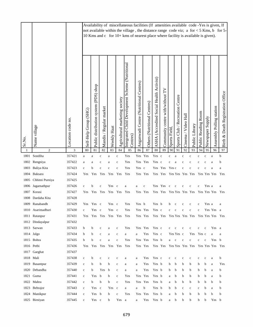
1 2 3
Lo
cati
on
co
de
no
.
Nam
e v
illa
ge
Sr.
No
.
1801 Sondiha 357421
1802 Rengniya 357422
1803 Baliya Kita 357423
1804 Baksara 357424
1805 Chhitni Purniya 357425
1806 Jagarnathpur 357426
1807 Korasi 357427
1808 Dardaha Kita 357428
1809 Ranabandh 357429
1810 Asarimadhuri 357430
1811 Ratanpur 357431
1812 Dindayalpur 357432
1813 Sarwan 357433
1814 Jalgo 357434
1815 Bohra 357435
1816 Petbi 357436
1817 Gaeghat 357437
1818 Mali 357438
1819 Basantpur 357439
1820 Debandha 357440
1821 Guma 357441
1822 Mahra 357442
1823 Behrajor 357443
1824 Manikpur 357444
1825 Birniyan 357445
Sel
f-H
elp
Gro
up
(S
HG
)
Pu
bli
c d
istr
ibu
tio
n s
yst
em (
PD
S)
sho
p
Man
dis
/ R
egu
lar
mar
ket
Wee
kly
Haa
t
Ag
ricu
ltu
ral
mar
ket
ing
so
ciet
y
Inte
gra
ted
Ch
ild
Dev
elo
pm
ent
Sch
eme
(Nu
trit
ion
al
Cen
tres
)
An
gan
wad
i C
entr
e (N
utr
itio
nal
Cen
tres
)
Oth
ers
(Nu
trit
ion
al C
entr
es)
AS
HA
(A
ccre
dit
ed S
oci
al H
ealt
h A
ctiv
ist)
Co
mm
un
ity
cen
tre
wit
h/w
ith
ou
t T
V
Sp
ort
s F
ield
,
Sp
ort
s C
lub
/ R
ecre
atio
n C
entr
e
Cin
ema
/ V
ideo
Hal
l
Pu
bli
c L
ibra
ry
Pu
bli
c R
ead
ing
Ro
om
New
spap
er S
up
ply
Ass
emb
ly P
oll
ing
sta
tio
n
Bir
th &
Dea
th R
egis
trat
ion
Off
ice
80 81 82 83 84 85 86 87 88 89 90 91 92 93 94 95 96 97
Availability of miscellaneous facilities (If amenities available code -Yes is given, If
not available within the village , the distance range code viz; a for < 5 Kms, b for 5-
10 Kms and c for 10+ kms of nearest place where facility is available is given).
a a c a c Yes Yes Yes Yes c c a c c c c a b
a a c a c Yes Yes Yes Yes c c a c c c c a b
c b c c c Yes Yes c Yes Yes Yes c c c c c a a
Yes Yes Yes Yes Yes Yes Yes Yes Yes Yes Yes Yes Yes Yes Yes Yes Yes Yes
c b c Yes c a a c Yes Yes c c c c c Yes a a
Yes Yes Yes Yes Yes Yes Yes Yes Yes Yes Yes Yes Yes Yes Yes Yes Yes Yes
Yes Yes c Yes c Yes Yes b Yes b b c c c c Yes a a
c Yes c Yes c Yes Yes Yes Yes c c c c c c Yes Yes a
Yes Yes Yes Yes Yes Yes Yes Yes Yes Yes Yes Yes Yes Yes Yes Yes Yes Yes
b b c a c Yes Yes Yes Yes c c c c c c c Yes a
b b c a c a a Yes Yes c Yes Yes c Yes Yes c a a
b b c a c Yes Yes Yes Yes b a c c c c c Yes b
Yes Yes Yes Yes Yes Yes Yes Yes Yes Yes Yes Yes Yes Yes Yes Yes Yes Yes
c b c c c a a Yes Yes c c c c c c c a b
c b b b c a a Yes Yes b b b b b b b a Yes
c b Yes b c a a Yes Yes b b b b b b b a b
c Yes b b c Yes Yes Yes Yes b a b b b b b a b
c b b b c Yes Yes Yes Yes b a b b b b b b b
c Yes c Yes c a a b Yes b b b c c c b a b
c Yes b b c Yes Yes Yes Yes b a b b b b b b b
c Yes c b Yes a a Yes Yes b a b b b b b Yes b
679

1 2 3
Lo
cati
on
co
de
no
.
Nam
e v
illa
ge
Sr.
No
.
1826 Dahupadhar 357446
1827 Liladah 357447
1828 Teliyatikar 357448
1829 Sasankita 357449
1830 Mohani 357450
1831 Ghanshampur 357451
1832 Danre 357452
1833 Lauamahua 357453
1834 Mohanabarandande 357454
1835 Balua 357455
1836 Beldanga 357456
1837 Sat Bandha 357457
1838 Naudiha 357458
1839 Kathwan 357459
1840 Parsoti 357460
1841 Bhatondha 357461
1842 Barga Chhahariyari 357462
1843 Sikatiya 357463
1844 Latta(Santali) 357464
1845 Latta (Dikuani) 357465
1846 Surapparwa 357466
1847 Balathar 357467
1848 Amjora 357468
1849 Burhnajor 357469
1850 Pakariya 357470
Sel
f-H
elp
Gro
up
(S
HG
)
Pu
bli
c d
istr
ibu
tio
n s
yst
em (
PD
S)
sho
p
Man
dis
/ R
egu
lar
mar
ket
Wee
kly
Haa
t
Ag
ricu
ltu
ral
mar
ket
ing
so
ciet
y
Inte
gra
ted
Ch
ild
Dev
elo
pm
ent
Sch
eme
(Nu
trit
ion
al
Cen
tres
)
An
gan
wad
i C
entr
e (N
utr
itio
nal
Cen
tres
)
Oth
ers
(Nu
trit
ion
al C
entr
es)
AS
HA
(A
ccre
dit
ed S
oci
al H
ealt
h A
ctiv
ist)
Co
mm
un
ity
cen
tre
wit
h/w
ith
ou
t T
V
Sp
ort
s F
ield
,
Sp
ort
s C
lub
/ R
ecre
atio
n C
entr
e
Cin
ema
/ V
ideo
Hal
l
Pu
bli
c L
ibra
ry
Pu
bli
c R
ead
ing
Ro
om
New
spap
er S
up
ply
Ass
emb
ly P
oll
ing
sta
tio
n
Bir
th &
Dea
th R
egis
trat
ion
Off
ice
80 81 82 83 84 85 86 87 88 89 90 91 92 93 94 95 96 97
Availability of miscellaneous facilities (If amenities available code -Yes is given, If
not available within the village , the distance range code viz; a for < 5 Kms, b for 5-
10 Kms and c for 10+ kms of nearest place where facility is available is given).
c b c b c a a Yes Yes b a b b b b b b b
c b c b c Yes Yes c Yes b b b a a a Yes Yes b
Yes Yes Yes Yes Yes Yes Yes Yes Yes Yes Yes Yes Yes Yes Yes Yes Yes Yes
c b c a c Yes Yes c Yes b b b b b b Yes Yes a
c b Yes Yes c a a Yes Yes b Yes b b b b b b a
Yes Yes Yes Yes Yes Yes Yes Yes Yes Yes Yes Yes Yes Yes Yes Yes Yes Yes
c a c a c Yes Yes Yes Yes c Yes c c c c c Yes b
c a c Yes c a a Yes Yes c Yes c c c c c Yes b
Yes Yes a a c Yes Yes b Yes c b c c c c Yes Yes Yes
Yes a a Yes a Yes Yes b Yes b Yes Yes b b b Yes Yes a
c Yes b b b Yes Yes b Yes b b b b b b Yes Yes Yes
b Yes b Yes b Yes Yes a Yes b b b b b b Yes Yes Yes
Yes Yes a Yes a Yes Yes b Yes a Yes a a c c Yes Yes a
Yes Yes b a b Yes Yes b Yes b b b b c c b Yes b
Yes a b a b Yes Yes Yes Yes b b b b c c b Yes b
c a b Yes c Yes Yes Yes Yes b Yes b b c c Yes Yes b
c a b b b Yes Yes Yes Yes Yes c b b b b b a b
c Yes b a c Yes Yes Yes Yes c Yes b b b b Yes Yes b
c a c a c Yes Yes Yes Yes c Yes c c c c c Yes b
Yes a c a c a a b Yes c Yes c c c c c a b
a a c b c Yes Yes Yes Yes c a c c c c c b b
a Yes c a c Yes Yes Yes Yes c Yes c c c c c Yes b
680

1 2 3
Lo
cati
on
co
de
no
.
Nam
e v
illa
ge
Sr.
No
.
1851 Bargaon 357471
1852 Taratikar 357472
1853 Pasai 357473
1854 Arazi Kita Sahuri 357474
1855 Machkhara 357475
1856 Barkabaiso 357476
1857 Durpat 357477
1858 Goaridih 357478
1859 Matihani 357479
1860 Bara Chapar 357480
1861 Amwar (Santali) 357481
1862 Amwar(Dikuani) 357482
1863 Tarpokhra 357483
1864 Harlatikar 357484
1865 Bhaga 357485
1866 Garhi 357486
1867 Gorharajpur(Dikuani) 357487
1868 Gorharajpur(Santali) 357488
1869 Khajurma 357489
1870 Tarkhuta 357490
1871 Joguadih (Dikuani) 357491
1872 Joguadih (Santali ) 357492
1873 Dakhinbahiar 357493
1874 Salaiya 357494
1875 Dumariya 357495
Sel
f-H
elp
Gro
up
(S
HG
)
Pu
bli
c d
istr
ibu
tio
n s
yst
em (
PD
S)
sho
p
Man
dis
/ R
egu
lar
mar
ket
Wee
kly
Haa
t
Ag
ricu
ltu
ral
mar
ket
ing
so
ciet
y
Inte
gra
ted
Ch
ild
Dev
elo
pm
ent
Sch
eme
(Nu
trit
ion
al
Cen
tres
)
An
gan
wad
i C
entr
e (N
utr
itio
nal
Cen
tres
)
Oth
ers
(Nu
trit
ion
al C
entr
es)
AS
HA
(A
ccre
dit
ed S
oci
al H
ealt
h A
ctiv
ist)
Co
mm
un
ity
cen
tre
wit
h/w
ith
ou
t T
V
Sp
ort
s F
ield
,
Sp
ort
s C
lub
/ R
ecre
atio
n C
entr
e
Cin
ema
/ V
ideo
Hal
l
Pu
bli
c L
ibra
ry
Pu
bli
c R
ead
ing
Ro
om
New
spap
er S
up
ply
Ass
emb
ly P
oll
ing
sta
tio
n
Bir
th &
Dea
th R
egis
trat
ion
Off
ice
80 81 82 83 84 85 86 87 88 89 90 91 92 93 94 95 96 97
Availability of miscellaneous facilities (If amenities available code -Yes is given, If
not available within the village , the distance range code viz; a for < 5 Kms, b for 5-
10 Kms and c for 10+ kms of nearest place where facility is available is given).
Yes Yes c c c Yes Yes Yes Yes c a c c c c c a b
a Yes b Yes b Yes Yes Yes Yes c Yes Yes b Yes Yes Yes Yes b
a a b a a Yes Yes Yes Yes c c a b b b b a b
a Yes b Yes b a a Yes Yes b Yes a b b b Yes Yes b
Yes Yes Yes Yes Yes Yes Yes Yes Yes Yes Yes Yes Yes Yes Yes Yes Yes Yes
a a b a b Yes Yes Yes Yes a c a b b b b a b
Yes a a a a a a b Yes a Yes a a c c a Yes a
Yes a a a a a a a Yes a Yes a a c c a Yes a
a a b a b Yes Yes Yes Yes a Yes a a a a a Yes a
a a b a a Yes Yes c Yes a a a a b b b a a
a a b a a Yes Yes Yes Yes a a a a b b b a a
Yes b c c c Yes Yes b Yes b b b c c c b Yes b
a a b a a Yes Yes Yes Yes a a c a b b b a a
Yes b c c c a a b Yes b b b c c c b a b
c b c c c Yes Yes Yes Yes c c c c c c b a b
c b c c c Yes Yes Yes Yes c c c c c c b a b
c b c c c Yes Yes Yes Yes c c c c c c c a b
c b c Yes c Yes Yes Yes Yes c c c c c c a Yes b
c a c b c Yes Yes Yes Yes c c c c c c Yes a a
Yes a c b c Yes Yes Yes Yes c c c c c c Yes Yes a
Yes Yes c b c Yes Yes b Yes c c c c c c Yes Yes a
Yes Yes c a c Yes Yes b Yes c c c c c c Yes a Yes
Yes a c a c Yes Yes Yes Yes c c c c c c a a a
Yes a c a c Yes Yes Yes Yes c c c c c c a Yes a
681
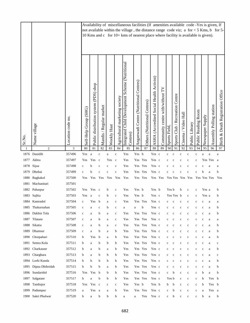
1 2 3
Lo
cati
on
co
de
no
.
Nam
e v
illa
ge
Sr.
No
.
1876 Danidih 357496
1877 Akhra 357497
1878 Sijua 357498
1879 Dhobai 357499
1880 Baghakol 357500
1881 Machanitari 357501
1882 Paharpur 357502
1883 Sajhia 357503
1884 Kamradol 357504
1885 Thakurnahan 357505
1886 Dakhin Tola 357506
1887 Tilatanr 357507
1888 Sikatia 357508
1889 Dhamsur 357509
1890 Chorpahari 357510
1891 Semra Kola 357511
1892 Charkatanr 357512
1893 Charghara 357513
1894 Lorhi Kunda 357514
1895 Dipna Dhibridah 357515
1896 Sundaridol 357516
1897 Salgatanr 357517
1898 Tambajor 357518
1899 Padumpur 357519
1900 Sakri Phulwar 357520
Sel
f-H
elp
Gro
up
(S
HG
)
Pu
bli
c d
istr
ibu
tio
n s
yst
em (
PD
S)
sho
p
Man
dis
/ R
egu
lar
mar
ket
Wee
kly
Haa
t
Ag
ricu
ltu
ral
mar
ket
ing
so
ciet
y
Inte
gra
ted
Ch
ild
Dev
elo
pm
ent
Sch
eme
(Nu
trit
ion
al
Cen
tres
)
An
gan
wad
i C
entr
e (N
utr
itio
nal
Cen
tres
)
Oth
ers
(Nu
trit
ion
al C
entr
es)
AS
HA
(A
ccre
dit
ed S
oci
al H
ealt
h A
ctiv
ist)
Co
mm
un
ity
cen
tre
wit
h/w
ith
ou
t T
V
Sp
ort
s F
ield
,
Sp
ort
s C
lub
/ R
ecre
atio
n C
entr
e
Cin
ema
/ V
ideo
Hal
l
Pu
bli
c L
ibra
ry
Pu
bli
c R
ead
ing
Ro
om
New
spap
er S
up
ply
Ass
emb
ly P
oll
ing
sta
tio
n
Bir
th &
Dea
th R
egis
trat
ion
Off
ice
80 81 82 83 84 85 86 87 88 89 90 91 92 93 94 95 96 97
Availability of miscellaneous facilities (If amenities available code -Yes is given, If
not available within the village , the distance range code viz; a for < 5 Kms, b for 5-
10 Kms and c for 10+ kms of nearest place where facility is available is given).
Yes a c a c Yes Yes b Yes c c c c c c a a a
Yes Yes c Yes c Yes Yes Yes Yes c c c c c c Yes Yes a
c b c c c Yes Yes Yes Yes c c c c c c c a a
c b c c c Yes Yes Yes Yes c c c c c c b a b
Yes Yes Yes Yes Yes Yes Yes Yes Yes Yes Yes Yes Yes Yes Yes Yes Yes Yes
Yes Yes c b c Yes Yes b Yes b Yes b b c c Yes a b
Yes a c b c Yes Yes b Yes c Yes Yes b c c Yes a b
c Yes b a c Yes Yes Yes Yes c c c c c c c a a
c a c b c a a b Yes c c c c c c c a b
c a b a c Yes Yes Yes Yes c c c c c c c a b
c a b a c Yes Yes Yes Yes c c c c c c c a a
c a b a c Yes Yes Yes Yes c c c c c c c a b
c a b a b Yes Yes Yes Yes c c c c c c c a b
b Yes b a b Yes Yes Yes Yes c c c c c c c a b
b a b b b Yes Yes Yes Yes c c c c c c c a c
b a b a b Yes Yes Yes Yes c c c c c c c a b
b a b b b Yes Yes Yes Yes c c c c c c c a c
b b b b b Yes Yes Yes Yes c c c c c c c a b
b b b a b Yes Yes Yes Yes c c c c c c c a b
Yes Yes b b b Yes Yes Yes Yes c c b c c c b a b
b a b b b Yes Yes Yes Yes c Yes b c c c b Yes b
Yes Yes c c c Yes Yes b Yes b b b c c c b Yes b
a Yes a a b Yes Yes Yes Yes c c b c c c a Yes a
b a b b b a a Yes Yes c c b c c c b a b
682

1 2 3
Lo
cati
on
co
de
no
.
Nam
e v
illa
ge
Sr.
No
.
1901 Kurwa 357521
1902 Kharbari 357522
1903 Chamudih 357523
1904 Maheshkiro Pachimtola 357524
1905 Kasturi 357525
1906 Khairadih 357526
1907 Panch Pahari 357527
1908 Dadughutu Paharpur 357528
1909 Maheshdhasa 357529
1910 Kita Makra 357530
1911 Dorabandh 357531
1912 Pareya Hat 357532
1913 Gunghasa 357533
1914 Rajdaha Bara 357534
1915 Gauripur 357535
1916 Sugathan 357536
1917 Hathihariyari 357537
1918 Dharophata 357538
1919 Lathibari 357539
1920 Jhapnibandh 357540
1921 Dhanu Kata 357541
1922 Raghunathpur 357542
1923 Kundapani 357543
1924 Kanchanrai Tola 357544
1925 Bandhaghat 357545
Sel
f-H
elp
Gro
up
(S
HG
)
Pu
bli
c d
istr
ibu
tio
n s
yst
em (
PD
S)
sho
p
Man
dis
/ R
egu
lar
mar
ket
Wee
kly
Haa
t
Ag
ricu
ltu
ral
mar
ket
ing
so
ciet
y
Inte
gra
ted
Ch
ild
Dev
elo
pm
ent
Sch
eme
(Nu
trit
ion
al
Cen
tres
)
An
gan
wad
i C
entr
e (N
utr
itio
nal
Cen
tres
)
Oth
ers
(Nu
trit
ion
al C
entr
es)
AS
HA
(A
ccre
dit
ed S
oci
al H
ealt
h A
ctiv
ist)
Co
mm
un
ity
cen
tre
wit
h/w
ith
ou
t T
V
Sp
ort
s F
ield
,
Sp
ort
s C
lub
/ R
ecre
atio
n C
entr
e
Cin
ema
/ V
ideo
Hal
l
Pu
bli
c L
ibra
ry
Pu
bli
c R
ead
ing
Ro
om
New
spap
er S
up
ply
Ass
emb
ly P
oll
ing
sta
tio
n
Bir
th &
Dea
th R
egis
trat
ion
Off
ice
80 81 82 83 84 85 86 87 88 89 90 91 92 93 94 95 96 97
Availability of miscellaneous facilities (If amenities available code -Yes is given, If
not available within the village , the distance range code viz; a for < 5 Kms, b for 5-
10 Kms and c for 10+ kms of nearest place where facility is available is given).
b a b b b Yes Yes Yes Yes c c b c c c b Yes b
b a b a b Yes Yes Yes Yes c c b c c c b a b
a a b a b Yes Yes Yes Yes b b b b c c b b b
Yes a b a c Yes Yes b Yes c Yes c c c c b Yes Yes
a a a a a Yes Yes Yes Yes a a a a c c a Yes a
Yes a b b c Yes Yes a Yes c a b b c c b Yes a
a a b b b Yes Yes Yes Yes c a c b c c b b b
Yes Yes b b b Yes Yes Yes Yes c a c b c c b b b
Yes a b b c Yes Yes Yes Yes c a c b c c b Yes a
Yes a a a a Yes Yes Yes Yes a a c a c c a Yes a
Yes Yes Yes c c Yes Yes b Yes b Yes Yes Yes Yes Yes Yes Yes Yes
a a a a a Yes Yes Yes Yes a a a a a a a Yes Yes
a a a a a Yes Yes Yes Yes a Yes Yes a a a Yes Yes a
Yes Yes b b b Yes Yes Yes Yes b Yes b b c c b Yes b
Yes a a a a a a b Yes a Yes a a c c Yes Yes a
a Yes c a b Yes Yes Yes Yes b a b c c c b Yes Yes
Yes Yes b a Yes a a b Yes b Yes b c c c b Yes a
Yes Yes b a c Yes Yes b Yes b Yes b c c c c Yes Yes
Yes Yes b a b a a b Yes b Yes b b c c c a b
Yes Yes c a c a a Yes Yes c Yes c c c c c b b
Yes Yes b Yes c Yes Yes a Yes b Yes b c c c b Yes Yes
Yes a b b b Yes Yes b Yes b b b b c c b Yes b
Yes Yes Yes Yes Yes Yes Yes Yes Yes Yes Yes Yes Yes Yes Yes Yes Yes Yes
683
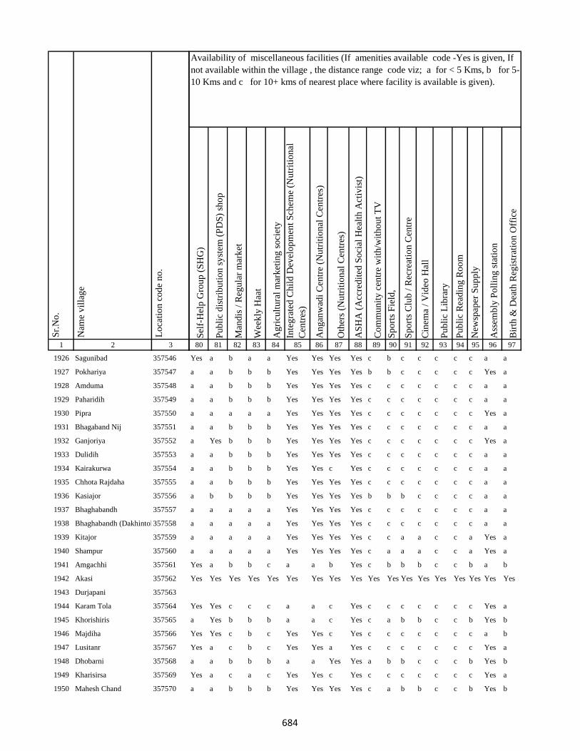
1 2 3
Lo
cati
on
co
de
no
.
Nam
e v
illa
ge
Sr.
No
.
1926 Sagunibad 357546
1927 Pokhariya 357547
1928 Amduma 357548
1929 Paharidih 357549
1930 Pipra 357550
1931 Bhagaband Nij 357551
1932 Ganjoriya 357552
1933 Dulidih 357553
1934 Kairakurwa 357554
1935 Chhota Rajdaha 357555
1936 Kasiajor 357556
1937 Bhaghabandh 357557
1938 Bhaghabandh (Dakhintola)357558
1939 Kitajor 357559
1940 Shampur 357560
1941 Amgachhi 357561
1942 Akasi 357562
1943 Durjapani 357563
1944 Karam Tola 357564
1945 Khorishiris 357565
1946 Majdiha 357566
1947 Lusitanr 357567
1948 Dhobarni 357568
1949 Kharisirsa 357569
1950 Mahesh Chand 357570
Sel
f-H
elp
Gro
up
(S
HG
)
Pu
bli
c d
istr
ibu
tio
n s
yst
em (
PD
S)
sho
p
Man
dis
/ R
egu
lar
mar
ket
Wee
kly
Haa
t
Ag
ricu
ltu
ral
mar
ket
ing
so
ciet
y
Inte
gra
ted
Ch
ild
Dev
elo
pm
ent
Sch
eme
(Nu
trit
ion
al
Cen
tres
)
An
gan
wad
i C
entr
e (N
utr
itio
nal
Cen
tres
)
Oth
ers
(Nu
trit
ion
al C
entr
es)
AS
HA
(A
ccre
dit
ed S
oci
al H
ealt
h A
ctiv
ist)
Co
mm
un
ity
cen
tre
wit
h/w
ith
ou
t T
V
Sp
ort
s F
ield
,
Sp
ort
s C
lub
/ R
ecre
atio
n C
entr
e
Cin
ema
/ V
ideo
Hal
l
Pu
bli
c L
ibra
ry
Pu
bli
c R
ead
ing
Ro
om
New
spap
er S
up
ply
Ass
emb
ly P
oll
ing
sta
tio
n
Bir
th &
Dea
th R
egis
trat
ion
Off
ice
80 81 82 83 84 85 86 87 88 89 90 91 92 93 94 95 96 97
Availability of miscellaneous facilities (If amenities available code -Yes is given, If
not available within the village , the distance range code viz; a for < 5 Kms, b for 5-
10 Kms and c for 10+ kms of nearest place where facility is available is given).
Yes a b a a Yes Yes Yes Yes c b c c c c c a a
a a b b b Yes Yes Yes Yes b b c c c c c Yes a
a a b b b Yes Yes Yes Yes c c c c c c c a a
a a b b b Yes Yes Yes Yes c c c c c c c a a
a a a a a Yes Yes Yes Yes c c c c c c c Yes a
a a b b b Yes Yes Yes Yes c c c c c c c a a
a Yes b b b Yes Yes Yes Yes c c c c c c c Yes a
a a b b b Yes Yes Yes Yes c c c c c c c a a
a a b b b Yes Yes c Yes c c c c c c c a a
a a b b b Yes Yes Yes Yes c c c c c c c a a
a b b b b Yes Yes Yes Yes b b b c c c c a a
a a a a a Yes Yes Yes Yes c c c c c c c a a
a a a a a Yes Yes Yes Yes c c c c c c c a a
a a a a a Yes Yes Yes Yes c c a a c c a Yes a
a a a a a Yes Yes Yes Yes c a a a c c a Yes a
Yes a b b c a a b Yes c b b b c c b a b
Yes Yes Yes Yes Yes Yes Yes Yes Yes Yes Yes Yes Yes Yes Yes Yes Yes Yes
Yes Yes c c c a a c Yes c c c c c c c Yes a
a Yes b b b a a c Yes c a b b c c b Yes b
Yes Yes c b c Yes Yes c Yes c c c c c c c a b
Yes a c b c Yes Yes a Yes c c c c c c c Yes a
a a b b b a a Yes Yes a b b c c c b Yes b
Yes a c a c Yes Yes c Yes c c c c c c c Yes a
a a b b b Yes Yes Yes Yes c a b b c c b Yes b
684
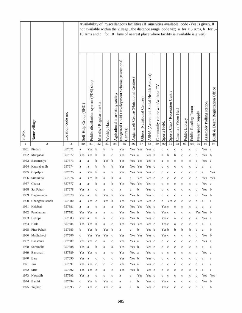
1 2 3
Lo
cati
on
co
de
no
.
Nam
e v
illa
ge
Sr.
No
.
1951 Pindari 357571
1952 Murgabani 357572
1953 Baramasiya 357573
1954 Kamrabandh 357574
1955 Gopalpur 357575
1956 Simrakita 357576
1957 Chatra 357577
1958 Sat Pahari 357578
1959 Baghmunda 357579
1960 Ghanghra Bandh 357580
1961 Kelabari 357581
1962 Panchratan 357582
1963 Beltopa 357583
1964 Harla 357584
1965 Pitar Pahari 357585
1966 Madhukopi 357586
1967 Bansmuri 357587
1968 Sarbindha 357588
1969 Bansmati 357589
1970 Bara 357590
1971 Jari 357591
1972 Siria 357592
1973 Nawadih 357593
1974 Banjhi 357594
1975 Taljhari 357595
Sel
f-H
elp
Gro
up
(S
HG
)
Pu
bli
c d
istr
ibu
tio
n s
yst
em (
PD
S)
sho
p
Man
dis
/ R
egu
lar
mar
ket
Wee
kly
Haa
t
Ag
ricu
ltu
ral
mar
ket
ing
so
ciet
y
Inte
gra
ted
Ch
ild
Dev
elo
pm
ent
Sch
eme
(Nu
trit
ion
al
Cen
tres
)
An
gan
wad
i C
entr
e (N
utr
itio
nal
Cen
tres
)
Oth
ers
(Nu
trit
ion
al C
entr
es)
AS
HA
(A
ccre
dit
ed S
oci
al H
ealt
h A
ctiv
ist)
Co
mm
un
ity
cen
tre
wit
h/w
ith
ou
t T
V
Sp
ort
s F
ield
,
Sp
ort
s C
lub
/ R
ecre
atio
n C
entr
e
Cin
ema
/ V
ideo
Hal
l
Pu
bli
c L
ibra
ry
Pu
bli
c R
ead
ing
Ro
om
New
spap
er S
up
ply
Ass
emb
ly P
oll
ing
sta
tio
n
Bir
th &
Dea
th R
egis
trat
ion
Off
ice
80 81 82 83 84 85 86 87 88 89 90 91 92 93 94 95 96 97
Availability of miscellaneous facilities (If amenities available code -Yes is given, If
not available within the village , the distance range code viz; a for < 5 Kms, b for 5-
10 Kms and c for 10+ kms of nearest place where facility is available is given).
a Yes b b b Yes Yes Yes Yes c c c c c c c Yes a
Yes Yes b b c Yes Yes a Yes b b b b c c b Yes b
a a b Yes b Yes Yes Yes Yes c a c c c c c Yes a
a a b b b Yes Yes Yes Yes c c c c c c c a a
a Yes b a b Yes Yes Yes Yes c c c c c c c a Yes
a Yes b a b a a Yes Yes c c c c c c c Yes Yes
a a b a b Yes Yes Yes Yes c c c c c c c Yes a
Yes a c a c a a b Yes c c c c c c c Yes b
Yes a b Yes b Yes Yes b Yes c c c c c c c Yes b
a Yes c Yes b Yes Yes Yes Yes c c Yes c c c c a a
a a c a a Yes Yes Yes Yes c Yes c c c c c a a
Yes Yes a a c Yes Yes b Yes b Yes c c c c Yes Yes b
Yes a b a c Yes Yes b Yes c Yes c a c c a Yes a
Yes Yes b a c Yes Yes Yes Yes c Yes c a c c c a a
b Yes b Yes b a a b Yes b Yes b b b b b a b
c Yes Yes Yes c Yes Yes Yes Yes c Yes c c c c c Yes b
Yes Yes c a c Yes Yes a Yes c c c c c c c Yes a
Yes a b a a Yes Yes b Yes c c c c c c c a a
Yes Yes c a c Yes Yes a Yes c c c c c c c Yes a
Yes a c c c Yes Yes b Yes c c c c c c c a a
Yes Yes c c c Yes Yes a Yes c c c c c c c a a
Yes Yes c a c Yes Yes b Yes c c c c c c c a a
Yes a c c c a a Yes Yes c c c c c c c Yes Yes
c Yes b Yes c a a b Yes c Yes c c c c c Yes b
c Yes c Yes c a a b Yes c Yes c c c c c a b
685

1 2 3
Lo
cati
on
co
de
no
.
Nam
e v
illa
ge
Sr.
No
.
1976 Kharkachia 357596
1977 Jambad 357597
1978 Chorbad 357598
1979 Agiabandh 357599
1980 Dewdanr(Uttartola) 357600
1981 Dewdanr 357601
1982 Baghmara 357602
1983 Kendua 357603
1984 Karikadar 357604
1985 Khardaha 357605
1986 Khardaha 357606
1987 Ambadiha 357607
1988 Baghmara Purabtola 357608
1989 Garhbana 357609
1990 Gobindpur 357610
1991 Bankati 357611
1992 Pindra 357612
1993 Piparjoriya 357613
1994 Jitpur 357614
1995 Boha 357615
1996 Liti 357616
1997 Sidhbank 357617
1998 Kairasol 357618
1999 Daharlangi 357619
2000 Halhiya Pathar 357620
Sel
f-H
elp
Gro
up
(S
HG
)
Pu
bli
c d
istr
ibu
tio
n s
yst
em (
PD
S)
sho
p
Man
dis
/ R
egu
lar
mar
ket
Wee
kly
Haa
t
Ag
ricu
ltu
ral
mar
ket
ing
so
ciet
y
Inte
gra
ted
Ch
ild
Dev
elo
pm
ent
Sch
eme
(Nu
trit
ion
al
Cen
tres
)
An
gan
wad
i C
entr
e (N
utr
itio
nal
Cen
tres
)
Oth
ers
(Nu
trit
ion
al C
entr
es)
AS
HA
(A
ccre
dit
ed S
oci
al H
ealt
h A
ctiv
ist)
Co
mm
un
ity
cen
tre
wit
h/w
ith
ou
t T
V
Sp
ort
s F
ield
,
Sp
ort
s C
lub
/ R
ecre
atio
n C
entr
e
Cin
ema
/ V
ideo
Hal
l
Pu
bli
c L
ibra
ry
Pu
bli
c R
ead
ing
Ro
om
New
spap
er S
up
ply
Ass
emb
ly P
oll
ing
sta
tio
n
Bir
th &
Dea
th R
egis
trat
ion
Off
ice
80 81 82 83 84 85 86 87 88 89 90 91 92 93 94 95 96 97
Availability of miscellaneous facilities (If amenities available code -Yes is given, If
not available within the village , the distance range code viz; a for < 5 Kms, b for 5-
10 Kms and c for 10+ kms of nearest place where facility is available is given).
Yes Yes b a c a a b Yes c a a a c c a Yes a
Yes a a Yes c Yes Yes b Yes c Yes c a c c Yes Yes a
c a c c c Yes Yes b Yes c c c c c c Yes Yes a
c a c c c a a b Yes b b b c c c Yes a b
c b Yes c c Yes Yes b Yes c c c c c c Yes a Yes
Yes a a a c a a Yes Yes c c c Yes c c a a Yes
Yes a a a c Yes Yes Yes Yes c Yes c a c c a a a
c Yes c Yes c a a b Yes c Yes c c c c c a b
c b c b c Yes Yes Yes Yes c c c c c c b a b
Yes b b b c Yes Yes Yes Yes c c c c c c b a b
Yes a a a c Yes Yes Yes Yes c Yes c a c c a a a
Yes Yes a a c a a b Yes c Yes c a c c a Yes a
c a a a c Yes Yes Yes Yes c c c c c c c Yes a
c a a a c Yes Yes Yes Yes c c c c c c c Yes a
c a b a c Yes Yes Yes Yes c c c c c c b Yes b
c a b Yes c a a Yes Yes c c c c c c a a a
b Yes b a c Yes Yes Yes Yes c c c b c c b a b
b a a a c Yes Yes Yes Yes c c c c c c c Yes a
b a b Yes c a a Yes Yes c c c c c c b Yes a
Yes Yes b b c a a b Yes c c c c c c b a a
Yes Yes c a c Yes Yes b Yes c Yes c c c c c a a
b a c Yes c a a Yes Yes c Yes c c c c b a b
b a c a c Yes Yes Yes Yes b c c c c c b a b
b a c a c Yes Yes Yes Yes c b c c c c b a b
b a c a c a a Yes Yes c b c c c c b Yes b
686
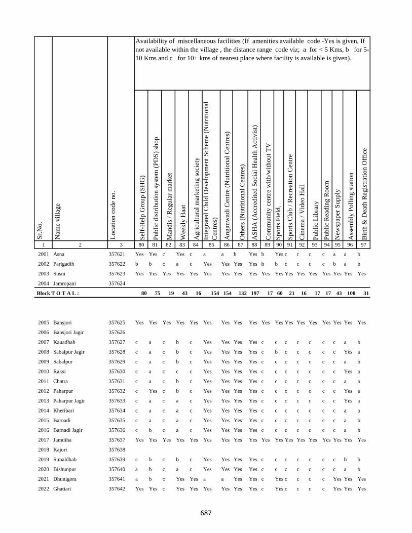
1 2 3
Lo
cati
on
co
de
no
.
Nam
e v
illa
ge
Sr.
No
.
2001 Asna 357621
2002 Parigadih 357622
2003 Susni 357623
2004 Jamropani 357624
Block T O T A L :
2005 Bansjori 357625
2006 Bansjori Jagir 357626
2007 Kauadhab 357627
2008 Sabalpur Jagir 357628
2009 Sabalpur 357629
2010 Raksi 357630
2011 Chatra 357631
2012 Paharpur 357632
2013 Paharpur Jagir 357633
2014 Kheribari 357634
2015 Barnadi 357635
2016 Barnadi Jagir 357636
2017 Jamdiha 357637
2018 Kajuri 357638
2019 Simaldhab 357639
2020 Bishunpur 357640
2021 Dhunigora 357641
2022 Ghatiari 357642
Sel
f-H
elp
Gro
up
(S
HG
)
Pu
bli
c d
istr
ibu
tio
n s
yst
em (
PD
S)
sho
p
Man
dis
/ R
egu
lar
mar
ket
Wee
kly
Haa
t
Ag
ricu
ltu
ral
mar
ket
ing
so
ciet
y
Inte
gra
ted
Ch
ild
Dev
elo
pm
ent
Sch
eme
(Nu
trit
ion
al
Cen
tres
)
An
gan
wad
i C
entr
e (N
utr
itio
nal
Cen
tres
)
Oth
ers
(Nu
trit
ion
al C
entr
es)
AS
HA
(A
ccre
dit
ed S
oci
al H
ealt
h A
ctiv
ist)
Co
mm
un
ity
cen
tre
wit
h/w
ith
ou
t T
V
Sp
ort
s F
ield
,
Sp
ort
s C
lub
/ R
ecre
atio
n C
entr
e
Cin
ema
/ V
ideo
Hal
l
Pu
bli
c L
ibra
ry
Pu
bli
c R
ead
ing
Ro
om
New
spap
er S
up
ply
Ass
emb
ly P
oll
ing
sta
tio
n
Bir
th &
Dea
th R
egis
trat
ion
Off
ice
80 81 82 83 84 85 86 87 88 89 90 91 92 93 94 95 96 97
Availability of miscellaneous facilities (If amenities available code -Yes is given, If
not available within the village , the distance range code viz; a for < 5 Kms, b for 5-
10 Kms and c for 10+ kms of nearest place where facility is available is given).
Yes Yes c Yes c a a b Yes b Yes c c c c a a b
b b c a c Yes Yes Yes Yes b b c c c c b a b
Yes Yes Yes Yes Yes Yes Yes Yes Yes Yes Yes Yes Yes Yes Yes Yes Yes Yes
80 75 19 43 16 154 154 132 197 17 60 21 16 17 17 43 100 31
Yes Yes Yes Yes Yes Yes Yes Yes Yes Yes Yes Yes Yes Yes Yes Yes Yes Yes
c a c b c Yes Yes Yes Yes c c c c c c c a b
c a c b c Yes Yes Yes Yes c b c c c c c Yes a
c a c b c Yes Yes Yes Yes c c c c c c c a b
c a c c c Yes Yes Yes Yes c c c c c c c Yes a
c a c b c Yes Yes Yes Yes c c c c c c c a a
c Yes c b c Yes Yes Yes Yes c c c c c c c Yes a
c a c a c Yes Yes Yes Yes c c c c c c c Yes a
c a c a c Yes Yes Yes Yes c c c c c c c a a
c a c a c Yes Yes Yes Yes c c c c c c c a b
c b c a c Yes Yes Yes Yes c c c c c c c a b
Yes Yes Yes Yes Yes Yes Yes Yes Yes Yes Yes Yes Yes Yes Yes Yes Yes Yes
c b c b c Yes Yes Yes Yes c c c c c c c b b
a b c a c Yes Yes Yes Yes c c c c c c c a b
a b c Yes Yes a a Yes Yes c Yes c c c c Yes Yes Yes
Yes Yes c Yes Yes Yes Yes Yes Yes c Yes c c c c Yes Yes Yes
687

1 2 3
Lo
cati
on
co
de
no
.
Nam
e v
illa
ge
Sr.
No
.
2023 Chhota Ghatiari 357643
2024 Tasria 357644
2025 Narayanpur 357645
2026 Jambia 357646
2027 Kherabani 357647
2028 Jilbari 357648
2029 Mahua Tanr 357649
2030 Karmatanr 357650
2031 Bhaluka 357651
2032 Sundar Maur 357652
2033 Sabalpur 357653
2034 Lawadih 357654
2035 Dighibathan 357655
2036 Jamuntanr 357656
2037 Khelari 357657
2038 Adro 357658
2039 Ammaqo 357659
2040 Bedotok 357660
2041 Berago(Telalkuria) 357661
2042 Bilamaqo(Basgo) 357662
2043 Chacham 357663
2044 Chalgoda(Madgi) 357664
2045 Chaparom 357665
2046 Chuclalo 357666
2047 Churi 357667
Sel
f-H
elp
Gro
up
(S
HG
)
Pu
bli
c d
istr
ibu
tio
n s
yst
em (
PD
S)
sho
p
Man
dis
/ R
egu
lar
mar
ket
Wee
kly
Haa
t
Ag
ricu
ltu
ral
mar
ket
ing
so
ciet
y
Inte
gra
ted
Ch
ild
Dev
elo
pm
ent
Sch
eme
(Nu
trit
ion
al
Cen
tres
)
An
gan
wad
i C
entr
e (N
utr
itio
nal
Cen
tres
)
Oth
ers
(Nu
trit
ion
al C
entr
es)
AS
HA
(A
ccre
dit
ed S
oci
al H
ealt
h A
ctiv
ist)
Co
mm
un
ity
cen
tre
wit
h/w
ith
ou
t T
V
Sp
ort
s F
ield
,
Sp
ort
s C
lub
/ R
ecre
atio
n C
entr
e
Cin
ema
/ V
ideo
Hal
l
Pu
bli
c L
ibra
ry
Pu
bli
c R
ead
ing
Ro
om
New
spap
er S
up
ply
Ass
emb
ly P
oll
ing
sta
tio
n
Bir
th &
Dea
th R
egis
trat
ion
Off
ice
80 81 82 83 84 85 86 87 88 89 90 91 92 93 94 95 96 97
Availability of miscellaneous facilities (If amenities available code -Yes is given, If
not available within the village , the distance range code viz; a for < 5 Kms, b for 5-
10 Kms and c for 10+ kms of nearest place where facility is available is given).
a b c b c Yes Yes Yes Yes c b c c c c c a b
Yes Yes Yes Yes Yes Yes Yes Yes Yes Yes Yes Yes Yes Yes Yes Yes Yes Yes
a b c b c Yes Yes Yes Yes c a c c c c c a b
a Yes c a c Yes Yes Yes Yes c Yes c c c c c a a
Yes Yes c a c a a b Yes c Yes c c c c Yes Yes Yes
Yes Yes c Yes c Yes Yes a Yes c Yes c c c c c Yes a
Yes Yes b Yes c Yes Yes b Yes c Yes c c c c c Yes Yes
Yes b c b c Yes Yes Yes Yes c b c c c c c a b
a a c a c Yes Yes Yes Yes c b c c c c c a a
Yes Yes c c c Yes Yes b Yes c Yes c c c c c Yes a
b b c c c a a b Yes c b c c c c c b a
c c c c c c c c c c c c c c c c c c
Yes Yes Yes Yes Yes Yes Yes Yes Yes Yes Yes Yes Yes Yes Yes Yes Yes Yes
c b c c c Yes Yes Yes Yes c b c c c c c a b
c b c c c Yes Yes Yes Yes c c c c c c c b b
Yes Yes Yes Yes Yes Yes Yes Yes Yes Yes Yes Yes Yes Yes Yes Yes Yes Yes
688
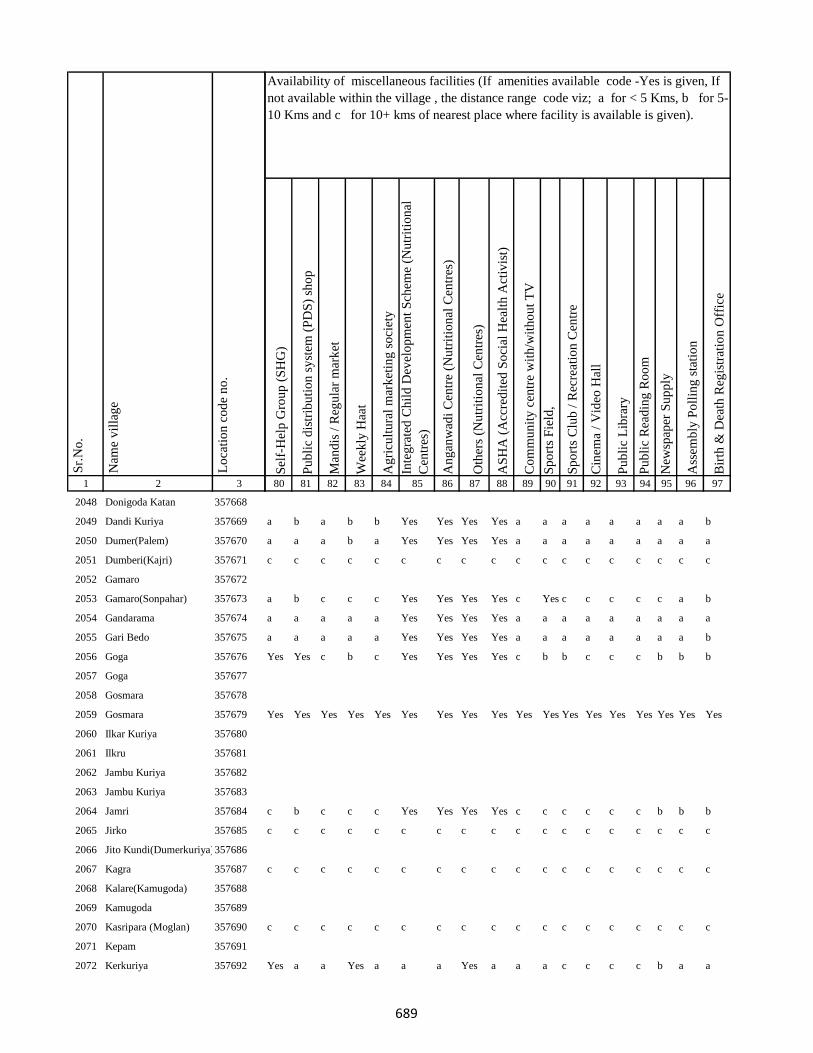
1 2 3
Lo
cati
on
co
de
no
.
Nam
e v
illa
ge
Sr.
No
.
2048 Donigoda Katan 357668
2049 Dandi Kuriya 357669
2050 Dumer(Palem) 357670
2051 Dumberi(Kajri) 357671
2052 Gamaro 357672
2053 Gamaro(Sonpahar) 357673
2054 Gandarama 357674
2055 Gari Bedo 357675
2056 Goga 357676
2057 Goga 357677
2058 Gosmara 357678
2059 Gosmara 357679
2060 Ilkar Kuriya 357680
2061 Ilkru 357681
2062 Jambu Kuriya 357682
2063 Jambu Kuriya 357683
2064 Jamri 357684
2065 Jirko 357685
2066 Jito Kundi(Dumerkuriya)357686
2067 Kagra 357687
2068 Kalare(Kamugoda) 357688
2069 Kamugoda 357689
2070 Kasripara (Moglan) 357690
2071 Kepam 357691
2072 Kerkuriya 357692
Sel
f-H
elp
Gro
up
(S
HG
)
Pu
bli
c d
istr
ibu
tio
n s
yst
em (
PD
S)
sho
p
Man
dis
/ R
egu
lar
mar
ket
Wee
kly
Haa
t
Ag
ricu
ltu
ral
mar
ket
ing
so
ciet
y
Inte
gra
ted
Ch
ild
Dev
elo
pm
ent
Sch
eme
(Nu
trit
ion
al
Cen
tres
)
An
gan
wad
i C
entr
e (N
utr
itio
nal
Cen
tres
)
Oth
ers
(Nu
trit
ion
al C
entr
es)
AS
HA
(A
ccre
dit
ed S
oci
al H
ealt
h A
ctiv
ist)
Co
mm
un
ity
cen
tre
wit
h/w
ith
ou
t T
V
Sp
ort
s F
ield
,
Sp
ort
s C
lub
/ R
ecre
atio
n C
entr
e
Cin
ema
/ V
ideo
Hal
l
Pu
bli
c L
ibra
ry
Pu
bli
c R
ead
ing
Ro
om
New
spap
er S
up
ply
Ass
emb
ly P
oll
ing
sta
tio
n
Bir
th &
Dea
th R
egis
trat
ion
Off
ice
80 81 82 83 84 85 86 87 88 89 90 91 92 93 94 95 96 97
Availability of miscellaneous facilities (If amenities available code -Yes is given, If
not available within the village , the distance range code viz; a for < 5 Kms, b for 5-
10 Kms and c for 10+ kms of nearest place where facility is available is given).
a b a b b Yes Yes Yes Yes a a a a a a a a b
a a a b a Yes Yes Yes Yes a a a a a a a a a
c c c c c c c c c c c c c c c c c c
a b c c c Yes Yes Yes Yes c Yes c c c c c a b
a a a a a Yes Yes Yes Yes a a a a a a a a a
a a a a a Yes Yes Yes Yes a a a a a a a a b
Yes Yes c b c Yes Yes Yes Yes c b b c c c b b b
Yes Yes Yes Yes Yes Yes Yes Yes Yes Yes Yes Yes Yes Yes Yes Yes Yes Yes
c b c c c Yes Yes Yes Yes c c c c c c b b b
c c c c c c c c c c c c c c c c c c
c c c c c c c c c c c c c c c c c c
c c c c c c c c c c c c c c c c c c
Yes a a Yes a a a Yes a a a c c c c b a a
689

1 2 3
Lo
cati
on
co
de
no
.
Nam
e v
illa
ge
Sr.
No
.
2073 Kerjuria 357693
2074 Kiro 357694
2075 Liladoni 357695
2076 Madgam 357696
2077 Maridoni 357697
2078 Mate 357698
2079 Pakeritok 357699
2080 Palem(Dumar) 357700
2081 Pawkuriya 357701
2082 Perdarda (Ambar) 357702
2083 Pokeri 357703
2084 Popkundo 357704
2085 Pusur Kuriya 357705
2086 Pusur Kuriya 357706
2087 Tamli Bedo 357707
2088 Tamligoda (Chaparbita) 357708
2089 Tatkota 357709
2090 Telo 357710
2091 Telodoni 357711
2092 Tetli (Telal Kuriya) 357712
2093 Sena(Katan) 357713
2094 Suju 357714
2095 Tetaria 357715
2096 Domdih 357716
2097 Kusumghati 357717
Sel
f-H
elp
Gro
up
(S
HG
)
Pu
bli
c d
istr
ibu
tio
n s
yst
em (
PD
S)
sho
p
Man
dis
/ R
egu
lar
mar
ket
Wee
kly
Haa
t
Ag
ricu
ltu
ral
mar
ket
ing
so
ciet
y
Inte
gra
ted
Ch
ild
Dev
elo
pm
ent
Sch
eme
(Nu
trit
ion
al
Cen
tres
)
An
gan
wad
i C
entr
e (N
utr
itio
nal
Cen
tres
)
Oth
ers
(Nu
trit
ion
al C
entr
es)
AS
HA
(A
ccre
dit
ed S
oci
al H
ealt
h A
ctiv
ist)
Co
mm
un
ity
cen
tre
wit
h/w
ith
ou
t T
V
Sp
ort
s F
ield
,
Sp
ort
s C
lub
/ R
ecre
atio
n C
entr
e
Cin
ema
/ V
ideo
Hal
l
Pu
bli
c L
ibra
ry
Pu
bli
c R
ead
ing
Ro
om
New
spap
er S
up
ply
Ass
emb
ly P
oll
ing
sta
tio
n
Bir
th &
Dea
th R
egis
trat
ion
Off
ice
80 81 82 83 84 85 86 87 88 89 90 91 92 93 94 95 96 97
Availability of miscellaneous facilities (If amenities available code -Yes is given, If
not available within the village , the distance range code viz; a for < 5 Kms, b for 5-
10 Kms and c for 10+ kms of nearest place where facility is available is given).
c c c c c c c c c c c c c c c c c c
c b c c c Yes Yes Yes Yes c c c c c c b a b
Yes Yes Yes Yes Yes Yes Yes Yes Yes Yes Yes Yes Yes Yes Yes Yes Yes Yes
Yes Yes Yes Yes Yes Yes Yes Yes Yes Yes Yes Yes Yes Yes Yes Yes Yes Yes
Yes a a a a Yes Yes Yes Yes a a a c c c c a a
b a a a a Yes Yes Yes Yes b b a c c c c a a
Yes a a a c Yes Yes Yes Yes b b b c c c c a a
Yes Yes Yes Yes Yes Yes Yes Yes Yes Yes Yes Yes Yes Yes Yes Yes Yes Yes
b a c a c Yes Yes b Yes c b c c c c c a a
Yes Yes Yes Yes Yes Yes Yes Yes Yes Yes Yes Yes Yes Yes Yes Yes Yes Yes
Yes Yes Yes Yes Yes Yes Yes Yes Yes Yes Yes Yes Yes Yes Yes Yes Yes Yes
a b c b c Yes Yes Yes Yes c a c c c c a a a
a a b b c Yes Yes Yes Yes c a c c c c a a a
c a c a c Yes Yes Yes Yes c b c c c c a b a
690

1 2 3
Lo
cati
on
co
de
no
.
Nam
e v
illa
ge
Sr.
No
.
2098 Amjora 357718
2099 Tilabad 357719
2100 Tesuba Than 357720
2101 Chhota Kalhajor 357721
2102 Mohanpur 357722
2103 Bara Kalhajor 357723
2104 Salodih 357724
2105 Salpathra 357725
2106 Sundar Pahari 357726
2107 Paharpur 357727
2108 Kairojori(Bara) 357728
2109 Kairojori(Chhota) 357729
2110 Jitpur 357730
2111 Telbhita 357731
2112 Gamaro 357732
2113 Gamarbera 357733
2114 Jamalo 357734
2115 Dahubera 357735
2116 Jiyajori 357736
2117 Rampur 357737
2118 Barajolo 357738
2119 Manikbathan 357739
2120 Dhaupahari 357740
2121 Ladapathar 357741
2122 Phulbaria 357742
Sel
f-H
elp
Gro
up
(S
HG
)
Pu
bli
c d
istr
ibu
tio
n s
yst
em (
PD
S)
sho
p
Man
dis
/ R
egu
lar
mar
ket
Wee
kly
Haa
t
Ag
ricu
ltu
ral
mar
ket
ing
so
ciet
y
Inte
gra
ted
Ch
ild
Dev
elo
pm
ent
Sch
eme
(Nu
trit
ion
al
Cen
tres
)
An
gan
wad
i C
entr
e (N
utr
itio
nal
Cen
tres
)
Oth
ers
(Nu
trit
ion
al C
entr
es)
AS
HA
(A
ccre
dit
ed S
oci
al H
ealt
h A
ctiv
ist)
Co
mm
un
ity
cen
tre
wit
h/w
ith
ou
t T
V
Sp
ort
s F
ield
,
Sp
ort
s C
lub
/ R
ecre
atio
n C
entr
e
Cin
ema
/ V
ideo
Hal
l
Pu
bli
c L
ibra
ry
Pu
bli
c R
ead
ing
Ro
om
New
spap
er S
up
ply
Ass
emb
ly P
oll
ing
sta
tio
n
Bir
th &
Dea
th R
egis
trat
ion
Off
ice
80 81 82 83 84 85 86 87 88 89 90 91 92 93 94 95 96 97
Availability of miscellaneous facilities (If amenities available code -Yes is given, If
not available within the village , the distance range code viz; a for < 5 Kms, b for 5-
10 Kms and c for 10+ kms of nearest place where facility is available is given).
Yes a c a c Yes Yes Yes Yes c a c c c c Yes Yes Yes
c a c Yes c Yes Yes Yes Yes c a c c c c a b a
c b c a c Yes Yes Yes Yes c b c c c c a b a
a a c b c Yes Yes Yes Yes c b c c c c a b b
a a c b c Yes Yes Yes Yes c a c c c c a b a
c a c a c Yes Yes Yes Yes c b c c c c a a a
a a b c c Yes Yes Yes Yes c a c c c c a b a
Yes Yes c Yes c Yes Yes b Yes c Yes c c c c Yes Yes Yes
a a c b c Yes Yes Yes Yes c c c c c c a b a
a a c a c Yes Yes Yes Yes b b b c c c b Yes a
a a c a c Yes Yes Yes Yes c b b c c c b a a
a a c a c Yes Yes Yes Yes c c c c c c c Yes a
Yes a a a c Yes Yes b Yes b a c c c c b Yes Yes
Yes Yes c c c Yes Yes Yes Yes c c c c c c c a a
Yes Yes Yes Yes Yes Yes Yes Yes Yes Yes Yes Yes Yes Yes Yes Yes Yes Yes
c b c a c Yes Yes Yes Yes c c c c c c b a b
c a c a c Yes Yes Yes Yes c c c c c c c Yes a
Yes Yes c Yes b Yes Yes b Yes b b b c b b b Yes a
Yes a b a c Yes Yes b Yes c b c c c c c a b
Yes a c a c Yes Yes Yes Yes c c c c c c c a a
Yes b c b c Yes Yes Yes Yes c c c c c c c Yes b
Yes b c b c Yes Yes Yes Yes c c c c c c c a b
Yes b c b c Yes Yes Yes Yes b b c c c c c a b
Yes Yes Yes Yes Yes Yes Yes Yes Yes Yes Yes Yes Yes Yes Yes Yes Yes Yes
691

1 2 3
Lo
cati
on
co
de
no
.
Nam
e v
illa
ge
Sr.
No
.
2123 Alkito(Katon) 357743
2124 Ambar 357744
2125 Bandaretoke(Madgi) 357745
2126 Champa 357746
2127 Charmaka 357747
2128 Chetamu (Jirik) 357748
2129 Dande(Salpahar) 357749
2130 Dando 357750
2131 Dawgoda 357751
2132 Dawgoda 357752
2133 Dumeri(Dumar) 357753
2134 Gambaritoke 357754
2135 Gambaritoke 357755
2136 Gelago(Basgo) 357756
2137 Jolame(Daupahar) 357757
2138 Kero Kuriya 357758
2139 Makma 357759
2140 Masbera (Banspahar) 357760
2141 Melijamali(Tetal Kuriya) 357761
2142 Pakeramo(Tok Kuriya) 357762
2143 Pakeri 357763
2144 Telbita 357764
2145 Dhankuti 357765
2146 Dhawadangal 357766
2147 Jabarda 357767
Sel
f-H
elp
Gro
up
(S
HG
)
Pu
bli
c d
istr
ibu
tio
n s
yst
em (
PD
S)
sho
p
Man
dis
/ R
egu
lar
mar
ket
Wee
kly
Haa
t
Ag
ricu
ltu
ral
mar
ket
ing
so
ciet
y
Inte
gra
ted
Ch
ild
Dev
elo
pm
ent
Sch
eme
(Nu
trit
ion
al
Cen
tres
)
An
gan
wad
i C
entr
e (N
utr
itio
nal
Cen
tres
)
Oth
ers
(Nu
trit
ion
al C
entr
es)
AS
HA
(A
ccre
dit
ed S
oci
al H
ealt
h A
ctiv
ist)
Co
mm
un
ity
cen
tre
wit
h/w
ith
ou
t T
V
Sp
ort
s F
ield
,
Sp
ort
s C
lub
/ R
ecre
atio
n C
entr
e
Cin
ema
/ V
ideo
Hal
l
Pu
bli
c L
ibra
ry
Pu
bli
c R
ead
ing
Ro
om
New
spap
er S
up
ply
Ass
emb
ly P
oll
ing
sta
tio
n
Bir
th &
Dea
th R
egis
trat
ion
Off
ice
80 81 82 83 84 85 86 87 88 89 90 91 92 93 94 95 96 97
Availability of miscellaneous facilities (If amenities available code -Yes is given, If
not available within the village , the distance range code viz; a for < 5 Kms, b for 5-
10 Kms and c for 10+ kms of nearest place where facility is available is given).
c b c b c Yes Yes Yes Yes c c c c c c c a a
Yes Yes Yes Yes Yes Yes Yes Yes Yes Yes Yes Yes Yes Yes Yes Yes Yes Yes
Yes Yes Yes Yes Yes Yes Yes Yes Yes Yes Yes Yes Yes Yes Yes Yes Yes Yes
Yes Yes Yes Yes Yes Yes Yes Yes Yes Yes Yes Yes Yes Yes Yes Yes Yes Yes
Yes Yes Yes Yes Yes Yes Yes Yes Yes Yes Yes Yes Yes Yes Yes Yes Yes Yes
c a c b c Yes Yes Yes Yes c c c c c c b a b
c a c a c Yes Yes Yes Yes c c c c c c a a a
c a c a c Yes Yes Yes Yes c c c c c c a Yes a
692

1 2 3
Lo
cati
on
co
de
no
.
Nam
e v
illa
ge
Sr.
No
.
2148 Bara Puro 357768
2149 Chhota Dhamni 357769
2150 Dhamni Bazar 357770
2151 Bara Dhamni 357771
2152 Chhota Puro 357772
2153 Gadidih 357773
2154 Piparjoria 357774
2155 Marchaitari 357775
2156 Pokharia 357776
2157 Kairasul 357777
2158 Ambardoni 357778
2159 Bat 357779
2160 Bitakepu 357780
2161 Daukuriya 357781
2162 Donigoda 357782
2163 Jari Mamqo 357783
2164 Kadu 357784
2165 Karag 357785
2166 Kiro 357786
2167 Koa 357787
2168 Kubji Bedo 357788
2169 Kubji Maqo 357789
2170 Kudi Goda 357790
2171 Madgi 357791
2172 Madgi Bedo 357792
Sel
f-H
elp
Gro
up
(S
HG
)
Pu
bli
c d
istr
ibu
tio
n s
yst
em (
PD
S)
sho
p
Man
dis
/ R
egu
lar
mar
ket
Wee
kly
Haa
t
Ag
ricu
ltu
ral
mar
ket
ing
so
ciet
y
Inte
gra
ted
Ch
ild
Dev
elo
pm
ent
Sch
eme
(Nu
trit
ion
al
Cen
tres
)
An
gan
wad
i C
entr
e (N
utr
itio
nal
Cen
tres
)
Oth
ers
(Nu
trit
ion
al C
entr
es)
AS
HA
(A
ccre
dit
ed S
oci
al H
ealt
h A
ctiv
ist)
Co
mm
un
ity
cen
tre
wit
h/w
ith
ou
t T
V
Sp
ort
s F
ield
,
Sp
ort
s C
lub
/ R
ecre
atio
n C
entr
e
Cin
ema
/ V
ideo
Hal
l
Pu
bli
c L
ibra
ry
Pu
bli
c R
ead
ing
Ro
om
New
spap
er S
up
ply
Ass
emb
ly P
oll
ing
sta
tio
n
Bir
th &
Dea
th R
egis
trat
ion
Off
ice
80 81 82 83 84 85 86 87 88 89 90 91 92 93 94 95 96 97
Availability of miscellaneous facilities (If amenities available code -Yes is given, If
not available within the village , the distance range code viz; a for < 5 Kms, b for 5-
10 Kms and c for 10+ kms of nearest place where facility is available is given).
c a c a c Yes Yes Yes Yes c c c c c c a Yes a
c a c a c Yes Yes Yes Yes c c c c c c a Yes a
c Yes c a c Yes Yes Yes Yes c c c c c c Yes Yes Yes
Yes Yes a Yes a Yes Yes Yes Yes a Yes a a a a a a Yes
Yes Yes a Yes a Yes Yes Yes Yes a Yes a a a a a b Yes
Yes a a a a a a a Yes c c c c c c b a a
Yes Yes a a a Yes Yes Yes Yes a a a a a a a a a
Yes a a a a Yes Yes Yes Yes b a c c c c Yes Yes a
Yes a a a a Yes Yes Yes Yes b a c c c c b Yes Yes
b b b b b b b b b b b b b b b b b b
c b c b b Yes Yes Yes Yes b c c c c c c a b
b b Yes b b a a a a a a a a b b b a a
b b b b b Yes Yes Yes Yes b b b b b b b a b
c b c b b Yes Yes Yes Yes b b b b c c c a b
a a a a a Yes Yes a a a a a a a a a a a
c b c b c Yes Yes Yes Yes c c c c c c b a b
c c c c c c c c b b b b b b b b b b
c b c c c Yes Yes Yes Yes b b b b b b b a b
c b c c c Yes Yes Yes Yes c c c c c c c a a
c b c b c Yes Yes Yes Yes c c c c c c b a b
693
1 2 3
Lo
cati
on
co
de
no
.
Nam
e v
illa
ge
Sr.
No
.
2173 Madgi Maqo 357793
2174 Puro Maqo (Katan) 357794
2175 Karag 357795
2176 Tamli 357796
2177 Takalo 357797
2178 Tetal Kuriya 357798
2179 Saharpura 357799
2180 Chandna 357800
2181 Longidih 357801
2182 Borwa 357802
2183 Karamtola 357803
2184 Roldih 357804
2185 Bara Haripur 357805
2186 Dulu 357806
2187 Asantari 357807
2188 Kusmaha 357808
2189 Damruhat 357809
2190 Dumki 357810
2191 Kairabani 357811
2192 Bariyarpur 357812
2193 Chhota Haripur 357813
2194 Kadampur 357814
2195 Angbali 357815
2196 Banspahari 357816
2197 Gamharia 357817
Sel
f-H
elp
Gro
up
(S
HG
)
Pu
bli
c d
istr
ibu
tio
n s
yst
em (
PD
S)
sho
p
Man
dis
/ R
egu
lar
mar
ket
Wee
kly
Haa
t
Ag
ricu
ltu
ral
mar
ket
ing
so
ciet
y
Inte
gra
ted
Ch
ild
Dev
elo
pm
ent
Sch
eme
(Nu
trit
ion
al
Cen
tres
)
An
gan
wad
i C
entr
e (N
utr
itio
nal
Cen
tres
)
Oth
ers
(Nu
trit
ion
al C
entr
es)
AS
HA
(A
ccre
dit
ed S
oci
al H
ealt
h A
ctiv
ist)
Co
mm
un
ity
cen
tre
wit
h/w
ith
ou
t T
V
Sp
ort
s F
ield
,
Sp
ort
s C
lub
/ R
ecre
atio
n C
entr
e
Cin
ema
/ V
ideo
Hal
l
Pu
bli
c L
ibra
ry
Pu
bli
c R
ead
ing
Ro
om
New
spap
er S
up
ply
Ass
emb
ly P
oll
ing
sta
tio
n
Bir
th &
Dea
th R
egis
trat
ion
Off
ice
80 81 82 83 84 85 86 87 88 89 90 91 92 93 94 95 96 97
Availability of miscellaneous facilities (If amenities available code -Yes is given, If
not available within the village , the distance range code viz; a for < 5 Kms, b for 5-
10 Kms and c for 10+ kms of nearest place where facility is available is given).
c b c b c Yes Yes Yes Yes b c c c c c b a b
b b b b b b b b b b b b b Yes Yes b b b
a Yes c Yes c a a Yes Yes c Yes c c c c Yes a Yes
a a c a c Yes Yes Yes Yes c Yes c c c c Yes Yes a
a a c a c Yes Yes Yes Yes c Yes c c c c c Yes a
a a c a c Yes Yes Yes Yes c Yes c c c c c a a
a a c a c Yes Yes Yes Yes c Yes c c c c c a a
b a b c c Yes Yes Yes Yes c Yes c c c c c a b
b b c b c Yes Yes Yes Yes c b c c c c c b a
b c c b c b b Yes Yes Yes b b c c c c b a
Yes Yes c Yes c Yes Yes Yes Yes c c c c c c c Yes a
Yes a c a c Yes Yes b Yes c b c c c c c a a
a a c a c Yes Yes b Yes c c c c c c b a a
c a a a c Yes Yes Yes Yes c a c c c c c Yes a
b b c b c Yes Yes Yes Yes c Yes c c c c c a b
b b b c c Yes Yes Yes Yes c Yes c c c c c Yes b
a b a c c Yes Yes Yes Yes c Yes c c c c c a a
Yes Yes Yes Yes Yes Yes Yes Yes Yes Yes Yes Yes Yes Yes Yes Yes Yes Yes
694
1 2 3
Lo
cati
on
co
de
no
.
Nam
e v
illa
ge
Sr.
No
.
2198 Paharpur 357818
2199 Tetariya 357819
2200 Khepadih 357820
2201 Chandraydih 357821
2202 Gardi 357822
2203 Ghaghri 357823
2204 Malikundi 357824
2205 Bara Sinddri 357825
2206 Sagar 357826
2207 Monadih 357827
2208 Ghorabali 357828
2209 Chhota Sindari 357829
2210 Tilaipara 357830
2211 Sahapi 357831
2212 Madni 357832
2213 Ratnapara 357833
2214 Dumartari 357834
2215 Bara Sabai Kundi 357835
2216 Chhota Sabai Kundi 357836
2217 Rajabhita 357837
2218 Chhota Adro 357838
2219 Manspara 357839
2220 Kesam 357840
2221 Keropara 357841
2222 Chamer 357842
Sel
f-H
elp
Gro
up
(S
HG
)
Pu
bli
c d
istr
ibu
tio
n s
yst
em (
PD
S)
sho
p
Man
dis
/ R
egu
lar
mar
ket
Wee
kly
Haa
t
Ag
ricu
ltu
ral
mar
ket
ing
so
ciet
y
Inte
gra
ted
Ch
ild
Dev
elo
pm
ent
Sch
eme
(Nu
trit
ion
al
Cen
tres
)
An
gan
wad
i C
entr
e (N
utr
itio
nal
Cen
tres
)
Oth
ers
(Nu
trit
ion
al C
entr
es)
AS
HA
(A
ccre
dit
ed S
oci
al H
ealt
h A
ctiv
ist)
Co
mm
un
ity
cen
tre
wit
h/w
ith
ou
t T
V
Sp
ort
s F
ield
,
Sp
ort
s C
lub
/ R
ecre
atio
n C
entr
e
Cin
ema
/ V
ideo
Hal
l
Pu
bli
c L
ibra
ry
Pu
bli
c R
ead
ing
Ro
om
New
spap
er S
up
ply
Ass
emb
ly P
oll
ing
sta
tio
n
Bir
th &
Dea
th R
egis
trat
ion
Off
ice
80 81 82 83 84 85 86 87 88 89 90 91 92 93 94 95 96 97
Availability of miscellaneous facilities (If amenities available code -Yes is given, If
not available within the village , the distance range code viz; a for < 5 Kms, b for 5-
10 Kms and c for 10+ kms of nearest place where facility is available is given).
c a b b c Yes Yes Yes Yes c b c c c c c a b
c a b b c Yes Yes Yes Yes c b c c c c c a b
a a b b c Yes Yes Yes Yes c b c c c c b a b
a b b b c Yes Yes Yes Yes b c c c c c b Yes b
a b b b c Yes Yes Yes Yes b c c c c c b a a
Yes b b b c Yes Yes b Yes b c c c c c b a a
a Yes b Yes c Yes Yes Yes Yes b Yes c c c c b Yes Yes
a a c a c Yes Yes Yes Yes c Yes c c c c c a a
a b a c c Yes Yes Yes Yes Yes c c c c c c a a
b b b c c Yes Yes Yes Yes c Yes c c c c c a b
b b b c c Yes Yes Yes Yes Yes c c c c c c a b
Yes a c a c Yes Yes b Yes c c c c c c c a a
Yes b c b c Yes Yes Yes Yes c c c c c c c Yes a
Yes a c a c Yes Yes b Yes c c c c c c c a a
Yes a c Yes c Yes Yes Yes Yes a a c c c c b a a
Yes a c a c Yes Yes b Yes c b c c c c c a a
Yes a b b Yes Yes Yes b c c c c c c c c Yes a
b b c c c Yes Yes Yes Yes c b c c c c c a b
c b b b c Yes Yes Yes Yes c a c c c c b a a
b a c b c Yes Yes Yes Yes c b c c c c b a a
Yes b c b b Yes Yes a Yes b c c c c c c b b
c Yes Yes Yes Yes Yes Yes Yes Yes Yes Yes Yes Yes Yes Yes Yes Yes Yes
b b c c c Yes Yes Yes Yes c b c c c c c b Yes
695

1 2 3
Lo
cati
on
co
de
no
.
Nam
e v
illa
ge
Sr.
No
.
2223 Mando Pahari 357843
2224 Chhatmi 357844
2225 Bara Paktari 357845
2226 Chhota Palma 357846
2227 Gargawan 357847
2228 Bara Palma 357848
2229 Chhota Paktari 357849
2230 Rakha 357850
2231 Adro 357851
2232 Balami 357852
2233 Chamdade 357853
2234 Chamar Bedo 357854
2235 Charchari 357855
2236 Chewo (Tetria) 357856
2237 Dando 357857
2238 Dumli 357858
2239 Gandiyamo 357859
2240 Garsingla 357860
2241 Garsingla (Malikundi) 357861
2242 Goga 357862
2243 Jolo (Berago) 357863
2244 Karamtok 357864
2245 Karmu 357865
2246 Keropara 357866
2247 Kirokuriya 357867
Sel
f-H
elp
Gro
up
(S
HG
)
Pu
bli
c d
istr
ibu
tio
n s
yst
em (
PD
S)
sho
p
Man
dis
/ R
egu
lar
mar
ket
Wee
kly
Haa
t
Ag
ricu
ltu
ral
mar
ket
ing
so
ciet
y
Inte
gra
ted
Ch
ild
Dev
elo
pm
ent
Sch
eme
(Nu
trit
ion
al
Cen
tres
)
An
gan
wad
i C
entr
e (N
utr
itio
nal
Cen
tres
)
Oth
ers
(Nu
trit
ion
al C
entr
es)
AS
HA
(A
ccre
dit
ed S
oci
al H
ealt
h A
ctiv
ist)
Co
mm
un
ity
cen
tre
wit
h/w
ith
ou
t T
V
Sp
ort
s F
ield
,
Sp
ort
s C
lub
/ R
ecre
atio
n C
entr
e
Cin
ema
/ V
ideo
Hal
l
Pu
bli
c L
ibra
ry
Pu
bli
c R
ead
ing
Ro
om
New
spap
er S
up
ply
Ass
emb
ly P
oll
ing
sta
tio
n
Bir
th &
Dea
th R
egis
trat
ion
Off
ice
80 81 82 83 84 85 86 87 88 89 90 91 92 93 94 95 96 97
Availability of miscellaneous facilities (If amenities available code -Yes is given, If
not available within the village , the distance range code viz; a for < 5 Kms, b for 5-
10 Kms and c for 10+ kms of nearest place where facility is available is given).
b a c b c Yes Yes b Yes c b c c c c b b a
Yes Yes c b b Yes Yes Yes Yes c b c c c c b a Yes
b a c b c Yes Yes Yes Yes c a c c c c b a a
b a c b c Yes Yes Yes Yes c a c c c c b a a
b b c b c Yes Yes b Yes c b c c c c b b a
b a c b c Yes Yes b Yes c b c c c c b a a
Yes b c b c Yes Yes b Yes c b c c c c b a b
b a b b c Yes Yes a Yes c b c c c c b a a
b b c b c Yes Yes Yes Yes c b c c c c b b a
a a b b c Yes Yes a Yes c b c c c c b b a
a b c b c Yes Yes Yes Yes c a c c c c c a Yes
b a c b c Yes Yes a Yes c b c c c c b b a
b Yes c b c Yes Yes Yes Yes c c c c c c b a Yes
Yes b c b c Yes Yes b Yes c c c c c c c b b
c a c b c Yes Yes Yes Yes c Yes c c c c c a Yes
Yes Yes Yes Yes Yes Yes Yes Yes Yes Yes Yes Yes Yes Yes Yes Yes Yes Yes
c b b b c a a b Yes c b c c c c c a a
b Yes b b c Yes Yes Yes b c b c c c c b c b
b Yes c b c b b Yes b a c c c c c b c Yes
696

1 2 3
Lo
cati
on
co
de
no
.
Nam
e v
illa
ge
Sr.
No
.
2248 Kasari(Gutipara) 357868
2249 Kote 357869
2250 Maspara 357870
2251 Nadgoda 357871
2252 Pertara 357872
2253 Sabekundi 357873
2254 Salgama 357874
2255 Sarmi 357875
2256 Sidler 357876
2257 Singni 357877
2258 Tarobar 357878
2259 Tasgemthu 357879
2260 Talakpara(Pusurkuriya) 357880
2261 Talbita(Mudgi) 357881
2262 Tatgoda 357882
2263 Telo 357883
2264 Barmasia 357884
2265 Bokrabandh 357885
2266 Hardisol 357886
2267 Tilaipara 357887
2268 Barai 357888
2269 Bara Dangapara 357889
2270 Damakol 357890
2271 Karamba 357891
2272 Chhota Dangapara 357892
Sel
f-H
elp
Gro
up
(S
HG
)
Pu
bli
c d
istr
ibu
tio
n s
yst
em (
PD
S)
sho
p
Man
dis
/ R
egu
lar
mar
ket
Wee
kly
Haa
t
Ag
ricu
ltu
ral
mar
ket
ing
so
ciet
y
Inte
gra
ted
Ch
ild
Dev
elo
pm
ent
Sch
eme
(Nu
trit
ion
al
Cen
tres
)
An
gan
wad
i C
entr
e (N
utr
itio
nal
Cen
tres
)
Oth
ers
(Nu
trit
ion
al C
entr
es)
AS
HA
(A
ccre
dit
ed S
oci
al H
ealt
h A
ctiv
ist)
Co
mm
un
ity
cen
tre
wit
h/w
ith
ou
t T
V
Sp
ort
s F
ield
,
Sp
ort
s C
lub
/ R
ecre
atio
n C
entr
e
Cin
ema
/ V
ideo
Hal
l
Pu
bli
c L
ibra
ry
Pu
bli
c R
ead
ing
Ro
om
New
spap
er S
up
ply
Ass
emb
ly P
oll
ing
sta
tio
n
Bir
th &
Dea
th R
egis
trat
ion
Off
ice
80 81 82 83 84 85 86 87 88 89 90 91 92 93 94 95 96 97
Availability of miscellaneous facilities (If amenities available code -Yes is given, If
not available within the village , the distance range code viz; a for < 5 Kms, b for 5-
10 Kms and c for 10+ kms of nearest place where facility is available is given).
c b b b c Yes Yes Yes Yes c a c c c c b a Yes
b b c b c Yes Yes b Yes c a c c c c b a Yes
b a c c c Yes Yes Yes Yes b a c c c c b a Yes
b a c c c Yes Yes Yes Yes b a c c c c b a b
b a c b c Yes Yes Yes Yes c a c c c c b a Yes
Yes b c b c Yes Yes Yes Yes c b c c c c c b b
Yes b c Yes c Yes Yes Yes Yes c a c c c c c a a
c Yes Yes Yes Yes Yes Yes Yes Yes a Yes c c c c Yes Yes Yes
b a c b c Yes Yes b Yes c a c c c c c a Yes
b a c b c a a b Yes b a c c c c c a b
Yes Yes Yes Yes Yes Yes Yes Yes Yes Yes Yes Yes Yes Yes Yes Yes Yes Yes
Yes b c b c Yes Yes b Yes c c c c c c b a a
c a c a c Yes Yes Yes Yes c a c c c c a a a
c a c a c Yes Yes Yes Yes c a c c c c a a a
c a c a c Yes Yes Yes Yes c c c c c c a a a
c b c b c Yes Yes Yes Yes a c c c c c a a a
c a c a c Yes Yes Yes Yes c b c c c c a a a
c b c b c Yes Yes Yes Yes c c c c c c a a a
c a c a c Yes Yes a Yes c c c c c c b a a
c a c b c Yes Yes Yes Yes c c c c c c b a b
c b c b c b b c c c c c c c c c c b
697

1 2 3
Lo
cati
on
co
de
no
.
Nam
e v
illa
ge
Sr.
No
.
2273 Mulgipur 357893
2274 Dumarpalampara 357894
2275 Simlipara 357895
2276 Bajrajogusami 357896
2277 Pipra 357897
2278 Kamupahari 357898
2279 Jagusama 357899
2280 Sundri Jola 357900
2281 Belpahari 357901
2282 Jogimarna 357902
2283 Bankati 357903
2284 Paharpur 357904
2285 Susni 357905
2286 Jamropani 357906
2287 Baigani 357907
2288 Babupur 357908
2289 Bargo 357909
2290 Parariya 357910
2291 Goradih 357911
2292 Patomdih 357912
2293 Malipara 357913
2294 Sidapara 357914
2295 Asripara 357915
2296 Dalkundi 357916
2297 Parkani 357917
Sel
f-H
elp
Gro
up
(S
HG
)
Pu
bli
c d
istr
ibu
tio
n s
yst
em (
PD
S)
sho
p
Man
dis
/ R
egu
lar
mar
ket
Wee
kly
Haa
t
Ag
ricu
ltu
ral
mar
ket
ing
so
ciet
y
Inte
gra
ted
Ch
ild
Dev
elo
pm
ent
Sch
eme
(Nu
trit
ion
al
Cen
tres
)
An
gan
wad
i C
entr
e (N
utr
itio
nal
Cen
tres
)
Oth
ers
(Nu
trit
ion
al C
entr
es)
AS
HA
(A
ccre
dit
ed S
oci
al H
ealt
h A
ctiv
ist)
Co
mm
un
ity
cen
tre
wit
h/w
ith
ou
t T
V
Sp
ort
s F
ield
,
Sp
ort
s C
lub
/ R
ecre
atio
n C
entr
e
Cin
ema
/ V
ideo
Hal
l
Pu
bli
c L
ibra
ry
Pu
bli
c R
ead
ing
Ro
om
New
spap
er S
up
ply
Ass
emb
ly P
oll
ing
sta
tio
n
Bir
th &
Dea
th R
egis
trat
ion
Off
ice
80 81 82 83 84 85 86 87 88 89 90 91 92 93 94 95 96 97
Availability of miscellaneous facilities (If amenities available code -Yes is given, If
not available within the village , the distance range code viz; a for < 5 Kms, b for 5-
10 Kms and c for 10+ kms of nearest place where facility is available is given).
c a c b c Yes Yes a Yes c c c c c c c b b
c a c b c a a a Yes b c c c c c c b b
c a b b c Yes Yes Yes Yes c c c c c c c Yes Yes
c a b b c Yes Yes Yes Yes c c c c c c c a b
c a c c c Yes Yes a Yes c c c c c c b b b
c Yes b b c Yes Yes Yes Yes c c c c c c a a b
c a c b c Yes Yes a Yes b c c c c c b a Yes
c a c a c Yes Yes Yes Yes b c c c c c a Yes a
c a c a c Yes Yes Yes Yes c c c c c c b a a
Yes a c a b Yes Yes b Yes b b c c c c b Yes Yes
Yes Yes c a c Yes Yes b Yes b c c c c c b Yes Yes
Yes a c a c Yes Yes Yes Yes b c c c c c b Yes a
Yes a c a c Yes Yes b Yes b c c c c c b Yes a
c a c b c Yes Yes a Yes b c c c c c b a a
c b c c c Yes Yes Yes Yes b b c c c c a a b
Yes b c b c a a a Yes c b c c c c b a b
c Yes c a c Yes Yes Yes Yes c b c c c c a Yes Yes
c b c b c Yes Yes Yes Yes c c c c c c a a b
c b c b c Yes Yes Yes Yes c c c c c c b b b
c b b b c Yes Yes Yes Yes b c c c c c b a b
c b c b c Yes Yes Yes Yes c b c c c c a a a
c b c b c Yes Yes Yes Yes c a c c c c a a a
c b c b c Yes Yes Yes Yes c a c c c c a a a
Yes b c b c Yes Yes a Yes c c c c c c b b b
698
1 2 3
Lo
cati
on
co
de
no
.
Nam
e v
illa
ge
Sr.
No
.
2298 Daribo 357918
2299 Golkunda 357919
2300 Pakri Khunta 357920
2301 Kathaldih 357921
2302 Telopara 357922
Block T O T A L :
District T O T A L :
Sel
f-H
elp
Gro
up
(S
HG
)
Pu
bli
c d
istr
ibu
tio
n s
yst
em (
PD
S)
sho
p
Man
dis
/ R
egu
lar
mar
ket
Wee
kly
Haa
t
Ag
ricu
ltu
ral
mar
ket
ing
so
ciet
y
Inte
gra
ted
Ch
ild
Dev
elo
pm
ent
Sch
eme
(Nu
trit
ion
al
Cen
tres
)
An
gan
wad
i C
entr
e (N
utr
itio
nal
Cen
tres
)
Oth
ers
(Nu
trit
ion
al C
entr
es)
AS
HA
(A
ccre
dit
ed S
oci
al H
ealt
h A
ctiv
ist)
Co
mm
un
ity
cen
tre
wit
h/w
ith
ou
t T
V
Sp
ort
s F
ield
,
Sp
ort
s C
lub
/ R
ecre
atio
n C
entr
e
Cin
ema
/ V
ideo
Hal
l
Pu
bli
c L
ibra
ry
Pu
bli
c R
ead
ing
Ro
om
New
spap
er S
up
ply
Ass
emb
ly P
oll
ing
sta
tio
n
Bir
th &
Dea
th R
egis
trat
ion
Off
ice
80 81 82 83 84 85 86 87 88 89 90 91 92 93 94 95 96 97
Availability of miscellaneous facilities (If amenities available code -Yes is given, If
not available within the village , the distance range code viz; a for < 5 Kms, b for 5-
10 Kms and c for 10+ kms of nearest place where facility is available is given).
c b c b c Yes Yes a Yes c c c c c c b a Yes
c b c b c Yes Yes Yes Yes c c c c c c b a Yes
c Yes c b c Yes Yes Yes Yes c b c c c c b a a
c b c a c Yes Yes Yes Yes c b c c c c b a a
c a b a a Yes Yes b Yes a a b a a a Yes Yes a
68 48 23 37 25 198 198 164 205 24 46 21 21 22 22 32 63 53
622 723 334 461 316 1446 ### 1148 ### 336 ## 333 307 318 318 573 878 487
699
1 2 3
1 Budhason 355619
2 Bajitpur 355620
3 Borma 355621
4 Singhari 355622
5 Kolbadda 355623
6 Barma 355624
7 Sirsingh Kita 355625
8 Tulsi Kita 355626
9 Siwanpur 355627
10 Khiraundhi 355628
11 Kharthi 355629
12 Parsa 355630
13 Amor 355631
14 Nadiawan 355632
15 Khirondha 355633
16 Sudin 355634
17 Teliadih 355635
18 Mehrma 355636
19 Hulukpur 355637
20 Pahar Khand 355638
21 Hulukpur 355639
Lo
cati
on
co
de
no
.
Nam
e v
illa
ge
Sr.
No
.
Po
wer
Su
pp
ly f
or
Do
mes
tic
Use
(E
D)
Po
wer
Su
pp
ly f
or
Ag
ricu
ltu
ral
Use
(E
AG
)
Po
wer
Su
pp
ly f
or
Co
mm
erci
al U
se (
EC
)
Po
wer
Su
pp
ly f
or
All
Use
s (E
A)
Nam
e
Dis
tan
ce r
ang
e co
de
i.e
. a
fo
r <
5 K
ms,
b
for
5-1
0
Km
s an
d c
f
or
10
+ k
ms
.
98 99 100 101 102 103
No No No No 0
Yes No No No 0
No No No No 0
No No No No 0
No No No No MEHERMA c
No No No No 0
No No No No 0
No No No No 0
Yes No No No MEHERMA c
No No No No 0
No No No No MEHERNA c
No No No No 0
No No No No 0
No No No No
Yes No No Yes
No No No No
Yes No No No 0
No No No No 0
No No No No 0
Yes No No No 0
Yes No No No 0
Nearest Town
Land UseAvailability of electricity (Yes/No)
700
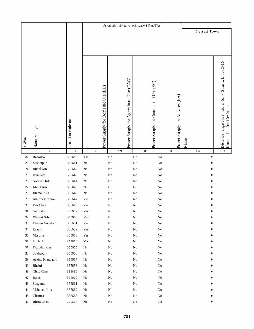
1 2 3
Lo
cati
on
co
de
no
.
Nam
e v
illa
ge
Sr.
No
.
22 Banodha 355640
23 Sankarpur 355641
24 Jitmal Kita 355642
25 Hira Kita 355643
26 Narain Chak 355644
27 Jitmal Kita 355645
28 Jitamal Kita 355646
29 Amjora Firozganj 355647
30 Pati Chak 355648
31 Gobindpur 355649
32 Dhamri Saheb 355650
33 Dhamri Gopalram 355651
34 Itahari 355652
35 Masuria 355653
36 Sukhari 355654
37 Fazilkhutahar 355655
38 Sobhapur 355656
39 Arbind Khutahari 355657
40 Bhalui 355658
41 Chitu Chak 355659
42 Barari 355660
43 Sangarua 355661
44 Mahadeb Kita 355662
45 Champa 355663
46 Bhata Chak 355664
Po
wer
Su
pp
ly f
or
Do
mes
tic
Use
(E
D)
Po
wer
Su
pp
ly f
or
Ag
ricu
ltu
ral
Use
(E
AG
)
Po
wer
Su
pp
ly f
or
Co
mm
erci
al U
se (
EC
)
Po
wer
Su
pp
ly f
or
All
Use
s (E
A)
Nam
e
Dis
tan
ce r
ang
e co
de
i.e
. a
fo
r <
5 K
ms,
b
for
5-1
0
Km
s an
d c
f
or
10
+ k
ms
.
98 99 100 101 102 103
Nearest Town
Land UseAvailability of electricity (Yes/No)
Yes No No No 0
No No No No 0
No No No No 0
No No No No 0
No No No No 0
No No No No 0
No No No No 0
Yes No No No 0
Yes No No No 0
Yes No No No 0
Yes No No No 0
Yes No No No 0
Yes No No No 0
Yes No No No 0
Yes No No No 0
No No No No 0
No No No No 0
No No No No 0
No No No No 0
No No No No 0
No No No No 0
No No No No 0
No No No No 0
No No No No 0
No No No No 0
701
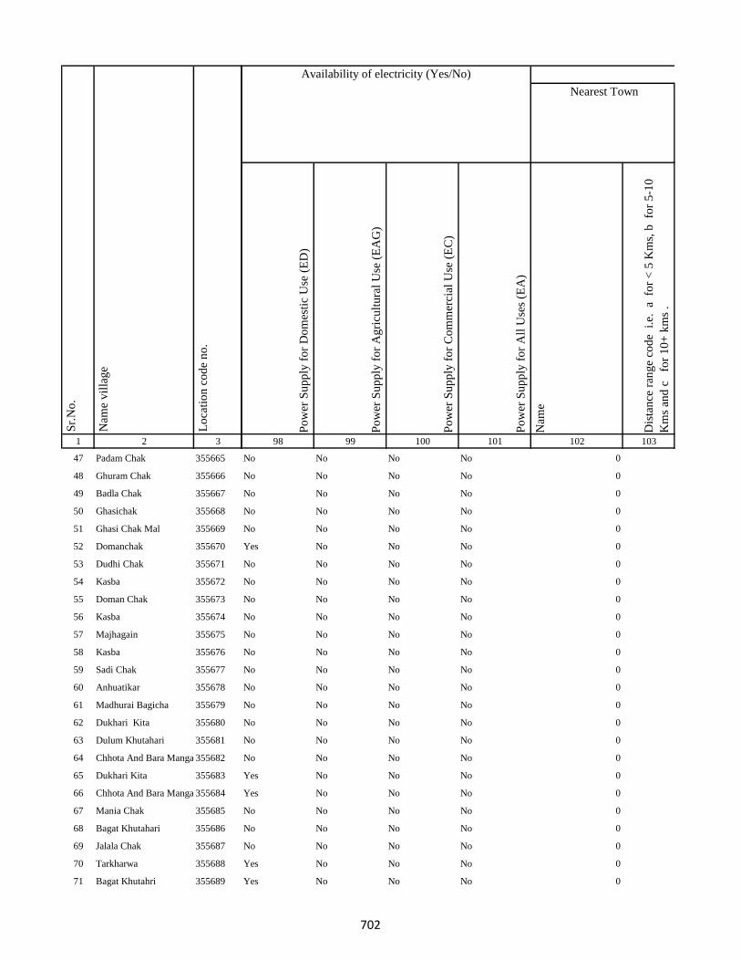
1 2 3
Lo
cati
on
co
de
no
.
Nam
e v
illa
ge
Sr.
No
.
47 Padam Chak 355665
48 Ghuram Chak 355666
49 Badla Chak 355667
50 Ghasichak 355668
51 Ghasi Chak Mal 355669
52 Domanchak 355670
53 Dudhi Chak 355671
54 Kasba 355672
55 Doman Chak 355673
56 Kasba 355674
57 Majhagain 355675
58 Kasba 355676
59 Sadi Chak 355677
60 Anhuatikar 355678
61 Madhurai Bagicha 355679
62 Dukhari Kita 355680
63 Dulum Khutahari 355681
64 Chhota And Bara Mangarh355682
65 Dukhari Kita 355683
66 Chhota And Bara Mangarh355684
67 Mania Chak 355685
68 Bagat Khutahari 355686
69 Jalala Chak 355687
70 Tarkharwa 355688
71 Bagat Khutahri 355689
Po
wer
Su
pp
ly f
or
Do
mes
tic
Use
(E
D)
Po
wer
Su
pp
ly f
or
Ag
ricu
ltu
ral
Use
(E
AG
)
Po
wer
Su
pp
ly f
or
Co
mm
erci
al U
se (
EC
)
Po
wer
Su
pp
ly f
or
All
Use
s (E
A)
Nam
e
Dis
tan
ce r
ang
e co
de
i.e
. a
fo
r <
5 K
ms,
b
for
5-1
0
Km
s an
d c
f
or
10
+ k
ms
.
98 99 100 101 102 103
Nearest Town
Land UseAvailability of electricity (Yes/No)
No No No No 0
No No No No 0
No No No No 0
No No No No 0
No No No No 0
Yes No No No 0
No No No No 0
No No No No 0
No No No No 0
No No No No 0
No No No No 0
No No No No 0
No No No No 0
No No No No 0
No No No No 0
No No No No 0
No No No No 0
No No No No 0
Yes No No No 0
Yes No No No 0
No No No No 0
No No No No 0
No No No No 0
Yes No No No 0
Yes No No No 0
702

1 2 3
Lo
cati
on
co
de
no
.
Nam
e v
illa
ge
Sr.
No
.
72 Meghchatar 355690
73 Kumardom 355691
74 Harchandpur 355692
75 Maheshdiri 355693
76 Nawadih Tola 355694
77 Beldara Chak 355695
78 Bhaju Chak 355696
79 Bhagwanpur 355697
80 Katmdanr 355698
81 Kita Kalamdanr 355699
82 Amdanr Asli 355700
83 Lachmipur 355701
84 Chandpur 355702
85 Rasti Kar 355703
86 Partappur Mal 355704
87 Partappur Jagir 355705
88 Kishungari Chak 355706
89 Sahi Chak 355707
90 Sarangdhar 355708
91 Sirampur 355709
92 Debi Chak 355710
93 Dogachhi 355711
94 Kandar Chak 355712
95 Tazi Chak 355713
96 Sapnia 355714
Po
wer
Su
pp
ly f
or
Do
mes
tic
Use
(E
D)
Po
wer
Su
pp
ly f
or
Ag
ricu
ltu
ral
Use
(E
AG
)
Po
wer
Su
pp
ly f
or
Co
mm
erci
al U
se (
EC
)
Po
wer
Su
pp
ly f
or
All
Use
s (E
A)
Nam
e
Dis
tan
ce r
ang
e co
de
i.e
. a
fo
r <
5 K
ms,
b
for
5-1
0
Km
s an
d c
f
or
10
+ k
ms
.
98 99 100 101 102 103
Nearest Town
Land UseAvailability of electricity (Yes/No)
Yes No No No 0
No No No No 0
No No No No 0
No No No No 0
No No No No 0
No No No No
No No No No 0
No No No No 0
No No No No 0
No No No No 0
No No No No 0
No No No No 0
No No No No BHAGALPUR c
No No No No 0
No No No No 0
No No No No 0
No No No No 0
No No No No 0
No No No No 0
No No No No 0
No No No No 0
No No No No 0
No No No No
No No No No 0
No No No No 0
703

1 2 3
Lo
cati
on
co
de
no
.
Nam
e v
illa
ge
Sr.
No
.
97 Sapta Chak 355715
98 Mathu Chak 355716
99 Sanolimor 355717
100 Siardih 355718
101 Khaira Chak 355719
102 Gauri Chak 355720
103 Tularam Bhuska 355721
104 Bishunpur 355722
105 Raghudas Bhuska 355723
106 Bhaloa 355724
107 Bisu Chak 355725
108 Jhagraha 355726
109 Benidas Bhuska 355727
110 Belakitar Jagir 355728
111 Chetni Chak 355729
112 Mahuadih 355730
113 Pipra 355731
114 Sauri Chak 355732
115 Dasu Chakla 355733
116 Dwarka Kita 355734
117 Karar Chakla 355735
118 Doi 355736
119 Haripur 355737
120 Gangaldo 355738
121 Sokha Chak 355739
Po
wer
Su
pp
ly f
or
Do
mes
tic
Use
(E
D)
Po
wer
Su
pp
ly f
or
Ag
ricu
ltu
ral
Use
(E
AG
)
Po
wer
Su
pp
ly f
or
Co
mm
erci
al U
se (
EC
)
Po
wer
Su
pp
ly f
or
All
Use
s (E
A)
Nam
e
Dis
tan
ce r
ang
e co
de
i.e
. a
fo
r <
5 K
ms,
b
for
5-1
0
Km
s an
d c
f
or
10
+ k
ms
.
98 99 100 101 102 103
Nearest Town
Land UseAvailability of electricity (Yes/No)
No No No No 0
No No No No BHAGALPUR c
No No No No 0
No No No No 0
No No No No
No No No No
No No No No
No No No No
No No No No
No No No No
No No No No
No No No No
No No No No
No No No No 0
No No No No
Yes No No No
Yes No No No
No No No No
No No No No
No No No No
Yes No No No
No No No No
No No No No
No No No No
No No No No
704
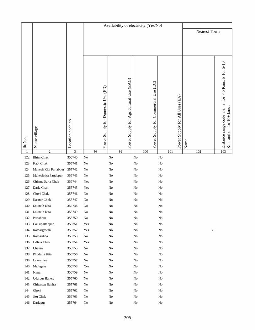
1 2 3
Lo
cati
on
co
de
no
.
Nam
e v
illa
ge
Sr.
No
.
122 Bhim Chak 355740
123 Kabi Chak 355741
124 Mahesh Kita Partabpur 355742
125 Maheshkita Partabpur 355743
126 Chhant Daria Chak 355744
127 Daria Chak 355745
128 Ghori Chak 355746
129 Kasmir Chak 355747
130 Loknath Kita 355748
131 Loknath Kita 355749
132 Partabpur 355750
133 Gausipartabpur 355751
134 Kamargawan 355752
135 Kamardiha 355753
136 Udhua Chak 355754
137 Chaura 355755
138 Phudulia Kita 355756
139 Lakramara 355757
140 Majhgain 355758
141 Nima 355759
142 Udaipur Bahera 355760
143 Chitarsen Bahira 355761
144 Ghori 355762
145 Jitu Chak 355763
146 Dariapur 355764
Po
wer
Su
pp
ly f
or
Do
mes
tic
Use
(E
D)
Po
wer
Su
pp
ly f
or
Ag
ricu
ltu
ral
Use
(E
AG
)
Po
wer
Su
pp
ly f
or
Co
mm
erci
al U
se (
EC
)
Po
wer
Su
pp
ly f
or
All
Use
s (E
A)
Nam
e
Dis
tan
ce r
ang
e co
de
i.e
. a
fo
r <
5 K
ms,
b
for
5-1
0
Km
s an
d c
f
or
10
+ k
ms
.
98 99 100 101 102 103
Nearest Town
Land UseAvailability of electricity (Yes/No)
No No No No
No No No No
No No No No
No No No No
Yes No No No
Yes No No No
No No No No
No No No No
No No No No
No No No No
No No No No
Yes No No No
Yes No No No 2
No No No No
Yes No No No
No No No No
No No No No
No No No No
Yes No No No
No No No No
No No No No
No No No No
No No No No
No No No No
No No No No
705

1 2 3
Lo
cati
on
co
de
no
.
Nam
e v
illa
ge
Sr.
No
.
147 Mathi Chak 355765
148 Chhaman Kita 355766
149 Suphal Kita 355767
150 Kanchanpur 355768
151 Dhankuria 355769
152 Belbadda 355770
153 Kotibari 355771
154 Chhagraha 355772
155 Chhagraha 355773
156 Benia Kita 355774
157 Sahi Chak 355775
158 Chhagraha 355776
159 Kukra Milik 355777
160 Kurkra Milik 355778
161 Bheronagar 355779
162 Niamat Kita 355780
163 Ghasi Kita 355781
164 Ghasi Kita 355782
165 Inarman Kita 355783
166 Gausi Chak 355784
167 Mosana Chak 355785
168 Singarpur 355786
169 Birnagar Arazi Chhit 355787
170 Birnagar Arazi Bara 355788
171 Birnagar 355789
Po
wer
Su
pp
ly f
or
Do
mes
tic
Use
(E
D)
Po
wer
Su
pp
ly f
or
Ag
ricu
ltu
ral
Use
(E
AG
)
Po
wer
Su
pp
ly f
or
Co
mm
erci
al U
se (
EC
)
Po
wer
Su
pp
ly f
or
All
Use
s (E
A)
Nam
e
Dis
tan
ce r
ang
e co
de
i.e
. a
fo
r <
5 K
ms,
b
for
5-1
0
Km
s an
d c
f
or
10
+ k
ms
.
98 99 100 101 102 103
Nearest Town
Land UseAvailability of electricity (Yes/No)
No No No No
No No No No
Yes No No No
Yes No No No
Yes No No No
No No No No
No No No No
No No No No
No No No No
No No No No
No No No No
No No No No
Yes No No No
Yes No No No
No No No No
No No No No
No No No No
No No No No
No No No No
No No No No
No No No No
No No No No
No No No No
No No No No
No No No No
706
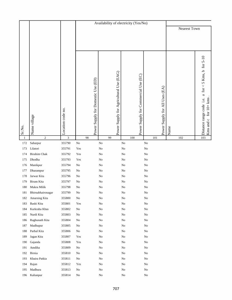
1 2 3
Lo
cati
on
co
de
no
.
Nam
e v
illa
ge
Sr.
No
.
172 Saharpur 355790
173 Lilatori 355791
174 Birahim Chak 355792
175 Dhodha 355793
176 Manikpur 355794
177 Dharampur 355795
178 Jarwar Kita 355796
179 Biram Kita 355797
180 Mukra Milik 355798
181 Bhirnabhaironagar 355799
182 Amarsing Kita 355800
183 Baski Kita 355801
184 Kurkraha Khas 355802
185 Nurdi Kita 355803
186 Raghunath Kita 355804
187 Madhupur 355805
188 Parbal Kita 355806
189 Jagan Kita 355807
190 Gajanda 355808
191 Amdiha 355809
192 Birnia 355810
193 Khaira Patkia 355811
194 Rajan 355812
195 Madhura 355813
196 Kalianpur 355814
Po
wer
Su
pp
ly f
or
Do
mes
tic
Use
(E
D)
Po
wer
Su
pp
ly f
or
Ag
ricu
ltu
ral
Use
(E
AG
)
Po
wer
Su
pp
ly f
or
Co
mm
erci
al U
se (
EC
)
Po
wer
Su
pp
ly f
or
All
Use
s (E
A)
Nam
e
Dis
tan
ce r
ang
e co
de
i.e
. a
fo
r <
5 K
ms,
b
for
5-1
0
Km
s an
d c
f
or
10
+ k
ms
.
98 99 100 101 102 103
Nearest Town
Land UseAvailability of electricity (Yes/No)
No No No No
Yes No No No
Yes No No No
Yes No No No
No No No No
No No No No
No No No No
No No No No
No No No No
No No No No
No No No No
Yes No No No
No No No No
No No No No
No No No No
No No No No
No No No No
Yes No No No
Yes No No No
No No No No
No No No No
No No No No
Yes No No No
No No No No
No No No No
707
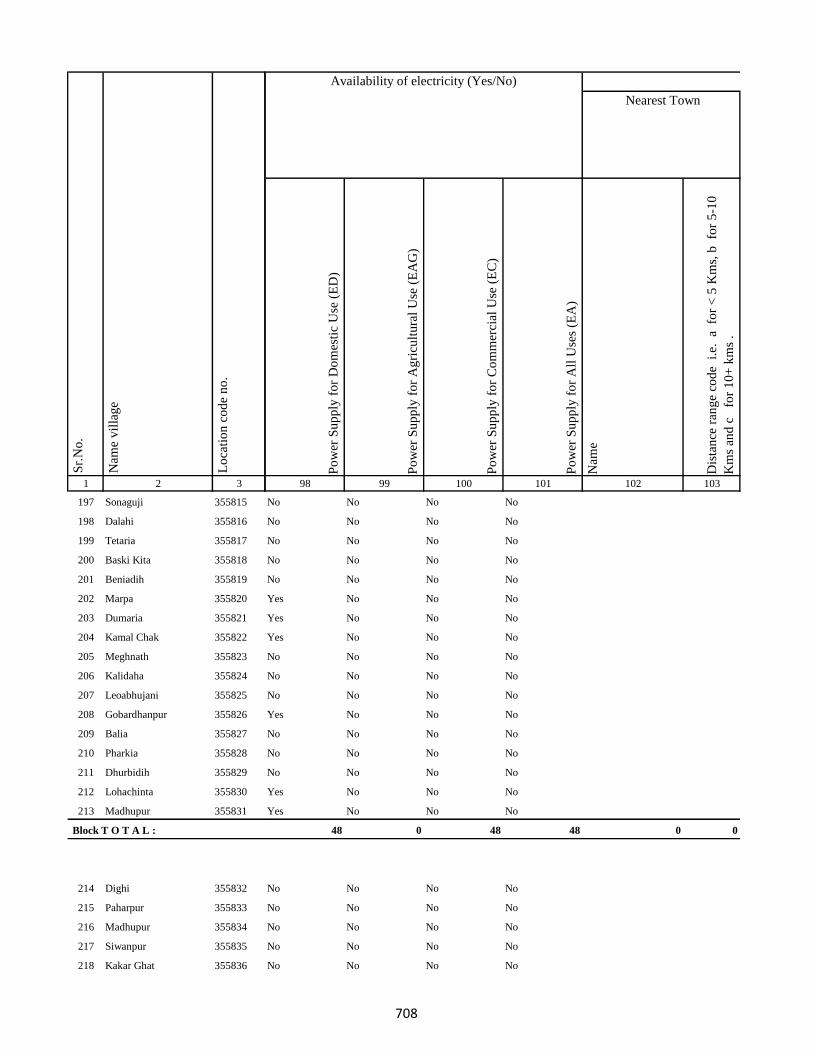
1 2 3
Lo
cati
on
co
de
no
.
Nam
e v
illa
ge
Sr.
No
.
197 Sonaguji 355815
198 Dalahi 355816
199 Tetaria 355817
200 Baski Kita 355818
201 Beniadih 355819
202 Marpa 355820
203 Dumaria 355821
204 Kamal Chak 355822
205 Meghnath 355823
206 Kalidaha 355824
207 Leoabhujani 355825
208 Gobardhanpur 355826
209 Balia 355827
210 Pharkia 355828
211 Dhurbidih 355829
212 Lohachinta 355830
213 Madhupur 355831
Block T O T A L :
214 Dighi 355832
215 Paharpur 355833
216 Madhupur 355834
217 Siwanpur 355835
218 Kakar Ghat 355836
Po
wer
Su
pp
ly f
or
Do
mes
tic
Use
(E
D)
Po
wer
Su
pp
ly f
or
Ag
ricu
ltu
ral
Use
(E
AG
)
Po
wer
Su
pp
ly f
or
Co
mm
erci
al U
se (
EC
)
Po
wer
Su
pp
ly f
or
All
Use
s (E
A)
Nam
e
Dis
tan
ce r
ang
e co
de
i.e
. a
fo
r <
5 K
ms,
b
for
5-1
0
Km
s an
d c
f
or
10
+ k
ms
.
98 99 100 101 102 103
Nearest Town
Land UseAvailability of electricity (Yes/No)
No No No No
No No No No
No No No No
No No No No
No No No No
Yes No No No
Yes No No No
Yes No No No
No No No No
No No No No
No No No No
Yes No No No
No No No No
No No No No
No No No No
Yes No No No
Yes No No No
48 0 48 48 0 0
No No No No
No No No No
No No No No
No No No No
No No No No
708

1 2 3
Lo
cati
on
co
de
no
.
Nam
e v
illa
ge
Sr.
No
.
219 Talbaria 355837
220 Mohamad Khutahari 355838
221 Mal Jhakhra 355839
222 Baghjhakhra 355840
223 Sinha Chak 355841
224 Babutaluk 355842
225 Paharpur 355843
226 Deban Chak 355844
227 Gargulal 355845
228 Madan Chauki 355846
229 Birahim Kita 355847
230 Banskola 355848
231 Kurpatti 355849
232 Baijani 355850
233 Chapri 355851
234 Kamat Chapri 355852
235 Khar Kudia 355853
236 Majhana (Arazi) 355854
237 Hasu Chak 355855
238 Domansaran Kita 355856
239 Silong 355857
240 Paharpur 355858
241 Akilkita 355859
242 Bikram Kita 355860
243 Paharpur 355861
Po
wer
Su
pp
ly f
or
Do
mes
tic
Use
(E
D)
Po
wer
Su
pp
ly f
or
Ag
ricu
ltu
ral
Use
(E
AG
)
Po
wer
Su
pp
ly f
or
Co
mm
erci
al U
se (
EC
)
Po
wer
Su
pp
ly f
or
All
Use
s (E
A)
Nam
e
Dis
tan
ce r
ang
e co
de
i.e
. a
fo
r <
5 K
ms,
b
for
5-1
0
Km
s an
d c
f
or
10
+ k
ms
.
98 99 100 101 102 103
Nearest Town
Land UseAvailability of electricity (Yes/No)
No No No No
Yes No No No
No No No No
No No No No
No No No No
No No No No
No No No No
No No No No
No No No No
No No No No
No No No No
No No No No
No No No No
Yes No No No
No No No No
No No No No
No No No No
No No No No
No No No No
No No No No
No No No No
No No No No
No No No No
No No No No
No No No No
709
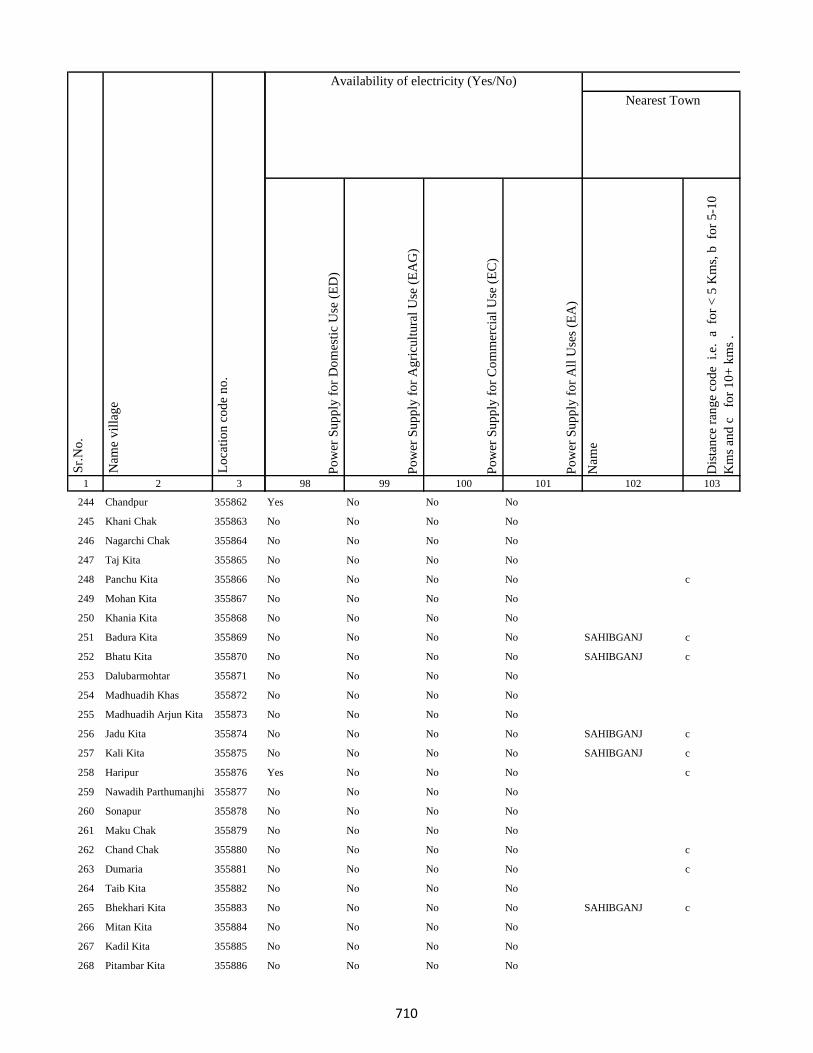
1 2 3
Lo
cati
on
co
de
no
.
Nam
e v
illa
ge
Sr.
No
.
244 Chandpur 355862
245 Khani Chak 355863
246 Nagarchi Chak 355864
247 Taj Kita 355865
248 Panchu Kita 355866
249 Mohan Kita 355867
250 Khania Kita 355868
251 Badura Kita 355869
252 Bhatu Kita 355870
253 Dalubarmohtar 355871
254 Madhuadih Khas 355872
255 Madhuadih Arjun Kita 355873
256 Jadu Kita 355874
257 Kali Kita 355875
258 Haripur 355876
259 Nawadih Parthumanjhi 355877
260 Sonapur 355878
261 Maku Chak 355879
262 Chand Chak 355880
263 Dumaria 355881
264 Taib Kita 355882
265 Bhekhari Kita 355883
266 Mitan Kita 355884
267 Kadil Kita 355885
268 Pitambar Kita 355886
Po
wer
Su
pp
ly f
or
Do
mes
tic
Use
(E
D)
Po
wer
Su
pp
ly f
or
Ag
ricu
ltu
ral
Use
(E
AG
)
Po
wer
Su
pp
ly f
or
Co
mm
erci
al U
se (
EC
)
Po
wer
Su
pp
ly f
or
All
Use
s (E
A)
Nam
e
Dis
tan
ce r
ang
e co
de
i.e
. a
fo
r <
5 K
ms,
b
for
5-1
0
Km
s an
d c
f
or
10
+ k
ms
.
98 99 100 101 102 103
Nearest Town
Land UseAvailability of electricity (Yes/No)
Yes No No No
No No No No
No No No No
No No No No
No No No No c
No No No No
No No No No
No No No No SAHIBGANJ c
No No No No SAHIBGANJ c
No No No No
No No No No
No No No No
No No No No SAHIBGANJ c
No No No No SAHIBGANJ c
Yes No No No c
No No No No
No No No No
No No No No
No No No No c
No No No No c
No No No No
No No No No SAHIBGANJ c
No No No No
No No No No
No No No No
710
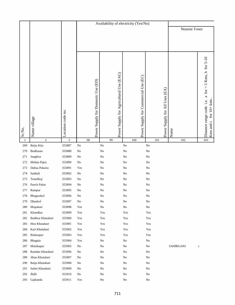
1 2 3
Lo
cati
on
co
de
no
.
Nam
e v
illa
ge
Sr.
No
.
269 Baiju Kita 355887
270 Budhasan 355888
271 Janghira 355889
272 Mohan Pipra 355890
273 Dahua Pakaria 355891
274 Sanhuli 355892
275 Tetarbhuj 355893
276 Panch Pahar 355894
277 Rampur 355895
278 Bhagwakol 355896
279 Dhankol 355897
280 Mopahari 355898
281 Khandhar 355899
282 Bodhrai Khutahari 355900
283 Hira Khutahari 355901
284 Kari Khutahari 355902
285 Bishunpur 355903
286 Bhagaia 355904
287 Manikapur 355905
288 Ramdas Khutahari 355906
289 Jiban Khutahari 355907
290 Baiju Khutahari 355908
291 Salim Khutahari 355909
292 Jhilli 355910
293 Gajhanda 355911
Po
wer
Su
pp
ly f
or
Do
mes
tic
Use
(E
D)
Po
wer
Su
pp
ly f
or
Ag
ricu
ltu
ral
Use
(E
AG
)
Po
wer
Su
pp
ly f
or
Co
mm
erci
al U
se (
EC
)
Po
wer
Su
pp
ly f
or
All
Use
s (E
A)
Nam
e
Dis
tan
ce r
ang
e co
de
i.e
. a
fo
r <
5 K
ms,
b
for
5-1
0
Km
s an
d c
f
or
10
+ k
ms
.
98 99 100 101 102 103
Nearest Town
Land UseAvailability of electricity (Yes/No)
No No No No
No No No No
No No No No
No No No No
Yes No No No
No No No No
No No No No
No No No No
No No No No
No No No No
No No No No
Yes No No No
Yes Yes Yes Yes
Yes Yes Yes Yes
Yes Yes Yes Yes
Yes Yes Yes Yes
Yes Yes Yes Yes
Yes No No No
No No No No SAHIBGANJ c
No No No No
No No No No
No No No No
No No No No
No No No No
Yes No No No
711
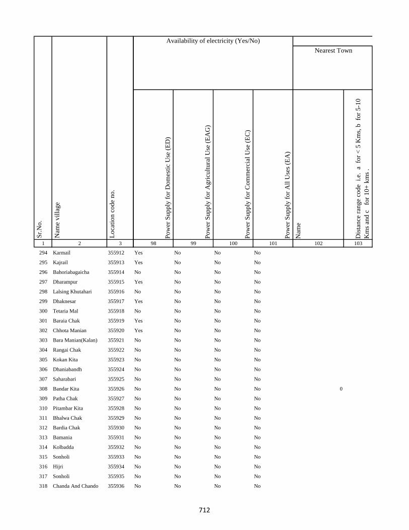
1 2 3
Lo
cati
on
co
de
no
.
Nam
e v
illa
ge
Sr.
No
.
294 Karmail 355912
295 Kajrail 355913
296 Bahoriabagaicha 355914
297 Dharampur 355915
298 Lalsing Khutahari 355916
299 Dhaknesar 355917
300 Tetaria Mal 355918
301 Baraia Chak 355919
302 Chhota Manian 355920
303 Bara Manian(Kalan) 355921
304 Rangai Chak 355922
305 Kokan Kita 355923
306 Dhaniabandh 355924
307 Saharabari 355925
308 Bandar Kita 355926
309 Patha Chak 355927
310 Pitambar Kita 355928
311 Bhalwa Chak 355929
312 Bardia Chak 355930
313 Bamania 355931
314 Kolbadda 355932
315 Sonholi 355933
316 Hijri 355934
317 Sonholi 355935
318 Chanda And Chando 355936
Po
wer
Su
pp
ly f
or
Do
mes
tic
Use
(E
D)
Po
wer
Su
pp
ly f
or
Ag
ricu
ltu
ral
Use
(E
AG
)
Po
wer
Su
pp
ly f
or
Co
mm
erci
al U
se (
EC
)
Po
wer
Su
pp
ly f
or
All
Use
s (E
A)
Nam
e
Dis
tan
ce r
ang
e co
de
i.e
. a
fo
r <
5 K
ms,
b
for
5-1
0
Km
s an
d c
f
or
10
+ k
ms
.
98 99 100 101 102 103
Nearest Town
Land UseAvailability of electricity (Yes/No)
Yes No No No
Yes No No No
No No No No
Yes No No No
No No No No
Yes No No No
No No No No
Yes No No No
Yes No No No
No No No No
No No No No
No No No No
No No No No
No No No No
No No No No 0
No No No No
No No No No
No No No No
No No No No
No No No No
No No No No
No No No No
No No No No
No No No No
No No No No
712
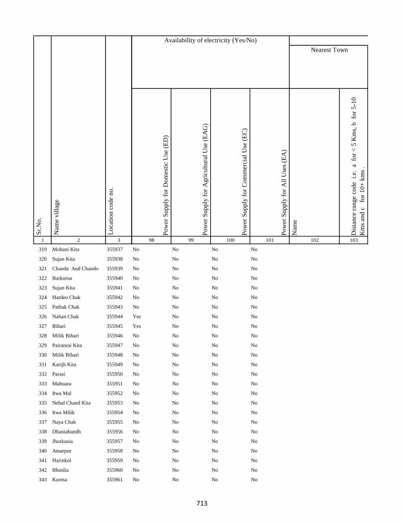
1 2 3
Lo
cati
on
co
de
no
.
Nam
e v
illa
ge
Sr.
No
.
319 Mohani Kita 355937
320 Sujan Kita 355938
321 Chanda And Chando 355939
322 Barkurua 355940
323 Sujan Kita 355941
324 Hardeo Chak 355942
325 Pathak Chak 355943
326 Nahan Chak 355944
327 Bihari 355945
328 Milik Bihari 355946
329 Pairanrai Kita 355947
330 Milik Bihari 355948
331 Karijh Kita 355949
332 Parasi 355950
333 Mahuara 355951
334 Itwa Mal 355952
335 Nehal Chand Kita 355953
336 Itwa Milik 355954
337 Naya Chak 355955
338 Dhaniabandh 355956
339 Jhurkusia 355957
340 Amarpur 355958
341 Harinkol 355959
342 Bhuslia 355960
343 Kurma 355961
Po
wer
Su
pp
ly f
or
Do
mes
tic
Use
(E
D)
Po
wer
Su
pp
ly f
or
Ag
ricu
ltu
ral
Use
(E
AG
)
Po
wer
Su
pp
ly f
or
Co
mm
erci
al U
se (
EC
)
Po
wer
Su
pp
ly f
or
All
Use
s (E
A)
Nam
e
Dis
tan
ce r
ang
e co
de
i.e
. a
fo
r <
5 K
ms,
b
for
5-1
0
Km
s an
d c
f
or
10
+ k
ms
.
98 99 100 101 102 103
Nearest Town
Land UseAvailability of electricity (Yes/No)
No No No No
No No No No
No No No No
No No No No
No No No No
No No No No
No No No No
Yes No No No
Yes No No No
No No No No
No No No No
No No No No
No No No No
No No No No
No No No No
No No No No
No No No No
No No No No
No No No No
No No No No
No No No No
No No No No
No No No No
No No No No
No No No No
713

1 2 3
Lo
cati
on
co
de
no
.
Nam
e v
illa
ge
Sr.
No
.
344 Darji Kita 355962
345 Birnath Chak 355963
346 Indar Chak 355964
347 Marro Mal 355965
348 Belatikar 355966
349 Pipra 355967
350 Budhuachak 355968
351 Pipra 355969
352 Purnia 355970
353 Mardiha 355971
354 Baghakol 355972
355 Rangila 355973
356 Bhuska 355974
357 Chand Chak 355975
358 Dogachhi 355976
359 Khajri Chak 355977
360 Lainbrar Barakhar 355978
361 Lensirsa 355979
362 Gorapariharpur 355980
363 Basta 355981
364 Bariasirsa 355982
365 Gobindi Chak 355983
366 Kanipathari 355984
367 Gaias Chak 355985
368 Majh Kola 355986
Po
wer
Su
pp
ly f
or
Do
mes
tic
Use
(E
D)
Po
wer
Su
pp
ly f
or
Ag
ricu
ltu
ral
Use
(E
AG
)
Po
wer
Su
pp
ly f
or
Co
mm
erci
al U
se (
EC
)
Po
wer
Su
pp
ly f
or
All
Use
s (E
A)
Nam
e
Dis
tan
ce r
ang
e co
de
i.e
. a
fo
r <
5 K
ms,
b
for
5-1
0
Km
s an
d c
f
or
10
+ k
ms
.
98 99 100 101 102 103
Nearest Town
Land UseAvailability of electricity (Yes/No)
No No No No
No No No No
Yes No No No
No No No No
No No No No
Yes No No No
No No No No
No No No No
Yes No No No
Yes No No No
No No No No
No No No No
No No No No
No No No No
No No No No
Yes No No No
No No No No
No No No No
No No No No
No No No No
No No No No
No No No No
No No No No
No No No No
No No No No
714

1 2 3
Lo
cati
on
co
de
no
.
Nam
e v
illa
ge
Sr.
No
.
369 Misirgangti 355987
370 Laghra Chak 355988
371 Mirik Chak 355989
372 Chamuakol 355990
373 Raghuni Kita 355991
374 Bhatkhoria 355992
375 Gauri Chak 355993
376 Sirikanta Chak 355994
377 Durga Chak 355995
378 Jogi Chak 355996
379 Bhiganda 355997
380 Kadma 355998
381 Asakhapar 355999
382 Mukeri Chak 356000
383 Dalang 356001
384 Raidih 356002
385 Nawadih 356003
386 Ratia Chak 356004
387 Pachradih 356005
388 Baniadih 356006
389 Dhawa 356007
390 Gopalpur Mohar Tola 356008
391 Gopalpur Karan Tola 356009
392 Runji 356010
393 Jadu Chak 356011
Po
wer
Su
pp
ly f
or
Do
mes
tic
Use
(E
D)
Po
wer
Su
pp
ly f
or
Ag
ricu
ltu
ral
Use
(E
AG
)
Po
wer
Su
pp
ly f
or
Co
mm
erci
al U
se (
EC
)
Po
wer
Su
pp
ly f
or
All
Use
s (E
A)
Nam
e
Dis
tan
ce r
ang
e co
de
i.e
. a
fo
r <
5 K
ms,
b
for
5-1
0
Km
s an
d c
f
or
10
+ k
ms
.
98 99 100 101 102 103
Nearest Town
Land UseAvailability of electricity (Yes/No)
No No No No
No No No No
No No No No
No No No No
No No No No SAHIBGANJ c
No No No No SAHIBGANJ c
No No No No
No No No No
No No No No
No No No No
No No No No SAHIBGANJ c
No No No No
No No No No
No No No No
No No No No
No No No No
No No No No
No No No No
Yes No No No
No No No No
No No No No
No No No No
Yes No No No
No No No No
No No No No
715
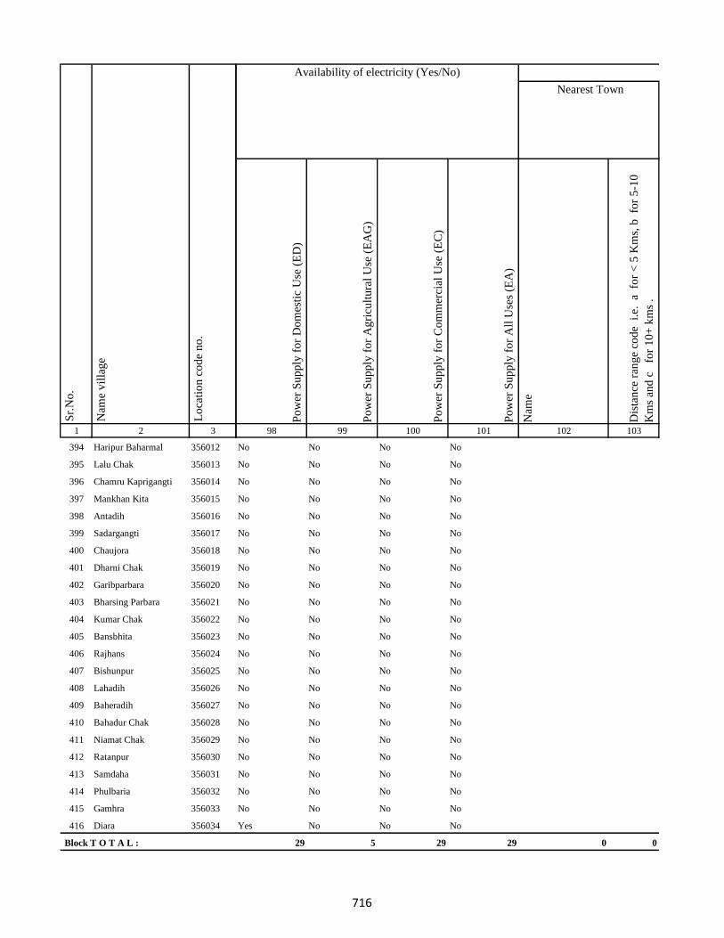
1 2 3
Lo
cati
on
co
de
no
.
Nam
e v
illa
ge
Sr.
No
.
394 Haripur Baharmal 356012
395 Lalu Chak 356013
396 Chamru Kaprigangti 356014
397 Mankhan Kita 356015
398 Antadih 356016
399 Sadargangti 356017
400 Chaujora 356018
401 Dharni Chak 356019
402 Garibparbara 356020
403 Bharsing Parbara 356021
404 Kumar Chak 356022
405 Bansbhita 356023
406 Rajhans 356024
407 Bishunpur 356025
408 Lahadih 356026
409 Baheradih 356027
410 Bahadur Chak 356028
411 Niamat Chak 356029
412 Ratanpur 356030
413 Samdaha 356031
414 Phulbaria 356032
415 Gamhra 356033
416 Diara 356034
Block T O T A L :
Po
wer
Su
pp
ly f
or
Do
mes
tic
Use
(E
D)
Po
wer
Su
pp
ly f
or
Ag
ricu
ltu
ral
Use
(E
AG
)
Po
wer
Su
pp
ly f
or
Co
mm
erci
al U
se (
EC
)
Po
wer
Su
pp
ly f
or
All
Use
s (E
A)
Nam
e
Dis
tan
ce r
ang
e co
de
i.e
. a
fo
r <
5 K
ms,
b
for
5-1
0
Km
s an
d c
f
or
10
+ k
ms
.
98 99 100 101 102 103
Nearest Town
Land UseAvailability of electricity (Yes/No)
No No No No
No No No No
No No No No
No No No No
No No No No
No No No No
No No No No
No No No No
No No No No
No No No No
No No No No
No No No No
No No No No
No No No No
No No No No
No No No No
No No No No
No No No No
No No No No
No No No No
No No No No
No No No No
Yes No No No
29 5 29 29 0 0
716
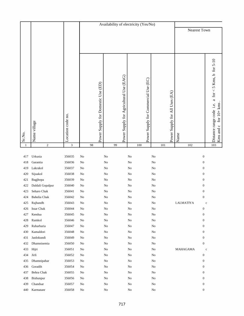
1 2 3
Lo
cati
on
co
de
no
.
Nam
e v
illa
ge
Sr.
No
.
417 Urkusia 356035
418 Garantia 356036
419 Lakrakol 356037
420 Sijuakol 356038
421 Bagjhopa 356039
422 Daldali Gopalpur 356040
423 Seharo Chak 356041
424 Bahelia Chak 356042
425 Rajbandh 356043
426 Issar Chak 356044
427 Kendua 356045
428 Ramkol 356046
429 Raharbaria 356047
430 Kamaldori 356048
431 Janlokundi 356049
432 Dhamnisemia 356050
433 Hijri 356051
434 Jirli 356052
435 Dhamnipahar 356053
436 Goradih 356054
437 Behra Chak 356055
438 Bishunpur 356056
439 Chandsar 356057
440 Karmatanr 356058
Po
wer
Su
pp
ly f
or
Do
mes
tic
Use
(E
D)
Po
wer
Su
pp
ly f
or
Ag
ricu
ltu
ral
Use
(E
AG
)
Po
wer
Su
pp
ly f
or
Co
mm
erci
al U
se (
EC
)
Po
wer
Su
pp
ly f
or
All
Use
s (E
A)
Nam
e
Dis
tan
ce r
ang
e co
de
i.e
. a
fo
r <
5 K
ms,
b
for
5-1
0
Km
s an
d c
f
or
10
+ k
ms
.
98 99 100 101 102 103
Nearest Town
Land UseAvailability of electricity (Yes/No)
No No No No 0
No No No No 0
No No No No 0
No No No No 0
No No No No 0
No No No No 0
No No No No 0
No No No No 0
No No No No LALMATIYA c
No No No No 0
No No No No 0
No No No No 0
No No No No 0
No No No No 0
No No No No 0
No No No No 0
No No No No MAHAGAMA c
No No No No 0
No No No No 0
No No No No 0
No No No No 0
No No No No 0
No No No No 0
No No No No 0
717

1 2 3
Lo
cati
on
co
de
no
.
Nam
e v
illa
ge
Sr.
No
.
441 Marpa 356059
442 Baghmara 356060
443 Itahari 356061
444 Chhota Itahari Pahar 356062
445 Chhota Gogra 356063
446 Bara Gogra 356064
447 Chhota Darma 356065
448 Kolhua 356066
449 Malbhita 356067
450 Pairgora 356068
451 Kaldigra 356069
452 Khejuria 356070
453 Talbaria 356071
454 Bara Darma 356072
455 Balajhor 356073
456 Bangama 356074
457 Sakrikita Rampur 356075
458 Darbe Chak 356076
459 Joborampur 356077
460 Ekdanrghat 356078
461 Chhota Siripur 356079
462 Siripur Bazar 356080
463 Bara Siripur 356081
464 Khairbani 356082
465 Losinghna 356083
Po
wer
Su
pp
ly f
or
Do
mes
tic
Use
(E
D)
Po
wer
Su
pp
ly f
or
Ag
ricu
ltu
ral
Use
(E
AG
)
Po
wer
Su
pp
ly f
or
Co
mm
erci
al U
se (
EC
)
Po
wer
Su
pp
ly f
or
All
Use
s (E
A)
Nam
e
Dis
tan
ce r
ang
e co
de
i.e
. a
fo
r <
5 K
ms,
b
for
5-1
0
Km
s an
d c
f
or
10
+ k
ms
.
98 99 100 101 102 103
Nearest Town
Land UseAvailability of electricity (Yes/No)
No No No No 0
No No No No 0
No No No No 0
No No No No 0
No No No No 0
No No No No 0
No No No No 0
No No No No 0
No No No No 0
No No No No 0
No No No No 0
No No No No 0
No No No No 0
No No No No 0
No No No No 0
No No No No 0
No No No No 0
No No No No 0
No No No No 0
No No No No 0
No No No No 0
No No No No 0
No No No No 0
No No No No MAHAGAMA c
No No No No 0
718
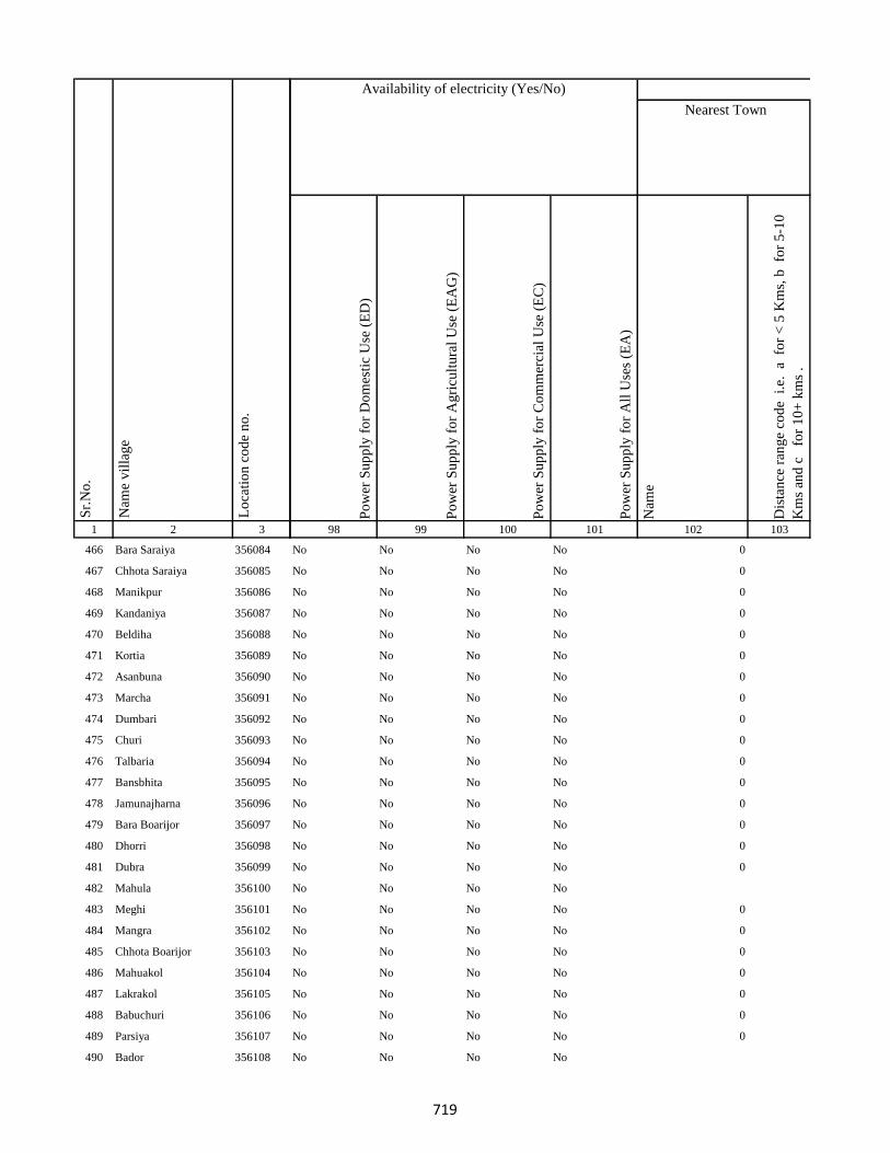
1 2 3
Lo
cati
on
co
de
no
.
Nam
e v
illa
ge
Sr.
No
.
466 Bara Saraiya 356084
467 Chhota Saraiya 356085
468 Manikpur 356086
469 Kandaniya 356087
470 Beldiha 356088
471 Kortia 356089
472 Asanbuna 356090
473 Marcha 356091
474 Dumbari 356092
475 Churi 356093
476 Talbaria 356094
477 Bansbhita 356095
478 Jamunajharna 356096
479 Bara Boarijor 356097
480 Dhorri 356098
481 Dubra 356099
482 Mahula 356100
483 Meghi 356101
484 Mangra 356102
485 Chhota Boarijor 356103
486 Mahuakol 356104
487 Lakrakol 356105
488 Babuchuri 356106
489 Parsiya 356107
490 Bador 356108
Po
wer
Su
pp
ly f
or
Do
mes
tic
Use
(E
D)
Po
wer
Su
pp
ly f
or
Ag
ricu
ltu
ral
Use
(E
AG
)
Po
wer
Su
pp
ly f
or
Co
mm
erci
al U
se (
EC
)
Po
wer
Su
pp
ly f
or
All
Use
s (E
A)
Nam
e
Dis
tan
ce r
ang
e co
de
i.e
. a
fo
r <
5 K
ms,
b
for
5-1
0
Km
s an
d c
f
or
10
+ k
ms
.
98 99 100 101 102 103
Nearest Town
Land UseAvailability of electricity (Yes/No)
No No No No 0
No No No No 0
No No No No 0
No No No No 0
No No No No 0
No No No No 0
No No No No 0
No No No No 0
No No No No 0
No No No No 0
No No No No 0
No No No No 0
No No No No 0
No No No No 0
No No No No 0
No No No No 0
No No No No
No No No No 0
No No No No 0
No No No No 0
No No No No 0
No No No No 0
No No No No 0
No No No No 0
No No No No
719
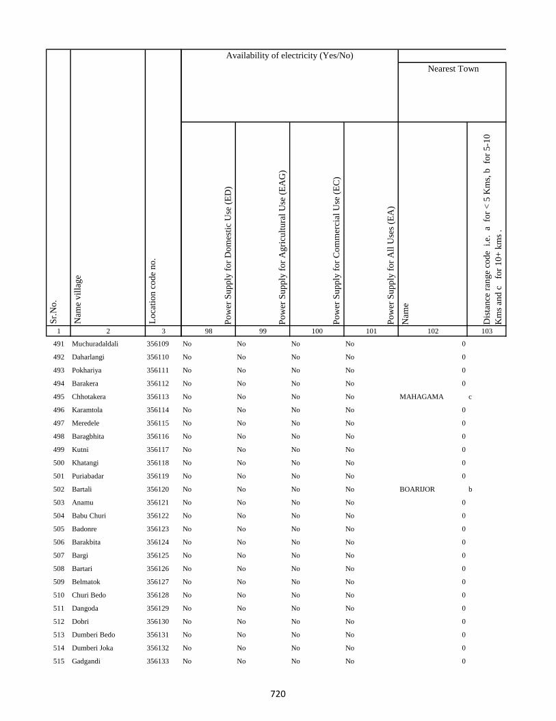
1 2 3
Lo
cati
on
co
de
no
.
Nam
e v
illa
ge
Sr.
No
.
491 Muchuradaldali 356109
492 Daharlangi 356110
493 Pokhariya 356111
494 Barakera 356112
495 Chhotakera 356113
496 Karamtola 356114
497 Meredele 356115
498 Baragbhita 356116
499 Kutni 356117
500 Khatangi 356118
501 Puriabadar 356119
502 Bartali 356120
503 Anamu 356121
504 Babu Churi 356122
505 Badonre 356123
506 Barakbita 356124
507 Bargi 356125
508 Bartari 356126
509 Belmatok 356127
510 Churi Bedo 356128
511 Dangoda 356129
512 Dobri 356130
513 Dumberi Bedo 356131
514 Dumberi Joka 356132
515 Gadgandi 356133
Po
wer
Su
pp
ly f
or
Do
mes
tic
Use
(E
D)
Po
wer
Su
pp
ly f
or
Ag
ricu
ltu
ral
Use
(E
AG
)
Po
wer
Su
pp
ly f
or
Co
mm
erci
al U
se (
EC
)
Po
wer
Su
pp
ly f
or
All
Use
s (E
A)
Nam
e
Dis
tan
ce r
ang
e co
de
i.e
. a
fo
r <
5 K
ms,
b
for
5-1
0
Km
s an
d c
f
or
10
+ k
ms
.
98 99 100 101 102 103
Nearest Town
Land UseAvailability of electricity (Yes/No)
No No No No 0
No No No No 0
No No No No 0
No No No No 0
No No No No MAHAGAMA c
No No No No 0
No No No No 0
No No No No 0
No No No No 0
No No No No 0
No No No No 0
No No No No BOARIJOR b
No No No No 0
No No No No 0
No No No No 0
No No No No 0
No No No No 0
No No No No 0
No No No No 0
No No No No 0
No No No No 0
No No No No 0
No No No No 0
No No No No 0
No No No No 0
720
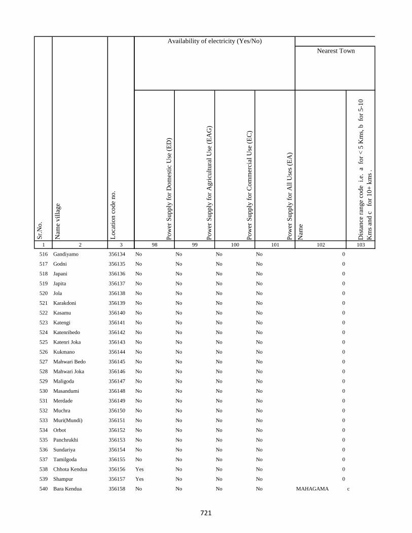
1 2 3
Lo
cati
on
co
de
no
.
Nam
e v
illa
ge
Sr.
No
.
516 Gandiyamo 356134
517 Godni 356135
518 Japani 356136
519 Japita 356137
520 Jola 356138
521 Karakdoni 356139
522 Kasamu 356140
523 Katengi 356141
524 Katenribedo 356142
525 Katenri Joka 356143
526 Kukmano 356144
527 Mahwari Bedo 356145
528 Mahwari Joka 356146
529 Maligoda 356147
530 Masandumi 356148
531 Merdade 356149
532 Muchra 356150
533 Muri(Mundi) 356151
534 Orbot 356152
535 Panchrukhi 356153
536 Sundariya 356154
537 Tamilgoda 356155
538 Chhota Kendua 356156
539 Shampur 356157
540 Bara Kendua 356158
Po
wer
Su
pp
ly f
or
Do
mes
tic
Use
(E
D)
Po
wer
Su
pp
ly f
or
Ag
ricu
ltu
ral
Use
(E
AG
)
Po
wer
Su
pp
ly f
or
Co
mm
erci
al U
se (
EC
)
Po
wer
Su
pp
ly f
or
All
Use
s (E
A)
Nam
e
Dis
tan
ce r
ang
e co
de
i.e
. a
fo
r <
5 K
ms,
b
for
5-1
0
Km
s an
d c
f
or
10
+ k
ms
.
98 99 100 101 102 103
Nearest Town
Land UseAvailability of electricity (Yes/No)
No No No No 0
No No No No 0
No No No No 0
No No No No 0
No No No No 0
No No No No 0
No No No No 0
No No No No 0
No No No No 0
No No No No 0
No No No No 0
No No No No 0
No No No No 0
No No No No 0
No No No No 0
No No No No 0
No No No No 0
No No No No 0
No No No No 0
No No No No 0
No No No No 0
No No No No 0
Yes No No No 0
Yes No No No 0
No No No No MAHAGAMA c
721

1 2 3
Lo
cati
on
co
de
no
.
Nam
e v
illa
ge
Sr.
No
.
541 Uparbandha 356159
542 Dhamni 356160
543 Narainpur 356161
544 Amjhor 356162
545 Debipur 356163
546 Rajabhita 356164
547 Chhota Dumarhir 356165
548 Bara Dumarhir 356166
549 Mungra 356167
550 Liti 356168
551 Champapur 356169
552 Telo 356170
553 Kero 356171
554 Kusumghati 356172
555 Ambadiha 356173
556 Lilatari 356174
557 Kusbila 356175
558 Bhadria 356176
559 Chandna 356177
560 Arajori Pokhar 356178
561 Dumaar Pahar 356179
562 Tetariya 356180
563 Rajapokhar Jagir 356181
564 Rajapokhar Jagir 356182
565 Rajapokhar Jagir 356183
Po
wer
Su
pp
ly f
or
Do
mes
tic
Use
(E
D)
Po
wer
Su
pp
ly f
or
Ag
ricu
ltu
ral
Use
(E
AG
)
Po
wer
Su
pp
ly f
or
Co
mm
erci
al U
se (
EC
)
Po
wer
Su
pp
ly f
or
All
Use
s (E
A)
Nam
e
Dis
tan
ce r
ang
e co
de
i.e
. a
fo
r <
5 K
ms,
b
for
5-1
0
Km
s an
d c
f
or
10
+ k
ms
.
98 99 100 101 102 103
Nearest Town
Land UseAvailability of electricity (Yes/No)
No No No No GODDA c
No No No No GODDA c
No No No No 0
No No No No 0
No No No No PATHARGAMA c
No No No No 0
No No No No GODDA c
No No No No GODDA c
No No No No GODDA c
No No No No 0
No No No No 0
No No No No 0
No No No No 0
No No No No 0
No No No No 0
No No No No 0
No No No No 0
No No No No GODDA c
No No No No 0
No No No No 0
No No No No 0
No No No No 0
No No No No 0
No No No No 0
No No No No 0
722

1 2 3
Lo
cati
on
co
de
no
.
Nam
e v
illa
ge
Sr.
No
.
566 Rajapokhar 356184
567 Bara Chatampur 356185
568 Lilabhita 356186
569 Tamlia Amdanda 356187
570 Manko 356188
571 Kilo 356189
572 Dhadhari Pahar 356190
573 Chhota Chatampur 356191
574 Chetmapahar 356192
575 Dhanigora 356193
576 Dimbni Pahar 356194
577 Dhunigora Pahar 356195
578 Palma Pahar 356196
579 Chalpahari 356197
580 Madomasi 356198
581 Bhagamakra 356199
582 Champatola 356200
583 Pakriya Pahar 356201
584 Kairasol 356202
585 Sundar Tola 356203
586 Pachro 356204
587 Marni Pahar 356205
588 Daria Pahar 356206
589 Harla Bathan 356207
590 Deodanrpahar 356208
Po
wer
Su
pp
ly f
or
Do
mes
tic
Use
(E
D)
Po
wer
Su
pp
ly f
or
Ag
ricu
ltu
ral
Use
(E
AG
)
Po
wer
Su
pp
ly f
or
Co
mm
erci
al U
se (
EC
)
Po
wer
Su
pp
ly f
or
All
Use
s (E
A)
Nam
e
Dis
tan
ce r
ang
e co
de
i.e
. a
fo
r <
5 K
ms,
b
for
5-1
0
Km
s an
d c
f
or
10
+ k
ms
.
98 99 100 101 102 103
Nearest Town
Land UseAvailability of electricity (Yes/No)
No No No No 0
No No No No 0
No No No No PATHARGAMA c
No No No No 0
No No No No 0
No No No No 0
No No No No 0
No No No No 0
No No No No MAHAGAMA c
No No No No 0
No No No No 0
No No No No 0
No No No No 0
No No No No 0
No No No No MAHAGAMA c
No No No No 0
No No No No 0
No No No No 0 c
No No No No 0
No No No No 0 c
No No No No 0
No No No No 0
No No No No GODDA c
No No No No GODDA c
No No No No 0
723
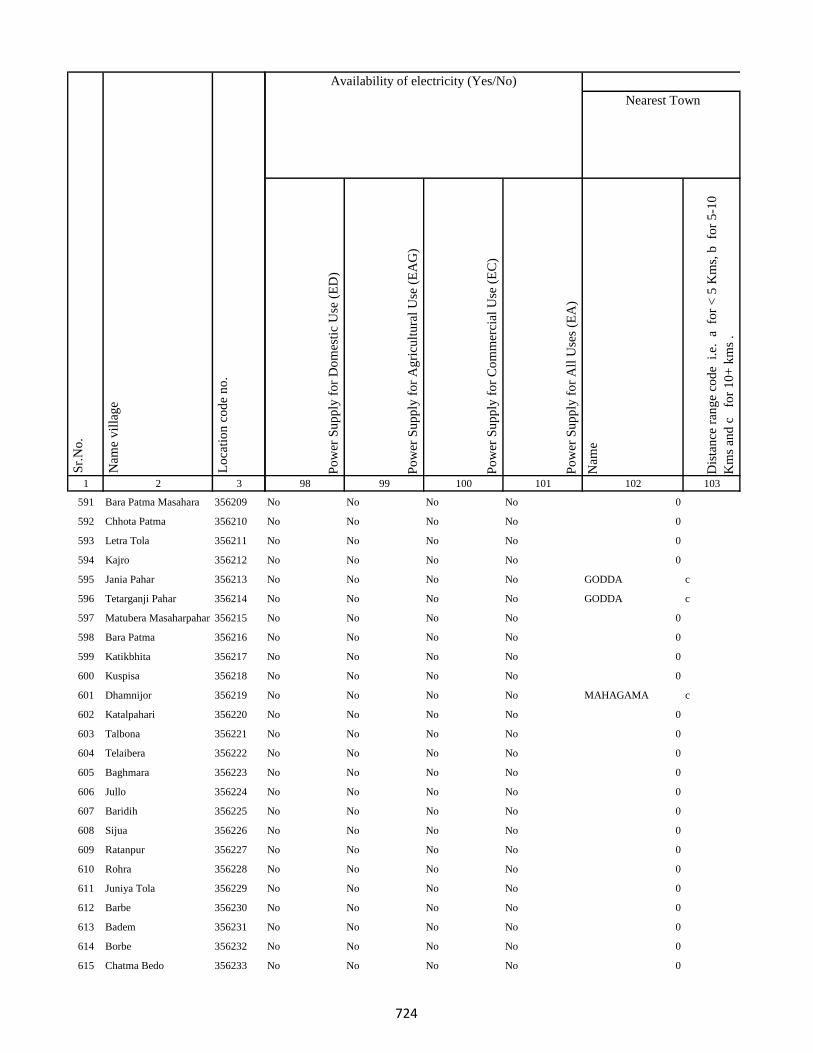
1 2 3
Lo
cati
on
co
de
no
.
Nam
e v
illa
ge
Sr.
No
.
591 Bara Patma Masahara 356209
592 Chhota Patma 356210
593 Letra Tola 356211
594 Kajro 356212
595 Jania Pahar 356213
596 Tetarganji Pahar 356214
597 Matubera Masaharpahar 356215
598 Bara Patma 356216
599 Katikbhita 356217
600 Kuspisa 356218
601 Dhamnijor 356219
602 Katalpahari 356220
603 Talbona 356221
604 Telaibera 356222
605 Baghmara 356223
606 Jullo 356224
607 Baridih 356225
608 Sijua 356226
609 Ratanpur 356227
610 Rohra 356228
611 Juniya Tola 356229
612 Barbe 356230
613 Badem 356231
614 Borbe 356232
615 Chatma Bedo 356233
Po
wer
Su
pp
ly f
or
Do
mes
tic
Use
(E
D)
Po
wer
Su
pp
ly f
or
Ag
ricu
ltu
ral
Use
(E
AG
)
Po
wer
Su
pp
ly f
or
Co
mm
erci
al U
se (
EC
)
Po
wer
Su
pp
ly f
or
All
Use
s (E
A)
Nam
e
Dis
tan
ce r
ang
e co
de
i.e
. a
fo
r <
5 K
ms,
b
for
5-1
0
Km
s an
d c
f
or
10
+ k
ms
.
98 99 100 101 102 103
Nearest Town
Land UseAvailability of electricity (Yes/No)
No No No No 0
No No No No 0
No No No No 0
No No No No 0
No No No No GODDA c
No No No No GODDA c
No No No No 0
No No No No 0
No No No No 0
No No No No 0
No No No No MAHAGAMA c
No No No No 0
No No No No 0
No No No No 0
No No No No 0
No No No No 0
No No No No 0
No No No No 0
No No No No 0
No No No No 0
No No No No 0
No No No No 0
No No No No 0
No No No No 0
No No No No 0
724

1 2 3
Lo
cati
on
co
de
no
.
Nam
e v
illa
ge
Sr.
No
.
616 Chatma Joka 356234
617 Chengro 356235
618 Donigoda Bedo 356236
619 Ejgoga 356237
620 Gamari 356238
621 Goari 356239
622 Godam 356240
623 Itkro Bedo 356241
624 Jani Bedo 356242
625 Jani Maqo 356243
626 Jaria 356244
627 Jonia 356245
628 Karji 356246
629 Karag 356247
630 Kariam 356248
631 Katal 356249
632 Kilo Bedo 356250
633 Kilo Maqo 356251
634 Kombita 356252
635 Kuro Maqo 356253
636 Kuspiso 356254
637 Kutam 356255
638 Letragoda 356256
639 Marchi 356257
640 Matubera 356258
Po
wer
Su
pp
ly f
or
Do
mes
tic
Use
(E
D)
Po
wer
Su
pp
ly f
or
Ag
ricu
ltu
ral
Use
(E
AG
)
Po
wer
Su
pp
ly f
or
Co
mm
erci
al U
se (
EC
)
Po
wer
Su
pp
ly f
or
All
Use
s (E
A)
Nam
e
Dis
tan
ce r
ang
e co
de
i.e
. a
fo
r <
5 K
ms,
b
for
5-1
0
Km
s an
d c
f
or
10
+ k
ms
.
98 99 100 101 102 103
Nearest Town
Land UseAvailability of electricity (Yes/No)
No No No No 0
No No No No 0
No No No No 0
No No No No 0
No No No No 0
No No No No 0
No No No No 0
No No No No 0
No No No No 0
No No No No 0
No No No No 0
No No No No 0
No No No No 0
No No No No 0
No No No No 0
No No No No 0
No No No No 0
No No No No 0
No No No No 0
No No No No 0
No No No No 0
No No No No 0
No No No No 0
No No No No 0
No No No No GODDA c
725
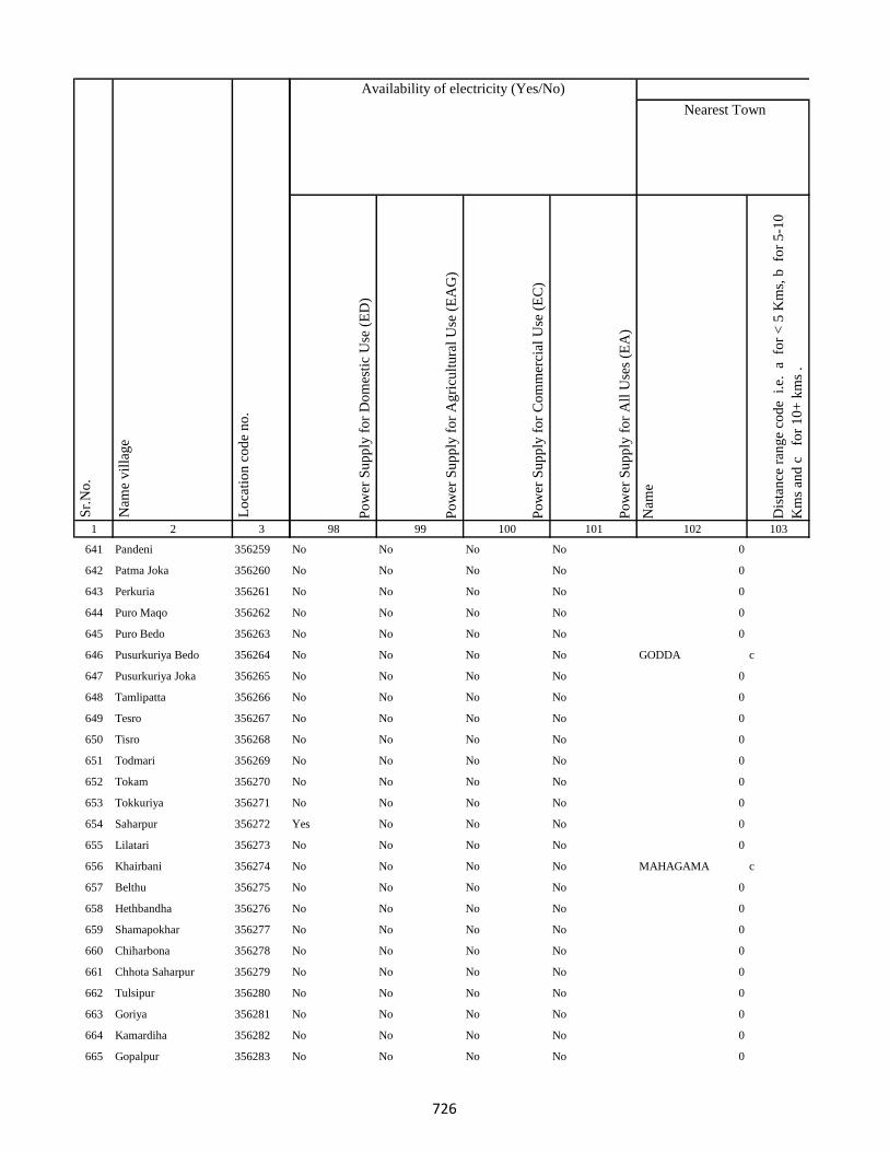
1 2 3
Lo
cati
on
co
de
no
.
Nam
e v
illa
ge
Sr.
No
.
641 Pandeni 356259
642 Patma Joka 356260
643 Perkuria 356261
644 Puro Maqo 356262
645 Puro Bedo 356263
646 Pusurkuriya Bedo 356264
647 Pusurkuriya Joka 356265
648 Tamlipatta 356266
649 Tesro 356267
650 Tisro 356268
651 Todmari 356269
652 Tokam 356270
653 Tokkuriya 356271
654 Saharpur 356272
655 Lilatari 356273
656 Khairbani 356274
657 Belthu 356275
658 Hethbandha 356276
659 Shamapokhar 356277
660 Chiharbona 356278
661 Chhota Saharpur 356279
662 Tulsipur 356280
663 Goriya 356281
664 Kamardiha 356282
665 Gopalpur 356283
Po
wer
Su
pp
ly f
or
Do
mes
tic
Use
(E
D)
Po
wer
Su
pp
ly f
or
Ag
ricu
ltu
ral
Use
(E
AG
)
Po
wer
Su
pp
ly f
or
Co
mm
erci
al U
se (
EC
)
Po
wer
Su
pp
ly f
or
All
Use
s (E
A)
Nam
e
Dis
tan
ce r
ang
e co
de
i.e
. a
fo
r <
5 K
ms,
b
for
5-1
0
Km
s an
d c
f
or
10
+ k
ms
.
98 99 100 101 102 103
Nearest Town
Land UseAvailability of electricity (Yes/No)
No No No No 0
No No No No 0
No No No No 0
No No No No 0
No No No No 0
No No No No GODDA c
No No No No 0
No No No No 0
No No No No 0
No No No No 0
No No No No 0
No No No No 0
No No No No 0
Yes No No No 0
No No No No 0
No No No No MAHAGAMA c
No No No No 0
No No No No 0
No No No No 0
No No No No 0
No No No No 0
No No No No 0
No No No No 0
No No No No 0
No No No No 0
726
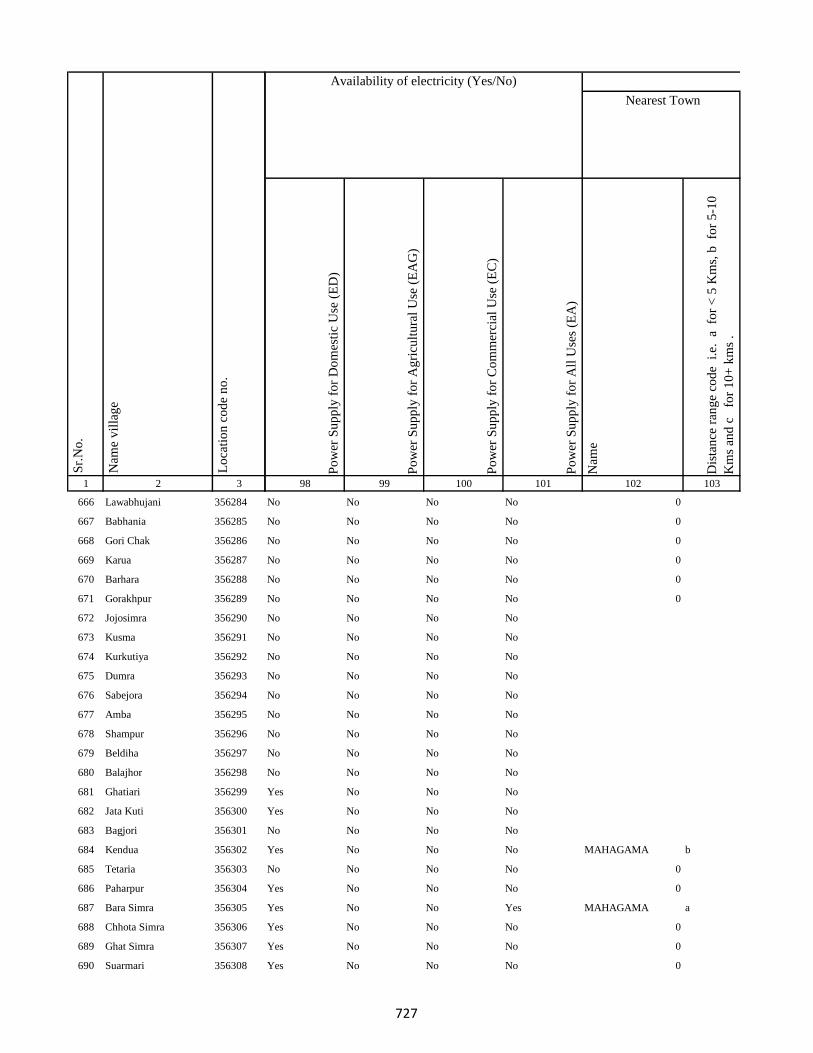
1 2 3
Lo
cati
on
co
de
no
.
Nam
e v
illa
ge
Sr.
No
.
666 Lawabhujani 356284
667 Babhania 356285
668 Gori Chak 356286
669 Karua 356287
670 Barhara 356288
671 Gorakhpur 356289
672 Jojosimra 356290
673 Kusma 356291
674 Kurkutiya 356292
675 Dumra 356293
676 Sabejora 356294
677 Amba 356295
678 Shampur 356296
679 Beldiha 356297
680 Balajhor 356298
681 Ghatiari 356299
682 Jata Kuti 356300
683 Bagjori 356301
684 Kendua 356302
685 Tetaria 356303
686 Paharpur 356304
687 Bara Simra 356305
688 Chhota Simra 356306
689 Ghat Simra 356307
690 Suarmari 356308
Po
wer
Su
pp
ly f
or
Do
mes
tic
Use
(E
D)
Po
wer
Su
pp
ly f
or
Ag
ricu
ltu
ral
Use
(E
AG
)
Po
wer
Su
pp
ly f
or
Co
mm
erci
al U
se (
EC
)
Po
wer
Su
pp
ly f
or
All
Use
s (E
A)
Nam
e
Dis
tan
ce r
ang
e co
de
i.e
. a
fo
r <
5 K
ms,
b
for
5-1
0
Km
s an
d c
f
or
10
+ k
ms
.
98 99 100 101 102 103
Nearest Town
Land UseAvailability of electricity (Yes/No)
No No No No 0
No No No No 0
No No No No 0
No No No No 0
No No No No 0
No No No No 0
No No No No
No No No No
No No No No
No No No No
No No No No
No No No No
No No No No
No No No No
No No No No
Yes No No No
Yes No No No
No No No No
Yes No No No MAHAGAMA b
No No No No 0
Yes No No No 0
Yes No No Yes MAHAGAMA a
Yes No No No 0
Yes No No No 0
Yes No No No 0
727

1 2 3
Lo
cati
on
co
de
no
.
Nam
e v
illa
ge
Sr.
No
.
691 Ghat Nima 356309
692 Chitar Koti 356310
693 Telgama 356311
694 Duwarighat Telgama 356312
695 Nima Kalan 356313
696 Hijukita 356314
697 Lalmatia 356315
698 Rangamatia 356316
699 Dakaita 356317
700 Lohandiya 356318
701 Lohandiya Bazar 356319
702 Basdiha 356320
703 Paharpur 356321
704 Bharanda 356322
705 Harrakha 356323
706 Mariya Chak 356324
707 Saraumi 356325
708 Ranidih 356326
709 Barkandali 356327
710 Dhankunda 356328
711 Dumriya 356329
712 Dumarkol 356330
713 Babupur 356331
714 Bara Kotha 356332
715 Bara Barma Pahar 356333
Po
wer
Su
pp
ly f
or
Do
mes
tic
Use
(E
D)
Po
wer
Su
pp
ly f
or
Ag
ricu
ltu
ral
Use
(E
AG
)
Po
wer
Su
pp
ly f
or
Co
mm
erci
al U
se (
EC
)
Po
wer
Su
pp
ly f
or
All
Use
s (E
A)
Nam
e
Dis
tan
ce r
ang
e co
de
i.e
. a
fo
r <
5 K
ms,
b
for
5-1
0
Km
s an
d c
f
or
10
+ k
ms
.
98 99 100 101 102 103
Nearest Town
Land UseAvailability of electricity (Yes/No)
Yes No No No 0
No No No No 0
Yes No No No 0
Yes No No No 0
Yes No No No MAHAGAMA b
Yes No No No MAHAGAMA b
No No No No 0
Yes No No No 0
No No No No 0
Yes No No No 0
Yes No No No 0
No No No No 0
No No No No 0
No No No No MAHAGAMA c
No No No No 0
No No No No
No No No No 0
No No No No 0
No No No No 0
No No No No MAHAGAMA c
No No No No 0
No No No No
No No No No MAHAGAMA c
No No No No 0
No No No No
728
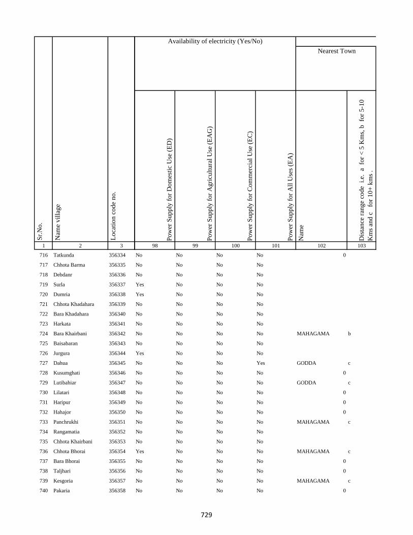
1 2 3
Lo
cati
on
co
de
no
.
Nam
e v
illa
ge
Sr.
No
.
716 Tatkunda 356334
717 Chhota Barma 356335
718 Debdanr 356336
719 Surla 356337
720 Dumria 356338
721 Chhota Khadahara 356339
722 Bara Khadahara 356340
723 Harkata 356341
724 Bara Khairbani 356342
725 Baisabaran 356343
726 Jurgura 356344
727 Dahua 356345
728 Kusumghati 356346
729 Lutibahiar 356347
730 Lilatari 356348
731 Haripur 356349
732 Hahajor 356350
733 Panchrukhi 356351
734 Rangamatia 356352
735 Chhota Khairbani 356353
736 Chhota Bhorai 356354
737 Bara Bhorai 356355
738 Taljhari 356356
739 Kesgoria 356357
740 Pakaria 356358
Po
wer
Su
pp
ly f
or
Do
mes
tic
Use
(E
D)
Po
wer
Su
pp
ly f
or
Ag
ricu
ltu
ral
Use
(E
AG
)
Po
wer
Su
pp
ly f
or
Co
mm
erci
al U
se (
EC
)
Po
wer
Su
pp
ly f
or
All
Use
s (E
A)
Nam
e
Dis
tan
ce r
ang
e co
de
i.e
. a
fo
r <
5 K
ms,
b
for
5-1
0
Km
s an
d c
f
or
10
+ k
ms
.
98 99 100 101 102 103
Nearest Town
Land UseAvailability of electricity (Yes/No)
No No No No 0
No No No No
No No No No
Yes No No No
Yes No No No
No No No No
No No No No
No No No No
No No No No MAHAGAMA b
No No No No
Yes No No No
No No No Yes GODDA c
No No No No 0
No No No No GODDA c
No No No No 0
No No No No 0
No No No No 0
No No No No MAHAGAMA c
No No No No
No No No No
Yes No No No MAHAGAMA c
No No No No 0
No No No No 0
No No No No MAHAGAMA c
No No No No 0
729

1 2 3
Lo
cati
on
co
de
no
.
Nam
e v
illa
ge
Sr.
No
.
741 Jaggora 356359
742 Bador 356360
743 Taratikar 356361
744 Bichduba 356362
745 Telodhuni 356363
746 Madgigora 356364
747 Dighi 356365
748 Gopali 356366
749 Dabra 356367
750 Rohari Naryanpur 356368
751 Jolopahari 356369
752 Raydih 356370
753 Piaram 356371
754 Phulbaria 356372
755 Harra 356373
756 Mahuabathan 356374
757 Gadial 356375
758 Chakra 356376
759 Bara Dhanbandhi 356377
760 Chhota Dhanbandhi 356378
761 Tetardiha 356379
762 Baramasia 356380
763 Kajribhita 356381
764 Adro 356382
765 Chhota Amra 356383
Po
wer
Su
pp
ly f
or
Do
mes
tic
Use
(E
D)
Po
wer
Su
pp
ly f
or
Ag
ricu
ltu
ral
Use
(E
AG
)
Po
wer
Su
pp
ly f
or
Co
mm
erci
al U
se (
EC
)
Po
wer
Su
pp
ly f
or
All
Use
s (E
A)
Nam
e
Dis
tan
ce r
ang
e co
de
i.e
. a
fo
r <
5 K
ms,
b
for
5-1
0
Km
s an
d c
f
or
10
+ k
ms
.
98 99 100 101 102 103
Nearest Town
Land UseAvailability of electricity (Yes/No)
No No No No
No No No No 0
No No No No 0
No No No No 0
No No No No
No No No No
No No No No
No No No No
No No No No
No No No No
No No No No
No No No No
No No No No
No No No No
No No No No
No No No No
No No No No
No No No No
No No No No GODDA c
No No No No GODDA c
No No No No
No No No No
No No No No
No No No No
No No No No
730
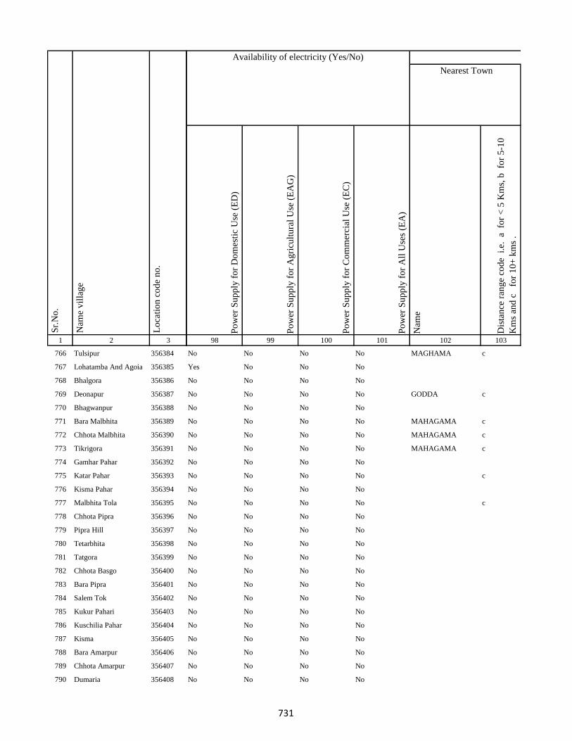
1 2 3
Lo
cati
on
co
de
no
.
Nam
e v
illa
ge
Sr.
No
.
766 Tulsipur 356384
767 Lohatamba And Agoia 356385
768 Bhalgora 356386
769 Deonapur 356387
770 Bhagwanpur 356388
771 Bara Malbhita 356389
772 Chhota Malbhita 356390
773 Tikrigora 356391
774 Gamhar Pahar 356392
775 Katar Pahar 356393
776 Kisma Pahar 356394
777 Malbhita Tola 356395
778 Chhota Pipra 356396
779 Pipra Hill 356397
780 Tetarbhita 356398
781 Tatgora 356399
782 Chhota Basgo 356400
783 Bara Pipra 356401
784 Salem Tok 356402
785 Kukur Pahari 356403
786 Kuschilia Pahar 356404
787 Kisma 356405
788 Bara Amarpur 356406
789 Chhota Amarpur 356407
790 Dumaria 356408
Po
wer
Su
pp
ly f
or
Do
mes
tic
Use
(E
D)
Po
wer
Su
pp
ly f
or
Ag
ricu
ltu
ral
Use
(E
AG
)
Po
wer
Su
pp
ly f
or
Co
mm
erci
al U
se (
EC
)
Po
wer
Su
pp
ly f
or
All
Use
s (E
A)
Nam
e
Dis
tan
ce r
ang
e co
de
i.e
. a
fo
r <
5 K
ms,
b
for
5-1
0
Km
s an
d c
f
or
10
+ k
ms
.
98 99 100 101 102 103
Nearest Town
Land UseAvailability of electricity (Yes/No)
No No No No MAGHAMA c
Yes No No No
No No No No
No No No No GODDA c
No No No No
No No No No MAHAGAMA c
No No No No MAHAGAMA c
No No No No MAHAGAMA c
No No No No
No No No No c
No No No No
No No No No c
No No No No
No No No No
No No No No
No No No No
No No No No
No No No No
No No No No
No No No No
No No No No
No No No No
No No No No
No No No No
No No No No
731
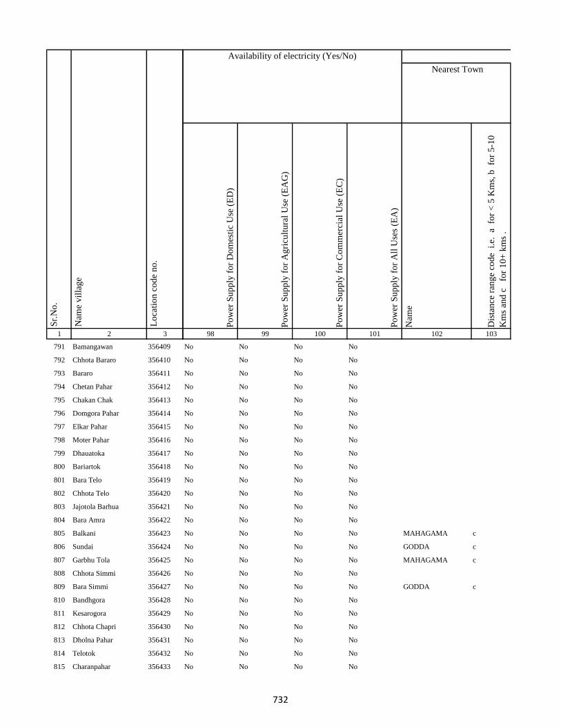
1 2 3
Lo
cati
on
co
de
no
.
Nam
e v
illa
ge
Sr.
No
.
791 Bamangawan 356409
792 Chhota Bararo 356410
793 Bararo 356411
794 Chetan Pahar 356412
795 Chakan Chak 356413
796 Domgora Pahar 356414
797 Elkar Pahar 356415
798 Moter Pahar 356416
799 Dhauatoka 356417
800 Bariartok 356418
801 Bara Telo 356419
802 Chhota Telo 356420
803 Jajotola Barhua 356421
804 Bara Amra 356422
805 Balkani 356423
806 Sundai 356424
807 Garbhu Tola 356425
808 Chhota Simmi 356426
809 Bara Simmi 356427
810 Bandhgora 356428
811 Kesarogora 356429
812 Chhota Chapri 356430
813 Dholna Pahar 356431
814 Telotok 356432
815 Charanpahar 356433
Po
wer
Su
pp
ly f
or
Do
mes
tic
Use
(E
D)
Po
wer
Su
pp
ly f
or
Ag
ricu
ltu
ral
Use
(E
AG
)
Po
wer
Su
pp
ly f
or
Co
mm
erci
al U
se (
EC
)
Po
wer
Su
pp
ly f
or
All
Use
s (E
A)
Nam
e
Dis
tan
ce r
ang
e co
de
i.e
. a
fo
r <
5 K
ms,
b
for
5-1
0
Km
s an
d c
f
or
10
+ k
ms
.
98 99 100 101 102 103
Nearest Town
Land UseAvailability of electricity (Yes/No)
No No No No
No No No No
No No No No
No No No No
No No No No
No No No No
No No No No
No No No No
No No No No
No No No No
No No No No
No No No No
No No No No
No No No No
No No No No MAHAGAMA c
No No No No GODDA c
No No No No MAHAGAMA c
No No No No
No No No No GODDA c
No No No No
No No No No
No No No No
No No No No
No No No No
No No No No
732
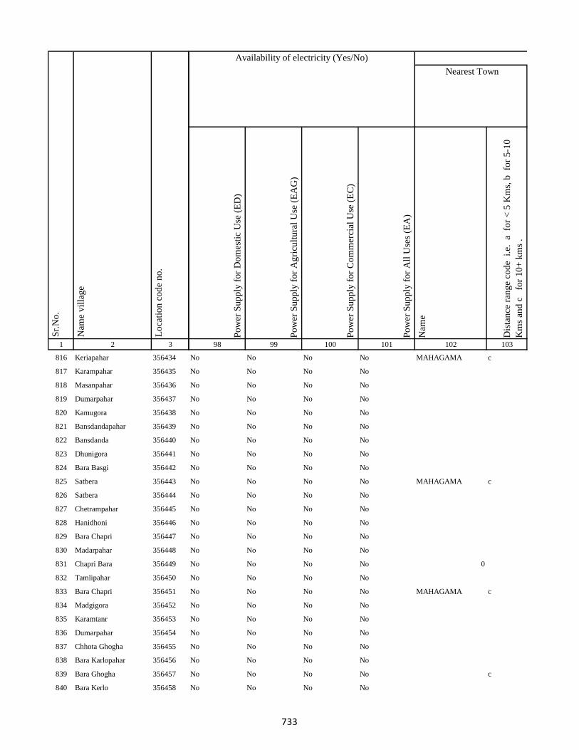
1 2 3
Lo
cati
on
co
de
no
.
Nam
e v
illa
ge
Sr.
No
.
816 Keriapahar 356434
817 Karampahar 356435
818 Masanpahar 356436
819 Dumarpahar 356437
820 Kamugora 356438
821 Bansdandapahar 356439
822 Bansdanda 356440
823 Dhunigora 356441
824 Bara Basgi 356442
825 Satbera 356443
826 Satbera 356444
827 Chetrampahar 356445
828 Hanidhoni 356446
829 Bara Chapri 356447
830 Madarpahar 356448
831 Chapri Bara 356449
832 Tamlipahar 356450
833 Bara Chapri 356451
834 Madgigora 356452
835 Karamtanr 356453
836 Dumarpahar 356454
837 Chhota Ghogha 356455
838 Bara Karlopahar 356456
839 Bara Ghogha 356457
840 Bara Kerlo 356458
Po
wer
Su
pp
ly f
or
Do
mes
tic
Use
(E
D)
Po
wer
Su
pp
ly f
or
Ag
ricu
ltu
ral
Use
(E
AG
)
Po
wer
Su
pp
ly f
or
Co
mm
erci
al U
se (
EC
)
Po
wer
Su
pp
ly f
or
All
Use
s (E
A)
Nam
e
Dis
tan
ce r
ang
e co
de
i.e
. a
fo
r <
5 K
ms,
b
for
5-1
0
Km
s an
d c
f
or
10
+ k
ms
.
98 99 100 101 102 103
Nearest Town
Land UseAvailability of electricity (Yes/No)
No No No No MAHAGAMA c
No No No No
No No No No
No No No No
No No No No
No No No No
No No No No
No No No No
No No No No
No No No No MAHAGAMA c
No No No No
No No No No
No No No No
No No No No
No No No No
No No No No 0
No No No No
No No No No MAHAGAMA c
No No No No
No No No No
No No No No
No No No No
No No No No
No No No No c
No No No No
733
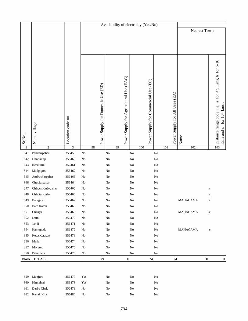
1 2 3
Lo
cati
on
co
de
no
.
Nam
e v
illa
ge
Sr.
No
.
841 Pandaripahar 356459
842 Dhobkanji 356460
843 Kerikuria 356461
844 Madgigora 356462
845 Androcharpahar 356463
846 Chuolalpahar 356464
847 Chhota Karlopahar 356465
848 Chhota Kerlo 356466
849 Baragawn 356467
850 Bara Kamu 356468
851 Chenya 356469
852 Dumli 356470
853 Jandi 356471
854 Kamugoda 356472
855 Keto(Keraya) 356473
856 Mada 356474
857 Moremo 356475
858 Pakarbera 356476
Block T O T A L :
859 Manjura 356477
860 Khutahari 356478
861 Darbe Chak 356479
862 Kanak Kita 356480
Po
wer
Su
pp
ly f
or
Do
mes
tic
Use
(E
D)
Po
wer
Su
pp
ly f
or
Ag
ricu
ltu
ral
Use
(E
AG
)
Po
wer
Su
pp
ly f
or
Co
mm
erci
al U
se (
EC
)
Po
wer
Su
pp
ly f
or
All
Use
s (E
A)
Nam
e
Dis
tan
ce r
ang
e co
de
i.e
. a
fo
r <
5 K
ms,
b
for
5-1
0
Km
s an
d c
f
or
10
+ k
ms
.
98 99 100 101 102 103
Nearest Town
Land UseAvailability of electricity (Yes/No)
No No No No
No No No No
No No No No
No No No No
No No No No
No No No No
No No No No c
No No No No c
No No No No MAHAGAMA c
No No No No
No No No No MAHAGAMA c
No No No No
No No No No
No No No No MAHAGAMA c
No No No No
No No No No
No No No No
No No No No
24 0 24 24 0 0
Yes No No No
Yes No No No
No No No No
No No No No
734
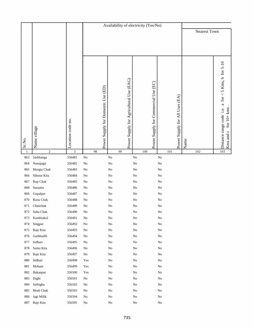
1 2 3
Lo
cati
on
co
de
no
.
Nam
e v
illa
ge
Sr.
No
.
863 Sarbhanga 356481
864 Nunajagir 356482
865 Murgia Chak 356483
866 Sibotar Kita 356484
867 Rup Chak 356485
868 Sarautia 356486
869 Gopalpur 356487
870 Ranu Chak 356488
871 Chauchak 356489
872 Saha Chak 356490
873 Kumhrakol 356491
874 Singpur 356492
875 Baje Kita 356493
876 Garbhudih 356494
877 Sidhari 356495
878 Samu Kita 356496
879 Baje Kita 356497
880 Sidhari 356498
881 Mohani 356499
882 Bakanpur 356500
883 Dighi 356501
884 Satbigha 356502
885 Modi Chak 356503
886 Jagi Milik 356504
887 Baje Kita 356505
Po
wer
Su
pp
ly f
or
Do
mes
tic
Use
(E
D)
Po
wer
Su
pp
ly f
or
Ag
ricu
ltu
ral
Use
(E
AG
)
Po
wer
Su
pp
ly f
or
Co
mm
erci
al U
se (
EC
)
Po
wer
Su
pp
ly f
or
All
Use
s (E
A)
Nam
e
Dis
tan
ce r
ang
e co
de
i.e
. a
fo
r <
5 K
ms,
b
for
5-1
0
Km
s an
d c
f
or
10
+ k
ms
.
98 99 100 101 102 103
Nearest Town
Land UseAvailability of electricity (Yes/No)
No No No No
No No No No
No No No No
No No No No
No No No No
No No No No
No No No No
No No No No
No No No No
No No No No
No No No No
No No No No
No No No No
No No No No
No No No No
No No No No
No No No No
Yes No No No
Yes No No No
Yes No No No
No No No No
No No No No
No No No No
No No No No
No No No No
735
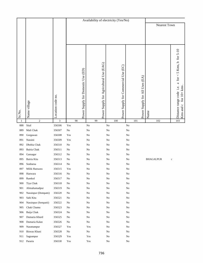
1 2 3
Lo
cati
on
co
de
no
.
Nam
e v
illa
ge
Sr.
No
.
888 Sital 356506
889 Mali Chak 356507
890 Gorgawan 356508
891 Naraini 356509
892 Dhobia Chak 356510
893 Bairia Chak 356511
894 Gansagar 356512
895 Bairia Kita 356513
896 Sonbarsa 356514
897 Milik Hanwara 356515
898 Hanwara 356516
899 Ramkol 356517
900 Tiya Chak 356518
901 Alimahamadpur 356519
902 Narainpur (Dompatti) 356520
903 Sahi Kita 356521
904 Narainpur (Sempatti) 356522
905 Chak Chamu 356523
906 Baija Chak 356524
907 Dumaria Khurd 356525
908 Dumaria Kalan 356526
909 Narattampur 356527
910 Biswas Khani 356528
911 Sagrampur 356529
912 Pararia 356530
Po
wer
Su
pp
ly f
or
Do
mes
tic
Use
(E
D)
Po
wer
Su
pp
ly f
or
Ag
ricu
ltu
ral
Use
(E
AG
)
Po
wer
Su
pp
ly f
or
Co
mm
erci
al U
se (
EC
)
Po
wer
Su
pp
ly f
or
All
Use
s (E
A)
Nam
e
Dis
tan
ce r
ang
e co
de
i.e
. a
fo
r <
5 K
ms,
b
for
5-1
0
Km
s an
d c
f
or
10
+ k
ms
.
98 99 100 101 102 103
Nearest Town
Land UseAvailability of electricity (Yes/No)
Yes No No No
No No No No
Yes No No No
Yes No No No
No No No No
No No No No
No No No No
No No No No BHAGALPUR c
No No No No
Yes No No No
No No No No
No No No No
No No No No
No No No No
No No No No
No No No No
No No No No
No No No No
No No No No
No No No No
No No No No
Yes Yes No No
No No No No
Yes Yes No No
Yes Yes No No
736
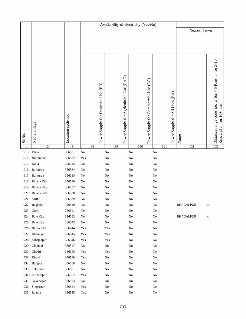
1 2 3
Lo
cati
on
co
de
no
.
Nam
e v
illa
ge
Sr.
No
.
913 Parsa 356531
914 Bikrampur 356532
915 Koila 356533
916 Barkurua 356534
917 Barkurua 356535
918 Bataua Kita 356536
919 Batana Kita 356537
920 Batana Kita 356538
921 Sarthu 356539
922 Baghakol 356540
923 Gurhi 356541
924 Baje Kita 356542
925 Baje Kita 356543
926 Bairia Kita 356544
927 Kharaiya 356545
928 Sahajadpur 356546
929 Ghatiani 356547
930 Ghuthi 356548
931 Khurd 356549
932 Banjpur 356550
933 Teknikita 356551
934 Sirinathpur 356552
935 Nayanagar 356553
936 Singarpur 356554
937 Jatama 356555
Po
wer
Su
pp
ly f
or
Do
mes
tic
Use
(E
D)
Po
wer
Su
pp
ly f
or
Ag
ricu
ltu
ral
Use
(E
AG
)
Po
wer
Su
pp
ly f
or
Co
mm
erci
al U
se (
EC
)
Po
wer
Su
pp
ly f
or
All
Use
s (E
A)
Nam
e
Dis
tan
ce r
ang
e co
de
i.e
. a
fo
r <
5 K
ms,
b
for
5-1
0
Km
s an
d c
f
or
10
+ k
ms
.
98 99 100 101 102 103
Nearest Town
Land UseAvailability of electricity (Yes/No)
No No No No
Yes No No No
No No No No
No No No No
No No No No
No No No No
No No No No
No No No No
No No No No
No No No No BHAGALPUR c
No No No No
No No No No BHAGALPUR c
No No No No
Yes Yes No No
Yes Yes No No
Yes Yes No No
No No No No
Yes Yes No No
Yes No No No
No No No No
No No No No
Yes No No No
No No No No
Yes No No No
Yes No No No
737
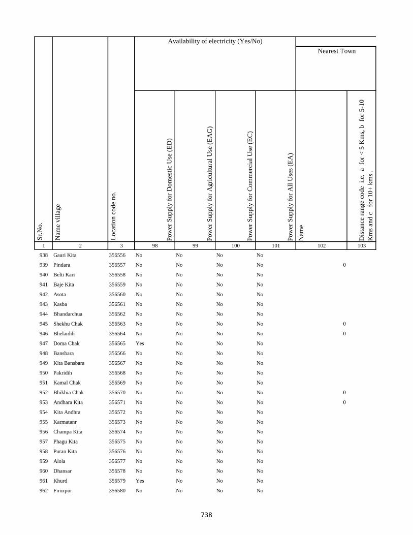
1 2 3
Lo
cati
on
co
de
no
.
Nam
e v
illa
ge
Sr.
No
.
938 Gauri Kita 356556
939 Pindara 356557
940 Belti Kari 356558
941 Baje Kita 356559
942 Asota 356560
943 Kasba 356561
944 Bhandarchua 356562
945 Shekhu Chak 356563
946 Bhelaidih 356564
947 Doma Chak 356565
948 Bansbara 356566
949 Kita Bansbara 356567
950 Pakridih 356568
951 Kamal Chak 356569
952 Bhikhia Chak 356570
953 Andhara Kita 356571
954 Kita Andhra 356572
955 Karmatanr 356573
956 Champa Kita 356574
957 Phagu Kita 356575
958 Puran Kita 356576
959 Alola 356577
960 Dhansar 356578
961 Khurd 356579
962 Firozpur 356580
Po
wer
Su
pp
ly f
or
Do
mes
tic
Use
(E
D)
Po
wer
Su
pp
ly f
or
Ag
ricu
ltu
ral
Use
(E
AG
)
Po
wer
Su
pp
ly f
or
Co
mm
erci
al U
se (
EC
)
Po
wer
Su
pp
ly f
or
All
Use
s (E
A)
Nam
e
Dis
tan
ce r
ang
e co
de
i.e
. a
fo
r <
5 K
ms,
b
for
5-1
0
Km
s an
d c
f
or
10
+ k
ms
.
98 99 100 101 102 103
Nearest Town
Land UseAvailability of electricity (Yes/No)
No No No No
No No No No 0
No No No No
No No No No
No No No No
No No No No
No No No No
No No No No 0
No No No No 0
Yes No No No
No No No No
No No No No
No No No No
No No No No
No No No No 0
No No No No 0
No No No No
No No No No
No No No No
No No No No
No No No No
No No No No
No No No No
Yes No No No
No No No No
738

1 2 3
Lo
cati
on
co
de
no
.
Nam
e v
illa
ge
Sr.
No
.
963 Dharampur Ghat 356581
964 Dharampur Mal 356582
965 Chaujora Mal 356583
966 Chaujora Ghat 356584
967 Kamargawan 356585
968 Mansura 356586
969 Sadulabhita 356587
970 Gosain Chak 356588
971 Madhupur 356589
972 Gokula 356590
973 Majhona 356591
974 Daniala 356592
975 Khaira 356593
976 Fouzdar Kita Ghat 356594
977 Ghatdiarhi 356595
978 Diarhi Kita 356596
979 Manoharpur Kita 356597
980 Manoharpur 356598
981 Solahbighia 356599
982 Jhagarua 356600
983 Ramchandarpur 356601
984 Maigar Kita 356602
985 Kita Majhona 356603
986 Khara Kita 356604
987 Chainpur 356605
Po
wer
Su
pp
ly f
or
Do
mes
tic
Use
(E
D)
Po
wer
Su
pp
ly f
or
Ag
ricu
ltu
ral
Use
(E
AG
)
Po
wer
Su
pp
ly f
or
Co
mm
erci
al U
se (
EC
)
Po
wer
Su
pp
ly f
or
All
Use
s (E
A)
Nam
e
Dis
tan
ce r
ang
e co
de
i.e
. a
fo
r <
5 K
ms,
b
for
5-1
0
Km
s an
d c
f
or
10
+ k
ms
.
98 99 100 101 102 103
Nearest Town
Land UseAvailability of electricity (Yes/No)
No No No No
No No No No
No No No No
No No No No
No No No No
No No No No
No No No No
No No No No
No No No No
No No No No
No No No No
No No No No
No No No No
No No No No
No No No No
No No No No
No No No No
No No No No
No No No No
No No No No
No No No No
No No No No
No No No No
No No No No
No No No No
739

1 2 3
Lo
cati
on
co
de
no
.
Nam
e v
illa
ge
Sr.
No
.
988 Darha 356606
989 Ramchandarpur 356607
990 Ghat Jagarnathpur 356608
991 Jagarnathpur Mal 356609
992 Jiajori 356610
993 Rai Kita 356611
994 Jatakothi 356612
995 Bagjori 356613
996 Harlabahiar 356614
997 Balachini 356615
998 Ghat Jagatpur 356616
999 Chand Chak Ghat 356617
1000 Ramchandarpur 356618
1001 Lakarha 356619
1002 Taran Kita 356620
1003 Chamgadra Darunbatia 356621
1004 Kachuamal Chhit 356622
1005 Maskand Kachua 356623
1006 Kachuamal Chhit 356624
1007 Kachua Raksi 356625
1008 Raksa Maskand 356626
1009 Maskand Kachua 356627
1010 Lilabari 356628
1011 Kachua Raksi 356629
1012 Maskand Chhit 356630
Po
wer
Su
pp
ly f
or
Do
mes
tic
Use
(E
D)
Po
wer
Su
pp
ly f
or
Ag
ricu
ltu
ral
Use
(E
AG
)
Po
wer
Su
pp
ly f
or
Co
mm
erci
al U
se (
EC
)
Po
wer
Su
pp
ly f
or
All
Use
s (E
A)
Nam
e
Dis
tan
ce r
ang
e co
de
i.e
. a
fo
r <
5 K
ms,
b
for
5-1
0
Km
s an
d c
f
or
10
+ k
ms
.
98 99 100 101 102 103
Nearest Town
Land UseAvailability of electricity (Yes/No)
No No No No
No No No No
No No No No
No No No No
Yes No No No
Yes No No No
No No No No
No No No No
No No No No
No No No No
No No No No
No No No No
No No No No
Yes No No No
No No No No
No No No No
Yes No No No
No No No No
No No No No
Yes No No No
Yes No No No
No No No No
No No No No
No No No No
No No No No
740

1 2 3
Lo
cati
on
co
de
no
.
Nam
e v
illa
ge
Sr.
No
.
1013 Maskand Kita 356631
1014 Sirsa Kalan 356632
1015 Sirsa Khurd 356633
1016 Bholu Chak 356634
1017 Mahuara Ghat 356635
1018 Mahuara 356636
1019 Fauj Kita 356637
1020 Logain 356638
1021 Asmantikar 356639
1022 Maskand Bhanjpur 356640
1023 Gidra Pathar 356641
1024 Lamahaghat 356642
1025 Hirai Chak 356643
1026 Sukhbona 356644
1027 Sankar Kita 356645
1028 Rahim Kita 356646
1029 Hajra Chak 356647
1030 Lachmania Kita 356648
1031 Lilambar 356649
1032 Maskand Chhit 356650
1033 Bishambhar Kita 356651
1034 Kita Bishambhara 356652
1035 Gunia 356653
1036 Harin Chora 356654
1037 Baghakol 356655
Po
wer
Su
pp
ly f
or
Do
mes
tic
Use
(E
D)
Po
wer
Su
pp
ly f
or
Ag
ricu
ltu
ral
Use
(E
AG
)
Po
wer
Su
pp
ly f
or
Co
mm
erci
al U
se (
EC
)
Po
wer
Su
pp
ly f
or
All
Use
s (E
A)
Nam
e
Dis
tan
ce r
ang
e co
de
i.e
. a
fo
r <
5 K
ms,
b
for
5-1
0
Km
s an
d c
f
or
10
+ k
ms
.
98 99 100 101 102 103
Nearest Town
Land UseAvailability of electricity (Yes/No)
No No No No
No No No No
No No No No
No No No No
No No No No
No No No No BHAGALPUR c
No No No No
No No No No
No No No No
No No No No
No No No No
No No No No
No No No No
No No No No
No No No No
No No No No BHAGALPUR c
No No No No
No No No No
No No No No
No No No No
No No No No
No No No No
Yes No No No
No No No No
Yes No No No
741
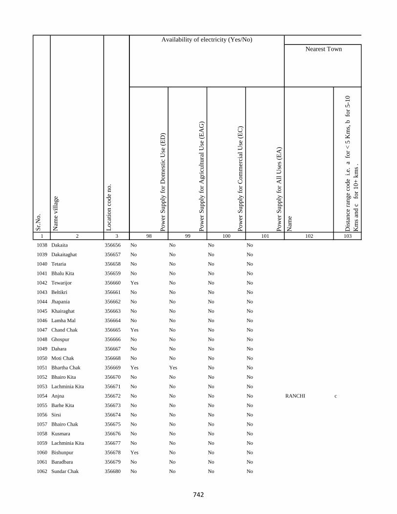
1 2 3
Lo
cati
on
co
de
no
.
Nam
e v
illa
ge
Sr.
No
.
1038 Dakaita 356656
1039 Dakaitaghat 356657
1040 Tetaria 356658
1041 Bhalu Kita 356659
1042 Tewarijor 356660
1043 Beltikri 356661
1044 Jhapania 356662
1045 Khairaghat 356663
1046 Lamha Mal 356664
1047 Chand Chak 356665
1048 Ghospur 356666
1049 Dahara 356667
1050 Moti Chak 356668
1051 Bhartha Chak 356669
1052 Bhairo Kita 356670
1053 Lachminia Kita 356671
1054 Anjna 356672
1055 Barhe Kita 356673
1056 Sirsi 356674
1057 Bhairo Chak 356675
1058 Kusmara 356676
1059 Lachminia Kita 356677
1060 Bishunpur 356678
1061 Baradbara 356679
1062 Sundar Chak 356680
Po
wer
Su
pp
ly f
or
Do
mes
tic
Use
(E
D)
Po
wer
Su
pp
ly f
or
Ag
ricu
ltu
ral
Use
(E
AG
)
Po
wer
Su
pp
ly f
or
Co
mm
erci
al U
se (
EC
)
Po
wer
Su
pp
ly f
or
All
Use
s (E
A)
Nam
e
Dis
tan
ce r
ang
e co
de
i.e
. a
fo
r <
5 K
ms,
b
for
5-1
0
Km
s an
d c
f
or
10
+ k
ms
.
98 99 100 101 102 103
Nearest Town
Land UseAvailability of electricity (Yes/No)
No No No No
No No No No
No No No No
No No No No
Yes No No No
No No No No
No No No No
No No No No
No No No No
Yes No No No
No No No No
No No No No
No No No No
Yes Yes No No
No No No No
No No No No
No No No No RANCHI c
No No No No
No No No No
No No No No
No No No No
No No No No
Yes No No No
No No No No
No No No No
742
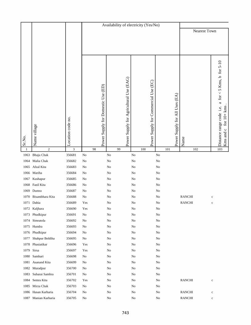
1 2 3
Lo
cati
on
co
de
no
.
Nam
e v
illa
ge
Sr.
No
.
1063 Bhaju Chak 356681
1064 Malia Chak 356682
1065 Afzal Kita 356683
1066 Mariha 356684
1067 Kushapur 356685
1068 Fazil Kita 356686
1069 Dumra 356687
1070 Bisambhara Kita 356688
1071 Dahia 356689
1072 Kaljhara 356690
1073 Phudkipur 356691
1074 Simratola 356692
1075 Hundra 356693
1076 Phudkipur 356694
1077 Shahpur Beldiha 356695
1078 Phasiatikar 356696
1079 Sirsa 356697
1080 Samhari 356698
1081 Asanand Kita 356699
1082 Muradpur 356700
1083 Subarai Samhra 356701
1084 Semra Kita 356702
1085 Mirza Chak 356703
1086 Hasan Karharia 356704
1087 Manian Karharia 356705
Po
wer
Su
pp
ly f
or
Do
mes
tic
Use
(E
D)
Po
wer
Su
pp
ly f
or
Ag
ricu
ltu
ral
Use
(E
AG
)
Po
wer
Su
pp
ly f
or
Co
mm
erci
al U
se (
EC
)
Po
wer
Su
pp
ly f
or
All
Use
s (E
A)
Nam
e
Dis
tan
ce r
ang
e co
de
i.e
. a
fo
r <
5 K
ms,
b
for
5-1
0
Km
s an
d c
f
or
10
+ k
ms
.
98 99 100 101 102 103
Nearest Town
Land UseAvailability of electricity (Yes/No)
No No No No
No No No No
No No No No
No No No No
No No No No
No No No No
No No No No
No No No No RANCHI c
Yes No No No RANCHI c
Yes No No No
No No No No
No No No No
No No No No
No No No No
No No No No
Yes No No No
Yes No No No
No No No No
No No No No
No No No No
No No No No
Yes No No No RANCHI c
No No No No
No No No No RANCHI c
No No No No RANCHI c
743
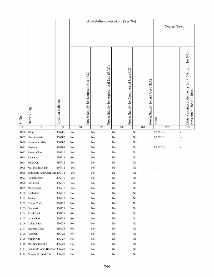
1 2 3
Lo
cati
on
co
de
no
.
Nam
e v
illa
ge
Sr.
No
.
1088 Jathari 356706
1089 Hari Karharia 356707
1090 Kanreswari Kita 356708
1091 Hasanpur 356709
1092 Bakwa Chak 356710
1093 Bela Kita 356711
1094 Janki Kita 356712
1095 Mal Bhandari Dih 356713
1096 Semrakita And Ghat Bhandarid356714
1097 Aslulahsamra 356715
1098 Bariartola 356716
1099 Maganpipra 356717
1100 Ranbahiar 356718
1101 Jamua 356719
1102 Chuna Chak 356720
1103 Ginratari 356721
1104 Sakal Chak 356722
1105 Larai Chak 356723
1106 Gohira Kita 356724
1107 Hemcha Chak 356725
1108 Asanbani 356726
1109 Jhigur Kita 356727
1110 Mal Bhandaridih 356728
1111 Semarkita Ghat Bhandaridih356729
1112 Nimgachhi And Kita 356730
Po
wer
Su
pp
ly f
or
Do
mes
tic
Use
(E
D)
Po
wer
Su
pp
ly f
or
Ag
ricu
ltu
ral
Use
(E
AG
)
Po
wer
Su
pp
ly f
or
Co
mm
erci
al U
se (
EC
)
Po
wer
Su
pp
ly f
or
All
Use
s (E
A)
Nam
e
Dis
tan
ce r
ang
e co
de
i.e
. a
fo
r <
5 K
ms,
b
for
5-1
0
Km
s an
d c
f
or
10
+ k
ms
.
98 99 100 101 102 103
Nearest Town
Land UseAvailability of electricity (Yes/No)
No No No No RANCHI c
No No No No RANCHI c
No No No No
Yes No No No RANCHI c
Yes No No No
No No No No
Yes No No No
Yes No No No .
Yes No No No
Yes No No No
Yes No No No
Yes No No No
No No No No
No No No No
No No No No
Yes No No No
No No No No
No No No No
No No No No
No No No No
No No No No
No No No No
No No No No
No No No No
No No No No
744
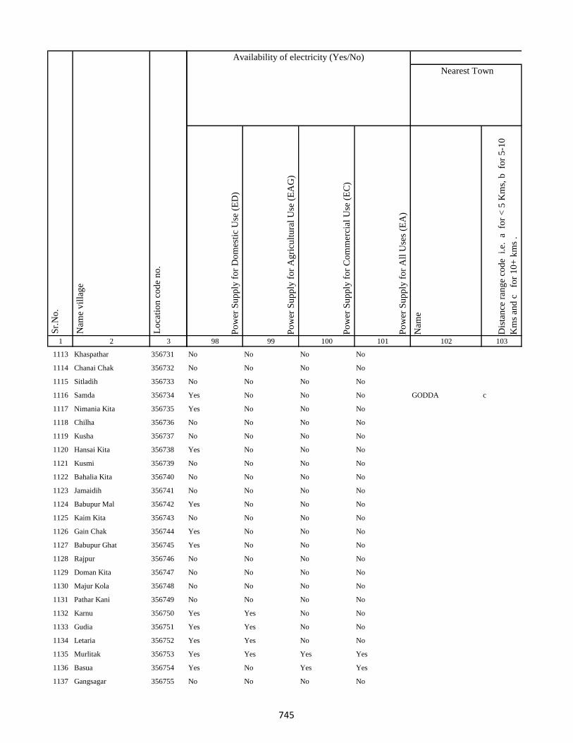
1 2 3
Lo
cati
on
co
de
no
.
Nam
e v
illa
ge
Sr.
No
.
1113 Khaspathar 356731
1114 Chanai Chak 356732
1115 Sitladih 356733
1116 Samda 356734
1117 Nimania Kita 356735
1118 Chilha 356736
1119 Kusha 356737
1120 Hansai Kita 356738
1121 Kusmi 356739
1122 Bahalia Kita 356740
1123 Jamaidih 356741
1124 Babupur Mal 356742
1125 Kaim Kita 356743
1126 Gain Chak 356744
1127 Babupur Ghat 356745
1128 Rajpur 356746
1129 Doman Kita 356747
1130 Majur Kola 356748
1131 Pathar Kani 356749
1132 Karnu 356750
1133 Gudia 356751
1134 Letaria 356752
1135 Murlitak 356753
1136 Basua 356754
1137 Gangsagar 356755
Po
wer
Su
pp
ly f
or
Do
mes
tic
Use
(E
D)
Po
wer
Su
pp
ly f
or
Ag
ricu
ltu
ral
Use
(E
AG
)
Po
wer
Su
pp
ly f
or
Co
mm
erci
al U
se (
EC
)
Po
wer
Su
pp
ly f
or
All
Use
s (E
A)
Nam
e
Dis
tan
ce r
ang
e co
de
i.e
. a
fo
r <
5 K
ms,
b
for
5-1
0
Km
s an
d c
f
or
10
+ k
ms
.
98 99 100 101 102 103
Nearest Town
Land UseAvailability of electricity (Yes/No)
No No No No
No No No No
No No No No
Yes No No No GODDA c
Yes No No No
No No No No
No No No No
Yes No No No
No No No No
No No No No
No No No No
Yes No No No
No No No No
Yes No No No
Yes No No No
No No No No
No No No No
No No No No
No No No No
Yes Yes No No
Yes Yes No No
Yes Yes No No
Yes Yes Yes Yes
Yes No Yes Yes
No No No No
745
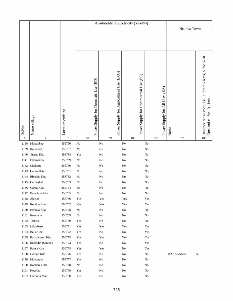
1 2 3
Lo
cati
on
co
de
no
.
Nam
e v
illa
ge
Sr.
No
.
1138 Monukhap 356756
1139 Katbaikal 356757
1140 Jharna Kita 356758
1141 Dhankurda 356759
1142 Majhoua 356760
1143 Gahira Kita 356761
1144 Bhadaia Kita 356762
1145 Garbaghat 356763
1146 Garba Kita 356764
1147 Balachini Kita 356765
1148 Akasni 356766
1149 Kendua Kita 356767
1150 Kendua Kita 356768
1151 Kusmaha 356769
1152 Tetaria 356770
1153 Lakrabank 356771
1154 Balia Ghat 356772
1155 Balia Kurmi Kita 356773
1156 Rabiadih (Santali) 356774
1157 Raksa Kita 356775
1158 Doman Kita 356776
1159 Mohanpur 356777
1160 Kadhara Ghat 356778
1161 Kusdiha 356779
1162 Dumaria Mal 356780
Po
wer
Su
pp
ly f
or
Do
mes
tic
Use
(E
D)
Po
wer
Su
pp
ly f
or
Ag
ricu
ltu
ral
Use
(E
AG
)
Po
wer
Su
pp
ly f
or
Co
mm
erci
al U
se (
EC
)
Po
wer
Su
pp
ly f
or
All
Use
s (E
A)
Nam
e
Dis
tan
ce r
ang
e co
de
i.e
. a
fo
r <
5 K
ms,
b
for
5-1
0
Km
s an
d c
f
or
10
+ k
ms
.
98 99 100 101 102 103
Nearest Town
Land UseAvailability of electricity (Yes/No)
No No No No
No No No No
Yes No No No
No No No No
No No No No
No No No No
No No No No
No No No No
No No No No
No No No No
Yes Yes Yes Yes
Yes Yes Yes Yes
No No No No
No No No No
Yes No No No
Yes Yes Yes Yes
Yes No No Yes
Yes Yes Yes Yes
Yes No No Yes
Yes Yes No Yes
Yes No No No MAHAGAMA b
Yes No No No
No No No No
Yes No No No
Yes No No No
746
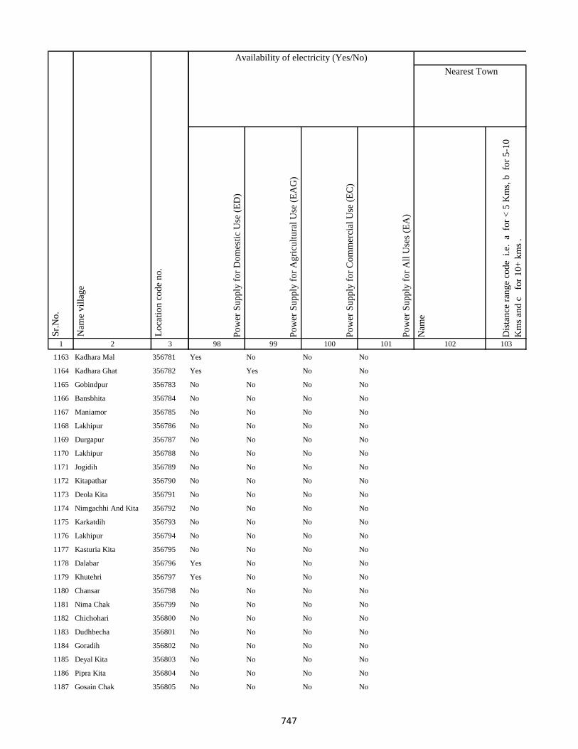
1 2 3
Lo
cati
on
co
de
no
.
Nam
e v
illa
ge
Sr.
No
.
1163 Kadhara Mal 356781
1164 Kadhara Ghat 356782
1165 Gobindpur 356783
1166 Bansbhita 356784
1167 Maniamor 356785
1168 Lakhipur 356786
1169 Durgapur 356787
1170 Lakhipur 356788
1171 Jogidih 356789
1172 Kitapathar 356790
1173 Deola Kita 356791
1174 Nimgachhi And Kita 356792
1175 Karkatdih 356793
1176 Lakhipur 356794
1177 Kasturia Kita 356795
1178 Dalabar 356796
1179 Khutehri 356797
1180 Chansar 356798
1181 Nima Chak 356799
1182 Chichohari 356800
1183 Dudhbecha 356801
1184 Goradih 356802
1185 Deyal Kita 356803
1186 Pipra Kita 356804
1187 Gosain Chak 356805
Po
wer
Su
pp
ly f
or
Do
mes
tic
Use
(E
D)
Po
wer
Su
pp
ly f
or
Ag
ricu
ltu
ral
Use
(E
AG
)
Po
wer
Su
pp
ly f
or
Co
mm
erci
al U
se (
EC
)
Po
wer
Su
pp
ly f
or
All
Use
s (E
A)
Nam
e
Dis
tan
ce r
ang
e co
de
i.e
. a
fo
r <
5 K
ms,
b
for
5-1
0
Km
s an
d c
f
or
10
+ k
ms
.
98 99 100 101 102 103
Nearest Town
Land UseAvailability of electricity (Yes/No)
Yes No No No
Yes Yes No No
No No No No
No No No No
No No No No
No No No No
No No No No
No No No No
No No No No
No No No No
No No No No
No No No No
No No No No
No No No No
No No No No
Yes No No No
Yes No No No
No No No No
No No No No
No No No No
No No No No
No No No No
No No No No
No No No No
No No No No
747
1 2 3
Lo
cati
on
co
de
no
.
Nam
e v
illa
ge
Sr.
No
.
1188 Malgarhia 356806
1189 Gadel 356807
1190 Dharmudih 356808
1191 Mahadeb Kita 356809
1192 Telaria 356810
1193 Nunajor 356811
1194 Bhogan 356812
1195 Kaithia 356813
1196 Saraiaghat 356814
1197 Manikpur Ghat 356815
1198 Amarpur 356816
1199 Bhainsabarankurum Tola356817
1200 Bhainsabarankurum Tola Mal356818
1201 Hahajor 356819
1202 Patharpur 356820
1203 Mahadeobathan 356821
1204 Bansipur 356822
1205 Sib Kita 356823
1206 Amdiha 356824
1207 Ghat Bhangabandh 356825
1208 Mal Bhangabandh 356826
1209 Panchgachhi 356827
1210 Ghat Gamharia 356828
1211 Sikkita 356829
1212 Ghat Garhaiya 356830
Po
wer
Su
pp
ly f
or
Do
mes
tic
Use
(E
D)
Po
wer
Su
pp
ly f
or
Ag
ricu
ltu
ral
Use
(E
AG
)
Po
wer
Su
pp
ly f
or
Co
mm
erci
al U
se (
EC
)
Po
wer
Su
pp
ly f
or
All
Use
s (E
A)
Nam
e
Dis
tan
ce r
ang
e co
de
i.e
. a
fo
r <
5 K
ms,
b
for
5-1
0
Km
s an
d c
f
or
10
+ k
ms
.
98 99 100 101 102 103
Nearest Town
Land UseAvailability of electricity (Yes/No)
No No No No
No No No No
No No No No
No No No No
Yes No No No
Yes No No No
Yes No No No
Yes No No No
Yes No No No
Yes No No No
Yes No No No
Yes No No No
No No No No
Yes No No No
Yes No No No
Yes No No No
No No No No
Yes No No No
Yes No No No
Yes No No No
Yes No No No
Yes No No No
No No No No
No No No No
No No No No
748
1 2 3
Lo
cati
on
co
de
no
.
Nam
e v
illa
ge
Sr.
No
.
1213 Raghunath Kita 356831
1214 Gauri Kita 356832
1215 Madhu Chak 356833
1216 Sikkita 356834
1217 Sarawa 356835
1218 Baridih 356836
1219 Gorantia 356837
1220 Baijnathpur 356838
1221 Lohathi 356839
Block T O T A L :
1222 Sonbarsa 356841
1223 Maheshliti 356842
1224 Matihani 356843
1225 Parasbana Urf Bhata Chak356844
1226 Chaura 356845
1227 Sareya 356846
1228 Tardiha 356847
1229 Khurd 356848
1230 Basbhita 356849
1231 Jogidih 356850
1232 Taratikar 356851
1233 Ghatkurwa 356852
1234 Ram Sundariya 356853
Po
wer
Su
pp
ly f
or
Do
mes
tic
Use
(E
D)
Po
wer
Su
pp
ly f
or
Ag
ricu
ltu
ral
Use
(E
AG
)
Po
wer
Su
pp
ly f
or
Co
mm
erci
al U
se (
EC
)
Po
wer
Su
pp
ly f
or
All
Use
s (E
A)
Nam
e
Dis
tan
ce r
ang
e co
de
i.e
. a
fo
r <
5 K
ms,
b
for
5-1
0
Km
s an
d c
f
or
10
+ k
ms
.
98 99 100 101 102 103
Nearest Town
Land UseAvailability of electricity (Yes/No)
Yes No No No
Yes No No No
Yes No No No
No No No No
Yes No No No
Yes No No No
Yes No No No
Yes Yes Yes No
No No No No
100 19 100 100 0 0
Yes No No Yes 0
Yes No No Yes 0
No No No No 0
No No No No 0
No No No No
Yes No No Yes
Yes No No No 0
Yes Yes No No 0
Yes Yes No No 0
No No No No 0
No No No No 0
No No No No
No No No No
749

1 2 3
Lo
cati
on
co
de
no
.
Nam
e v
illa
ge
Sr.
No
.
1235 Taratikar 356854
1236 Siardih 356855
1237 Lakhanpahari 356856
1238 Joginpahari 356857
1239 Jagarnathpur 356858
1240 Lilatari 356859
1241 Kamla Chak 356860
1242 Siardih(Chhit) 356861
1243 Bhanjpur 356862
1244 Barkop 356863
1245 Mirza Chak 356864
1246 Birseni 356865
1247 Siardih 356866
1248 Mirza Chak 356867
1249 Jogi Chak 356868
1250 Amdiha 356869
1251 Babupur 356870
1252 Jamua 356871
1253 Rangatanr 356872
1254 Semariya 356873
1255 Ramgarh 356874
1256 Kamaldiha 356875
1257 Kureri 356876
1258 Pipra 356877
1259 Babupur 356878
Po
wer
Su
pp
ly f
or
Do
mes
tic
Use
(E
D)
Po
wer
Su
pp
ly f
or
Ag
ricu
ltu
ral
Use
(E
AG
)
Po
wer
Su
pp
ly f
or
Co
mm
erci
al U
se (
EC
)
Po
wer
Su
pp
ly f
or
All
Use
s (E
A)
Nam
e
Dis
tan
ce r
ang
e co
de
i.e
. a
fo
r <
5 K
ms,
b
for
5-1
0
Km
s an
d c
f
or
10
+ k
ms
.
98 99 100 101 102 103
Nearest Town
Land UseAvailability of electricity (Yes/No)
No No No No
Yes No No Yes 0
No No No No
Yes No No No
No No No No
No No No No
No No No No
No No No No
Yes No No No
No No No No
No No No No
No No No No
No No No No
No No No No
No No No No
No No No No
Yes Yes No No
Yes No No No
Yes No No No
Yes No No No
No No No No
Yes No No No 0
No No No No
No No No No
No No No No
750

1 2 3
Lo
cati
on
co
de
no
.
Nam
e v
illa
ge
Sr.
No
.
1260 Lakarjorimal 356879
1261 Tikabagicha 356880
1262 Gordhoi 356881
1263 Babupur 356882
1264 Nauratan Kita 356883
1265 Gordhoi 356884
1266 Joginpahari 356885
1267 Simariya 356886
1268 Sonar Chak 356887
1269 Duarichak 356888
1270 Tulsi Kita 356889
1271 Chau Chak 356890
1272 Karubandh 356891
1273 Haripur 356892
1274 Chau Chak 356893
1275 Lachhminiyan 356894
1276 Chepi 356895
1277 Kasiyatari 356896
1278 Kita Gardharpur 356897
1279 Lasutiya 356898
1280 Pathargama 356899
1281 Mal Pathargama 356900
1282 Arazi Pathargama 356901
1283 Chandi Chak 356902
1284 Baliya Kita 356903
Po
wer
Su
pp
ly f
or
Do
mes
tic
Use
(E
D)
Po
wer
Su
pp
ly f
or
Ag
ricu
ltu
ral
Use
(E
AG
)
Po
wer
Su
pp
ly f
or
Co
mm
erci
al U
se (
EC
)
Po
wer
Su
pp
ly f
or
All
Use
s (E
A)
Nam
e
Dis
tan
ce r
ang
e co
de
i.e
. a
fo
r <
5 K
ms,
b
for
5-1
0
Km
s an
d c
f
or
10
+ k
ms
.
98 99 100 101 102 103
Nearest Town
Land UseAvailability of electricity (Yes/No)
No No No No
Yes No No No
Yes No No No
No No No No
No No No No
Yes No No No
No No No No
No No No No
No No No No
No No No No
No No No No
No No No No
No No No No
No No No No
No No No No
No No No No
No No No No
No No No No
Yes Yes No No
Yes Yes Yes Yes
No No No No
No No No No
No No No No 0
No No No No
No No No No 0
751
1 2 3
Lo
cati
on
co
de
no
.
Nam
e v
illa
ge
Sr.
No
.
1285 Janki Kita 356904
1286 Sapinmor 356905
1287 Panjarhar 356906
1288 Panjarhar Birit 356907
1289 Karaila Chak 356908
1290 Ambasongram 356909
1291 Mahadeva Kita 356910
1292 Ghandharpur 356911
1293 Kumarsi 356912
1294 Sundarmor 356913
1295 Dandighat 356914
1296 Tengar 356915
1297 Machhitanr 356916
1298 Telni 356917
1299 Kobhara 356918
1300 Chilkara Gobind 356919
1301 Dumarariya 356920
1302 Bareghat 356921
1303 Baredih 356922
1304 Kasturiya 356923
1305 Sukhanand 356924
1306 Jamchir 356925
1307 Kendua 356926
1308 Rampur 356927
1309 Shampur 356928
Po
wer
Su
pp
ly f
or
Do
mes
tic
Use
(E
D)
Po
wer
Su
pp
ly f
or
Ag
ricu
ltu
ral
Use
(E
AG
)
Po
wer
Su
pp
ly f
or
Co
mm
erci
al U
se (
EC
)
Po
wer
Su
pp
ly f
or
All
Use
s (E
A)
Nam
e
Dis
tan
ce r
ang
e co
de
i.e
. a
fo
r <
5 K
ms,
b
for
5-1
0
Km
s an
d c
f
or
10
+ k
ms
.
98 99 100 101 102 103
Nearest Town
Land UseAvailability of electricity (Yes/No)
No No No No
No No No No
No No No No
No No No No
No No No No
No No No No
Yes Yes No No
Yes Yes No No
No No No No
Yes No No No
Yes No No No 0
Yes No No No 0
Yes No No No
Yes No No No
Yes Yes No No 0
Yes No No No 0
No No No No 0
Yes Yes No No
Yes No No No
No No No No
No No No No
Yes No No No
No No No No 0
Yes No No No
Yes No No No 0
752

1 2 3
Lo
cati
on
co
de
no
.
Nam
e v
illa
ge
Sr.
No
.
1310 Barmasiya 356929
1311 Palipaya 356930
1312 Bargama 356931
1313 Manoharpur 356932
1314 Saranda 356933
1315 Boha 356934
1316 Khariani 356935
1317 Barhara 356936
1318 Bhalsumbhiya 356937
1319 Pipra 356938
1320 Bara Bandh 356939
1321 Awratanr 356940
1322 Harkata 356941
1323 Lakhanpahari Chhit 356942
1324 Bhanta Chak Chhota 356943
1325 Khairbani 356944
1326 Masnaha 356945
1327 Siripur 356946
1328 Mohanpur 356947
1329 Kolua 356948
1330 Ghatbaliya 356949
1331 Jalo Kundi 356950
1332 Bhata Chak 356951
1333 Tetariya 356952
1334 Taratikar 356953
Po
wer
Su
pp
ly f
or
Do
mes
tic
Use
(E
D)
Po
wer
Su
pp
ly f
or
Ag
ricu
ltu
ral
Use
(E
AG
)
Po
wer
Su
pp
ly f
or
Co
mm
erci
al U
se (
EC
)
Po
wer
Su
pp
ly f
or
All
Use
s (E
A)
Nam
e
Dis
tan
ce r
ang
e co
de
i.e
. a
fo
r <
5 K
ms,
b
for
5-1
0
Km
s an
d c
f
or
10
+ k
ms
.
98 99 100 101 102 103
Nearest Town
Land UseAvailability of electricity (Yes/No)
No No No No
Yes Yes No No
No No No No
Yes No No No
No No No No
Yes No No No
No No No No
Yes No No No
Yes No No No
Yes Yes No No
No No No No
Yes Yes No No
No No No No
Yes No No No
Yes No No No
No No No No
No No No No
No No No No
No No No No
Yes No No No
No No No No
No No No No
No No No No
No No No No
Yes No No No
753

1 2 3
Lo
cati
on
co
de
no
.
Nam
e v
illa
ge
Sr.
No
.
1335 Bandelwar 356954
1336 Taratikar 356955
1337 Dumariya 356956
1338 Dhobdiha 356957
1339 Beltikri 356958
1340 Belshar 356959
1341 Parua 356960
1342 Biahunpurmal 356961
1343 Arazi Bishunpur 356962
1344 Pakariya 356963
1345 Chamra Koli 356964
1346 Boharna 356965
1347 Rajaun Khurd 356966
1348 Ambabathan 356967
1349 Dhibabandh 356968
1350 Kerbar 356969
1351 Barwarda 356970
1352 Ranipur 356971
1353 Laugai 356972
1354 Gangarampur 356973
1355 Latauna 356974
1356 Chunakothi 356975
1357 Ghutiya 356976
1358 Rajaun Kalan 356977
1359 Bisaha 356978
Po
wer
Su
pp
ly f
or
Do
mes
tic
Use
(E
D)
Po
wer
Su
pp
ly f
or
Ag
ricu
ltu
ral
Use
(E
AG
)
Po
wer
Su
pp
ly f
or
Co
mm
erci
al U
se (
EC
)
Po
wer
Su
pp
ly f
or
All
Use
s (E
A)
Nam
e
Dis
tan
ce r
ang
e co
de
i.e
. a
fo
r <
5 K
ms,
b
for
5-1
0
Km
s an
d c
f
or
10
+ k
ms
.
98 99 100 101 102 103
Nearest Town
Land UseAvailability of electricity (Yes/No)
No No No No
No No No No
No No No No
No No No No
Yes No No No
No No No No
No No No No
No No No No
No No No No
No No No No
No No No No
Yes No No No
Yes No No No
No No No No
Yes No No No
No No No No
Yes No No No
Yes No No No
No No No No
Yes No No No
No No No No
No No No No
No No No No
No No No No 0
No No No No 0
754

1 2 3
Lo
cati
on
co
de
no
.
Nam
e v
illa
ge
Sr.
No
.
1360 Charkaghat 356979
1361 Nimbar 356980
1362 Dighi 356981
1363 Korkaghat 356982
1364 Amad Khani 356983
1365 Raksu Kita 356984
1366 Chakwa 356985
1367 Jasmata 356986
1368 Simariya 356987
1369 Sanatan 356988
1370 Kela Kita 356989
1371 Khasdighi 356990
1372 Toiadih 356991
1373 Ramu Chak 356992
1374 Charkaghat 356993
1375 Garka 356994
1376 Bariyata 356995
1377 Charkaghat 356996
1378 Tabhalpur 356997
1379 Gobindpur 356998
1380 Masudanpur 356999
1381 Bedpur 357000
1382 Bhagwan Chak 357001
1383 Rup Chak 357002
1384 Pathar Kani Mal 357003
Po
wer
Su
pp
ly f
or
Do
mes
tic
Use
(E
D)
Po
wer
Su
pp
ly f
or
Ag
ricu
ltu
ral
Use
(E
AG
)
Po
wer
Su
pp
ly f
or
Co
mm
erci
al U
se (
EC
)
Po
wer
Su
pp
ly f
or
All
Use
s (E
A)
Nam
e
Dis
tan
ce r
ang
e co
de
i.e
. a
fo
r <
5 K
ms,
b
for
5-1
0
Km
s an
d c
f
or
10
+ k
ms
.
98 99 100 101 102 103
Nearest Town
Land UseAvailability of electricity (Yes/No)
Yes No No No
No No No No
Yes No No No
No No No No
No No No No GODDA c
No No No No
No No No No 0
No No No No
No No No No GODDA c
No No No No GODDA c
No No No No GODDA c
No No No No
No No No No
No No No No
No No No No
Yes No No No
No No No No
No No No No
No No No No
No No No No
No No No No GODDA b
No No No No
No No No No 0
No No No No GODDA b
No No No No GODDA b
755

1 2 3
Lo
cati
on
co
de
no
.
Nam
e v
illa
ge
Sr.
No
.
1385 Pathar Kani Ghat 357004
1386 Chilra 357005
1387 Chainpur 357006
1388 Ghat Rampur 357007
1389 Mal Rampur 357008
1390 Mal Nistara 357009
1391 Ghat Nistara 357010
1392 Ghat Gasti 357011
1393 Mahuakol 357012
1394 Mahuasol 357013
1395 Sighai Mal 357014
1396 Singhi Ghat 357015
1397 Jogiya 357016
1398 Khaira 357017
1399 Jamjori 357018
1400 Gangtamal Chhit 357019
1401 Jokela 357020
1402 Dhangri Mal 357021
1403 Dhangdri Ghat 357022
1404 Ghangri Mal 357023
1405 Basbhita Ghat 357024
1406 Basbhita Mal 357025
1407 Ranipur Dumariya 357026
1408 Gangta Kalan 357027
1409 Jokela Mal 357028
Po
wer
Su
pp
ly f
or
Do
mes
tic
Use
(E
D)
Po
wer
Su
pp
ly f
or
Ag
ricu
ltu
ral
Use
(E
AG
)
Po
wer
Su
pp
ly f
or
Co
mm
erci
al U
se (
EC
)
Po
wer
Su
pp
ly f
or
All
Use
s (E
A)
Nam
e
Dis
tan
ce r
ang
e co
de
i.e
. a
fo
r <
5 K
ms,
b
for
5-1
0
Km
s an
d c
f
or
10
+ k
ms
.
98 99 100 101 102 103
Nearest Town
Land UseAvailability of electricity (Yes/No)
No No No No
Yes No Yes No GODDA c
Yes No No No
Yes No No No
Yes No No No
No No No No
No No No No 0
No No No No
No No No No
Yes No No No
Yes No No No
No No No No
No No No No 0
No No No No 0
No No No No
No No No No
No No No No
No No No No 0
No No No No
No No No No
No No No No 0
Yes No No No GODDA c
No No No No
Yes No No No
No No No No
756
1 2 3
Lo
cati
on
co
de
no
.
Nam
e v
illa
ge
Sr.
No
.
1410 Kerwar Ghat 357029
1411 Gangta Mal Chhit 357030
1412 Lautana 357031
1413 Mahuatanr 357032
1414 Kerwar 357033
1415 Ranipur Dumariya 357034
1416 Badalpur 357035
1417 Tetuliya 357036
1418 Paraspani 357037
1419 Daharlangi 357038
Block T O T A L :
1420 Gorgawan 357039
1421 Koriana 357040
1422 Arazi Koriana 357041
1423 Raha 357042
1424 Bade 357043
1425 Maheshtikri 357044
1426 Arazi Maheshtikri 357045
1427 Majar Khurd 357046
1428 Arazi Majar Buzurg 357047
1429 Manjar Buzurg 357048
1430 Arazi Dhapra 357049
1431 Dhapra Kita 357050
Po
wer
Su
pp
ly f
or
Do
mes
tic
Use
(E
D)
Po
wer
Su
pp
ly f
or
Ag
ricu
ltu
ral
Use
(E
AG
)
Po
wer
Su
pp
ly f
or
Co
mm
erci
al U
se (
EC
)
Po
wer
Su
pp
ly f
or
All
Use
s (E
A)
Nam
e
Dis
tan
ce r
ang
e co
de
i.e
. a
fo
r <
5 K
ms,
b
for
5-1
0
Km
s an
d c
f
or
10
+ k
ms
.
98 99 100 101 102 103
Nearest Town
Land UseAvailability of electricity (Yes/No)
No No No No 0
Yes No No No
No No No No
No No No No 0
No No No No
No No No No
No No No No
Yes No No No 0
Yes No No No
No No No No
65 12 65 65 0 0
Yes No No No
No No No No
No No No No
No No No No
No No No No
No No No No
No No No No
No No No No
No No No No
No No No No
No No No No
No No No No
757
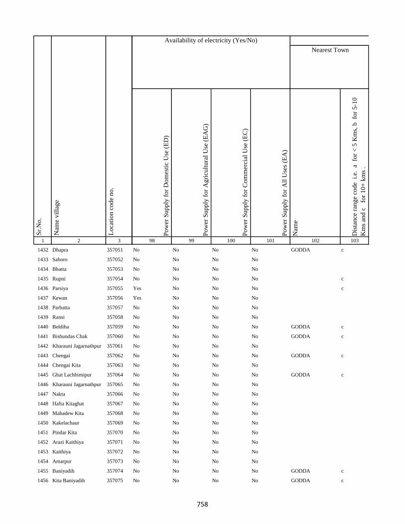
1 2 3
Lo
cati
on
co
de
no
.
Nam
e v
illa
ge
Sr.
No
.
1432 Dhapra 357051
1433 Sahoro 357052
1434 Bhatta 357053
1435 Rupni 357054
1436 Parsiya 357055
1437 Kewan 357056
1438 Parbatta 357057
1439 Ransi 357058
1440 Beldiha 357059
1441 Bishundas Chak 357060
1442 Kharauni Jagarnathpur 357061
1443 Chengai 357062
1444 Chengai Kita 357063
1445 Ghat Lachhimipur 357064
1446 Kharauni Jagarnathpur 357065
1447 Nakta 357066
1448 Hafta Kitaghat 357067
1449 Mahadew Kita 357068
1450 Kakelachaur 357069
1451 Pindar Kita 357070
1452 Arazi Kaithiya 357071
1453 Kaithiya 357072
1454 Amarpur 357073
1455 Baniyadih 357074
1456 Kita Baniyadih 357075
Po
wer
Su
pp
ly f
or
Do
mes
tic
Use
(E
D)
Po
wer
Su
pp
ly f
or
Ag
ricu
ltu
ral
Use
(E
AG
)
Po
wer
Su
pp
ly f
or
Co
mm
erci
al U
se (
EC
)
Po
wer
Su
pp
ly f
or
All
Use
s (E
A)
Nam
e
Dis
tan
ce r
ang
e co
de
i.e
. a
fo
r <
5 K
ms,
b
for
5-1
0
Km
s an
d c
f
or
10
+ k
ms
.
98 99 100 101 102 103
Nearest Town
Land UseAvailability of electricity (Yes/No)
No No No No GODDA c
No No No No
No No No No
No No No No c
Yes No No No c
Yes No No No
No No No No
No No No No
No No No No GODDA c
No No No No GODDA c
No No No No
No No No No GODDA c
No No No No
No No No No GODDA c
No No No No
No No No No
No No No No
No No No No
No No No No
No No No No
No No No No
No No No No
No No No No
No No No No GODDA c
No No No No GODDA c
758
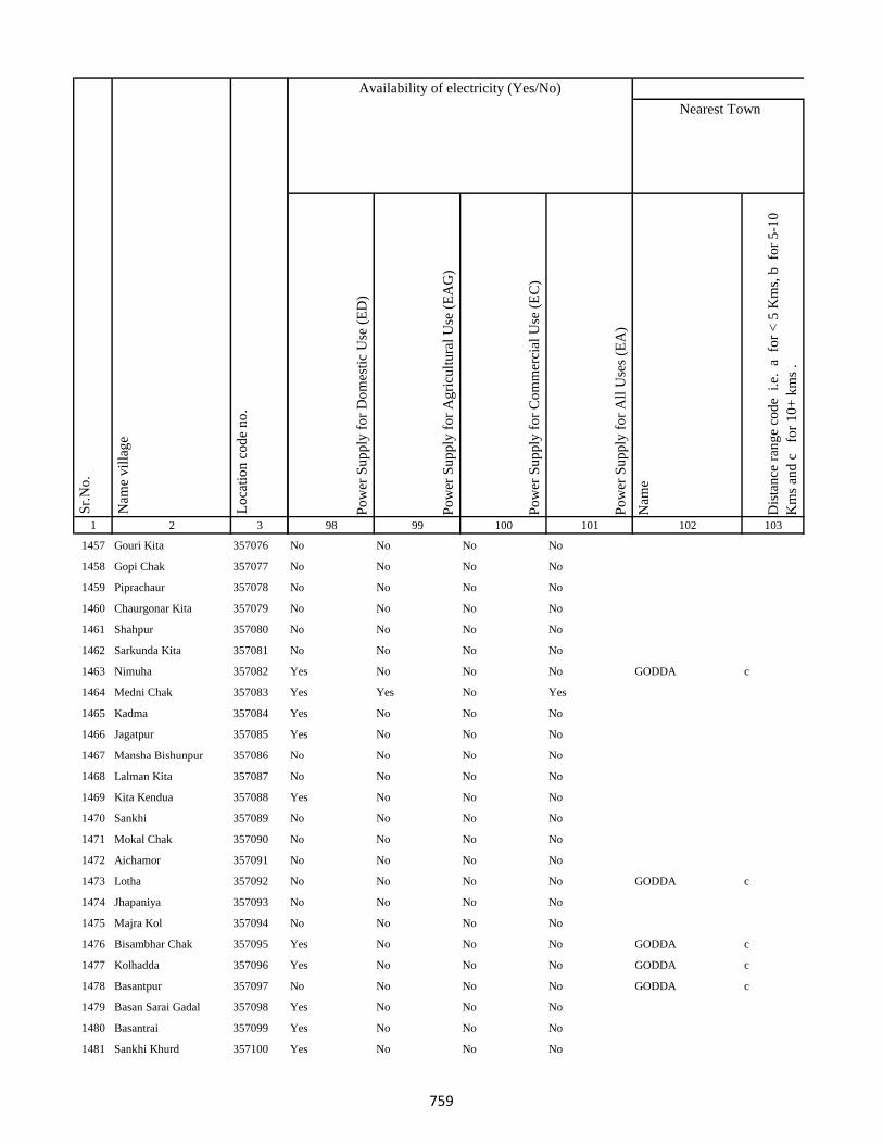
1 2 3
Lo
cati
on
co
de
no
.
Nam
e v
illa
ge
Sr.
No
.
1457 Gouri Kita 357076
1458 Gopi Chak 357077
1459 Piprachaur 357078
1460 Chaurgonar Kita 357079
1461 Shahpur 357080
1462 Sarkunda Kita 357081
1463 Nimuha 357082
1464 Medni Chak 357083
1465 Kadma 357084
1466 Jagatpur 357085
1467 Mansha Bishunpur 357086
1468 Lalman Kita 357087
1469 Kita Kendua 357088
1470 Sankhi 357089
1471 Mokal Chak 357090
1472 Aichamor 357091
1473 Lotha 357092
1474 Jhapaniya 357093
1475 Majra Kol 357094
1476 Bisambhar Chak 357095
1477 Kolhadda 357096
1478 Basantpur 357097
1479 Basan Sarai Gadal 357098
1480 Basantrai 357099
1481 Sankhi Khurd 357100
Po
wer
Su
pp
ly f
or
Do
mes
tic
Use
(E
D)
Po
wer
Su
pp
ly f
or
Ag
ricu
ltu
ral
Use
(E
AG
)
Po
wer
Su
pp
ly f
or
Co
mm
erci
al U
se (
EC
)
Po
wer
Su
pp
ly f
or
All
Use
s (E
A)
Nam
e
Dis
tan
ce r
ang
e co
de
i.e
. a
fo
r <
5 K
ms,
b
for
5-1
0
Km
s an
d c
f
or
10
+ k
ms
.
98 99 100 101 102 103
Nearest Town
Land UseAvailability of electricity (Yes/No)
No No No No
No No No No
No No No No
No No No No
No No No No
No No No No
Yes No No No GODDA c
Yes Yes No Yes
Yes No No No
Yes No No No
No No No No
No No No No
Yes No No No
No No No No
No No No No
No No No No
No No No No GODDA c
No No No No
No No No No
Yes No No No GODDA c
Yes No No No GODDA c
No No No No GODDA c
Yes No No No
Yes No No No
Yes No No No
759

1 2 3
Lo
cati
on
co
de
no
.
Nam
e v
illa
ge
Sr.
No
.
1482 Bela Kita 357101
1483 Baskhoriya 357102
1484 Baghakol 357103
1485 Harganman 357104
1486 Kola Kita 357105
1487 Kaithpura 357106
1488 Lochni 357107
1489 Pachua Kita 357108
1490 Sanaur 357109
1491 Gathaur 357110
1492 Derma 357111
1493 Deshbarag 357112
1494 Chutiyan 357113
1495 Rampur 357114
1496 Rampur Mokarri 357115
1497 Rampur Arazi 357116
1498 Gobindpur Kita 357117
1499 Shampur Gobindpur 357118
1500 Shampur 357119
1501 Kapeta 357120
1502 Karu Chak 357121
1503 Pakariya 357122
1504 Arazi Pakariya 357123
1505 Jadu Chak 357124
1506 Paradharichak 357125
Po
wer
Su
pp
ly f
or
Do
mes
tic
Use
(E
D)
Po
wer
Su
pp
ly f
or
Ag
ricu
ltu
ral
Use
(E
AG
)
Po
wer
Su
pp
ly f
or
Co
mm
erci
al U
se (
EC
)
Po
wer
Su
pp
ly f
or
All
Use
s (E
A)
Nam
e
Dis
tan
ce r
ang
e co
de
i.e
. a
fo
r <
5 K
ms,
b
for
5-1
0
Km
s an
d c
f
or
10
+ k
ms
.
98 99 100 101 102 103
Nearest Town
Land UseAvailability of electricity (Yes/No)
Yes No No No GODDA c
Yes No No No
No No No No GODDA c
No No No No
No No No No
Yes Yes Yes Yes
No No No No
No No No No
No No No No
No No No No
No No No No
No No No No
No No No No
No No No No
No No No No
No No No No
No No No No
No No No No
Yes No No No
No No No No
No No No No
No No No No
No No No No
No No No No
No No No No
760
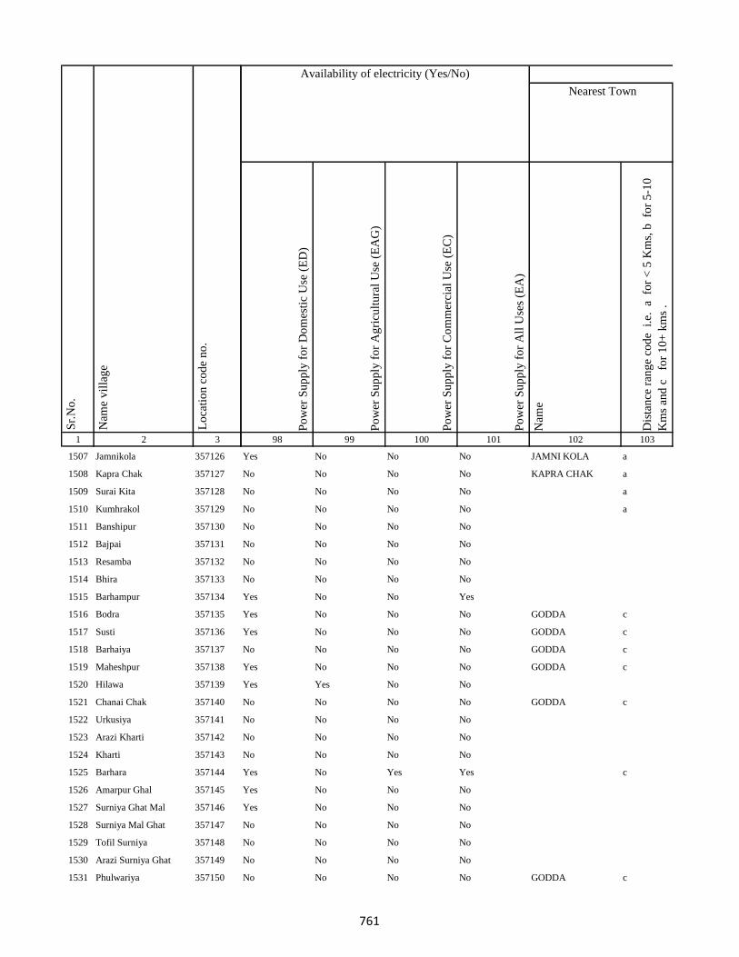
1 2 3
Lo
cati
on
co
de
no
.
Nam
e v
illa
ge
Sr.
No
.
1507 Jamnikola 357126
1508 Kapra Chak 357127
1509 Surai Kita 357128
1510 Kumhrakol 357129
1511 Banshipur 357130
1512 Bajpai 357131
1513 Resamba 357132
1514 Bhira 357133
1515 Barhampur 357134
1516 Bodra 357135
1517 Susti 357136
1518 Barhaiya 357137
1519 Maheshpur 357138
1520 Hilawa 357139
1521 Chanai Chak 357140
1522 Urkusiya 357141
1523 Arazi Kharti 357142
1524 Kharti 357143
1525 Barhara 357144
1526 Amarpur Ghal 357145
1527 Surniya Ghat Mal 357146
1528 Surniya Mal Ghat 357147
1529 Tofil Surniya 357148
1530 Arazi Surniya Ghat 357149
1531 Phulwariya 357150
Po
wer
Su
pp
ly f
or
Do
mes
tic
Use
(E
D)
Po
wer
Su
pp
ly f
or
Ag
ricu
ltu
ral
Use
(E
AG
)
Po
wer
Su
pp
ly f
or
Co
mm
erci
al U
se (
EC
)
Po
wer
Su
pp
ly f
or
All
Use
s (E
A)
Nam
e
Dis
tan
ce r
ang
e co
de
i.e
. a
fo
r <
5 K
ms,
b
for
5-1
0
Km
s an
d c
f
or
10
+ k
ms
.
98 99 100 101 102 103
Nearest Town
Land UseAvailability of electricity (Yes/No)
Yes No No No JAMNI KOLA a
No No No No KAPRA CHAK a
No No No No a
No No No No a
No No No No
No No No No
No No No No
No No No No
Yes No No Yes
Yes No No No GODDA c
Yes No No No GODDA c
No No No No GODDA c
Yes No No No GODDA c
Yes Yes No No
No No No No GODDA c
No No No No
No No No No
No No No No
Yes No Yes Yes c
Yes No No No
Yes No No No
No No No No
No No No No
No No No No
No No No No GODDA c
761
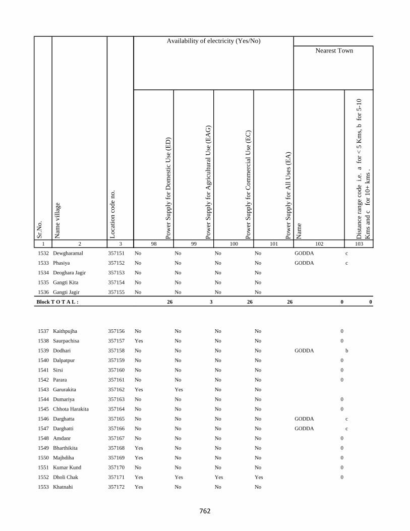
1 2 3
Lo
cati
on
co
de
no
.
Nam
e v
illa
ge
Sr.
No
.
1532 Dewgharamal 357151
1533 Phasiya 357152
1534 Deoghara Jagir 357153
1535 Gangti Kita 357154
1536 Gangti Jagir 357155
Block T O T A L :
1537 Kaithpujha 357156
1538 Saurpachisa 357157
1539 Dodhari 357158
1540 Dalpatpur 357159
1541 Sirsi 357160
1542 Parara 357161
1543 Garurakita 357162
1544 Dumariya 357163
1545 Chhota Harakita 357164
1546 Darghatta 357165
1547 Darghatti 357166
1548 Amdanr 357167
1549 Bharthikita 357168
1550 Majhdiha 357169
1551 Kumar Kund 357170
1552 Dholi Chak 357171
1553 Khatnahi 357172
Po
wer
Su
pp
ly f
or
Do
mes
tic
Use
(E
D)
Po
wer
Su
pp
ly f
or
Ag
ricu
ltu
ral
Use
(E
AG
)
Po
wer
Su
pp
ly f
or
Co
mm
erci
al U
se (
EC
)
Po
wer
Su
pp
ly f
or
All
Use
s (E
A)
Nam
e
Dis
tan
ce r
ang
e co
de
i.e
. a
fo
r <
5 K
ms,
b
for
5-1
0
Km
s an
d c
f
or
10
+ k
ms
.
98 99 100 101 102 103
Nearest Town
Land UseAvailability of electricity (Yes/No)
No No No No GODDA c
No No No No GODDA c
No No No No
No No No No
No No No No
26 3 26 26 0 0
No No No No 0
Yes No No No 0
No No No No GODDA b
No No No No 0
No No No No 0
No No No No 0
Yes Yes No No
No No No No 0
No No No No 0
No No No No GODDA c
No No No No GODDA c
No No No No 0
Yes No No No 0
Yes No No No 0
No No No No 0
Yes Yes Yes Yes 0
Yes No No No
762

1 2 3
Lo
cati
on
co
de
no
.
Nam
e v
illa
ge
Sr.
No
.
1554 Baijnathpur 357173
1555 Amlo 357174
1556 Bohoriya 357175
1557 Bokha 357176
1558 Gangta Phasiya 357177
1559 Malipalgajia 357178
1560 Kusmara 357179
1561 Dusadhi Kola 357180
1562 Maldiha 357181
1563 Simariya 357182
1564 Motia 357183
1565 Rampur 357184
1566 Jharkata 357185
1567 Patwa 357186
1568 Gangta 357187
1569 Barachaur 357188
1570 Karikado 357189
1571 Nayabad 357190
1572 Lachhanpur 357191
1573 Susunia 357192
1574 Tabalpur 357193
1575 Sikatia 357194
1576 Lohbandha 357195
1577 Tuka 357196
1578 Ramla Santali 357197
Po
wer
Su
pp
ly f
or
Do
mes
tic
Use
(E
D)
Po
wer
Su
pp
ly f
or
Ag
ricu
ltu
ral
Use
(E
AG
)
Po
wer
Su
pp
ly f
or
Co
mm
erci
al U
se (
EC
)
Po
wer
Su
pp
ly f
or
All
Use
s (E
A)
Nam
e
Dis
tan
ce r
ang
e co
de
i.e
. a
fo
r <
5 K
ms,
b
for
5-1
0
Km
s an
d c
f
or
10
+ k
ms
.
98 99 100 101 102 103
Nearest Town
Land UseAvailability of electricity (Yes/No)
No No No No
Yes No No No
No No No No
Yes No No No
Yes Yes No No
No No No No
No No No No
No No No No
No No No No
No No No No
Yes Yes Yes Yes
No No No No
No No No No
No No No No
No No No No
No No No No
No No No No
No No No No
No No No No
No No No No
No No No No
No No No No
No No No No
No No No No
No No No No
763

1 2 3
Lo
cati
on
co
de
no
.
Nam
e v
illa
ge
Sr.
No
.
1579 Ramla Dikwani 357198
1580 Nankhil 357199
1581 Devpur 357200
1582 Kumarreri 357201
1583 Saidapur 357202
1584 Algajora 357203
1585 Sinhpur 357204
1586 Parasi 357205
1587 Bhawanipur 357206
1588 Bishunpur 357207
1589 Manpur 357208
1590 Dubrajpur 357209
1591 Gurguri 357210
1592 Reni 357211
1593 Kitabuidi 357212
1594 Kathra 357213
1595 Dokabandh 357214
1596 Makunddih 357215
1597 Makunddin (Santoli) 357216
1598 Pakariya Mal 357217
1599 Pakarya Ghat 357218
1600 Beldiha 357219
1601 Barahara 357220
1602 Harpati Chak 357221
1603 Bansipur 357222
Po
wer
Su
pp
ly f
or
Do
mes
tic
Use
(E
D)
Po
wer
Su
pp
ly f
or
Ag
ricu
ltu
ral
Use
(E
AG
)
Po
wer
Su
pp
ly f
or
Co
mm
erci
al U
se (
EC
)
Po
wer
Su
pp
ly f
or
All
Use
s (E
A)
Nam
e
Dis
tan
ce r
ang
e co
de
i.e
. a
fo
r <
5 K
ms,
b
for
5-1
0
Km
s an
d c
f
or
10
+ k
ms
.
98 99 100 101 102 103
Nearest Town
Land UseAvailability of electricity (Yes/No)
Yes No No No
No No No No
No No No No
Yes Yes No Yes
No No No No
No No No No
Yes No No No
No No No No
No No No No
No No No No
Yes Yes No No
No No No No
Yes No No No
No No No No GODDA b
No No No No
No No No No
No No No No
No No No No
Yes No No No
No No No No
No No No No
Yes No No No
No No No No
No No No No
Yes No No No
764
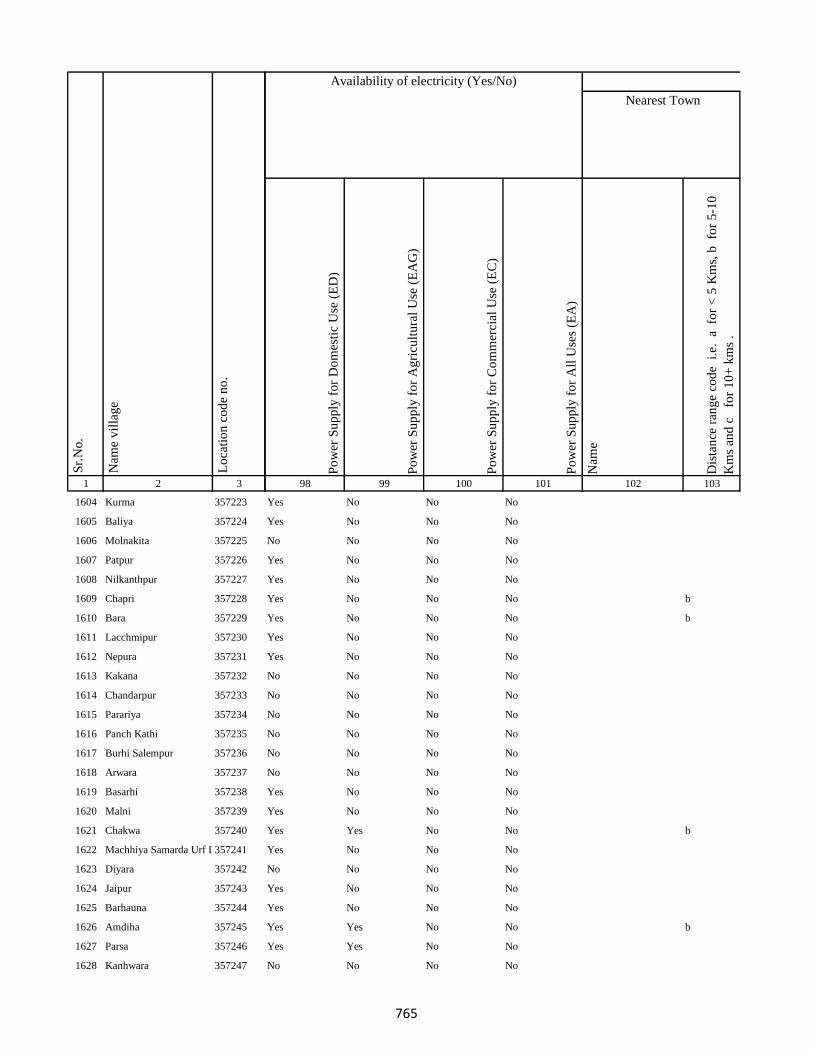
1 2 3
Lo
cati
on
co
de
no
.
Nam
e v
illa
ge
Sr.
No
.
1604 Kurma 357223
1605 Baliya 357224
1606 Molnakita 357225
1607 Patpur 357226
1608 Nilkanthpur 357227
1609 Chapri 357228
1610 Bara 357229
1611 Lacchmipur 357230
1612 Nepura 357231
1613 Kakana 357232
1614 Chandarpur 357233
1615 Parariya 357234
1616 Panch Kathi 357235
1617 Burhi Salempur 357236
1618 Arwara 357237
1619 Basarhi 357238
1620 Malni 357239
1621 Chakwa 357240
1622 Machhiya Samarda Urf Lalpur357241
1623 Diyara 357242
1624 Jaipur 357243
1625 Barhauna 357244
1626 Amdiha 357245
1627 Parsa 357246
1628 Kanhwara 357247
Po
wer
Su
pp
ly f
or
Do
mes
tic
Use
(E
D)
Po
wer
Su
pp
ly f
or
Ag
ricu
ltu
ral
Use
(E
AG
)
Po
wer
Su
pp
ly f
or
Co
mm
erci
al U
se (
EC
)
Po
wer
Su
pp
ly f
or
All
Use
s (E
A)
Nam
e
Dis
tan
ce r
ang
e co
de
i.e
. a
fo
r <
5 K
ms,
b
for
5-1
0
Km
s an
d c
f
or
10
+ k
ms
.
98 99 100 101 102 103
Nearest Town
Land UseAvailability of electricity (Yes/No)
Yes No No No
Yes No No No
No No No No
Yes No No No
Yes No No No
Yes No No No b
Yes No No No b
Yes No No No
Yes No No No
No No No No
No No No No
No No No No
No No No No
No No No No
No No No No
Yes No No No
Yes No No No
Yes Yes No No b
Yes No No No
No No No No
Yes No No No
Yes No No No
Yes Yes No No b
Yes Yes No No
No No No No
765
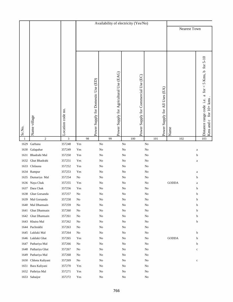
1 2 3
Lo
cati
on
co
de
no
.
Nam
e v
illa
ge
Sr.
No
.
1629 Garbana 357248
1630 Galapahar 357249
1631 Bhadrahi Mal 357250
1632 Ghat Bhadrahi 357251
1633 Chilauna 357252
1634 Rampur 357253
1635 Dumariya Mal 357254
1636 Naya Chak 357255
1637 Dara Chak 357256
1638 Ghat Gorsanda 357257
1639 Mal Gorsanda 357258
1640 Mal Dhamsain 357259
1641 Ghat Dhamsain 357260
1642 Ghat Dhamsain 357261
1643 Khaira Mal 357262
1644 Pachrukhi 357263
1645 Lukluki Mal 357264
1646 Lukluki Ghat 357265
1647 Pathariya Mal 357266
1648 Pathariya Ghat 357267
1649 Pathariya Mal 357268
1650 Chhota Kaliyani 357269
1651 Bara Kaliyani 357270
1652 Pathriya Mal 357271
1653 Sabaijor 357272
Po
wer
Su
pp
ly f
or
Do
mes
tic
Use
(E
D)
Po
wer
Su
pp
ly f
or
Ag
ricu
ltu
ral
Use
(E
AG
)
Po
wer
Su
pp
ly f
or
Co
mm
erci
al U
se (
EC
)
Po
wer
Su
pp
ly f
or
All
Use
s (E
A)
Nam
e
Dis
tan
ce r
ang
e co
de
i.e
. a
fo
r <
5 K
ms,
b
for
5-1
0
Km
s an
d c
f
or
10
+ k
ms
.
98 99 100 101 102 103
Nearest Town
Land UseAvailability of electricity (Yes/No)
Yes No No No
Yes No No No a
Yes No No No b
Yes No No No a
Yes No No No
Yes No No No a
No No No No b
Yes No No No GODDA a
Yes No No No b
No No No No b
No No No No b
No No No No b
No No No No b
No No No No b
No No No No b
No No No No
No No No No b
Yes No No No GODDA b
No No No No b
No No No No c
No No No No
No No No No c
Yes No No No
Yes No No No
Yes No No No
766
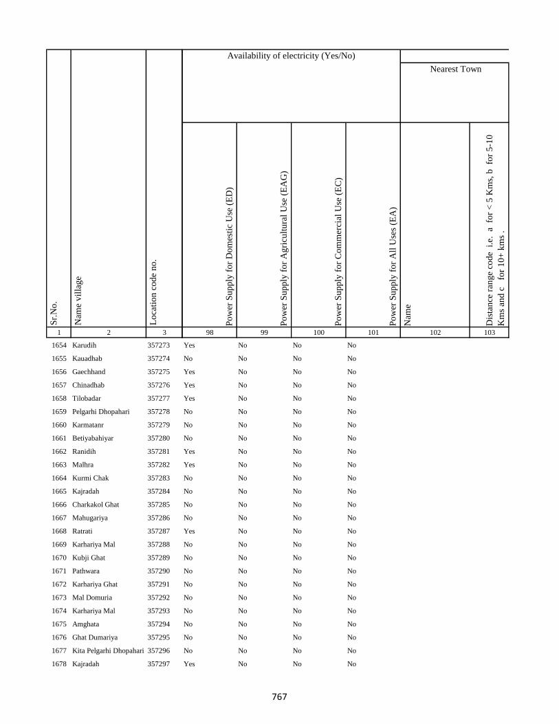
1 2 3
Lo
cati
on
co
de
no
.
Nam
e v
illa
ge
Sr.
No
.
1654 Karudih 357273
1655 Kauadhab 357274
1656 Gaechhand 357275
1657 Chinadhab 357276
1658 Tilobadar 357277
1659 Pelgarhi Dhopahari 357278
1660 Karmatanr 357279
1661 Betiyabahiyar 357280
1662 Ranidih 357281
1663 Malhra 357282
1664 Kurmi Chak 357283
1665 Kajradah 357284
1666 Charkakol Ghat 357285
1667 Mahugariya 357286
1668 Ratrati 357287
1669 Karhariya Mal 357288
1670 Kubji Ghat 357289
1671 Pathwara 357290
1672 Karhariya Ghat 357291
1673 Mal Domuria 357292
1674 Karhariya Mal 357293
1675 Amghata 357294
1676 Ghat Dumariya 357295
1677 Kita Pelgarhi Dhopahari 357296
1678 Kajradah 357297
Po
wer
Su
pp
ly f
or
Do
mes
tic
Use
(E
D)
Po
wer
Su
pp
ly f
or
Ag
ricu
ltu
ral
Use
(E
AG
)
Po
wer
Su
pp
ly f
or
Co
mm
erci
al U
se (
EC
)
Po
wer
Su
pp
ly f
or
All
Use
s (E
A)
Nam
e
Dis
tan
ce r
ang
e co
de
i.e
. a
fo
r <
5 K
ms,
b
for
5-1
0
Km
s an
d c
f
or
10
+ k
ms
.
98 99 100 101 102 103
Nearest Town
Land UseAvailability of electricity (Yes/No)
Yes No No No
No No No No
Yes No No No
Yes No No No
Yes No No No
No No No No
No No No No
No No No No
Yes No No No
Yes No No No
No No No No
No No No No
No No No No
No No No No
Yes No No No
No No No No
No No No No
No No No No
No No No No
No No No No
No No No No
No No No No
No No No No
No No No No
Yes No No No
767
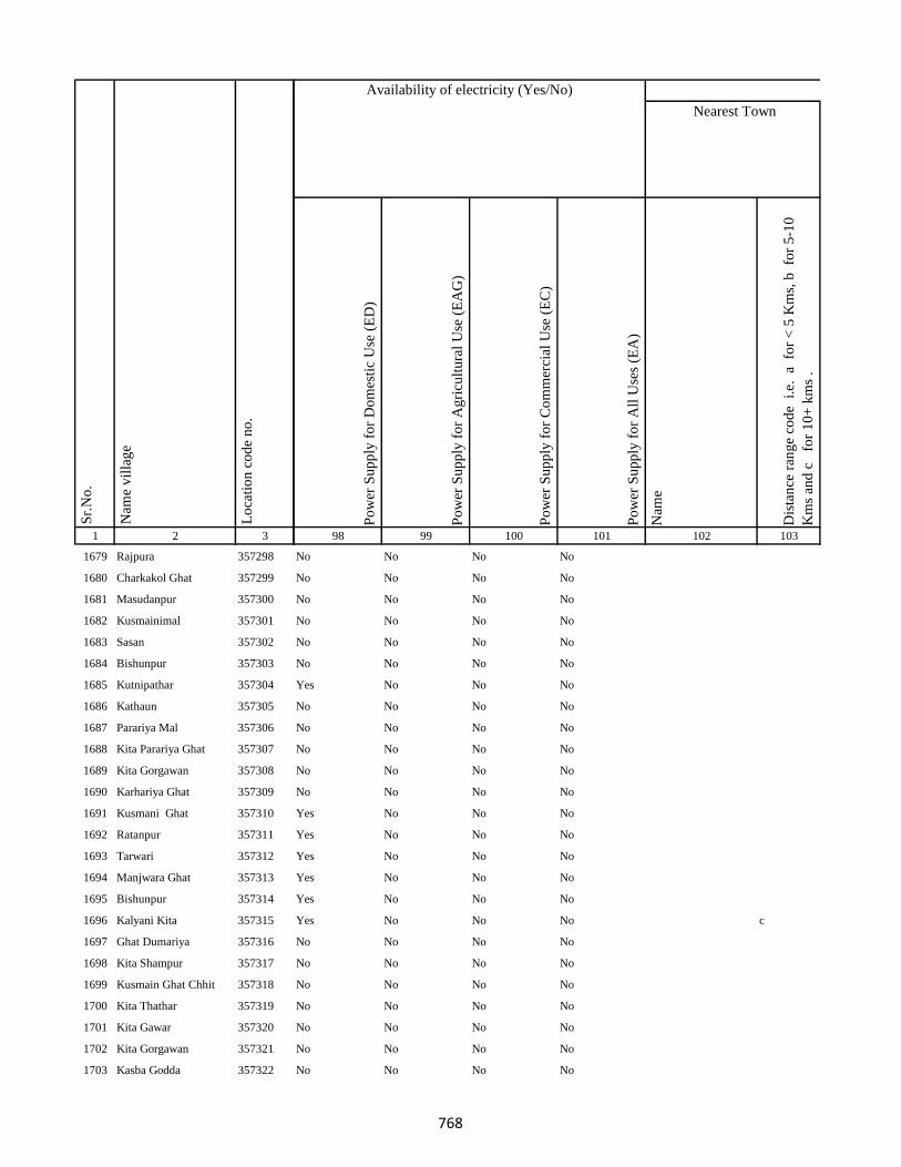
1 2 3
Lo
cati
on
co
de
no
.
Nam
e v
illa
ge
Sr.
No
.
1679 Rajpura 357298
1680 Charkakol Ghat 357299
1681 Masudanpur 357300
1682 Kusmainimal 357301
1683 Sasan 357302
1684 Bishunpur 357303
1685 Kutnipathar 357304
1686 Kathaun 357305
1687 Parariya Mal 357306
1688 Kita Parariya Ghat 357307
1689 Kita Gorgawan 357308
1690 Karhariya Ghat 357309
1691 Kusmani Ghat 357310
1692 Ratanpur 357311
1693 Tarwari 357312
1694 Manjwara Ghat 357313
1695 Bishunpur 357314
1696 Kalyani Kita 357315
1697 Ghat Dumariya 357316
1698 Kita Shampur 357317
1699 Kusmain Ghat Chhit 357318
1700 Kita Thathar 357319
1701 Kita Gawar 357320
1702 Kita Gorgawan 357321
1703 Kasba Godda 357322
Po
wer
Su
pp
ly f
or
Do
mes
tic
Use
(E
D)
Po
wer
Su
pp
ly f
or
Ag
ricu
ltu
ral
Use
(E
AG
)
Po
wer
Su
pp
ly f
or
Co
mm
erci
al U
se (
EC
)
Po
wer
Su
pp
ly f
or
All
Use
s (E
A)
Nam
e
Dis
tan
ce r
ang
e co
de
i.e
. a
fo
r <
5 K
ms,
b
for
5-1
0
Km
s an
d c
f
or
10
+ k
ms
.
98 99 100 101 102 103
Nearest Town
Land UseAvailability of electricity (Yes/No)
No No No No
No No No No
No No No No
No No No No
No No No No
No No No No
Yes No No No
No No No No
No No No No
No No No No
No No No No
No No No No
Yes No No No
Yes No No No
Yes No No No
Yes No No No
Yes No No No
Yes No No No c
No No No No
No No No No
No No No No
No No No No
No No No No
No No No No
No No No No
768

1 2 3
Lo
cati
on
co
de
no
.
Nam
e v
illa
ge
Sr.
No
.
1704 Ghat Paharpur 357323
1705 Kutni Pathar 357324
1706 Gorka Kita 357325
1707 Bhandar Koli 357326
1708 Harlal Tola 357327
1709 Haripur 357328
1710 Ghat Paharpur 357329
1711 Kasba Godda 357330
1712 Ghat Paharpur 357331
1713 Mohanpur 357332
1714 Markhan 357333
1715 Daldali 357334
1716 Jamuni Paharpur 357335
1717 Ghat Paharpur 357336
1718 Nonmati 357337
1719 Sarotiya 357338
1720 Bhatdiha 357339
1721 Bengbahiyar 357340
1722 Rupiyamal 357341
1723 Maruabaran 357342
1724 Kauribahiyarmal Chhit 357343
1725 Kauribahiyar Ghat 357344
1726 Kauribahiyar Mal 357345
1727 Pairdih 357346
1728 Kanadih Chhit 357347
Po
wer
Su
pp
ly f
or
Do
mes
tic
Use
(E
D)
Po
wer
Su
pp
ly f
or
Ag
ricu
ltu
ral
Use
(E
AG
)
Po
wer
Su
pp
ly f
or
Co
mm
erci
al U
se (
EC
)
Po
wer
Su
pp
ly f
or
All
Use
s (E
A)
Nam
e
Dis
tan
ce r
ang
e co
de
i.e
. a
fo
r <
5 K
ms,
b
for
5-1
0
Km
s an
d c
f
or
10
+ k
ms
.
98 99 100 101 102 103
Nearest Town
Land UseAvailability of electricity (Yes/No)
No No No No
No No No No
No No No No
Yes No No No
Yes No No No
Yes No No No
Yes No No No
No No No No
No No No No
Yes No No No
Yes No No No
Yes No No No
No No No No
No No No No
No No No No
Yes Yes Yes Yes
Yes No No No
Yes No No No
No No No No
No No No No
No No No No
Yes No No No
Yes No No No
Yes No No No
No No No No
769

1 2 3
Lo
cati
on
co
de
no
.
Nam
e v
illa
ge
Sr.
No
.
1729 Gorhighat Chhit 357348
1730 Kanidih Chhit 357349
1731 Jamua 357350
1732 Kurman Ghat 357351
1733 Lamhati Kar 357352
1734 Kurman Mal 357353
1735 Dharmudih 357354
1736 Punsiya 357355
1737 Kumardih 357356
1738 Murlidih Kita 357357
1739 Pandubathan 357358
1740 Sarkanda 357359
1741 Pathra 357360
1742 Bilari 357361
1743 Ghat Jamuni 357362
1744 Pandaha 357363
1745 Ghat Jhilua 357364
1746 Lachhmi 357365
1747 Ghat Jopnadih 357366
1748 Majhdiha 357367
1749 Makhni 357368
1750 Amarpur 357369
1751 Baramasia 357370
1752 Sonjhar 357371
1753 Kadwa 357372
Po
wer
Su
pp
ly f
or
Do
mes
tic
Use
(E
D)
Po
wer
Su
pp
ly f
or
Ag
ricu
ltu
ral
Use
(E
AG
)
Po
wer
Su
pp
ly f
or
Co
mm
erci
al U
se (
EC
)
Po
wer
Su
pp
ly f
or
All
Use
s (E
A)
Nam
e
Dis
tan
ce r
ang
e co
de
i.e
. a
fo
r <
5 K
ms,
b
for
5-1
0
Km
s an
d c
f
or
10
+ k
ms
.
98 99 100 101 102 103
Nearest Town
Land UseAvailability of electricity (Yes/No)
No No No No
No No No No
Yes No No No
Yes No No No
Yes No No No
Yes No No No
Yes No No No
Yes No No No
Yes No No No
Yes No No No
Yes No No No
Yes No No No
No No No No
Yes No No No
Yes No No No
Yes No No No
Yes No No No
Yes No No No
No No No No
No No No No
Yes No No No
Yes No No No
Yes No No No
Yes No No No GODDA
Yes Yes No No
770

1 2 3
Lo
cati
on
co
de
no
.
Nam
e v
illa
ge
Sr.
No
.
1754 Nonbatta 357373
1755 Teldiha 357374
1756 Banka Ghat 357375
1757 Langradih 357376
1758 Bhalpahari 357377
1759 Sundarmor 357378
1760 Nipaniya 357379
1761 Baristanr 357380
1762 Jalgar 357381
1763 Sandmara 357382
1764 Dhokal Tola 357383
1765 Nandupahari 357384
1766 Jainagar Piprajoria 357385
1767 Birbal Tola 357386
1768 Belbathan 357387
1769 Raj Daha 357388
1770 Lalpur 357389
1771 Shampur 357390
1772 Jhagarahi 357391
1773 Kalhajor Kalan 357392
1774 Saharpur 357393
1775 Jhilua 357394
1776 Amjora 357395
1777 Hijaljor 357396
1778 Kundadah 357397
Po
wer
Su
pp
ly f
or
Do
mes
tic
Use
(E
D)
Po
wer
Su
pp
ly f
or
Ag
ricu
ltu
ral
Use
(E
AG
)
Po
wer
Su
pp
ly f
or
Co
mm
erci
al U
se (
EC
)
Po
wer
Su
pp
ly f
or
All
Use
s (E
A)
Nam
e
Dis
tan
ce r
ang
e co
de
i.e
. a
fo
r <
5 K
ms,
b
for
5-1
0
Km
s an
d c
f
or
10
+ k
ms
.
98 99 100 101 102 103
Nearest Town
Land UseAvailability of electricity (Yes/No)
No No No No GODDA c
Yes No No No GODDA
Yes No No No
No No No No
Yes No No No
Yes No No No
No No No No GODDA
No No No No GODDA
No No No No GODDA
No No No No GODDA
No No No No GODDA
No No No No GODDA
No No No No GODDA
No No No No GODDA
No No No No GODDA
No No No No GODDA
No No No No GODDA
No No No No GODDA
No No No No GODDA
No No No No GODDA
No No No No GODDA
No No No No GODDA
No No No No GODDA
No No No No GODDA
No No No No GODDA
771
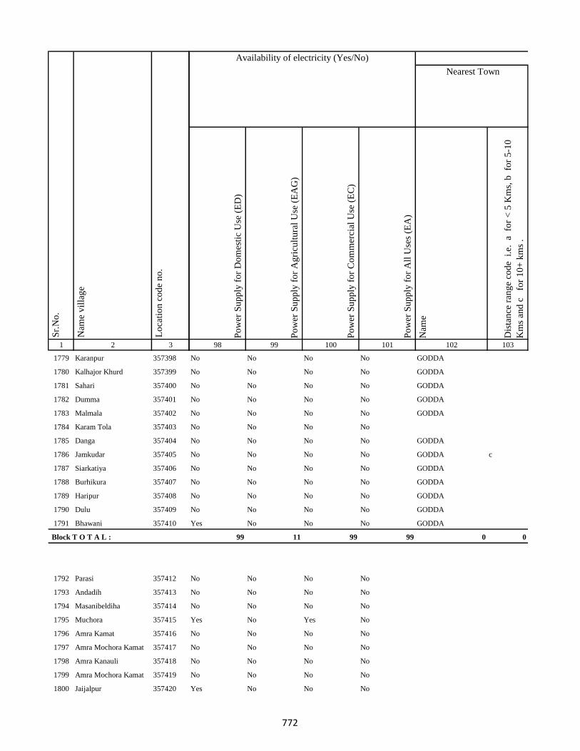
1 2 3
Lo
cati
on
co
de
no
.
Nam
e v
illa
ge
Sr.
No
.
1779 Karanpur 357398
1780 Kalhajor Khurd 357399
1781 Sahari 357400
1782 Dumma 357401
1783 Malmala 357402
1784 Karam Tola 357403
1785 Danga 357404
1786 Jamkudar 357405
1787 Siarkatiya 357406
1788 Burhikura 357407
1789 Haripur 357408
1790 Dulu 357409
1791 Bhawani 357410
Block T O T A L :
1792 Parasi 357412
1793 Andadih 357413
1794 Masanibeldiha 357414
1795 Muchora 357415
1796 Amra Kamat 357416
1797 Amra Mochora Kamat 357417
1798 Amra Kanauli 357418
1799 Amra Mochora Kamat 357419
1800 Jaijalpur 357420
Po
wer
Su
pp
ly f
or
Do
mes
tic
Use
(E
D)
Po
wer
Su
pp
ly f
or
Ag
ricu
ltu
ral
Use
(E
AG
)
Po
wer
Su
pp
ly f
or
Co
mm
erci
al U
se (
EC
)
Po
wer
Su
pp
ly f
or
All
Use
s (E
A)
Nam
e
Dis
tan
ce r
ang
e co
de
i.e
. a
fo
r <
5 K
ms,
b
for
5-1
0
Km
s an
d c
f
or
10
+ k
ms
.
98 99 100 101 102 103
Nearest Town
Land UseAvailability of electricity (Yes/No)
No No No No GODDA
No No No No GODDA
No No No No GODDA
No No No No GODDA
No No No No GODDA
No No No No
No No No No GODDA
No No No No GODDA c
No No No No GODDA
No No No No GODDA
No No No No GODDA
No No No No GODDA
Yes No No No GODDA
99 11 99 99 0 0
No No No No
No No No No
No No No No
Yes No Yes No
No No No No
No No No No
No No No No
No No No No
Yes No No No
772
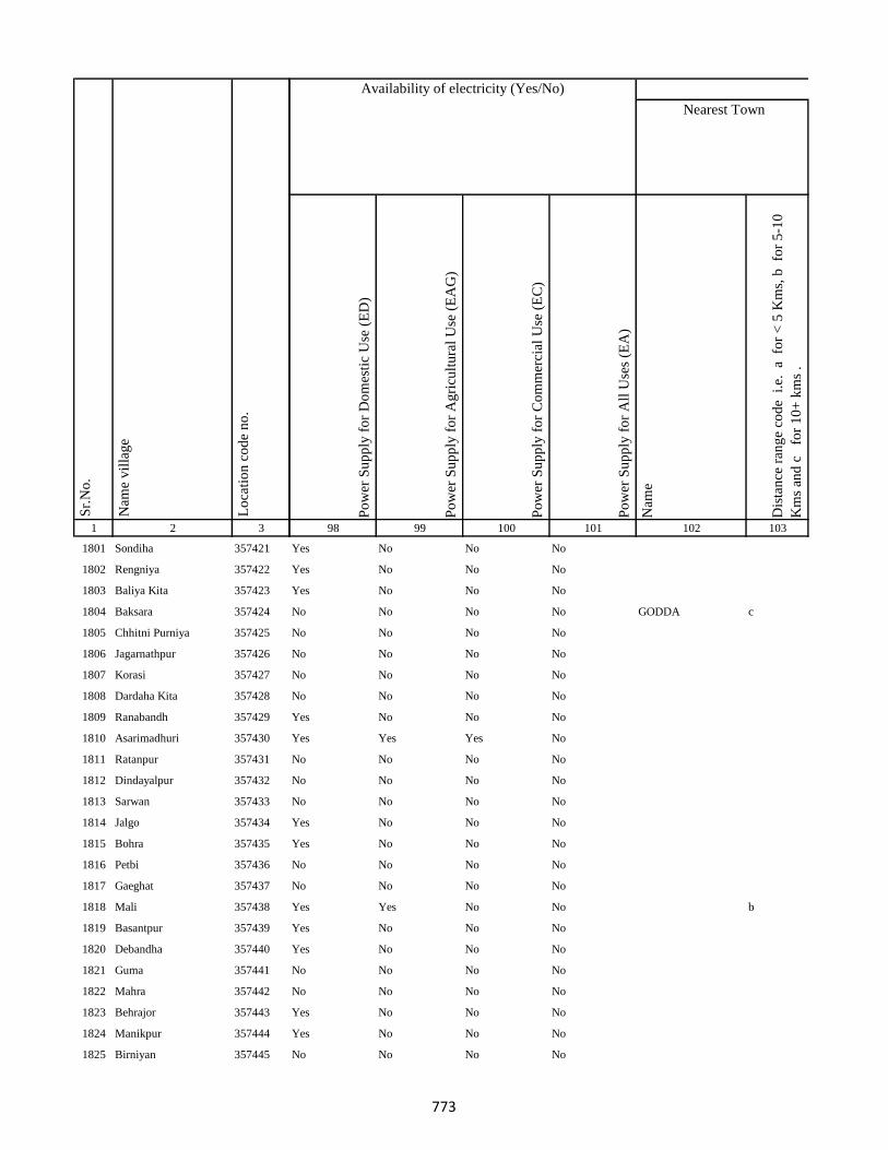
1 2 3
Lo
cati
on
co
de
no
.
Nam
e v
illa
ge
Sr.
No
.
1801 Sondiha 357421
1802 Rengniya 357422
1803 Baliya Kita 357423
1804 Baksara 357424
1805 Chhitni Purniya 357425
1806 Jagarnathpur 357426
1807 Korasi 357427
1808 Dardaha Kita 357428
1809 Ranabandh 357429
1810 Asarimadhuri 357430
1811 Ratanpur 357431
1812 Dindayalpur 357432
1813 Sarwan 357433
1814 Jalgo 357434
1815 Bohra 357435
1816 Petbi 357436
1817 Gaeghat 357437
1818 Mali 357438
1819 Basantpur 357439
1820 Debandha 357440
1821 Guma 357441
1822 Mahra 357442
1823 Behrajor 357443
1824 Manikpur 357444
1825 Birniyan 357445
Po
wer
Su
pp
ly f
or
Do
mes
tic
Use
(E
D)
Po
wer
Su
pp
ly f
or
Ag
ricu
ltu
ral
Use
(E
AG
)
Po
wer
Su
pp
ly f
or
Co
mm
erci
al U
se (
EC
)
Po
wer
Su
pp
ly f
or
All
Use
s (E
A)
Nam
e
Dis
tan
ce r
ang
e co
de
i.e
. a
fo
r <
5 K
ms,
b
for
5-1
0
Km
s an
d c
f
or
10
+ k
ms
.
98 99 100 101 102 103
Nearest Town
Land UseAvailability of electricity (Yes/No)
Yes No No No
Yes No No No
Yes No No No
No No No No GODDA c
No No No No
No No No No
No No No No
No No No No
Yes No No No
Yes Yes Yes No
No No No No
No No No No
No No No No
Yes No No No
Yes No No No
No No No No
No No No No
Yes Yes No No b
Yes No No No
Yes No No No
No No No No
No No No No
Yes No No No
Yes No No No
No No No No
773
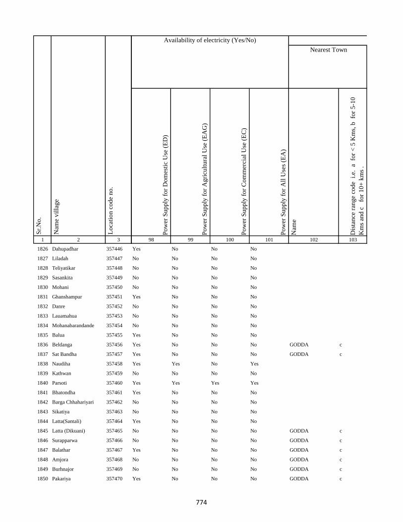
1 2 3
Lo
cati
on
co
de
no
.
Nam
e v
illa
ge
Sr.
No
.
1826 Dahupadhar 357446
1827 Liladah 357447
1828 Teliyatikar 357448
1829 Sasankita 357449
1830 Mohani 357450
1831 Ghanshampur 357451
1832 Danre 357452
1833 Lauamahua 357453
1834 Mohanabarandande 357454
1835 Balua 357455
1836 Beldanga 357456
1837 Sat Bandha 357457
1838 Naudiha 357458
1839 Kathwan 357459
1840 Parsoti 357460
1841 Bhatondha 357461
1842 Barga Chhahariyari 357462
1843 Sikatiya 357463
1844 Latta(Santali) 357464
1845 Latta (Dikuani) 357465
1846 Surapparwa 357466
1847 Balathar 357467
1848 Amjora 357468
1849 Burhnajor 357469
1850 Pakariya 357470
Po
wer
Su
pp
ly f
or
Do
mes
tic
Use
(E
D)
Po
wer
Su
pp
ly f
or
Ag
ricu
ltu
ral
Use
(E
AG
)
Po
wer
Su
pp
ly f
or
Co
mm
erci
al U
se (
EC
)
Po
wer
Su
pp
ly f
or
All
Use
s (E
A)
Nam
e
Dis
tan
ce r
ang
e co
de
i.e
. a
fo
r <
5 K
ms,
b
for
5-1
0
Km
s an
d c
f
or
10
+ k
ms
.
98 99 100 101 102 103
Nearest Town
Land UseAvailability of electricity (Yes/No)
Yes No No No
No No No No
No No No No
No No No No
No No No No
Yes No No No
No No No No
No No No No
No No No No
Yes No No No
Yes No No No GODDA c
Yes No No No GODDA c
Yes Yes No Yes
No No No No
Yes Yes Yes Yes
Yes No No No
No No No No
No No No No
Yes No No No
No No No No GODDA c
No No No No GODDA c
Yes No No No GODDA c
No No No No GODDA c
No No No No GODDA c
Yes No No No GODDA c
774
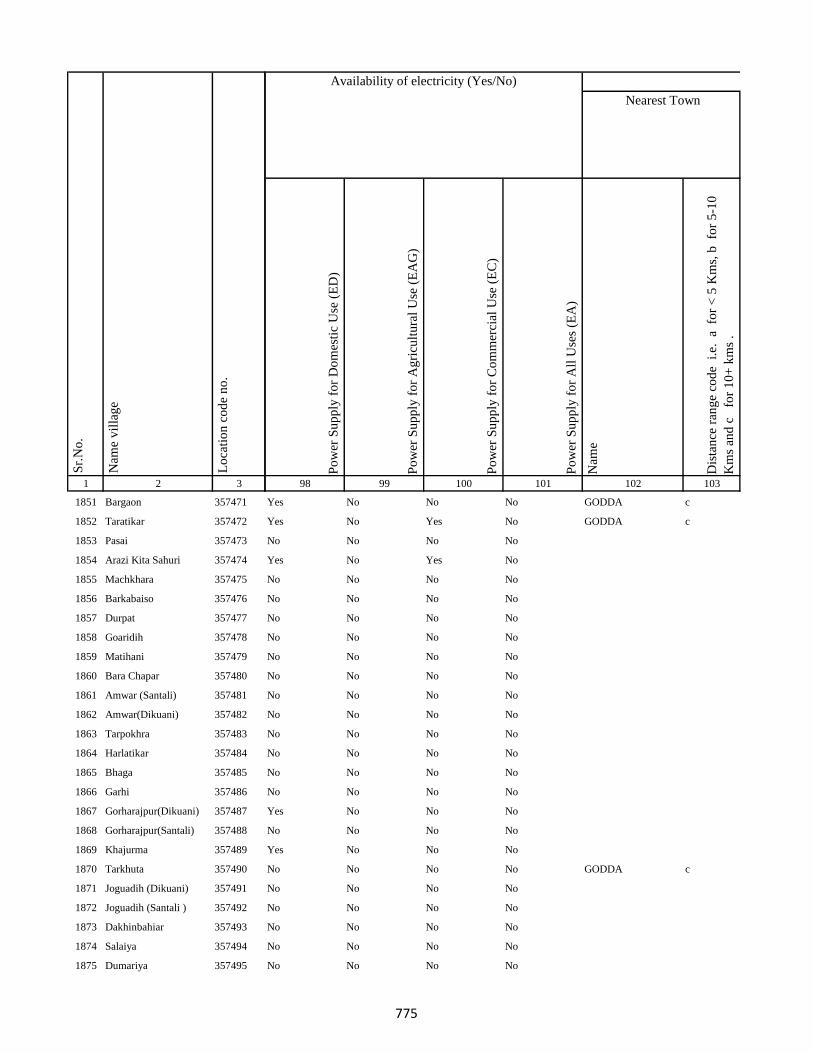
1 2 3
Lo
cati
on
co
de
no
.
Nam
e v
illa
ge
Sr.
No
.
1851 Bargaon 357471
1852 Taratikar 357472
1853 Pasai 357473
1854 Arazi Kita Sahuri 357474
1855 Machkhara 357475
1856 Barkabaiso 357476
1857 Durpat 357477
1858 Goaridih 357478
1859 Matihani 357479
1860 Bara Chapar 357480
1861 Amwar (Santali) 357481
1862 Amwar(Dikuani) 357482
1863 Tarpokhra 357483
1864 Harlatikar 357484
1865 Bhaga 357485
1866 Garhi 357486
1867 Gorharajpur(Dikuani) 357487
1868 Gorharajpur(Santali) 357488
1869 Khajurma 357489
1870 Tarkhuta 357490
1871 Joguadih (Dikuani) 357491
1872 Joguadih (Santali ) 357492
1873 Dakhinbahiar 357493
1874 Salaiya 357494
1875 Dumariya 357495
Po
wer
Su
pp
ly f
or
Do
mes
tic
Use
(E
D)
Po
wer
Su
pp
ly f
or
Ag
ricu
ltu
ral
Use
(E
AG
)
Po
wer
Su
pp
ly f
or
Co
mm
erci
al U
se (
EC
)
Po
wer
Su
pp
ly f
or
All
Use
s (E
A)
Nam
e
Dis
tan
ce r
ang
e co
de
i.e
. a
fo
r <
5 K
ms,
b
for
5-1
0
Km
s an
d c
f
or
10
+ k
ms
.
98 99 100 101 102 103
Nearest Town
Land UseAvailability of electricity (Yes/No)
Yes No No No GODDA c
Yes No Yes No GODDA c
No No No No
Yes No Yes No
No No No No
No No No No
No No No No
No No No No
No No No No
No No No No
No No No No
No No No No
No No No No
No No No No
No No No No
No No No No
Yes No No No
No No No No
Yes No No No
No No No No GODDA c
No No No No
No No No No
No No No No
No No No No
No No No No
775
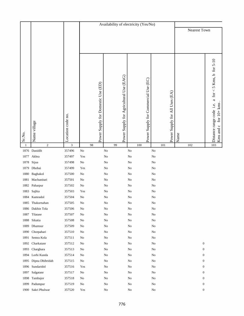
1 2 3
Lo
cati
on
co
de
no
.
Nam
e v
illa
ge
Sr.
No
.
1876 Danidih 357496
1877 Akhra 357497
1878 Sijua 357498
1879 Dhobai 357499
1880 Baghakol 357500
1881 Machanitari 357501
1882 Paharpur 357502
1883 Sajhia 357503
1884 Kamradol 357504
1885 Thakurnahan 357505
1886 Dakhin Tola 357506
1887 Tilatanr 357507
1888 Sikatia 357508
1889 Dhamsur 357509
1890 Chorpahari 357510
1891 Semra Kola 357511
1892 Charkatanr 357512
1893 Charghara 357513
1894 Lorhi Kunda 357514
1895 Dipna Dhibridah 357515
1896 Sundaridol 357516
1897 Salgatanr 357517
1898 Tambajor 357518
1899 Padumpur 357519
1900 Sakri Phulwar 357520
Po
wer
Su
pp
ly f
or
Do
mes
tic
Use
(E
D)
Po
wer
Su
pp
ly f
or
Ag
ricu
ltu
ral
Use
(E
AG
)
Po
wer
Su
pp
ly f
or
Co
mm
erci
al U
se (
EC
)
Po
wer
Su
pp
ly f
or
All
Use
s (E
A)
Nam
e
Dis
tan
ce r
ang
e co
de
i.e
. a
fo
r <
5 K
ms,
b
for
5-1
0
Km
s an
d c
f
or
10
+ k
ms
.
98 99 100 101 102 103
Nearest Town
Land UseAvailability of electricity (Yes/No)
No No No No
Yes No No No
No No No No
Yes No No No
No No No No
No No No No
No No No No
Yes No No No
No No No No
No No No No
No No No No
No No No No
No No No No
No No No No
No No No No
No No No No
No No No No 0
No No No No 0
No No No No 0
No No No No 0
Yes No No No 0
No No No No 0
No No No No 0
No No No No 0
Yes No No No 0
776
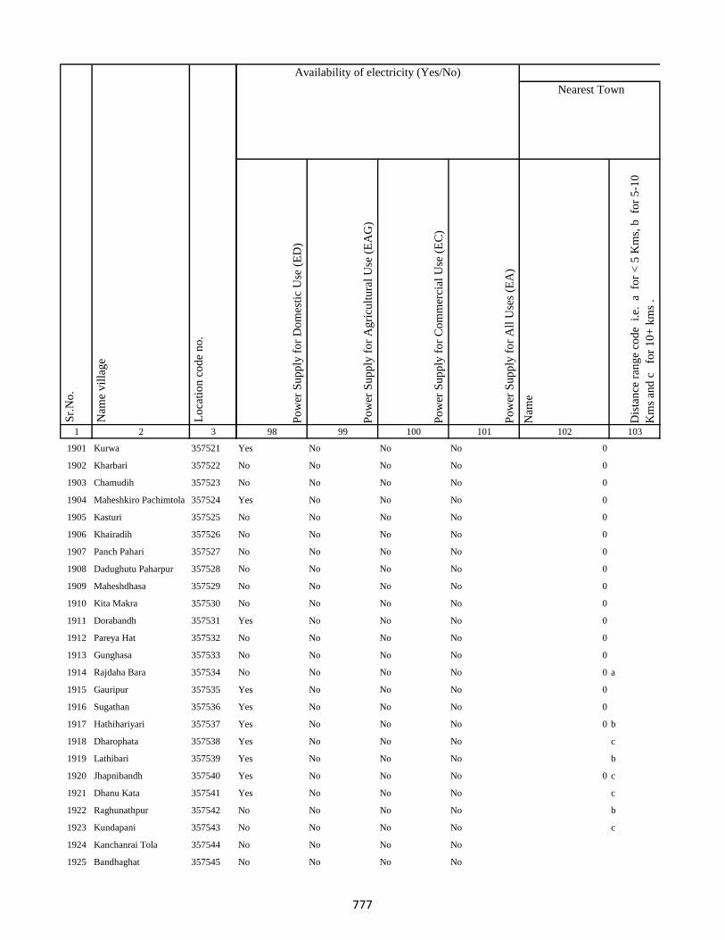
1 2 3
Lo
cati
on
co
de
no
.
Nam
e v
illa
ge
Sr.
No
.
1901 Kurwa 357521
1902 Kharbari 357522
1903 Chamudih 357523
1904 Maheshkiro Pachimtola 357524
1905 Kasturi 357525
1906 Khairadih 357526
1907 Panch Pahari 357527
1908 Dadughutu Paharpur 357528
1909 Maheshdhasa 357529
1910 Kita Makra 357530
1911 Dorabandh 357531
1912 Pareya Hat 357532
1913 Gunghasa 357533
1914 Rajdaha Bara 357534
1915 Gauripur 357535
1916 Sugathan 357536
1917 Hathihariyari 357537
1918 Dharophata 357538
1919 Lathibari 357539
1920 Jhapnibandh 357540
1921 Dhanu Kata 357541
1922 Raghunathpur 357542
1923 Kundapani 357543
1924 Kanchanrai Tola 357544
1925 Bandhaghat 357545
Po
wer
Su
pp
ly f
or
Do
mes
tic
Use
(E
D)
Po
wer
Su
pp
ly f
or
Ag
ricu
ltu
ral
Use
(E
AG
)
Po
wer
Su
pp
ly f
or
Co
mm
erci
al U
se (
EC
)
Po
wer
Su
pp
ly f
or
All
Use
s (E
A)
Nam
e
Dis
tan
ce r
ang
e co
de
i.e
. a
fo
r <
5 K
ms,
b
for
5-1
0
Km
s an
d c
f
or
10
+ k
ms
.
98 99 100 101 102 103
Nearest Town
Land UseAvailability of electricity (Yes/No)
Yes No No No 0
No No No No 0
No No No No 0
Yes No No No 0
No No No No 0
No No No No 0
No No No No 0
No No No No 0
No No No No 0
No No No No 0
Yes No No No 0
No No No No 0
No No No No 0
No No No No 0 a
Yes No No No 0
Yes No No No 0
Yes No No No 0 b
Yes No No No c
Yes No No No b
Yes No No No 0 c
Yes No No No c
No No No No b
No No No No c
No No No No
No No No No
777
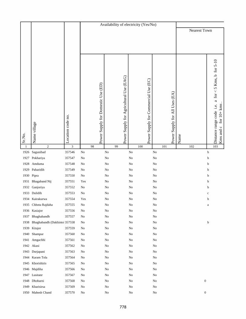
1 2 3
Lo
cati
on
co
de
no
.
Nam
e v
illa
ge
Sr.
No
.
1926 Sagunibad 357546
1927 Pokhariya 357547
1928 Amduma 357548
1929 Paharidih 357549
1930 Pipra 357550
1931 Bhagaband Nij 357551
1932 Ganjoriya 357552
1933 Dulidih 357553
1934 Kairakurwa 357554
1935 Chhota Rajdaha 357555
1936 Kasiajor 357556
1937 Bhaghabandh 357557
1938 Bhaghabandh (Dakhintola)357558
1939 Kitajor 357559
1940 Shampur 357560
1941 Amgachhi 357561
1942 Akasi 357562
1943 Durjapani 357563
1944 Karam Tola 357564
1945 Khorishiris 357565
1946 Majdiha 357566
1947 Lusitanr 357567
1948 Dhobarni 357568
1949 Kharisirsa 357569
1950 Mahesh Chand 357570
Po
wer
Su
pp
ly f
or
Do
mes
tic
Use
(E
D)
Po
wer
Su
pp
ly f
or
Ag
ricu
ltu
ral
Use
(E
AG
)
Po
wer
Su
pp
ly f
or
Co
mm
erci
al U
se (
EC
)
Po
wer
Su
pp
ly f
or
All
Use
s (E
A)
Nam
e
Dis
tan
ce r
ang
e co
de
i.e
. a
fo
r <
5 K
ms,
b
for
5-1
0
Km
s an
d c
f
or
10
+ k
ms
.
98 99 100 101 102 103
Nearest Town
Land UseAvailability of electricity (Yes/No)
No No No No b
No No No No b
No No No No b
No No No No b
No No No No b
Yes No No No b
No No No No b
No No No No c
Yes No No No b
No No No No a
No No No No
No No No No
No No No No b
No No No No
No No No No
No No No No
No No No No
No No No No
No No No No
No No No No
No No No No
No No No No
No No No No 0
No No No No
No No No No 0
778
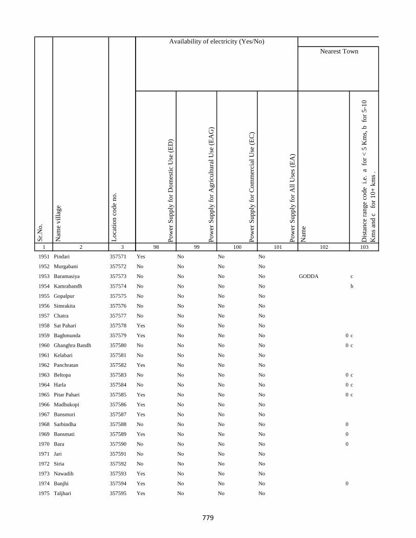
1 2 3
Lo
cati
on
co
de
no
.
Nam
e v
illa
ge
Sr.
No
.
1951 Pindari 357571
1952 Murgabani 357572
1953 Baramasiya 357573
1954 Kamrabandh 357574
1955 Gopalpur 357575
1956 Simrakita 357576
1957 Chatra 357577
1958 Sat Pahari 357578
1959 Baghmunda 357579
1960 Ghanghra Bandh 357580
1961 Kelabari 357581
1962 Panchratan 357582
1963 Beltopa 357583
1964 Harla 357584
1965 Pitar Pahari 357585
1966 Madhukopi 357586
1967 Bansmuri 357587
1968 Sarbindha 357588
1969 Bansmati 357589
1970 Bara 357590
1971 Jari 357591
1972 Siria 357592
1973 Nawadih 357593
1974 Banjhi 357594
1975 Taljhari 357595
Po
wer
Su
pp
ly f
or
Do
mes
tic
Use
(E
D)
Po
wer
Su
pp
ly f
or
Ag
ricu
ltu
ral
Use
(E
AG
)
Po
wer
Su
pp
ly f
or
Co
mm
erci
al U
se (
EC
)
Po
wer
Su
pp
ly f
or
All
Use
s (E
A)
Nam
e
Dis
tan
ce r
ang
e co
de
i.e
. a
fo
r <
5 K
ms,
b
for
5-1
0
Km
s an
d c
f
or
10
+ k
ms
.
98 99 100 101 102 103
Nearest Town
Land UseAvailability of electricity (Yes/No)
Yes No No No
No No No No
No No No No GODDA c
No No No No b
No No No No
No No No No
No No No No
Yes No No No
Yes No No No 0 c
No No No No 0 c
No No No No
Yes No No No
No No No No 0 c
No No No No 0 c
Yes No No No 0 c
Yes No No No
Yes No No No
No No No No 0
Yes No No No 0
No No No No 0
No No No No
No No No No
Yes No No No
Yes No No No 0
Yes No No No
779
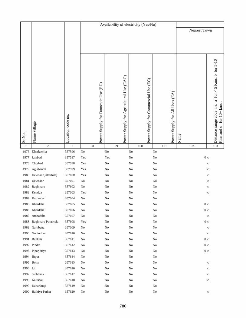
1 2 3
Lo
cati
on
co
de
no
.
Nam
e v
illa
ge
Sr.
No
.
1976 Kharkachia 357596
1977 Jambad 357597
1978 Chorbad 357598
1979 Agiabandh 357599
1980 Dewdanr(Uttartola) 357600
1981 Dewdanr 357601
1982 Baghmara 357602
1983 Kendua 357603
1984 Karikadar 357604
1985 Khardaha 357605
1986 Khardaha 357606
1987 Ambadiha 357607
1988 Baghmara Purabtola 357608
1989 Garhbana 357609
1990 Gobindpur 357610
1991 Bankati 357611
1992 Pindra 357612
1993 Piparjoriya 357613
1994 Jitpur 357614
1995 Boha 357615
1996 Liti 357616
1997 Sidhbank 357617
1998 Kairasol 357618
1999 Daharlangi 357619
2000 Halhiya Pathar 357620
Po
wer
Su
pp
ly f
or
Do
mes
tic
Use
(E
D)
Po
wer
Su
pp
ly f
or
Ag
ricu
ltu
ral
Use
(E
AG
)
Po
wer
Su
pp
ly f
or
Co
mm
erci
al U
se (
EC
)
Po
wer
Su
pp
ly f
or
All
Use
s (E
A)
Nam
e
Dis
tan
ce r
ang
e co
de
i.e
. a
fo
r <
5 K
ms,
b
for
5-1
0
Km
s an
d c
f
or
10
+ k
ms
.
98 99 100 101 102 103
Nearest Town
Land UseAvailability of electricity (Yes/No)
No No No No
Yes Yes No No 0 c
Yes No No No c
Yes No No No c
Yes No No No c
No No No No c
No No No No c
Yes No No No c
No No No No
No No No No 0 c
No No No No 0 c
No No No No c
Yes No No No 0 c
No No No No c
No No No No c
No No No No 0 c
No No No No 0 c
No No No No 0 c
No No No No
No No No No c
No No No No c
No No No No c
No No No No c
No No No No
No No No No c
780
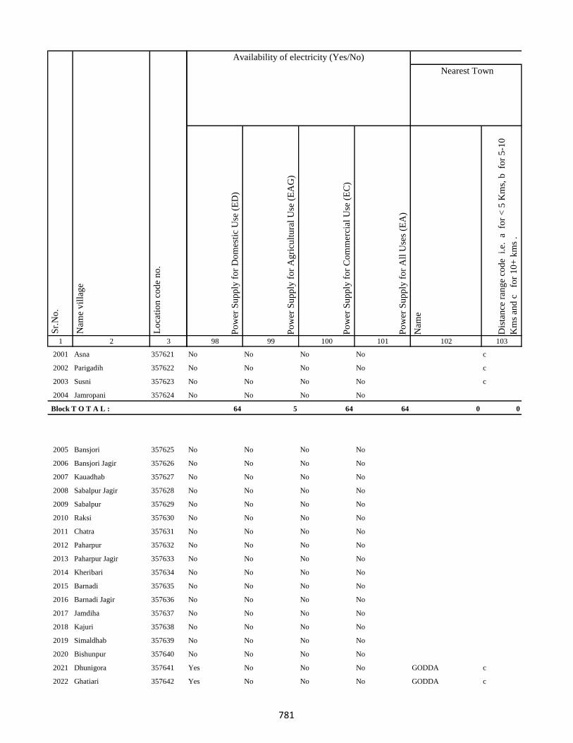
1 2 3
Lo
cati
on
co
de
no
.
Nam
e v
illa
ge
Sr.
No
.
2001 Asna 357621
2002 Parigadih 357622
2003 Susni 357623
2004 Jamropani 357624
Block T O T A L :
2005 Bansjori 357625
2006 Bansjori Jagir 357626
2007 Kauadhab 357627
2008 Sabalpur Jagir 357628
2009 Sabalpur 357629
2010 Raksi 357630
2011 Chatra 357631
2012 Paharpur 357632
2013 Paharpur Jagir 357633
2014 Kheribari 357634
2015 Barnadi 357635
2016 Barnadi Jagir 357636
2017 Jamdiha 357637
2018 Kajuri 357638
2019 Simaldhab 357639
2020 Bishunpur 357640
2021 Dhunigora 357641
2022 Ghatiari 357642
Po
wer
Su
pp
ly f
or
Do
mes
tic
Use
(E
D)
Po
wer
Su
pp
ly f
or
Ag
ricu
ltu
ral
Use
(E
AG
)
Po
wer
Su
pp
ly f
or
Co
mm
erci
al U
se (
EC
)
Po
wer
Su
pp
ly f
or
All
Use
s (E
A)
Nam
e
Dis
tan
ce r
ang
e co
de
i.e
. a
fo
r <
5 K
ms,
b
for
5-1
0
Km
s an
d c
f
or
10
+ k
ms
.
98 99 100 101 102 103
Nearest Town
Land UseAvailability of electricity (Yes/No)
No No No No c
No No No No c
No No No No c
No No No No
64 5 64 64 0 0
No No No No
No No No No
No No No No
No No No No
No No No No
No No No No
No No No No
No No No No
No No No No
No No No No
No No No No
No No No No
No No No No
No No No No
No No No No
No No No No
Yes No No No GODDA c
Yes No No No GODDA c
781
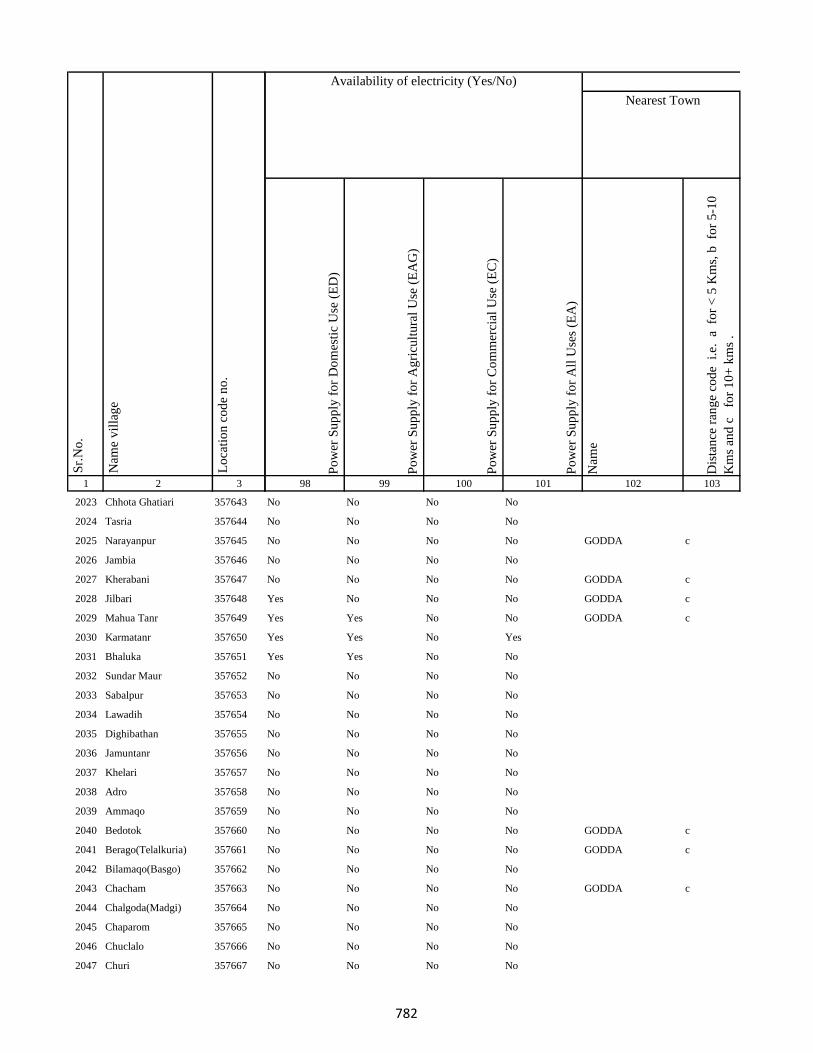
1 2 3
Lo
cati
on
co
de
no
.
Nam
e v
illa
ge
Sr.
No
.
2023 Chhota Ghatiari 357643
2024 Tasria 357644
2025 Narayanpur 357645
2026 Jambia 357646
2027 Kherabani 357647
2028 Jilbari 357648
2029 Mahua Tanr 357649
2030 Karmatanr 357650
2031 Bhaluka 357651
2032 Sundar Maur 357652
2033 Sabalpur 357653
2034 Lawadih 357654
2035 Dighibathan 357655
2036 Jamuntanr 357656
2037 Khelari 357657
2038 Adro 357658
2039 Ammaqo 357659
2040 Bedotok 357660
2041 Berago(Telalkuria) 357661
2042 Bilamaqo(Basgo) 357662
2043 Chacham 357663
2044 Chalgoda(Madgi) 357664
2045 Chaparom 357665
2046 Chuclalo 357666
2047 Churi 357667
Po
wer
Su
pp
ly f
or
Do
mes
tic
Use
(E
D)
Po
wer
Su
pp
ly f
or
Ag
ricu
ltu
ral
Use
(E
AG
)
Po
wer
Su
pp
ly f
or
Co
mm
erci
al U
se (
EC
)
Po
wer
Su
pp
ly f
or
All
Use
s (E
A)
Nam
e
Dis
tan
ce r
ang
e co
de
i.e
. a
fo
r <
5 K
ms,
b
for
5-1
0
Km
s an
d c
f
or
10
+ k
ms
.
98 99 100 101 102 103
Nearest Town
Land UseAvailability of electricity (Yes/No)
No No No No
No No No No
No No No No GODDA c
No No No No
No No No No GODDA c
Yes No No No GODDA c
Yes Yes No No GODDA c
Yes Yes No Yes
Yes Yes No No
No No No No
No No No No
No No No No
No No No No
No No No No
No No No No
No No No No
No No No No
No No No No GODDA c
No No No No GODDA c
No No No No
No No No No GODDA c
No No No No
No No No No
No No No No
No No No No
782
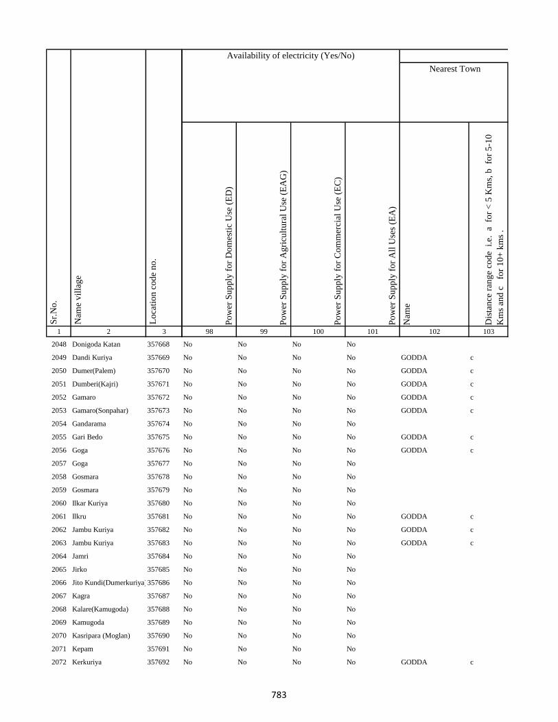
1 2 3
Lo
cati
on
co
de
no
.
Nam
e v
illa
ge
Sr.
No
.
2048 Donigoda Katan 357668
2049 Dandi Kuriya 357669
2050 Dumer(Palem) 357670
2051 Dumberi(Kajri) 357671
2052 Gamaro 357672
2053 Gamaro(Sonpahar) 357673
2054 Gandarama 357674
2055 Gari Bedo 357675
2056 Goga 357676
2057 Goga 357677
2058 Gosmara 357678
2059 Gosmara 357679
2060 Ilkar Kuriya 357680
2061 Ilkru 357681
2062 Jambu Kuriya 357682
2063 Jambu Kuriya 357683
2064 Jamri 357684
2065 Jirko 357685
2066 Jito Kundi(Dumerkuriya)357686
2067 Kagra 357687
2068 Kalare(Kamugoda) 357688
2069 Kamugoda 357689
2070 Kasripara (Moglan) 357690
2071 Kepam 357691
2072 Kerkuriya 357692
Po
wer
Su
pp
ly f
or
Do
mes
tic
Use
(E
D)
Po
wer
Su
pp
ly f
or
Ag
ricu
ltu
ral
Use
(E
AG
)
Po
wer
Su
pp
ly f
or
Co
mm
erci
al U
se (
EC
)
Po
wer
Su
pp
ly f
or
All
Use
s (E
A)
Nam
e
Dis
tan
ce r
ang
e co
de
i.e
. a
fo
r <
5 K
ms,
b
for
5-1
0
Km
s an
d c
f
or
10
+ k
ms
.
98 99 100 101 102 103
Nearest Town
Land UseAvailability of electricity (Yes/No)
No No No No
No No No No GODDA c
No No No No GODDA c
No No No No GODDA c
No No No No GODDA c
No No No No GODDA c
No No No No
No No No No GODDA c
No No No No GODDA c
No No No No
No No No No
No No No No
No No No No
No No No No GODDA c
No No No No GODDA c
No No No No GODDA c
No No No No
No No No No
No No No No
No No No No
No No No No
No No No No
No No No No
No No No No
No No No No GODDA c
783
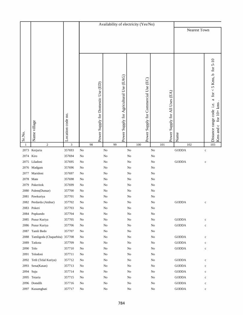
1 2 3
Lo
cati
on
co
de
no
.
Nam
e v
illa
ge
Sr.
No
.
2073 Kerjuria 357693
2074 Kiro 357694
2075 Liladoni 357695
2076 Madgam 357696
2077 Maridoni 357697
2078 Mate 357698
2079 Pakeritok 357699
2080 Palem(Dumar) 357700
2081 Pawkuriya 357701
2082 Perdarda (Ambar) 357702
2083 Pokeri 357703
2084 Popkundo 357704
2085 Pusur Kuriya 357705
2086 Pusur Kuriya 357706
2087 Tamli Bedo 357707
2088 Tamligoda (Chaparbita) 357708
2089 Tatkota 357709
2090 Telo 357710
2091 Telodoni 357711
2092 Tetli (Telal Kuriya) 357712
2093 Sena(Katan) 357713
2094 Suju 357714
2095 Tetaria 357715
2096 Domdih 357716
2097 Kusumghati 357717
Po
wer
Su
pp
ly f
or
Do
mes
tic
Use
(E
D)
Po
wer
Su
pp
ly f
or
Ag
ricu
ltu
ral
Use
(E
AG
)
Po
wer
Su
pp
ly f
or
Co
mm
erci
al U
se (
EC
)
Po
wer
Su
pp
ly f
or
All
Use
s (E
A)
Nam
e
Dis
tan
ce r
ang
e co
de
i.e
. a
fo
r <
5 K
ms,
b
for
5-1
0
Km
s an
d c
f
or
10
+ k
ms
.
98 99 100 101 102 103
Nearest Town
Land UseAvailability of electricity (Yes/No)
No No No No GODDA c
No No No No
No No No No GODDA c
No No No No
No No No No
No No No No
No No No No
No No No No
No No No No
No No No No GODDA c
No No No No
No No No No
No No No No GODDA c
No No No No GODDA c
No No No No
No No No No GODDA c
No No No No GODDA c
No No No No GODDA c
No No No No
No No No No GODDA c
No No No No GODDA c
No No No No GODDA c
No No No No GODDA c
No No No No GODDA c
No No No No GODDA c
784
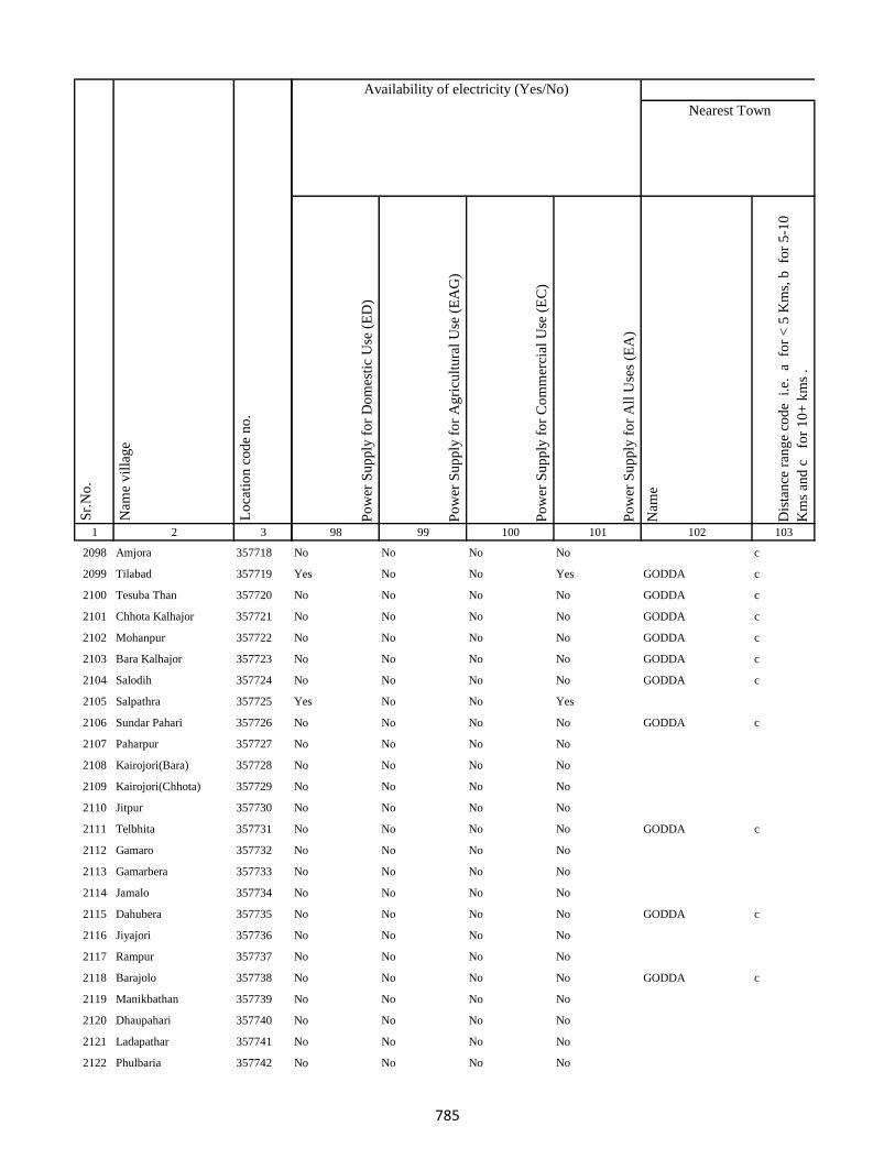
1 2 3
Lo
cati
on
co
de
no
.
Nam
e v
illa
ge
Sr.
No
.
2098 Amjora 357718
2099 Tilabad 357719
2100 Tesuba Than 357720
2101 Chhota Kalhajor 357721
2102 Mohanpur 357722
2103 Bara Kalhajor 357723
2104 Salodih 357724
2105 Salpathra 357725
2106 Sundar Pahari 357726
2107 Paharpur 357727
2108 Kairojori(Bara) 357728
2109 Kairojori(Chhota) 357729
2110 Jitpur 357730
2111 Telbhita 357731
2112 Gamaro 357732
2113 Gamarbera 357733
2114 Jamalo 357734
2115 Dahubera 357735
2116 Jiyajori 357736
2117 Rampur 357737
2118 Barajolo 357738
2119 Manikbathan 357739
2120 Dhaupahari 357740
2121 Ladapathar 357741
2122 Phulbaria 357742
Po
wer
Su
pp
ly f
or
Do
mes
tic
Use
(E
D)
Po
wer
Su
pp
ly f
or
Ag
ricu
ltu
ral
Use
(E
AG
)
Po
wer
Su
pp
ly f
or
Co
mm
erci
al U
se (
EC
)
Po
wer
Su
pp
ly f
or
All
Use
s (E
A)
Nam
e
Dis
tan
ce r
ang
e co
de
i.e
. a
fo
r <
5 K
ms,
b
for
5-1
0
Km
s an
d c
f
or
10
+ k
ms
.
98 99 100 101 102 103
Nearest Town
Land UseAvailability of electricity (Yes/No)
No No No No c
Yes No No Yes GODDA c
No No No No GODDA c
No No No No GODDA c
No No No No GODDA c
No No No No GODDA c
No No No No GODDA c
Yes No No Yes
No No No No GODDA c
No No No No
No No No No
No No No No
No No No No
No No No No GODDA c
No No No No
No No No No
No No No No
No No No No GODDA c
No No No No
No No No No
No No No No GODDA c
No No No No
No No No No
No No No No
No No No No
785
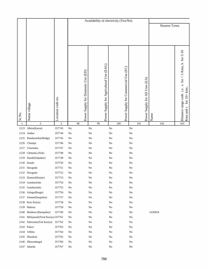
1 2 3
Lo
cati
on
co
de
no
.
Nam
e v
illa
ge
Sr.
No
.
2123 Alkito(Katon) 357743
2124 Ambar 357744
2125 Bandaretoke(Madgi) 357745
2126 Champa 357746
2127 Charmaka 357747
2128 Chetamu (Jirik) 357748
2129 Dande(Salpahar) 357749
2130 Dando 357750
2131 Dawgoda 357751
2132 Dawgoda 357752
2133 Dumeri(Dumar) 357753
2134 Gambaritoke 357754
2135 Gambaritoke 357755
2136 Gelago(Basgo) 357756
2137 Jolame(Daupahar) 357757
2138 Kero Kuriya 357758
2139 Makma 357759
2140 Masbera (Banspahar) 357760
2141 Melijamali(Tetal Kuriya) 357761
2142 Pakeramo(Tok Kuriya) 357762
2143 Pakeri 357763
2144 Telbita 357764
2145 Dhankuti 357765
2146 Dhawadangal 357766
2147 Jabarda 357767
Po
wer
Su
pp
ly f
or
Do
mes
tic
Use
(E
D)
Po
wer
Su
pp
ly f
or
Ag
ricu
ltu
ral
Use
(E
AG
)
Po
wer
Su
pp
ly f
or
Co
mm
erci
al U
se (
EC
)
Po
wer
Su
pp
ly f
or
All
Use
s (E
A)
Nam
e
Dis
tan
ce r
ang
e co
de
i.e
. a
fo
r <
5 K
ms,
b
for
5-1
0
Km
s an
d c
f
or
10
+ k
ms
.
98 99 100 101 102 103
Nearest Town
Land UseAvailability of electricity (Yes/No)
No No No No
No No No No
No No No No
No No No No
No No No No
No No No No
No No No No
No No No No
No No No No
No No No No
No No No No
No No No No
No No No No
No No No No
No No No No
No No No No
No No No No
No No No No GODDA
No No No No
No No No No
No No No No
No No No No
No No No No
No No No No
No No No No
786
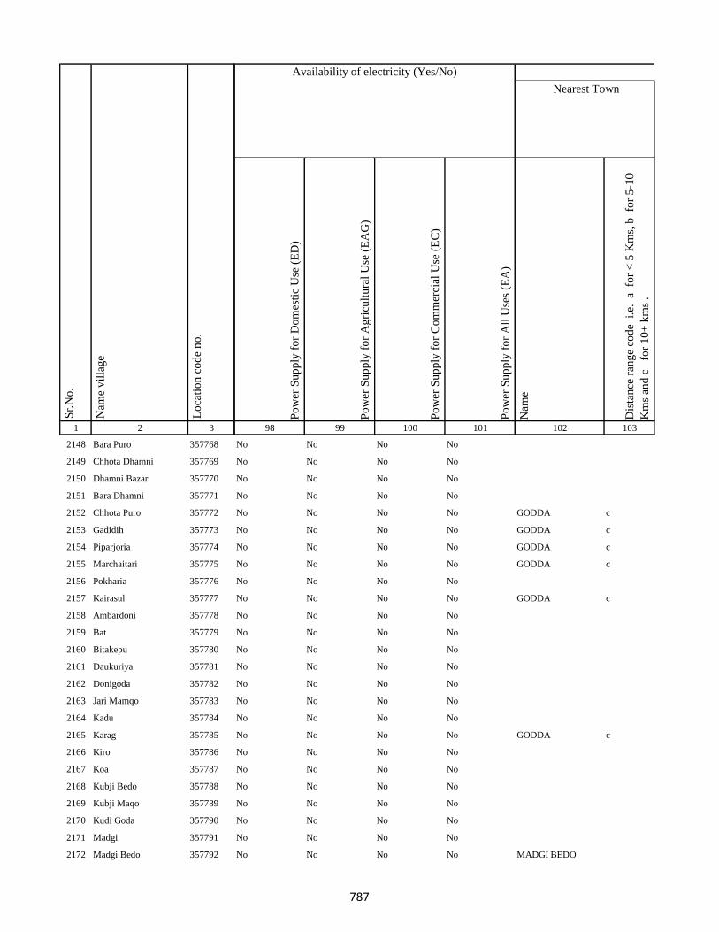
1 2 3
Lo
cati
on
co
de
no
.
Nam
e v
illa
ge
Sr.
No
.
2148 Bara Puro 357768
2149 Chhota Dhamni 357769
2150 Dhamni Bazar 357770
2151 Bara Dhamni 357771
2152 Chhota Puro 357772
2153 Gadidih 357773
2154 Piparjoria 357774
2155 Marchaitari 357775
2156 Pokharia 357776
2157 Kairasul 357777
2158 Ambardoni 357778
2159 Bat 357779
2160 Bitakepu 357780
2161 Daukuriya 357781
2162 Donigoda 357782
2163 Jari Mamqo 357783
2164 Kadu 357784
2165 Karag 357785
2166 Kiro 357786
2167 Koa 357787
2168 Kubji Bedo 357788
2169 Kubji Maqo 357789
2170 Kudi Goda 357790
2171 Madgi 357791
2172 Madgi Bedo 357792
Po
wer
Su
pp
ly f
or
Do
mes
tic
Use
(E
D)
Po
wer
Su
pp
ly f
or
Ag
ricu
ltu
ral
Use
(E
AG
)
Po
wer
Su
pp
ly f
or
Co
mm
erci
al U
se (
EC
)
Po
wer
Su
pp
ly f
or
All
Use
s (E
A)
Nam
e
Dis
tan
ce r
ang
e co
de
i.e
. a
fo
r <
5 K
ms,
b
for
5-1
0
Km
s an
d c
f
or
10
+ k
ms
.
98 99 100 101 102 103
Nearest Town
Land UseAvailability of electricity (Yes/No)
No No No No
No No No No
No No No No
No No No No
No No No No GODDA c
No No No No GODDA c
No No No No GODDA c
No No No No GODDA c
No No No No
No No No No GODDA c
No No No No
No No No No
No No No No
No No No No
No No No No
No No No No
No No No No
No No No No GODDA c
No No No No
No No No No
No No No No
No No No No
No No No No
No No No No
No No No No MADGI BEDO
787
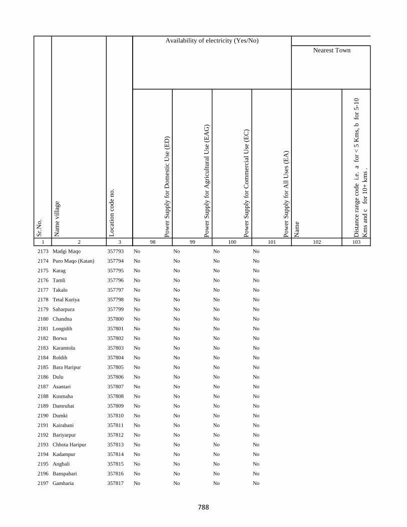
1 2 3
Lo
cati
on
co
de
no
.
Nam
e v
illa
ge
Sr.
No
.
2173 Madgi Maqo 357793
2174 Puro Maqo (Katan) 357794
2175 Karag 357795
2176 Tamli 357796
2177 Takalo 357797
2178 Tetal Kuriya 357798
2179 Saharpura 357799
2180 Chandna 357800
2181 Longidih 357801
2182 Borwa 357802
2183 Karamtola 357803
2184 Roldih 357804
2185 Bara Haripur 357805
2186 Dulu 357806
2187 Asantari 357807
2188 Kusmaha 357808
2189 Damruhat 357809
2190 Dumki 357810
2191 Kairabani 357811
2192 Bariyarpur 357812
2193 Chhota Haripur 357813
2194 Kadampur 357814
2195 Angbali 357815
2196 Banspahari 357816
2197 Gamharia 357817
Po
wer
Su
pp
ly f
or
Do
mes
tic
Use
(E
D)
Po
wer
Su
pp
ly f
or
Ag
ricu
ltu
ral
Use
(E
AG
)
Po
wer
Su
pp
ly f
or
Co
mm
erci
al U
se (
EC
)
Po
wer
Su
pp
ly f
or
All
Use
s (E
A)
Nam
e
Dis
tan
ce r
ang
e co
de
i.e
. a
fo
r <
5 K
ms,
b
for
5-1
0
Km
s an
d c
f
or
10
+ k
ms
.
98 99 100 101 102 103
Nearest Town
Land UseAvailability of electricity (Yes/No)
No No No No
No No No No
No No No No
No No No No
No No No No
No No No No
No No No No
No No No No
No No No No
No No No No
No No No No
No No No No
No No No No
No No No No
No No No No
No No No No
No No No No
No No No No
No No No No
No No No No
No No No No
No No No No
No No No No
No No No No
No No No No
788
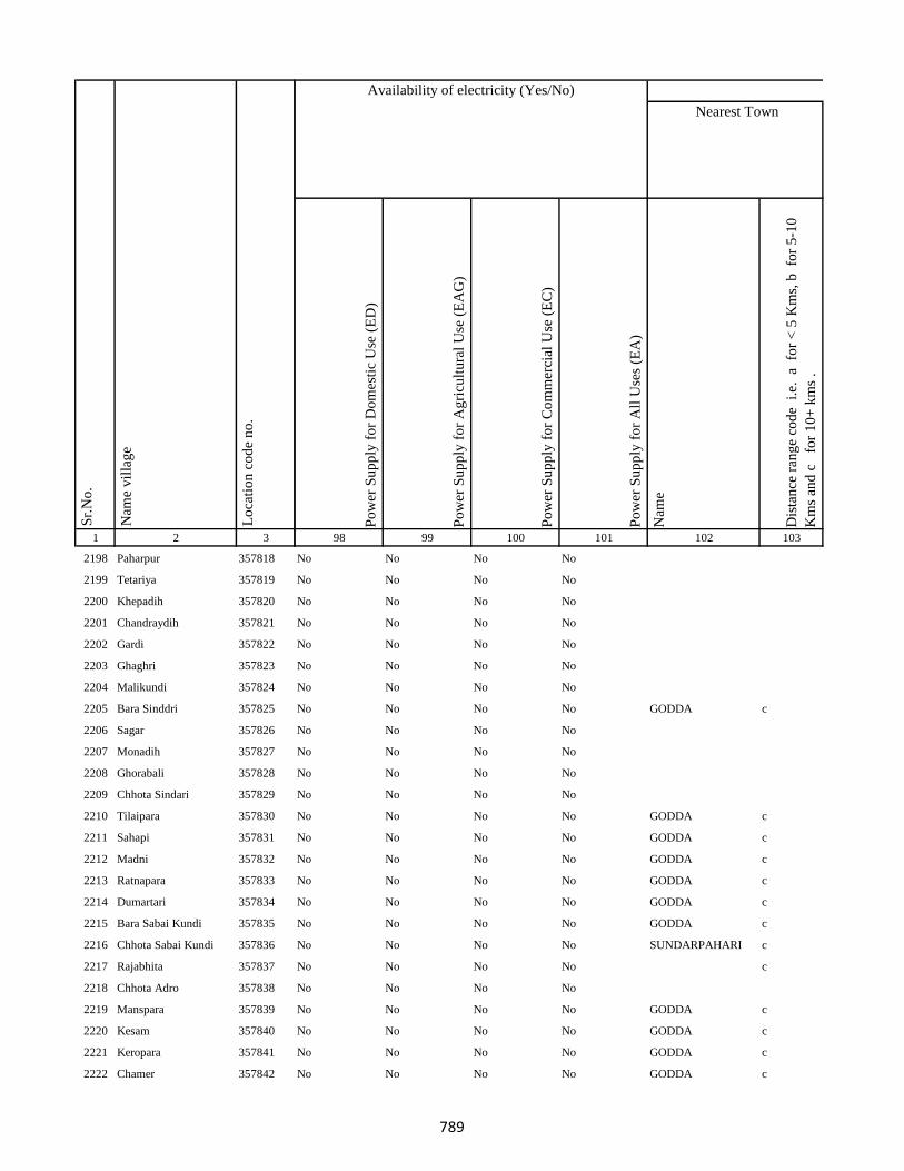
1 2 3
Lo
cati
on
co
de
no
.
Nam
e v
illa
ge
Sr.
No
.
2198 Paharpur 357818
2199 Tetariya 357819
2200 Khepadih 357820
2201 Chandraydih 357821
2202 Gardi 357822
2203 Ghaghri 357823
2204 Malikundi 357824
2205 Bara Sinddri 357825
2206 Sagar 357826
2207 Monadih 357827
2208 Ghorabali 357828
2209 Chhota Sindari 357829
2210 Tilaipara 357830
2211 Sahapi 357831
2212 Madni 357832
2213 Ratnapara 357833
2214 Dumartari 357834
2215 Bara Sabai Kundi 357835
2216 Chhota Sabai Kundi 357836
2217 Rajabhita 357837
2218 Chhota Adro 357838
2219 Manspara 357839
2220 Kesam 357840
2221 Keropara 357841
2222 Chamer 357842
Po
wer
Su
pp
ly f
or
Do
mes
tic
Use
(E
D)
Po
wer
Su
pp
ly f
or
Ag
ricu
ltu
ral
Use
(E
AG
)
Po
wer
Su
pp
ly f
or
Co
mm
erci
al U
se (
EC
)
Po
wer
Su
pp
ly f
or
All
Use
s (E
A)
Nam
e
Dis
tan
ce r
ang
e co
de
i.e
. a
fo
r <
5 K
ms,
b
for
5-1
0
Km
s an
d c
f
or
10
+ k
ms
.
98 99 100 101 102 103
Nearest Town
Land UseAvailability of electricity (Yes/No)
No No No No
No No No No
No No No No
No No No No
No No No No
No No No No
No No No No
No No No No GODDA c
No No No No
No No No No
No No No No
No No No No
No No No No GODDA c
No No No No GODDA c
No No No No GODDA c
No No No No GODDA c
No No No No GODDA c
No No No No GODDA c
No No No No SUNDARPAHARI c
No No No No c
No No No No
No No No No GODDA c
No No No No GODDA c
No No No No GODDA c
No No No No GODDA c
789
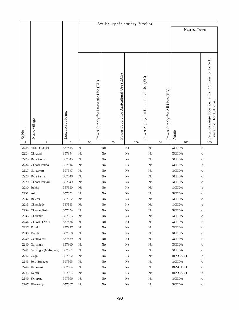
1 2 3
Lo
cati
on
co
de
no
.
Nam
e v
illa
ge
Sr.
No
.
2223 Mando Pahari 357843
2224 Chhatmi 357844
2225 Bara Paktari 357845
2226 Chhota Palma 357846
2227 Gargawan 357847
2228 Bara Palma 357848
2229 Chhota Paktari 357849
2230 Rakha 357850
2231 Adro 357851
2232 Balami 357852
2233 Chamdade 357853
2234 Chamar Bedo 357854
2235 Charchari 357855
2236 Chewo (Tetria) 357856
2237 Dando 357857
2238 Dumli 357858
2239 Gandiyamo 357859
2240 Garsingla 357860
2241 Garsingla (Malikundi) 357861
2242 Goga 357862
2243 Jolo (Berago) 357863
2244 Karamtok 357864
2245 Karmu 357865
2246 Keropara 357866
2247 Kirokuriya 357867
Po
wer
Su
pp
ly f
or
Do
mes
tic
Use
(E
D)
Po
wer
Su
pp
ly f
or
Ag
ricu
ltu
ral
Use
(E
AG
)
Po
wer
Su
pp
ly f
or
Co
mm
erci
al U
se (
EC
)
Po
wer
Su
pp
ly f
or
All
Use
s (E
A)
Nam
e
Dis
tan
ce r
ang
e co
de
i.e
. a
fo
r <
5 K
ms,
b
for
5-1
0
Km
s an
d c
f
or
10
+ k
ms
.
98 99 100 101 102 103
Nearest Town
Land UseAvailability of electricity (Yes/No)
No No No No GODDA c
No No No No GODDA c
No No No No GODDA c
No No No No GODDA c
No No No No GODDA c
No No No No GODDA c
No No No No GODDA c
No No No No GODDA c
No No No No GODDA c
No No No No GODDA c
No No No No GODDA c
No No No No GODDA c
No No No No GODDA c
No No No No GODDA c
No No No No GODDA c
No No No No GODDA c
No No No No GODDA c
No No No No GODDA c
No No No No GODDA c
No No No No DEVGARH c
No No No No GODDA c
No No No No DEVGARH c
No No No No DEVGARH c
No No No No GODDA c
No No No No GODDA c
790
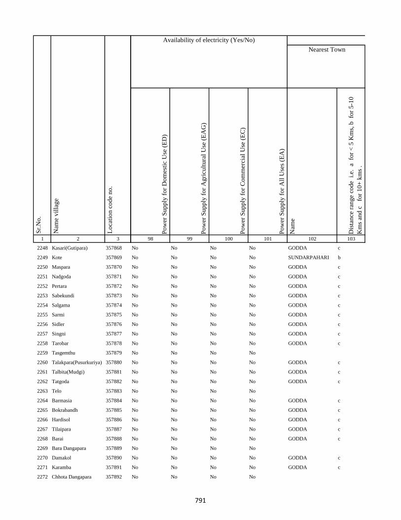
1 2 3
Lo
cati
on
co
de
no
.
Nam
e v
illa
ge
Sr.
No
.
2248 Kasari(Gutipara) 357868
2249 Kote 357869
2250 Maspara 357870
2251 Nadgoda 357871
2252 Pertara 357872
2253 Sabekundi 357873
2254 Salgama 357874
2255 Sarmi 357875
2256 Sidler 357876
2257 Singni 357877
2258 Tarobar 357878
2259 Tasgemthu 357879
2260 Talakpara(Pusurkuriya) 357880
2261 Talbita(Mudgi) 357881
2262 Tatgoda 357882
2263 Telo 357883
2264 Barmasia 357884
2265 Bokrabandh 357885
2266 Hardisol 357886
2267 Tilaipara 357887
2268 Barai 357888
2269 Bara Dangapara 357889
2270 Damakol 357890
2271 Karamba 357891
2272 Chhota Dangapara 357892
Po
wer
Su
pp
ly f
or
Do
mes
tic
Use
(E
D)
Po
wer
Su
pp
ly f
or
Ag
ricu
ltu
ral
Use
(E
AG
)
Po
wer
Su
pp
ly f
or
Co
mm
erci
al U
se (
EC
)
Po
wer
Su
pp
ly f
or
All
Use
s (E
A)
Nam
e
Dis
tan
ce r
ang
e co
de
i.e
. a
fo
r <
5 K
ms,
b
for
5-1
0
Km
s an
d c
f
or
10
+ k
ms
.
98 99 100 101 102 103
Nearest Town
Land UseAvailability of electricity (Yes/No)
No No No No GODDA c
No No No No SUNDARPAHARI b
No No No No GODDA c
No No No No GODDA c
No No No No GODDA c
No No No No GODDA c
No No No No GODDA c
No No No No GODDA c
No No No No GODDA c
No No No No GODDA c
No No No No GODDA c
No No No No
No No No No GODDA c
No No No No GODDA c
No No No No GODDA c
No No No No
No No No No GODDA c
No No No No GODDA c
No No No No GODDA c
No No No No GODDA c
No No No No GODDA c
No No No No
No No No No GODDA c
No No No No GODDA c
No No No No
791
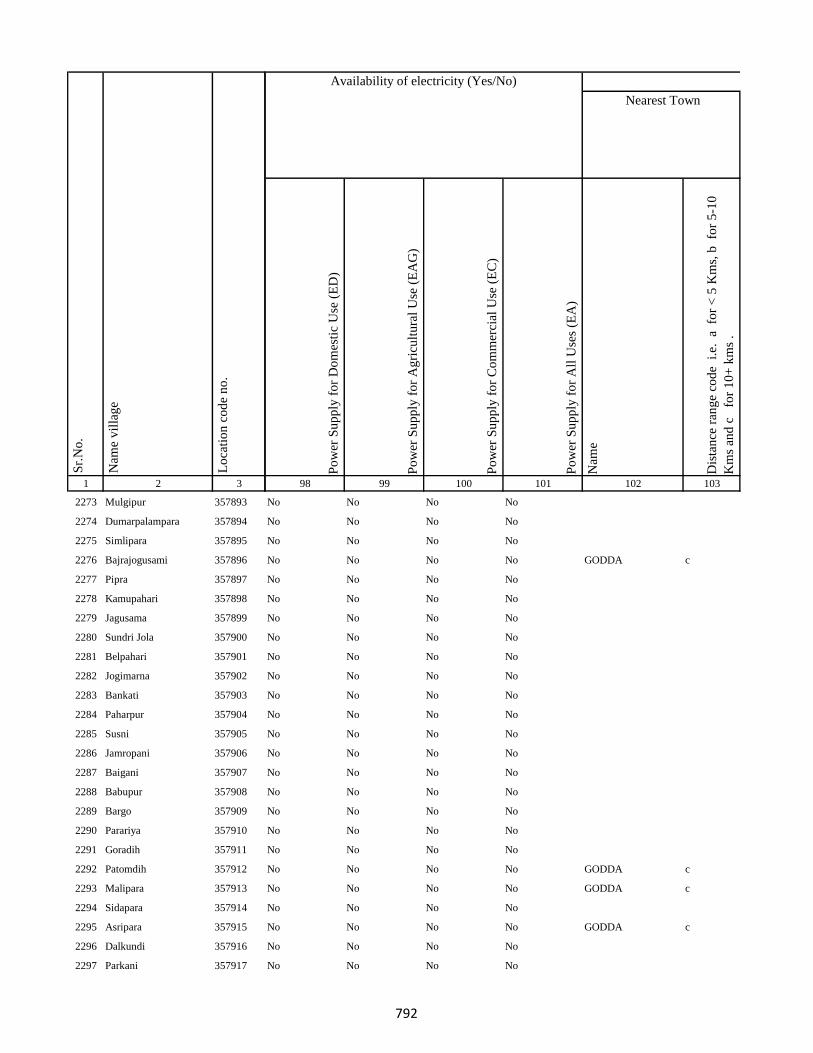
1 2 3
Lo
cati
on
co
de
no
.
Nam
e v
illa
ge
Sr.
No
.
2273 Mulgipur 357893
2274 Dumarpalampara 357894
2275 Simlipara 357895
2276 Bajrajogusami 357896
2277 Pipra 357897
2278 Kamupahari 357898
2279 Jagusama 357899
2280 Sundri Jola 357900
2281 Belpahari 357901
2282 Jogimarna 357902
2283 Bankati 357903
2284 Paharpur 357904
2285 Susni 357905
2286 Jamropani 357906
2287 Baigani 357907
2288 Babupur 357908
2289 Bargo 357909
2290 Parariya 357910
2291 Goradih 357911
2292 Patomdih 357912
2293 Malipara 357913
2294 Sidapara 357914
2295 Asripara 357915
2296 Dalkundi 357916
2297 Parkani 357917
Po
wer
Su
pp
ly f
or
Do
mes
tic
Use
(E
D)
Po
wer
Su
pp
ly f
or
Ag
ricu
ltu
ral
Use
(E
AG
)
Po
wer
Su
pp
ly f
or
Co
mm
erci
al U
se (
EC
)
Po
wer
Su
pp
ly f
or
All
Use
s (E
A)
Nam
e
Dis
tan
ce r
ang
e co
de
i.e
. a
fo
r <
5 K
ms,
b
for
5-1
0
Km
s an
d c
f
or
10
+ k
ms
.
98 99 100 101 102 103
Nearest Town
Land UseAvailability of electricity (Yes/No)
No No No No
No No No No
No No No No
No No No No GODDA c
No No No No
No No No No
No No No No
No No No No
No No No No
No No No No
No No No No
No No No No
No No No No
No No No No
No No No No
No No No No
No No No No
No No No No
No No No No
No No No No GODDA c
No No No No GODDA c
No No No No
No No No No GODDA c
No No No No
No No No No
792
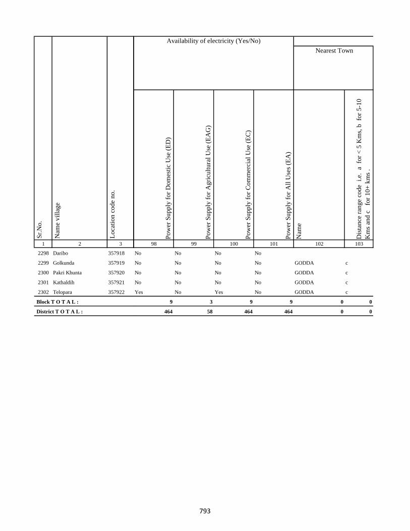
1 2 3
Lo
cati
on
co
de
no
.
Nam
e v
illa
ge
Sr.
No
.
2298 Daribo 357918
2299 Golkunda 357919
2300 Pakri Khunta 357920
2301 Kathaldih 357921
2302 Telopara 357922
Block T O T A L :
District T O T A L :
Po
wer
Su
pp
ly f
or
Do
mes
tic
Use
(E
D)
Po
wer
Su
pp
ly f
or
Ag
ricu
ltu
ral
Use
(E
AG
)
Po
wer
Su
pp
ly f
or
Co
mm
erci
al U
se (
EC
)
Po
wer
Su
pp
ly f
or
All
Use
s (E
A)
Nam
e
Dis
tan
ce r
ang
e co
de
i.e
. a
fo
r <
5 K
ms,
b
for
5-1
0
Km
s an
d c
f
or
10
+ k
ms
.
98 99 100 101 102 103
Nearest Town
Land UseAvailability of electricity (Yes/No)
No No No No
No No No No GODDA c
No No No No GODDA c
No No No No GODDA c
Yes No Yes No GODDA c
9 3 9 9 0 0
464 58 464 464 0 0
793
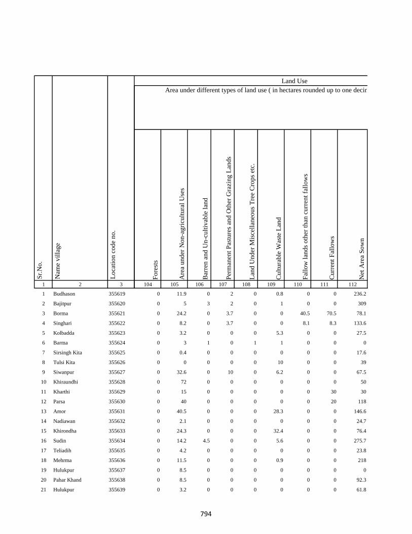
1 2 3
1 Budhason 355619
2 Bajitpur 355620
3 Borma 355621
4 Singhari 355622
5 Kolbadda 355623
6 Barma 355624
7 Sirsingh Kita 355625
8 Tulsi Kita 355626
9 Siwanpur 355627
10 Khiraundhi 355628
11 Kharthi 355629
12 Parsa 355630
13 Amor 355631
14 Nadiawan 355632
15 Khirondha 355633
16 Sudin 355634
17 Teliadih 355635
18 Mehrma 355636
19 Hulukpur 355637
20 Pahar Khand 355638
21 Hulukpur 355639
Lo
cati
on
co
de
no
.
Nam
e v
illa
ge
Sr.
No
.
Fo
rest
s
Are
a u
nd
er N
on
-ag
ricu
ltu
ral
Use
s
Bar
ren
an
d U
n-c
ult
ivab
le l
and
Per
man
ent
Pas
ture
s an
d O
ther
Gra
zin
g L
and
s
Lan
d U
nd
er M
isce
llan
eou
s T
ree
Cro
ps
etc.
Cu
ltu
rab
le W
aste
Lan
d
Fal
low
lan
ds
oth
er t
han
cu
rren
t fa
llo
ws
Cu
rren
t F
allo
ws
Net
Are
a S
ow
n
104 105 106 107 108 109 110 111 112
0 11.9 0 2 0 0.8 0 0 236.2
0 5 3 2 0 1 0 0 309
0 24.2 0 3.7 0 0 40.5 70.5 78.1
0 8.2 0 3.7 0 0 8.1 8.3 133.6
0 3.2 0 0 0 5.3 0 0 27.5
0 3 1 0 1 1 0 0 0
0 0.4 0 0 0 0 0 0 17.6
0 0 0 0 0 10 0 0 39
0 32.6 0 10 0 6.2 0 0 67.5
0 72 0 0 0 0 0 0 50
0 15 0 0 0 0 0 30 30
0 40 0 0 0 0 0 20 118
0 40.5 0 0 0 28.3 0 0 146.6
0 2.1 0 0 0 0 0 0 24.7
0 24.3 0 0 0 32.4 0 0 76.4
0 14.2 4.5 0 0 5.6 0 0 275.7
0 4.2 0 0 0 0 0 0 23.8
0 11.5 0 0 0 0.9 0 0 218
0 8.5 0 0 0 0 0 0 0
0 8.5 0 0 0 0 0 0 92.3
0 3.2 0 0 0 0 0 0 61.8
Area under different types of land use ( in hectares rounded up to one decimal place)
Land Use
794

1 2 3
Lo
cati
on
co
de
no
.
Nam
e v
illa
ge
Sr.
No
.
22 Banodha 355640
23 Sankarpur 355641
24 Jitmal Kita 355642
25 Hira Kita 355643
26 Narain Chak 355644
27 Jitmal Kita 355645
28 Jitamal Kita 355646
29 Amjora Firozganj 355647
30 Pati Chak 355648
31 Gobindpur 355649
32 Dhamri Saheb 355650
33 Dhamri Gopalram 355651
34 Itahari 355652
35 Masuria 355653
36 Sukhari 355654
37 Fazilkhutahar 355655
38 Sobhapur 355656
39 Arbind Khutahari 355657
40 Bhalui 355658
41 Chitu Chak 355659
42 Barari 355660
43 Sangarua 355661
44 Mahadeb Kita 355662
45 Champa 355663
46 Bhata Chak 355664
Fo
rest
s
Are
a u
nd
er N
on
-ag
ricu
ltu
ral
Use
s
Bar
ren
an
d U
n-c
ult
ivab
le l
and
Per
man
ent
Pas
ture
s an
d O
ther
Gra
zin
g L
and
s
Lan
d U
nd
er M
isce
llan
eou
s T
ree
Cro
ps
etc.
Cu
ltu
rab
le W
aste
Lan
d
Fal
low
lan
ds
oth
er t
han
cu
rren
t fa
llo
ws
Cu
rren
t F
allo
ws
Net
Are
a S
ow
n
104 105 106 107 108 109 110 111 112
Area under different types of land use ( in hectares rounded up to one decimal place)
Land Use
0 2.4 0 0 0 0 0 0 41.6
0 2 3 1 0 0 0 3 228
0 2.4 0 0 0 0 0 1.6 7.7
0 2.4 0 0 0 2.2 0 0 16.3
0 1.4 0 0 0 0 0 0 3.6
0 0 0 0 0 0 0 0 0
0 0 0 0 0 0 0 0 0
0 36.4 0 0 0 4 0 0 9.6
0 0.4 0.2 0.2 1 1.2 1.4 1.2 120.4
0 36.4 0 0 0 0 0 0 39.6
0 14 0 0 0 8.1 0 0 22.9
0 10.4 0 0 0 2 0 0 38.6
0 40.5 0 0 0 40.5 0 0 126.4
0 9.7 0 0 0 47.2 0 0 66.8
0 34.4 0 0 0 13 0 0 77.6
0 2.2 0 0 0 4.5 0 0 29.4
0 3.8 0 0 0 5 0 0 20.2
0 2.6 0 0 0 9 0 0 3.4
0 24.3 0 0 0 8.1 0 0 57.6
0 3.6 0 0 0 3.8 0 0 4.6
0 5 2 1 1 3 2 1 135
0 8.1 0 0 0 4 0 0 11.9
0 0 0 0 0 0.4 0 0 2.6
0 0 0 1 0 0 2 0 73
0 0 0 0 0 0 0 0.8 6
795
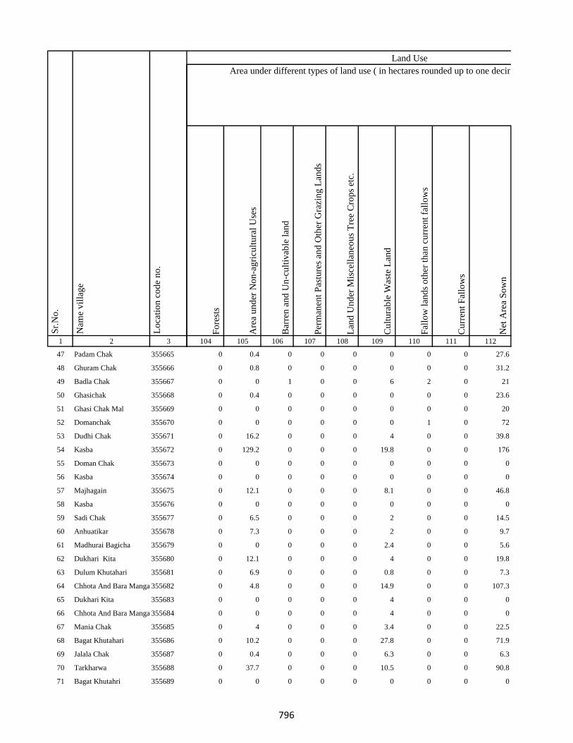
1 2 3
Lo
cati
on
co
de
no
.
Nam
e v
illa
ge
Sr.
No
.
47 Padam Chak 355665
48 Ghuram Chak 355666
49 Badla Chak 355667
50 Ghasichak 355668
51 Ghasi Chak Mal 355669
52 Domanchak 355670
53 Dudhi Chak 355671
54 Kasba 355672
55 Doman Chak 355673
56 Kasba 355674
57 Majhagain 355675
58 Kasba 355676
59 Sadi Chak 355677
60 Anhuatikar 355678
61 Madhurai Bagicha 355679
62 Dukhari Kita 355680
63 Dulum Khutahari 355681
64 Chhota And Bara Mangarh355682
65 Dukhari Kita 355683
66 Chhota And Bara Mangarh355684
67 Mania Chak 355685
68 Bagat Khutahari 355686
69 Jalala Chak 355687
70 Tarkharwa 355688
71 Bagat Khutahri 355689
Fo
rest
s
Are
a u
nd
er N
on
-ag
ricu
ltu
ral
Use
s
Bar
ren
an
d U
n-c
ult
ivab
le l
and
Per
man
ent
Pas
ture
s an
d O
ther
Gra
zin
g L
and
s
Lan
d U
nd
er M
isce
llan
eou
s T
ree
Cro
ps
etc.
Cu
ltu
rab
le W
aste
Lan
d
Fal
low
lan
ds
oth
er t
han
cu
rren
t fa
llo
ws
Cu
rren
t F
allo
ws
Net
Are
a S
ow
n
104 105 106 107 108 109 110 111 112
Area under different types of land use ( in hectares rounded up to one decimal place)
Land Use
0 0.4 0 0 0 0 0 0 27.6
0 0.8 0 0 0 0 0 0 31.2
0 0 1 0 0 6 2 0 21
0 0.4 0 0 0 0 0 0 23.6
0 0 0 0 0 0 0 0 20
0 0 0 0 0 0 1 0 72
0 16.2 0 0 0 4 0 0 39.8
0 129.2 0 0 0 19.8 0 0 176
0 0 0 0 0 0 0 0 0
0 0 0 0 0 0 0 0 0
0 12.1 0 0 0 8.1 0 0 46.8
0 0 0 0 0 0 0 0 0
0 6.5 0 0 0 2 0 0 14.5
0 7.3 0 0 0 2 0 0 9.7
0 0 0 0 0 2.4 0 0 5.6
0 12.1 0 0 0 4 0 0 19.8
0 6.9 0 0 0 0.8 0 0 7.3
0 4.8 0 0 0 14.9 0 0 107.3
0 0 0 0 0 4 0 0 0
0 0 0 0 0 4 0 0 0
0 4 0 0 0 3.4 0 0 22.5
0 10.2 0 0 0 27.8 0 0 71.9
0 0.4 0 0 0 6.3 0 0 6.3
0 37.7 0 0 0 10.5 0 0 90.8
0 0 0 0 0 0 0 0 0
796

1 2 3
Lo
cati
on
co
de
no
.
Nam
e v
illa
ge
Sr.
No
.
72 Meghchatar 355690
73 Kumardom 355691
74 Harchandpur 355692
75 Maheshdiri 355693
76 Nawadih Tola 355694
77 Beldara Chak 355695
78 Bhaju Chak 355696
79 Bhagwanpur 355697
80 Katmdanr 355698
81 Kita Kalamdanr 355699
82 Amdanr Asli 355700
83 Lachmipur 355701
84 Chandpur 355702
85 Rasti Kar 355703
86 Partappur Mal 355704
87 Partappur Jagir 355705
88 Kishungari Chak 355706
89 Sahi Chak 355707
90 Sarangdhar 355708
91 Sirampur 355709
92 Debi Chak 355710
93 Dogachhi 355711
94 Kandar Chak 355712
95 Tazi Chak 355713
96 Sapnia 355714
Fo
rest
s
Are
a u
nd
er N
on
-ag
ricu
ltu
ral
Use
s
Bar
ren
an
d U
n-c
ult
ivab
le l
and
Per
man
ent
Pas
ture
s an
d O
ther
Gra
zin
g L
and
s
Lan
d U
nd
er M
isce
llan
eou
s T
ree
Cro
ps
etc.
Cu
ltu
rab
le W
aste
Lan
d
Fal
low
lan
ds
oth
er t
han
cu
rren
t fa
llo
ws
Cu
rren
t F
allo
ws
Net
Are
a S
ow
n
104 105 106 107 108 109 110 111 112
Area under different types of land use ( in hectares rounded up to one decimal place)
Land Use
0 3.8 0 0 0 19.8 0 0 63.3
0 18.6 0 0 0 48.7 0 0 151.5
0 0.4 0 0 0 11.9 0 0 76.7
0 0 0 0 0 1.6 0 0 19.4
0 0 1 0 0 0 0 0 99
0 2 18.7 0 0 0 0 0 0.3
0 0.1 0 0 0 0 0 8 0
0 0 0 0 0 17 0 0 32
0 3.4 12.2 0 0 0 0 0 3.3
0 1.5 0 0 0 0 0 0 35.5
0 1.9 0 0 0 0 0 0 40.1
0 0 0 0 0 0 0 0 16
0 6.1 0 0 0 52.9 0 0 0
0 8.2 0 0 0 5.8 0 0 18
0 8.6 0 0 0 3.4 0 0 18
0 3.2 0 0 0 29.8 0 0 20
0 0 0 0 0 0.1 0 0 1.9
0 4.6 0 0 0 3 0 0 13.4
0 1.4 0 0 0 0 0 0 19.6
0 9.8 0 0 0 13 0 0 3.2
0 0 0 0 0 2 0 0 2
0 8 0 0 0 40 0 0 5
0 1 0 0 0 4 0 0 2
0 0.2 0 0 0 0 0 0 9.8
0 1.7 0 0 0 0 0 0 21.3
797
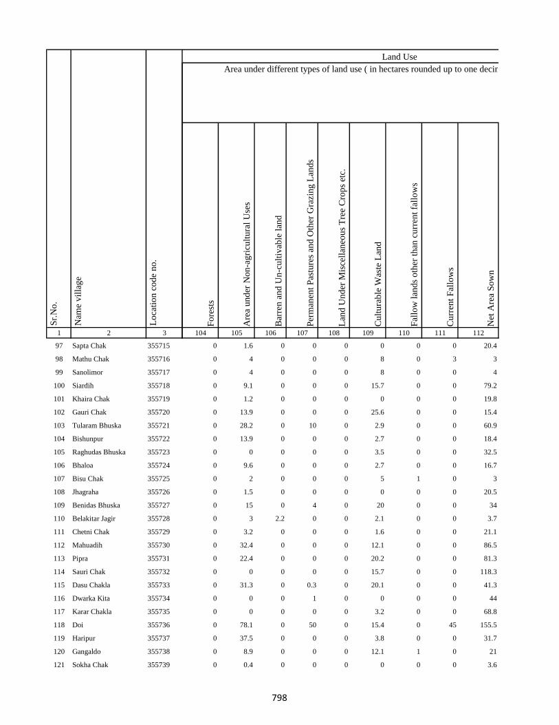
1 2 3
Lo
cati
on
co
de
no
.
Nam
e v
illa
ge
Sr.
No
.
97 Sapta Chak 355715
98 Mathu Chak 355716
99 Sanolimor 355717
100 Siardih 355718
101 Khaira Chak 355719
102 Gauri Chak 355720
103 Tularam Bhuska 355721
104 Bishunpur 355722
105 Raghudas Bhuska 355723
106 Bhaloa 355724
107 Bisu Chak 355725
108 Jhagraha 355726
109 Benidas Bhuska 355727
110 Belakitar Jagir 355728
111 Chetni Chak 355729
112 Mahuadih 355730
113 Pipra 355731
114 Sauri Chak 355732
115 Dasu Chakla 355733
116 Dwarka Kita 355734
117 Karar Chakla 355735
118 Doi 355736
119 Haripur 355737
120 Gangaldo 355738
121 Sokha Chak 355739
Fo
rest
s
Are
a u
nd
er N
on
-ag
ricu
ltu
ral
Use
s
Bar
ren
an
d U
n-c
ult
ivab
le l
and
Per
man
ent
Pas
ture
s an
d O
ther
Gra
zin
g L
and
s
Lan
d U
nd
er M
isce
llan
eou
s T
ree
Cro
ps
etc.
Cu
ltu
rab
le W
aste
Lan
d
Fal
low
lan
ds
oth
er t
han
cu
rren
t fa
llo
ws
Cu
rren
t F
allo
ws
Net
Are
a S
ow
n
104 105 106 107 108 109 110 111 112
Area under different types of land use ( in hectares rounded up to one decimal place)
Land Use
0 1.6 0 0 0 0 0 0 20.4
0 4 0 0 0 8 0 3 3
0 4 0 0 0 8 0 0 4
0 9.1 0 0 0 15.7 0 0 79.2
0 1.2 0 0 0 0 0 0 19.8
0 13.9 0 0 0 25.6 0 0 15.4
0 28.2 0 10 0 2.9 0 0 60.9
0 13.9 0 0 0 2.7 0 0 18.4
0 0 0 0 0 3.5 0 0 32.5
0 9.6 0 0 0 2.7 0 0 16.7
0 2 0 0 0 5 1 0 3
0 1.5 0 0 0 0 0 0 20.5
0 15 0 4 0 20 0 0 34
0 3 2.2 0 0 2.1 0 0 3.7
0 3.2 0 0 0 1.6 0 0 21.1
0 32.4 0 0 0 12.1 0 0 86.5
0 22.4 0 0 0 20.2 0 0 81.3
0 0 0 0 0 15.7 0 0 118.3
0 31.3 0 0.3 0 20.1 0 0 41.3
0 0 0 1 0 0 0 0 44
0 0 0 0 0 3.2 0 0 68.8
0 78.1 0 50 0 15.4 0 45 155.5
0 37.5 0 0 0 3.8 0 0 31.7
0 8.9 0 0 0 12.1 1 0 21
0 0.4 0 0 0 0 0 0 3.6
798

1 2 3
Lo
cati
on
co
de
no
.
Nam
e v
illa
ge
Sr.
No
.
122 Bhim Chak 355740
123 Kabi Chak 355741
124 Mahesh Kita Partabpur 355742
125 Maheshkita Partabpur 355743
126 Chhant Daria Chak 355744
127 Daria Chak 355745
128 Ghori Chak 355746
129 Kasmir Chak 355747
130 Loknath Kita 355748
131 Loknath Kita 355749
132 Partabpur 355750
133 Gausipartabpur 355751
134 Kamargawan 355752
135 Kamardiha 355753
136 Udhua Chak 355754
137 Chaura 355755
138 Phudulia Kita 355756
139 Lakramara 355757
140 Majhgain 355758
141 Nima 355759
142 Udaipur Bahera 355760
143 Chitarsen Bahira 355761
144 Ghori 355762
145 Jitu Chak 355763
146 Dariapur 355764
Fo
rest
s
Are
a u
nd
er N
on
-ag
ricu
ltu
ral
Use
s
Bar
ren
an
d U
n-c
ult
ivab
le l
and
Per
man
ent
Pas
ture
s an
d O
ther
Gra
zin
g L
and
s
Lan
d U
nd
er M
isce
llan
eou
s T
ree
Cro
ps
etc.
Cu
ltu
rab
le W
aste
Lan
d
Fal
low
lan
ds
oth
er t
han
cu
rren
t fa
llo
ws
Cu
rren
t F
allo
ws
Net
Are
a S
ow
n
104 105 106 107 108 109 110 111 112
Area under different types of land use ( in hectares rounded up to one decimal place)
Land Use
0 0 0 0 0 7 0 0 18
0 4 0 0 0 4 0 0 18.9
0 0 10 0 0 0 0 5 0
0 0 0 0 0 10 0 0 0
0 10.2 0 0 0 10.7 1.5 0 52.6
0 6 0 20.1 0 25.2 0 0 17.7
0 0.4 0 0 0 8.9 0 0 13.7
0 3 0 0 0 8 0 0 6
0 0.8 0 0 0 0.1 0 0 6
0 0 0 0 0 0 0 0 0
0 4.5 0 0 0 15.6 0 0 14.8
0 5.1 1 0 0 12.8 0 0 7
0 15.1 0 0 0 10.1 0 0 13.8
0 0 0 0 0 9.2 0 0 89.8
0 0 0 0 0 1.8 0 0 17.2
0 0 0 0 0 12.2 0 0 101.8
0 0 0 0 0 0 0 0 4.6
0 0 0 0 0 15.1 0 0 244.7
0 4.8 0 0 0 0 0 0 20.2
0 0 0 0 0 9.8 0 0 41.2
0 19.2 0 0 0 20 0 0 19.8
0 12.2 0 0 0 8.2 0 0 8.6
0 25 0 0 0 30.4 0 9 94.6
0 0 0 0 0 1.6 0 0 6.4
0 0 0 0 0 0 0 0 79.8
799
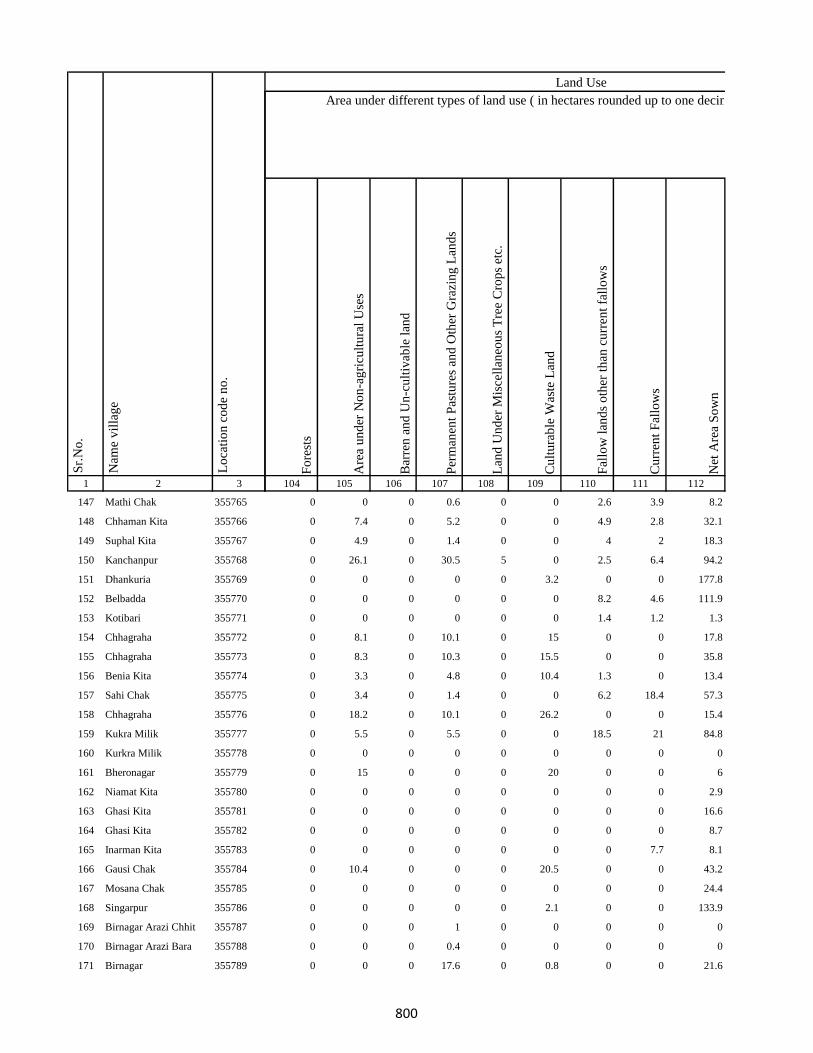
1 2 3
Lo
cati
on
co
de
no
.
Nam
e v
illa
ge
Sr.
No
.
147 Mathi Chak 355765
148 Chhaman Kita 355766
149 Suphal Kita 355767
150 Kanchanpur 355768
151 Dhankuria 355769
152 Belbadda 355770
153 Kotibari 355771
154 Chhagraha 355772
155 Chhagraha 355773
156 Benia Kita 355774
157 Sahi Chak 355775
158 Chhagraha 355776
159 Kukra Milik 355777
160 Kurkra Milik 355778
161 Bheronagar 355779
162 Niamat Kita 355780
163 Ghasi Kita 355781
164 Ghasi Kita 355782
165 Inarman Kita 355783
166 Gausi Chak 355784
167 Mosana Chak 355785
168 Singarpur 355786
169 Birnagar Arazi Chhit 355787
170 Birnagar Arazi Bara 355788
171 Birnagar 355789
Fo
rest
s
Are
a u
nd
er N
on
-ag
ricu
ltu
ral
Use
s
Bar
ren
an
d U
n-c
ult
ivab
le l
and
Per
man
ent
Pas
ture
s an
d O
ther
Gra
zin
g L
and
s
Lan
d U
nd
er M
isce
llan
eou
s T
ree
Cro
ps
etc.
Cu
ltu
rab
le W
aste
Lan
d
Fal
low
lan
ds
oth
er t
han
cu
rren
t fa
llo
ws
Cu
rren
t F
allo
ws
Net
Are
a S
ow
n
104 105 106 107 108 109 110 111 112
Area under different types of land use ( in hectares rounded up to one decimal place)
Land Use
0 0 0 0.6 0 0 2.6 3.9 8.2
0 7.4 0 5.2 0 0 4.9 2.8 32.1
0 4.9 0 1.4 0 0 4 2 18.3
0 26.1 0 30.5 5 0 2.5 6.4 94.2
0 0 0 0 0 3.2 0 0 177.8
0 0 0 0 0 0 8.2 4.6 111.9
0 0 0 0 0 0 1.4 1.2 1.3
0 8.1 0 10.1 0 15 0 0 17.8
0 8.3 0 10.3 0 15.5 0 0 35.8
0 3.3 0 4.8 0 10.4 1.3 0 13.4
0 3.4 0 1.4 0 0 6.2 18.4 57.3
0 18.2 0 10.1 0 26.2 0 0 15.4
0 5.5 0 5.5 0 0 18.5 21 84.8
0 0 0 0 0 0 0 0 0
0 15 0 0 0 20 0 0 6
0 0 0 0 0 0 0 0 2.9
0 0 0 0 0 0 0 0 16.6
0 0 0 0 0 0 0 0 8.7
0 0 0 0 0 0 0 7.7 8.1
0 10.4 0 0 0 20.5 0 0 43.2
0 0 0 0 0 0 0 0 24.4
0 0 0 0 0 2.1 0 0 133.9
0 0 0 1 0 0 0 0 0
0 0 0 0.4 0 0 0 0 0
0 0 0 17.6 0 0.8 0 0 21.6
800
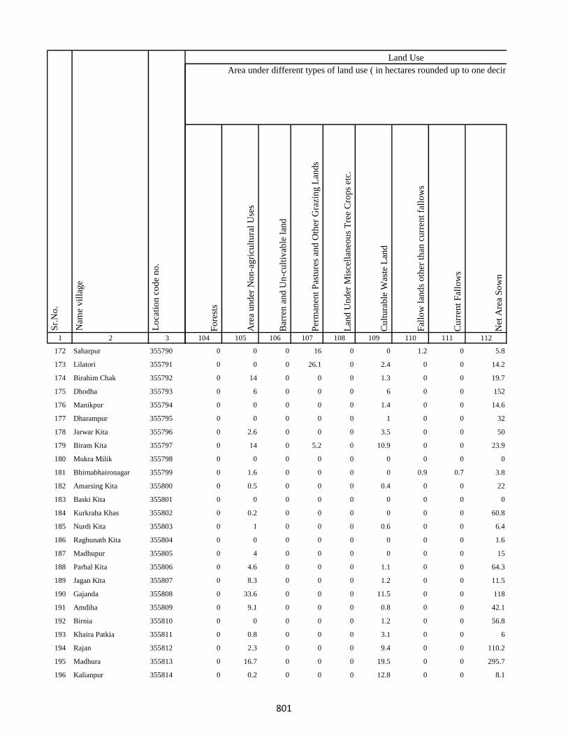
1 2 3
Lo
cati
on
co
de
no
.
Nam
e v
illa
ge
Sr.
No
.
172 Saharpur 355790
173 Lilatori 355791
174 Birahim Chak 355792
175 Dhodha 355793
176 Manikpur 355794
177 Dharampur 355795
178 Jarwar Kita 355796
179 Biram Kita 355797
180 Mukra Milik 355798
181 Bhirnabhaironagar 355799
182 Amarsing Kita 355800
183 Baski Kita 355801
184 Kurkraha Khas 355802
185 Nurdi Kita 355803
186 Raghunath Kita 355804
187 Madhupur 355805
188 Parbal Kita 355806
189 Jagan Kita 355807
190 Gajanda 355808
191 Amdiha 355809
192 Birnia 355810
193 Khaira Patkia 355811
194 Rajan 355812
195 Madhura 355813
196 Kalianpur 355814
Fo
rest
s
Are
a u
nd
er N
on
-ag
ricu
ltu
ral
Use
s
Bar
ren
an
d U
n-c
ult
ivab
le l
and
Per
man
ent
Pas
ture
s an
d O
ther
Gra
zin
g L
and
s
Lan
d U
nd
er M
isce
llan
eou
s T
ree
Cro
ps
etc.
Cu
ltu
rab
le W
aste
Lan
d
Fal
low
lan
ds
oth
er t
han
cu
rren
t fa
llo
ws
Cu
rren
t F
allo
ws
Net
Are
a S
ow
n
104 105 106 107 108 109 110 111 112
Area under different types of land use ( in hectares rounded up to one decimal place)
Land Use
0 0 0 16 0 0 1.2 0 5.8
0 0 0 26.1 0 2.4 0 0 14.2
0 14 0 0 0 1.3 0 0 19.7
0 6 0 0 0 6 0 0 152
0 0 0 0 0 1.4 0 0 14.6
0 0 0 0 0 1 0 0 32
0 2.6 0 0 0 3.5 0 0 50
0 14 0 5.2 0 10.9 0 0 23.9
0 0 0 0 0 0 0 0 0
0 1.6 0 0 0 0 0.9 0.7 3.8
0 0.5 0 0 0 0.4 0 0 22
0 0 0 0 0 0 0 0 0
0 0.2 0 0 0 0 0 0 60.8
0 1 0 0 0 0.6 0 0 6.4
0 0 0 0 0 0 0 0 1.6
0 4 0 0 0 0 0 0 15
0 4.6 0 0 0 1.1 0 0 64.3
0 8.3 0 0 0 1.2 0 0 11.5
0 33.6 0 0 0 11.5 0 0 118
0 9.1 0 0 0 0.8 0 0 42.1
0 0 0 0 0 1.2 0 0 56.8
0 0.8 0 0 0 3.1 0 0 6
0 2.3 0 0 0 9.4 0 0 110.2
0 16.7 0 0 0 19.5 0 0 295.7
0 0.2 0 0 0 12.8 0 0 8.1
801
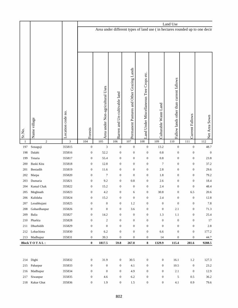
1 2 3
Lo
cati
on
co
de
no
.
Nam
e v
illa
ge
Sr.
No
.
197 Sonaguji 355815
198 Dalahi 355816
199 Tetaria 355817
200 Baski Kita 355818
201 Beniadih 355819
202 Marpa 355820
203 Dumaria 355821
204 Kamal Chak 355822
205 Meghnath 355823
206 Kalidaha 355824
207 Leoabhujani 355825
208 Gobardhanpur 355826
209 Balia 355827
210 Pharkia 355828
211 Dhurbidih 355829
212 Lohachinta 355830
213 Madhupur 355831
Block T O T A L :
214 Dighi 355832
215 Paharpur 355833
216 Madhupur 355834
217 Siwanpur 355835
218 Kakar Ghat 355836
Fo
rest
s
Are
a u
nd
er N
on
-ag
ricu
ltu
ral
Use
s
Bar
ren
an
d U
n-c
ult
ivab
le l
and
Per
man
ent
Pas
ture
s an
d O
ther
Gra
zin
g L
and
s
Lan
d U
nd
er M
isce
llan
eou
s T
ree
Cro
ps
etc.
Cu
ltu
rab
le W
aste
Lan
d
Fal
low
lan
ds
oth
er t
han
cu
rren
t fa
llo
ws
Cu
rren
t F
allo
ws
Net
Are
a S
ow
n
104 105 106 107 108 109 110 111 112
Area under different types of land use ( in hectares rounded up to one decimal place)
Land Use
0 3 0 0 0 13.2 0 0 48.7
0 52.2 0 0 0 0.8 0 0 0
0 55.4 0 0 0 0.8 0 0 23.8
0 12.8 0 0 0 7 0 0 37.2
0 11.6 0 0 0 2.8 0 0 29.6
0 7 0 0 0 1.8 0 0 79.2
0 9.2 0 0.8 0 2.6 0 0 18.4
0 15.2 0 0 0 2.4 0 0 48.4
0 4.2 0 6 0 30.8 0 6.5 20.6
0 15.2 0 0 0 2.4 0 0 12.8
0 0 0 1.2 0 0 0 0 7.8
0 0 0 3.6 0 0 2.1 0 71.3
0 14.2 0 0 0 1.3 1.1 0 25.4
0 2 0 0 0 0 0 0 17
0 0 0 0 0 0 0 0 2.8
0 6.2 0 0 0 6.6 0 0 177.2
0 39.3 0 0 0 14 0 0 44.7
0 1817.5 59.8 267.8 8 1329.9 115.4 281.6 9288.5
0 31.9 0 30.5 0 0 16.1 1.2 127.3
0 0 0 4.1 0 0 10.5 0 23.2
0 0 0 4.9 0 0 2.1 0 12.9
0 4.6 0 6.2 0 0 5 0.5 36.2
0 1.9 0 1.5 0 0 4.1 0.9 79.6
802

1 2 3
Lo
cati
on
co
de
no
.
Nam
e v
illa
ge
Sr.
No
.
219 Talbaria 355837
220 Mohamad Khutahari 355838
221 Mal Jhakhra 355839
222 Baghjhakhra 355840
223 Sinha Chak 355841
224 Babutaluk 355842
225 Paharpur 355843
226 Deban Chak 355844
227 Gargulal 355845
228 Madan Chauki 355846
229 Birahim Kita 355847
230 Banskola 355848
231 Kurpatti 355849
232 Baijani 355850
233 Chapri 355851
234 Kamat Chapri 355852
235 Khar Kudia 355853
236 Majhana (Arazi) 355854
237 Hasu Chak 355855
238 Domansaran Kita 355856
239 Silong 355857
240 Paharpur 355858
241 Akilkita 355859
242 Bikram Kita 355860
243 Paharpur 355861
Fo
rest
s
Are
a u
nd
er N
on
-ag
ricu
ltu
ral
Use
s
Bar
ren
an
d U
n-c
ult
ivab
le l
and
Per
man
ent
Pas
ture
s an
d O
ther
Gra
zin
g L
and
s
Lan
d U
nd
er M
isce
llan
eou
s T
ree
Cro
ps
etc.
Cu
ltu
rab
le W
aste
Lan
d
Fal
low
lan
ds
oth
er t
han
cu
rren
t fa
llo
ws
Cu
rren
t F
allo
ws
Net
Are
a S
ow
n
104 105 106 107 108 109 110 111 112
Area under different types of land use ( in hectares rounded up to one decimal place)
Land Use
0 4.6 0 1.7 0 0 4.1 0.4 98.2
0 5.4 0 6.4 0 0 2.5 0 29.7
0 4.4 0 13.2 0 0 1.1 0 54.6
0 1.8 0 0 0 0 2 0 38.6
0 1.2 0 0 0 0 1.6 0 36.4
0 0 0 1.6 0 0 1.5 0 5.5
0 1.7 0 0 0 2.6 0 0 6
0 14 0 17.7 0 0 16.1 0 11.1
0 2 0 0 0 0 1.9 0 42.5
0 2.3 0 1.5 0 0 0.8 0 62.9
0 1 0 0.5 0 0 1.3 0 41.4
0 1.4 0 0.5 0 0 1.2 0 14.9
0 1.9 0 0.8 0 0 0.6 0 44.9
0 1.7 0 0.9 0 0 0.4 0 41.9
0 27.6 0 0 0 19.7 0 0 149.6
0 1.9 0 0 0 0 0.9 0 7.1
0 0 0 2.6 0 0 2.1 0 77.8
0 0.4 0 0.2 0 0 1.2 0 1.8
0 1.1 0 0.2 0 0 2.1 0 47.5
0 0.4 0 0.2 0 0 1 0 5
0 2.6 0 13.6 0 3.1 15.3 0 12.4
0 4.3 0 5.6 0 32 4.5 0.4 81.1
0 0 0 0.8 0 0 1.1 0 6.3
0 0.7 0 0 0 0 0 0 0
0 2.1 0 2.6 0 0 0 0 15.5
803

1 2 3
Lo
cati
on
co
de
no
.
Nam
e v
illa
ge
Sr.
No
.
244 Chandpur 355862
245 Khani Chak 355863
246 Nagarchi Chak 355864
247 Taj Kita 355865
248 Panchu Kita 355866
249 Mohan Kita 355867
250 Khania Kita 355868
251 Badura Kita 355869
252 Bhatu Kita 355870
253 Dalubarmohtar 355871
254 Madhuadih Khas 355872
255 Madhuadih Arjun Kita 355873
256 Jadu Kita 355874
257 Kali Kita 355875
258 Haripur 355876
259 Nawadih Parthumanjhi 355877
260 Sonapur 355878
261 Maku Chak 355879
262 Chand Chak 355880
263 Dumaria 355881
264 Taib Kita 355882
265 Bhekhari Kita 355883
266 Mitan Kita 355884
267 Kadil Kita 355885
268 Pitambar Kita 355886
Fo
rest
s
Are
a u
nd
er N
on
-ag
ricu
ltu
ral
Use
s
Bar
ren
an
d U
n-c
ult
ivab
le l
and
Per
man
ent
Pas
ture
s an
d O
ther
Gra
zin
g L
and
s
Lan
d U
nd
er M
isce
llan
eou
s T
ree
Cro
ps
etc.
Cu
ltu
rab
le W
aste
Lan
d
Fal
low
lan
ds
oth
er t
han
cu
rren
t fa
llo
ws
Cu
rren
t F
allo
ws
Net
Are
a S
ow
n
104 105 106 107 108 109 110 111 112
Area under different types of land use ( in hectares rounded up to one decimal place)
Land Use
0 3.9 0 25.6 0 0 2.1 0 53.3
0 5.1 0 8.4 0 0 12.8 0 27.2
0 1 0 0 0 0 0.8 0 2.3
0 6.1 0 1 0 0 1 0 22
0 3.1 0 2.1 1.1 0 3.4 0 34.4
0 1.2 0 1.1 0 0 1.1 0 4.3
0 1.1 0 1.2 0 0 4.5 0 18.2
0 1.2 0 2.1 0 0 3.1 0 1.4
0 2.1 0 1.2 0 0 3.4 0 35.9
0 0.4 0 0.2 0 0 0.5 0 1
0 1.2 0 0 0 1.1 0 7.2 0.4
0 1.3 0 0 0 0 1 0 8
0 2.6 0 2.3 1.1 0 3.6 0 35.7
0 1.2 0 3.1 1.1 0 2.1 0 36.3
0 3.6 0 1.6 1.1 0 3.6 0 31.1
0 5.2 0 0 0 14.2 8.6 0.4 40.5
0 6.4 0 0.4 0 0 8.1 0 46.8
0 4.5 0 0.2 0 0 8.5 0.4 59.2
0 3.1 0 1.2 1.4 0 2 0 15.2
0 3.1 0 3.5 1.2 0 5.6 0 67.2
0 0.7 0 0 0 0 0.3 0 3.4
0 1.1 0 2.1 0 0 3.1 0 16.1
0 0.9 0 0 0 0 0.6 0 4.8
0 0.2 0 0 0 0 0 0 9.6
0 0.2 0 0 0.2 0 0 0 5.2
804
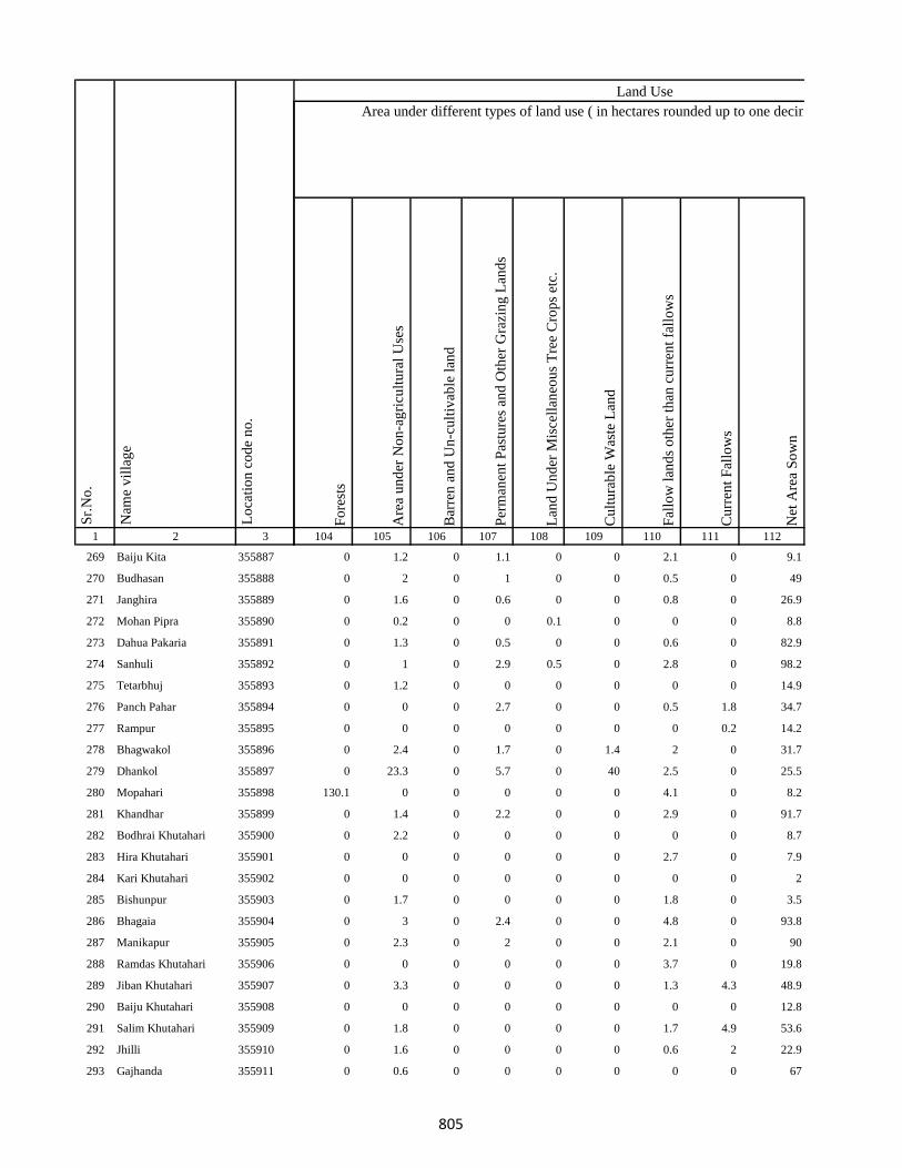
1 2 3
Lo
cati
on
co
de
no
.
Nam
e v
illa
ge
Sr.
No
.
269 Baiju Kita 355887
270 Budhasan 355888
271 Janghira 355889
272 Mohan Pipra 355890
273 Dahua Pakaria 355891
274 Sanhuli 355892
275 Tetarbhuj 355893
276 Panch Pahar 355894
277 Rampur 355895
278 Bhagwakol 355896
279 Dhankol 355897
280 Mopahari 355898
281 Khandhar 355899
282 Bodhrai Khutahari 355900
283 Hira Khutahari 355901
284 Kari Khutahari 355902
285 Bishunpur 355903
286 Bhagaia 355904
287 Manikapur 355905
288 Ramdas Khutahari 355906
289 Jiban Khutahari 355907
290 Baiju Khutahari 355908
291 Salim Khutahari 355909
292 Jhilli 355910
293 Gajhanda 355911
Fo
rest
s
Are
a u
nd
er N
on
-ag
ricu
ltu
ral
Use
s
Bar
ren
an
d U
n-c
ult
ivab
le l
and
Per
man
ent
Pas
ture
s an
d O
ther
Gra
zin
g L
and
s
Lan
d U
nd
er M
isce
llan
eou
s T
ree
Cro
ps
etc.
Cu
ltu
rab
le W
aste
Lan
d
Fal
low
lan
ds
oth
er t
han
cu
rren
t fa
llo
ws
Cu
rren
t F
allo
ws
Net
Are
a S
ow
n
104 105 106 107 108 109 110 111 112
Area under different types of land use ( in hectares rounded up to one decimal place)
Land Use
0 1.2 0 1.1 0 0 2.1 0 9.1
0 2 0 1 0 0 0.5 0 49
0 1.6 0 0.6 0 0 0.8 0 26.9
0 0.2 0 0 0.1 0 0 0 8.8
0 1.3 0 0.5 0 0 0.6 0 82.9
0 1 0 2.9 0.5 0 2.8 0 98.2
0 1.2 0 0 0 0 0 0 14.9
0 0 0 2.7 0 0 0.5 1.8 34.7
0 0 0 0 0 0 0 0.2 14.2
0 2.4 0 1.7 0 1.4 2 0 31.7
0 23.3 0 5.7 0 40 2.5 0 25.5
130.1 0 0 0 0 0 4.1 0 8.2
0 1.4 0 2.2 0 0 2.9 0 91.7
0 2.2 0 0 0 0 0 0 8.7
0 0 0 0 0 0 2.7 0 7.9
0 0 0 0 0 0 0 0 2
0 1.7 0 0 0 0 1.8 0 3.5
0 3 0 2.4 0 0 4.8 0 93.8
0 2.3 0 2 0 0 2.1 0 90
0 0 0 0 0 0 3.7 0 19.8
0 3.3 0 0 0 0 1.3 4.3 48.9
0 0 0 0 0 0 0 0 12.8
0 1.8 0 0 0 0 1.7 4.9 53.6
0 1.6 0 0 0 0 0.6 2 22.9
0 0.6 0 0 0 0 0 0 67
805

1 2 3
Lo
cati
on
co
de
no
.
Nam
e v
illa
ge
Sr.
No
.
294 Karmail 355912
295 Kajrail 355913
296 Bahoriabagaicha 355914
297 Dharampur 355915
298 Lalsing Khutahari 355916
299 Dhaknesar 355917
300 Tetaria Mal 355918
301 Baraia Chak 355919
302 Chhota Manian 355920
303 Bara Manian(Kalan) 355921
304 Rangai Chak 355922
305 Kokan Kita 355923
306 Dhaniabandh 355924
307 Saharabari 355925
308 Bandar Kita 355926
309 Patha Chak 355927
310 Pitambar Kita 355928
311 Bhalwa Chak 355929
312 Bardia Chak 355930
313 Bamania 355931
314 Kolbadda 355932
315 Sonholi 355933
316 Hijri 355934
317 Sonholi 355935
318 Chanda And Chando 355936
Fo
rest
s
Are
a u
nd
er N
on
-ag
ricu
ltu
ral
Use
s
Bar
ren
an
d U
n-c
ult
ivab
le l
and
Per
man
ent
Pas
ture
s an
d O
ther
Gra
zin
g L
and
s
Lan
d U
nd
er M
isce
llan
eou
s T
ree
Cro
ps
etc.
Cu
ltu
rab
le W
aste
Lan
d
Fal
low
lan
ds
oth
er t
han
cu
rren
t fa
llo
ws
Cu
rren
t F
allo
ws
Net
Are
a S
ow
n
104 105 106 107 108 109 110 111 112
Area under different types of land use ( in hectares rounded up to one decimal place)
Land Use
0 10.5 0 1.4 0 13 1 2.2 43.8
0 0.9 0 0 0 0 0 1.8 8.3
0 0 0 0 0 0 0.5 1.5 1
0 0 0 0 0 0 0 0.1 30.4
0 0 0 0 0 0 0 0.6 5
0 0 0 0 0 0 1 2.7 9.7
0 1.7 0 0 0 12.6 1.5 3.5 17.6
0 1.3 0 0 0 0 0 0.6 22.7
0 1.4 0 0 0 0 5 0 18.6
0 5 0 0 0 0 7.2 0 41.8
0 1.1 0 0 0 0 2.2 0 11.7
0 0.5 0 0 0 0.2 1.5 0 4.7
0 0.5 0 0 0 0 0.9 0 19.3
0 0 0 0 0 0 1.1 0 3.5
0 0 0 0 0 0 0.2 0 1.5
0 0 0 0 0 0 0 0.4 1.6
0 4.4 0 7.3 0 0 0 11.7 32.7
0 0.2 0 0 0 0 1 0 5.8
0 1.1 0 0 0 0 1 0 3.2
0 0 0 1.1 0 0 2.2 0 30.2
0 1.3 0 1 0 0 0.6 0 77.6
0 0.6 0 0.2 0 0 0 0 3.1
0 2.1 0 2 0 0 1 0 29.1
0 0 0 0 0 0 0 0 4.2
0 36 10.3 11.2 0 60.7 0 0 60.8
806
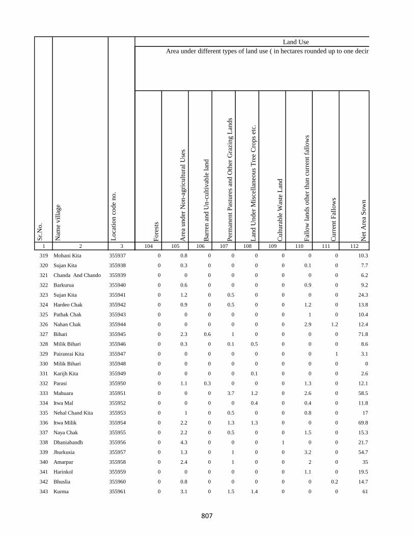
1 2 3
Lo
cati
on
co
de
no
.
Nam
e v
illa
ge
Sr.
No
.
319 Mohani Kita 355937
320 Sujan Kita 355938
321 Chanda And Chando 355939
322 Barkurua 355940
323 Sujan Kita 355941
324 Hardeo Chak 355942
325 Pathak Chak 355943
326 Nahan Chak 355944
327 Bihari 355945
328 Milik Bihari 355946
329 Pairanrai Kita 355947
330 Milik Bihari 355948
331 Karijh Kita 355949
332 Parasi 355950
333 Mahuara 355951
334 Itwa Mal 355952
335 Nehal Chand Kita 355953
336 Itwa Milik 355954
337 Naya Chak 355955
338 Dhaniabandh 355956
339 Jhurkusia 355957
340 Amarpur 355958
341 Harinkol 355959
342 Bhuslia 355960
343 Kurma 355961
Fo
rest
s
Are
a u
nd
er N
on
-ag
ricu
ltu
ral
Use
s
Bar
ren
an
d U
n-c
ult
ivab
le l
and
Per
man
ent
Pas
ture
s an
d O
ther
Gra
zin
g L
and
s
Lan
d U
nd
er M
isce
llan
eou
s T
ree
Cro
ps
etc.
Cu
ltu
rab
le W
aste
Lan
d
Fal
low
lan
ds
oth
er t
han
cu
rren
t fa
llo
ws
Cu
rren
t F
allo
ws
Net
Are
a S
ow
n
104 105 106 107 108 109 110 111 112
Area under different types of land use ( in hectares rounded up to one decimal place)
Land Use
0 0.8 0 0 0 0 0 0 10.3
0 0.3 0 0 0 0 0.1 0 7.7
0 0 0 0 0 0 0 0 6.2
0 0.6 0 0 0 0 0.9 0 9.2
0 1.2 0 0.5 0 0 0 0 24.3
0 0.9 0 0.5 0 0 1.2 0 13.8
0 0 0 0 0 0 1 0 10.4
0 0 0 0 0 0 2.9 1.2 12.4
0 2.3 0.6 1 0 0 0 0 71.8
0 0.3 0 0.1 0.5 0 0 0 8.6
0 0 0 0 0 0 0 1 3.1
0 0 0 0 0 0 0 0 0
0 0 0 0 0.1 0 0 0 2.6
0 1.1 0.3 0 0 0 1.3 0 12.1
0 0 0 3.7 1.2 0 2.6 0 58.5
0 0 0 0 0.4 0 0.4 0 11.8
0 1 0 0.5 0 0 0.8 0 17
0 2.2 0 1.3 1.3 0 0 0 69.8
0 2.2 0 0.5 0 0 1.5 0 15.3
0 4.3 0 0 0 1 0 0 21.7
0 1.3 0 1 0 0 3.2 0 54.7
0 2.4 0 1 0 0 2 0 35
0 0 0 0 0 0 1.1 0 19.5
0 0.8 0 0 0 0 0 0.2 14.7
0 3.1 0 1.5 1.4 0 0 0 61
807

1 2 3
Lo
cati
on
co
de
no
.
Nam
e v
illa
ge
Sr.
No
.
344 Darji Kita 355962
345 Birnath Chak 355963
346 Indar Chak 355964
347 Marro Mal 355965
348 Belatikar 355966
349 Pipra 355967
350 Budhuachak 355968
351 Pipra 355969
352 Purnia 355970
353 Mardiha 355971
354 Baghakol 355972
355 Rangila 355973
356 Bhuska 355974
357 Chand Chak 355975
358 Dogachhi 355976
359 Khajri Chak 355977
360 Lainbrar Barakhar 355978
361 Lensirsa 355979
362 Gorapariharpur 355980
363 Basta 355981
364 Bariasirsa 355982
365 Gobindi Chak 355983
366 Kanipathari 355984
367 Gaias Chak 355985
368 Majh Kola 355986
Fo
rest
s
Are
a u
nd
er N
on
-ag
ricu
ltu
ral
Use
s
Bar
ren
an
d U
n-c
ult
ivab
le l
and
Per
man
ent
Pas
ture
s an
d O
ther
Gra
zin
g L
and
s
Lan
d U
nd
er M
isce
llan
eou
s T
ree
Cro
ps
etc.
Cu
ltu
rab
le W
aste
Lan
d
Fal
low
lan
ds
oth
er t
han
cu
rren
t fa
llo
ws
Cu
rren
t F
allo
ws
Net
Are
a S
ow
n
104 105 106 107 108 109 110 111 112
Area under different types of land use ( in hectares rounded up to one decimal place)
Land Use
0 0 0 1.2 0 0 0 0 4.4
0 0.7 0 0.9 0.4 0 0 0 9.8
0 2.6 0 1 0.4 0 0 0 63.2
0 6.9 0 1.2 1.6 0 0.8 0 78.5
0 2.2 0 2.1 2.7 0 2.2 0 45.7
0 1.6 0 0 1.2 0 0.8 0 44.4
0 1.9 0 0.6 0 0 0 0 14.4
0 0.4 0 0 0 0 0 0 5.7
0 0 0 0 2.1 0 0.8 0 17.2
0 3.6 0 0 1.2 0 0 1 226.2
0 0.6 0 0.4 0 0 1.5 0 7
0 0.8 0 0 1.2 0 0 0 24.3
0 1.6 0 1.7 0 0 2.1 0 23.1
0 0.3 0 0.6 0 0 0 0 16.9
0 0 0 0 0 0 1.4 0 24.7
0 1 0 0.9 0 0 1.6 0 58.1
0 0.8 0 0 0 0 1.4 0 5.9
0 0.6 0 0 0 0 0 0 7.9
0 0 0 0 1.3 0.3 0 0 6.1
0 3.8 10.7 0.2 0 0 4.1 4.8 84.3
0 1 0 0 0 0 0.2 0 19.8
0 0.3 0 0.6 0 0 0.1 0 16.3
0 0 0 0 0 0 0 0 5
0 5 0 1 0 4 0 0 11
0 2.4 0 1 1 0 0 0 69.4
808

1 2 3
Lo
cati
on
co
de
no
.
Nam
e v
illa
ge
Sr.
No
.
369 Misirgangti 355987
370 Laghra Chak 355988
371 Mirik Chak 355989
372 Chamuakol 355990
373 Raghuni Kita 355991
374 Bhatkhoria 355992
375 Gauri Chak 355993
376 Sirikanta Chak 355994
377 Durga Chak 355995
378 Jogi Chak 355996
379 Bhiganda 355997
380 Kadma 355998
381 Asakhapar 355999
382 Mukeri Chak 356000
383 Dalang 356001
384 Raidih 356002
385 Nawadih 356003
386 Ratia Chak 356004
387 Pachradih 356005
388 Baniadih 356006
389 Dhawa 356007
390 Gopalpur Mohar Tola 356008
391 Gopalpur Karan Tola 356009
392 Runji 356010
393 Jadu Chak 356011
Fo
rest
s
Are
a u
nd
er N
on
-ag
ricu
ltu
ral
Use
s
Bar
ren
an
d U
n-c
ult
ivab
le l
and
Per
man
ent
Pas
ture
s an
d O
ther
Gra
zin
g L
and
s
Lan
d U
nd
er M
isce
llan
eou
s T
ree
Cro
ps
etc.
Cu
ltu
rab
le W
aste
Lan
d
Fal
low
lan
ds
oth
er t
han
cu
rren
t fa
llo
ws
Cu
rren
t F
allo
ws
Net
Are
a S
ow
n
104 105 106 107 108 109 110 111 112
Area under different types of land use ( in hectares rounded up to one decimal place)
Land Use
0 3.8 1.4 0 2.4 0 0 0 79.2
0 0.6 0.2 0 0 0 0 0 6.7
0 1.2 1.3 0 1 0 0 0 45.7
0 0.5 0 0 0 0 3.5 3.6 16.3
0 0 0 0 0 0 2 2.1 1
0 0 0 0 0 0 7.2 7.9 13.8
0 0 0 0 0 0 0 0 10
0 0 0 0 0 0 1.9 1.8 1.2
0 0 0 0 0 0 2.1 2.1 4.1
0 0 0 0 0 0 2.4 2.6 9.3
0 0 4.3 0 0 0 5.1 7.4 86.3
0 2.7 0.9 0 0 0 7.9 7.4 7.2
0 6.5 1.7 0 0 0 5.3 8.5 46.8
0 4.6 4.3 3.8 0 0 6.3 18.9 35
0 6.6 7.2 2.3 0 0 5.6 0.8 78.7
0 3.9 6.3 1.7 0 0 4.1 12 56.9
0 6.2 2 0.3 0 0 0.6 1.6 111.2
0 4.3 5.3 1.5 0 0 1.1 26 38.8
0 7.4 1.1 0.7 0 0 0.8 3.6 82.4
0 11.5 0 0 0 32.1 7.4 8.4 39.7
0 2.5 0 0 0 1.3 0 0 46.2
0 0.9 0 1.2 0 0 7.2 7.8 43.9
0 2.4 2.1 0 0 0 5.6 7.1 23.8
0 9.3 0 0.8 0 0 10.1 11.1 74.4
0 0.1 0 0 0 0 0 16.6 0
809

1 2 3
Lo
cati
on
co
de
no
.
Nam
e v
illa
ge
Sr.
No
.
394 Haripur Baharmal 356012
395 Lalu Chak 356013
396 Chamru Kaprigangti 356014
397 Mankhan Kita 356015
398 Antadih 356016
399 Sadargangti 356017
400 Chaujora 356018
401 Dharni Chak 356019
402 Garibparbara 356020
403 Bharsing Parbara 356021
404 Kumar Chak 356022
405 Bansbhita 356023
406 Rajhans 356024
407 Bishunpur 356025
408 Lahadih 356026
409 Baheradih 356027
410 Bahadur Chak 356028
411 Niamat Chak 356029
412 Ratanpur 356030
413 Samdaha 356031
414 Phulbaria 356032
415 Gamhra 356033
416 Diara 356034
Block T O T A L :
Fo
rest
s
Are
a u
nd
er N
on
-ag
ricu
ltu
ral
Use
s
Bar
ren
an
d U
n-c
ult
ivab
le l
and
Per
man
ent
Pas
ture
s an
d O
ther
Gra
zin
g L
and
s
Lan
d U
nd
er M
isce
llan
eou
s T
ree
Cro
ps
etc.
Cu
ltu
rab
le W
aste
Lan
d
Fal
low
lan
ds
oth
er t
han
cu
rren
t fa
llo
ws
Cu
rren
t F
allo
ws
Net
Are
a S
ow
n
104 105 106 107 108 109 110 111 112
Area under different types of land use ( in hectares rounded up to one decimal place)
Land Use
0 1.5 0 0 1.3 0 1.6 0 21.7
0 0 0 0 0 0 0 0 10.4
0 2 0 1.6 1.1 0 0 0 31.9
0 1.4 0 0.3 0 0 0 0.2 20.4
0 1.3 0 0 1.6 0 1.7 0 17.8
0 2 0 0 0.9 0 1 0 28.2
0 3.2 0 1.2 1.7 1.3 2.2 0 85.5
0 2.8 0.4 1 1.3 0 0.9 0 87.9
0 1.1 0 0 0 0 4.4 6.2 20.7
0 2.7 1 0 0 0 0 1.2 12.7
0 0 3.7 0 0 0 0 0 4.2
0 0.3 0 0 0 0 0.2 10.9 0
0 0 0 0 0 0 2.8 3.2 4.9
0 0 0 0 0 0 0 1.1 14.9
0 6.6 2.4 1.5 0 0 0 0.7 80.7
0 3.1 0 1.3 0 0 3.6 0 15
0 3.7 0 2.1 0 0 4.1 0 52.1
0 1.2 0 3.2 0 0 4.6 0 23.6
0 10.2 0 3.6 0 0 12.5 2.1 86.4
0 3.9 0 5.2 0 0 6.1 1.2 93.8
0 8.2 0 1.3 0 0 6.1 0.8 86.9
0 5.1 0 2.2 0 0 11.2 2.1 30.4
0 3.6 0 5.6 0 0 8.2 0 58.8
130.1 505.9 67.5 289.5 37.1 240.6 439.7 244.9 6514.3
810
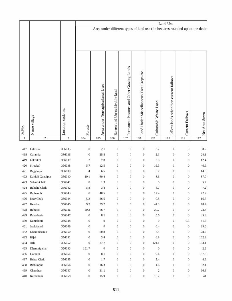
1 2 3
Lo
cati
on
co
de
no
.
Nam
e v
illa
ge
Sr.
No
.
417 Urkusia 356035
418 Garantia 356036
419 Lakrakol 356037
420 Sijuakol 356038
421 Bagjhopa 356039
422 Daldali Gopalpur 356040
423 Seharo Chak 356041
424 Bahelia Chak 356042
425 Rajbandh 356043
426 Issar Chak 356044
427 Kendua 356045
428 Ramkol 356046
429 Raharbaria 356047
430 Kamaldori 356048
431 Janlokundi 356049
432 Dhamnisemia 356050
433 Hijri 356051
434 Jirli 356052
435 Dhamnipahar 356053
436 Goradih 356054
437 Behra Chak 356055
438 Bishunpur 356056
439 Chandsar 356057
440 Karmatanr 356058
Fo
rest
s
Are
a u
nd
er N
on
-ag
ricu
ltu
ral
Use
s
Bar
ren
an
d U
n-c
ult
ivab
le l
and
Per
man
ent
Pas
ture
s an
d O
ther
Gra
zin
g L
and
s
Lan
d U
nd
er M
isce
llan
eou
s T
ree
Cro
ps
etc.
Cu
ltu
rab
le W
aste
Lan
d
Fal
low
lan
ds
oth
er t
han
cu
rren
t fa
llo
ws
Cu
rren
t F
allo
ws
Net
Are
a S
ow
n
104 105 106 107 108 109 110 111 112
Area under different types of land use ( in hectares rounded up to one decimal place)
Land Use
0 2.1 0 0 0 3.7 0 0 8.2
0 25.8 0 0 0 2.1 0 0 24.1
2 7.8 0 0 0 5.8 0 0 12.4
5.7 12.5 0 0 0 16.3 0 0 46.6
4 6.5 0 0 0 5.7 0 0 14.8
10.1 60.4 0 0 0 8.6 0 0 87.9
0 1.3 0 0 0 5 0 0 5.7
5.8 3.4 0 0 0 8.7 0 0 7.2
0 40.5 0 0 0 12.4 0 0 42.2
5.3 26.5 0 0 0 0.5 0 0 16.7
9.3 39.2 0 0 0 44.3 0 0 78.2
20.3 66.7 0 0 0 20.7 0 0 23.3
0 8.1 0 0 0 5.6 0 0 35.3
0 0 0 0 0 0 0 0.3 41.7
0 0 0 0 0 0.4 0 0 25.6
0 50.8 0 0 0 5.5 0 0 128.7
0 3.4 0 0 0 6.8 0 0 102.8
0 27.7 0 0 0 121.1 0 0 193.1
161.7 0 0 0 0 0 0 0 2.3
0 8.1 0 0 0 9.4 0 0 197.5
0 1.7 0 0 0 5.4 0 0 4.9
0 16.3 0 0 0 1.6 0 0 32.1
0 31.1 0 0 0 2 0 0 36.8
0 15.9 0 0 0 16.2 0 0 41
811
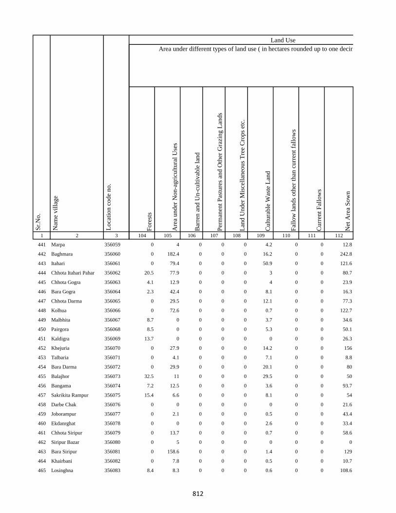
1 2 3
Lo
cati
on
co
de
no
.
Nam
e v
illa
ge
Sr.
No
.
441 Marpa 356059
442 Baghmara 356060
443 Itahari 356061
444 Chhota Itahari Pahar 356062
445 Chhota Gogra 356063
446 Bara Gogra 356064
447 Chhota Darma 356065
448 Kolhua 356066
449 Malbhita 356067
450 Pairgora 356068
451 Kaldigra 356069
452 Khejuria 356070
453 Talbaria 356071
454 Bara Darma 356072
455 Balajhor 356073
456 Bangama 356074
457 Sakrikita Rampur 356075
458 Darbe Chak 356076
459 Joborampur 356077
460 Ekdanrghat 356078
461 Chhota Siripur 356079
462 Siripur Bazar 356080
463 Bara Siripur 356081
464 Khairbani 356082
465 Losinghna 356083
Fo
rest
s
Are
a u
nd
er N
on
-ag
ricu
ltu
ral
Use
s
Bar
ren
an
d U
n-c
ult
ivab
le l
and
Per
man
ent
Pas
ture
s an
d O
ther
Gra
zin
g L
and
s
Lan
d U
nd
er M
isce
llan
eou
s T
ree
Cro
ps
etc.
Cu
ltu
rab
le W
aste
Lan
d
Fal
low
lan
ds
oth
er t
han
cu
rren
t fa
llo
ws
Cu
rren
t F
allo
ws
Net
Are
a S
ow
n
104 105 106 107 108 109 110 111 112
Area under different types of land use ( in hectares rounded up to one decimal place)
Land Use
0 4 0 0 0 4.2 0 0 12.8
0 182.4 0 0 0 16.2 0 0 242.8
0 79.4 0 0 0 50.9 0 0 121.6
20.5 77.9 0 0 0 3 0 0 80.7
4.1 12.9 0 0 0 4 0 0 23.9
2.3 42.4 0 0 0 8.1 0 0 16.3
0 29.5 0 0 0 12.1 0 0 77.3
0 72.6 0 0 0 0.7 0 0 122.7
8.7 0 0 0 0 3.7 0 0 34.6
8.5 0 0 0 0 5.3 0 0 50.1
13.7 0 0 0 0 0 0 0 26.3
0 27.9 0 0 0 14.2 0 0 156
0 4.1 0 0 0 7.1 0 0 8.8
0 29.9 0 0 0 20.1 0 0 80
32.5 11 0 0 0 29.5 0 0 50
7.2 12.5 0 0 0 3.6 0 0 93.7
15.4 6.6 0 0 0 8.1 0 0 54
0 0 0 0 0 0 0 0 21.6
0 2.1 0 0 0 0.5 0 0 43.4
0 0 0 0 0 2.6 0 0 33.4
0 13.7 0 0 0 0.7 0 0 58.6
0 5 0 0 0 0 0 0 0
0 158.6 0 0 0 1.4 0 0 129
0 7.8 0 0 0 0.5 0 0 10.7
8.4 8.3 0 0 0 0.6 0 0 108.6
812

1 2 3
Lo
cati
on
co
de
no
.
Nam
e v
illa
ge
Sr.
No
.
466 Bara Saraiya 356084
467 Chhota Saraiya 356085
468 Manikpur 356086
469 Kandaniya 356087
470 Beldiha 356088
471 Kortia 356089
472 Asanbuna 356090
473 Marcha 356091
474 Dumbari 356092
475 Churi 356093
476 Talbaria 356094
477 Bansbhita 356095
478 Jamunajharna 356096
479 Bara Boarijor 356097
480 Dhorri 356098
481 Dubra 356099
482 Mahula 356100
483 Meghi 356101
484 Mangra 356102
485 Chhota Boarijor 356103
486 Mahuakol 356104
487 Lakrakol 356105
488 Babuchuri 356106
489 Parsiya 356107
490 Bador 356108
Fo
rest
s
Are
a u
nd
er N
on
-ag
ricu
ltu
ral
Use
s
Bar
ren
an
d U
n-c
ult
ivab
le l
and
Per
man
ent
Pas
ture
s an
d O
ther
Gra
zin
g L
and
s
Lan
d U
nd
er M
isce
llan
eou
s T
ree
Cro
ps
etc.
Cu
ltu
rab
le W
aste
Lan
d
Fal
low
lan
ds
oth
er t
han
cu
rren
t fa
llo
ws
Cu
rren
t F
allo
ws
Net
Are
a S
ow
n
104 105 106 107 108 109 110 111 112
Area under different types of land use ( in hectares rounded up to one decimal place)
Land Use
0 1.5 0 0 0 6.1 0 0 39.4
0 1.2 0 0 0 0.4 0 0 10.4
0 18.5 0 0 0 12.7 0 0 88.8
0 82.7 0 0 0 0.4 0 0 122
6.7 31.3 0 0 0 3.7 0 0 39.4
81.4 25.2 0 0 0 20.2 0 0 33.2
26.3 12.3 0 0 0 12 0 0 40.5
33.7 1.5 0 0 0 6.2 0 0 19.5
2.7 0.9 0 0 0 1.2 0 0 2.3
5.9 2.2 0 0 0 4 0 0 9.8
20.9 17 0 0 0 0.8 0 0 24.3
0.9 3 0 0 0 9.8 0 0 29.2
3.7 4.2 0 0 0 0.4 0 0 59.7
0 27.9 0 0 0 2 0 0 170
0 3.6 0 0 0 4 0 0 58.3
0 26.3 0 0 0 20.4 0 0 125.3
0 11.1 0 0 0 90 0 0 84.9
0 21.4 0 0 0 4 0 0 236.7
0 99 0 0 0 31.6 0 0 103.5
10.6 85.7 0 0 0 1.7 0 0 6.9
40.5 12.1 0 0 0 2.8 0 0 19.5
8.7 10.4 0 0 0 3 0 0 14.9
10.2 6.8 0 0 0 4 0 0 11
26.9 21 0 0 0 4.6 0 0 28.5
20.6 33.4 0 0 0 7.8 0 0 48.2
813

1 2 3
Lo
cati
on
co
de
no
.
Nam
e v
illa
ge
Sr.
No
.
491 Muchuradaldali 356109
492 Daharlangi 356110
493 Pokhariya 356111
494 Barakera 356112
495 Chhotakera 356113
496 Karamtola 356114
497 Meredele 356115
498 Baragbhita 356116
499 Kutni 356117
500 Khatangi 356118
501 Puriabadar 356119
502 Bartali 356120
503 Anamu 356121
504 Babu Churi 356122
505 Badonre 356123
506 Barakbita 356124
507 Bargi 356125
508 Bartari 356126
509 Belmatok 356127
510 Churi Bedo 356128
511 Dangoda 356129
512 Dobri 356130
513 Dumberi Bedo 356131
514 Dumberi Joka 356132
515 Gadgandi 356133
Fo
rest
s
Are
a u
nd
er N
on
-ag
ricu
ltu
ral
Use
s
Bar
ren
an
d U
n-c
ult
ivab
le l
and
Per
man
ent
Pas
ture
s an
d O
ther
Gra
zin
g L
and
s
Lan
d U
nd
er M
isce
llan
eou
s T
ree
Cro
ps
etc.
Cu
ltu
rab
le W
aste
Lan
d
Fal
low
lan
ds
oth
er t
han
cu
rren
t fa
llo
ws
Cu
rren
t F
allo
ws
Net
Are
a S
ow
n
104 105 106 107 108 109 110 111 112
Area under different types of land use ( in hectares rounded up to one decimal place)
Land Use
43.7 20.1 0 0 0 51.1 0 0 41.1
0 0 0 3.7 0 2.2 0 0 99.2
56.7 1.2 0 0 0 1.2 0 0 57.9
0 150.6 0 0 0 4.7 0 0 53.7
0 13 0 0 0 1.4 0 0 62.6
0 8.5 0 0 0 56.4 0 0 16.1
8.3 0.2 0 0 0 2.8 0 0 13.6
28.3 0.2 0 0 0 2.8 0 0 0
0 5.4 0 0 0 6.2 0 0 14.5
0 1.9 0 0 0 16.2 0 0 7.9
0 14.3 0 0 0 3.3 0 0 31.4
22.6 2.6 0 0 0 0 0 0 72.8
13.4 4 0 0 0 1 0 0 6
0 0 0 0 0 0 0 0 0
0 2.1 0 0 0 2.1 0 16.3 7.9
0 0 0 0 0 0 0 0 0
20.3 3.5 0 0 0 0 75.7 0 0
0 0 0 0 0 0 0 0 0
28.6 0 0 0 0 0 0 42.6 0.4
0 0 0 0 0 0 0 0 0
0 0 0 0 0 0 0 0 0
4.5 4 0 0 0 16 0 0 21.1
0 4.7 0 0 0 14.7 0 17.3 26.7
0 0 0 0 0 0 0 0 0
20.2 10.3 0 0 0 8.1 0 0 20.8
814

1 2 3
Lo
cati
on
co
de
no
.
Nam
e v
illa
ge
Sr.
No
.
516 Gandiyamo 356134
517 Godni 356135
518 Japani 356136
519 Japita 356137
520 Jola 356138
521 Karakdoni 356139
522 Kasamu 356140
523 Katengi 356141
524 Katenribedo 356142
525 Katenri Joka 356143
526 Kukmano 356144
527 Mahwari Bedo 356145
528 Mahwari Joka 356146
529 Maligoda 356147
530 Masandumi 356148
531 Merdade 356149
532 Muchra 356150
533 Muri(Mundi) 356151
534 Orbot 356152
535 Panchrukhi 356153
536 Sundariya 356154
537 Tamilgoda 356155
538 Chhota Kendua 356156
539 Shampur 356157
540 Bara Kendua 356158
Fo
rest
s
Are
a u
nd
er N
on
-ag
ricu
ltu
ral
Use
s
Bar
ren
an
d U
n-c
ult
ivab
le l
and
Per
man
ent
Pas
ture
s an
d O
ther
Gra
zin
g L
and
s
Lan
d U
nd
er M
isce
llan
eou
s T
ree
Cro
ps
etc.
Cu
ltu
rab
le W
aste
Lan
d
Fal
low
lan
ds
oth
er t
han
cu
rren
t fa
llo
ws
Cu
rren
t F
allo
ws
Net
Are
a S
ow
n
104 105 106 107 108 109 110 111 112
Area under different types of land use ( in hectares rounded up to one decimal place)
Land Use
22.6 0 0 0 0 1.2 0 0 35
13.8 0 0 0 0 0 0 0 10.4
0 0 0 0 0 0 0 0 0
18.4 2.8 0 0 0 0 0 25.1 0.6
0 0 0 0 0 0 0 0 0
75 10.7 40.3 100 5 0 5 6 10.1
39.2 0.4 0 0 0 1.1 0 50.2 4.7
36 0 0 0 0 0 0 54.8 1.2
0 0 0 0 0 0 0 0 0
24.4 0 0 0 0 0 63.6 0 4
8.7 0 0 0 0 4.2 0 0 0
22.7 16.9 0 0 0 24 0 0 35.8
31.5 0 0 0 0 0 0 0 11.3
39.7 0 0 0 0 1.5 0 187.6 86.3
0 0 0 0 0 0 0 0 0
0 0 0 0 0 0 0 0 0
0 0 0 0 0 0 0 0 0
0 0 0 0 0 0 0 0 0
42.6 0 0 0 0 0 0 62.2 1.6
0 0 0 0 0 0 0 0 0
21.2 5.7 0 0 0 0 0 85.8 31.4
0 0 0 0 0 0 0 0 0
0 8 0 0 0 0 0 0 56
0 3 0 0 0 0.6 0 0 8.4
0 14.2 0 0 0 20.8 0 0 55.9
815

1 2 3
Lo
cati
on
co
de
no
.
Nam
e v
illa
ge
Sr.
No
.
541 Uparbandha 356159
542 Dhamni 356160
543 Narainpur 356161
544 Amjhor 356162
545 Debipur 356163
546 Rajabhita 356164
547 Chhota Dumarhir 356165
548 Bara Dumarhir 356166
549 Mungra 356167
550 Liti 356168
551 Champapur 356169
552 Telo 356170
553 Kero 356171
554 Kusumghati 356172
555 Ambadiha 356173
556 Lilatari 356174
557 Kusbila 356175
558 Bhadria 356176
559 Chandna 356177
560 Arajori Pokhar 356178
561 Dumaar Pahar 356179
562 Tetariya 356180
563 Rajapokhar Jagir 356181
564 Rajapokhar Jagir 356182
565 Rajapokhar Jagir 356183
Fo
rest
s
Are
a u
nd
er N
on
-ag
ricu
ltu
ral
Use
s
Bar
ren
an
d U
n-c
ult
ivab
le l
and
Per
man
ent
Pas
ture
s an
d O
ther
Gra
zin
g L
and
s
Lan
d U
nd
er M
isce
llan
eou
s T
ree
Cro
ps
etc.
Cu
ltu
rab
le W
aste
Lan
d
Fal
low
lan
ds
oth
er t
han
cu
rren
t fa
llo
ws
Cu
rren
t F
allo
ws
Net
Are
a S
ow
n
104 105 106 107 108 109 110 111 112
Area under different types of land use ( in hectares rounded up to one decimal place)
Land Use
0 16.9 0 0 0 19.7 0 0 117.4
0 21.3 0 0 0 21.8 0 0 134.9
0 93.1 0 0 0 11.5 0 0 113.4
0 34.1 0 0 0 28.8 0 0 77
0 56.7 0 0 0 43.8 0 0 116.5
0 48.8 0 0 0 55.5 0 0 165.7
0 4.5 0 0 0 2.1 0 0 36.4
0 52.2 0 0 0 59.6 0 0 162.2
0 0.8 0 0 0 5.5 0 0 14.7
0 22.2 0 0 0 66.4 0 0 140.6
0 9.8 0 0 0 2.1 0 0 31.2
0 27.1 0 0 0 10.3 0 0 38.6
0 40.5 0 0 0 46.2 0 0 135.3
0 15.4 0 0 0 45.2 0 0 63.4
0 14.7 0 0 0 42.2 0 0 53.2
0 26 0 0 0 21.1 0 0 84.9
0 40 0 0 0 16 0 0 158
0 34.3 0 0 0 12.2 0 0 129.5
0 44.5 0 0 0 52.8 0 0 116.8
0 0 0 0 0 8.7 0 0 2.3
0 0 0 0 0 14.4 0 0 0
0 18.2 0 0 0 24.8 0 0 118.9
0 17.8 0 0 0 0 0 0 19.2
0 2.1 0 0 0 9.6 0 0 22.2
0 3.7 0 0 0 0.9 0 0 21.4
816

1 2 3
Lo
cati
on
co
de
no
.
Nam
e v
illa
ge
Sr.
No
.
566 Rajapokhar 356184
567 Bara Chatampur 356185
568 Lilabhita 356186
569 Tamlia Amdanda 356187
570 Manko 356188
571 Kilo 356189
572 Dhadhari Pahar 356190
573 Chhota Chatampur 356191
574 Chetmapahar 356192
575 Dhanigora 356193
576 Dimbni Pahar 356194
577 Dhunigora Pahar 356195
578 Palma Pahar 356196
579 Chalpahari 356197
580 Madomasi 356198
581 Bhagamakra 356199
582 Champatola 356200
583 Pakriya Pahar 356201
584 Kairasol 356202
585 Sundar Tola 356203
586 Pachro 356204
587 Marni Pahar 356205
588 Daria Pahar 356206
589 Harla Bathan 356207
590 Deodanrpahar 356208
Fo
rest
s
Are
a u
nd
er N
on
-ag
ricu
ltu
ral
Use
s
Bar
ren
an
d U
n-c
ult
ivab
le l
and
Per
man
ent
Pas
ture
s an
d O
ther
Gra
zin
g L
and
s
Lan
d U
nd
er M
isce
llan
eou
s T
ree
Cro
ps
etc.
Cu
ltu
rab
le W
aste
Lan
d
Fal
low
lan
ds
oth
er t
han
cu
rren
t fa
llo
ws
Cu
rren
t F
allo
ws
Net
Are
a S
ow
n
104 105 106 107 108 109 110 111 112
Area under different types of land use ( in hectares rounded up to one decimal place)
Land Use
0 47.9 0 0 0 26.3 0 0 62.7
70.1 0 0 0 0 11.4 0 0 22.4
7.2 7.3 0 0 0 14 0 0 28.5
0.1 41.6 0 0 0 24.8 0 0 44.6
20.4 10.9 0 0 0 3.3 0 0 12.4
47.4 0 0 0 0 2.2 0 0 0
102.3 13.7 0 0 0 0.8 0 0 0
41.9 50.2 0 0 0 0 0 0 65.9
17.9 31.2 0 0 0 26.4 0 0 95.6
0 0 0 0 0 138 0 0 0
2.5 0 0 0 0 0 0 0 0
27.5 0 0 0 0 0 0 0 0
49.9 0 0 0 0 0 0 0 0
0 58 0 0 0 4.8 0 0 2.2
0 13.7 0 0 0 2.4 0 0 43.9
2.8 3 0 0 0 0 0 0 26.1
24.3 0.4 0 0 0 0 0 0 6.2
10.2 1.3 0 0 0 0 0 0 24.6
6.1 2.2 0 0 0 0 0 0 52.7
6.6 7.4 0 0 0 1 0 0 20
3.7 2.5 0 0 0 0 0 0 20.9
4.1 25.9 0 0 0 0 0 0 0
16.7 33.6 0 0 0 52.6 0 0 67.1
0 47.1 0 0 0 1.1 0 0 8.8
0 10.1 0 0 0 16.2 0 0 9.7
817

1 2 3
Lo
cati
on
co
de
no
.
Nam
e v
illa
ge
Sr.
No
.
591 Bara Patma Masahara 356209
592 Chhota Patma 356210
593 Letra Tola 356211
594 Kajro 356212
595 Jania Pahar 356213
596 Tetarganji Pahar 356214
597 Matubera Masaharpahar 356215
598 Bara Patma 356216
599 Katikbhita 356217
600 Kuspisa 356218
601 Dhamnijor 356219
602 Katalpahari 356220
603 Talbona 356221
604 Telaibera 356222
605 Baghmara 356223
606 Jullo 356224
607 Baridih 356225
608 Sijua 356226
609 Ratanpur 356227
610 Rohra 356228
611 Juniya Tola 356229
612 Barbe 356230
613 Badem 356231
614 Borbe 356232
615 Chatma Bedo 356233
Fo
rest
s
Are
a u
nd
er N
on
-ag
ricu
ltu
ral
Use
s
Bar
ren
an
d U
n-c
ult
ivab
le l
and
Per
man
ent
Pas
ture
s an
d O
ther
Gra
zin
g L
and
s
Lan
d U
nd
er M
isce
llan
eou
s T
ree
Cro
ps
etc.
Cu
ltu
rab
le W
aste
Lan
d
Fal
low
lan
ds
oth
er t
han
cu
rren
t fa
llo
ws
Cu
rren
t F
allo
ws
Net
Are
a S
ow
n
104 105 106 107 108 109 110 111 112
Area under different types of land use ( in hectares rounded up to one decimal place)
Land Use
5.8 25 0 0 0 41.6 0 0 35.6
10.6 2 0 0 0 20.8 0 0 33.7
8.1 21.5 0 0 0 0 0 0 4.4
20.5 11.8 0 0 0 2.5 0 45.8 4.7
17.5 14.3 0 0 0 74.8 0 211.4 82.6
6.6 20.1 0 0 0 0 0 0 0
0 0 0 0 0 0 0 0 0
11.9 44.3 0 0 0 16.8 0 0 56
0 8.7 0 0 0 0 0 0 46.3
0 0 0 0 0 4.1 0 0 4.9
0 3 6.2 3 0 5 2 2 10.8
4.1 8.6 0 0 0 0 0 65.8 31.5
4.4 41.9 0 0 0 0 0 0 18.6
30.4 17 0 0 0 5.9 0 0 27.7
22.8 14.9 0 0 0 5.6 0 0 27.6
0.2 61.1 0 0 0 0 0 0 0
121.4 13.4 0 0 0 6.5 0 0 155.8
121.4 49.5 0 0 0 0 0 0 35.1
0 19.8 0 0 0 6.6 0 0 56.6
0 149.5 0 0 0 50.5 0 0 148
16.2 67 0 0 0 39.4 0 0 55.3
40.5 6.8 0 0 0 0 0 0 0
4.1 0 0 0 0 0 0 143.2 2.2
7.7 34.1 0 0 0 8.4 0 89 10.4
22.9 8.3 0 0 0 0 0 0 0
818

1 2 3
Lo
cati
on
co
de
no
.
Nam
e v
illa
ge
Sr.
No
.
616 Chatma Joka 356234
617 Chengro 356235
618 Donigoda Bedo 356236
619 Ejgoga 356237
620 Gamari 356238
621 Goari 356239
622 Godam 356240
623 Itkro Bedo 356241
624 Jani Bedo 356242
625 Jani Maqo 356243
626 Jaria 356244
627 Jonia 356245
628 Karji 356246
629 Karag 356247
630 Kariam 356248
631 Katal 356249
632 Kilo Bedo 356250
633 Kilo Maqo 356251
634 Kombita 356252
635 Kuro Maqo 356253
636 Kuspiso 356254
637 Kutam 356255
638 Letragoda 356256
639 Marchi 356257
640 Matubera 356258
Fo
rest
s
Are
a u
nd
er N
on
-ag
ricu
ltu
ral
Use
s
Bar
ren
an
d U
n-c
ult
ivab
le l
and
Per
man
ent
Pas
ture
s an
d O
ther
Gra
zin
g L
and
s
Lan
d U
nd
er M
isce
llan
eou
s T
ree
Cro
ps
etc.
Cu
ltu
rab
le W
aste
Lan
d
Fal
low
lan
ds
oth
er t
han
cu
rren
t fa
llo
ws
Cu
rren
t F
allo
ws
Net
Are
a S
ow
n
104 105 106 107 108 109 110 111 112
Area under different types of land use ( in hectares rounded up to one decimal place)
Land Use
4.5 0 0 0 0 0 0 3.9 4.3
2.2 0 0 0 0 0 0 8.5 3.6
0 0 0 0 0 0 0 0 0
33 0 0 0 0 0 0 55.7 4.8
0 0 0 0 0 0 0 0 0
22.1 0 0 0 0 0 0 41.7 6.3
33.3 0 0 0 0 0 0 45.4 2.6
4.4 0 0 0 0 1.7 0 0.2 0.8
6.4 2.1 0 0 0 0 0 14.2 1.2
5.9 4.5 0 0 0 2.5 0 22.5 2.4
36 0.5 0 0 0 0 0 67.8 9.5
33.8 3.3 0 0 0 0 0 203.2 9
0 0 0 0 0 0 0 0 0
5.4 19 0 0 0 4.3 0 53.1 4.2
0 0 0 0 0 0 0 0 0
4.4 17.2 0 0 0 0 0 162 6.9
20.3 10 0 0 0 10.1 0 0 35
5.6 0 0 0 0 0 0 71.9 0.7
0 0 0 0 0 0 0 0 0
18 13.3 0 0 0 0 0 0 4.5
5.2 0 0 0 0 0 0 58.7 2.6
5.8 0 0 0 0 4 0 35.8 17
16.3 0 0 0 0 0 0 0 10.3
7.5 0 0 0 0 0 0 15.6 3.1
8.1 0 0 0 0 2.6 0 33 6.2
819

1 2 3
Lo
cati
on
co
de
no
.
Nam
e v
illa
ge
Sr.
No
.
641 Pandeni 356259
642 Patma Joka 356260
643 Perkuria 356261
644 Puro Maqo 356262
645 Puro Bedo 356263
646 Pusurkuriya Bedo 356264
647 Pusurkuriya Joka 356265
648 Tamlipatta 356266
649 Tesro 356267
650 Tisro 356268
651 Todmari 356269
652 Tokam 356270
653 Tokkuriya 356271
654 Saharpur 356272
655 Lilatari 356273
656 Khairbani 356274
657 Belthu 356275
658 Hethbandha 356276
659 Shamapokhar 356277
660 Chiharbona 356278
661 Chhota Saharpur 356279
662 Tulsipur 356280
663 Goriya 356281
664 Kamardiha 356282
665 Gopalpur 356283
Fo
rest
s
Are
a u
nd
er N
on
-ag
ricu
ltu
ral
Use
s
Bar
ren
an
d U
n-c
ult
ivab
le l
and
Per
man
ent
Pas
ture
s an
d O
ther
Gra
zin
g L
and
s
Lan
d U
nd
er M
isce
llan
eou
s T
ree
Cro
ps
etc.
Cu
ltu
rab
le W
aste
Lan
d
Fal
low
lan
ds
oth
er t
han
cu
rren
t fa
llo
ws
Cu
rren
t F
allo
ws
Net
Are
a S
ow
n
104 105 106 107 108 109 110 111 112
Area under different types of land use ( in hectares rounded up to one decimal place)
Land Use
31.4 0 0 0 0 0 45.5 0 0
12.1 6.9 0 0 0 0 32.1 0 3.1
6.8 0 0 0 0 0 16.3 0 3.3
3.7 2.5 0 0 0 0 22.6 0 9.2
0 0 0 0 0 0 14.2 0 9.7
15.6 0 0 0 0 0 24.3 0 0
16.2 0 0 0 0 0 23.8 0 0
17.1 7.8 0 0 0 0 29 0 5
17.3 5.3 0 0 0 0 34.4 0 0.8
13.3 5.9 0 0 0 1.7 33.6 0 1.9
14.5 0 0 0 0 0 22.5 0 0.8
25.2 0 0 0 0 0 19.6 0 1.7
25.2 0 0 0 0 0 21.1 0 1.7
0 0.4 0 0 0 0.4 3.2 0 0
1.3 21.4 0 0 0 15.9 0 0 8.5
8.5 26 0 0 0 45.8 0 0 22.7
8.1 28.9 0 0 0 8.3 0 0 31.7
12.1 53 0 0 0 47.8 0 0 24
3.3 39.9 0 0 0 12.9 0 0 39.9
8.3 0.8 0 0 0 54.5 0 0 30.4
0 0 0 0 0 0 0 0 0
10.1 16 0 0 0 10.9 0 0 26.9
1.2 12.4 0 0 0 17.3 0 0 29.2
2 5.8 0 0 0 16.2 0 0 20
10.2 10.8 0 0 0 1.8 0 0 21.2
820
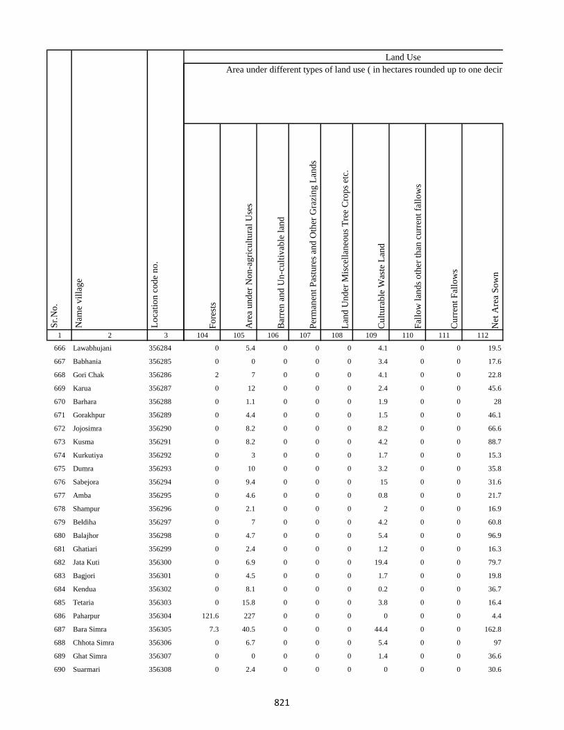
1 2 3
Lo
cati
on
co
de
no
.
Nam
e v
illa
ge
Sr.
No
.
666 Lawabhujani 356284
667 Babhania 356285
668 Gori Chak 356286
669 Karua 356287
670 Barhara 356288
671 Gorakhpur 356289
672 Jojosimra 356290
673 Kusma 356291
674 Kurkutiya 356292
675 Dumra 356293
676 Sabejora 356294
677 Amba 356295
678 Shampur 356296
679 Beldiha 356297
680 Balajhor 356298
681 Ghatiari 356299
682 Jata Kuti 356300
683 Bagjori 356301
684 Kendua 356302
685 Tetaria 356303
686 Paharpur 356304
687 Bara Simra 356305
688 Chhota Simra 356306
689 Ghat Simra 356307
690 Suarmari 356308
Fo
rest
s
Are
a u
nd
er N
on
-ag
ricu
ltu
ral
Use
s
Bar
ren
an
d U
n-c
ult
ivab
le l
and
Per
man
ent
Pas
ture
s an
d O
ther
Gra
zin
g L
and
s
Lan
d U
nd
er M
isce
llan
eou
s T
ree
Cro
ps
etc.
Cu
ltu
rab
le W
aste
Lan
d
Fal
low
lan
ds
oth
er t
han
cu
rren
t fa
llo
ws
Cu
rren
t F
allo
ws
Net
Are
a S
ow
n
104 105 106 107 108 109 110 111 112
Area under different types of land use ( in hectares rounded up to one decimal place)
Land Use
0 5.4 0 0 0 4.1 0 0 19.5
0 0 0 0 0 3.4 0 0 17.6
2 7 0 0 0 4.1 0 0 22.8
0 12 0 0 0 2.4 0 0 45.6
0 1.1 0 0 0 1.9 0 0 28
0 4.4 0 0 0 1.5 0 0 46.1
0 8.2 0 0 0 8.2 0 0 66.6
0 8.2 0 0 0 4.2 0 0 88.7
0 3 0 0 0 1.7 0 0 15.3
0 10 0 0 0 3.2 0 0 35.8
0 9.4 0 0 0 15 0 0 31.6
0 4.6 0 0 0 0.8 0 0 21.7
0 2.1 0 0 0 2 0 0 16.9
0 7 0 0 0 4.2 0 0 60.8
0 4.7 0 0 0 5.4 0 0 96.9
0 2.4 0 0 0 1.2 0 0 16.3
0 6.9 0 0 0 19.4 0 0 79.7
0 4.5 0 0 0 1.7 0 0 19.8
0 8.1 0 0 0 0.2 0 0 36.7
0 15.8 0 0 0 3.8 0 0 16.4
121.6 227 0 0 0 0 0 0 4.4
7.3 40.5 0 0 0 44.4 0 0 162.8
0 6.7 0 0 0 5.4 0 0 97
0 0 0 0 0 1.4 0 0 36.6
0 2.4 0 0 0 0 0 0 30.6
821
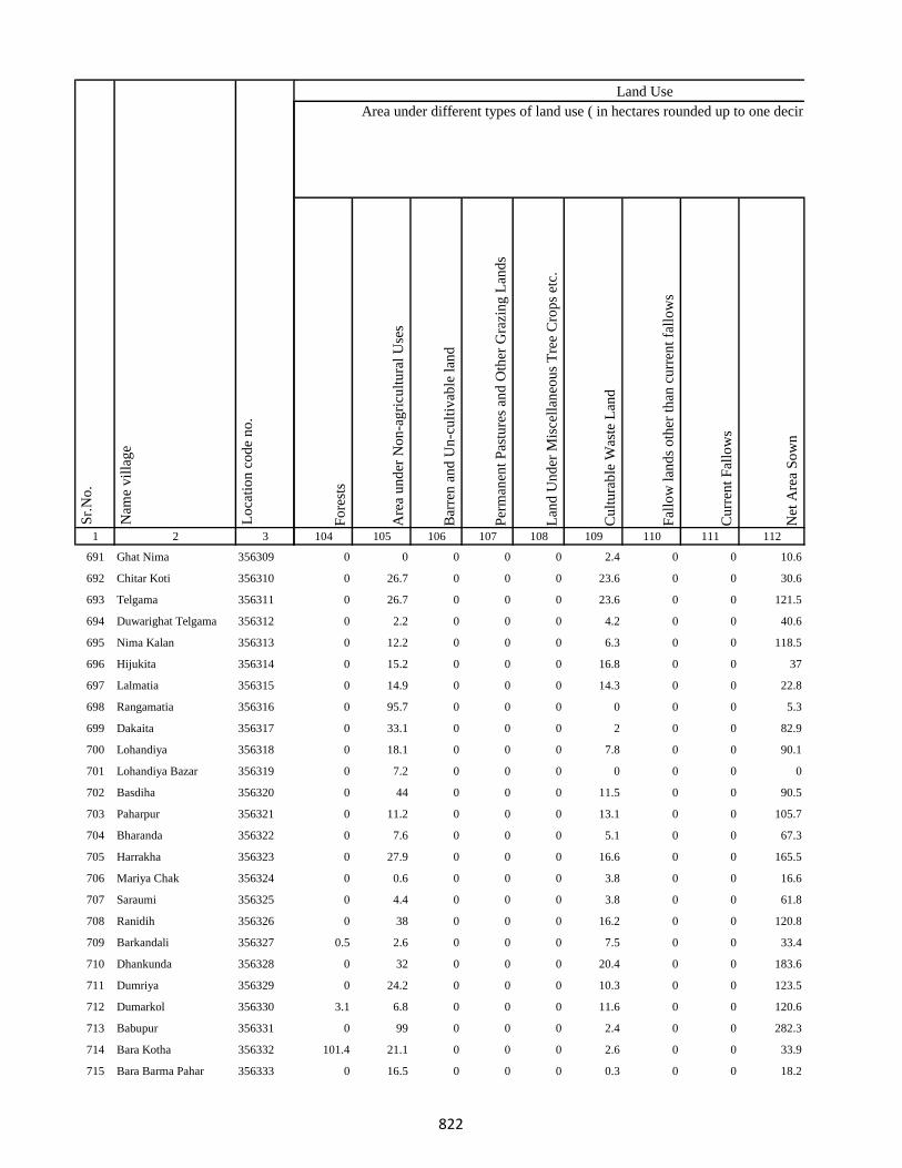
1 2 3
Lo
cati
on
co
de
no
.
Nam
e v
illa
ge
Sr.
No
.
691 Ghat Nima 356309
692 Chitar Koti 356310
693 Telgama 356311
694 Duwarighat Telgama 356312
695 Nima Kalan 356313
696 Hijukita 356314
697 Lalmatia 356315
698 Rangamatia 356316
699 Dakaita 356317
700 Lohandiya 356318
701 Lohandiya Bazar 356319
702 Basdiha 356320
703 Paharpur 356321
704 Bharanda 356322
705 Harrakha 356323
706 Mariya Chak 356324
707 Saraumi 356325
708 Ranidih 356326
709 Barkandali 356327
710 Dhankunda 356328
711 Dumriya 356329
712 Dumarkol 356330
713 Babupur 356331
714 Bara Kotha 356332
715 Bara Barma Pahar 356333
Fo
rest
s
Are
a u
nd
er N
on
-ag
ricu
ltu
ral
Use
s
Bar
ren
an
d U
n-c
ult
ivab
le l
and
Per
man
ent
Pas
ture
s an
d O
ther
Gra
zin
g L
and
s
Lan
d U
nd
er M
isce
llan
eou
s T
ree
Cro
ps
etc.
Cu
ltu
rab
le W
aste
Lan
d
Fal
low
lan
ds
oth
er t
han
cu
rren
t fa
llo
ws
Cu
rren
t F
allo
ws
Net
Are
a S
ow
n
104 105 106 107 108 109 110 111 112
Area under different types of land use ( in hectares rounded up to one decimal place)
Land Use
0 0 0 0 0 2.4 0 0 10.6
0 26.7 0 0 0 23.6 0 0 30.6
0 26.7 0 0 0 23.6 0 0 121.5
0 2.2 0 0 0 4.2 0 0 40.6
0 12.2 0 0 0 6.3 0 0 118.5
0 15.2 0 0 0 16.8 0 0 37
0 14.9 0 0 0 14.3 0 0 22.8
0 95.7 0 0 0 0 0 0 5.3
0 33.1 0 0 0 2 0 0 82.9
0 18.1 0 0 0 7.8 0 0 90.1
0 7.2 0 0 0 0 0 0 0
0 44 0 0 0 11.5 0 0 90.5
0 11.2 0 0 0 13.1 0 0 105.7
0 7.6 0 0 0 5.1 0 0 67.3
0 27.9 0 0 0 16.6 0 0 165.5
0 0.6 0 0 0 3.8 0 0 16.6
0 4.4 0 0 0 3.8 0 0 61.8
0 38 0 0 0 16.2 0 0 120.8
0.5 2.6 0 0 0 7.5 0 0 33.4
0 32 0 0 0 20.4 0 0 183.6
0 24.2 0 0 0 10.3 0 0 123.5
3.1 6.8 0 0 0 11.6 0 0 120.6
0 99 0 0 0 2.4 0 0 282.3
101.4 21.1 0 0 0 2.6 0 0 33.9
0 16.5 0 0 0 0.3 0 0 18.2
822

1 2 3
Lo
cati
on
co
de
no
.
Nam
e v
illa
ge
Sr.
No
.
716 Tatkunda 356334
717 Chhota Barma 356335
718 Debdanr 356336
719 Surla 356337
720 Dumria 356338
721 Chhota Khadahara 356339
722 Bara Khadahara 356340
723 Harkata 356341
724 Bara Khairbani 356342
725 Baisabaran 356343
726 Jurgura 356344
727 Dahua 356345
728 Kusumghati 356346
729 Lutibahiar 356347
730 Lilatari 356348
731 Haripur 356349
732 Hahajor 356350
733 Panchrukhi 356351
734 Rangamatia 356352
735 Chhota Khairbani 356353
736 Chhota Bhorai 356354
737 Bara Bhorai 356355
738 Taljhari 356356
739 Kesgoria 356357
740 Pakaria 356358
Fo
rest
s
Are
a u
nd
er N
on
-ag
ricu
ltu
ral
Use
s
Bar
ren
an
d U
n-c
ult
ivab
le l
and
Per
man
ent
Pas
ture
s an
d O
ther
Gra
zin
g L
and
s
Lan
d U
nd
er M
isce
llan
eou
s T
ree
Cro
ps
etc.
Cu
ltu
rab
le W
aste
Lan
d
Fal
low
lan
ds
oth
er t
han
cu
rren
t fa
llo
ws
Cu
rren
t F
allo
ws
Net
Are
a S
ow
n
104 105 106 107 108 109 110 111 112
Area under different types of land use ( in hectares rounded up to one decimal place)
Land Use
58.5 0 0 0 0 4.9 0 0 17.6
0 22.8 0 0 0 3.9 0 0 3.3
121.3 14.9 0 0 0 15.6 0 0 22.2
95.6 87.9 0 0 0 4 0 0 45.5
3.1 121.1 0 0 0 9.9 0 0 120.9
0 2.8 0 0 0 0.8 0 0 26.4
0 1.6 0 0 0 0 0 0 7.4
36.5 14.3 0 0 0 17.4 0 0 107.8
4.1 11.7 0 0 0 19.5 0 0 120.5
41.4 5.4 0 0 0 7.1 0 0 16.1
0 81.8 0 0 0 58 0 0 170.2
0 15 0 0 0 0 0 0 169
0 161.1 0 0 0 24.2 0 0 102.8
32 20 0 0 0 13.1 0 0 76.9
60.6 17.7 0 0 0 12.2 0 0 112.5
18.9 16.6 0 0 0 33.9 0 0 131.6
37.3 13.7 0 0 0 13.6 0 0 135.4
17 10.5 0 0 0 8.3 0 0 56.3
19.9 4.6 0 0 0 2.2 0 0 26.3
111.4 4.9 0 0 0 1.7 0 0 9
0 2.8 0 0 0 1.1 0 0 32.1
6.6 73.9 0 0 0 0 0 0 326.8
4.5 7.6 0 0 0 0 0 0 124.9
390.4 5.3 0 0 0 10 0 0 30.4
22 12.7 0 0 0 5.1 0 0 44.2
823
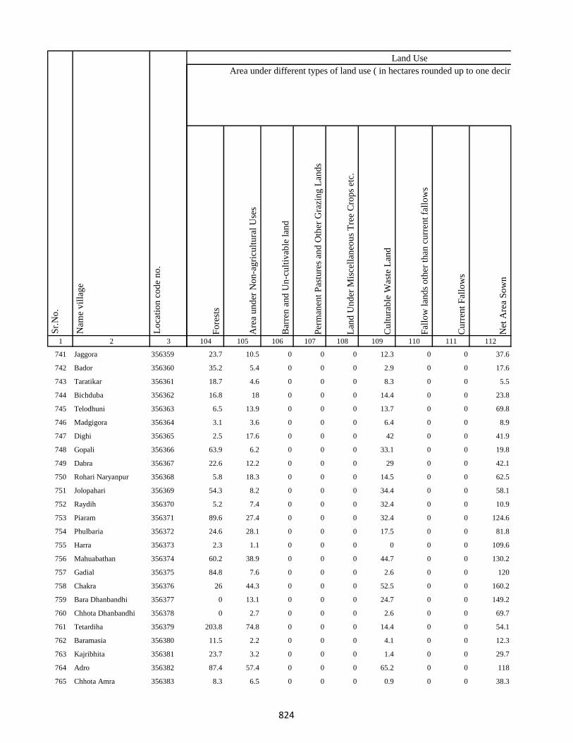
1 2 3
Lo
cati
on
co
de
no
.
Nam
e v
illa
ge
Sr.
No
.
741 Jaggora 356359
742 Bador 356360
743 Taratikar 356361
744 Bichduba 356362
745 Telodhuni 356363
746 Madgigora 356364
747 Dighi 356365
748 Gopali 356366
749 Dabra 356367
750 Rohari Naryanpur 356368
751 Jolopahari 356369
752 Raydih 356370
753 Piaram 356371
754 Phulbaria 356372
755 Harra 356373
756 Mahuabathan 356374
757 Gadial 356375
758 Chakra 356376
759 Bara Dhanbandhi 356377
760 Chhota Dhanbandhi 356378
761 Tetardiha 356379
762 Baramasia 356380
763 Kajribhita 356381
764 Adro 356382
765 Chhota Amra 356383
Fo
rest
s
Are
a u
nd
er N
on
-ag
ricu
ltu
ral
Use
s
Bar
ren
an
d U
n-c
ult
ivab
le l
and
Per
man
ent
Pas
ture
s an
d O
ther
Gra
zin
g L
and
s
Lan
d U
nd
er M
isce
llan
eou
s T
ree
Cro
ps
etc.
Cu
ltu
rab
le W
aste
Lan
d
Fal
low
lan
ds
oth
er t
han
cu
rren
t fa
llo
ws
Cu
rren
t F
allo
ws
Net
Are
a S
ow
n
104 105 106 107 108 109 110 111 112
Area under different types of land use ( in hectares rounded up to one decimal place)
Land Use
23.7 10.5 0 0 0 12.3 0 0 37.6
35.2 5.4 0 0 0 2.9 0 0 17.6
18.7 4.6 0 0 0 8.3 0 0 5.5
16.8 18 0 0 0 14.4 0 0 23.8
6.5 13.9 0 0 0 13.7 0 0 69.8
3.1 3.6 0 0 0 6.4 0 0 8.9
2.5 17.6 0 0 0 42 0 0 41.9
63.9 6.2 0 0 0 33.1 0 0 19.8
22.6 12.2 0 0 0 29 0 0 42.1
5.8 18.3 0 0 0 14.5 0 0 62.5
54.3 8.2 0 0 0 34.4 0 0 58.1
5.2 7.4 0 0 0 32.4 0 0 10.9
89.6 27.4 0 0 0 32.4 0 0 124.6
24.6 28.1 0 0 0 17.5 0 0 81.8
2.3 1.1 0 0 0 0 0 0 109.6
60.2 38.9 0 0 0 44.7 0 0 130.2
84.8 7.6 0 0 0 2.6 0 0 120
26 44.3 0 0 0 52.5 0 0 160.2
0 13.1 0 0 0 24.7 0 0 149.2
0 2.7 0 0 0 2.6 0 0 69.7
203.8 74.8 0 0 0 14.4 0 0 54.1
11.5 2.2 0 0 0 4.1 0 0 12.3
23.7 3.2 0 0 0 1.4 0 0 29.7
87.4 57.4 0 0 0 65.2 0 0 118
8.3 6.5 0 0 0 0.9 0 0 38.3
824
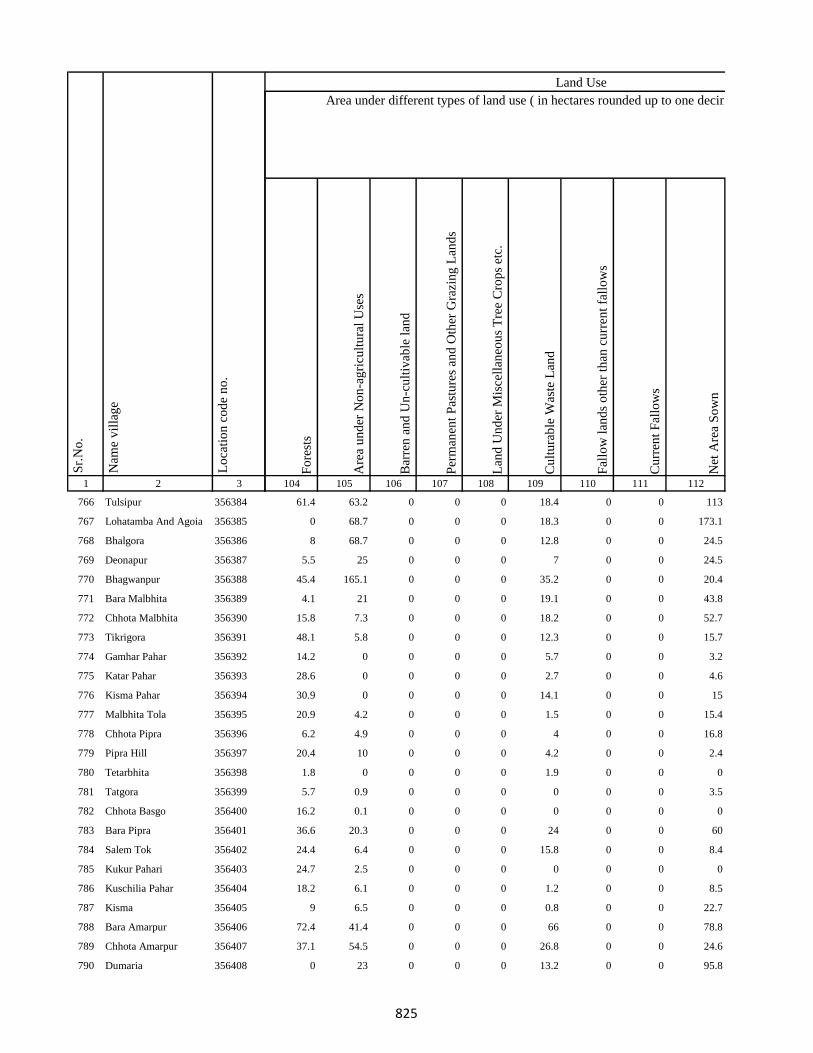
1 2 3
Lo
cati
on
co
de
no
.
Nam
e v
illa
ge
Sr.
No
.
766 Tulsipur 356384
767 Lohatamba And Agoia 356385
768 Bhalgora 356386
769 Deonapur 356387
770 Bhagwanpur 356388
771 Bara Malbhita 356389
772 Chhota Malbhita 356390
773 Tikrigora 356391
774 Gamhar Pahar 356392
775 Katar Pahar 356393
776 Kisma Pahar 356394
777 Malbhita Tola 356395
778 Chhota Pipra 356396
779 Pipra Hill 356397
780 Tetarbhita 356398
781 Tatgora 356399
782 Chhota Basgo 356400
783 Bara Pipra 356401
784 Salem Tok 356402
785 Kukur Pahari 356403
786 Kuschilia Pahar 356404
787 Kisma 356405
788 Bara Amarpur 356406
789 Chhota Amarpur 356407
790 Dumaria 356408
Fo
rest
s
Are
a u
nd
er N
on
-ag
ricu
ltu
ral
Use
s
Bar
ren
an
d U
n-c
ult
ivab
le l
and
Per
man
ent
Pas
ture
s an
d O
ther
Gra
zin
g L
and
s
Lan
d U
nd
er M
isce
llan
eou
s T
ree
Cro
ps
etc.
Cu
ltu
rab
le W
aste
Lan
d
Fal
low
lan
ds
oth
er t
han
cu
rren
t fa
llo
ws
Cu
rren
t F
allo
ws
Net
Are
a S
ow
n
104 105 106 107 108 109 110 111 112
Area under different types of land use ( in hectares rounded up to one decimal place)
Land Use
61.4 63.2 0 0 0 18.4 0 0 113
0 68.7 0 0 0 18.3 0 0 173.1
8 68.7 0 0 0 12.8 0 0 24.5
5.5 25 0 0 0 7 0 0 24.5
45.4 165.1 0 0 0 35.2 0 0 20.4
4.1 21 0 0 0 19.1 0 0 43.8
15.8 7.3 0 0 0 18.2 0 0 52.7
48.1 5.8 0 0 0 12.3 0 0 15.7
14.2 0 0 0 0 5.7 0 0 3.2
28.6 0 0 0 0 2.7 0 0 4.6
30.9 0 0 0 0 14.1 0 0 15
20.9 4.2 0 0 0 1.5 0 0 15.4
6.2 4.9 0 0 0 4 0 0 16.8
20.4 10 0 0 0 4.2 0 0 2.4
1.8 0 0 0 0 1.9 0 0 0
5.7 0.9 0 0 0 0 0 0 3.5
16.2 0.1 0 0 0 0 0 0 0
36.6 20.3 0 0 0 24 0 0 60
24.4 6.4 0 0 0 15.8 0 0 8.4
24.7 2.5 0 0 0 0 0 0 0
18.2 6.1 0 0 0 1.2 0 0 8.5
9 6.5 0 0 0 0.8 0 0 22.7
72.4 41.4 0 0 0 66 0 0 78.8
37.1 54.5 0 0 0 26.8 0 0 24.6
0 23 0 0 0 13.2 0 0 95.8
825

1 2 3
Lo
cati
on
co
de
no
.
Nam
e v
illa
ge
Sr.
No
.
791 Bamangawan 356409
792 Chhota Bararo 356410
793 Bararo 356411
794 Chetan Pahar 356412
795 Chakan Chak 356413
796 Domgora Pahar 356414
797 Elkar Pahar 356415
798 Moter Pahar 356416
799 Dhauatoka 356417
800 Bariartok 356418
801 Bara Telo 356419
802 Chhota Telo 356420
803 Jajotola Barhua 356421
804 Bara Amra 356422
805 Balkani 356423
806 Sundai 356424
807 Garbhu Tola 356425
808 Chhota Simmi 356426
809 Bara Simmi 356427
810 Bandhgora 356428
811 Kesarogora 356429
812 Chhota Chapri 356430
813 Dholna Pahar 356431
814 Telotok 356432
815 Charanpahar 356433
Fo
rest
s
Are
a u
nd
er N
on
-ag
ricu
ltu
ral
Use
s
Bar
ren
an
d U
n-c
ult
ivab
le l
and
Per
man
ent
Pas
ture
s an
d O
ther
Gra
zin
g L
and
s
Lan
d U
nd
er M
isce
llan
eou
s T
ree
Cro
ps
etc.
Cu
ltu
rab
le W
aste
Lan
d
Fal
low
lan
ds
oth
er t
han
cu
rren
t fa
llo
ws
Cu
rren
t F
allo
ws
Net
Are
a S
ow
n
104 105 106 107 108 109 110 111 112
Area under different types of land use ( in hectares rounded up to one decimal place)
Land Use
0 12 0 0 0 13.7 0 0 60.3
1 0.4 0 0 0 5.9 0 0 0
72 14.9 0 0 0 6.5 0 0 53.6
18.4 4.1 0 0 0 0.8 0 0 0
12.7 0 0 0 0 0.3 0 0 0
8.2 0.4 0 0 0 0 0 0 0
16.8 5.3 0 0 0 0 0 0 0
102.8 20.2 0 0 0 25.2 0 0 18.8
18 6.6 0 0 0 0 0 0 2.5
18.6 0 0 0 0 0 0 0 0
11.1 24.6 0 0 0 47.2 0 0 98.1
6.7 8.5 0 0 0 19.1 0 0 20.7
4.3 11.8 0 0 0 6.8 0 0 27.1
69.6 11.6 0 0 0 12.5 0 0 63.3
121.6 12.3 0 0 0 6.7 0 0 74.4
45.7 3 0 0 0 3.3 0 0 45
23.2 4.5 0 0 0 11.2 0 0 38
24.6 15.1 0 0 0 4.2 0 0 46.2
35.5 4.3 0 0 0 3.8 0 0 30.4
21.2 5.2 0 0 0 2.5 0 0 17.1
15.9 17.9 0 0 0 3.9 0 0 6.3
61.3 4.1 0 0 0 2.6 0 0 44
32.7 6.2 0 0 0 2.4 0 0 17.7
38.6 0.7 0 0 0 0 0 0 43.7
17.3 0 0 0 0 0.5 0 0 0
826

1 2 3
Lo
cati
on
co
de
no
.
Nam
e v
illa
ge
Sr.
No
.
816 Keriapahar 356434
817 Karampahar 356435
818 Masanpahar 356436
819 Dumarpahar 356437
820 Kamugora 356438
821 Bansdandapahar 356439
822 Bansdanda 356440
823 Dhunigora 356441
824 Bara Basgi 356442
825 Satbera 356443
826 Satbera 356444
827 Chetrampahar 356445
828 Hanidhoni 356446
829 Bara Chapri 356447
830 Madarpahar 356448
831 Chapri Bara 356449
832 Tamlipahar 356450
833 Bara Chapri 356451
834 Madgigora 356452
835 Karamtanr 356453
836 Dumarpahar 356454
837 Chhota Ghogha 356455
838 Bara Karlopahar 356456
839 Bara Ghogha 356457
840 Bara Kerlo 356458
Fo
rest
s
Are
a u
nd
er N
on
-ag
ricu
ltu
ral
Use
s
Bar
ren
an
d U
n-c
ult
ivab
le l
and
Per
man
ent
Pas
ture
s an
d O
ther
Gra
zin
g L
and
s
Lan
d U
nd
er M
isce
llan
eou
s T
ree
Cro
ps
etc.
Cu
ltu
rab
le W
aste
Lan
d
Fal
low
lan
ds
oth
er t
han
cu
rren
t fa
llo
ws
Cu
rren
t F
allo
ws
Net
Are
a S
ow
n
104 105 106 107 108 109 110 111 112
Area under different types of land use ( in hectares rounded up to one decimal place)
Land Use
0 0 0 0 0 0 0 0 0
0 9.5 0 0 0 0.8 0 0 0
7.5 0 0 0 0 0 0 0 0
12.4 0 0 0 0 0 0 0 0
0 56.6 0 0 0 0 0 0 0
16.3 0 0 0 0 0 0 0 0
35.3 38.2 0 0 0 64.2 0 0 55.4
11 1.2 0 0 0 0 0 0 3.8
2.2 1.1 0 0 0 0 0 0 0
38.4 3.2 0 0 0 2 0 0 24.4
18.4 2.4 0 0 0 0 0 0 2.2
24.4 8 0 0 0 0 0 0 2.6
28.5 3 0 0 0 6.8 0 0 4.8
62 10.4 0 0 0 6 0 0 20.6
34 7.1 0 0 0 0 0 0 3.9
39.3 6.6 0 0 0 2.2 0 0 2.9
18 2.6 0 0 0 0 0 0 3.4
33.3 10.4 0 0 0 2.1 0 0 5.2
50.4 19 0 0 0 1.5 0 0 0
8.6 5.7 0 0 0 0 0 0 4.7
28.8 3.7 0 0 0 0 0 0 3.6
17.9 0 0 0 0 0 0 0 0
16.5 0 0 0 0 0 0 0 0
33.2 0 0 0 0 0 0 0 0
109.8 8.3 0 0 0 4.3 0 0 45.6
827
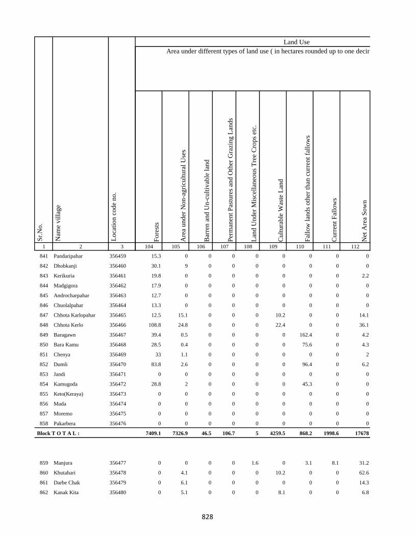
1 2 3
Lo
cati
on
co
de
no
.
Nam
e v
illa
ge
Sr.
No
.
841 Pandaripahar 356459
842 Dhobkanji 356460
843 Kerikuria 356461
844 Madgigora 356462
845 Androcharpahar 356463
846 Chuolalpahar 356464
847 Chhota Karlopahar 356465
848 Chhota Kerlo 356466
849 Baragawn 356467
850 Bara Kamu 356468
851 Chenya 356469
852 Dumli 356470
853 Jandi 356471
854 Kamugoda 356472
855 Keto(Keraya) 356473
856 Mada 356474
857 Moremo 356475
858 Pakarbera 356476
Block T O T A L :
859 Manjura 356477
860 Khutahari 356478
861 Darbe Chak 356479
862 Kanak Kita 356480
Fo
rest
s
Are
a u
nd
er N
on
-ag
ricu
ltu
ral
Use
s
Bar
ren
an
d U
n-c
ult
ivab
le l
and
Per
man
ent
Pas
ture
s an
d O
ther
Gra
zin
g L
and
s
Lan
d U
nd
er M
isce
llan
eou
s T
ree
Cro
ps
etc.
Cu
ltu
rab
le W
aste
Lan
d
Fal
low
lan
ds
oth
er t
han
cu
rren
t fa
llo
ws
Cu
rren
t F
allo
ws
Net
Are
a S
ow
n
104 105 106 107 108 109 110 111 112
Area under different types of land use ( in hectares rounded up to one decimal place)
Land Use
15.3 0 0 0 0 0 0 0 0
30.1 9 0 0 0 0 0 0 0
19.8 0 0 0 0 0 0 0 2.2
17.9 0 0 0 0 0 0 0 0
12.7 0 0 0 0 0 0 0 0
13.3 0 0 0 0 0 0 0 0
12.5 15.1 0 0 0 10.2 0 0 14.1
108.8 24.8 0 0 0 22.4 0 0 36.1
39.4 0.5 0 0 0 0 162.4 0 4.2
28.5 0.4 0 0 0 0 75.6 0 4.3
33 1.1 0 0 0 0 0 0 2
83.8 2.6 0 0 0 0 96.4 0 6.2
0 0 0 0 0 0 0 0 0
28.8 2 0 0 0 0 45.3 0 0
0 0 0 0 0 0 0 0 0
0 0 0 0 0 0 0 0 0
0 0 0 0 0 0 0 0 0
0 0 0 0 0 0 0 0 0
7409.1 7326.9 46.5 106.7 5 4259.5 868.2 1998.6 17678
0 0 0 0 1.6 0 3.1 8.1 31.2
0 4.1 0 0 0 10.2 0 0 62.6
0 6.1 0 0 0 0 0 0 14.3
0 5.1 0 0 0 8.1 0 0 6.8
828

1 2 3
Lo
cati
on
co
de
no
.
Nam
e v
illa
ge
Sr.
No
.
863 Sarbhanga 356481
864 Nunajagir 356482
865 Murgia Chak 356483
866 Sibotar Kita 356484
867 Rup Chak 356485
868 Sarautia 356486
869 Gopalpur 356487
870 Ranu Chak 356488
871 Chauchak 356489
872 Saha Chak 356490
873 Kumhrakol 356491
874 Singpur 356492
875 Baje Kita 356493
876 Garbhudih 356494
877 Sidhari 356495
878 Samu Kita 356496
879 Baje Kita 356497
880 Sidhari 356498
881 Mohani 356499
882 Bakanpur 356500
883 Dighi 356501
884 Satbigha 356502
885 Modi Chak 356503
886 Jagi Milik 356504
887 Baje Kita 356505
Fo
rest
s
Are
a u
nd
er N
on
-ag
ricu
ltu
ral
Use
s
Bar
ren
an
d U
n-c
ult
ivab
le l
and
Per
man
ent
Pas
ture
s an
d O
ther
Gra
zin
g L
and
s
Lan
d U
nd
er M
isce
llan
eou
s T
ree
Cro
ps
etc.
Cu
ltu
rab
le W
aste
Lan
d
Fal
low
lan
ds
oth
er t
han
cu
rren
t fa
llo
ws
Cu
rren
t F
allo
ws
Net
Are
a S
ow
n
104 105 106 107 108 109 110 111 112
Area under different types of land use ( in hectares rounded up to one decimal place)
Land Use
0 25.3 0 0 0.1 36 7.3 0 17.4
0 0 0 0 0 0 0 0 5.9
0 0 0 0 0 0 0 0 5
0 3 0 0 0 4 0 0 2
0 4.6 0 0 0 0 10.8 9.5 26.3
0 6.5 0 0 0 24.1 9.3 1.3 79.7
0 2.3 0 0.4 0 0 10 8.8 22.4
0 4.6 0 0 0 0 10.8 9.5 26.5
0 8.1 0 0.2 0 0 14.3 12.6 5.9
0 1.1 0 0 0 0 3.3 2.4 11.1
0 0.1 0.4 0 0 0 6.6 5.7 11.6
0 10.4 0 1.8 0 0 20.4 19.7 64
0 0 0 0 0 0 2.5 1.7 0.8
0 4.9 0 0.1 0 0 15.4 14.6 6.6
0 3.2 0 0.3 0 0 5.7 5.2 17.1
0 2.4 0 0.4 0 0 4.1 3.6 25.4
0 0 0 0 0 0 0 0 1
0 3.2 0 0.3 0 0 5.7 5.2 17.1
0 7.3 0 0.5 0 0 17.2 15.8 11
0 7.3 0 0.5 0 8.1 0 0 5.1
0 33.2 5.1 0.4 0 0 102 96 122.7
0 3.6 5.1 0.2 0 0 2.1 1.7 8.2
0 2.9 0 5.2 0 0 10.7 8.9 35.3
0 0.4 0 0 0 0 1.5 1 1.4
0 0 0 0 0 0 0.5 0.3 5.2
829

1 2 3
Lo
cati
on
co
de
no
.
Nam
e v
illa
ge
Sr.
No
.
888 Sital 356506
889 Mali Chak 356507
890 Gorgawan 356508
891 Naraini 356509
892 Dhobia Chak 356510
893 Bairia Chak 356511
894 Gansagar 356512
895 Bairia Kita 356513
896 Sonbarsa 356514
897 Milik Hanwara 356515
898 Hanwara 356516
899 Ramkol 356517
900 Tiya Chak 356518
901 Alimahamadpur 356519
902 Narainpur (Dompatti) 356520
903 Sahi Kita 356521
904 Narainpur (Sempatti) 356522
905 Chak Chamu 356523
906 Baija Chak 356524
907 Dumaria Khurd 356525
908 Dumaria Kalan 356526
909 Narattampur 356527
910 Biswas Khani 356528
911 Sagrampur 356529
912 Pararia 356530
Fo
rest
s
Are
a u
nd
er N
on
-ag
ricu
ltu
ral
Use
s
Bar
ren
an
d U
n-c
ult
ivab
le l
and
Per
man
ent
Pas
ture
s an
d O
ther
Gra
zin
g L
and
s
Lan
d U
nd
er M
isce
llan
eou
s T
ree
Cro
ps
etc.
Cu
ltu
rab
le W
aste
Lan
d
Fal
low
lan
ds
oth
er t
han
cu
rren
t fa
llo
ws
Cu
rren
t F
allo
ws
Net
Are
a S
ow
n
104 105 106 107 108 109 110 111 112
Area under different types of land use ( in hectares rounded up to one decimal place)
Land Use
0 3.3 1.4 0 0 0 6.6 5.1 48.6
0 13.6 0 0 0 10.1 0 0 30.3
0 10.2 0 2 0 0 2 9.3 108.4
0 10.1 0 1.6 0 0 22.4 35.2 29.8
0 2.5 0 0 0 6.3 2.1 1.7 12.4
0 1.4 0 0 0 0 2.4 1.6 17.2
0 0.2 0 0 0 0 1.2 0.9 0.4
0 0 0 0 0 1.3 4.1 3.9 34.7
0 0 0 0 0 0 0 1.7 5.3
0 6.1 0 0.1 0 0 8.6 6.8 46.2
0 26.6 9 6.2 10.2 100 41.7 66.7 32.6
0 9.8 10.2 2.1 0 0 5.3 20.3 50.7
0 1.5 1.2 0 0 0 2 5.3 13.2
0 1.2 0.6 0 0 0 3 7.4 6.6
0 5.5 0 0.6 0 0 0 0.4 47.9
0 4.1 2.4 0 0 0 0 5 20.3
0 5.4 8.2 2.6 0 0 0 0 41.3
0 3.7 0 0.5 0 0 0 10.8 10.7
0 5.2 0 0 0 0 0 0 6.8
0 8.1 0 2.1 0 0 0 41.8 70
0 9.1 1.4 4.6 0 0 0 8.1 50.7
0 4.2 0 0.1 0 0 0 0 140.5
0 23.1 28.4 3.2 0 66.4 0 6 67
0 21.1 22.4 2.2 0 0 0 46 49.2
0 8.1 0.4 1.5 0 0 0 4.4 48
830
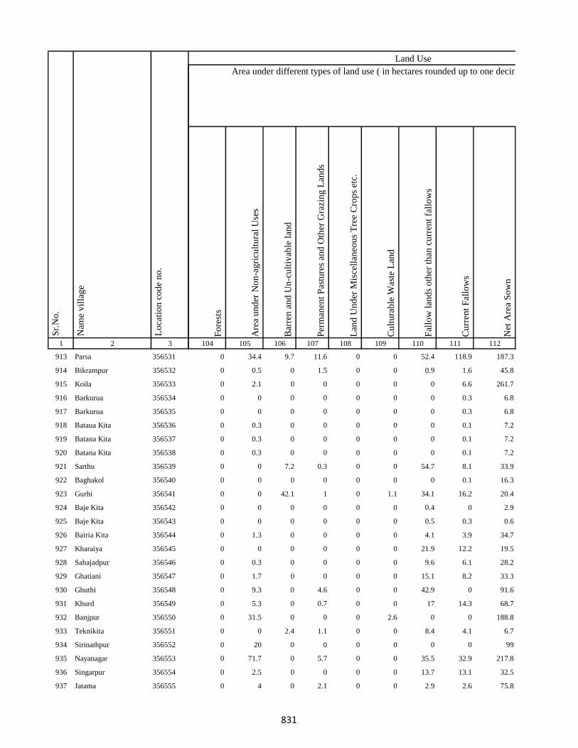
1 2 3
Lo
cati
on
co
de
no
.
Nam
e v
illa
ge
Sr.
No
.
913 Parsa 356531
914 Bikrampur 356532
915 Koila 356533
916 Barkurua 356534
917 Barkurua 356535
918 Bataua Kita 356536
919 Batana Kita 356537
920 Batana Kita 356538
921 Sarthu 356539
922 Baghakol 356540
923 Gurhi 356541
924 Baje Kita 356542
925 Baje Kita 356543
926 Bairia Kita 356544
927 Kharaiya 356545
928 Sahajadpur 356546
929 Ghatiani 356547
930 Ghuthi 356548
931 Khurd 356549
932 Banjpur 356550
933 Teknikita 356551
934 Sirinathpur 356552
935 Nayanagar 356553
936 Singarpur 356554
937 Jatama 356555
Fo
rest
s
Are
a u
nd
er N
on
-ag
ricu
ltu
ral
Use
s
Bar
ren
an
d U
n-c
ult
ivab
le l
and
Per
man
ent
Pas
ture
s an
d O
ther
Gra
zin
g L
and
s
Lan
d U
nd
er M
isce
llan
eou
s T
ree
Cro
ps
etc.
Cu
ltu
rab
le W
aste
Lan
d
Fal
low
lan
ds
oth
er t
han
cu
rren
t fa
llo
ws
Cu
rren
t F
allo
ws
Net
Are
a S
ow
n
104 105 106 107 108 109 110 111 112
Area under different types of land use ( in hectares rounded up to one decimal place)
Land Use
0 34.4 9.7 11.6 0 0 52.4 118.9 187.3
0 0.5 0 1.5 0 0 0.9 1.6 45.8
0 2.1 0 0 0 0 0 6.6 261.7
0 0 0 0 0 0 0 0.3 6.8
0 0 0 0 0 0 0 0.3 6.8
0 0.3 0 0 0 0 0 0.1 7.2
0 0.3 0 0 0 0 0 0.1 7.2
0 0.3 0 0 0 0 0 0.1 7.2
0 0 7.2 0.3 0 0 54.7 8.1 33.9
0 0 0 0 0 0 0 0.1 16.3
0 0 42.1 1 0 1.1 34.1 16.2 20.4
0 0 0 0 0 0 0.4 0 2.9
0 0 0 0 0 0 0.5 0.3 0.6
0 1.3 0 0 0 0 4.1 3.9 34.7
0 0 0 0 0 0 21.9 12.2 19.5
0 0.3 0 0 0 0 9.6 6.1 28.2
0 1.7 0 0 0 0 15.1 8.2 33.3
0 9.3 0 4.6 0 0 42.9 0 91.6
0 5.3 0 0.7 0 0 17 14.3 68.7
0 31.5 0 0 0 2.6 0 0 188.8
0 0 2.4 1.1 0 0 8.4 4.1 6.7
0 20 0 0 0 0 0 0 99
0 71.7 0 5.7 0 0 35.5 32.9 217.8
0 2.5 0 0 0 0 13.7 13.1 32.5
0 4 0 2.1 0 0 2.9 2.6 75.8
831
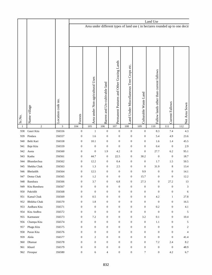
1 2 3
Lo
cati
on
co
de
no
.
Nam
e v
illa
ge
Sr.
No
.
938 Gauri Kita 356556
939 Pindara 356557
940 Belti Kari 356558
941 Baje Kita 356559
942 Asota 356560
943 Kasba 356561
944 Bhandarchua 356562
945 Shekhu Chak 356563
946 Bhelaidih 356564
947 Doma Chak 356565
948 Bansbara 356566
949 Kita Bansbara 356567
950 Pakridih 356568
951 Kamal Chak 356569
952 Bhikhia Chak 356570
953 Andhara Kita 356571
954 Kita Andhra 356572
955 Karmatanr 356573
956 Champa Kita 356574
957 Phagu Kita 356575
958 Puran Kita 356576
959 Alola 356577
960 Dhansar 356578
961 Khurd 356579
962 Firozpur 356580
Fo
rest
s
Are
a u
nd
er N
on
-ag
ricu
ltu
ral
Use
s
Bar
ren
an
d U
n-c
ult
ivab
le l
and
Per
man
ent
Pas
ture
s an
d O
ther
Gra
zin
g L
and
s
Lan
d U
nd
er M
isce
llan
eou
s T
ree
Cro
ps
etc.
Cu
ltu
rab
le W
aste
Lan
d
Fal
low
lan
ds
oth
er t
han
cu
rren
t fa
llo
ws
Cu
rren
t F
allo
ws
Net
Are
a S
ow
n
104 105 106 107 108 109 110 111 112
Area under different types of land use ( in hectares rounded up to one decimal place)
Land Use
0 1 0 0 0 0 8.3 7.4 4.3
0 1.6 0 0 0 0 5.4 4.9 23.6
0 10.1 0 0 0 0 1.6 1.4 45.5
0 0 0 0 0 0 0.4 0 2.9
0 0 1.9 4.2 0 0 27.7 6.2 95.1
0 44.7 0 22.5 0 30.2 0 0 18.7
0 12.2 0 0.4 0 0 1.7 1.5 50.5
0 1.3 0 2.5 0 0 31.9 8 13.4
0 12.5 0 0 0 9.9 0 0 14.1
0 1.2 0 0 0 15.7 0 0 12.2
0 3.7 0 6.8 0 27.3 0 27.2 13
0 0 0 0 0 0 0 0 3
0 0 0 0 0 0 0 0 6
0 0.5 0 0 0 0 4.2 1 27.8
0 1.8 0 0 0 0 0 0 16.5
0 0 0 0 0 0 0.2 0 4.1
0 0 0 0 0 0 0 0 5
0 7.2 0 0 0 3.2 0.1 0 10.4
0 0 0 0 0 0 1.1 0 5
0 0 0 0 0 0 0 0 2
0 0 0 0 0 0 0 0 4
0 2 0 0 0 0 0 0 41.4
0 0 0 0 0 0 7.2 2.4 8.2
0 0 0 0 0 0 0 0 48.9
0 6 4 0 0 7 0 4.2 6.7
832
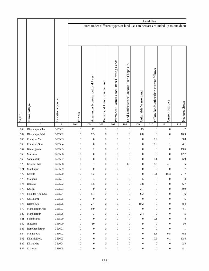
1 2 3
Lo
cati
on
co
de
no
.
Nam
e v
illa
ge
Sr.
No
.
963 Dharampur Ghat 356581
964 Dharampur Mal 356582
965 Chaujora Mal 356583
966 Chaujora Ghat 356584
967 Kamargawan 356585
968 Mansura 356586
969 Sadulabhita 356587
970 Gosain Chak 356588
971 Madhupur 356589
972 Gokula 356590
973 Majhona 356591
974 Daniala 356592
975 Khaira 356593
976 Fouzdar Kita Ghat 356594
977 Ghatdiarhi 356595
978 Diarhi Kita 356596
979 Manoharpur Kita 356597
980 Manoharpur 356598
981 Solahbighia 356599
982 Jhagarua 356600
983 Ramchandarpur 356601
984 Maigar Kita 356602
985 Kita Majhona 356603
986 Khara Kita 356604
987 Chainpur 356605
Fo
rest
s
Are
a u
nd
er N
on
-ag
ricu
ltu
ral
Use
s
Bar
ren
an
d U
n-c
ult
ivab
le l
and
Per
man
ent
Pas
ture
s an
d O
ther
Gra
zin
g L
and
s
Lan
d U
nd
er M
isce
llan
eou
s T
ree
Cro
ps
etc.
Cu
ltu
rab
le W
aste
Lan
d
Fal
low
lan
ds
oth
er t
han
cu
rren
t fa
llo
ws
Cu
rren
t F
allo
ws
Net
Are
a S
ow
n
104 105 106 107 108 109 110 111 112
Area under different types of land use ( in hectares rounded up to one decimal place)
Land Use
0 12 0 0 0 15 0 0 7
0 7.3 0 0 0 0.8 0 0 10.3
0 0 0 0 0 0 2.9 1 9.8
0 0 0 0 0 0 2.9 1 4.1
0 2 0 0 0 0 0 0 19.6
0 0 0 0 0 0 0 0 12.7
0 0 0 0 0 0 0.1 0 6.9
0 1 0 0 1.5 0 12.3 4.1 5
0 0 0 0 0 0 0 0 7
0 1.2 0 0 0 0 6.4 15.3 21.7
0 4 0 0 0 5 0 0 4
0 4.5 0 0 0 3.8 0 0 6.7
0 0 0 0 0 2.1 0 0 30.9
0 5.1 0 0 0 6.2 0 0 1.6
0 0 0 0 0 0 0 0 5
0 2.4 0 0 0 10.2 0 0 8.4
0 0.9 0 0 0 0 0 0 4.1
0 3 0 0 0 2.4 0 0 5
0 0 0 0 0 0 0.1 0 4
0 10 0 0 0 9 0 0 10
0 0 0 0 0 0 0 0 1
0 0 0 0 0 0 1.8 0.5 6.2
0 0 0 0 0 0 0.2 0.1 12.4
0 0 0 0 0 0 0 0 2.5
0 0 0 0 0 0 0 0 8.1
833
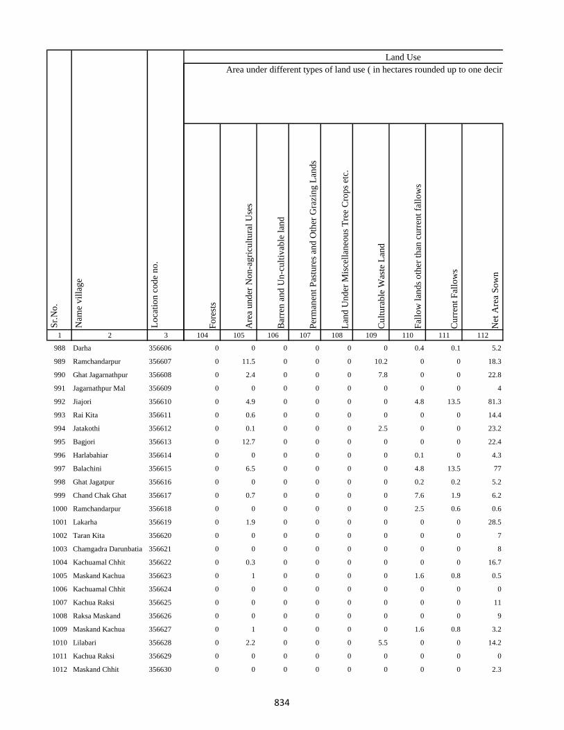
1 2 3
Lo
cati
on
co
de
no
.
Nam
e v
illa
ge
Sr.
No
.
988 Darha 356606
989 Ramchandarpur 356607
990 Ghat Jagarnathpur 356608
991 Jagarnathpur Mal 356609
992 Jiajori 356610
993 Rai Kita 356611
994 Jatakothi 356612
995 Bagjori 356613
996 Harlabahiar 356614
997 Balachini 356615
998 Ghat Jagatpur 356616
999 Chand Chak Ghat 356617
1000 Ramchandarpur 356618
1001 Lakarha 356619
1002 Taran Kita 356620
1003 Chamgadra Darunbatia 356621
1004 Kachuamal Chhit 356622
1005 Maskand Kachua 356623
1006 Kachuamal Chhit 356624
1007 Kachua Raksi 356625
1008 Raksa Maskand 356626
1009 Maskand Kachua 356627
1010 Lilabari 356628
1011 Kachua Raksi 356629
1012 Maskand Chhit 356630
Fo
rest
s
Are
a u
nd
er N
on
-ag
ricu
ltu
ral
Use
s
Bar
ren
an
d U
n-c
ult
ivab
le l
and
Per
man
ent
Pas
ture
s an
d O
ther
Gra
zin
g L
and
s
Lan
d U
nd
er M
isce
llan
eou
s T
ree
Cro
ps
etc.
Cu
ltu
rab
le W
aste
Lan
d
Fal
low
lan
ds
oth
er t
han
cu
rren
t fa
llo
ws
Cu
rren
t F
allo
ws
Net
Are
a S
ow
n
104 105 106 107 108 109 110 111 112
Area under different types of land use ( in hectares rounded up to one decimal place)
Land Use
0 0 0 0 0 0 0.4 0.1 5.2
0 11.5 0 0 0 10.2 0 0 18.3
0 2.4 0 0 0 7.8 0 0 22.8
0 0 0 0 0 0 0 0 4
0 4.9 0 0 0 0 4.8 13.5 81.3
0 0.6 0 0 0 0 0 0 14.4
0 0.1 0 0 0 2.5 0 0 23.2
0 12.7 0 0 0 0 0 0 22.4
0 0 0 0 0 0 0.1 0 4.3
0 6.5 0 0 0 0 4.8 13.5 77
0 0 0 0 0 0 0.2 0.2 5.2
0 0.7 0 0 0 0 7.6 1.9 6.2
0 0 0 0 0 0 2.5 0.6 0.6
0 1.9 0 0 0 0 0 0 28.5
0 0 0 0 0 0 0 0 7
0 0 0 0 0 0 0 0 8
0 0.3 0 0 0 0 0 0 16.7
0 1 0 0 0 0 1.6 0.8 0.5
0 0 0 0 0 0 0 0 0
0 0 0 0 0 0 0 0 11
0 0 0 0 0 0 0 0 9
0 1 0 0 0 0 1.6 0.8 3.2
0 2.2 0 0 0 5.5 0 0 14.2
0 0 0 0 0 0 0 0 0
0 0 0 0 0 0 0 0 2.3
834

1 2 3
Lo
cati
on
co
de
no
.
Nam
e v
illa
ge
Sr.
No
.
1013 Maskand Kita 356631
1014 Sirsa Kalan 356632
1015 Sirsa Khurd 356633
1016 Bholu Chak 356634
1017 Mahuara Ghat 356635
1018 Mahuara 356636
1019 Fauj Kita 356637
1020 Logain 356638
1021 Asmantikar 356639
1022 Maskand Bhanjpur 356640
1023 Gidra Pathar 356641
1024 Lamahaghat 356642
1025 Hirai Chak 356643
1026 Sukhbona 356644
1027 Sankar Kita 356645
1028 Rahim Kita 356646
1029 Hajra Chak 356647
1030 Lachmania Kita 356648
1031 Lilambar 356649
1032 Maskand Chhit 356650
1033 Bishambhar Kita 356651
1034 Kita Bishambhara 356652
1035 Gunia 356653
1036 Harin Chora 356654
1037 Baghakol 356655
Fo
rest
s
Are
a u
nd
er N
on
-ag
ricu
ltu
ral
Use
s
Bar
ren
an
d U
n-c
ult
ivab
le l
and
Per
man
ent
Pas
ture
s an
d O
ther
Gra
zin
g L
and
s
Lan
d U
nd
er M
isce
llan
eou
s T
ree
Cro
ps
etc.
Cu
ltu
rab
le W
aste
Lan
d
Fal
low
lan
ds
oth
er t
han
cu
rren
t fa
llo
ws
Cu
rren
t F
allo
ws
Net
Are
a S
ow
n
104 105 106 107 108 109 110 111 112
Area under different types of land use ( in hectares rounded up to one decimal place)
Land Use
0 0 0 0 0 0 6 6 2
0 3 0 0 0 0 6.2 4 9.8
0 5.7 0 0 0 0 0 0 6.3
0 0.9 0 0 0 0 0 0 6.1
0 0.2 0 0 0 0 0.7 0.2 2.1
0 8 0 0 0 0.5 36.5 27.9 8.6
0 0 0 0 0 0 0 1.4 0
0 0 0.9 0 0 0 41.7 20.3 71.9
0 0 1.3 0 0 0 6 3.3 6.1
0 1.7 0 0 0 0 20.3 4.1 13
0 0 0 0 0 0 2.4 1.2 2.6
0 0 0.7 0 0 0 17.4 6.2 26.9
0 15.2 0 0 0 0.8 0 0 8
0 0 0.1 0 0 0 2.6 1.7 8.1
0 0 0 0 0 0 1.8 0.4 6.8
0 0.2 0 0 0 0 7.4 2.1 6.3
0 0 0 0 0 0 0 0.2 4.1
0 0 0 0 0 0 0.2 0.2 2.3
0 1.3 0 0 0 0 8.1 6.5 7
0 0 0 0 0 0 0.6 0.5 2.7
0 0.9 0 0 0 0 0.6 0.5 0.8
0 1.1 0 0 0 0 1.9 1.8 2.2
0 0.7 0 0 0 0 2.2 2.9 2.2
0 2.8 0 0 0 0 8.7 7 3.7
0 0 0 0 0 0 0 0 7.7
835

1 2 3
Lo
cati
on
co
de
no
.
Nam
e v
illa
ge
Sr.
No
.
1038 Dakaita 356656
1039 Dakaitaghat 356657
1040 Tetaria 356658
1041 Bhalu Kita 356659
1042 Tewarijor 356660
1043 Beltikri 356661
1044 Jhapania 356662
1045 Khairaghat 356663
1046 Lamha Mal 356664
1047 Chand Chak 356665
1048 Ghospur 356666
1049 Dahara 356667
1050 Moti Chak 356668
1051 Bhartha Chak 356669
1052 Bhairo Kita 356670
1053 Lachminia Kita 356671
1054 Anjna 356672
1055 Barhe Kita 356673
1056 Sirsi 356674
1057 Bhairo Chak 356675
1058 Kusmara 356676
1059 Lachminia Kita 356677
1060 Bishunpur 356678
1061 Baradbara 356679
1062 Sundar Chak 356680
Fo
rest
s
Are
a u
nd
er N
on
-ag
ricu
ltu
ral
Use
s
Bar
ren
an
d U
n-c
ult
ivab
le l
and
Per
man
ent
Pas
ture
s an
d O
ther
Gra
zin
g L
and
s
Lan
d U
nd
er M
isce
llan
eou
s T
ree
Cro
ps
etc.
Cu
ltu
rab
le W
aste
Lan
d
Fal
low
lan
ds
oth
er t
han
cu
rren
t fa
llo
ws
Cu
rren
t F
allo
ws
Net
Are
a S
ow
n
104 105 106 107 108 109 110 111 112
Area under different types of land use ( in hectares rounded up to one decimal place)
Land Use
0 8.3 0 0 0 0 10.2 8.9 2.2
0 0 0 0 0 0 0.2 0.1 2.7
0 8.2 0 0 0 9.5 0 0 5.3
0 2.4 0 0 0 0 3.9 3.1 4
0 1.2 0 0 0 0 8.4 7.2 2.8
0 2.3 0 5.8 0 0 0 0 93.8
0 1 0 0 0 0 2.1 1 11.2
0 0.7 0 0.8 0 0 0.3 0 8.7
0 0.6 0 0 0 0 1 0 7.7
0 1.4 0 1.5 0 0 10.4 4.9 52
0 2.6 0 1.4 0 0 4.4 2.1 46
0 0.5 0 0 0 0 1.1 0 7.4
0 8.1 0 4.1 0 0 23.5 8.2 28.1
0 2.4 2.2 0.2 0 6.1 0 0 20.2
0 0 0 0 0 0 0.9 1 5.9
0 0.9 0 0 0 0 0 0 6.1
0 42.4 0 0 0 3 0 0 186.3
0 0 0 0.4 0 0 0 0 15
0 1 0 0 0 5.2 0 0 50.8
0 25 0 0.4 0 0 0 0 22.7
0 2.2 0 0 0 0 2.1 1.3 77.7
0 4.6 0 0 0 0 0 0 9.4
0 3.6 0 0.4 0 0 44.2 32.4 22.5
0 5 1.8 0.6 0 0 36 40.5 33.5
0 7.4 0 0.5 0 0 5.6 4.1 38.8
836

1 2 3
Lo
cati
on
co
de
no
.
Nam
e v
illa
ge
Sr.
No
.
1063 Bhaju Chak 356681
1064 Malia Chak 356682
1065 Afzal Kita 356683
1066 Mariha 356684
1067 Kushapur 356685
1068 Fazil Kita 356686
1069 Dumra 356687
1070 Bisambhara Kita 356688
1071 Dahia 356689
1072 Kaljhara 356690
1073 Phudkipur 356691
1074 Simratola 356692
1075 Hundra 356693
1076 Phudkipur 356694
1077 Shahpur Beldiha 356695
1078 Phasiatikar 356696
1079 Sirsa 356697
1080 Samhari 356698
1081 Asanand Kita 356699
1082 Muradpur 356700
1083 Subarai Samhra 356701
1084 Semra Kita 356702
1085 Mirza Chak 356703
1086 Hasan Karharia 356704
1087 Manian Karharia 356705
Fo
rest
s
Are
a u
nd
er N
on
-ag
ricu
ltu
ral
Use
s
Bar
ren
an
d U
n-c
ult
ivab
le l
and
Per
man
ent
Pas
ture
s an
d O
ther
Gra
zin
g L
and
s
Lan
d U
nd
er M
isce
llan
eou
s T
ree
Cro
ps
etc.
Cu
ltu
rab
le W
aste
Lan
d
Fal
low
lan
ds
oth
er t
han
cu
rren
t fa
llo
ws
Cu
rren
t F
allo
ws
Net
Are
a S
ow
n
104 105 106 107 108 109 110 111 112
Area under different types of land use ( in hectares rounded up to one decimal place)
Land Use
0 2.1 0 0 0 0 45.4 20.3 50.3
0 1.9 0 1.2 0 0 4.1 1.7 47.1
0 0 0 0 0 3.9 0 0 16.1
0 0 0 0 0 0 10.2 6.2 12.1
0 2.5 0 0 0 0 0.3 6.2 35.1
0 0.9 0 0 0 0 0 1 7.6
0 0 0 0 0 30 0 0 30
0 0 0 0 0 3 0 0 9
0 12.5 0 0 0 1.9 0 0 44.6
0 8 0 0 0 2 0 0 72
0 4.8 0 0 0 0.8 0 0 25.3
0 0.2 0 0 0 0.2 0 0 9.6
0 6 0 0 0 0 0 0 34
0 0.5 0 0 0 0 0 1 1.5
0 30.6 0 0 0 2.8 0 0 115.6
0 0.6 0 0 0 0 0 0 16.4
0 5.1 0 0 0 0.3 0 0 33.6
0 60.8 0 0 0 3.2 0 0 123
0 2.2 0 0 0 0.4 0 0 4.4
0 7.1 0 0 0 0.7 0 0 39.2
0 0.8 0 0 0 7 0 0 21.2
0 1.9 0 0 0 12.5 0 0 18.6
0 8 0 0 0 0.2 0 0 54.8
0 13.9 20 18.2 0 0.2 0 0 28.7
0 2.5 1 0 0 0 0 0 64.5
837
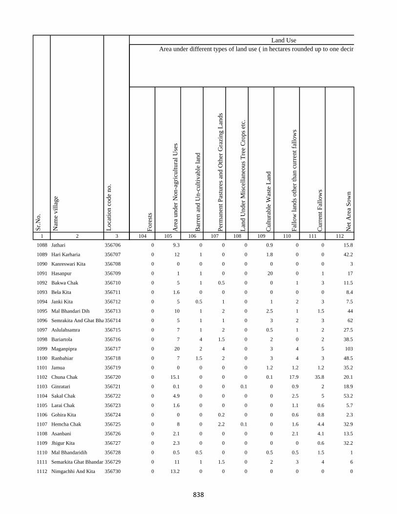
1 2 3
Lo
cati
on
co
de
no
.
Nam
e v
illa
ge
Sr.
No
.
1088 Jathari 356706
1089 Hari Karharia 356707
1090 Kanreswari Kita 356708
1091 Hasanpur 356709
1092 Bakwa Chak 356710
1093 Bela Kita 356711
1094 Janki Kita 356712
1095 Mal Bhandari Dih 356713
1096 Semrakita And Ghat Bhandarid356714
1097 Aslulahsamra 356715
1098 Bariartola 356716
1099 Maganpipra 356717
1100 Ranbahiar 356718
1101 Jamua 356719
1102 Chuna Chak 356720
1103 Ginratari 356721
1104 Sakal Chak 356722
1105 Larai Chak 356723
1106 Gohira Kita 356724
1107 Hemcha Chak 356725
1108 Asanbani 356726
1109 Jhigur Kita 356727
1110 Mal Bhandaridih 356728
1111 Semarkita Ghat Bhandaridih356729
1112 Nimgachhi And Kita 356730
Fo
rest
s
Are
a u
nd
er N
on
-ag
ricu
ltu
ral
Use
s
Bar
ren
an
d U
n-c
ult
ivab
le l
and
Per
man
ent
Pas
ture
s an
d O
ther
Gra
zin
g L
and
s
Lan
d U
nd
er M
isce
llan
eou
s T
ree
Cro
ps
etc.
Cu
ltu
rab
le W
aste
Lan
d
Fal
low
lan
ds
oth
er t
han
cu
rren
t fa
llo
ws
Cu
rren
t F
allo
ws
Net
Are
a S
ow
n
104 105 106 107 108 109 110 111 112
Area under different types of land use ( in hectares rounded up to one decimal place)
Land Use
0 9.3 0 0 0 0.9 0 0 15.8
0 12 1 0 0 1.8 0 0 42.2
0 0 0 0 0 0 0 0 3
0 1 1 0 0 20 0 1 17
0 5 1 0.5 0 0 1 3 11.5
0 1.6 0 0 0 0 0 0 8.4
0 5 0.5 1 0 1 2 3 7.5
0 10 1 2 0 2.5 1 1.5 44
0 5 1 1 0 3 2 3 62
0 7 1 2 0 0.5 1 2 27.5
0 7 4 1.5 0 2 0 2 38.5
0 20 2 4 0 3 4 5 103
0 7 1.5 2 0 3 4 3 48.5
0 0 0 0 0 1.2 1.2 1.2 35.2
0 15.1 0 0 0 0.1 17.9 35.8 20.1
0 0.1 0 0 0.1 0 0.9 2 18.9
0 4.9 0 0 0 0 2.5 5 53.2
0 1.6 0 0 0 0 1.1 0.6 5.7
0 0 0 0.2 0 0 0.6 0.8 2.3
0 8 0 2.2 0.1 0 1.6 4.4 32.9
0 2.1 0 0 0 0 2.1 4.1 13.5
0 2.3 0 0 0 0 0 0.6 32.2
0 0.5 0.5 0 0 0.5 0.5 1.5 1
0 11 1 1.5 0 2 3 4 6
0 13.2 0 0 0 0 0 0 0
838
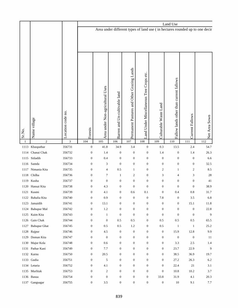
1 2 3
Lo
cati
on
co
de
no
.
Nam
e v
illa
ge
Sr.
No
.
1113 Khaspathar 356731
1114 Chanai Chak 356732
1115 Sitladih 356733
1116 Samda 356734
1117 Nimania Kita 356735
1118 Chilha 356736
1119 Kusha 356737
1120 Hansai Kita 356738
1121 Kusmi 356739
1122 Bahalia Kita 356740
1123 Jamaidih 356741
1124 Babupur Mal 356742
1125 Kaim Kita 356743
1126 Gain Chak 356744
1127 Babupur Ghat 356745
1128 Rajpur 356746
1129 Doman Kita 356747
1130 Majur Kola 356748
1131 Pathar Kani 356749
1132 Karnu 356750
1133 Gudia 356751
1134 Letaria 356752
1135 Murlitak 356753
1136 Basua 356754
1137 Gangsagar 356755
Fo
rest
s
Are
a u
nd
er N
on
-ag
ricu
ltu
ral
Use
s
Bar
ren
an
d U
n-c
ult
ivab
le l
and
Per
man
ent
Pas
ture
s an
d O
ther
Gra
zin
g L
and
s
Lan
d U
nd
er M
isce
llan
eou
s T
ree
Cro
ps
etc.
Cu
ltu
rab
le W
aste
Lan
d
Fal
low
lan
ds
oth
er t
han
cu
rren
t fa
llo
ws
Cu
rren
t F
allo
ws
Net
Are
a S
ow
n
104 105 106 107 108 109 110 111 112
Area under different types of land use ( in hectares rounded up to one decimal place)
Land Use
0 41.8 34.9 3.4 0 0.3 13.5 2.4 54.7
0 1.4 0 0 0 1.4 0 1.4 26.3
0 0.4 0 0 0 0 0 0 6.6
0 3 0 0 0 0 0 0 32.5
0 4 0.5 1 0 2 1 2 8.5
0 7 1 2 0 3 4 3 28
0 0 0 0 0 0 0 0 41
0 4.3 0 0 0 0 0 0 38.9
0 4.1 0 0.6 0.1 0 0.4 0.8 31.7
0 0.9 0 0 0 7.8 0 3.5 6.8
0 13.1 0 0 0 0 0 15.1 11.8
0 1.2 0 0 0 0 0 0 22.8
0 1 0 0 0 0 0 0 9
0 0 0.5 0.5 0 0.5 0.5 0.5 65.5
0 0.5 0.5 1.2 0 0.5 1 1 25.2
0 4.5 0 0 0 0 15.9 12.8 9.9
0 0 0 0 0 0 0 0 11
0 0.6 0 0 0 0 3.3 2.5 1.4
0 7.7 0 0 0 0 23.7 22.9 9
0 20.5 0 0 0 0 38.5 36.9 19.7
0 5 0 0 0 0 27.2 26.3 6.2
0 4.1 0 0 0 0 22.4 21 3.1
0 2 0 0 0 0 10.8 10.2 3.7
0 0 0 0 0 33.8 31.9 4.1 20.3
0 3.5 0 0 0 0 10 9.1 7.7
839

1 2 3
Lo
cati
on
co
de
no
.
Nam
e v
illa
ge
Sr.
No
.
1138 Monukhap 356756
1139 Katbaikal 356757
1140 Jharna Kita 356758
1141 Dhankurda 356759
1142 Majhoua 356760
1143 Gahira Kita 356761
1144 Bhadaia Kita 356762
1145 Garbaghat 356763
1146 Garba Kita 356764
1147 Balachini Kita 356765
1148 Akasni 356766
1149 Kendua Kita 356767
1150 Kendua Kita 356768
1151 Kusmaha 356769
1152 Tetaria 356770
1153 Lakrabank 356771
1154 Balia Ghat 356772
1155 Balia Kurmi Kita 356773
1156 Rabiadih (Santali) 356774
1157 Raksa Kita 356775
1158 Doman Kita 356776
1159 Mohanpur 356777
1160 Kadhara Ghat 356778
1161 Kusdiha 356779
1162 Dumaria Mal 356780
Fo
rest
s
Are
a u
nd
er N
on
-ag
ricu
ltu
ral
Use
s
Bar
ren
an
d U
n-c
ult
ivab
le l
and
Per
man
ent
Pas
ture
s an
d O
ther
Gra
zin
g L
and
s
Lan
d U
nd
er M
isce
llan
eou
s T
ree
Cro
ps
etc.
Cu
ltu
rab
le W
aste
Lan
d
Fal
low
lan
ds
oth
er t
han
cu
rren
t fa
llo
ws
Cu
rren
t F
allo
ws
Net
Are
a S
ow
n
104 105 106 107 108 109 110 111 112
Area under different types of land use ( in hectares rounded up to one decimal place)
Land Use
0 0 0 0 0 0 0.6 0.4 1.8
0 0.7 0 0 0 0 1.7 1.2 1.3
0 0.1 0 0 0 0 0.8 0.7 3.1
0 2.3 0 0 0 0 0 7.4 22.9
0 0.1 0 0 0 0 0.1 4.3 4.5
0 0.1 0 0 0 0 1.3 1 1.6
0 0.2 0 0 0 0 1.6 1.4 2.8
0 0 0 0 0 0 0 0 4
0 0 0 0 0 0 0.3 0.1 4.2
0 0.6 0 0 0 0 2.6 0.2 2.6
0 0.3 0 0 0 0 4.2 33.9 8.5
0 0 0 0 0 0 0 0 2
50 0.1 0 0 0 1.3 0 0 0
0 0 0 0 0 0 2.8 2.5 3
0 2 0 0 0 0 6.6 6.3 4
0 0.1 0 0 0 0 3.1 0.4 4.4
0 0 0 0 0 0 0.6 0.4 2.8
0 2.5 0 0 0 0 10 9.3 4.2
0 3.6 0 0 0 0 11.9 11.3 7.8
0 4.1 0 0 0 0 16.2 14.9 4.8
0 0.9 0 0 0 0 11.2 10.5 3.6
0 9.3 0 0 0 0 33.1 31.3 7.6
0 0.7 0 0 0 0 0 0 2.1
0 0.7 0 0 0 0 3.7 2.8 3.1
0 0.1 0 0 0 0 1 0.9 1.4
840

1 2 3
Lo
cati
on
co
de
no
.
Nam
e v
illa
ge
Sr.
No
.
1163 Kadhara Mal 356781
1164 Kadhara Ghat 356782
1165 Gobindpur 356783
1166 Bansbhita 356784
1167 Maniamor 356785
1168 Lakhipur 356786
1169 Durgapur 356787
1170 Lakhipur 356788
1171 Jogidih 356789
1172 Kitapathar 356790
1173 Deola Kita 356791
1174 Nimgachhi And Kita 356792
1175 Karkatdih 356793
1176 Lakhipur 356794
1177 Kasturia Kita 356795
1178 Dalabar 356796
1179 Khutehri 356797
1180 Chansar 356798
1181 Nima Chak 356799
1182 Chichohari 356800
1183 Dudhbecha 356801
1184 Goradih 356802
1185 Deyal Kita 356803
1186 Pipra Kita 356804
1187 Gosain Chak 356805
Fo
rest
s
Are
a u
nd
er N
on
-ag
ricu
ltu
ral
Use
s
Bar
ren
an
d U
n-c
ult
ivab
le l
and
Per
man
ent
Pas
ture
s an
d O
ther
Gra
zin
g L
and
s
Lan
d U
nd
er M
isce
llan
eou
s T
ree
Cro
ps
etc.
Cu
ltu
rab
le W
aste
Lan
d
Fal
low
lan
ds
oth
er t
han
cu
rren
t fa
llo
ws
Cu
rren
t F
allo
ws
Net
Are
a S
ow
n
104 105 106 107 108 109 110 111 112
Area under different types of land use ( in hectares rounded up to one decimal place)
Land Use
0 18 0 0 0 0 82.1 57.2 13.4
0 2.8 0 0 0 0 7.9 10.2 2.1
0 19.8 0 0 0 5.6 0 49.1 49
0 0 0 0 0 0 2.8 2.2 1.7
0 25.5 0 0 0 0 36.8 34.8 9.4
0 5.4 0 0 0 0 0 0 44.6
0 15 0 0 0 0 40.6 36.4 4.8
0 2.7 0 0 0 0 0.3 0.6 27.3
0 0.2 0 0 0 0 5.1 10.2 9.1
0 4.3 0 3.3 0 0.1 0.8 1.5 22.8
0 1.8 0 0 0 0 0.4 0.8 8.9
0 1.6 0 0 0 0 0 1.1 10.4
0 6.1 0 9.3 0.1 0 0.6 0 43.1
0 15 0 0 0 0 22.3 17.9 5.6
0 0 0 0 0 0 0.2 1.1 4.4
0 8.7 0 2.7 0.1 0 15.6 1.5 79
0 8.5 0 0 0.1 0 8.2 31.3 35.4
0 3.1 0 0 0 0 1.3 1.7 34.9
0 1.4 0 0.2 0 0 0.6 1.7 19.5
0 9.8 0 1 0 0 0.5 1.2 20.4
0 3.2 0 0 0 0 0.8 0.9 23.2
0 3.4 0 0.1 0 0 0.8 0.8 11.8
0 1.9 0 4 0 0 0 0.6 21.6
0 0 0 0 0 0 0 0.1 9.8
0 0 0 0 0 0 0 0.8 10.8
841
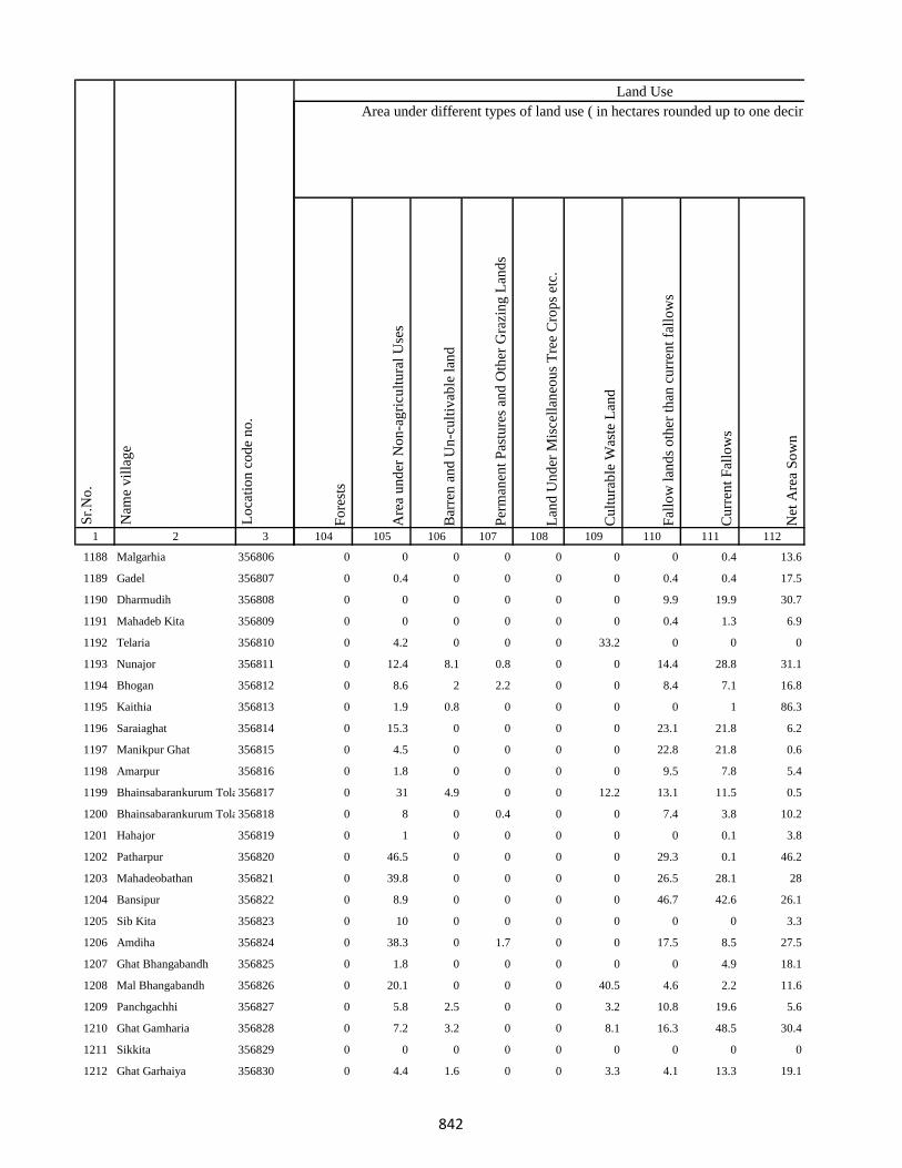
1 2 3
Lo
cati
on
co
de
no
.
Nam
e v
illa
ge
Sr.
No
.
1188 Malgarhia 356806
1189 Gadel 356807
1190 Dharmudih 356808
1191 Mahadeb Kita 356809
1192 Telaria 356810
1193 Nunajor 356811
1194 Bhogan 356812
1195 Kaithia 356813
1196 Saraiaghat 356814
1197 Manikpur Ghat 356815
1198 Amarpur 356816
1199 Bhainsabarankurum Tola356817
1200 Bhainsabarankurum Tola Mal356818
1201 Hahajor 356819
1202 Patharpur 356820
1203 Mahadeobathan 356821
1204 Bansipur 356822
1205 Sib Kita 356823
1206 Amdiha 356824
1207 Ghat Bhangabandh 356825
1208 Mal Bhangabandh 356826
1209 Panchgachhi 356827
1210 Ghat Gamharia 356828
1211 Sikkita 356829
1212 Ghat Garhaiya 356830
Fo
rest
s
Are
a u
nd
er N
on
-ag
ricu
ltu
ral
Use
s
Bar
ren
an
d U
n-c
ult
ivab
le l
and
Per
man
ent
Pas
ture
s an
d O
ther
Gra
zin
g L
and
s
Lan
d U
nd
er M
isce
llan
eou
s T
ree
Cro
ps
etc.
Cu
ltu
rab
le W
aste
Lan
d
Fal
low
lan
ds
oth
er t
han
cu
rren
t fa
llo
ws
Cu
rren
t F
allo
ws
Net
Are
a S
ow
n
104 105 106 107 108 109 110 111 112
Area under different types of land use ( in hectares rounded up to one decimal place)
Land Use
0 0 0 0 0 0 0 0.4 13.6
0 0.4 0 0 0 0 0.4 0.4 17.5
0 0 0 0 0 0 9.9 19.9 30.7
0 0 0 0 0 0 0.4 1.3 6.9
0 4.2 0 0 0 33.2 0 0 0
0 12.4 8.1 0.8 0 0 14.4 28.8 31.1
0 8.6 2 2.2 0 0 8.4 7.1 16.8
0 1.9 0.8 0 0 0 0 1 86.3
0 15.3 0 0 0 0 23.1 21.8 6.2
0 4.5 0 0 0 0 22.8 21.8 0.6
0 1.8 0 0 0 0 9.5 7.8 5.4
0 31 4.9 0 0 12.2 13.1 11.5 0.5
0 8 0 0.4 0 0 7.4 3.8 10.2
0 1 0 0 0 0 0 0.1 3.8
0 46.5 0 0 0 0 29.3 0.1 46.2
0 39.8 0 0 0 0 26.5 28.1 28
0 8.9 0 0 0 0 46.7 42.6 26.1
0 10 0 0 0 0 0 0 3.3
0 38.3 0 1.7 0 0 17.5 8.5 27.5
0 1.8 0 0 0 0 0 4.9 18.1
0 20.1 0 0 0 40.5 4.6 2.2 11.6
0 5.8 2.5 0 0 3.2 10.8 19.6 5.6
0 7.2 3.2 0 0 8.1 16.3 48.5 30.4
0 0 0 0 0 0 0 0 0
0 4.4 1.6 0 0 3.3 4.1 13.3 19.1
842
1 2 3
Lo
cati
on
co
de
no
.
Nam
e v
illa
ge
Sr.
No
.
1213 Raghunath Kita 356831
1214 Gauri Kita 356832
1215 Madhu Chak 356833
1216 Sikkita 356834
1217 Sarawa 356835
1218 Baridih 356836
1219 Gorantia 356837
1220 Baijnathpur 356838
1221 Lohathi 356839
Block T O T A L :
1222 Sonbarsa 356841
1223 Maheshliti 356842
1224 Matihani 356843
1225 Parasbana Urf Bhata Chak356844
1226 Chaura 356845
1227 Sareya 356846
1228 Tardiha 356847
1229 Khurd 356848
1230 Basbhita 356849
1231 Jogidih 356850
1232 Taratikar 356851
1233 Ghatkurwa 356852
1234 Ram Sundariya 356853
Fo
rest
s
Are
a u
nd
er N
on
-ag
ricu
ltu
ral
Use
s
Bar
ren
an
d U
n-c
ult
ivab
le l
and
Per
man
ent
Pas
ture
s an
d O
ther
Gra
zin
g L
and
s
Lan
d U
nd
er M
isce
llan
eou
s T
ree
Cro
ps
etc.
Cu
ltu
rab
le W
aste
Lan
d
Fal
low
lan
ds
oth
er t
han
cu
rren
t fa
llo
ws
Cu
rren
t F
allo
ws
Net
Are
a S
ow
n
104 105 106 107 108 109 110 111 112
Area under different types of land use ( in hectares rounded up to one decimal place)
Land Use
0 1 0 0 0 0 0.8 1.4 18.6
0 0.7 0.2 0 0 0.4 0.4 1.6 13.7
0 4.7 5.6 0 0 3 4.5 1 3.2
0 10 0 0 0 0 0 0 6
0 4.6 1.7 0 0 3.5 8.1 18.6 5.6
0 9.4 3.3 0 0 8.7 8.6 29.7 14.9
0 9.9 4.9 0 0 5.1 6.3 17.9 13
0 11.6 7.4 0 0 9.8 18.7 53 36.5
0 20.6 8.3 9.3 0 13.1 33.3 42.3 19.6
50 1881.1 298.9 201.8 14 788.2 2142 2260.2 8472
0 7.8 0 0 0 0.8 0 0 48.4
0 9.4 0 0 0 8.6 0 0 76.2
0 4.2 0 0 0 3.4 0 0.1 101.5
0 1.8 0 0 0 0 0 0 42.2
0 5.6 0 0 0 0.6 0 0 94.8
0 7.9 0 0 0 3 0 0 92
0 12.6 0 0 0 1.6 0.1 0.8 165.8
0 0.8 0 0 0 0 0 0 30.2
0 2.6 0 0 0 2.4 0 0 64
0 0 0 1 0 0 0 0 66
0 0 0 0 0 1.4 0 0 87.6
0 36.7 0 0 0 6.4 0 0 178.2
0 3.5 0 0 0 1.8 0 0 8.7
843

1 2 3
Lo
cati
on
co
de
no
.
Nam
e v
illa
ge
Sr.
No
.
1235 Taratikar 356854
1236 Siardih 356855
1237 Lakhanpahari 356856
1238 Joginpahari 356857
1239 Jagarnathpur 356858
1240 Lilatari 356859
1241 Kamla Chak 356860
1242 Siardih(Chhit) 356861
1243 Bhanjpur 356862
1244 Barkop 356863
1245 Mirza Chak 356864
1246 Birseni 356865
1247 Siardih 356866
1248 Mirza Chak 356867
1249 Jogi Chak 356868
1250 Amdiha 356869
1251 Babupur 356870
1252 Jamua 356871
1253 Rangatanr 356872
1254 Semariya 356873
1255 Ramgarh 356874
1256 Kamaldiha 356875
1257 Kureri 356876
1258 Pipra 356877
1259 Babupur 356878
Fo
rest
s
Are
a u
nd
er N
on
-ag
ricu
ltu
ral
Use
s
Bar
ren
an
d U
n-c
ult
ivab
le l
and
Per
man
ent
Pas
ture
s an
d O
ther
Gra
zin
g L
and
s
Lan
d U
nd
er M
isce
llan
eou
s T
ree
Cro
ps
etc.
Cu
ltu
rab
le W
aste
Lan
d
Fal
low
lan
ds
oth
er t
han
cu
rren
t fa
llo
ws
Cu
rren
t F
allo
ws
Net
Are
a S
ow
n
104 105 106 107 108 109 110 111 112
Area under different types of land use ( in hectares rounded up to one decimal place)
Land Use
0 0 0 0 0 0 0 0 0
0 31.6 0 0 0 1.1 0 0 250.4
0 12.7 0 0 0 86.1 0 0 110.2
0 10.8 0 0 0 0.5 0 0 17.8
0 6.1 0 0 0 1.2 0 0 42.7
0 5.9 0 0 0 0.8 0 0 14.3
0 1 0 0 0 0 0 0 6
0 0 0 0 0 0 0 0 2.7
0 5.4 0 0 0 0.5 0 0 23.2
0 16.3 0 0 0 0 0 0 53.7
0 6.4 0 0 0 0 0 0 20.6
0 2.2 0 0 0 0.2 0 0 22.5
0 0 0 0 0 0 0 0 0
0 0 0 0 0 0 0 0 0
0 1.6 0 0 0 1.3 0 0 13.1
0 5.4 0 0 0 0.3 0 0 56.3
0 10.8 0 0 0 0.2 0 0 78.9
0 12.8 0 0 0 0 0 0 112.2
0 5.6 0 0 0 3.3 0 0 59
0 8.6 0 0 0 4.1 0 0 122.3
0 3.6 0 0 0 0.2 0 0 8.1
0 5.9 0 0 0 72.8 0 0 34.3
0 5 0 0 0 0 0 0 17
0 0 0 0 0 0 0 0 0
0 0 0 0 0 0 0 0 0
844
1 2 3
Lo
cati
on
co
de
no
.
Nam
e v
illa
ge
Sr.
No
.
1260 Lakarjorimal 356879
1261 Tikabagicha 356880
1262 Gordhoi 356881
1263 Babupur 356882
1264 Nauratan Kita 356883
1265 Gordhoi 356884
1266 Joginpahari 356885
1267 Simariya 356886
1268 Sonar Chak 356887
1269 Duarichak 356888
1270 Tulsi Kita 356889
1271 Chau Chak 356890
1272 Karubandh 356891
1273 Haripur 356892
1274 Chau Chak 356893
1275 Lachhminiyan 356894
1276 Chepi 356895
1277 Kasiyatari 356896
1278 Kita Gardharpur 356897
1279 Lasutiya 356898
1280 Pathargama 356899
1281 Mal Pathargama 356900
1282 Arazi Pathargama 356901
1283 Chandi Chak 356902
1284 Baliya Kita 356903
Fo
rest
s
Are
a u
nd
er N
on
-ag
ricu
ltu
ral
Use
s
Bar
ren
an
d U
n-c
ult
ivab
le l
and
Per
man
ent
Pas
ture
s an
d O
ther
Gra
zin
g L
and
s
Lan
d U
nd
er M
isce
llan
eou
s T
ree
Cro
ps
etc.
Cu
ltu
rab
le W
aste
Lan
d
Fal
low
lan
ds
oth
er t
han
cu
rren
t fa
llo
ws
Cu
rren
t F
allo
ws
Net
Are
a S
ow
n
104 105 106 107 108 109 110 111 112
Area under different types of land use ( in hectares rounded up to one decimal place)
Land Use
0 0.4 0 0 0 0 0 0 6.6
0 0.7 0 0 0 0 0 0 6.3
0 0.9 0 0 0 0.8 0 0 11.3
0 0 0 0 0 0 0 0 0
0 0 0 0 0 0 0 0 2.1
0 0.9 0 0 0 0.8 0 0 25.3
0 0 0 0 0 0 0 0 0
0 0 0 0 0 0 0 0 0
0 1.8 0 0 0 2.5 0 0 83.7
0 0.6 0 0 0 0.6 0 0 26.8
0 26.4 0 0 0 0 0 0 41.6
0 0.7 0 0 0 0 0 0 14.3
0 2.4 0 0 0 0 0 0 9.6
0 1.2 0 0 0 0.4 0 0 38.4
0 0 0 0 0 0 0 0 0
0 0.4 0 0 0 0 0 0 4.6
0 0.6 0 0 0 0 0 0 15.4
0 17.9 0 0 0 0 0 0 101.1
0 0.4 0 0 0 0 0 0 9.6
0 1.8 0 0 0 0 0 0 28.2
0 3.2 0 0 0 0 0 0 58.8
0 0 0 0 0.2 0 0 0 3.8
0 0 0 0 0 0 0 0 1.3
0 0.6 0 0 0 0.2 0 0 12.2
0 0 0 0 0 0.5 0 0 15.5
845

1 2 3
Lo
cati
on
co
de
no
.
Nam
e v
illa
ge
Sr.
No
.
1285 Janki Kita 356904
1286 Sapinmor 356905
1287 Panjarhar 356906
1288 Panjarhar Birit 356907
1289 Karaila Chak 356908
1290 Ambasongram 356909
1291 Mahadeva Kita 356910
1292 Ghandharpur 356911
1293 Kumarsi 356912
1294 Sundarmor 356913
1295 Dandighat 356914
1296 Tengar 356915
1297 Machhitanr 356916
1298 Telni 356917
1299 Kobhara 356918
1300 Chilkara Gobind 356919
1301 Dumarariya 356920
1302 Bareghat 356921
1303 Baredih 356922
1304 Kasturiya 356923
1305 Sukhanand 356924
1306 Jamchir 356925
1307 Kendua 356926
1308 Rampur 356927
1309 Shampur 356928
Fo
rest
s
Are
a u
nd
er N
on
-ag
ricu
ltu
ral
Use
s
Bar
ren
an
d U
n-c
ult
ivab
le l
and
Per
man
ent
Pas
ture
s an
d O
ther
Gra
zin
g L
and
s
Lan
d U
nd
er M
isce
llan
eou
s T
ree
Cro
ps
etc.
Cu
ltu
rab
le W
aste
Lan
d
Fal
low
lan
ds
oth
er t
han
cu
rren
t fa
llo
ws
Cu
rren
t F
allo
ws
Net
Are
a S
ow
n
104 105 106 107 108 109 110 111 112
Area under different types of land use ( in hectares rounded up to one decimal place)
Land Use
0 0.9 0 0 0 0.9 0 0 29.1
0 1.9 0 0 0 0 0 0 9.1
0 2.2 0 0 0 0.9 0 0 35
0 0 0 0 0 0 0 0 1.8
0 0.9 0 0 0 0 0 0 20.1
0 4.8 0 0 0 0 0 0 43.2
0 6 0 0 0 0 0 0 31
0 6.3 0 0 0 0.8 0 0 68.9
0 5.4 0 0 0 0.9 0 0 77.7
0 8.2 0 0 0 0.8 0 0 121
0 0 0 0 0 0.8 0 0 51.2
0 0.3 0 0 0 9.4 0 0 130.4
0 0 0 0 0 4 0 0 118
0 0 0 0 0 3.6 0 0 108.4
0 5 0 0 0 11 0 0 113
0 12.8 0 0 0 0 0 0 184.2
0 12.3 0 0 0 2 0 0 153.7
0 0.2 0 0 0 0 0 0 7.8
0 3 0 0 0 0.3 0 0 39.7
0 18.8 0 0 0 12 0 0 156.2
0 2.9 0 0 0 0.2 0 0 27.9
0 4.5 0 0 0 2.8 0 0 115.8
0 15.1 0 0 0 0.4 0 0 92.5
0 2.6 0 0 0 0 0 0 40.4
0 4.3 0 0 0 0.6 0 0 27.1
846
1 2 3
Lo
cati
on
co
de
no
.
Nam
e v
illa
ge
Sr.
No
.
1310 Barmasiya 356929
1311 Palipaya 356930
1312 Bargama 356931
1313 Manoharpur 356932
1314 Saranda 356933
1315 Boha 356934
1316 Khariani 356935
1317 Barhara 356936
1318 Bhalsumbhiya 356937
1319 Pipra 356938
1320 Bara Bandh 356939
1321 Awratanr 356940
1322 Harkata 356941
1323 Lakhanpahari Chhit 356942
1324 Bhanta Chak Chhota 356943
1325 Khairbani 356944
1326 Masnaha 356945
1327 Siripur 356946
1328 Mohanpur 356947
1329 Kolua 356948
1330 Ghatbaliya 356949
1331 Jalo Kundi 356950
1332 Bhata Chak 356951
1333 Tetariya 356952
1334 Taratikar 356953
Fo
rest
s
Are
a u
nd
er N
on
-ag
ricu
ltu
ral
Use
s
Bar
ren
an
d U
n-c
ult
ivab
le l
and
Per
man
ent
Pas
ture
s an
d O
ther
Gra
zin
g L
and
s
Lan
d U
nd
er M
isce
llan
eou
s T
ree
Cro
ps
etc.
Cu
ltu
rab
le W
aste
Lan
d
Fal
low
lan
ds
oth
er t
han
cu
rren
t fa
llo
ws
Cu
rren
t F
allo
ws
Net
Are
a S
ow
n
104 105 106 107 108 109 110 111 112
Area under different types of land use ( in hectares rounded up to one decimal place)
Land Use
0 15.2 0 0 0 15.1 0 0 98.8
0 1.4 0 0 0 0.2 0 0 16.5
0 12 0 0 0 4.2 0 0 115.8
0 5.8 0 0 0 10.9 0 0 43.3
0 8.8 0 0 0 13 0 0 102.2
0 15.5 0 0 0 8.1 0 0 144.4
0 24.1 0 0 0 10.5 0 0 160.4
0 7.1 0 0 0 5.5 0 0 80.4
0 10 0 0 0 3.6 0 0 159.5
0 38.5 0 0 0 4.5 0 0 390.7
0 12.6 0 0 0 7.1 0 0 135.3
0 1.9 0 0 0 1.9 0 0 25.2
0 57.1 0 0 0 12.1 0 0 111.8
0 0 0 0 0 0 0 0 0
0 5.3 0 0 0 0.8 0 0 29.9
0 37.6 0 0 0 8.1 0 0 118.2
0 5.1 0 0 0 1 0 0 20.9
0 23.9 0 0 0 3.5 0 0 49.6
0 2.7 0 0 0 2 0 0 15.3
0 103.2 0 0 0 10.8 0 0 122.9
0 13.3 0 0 0 1.1 0 0 74.6
0 4.4 0 0 0 3.1 0 0 20.5
0 0 0 0 0 0 0 0 0
0 0.2 0 0 0 0.6 0 0 8.3
0 0 0 0 0 0 0 0 0
847

1 2 3
Lo
cati
on
co
de
no
.
Nam
e v
illa
ge
Sr.
No
.
1335 Bandelwar 356954
1336 Taratikar 356955
1337 Dumariya 356956
1338 Dhobdiha 356957
1339 Beltikri 356958
1340 Belshar 356959
1341 Parua 356960
1342 Biahunpurmal 356961
1343 Arazi Bishunpur 356962
1344 Pakariya 356963
1345 Chamra Koli 356964
1346 Boharna 356965
1347 Rajaun Khurd 356966
1348 Ambabathan 356967
1349 Dhibabandh 356968
1350 Kerbar 356969
1351 Barwarda 356970
1352 Ranipur 356971
1353 Laugai 356972
1354 Gangarampur 356973
1355 Latauna 356974
1356 Chunakothi 356975
1357 Ghutiya 356976
1358 Rajaun Kalan 356977
1359 Bisaha 356978
Fo
rest
s
Are
a u
nd
er N
on
-ag
ricu
ltu
ral
Use
s
Bar
ren
an
d U
n-c
ult
ivab
le l
and
Per
man
ent
Pas
ture
s an
d O
ther
Gra
zin
g L
and
s
Lan
d U
nd
er M
isce
llan
eou
s T
ree
Cro
ps
etc.
Cu
ltu
rab
le W
aste
Lan
d
Fal
low
lan
ds
oth
er t
han
cu
rren
t fa
llo
ws
Cu
rren
t F
allo
ws
Net
Are
a S
ow
n
104 105 106 107 108 109 110 111 112
Area under different types of land use ( in hectares rounded up to one decimal place)
Land Use
0 7.3 0 0 0 2.1 0 0 83.6
0 0 0 0 0 0 0 0 0
0 10.4 0 0 0 1.3 0 0 39.3
0 21.1 0 0 0 7.4 0 0 66.5
0 23.9 0 0 0 3 0 0 59.1
0 14.8 0 0 0 1.9 0 0 49.3
0 48 0 4 25 0 0 0 79
0 5.7 0 0 0 0 0 0 21.3
0 1.2 0 0 0 0 0 0 9.8
0 15.9 0 0 0 2 0 0 71.1
0 0.8 0 0 0 0 0 0 5.2
0 5 4 0 0 10 0 0 5
0 12.6 0 0 0 0 0 0 68.4
0 26.6 0 0 0 3 0 0 170.4
0 25 28 6 5 4.9 0 30 0
0 50 0 4 5 0 0 0 175
0 19.5 0 0 0 2 0 0 64.4
0 13.2 0 0 0 11.5 0 0 45.3
0 48.6 0 0 0 8.7 0 0 123.8
0 20.8 0 0 0 10.3 0 0 95.9
0 9 0 0 7 8 6 70 84
0 2 0 2 3 2 2 19 154
0 18.3 0 0 0 12.1 0 0 123.6
0 68.6 0 0 0 27.8 0 0 114.6
0 70.3 0 0 0 51.6 0 0 341.4
848

1 2 3
Lo
cati
on
co
de
no
.
Nam
e v
illa
ge
Sr.
No
.
1360 Charkaghat 356979
1361 Nimbar 356980
1362 Dighi 356981
1363 Korkaghat 356982
1364 Amad Khani 356983
1365 Raksu Kita 356984
1366 Chakwa 356985
1367 Jasmata 356986
1368 Simariya 356987
1369 Sanatan 356988
1370 Kela Kita 356989
1371 Khasdighi 356990
1372 Toiadih 356991
1373 Ramu Chak 356992
1374 Charkaghat 356993
1375 Garka 356994
1376 Bariyata 356995
1377 Charkaghat 356996
1378 Tabhalpur 356997
1379 Gobindpur 356998
1380 Masudanpur 356999
1381 Bedpur 357000
1382 Bhagwan Chak 357001
1383 Rup Chak 357002
1384 Pathar Kani Mal 357003
Fo
rest
s
Are
a u
nd
er N
on
-ag
ricu
ltu
ral
Use
s
Bar
ren
an
d U
n-c
ult
ivab
le l
and
Per
man
ent
Pas
ture
s an
d O
ther
Gra
zin
g L
and
s
Lan
d U
nd
er M
isce
llan
eou
s T
ree
Cro
ps
etc.
Cu
ltu
rab
le W
aste
Lan
d
Fal
low
lan
ds
oth
er t
han
cu
rren
t fa
llo
ws
Cu
rren
t F
allo
ws
Net
Are
a S
ow
n
104 105 106 107 108 109 110 111 112
Area under different types of land use ( in hectares rounded up to one decimal place)
Land Use
0 0 0 0 0 0 0 0 0
0 7.5 0 7.5 7 75 0 5 15
0 8 5 0 0 10 0 0 139
0 28.9 0 0 0 4.2 0 0 89.9
0 1.6 0 0 0 0 0 0 20.4
0 0 0 0 0 0 0 0 9.6
0 55.8 0 0 0 0.2 0 0 45
0 1.6 0 0 0 0 0 0 41.4
0 6.5 0 1.5 0 70 0 0 48
0 40.3 39.4 0 0 10 0 8 29.7
0 0 0 0 0 0 0 0 2.4
0 4.9 0 0 0 11 0 0 23.1
0 0 0 0 0 0.2 0 0 4.8
0 2.7 0 0 0 4.2 0 0 27.1
0 0 0 0.1 1 75 0 0 54.9
0 0 0 0 0.5 0 0 0 19.5
0 9.1 0 0 0 1.4 0 0 27.4
0 0 0 0 0 0 0 0 26.8
0 0 0 0 1 0 0 0 45
0 0 0 0 0 0 0 0 45
0 0.1 0 0 0 0.6 0 0 12.3
0 8.6 0 0 0 0 0 0 18.4
0 33.4 0 0 0 11.2 0 0 80.4
0 21.9 0 0 0 5.9 0 0 53.1
0 49.4 0 0 0 14.5 0 0 85.1
849
1 2 3
Lo
cati
on
co
de
no
.
Nam
e v
illa
ge
Sr.
No
.
1385 Pathar Kani Ghat 357004
1386 Chilra 357005
1387 Chainpur 357006
1388 Ghat Rampur 357007
1389 Mal Rampur 357008
1390 Mal Nistara 357009
1391 Ghat Nistara 357010
1392 Ghat Gasti 357011
1393 Mahuakol 357012
1394 Mahuasol 357013
1395 Sighai Mal 357014
1396 Singhi Ghat 357015
1397 Jogiya 357016
1398 Khaira 357017
1399 Jamjori 357018
1400 Gangtamal Chhit 357019
1401 Jokela 357020
1402 Dhangri Mal 357021
1403 Dhangdri Ghat 357022
1404 Ghangri Mal 357023
1405 Basbhita Ghat 357024
1406 Basbhita Mal 357025
1407 Ranipur Dumariya 357026
1408 Gangta Kalan 357027
1409 Jokela Mal 357028
Fo
rest
s
Are
a u
nd
er N
on
-ag
ricu
ltu
ral
Use
s
Bar
ren
an
d U
n-c
ult
ivab
le l
and
Per
man
ent
Pas
ture
s an
d O
ther
Gra
zin
g L
and
s
Lan
d U
nd
er M
isce
llan
eou
s T
ree
Cro
ps
etc.
Cu
ltu
rab
le W
aste
Lan
d
Fal
low
lan
ds
oth
er t
han
cu
rren
t fa
llo
ws
Cu
rren
t F
allo
ws
Net
Are
a S
ow
n
104 105 106 107 108 109 110 111 112
Area under different types of land use ( in hectares rounded up to one decimal place)
Land Use
0 1.8 0 0 0 0 0 0 13.2
0 21.2 0 0 0 11.7 0 0 115.1
0 28.8 0 0 0 3.7 0 0 64.5
0 0.6 0 0 0 29.8 178.6 0 24.5
0 22.5 0 0 0 5.4 0 0 35.2
0 18.7 0 0 0 1.3 0 0 24.1
0 7 0 0 0 6 0 0 42
0 4.4 0 0 0 0 0 0 12.6
0 2.1 0 0 0 0 0 0 21.9
0 24 0 0 0 5.8 0 0 42.2
0 5 0 0 0 9.8 0 0 72.2
0 2 0 0 0 5.9 0 0 60.2
0 4.2 0 0 0 24.2 0 0 9.6
0 21 0 0 0 0 0 0 137
0 13.1 0 0 0 6.4 0 0 104.5
0 0 0 0 0 0 0 0 0
0 9 0 0 0 3.6 0 0 59.4
0 7.5 0 0 0 0 0 0 54.5
0 1.8 0 0 0 0 0 0 18.2
0 0 0 0 0 0 0 0 0
0 1.8 0 0 0 0 0 0 6.2
0 15.2 0 0 0 0.6 0 0 112.3
0 9 2 0 2 3 0 0 87
0 17 0 0 0 25 0 0 5
0 7.8 0 0 0 0 0 0 67.2
850
1 2 3
Lo
cati
on
co
de
no
.
Nam
e v
illa
ge
Sr.
No
.
1410 Kerwar Ghat 357029
1411 Gangta Mal Chhit 357030
1412 Lautana 357031
1413 Mahuatanr 357032
1414 Kerwar 357033
1415 Ranipur Dumariya 357034
1416 Badalpur 357035
1417 Tetuliya 357036
1418 Paraspani 357037
1419 Daharlangi 357038
Block T O T A L :
1420 Gorgawan 357039
1421 Koriana 357040
1422 Arazi Koriana 357041
1423 Raha 357042
1424 Bade 357043
1425 Maheshtikri 357044
1426 Arazi Maheshtikri 357045
1427 Majar Khurd 357046
1428 Arazi Majar Buzurg 357047
1429 Manjar Buzurg 357048
1430 Arazi Dhapra 357049
1431 Dhapra Kita 357050
Fo
rest
s
Are
a u
nd
er N
on
-ag
ricu
ltu
ral
Use
s
Bar
ren
an
d U
n-c
ult
ivab
le l
and
Per
man
ent
Pas
ture
s an
d O
ther
Gra
zin
g L
and
s
Lan
d U
nd
er M
isce
llan
eou
s T
ree
Cro
ps
etc.
Cu
ltu
rab
le W
aste
Lan
d
Fal
low
lan
ds
oth
er t
han
cu
rren
t fa
llo
ws
Cu
rren
t F
allo
ws
Net
Are
a S
ow
n
104 105 106 107 108 109 110 111 112
Area under different types of land use ( in hectares rounded up to one decimal place)
Land Use
0 1.1 0 0 0 0 0 0 4.9
0 0 0 0 0 0 0 0 0
0 35.2 0 0 0 9.4 0 0 188.3
0 0 0 0 0 0 0 0 0
0 22.4 0 0 0 11 0 0 227.7
0 7.2 0 0 0 0 0 0 22.8
0 1.3 0 0 0 7.8 0 0 125.9
0 0 0 0 0 17.5 0.4 24.9 200.2
0 1 39 0 0 26.2 0 0 400.2
0 2 0 2 0 2 0 3 148
0 1970.2 117.4 28.1 56.7 1066.6 187.1 160.8 12005
0 6 0 0 0 5.1 0 0 73.9
0 14 0 0 0 22.5 0 0 157.5
0 0 0 0 0 2.1 0 0 0
0 18.2 0 0 0 9.2 0 0 185.6
0 1.2 0 0 0 1.8 0 0 27
0 2.1 0 0 0 9.6 0 0 92.3
0 0 0 0 0 2.2 0 0 0
0 4.7 0 0 0 1.5 0 0 38.7
0 0 0 0 0 0 0 0 2.4
0 4.2 0 0 0 1.7 0 0 114.2
0 0 0 0 0 0 0 0 1.5
0 0 0 0 0 0 0 0 1.8
851
1 2 3
Lo
cati
on
co
de
no
.
Nam
e v
illa
ge
Sr.
No
.
1432 Dhapra 357051
1433 Sahoro 357052
1434 Bhatta 357053
1435 Rupni 357054
1436 Parsiya 357055
1437 Kewan 357056
1438 Parbatta 357057
1439 Ransi 357058
1440 Beldiha 357059
1441 Bishundas Chak 357060
1442 Kharauni Jagarnathpur 357061
1443 Chengai 357062
1444 Chengai Kita 357063
1445 Ghat Lachhimipur 357064
1446 Kharauni Jagarnathpur 357065
1447 Nakta 357066
1448 Hafta Kitaghat 357067
1449 Mahadew Kita 357068
1450 Kakelachaur 357069
1451 Pindar Kita 357070
1452 Arazi Kaithiya 357071
1453 Kaithiya 357072
1454 Amarpur 357073
1455 Baniyadih 357074
1456 Kita Baniyadih 357075
Fo
rest
s
Are
a u
nd
er N
on
-ag
ricu
ltu
ral
Use
s
Bar
ren
an
d U
n-c
ult
ivab
le l
and
Per
man
ent
Pas
ture
s an
d O
ther
Gra
zin
g L
and
s
Lan
d U
nd
er M
isce
llan
eou
s T
ree
Cro
ps
etc.
Cu
ltu
rab
le W
aste
Lan
d
Fal
low
lan
ds
oth
er t
han
cu
rren
t fa
llo
ws
Cu
rren
t F
allo
ws
Net
Are
a S
ow
n
104 105 106 107 108 109 110 111 112
Area under different types of land use ( in hectares rounded up to one decimal place)
Land Use
0 11 0 5 1.1 3 2 1.2 92.6
0 2.5 0 0 0 80.1 0 0 23.4
0 5.3 0 0 0 103.6 0 0 9.1
0 0 0 30 10 0 0 0 78
0 5 0 10 5 0 0 1 81
0 3.1 0 0 0 2.6 0 0 119.3
0 3.2 0 0 0 2.7 0 0 29
0 15 0 0 0 12.7 0 0 85.4
0 21.3 3.1 1.1 5 30.3 1.1 0.6 66.4
0 5 2.1 0 0.5 0 5 43.2 45.1
0 0 0 0 0 0 0 0 0
0 3.1 1.1 0.5 1.1 0.6 50.1 14.1 18.3
0 0 0 0 0 1 0 0 3
0 0 0 0 0 0 0 0 108
0 4.4 0 0 0 6.4 0 0 32.2
0 2.6 0 0 0 10.2 0 0 32.2
0 0 0 0 0 0 0 0 6.4
0 1.5 0 0 0 2.2 0 0 39.3
0 0 0 0 0 0 0 0 10.2
0 0 0 0 0 0 0 0 5.6
0 0.4 0 0 0 0.6 0 0 6
0 19.3 0 0 0 12.3 0 0 114.4
0 3.4 0 0 0 8.6 0 0 98
0 13 0 0 0 1 0 0 99
0 1.2 0 0 0 0 0 0 9.8
852

1 2 3
Lo
cati
on
co
de
no
.
Nam
e v
illa
ge
Sr.
No
.
1457 Gouri Kita 357076
1458 Gopi Chak 357077
1459 Piprachaur 357078
1460 Chaurgonar Kita 357079
1461 Shahpur 357080
1462 Sarkunda Kita 357081
1463 Nimuha 357082
1464 Medni Chak 357083
1465 Kadma 357084
1466 Jagatpur 357085
1467 Mansha Bishunpur 357086
1468 Lalman Kita 357087
1469 Kita Kendua 357088
1470 Sankhi 357089
1471 Mokal Chak 357090
1472 Aichamor 357091
1473 Lotha 357092
1474 Jhapaniya 357093
1475 Majra Kol 357094
1476 Bisambhar Chak 357095
1477 Kolhadda 357096
1478 Basantpur 357097
1479 Basan Sarai Gadal 357098
1480 Basantrai 357099
1481 Sankhi Khurd 357100
Fo
rest
s
Are
a u
nd
er N
on
-ag
ricu
ltu
ral
Use
s
Bar
ren
an
d U
n-c
ult
ivab
le l
and
Per
man
ent
Pas
ture
s an
d O
ther
Gra
zin
g L
and
s
Lan
d U
nd
er M
isce
llan
eou
s T
ree
Cro
ps
etc.
Cu
ltu
rab
le W
aste
Lan
d
Fal
low
lan
ds
oth
er t
han
cu
rren
t fa
llo
ws
Cu
rren
t F
allo
ws
Net
Are
a S
ow
n
104 105 106 107 108 109 110 111 112
Area under different types of land use ( in hectares rounded up to one decimal place)
Land Use
0 2.6 0 3.4 0 3.2 0 0 125.9
0 1.1 3.2 0 0.2 17.1 1 0.1 28.3
0 0 0 0 0 0 0 0 5
0 0 0 0 0 0 0 0 3.9
0 2.5 0 0 0 0 0 1 102.5
0 1.6 0 0 0 0 0 0 8.4
0 6.1 7.8 0 0 0 0 0 163.1
0 21.3 0 0 0 10.2 0 0 286
0 13.6 0 0 0 3.2 0 0 172.2
0 5.9 179 0.1 0 0.8 0 0 0
0 2.2 0 0 0 0.4 0 0 67.4
0 2.9 0 0 0 2.2 0 0 22.9
0 2.8 0 0 0 12.5 0 0 48.7
0 30.6 0 0 0 0 0 0 0
0 4.2 0 1.2 0 1.2 2.8 2 43.7
0 0 0 1 0 4.4 4.2 4.4 14.1
0 0 5 5 0 0 0 5 80.1
0 16.5 0 2 51.5 0 0.5 0.5 0
0 0 0 0 0 0 0 0 18.3
0 4.1 0 0 0 2.1 0 0 84.8
0 0 0 0 10 0 0 0 81
0 0 0 0 10 0 0 0 11
0 0 0 0 0 7.8 0 0 27.2
0 16.8 0 0 0 0 0 0 0
0 10 0 0 0 6 0 0 59
853
1 2 3
Lo
cati
on
co
de
no
.
Nam
e v
illa
ge
Sr.
No
.
1482 Bela Kita 357101
1483 Baskhoriya 357102
1484 Baghakol 357103
1485 Harganman 357104
1486 Kola Kita 357105
1487 Kaithpura 357106
1488 Lochni 357107
1489 Pachua Kita 357108
1490 Sanaur 357109
1491 Gathaur 357110
1492 Derma 357111
1493 Deshbarag 357112
1494 Chutiyan 357113
1495 Rampur 357114
1496 Rampur Mokarri 357115
1497 Rampur Arazi 357116
1498 Gobindpur Kita 357117
1499 Shampur Gobindpur 357118
1500 Shampur 357119
1501 Kapeta 357120
1502 Karu Chak 357121
1503 Pakariya 357122
1504 Arazi Pakariya 357123
1505 Jadu Chak 357124
1506 Paradharichak 357125
Fo
rest
s
Are
a u
nd
er N
on
-ag
ricu
ltu
ral
Use
s
Bar
ren
an
d U
n-c
ult
ivab
le l
and
Per
man
ent
Pas
ture
s an
d O
ther
Gra
zin
g L
and
s
Lan
d U
nd
er M
isce
llan
eou
s T
ree
Cro
ps
etc.
Cu
ltu
rab
le W
aste
Lan
d
Fal
low
lan
ds
oth
er t
han
cu
rren
t fa
llo
ws
Cu
rren
t F
allo
ws
Net
Are
a S
ow
n
104 105 106 107 108 109 110 111 112
Area under different types of land use ( in hectares rounded up to one decimal place)
Land Use
0 3.2 0 0 0 2.7 0 0 43
0 2.1 0 0 0 0.5 0 0 59.4
0 0 0 0 0 0 0 0 127
0 0 0 0 0 0 0 0 73
0 7 0 0 0 0 0 0 26
0 10.2 0 0 0 0.9 0 0 118.9
0 6.5 0 0 0 4.1 0 0 139.3
0 40 0 0 0 0 0 0 0
0 39.7 0 0 0 5.3 0 0 129
0 0 0 0 0 0 0 0 2.7
0 19.1 0 0 0 4 0 0 145.8
0 17.6 0 0 0 7.3 0 0 79.2
0 3 0 0 0 0.8 0 0 27.2
0 1.1 0 0 0 6.6 0 0 96.3
0 0 0 0 0 0 0 0 12.3
0 0 0 0 0 0 0 0 4.6
0 0.6 0 0 0 0 0 0 41.4
0 5 0 0 0 0 0 0 22
0 11 0 0 0 0.4 0 0 50.6
0 9.7 0 0 0 3.2 0 0 173.1
0 2.1 0 0 0 0 0 0 8.9
0 90.2 0 0 0 3.6 0 0 19.2
0 1.7 0 0 0 0 0 0 9.3
0 5.8 0 0 0 14.6 0 0 12.5
0 0 0 0 0 3.6 0 0 8.4
854
1 2 3
Lo
cati
on
co
de
no
.
Nam
e v
illa
ge
Sr.
No
.
1507 Jamnikola 357126
1508 Kapra Chak 357127
1509 Surai Kita 357128
1510 Kumhrakol 357129
1511 Banshipur 357130
1512 Bajpai 357131
1513 Resamba 357132
1514 Bhira 357133
1515 Barhampur 357134
1516 Bodra 357135
1517 Susti 357136
1518 Barhaiya 357137
1519 Maheshpur 357138
1520 Hilawa 357139
1521 Chanai Chak 357140
1522 Urkusiya 357141
1523 Arazi Kharti 357142
1524 Kharti 357143
1525 Barhara 357144
1526 Amarpur Ghal 357145
1527 Surniya Ghat Mal 357146
1528 Surniya Mal Ghat 357147
1529 Tofil Surniya 357148
1530 Arazi Surniya Ghat 357149
1531 Phulwariya 357150
Fo
rest
s
Are
a u
nd
er N
on
-ag
ricu
ltu
ral
Use
s
Bar
ren
an
d U
n-c
ult
ivab
le l
and
Per
man
ent
Pas
ture
s an
d O
ther
Gra
zin
g L
and
s
Lan
d U
nd
er M
isce
llan
eou
s T
ree
Cro
ps
etc.
Cu
ltu
rab
le W
aste
Lan
d
Fal
low
lan
ds
oth
er t
han
cu
rren
t fa
llo
ws
Cu
rren
t F
allo
ws
Net
Are
a S
ow
n
104 105 106 107 108 109 110 111 112
Area under different types of land use ( in hectares rounded up to one decimal place)
Land Use
0 16.6 0 22.9 22 3.4 0 0 149.1
0 0 0 0 0 0 0 0 12
0 2.5 0 0 0 0.9 0 0 34.6
0 0 0 0 0 0 0.6 0.3 127.4
0 10 23.1 21.3 1.2 3 0 40 25.4
0 10 22.3 5 2 0.5 2.5 20 42.7
0 26.1 0 0 0 8.2 0 0 99.7
0 1.4 0 0 0 0 0 0 30.6
0 11.5 0 0 0 2.9 0 0 76.6
0 0 0 0 0 100 0 0 176
0 8.6 0 0 0 2 0 0 87.4
0 0 0 0 0 0 0 0 62
0 0 0 0 0 100 0 0 63
0 70 0 5 5 0 0 0 84
0 0 0 1 5 0 0 0 107
0 0.1 0 0 0 1 0 0 26.9
0 0 0 0 0 0 0 0 10.2
0 1.1 0 0 0 1.4 0 0 106.5
0 0 0 10 5 10 5 0 16
0 0 20 0 0 0 0 0.5 81.5
0 6.2 0 0 0 3.2 0 0 46.5
0 4.5 0 0 0 3 0 0 24.5
0 2.5 0 0 0 0.8 0 0 30.6
0 0 0 0 0 0 0 0 0
0 9.1 5 3 2 8.2 4.7 3 56
855
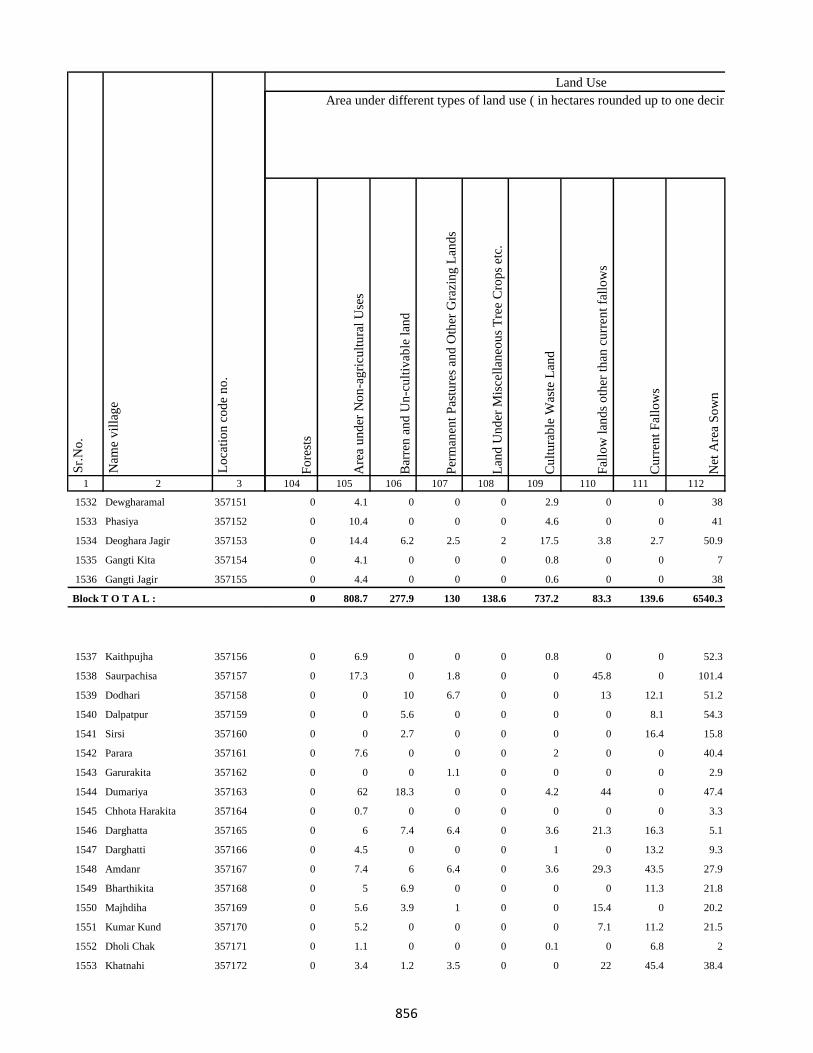
1 2 3
Lo
cati
on
co
de
no
.
Nam
e v
illa
ge
Sr.
No
.
1532 Dewgharamal 357151
1533 Phasiya 357152
1534 Deoghara Jagir 357153
1535 Gangti Kita 357154
1536 Gangti Jagir 357155
Block T O T A L :
1537 Kaithpujha 357156
1538 Saurpachisa 357157
1539 Dodhari 357158
1540 Dalpatpur 357159
1541 Sirsi 357160
1542 Parara 357161
1543 Garurakita 357162
1544 Dumariya 357163
1545 Chhota Harakita 357164
1546 Darghatta 357165
1547 Darghatti 357166
1548 Amdanr 357167
1549 Bharthikita 357168
1550 Majhdiha 357169
1551 Kumar Kund 357170
1552 Dholi Chak 357171
1553 Khatnahi 357172
Fo
rest
s
Are
a u
nd
er N
on
-ag
ricu
ltu
ral
Use
s
Bar
ren
an
d U
n-c
ult
ivab
le l
and
Per
man
ent
Pas
ture
s an
d O
ther
Gra
zin
g L
and
s
Lan
d U
nd
er M
isce
llan
eou
s T
ree
Cro
ps
etc.
Cu
ltu
rab
le W
aste
Lan
d
Fal
low
lan
ds
oth
er t
han
cu
rren
t fa
llo
ws
Cu
rren
t F
allo
ws
Net
Are
a S
ow
n
104 105 106 107 108 109 110 111 112
Area under different types of land use ( in hectares rounded up to one decimal place)
Land Use
0 4.1 0 0 0 2.9 0 0 38
0 10.4 0 0 0 4.6 0 0 41
0 14.4 6.2 2.5 2 17.5 3.8 2.7 50.9
0 4.1 0 0 0 0.8 0 0 7
0 4.4 0 0 0 0.6 0 0 38
0 808.7 277.9 130 138.6 737.2 83.3 139.6 6540.3
0 6.9 0 0 0 0.8 0 0 52.3
0 17.3 0 1.8 0 0 45.8 0 101.4
0 0 10 6.7 0 0 13 12.1 51.2
0 0 5.6 0 0 0 0 8.1 54.3
0 0 2.7 0 0 0 0 16.4 15.8
0 7.6 0 0 0 2 0 0 40.4
0 0 0 1.1 0 0 0 0 2.9
0 62 18.3 0 0 4.2 44 0 47.4
0 0.7 0 0 0 0 0 0 3.3
0 6 7.4 6.4 0 3.6 21.3 16.3 5.1
0 4.5 0 0 0 1 0 13.2 9.3
0 7.4 6 6.4 0 3.6 29.3 43.5 27.9
0 5 6.9 0 0 0 0 11.3 21.8
0 5.6 3.9 1 0 0 15.4 0 20.2
0 5.2 0 0 0 0 7.1 11.2 21.5
0 1.1 0 0 0 0.1 0 6.8 2
0 3.4 1.2 3.5 0 0 22 45.4 38.4
856

1 2 3
Lo
cati
on
co
de
no
.
Nam
e v
illa
ge
Sr.
No
.
1554 Baijnathpur 357173
1555 Amlo 357174
1556 Bohoriya 357175
1557 Bokha 357176
1558 Gangta Phasiya 357177
1559 Malipalgajia 357178
1560 Kusmara 357179
1561 Dusadhi Kola 357180
1562 Maldiha 357181
1563 Simariya 357182
1564 Motia 357183
1565 Rampur 357184
1566 Jharkata 357185
1567 Patwa 357186
1568 Gangta 357187
1569 Barachaur 357188
1570 Karikado 357189
1571 Nayabad 357190
1572 Lachhanpur 357191
1573 Susunia 357192
1574 Tabalpur 357193
1575 Sikatia 357194
1576 Lohbandha 357195
1577 Tuka 357196
1578 Ramla Santali 357197
Fo
rest
s
Are
a u
nd
er N
on
-ag
ricu
ltu
ral
Use
s
Bar
ren
an
d U
n-c
ult
ivab
le l
and
Per
man
ent
Pas
ture
s an
d O
ther
Gra
zin
g L
and
s
Lan
d U
nd
er M
isce
llan
eou
s T
ree
Cro
ps
etc.
Cu
ltu
rab
le W
aste
Lan
d
Fal
low
lan
ds
oth
er t
han
cu
rren
t fa
llo
ws
Cu
rren
t F
allo
ws
Net
Are
a S
ow
n
104 105 106 107 108 109 110 111 112
Area under different types of land use ( in hectares rounded up to one decimal place)
Land Use
0 27.4 0 0 0 4.3 0 0 31.3
0 90.9 10.1 4.1 3.2 77 16.4 1 21.3
0 9.7 0 0 0 10.2 0 0.5 118.5
0 18.3 11.5 0 0 0 1.2 0.9 67.1
0 0 6 0 0 1.2 3.7 1.3 94.8
0 9.1 10.1 0.8 5 22.6 1.7 2.5 135.2
0 0.5 0 0 0 8.8 0 0 29.7
0 2 4.1 0 0 0 0 2 4.6
0 17.6 0 0 0 9 0 0 44.4
0 6.8 0 0.1 0 16 0 12.4 1.8
0 24.4 0 0 0 2.5 0 0 499.6
0 12 0 11.4 0 4 11.2 16.1 0.2
0 5.1 0 0 0 2.4 0 0 24.4
0 0 0.2 0.3 1 2 1 0 68.5
0 1.4 4.1 8.4 1.3 136.8 1.8 0 18.2
0 1 1 0 1 0 0 2 0
0 17.9 0 0 0 0 0 0 90
0 20.8 13.3 2 2 10.5 1 2 29.3
0 6.8 0 0 0 7.2 0 0 26
0 3 0 0 0 18 0 0 35
0 5 0 0 0 4 0 0 34
0 16.8 11.4 0 0 8.4 8 18 46.4
0 33.4 0 0 0 14.3 0 0 245.3
0 20.2 7.2 10 0 0 35.2 24.4 49
0 41 2.1 0 0 0 0 23.5 71.4
857
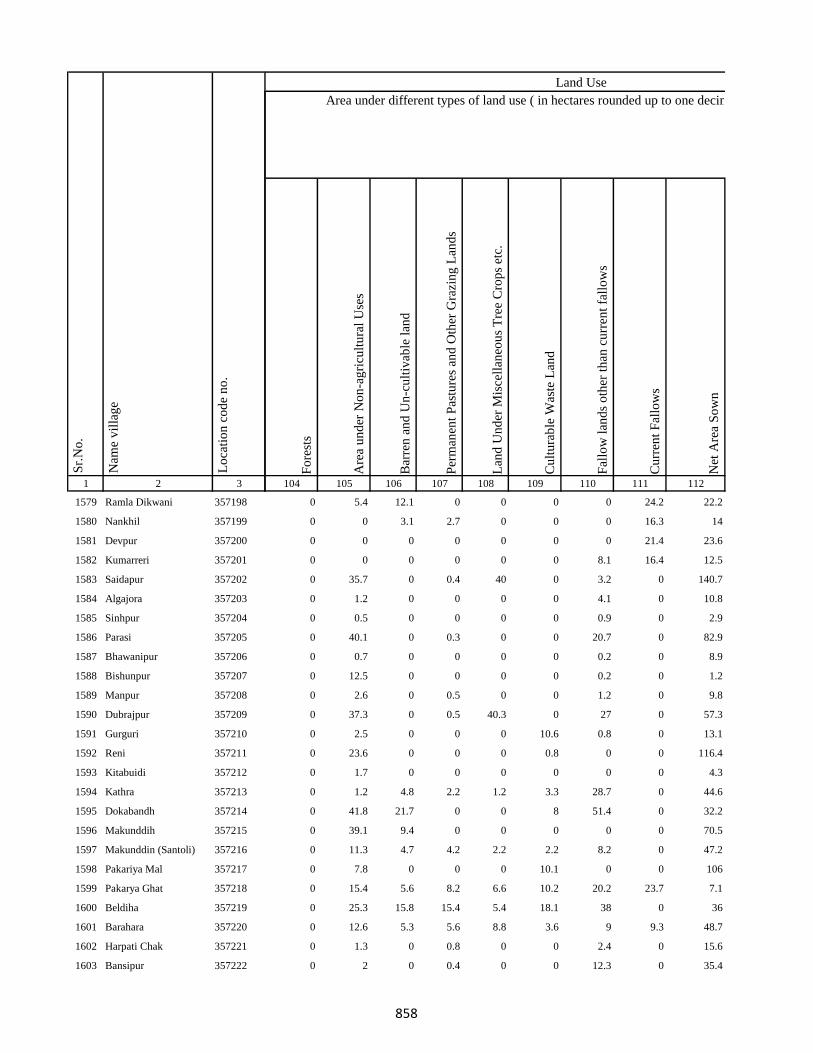
1 2 3
Lo
cati
on
co
de
no
.
Nam
e v
illa
ge
Sr.
No
.
1579 Ramla Dikwani 357198
1580 Nankhil 357199
1581 Devpur 357200
1582 Kumarreri 357201
1583 Saidapur 357202
1584 Algajora 357203
1585 Sinhpur 357204
1586 Parasi 357205
1587 Bhawanipur 357206
1588 Bishunpur 357207
1589 Manpur 357208
1590 Dubrajpur 357209
1591 Gurguri 357210
1592 Reni 357211
1593 Kitabuidi 357212
1594 Kathra 357213
1595 Dokabandh 357214
1596 Makunddih 357215
1597 Makunddin (Santoli) 357216
1598 Pakariya Mal 357217
1599 Pakarya Ghat 357218
1600 Beldiha 357219
1601 Barahara 357220
1602 Harpati Chak 357221
1603 Bansipur 357222
Fo
rest
s
Are
a u
nd
er N
on
-ag
ricu
ltu
ral
Use
s
Bar
ren
an
d U
n-c
ult
ivab
le l
and
Per
man
ent
Pas
ture
s an
d O
ther
Gra
zin
g L
and
s
Lan
d U
nd
er M
isce
llan
eou
s T
ree
Cro
ps
etc.
Cu
ltu
rab
le W
aste
Lan
d
Fal
low
lan
ds
oth
er t
han
cu
rren
t fa
llo
ws
Cu
rren
t F
allo
ws
Net
Are
a S
ow
n
104 105 106 107 108 109 110 111 112
Area under different types of land use ( in hectares rounded up to one decimal place)
Land Use
0 5.4 12.1 0 0 0 0 24.2 22.2
0 0 3.1 2.7 0 0 0 16.3 14
0 0 0 0 0 0 0 21.4 23.6
0 0 0 0 0 0 8.1 16.4 12.5
0 35.7 0 0.4 40 0 3.2 0 140.7
0 1.2 0 0 0 0 4.1 0 10.8
0 0.5 0 0 0 0 0.9 0 2.9
0 40.1 0 0.3 0 0 20.7 0 82.9
0 0.7 0 0 0 0 0.2 0 8.9
0 12.5 0 0 0 0 0.2 0 1.2
0 2.6 0 0.5 0 0 1.2 0 9.8
0 37.3 0 0.5 40.3 0 27 0 57.3
0 2.5 0 0 0 10.6 0.8 0 13.1
0 23.6 0 0 0 0.8 0 0 116.4
0 1.7 0 0 0 0 0 0 4.3
0 1.2 4.8 2.2 1.2 3.3 28.7 0 44.6
0 41.8 21.7 0 0 8 51.4 0 32.2
0 39.1 9.4 0 0 0 0 0 70.5
0 11.3 4.7 4.2 2.2 2.2 8.2 0 47.2
0 7.8 0 0 0 10.1 0 0 106
0 15.4 5.6 8.2 6.6 10.2 20.2 23.7 7.1
0 25.3 15.8 15.4 5.4 18.1 38 0 36
0 12.6 5.3 5.6 8.8 3.6 9 9.3 48.7
0 1.3 0 0.8 0 0 2.4 0 15.6
0 2 0 0.4 0 0 12.3 0 35.4
858
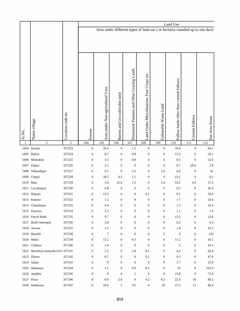
1 2 3
Lo
cati
on
co
de
no
.
Nam
e v
illa
ge
Sr.
No
.
1604 Kurma 357223
1605 Baliya 357224
1606 Molnakita 357225
1607 Patpur 357226
1608 Nilkanthpur 357227
1609 Chapri 357228
1610 Bara 357229
1611 Lacchmipur 357230
1612 Nepura 357231
1613 Kakana 357232
1614 Chandarpur 357233
1615 Parariya 357234
1616 Panch Kathi 357235
1617 Burhi Salempur 357236
1618 Arwara 357237
1619 Basarhi 357238
1620 Malni 357239
1621 Chakwa 357240
1622 Machhiya Samarda Urf Lalpur357241
1623 Diyara 357242
1624 Jaipur 357243
1625 Barhauna 357244
1626 Amdiha 357245
1627 Parsa 357246
1628 Kanhwara 357247
Fo
rest
s
Are
a u
nd
er N
on
-ag
ricu
ltu
ral
Use
s
Bar
ren
an
d U
n-c
ult
ivab
le l
and
Per
man
ent
Pas
ture
s an
d O
ther
Gra
zin
g L
and
s
Lan
d U
nd
er M
isce
llan
eou
s T
ree
Cro
ps
etc.
Cu
ltu
rab
le W
aste
Lan
d
Fal
low
lan
ds
oth
er t
han
cu
rren
t fa
llo
ws
Cu
rren
t F
allo
ws
Net
Are
a S
ow
n
104 105 106 107 108 109 110 111 112
Area under different types of land use ( in hectares rounded up to one decimal place)
Land Use
0 20.5 0 1.2 0 0 10.6 0 64.1
0 8.7 0 0.8 0 0 13.3 0 20.1
0 3.5 0 0.8 4 0 0.5 0 52.6
0 2.1 0 0 0 0 0.7 20.4 2.8
0 9.1 0 1.5 0 2.9 6.6 0 41
0 34.5 0.1 1.1 0 0 23.1 0 8.2
0 3.6 22.6 1.3 0 2.4 55.2 4.3 15.5
0 0.8 0 0 0 0 0.5 0 36.3
0 15.3 0 0 4.1 0 9.1 0 56.4
0 1.5 0 0 0 0 1.7 0 24.4
0 0.4 0 0 0 0 1.3 0 25.4
0 3.3 0 0 0 0 1.1 0 1.4
0 9.7 0 0 0 0 13.5 0 13.6
0 2.8 0 0 0 0 0.2 0 9.3
0 2.5 0 0 0 0 1.4 0 10.3
0 7 0 0 0 3 0 0 124
0 12.2 0 0.3 0 0 11.2 0 16.1
0 1.4 0 0 0 0 2 0 43.5
0 2.5 0 2.8 8.1 0 4.2 0 63.4
0 0.7 0 0 6.1 0 9.3 0 47.9
0 0 0 0 0 0 1.7 0 23.9
0 1.1 0 0.9 8.1 0 33 0 161.9
0 0 0 1 0 0 13.8 0 71.9
0 6.9 2.8 0 4.2 8.3 22.4 10 84.2
0 20.6 5 4.5 4 10 27.5 11 86.4
859
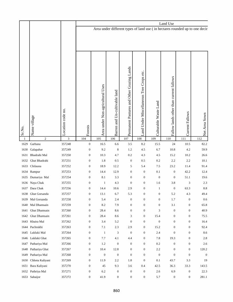
1 2 3
Lo
cati
on
co
de
no
.
Nam
e v
illa
ge
Sr.
No
.
1629 Garbana 357248
1630 Galapahar 357249
1631 Bhadrahi Mal 357250
1632 Ghat Bhadrahi 357251
1633 Chilauna 357252
1634 Rampur 357253
1635 Dumariya Mal 357254
1636 Naya Chak 357255
1637 Dara Chak 357256
1638 Ghat Gorsanda 357257
1639 Mal Gorsanda 357258
1640 Mal Dhamsain 357259
1641 Ghat Dhamsain 357260
1642 Ghat Dhamsain 357261
1643 Khaira Mal 357262
1644 Pachrukhi 357263
1645 Lukluki Mal 357264
1646 Lukluki Ghat 357265
1647 Pathariya Mal 357266
1648 Pathariya Ghat 357267
1649 Pathariya Mal 357268
1650 Chhota Kaliyani 357269
1651 Bara Kaliyani 357270
1652 Pathriya Mal 357271
1653 Sabaijor 357272
Fo
rest
s
Are
a u
nd
er N
on
-ag
ricu
ltu
ral
Use
s
Bar
ren
an
d U
n-c
ult
ivab
le l
and
Per
man
ent
Pas
ture
s an
d O
ther
Gra
zin
g L
and
s
Lan
d U
nd
er M
isce
llan
eou
s T
ree
Cro
ps
etc.
Cu
ltu
rab
le W
aste
Lan
d
Fal
low
lan
ds
oth
er t
han
cu
rren
t fa
llo
ws
Cu
rren
t F
allo
ws
Net
Are
a S
ow
n
104 105 106 107 108 109 110 111 112
Area under different types of land use ( in hectares rounded up to one decimal place)
Land Use
0 16.5 6.6 3.5 8.2 15.5 24 10.5 82.2
0 9.2 8 1.2 4.5 6.7 10.8 4.2 59.9
0 10.3 4.7 0.2 4.3 4.5 15.2 10.2 26.6
0 1.8 0.5 0 0.5 0.2 2.2 2.2 10.1
0 18.9 12.2 5 5.4 7.5 23.2 11.4 91.4
0 14.4 12.9 0 0 0.1 0 42.2 12.4
0 8.1 3.3 0 0 0 0 51.1 19.6
0 1 4.3 0 0 1.6 3.8 3 2.3
0 14.4 10.6 2.9 0 1 0 63.3 8.8
0 13.1 6.7 5.3 0 0 5.2 4.3 49.4
0 5.4 2.4 0 0 0 1.7 0 0.6
0 8.2 7.9 0 0 0 3.1 0 65.8
0 28.4 8.6 0 0 3 0 0 40.9
0 28.4 8.6 3 0 15.4 0 0 75.5
0 3.4 5.2 0 0 0 0 0 16.4
0 7.1 2.3 2.9 0 15.2 0 0 92.4
0 1 3 0 0 2.4 0 0 8.6
0 7.7 4.1 4.4 0 7.8 19.3 0 2.8
0 1.2 0 0 0 0.2 0 0 2.6
0 10.4 12.8 0 0 2.2 0 0 120.2
0 0 0 0 0 0 0 0 0
0 11.9 2.2 1.8 0 0.1 43.7 3.3 19
0 45 9.3 3.6 0.4 42.5 36.3 33.3 143.5
0 6.2 0 0 0 2.6 6.9 0 22.3
0 41.9 0 0 0 5.7 0 0 281.1
860
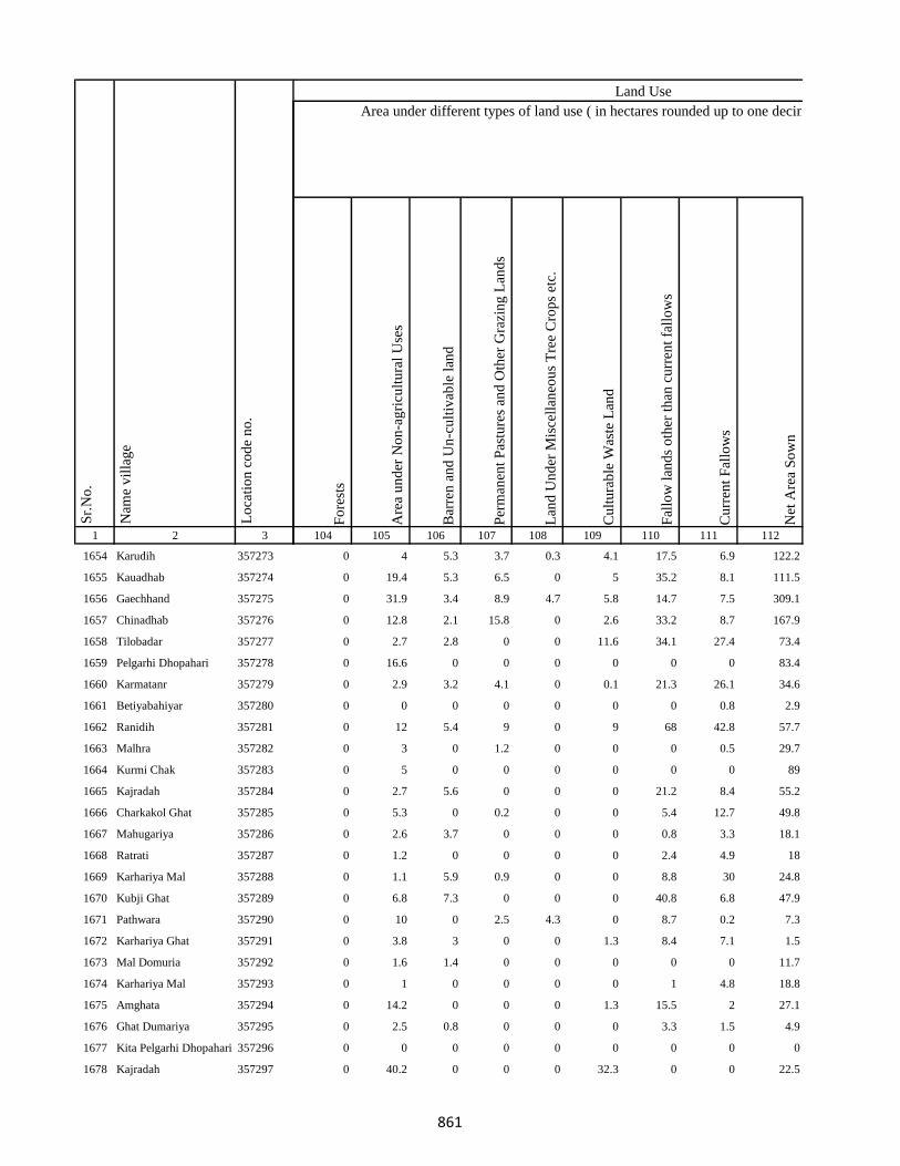
1 2 3
Lo
cati
on
co
de
no
.
Nam
e v
illa
ge
Sr.
No
.
1654 Karudih 357273
1655 Kauadhab 357274
1656 Gaechhand 357275
1657 Chinadhab 357276
1658 Tilobadar 357277
1659 Pelgarhi Dhopahari 357278
1660 Karmatanr 357279
1661 Betiyabahiyar 357280
1662 Ranidih 357281
1663 Malhra 357282
1664 Kurmi Chak 357283
1665 Kajradah 357284
1666 Charkakol Ghat 357285
1667 Mahugariya 357286
1668 Ratrati 357287
1669 Karhariya Mal 357288
1670 Kubji Ghat 357289
1671 Pathwara 357290
1672 Karhariya Ghat 357291
1673 Mal Domuria 357292
1674 Karhariya Mal 357293
1675 Amghata 357294
1676 Ghat Dumariya 357295
1677 Kita Pelgarhi Dhopahari 357296
1678 Kajradah 357297
Fo
rest
s
Are
a u
nd
er N
on
-ag
ricu
ltu
ral
Use
s
Bar
ren
an
d U
n-c
ult
ivab
le l
and
Per
man
ent
Pas
ture
s an
d O
ther
Gra
zin
g L
and
s
Lan
d U
nd
er M
isce
llan
eou
s T
ree
Cro
ps
etc.
Cu
ltu
rab
le W
aste
Lan
d
Fal
low
lan
ds
oth
er t
han
cu
rren
t fa
llo
ws
Cu
rren
t F
allo
ws
Net
Are
a S
ow
n
104 105 106 107 108 109 110 111 112
Area under different types of land use ( in hectares rounded up to one decimal place)
Land Use
0 4 5.3 3.7 0.3 4.1 17.5 6.9 122.2
0 19.4 5.3 6.5 0 5 35.2 8.1 111.5
0 31.9 3.4 8.9 4.7 5.8 14.7 7.5 309.1
0 12.8 2.1 15.8 0 2.6 33.2 8.7 167.9
0 2.7 2.8 0 0 11.6 34.1 27.4 73.4
0 16.6 0 0 0 0 0 0 83.4
0 2.9 3.2 4.1 0 0.1 21.3 26.1 34.6
0 0 0 0 0 0 0 0.8 2.9
0 12 5.4 9 0 9 68 42.8 57.7
0 3 0 1.2 0 0 0 0.5 29.7
0 5 0 0 0 0 0 0 89
0 2.7 5.6 0 0 0 21.2 8.4 55.2
0 5.3 0 0.2 0 0 5.4 12.7 49.8
0 2.6 3.7 0 0 0 0.8 3.3 18.1
0 1.2 0 0 0 0 2.4 4.9 18
0 1.1 5.9 0.9 0 0 8.8 30 24.8
0 6.8 7.3 0 0 0 40.8 6.8 47.9
0 10 0 2.5 4.3 0 8.7 0.2 7.3
0 3.8 3 0 0 1.3 8.4 7.1 1.5
0 1.6 1.4 0 0 0 0 0 11.7
0 1 0 0 0 0 1 4.8 18.8
0 14.2 0 0 0 1.3 15.5 2 27.1
0 2.5 0.8 0 0 0 3.3 1.5 4.9
0 0 0 0 0 0 0 0 0
0 40.2 0 0 0 32.3 0 0 22.5
861
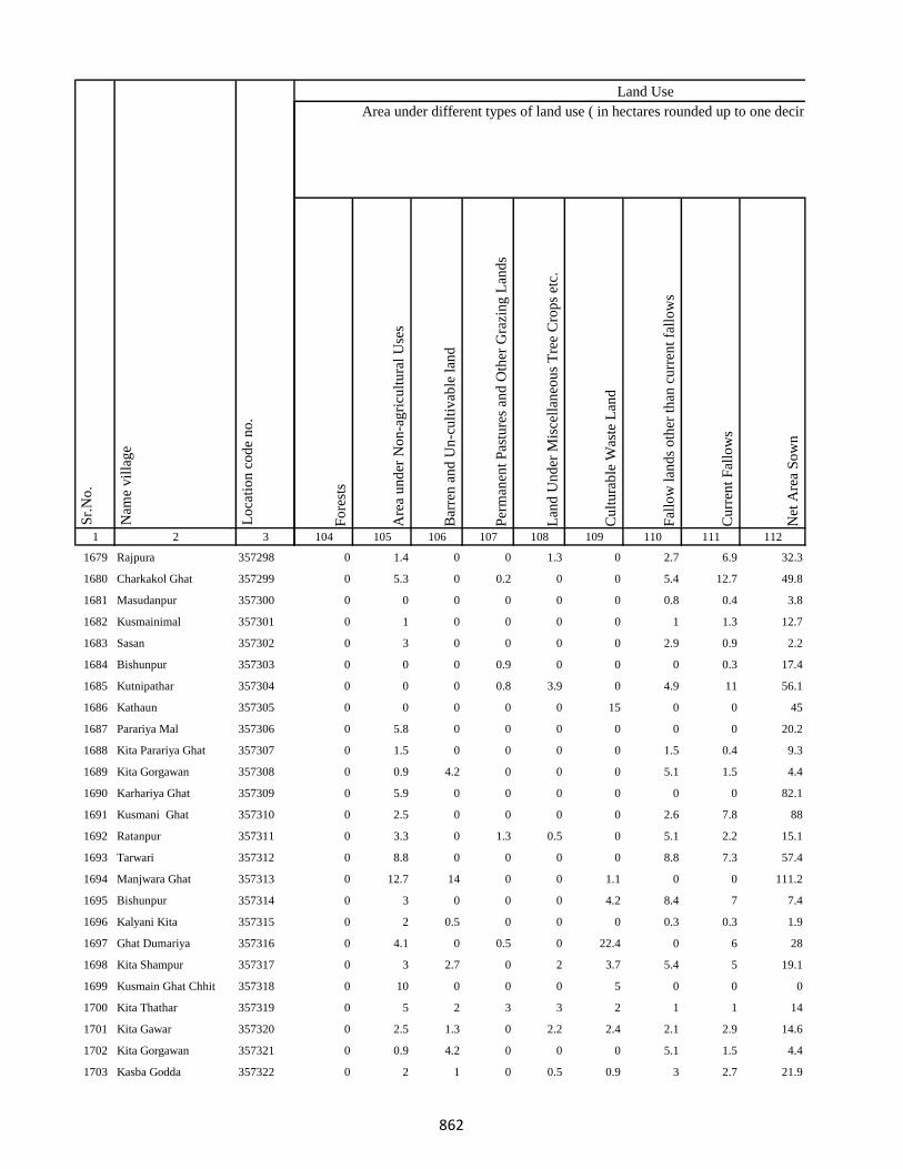
1 2 3
Lo
cati
on
co
de
no
.
Nam
e v
illa
ge
Sr.
No
.
1679 Rajpura 357298
1680 Charkakol Ghat 357299
1681 Masudanpur 357300
1682 Kusmainimal 357301
1683 Sasan 357302
1684 Bishunpur 357303
1685 Kutnipathar 357304
1686 Kathaun 357305
1687 Parariya Mal 357306
1688 Kita Parariya Ghat 357307
1689 Kita Gorgawan 357308
1690 Karhariya Ghat 357309
1691 Kusmani Ghat 357310
1692 Ratanpur 357311
1693 Tarwari 357312
1694 Manjwara Ghat 357313
1695 Bishunpur 357314
1696 Kalyani Kita 357315
1697 Ghat Dumariya 357316
1698 Kita Shampur 357317
1699 Kusmain Ghat Chhit 357318
1700 Kita Thathar 357319
1701 Kita Gawar 357320
1702 Kita Gorgawan 357321
1703 Kasba Godda 357322
Fo
rest
s
Are
a u
nd
er N
on
-ag
ricu
ltu
ral
Use
s
Bar
ren
an
d U
n-c
ult
ivab
le l
and
Per
man
ent
Pas
ture
s an
d O
ther
Gra
zin
g L
and
s
Lan
d U
nd
er M
isce
llan
eou
s T
ree
Cro
ps
etc.
Cu
ltu
rab
le W
aste
Lan
d
Fal
low
lan
ds
oth
er t
han
cu
rren
t fa
llo
ws
Cu
rren
t F
allo
ws
Net
Are
a S
ow
n
104 105 106 107 108 109 110 111 112
Area under different types of land use ( in hectares rounded up to one decimal place)
Land Use
0 1.4 0 0 1.3 0 2.7 6.9 32.3
0 5.3 0 0.2 0 0 5.4 12.7 49.8
0 0 0 0 0 0 0.8 0.4 3.8
0 1 0 0 0 0 1 1.3 12.7
0 3 0 0 0 0 2.9 0.9 2.2
0 0 0 0.9 0 0 0 0.3 17.4
0 0 0 0.8 3.9 0 4.9 11 56.1
0 0 0 0 0 15 0 0 45
0 5.8 0 0 0 0 0 0 20.2
0 1.5 0 0 0 0 1.5 0.4 9.3
0 0.9 4.2 0 0 0 5.1 1.5 4.4
0 5.9 0 0 0 0 0 0 82.1
0 2.5 0 0 0 0 2.6 7.8 88
0 3.3 0 1.3 0.5 0 5.1 2.2 15.1
0 8.8 0 0 0 0 8.8 7.3 57.4
0 12.7 14 0 0 1.1 0 0 111.2
0 3 0 0 0 4.2 8.4 7 7.4
0 2 0.5 0 0 0 0.3 0.3 1.9
0 4.1 0 0.5 0 22.4 0 6 28
0 3 2.7 0 2 3.7 5.4 5 19.1
0 10 0 0 0 5 0 0 0
0 5 2 3 3 2 1 1 14
0 2.5 1.3 0 2.2 2.4 2.1 2.9 14.6
0 0.9 4.2 0 0 0 5.1 1.5 4.4
0 2 1 0 0.5 0.9 3 2.7 21.9
862

1 2 3
Lo
cati
on
co
de
no
.
Nam
e v
illa
ge
Sr.
No
.
1704 Ghat Paharpur 357323
1705 Kutni Pathar 357324
1706 Gorka Kita 357325
1707 Bhandar Koli 357326
1708 Harlal Tola 357327
1709 Haripur 357328
1710 Ghat Paharpur 357329
1711 Kasba Godda 357330
1712 Ghat Paharpur 357331
1713 Mohanpur 357332
1714 Markhan 357333
1715 Daldali 357334
1716 Jamuni Paharpur 357335
1717 Ghat Paharpur 357336
1718 Nonmati 357337
1719 Sarotiya 357338
1720 Bhatdiha 357339
1721 Bengbahiyar 357340
1722 Rupiyamal 357341
1723 Maruabaran 357342
1724 Kauribahiyarmal Chhit 357343
1725 Kauribahiyar Ghat 357344
1726 Kauribahiyar Mal 357345
1727 Pairdih 357346
1728 Kanadih Chhit 357347
Fo
rest
s
Are
a u
nd
er N
on
-ag
ricu
ltu
ral
Use
s
Bar
ren
an
d U
n-c
ult
ivab
le l
and
Per
man
ent
Pas
ture
s an
d O
ther
Gra
zin
g L
and
s
Lan
d U
nd
er M
isce
llan
eou
s T
ree
Cro
ps
etc.
Cu
ltu
rab
le W
aste
Lan
d
Fal
low
lan
ds
oth
er t
han
cu
rren
t fa
llo
ws
Cu
rren
t F
allo
ws
Net
Are
a S
ow
n
104 105 106 107 108 109 110 111 112
Area under different types of land use ( in hectares rounded up to one decimal place)
Land Use
0 1.7 0.5 1 0.5 13.7 1.2 1.6 45.1
0 0 0 0 0 0 0 0 0
0 1.6 0.7 2.2 1.1 0.5 1.2 1.7 69
0 3.7 9.4 2.3 0 0.9 0 0 0.7
0 2.1 1 7.4 1.7 2.9 2.5 2.5 143.9
0 2.5 5.2 1.5 2.8 8 0 0 0
0 4 0.5 0 0.7 0 1 1.5 15.3
0 2.7 1.3 0 0.5 2.1 3.2 2.5 119.7
0 1 1 0 0 0.5 0.5 1 15
0 15.1 0 0 0 33 0 0 54.9
0 3.5 0 1.5 81.7 0 46 77.5 220.8
0 0.9 0 12 43.3 0 112 25 136.7
0 0.8 0 2.6 48.4 0 80.8 86 363.3
0 0 0 0 0 0 0 0 0
0 35 20 6.6 0 0 0 0 2.3
0 8.2 0 19.2 0 3 14.3 10.7 148.6
0 24.3 4.9 4 0 0 45.1 40.2 5.5
0 1.6 0 0.9 0 0 0 0 16.4
0 8.6 0 4.6 2.5 2.4 7 20.7 4.2
0 2.6 0 1.3 0 0 30 0 29.1
0 0 0 0 0 0 0 0 0
0 6.6 15.4 12.2 7.8 0 22.2 80.2 15.7
0 55.7 18.6 8.7 20.8 24.3 42 0 32.8
0 32.6 0 0 0 18.5 0 0 23.9
0 22.9 1.3 7.6 10.5 8.6 40.1 49.4 118.6
863

1 2 3
Lo
cati
on
co
de
no
.
Nam
e v
illa
ge
Sr.
No
.
1729 Gorhighat Chhit 357348
1730 Kanidih Chhit 357349
1731 Jamua 357350
1732 Kurman Ghat 357351
1733 Lamhati Kar 357352
1734 Kurman Mal 357353
1735 Dharmudih 357354
1736 Punsiya 357355
1737 Kumardih 357356
1738 Murlidih Kita 357357
1739 Pandubathan 357358
1740 Sarkanda 357359
1741 Pathra 357360
1742 Bilari 357361
1743 Ghat Jamuni 357362
1744 Pandaha 357363
1745 Ghat Jhilua 357364
1746 Lachhmi 357365
1747 Ghat Jopnadih 357366
1748 Majhdiha 357367
1749 Makhni 357368
1750 Amarpur 357369
1751 Baramasia 357370
1752 Sonjhar 357371
1753 Kadwa 357372
Fo
rest
s
Are
a u
nd
er N
on
-ag
ricu
ltu
ral
Use
s
Bar
ren
an
d U
n-c
ult
ivab
le l
and
Per
man
ent
Pas
ture
s an
d O
ther
Gra
zin
g L
and
s
Lan
d U
nd
er M
isce
llan
eou
s T
ree
Cro
ps
etc.
Cu
ltu
rab
le W
aste
Lan
d
Fal
low
lan
ds
oth
er t
han
cu
rren
t fa
llo
ws
Cu
rren
t F
allo
ws
Net
Are
a S
ow
n
104 105 106 107 108 109 110 111 112
Area under different types of land use ( in hectares rounded up to one decimal place)
Land Use
3 138.4 3.6 28.7 20.7 23.6 10 21.2 187.9
0 0 0 0 0 0 0 0 0
0 26.4 25.1 8.8 7.8 25.8 0 9.2 92.9
0 6.8 0 8.3 0 1 78 0 8.9
0 2.8 0.5 0 0 0 0 3.7 23
0 1.4 0 0 0 1.7 0 0 37.9
0 100.4 30.8 23.8 7.6 75.8 0 0 79.6
0 25.5 4.3 20.8 28.3 5.8 42.6 0 4.6
0 7.9 13.5 5.6 0 15.3 20.1 0 1.6
0 5.7 3.4 3.6 0 2.2 10.4 30.2 10.5
30.4 53.8 50.5 12.7 0 45.8 20.1 18.2 50.5
0 17.2 0 0 0 3 0 0 355.8
0 74 14.3 8.1 0 0 0 28.8 46.7
0 14 0 0 0 6.4 0 0 159.6
0 3.4 0 0.5 8.1 0 12 8.6 47.9
0 77.2 0 20 0 0 100.4 106.1 8.2
0 0 0 1.2 0 0 0 2.8 33.3
0 2 0 5.1 39.2 0 42.8 64.8 140
0 5.1 0 1.9 4 0 3.3 9.9 15
0 2.5 8.2 20.3 0 24 24.4 63.1 23.5
0 1.2 0 12.4 82.5 0 165.1 128.9 353.9
0 246.3 0 0 0 134.1 0 0 744.5
0 35.1 0 0 0 10.1 0 0 255.4
0 50.8 14.9 11.7 1.6 94.7 120 52.7 71.6
0 92.6 0 0 0 132.7 0 0 130.7
864
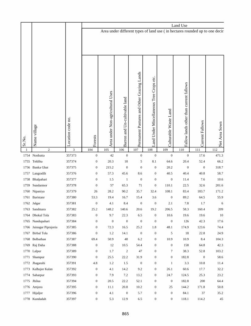
1 2 3
Lo
cati
on
co
de
no
.
Nam
e v
illa
ge
Sr.
No
.
1754 Nonbatta 357373
1755 Teldiha 357374
1756 Banka Ghat 357375
1757 Langradih 357376
1758 Bhalpahari 357377
1759 Sundarmor 357378
1760 Nipaniya 357379
1761 Baristanr 357380
1762 Jalgar 357381
1763 Sandmara 357382
1764 Dhokal Tola 357383
1765 Nandupahari 357384
1766 Jainagar Piprajoria 357385
1767 Birbal Tola 357386
1768 Belbathan 357387
1769 Raj Daha 357388
1770 Lalpur 357389
1771 Shampur 357390
1772 Jhagarahi 357391
1773 Kalhajor Kalan 357392
1774 Saharpur 357393
1775 Jhilua 357394
1776 Amjora 357395
1777 Hijaljor 357396
1778 Kundadah 357397
Fo
rest
s
Are
a u
nd
er N
on
-ag
ricu
ltu
ral
Use
s
Bar
ren
an
d U
n-c
ult
ivab
le l
and
Per
man
ent
Pas
ture
s an
d O
ther
Gra
zin
g L
and
s
Lan
d U
nd
er M
isce
llan
eou
s T
ree
Cro
ps
etc.
Cu
ltu
rab
le W
aste
Lan
d
Fal
low
lan
ds
oth
er t
han
cu
rren
t fa
llo
ws
Cu
rren
t F
allo
ws
Net
Are
a S
ow
n
104 105 106 107 108 109 110 111 112
Area under different types of land use ( in hectares rounded up to one decimal place)
Land Use
0 42 0 0 0 0 0 17.6 471.3
0 20.3 18 5 8.1 64.6 20.4 52.4 66.2
0 215.2 0 0 0 20.2 0 0 318.7
0 57.3 45.6 8.6 0 40.5 40.4 40.8 58.7
0 1.5 1 0 0 0 11.4 7.6 10.6
0 57 65.3 71 0 110.1 22.5 32.6 201.6
26 28.2 90.2 35.7 32.4 108.1 83.4 183.7 171.2
53.3 19.4 16.7 15.4 3.6 0 89.2 64.5 55.9
0 4.1 8.4 0 0 2.1 7.8 1.7 6
25.2 148.2 140.6 20.6 19.2 206.5 58.3 160.4 209
0 9.7 22.3 6.5 0 10.6 19.6 19.6 10
0 0 0 0 0 0 126 42.3 17.6
0 72.3 16.5 25.2 1.8 48.1 174.9 123.6 74.4
0 1.2 14.1 0 0 5 18 22.8 24.9
69.4 50.9 48 6.2 0 10.9 10.9 8.4 104.3
0 12 10.5 54.4 0 0 158 64.8 42.3
0 1.7 2 47 0 7 38.3 52.8 103.2
0 25.5 22.2 31.9 0 0 182.8 0 58.6
4.8 1.2 1.5 0 0 1 3.3 10.8 11.4
0 4.1 14.2 9.2 0 26.1 60.6 17.7 32.2
0 7.9 7.2 13.2 0 24.7 124.5 25.3 23.2
0 20.5 22.2 52.1 0 0 182.8 200 64.4
0 11.1 20.8 10.2 0 25 144.2 171.8 50.8
0 4.1 0 5.7 0 0 84.1 37 35.2
0 5.3 12.9 6.5 0 0 118.1 114.2 45
865
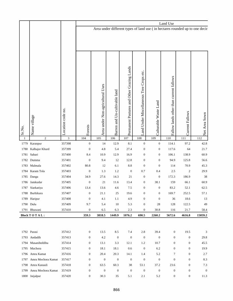
1 2 3
Lo
cati
on
co
de
no
.
Nam
e v
illa
ge
Sr.
No
.
1779 Karanpur 357398
1780 Kalhajor Khurd 357399
1781 Sahari 357400
1782 Dumma 357401
1783 Malmala 357402
1784 Karam Tola 357403
1785 Danga 357404
1786 Jamkudar 357405
1787 Siarkatiya 357406
1788 Burhikura 357407
1789 Haripur 357408
1790 Dulu 357409
1791 Bhawani 357410
Block T O T A L :
1792 Parasi 357412
1793 Andadih 357413
1794 Masanibeldiha 357414
1795 Muchora 357415
1796 Amra Kamat 357416
1797 Amra Mochora Kamat 357417
1798 Amra Kanauli 357418
1799 Amra Mochora Kamat 357419
1800 Jaijalpur 357420
Fo
rest
s
Are
a u
nd
er N
on
-ag
ricu
ltu
ral
Use
s
Bar
ren
an
d U
n-c
ult
ivab
le l
and
Per
man
ent
Pas
ture
s an
d O
ther
Gra
zin
g L
and
s
Lan
d U
nd
er M
isce
llan
eou
s T
ree
Cro
ps
etc.
Cu
ltu
rab
le W
aste
Lan
d
Fal
low
lan
ds
oth
er t
han
cu
rren
t fa
llo
ws
Cu
rren
t F
allo
ws
Net
Are
a S
ow
n
104 105 106 107 108 109 110 111 112
Area under different types of land use ( in hectares rounded up to one decimal place)
Land Use
0 14 12.9 8.1 0 0 114.1 97.2 42.8
0 4.8 5.4 27.4 0 0 117.6 64 21.7
8.4 10.9 12.9 16.9 0 0 106.1 138.9 60.9
0 9.4 12 12.8 0 0 94.9 125.8 56.6
80.8 12 6.1 8.8 0 0 114 70.9 45.3
0 1.3 1.2 0 0.7 0.4 2.5 2 29.9
34.9 27.6 14.3 21 0 0 172.3 186.9 38
0 21 11.6 13.4 0 38.1 159 66.1 60.9
13.4 13.6 4.6 7.5 0 0 83.2 52.1 62.5
0 21.1 25 19.6 0 0 169.7 252.5 57.1
0 4.1 1.1 4.9 0 0 36 18.6 13
9.7 5.4 10 5.3 0 28 128 122.5 49
0 6.5 6.3 2.3 0 30.8 116 21.7 58.4
359.3 3818.5 1449.9 1076.2 690.5 2260.2 5672.6 4616.8 15059.2
0 13.5 8.5 7.4 2.8 39.4 0 19.5 3
0 4.2 0 0 0 0 0 0 29.8
0 13.1 3.3 12.1 1.2 10.7 0 0 45.5
0 18.1 18.1 0.6 0 6.2 0 0 19.9
0 20.4 20.3 14.1 1.4 5.2 7 0 2.7
0 0 0 0 0 0 0 0 8.3
0 63.5 60.3 38 53.1 37.2 23.6 0 7.3
0 0 0 0 0 0 0 0 0
0 30.3 35 5.1 2.1 5.2 0 0 11.3
866
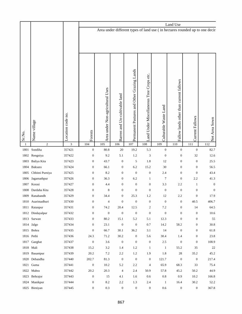
1 2 3
Lo
cati
on
co
de
no
.
Nam
e v
illa
ge
Sr.
No
.
1801 Sondiha 357421
1802 Rengniya 357422
1803 Baliya Kita 357423
1804 Baksara 357424
1805 Chhitni Purniya 357425
1806 Jagarnathpur 357426
1807 Korasi 357427
1808 Dardaha Kita 357428
1809 Ranabandh 357429
1810 Asarimadhuri 357430
1811 Ratanpur 357431
1812 Dindayalpur 357432
1813 Sarwan 357433
1814 Jalgo 357434
1815 Bohra 357435
1816 Petbi 357436
1817 Gaeghat 357437
1818 Mali 357438
1819 Basantpur 357439
1820 Debandha 357440
1821 Guma 357441
1822 Mahra 357442
1823 Behrajor 357443
1824 Manikpur 357444
1825 Birniyan 357445
Fo
rest
s
Are
a u
nd
er N
on
-ag
ricu
ltu
ral
Use
s
Bar
ren
an
d U
n-c
ult
ivab
le l
and
Per
man
ent
Pas
ture
s an
d O
ther
Gra
zin
g L
and
s
Lan
d U
nd
er M
isce
llan
eou
s T
ree
Cro
ps
etc.
Cu
ltu
rab
le W
aste
Lan
d
Fal
low
lan
ds
oth
er t
han
cu
rren
t fa
llo
ws
Cu
rren
t F
allo
ws
Net
Are
a S
ow
n
104 105 106 107 108 109 110 111 112
Area under different types of land use ( in hectares rounded up to one decimal place)
Land Use
0 80.8 20 19.2 5.3 0 0 0 82.7
0 9.2 5.1 1.2 3 0 0 32 12.6
0 43.7 0 5 1.8 12 0 0 25.5
0 66.1 0 6.2 15.2 30 0 0 56.5
0 8.2 0 0 0 2.4 0 0 43.4
0 36.3 0 6.2 1 7 0 2.2 41.3
0 4.4 0 0 0 3.3 2.2 1 0
0 8 0 0 0 0 0 0 0
0 34.4 0 25.3 1.2 12 2.2 0 17.9
0 4 0 0 0 0 0 40.5 406.7
0 74.2 20.4 12.5 2 7.2 0 14 64.5
0 0 0 0 0 0 0 0 10.6
0 80.2 15.1 5.2 5.1 12.3 0 0 55
0 23.1 0 0 0.7 14.2 58.2 0 30.8
0 66.7 30.1 36.2 3.1 14 0 0 61.8
24.3 71.2 30.2 0 5.6 30.4 1.4 0 23.8
0 3.6 0 0 0 2.5 0 0 108.9
15.2 3.2 1.4 1.2 1 1 55.2 35 22
20.2 7.2 2.2 1.2 1.9 1.8 28 35.2 45.2
202.7 81.3 0 0 0 121.7 0 0 217.4
0 10.2 5.2 2.2 4 65.9 68.3 33 75.4
20.2 20.3 4 2.4 50.9 57.8 45.2 50.2 44.9
0 15 4.1 1.6 0.6 0.8 0.9 10.2 166.8
0 8.2 2.2 1.3 2.4 1 16.4 30.2 52.2
0 0.3 0 0 0 0.6 0 0 367.8
867
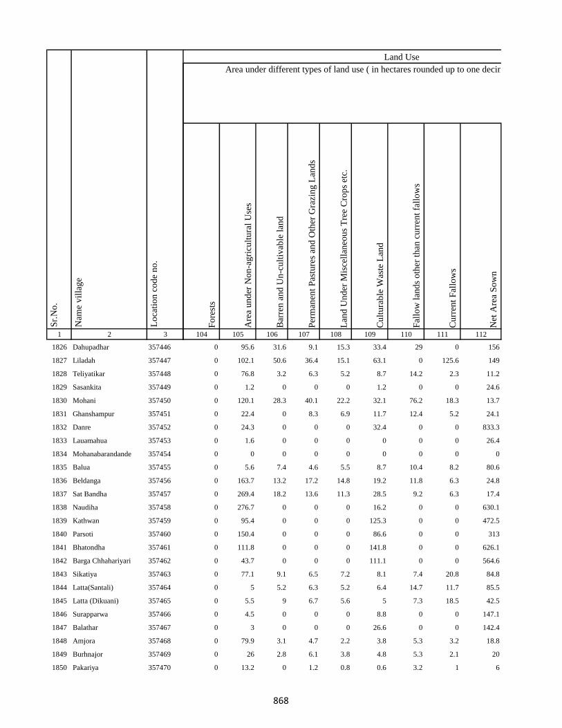
1 2 3
Lo
cati
on
co
de
no
.
Nam
e v
illa
ge
Sr.
No
.
1826 Dahupadhar 357446
1827 Liladah 357447
1828 Teliyatikar 357448
1829 Sasankita 357449
1830 Mohani 357450
1831 Ghanshampur 357451
1832 Danre 357452
1833 Lauamahua 357453
1834 Mohanabarandande 357454
1835 Balua 357455
1836 Beldanga 357456
1837 Sat Bandha 357457
1838 Naudiha 357458
1839 Kathwan 357459
1840 Parsoti 357460
1841 Bhatondha 357461
1842 Barga Chhahariyari 357462
1843 Sikatiya 357463
1844 Latta(Santali) 357464
1845 Latta (Dikuani) 357465
1846 Surapparwa 357466
1847 Balathar 357467
1848 Amjora 357468
1849 Burhnajor 357469
1850 Pakariya 357470
Fo
rest
s
Are
a u
nd
er N
on
-ag
ricu
ltu
ral
Use
s
Bar
ren
an
d U
n-c
ult
ivab
le l
and
Per
man
ent
Pas
ture
s an
d O
ther
Gra
zin
g L
and
s
Lan
d U
nd
er M
isce
llan
eou
s T
ree
Cro
ps
etc.
Cu
ltu
rab
le W
aste
Lan
d
Fal
low
lan
ds
oth
er t
han
cu
rren
t fa
llo
ws
Cu
rren
t F
allo
ws
Net
Are
a S
ow
n
104 105 106 107 108 109 110 111 112
Area under different types of land use ( in hectares rounded up to one decimal place)
Land Use
0 95.6 31.6 9.1 15.3 33.4 29 0 156
0 102.1 50.6 36.4 15.1 63.1 0 125.6 149
0 76.8 3.2 6.3 5.2 8.7 14.2 2.3 11.2
0 1.2 0 0 0 1.2 0 0 24.6
0 120.1 28.3 40.1 22.2 32.1 76.2 18.3 13.7
0 22.4 0 8.3 6.9 11.7 12.4 5.2 24.1
0 24.3 0 0 0 32.4 0 0 833.3
0 1.6 0 0 0 0 0 0 26.4
0 0 0 0 0 0 0 0 0
0 5.6 7.4 4.6 5.5 8.7 10.4 8.2 80.6
0 163.7 13.2 17.2 14.8 19.2 11.8 6.3 24.8
0 269.4 18.2 13.6 11.3 28.5 9.2 6.3 17.4
0 276.7 0 0 0 16.2 0 0 630.1
0 95.4 0 0 0 125.3 0 0 472.5
0 150.4 0 0 0 86.6 0 0 313
0 111.8 0 0 0 141.8 0 0 626.1
0 43.7 0 0 0 111.1 0 0 564.6
0 77.1 9.1 6.5 7.2 8.1 7.4 20.8 84.8
0 5 5.2 6.3 5.2 6.4 14.7 11.7 85.5
0 5.5 9 6.7 5.6 5 7.3 18.5 42.5
0 4.5 0 0 0 8.8 0 0 147.1
0 3 0 0 0 26.6 0 0 142.4
0 79.9 3.1 4.7 2.2 3.8 5.3 3.2 18.8
0 26 2.8 6.1 3.8 4.8 5.3 2.1 20
0 13.2 0 1.2 0.8 0.6 3.2 1 6
868
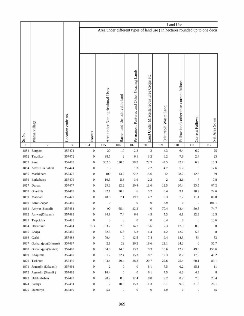
1 2 3
Lo
cati
on
co
de
no
.
Nam
e v
illa
ge
Sr.
No
.
1851 Bargaon 357471
1852 Taratikar 357472
1853 Pasai 357473
1854 Arazi Kita Sahuri 357474
1855 Machkhara 357475
1856 Barkabaiso 357476
1857 Durpat 357477
1858 Goaridih 357478
1859 Matihani 357479
1860 Bara Chapar 357480
1861 Amwar (Santali) 357481
1862 Amwar(Dikuani) 357482
1863 Tarpokhra 357483
1864 Harlatikar 357484
1865 Bhaga 357485
1866 Garhi 357486
1867 Gorharajpur(Dikuani) 357487
1868 Gorharajpur(Santali) 357488
1869 Khajurma 357489
1870 Tarkhuta 357490
1871 Joguadih (Dikuani) 357491
1872 Joguadih (Santali ) 357492
1873 Dakhinbahiar 357493
1874 Salaiya 357494
1875 Dumariya 357495
Fo
rest
s
Are
a u
nd
er N
on
-ag
ricu
ltu
ral
Use
s
Bar
ren
an
d U
n-c
ult
ivab
le l
and
Per
man
ent
Pas
ture
s an
d O
ther
Gra
zin
g L
and
s
Lan
d U
nd
er M
isce
llan
eou
s T
ree
Cro
ps
etc.
Cu
ltu
rab
le W
aste
Lan
d
Fal
low
lan
ds
oth
er t
han
cu
rren
t fa
llo
ws
Cu
rren
t F
allo
ws
Net
Are
a S
ow
n
104 105 106 107 108 109 110 111 112
Area under different types of land use ( in hectares rounded up to one decimal place)
Land Use
0 20 1.9 2.3 2 4.3 6.4 6.2 25
0 38.5 2 6.1 3.2 6.2 7.6 2.4 23
0 302.6 120.5 98.2 22.3 44.5 42.7 6.9 15.3
0 13 0 1.3 2.2 4.7 5.2 0 12.6
0 100 13.7 22.2 15.6 12 28.2 12.3 39
0 10.5 5.3 3.6 2.3 2 2.6 7 7.8
0 85.2 12.3 20.4 11.6 12.5 30.4 23.5 87.2
0 32.1 20.3 6 5.2 6.4 9.1 10.2 22.6
0 48.8 7.1 19.7 4.2 9.3 7.7 11.4 88.8
0 0 0 0 0 3.9 0 0 101.1
0 90 65.4 22.2 0 70.4 82.4 50.8 74.7
0 34.8 7.4 6.6 4.5 5.3 6.1 12.9 12.5
0 5 0 0 0 0.4 0 0 15.6
8.3 53.2 7.8 14.7 5.6 7.3 17.3 8.6 0
0 82.5 5.6 5.3 4.4 4.2 12.7 5.3 8
0 79.4 0 12.5 7.4 9.4 18.3 54 53
0 2.1 29 26.2 18.6 21.1 24.3 0 55.7
0 64.8 14.6 13.3 9.3 10.6 12.2 49.8 159.6
0 31.2 22.4 15.3 8.7 12.3 8.2 17.2 40.2
0 103.4 29.4 28.2 20.7 22.6 25.4 60.1 80.1
0 2 0 0 8.1 7.5 6.2 15.1 11
0 16.4 0 0 6.1 7.5 6.2 4.8 8
0 20.2 8.3 12.4 8.8 9.2 8.2 7.6 23.4
0 12 10.3 15.3 11.3 8.1 9.3 21.6 26.1
0 5.1 0 0 0 4.9 0 0 45
869
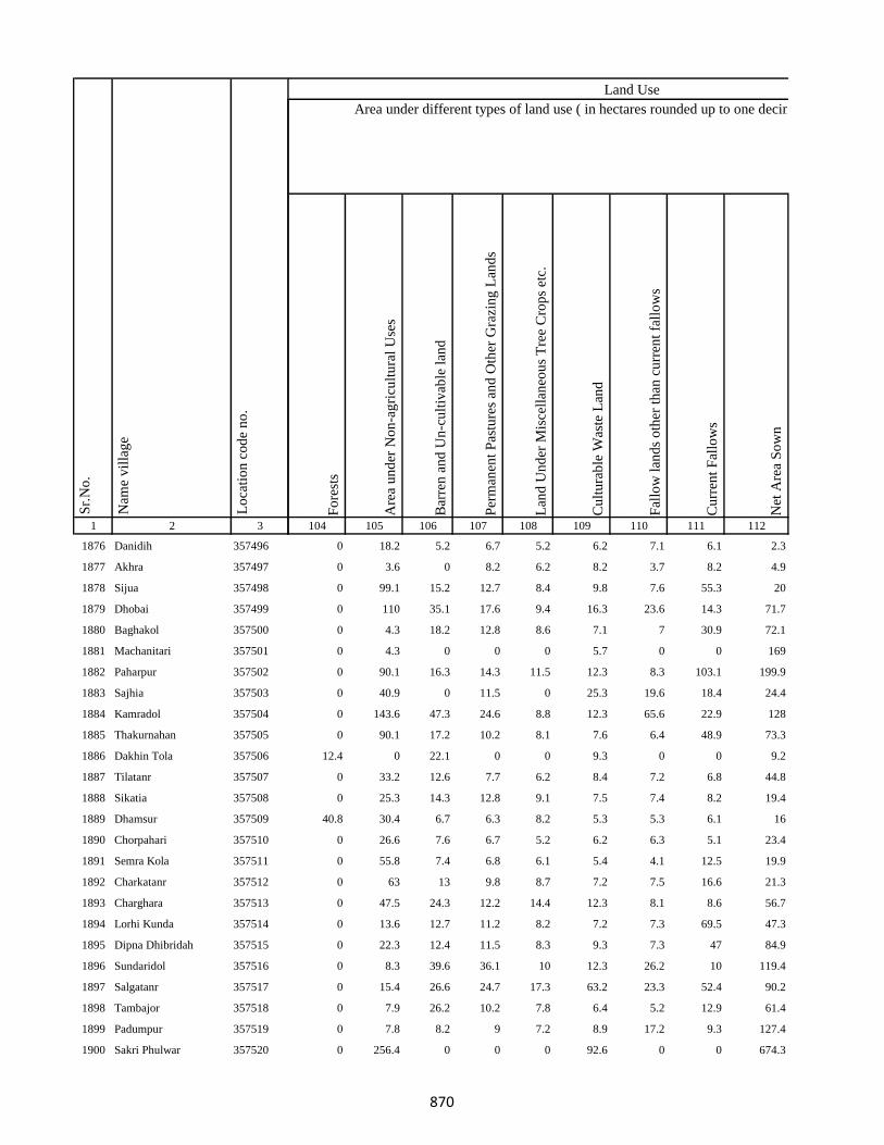
1 2 3
Lo
cati
on
co
de
no
.
Nam
e v
illa
ge
Sr.
No
.
1876 Danidih 357496
1877 Akhra 357497
1878 Sijua 357498
1879 Dhobai 357499
1880 Baghakol 357500
1881 Machanitari 357501
1882 Paharpur 357502
1883 Sajhia 357503
1884 Kamradol 357504
1885 Thakurnahan 357505
1886 Dakhin Tola 357506
1887 Tilatanr 357507
1888 Sikatia 357508
1889 Dhamsur 357509
1890 Chorpahari 357510
1891 Semra Kola 357511
1892 Charkatanr 357512
1893 Charghara 357513
1894 Lorhi Kunda 357514
1895 Dipna Dhibridah 357515
1896 Sundaridol 357516
1897 Salgatanr 357517
1898 Tambajor 357518
1899 Padumpur 357519
1900 Sakri Phulwar 357520
Fo
rest
s
Are
a u
nd
er N
on
-ag
ricu
ltu
ral
Use
s
Bar
ren
an
d U
n-c
ult
ivab
le l
and
Per
man
ent
Pas
ture
s an
d O
ther
Gra
zin
g L
and
s
Lan
d U
nd
er M
isce
llan
eou
s T
ree
Cro
ps
etc.
Cu
ltu
rab
le W
aste
Lan
d
Fal
low
lan
ds
oth
er t
han
cu
rren
t fa
llo
ws
Cu
rren
t F
allo
ws
Net
Are
a S
ow
n
104 105 106 107 108 109 110 111 112
Area under different types of land use ( in hectares rounded up to one decimal place)
Land Use
0 18.2 5.2 6.7 5.2 6.2 7.1 6.1 2.3
0 3.6 0 8.2 6.2 8.2 3.7 8.2 4.9
0 99.1 15.2 12.7 8.4 9.8 7.6 55.3 20
0 110 35.1 17.6 9.4 16.3 23.6 14.3 71.7
0 4.3 18.2 12.8 8.6 7.1 7 30.9 72.1
0 4.3 0 0 0 5.7 0 0 169
0 90.1 16.3 14.3 11.5 12.3 8.3 103.1 199.9
0 40.9 0 11.5 0 25.3 19.6 18.4 24.4
0 143.6 47.3 24.6 8.8 12.3 65.6 22.9 128
0 90.1 17.2 10.2 8.1 7.6 6.4 48.9 73.3
12.4 0 22.1 0 0 9.3 0 0 9.2
0 33.2 12.6 7.7 6.2 8.4 7.2 6.8 44.8
0 25.3 14.3 12.8 9.1 7.5 7.4 8.2 19.4
40.8 30.4 6.7 6.3 8.2 5.3 5.3 6.1 16
0 26.6 7.6 6.7 5.2 6.2 6.3 5.1 23.4
0 55.8 7.4 6.8 6.1 5.4 4.1 12.5 19.9
0 63 13 9.8 8.7 7.2 7.5 16.6 21.3
0 47.5 24.3 12.2 14.4 12.3 8.1 8.6 56.7
0 13.6 12.7 11.2 8.2 7.2 7.3 69.5 47.3
0 22.3 12.4 11.5 8.3 9.3 7.3 47 84.9
0 8.3 39.6 36.1 10 12.3 26.2 10 119.4
0 15.4 26.6 24.7 17.3 63.2 23.3 52.4 90.2
0 7.9 26.2 10.2 7.8 6.4 5.2 12.9 61.4
0 7.8 8.2 9 7.2 8.9 17.2 9.3 127.4
0 256.4 0 0 0 92.6 0 0 674.3
870
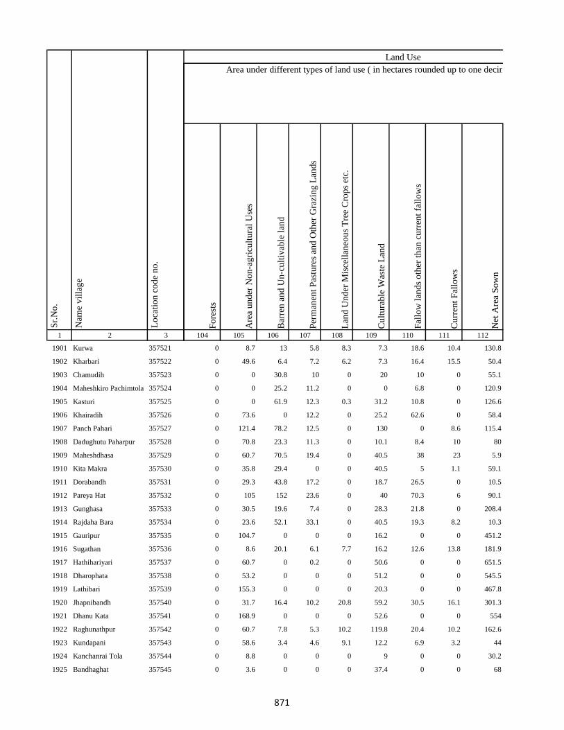
1 2 3
Lo
cati
on
co
de
no
.
Nam
e v
illa
ge
Sr.
No
.
1901 Kurwa 357521
1902 Kharbari 357522
1903 Chamudih 357523
1904 Maheshkiro Pachimtola 357524
1905 Kasturi 357525
1906 Khairadih 357526
1907 Panch Pahari 357527
1908 Dadughutu Paharpur 357528
1909 Maheshdhasa 357529
1910 Kita Makra 357530
1911 Dorabandh 357531
1912 Pareya Hat 357532
1913 Gunghasa 357533
1914 Rajdaha Bara 357534
1915 Gauripur 357535
1916 Sugathan 357536
1917 Hathihariyari 357537
1918 Dharophata 357538
1919 Lathibari 357539
1920 Jhapnibandh 357540
1921 Dhanu Kata 357541
1922 Raghunathpur 357542
1923 Kundapani 357543
1924 Kanchanrai Tola 357544
1925 Bandhaghat 357545
Fo
rest
s
Are
a u
nd
er N
on
-ag
ricu
ltu
ral
Use
s
Bar
ren
an
d U
n-c
ult
ivab
le l
and
Per
man
ent
Pas
ture
s an
d O
ther
Gra
zin
g L
and
s
Lan
d U
nd
er M
isce
llan
eou
s T
ree
Cro
ps
etc.
Cu
ltu
rab
le W
aste
Lan
d
Fal
low
lan
ds
oth
er t
han
cu
rren
t fa
llo
ws
Cu
rren
t F
allo
ws
Net
Are
a S
ow
n
104 105 106 107 108 109 110 111 112
Area under different types of land use ( in hectares rounded up to one decimal place)
Land Use
0 8.7 13 5.8 8.3 7.3 18.6 10.4 130.8
0 49.6 6.4 7.2 6.2 7.3 16.4 15.5 50.4
0 0 30.8 10 0 20 10 0 55.1
0 0 25.2 11.2 0 0 6.8 0 120.9
0 0 61.9 12.3 0.3 31.2 10.8 0 126.6
0 73.6 0 12.2 0 25.2 62.6 0 58.4
0 121.4 78.2 12.5 0 130 0 8.6 115.4
0 70.8 23.3 11.3 0 10.1 8.4 10 80
0 60.7 70.5 19.4 0 40.5 38 23 5.9
0 35.8 29.4 0 0 40.5 5 1.1 59.1
0 29.3 43.8 17.2 0 18.7 26.5 0 10.5
0 105 152 23.6 0 40 70.3 6 90.1
0 30.5 19.6 7.4 0 28.3 21.8 0 208.4
0 23.6 52.1 33.1 0 40.5 19.3 8.2 10.3
0 104.7 0 0 0 16.2 0 0 451.2
0 8.6 20.1 6.1 7.7 16.2 12.6 13.8 181.9
0 60.7 0 0.2 0 50.6 0 0 651.5
0 53.2 0 0 0 51.2 0 0 545.5
0 155.3 0 0 0 20.3 0 0 467.8
0 31.7 16.4 10.2 20.8 59.2 30.5 16.1 301.3
0 168.9 0 0 0 52.6 0 0 554
0 60.7 7.8 5.3 10.2 119.8 20.4 10.2 162.6
0 58.6 3.4 4.6 9.1 12.2 6.9 3.2 44
0 8.8 0 0 0 9 0 0 30.2
0 3.6 0 0 0 37.4 0 0 68
871
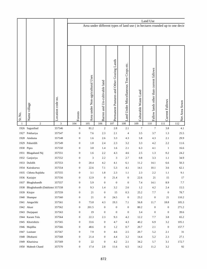
1 2 3
Lo
cati
on
co
de
no
.
Nam
e v
illa
ge
Sr.
No
.
1926 Sagunibad 357546
1927 Pokhariya 357547
1928 Amduma 357548
1929 Paharidih 357549
1930 Pipra 357550
1931 Bhagaband Nij 357551
1932 Ganjoriya 357552
1933 Dulidih 357553
1934 Kairakurwa 357554
1935 Chhota Rajdaha 357555
1936 Kasiajor 357556
1937 Bhaghabandh 357557
1938 Bhaghabandh (Dakhintola)357558
1939 Kitajor 357559
1940 Shampur 357560
1941 Amgachhi 357561
1942 Akasi 357562
1943 Durjapani 357563
1944 Karam Tola 357564
1945 Khorishiris 357565
1946 Majdiha 357566
1947 Lusitanr 357567
1948 Dhobarni 357568
1949 Kharisirsa 357569
1950 Mahesh Chand 357570
Fo
rest
s
Are
a u
nd
er N
on
-ag
ricu
ltu
ral
Use
s
Bar
ren
an
d U
n-c
ult
ivab
le l
and
Per
man
ent
Pas
ture
s an
d O
ther
Gra
zin
g L
and
s
Lan
d U
nd
er M
isce
llan
eou
s T
ree
Cro
ps
etc.
Cu
ltu
rab
le W
aste
Lan
d
Fal
low
lan
ds
oth
er t
han
cu
rren
t fa
llo
ws
Cu
rren
t F
allo
ws
Net
Are
a S
ow
n
104 105 106 107 108 109 110 111 112
Area under different types of land use ( in hectares rounded up to one decimal place)
Land Use
0 81.2 2 2.8 2.1 7 7 3.8 4.1
0 7.6 2.3 2.1 4 3.5 3.7 1.3 25.5
0 1.6 2.6 3.3 4.3 5.8 4.3 2.1 29.9
0 1.8 2.4 2.3 3.2 3.3 4.2 2.2 11.6
0 3.8 1.4 1.6 2.1 6.3 4.1 1 16.6
0 1.6 2.2 4.3 4.6 2.5 1.3 0.2 24.2
0 3 2.2 3 2.7 0.8 3.3 1.1 34.9
0 20.4 4.2 4.1 6.1 11.2 14.1 6.6 50.3
0 22.6 7.1 5.3 4.1 14.1 10.1 3.6 62.1
0 3.1 1.8 2.3 1.1 2.3 2.2 1.1 9.1
0 12.9 0 21.4 0 22.6 21 15 17
0 5.9 0 0 0 7.4 14.1 8.9 7.7
0 9.3 1.4 3.2 2.6 1.2 4.2 2.4 15.5
0 21 0 15 0.3 25.2 7.7 0 78.7
0 21 0 24.5 0 25.2 0 21 110.2
0 73.8 4.3 19.3 7.1 56.8 11.7 18.8 105.3
0 201.5 0 0 0 80.2 0 0 271.2
0 19 0 0 0 3.4 0 0 39.6
0 22.3 2.3 9.3 4.2 12.2 7.7 3.8 65.2
0 33.6 0 4.7 4.3 40.2 6.9 3.2 105.1
0 48.6 0 1.2 0.7 20.7 2.1 0 157.7
0 7.9 0 4.6 2.5 20.7 5.2 2.1 31
0 21.4 0 4.4 3.2 14.4 5.2 2.3 27.1
0 22 0 4.2 2.1 34.2 5.7 3.1 172.7
0 17.4 2.8 11.6 6.5 14.2 11.2 3.2 92
872
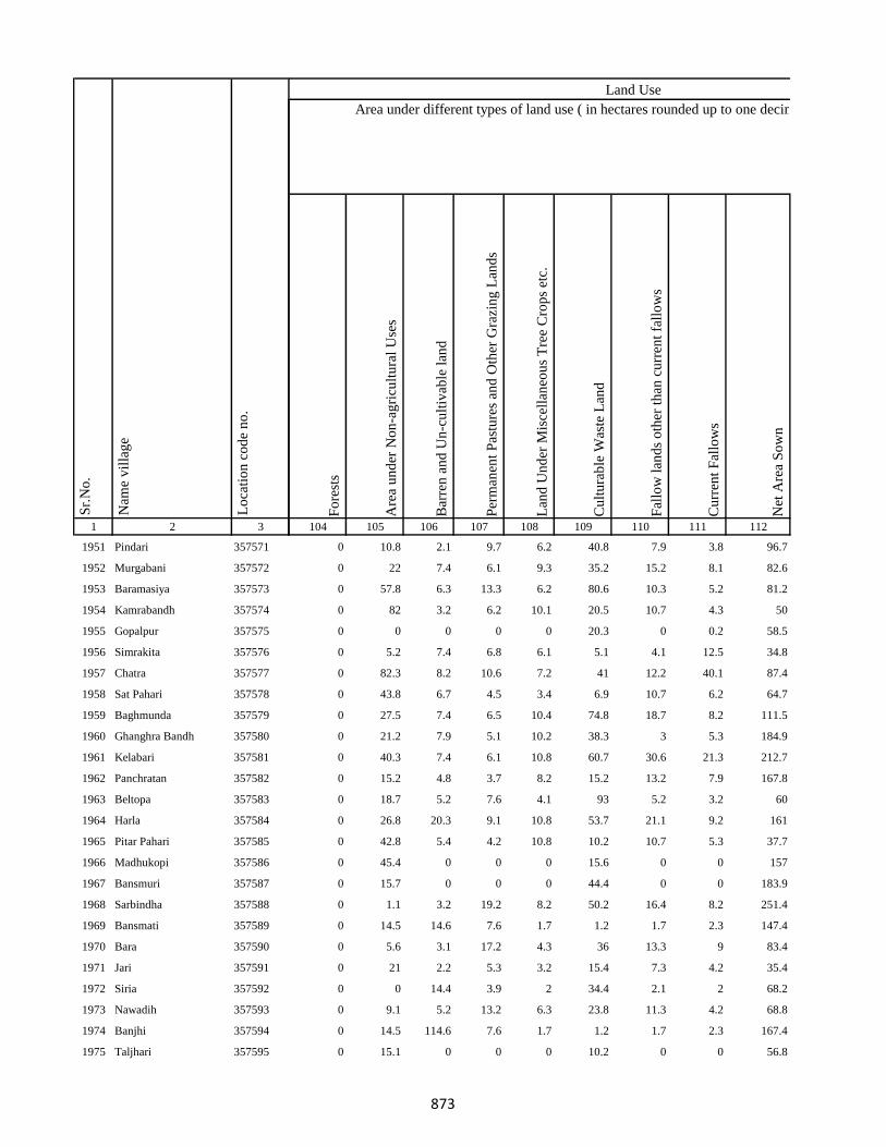
1 2 3
Lo
cati
on
co
de
no
.
Nam
e v
illa
ge
Sr.
No
.
1951 Pindari 357571
1952 Murgabani 357572
1953 Baramasiya 357573
1954 Kamrabandh 357574
1955 Gopalpur 357575
1956 Simrakita 357576
1957 Chatra 357577
1958 Sat Pahari 357578
1959 Baghmunda 357579
1960 Ghanghra Bandh 357580
1961 Kelabari 357581
1962 Panchratan 357582
1963 Beltopa 357583
1964 Harla 357584
1965 Pitar Pahari 357585
1966 Madhukopi 357586
1967 Bansmuri 357587
1968 Sarbindha 357588
1969 Bansmati 357589
1970 Bara 357590
1971 Jari 357591
1972 Siria 357592
1973 Nawadih 357593
1974 Banjhi 357594
1975 Taljhari 357595
Fo
rest
s
Are
a u
nd
er N
on
-ag
ricu
ltu
ral
Use
s
Bar
ren
an
d U
n-c
ult
ivab
le l
and
Per
man
ent
Pas
ture
s an
d O
ther
Gra
zin
g L
and
s
Lan
d U
nd
er M
isce
llan
eou
s T
ree
Cro
ps
etc.
Cu
ltu
rab
le W
aste
Lan
d
Fal
low
lan
ds
oth
er t
han
cu
rren
t fa
llo
ws
Cu
rren
t F
allo
ws
Net
Are
a S
ow
n
104 105 106 107 108 109 110 111 112
Area under different types of land use ( in hectares rounded up to one decimal place)
Land Use
0 10.8 2.1 9.7 6.2 40.8 7.9 3.8 96.7
0 22 7.4 6.1 9.3 35.2 15.2 8.1 82.6
0 57.8 6.3 13.3 6.2 80.6 10.3 5.2 81.2
0 82 3.2 6.2 10.1 20.5 10.7 4.3 50
0 0 0 0 0 20.3 0 0.2 58.5
0 5.2 7.4 6.8 6.1 5.1 4.1 12.5 34.8
0 82.3 8.2 10.6 7.2 41 12.2 40.1 87.4
0 43.8 6.7 4.5 3.4 6.9 10.7 6.2 64.7
0 27.5 7.4 6.5 10.4 74.8 18.7 8.2 111.5
0 21.2 7.9 5.1 10.2 38.3 3 5.3 184.9
0 40.3 7.4 6.1 10.8 60.7 30.6 21.3 212.7
0 15.2 4.8 3.7 8.2 15.2 13.2 7.9 167.8
0 18.7 5.2 7.6 4.1 93 5.2 3.2 60
0 26.8 20.3 9.1 10.8 53.7 21.1 9.2 161
0 42.8 5.4 4.2 10.8 10.2 10.7 5.3 37.7
0 45.4 0 0 0 15.6 0 0 157
0 15.7 0 0 0 44.4 0 0 183.9
0 1.1 3.2 19.2 8.2 50.2 16.4 8.2 251.4
0 14.5 14.6 7.6 1.7 1.2 1.7 2.3 147.4
0 5.6 3.1 17.2 4.3 36 13.3 9 83.4
0 21 2.2 5.3 3.2 15.4 7.3 4.2 35.4
0 0 14.4 3.9 2 34.4 2.1 2 68.2
0 9.1 5.2 13.2 6.3 23.8 11.3 4.2 68.8
0 14.5 114.6 7.6 1.7 1.2 1.7 2.3 167.4
0 15.1 0 0 0 10.2 0 0 56.8
873

1 2 3
Lo
cati
on
co
de
no
.
Nam
e v
illa
ge
Sr.
No
.
1976 Kharkachia 357596
1977 Jambad 357597
1978 Chorbad 357598
1979 Agiabandh 357599
1980 Dewdanr(Uttartola) 357600
1981 Dewdanr 357601
1982 Baghmara 357602
1983 Kendua 357603
1984 Karikadar 357604
1985 Khardaha 357605
1986 Khardaha 357606
1987 Ambadiha 357607
1988 Baghmara Purabtola 357608
1989 Garhbana 357609
1990 Gobindpur 357610
1991 Bankati 357611
1992 Pindra 357612
1993 Piparjoriya 357613
1994 Jitpur 357614
1995 Boha 357615
1996 Liti 357616
1997 Sidhbank 357617
1998 Kairasol 357618
1999 Daharlangi 357619
2000 Halhiya Pathar 357620
Fo
rest
s
Are
a u
nd
er N
on
-ag
ricu
ltu
ral
Use
s
Bar
ren
an
d U
n-c
ult
ivab
le l
and
Per
man
ent
Pas
ture
s an
d O
ther
Gra
zin
g L
and
s
Lan
d U
nd
er M
isce
llan
eou
s T
ree
Cro
ps
etc.
Cu
ltu
rab
le W
aste
Lan
d
Fal
low
lan
ds
oth
er t
han
cu
rren
t fa
llo
ws
Cu
rren
t F
allo
ws
Net
Are
a S
ow
n
104 105 106 107 108 109 110 111 112
Area under different types of land use ( in hectares rounded up to one decimal place)
Land Use
0 54.7 2.3 7.7 4.3 20.3 11.3 6.2 199.2
0 15 6.2 5.1 7.4 62 10.3 6.1 85.8
0 101.2 7.1 6.4 8.7 50.6 17.4 8.2 64.4
0 20.7 4.9 5 8 91.1 16.2 9.1 77.9
0 4 0.3 0 0.9 8.1 2.4 0.5 13.8
0 103.3 5.1 6.7 8.2 69.1 15.6 5.3 148.6
0 154.9 5.6 6.3 10.1 60.7 17.4 8.1 152.8
0 59.2 6.7 7.8 5.1 10.1 11.2 5.4 38.4
0 39.3 6.7 18.2 9.4 53.6 21.4 21.5 248.9
0 57.5 5.9 0.8 7.1 8.1 12.4 6.2 49
0 11.4 5.9 4.8 7.1 13.8 12.4 6.2 47.4
0 61.2 8.3 4.1 6.5 11.2 10.2 7.1 93.3
0 8 4.7 4.1 5.4 10.2 12.8 6.2 138.7
0 44.5 7.2 5.3 10.7 22.2 20 10.1 60.9
0 61.5 7.2 6.3 12.8 20.2 19.8 10.1 129.1
0 21 6.3 8.9 17.3 5.9 15.1 8.2 138.3
0 82.6 9.4 10.2 20.1 96 33.8 16.3 270.6
0 6.8 5.1 4.6 5.7 7.5 9.2 4.2 55.9
0 29.5 10 7.2 8.2 16.2 24.7 10.3 192.9
0 34.7 18.4 10.3 16.8 25.2 26.4 12.4 260.7
0 33.3 8.2 7.1 16.5 40.9 19.4 9.2 243
86.7 60.5 0 0 0 116.8 0 0 556.1
0 74.1 10.3 7.1 18.4 29.1 24.8 10.1 198.2
0 7.3 4.8 2.1 6.2 6.8 3.6 1.4 96.9
0 10.4 4.4 2.2 10.8 10.4 12.2 7.1 94.5
874
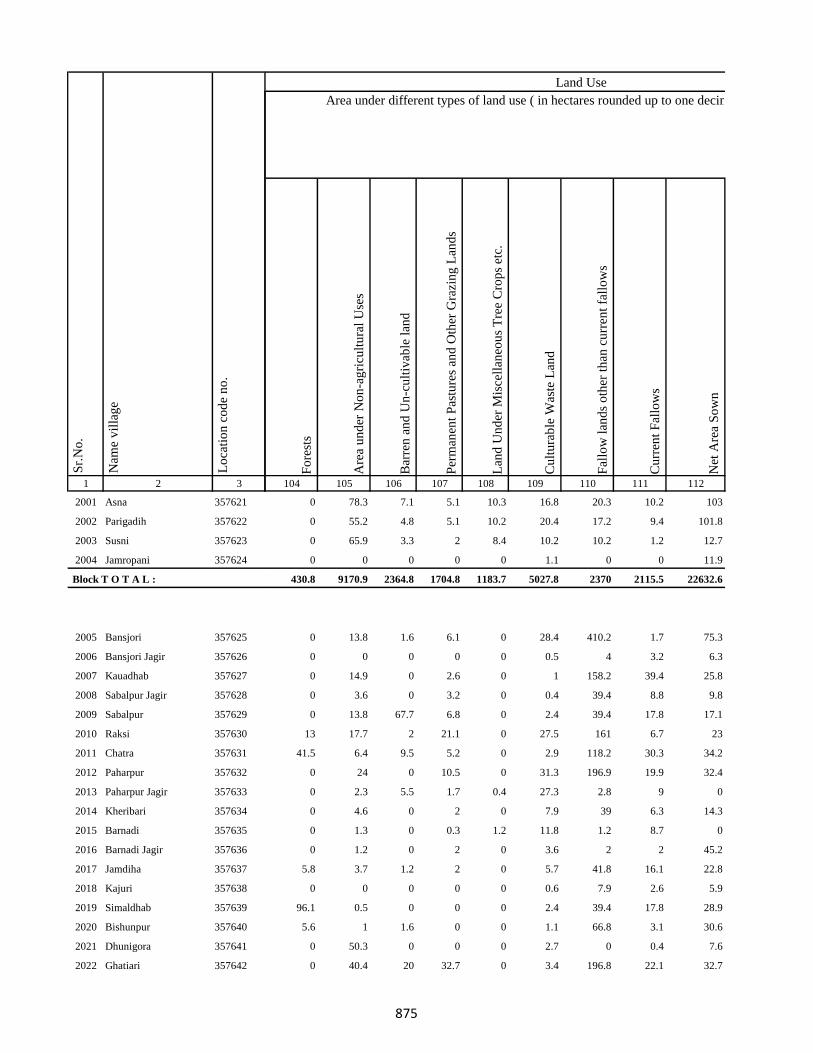
1 2 3
Lo
cati
on
co
de
no
.
Nam
e v
illa
ge
Sr.
No
.
2001 Asna 357621
2002 Parigadih 357622
2003 Susni 357623
2004 Jamropani 357624
Block T O T A L :
2005 Bansjori 357625
2006 Bansjori Jagir 357626
2007 Kauadhab 357627
2008 Sabalpur Jagir 357628
2009 Sabalpur 357629
2010 Raksi 357630
2011 Chatra 357631
2012 Paharpur 357632
2013 Paharpur Jagir 357633
2014 Kheribari 357634
2015 Barnadi 357635
2016 Barnadi Jagir 357636
2017 Jamdiha 357637
2018 Kajuri 357638
2019 Simaldhab 357639
2020 Bishunpur 357640
2021 Dhunigora 357641
2022 Ghatiari 357642
Fo
rest
s
Are
a u
nd
er N
on
-ag
ricu
ltu
ral
Use
s
Bar
ren
an
d U
n-c
ult
ivab
le l
and
Per
man
ent
Pas
ture
s an
d O
ther
Gra
zin
g L
and
s
Lan
d U
nd
er M
isce
llan
eou
s T
ree
Cro
ps
etc.
Cu
ltu
rab
le W
aste
Lan
d
Fal
low
lan
ds
oth
er t
han
cu
rren
t fa
llo
ws
Cu
rren
t F
allo
ws
Net
Are
a S
ow
n
104 105 106 107 108 109 110 111 112
Area under different types of land use ( in hectares rounded up to one decimal place)
Land Use
0 78.3 7.1 5.1 10.3 16.8 20.3 10.2 103
0 55.2 4.8 5.1 10.2 20.4 17.2 9.4 101.8
0 65.9 3.3 2 8.4 10.2 10.2 1.2 12.7
0 0 0 0 0 1.1 0 0 11.9
430.8 9170.9 2364.8 1704.8 1183.7 5027.8 2370 2115.5 22632.6
0 13.8 1.6 6.1 0 28.4 410.2 1.7 75.3
0 0 0 0 0 0.5 4 3.2 6.3
0 14.9 0 2.6 0 1 158.2 39.4 25.8
0 3.6 0 3.2 0 0.4 39.4 8.8 9.8
0 13.8 67.7 6.8 0 2.4 39.4 17.8 17.1
13 17.7 2 21.1 0 27.5 161 6.7 23
41.5 6.4 9.5 5.2 0 2.9 118.2 30.3 34.2
0 24 0 10.5 0 31.3 196.9 19.9 32.4
0 2.3 5.5 1.7 0.4 27.3 2.8 9 0
0 4.6 0 2 0 7.9 39 6.3 14.3
0 1.3 0 0.3 1.2 11.8 1.2 8.7 0
0 1.2 0 2 0 3.6 2 2 45.2
5.8 3.7 1.2 2 0 5.7 41.8 16.1 22.8
0 0 0 0 0 0.6 7.9 2.6 5.9
96.1 0.5 0 0 0 2.4 39.4 17.8 28.9
5.6 1 1.6 0 0 1.1 66.8 3.1 30.6
0 50.3 0 0 0 2.7 0 0.4 7.6
0 40.4 20 32.7 0 3.4 196.8 22.1 32.7
875
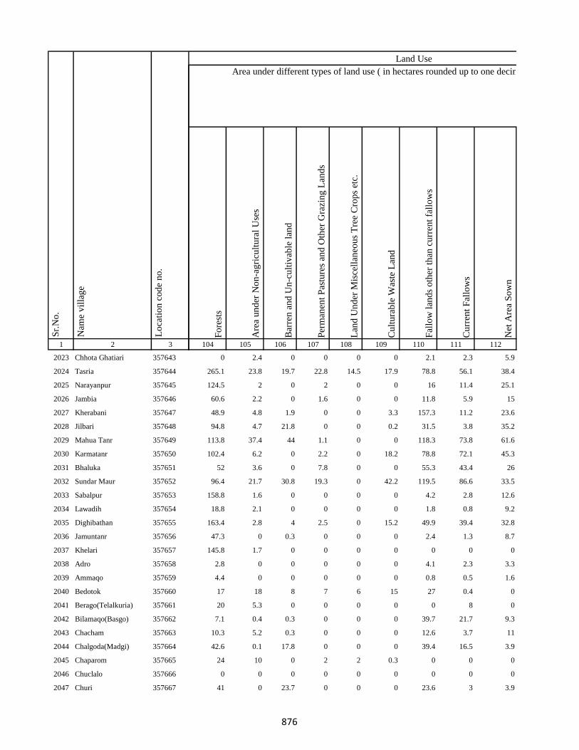
1 2 3
Lo
cati
on
co
de
no
.
Nam
e v
illa
ge
Sr.
No
.
2023 Chhota Ghatiari 357643
2024 Tasria 357644
2025 Narayanpur 357645
2026 Jambia 357646
2027 Kherabani 357647
2028 Jilbari 357648
2029 Mahua Tanr 357649
2030 Karmatanr 357650
2031 Bhaluka 357651
2032 Sundar Maur 357652
2033 Sabalpur 357653
2034 Lawadih 357654
2035 Dighibathan 357655
2036 Jamuntanr 357656
2037 Khelari 357657
2038 Adro 357658
2039 Ammaqo 357659
2040 Bedotok 357660
2041 Berago(Telalkuria) 357661
2042 Bilamaqo(Basgo) 357662
2043 Chacham 357663
2044 Chalgoda(Madgi) 357664
2045 Chaparom 357665
2046 Chuclalo 357666
2047 Churi 357667
Fo
rest
s
Are
a u
nd
er N
on
-ag
ricu
ltu
ral
Use
s
Bar
ren
an
d U
n-c
ult
ivab
le l
and
Per
man
ent
Pas
ture
s an
d O
ther
Gra
zin
g L
and
s
Lan
d U
nd
er M
isce
llan
eou
s T
ree
Cro
ps
etc.
Cu
ltu
rab
le W
aste
Lan
d
Fal
low
lan
ds
oth
er t
han
cu
rren
t fa
llo
ws
Cu
rren
t F
allo
ws
Net
Are
a S
ow
n
104 105 106 107 108 109 110 111 112
Area under different types of land use ( in hectares rounded up to one decimal place)
Land Use
0 2.4 0 0 0 0 2.1 2.3 5.9
265.1 23.8 19.7 22.8 14.5 17.9 78.8 56.1 38.4
124.5 2 0 2 0 0 16 11.4 25.1
60.6 2.2 0 1.6 0 0 11.8 5.9 15
48.9 4.8 1.9 0 0 3.3 157.3 11.2 23.6
94.8 4.7 21.8 0 0 0.2 31.5 3.8 35.2
113.8 37.4 44 1.1 0 0 118.3 73.8 61.6
102.4 6.2 0 2.2 0 18.2 78.8 72.1 45.3
52 3.6 0 7.8 0 0 55.3 43.4 26
96.4 21.7 30.8 19.3 0 42.2 119.5 86.6 33.5
158.8 1.6 0 0 0 0 4.2 2.8 12.6
18.8 2.1 0 0 0 0 1.8 0.8 9.2
163.4 2.8 4 2.5 0 15.2 49.9 39.4 32.8
47.3 0 0.3 0 0 0 2.4 1.3 8.7
145.8 1.7 0 0 0 0 0 0 0
2.8 0 0 0 0 0 4.1 2.3 3.3
4.4 0 0 0 0 0 0.8 0.5 1.6
17 18 8 7 6 15 27 0.4 0
20 5.3 0 0 0 0 0 8 0
7.1 0.4 0.3 0 0 0 39.7 21.7 9.3
10.3 5.2 0.3 0 0 0 12.6 3.7 11
42.6 0.1 17.8 0 0 0 39.4 16.5 3.9
24 10 0 2 2 0.3 0 0 0
0 0 0 0 0 0 0 0 0
41 0 23.7 0 0 0 23.6 3 3.9
876
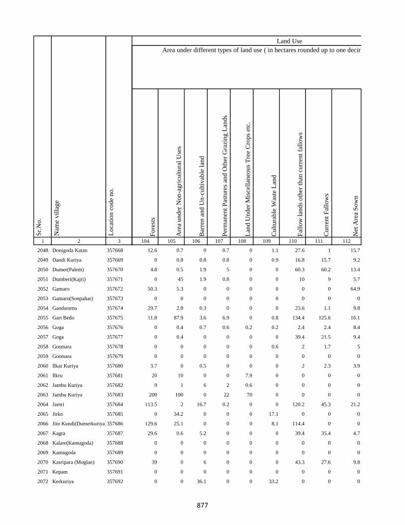
1 2 3
Lo
cati
on
co
de
no
.
Nam
e v
illa
ge
Sr.
No
.
2048 Donigoda Katan 357668
2049 Dandi Kuriya 357669
2050 Dumer(Palem) 357670
2051 Dumberi(Kajri) 357671
2052 Gamaro 357672
2053 Gamaro(Sonpahar) 357673
2054 Gandarama 357674
2055 Gari Bedo 357675
2056 Goga 357676
2057 Goga 357677
2058 Gosmara 357678
2059 Gosmara 357679
2060 Ilkar Kuriya 357680
2061 Ilkru 357681
2062 Jambu Kuriya 357682
2063 Jambu Kuriya 357683
2064 Jamri 357684
2065 Jirko 357685
2066 Jito Kundi(Dumerkuriya)357686
2067 Kagra 357687
2068 Kalare(Kamugoda) 357688
2069 Kamugoda 357689
2070 Kasripara (Moglan) 357690
2071 Kepam 357691
2072 Kerkuriya 357692
Fo
rest
s
Are
a u
nd
er N
on
-ag
ricu
ltu
ral
Use
s
Bar
ren
an
d U
n-c
ult
ivab
le l
and
Per
man
ent
Pas
ture
s an
d O
ther
Gra
zin
g L
and
s
Lan
d U
nd
er M
isce
llan
eou
s T
ree
Cro
ps
etc.
Cu
ltu
rab
le W
aste
Lan
d
Fal
low
lan
ds
oth
er t
han
cu
rren
t fa
llo
ws
Cu
rren
t F
allo
ws
Net
Are
a S
ow
n
104 105 106 107 108 109 110 111 112
Area under different types of land use ( in hectares rounded up to one decimal place)
Land Use
12.6 0.7 0 0.7 0 1.1 27.6 1 15.7
0 0.8 0.8 0.8 0 0.9 16.8 15.7 9.2
4.8 0.5 1.9 5 0 0 60.3 60.2 13.4
0 45 1.9 0.8 0 0 10 9 5.7
50.3 5.3 0 0 0 0 0 0 64.9
0 0 0 0 0 0 0 0 0
29.7 2.8 0.3 0 0 0 23.6 1.1 9.8
11.8 87.9 3.6 6.9 0 0.8 134.4 125.6 16.1
0 0.4 0.7 0.6 0.2 0.2 2.4 2.4 8.4
0 0.4 0 0 0 0 39.4 21.5 9.4
0 0 0 0 0 0.6 2 1.7 5
0 0 0 0 0 0 0 0 0
3.7 0 0.5 0 0 0 2 2.3 3.9
20 10 0 0 7.9 0 0 0 0
9 1 6 2 0.6 0 0 0 0
200 100 0 22 70 0 0 0 0
113.5 2 16.7 0.2 0 0 120.2 45.3 21.2
0 34.2 0 0 0 17.1 0 0 0
129.6 25.1 0 0 0 8.1 114.4 0 0
29.6 0.6 5.2 0 0 0 39.4 35.4 4.7
0 0 0 0 0 0 0 0 0
0 0 0 0 0 0 0 0 0
39 0 6 0 0 0 43.3 27.6 9.8
0 0 0 0 0 0 0 0 0
0 0 36.1 0 0 33.2 0 0 0
877
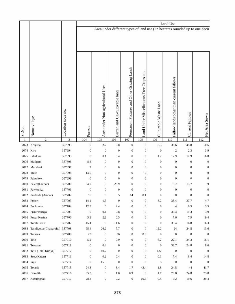
1 2 3
Lo
cati
on
co
de
no
.
Nam
e v
illa
ge
Sr.
No
.
2073 Kerjuria 357693
2074 Kiro 357694
2075 Liladoni 357695
2076 Madgam 357696
2077 Maridoni 357697
2078 Mate 357698
2079 Pakeritok 357699
2080 Palem(Dumar) 357700
2081 Pawkuriya 357701
2082 Perdarda (Ambar) 357702
2083 Pokeri 357703
2084 Popkundo 357704
2085 Pusur Kuriya 357705
2086 Pusur Kuriya 357706
2087 Tamli Bedo 357707
2088 Tamligoda (Chaparbita) 357708
2089 Tatkota 357709
2090 Telo 357710
2091 Telodoni 357711
2092 Tetli (Telal Kuriya) 357712
2093 Sena(Katan) 357713
2094 Suju 357714
2095 Tetaria 357715
2096 Domdih 357716
2097 Kusumghati 357717
Fo
rest
s
Are
a u
nd
er N
on
-ag
ricu
ltu
ral
Use
s
Bar
ren
an
d U
n-c
ult
ivab
le l
and
Per
man
ent
Pas
ture
s an
d O
ther
Gra
zin
g L
and
s
Lan
d U
nd
er M
isce
llan
eou
s T
ree
Cro
ps
etc.
Cu
ltu
rab
le W
aste
Lan
d
Fal
low
lan
ds
oth
er t
han
cu
rren
t fa
llo
ws
Cu
rren
t F
allo
ws
Net
Are
a S
ow
n
104 105 106 107 108 109 110 111 112
Area under different types of land use ( in hectares rounded up to one decimal place)
Land Use
0 2.7 0.8 0 0 8.3 38.6 45.8 10.6
0 0 0 0 0 0 2 2.3 3.9
0 0.1 0.4 0 0 1.2 17.9 17.9 16.8
8.4 0 0 0 0 0 0 0 0
2 0 0 0 0 0 0 0 0
14.5 0 0 0 0 0 0 0 0
0 0 0 0 0 0 0 0 0
4.7 0 28.9 0 0 0 19.7 13.7 9
0 0 0 0 0 0 0 0 0
15 0 5 14 0.1 0 0 0 0
14.1 1.3 0 0 0 3.2 35.4 27.7 4.7
12.9 0 4.4 0 0 0 4 0.5 3.5
0 0.4 0.8 0 0 0 39.4 11.3 3.9
5.3 2.2 0.5 0 0 0 7.6 7.9 9.4
45.4 0 11.6 0 0 0 39.4 16.8 6.3
95.4 26.2 7.7 0 0 12.2 24 24.5 13.6
23 0 36 8 0.8 0 0 0 0
5.2 0 0.9 0 0 6.2 22.1 24.3 16.1
0 0.4 0 0 0 0 39.7 24.8 8.6
0 40.7 0 0 0 122 0 0 0
0 0.2 0.4 0 0 0.1 7.4 8.4 14.8
0 15.5 0 0 0 5 0 0 0
24.3 0 3.4 1.7 42.4 1.8 24.5 44 41.7
85.3 0 1.8 0.9 0 1.7 79.8 24.8 73.8
28.3 0 0.2 0 10.8 0.4 3.2 19.6 39.4
878
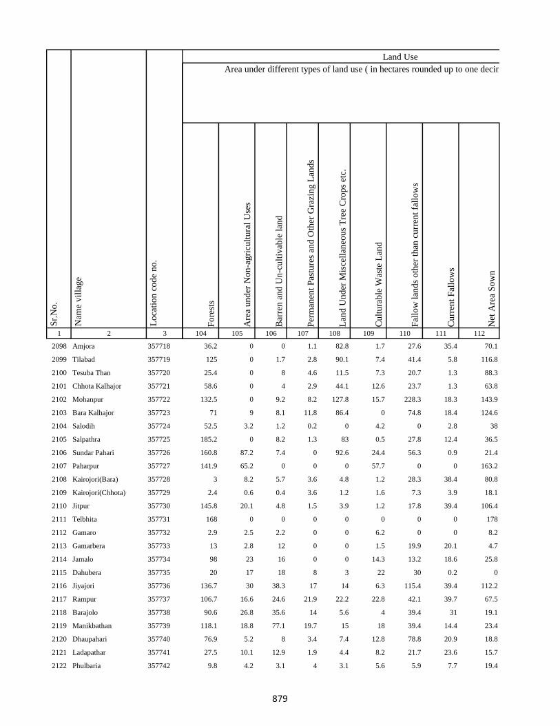
1 2 3
Lo
cati
on
co
de
no
.
Nam
e v
illa
ge
Sr.
No
.
2098 Amjora 357718
2099 Tilabad 357719
2100 Tesuba Than 357720
2101 Chhota Kalhajor 357721
2102 Mohanpur 357722
2103 Bara Kalhajor 357723
2104 Salodih 357724
2105 Salpathra 357725
2106 Sundar Pahari 357726
2107 Paharpur 357727
2108 Kairojori(Bara) 357728
2109 Kairojori(Chhota) 357729
2110 Jitpur 357730
2111 Telbhita 357731
2112 Gamaro 357732
2113 Gamarbera 357733
2114 Jamalo 357734
2115 Dahubera 357735
2116 Jiyajori 357736
2117 Rampur 357737
2118 Barajolo 357738
2119 Manikbathan 357739
2120 Dhaupahari 357740
2121 Ladapathar 357741
2122 Phulbaria 357742
Fo
rest
s
Are
a u
nd
er N
on
-ag
ricu
ltu
ral
Use
s
Bar
ren
an
d U
n-c
ult
ivab
le l
and
Per
man
ent
Pas
ture
s an
d O
ther
Gra
zin
g L
and
s
Lan
d U
nd
er M
isce
llan
eou
s T
ree
Cro
ps
etc.
Cu
ltu
rab
le W
aste
Lan
d
Fal
low
lan
ds
oth
er t
han
cu
rren
t fa
llo
ws
Cu
rren
t F
allo
ws
Net
Are
a S
ow
n
104 105 106 107 108 109 110 111 112
Area under different types of land use ( in hectares rounded up to one decimal place)
Land Use
36.2 0 0 1.1 82.8 1.7 27.6 35.4 70.1
125 0 1.7 2.8 90.1 7.4 41.4 5.8 116.8
25.4 0 8 4.6 11.5 7.3 20.7 1.3 88.3
58.6 0 4 2.9 44.1 12.6 23.7 1.3 63.8
132.5 0 9.2 8.2 127.8 15.7 228.3 18.3 143.9
71 9 8.1 11.8 86.4 0 74.8 18.4 124.6
52.5 3.2 1.2 0.2 0 4.2 0 2.8 38
185.2 0 8.2 1.3 83 0.5 27.8 12.4 36.5
160.8 87.2 7.4 0 92.6 24.4 56.3 0.9 21.4
141.9 65.2 0 0 0 57.7 0 0 163.2
3 8.2 5.7 3.6 4.8 1.2 28.3 38.4 80.8
2.4 0.6 0.4 3.6 1.2 1.6 7.3 3.9 18.1
145.8 20.1 4.8 1.5 3.9 1.2 17.8 39.4 106.4
168 0 0 0 0 0 0 0 178
2.9 2.5 2.2 0 0 6.2 0 0 8.2
13 2.8 12 0 0 1.5 19.9 20.1 4.7
98 23 16 0 0 14.3 13.2 18.6 25.8
20 17 18 8 3 22 30 0.2 0
136.7 30 38.3 17 14 6.3 115.4 39.4 112.2
106.7 16.6 24.6 21.9 22.2 22.8 42.1 39.7 67.5
90.6 26.8 35.6 14 5.6 4 39.4 31 19.1
118.1 18.8 77.1 19.7 15 18 39.4 14.4 23.4
76.9 5.2 8 3.4 7.4 12.8 78.8 20.9 18.8
27.5 10.1 12.9 1.9 4.4 8.2 21.7 23.6 15.7
9.8 4.2 3.1 4 3.1 5.6 5.9 7.7 19.4
879
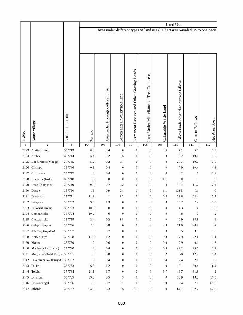
1 2 3
Lo
cati
on
co
de
no
.
Nam
e v
illa
ge
Sr.
No
.
2123 Alkito(Katon) 357743
2124 Ambar 357744
2125 Bandaretoke(Madgi) 357745
2126 Champa 357746
2127 Charmaka 357747
2128 Chetamu (Jirik) 357748
2129 Dande(Salpahar) 357749
2130 Dando 357750
2131 Dawgoda 357751
2132 Dawgoda 357752
2133 Dumeri(Dumar) 357753
2134 Gambaritoke 357754
2135 Gambaritoke 357755
2136 Gelago(Basgo) 357756
2137 Jolame(Daupahar) 357757
2138 Kero Kuriya 357758
2139 Makma 357759
2140 Masbera (Banspahar) 357760
2141 Melijamali(Tetal Kuriya) 357761
2142 Pakeramo(Tok Kuriya) 357762
2143 Pakeri 357763
2144 Telbita 357764
2145 Dhankuti 357765
2146 Dhawadangal 357766
2147 Jabarda 357767
Fo
rest
s
Are
a u
nd
er N
on
-ag
ricu
ltu
ral
Use
s
Bar
ren
an
d U
n-c
ult
ivab
le l
and
Per
man
ent
Pas
ture
s an
d O
ther
Gra
zin
g L
and
s
Lan
d U
nd
er M
isce
llan
eou
s T
ree
Cro
ps
etc.
Cu
ltu
rab
le W
aste
Lan
d
Fal
low
lan
ds
oth
er t
han
cu
rren
t fa
llo
ws
Cu
rren
t F
allo
ws
Net
Are
a S
ow
n
104 105 106 107 108 109 110 111 112
Area under different types of land use ( in hectares rounded up to one decimal place)
Land Use
0.6 0.4 0 0 0 0.6 4.1 5.5 1.2
6.4 0.2 0.5 0 0 0 19.7 19.6 1.6
5.2 0.3 0.4 0 0 0 25.7 19.7 3.5
0.8 0.4 0 0 0 0 7.9 10.4 4.3
0 0.4 0 0 0 0 2 1 11.8
0 0 0 0 0 11.1 0 0 0
9.8 0.7 5.2 0 0 0 19.4 11.2 2.4
15 0.9 2.8 0 0 1.1 121.5 5.1 0
11.8 1 3.2 0 0 0.8 23.6 22.4 3.7
9.6 1.3 0 0 0 0 15.7 7.9 3.5
10.3 0 0 0 0 0 4.3 4 1.6
10.2 0 0 0 0 0 8 7 2
2.4 0.2 1.5 0 0 0 9.9 15.8 2
14 0.8 0 0 0 3.9 31.6 20.8 2
0 0.7 0 0 0 0 5 3.8 1.6
11.8 1.2 0 0 0 0.8 27.9 22.4 3.1
0 0.6 0 0 0 0.9 7.9 9.1 1.6
0 0.4 0 0 0 0.5 49.2 39.7 1.2
0 0.8 0 0 0 2 20 12.2 1.4
0 0.4 0 0 0 0.4 2.4 2.1 2
6.3 1.2 0 0 0 0 12.1 39.4 6.4
24.1 1.7 0 0 0 9.7 19.7 31.8 2
39.6 0.5 3 0 0 0 13.9 18.3 17.5
76 0.7 3.7 0 0 0.9 4 7.1 67.6
94.6 6.3 3.5 6.3 0 0 64.1 62.7 52.5
880

1 2 3
Lo
cati
on
co
de
no
.
Nam
e v
illa
ge
Sr.
No
.
2148 Bara Puro 357768
2149 Chhota Dhamni 357769
2150 Dhamni Bazar 357770
2151 Bara Dhamni 357771
2152 Chhota Puro 357772
2153 Gadidih 357773
2154 Piparjoria 357774
2155 Marchaitari 357775
2156 Pokharia 357776
2157 Kairasul 357777
2158 Ambardoni 357778
2159 Bat 357779
2160 Bitakepu 357780
2161 Daukuriya 357781
2162 Donigoda 357782
2163 Jari Mamqo 357783
2164 Kadu 357784
2165 Karag 357785
2166 Kiro 357786
2167 Koa 357787
2168 Kubji Bedo 357788
2169 Kubji Maqo 357789
2170 Kudi Goda 357790
2171 Madgi 357791
2172 Madgi Bedo 357792
Fo
rest
s
Are
a u
nd
er N
on
-ag
ricu
ltu
ral
Use
s
Bar
ren
an
d U
n-c
ult
ivab
le l
and
Per
man
ent
Pas
ture
s an
d O
ther
Gra
zin
g L
and
s
Lan
d U
nd
er M
isce
llan
eou
s T
ree
Cro
ps
etc.
Cu
ltu
rab
le W
aste
Lan
d
Fal
low
lan
ds
oth
er t
han
cu
rren
t fa
llo
ws
Cu
rren
t F
allo
ws
Net
Are
a S
ow
n
104 105 106 107 108 109 110 111 112
Area under different types of land use ( in hectares rounded up to one decimal place)
Land Use
5.8 24.5 9.9 5.3 9.4 5.5 69.5 67.4 79.7
24.8 13.5 10 3.7 0 0 22.8 20 61.2
0 3.5 0 0 0 0 0.2 0.2 0
7.7 8.3 9 7.1 0 0 36.5 32 116.3
1.2 6 4.7 3.1 0 0 65.1 53.2 83.6
2.5 6.6 4.9 2 0 0 16.2 17.6 52.2
2.3 5.8 0 0.3 0 0 0.8 0.4 39.8
0 10.7 3.1 4.6 0 21.5 8.7 13.9 61.5
8.9 10.4 4.9 1.5 0 0 3.5 2.7 57.1
46.2 11.5 14 6.3 0 3.7 12.4 10.4 103.4
0 0 0 0 0 0 0 0 0
41.3 2.6 0 0 0 0 0.2 0.2 7.7
49.4 0.3 0 0 0 0 0.2 0.2 9.8
0 0 0 0 0 0 0 0 0
27 0.1 0 0 0 0 0.3 0.3 9.9
0 0 0 0 0 0 0 0 0
0 0 0 0 0 0 0 0 0
0 0 0.5 0 0 0 3.9 6.4 6.1
8.5 0 0 0 0 0 0 0 0
0 1.4 0 0 0 0 56 29.6 31.3
0 1.5 0 0 0 0 20.2 15.7 23
0 0 0 0 0 0 0 0 0
0 0.3 0 0 0 0 7.6 9.4 12
0 0 0 0 0 0 0 0 0
0 0 0 0 0 0 0 0 0
881

1 2 3
Lo
cati
on
co
de
no
.
Nam
e v
illa
ge
Sr.
No
.
2173 Madgi Maqo 357793
2174 Puro Maqo (Katan) 357794
2175 Karag 357795
2176 Tamli 357796
2177 Takalo 357797
2178 Tetal Kuriya 357798
2179 Saharpura 357799
2180 Chandna 357800
2181 Longidih 357801
2182 Borwa 357802
2183 Karamtola 357803
2184 Roldih 357804
2185 Bara Haripur 357805
2186 Dulu 357806
2187 Asantari 357807
2188 Kusmaha 357808
2189 Damruhat 357809
2190 Dumki 357810
2191 Kairabani 357811
2192 Bariyarpur 357812
2193 Chhota Haripur 357813
2194 Kadampur 357814
2195 Angbali 357815
2196 Banspahari 357816
2197 Gamharia 357817
Fo
rest
s
Are
a u
nd
er N
on
-ag
ricu
ltu
ral
Use
s
Bar
ren
an
d U
n-c
ult
ivab
le l
and
Per
man
ent
Pas
ture
s an
d O
ther
Gra
zin
g L
and
s
Lan
d U
nd
er M
isce
llan
eou
s T
ree
Cro
ps
etc.
Cu
ltu
rab
le W
aste
Lan
d
Fal
low
lan
ds
oth
er t
han
cu
rren
t fa
llo
ws
Cu
rren
t F
allo
ws
Net
Are
a S
ow
n
104 105 106 107 108 109 110 111 112
Area under different types of land use ( in hectares rounded up to one decimal place)
Land Use
10.9 0 0.3 0.3 0 0 4.7 4 19.3
16.5 0.1 0.8 0.6 0 0 18.4 16.6 11.2
0 0 0 0 0 0 0 0 0
0 0 0 0 0 0 0 0 0
0 0 0 0 0 0 0 0 0
0 0 0 0 0 0 0 0 0
36.9 4.4 7.5 0 0 0.6 20.1 12 32.4
229.2 24.1 8.2 0 0 95.5 84.6 80 135.4
51.9 12.7 0 0 53.2 19.9 24.4 79.8 7
173.2 20.1 130 0 0 20 57.3 54.5 145.9
2 2.4 0.7 0 0 0.4 6 4 26.8
2 2.8 1.6 0 0 1.6 8 10.9 21
12.7 1.6 9.7 0 0 7.1 6.6 4.4 59.9
19 0.3 0 0 0 6.2 0 0 19.4
21.1 2.9 0 0 0 0.3 0 0 17.8
290.4 4.9 3.3 0 0 24.8 137.6 88 98
72 4.6 16.7 1.3 0 8.1 45.7 28.2 41.5
32.8 0 4.6 6.5 0.2 6.5 0 1 11.5
1.5 0 0 0 0 0 0 0.9 14.6
46.1 1 1 3.2 0 0.3 68 32 76.4
7.5 5.1 16.8 0 0 4.4 29.3 24.8 81
131.9 1.6 0.2 0 0 55.4 0.9 13.1 56.9
6.1 1.5 19.8 0 0 42.4 8.4 40.5 50.3
18.2 2 4 0 0 15.8 2.5 2.5 19.2
31.2 2.9 2.9 1.3 0 4 8.1 3.6 8
882
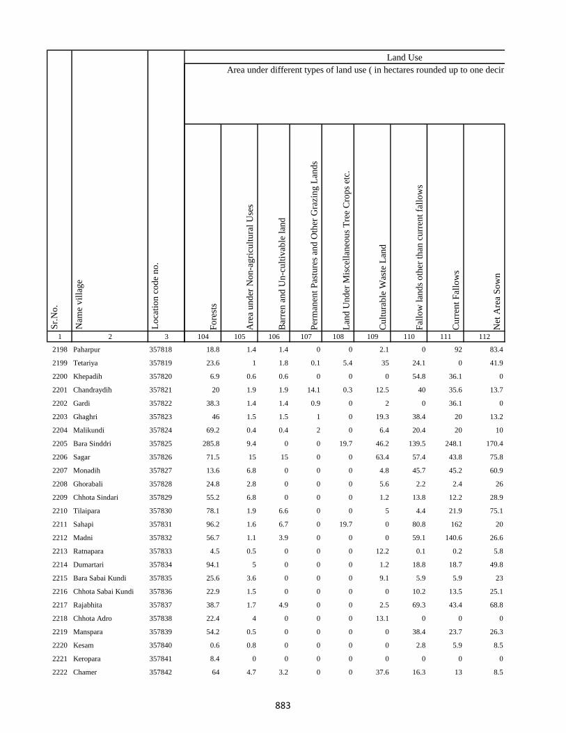
1 2 3
Lo
cati
on
co
de
no
.
Nam
e v
illa
ge
Sr.
No
.
2198 Paharpur 357818
2199 Tetariya 357819
2200 Khepadih 357820
2201 Chandraydih 357821
2202 Gardi 357822
2203 Ghaghri 357823
2204 Malikundi 357824
2205 Bara Sinddri 357825
2206 Sagar 357826
2207 Monadih 357827
2208 Ghorabali 357828
2209 Chhota Sindari 357829
2210 Tilaipara 357830
2211 Sahapi 357831
2212 Madni 357832
2213 Ratnapara 357833
2214 Dumartari 357834
2215 Bara Sabai Kundi 357835
2216 Chhota Sabai Kundi 357836
2217 Rajabhita 357837
2218 Chhota Adro 357838
2219 Manspara 357839
2220 Kesam 357840
2221 Keropara 357841
2222 Chamer 357842
Fo
rest
s
Are
a u
nd
er N
on
-ag
ricu
ltu
ral
Use
s
Bar
ren
an
d U
n-c
ult
ivab
le l
and
Per
man
ent
Pas
ture
s an
d O
ther
Gra
zin
g L
and
s
Lan
d U
nd
er M
isce
llan
eou
s T
ree
Cro
ps
etc.
Cu
ltu
rab
le W
aste
Lan
d
Fal
low
lan
ds
oth
er t
han
cu
rren
t fa
llo
ws
Cu
rren
t F
allo
ws
Net
Are
a S
ow
n
104 105 106 107 108 109 110 111 112
Area under different types of land use ( in hectares rounded up to one decimal place)
Land Use
18.8 1.4 1.4 0 0 2.1 0 92 83.4
23.6 1 1.8 0.1 5.4 35 24.1 0 41.9
6.9 0.6 0.6 0 0 0 54.8 36.1 0
20 1.9 1.9 14.1 0.3 12.5 40 35.6 13.7
38.3 1.4 1.4 0.9 0 2 0 36.1 0
46 1.5 1.5 1 0 19.3 38.4 20 13.2
69.2 0.4 0.4 2 0 6.4 20.4 20 10
285.8 9.4 0 0 19.7 46.2 139.5 248.1 170.4
71.5 15 15 0 0 63.4 57.4 43.8 75.8
13.6 6.8 0 0 0 4.8 45.7 45.2 60.9
24.8 2.8 0 0 0 5.6 2.2 2.4 26
55.2 6.8 0 0 0 1.2 13.8 12.2 28.9
78.1 1.9 6.6 0 0 5 4.4 21.9 75.1
96.2 1.6 6.7 0 19.7 0 80.8 162 20
56.7 1.1 3.9 0 0 0 59.1 140.6 26.6
4.5 0.5 0 0 0 12.2 0.1 0.2 5.8
94.1 5 0 0 0 1.2 18.8 18.7 49.8
25.6 3.6 0 0 0 9.1 5.9 5.9 23
22.9 1.5 0 0 0 0 10.2 13.5 25.1
38.7 1.7 4.9 0 0 2.5 69.3 43.4 68.8
22.4 4 0 0 0 13.1 0 0 0
54.2 0.5 0 0 0 0 38.4 23.7 26.3
0.6 0.8 0 0 0 0 2.8 5.9 8.5
8.4 0 0 0 0 0 0 0 0
64 4.7 3.2 0 0 37.6 16.3 13 8.5
883
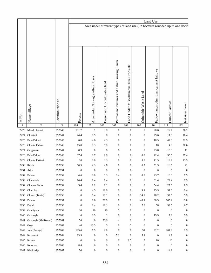
1 2 3
Lo
cati
on
co
de
no
.
Nam
e v
illa
ge
Sr.
No
.
2223 Mando Pahari 357843
2224 Chhatmi 357844
2225 Bara Paktari 357845
2226 Chhota Palma 357846
2227 Gargawan 357847
2228 Bara Palma 357848
2229 Chhota Paktari 357849
2230 Rakha 357850
2231 Adro 357851
2232 Balami 357852
2233 Chamdade 357853
2234 Chamar Bedo 357854
2235 Charchari 357855
2236 Chewo (Tetria) 357856
2237 Dando 357857
2238 Dumli 357858
2239 Gandiyamo 357859
2240 Garsingla 357860
2241 Garsingla (Malikundi) 357861
2242 Goga 357862
2243 Jolo (Berago) 357863
2244 Karamtok 357864
2245 Karmu 357865
2246 Keropara 357866
2247 Kirokuriya 357867
Fo
rest
s
Are
a u
nd
er N
on
-ag
ricu
ltu
ral
Use
s
Bar
ren
an
d U
n-c
ult
ivab
le l
and
Per
man
ent
Pas
ture
s an
d O
ther
Gra
zin
g L
and
s
Lan
d U
nd
er M
isce
llan
eou
s T
ree
Cro
ps
etc.
Cu
ltu
rab
le W
aste
Lan
d
Fal
low
lan
ds
oth
er t
han
cu
rren
t fa
llo
ws
Cu
rren
t F
allo
ws
Net
Are
a S
ow
n
104 105 106 107 108 109 110 111 112
Area under different types of land use ( in hectares rounded up to one decimal place)
Land Use
101.7 1 3.8 0 0 0 20.6 12.7 36.2
24.4 0.9 0 0 0 0 29.6 11.8 18.4
6.8 4.6 4.3 0 0 0 110.5 47.3 31.5
15.8 0.3 0.9 0 0 0 10 4.8 20.6
8.3 0 0 0 0 0 23.8 10.3 11
87.4 0.7 2.8 0 0 0.8 42.4 35.5 27.4
10 0.8 3.3 0 0 3.3 41.5 19.7 13.5
50.5 2.3 2.6 0 0 0.7 51.3 18.6 21
0 0 0 0 0 0 0 0 0
4.6 0.8 0.3 0.4 0 0.3 23.7 13.8 7.5
14.4 1.4 1.4 0 0 0 51.4 27.4 7.5
5.4 1.2 1.1 0 0 0 54.4 27.6 8.3
0 4.5 11.6 0 0 9.1 75.3 31.6 9.4
0 5.4 18.1 0 0 14.3 78.2 37.5 5.9
0 9.6 29.9 0 0 48.1 90.5 185.2 3.8
0 2.4 11.1 0 0 7.3 58 39.5 6.7
30 10 10 5 0 0 0 0 0
0 0.5 1 0 0 0 15.9 7.8 5.9
54 0 50.6 4 0 0 0 0 0
40 10.5 5 0 5 0 0 0 0
135.6 7.5 2.8 0 0 51 92.2 281.3 2.5
13.9 0 0 5.1 0 5.1 0 4.1 0
0 0 0 0 2.5 5 10 10 0
8.4 0 0 0 0 0 0 0 0
50 0 0 0 0 0 0 14.1 0
884

1 2 3
Lo
cati
on
co
de
no
.
Nam
e v
illa
ge
Sr.
No
.
2248 Kasari(Gutipara) 357868
2249 Kote 357869
2250 Maspara 357870
2251 Nadgoda 357871
2252 Pertara 357872
2253 Sabekundi 357873
2254 Salgama 357874
2255 Sarmi 357875
2256 Sidler 357876
2257 Singni 357877
2258 Tarobar 357878
2259 Tasgemthu 357879
2260 Talakpara(Pusurkuriya) 357880
2261 Talbita(Mudgi) 357881
2262 Tatgoda 357882
2263 Telo 357883
2264 Barmasia 357884
2265 Bokrabandh 357885
2266 Hardisol 357886
2267 Tilaipara 357887
2268 Barai 357888
2269 Bara Dangapara 357889
2270 Damakol 357890
2271 Karamba 357891
2272 Chhota Dangapara 357892
Fo
rest
s
Are
a u
nd
er N
on
-ag
ricu
ltu
ral
Use
s
Bar
ren
an
d U
n-c
ult
ivab
le l
and
Per
man
ent
Pas
ture
s an
d O
ther
Gra
zin
g L
and
s
Lan
d U
nd
er M
isce
llan
eou
s T
ree
Cro
ps
etc.
Cu
ltu
rab
le W
aste
Lan
d
Fal
low
lan
ds
oth
er t
han
cu
rren
t fa
llo
ws
Cu
rren
t F
allo
ws
Net
Are
a S
ow
n
104 105 106 107 108 109 110 111 112
Area under different types of land use ( in hectares rounded up to one decimal place)
Land Use
100 0 10 0 0 10 0 10 0
4 1.3 0 0 0 0 78.5 105.6 0.5
0 2.9 0 0 0 33.9 0 0 13.2
46.3 4.3 4.3 0 0 10.1 23.7 21.8 2.5
0 0 0.6 0 0 0 74.9 25.7 4.7
0 50.1 0 0 0 30.1 0 68.2 0
0 0 0 0.8 0 0 67 33.9 3.1
30.1 0.5 0.5 0 0 0 106.4 16.5 3.8
0 2.2 1.2 0 0 1.9 71.2 712.5 1.6
0 0 0 10 10 0 0 10.1 0
60 10 0 10 0 10 0 10 0
88.6 0 0.4 0 0 0 137.8 52.8 5.9
47.7 0.5 0.2 0 0 0 101.3 59.9 2.8
50 10 10 0 10 10 0 6.9 0
0 0 0 0 0 2.7 0 0 0
0 0.5 0 0 0 0 27 13.6 7.1
90.5 1.3 12.2 9.9 2 4.8 0.7 24.4 18.3
133 36.5 7.6 0 5.1 19.5 95.3 39.6 42.5
2.5 2.1 2 0 2.4 4.9 112.6 44.9 13.6
40.4 5.4 0 0 0 6.6 0 0 359
2.5 7.2 33.9 0 1.2 3.9 39.4 21 14.9
71.1 5.9 1.5 0 0.8 2.6 11.9 25.4 72.8
17.2 2.6 0.5 0 1.6 4.2 0 14.6 15
37.8 2.5 0 0 1.7 2.2 11.9 22.3 20
58.6 9.2 0 1.4 0 2.2 9.4 0 40.2
885

1 2 3
Lo
cati
on
co
de
no
.
Nam
e v
illa
ge
Sr.
No
.
2273 Mulgipur 357893
2274 Dumarpalampara 357894
2275 Simlipara 357895
2276 Bajrajogusami 357896
2277 Pipra 357897
2278 Kamupahari 357898
2279 Jagusama 357899
2280 Sundri Jola 357900
2281 Belpahari 357901
2282 Jogimarna 357902
2283 Bankati 357903
2284 Paharpur 357904
2285 Susni 357905
2286 Jamropani 357906
2287 Baigani 357907
2288 Babupur 357908
2289 Bargo 357909
2290 Parariya 357910
2291 Goradih 357911
2292 Patomdih 357912
2293 Malipara 357913
2294 Sidapara 357914
2295 Asripara 357915
2296 Dalkundi 357916
2297 Parkani 357917
Fo
rest
s
Are
a u
nd
er N
on
-ag
ricu
ltu
ral
Use
s
Bar
ren
an
d U
n-c
ult
ivab
le l
and
Per
man
ent
Pas
ture
s an
d O
ther
Gra
zin
g L
and
s
Lan
d U
nd
er M
isce
llan
eou
s T
ree
Cro
ps
etc.
Cu
ltu
rab
le W
aste
Lan
d
Fal
low
lan
ds
oth
er t
han
cu
rren
t fa
llo
ws
Cu
rren
t F
allo
ws
Net
Are
a S
ow
n
104 105 106 107 108 109 110 111 112
Area under different types of land use ( in hectares rounded up to one decimal place)
Land Use
11.2 1.3 0 0 0 0.2 0 0 31.2
35.2 5.7 0 0 30.1 20.7 0 32.5 21.8
103.7 7.3 0 0 0 0 10.1 3.8 24.2
100 2.6 50 0 19 12.8 0 0 35.7
90 2.3 0 4.2 0 6.8 0 25.7 30
92.3 6.4 0 0.5 10.2 6.3 0 12.5 39.8
48.6 1.6 0 0 0 5.1 0 0 21.7
376.5 3.3 0 0 0 54.3 5.3 1.4 17.1
86.1 3 0 0 0 22.6 0 0 61.3
109.8 4.8 0 0 0.4 33.8 0 0 66.2
26.5 0 0 0 0 2.1 0 0 29.4
156.7 4.1 0 0 0 12.7 0 0 80.4
163.6 15.9 0 0 0 30.4 0 0 193.1
41.6 4.5 0 0 0 4.9 0 0 182
63.7 15.7 0 0 0 62.2 0 0 130.3
137 9.5 0 0 0 5.4 0 0 61.1
95 3 0 0 0 29.6 0 0 51.4
106.1 1.6 2.9 1.6 0 24.4 39.8 32.2 15.5
97.2 15.2 0 0 0 5.7 0 0 432.8
124.7 4.4 0 0 0 36.9 0 0 43
105.5 5.7 0 0 2.8 8.2 39.4 51.1 27.4
91.4 2 0 0 0 21.9 0 0 67.6
21 0.6 0.9 0 1.6 3.2 0 10.3 24.1
40.7 1.1 2.1 0 0 14.4 42.9 22 13.8
32.5 0.4 1.9 0 0 14.4 25 12.1 19.3
886
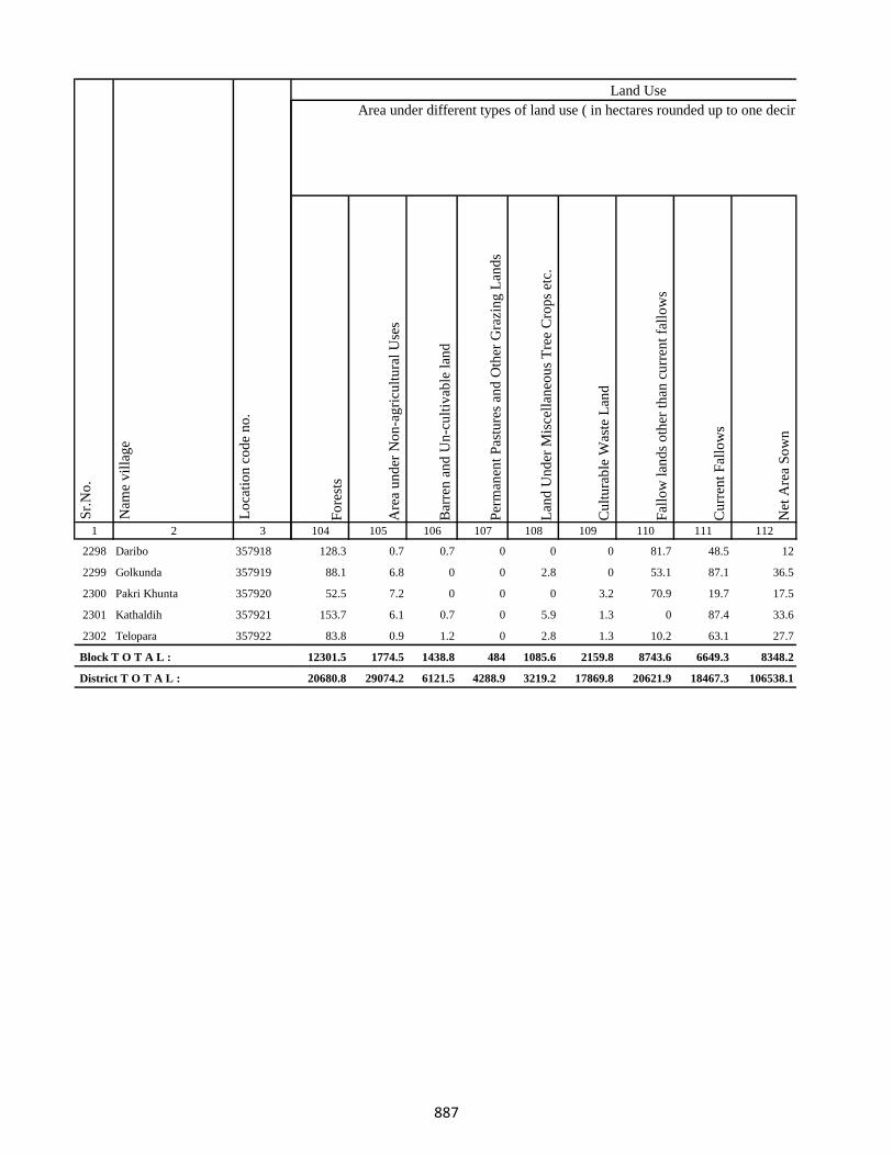
1 2 3
Lo
cati
on
co
de
no
.
Nam
e v
illa
ge
Sr.
No
.
2298 Daribo 357918
2299 Golkunda 357919
2300 Pakri Khunta 357920
2301 Kathaldih 357921
2302 Telopara 357922
Block T O T A L :
District T O T A L :
Fo
rest
s
Are
a u
nd
er N
on
-ag
ricu
ltu
ral
Use
s
Bar
ren
an
d U
n-c
ult
ivab
le l
and
Per
man
ent
Pas
ture
s an
d O
ther
Gra
zin
g L
and
s
Lan
d U
nd
er M
isce
llan
eou
s T
ree
Cro
ps
etc.
Cu
ltu
rab
le W
aste
Lan
d
Fal
low
lan
ds
oth
er t
han
cu
rren
t fa
llo
ws
Cu
rren
t F
allo
ws
Net
Are
a S
ow
n
104 105 106 107 108 109 110 111 112
Area under different types of land use ( in hectares rounded up to one decimal place)
Land Use
128.3 0.7 0.7 0 0 0 81.7 48.5 12
88.1 6.8 0 0 2.8 0 53.1 87.1 36.5
52.5 7.2 0 0 0 3.2 70.9 19.7 17.5
153.7 6.1 0.7 0 5.9 1.3 0 87.4 33.6
83.8 0.9 1.2 0 2.8 1.3 10.2 63.1 27.7
12301.5 1774.5 1438.8 484 1085.6 2159.8 8743.6 6649.3 8348.2
20680.8 29074.2 6121.5 4288.9 3219.2 17869.8 20621.9 18467.3 106538.1
887
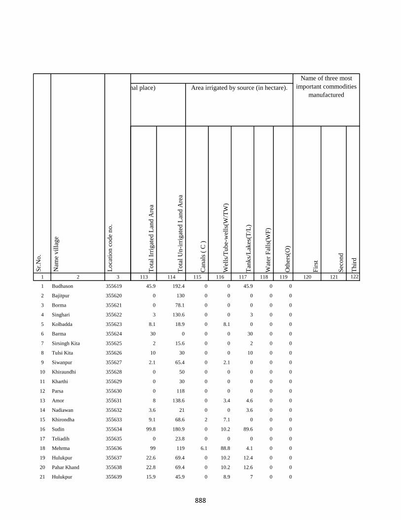
1 2 3
1 Budhason 355619
2 Bajitpur 355620
3 Borma 355621
4 Singhari 355622
5 Kolbadda 355623
6 Barma 355624
7 Sirsingh Kita 355625
8 Tulsi Kita 355626
9 Siwanpur 355627
10 Khiraundhi 355628
11 Kharthi 355629
12 Parsa 355630
13 Amor 355631
14 Nadiawan 355632
15 Khirondha 355633
16 Sudin 355634
17 Teliadih 355635
18 Mehrma 355636
19 Hulukpur 355637
20 Pahar Khand 355638
21 Hulukpur 355639
Lo
cati
on
co
de
no
.
Nam
e v
illa
ge
Sr.
No
.
To
tal
Irri
gat
ed L
and
Are
a
To
tal
Un
-irr
igat
ed L
and
Are
a
Can
als
( C
)
Wel
ls/T
ub
e-w
ells
(W/T
W)
Tan
ks/
Lak
es(T
/L)
Wat
er F
alls
(WF
)
Oth
ers(
O)
Fir
st
Sec
on
d
Th
ird
113 114 115 116 117 118 119 120 121 122
45.9 192.4 0 0 45.9 0 0
0 130 0 0 0 0 0
0 78.1 0 0 0 0 0
3 130.6 0 0 3 0 0
8.1 18.9 0 8.1 0 0 0
30 0 0 0 30 0 0
2 15.6 0 0 2 0 0
10 30 0 0 10 0 0
2.1 65.4 0 2.1 0 0 0
0 50 0 0 0 0 0
0 30 0 0 0 0 0
0 118 0 0 0 0 0
8 138.6 0 3.4 4.6 0 0
3.6 21 0 0 3.6 0 0
9.1 68.6 2 7.1 0 0 0
99.8 180.9 0 10.2 89.6 0 0
0 23.8 0 0 0 0 0
99 119 6.1 88.8 4.1 0 0
22.6 69.4 0 10.2 12.4 0 0
22.8 69.4 0 10.2 12.6 0 0
15.9 45.9 0 8.9 7 0 0
Area under different types of land use ( in hectares rounded up to one decimal place) Area irrigated by source (in hectare).
Name of three most
important commodities
manufactured
Land Use
888
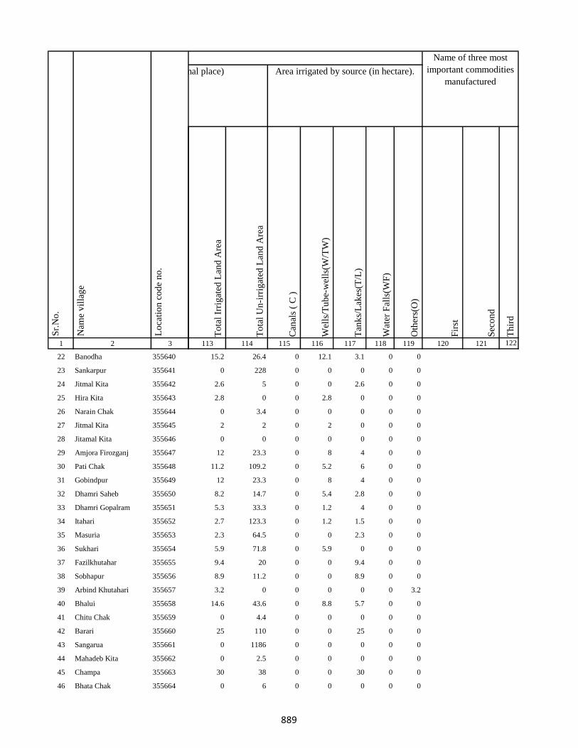
1 2 3
Lo
cati
on
co
de
no
.
Nam
e v
illa
ge
Sr.
No
.
22 Banodha 355640
23 Sankarpur 355641
24 Jitmal Kita 355642
25 Hira Kita 355643
26 Narain Chak 355644
27 Jitmal Kita 355645
28 Jitamal Kita 355646
29 Amjora Firozganj 355647
30 Pati Chak 355648
31 Gobindpur 355649
32 Dhamri Saheb 355650
33 Dhamri Gopalram 355651
34 Itahari 355652
35 Masuria 355653
36 Sukhari 355654
37 Fazilkhutahar 355655
38 Sobhapur 355656
39 Arbind Khutahari 355657
40 Bhalui 355658
41 Chitu Chak 355659
42 Barari 355660
43 Sangarua 355661
44 Mahadeb Kita 355662
45 Champa 355663
46 Bhata Chak 355664
To
tal
Irri
gat
ed L
and
Are
a
To
tal
Un
-irr
igat
ed L
and
Are
a
Can
als
( C
)
Wel
ls/T
ub
e-w
ells
(W/T
W)
Tan
ks/
Lak
es(T
/L)
Wat
er F
alls
(WF
)
Oth
ers(
O)
Fir
st
Sec
on
d
Th
ird
113 114 115 116 117 118 119 120 121 122
Area under different types of land use ( in hectares rounded up to one decimal place) Area irrigated by source (in hectare).
Name of three most
important commodities
manufactured
Land Use
15.2 26.4 0 12.1 3.1 0 0
0 228 0 0 0 0 0
2.6 5 0 0 2.6 0 0
2.8 0 0 2.8 0 0 0
0 3.4 0 0 0 0 0
2 2 0 2 0 0 0
0 0 0 0 0 0 0
12 23.3 0 8 4 0 0
11.2 109.2 0 5.2 6 0 0
12 23.3 0 8 4 0 0
8.2 14.7 0 5.4 2.8 0 0
5.3 33.3 0 1.2 4 0 0
2.7 123.3 0 1.2 1.5 0 0
2.3 64.5 0 0 2.3 0 0
5.9 71.8 0 5.9 0 0 0
9.4 20 0 0 9.4 0 0
8.9 11.2 0 0 8.9 0 0
3.2 0 0 0 0 0 3.2
14.6 43.6 0 8.8 5.7 0 0
0 4.4 0 0 0 0 0
25 110 0 0 25 0 0
0 1186 0 0 0 0 0
0 2.5 0 0 0 0 0
30 38 0 0 30 0 0
0 6 0 0 0 0 0
889
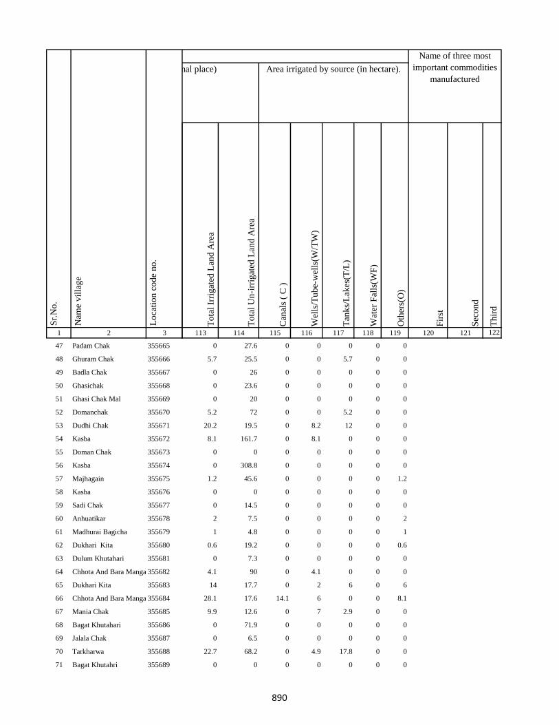
1 2 3
Lo
cati
on
co
de
no
.
Nam
e v
illa
ge
Sr.
No
.
47 Padam Chak 355665
48 Ghuram Chak 355666
49 Badla Chak 355667
50 Ghasichak 355668
51 Ghasi Chak Mal 355669
52 Domanchak 355670
53 Dudhi Chak 355671
54 Kasba 355672
55 Doman Chak 355673
56 Kasba 355674
57 Majhagain 355675
58 Kasba 355676
59 Sadi Chak 355677
60 Anhuatikar 355678
61 Madhurai Bagicha 355679
62 Dukhari Kita 355680
63 Dulum Khutahari 355681
64 Chhota And Bara Mangarh355682
65 Dukhari Kita 355683
66 Chhota And Bara Mangarh355684
67 Mania Chak 355685
68 Bagat Khutahari 355686
69 Jalala Chak 355687
70 Tarkharwa 355688
71 Bagat Khutahri 355689
To
tal
Irri
gat
ed L
and
Are
a
To
tal
Un
-irr
igat
ed L
and
Are
a
Can
als
( C
)
Wel
ls/T
ub
e-w
ells
(W/T
W)
Tan
ks/
Lak
es(T
/L)
Wat
er F
alls
(WF
)
Oth
ers(
O)
Fir
st
Sec
on
d
Th
ird
113 114 115 116 117 118 119 120 121 122
Area under different types of land use ( in hectares rounded up to one decimal place) Area irrigated by source (in hectare).
Name of three most
important commodities
manufactured
Land Use
0 27.6 0 0 0 0 0
5.7 25.5 0 0 5.7 0 0
0 26 0 0 0 0 0
0 23.6 0 0 0 0 0
0 20 0 0 0 0 0
5.2 72 0 0 5.2 0 0
20.2 19.5 0 8.2 12 0 0
8.1 161.7 0 8.1 0 0 0
0 0 0 0 0 0 0
0 308.8 0 0 0 0 0
1.2 45.6 0 0 0 0 1.2
0 0 0 0 0 0 0
0 14.5 0 0 0 0 0
2 7.5 0 0 0 0 2
1 4.8 0 0 0 0 1
0.6 19.2 0 0 0 0 0.6
0 7.3 0 0 0 0 0
4.1 90 0 4.1 0 0 0
14 17.7 0 2 6 0 6
28.1 17.6 14.1 6 0 0 8.1
9.9 12.6 0 7 2.9 0 0
0 71.9 0 0 0 0 0
0 6.5 0 0 0 0 0
22.7 68.2 0 4.9 17.8 0 0
0 0 0 0 0 0 0
890
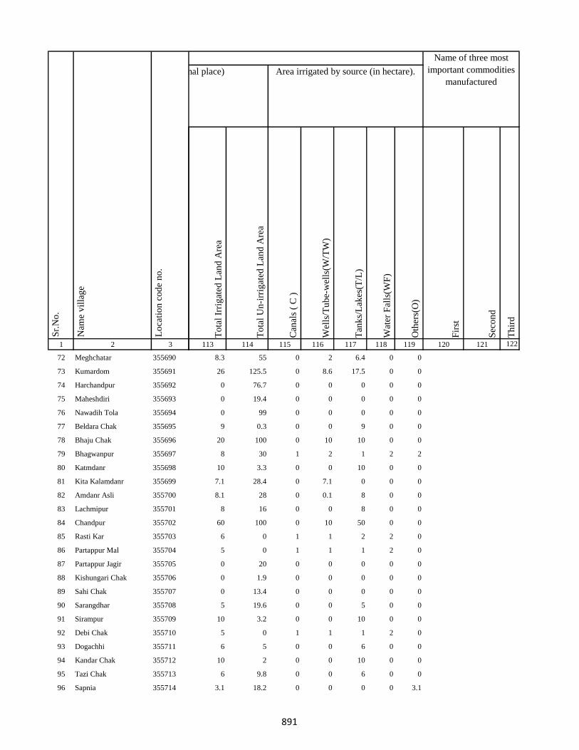
1 2 3
Lo
cati
on
co
de
no
.
Nam
e v
illa
ge
Sr.
No
.
72 Meghchatar 355690
73 Kumardom 355691
74 Harchandpur 355692
75 Maheshdiri 355693
76 Nawadih Tola 355694
77 Beldara Chak 355695
78 Bhaju Chak 355696
79 Bhagwanpur 355697
80 Katmdanr 355698
81 Kita Kalamdanr 355699
82 Amdanr Asli 355700
83 Lachmipur 355701
84 Chandpur 355702
85 Rasti Kar 355703
86 Partappur Mal 355704
87 Partappur Jagir 355705
88 Kishungari Chak 355706
89 Sahi Chak 355707
90 Sarangdhar 355708
91 Sirampur 355709
92 Debi Chak 355710
93 Dogachhi 355711
94 Kandar Chak 355712
95 Tazi Chak 355713
96 Sapnia 355714
To
tal
Irri
gat
ed L
and
Are
a
To
tal
Un
-irr
igat
ed L
and
Are
a
Can
als
( C
)
Wel
ls/T
ub
e-w
ells
(W/T
W)
Tan
ks/
Lak
es(T
/L)
Wat
er F
alls
(WF
)
Oth
ers(
O)
Fir
st
Sec
on
d
Th
ird
113 114 115 116 117 118 119 120 121 122
Area under different types of land use ( in hectares rounded up to one decimal place) Area irrigated by source (in hectare).
Name of three most
important commodities
manufactured
Land Use
8.3 55 0 2 6.4 0 0
26 125.5 0 8.6 17.5 0 0
0 76.7 0 0 0 0 0
0 19.4 0 0 0 0 0
0 99 0 0 0 0 0
9 0.3 0 0 9 0 0
20 100 0 10 10 0 0
8 30 1 2 1 2 2
10 3.3 0 0 10 0 0
7.1 28.4 0 7.1 0 0 0
8.1 28 0 0.1 8 0 0
8 16 0 0 8 0 0
60 100 0 10 50 0 0
6 0 1 1 2 2 0
5 0 1 1 1 2 0
0 20 0 0 0 0 0
0 1.9 0 0 0 0 0
0 13.4 0 0 0 0 0
5 19.6 0 0 5 0 0
10 3.2 0 0 10 0 0
5 0 1 1 1 2 0
6 5 0 0 6 0 0
10 2 0 0 10 0 0
6 9.8 0 0 6 0 0
3.1 18.2 0 0 0 0 3.1
891
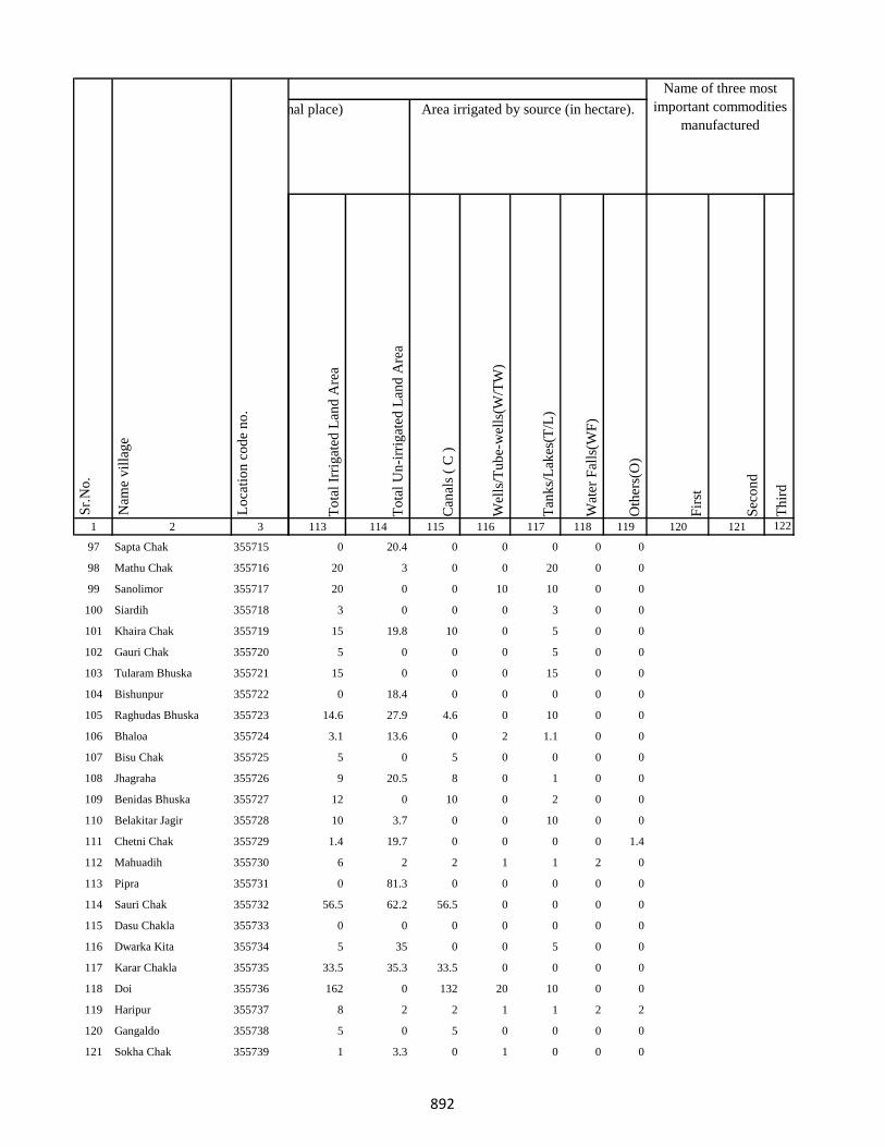
1 2 3
Lo
cati
on
co
de
no
.
Nam
e v
illa
ge
Sr.
No
.
97 Sapta Chak 355715
98 Mathu Chak 355716
99 Sanolimor 355717
100 Siardih 355718
101 Khaira Chak 355719
102 Gauri Chak 355720
103 Tularam Bhuska 355721
104 Bishunpur 355722
105 Raghudas Bhuska 355723
106 Bhaloa 355724
107 Bisu Chak 355725
108 Jhagraha 355726
109 Benidas Bhuska 355727
110 Belakitar Jagir 355728
111 Chetni Chak 355729
112 Mahuadih 355730
113 Pipra 355731
114 Sauri Chak 355732
115 Dasu Chakla 355733
116 Dwarka Kita 355734
117 Karar Chakla 355735
118 Doi 355736
119 Haripur 355737
120 Gangaldo 355738
121 Sokha Chak 355739
To
tal
Irri
gat
ed L
and
Are
a
To
tal
Un
-irr
igat
ed L
and
Are
a
Can
als
( C
)
Wel
ls/T
ub
e-w
ells
(W/T
W)
Tan
ks/
Lak
es(T
/L)
Wat
er F
alls
(WF
)
Oth
ers(
O)
Fir
st
Sec
on
d
Th
ird
113 114 115 116 117 118 119 120 121 122
Area under different types of land use ( in hectares rounded up to one decimal place) Area irrigated by source (in hectare).
Name of three most
important commodities
manufactured
Land Use
0 20.4 0 0 0 0 0
20 3 0 0 20 0 0
20 0 0 10 10 0 0
3 0 0 0 3 0 0
15 19.8 10 0 5 0 0
5 0 0 0 5 0 0
15 0 0 0 15 0 0
0 18.4 0 0 0 0 0
14.6 27.9 4.6 0 10 0 0
3.1 13.6 0 2 1.1 0 0
5 0 5 0 0 0 0
9 20.5 8 0 1 0 0
12 0 10 0 2 0 0
10 3.7 0 0 10 0 0
1.4 19.7 0 0 0 0 1.4
6 2 2 1 1 2 0
0 81.3 0 0 0 0 0
56.5 62.2 56.5 0 0 0 0
0 0 0 0 0 0 0
5 35 0 0 5 0 0
33.5 35.3 33.5 0 0 0 0
162 0 132 20 10 0 0
8 2 2 1 1 2 2
5 0 5 0 0 0 0
1 3.3 0 1 0 0 0
892
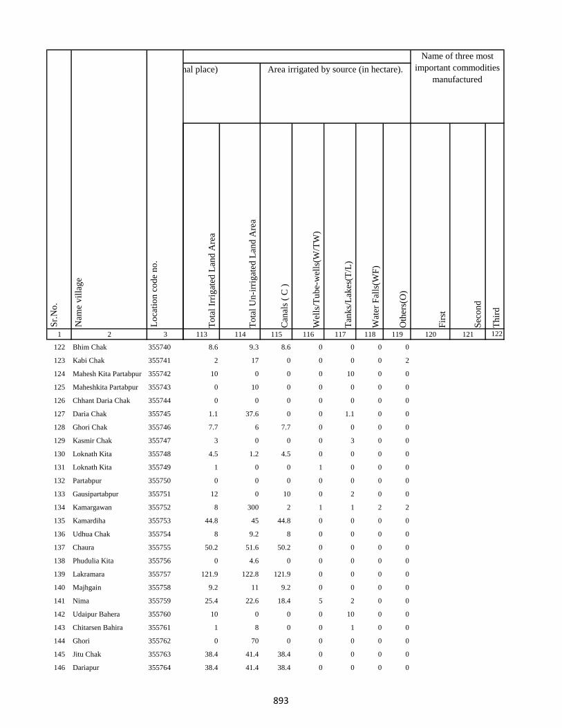
1 2 3
Lo
cati
on
co
de
no
.
Nam
e v
illa
ge
Sr.
No
.
122 Bhim Chak 355740
123 Kabi Chak 355741
124 Mahesh Kita Partabpur 355742
125 Maheshkita Partabpur 355743
126 Chhant Daria Chak 355744
127 Daria Chak 355745
128 Ghori Chak 355746
129 Kasmir Chak 355747
130 Loknath Kita 355748
131 Loknath Kita 355749
132 Partabpur 355750
133 Gausipartabpur 355751
134 Kamargawan 355752
135 Kamardiha 355753
136 Udhua Chak 355754
137 Chaura 355755
138 Phudulia Kita 355756
139 Lakramara 355757
140 Majhgain 355758
141 Nima 355759
142 Udaipur Bahera 355760
143 Chitarsen Bahira 355761
144 Ghori 355762
145 Jitu Chak 355763
146 Dariapur 355764
To
tal
Irri
gat
ed L
and
Are
a
To
tal
Un
-irr
igat
ed L
and
Are
a
Can
als
( C
)
Wel
ls/T
ub
e-w
ells
(W/T
W)
Tan
ks/
Lak
es(T
/L)
Wat
er F
alls
(WF
)
Oth
ers(
O)
Fir
st
Sec
on
d
Th
ird
113 114 115 116 117 118 119 120 121 122
Area under different types of land use ( in hectares rounded up to one decimal place) Area irrigated by source (in hectare).
Name of three most
important commodities
manufactured
Land Use
8.6 9.3 8.6 0 0 0 0
2 17 0 0 0 0 2
10 0 0 0 10 0 0
0 10 0 0 0 0 0
0 0 0 0 0 0 0
1.1 37.6 0 0 1.1 0 0
7.7 6 7.7 0 0 0 0
3 0 0 0 3 0 0
4.5 1.2 4.5 0 0 0 0
1 0 0 1 0 0 0
0 0 0 0 0 0 0
12 0 10 0 2 0 0
8 300 2 1 1 2 2
44.8 45 44.8 0 0 0 0
8 9.2 8 0 0 0 0
50.2 51.6 50.2 0 0 0 0
0 4.6 0 0 0 0 0
121.9 122.8 121.9 0 0 0 0
9.2 11 9.2 0 0 0 0
25.4 22.6 18.4 5 2 0 0
10 0 0 0 10 0 0
1 8 0 0 1 0 0
0 70 0 0 0 0 0
38.4 41.4 38.4 0 0 0 0
38.4 41.4 38.4 0 0 0 0
893

1 2 3
Lo
cati
on
co
de
no
.
Nam
e v
illa
ge
Sr.
No
.
147 Mathi Chak 355765
148 Chhaman Kita 355766
149 Suphal Kita 355767
150 Kanchanpur 355768
151 Dhankuria 355769
152 Belbadda 355770
153 Kotibari 355771
154 Chhagraha 355772
155 Chhagraha 355773
156 Benia Kita 355774
157 Sahi Chak 355775
158 Chhagraha 355776
159 Kukra Milik 355777
160 Kurkra Milik 355778
161 Bheronagar 355779
162 Niamat Kita 355780
163 Ghasi Kita 355781
164 Ghasi Kita 355782
165 Inarman Kita 355783
166 Gausi Chak 355784
167 Mosana Chak 355785
168 Singarpur 355786
169 Birnagar Arazi Chhit 355787
170 Birnagar Arazi Bara 355788
171 Birnagar 355789
To
tal
Irri
gat
ed L
and
Are
a
To
tal
Un
-irr
igat
ed L
and
Are
a
Can
als
( C
)
Wel
ls/T
ub
e-w
ells
(W/T
W)
Tan
ks/
Lak
es(T
/L)
Wat
er F
alls
(WF
)
Oth
ers(
O)
Fir
st
Sec
on
d
Th
ird
113 114 115 116 117 118 119 120 121 122
Area under different types of land use ( in hectares rounded up to one decimal place) Area irrigated by source (in hectare).
Name of three most
important commodities
manufactured
Land Use
7 1.2 0 4 3 0 0
13.1 19 0 10 3.1 0 0
7.3 11 0 5.3 2 0 0
37.2 57 0 10.2 27 0 0
87.4 90.3 87.4 0 0 0 0
32.4 79.5 0 20 12.4 0 0
0.3 1 0 0.3 0 0 0
32.3 19.4 0 10.1 22.2 0 0
32.3 19.4 0 10.1 22.2 0 0
10.8 13 0 8.8 0 0 2
7.1 50.1 0 5.1 2 0 0
32.3 19.4 0 10.1 22.2 0 0
54.8 30 0 54 0 0 0.8
0 0 0 0 0 0 0
22 18 0 1.7 6.1 0 14.2
0 0 0 0 0 0 0
6.3 10.3 0 2.8 0 0 3.5
0 8.7 0 0 0 0 0
7.7 0 0 3.6 2 0 2
33.6 39.9 0 1.2 16.2 0 16.2
6.1 18.3 0 0.8 1.3 0 4
46.5 87.3 0 2 16.2 0 28.3
0 1 0 0 0 0 0
0.2 0.2 0 0 0.2 0 0
0.2 21.4 0 0 0.2 0 0
894
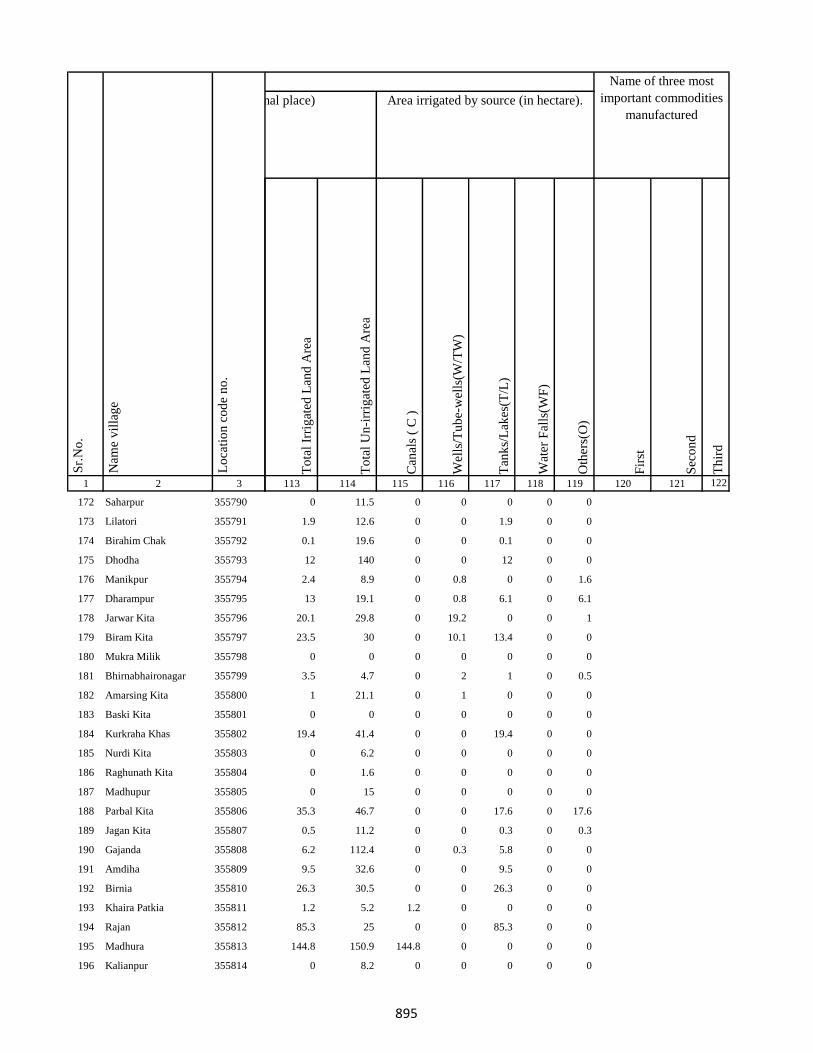
1 2 3
Lo
cati
on
co
de
no
.
Nam
e v
illa
ge
Sr.
No
.
172 Saharpur 355790
173 Lilatori 355791
174 Birahim Chak 355792
175 Dhodha 355793
176 Manikpur 355794
177 Dharampur 355795
178 Jarwar Kita 355796
179 Biram Kita 355797
180 Mukra Milik 355798
181 Bhirnabhaironagar 355799
182 Amarsing Kita 355800
183 Baski Kita 355801
184 Kurkraha Khas 355802
185 Nurdi Kita 355803
186 Raghunath Kita 355804
187 Madhupur 355805
188 Parbal Kita 355806
189 Jagan Kita 355807
190 Gajanda 355808
191 Amdiha 355809
192 Birnia 355810
193 Khaira Patkia 355811
194 Rajan 355812
195 Madhura 355813
196 Kalianpur 355814
To
tal
Irri
gat
ed L
and
Are
a
To
tal
Un
-irr
igat
ed L
and
Are
a
Can
als
( C
)
Wel
ls/T
ub
e-w
ells
(W/T
W)
Tan
ks/
Lak
es(T
/L)
Wat
er F
alls
(WF
)
Oth
ers(
O)
Fir
st
Sec
on
d
Th
ird
113 114 115 116 117 118 119 120 121 122
Area under different types of land use ( in hectares rounded up to one decimal place) Area irrigated by source (in hectare).
Name of three most
important commodities
manufactured
Land Use
0 11.5 0 0 0 0 0
1.9 12.6 0 0 1.9 0 0
0.1 19.6 0 0 0.1 0 0
12 140 0 0 12 0 0
2.4 8.9 0 0.8 0 0 1.6
13 19.1 0 0.8 6.1 0 6.1
20.1 29.8 0 19.2 0 0 1
23.5 30 0 10.1 13.4 0 0
0 0 0 0 0 0 0
3.5 4.7 0 2 1 0 0.5
1 21.1 0 1 0 0 0
0 0 0 0 0 0 0
19.4 41.4 0 0 19.4 0 0
0 6.2 0 0 0 0 0
0 1.6 0 0 0 0 0
0 15 0 0 0 0 0
35.3 46.7 0 0 17.6 0 17.6
0.5 11.2 0 0 0.3 0 0.3
6.2 112.4 0 0.3 5.8 0 0
9.5 32.6 0 0 9.5 0 0
26.3 30.5 0 0 26.3 0 0
1.2 5.2 1.2 0 0 0 0
85.3 25 0 0 85.3 0 0
144.8 150.9 144.8 0 0 0 0
0 8.2 0 0 0 0 0
895
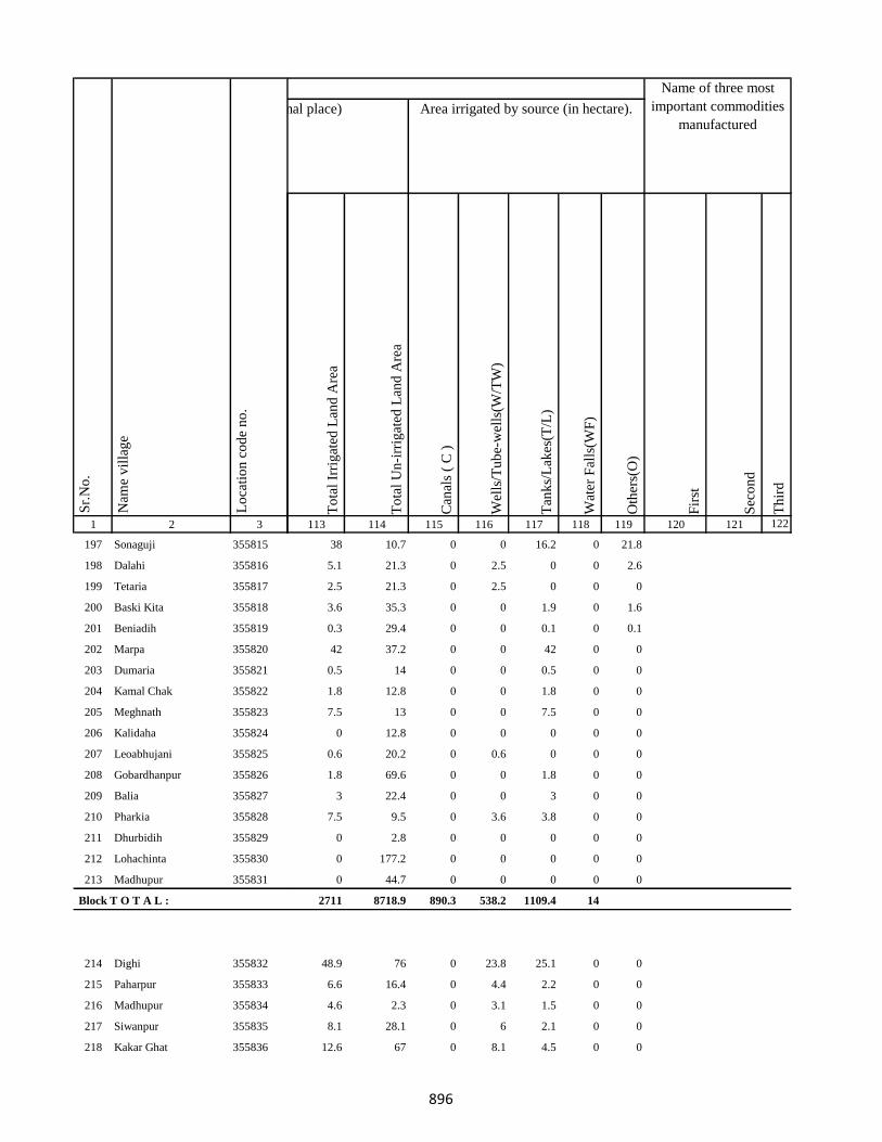
1 2 3
Lo
cati
on
co
de
no
.
Nam
e v
illa
ge
Sr.
No
.
197 Sonaguji 355815
198 Dalahi 355816
199 Tetaria 355817
200 Baski Kita 355818
201 Beniadih 355819
202 Marpa 355820
203 Dumaria 355821
204 Kamal Chak 355822
205 Meghnath 355823
206 Kalidaha 355824
207 Leoabhujani 355825
208 Gobardhanpur 355826
209 Balia 355827
210 Pharkia 355828
211 Dhurbidih 355829
212 Lohachinta 355830
213 Madhupur 355831
Block T O T A L :
214 Dighi 355832
215 Paharpur 355833
216 Madhupur 355834
217 Siwanpur 355835
218 Kakar Ghat 355836
To
tal
Irri
gat
ed L
and
Are
a
To
tal
Un
-irr
igat
ed L
and
Are
a
Can
als
( C
)
Wel
ls/T
ub
e-w
ells
(W/T
W)
Tan
ks/
Lak
es(T
/L)
Wat
er F
alls
(WF
)
Oth
ers(
O)
Fir
st
Sec
on
d
Th
ird
113 114 115 116 117 118 119 120 121 122
Area under different types of land use ( in hectares rounded up to one decimal place) Area irrigated by source (in hectare).
Name of three most
important commodities
manufactured
Land Use
38 10.7 0 0 16.2 0 21.8
5.1 21.3 0 2.5 0 0 2.6
2.5 21.3 0 2.5 0 0 0
3.6 35.3 0 0 1.9 0 1.6
0.3 29.4 0 0 0.1 0 0.1
42 37.2 0 0 42 0 0
0.5 14 0 0 0.5 0 0
1.8 12.8 0 0 1.8 0 0
7.5 13 0 0 7.5 0 0
0 12.8 0 0 0 0 0
0.6 20.2 0 0.6 0 0 0
1.8 69.6 0 0 1.8 0 0
3 22.4 0 0 3 0 0
7.5 9.5 0 3.6 3.8 0 0
0 2.8 0 0 0 0 0
0 177.2 0 0 0 0 0
0 44.7 0 0 0 0 0
2711 8718.9 890.3 538.2 1109.4 14
48.9 76 0 23.8 25.1 0 0
6.6 16.4 0 4.4 2.2 0 0
4.6 2.3 0 3.1 1.5 0 0
8.1 28.1 0 6 2.1 0 0
12.6 67 0 8.1 4.5 0 0
896

1 2 3
Lo
cati
on
co
de
no
.
Nam
e v
illa
ge
Sr.
No
.
219 Talbaria 355837
220 Mohamad Khutahari 355838
221 Mal Jhakhra 355839
222 Baghjhakhra 355840
223 Sinha Chak 355841
224 Babutaluk 355842
225 Paharpur 355843
226 Deban Chak 355844
227 Gargulal 355845
228 Madan Chauki 355846
229 Birahim Kita 355847
230 Banskola 355848
231 Kurpatti 355849
232 Baijani 355850
233 Chapri 355851
234 Kamat Chapri 355852
235 Khar Kudia 355853
236 Majhana (Arazi) 355854
237 Hasu Chak 355855
238 Domansaran Kita 355856
239 Silong 355857
240 Paharpur 355858
241 Akilkita 355859
242 Bikram Kita 355860
243 Paharpur 355861
To
tal
Irri
gat
ed L
and
Are
a
To
tal
Un
-irr
igat
ed L
and
Are
a
Can
als
( C
)
Wel
ls/T
ub
e-w
ells
(W/T
W)
Tan
ks/
Lak
es(T
/L)
Wat
er F
alls
(WF
)
Oth
ers(
O)
Fir
st
Sec
on
d
Th
ird
113 114 115 116 117 118 119 120 121 122
Area under different types of land use ( in hectares rounded up to one decimal place) Area irrigated by source (in hectare).
Name of three most
important commodities
manufactured
Land Use
5.4 92.8 0 3.2 2.2 0 0
5.2 24.4 0 3.2 2 0 0
14.4 39.8 0 9.4 5.1 0 0
4.8 29.8 0 2.6 2.2 0 0
4.4 32 0 1.6 2.7 0 0
2.3 3.1 0 1.3 1 0 0
2.1 3.9 0 0 2.1 0 0
16.5 24.2 0 9.4 7.2 0 0
5.3 37.2 0 1.8 3.4 0 0
5.9 57 0 1.5 4.3 0 0
3.5 37.9 0 0 3.5 0 0
3.5 34.6 0 0 3.5 0 0
3.9 41 0 1.2 2.7 0 0
2.8 39.1 0 1 1.8 0 0
139.3 139.3 0 9.3 130 0 0
0 7.1 0 0 0 0 0
32.8 44.9 0 20.1 12.7 0 0
0 1.8 0 0 0 0 0
17.6 29.9 0 8.5 9.1 0 0
0 5 0 0 0 0 0
16.1 27.3 0 6.1 6 2 2
8.4 72.7 0 5.1 3.3 0 0
0 6.3 0 0 0 0 0
0 0 0 0 0 0 0
5.1 10.4 0 3 2.1 0 0
897

1 2 3
Lo
cati
on
co
de
no
.
Nam
e v
illa
ge
Sr.
No
.
244 Chandpur 355862
245 Khani Chak 355863
246 Nagarchi Chak 355864
247 Taj Kita 355865
248 Panchu Kita 355866
249 Mohan Kita 355867
250 Khania Kita 355868
251 Badura Kita 355869
252 Bhatu Kita 355870
253 Dalubarmohtar 355871
254 Madhuadih Khas 355872
255 Madhuadih Arjun Kita 355873
256 Jadu Kita 355874
257 Kali Kita 355875
258 Haripur 355876
259 Nawadih Parthumanjhi 355877
260 Sonapur 355878
261 Maku Chak 355879
262 Chand Chak 355880
263 Dumaria 355881
264 Taib Kita 355882
265 Bhekhari Kita 355883
266 Mitan Kita 355884
267 Kadil Kita 355885
268 Pitambar Kita 355886
To
tal
Irri
gat
ed L
and
Are
a
To
tal
Un
-irr
igat
ed L
and
Are
a
Can
als
( C
)
Wel
ls/T
ub
e-w
ells
(W/T
W)
Tan
ks/
Lak
es(T
/L)
Wat
er F
alls
(WF
)
Oth
ers(
O)
Fir
st
Sec
on
d
Th
ird
113 114 115 116 117 118 119 120 121 122
Area under different types of land use ( in hectares rounded up to one decimal place) Area irrigated by source (in hectare).
Name of three most
important commodities
manufactured
Land Use
21.1 32.2 0 11.8 9.3 0 0
11.5 15.6 0 5.6 5.9 0 0
0 2.3 0 0 0 0 0
8.3 13.7 0 5.1 3.1 0 0
12.5 21.9 0 7.2 5.3 0 0
0 1.3 0 0 0 0 0
6.1 12.1 0 3 3.1 0 0
4.1 3.8 0 4.1 0 0 0
13.1 22.8 0 11.1 2 0 0
0 1 0 0 0 0 0
8.9 0 0 2.9 2 2 2
1.9 7.2 0 1.9 0 0 0
16.5 19.2 0 8.1 8.4 0 0
12.4 24 0 7.2 5.2 0 0
12.4 18.7 0 5.3 7.1 0 0
6.2 34.3 0 4.1 2.1 0 0
17.6 29.2 2.6 8.4 6.6 0 0
11.1 47.2 0 6.1 5 0 0
3.1 12.1 0 0 3.1 0 0
8.7 58.5 0 4.3 4.3 0 0
0 3.4 0 0 0 0 0
3.6 12.5 0 3.6 0 0 0
0 4.8 0 0 0 0 0
0 9.6 0 0 0 0 0
0 5.2 0 0 0 0 0
898

1 2 3
Lo
cati
on
co
de
no
.
Nam
e v
illa
ge
Sr.
No
.
269 Baiju Kita 355887
270 Budhasan 355888
271 Janghira 355889
272 Mohan Pipra 355890
273 Dahua Pakaria 355891
274 Sanhuli 355892
275 Tetarbhuj 355893
276 Panch Pahar 355894
277 Rampur 355895
278 Bhagwakol 355896
279 Dhankol 355897
280 Mopahari 355898
281 Khandhar 355899
282 Bodhrai Khutahari 355900
283 Hira Khutahari 355901
284 Kari Khutahari 355902
285 Bishunpur 355903
286 Bhagaia 355904
287 Manikapur 355905
288 Ramdas Khutahari 355906
289 Jiban Khutahari 355907
290 Baiju Khutahari 355908
291 Salim Khutahari 355909
292 Jhilli 355910
293 Gajhanda 355911
To
tal
Irri
gat
ed L
and
Are
a
To
tal
Un
-irr
igat
ed L
and
Are
a
Can
als
( C
)
Wel
ls/T
ub
e-w
ells
(W/T
W)
Tan
ks/
Lak
es(T
/L)
Wat
er F
alls
(WF
)
Oth
ers(
O)
Fir
st
Sec
on
d
Th
ird
113 114 115 116 117 118 119 120 121 122
Area under different types of land use ( in hectares rounded up to one decimal place) Area irrigated by source (in hectare).
Name of three most
important commodities
manufactured
Land Use
4.1 5 0 2.1 2 0 0
5.4 43.6 0 1.4 4 0 0
4.5 22.4 0 1.5 3 0 0
0 5.2 0 0 0 0 0
7.5 75.4 0 2.1 5.4 0 0
5.2 92.9 0 1.2 4 0 0
2.4 12.5 0 0 2.4 0 0
0 0 0 0 0 0 0
0 0 0 0 0 0 0
5.9 25.8 0 3.3 2.6 0 0
5.6 19.9 0 1.5 4.1 0 0
0 8.2 0 0 0 0 0
8.8 82.9 0 3.4 5.4 0 0
3.6 5.1 0 1.2 2.4 0 0
1.2 6.7 0 0 1.2 0 0
3 3.3 0 1.3 1.8 0 0
0 3.5 0 0 0 0 0
14.8 78.2 0 4.4 10.4 0 0
10.9 79 0 3.4 7.6 0 0
1.5 18.3 0 1.5 0 0 0
0 0 0 0 0 0 0
1.8 12 0 1.8 0 0 0
0 0 0 0 0 0 0
0 0 0 0 0 0 0
0 0 0 0 0 0 0
899

1 2 3
Lo
cati
on
co
de
no
.
Nam
e v
illa
ge
Sr.
No
.
294 Karmail 355912
295 Kajrail 355913
296 Bahoriabagaicha 355914
297 Dharampur 355915
298 Lalsing Khutahari 355916
299 Dhaknesar 355917
300 Tetaria Mal 355918
301 Baraia Chak 355919
302 Chhota Manian 355920
303 Bara Manian(Kalan) 355921
304 Rangai Chak 355922
305 Kokan Kita 355923
306 Dhaniabandh 355924
307 Saharabari 355925
308 Bandar Kita 355926
309 Patha Chak 355927
310 Pitambar Kita 355928
311 Bhalwa Chak 355929
312 Bardia Chak 355930
313 Bamania 355931
314 Kolbadda 355932
315 Sonholi 355933
316 Hijri 355934
317 Sonholi 355935
318 Chanda And Chando 355936
To
tal
Irri
gat
ed L
and
Are
a
To
tal
Un
-irr
igat
ed L
and
Are
a
Can
als
( C
)
Wel
ls/T
ub
e-w
ells
(W/T
W)
Tan
ks/
Lak
es(T
/L)
Wat
er F
alls
(WF
)
Oth
ers(
O)
Fir
st
Sec
on
d
Th
ird
113 114 115 116 117 118 119 120 121 122
Area under different types of land use ( in hectares rounded up to one decimal place) Area irrigated by source (in hectare).
Name of three most
important commodities
manufactured
Land Use
0 43.8 0 0 0 0 0
0 0 0 0 0 0 0
0 0 0 0 0 0 0
0 0 0 0 0 0 0
0 0 0 0 0 0 0
0 0 0 0 0 0 0
0 17.6 0 0 0 0 0
0 0 0 0 0 0 0
7.5 11.1 0 1.5 6 0 0
2 39.8 0 0 2 0 0
2 6.8 0 0 2 0 0
0 4.7 0 0 0 0 0
2 17.3 0 2 0 0 0
0 3.5 0 0 0 0 0
0 1.5 0 0 0 0 0
0 1.6 0 0 0 0 0
0 32.7 0 0 0 0 0
0 5.8 0 0 0 0 0
0 3.2 0 0 0 0 0
4.5 25.7 0 1.5 3 0 0
5.6 72 0 2 3.6 0 0
0 3.1 0 0 0 0 0
0 29.1 0 0 0 0 0
0 0 0 0 0 0 0
5.9 55 0 0 5.9 0 0
900

1 2 3
Lo
cati
on
co
de
no
.
Nam
e v
illa
ge
Sr.
No
.
319 Mohani Kita 355937
320 Sujan Kita 355938
321 Chanda And Chando 355939
322 Barkurua 355940
323 Sujan Kita 355941
324 Hardeo Chak 355942
325 Pathak Chak 355943
326 Nahan Chak 355944
327 Bihari 355945
328 Milik Bihari 355946
329 Pairanrai Kita 355947
330 Milik Bihari 355948
331 Karijh Kita 355949
332 Parasi 355950
333 Mahuara 355951
334 Itwa Mal 355952
335 Nehal Chand Kita 355953
336 Itwa Milik 355954
337 Naya Chak 355955
338 Dhaniabandh 355956
339 Jhurkusia 355957
340 Amarpur 355958
341 Harinkol 355959
342 Bhuslia 355960
343 Kurma 355961
To
tal
Irri
gat
ed L
and
Are
a
To
tal
Un
-irr
igat
ed L
and
Are
a
Can
als
( C
)
Wel
ls/T
ub
e-w
ells
(W/T
W)
Tan
ks/
Lak
es(T
/L)
Wat
er F
alls
(WF
)
Oth
ers(
O)
Fir
st
Sec
on
d
Th
ird
113 114 115 116 117 118 119 120 121 122
Area under different types of land use ( in hectares rounded up to one decimal place) Area irrigated by source (in hectare).
Name of three most
important commodities
manufactured
Land Use
0 10.3 0 0 0 0 0
0 7.7 0 0 0 0 0
0 0 0 0 0 0 0
0 9.2 0 0 0 0 0
3 13.1 0 0 3 0 0
2.3 11.5 0 1.1 1.2 0 0
2.3 8.1 0 0 1.2 1.1 0
6.1 6.3 0 0 3.1 3 0
0 71.8 0 0 0 0 0
0 8.6 0 0 0 0 0
0 3.1 0 0 0 0 0
0 0 0 0 0 0 0
0 2.6 0 0 0 0 0
0 12.1 0 0 0 0 0
13.7 37.8 0 6.6 7.1 0 0
2.1 9.7 0 0 2.1 0 0
2 15 0 0 2 0 0
0 69.8 0 0 0 0 0
2.9 12.4 0 2.9 0 0 0
0 21.7 0 0 0 0 0
8.2 46.5 0 2 6.2 0 0 Cotton Silken Cloth
6.5 28.5 0 1.5 5 0 0 Cotton Silken Cloth
3.2 16.3 0 0 0 0 3.2 N.a. N.a.
0 14.7 0 0 0 0 0
0 61.1 0 0 0 0 0 N.a. N.a.
901

1 2 3
Lo
cati
on
co
de
no
.
Nam
e v
illa
ge
Sr.
No
.
344 Darji Kita 355962
345 Birnath Chak 355963
346 Indar Chak 355964
347 Marro Mal 355965
348 Belatikar 355966
349 Pipra 355967
350 Budhuachak 355968
351 Pipra 355969
352 Purnia 355970
353 Mardiha 355971
354 Baghakol 355972
355 Rangila 355973
356 Bhuska 355974
357 Chand Chak 355975
358 Dogachhi 355976
359 Khajri Chak 355977
360 Lainbrar Barakhar 355978
361 Lensirsa 355979
362 Gorapariharpur 355980
363 Basta 355981
364 Bariasirsa 355982
365 Gobindi Chak 355983
366 Kanipathari 355984
367 Gaias Chak 355985
368 Majh Kola 355986
To
tal
Irri
gat
ed L
and
Are
a
To
tal
Un
-irr
igat
ed L
and
Are
a
Can
als
( C
)
Wel
ls/T
ub
e-w
ells
(W/T
W)
Tan
ks/
Lak
es(T
/L)
Wat
er F
alls
(WF
)
Oth
ers(
O)
Fir
st
Sec
on
d
Th
ird
113 114 115 116 117 118 119 120 121 122
Area under different types of land use ( in hectares rounded up to one decimal place) Area irrigated by source (in hectare).
Name of three most
important commodities
manufactured
Land Use
0 4.4 0 0 0 0 0
0 9.8 0 0 0 0 0
0 63.2 0 0 0 0 0 Cotton Silken Cloth
0 75.3 0 0 0 0 0
7.1 40.6 0 2 5.1 0 0
3.2 34.9 0 1.2 2 0 0
2.5 11.9 0 1 1.5 0 0
1.2 4.5 0 1.2 0 0 0
2.5 14.8 0 0 2.5 0 0
0 223 0 0 0 0 0
2 4.9 0 1 1 0 0
0 24.3 0 0 0 0 0
5.1 18 0 1.5 3.6 0 0
2.3 14.6 0 0 2.3 0 0
2.6 22.1 0 1.4 1.2 0 0
7.5 50.6 0 1.5 6 0 0
1.6 4.3 0 0.9 0.7 0 0
1.5 6.4 0 1.5 0 0 0
1 5.1 0 1 0 0 0
3.4 80.9 0 1.6 1.7 0 0
2.3 17.5 0 1.1 1.2 0 0
2.6 13.7 0 0.6 2 0 0
3.5 16.7 0 1.5 2 0 0
0 14 0 0 0 0 0
0 69.4 0 0 0 0 0
902
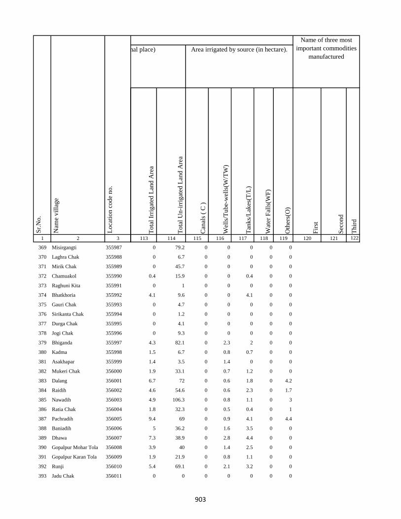
1 2 3
Lo
cati
on
co
de
no
.
Nam
e v
illa
ge
Sr.
No
.
369 Misirgangti 355987
370 Laghra Chak 355988
371 Mirik Chak 355989
372 Chamuakol 355990
373 Raghuni Kita 355991
374 Bhatkhoria 355992
375 Gauri Chak 355993
376 Sirikanta Chak 355994
377 Durga Chak 355995
378 Jogi Chak 355996
379 Bhiganda 355997
380 Kadma 355998
381 Asakhapar 355999
382 Mukeri Chak 356000
383 Dalang 356001
384 Raidih 356002
385 Nawadih 356003
386 Ratia Chak 356004
387 Pachradih 356005
388 Baniadih 356006
389 Dhawa 356007
390 Gopalpur Mohar Tola 356008
391 Gopalpur Karan Tola 356009
392 Runji 356010
393 Jadu Chak 356011
To
tal
Irri
gat
ed L
and
Are
a
To
tal
Un
-irr
igat
ed L
and
Are
a
Can
als
( C
)
Wel
ls/T
ub
e-w
ells
(W/T
W)
Tan
ks/
Lak
es(T
/L)
Wat
er F
alls
(WF
)
Oth
ers(
O)
Fir
st
Sec
on
d
Th
ird
113 114 115 116 117 118 119 120 121 122
Area under different types of land use ( in hectares rounded up to one decimal place) Area irrigated by source (in hectare).
Name of three most
important commodities
manufactured
Land Use
0 79.2 0 0 0 0 0
0 6.7 0 0 0 0 0
0 45.7 0 0 0 0 0
0.4 15.9 0 0 0.4 0 0
0 1 0 0 0 0 0
4.1 9.6 0 0 4.1 0 0
0 4.7 0 0 0 0 0
0 1.2 0 0 0 0 0
0 4.1 0 0 0 0 0
0 9.3 0 0 0 0 0
4.3 82.1 0 2.3 2 0 0
1.5 6.7 0 0.8 0.7 0 0
1.4 3.5 0 1.4 0 0 0
1.9 33.1 0 0.7 1.2 0 0
6.7 72 0 0.6 1.8 0 4.2
4.6 54.6 0 0.6 2.3 0 1.7
4.9 106.3 0 0.8 1.1 0 3
1.8 32.3 0 0.5 0.4 0 1
9.4 69 0 0.9 4.1 0 4.4
5 36.2 0 1.6 3.5 0 0
7.3 38.9 0 2.8 4.4 0 0
3.9 40 0 1.4 2.5 0 0
1.9 21.9 0 0.8 1.1 0 0
5.4 69.1 0 2.1 3.2 0 0
0 0 0 0 0 0 0
903
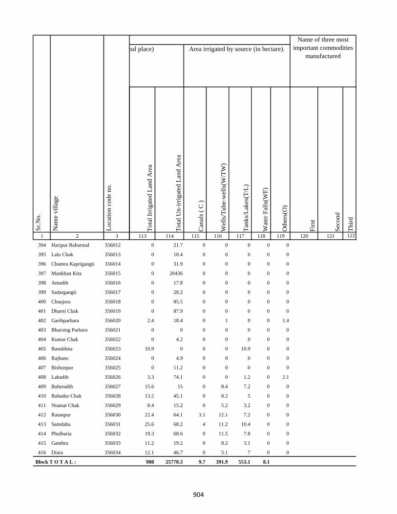
1 2 3
Lo
cati
on
co
de
no
.
Nam
e v
illa
ge
Sr.
No
.
394 Haripur Baharmal 356012
395 Lalu Chak 356013
396 Chamru Kaprigangti 356014
397 Mankhan Kita 356015
398 Antadih 356016
399 Sadargangti 356017
400 Chaujora 356018
401 Dharni Chak 356019
402 Garibparbara 356020
403 Bharsing Parbara 356021
404 Kumar Chak 356022
405 Bansbhita 356023
406 Rajhans 356024
407 Bishunpur 356025
408 Lahadih 356026
409 Baheradih 356027
410 Bahadur Chak 356028
411 Niamat Chak 356029
412 Ratanpur 356030
413 Samdaha 356031
414 Phulbaria 356032
415 Gamhra 356033
416 Diara 356034
Block T O T A L :
To
tal
Irri
gat
ed L
and
Are
a
To
tal
Un
-irr
igat
ed L
and
Are
a
Can
als
( C
)
Wel
ls/T
ub
e-w
ells
(W/T
W)
Tan
ks/
Lak
es(T
/L)
Wat
er F
alls
(WF
)
Oth
ers(
O)
Fir
st
Sec
on
d
Th
ird
113 114 115 116 117 118 119 120 121 122
Area under different types of land use ( in hectares rounded up to one decimal place) Area irrigated by source (in hectare).
Name of three most
important commodities
manufactured
Land Use
0 21.7 0 0 0 0 0
0 10.4 0 0 0 0 0
0 31.9 0 0 0 0 0
0 20436 0 0 0 0 0
0 17.8 0 0 0 0 0
0 28.2 0 0 0 0 0
0 85.5 0 0 0 0 0
0 87.9 0 0 0 0 0
2.4 18.4 0 1 0 0 1.4
0 0 0 0 0 0 0
0 4.2 0 0 0 0 0
10.9 0 0 0 10.9 0 0
0 4.9 0 0 0 0 0
0 11.2 0 0 0 0 0
3.3 74.1 0 0 1.2 0 2.1
15.6 15 0 8.4 7.2 0 0
13.2 45.1 0 8.2 5 0 0
8.4 15.2 0 5.2 3.2 0 0
22.4 64.1 3.1 12.1 7.2 0 0
25.6 68.2 4 11.2 10.4 0 0
19.3 68.6 0 11.5 7.8 0 0
11.2 19.2 0 8.2 3.1 0 0
12.1 46.7 0 5.1 7 0 0
988 25778.3 9.7 391.9 553.1 8.1
904
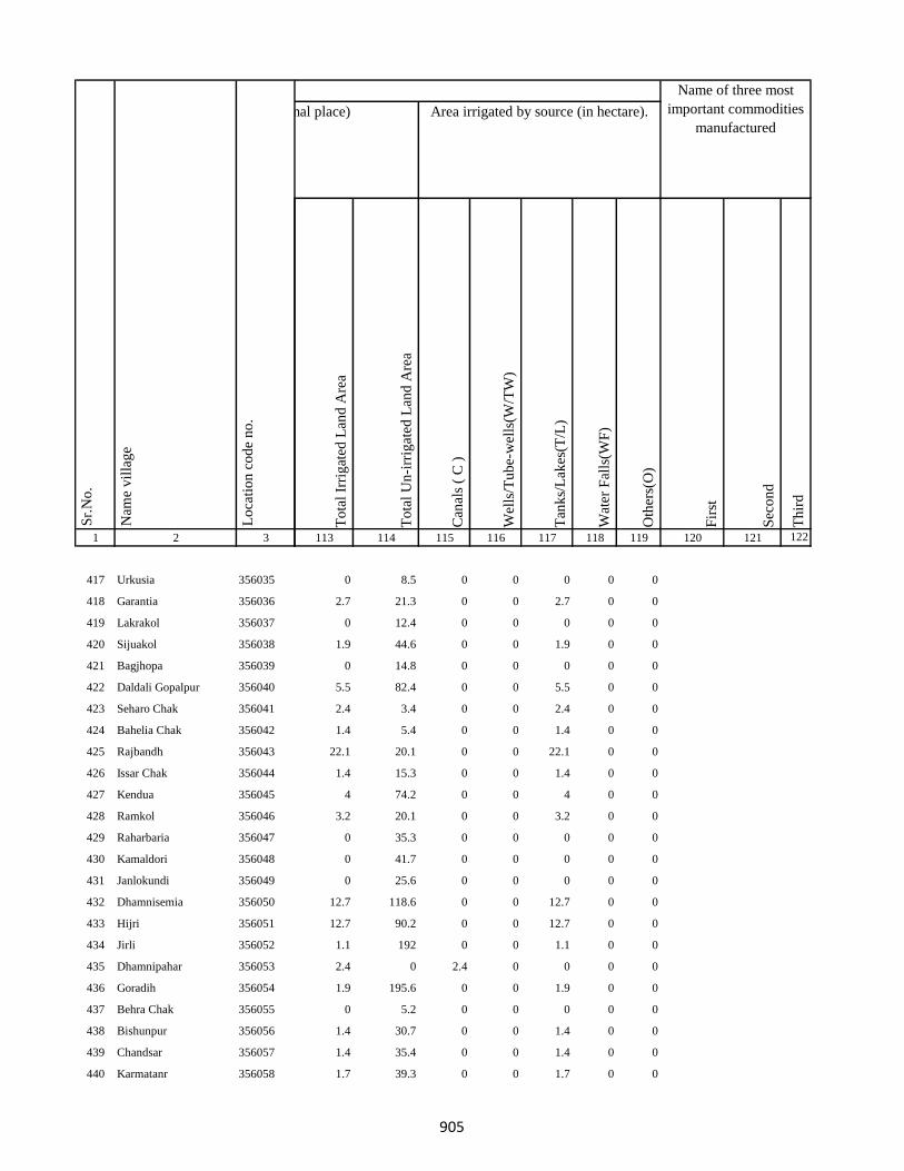
1 2 3
Lo
cati
on
co
de
no
.
Nam
e v
illa
ge
Sr.
No
.
417 Urkusia 356035
418 Garantia 356036
419 Lakrakol 356037
420 Sijuakol 356038
421 Bagjhopa 356039
422 Daldali Gopalpur 356040
423 Seharo Chak 356041
424 Bahelia Chak 356042
425 Rajbandh 356043
426 Issar Chak 356044
427 Kendua 356045
428 Ramkol 356046
429 Raharbaria 356047
430 Kamaldori 356048
431 Janlokundi 356049
432 Dhamnisemia 356050
433 Hijri 356051
434 Jirli 356052
435 Dhamnipahar 356053
436 Goradih 356054
437 Behra Chak 356055
438 Bishunpur 356056
439 Chandsar 356057
440 Karmatanr 356058
To
tal
Irri
gat
ed L
and
Are
a
To
tal
Un
-irr
igat
ed L
and
Are
a
Can
als
( C
)
Wel
ls/T
ub
e-w
ells
(W/T
W)
Tan
ks/
Lak
es(T
/L)
Wat
er F
alls
(WF
)
Oth
ers(
O)
Fir
st
Sec
on
d
Th
ird
113 114 115 116 117 118 119 120 121 122
Area under different types of land use ( in hectares rounded up to one decimal place) Area irrigated by source (in hectare).
Name of three most
important commodities
manufactured
Land Use
0 8.5 0 0 0 0 0
2.7 21.3 0 0 2.7 0 0
0 12.4 0 0 0 0 0
1.9 44.6 0 0 1.9 0 0
0 14.8 0 0 0 0 0
5.5 82.4 0 0 5.5 0 0
2.4 3.4 0 0 2.4 0 0
1.4 5.4 0 0 1.4 0 0
22.1 20.1 0 0 22.1 0 0
1.4 15.3 0 0 1.4 0 0
4 74.2 0 0 4 0 0
3.2 20.1 0 0 3.2 0 0
0 35.3 0 0 0 0 0
0 41.7 0 0 0 0 0
0 25.6 0 0 0 0 0
12.7 118.6 0 0 12.7 0 0
12.7 90.2 0 0 12.7 0 0
1.1 192 0 0 1.1 0 0
2.4 0 2.4 0 0 0 0
1.9 195.6 0 0 1.9 0 0
0 5.2 0 0 0 0 0
1.4 30.7 0 0 1.4 0 0
1.4 35.4 0 0 1.4 0 0
1.7 39.3 0 0 1.7 0 0
905

1 2 3
Lo
cati
on
co
de
no
.
Nam
e v
illa
ge
Sr.
No
.
441 Marpa 356059
442 Baghmara 356060
443 Itahari 356061
444 Chhota Itahari Pahar 356062
445 Chhota Gogra 356063
446 Bara Gogra 356064
447 Chhota Darma 356065
448 Kolhua 356066
449 Malbhita 356067
450 Pairgora 356068
451 Kaldigra 356069
452 Khejuria 356070
453 Talbaria 356071
454 Bara Darma 356072
455 Balajhor 356073
456 Bangama 356074
457 Sakrikita Rampur 356075
458 Darbe Chak 356076
459 Joborampur 356077
460 Ekdanrghat 356078
461 Chhota Siripur 356079
462 Siripur Bazar 356080
463 Bara Siripur 356081
464 Khairbani 356082
465 Losinghna 356083
To
tal
Irri
gat
ed L
and
Are
a
To
tal
Un
-irr
igat
ed L
and
Are
a
Can
als
( C
)
Wel
ls/T
ub
e-w
ells
(W/T
W)
Tan
ks/
Lak
es(T
/L)
Wat
er F
alls
(WF
)
Oth
ers(
O)
Fir
st
Sec
on
d
Th
ird
113 114 115 116 117 118 119 120 121 122
Area under different types of land use ( in hectares rounded up to one decimal place) Area irrigated by source (in hectare).
Name of three most
important commodities
manufactured
Land Use
0 12.8 0 0 0 0 0
2.8 240 0 2.8 0 0 0
1.4 120.2 0 0 1.4 0 0
0 80.7 0 0 0 0 0
0 23.9 0 0 0 0 0
0 16.3 0 0 0 0 0
0 77.3 0 0 0 0 0
1.4 121.3 0 0 1.4 0 0
8.6 26.2 0 0 8.6 0 0
9.4 40.7 0 0 9.4 0 0
0 26.3 0 0 0 0 0
0 156 0 0 0 0 0
1.7 7 0 1.7 0 0 0
0 80 0 0 0 0 0
0 50 0 0 0 0 0
1.4 92.3 0 0 1.4 0 0
0 54 0 0 0 0 0
0 21.6 0 0 0 0 0
2.4 41 0 0 2.4 0 0
2.4 31 0 0 2.4 0 0
0 58.6 0 0 0 0 0
0 1.2 0 0 0 0 0
7.9 121.2 0 5.4 2.5 0 0
0 10.7 0 0 0 0 0
2 106.6 0 0 2 0 0
906

1 2 3
Lo
cati
on
co
de
no
.
Nam
e v
illa
ge
Sr.
No
.
466 Bara Saraiya 356084
467 Chhota Saraiya 356085
468 Manikpur 356086
469 Kandaniya 356087
470 Beldiha 356088
471 Kortia 356089
472 Asanbuna 356090
473 Marcha 356091
474 Dumbari 356092
475 Churi 356093
476 Talbaria 356094
477 Bansbhita 356095
478 Jamunajharna 356096
479 Bara Boarijor 356097
480 Dhorri 356098
481 Dubra 356099
482 Mahula 356100
483 Meghi 356101
484 Mangra 356102
485 Chhota Boarijor 356103
486 Mahuakol 356104
487 Lakrakol 356105
488 Babuchuri 356106
489 Parsiya 356107
490 Bador 356108
To
tal
Irri
gat
ed L
and
Are
a
To
tal
Un
-irr
igat
ed L
and
Are
a
Can
als
( C
)
Wel
ls/T
ub
e-w
ells
(W/T
W)
Tan
ks/
Lak
es(T
/L)
Wat
er F
alls
(WF
)
Oth
ers(
O)
Fir
st
Sec
on
d
Th
ird
113 114 115 116 117 118 119 120 121 122
Area under different types of land use ( in hectares rounded up to one decimal place) Area irrigated by source (in hectare).
Name of three most
important commodities
manufactured
Land Use
0 39.4 0 0 0 0 0
0 10.4 0 0 0 0 0
0 88.8 0 0 0 0 0
0 122 0 0 0 0 0
0 39.4 0 0 0 0 0
0 33.2 0 0 0 0 0
40.4 0.4 0 0 40.4 0 0
0 19.5 0 0 0 0 0
0 2.6 0 0 0 0 0
0 9.6 0 0 0 0 0
0 24.3 0 0 0 0 0
0 29.2 0 0 0 0 0
0 59.7 0 0 0 0 0
8.1 162 0 0 8.1 0 0
0 58.3 0 0 0 0 0
0 125.3 0 0 0 0 0
0 84.9 0 0 0 0 0
0 236.7 0 0 0 0 0
0 103.5 0 0 0 0 0
0 7.3 0 0 0 0 0
0 19.5 0 0 0 0 0
0 14.9 0 0 0 0 0
0 11 0 0 0 0 0
0 28.5 0 0 0 0 0
0 48.2 0 0 0 0 0
907

1 2 3
Lo
cati
on
co
de
no
.
Nam
e v
illa
ge
Sr.
No
.
491 Muchuradaldali 356109
492 Daharlangi 356110
493 Pokhariya 356111
494 Barakera 356112
495 Chhotakera 356113
496 Karamtola 356114
497 Meredele 356115
498 Baragbhita 356116
499 Kutni 356117
500 Khatangi 356118
501 Puriabadar 356119
502 Bartali 356120
503 Anamu 356121
504 Babu Churi 356122
505 Badonre 356123
506 Barakbita 356124
507 Bargi 356125
508 Bartari 356126
509 Belmatok 356127
510 Churi Bedo 356128
511 Dangoda 356129
512 Dobri 356130
513 Dumberi Bedo 356131
514 Dumberi Joka 356132
515 Gadgandi 356133
To
tal
Irri
gat
ed L
and
Are
a
To
tal
Un
-irr
igat
ed L
and
Are
a
Can
als
( C
)
Wel
ls/T
ub
e-w
ells
(W/T
W)
Tan
ks/
Lak
es(T
/L)
Wat
er F
alls
(WF
)
Oth
ers(
O)
Fir
st
Sec
on
d
Th
ird
113 114 115 116 117 118 119 120 121 122
Area under different types of land use ( in hectares rounded up to one decimal place) Area irrigated by source (in hectare).
Name of three most
important commodities
manufactured
Land Use
0 41.1 0 0 0 0 0
10.8 88.4 0 0 10.8 0 0
0 57.9 0 0 0 0 0
0 53.7 0 0 0 0 0
0 62.6 0 0 0 0 0
0 16.1 0 0 0 0 0
0 13.6 0 0 0 0 0
0 0 0 0 0 0 0
0 14.5 0 0 0 0 0
0 7.8 0 0 0 0 0
0 31.4 0 0 0 0 0
0 72.8 0 0 0 0 0
0 6 0 0 0 0 0
0 0 0 0 0 0 0
0 7.9 0 0 0 0 0
0 0 0 0 0 0 0
0 0 0 0 0 0 0
0 0 0 0 0 0 0
0 0.4 0 0 0 0 0
0 0 0 0 0 0 0
0 0 0 0 0 0 0
0 21.1 0 0 0 0 0
0 26.7 0 0 0 0 0
0 0 0 0 0 0 0
0 0 0 0 0 0 0
908

1 2 3
Lo
cati
on
co
de
no
.
Nam
e v
illa
ge
Sr.
No
.
516 Gandiyamo 356134
517 Godni 356135
518 Japani 356136
519 Japita 356137
520 Jola 356138
521 Karakdoni 356139
522 Kasamu 356140
523 Katengi 356141
524 Katenribedo 356142
525 Katenri Joka 356143
526 Kukmano 356144
527 Mahwari Bedo 356145
528 Mahwari Joka 356146
529 Maligoda 356147
530 Masandumi 356148
531 Merdade 356149
532 Muchra 356150
533 Muri(Mundi) 356151
534 Orbot 356152
535 Panchrukhi 356153
536 Sundariya 356154
537 Tamilgoda 356155
538 Chhota Kendua 356156
539 Shampur 356157
540 Bara Kendua 356158
To
tal
Irri
gat
ed L
and
Are
a
To
tal
Un
-irr
igat
ed L
and
Are
a
Can
als
( C
)
Wel
ls/T
ub
e-w
ells
(W/T
W)
Tan
ks/
Lak
es(T
/L)
Wat
er F
alls
(WF
)
Oth
ers(
O)
Fir
st
Sec
on
d
Th
ird
113 114 115 116 117 118 119 120 121 122
Area under different types of land use ( in hectares rounded up to one decimal place) Area irrigated by source (in hectare).
Name of three most
important commodities
manufactured
Land Use
0 0 0 0 0 0 0
0 5 0 0 0 0 0
0 0 0 0 0 0 0
0 0.6 0 0 0 0 0
0 0 0 0 0 0 0
0 10.1 0 0 0 0 0
0 4.7 0 0 0 0 0
0 1.2 0 0 0 0 0
0 0 0 0 0 0 0
0 4 0 0 0 0 0
0 0 0 0 0 0 0
0 35.8 0 0 0 0 0
0 11.3 0 0 0 0 0
0 86.3 0 0 0 0 0
0 0 0 0 0 0 0
0 0 0 0 0 0 0
0 0 0 0 0 0 0
0 0 0 0 0 0 0
0 1.6 0 0 0 0 0
0 0 0 0 0 0 0
0 31.4 0 0 0 0 0
0 0 0 0 0 0 0
9.6 46.4 5.6 3.1 0 0 0.9
0 8.4 0 0 0 0 0
0 55.9 0 0 0 0 0
909

1 2 3
Lo
cati
on
co
de
no
.
Nam
e v
illa
ge
Sr.
No
.
541 Uparbandha 356159
542 Dhamni 356160
543 Narainpur 356161
544 Amjhor 356162
545 Debipur 356163
546 Rajabhita 356164
547 Chhota Dumarhir 356165
548 Bara Dumarhir 356166
549 Mungra 356167
550 Liti 356168
551 Champapur 356169
552 Telo 356170
553 Kero 356171
554 Kusumghati 356172
555 Ambadiha 356173
556 Lilatari 356174
557 Kusbila 356175
558 Bhadria 356176
559 Chandna 356177
560 Arajori Pokhar 356178
561 Dumaar Pahar 356179
562 Tetariya 356180
563 Rajapokhar Jagir 356181
564 Rajapokhar Jagir 356182
565 Rajapokhar Jagir 356183
To
tal
Irri
gat
ed L
and
Are
a
To
tal
Un
-irr
igat
ed L
and
Are
a
Can
als
( C
)
Wel
ls/T
ub
e-w
ells
(W/T
W)
Tan
ks/
Lak
es(T
/L)
Wat
er F
alls
(WF
)
Oth
ers(
O)
Fir
st
Sec
on
d
Th
ird
113 114 115 116 117 118 119 120 121 122
Area under different types of land use ( in hectares rounded up to one decimal place) Area irrigated by source (in hectare).
Name of three most
important commodities
manufactured
Land Use
80.9 36.4 0 0 80.9 0 0
40.5 94.4 0 0 40.5 0 0
7.8 105.6 0 0 7.8 0 0
3 73.9 0 1.3 1.7 0 0
0 116.5 0 0 0 0 0
0 165.7 0 0 0 0 0
0 36.4 0 0 0 0 0
0 162.2 0 0 0 0 0
2.6 12.1 0 2.6 0 0 0
2.6 138 0 2.6 0 0 0
0 31.2 0 0 0 0 0
1.6 37.1 0 1.6 0 0 0
1.9 133.4 0 1.9 0 0 0
1.4 61.9 0 0 1.4 0 0
0 53.2 0 0 0 0 0
1.4 83.5 0 0 1.4 0 0
3.2 154.7 0 2.2 1 0 0
1.4 128.1 0 0 1.4 0 0
0 116.8 0 0 0 0 0
0 2.7 0 0 0 0 0
0 0.4 0 0 0 0 0
0 118.9 0 0 0 0 0
0 19.2 0 0 0 0 0
0 22.2 0 0 0 0 0
0 21.4 0 0 0 0 0
910
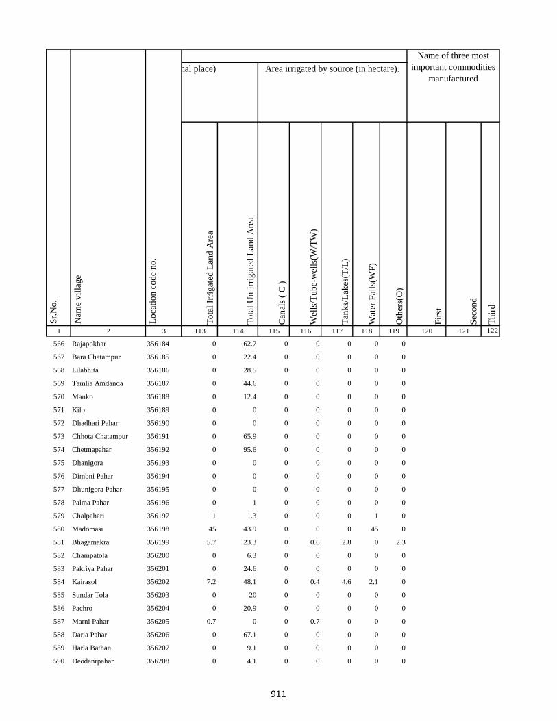
1 2 3
Lo
cati
on
co
de
no
.
Nam
e v
illa
ge
Sr.
No
.
566 Rajapokhar 356184
567 Bara Chatampur 356185
568 Lilabhita 356186
569 Tamlia Amdanda 356187
570 Manko 356188
571 Kilo 356189
572 Dhadhari Pahar 356190
573 Chhota Chatampur 356191
574 Chetmapahar 356192
575 Dhanigora 356193
576 Dimbni Pahar 356194
577 Dhunigora Pahar 356195
578 Palma Pahar 356196
579 Chalpahari 356197
580 Madomasi 356198
581 Bhagamakra 356199
582 Champatola 356200
583 Pakriya Pahar 356201
584 Kairasol 356202
585 Sundar Tola 356203
586 Pachro 356204
587 Marni Pahar 356205
588 Daria Pahar 356206
589 Harla Bathan 356207
590 Deodanrpahar 356208
To
tal
Irri
gat
ed L
and
Are
a
To
tal
Un
-irr
igat
ed L
and
Are
a
Can
als
( C
)
Wel
ls/T
ub
e-w
ells
(W/T
W)
Tan
ks/
Lak
es(T
/L)
Wat
er F
alls
(WF
)
Oth
ers(
O)
Fir
st
Sec
on
d
Th
ird
113 114 115 116 117 118 119 120 121 122
Area under different types of land use ( in hectares rounded up to one decimal place) Area irrigated by source (in hectare).
Name of three most
important commodities
manufactured
Land Use
0 62.7 0 0 0 0 0
0 22.4 0 0 0 0 0
0 28.5 0 0 0 0 0
0 44.6 0 0 0 0 0
0 12.4 0 0 0 0 0
0 0 0 0 0 0 0
0 0 0 0 0 0 0
0 65.9 0 0 0 0 0
0 95.6 0 0 0 0 0
0 0 0 0 0 0 0
0 0 0 0 0 0 0
0 0 0 0 0 0 0
0 1 0 0 0 0 0
1 1.3 0 0 0 1 0
45 43.9 0 0 0 45 0
5.7 23.3 0 0.6 2.8 0 2.3
0 6.3 0 0 0 0 0
0 24.6 0 0 0 0 0
7.2 48.1 0 0.4 4.6 2.1 0
0 20 0 0 0 0 0
0 20.9 0 0 0 0 0
0.7 0 0 0.7 0 0 0
0 67.1 0 0 0 0 0
0 9.1 0 0 0 0 0
0 4.1 0 0 0 0 0
911

1 2 3
Lo
cati
on
co
de
no
.
Nam
e v
illa
ge
Sr.
No
.
591 Bara Patma Masahara 356209
592 Chhota Patma 356210
593 Letra Tola 356211
594 Kajro 356212
595 Jania Pahar 356213
596 Tetarganji Pahar 356214
597 Matubera Masaharpahar 356215
598 Bara Patma 356216
599 Katikbhita 356217
600 Kuspisa 356218
601 Dhamnijor 356219
602 Katalpahari 356220
603 Talbona 356221
604 Telaibera 356222
605 Baghmara 356223
606 Jullo 356224
607 Baridih 356225
608 Sijua 356226
609 Ratanpur 356227
610 Rohra 356228
611 Juniya Tola 356229
612 Barbe 356230
613 Badem 356231
614 Borbe 356232
615 Chatma Bedo 356233
To
tal
Irri
gat
ed L
and
Are
a
To
tal
Un
-irr
igat
ed L
and
Are
a
Can
als
( C
)
Wel
ls/T
ub
e-w
ells
(W/T
W)
Tan
ks/
Lak
es(T
/L)
Wat
er F
alls
(WF
)
Oth
ers(
O)
Fir
st
Sec
on
d
Th
ird
113 114 115 116 117 118 119 120 121 122
Area under different types of land use ( in hectares rounded up to one decimal place) Area irrigated by source (in hectare).
Name of three most
important commodities
manufactured
Land Use
0 35.6 0 0 0 0 0
0 33.7 0 0 0 0 0
0 4.2 0 0 0 0 0
0 4.7 0 0 0 0 0
0 82.6 0 0 0 0 0
0 0 0 0 0 0 0
0 0 0 0 0 0 0
0 56 0 0 0 0 0
0.8 45.5 0 0 0.8 0 0
0.4 4.7 0 0.4 0 0 0
9 10.8 0 0 0 9 0
0 31.5 0 0 0 0 0
0 18.6 0 0 0 0 0
0 27.7 0 0 0 0 0
0 27.6 0 0 0 0 0
0 0 0 0 0 0 0
0 155.8 0 0 0 0 0
4.2 30.9 0 1 3.2 0 0
0 56.6 0 0 0 0 0
0 148 0 0 0 0 0
0 55.3 0 0 0 0 0
0 0 0 0 0 0 0
0 2.2 0 0 0 0 0
0 10.4 0 0 0 0 0
0 0 0 0 0 0 0
912
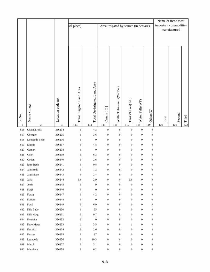
1 2 3
Lo
cati
on
co
de
no
.
Nam
e v
illa
ge
Sr.
No
.
616 Chatma Joka 356234
617 Chengro 356235
618 Donigoda Bedo 356236
619 Ejgoga 356237
620 Gamari 356238
621 Goari 356239
622 Godam 356240
623 Itkro Bedo 356241
624 Jani Bedo 356242
625 Jani Maqo 356243
626 Jaria 356244
627 Jonia 356245
628 Karji 356246
629 Karag 356247
630 Kariam 356248
631 Katal 356249
632 Kilo Bedo 356250
633 Kilo Maqo 356251
634 Kombita 356252
635 Kuro Maqo 356253
636 Kuspiso 356254
637 Kutam 356255
638 Letragoda 356256
639 Marchi 356257
640 Matubera 356258
To
tal
Irri
gat
ed L
and
Are
a
To
tal
Un
-irr
igat
ed L
and
Are
a
Can
als
( C
)
Wel
ls/T
ub
e-w
ells
(W/T
W)
Tan
ks/
Lak
es(T
/L)
Wat
er F
alls
(WF
)
Oth
ers(
O)
Fir
st
Sec
on
d
Th
ird
113 114 115 116 117 118 119 120 121 122
Area under different types of land use ( in hectares rounded up to one decimal place) Area irrigated by source (in hectare).
Name of three most
important commodities
manufactured
Land Use
0 4.3 0 0 0 0 0
0 3.6 0 0 0 0 0
0 0 0 0 0 0 0
0 4.8 0 0 0 0 0
0 0 0 0 0 0 0
0 6.3 0 0 0 0 0
0 2.6 0 0 0 0 0
0 0.8 0 0 0 0 0
0 1.2 0 0 0 0 0
0 2.4 0 0 0 0 0
6.6 2.9 0 0 6.6 0 0
0 9 0 0 0 0 0
0 0 0 0 0 0 0
0 4.2 0 0 0 0 0
0 0 0 0 0 0 0
0 6.9 0 0 0 0 0
0 35 0 0 0 0 0
0 0.7 0 0 0 0 0
0 0 0 0 0 0 0
1 3.5 0 0 1 0 0
0 2.6 0 0 0 0 0
0 17 0 0 0 0 0
0 10.3 0 0 0 0 0
0 3.1 0 0 0 0 0
0 6.2 0 0 0 0 0
913

1 2 3
Lo
cati
on
co
de
no
.
Nam
e v
illa
ge
Sr.
No
.
641 Pandeni 356259
642 Patma Joka 356260
643 Perkuria 356261
644 Puro Maqo 356262
645 Puro Bedo 356263
646 Pusurkuriya Bedo 356264
647 Pusurkuriya Joka 356265
648 Tamlipatta 356266
649 Tesro 356267
650 Tisro 356268
651 Todmari 356269
652 Tokam 356270
653 Tokkuriya 356271
654 Saharpur 356272
655 Lilatari 356273
656 Khairbani 356274
657 Belthu 356275
658 Hethbandha 356276
659 Shamapokhar 356277
660 Chiharbona 356278
661 Chhota Saharpur 356279
662 Tulsipur 356280
663 Goriya 356281
664 Kamardiha 356282
665 Gopalpur 356283
To
tal
Irri
gat
ed L
and
Are
a
To
tal
Un
-irr
igat
ed L
and
Are
a
Can
als
( C
)
Wel
ls/T
ub
e-w
ells
(W/T
W)
Tan
ks/
Lak
es(T
/L)
Wat
er F
alls
(WF
)
Oth
ers(
O)
Fir
st
Sec
on
d
Th
ird
113 114 115 116 117 118 119 120 121 122
Area under different types of land use ( in hectares rounded up to one decimal place) Area irrigated by source (in hectare).
Name of three most
important commodities
manufactured
Land Use
0 0 0 0 0 0 0
0 3.1 0 0 0 0 0
0 3.3 0 0 0 0 0
0 9.2 0 0 0 0 0
0 9.7 0 0 0 0 0
0 0 0 0 0 0 0
0 0 0 0 0 0 0
0 5 0 0 0 0 0
0 0.8 0 0 0 0 0
0 1.9 0 0 0 0 0
0 0.8 0 0 0 0 0
0 1.7 0 0 0 0 0
0 1.7 0 0 0 0 0
0 3.2 0 0 0 0 0
0.2 8 0 0.2 0 0 0
22.5 0.2 0 0 22.5 0 0
2.8 28.9 0 0 2.8 0 0
5.9 18.1 0 0 5.9 0 0
1.3 38.5 0 1.3 0 0 0
1.8 28.6 0 1.8 0 0 0
0 0 0 0 0 0 0
4.7 22.2 0 2 2.7 0 0
5.7 23.4 0 1.6 4.2 0 0
9.5 10.5 0 6.4 3.1 0 0
3.8 17.4 0 2 1.7 0 0
914
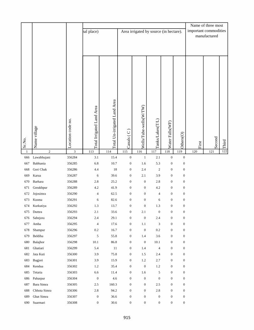
1 2 3
Lo
cati
on
co
de
no
.
Nam
e v
illa
ge
Sr.
No
.
666 Lawabhujani 356284
667 Babhania 356285
668 Gori Chak 356286
669 Karua 356287
670 Barhara 356288
671 Gorakhpur 356289
672 Jojosimra 356290
673 Kusma 356291
674 Kurkutiya 356292
675 Dumra 356293
676 Sabejora 356294
677 Amba 356295
678 Shampur 356296
679 Beldiha 356297
680 Balajhor 356298
681 Ghatiari 356299
682 Jata Kuti 356300
683 Bagjori 356301
684 Kendua 356302
685 Tetaria 356303
686 Paharpur 356304
687 Bara Simra 356305
688 Chhota Simra 356306
689 Ghat Simra 356307
690 Suarmari 356308
To
tal
Irri
gat
ed L
and
Are
a
To
tal
Un
-irr
igat
ed L
and
Are
a
Can
als
( C
)
Wel
ls/T
ub
e-w
ells
(W/T
W)
Tan
ks/
Lak
es(T
/L)
Wat
er F
alls
(WF
)
Oth
ers(
O)
Fir
st
Sec
on
d
Th
ird
113 114 115 116 117 118 119 120 121 122
Area under different types of land use ( in hectares rounded up to one decimal place) Area irrigated by source (in hectare).
Name of three most
important commodities
manufactured
Land Use
3.1 15.4 0 1 2.1 0 0
6.8 10.7 0 1.6 5.3 0 0
4.4 18 0 2.4 2 0 0
6 39.6 0 2.1 3.9 0 0
2.8 25.2 0 0 2.8 0 0
4.2 41.9 0 0 4.2 0 0
4 62.5 0 0 4 0 0
6 82.6 0 0 6 0 0
1.3 13.7 0 0 1.3 0 0
2.1 33.6 0 2.1 0 0 0
2.4 29.1 0 0 2.4 0 0
4 17.6 0 1.1 3 0 0
0.2 16.7 0 0 0.2 0 0
5 55.8 0 1.4 3.6 0 0
10.1 86.8 0 0 10.1 0 0
5.4 11 0 1.4 4 0 0
3.9 75.8 0 1.5 2.4 0 0
3.9 15.9 0 1.2 2.7 0 0
1.2 35.4 0 0 1.2 0 0
6.6 11.4 0 1.6 5 0 0
0 4.6 0 0 0 0 0
2.5 160.3 0 0 2.5 0 0
2.8 94.2 0 0 2.8 0 0
0 36.6 0 0 0 0 0
0 30.6 0 0 0 0 0
915
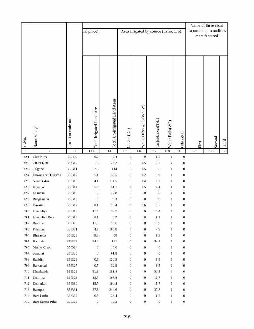
1 2 3
Lo
cati
on
co
de
no
.
Nam
e v
illa
ge
Sr.
No
.
691 Ghat Nima 356309
692 Chitar Koti 356310
693 Telgama 356311
694 Duwarighat Telgama 356312
695 Nima Kalan 356313
696 Hijukita 356314
697 Lalmatia 356315
698 Rangamatia 356316
699 Dakaita 356317
700 Lohandiya 356318
701 Lohandiya Bazar 356319
702 Basdiha 356320
703 Paharpur 356321
704 Bharanda 356322
705 Harrakha 356323
706 Mariya Chak 356324
707 Saraumi 356325
708 Ranidih 356326
709 Barkandali 356327
710 Dhankunda 356328
711 Dumriya 356329
712 Dumarkol 356330
713 Babupur 356331
714 Bara Kotha 356332
715 Bara Barma Pahar 356333
To
tal
Irri
gat
ed L
and
Are
a
To
tal
Un
-irr
igat
ed L
and
Are
a
Can
als
( C
)
Wel
ls/T
ub
e-w
ells
(W/T
W)
Tan
ks/
Lak
es(T
/L)
Wat
er F
alls
(WF
)
Oth
ers(
O)
Fir
st
Sec
on
d
Th
ird
113 114 115 116 117 118 119 120 121 122
Area under different types of land use ( in hectares rounded up to one decimal place) Area irrigated by source (in hectare).
Name of three most
important commodities
manufactured
Land Use
0.2 10.4 0 0 0.2 0 0
9 23.2 0 1.5 7.5 0 0
7.5 114 0 1.5 6 0 0
5.1 35.5 0 1.2 3.9 0 0
4.1 114.5 0 1.4 2.7 0 0
5.9 31.1 0 1.5 4.4 0 0
0 22.8 0 0 0 0 0
0 5.3 0 0 0 0 0
8.1 75.4 0 0.6 7.5 0 0
11.4 78.7 0 0 11.4 0 0
0.1 0.2 0 0 0.1 0 0
11.9 78.6 0 0 11.9 0 0
4.9 100.8 0 0 4.9 0 0
9.3 58 0 0 9.3 0 0
24.4 141 0 0 24.4 0 0
0 16.6 0 0 0 0 0
0 61.8 0 0 0 0 0
0.5 120.3 0 0 0.5 0 0
0.5 32.9 0 0 0.5 0 0
31.8 151.8 0 0 31.8 0 0
15.7 107.8 0 0 15.7 0 0
15.7 104.8 0 0 15.7 0 0
37.8 244.6 0 0 37.8 0 0
0.5 33.4 0 0 0.5 0 0
0 18.2 0 0 0 0 0
916

1 2 3
Lo
cati
on
co
de
no
.
Nam
e v
illa
ge
Sr.
No
.
716 Tatkunda 356334
717 Chhota Barma 356335
718 Debdanr 356336
719 Surla 356337
720 Dumria 356338
721 Chhota Khadahara 356339
722 Bara Khadahara 356340
723 Harkata 356341
724 Bara Khairbani 356342
725 Baisabaran 356343
726 Jurgura 356344
727 Dahua 356345
728 Kusumghati 356346
729 Lutibahiar 356347
730 Lilatari 356348
731 Haripur 356349
732 Hahajor 356350
733 Panchrukhi 356351
734 Rangamatia 356352
735 Chhota Khairbani 356353
736 Chhota Bhorai 356354
737 Bara Bhorai 356355
738 Taljhari 356356
739 Kesgoria 356357
740 Pakaria 356358
To
tal
Irri
gat
ed L
and
Are
a
To
tal
Un
-irr
igat
ed L
and
Are
a
Can
als
( C
)
Wel
ls/T
ub
e-w
ells
(W/T
W)
Tan
ks/
Lak
es(T
/L)
Wat
er F
alls
(WF
)
Oth
ers(
O)
Fir
st
Sec
on
d
Th
ird
113 114 115 116 117 118 119 120 121 122
Area under different types of land use ( in hectares rounded up to one decimal place) Area irrigated by source (in hectare).
Name of three most
important commodities
manufactured
Land Use
0 17.6 0 0 0 0 0
0 3 0 0 0 0 0
0.5 22.7 0 0 0.5 0 0
0.4 45.4 0 0 0.4 0 0
7.7 113.2 0 0 3.8 0 3.8
0.2 26.2 0 0.2 0 0 0
0 7.2 0 0 0 0 0
0.7 106.1 0 0.7 0 0 0
5.8 114.6 0 0 5.8 0 0
6.3 2.5 6.3 0 0 0 0
0 170.2 0 0 0 0 0
77 128.2 36.2 0 40.8 0 0
141.7 26.1 65 0 76.7 0 0
0 76.9 0 0 0 0 0
6.3 106.2 0 0 6.3 0 0
21.2 120.4 0 10 11.2 0 0
2.5 132.8 0 0 2.5 0 0
0 56.2 0 0 0 0 0
0 26.3 0 0 0 0 0
0 2.9 0 0 0 0 0
0 32.1 0 0 0 0 0
326.8 0 0 0 326.8 0 0
4.2 120.7 0 4.2 0 0 0
0.1 30.3 0 0 0.1 0 0
0 44.2 0 0 0 0 0
917

1 2 3
Lo
cati
on
co
de
no
.
Nam
e v
illa
ge
Sr.
No
.
741 Jaggora 356359
742 Bador 356360
743 Taratikar 356361
744 Bichduba 356362
745 Telodhuni 356363
746 Madgigora 356364
747 Dighi 356365
748 Gopali 356366
749 Dabra 356367
750 Rohari Naryanpur 356368
751 Jolopahari 356369
752 Raydih 356370
753 Piaram 356371
754 Phulbaria 356372
755 Harra 356373
756 Mahuabathan 356374
757 Gadial 356375
758 Chakra 356376
759 Bara Dhanbandhi 356377
760 Chhota Dhanbandhi 356378
761 Tetardiha 356379
762 Baramasia 356380
763 Kajribhita 356381
764 Adro 356382
765 Chhota Amra 356383
To
tal
Irri
gat
ed L
and
Are
a
To
tal
Un
-irr
igat
ed L
and
Are
a
Can
als
( C
)
Wel
ls/T
ub
e-w
ells
(W/T
W)
Tan
ks/
Lak
es(T
/L)
Wat
er F
alls
(WF
)
Oth
ers(
O)
Fir
st
Sec
on
d
Th
ird
113 114 115 116 117 118 119 120 121 122
Area under different types of land use ( in hectares rounded up to one decimal place) Area irrigated by source (in hectare).
Name of three most
important commodities
manufactured
Land Use
0 37.6 0 0 0 0 0
0 17.6 0 0 0 0 0
0 5.8 0 0 0 0 0
0 23.8 0 0 0 0 0
0 69.8 0 0 0 0 0
0 8.6 0 0 0 0 0
0 41.9 0 0 0 0 0
0 19.8 0 0 0 0 0
0 42.1 0 0 0 0 0
0.8 61.6 0 0 0.8 0 0
6.9 51.2 0 0 6.9 0 0
0.7 10.3 0 0 0.7 0 0
0.1 124 0 0 0.1 0 0
0 81.8 0 0 0 0 0
3.4 106.3 0 0 3.4 0 0
3.3 126.9 0 0 3.3 0 0
3 117 0 0 3 0 0
4.2 156.1 0 0 4.2 0 0
8.4 140.8 0 0 8.4 0 0
2.1 67.7 0 0 2.1 0 0
0 54.1 0 0 0 0 0
0 12.3 0 0 0 0 0
0 29.7 0 0 0 0 0
0 118 0 0 0 0 0
0 38.3 0 0 0 0 0
918

1 2 3
Lo
cati
on
co
de
no
.
Nam
e v
illa
ge
Sr.
No
.
766 Tulsipur 356384
767 Lohatamba And Agoia 356385
768 Bhalgora 356386
769 Deonapur 356387
770 Bhagwanpur 356388
771 Bara Malbhita 356389
772 Chhota Malbhita 356390
773 Tikrigora 356391
774 Gamhar Pahar 356392
775 Katar Pahar 356393
776 Kisma Pahar 356394
777 Malbhita Tola 356395
778 Chhota Pipra 356396
779 Pipra Hill 356397
780 Tetarbhita 356398
781 Tatgora 356399
782 Chhota Basgo 356400
783 Bara Pipra 356401
784 Salem Tok 356402
785 Kukur Pahari 356403
786 Kuschilia Pahar 356404
787 Kisma 356405
788 Bara Amarpur 356406
789 Chhota Amarpur 356407
790 Dumaria 356408
To
tal
Irri
gat
ed L
and
Are
a
To
tal
Un
-irr
igat
ed L
and
Are
a
Can
als
( C
)
Wel
ls/T
ub
e-w
ells
(W/T
W)
Tan
ks/
Lak
es(T
/L)
Wat
er F
alls
(WF
)
Oth
ers(
O)
Fir
st
Sec
on
d
Th
ird
113 114 115 116 117 118 119 120 121 122
Area under different types of land use ( in hectares rounded up to one decimal place) Area irrigated by source (in hectare).
Name of three most
important commodities
manufactured
Land Use
0 113 0 0 0 0 0
0 173.1 0 0 0 0 0
0 24.5 0 0 0 0 0
0 24.5 0 0 0 0 0
0 20.4 0 0 0 0 0
1.3 42.5 0 0 1.3 0 0
0 52.7 0 0 0 0 0
50 15.7 0 0 0 50 0
2.8 5.7 0 0 2.8 0 0
0 4.3 0 0 0 0 0
0 15 0 0 0 0 0
0 15.4 0 0 0 0 0
0 16.8 0 0 0 0 0
0 2.8 0 0 0 0 0
0 1.2 0 0 0 0 0
0 3.2 0 0 0 0 0
0 1.4 0 0 0 0 0
0 60 0 0 0 0 0
0 7.9 0 0 0 0 0
0 1.2 0 0 0 0 0
0 8.1 0 0 0 0 0
0 22.7 0 0 0 0 0
0 78.8 0 0 0 0 0
0 24.6 0 0 0 0 0
0 95.8 0 0 0 0 0
919

1 2 3
Lo
cati
on
co
de
no
.
Nam
e v
illa
ge
Sr.
No
.
791 Bamangawan 356409
792 Chhota Bararo 356410
793 Bararo 356411
794 Chetan Pahar 356412
795 Chakan Chak 356413
796 Domgora Pahar 356414
797 Elkar Pahar 356415
798 Moter Pahar 356416
799 Dhauatoka 356417
800 Bariartok 356418
801 Bara Telo 356419
802 Chhota Telo 356420
803 Jajotola Barhua 356421
804 Bara Amra 356422
805 Balkani 356423
806 Sundai 356424
807 Garbhu Tola 356425
808 Chhota Simmi 356426
809 Bara Simmi 356427
810 Bandhgora 356428
811 Kesarogora 356429
812 Chhota Chapri 356430
813 Dholna Pahar 356431
814 Telotok 356432
815 Charanpahar 356433
To
tal
Irri
gat
ed L
and
Are
a
To
tal
Un
-irr
igat
ed L
and
Are
a
Can
als
( C
)
Wel
ls/T
ub
e-w
ells
(W/T
W)
Tan
ks/
Lak
es(T
/L)
Wat
er F
alls
(WF
)
Oth
ers(
O)
Fir
st
Sec
on
d
Th
ird
113 114 115 116 117 118 119 120 121 122
Area under different types of land use ( in hectares rounded up to one decimal place) Area irrigated by source (in hectare).
Name of three most
important commodities
manufactured
Land Use
0 60.3 0 0 0 0 0
0 0 0 0 0 0 0
0 53.6 0 0 0 0 0
0 0 0 0 0 0 0
0 0 0 0 0 0 0
0 0.2 0 0 0 0 0
0 0.7 0 0 0 0 0
0 18.8 0 0 0 0 0
0 2.3 0 0 0 0 0
0 1.6 0 0 0 0 0
0 98.1 0 0 0 0 0
0 20.7 0 0 0 0 0
0 27.1 0 0 0 0 0
0 63.3 0 0 0 0 0
0 0 0 0 0 0 0
0 45 0 0 0 0 0
60 38 0 0 0 60 0
0 46.2 0 0 0 0 0
0 30.4 0 0 0 0 0
0 17.1 0 0 0 0 0
0 6.3 0 0 0 0 0
0 44 0 0 0 0 0
0 17.7 0 0 0 0 0
0 44.7 0 0 0 0 0
0 0 0 0 0 0 0
920

1 2 3
Lo
cati
on
co
de
no
.
Nam
e v
illa
ge
Sr.
No
.
816 Keriapahar 356434
817 Karampahar 356435
818 Masanpahar 356436
819 Dumarpahar 356437
820 Kamugora 356438
821 Bansdandapahar 356439
822 Bansdanda 356440
823 Dhunigora 356441
824 Bara Basgi 356442
825 Satbera 356443
826 Satbera 356444
827 Chetrampahar 356445
828 Hanidhoni 356446
829 Bara Chapri 356447
830 Madarpahar 356448
831 Chapri Bara 356449
832 Tamlipahar 356450
833 Bara Chapri 356451
834 Madgigora 356452
835 Karamtanr 356453
836 Dumarpahar 356454
837 Chhota Ghogha 356455
838 Bara Karlopahar 356456
839 Bara Ghogha 356457
840 Bara Kerlo 356458
To
tal
Irri
gat
ed L
and
Are
a
To
tal
Un
-irr
igat
ed L
and
Are
a
Can
als
( C
)
Wel
ls/T
ub
e-w
ells
(W/T
W)
Tan
ks/
Lak
es(T
/L)
Wat
er F
alls
(WF
)
Oth
ers(
O)
Fir
st
Sec
on
d
Th
ird
113 114 115 116 117 118 119 120 121 122
Area under different types of land use ( in hectares rounded up to one decimal place) Area irrigated by source (in hectare).
Name of three most
important commodities
manufactured
Land Use
0 0 0 0 0 0 0
0 0 0 0 0 0 0
0 1.7 0 0 0 0 0
0 0 0 0 0 0 0
0 0 0 0 0 0 0
0 0.7 0 0 0 0 0
0 55.4 0 0 0 0 0
0 3.7 0 0 0 0 0
0 1.2 0 0 0 0 0
0 24.4 0 0 0 0 0
0 2.6 0 0 0 0 0
0 2.9 0 0 0 0 0
0 4.4 0 0 0 0 0
0 20.6 0 0 0 0 0
0 4.1 0 0 0 0 0
0 3.2 0 0 0 0 0
0 3.2 0 0 0 0 0
1 3.7 0 0 0 1 0
0 0 0 0 0 0 0
0 4.5 0 0 0 0 0
0 3.8 0 0 0 0 0
0 0 0 0 0 0 0
0 1.8 0 0 0 0 0
0 0.5 0 0 0 0 0
0 45.6 0 0 0 0 0
921
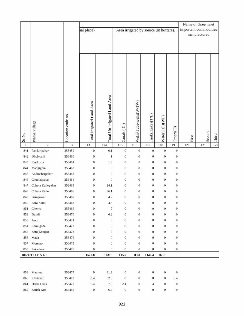
1 2 3
Lo
cati
on
co
de
no
.
Nam
e v
illa
ge
Sr.
No
.
841 Pandaripahar 356459
842 Dhobkanji 356460
843 Kerikuria 356461
844 Madgigora 356462
845 Androcharpahar 356463
846 Chuolalpahar 356464
847 Chhota Karlopahar 356465
848 Chhota Kerlo 356466
849 Baragawn 356467
850 Bara Kamu 356468
851 Chenya 356469
852 Dumli 356470
853 Jandi 356471
854 Kamugoda 356472
855 Keto(Keraya) 356473
856 Mada 356474
857 Moremo 356475
858 Pakarbera 356476
Block T O T A L :
859 Manjura 356477
860 Khutahari 356478
861 Darbe Chak 356479
862 Kanak Kita 356480
To
tal
Irri
gat
ed L
and
Are
a
To
tal
Un
-irr
igat
ed L
and
Are
a
Can
als
( C
)
Wel
ls/T
ub
e-w
ells
(W/T
W)
Tan
ks/
Lak
es(T
/L)
Wat
er F
alls
(WF
)
Oth
ers(
O)
Fir
st
Sec
on
d
Th
ird
113 114 115 116 117 118 119 120 121 122
Area under different types of land use ( in hectares rounded up to one decimal place) Area irrigated by source (in hectare).
Name of three most
important commodities
manufactured
Land Use
0 0.1 0 0 0 0 0
0 1 0 0 0 0 0
0 1.8 0 0 0 0 0
0 0 0 0 0 0 0
0 0 0 0 0 0 0
0 0 0 0 0 0 0
0 14.1 0 0 0 0 0
0 36.1 0 0 0 0 0
0 4.2 0 0 0 0 0
0 4.3 0 0 0 0 0
0 2 0 0 0 0 0
0 6.2 0 0 0 0 0
0 0 0 0 0 0 0
0 0 0 0 0 0 0
0 0 0 0 0 0 0
0 0 0 0 0 0 0
0 0 0 0 0 0 0
0 0 0 0 0 0 0
1520.8 16313 115.5 83.8 1146.4 168.1
0 31.2 0 0 0 0 0
0.4 62.6 0 0 0 0 0.4
6.4 7.9 2.4 0 4 0 0
0 6.8 0 0 0 0 0
922
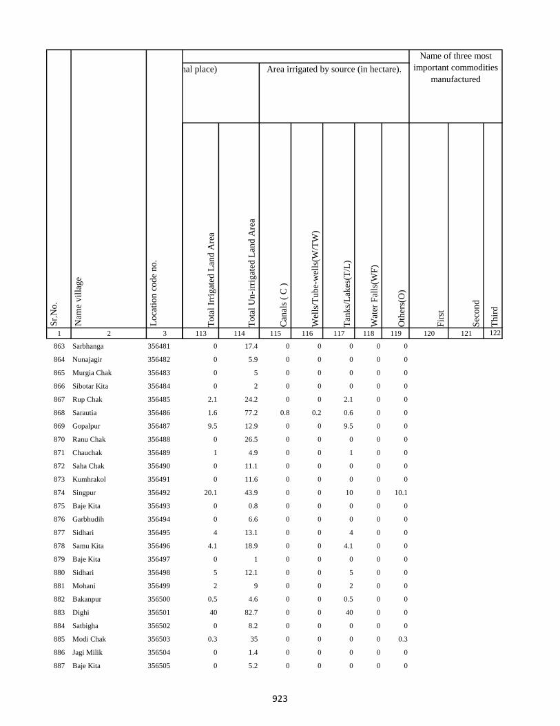
1 2 3
Lo
cati
on
co
de
no
.
Nam
e v
illa
ge
Sr.
No
.
863 Sarbhanga 356481
864 Nunajagir 356482
865 Murgia Chak 356483
866 Sibotar Kita 356484
867 Rup Chak 356485
868 Sarautia 356486
869 Gopalpur 356487
870 Ranu Chak 356488
871 Chauchak 356489
872 Saha Chak 356490
873 Kumhrakol 356491
874 Singpur 356492
875 Baje Kita 356493
876 Garbhudih 356494
877 Sidhari 356495
878 Samu Kita 356496
879 Baje Kita 356497
880 Sidhari 356498
881 Mohani 356499
882 Bakanpur 356500
883 Dighi 356501
884 Satbigha 356502
885 Modi Chak 356503
886 Jagi Milik 356504
887 Baje Kita 356505
To
tal
Irri
gat
ed L
and
Are
a
To
tal
Un
-irr
igat
ed L
and
Are
a
Can
als
( C
)
Wel
ls/T
ub
e-w
ells
(W/T
W)
Tan
ks/
Lak
es(T
/L)
Wat
er F
alls
(WF
)
Oth
ers(
O)
Fir
st
Sec
on
d
Th
ird
113 114 115 116 117 118 119 120 121 122
Area under different types of land use ( in hectares rounded up to one decimal place) Area irrigated by source (in hectare).
Name of three most
important commodities
manufactured
Land Use
0 17.4 0 0 0 0 0
0 5.9 0 0 0 0 0
0 5 0 0 0 0 0
0 2 0 0 0 0 0
2.1 24.2 0 0 2.1 0 0
1.6 77.2 0.8 0.2 0.6 0 0
9.5 12.9 0 0 9.5 0 0
0 26.5 0 0 0 0 0
1 4.9 0 0 1 0 0
0 11.1 0 0 0 0 0
0 11.6 0 0 0 0 0
20.1 43.9 0 0 10 0 10.1
0 0.8 0 0 0 0 0
0 6.6 0 0 0 0 0
4 13.1 0 0 4 0 0
4.1 18.9 0 0 4.1 0 0
0 1 0 0 0 0 0
5 12.1 0 0 5 0 0
2 9 0 0 2 0 0
0.5 4.6 0 0 0.5 0 0
40 82.7 0 0 40 0 0
0 8.2 0 0 0 0 0
0.3 35 0 0 0 0 0.3
0 1.4 0 0 0 0 0
0 5.2 0 0 0 0 0
923
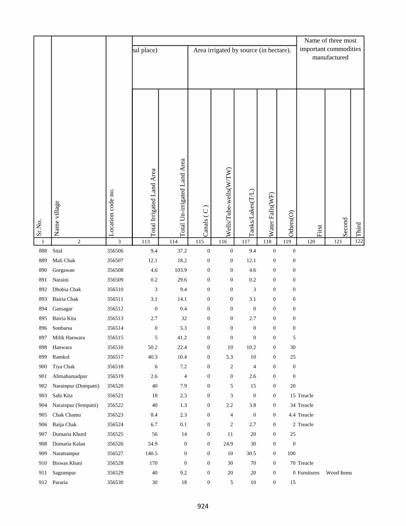
1 2 3
Lo
cati
on
co
de
no
.
Nam
e v
illa
ge
Sr.
No
.
888 Sital 356506
889 Mali Chak 356507
890 Gorgawan 356508
891 Naraini 356509
892 Dhobia Chak 356510
893 Bairia Chak 356511
894 Gansagar 356512
895 Bairia Kita 356513
896 Sonbarsa 356514
897 Milik Hanwara 356515
898 Hanwara 356516
899 Ramkol 356517
900 Tiya Chak 356518
901 Alimahamadpur 356519
902 Narainpur (Dompatti) 356520
903 Sahi Kita 356521
904 Narainpur (Sempatti) 356522
905 Chak Chamu 356523
906 Baija Chak 356524
907 Dumaria Khurd 356525
908 Dumaria Kalan 356526
909 Narattampur 356527
910 Biswas Khani 356528
911 Sagrampur 356529
912 Pararia 356530
To
tal
Irri
gat
ed L
and
Are
a
To
tal
Un
-irr
igat
ed L
and
Are
a
Can
als
( C
)
Wel
ls/T
ub
e-w
ells
(W/T
W)
Tan
ks/
Lak
es(T
/L)
Wat
er F
alls
(WF
)
Oth
ers(
O)
Fir
st
Sec
on
d
Th
ird
113 114 115 116 117 118 119 120 121 122
Area under different types of land use ( in hectares rounded up to one decimal place) Area irrigated by source (in hectare).
Name of three most
important commodities
manufactured
Land Use
9.4 37.2 0 0 9.4 0 0
12.1 18.2 0 0 12.1 0 0
4.6 103.9 0 0 4.6 0 0
0.2 29.6 0 0 0.2 0 0
3 9.4 0 0 3 0 0
3.1 14.1 0 0 3.1 0 0
0 0.4 0 0 0 0 0
2.7 32 0 0 2.7 0 0
0 5.3 0 0 0 0 0
5 41.2 0 0 0 0 5
50.2 22.4 0 10 10.2 0 30
40.3 10.4 0 5.3 10 0 25
6 7.2 0 2 4 0 0
2.6 4 0 0 2.6 0 0
40 7.9 0 5 15 0 20
18 2.3 0 3 0 0 15 Treacle
40 1.3 0 2.2 3.8 0 34 Treacle
8.4 2.3 0 4 0 0 4.4 Treacle
6.7 0.1 0 2 2.7 0 2 Treacle
56 14 0 11 20 0 25
54.9 0 0 24.9 30 0 0
140.5 0 0 10 30.5 0 100
170 0 0 30 70 0 70 Treacle
40 9.2 0 20 20 0 0 Furnitures Wood Items
30 18 0 5 10 0 15
924
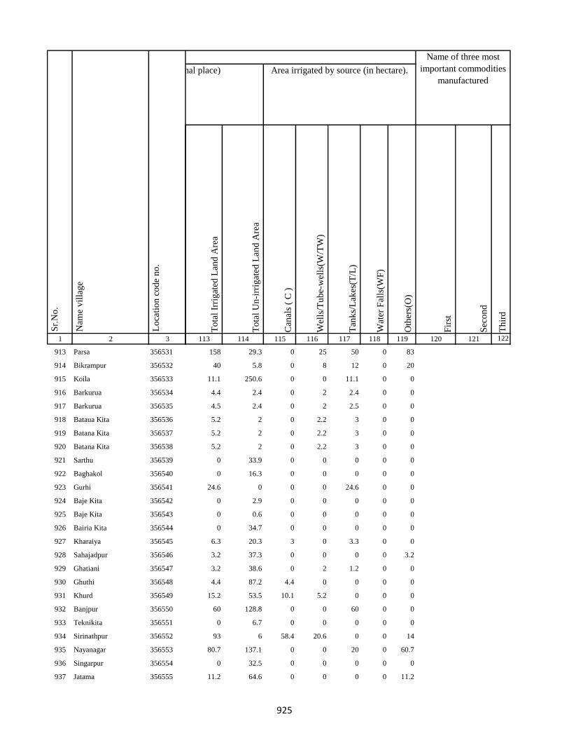
1 2 3
Lo
cati
on
co
de
no
.
Nam
e v
illa
ge
Sr.
No
.
913 Parsa 356531
914 Bikrampur 356532
915 Koila 356533
916 Barkurua 356534
917 Barkurua 356535
918 Bataua Kita 356536
919 Batana Kita 356537
920 Batana Kita 356538
921 Sarthu 356539
922 Baghakol 356540
923 Gurhi 356541
924 Baje Kita 356542
925 Baje Kita 356543
926 Bairia Kita 356544
927 Kharaiya 356545
928 Sahajadpur 356546
929 Ghatiani 356547
930 Ghuthi 356548
931 Khurd 356549
932 Banjpur 356550
933 Teknikita 356551
934 Sirinathpur 356552
935 Nayanagar 356553
936 Singarpur 356554
937 Jatama 356555
To
tal
Irri
gat
ed L
and
Are
a
To
tal
Un
-irr
igat
ed L
and
Are
a
Can
als
( C
)
Wel
ls/T
ub
e-w
ells
(W/T
W)
Tan
ks/
Lak
es(T
/L)
Wat
er F
alls
(WF
)
Oth
ers(
O)
Fir
st
Sec
on
d
Th
ird
113 114 115 116 117 118 119 120 121 122
Area under different types of land use ( in hectares rounded up to one decimal place) Area irrigated by source (in hectare).
Name of three most
important commodities
manufactured
Land Use
158 29.3 0 25 50 0 83
40 5.8 0 8 12 0 20
11.1 250.6 0 0 11.1 0 0
4.4 2.4 0 2 2.4 0 0
4.5 2.4 0 2 2.5 0 0
5.2 2 0 2.2 3 0 0
5.2 2 0 2.2 3 0 0
5.2 2 0 2.2 3 0 0
0 33.9 0 0 0 0 0
0 16.3 0 0 0 0 0
24.6 0 0 0 24.6 0 0
0 2.9 0 0 0 0 0
0 0.6 0 0 0 0 0
0 34.7 0 0 0 0 0
6.3 20.3 3 0 3.3 0 0
3.2 37.3 0 0 0 0 3.2
3.2 38.6 0 2 1.2 0 0
4.4 87.2 4.4 0 0 0 0
15.2 53.5 10.1 5.2 0 0 0
60 128.8 0 0 60 0 0
0 6.7 0 0 0 0 0
93 6 58.4 20.6 0 0 14
80.7 137.1 0 0 20 0 60.7
0 32.5 0 0 0 0 0
11.2 64.6 0 0 0 0 11.2
925

1 2 3
Lo
cati
on
co
de
no
.
Nam
e v
illa
ge
Sr.
No
.
938 Gauri Kita 356556
939 Pindara 356557
940 Belti Kari 356558
941 Baje Kita 356559
942 Asota 356560
943 Kasba 356561
944 Bhandarchua 356562
945 Shekhu Chak 356563
946 Bhelaidih 356564
947 Doma Chak 356565
948 Bansbara 356566
949 Kita Bansbara 356567
950 Pakridih 356568
951 Kamal Chak 356569
952 Bhikhia Chak 356570
953 Andhara Kita 356571
954 Kita Andhra 356572
955 Karmatanr 356573
956 Champa Kita 356574
957 Phagu Kita 356575
958 Puran Kita 356576
959 Alola 356577
960 Dhansar 356578
961 Khurd 356579
962 Firozpur 356580
To
tal
Irri
gat
ed L
and
Are
a
To
tal
Un
-irr
igat
ed L
and
Are
a
Can
als
( C
)
Wel
ls/T
ub
e-w
ells
(W/T
W)
Tan
ks/
Lak
es(T
/L)
Wat
er F
alls
(WF
)
Oth
ers(
O)
Fir
st
Sec
on
d
Th
ird
113 114 115 116 117 118 119 120 121 122
Area under different types of land use ( in hectares rounded up to one decimal place) Area irrigated by source (in hectare).
Name of three most
important commodities
manufactured
Land Use
0 4.3 0 0 0 0 0
0 23.6 0 0 0 0 0
5.5 40 0 0 5.5 0 0
0 2.9 0 0 0 0 0
0 97.7 0 0 0 0 0
2.7 18.7 1.2 1 0.5 0 0
20.5 30 0 0 0 0 20.5
0 0 0 0 0 0 0
0 14.1 0 0 0 0 0
1 12.2 0.3 0.2 0.4 0 0.1
1 1 0.4 0.3 0.2 0 0
0 3 0 0 0 0 0
0 6 0 0 0 0 0
2.2 25 0.8 0 0.6 0 0.7
0 16.5 0 0 0 0 0
0 4.1 0 0 0 0 0
0 5 0 0 0 0 0
2.2 10.4 0.2 0.4 0.4 0 1.2
0 5 0 0 0 0 0
0 2 0 0 0 0 0
0 4 0 0 0 0 0
15.4 26 11 0 4.4 0 0
1.3 6.9 0 0 1 0.1 0.2
25 23.9 22 0 0 0 3
0 6.7 0 0 0 0 0
926
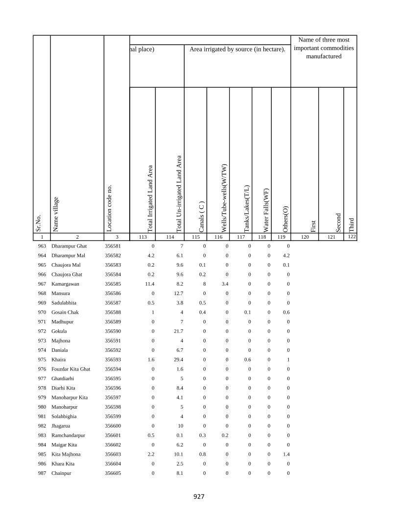
1 2 3
Lo
cati
on
co
de
no
.
Nam
e v
illa
ge
Sr.
No
.
963 Dharampur Ghat 356581
964 Dharampur Mal 356582
965 Chaujora Mal 356583
966 Chaujora Ghat 356584
967 Kamargawan 356585
968 Mansura 356586
969 Sadulabhita 356587
970 Gosain Chak 356588
971 Madhupur 356589
972 Gokula 356590
973 Majhona 356591
974 Daniala 356592
975 Khaira 356593
976 Fouzdar Kita Ghat 356594
977 Ghatdiarhi 356595
978 Diarhi Kita 356596
979 Manoharpur Kita 356597
980 Manoharpur 356598
981 Solahbighia 356599
982 Jhagarua 356600
983 Ramchandarpur 356601
984 Maigar Kita 356602
985 Kita Majhona 356603
986 Khara Kita 356604
987 Chainpur 356605
To
tal
Irri
gat
ed L
and
Are
a
To
tal
Un
-irr
igat
ed L
and
Are
a
Can
als
( C
)
Wel
ls/T
ub
e-w
ells
(W/T
W)
Tan
ks/
Lak
es(T
/L)
Wat
er F
alls
(WF
)
Oth
ers(
O)
Fir
st
Sec
on
d
Th
ird
113 114 115 116 117 118 119 120 121 122
Area under different types of land use ( in hectares rounded up to one decimal place) Area irrigated by source (in hectare).
Name of three most
important commodities
manufactured
Land Use
0 7 0 0 0 0 0
4.2 6.1 0 0 0 0 4.2
0.2 9.6 0.1 0 0 0 0.1
0.2 9.6 0.2 0 0 0 0
11.4 8.2 8 3.4 0 0 0
0 12.7 0 0 0 0 0
0.5 3.8 0.5 0 0 0 0
1 4 0.4 0 0.1 0 0.6
0 7 0 0 0 0 0
0 21.7 0 0 0 0 0
0 4 0 0 0 0 0
0 6.7 0 0 0 0 0
1.6 29.4 0 0 0.6 0 1
0 1.6 0 0 0 0 0
0 5 0 0 0 0 0
0 8.4 0 0 0 0 0
0 4.1 0 0 0 0 0
0 5 0 0 0 0 0
0 4 0 0 0 0 0
0 10 0 0 0 0 0
0.5 0.1 0.3 0.2 0 0 0
0 6.2 0 0 0 0 0
2.2 10.1 0.8 0 0 0 1.4
0 2.5 0 0 0 0 0
0 8.1 0 0 0 0 0
927

1 2 3
Lo
cati
on
co
de
no
.
Nam
e v
illa
ge
Sr.
No
.
988 Darha 356606
989 Ramchandarpur 356607
990 Ghat Jagarnathpur 356608
991 Jagarnathpur Mal 356609
992 Jiajori 356610
993 Rai Kita 356611
994 Jatakothi 356612
995 Bagjori 356613
996 Harlabahiar 356614
997 Balachini 356615
998 Ghat Jagatpur 356616
999 Chand Chak Ghat 356617
1000 Ramchandarpur 356618
1001 Lakarha 356619
1002 Taran Kita 356620
1003 Chamgadra Darunbatia 356621
1004 Kachuamal Chhit 356622
1005 Maskand Kachua 356623
1006 Kachuamal Chhit 356624
1007 Kachua Raksi 356625
1008 Raksa Maskand 356626
1009 Maskand Kachua 356627
1010 Lilabari 356628
1011 Kachua Raksi 356629
1012 Maskand Chhit 356630
To
tal
Irri
gat
ed L
and
Are
a
To
tal
Un
-irr
igat
ed L
and
Are
a
Can
als
( C
)
Wel
ls/T
ub
e-w
ells
(W/T
W)
Tan
ks/
Lak
es(T
/L)
Wat
er F
alls
(WF
)
Oth
ers(
O)
Fir
st
Sec
on
d
Th
ird
113 114 115 116 117 118 119 120 121 122
Area under different types of land use ( in hectares rounded up to one decimal place) Area irrigated by source (in hectare).
Name of three most
important commodities
manufactured
Land Use
0 5.2 0 0 0 0 0
0 18.3 0 0 0 0 0
0 22.8 0 0 0 0 0
0.5 2.8 0.5 0 0 0 0
0 81.3 0 0 0 0 0
0 14.4 0 0 0 0 0
0 23.2 0 0 0 0 0
0 22.4 0 0 0 0 0
0.5 3.8 0.5 0 0 0 0
0 77 0 0 0 0 0
0 195 0 0 0 0 0
0 6.2 0 0 0 0 0
0.3 0.3 0.3 0 0 0 0
1 27.5 1 0 0 0 0
0 4.9 0 0 0 0 0
0 6.6 0 0 0 0 0
0.1 16.6 0 0.1 0 0 0
0.3 3.3 0 0.2 0 0 0
0 0 0 0 0 0 0
0.6 4.4 0 0.3 0.3 0 0
2.1 5 0 1.8 0.2 0 0
0.3 3.3 0 0.2 0 0 0
1.9 14.2 0 1.4 0.5 0 0
0 0 0 0 0 0 0
0.3 2.3 0 0.2 0.1 0 0
928

1 2 3
Lo
cati
on
co
de
no
.
Nam
e v
illa
ge
Sr.
No
.
1013 Maskand Kita 356631
1014 Sirsa Kalan 356632
1015 Sirsa Khurd 356633
1016 Bholu Chak 356634
1017 Mahuara Ghat 356635
1018 Mahuara 356636
1019 Fauj Kita 356637
1020 Logain 356638
1021 Asmantikar 356639
1022 Maskand Bhanjpur 356640
1023 Gidra Pathar 356641
1024 Lamahaghat 356642
1025 Hirai Chak 356643
1026 Sukhbona 356644
1027 Sankar Kita 356645
1028 Rahim Kita 356646
1029 Hajra Chak 356647
1030 Lachmania Kita 356648
1031 Lilambar 356649
1032 Maskand Chhit 356650
1033 Bishambhar Kita 356651
1034 Kita Bishambhara 356652
1035 Gunia 356653
1036 Harin Chora 356654
1037 Baghakol 356655
To
tal
Irri
gat
ed L
and
Are
a
To
tal
Un
-irr
igat
ed L
and
Are
a
Can
als
( C
)
Wel
ls/T
ub
e-w
ells
(W/T
W)
Tan
ks/
Lak
es(T
/L)
Wat
er F
alls
(WF
)
Oth
ers(
O)
Fir
st
Sec
on
d
Th
ird
113 114 115 116 117 118 119 120 121 122
Area under different types of land use ( in hectares rounded up to one decimal place) Area irrigated by source (in hectare).
Name of three most
important commodities
manufactured
Land Use
2.7 9.6 0 1.7 1 0 0
0.5 10.5 0 0.3 0.2 0 0
0 6.3 0 0 0 0 0
0 6.5 0 0 0 0 0
1.1 2.7 0 1 0.1 0 0
2.1 18.9 0 1 0.1 1 0
0 1.4 0 0 0 0 0
0 71.9 0 0 0 0 0
0 6.1 0 0 0 0 0
0 13 0 0 0 0 0
0 2.6 0 0 0 0 0
0 26.9 0 0 0 0 0
7.4 7.8 3 0 0 0 4.4
0 8.1 0 0 0 0 0
0 6.8 0 0 0 0 0
0 6.3 0 0 0 0 0
0 4.1 0 0 0 0 0
0 2.6 0 0 0 0 0
1.4 12.8 0 1 0.4 0 0
0 3.9 0 0 0 0 0
1.6 1.4 0 1 0.6 0 0
0 12.1 0 0 0 0 0
0.9 7.6 0 0.8 0.1 0 0
3.7 15.5 0 2.7 1 0 0
0 7.7 0 0 0 0 0
929

1 2 3
Lo
cati
on
co
de
no
.
Nam
e v
illa
ge
Sr.
No
.
1038 Dakaita 356656
1039 Dakaitaghat 356657
1040 Tetaria 356658
1041 Bhalu Kita 356659
1042 Tewarijor 356660
1043 Beltikri 356661
1044 Jhapania 356662
1045 Khairaghat 356663
1046 Lamha Mal 356664
1047 Chand Chak 356665
1048 Ghospur 356666
1049 Dahara 356667
1050 Moti Chak 356668
1051 Bhartha Chak 356669
1052 Bhairo Kita 356670
1053 Lachminia Kita 356671
1054 Anjna 356672
1055 Barhe Kita 356673
1056 Sirsi 356674
1057 Bhairo Chak 356675
1058 Kusmara 356676
1059 Lachminia Kita 356677
1060 Bishunpur 356678
1061 Baradbara 356679
1062 Sundar Chak 356680
To
tal
Irri
gat
ed L
and
Are
a
To
tal
Un
-irr
igat
ed L
and
Are
a
Can
als
( C
)
Wel
ls/T
ub
e-w
ells
(W/T
W)
Tan
ks/
Lak
es(T
/L)
Wat
er F
alls
(WF
)
Oth
ers(
O)
Fir
st
Sec
on
d
Th
ird
113 114 115 116 117 118 119 120 121 122
Area under different types of land use ( in hectares rounded up to one decimal place) Area irrigated by source (in hectare).
Name of three most
important commodities
manufactured
Land Use
2.1 5.8 0 1 1.1 0 0
0 2.7 0 0 0 0 0
0.6 5 0 0 0.3 0 0.3
0.8 7.2 0 0.5 0.3 0 0
1.6 6 0 1 0.6 0 0
0 84.1 0 0 0 0 0
0 11.2 0 0 0 0 0
0 8.7 0 0 0 0 0
0 7.7 0 0 0 0 0
0 52 0 0 0 0 0
0 46 0 0 0 0 0
0 7.4 0 0 0 0 0
0 28.1 0 0 0 0 0
0 20.2 0 0 0 0 0
0 6.6 0 0 0 0 0
0 6.1 0 0 0 0 0
20.2 10.6 12 2 6.2 0 0
0 15 0 0 0 0 0
0 50.8 0 0 0 0 0
0 22.7 0 0 0 0 0
0 77.7 0 0 0 0 0
0 9.4 0 0 0 0 0
0 22.5 0 0 0 0 0
13.5 20 0 3.5 7 0 3
0 38.8 0 0 0 0 0
930

1 2 3
Lo
cati
on
co
de
no
.
Nam
e v
illa
ge
Sr.
No
.
1063 Bhaju Chak 356681
1064 Malia Chak 356682
1065 Afzal Kita 356683
1066 Mariha 356684
1067 Kushapur 356685
1068 Fazil Kita 356686
1069 Dumra 356687
1070 Bisambhara Kita 356688
1071 Dahia 356689
1072 Kaljhara 356690
1073 Phudkipur 356691
1074 Simratola 356692
1075 Hundra 356693
1076 Phudkipur 356694
1077 Shahpur Beldiha 356695
1078 Phasiatikar 356696
1079 Sirsa 356697
1080 Samhari 356698
1081 Asanand Kita 356699
1082 Muradpur 356700
1083 Subarai Samhra 356701
1084 Semra Kita 356702
1085 Mirza Chak 356703
1086 Hasan Karharia 356704
1087 Manian Karharia 356705
To
tal
Irri
gat
ed L
and
Are
a
To
tal
Un
-irr
igat
ed L
and
Are
a
Can
als
( C
)
Wel
ls/T
ub
e-w
ells
(W/T
W)
Tan
ks/
Lak
es(T
/L)
Wat
er F
alls
(WF
)
Oth
ers(
O)
Fir
st
Sec
on
d
Th
ird
113 114 115 116 117 118 119 120 121 122
Area under different types of land use ( in hectares rounded up to one decimal place) Area irrigated by source (in hectare).
Name of three most
important commodities
manufactured
Land Use
0 50.3 0 0 0 0 0
0 47.1 0 0 0 0 0
0 16.1 0 0 0 0 0
0 12.1 0 0 0 0 0
0 35.1 0 0 0 0 0
0 7.6 0 0 0 0 0
15 15 5 5 5 0 0
15 9 5 5 5 0 0
35 44.6 15 10 10 0 0
3 69 0.5 0.5 1 1 0
3 23.8 0 1.5 1.5 0 0
1.4 7.8 0 1.4 0 0 0
3 34 0 1.5 1.5 0 0
1.2 0.5 1.2 0 0 0 0
3 113.6 1 0.5 1.5 0 0
1.2 15.2 0 0 1.2 0 0
60 33.6 20 15 25 0 0
3.5 119 1 0.5 2 0 0
16 4.4 2 2 10 2 0
1 39.2 0.5 0 0.5 0 0
20 16.2 5 5 10 0 0
15 18.6 5 5 5 0 0
9 50.8 5 1.5 2.5 0 0
10 28.7 0 0 10 0 0
25 34.5 5 10 10 0 0
931
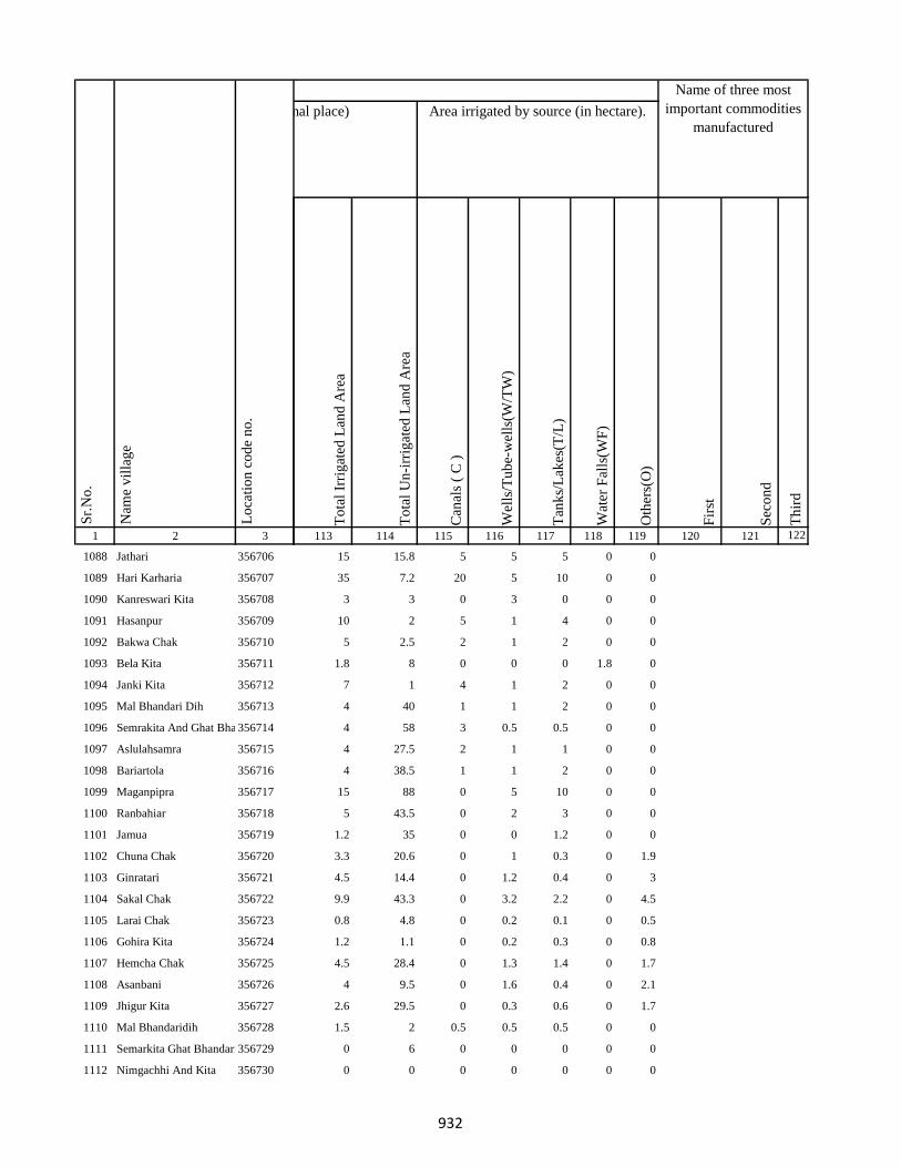
1 2 3
Lo
cati
on
co
de
no
.
Nam
e v
illa
ge
Sr.
No
.
1088 Jathari 356706
1089 Hari Karharia 356707
1090 Kanreswari Kita 356708
1091 Hasanpur 356709
1092 Bakwa Chak 356710
1093 Bela Kita 356711
1094 Janki Kita 356712
1095 Mal Bhandari Dih 356713
1096 Semrakita And Ghat Bhandarid356714
1097 Aslulahsamra 356715
1098 Bariartola 356716
1099 Maganpipra 356717
1100 Ranbahiar 356718
1101 Jamua 356719
1102 Chuna Chak 356720
1103 Ginratari 356721
1104 Sakal Chak 356722
1105 Larai Chak 356723
1106 Gohira Kita 356724
1107 Hemcha Chak 356725
1108 Asanbani 356726
1109 Jhigur Kita 356727
1110 Mal Bhandaridih 356728
1111 Semarkita Ghat Bhandaridih356729
1112 Nimgachhi And Kita 356730
To
tal
Irri
gat
ed L
and
Are
a
To
tal
Un
-irr
igat
ed L
and
Are
a
Can
als
( C
)
Wel
ls/T
ub
e-w
ells
(W/T
W)
Tan
ks/
Lak
es(T
/L)
Wat
er F
alls
(WF
)
Oth
ers(
O)
Fir
st
Sec
on
d
Th
ird
113 114 115 116 117 118 119 120 121 122
Area under different types of land use ( in hectares rounded up to one decimal place) Area irrigated by source (in hectare).
Name of three most
important commodities
manufactured
Land Use
15 15.8 5 5 5 0 0
35 7.2 20 5 10 0 0
3 3 0 3 0 0 0
10 2 5 1 4 0 0
5 2.5 2 1 2 0 0
1.8 8 0 0 0 1.8 0
7 1 4 1 2 0 0
4 40 1 1 2 0 0
4 58 3 0.5 0.5 0 0
4 27.5 2 1 1 0 0
4 38.5 1 1 2 0 0
15 88 0 5 10 0 0
5 43.5 0 2 3 0 0
1.2 35 0 0 1.2 0 0
3.3 20.6 0 1 0.3 0 1.9
4.5 14.4 0 1.2 0.4 0 3
9.9 43.3 0 3.2 2.2 0 4.5
0.8 4.8 0 0.2 0.1 0 0.5
1.2 1.1 0 0.2 0.3 0 0.8
4.5 28.4 0 1.3 1.4 0 1.7
4 9.5 0 1.6 0.4 0 2.1
2.6 29.5 0 0.3 0.6 0 1.7
1.5 2 0.5 0.5 0.5 0 0
0 6 0 0 0 0 0
0 0 0 0 0 0 0
932
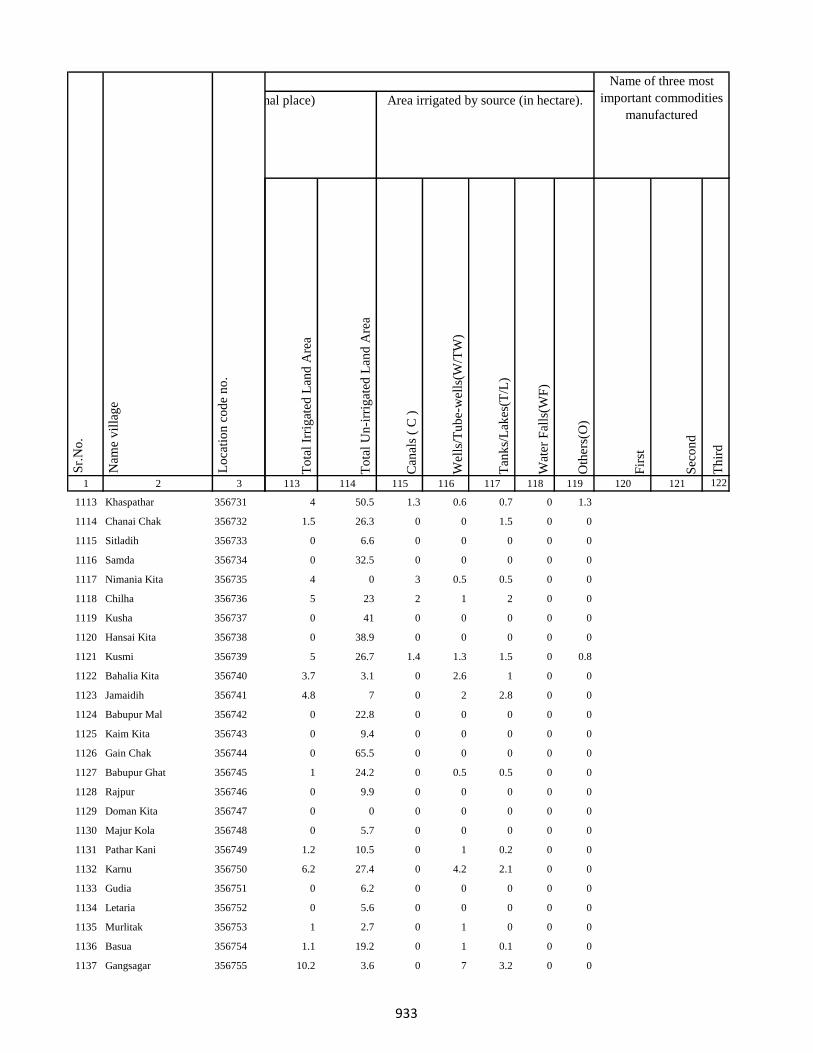
1 2 3
Lo
cati
on
co
de
no
.
Nam
e v
illa
ge
Sr.
No
.
1113 Khaspathar 356731
1114 Chanai Chak 356732
1115 Sitladih 356733
1116 Samda 356734
1117 Nimania Kita 356735
1118 Chilha 356736
1119 Kusha 356737
1120 Hansai Kita 356738
1121 Kusmi 356739
1122 Bahalia Kita 356740
1123 Jamaidih 356741
1124 Babupur Mal 356742
1125 Kaim Kita 356743
1126 Gain Chak 356744
1127 Babupur Ghat 356745
1128 Rajpur 356746
1129 Doman Kita 356747
1130 Majur Kola 356748
1131 Pathar Kani 356749
1132 Karnu 356750
1133 Gudia 356751
1134 Letaria 356752
1135 Murlitak 356753
1136 Basua 356754
1137 Gangsagar 356755
To
tal
Irri
gat
ed L
and
Are
a
To
tal
Un
-irr
igat
ed L
and
Are
a
Can
als
( C
)
Wel
ls/T
ub
e-w
ells
(W/T
W)
Tan
ks/
Lak
es(T
/L)
Wat
er F
alls
(WF
)
Oth
ers(
O)
Fir
st
Sec
on
d
Th
ird
113 114 115 116 117 118 119 120 121 122
Area under different types of land use ( in hectares rounded up to one decimal place) Area irrigated by source (in hectare).
Name of three most
important commodities
manufactured
Land Use
4 50.5 1.3 0.6 0.7 0 1.3
1.5 26.3 0 0 1.5 0 0
0 6.6 0 0 0 0 0
0 32.5 0 0 0 0 0
4 0 3 0.5 0.5 0 0
5 23 2 1 2 0 0
0 41 0 0 0 0 0
0 38.9 0 0 0 0 0
5 26.7 1.4 1.3 1.5 0 0.8
3.7 3.1 0 2.6 1 0 0
4.8 7 0 2 2.8 0 0
0 22.8 0 0 0 0 0
0 9.4 0 0 0 0 0
0 65.5 0 0 0 0 0
1 24.2 0 0.5 0.5 0 0
0 9.9 0 0 0 0 0
0 0 0 0 0 0 0
0 5.7 0 0 0 0 0
1.2 10.5 0 1 0.2 0 0
6.2 27.4 0 4.2 2.1 0 0
0 6.2 0 0 0 0 0
0 5.6 0 0 0 0 0
1 2.7 0 1 0 0 0
1.1 19.2 0 1 0.1 0 0
10.2 3.6 0 7 3.2 0 0
933

1 2 3
Lo
cati
on
co
de
no
.
Nam
e v
illa
ge
Sr.
No
.
1138 Monukhap 356756
1139 Katbaikal 356757
1140 Jharna Kita 356758
1141 Dhankurda 356759
1142 Majhoua 356760
1143 Gahira Kita 356761
1144 Bhadaia Kita 356762
1145 Garbaghat 356763
1146 Garba Kita 356764
1147 Balachini Kita 356765
1148 Akasni 356766
1149 Kendua Kita 356767
1150 Kendua Kita 356768
1151 Kusmaha 356769
1152 Tetaria 356770
1153 Lakrabank 356771
1154 Balia Ghat 356772
1155 Balia Kurmi Kita 356773
1156 Rabiadih (Santali) 356774
1157 Raksa Kita 356775
1158 Doman Kita 356776
1159 Mohanpur 356777
1160 Kadhara Ghat 356778
1161 Kusdiha 356779
1162 Dumaria Mal 356780
To
tal
Irri
gat
ed L
and
Are
a
To
tal
Un
-irr
igat
ed L
and
Are
a
Can
als
( C
)
Wel
ls/T
ub
e-w
ells
(W/T
W)
Tan
ks/
Lak
es(T
/L)
Wat
er F
alls
(WF
)
Oth
ers(
O)
Fir
st
Sec
on
d
Th
ird
113 114 115 116 117 118 119 120 121 122
Area under different types of land use ( in hectares rounded up to one decimal place) Area irrigated by source (in hectare).
Name of three most
important commodities
manufactured
Land Use
2.3 2.3 0 1.3 1 0 0
0 4.4 0 0 0 0 0
0 4.3 0 0 0 0 0
0.4 14.1 0 0.3 0.1 0 0
1.4 6.6 0 1 0.4 0 0
0 5.5 0 0 0 0 0
2.9 7.8 0 1 1.9 0 0
0.4 3.6 0 0 0.4 0 0
0.3 3.9 0 0 0.3 0 0
0 6.4 0 0 0 0 0
176.8 3.3 0 175 1.8 0 0
1.8 20 0 0 1.8 0 0
0 0 0 0 0 0 0
0 3.3 0 0 0 0 0
1.4 6.8 0 1 0.3 0 0
0 2.5 0 0 0 0 0
0.2 4.1 0 0.2 0 0 0
2.3 8.3 0 1.4 0.8 0 0
0.2 8.1 0 0.2 0 0 0
3.5 10.2 0 2.3 1.2 0 0
1.3 7.4 0 1 0.3 0 0
4.9 19.8 0 3.9 1 0 0
1 2.1 0 1 0 0 0
0.3 3.3 0 0.3 0 0 0
0 1.4 0 0 0 0 0
934

1 2 3
Lo
cati
on
co
de
no
.
Nam
e v
illa
ge
Sr.
No
.
1163 Kadhara Mal 356781
1164 Kadhara Ghat 356782
1165 Gobindpur 356783
1166 Bansbhita 356784
1167 Maniamor 356785
1168 Lakhipur 356786
1169 Durgapur 356787
1170 Lakhipur 356788
1171 Jogidih 356789
1172 Kitapathar 356790
1173 Deola Kita 356791
1174 Nimgachhi And Kita 356792
1175 Karkatdih 356793
1176 Lakhipur 356794
1177 Kasturia Kita 356795
1178 Dalabar 356796
1179 Khutehri 356797
1180 Chansar 356798
1181 Nima Chak 356799
1182 Chichohari 356800
1183 Dudhbecha 356801
1184 Goradih 356802
1185 Deyal Kita 356803
1186 Pipra Kita 356804
1187 Gosain Chak 356805
To
tal
Irri
gat
ed L
and
Are
a
To
tal
Un
-irr
igat
ed L
and
Are
a
Can
als
( C
)
Wel
ls/T
ub
e-w
ells
(W/T
W)
Tan
ks/
Lak
es(T
/L)
Wat
er F
alls
(WF
)
Oth
ers(
O)
Fir
st
Sec
on
d
Th
ird
113 114 115 116 117 118 119 120 121 122
Area under different types of land use ( in hectares rounded up to one decimal place) Area irrigated by source (in hectare).
Name of three most
important commodities
manufactured
Land Use
54.4 32.7 0 51.9 2.5 0 0
1.5 3.8 0 1 0.5 0 0
0 49 0 0 0 0 0
0.2 0 0 0.1 0.1 0 0
1 8.4 0 1 0 0 0
0 44.6 0 0 0 0 0
3.5 12.3 0 1.1 2.4 0 0
1.6 32.1 0.4 0.6 0.7 0 0
5.4 3.7 0 1 1.3 0 3
5.5 17.3 1.2 0.8 1.8 0 1.8
1.3 7.6 0 0.3 0.2 0 0.8
0 10.4 0 0 0 0 0
3.6 39.5 0.8 0.5 0.5 0 1.8
4.1 1.5 0 2 2.1 0 0
0.8 3.6 0 0 0.2 0 0.6
6.1 72.9 1.3 1 0.4 0 3.4
5.1 30.3 0 1.3 1.2 0 2.6
8.2 26.7 0 3.2 2.7 0 2.3
1.1 18.4 0 0.3 0.2 0 0.5
4.8 15.6 0 2.8 1 0 1
4.8 18.4 0 1.4 0.8 0 2.7
2.1 9.7 0.3 0.4 0.6 0 0.8
4.2 17.4 0 0.4 1.5 0 2.3
1.5 8.3 0 0.3 0.2 0 0.9
3.7 7.1 0 0.3 0.6 0 2.8
935

1 2 3
Lo
cati
on
co
de
no
.
Nam
e v
illa
ge
Sr.
No
.
1188 Malgarhia 356806
1189 Gadel 356807
1190 Dharmudih 356808
1191 Mahadeb Kita 356809
1192 Telaria 356810
1193 Nunajor 356811
1194 Bhogan 356812
1195 Kaithia 356813
1196 Saraiaghat 356814
1197 Manikpur Ghat 356815
1198 Amarpur 356816
1199 Bhainsabarankurum Tola356817
1200 Bhainsabarankurum Tola Mal356818
1201 Hahajor 356819
1202 Patharpur 356820
1203 Mahadeobathan 356821
1204 Bansipur 356822
1205 Sib Kita 356823
1206 Amdiha 356824
1207 Ghat Bhangabandh 356825
1208 Mal Bhangabandh 356826
1209 Panchgachhi 356827
1210 Ghat Gamharia 356828
1211 Sikkita 356829
1212 Ghat Garhaiya 356830
To
tal
Irri
gat
ed L
and
Are
a
To
tal
Un
-irr
igat
ed L
and
Are
a
Can
als
( C
)
Wel
ls/T
ub
e-w
ells
(W/T
W)
Tan
ks/
Lak
es(T
/L)
Wat
er F
alls
(WF
)
Oth
ers(
O)
Fir
st
Sec
on
d
Th
ird
113 114 115 116 117 118 119 120 121 122
Area under different types of land use ( in hectares rounded up to one decimal place) Area irrigated by source (in hectare).
Name of three most
important commodities
manufactured
Land Use
5.6 8 0 1.1 1.4 0 3.1
6.1 11.3 0 2.2 1.1 0 2.7
7.9 22.8 1.4 1.4 1.1 0 4
5.2 5.2 0 2.2 1.1 0 1.9
0 0 0 0 0 0 0
6 25.1 1.8 1 0.8 0 2.4
10.3 6.5 2.2 1.2 1 0 6
2.1 84.3 0 1 0.3 0 0.7
0 7.4 0 0 0 0 0
3.6 8.5 0 2 1.6 0 0
1.7 10.2 0 1 0.7 0 0
3.4 0 1 0.9 0 1.5 0
4.3 5.9 1.4 0.7 0.7 0 1.4
0.8 3 0 0.1 0.7 0 0
5.9 40.3 1.2 0.8 1.9 0 2
6.1 22.4 0 1.6 1.4 0 3.1
5.1 12.8 0 0 4 1.1 0
0 3.3 0 0 0 0 0
1.2 26.3 0 0.5 0.1 0 0.6
5.9 12.2 1.4 1 1.7 0 1.8
1 10.6 0 0.3 0.5 0 0.2
2.8 2.7 0 1 1 0 0.9
6.6 23.9 1.8 0.8 1.6 0 2.3
0 0 0 0 0 0 0
2.3 16.8 0 1 0.3 0 1
936
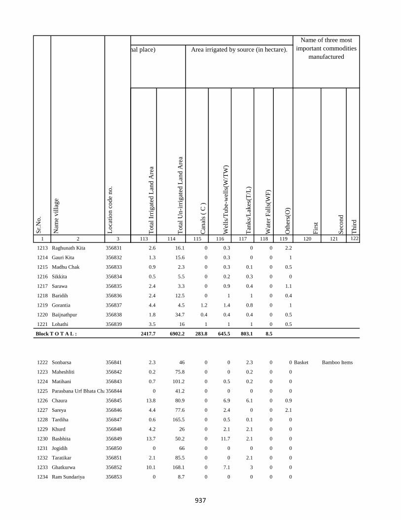
1 2 3
Lo
cati
on
co
de
no
.
Nam
e v
illa
ge
Sr.
No
.
1213 Raghunath Kita 356831
1214 Gauri Kita 356832
1215 Madhu Chak 356833
1216 Sikkita 356834
1217 Sarawa 356835
1218 Baridih 356836
1219 Gorantia 356837
1220 Baijnathpur 356838
1221 Lohathi 356839
Block T O T A L :
1222 Sonbarsa 356841
1223 Maheshliti 356842
1224 Matihani 356843
1225 Parasbana Urf Bhata Chak356844
1226 Chaura 356845
1227 Sareya 356846
1228 Tardiha 356847
1229 Khurd 356848
1230 Basbhita 356849
1231 Jogidih 356850
1232 Taratikar 356851
1233 Ghatkurwa 356852
1234 Ram Sundariya 356853
To
tal
Irri
gat
ed L
and
Are
a
To
tal
Un
-irr
igat
ed L
and
Are
a
Can
als
( C
)
Wel
ls/T
ub
e-w
ells
(W/T
W)
Tan
ks/
Lak
es(T
/L)
Wat
er F
alls
(WF
)
Oth
ers(
O)
Fir
st
Sec
on
d
Th
ird
113 114 115 116 117 118 119 120 121 122
Area under different types of land use ( in hectares rounded up to one decimal place) Area irrigated by source (in hectare).
Name of three most
important commodities
manufactured
Land Use
2.6 16.1 0 0.3 0 0 2.2
1.3 15.6 0 0.3 0 0 1
0.9 2.3 0 0.3 0.1 0 0.5
0.5 5.5 0 0.2 0.3 0 0
2.4 3.3 0 0.9 0.4 0 1.1
2.4 12.5 0 1 1 0 0.4
4.4 4.5 1.2 1.4 0.8 0 1
1.8 34.7 0.4 0.4 0.4 0 0.5
3.5 16 1 1 1 0 0.5
2417.7 6902.2 283.8 645.5 803.1 8.5
2.3 46 0 0 2.3 0 0 Basket Bamboo Items
0.2 75.8 0 0 0.2 0 0
0.7 101.2 0 0.5 0.2 0 0
0 41.2 0 0 0 0 0
13.8 80.9 0 6.9 6.1 0 0.9
4.4 77.6 0 2.4 0 0 2.1
0.6 165.5 0 0.5 0.1 0 0
4.2 26 0 2.1 2.1 0 0
13.7 50.2 0 11.7 2.1 0 0
0 66 0 0 0 0 0
2.1 85.5 0 0 2.1 0 0
10.1 168.1 0 7.1 3 0 0
0 8.7 0 0 0 0 0
937
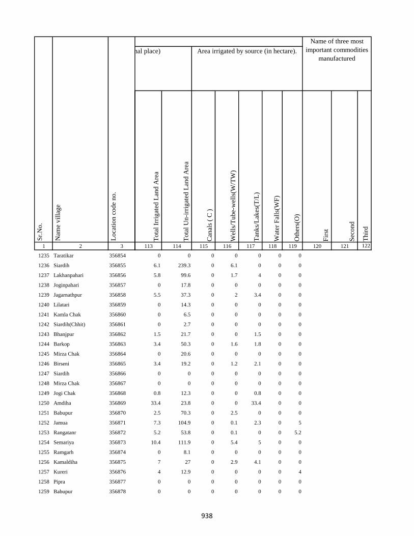
1 2 3
Lo
cati
on
co
de
no
.
Nam
e v
illa
ge
Sr.
No
.
1235 Taratikar 356854
1236 Siardih 356855
1237 Lakhanpahari 356856
1238 Joginpahari 356857
1239 Jagarnathpur 356858
1240 Lilatari 356859
1241 Kamla Chak 356860
1242 Siardih(Chhit) 356861
1243 Bhanjpur 356862
1244 Barkop 356863
1245 Mirza Chak 356864
1246 Birseni 356865
1247 Siardih 356866
1248 Mirza Chak 356867
1249 Jogi Chak 356868
1250 Amdiha 356869
1251 Babupur 356870
1252 Jamua 356871
1253 Rangatanr 356872
1254 Semariya 356873
1255 Ramgarh 356874
1256 Kamaldiha 356875
1257 Kureri 356876
1258 Pipra 356877
1259 Babupur 356878
To
tal
Irri
gat
ed L
and
Are
a
To
tal
Un
-irr
igat
ed L
and
Are
a
Can
als
( C
)
Wel
ls/T
ub
e-w
ells
(W/T
W)
Tan
ks/
Lak
es(T
/L)
Wat
er F
alls
(WF
)
Oth
ers(
O)
Fir
st
Sec
on
d
Th
ird
113 114 115 116 117 118 119 120 121 122
Area under different types of land use ( in hectares rounded up to one decimal place) Area irrigated by source (in hectare).
Name of three most
important commodities
manufactured
Land Use
0 0 0 0 0 0 0
6.1 239.3 0 6.1 0 0 0
5.8 99.6 0 1.7 4 0 0
0 17.8 0 0 0 0 0
5.5 37.3 0 2 3.4 0 0
0 14.3 0 0 0 0 0
0 6.5 0 0 0 0 0
0 2.7 0 0 0 0 0
1.5 21.7 0 0 1.5 0 0
3.4 50.3 0 1.6 1.8 0 0
0 20.6 0 0 0 0 0
3.4 19.2 0 1.2 2.1 0 0
0 0 0 0 0 0 0
0 0 0 0 0 0 0
0.8 12.3 0 0 0.8 0 0
33.4 23.8 0 0 33.4 0 0
2.5 70.3 0 2.5 0 0 0
7.3 104.9 0 0.1 2.3 0 5
5.2 53.8 0 0.1 0 0 5.2
10.4 111.9 0 5.4 5 0 0
0 8.1 0 0 0 0 0
7 27 0 2.9 4.1 0 0
4 12.9 0 0 0 0 4
0 0 0 0 0 0 0
0 0 0 0 0 0 0
938

1 2 3
Lo
cati
on
co
de
no
.
Nam
e v
illa
ge
Sr.
No
.
1260 Lakarjorimal 356879
1261 Tikabagicha 356880
1262 Gordhoi 356881
1263 Babupur 356882
1264 Nauratan Kita 356883
1265 Gordhoi 356884
1266 Joginpahari 356885
1267 Simariya 356886
1268 Sonar Chak 356887
1269 Duarichak 356888
1270 Tulsi Kita 356889
1271 Chau Chak 356890
1272 Karubandh 356891
1273 Haripur 356892
1274 Chau Chak 356893
1275 Lachhminiyan 356894
1276 Chepi 356895
1277 Kasiyatari 356896
1278 Kita Gardharpur 356897
1279 Lasutiya 356898
1280 Pathargama 356899
1281 Mal Pathargama 356900
1282 Arazi Pathargama 356901
1283 Chandi Chak 356902
1284 Baliya Kita 356903
To
tal
Irri
gat
ed L
and
Are
a
To
tal
Un
-irr
igat
ed L
and
Are
a
Can
als
( C
)
Wel
ls/T
ub
e-w
ells
(W/T
W)
Tan
ks/
Lak
es(T
/L)
Wat
er F
alls
(WF
)
Oth
ers(
O)
Fir
st
Sec
on
d
Th
ird
113 114 115 116 117 118 119 120 121 122
Area under different types of land use ( in hectares rounded up to one decimal place) Area irrigated by source (in hectare).
Name of three most
important commodities
manufactured
Land Use
0 6.4 0 0 0 0 0
0 5.8 0 0 0 0 0
3 8.3 0 0 3 0 0
0 0 0 0 0 0 0
0 2.1 0 0 0 0 0
16.5 8.7 0 0 16.5 0 0
0 0 0 0 0 0 0
0 0 0 0 0 0 0
3 78.6 0 0 3 0 0
4.1 22.7 1.5 0 2.6 0 0
4.5 37.1 0 0 4 0 0.5
0 14.3 0 0 0 0 0
0 10 0 0 0 0 0
0 38.4 0 0 0 0 0
0 0 0 0 0 0 0
0 4.6 0 0 0 0 0
0 15.4 0 0 0 0 0
4.5 96.6 0 0 4.5 0 0
1.8 7.5 0 1.8 0 0 0
2.2 25.9 0 0 2.2 0 0
54.7 4.2 0 12.1 40.5 0 2.1
0 3.9 0 0 0 0 0
0 1.3 0 0 0 0 0
2.8 9.4 0 0 2.8 0 0
1 14.5 0 0 1 0 0
939
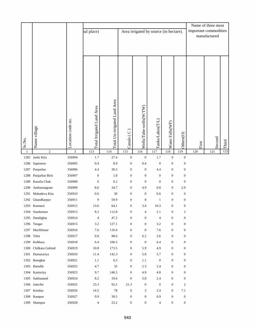
1 2 3
Lo
cati
on
co
de
no
.
Nam
e v
illa
ge
Sr.
No
.
1285 Janki Kita 356904
1286 Sapinmor 356905
1287 Panjarhar 356906
1288 Panjarhar Birit 356907
1289 Karaila Chak 356908
1290 Ambasongram 356909
1291 Mahadeva Kita 356910
1292 Ghandharpur 356911
1293 Kumarsi 356912
1294 Sundarmor 356913
1295 Dandighat 356914
1296 Tengar 356915
1297 Machhitanr 356916
1298 Telni 356917
1299 Kobhara 356918
1300 Chilkara Gobind 356919
1301 Dumarariya 356920
1302 Bareghat 356921
1303 Baredih 356922
1304 Kasturiya 356923
1305 Sukhanand 356924
1306 Jamchir 356925
1307 Kendua 356926
1308 Rampur 356927
1309 Shampur 356928
To
tal
Irri
gat
ed L
and
Are
a
To
tal
Un
-irr
igat
ed L
and
Are
a
Can
als
( C
)
Wel
ls/T
ub
e-w
ells
(W/T
W)
Tan
ks/
Lak
es(T
/L)
Wat
er F
alls
(WF
)
Oth
ers(
O)
Fir
st
Sec
on
d
Th
ird
113 114 115 116 117 118 119 120 121 122
Area under different types of land use ( in hectares rounded up to one decimal place) Area irrigated by source (in hectare).
Name of three most
important commodities
manufactured
Land Use
1.7 27.4 0 0 1.7 0 0
0.4 8.9 0 0.4 0 0 0
4.4 30.5 0 0 4.4 0 0
0 1.8 0 0 0 0 0
0 0.2 0 0 0 0 0
8.6 34.7 0 4.9 0.8 0 2.9
0.6 30 0 0 0.6 0 0
9 59.9 0 8 1 0 0
13.6 64.1 0 3.4 10.3 0 0
8.2 112.8 0 4 2.1 0 2
4 47.2 0 0 4 0 0
3.2 127.1 0 0 3.2 0 0
7.6 110.4 0 0 7.6 0 0
9.8 98.6 0 6.2 3.6 0 0
6.4 106.5 0 0 6.4 0 0
10.8 173.5 0 5.9 4.9 0 0
11.4 142.3 0 5.8 5.7 0 0
1.1 6.5 0 1.1 0 0 0
4.7 35 0 2.3 2.4 0 0
9.7 146.5 0 4.9 4.8 0 0
8.2 19.6 0 5.8 2.4 0 0
23.3 92.5 21.3 0 0 0 2
14.5 78 0 5 2.4 0 7.1
0.9 39.5 0 0 0.9 0 0
4 23.2 0 0 4 0 0
940

1 2 3
Lo
cati
on
co
de
no
.
Nam
e v
illa
ge
Sr.
No
.
1310 Barmasiya 356929
1311 Palipaya 356930
1312 Bargama 356931
1313 Manoharpur 356932
1314 Saranda 356933
1315 Boha 356934
1316 Khariani 356935
1317 Barhara 356936
1318 Bhalsumbhiya 356937
1319 Pipra 356938
1320 Bara Bandh 356939
1321 Awratanr 356940
1322 Harkata 356941
1323 Lakhanpahari Chhit 356942
1324 Bhanta Chak Chhota 356943
1325 Khairbani 356944
1326 Masnaha 356945
1327 Siripur 356946
1328 Mohanpur 356947
1329 Kolua 356948
1330 Ghatbaliya 356949
1331 Jalo Kundi 356950
1332 Bhata Chak 356951
1333 Tetariya 356952
1334 Taratikar 356953
To
tal
Irri
gat
ed L
and
Are
a
To
tal
Un
-irr
igat
ed L
and
Are
a
Can
als
( C
)
Wel
ls/T
ub
e-w
ells
(W/T
W)
Tan
ks/
Lak
es(T
/L)
Wat
er F
alls
(WF
)
Oth
ers(
O)
Fir
st
Sec
on
d
Th
ird
113 114 115 116 117 118 119 120 121 122
Area under different types of land use ( in hectares rounded up to one decimal place) Area irrigated by source (in hectare).
Name of three most
important commodities
manufactured
Land Use
7.2 91.5 0 4.8 2.4 0 0
0 16.5 0 0 0 0 0
12 103.8 0 6.8 5.1 0 0
1.6 40.7 0 0 1.6 0 0
13.3 88.9 0 3.3 10 0 0
12.3 132.1 0 6.9 5.4 0 0
8.2 152.2 0 5.8 2.4 0 0
9.1 71.3 0 0 9.1 0 0
9.7 149.9 0 7.5 2.2 0 0
42.5 348.2 0 2 40.4 0 0
4.9 130.5 0 1.6 3.2 0 0
1 24.2 0 0.5 0.5 0 0 Cloth
6.7 105.1 0 3.1 3.6 0 0
0 0 0 0 0 0 0
3 26.8 0 2.5 0.6 0 0
2 116.2 0 0 2 0 0
1 19.9 0 0 1 0 0
0 49.6 0 0 0 0 0
0 15.3 0 0 0 0 0
0 122.9 0 0 0 0 0
0 74.6 0 0 0 0 0
0 20.5 0 0 0 0 0
0 0 0 0 0 0 0
0 7.9 0 0 0 0 0
0 0 0 0 0 0 0
941

1 2 3
Lo
cati
on
co
de
no
.
Nam
e v
illa
ge
Sr.
No
.
1335 Bandelwar 356954
1336 Taratikar 356955
1337 Dumariya 356956
1338 Dhobdiha 356957
1339 Beltikri 356958
1340 Belshar 356959
1341 Parua 356960
1342 Biahunpurmal 356961
1343 Arazi Bishunpur 356962
1344 Pakariya 356963
1345 Chamra Koli 356964
1346 Boharna 356965
1347 Rajaun Khurd 356966
1348 Ambabathan 356967
1349 Dhibabandh 356968
1350 Kerbar 356969
1351 Barwarda 356970
1352 Ranipur 356971
1353 Laugai 356972
1354 Gangarampur 356973
1355 Latauna 356974
1356 Chunakothi 356975
1357 Ghutiya 356976
1358 Rajaun Kalan 356977
1359 Bisaha 356978
To
tal
Irri
gat
ed L
and
Are
a
To
tal
Un
-irr
igat
ed L
and
Are
a
Can
als
( C
)
Wel
ls/T
ub
e-w
ells
(W/T
W)
Tan
ks/
Lak
es(T
/L)
Wat
er F
alls
(WF
)
Oth
ers(
O)
Fir
st
Sec
on
d
Th
ird
113 114 115 116 117 118 119 120 121 122
Area under different types of land use ( in hectares rounded up to one decimal place) Area irrigated by source (in hectare).
Name of three most
important commodities
manufactured
Land Use
56 27.5 0 41 15 0 0
0 0 0 0 0 0 0
0.4 38.9 0 0 0.4 0 0
2 64.5 0 0 2 0 0
0.1 59 0 0 0.1 0 0
0.5 48.8 0 0 0.5 0 0
0 79 0 0 0 0 0
6.2 15.2 0 2.5 3.6 0 0
0.4 9.3 0 0.4 0 0 0
5.8 64.3 0 0 5.8 0 0
0 5.1 0 0 0 0 0
0 0 0 0 0 0 0
4 64.4 0 0 4 0 0
60 110.4 0 0 60 0 0
0 0 0 0 0 0 0
0 175 0 0 0 0 0
0.6 63.8 0 0 0.6 0 0
21 24.3 0 18 3 0 0
0 123.8 0 0 0 0 0
4 91.9 0 0 4 0 0
0 84 0 0 0 0 0
1.8 19 0 0.8 1 0 0
14.8 38.3 0 10.5 4.2 0 0
75 39.6 0 50 25 0 0
173.3 168.1 30 30 40 35.3 38
942

1 2 3
Lo
cati
on
co
de
no
.
Nam
e v
illa
ge
Sr.
No
.
1360 Charkaghat 356979
1361 Nimbar 356980
1362 Dighi 356981
1363 Korkaghat 356982
1364 Amad Khani 356983
1365 Raksu Kita 356984
1366 Chakwa 356985
1367 Jasmata 356986
1368 Simariya 356987
1369 Sanatan 356988
1370 Kela Kita 356989
1371 Khasdighi 356990
1372 Toiadih 356991
1373 Ramu Chak 356992
1374 Charkaghat 356993
1375 Garka 356994
1376 Bariyata 356995
1377 Charkaghat 356996
1378 Tabhalpur 356997
1379 Gobindpur 356998
1380 Masudanpur 356999
1381 Bedpur 357000
1382 Bhagwan Chak 357001
1383 Rup Chak 357002
1384 Pathar Kani Mal 357003
To
tal
Irri
gat
ed L
and
Are
a
To
tal
Un
-irr
igat
ed L
and
Are
a
Can
als
( C
)
Wel
ls/T
ub
e-w
ells
(W/T
W)
Tan
ks/
Lak
es(T
/L)
Wat
er F
alls
(WF
)
Oth
ers(
O)
Fir
st
Sec
on
d
Th
ird
113 114 115 116 117 118 119 120 121 122
Area under different types of land use ( in hectares rounded up to one decimal place) Area irrigated by source (in hectare).
Name of three most
important commodities
manufactured
Land Use
0 0 0 0 0 0 0
0 15 0 0 0 0 0
0 139 0 0 0 0 0
3.5 86.4 0 0 0.1 0 3.4
1.6 19.1 0 1.2 0 0 0.4
0 9.6 0 0 0 0 0
1.5 43.6 0 0 1.5 0 0
1.5 39.9 0 0 0 1.5 0
0 48 0 0 0 0 0
0 29.7 0 0 0 0 0
0 2.4 0 0 0 0 0
0 23.1 0 0 0 0 0
0 5.1 0 0 0 0 0
13 14.1 0 10 3 0 0
0 54.9 0 0 0 0 0
0 19.5 0 0 0 0 0
12.6 14.9 0 4 8.6 0 0
10 16.8 0 0 10 0 0
0.2 50 0 0 0.2 0 0
0.5 50 0 0 0.5 0 0
10 2.3 2 6 2 0 0
1.4 17.1 0 0 1.4 0 0
57 22.4 15 27 15 0 0
27.4 25.8 0 5.1 22.3 0 0
37.2 47.9 0 12.1 25.1 0 0
943

1 2 3
Lo
cati
on
co
de
no
.
Nam
e v
illa
ge
Sr.
No
.
1385 Pathar Kani Ghat 357004
1386 Chilra 357005
1387 Chainpur 357006
1388 Ghat Rampur 357007
1389 Mal Rampur 357008
1390 Mal Nistara 357009
1391 Ghat Nistara 357010
1392 Ghat Gasti 357011
1393 Mahuakol 357012
1394 Mahuasol 357013
1395 Sighai Mal 357014
1396 Singhi Ghat 357015
1397 Jogiya 357016
1398 Khaira 357017
1399 Jamjori 357018
1400 Gangtamal Chhit 357019
1401 Jokela 357020
1402 Dhangri Mal 357021
1403 Dhangdri Ghat 357022
1404 Ghangri Mal 357023
1405 Basbhita Ghat 357024
1406 Basbhita Mal 357025
1407 Ranipur Dumariya 357026
1408 Gangta Kalan 357027
1409 Jokela Mal 357028
To
tal
Irri
gat
ed L
and
Are
a
To
tal
Un
-irr
igat
ed L
and
Are
a
Can
als
( C
)
Wel
ls/T
ub
e-w
ells
(W/T
W)
Tan
ks/
Lak
es(T
/L)
Wat
er F
alls
(WF
)
Oth
ers(
O)
Fir
st
Sec
on
d
Th
ird
113 114 115 116 117 118 119 120 121 122
Area under different types of land use ( in hectares rounded up to one decimal place) Area irrigated by source (in hectare).
Name of three most
important commodities
manufactured
Land Use
0 13.2 0 0 0 0 0
43.7 71.4 0 18.2 25.5 0 0
0 64.5 0 0 0 0 0
8.2 16.3 0 0 8.2 0 0
10.2 24.9 0 10.2 0 0 0
2.1 21.9 0 0 2.1 0 0
6.1 36 0 0 6.1 0 0
0 12.6 0 0 0 0 0
0 21.9 0 0 0 0 0
14.4 27.7 0 1.2 13.2 0 0
9 63.2 0 4.5 0 0 4.5
0 60.2 0 0 0 0 0
9.5 0 0 4.8 0 0 4.8
13.1 123.8 0 10.1 3 0 0
6 98.5 0 4.1 2 0 0
0 0 0 0 0 0 0
4.8 54.6 0 2 2.8 0 0
3.2 51.4 0 0 3.2 0 0
5 13.2 0 2 3 0 0
0 0 0 0 0 0 0
0 6 0 0 0 0 0
13.5 98.8 0 10 3.5 0 0
25 62 0 10 0 15 0
0 5 0 0 0 0 0
1 66.1 0 0 1 0 0
944
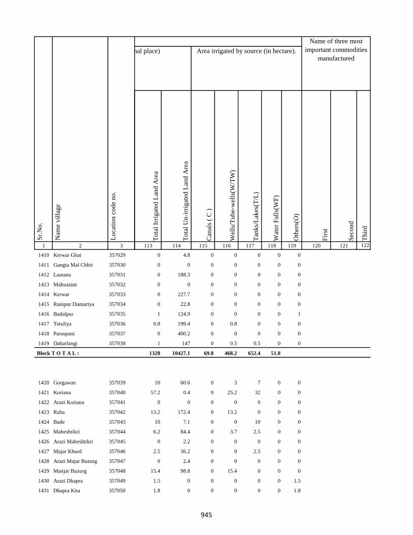
1 2 3
Lo
cati
on
co
de
no
.
Nam
e v
illa
ge
Sr.
No
.
1410 Kerwar Ghat 357029
1411 Gangta Mal Chhit 357030
1412 Lautana 357031
1413 Mahuatanr 357032
1414 Kerwar 357033
1415 Ranipur Dumariya 357034
1416 Badalpur 357035
1417 Tetuliya 357036
1418 Paraspani 357037
1419 Daharlangi 357038
Block T O T A L :
1420 Gorgawan 357039
1421 Koriana 357040
1422 Arazi Koriana 357041
1423 Raha 357042
1424 Bade 357043
1425 Maheshtikri 357044
1426 Arazi Maheshtikri 357045
1427 Majar Khurd 357046
1428 Arazi Majar Buzurg 357047
1429 Manjar Buzurg 357048
1430 Arazi Dhapra 357049
1431 Dhapra Kita 357050
To
tal
Irri
gat
ed L
and
Are
a
To
tal
Un
-irr
igat
ed L
and
Are
a
Can
als
( C
)
Wel
ls/T
ub
e-w
ells
(W/T
W)
Tan
ks/
Lak
es(T
/L)
Wat
er F
alls
(WF
)
Oth
ers(
O)
Fir
st
Sec
on
d
Th
ird
113 114 115 116 117 118 119 120 121 122
Area under different types of land use ( in hectares rounded up to one decimal place) Area irrigated by source (in hectare).
Name of three most
important commodities
manufactured
Land Use
0 4.8 0 0 0 0 0
0 0 0 0 0 0 0
0 188.3 0 0 0 0 0
0 0 0 0 0 0 0
0 227.7 0 0 0 0 0
0 22.8 0 0 0 0 0
1 124.9 0 0 0 0 1
0.8 199.4 0 0.8 0 0 0
0 400.2 0 0 0 0 0
1 147 0 0.5 0.5 0 0
1328 10427.1 69.8 468.2 652.4 51.8
10 60.6 0 3 7 0 0
57.2 0.4 0 25.2 32 0 0
0 0 0 0 0 0 0
13.2 172.4 0 13.2 0 0 0
10 7.1 0 0 10 0 0
6.2 84.4 0 3.7 2.5 0 0
0 2.2 0 0 0 0 0
2.5 36.2 0 0 2.5 0 0
0 2.4 0 0 0 0 0
15.4 98.8 0 15.4 0 0 0
1.5 0 0 0 0 0 1.5
1.8 0 0 0 0 0 1.8
945
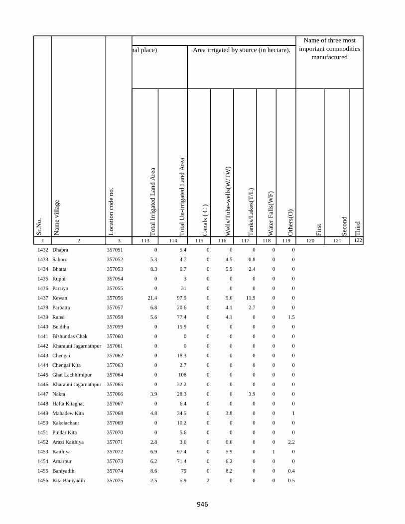
1 2 3
Lo
cati
on
co
de
no
.
Nam
e v
illa
ge
Sr.
No
.
1432 Dhapra 357051
1433 Sahoro 357052
1434 Bhatta 357053
1435 Rupni 357054
1436 Parsiya 357055
1437 Kewan 357056
1438 Parbatta 357057
1439 Ransi 357058
1440 Beldiha 357059
1441 Bishundas Chak 357060
1442 Kharauni Jagarnathpur 357061
1443 Chengai 357062
1444 Chengai Kita 357063
1445 Ghat Lachhimipur 357064
1446 Kharauni Jagarnathpur 357065
1447 Nakta 357066
1448 Hafta Kitaghat 357067
1449 Mahadew Kita 357068
1450 Kakelachaur 357069
1451 Pindar Kita 357070
1452 Arazi Kaithiya 357071
1453 Kaithiya 357072
1454 Amarpur 357073
1455 Baniyadih 357074
1456 Kita Baniyadih 357075
To
tal
Irri
gat
ed L
and
Are
a
To
tal
Un
-irr
igat
ed L
and
Are
a
Can
als
( C
)
Wel
ls/T
ub
e-w
ells
(W/T
W)
Tan
ks/
Lak
es(T
/L)
Wat
er F
alls
(WF
)
Oth
ers(
O)
Fir
st
Sec
on
d
Th
ird
113 114 115 116 117 118 119 120 121 122
Area under different types of land use ( in hectares rounded up to one decimal place) Area irrigated by source (in hectare).
Name of three most
important commodities
manufactured
Land Use
0 5.4 0 0 0 0 0
5.3 4.7 0 4.5 0.8 0 0
8.3 0.7 0 5.9 2.4 0 0
0 3 0 0 0 0 0
0 31 0 0 0 0 0
21.4 97.9 0 9.6 11.9 0 0
6.8 20.6 0 4.1 2.7 0 0
5.6 77.4 0 4.1 0 0 1.5
0 15.9 0 0 0 0 0
0 0 0 0 0 0 0
0 0 0 0 0 0 0
0 18.3 0 0 0 0 0
0 2.7 0 0 0 0 0
0 108 0 0 0 0 0
0 32.2 0 0 0 0 0
3.9 28.3 0 0 3.9 0 0
0 6.4 0 0 0 0 0
4.8 34.5 0 3.8 0 0 1
0 10.2 0 0 0 0 0
0 5.6 0 0 0 0 0
2.8 3.6 0 0.6 0 0 2.2
6.9 97.4 0 5.9 0 1 0
6.2 71.4 0 6.2 0 0 0
8.6 79 0 8.2 0 0 0.4
2.5 5.9 2 0 0 0 0.5
946
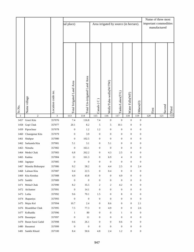
1 2 3
Lo
cati
on
co
de
no
.
Nam
e v
illa
ge
Sr.
No
.
1457 Gouri Kita 357076
1458 Gopi Chak 357077
1459 Piprachaur 357078
1460 Chaurgonar Kita 357079
1461 Shahpur 357080
1462 Sarkunda Kita 357081
1463 Nimuha 357082
1464 Medni Chak 357083
1465 Kadma 357084
1466 Jagatpur 357085
1467 Mansha Bishunpur 357086
1468 Lalman Kita 357087
1469 Kita Kendua 357088
1470 Sankhi 357089
1471 Mokal Chak 357090
1472 Aichamor 357091
1473 Lotha 357092
1474 Jhapaniya 357093
1475 Majra Kol 357094
1476 Bisambhar Chak 357095
1477 Kolhadda 357096
1478 Basantpur 357097
1479 Basan Sarai Gadal 357098
1480 Basantrai 357099
1481 Sankhi Khurd 357100
To
tal
Irri
gat
ed L
and
Are
a
To
tal
Un
-irr
igat
ed L
and
Are
a
Can
als
( C
)
Wel
ls/T
ub
e-w
ells
(W/T
W)
Tan
ks/
Lak
es(T
/L)
Wat
er F
alls
(WF
)
Oth
ers(
O)
Fir
st
Sec
on
d
Th
ird
113 114 115 116 117 118 119 120 121 122
Area under different types of land use ( in hectares rounded up to one decimal place) Area irrigated by source (in hectare).
Name of three most
important commodities
manufactured
Land Use
7.4 116.8 7.4 0 0 0 0
20.1 8.2 5 5 10.1 0 0
0 1.2 1.2 0 0 0 0
0 3.9 0 0 0 0 0
0 102.5 0 0 0 0 0
5.1 3.1 0 5.1 0 0 0
0 163.1 0 0 0 0 0
6.8 262.2 0 4.3 2.5 0 0
11 161.3 0 6.9 4 0 0
0 0 0 0 0 0 0
9.2 58.2 0 4.4 2.5 0 2.4
0.4 22.5 0 0.4 0 0 0
4.9 43.8 0 0 4.9 0 0
0 0 0 0 0 0 0
8.2 35.5 2 2 4.2 0 0
0 14.1 0 0 0 0 0
9.6 70.1 1.5 0 8 0 0
0 0 0 0 0 0 0
10.7 2.4 0 8.6 0 0 2.1
7.5 77.3 0 4.9 0 0 2.6
1 80 0 0 1 0 0
0 11 0 0 0 0 0
0.6 26.1 0 0 0.6 0 0
0 0 0 0 0 0 0
8.4 50.6 4.8 2.4 1.2 0 0
947

1 2 3
Lo
cati
on
co
de
no
.
Nam
e v
illa
ge
Sr.
No
.
1482 Bela Kita 357101
1483 Baskhoriya 357102
1484 Baghakol 357103
1485 Harganman 357104
1486 Kola Kita 357105
1487 Kaithpura 357106
1488 Lochni 357107
1489 Pachua Kita 357108
1490 Sanaur 357109
1491 Gathaur 357110
1492 Derma 357111
1493 Deshbarag 357112
1494 Chutiyan 357113
1495 Rampur 357114
1496 Rampur Mokarri 357115
1497 Rampur Arazi 357116
1498 Gobindpur Kita 357117
1499 Shampur Gobindpur 357118
1500 Shampur 357119
1501 Kapeta 357120
1502 Karu Chak 357121
1503 Pakariya 357122
1504 Arazi Pakariya 357123
1505 Jadu Chak 357124
1506 Paradharichak 357125
To
tal
Irri
gat
ed L
and
Are
a
To
tal
Un
-irr
igat
ed L
and
Are
a
Can
als
( C
)
Wel
ls/T
ub
e-w
ells
(W/T
W)
Tan
ks/
Lak
es(T
/L)
Wat
er F
alls
(WF
)
Oth
ers(
O)
Fir
st
Sec
on
d
Th
ird
113 114 115 116 117 118 119 120 121 122
Area under different types of land use ( in hectares rounded up to one decimal place) Area irrigated by source (in hectare).
Name of three most
important commodities
manufactured
Land Use
7.9 35.1 5.4 1.8 0.7 0 0
3 56.4 0 0.5 2.5 0 0
0 127 0 0 0 0 0
0 73 0 0 0 0 0
1 25 0 0 0 0 0
5.4 113.5 0 1 3.2 0 1.2
12.2 126.4 0 10.1 0 0 2
0 0 0 0 0 0 0
14.3 114.8 0 14.3 0 0 0
0.2 2.5 0 0.2 0 0 0
0 135.9 0 0 0 0 0
2 79.2 0 0 2 0 0
0 27.2 0 0 0 0 0
0 96.3 0 0 0 0 0
0.5 11.8 0 0.5 0 0 0
0 4.6 0 0 0 0 0
1.9 39.5 0 0 1.9 0 0
4.2 17.8 0 2.1 2.1 0 0
4.9 45.7 0 0 2.4 0 2.4
15.6 151.5 0 1.8 12.5 0 1.2
0 9.1 0 0 0 0 0
0 19.2 0 0 0 0 0
1.1 8.5 0 1.1 0 0 0
0 12.5 0 0 0 0 0
0 8.6 0 0 0 0 0
948

1 2 3
Lo
cati
on
co
de
no
.
Nam
e v
illa
ge
Sr.
No
.
1507 Jamnikola 357126
1508 Kapra Chak 357127
1509 Surai Kita 357128
1510 Kumhrakol 357129
1511 Banshipur 357130
1512 Bajpai 357131
1513 Resamba 357132
1514 Bhira 357133
1515 Barhampur 357134
1516 Bodra 357135
1517 Susti 357136
1518 Barhaiya 357137
1519 Maheshpur 357138
1520 Hilawa 357139
1521 Chanai Chak 357140
1522 Urkusiya 357141
1523 Arazi Kharti 357142
1524 Kharti 357143
1525 Barhara 357144
1526 Amarpur Ghal 357145
1527 Surniya Ghat Mal 357146
1528 Surniya Mal Ghat 357147
1529 Tofil Surniya 357148
1530 Arazi Surniya Ghat 357149
1531 Phulwariya 357150
To
tal
Irri
gat
ed L
and
Are
a
To
tal
Un
-irr
igat
ed L
and
Are
a
Can
als
( C
)
Wel
ls/T
ub
e-w
ells
(W/T
W)
Tan
ks/
Lak
es(T
/L)
Wat
er F
alls
(WF
)
Oth
ers(
O)
Fir
st
Sec
on
d
Th
ird
113 114 115 116 117 118 119 120 121 122
Area under different types of land use ( in hectares rounded up to one decimal place) Area irrigated by source (in hectare).
Name of three most
important commodities
manufactured
Land Use
0 149.1 0 0 0 0 0
0 12 0 0 0 0 0
3.9 30.7 0 1.8 0 0 2.2
2 125.4 0 0 2 0 0
0 25.4 0 0 0 0 0
0 42.7 0 0 0 0 0
8.6 91.2 0 0.9 7.6 0 0
0 30.6 0 0 0 0 0
5.8 55.3 0 0.4 0 0 5.4
8 176 0 0 8 0 0
0 87.4 0 0 0 0 0
0 62 0 0 0 0 0
10 63 0 0 10 0 0
0 84 0 0 0 0 0
0 107 0 0 0 0 0
2.1 24.8 0 0 2.1 0 0
2.2 8 0 0.9 1.3 0 0
8 98.5 0 5.1 2.1 0 0.8
0 16 0 0 0 0 0
5 76.5 0 0 5 0 0
0.1 46.4 0 0 0 0 0.1
0 24.5 0 0 0 0 0
4 26.6 0 0 4 0 0
0 0 0 0 0 0 0
5 51 0 0 5 0 0
949
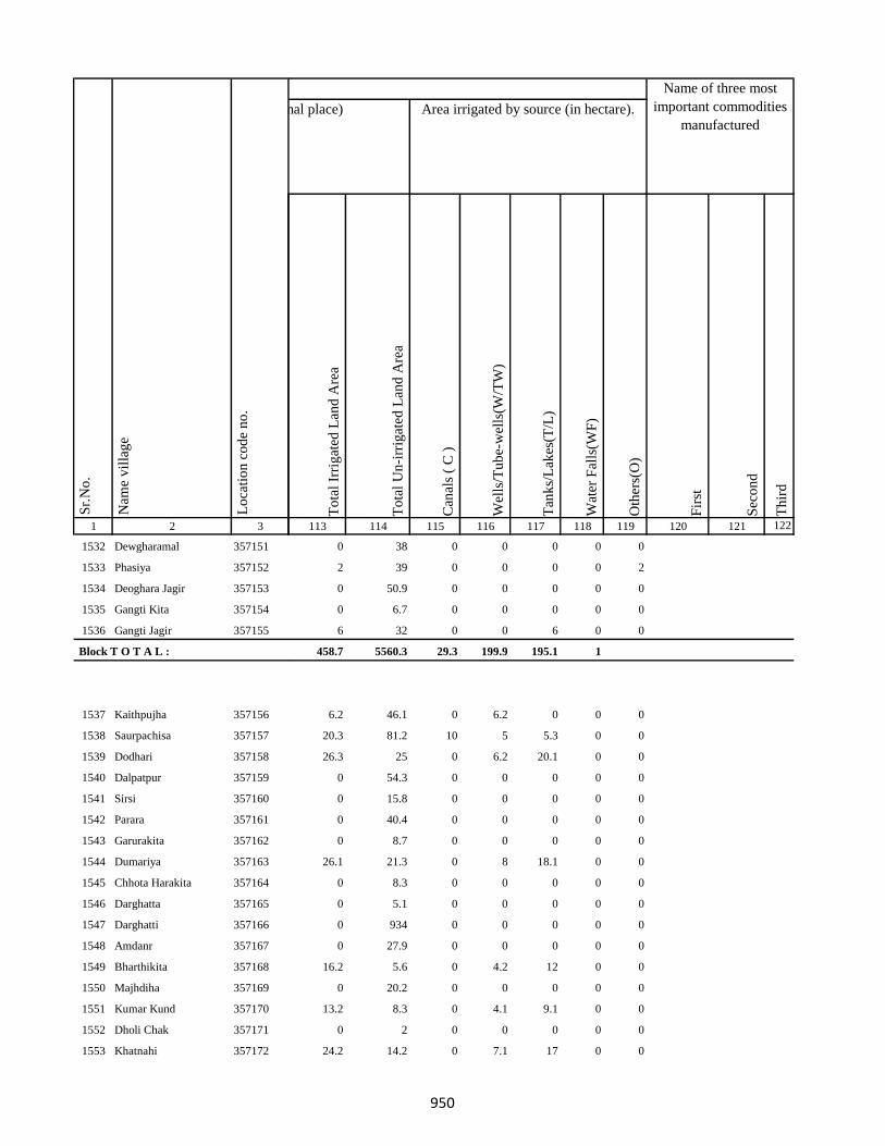
1 2 3
Lo
cati
on
co
de
no
.
Nam
e v
illa
ge
Sr.
No
.
1532 Dewgharamal 357151
1533 Phasiya 357152
1534 Deoghara Jagir 357153
1535 Gangti Kita 357154
1536 Gangti Jagir 357155
Block T O T A L :
1537 Kaithpujha 357156
1538 Saurpachisa 357157
1539 Dodhari 357158
1540 Dalpatpur 357159
1541 Sirsi 357160
1542 Parara 357161
1543 Garurakita 357162
1544 Dumariya 357163
1545 Chhota Harakita 357164
1546 Darghatta 357165
1547 Darghatti 357166
1548 Amdanr 357167
1549 Bharthikita 357168
1550 Majhdiha 357169
1551 Kumar Kund 357170
1552 Dholi Chak 357171
1553 Khatnahi 357172
To
tal
Irri
gat
ed L
and
Are
a
To
tal
Un
-irr
igat
ed L
and
Are
a
Can
als
( C
)
Wel
ls/T
ub
e-w
ells
(W/T
W)
Tan
ks/
Lak
es(T
/L)
Wat
er F
alls
(WF
)
Oth
ers(
O)
Fir
st
Sec
on
d
Th
ird
113 114 115 116 117 118 119 120 121 122
Area under different types of land use ( in hectares rounded up to one decimal place) Area irrigated by source (in hectare).
Name of three most
important commodities
manufactured
Land Use
0 38 0 0 0 0 0
2 39 0 0 0 0 2
0 50.9 0 0 0 0 0
0 6.7 0 0 0 0 0
6 32 0 0 6 0 0
458.7 5560.3 29.3 199.9 195.1 1
6.2 46.1 0 6.2 0 0 0
20.3 81.2 10 5 5.3 0 0
26.3 25 0 6.2 20.1 0 0
0 54.3 0 0 0 0 0
0 15.8 0 0 0 0 0
0 40.4 0 0 0 0 0
0 8.7 0 0 0 0 0
26.1 21.3 0 8 18.1 0 0
0 8.3 0 0 0 0 0
0 5.1 0 0 0 0 0
0 934 0 0 0 0 0
0 27.9 0 0 0 0 0
16.2 5.6 0 4.2 12 0 0
0 20.2 0 0 0 0 0
13.2 8.3 0 4.1 9.1 0 0
0 2 0 0 0 0 0
24.2 14.2 0 7.1 17 0 0
950
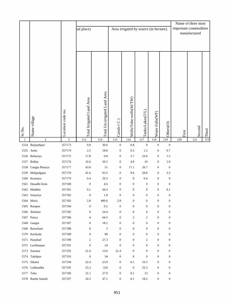
1 2 3
Lo
cati
on
co
de
no
.
Nam
e v
illa
ge
Sr.
No
.
1554 Baijnathpur 357173
1555 Amlo 357174
1556 Bohoriya 357175
1557 Bokha 357176
1558 Gangta Phasiya 357177
1559 Malipalgajia 357178
1560 Kusmara 357179
1561 Dusadhi Kola 357180
1562 Maldiha 357181
1563 Simariya 357182
1564 Motia 357183
1565 Rampur 357184
1566 Jharkata 357185
1567 Patwa 357186
1568 Gangta 357187
1569 Barachaur 357188
1570 Karikado 357189
1571 Nayabad 357190
1572 Lachhanpur 357191
1573 Susunia 357192
1574 Tabalpur 357193
1575 Sikatia 357194
1576 Lohbandha 357195
1577 Tuka 357196
1578 Ramla Santali 357197
To
tal
Irri
gat
ed L
and
Are
a
To
tal
Un
-irr
igat
ed L
and
Are
a
Can
als
( C
)
Wel
ls/T
ub
e-w
ells
(W/T
W)
Tan
ks/
Lak
es(T
/L)
Wat
er F
alls
(WF
)
Oth
ers(
O)
Fir
st
Sec
on
d
Th
ird
113 114 115 116 117 118 119 120 121 122
Area under different types of land use ( in hectares rounded up to one decimal place) Area irrigated by source (in hectare).
Name of three most
important commodities
manufactured
Land Use
0.8 30.6 0 0.8 0 0 0
2.5 18.8 0 0.5 1.2 0 0.7
17.8 0.8 0 5.7 10.6 0 1.5
16.6 50.5 0 4.8 10 0 1.8
43.8 51 0 17.1 26.7 0 0
41.6 93.5 0 9.6 28.8 0 3.3
0.4 29.3 0 0 0.4 0 0
0 4.6 0 0 0 0 0
0.1 44.3 0 0 0 0 0.1
0 1.8 0 0 0 0 0
2.8 490.6 2.8 0 0 0 0
0 0.2 0 0 0 0 0
0 24.4 0 0 0 0 0
4 64.5 0 2 2 0 0
0 18.2 0 0 0 0 0
0 3 0 0 0 0 0
0 90 0 0 0 0 0
2 27.3 0 0 2 0 0
0 24 0 0 0 0 0
21.4 13.6 21.4 0 0 0 0
0 34 0 0 0 0 0
22.4 23.9 0 6.1 16.3 0 0
25.3 220 0 0 25.3 0 0
21.1 27.9 0 8.1 13 0 0
24.3 47.1 0 6.1 18.2 0 0
951

1 2 3
Lo
cati
on
co
de
no
.
Nam
e v
illa
ge
Sr.
No
.
1579 Ramla Dikwani 357198
1580 Nankhil 357199
1581 Devpur 357200
1582 Kumarreri 357201
1583 Saidapur 357202
1584 Algajora 357203
1585 Sinhpur 357204
1586 Parasi 357205
1587 Bhawanipur 357206
1588 Bishunpur 357207
1589 Manpur 357208
1590 Dubrajpur 357209
1591 Gurguri 357210
1592 Reni 357211
1593 Kitabuidi 357212
1594 Kathra 357213
1595 Dokabandh 357214
1596 Makunddih 357215
1597 Makunddin (Santoli) 357216
1598 Pakariya Mal 357217
1599 Pakarya Ghat 357218
1600 Beldiha 357219
1601 Barahara 357220
1602 Harpati Chak 357221
1603 Bansipur 357222
To
tal
Irri
gat
ed L
and
Are
a
To
tal
Un
-irr
igat
ed L
and
Are
a
Can
als
( C
)
Wel
ls/T
ub
e-w
ells
(W/T
W)
Tan
ks/
Lak
es(T
/L)
Wat
er F
alls
(WF
)
Oth
ers(
O)
Fir
st
Sec
on
d
Th
ird
113 114 115 116 117 118 119 120 121 122
Area under different types of land use ( in hectares rounded up to one decimal place) Area irrigated by source (in hectare).
Name of three most
important commodities
manufactured
Land Use
14.2 8 7.1 0 7.1 0 0
0.8 0.8 0 0 0.8 0 0
0 23.6 0 0 0 0 0
12.4 0.1 0 4.2 8.2 0 0
45.9 92.1 0 25.9 20 0 0
2 8.8 0 1 1 0 0
0.9 2 0 0.5 0.4 0 0
0 2.3 0 0 0 0 0
3 5.9 0 1.6 1.4 0 0
0.2 1 0 0 0.2 0 0
2.8 7 0 0.8 2 0 0
12 45.3 0 4 8 0 0
4.8 18.2 0 1.8 3 0 0
20.3 96.1 0 2 18.3 0 0
0 4.3 0 0 0 0 0
3.1 41.5 0 3.1 0 0 0
16.2 15.9 0 6.1 10.1 0 0
15.1 55.4 0 5 10.1 0 0
0 47.2 0 0 0 0 0
5 101 0 5 0 0 0
0 7.1 0 0 0 0 0
3 33 0 3 0 0 0
0 48.7 0 0 0 0 0
2.5 13 0 1.5 1 0 0
10.4 25 0 3.2 7.2 0 0
952

1 2 3
Lo
cati
on
co
de
no
.
Nam
e v
illa
ge
Sr.
No
.
1604 Kurma 357223
1605 Baliya 357224
1606 Molnakita 357225
1607 Patpur 357226
1608 Nilkanthpur 357227
1609 Chapri 357228
1610 Bara 357229
1611 Lacchmipur 357230
1612 Nepura 357231
1613 Kakana 357232
1614 Chandarpur 357233
1615 Parariya 357234
1616 Panch Kathi 357235
1617 Burhi Salempur 357236
1618 Arwara 357237
1619 Basarhi 357238
1620 Malni 357239
1621 Chakwa 357240
1622 Machhiya Samarda Urf Lalpur357241
1623 Diyara 357242
1624 Jaipur 357243
1625 Barhauna 357244
1626 Amdiha 357245
1627 Parsa 357246
1628 Kanhwara 357247
To
tal
Irri
gat
ed L
and
Are
a
To
tal
Un
-irr
igat
ed L
and
Are
a
Can
als
( C
)
Wel
ls/T
ub
e-w
ells
(W/T
W)
Tan
ks/
Lak
es(T
/L)
Wat
er F
alls
(WF
)
Oth
ers(
O)
Fir
st
Sec
on
d
Th
ird
113 114 115 116 117 118 119 120 121 122
Area under different types of land use ( in hectares rounded up to one decimal place) Area irrigated by source (in hectare).
Name of three most
important commodities
manufactured
Land Use
14.2 49.8 0 5.2 9 0 0
5.1 15 0 3 2.1 0 0
12.6 40 2 5 5.6 0 0
4.5 0 1 3.5 0 0 0
1.9 39.1 0 0.9 1 0 0
0 8.2 0 0 0 0 0
15.5 0 0 15.5 0 0 0
6.3 30 0 3 3.3 0 0
16.4 50 0 8.2 8.2 0 0
4.4 20 0 2 2.4 0 0
5.4 20 0 2 3.4 0 0
0.4 1 0 0.4 0 0 0
3.6 10.1 0 2.6 1 0 0
2.2 7 0 1 1.2 0 0
3.5 6.7 0 1.5 2 0 0
43.5 80.6 43.5 0 0 0 0
2.1 13.9 0 1.1 1 0 0
1.3 42.2 0 0.3 1 0 0
6.2 56.2 0 3.2 3 0 0
0 47.9 0 0 0 0 0
2.9 0 1.9 1 0 0 0
26.9 26.9 0 2 10.9 14 0
22.8 51 0 12.8 10 0 0
10.8 73.4 0 8.7 2.2 0 0
21 63.2 0 15.5 5.6 0 0
953

1 2 3
Lo
cati
on
co
de
no
.
Nam
e v
illa
ge
Sr.
No
.
1629 Garbana 357248
1630 Galapahar 357249
1631 Bhadrahi Mal 357250
1632 Ghat Bhadrahi 357251
1633 Chilauna 357252
1634 Rampur 357253
1635 Dumariya Mal 357254
1636 Naya Chak 357255
1637 Dara Chak 357256
1638 Ghat Gorsanda 357257
1639 Mal Gorsanda 357258
1640 Mal Dhamsain 357259
1641 Ghat Dhamsain 357260
1642 Ghat Dhamsain 357261
1643 Khaira Mal 357262
1644 Pachrukhi 357263
1645 Lukluki Mal 357264
1646 Lukluki Ghat 357265
1647 Pathariya Mal 357266
1648 Pathariya Ghat 357267
1649 Pathariya Mal 357268
1650 Chhota Kaliyani 357269
1651 Bara Kaliyani 357270
1652 Pathriya Mal 357271
1653 Sabaijor 357272
To
tal
Irri
gat
ed L
and
Are
a
To
tal
Un
-irr
igat
ed L
and
Are
a
Can
als
( C
)
Wel
ls/T
ub
e-w
ells
(W/T
W)
Tan
ks/
Lak
es(T
/L)
Wat
er F
alls
(WF
)
Oth
ers(
O)
Fir
st
Sec
on
d
Th
ird
113 114 115 116 117 118 119 120 121 122
Area under different types of land use ( in hectares rounded up to one decimal place) Area irrigated by source (in hectare).
Name of three most
important commodities
manufactured
Land Use
8 71.8 0 5.9 2.1 0 0
4 49.9 0 2 2 0 0
6.6 20 0 4 2.6 0 0
2.1 8 0 1.6 0.4 0 0
10 78.6 0 8 2 0 0
0 12.4 0 0 0 0 0
0 19.6 0 0 0 0 0
0 2.3 0 0 0 0 0
21.6 8.8 0 0 0 0 21.6
33.6 15.8 0 13.6 20 0 0
0 0 0 0 0 0 0
14.7 55.2 0 0 14.7 0 0
39.4 1.6 0 39.4 0 0 0
0 75.5 0 0 0 0 0
7.4 9 0 7.4 0 0 0
0 92.4 0 0 0 0 0
3.6 5 0 0 3.6 0 0
0 1.8 0 0 0 0 0
0 2.6 0 0 0 0 0
33.8 86.4 0 33.8 0 0 0
0 0 0 0 0 0 0
0 19 0 0 0 0 0
0 143.5 0 0 0 0 0
2.4 19.8 0 0 2.4 0 0
15.9 265.2 0 0 15.9 0 0
954

1 2 3
Lo
cati
on
co
de
no
.
Nam
e v
illa
ge
Sr.
No
.
1654 Karudih 357273
1655 Kauadhab 357274
1656 Gaechhand 357275
1657 Chinadhab 357276
1658 Tilobadar 357277
1659 Pelgarhi Dhopahari 357278
1660 Karmatanr 357279
1661 Betiyabahiyar 357280
1662 Ranidih 357281
1663 Malhra 357282
1664 Kurmi Chak 357283
1665 Kajradah 357284
1666 Charkakol Ghat 357285
1667 Mahugariya 357286
1668 Ratrati 357287
1669 Karhariya Mal 357288
1670 Kubji Ghat 357289
1671 Pathwara 357290
1672 Karhariya Ghat 357291
1673 Mal Domuria 357292
1674 Karhariya Mal 357293
1675 Amghata 357294
1676 Ghat Dumariya 357295
1677 Kita Pelgarhi Dhopahari 357296
1678 Kajradah 357297
To
tal
Irri
gat
ed L
and
Are
a
To
tal
Un
-irr
igat
ed L
and
Are
a
Can
als
( C
)
Wel
ls/T
ub
e-w
ells
(W/T
W)
Tan
ks/
Lak
es(T
/L)
Wat
er F
alls
(WF
)
Oth
ers(
O)
Fir
st
Sec
on
d
Th
ird
113 114 115 116 117 118 119 120 121 122
Area under different types of land use ( in hectares rounded up to one decimal place) Area irrigated by source (in hectare).
Name of three most
important commodities
manufactured
Land Use
10.9 109.1 1 3.9 6 0 0
16.4 92.7 5.4 3 8 0 0
45.7 258.9 25 10.7 10 0 0
69.2 95.6 20.2 18.2 30.8 0 0
14.7 58.7 0 3.7 9 2 0
5.7 78.2 0 4.5 1.2 0 0
4.8 29.8 0 1.8 3.1 0 0
0 0 0 0 0 0 0
8.4 45.4 2.2 2 4.2 0 0
16.5 13.2 7.2 3.1 2 0 4.1
19.7 72 0 2.2 11.8 0 5.7
11 44.1 0 3.4 7.6 0 0
14.9 34.8 5 7 2.9 0 0
12.9 5.2 0 5.2 7.7 0 0
10 10 0 4.4 5.6 0 0
3.3 21.5 0 1.6 1.7 0 0
2.7 45.2 0 0.8 1.9 0 0
0 7.3 0 0 0 0 0
0 1.5 0 0 0 0 0
2.4 9.3 0 0 2.4 0 0
5.6 13.2 1.2 2 2.4 0 0
6.2 20.8 2 0 4.2 0 0
2.2 2.7 0.8 0.5 1 0 0
0 0 0 0 0 0 0
0 22.5 0 0 0 0 0
955

1 2 3
Lo
cati
on
co
de
no
.
Nam
e v
illa
ge
Sr.
No
.
1679 Rajpura 357298
1680 Charkakol Ghat 357299
1681 Masudanpur 357300
1682 Kusmainimal 357301
1683 Sasan 357302
1684 Bishunpur 357303
1685 Kutnipathar 357304
1686 Kathaun 357305
1687 Parariya Mal 357306
1688 Kita Parariya Ghat 357307
1689 Kita Gorgawan 357308
1690 Karhariya Ghat 357309
1691 Kusmani Ghat 357310
1692 Ratanpur 357311
1693 Tarwari 357312
1694 Manjwara Ghat 357313
1695 Bishunpur 357314
1696 Kalyani Kita 357315
1697 Ghat Dumariya 357316
1698 Kita Shampur 357317
1699 Kusmain Ghat Chhit 357318
1700 Kita Thathar 357319
1701 Kita Gawar 357320
1702 Kita Gorgawan 357321
1703 Kasba Godda 357322
To
tal
Irri
gat
ed L
and
Are
a
To
tal
Un
-irr
igat
ed L
and
Are
a
Can
als
( C
)
Wel
ls/T
ub
e-w
ells
(W/T
W)
Tan
ks/
Lak
es(T
/L)
Wat
er F
alls
(WF
)
Oth
ers(
O)
Fir
st
Sec
on
d
Th
ird
113 114 115 116 117 118 119 120 121 122
Area under different types of land use ( in hectares rounded up to one decimal place) Area irrigated by source (in hectare).
Name of three most
important commodities
manufactured
Land Use
3.2 29.1 1 0.2 2 0 0
32.9 34.8 5 7 20.9 0 0
1 2.8 0.5 0 0.6 0 0
1 7.4 0 0 1 0 0
1.3 1 0 0.5 0.4 0.4 0
3 14.3 0 1 1.6 0 0.4
13.4 44.8 0 3.4 7.5 0 2.4
5.5 39.6 0 2.8 0 0 2.6
0 21.1 0 0 0 0 0
5.6 3.7 2 1.2 2 0.3 0
2.1 2.3 0.3 0.8 1 0 0
0 82.1 0 0 0 0 0
22.7 65.7 10 10.5 2.2 0 0
9.1 6 0 5 4.1 0 0
40.2 17.2 12.2 15.9 12.1 0 0
34.1 80.1 0 0 14.1 0 20
0 7.4 0 0 0 0 0
14.8 19.7 0 0 14.8 0 0
12.4 15.6 0 0 12.4 0 0
2 17.1 0 0 0.4 1.6 0
0 0 0 0 0 0 0
6 8 0 3 3 0 0
0 17.6 0 0 0 0 0
2.1 2.3 0.3 0.8 1 0 0
0.4 20.5 0 0 0.4 0 0
956

1 2 3
Lo
cati
on
co
de
no
.
Nam
e v
illa
ge
Sr.
No
.
1704 Ghat Paharpur 357323
1705 Kutni Pathar 357324
1706 Gorka Kita 357325
1707 Bhandar Koli 357326
1708 Harlal Tola 357327
1709 Haripur 357328
1710 Ghat Paharpur 357329
1711 Kasba Godda 357330
1712 Ghat Paharpur 357331
1713 Mohanpur 357332
1714 Markhan 357333
1715 Daldali 357334
1716 Jamuni Paharpur 357335
1717 Ghat Paharpur 357336
1718 Nonmati 357337
1719 Sarotiya 357338
1720 Bhatdiha 357339
1721 Bengbahiyar 357340
1722 Rupiyamal 357341
1723 Maruabaran 357342
1724 Kauribahiyarmal Chhit 357343
1725 Kauribahiyar Ghat 357344
1726 Kauribahiyar Mal 357345
1727 Pairdih 357346
1728 Kanadih Chhit 357347
To
tal
Irri
gat
ed L
and
Are
a
To
tal
Un
-irr
igat
ed L
and
Are
a
Can
als
( C
)
Wel
ls/T
ub
e-w
ells
(W/T
W)
Tan
ks/
Lak
es(T
/L)
Wat
er F
alls
(WF
)
Oth
ers(
O)
Fir
st
Sec
on
d
Th
ird
113 114 115 116 117 118 119 120 121 122
Area under different types of land use ( in hectares rounded up to one decimal place) Area irrigated by source (in hectare).
Name of three most
important commodities
manufactured
Land Use
1.9 43.2 0 0 1.9 0 0
0 0 0 0 0 0 0
0 69 0 0 0 0 0
0 0.7 0 0 0 0 0
2.2 141.7 0 1.4 0.8 0 0
0 0 0 0 0 0 0
1.6 13.8 0 1.6 0 0 0
0.6 118.1 0 0.6 0 0 0
0 0 0 0 0 0 0
10 44.9 0 5.1 2.8 0 2.1
52.6 163.3 0 16.9 30 0 5.7
24.2 108.7 0 5.1 17 0 2.1
52.9 304.1 0 11.4 33.6 0 7.9
0 0 0 0 0 0 0
0 2.3 0 0 0 0 0
13.7 134.9 0 13.7 0 0 0
0 5.5 0 0 0 0 0
0 16.4 0 0 0 0 0
0 4.2 0 0 0 0 0
3.1 26 0 3.1 0 0 0
0 0 0 0 0 0 0
0 15.7 0 0 0 0 0
15.2 17.5 0 5.2 10 0 0
0 23.9 0 0 0 0 0
5 113.6 0 5 0 0 0
957
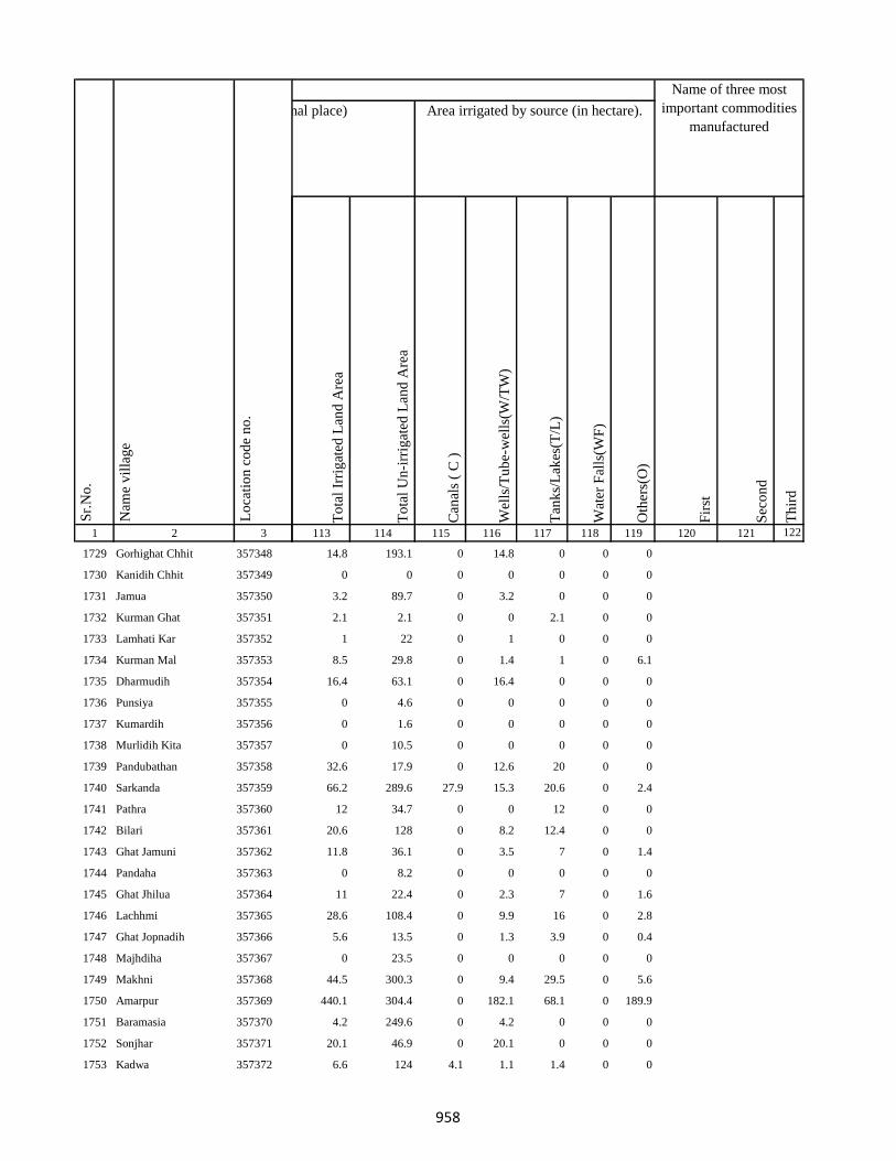
1 2 3
Lo
cati
on
co
de
no
.
Nam
e v
illa
ge
Sr.
No
.
1729 Gorhighat Chhit 357348
1730 Kanidih Chhit 357349
1731 Jamua 357350
1732 Kurman Ghat 357351
1733 Lamhati Kar 357352
1734 Kurman Mal 357353
1735 Dharmudih 357354
1736 Punsiya 357355
1737 Kumardih 357356
1738 Murlidih Kita 357357
1739 Pandubathan 357358
1740 Sarkanda 357359
1741 Pathra 357360
1742 Bilari 357361
1743 Ghat Jamuni 357362
1744 Pandaha 357363
1745 Ghat Jhilua 357364
1746 Lachhmi 357365
1747 Ghat Jopnadih 357366
1748 Majhdiha 357367
1749 Makhni 357368
1750 Amarpur 357369
1751 Baramasia 357370
1752 Sonjhar 357371
1753 Kadwa 357372
To
tal
Irri
gat
ed L
and
Are
a
To
tal
Un
-irr
igat
ed L
and
Are
a
Can
als
( C
)
Wel
ls/T
ub
e-w
ells
(W/T
W)
Tan
ks/
Lak
es(T
/L)
Wat
er F
alls
(WF
)
Oth
ers(
O)
Fir
st
Sec
on
d
Th
ird
113 114 115 116 117 118 119 120 121 122
Area under different types of land use ( in hectares rounded up to one decimal place) Area irrigated by source (in hectare).
Name of three most
important commodities
manufactured
Land Use
14.8 193.1 0 14.8 0 0 0
0 0 0 0 0 0 0
3.2 89.7 0 3.2 0 0 0
2.1 2.1 0 0 2.1 0 0
1 22 0 1 0 0 0
8.5 29.8 0 1.4 1 0 6.1
16.4 63.1 0 16.4 0 0 0
0 4.6 0 0 0 0 0
0 1.6 0 0 0 0 0
0 10.5 0 0 0 0 0
32.6 17.9 0 12.6 20 0 0
66.2 289.6 27.9 15.3 20.6 0 2.4
12 34.7 0 0 12 0 0
20.6 128 0 8.2 12.4 0 0
11.8 36.1 0 3.5 7 0 1.4
0 8.2 0 0 0 0 0
11 22.4 0 2.3 7 0 1.6
28.6 108.4 0 9.9 16 0 2.8
5.6 13.5 0 1.3 3.9 0 0.4
0 23.5 0 0 0 0 0
44.5 300.3 0 9.4 29.5 0 5.6
440.1 304.4 0 182.1 68.1 0 189.9
4.2 249.6 0 4.2 0 0 0
20.1 46.9 0 20.1 0 0 0
6.6 124 4.1 1.1 1.4 0 0
958

1 2 3
Lo
cati
on
co
de
no
.
Nam
e v
illa
ge
Sr.
No
.
1754 Nonbatta 357373
1755 Teldiha 357374
1756 Banka Ghat 357375
1757 Langradih 357376
1758 Bhalpahari 357377
1759 Sundarmor 357378
1760 Nipaniya 357379
1761 Baristanr 357380
1762 Jalgar 357381
1763 Sandmara 357382
1764 Dhokal Tola 357383
1765 Nandupahari 357384
1766 Jainagar Piprajoria 357385
1767 Birbal Tola 357386
1768 Belbathan 357387
1769 Raj Daha 357388
1770 Lalpur 357389
1771 Shampur 357390
1772 Jhagarahi 357391
1773 Kalhajor Kalan 357392
1774 Saharpur 357393
1775 Jhilua 357394
1776 Amjora 357395
1777 Hijaljor 357396
1778 Kundadah 357397
To
tal
Irri
gat
ed L
and
Are
a
To
tal
Un
-irr
igat
ed L
and
Are
a
Can
als
( C
)
Wel
ls/T
ub
e-w
ells
(W/T
W)
Tan
ks/
Lak
es(T
/L)
Wat
er F
alls
(WF
)
Oth
ers(
O)
Fir
st
Sec
on
d
Th
ird
113 114 115 116 117 118 119 120 121 122
Area under different types of land use ( in hectares rounded up to one decimal place) Area irrigated by source (in hectare).
Name of three most
important commodities
manufactured
Land Use
25.5 426.9 0 25.5 0 0 0
14.6 48.3 0 14.6 0 0 0
6.6 308.8 0 2.9 0 0 3.7
18.5 40.2 0 7.4 11.1 0 0
1.9 8.7 0 0.4 1.5 0 0
57.3 134.8 0 23.2 34.2 0 0
45.3 117.2 0 45.3 0 0 0
10.1 45.8 0 10.1 0 0 0
0 6 0 0 0 0 0
51.7 157.3 0 51.7 0 0 0
7 3.5 3.5 0 0.9 2.6 0
3.8 11.7 0 3.8 0 0 0
17.4 50.8 0 10.4 7 0 0
5.4 17.2 0 2.1 0 3.3 0
25.1 76 0 25.1 0 0 0
7.5 30.6 0 7.5 0 0 0
1.2 102 0 1.2 0 0 0
10.5 48.1 0 10.5 0 0 0
3.2 8.2 0 3.2 0 0 0
4.9 27.3 0 3.8 1.1 0 0
5.2 15.1 0 5.2 0 0 0
15.8 48.8 0 15.8 0 0 0
11.6 34.6 0 11.6 0 0 0
12.2 23 0 12.2 0 0 0
9.8 31.4 0 9.8 0 0 0
959

1 2 3
Lo
cati
on
co
de
no
.
Nam
e v
illa
ge
Sr.
No
.
1779 Karanpur 357398
1780 Kalhajor Khurd 357399
1781 Sahari 357400
1782 Dumma 357401
1783 Malmala 357402
1784 Karam Tola 357403
1785 Danga 357404
1786 Jamkudar 357405
1787 Siarkatiya 357406
1788 Burhikura 357407
1789 Haripur 357408
1790 Dulu 357409
1791 Bhawani 357410
Block T O T A L :
1792 Parasi 357412
1793 Andadih 357413
1794 Masanibeldiha 357414
1795 Muchora 357415
1796 Amra Kamat 357416
1797 Amra Mochora Kamat 357417
1798 Amra Kanauli 357418
1799 Amra Mochora Kamat 357419
1800 Jaijalpur 357420
To
tal
Irri
gat
ed L
and
Are
a
To
tal
Un
-irr
igat
ed L
and
Are
a
Can
als
( C
)
Wel
ls/T
ub
e-w
ells
(W/T
W)
Tan
ks/
Lak
es(T
/L)
Wat
er F
alls
(WF
)
Oth
ers(
O)
Fir
st
Sec
on
d
Th
ird
113 114 115 116 117 118 119 120 121 122
Area under different types of land use ( in hectares rounded up to one decimal place) Area irrigated by source (in hectare).
Name of three most
important commodities
manufactured
Land Use
8.1 31.8 0 8.1 0 0 0
5.1 13.7 0 5.1 0 0 0
16 40.8 0 16 0 0 0
13.8 42.8 0 13.8 0 0 0
15 26.1 0 15 0 0 0
0 29.9 0 0 0 0 0
8.2 23.8 0 8.2 0 0 0
9.7 46.7 0 9.7 0 0 0
8.9 59.7 0 8.9 0 0 0
11.2 40.9 0 11.2 0 0 0
3.2 9.8 0 3.2 0 0 0
10.2 38.9 0 10.2 0 0 0
8.6 46.8 0 8.6 0 0 0
2909.6 12689.4 226.5 1311.7 1051.4 24.2
0 3 0 0 0 0 0
8 21.8 8 0 0 0 0
11 34.5 0 3 8 0 0
13.6 6.3 0 3.4 10.2 0 0
0 2.7 0 0 0 0 0
2.7 5.6 2.7 0 0 0 0
0 7.3 0 0 0 0 0
0 0 0 0 0 0 0
0 11.3 0 0 0 0 0
960
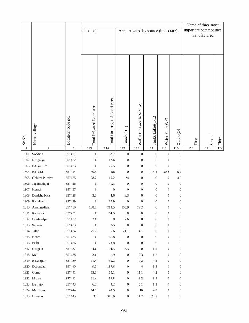
1 2 3
Lo
cati
on
co
de
no
.
Nam
e v
illa
ge
Sr.
No
.
1801 Sondiha 357421
1802 Rengniya 357422
1803 Baliya Kita 357423
1804 Baksara 357424
1805 Chhitni Purniya 357425
1806 Jagarnathpur 357426
1807 Korasi 357427
1808 Dardaha Kita 357428
1809 Ranabandh 357429
1810 Asarimadhuri 357430
1811 Ratanpur 357431
1812 Dindayalpur 357432
1813 Sarwan 357433
1814 Jalgo 357434
1815 Bohra 357435
1816 Petbi 357436
1817 Gaeghat 357437
1818 Mali 357438
1819 Basantpur 357439
1820 Debandha 357440
1821 Guma 357441
1822 Mahra 357442
1823 Behrajor 357443
1824 Manikpur 357444
1825 Birniyan 357445
To
tal
Irri
gat
ed L
and
Are
a
To
tal
Un
-irr
igat
ed L
and
Are
a
Can
als
( C
)
Wel
ls/T
ub
e-w
ells
(W/T
W)
Tan
ks/
Lak
es(T
/L)
Wat
er F
alls
(WF
)
Oth
ers(
O)
Fir
st
Sec
on
d
Th
ird
113 114 115 116 117 118 119 120 121 122
Area under different types of land use ( in hectares rounded up to one decimal place) Area irrigated by source (in hectare).
Name of three most
important commodities
manufactured
Land Use
0 82.7 0 0 0 0 0
0 12.6 0 0 0 0 0
0 25.5 0 0 0 0 0
50.5 56 0 0 15.1 30.2 5.2
28.2 15.2 24 0 0 0 4.2
0 41.3 0 0 0 0 0
0 0 0 0 0 0 0
3.3 4.6 3.3 0 0 0 0
0 17.9 0 0 0 0 0
188.2 218.5 165.9 22.2 0 0 0
0 64.5 0 0 0 0 0
2.6 8 2.6 0 0 0 0
0 55 0 0 0 0 0
25.2 5.6 21.1 4.1 0 0 0
0 61.8 0 0 0 0 0
0 23.8 0 0 0 0 0
4.6 104.3 3.3 0 1.2 0 0
3.6 1.9 0 2.3 1.2 0 0
11.4 50.2 0 7.2 4.2 0 0
9.3 187.6 0 4 5.3 0 0
15.3 50.1 0 11.1 4.2 0 0
11.4 53.8 0 8.2 3.2 0 0
6.2 3.2 0 5.1 1.1 0 0
14.3 40.5 0 10 4.2 0 0
32 311.6 0 11.7 20.2 0 0
961
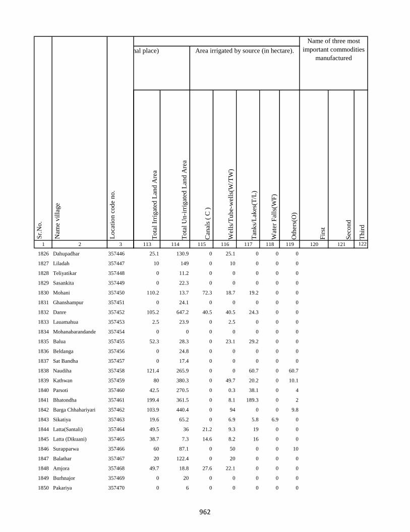
1 2 3
Lo
cati
on
co
de
no
.
Nam
e v
illa
ge
Sr.
No
.
1826 Dahupadhar 357446
1827 Liladah 357447
1828 Teliyatikar 357448
1829 Sasankita 357449
1830 Mohani 357450
1831 Ghanshampur 357451
1832 Danre 357452
1833 Lauamahua 357453
1834 Mohanabarandande 357454
1835 Balua 357455
1836 Beldanga 357456
1837 Sat Bandha 357457
1838 Naudiha 357458
1839 Kathwan 357459
1840 Parsoti 357460
1841 Bhatondha 357461
1842 Barga Chhahariyari 357462
1843 Sikatiya 357463
1844 Latta(Santali) 357464
1845 Latta (Dikuani) 357465
1846 Surapparwa 357466
1847 Balathar 357467
1848 Amjora 357468
1849 Burhnajor 357469
1850 Pakariya 357470
To
tal
Irri
gat
ed L
and
Are
a
To
tal
Un
-irr
igat
ed L
and
Are
a
Can
als
( C
)
Wel
ls/T
ub
e-w
ells
(W/T
W)
Tan
ks/
Lak
es(T
/L)
Wat
er F
alls
(WF
)
Oth
ers(
O)
Fir
st
Sec
on
d
Th
ird
113 114 115 116 117 118 119 120 121 122
Area under different types of land use ( in hectares rounded up to one decimal place) Area irrigated by source (in hectare).
Name of three most
important commodities
manufactured
Land Use
25.1 130.9 0 25.1 0 0 0
10 149 0 10 0 0 0
0 11.2 0 0 0 0 0
0 22.3 0 0 0 0 0
110.2 13.7 72.3 18.7 19.2 0 0
0 24.1 0 0 0 0 0
105.2 647.2 40.5 40.5 24.3 0 0
2.5 23.9 0 2.5 0 0 0
0 0 0 0 0 0 0
52.3 28.3 0 23.1 29.2 0 0
0 24.8 0 0 0 0 0
0 17.4 0 0 0 0 0
121.4 265.9 0 0 60.7 0 60.7
80 380.3 0 49.7 20.2 0 10.1
42.5 270.5 0 0.3 38.1 0 4
199.4 361.5 0 8.1 189.3 0 2
103.9 440.4 0 94 0 0 9.8
19.6 65.2 0 6.9 5.8 6.9 0
49.5 36 21.2 9.3 19 0 0
38.7 7.3 14.6 8.2 16 0 0
60 87.1 0 50 0 0 10
20 122.4 0 20 0 0 0
49.7 18.8 27.6 22.1 0 0 0
0 20 0 0 0 0 0
0 6 0 0 0 0 0
962
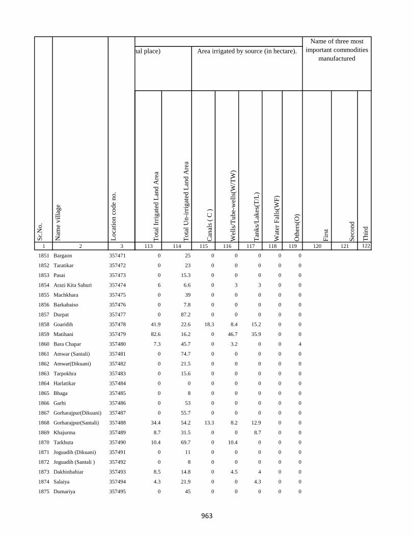
1 2 3
Lo
cati
on
co
de
no
.
Nam
e v
illa
ge
Sr.
No
.
1851 Bargaon 357471
1852 Taratikar 357472
1853 Pasai 357473
1854 Arazi Kita Sahuri 357474
1855 Machkhara 357475
1856 Barkabaiso 357476
1857 Durpat 357477
1858 Goaridih 357478
1859 Matihani 357479
1860 Bara Chapar 357480
1861 Amwar (Santali) 357481
1862 Amwar(Dikuani) 357482
1863 Tarpokhra 357483
1864 Harlatikar 357484
1865 Bhaga 357485
1866 Garhi 357486
1867 Gorharajpur(Dikuani) 357487
1868 Gorharajpur(Santali) 357488
1869 Khajurma 357489
1870 Tarkhuta 357490
1871 Joguadih (Dikuani) 357491
1872 Joguadih (Santali ) 357492
1873 Dakhinbahiar 357493
1874 Salaiya 357494
1875 Dumariya 357495
To
tal
Irri
gat
ed L
and
Are
a
To
tal
Un
-irr
igat
ed L
and
Are
a
Can
als
( C
)
Wel
ls/T
ub
e-w
ells
(W/T
W)
Tan
ks/
Lak
es(T
/L)
Wat
er F
alls
(WF
)
Oth
ers(
O)
Fir
st
Sec
on
d
Th
ird
113 114 115 116 117 118 119 120 121 122
Area under different types of land use ( in hectares rounded up to one decimal place) Area irrigated by source (in hectare).
Name of three most
important commodities
manufactured
Land Use
0 25 0 0 0 0 0
0 23 0 0 0 0 0
0 15.3 0 0 0 0 0
6 6.6 0 3 3 0 0
0 39 0 0 0 0 0
0 7.8 0 0 0 0 0
0 87.2 0 0 0 0 0
41.9 22.6 18.3 8.4 15.2 0 0
82.6 16.2 0 46.7 35.9 0 0
7.3 45.7 0 3.2 0 0 4
0 74.7 0 0 0 0 0
0 21.5 0 0 0 0 0
0 15.6 0 0 0 0 0
0 0 0 0 0 0 0
0 8 0 0 0 0 0
0 53 0 0 0 0 0
0 55.7 0 0 0 0 0
34.4 54.2 13.3 8.2 12.9 0 0
8.7 31.5 0 0 8.7 0 0
10.4 69.7 0 10.4 0 0 0
0 11 0 0 0 0 0
0 8 0 0 0 0 0
8.5 14.8 0 4.5 4 0 0
4.3 21.9 0 0 4.3 0 0
0 45 0 0 0 0 0
963

1 2 3
Lo
cati
on
co
de
no
.
Nam
e v
illa
ge
Sr.
No
.
1876 Danidih 357496
1877 Akhra 357497
1878 Sijua 357498
1879 Dhobai 357499
1880 Baghakol 357500
1881 Machanitari 357501
1882 Paharpur 357502
1883 Sajhia 357503
1884 Kamradol 357504
1885 Thakurnahan 357505
1886 Dakhin Tola 357506
1887 Tilatanr 357507
1888 Sikatia 357508
1889 Dhamsur 357509
1890 Chorpahari 357510
1891 Semra Kola 357511
1892 Charkatanr 357512
1893 Charghara 357513
1894 Lorhi Kunda 357514
1895 Dipna Dhibridah 357515
1896 Sundaridol 357516
1897 Salgatanr 357517
1898 Tambajor 357518
1899 Padumpur 357519
1900 Sakri Phulwar 357520
To
tal
Irri
gat
ed L
and
Are
a
To
tal
Un
-irr
igat
ed L
and
Are
a
Can
als
( C
)
Wel
ls/T
ub
e-w
ells
(W/T
W)
Tan
ks/
Lak
es(T
/L)
Wat
er F
alls
(WF
)
Oth
ers(
O)
Fir
st
Sec
on
d
Th
ird
113 114 115 116 117 118 119 120 121 122
Area under different types of land use ( in hectares rounded up to one decimal place) Area irrigated by source (in hectare).
Name of three most
important commodities
manufactured
Land Use
0 2.3 0 0 0 0 0
0 4.9 0 0 0 0 0
0 20 0 0 0 0 0
0 71.7 0 0 0 0 0
0 72.1 0 0 0 0 0
28.6 140.3 0 4.6 24 0 0
0 199.9 0 0 0 0 0
0 24.4 0 0 0 0 0
0 128 0 0 0 0 0
0 73.3 0 0 0 0 0
0 9.2 0 0 0 0 0
0 44.8 0 0 0 0 0
0 19.4 0 0 0 0 0
0 16 0 0 0 0 0
0 23.4 0 0 0 0 0
0 19.9 0 0 0 0 0
0 21.3 0 0 0 0 0
0 56.7 0 0 0 0 0
7.2 47.3 0 0 7.2 0 0
0 84.9 0 0 0 0 0
105.8 44.3 42.2 22.3 41.3 0 0
0 90.2 0 0 0 0 0
29.2 10.3 10.9 7.4 10.9 0 0
60.8 56.3 25.2 12.5 23.2 0 0
8.6 665.7 0 6.5 2.1 0 0
964

1 2 3
Lo
cati
on
co
de
no
.
Nam
e v
illa
ge
Sr.
No
.
1901 Kurwa 357521
1902 Kharbari 357522
1903 Chamudih 357523
1904 Maheshkiro Pachimtola 357524
1905 Kasturi 357525
1906 Khairadih 357526
1907 Panch Pahari 357527
1908 Dadughutu Paharpur 357528
1909 Maheshdhasa 357529
1910 Kita Makra 357530
1911 Dorabandh 357531
1912 Pareya Hat 357532
1913 Gunghasa 357533
1914 Rajdaha Bara 357534
1915 Gauripur 357535
1916 Sugathan 357536
1917 Hathihariyari 357537
1918 Dharophata 357538
1919 Lathibari 357539
1920 Jhapnibandh 357540
1921 Dhanu Kata 357541
1922 Raghunathpur 357542
1923 Kundapani 357543
1924 Kanchanrai Tola 357544
1925 Bandhaghat 357545
To
tal
Irri
gat
ed L
and
Are
a
To
tal
Un
-irr
igat
ed L
and
Are
a
Can
als
( C
)
Wel
ls/T
ub
e-w
ells
(W/T
W)
Tan
ks/
Lak
es(T
/L)
Wat
er F
alls
(WF
)
Oth
ers(
O)
Fir
st
Sec
on
d
Th
ird
113 114 115 116 117 118 119 120 121 122
Area under different types of land use ( in hectares rounded up to one decimal place) Area irrigated by source (in hectare).
Name of three most
important commodities
manufactured
Land Use
71.4 54.7 32.5 12.3 26.6 0 0
0 50.4 0 0 0 0 0
25 30.1 0 0 2 0 23
95 25.9 0 45 50 0 0
70 56.6 0 20 50 0 0
0 58.4 0 0 0 0 0
70 45.4 0 25 45 0 0
0 80 0 0 0 0 0
0 5.9 0 0 0 0 0
0 59.1 0 0 0 0 0
62.2 62.4 0 11 9 0 42.2
0 90.1 0 0 0 0 0
176.6 31.7 0 15 40 0 121.6
0 10.3 0 0 0 0 0
52.6 398.6 0 12.1 0 0 40.5
81.2 90.6 0 48.3 32.9 0 0
64.7 586.8 0 8.1 32.4 0 24.3
5.8 539.7 0 0 5.8 0 0
24.3 443.5 0 4 0 0 20.2
180.4 541.1 4.2 91.3 84.9 0 0
6.9 547.1 0 6.9 0 0 0
147.1 15.4 0 74.3 72.8 0 0
0 44 0 0 0 0 0
0 30.2 0 0 0 0 0
0.6 67.4 0 0.6 0 0 0
965
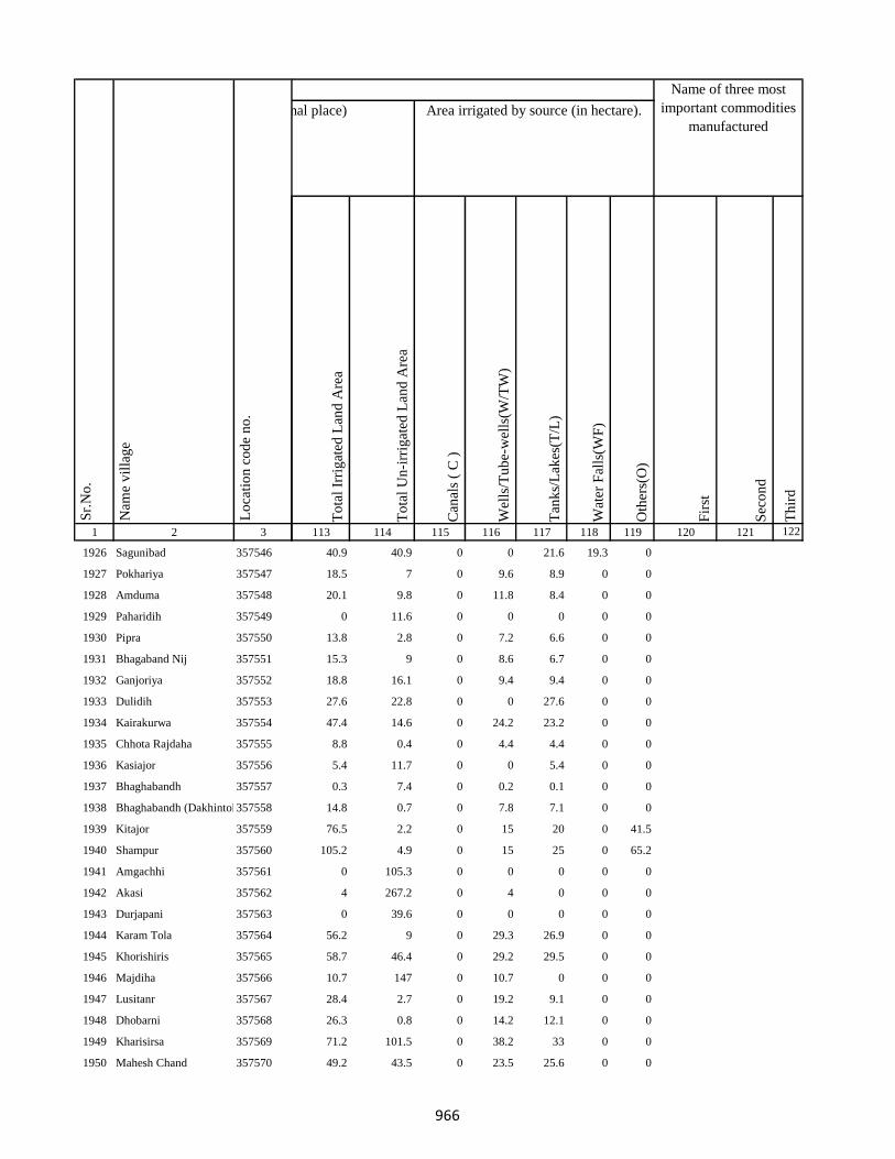
1 2 3
Lo
cati
on
co
de
no
.
Nam
e v
illa
ge
Sr.
No
.
1926 Sagunibad 357546
1927 Pokhariya 357547
1928 Amduma 357548
1929 Paharidih 357549
1930 Pipra 357550
1931 Bhagaband Nij 357551
1932 Ganjoriya 357552
1933 Dulidih 357553
1934 Kairakurwa 357554
1935 Chhota Rajdaha 357555
1936 Kasiajor 357556
1937 Bhaghabandh 357557
1938 Bhaghabandh (Dakhintola)357558
1939 Kitajor 357559
1940 Shampur 357560
1941 Amgachhi 357561
1942 Akasi 357562
1943 Durjapani 357563
1944 Karam Tola 357564
1945 Khorishiris 357565
1946 Majdiha 357566
1947 Lusitanr 357567
1948 Dhobarni 357568
1949 Kharisirsa 357569
1950 Mahesh Chand 357570
To
tal
Irri
gat
ed L
and
Are
a
To
tal
Un
-irr
igat
ed L
and
Are
a
Can
als
( C
)
Wel
ls/T
ub
e-w
ells
(W/T
W)
Tan
ks/
Lak
es(T
/L)
Wat
er F
alls
(WF
)
Oth
ers(
O)
Fir
st
Sec
on
d
Th
ird
113 114 115 116 117 118 119 120 121 122
Area under different types of land use ( in hectares rounded up to one decimal place) Area irrigated by source (in hectare).
Name of three most
important commodities
manufactured
Land Use
40.9 40.9 0 0 21.6 19.3 0
18.5 7 0 9.6 8.9 0 0
20.1 9.8 0 11.8 8.4 0 0
0 11.6 0 0 0 0 0
13.8 2.8 0 7.2 6.6 0 0
15.3 9 0 8.6 6.7 0 0
18.8 16.1 0 9.4 9.4 0 0
27.6 22.8 0 0 27.6 0 0
47.4 14.6 0 24.2 23.2 0 0
8.8 0.4 0 4.4 4.4 0 0
5.4 11.7 0 0 5.4 0 0
0.3 7.4 0 0.2 0.1 0 0
14.8 0.7 0 7.8 7.1 0 0
76.5 2.2 0 15 20 0 41.5
105.2 4.9 0 15 25 0 65.2
0 105.3 0 0 0 0 0
4 267.2 0 4 0 0 0
0 39.6 0 0 0 0 0
56.2 9 0 29.3 26.9 0 0
58.7 46.4 0 29.2 29.5 0 0
10.7 147 0 10.7 0 0 0
28.4 2.7 0 19.2 9.1 0 0
26.3 0.8 0 14.2 12.1 0 0
71.2 101.5 0 38.2 33 0 0
49.2 43.5 0 23.5 25.6 0 0
966
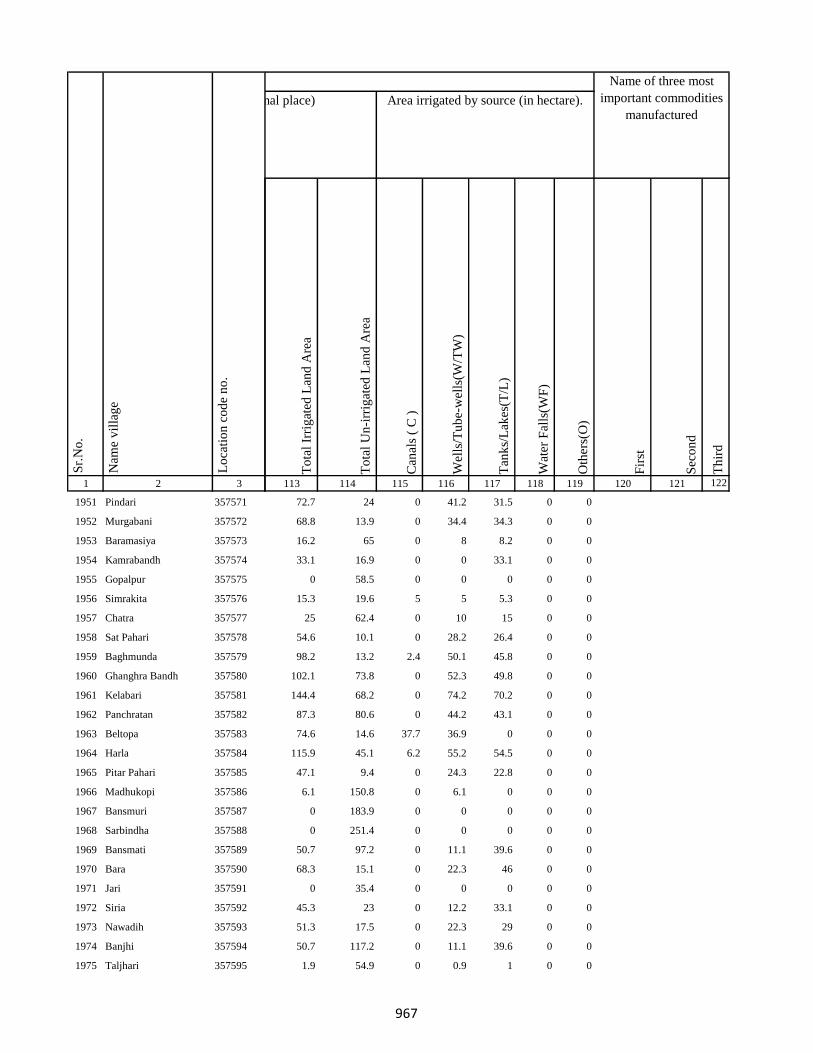
1 2 3
Lo
cati
on
co
de
no
.
Nam
e v
illa
ge
Sr.
No
.
1951 Pindari 357571
1952 Murgabani 357572
1953 Baramasiya 357573
1954 Kamrabandh 357574
1955 Gopalpur 357575
1956 Simrakita 357576
1957 Chatra 357577
1958 Sat Pahari 357578
1959 Baghmunda 357579
1960 Ghanghra Bandh 357580
1961 Kelabari 357581
1962 Panchratan 357582
1963 Beltopa 357583
1964 Harla 357584
1965 Pitar Pahari 357585
1966 Madhukopi 357586
1967 Bansmuri 357587
1968 Sarbindha 357588
1969 Bansmati 357589
1970 Bara 357590
1971 Jari 357591
1972 Siria 357592
1973 Nawadih 357593
1974 Banjhi 357594
1975 Taljhari 357595
To
tal
Irri
gat
ed L
and
Are
a
To
tal
Un
-irr
igat
ed L
and
Are
a
Can
als
( C
)
Wel
ls/T
ub
e-w
ells
(W/T
W)
Tan
ks/
Lak
es(T
/L)
Wat
er F
alls
(WF
)
Oth
ers(
O)
Fir
st
Sec
on
d
Th
ird
113 114 115 116 117 118 119 120 121 122
Area under different types of land use ( in hectares rounded up to one decimal place) Area irrigated by source (in hectare).
Name of three most
important commodities
manufactured
Land Use
72.7 24 0 41.2 31.5 0 0
68.8 13.9 0 34.4 34.3 0 0
16.2 65 0 8 8.2 0 0
33.1 16.9 0 0 33.1 0 0
0 58.5 0 0 0 0 0
15.3 19.6 5 5 5.3 0 0
25 62.4 0 10 15 0 0
54.6 10.1 0 28.2 26.4 0 0
98.2 13.2 2.4 50.1 45.8 0 0
102.1 73.8 0 52.3 49.8 0 0
144.4 68.2 0 74.2 70.2 0 0
87.3 80.6 0 44.2 43.1 0 0
74.6 14.6 37.7 36.9 0 0 0
115.9 45.1 6.2 55.2 54.5 0 0
47.1 9.4 0 24.3 22.8 0 0
6.1 150.8 0 6.1 0 0 0
0 183.9 0 0 0 0 0
0 251.4 0 0 0 0 0
50.7 97.2 0 11.1 39.6 0 0
68.3 15.1 0 22.3 46 0 0
0 35.4 0 0 0 0 0
45.3 23 0 12.2 33.1 0 0
51.3 17.5 0 22.3 29 0 0
50.7 117.2 0 11.1 39.6 0 0
1.9 54.9 0 0.9 1 0 0
967

1 2 3
Lo
cati
on
co
de
no
.
Nam
e v
illa
ge
Sr.
No
.
1976 Kharkachia 357596
1977 Jambad 357597
1978 Chorbad 357598
1979 Agiabandh 357599
1980 Dewdanr(Uttartola) 357600
1981 Dewdanr 357601
1982 Baghmara 357602
1983 Kendua 357603
1984 Karikadar 357604
1985 Khardaha 357605
1986 Khardaha 357606
1987 Ambadiha 357607
1988 Baghmara Purabtola 357608
1989 Garhbana 357609
1990 Gobindpur 357610
1991 Bankati 357611
1992 Pindra 357612
1993 Piparjoriya 357613
1994 Jitpur 357614
1995 Boha 357615
1996 Liti 357616
1997 Sidhbank 357617
1998 Kairasol 357618
1999 Daharlangi 357619
2000 Halhiya Pathar 357620
To
tal
Irri
gat
ed L
and
Are
a
To
tal
Un
-irr
igat
ed L
and
Are
a
Can
als
( C
)
Wel
ls/T
ub
e-w
ells
(W/T
W)
Tan
ks/
Lak
es(T
/L)
Wat
er F
alls
(WF
)
Oth
ers(
O)
Fir
st
Sec
on
d
Th
ird
113 114 115 116 117 118 119 120 121 122
Area under different types of land use ( in hectares rounded up to one decimal place) Area irrigated by source (in hectare).
Name of three most
important commodities
manufactured
Land Use
106.2 93 41.2 28.7 36.3 0 0
73.5 12.3 0 37.8 35.7 0 0
0 64.4 0 0 0 0 0
44.1 33.8 0 20.1 24 0 0
11.4 2.3 0 6.4 5.1 0 0
134.3 14.4 0 68.3 66 0 0
154 152.8 0 78.1 75.9 0 0
0 38.4 0 0 0 0 0
229.2 19.7 138.2 69.7 21.3 0 0
0 49 0 0 0 0 0
0 47.4 0 0 0 0 0
67.4 25.9 0 35.2 32.2 0 0
70.4 68.2 0 36.1 34.2 0 0
57.2 3.7 0 24.1 33.1 0 0
98.8 30.3 0 49.8 49 0 0
81.9 56.3 0 41.5 40.4 0 0
199.7 70.9 0 102.4 97.3 0 0
36.8 19.1 0 19.2 17.6 0 0
110.8 82 0 56.4 54.5 0 0
150.1 110.6 0 76.1 74 0 0
140.2 102.7 0 72.2 68.1 0 0
5.7 550.4 0 5.7 0 0 0
137.7 60.4 0 70.3 67.4 0 0
48 49 0 24.7 23.3 0 0
56.4 38 0 29.2 27.3 0 0
968
1 2 3
Lo
cati
on
co
de
no
.
Nam
e v
illa
ge
Sr.
No
.
2001 Asna 357621
2002 Parigadih 357622
2003 Susni 357623
2004 Jamropani 357624
Block T O T A L :
2005 Bansjori 357625
2006 Bansjori Jagir 357626
2007 Kauadhab 357627
2008 Sabalpur Jagir 357628
2009 Sabalpur 357629
2010 Raksi 357630
2011 Chatra 357631
2012 Paharpur 357632
2013 Paharpur Jagir 357633
2014 Kheribari 357634
2015 Barnadi 357635
2016 Barnadi Jagir 357636
2017 Jamdiha 357637
2018 Kajuri 357638
2019 Simaldhab 357639
2020 Bishunpur 357640
2021 Dhunigora 357641
2022 Ghatiari 357642
To
tal
Irri
gat
ed L
and
Are
a
To
tal
Un
-irr
igat
ed L
and
Are
a
Can
als
( C
)
Wel
ls/T
ub
e-w
ells
(W/T
W)
Tan
ks/
Lak
es(T
/L)
Wat
er F
alls
(WF
)
Oth
ers(
O)
Fir
st
Sec
on
d
Th
ird
113 114 115 116 117 118 119 120 121 122
Area under different types of land use ( in hectares rounded up to one decimal place) Area irrigated by source (in hectare).
Name of three most
important commodities
manufactured
Land Use
93 10 0 49 44 0 0
83.3 18.4 0 42.2 41.1 0 0
0 12.7 0 0 0 0 0
0 11.9 0 0 0 0 0
7247.3 15742.5 784.4 2867.1 3050.7 56.4
0 75.3 0 0 0 0 0
0 0 0 0 0 0 0
0 0 0 0 0 0 0
0 0 0 0 0 0 0
0 0 0 0 0 0 0
0 0 0 0 0 0 0
0 0 0 0 0 0 0
0 0 0 0 0 0 0
0 0 0 0 0 0 0
0 0 0 0 0 0 0
0 0 0 0 0 0 0
0 45.2 0 0 0 0 0
0 0 0 0 0 0 0
0 0 0 0 0 0 0
0 0 0 0 0 0 0
0 0 0 0 0 0 0
0 7.6 0 0 0 0 0
0 0 0 0 0 0 0
969
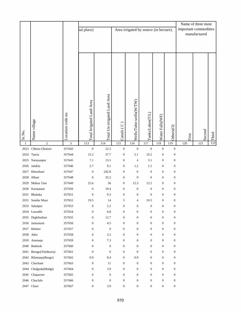
1 2 3
Lo
cati
on
co
de
no
.
Nam
e v
illa
ge
Sr.
No
.
2023 Chhota Ghatiari 357643
2024 Tasria 357644
2025 Narayanpur 357645
2026 Jambia 357646
2027 Kherabani 357647
2028 Jilbari 357648
2029 Mahua Tanr 357649
2030 Karmatanr 357650
2031 Bhaluka 357651
2032 Sundar Maur 357652
2033 Sabalpur 357653
2034 Lawadih 357654
2035 Dighibathan 357655
2036 Jamuntanr 357656
2037 Khelari 357657
2038 Adro 357658
2039 Ammaqo 357659
2040 Bedotok 357660
2041 Berago(Telalkuria) 357661
2042 Bilamaqo(Basgo) 357662
2043 Chacham 357663
2044 Chalgoda(Madgi) 357664
2045 Chaparom 357665
2046 Chuclalo 357666
2047 Churi 357667
To
tal
Irri
gat
ed L
and
Are
a
To
tal
Un
-irr
igat
ed L
and
Are
a
Can
als
( C
)
Wel
ls/T
ub
e-w
ells
(W/T
W)
Tan
ks/
Lak
es(T
/L)
Wat
er F
alls
(WF
)
Oth
ers(
O)
Fir
st
Sec
on
d
Th
ird
113 114 115 116 117 118 119 120 121 122
Area under different types of land use ( in hectares rounded up to one decimal place) Area irrigated by source (in hectare).
Name of three most
important commodities
manufactured
Land Use
0 12.3 0 0 0 0 0
15.2 37.7 0 5.1 10.2 0 0
7.1 13.5 0 4 3.1 0 0
2.7 9.1 0 1.2 1.5 0 0
0 242.8 0 0 0 0 0
0 35.2 0 0 0 0 0
25.6 36 0 12.3 13.2 0 0
0 19.4 0 0 0 0 0
0 9.3 0 0 0 0 0
19.5 14 5 4 10.5 0 0
0 2.2 0 0 0 0 0
0 6.8 0 0 0 0 0
0 12.7 0 0 0 0 0
0 4.5 0 0 0 0 0
0 0 0 0 0 0 0
0 3.3 0 0 0 0 0
0 7.3 0 0 0 0 0
0 0 0 0 0 0 0
0 0 0 0 0 0 0
0.9 8.4 0 0.9 0 0 0
0 11 0 0 0 0 0
0 3.9 0 0 0 0 0
0 0 0 0 0 0 0
0 0 0 0 0 0 0
0 3.9 0 0 0 0 0
970
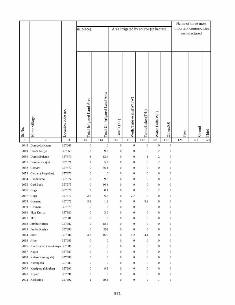
1 2 3
Lo
cati
on
co
de
no
.
Nam
e v
illa
ge
Sr.
No
.
2048 Donigoda Katan 357668
2049 Dandi Kuriya 357669
2050 Dumer(Palem) 357670
2051 Dumberi(Kajri) 357671
2052 Gamaro 357672
2053 Gamaro(Sonpahar) 357673
2054 Gandarama 357674
2055 Gari Bedo 357675
2056 Goga 357676
2057 Goga 357677
2058 Gosmara 357678
2059 Gosmara 357679
2060 Ilkar Kuriya 357680
2061 Ilkru 357681
2062 Jambu Kuriya 357682
2063 Jambu Kuriya 357683
2064 Jamri 357684
2065 Jirko 357685
2066 Jito Kundi(Dumerkuriya)357686
2067 Kagra 357687
2068 Kalare(Kamugoda) 357688
2069 Kamugoda 357689
2070 Kasripara (Moglan) 357690
2071 Kepam 357691
2072 Kerkuriya 357692
To
tal
Irri
gat
ed L
and
Are
a
To
tal
Un
-irr
igat
ed L
and
Are
a
Can
als
( C
)
Wel
ls/T
ub
e-w
ells
(W/T
W)
Tan
ks/
Lak
es(T
/L)
Wat
er F
alls
(WF
)
Oth
ers(
O)
Fir
st
Sec
on
d
Th
ird
113 114 115 116 117 118 119 120 121 122
Area under different types of land use ( in hectares rounded up to one decimal place) Area irrigated by source (in hectare).
Name of three most
important commodities
manufactured
Land Use
0 0 0 0 0 0 0
2 9.2 0 0 0 2 0
3 13.4 0 0 1 2 0
2 5.7 0 0 0 2 0
0 36.4 0 0 0 0 0
0 0 0 0 0 0 0
0 9.8 0 0 0 0 0
0 16.1 0 0 0 0 0
2 8.4 0 0 0 2 0
2.7 6.7 0 2.7 0 0 0
3.2 1.9 0 0 3.2 0 0
0 0 0 0 0 0 0
0 3.9 0 0 0 0 0
0 0 0 0 0 0 0
0 18.6 0 0 0 0 0
0 392 0 0 0 0 0
4.7 16.5 0 1.2 3.4 0 0
0 0 0 0 0 0 0
0 0 0 0 0 0 0
0 0 0 0 0 0 0
0 0 0 0 0 0 0
0 0 0 0 0 0 0
0 9.8 0 0 0 0 0
0 0 0 0 0 0 0
1 69.3 0 0 0 1 0
971
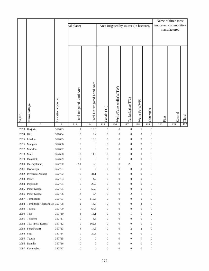
1 2 3
Lo
cati
on
co
de
no
.
Nam
e v
illa
ge
Sr.
No
.
2073 Kerjuria 357693
2074 Kiro 357694
2075 Liladoni 357695
2076 Madgam 357696
2077 Maridoni 357697
2078 Mate 357698
2079 Pakeritok 357699
2080 Palem(Dumar) 357700
2081 Pawkuriya 357701
2082 Perdarda (Ambar) 357702
2083 Pokeri 357703
2084 Popkundo 357704
2085 Pusur Kuriya 357705
2086 Pusur Kuriya 357706
2087 Tamli Bedo 357707
2088 Tamligoda (Chaparbita) 357708
2089 Tatkota 357709
2090 Telo 357710
2091 Telodoni 357711
2092 Tetli (Telal Kuriya) 357712
2093 Sena(Katan) 357713
2094 Suju 357714
2095 Tetaria 357715
2096 Domdih 357716
2097 Kusumghati 357717
To
tal
Irri
gat
ed L
and
Are
a
To
tal
Un
-irr
igat
ed L
and
Are
a
Can
als
( C
)
Wel
ls/T
ub
e-w
ells
(W/T
W)
Tan
ks/
Lak
es(T
/L)
Wat
er F
alls
(WF
)
Oth
ers(
O)
Fir
st
Sec
on
d
Th
ird
113 114 115 116 117 118 119 120 121 122
Area under different types of land use ( in hectares rounded up to one decimal place) Area irrigated by source (in hectare).
Name of three most
important commodities
manufactured
Land Use
1 10.6 0 0 0 1 0
0 8.2 0 0 0 0 0
0 16.8 0 0 0 0 0
0 0 0 0 0 0 0
0 0 0 0 0 0 0
0 14.5 0 0 0 0 0
0 0 0 0 0 0 0
2.1 6.9 0 0 2.1 0 0
0 0 0 0 0 0 0
0 34.1 0 0 0 0 0
0 4.7 0 0 0 0 0
0 25.2 0 0 0 0 0
0 55.9 0 0 0 0 0
3 9.4 0 0 2 1 0
0 119.5 0 0 0 0 0
2 13.6 0 0 0 2 0
0 67.8 0 0 0 0 0
3 16.1 0 0 1 0 2
0 8.6 0 0 0 0 0
0 162.8 0 0 0 0 0
4 14.8 0 0 2 2 0
0 20.5 0 0 0 0 0
0 0 0 0 0 0 0
0 0 0 0 0 0 0
0 0 0 0 0 0 0
972
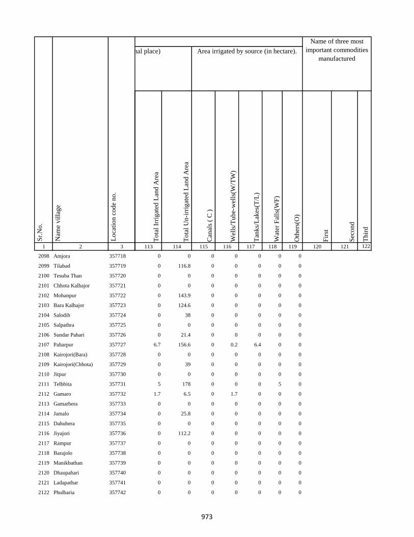
1 2 3
Lo
cati
on
co
de
no
.
Nam
e v
illa
ge
Sr.
No
.
2098 Amjora 357718
2099 Tilabad 357719
2100 Tesuba Than 357720
2101 Chhota Kalhajor 357721
2102 Mohanpur 357722
2103 Bara Kalhajor 357723
2104 Salodih 357724
2105 Salpathra 357725
2106 Sundar Pahari 357726
2107 Paharpur 357727
2108 Kairojori(Bara) 357728
2109 Kairojori(Chhota) 357729
2110 Jitpur 357730
2111 Telbhita 357731
2112 Gamaro 357732
2113 Gamarbera 357733
2114 Jamalo 357734
2115 Dahubera 357735
2116 Jiyajori 357736
2117 Rampur 357737
2118 Barajolo 357738
2119 Manikbathan 357739
2120 Dhaupahari 357740
2121 Ladapathar 357741
2122 Phulbaria 357742
To
tal
Irri
gat
ed L
and
Are
a
To
tal
Un
-irr
igat
ed L
and
Are
a
Can
als
( C
)
Wel
ls/T
ub
e-w
ells
(W/T
W)
Tan
ks/
Lak
es(T
/L)
Wat
er F
alls
(WF
)
Oth
ers(
O)
Fir
st
Sec
on
d
Th
ird
113 114 115 116 117 118 119 120 121 122
Area under different types of land use ( in hectares rounded up to one decimal place) Area irrigated by source (in hectare).
Name of three most
important commodities
manufactured
Land Use
0 0 0 0 0 0 0
0 116.8 0 0 0 0 0
0 0 0 0 0 0 0
0 0 0 0 0 0 0
0 143.9 0 0 0 0 0
0 124.6 0 0 0 0 0
0 38 0 0 0 0 0
0 0 0 0 0 0 0
0 21.4 0 0 0 0 0
6.7 156.6 0 0.2 6.4 0 0
0 0 0 0 0 0 0
0 39 0 0 0 0 0
0 0 0 0 0 0 0
5 178 0 0 0 5 0
1.7 6.5 0 1.7 0 0 0
0 0 0 0 0 0 0
0 25.8 0 0 0 0 0
0 0 0 0 0 0 0
0 112.2 0 0 0 0 0
0 0 0 0 0 0 0
0 0 0 0 0 0 0
0 0 0 0 0 0 0
0 0 0 0 0 0 0
0 0 0 0 0 0 0
0 0 0 0 0 0 0
973

1 2 3
Lo
cati
on
co
de
no
.
Nam
e v
illa
ge
Sr.
No
.
2123 Alkito(Katon) 357743
2124 Ambar 357744
2125 Bandaretoke(Madgi) 357745
2126 Champa 357746
2127 Charmaka 357747
2128 Chetamu (Jirik) 357748
2129 Dande(Salpahar) 357749
2130 Dando 357750
2131 Dawgoda 357751
2132 Dawgoda 357752
2133 Dumeri(Dumar) 357753
2134 Gambaritoke 357754
2135 Gambaritoke 357755
2136 Gelago(Basgo) 357756
2137 Jolame(Daupahar) 357757
2138 Kero Kuriya 357758
2139 Makma 357759
2140 Masbera (Banspahar) 357760
2141 Melijamali(Tetal Kuriya) 357761
2142 Pakeramo(Tok Kuriya) 357762
2143 Pakeri 357763
2144 Telbita 357764
2145 Dhankuti 357765
2146 Dhawadangal 357766
2147 Jabarda 357767
To
tal
Irri
gat
ed L
and
Are
a
To
tal
Un
-irr
igat
ed L
and
Are
a
Can
als
( C
)
Wel
ls/T
ub
e-w
ells
(W/T
W)
Tan
ks/
Lak
es(T
/L)
Wat
er F
alls
(WF
)
Oth
ers(
O)
Fir
st
Sec
on
d
Th
ird
113 114 115 116 117 118 119 120 121 122
Area under different types of land use ( in hectares rounded up to one decimal place) Area irrigated by source (in hectare).
Name of three most
important commodities
manufactured
Land Use
0 1.2 0 0 0 0 0
0 0 0 0 0 0 0
0 3.5 0 0 0 0 0
0 4.3 0 0 0 0 0
0 11.8 0 0 0 0 0
0 0 0 0 0 0 0
0 0 0 0 0 0 0
0 0 0 0 0 0 0
0 3.7 0 0 0 0 0
0 3.5 0 0 0 0 0
0 1.6 0 0 0 0 0
0 2 0 0 0 0 0
0 2 0 0 0 0 0
0 2 0 0 0 0 0
0 1.6 0 0 0 0 0
0 3.1 0 0 0 0 0
0 1.6 0 0 0 0 0
0 1.2 0 0 0 0 0
0 1.4 0 0 0 0 0
0 2 0 0 0 0 0
0 6.4 0 0 0 0 0
0 2 0 0 0 0 0
4.2 13.3 0 0 4.2 0 0
0 54.6 0 0 0 0 0
0 32.6 0 0 0 0 0
974
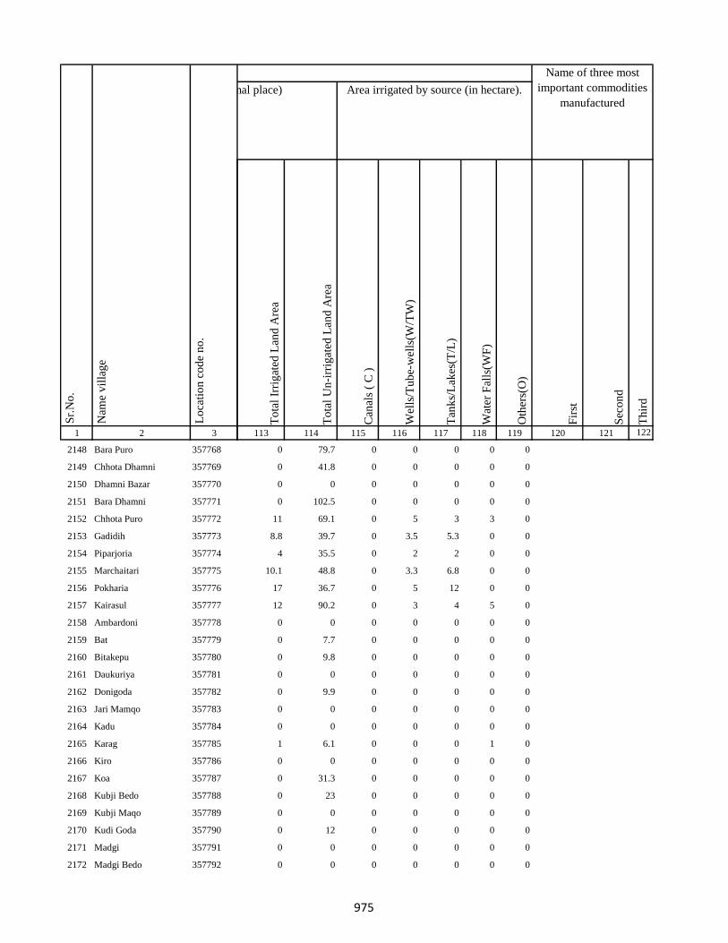
1 2 3
Lo
cati
on
co
de
no
.
Nam
e v
illa
ge
Sr.
No
.
2148 Bara Puro 357768
2149 Chhota Dhamni 357769
2150 Dhamni Bazar 357770
2151 Bara Dhamni 357771
2152 Chhota Puro 357772
2153 Gadidih 357773
2154 Piparjoria 357774
2155 Marchaitari 357775
2156 Pokharia 357776
2157 Kairasul 357777
2158 Ambardoni 357778
2159 Bat 357779
2160 Bitakepu 357780
2161 Daukuriya 357781
2162 Donigoda 357782
2163 Jari Mamqo 357783
2164 Kadu 357784
2165 Karag 357785
2166 Kiro 357786
2167 Koa 357787
2168 Kubji Bedo 357788
2169 Kubji Maqo 357789
2170 Kudi Goda 357790
2171 Madgi 357791
2172 Madgi Bedo 357792
To
tal
Irri
gat
ed L
and
Are
a
To
tal
Un
-irr
igat
ed L
and
Are
a
Can
als
( C
)
Wel
ls/T
ub
e-w
ells
(W/T
W)
Tan
ks/
Lak
es(T
/L)
Wat
er F
alls
(WF
)
Oth
ers(
O)
Fir
st
Sec
on
d
Th
ird
113 114 115 116 117 118 119 120 121 122
Area under different types of land use ( in hectares rounded up to one decimal place) Area irrigated by source (in hectare).
Name of three most
important commodities
manufactured
Land Use
0 79.7 0 0 0 0 0
0 41.8 0 0 0 0 0
0 0 0 0 0 0 0
0 102.5 0 0 0 0 0
11 69.1 0 5 3 3 0
8.8 39.7 0 3.5 5.3 0 0
4 35.5 0 2 2 0 0
10.1 48.8 0 3.3 6.8 0 0
17 36.7 0 5 12 0 0
12 90.2 0 3 4 5 0
0 0 0 0 0 0 0
0 7.7 0 0 0 0 0
0 9.8 0 0 0 0 0
0 0 0 0 0 0 0
0 9.9 0 0 0 0 0
0 0 0 0 0 0 0
0 0 0 0 0 0 0
1 6.1 0 0 0 1 0
0 0 0 0 0 0 0
0 31.3 0 0 0 0 0
0 23 0 0 0 0 0
0 0 0 0 0 0 0
0 12 0 0 0 0 0
0 0 0 0 0 0 0
0 0 0 0 0 0 0
975

1 2 3
Lo
cati
on
co
de
no
.
Nam
e v
illa
ge
Sr.
No
.
2173 Madgi Maqo 357793
2174 Puro Maqo (Katan) 357794
2175 Karag 357795
2176 Tamli 357796
2177 Takalo 357797
2178 Tetal Kuriya 357798
2179 Saharpura 357799
2180 Chandna 357800
2181 Longidih 357801
2182 Borwa 357802
2183 Karamtola 357803
2184 Roldih 357804
2185 Bara Haripur 357805
2186 Dulu 357806
2187 Asantari 357807
2188 Kusmaha 357808
2189 Damruhat 357809
2190 Dumki 357810
2191 Kairabani 357811
2192 Bariyarpur 357812
2193 Chhota Haripur 357813
2194 Kadampur 357814
2195 Angbali 357815
2196 Banspahari 357816
2197 Gamharia 357817
To
tal
Irri
gat
ed L
and
Are
a
To
tal
Un
-irr
igat
ed L
and
Are
a
Can
als
( C
)
Wel
ls/T
ub
e-w
ells
(W/T
W)
Tan
ks/
Lak
es(T
/L)
Wat
er F
alls
(WF
)
Oth
ers(
O)
Fir
st
Sec
on
d
Th
ird
113 114 115 116 117 118 119 120 121 122
Area under different types of land use ( in hectares rounded up to one decimal place) Area irrigated by source (in hectare).
Name of three most
important commodities
manufactured
Land Use
0 19.3 0 0 0 0 0
0 11.2 0 0 0 0 0
0 0 0 0 0 0 0
0 0 0 0 0 0 0
0 0 0 0 0 0 0
0 0 0 0 0 0 0
0 105.7 0 0 0 0 0
21.4 114 0 0 21.4 0 0
7 0 0 0 7 0 0
18.4 127.5 0 0 18.4 0 0
5.9 36.6 0 1.5 4.4 0 0
5.6 42.2 0 3.6 2 0 0
10 92.5 0 0 10 0 0
3 16.5 0 3 0 0 0
3.4 14.4 0 3.4 0 0 0
0 98 0 0 0 0 0
2.8 38.7 0 0 2.8 0 0
0 11.5 0 0 0 0 0
0 14.6 0 0 0 0 0
0 76.4 0 0 0 0 0
4 160.3 0 2 2 0 0
9.7 47.2 0 0 9.7 0 0
13.5 150.4 0 5 8.5 0 0
0 64.2 0 0 0 0 0
0 0 0 0 0 0 0
976

1 2 3
Lo
cati
on
co
de
no
.
Nam
e v
illa
ge
Sr.
No
.
2198 Paharpur 357818
2199 Tetariya 357819
2200 Khepadih 357820
2201 Chandraydih 357821
2202 Gardi 357822
2203 Ghaghri 357823
2204 Malikundi 357824
2205 Bara Sinddri 357825
2206 Sagar 357826
2207 Monadih 357827
2208 Ghorabali 357828
2209 Chhota Sindari 357829
2210 Tilaipara 357830
2211 Sahapi 357831
2212 Madni 357832
2213 Ratnapara 357833
2214 Dumartari 357834
2215 Bara Sabai Kundi 357835
2216 Chhota Sabai Kundi 357836
2217 Rajabhita 357837
2218 Chhota Adro 357838
2219 Manspara 357839
2220 Kesam 357840
2221 Keropara 357841
2222 Chamer 357842
To
tal
Irri
gat
ed L
and
Are
a
To
tal
Un
-irr
igat
ed L
and
Are
a
Can
als
( C
)
Wel
ls/T
ub
e-w
ells
(W/T
W)
Tan
ks/
Lak
es(T
/L)
Wat
er F
alls
(WF
)
Oth
ers(
O)
Fir
st
Sec
on
d
Th
ird
113 114 115 116 117 118 119 120 121 122
Area under different types of land use ( in hectares rounded up to one decimal place) Area irrigated by source (in hectare).
Name of three most
important commodities
manufactured
Land Use
0 83.4 0 0 0 0 0
0 41.9 0 0 0 0 0
0 0 0 0 0 0 0
0 13.7 0 0 0 0 0
0 0 0 0 0 0 0
0 13.2 0 0 0 0 0
0 10 0 0 0 0 0
0 170.4 0 0 0 0 0
13 319.6 0 0 13 0 0
0 172.1 0 0 0 0 0
0 63.7 0 0 0 0 0
6 108.9 0 3 3 0 0
0 75.1 0 0 0 0 0
0 20 0 0 0 0 0
0 0 0 0 0 0 0
0 0 0 0 0 0 0
0 49.8 0 0 0 0 0
0 0 0 0 0 0 0
0 25.1 0 0 0 0 0
20.3 68.8 0 10.3 0 10 0
0 0 0 0 0 0 0
8 26.3 0 2 4 2 0
0 0 0 0 0 0 0
0 8.4 0 0 0 0 0
0 8.5 0 0 0 0 0
977
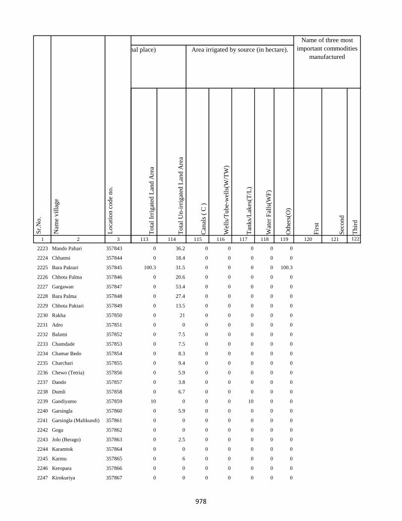
1 2 3
Lo
cati
on
co
de
no
.
Nam
e v
illa
ge
Sr.
No
.
2223 Mando Pahari 357843
2224 Chhatmi 357844
2225 Bara Paktari 357845
2226 Chhota Palma 357846
2227 Gargawan 357847
2228 Bara Palma 357848
2229 Chhota Paktari 357849
2230 Rakha 357850
2231 Adro 357851
2232 Balami 357852
2233 Chamdade 357853
2234 Chamar Bedo 357854
2235 Charchari 357855
2236 Chewo (Tetria) 357856
2237 Dando 357857
2238 Dumli 357858
2239 Gandiyamo 357859
2240 Garsingla 357860
2241 Garsingla (Malikundi) 357861
2242 Goga 357862
2243 Jolo (Berago) 357863
2244 Karamtok 357864
2245 Karmu 357865
2246 Keropara 357866
2247 Kirokuriya 357867
To
tal
Irri
gat
ed L
and
Are
a
To
tal
Un
-irr
igat
ed L
and
Are
a
Can
als
( C
)
Wel
ls/T
ub
e-w
ells
(W/T
W)
Tan
ks/
Lak
es(T
/L)
Wat
er F
alls
(WF
)
Oth
ers(
O)
Fir
st
Sec
on
d
Th
ird
113 114 115 116 117 118 119 120 121 122
Area under different types of land use ( in hectares rounded up to one decimal place) Area irrigated by source (in hectare).
Name of three most
important commodities
manufactured
Land Use
0 36.2 0 0 0 0 0
0 18.4 0 0 0 0 0
100.3 31.5 0 0 0 0 100.3
0 20.6 0 0 0 0 0
0 53.4 0 0 0 0 0
0 27.4 0 0 0 0 0
0 13.5 0 0 0 0 0
0 21 0 0 0 0 0
0 0 0 0 0 0 0
0 7.5 0 0 0 0 0
0 7.5 0 0 0 0 0
0 8.3 0 0 0 0 0
0 9.4 0 0 0 0 0
0 5.9 0 0 0 0 0
0 3.8 0 0 0 0 0
0 6.7 0 0 0 0 0
10 0 0 0 10 0 0
0 5.9 0 0 0 0 0
0 0 0 0 0 0 0
0 0 0 0 0 0 0
0 2.5 0 0 0 0 0
0 0 0 0 0 0 0
0 6 0 0 0 0 0
0 0 0 0 0 0 0
0 0 0 0 0 0 0
978

1 2 3
Lo
cati
on
co
de
no
.
Nam
e v
illa
ge
Sr.
No
.
2248 Kasari(Gutipara) 357868
2249 Kote 357869
2250 Maspara 357870
2251 Nadgoda 357871
2252 Pertara 357872
2253 Sabekundi 357873
2254 Salgama 357874
2255 Sarmi 357875
2256 Sidler 357876
2257 Singni 357877
2258 Tarobar 357878
2259 Tasgemthu 357879
2260 Talakpara(Pusurkuriya) 357880
2261 Talbita(Mudgi) 357881
2262 Tatgoda 357882
2263 Telo 357883
2264 Barmasia 357884
2265 Bokrabandh 357885
2266 Hardisol 357886
2267 Tilaipara 357887
2268 Barai 357888
2269 Bara Dangapara 357889
2270 Damakol 357890
2271 Karamba 357891
2272 Chhota Dangapara 357892
To
tal
Irri
gat
ed L
and
Are
a
To
tal
Un
-irr
igat
ed L
and
Are
a
Can
als
( C
)
Wel
ls/T
ub
e-w
ells
(W/T
W)
Tan
ks/
Lak
es(T
/L)
Wat
er F
alls
(WF
)
Oth
ers(
O)
Fir
st
Sec
on
d
Th
ird
113 114 115 116 117 118 119 120 121 122
Area under different types of land use ( in hectares rounded up to one decimal place) Area irrigated by source (in hectare).
Name of three most
important commodities
manufactured
Land Use
0 0 0 0 0 0 0
0 0.5 0 0 0 0 0
0 13.2 0 0 0 0 0
0 2.5 0 0 0 0 0
0 4.7 0 0 0 0 0
0 0 0 0 0 0 0
0 3.1 0 0 0 0 0
0 3.8 0 0 0 0 0
0 1.6 0 0 0 0 0
7 0 0 0 7 0 0
0 0 0 0 0 0 0
0 5.9 0 0 0 0 0
0 2.8 0 0 0 0 0
0 0 0 0 0 0 0
1 2.7 0 0 0 1 0
0 7.1 0 0 0 0 0
0 18.3 0 0 0 0 0
0 42.5 0 0 0 0 0
0 13.6 0 0 0 0 0
201.5 157.5 0 201.5 0 0 0
0 14.9 0 0 0 0 0
0 72.8 0 0 0 0 0
0 0 0 0 0 0 0
0 20 0 0 0 0 0
0.2 40 0 0 0.2 0 0
979
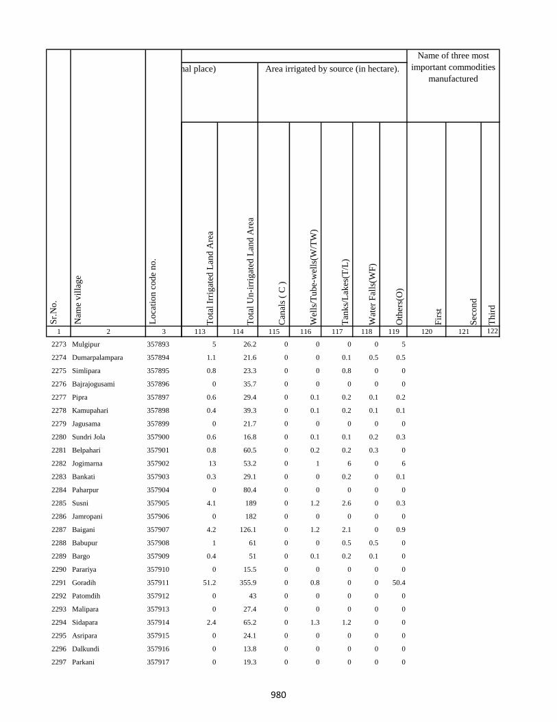
1 2 3
Lo
cati
on
co
de
no
.
Nam
e v
illa
ge
Sr.
No
.
2273 Mulgipur 357893
2274 Dumarpalampara 357894
2275 Simlipara 357895
2276 Bajrajogusami 357896
2277 Pipra 357897
2278 Kamupahari 357898
2279 Jagusama 357899
2280 Sundri Jola 357900
2281 Belpahari 357901
2282 Jogimarna 357902
2283 Bankati 357903
2284 Paharpur 357904
2285 Susni 357905
2286 Jamropani 357906
2287 Baigani 357907
2288 Babupur 357908
2289 Bargo 357909
2290 Parariya 357910
2291 Goradih 357911
2292 Patomdih 357912
2293 Malipara 357913
2294 Sidapara 357914
2295 Asripara 357915
2296 Dalkundi 357916
2297 Parkani 357917
To
tal
Irri
gat
ed L
and
Are
a
To
tal
Un
-irr
igat
ed L
and
Are
a
Can
als
( C
)
Wel
ls/T
ub
e-w
ells
(W/T
W)
Tan
ks/
Lak
es(T
/L)
Wat
er F
alls
(WF
)
Oth
ers(
O)
Fir
st
Sec
on
d
Th
ird
113 114 115 116 117 118 119 120 121 122
Area under different types of land use ( in hectares rounded up to one decimal place) Area irrigated by source (in hectare).
Name of three most
important commodities
manufactured
Land Use
5 26.2 0 0 0 0 5
1.1 21.6 0 0 0.1 0.5 0.5
0.8 23.3 0 0 0.8 0 0
0 35.7 0 0 0 0 0
0.6 29.4 0 0.1 0.2 0.1 0.2
0.4 39.3 0 0.1 0.2 0.1 0.1
0 21.7 0 0 0 0 0
0.6 16.8 0 0.1 0.1 0.2 0.3
0.8 60.5 0 0.2 0.2 0.3 0
13 53.2 0 1 6 0 6
0.3 29.1 0 0 0.2 0 0.1
0 80.4 0 0 0 0 0
4.1 189 0 1.2 2.6 0 0.3
0 182 0 0 0 0 0
4.2 126.1 0 1.2 2.1 0 0.9
1 61 0 0 0.5 0.5 0
0.4 51 0 0.1 0.2 0.1 0
0 15.5 0 0 0 0 0
51.2 355.9 0 0.8 0 0 50.4
0 43 0 0 0 0 0
0 27.4 0 0 0 0 0
2.4 65.2 0 1.3 1.2 0 0
0 24.1 0 0 0 0 0
0 13.8 0 0 0 0 0
0 19.3 0 0 0 0 0
980
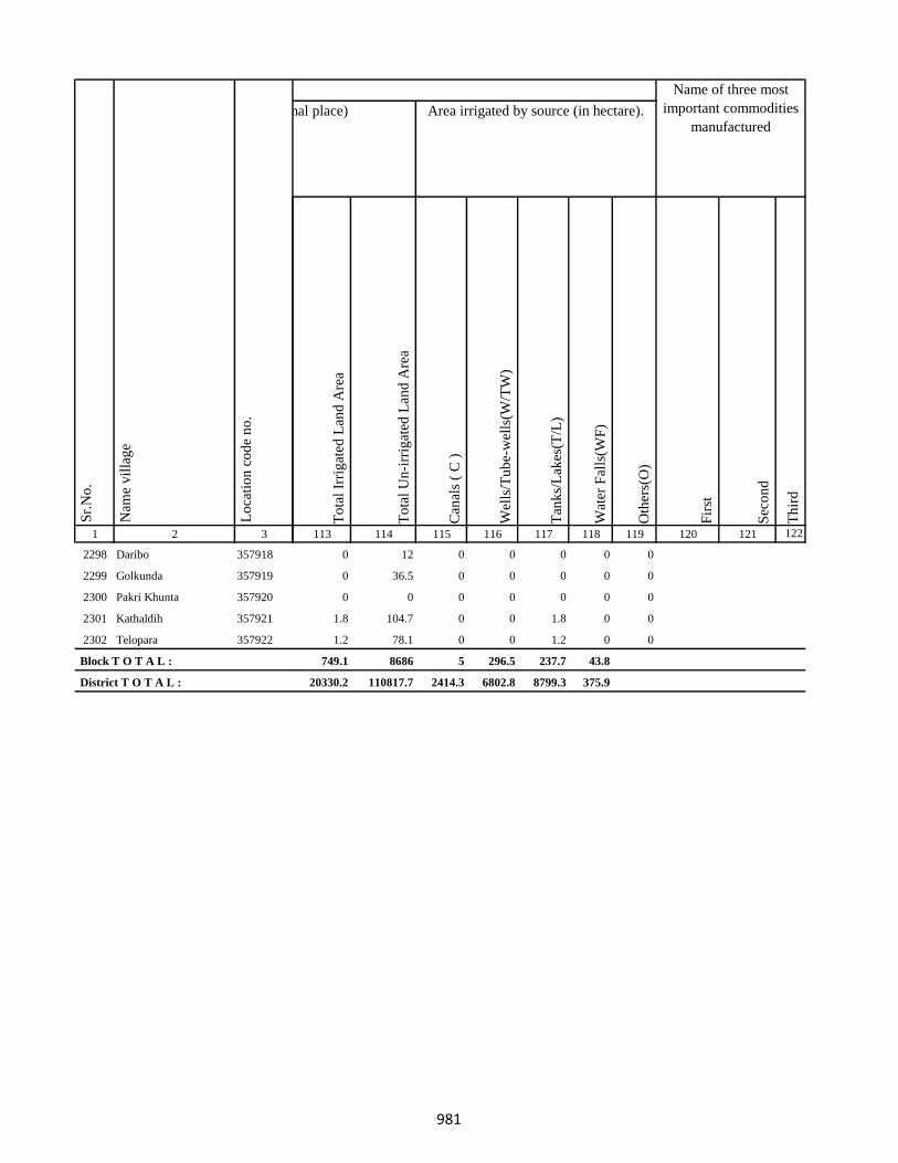
1 2 3
Lo
cati
on
co
de
no
.
Nam
e v
illa
ge
Sr.
No
.
2298 Daribo 357918
2299 Golkunda 357919
2300 Pakri Khunta 357920
2301 Kathaldih 357921
2302 Telopara 357922
Block T O T A L :
District T O T A L :
To
tal
Irri
gat
ed L
and
Are
a
To
tal
Un
-irr
igat
ed L
and
Are
a
Can
als
( C
)
Wel
ls/T
ub
e-w
ells
(W/T
W)
Tan
ks/
Lak
es(T
/L)
Wat
er F
alls
(WF
)
Oth
ers(
O)
Fir
st
Sec
on
d
Th
ird
113 114 115 116 117 118 119 120 121 122
Area under different types of land use ( in hectares rounded up to one decimal place) Area irrigated by source (in hectare).
Name of three most
important commodities
manufactured
Land Use
0 12 0 0 0 0 0
0 36.5 0 0 0 0 0
0 0 0 0 0 0 0
1.8 104.7 0 0 1.8 0 0
1.2 78.1 0 0 1.2 0 0
749.1 8686 5 296.5 237.7 43.8
20330.2 110817.7 2414.3 6802.8 8799.3 375.9
981
982
APPENDICES TO VILLAGE DIRECTORY

983
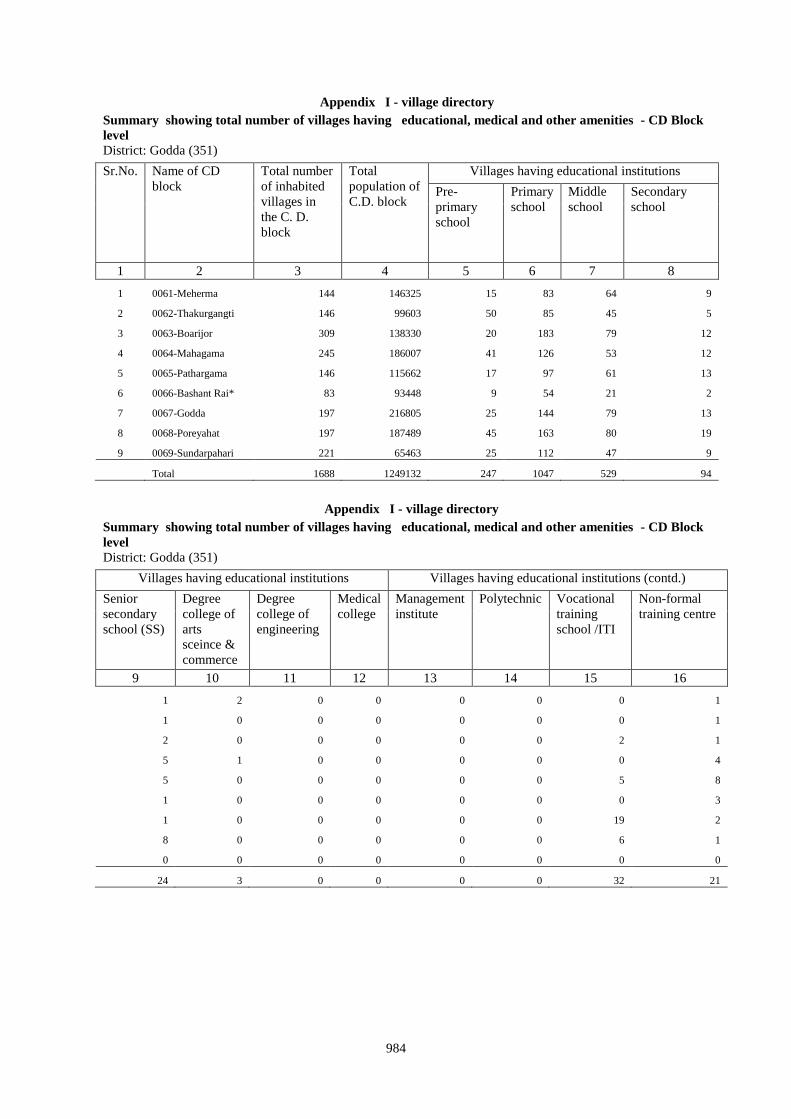
984
Appendix I - village directory
Summary showing total number of villages having educational, medical and other amenities - CD Block
level
District: Godda (351)
Sr.No. Name of CD
block
Total number
of inhabited
villages in
the C. D.
block
Total
population of
C.D. block
Villages having educational institutions
Pre-
primary
school
Primary
school
Middle
school
Secondary
school
1 2 3 4 5 6 7 8
1 0061-Meherma 144 146325 15 83 64 9
2 0062-Thakurgangti 146 99603 50 85 45 5
3 0063-Boarijor 309 138330 20 183 79 12
4 0064-Mahagama 245 186007 41 126 53 12
5 0065-Pathargama 146 115662 17 97 61 13
6 0066-Bashant Rai* 83 93448 9 54 21 2
7 0067-Godda 197 216805 25 144 79 13
8 0068-Poreyahat 197 187489 45 163 80 19
9 0069-Sundarpahari 221 65463 25 112 47 9
Total 1688 1249132 247 1047 529 94
Appendix I - village directory
Summary showing total number of villages having educational, medical and other amenities - CD Block
level
District: Godda (351)
Villages having educational institutions Villages having educational institutions (contd.)
Senior
secondary
school (SS)
Degree
college of
arts
sceince &
commerce
Degree
college of
engineering
Medical
college
Management
institute
Polytechnic Vocational
training
school /ITI
Non-formal
training centre
9 10 11 12 13 14 15 16
1 2 0 0 0 0 0 1
1 0 0 0 0 0 0 1
2 0 0 0 0 0 2 1
5 1 0 0 0 0 0 4
5 0 0 0 0 0 5 8
1 0 0 0 0 0 0 3
1 0 0 0 0 0 19 2
8 0 0 0 0 0 6 1
0 0 0 0 0 0 0 0
24 3 0 0 0 0 32 21

985
Appendix I - village directory
Summary showing total number of villages having educational, medical and other amenities - CD Block level District: Godda (351)
Villages having educational
institutions (contd.)
Villages having Medical institutions
Special
school for
disabled
Others
(specify)
No
educational
facility
Community
health
centre
Primary
health
centre
Primary
health sub
centre
Maternity and
child welfare
centre
T.B.
clinic
Hospital-
allopathic
17 18 19 20 21 22 23 24 25
0 0 59 0 4 12 6 4 7
0 0 55 0 2 5 0 0 0
0 0 125 0 8 16 10 0 3
1 1 117 0 3 13 3 0 3
8 10 47 0 4 15 3 1 2
0 0 26 1 11 21 10 5 8
0 0 51 0 6 21 0 0 2
2 0 31 0 10 17 8 3 6
0 0 106 0 1 12 0 0 2
11 11 617 1 49 132 40 13 33
Appendix I - village directory
Summary showing total number of villages having educational, medical and other amenities - CD Block level
District: Godda (351)
Villages having Medical institutions (contd.) …
Hospital-
alternative
medicine
Dispensary Veterinary
hospital
Mobile
health
clinic
Family
welfare
centre
Medical
practioner (with
MBBS Degree)
Medical
practioner (with
other degree)
Medicine
shop
26 27 28 29 30 31 32 33
5 7 3 3 4 10 17 26
0 2 0 0 0 0 0 0
1 4 0 19 1 14 16 18
1 2 0 1 0 16 20 21
0 1 1 0 1 2 4 3
4 14 6 3 9 4 4 6
0 2 0 0 4 8 8 9
5 8 2 4 4 3 1 5
3 1 0 0 1 1 1 3
19 41 12 30 24 58 71 91
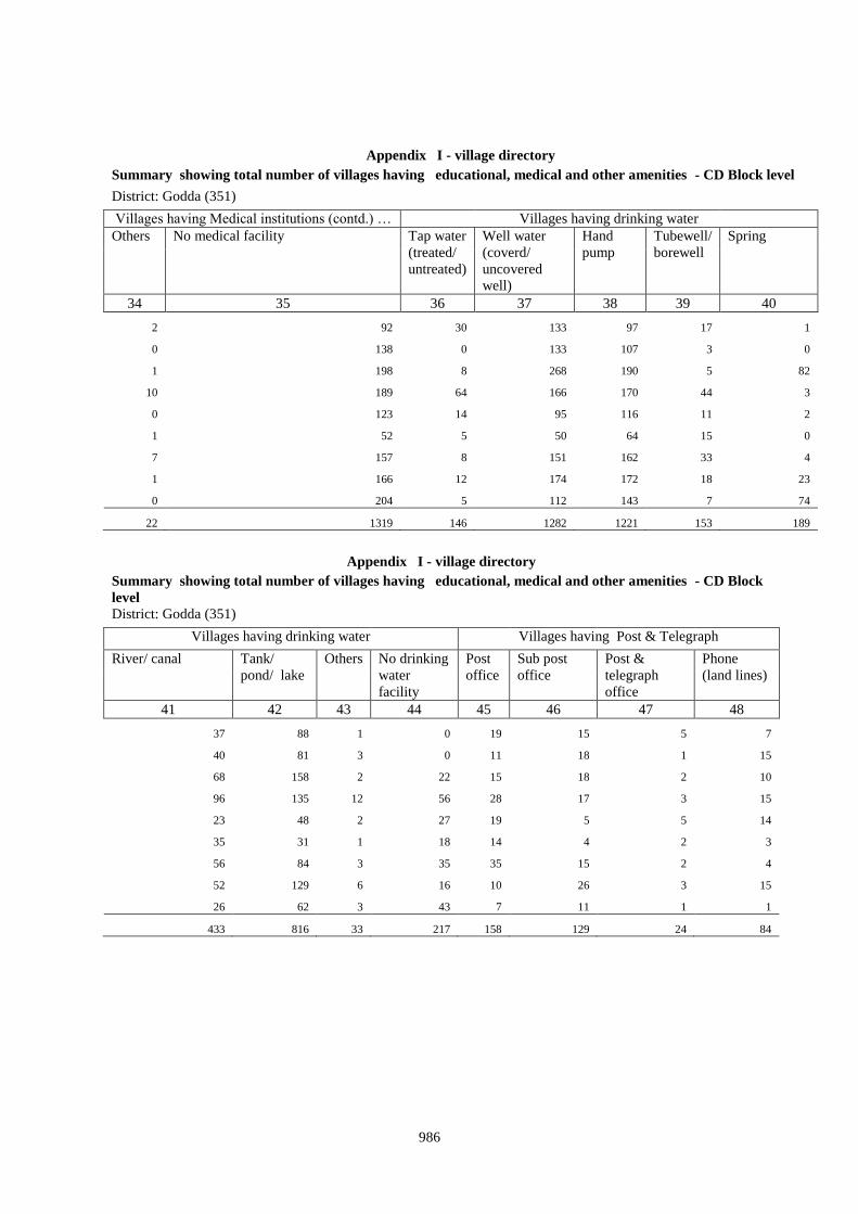
986
Appendix I - village directory
Summary showing total number of villages having educational, medical and other amenities - CD Block level
District: Godda (351)
Villages having Medical institutions (contd.) … Villages having drinking water
Others No medical facility Tap water
(treated/
untreated)
Well water
(coverd/
uncovered
well)
Hand
pump
Tubewell/
borewell
Spring
34 35 36 37 38 39 40
2 92 30 133 97 17 1
0 138 0 133 107 3 0
1 198 8 268 190 5 82
10 189 64 166 170 44 3
0 123 14 95 116 11 2
1 52 5 50 64 15 0
7 157 8 151 162 33 4
1 166 12 174 172 18 23
0 204 5 112 143 7 74
22 1319 146 1282 1221 153 189
Appendix I - village directory
Summary showing total number of villages having educational, medical and other amenities - CD Block
level
District: Godda (351)
Villages having drinking water Villages having Post & Telegraph
River/ canal Tank/
pond/ lake
Others No drinking
water
facility
Post
office
Sub post
office
Post &
telegraph
office
Phone
(land lines)
41 42 43 44 45 46 47 48
37 88 1 0 19 15 5 7
40 81 3 0 11 18 1 15
68 158 2 22 15 18 2 10
96 135 12 56 28 17 3 15
23 48 2 27 19 5 5 14
35 31 1 18 14 4 2 3
56 84 3 35 35 15 2 4
52 129 6 16 10 26 3 15
26 62 3 43 7 11 1 1
433 816 33 217 158 129 24 84
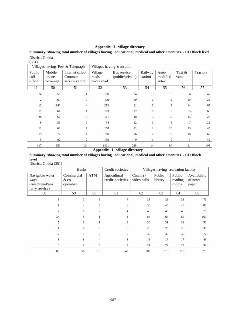
987
Appendix I - village directory
Summary showing total number of villages having educational, medical and other amenities - CD Block level
District: Godda
(351)
Villages having Post & Telegraph Villages having transport
Public
call
office
Mobile
phone
coverage
Internet cafes/
Common
service centre
Village
roads-
pucca road
Bus service
(public/private)
Railway
station
Auto/
modified
autos
Taxi &
vans
Tractors
49 50 51 52 53 54 55 56 57
14 58 4 100 24 3 6 6 47
2 67 0 109 40 0 9 10 22
13 140 4 253 31 3 8 14 65
17 64 1 173 27 0 3 5 65
28 60 8 111 18 3 10 15 23
8 33 0 58 12 1 5 7 29
11 69 1 158 21 2 20 13 45
19 77 4 180 36 2 19 18 67
5 82 2 159 9 0 0 3 42
117 650 24 1301 218 14 80 91 405
Appendix I - village directory
Summary showing total number of villages having educational, medical and other amenities - CD Block
level
District: Godda (351)
Banks Credit societies Villages having recreation facility
Navigable water
ways
(river/canal/sea
ferry service)
Commercial
& co-
operative
ATM Agricultural
credit societies
Cinema /
video halls
Public
library
Public
reading
rooms
Availability
of news
paper
58 59 60 61 62 63 64 65
5 7 5 7 35 36 36 73
1 4 0 0 36 40 40 85
7 8 2 4 48 46 46 79
34 6 1 1 66 65 65 100
5 6 1 6 30 31 31 50
11 6 0 3 25 26 26 39
12 9 6 16 30 35 35 72
8 8 4 3 16 17 17 43
0 2 0 2 21 22 22 32
83 56 19 42 307 318 318 573

988
Appendix I - village directory
Summary showing total number of villages having educational, medical and other amenities - CD Block
level
District: Godda (351)
Miscellaneous Villages having power supply
Public distribution
system (PDS) shop
Weekly
haat
Asembly
polling station
Birth & death
registration office
Available Not available
66 67 68 69 70 71
78 48 102 55 48 96
78 51 103 77 29 117
105 76 134 54 25 284
125 81 138 84 100 145
58 42 52 34 65 81
60 38 55 27 26 57
96 45 131 72 99 98
75 43 100 31 64 133
48 37 63 53 9 212
723 461 878 487 465 1223
Appendix IA - village directory
Villages by number of primary schools
District: Godda (351)
Sr.No. Name of C.D.Block Total number of
inhabited
villages
Number of primary schools
None One Two Three Four +
1 2 3 4 5 6 7 8
1 0061-Meherma 144 61 68 14 1 0
2 0062-Thakurgangti 146 61 82 3 0 0
3 0063-Boarijor 309 126 160 20 3 0
4 0064-Mahagama 245 119 108 17 1 0
5 0065-Pathargama 146 49 81 12 3 1
6 0066-Bashant Rai* 83 29 45 7 2 0
7 0067-Godda 197 53 77 52 11 4
8 0068-Poreyahat 197 34 131 23 8 1
9 0069-Sundarpahari 221 109 101 9 2 0
Total 1688 641 853 157 31 6
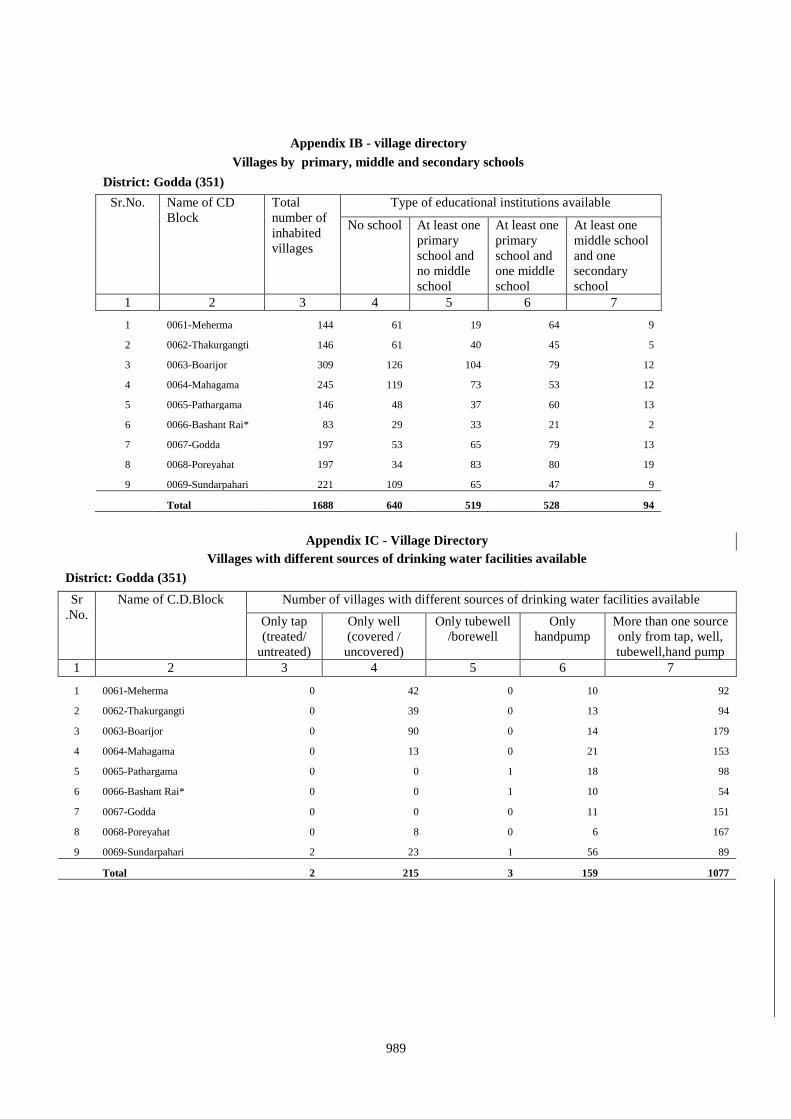
989
Appendix IB - village directory
Villages by primary, middle and secondary schools
District: Godda (351)
Sr.No. Name of CD
Block
Total
number of
inhabited
villages
Type of educational institutions available
No school At least one
primary
school and
no middle
school
At least one
primary
school and
one middle
school
At least one
middle school
and one
secondary
school
1 2 3 4 5 6 7
1 0061-Meherma 144 61 19 64 9
2 0062-Thakurgangti 146 61 40 45 5
3 0063-Boarijor 309 126 104 79 12
4 0064-Mahagama 245 119 73 53 12
5 0065-Pathargama 146 48 37 60 13
6 0066-Bashant Rai* 83 29 33 21 2
7 0067-Godda 197 53 65 79 13
8 0068-Poreyahat 197 34 83 80 19
9 0069-Sundarpahari 221 109 65 47 9
Total 1688 640 519 528 94
Appendix IC - Village Directory
Villages with different sources of drinking water facilities available
District: Godda (351)
Sr
.No.
Name of C.D.Block Number of villages with different sources of drinking water facilities available
Only tap
(treated/
untreated)
Only well
(covered /
uncovered)
Only tubewell
/borewell
Only
handpump
More than one source
only from tap, well,
tubewell,hand pump
1 2 3 4 5 6 7
1 0061-Meherma 0 42 0 10 92
2 0062-Thakurgangti 0 39 0 13 94
3 0063-Boarijor 0 90 0 14 179
4 0064-Mahagama 0 13 0 21 153
5 0065-Pathargama 0 0 1 18 98
6 0066-Bashant Rai* 0 0 1 10 54
7 0067-Godda 0 0 0 11 151
8 0068-Poreyahat 0 8 0 6 167
9 0069-Sundarpahari 2 23 1 56 89
Total 2 215 3 159 1077
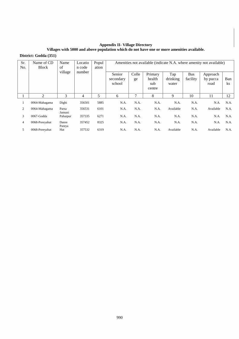
990
Appendix II- Village Directory
Villages with 5000 and above population which do not have one or more amenities available.
District: Godda (351)
Sr.
No.
Name of CD
Block
Name
of
village
Locatio
n code
number
Popul
ation
Amenities not available (indicate N.A. where amenity not available)
Senior
secondary
school
Colle
ge
Primary
health
sub
centre
Tap
drinking
water
Bus
facility
Approach
by pucca
road
Ban
ks
1 2 3 4 5 6 7 8 9 10 11 12
1 0064-Mahagama Dighi 356501 5885 N.A. N.A. N.A. N.A. N.A. N.A. N.A.
2 0064-Mahagama Parsa 356531 6101 N.A. N.A. N.A. Available N.A. Available N.A.
3 0067-Godda
Jamuni
Paharpur 357335 6271 N.A. N.A. N.A. N.A. N.A. N.A. N.A.
4 0068-Poreyahat Danre 357452 8325 N.A. N.A. N.A. N.A. N.A. N.A. N.A.
5 0068-Poreyahat Pareya Hat 357532 6319 N.A. N.A. N.A. Available N.A. Available N.A.
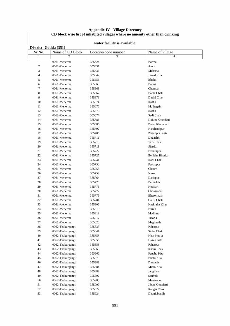
991
Appendix IV - Village Directory
CD block wise list of inhabited villages where no amenity other than drinking
water facility is available.
District: Godda (351)
Sr.No. Name of CD Block Location code number Name of village 1 2 3 4
1 0061-Meherma 355624 Barma
2 0061-Meherma 355631 Amor
3 0061-Meherma 355636 Mehrma
4 0061-Meherma 355642 Jitmal Kita
5 0061-Meherma 355658 Bhalui
6 0061-Meherma 355660 Barari
7 0061-Meherma 355663 Champa
8 0061-Meherma 355667 Badla Chak
9 0061-Meherma 355671 Dudhi Chak
10 0061-Meherma 355674 Kasba
11 0061-Meherma 355675 Majhagain
12 0061-Meherma 355676 Kasba
13 0061-Meherma 355677 Sadi Chak
14 0061-Meherma 355681 Dulum Khutahari
15 0061-Meherma 355686 Bagat Khutahari
16 0061-Meherma 355692 Harchandpur
17 0061-Meherma 355705 Partappur Jagir
18 0061-Meherma 355711 Dogachhi
19 0061-Meherma 355713 Tazi Chak
20 0061-Meherma 355718 Siardih
21 0061-Meherma 355722 Bishunpur
22 0061-Meherma 355727 Benidas Bhuska
23 0061-Meherma 355741 Kabi Chak
24 0061-Meherma 355750 Partabpur
25 0061-Meherma 355755 Chaura
26 0061-Meherma 355759 Nima
27 0061-Meherma 355764 Dariapur
28 0061-Meherma 355770 Belbadda
29 0061-Meherma 355771 Kotibari
30 0061-Meherma 355772 Chhagraha
31 0061-Meherma 355779 Bheronagar
32 0061-Meherma 355784 Gausi Chak
33 0061-Meherma 355802 Kurkraha Khas
34 0061-Meherma 355810 Birnia
35 0061-Meherma 355813 Madhura
36 0061-Meherma 355817 Tetaria
37 0061-Meherma 355823 Meghnath
38 0062-Thakurgangti 355833 Paharpur
39 0062-Thakurgangti 355841 Sinha Chak
40 0062-Thakurgangti 355853 Khar Kudia
41 0062-Thakurgangti 355855 Hasu Chak
42 0062-Thakurgangti 355858 Paharpur
43 0062-Thakurgangti 355863 Khani Chak
44 0062-Thakurgangti 355866 Panchu Kita
45 0062-Thakurgangti 355870 Bhatu Kita
46 0062-Thakurgangti 355881 Dumaria
47 0062-Thakurgangti 355884 Mitan Kita
48 0062-Thakurgangti 355889 Janghira
49 0062-Thakurgangti 355892 Sanhuli
50 0062-Thakurgangti 355905 Manikapur
51 0062-Thakurgangti 355907 Jiban Khutahari
52 0062-Thakurgangti 355922 Rangai Chak
53 0062-Thakurgangti 355924 Dhaniabandh
992
54 0062-Thakurgangti 355928 Pitambar Kita
55 0062-Thakurgangti 355932 Kolbadda
56 0062-Thakurgangti 355934 Hijri
57 0062-Thakurgangti 355937 Mohani Kita
58 0062-Thakurgangti 355941 Sujan Kita
59 0062-Thakurgangti 355943 Pathak Chak
60 0062-Thakurgangti 355947 Pairanrai Kita
61 0062-Thakurgangti 355948 Milik Bihari
62 0062-Thakurgangti 355951 Mahuara
63 0062-Thakurgangti 355959 Harinkol
64 0062-Thakurgangti 355961 Kurma
65 0062-Thakurgangti 355975 Chand Chak
66 0062-Thakurgangti 355982 Bariasirsa
67 0062-Thakurgangti 355987 Misirgangti
68 0062-Thakurgangti 355990 Chamuakol
69 0062-Thakurgangti 355992 Bhatkhoria
70 0062-Thakurgangti 356012 Haripur Baharmal
71 0062-Thakurgangti 356014 Chamru Kaprigangti
72 0062-Thakurgangti 356021 Bharsing Parbara
73 0063-Boarijor 356054 Goradih
74 0063-Boarijor 356091 Marcha
75 0063-Boarijor 356117 Kutni
76 0063-Boarijor 356121 Anamu
77 0063-Boarijor 356125 Bargi
78 0063-Boarijor 356130 Dobri
79 0063-Boarijor 356134 Gandiyamo
80 0063-Boarijor 356140 Kasamu
81 0063-Boarijor 356145 Mahwari Bedo
82 0063-Boarijor 356147 Maligoda
83 0063-Boarijor 356152 Orbot
84 0063-Boarijor 356154 Sundariya
85 0063-Boarijor 356177 Chandna
86 0063-Boarijor 356187 Tamlia Amdanda
87 0063-Boarijor 356193 Dhanigora
88 0063-Boarijor 356206 Daria Pahar
89 0063-Boarijor 356210 Chhota Patma
90 0063-Boarijor 356214 Tetarganji Pahar
91 0063-Boarijor 356220 Katalpahari
92 0063-Boarijor 356222 Telaibera
93 0063-Boarijor 356229 Juniya Tola
94 0063-Boarijor 356232 Borbe
95 0063-Boarijor 356236 Donigoda Bedo
96 0063-Boarijor 356245 Jonia
97 0063-Boarijor 356250 Kilo Bedo
98 0063-Boarijor 356409 Bamangawan
99 0063-Boarijor 356411 Bararo
100 0063-Boarijor 356443 Satbera
101 0064-Mahagama 356486 Sarautia
102 0064-Mahagama 356489 Chauchak
103 0064-Mahagama 356490 Saha Chak
104 0064-Mahagama 356492 Singpur
105 0064-Mahagama 356496 Samu Kita
106 0064-Mahagama 356501 Dighi
107 0064-Mahagama 356541 Gurhi
108 0064-Mahagama 356556 Gauri Kita
109 0064-Mahagama 356558 Belti Kari
110 0064-Mahagama 356672 Anjna
111 0064-Mahagama 356676 Kusmara
112 0064-Mahagama 356684 Mariha
113 0065-Pathargama 357034 Ranipur Dumariya
993
114 0066-Bashant Rai* 357111 Derma
115 0067-Godda 357187 Gangta
116 0069-Sundarpahari 357692 Kerkuriya
117 0069-Sundarpahari 357782 Donigoda
118 0069-Sundarpahari 357783 Jari Mamqo
119 0069-Sundarpahari 357784 Kadu
120 0069-Sundarpahari 357788 Kubji Bedo
121 0069-Sundarpahari 357912 Patomdih
122 0069-Sundarpahari 357915 Asripara
123 0069-Sundarpahari 357916 Dalkundi
Appendix V- Village Directory
Summary showing number of villages not having scheduled castes population
District: Godda(20351)
Sr.No. Name of C.D.
Block
Total
villages
Uninhabited
villages
Inhabited
villages
Number of inhabited
villages having no
scheduled castes
population
1 2 3 4 5 6
1 0061-Meherma 213 69 144 45
2 0062-Thakurgangti 203 57 146 77
3 0063-Boarijor 442 133 309 226
4 0064-Mahagama 363 118 245 116
5 0065-Pathargama 198 52 146 54
6 0066-Bashant Rai* 117 34 83 20
7 0067-Godda 255 58 197 54
8 0068-Poreyahat 213 16 197 109
9 0069-Sundarpahari 298 77 221 179
Total 2302 614 1688 880
Appendix VI - Village Directory
Summary showing number of villages not having scheduled tribes population
District: Godda(20351)
Sr.No. Name of C.D.
Block
Total
villages
Uninhabited
villages
Inhabited
villages
Number of inhabited
villages having no
scheduled tribes population
1 2 3 4 5 6
1 0061-Meherma 213 69 144 76
2 0062-Thakurgangti 203 57 146 73
3 0063-Boarijor 442 133 309 17
4 0064-Mahagama 363 118 245 159
5 0065-Pathargama 198 52 146 63
6 0066-Bashant Rai* 117 34 83 58
7 0067-Godda 255 58 197 107
8 0068-Poreyahat 213 16 197 51
9 0069-Sundarpahari 298 77 221 1
Total 2302 614 1688 605
994
Appendix VII - Village Directory
List of villages according to the proportion of the scheduled castes and the scheduled tribes to the total
population by ranges.
District: Godda(20351)
Block: Meherma(0061)
A - Scheduled Castes
Range of scheduled castes
population (Percentages)
Location code number Name of village
1 2 3
Nil 355624 Barma
Nil 355635 Teliadih
Nil 355642 Jitmal Kita
Nil 355666 Ghuram Chak
Nil 355675 Majhagain
Nil 355676 Kasba
Nil 355683 Dukhari Kita
Nil 355692 Harchandpur
Nil 355699 Kita Kalamdanr
Nil 355700 Amdanr Asli
Nil 355704 Partappur Mal
Nil 355709 Sirampur
Nil 355720 Gauri Chak
Nil 355721 Tularam Bhuska
Nil 355722 Bishunpur
Nil 355734 Dwarka Kita
Nil 355735 Karar Chakla
Nil 355744 Chhant Daria Chak
Nil 355745 Daria Chak
Nil 355746 Ghori Chak
Nil 355747 Kasmir Chak
Nil 355748 Loknath Kita
Nil 355751 Gausipartabpur
Nil 355752 Kamargawan
Nil 355754 Udhua Chak
Nil 355758 Majhgain
Nil 355760 Udaipur Bahera
Nil 355761 Chitarsen Bahira
Nil 355767 Suphal Kita
Nil 355771 Kotibari
Nil 355774 Benia Kita
Nil 355776 Chhagraha
Nil 355777 Kukra Milik
Nil 355778 Kurkra Milik
Nil 355790 Saharpur
Nil 355791 Lilatori
995
Nil 355792 Birahim Chak
Nil 355799 Bhirnabhaironagar
Nil 355800 Amarsing Kita
Nil 355809 Amdiha
Nil 355814 Kalianpur
Nil 355816 Dalahi
Nil 355823 Meghnath
Nil 355825 Leoabhujani
Nil 355826 Gobardhanpur
Less than 5 355623 Kolbadda
Less than 5 355654 Sukhari
Less than 5 355655 Fazilkhutahar
Less than 5 355663 Champa
Less than 5 355670 Domanchak
Less than 5 355689 Bagat Khutahri
Less than 5 355703 Rasti Kar
Less than 5 355713 Tazi Chak
Less than 5 355718 Siardih
Less than 5 355732 Sauri Chak
Less than 5 355737 Haripur
Less than 5 355740 Bhim Chak
Less than 5 355772 Chhagraha
Less than 5 355801 Baski Kita
Less than 5 355815 Sonaguji
Less than 5 355820 Marpa
Less than 5 355827 Balia
Less than 5 355831 Madhupur
5 - 10 355620 Bajitpur
5 - 10 355622 Singhari
5 - 10 355636 Mehrma
5 - 10 355641 Sankarpur
5 - 10 355648 Pati Chak
5 - 10 355656 Sobhapur
5 - 10 355671 Dudhi Chak
5 - 10 355684 Chhota And Bara Mangarh
5 - 10 355694 Nawadih Tola
5 - 10 355727 Benidas Bhuska
5 - 10 355733 Dasu Chakla
5 - 10 355741 Kabi Chak
5 - 10 355755 Chaura
5 - 10 355769 Dhankuria
5 - 10 355779 Bheronagar
5 - 10 355786 Singarpur
5 - 10 355789 Birnagar
5 - 10 355806 Parbal Kita
5 - 10 355822 Kamal Chak
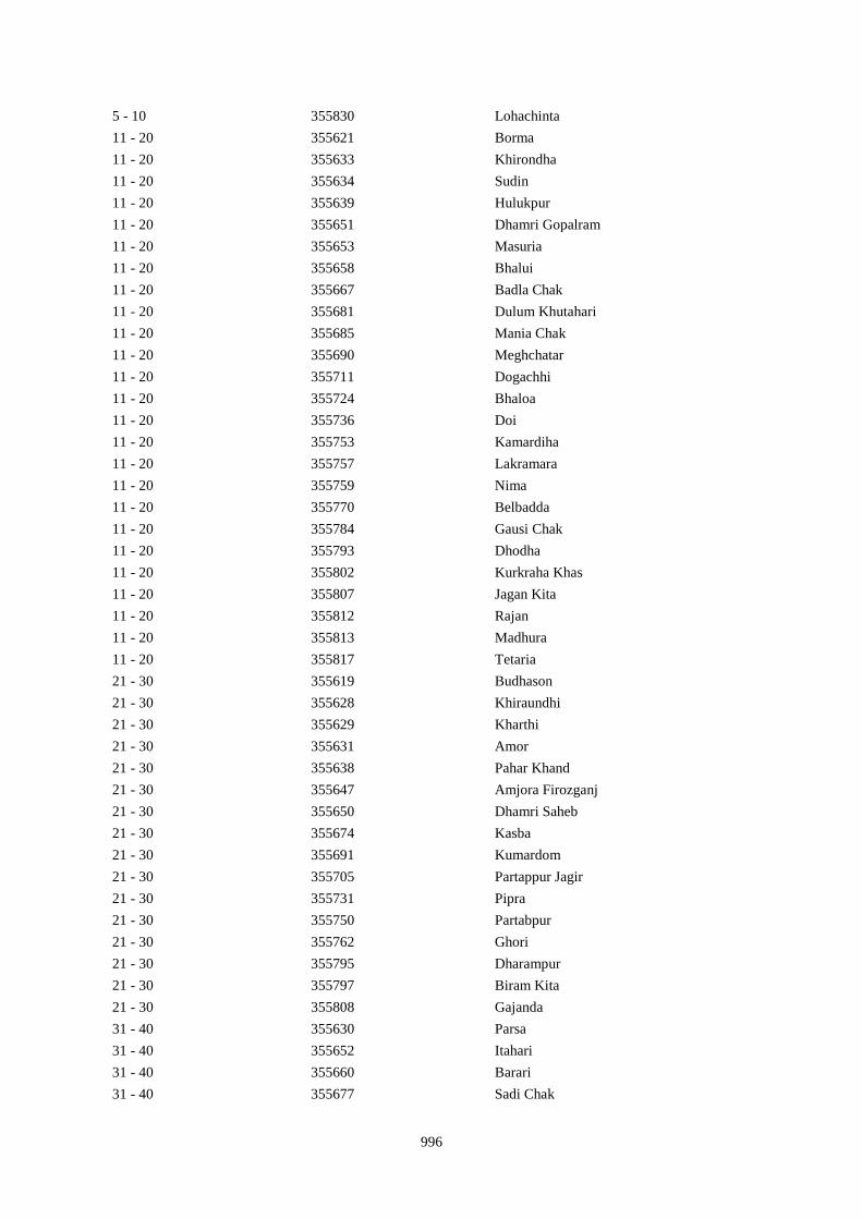
996
5 - 10 355830 Lohachinta
11 - 20 355621 Borma
11 - 20 355633 Khirondha
11 - 20 355634 Sudin
11 - 20 355639 Hulukpur
11 - 20 355651 Dhamri Gopalram
11 - 20 355653 Masuria
11 - 20 355658 Bhalui
11 - 20 355667 Badla Chak
11 - 20 355681 Dulum Khutahari
11 - 20 355685 Mania Chak
11 - 20 355690 Meghchatar
11 - 20 355711 Dogachhi
11 - 20 355724 Bhaloa
11 - 20 355736 Doi
11 - 20 355753 Kamardiha
11 - 20 355757 Lakramara
11 - 20 355759 Nima
11 - 20 355770 Belbadda
11 - 20 355784 Gausi Chak
11 - 20 355793 Dhodha
11 - 20 355802 Kurkraha Khas
11 - 20 355807 Jagan Kita
11 - 20 355812 Rajan
11 - 20 355813 Madhura
11 - 20 355817 Tetaria
21 - 30 355619 Budhason
21 - 30 355628 Khiraundhi
21 - 30 355629 Kharthi
21 - 30 355631 Amor
21 - 30 355638 Pahar Khand
21 - 30 355647 Amjora Firozganj
21 - 30 355650 Dhamri Saheb
21 - 30 355674 Kasba
21 - 30 355691 Kumardom
21 - 30 355705 Partappur Jagir
21 - 30 355731 Pipra
21 - 30 355750 Partabpur
21 - 30 355762 Ghori
21 - 30 355795 Dharampur
21 - 30 355797 Biram Kita
21 - 30 355808 Gajanda
31 - 40 355630 Parsa
31 - 40 355652 Itahari
31 - 40 355660 Barari
31 - 40 355677 Sadi Chak
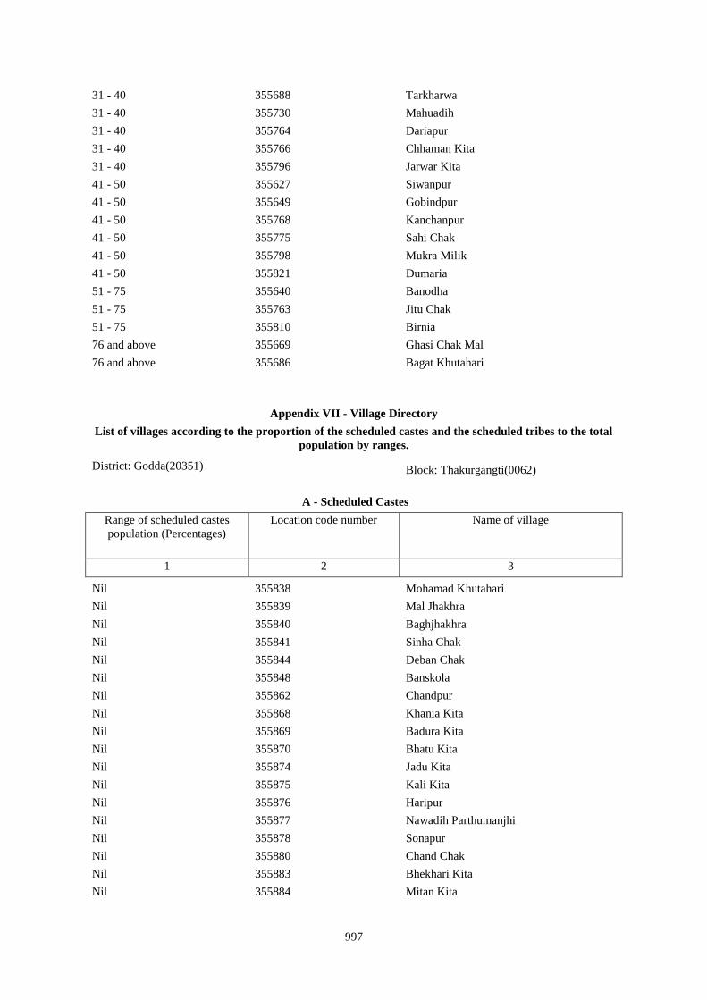
997
31 - 40 355688 Tarkharwa
31 - 40 355730 Mahuadih
31 - 40 355764 Dariapur
31 - 40 355766 Chhaman Kita
31 - 40 355796 Jarwar Kita
41 - 50 355627 Siwanpur
41 - 50 355649 Gobindpur
41 - 50 355768 Kanchanpur
41 - 50 355775 Sahi Chak
41 - 50 355798 Mukra Milik
41 - 50 355821 Dumaria
51 - 75 355640 Banodha
51 - 75 355763 Jitu Chak
51 - 75 355810 Birnia
76 and above 355669 Ghasi Chak Mal
76 and above 355686 Bagat Khutahari
Appendix VII - Village Directory
List of villages according to the proportion of the scheduled castes and the scheduled tribes to the total
population by ranges.
District: Godda(20351) Block: Thakurgangti(0062)
A - Scheduled Castes
Range of scheduled castes
population (Percentages)
Location code number Name of village
1 2 3
Nil 355838 Mohamad Khutahari
Nil 355839 Mal Jhakhra
Nil 355840 Baghjhakhra
Nil 355841 Sinha Chak
Nil 355844 Deban Chak
Nil 355848 Banskola
Nil 355862 Chandpur
Nil 355868 Khania Kita
Nil 355869 Badura Kita
Nil 355870 Bhatu Kita
Nil 355874 Jadu Kita
Nil 355875 Kali Kita
Nil 355876 Haripur
Nil 355877 Nawadih Parthumanjhi
Nil 355878 Sonapur
Nil 355880 Chand Chak
Nil 355883 Bhekhari Kita
Nil 355884 Mitan Kita
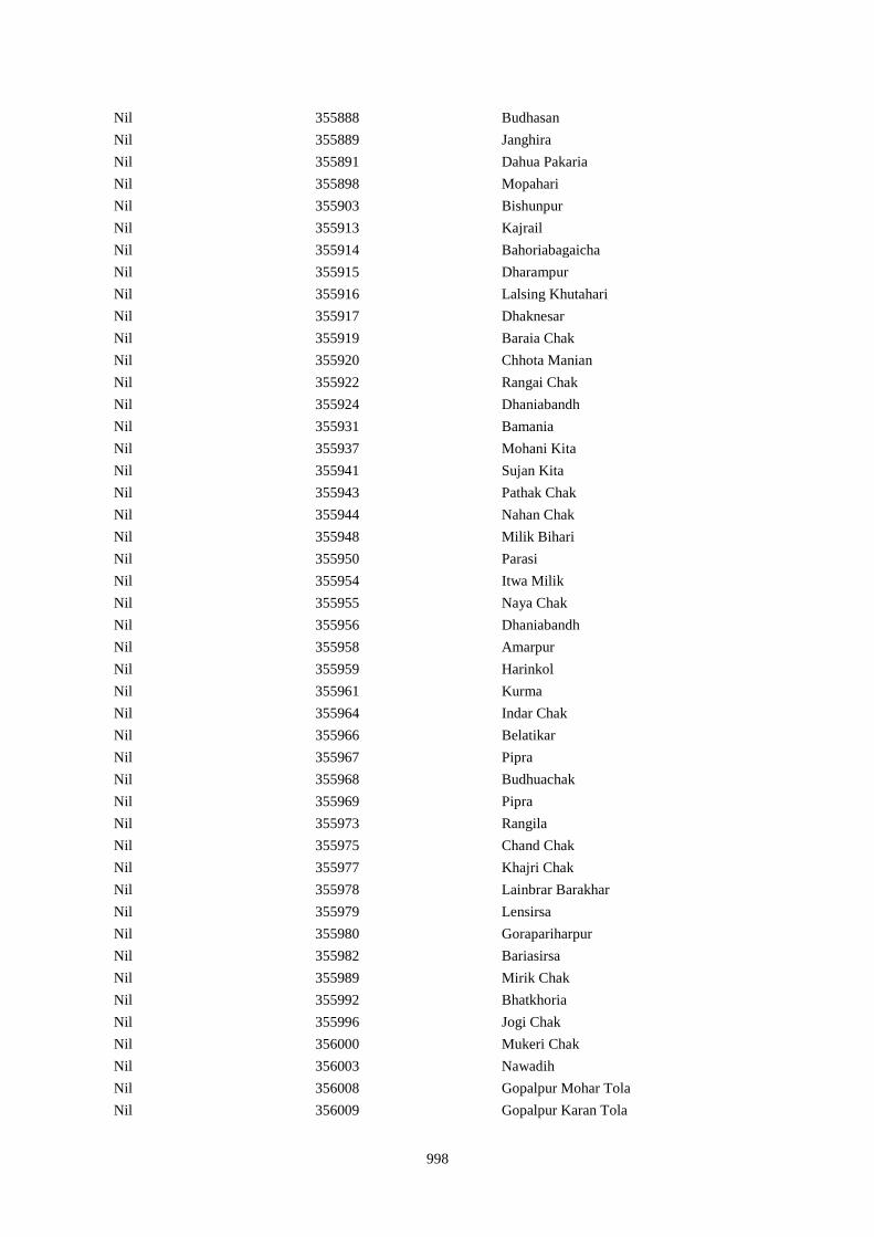
998
Nil 355888 Budhasan
Nil 355889 Janghira
Nil 355891 Dahua Pakaria
Nil 355898 Mopahari
Nil 355903 Bishunpur
Nil 355913 Kajrail
Nil 355914 Bahoriabagaicha
Nil 355915 Dharampur
Nil 355916 Lalsing Khutahari
Nil 355917 Dhaknesar
Nil 355919 Baraia Chak
Nil 355920 Chhota Manian
Nil 355922 Rangai Chak
Nil 355924 Dhaniabandh
Nil 355931 Bamania
Nil 355937 Mohani Kita
Nil 355941 Sujan Kita
Nil 355943 Pathak Chak
Nil 355944 Nahan Chak
Nil 355948 Milik Bihari
Nil 355950 Parasi
Nil 355954 Itwa Milik
Nil 355955 Naya Chak
Nil 355956 Dhaniabandh
Nil 355958 Amarpur
Nil 355959 Harinkol
Nil 355961 Kurma
Nil 355964 Indar Chak
Nil 355966 Belatikar
Nil 355967 Pipra
Nil 355968 Budhuachak
Nil 355969 Pipra
Nil 355973 Rangila
Nil 355975 Chand Chak
Nil 355977 Khajri Chak
Nil 355978 Lainbrar Barakhar
Nil 355979 Lensirsa
Nil 355980 Gorapariharpur
Nil 355982 Bariasirsa
Nil 355989 Mirik Chak
Nil 355992 Bhatkhoria
Nil 355996 Jogi Chak
Nil 356000 Mukeri Chak
Nil 356003 Nawadih
Nil 356008 Gopalpur Mohar Tola
Nil 356009 Gopalpur Karan Tola
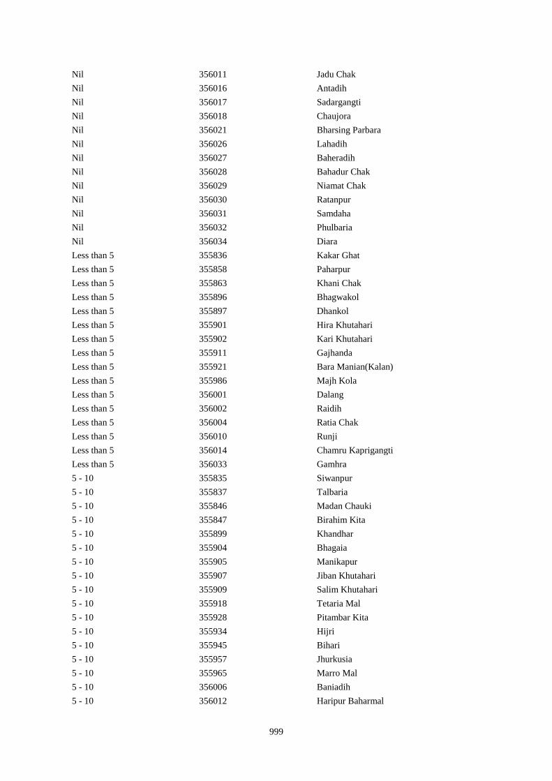
999
Nil 356011 Jadu Chak
Nil 356016 Antadih
Nil 356017 Sadargangti
Nil 356018 Chaujora
Nil 356021 Bharsing Parbara
Nil 356026 Lahadih
Nil 356027 Baheradih
Nil 356028 Bahadur Chak
Nil 356029 Niamat Chak
Nil 356030 Ratanpur
Nil 356031 Samdaha
Nil 356032 Phulbaria
Nil 356034 Diara
Less than 5 355836 Kakar Ghat
Less than 5 355858 Paharpur
Less than 5 355863 Khani Chak
Less than 5 355896 Bhagwakol
Less than 5 355897 Dhankol
Less than 5 355901 Hira Khutahari
Less than 5 355902 Kari Khutahari
Less than 5 355911 Gajhanda
Less than 5 355921 Bara Manian(Kalan)
Less than 5 355986 Majh Kola
Less than 5 356001 Dalang
Less than 5 356002 Raidih
Less than 5 356004 Ratia Chak
Less than 5 356010 Runji
Less than 5 356014 Chamru Kaprigangti
Less than 5 356033 Gamhra
5 - 10 355835 Siwanpur
5 - 10 355837 Talbaria
5 - 10 355846 Madan Chauki
5 - 10 355847 Birahim Kita
5 - 10 355899 Khandhar
5 - 10 355904 Bhagaia
5 - 10 355905 Manikapur
5 - 10 355907 Jiban Khutahari
5 - 10 355909 Salim Khutahari
5 - 10 355918 Tetaria Mal
5 - 10 355928 Pitambar Kita
5 - 10 355934 Hijri
5 - 10 355945 Bihari
5 - 10 355957 Jhurkusia
5 - 10 355965 Marro Mal
5 - 10 356006 Baniadih
5 - 10 356012 Haripur Baharmal
1000
11 - 20 355845 Gargulal
11 - 20 355849 Kurpatti
11 - 20 355851 Chapri
11 - 20 355853 Khar Kudia
11 - 20 355855 Hasu Chak
11 - 20 355857 Silong
11 - 20 355865 Taj Kita
11 - 20 355900 Bodhrai Khutahari
11 - 20 355912 Karmail
11 - 20 355932 Kolbadda
11 - 20 355936 Chanda And Chando
11 - 20 355951 Mahuara
11 - 20 355971 Mardiha
11 - 20 355972 Baghakol
11 - 20 355981 Basta
11 - 20 355999 Asakhapar
21 - 30 355832 Dighi
21 - 30 355866 Panchu Kita
21 - 30 355881 Dumaria
21 - 30 355892 Sanhuli
21 - 30 355947 Pairanrai Kita
21 - 30 355987 Misirgangti
21 - 30 355998 Kadma
31 - 40 355833 Paharpur
31 - 40 355990 Chamuakol
31 - 40 356005 Pachradih
41 - 50 355852 Kamat Chapri
41 - 50 355861 Paharpur
41 - 50 356019 Dharni Chak
51 - 75 355850 Baijani
51 - 75 355887 Baiju Kita
51 - 75 355970 Purnia
51 - 75 355997 Bhiganda
51 - 75 356007 Dhawa
76 and above 355974 Bhuska
76 and above 356020 Garibparbara

1001
Appendix VII - Village Directory
List of villages according to the proportion of the scheduled castes and the scheduled tribes to the total
population by ranges.
District: Godda(20351) Block: Boarijor(0063)
A - Scheduled Castes
Range of scheduled castes
population (Percentages)
Location code number Name of village
1 2 3
Nil 356035 Urkusia
Nil 356036 Garantia
Nil 356037 Lakrakol
Nil 356038 Sijuakol
Nil 356039 Bagjhopa
Nil 356042 Bahelia Chak
Nil 356045 Kendua
Nil 356046 Ramkol
Nil 356047 Raharbaria
Nil 356048 Kamaldori
Nil 356049 Janlokundi
Nil 356050 Dhamnisemia
Nil 356051 Hijri
Nil 356053 Dhamnipahar
Nil 356057 Chandsar
Nil 356061 Itahari
Nil 356063 Chhota Gogra
Nil 356064 Bara Gogra
Nil 356067 Malbhita
Nil 356068 Pairgora
Nil 356069 Kaldigra
Nil 356071 Talbaria
Nil 356072 Bara Darma
Nil 356077 Joborampur
Nil 356078 Ekdanrghat
Nil 356082 Khairbani
Nil 356085 Chhota Saraiya
Nil 356086 Manikpur
Nil 356088 Beldiha
Nil 356089 Kortia
Nil 356090 Asanbuna
Nil 356091 Marcha
Nil 356093 Churi
Nil 356094 Talbaria
Nil 356095 Bansbhita
1002
Nil 356096 Jamunajharna
Nil 356099 Dubra
Nil 356100 Mahula
Nil 356105 Lakrakol
Nil 356106 Babuchuri
Nil 356107 Parsiya
Nil 356108 Bador
Nil 356109 Muchuradaldali
Nil 356110 Daharlangi
Nil 356111 Pokhariya
Nil 356112 Barakera
Nil 356113 Chhotakera
Nil 356114 Karamtola
Nil 356115 Meredele
Nil 356116 Baragbhita
Nil 356117 Kutni
Nil 356119 Puriabadar
Nil 356120 Bartali
Nil 356121 Anamu
Nil 356125 Bargi
Nil 356130 Dobri
Nil 356133 Gadgandi
Nil 356134 Gandiyamo
Nil 356139 Karakdoni
Nil 356140 Kasamu
Nil 356145 Mahwari Bedo
Nil 356147 Maligoda
Nil 356152 Orbot
Nil 356154 Sundariya
Nil 356157 Shampur
Nil 356158 Bara Kendua
Nil 356165 Chhota Dumarhir
Nil 356167 Mungra
Nil 356172 Kusumghati
Nil 356176 Bhadria
Nil 356177 Chandna
Nil 356180 Tetariya
Nil 356183 Rajapokhar Jagir
Nil 356184 Rajapokhar
Nil 356185 Bara Chatampur
Nil 356186 Lilabhita
Nil 356187 Tamlia Amdanda
Nil 356191 Chhota Chatampur
Nil 356192 Chetmapahar
Nil 356193 Dhanigora
Nil 356197 Chalpahari
1003
Nil 356198 Madomasi
Nil 356199 Bhagamakra
Nil 356200 Champatola
Nil 356201 Pakriya Pahar
Nil 356202 Kairasol
Nil 356204 Pachro
Nil 356205 Marni Pahar
Nil 356206 Daria Pahar
Nil 356209 Bara Patma Masahara
Nil 356210 Chhota Patma
Nil 356213 Jania Pahar
Nil 356214 Tetarganji Pahar
Nil 356216 Bara Patma
Nil 356217 Katikbhita
Nil 356218 Kuspisa
Nil 356219 Dhamnijor
Nil 356220 Katalpahari
Nil 356222 Telaibera
Nil 356225 Baridih
Nil 356226 Sijua
Nil 356227 Ratanpur
Nil 356228 Rohra
Nil 356229 Juniya Tola
Nil 356232 Borbe
Nil 356235 Chengro
Nil 356236 Donigoda Bedo
Nil 356245 Jonia
Nil 356250 Kilo Bedo
Nil 356251 Kilo Maqo
Nil 356253 Kuro Maqo
Nil 356255 Kutam
Nil 356256 Letragoda
Nil 356258 Matubera
Nil 356260 Patma Joka
Nil 356262 Puro Maqo
Nil 356263 Puro Bedo
Nil 356271 Tokkuriya
Nil 356272 Saharpur
Nil 356275 Belthu
Nil 356277 Shamapokhar
Nil 356280 Tulsipur
Nil 356281 Goriya
Nil 356282 Kamardiha
Nil 356283 Gopalpur
Nil 356284 Lawabhujani
Nil 356286 Gori Chak
1004
Nil 356288 Barhara
Nil 356289 Gorakhpur
Nil 356291 Kusma
Nil 356292 Kurkutiya
Nil 356296 Shampur
Nil 356297 Beldiha
Nil 356300 Jata Kuti
Nil 356302 Kendua
Nil 356304 Paharpur
Nil 356306 Chhota Simra
Nil 356307 Ghat Simra
Nil 356308 Suarmari
Nil 356309 Ghat Nima
Nil 356310 Chitar Koti
Nil 356311 Telgama
Nil 356312 Duwarighat Telgama
Nil 356314 Hijukita
Nil 356319 Lohandiya Bazar
Nil 356321 Paharpur
Nil 356322 Bharanda
Nil 356326 Ranidih
Nil 356327 Barkandali
Nil 356328 Dhankunda
Nil 356329 Dumriya
Nil 356330 Dumarkol
Nil 356331 Babupur
Nil 356332 Bara Kotha
Nil 356333 Bara Barma Pahar
Nil 356334 Tatkunda
Nil 356335 Chhota Barma
Nil 356336 Debdanr
Nil 356341 Harkata
Nil 356343 Baisabaran
Nil 356347 Lutibahiar
Nil 356348 Lilatari
Nil 356350 Hahajor
Nil 356351 Panchrukhi
Nil 356354 Chhota Bhorai
Nil 356356 Taljhari
Nil 356357 Kesgoria
Nil 356358 Pakaria
Nil 356359 Jaggora
Nil 356360 Bador
Nil 356362 Bichduba
Nil 356363 Telodhuni
Nil 356364 Madgigora

1005
Nil 356365 Dighi
Nil 356366 Gopali
Nil 356367 Dabra
Nil 356368 Rohari Naryanpur
Nil 356369 Jolopahari
Nil 356371 Piaram
Nil 356372 Phulbaria
Nil 356373 Harra
Nil 356374 Mahuabathan
Nil 356376 Chakra
Nil 356378 Chhota Dhanbandhi
Nil 356379 Tetardiha
Nil 356381 Kajribhita
Nil 356382 Adro
Nil 356383 Chhota Amra
Nil 356386 Bhalgora
Nil 356387 Deonapur
Nil 356388 Bhagwanpur
Nil 356390 Chhota Malbhita
Nil 356391 Tikrigora
Nil 356395 Malbhita Tola
Nil 356396 Chhota Pipra
Nil 356401 Bara Pipra
Nil 356405 Kisma
Nil 356406 Bara Amarpur
Nil 356407 Chhota Amarpur
Nil 356408 Dumaria
Nil 356409 Bamangawan
Nil 356411 Bararo
Nil 356412 Chetan Pahar
Nil 356416 Moter Pahar
Nil 356420 Chhota Telo
Nil 356421 Jajotola Barhua
Nil 356422 Bara Amra
Nil 356423 Balkani
Nil 356424 Sundai
Nil 356425 Garbhu Tola
Nil 356426 Chhota Simmi
Nil 356427 Bara Simmi
Nil 356428 Bandhgora
Nil 356429 Kesarogora
Nil 356430 Chhota Chapri
Nil 356431 Dholna Pahar
Nil 356432 Telotok
Nil 356434 Keriapahar
Nil 356443 Satbera
1006
Nil 356447 Bara Chapri
Nil 356449 Chapri Bara
Nil 356458 Bara Kerlo
Nil 356465 Chhota Karlopahar
Nil 356466 Chhota Kerlo
Nil 356468 Bara Kamu
Nil 356470 Dumli
Less than 5 356040 Daldali Gopalpur
Less than 5 356044 Issar Chak
Less than 5 356054 Goradih
Less than 5 356056 Bishunpur
Less than 5 356060 Baghmara
Less than 5 356065 Chhota Darma
Less than 5 356066 Kolhua
Less than 5 356070 Khejuria
Less than 5 356073 Balajhor
Less than 5 356075 Sakrikita Rampur
Less than 5 356080 Siripur Bazar
Less than 5 356081 Bara Siripur
Less than 5 356097 Bara Boarijor
Less than 5 356098 Dhorri
Less than 5 356156 Chhota Kendua
Less than 5 356160 Dhamni
Less than 5 356163 Debipur
Less than 5 356166 Bara Dumarhir
Less than 5 356168 Liti
Less than 5 356170 Telo
Less than 5 356174 Lilatari
Less than 5 356175 Kusbila
Less than 5 356182 Rajapokhar Jagir
Less than 5 356273 Lilatari
Less than 5 356276 Hethbandha
Less than 5 356278 Chiharbona
Less than 5 356287 Karua
Less than 5 356290 Jojosimra
Less than 5 356298 Balajhor
Less than 5 356313 Nima Kalan
Less than 5 356317 Dakaita
Less than 5 356318 Lohandiya
Less than 5 356320 Basdiha
Less than 5 356323 Harrakha
Less than 5 356337 Surla
Less than 5 356338 Dumria
Less than 5 356344 Jurgura
Less than 5 356346 Kusumghati
Less than 5 356355 Bara Bhorai
1007
Less than 5 356375 Gadial
Less than 5 356385 Lohatamba And Agoia
Less than 5 356389 Bara Malbhita
5 - 10 356052 Jirli
5 - 10 356058 Karmatanr
5 - 10 356062 Chhota Itahari Pahar
5 - 10 356083 Losinghna
5 - 10 356084 Bara Saraiya
5 - 10 356087 Kandaniya
5 - 10 356101 Meghi
5 - 10 356103 Chhota Boarijor
5 - 10 356159 Uparbandha
5 - 10 356161 Narainpur
5 - 10 356164 Rajabhita
5 - 10 356169 Champapur
5 - 10 356171 Kero
5 - 10 356173 Ambadiha
5 - 10 356274 Khairbani
5 - 10 356301 Bagjori
5 - 10 356303 Tetaria
5 - 10 356315 Lalmatia
5 - 10 356339 Chhota Khadahara
5 - 10 356345 Dahua
5 - 10 356349 Haripur
5 - 10 356440 Bansdanda
11 - 20 356043 Rajbandh
11 - 20 356059 Marpa
11 - 20 356079 Chhota Siripur
11 - 20 356102 Mangra
11 - 20 356104 Mahuakol
11 - 20 356293 Dumra
11 - 20 356295 Amba
11 - 20 356305 Bara Simra
11 - 20 356316 Rangamatia
11 - 20 356377 Bara Dhanbandhi
11 - 20 356384 Tulsipur
11 - 20 356419 Bara Telo
21 - 30 356285 Babhania
21 - 30 356342 Bara Khairbani
31 - 40 356074 Bangama
31 - 40 356162 Amjhor
41 - 50 356294 Sabejora
51 - 75 356181 Rajapokhar Jagir
76 and above 356299 Ghatiari
1008
Appendix VII - Village Directory
List of villages according to the proportion of the scheduled castes and the scheduled tribes to the total
population by ranges.
District: Godda(20351) Block: Mahagama(0064)
A - Scheduled Castes
Range of scheduled castes
population (Percentages)
Location code number Name of village
1 2 3
Nil 356477 Manjura
Nil 356479 Darbe Chak
Nil 356480 Kanak Kita
Nil 356494 Garbhudih
Nil 356496 Samu Kita
Nil 356500 Bakanpur
Nil 356510 Dhobia Chak
Nil 356520 Narainpur (Dompatti)
Nil 356521 Sahi Kita
Nil 356523 Chak Chamu
Nil 356532 Bikrampur
Nil 356542 Baje Kita
Nil 356543 Baje Kita
Nil 356545 Kharaiya
Nil 356563 Shekhu Chak
Nil 356564 Bhelaidih
Nil 356565 Doma Chak
Nil 356569 Kamal Chak
Nil 356573 Karmatanr
Nil 356579 Khurd
Nil 356580 Firozpur
Nil 356582 Dharampur Mal
Nil 356583 Chaujora Mal
Nil 356585 Kamargawan
Nil 356586 Mansura
Nil 356590 Gokula
Nil 356593 Khaira
Nil 356594 Fouzdar Kita Ghat
Nil 356595 Ghatdiarhi
Nil 356598 Manoharpur
Nil 356600 Jhagarua
Nil 356605 Chainpur
Nil 356607 Ramchandarpur
Nil 356608 Ghat Jagarnathpur
Nil 356610 Jiajori

1009
Nil 356611 Rai Kita
Nil 356612 Jatakothi
Nil 356613 Bagjori
Nil 356615 Balachini
Nil 356616 Ghat Jagatpur
Nil 356619 Lakarha
Nil 356622 Kachuamal Chhit
Nil 356627 Maskand Kachua
Nil 356632 Sirsa Kalan
Nil 356635 Mahuara Ghat
Nil 356640 Maskand Bhanjpur
Nil 356646 Rahim Kita
Nil 356649 Lilambar
Nil 356651 Bishambhar Kita
Nil 356652 Kita Bishambhara
Nil 356653 Gunia
Nil 356654 Harin Chora
Nil 356660 Tewarijor
Nil 356665 Chand Chak
Nil 356666 Ghospur
Nil 356669 Bhartha Chak
Nil 356674 Sirsi
Nil 356684 Mariha
Nil 356686 Fazil Kita
Nil 356688 Bisambhara Kita
Nil 356689 Dahia
Nil 356691 Phudkipur
Nil 356696 Phasiatikar
Nil 356700 Muradpur
Nil 356706 Jathari
Nil 356710 Bakwa Chak
Nil 356713 Mal Bhandari Dih
Nil 356714 Semrakita And Ghat Bhandarid
Nil 356715 Aslulahsamra
Nil 356716 Bariartola
Nil 356718 Ranbahiar
Nil 356721 Ginratari
Nil 356723 Larai Chak
Nil 356725 Hemcha Chak
Nil 356732 Chanai Chak
Nil 356734 Samda
Nil 356735 Nimania Kita
Nil 356737 Kusha
Nil 356738 Hansai Kita
Nil 356739 Kusmi
Nil 356740 Bahalia Kita
1010
Nil 356742 Babupur Mal
Nil 356745 Babupur Ghat
Nil 356751 Gudia
Nil 356758 Jharna Kita
Nil 356759 Dhankurda
Nil 356766 Akasni
Nil 356767 Kendua Kita
Nil 356773 Balia Kurmi Kita
Nil 356774 Rabiadih (Santali)
Nil 356775 Raksa Kita
Nil 356779 Kusdiha
Nil 356780 Dumaria Mal
Nil 356782 Kadhara Ghat
Nil 356790 Kitapathar
Nil 356793 Karkatdih
Nil 356798 Chansar
Nil 356799 Nima Chak
Nil 356800 Chichohari
Nil 356801 Dudhbecha
Nil 356803 Deyal Kita
Nil 356805 Gosain Chak
Nil 356809 Mahadeb Kita
Nil 356810 Telaria
Nil 356812 Bhogan
Nil 356814 Saraiaghat
Nil 356816 Amarpur
Nil 356819 Hahajor
Nil 356820 Patharpur
Nil 356823 Sib Kita
Nil 356825 Ghat Bhangabandh
Nil 356831 Raghunath Kita
Nil 356832 Gauri Kita
Nil 356836 Baridih
Nil 356837 Gorantia
Nil 356838 Baijnathpur
Less than 5 356478 Khutahari
Less than 5 356506 Sital
Less than 5 356511 Bairia Chak
Less than 5 356517 Ramkol
Less than 5 356522 Narainpur (Sempatti)
Less than 5 356539 Sarthu
Less than 5 356546 Sahajadpur
Less than 5 356549 Khurd
Less than 5 356560 Asota
Less than 5 356561 Kasba
Less than 5 356570 Bhikhia Chak
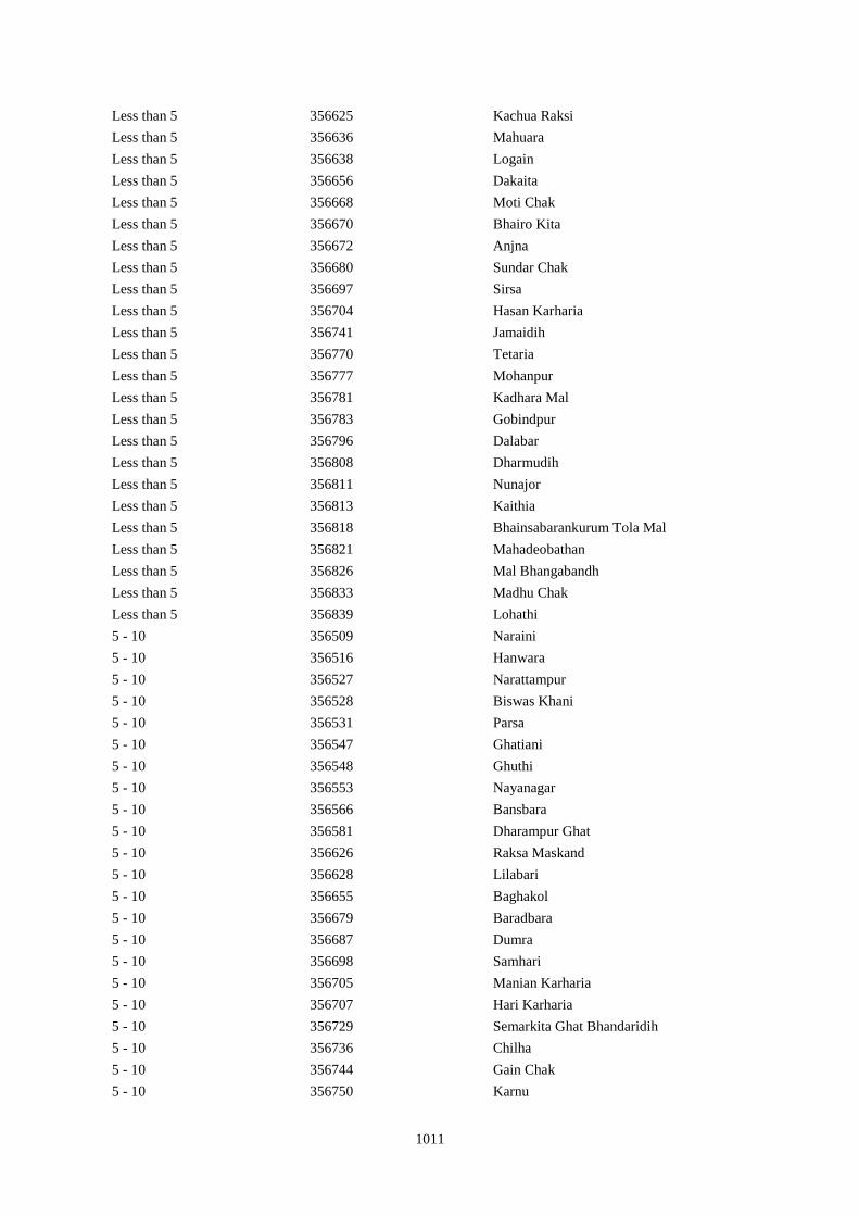
1011
Less than 5 356625 Kachua Raksi
Less than 5 356636 Mahuara
Less than 5 356638 Logain
Less than 5 356656 Dakaita
Less than 5 356668 Moti Chak
Less than 5 356670 Bhairo Kita
Less than 5 356672 Anjna
Less than 5 356680 Sundar Chak
Less than 5 356697 Sirsa
Less than 5 356704 Hasan Karharia
Less than 5 356741 Jamaidih
Less than 5 356770 Tetaria
Less than 5 356777 Mohanpur
Less than 5 356781 Kadhara Mal
Less than 5 356783 Gobindpur
Less than 5 356796 Dalabar
Less than 5 356808 Dharmudih
Less than 5 356811 Nunajor
Less than 5 356813 Kaithia
Less than 5 356818 Bhainsabarankurum Tola Mal
Less than 5 356821 Mahadeobathan
Less than 5 356826 Mal Bhangabandh
Less than 5 356833 Madhu Chak
Less than 5 356839 Lohathi
5 - 10 356509 Naraini
5 - 10 356516 Hanwara
5 - 10 356527 Narattampur
5 - 10 356528 Biswas Khani
5 - 10 356531 Parsa
5 - 10 356547 Ghatiani
5 - 10 356548 Ghuthi
5 - 10 356553 Nayanagar
5 - 10 356566 Bansbara
5 - 10 356581 Dharampur Ghat
5 - 10 356626 Raksa Maskand
5 - 10 356628 Lilabari
5 - 10 356655 Baghakol
5 - 10 356679 Baradbara
5 - 10 356687 Dumra
5 - 10 356698 Samhari
5 - 10 356705 Manian Karharia
5 - 10 356707 Hari Karharia
5 - 10 356729 Semarkita Ghat Bhandaridih
5 - 10 356736 Chilha
5 - 10 356744 Gain Chak
5 - 10 356750 Karnu
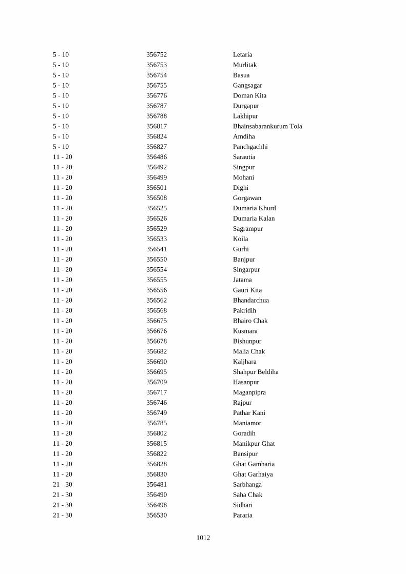
1012
5 - 10 356752 Letaria
5 - 10 356753 Murlitak
5 - 10 356754 Basua
5 - 10 356755 Gangsagar
5 - 10 356776 Doman Kita
5 - 10 356787 Durgapur
5 - 10 356788 Lakhipur
5 - 10 356817 Bhainsabarankurum Tola
5 - 10 356824 Amdiha
5 - 10 356827 Panchgachhi
11 - 20 356486 Sarautia
11 - 20 356492 Singpur
11 - 20 356499 Mohani
11 - 20 356501 Dighi
11 - 20 356508 Gorgawan
11 - 20 356525 Dumaria Khurd
11 - 20 356526 Dumaria Kalan
11 - 20 356529 Sagrampur
11 - 20 356533 Koila
11 - 20 356541 Gurhi
11 - 20 356550 Banjpur
11 - 20 356554 Singarpur
11 - 20 356555 Jatama
11 - 20 356556 Gauri Kita
11 - 20 356562 Bhandarchua
11 - 20 356568 Pakridih
11 - 20 356675 Bhairo Chak
11 - 20 356676 Kusmara
11 - 20 356678 Bishunpur
11 - 20 356682 Malia Chak
11 - 20 356690 Kaljhara
11 - 20 356695 Shahpur Beldiha
11 - 20 356709 Hasanpur
11 - 20 356717 Maganpipra
11 - 20 356746 Rajpur
11 - 20 356749 Pathar Kani
11 - 20 356785 Maniamor
11 - 20 356802 Goradih
11 - 20 356815 Manikpur Ghat
11 - 20 356822 Bansipur
11 - 20 356828 Ghat Gamharia
11 - 20 356830 Ghat Garhaiya
21 - 30 356481 Sarbhanga
21 - 30 356490 Saha Chak
21 - 30 356498 Sidhari
21 - 30 356530 Pararia
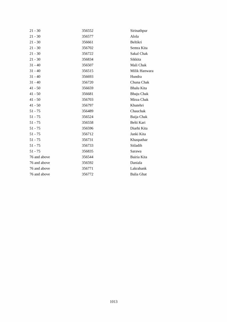
1013
21 - 30 356552 Sirinathpur
21 - 30 356577 Alola
21 - 30 356661 Beltikri
21 - 30 356702 Semra Kita
21 - 30 356722 Sakal Chak
21 - 30 356834 Sikkita
31 - 40 356507 Mali Chak
31 - 40 356515 Milik Hanwara
31 - 40 356693 Hundra
31 - 40 356720 Chuna Chak
41 - 50 356659 Bhalu Kita
41 - 50 356681 Bhaju Chak
41 - 50 356703 Mirza Chak
41 - 50 356797 Khutehri
51 - 75 356489 Chauchak
51 - 75 356524 Baija Chak
51 - 75 356558 Belti Kari
51 - 75 356596 Diarhi Kita
51 - 75 356712 Janki Kita
51 - 75 356731 Khaspathar
51 - 75 356733 Sitladih
51 - 75 356835 Sarawa
76 and above 356544 Bairia Kita
76 and above 356592 Daniala
76 and above 356771 Lakrabank
76 and above 356772 Balia Ghat
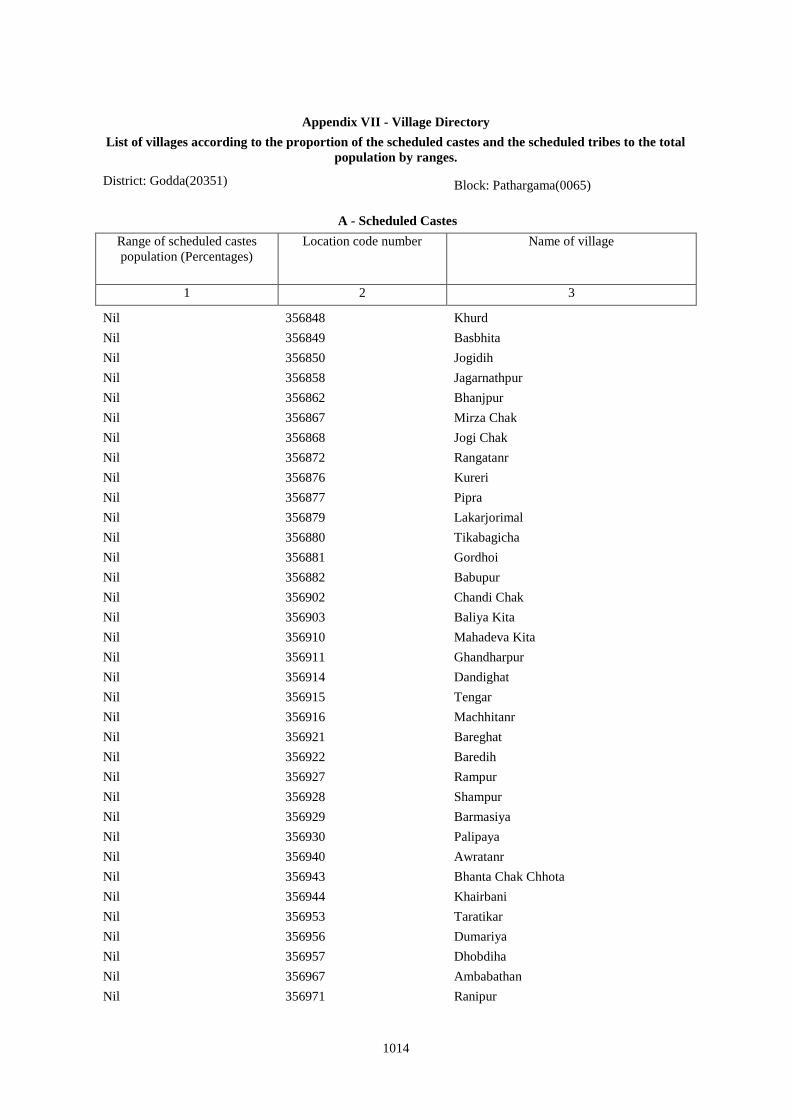
1014
Appendix VII - Village Directory
List of villages according to the proportion of the scheduled castes and the scheduled tribes to the total
population by ranges.
District: Godda(20351) Block: Pathargama(0065)
A - Scheduled Castes
Range of scheduled castes
population (Percentages)
Location code number Name of village
1 2 3
Nil 356848 Khurd
Nil 356849 Basbhita
Nil 356850 Jogidih
Nil 356858 Jagarnathpur
Nil 356862 Bhanjpur
Nil 356867 Mirza Chak
Nil 356868 Jogi Chak
Nil 356872 Rangatanr
Nil 356876 Kureri
Nil 356877 Pipra
Nil 356879 Lakarjorimal
Nil 356880 Tikabagicha
Nil 356881 Gordhoi
Nil 356882 Babupur
Nil 356902 Chandi Chak
Nil 356903 Baliya Kita
Nil 356910 Mahadeva Kita
Nil 356911 Ghandharpur
Nil 356914 Dandighat
Nil 356915 Tengar
Nil 356916 Machhitanr
Nil 356921 Bareghat
Nil 356922 Baredih
Nil 356927 Rampur
Nil 356928 Shampur
Nil 356929 Barmasiya
Nil 356930 Palipaya
Nil 356940 Awratanr
Nil 356943 Bhanta Chak Chhota
Nil 356944 Khairbani
Nil 356953 Taratikar
Nil 356956 Dumariya
Nil 356957 Dhobdiha
Nil 356967 Ambabathan
Nil 356971 Ranipur
1015
Less than 5 356841 Sonbarsa
Less than 5 356843 Matihani
Less than 5 356875 Kamaldiha
Less than 5 356887 Sonar Chak
Less than 5 356899 Pathargama
Less than 5 356906 Panjarhar
Less than 5 356912 Kumarsi
Less than 5 356917 Telni
Less than 5 356923 Kasturiya
Less than 5 356925 Jamchir
Less than 5 356937 Bhalsumbhiya
Less than 5 356939 Bara Bandh
Less than 5 356942 Lakhanpahari Chhit
Less than 5 356946 Siripur
Less than 5 356949 Ghatbaliya
Less than 5 356963 Pakariya
Less than 5 356966 Rajaun Khurd
Less than 5 356970 Barwarda
5 - 10 356863 Barkop
5 - 10 356871 Jamua
5 - 10 356885 Joginpahari
5 - 10 356888 Duarichak
5 - 10 356889 Tulsi Kita
5 - 10 356913 Sundarmor
5 - 10 356920 Dumarariya
5 - 10 356926 Kendua
5 - 10 356931 Bargama
5 - 10 356933 Saranda
5 - 10 356938 Pipra
5 - 10 356948 Kolua
5 - 10 356959 Belshar
11 - 20 356842 Maheshliti
11 - 20 356846 Sareya
11 - 20 356855 Siardih
11 - 20 356856 Lakhanpahari
11 - 20 356873 Semariya
11 - 20 356878 Babupur
11 - 20 356884 Gordhoi
11 - 20 356934 Boha
11 - 20 356935 Khariani
11 - 20 356941 Harkata
11 - 20 356954 Bandelwar
11 - 20 356958 Beltikri
11 - 20 356965 Boharna
11 - 20 356968 Dhibabandh
11 - 20 356969 Kerbar
1016
21 - 30 356845 Chaura
21 - 30 356847 Tardiha
21 - 30 356852 Ghatkurwa
21 - 30 356896 Kasiyatari
21 - 30 356898 Lasutiya
21 - 30 356909 Ambasongram
21 - 30 356918 Kobhara
21 - 30 356932 Manoharpur
21 - 30 356960 Parua
31 - 40 356869 Amdiha
31 - 40 356897 Kita Gardharpur
31 - 40 356936 Barhara
41 - 50 356865 Birseni
41 - 50 356919 Chilkara Gobind
51 - 75 356857 Joginpahari
51 - 75 356870 Babupur
76 and above 356853 Ram Sundariya
76 and above 356972 Laugai
51 - 75 356973 Gangarampur
21 - 30 356974 Latauna
Less than 5 356975 Chunakothi
Nil 356976 Ghutiya
Less than 5 356977 Rajaun Kalan
5 - 10 356978 Bisaha
Nil 356979 Charkaghat
Nil 356980 Nimbar
5 - 10 356981 Dighi
31 - 40 356982 Korkaghat
Nil 356983 Amad Khani
76 and above 356985 Chakwa
11 - 20 356987 Simariya
Less than 5 356988 Sanatan
5 - 10 356993 Charkaghat
Nil 356994 Garka
11 - 20 356995 Bariyata
Nil 356997 Tabhalpur
11 - 20 356999 Masudanpur
Nil 357001 Bhagwan Chak
11 - 20 357002 Rup Chak
Nil 357003 Pathar Kani Mal
11 - 20 357005 Chilra
Less than 5 357006 Chainpur
Nil 357007 Ghat Rampur
21 - 30 357008 Mal Rampur
5 - 10 357009 Mal Nistara
Nil 357010 Ghat Nistara
1017
Nil 357013 Mahuasol
Less than 5 357014 Sighai Mal
11 - 20 357015 Singhi Ghat
5 - 10 357016 Jogiya
11 - 20 357017 Khaira
Nil 357018 Jamjori
Nil 357020 Jokela
Nil 357021 Dhangri Mal
5 - 10 357022 Dhangdri Ghat
Nil 357025 Basbhita Mal
5 - 10 357027 Gangta Kalan
Nil 357030 Gangta Mal Chhit
5 - 10 357031 Lautana
Nil 357033 Kerwar
Nil 357034 Ranipur Dumariya
Nil 357035 Badalpur
11 - 20 357036 Tetuliya
Less than 5 357037 Paraspani
Less than 5 357038 Daharlangi
1018
Appendix VII - Village Directory
List of villages according to the proportion of the scheduled castes and the scheduled tribes to the total
population by ranges.
District: Godda(20351) Block: Bashant Rai*(0066)
A - Scheduled Castes
Range of scheduled castes
population (Percentages)
Location code number Name of village
1 2 3
Nil 357039 Gorgawan
5 - 10 357040 Koriana
11 - 20 357042 Raha
5 - 10 357043 Bade
11 - 20 357044 Maheshtikri
76 and above 357046 Majar Khurd
11 - 20 357048 Manjar Buzurg
21 - 30 357051 Dhapra
Less than 5 357052 Sahoro
Less than 5 357053 Bhatta
5 - 10 357054 Rupni
11 - 20 357055 Parsiya
Nil 357056 Kewan
Nil 357057 Parbatta
5 - 10 357058 Ransi
21 - 30 357059 Beldiha
5 - 10 357060 Bishundas Chak
5 - 10 357062 Chengai
21 - 30 357064 Ghat Lachhimipur
Nil 357066 Nakta
Nil 357068 Mahadew Kita
Nil 357071 Arazi Kaithiya
5 - 10 357072 Kaithiya
51 - 75 357073 Amarpur
41 - 50 357074 Baniyadih
5 - 10 357075 Kita Baniyadih
21 - 30 357076 Gouri Kita
11 - 20 357077 Gopi Chak
Less than 5 357080 Shahpur
Less than 5 357082 Nimuha
11 - 20 357083 Medni Chak
5 - 10 357084 Kadma
5 - 10 357085 Jagatpur
21 - 30 357086 Mansha Bishunpur
Nil 357088 Kita Kendua
Less than 5 357089 Sankhi
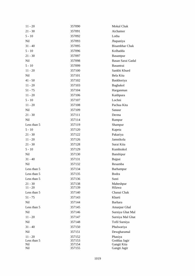
1019
11 - 20 357090 Mokal Chak
21 - 30 357091 Aichamor
5 - 10 357092 Lotha
Nil 357093 Jhapaniya
31 - 40 357095 Bisambhar Chak
5 - 10 357096 Kolhadda
21 - 30 357097 Basantpur
Nil 357098 Basan Sarai Gadal
5 - 10 357099 Basantrai
11 - 20 357100 Sankhi Khurd
Nil 357101 Bela Kita
41 - 50 357102 Baskhoriya
11 - 20 357103 Baghakol
51 - 75 357104 Harganman
11 - 20 357106 Kaithpura
5 - 10 357107 Lochni
11 - 20 357108 Pachua Kita
Nil 357109 Sanaur
21 - 30 357111 Derma
Nil 357114 Rampur
Less than 5 357119 Shampur
5 - 10 357120 Kapeta
21 - 30 357122 Pakariya
11 - 20 357126 Jamnikola
21 - 30 357128 Surai Kita
5 - 10 357129 Kumhrakol
Nil 357130 Banshipur
31 - 40 357131 Bajpai
Nil 357132 Resamba
Less than 5 357134 Barhampur
Less than 5 357135 Bodra
Less than 5 357136 Susti
21 - 30 357138 Maheshpur
11 - 20 357139 Hilawa
Less than 5 357140 Chanai Chak
51 - 75 357143 Kharti
Nil 357144 Barhara
Less than 5 357145 Amarpur Ghal
Nil 357146 Surniya Ghat Mal
11 - 20 357147 Surniya Mal Ghat
Nil 357148 Tofil Surniya
31 - 40 357150 Phulwariya
Nil 357151 Dewgharamal
11 - 20 357152 Phasiya
Less than 5 357153 Goddaa Jagir
Nil 357154 Gangti Kita
Nil 357155 Gangti Jagir
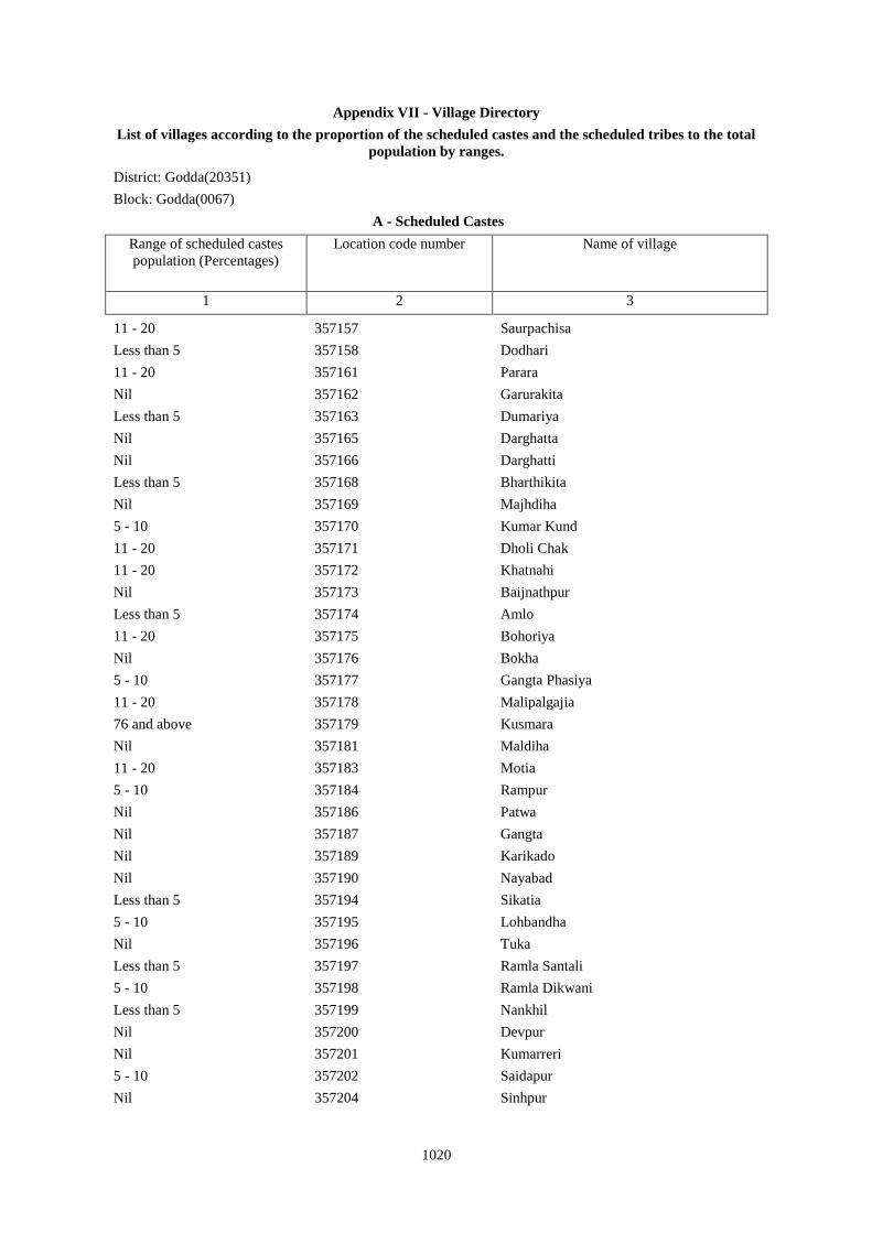
1020
Appendix VII - Village Directory
List of villages according to the proportion of the scheduled castes and the scheduled tribes to the total
population by ranges.
District: Godda(20351)
Block: Godda(0067)
A - Scheduled Castes
Range of scheduled castes
population (Percentages)
Location code number Name of village
1 2 3
11 - 20 357157 Saurpachisa
Less than 5 357158 Dodhari
11 - 20 357161 Parara
Nil 357162 Garurakita
Less than 5 357163 Dumariya
Nil 357165 Darghatta
Nil 357166 Darghatti
Less than 5 357168 Bharthikita
Nil 357169 Majhdiha
5 - 10 357170 Kumar Kund
11 - 20 357171 Dholi Chak
11 - 20 357172 Khatnahi
Nil 357173 Baijnathpur
Less than 5 357174 Amlo
11 - 20 357175 Bohoriya
Nil 357176 Bokha
5 - 10 357177 Gangta Phasiya
11 - 20 357178 Malipalgajia
76 and above 357179 Kusmara
Nil 357181 Maldiha
11 - 20 357183 Motia
5 - 10 357184 Rampur
Nil 357186 Patwa
Nil 357187 Gangta
Nil 357189 Karikado
Nil 357190 Nayabad
Less than 5 357194 Sikatia
5 - 10 357195 Lohbandha
Nil 357196 Tuka
Less than 5 357197 Ramla Santali
5 - 10 357198 Ramla Dikwani
Less than 5 357199 Nankhil
Nil 357200 Devpur
Nil 357201 Kumarreri
5 - 10 357202 Saidapur
Nil 357204 Sinhpur

1021
31 - 40 357205 Parasi
21 - 30 357208 Manpur
11 - 20 357209 Dubrajpur
76 and above 357210 Gurguri
Less than 5 357211 Reni
11 - 20 357213 Kathra
Less than 5 357214 Dokabandh
21 - 30 357215 Makunddih
5 - 10 357216 Makunddin (Santoli)
Nil 357217 Pakariya Mal
Nil 357218 Pakarya Ghat
5 - 10 357219 Beldiha
11 - 20 357220 Barahara
76 and above 357222 Bansipur
Less than 5 357223 Kurma
31 - 40 357224 Baliya
41 - 50 357225 Molnakita
51 - 75 357226 Patpur
Nil 357227 Nilkanthpur
5 - 10 357228 Chapri
Nil 357229 Bara
Nil 357230 Lacchmipur
5 - 10 357231 Nepura
21 - 30 357232 Kakana
11 - 20 357235 Panch Kathi
21 - 30 357238 Basarhi
21 - 30 357239 Malni
31 - 40 357240 Chakwa
5 - 10 357241 Machhiya Samarda Urf Lalpur
5 - 10 357242 Diyara
Nil 357243 Jaipur
31 - 40 357244 Barhauna
Less than 5 357245 Amdiha
Nil 357246 Parsa
5 - 10 357247 Kanhwara
11 - 20 357248 Garbana
Less than 5 357249 Galapahar
5 - 10 357250 Bhadrahi Mal
21 - 30 357251 Ghat Bhadrahi
Less than 5 357252 Chilauna
5 - 10 357253 Rampur
11 - 20 357254 Dumariya Mal
Nil 357255 Naya Chak
21 - 30 357256 Dara Chak
11 - 20 357257 Ghat Gorsanda
5 - 10 357261 Ghat Dhamsain
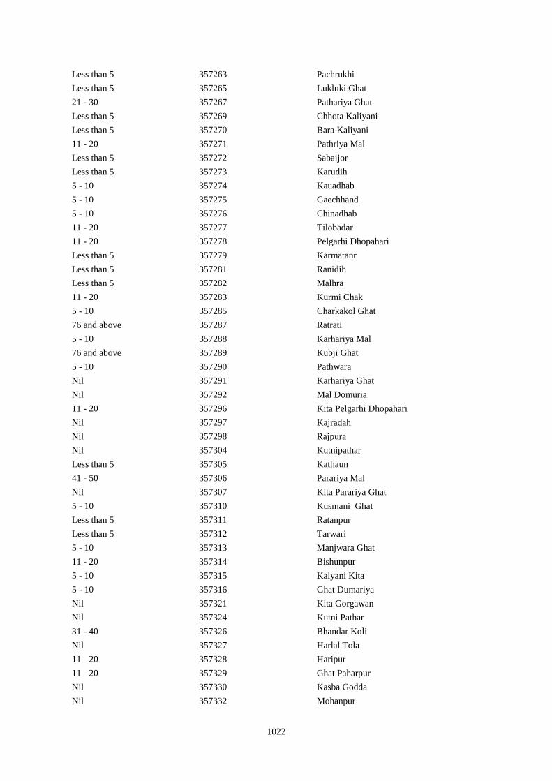
1022
Less than 5 357263 Pachrukhi
Less than 5 357265 Lukluki Ghat
21 - 30 357267 Pathariya Ghat
Less than 5 357269 Chhota Kaliyani
Less than 5 357270 Bara Kaliyani
11 - 20 357271 Pathriya Mal
Less than 5 357272 Sabaijor
Less than 5 357273 Karudih
5 - 10 357274 Kauadhab
5 - 10 357275 Gaechhand
5 - 10 357276 Chinadhab
11 - 20 357277 Tilobadar
11 - 20 357278 Pelgarhi Dhopahari
Less than 5 357279 Karmatanr
Less than 5 357281 Ranidih
Less than 5 357282 Malhra
11 - 20 357283 Kurmi Chak
5 - 10 357285 Charkakol Ghat
76 and above 357287 Ratrati
5 - 10 357288 Karhariya Mal
76 and above 357289 Kubji Ghat
5 - 10 357290 Pathwara
Nil 357291 Karhariya Ghat
Nil 357292 Mal Domuria
11 - 20 357296 Kita Pelgarhi Dhopahari
Nil 357297 Kajradah
Nil 357298 Rajpura
Nil 357304 Kutnipathar
Less than 5 357305 Kathaun
41 - 50 357306 Parariya Mal
Nil 357307 Kita Parariya Ghat
5 - 10 357310 Kusmani Ghat
Less than 5 357311 Ratanpur
Less than 5 357312 Tarwari
5 - 10 357313 Manjwara Ghat
11 - 20 357314 Bishunpur
5 - 10 357315 Kalyani Kita
5 - 10 357316 Ghat Dumariya
Nil 357321 Kita Gorgawan
Nil 357324 Kutni Pathar
31 - 40 357326 Bhandar Koli
Nil 357327 Harlal Tola
11 - 20 357328 Haripur
11 - 20 357329 Ghat Paharpur
Nil 357330 Kasba Godda
Nil 357332 Mohanpur
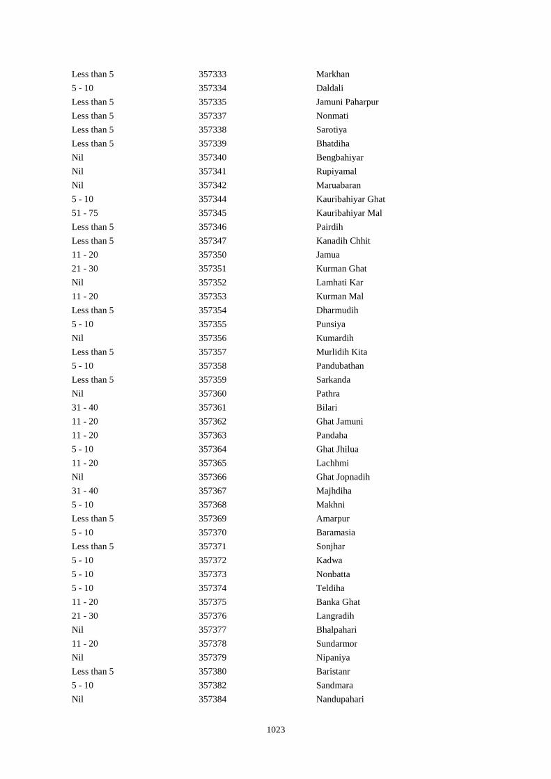
1023
Less than 5 357333 Markhan
5 - 10 357334 Daldali
Less than 5 357335 Jamuni Paharpur
Less than 5 357337 Nonmati
Less than 5 357338 Sarotiya
Less than 5 357339 Bhatdiha
Nil 357340 Bengbahiyar
Nil 357341 Rupiyamal
Nil 357342 Maruabaran
5 - 10 357344 Kauribahiyar Ghat
51 - 75 357345 Kauribahiyar Mal
Less than 5 357346 Pairdih
Less than 5 357347 Kanadih Chhit
11 - 20 357350 Jamua
21 - 30 357351 Kurman Ghat
Nil 357352 Lamhati Kar
11 - 20 357353 Kurman Mal
Less than 5 357354 Dharmudih
5 - 10 357355 Punsiya
Nil 357356 Kumardih
Less than 5 357357 Murlidih Kita
5 - 10 357358 Pandubathan
Less than 5 357359 Sarkanda
Nil 357360 Pathra
31 - 40 357361 Bilari
11 - 20 357362 Ghat Jamuni
11 - 20 357363 Pandaha
5 - 10 357364 Ghat Jhilua
11 - 20 357365 Lachhmi
Nil 357366 Ghat Jopnadih
31 - 40 357367 Majhdiha
5 - 10 357368 Makhni
Less than 5 357369 Amarpur
5 - 10 357370 Baramasia
Less than 5 357371 Sonjhar
5 - 10 357372 Kadwa
5 - 10 357373 Nonbatta
5 - 10 357374 Teldiha
11 - 20 357375 Banka Ghat
21 - 30 357376 Langradih
Nil 357377 Bhalpahari
11 - 20 357378 Sundarmor
Nil 357379 Nipaniya
Less than 5 357380 Baristanr
5 - 10 357382 Sandmara
Nil 357384 Nandupahari
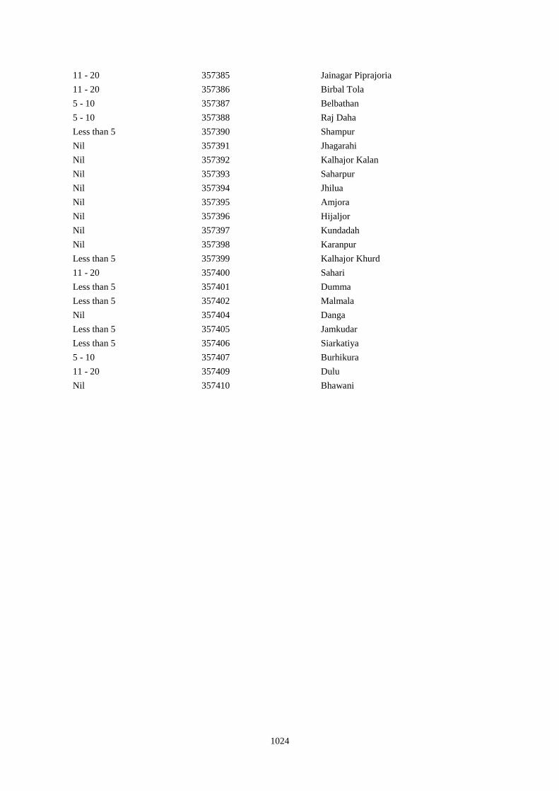
1024
11 - 20 357385 Jainagar Piprajoria
11 - 20 357386 Birbal Tola
5 - 10 357387 Belbathan
5 - 10 357388 Raj Daha
Less than 5 357390 Shampur
Nil 357391 Jhagarahi
Nil 357392 Kalhajor Kalan
Nil 357393 Saharpur
Nil 357394 Jhilua
Nil 357395 Amjora
Nil 357396 Hijaljor
Nil 357397 Kundadah
Nil 357398 Karanpur
Less than 5 357399 Kalhajor Khurd
11 - 20 357400 Sahari
Less than 5 357401 Dumma
Less than 5 357402 Malmala
Nil 357404 Danga
Less than 5 357405 Jamkudar
Less than 5 357406 Siarkatiya
5 - 10 357407 Burhikura
11 - 20 357409 Dulu
Nil 357410 Bhawani
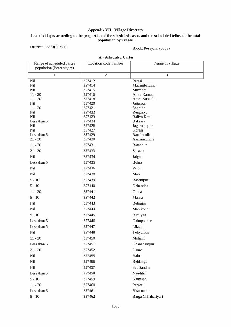
1025
Appendix VII - Village Directory
List of villages according to the proportion of the scheduled castes and the scheduled tribes to the total
population by ranges.
District: Godda(20351) Block: Poreyahat(0068)
A - Scheduled Castes
Range of scheduled castes
population (Percentages)
Location code number Name of village
1 2 3
Nil 357412 Parasi
Nil 357414 Masanibeldiha
Nil 357415 Muchora
11 - 20 357416 Amra Kamat
11 - 20 357418 Amra Kanauli
Nil 357420 Jaijalpur
11 - 20 357421 Sondiha
Nil 357422 Rengniya
Nil 357423 Baliya Kita
Less than 5 357424 Baksara
Nil 357426 Jagarnathpur
Nil 357427 Korasi
Less than 5 357429 Ranabandh
21 - 30 357430 Asarimadhuri
11 - 20 357431 Ratanpur
21 - 30 357433 Sarwan
Nil 357434 Jalgo
Less than 5 357435 Bohra
Nil 357436 Petbi
Nil 357438 Mali
5 - 10 357439 Basantpur
5 - 10 357440 Debandha
11 - 20 357441 Guma
5 - 10 357442 Mahra
Nil 357443 Behrajor
Nil 357444 Manikpur
5 - 10 357445 Birniyan
Less than 5 357446 Dahupadhar
Less than 5 357447 Liladah
Nil 357448 Teliyatikar
11 - 20 357450 Mohani
Less than 5 357451 Ghanshampur
21 - 30 357452 Danre
Nil 357455 Balua
Nil 357456 Beldanga
Nil 357457 Sat Bandha
Less than 5 357458 Naudiha
5 - 10 357459 Kathwan
11 - 20 357460 Parsoti
Less than 5 357461 Bhatondha
5 - 10 357462 Barga Chhahariyari
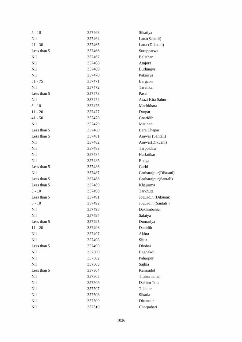
1026
5 - 10 357463 Sikatiya
Nil 357464 Latta(Santali)
21 - 30 357465 Latta (Dikuani)
Less than 5 357466 Surapparwa
Nil 357467 Balathar
Nil 357468 Amjora
Nil 357469 Burhnajor
Nil 357470 Pakariya
51 - 75 357471 Bargaon
Nil 357472 Taratikar
Less than 5 357473 Pasai
Nil 357474 Arazi Kita Sahuri
5 - 10 357475 Machkhara
11 - 20 357477 Durpat
41 - 50 357478 Goaridih
Nil 357479 Matihani
Less than 5 357480 Bara Chapar
Less than 5 357481 Amwar (Santali)
Nil 357482 Amwar(Dikuani)
Nil 357483 Tarpokhra
Nil 357484 Harlatikar
Nil 357485 Bhaga
Less than 5 357486 Garhi
Nil 357487 Gorharajpur(Dikuani)
Less than 5 357488 Gorharajpur(Santali)
Less than 5 357489 Khajurma
5 - 10 357490 Tarkhuta
Less than 5 357491 Joguadih (Dikuani)
5 - 10 357492 Joguadih (Santali )
Nil 357493 Dakhinbahiar
Nil 357494 Salaiya
Less than 5 357495 Dumariya
11 - 20 357496 Danidih
Nil 357497 Akhra
Nil 357498 Sijua
Less than 5 357499 Dhobai
Nil 357500 Baghakol
Nil 357502 Paharpur
Nil 357503 Sajhia
Less than 5 357504 Kamradol
Nil 357505 Thakurnahan
Nil 357506 Dakhin Tola
Nil 357507 Tilatanr
Nil 357508 Sikatia
Nil 357509 Dhamsur
Nil 357510 Chorpahari
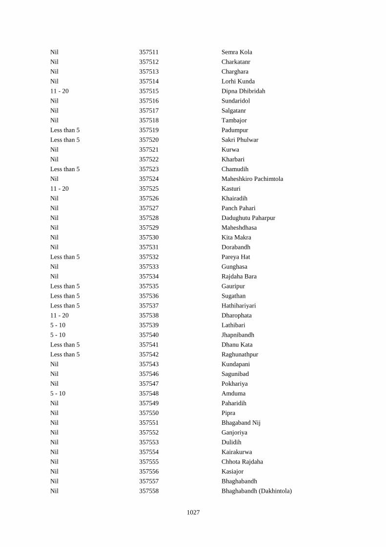
1027
Nil 357511 Semra Kola
Nil 357512 Charkatanr
Nil 357513 Charghara
Nil 357514 Lorhi Kunda
11 - 20 357515 Dipna Dhibridah
Nil 357516 Sundaridol
Nil 357517 Salgatanr
Nil 357518 Tambajor
Less than 5 357519 Padumpur
Less than 5 357520 Sakri Phulwar
Nil 357521 Kurwa
Nil 357522 Kharbari
Less than 5 357523 Chamudih
Nil 357524 Maheshkiro Pachimtola
11 - 20 357525 Kasturi
Nil 357526 Khairadih
Nil 357527 Panch Pahari
Nil 357528 Dadughutu Paharpur
Nil 357529 Maheshdhasa
Nil 357530 Kita Makra
Nil 357531 Dorabandh
Less than 5 357532 Pareya Hat
Nil 357533 Gunghasa
Nil 357534 Rajdaha Bara
Less than 5 357535 Gauripur
Less than 5 357536 Sugathan
Less than 5 357537 Hathihariyari
11 - 20 357538 Dharophata
5 - 10 357539 Lathibari
5 - 10 357540 Jhapnibandh
Less than 5 357541 Dhanu Kata
Less than 5 357542 Raghunathpur
Nil 357543 Kundapani
Nil 357546 Sagunibad
Nil 357547 Pokhariya
5 - 10 357548 Amduma
Nil 357549 Paharidih
Nil 357550 Pipra
Nil 357551 Bhagaband Nij
Nil 357552 Ganjoriya
Nil 357553 Dulidih
Nil 357554 Kairakurwa
Nil 357555 Chhota Rajdaha
Nil 357556 Kasiajor
Nil 357557 Bhaghabandh
Nil 357558 Bhaghabandh (Dakhintola)
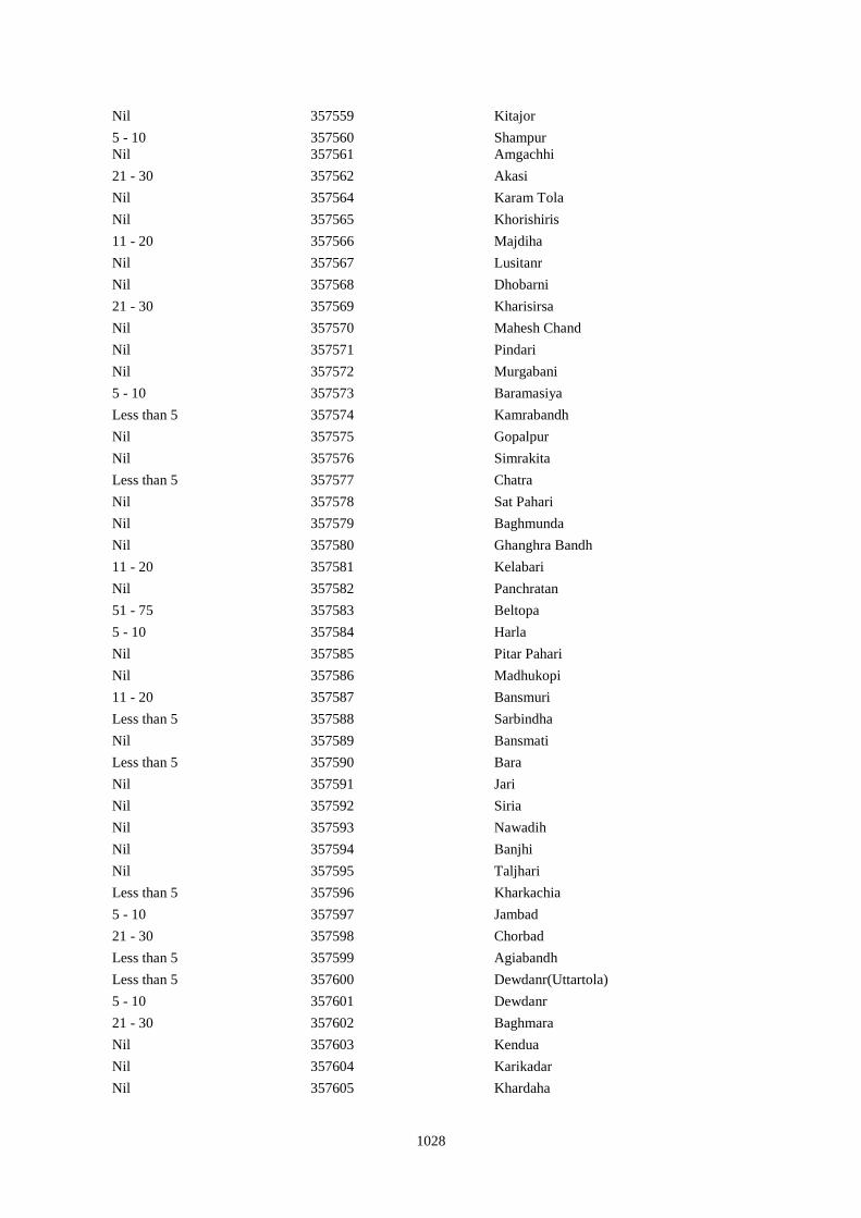
1028
Nil 357559 Kitajor
5 - 10 357560 Shampur
Nil 357561 Amgachhi
21 - 30 357562 Akasi
Nil 357564 Karam Tola
Nil 357565 Khorishiris
11 - 20 357566 Majdiha
Nil 357567 Lusitanr
Nil 357568 Dhobarni
21 - 30 357569 Kharisirsa
Nil 357570 Mahesh Chand
Nil 357571 Pindari
Nil 357572 Murgabani
5 - 10 357573 Baramasiya
Less than 5 357574 Kamrabandh
Nil 357575 Gopalpur
Nil 357576 Simrakita
Less than 5 357577 Chatra
Nil 357578 Sat Pahari
Nil 357579 Baghmunda
Nil 357580 Ghanghra Bandh
11 - 20 357581 Kelabari
Nil 357582 Panchratan
51 - 75 357583 Beltopa
5 - 10 357584 Harla
Nil 357585 Pitar Pahari
Nil 357586 Madhukopi
11 - 20 357587 Bansmuri
Less than 5 357588 Sarbindha
Nil 357589 Bansmati
Less than 5 357590 Bara
Nil 357591 Jari
Nil 357592 Siria
Nil 357593 Nawadih
Nil 357594 Banjhi
Nil 357595 Taljhari
Less than 5 357596 Kharkachia
5 - 10 357597 Jambad
21 - 30 357598 Chorbad
Less than 5 357599 Agiabandh
Less than 5 357600 Dewdanr(Uttartola)
5 - 10 357601 Dewdanr
21 - 30 357602 Baghmara
Nil 357603 Kendua
Nil 357604 Karikadar
Nil 357605 Khardaha
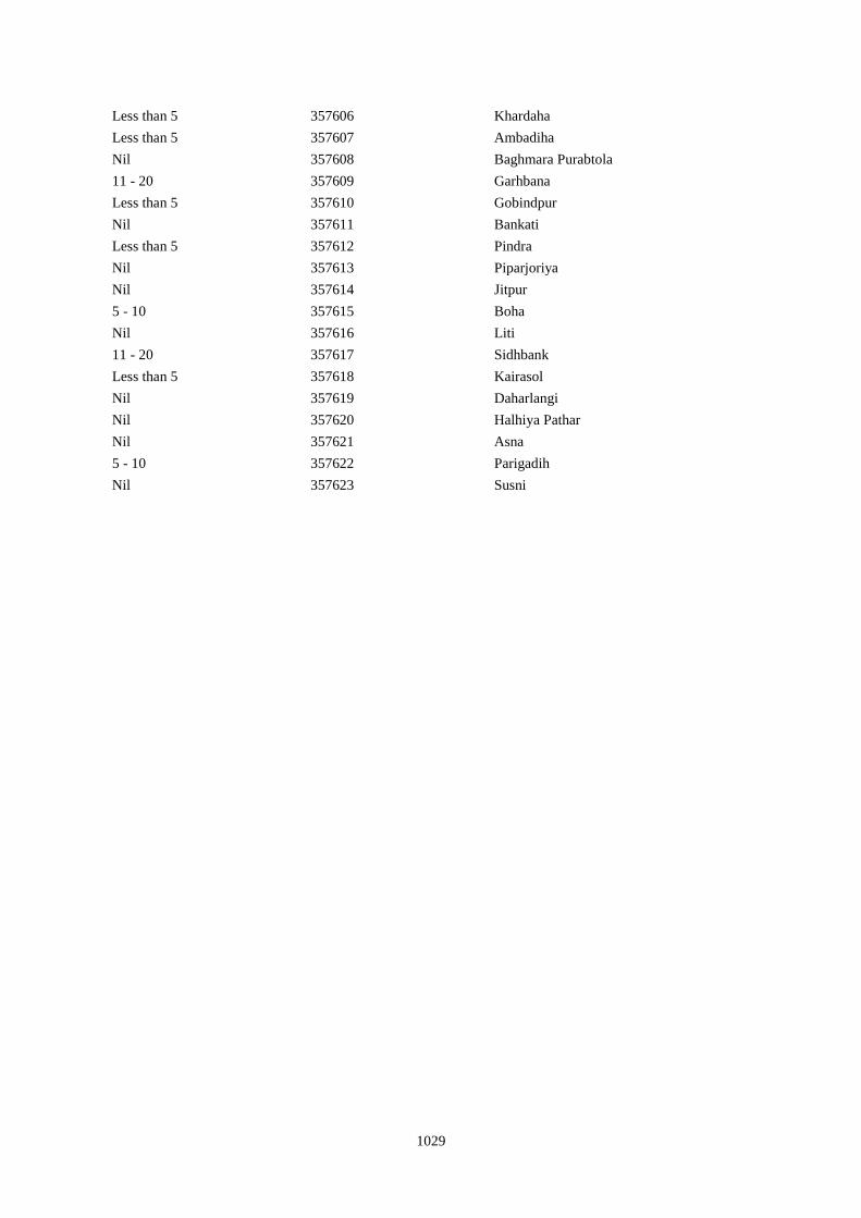
1029
Less than 5 357606 Khardaha
Less than 5 357607 Ambadiha
Nil 357608 Baghmara Purabtola
11 - 20 357609 Garhbana
Less than 5 357610 Gobindpur
Nil 357611 Bankati
Less than 5 357612 Pindra
Nil 357613 Piparjoriya
Nil 357614 Jitpur
5 - 10 357615 Boha
Nil 357616 Liti
11 - 20 357617 Sidhbank
Less than 5 357618 Kairasol
Nil 357619 Daharlangi
Nil 357620 Halhiya Pathar
Nil 357621 Asna
5 - 10 357622 Parigadih
Nil 357623 Susni
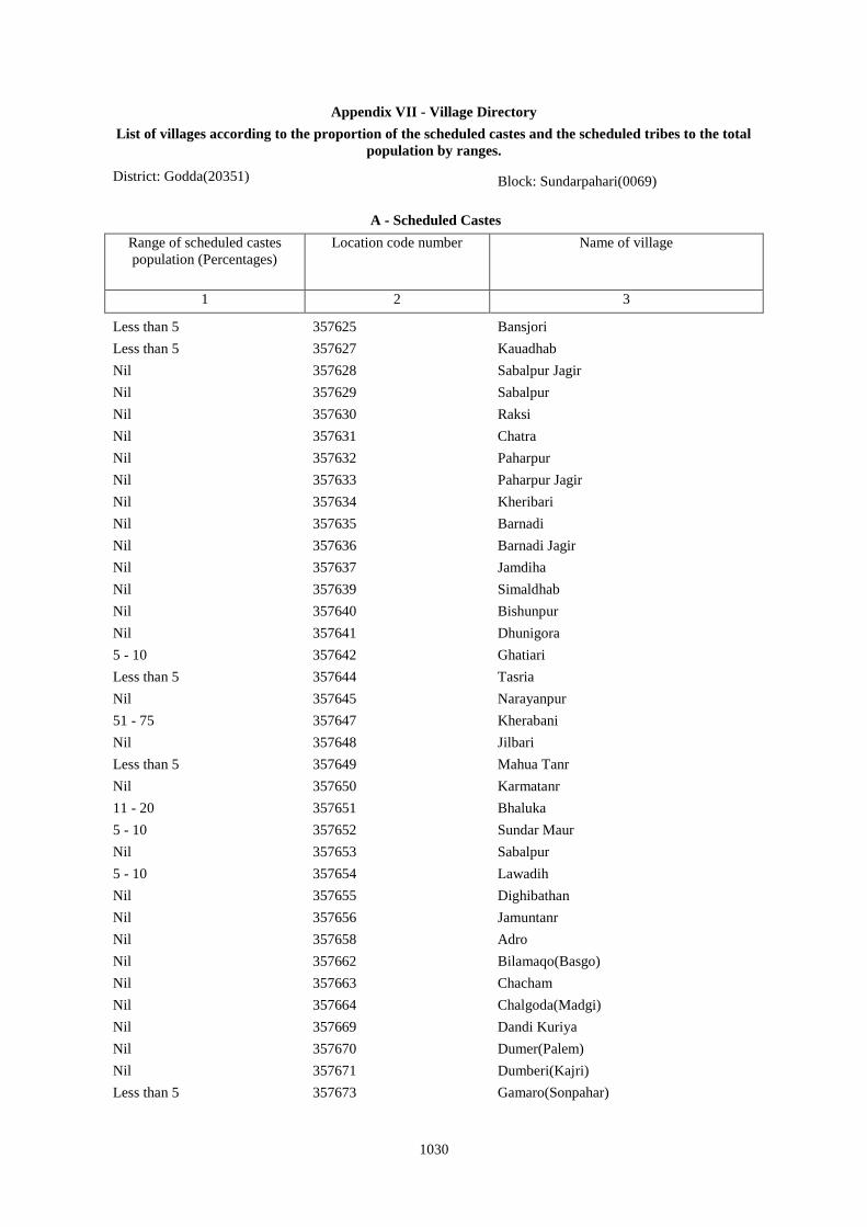
1030
Appendix VII - Village Directory
List of villages according to the proportion of the scheduled castes and the scheduled tribes to the total
population by ranges.
District: Godda(20351) Block: Sundarpahari(0069)
A - Scheduled Castes
Range of scheduled castes
population (Percentages)
Location code number Name of village
1 2 3
Less than 5 357625 Bansjori
Less than 5 357627 Kauadhab
Nil 357628 Sabalpur Jagir
Nil 357629 Sabalpur
Nil 357630 Raksi
Nil 357631 Chatra
Nil 357632 Paharpur
Nil 357633 Paharpur Jagir
Nil 357634 Kheribari
Nil 357635 Barnadi
Nil 357636 Barnadi Jagir
Nil 357637 Jamdiha
Nil 357639 Simaldhab
Nil 357640 Bishunpur
Nil 357641 Dhunigora
5 - 10 357642 Ghatiari
Less than 5 357644 Tasria
Nil 357645 Narayanpur
51 - 75 357647 Kherabani
Nil 357648 Jilbari
Less than 5 357649 Mahua Tanr
Nil 357650 Karmatanr
11 - 20 357651 Bhaluka
5 - 10 357652 Sundar Maur
Nil 357653 Sabalpur
5 - 10 357654 Lawadih
Nil 357655 Dighibathan
Nil 357656 Jamuntanr
Nil 357658 Adro
Nil 357662 Bilamaqo(Basgo)
Nil 357663 Chacham
Nil 357664 Chalgoda(Madgi)
Nil 357669 Dandi Kuriya
Nil 357670 Dumer(Palem)
Nil 357671 Dumberi(Kajri)
Less than 5 357673 Gamaro(Sonpahar)
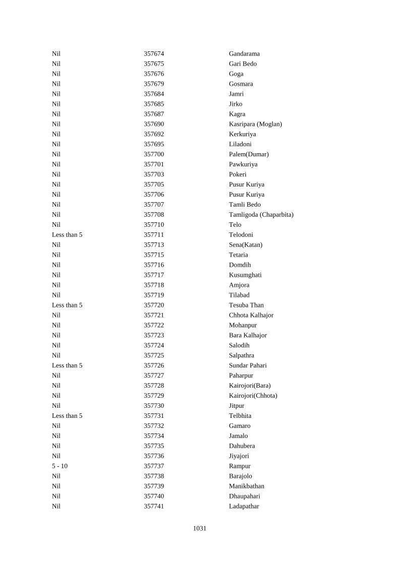
1031
Nil 357674 Gandarama
Nil 357675 Gari Bedo
Nil 357676 Goga
Nil 357679 Gosmara
Nil 357684 Jamri
Nil 357685 Jirko
Nil 357687 Kagra
Nil 357690 Kasripara (Moglan)
Nil 357692 Kerkuriya
Nil 357695 Liladoni
Nil 357700 Palem(Dumar)
Nil 357701 Pawkuriya
Nil 357703 Pokeri
Nil 357705 Pusur Kuriya
Nil 357706 Pusur Kuriya
Nil 357707 Tamli Bedo
Nil 357708 Tamligoda (Chaparbita)
Nil 357710 Telo
Less than 5 357711 Telodoni
Nil 357713 Sena(Katan)
Nil 357715 Tetaria
Nil 357716 Domdih
Nil 357717 Kusumghati
Nil 357718 Amjora
Nil 357719 Tilabad
Less than 5 357720 Tesuba Than
Nil 357721 Chhota Kalhajor
Nil 357722 Mohanpur
Nil 357723 Bara Kalhajor
Nil 357724 Salodih
Nil 357725 Salpathra
Less than 5 357726 Sundar Pahari
Nil 357727 Paharpur
Nil 357728 Kairojori(Bara)
Nil 357729 Kairojori(Chhota)
Nil 357730 Jitpur
Less than 5 357731 Telbhita
Nil 357732 Gamaro
Nil 357734 Jamalo
Nil 357735 Dahubera
Nil 357736 Jiyajori
5 - 10 357737 Rampur
Nil 357738 Barajolo
Nil 357739 Manikbathan
Nil 357740 Dhaupahari
Nil 357741 Ladapathar
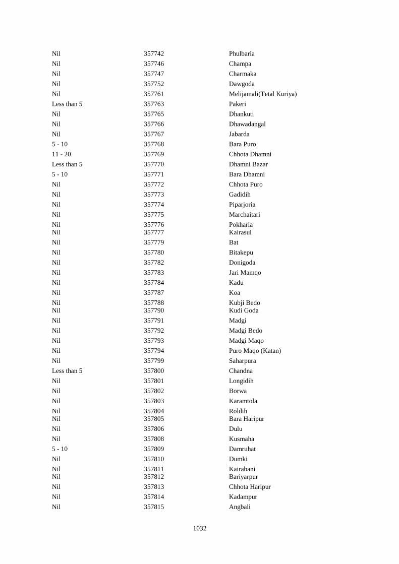
1032
Nil 357742 Phulbaria
Nil 357746 Champa
Nil 357747 Charmaka
Nil 357752 Dawgoda
Nil 357761 Melijamali(Tetal Kuriya)
Less than 5 357763 Pakeri
Nil 357765 Dhankuti
Nil 357766 Dhawadangal
Nil 357767 Jabarda
5 - 10 357768 Bara Puro
11 - 20 357769 Chhota Dhamni
Less than 5 357770 Dhamni Bazar
5 - 10 357771 Bara Dhamni
Nil 357772 Chhota Puro
Nil 357773 Gadidih
Nil 357774 Piparjoria
Nil 357775 Marchaitari
Nil 357776 Pokharia
Nil 357777 Kairasul
Nil 357779 Bat
Nil 357780 Bitakepu
Nil 357782 Donigoda
Nil 357783 Jari Mamqo
Nil 357784 Kadu
Nil 357787 Koa
Nil 357788 Kubji Bedo
Nil 357790 Kudi Goda
Nil 357791 Madgi
Nil 357792 Madgi Bedo
Nil 357793 Madgi Maqo
Nil 357794 Puro Maqo (Katan)
Nil 357799 Saharpura
Less than 5 357800 Chandna
Nil 357801 Longidih
Nil 357802 Borwa
Nil 357803 Karamtola
Nil 357804 Roldih
Nil 357805 Bara Haripur
Nil 357806 Dulu
Nil 357808 Kusmaha
5 - 10 357809 Damruhat
Nil 357810 Dumki
Nil 357811 Kairabani
Nil 357812 Bariyarpur
Nil 357813 Chhota Haripur
Nil 357814 Kadampur
Nil 357815 Angbali
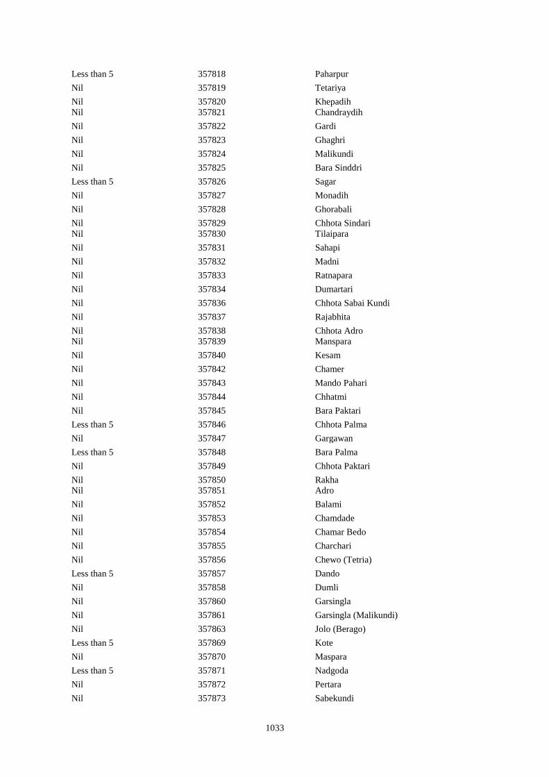
1033
Less than 5 357818 Paharpur
Nil 357819 Tetariya
Nil 357820 Khepadih
Nil 357821 Chandraydih
Nil 357822 Gardi
Nil 357823 Ghaghri
Nil 357824 Malikundi
Nil 357825 Bara Sinddri
Less than 5 357826 Sagar
Nil 357827 Monadih
Nil 357828 Ghorabali
Nil 357829 Chhota Sindari
Nil 357830 Tilaipara
Nil 357831 Sahapi
Nil 357832 Madni
Nil 357833 Ratnapara
Nil 357834 Dumartari
Nil 357836 Chhota Sabai Kundi
Nil 357837 Rajabhita
Nil 357838 Chhota Adro
Nil 357839 Manspara
Nil 357840 Kesam
Nil 357842 Chamer
Nil 357843 Mando Pahari
Nil 357844 Chhatmi
Nil 357845 Bara Paktari
Less than 5 357846 Chhota Palma
Nil 357847 Gargawan
Less than 5 357848 Bara Palma
Nil 357849 Chhota Paktari
Nil 357850 Rakha
Nil 357851 Adro
Nil 357852 Balami
Nil 357853 Chamdade
Nil 357854 Chamar Bedo
Nil 357855 Charchari
Nil 357856 Chewo (Tetria)
Less than 5 357857 Dando
Nil 357858 Dumli
Nil 357860 Garsingla
Nil 357861 Garsingla (Malikundi)
Nil 357863 Jolo (Berago)
Less than 5 357869 Kote
Nil 357870 Maspara
Less than 5 357871 Nadgoda
Nil 357872 Pertara
Nil 357873 Sabekundi
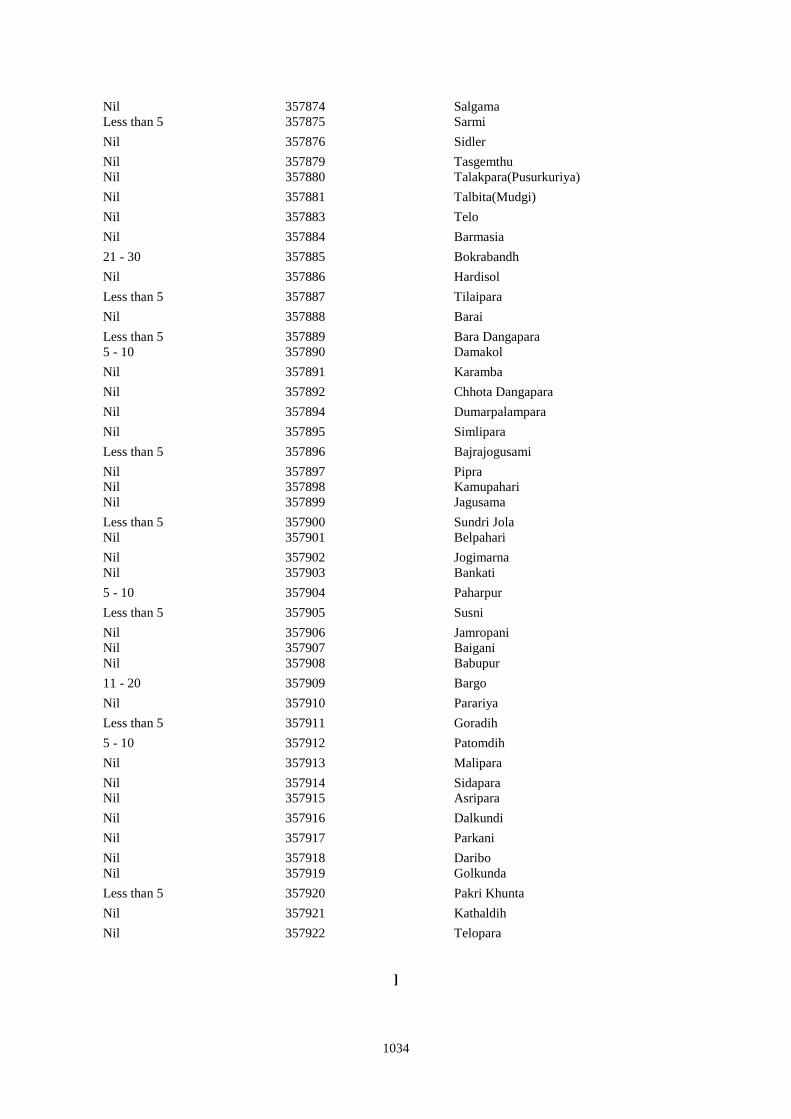
1034
Nil 357874 Salgama
Less than 5 357875 Sarmi
Nil 357876 Sidler
Nil 357879 Tasgemthu
Nil 357880 Talakpara(Pusurkuriya)
Nil 357881 Talbita(Mudgi)
Nil 357883 Telo
Nil 357884 Barmasia
21 - 30 357885 Bokrabandh
Nil 357886 Hardisol
Less than 5 357887 Tilaipara
Nil 357888 Barai
Less than 5 357889 Bara Dangapara
5 - 10 357890 Damakol
Nil 357891 Karamba
Nil 357892 Chhota Dangapara
Nil 357894 Dumarpalampara
Nil 357895 Simlipara
Less than 5 357896 Bajrajogusami
Nil 357897 Pipra
Nil 357898 Kamupahari
Nil 357899 Jagusama
Less than 5 357900 Sundri Jola
Nil 357901 Belpahari
Nil 357902 Jogimarna
Nil 357903 Bankati
5 - 10 357904 Paharpur
Less than 5 357905 Susni
Nil 357906 Jamropani
Nil 357907 Baigani
Nil 357908 Babupur
11 - 20 357909 Bargo
Nil 357910 Parariya
Less than 5 357911 Goradih
5 - 10 357912 Patomdih
Nil 357913 Malipara
Nil 357914 Sidapara
Nil 357915 Asripara
Nil 357916 Dalkundi
Nil 357917 Parkani
Nil 357918 Daribo
Nil 357919 Golkunda
Less than 5 357920 Pakri Khunta
Nil 357921 Kathaldih
Nil 357922 Telopara
]
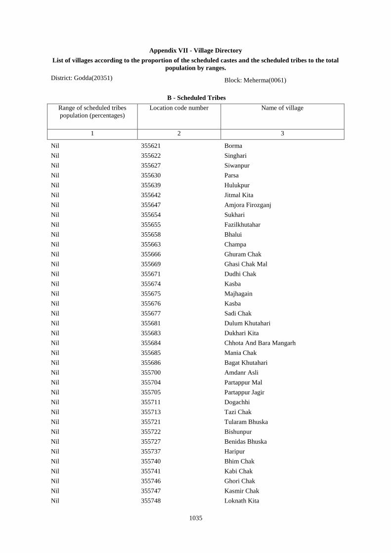
1035
Appendix VII - Village Directory
List of villages according to the proportion of the scheduled castes and the scheduled tribes to the total
population by ranges.
District: Godda(20351) Block: Meherma(0061)
B - Scheduled Tribes
Range of scheduled tribes
population (percentages)
Location code number Name of village
1 2 3
Nil 355621 Borma
Nil 355622 Singhari
Nil 355627 Siwanpur
Nil 355630 Parsa
Nil 355639 Hulukpur
Nil 355642 Jitmal Kita
Nil 355647 Amjora Firozganj
Nil 355654 Sukhari
Nil 355655 Fazilkhutahar
Nil 355658 Bhalui
Nil 355663 Champa
Nil 355666 Ghuram Chak
Nil 355669 Ghasi Chak Mal
Nil 355671 Dudhi Chak
Nil 355674 Kasba
Nil 355675 Majhagain
Nil 355676 Kasba
Nil 355677 Sadi Chak
Nil 355681 Dulum Khutahari
Nil 355683 Dukhari Kita
Nil 355684 Chhota And Bara Mangarh
Nil 355685 Mania Chak
Nil 355686 Bagat Khutahari
Nil 355700 Amdanr Asli
Nil 355704 Partappur Mal
Nil 355705 Partappur Jagir
Nil 355711 Dogachhi
Nil 355713 Tazi Chak
Nil 355721 Tularam Bhuska
Nil 355722 Bishunpur
Nil 355727 Benidas Bhuska
Nil 355737 Haripur
Nil 355740 Bhim Chak
Nil 355741 Kabi Chak
Nil 355746 Ghori Chak
Nil 355747 Kasmir Chak
Nil 355748 Loknath Kita
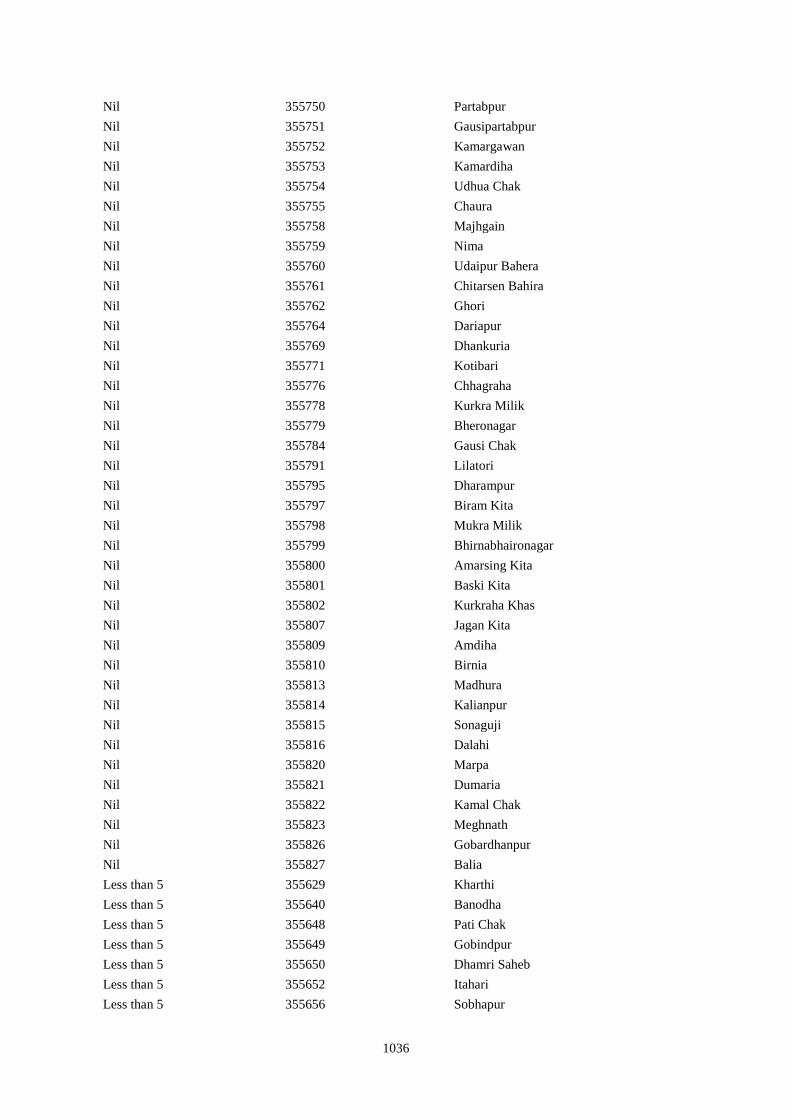
1036
Nil 355750 Partabpur
Nil 355751 Gausipartabpur
Nil 355752 Kamargawan
Nil 355753 Kamardiha
Nil 355754 Udhua Chak
Nil 355755 Chaura
Nil 355758 Majhgain
Nil 355759 Nima
Nil 355760 Udaipur Bahera
Nil 355761 Chitarsen Bahira
Nil 355762 Ghori
Nil 355764 Dariapur
Nil 355769 Dhankuria
Nil 355771 Kotibari
Nil 355776 Chhagraha
Nil 355778 Kurkra Milik
Nil 355779 Bheronagar
Nil 355784 Gausi Chak
Nil 355791 Lilatori
Nil 355795 Dharampur
Nil 355797 Biram Kita
Nil 355798 Mukra Milik
Nil 355799 Bhirnabhaironagar
Nil 355800 Amarsing Kita
Nil 355801 Baski Kita
Nil 355802 Kurkraha Khas
Nil 355807 Jagan Kita
Nil 355809 Amdiha
Nil 355810 Birnia
Nil 355813 Madhura
Nil 355814 Kalianpur
Nil 355815 Sonaguji
Nil 355816 Dalahi
Nil 355820 Marpa
Nil 355821 Dumaria
Nil 355822 Kamal Chak
Nil 355823 Meghnath
Nil 355826 Gobardhanpur
Nil 355827 Balia
Less than 5 355629 Kharthi
Less than 5 355640 Banodha
Less than 5 355648 Pati Chak
Less than 5 355649 Gobindpur
Less than 5 355650 Dhamri Saheb
Less than 5 355652 Itahari
Less than 5 355656 Sobhapur
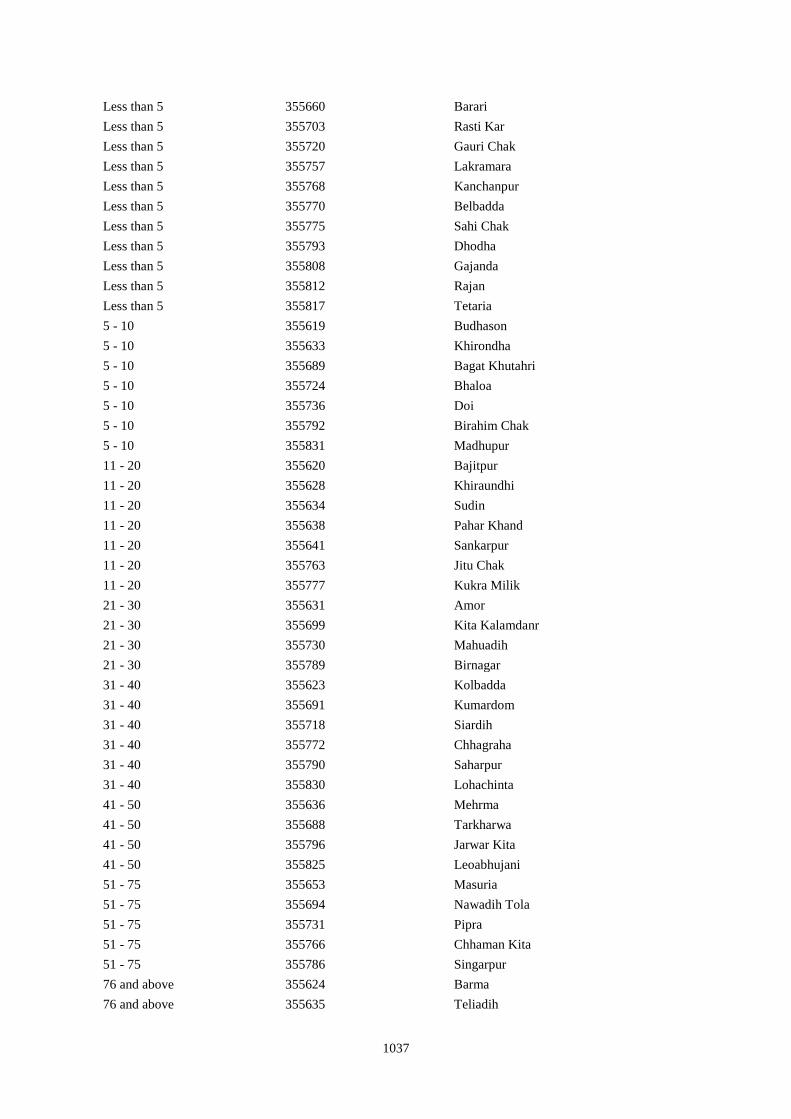
1037
Less than 5 355660 Barari
Less than 5 355703 Rasti Kar
Less than 5 355720 Gauri Chak
Less than 5 355757 Lakramara
Less than 5 355768 Kanchanpur
Less than 5 355770 Belbadda
Less than 5 355775 Sahi Chak
Less than 5 355793 Dhodha
Less than 5 355808 Gajanda
Less than 5 355812 Rajan
Less than 5 355817 Tetaria
5 - 10 355619 Budhason
5 - 10 355633 Khirondha
5 - 10 355689 Bagat Khutahri
5 - 10 355724 Bhaloa
5 - 10 355736 Doi
5 - 10 355792 Birahim Chak
5 - 10 355831 Madhupur
11 - 20 355620 Bajitpur
11 - 20 355628 Khiraundhi
11 - 20 355634 Sudin
11 - 20 355638 Pahar Khand
11 - 20 355641 Sankarpur
11 - 20 355763 Jitu Chak
11 - 20 355777 Kukra Milik
21 - 30 355631 Amor
21 - 30 355699 Kita Kalamdanr
21 - 30 355730 Mahuadih
21 - 30 355789 Birnagar
31 - 40 355623 Kolbadda
31 - 40 355691 Kumardom
31 - 40 355718 Siardih
31 - 40 355772 Chhagraha
31 - 40 355790 Saharpur
31 - 40 355830 Lohachinta
41 - 50 355636 Mehrma
41 - 50 355688 Tarkharwa
41 - 50 355796 Jarwar Kita
41 - 50 355825 Leoabhujani
51 - 75 355653 Masuria
51 - 75 355694 Nawadih Tola
51 - 75 355731 Pipra
51 - 75 355766 Chhaman Kita
51 - 75 355786 Singarpur
76 and above 355624 Barma
76 and above 355635 Teliadih
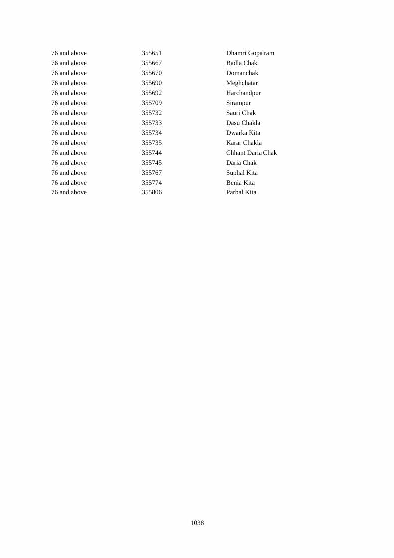
1038
76 and above 355651 Dhamri Gopalram
76 and above 355667 Badla Chak
76 and above 355670 Domanchak
76 and above 355690 Meghchatar
76 and above 355692 Harchandpur
76 and above 355709 Sirampur
76 and above 355732 Sauri Chak
76 and above 355733 Dasu Chakla
76 and above 355734 Dwarka Kita
76 and above 355735 Karar Chakla
76 and above 355744 Chhant Daria Chak
76 and above 355745 Daria Chak
76 and above 355767 Suphal Kita
76 and above 355774 Benia Kita
76 and above 355806 Parbal Kita
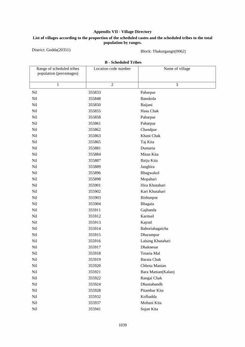
1039
Appendix VII - Village Directory
List of villages according to the proportion of the scheduled castes and the scheduled tribes to the total
population by ranges.
District: Godda(20351) Block: Thakurgangti(0062)
B - Scheduled Tribes
Range of scheduled tribes
population (percentages)
Location code number Name of village
1 2 3
Nil 355833 Paharpur
Nil 355848 Banskola
Nil 355850 Baijani
Nil 355855 Hasu Chak
Nil 355858 Paharpur
Nil 355861 Paharpur
Nil 355862 Chandpur
Nil 355863 Khani Chak
Nil 355865 Taj Kita
Nil 355881 Dumaria
Nil 355884 Mitan Kita
Nil 355887 Baiju Kita
Nil 355889 Janghira
Nil 355896 Bhagwakol
Nil 355898 Mopahari
Nil 355901 Hira Khutahari
Nil 355902 Kari Khutahari
Nil 355903 Bishunpur
Nil 355904 Bhagaia
Nil 355911 Gajhanda
Nil 355912 Karmail
Nil 355913 Kajrail
Nil 355914 Bahoriabagaicha
Nil 355915 Dharampur
Nil 355916 Lalsing Khutahari
Nil 355917 Dhaknesar
Nil 355918 Tetaria Mal
Nil 355919 Baraia Chak
Nil 355920 Chhota Manian
Nil 355921 Bara Manian(Kalan)
Nil 355922 Rangai Chak
Nil 355924 Dhaniabandh
Nil 355928 Pitambar Kita
Nil 355932 Kolbadda
Nil 355937 Mohani Kita
Nil 355941 Sujan Kita
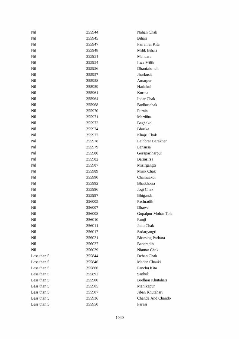
1040
Nil 355944 Nahan Chak
Nil 355945 Bihari
Nil 355947 Pairanrai Kita
Nil 355948 Milik Bihari
Nil 355951 Mahuara
Nil 355954 Itwa Milik
Nil 355956 Dhaniabandh
Nil 355957 Jhurkusia
Nil 355958 Amarpur
Nil 355959 Harinkol
Nil 355961 Kurma
Nil 355964 Indar Chak
Nil 355968 Budhuachak
Nil 355970 Purnia
Nil 355971 Mardiha
Nil 355972 Baghakol
Nil 355974 Bhuska
Nil 355977 Khajri Chak
Nil 355978 Lainbrar Barakhar
Nil 355979 Lensirsa
Nil 355980 Gorapariharpur
Nil 355982 Bariasirsa
Nil 355987 Misirgangti
Nil 355989 Mirik Chak
Nil 355990 Chamuakol
Nil 355992 Bhatkhoria
Nil 355996 Jogi Chak
Nil 355997 Bhiganda
Nil 356005 Pachradih
Nil 356007 Dhawa
Nil 356008 Gopalpur Mohar Tola
Nil 356010 Runji
Nil 356011 Jadu Chak
Nil 356017 Sadargangti
Nil 356021 Bharsing Parbara
Nil 356027 Baheradih
Nil 356029 Niamat Chak
Less than 5 355844 Deban Chak
Less than 5 355846 Madan Chauki
Less than 5 355866 Panchu Kita
Less than 5 355892 Sanhuli
Less than 5 355900 Bodhrai Khutahari
Less than 5 355905 Manikapur
Less than 5 355907 Jiban Khutahari
Less than 5 355936 Chanda And Chando
Less than 5 355950 Parasi
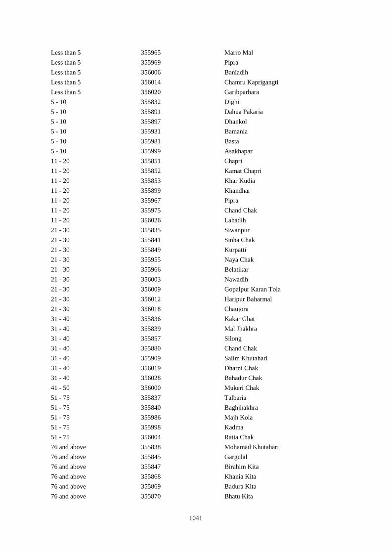
1041
Less than 5 355965 Marro Mal
Less than 5 355969 Pipra
Less than 5 356006 Baniadih
Less than 5 356014 Chamru Kaprigangti
Less than 5 356020 Garibparbara
5 - 10 355832 Dighi
5 - 10 355891 Dahua Pakaria
5 - 10 355897 Dhankol
5 - 10 355931 Bamania
5 - 10 355981 Basta
5 - 10 355999 Asakhapar
11 - 20 355851 Chapri
11 - 20 355852 Kamat Chapri
11 - 20 355853 Khar Kudia
11 - 20 355899 Khandhar
11 - 20 355967 Pipra
11 - 20 355975 Chand Chak
11 - 20 356026 Lahadih
21 - 30 355835 Siwanpur
21 - 30 355841 Sinha Chak
21 - 30 355849 Kurpatti
21 - 30 355955 Naya Chak
21 - 30 355966 Belatikar
21 - 30 356003 Nawadih
21 - 30 356009 Gopalpur Karan Tola
21 - 30 356012 Haripur Baharmal
21 - 30 356018 Chaujora
31 - 40 355836 Kakar Ghat
31 - 40 355839 Mal Jhakhra
31 - 40 355857 Silong
31 - 40 355880 Chand Chak
31 - 40 355909 Salim Khutahari
31 - 40 356019 Dharni Chak
31 - 40 356028 Bahadur Chak
41 - 50 356000 Mukeri Chak
51 - 75 355837 Talbaria
51 - 75 355840 Baghjhakhra
51 - 75 355986 Majh Kola
51 - 75 355998 Kadma
51 - 75 356004 Ratia Chak
76 and above 355838 Mohamad Khutahari
76 and above 355845 Gargulal
76 and above 355847 Birahim Kita
76 and above 355868 Khania Kita
76 and above 355869 Badura Kita
76 and above 355870 Bhatu Kita
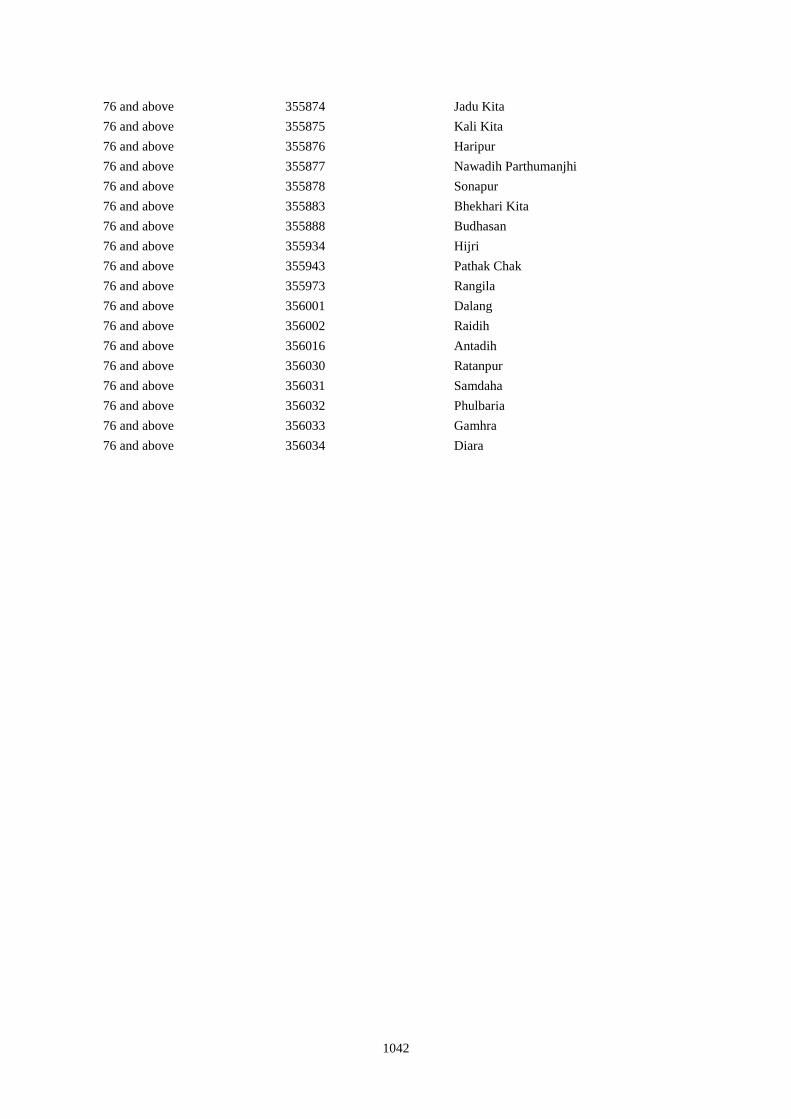
1042
76 and above 355874 Jadu Kita
76 and above 355875 Kali Kita
76 and above 355876 Haripur
76 and above 355877 Nawadih Parthumanjhi
76 and above 355878 Sonapur
76 and above 355883 Bhekhari Kita
76 and above 355888 Budhasan
76 and above 355934 Hijri
76 and above 355943 Pathak Chak
76 and above 355973 Rangila
76 and above 356001 Dalang
76 and above 356002 Raidih
76 and above 356016 Antadih
76 and above 356030 Ratanpur
76 and above 356031 Samdaha
76 and above 356032 Phulbaria
76 and above 356033 Gamhra
76 and above 356034 Diara
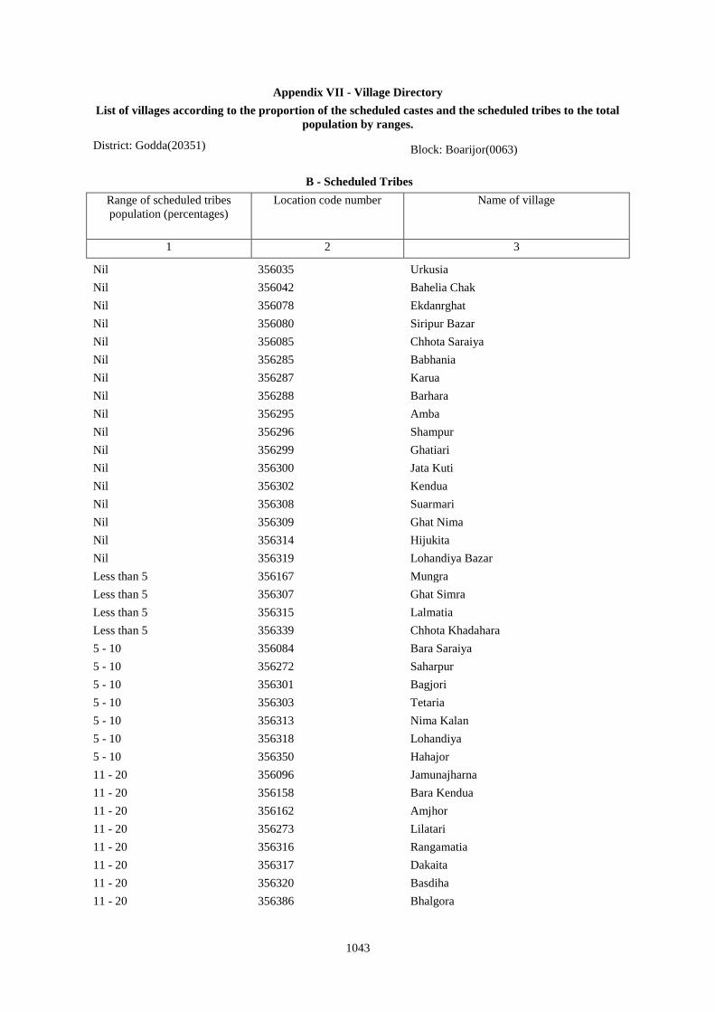
1043
Appendix VII - Village Directory
List of villages according to the proportion of the scheduled castes and the scheduled tribes to the total
population by ranges.
District: Godda(20351) Block: Boarijor(0063)
B - Scheduled Tribes
Range of scheduled tribes
population (percentages)
Location code number Name of village
1 2 3
Nil 356035 Urkusia
Nil 356042 Bahelia Chak
Nil 356078 Ekdanrghat
Nil 356080 Siripur Bazar
Nil 356085 Chhota Saraiya
Nil 356285 Babhania
Nil 356287 Karua
Nil 356288 Barhara
Nil 356295 Amba
Nil 356296 Shampur
Nil 356299 Ghatiari
Nil 356300 Jata Kuti
Nil 356302 Kendua
Nil 356308 Suarmari
Nil 356309 Ghat Nima
Nil 356314 Hijukita
Nil 356319 Lohandiya Bazar
Less than 5 356167 Mungra
Less than 5 356307 Ghat Simra
Less than 5 356315 Lalmatia
Less than 5 356339 Chhota Khadahara
5 - 10 356084 Bara Saraiya
5 - 10 356272 Saharpur
5 - 10 356301 Bagjori
5 - 10 356303 Tetaria
5 - 10 356313 Nima Kalan
5 - 10 356318 Lohandiya
5 - 10 356350 Hahajor
11 - 20 356096 Jamunajharna
11 - 20 356158 Bara Kendua
11 - 20 356162 Amjhor
11 - 20 356273 Lilatari
11 - 20 356316 Rangamatia
11 - 20 356317 Dakaita
11 - 20 356320 Basdiha
11 - 20 356386 Bhalgora
1044
21 - 30 356077 Joborampur
21 - 30 356103 Chhota Boarijor
21 - 30 356156 Chhota Kendua
21 - 30 356171 Kero
21 - 30 356175 Kusbila
21 - 30 356176 Bhadria
21 - 30 356372 Phulbaria
31 - 40 356049 Janlokundi
31 - 40 356075 Sakrikita Rampur
31 - 40 356097 Bara Boarijor
31 - 40 356098 Dhorri
31 - 40 356160 Dhamni
31 - 40 356174 Lilatari
31 - 40 356274 Khairbani
31 - 40 356281 Goriya
31 - 40 356289 Gorakhpur
31 - 40 356290 Jojosimra
31 - 40 356329 Dumriya
31 - 40 356346 Kusumghati
31 - 40 356355 Bara Bhorai
31 - 40 356377 Bara Dhanbandhi
41 - 50 356038 Sijuakol
41 - 50 356062 Chhota Itahari Pahar
41 - 50 356086 Manikpur
41 - 50 356159 Uparbandha
41 - 50 356168 Liti
41 - 50 356181 Rajapokhar Jagir
41 - 50 356282 Kamardiha
41 - 50 356310 Chitar Koti
41 - 50 356371 Piaram
41 - 50 356408 Dumaria
51 - 75 356043 Rajbandh
51 - 75 356046 Ramkol
51 - 75 356052 Jirli
51 - 75 356054 Goradih
51 - 75 356060 Baghmara
51 - 75 356064 Bara Gogra
51 - 75 356065 Chhota Darma
51 - 75 356070 Khejuria
51 - 75 356073 Balajhor
51 - 75 356074 Bangama
51 - 75 356079 Chhota Siripur
51 - 75 356081 Bara Siripur
51 - 75 356087 Kandaniya
51 - 75 356101 Meghi
51 - 75 356102 Mangra
1045
51 - 75 356157 Shampur
51 - 75 356163 Debipur
51 - 75 356164 Rajabhita
51 - 75 356166 Bara Dumarhir
51 - 75 356169 Champapur
51 - 75 356173 Ambadiha
51 - 75 356305 Bara Simra
51 - 75 356306 Chhota Simra
51 - 75 356341 Harkata
51 - 75 356342 Bara Khairbani
51 - 75 356345 Dahua
51 - 75 356348 Lilatari
51 - 75 356349 Haripur
51 - 75 356354 Chhota Bhorai
51 - 75 356357 Kesgoria
76 and above 356036 Garantia
76 and above 356037 Lakrakol
76 and above 356039 Bagjhopa
76 and above 356040 Daldali Gopalpur
76 and above 356044 Issar Chak
76 and above 356045 Kendua
76 and above 356047 Raharbaria
76 and above 356048 Kamaldori
76 and above 356050 Dhamnisemia
76 and above 356051 Hijri
76 and above 356053 Dhamnipahar
76 and above 356056 Bishunpur
76 and above 356057 Chandsar
76 and above 356058 Karmatanr
76 and above 356059 Marpa
76 and above 356061 Itahari
76 and above 356063 Chhota Gogra
76 and above 356066 Kolhua
76 and above 356067 Malbhita
76 and above 356068 Pairgora
76 and above 356069 Kaldigra
76 and above 356071 Talbaria
76 and above 356072 Bara Darma
76 and above 356082 Khairbani
76 and above 356083 Losinghna
76 and above 356088 Beldiha
76 and above 356089 Kortia
76 and above 356090 Asanbuna
76 and above 356091 Marcha
76 and above 356093 Churi
76 and above 356094 Talbaria
1046
76 and above 356095 Bansbhita
76 and above 356099 Dubra
76 and above 356100 Mahula
76 and above 356104 Mahuakol
76 and above 356105 Lakrakol
76 and above 356106 Babuchuri
76 and above 356107 Parsiya
76 and above 356108 Bador
76 and above 356109 Muchuradaldali
76 and above 356110 Daharlangi
76 and above 356111 Pokhariya
76 and above 356112 Barakera
76 and above 356113 Chhotakera
76 and above 356114 Karamtola
76 and above 356115 Meredele
76 and above 356116 Baragbhita
76 and above 356117 Kutni
76 and above 356119 Puriabadar
76 and above 356120 Bartali
76 and above 356121 Anamu
76 and above 356125 Bargi
76 and above 356130 Dobri
76 and above 356133 Gadgandi
76 and above 356134 Gandiyamo
76 and above 356139 Karakdoni
76 and above 356140 Kasamu
76 and above 356145 Mahwari Bedo
76 and above 356147 Maligoda
76 and above 356152 Orbot
76 and above 356154 Sundariya
76 and above 356161 Narainpur
76 and above 356165 Chhota Dumarhir
76 and above 356170 Telo
76 and above 356172 Kusumghati
76 and above 356177 Chandna
76 and above 356180 Tetariya
76 and above 356182 Rajapokhar Jagir
76 and above 356183 Rajapokhar Jagir
76 and above 356184 Rajapokhar
76 and above 356185 Bara Chatampur
76 and above 356186 Lilabhita
76 and above 356187 Tamlia Amdanda
76 and above 356191 Chhota Chatampur
76 and above 356192 Chetmapahar
76 and above 356193 Dhanigora
76 and above 356197 Chalpahari
1047
76 and above 356198 Madomasi
76 and above 356199 Bhagamakra
76 and above 356200 Champatola
76 and above 356201 Pakriya Pahar
76 and above 356202 Kairasol
76 and above 356204 Pachro
76 and above 356205 Marni Pahar
76 and above 356206 Daria Pahar
76 and above 356209 Bara Patma Masahara
76 and above 356210 Chhota Patma
76 and above 356213 Jania Pahar
76 and above 356214 Tetarganji Pahar
76 and above 356216 Bara Patma
76 and above 356217 Katikbhita
76 and above 356218 Kuspisa
76 and above 356219 Dhamnijor
76 and above 356220 Katalpahari
76 and above 356222 Telaibera
76 and above 356225 Baridih
76 and above 356226 Sijua
76 and above 356227 Ratanpur
76 and above 356228 Rohra
76 and above 356229 Juniya Tola
76 and above 356232 Borbe
76 and above 356235 Chengro
76 and above 356236 Donigoda Bedo
76 and above 356245 Jonia
76 and above 356250 Kilo Bedo
76 and above 356251 Kilo Maqo
76 and above 356253 Kuro Maqo
76 and above 356255 Kutam
76 and above 356256 Letragoda
76 and above 356258 Matubera
76 and above 356260 Patma Joka
76 and above 356262 Puro Maqo
76 and above 356263 Puro Bedo
76 and above 356271 Tokkuriya
76 and above 356275 Belthu
76 and above 356276 Hethbandha
76 and above 356277 Shamapokhar
76 and above 356278 Chiharbona
76 and above 356280 Tulsipur
76 and above 356283 Gopalpur
76 and above 356284 Lawabhujani
76 and above 356286 Gori Chak
76 and above 356291 Kusma
1048
76 and above 356292 Kurkutiya
76 and above 356293 Dumra
76 and above 356294 Sabejora
76 and above 356297 Beldiha
76 and above 356298 Balajhor
76 and above 356304 Paharpur
76 and above 356311 Telgama
76 and above 356312 Duwarighat Telgama
76 and above 356321 Paharpur
76 and above 356322 Bharanda
76 and above 356323 Harrakha
76 and above 356326 Ranidih
76 and above 356327 Barkandali
76 and above 356328 Dhankunda
76 and above 356330 Dumarkol
76 and above 356331 Babupur
76 and above 356332 Bara Kotha
76 and above 356333 Bara Barma Pahar
76 and above 356334 Tatkunda
76 and above 356335 Chhota Barma
76 and above 356336 Debdanr
76 and above 356337 Surla
76 and above 356338 Dumria
76 and above 356343 Baisabaran
76 and above 356344 Jurgura
76 and above 356347 Lutibahiar
76 and above 356351 Panchrukhi
76 and above 356356 Taljhari
76 and above 356358 Pakaria
76 and above 356359 Jaggora
76 and above 356360 Bador
76 and above 356362 Bichduba
76 and above 356363 Telodhuni
76 and above 356364 Madgigora
76 and above 356365 Dighi
76 and above 356366 Gopali
76 and above 356367 Dabra
76 and above 356368 Rohari Naryanpur
76 and above 356369 Jolopahari
76 and above 356373 Harra
76 and above 356374 Mahuabathan
76 and above 356375 Gadial
76 and above 356376 Chakra
76 and above 356378 Chhota Dhanbandhi
76 and above 356379 Tetardiha
76 and above 356381 Kajribhita

1049
76 and above 356382 Adro
76 and above 356383 Chhota Amra
76 and above 356384 Tulsipur
76 and above 356385 Lohatamba And Agoia
76 and above 356387 Deonapur
76 and above 356388 Bhagwanpur
76 and above 356389 Bara Malbhita
76 and above 356390 Chhota Malbhita
76 and above 356391 Tikrigora
76 and above 356395 Malbhita Tola
76 and above 356396 Chhota Pipra
76 and above 356401 Bara Pipra
76 and above 356405 Kisma
76 and above 356406 Bara Amarpur
76 and above 356407 Chhota Amarpur
76 and above 356409 Bamangawan
76 and above 356411 Bararo
76 and above 356412 Chetan Pahar
76 and above 356416 Moter Pahar
76 and above 356419 Bara Telo
76 and above 356420 Chhota Telo
76 and above 356421 Jajotola Barhua
76 and above 356422 Bara Amra
76 and above 356423 Balkani
76 and above 356424 Sundai
76 and above 356425 Garbhu Tola
76 and above 356426 Chhota Simmi
76 and above 356427 Bara Simmi
76 and above 356428 Bandhgora
76 and above 356429 Kesarogora
76 and above 356430 Chhota Chapri
76 and above 356431 Dholna Pahar
76 and above 356432 Telotok
76 and above 356434 Keriapahar
76 and above 356440 Bansdanda
76 and above 356443 Satbera
76 and above 356447 Bara Chapri
76 and above 356449 Chapri Bara
76 and above 356458 Bara Kerlo
76 and above 356465 Chhota Karlopahar
76 and above 356466 Chhota Kerlo
76 and above 356468 Bara Kamu
76 and above 356470 Dumli

1050
Appendix VII - Village Directory
List of villages according to the proportion of the scheduled castes and the scheduled tribes to the total
population by ranges.
District: Godda(20351) Block: Mahagama(0064)
B - Scheduled Tribes
Range of scheduled tribes
population (percentages)
Location code number Name of village
1 2 3
Nil 356478 Khutahari
Nil 356479 Darbe Chak
Nil 356480 Kanak Kita
Nil 356481 Sarbhanga
Nil 356486 Sarautia
Nil 356489 Chauchak
Nil 356490 Saha Chak
Nil 356492 Singpur
Nil 356494 Garbhudih
Nil 356496 Samu Kita
Nil 356498 Sidhari
Nil 356499 Mohani
Nil 356500 Bakanpur
Nil 356506 Sital
Nil 356507 Mali Chak
Nil 356508 Gorgawan
Nil 356510 Dhobia Chak
Nil 356511 Bairia Chak
Nil 356515 Milik Hanwara
Nil 356516 Hanwara
Nil 356517 Ramkol
Nil 356520 Narainpur (Dompatti)
Nil 356521 Sahi Kita
Nil 356522 Narainpur (Sempatti)
Nil 356523 Chak Chamu
Nil 356524 Baija Chak
Nil 356526 Dumaria Kalan
Nil 356527 Narattampur
Nil 356528 Biswas Khani
Nil 356529 Sagrampur
Nil 356530 Pararia
Nil 356532 Bikrampur
Nil 356533 Koila
Nil 356539 Sarthu
Nil 356541 Gurhi
Nil 356542 Baje Kita
1051
Nil 356543 Baje Kita
Nil 356544 Bairia Kita
Nil 356545 Kharaiya
Nil 356546 Sahajadpur
Nil 356547 Ghatiani
Nil 356548 Ghuthi
Nil 356549 Khurd
Nil 356552 Sirinathpur
Nil 356554 Singarpur
Nil 356555 Jatama
Nil 356556 Gauri Kita
Nil 356558 Belti Kari
Nil 356560 Asota
Nil 356561 Kasba
Nil 356562 Bhandarchua
Nil 356563 Shekhu Chak
Nil 356564 Bhelaidih
Nil 356565 Doma Chak
Nil 356566 Bansbara
Nil 356570 Bhikhia Chak
Nil 356579 Khurd
Nil 356580 Firozpur
Nil 356581 Dharampur Ghat
Nil 356582 Dharampur Mal
Nil 356583 Chaujora Mal
Nil 356585 Kamargawan
Nil 356586 Mansura
Nil 356590 Gokula
Nil 356592 Daniala
Nil 356593 Khaira
Nil 356594 Fouzdar Kita Ghat
Nil 356595 Ghatdiarhi
Nil 356596 Diarhi Kita
Nil 356598 Manoharpur
Nil 356600 Jhagarua
Nil 356605 Chainpur
Nil 356607 Ramchandarpur
Nil 356611 Rai Kita
Nil 356612 Jatakothi
Nil 356622 Kachuamal Chhit
Nil 356625 Kachua Raksi
Nil 356627 Maskand Kachua
Nil 356628 Lilabari
Nil 356632 Sirsa Kalan
Nil 356635 Mahuara Ghat
Nil 356638 Logain
1052
Nil 356640 Maskand Bhanjpur
Nil 356652 Kita Bishambhara
Nil 356653 Gunia
Nil 356665 Chand Chak
Nil 356666 Ghospur
Nil 356669 Bhartha Chak
Nil 356672 Anjna
Nil 356674 Sirsi
Nil 356675 Bhairo Chak
Nil 356676 Kusmara
Nil 356678 Bishunpur
Nil 356679 Baradbara
Nil 356680 Sundar Chak
Nil 356682 Malia Chak
Nil 356684 Mariha
Nil 356686 Fazil Kita
Nil 356687 Dumra
Nil 356688 Bisambhara Kita
Nil 356689 Dahia
Nil 356690 Kaljhara
Nil 356696 Phasiatikar
Nil 356697 Sirsa
Nil 356700 Muradpur
Nil 356702 Semra Kita
Nil 356703 Mirza Chak
Nil 356704 Hasan Karharia
Nil 356709 Hasanpur
Nil 356710 Bakwa Chak
Nil 356713 Mal Bhandari Dih
Nil 356714 Semrakita And Ghat Bhandarid
Nil 356715 Aslulahsamra
Nil 356718 Ranbahiar
Nil 356723 Larai Chak
Nil 356725 Hemcha Chak
Nil 356734 Samda
Nil 356737 Kusha
Nil 356738 Hansai Kita
Nil 356739 Kusmi
Nil 356740 Bahalia Kita
Nil 356741 Jamaidih
Nil 356742 Babupur Mal
Nil 356744 Gain Chak
Nil 356745 Babupur Ghat
Nil 356746 Rajpur
Nil 356751 Gudia
Nil 356759 Dhankurda
1053
Nil 356766 Akasni
Nil 356767 Kendua Kita
Nil 356770 Tetaria
Nil 356771 Lakrabank
Nil 356772 Balia Ghat
Nil 356773 Balia Kurmi Kita
Nil 356776 Doman Kita
Nil 356780 Dumaria Mal
Nil 356782 Kadhara Ghat
Nil 356798 Chansar
Nil 356799 Nima Chak
Nil 356800 Chichohari
Nil 356801 Dudhbecha
Nil 356802 Goradih
Nil 356803 Deyal Kita
Nil 356805 Gosain Chak
Nil 356808 Dharmudih
Nil 356809 Mahadeb Kita
Nil 356810 Telaria
Nil 356811 Nunajor
Nil 356814 Saraiaghat
Nil 356815 Manikpur Ghat
Nil 356819 Hahajor
Nil 356822 Bansipur
Nil 356823 Sib Kita
Nil 356825 Ghat Bhangabandh
Nil 356828 Ghat Gamharia
Nil 356830 Ghat Garhaiya
Nil 356834 Sikkita
Nil 356835 Sarawa
Nil 356836 Baridih
Less than 5 356501 Dighi
Less than 5 356509 Naraini
Less than 5 356525 Dumaria Khurd
Less than 5 356531 Parsa
Less than 5 356550 Banjpur
Less than 5 356553 Nayanagar
Less than 5 356626 Raksa Maskand
Less than 5 356655 Baghakol
Less than 5 356698 Samhari
Less than 5 356707 Hari Karharia
Less than 5 356717 Maganpipra
Less than 5 356720 Chuna Chak
Less than 5 356722 Sakal Chak
Less than 5 356729 Semarkita Ghat Bhandaridih
Less than 5 356736 Chilha

1054
Less than 5 356755 Gangsagar
Less than 5 356758 Jharna Kita
Less than 5 356839 Lohathi
5 - 10 356569 Kamal Chak
5 - 10 356754 Basua
11 - 20 356661 Beltikri
11 - 20 356681 Bhaju Chak
11 - 20 356705 Manian Karharia
11 - 20 356752 Letaria
11 - 20 356753 Murlitak
11 - 20 356775 Raksa Kita
11 - 20 356777 Mohanpur
11 - 20 356779 Kusdiha
11 - 20 356781 Kadhara Mal
11 - 20 356797 Khutehri
11 - 20 356816 Amarpur
11 - 20 356833 Madhu Chak
21 - 30 356577 Alola
21 - 30 356610 Jiajori
21 - 30 356636 Mahuara
21 - 30 356659 Bhalu Kita
21 - 30 356695 Shahpur Beldiha
21 - 30 356712 Janki Kita
21 - 30 356733 Sitladih
21 - 30 356796 Dalabar
21 - 30 356812 Bhogan
31 - 40 356477 Manjura
31 - 40 356646 Rahim Kita
31 - 40 356716 Bariartola
31 - 40 356721 Ginratari
31 - 40 356731 Khaspathar
31 - 40 356750 Karnu
31 - 40 356790 Kitapathar
31 - 40 356826 Mal Bhangabandh
31 - 40 356827 Panchgachhi
41 - 50 356654 Harin Chora
41 - 50 356693 Hundra
41 - 50 356749 Pathar Kani
41 - 50 356774 Rabiadih (Santali)
41 - 50 356788 Lakhipur
41 - 50 356818 Bhainsabarankurum Tola Mal
41 - 50 356824 Amdiha
51 - 75 356568 Pakridih
51 - 75 356608 Ghat Jagarnathpur
51 - 75 356615 Balachini
51 - 75 356619 Lakarha
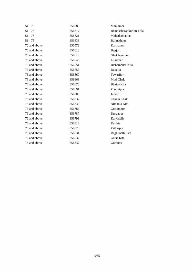
1055
51 - 75 356785 Maniamor
51 - 75 356817 Bhainsabarankurum Tola
51 - 75 356821 Mahadeobathan
51 - 75 356838 Baijnathpur
76 and above 356573 Karmatanr
76 and above 356613 Bagjori
76 and above 356616 Ghat Jagatpur
76 and above 356649 Lilambar
76 and above 356651 Bishambhar Kita
76 and above 356656 Dakaita
76 and above 356660 Tewarijor
76 and above 356668 Moti Chak
76 and above 356670 Bhairo Kita
76 and above 356691 Phudkipur
76 and above 356706 Jathari
76 and above 356732 Chanai Chak
76 and above 356735 Nimania Kita
76 and above 356783 Gobindpur
76 and above 356787 Durgapur
76 and above 356793 Karkatdih
76 and above 356813 Kaithia
76 and above 356820 Patharpur
76 and above 356831 Raghunath Kita
76 and above 356832 Gauri Kita
76 and above 356837 Gorantia
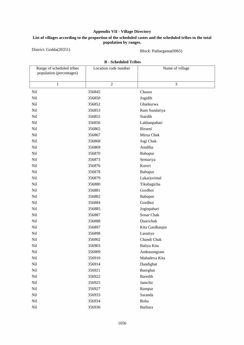
1056
Appendix VII - Village Directory
List of villages according to the proportion of the scheduled castes and the scheduled tribes to the total
population by ranges.
District: Godda(20351) Block: Pathargama(0065)
B - Scheduled Tribes
Range of scheduled tribes
population (percentages)
Location code number Name of village
1 2 3
Nil 356845 Chaura
Nil 356850 Jogidih
Nil 356852 Ghatkurwa
Nil 356853 Ram Sundariya
Nil 356855 Siardih
Nil 356856 Lakhanpahari
Nil 356865 Birseni
Nil 356867 Mirza Chak
Nil 356868 Jogi Chak
Nil 356869 Amdiha
Nil 356870 Babupur
Nil 356873 Semariya
Nil 356876 Kureri
Nil 356878 Babupur
Nil 356879 Lakarjorimal
Nil 356880 Tikabagicha
Nil 356881 Gordhoi
Nil 356882 Babupur
Nil 356884 Gordhoi
Nil 356885 Joginpahari
Nil 356887 Sonar Chak
Nil 356888 Duarichak
Nil 356897 Kita Gardharpur
Nil 356898 Lasutiya
Nil 356902 Chandi Chak
Nil 356903 Baliya Kita
Nil 356909 Ambasongram
Nil 356910 Mahadeva Kita
Nil 356914 Dandighat
Nil 356921 Bareghat
Nil 356922 Baredih
Nil 356925 Jamchir
Nil 356927 Rampur
Nil 356933 Saranda
Nil 356934 Boha
Nil 356936 Barhara
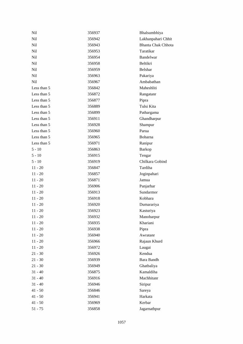
1057
Nil 356937 Bhalsumbhiya
Nil 356942 Lakhanpahari Chhit
Nil 356943 Bhanta Chak Chhota
Nil 356953 Taratikar
Nil 356954 Bandelwar
Nil 356958 Beltikri
Nil 356959 Belshar
Nil 356963 Pakariya
Nil 356967 Ambabathan
Less than 5 356842 Maheshliti
Less than 5 356872 Rangatanr
Less than 5 356877 Pipra
Less than 5 356889 Tulsi Kita
Less than 5 356899 Pathargama
Less than 5 356911 Ghandharpur
Less than 5 356928 Shampur
Less than 5 356960 Parua
Less than 5 356965 Boharna
Less than 5 356971 Ranipur
5 - 10 356863 Barkop
5 - 10 356915 Tengar
5 - 10 356919 Chilkara Gobind
11 - 20 356847 Tardiha
11 - 20 356857 Joginpahari
11 - 20 356871 Jamua
11 - 20 356906 Panjarhar
11 - 20 356913 Sundarmor
11 - 20 356918 Kobhara
11 - 20 356920 Dumarariya
11 - 20 356923 Kasturiya
11 - 20 356932 Manoharpur
11 - 20 356935 Khariani
11 - 20 356938 Pipra
11 - 20 356940 Awratanr
11 - 20 356966 Rajaun Khurd
11 - 20 356972 Laugai
21 - 30 356926 Kendua
21 - 30 356939 Bara Bandh
21 - 30 356949 Ghatbaliya
31 - 40 356875 Kamaldiha
31 - 40 356916 Machhitanr
31 - 40 356946 Siripur
41 - 50 356846 Sareya
41 - 50 356941 Harkata
41 - 50 356969 Kerbar
51 - 75 356858 Jagarnathpur
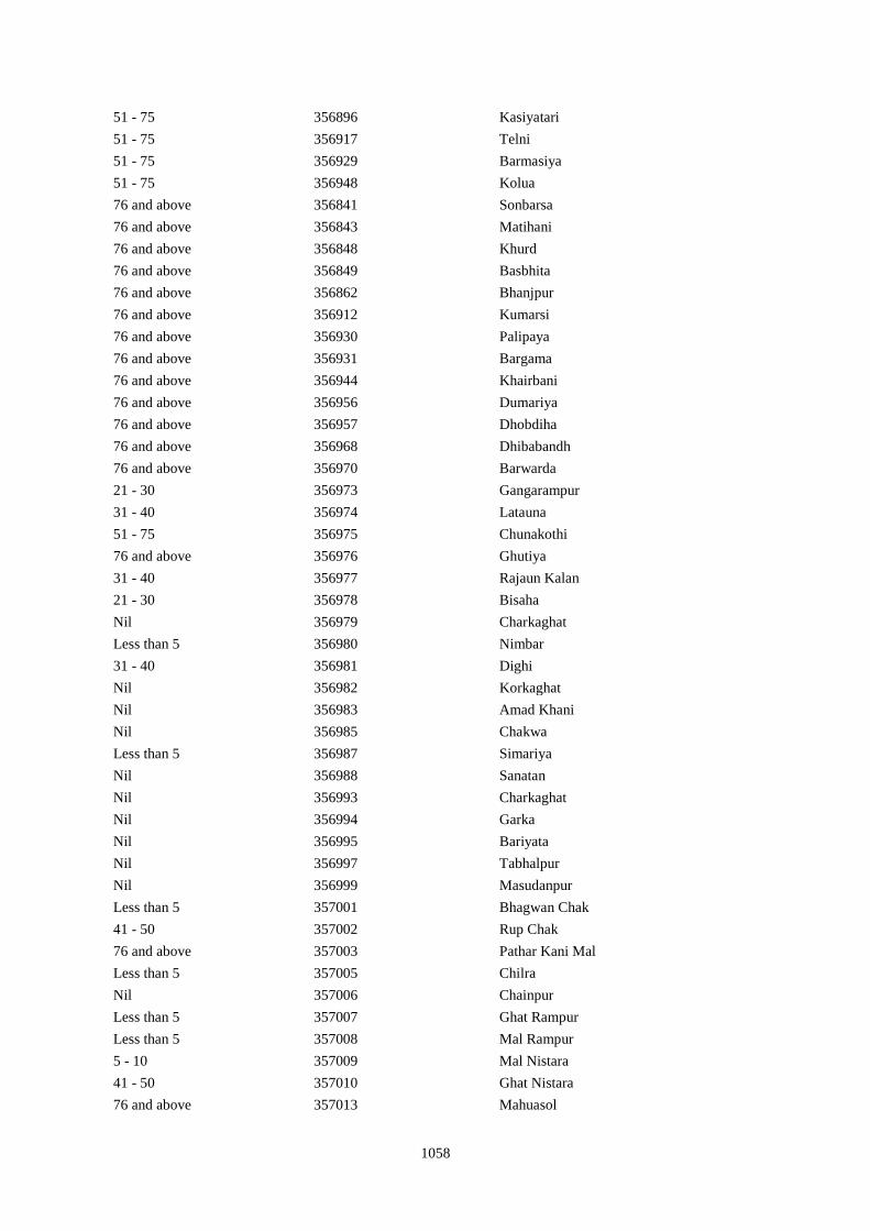
1058
51 - 75 356896 Kasiyatari
51 - 75 356917 Telni
51 - 75 356929 Barmasiya
51 - 75 356948 Kolua
76 and above 356841 Sonbarsa
76 and above 356843 Matihani
76 and above 356848 Khurd
76 and above 356849 Basbhita
76 and above 356862 Bhanjpur
76 and above 356912 Kumarsi
76 and above 356930 Palipaya
76 and above 356931 Bargama
76 and above 356944 Khairbani
76 and above 356956 Dumariya
76 and above 356957 Dhobdiha
76 and above 356968 Dhibabandh
76 and above 356970 Barwarda
21 - 30 356973 Gangarampur
31 - 40 356974 Latauna
51 - 75 356975 Chunakothi
76 and above 356976 Ghutiya
31 - 40 356977 Rajaun Kalan
21 - 30 356978 Bisaha
Nil 356979 Charkaghat
Less than 5 356980 Nimbar
31 - 40 356981 Dighi
Nil 356982 Korkaghat
Nil 356983 Amad Khani
Nil 356985 Chakwa
Less than 5 356987 Simariya
Nil 356988 Sanatan
Nil 356993 Charkaghat
Nil 356994 Garka
Nil 356995 Bariyata
Nil 356997 Tabhalpur
Nil 356999 Masudanpur
Less than 5 357001 Bhagwan Chak
41 - 50 357002 Rup Chak
76 and above 357003 Pathar Kani Mal
Less than 5 357005 Chilra
Nil 357006 Chainpur
Less than 5 357007 Ghat Rampur
Less than 5 357008 Mal Rampur
5 - 10 357009 Mal Nistara
41 - 50 357010 Ghat Nistara
76 and above 357013 Mahuasol
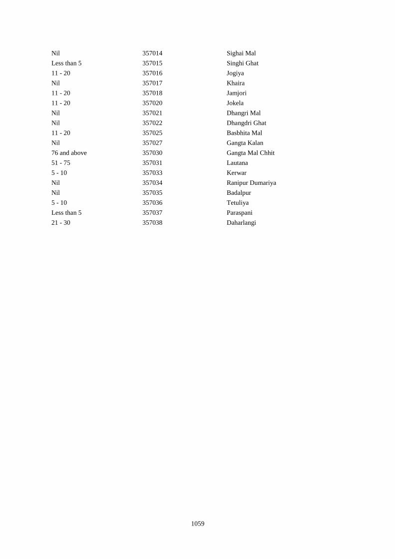
1059
Nil 357014 Sighai Mal
Less than 5 357015 Singhi Ghat
11 - 20 357016 Jogiya
Nil 357017 Khaira
11 - 20 357018 Jamjori
11 - 20 357020 Jokela
Nil 357021 Dhangri Mal
Nil 357022 Dhangdri Ghat
11 - 20 357025 Basbhita Mal
Nil 357027 Gangta Kalan
76 and above 357030 Gangta Mal Chhit
51 - 75 357031 Lautana
5 - 10 357033 Kerwar
Nil 357034 Ranipur Dumariya
Nil 357035 Badalpur
5 - 10 357036 Tetuliya
Less than 5 357037 Paraspani
21 - 30 357038 Daharlangi
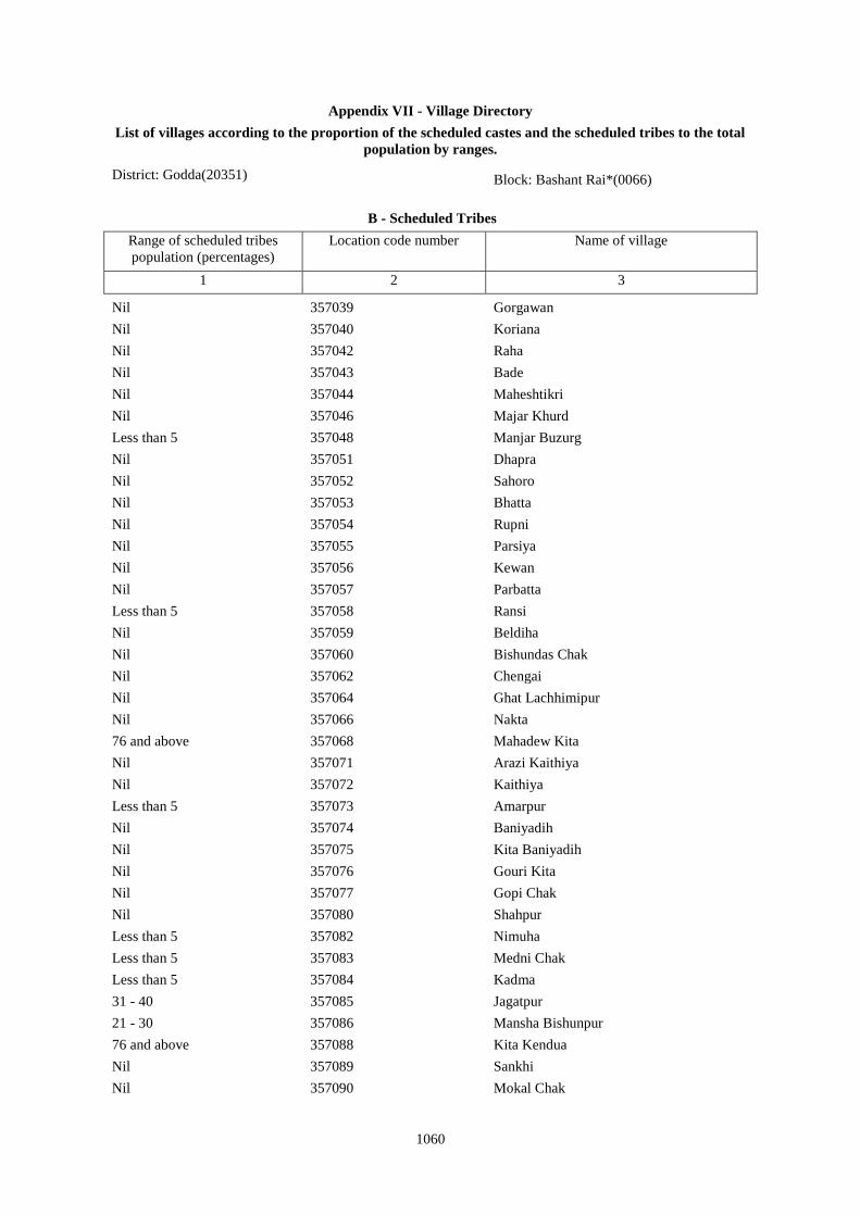
1060
Appendix VII - Village Directory
List of villages according to the proportion of the scheduled castes and the scheduled tribes to the total
population by ranges.
District: Godda(20351) Block: Bashant Rai*(0066)
B - Scheduled Tribes
Range of scheduled tribes
population (percentages)
Location code number Name of village
1 2 3
Nil 357039 Gorgawan
Nil 357040 Koriana
Nil 357042 Raha
Nil 357043 Bade
Nil 357044 Maheshtikri
Nil 357046 Majar Khurd
Less than 5 357048 Manjar Buzurg
Nil 357051 Dhapra
Nil 357052 Sahoro
Nil 357053 Bhatta
Nil 357054 Rupni
Nil 357055 Parsiya
Nil 357056 Kewan
Nil 357057 Parbatta
Less than 5 357058 Ransi
Nil 357059 Beldiha
Nil 357060 Bishundas Chak
Nil 357062 Chengai
Nil 357064 Ghat Lachhimipur
Nil 357066 Nakta
76 and above 357068 Mahadew Kita
Nil 357071 Arazi Kaithiya
Nil 357072 Kaithiya
Less than 5 357073 Amarpur
Nil 357074 Baniyadih
Nil 357075 Kita Baniyadih
Nil 357076 Gouri Kita
Nil 357077 Gopi Chak
Nil 357080 Shahpur
Less than 5 357082 Nimuha
Less than 5 357083 Medni Chak
Less than 5 357084 Kadma
31 - 40 357085 Jagatpur
21 - 30 357086 Mansha Bishunpur
76 and above 357088 Kita Kendua
Nil 357089 Sankhi
Nil 357090 Mokal Chak
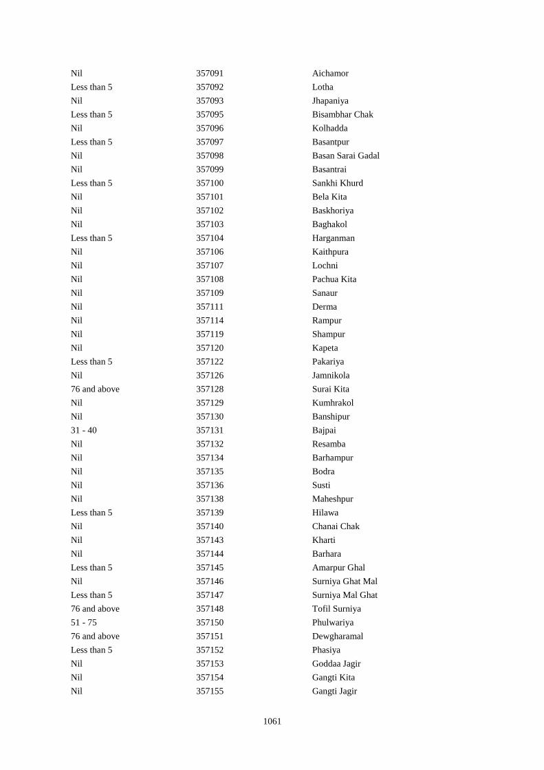
1061
Nil 357091 Aichamor
Less than 5 357092 Lotha
Nil 357093 Jhapaniya
Less than 5 357095 Bisambhar Chak
Nil 357096 Kolhadda
Less than 5 357097 Basantpur
Nil 357098 Basan Sarai Gadal
Nil 357099 Basantrai
Less than 5 357100 Sankhi Khurd
Nil 357101 Bela Kita
Nil 357102 Baskhoriya
Nil 357103 Baghakol
Less than 5 357104 Harganman
Nil 357106 Kaithpura
Nil 357107 Lochni
Nil 357108 Pachua Kita
Nil 357109 Sanaur
Nil 357111 Derma
Nil 357114 Rampur
Nil 357119 Shampur
Nil 357120 Kapeta
Less than 5 357122 Pakariya
Nil 357126 Jamnikola
76 and above 357128 Surai Kita
Nil 357129 Kumhrakol
Nil 357130 Banshipur
31 - 40 357131 Bajpai
Nil 357132 Resamba
Nil 357134 Barhampur
Nil 357135 Bodra
Nil 357136 Susti
Nil 357138 Maheshpur
Less than 5 357139 Hilawa
Nil 357140 Chanai Chak
Nil 357143 Kharti
Nil 357144 Barhara
Less than 5 357145 Amarpur Ghal
Nil 357146 Surniya Ghat Mal
Less than 5 357147 Surniya Mal Ghat
76 and above 357148 Tofil Surniya
51 - 75 357150 Phulwariya
76 and above 357151 Dewgharamal
Less than 5 357152 Phasiya
Nil 357153 Goddaa Jagir
Nil 357154 Gangti Kita
Nil 357155 Gangti Jagir
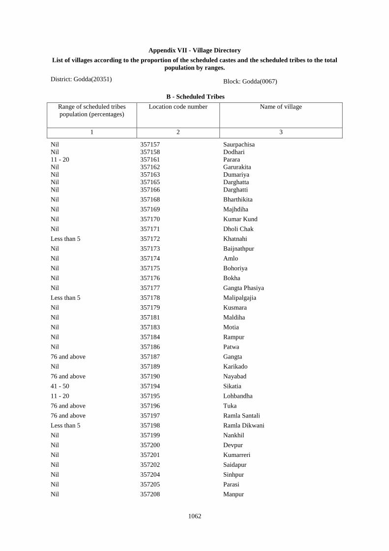
1062
Appendix VII - Village Directory
List of villages according to the proportion of the scheduled castes and the scheduled tribes to the total
population by ranges.
District: Godda(20351) Block: Godda(0067)
B - Scheduled Tribes
Range of scheduled tribes
population (percentages)
Location code number Name of village
1 2 3
Nil 357157 Saurpachisa
Nil 357158 Dodhari
11 - 20 357161 Parara
Nil 357162 Garurakita
Nil 357163 Dumariya
Nil 357165 Darghatta
Nil 357166 Darghatti
Nil 357168 Bharthikita
Nil 357169 Majhdiha
Nil 357170 Kumar Kund
Nil 357171 Dholi Chak
Less than 5 357172 Khatnahi
Nil 357173 Baijnathpur
Nil 357174 Amlo
Nil 357175 Bohoriya
Nil 357176 Bokha
Nil 357177 Gangta Phasiya
Less than 5 357178 Malipalgajia
Nil 357179 Kusmara
Nil 357181 Maldiha
Nil 357183 Motia
Nil 357184 Rampur
Nil 357186 Patwa
76 and above 357187 Gangta
Nil 357189 Karikado
76 and above 357190 Nayabad
41 - 50 357194 Sikatia
11 - 20 357195 Lohbandha
76 and above 357196 Tuka
76 and above 357197 Ramla Santali
Less than 5 357198 Ramla Dikwani
Nil 357199 Nankhil
Nil 357200 Devpur
Nil 357201 Kumarreri
Nil 357202 Saidapur
Nil 357204 Sinhpur
Nil 357205 Parasi
Nil 357208 Manpur
1063
Nil 357209 Dubrajpur
Nil 357210 Gurguri
Nil 357211 Reni
Nil 357213 Kathra
51 - 75 357214 Dokabandh
11 - 20 357215 Makunddih
51 - 75 357216 Makunddin (Santoli)
Less than 5 357217 Pakariya Mal
Nil 357218 Pakarya Ghat
76 and above 357219 Beldiha
Nil 357220 Barahara
Nil 357222 Bansipur
Nil 357223 Kurma
Nil 357224 Baliya
Nil 357225 Molnakita
Nil 357226 Patpur
Nil 357227 Nilkanthpur
Nil 357228 Chapri
Nil 357229 Bara
Nil 357230 Lacchmipur
Nil 357231 Nepura
Nil 357232 Kakana
Nil 357235 Panch Kathi
Nil 357238 Basarhi
Nil 357239 Malni
Nil 357240 Chakwa
Nil 357241 Machhiya Samarda Urf Lalpur
Nil 357242 Diyara
Nil 357243 Jaipur
Less than 5 357244 Barhauna
Nil 357245 Amdiha
Nil 357246 Parsa
Less than 5 357247 Kanhwara
11 - 20 357248 Garbana
21 - 30 357249 Galapahar
Less than 5 357250 Bhadrahi Mal
Nil 357251 Ghat Bhadrahi
Nil 357252 Chilauna
Nil 357253 Rampur
Nil 357254 Dumariya Mal
Nil 357255 Naya Chak
Less than 5 357256 Dara Chak
Nil 357257 Ghat Gorsanda
Nil 357261 Ghat Dhamsain
Less than 5 357263 Pachrukhi
Nil 357265 Lukluki Ghat
1064
Less than 5 357267 Pathariya Ghat
Nil 357269 Chhota Kaliyani
11 - 20 357270 Bara Kaliyani
Nil 357271 Pathriya Mal
21 - 30 357272 Sabaijor
Less than 5 357273 Karudih
11 - 20 357274 Kauadhab
21 - 30 357275 Gaechhand
11 - 20 357276 Chinadhab
11 - 20 357277 Tilobadar
Nil 357278 Pelgarhi Dhopahari
Nil 357279 Karmatanr
5 - 10 357281 Ranidih
Nil 357282 Malhra
Less than 5 357283 Kurmi Chak
Nil 357285 Charkakol Ghat
Nil 357287 Ratrati
Nil 357288 Karhariya Mal
Nil 357289 Kubji Ghat
Nil 357290 Pathwara
Nil 357291 Karhariya Ghat
Nil 357292 Mal Domuria
Nil 357296 Kita Pelgarhi Dhopahari
Nil 357297 Kajradah
Nil 357298 Rajpura
Nil 357304 Kutnipathar
Nil 357305 Kathaun
Nil 357306 Parariya Mal
Nil 357307 Kita Parariya Ghat
Nil 357310 Kusmani Ghat
Nil 357311 Ratanpur
Nil 357312 Tarwari
Nil 357313 Manjwara Ghat
Nil 357314 Bishunpur
Nil 357315 Kalyani Kita
Less than 5 357316 Ghat Dumariya
Nil 357321 Kita Gorgawan
Nil 357324 Kutni Pathar
Nil 357326 Bhandar Koli
Nil 357327 Harlal Tola
Nil 357328 Haripur
Nil 357329 Ghat Paharpur
Nil 357330 Kasba Godda
31 - 40 357332 Mohanpur
21 - 30 357333 Markhan
51 - 75 357334 Daldali
1065
5 - 10 357335 Jamuni Paharpur
Nil 357337 Nonmati
11 - 20 357338 Sarotiya
Less than 5 357339 Bhatdiha
Nil 357340 Bengbahiyar
Nil 357341 Rupiyamal
Nil 357342 Maruabaran
Less than 5 357344 Kauribahiyar Ghat
21 - 30 357345 Kauribahiyar Mal
5 - 10 357346 Pairdih
11 - 20 357347 Kanadih Chhit
31 - 40 357350 Jamua
Nil 357351 Kurman Ghat
31 - 40 357352 Lamhati Kar
Nil 357353 Kurman Mal
31 - 40 357354 Dharmudih
Nil 357355 Punsiya
5 - 10 357356 Kumardih
Less than 5 357357 Murlidih Kita
21 - 30 357358 Pandubathan
11 - 20 357359 Sarkanda
5 - 10 357360 Pathra
Nil 357361 Bilari
Less than 5 357362 Ghat Jamuni
Less than 5 357363 Pandaha
Nil 357364 Ghat Jhilua
11 - 20 357365 Lachhmi
Nil 357366 Ghat Jopnadih
11 - 20 357367 Majhdiha
11 - 20 357368 Makhni
21 - 30 357369 Amarpur
Less than 5 357370 Baramasia
76 and above 357371 Sonjhar
5 - 10 357372 Kadwa
5 - 10 357373 Nonbatta
11 - 20 357374 Teldiha
21 - 30 357375 Banka Ghat
21 - 30 357376 Langradih
5 - 10 357377 Bhalpahari
11 - 20 357378 Sundarmor
11 - 20 357379 Nipaniya
76 and above 357380 Baristanr
21 - 30 357382 Sandmara
Nil 357384 Nandupahari
41 - 50 357385 Jainagar Piprajoria
51 - 75 357386 Birbal Tola
1066
Less than 5 357387 Belbathan
51 - 75 357388 Raj Daha
76 and above 357390 Shampur
Nil 357391 Jhagarahi
Nil 357392 Kalhajor Kalan
76 and above 357393 Saharpur
76 and above 357394 Jhilua
76 and above 357395 Amjora
76 and above 357396 Hijaljor
76 and above 357397 Kundadah
51 - 75 357398 Karanpur
76 and above 357399 Kalhajor Khurd
51 - 75 357400 Sahari
41 - 50 357401 Dumma
41 - 50 357402 Malmala
76 and above 357404 Danga
51 - 75 357405 Jamkudar
76 and above 357406 Siarkatiya
41 - 50 357407 Burhikura
76 and above 357409 Dulu
76 and above 357410 Bhawani
1067
Appendix VII - Village Directory
List of villages according to the proportion of the scheduled castes and the scheduled tribes to the total
population by ranges.
District: Godda(20351) Block: Poreyahat(0068)
B - Scheduled Tribes
Range of scheduled tribes
population (percentages)
Location code number Name of village
1 2 3
Nil 357412 Parasi
Nil 357414 Masanibeldiha
Nil 357415 Muchora
Nil 357416 Amra Kamat
Nil 357418 Amra Kanauli
Nil 357420 Jaijalpur
Less than 5 357421 Sondiha
Nil 357422 Rengniya
Nil 357423 Baliya Kita
Less than 5 357424 Baksara
Nil 357426 Jagarnathpur
Nil 357427 Korasi
Less than 5 357429 Ranabandh
Nil 357430 Asarimadhuri
Less than 5 357431 Ratanpur
Nil 357433 Sarwan
Nil 357434 Jalgo
11 - 20 357435 Bohra
21 - 30 357436 Petbi
31 - 40 357438 Mali
Less than 5 357439 Basantpur
11 - 20 357440 Debandha
21 - 30 357441 Guma
51 - 75 357442 Mahra
Nil 357443 Behrajor
Nil 357444 Manikpur
Less than 5 357445 Birniyan
76 and above 357446 Dahupadhar
21 - 30 357447 Liladah
Nil 357448 Teliyatikar
Nil 357450 Mohani
Less than 5 357451 Ghanshampur
Less than 5 357452 Danre
76 and above 357455 Balua
76 and above 357456 Beldanga
76 and above 357457 Sat Bandha
1068
41 - 50 357458 Naudiha
21 - 30 357459 Kathwan
51 - 75 357460 Parsoti
51 - 75 357461 Bhatondha
51 - 75 357462 Barga Chhahariyari
76 and above 357463 Sikatiya
76 and above 357464 Latta(Santali)
Nil 357465 Latta (Dikuani)
31 - 40 357466 Surapparwa
76 and above 357467 Balathar
Nil 357468 Amjora
Nil 357469 Burhnajor
Nil 357470 Pakariya
Nil 357471 Bargaon
Nil 357472 Taratikar
Less than 5 357473 Pasai
Nil 357474 Arazi Kita Sahuri
Nil 357475 Machkhara
Less than 5 357477 Durpat
Nil 357478 Goaridih
76 and above 357479 Matihani
76 and above 357480 Bara Chapar
51 - 75 357481 Amwar (Santali)
51 - 75 357482 Amwar(Dikuani)
Nil 357483 Tarpokhra
Nil 357484 Harlatikar
Nil 357485 Bhaga
Nil 357486 Garhi
5 - 10 357487 Gorharajpur(Dikuani)
76 and above 357488 Gorharajpur(Santali)
51 - 75 357489 Khajurma
Less than 5 357490 Tarkhuta
Nil 357491 Joguadih (Dikuani)
76 and above 357492 Joguadih (Santali )
76 and above 357493 Dakhinbahiar
51 - 75 357494 Salaiya
31 - 40 357495 Dumariya
Nil 357496 Danidih
Nil 357497 Akhra
76 and above 357498 Sijua
51 - 75 357499 Dhobai
31 - 40 357500 Baghakol
76 and above 357502 Paharpur
76 and above 357503 Sajhia
51 - 75 357504 Kamradol
21 - 30 357505 Thakurnahan
1069
21 - 30 357506 Dakhin Tola
11 - 20 357507 Tilatanr
76 and above 357508 Sikatia
76 and above 357509 Dhamsur
21 - 30 357510 Chorpahari
Nil 357511 Semra Kola
5 - 10 357512 Charkatanr
76 and above 357513 Charghara
Nil 357514 Lorhi Kunda
41 - 50 357515 Dipna Dhibridah
51 - 75 357516 Sundaridol
21 - 30 357517 Salgatanr
76 and above 357518 Tambajor
51 - 75 357519 Padumpur
51 - 75 357520 Sakri Phulwar
51 - 75 357521 Kurwa
31 - 40 357522 Kharbari
5 - 10 357523 Chamudih
11 - 20 357524 Maheshkiro Pachimtola
11 - 20 357525 Kasturi
51 - 75 357526 Khairadih
51 - 75 357527 Panch Pahari
76 and above 357528 Dadughutu Paharpur
76 and above 357529 Maheshdhasa
76 and above 357530 Kita Makra
76 and above 357531 Dorabandh
11 - 20 357532 Pareya Hat
76 and above 357533 Gunghasa
41 - 50 357534 Rajdaha Bara
51 - 75 357535 Gauripur
76 and above 357536 Sugathan
76 and above 357537 Hathihariyari
41 - 50 357538 Dharophata
11 - 20 357539 Lathibari
21 - 30 357540 Jhapnibandh
31 - 40 357541 Dhanu Kata
31 - 40 357542 Raghunathpur
31 - 40 357543 Kundapani
Nil 357546 Sagunibad
Nil 357547 Pokhariya
Less than 5 357548 Amduma
76 and above 357549 Paharidih
Nil 357550 Pipra
Nil 357551 Bhagaband Nij
76 and above 357552 Ganjoriya
11 - 20 357553 Dulidih
1070
21 - 30 357554 Kairakurwa
11 - 20 357555 Chhota Rajdaha
76 and above 357556 Kasiajor
76 and above 357557 Bhaghabandh
76 and above 357558 Bhaghabandh (Dakhintola)
76 and above 357559 Kitajor
51 - 75 357560 Shampur
51 - 75 357561 Amgachhi
11 - 20 357562 Akasi
51 - 75 357564 Karam Tola
76 and above 357565 Khorishiris
11 - 20 357566 Majdiha
Nil 357567 Lusitanr
76 and above 357568 Dhobarni
41 - 50 357569 Kharisirsa
76 and above 357570 Mahesh Chand
76 and above 357571 Pindari
21 - 30 357572 Murgabani
31 - 40 357573 Baramasiya
Nil 357574 Kamrabandh
Nil 357575 Gopalpur
Nil 357576 Simrakita
Less than 5 357577 Chatra
31 - 40 357578 Sat Pahari
31 - 40 357579 Baghmunda
76 and above 357580 Ghanghra Bandh
51 - 75 357581 Kelabari
51 - 75 357582 Panchratan
31 - 40 357583 Beltopa
76 and above 357584 Harla
51 - 75 357585 Pitar Pahari
Nil 357586 Madhukopi
11 - 20 357587 Bansmuri
41 - 50 357588 Sarbindha
Less than 5 357589 Bansmati
Nil 357590 Bara
76 and above 357591 Jari
51 - 75 357592 Siria
Nil 357593 Nawadih
21 - 30 357594 Banjhi
Nil 357595 Taljhari
11 - 20 357596 Kharkachia
11 - 20 357597 Jambad
Less than 5 357598 Chorbad
76 and above 357599 Agiabandh
Nil 357600 Dewdanr(Uttartola)
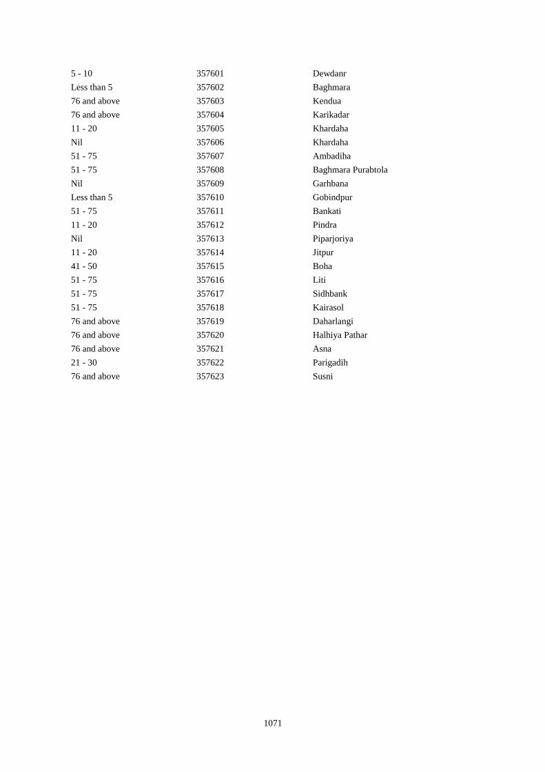
1071
5 - 10 357601 Dewdanr
Less than 5 357602 Baghmara
76 and above 357603 Kendua
76 and above 357604 Karikadar
11 - 20 357605 Khardaha
Nil 357606 Khardaha
51 - 75 357607 Ambadiha
51 - 75 357608 Baghmara Purabtola
Nil 357609 Garhbana
Less than 5 357610 Gobindpur
51 - 75 357611 Bankati
11 - 20 357612 Pindra
Nil 357613 Piparjoriya
11 - 20 357614 Jitpur
41 - 50 357615 Boha
51 - 75 357616 Liti
51 - 75 357617 Sidhbank
51 - 75 357618 Kairasol
76 and above 357619 Daharlangi
76 and above 357620 Halhiya Pathar
76 and above 357621 Asna
21 - 30 357622 Parigadih
76 and above 357623 Susni
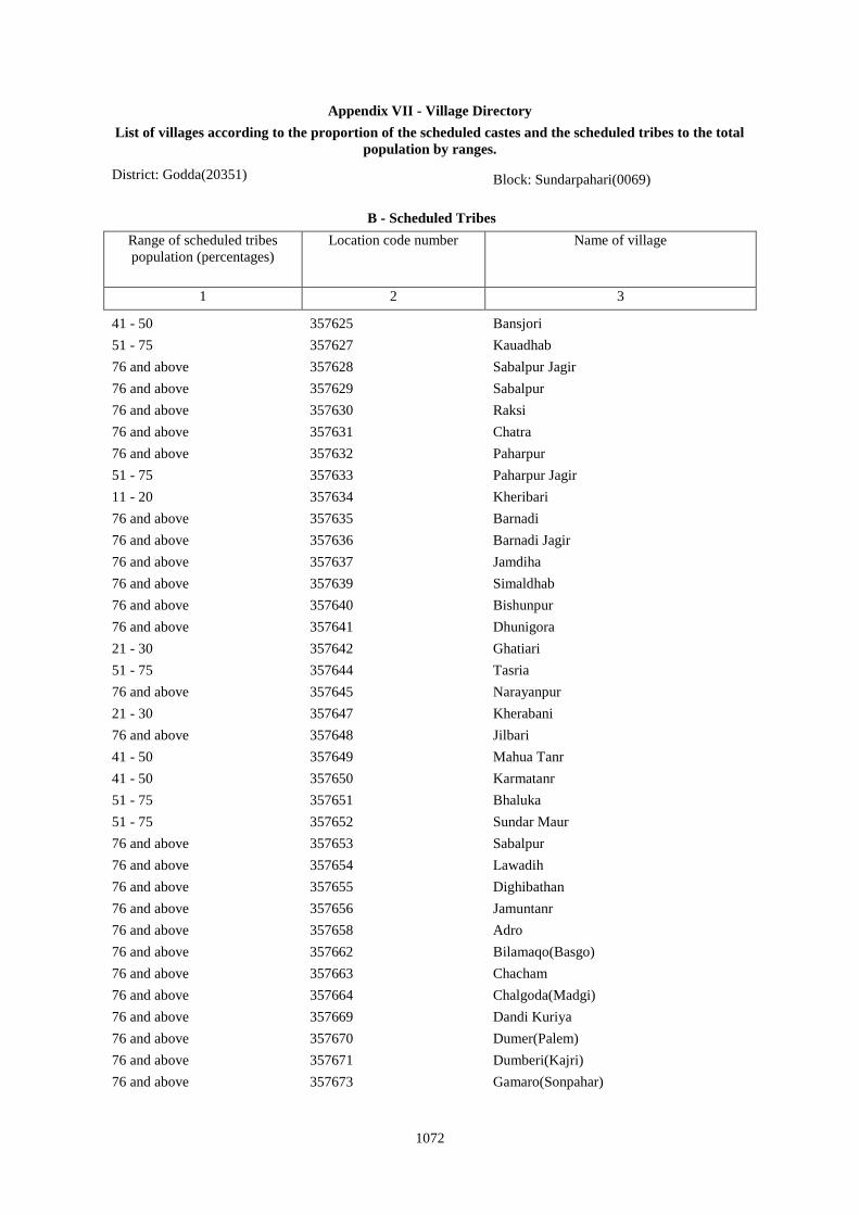
1072
Appendix VII - Village Directory
List of villages according to the proportion of the scheduled castes and the scheduled tribes to the total
population by ranges.
District: Godda(20351) Block: Sundarpahari(0069)
B - Scheduled Tribes
Range of scheduled tribes
population (percentages)
Location code number Name of village
1 2 3
41 - 50 357625 Bansjori
51 - 75 357627 Kauadhab
76 and above 357628 Sabalpur Jagir
76 and above 357629 Sabalpur
76 and above 357630 Raksi
76 and above 357631 Chatra
76 and above 357632 Paharpur
51 - 75 357633 Paharpur Jagir
11 - 20 357634 Kheribari
76 and above 357635 Barnadi
76 and above 357636 Barnadi Jagir
76 and above 357637 Jamdiha
76 and above 357639 Simaldhab
76 and above 357640 Bishunpur
76 and above 357641 Dhunigora
21 - 30 357642 Ghatiari
51 - 75 357644 Tasria
76 and above 357645 Narayanpur
21 - 30 357647 Kherabani
76 and above 357648 Jilbari
41 - 50 357649 Mahua Tanr
41 - 50 357650 Karmatanr
51 - 75 357651 Bhaluka
51 - 75 357652 Sundar Maur
76 and above 357653 Sabalpur
76 and above 357654 Lawadih
76 and above 357655 Dighibathan
76 and above 357656 Jamuntanr
76 and above 357658 Adro
76 and above 357662 Bilamaqo(Basgo)
76 and above 357663 Chacham
76 and above 357664 Chalgoda(Madgi)
76 and above 357669 Dandi Kuriya
76 and above 357670 Dumer(Palem)
76 and above 357671 Dumberi(Kajri)
76 and above 357673 Gamaro(Sonpahar)
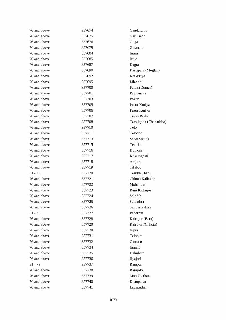
1073
76 and above 357674 Gandarama
76 and above 357675 Gari Bedo
76 and above 357676 Goga
76 and above 357679 Gosmara
76 and above 357684 Jamri
76 and above 357685 Jirko
76 and above 357687 Kagra
76 and above 357690 Kasripara (Moglan)
76 and above 357692 Kerkuriya
76 and above 357695 Liladoni
76 and above 357700 Palem(Dumar)
76 and above 357701 Pawkuriya
76 and above 357703 Pokeri
76 and above 357705 Pusur Kuriya
76 and above 357706 Pusur Kuriya
76 and above 357707 Tamli Bedo
76 and above 357708 Tamligoda (Chaparbita)
76 and above 357710 Telo
76 and above 357711 Telodoni
76 and above 357713 Sena(Katan)
76 and above 357715 Tetaria
76 and above 357716 Domdih
76 and above 357717 Kusumghati
76 and above 357718 Amjora
76 and above 357719 Tilabad
51 - 75 357720 Tesuba Than
76 and above 357721 Chhota Kalhajor
76 and above 357722 Mohanpur
76 and above 357723 Bara Kalhajor
76 and above 357724 Salodih
76 and above 357725 Salpathra
76 and above 357726 Sundar Pahari
51 - 75 357727 Paharpur
76 and above 357728 Kairojori(Bara)
76 and above 357729 Kairojori(Chhota)
76 and above 357730 Jitpur
76 and above 357731 Telbhita
76 and above 357732 Gamaro
76 and above 357734 Jamalo
76 and above 357735 Dahubera
76 and above 357736 Jiyajori
51 - 75 357737 Rampur
76 and above 357738 Barajolo
76 and above 357739 Manikbathan
76 and above 357740 Dhaupahari
76 and above 357741 Ladapathar
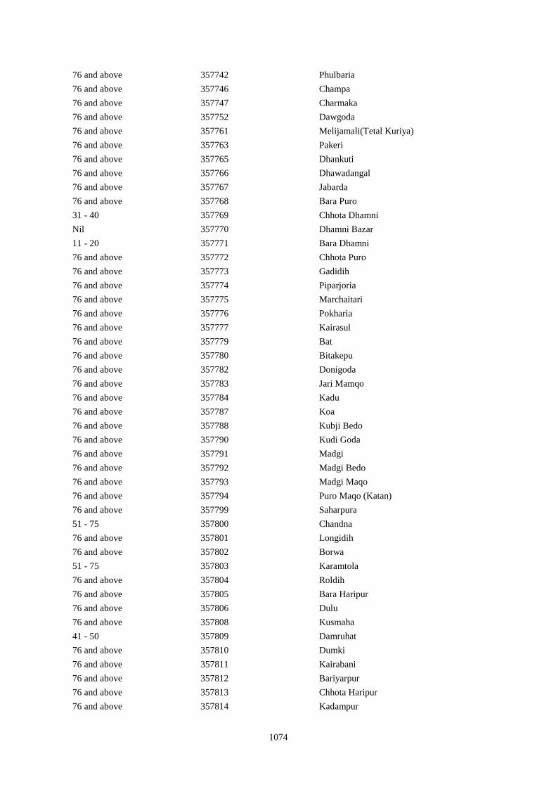
1074
76 and above 357742 Phulbaria
76 and above 357746 Champa
76 and above 357747 Charmaka
76 and above 357752 Dawgoda
76 and above 357761 Melijamali(Tetal Kuriya)
76 and above 357763 Pakeri
76 and above 357765 Dhankuti
76 and above 357766 Dhawadangal
76 and above 357767 Jabarda
76 and above 357768 Bara Puro
31 - 40 357769 Chhota Dhamni
Nil 357770 Dhamni Bazar
11 - 20 357771 Bara Dhamni
76 and above 357772 Chhota Puro
76 and above 357773 Gadidih
76 and above 357774 Piparjoria
76 and above 357775 Marchaitari
76 and above 357776 Pokharia
76 and above 357777 Kairasul
76 and above 357779 Bat
76 and above 357780 Bitakepu
76 and above 357782 Donigoda
76 and above 357783 Jari Mamqo
76 and above 357784 Kadu
76 and above 357787 Koa
76 and above 357788 Kubji Bedo
76 and above 357790 Kudi Goda
76 and above 357791 Madgi
76 and above 357792 Madgi Bedo
76 and above 357793 Madgi Maqo
76 and above 357794 Puro Maqo (Katan)
76 and above 357799 Saharpura
51 - 75 357800 Chandna
76 and above 357801 Longidih
76 and above 357802 Borwa
51 - 75 357803 Karamtola
76 and above 357804 Roldih
76 and above 357805 Bara Haripur
76 and above 357806 Dulu
76 and above 357808 Kusmaha
41 - 50 357809 Damruhat
76 and above 357810 Dumki
76 and above 357811 Kairabani
76 and above 357812 Bariyarpur
76 and above 357813 Chhota Haripur
76 and above 357814 Kadampur
1075
76 and above 357815 Angbali
76 and above 357818 Paharpur
76 and above 357819 Tetariya
76 and above 357820 Khepadih
76 and above 357821 Chandraydih
76 and above 357822 Gardi
76 and above 357823 Ghaghri
76 and above 357824 Malikundi
76 and above 357825 Bara Sinddri
76 and above 357826 Sagar
76 and above 357827 Monadih
76 and above 357828 Ghorabali
76 and above 357829 Chhota Sindari
51 - 75 357830 Tilaipara
76 and above 357831 Sahapi
76 and above 357832 Madni
76 and above 357833 Ratnapara
76 and above 357834 Dumartari
76 and above 357836 Chhota Sabai Kundi
76 and above 357837 Rajabhita
76 and above 357838 Chhota Adro
76 and above 357839 Manspara
76 and above 357840 Kesam
76 and above 357842 Chamer
76 and above 357843 Mando Pahari
76 and above 357844 Chhatmi
76 and above 357845 Bara Paktari
76 and above 357846 Chhota Palma
76 and above 357847 Gargawan
76 and above 357848 Bara Palma
76 and above 357849 Chhota Paktari
76 and above 357850 Rakha
76 and above 357851 Adro
76 and above 357852 Balami
76 and above 357853 Chamdade
76 and above 357854 Chamar Bedo
76 and above 357855 Charchari
76 and above 357856 Chewo (Tetria)
76 and above 357857 Dando
76 and above 357858 Dumli
76 and above 357860 Garsingla
76 and above 357861 Garsingla (Malikundi)
76 and above 357863 Jolo (Berago)
76 and above 357869 Kote
76 and above 357870 Maspara
76 and above 357871 Nadgoda
1076
76 and above 357872 Pertara
76 and above 357873 Sabekundi
76 and above 357874 Salgama
76 and above 357875 Sarmi
76 and above 357876 Sidler
76 and above 357879 Tasgemthu
76 and above 357880 Talakpara(Pusurkuriya)
76 and above 357881 Talbita(Mudgi)
76 and above 357883 Telo
76 and above 357884 Barmasia
76 and above 357885 Bokrabandh
76 and above 357886 Hardisol
76 and above 357887 Tilaipara
76 and above 357888 Barai
76 and above 357889 Bara Dangapara
76 and above 357890 Damakol
76 and above 357891 Karamba
76 and above 357892 Chhota Dangapara
76 and above 357894 Dumarpalampara
76 and above 357895 Simlipara
76 and above 357896 Bajrajogusami
76 and above 357897 Pipra
76 and above 357898 Kamupahari
76 and above 357899 Jagusama
76 and above 357900 Sundri Jola
76 and above 357901 Belpahari
76 and above 357902 Jogimarna
51 - 75 357903 Bankati
76 and above 357904 Paharpur
76 and above 357905 Susni
76 and above 357906 Jamropani
76 and above 357907 Baigani
76 and above 357908 Babupur
51 - 75 357909 Bargo
76 and above 357910 Parariya
76 and above 357911 Goradih
76 and above 357912 Patomdih
76 and above 357913 Malipara
76 and above 357914 Sidapara
76 and above 357915 Asripara
76 and above 357916 Dalkundi
76 and above 357917 Parkani
76 and above 357918 Daribo
76 and above 357919 Golkunda
76 and above 357920 Pakri Khunta
76 and above 357921 Kathaldih
76 and above 357922 Telopara

1077
Town Directory
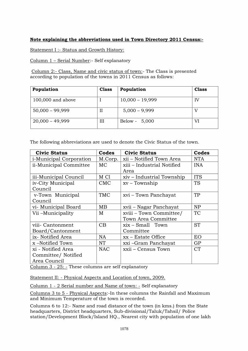
1078
Note explaining the abbreviations used in Town Directory 2011 Census:-
Statement I :- Status and Growth History: Column 1 – Serial Number:- Self explanatory Column 2:- Class, Name and civic status of town:- The Class is presented according to population of the towns in 2011 Census as follows:
Population Class Population Class
100,000 and above I 10,000 – 19,999 IV
50,000 – 99,999 II 5,000 – 9,999 V
20,000 – 49,999 III Below - 5,000 VI
The following abbreviations are used to denote the Civic Status of the town.
Civic Status Codes Civic Status Codes
i-Municipal Corporation M.Corp. xii – Notified Town Area NTA
ii-Municipal Committee MC xiii – Industrial Notified Area
INA
iii-Municipal Council M Cl xiv – Industrial Township ITS
iv-City Municipal Council
CMC xv – Township TS
v-Town Municipal Council
TMC xvi – Town Panchayat TP
vi- Municipal Board MB xvii – Nagar Panchayat NP
Vii –Municipality M xviii – Town Committee/ Town Area Committee
TC
viii- Cantonment
Board/Cantonment
CB xix – Small Town
Committee
ST
ix- Notified Area NA xx – Estate Office EO
x –Notified Town NT xxi –Gram Panchayat GP
xi - Notified Area
Committee/ Notified Area Council
NAC xxii – Census Town CT
Column 3 - 25: - These columns are self explanatory Statement II: - Physical Aspects and Location of town, 2009.
Column 1 - 2 Serial number and Name of town: - Self explanatory
Columns 3 to 5 - Physical Aspects:-In these columns the Rainfall and Maximum and Minimum Temperature of the town is recorded.
Columns 6 to 12:- Name and road distance of the town (in kms.) from the State headquarters, District headquarters, Sub-divisional/Taluk/Tahsil/ Police station/Development Block/Island HQ., Nearest city with population of one lakh
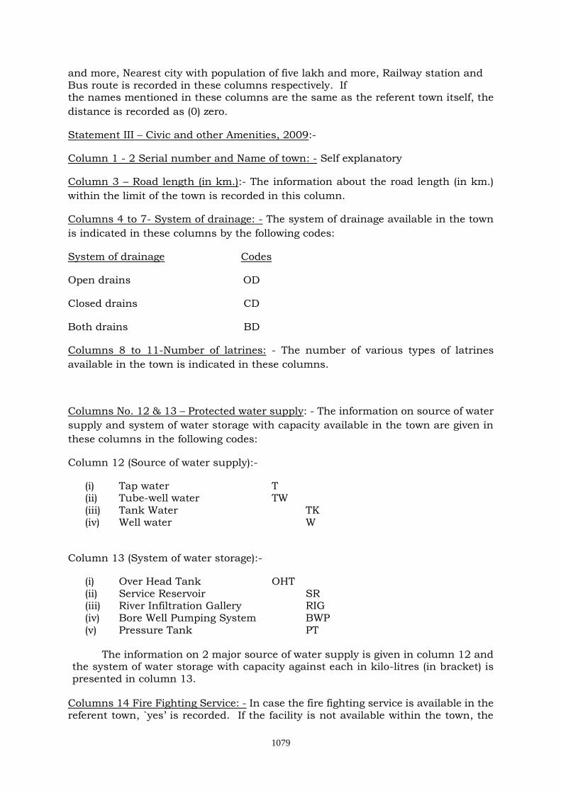
1079
and more, Nearest city with population of five lakh and more, Railway station and Bus route is recorded in these columns respectively. If the names mentioned in these columns are the same as the referent town itself, the
distance is recorded as (0) zero.
Statement III – Civic and other Amenities, 2009:-
Column 1 - 2 Serial number and Name of town: - Self explanatory
Column 3 – Road length (in km.):- The information about the road length (in km.)
within the limit of the town is recorded in this column.
Columns 4 to 7- System of drainage: - The system of drainage available in the town
is indicated in these columns by the following codes:
System of drainage Codes
Open drains OD
Closed drains CD
Both drains BD
Columns 8 to 11-Number of latrines: - The number of various types of latrines
available in the town is indicated in these columns.
Columns No. 12 & 13 – Protected water supply: - The information on source of water
supply and system of water storage with capacity available in the town are given in
these columns in the following codes:
Column 12 (Source of water supply):-
(i) Tap water T (ii) Tube-well water TW (iii) Tank Water TK (iv) Well water W
Column 13 (System of water storage):-
(i) Over Head Tank OHT (ii) Service Reservoir SR (iii) River Infiltration Gallery RIG (iv) Bore Well Pumping System BWP (v) Pressure Tank PT
The information on 2 major source of water supply is given in column 12 and
the system of water storage with capacity against each in kilo-litres (in bracket) is presented in column 13.
Columns 14 Fire Fighting Service: - In case the fire fighting service is available in the referent town, `yes’ is recorded. If the facility is not available within the town, the
1080
name of the nearest place having this facility with its distance from the referent town has been recorded. Columns 15 to 19- Electrification (Number of connections):-Different types of electric connections have been shown in these columns, i.e., Domestic, Industrial, Commercial, Road lighting (points) & others. Statement IV: Medical Facilities, 2009:- Columns 1 - 2 Serial number and Name of town: - Self explanatory Columns 3 to 13 :- The number of various medical institutions such as Hospitals, Dispensaries, Health Center, Family Welfare Center, Maternity and Child Welfare Center, Maternity Homes, T.B. Hospital/clinic, Nursing Homes, Charitable Hospital/Nursing Home, Mobile Health Clinic and Others as available in the town, are indicated in these columns (along with number of beds in brackets). If a medical facility is not available in the town, the name of the nearest place and its distance in kilometers from the town where the facility is available is mentioned. Column 14 - Veterinary Hospital:-The Number of Veterinary Hospitals available in the town is given in this column. Column 15 - Medicine Shop:-The number of Medicine shops available in the town is given in this column. Statement V: Educational, Recreational and Cultural Facilities, 2009:- Columns 1 - 2 Serial number and Name of town: - Self explanatory Columns 3 to 15 Educational Facilities:- The information on number of Primary school, Middle school, Secondary school, Senior Secondary school, Arts/Science/ Commerce colleges (of degree level and above), Medical colleges, Engineering colleges, Management Institute/Colleges, Polytechnics, Recognized Shorthand, Typewriting and vocational training Institutions, Non-formal Education Center (Sarva Shiksha Abhiyan Center), Special School for disabled and Others available in the town, are indicated in these columns.
If an educational facility is not available in the town, the name of the nearest place and its distance in kilometers from the town where the facility is available is mentioned.
Columns 16 to 23 – Number of Social, Recreational and Culture Facilities :- The information on No. of Home Orphanage, Working women’s hostels (with No. of seats in bracket), No. of Old Age Home, Stadium, Cinema Theatre, Auditorium/Community halls, Public libraries and Reading rooms available in the town are given under these column.
Statement VI: Industry and Banking 2009:- Columns 1 - 2 Serial number and Name of town: - Self explanatory
1081
Columns 3 to 5 - Names of three most important commodities manufactured:- The names of three most important commodities manufactured in the town are given under these columns. Columns 6 to 8 - Number of banks: - The number of banks available in the referent town both Commercial and Co-operative banks are recorded against these columns. Columns 9 & 10 – Number of Agricultural and Non Agricultural Credit Societies: - The number of Agricultural and Non Agricultural Credit Societies available in the referent town are given in these columns. Statement VII: Civic and other Amenities in Slums, 2009:- This statement VII provides information on civic and other amenities in all slums whether notified or not and for all towns having statutory bodies, like Municipality, Municipal Corporation, Town area committee etc.
--------------
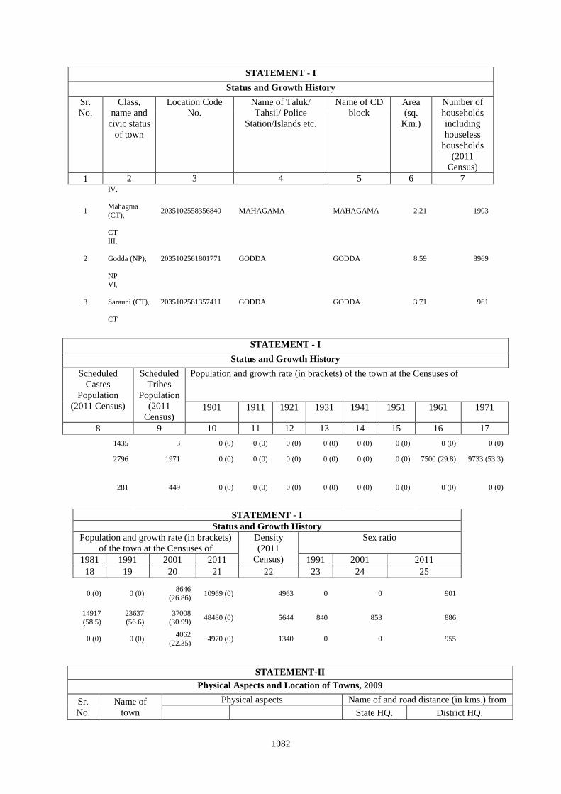
1082
STATEMENT - I
Status and Growth History
Sr.
No.
Class,
name and
civic status
of town
Location Code
No.
Name of Taluk/
Tahsil/ Police
Station/Islands etc.
Name of CD
block
Area
(sq.
Km.)
Number of
households
including
houseless
households
(2011
Census)
1 2 3 4 5 6 7
1
IV,
Mahagma
(CT),
CT
2035102558356840 MAHAGAMA MAHAGAMA 2.21 1903
2
III,
Godda (NP),
NP
2035102561801771 GODDA GODDA 8.59 8969
3
VI,
Sarauni (CT),
CT
2035102561357411 GODDA GODDA 3.71 961
STATEMENT - I
Status and Growth History
Scheduled
Castes
Population
(2011 Census)
Scheduled
Tribes
Population
(2011
Census)
Population and growth rate (in brackets) of the town at the Censuses of
1901 1911 1921 1931 1941 1951 1961 1971
8 9 10 11 12 13 14 15 16 17
1435 3 0 (0) 0 (0) 0 (0) 0 (0) 0 (0) 0 (0) 0 (0) 0 (0)
2796 1971 0 (0) 0 (0) 0 (0) 0 (0) 0 (0) 0 (0) 7500 (29.8) 9733 (53.3)
281 449 0 (0) 0 (0) 0 (0) 0 (0) 0 (0) 0 (0) 0 (0) 0 (0)
STATEMENT - I
Status and Growth History
Population and growth rate (in brackets)
of the town at the Censuses of
Density
(2011
Census)
Sex ratio
1981 1991 2001 2011 1991 2001 2011
18 19 20 21 22 23 24 25
0 (0) 0 (0) 8646
(26.86) 10969 (0) 4963 0 0 901
14917 (58.5)
23637 (56.6)
37008 (30.99)
48480 (0) 5644 840 853 886
0 (0) 0 (0) 4062
(22.35) 4970 (0) 1340 0 0 955
STATEMENT-II
Physical Aspects and Location of Towns, 2009
Sr.
No.
Name of
town
Physical aspects Name of and road distance (in kms.) from
State HQ. District HQ.
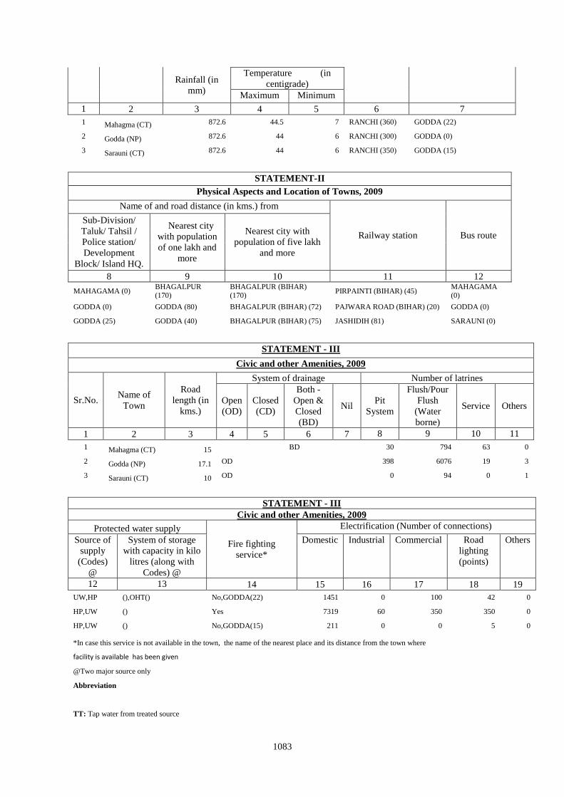
1083
Rainfall (in
mm)
Temperature (in
centigrade)
Maximum Minimum
1 2 3 4 5 6 7
1 Mahagma (CT) 872.6 44.5 7 RANCHI (360) GODDA (22)
2 Godda (NP) 872.6 44 6 RANCHI (300) GODDA (0)
3 Sarauni (CT) 872.6 44 6 RANCHI (350) GODDA (15)
STATEMENT-II
Physical Aspects and Location of Towns, 2009
Name of and road distance (in kms.) from
Railway station Bus route
Sub-Division/
Taluk/ Tahsil /
Police station/
Development
Block/ Island HQ.
Nearest city
with population
of one lakh and
more
Nearest city with
population of five lakh
and more
8 9 10 11 12
MAHAGAMA (0) BHAGALPUR (170)
BHAGALPUR (BIHAR) (170)
PIRPAINTI (BIHAR) (45) MAHAGAMA (0)
GODDA (0) GODDA (80) BHAGALPUR (BIHAR) (72) PAJWARA ROAD (BIHAR) (20) GODDA (0)
GODDA (25) GODDA (40) BHAGALPUR (BIHAR) (75) JASHIDIH (81) SARAUNI (0)
STATEMENT - III
Civic and other Amenities, 2009
Sr.No. Name of
Town
Road
length (in
kms.)
System of drainage Number of latrines
Open
(OD)
Closed
(CD)
Both -
Open &
Closed
(BD)
Nil Pit
System
Flush/Pour
Flush
(Water
borne)
Service Others
1 2 3 4 5 6 7 8 9 10 11
1 Mahagma (CT) 15 BD 30 794 63 0
2 Godda (NP) 17.1 OD 398 6076 19 3
3 Sarauni (CT) 10 OD 0 94 0 1
STATEMENT - III
Civic and other Amenities, 2009
Protected water supply
Fire fighting
service*
Electrification (Number of connections)
Source of
supply
(Codes)
@
System of storage
with capacity in kilo
litres (along with
Codes) @
Domestic Industrial Commercial Road
lighting
(points)
Others
12 13 14 15 16 17 18 19
UW,HP (),OHT() No,GODDA(22) 1451 0 100 42 0
HP,UW () Yes 7319 60 350 350 0
HP,UW () No,GODDA(15) 211 0 0 5 0
*In case this service is not available in the town, the name of the nearest place and its distance from the town where
facility is available has been given
@Two major source only
Abbreviation
TT: Tap water from treated source
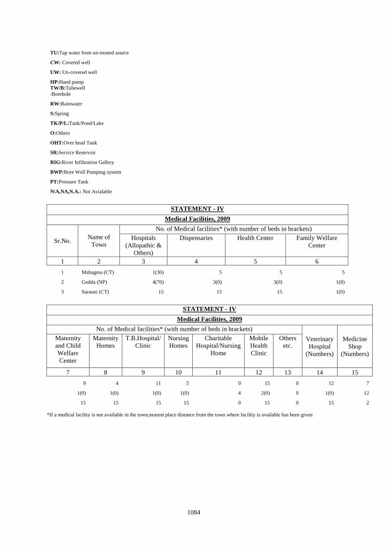
1084
TU:Tap water from un-treated source
CW: Covered well
UW: Un-covered well
HP:Hand pump TW/B:Tubewell
/Borehole
RW:Rainwater
S:Spring
TK/P/L:Tank/Pond/Lake
O:Others
OHT:Over head Tank
SR:Service Reservoir
RIG:River Infiltration Gallery
BWP:Bore Well Pumping system
PT:Pressure Tank
N\A,NA,N.A.: Not Avialable
STATEMENT - IV
Medical Facilities, 2009
Sr.No. Name of
Town
No. of Medical facilities* (with number of beds in brackets)
Hospitals
(Allopathic &
Others)
Dispensaries Health Center Family Welfare
Center
1 2 3 4 5 6
1 Mahagma (CT) 1(30) 5 5 5
2 Godda (NP) 4(70) 3(0) 3(0) 1(8)
3 Sarauni (CT) 15 15 15 1(0)
STATEMENT - IV
Medical Facilities, 2009
No. of Medical facilities* (with number of beds in brackets)
Veterinary
Hospital
(Numbers)
Medicine
Shop
(Numbers)
Maternity
and Child
Welfare
Center
Maternity
Homes
T.B.Hospital/
Clinic
Nursing
Homes
Charitable
Hospital/Nursing
Home
Mobile
Health
Clinic
Others
etc.
7 8 9 10 11 12 13 14 15
9 4 11 5 0 15 0 12 7
1(0) 1(0) 1(0) 1(0) 4 2(0) 0 1(0) 12
15 15 15 15 0 15 0 15 2
*If a medical facility is not available in the town,nearest place distance from the town where facility is available has been given
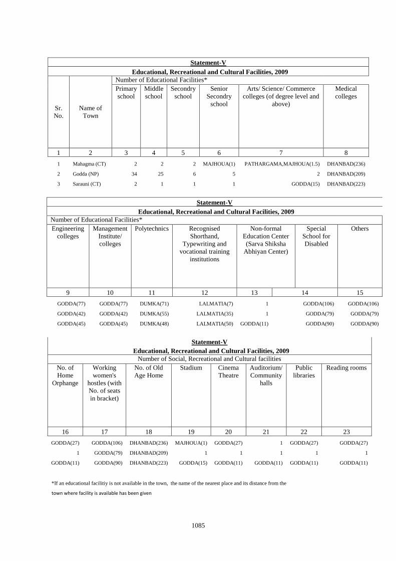
1085
Statement-V
Educational, Recreational and Cultural Facilities, 2009
Sr.
No.
Name of
Town
Number of Educational Facilities*
Primary
school
Middle
school
Secondry
school
Senior
Secondry
school
Arts/ Science/ Commerce
colleges (of degree level and
above)
Medical
colleges
1 2 3 4 5 6 7 8
1 Mahagma (CT) 2 2 2 MAJHOUA(1) PATHARGAMA,MAJHOUA(1.5) DHANBAD(236)
2 Godda (NP) 34 25 6 5 2 DHANBAD(209)
3 Sarauni (CT) 2 1 1 1 GODDA(15) DHANBAD(223)
Statement-V
Educational, Recreational and Cultural Facilities, 2009
Number of Educational Facilities*
Engineering
colleges
Management
Institute/
colleges
Polytechnics Recognised
Shorthand,
Typewriting and
vocational training
institutions
Non-formal
Education Center
(Sarva Shiksha
Abhiyan Center)
Special
School for
Disabled
Others
9 10 11 12 13 14 15
GODDA(77) GODDA(77) DUMKA(71) LALMATIA(7) 1 GODDA(106) GODDA(106)
GODDA(42) GODDA(42) DUMKA(55) LALMATIA(35) 1 GODDA(79) GODDA(79)
GODDA(45) GODDA(45) DUMKA(48) LALMATIA(50) GODDA(11) GODDA(90) GODDA(90)
Statement-V
Educational, Recreational and Cultural Facilities, 2009
Number of Social, Recreational and Cultural facilities
No. of
Home
Orphange
Working
women's
hostles (with
No. of seats
in bracket)
No. of Old
Age Home
Stadium Cinema
Theatre
Auditorium/
Community
halls
Public
libraries
Reading rooms
16 17 18 19 20 21 22 23
GODDA(27) GODDA(106) DHANBAD(236) MAJHOUA(1) GODDA(27) 1 GODDA(27) GODDA(27)
1 GODDA(79) DHANBAD(209) 1 1 1 1 1
GODDA(11) GODDA(90) DHANBAD(223) GODDA(15) GODDA(11) GODDA(11) GODDA(11) GODDA(11)
*If an educational facilitiy is not available in the town, the name of the nearest place and its distance from the
town where facility is available has been given
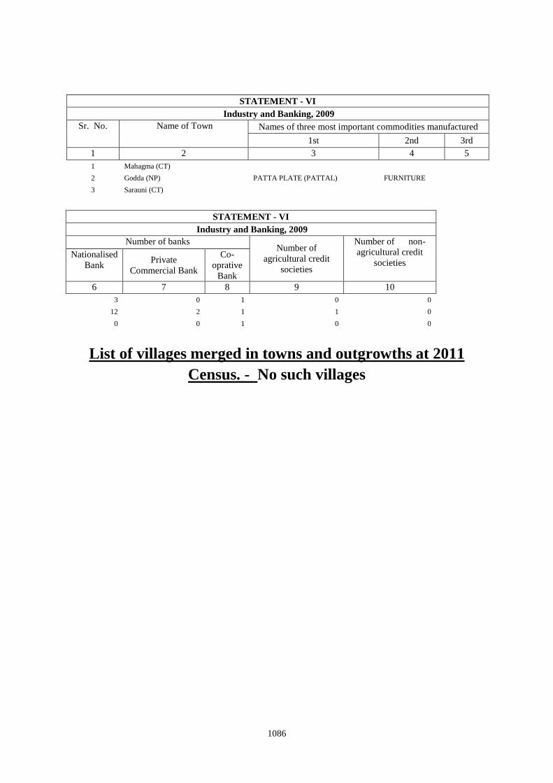
1086
STATEMENT - VI
Industry and Banking, 2009
Sr. No. Name of Town Names of three most important commodities manufactured
1st 2nd 3rd
1 2 3 4 5
1 Mahagma (CT)
2 Godda (NP) PATTA PLATE (PATTAL) FURNITURE
3 Sarauni (CT)
STATEMENT - VI
Industry and Banking, 2009
Number of banks Number of
agricultural credit
societies
Number of non-
agricultural credit
societies Nationalised
Bank Private
Commercial Bank
Co-
oprative
Bank
6 7 8 9 10
3 0 1 0 0
12 2 1 1 0
0 0 1 0 0
List of villages merged in towns and outgrowths at 2011
Census. - No such villages