geographic tools for eradication programs of insular non-native mammals
TRANSCRIPT
Abstract Non-native mammals are major driv-
ers of ecosystem change and biodiversity loss; this
is especially apparent on islands. However, tech-
niques exist to remove non-native mammals,
providing a powerful conservation tool. Conser-
vation practitioners are now targeting larger
islands for restoration. Leveraging existing and
developing new techniques and technologies will
prove critical to successful eradications on large
islands. Using the removal of introduced goats
(Capra hircus) from Santiago Island, Galapagos
as a case study, we present a suite of Geographic
Information System (GIS) tools that aid island
conservation actions. GIS tools were incorporated
into the three phases of the eradication campaign:
planning, hunting, and monitoring. Further, these
tools were adopted for three eradication tech-
niques: ground-based hunting, aerial hunting by
helicopter, and Judas goats. These geographic
approaches provide a foundation for statistical,
spatial, and economic analyses that should
increase the capability and efficiency of removal
campaigns. Given limited conservation funds and
the dire status of many insular species, efficiently
removing non-native mammals from islands is of
paramount global conservation importance.
Keywords Capra hircus Æ Eradication ÆIntroduced species Æ Invasive species Æ Island
conservation Æ Non-native mammals Æ Sus scrofa
Introduction
Extinction over the last six centuries has been
largely dominated by insular species, with non-
native mammals being responsible for the
majority (Diamond 1989; Groombridge et al.
1992; MacPhee and Flemming 1999). Introduced
C. Lavoie Æ K. Campbell Æ F. Cruz Æ G. Victor CarrionGalapagos National Park Service, Puerto Ayora, IslaSanta Cruz, Galapagos, Ecuador
C. Lavoie Æ K. Campbell Æ F. CruzCharles Darwin Foundation, Casilla, 17-01-3891Quito, Ecuador
C. LavoieUnited Nations Development Program, Av.Amazonas, 2889 Quito, Ecuador
C. J. Donlan (&)Department of Ecology and Evolutionary Biology,Corson Hall, Cornell University, Ithaca,NY 14853-2701, USAe-mail: [email protected]
C. J. DonlanIsland Conservation, Center for Ocean Health, 100Shaffer Road, Santa Cruz, California 95060, USA
K. CampbellSchool of Natural and Rural Systems Management,University of Queensland Gatton, Gatton,Queensland 4343, Australia
Biol Invasions (2007) 9:139–148
DOI 10.1007/s10530-006-9011-y
123
ORIGINAL PAPER
Geographic tools for eradication programs of insularnon-native mammals
Christian Lavoie Æ C. Josh Donlan ÆKarl Campbell Æ Felipe Cruz Æ G. Victor Carrion
Received: 4 September 2005 / Accepted: 31 March 2006 / Published online: 4 July 2006� Springer Science+Business Media B.V. 2006
predators, such as rats (Rattus spp.) and cats
(Felis catus), have decimated endemic rodent,
reptile, and bird populations, and extirpated
numerous seabird colonies on islands around
the globe (Atkinson 1985; Nogales et al. 2004).
Introduced herbivores, such as feral goats
(Capra hircus) and European rabbits (Oryctola-
gus cuniculus), have caused wholesale changes in
insular plant communities, as well as secondary
impacts via habitat degradation (Coblentz 1978;
Ebenhard 1988; Donlan et al. 2002; Campbell
and Donlan 2005). As omnivores, feral pigs
(Sus scrofa) feed on fruits and plants, prey on
vertebrates, and raid nests of birds and reptiles
(Coblentz and Baber 1987; Cruz and Cruz 1987;
Choquenot et al. 1996). In sum, non-native
mammals are major drivers of ecosystem change
and biodiversity loss.
In the 1980s, in response to these biodiversity
threats, New Zealand conservation practitioners
began developing techniques to remove non-na-
tive mammals from islands (Taylor and Thomas
1989; Towns et al. 1990; Atkinson 2001; Towns and
Broome 2003). Until recently, eradication has
been largely limited to small islands, mostly in
Australasia. Building on these techniques, con-
servation biologists and practitioners from around
the globe are now tackling large and biologically
complex islands (Veitch and Clout 2002; Howald
et al. 2005). Removing non-native mammals from
islands is now one of our most powerful conser-
vation tools (Donlan et al. 2003). As larger islands
are targeted for restoration via introduced mam-
mal eradication, integrating existing and develop-
ing new techniques and technology will prove
critical for success (Campbell and Donlan 2005).
GIS and GPS technologies are underutilized in
eradication campaigns. Although these technolo-
gies have been available for nearly two decades
and the US Defense Department removed built-
in GPS error in May 2000 further increasing
accuracy, only in the last few years has this
technology begun to be exploited (Hulbert and
French 2001; McClelland 2002; Cruz et al. 2005;
Howald et al. 2005; Phillips et al. 2005). We know
of no published accounts of GIS or GPS meth-
odologies being detailed for non-native mammal
eradication programs. In the recently published
proceedings of an international invasive species
eradications, 27 papers dealt with introduced
mammal eradication; none mentioned the use of
GIS and seven papers mentioned the use of GPS,
four of which provided detailed GPS methodol-
ogies (all for helicopter applications, with three
being related to aerial baiting of rodents) (Veitch
and Clout 2002).
Here, we present a suite of GIS tools that
increases the efficiency and capabilities of non-
native mammal eradications on islands. These
tools are a product of a series of large-scale
eradication campaigns on the Galapagos Islands
(Donlan et al. 2003; Campbell et al. 2004; Cruz
et al. 2005). We integrate GIS and GPS data
collection methodologies with existing eradica-
tion techniques, including ground-based hunting,
aerial hunting by helicopter, and Judas goat
techniques. Using an introduced goat eradication
campaign on Santiago Island (58,465 ha) as a case
study, we present the details of these techniques
in an effort to make them available for future
island conservation actions.
Background
Santiago Island, located in the center of the
Galapagos archipelago, enjoys protected status,
and is home to many endemic species. Nonethe-
less, a number of non-native mammals have been
present on the island, including rats, goats, and
pigs, which have had devastating impacts on the
island. Pigs were recently eradicated and goats
are in the final phases of being removed, the
largest non-native mammal eradication cam-
paigns to date (Cruz et al. 2005). These conser-
vation actions were accomplished by leveraging
three techniques: aerial hunting by helicopter,
ground hunting (with and without specialist
dogs), and Judas goat techniques. Judas goats,
radio-collared individuals that are released and
associate with conspecifics, aid in removing rem-
nant goats in the final stages of a removal cam-
paign (Rainbolt and Coblentz 1999).
During the goat eradication campaign on
Santiago Island, GIS tools were integrated into
each of the three project phases: planning, hunt-
ing, and monitoring. GIS tools during the plan-
ning phase were critical for all three eradication
140 Biol Invasions (2007) 9:139–148
123
techniques: aerial hunting, ground hunting, and
Judas goat operations. During planning, GIS
proved valuable in developing a systematic
approach across a large spatial scale. During both
aerial and ground hunting, GIS tools were
implemented for data collection, which was ana-
lyzed daily/weekly and allowed for adaptive
management decisions. Lastly, the implementa-
tion and efficiency of a large-scale ground moni-
toring effort and Judas goat operations were
vastly improved by using a variety of standard
GIS tools.
Methods
Software utilized included ESRI ArcView v3.2/
ArcGIS v8.1, freeware and scripts available from
the Internet, and Microsoft Access for database
management. Although we describe a detailed
methodology utilizing this software, other
GIS and database packages could be similarly
employed. SPOT images provided the geographic
foundation for planning. Hand-held and helicop-
ter mounted GPS units (Garmin 12XL and Gar-
min GPSII plus respectively) were used to collect
hunting and additional geographic data in the
field.
Planning and management
Santiago Island was systematically divided into
blocks, differing for each phase of eradication:
ground hunting, aerial hunting, and Judas goats
(Fig. 1). Field knowledge was combined with
geographic information to divide the island into
blocks. Block boundaries were delineated in
ArcMap/ArcView using the combined criteria:
vegetation type/cover, trails, topographic fea-
tures, and the ability to work an entire block over
a certain time period. Compare to traditional
methods, this approach proved highly effective
with respect to the abilities of navigating and
systematically covering the block within a given
time period.
Santiago Island was divided into 24 blocks for
ground hunting, ranging in size from 414 to
4491 ha (Fig. 1a). SPOT satellite imagery was
used to assess the island geography; wavelength
band combinations were used to highlight vege-
tated (RGB, bands 4, 3, 2) and volcanic (band
Stretch, band 4) areas (Fig. 1b). GPS units were
used to mark existing trails throughout the island.
Natural topographic features, easily identified by
hunters (e.g., ridgelines, hills, etc.), were also
identified. Ground hunting blocks were subdi-
vided into sub-blocks (137 total; Fig. 1a) which
served two effective purposes: (1) facilitating a
specialized ground hunting technique ‘rastrillo’
(see hunting below), and (2) providing a suitable
sized area for a team of 15 hunters to cover in one
day. Sub-blocks averaged 384 ha in open areas
and 171 ha in heavily vegetated areas.
Blocks for aerial hunting were similar to ground
hunting, differing in scale and often covering
multiple vegetation types. With experienced pilots
and several reconnaissance flights, along with
SPOT images, Santiago was broken into ten blocks
for aerial hunting ranging from 3547 to 10,109 ha
(Fig. 1b). Block size was determined primarily by
openness of vegetation and estimated goat density.
Individual helicopter flights were limited to two
hours, also a factor in block size.
For the deployment of Judas goats, we gener-
ated a set of equidistant points with an Avenue
script (Nickseigal.CreateTriangularArray.ave,
Seigal 2001; Terrace 2002) in which equidistance
was based on known home range data for goats,
available resources (i.e., number of goat teleme-
try collars), and distribution of where goats were
removed during the hunting phase. Equidistant
spacing of 2250 m was adopted, resulting in 111
points. In areas dominated by lava, where few
or no goats had been removed, spacing was
increased to 3250 m resulting in 12 points. To
provide a visual aid to managers and practitioners
on the ground, Judas goat blocks were con-
structed with an ArcScript from Terrace GIS
(CreateThiessenPoly.dll) that creates Thiessen
polygons around the equidistant points (Fig. 1c).
The equidistant spacing and blocks for Judas
goats also aided in the experimental design of
research attempting to assess the performance of
different types of Judas goats (i.e., males, females,
and females with hormone implants, Campbell
2002; Campbell et al. 2005, in press). To ran-
domly assign Judas types across different vege-
Biol Invasions (2007) 9:139–148 141
123
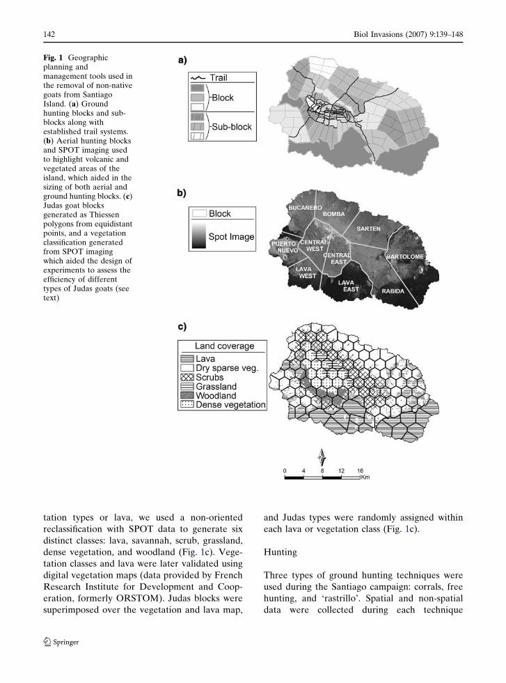
tation types or lava, we used a non-oriented
reclassification with SPOT data to generate six
distinct classes: lava, savannah, scrub, grassland,
dense vegetation, and woodland (Fig. 1c). Vege-
tation classes and lava were later validated using
digital vegetation maps (data provided by French
Research Institute for Development and Coop-
eration, formerly ORSTOM). Judas blocks were
superimposed over the vegetation and lava map,
and Judas types were randomly assigned within
each lava or vegetation class (Fig. 1c).
Hunting
Three types of ground hunting techniques were
used during the Santiago campaign: corrals, free
hunting, and ‘rastrillo’. Spatial and non-spatial
data were collected during each technique
Fig. 1 Geographicplanning andmanagement tools used inthe removal of non-nativegoats from SantiagoIsland. (a) Groundhunting blocks and sub-blocks along withestablished trail systems.(b) Aerial hunting blocksand SPOT imaging usedto highlight volcanic andvegetated areas of theisland, which aided in thesizing of both aerial andground hunting blocks. (c)Judas goat blocksgenerated as Thiessenpolygons from equidistantpoints, and a vegetationclassification generatedfrom SPOT imagingwhich aided the design ofexperiments to assess theefficiency of differenttypes of Judas goats (seetext)
142 Biol Invasions (2007) 9:139–148
123
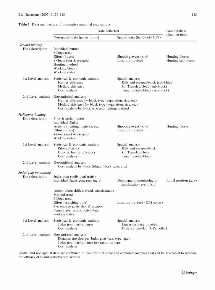
Table 1 Data architecture of non-native mammal eradications
Data collected Geo database
Non-spatial data (paper forms) Spatial data (hand-held GPS)planning units
Ground huntingData description Individual hunter
# Dogs usedEffort (hours) Shooting event (x, y) Hunting blocks# Goats shot & escaped Location traveled Hunting sub-blocksHunting methodWorking blockWorking dates
1st Level analysis Statistical & economic analysis Spatial analysisHunter efficiency Kills and escapes/block (sub-block)Method efficiency km Traveled/block (sub-block)Cost analysis Time traveled/block (sub-block)
2nd Level analysis Geostatistical analysisHunter efficiency by block type (vegetation, size, etc)Method efficiency by block type (vegetation, size, etc)Cost analysis by block type and hunting method
Helicopter huntingData description Pilot & aerial hunter
Individual flightsActivity (hunting, logistics, etc) Shooting event (x, y) Hunting blocksEffort (hours) Location traveled# Goats shot & escapedWorking dates
1st Level analysis Statistical & economic analysis Spatial analysisPilot efficiency Kills and escapes/blockCrew or hunter efficiency km Traveled/blockCost analysis Time traveled/block
2nd Level analysis Geostatistical analysisCost analysis by block (island, block type, etc.)
Judas goat monitoringData description Judas goat (individual traits)
Individual Judas goat (ear tag #) Deployment, monitoring ortranslocation event (x,y)
Initial position (x, y)
Action taken (killed, freed, translocated)Method used# Dogs usedEffort (searching time) Location traveled (GPS collar)# & sex-age goats shot & escapedFemale goat reproductive dataworking dates
1st Level analysis Statistical & economic analysis Spatial analysisJudas goat performance Linear distance traveledCost analysis Distance traveled (GPS collar)
2nd Level analysis Geostatistical analysisDistance traveled per Judas goat (sex, type, age)Judas goat performance in vegetation typeCost analysis
Spatial and non-spatial data are combined to facilitate statistical and economic analyses that can be leveraged to increasethe efficacy of island conservation actions
Biol Invasions (2007) 9:139–148 143
123
(Table 1). Herds of goats were mustered into
corrals, which were strategically positioned over
the island; this method removed a large number
of goats in the early phases of the project. Free
hunting with and without specialized dogs was
utilized when densities were at medium-low lev-
els. ‘Rastrillo’ hunting consists of hunters with or
without dogs arranged in a line advancing through
an area in a systematic fashion; this technique was
particularly effective in areas of thick vegetation
when goats were at low densities.
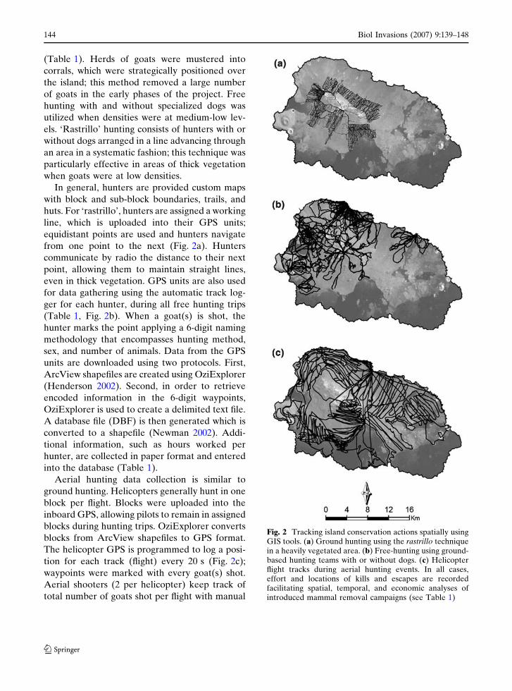
In general, hunters are provided custom maps
with block and sub-block boundaries, trails, and
huts. For ‘rastrillo’, hunters are assigned a working
line, which is uploaded into their GPS units;
equidistant points are used and hunters navigate
from one point to the next (Fig. 2a). Hunters
communicate by radio the distance to their next
point, allowing them to maintain straight lines,
even in thick vegetation. GPS units are also used
for data gathering using the automatic track log-
ger for each hunter, during all free hunting trips
(Table 1, Fig. 2b). When a goat(s) is shot, the
hunter marks the point applying a 6-digit naming
methodology that encompasses hunting method,
sex, and number of animals. Data from the GPS
units are downloaded using two protocols. First,
ArcView shapefiles are created using OziExplorer
(Henderson 2002). Second, in order to retrieve
encoded information in the 6-digit waypoints,
OziExplorer is used to create a delimited text file.
A database file (DBF) is then generated which is
converted to a shapefile (Newman 2002). Addi-
tional information, such as hours worked per
hunter, are collected in paper format and entered
into the database (Table 1).
Aerial hunting data collection is similar to
ground hunting. Helicopters generally hunt in one
block per flight. Blocks were uploaded into the
inboard GPS, allowing pilots to remain in assigned
blocks during hunting trips. OziExplorer converts
blocks from ArcView shapefiles to GPS format.
The helicopter GPS is programmed to log a posi-
tion for each track (flight) every 20 s (Fig. 2c);
waypoints were marked with every goat(s) shot.
Aerial shooters (2 per helicopter) keep track of
total number of goats shot per flight with manual
Fig. 2 Tracking island conservation actions spatially usingGIS tools. (a) Ground hunting using the rastrillo techniquein a heavily vegetated area. (b) Free-hunting using ground-based hunting teams with or without dogs. (c) Helicopterflight tracks during aerial hunting events. In all cases,effort and locations of kills and escapes are recordedfacilitating spatial, temporal, and economic analyses ofintroduced mammal removal campaigns (see Table 1)
144 Biol Invasions (2007) 9:139–148
123
counters, while the number of waypoints entered
in the GPS unit by the pilot (1–5) per shooting
event represented number of goats shot depending
on goat density (e.g., 1 waypoint entered equals 2
goats shot). Throughout the aerial hunting phase,
tracks and waypoints were linked to other relevant
data, such as pilot and flight time, all of which were
incorporated into the database (Table 1).
Monitoring
Along with hunters with dogs in ‘rastrillo’, Judas
goat operations are the primary monitoring
technique used in the eradication campaign on
Santiago Island. GIS tools contribute significantly
to the efficiency of these operations. Judas goat
operations rely on the monitoring of deployed
goats with telemetry collars using telemetry
antennas and receivers to track the animals either
by foot or helicopter. To deploy Judas goats the
helicopter’s rear seats were removed, allowing up
to 12 Judas goats to be deployed per load with a
crew member on the pilot’s side skid deploying
goats numbered as per waypoints. Routes for
deploying Judas goats at equidistant deployment
points were generated by GIS and uploaded to
GPS units to minimize helicopter ferry time.
Judas goats are subsequently checked at regular
intervals; once Judas goats are located, all asso-
ciated feral goats are shot. In order to facilitate
monitoring activities, on each trip the helicopter
crew is provided with maps of the last known
position of Judas goats. For each Judas monitor-
ing event, the position is recorded with GPS,
and other data are recorded in paper format
(Table 1). On a daily basis, data from Judas
monitoring events are incorporated into both
relational and spatial databases. Data can than be
analyzed in an adaptive management fashion. For
example, recent events can be queried for
selected Judas goats and then linked to the spatial
database to generate an updated map of last
known positions.
Discussion
The described GIS tools serve three general
purposes. First, they allow a large island to be
broken into manageable sections that facilitate
systematic planning, hunting, and monitoring.
Second, they allow critical data to be collected,
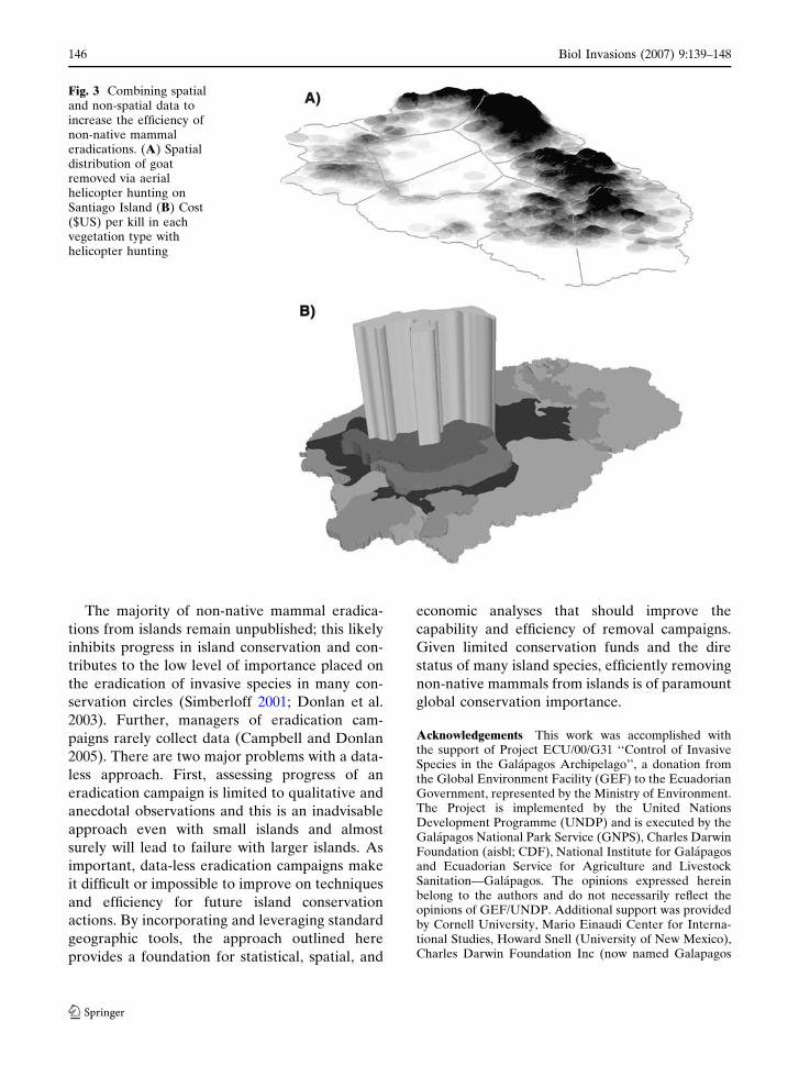
visualized, and analyzed (e.g., goats shot per
hour) on a daily/weekly basis during the eradi-
cation campaign; this allows for progress to be
monitored and adaptive decisions regarding
techniques and strategies to be made in a timely
fashion (Fig. 3). Lastly, these GIS tools increase
the cost-effectiveness and efficiency of the overall
campaign, facilitating economic analysis of erad-
ications and saving both limited conservation
dollars and time (Table 1, Fig. 3).
Some or all of these GIS tools should be
incorporated into the planning and management
of most medium to large-scale non-native mam-
mal eradications, including introduced herbivores
(goats, donkeys, sheep, rabbits), pigs, and intro-
duced predators (cats and rats). Most non-native
mammal eradications to date have not utilized
geographic tools. While this may be a non-issue
for campaigns on smaller islands, even medium-
sized island eradications have failed or taken
decades rather than years due to the lack of
incorporating technology and systematic methods
(Campbell and Donlan 2005).
A common reason for unsuccessful eradications
is the failure to detect the last remaining animals.
Integrating GIS tools, such as monitoring pro-
grams using equidistant points, holds great
potential in detecting remnant animals and sub-
sequently shortening the length of eradication
campaigns and their confirmation. On Santiago
Island, equidistant points were used for the
deployment and monitoring of poisoned bait sta-
tions during the successful removal of non-native
pigs (see Cruz et al. 2005), as well as for systematic
monitoring of invasive plant species. On Pinta
Island, equidistant points were used to conduct a
systematic search for Galapagos giant tortoises,
thought to be extinct on the island (Campbell
et al. 2004). This GIS tool was also successfully
integrated into a feral cat removal campaign on
Baltra Island, both for bait station placement and
conducting systematic searches for sign (Phillips
et al. 2005). These examples demonstrate the
efficacy and potential widespread application of
using equidistant points in insular eradication
campaigns and other conservation actions.
Biol Invasions (2007) 9:139–148 145
123
The majority of non-native mammal eradica-
tions from islands remain unpublished; this likely
inhibits progress in island conservation and con-
tributes to the low level of importance placed on
the eradication of invasive species in many con-
servation circles (Simberloff 2001; Donlan et al.
2003). Further, managers of eradication cam-
paigns rarely collect data (Campbell and Donlan
2005). There are two major problems with a data-
less approach. First, assessing progress of an
eradication campaign is limited to qualitative and
anecdotal observations and this is an inadvisable
approach even with small islands and almost
surely will lead to failure with larger islands. As
important, data-less eradication campaigns make
it difficult or impossible to improve on techniques
and efficiency for future island conservation
actions. By incorporating and leveraging standard
geographic tools, the approach outlined here
provides a foundation for statistical, spatial, and
economic analyses that should improve the
capability and efficiency of removal campaigns.
Given limited conservation funds and the dire
status of many island species, efficiently removing
non-native mammals from islands is of paramount
global conservation importance.
Acknowledgements This work was accomplished withthe support of Project ECU/00/G31 ‘‘Control of InvasiveSpecies in the Galapagos Archipelago’’, a donation fromthe Global Environment Facility (GEF) to the EcuadorianGovernment, represented by the Ministry of Environment.The Project is implemented by the United NationsDevelopment Programme (UNDP) and is executed by theGalapagos National Park Service (GNPS), Charles DarwinFoundation (aisbl; CDF), National Institute for Galapagosand Ecuadorian Service for Agriculture and LivestockSanitation—Galapagos. The opinions expressed hereinbelong to the authors and do not necessarily reflect theopinions of GEF/UNDP. Additional support was providedby Cornell University, Mario Einaudi Center for Interna-tional Studies, Howard Snell (University of New Mexico),Charles Darwin Foundation Inc (now named Galapagos
Fig. 3 Combining spatialand non-spatial data toincrease the efficiency ofnon-native mammaleradications. (A) Spatialdistribution of goatremoved via aerialhelicopter hunting onSantiago Island (B) Cost($US) per kill in eachvegetation type withhelicopter hunting
146 Biol Invasions (2007) 9:139–148
123
Conservancy), Lindblad Expeditions, European Friends ofGalapagos Organizations, the GNPS, TAME Airlines, andthe CDF. We thank Prohunt New Zealand Ltd for valu-able inputs and for the initial development of the rastrillohunting method. Bruce Coblentz and an anonymous re-viewer improved this manuscript. CDF contribution 1016.
References
Atkinson IAE (1985) The spread of commensal species ofRattus to oceanic islands and their effect on islandavifaunas. In: Moors PJ (ed) Conservation of islandbirds. International Council for Bird Preservation,Cambridge, pp 35–81
Atkinson IAE (2001) Introduced mammals and models forrestoration. Biol Conserv 99:81–96
Campbell K, Baxter G, Murray P, Coblentz BE, DonlanCJ (2006) Development of a prolonged estrus effectfor use in Judas goats. Appl Anim Behav Sci, in press
Campbell K, Baxter G, Murray P, Coblentz BE, DonlanCJ, Carrion V (2005) Increasing the efficacy of Judasgoats by sterilisation and pregnancy termination.Wildl Res 32:737–743
Campbell K, Donlan CJ (2005) Feral goat eradications onislands. Conserv Biol 19:1362–1374
Campbell K, Donlan CJ, Cruz F, Carrion V (2004) Erad-ication of feral goats Capra hircus from Pinta Island,Galapagos, Ecuador. Oryx 38:328–333
Campbell KJ (2002) Advances in Judas goat methodologyin the Galapagos Islands: manipulating the animals.In: Gregory J, Kyle B, Simmons M (eds) Judasworkshop 2002. New Zealand Department of Con-servation, Otago Conservancy, Dunedin, pp 70–77
Choquenot D, McIlroy J, Korn T (1996) Managing verte-brate pests: feral pigs. Bureau of Resource Sciences,Australian Government Publishing Service, Canberra,Australia
Coblentz BE (1978) The effects of feral goats (Ca-pra hircus) on island ecosystems. Biol Conserv13:279–285
Coblentz BE, Baber DW (1987) Biology and control offeral pigs on Isla Santiago, Galapagos, Ecuador.J Appl Ecol 24:403–418
Cruz F, Donlan CJ, Campbell K, Carrion V (2005) Con-servation action in the Galapagos: Feral pig (Sus -scrofa) eradication from Santiago Island. BiolConserv 121:473–478
Cruz JB, Cruz F (1987) Conservation of the dark rumpedpetrel (Pterodroma phaeopygia) in the GalapagosIslands, Ecuador. Biol Conserv 42:303–312
Diamond JM (1989) Overview of recent extinctions. In:Western D, Pearl MC (eds) Conservation for thetwenty-first century. Oxford University Press, NewYork, USA, pp 37–41
Donlan CJ, Tershy BR, Campbell K, Cruz F (2003) Re-search for requiems: the need for more collaborativeaction in invasive species management and conserva-tion. Conserv Biol 17:1850–1851
Donlan CJ, Tershy BR, Croll DA (2002) Islands andintroduced herbivores: conservation action as ecosys-tem experimentation. J Appl Ecol 39:235–246
Ebenhard T (1988) Introduced birds and mammals andtheir ecological effects. Swed Wildl Res Viltrevy 13:1–107
Groombridge B, World Conservation Monitoring Centre,British Natural History Museum, InternationalUnion for Conservation of Nature and NaturalResources (1992) Global biodiversity: status of theearth’s living resources: a report, 1st edn. Chapman& Hall, London
Henderson CR (2002) OziExplorer v3.95.3b. In. http://www.oziexplorer.com
Howald GR, Faulkner KR, Tershy B, Keitt B, GellermanH, Creel EM, Grinnel M, Ortega S, Croll DA (2005)Eradication of black rat from Anacapa Island: bio-logical and social considerations. In: Garcelon DK,Schwemm CA (eds) Proceedings of the sixth Cali-fornia Islands Symposium. Institute for WildlifeStudies, Arcata, California, pp 299–312
Hulbert IAR, French J (2001) The accuracy of GPS forwildlife telemetry and habitat mapping. J Appl Ecol38:869–878
MacPhee RDE, Flemming C (1999) Requim AEternam:the last five hundred years of mammalian speciesextinctions. In: MacPhee RDE (ed) Extinctions innear time: causes, contexts, and consequences. KluwerPublishing, New York, pp 333–371
McClelland PJ (2002) Preparation for the eradication ofNorway rats (Rattus norvegicus) from Campbell Is-land, New Zealand. In: Veitch CR, Clout MN (eds)Turning the tide: the eradication of invasive species.IUCN SSC Invasive Species Specialist Group, IUCN,Gland Switzerland, p 409
Newman D (2002) G7toWin v.A.00.120. In. http://www.g7towin.home.attbi.com
Nogales M, Martın A, Tershy BR, Donlan CJ, Veitch D,Puerta N, Wood B, Alonso J (2004) A review of feralcat eradication on islands. Conserv Biol 18:310–319
Phillips RB, Cooke BD, Campbell K, Carrion V, MarquezC, Snell HL (2005) Eradicating feral cats to protectGalapagos land iguanas: methods and strategies. PacConserv Biol 11:57–66
Rainbolt RE, Coblentz BE (1999) Restoration of insularecosystems: control of feral goats on Aldabra Atoll,Republic of Seychelles. Biol Invas 1:363–375
Seigal N (2001) Nickseigal.createtriangulararray.ave,http://www.esri.com/downloads.
Simberloff D (2001) Eradication of island invasives:practical actions and results achieved. Trends EcolEvol 16:273–274
Taylor RH, Thomas BW (1989) Eradication of Norwayrats Rattus norvegicus from Hawea Island, Fjiordland,using brodifacoum. NZ J Ecol 12:23–32
Terrace GIS (2002) CreateThiessenPoly.dll. In. http://www.esri.com
Towns DR, Atkinson IAE, Daughtery CH (1990) Eco-logical restoration of New Zealand islands: paperspresented at conference on ecological restoration of
Biol Invasions (2007) 9:139–148 147
123

New Zealand islands, University of Auckland, 20–24November 1989, Auckland, New Zealand. Dept. ofConservation, Wellington, New Zealand
Towns DR, Broome KG (2003) From small Maria tomassive Campbell: forty years of rat eradications fromNew Zealand islands. NZ J Ecol 30:377–398
Veitch CR, Clout MN (2002) Turning the tide: the eradi-cation of invasive species. In: World ConservationUnion, Gland, Switzerland
148 Biol Invasions (2007) 9:139–148
123