fusing laser derived dsm's and matched image edges to create close range ortho-images
TRANSCRIPT
Fusing laser derived DSM’s and matched image edges to create close range
ortho-images
Van Genechten B. & Neuckermans H. Catholic University of Leuven, Department of Architecture, Urban Design and Planning
(CADLAB), Kasteelpark Arenberg 1, 3001 Heverlee, Belgium, 0032 (0)16 321381, [email protected]
[email protected] KEYWORDS: Orthophoto, Laser scanning, Photogrammetry, Cultural Heritage
ABSTRACT Documenting cultural heritage is an important step towards the conservation and restoration of monuments. ‘Precise documentation’ in conservation works, deals with the use of techniques capable of acquiring geometry as well as texture information with high precision and integrity. Only recently orthophoto’s have been accepted and are used as a standard tool in archeological and cultural heritage documentation. By analyzing two existing software packages for orthophotograph production, we conclude that standard automatic surface modeling techniques as well as laser scanning do not fulfill the high needs of close range architectural orthophotography because of the large amount of discontinuities in the surface. This paper presents ongoing research that combines the use of laser scanning, photogrammetry and image processing to overcome these problems. The major problem lies in achieving automation and efficiency together with robustness and reliability so that the algorithms and methods can be used for a successful and economically feasible implementation in practice.
1. INTRODUCTION
Different directives exist for conservation and documentation of historic buildings as the Venice Charter and the Appleton Charter. Both stress the importance of high quality and complete recording of historic buildings before, during and after conservation treatments. ‘Precise documentation’ in conservation works, deals with the use of techniques capable of acquiring geometry as well as texture information with high precision and integrity. This ‘measured dataset’ can be used as a mapping instrument for the recording of thematic content like historical, pathological or conditional analyses.
Only recently orthophoto’s have become the standard tool in archeological and in cultural heritage documentation. They have the qualitative merits of an image document and the metric attributes of a map. The digital orthoimage allows an efficient and economic way for the representation of measured data, containing texture information [1]. The generation of orthophoto’s requires a dataset which consists of a description of the object’s surface, one or more images of the object and the orientation of these images according to the surface model.
By analyzing two existing software packages, we try to get a good overview of the problems of generating orthophotos from close range objects. Both packages are originally designed for aerial or space photogrammetry, but with minor intervention they can also be used for close range application. 2. INTERGRAPH IMAGESTATION
Imagestation is a photogrammetric software package developed by the firm Intergraph [2]. The full line of photogrammetric software modules has different possibilities going from automatic triangulation to orthophoto generation. The application has been developed mainly for use in aerial surveys but tests at the department of environment and infrastructure of the Flemish government [3] have proven that it can also be used for terrestrial applications.
The software basically works the same way as many commercially available photogrammetric packages. After an interior, a relative and an absolute orientation process, one can start generating the DSM (digital surface model). This is done by manually referencing a grid in two images using a stereoscopical view. In areas with surface discontinuities additional points and breaklines have to be placed to get more accurate results. Imagestation works with multiple stereo pairs, which is a great benefit because lesser stereo shadows will appear. However in areas where no texture information is available, the algorithm stretches the surrounding image pixels to fill the hole, leaving a blurred patch.
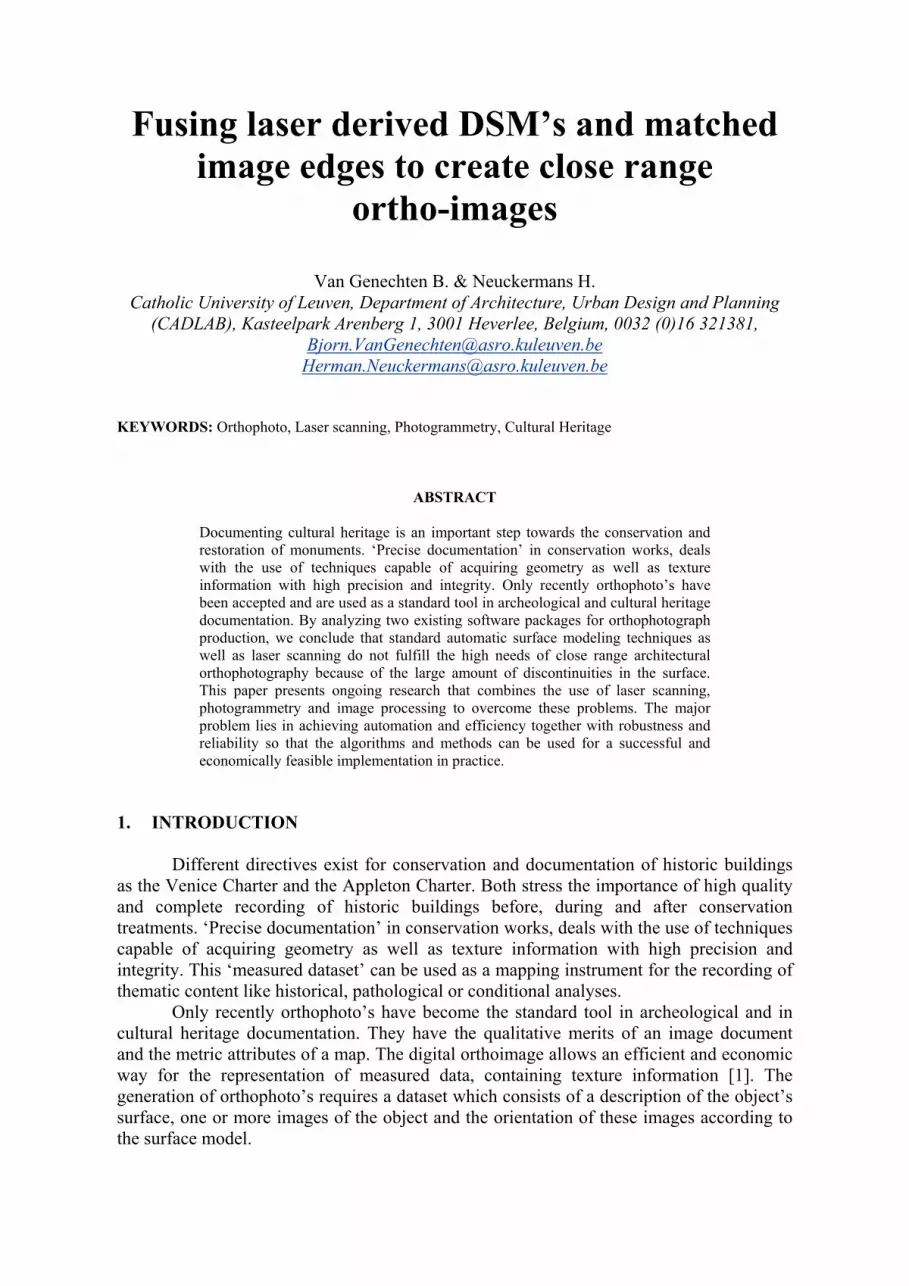
Different tests were made to use the software with DSM’s created from laser scanner point clouds, but the results were unsatisfactory. Only after a lengthy editing process of manually adding breaklines to the DSM, the result became somewhat satisfactory (see Figure 1).
Figure 1 : Orthophoto from laser scanning point cloud before and after editing
3. SUPRESOFT VIRTUOZO
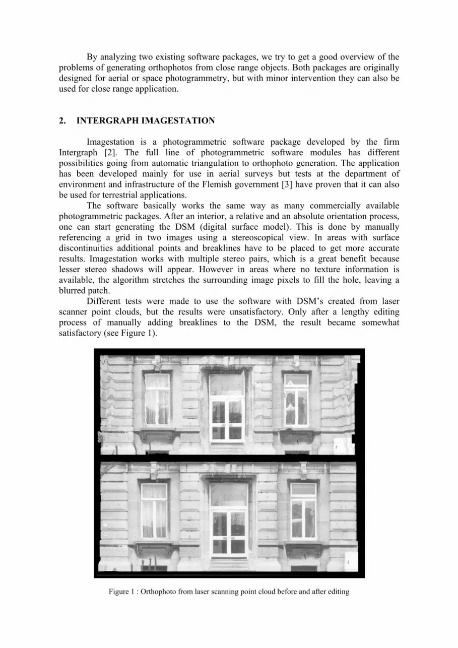
Figure 2 : DSM before and after editing
The Chinese firm Supresoft Inc. has developed a software package called Virtuozo [4]. Virtuozo is a photogrammetry application that starts from digital stereo image data and generates digital surface models using automatic high end image matching techniques. Goossens & Devriendt [5, 6] from the university of Brussels have provided us a thorough analysis of the system and its problems in close range applications.
The results of the almost fully automatic process were not satisfactory at all. The final surface model created by the matching algorithm contained a lot of spikes in areas of low texture information and sharp surface discontinuities appeared to be smoothed (see
Figure 2). Image matching processes generally compare image patches using a correlation measure. Because of noise in the images, lack of texture, shadows and occlusions these matching algorithms may fail in certain areas.
An iterative process of manually adding constraints at these locations and recalculating the digital surface model, partially solved or minimized the problems. Adding constraints basically means inserting breaklines at places where discontinuities should appear, adding sparse point or line correspondences between the stereo images or setting the DSM height to an average value at places of low texture.
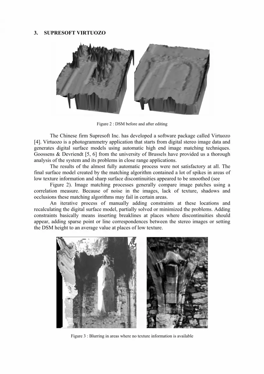
Figure 3 : Blurring in areas where no texture information is available

The Virtuozo software only works with one pair of stereo images. This implies that some areas will not be visible on either of the source photographs because of stereo shadows. In these areas no texture information is available and Virtuozo stretches the nearby color values as to fill the leaping gap, resulting in blurred patches in the orthophoto (see Figure 3).
It also means that for larger architectural objects, multiple orthophoto’s have to be made which have to be stitched afterwards. Because of differences in the lighting conditions and possible scale dissimilarities when taking the photographs, the seamlines between these partial orthophotographs will be visible. 4. CREATING ACCURATE SURFACE MODELS OF CLOSE RANGE
ARCHITECTURAL OBJECTS
As proven in the previous chapters, surface modeling remains a very crucial issue in generating orthophotos. The accuracy of the surface description is directly linked to the quality of the orthoimage. Close range applications usually face complex object shapes. For instance if we have a look at a simple façade, we see that architectural objects are highly characterized by abrupt changes in their surface continuity. Their curvature stays identical over large areas and changes suddenly. Other problems in close range applications are due to the fact that the ratio of height differences to image acquisition distance is much bigger than in aerial surveys. This results in significant occlusion problems and large deformations.
The use of digital stereo photogrammetric workstations is one way of collecting surface points. Since manually selecting points of interest, as in the early days, has become a lengthy and labor intensive task, automatic matching algorithms have been created and are commercially available today. They are highly recommended in open and flat areas as in aerial photogrammetry, nevertheless most software packages perform poorly in areas with abrupt changes in depth as in close range projects [7, 8]. Many people creating close range orthophotographs today try to use these algorithms, which are generally created for aerial photogrammetry, in close range application at the cost of a time-consuming editing phase afterwards.
Recently, laser scanning has been receiving more attention as a useful tool for real-time 3D data capturing. However 3D representation of historical structures from point clouds collected by laser scanning still has some issues, they have already shown promising contribution in overcoming lengthy, intensive manual interaction when measuring buildings [9, 10, 11]. Laser scanning allows a very detailed sampling of the surface of an object or landscape within a more or less automated recording procedure and may thus be used to produce surface models for orthorectification. But laser scanning also has its problems. Besides the high cost, it samples points at regular intervals. This means that it returns an overflow of data in areas that are smooth and flat, while in other parts, especially near visually interesting surface features like edges, its resolution is often insufficient. The laser scanner tries to substitute the ‘intelligence” of a human surveyor by means of the redundancy of the acquisition [12]. After a lengthy post-processing step which includes noise filtering, hole filling and registering multiple scans, the point cloud is transformed into a mesh using interpolation techniques which often do not cope with discontinuities in the surface. Since breaklines are a vital parameter for an accurate surface model reconstruction, laser scanning on its own is not sufficient to meet the high requirements of orthophoto generation.
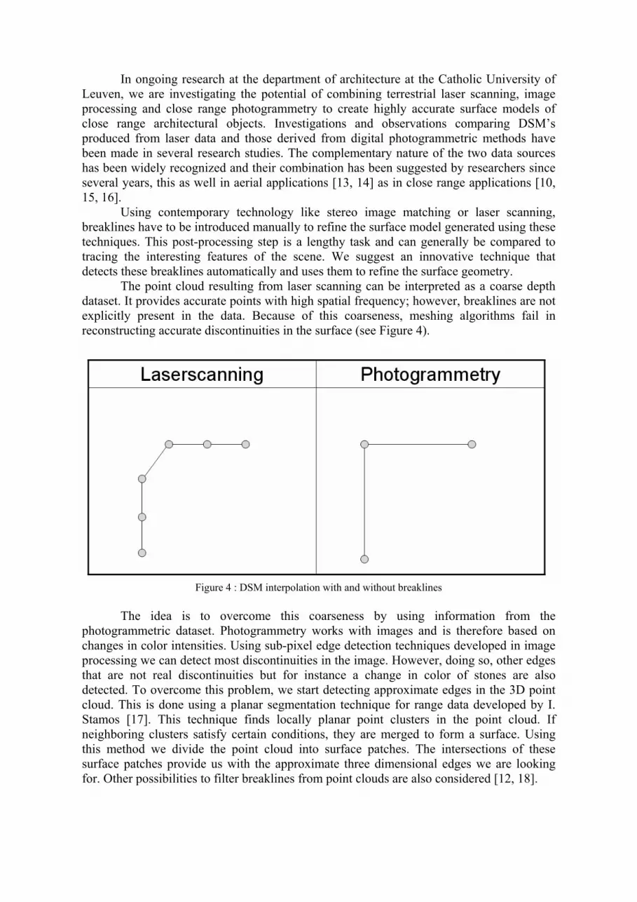
In ongoing research at the department of architecture at the Catholic University of Leuven, we are investigating the potential of combining terrestrial laser scanning, image processing and close range photogrammetry to create highly accurate surface models of close range architectural objects. Investigations and observations comparing DSM’s produced from laser data and those derived from digital photogrammetric methods have been made in several research studies. The complementary nature of the two data sources has been widely recognized and their combination has been suggested by researchers since several years, this as well in aerial applications [13, 14] as in close range applications [10, 15, 16]. Using contemporary technology like stereo image matching or laser scanning, breaklines have to be introduced manually to refine the surface model generated using these techniques. This post-processing step is a lengthy task and can generally be compared to tracing the interesting features of the scene. We suggest an innovative technique that detects these breaklines automatically and uses them to refine the surface geometry. The point cloud resulting from laser scanning can be interpreted as a coarse depth dataset. It provides accurate points with high spatial frequency; however, breaklines are not explicitly present in the data. Because of this coarseness, meshing algorithms fail in reconstructing accurate discontinuities in the surface (see Figure 4).
Figure 4 : DSM interpolation with and without breaklines
The idea is to overcome this coarseness by using information from the
photogrammetric dataset. Photogrammetry works with images and is therefore based on changes in color intensities. Using sub-pixel edge detection techniques developed in image processing we can detect most discontinuities in the image. However, doing so, other edges that are not real discontinuities but for instance a change in color of stones are also detected. To overcome this problem, we start detecting approximate edges in the 3D point cloud. This is done using a planar segmentation technique for range data developed by I. Stamos [17]. This technique finds locally planar point clusters in the point cloud. If neighboring clusters satisfy certain conditions, they are merged to form a surface. Using this method we divide the point cloud into surface patches. The intersections of these surface patches provide us with the approximate three dimensional edges we are looking for. Other possibilities to filter breaklines from point clouds are also considered [12, 18].

Using the orientation data, these approximate 3D edges can be back-projected into all available images. Using ‘snakes’, a technique well known in computer vision and image processing, we try to optimize the position of this approximate edge in the image. A snake is an energy minimizing spline guided by external constraint forces and influenced by image forces that pull it toward features such as lines and edges. The snake’s energy-function can be minimized using different constraints like its stiffness, its originally projected position in the image and the intensity gradient of the image around the edge. Using this technique, the approximate breakline will be refined as to be in an optimal position according to the available depth information from the laser scanner and the intensity information from the image. When using multiple images, one can re-project these refined image edges into 3D space as to integrate breaklines into the 3D laser scanner dataset. These breaklines constrain the mesh triangulation method that reconstructs the surface geometry from the point cloud. We believe that fusing the data of different layers will improve the accuracy of the original point clouds because of the strong correlation between the scenes depth and its image intensity. Special attention will be put to structural conserving noise suppression because of the importance of the building details in the reconstruction. 5. ORTHOPROJECTION PROCEDURE
Once an accurate surface model is available, it can be used in the orthoprojection procedure. The orthoprojection algorithm however is more complex for close range objects then for aerial projections. In our implementation we follow the process described by Grammatikopoulos [19].
The algorithm requires the following input:
• a triangulated 3D mesh • some photographs of the scene (preferably more than 1) • the orientation parameters (interior and exterior) of the photographs • a description of the reference plane in space • the pixel size of the final orthophotograph
The main problem of orthoprojection is visibility, which is twofold. Which part is
visible in the final orthoimage and from which source image can we get the texture information for this part? The algorithm starts by transforming the exterior orientation data and the mesh data into a different coordinate system in which the xy-plane is parallel to the reference plane. By projecting all the mesh triangles orthogonally onto the reference plane and mapping the distance of each ortho-pixel to the surface model (which corresponds to the z-coordinate of the mesh in the transformed coordinate system) as a grey value, one can generate a depth map. The visibility problem is solved by comparing the calculated depth value of each pixel with a possibly already existing depth value from other triangles. If the pixel already has been used and thus already has a depth value, the larger depth value replaces the lower one. Meanwhile the mesh triangle ID number is stored for each orthoimage pixel.
Next we have to check which surface points are visible from the perspective centre of each image. Therefore we project all mesh triangles onto the source images using the orientation information. Each triangle is rasterized and for each resolving image pixel the distance from the focal point to the actual mesh point is calculated. Using the same method as for the orthoprojection, the larger distance values are replaced by pixels that are closer to the image plane. For each image pixel, the triangle ID number is also stored (see Figure 5).
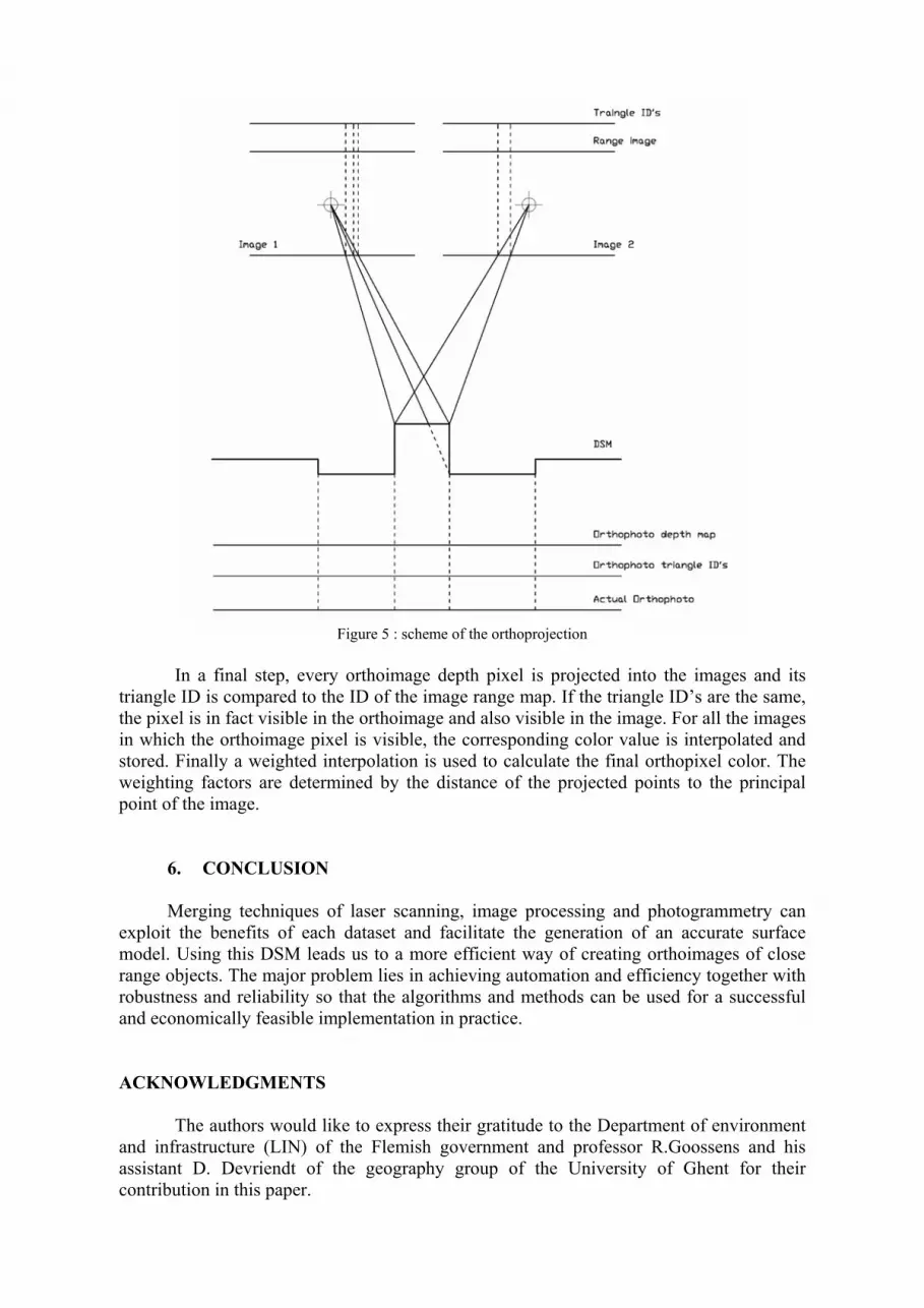
Figure 5 : scheme of the orthoprojection
In a final step, every orthoimage depth pixel is projected into the images and its triangle ID is compared to the ID of the image range map. If the triangle ID’s are the same, the pixel is in fact visible in the orthoimage and also visible in the image. For all the images in which the orthoimage pixel is visible, the corresponding color value is interpolated and stored. Finally a weighted interpolation is used to calculate the final orthopixel color. The weighting factors are determined by the distance of the projected points to the principal point of the image.
6. CONCLUSION
Merging techniques of laser scanning, image processing and photogrammetry can exploit the benefits of each dataset and facilitate the generation of an accurate surface model. Using this DSM leads us to a more efficient way of creating orthoimages of close range objects. The major problem lies in achieving automation and efficiency together with robustness and reliability so that the algorithms and methods can be used for a successful and economically feasible implementation in practice.
ACKNOWLEDGMENTS
The authors would like to express their gratitude to the Department of environment and infrastructure (LIN) of the Flemish government and professor R.Goossens and his assistant D. Devriendt of the geography group of the University of Ghent for their contribution in this paper.

REFERENCES
1. Mavromati D. & Petsa E. & Karras G.E. (2002). Theoretical and practical aspects of archeological orthoimaging, International Archives of Photogrammetry & remote sensing, Vol 34(5), pp 413-418
2. http://www.intergraph.com/istation/ 3. Cocquyt Y. (2003). Terrestrische fotogrammetrie – inmeten DTM, master thesis, Katholieke
Hogeschool Brugge-Oostende (KHBO), Belgium 4. http://www.supresoft.com.cn/english/ 5. Benoit F. & Devriendt D. (2001). Onderzoek naar de mogelijkheden van digitale fotogrammetrische
methoden voor terrestrische stereoscopische opnamen, toegepast op de ruïnes van het transept en het koor van de kerk van de Aulne-abdij, master thesis, Faculty of sciences (geography), University of Ghent, Belgium
6. Cristophe F. (2004). Onderzoek naar de mogelijkheden van fotogrammetrische restitutie van oppervlakken met uitgesproken reliëf toegepast op de Onze-Lieve Vrouwe Kathedraal in Doornik, master thesis, Faculty of sciences (geography), University of Ghent, Belgium
7. Tsioukas V. & Patias P. (2004). A new approach on image matching techniques for the automatic production of dtm in terrestrial photogrammetry, International Archives of the photogrammetry, remote sensing and spatial information Sciences, Istanbul, Turkey, Vol. 35(5)
8. Wiedemann A. (2004). Challenges and solutions on the generation of digital surface models of facades using image processing techniques, International Archives of the photogrammetry, remote sensing and spatial information Sciences, Istanbul, Turkey, Vol. 35(5)
9. Barber D. & Mills J. & Bryan P. (2002). Experiences of laser scanning for close range structural recording, Proceedings of the CIPA WG 6 International workshop on scanning for Cultural heritage recording, Corfu, Greece, pp.121-126.
10. Belletti C. & Guerra F. & Lingua A. & Rinaudo F. (2001). True digital orthophoto of the san marco basilica in Venice, International Archives of the photogrammetry, remote sensing and spatial information Sciences, Potsdam, Vol. 34(5)
11. Monti C. & Fregonese L., Achille C. (2003). Laser scanner application on complex shapes of architecture, profiles extraction processing and 3D modeling, International Archives of the photogrammetry, remote sensing and spatial information Sciences, Tarasp, Switzerland, Vol. 34(5)
12. Yokoyama H. & Chikatsu H. (2004). 3D modeling for historical structure using terrestrial laser range data, , International Archives of the photogrammetry, remote sensing and spatial information Sciences, Istanbul, Turkey, Vol. 35(5)
13. Ackermann F. (1999). Airborne laser scanning - present status and future expectations, International Archives of the photogrammetry, remote sensing and spatial information Sciences, Potsdam, Vol. 54:64-67
14. McIntosh K. & Krupnik A. (2002). Integration of laser-derived DSM’s and matched image edges for generating an accurate surface model, Journal of photogrammetry and remote sensing, Vol. 56, pp.167-176
15. Boccardo P. &, Dequal S. & Lingua A. & Rinaudo F. (2001). True digital orthophoto for architecture and archeological applications, , International Archives of the photogrammetry, remote sensing and spatial information Sciences, Potsdam, Vol. 34(5), pp 50-55
16. Wiedemann A. (1996). Digital orthoimages in architectural photogrammetry using digital surface models, , International Archives of the photogrammetry, remote sensing and spatial information Sciences, Vienna, Austria, Vol. 31(5), pp. 605-609
17. Stamos I. & Allen P.K. (2000). Integration of range and image sensing for photorealistic 3D modeling, proceedings of International Conference on Robotics and Automation, San Fransisco, U.S., pp. 1435-1440
18. Briese C. (2004). Three-dimensional modeling of breaklines from airborne laser scanner data, International Archives of the photogrammetry, remote sensing and spatial information Sciences, Istanbul, Turkey, Vol. 35(3)
19. Grammatikopoulos L. & Kalisperakis I. & Karras G. & Kokkinos T. & Petsa E. (2004). Automatic multi-image photo-texturing of 3D-surface models obtained with laser scanning, CIPA International Workshop on Vision Techniques applied to the Rehabilitation of City Centres, Lisbon
20. Alshawabkeh Y. & Haala N. (2004). Integration of digital photogrammetry and laser scanning for heritage documentation, International Archives on Photogrammetry and Remote Sensing, Istanbul, Turkey, Vol. 35(5)