formation and disintegration of a high-arctic ice-cored moraine complex, scott turnerbreen, svalbard
TRANSCRIPT
Formation and disintegration of a high-arctic ice-cored morainecomplex, Scott Turnerbreen, Svalbard
KARI SLETTEN, ASTRID LYSAÊ AND IDA LØNNE
Sletten, K., LysaÊ , A. & Lønne, I. 2001 (December): Formation and disintegratio n of a high-arcti c ice-coredmoraine complex, Scott Turnerbreen , Svalbard. Boreas, Vol. 30, 272–284. Oslo. ISSN 0300-9483 .
Englacial debris structures , morphology and sediment distribution at the frontal part and at the proglacial areaof the Scott Turnerbreen glacier have been studied through � eldwork and aerial photograph interpretation . Themain emphasis has been on processes controlling the morphologica l development of the proglacial area. Threetypes of supraglacia l ridges have been related to different types of englacial debris bands. We suggest that thesediments were transported in thrusts, along � ow lines and in englacial meltwater channels prior to, and duringa surge in, the 1930s, before the glacier turned cold. Melting-out of englacial debris and debris that � owsdown the glacier front has formed an isolating debris cover on the glacier surface, preventing further melting.As the glacier wasted, the stagnant, debris-covered front became separated from the glacier and formed ice-cored moraine ridges. Three moraine ridges were formed outside the present ice-front . The further glacier wa-stage formed a low-relief proglacial area with debris-� ow deposits resting directly on glacier ice. Melting ofthis buried ice initiated a second phase of slides and debris � ows with a � ow direction independen t of the pre-sent glacier surface. The rapid disintegration of the proglacia l morphology is mainly caused by slides andstream erosion that uncover buried ice and often cause sediments to be transported into the main river and outof the proglacial area. Inactive stream channels are probably one of the morphologica l elements that have thebest potential for preservation in a wasting ice-cored moraine complex and may indicate former ice-front posi-tions.
Kari Sletten (e-mail: [email protected] ) and Astrid LysaÊ , Geological Survey of Norway, NO-7491 Trond-heim, Norway; Ida Lønne, The University Courses on Svalbard , UNIS, P.O. Box 156, NO-9170 Longyearbyen ,Norway; received 13th October 2000, accepted 1st May 2001.
Studies of moraine formation by high-arctic glaciersfocus mainly on surges and glaciotectonic processes(e.g. Croot 1988; Lefauconnier & Hagen 1991; Ham-brey & Huddart 1995; Bennett et al. 1996a; Bennett etal. 1998; Boulton et al. 1999), or melt-out of englacialdebris and formation of ice-cored moraines (e.g.Boulton 1967, 1968; Sollid & Sørbel 1988; Sollid etal. 1994; Etzelmuller et al. 1996). Until recently(Etzelmuller 2000; LysaÊ & Lønne 2001), there hasbeen only a minor focus on the understanding ofdisintegration processes of moraine complexes. Thepreservation potential of the morphological featuresassociated with ice-cored deposits is very low. Knowl-edge of sediment transport processes and processescontrolling the down-wasting of terrestrial glaciers andglacier landforms in high-arctic settings is important inunderstanding former glacier features. On Svalbardthere is a scarcity of such features on land (see, e.g.,Landvik et al. 1998).
This study aims to provide new information concern-ing processes related to ice-cored moraines and effectsof disintegration processes in a proglacial area. Foursubjects are emphasized: (1) the morphology andsedimentology of the proglacial area as well as thedebris-covered glacial snout; (2) debris transport to theglacier front; (3) the mode of moraine formation; and(4) resedimentation and disintegration of the morainecomplex.
Geological and climatic setting
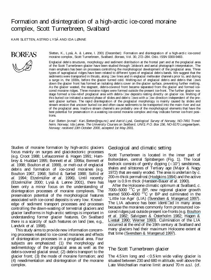
Scott Turnerbreen is located in the inner part ofBolterdalen, central Spitsbergen (Fig. 1). The localbedrock consists of gently dipping (<10°) sandstones,shales and siltstones of Tertiary age (Major & Nagy1972) that are easily eroded. The area is underlain by c.200-m-thick permafrost (Hodgkins 1994) and the activelayer is 0.9 m thick (Hanssen-Bauer et al. 1990).
After the Holocene climatic optimum at Svalbard, c.7000–5000 14C yr BP, new regional glacier growthstarted 5000–4000 14C yr BP and culminated in the‘Little Ice Age’ (LIA) (Svendsen & Mangerud 1997).The LIA advance has been identi� ed in many areasbecause the moraines commonly form pronounced ice-cored ridges just outside present ice-fronts (e.g. Boultonet al. 1982; Salvigsen & Osterholm 1982; Hagen &Liestøl 1990; Werner 1993). Culmination of the LIAoccurred at the end of the 19th century at Svalbard andmany glaciers had their maximum Holocene extent atthat time (Svendsen & Mangerud 1997).
The Scott Turnerbreen glacier
The 4.5 km long and <0.5 km wide valley glacier issituated between 230 and 680 m altitude, well above theLate Weichselian marine limit around 70 m a.s.l. (cf.
Salvigsen 1984; Landvik et al. 1987). Two north-facingaccumulation basins feed two glacier streams, thewestern main stream and the smaller eastern stream,which coalesce at about 500 m a.s.l. (Fig. 1C). Theequilibrium line is estimated to be c. 530 m a.s.l. (Hagenet al. 1993), but is likely higher because the glaciers onSvalbard are not in balance with the existing climate.
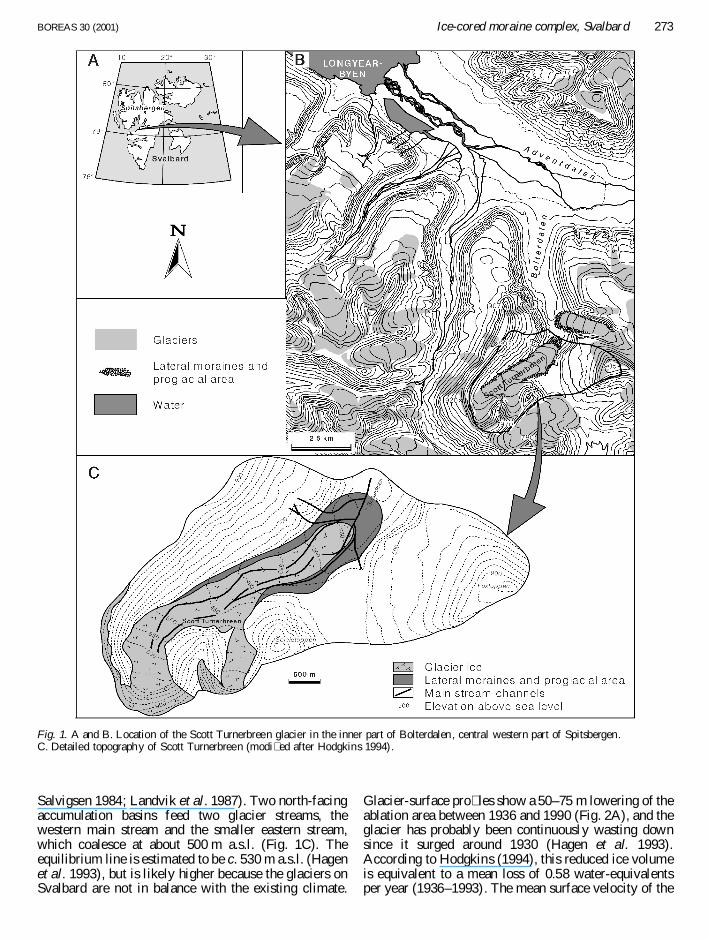
Glacier-surface pro� les show a 50–75 m lowering of theablation area between 1936 and 1990 (Fig. 2A), and theglacier has probably been continuously wasting downsince it surged around 1930 (Hagen et al. 1993).According to Hodgkins (1994), this reduced ice volumeis equivalent to a mean loss of 0.58 water-equivalentsper year (1936–1993). The mean surface velocity of the
Fig. 1. A and B. Location of the Scott Turnerbreen glacier in the inner part of Bolterdalen , central western part of Spitsbergen.C. Detailed topography of Scott Turnerbreen (modi� ed after Hodgkins 1994).
BOREAS 30 (2001) Ice-cored moraine complex, Svalbard 273
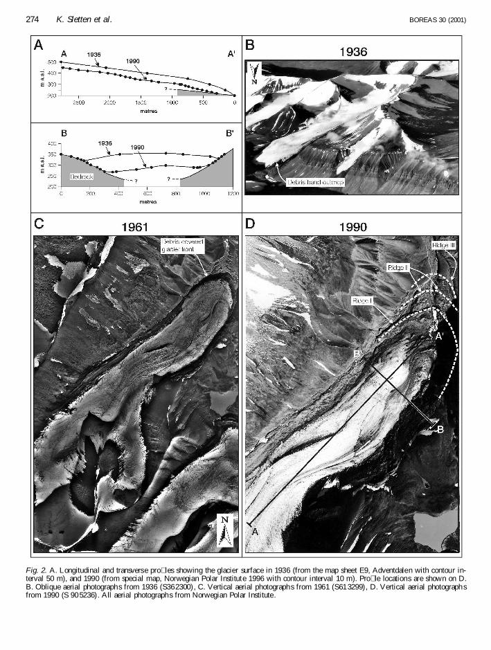
Fig. 2. A. Longitudina l and transverse pro� les showing the glacier surface in 1936 (from the map sheet E9, Adventdalen with contour in-terval 50 m), and 1990 (from special map, Norwegian Polar Institute 1996 with contour interval 10 m). Pro� le locations are shown on D.B. Oblique aerial photographs from 1936 (S362300), C. Vertical aerial photographs from 1961 (S613299), D. Vertical aerial photograph sfrom 1990 (S 90 5236). All aerial photographs from Norwegian Polar Institute .
274 K. Sletten et al. BOREAS 30 (2001)
main glacier stream is 9.5 cm a¡1, locally reaching amaximum of 47.5 cm a¡1, while much of the lowerpart of the glacier is essentially stagnant (Hodgkins1994). High-frequency radar pro� les and temperaturemeasurements in boreholes show that the glacier isbelow the pressure-melting temperature throughout(Hodgkins 1994). Based on the borehole temperaturegradients Hodgkins (1994) calculated that the glacierwas at the pressure-melting temperature over c. 2 km ofits bed in 1936. Only supraglacial melting occurs atpresent and the main glacial streams coalesce 100 m infront of the glacier terminus (Figs 1C, 3).
The proglacial area comprises a 750 m long zone ofice-cored deposits that are transitional to lateralmoraines extending 2.5 and 3.6 km along the easternand western side of the glacier, respectively (Fig. 1C).Mapping of morphology and sediment distribution inthe proglacial area has revealed three separate moraineridges named I, II and III (Figs 2D, 3).
Methods
Oblique aerial photos from 1936 and vertical aerialphotos from 1961 (1: 46.000) and 1990 (1: 15.000) (Fig.2) were used for mapping purposes. Clast-fabricanalyses were carried out in diamict units, using 100clasts with an a/b axis ratio of 2. The results are plottedas points on lower hemisphere Schmidt nets withstatistical parameters (Woodcock & Naylor 1983).The � eldwork was carried out from early July to lateSeptember 1996.
Results
Morphology, sediment distribution and resedimentationprocesses at the glacier snout and in the proglacial areaof Scott Turnerbreen are described below.
Debris-covered glacier front
Morphology and sedimentology. – The snout area ofScott Turnerbreen, dipping about 7°, is covered by up to60 cm of debris, and shows a gradual transition into theproglacial area, where buried ice appears commonly.Superimposed on this more or less continuous supra-glacial sediment cover is a series of ice-cored sedimentridges. The rough topography is clearly shown in crosspro� les (Fig. 3B). Three main types of ridges, A, B andC, are recognized and the englacial sediment sources ofthese ridges were revealed in a meltwater channelcutting through the eastern part of the glacier front (Fig.3). Debris bands in the 2–3 m high channel walls cropout at the surface and are directly related to thesupraglacial ridges.
Type A ridges are concentric in shape, parallel to the
glacier front (Fig. 3), and the ice-cores are covered by<20-cm debris layers. Three ridges of this type, withmaximum height and width of 6 m and 25 m, respec-tively, arc around the front of the eastern ice stream(Fig. 3). The middle one consists exclusively of pebble-and cobble-sized black shale fragments, while the othertwo are dominated by 10–30 cm � at, angular cobbles ofyellow and grey sandstone and siltstone. Some � nesoccur in between the cobbles. Ridges of type A that arcaround the front of the main ice stream are >1 m high,but their lateral extension can attain 450 m (Fig. 3). Themassive, poorly compacted sediment consists of angulargravel, cobbles and some boulders up to 50 cm indiameter, and also some sand and silt.
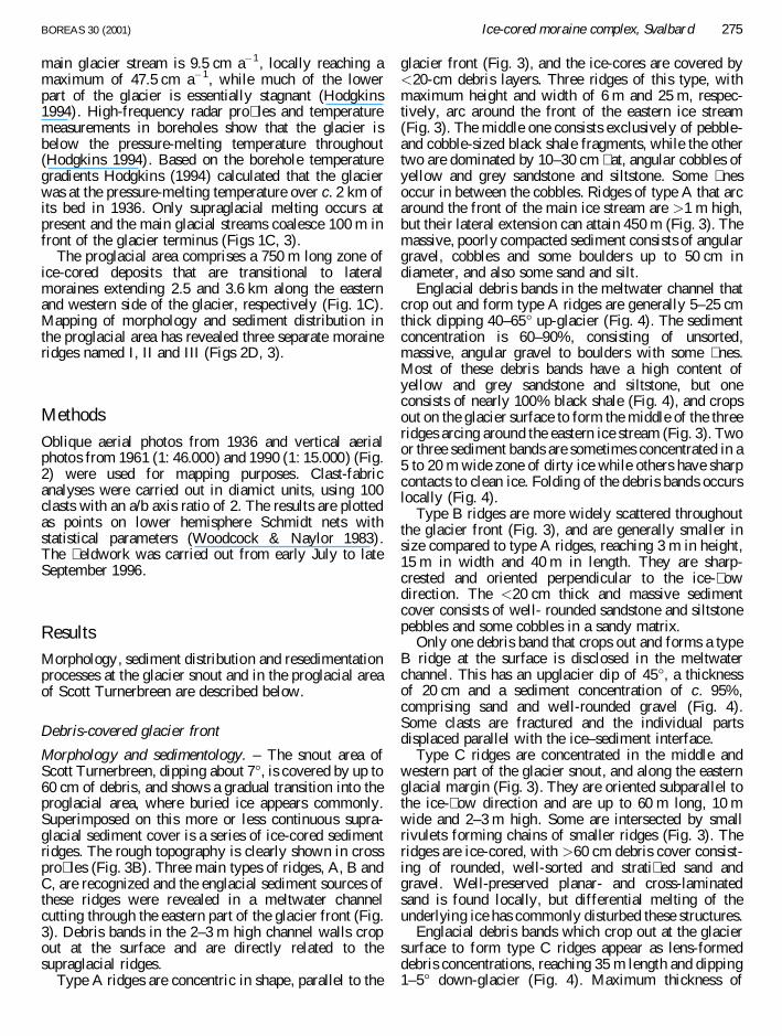
Englacial debris bands in the meltwater channel thatcrop out and form type A ridges are generally 5–25 cmthick dipping 40–65° up-glacier (Fig. 4). The sedimentconcentration is 60–90%, consisting of unsorted,massive, angular gravel to boulders with some � nes.Most of these debris bands have a high content ofyellow and grey sandstone and siltstone, but oneconsists of nearly 100% black shale (Fig. 4), and cropsout on the glacier surface to form the middle of the threeridges arcing around the eastern ice stream (Fig. 3). Twoor three sediment bands are sometimes concentrated in a5 to 20 m wide zone of dirty ice while others have sharpcontacts to clean ice. Folding of the debris bands occurslocally (Fig. 4).
Type B ridges are more widely scattered throughoutthe glacier front (Fig. 3), and are generally smaller insize compared to type A ridges, reaching 3 m in height,15 m in width and 40 m in length. They are sharp-crested and oriented perpendicular to the ice-� owdirection. The <20 cm thick and massive sedimentcover consists of well- rounded sandstone and siltstonepebbles and some cobbles in a sandy matrix.
Only one debris band that crops out and forms a typeB ridge at the surface is disclosed in the meltwaterchannel. This has an upglacier dip of 45°, a thicknessof 20 cm and a sediment concentration of c. 95%,comprising sand and well-rounded gravel (Fig. 4).Some clasts are fractured and the individual partsdisplaced parallel with the ice–sediment interface.
Type C ridges are concentrated in the middle andwestern part of the glacier snout, and along the easternglacial margin (Fig. 3). They are oriented subparallel tothe ice-� ow direction and are up to 60 m long, 10 mwide and 2–3 m high. Some are intersected by smallrivulets forming chains of smaller ridges (Fig. 3). Theridges are ice-cored, with >60 cm debris cover consist-ing of rounded, well-sorted and strati� ed sand andgravel. Well-preserved planar- and cross-laminatedsand is found locally, but differential melting of theunderlying ice has commonly disturbed these structures.
Englacial debris bands which crop out at the glaciersurface to form type C ridges appear as lens-formeddebris concentrations, reaching 35 m length and dipping1–5° down-glacier (Fig. 4). Maximum thickness of
BOREAS 30 (2001) Ice-cored moraine complex, Svalbard 275
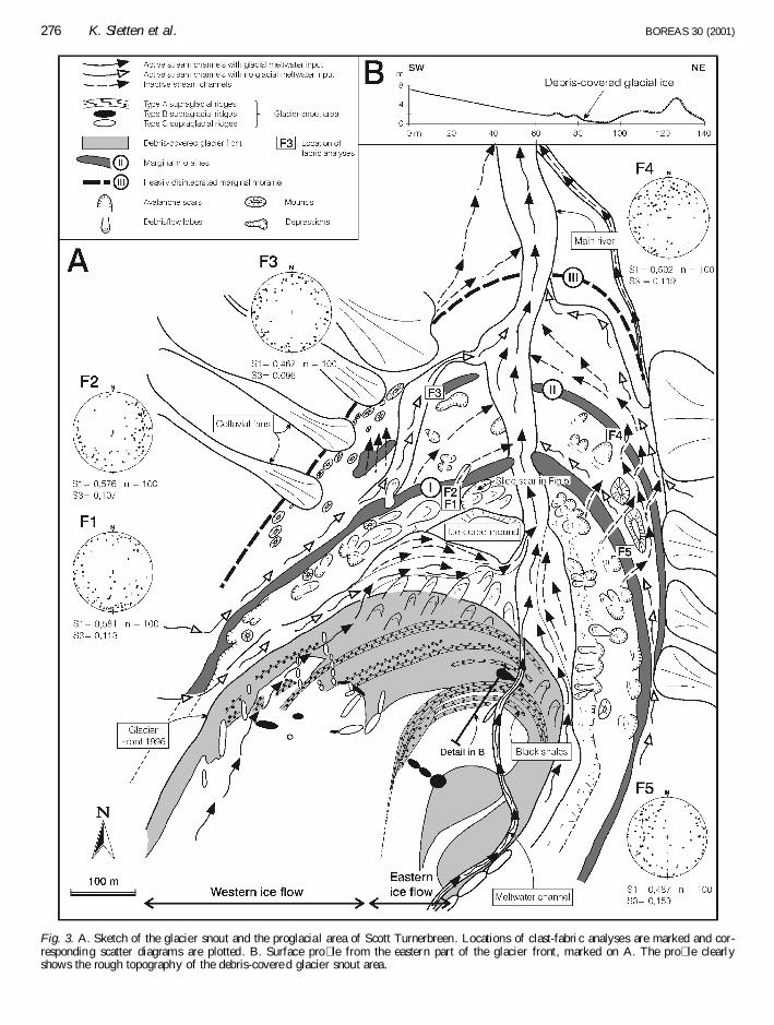
Fig. 3. A. Sketch of the glacier snout and the proglacia l area of Scott Turnerbreen. Locations of clast-fabri c analyses are marked and cor-responding scatter diagrams are plotted. B. Surface pro� le from the eastern part of the glacier front, marked on A. The pro� le clearlyshows the rough topography of the debris-covere d glacier snout area.
276 K. Sletten et al. BOREAS 30 (2001)
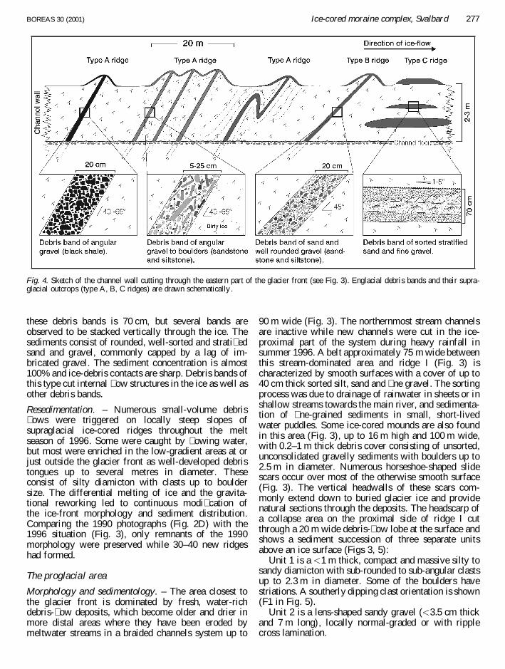
these debris bands is 70 cm, but several bands areobserved to be stacked vertically through the ice. Thesediments consist of rounded, well-sorted and strati� edsand and gravel, commonly capped by a lag of im-bricated gravel. The sediment concentration is almost100% and ice-debris contacts are sharp. Debris bands ofthis type cut internal � ow structures in the ice as well asother debris bands.
Resedimentation. – Numerous small-volume debris� ows were triggered on locally steep slopes ofsupraglacial ice-cored ridges throughout the meltseason of 1996. Some were caught by � owing water,but most were enriched in the low-gradient areas at orjust outside the glacier front as well-developed debristongues up to several metres in diameter. Theseconsist of silty diamicton with clasts up to bouldersize. The differential melting of ice and the gravita-tional reworking led to continuous modi� cation ofthe ice-front morphology and sediment distribution.Comparing the 1990 photographs (Fig. 2D) with the1996 situation (Fig. 3), only remnants of the 1990morphology were preserved while 30–40 new ridgeshad formed.
The proglacial area
Morphology and sedimentology. – The area closest tothe glacier front is dominated by fresh, water-richdebris-� ow deposits, which become older and drier inmore distal areas where they have been eroded bymeltwater streams in a braided channels system up to
90 m wide (Fig. 3). The northernmost stream channelsare inactive while new channels were cut in the ice-proximal part of the system during heavy rainfall insummer 1996. A belt approximately 75 m wide betweenthis stream-dominated area and ridge I (Fig. 3) ischaracterized by smooth surfaces with a cover of up to40 cm thick sorted silt, sand and � ne gravel. The sortingprocess was due to drainage of rainwater in sheets or inshallow streams towards the main river, and sedimenta-tion of � ne-grained sediments in small, short-livedwater puddles. Some ice-cored mounds are also foundin this area (Fig. 3), up to 16 m high and 100 m wide,with 0.2–1 m thick debris cover consisting of unsorted,unconsolidated gravelly sediments with boulders up to2.5 m in diameter. Numerous horseshoe-shaped slidescars occur over most of the otherwise smooth surface(Fig. 3). The vertical headwalls of these scars com-monly extend down to buried glacier ice and providenatural sections through the deposits. The headscarp ofa collapse area on the proximal side of ridge I cutthrough a 20 m wide debris-� ow lobe at the surface andshows a sediment succession of three separate unitsabove an ice surface (Figs 3, 5):
Unit 1 is a <1 m thick, compact and massive silty tosandy diamicton with sub-rounded to sub-angular clastsup to 2.3 m in diameter. Some of the boulders havestriations. A southerly dipping clast orientation is shown(F1 in Fig. 5).
Unit 2 is a lens-shaped sandy gravel (<3.5 cm thickand 7 m long), locally normal-graded or with ripplecross lamination.
Fig. 4. Sketch of the channel wall cutting through the eastern part of the glacier front (see Fig. 3). Englacial debris bands and their supra-glacial outcrops (type A, B, C ridges) are drawn schematically .
BOREAS 30 (2001) Ice-cored moraine complex, Svalbard 277
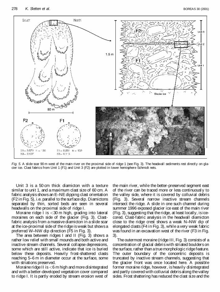
Unit 3 is a 50 cm thick diamicton with a texturesimilar to unit 1, and a maximum clast size of 60 cm. Afabric analysis shows an E–NE dipping clast orientation(F2 in Fig. 5), i.e. parallel to the surface dip. Diamictonsseparated by thin, sorted beds are seen in severalheadwalls on the proximal side of ridge I.
Moraine ridge I is <30 m high, grading into lateralmoraines on each side of the glacier (Fig. 3). Clast-fabric analysis from a massive diamicton in a slide scarat the ice-proximal side of the ridge is weak but shows apreferred W–NW dip direction (F5 in Fig. 3).
The area between ridges I and II (Fig. 3) shows arather low relief with small mounds and both active andinactive stream channels. Several collapse depressions,some which are still active, indicate that ice is buriedbelow these deposits. Heavily frost-shattered clastsreaching 5–6 m in diameter occur at the surface, somewith striations preserved.
Moraine ridge II is <6 m high and more disintegratedand with a better-developed vegetation cover comparedto ridge I. It is partly eroded by stream erosion west of
the main river, while the better-preserved segment eastof the river can be traced more or less continuously tothe valley side, where it is covered by colluvial debris(Fig. 3). Several narrow inactive stream channelsintersect the ridge. A slide in one such channel duringsummer 1996 exposed glacier ice east of the main river(Fig. 3), suggesting that the ridge, at least locally, is ice-cored. Clast-fabric analysis in the headwall diamictonclose to the ridge crest shows a weak N–NW dip ofelongated clasts (F4 in Fig. 3), while a very weak fabricwas found in an excavation west of the river (F3 in Fig.3).
The outermost moraine (ridge III, Fig. 3) consists of aconcentration of glacial debris with striated boulders onthe surface, rather than a true morphologic ridge feature.The outer boundary of the concentric deposits istruncated by inactive stream channels, suggesting thatthe glacier front was once located here. A possibleformer moraine ridge, however, is heavily disintegratedand partly covered with colluvial debris along the valleysides. Frost shattering has reduced the clast size and the
Fig. 5. A slide scar 90 m west of the main river on the proximal side of ridge 1 (see Fig. 3). The headwall sediments rest directly on gla-cier ice. Clast fabrics from Unit 1 (F1) and Unit 3 (F2) are plotted in lower hemisphere Schmidt nets.
278 K. Sletten et al. BOREAS 30 (2001)
vegetation cover is much better developed than on ridgeII. There are no observations of buried ice on the distalside of ridge II.
Resedimentation. – Slides and debris � ows are activeprocesses just outside the glacier front and in the c. 75 mwide area on the proximal side of ridge I (Fig. 3).Flows in the � rst area are sourced from supraglacialdebris and show a northerly transport direction. Flowsin the second area are fed by slides and slumps fromthe ridge slope, from the ice-cored mounds and fromslide scars on the otherwise smooth surface of thisarea, and show a transport direction towards themain river, i.e. a westerly � ow on the east side and aneasterly � ow on the west side of the river. Debris-� ow processes are less active on the distal side of ridgeI, but inactive slide scars and debris-� ow lobes show
that these processes were more active in an earlierstage.
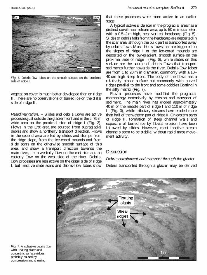
A typical active slide scar in the proglacial area has adistinct curvilinear release area, up to 50 m in diameter,with a 0.5–2 m high, near vertical headscarp (Fig. 5).Slides or debris falls from the headscarp are deposited inthe scar area, although the bulk part is transported awayby debris � ows. Most debris � ows that are triggered onthe slopes of ridge I or the ice-cored mounds aredeposited on the low-gradient, smooth surface on theproximal side of ridge I (Fig. 6), while slides on thissurface are the source of debris � ows that transportsediments further towards the river. Debris-� ow lobesare from 1 to 20 m in diameter, commonly with a 10–40 cm high steep front. The body of the � ows has arelatively planar surface but commonly with curvedridges parallel to the front and some cobbles � oating inthe silty matrix (Fig. 7).
Fluvial processes have modi� ed the proglacialmorphology extensively by erosion and transport ofsediment. The main river has eroded approximately40 m of the middle part of ridge I and 110 m of ridgeII (Fig. 3), while tributary streams have eroded morethan half of the western part of ridge II. On eastern partsof ridge II, formation of steep channel walls andexposure of buried ice by � uvial erosion have beenfollowed by slides. However, most inactive streamchannels seem to be stabile, without rapid mass move-ment activity.
Discussion
Debris entrainment and transport through the glacier
Debris transported through a glacier may be derived
Fig. 6. Debris-� ow lobes on the smooth surface on the proximalside of ridge I.
Fig. 7. A cohesive debris � owwith � oating clasts andconcentri c surface ridgesprobably caused bycompression and shearing.
BOREAS 30 (2001) Ice-cored moraine complex, Svalbard 279
supraglacially from the valley sides, subglacially fromthe glacier bed or englacially from stream channels.Both snow avalanches and rockfalls are common in thevalley sides surrounding the accumulation area of ScottTurnerbreen. Such deposits form debris-rich layersparallel to the strati� cation and are transported down-glacier along � ow lines.
Formation of basal debris-rich ice is governed mainlyby two different processes; regelation and basal ad-freezing (see, e.g., Weertman 1957, 1964; Boulton1970, 1972; Souchez et al. 1988; Shoemaker 1990;Hubbard & Sharp 1993; Iverson & Souchez 1996; Alleyet al. 1997; Hart 1998; Iverson 2000). Both processesrequire temperate or polythermal conditions (Etzelmul-ler et al. 1996). In a study of 12 Svalbard glaciers,Hambrey et al. (1999) present evidence for two mech-anisms that bring debris-rich basal ice and subglacialsediments to an englacial and even supraglacial posi-tion, namely folding at the bed and thrusting. Folding ofstrati� cation is a result of converging � ow lines,especially at the narrowing of the valley. Basal debris-rich ice may form the lower part of the fold sequenceand can reach the surface where the folding is mostintense. The initiation of thrusting is facilitated by thetransition from basal sliding to frozen-bed conditions,bedrock steps and the passage of a surge front throughthe system (Hambrey et al. 1999).
In addition to the transport of debris by incorporationinto moving glacier ice, sediments are transportedand deposited in supra-, en- or subglacial meltwaterchannels. In cold glaciers only supraglacial meltingtakes place, while polythermal and temperate glaciersproduce subglacial meltwater by basal sliding (Paterson1994), which also promotes a higher � ow speed andmore crevasses where supraglacial meltwater can � owinto and form moulins and englacial stream channels.
In polythermal glaciers the frozen snout area makes azone of compression where englacial debris is concen-trated and transported to the surface either in thrusts or inupwarped � ow lines on the thermal boundary betweenthe temperate and the cold part of the glacier (Boulton1970, 1972; Bennett et al. 1996b; Etzelmuller et al. 1996;Bennett et al. 1998). If the cold snout area expands upglacier, thrusts and � ow lines in lower parts will becomeinactive. Scott Turnerbreen was polythermal earlier inthe 20th century, but the whole glacier turned coldsometime after 1936 (Hodgkins 1994), suggesting thatenglacial sediments melt passively out at the glacier fronttoday. Differential melting turns sediment-covered partsof the surface into positive features related to thegeometry of the debris source and the local geometryof surface drainage. The three different types ofsupraglacial moraine ridges and the associated englacialdebris bands described from Scott Turnerbreen (Fig. 4)give information about transport mechanisms and glacierdynamics, and are discussed below.
Type A ridges. – The sediments in type A ridges may
have a supraglacial or subglacial origin, and are broughtto the surface either through � ow lines or in thrusts. Theexpansion up to 450 m suggests transport through � owlines because thrust-derived ridges described by Ham-brey et al. (1999) are commonly only several metreslong. Also the dip angle of 40–65° of the associateddebris bands is low compared to thrusts in the surgingBakaninbreen, where 50% of the thrusts dip between 70and 80° (Hambrey et al. 1996). Moreover, locallyfolding of debris bands related to type A ridges occurs(Fig. 4). Type A ridges at the front of the eastern icestream form looped moraines (Fig. 3), which is commonin surge-type glaciers and re� ects folding of supragla-cial-derived debris layers, accompanied by rotation offold axes (Hambrey et al. 1999). Individual foldeddebris layers commonly consist of a single rock type,probably re� ecting different point sources in the head-wall (Hambrey et al. 1999), as also seen in the loopedmoraines at Scott Turnerbreen. One of the loopedmoraines is formed where a zone of dirty ice containingthree debris bands crops out. This is not in accordancewith the description of debris-rich layers in strati� cationhaving sharp boundaries (Hambrey et al. 1999).However, the angularity of the debris suggests asupraglacial source. If this source were snow ava-lanches, which produce deposits consisting of a snow-debris mixture, one might not expect such sharp ice-debris contacts. The lateral extension and geometry oftype A ridges, the looped moraines, the clast angularity,and the dip angle and locally folding source debrisbands indicate that type A ridges are formed by meltingout of debris-rich layers of supraglacial origin, trans-ported through the glacier and brought to the surface in� ow lines.
Type B ridges. – The sandy gravels in type B ridges andthe associated debris band are common sedimentaryfacies in thrusts (Hambrey et al. 1999). Also thetransverse orientations and sharp crests, as seen intype B ridges, suggest thrusting (Bennett et al. 1996a),and the fractured clasts and displacement of individualparts indicate shearing within the debris band. Well-rounded clasts suggest � uvial transport of the sedi-ments, which likely are of en- or subglacial streamorigin, probably deposited when the glacier waspolythermal. The dip angle of the debris band indicatesthat the thrusting did not occur during a surge, becausesteeper dips are common in surging glaciers (Hambreyet al. 1996). However, the data are too limited for such aconclusion to be drawn and thrusting is also likely tooccur during surges (Hambrey et al. 1999).
Type C ridges. – The sorted, strati� ed sediments withrounded clasts in type C ridges and associated englacialdebris bands are interpreted as stream deposits. Also theice-� ow-parallel appearance of type C ridges suggestsdeposition in englacial meltwater channels. The pri-mary sedimentary structures preserved in both the
280 K. Sletten et al. BOREAS 30 (2001)
ridges and the debris bands indicate that the channel � llshave not been exposed to shear movements, anddeposition may have taken place during a short timespan after the surge in the 1930s, but before the wholeglacier turned cold. Preservation of structures in meltedridge sediments is due to the low ice content.
Timing of moraine-ridge formations
LIA moraines are identi� ed as the most pronouncedridges just outside the present ice-fronts of manySvalbard glaciers (e.g. Boulton et al. 1982; Salvigsen& Osterholm 1982; Hagen & Liestøl 1990; Werner1993). At Scott Turnerbreen, the largest and mostproximal moraine ridge, ridge I (Fig. 3), marks theglacier-front position after the early 1930s surge, seenon aerial photographs from 1936 (Fig. 2B). Apart fromthis surge ridge, ridge II (Fig. 3) is the only preservedmoraine ridge in the proglacial area. The location on thedistal side of ridge I, the higher degree of disintegrationand also the better-developed vegetation cover suggestthat it is older than ridge I, and a LIA-maximum age ismost likely. The outermost system, ridge III, is probablypart of a heavily disintegrated former moraine ridgewith a much more developed vegetation cover, suggest-ing an older and pre-LIA-maximum age. Ridge III couldhave been formed during moraine stabilization c. 650years BP, as proposed by Werner (1993), or evenearlier. However, we do not have any chronologicalcontrol on this.
Formation of proglacial morphological elements
The most striking morphological elements of theproglacial area are the moraine ridges and some ice-cored mounds. The areas not occupied by theseelements show a fairly low relief, except where heavilyeroded by streams, and comprise sediments resting onburied ice.
Moraine ridges. – Ridge I is related to a surge event,which involves an alternation of the longitudinal surfacepro� le of the glacier as considerable ice volume istransported from higher to lower parts, while the glacierfront normally advances rapidly (Paterson 1994). Undersuch highly dynamic conditions, push or thrust mor-
aines could have been built up when stress wastransmitted from the advancing glacier into deformablesub- or proglacial sediments, as described by Etzelmul-ler et al. (1996). However, this process often producesnot one single ridge, but a complex of several ridges andmounds that are mainly found below the Holocenemarine limit (Hambrey & Huddart 1995; Bennett et al.1996b; Etzelmuller et al. 1996; Huddart & Hambrey1996; Boulton et al. 1999). Furthermore, no shear orthrust planes are visible in the headwalls of slide scaresat the ridge slopes and a clast-fabric analysis gave a W–NW dip direction of elongated clasts in the ridgesediments (F5 in Fig. 3). A SW dip direction wouldhave been expected in a push/thrust moraine and even ifthe fabric is weak it indicates that the ridge not has beenexposed to shearing.
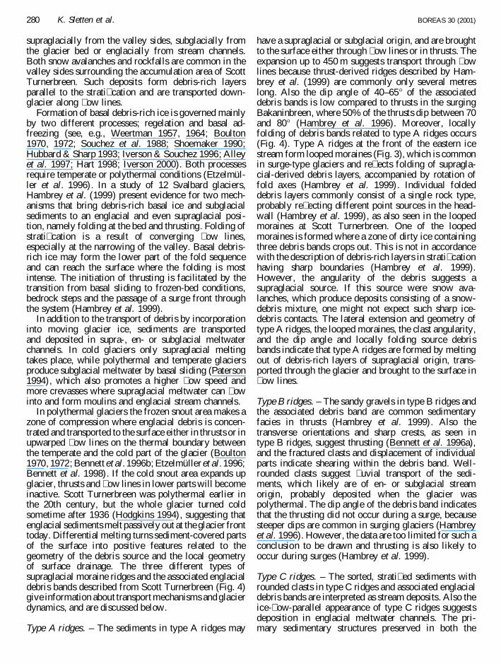
The debris on the glacier front in 1936 (Fig. 2B) wasprobably brought to the surface along active � ow linesand thrusts during the surge (Fig. 8A). A morecontinuous debris cover on the glacier front is seen onaerial photographs from 1961 (Fig. 2C), which alsodisclose a vertical lowering, but no retreat of the glacierfront during the � rst 25–30 years after the surge. Duringthis time the debris cover prevented effective melting ofthe outermost glacier front and ridge I began to formdue to differential melting (Fig. 8B). The weak clastfabric of the ridge sediment probably re� ects resedi-mentation processes. Further wastage after 1961 thick-ened the debris cover through melting out of englacialdebris and ridge I was � nely separated from the glacierand left behind as an ice-cored ablation moraine in theproglacial area (Fig. 8C). Etzelmuller et al. (1996) alsoexplain the formation of ice-cored moraines by differ-ential melting during a long period of vertical loweringafter a rapid glacier advance.
If the correlation of ridge II to the LIA maximum iscorrect, the ridge II sediments were most likelytransported to this position during a period of glacieradvance and the ridge could have been a push or thrustmoraine. However, this possibility seems unlikely forthe same reasons as discussed for ridge I, including twoclast-fabric analyses showing a weak N–NW dipdirection and a more random dip direction of elongatedclasts in the ridge sediments (F4 and F3 in Fig. 3). ScottTurnerbreen was most probably polythermal duringLIA and the rate of sediment transport through the
Fig. 8. Formation of the surge ridge. Sketches based on aerial photograph s from A: 1936, B: 1961 and C: � eld observations in 1996.
BOREAS 30 (2001) Ice-cored moraine complex, Svalbard 281
glacier was higher than today. During the succeedingglacier wastage, this debris was likely concentrated onthe glacier surface in the same manner as observed onthe modern glacier front and on aerial photographssfrom 1936 and 1961. We therefore suggest that ridge IIwas formed as an ice-cored ablation moraine throughdifferential melting in a similar way as ridge I.
Low-relief areas. – Based on a high-resolution ground-penetrating radar pro� le from the glacier front and180 m towards ridge I, Lønne & Lauritsen (1996)interpreted the proglacial area to be proglacial pushmoraines, as ice blocks buried by up to 13 m ofsediments were cut by numerous thrust faults thatcontinued to the surface. However, the � eld observa-tions in 1996 contradict this. Buried ice is found below asediment cover only 0.5–2 m thick. Resedimentationprocesses heavily in� uence the surface and no morpho-logical or structural elements indicate that the area hasbeen exposed to proglacial thrusting. Furthermore,deformation of proglacial sediments requires that thetransmitted stress from the glacier exceeds the sedimentcreep strength (Etzelmuller et al. 1996), and is likely tooccur in periods of glacial advance and active shearingin the glacier front (Bennett et al. 1996a, b; Etzelmulleret al. 1996; Huddart & Hambrey 1996). The areastudied by Lønne & Lauritsen is situated ice-proximalto ridge I that was formed during the surge around 1930.Since that time, the glacier has shown a continuoussurface lowering and retreat (Fig. 2A), and in 1993 hada maximum surface speed of less than 50 cm a¡1
(Hodgkins 1994). It therefore seems inconceivable thatat any time after the surge the glacier could transmitenough stress onto the proglacial sediments to causethrusting.
The sediments in slide scar headwalls give a detailedpicture of the processes involved in forming themorphology of this area. The clast-fabric analysisfrom the lower diamicton (unit 1) (F1 in Fig. 5) showsa south-trending dip direction, i.e. in the direction of theglacier front. Provided that the underlying glacier iceconsists of remnants from the last glacier advance, thesurge, there are two possible interpretations of the originof this diamicton. It could be melt-out till in which thefabric re� ects the clast orientation in former englacialdebris bands. Preservation of englacial fabric in asupraglacial position requires melt-out of debris fromstagnant ice with a high density of debris bands overlainby a debris cover suf� ciently thick to inhibit sediment� ow and suf� ciently permeable to allow meltwater toescape (Boulton 1971; Johnson et al. 1995). However,supraglacial sediments are to a large extent resedimen-ted on the modern glacier front (see earlier discussion).It is therefore more likely that the fabric re� ects alaminar shear and imbrication of elongated clasts indebris � ows that moved down the former glacier front(Boulton 1971; Blikra & Nemec 1998). When ridge Iwas formed, the surface slightly more upglacier needed
further lowering through supraglacial melting beforethe debris cover was thicker than the active layer. Thisresulted in a rather low-relief surface of resedimentatedtill deposits resting on glacier ice. Some small areasprobably had thicker debris cover and remained as ice-cored mounds in the proglacial area.
The lenticular sand and gravel bed (unit 2) separatingthe two diamicton units (Fig. 5) is likely of stream� oworigin and the sorting process could be an analogue tothe modern surface drainage of this area, or alterna-tively represents the distal parts of debris � ows (Blikra& Nemec 1998; Matthews et al. 1999). The upperdiamicton (unit 3) is similar to the lower one, but showsan E–NE-dipping clast fabric (F2 in Fig. 5), i.e. parallelwith the local surface dip. The surface morphology inthe area, with several debris-� ow lobes fed by a stillactive slide scar 240 m further SW (Fig. 3), suggeststhat the upper diamicton is a debris-� ow deposit withelongated clasts oriented parallel to the � ow direction,but not imbricated. This shows that the area undergoes asecond generation of slides, with debris � ows movingindependently of the glacier surface.
Disintegration of morphological elements in theproglacial area
Studies of proglacial areas on Svalbard show that thepreservation potential of ice-cored moraines is low andthat removal of the ice-core cover by water or massmovement processes accelerates the decay (Etzelmuller2000; LysaÊ & Lønne 2001). At Scott Turnerbreen thesame processes are observed to occur through the meltseason and are considered the most important processesin the further morphological evolution of the proglacialarea.
Slides and debris � ows. – While debris � ows on theglacier front contribute to the building up of a thickdebris cover, slides in the proglacial area remove thesedeposits. Slides are triggered by melting of ice andoccasionally by rainstorms. When buried ice is uncov-ered it melts and undermines the sediments resting onthe ice surface, increases the porewater pressure andeventually triggers the next sediment failure. Slides,slumps and debris falls are therefore active processeswhen a steep headwall is established and a headwallretreat of 3–4 m was measured during summer 1996.This, however, cannot explain the triggering of the � rstslide, which initiated the process. Buried ice in apermafrost area will not melt as long as the debris coveris suf� ciently thick to keep the temperature at the ice-sediment boundary below 0°C. The active layer willexpand when the temperature is above normal (Wil-liams & Smith 1995), and could reach the top of theburied ice during especially warm summers. However,it is more likely that melting starts after removal ofsome of the isolating debris cover by stream erosion orslides triggered by heavy rainfall or melting snow.
282 K. Sletten et al. BOREAS 30 (2001)
The debris-� ow activity is observed to occur inpulses during the melt season, controlled by airtemperature and precipitation. Most scars remain activefor a number of years and several generations of thesecharacteristic tongue- or lobe-shaped deposits can betraced back to a single scar (Fig. 5). Flow deposits withsurface cobbles � oating in the matrix (Fig. 7) areinterpreted as cohesive, high-viscosity debris � ows(Blikra & Nemec 1998). Curved ridges on the surfaceare probably due to compression and/or shearing causedby � ow resistance along the margins (Lawson 1982).The run-out distance depends mainly upon the slopegradient and water content. Some debris � ows reach theriver and sediments are transported out of the system.
Stream erosion and transport. – The moraine ridges,which are oriented transverse to the ice-� ow direction,are especially exposed to stream erosion. The erosion ofridge II was probably most effective during and after thesurge, because the drainage system on the distal side ofridge I has no input of glacial meltwater today and theerosion capacity is reduced. Fluvial erosion of the ice-core cover at that time likely accelerated the ice-coredecay, as described by Etzelmuller (2000). At present,the focus of stream erosion is located in the main riverand in the most ice-proximal areas as a result ofsouthward movement of the drainage system in stepwith the retreating glacier front. New channels areconstantly formed, while others are abandoned duringthe melt season, and the erosion is in this waydistributed over a large area. Because no proglaciallakes act as sediment traps, most � uvial eroded debrisare transported out of the proglacial area.
Preservation potential. – Melting of buried ice andtransport of sediments from higher to lower areas bydebris � ows and stream � ows level the proglacialtopography. Although weathering processes are slow,disintegration of glacial debris by frost shattering will inthe long run reduce traces of glacier in� uence on thesurface. However, inactive stream channels seem to bemore stable than other morphological elements. Atentative explanation is that buried ice below streamchannels melts to a greater depth than the surroundingactive layer because of the higher thermal conductivityand thermal diffusivity of wet sediments (Williams &Smith 1995). When the channels are abandoned, the icesurface will be located below the new active layer.Good preservation of stream channels and the sparsevegetation should make it possible to detect olderHolocene drainage patterns on aerial photos and usethem to map former glacier-front positions in perma-frost areas. Such a drainage system is seen on the 1990photographs immediately on the ice-distal side of ridgeIII (Figs 3, 2D). Similar patterns of channels areobserved on the distal side of ridges I and II (Fig. 3).
Conclusions
. The englacial debris bands and supraglacial ridges onthe glacier snout of Scott Turnerbreen show thatthrusting and transport of debris along � ow lines andin englacial meltwater channels have taken place.Debris entrainment was probably most effective whenthe glacier was polythermal and during the surge, i.e.until sometime after 1930.
. Englacial debris has melted out at the glacier surfaceand formed a supraglacial debris cover that is exposedto sediment failure and debris � ows triggered bymeltwater and locally steep slopes. The debris � owsmove down the glacier front and accumulate in lowareas. As the glacier wastes, differential melting onthe glacier front causes development of ridges andmounds where the supraglacial debris cover isthickest.
. The formation of the youngest moraine ridge (ridge I)is related to a surge in the 1930s, while ridge II isassociated with the LIA maximum. Both ridges wereprobably formed as ablation moraines through differ-ential melting during glacier wastage after theadvances. A third less distinct moraine ridge (ridgeIII) predates the LIA maximum.
. The morphological elements in the proglacial area aredisintegrating rapidly, mainly by slide and debris-� ow processes, commonly triggered by melting ofburied ice, and stream erosion and transport. Inactivestream channels are suggested to have the bestpreservation potential of the proglacial morphologicalelements.
Acknowledgements . – The University Courses on Svalbard, theUniversity of Tromsø, the Norwegian Polar Institute and RoaldAmundsens minnefond � nancially supported the � eldwork. TheNorwegian Polar Institute kindly permitted publication of the aerialphotos. G. H. Justad assisted the � eldwork and contributed withideas in helpful discussions . L. H. Blikra and E. Larsen, and re-views by N. Glasser and J. L. Sollid provided valuable and con-structive comments on the manuscript . I. Lundquist helped withthe graphics, and I. Henderson and P. Robinson improved the Eng-lish language. To all these institutions and persons we extend oursincere thanks.
ReferencesAlley, R. B., Cuffey, K. M., Evenson, E. B., Strasser, J. C., Law-
son, D. E. & Larson, G. J. 1997: How glaciers entrain and trans-port basal sediment: physical constraints . Quaternary ScienceReviews 16, 1017–1038.
Bennett, M. R., Hambrey, M. J., Huddart, D. & Ghienne, J. F.1996a: The formation of a geometrica l ridge network by thesurge-type glacier Kongsvegen , Svalbard. Journal of QuaternaryScience 11, 437–449.
Bennett, M. R., Huddart, D., Hambrey, M. J. & Ghienne, J. F.1996b: Moraine developmen t at the High-Arctic valley GlacierPedersenbreen , Svalbard. Geogra� ska Annaler 78 A, 209–222.
Bennett, M. R., Hambrey, M. J., Huddart, D. & Glasser, N. F.1998: Glacial thrusting and moraine-mound formation in Sval-bard and Britain: the example of Coire a’ Cheud-chnoi c (Valley
BOREAS 30 (2001) Ice-cored moraine complex, Svalbard 283
of Hundred Hills), Torridon Scotland. Quaternary Proceeding 6,17–34.
Blikra, L. H. & Nemec, W. 1998: Postglacial colluvium in westernNorway: depositiona l processes , facies and palaeoclimati crecord. Sedimentology 45, 909–959.
Boulton, G. S. 1967: The developmen t of a complex supraglacia lmoraine at the margin of Sørbreen, Ny Friesland, Vest Spitsber-gen. Journal of Glaciology 6, 717–735.
Boulton, G. S. 1968: Flow tills and related deposits on some VestSpitsbergen glaciers . Journal of Glaciology 7, 391–412.
Boulton, G. S. 1970: On the origin and transport of englacial debrisin Svalbard Glaciers. Journal of Glaciology 9, 213–229.
Boulton, G. S. 1971: Till genesis and fabric in Svalbard, Spitsber-gen. In Goldthwait, R. P. (ed.): Till: a Symposium, 41–72. OhioState University Press, Columbus.
Boulton, G. S. 1972: The role of thermal regime in glacial sedi-mentation. Institute of British Geographers Special Publication4, 1–19.
Boulton, G. S., Baldwin, C. T., Peacock, J. D., McCabe, A. M.,Miller, G., Jarvis, J., Horse� eld, B., Worsley, P., Eyles, N.,Chroston, P. N., Day, T. E., Gibbard, P., Hare, P. E. & vonBrunn, V. 1982: A glacio-isostati c facies model and amino acidstratigraphy for late Quaternary events in Spitsbergen and theArctic. Nature 298, 437–441.
Boulton, G. S., Van der Meer, J. J. M., Beets, D. J., Hart, J. K. &Ruegg, G. H. J. 1999: The sedimentary and structura l evolutionof a recent push moraine complex: Holmstrømbreen, Spitsber-gen. Quaternary Science Reviews 18, 339–371.
Croot, D. G. 1988: Glaciotectonic s and surging glaciers: a correla-tion based on Vestspitsbergen , Svalbard, Norway. In Croot, D.G. (ed.):Glaciotectonics : Forms and Processes, 33–47. Balkema,Rotterdam.
Etzelmuller, B. 2000: Quanti� cation of thermo-erosio n in pro-gla-cial areas – examples from Svalbard. Zeitschrift fur Geomor-phologie 44, 343–361.
Etzelmuller, B., Hagen, J. O., Vatne, G., ØdegaÊ rd, R. & Sollid, J.L. 1996: Glacier debris accumulation and sediment deformationin� uenced by permafrost , examples from Svalbard. Annals ofGlaciology 22, 53–62.
Hagen, J. O. & Liestøl, O. 1990: Long-term glacier mass-balanceinvestigation s in Svalbard, 1950–88. Annals of Glaciology 14,102–106.
Hagen, J. O., Liestøl, O., Roland, E. & Jørgensen, T. 1993: GlacierAtlas of Svalbard and Jan Mayen. Norsk Polarinstitutt Meddel-elser 129. 141 pp.
Hambrey, M. J. & Huddart, D. 1995: Englacial and proglacia l gla-ciotectonic processes at the snout of a thermally complex glacierin Svalbard. Journal of Quaternary Science 10, 312–326.
Hambrey, M. J., Dowdeswell, J. A., Murray, T. & Porter, P. R.1996: Thrusting and debris entrainment in a surging glacier:Bakaninbreen , Svalbard. Annals of Glaciology 22, 241–248.
Hambrey, M. J., Bennett, M. R., Dowdeswell, J. A., Glasser, N. F.& Huddart, D. 1999: Debris entrainment and transfer in poly-thermal valley glaciers. Journal of Glaciology 45, 69–86.
Hanssen-Bauer , I., Kristensen SolaÊ s, M. & Steffensen, E. L. 1990:Klima, The Climate of Spitsbergen . DNMI rapport 39/90. 40 pp.
Hart, J. K. 1998: The deforming bed/debris-rich basal ice con-tinuum and its implications for the formation of glacial land-forms (� utes) and sediments (melt-out till). Quaternary ScienceReviews 17, 737–754.
Hodgkins, R. 1994: The Seasonal Evolution of Meltwater Dis-charge, Quality and Routing at a High-Arctic Glacier. Ph.D.dissertation , University of Cambridge. 245 pp.
Hubbard, B. & Sharp, M. 1993: Weertman regelation , multiplerefreezing events and the isotopic evolution of the basal icelayer. Journal of Glaciology 39, 275–291.
Huddart, D. & Hambrey, M. J. 1996: Sedimentary and tectonicdevelopmen t of a high-artic, thrust-moraine complex: Comfort-lessbreen , Svalbard. Boreas 25, 227–234.
Iverson, N. R. 2000: Sediment entrainment by a soft-bedded gla-
cier: a model based on regelation into the bed. Earth SurfaceProcesses and Landform 25, 881–893.
Iverson, N. R. & Souchez, R. 1996: Isotopic signature of debris-rich ice formed by regelation into a subglacia l sediment bed.Geophysica l Research Letters 23, 1151–1154.
Johnson, M. D., Mickelson, D. M., Clayton, L. & Attig, J. W.1995: Composition and genesis of glacial hummocks, westernWisconsin, USA. Boreas 24, 97–116.
Landvik, J. Y., Mangerud, J. & Salvigsen, O. 1987: The LateWeichselian and Holocene shoreline displacemen t on the west-central coast of Svalbard. Polar Research 5, 29–44.
Landvik, J. Y., Bondevik, S., Elverhøy, A., Fjeldskaar , W., Man-gerud, J., Salvigsen, O., Siegert, M. J., Svendsen, J. I. & Vorren,T. O. 1998: The last glacial maximum of Svalbard and theBarents Sea area: ice sheet extent and con� guration. QuaternaryScience Reviews 17, 43–75.
Lawson, D. E. 1982: Mobilization, movement and deposition ofactive subaerial sediment � ows, Matanuska glacier, Alaska.Journal of Geology 90, 279–300.
Lefauconnier , B. & Hagen, J. O. 1991: Surging and calving gla-ciers in eastern Svalbard. Norsk Polarinstitutt Meddelelser 116.130 pp.
LysaÊ , A. & Lønne, I. In press: Moraine development at a smallhigh-arcti c valley glacier: Rieperbreen , Svalbard. Journal ofQuaternary Science.
Lønne, I. & Lauritsen, T. 1996: The architectur e of a modernPush-moraine at Svalbard as inferred from ground-penetratin gradar measurements . Arctic and Alpine Research 28, 488–495.
Major, H. & Nagy, J. 1972: Geology of the Adventdalen map area.Norsk Polarinstitut t Skrifter 138. 58 pp.
Matthews, J. A., Shakesby, R. A., McEwen, L. J., Berrisford, M.S., Owen, G. & Bevan, P. 1999: Alpine debris-� ows in Leir-dalen, Jotunheimen , Norway, with particular reference to distalfans, intermediate-typ e deposits , and � ow types. Arctic, Antarc-tic, and Alpine Research 31, 421–435.
Paterson, W. S. B. 1994: The Physics of Glaciers. 480 pp. Perga-mon Press, Oxford.
Salvigsen, O. 1984: Occurrence of pumice on raised beaches andHolocene shoreline displacemen t in the inner Isfjorden area,Svalbard. Polar Research 2, 107–113.
Salvigsen, O. & Osterholm, H. 1982: Radiocarbon dated raisedbeaches and glacial history of the northern coast of Spitsbergen,Svalbard. Polar Research 1, 97–115.
Shoemaker, E. M. 1990: A subglacial boundary-laye r regelationmechanism. Journal of Glaciology 36, 263–268.
Sollid, J. L. & Sørbel, L. 1988: In� uence of temperature conditionsin formation of end moraines in Fennoscandia and Svalbard.Boreas 17, 553–558.
Sollid, J. L., Etzelmuller, B., Vatne, G. & ØdegaÊ rd, R. 1994: Gla-cial dynamics, material transfer and sedimentation of Erikbreenand Hannabreen , Liefdefjorden , northern Spitsbergen. Zeitschriftfur Geomorphologie , Supplement-Band 97, 123–144.
Souchez, R., Lorrain, R. & Tison, J. L. 1988: Co-isotopic signatureof two mechanisms of basal-ice formation in arctic outlet gla-ciers. Annals of Glaciology 10, 163–166.
Svendsen, J. I. & Mangerud, J. 1997: Holocene glacial and climaticvariations on Spitsbergen, Svalbard. The Holocene 7, 45–57.
Weertman, J. 1957: On the sliding of glaciers. Journal of Glaciol-ogy 3, 33–38.
Weertman, J. 1964: The theory of glacier sliding. Journal of Gla-ciology 5, 287–303.
Werner, A. 1993: Holocene moraine chronology , Spitsbergen ,Svalbard: lichenometri c evidence for multiple Neoglacialadvances in the Arctic. The Holocene 3, 128–137.
Williams, P. J. & Smith, M. W. 1995: The Frozen Earth. 306 pp.Cambridge University Press, Cambridge.
Woodcock, N. H. & Naylor, M. A. 1983: Randomness testing inthree-dimensiona l orientation data. Journal of Structura l Geol-ogy 5, 539–548.
284 K. Sletten et al. BOREAS 30 (2001)