forestry training unit, kepong kuala lumpur 19
TRANSCRIPT
PROCEEDINGS OF
Forestry Training Unit, Kepong Kuala Lumpur
19th - 21st March 2002
Forestry DepartmentPeninsular Malaysia
Global Environment Centre
Jointly organised by: Supported by:
ASEAN Regional Centre for
Biodiversity Conservation
Royal Netherlands Embassy Malaysia
ii
PREVENTION AND CONTROL OF FIRE IN PEATLANDS
Proceedings of Workshop At
Forestry Training Unit, Kepong Kuala Lumpur
19th - 21st March 2002
Forestry DepartmentPeninsular Malaysia
Global Environment Centre
Jointly organised by:
Supported by:
ASEAN Regional Centre for Biodiversity Conservation
Royal Netherlands Embassy - Malaysia
i
CREDIT PAGE
Edited by Mr. Faizal Parish Dr. Eswaran Padmanabhan Mr. David Lee Chee Leong Mr. Thang Hooi Chiew Organised by Forestry Department, Peninsular Malaysia & Global Environment Centre Sponsored by ASEAN Regional Center for Biodiversity Conservation (ARCBC) Royal Netherlands Embassy - Malaysia Citation Parish, F., Padmanabhan, E., Lee, C.L. & H. C. Thang (eds.)
PREVENTION AND CONTROL OF FIRE IN PEATLANDS. Proc. of Workshop on Prevention and Control of Fire in Peatlands, 19-21 March 2002, Kuala Lumpur. Global Environment Centre & Forestry Department Peninsular Malaysia. Cetaktama, Kuala Lumpur.
Published by Global Environment Centre &
Forestry Department Peninsular Malaysia Printed by Cetaktama Sdn. Bhd. B4-09, 4th Floor KL Industrial Park 5th Mile Klang Road 58200 Kuala Lumpur Available from Global Environment Centre 7A, Jalan 19/29
46300 Petaling Jaya Selangor, Malaysia
Tel: +603-7957 2007 Fax: +603-7957 7003 E-mail: [email protected] Forestry Department, Peninsular Malaysia Jalan Sultan Salahuddin 50660 Kuala Lumpur Wilayah Persekutuan Malaysia Tel: +603-2698 8244 Fax: +603-2692 5657 E-mail: [email protected]
ii
TABLE OF CONTENTS Preface iv Acknowledgements v Opening Speeches Welcome Address by Faizal Parish, Director of Global Environment 1 Centre (GEC) Opening Address by Y. Bhg. Datuk Zul Mukhshar bin Dato’ Md. Shaari, 2 Director General of Forestry, Peninsular Malaysia Speech from ARCBC by Miss Alona C. Linatoc, Science Research Specialist II of 4 ASEAN Regional Centre for Biodiversity Conservation Workshop Report Working Group Discussions and Conclusions 5 Workshop Statement on Prevention and Control of Fire in Peatlands 9 Papers Presented 1. Overview on peat, biodiversity, climate change and fire 11 Faizal Parish 2. History of peat fires in Malaysia 20 Mohd. Jinis Abdullah, Mahmad Rasid Ibrahim & Abdul Rahman Abdul Rahim 3. Formation of peat basin, its properties and fire management 28 Salmah Zakaria 4. Fire and peat forests, what are the solutions? 41 Herbert Diemont 5. Hydrological aspect of peat swamp forest in North Selangor 51 Zulkifli Yusop 6. Monitoring peat water level as an early warning indicator for the 57
peat forest fire management programme Ahmad Ainuddin Nuruddin 7. El Nino, climate change and peat fires 61
Santhira Segaran Singaravelu 8. The 97/98 forest fire in Malaysia 69 Samsudin Musa & Ismail Parlan
iii
9. Fire prevention and protection in peat swamp forest – Pahang’s experience 75 Abdul Hamid Maarof 10. Impacts of spatial variability on designing/implementing risk management 78
and rehabilitation strategies for peatlands in Southeast Asia Eswaran Padmanabhan 11. Post-fire management of the damaged peat swamp forest in 82
Berbak-Sembilang area, southern Sumatera, Indonesia Reza Irwansyah Lubis 12. Experience with the 1998 peat fires in Brunei 91 Jonathan Davies Annex 1 Workshop Organising Committee 96 Annex 2 Workshop Programme 97 Annex 3 Participants List and Contacts 98
iv
PREFACE
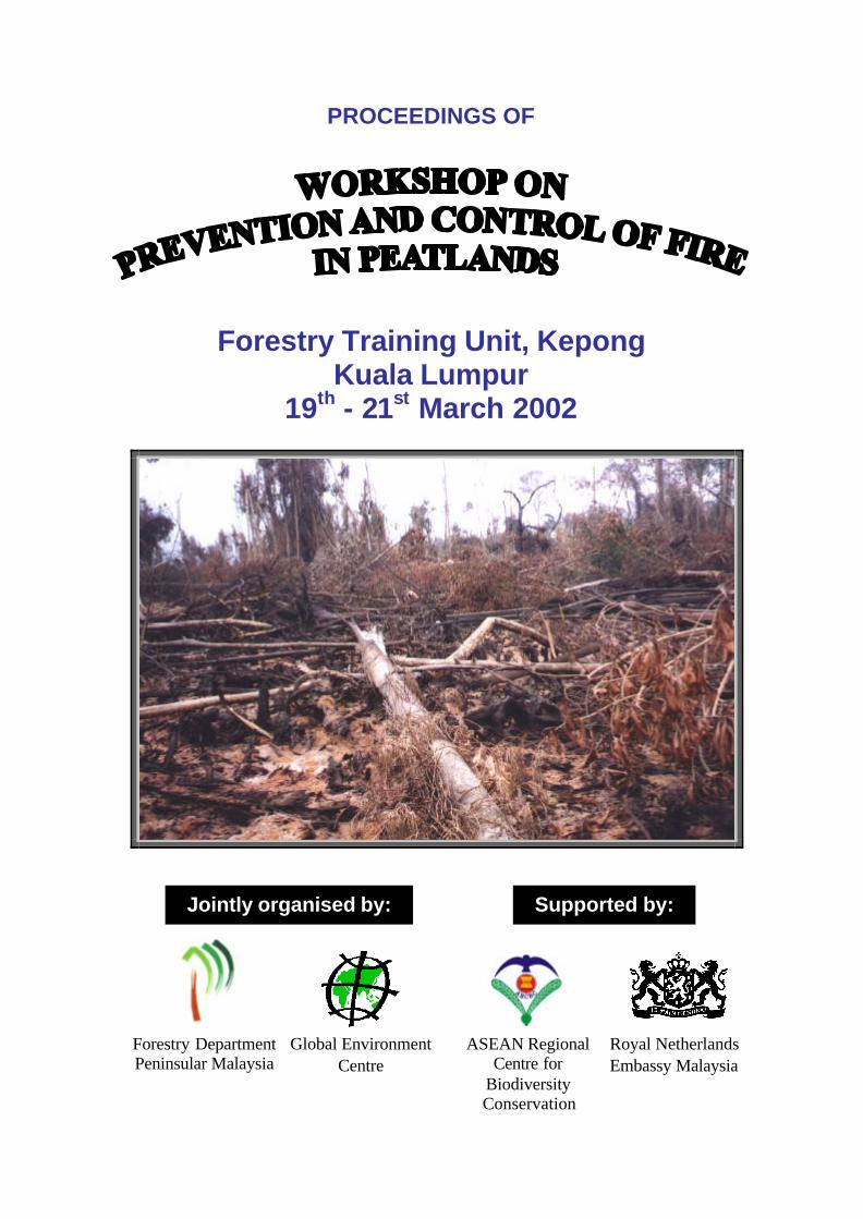
Currently, fires and associated haze have increasingly affected the economies, health and environment in Southeast Asia, especially in Malaysia, Indonesia, Brunei and Singapore. The damage caused by the recent major fire and haze event in 1997-98 was estimated to be nine billion USD.
During the 1997/98 forest and land fires in Indonesia and Malaysia, a total of about 10 million ha of forest and agricultural land was burnt. Although only 15% of this land was peatland, the peat fires contributed an estimated 60% of the regional smoke and haze. In addition, the peat fires burnt longer and were more difficult to put out than all the other fires. Even though large numbers of fire suppression personnel were mobilised, their effectiveness was limited by the lack of reliable, current information on locations of the fires and most of all the environmental conditions promoting their ignition and spread. One of the important lessons of this event is that more emphasis needs to be put into the sustainable management of peatlands and the prevention of forest fires, such as through better water management and restoration of degraded peatland areas. This publication consist of papers presented at the Workshop on “Prevention and Control of Fire in Peatlands” held from 19th to 21st of March 2002 which was attended by almost 70 representatives from Federal and State agencies, NGOs and research institutions in Malaysia, and regional representatives from ARCBC, Wetlands International Indonesia Programme and Alterra. The Workshop was jointly organised by the Forestry Department Peninsular Malaysia and Global Environment Centre Malaysia, with valuable support from Selangor State Forestry Department, ASEAN Regional Centre for Biodiversity Conservation and the Royal Netherlands Embassy, Malaysia. This Workshop brought about together concerned parties to discuss issues relating to the importance and vulnerability of peat swamp forest in Malaysia. At the same time to pursue on collaborations and interaction between scientists, policy makers, government agencies and institutions to address the issue of peatland fires. The Workshop provided opportunity for active presentation and discussions on issues such as (a) peatland status and management in relation to biodiversity, (b) peatland fire and climate change, (c) wise hydrological management of peatland in preventing fires, (d) issue of 1997/98 forest fires and (e) experiences from regional case studies on peat fire management. Information derived from the discussions were compiled and incorporated into a Workshop Statement with 13 proposed actions for fire prevention and control in peatlands to be taken up by relevant agencies and institutions. The Workshop Statement is included in page 9. While this Workshop has attempted to tackle broader and wider issues on peatland fires, nevertheless, there are still emerging questions on how to deal with the situation in a practical manner and room for improvement in the future on “wise use of peatland”.
v
ACKNOWLEDGEMENTS
The organising committee would like to express our sincere gratitude to the Forestry Department Peninsular Malaysia and the Global Environment Centre in co-organising the workshop on “Prevention and Control of Fire in Peatlands”. Special thanks also goes to the ASEAN Regional Centre for Biodiversity Conservation for the support in funding part of this workshop, and The Royal Netherlands Embassy, Malaysia for providing funds for the publication of this proceedings. The organising committee is deeply indebted to Y. Bhg. Datuk Zul Mukhshar bin Dato’ Md. Shaari, Director General of Forestry, Peninsular Malaysia, who not only officiated the opening of the Workshop which has enable scientist, collaborators to have the opportunity to openly and constructively discuss the issue of peatland fires, but allowing the use of the Forestry Training Unit in Kepong as the workshop venue, providing buses for field trips, and secretariat support. We also would like to thank the Selangor State Forestry Department, Selangor Agricultural Development Board (PKPS) and Agrotech Sdn. Bhd. for hosting and conducting the field visits for the workshop participants. To all the paper presenters for their effort and contributions, to all the participants of the workshop, the organising committee is extremely grateful for their inputs to the discussion and in making the workshop a successful one. Last but not least, “thank you” to all the members of the organising committee for their time and commitment, which made this Workshop run smoothly without a hitch. The names of the organising committee and participants are listed in Annex 1 and Annex 3 respectively. Mr. Thang Hooi Chiew Chairman Workshop Organising Committee
1
WELCOME ADDRESS By
Faizal Parish
Director of Global Environment Centre
Yang Bahagia Datuk Zul Mukshar bin Dato’ Md Shaari, Director General of Forestry, Peninsular Malaysia
Ms Alona Linatoc, representative of the ASEAN Regional Centre of Biodiversity Conservation
Participants, Ladies and Gentlemen
I am very happy to welcome you this morning to the Workshop on Prevention and Control of Fire in Peatlands. I know that many of you have travelled long distances from all parts of Malaysia and neighbouring countries to attend this workshop. We hope that it will be a very useful and productive workshop.
The workshop has been organised jointly by the Forestry Department, Peninsular Malaysia and the Global Environment Centre and represents an activity in line with the Malaysian Government’s vision of encouraging smart partnerships between government and non government agencies. A range of different agencies have supported the preparations for the workshop including the Forestry Training Unit, the Selangor Forestry Department, and the Fire and Rescue Department.
Funds to support the preparations and the workshop have been provided by the Forestry Department Peninsular Malaysia, GEC and the ASEAN Regional Centre of Biodiversity Conservation (ARCBC). We would also like to thank all of your agencies for facilitating your presence here today.
Let me tell you a little about the Global Environment Centre (GEC). GEC is a Malaysian registered NGO which is active in supporting activities worldwide related to addressing environment issues of global concern. We were established in 1998 and are currently working with many other international organisations and environmental conventions providing support to more than 80 countries. We have more than 20 different projects divided into three main programme areas — Capacity Building; Integrated River Basin Management; and Land-use, Biodiversity and Climate Change. We always work in a partnership manner with government, non-government and research agencies — wherever possible in facilitating local partners to undertake the lead in activities. Our focus is often related to building links and capacity to enable an integrated cross-sectoral approach to addressing environmental problems.
The sustainable management of peatlands is a key area of GEC activity. Peatlands cover about 3% of the globe and are the most extensive of all wetland types. In Malaysia, peatlands cover about 8% of the country and are most extensive in Selangor, Pahang and Sarawak. Peatlands play a very important role in storing carbon (they support up to 25% of the carbon in the terrestrial biosphere) and hence their degradation leads to significant release of carbon which will impact the global climate. Malaysians will be very familiar with the impacts of peatland fires — as peatlands contributed more than 60% of the transboundary haze that affected SE Asia in 1997-98 and is the main cause of the current haze episode. Peat fires are normally caused by drainage and land clearance activities undertaken in an inappropriate and unsustainable manner. GEC is involved in developing a SE Asia peatland action plan and coordinates a peatland information network. GEC is also working with partners in Russia, China, South Africa and North America on peatland related issues.
One of our other active activities is the River Basin Initiative. This is a formal Initiative in the framework of the joint work Plan of the Convention on Biological Diversity (CBD) and the Ramsar Convention on Wetlands which has been formally endorsed in May 2000 by the 180 countries who are parties to the CBD convention. The main objective of the Initiative is to promote and support integrated management of biodiversity, wetlands and river basins worldwide. Key activities include developing partnerships and cross-sectoral dialogues, facilitating information sharing within and between countries, development and dissemination of information and awareness materials; operating a web portal and an internet based information service, and assisting countries in developing pilot activities and demonstration sites. Over the past few months more than 80 countries have agreed to share their experiences through the RBI.
I would like to thank each and every one of you for making your time available to attend this workshop. I hope that the workshop will be of value to you and you will also share your thoughts during the discussion periods. We hope that after the workshop you will keep in touch with the Global Environment Centre and let us know if there are any ways in which we can assist you in your activities.
Thank you.
2
OPENING ADDRESS
By
Y. Bhg. Datuk Zul Mukhshar bin Dato’ Md. Shaari
Director General of Forestry, Peninsular Malaysia
Yang Berusaha Mr. Faizal Parish, Director of the Global Environment Centre (GEC) Yang Berusaha Miss Alona C. Linatoc, representative of the ASEAN Regional Centre of Biodiversity Conservation (ARCBC) Ladies and Gentlemen, It is indeed a great pleasure and honour for me to be here today for the opening of the Workshop on Prevention and Control of Fire in Peatlands. I like to take this opportunity to extend my warmest welcome to all participants and to thank all of you for your presence here this morning. First and foremost, I would like to put on record my most sincere thanks and appreciation to the Global Environment Centre (GEC) for jointly organising this workshop. I would also like to recognise the support of the ASEAN Regional Centre of Biodiversity Conservation. I am pleased to note that we have with us today participants from various government and non-governmental organisations, the universities, research institutions, as well as international participants in this workshop. Ladies and Gentlemen, Malaysia is very fortunate to be well endowed with relatively large tract of rich and diverse tropical rain forests which has been acknowledged to be amongst the most complex ecosystem in the world. In this context, the total forested area in Malaysia at the end of 2000 was estimated at 19.84 million hectares or 60.4% of its total land area. The bulk of these forest areas comprises the Inland forest covering an area of 7.55 million hectares or 88.5% of the total land area, followed by 1.46 million hectares or 7.4% Peat Swamp forest, 0.58 million hectares or 2.9% Mangrove forest and 0.25 million hectares or 1.2% planted forest. Of the total forested area in 2000, 14.44 million hectares or 44.0% had been designated as the Permanent Reserved Forest (PRF) to be managed sustainably for the benefit of both the present and future generations. These forest lands are secured in their tenure as they are gazetted in accordance with the National Forestry Act 1984 (amended 1993) in Peninsular Malaysia, and the State Forest Ordinance/Enactment for the States of Sabah and Sarawak. Peat swamp forests play a very significant role in the socio-economic developments of the nation and the maintenance of the environment. Although low in tree species diversity compared to the dry land forest type, peat swamp forests are of a very special type of forest and have a restrictive flora. Besides contributing to the local community with its unique biodiversity and commercially valuable timbers, this forest type is also noted for its importance in providing habitats for many of the endemic peat flora and fauna, acting as sink for organic carbon and maintaining the hydrological function of the ecosystem.
The Forestry Department of Peninsular Malaysia began to implement a joint bilateral project on Peat Swamp Forests with the technical cooperation and assistance from the Government of Denmark in 1996. Following an appraisal mission by the Danish Cooperation for Environment and Development (DANCED), it was agreed by both parties to implement the "Sustainable Management of Peat Swamp Forest" project in Peninsular Malaysia for a period of three 3 years beginning 1 September 1996. This project was formulated to address the issue of peat swamp forest management in Peninsular Malaysia for sustainable social, economic and environmental benefits. The project had been successfully completed and generated baseline information in relation to peat swamp management, silviculture, fire hazards, hydrological regimes, wildlife, socio-economic benefits, valuation and awareness enhancement. Considering the importance of managing the peat forest ecosystem another technical cooperation project involving UNDP/GEF, The Governments of Denmark and the Netherlands, and the Malaysian Government have been initiated in Sabah, Sarawak and Pahang in Peninsular Malaysia to develop and implement management plans for the peat swamp forests in these states. This is a five-year project commencing in 2002.

3
In recent years, peat swamp forests in Malaysia and its neighbouring countries have been associated more with forest fires and the resultant haze. However, fire has long been considered as part of many forest ecosystems and many forest ecosystems have evolved in response to the effects of fire. Thus, the effects of fire are not always negative. Traditional knowledge of fire as a tool is deeply embedded in the culture of developing and developed countries alike. Fire is still essential for land clearing to meet the food requirement of most developing countries and as part of their development process, while in other countries fire is used to achieve a wide variety of resource management objectives. In many forest practices, prescribed burning has been used as a management tool by foresters. In suitable situations fire can help check weed growth in forest plantations, induce better regeneration and growth of plants, and maintain a serial status of vegetation which contains high percentage of commercial tree species. Properly manipulated, fires have been used as a means of reducing litter build-up in forest plantations to prevent future forest fires. Using fire to fight fire is a normal technique practised in forest fire fighting. Tropical rain forests have been regarded as ecosystems in which natural fires were excluded, or fires take place in a long cycle, due to fuel characteristics and prevailing moist conditions. Historical records have shown that the natural undisturbed forest in Peninsular Malaysia very seldom experienced any major fire outbreak. With an average rainfall of 2,540 mm/year and humidity ranging from 70% to 80%, the climatic condition in Peninsular Malaysia are generally moist and has a fast rate of litter decomposition. The low fuel build-up prevents the occurrence of major fire in this country. Most forest fires in Peninsular Malaysia originated from sources outside the forest area. The fire may spread from land preparation activities, or other related human activities in nearby areas, more of a result of negligence. There is a Malay proverb that says "Api bila kecil menjadi kawan, bila besar menjadi lawan". Literally translated it means "Fire, when it is small is a friend; but when it grows bigger it becomes an enemy". Ladies and Gentlemen, Today's workshop is very timely to address issue related to peatland fires. It will provide a platform for experts and interested parties to share knowledge and exchange experiences, not only through paper presentation but also panel discussion and field visit. This will ultimately contribute to the development of new strategies in preventing and control of peatland fires. This workshop will also promote collaboration and interaction amongst scientists, policy makers, government agencies and institutions in addressing this issue. We are fortunate to have with us in this workshop speakers/experts, both local and international from various organisations with vast experience in their respective fields. I strongly urge all participants to make full use of this opportunity to gain as much knowledge and share the experience of our experts/panellists, and participate actively throughout the Workshop. It is my sincere hope that with your active participation and deliberations, we can further develop a comprehensive set of guidelines and procedures in the prevention and control of peatland fires in the future. Before I conclude, I would like to take this opportunity to once again thank the Chairman of the Workshop Organising Committee and his team for their tireless efforts in organising this Workshop. With this brief address, I thank you all for your indulgence and I have the great pleasure to officially declare this Workshop open. Thank you.

4
SPEECH FROM ARCBC
By
Miss Alona C. Linatoc
Science Research Specialist II
Director General of Forestry Department, Peninsular Malaysia Y. Bhg. Datuk Zul Mukshar Bin Dato’ Md. Shaari, Director of Global Environment Centre Mr. Faizal Parish, scientists and participants, ladies and gentleman, good morning. It is an honour for me to be invited in this special occasion. On behalf of the ASEAN Regional Centre for Biodiversity Conservation and its two Directors, Dr. John R. MacKinnon and Greg Texon, I am congratulating the Global Environment Centre and the Forestry Department, Peninsular Malaysia for successfully organising this Workshop on Prevention and Control of Fire in Peatlands. The episode of forest fire in 1997-1998, and that of 20 years ago has caused high loss of revenue for Malaysia and Indonesia, not to mention the priceless loss of biodiversity in the region and the health-related problems it caused in Malaysia, Brunei and Singapore. Indeed, 2002 is forecasted to be another El Niño year. The regular three-year interval of El Niño phenomenon makes it easier for us to predict and to conduct counter measures in preventing the occurrence of forest fires. We do not want the same losses to happen again. The impact of forest fire has been a global concern that calls for international cooperation. Last year in March, ARCBC has conducted a symposium in Brunei on ‘Minimising the Impact of Forest Fire on Biodiversity in ASEAN’ and developed guidelines and criteria in minimising the impact of forest fire on biodiversity in ASEAN. The proceedings of the symposium can be found on our website at www.arcbc.org.ph As scientists and experts gather today to share their own experiences and provide strategies for fire prevention and control particularly in peatlands, we are confident that addressing such issues will definitely lead us to better management of this important and under-appreciated ecosystem. In furtherance of such goal to protect ASEAN biodiversity against the impacts of forest fire, ARCBC fully supports this initiative by the Global Environment Centre and the Forestry Department, Peninsular Malaysia in preventing and controlling the occurrence and damage of forest fire in the peatlands. I wish the participants all the best for the meeting and hope this will result in some valuable plans and recommendations that would be very essential to all parties in addressing issues and concerns of fires in peatlands. Again, to the organisers, congratulations! Thank you very much and good morning.

5
WORKING GROUP DISCUSSIONS AND CONCLUSIONS PREMISE • Prevention is better than cure • Loss and damages incurred are irreversible • Focus should be on preventive measures i.e. Before adverse things happen e.g. outbreak of fire • Need for land development cannot be compromised RECOMMENDATIONS Peatland Hydrology Water content/level in the P.S.F. (water control) • Strike a balance between forest (inside) and buffer zone (Future R & D on matter required) • Maintain sufficient supply/amount of water
– Man-made reservoirs in the buffer zones of P.S.F. – Consider to have site-specific water supply regulation over the overall land use basin
• Canals : Maintenance is expensive – Funding is definitely required for constructing and maintaining these canals (D.I.D. needs to pursue this further) – Fire-hazard zones to be identified for strategic monitoring etc. – Sensitive areas to be made aware to public – D.I.D. should come out with optimal no. of canals, intensity, size etc. for multipurpose holistic purpose
designing of these canals. • Water rationing among various land users (site-specific): Further R & D required. • Zoning of industry closer to selected spots depending on water quality and quantity • Stop logging activities to prevent vulnerability to fire (Further R&D required)
–Drop in water level –Compaction –Surface Exposure
• Legislation: Need modification to cater for current and future needs Plan of PSF Layout for Fire Prevention Plan Alternative Land Use • P.S.F.
–Is classified as a “NON-RENEWABLE, FRAGILE NATIONAL HERITAGE”
–Therefore, no alternative land use is recommended • Buffer zone
– Activities that support the maintenance of the hydrological status e.g. Man-made reservoirs – Water recycling plants – Non-fire inducing activities – Incentives (attractive) also to foreign companies when implementing the above incentives – Compensation/ relocation programme (involves Town Planning and Development Unit) in the Master
Plan Definition of Buffer Zone (Fire Prevention) • An area, outside the P.S.F. that functions as a hazard prevention mechanism that:
– Has a width, so defined, of no less than 5km fringing the PSF – Includes, in places, water-reservoirs – Comprises selective vegetative cover that is more fire tolerant – Contains mineral soil types that are fire tolerant – May or may not comprise canals – Does not support any form of land use activity that is defined herein as detrimental, and – Having a boundary, where in places, may be modified by naturally-occurring non-permeable bodies
Group A : Fire Prevention in Peatlands

6
Reclamation and Replanting • P.S.F. – Nil; Replanting plant species that are not susceptible to fire; further R&D required • Buffer Zone – Controlled reclamation; Replanting plant species that are not susceptible to fire; further R&D
required • Surrounding zone – Future R & D Susceptibility to Fire • Danger/Warning
– Need indicators for fire/danger rating – Further R & D – Active involvement by meteorological department in predicting and disseminating danger/warning – Threshold moisture values (R&D) – Awareness programme in ratings and evasive action (Ownership concept – certificate, sell restricted
rights to individuals); fire hazard mapping and ground surveillance; possible causes include water level, rain, fuel distribution, human activities
– Special enforcement unit needs to be established for regular patrolling; sufficient task force and skilled personnel; strong and supportive legislation; awareness programme for public as to how they can assist FRDM
Research and Development • All identified R & D are urgent and classified as short term projects (≤ 3 years) • The Technical Advisory Group (Intra Agency / Professional) will evaluate all projects and streamline those
projects that merit medium and long-term action/project term SUMMARY OF MAIN RECOMMENDATIONS • Hydrology: Mandatory maintenance of high water level in PSF and Buffer zones • Alternative land use: Limited to non-detrimental activities in buffer zone only. • Reclamation and Replanting: Demarcating degraded PSF and rehabilitate • Susceptibility to fire: Strong and supportive legislation to curb recurrence of fire coupled with enhanced
awareness programme • R & D: Strong encouragement to start with sufficient national level funding KEY ISSUES
- Develop Fire Management Plan – Urgent for fire prone peatlands (Each Forest Area)
- Setting up special Forestry Fire fighting Teams (training/Equipment/ Structured Organisation)
- Enhance Cooperation With Agencies (e.g. Fire and Rescue Department, Forestry, DID, Local government, DOE) before, during & after fire event
Research -To identify Fire risks and control methods -Develop new tools - e.g. Thermal probe - Improve water management in Peat-Dual- purpose - Prevention/fire fighting Monitoring and warning systems Fire management plan Assess Risk
–Develop Strategy
–Cooperation with other agencies
–Allocate Trained Manpower
–Provide appropriate tools/equipment-
–Develop Standard operating procedures
–Secure Access
–Enforcement
Group B : Fire Control in Peatlands

7
Finance Key equipment • Pumps-Need specialised pumps (Wajax pumps) - 100 Units, 4 horse power • Floating pump - Portable pump • Hands tools - Mattocks
- Rakes - Double headed axes - Shovels - Brush hooks - Mcleod fire tools
• Fire swatter, back pack, Jet shooter, Portable Dam, Canvas water bucket, 'parang', chainsaw. Access to forest • Special vehicle – Polaris 42K
- Helipad in fire prone area. - Identify potential base camp - Need clear plans areas maps for access. - Mapping/control of access problem. - Evacuation from forest (emergency). - Access through adjacent lands. - Section 18 Fire Service Act. Delegation of powers for access.
Warning/monitoring system
•Important to support rapid response
•Medium and long term prediction- very important for planning
•Short term prediction – to enable deployment
•Focus on areas with frequent fires for monitoring
•Use satellite, air and ground survey Objective of Rehabilitation • What do we want to achieve through rehabilitation? • Restore water regime to prevent and reduce risk of fire • Restore tree cover for what?
–Timber/ commercial extraction –Biodiversity
Key Issues to Address • Accessibility of rehabilitation site • Insufficient funds to support rehabilitation work at the moment even with cess collection • Water management in PSF • More R&D on rehabilitation of PSF should be carried out • Social issues in promoting rehabilitation • Classification mappings Recommendations 1. Accessibility of rehabilitation site • Examine whatever means of transportation existing in that area • Use and maintain whatever existing mode of transportation • Responsibility should be taken by Forestry Department • Accessibility should be tightly monitored and strict enforcement need to be in place
Group C : Peat Swamp Rehabilitation

8
2. Insufficient funds to support implementation of rehabilitation work • Possibility to increase cess and levy (particularly in Selangor) • Apply for international funds outside government agencies • “Targeted” application for funding:
e.g. carbon sequestration and climate change e.g. biodiversity values
• Sponsorship from private sector • Public donations 3. Water management • Restore water table and hydrological regime • Make sure that existing canals are blocked • Cooperation and integration between various agencies in managing hydrology of PSF • There shouldn’t be conflicting interest between forestry and land users • Series of weirs to control the outflow of water • Regular maintenance of weirs /water gate • There should be a buffer zone of at least 1km within the state land surrounding the reserve • Activities that are incompatible with the maintenance of the hydrological regime should not be allowed 4. More R&D on rehabilitation in PSF • Literature review to identify existing knowledge and gaps in the rehabilitation works (networking
importance) • Monitoring of life histories and general ecology of trees in PSF by establishing permanent plots • Identify natural succession pattern • Funding for R&D • From research, there should be proper manuals or guidelines for rehabilitation measures 5. Social issues in promoting rehabilitation • Promote community based rehabilitation progra mme • Cultivate sense of ownership among community • Awareness programmes / Fire prevention programmes among local communities concerning the effort of
rehabilitation (schools) 6. Classification mapping Classification mapping to identify areas that need rehabilitation
9
Endorsed by the participants at the end of the Workshop on Prevention and Control of Fire in Peatlands,
held in Kuala Lumpur, Malaysia on 18-21 March 2002
The Workshop on Fire Prevention and Control in Peatlands was held in Kuala Lumpur, Malaysia from 19-21 March 2002. The Workshop was jointly organised by the Forestry Department Peninsular Malaysia and Global Environment Centre with support from the ASEAN Regional Centre for Biodiversity Conservation. It was attended by more than 60 technical experts and representatives from a broad range of government agencies from Malaysia, as well as selected NGOs and international participants. The Workshop was officially opened by the Director General of the Forestry Department, Peninsular Malaysia, Y. Bhg. Datuk Zul Mukhshar bin Dato’ Md. Shaari. This Workshop examined three main issues: fire prevention, fire control and rehabilitation of peatlands. Detailed presentations were made on 19 March on a broad range of issues ranging from peatland fire control, hydrology, rehabilitation, fire prevention, biodiversity, climate change to management and monitoring methodologies. A field assessment of peatland management and recent peat fires in Selangor was made on 20 March. Three Working Groups elaborated in detail, issues related to peatland fire prevention, control and rehabilitation and prepared a broad range of recommendations on 21 March, which were subsequently reviewed by the Workshop participants through plenary and panel discussions. The Workshop noted that Southeast Asia has more than 60% of the world’s tropical peatlands that play a significant role in maintaining the hydrological balance, regulating local or global climate, playing host to a wide range of biological diversity, as well as providing key socio-economic benefits. The immense capacity of peatlands to sequester and store carbon and thereby mitigate global climate change has attracted a lot of attention recently. Tropical peatland is a fragile ecosystem which is vulnerable to fire and for which rehabilitation after major damage is very expensive and difficult. The Workshop noted the continuing loss and degradation of peat swamp forests in recent years, especially the damage of over 10 million ha of land, including 1.5 million ha of peatland, through the extensive forest fires of 1997/98 which caused an estimated economic loss of US$9 billion in the region and the release of 1,500 million tonnes of carbon. Similarly, the extensive peat fires which have been burning in Malaysia and Indonesia in February - March 2002 were noted with concern.
GOAL
The Workshop agreed that concerted efforts to combat the susceptibility of peatlands to fire hazards are urgently needed between the various agencies nationwide, as well as between the affected countries in the region and urged governments, research institutions, NGOs, private sector and other organisations to work together in achieving the following goal:
To establish a cooperative programme to prevent and control fires in Peatlands in Malaysia and other South East Asian Countries.
PROPOSED ACTIONS
The Workshop further called for the following actions to be undertaken (not in priority order): 1. Identify and protect key tropical peatland sites important for biodiversity, carbon storage, hydrological
functions and socio-economic values to local communities. 2. Strengthen interagency cooperation to facilitate integrated, multidisciplinary and multi-stakeholder
approaches to prevent and control peatland fire, as well as the sustainable use of peatland resources. 3. Develop a comprehensive set of guidelines/manuals that will help prevent and control peatland fires,
including developing fire danger index, fire management plans, water management strategies, early warning systems and fire control strategies.
4. Prepare fire management plans for all peatlands with fire risk to include risk assessment; implementation
strategies; cooperation with other agencies; allocation and training of human resources; provision of appropriate tools/equipment; development of operating procedures; and strengthening of legislation and regulations.
KUALA LUMPUR STATEMENT ON PREVENTION AND CONTROL OF FIRE IN PEATLANDS
10
5. Elaborate further the concept for the establishment of Buffer zones around peatland areas in which development and land use activities may be controlled to minimise risk of fire.
6. Formulate and implement water management strategies for previously drained peatlands to improve water
tables and thereby enhance fire control and preventive measures, as well as support rehabilitation efforts. 7. Develop and document techniques, and promote rehabilitation of degraded peatlands by restoring water
regimes and forest cover to reduce fire risk and enhance biodiversity and socio-economic benefits. 8. Enhance cooperation among governments of Southeast Asia in the protection of tropical peatland resources
and prevention of peatland fire, such as through the framework of the ASEAN Haze Action Plan. 9. Strengthen regional cooperation and research for peatland restoration and management through the ASEAN
Centre for Biodiversity Conservation, based in the Philippines. 10. Strengthen mechanisms for exchange of experience and information, including on funding opportunities,
among those working on peatlands in the region, such as the Global Environment Centre coordinated SEA -Peat network and PEAT-PORTAL website or through establishment of specialised discussion groups on fire prevention and control.
11. Establish demonstration projects to test and promote approaches on fire prevention and post-fire
rehabilitation in the overall context of sustainable management of peatland resources. 12. Develop public awareness and education programmes addressing schools, local residents and user groups, to
enhance the active participation and support from key target groups in the control and prevention of peatland fire.
13. Promote and facilitate increase in allocation of human and financial resources by national agencies and
international donor communities to support the implementation of the above proposed actions. Request the organisers of the Workshop to widely disseminate the Statement and Workshop Proceedings and coordinate follow-up activities.
11
OVERVIEW ON PEAT, BIODIVERSITY, CLIMATE CHANGE AND FIRE
FAIZAL PARISH Global Environment Centre
[email protected] INTRODUCTION This paper outlines the distribution and status of peatlands in South East Asia and their importance for biodiversity , climate change, and local values. In addition it describes the impact of human activities on them (with particular reference to fire) and the options for sustainable utilization of peatland resources. BACKGROUND Distribution and origin of Peatlands in Southeast Asia Tropical peatlands are found in Southeast Asia, the Caribbean, Central America, South America and Central Africa, wherever rainfall and topography lead to poor drainage, permanent water logging and substrate acidification slowing down organic matter decomposition. The total area of undeveloped tropical peat is estimated to be between 30 and 45 million ha, which is approximately 10-15 per cent of the global peatland resource (Immirzi and Maltby, 1992; Lappalainen, 1996). South East Asia contains the largest area of peat in the tropical zone; estimates range from 20-30 million ha (RePPProT, 1990; Rieley et al, 1996;), representing about 60% of the world’s tropical peatland. Most of this peat is located at low altitude in the coastal lowlands of Borneo, Papua, Sumatra, Sarawak and the Malay Peninsular. Other small peatland areas are found in, Vietnam and the Philippines. Further information and details of distribution of peatlands in each country are given in Annex 1. Lowland tropical peat consists mainly of slightly or partially decomposed trunks, branches and roots of trees within a matrix of almost structureless, dark brown, amorphous, organic material that also originated from rain forest plants, mostly trees (Rieley et al., 1996). The peat is mainly fibric, with low ash and mineral contents, and its thickness varies from 0.5 m to in excess of 20 m (Anderson, 1963).
There are two major categories of peatland in SE Asia - topogenous and ombrogenous. The former are derived from freshwater swamps that have a limited distribution along the margins of lowland rivers and lakes and in which there are only shallow accumulations of organic material (generally less than 50 cm). The latter are true peat-forming swamps (organic matter greater than 50 cm thick). The water and nutrient supplies are derived from aerial deposition only (aerosols, dust and rain). The surface of these ombrogenous peatlands is usually convex and rises above the highest limit of wet season river flooding. The rain-fed, perched water table is close to, or above, the peat surface throughout the year, and fluctuates with the intensity and frequency of rainfall.
Most of the coastal peat swamps of Southeast Asia started to form between 4,000 and 5,000 years before present (Anderson, 1963) after the rise in sea level that followed the Wurm glacial period. A period of inundation and sedimentation in shallow waters resulted in coastal plain and delta building that provided the waterlogged conditions essential for the development of peat (Vijarnsorn, 1996). Initial accumulation rates were rapid (2-4mm/yr) but in some cases this has declined (to 1-2mm/yr) or at certain sites such as in Central Kalimantan, may have stopped altogether.
At the present time, undisturbed lowland peat swamps support forest vegetation, although fern, sedge or scrub dominate degraded peatlands. The vegetation is mostly medium to low-canopy forest that varies from a mixed forest community, with up to 120 tree species per hectare, to areas of lower tree species diversity dominated by one or a few species, with an average of 30 to 55 tree species per hectare (Anderson, 1963; Rieley & Shah, 1996).
Values of peatlands
Biodiversity - Plants Southeast Asia peat swamp forest vegetation has been recognised as an important reservoir of plant diversity (Whitmore, 1984). Peat swamp forest has a relatively high diversity of tree species. For instance in Indonesia, more than 300 tree species have been recorded in swamp forests of Sumatra, some of which are becoming increasingly rare. 160 tree species have been recorded in Berbak National Park in Jambi province. (Giesen, 1991).
12
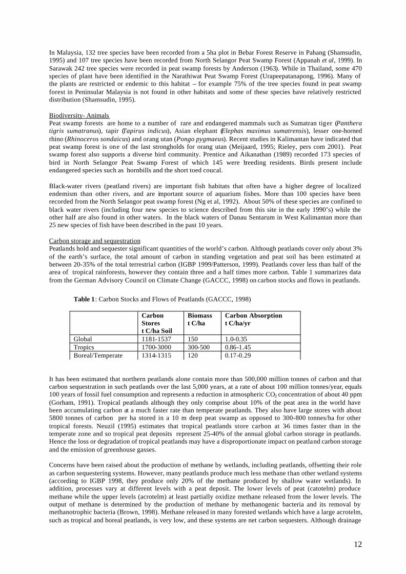
In Malaysia, 132 tree species have been recorded from a 5ha plot in Bebar Forest Reserve in Pahang (Shamsudin, 1995) and 107 tree species have been recorded from North Selangor Peat Swamp Forest (Appanah et al, 1999). In Sarawak 242 tree species were recorded in peat swamp forests by Anderson (1963). While in Thailand, some 470 species of plant have been identified in the Narathiwat Peat Swamp Forest (Urapeepatanapong, 1996). Many of the plants are restricted or endemic to this habitat – for example 75% of the tree species found in peat swamp forest in Peninsular Malaysia is not found in other habitats and some of these species have relatively restricted distribution (Shamsudin, 1995). Biodiversity- Animals Peat swamp forests are home to a number of rare and endangered mammals such as Sumatran tiger (Panthera tigris sumatranus), tapir (Tapirus indicus), Asian elephant (Elephas maximus sumatrensis), lesser one-horned rhino (Rhinoceros sondaicus) and orang utan (Pongo pygmaeus). Recent studies in Kalimantan have indicated that peat swamp forest is one of the last strongholds for orang utan (Meijaard, 1995; Rieley, pers com 2001). Peat swamp forest also supports a diverse bird community. Prentice and Aikanathan (1989) recorded 173 species of bird in North Selangor Peat Swamp Forest of which 145 were breeding residents. Birds present include endangered species such as hornbills and the short toed coucal. Black-water rivers (peatland rivers) are important fish habitats that often have a higher degree of localized endemism than other rivers, and are important source of aquarium fishes. More than 100 species have been recorded from the North Selangor peat swamp forest (Ng et al, 1992). About 50% of these species are confined to black water rivers (including four new species to science described from this site in the early 1990’s) while the other half are also found in other waters. In the black waters of Danau Sentarum in West Kalimantan more than 25 new species of fish have been described in the past 10 years. Carbon storage and sequestration Peatlands hold and sequester significant quantities of the world’s carbon. Although peatlands cover only about 3% of the earth’s surface, the total amount of carbon in standing vegetation and peat soil has been estimated at between 20-35% of the total terrestrial carbon (IGBP 1999/Patterson, 1999). Peatlands cover less than half of the area of tropical rainforests, however they contain three and a half times more carbon. Table 1 summarizes data from the German Advisory Council on Climate Change (GACCC, 1998) on carbon stocks and flows in peatlands.
It has been estimated that northern peatlands alone contain more than 500,000 million tonnes of carbon and that carbon sequestration in such peatlands over the last 5,000 years, at a rate of about 100 million tonnes/year, equals 100 years of fossil fuel consumption and represents a reduction in atmospheric CO2 concentration of about 40 ppm (Gorham, 1991). Tropical peatlands although they only comprise about 10% of the peat area in the world have been accumulating carbon at a much faster rate than temperate peatlands. They also have large stores with about 5800 tonnes of carbon per ha stored in a 10 m deep peat swamp as opposed to 300-800 tonnes/ha for other tropical forests. Neuzil (1995) estimates that tropical peatlands store carbon at 3-6 times faster than in the temperate zone and so tropical peat deposits represent 25-40% of the annual global carbon storage in peatlands. Hence the loss or degradation of tropical peatlands may have a disproportionate impact on peatland carbon storage and the emission of greenhouse gasses. Concerns have been raised about the production of methane by wetlands, including peatlands, offsetting their role as carbon sequestering systems. However, many peatlands produce much less methane than other wetland systems (according to IGBP 1998, they produce only 20% of the methane produced by shallow water wetlands). In addition, processes vary at different levels with a peat deposit. The lower levels of peat (catotelm) produce methane while the upper levels (acrotelm) at least partially oxidize methane released from the lower levels. The output of methane is determined by the production of methane by methanogenic bacteria and its removal by methanotrophic bacteria (Brown, 1998). Methane released in many forested wetlands which have a large acrotelm, such as tropical and boreal peatlands, is very low, and these systems are net carbon sequesters. Although drainage
Table 1: Carbon Stocks and Flows of Peatlands (GACCC, 1998) Carbon
Stores t C/ha Soil
Biomass t C/ha
Carbon Absorption t C/ha/yr
Global 1181-1537 150 1.0-0.35 Tropics 1700-3000 300-500 0.86-1.45 Boreal/Temperate 1314-1315 120 0.17-0.29
13
of peatlands has been shown to reduce methane production, other studies have indicated that this may be more than compensated by the methane production in the associated drainage ditches. On the other hand, drainage of peatlands leads to rapid oxidation of the peat. Carbon dioxide release will increase dramatically to levels as high as 15 t C/ha/yr in the temperate zone, and 50 t C/ha/yr in the tropics through decomposition (Immirzi and Maltby, 1992) or more than 500t/ha through fire.
Hydrology Peat swamp forests play important functional roles in regulation of hydrology. Such functions as flood control, flow regulation, water supply and prevention of saline water intrusion are crucial to maintain integrity of the surrounding ecosystem. For instance in south Thailand, Pru Toe Daeng peat swamps play an important hydrological role in regulating the quantity and quality of waters in lower basin. The swamps buffer the high rainfalls of the months of November and December before eventually discharging the water into the sea. In Peninsular Malaysia, the North Selangor Peat Swamp Forest provides a significant supply of water (especially at the beginning of the dry season) to the adjacent Sekincan Rice fields - one of the key granary areas for the country. Socio-economic values Many economically valuable species are found in peat swamp forests. High quality timbers include Ramin (Gonystylus bancanus) and Meranti (Shorea spp.). Jelutung (Dyera costulata) is used for timber, pencils and for extraction of latex which is used in the production of chewing gum. Export values of wood products from peat swamp forests in Sarawak were over RM150 million in 1973 accounting for 60% of wood export revenue at the time. FAO (1974) estimated that a sustainable harvest with an annual export value of over RM200 million/annum from peat swamp forests would be possible. However, the amount of Ramin and other timber species harvested from peat swamp forests in the state has subsequently declined due to earlier heavy harvesting, poor regeneration and also conversion of peat swamp forests to agricultural land. Of the non-timber forest products rattans (Calamus spp.) latex (from trees of Dyera spp.) and incense bark (from the gemur tree, Alseodaphne coriacea) are important. These forests also contain a variety of medicinal plants such as Cratoxylum arborescens (for chicken pox), Eugenia paradixa (for diarrhoea) or Piper arborescens (for rheumatism) (Chai et al. 1989) . One of the important ornamental plants is the Pinang Rajah or sealing wax palm (Cyrtostachys lakka). Other species of commercial value from Peat swamp forests include fish and prawns with many species of ornamental fish being found in the black waters of peat swamp forests. Zakaria Ismail (1999) records that over 10,000 specimens of one species of ornamental fish (Pseudobagrus ornatus) were collected in the Nenasi peatlands in Pahang in 1997. IMPACTS The main negative impacts of human activities on peatland ecosystems are as follows:
• Extraction/over-exploitation of plants and animals • Conversion to other land uses • Drainage • Fire
Extraction Most of the peat swamp forests in the region are subject to logging and extraction of non-timber forest products. These activities can be undertaken on a sustainable basis with proper management. However in many parts of the region such extraction takes place at a high level and in an uncontrolled manner. In Indonesia in recent years for example – illegal logging of forests including peat swamp forest is being undertaken at unprecedented levels even in totally protected forests (such as Berbak National Park). Unsustainable harvesting of non-timber forest products also takes place such as excessive harvests of aquarium and other fish; use of destructive fishing techniques such as use of small mesh nets or poisons, large-scale cutting of rattans or debarking of trees to harvest gemur. Damage may be due to the direct extraction of the trees or through the extraction methods. Until 20 years ago most timber extraction in peat swamp forest involved the construction of “kuda-kuda” railway lines which did not involve heavy machinery and maintained the hydrology of the system. Subsequently in Malaysia, tracked excavators (traxcavators) were introduced with the canal logging system – whereby large canals were constructed to drain water from the forest to facilitate access by heavy vehicles and the easy extraction of timber. This system of logging has been judged to be very damaging to the peatland as it induces drainage and leads to subsidence, soil compaction and fires. In certain forest areas it has now been stopped for new concessions – but often no
14
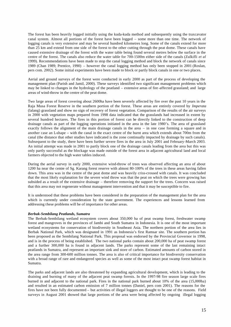
action is taken to block canals from previous operations. Illegal loggers in Indonesia have also recently started using a canal system – whereby small canals (about 1m deep and 1 m wide) are cut by chainsaw up to 10 km into the forest from rivers. Land conversion Large areas of peat swamp forest have been converted for agricultural or other uses. In Malaysia more than 1 million ha of peatland has been put into agricultural use while in Indonesia over 3 million ha has been converted. Such land conversion destroys not only the developed peatland and its associated biodiversity but may also have a residual effect on remaining peatlands and other lands through drainage or fire or loss of ecological services such as flood control or dry season water supply. Some of this land conversion has not been successful, with a striking example being the so-called One Million Hectare or Mega-Rice Project in Central Kalimantan which was abandoned in 1998. Drainage Since the naturally high water table is probably the most important factor in the creation and maintenance of natural peatlands then drainage is probably the most important negative impact on peatlands. Drainage may occur as a result of forestry operations, agricultural drainage of adjacent lands or the channelization of downstream water courses. The lowering of the water table leads to drying of the surface peat layers which affects plant growth and leads to the breakdown of the peat soil. This in turn may lead to subsidence of the peat. In cases of severe drainage subsidence by up to five meters has been recoded over a period of 20 years. The impact of drainage channels cut through peatlands may extend 70-1500m laterally from the canal depending on the season and depth of the canal – hence very large areas can be impacted by a relatively small network of channels. Fire Forest and ground fires in peatlands have become much more common in the past 20 years in South East Asia. These fires are often linked with the occurrence of periodic drought but are more closely linked to the ground to forestry or agricultural clearance or drainage activities. The first large-scale peat fires in the region occurred in 1982-83 during a pronounced El-Nino related drought. At that time about 500,000 ha of peatland was burnt primarily in East Kalimantan. The fires at that time were linked to large-scale logging in these forests prior to the time of the drought. Smaller areas of peatlands were also burnt during droughts in 1990 and 1992. Forest fires during 1997 and 1998 drought affected an area of over 1,500,000ha of peatland in Indonesia (Table 2). The smoke from the peat fires in Indonesia is considered a major (estimated 60%) contribution to the cloud of smoke (haze) which enveloped the region for several months and caused an estimated economic loss of US$9 billion. In addition, fires are estimated to have released over 400 million tonnes of CO2 from the combustion of peat. A recent report indicated that six of seven persistent fire prone zones in Sumatra which burned in 1997-8 and in a number of shorter dry periods since then are all in peatland areas (Anderson and Bowen 2000).
CASE STUDIES North Selangor Peat Swamp Forest The North Selangor Peat Swamp Forest is situated on the west coast of Peninsular Malaysia, about 50km north-west of Kuala Lumpur. It covers an area of about 70,000 ha and consists of two forest reserves (Raja Musa FR and Sg. Karang FR) and Sg. Dusun Wildlife Reserve. The area is of significance for biodiversity conservation with 35 mammal, 173 bird, 15 reptile, 120 tree and over 100 fish species recorded (Prentice, 1990; Zakaria, 1999; Shamsudin 1999). The area also plays an important role in carbon storage (Kumari, 1995) as well as the hydrology of the surrounding area (Low and Balamuragan, 1989). The area had been heavily logged prior to its establishment as a forest reserve in 1989 (Chan, 1989), but the logging intensity was progressively reduced in the subsequent 10 years. In 2000, a management plan for the two forest reserves was prepared which recommended significant proportion to be set aside for research, conservation and rehabilitation areas. This management plan is currently pending approval by the state government.
Table 2: Estimated Extent of Spatial Damage of Peat and Swamp Forest by Fire in 1997/98 (ha)(Bappenas, 1999)
Region Area Damaged (ha) Sumatra 308,000
Kalimantan 750,000 Papua 400,000 Total 1,508,000
15
The forest has been heavily logged initially using the kuda-kuda method and subsequently using the traxcavator canal system. Almost all portions of the forest have been logged – some more than one time. The network of logging canals is very extensive and may be several hundred kilometres long. Some of the canals extend for more than 25 km and extend from one side of the forest to the other cutting through the peat dome. These canals have caused extensive drainage of the forest with the water table being found several metres below the surface in the centre of the forest. The canals also reduce the water table for 700-1500m either side of the canals (Zulkifli et al 1999). Recommendations have been made to stop the canal logging method and block the network of canals since 1989 (Chan 1989; Prentice, 1990) – however the canal logging method has only been stopped in 2001 (Roslan, pers com. 2002). Some initial experiments have been made to block or partly block canals in one or two places. Aerial and ground surveys of the forest were conducted in early 2000 as part of the process of developing the management plan (Parish and Jamil, 2000). These surveys identified two significant management problems which may be linked to changes in the hydrology of the peatland – extensive areas of fire -affected grassland; and large areas of wind-throw in the centre of the peat dome. Two large areas of forest covering about 2600ha have been severely affected by fire over the past 10 years in the Raja Musa Forest Reserve in the southern portion of the forest. These areas are entirely covered by Imperata (lalang) grassland and show no sign of recovery of forest vegetation. Comparison of the results of the air surveys in 2000 with vegetation maps prepared from 1998 data indicated that the grasslands had increased in extent by several hundred hectares. The fires in this portion of forest can be directly linked to the construction of deep drainage canals as part of the logging operations initiated in the area in the late 1980’s. The area of grassland exactly follows the alignment of the main drainage canals in the area – in one case forming a square and in another case an L-shape – with the canal in the exact centre of the burnt area which extends about 700m from the canal (the distance that other studies have indicated is the zone continually impacted by drainage by such canals). Subsequent to the study, there have been further severe fires in the area in July 2001 and February-March 2003. An initial attempt was made in 2001 to partly block one of the drainage canals leading from the area but this was only partly successful as the blockage was made outside of the forest area in adjacent agricultural land and local farmers objected to the high water tables induced. During the aerial survey in early 2000, extensive wind-throw of trees was observed affecting an area of about 1200 ha near the centre of Sg. Karang forest reserve with almost 80-100% of the trees in these areas having fallen down. This area was in the centre of the peat dome and was heavily criss-crossed with canals. It was concluded that the most likely explanation for the severe wind throw was that the peat on which the trees were growing has subsided as a result of the extensive drainage – therefore removing the support for the trees. Concern was raised that this area may not regenerate without management intervention and that it may be susceptible to fire. It is understood that these problems have been considered in the preparation of the management plan for the area which is currently under consideration by the state government. The experiences and lessons learned from addressing these problems will be of importance for other areas.
Berbak-Sembilang Peatlands, Sumatra The Berbak-Sembilang wetland ecosystem covers about 350,000 ha of peat swamp forest, freshwater swamp forest and mangroves in the provinces of Jambi and South Sumatra in Indonesia. It is one of the most important wetland ecosystems for conservation of biodiversity in Southeast Asia. The northern portion of the area lies in Berbak National Park, which was designated in 1991 as Indonesia’s first Ramsar site. The southern portion has been proposed as the Sembilang National Park. This proposal was endorsed by the Provincial Governor in 1998, and is in the process of being established. The two national parks contain about 200,000 ha of peat swamp forest and a further 300,000 ha is found in adjacent lands. The parks represent some of the last remaining intact peatlands in Sumatra, and represent an important sink and store of carbon. Estimated amounts of carbon stored in the area range from 300-600 million tonnes. The area is also of critical importance for biodiversity conservation with a broad range of rare and endangered species as well as some of the most intact peat swamp forest habitat in Sumatra.
The parks and adjacent lands are also threatened by expanding agricultural development, which is leading to the draining and burning of many of the adjacent peat swamp forests. In the 1997-98 fire season large scale fires burned in and adjacent to the national park. Fires in the national park burned about 10% of the area (15,000ha) and resulted in an estimated carbon emission of 7 million tonnes (Daniel, pers com 2001). The reasons for the fires have not been fully documented – but activities of illegal loggers are thought to be one of the reasons. Field surveys in August 2001 showed that large portions of the area were being affected by ongoing illegal logging
16
activities with several illegal sawmills operating around the national park. This combined with the relatively low capacity of the management authority – may make the area susceptible to fire in the next fire season. Central Kalimantan Peatlands Central Kalimantan province contains about 3 million ha of peatlands making it one of the most important areas for peatlands in the region. Until recently the peatlands were well forested and in relatively pristine state. The peatlands are critical for both conservation of biodiversity (they hold one of the largest remaining populations of orang utan in the world) as well as storage of carbon. However in the mid-1990s a large scale development project (the so-called Mega Rice Project) was approved by the government. Construction of the project was initiated in 1996, based on a presidential decree of former president Suharto. The project was put on hold shortly after Suharto left office in 1998, and was cancelled when president Habibie issued another decree in July 1999.
The aim of the Mega Rice Project was to convert one million hectares of land in Central Kalimantan, mostly peatland several metres thick, to rice fields. In the course of implementation, much of the peat swamp forest within the designated area was removed or degraded. The area of peatland was seriously disrupted by more than 4,500 kilometres of canals that were excavated supposedly to distribute water for irrigation in the dry season and remove excess water to prevent flooding in the wet season. The canals failed to function, owing to the contours of the land surface and the constraining physical properties of the peat itself. After only two years, the main canals were losing their water, their banks had collapsed, and they were silting up with peat mud. However the remaining canals have caused extensive damage to the peatlands and have caused a severe lowering of the water table – making the area very prone to fires. The canals have also been used extensively as access for illegal logging activities and this has hampered efforts by the local government to block them. Fires have led to extensive damage to the peatlands and surrounding areas. It is estimated that about 750,000 ha of peatlands in Kalimantan were degraded by fire in 1997/1998 with about 500,000 in the mega rice project area. Large amounts of carbon as well as smoke were released into the atmosphere as a result of these fires. The impacts on the local population as well as the biodiversity were devastating. Although most of the area has been confirmed as unsuitable for agriculture and recommended to be given a status of conservation area – the local government has no resources to manage or re-habilitate the area. Several projects with national and international funding are now being established to support assessment and rehabilitation of the area.
RECOMMENDATIONS FOR ACTION There is an urgent need for a more concerted action in Southeast Asia to minimise or stop the continuous loss and degradation of peatlands, as a result of increasing unsustainable exploitation or development activities which are leading to degradation and increased susceptibility to forest fires. Unless prompt measures are undertaken, severe degradation to peat resources in the region, which make up 60% of the world’s tropical peatlands will continue to occur in coming years, with severe consequences to both the environment and to the people of the region. Urgent collaborative measures or actions are becoming even more critical in the light of the forest fire episodes in Southeast Asia region. Forest fires in 1997/98 burnt or partially degraded more than 1.45 million ha of peatlands, about 4% of the total peatland areas in the region. Peatland fires were identified as the major contributors (about 60% of particulates) to the smoke and haze which envelops a major part of the region. A new El-Nino cycle appears to be starting in 2002 with associated drought conditions and an increase in forest and peat fires in various countries in the region. The main immediate actions recommended are as follows:
1. Undertake rapid assessments of all major peatland areas to identify those areas where agriculture or forestry practices have caused significant drainage as identify these areas as those with significant fire risk.
2. Develop and implement short and medium term management measures for these areas to restore the hydrology or to minimise the chances of fire in the areas.
3. Prepare contingency or fire fighting plans for the areas for use in the event that fires start. 4. Initiate a programme of hydrological restoration and forest rehabilitation in drained peatlands which still
have forest cover or are under forestry agency control. 5. Stop the practice of logging through cutting of canals and require that existing logging canals be blocked. 6. Control the drainage of water in agricultural or other lands bordering peat swamp forests. 7. Promote agricultural practices which ensure high water table maintenance on peatlands. 8. Require rehabilitation of any abandoned agricultural land on or adjacent to peatlands.
17
9. Explore options to obtain resources for peatland management and rehabilitation under the framework of the UN Convention on Climate Change.
10. Promote the setting aside of any remaining intact peatlands for their biodiversity, carbon storage and hydrological functions.
11. Establish and strengthen regional cooperation mechanisms to enhance collaboration and exchange in the region.
ACKNOWLEDGEMENTS The preparation of this paper was facilitated by a grant (No RE-MYS-003) to the Global Environment Centre by the ASEAN Regional Centre for Biodiversity Conservation as part of a project Regional collaboration for the conservation of peatland biodiversity in SE Asia. REFERENCES Anderson, J.A.R., 1963. The flora of the peat swamp forest of Sarawak and Brunei including a catalogue of all
recorded species of flowering plants, ferns and fern allies. Gardens Bulletin (Singapore) , 29: 131-228. Anderson, I. and Bowen, 2000. Fire Zones and the Threat to the Wetlands of Sumatra, Indonesia. Report of
European Union and Ministry of Forestry Forest Fire Prevention and Control Project. Appanah, S. Ismail H., Samsudin, M. and Sadali, S. 1999. Flora survey in North Selangor Peat swamp forest. In
sustainable management of Peat swamp Forest in Malaysia. Forest Department , Kuala Lumpur. BAPPENAS 1999. Final Report on Planning and Drought management in Indonesia Chai, PPK., Lee, BMH., Ismawi, O. 1989. Native medicinal plants of Sarawak. Forest Department Sarawak. Chan, HT. 1989 A forestry action plan for the North Selangor Peat Swamp Forest. AWB, Kuala Lumpur. FAO. 1974. The Peat swamps of Sarawak and their potential for development. FAO Report No 3. FAO Forestry
and Forest Industries Development Project, Malaysia. Kuala Lumpur German Advisory Council on Climate Change (GACCC), 1998. The Accounting Biological Sinks and Sources
Under the Kyoto Protocol: A Step Forwards or backwards for Global Environmental Protection?, 1998 Special Report, Bremerhaven
Giesen, W. 1991. Berbak Wildlife Reserve, Jambi Sumatra. PHPA/AWB Sumatra wetlands project Report No 13. AWB, Bogor.
Gorham, E. 1991. Northern Peatlands: Role in the carbon cycle and probable responses to climatic warming. Ecological Applications, 1: 182-195
IGBP Terrestrial Carbon Working Group. 1998. The Terrestrial Carbon Cycle: Implications for the Kyoto Protocol. Science 280:1393-1394
Immirzi, C.P. and Maltby, E., 1992. The Global Status of Peatlands and their Role in the Carbon Cycle. Wetlands Ecosystems Research Group, Report 11, Department of Geography, University of Exeter, UK, 118 pp.
Kumari, K. 1995. “An Environmental and Economic Assessment of Forest Management Options: A Case Study in Malaysia”. The World Bank: Environmental Department Papers No. 026. In: Woon et al., 1999.
Lappalainen, E. 1996. Global Peat Resources. International Peat Society, Jyska, Finland, 358 pp. Low, KS and Balamuragan, G. 1989. A preliminary Hydrological Investigation of the North Selangor Peat
Swamp Forest. AWB, Kuala Lumpur. Meijaard, E. 1995. The Importance of swamp forest for the conservation of the orang Utan (Pongo pygmaeus) in
Kalimantan, Indonesia. In J.O. Rieley and S.E. Page (eds.) Tropical Peatlands. Samara Press. Neuzil, SG. 1995. Onset and rate of peat and carbon accumulation in four domed Ombrogenous peat deposits,
Indonesia. In J.O. Rieley and S.E. Page (eds.) Tropical Peatlands. Samara Press. Ng, PKL, Tay, JB, Lim, KKP and CM, Yang. 1992. The conservation of the fish and other aquatic fauna of the
North Selangor Peat Swamp Forest and adjacent areas. AWB Kuala Lumpur. Parish, F. and Jamil H.(eds.) 2000. Management inventory of North Selangor Peat Swamp Forest. Danced-Forest
department Kuala Lumpur. Patterson, J. 1999. Wetlands and Climate Change: Feasibility investigation of giving credit for conserving
wetlands as carbon sinks. Wetlands International, Ottawa, Canada. Prentice, R. 1990. Environmental Action Plan for the north Selangor peat swamp Forest. AWB, Kuala Lumpur. Prentice C. and Aikanathan S. (1989) A preliminary faunal assessment of the North Selangor Peat swamp Forest.
Asian Wetland Bureau, Kuala Lumpur. RePPProT. 1990. A National Overview from the Regional Physical Planning Programme for Transmigration.
UK Overseas Development Administration and Directorate BINA Programme. Indonesian Ministry of Transmigration, Jakarta, Indonesia.

18
Rieley, J.O., Ahmad-Shah, A. A. and Brady, M.A. 1996. The extent and nature of tropical peat swamps. In: Tropical Lowland Peatlands of Southeast Asia. Eds.: E. Maltby, C.P. Immirzi and R.J. Safford. July 1992. IUCN, Gland, Switzerland, pp. 17-53.
Shamsudin, I. 1995. Tree species in Peat Swamp Forest in Peninsular Malaysia. In J.O. Rieley and S.E. Page (eds.) Tropical Peatlands. Samara Press.
Urapeepatanapong, C. 1996. Flora of Narathiwat peat swamp forest. Royal Thai Forest Department, Bangkok. Whitmore, TC. 1984 Tropical Rainforests of the Far East. Clarendon Press, Oxford. Zakaria, I. 1999. Survey of fish fauna in peat swamp forests. In sustainable management of peat swamp forest in
Malaysia. Forest Department, Kuala Lumpur Zulkifli, Y., Vily, K. and Baharuddin, K. 1999. Hydrological characteristics of the North Selangor Peat Swamp
Forest. In Sustainable Management of Peat swamp Forest in Malaysia. Forest Department, Kuala Lumpur
19
ANNEX 1 Peatland Resources in Southeast Asia In 1992, the extent of peatland resources of Southeast Asia was estimated by Immirzi and Maltby (1992) to be around 35-40 million ha. However, increased development, land conversion and degradation caused by forest fires have reduced peatland resources significantly over the past few years. Remaining total peatland under forest cover in Southeast Asia is estimated to be around 25-30 million ha. Most peatlands occupy low altitude, sub-coastal areas extending inland for distances up to 300 km. The depth of peat varies from 0.5 to more than 15 meters. Indonesia In 1987, it was estimated that the remaining total peatland area in Indonesia amounts to about 17 million ha, down from the original peatland area of about 20 million ha (Silvius et al, 1987). Since 1987 it has been estimated that a further 3 million ha of peat swamp forest have been converted to agriculture. An increasing area of peatland is being used for the cultivation of perennial/ estate crops such as oil palm. . The major peatland areas in Indonesia: (a) Sumatra: Approximately 4.6 million ha of remaining peatlands occur mainly along the east coast of North Sumatra down to South Sumatra. Main areas are in Tanjung and Lagan (Jambi); Bunut-Kuala Kampar, Sei Rokan Timur and Sei Kecil (Riau); Lalan (South Sumatra). (b) Kalimantan: peatland occupies 3.5 million ha mainly on the west coast of West Kalimantan, in the central part of Central Kalimantan and some parts of East Kalimantan. Main areas are Kubu (west) and Sebangau (central). (c) Irian Jaya: Peatland occur mostly on the south coast and some fringes of the south-west coast with a total area of 8.7 million ha. Malaysia Total peatland area in Malaysia is estimated to be between 2- 2.5 million ha (Mohd-Ali, 1989; Dent, 1986). However, substantial peat swamp forests have been cleared for agriculture and are under plantation crops such as oil palm and rubber. Estimates put total peatland area in Peninsula Malaysia at 0.9 million ha (Mohd-Ali, 1989) but pristine peatlands amounts to less than 50,000ha. The major remaining areas of peat swamp are the North Selangor Peat Swamp, Kuala Langat (South Selangor) and Southeast Pahang Peat Swamp (from Kuantan to Endau along the east coast). In the island of Borneo, peat swamps is estimated to cover an area of about 1.5 million ha with major areas in state of Sarawak near the town of Sibu, Sri Aman and Miri. Most of the area has been affected by logging and some by agricultural conversion. Thailand Total peat swamp areas of Thailand are estimated to be about 64,000 ha. Most of the peat swamp forest is situated in Narathiwat Province of southeast Thailand, which has an area of 45,000 ha. Brunei The main peat deposits are in the Belait Peat swamp in the South and in the Tasek Merimbun Park in Central Brunei. Philippines The main area of peat is in the Southern Island of Mindanao, primarily in Agusan Marsh and Liguasan Marsh. Vietnam The main peat deposits in Vietnam occur in the Mekong delta in the south of the country.
20
THE INCIDENCE OF FOREST FIRE IN PENINSULAR MALAYSIA: HISTORY, ROOT CAUSES, PREVENTION AND CONTROL
by
MOHD JINIS ABDULLAH, MAHMAD RASID IBRAHIM & ABDUL RAHMAN ABDUL RAHIM Forest Department Peninsular Malaysia
Abstract Natural evergreen rainforest of Malaysia covers about 20.3 million hectares or 61.7% of the country total land area. Of this total, about 5.9 million hectares are located in Peninsular Malaysia, while the remainder is in Sabah and Sarawak. Prior to 1990’s, the occurrence of major fire outbreak in the forest has been generally low and minimal reports have been compiled for Peninsular Malaysia, while several reports may be available for Sabah and Sarawak. After 1990's, however, the incidence of uncontrolled fire outbreak in the forest has been high for Peninsular Malaysia and reports particularly for permanent reserved forest were seriously documented by the Forestry Department of Peninsular Malaysia (FDPM). The probable causes of these uncontrolled fire outbreaks have been commonly originated directly or indirectly from land clearing operation which involve an open burning, especially by planters and farmers in, near or surrounding the affected forested areas. In peat swamp forest, the occurrence of prolong dry spell with insufficient water supply to curb the spreading of ‘peat fires' have further worsen the situation. In Peninsular Malaysia alone, there has been a total 35 cases of ‘forest fires’ and has affected an area of 4,143 hectares. Of this total, 9 cases is incidence of ‘peat fires’ and has destroyed about 1,940 hectares of peat swamp forest The uncontrolled open burning activity in the neighbouring land areas to the peat swamp forest together with prolong dry spells, insufficient supply of water, limited experience of the state of art to totally suppress ‘peat fires’, excessive availability of dried vegetative humus and low water table in the forest floor were among constraints for effective combating of ‘peat fires’ inherited by the FDPM from the past. However, with recent developments of wide spreading of uncontrolled ‘peat fires’ which has affected large track of peat swamp forest, serious concern from the public, availability of fund and strong support by the government and other interested parties have called upon FDPM to take necessary measures to draw more effective plan of actions in combating the future outbreak of ‘peat fires’. This paper will attempt to highlight some experiences accumulates over the years in combating forest fire in the permanent reserved forest by the FDPM, addressing several probable root causes of these fire outbreak and out lining future plan of action to combat fire outbreak in the forest, particularly for “peat fires” in the peat swamp forest.
1.0 INTRODUCTION
1.1 The natural evergreen tropical rainforest forms the dominant natural vegetative cover in Malaysia. Its formation has been driven by typically monsoon humid tropical climate which is characterized by year round sunshine and seasonal heavy rainfall. Heavy rainfall occurs especially during the North East monsoons seasons from the month of October/ November to February/ March. The temperature pattern varies very small through out the year with an average of 32oC during the day and 22oC at night. Most of the time the forest receives an abundant rainfall with an average of 2,540 mm per year with a maximum 5,080 mm and minimum of 1,650 mm, respectively. Tropical rainforest is also characterised by relatively high humidity which ranges from 70-90%. Several major forest types, such as inland forest, peat-swamp forest and mangrove forest are commonly available in the tropical rainforest of Malaysia.
1.2 About a total of 20.3 million hectares or 61.7% of Malaysia’s land area is under forest (Statistics On
Commodities, The Ministry of Primary Industries, 2000). Of this total, about 5.9 million is in Peninsular Malaysia. In inland forest, the forest areas are generally dominated by natural rainforest. Under natural conditions, the forest does not easily burn as its unique structure of close canopy as well as minimum direct penetration of sunlight onto the ground keeps the ground surface always moist (except during the extra ordinary prolonged dry season). Both, the peat swamp and mangrove forest generally have moist forest floors. This characteristic serves as ‘natural immunity’ to the incidence of serious uncontrolled fire out-breaks on the forest floor in these forest types. This special ‘natural immunity’, however, is seen to be gradually depleted along with recent changes in land use practices in, near or surrounding the forest. To avoid the continuing depletion of the ‘natural immunity’, it is thus timely that the government should consider to initiate a very serious critical review on the future prospect of these major groups of forest types in relation to any major land development programme in, near or surrounding these forests.
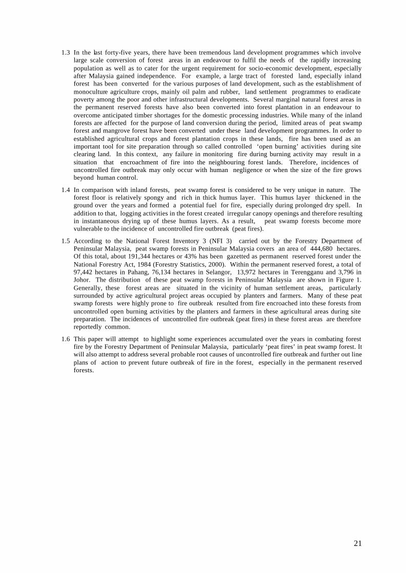
21
1.3 In the last forty-five years, there have been tremendous land development programmes which involve large scale conversion of forest areas in an endeavour to fulfil the needs of the rapidly increasing population as well as to cater for the urgent requirement for socio-economic development, especially after Malaysia gained independence. For example, a large tract of forested land, especially inland forest has been converted for the various purposes of land development, such as the establishment of monoculture agriculture crops, mainly oil palm and rubber, land settlement programmes to eradicate poverty among the poor and other infrastructural developments. Several marginal natural forest areas in the permanent reserved forests have also been converted into forest plantation in an endeavour to overcome anticipated timber shortages for the domestic processing industries. While many of the inland forests are affected for the purpose of land conversion during the period, limited areas of peat swamp forest and mangrove forest have been converted under these land development programmes. In order to established agricultural crops and forest plantation crops in these lands, fire has been used as an important tool for site preparation through so called controlled ‘open burning’ activities during site clearing land. In this context, any failure in monitoring fire during burning activity may result in a situation that encroachment of fire into the neighbouring forest lands. Therefore, incidences of uncontrolled fire outbreak may only occur with human negligence or when the size of the fire grows beyond human control.
1.4 In comparison with inland forests, peat swamp forest is considered to be very unique in nature. The forest floor is relatively spongy and rich in thick humus layer. This humus layer thickened in the ground over the years and formed a potential fuel for fire, especially during prolonged dry spell. In addition to that, logging activities in the forest created irregular canopy openings and therefore resulting in instantaneous drying up of these humus layers. As a result, peat swamp forests become more vulnerable to the incidence of uncontrolled fire outbreak (peat fires).
1.5 According to the National Forest Inventory 3 (NFI 3) carried out by the Forestry Department of Peninsular Malaysia, peat swamp forests in Peninsular Malaysia covers an area of 444,680 hectares. Of this total, about 191,344 hectares or 43% has been gazetted as permanent reserved forest under the National Forestry Act, 1984 (Forestry Statistics, 2000). Within the permanent reserved forest, a total of 97,442 hectares in Pahang, 76,134 hectares in Selangor, 13,972 hectares in Terengganu and 3,796 in Johor. The distribution of these peat swamp forests in Peninsular Malaysia are shown in Figure 1. Generally, these forest areas are situated in the vicinity of human settlement areas, particularly surrounded by active agricultural project areas occupied by planters and farmers. Many of these peat swamp forests were highly prone to fire outbreak resulted from fire encroached into these forests from uncontrolled open burning activities by the planters and farmers in these agricultural areas during site preparation. The incidences of uncontrolled fire outbreak (peat fires) in these forest areas are therefore reportedly common.
1.6 This paper will attempt to highlight some experiences accumulated over the years in combating forest fire by the Forestry Department of Peninsular Malaysia, particularly ‘peat fires’ in peat swamp forest. It will also attempt to address several probable root causes of uncontrolled fire outbreak and further out line plans of action to prevent future outbreak of fire in the forest, especially in the permanent reserved forests.
22
Figure 1 : The Extent of Peat Swamp Forest in Peninsular Malaysia
2.0 THE INCIDENCE OF UNCONTROLLED FIRE OUT-BREAK IN THE FOREST
2.1 Prior to year 1990, there was no large scale occurrence of major uncontrolled fire outbreaks
documented in natural forests of Peninsular Malaysia. Few incidences of uncontrolled fire outbreaks, however, were reported in pine plantations (Pinus spp.) in the early 1970’s and Acacia mangium plantations in the late 1980’s. About a total of 1,100 hectares of Pines and Acacia mangium plantations were destroyed due to human negligence resulted from uncontrolled open burning activity in forest areas surrounding these forest plantations. Although the fire outbreak is small and at a manageable level, but recognizing the level of risk and serious losses and damages due to the uncontrolled fire out-break in the forest plantations, Forestry Department Peninsular Malaysia began to outline several precautionary measures, such as strengthening frequent patrolling by fire patrolling team, updating knowledge pertaining to fire through proper reporting and recording of severity of outbreak and strengthening
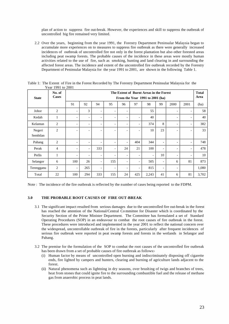
23
plan of action to suppress fire out-break. However, the experiences and skill to suppress the outbreak of uncontrolled big fire remained very limited.
2.2 Over the years, beginning from the year 1991, the Forestry Department Peninsular Malaysia began to
accumulate more experiences on to measures to suppress fire outbreak as there were generally increased incidences of outbreak of uncontrolled fire not only in the forest plantation but also other forested areas including peat swamp forests. The probable causes of the incidence in these areas were mostly human activities related to the use of fire, such as smoking, hunting and land clearing in and surrounding the affected forest areas. The incidence and extent of the uncontrolled fire outbreak recorded by the Forestry Department of Peninsular Malaysia for the year 1991 to 2001, are shown in the following Table 1.
Table 1: The Extent of Fire in the Forest Recorded by The Forestry Department Peninsular Malaysia for the Year 1991 to 2001
State
No. of Cases
The Extent of Burnt Areas in the Forest From the Year 1991 to 2001 (ha)
Total Area
91 92 94 95 96 97 98 99 2000 2001 (ha)
Johor 2 - 3 - - - 55 - - 58
Kedah 1 - - - - - - 40 - - 40
Kelantan 2 - - - - - - 374 8 - - 382
Negeri Sembilan
2 - - - - - - 10 23 - - 33
Pahang 2 - - - - - 404 344 - - - 748
Perak 4 - - 333 - 24 21 100 - - - 478
Perlis 1 - - - - - - - 10 - - 10
Selangor 6 100 26 - 155 - - 505 - 6 81 873
Terengganu 2 - 265 - - - - 815 - - 1,080
Total 22 100 294 333 155 24 425 2,243 41 6 81 3,702
Note : The incidence of the fire outbreak is reflected by the number of cases being reported to the FDPM. 3.0 THE PROBABLE ROOT CAUSES OF FIRE OUT-BREAK
3.1 The significant impact resulted from serious damages due to the uncontrolled fire out-break in the forest
has reached the attention of the National/Central Co mmittee for Disaster which is coordinated by the Security Section of the Prime Minister Department. The Committee has formulated a set of Standard Operating Procedures (SOP) in an endeavour to combat the root causes of fire outbreak in the forest. These procedures were introduced and implemented in the year 2001 to reflect the national concern over the widespread, uncontrollable outbreak of fire in the forests, particularly after frequent incidences of serious fire outbreak were reported in peat swamp forests and forests in the wetlands in Selangor and Pahang.
3.2 The premise for the formulation of the SOP to combat the root causes of the uncontrolled fire outbreak
has been drawn from a set of probable causes of fire outbreak as follows:- (i) Human factor by means of uncontrolled open burning and indiscriminately disposing off cigarette
ends, fire lighted by campers and hunters, clearing and burning of agriculture lands adjacent to the forest.
(ii) Natural phenomena such as lightning in dry seasons, over brushing of twigs and branches of trees, heat from stones that could ignite fire to the surrounding combustible fuel and the release of methane gas from anaerobic process in peat lands.
24
3.3 The above set of the probable causes of the fire outbreak outlined for the SOP by the National Committee for Disaster serve as an important guidance for the Forestry Department of Peninsular Malaysia to single out the most probable root causes of frequent uncontrolled fire outbreak in the permanent reserved forest, particularly in the peat swamp forest. The record accumulated to date by the Forestry Department of Peninsular Malaysia has shown that there were several probable root causes of the uncontrolled fire outbreak. Human negligence, however, has shown to be the common root caused of many uncontrolled fire out-breaks in the forest areas. Many of the fire incidences that have encroached into the affected forest areas have been linked to from uncontrolled open burning from land clearing activities by planters and farmers for agriculture and none by natural phenomena. The information accumulated has also shown that human negligence ranges in the activities such as hunting, smoking, land clearing and open burning. This is shown in the Table 2.
3.4 In relation to peat swamp forest areas, the table has shown that the common causes of fire outbreak have been due human negligence when using fire in the neighbouring land clearing for agricultural purposes and hunting activities. Out of these causes of uncontrolled fire outbreak, the most frequent cause is due to from uncontrolled open burning by the planters and farmers in the land surrounding the affected peat swamp forest. Hunting activity in the forest seems to be the next frequent cause of the uncontrolled fire outbreak.
3.5 Table 2 also shows that the most affected peat swamp forests are located in Selangor, Pahang, Johor, Perak and Terengganu. Out of these, the occurrence of the outbreak seems to be more frequent in Selangor, with reported incidences of fire outbreak in the year 1995, 1998, 2000 and 2001. The highest incidences of uncontrolled fire outbreak in peat swamp forest was in the year 1998, covering Johor, Pahang, Selangor, Perak and Terengganu with a total of affected areas of about 1,496 hectares. The situation of uncontrolled fire outbreak in forest areas has further worsened with prolonging of the dry spell in that year.
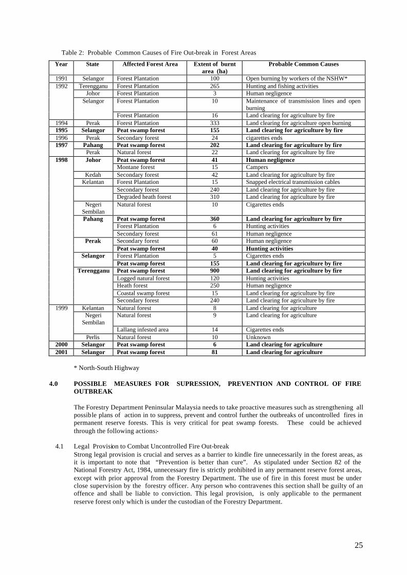
25
Table 2: Probable Common Causes of Fire Out-break in Forest Areas
Year State Affected Forest Area Extent of burnt area (ha)
Probable Common Causes
1991 Selangor Forest Plantation 100 Open burning by workers of the NSHW* 1992 Terengganu Forest Plantation 265 Hunting and fishing activities
Johor Forest Plantation 3 Human negligence Selangor Forest Plantation 10 Maintenance of transmission lines and open
burning Forest Plantation 16 Land clearing for agriculture by fire
1994 Perak Forest Plantation 333 Land clearing for agriculture open burning 1995 Selangor Peat swamp forest 155 Land clearing for agriculture by fire 1996 Perak Secondary forest 24 cigarettes ends 1997 Pahang Peat swamp forest 202 Land clearing for agriculture by fire
Perak Natural forest 22 Land clearing for agriculture by fire 1998 Johor Peat swamp forest 41 Human negligence
Montane forest 15 Campers Kedah Secondary forest 42 Land clearing for agriculture by fire Kelantan Forest Plantation 15 Snapped electrical transmission cables Secondary forest 240 Land clearing for agriculture by fire Degraded heath forest 310 Land clearing for agriculture by fire Negeri
Sembilan Natural forest 10 Cigarettes ends
Pahang Peat swamp forest 360 Land clearing for agriculture by fire Forest Plantation 6 Hunting activities Secondary forest 61 Human negligence Perak Secondary forest 60 Human negligence Peat swamp forest 40 Hunting activities Selangor Forest Plantation 5 Cigarettes ends Peat swamp forest 155 Land clearing for agriculture by fire Terengganu Peat swamp forest 900 Land clearing for agriculture by fire Logged natural forest 120 Hunting activities Heath forest 250 Human negligence Coastal swamp forest 15 Land clearing for agriculture by fire Secondary forest 240 Land clearing for agriculture by fire
1999 Kelantan Natural forest 8 Land clearing for agriculture Negeri
Sembilan Natural forest 9 Land clearing for agriculture
Lallang infested area 14 Cigarettes ends Perlis Natural forest 10 Unknown
2000 Selangor Peat swamp forest 6 Land clearing for agriculture 2001 Selangor Peat swamp forest 81 Land clearing for agriculture
* North-South Highway
4.0 POSSIBLE MEASURES FOR SUPRESSION, PREVENTION AND CONTROL OF FIRE
OUTBREAK
The Forestry Department Peninsular Malaysia needs to take proactive measures such as strengthening all possible plans of action in to suppress, prevent and control further the outbreaks of uncontrolled fires in permanent reserve forests. This is very critical for peat swamp forests. These could be achieved through the following actions:-
4.1 Legal Provision to Combat Uncontrolled Fire Out-break Strong legal provision is crucial and serves as a barrier to kindle fire unnecessarily in the forest areas, as it is important to note that “Prevention is better than cure”. As stipulated under Section 82 of the National Forestry Act, 1984, unnecessary fire is strictly prohibited in any permanent reserve forest areas, except with prior approval from the Forestry Department. The use of fire in this forest must be under close supervision by the forestry officer. Any person who contravenes this section shall be guilty of an offence and shall be liable to conviction. This legal provision, is only applicable to the permanent reserve forest only which is under the custodian of the Forestry Department.
26
Outside the permanent reserve forest, however, people should know that there is a total ban on all forms of opening burning except for religious and cremation purposes as stipulated under Section 29A of the Environmental Quality Act, 1974. Any public liable on conviction to be charged under such law which carries a RM500,000 (Ringgit Malaysia: Five Hundred Thousand) fine or maximum prison term of five years or both. Therefore, farmers and planters should refrain from open burning especially during prolong dry spell.
4.2 Institutional Strengthening and Increase in Intra-Agencies Cooperation
Institutional strengthening is necessary in order to outline concerted and effective plan of action to combat uncontrolled fire outbreak at its root cause. Fortunately, at the national level, the government has set-up the National/Central Committee For Disaster. This Committee is being coordinated by The Security Section in the Prime Minister’s Department. The key responsibility of this committee is to monitor and draw-up possible actions to combat any natural disaster, including the incidence of serious fire out-breaks in forests. This committee is currently guided by Standard Operating Procedure (SOP) of the National Contingency Plan To Handle Forest Fire/Open Burning And Haze. The Forestry Department of Malaysia is a member of the Committee, together with other governmental agencies. To compliment the action taken by the National Committee, the task of the Forestry Department Peninsular Malaysia is to detect and suppress fire outbreaks in forest areas. The task of searching and rescuing any trapped fire victim is also included. The Forestry Department is also responsible to provide information on the forest type, man-power, transport, camping gear, tools and equipment for the purpose of combating fire outbreak. The department has been also given the task of assisting in the assessment and post forest fire evaluation; while also taking steps to reduce the effect of fire on the affected site by means of forest rehabilitation.
4.3 Special Training to Combat and Prevent Fire Outbreak Special training on procedures and safety to combat the uncontrolled fire outbreak is crucial to members of fire fighting/patrolling team. For example, Forest Officers have been given a basic training on fire fighting to certain extent at institutions abroad and local. However, their knowledge and skills need to be upgraded along with current development on the latest/updated state of the art and knowledge on suppression of fire outbreak. Planters and farmers should be given proper training on controlling open burning during site preparation.
4.4 Extension Programme to the Public Pertaining to Fire Danger In relation to extension programme, public also need to be informed and made realised that there is a total ban on all forms of opening burning as well as the dangers of uncontrolled fire outbreaks to property and life.
4.5 Update Knowledge and Increase Understanding about Peat Swamp Forest
Peat swamp forest areas are vulnerable to outbreak of uncontrolled fire outbreak. Updated knowledge and in-depth understanding pertaining to the effective management of this forest is essential. For example, the hydrological pattern in the soil which would help to regulate water retention needs further research. The research findings could further help to effectively curb the effect of open burning activities in, near or surrounding the forest. Dry spell and strong winds contributed to rapid spreading of the ‘peat fires’.
4.6 Right Tools and Effective Equipment to Combat Fire Outbreak
Typical fire situations in natural tropical vegetation types can be successfully suppressed, and controlled by ground crews of fire -fighters. The success of these groups is significantly contributed by the availability of right tools. This is very crucial when combating large fire outbreaks in the forest. It has also been reported to certain extent that the distance between the scene of the fire outbreak and water sources posed a serious problem especially during prolong dry spell when the humus layer in the ground are totally dried and water table is low. Right tool to bring water into the scene is therefore necessary.
Heavy rainfall may also help put out fire but the effectiveness remains limited. The problem is that fires are under the shrubs and the rainfall is not able to penetrate through thick vegetation to actually put the fire out. Appropriate machineries may also be brought into the scene to clear burnt dead shrubs and vegetation to prevent the fires from spreading or re-igniting.
4.7 The Availability of Sufficient Fund
27
Sufficient funding is very essential and should be made available for the effective formulation of plan of action to combat the uncontrolled fire outbreak. For example, necessary funding should be made available for the purchasing of tools and equipment. Sufficient fund should also be put aside for the purpose of compensation due to losses and damages experienced by the public.
5.0 CONCLUSION AND RECOMMENDATIONS
5.1 The incidence of uncontrolled fire out-breaks in the forests posses a significant loss to the country. While the forest areas are destroyed by fire; fauna and flora (element of biodiversity) also disappear. Therefore, it is important and very timely to strengthen up the necessary plan of actions to combat these forest fires.
5.2 A Concerted plan of action to combat fire outbreak is very timely. It is important to adopt “Prevention is better than Cure” approach, as the losses and damages due to fire outbreak in the affected forest areas are large and irreversible. In relation to peat swamp forest, effective plan of action could incorporate the following measures: availability of legal provision to combat uncontrolled fire outbreak, emphasis on institutional strengthening and increase in intra-agencies cooperation, provide special training to the fire fighting teams, initiate an extension programme to increase public awareness on fire dangers, ensuring updated knowledge for better understanding about the forest, using right tools and effective equipment, and finally ensuring availability of sufficient funds.
REFERENCES
Act 313, 1984. National Forestry Act 1984. Forest Department Peninsular Malaysia, Kuala Lumpur.
Environmental Quality Act, 1974. Department of Environment Malaysia, Kuala Lumpur.
Forestry Statistics, 2000. Forest Department Peninsular Malaysia, Kuala Lumpur.
NFI 3, 1996. National Forest Inventory 3. Forest Department Peninsular
Malaysia, Kuala Lumpur.
Statistics on Commodities, 2000. Ministry of Primary Industries Malaysia, Kuala Lumpur.
SOP, 2001. Standard Operation Procedure. National Security Section, Prime Minister Department, Putrajaya, Malaysia
28
FORMATION OF PEAT BASIN, ITS PROPERTIES AND FIRE MANAGEMENT
SALMAH ZAKARIA1 & ZALILAH SELAMAT2 1Department of Irrigation and Drainage Malaysia (DID)
2National Hydraulic Research Institute Malaysia (NAHRIM) [email protected]
Abstract
In its natural condition, peat land, essentially swamps, served as retention/detention areas for floodwaters of each individual river basin. The planning and construction of development projects (buildings, recreational areas, conservation areas, roads, drainage, water supply, power, etc) in peat land will be influenced by the nature of the peat soil itself. There is a need to grasp the nature and properties of peat soil and to understand the constraints involved in development on peat land. In lowland coastal areas, affected by tides and with heavy torrential rain, problems encountered in peat drainage/reclamation will be magnified. Because the peat deposit occurs in wet and/or saturated condition the genesis of the peat and its properties is very much influenced by the hydrology of the surrounding area. Project initiatives usually, though not necessarily, require the peat land to be drained. Most development requirements are tied to specific objectives, which will require certain minimum bearing capacity. This bearing capacity is in turn directly related to the water table depth below the ground level and can only be achieved through drainage of the area. As drainage will change the initial status quo of the peat environment, there is also a need to relate specific project objective to realistic environmental objectives achievable within the peat environment and land reclamation.
1.0 PEAT SOIL
1.1 General There are about 500 million hectares of peatland worldwide. This is as big an area as India and Pakistan combined. The occurrence, extend and type of peatland depends on the climate. Tropical peatlands contributes to approximately 12% of the global peatland resources with the largest areas in Indonesia, China and Malaysia. Peat soils in Malaysia cover an estimated 2.4 million hectares or 7.2 % of the total land area. Peatlands are imp ortant wetland areas helping to maintain reliable supplies of clean water to rivers and acting as carbon sink. Peat is made of accumulated remains of undecomposed and partially decomposed plant material and is not a spatial or temporal single homogeneous substance. Peat deposits can occur in any type of climatic zone and can be found either in hilly areas of continuous high humidity or in enclosed lowland basins. The single common factor in all peat occurrences is the presence of excess moisture. In its natural condition, peat soils have high water table, frequently reaching the ground surface. Peat basins in its natural form served as detention/retention areas for floodwaters of each individual basin. An example is the Briah Swamp of Sg. Krian. A hydraulic analysis for the floods of 15-22 Nov 1988 (Abdul Jalil Hassan, 1999) looked into the influenced of the 5000 ha Briah Swamp within the 141,800 ha (1418 km2 ) Sg. Krian catchment. The study estimated that out of the 130 million m3 total volume of water involved, 38 million m3 flow into Briah Swamp with about 17 million m3 (13% of total volume) being detained by the swamp. Had it not been for Briah, the impact of the flood (which closed the Plus highway and railway line for 2-5 days) would have been worst. Briah has the capacity to detain a bigger volume of water. However it is now being planed for industrial development by the state of Perak. Another example of peat swamps within river basin is the North and South Langat peat swamp of the Langat River basin. Paya Indah and Cyberjaya are within the North Langat Peat basin with the coastal highway cutting through it.
Peat deposits have been classified into various groups according to the field of study that the deposit is subjected to and the different needs that the peat is expected to serve. Tables 1a and 1b lists some of the common names under which the deposits have been grouped. Peat was defined at the Second International Congress of Soil Science, Russia, 1930, as an organic soil covering an area greater than 1 hectare, with a depth greater than 0.5 metres and containing less than 35% mineral content. Under the USDA Soil Taxonomy System (Soil Survey Staff, 1975), peat is grouped under Histosols, and is further classified into suborder, great group, subgroup, family and series. In general the suborders of Histosols are defined by the moisture regime and by the degree of decomposition.
29
Peat found in Malaysia is mostly the lowland types and has been previously described as topogeneous, ombrogeneous and oligotrophic peat. “Topo” because it occurs in basins as a result of topographical features; “ombro” because the source of water for its formation is assumed to be from rainfall and “oligo” because of its inherent infertility. In the west coast of Peninsula Malaysia, lowland peats are found in inland river basins, a few kilometres from the coast and with subsoil generally above the current MSL. In the east coast of the Peninsula, peats are found interspersed horizontally between sand bars and vertically in between layers of sand deposits. The properties of peat soils of Sarawak are in general similar to that of the west coast of the peninsula. These peat are reddish to dark brown in colour, spongy and contain large quantities of woody materials and buried timbers at varying stages of decay. The difference is in the location of these deposits. In Sarawak, they are generally found either nearer the coast or in the interior but adjacent to the rivers. The deposit can either be totally elevated above MSL or substantially below the MSL. The depth of the deposit can exceed 20 metres. The classification of peninsula peat differs from the two East Malaysian states. In Peninsula Malaysia, the Department of Agriculture (DOA) uses the “percentage loss on ignit ion” as well as “peat depth” (Table 2) to separate and classify the different types of organic soil (Jamil, et al 1989). In Sarawak, peats are classified mainly in accordance to the depth of the deposit and the underlying soil material.
1.2 Chemical Properties
Raw material for the formation of peat is dependent on the vegetation growing in the area. While moss and sedges may be the parent raw material in temperate and subtropical peat, in Malaysia, the parent materials are trees of the tropical rain forests. As such buried timbers and components of rain forest trees are to be found in the Malaysian peat. Deposition and decomposition (mineralization) is an ongoing process and peat is formed, as a result of net deposition (the organic matters accumulate). With drainage, water table level is lowered and oxygen becomes readily available within the deposit, increasing the rate of decomposition. Decomposition of these organic materials, which are mainly of the C-H-O compound, produces new compounds, such as releasing carbon dioxide, water and energy. The thickness of the organic horizon, the nature of the subsoil and the frequency of flooding can influence the chemical composition of organic soils. In general, the older and thicker the organic horizon, the more impoverished are the surface layers. If the soil is regularly flooded, it will have higher mineral content and more fertile. Although ash content may exceed more than 65% (mainly east-coast states), peat in Malaysian frequently has ash contents less than 5% (Ismail, 1984, Jalaludin et al, 1979). Ash content of some Pontian peat was found to be between 2 to 5 % at the surface and reduces with depth to less than 1% at a depth of 1m (Salmah, 1992). The Anderson series of Sarawak peat have losses on ignition of 83-99% (Tie and Kueh, 1979). Valley peat generally has more minerals content due to contributions from the erosion of hillsides and deposition from floods. Peat in Malaysian usually has total nitrogen content of about 1.5% of its dry weight. Of this, less than 1% is in mineral form. Tie and Kueh (1979) stated that the total nitrogen content for Sarawak to be mostly greater than 1.0%. The C:N of some Malaysian peat has been estimated to be about 40:1(Ismail, 1984). Available nitrogen, sulphur and phosphorus are very low as is magnesium, iron, copper, manganese and zinc (Chew, 1982, Tay, 1980 and Joseph et al, 1974 in Salmah, 1992). The Cation Exchange Capacity (CEC) of our peat is about 145 Cmolkg -1 (Zahari et al, 1982). pHs of 3.5 to 3.8 is commonly found in peat in its natural state in Malaysia (Jalaludin et al, 1979). Work by Ismail (1984) using 0.15N CaCl2 however, showed that about 80% of his samples had a pH of between 2 to 3 with higher values of pH more than 3 being confined to soils under cultivation. Similar to peninsular, all the organic soils in Sarawak are characterized by low pH of less than 4.0 (Tie and Kueh, 1979).
1.3 Physical properties
The tropical peat of Malaysia is reddish brown to very dark brown, with raw woody and timber-like materials embedded within it. Fibre content (Pontian peat), using undisturbed sample can measure 150 mm by 150 mm for the top 1.05 m, and varies, depending on how long the area has been drained (Salmah, 1992). A newly drained area
30
(Ulu Air Baloi, about 3 years) had fibre content varying from 73% to 91%. An area drained for around 15-years, (Integrated Peat Research Station) IPRS Pontian, had fibre content varying from 49% to 67% while an area having drained for the last 40 years, Parit Sikom, had fibre content varying from 53% to 6%. The dry bulk density of peat from Pontian varies from 0.2 Mgm-3 at the surface for Parit Sikom to about 0.1 Mgm-3 for Ulu Air Baloi (Fig. 1). At 1m depth the dry bulk density for all 3 locations were between 0.06 to 0.07 Mgm-3. In Sarawak, Andriesse estimated a mean bulk density of 0.12 and 0.09 Mgm-3 at 0-30 and 60-120 cm depths respectively. Well-decomposed sapric peat at Stapok Peat Research Station has an average bulk density of 0.15 and 0.13 Mgm-3 at 0-15 and 15-30 cm depths respectively (Tie and Kueh, 1979). The specific gravity of peat, can range from 1.23 to 1.46, averaging at 1.34. While the percentage void or total porosity of fresh peat can exceed 90%, the drainable porosity (estimated over a 3-day drainage test) ranges from 15% to 40%. Due to the high porosity, capillary rise and capillary fringe were minimal. Estimated depth of capillary fringe in peat soil (moisture content exceeding 90% of the saturated condition) range from 10 to 20 cm above the water line. Moisture contents of peat is higher in newly drained area and reduces as the area continues to be drained. Moisture content increases with depth, from between 100 to 400% at about 5mm depth to about 1200% to 1400% at 1m depth. The moisture characteristic curve of Pontian peat is given in Fig 2. For all practical purposes moisture content at 5 bar and at 15 bar (Permanent Wilting Point, PWP) can be taken to be similar. Available moisture capacity (AWC) for crop growth is the difference in moisture content between PWP and field capacity (FC). If FC is taken as moisture content at 0.1 bar, then the AWC (for the 200-300mm depth) is about 220% (550% -330%) of the total mass. This is only about 2/3 of the moisture held at saturated condition. A third of the moisture, is loss almost immediately as the water level is lowered and another third of the moisture not accessible to the root system. Using the auger hole tests, the permeability or hydraulic conductivity (k value) in the IPRS plot was calculated to range from 2m to more than 48m per day. Out of 71 tests, 14% were found to have values between 7m to 8m per day with 66% of the tests having values ranging from 2m to 10m per day. Drainage testing on an area exceeding 1 hectare gave an estimated K value of 5.5m per day. The bearing capacity in peat varies considerably with moisture content. In general, the drier the soil (reducing moisture content), the better will be the bearing capacity. Preliminary studies (3 readings only) in water table/bearing capacity relationship (Salmah, 1992) gave a straight line relationship as given below
y = 7.68 + 0.0436x Where y = bearing capacity in KN/m2
x = water table depth from surface in mm
The above equation indicates, that when the water table is at the surface (x = 0), the bearing capacity is 7.68 KN/m2. For water table at 1m (1000mm) depth below the surface the equation estimated a bearing capacity of 51.28 KN/m2. For a Factor of Safety (FOS) of 1.5, the allowable bearing pressure at this water table is only 34.19 KN/m2. Other factors affecting bearing capacity are the matrix of fibres at the surface and the bulk density value. The strength of the interwoven fibres will give added bearing capacity. Higher bulk density indicates better bearing capacity. In Pontian experimental data indicate that bulk density reduces with depth. Drainage will result in consolidation and compaction by the overburden pressure above the water table. This will increase the bulk density value. Attempts at improving bearing capacity value have led to mechanical compaction in some oil palm estates on peat (Singh et al, 1986) In Malaysia initial subsidence of the surface of peat areas upon drainage, are functions of the peat initial physical parameters and depth of drains, and can exceed 0.5 metre. Further compaction and burning (either accidental or purposeful) will lower the surface further. Initial subsidence due to shrinkage and consolidation may stabilise however subsidence due to mineralisation/oxidation (most lowland Malaysian peat is more than 90% organic) will continue until the peat deposit is again completely under water. If drainage is continued and the water table is lowered further, then subsidence will continue until
31
a point when either the peat deposit is completely oxidised or drainage is discontinued. The subsidence immediately following drainage is dependent upon the initial peat properties and depth of drains. The subsequent subsidence rate will depend also on the type of development on the peat and other cultural practices. Burning will further aggravate and accelerate subsidence. A subsidence post in Pontian recorded a cumulative subsidence of around 1.2m since it was drained in the early 1970s.
1.4 Peat Hydrology
Hydrology can be broadly defined as the science of water. Emphasis of traditional hydrology has been on the physical hydrology. This is largely because of its application to water resources engineering design. Physical hydrology include the study of water as it occurs on, over and under the earth’s surface as stream flow, water vapour, precipitation, soil moisture and groundwater. Environmental hydrology, in practice, has been restricted to water-quality hydrology. This has much relevance in peat areas. The nature and quality of water in peat swamps has relevance on its potential use for water supply, agriculture, etc. The water drained from peat areas are acidic, sometimes with very low pH values, and can also have negative impact on areas in its flow paths. The peat subsidence following drainage, have implication within the peat basin itself as well as to the surrounding areas not only in terms of water quality but quantity, flow rate and flow direction. In peat basins, the hydrology of the surrounding areas influence their genesis and properties. The basin started at the lowest point of the area. Water from the surrounding area flows into the basin bringing with it dissolved minerals in its path. Stagnated basins, reduces the rate of decomposition of fallen trees and plant materials into the basins. Therefore, there is an overall net deposition of decayed plants, which is the parent material of the peat deposits. The peat soils, being organic soils, have different physical parameters to the mineral soils surrounding it. It is, therefore, to be expected that the movement of water within the peat soil, either in its natural condition or in a drained environment, will differ markedly from the surrounding mineral soils. In the study of hydrology, there is a need to consider, the contiguous peat deposit, as a single unit in relation to the surrounding areas. Once drained, the peat mineralised/oxidised/decomposed at a faster rate, resulting in net subsidence. This subsidence will continue until the basin has been depleted of its entire peat deposit. The subsidence of peat areas can alter the catchment divide of river basins. The flow pattern within initially defined hydrological regime will change in accordance with the newly established topography. Lowland peat areas in Malaysia, in its natural state are difficult areas to access and live. Very few studies related to hydrology in peat are being carried out. Of the studies carried out, each can only focus on limited issues based on the funding that initiate the studies. None yet have been comprehensive enough to combine both the physical and environmental components of peat hydrology or that have taken into cognisance the contiguous peat deposit as a unit within the broader hydrological regime. Many consider the hydrology of peat areas similar to the study of physical hydrology of other catchment areas. Nevertheless, the knowledge of peat hydrology in Malaysia is slowly being gathered.
Section 1.3 above gave estimated values of some relevant hydropedological parameters such as bulk density, percentage void, drainable porosity, capillary fringe and hydraulic conductivity. The wide ranges in the value of each parameter indicate the heterogeneity of the peat soil and the difficulty in studying its hydrology. Most of these parameters will change with drainage. The average hydraulic conductivity (k value) of a well-drained peat soil is expected to be around 5.5 m/day or more. The k value of the subsurface clay soil is generally 0.01m/day or less. Therefore the clay soil is effectively impermeable when compared to the peat. This is another important reason for treating the whole contiguous peat basin as a single unit in relation to the surrounding areas. The hydrology of peat in Sarawak is more complex due to its location, which is very low-lying, near the coast or/and rivers and affected by tides. The heavy annual rainfall in Sarawak is such that, drainage of such areas will be made more difficult and expensive. This is not yet accounting the impact of subsidence. The dependence on the peat deposit for coastal water supply requires that significant measures be considered so as not to pollute the water source with residuals from fertilisers, pesticides and herbicides. There is a need to model the speed such residuals can reach water supply intake areas in reclaimed land.
32
2.0 GROUND/FIELD WATER TABLE REQUIREMENT
2.1 General Any development project requires accessibility. The type of accessibility is dependent on the project requirement, location and other in-situ soil parameters. Accessibility is not only confined to roads, expressways, rivers, drains and canals that allows input and output from the project to be moved in and out of the area but also the ability to enter the project area, construct the necessary buildings and utilities and/or worked on the land economically. Included in this is a reasonable protection from the inclement of weather such as floods and tidal intrusion. As in most wetland areas, a prerequisite for development will be the attainment of a suitable bearing capacity for crop establishment, and for man, animal and machine to move and work on the soil. Section 1.3 above indicates the relationship between water table level and bearing capacity in the peat of IPRS Pontian. A man weighing about 60 kg, and assuming a ground contact area of 200mm x 200mm, requires the soil to have a bearing capacity of around 15 kN m-2 for him to walk comfortably without sinking into the peat soil. This, in peat land, is equivalent to a water table lowering of about 0.17m (0.56 ft). Some machines working on peat have a fully loaded ground pressure of around 36 kN m-2. Accounting for a factor of safety (FOS) of 1.5, the design ground pressure is 54 kN m-2. This requires the water table to be lowered to about 1.06 m. Deeper water table drawdown will be needed if bigger bearing capacity is required. If the water level is required at mid-field, deeper water depth will be required in the drains because of the parabolic shape of the water table. Noting the moisture retention properties, the minimal capillary rise and capillary fringe, deep water table will create moisture stress to crops, particularly those with shallower root zones. Moisture in the peat soil above 5 bar suction is generally not available for plant growth Drainage of peat areas has other implications. These are surface subsidence, discharging acidic water into the environment and changes in soil parameters such as bulk density, hydraulic conductivity etc. The impact of subsidence can be manifold. Subsidence will alter the topography of the area. Flow pattern of surface runoff and flood will be affected. The hydrological regime will be altered. The continuously lowered new surface datum will make water management in the area increasingly complex and expensive. If the surface datum is below a minimum design level, flood will be a common occurrence. Structures well anchored into the ground will be increasingly found to be hanging in the air. The peat deposit will continuously be reduced at a rate depending on the water management and cultural practices. Therefore, if planting depth (of peat) required for a perennial crop is 1m, for an economic life of 30 years, then the initial depth should at least be 3.0 m. This is assuming that the initial subsidence is 0.5m and the annual subsidence rate is 5cm. The basin development approach has been recommended in recognition of the constraints facing peat development. Andriesse, 1988, has touched this in effect, when he stated that, “For many reasons it is not advisable to reclaim and develop peat swamps piecemeal. Piecemeal reclamation invariably results in difficulties with water management”. With basin development it is hope that more realistic environmental objectives can be targeted.
2.2 Wetland Sanctuary and National Park
Wetland sanctuaries and National Parks, generally, are planned to project the natural flora and fauna of the area. The vegetation and the animals of an area are interconnected where, such fauna would have evolved and depended on the growth and development of the natural vegetation. Draining such areas will change the ecosystem, triggering with it changes to the flora and eventually fauna of the area. For these project initiatives, the peat area should be maintained in its initial condition with ground water level be maintained near the ground level
2.3 Water Supply
In an undisturbed peat area, the water levels fluctuate near the ground surface keeping the peat soil generally saturated. Peat in such undisturbed areas will have porosity values of 90% or more. This practically means that 90% of the peat volume is essentially water, which in Sarawak have been tapped and treated for water supply. Moisture curves indicate that about a third could be freely drained (up to a
33
pressure of 0.1 bar or at FC). Another third is held between FC and PWP. The last third is even difficult for plant root system to extract. This corresponds with the estimated drainable porosity (over a 3-day drainage test) found to be between 15% to 40%. If the peat deposit is drained, subsidence causes reduction in water supply as a result of: i) Reduced peat volume: drainage results in oxidation: volume of peat deposit will continue to
reduce as the ground surface subsidised. ii) Change in soil physical properties: consolidation and compaction of the peat mass due to
drainage result in increase in bulk density and reduce in drainable porosity of the drained peat. iii) Subsidence inadvertently changed the catchment divide, generally reducing the catchment area Because of the relatively high porosity and permeability (hydraulic conductivity), solutes from residuals of fertilisers and pesticides (particularly on the upstream of intake points) can travel very fast to the intake point, and treatment cost then, can be more expensive. In water supply catchment area, no industries including agriculture should be allowed to be developed within the same peat basin. Water level should also be maintained near the ground level
2.4 Forestry
With reference to crop/plant needs, if local species were to be developed, maintained and harvested, the water management requirement would be very similar to section 2.2 above. However, if the forest area is part of a contiguous peat area, and the other parts are earmarked for different kind of development projects, there may be a necessity to plan a water management system to ensure water tables are maintained fluctuated within the range required. Another alternative is to look for other suitable and commercial species to suit the expected changes. Access into forest areas, when compared to agriculture and industry, is probably the least demanding. Rudimentary rail tracks can and have been constructed to move the inputs and products in and out of the area in conjunction with the river transport system. Normal dirt road is not possible because of the poor soil bearing capacity.
2.5 Aquaculture
Aquaculture in peatland requires that species farmed is hardy enough to withstand the acidic water. Water table requirement will be dependent on the design of the fish ponds with respect to the various control structures. The design of the ponds will be quite complex, as the surrounding peat soil is very porous. There will be difficulty in preventing movement of pollutants between the ponds and the surrounding areas because of the extreme high permeability of the peat soil. Lining the ponds with impermeable membrane can be a solution but will add to the capital cost.
2.6 Agriculture
Except for aquatic agriculture, drainage is a prerequisite to crop production on peat. Without drainage crop establishment is difficult, as crops cannot breath through their root system within an inundated and/or saturated condition. The soil also has poor bearing capacity in its natural condition. Drainage, while initiating subsidence, will improve bearing capacity and assists in crop establishment, mechanisation and access for the transport of inputs and products. Choice of crops grown on peat is important. Crops with fibrous root system and/or having shallower rooting systems seems to thrive relatively better in peat. Water table levels for optimum crop growth will depend on the depth of the root zone of each specific crop, which varies as it grows from seedlings to harvesting. Ideally, water table level should be designed about 20 cm below the root zone of crops to take into consideration the rate of capillary rise and the capillary fringe in peat. Crops with shallower rooting zone, say 30cm, will suffer from unnecessary moisture stress if grown in a field with mid-field drainage level designed at 90cm. For crops grown in such areas, irrigation measures must be considered. As a rule of thumb the AWC is about a third of moisture content at saturated condition. The scheduling of planting of annuals and irrigation systems of any crops must take into consideration the amount of available water in the soil above the water table, the amount and distribution of rainfall and the evaporation in the area. For minimum subsidence, field water table should be lowered as the crops mature. To support mechanisation needs, the water table has to be sufficiently lowered to cater for the required bearing capacity.
34
For optimum profit in agriculture, the water management strategies at field level must be first decided, to support the type of crops grown. Systems at the secondary and primary level must then be designed to support these field level strategies. To manipulate water table as required, there must be appropriate control on the water management system, as well as sources of water supply for back irrigation, particularly during the dry period. Normal access farm roads on peat soil will be expensive because of the need for fill material in the very porous peat soil (porosity, 90%) and to improve its bearing capacity for 3.5 tons vehicles. If contact point between each wheel is 250mm x 400mm, then total contact area for the 4 wheels is 0.4m2. The contact pressure from a 3.5 tons vehicle, assuming the pressure is equally distributed is 8.75 tons/m2 or 85.85 KN/m2. To achieve this bearing capacity on peat, the water table has to be lowered to around 1.8m at mid-field (based on equation in section 1.3 above). Subsidence rate at 1.2m drain depth is estimated at 10cm/yr in the tropics (Andriesse, 1988). Subsidence rate for deeper water level is expected to be higher. An alternative is to utilise the waterways; both existing and man made ones, as transport system where possible. For this support from users are important.
2.7 Commercial and Industrial Areas
Generally, development of industrial areas will require fast transport system and access, easy mobility, and a certain amount of minimum allowable bearing capacity, not only to transport input and products but also for construction of some if not all buildings and utilities. These will include heavy machinery. For heavier industries the allowable bearing capacity required will be higher. As has been stated in section 1.3 above, the bearing capacity of undrained peat is less than 10 KN/m2. For drained area at water table level of 2m, the anticipated achievable bearing capacity is only about 95 KN/m2. If higher bearing capacity is required, then deeper drain depths will be necessary. This constantly high bearing capacity is required through out the year, not only to cater for heavy machinery but also to ensure minimum maintenance of infrastructures. Such deep water table requirement will accelerate the rate of subsidence in excess of 10 cm per annum. Preferably development of industrial estates on peat land should be deferred until the peat deposits have been completely oxidised. Even the setting up of oil palm mills should be located, where possible on non-peat areas. If this is not possible, then it should be located on the shallowest peat deposit. It must be remembered that structures build on peat must be suitably designed and anchored to the subsoil. As the peat subsides, these structures will be hanging in the air. To avoid such occurrence, the subsidence must be anticipated and catered for in the design. Another alternative is to excavate and cart away the entire peat soil, as has been carried out in the construction of parts of Kuala Lumpur International Airport (KLIA). If there is still a necessity to have an industry immediately within a peat area, a light and/or cottage industry can probably be considered taking into accounts all the constraints highlighted.
3.0 BEST MANAGEMENT PRACTICES
3.1 General Although in section 2 above, the water table requirements for some of the development initiatives have been defined, a holistic and integrated approach in developing peat is to first, understand the need for a paradigm shift in defining peat as soil. Although peat is defined as soil, it is essentially a mess of rotted woody material at various stages of decomposition. The mindset that soil is only displaced if it is carried away (e.g. by erosion) is not valid in the case of drained/reclaimed peat. In peat, drainage will initiate the process of mineralisation/oxidation with the introduction of oxygen in the pore spaces upon drainage. The net result is the loss of all the peat material with time. Examples of such areas are in the Fens, North-east England and Bellaglades in Florida, United States. Closer to home, is at Pekan Nenas in Pontian, Johor, where an area with more than a meter peat depth has become clay soils. This process will be accelerated with deeper ground water table level. The impact on the area is, the peat land will subside at the rate as given in Figure 2. If the area is sufficiently low, flood occurrences will become common. The reclamation of such wetland also reduces the natural locations and volume for flood storages in the flood plains. As the peat soil is so porous (as high as 90%) and low mineral content (as low as 2%), a 1 m peat soil after decomposition can be left with only 2 cm depth which will further reduced to a few mm once it is
35
compacted from a bulk density of 0.06 gm/cc to 1.65 gm/cc (normal for mineral soil). Thus essentially in a few years (depending on the intensity of development) the peat basin will be devoid of the peat material. If it is in a low area it can become a lake. Thus it is imperative that the basin boundary of all peat basin be defined and the peat depth determined before proceeding with any projects. Looking at the peat hydrology/hydraulic requirements, below are findings and recommended policies that should be considered. The authors have included these findings and recommendations in the Sarawak UPEN (1999) study.
3.2 Technical Findings on Peat Basin/Deposits
To arrive at basic salient development policies, certain technical findings have to be accepted. Among these are:
i. The fact that the peat soil being organic, drainage will ultimately lower the ground level (GL)to the clay layer which may be as much 6m to 7m below initial GL.
ii. The rate of subsidence is influenced by the water level below the ground level (the Water Table – WT). The deeper the WT level, the faster will be the rate of subsidence. Records have indicated that a WT level of 1.2m below the GL can induced subsidence rate as much as 10cm/yr or 0.9m in 30 years in our climate. This does not include the initial subsidence which have been reported to vary between 0.5m to 1m.
iii. The soil bearing capacity is directly proportional to the WT level. When WT is at the GL, the bearing capacity is almost zero (0). For manual working of the agricultural field the WT should be at least 30 cm below GL at midfield. For mechanised farming the WT should be at least 1.0m below GL at midfield. For urbanised areas, the WT should be at least 2.0m below GL at midfield.
iv. The peat deposit within an enclosed basin is contiguous. v. The flow velocity within the peat media is very fast. It can exceed more than 30m/day.
vi. While it will be costly to immediately reclaim deep peat areas for urban/commercialised centres, agriculture can utilised the peat substrate for crop growth
vii. The peat soil derives the macro and micro -nutrients needed for crop growth from the plant parent materials and/or the surrounding mineral soil area. These available nutrients are usually very much less than mineral soils. Therefore, even agriculture requires much more investment than that for mineral soils
3.3 Recommended Policies in Developing Peat Basins
Based on the above accepted technical findings, the following policies are recommended with reference to peatland reclamation.
i. Peat drainage should not be done on a piecemeal basis. Once identified for drainage, whole individual basin should be reclaimed and the infrastructure requirement planned holistically for each basin.
ii. Peat basins where all, or parts of it, is earmarked/reserved for conservation, catchment areas, forestry and/or other eco-sensitive projects should be left untouched.
iii. Dewatering and drainage of peat areas is essentially reclamation of new land. All considerations of reclamation of new land areas should be duly given to reclamation of peatland. These should include detail engineering, hydraulic, environmental and other related analysis.
iv. Reclamation of peat land is a costly exercise. Optimum used of the land should be planned. In the initial years, the reclaimed peat land should be used for agriculture.
v. There is a practical need to plan for other types of development as the subsurface clay soil is reached. There can be alternatives for better and higher valued crops or possibly plans for new urban or growth centres. In such instances the value of such land may escalate. (The time when the clay subsurface layer is reached depends on the depth of the peat deposit and the WT level in the midfield).
vi. Reclamation of peat land is not only costly but challenging. The peat areas are also not easily accessible. In the same manner that the public sector has provided access and other basic infrastructure to growth centres and rural areas, such provision in peat development may be a necessary impetus. In addition to the norms, the basic infrastructure in reclaimed peat areas include water management facilities, as substantial part of these swamp area is expected to fall below ground WT once drainage is initiated.
36
vii. Alternatively land concession and minimum premium are other options that can be considered to spearhead peat land reclamation
4.0 MANAGING PEAT FIRES
4.1 General 1982/83 saw one of the largest forest fires in this century which raged for several months through an estimated 5 million hectares of Borneo’s tropical rainforest. Since then, fire has been a recurring feature of the islands of Borneo and Sumatra causing health problems, disruption of shipping and aviation, huge economic losses and ecological damages. The Integrated Forest Fire Management (IFFM) Project based in Indonesia has reported that Indonesia’s fire and haze problems are being ascribed to large scale forest conversion and land clearing activities. A fire season occurs usually every 3 to 5 years when the climate in Indonesia becomes exceptionally dry due to the “El Nino Southern Oscillation”.
In Malaysia, IFFN No. 18 – January 1998 reported on four incidences of forest fire in 1997 with a total burnt area of 425.27 hectares in Peninsular Malaysia. Of the total area, 21.5 hectares were forest plantation, while 403.77 hectares were natural forests.
4.2 Peat Fires
For more than 500 years, peat has been used for domestic cooking and heating in temperate countries such as Ireland. The Bord na Moda (Irish Peat Development Authority) has provided Ireland with electricity and fuel for the home. Peat has been an important energy option in areas with peat such as Sweden and Finland where peat is commonly used in the industrial steam boilers and municipal heating plants. Utilization of peat for energy on a bigger scale started in the early 1970s. Peat fires have been reported in areas where there had been land clearing and over logging activities. Peat soil has been reported to burn over large areas in the upper 30 cm. Topsoil. This is because the top layer of drained peat is normally dried and is an extremely good burning material. Once ignited, it spreads easily and the fire is extremely difficult to put out. As have been highlighted in section 1.2 the ash content of Malaysian peat can be as high as 1%. As the organic content is very high, on drainage and drying the “Malaysian woody peat” catches fire very easily. Drought condition will lower the water table in peat areas, drying the peat deposit further. Human activities such as throwing of cigarettes butts, glasses etc can trigger a fire and start a prolong burning in dried peat areas, with winds fanning and spreading it afar. Land use change when linked to extended periods of drought, increase greatly the incidence of fire on peatlands.
4.3 Peat Fires Prevention
Peat catches fire easily if it is dried because of its organic nature. In its natural condition peat is not expected to catch fire as the water table reaches the ground surface and/or the peat deposit is completely saturated. Peat forests in an undrained peat basin, are not expected to catch fire. Therefore to prevent the onset of fire in peat forests the peat basin should be managed in a manner that will minimise the drainage of the land and keep the deposit continuously wet and at a high water table level. Strategies for managing fire in peatlands can be divided into that for reclaimed land and untouched and undrained peatland or virgin peat basin
4.3.1 Virgin Peat Basin
For new areas to be reclaimed the policies recommended in Section 3.3 should be followed and where possible avoid draining of peat basins. When alienating land, location of peat basins must be considered and policies on drainage of such land must be incorporated as mandatory requirements for the owner/concessionaires/tenants.
4.3.2 Drained Reclaimed Peat Areas
Ideally it would be best if the drainage of the peat basin can be terminated and the basin is flooded. However since this is usually not possible the following steps need to be taken
i. Map the peat basin perimeter ii. Identify the various field water table requirements for all the economic activities being
carried in each basin (see in Section 2) iii. Identify all drainage outlets
37
iv. Design the required drainage management system, ensuring the water table levels does not fall below that required in (ii) above
5.0 CONCLUSION Peat areas are sensitive ecosystem. There should be a master-plan or blue print for the usage, preservation, conservation and/or reclamation of the peat land into new land forms. As these are natural resource heritage, the planning and monitoring of such development should be within the public sector. Setting up a National/State Peat Board is an option. The proposed Peat Board can look at various options on conservation and/or development of each basin that can be identified. Guidelines for such proposals should be provided by the Board for interested parties. As the peat land are eco-sensitive areas, the guidelines for the management of each basin, particularly the environmental and water management aspects should also be provided by the Board.
Any development and changes to a stabilized ecosystem will have an impact. Wetlands are fragile ecosystems and peat land is a fragile wetlands. The bottom line is the economic viability of the project, which must take into consideration not only political and socio-economic dictates but also physical limitations over the life of the project, which is generally 25 to 30 years. At a drain depth of 1.2 m, in our tropical climate, subsidence rate can be as high as 10cm per year (see Figure 2). This is not inclusive of initial subsidence which can be as high as 1m. Assuming initial subsidence of 1m, over 30 years natural land subsidence with drainage (not accounting for peat burning) can be as much as 1.3 m. This can have grave implication not only on structural status of individual buildings but also on accessibility of area drained, as it may result in flooding occurrences.
REFERENCES
Abd. Jalil Hassan (1999): Laporan Analisa Hidraulik Banjir Sg. Krian pada 15-22 Nov 1998, Bhg. Kejuruteraan Sungai, Jabatan Pengairan dan Saliran, 1999 (unpublished).
Anderson, J.A.R. (1964): The Structure and Development of the Peat Swamps of Sarawak and Brunei, J. Trop. Geogr. 18
Anderson, J.A.R. (1974): The Tropical Peat Swamps of Western Malaysia, in Gore, A.J.P. (Ed) (1983), Mines: swamp, bog, fen and moor, Regional Studies Vol. 4B. Elsevier Scientific Publishing Company, Amsterdam 1983.
Andriesse, J.P. (1988): Nature and management of tropical peat soils. Soil Resources, Management and Conservation Service, FAO Land and Water Development Division. FAO Rome.
Anon (1994): Laporan Penggunaan Tanah di Skim-skim Pengairan dan Saliran Sarawak, Jabatan Pengairan dan Saliran, Negeri Sarawak.
Anon (1996): Tide Tables – Malaysia 1997. Pub, Hydrographic Branch, Royal Malaysian Navy Jamil, M.A., Chow, W.T., Chan, Y.K. and Siew, K.Y. (1989): Land use of Peat in Peninsula Malaysia. Bengkel
Penyelidikan dan Pembangunan Tanah Gambut Kebangsaan, 1989. MARDI 21-22 Feb 1989 Lah J. U. (1983): Report on a Semi-Detailed Soil Survey of the Kalaka -Saribas Area, Second Division, Rep No
227, Soils Division, Research Branch, Dept of Agriculture Sarawak. Law K.H., Ng H. C. and Tserng G.F. (1997): Water Resources Assessment in Sarawak, Department of Irrigation
and Drainage, Sarawak, Malaysia. Paper presented at the Seminar on Water Resources Assessment for National Development, WDW97, 15-17 March 1997, Kuching Hilton.
M.D, Yusof, H (1984): Potential and Problem of Peat for Agriculture in Malaysia, Proc. Of Workshop on Classification and Management of Peat in Malaysia. Ed. Pushparajah, E. and Wong C. B. Mal Sol Sc So (1984)
Rieley, J. (2002): Homepage at www.geography.nottingham.ac.uk/~rieley/ Salmah, Z (1991): Peat Drainage, Sen. Eng. Conference of the Drainage and Irrigation Dept, Shah Alam,
Malaysia (1991) Salmah, Z. Spoor G., A.B, Zahari and Welch D.N. (1991): Importance of Water Management in Peat Soil at Farm
Level. Int. Peat Symposium, Sarawak, Malaysia 6-20 May 1991 Salmah, Z (1992): Water Management in Deep Peat Soils in Malaysia, PhD. Thesis, Silsoe College, Cranfield
Institute of Technology, UK Salmah, Z (1997): Hydrology and Infrastructure Development in Peat Areas . Asian Wetland, GEF Peat Project,
Workshop, 24th-25th July 1997, Kuala Lumpur, Malaysia
38
Singh, G., Tan Y.P., Padman, C.V.R. & Lee F.W. (1986): Experiences on the Cultivation and Management of Oil Palms on Deep Peat in United Plantations Berhad. Proc 2nd Int. Soil Management Workshop, Thailand/Malaysia. (eds.) H. Eswaran, S. Panichong, AT. Bachik and T. Chitchumnong. Dept Land Development, Thailand, Soil Management Service, USA, Malaysian Soil Sc. Soc. And Int. Dev. Res. Centre, Canada.
Teng, C. S. (1978): Report on a Detailed Reconnaissance Soil Survey of the Saribas-Layar Area, 2nd Division, Rep No 185, Soils Division, Research Branch, Dept of Agriculture Sarawak.
Teng, C. S. (1982): Report on a Semi-Detailed Soil Survey of the Sebuyau-Sebagan Area, First and Second Div ision, Rep No 228, Soils Division, Research Branch, Dept of Agriculture Sarawak.
Welch, D.N. and M. Adnan M. N. (1989): Drainage Works on Peat in Relation to Crop Cultivation – A Review of Problems. Nat. Seminar on Soil Management for Food and Fruit Crop Production, Malaysian Soc. of Soil Science, Kuala Lumpur, Malaysia, 28-29 March 1989.
Tie, Y.L. and Kueh, H.S. (1979): A review of Lowland Organic Soils of Sarawak, Tech. Paper No 4, Research Branch, Dept of Agriculture Sarawak.
Tie, Y.L. (1988): Report on a Semi-Detailed Soil Survey of Sibu-Bintangor Area, Sibu/Sarikei Division, Rep No 260, Soils Division, Research Branch, Dept of Agriculture Sarawak.
Tie, Y.L. (1991): Report on Detailed Soil Surveys of Peat Experimental Stations – 1.Stapok, Kuching Division, 2.Sesang, Sri Aman Division, 3.Sg. Mauh, Sibu Division, 4.Sg Talau, Sibu Division, and 4.Bario (Proposed), Miri Division, Rep No 271, Soils Division, Research Branch, Dept of Agriculture Sarawak.
UPEN-Unit Perancangan Negeri Sarawak (1999): Integrated Development Plan Study for Coastal Peat Land, Sarawak, 5 Volumes, . Sime Darby Services
Zahari, A.B., Abd. Wahab, N., Ting, C.C. and Abd. Rahim, M. (1982): Distribution, characterisation and utilisation of problem soils in Malaysia - A country report , Tropical Agric Res Series
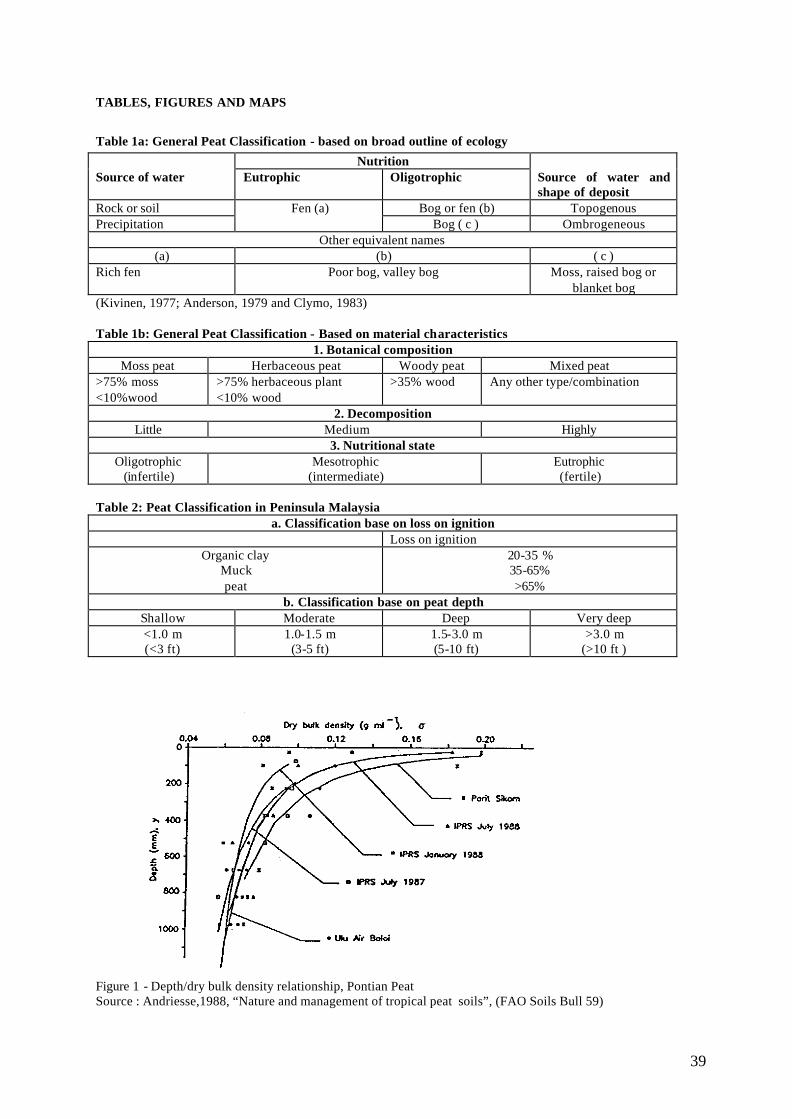
39
TABLES, FIGURES AND MAPS
Table 1a: General Peat Classification - based on broad outline of ecology
Nutrition Source of water Eutrophic Oligotrophic Source of water and
shape of deposit Rock or soil Bog or fen (b) Topogenous Precipitation
Fen (a) Bog ( c ) Ombrogeneous
Other equivalent names (a) (b) ( c )
Rich fen Poor bog, valley bog Moss, raised bog or blanket bog
(Kivinen, 1977; Anderson, 1979 and Clymo, 1983) Table 1b: General Peat Classification - Based on material characteristics
1. Botanical composition Moss peat Herbaceous peat Woody peat Mixed peat
>75% moss <10%wood
>75% herbaceous plant <10% wood
>35% wood Any other type/combination
2. Decomposition Little Medium Highly
3. Nutritional state Oligotrophic
(infertile) Mesotrophic
(intermediate) Eutrophic (fertile)
Table 2: Peat Classification in Peninsula Malaysia
a. Classification base on loss on ignition Loss on ignition
Organic clay Muck peat
20-35 % 35-65% >65%
b. Classification base on peat depth Shallow Moderate Deep Very deep <1.0 m (<3 ft)
1.0-1.5 m (3-5 ft)
1.5-3.0 m (5-10 ft)
>3.0 m (>10 ft )
Figure 1 - Depth/dry bulk density relationship, Pontian Peat Source : Andriesse,1988, “Nature and management of tropical peat soils”, (FAO Soils Bull 59)
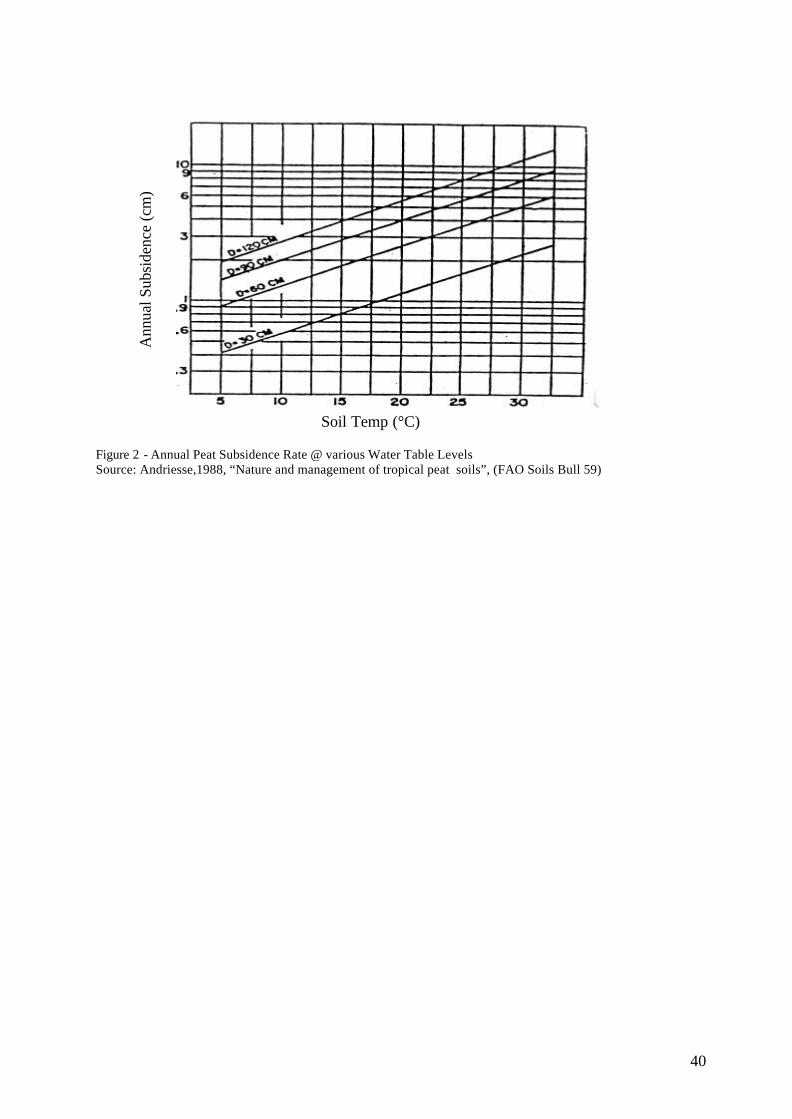
40
Figure 2 - Annual Peat Subsidence Rate @ various Water Table Levels Source: Andriesse,1988, “Nature and management of tropical peat soils”, (FAO Soils Bull 59)
Ann
ual S
ubsi
denc
e (c
m)
Soil Temp (°C)
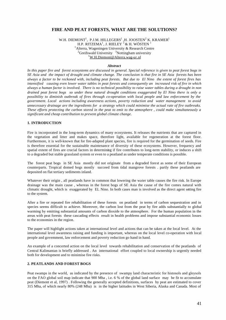
41
FIRE AND PEAT FORESTS, WHAT ARE THE SOLUTIONS?
W.H. DIEMONT1, P.J.M. HILLEGERS1 ,H. JOOSTEN2 K. KRAMER1 H.P. RITZEMA1, J. RIELEY 3 & H. WÖSTEN 1
1Alterra, Wageningen University & Research Centre 2Greifswald University 3Nottingham university
Abstract In this paper fire and forest ecosystems are discussed in general. Special reference is given to peat forest bogs in SE Asia and the impact of drought and climate change. The conclusion is that fire in SE Asia forests has been always a factor to be reckoned with, including peat forests. But due to El Nino the extent of forest fires has intensified causing even lower water tables in peat forests and consequently an increased risk of fire in which always a human factor is involved. There is no technical possibility to raise water tables during a drought in non drained peat forest bogs so under these natural drought conditions exaggerated by El Nino there is only a possibility to diminish outbreak of fires through co-operation with local people and law enforcement by the government. Local actions including awareness actions, poverty reduction and water management to avoid unnecessary drainage are the ingredients for a strategy which could minimise the actual rate of fire outbreaks. These efforts protecting the carbon stored in the peat to emit to the atmosphere , could make simultaneously a significant and cheap contribution to prevent global climate change. 1. INTRODUCTION Fire is incorporated in the long-term dynamics of many ecosystems. It releases the nutrients that are captured in the vegetation and litter and makes space, therefore light, available for regeneration at the forest floor. Furthermore, it is well-known that for fire-adapted plant species, fire is required for the germination of seeds. Fire is therefore essential for the sustainable maintenance of diversity of these ecosystems. However, frequency and spatial extent of fires are crucial factors in determining if fire contributes to long-term stability, or induces a shift to a degraded but stable grassland system or even to a peatland as under temperate conditions is possible. The forest peat bogs in SE Asia mostly did not originate from a degraded forest as some of their European counterparts. Tropical domed bogs mostly succeed from tidal mangrove forests . partly these peatlands are deposited on flat tertiary sediments inland. Whatever their origin , all peatlands have in common that lowering the water table causes the fire risk. In Europe drainage was the main cause , whereas in the forest bogs of SE Asia the cause of the fire comes natural with climatic drought, which is exaggerated by EL Nino. In both cases man is involved as the direct agent setting fire to the system. After a fire or repeated fire rehabilitation of these forests on peatland in terms of carbon sequestration and in species seems difficult to achieve. Moreover, the carbon lost from the peat by fire adds substantially to global warming by emitting substantial amounts of carbon dioxide to the atmosphere. For the human population in the areas with peat forests these cascading effects result in health problems and impose substantial economic losses to the economies in the region. The paper will highlight actions taken at international level and actions that can be taken at the local level. At the international level awareness raising and funding is important, whereas on the local level co-operation with local people and government, law enforcement and poverty reduction go hand in hand. An example of a concerted action on the local level towards rehabilitation and conservation of the peatlands of Central Kalimantan is briefly addressed . An international effort coupled to local ownership is urgently needed both for development and to minimise fire risks. 2. PEATLANDS AND FOREST BOGS Peat swamps in the world, as indicated by the presence of swampy land characteristic for histosols and gleysols on the FAO global soil map indicate that 900 Mha , i.e. 6 % of the global land surface may be fit to accumulate peat (Diemont et al, 1997) . Following the generally accepted definitions, surfaces by peat are estimated to cover 315 Mha, of which nearly 80% (248 Mha) is in the higher latitudes in West Siberia, Alaska and Canada. Most of
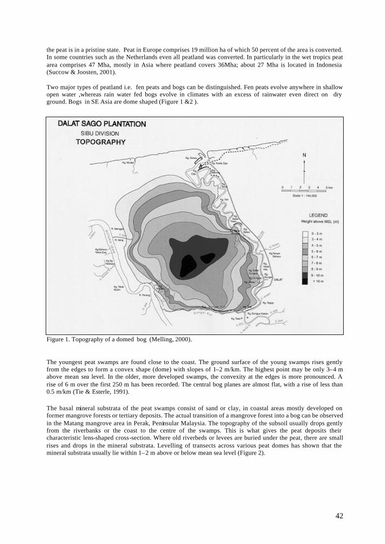
42
the peat is in a pristine state. Peat in Europe comprises 19 million ha of which 50 percent of the area is converted. In some countries such as the Netherlands even all peatland was converted. In particularly in the wet tropics peat area comprises 47 Mha, mostly in Asia where peatland covers 36Mha; about 27 Mha is located in Indonesia (Succow & Joosten, 2001). Two major types of peatland i.e. fen peats and bogs can be distinguished. Fen peats evolve anywhere in shallow open water ,whereas rain water fed bogs evolve in climates with an excess of rainwater even direct on dry ground. Bogs in SE Asia are dome shaped (Figure 1 &2 ). Figure 1. Topography of a domed bog (Melling, 2000).
The youngest peat swamps are found close to the coast. The ground surface of the young swamps rises gently from the edges to form a convex shape (dome) with slopes of 1–2 m/km. The highest point may be only 3–4 m above mean sea level. In the older, more developed swamps, the convexity at the edges is more pronounced. A rise of 6 m over the first 250 m has been recorded. The central bog planes are almost flat, with a rise of less than 0.5 m/km (Tie & Esterle, 1991). The basal mineral substrata of the peat swamps consist of sand or clay, in coastal areas mostly developed on former mangrove forests or tertiary deposits. The actual transition of a mangrove forest into a bog can be observed in the Matang mangrove area in Perak, Peninsular Malaysia. The topography of the subsoil usually drops gently from the riverbanks or the coast to the centre of the swamps. This is what gives the peat deposits their characteristic lens-shaped cross-section. Where old riverbeds or levees are buried under the peat, there are small rises and drops in the mineral substrata. Levelling of transects across various peat domes has shown that the mineral substrata usually lie within 1–2 m above or below mean sea level (Figure 2).
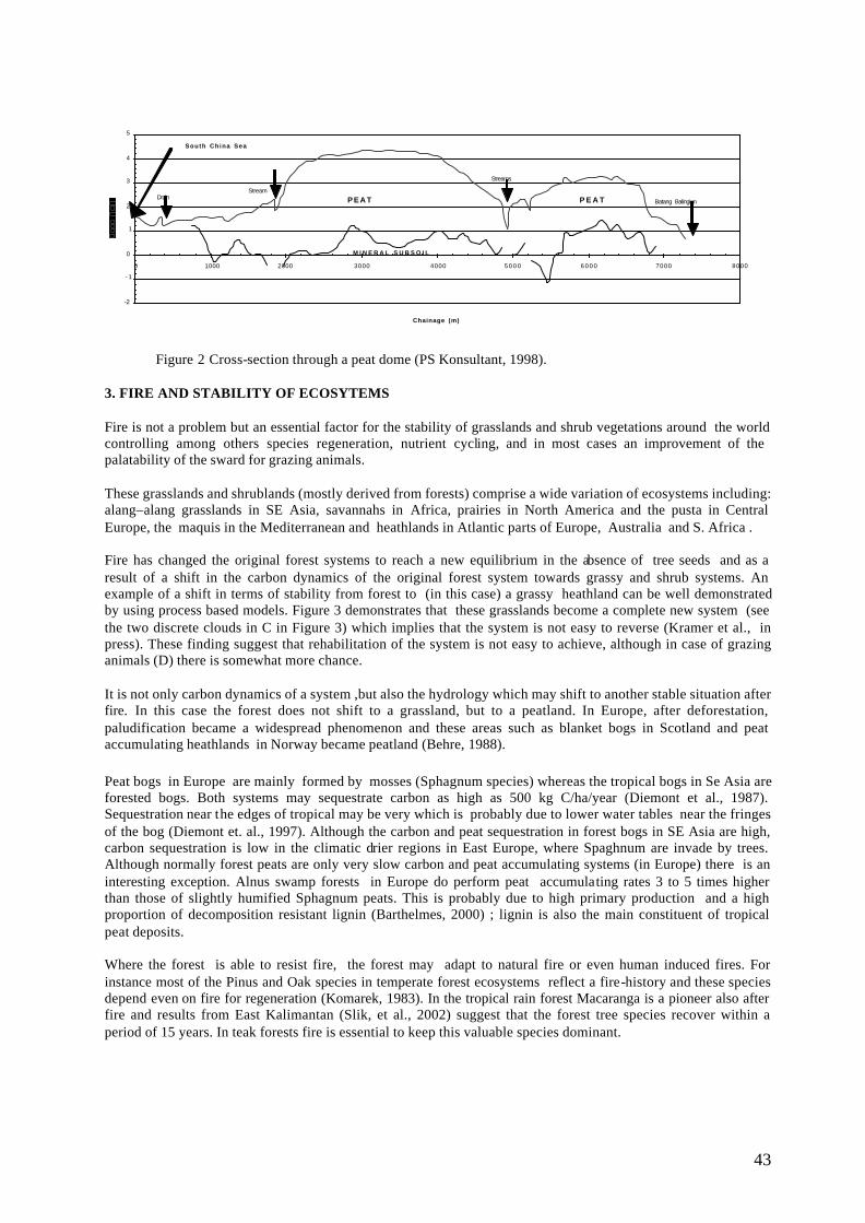
43
Figure 2 Cross-section through a peat dome (PS Konsultant, 1998). 3. FIRE AND STABILITY OF ECOSYTEMS Fire is not a problem but an essential factor for the stability of grasslands and shrub vegetations around the world controlling among others species regeneration, nutrient cycling, and in most cases an improvement of the palatability of the sward for grazing animals. These grasslands and shrublands (mostly derived from forests) comprise a wide variation of ecosystems including: alang–alang grasslands in SE Asia, savannahs in Africa, prairies in North America and the pusta in Central Europe, the maquis in the Mediterranean and heathlands in Atlantic parts of Europe, Australia and S. Africa . Fire has changed the original forest systems to reach a new equilibrium in the absence of tree seeds and as a result of a shift in the carbon dynamics of the original forest system towards grassy and shrub systems. An example of a shift in terms of stability from forest to (in this case) a grassy heathland can be well demonstrated by using process based models. Figure 3 demonstrates that these grasslands become a complete new system (see the two discrete clouds in C in Figure 3) which implies that the system is not easy to reverse (Kramer et al., in press). These finding suggest that rehabilitation of the system is not easy to achieve, although in case of grazing animals (D) there is somewhat more chance. It is not only carbon dynamics of a system ,but also the hydrology which may shift to another stable situation after fire. In this case the forest does not shift to a grassland, but to a peatland. In Europe, after deforestation, paludification became a widespread phenomenon and these areas such as blanket bogs in Scotland and peat accumulating heathlands in Norway became peatland (Behre, 1988). Peat bogs in Europe are mainly formed by mosses (Sphagnum species) whereas the tropical bogs in Se Asia are forested bogs. Both systems may sequestrate carbon as high as 500 kg C/ha/year (Diemont et al., 1987). Sequestration near the edges of tropical may be very which is probably due to lower water tables near the fringes of the bog (Diemont et. al., 1997). Although the carbon and peat sequestration in forest bogs in SE Asia are high, carbon sequestration is low in the climatic drier regions in East Europe, where Spaghnum are invade by trees. Although normally forest peats are only very slow carbon and peat accumulating systems (in Europe) there is an interesting exception. Alnus swamp forests in Europe do perform peat accumulating rates 3 to 5 times higher than those of slightly humified Sphagnum peats. This is probably due to high primary production and a high proportion of decomposition resistant lignin (Barthelmes, 2000) ; lignin is also the main constituent of tropical peat deposits. Where the forest is able to resist fire, the forest may adapt to natural fire or even human induced fires. For instance most of the Pinus and Oak species in temperate forest ecosystems reflect a fire-history and these species depend even on fire for regeneration (Komarek, 1983). In the tropical rain forest Macaranga is a pioneer also after fire and results from East Kalimantan (Slik, et al., 2002) suggest that the forest tree species recover within a period of 15 years. In teak forests fire is essential to keep this valuable species dominant.
-2
- 1
0
1
2
3
4
5
0 1000 2000 3000 4000 5 0 0 0 6 0 0 0 7000 8000
Chainage (m)
DrainStream
Streams
Batang BalingianP E A T P E A T
M I N E R A L S U B S O I L
South China Sea
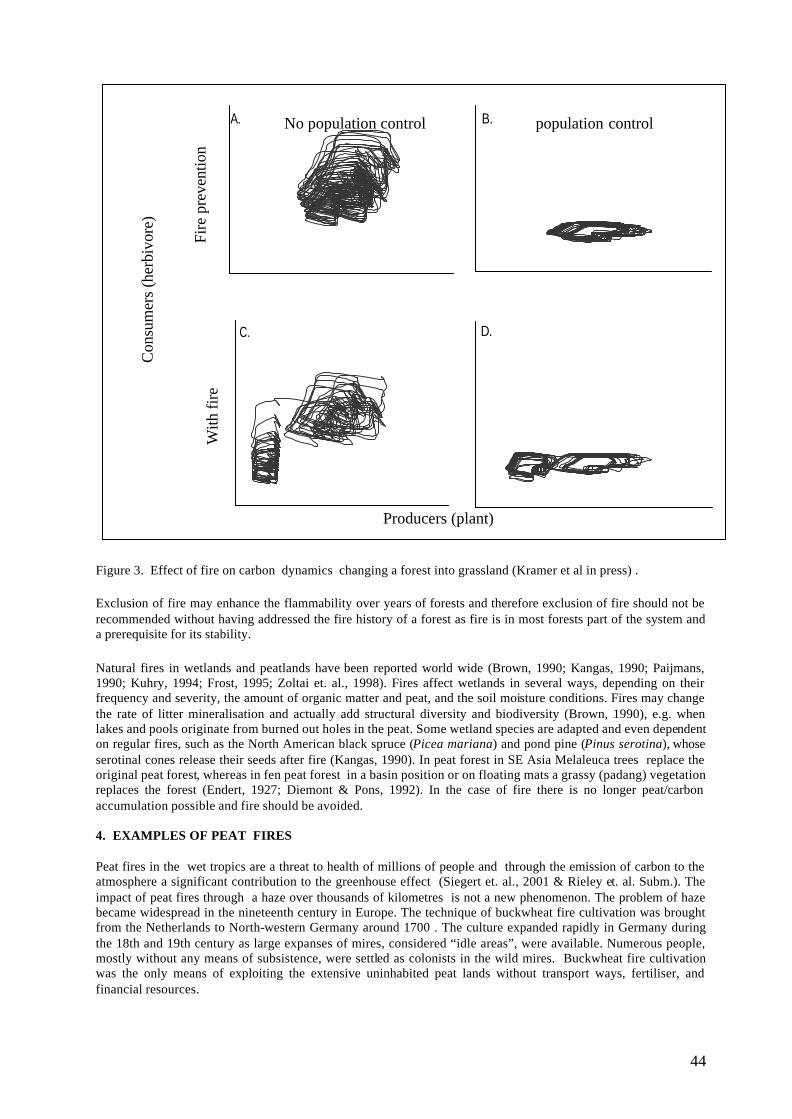
44
Figure 3. Effect of fire on carbon dynamics changing a forest into grassland (Kramer et al in press) . Exclusion of fire may enhance the flammability over years of forests and therefore exclusion of fire should not be recommended without having addressed the fire history of a forest as fire is in most forests part of the system and a prerequisite for its stability. Natural fires in wetlands and peatlands have been reported world wide (Brown, 1990; Kangas, 1990; Paijmans, 1990; Kuhry, 1994; Frost, 1995; Zoltai et. al., 1998). Fires affect wetlands in several ways, depending on their frequency and severity, the amount of organic matter and peat, and the soil moisture conditions. Fires may change the rate of litter mineralisation and actually add structural diversity and biodiversity (Brown, 1990), e.g. when lakes and pools originate from burned out holes in the peat. Some wetland species are adapted and even dependent on regular fires, such as the North American black spruce (Picea mariana) and pond pine (Pinus serotina), whose serotinal cones release their seeds after fire (Kangas, 1990). In peat forest in SE Asia Melaleuca trees replace the original peat forest, whereas in fen peat forest in a basin position or on floating mats a grassy (padang) vegetation replaces the forest (Endert, 1927; Diemont & Pons, 1992). In the case of fire there is no longer peat/carbon accumulation possible and fire should be avoided. 4. EXAMPLES OF PEAT FIRES Peat fires in the wet tropics are a threat to health of millions of people and through the emission of carbon to the atmosphere a significant contribution to the greenhouse effect (Siegert et. al., 2001 & Rieley et. al. Subm.). The impact of peat fires through a haze over thousands of kilometres is not a new phenomenon. The problem of haze became widespread in the nineteenth century in Europe. The technique of buckwheat fire cultivation was brought from the Netherlands to North-western Germany around 1700 . The culture expanded rapidly in Germany during the 18th and 19th century as large expanses of mires, considered “idle areas”, were available. Numerous people, mostly without any means of subsistence, were settled as colonists in the wild mires. Buckwheat fire cultivation was the only means of exploiting the extensive uninhabited peat lands without transport ways, fertiliser, and financial resources.
B.A.
D.C.
Fire
pre
vent
ion
With
fire
Con
sum
ers
(her
bivo
re)
No population control population control
Producers (plant)
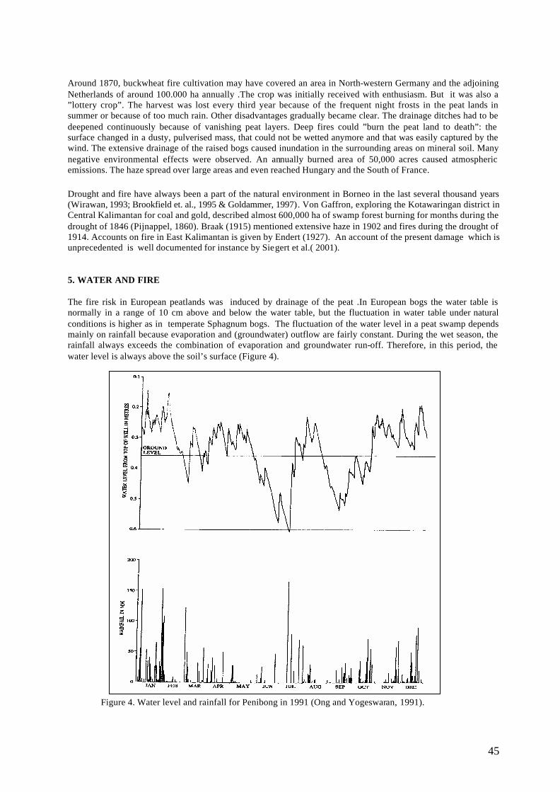
45
Around 1870, buckwheat fire cultivation may have covered an area in North-western Germany and the adjoining Netherlands of around 100.000 ha annually .The crop was initially received with enthusiasm. But it was also a ”lottery crop”. The harvest was lost every third year because of the frequent night frosts in the peat lands in summer or because of too much rain. Other disadvantages gradually became clear. The drainage ditches had to be deepened continuously because of vanishing peat layers. Deep fires could ”burn the peat land to death”: the surface changed in a dusty, pulverised mass, that could not be wetted anymore and that was easily captured by the wind. The extensive drainage of the raised bogs caused inundation in the surrounding areas on mineral soil. Many negative environmental effects were observed. An annually burned area of 50,000 acres caused atmospheric emissions. The haze spread over large areas and even reached Hungary and the South of France. Drought and fire have always been a part of the natural environment in Borneo in the last several thousand years (Wirawan, 1993; Brookfield et. al., 1995 & Goldammer, 1997). Von Gaffron, exploring the Kotawaringan district in Central Kalimantan for coal and gold, described almost 600,000 ha of swamp forest burning for months during the drought of 1846 (Pijnappel, 1860). Braak (1915) mentioned extensive haze in 1902 and fires during the drought of 1914. Accounts on fire in East Kalimantan is given by Endert (1927). An account of the present damage which is unprecedented is well documented for instance by Siegert et al.( 2001). 5. WATER AND FIRE The fire risk in European peatlands was induced by drainage of the peat .In European bogs the water table is normally in a range of 10 cm above and below the water table, but the fluctuation in water table under natural conditions is higher as in temperate Sphagnum bogs. The fluctuation of the water level in a peat swamp depends mainly on rainfall because evaporation and (groundwater) outflow are fairly constant. During the wet season, the rainfall always exceeds the combination of evaporation and groundwater run-off. Therefore, in this period, the water level is always above the soil’s surface (Figure 4).
Figure 4. Water level and rainfall for Penibong in 1991 (Ong and Yogeswaran, 1991).
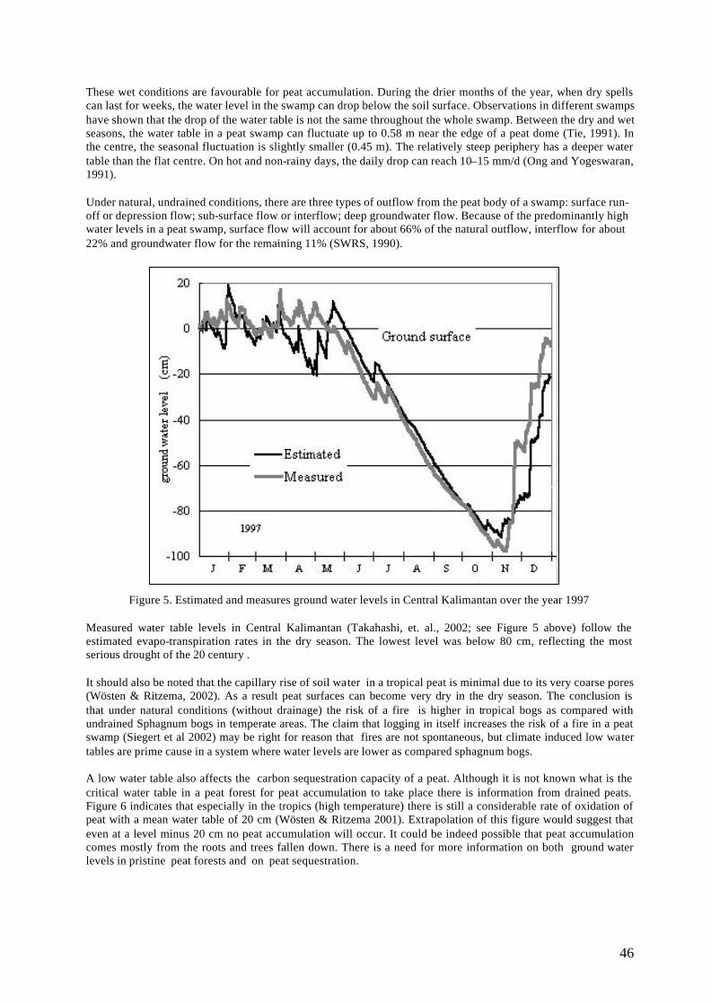
46
These wet conditions are favourable for peat accumulation. During the drier months of the year, when dry spells can last for weeks, the water level in the swamp can drop below the soil surface. Observations in different swamps have shown that the drop of the water table is not the same throughout the whole swamp. Between the dry and wet seasons, the water table in a peat swamp can fluctuate up to 0.58 m near the edge of a peat dome (Tie, 1991). In the centre, the seasonal fluctuation is slightly smaller (0.45 m). The relatively steep periphery has a deeper water table than the flat centre. On hot and non-rainy days, the daily drop can reach 10–15 mm/d (Ong and Yogeswaran, 1991). Under natural, undrained conditions, there are three types of outflow from the peat body of a swamp: surface run-off or depression flow; sub-surface flow or interflow; deep groundwater flow. Because of the predominantly high water levels in a peat swamp, surface flow will account for about 66% of the natural outflow, interflow for about 22% and groundwater flow for the remaining 11% (SWRS, 1990).
Figure 5. Estimated and measures ground water levels in Central Kalimantan over the year 1997 Measured water table levels in Central Kalimantan (Takahashi, et. al., 2002; see Figure 5 above) follow the estimated evapo-transpiration rates in the dry season. The lowest level was below 80 cm, reflecting the most serious drought of the 20 century . It should also be noted that the capillary rise of soil water in a tropical peat is minimal due to its very coarse pores (Wösten & Ritzema, 2002). As a result peat surfaces can become very dry in the dry season. The conclusion is that under natural conditions (without drainage) the risk of a fire is higher in tropical bogs as compared with undrained Sphagnum bogs in temperate areas. The claim that logging in itself increases the risk of a fire in a peat swamp (Siegert et al 2002) may be right for reason that fires are not spontaneous, but climate induced low water tables are prime cause in a system where water levels are lower as compared sphagnum bogs. A low water table also affects the carbon sequestration capacity of a peat. Although it is not known what is the critical water table in a peat forest for peat accumulation to take place there is information from drained peats. Figure 6 indicates that especially in the tropics (high temperature) there is still a considerable rate of oxidation of peat with a mean water table of 20 cm (Wösten & Ritzema 2001). Extrapolation of this figure would suggest that even at a level minus 20 cm no peat accumulation will occur. It could be indeed possible that peat accumulation comes mostly from the roots and trees fallen down. There is a need for more information on both ground water levels in pristine peat forests and on peat sequestration.
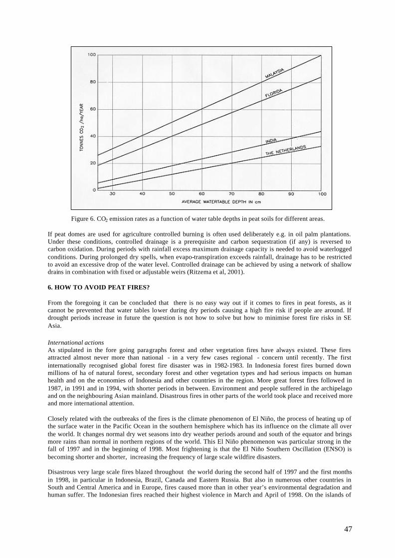
47
Figure 6. CO2 emission rates as a function of water table depths in peat soils for different areas. If peat domes are used for agriculture controlled burning is often used deliberately e.g. in oil palm plantations. Under these conditions, controlled drainage is a prerequisite and carbon sequestration (if any) is reversed to carbon oxidation. During periods with rainfall excess maximum drainage capacity is needed to avoid waterlogged conditions. During prolonged dry spells, when evapo-transpiration exceeds rainfall, drainage has to be restricted to avoid an excessive drop of the water level. Controlled drainage can be achieved by using a network of shallow drains in combination with fixed or adjustable weirs (Ritzema et al, 2001). 6. HOW TO AVOID PEAT FIRES? From the foregoing it can be concluded that there is no easy way out if it comes to fires in peat forests, as it cannot be prevented that water tables lower during dry periods causing a high fire risk if people are around. If drought periods increase in future the question is not how to solve but how to minimise forest fire risks in SE Asia. International actions As stipulated in the fore going paragraphs forest and other vegetation fires have always existed. These fires attracted almost never more than national - in a very few cases regional - concern until recently. The first internationally recognised global forest fire disaster was in 1982-1983. In Indonesia forest fires burned down millions of ha of natural forest, secondary forest and other vegetation types and had serious impacts on human health and on the economies of Indonesia and other countries in the region. More great forest fires followed in 1987, in 1991 and in 1994, with shorter periods in between. Environment and people suffered in the archipelago and on the neighbouring Asian mainland. Disastrous fires in other parts of the world took place and received more and more international attention. Closely related with the outbreaks of the fires is the climate phenomenon of El Niño, the process of heating up of the surface water in the Pacific Ocean in the southern hemisphere which has its influence on the climate all over the world. It changes normal dry wet seasons into dry weather periods around and south of the equator and brings more rains than normal in northern regions of the world. This El Niño phenomenon was particular strong in the fall of 1997 and in the beginning of 1998. Most frightening is that the El Niño Southern Oscillation (ENSO) is becoming shorter and shorter, increasing the frequency of large scale wildfire disasters. Disastrous very large scale fires blazed throughout the world during the second half of 1997 and the first months in 1998, in particular in Indonesia, Brazil, Canada and Eastern Russia. But also in numerous other countries in South and Central America and in Europe, fires caused more than in other year’s environmental degradation and human suffer. The Indonesian fires reached their highest violence in March and April of 1998. On the islands of
48
Sumatra and Borneo millions ha of grasslands, degraded and logged-over forests and to lesser extend primary forest burned, including large areas of peat swamp forests. Fire disaster response Especially because of the haze caused by the fires and its effects on human health and on the regional and national economies the forest fires became a hot item on the international, regional and national agendas. National and international intergovernmental organisations, as well as NGO’s, are very concerned and have launched many activities to mitigate the impacts of the fire. UN organisations are responding according to their mandates. For the United Nations the Office of the Co-ordination of Humanitarian Affairs (OCHA) and the United Nations Environment Programme (UNEP) are responsible for the disaster response. Their task is to monitor closely fire disaster situations and stay in close contact with the national authorities through the Joint UNEP/OCHA Environment Unit (Joint Unit). In 1997 and 1998 they have sent disaster assessment and co-ordination missions to Indonesia and Brazil. The Executive Director of UNEP was requested by the UN Secretary General to co-ordinate the UN system’s response to the forest fires. FAO, WHO, WMO, UNESCO, UNDP, ICRAF and CIFOR mobilised their own capabilities. The haze pollution problems caused by the fires in Indonesia became major issue on the agenda of frequent meetings of the ASEAN ministers of environment. Many governments contributed money or made in kind donations. Unilateral organisations, international NGO’s , bilateral assistance agencies and National Governments launched a variety of aid and support programmes. A strategic plan for immediate, mid-term and long term actions was developed after the 1997/98 fires. The plan concentrates primarily on Indonesia and South East Asia, while offering opportunities for expansion at the global level. It consists of a series of activities addressing the need for immediate response to fire emergencies, an early warning system, and public awareness. I. FIRE STRATEGY FOR SOUTH EAST ASIA A. Immediate response to the fire emergency in South East Asia
1. Expert meeting to develop a short-term action plan to combat fires in Indonesia 2. Implementation of a short-term action plan to combat fires in Indonesia
B. Early Warning System for South East Asia 1. Workshop on the design of an early warning system for South East Asia 2. Establishment of an early warning system for South East Asia
II. GLOBAL FIRE STRATEGY FOR THE 21ST CENTURY A. Global action plan to address fire emergencies
1. International Conference on fire fighting and conservation 2. Implementation of a global action plan to address fire emergencies
B. Global Fire Watch 1. Expert workshop to design a Global Fire Watch 2. Establishment and maintenance of the Global Fire Watch
C. Public Awareness 1. Expert meeting on raising public awareness on fire risks 2. Implementation of the medium term action plan
Major problems Experiences of earlier emergency responses and the great variety of current actions taken by the numerous organisations involved, show that there are some problems to be resolved with regard to medium- and long-term strategies and action plans for fire prevention, preparedness and restoration of damage and losses, linked to short-term emergency response. Major problems to work on are:
1. Early warning system. Development of an efficient early warning system based on a strong information, monitoring and assessment capability.
2. Co-ordination of UN organisations with regard to medium- and long-term activities. Given the multiple
actions by concerned UN organisations, it is essential that a co-ordinated , comprehensive approach is taken. Responsibilities should be clearly delineated, roles of organisations defined, and overlaps identified and allowed for partnership. Creating and strengthening global, regional, national, provincial
49
and local alliances to prevent and combat environmental disasters arising from land, brush and forest fires. This calls for a closer co-operation between government organisations, NGO’s and the private sector.
Local actions The most important action to be taken on the grass root level is in particular, in poor areas, is to get a local commitment, which must be balanced by international funding in order to replace income of people from peat forest, people who are trapped in a “system of impoverishment” and get part if not all of their income from forest resources which should be protected from fire, for biodiversity reasons and to avoid carbon emission. In peatland set aside for agriculture, water management should be in place in order to minimise carbon emission and decrease fire risks. At present the EU project “STRAPEAT” and teams from WWF, CIDA, CARE are present in Central Kalimantan. One of the most extensive peatland areas in the province of Central Kalimantan with 4 to 4 million ha of peatland including the former Mega Rice Project area and the Sebangau watershed with a large population of Orang Utan. The commitment of the local people to conserve the forest and to rehabilitate the peatland former Mega Rice project and the role of the international community will be briefly discussed during the presentation. REFERENCES Barthelmes, A. 2000. Paläoökologische Untersuchungen zur Entstehung von bruchwaldtorfen. Diplomarbeit
Greifswald University, Germany. Behre, K.E. 1988. The role of man in European vegetation history . In : Huntley ,B. & Webb,T.III (eds.)
Vegetation history. Kluwer Academic Press 803pp. Braak, C. (1915) De sterke nevel in de oostmoesson van 1914. Natuurkundig Tijdschrift voor Nederlandsch Indie
74: 131 - 140. Brookfield, H., Potter, L. & Byron, Y. 1995. In Place of the Forest. Environmental and Socio-economic
Transformation in Borneo and the Eastern Malay Peninsula. United Nations University Press, Tokyo - New York – Paris.
Brown, S. 1990. Structure and dynamics of basin forested wetlands in North America. In Forested Wetlands (eds.) A.E. Lugo, M. Brinson & S. Brown, Ecosystems of the World 15, pp. 171 - 199, Elsevier, Amsterdam.
Diemont, W.H. & L.J. Pons. 1992. A preliminary note on peat formation and gleying in the Mahakam inland floodplain, East Kalimantan ,Indonesia. In B.Y. Aminuddin & S.L. Tan (eds.). Tropical Peat: Proceedings of the International Symposium on Tropical Peatlands 6-10 May 1991, Kuching, Sarawak, Malaysia.
Diemont, W.H., G.J. Nabuurs, J.O. Rieley & H.D. Rijksen. 1997. Climate change and management of tropical peatlands as carbon reservoir. In: Tropical peatlands. J.O. Rieley & S.E. Page (eds.): 363-368. Samara Publ. Lim. Cardigan.
Driessen, P.M. 1978. Peat soils. Soils and Rice, pp. 763-779. IRRI, Los Banos Philippines. Endert, F.H. 1927. Floristisch verslag van de Midden Oost Borneo expeditie 1925. Indisch Comite voor
Wetenschappelijke Onderzoekingen. p.200-312. Evelyn, J. 1661. Fumifugium or The Inconvenience of the Air and Smoke of London dissipated. Together With
some Remedies humbly Proposed By J.E. Esq; To His Sacred Majesty, And To the PARLIAMENT now Assembled.W.Godbid, London. www.geocities.com/Paris/LeftBank/1914/fumifug.html
Frost, C.C. 1995. Pre -settlement fire regimes in south eastern marshes, peatlands and swamps. In Fire in wetlands: a management perspective (ed. S.I. Cerulean & R.T. Engstrom), pp. 39 – 60, Tall Timbers Research Station, Tallahassee
Goldammer, J. G. 1997. The Role of Fire on Greenhouse Gas and Aerosol Emissions and Land Use and Cover Change in Southeast Asia: Ecological Background and Research Needs . International Conference on Science and Technology for the Assessment of Global Environmental Change and its Impacts on the Indonesian Maritime Continent, Jakarta, Indonesia, 10-12 November 1997
Kangas, P.C. (1990) Long-term development of forested wetlands. In Forested wetlands (eds. A.E. Lugo, M. Brinson & S. Brown), pp. 25 - 51, Ecosystems of the World 15, Elsevier, Amsterdam.
Komarek, E.V. 1983. Fire as an anthropogenic factor in vegetation ecology. In W. Holzner, M.J.A. Werger & I. Ikusima (eds.) Man‘s impact on vegetation. W. Junk Publishers 370pp.
Kramer, K., I.T.M. Jorritsma & T.A.Groen. Effects of the interactions between ungulates on forest dynamics at different spatial scales using the model FORSPACE. Submitted
50
Kuhry, P. (1994) The role of fire in the development of Sphagnum-dominated peatlands in western boreal Canada. Journal of Ecology 82: 899 - 910.
Melling, L. 2000. Dalat and Mukah sago plantation peat soil study. Final Report. Soil Branch, Department of Agriculture Sarawak.
Ong, B.Y. and Yogeswaran, M., 1991. Peatland as a resource for water supply in Sarawak . Proceedings of the International Symposium on Tropical Peatland. Kuching, Sarawak.
Paijmans, K. 1990. Wooded swamps in New Guinea. In Forested Wetlands (eds.) A.E. Lugo, M. Brinson & S. Brown. pp. 335 - 355, Ecosystems of the World 15, Elsevier, Amsterdam.
Pijnappel, J. 1860. Beschrijving van het Westelijke Gedeelte van de Zuider-en Oosterafdeeling van Borneo (De Afdeeling Sampit en de Zuidkust). Bijdragen tot de Taal-, Land- en Volkenkunde 3: 243-346.
PS Konsultant 1998. Detailed Design and Construction Supervision of Flood Protection and Drainage Facilities for Balingian RGC Agricultural Development Project, Sibu Division, Sarawak (Inception Report), Department of Irrigation and Drainage, Kuching. pp.24.
Ritzema, H.P., Tom K.F. Chong and Tie Y.L. 2001. Water Management Guidelines for Agricultural Development in Peatland. Proceedings Workshop on Water Management for sustainable Agricultural Development of Peatland, 28-29 March 2001, Kuching, Sarawak, Malaysia.
Sarawak Water Resources Council,1997. Sarawak Water Resources Study Projects - Final Report submitted by PS Konsultant, Montgomery Watson, Australia, The Centre for Water Research (CWR).
Siegert, F., G. Ruecker, A. Hinrichs & A.A. Hoffmann. 2001. Increased damage from fires in logged forests during droughts caused by El Nino. Nature vol 414437-440.
Slik, J.W. ,F. R.W. Verburg & P.J.A. Kessler. 2002. Effects of fire and selective logging on the tree species composition of lowland dipterocarp forest in East Kalimantan, Indonesia. Biodiversity and Conservation: 85-98.
Succow, M. & H. Joosten. Landschaftökolgische Moorkunde. 2001. E. Schweizerbert’sche Verlagsbuchhandlung, Stuttgart. 662 pp.
Takahashi, H. S. Shimada, B.F. Ibie, Usup, A , Yudha & S.H. Limin. 2002. Annual changes of water balance and a drought index in a tropical peat swamp forest of Central Kalimantan, Indones ia. International Peat Journal. In press.
Tie, Y.L. and Esterle, J.S., 1991. Formation of lowland peat domes in Sarawak, Malaysia. Proceedings of the International Symposium on Tropical Peatland. Kuching, Sarawak.
Wirawan, N. (1993) The hazard of fire. . In: South-East Asia’s environmental future - the search for sustainability (ed. H. Brookfield & Y. Byron). United Nations University Press, Tokyo – New York – Paris.
Wösten, H & H.Ritzema.2002. Land and water management options for peatland development in Sarawak. International Peatland Journal . In press.
Zoltai, S.C., Morrissey, L.A., Livingston, G.P. & De Groot, W.J. (1998) Effects of fires on carbon cycling in North American boreal peatlands. Environmental Reviews 6: 13 - 24.
51
HYDROLOGICAL ATTRIBUTES OF A DISTURBED PEAT SWAMP FOREST
ZULKIFLI YUSOP Universiti Teknologi Malaysia
Abstract The water table and water balance of disturbed North Selangor Peat Swamp Forest (NSPSF) were studied over a period of seven months. The water table showed a lowering trend during the onset of dry period from February to June. Lower water tables were observed near the canal, but increase gradually to the inner sites. The draw-down effect could go beyond 700 meters from the canal. On an average, the NSPSF contributes about 11% of the total water in the main irrigation canal. The larger source, 89% is diverted from the Bernam River. The forest yields less flow during dry days and accounts for only 8% of the total flow, compared to 17% during rainy days. Based on rather limited data for water balance analysis, the runoff amounted to 146 mm/yr or about 6% of the annual rainfall. The corresponding values for ground water recharge and evapotranspiration loss were 29% and 65% of the rainfall, respectively. It seems that the presence of extensive canals leads to rapid evacuation of excess water from the forest. This results in a faster rate of soil moisture depletion during dry periods. Consequently, the soil is dryer and probably more prone to fire compared to situations where such canals do not exist. INTRODUCTION Forest fire has been increasingly recognised as one of the major threats to the remaining peat swamp forests in this region. Due to the inherent characteristics of the peat soil, disturbed peat swamp forests are highly susceptible to fire especially during a prolonged dry season. Like any other wetland, the bio-physical and geochemical processes as well as the functioning of peat swamp forests are very much controlled by its hydrological regimes (Mitsch and Gosselink, 1993). The hydrology also controls abiotic activities that are important for soil anaerobiosis and nutrient availability. These factors subsequently determine the type of fauna and flora that inhabit the ecosystem. During wet seasons, undisturbed peat swamp forests act as a natural flood control structure for the downstream catchments. Peat swamp forests temporarily store the excess runoff, lengthening the time to peak and lowering the peak discharge The excess water is then released slowly, thereby sustaining the baseflow. Besides the provision and maintenance of surface water, it also recharges groundwater aquifer. Under pristine conditions, the ecosystem is able to maintain and protect the ecological balance even under extreme climatic events. Human disturbances on these sensitive ecosystems seem to break this ecological balance, resulting in adverse environmental consequences, particularly food at downstream and frequent forest fire. Therefore, hydrological knowledge of peat swamp forests is crucial to sustainably manage the ecosystem. This paper presents the water balance analysis and water table fluctuation based on seven months observation in the North Selangor Peat Swamp Forest (NSPSF). THE NORTH SELANGOR PEAT SWAMP FOREST (NSPSF) The NSPSF is located on a flat coastal plain in the northwest of the State of Selangor (Figure 1). It consists of the Raja Musa and Sungai Karang Forest Reserves covering a total area of about 72,800 ha. The land-use adjoining the forest reserve is the Tanjong Karang Irrigation Scheme to the south-west and west, oil palm stands to the north and north-west, and Rhinoceros Rehabilitation Centre to the east. Prior to the gazettement as forest reserves, the forest was originally a state land. Logging operation has resulted in extensive construction of canals for extracting logs. The forest is separated from the irrigation scheme to the south-west by the main irrigation canal whereas the Bernam River forms the northern boundary. The peat swamp forests together with the upper Bernam catchments are important sources of water for domestic and irrigation uses. The peat depth ranges from 1.3 m at the southern edge to the deepest of 7.0 m toward the north (Hahn- Schilling, 1994; Zulkifli et al., 1999). The mean annual rainfall varies from 1750 mm along the coastal belt in the southwest to 2750 mm in the inland. The rainfall pattern shows two distinct peaks, generally in the months of April-May and November-December, coincided with the on-set of the southwest and northeast monsoons, respectively. Dry months generally fall in February-March and June-August. The mean annual temperature is 28oC and the relative humidity is 77%. Average pan evaporation at Kuala Kubu, about 60 km to the south-west is 1907 mm/yr.
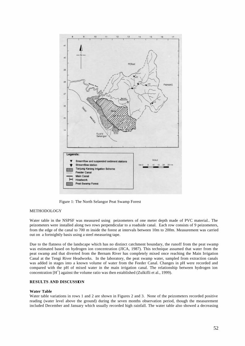
52
Figure 1: The North Selangor Peat Swamp Forest METHODOLOGY Water table in the NSPSF was measured using peizometers of one meter depth made of PVC material.. The peizometers were installed along two rows perpendicular to a roadside canal. Each row consists of 9 peizometers, from the edge of the canal to 700 m inside the forest at intervals between 10m to 200m. Measurement was carried out on a fortnightly basis using a steel measuring tape. Due to the flatness of the landscape which has no distinct catchment boundary, the runoff from the peat swamp was estimated based on hydrogen ion concentration (JICA, 1987). This technique assumed that water from the peat swamp and that diverted from the Bernam River has completely mixed once reaching the Main Irrigation Canal at the Tengi River Headworks. In the laboratory, the peat swamp water, sampled from extraction canals was added in stages into a known volume of water from the Feeder Canal. Changes in pH were recorded and compared with the pH of mixed water in the main irrigation canal. The relationship between hydrogen ion concentration [H+] against the volume ratio was then established (Zulkifli et al., 1999). RESULTS AND DISCUSSION Water Table Water table variations in rows 1 and 2 are shown in Figures 2 and 3. None of the peizometers recorded positive reading (water level above the ground) during the seven months observation period, though the measurement included December and January which usually recorded high rainfall. The water table also showed a decreasing
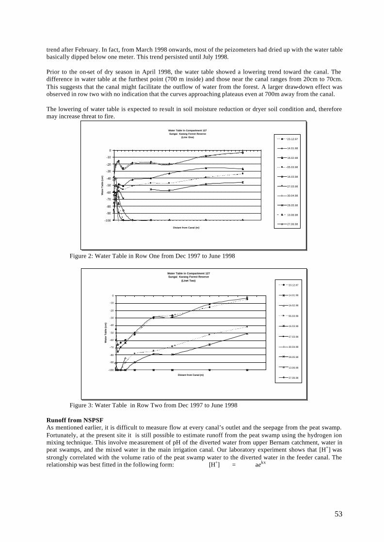
53
trend after February. In fact, from March 1998 onwards, most of the peizometers had dried up with the water table basically dipped below one meter. This trend persisted until July 1998. Prior to the on-set of dry season in April 1998, the water table showed a lowering trend toward the canal. The difference in water table at the furthest point (700 m inside) and those near the canal ranges from 20cm to 70cm. This suggests that the canal might facilitate the outflow of water from the forest. A larger draw-down effect was observed in row two with no indication that the curves approaching plateaus even at 700m away from the canal. The lowering of water table is expected to result in soil moisture reduction or dryer soil condition and, therefore may increase threat to fire.
Water Table in Compartment 127 Sungai Karang Forest Reserve
(Line One)
-100
-90
-80
-70
-60
-50
-40
-30
-20
-10
0
Distant from Canal (m)
Wat
er T
able
(cm
)
23.12.97
14.01.98
16.02.98
05.03.98
16.03.98
27.03.98
30.04.98
28.05.98
13.06.98
27.06.98
Figure 2: Water Table in Row One from Dec 1997 to June 1998
Water Table in Compartment 127Sungai Karang Forest Reserve
(Linet Two)
-100
-90
-80
-70
-60
-50
-40
-30
-20
-10
0
Distant from Canal (m)
Wat
er T
able
(cm
)
23.12.97
14.01.98
16.02.98
05.03.98
16.03.98
27.03.98
30.04.98
28.05.98
13.06.98
27.06.98
Figure 3: Water Table in Row Two from Dec 1997 to June 1998
Runoff from NSPSF As mentioned earlier, it is difficult to measure flow at every canal’s outlet and the seepage from the peat swamp. Fortunately, at the present site it is still possible to estimate runoff from the peat swamp using the hydrogen ion mixing technique. This involve measurement of pH of the diverted water from upper Bernam catchment, water in peat swamps, and the mixed water in the main irrigation canal. Our laboratory experiment shows that [H+] was strongly correlated with the volume ratio of the peat swamp water to the diverted water in the feeder canal. The relationship was best fitted in the following form: [H+] = aekx
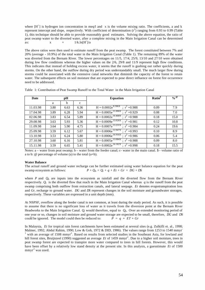
54
where [H+] is hydrogen ion concentration in meq/l and x is the volume mixing ratio. The coefficients, a and k represent intercept and slope, respectively. With coefficient of determination (r2) ranging from 0.93 to 0.99 (Table 1), this technique should be able to provide reasonably good estimates. Solving the above equation, the ratio of peat swamp water to the diverted water, after a complete mixing in the Main Irrigation Canal can be determined as: x = 1/k.ln[H+]/a The above ratios were then used to estimate runoff from the peat swamp. The forest constituted between 7% and 20% (average - 10.9%) of the total water in the Main Irrigation Canal (Table 1). The remaining 89% of the water was diverted from the Bernam River. The lower percentages on 11/5, 17/4, 25/9, 13/10 and 27/10 were obtained during low flow conditions whereas the higher values on the 2/6, 29/8 and 11/9 represent high flow conditions. This indicates that instead of holding excess water, it seems that the runoff is gushing out rather quickly during storms. On the other hand, the outflow during dry period was understandably small. The much larger flow during storms could be associated with the extensive canal networks that diminish the capacity of the forest to retain water. The subsequent effects on soil moisture that are expected to pose direct influence on forest fire occurrence need to be addressed. Table 1: Contribution of Peat Swamp Runoff to the Total Water in the Main Irrigation Canal
Date pH a b c
Equation Ratio$ %@
11.03.98 3.80 6.63 6.36 H = 0.0002e8.586X ; r2 =0.988 0.09 7.9 17.04.98 3.89 6.28 5.94 H = 0.0005e11.006X ; r2 =0.929 0.08 7.0 02.06.98 3.83 6.54 5.89 H = 0.0002e10.468X ; r2 =0.988 0.18 15.0 29.08.98 3.63 5.93 5.36 H = 0.0009e13.026X ; r2 =0.981 0.12 10.8 11.09.98 3.64 5.90 4.75 H = 0.0007e13.231X ; r2 =0.984 0.24 19.6 25.09.98 3.59 6.12 5.67 H = 0.0006e12.947X ; r2 =0.993 0.10 8.9 13.10.98 3.53 6.24 5.80 H = 0.0006e16.916X ; r2 =0.986 0.06 5.4 27.10.98 3.60 6.16 5.81 H = 0.0005e13.084X ; r2 =0.988 0.09 8.0 15.11.98 3.59 6.65 5.41 H = 0.0002e16.182X ; r2 =0.998 0.18 15.5
Notes: a – water from peat swamp; b – water from the feeder canal; c- water in the main canal. $ - volume ratio of a to b: @ percentage of volume (a) to the total (a+b). Water Balance The actual runoff and ground water recharge can be further estimated using water balance equation for the peat swamp ecosystem as follows: P + Qb = Qt + q + Et + Gr + ∆G + ∆S
where P and Qb are inputs into the ecosystem as rainfall and the diverted flow from the Bernam River respectively. Qt is the diverted flow that reach in the Main Irrigation Canal whereas q is the runoff from the peat swamp comprising both outflow from extraction canals, and lateral seepage. Et denotes evapotranspiration loss and Gr, recharge to ground water. ∆G and ∆S represent changes in the soil moisture and groundwater storages, respectively. These variables are expressed in a unit depth (mm). At NSPSF, overflow along the feeder canal is not common, at least during the study period. As such, it is possible to assume that there is no significant loss of water as it travels from the diversion point at the Bernam River Headworks to the Main Irrigation Canal. Qt would therefore, equal to Qb. Over an extended monitoring period of one year or so, changes in soil moisture and ground water storage are expected to be small, therefore, ∆G and ∆S could be ignored. The model could then be reduced to: P = q + ET + Gr In Malaysia, Et for tropical rain forest catchments have been estimated at several sites (e.g. Zulkifli et. al., 1998; Malmer, 1992; Abdul Rahim, 1990; Low & Goh, 1972 & DID, 1986). The values range from 1253 to 1540 mmyr-1 with an average of 1508 mmyr-1. Based on results from selected studies in the Southeast Asia, for lowland and hill forest sites, Bruijnzeel (1990) suggested an average Et of 1459 mmyr-1. Due to a higher soil moisture, trees in peat swamp forest are expected to transpire more water compared to trees in hill forests. However, this would have been offset by a relatively low stand density at the present site. In this analysis, a guesstimate Et of 1500 mmyr-1 was used.
55
The runoff from peat swamp, q as estimated from the hydrogen ion concentration constituted about 11% of the total water arriving in the Main Irrigation Canal (Qb + q). Discharge in the Feeder Canal on the earlier study by DID (1996) range from 8.75 to 32.21 m3s -1 with an average 21 m3s -1. This average was used for calculating total flow over a year. With annual rainfall 2300 mmyr-1 the estimate of ground water recharge, Gr was 654 mmyr-1 (Zulkifli et al., 1999). The analysis suggests that the bulk of water entering the peat swamp is returned back to the atmosphere through evapotranspiration that make up about 65% of the rainfall. Ground water recharge constitutes 29% and runoff into the Main Irrigation Canal about 6% of the rainfall. It is interesting to note that the peat swamp yield much smaller runoff compared to hill forest catchments. Runoff for primary and matured second growth forests on hilly or undulating catchments range from 56 to 61% of the rainfall in Sabah (Malmer, 1992) and 32 to 47% in Peninsular Malaysia (Abdul Rahim, 1990; Low and Goh, 1972 & Zulkifli et al., 1998). The low runoff could be explained in term of high hydraulic conductivity of the peat soil and its small hydraulic gradient for such a flat topography. These in turn provide greater opportunities for the excess water to percolate and contribute to groundwater recharge. CONCLUSION The NSPF is an example of a wetland ecosystem that the surrounding area has been opened and disturbed. The forest itself was quite severely logged with extensive excavation of log extraction canals. There is a clear competition for water resources. On one hand, water is needed for irrigation and on the other hand, the forest itself need water to sustain its ecological functions. Flow from the Bernam River which in the past contributed major recharge to the ecosystem especially in the north-west has been diverted to augment water requirement for irrigation. The impact of this drainage alteration on the ecology of the peat swamp is yet to be systematically assessed. However, there are already signs of ecological degradation as a result of human activities inside and surrounding the peat swamp forest. Some of the pertinent issues are
• The lower end of extraction canals that was not adequately dammed could release substantial amount of water, especially during and immediately after storms. This might result in a faster soil moisture depletion during dry season, thus increase fire hazard.
• The peat swamp contributes about 11% of the total water in the Main Irrigation Canal. The major source of water was from the Bernam River, diverted through a feeder canal.
• The water balance analysis suggests that recharge to ground water constitute about 29% of the rainfall, evapotranspiration loss 65% and runoff 6%.
• The exis ting diversion of Bernam River and, possibly future construction of new dams in the upper Bernam catchment may have considerable impact on the NSPSF especially in the north-western part. Bernam River will contribute less water to the forest, resulting in drier conditions during droughts.
• Water table seems to be quite low (< -1.0m) most of the time and could dip several meter from the surface during drought periods.
• Proper design of logging canals with correct spacing is necessary to reduce the drawdown of water table.
REFERENCES Abdul Rahim, N. (1990) The Effects of Selective Logging Methods on Hydrological Parameters in Peninsular
Malaysia., University of Wales, UK, PhD Thesis APHA (1976) Standard methods for the Examination of Water and Wastewater. 14th ed. American Public Health
Association, American Water Works Association and Water Pollution Control Federation. Davies, J. and Abdullah, A.R. (1989) Freshwater fish survey of the North Selangor Peat Swamp Forest. Asian
Wetland Bureau Publication No 46. IPT Asian Wetland Bureau/WWF Malaysia, Kuala Lumpur. DID (1986) Sungai Tekam Experimental Basin. Transitional Report July 1980 to June 1983. Water Resources
Publication, no. 16. Drainage and Irrigation Department, Ministry of Agriculture, Kuala Lumpur, Malaysia.
DID (1996) Detailed Study of Water Resource Availability Northwest Selangor Integrated Agricultural Development Project. Selangor Drainage and Irrigation Department.
DOE (1986) Water Quality Criteria and Standards for Malaysia. Volume 1. Executive Su mmary. Kuala Lumpur: Department of Environment.
JICA (1987) Feasibility study on the Tanjung Karang Irrigation Development and Management Project.

56
Hahn-Schilling, B. (1994) Struktur, sukzessionale Entwicklung und Bewirtschaftung selektiv genutzter Moorwalder in Malaysia. Gottingen University, Germany. PhD. Thesis.
Low, K.S. and G.C. Goh (1972) The Water Balance of Five Catchments in Selangor. Journal of Tropical Geography. 35: 60-66.
Malmer, A. (1992) Water Yield Changes after Clear-felling Tropical Rainforest and Establishment of Forest Plantation in Sabah, Malaysia. Journal Hydrology, 134: 77-94.
Mitsch, W.J. & Gosselink, J.G. (1993) Wetlands, second edition, Van Nostrand Reinhold. New York, USA. Zulkifli, Y, Abdul Rahim N. and Baharuddin, K. (1998) Evapotranspiration Loss from a Second Growth Forest of
Peninsular Malaysia. Paper presented at International Conference on Hydrology and Water Resources of Humid Tropics. Pangkor, Malaysia 24-26 Nov.
Zulkifli, Y. Krogh, V. and Baharuddin, K. (1999) Hydrological characteristics of the North Selangor Peat Swamp Forest. In. Chin, T.Y. and P. Havmoller (eds.) Sustainable Management of Peat Swamp Forests in Malaysia: Vol II – Impacts. Forestry Department Peninsular Malaysia, Kuala Lumpur. Pp. 1-38.
57
MONITORING PEAT WATER LEVEL AS AN EARLY WARNING INDICATOR FOR PEAT FOREST FIRE MANAGEMENT PROGRAMME
AHMAD AINUDDIN NURUDDIN & HOO MEI LENG
Universiti Putra Malaysia [email protected]
Abstract
Peat forest fire frequency has been on the increase at an alarming rate. This year, 15, 147 ha of peat areas have been affected by forest fire. This problem is further compounded by the fact that some of the affected areas have burned twice or more. If left unabated, peat areas that will be at risk to fire, will be on the increase. Therefore, there is a need to develop an early warning indicator of peat forest fire occurrence. This paper explores the use of water level monitoring for the early warning indicator for forest fire occurrence. A study has been conducted to investigate the temporal characteristics of the peat water level and to understand the relationship between water table and peat moisture. The study was conducted at Compartment 101, Raja Musa Forest Reserve, Selangor. This area was on fire in 1998, early June 1999 and 9 March 2000. A 180 m long transect starting from the edge of the canal into the forest was established. 20 peizometers of 2 meters length each, were installed along the established transect. Water table and peat samples were taken weekly beginning at 24 October to 20 December 2000. Peat soils were analysed for soil moisture on oven-dry basis. The result showed that there was a systematic rise and fall of the water table. The maximum and minimum water table recorded were at 22.6 cm above ground and 31.5 cm below ground, respectively. In the forested area, results showed that the changes in water level had a smaller range (16.9 cm) compared to the open area (25.1 cm). Mean peat moisture sample at depths 0 cm (surface), 50 cm and 100 cm were 577%, 891% and 1070% respectively. ANOVA analysis showed that lower depth has significantly higher moisture (at 95% confidence level) compared to higher layers. The study shows the temporal variations of water level in peat swamp forest. This variations can be used as a basis for early warning indicator of peat forest fire. INTRODUCTION Frequency of fire occurrence in the peat area, whether under forest or agriculture land has been on the increase at an alarming rate. This year, up to the middle of March, about 15,000 ha of peat areas have been reported to be affected by fire. This will lead to degradation of peat and increasing susceptible to the recurrent fires. Many of the areas affected this year have burnt more than once, and if this situation is not monitored, fire may be a periodic event. Most of the fires in peat areas are classified as ground fire. This type of fire occurs in subsurface organic fuels such as duff layers under forest stands, artic tundra and organic soils of bogs, swamp and peat (Brown and Davis, 1973). Peat fire is dominated by smouldering combustion under the soil surface, penetrating into deeper horizons of the soil, burning out funnel shaped pits and then spreads in a horizontal manner (Artsbashev, 1983). This also causes injury to the tree roots causing extensive damage especially toppling of the trees. A study conducted by Ainuddin et al. (2001) shows that fire caused considerable changes in the vegetation composition and structure of the burned forest. It also changed the chemical and physical characteristics of the peat soil (Lailan and Ainuddin, 2000 and Lailan et al., 2001). Water is one of the important components in peat forest ecosystem and water level is one of the indicators of hydrological conditions which can lead to the increase in susceptibility of forest fire. Therefore this study intends to explore the use of water level monitoring for the early warning indicator for forest fire occurrence. Specifically the objectives of the study presented in this paper were to investigate the temporal and spatial characteristics of water table in peat swamp forest and to understand the relationship between water table and peat moisture in peat swamp forest. METHODOLOGY This study was conducted at Compartment 101, Raja Musa Forest Reserve; a site (3°27’01”N and 101°25’27”E) that was on fire during El-Nino season in 1998, early June 1999 and 9 March 2000. The area is now covered with weed. This site was selected based on several considerations such as near the canal since this study needs to know the effect of canal to peat water table level and peat moisture. This site consists of two major vegetation types; weed (in burnt areas) and forest (in unburned areas).
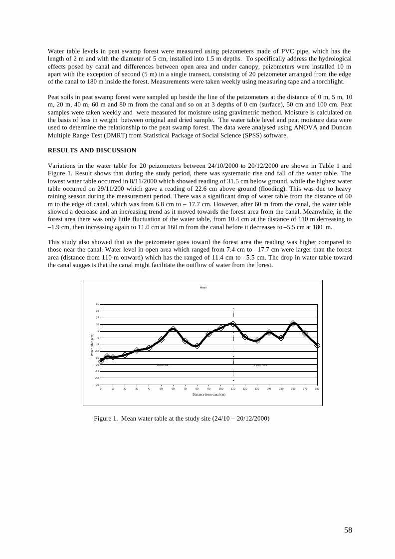
58
Water table levels in peat swamp forest were measured using peizometers made of PVC pipe, which has the length of 2 m and with the diameter of 5 cm, installed into 1.5 m depths. To specifically address the hydrological effects posed by canal and differences between open area and under canopy, peizometers were installed 10 m apart with the exception of second (5 m) in a single transect, consisting of 20 peizometer arranged from the edge of the canal to 180 m inside the forest. Measurements were taken weekly using measuring tape and a torchlight. Peat soils in peat swamp forest were sampled up beside the line of the peizometers at the distance of 0 m, 5 m, 10 m, 20 m, 40 m, 60 m and 80 m from the canal and so on at 3 depths of 0 cm (surface), 50 cm and 100 cm. Peat samples were taken weekly and were measured for moisture using gravimetric method. Moisture is calculated on the basis of loss in weight between original and dried sample. The water table level and peat moisture data were used to determine the relationship to the peat swamp forest. The data were analysed using ANOVA and Duncan Multiple Range Test (DMRT) from Statistical Package of Social Science (SPSS) software. RESULTS AND DISCUSSION Variations in the water table for 20 peizometers between 24/10/2000 to 20/12/2000 are shown in Table 1 and Figure 1. Result shows that during the study period, there was systematic rise and fall of the water table. The lowest water table occurred in 8/11/2000 which showed reading of 31.5 cm below ground, while the highest water table occurred on 29/11/200 which gave a reading of 22.6 cm above ground (flooding). This was due to heavy raining season during the measurement period. There was a significant drop of water table from the distance of 60 m to the edge of canal, which was from 6.8 cm to – 17.7 cm. However, after 60 m from the canal, the water table showed a decrease and an increasing trend as it moved towards the forest area from the canal. Meanwhile, in the forest area there was only little fluctuation of the water table, from 10.4 cm at the distance of 110 m decreasing to –1.9 cm, then increasing again to 11.0 cm at 160 m from the canal before it decreases to –5.5 cm at 180 m. This study also showed that as the peizometer goes toward the forest area the reading was higher compared to those near the canal. Water level in open area which ranged from 7.4 cm to –17.7 cm were larger than the forest area (distance from 110 m onward) which has the ranged of 11.4 cm to –5.5 cm. The drop in water table toward the canal sugges ts that the canal might facilitate the outflow of water from the forest.
Figure 1. Mean water table at the study site (24/10 – 20/12/2000)
Mean
-35
-30
-25
-20
-15
-10
-5
0
5
10
15
20
25
0 10 20 30 40 50 60 70 80 90 100 110 120 130 140 150 160 170 180
Distance from canal (m)
Wat
er ta
ble
(cm
)
Open Area Forest Area
59
Table 1: Peat water table at Raja Musa Forest Reserve, Selangor (24/10/00 to 20/12/00)
Distance Water Table (cm) from canal (m) Mean Range
0 -17.7 28.0 5 -13.8 34.0 10 -14.2 32.9 20 -12.6 27.5 30 -9.1 24.5 40 -7.2 24.2 50 -1.2 21.2 60 6.8 21.5 70 -2.1 20.6 80 -5.8 23.4 90 3.0 21.4 100 7.4 19.1 110 10.4 23.2 120 0.8 21.0 130 -1.9 24.5 140 4.2 28.0 150 0.2 24.6 160 11.0 27.1 170 3.4 25.5 180 -5.5 24.0
Mean peat moisture during the study period at depth 0 cm (surface), 50 cm and 100 cm were 577%, 891% and 1070% respectively (Table 2). In the surface soil, the minimum and the maximum were 189% and 1304% respectively, while at depth 50 cm minimum and maximum peat moisture were 401% and 1578%, respectively. However, at 100 cm depth, minimum peat moisture was 661%, while the maximum was 1695%. We can see that the minimum soil moisture occurred at the open area, while the maximum soil moisture occurred in the forest area. The results also showed that the lower soil moisture at open area may be caused by the outflow of water from the canal. Result also showed that peat moisture increased with the depth of the soils, mainly due to the evaporation process at the surface. In terms of peat moisture range, surface level has the highest range of 380 %, followed by 50 cm depth which has a range of 287 % and 100 cm depth which has a range of 223 %. This showed that the soil moisture of the deepest depth of soil (100 cm) fluctuated less compared to the surface soil.
Table 2: Mean surface, 50 cm and 100 cm depth peat moisture. Distance Soil Moisture (%)
from canal (m) Surface 50 cm 100 cm 0 491 774 1045 5 474 937 1103 10 454 994 1102 20 401 796 1036 40 620 974 1138 60 600 947 1113 80 646 1010 1133 100 658 840 1050 120 661 871 1047 140 663 873 1031 160 781 952 1134 180 472 723 915
Mean 577 891 1070
60
Table 3: Duncan Multiple Range Test (DMRT) for the mean moisture at different depths.
Duncana,b
Depth of soil N Subset1 2 3
0 84 57750 84 891100 84 1058
a. Uses harmonic mean sample size = 84.000.b. Alpha = 0.05.
CONCLUSIONS The water table level in peat swamp forest showed a systematic temporal characteristic of rising and falling. The maximum water table occurred was 22.6 cm above ground while the minimum was 31.5 cm below ground. The canal has some effect to the water table as the result showed that the water table decreased as it moved toward the canal. Other than that, there was a difference in water table between forest area and open area, where the range of the forested area was smaller than the open area. There was significant result of peat moisture within depth of the soils. For the surface soil, the moisture ranged from 401% to 781%, while at 50 cm, it ranged from 723% to 1010%. Moisture of the 100 cm depth has the highest value, which ranged from 915% to 1138%. From the results shown, we can conclude that there was an effect of the canal on the peat water table. An effect was also noticed between open area and forest area. The lower layers of peat have higher moisture contents. We hope to develop relationships between water level depths and peat moisture that can be used as an indicator for the early warning system in the peat forest fire management. ACKNOWLEDGEMENTS I would like to express my utmost gratitude to the Selangor State Forest Department in giving the permission to conduct the study in the Raja Musa Forest reserve. REFERENCES Artsybashev, E.S. 1983. Forest Fires and Their Control. Oxonian Press. New Delhi, India. 160 pp. Ainuddin, N.A. , Kelvin, G. and Jamaluddin, B., 2001. Effect of forest fire on vegetation in Raja Musa Forest
Reserve. Abstract in Symposium Programme and Asbtracts Asian Wetland Symposium. 27-30 August, 2001. Penang. pp. 36.
Brown, A.A. and Davis, K.P. 1973. Forest Fire Control and Use. McGraw Hill Inc. New York. 686 pp. Lailan, S and Ainuddin, N A. 2000. The effects of forest fire on peat soil properties: A case study in Sungai
Karang Forest Reserve, Selangor. In Proceedings SOILS 2000: Soil Science Conference of Malaysia. pp. 74-78.
Lailan, S, Ainuddin, N.A. and Jamaluddin ,B. 2001. Fire effects on physical and chemical peat properties in Sungai Karang Forest Reserve, Selangor. . Abstract in Symposium Programme and Asbtracts Asian Wetland Symposium. 27-30 August, 2001. Penang. pp. 229
61
EL NIÑO, CLIMATE CHANGE AND PEAT FIRES
SANTHIRA SEGARAN SINGARAVELU Malaysian Meteorological Service
Abstract An overview of the El-Nino phenomenon, its effect on regional climate and consequent impact on peatlands is given. The water temperature of the ocean surface in the central and eastern equatorial Pacific is usually colder than that of the western equatorial Pacific. In some years, however, this part of the ocean is observed to be exceptionally warmer than normal over an extensive area. This observed phenomenon is termed as El-Niño (Spanish for the boy child). The El-Niño event is also referred to as a Warm episode or ENSO (El-Niño-Southern Oscillation) and is one of the major climate influences in the world. Warming typically begins in October, increases toward year-end and peaks at mid-year the following year. The Southern Oscillation Index or SOI is used to indicate the occurrence of an El-Niño event. A negative SOI means there is an El-Niño under way. Other indicators include warmer than normal ocean temperatures across the central and eastern tropical Pacific Ocean, cooler than normal ocean temperatures over the western tropical Pacific, increased convection or cloudiness in the central tropical Pacific Ocean - the focus of convection migrates from the Australian/Indonesian region eastward towards the central tropical Pacific Ocean, and weaker than normal (easterly) trade winds. During more intense El Niño episodes, westerly winds are observed over parts of the equatorial western and central Pacific. During an El-Niño event, drier than normal conditions prevail in Southeast Asia, Indonesia and Australia. Such conditions can be prolonged and, during intense episodes, result in droughts. Droughts cause water levels to lower in peatlands and upper layers of plant material to dry up, thus becoming combustible fuel. Some of the more widespread incidents of peat fires occurred during intense El-Niño years such as in 1982 and 1997. Although the unusually dry conditions could be a reason for peat fires to start and spread easily, it is more likely most of the fires were started deliberately, by human activity in and around the peatlands. Such fires destroyed large areas of peatland, like in 1982, the over 3.5 million hectares of forest burnt in east Kalimantan included 550,000ha of peat swamp. A 1987 fire destroyed another 12,000ha in south Sumatra. South-East Asian countries, particularly Indonesia and Malaysia, have over 20 million hectares or 60% of the world's tropical peatlands. In the long term, peat swamp loss will surely have repercussions extending beyond just a hazy sky. Drained or burnt peat swamps will lose their crucial functions: soaking and storing water to mitigate floods and as a water catchment; buffering coastal lands from the intrusion of salty marine water; filtering pollutants which will otherwise degrade lakes, rivers and groundwater; providing timber and non-timber products; and providing critical wildlife habitat, particularly for the endangered Sumatran rhinoceros. While most of us feel the effects of climate variation, many businesses, services and activities depend on climate forecasting to prepare adequately, to manage risk, protect the environment, and to save lives. Climate extremes like flood, fire, cyclones and drought cause major impacts that can be minimised more effectively with climate forecasting. INTRODUCTION Southeast Asian countries, particularly Indonesia and Malaysia, have over 20 million hectares or 60% of the world's tropical peatlands. Peat swamp infernos have become more common in this region in recent years. In Indonesia, some of the more persistent fires over the years have been in peat swamps. In the long term, peat swamp loss will surely have repercussions extending beyond just a hazy sky. Drained or burnt peat swamps will lose their crucial functions: soaking and storing water to mitigate floods and as a water catchment; buffering coastal lands from the intrusion of salty marine water; filtering pollutants which will otherwise degrade lakes, rivers and groundwater; providing timber and non-timber products; and providing critical wildlife habitat, particularly for the endangered Sumatran rhinoceros. During an El Niño event, drier than normal conditions prevail in Southeast Asia, Indonesia and Australia. Such conditions can be prolonged and, during intense episodes, result in droughts. Droughts cause water levels to lower in peatlands and upper layers of plant material to dry up, thus becoming combustible fuel. Some of the more widespread incidents of peat fires occurred during intense El Niño years such as in 1982 and 1997. Although the unusually dry conditions could be a reason for peat fires to start and spread easily, it is more likely most of the fires were started deliberately, by human activity in and around the peatlands. Such fires destroyed large areas of peatland, like in 1982, the over 3.5 million hectares of forest burnt in east Kalimantan included 1.5 million ha of peat swamp. A 1987 fire destroyed another 12,000ha in south Sumatra. In 1997, 800,000 ha of peat swamp and plantations burned in Indonesia and up to 2,000 ha of peat swamp could have been affected in Malaysia.
THE EL NIÑO
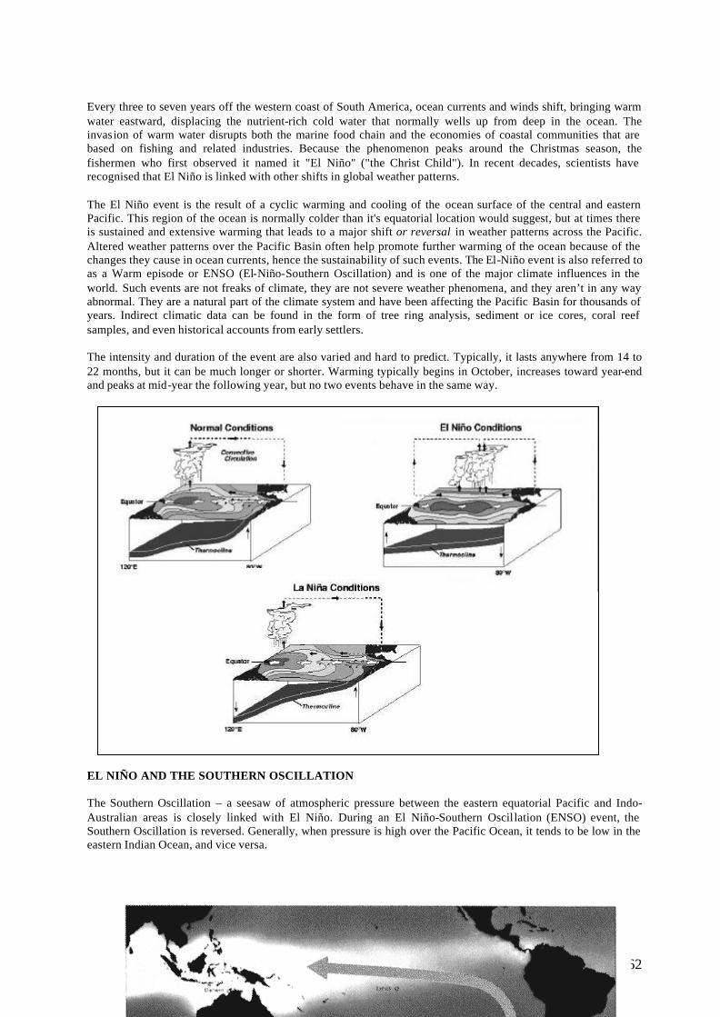
62
Every three to seven years off the western coast of South America, ocean currents and winds shift, bringing warm water eastward, displacing the nutrient-rich cold water that normally wells up from deep in the ocean. The invasion of warm water disrupts both the marine food chain and the economies of coastal communities that are based on fishing and related industries. Because the phenomenon peaks around the Christmas season, the fishermen who first observed it named it "El Niño" ("the Christ Child"). In recent decades, scientists have recognised that El Niño is linked with other shifts in global weather patterns. The El Niño event is the result of a cyclic warming and cooling of the ocean surface of the central and eastern Pacific. This region of the ocean is normally colder than it's equatorial location would suggest, but at times there is sustained and extensive warming that leads to a major shift or reversal in weather patterns across the Pacific. Altered weather patterns over the Pacific Basin often help promote further warming of the ocean because of the changes they cause in ocean currents, hence the sustainability of such events. The El-Niño event is also referred to as a Warm episode or ENSO (El-Niño-Southern Oscillation) and is one of the major climate influences in the world. Such events are not freaks of climate, they are not severe weather phenomena, and they aren’t in any way abnormal. They are a natural part of the climate system and have been affecting the Pacific Basin for thousands of years. Indirect climatic data can be found in the form of tree ring analysis, sediment or ice cores, coral reef samples, and even historical accounts from early settlers. The intensity and duration of the event are also varied and hard to predict. Typically, it lasts anywhere from 14 to 22 months, but it can be much longer or shorter. Warming typically begins in October, increases toward year-end and peaks at mid-year the following year, but no two events behave in the same way.
EL NIÑO AND THE SOUTHERN OSCILLATION The Southern Oscillation – a seesaw of atmospheric pressure between the eastern equatorial Pacific and Indo-Australian areas is closely linked with El Niño. During an El Niño-Southern Oscillation (ENSO) event, the Southern Oscillation is reversed. Generally, when pressure is high over the Pacific Ocean, it tends to be low in the eastern Indian Ocean, and vice versa.
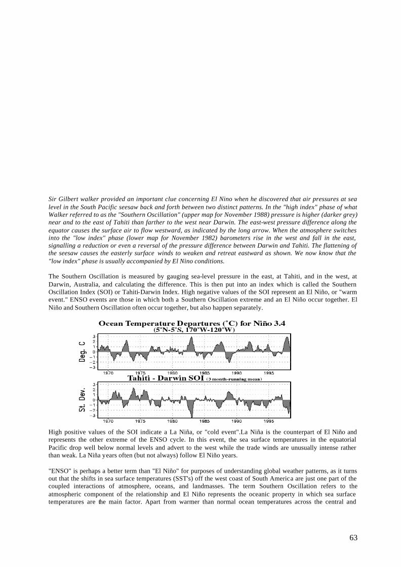
63
Sir Gilbert walker provided an important clue concerning El Nino when he discovered that air pressures at sea level in the South Pacific seesaw back and forth between two distinct patterns. In the "high index" phase of what Walker referred to as the "Southern Oscillation" (upper map for November 1988) pressure is higher (darker grey) near and to the east of Tahiti than farther to the west near Darwin. The east-west pressure difference along the equator causes the surface air to flow westward, as indicated by the long arrow. When the atmosphere switches into the "low index" phase (lower map for November 1982) barometers rise in the west and fall in the east, signalling a reduction or even a reversal of the pressure difference between Darwin and Tahiti. The flattening of the seesaw causes the easterly surface winds to weaken and retreat eastward as shown. We now know that the "low index" phase is usually accompanied by El Nino conditions. The Southern Oscillation is measured by gauging sea-level pressure in the east, at Tahiti, and in the west, at Darwin, Australia, and calculating the difference. This is then put into an index which is called the Southern Oscillation Index (SOI) or Tahiti-Darwin Index. High negative values of the SOI represent an El Niño, or "warm event." ENSO events are those in which both a Southern Oscillation extreme and an El Niño occur together. El Niño and Southern Oscillation often occur together, but also happen separately.
High positive values of the SOI indicate a La Niña, or "cold event".La Niña is the counterpart of El Niño and represents the other extreme of the ENSO cycle. In this event, the sea surface temperatures in the equatorial Pacific drop well below normal levels and advert to the west while the trade winds are unusually intense rather than weak. La Niña years often (but not always) follow El Niño years. "ENSO" is perhaps a better term than "El Niño" for purposes of understanding global weather patterns, as it turns out that the shifts in sea surface temperatures (SST's) off the west coast of South America are just one part of the coupled interactions of atmosphere, oceans, and landmasses. The term Southern Oscillation refers to the atmospheric component of the relationship and El Niño represents the oceanic property in which sea surface temperatures are the main factor. Apart from warmer than normal ocean temperatures across the central and
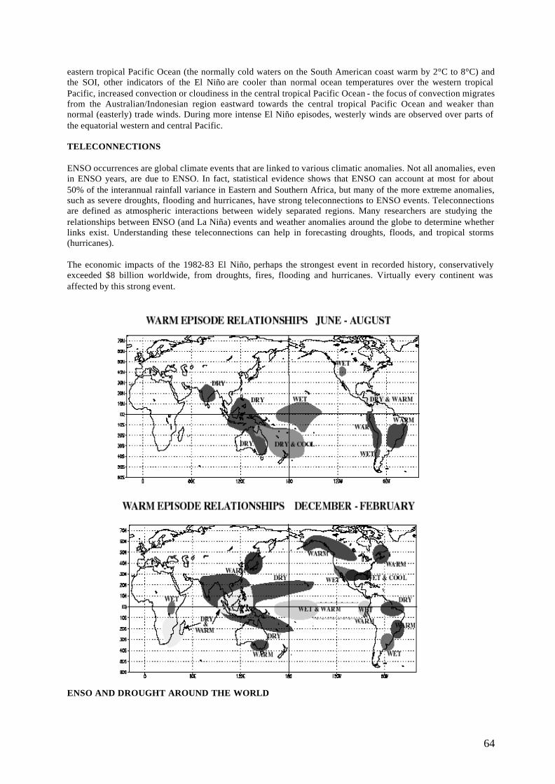
64
eastern tropical Pacific Ocean (the normally cold waters on the South American coast warm by 2°C to 8°C) and the SOI, other indicators of the El Niño are cooler than normal ocean temperatures over the western tropical Pacific, increased convection or cloudiness in the central tropical Pacific Ocean - the focus of convection migrates from the Australian/Indonesian region eastward towards the central tropical Pacific Ocean and weaker than normal (easterly) trade winds. During more intense El Niño episodes, westerly winds are observed over parts of the equatorial western and central Pacific. TELECONNECTIONS ENSO occurrences are global climate events that are linked to various climatic anomalies. Not all anomalies, even in ENSO years, are due to ENSO. In fact, statistical evidence shows that ENSO can account at most for about 50% of the interannual rainfall variance in Eastern and Southern Africa, but many of the more extreme anomalies, such as severe droughts, flooding and hurricanes, have strong teleconnections to ENSO events. Teleconnections are defined as atmospheric interactions between widely separated regions. Many researchers are studying the relationships between ENSO (and La Niña) events and weather anomalies around the globe to determine whether links exist. Understanding these teleconnections can help in forecasting droughts, floods, and tropical storms (hurricanes). The economic impacts of the 1982-83 El Niño, perhaps the strongest event in recorded history, conservatively exceeded $8 billion worldwide, from droughts, fires, flooding and hurricanes. Virtually every continent was affected by this strong event. ENSO AND DROUGHT AROUND THE WORLD
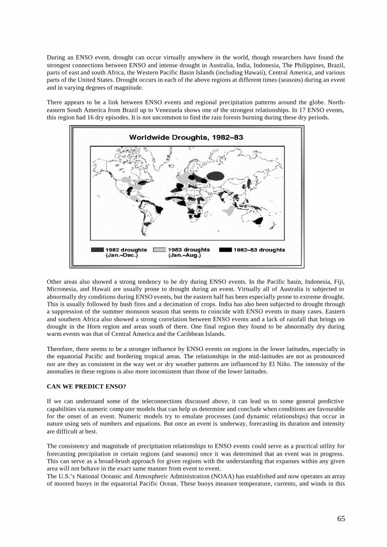
65
During an ENSO event, drought can occur virtually anywhere in the world, though researchers have found the strongest connections between ENSO and intense drought in Australia, India, Indonesia, The Philippines, Brazil, parts of east and south Africa, the Western Pacific Basin Islands (including Hawaii), Central America, and various parts of the United States. Drought occurs in each of the above regions at different times (seasons) during an event and in varying degrees of magnitude. There appears to be a link between ENSO events and regional precipitation patterns around the globe. North-eastern South America from Brazil up to Venezuela shows one of the strongest relationships. In 17 ENSO events, this region had 16 dry episodes. It is not uncommon to find the rain forests burning during these dry periods.
Other areas also showed a strong tendency to be dry during ENSO events. In the Pacific basin, Indonesia, Fiji, Micronesia, and Hawaii are usually prone to drought during an event. Virtually all of Australia is subjected to abnormally dry conditions during ENSO events, but the eastern half has been especially prone to extreme drought. This is usually followed by bush fires and a decimation of crops. India has also been subjected to drought through a suppression of the summer monsoon season that seems to coincide with ENSO events in many cases. Eastern and southern Africa also showed a strong correlation between ENSO events and a lack of rainfall that brings on drought in the Horn region and areas south of there. One final region they found to be abnormally dry during warm events was that of Central America and the Caribbean Islands. Therefore, there seems to be a stronger influence by ENSO events on regions in the lower latitudes, especially in the equatorial Pacific and bordering tropical areas. The relationships in the mid-latitudes are not as pronounced nor are they as consistent in the way wet or dry weather patterns are influenced by El Niño. The intensity of the anomalies in these regions is also more inconsistent than those of the lower latitudes. CAN WE PREDICT ENSO? If we can understand some of the teleconnections discussed above, it can lead us to some general predictive capabilities via numeric comp uter models that can help us determine and conclude when conditions are favourable for the onset of an event. Numeric models try to emulate processes (and dynamic relationships) that occur in nature using sets of numbers and equations. But once an event is underway, forecasting its duration and intensity are difficult at best. The consistency and magnitude of precipitation relationships to ENSO events could serve as a practical utility for forecasting precipitation in certain regions (and seasons) once it was determined that an event was in progress. This can serve as a broad-brush approach for given regions with the understanding that expanses within any given area will not behave in the exact same manner from event to event. The U.S.’s National Oceanic and Atmospheric Administration (NOAA) has established and now operates an array of moored buoys in the equatorial Pacific Ocean. These buoys measure temperature, currents, and winds in this
66
region on a daily basis. The data is available to scientists around the world in real time enabling them to use the data for both research and forecasting. This network is very valuable in that the first stages of an ENSO event occur in this region. By monitoring data from past episodes and the data from the months leading up to an episode, scientists can use numerical models (similar, but not as reliable, to those used in weather forecasting) to help them predict and/or simulate ENSO events. The predictive models are becoming more sophisticated and more effective in many respects thanks in part to the expanded data sets that are available for the equatorial Pacific region. The dynamic coupled nature of the new models has allowed for prediction of ENSO events a year or more in advance. ENSO forecasts help countries anticipate and mitigate droughts and floods, and are very useful in agricultural planning. Countries such as Brazil, Australia, India, Peru and various African nations that are in latitudes with strong El Niño connections to weather patterns, use predictions of near-normal conditions, weak El Niño conditions, strong El Niño conditions, or a La Niña to help agricultural producers select crops most likely to be successful in the coming growing season. In countries or regions with a Famine Early Warning System (FEW S) in place, ENSO forecasts can play a key role in mitigating the impacts of flood or drought that can lead to famine. Famine, like drought, is a slow-onset disaster, so forewarning may enable countries to greatly reduce, if not eliminate, its worst impacts. ENSO advisories are used to a lesser extent in planning in extratropical countries, because the links between ENSO and weather patterns are less clear here. As prediction models improve, the role of ENSO advisories in planning in mid-latitude countries will increase.
THE SCIENTIFIC BASIS OF SEASONAL CLIMATE FORECASTING Predictability of the climate from season-to-season and year-to-year primarily arises from the interaction of the ocean and the atmosphere. The best-known example is the ENSO phenomenon. As ENSO involves the quasi-periodic warming and cooling of the sea-surface temperature (SSTs) in the eastern Pacific Ocean, the combination of the slowly changing ocean and interactions in the atmosphere provides a degree of predictability for seasonal climate in many regions of the world. Seasonal climate prediction is based on the expectation of effects of global influences of ENSO and other sea-surface temperature anomalies in the coming season. Seasonal forecasters ask the following two basic questions: what will the sea-surface temperature anomalies be in the coming season, and how will they impact global climate? Current seasonal forecasting methods involves the use of dynamical computer models such as Global Coupled Ocean-Atmosphere General Circulation Models (GCMs) and higher-resolution regional models as well as statistical methods based on historical data. These techniques provide ways of specifying the behaviour of ocean and atmosphere, and the interactions between them and of using information about the interaction to predict the probable behaviour of specific climate variables, such as temperature or precipitation, over certain regions and time periods.
GCMs are complex and are developed and run only at major centres. Regional models are also complex but are starting to be used outside the major centres to address regional needs. Statistical model and relationships are more easily constructed and are in widespread use. These are typically built up from local climate data and sea-surface temperature information for the Pacific and other major oceans. There is a trade-off between the GCM approach, which endeavours to model the physics of the climate’s actual seasonal evolution but which requires large resources, and statistical approaches, which are simple and inexpensive but which can represent only a single type of climatic behaviour evident in the historical data. It is important to recognise that seasonal climate predictability is not universal - the nature of the climate system only allo ws for predictability in certain circumstances. A sizeable fraction of seasonal variation of the climate is inherently unpredictable. Even where predictability is known to exist, the available scientific methods may still be unable to capture fully the predictability. Furthermore, the nature of the climate system and current scientific limitations allow forecasters to provide only probabilistic forecast rather than the unqualified, deterministic forecasts that users usually seek. They provide information about the likely characteristic of the seasonal climate, but they cannot indicate the exact timing,
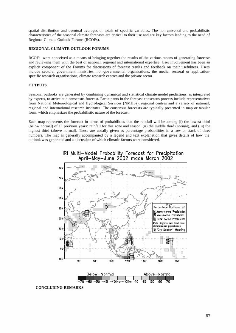
67
spatial distribution and eventual averages or totals of specific variables. The non-universal and probabilistic characteristics of the seasonal climate forecasts are critical to their use and are key factors leading to the need of Regional Climate Outlook Forums (RCOFs). REGIONAL CLIMATE OUTLOOK FORUMS RCOFs were conceived as a means of bringing together the results of the various means of generating forecasts and reviewing them with the best of national, regional and international expertise. User involvement has been an explicit component of the Forums for discussions of forecast results and feedback on their usefulness. Users include sectoral government ministries, non-governmental organisations, the media, sectoral or application-specific research organisations, climate research centres and the private sector. OUTPUTS Seasonal outlooks are generated by combining dynamical and statistical climate model predictions, as interpreted by experts, to arrive at a consensus forecast. Participants in the forecast consensus process include representatives from National Meteorological and Hydrological Services (NMHSs), regional centres and a variety of national, regional and international research institutes. The consensus forecasts are typically presented in map or tabular form, which emphasizes the probabilistic nature of the forecast. Each map represents the forecast in terms of probabilities that the rainfall will be among (i) the lowest third (below normal) of all previous years’ rainfall for this zone and season, (ii) the middle third (normal), and (iii) the highest third (above normal). These are usually given as percentage probabilities in a row or stack of three numbers. The map is generally accompanied by a legend and text explanation that gives details of how the outlook was generated and a discussion of which climatic factors were considered.
CONCLUDING REMARKS

68
While most of us feel the effects of climate variation, many businesses, services and activities depend on climate forecasting to prepare adequately, to manage risk, protect the environment, and to save lives. Climate extremes like flood, fire, cyclones and drought cause major impacts that can be minimised more effectively with climate forecasting.
69
THE 1997/98 FOREST FIRE EXPERIENCE IN PENINSULAR MALAYSIA
SAMSUDIN MUSA & ISMAIL PARLAN Forest Research Institute Malaysia
[email protected] , [email protected]
Abstract Malaysia experienced one its most serious haze problem in 1997/98. Although the main source of the haze has been attributed to have come from rampant forest and bush fires in neighbouring Indonesia, there were significant outbreaks of such fires in Malaysia as well, that exacerbated the situation. In Peninsular Malaysia, the incidences of forest fires mainly occurred in Selangor, Pahang, Kelantan and Terengganu covering an area of about 2800 ha. Haze and forest fires although not new to Malaysia, were never taken very seriously until the 1997 haze incident that not only affected us but also Singapore, Brunei, Thailand and even the Philippines. We have experienced several forest fire episodes over the last two decades. These episodes seem to coincide with dry conditions brought about by the ENSO phenomena. The haze and forest fires had caused significant damage to property, vegetation, wildlife, environment and public health. Most of the forest fires reported in Malaysia occurred in degraded or logged-over peat swamp forests and is thus a major threat to the conservation of such ecosystem. The destruction of the peat which had accumulated over thousands of years is globally significant as carbon storage may have greater impacts than the burning of surface vegetation. It contributes greenhouse gases to the atmosphere and also releases particulate matter and sulphur and nitrous oxides harmful to human health. Serious occurrences of forest fire are due to improper peat land management, slash and burn activities and poor water regulation in cultivated lands. The forest fire experience have created awareness on the severity of forest fires in this region and its transboundary nature. It also reflected the urgent need to address the issues concerning sound management of forest resources at the local level as well as the need to enhance forestry cooperation in the region. INTRODUCTION In mid 1997 to mid 1998, the world had experienced one of the worst ever ecological disaster. A total of 5 million hectares of forest land were destroyed in Kalimantan and Sumatra alone by fire. . At the height of the panic, about 1000 new hotspots in Indonesia, were picked up by satellites within a two-week period in Sumatra. The region was blanketed by thick haze for months and tension rose on how to address this transboundary pollution between neighbours. The social, economic and ecological impacts are difficult to assess reliably. Direct estimates of loss of timber, infrastructure and business of the forest fires in Indonesia alone is about USD 9.5 billion (Bambang, 1999). This however does not include loss of biological diversity as well as psychological impacts, and long-term health of affected people. Of late the occurrence of forest fires have been increasing, both in its extent and frequency, especially in the South and South-east Asian regions. The issues of forest fires are somewhat unique because although the forest fires themselves are a concern to individual countries, its resultant haze which are transboundary in nature affects a far wider area sometimes involving several countries. There have been several of such experiences for Malaysia and her neighbours especially in 1993 and 1997/98. Consequently much attention are currently being focussed to address the issue both at the individual country level as well as at the regional and bilateral levels. FOREST FIRES IN PENINSULAR MALAYSIA The threat of forest fires in Malaysia are still considered to be small, even though there was one incident where Sabah had lost almost a million hectares of forest in the Great Borneo fires of 1982/83. Rather, most Malaysians tend to associate forest fire and haze problems to our neighbour Indonesia because comparatively the magnitude of the problem there is very much larger. For example in 1997/98, when one of the worst episodes of haze struck this region engulfing Malaysia, Indonesia, Singapore and Brunei, more than 3 million ha of forest burned in Kalimantan alone. The Malaysian Air Pollutant Index (API)1 exceeded the hazardous level of 500 in Sarawak; forcing the government to close schools and offices. The haze caused the Malaysian public much discomfort and resulted in disruption to air travel, increased respiratory and related health problems and also a significant
1 Malaysian Standard of Air Pollutant Index (API) is measured in µg/m3 of air sampled. The scales of the index are categorised as follows: 0-50 = Good; 51-100 = Moderate; 101-200 = Unhealthy; 201-300 = Very Unhealthy; 301-500 = Hazardous.

70
decrease in tourists visiting the country. Had the haze conditions persisted a little longer, it would have embarrassed the nation and disrupted the prestigious Commonwealth Games that the nation proudly hosted in September 1998. When the forest fires did not cease after several weeks, the Malaysian Government decided to assist Indonesia in putting out the fires. A total of 1262 fire -fighters (the largest recorded anywhere) from Malaysia were deployed to Sumatra and Kalimantan to combat the forest fires. However, the haze cannot be totally attributed to the forest fires in Indonesia alone as there were also fires reported in various parts of Peninsular Malaysia, Sabah and Sarawak. Many of these fires occurred in degraded peat lands, logged-over forest reserves and secondary state land forests. They have caused significant damage to property and loss of valuable timber as well as biological diversity. In this regard however, there were no detailed study of the extent and impact of the forest fires undertaken, making it difficult assess the actual situation. DAMAGE EXTENT OF FOREST FIRES Other then the great Borneo fires which affected Sabah mentioned above, forest fire occurrences are mainly minor in extent especially in Peninsular Malaysia and it is mainly confined to forest plantations and the logged-over forest. Incidences of forest fires have been reported as early as 1970's in the pine plantations and the 1980's in the Acacia mangium plantations. However, many of these incidences were not recorded properly. Those available were of the more recent occurrences. The occurrence of forest fires are also associated to the prolonged dry conditions brought about periodically due to the El-Nino Southern Oscillation (ENSO) phenomenon. Table 1 shows the occurrences of fires that were recorded in Malaysia beginning 1992-1998. There were also incidences of fires in Peninsular Malaysia in 1999 and even in the early parts of this year. In fact, the areas affected by forest/bush fires this year is even wider covering an area of about 14,500 ha. The fires this around was also more visible for public viewing as a lot of them can be seen from the highways and close to residential areas SOME UNDERLYING CAUS ES OF FOREST FIRES A combination of climate and human activities account for the majority of forest fires. In 1997/98, the region was affected by a very strong ENSO phenomena which resulted in a prolonged hot and dry period. Malaysia, it is obvious from the above tables that incidences of forest fires mainly occurred in forest plantations, degraded peat swamp forests and logged-over forests. Some of the major reasons for the cause of fire are as follows:
• Land preparations in agricultural plantations establishment • Land preparation by farmers • Traditional slash and burn agriculture • Recreational Activities such as camping and picnicking • Hunting • Snapped electric cable • Natural Causes– lightning, spontaneous combustion, etc.
Table 1 Forest Fires in Malaysia 1992-1997
Year Forest Type Area(ha) Probable Cause
Plantation Acacia Mangium 265 Nearby land clearing and from picnickers at nearby recreational Forest
Plantation Acacia Mangium 3 Unknown
Plantation Acacia Mangium 10 Power transmission undergoing maintenance
Plantation- Pinus Carribaea 16 Adjacent land clearing by villagers
Natural Forest 2500 Cooking by hunters
Natural Forest 1000 Arson
Natural Forest 825 Nearby land clearing , picnickers and cigarettes
1992
Virgin Jungle Reserve 65 Adjacent land clearing by farmers
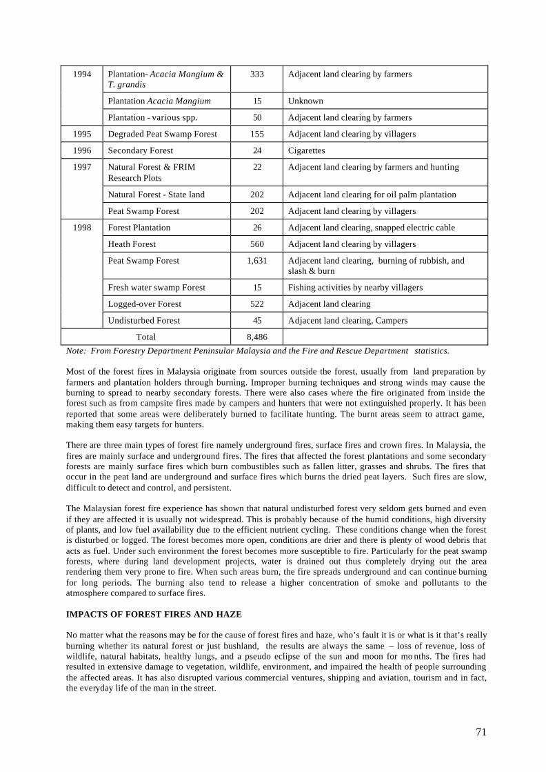
71
Plantation- Acacia Mangium & T. grandis
333 Adjacent land clearing by farmers
Plantation Acacia Mangium 15 Unknown
1994
Plantation - various spp. 50 Adjacent land clearing by farmers
1995 Degraded Peat Swamp Forest 155 Adjacent land clearing by villagers
1996 Secondary Forest 24 Cigarettes
Natural Forest & FRIM Research Plots
22 Adjacent land clearing by farmers and hunting
Natural Forest - State land 202 Adjacent land clearing for oil palm plantation
1997
Peat Swamp Forest 202 Adjacent land clearing by villagers
Forest Plantation 26 Adjacent land clearing, snapped electric cable
Heath Forest 560 Adjacent land clearing by villagers
Peat Swamp Forest 1,631 Adjacent land clearing, burning of rubbish, and slash & burn
Fresh water swamp Forest 15 Fishing activities by nearby villagers
Logged-over Forest 522 Adjacent land clearing
1998
Undisturbed Forest 45 Adjacent land clearing, Campers
Total 8,486
Note: From Forestry Department Peninsular Malaysia and the Fire and Rescue Department statistics.
Most of the forest fires in Malaysia originate from sources outside the forest, usually from land preparation by farmers and plantation holders through burning. Improper burning techniques and strong winds may cause the burning to spread to nearby secondary forests. There were also cases where the fire originated from inside the forest such as from campsite fires made by campers and hunters that were not extinguished properly. It has been reported that some areas were deliberately burned to facilitate hunting. The burnt areas seem to attract game, making them easy targets for hunters. There are three main types of forest fire namely underground fires, surface fires and crown fires. In Malaysia, the fires are mainly surface and underground fires. The fires that affected the forest plantations and some secondary forests are mainly surface fires which burn combustibles such as fallen litter, grasses and shrubs. The fires that occur in the peat land are underground and surface fires which burns the dried peat layers. Such fires are slow, difficult to detect and control, and persistent. The Malaysian forest fire experience has shown that natural undisturbed forest very seldom gets burned and even if they are affected it is usually not widespread. This is probably because of the humid conditions, high diversity of plants, and low fuel availability due to the efficient nutrient cycling. These conditions change when the forest is disturbed or logged. The forest becomes more open, conditions are drier and there is plenty of wood debris that acts as fuel. Under such environment the forest becomes more susceptible to fire. Particularly for the peat swamp forests, where during land development projects, water is drained out thus completely drying out the area rendering them very prone to fire. When such areas burn, the fire spreads underground and can continue burning for long periods. The burning also tend to release a higher concentration of smoke and pollutants to the atmosphere compared to surface fires. IMPACTS OF FOREST FIRES AND HAZE No matter what the reasons may be for the cause of forest fires and haze, who’s fault it is or what is it that’s really burning whether its natural forest or just bushland, the results are always the same – loss of revenue, loss of wildlife, natural habitats, healthy lungs, and a pseudo eclipse of the sun and moon for mo nths. The fires had resulted in extensive damage to vegetation, wildlife, environment, and impaired the health of people surrounding the affected areas. It has also disrupted various commercial ventures, shipping and aviation, tourism and in fact, the everyday life of the man in the street.
72
HEALTH CONCERNS There was a stark increase in respiratory and related ailments during the haze episode. While the long term effects on health is difficult to predict, experts say that the pollution levels in the vicin ity of the forest fires were hazardous. Doctors advised that the best measure to stay healthy is to leave the region. In this regard, many Japanese, German, Danish and British expatriates working in the region have been requested by their government to take a break and return to their respective countries until the situation improves. However local communities will just have to bear with it. Staying indoors and avoiding physical exertion is the next best option. But cloth masks, no matter how finely meshed are not useful as they are not capable of filtering the RSP’s (respirable suspended particles). As such they provide a false sense of security. Vegetation Dynamics Studies on the effects of the forest fires on the vegetation dynamics showed that fires had caused considerable damage to the soil and vegetation and had altered the structure and composition of the residual forest. Burnt forest suffered severe canopy damage, and most of the seedlings and saplings were destroyed. Consequently, the residual stand that regenerates are very different from the original stand. There will be greater numbers of pioneer species such as various macaranga spp., ferns, lallang, bamboo etc. and less of the dipterocarps and other climax species. The density of the pioneer species is relative to the intensity of the disturbance. The more intensely burnt areas will have higher densities of the pioneers and will need much longer periods for the stands to recover. It has been reported that areas affected by repeated burnings may not cover at all and will be dominated by lallang.. In such areas silvicultural interventions through planting is needed. In this respect, FRIM (Ismail P. et. al 2001) has undertaken research in the rehabilitation of degraded peat lands through planting of indigenous peat swamp species such as Ramin. Four different planting techniques were tried on five different species and their performance were monitored. Estimates of costs of the methods were also made. ECONOMIC LOSS ESTIMATES The economic loss due to forest fires are difficult to ascertain as there tangible and non-tangible parameters as well as short-term and long-term impacts. For example there is direct economic loss of potential income from forest products such as timber, medicinal plants, rattan, bamboo, fruits, nuts, resin etc. There is also a direct cost involved in the man-hours spent on trying to suppress the fires and a reduction in tourist visits. However there is also economic loss due to loss in biodiversity, transboundary haze, long-term health effects, reduction in the productivity of burnt areas, lost of carbon storage in the peat and contribution towards global warming In Malaysia, although direct financial estimates due to fires were still not easily available many man-hours were spent in fighting fires. It involved personnel from the FRD, State Forestry Department, Police, Drainage and Irrigation Department, Public Defence Department (JPA 3), Public works Department, Local Town Councils and also members of the community. During the period, air travel were often disrupted, tourism sector adversely affected and cost of medical treatment for haze related ailments increased. There was however an attempt to quantify the losses due to the haze in Malaysia (Mohd. Shahwahid, 1999) by looking at production losses (reduction in crop yields, fishing efforts, and industrial and commercial activities), tourism losses, airline and airport losses and averting expenditures for haze control. It was estimated that the aggregate incremental cost of the haze damage for 1998 in Malaysia amounted to about RM 816 million. (Table 2) Table 2 Aggregate Incremental Cost of the Haze Damage
Types of Damage RM (million) Percentage Cost of Illness 36.2 4
Productivity Loss 393.5 39 Tourist Decline 318.6 39
Flight cancellations 0.5 negligible Decline in Fist Landing 40.7 55
Cost of Fire Fighting 25.0 3 Cloud Seedling 2.1 negligible
Total 816.6 100
73
EXPERIENCES IN CONTROLLING FOREST FIRES The suppression of all kinds of fires including forest fires is the responsibility of the Fire and Rescue Department. However, during the combating of forest fires the agency is assisted by other relevant agencies such as the Forestry Department, Public Defence Department, Drainage and Irrigation Department, the police and the local town councils. The fires that occur in the peat and heath forest/bush areas are relatively slow and patchy but widespread. The fires spread through the forest floor. Thus, even if whole trees were not razed, the root systems were completely damaged and often the tree will fall and die. In peat lands the fires spread slowly through the thick peat layers making it extremely difficult to detect and extinguish. In such areas, although the surface fires are extinguished, the peat underground will continue to burn unless a large amount of water is used to completely drench the peat layers. Thus it is common to see areas fires recurring in areas where the fires were doused earlier. Consequently, in peat lands, the most effective way of containing the fires will be by flooding the area. This would require a large amount of water, which is scarce during the dry ENSO period. Another impediment in the suppression of fires is the problem of access. The Fire and Rescue Department’s vehicles were designed for structural fire fighting and not for travelling in forested areas and thus they were unable to venture in the interior areas that were affected by fires. There was a serious lack of water source to enable the Fire Department to fight the fires effectively. Even in cases where pits and canals were dug, they dried up quickly. Under such conditions, according to the FRD, the best way to tackle forest fires is to contain them by preventing their spread especially to sensitive areas and communities. This is undertaken by creating fire breaks.
PREVENTION BETTER THEN CURE As mentioned earlier, once the forest fires are started, especially peat fire, they are extremely difficult, expensive and time consuming to contain. Past experience shows that the possibilities of fires occurring in fire prone areas are very high during ENSO periods. More ENSO events are expected to occur in the future. In fact, it has been predicted that there will be an ENSO episode (probably less intense that 1997/98) in the August-September this year. Thus, it is imperative that appropriate mitigating measures be in place to prevent the further scourge of forest fires on our forests resources as well as our environment. In addition fire suppression capabilities will have to be enhanced to enable quick and effective control of the fires when they do occur. There seem to be sufficient measures in place to prevent and combat fires in the forest plantations. However, similar measures are grossly lacking for the natural forest areas as managers still view lightly the threat of fires in such forests. It is hoped that the severity of the 1998 fire and the involvement of various agencies and the community in fighting the fires had increased the awareness for the need to take precautionary measures in the future. Some of the recommended preventive measures include:
a) Increasing Public Awareness b) Sustainable Forest Management c) Creating Buffer Zones and Canals d) Development of Forest Fire Squad e) Fire Detection and Mapping f) Development of Risk Index g) Operationalize the Forest Fire Prevention and Control Plan h) Rehabilitation of Degraded Areas i) Undertake Research in Forest Fire
The transboundary nature of forest fire problems have made it suitable for adopting a network approach to sharing of information and experience. Networking is a cost-effective mechanism for strengthening institutional capacity, facilitating transfer of technology and enhancing cooperation. For example, Indonesia have more experience in combating forest fires and are also more advanced in their research in forest fire management. As such, a country like Malaysia would be able to tab and use some of this knowledge and expertise available in addressing similar issues. In addition to national initiatives, there has also been regional initiatives undertaken. A number of regional workshops and meetings were held on transboundary haze pollution in Malaysia and Indonesia. In ASEAN, a Working Group on Transboundary Pollution was formed. A Haze Technical Task Force was commissioned in 1997 to formulate Regional and National Haze Action Plans. In 1998, ADB approved the Regional Technical
74
Assistance (RETA) which will assist ASEAN in setting up a strong regional programme for fire and haze prevention, monitoring and mitigation.
CONCLUSION The 1997/98 fires have been described as an ecological disaster and an environmental catastrophe by many quarters. Forest fires were not only found in the ASEAN region but many other places such as Australia, China, India, Turkey, USA, Canada, Mexico and Brazil. However, problems caused by forest fires in the ASEAN region have assumed a new and serious dimension that needs to addressed in its proper perspective.. In Malaysia, fire occurrence are becoming more serious and valuable peat lands are being destroyed. Compared to our neighbour, we are in a better position to overcome forest fires. However, concrete mitigating measures must be taken to protect the forest from being burnt. The management of peat lands need to be pay special attention to water regulation and open burning activities must curbed especially during the dry ENSO periods. The dark episodes of forest fires and haze in the last two decades namely in 1982/83, 1990, 1991, 1994 and 1997/98 should serve as useful lessons for us to be more cautious and be better prepared for the next attack. The severity of the next recurrence of forest fires will depend on how we make use of past lessons to be better prepared and equipped and to have in place effective preventive measures that can efficiently imp lemented. REFERENCE Bambang H.S., 1999. The Management of Fuel and Fire in Land Preparation Area for Slash and Burn Agriculture.
Paper presented at the 3rd International Symposium on Asian Tropical Forest Management, September 20-23, 1999, Samarinda, Indonesia.
Goldammer J.G. (Ed), 1990. Fire in the Tropical Biota. Ecosystem Processes and Global Challenges. Ecological Studies 84.
Haron abu Hassan (Ed). 1997. Transboundary Pollution and the Sustainability of the Tropical Forests: Towards Wise Forest Fire Management. Proceeding of the. ASEAN Institute of Forest Management International Conference, Kuala Lumpur 2-4 December 1996.
Mohd. Puad Dahlan & Tg. Abdullah Tg. Ismail. 1998. Pengurusan Ladang Hutan dan Pencegahan Kebakaran. Paper presented at the Forestry Seminar for the Fire and Rescue Department held at FRIM 22-27 Jun 1998.
Mohd. Shahwahid H.O. and Jamal, 1999. Cost Based Evaluation Approach: An Illustration on the Damage Cost of the Indonesian Forest Fires and Transboundary Haze on Neighbouring Malaysia. Chapter 7, Manual on Economic Valuation of Environmental Goods and Services of Peat Swamp Forest. Malaysian-DANCED Project on Sustainable Forest Management of Peat Swamp Forest, Pen. Malaysia.
Samsudin M. and Wan M. Shukri Wan Ahmad, 1998. Report on the Status of Forest Fires in Kelantan and Terengganu (Unpublished). Forest Research Institute Malaysia.
Samsudin M., Mohd. Puat Dahlan, Wan Mohd. Shukri W.A., Shamsudin I., Raja Barizan R.S., Azman H., Ismail H. & Ismail P., 1999. Forest Fires in Peninsular Malaysia: A New and Recurring Threat. Paper presented at the 3rd International Symposium on Asian Tropical Forest Management: Impacts of Forest and Human Activities on Forest Ecosystems in the Tropics, Samarinda, Indonesia, 20-23 September 1999
Ismail, P., Shamsudin, I., Nik Muhamad N.M., & Fridah, H. 2001. Rehabilitation of grassland areas in peat swamp forests in Peninsular Malaysia . Paper presented at Asian Wetland Symposium 2001, 27-30 August 2001, Penang, Malaysia.
75
FIRE PREVENTION AND PROTECTION IN PEAT SWAMP FORESTS “PAHANG EXPERIENCE”
ABDUL HAMID BIN MAAROF
Forestry Department Pahang
Abstract To promote the policy of conservation and sustainable forest management of Tropical Forest is impossible without taking into consideration proper forest fire prevention and protection. Fire can destroy forest areas in a few hours what has been built up during several decades. It is worthwhile to spend energy, time and funds to protect plantation and forest against wildfires and to detect and to control the fires as soon as possible. Just as we need a good and detailed forest management plan to guarantee the sustainable management of the Pahang Peat Swamp Forest Reserve, we also need a fire management plan.
Peat Swamp Forests Of Pahang
The total areas designated for Permanent Forest Reserve of Peat Swamp Forest of Pahang covering 91,882ha. as shown in the table below.
Forest Reserves Area (ha) 1. Hutan Simpan Pekan 59,097 2. Hutan Simpan Kedondong 1,818 3. Hutan Simpan Nenasi 20,546 4. Hutan Simpan Resak (Rompin) 9,631 5. Hutan Simpan Menchali (Rompin) 790
TOTAL : 91,882
These areas are located just behind the coastal area of Kuantan/ Pekan/ Rompin Districts. These rain forests are of a very special type, found growing on peat of from a few feet to about 15ft. deep. Peat soils are usually defined as soils having more than 65% organic matter. The water in peat swamp forest is almost brown-blackish in appearance but clear and tea-coloured when held up against the light. It is very common to see big trees in the Peat Swamp Forest having big buttresses with spreading roots and stilt roots and the understorey vegetation is quite dense with palm spp. The waterlogged nature of the peat soil make it difficult to move/walk around in the Peat Swamp Forest.
Some of the Common Commercial Spp. Present in Peat Swamp Forests are: Scientific Name Local Name Gonystylus bancanus ----- (Ramin) Kompassia malaccensis ----- (Kempas) Calophyllum Spp. ----- (Bintangor) Durio carinatus ----- (Durian hutan) Shorea uliginosa ----- (Meranti Bakau) Anisoptera merginata ----- (Mersawa Paya)
Peat Swamp Forest play an important functions as described briefly below:
- Source of ornamental plants and high quality logs, firewood. - Carbon-sink area, climate regulator and as mechanism of water supply and flood control. - Habitat of wildlife. - Source of Aquarium fish and Eco-Tourism - Prevention of saline water intrusion
The functions of Peat Swamp Forest must be properly managed. If not, the sustainable management maybe jeopardised.
Peat Swamp Forest Fire Beginning July, 1997, Pekan/ Kuantan Districts were seriously affected by dense haze coming from local wildfire in Peat Swamp Forest and also large-scale forest fires in other places, such as in Borneo and Sumatra, Indonesia. These fires led to a haze incidence. The readings from the Air Pollution Index (API) had reached to the level which was hazardous to health. The Air Pollution Index is used as a guide for measuring air quality and its effects
76
on health. The haze incidence in 1997/98 has caused a lot of inconveniences such as poor visibility, increased temperatures and economic slowdown of our country. There were about 10 hotspots reported of wildfire occurrence in Pekan/ Kuantan Districts during that period of time. It destroyed the Peat Swamp Forest areas totalling approximately 1,600 ha. These fires started in the state land logged-over areas, and in the area burned before. This causes the ground water level to drop and subsequently lead to drying of peat soil. This increased the potential for forest fire to occur. As an example, Mukim Penor was burnt before 9since 1983) and burning reoccurred almost every year during the drought season. An area that involved with forest fire could also lead to losses of commercial timber and revenue to the states Government. In Peat Swamp Forest, the interaction of flora and fauna within their environment is dependent on each other. If forest fire occurred, one of the components such as destroying the natural habitat of wildlife is disturbed, then the entire Peat Swamp Forest ecosystem will be affected. What Causes The Forest fire The Primary Causes of forest fire in Pahang Peat Swamp Forests that occurred in 1997/98 may be due mainly to :- (1) The location of Peat Swamp Forests are relatively near to land development/ human settlement. The Peat
Swamp Forest are under threat from a variety of human activities including unsustainable logging, drainage, land conversion to agriculture (such as oil palm/ rubber plantation), aquaculture and industries.
(2) Human activities mainly cause wildfire.
(i) Lack of precautions and experience when using fire During clearing and cleaning operation fires get out of control because:
- There is no adequate safety measures were taken before the burning - the fire was not controlled sufficiently during the burning - the fire was left alone before it was completely extinguished.
(ii) Lack of attention and care when using fire. a) Hunting activities : The burning of vegetation is a way to attract deer and
other game for hunting. b) Fishing activities : While fishing in the Peat Swamp Forests, fisherman
may smoke cigarettes, cook fish at the site and leave the fire without extinguishing it
c) Honey collection : During honey harvest activities, burning torches sometimes fall on the dry vegetation, which catches fire.
(iii) A lack of attention with campfires, cigarettes and cooking activities.
(3) Natural Causes such as lightning, Al-Nino-induced drought Natural burning in the Peat Swamp Forests may occurred due to drought and dry forest fuel and vegetations particularly when the water level in the Peat Swamp decreases below 2 meters. There are many types of fuel in or around the forest areas that can create hazards, such as:- (a) Fuels from bush, field and right of way cleaning. (b) Large accumulations of dead trees and leaves, dry bushes etc.
Forest Fires Prevention Strategies Collect and update forest fire history data such as location of forest fire, dates, weather condition, causes etc. Through the knowledge and information collected on forest fire causes, it is easier to develop fire management strategies. Let us examine some causes of these forest fire.
- Why do people use fire? - Why are these fire getting out of control especially in Peat Swamp Forest? - Why are fires ravaging during prolonged dry seas on? - Why people do not care much about the effect of forest fire? - Why is it that people do not care about the values and functions of Peat Swamp Forest?
How to Prevent Forest Fire
77
(a) Fire Awareness campaigns and public education:- Fire awareness campaigns can be used to inform the public concerning the danger of fire and its
hazardous consequences. This can be done through personal contact, through school and community centres, signs and warning notice boards, and through posters and information leaflets. It is essential to help the public to be more conscious towards the tangible and intangible values of Peat Swamp Forest.
(b) Forest Fire Policy and Regulations One way to enhance wildfire prevention is to impose the rules and regulations enacted under Forestry Act and other relevant Act concerning Forest Fire Policy. This Act is potentially important for the practical enforcement of forest management in line with sustainable criteria. The existing regulations concerning penalties and punishments mu st be applied to the culprits and be made public.
(c) Construction and maintenance of firebreaks:- A firebreak or fire lines such as roads or streams are natural barriers specially constructed to limit the
spread of fire, and to provide and establish control line in the case of fire starting. In the case of sub-surface fire that occurs in peat-swamp forests which is very difficult to suppress, water-canals nearby will be helpful as an ideal firebreak besides a mean of transportations, providing accessibility to the area. However these canals must be closed during dry seasons and allow water to drain out in the wet seasons.
The presence of water canals does affect the ecosystem of the Peat Swamp Forest; but without these, it is very difficult to suppress sub-surface peat fire. Therefore, we need a proper control of water-canal system. A proper firebreak construction plan should be made.
(d) Controlled burning of fire hazard areas:- The most effective way to reduce fire hazard is to eliminate most of the fuel from hazardous area. This
can be done through controlled burning so that no fire could spread into the Peat Swamp Forests. (e) Fire Prevention training and education:-
Forestry staff (as front liner) should be trained to execute or be involved in the different fire prevention activities. Training could be organised to cover the following areas:-
- Fire awareness campaign in schools and community centres. - Producing posters/ leaflets, sign and warning board regarding the dangers of forest fire in Peat
Swamp Forests. - Construction of firebreak/ fuel breaks - Able to use fire suppression equipments.
Fire Pre-Control Activities § Peat Swamp Forest fire is very difficult and dangerous task to handle because the fire burns out the forest
floor and also the peat underground. It also produced a lot of carbon-released smoke. § To control and suppress these fire will only be effective with the involvement of various organisation
such as Fire-Brigade, medical staff, forestry staff etc. § Involved organisation must be cooperative with each other and line of responsibility and reporting must
be clarified. § Finally members of the organisation must also be committed, having good teamwork, courage and
knowledgeable in battling the forest fire.
References J. Wyatt-Smith - A note of fresh water swamp lowland and hill forest type of Malaya.
Johan Ramon - Potential Wildfire causes of SEA countries. Mohd Shahwahid Hj. Othman (UPM) - Valuation of Environmental Damages to PEAT SWAMP FOREST,
Proceedings of the workshop on Economic Valuation of Goods and Environmental Services of PEAT SWAMP FOREST – 18 May 1999, Kuala Selangor.
78
IMPACT OF SPATIAL VARIABILITY ON DESIGNING AND IMPLEMENTING RISK MANAGEMENT AND REHABILITATION STRATEGIES FOR PEATLANDS
IN SOUTH EAST ASIA
ESWARAN PADMANABHAN Global Environment Centre
Abstract
Spatial variability has been a subject-matter of tremendous interest over the last two decades. However, as land attributes are complicated in their composition and distribution, predicting the impact of spatial variability on the behaviour or response of systems to most management strategies has been challenging. There is a mismatch between the wealth of knowledge available on peatlands and the sustainability of management options utilized to conserve these non-renewable resources. Peatlands display tremendous spatial variability in critical physical and chemical properties. These properties have a major role in determining the quality of such systems. The subject matter is even more complicated when these properties are evaluated in terms of their inherent resilience to anthropogenically-induced changes. Designing risk -management strategies or even attempting to rehabilitate such systems requires examining these properties from the resilience stand point. Diminished output of response curves to resilience-based systems is apparent. The loss in terms of profitability cannot be argued. However, with the impact of spatial variability taken for granted, the gain in terms of preserving the original properties and maintaining the land quality in a truly sustainable manner is evident. It is therefore imperative that management strategies consider the impact of spatial variability to maintain stewardship over these non-renewable natural resources.
INTRODUCTION Peatlands are one ecosystem that are fragile and perhaps been subject to most abuse in the region and as a consequence are receiving more attention recently (Prentice and Parish, 1992; Parkyn et al., 1998). Peat lands are currently recognised as fragile ecosystems. The utilization of these lands has resulted in a decline or loss in productivity with a significant impact on the entire ecosystem. Numerous technical problems have been identified in trying to manage peat lands in a sustainable manner. It is well known that technically, agriculture is possible in such soils. However, the high capital input required is an economic deterrent. Practically every kind of land has been exploited for agriculture in Asia. Several factors have emerged in the last decade that questions the exploitation of many ecosystems, especially in the context of the quality of the environment, the desire to protect and preserve biodiversity, and the commitment of governments to the tenets of AGENDA 21 (UNCED, 1992). This paradigm shift in the practice of agriculture is not easy to achieve because there are rapid increases in population in many of the countries, rampant land degradation reducing the production capacity of lands, and a continuing increase in the cost of production.
Events of the last few months have cast some serious doubts on the feasibility of standard management strategies that may be employed in Southeast Asia. The advent of certain new concepts inland management dictate different approaches to ensure sustainability in agro- or other eco-systems. This paper explores some of these issues and sets the precedence for future work to ensure sustainability in peat systems. DISCUSSION Circumventing the Bulk Density Problem Tropical peats are known to have a range of bulk density values, typically between 0.1 and 1.0 Mg m-3. Peat soils in Sarawak, Dumai (Indonesia), Pulau Belitung (Indonesia) have tremendous variability in bulk density values across a landscape. Despite similarities in the low values, this problem of variability is not that apparent in the volcanic soils of this region (e.g. Central Java). This variation, in part, explains the highly irregular surface that evolves when peatlands are drained. It is common knowledge that the dry bulk densities of peat soils also show spatial variability. This is an important consideration to be taken into account in reclamation or reconstruction phases.
79
Diversification in Parent Material To date, the parent material of peat soils has been quite generally referred to as organic material. Recent studies (Padmanabhan et al., 1999) indicate this to be highly imprecise, as the dominant type of vegetation present at a particular point appears to control a number of important basic functions. This basically translates to the fact that the C-sequestration capacity of a peat system is highly diversified across a landscape. Variability in Soil Depth It is a common misnomer to address peat soils from the perspective of soil depth. Typically, we refer to peat soils in an area as “5m deep”. Studies have shown this to be untrue in shallow, deep or even very deep peat conditions. The spatial variation in soil depth is immense in shallow areas but is still quite appreciable in deep peat areas. It has been shown that hydrology, nutrient dynamics, C-sequestration abilities and many more important functions would then tend to differ spatially as a direct consequence of this variation (Padmanabhan et al., 1999). The Nutrient Retention Problem It is common knowledge that peat has very low nutrient reserves. However, the variability in nutrient retention and release behaviours has been poorly documented. Post incineration availability and distribution of potential nutrients has not been properly addressed from the perspective of spatially variable properties. It then becomes apparent that rehabilitation programmes would suffer from the lack of precise information that is crucial to ensure viability of such projects. Degradation Potential Susceptibility to degradation would appear, at first glance, to be related to erosivity potential. However, in peat systems, the problems with irreversible drying, collapse in soil structure upon excessive drainage and variability in parent material leads to further complications in terms of evaluating the resilience of the entire system. Since this becomes a problem for management, specifying the degradative potential of peat systems to ensure sustainability in management systems becomes difficult. Soil/Land Quality Assessments Critical basic functions of the peatlands would be to act as a filter for sediments and cations and to maintain the hydrological balance of the system. Other functions would also include the role played by peat systems as a cultural heritage, socio-economic value and as a value-added non-renewable resource. Up till this moment, very little attempt has been made to attach monetary value to peatlands. Soil quality or even land quality assessments have only focused on intrinsic values of the system and not in terms of absolute dollars and cents.
The basis for such assessments would not be easy. Are we to give such a value to peatlands that will match the cost of rehabilitating it upon total destruction? Alternatively, should we affix a flat cost for any peatland across all geographical locations. Should the aesthetic value of peatlands help determine the cost for such lands? It is very clear then, that until this non-renewable resource can be properly evaluated for its worth, the resource itself should be well protected and not squandered away on ill-planned projects based on very poor understanding of the system.
Maintaining the Hydrological Status It is common knowledge that peat will not rebound to its original structure when the moisture status drops well below the critical limit. However, in many land use cases, it is appalling that this fact has been overlooked, if not misjudged. Obviously, it is not possible to provide a fixed value for this critical limit as studies have shown that these and related properties are spatially variable. Associated with this is the permanent compaction of the voids upon protracted periods of drainage. Needless to say, important properties such as the saturated hydraulic conductivity, permeability as well as infiltration characteristics will be modified. In some places this modification is permanent. It is then reasonable to conclude that the rewettability issue of drained peat will remain to be a main deterrent in all reconstruction/rehabilitation phases wherein the peat system has been subjected to stresses beyond the resilience capacity. The Resilience Phenomena Introducing the relative resilience concept is not an easy task as it revolves around thoroughly understanding the entire ecosystem. Interdependence of peat systems on adjoining systems and vice-versa is to be expected. Often, it is mistakenly stated that peat-swamp forests are special situations. Such statements are usually made innocently as there is a lack of awareness of the interrelationships that occur between the various types of systems present in a particular location. Ignorance, in this case, is definitely not blissful.
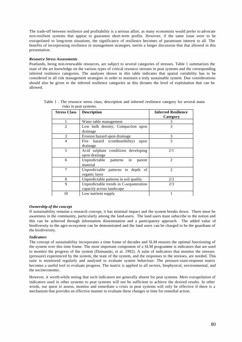
80
The trade-off between resilience and profitability is a serious affair, as many economists would prefer to advocate non-resilient systems that appear to guarantee short-term profits. However, if the same issue were to be extrapolated to long-term situations, the significance of resilience becomes of paramount interest to all. The benefits of incorporating resilience in management strategies, merits a longer discussion that that allowed in this presentation. Resource Stress Assessments Peatlands, being non-renewable resources, are subject to several categories of stresses. Table 1 summarizes the state of the art knowledge on the various types of critical resource stresses in peat systems and the corresponding inferred resilience categories. The analyses shown in this table indicates that spatial variability has to be considered in all risk management strategies in order to maintain a truly sustainable system. Due considerations should also be given to the inferred resilience categories as this dictates the level of exploitation that can be allowed.
Table 1 . The resource stress class, description and inferred resilience category for several main risks in peat systems.
Ownership of the concept If sustainability remains a research concept, it has minimal impact and the system breaks down. There must be awareness in the community, particularly among the land-users. The land users must subscribe to the notion and this can be achieved through information dissemination and a participatory approach. The added value of biodiversity to the agro-ecosystem can be demonstrated and the land users can be charged to be the guardians of the biodiversity.
Indicators The concept of sustainability incorporates a time frame of decades and SLM ensures the optimal functioning of the system over this time frame. The most important component of a SLM programme is indicators that are used to monitor the progress of the system (Dumanski, et al. 1992). A suite of indicators that monitor the stresses (pressure) experienced by the system, the state of the system, and the responses to the stresses, are needed. This suite is monitored regularly and analysed to evaluate system behaviour. The pressure-state-response matrix becomes a useful tool to evaluate progress. The matrix is applied to all sectors, biophysical, environmental, and the socioeconomic.
However, it worth-while noting that such indicators are generally absent for peat systems. Mere extrapolation of indicators used in other systems to peat systems will not be sufficient to achieve the desired results. In other words, our quest to assess, monitor and remediate a crisis in peat systems will only be effective if there is a mechanism that provides an effective manner to evaluate these changes in time for remedial action.
Stress Class Description Inferred Resilience Category
1 Water table management 3 2 Low bulk density; Compaction upon
drainage 3
3 Erosion hazard upon drainage 3 4 Fire hazard (combustibility) upon
drainage 3
5 Acid sulphate conditions developing upon drainage
2/1
6 Unpredictable patterns in parent material
2
7 Unpredictable patterns in depth of organic layer
2
8 Unpredictable patterns in soil quality 2/3 9 Unpredictable trends in C-sequestration
capacity across landscape 2/3
10 Low nutrient supply 1
81
CONCLUSIONS Viable options to enhance the quality of peatlands and to preserve the system as a risk-free environment would negate all attempts to make provisions for spatial variability. However, the events of the last few weeks prove that such trends will phase out quickly and pave the way for more holistic approaches. Future trends in preserving this invaluable and non-renewable resource will undoubtedly consider spatial variability of the system. In view of its recognised values, our poor knowledge and the rapid rate of degradation of peat swamp forest, it is urgent that suitable areas are protected for conservation purposes. This may have to include logged-over forest to some extent. In the long term, systematic holistic planning represents the best means of achieving integrated management incorporating conservation, forestry and water management objectives. Undoubtedly, all these measures will have to consider resilience in order to formulate truly sustainable land management strategies.
REFERENCES Dumanski, J., H. Eswaran, and M. Latham. 1992. A proposal for an international framework for evaluating
sustainable land management. In: Evaluation for sustainable land management in the developing world. (eds.) Dumanski, J., E. Pushparajah, M. Latham, and R. Meyers. Vol. 2: 25-45. Publ. IBSRAM, Bangkok, Thailand.
Padmanabhan, E., R. Yong, M. Anuar and Z. Assim. 1999. Impact of Spatial Variability on Resource Allocation Considerations in Peat Soils Malaysian Science & Technology Congress, November 8-10, 1999. Kuching, Sarawak.
Parkyn, L., R.E. Stoneman, and H.A.P. Ingram. 1998. (eds.) Conserving Peatlands. Publ. Commonwealth Agric. Bureau Inc. UK. 500 pp.
Prentice, C, and D. Parish. 1992. Conservation of peat swamp forest: a forgotten ecosystem. Malayan Nature Journal (Malaysia). 45:128-144.
UNCED, 1992. United Nations Conference on Environment and Development. Rio de Janeiro, Brazil.
82
POST-FIRE MANAGEMENT OF THE DAMAGE PEAT SWAMP FOREST IN BERBAK-SEMBILANG AREA, SOUTHERN SUMATERA, INDONESIA
IRWANSYAH REZA LUBIS
Wetlands International - Indonesia Programme [email protected]
INTRODUCTION The project on Management of the Ex-Peat Swamp Forest Fire Areas of Berbak-Sembilang (later on refer as BS-DGIS Peat Swamp project) is a short-term project funded by DGIS through its GPI Global Peatland Initiative) programme. The project was started in August 2001 until June 2002 and is carried out by Wetlands International – Indonesia Programme in two provinces i.e. Jambi and South Sumatera and both of these provinces are located in Sumatera. Apart from DGIS project, there is also another project being implemented in this area by WI-IP, i.e. the Berbak Sembilang coastal wetland conservation project funded by the GEF (or GEF-BSP). This 4-year GEF -BSP project was started in October 2000 and is mainly focusing on the establishment of the Sembilang area to become national park and later to integrate its management with Berbak NP as the boundaries of these two areas are overlapping and their ecosystem are relatively similar. By having two on-going projects in this area, the projects will therefore have to support and complimentary from one to another and at the end the output (mainly of the BS-DGIS) will be integrated into the GEF -BSP in the form of an integrated management plan of Berbak Sembilang national parks. The BS-DGIS project will also provide additional information regarding burnt and degraded peat swamp areas located beyond the administrative boundaries of Berbak National Park and proposed Sembilang National Park. While the GEF-BSP project itself will provide intensive information on the situation inside the park areas. As the goal of the DGIS project will develop strategies and management plan for the ex fire damaged peat swamp forest areas of the Berbak Sembilang, the information gathered under this project will therefore be integrated by the GEF-BSP project in developing comprehensive management plan of the areas. BACKGROUND There are currently an estimated 14 million ha of peatland in Indonesia mainly in Sumatra, Kalimantan and Irian Jaya. This represents over 70% of peatland area in Southeast Asia and about 50% of the world’s tropical peatlands. Due to development and rising population pressure, severe degradation of peatland in Indonesia is likely to continue in coming years unless prompt action is taken to safeguard these resources. Berbak –Sembilang is one of the most important wetland areas in Sumatra with extensive peat swamp forest in the Berbak site and mangrove forest in the Sembilang site. The Berbak-Sembilang wetland ecosystem covers about 350,000ha of peat swamp forest, freshwater swamp forest and mangroves in the provinces of Jambi and South Sumatra. It is also consider as one of the most important wetland ecosystems for conservation of biodiversity in SE Asia. The northern portion of the area lies in Berbak National Park that was designated in 1992 as Indonesia’s first Ramsar site. The southern portion has been proposed as the Sembilang National Park that was endorsed by the Provincial Governor in 1998, but has yet to be established. The two national parks contain about 200,000 ha of peat swamp forest and a further 300,000ha is found in adjacent lands. The parks represent some of the last remaining intact peatlands of Sumatra and represent an important sink and store of carbon. Estimated amounts of carbon stored in the area range from 70-200 million tonnes. There is a significant and growing local community living in and adjacent to the wetland area that depends on the ecosystem for a range of goods and services. Their future survival is linked to the development of sustainable use strategies for the resources. The areas have long history of fires started in 1987 up to the recent fires of 1997/98. The parks and the adjacent lands are threatened by expanding agricultural development which is leading to draining and burning of many adjacent peat swamp forests. This led to some of the most extensive and damaging forest fires in the history of the region of the past two years (1997-1998). It is estimated that already 146,000 ha of peat swamp within the parks and adjacent area in the eastern coast of Jambi has been burnt. However, this data may not be accurate as fires in Berbak areas were forming numerous patchy small areas with few which are large enough to be detected from satellite images. One show a big hole in the middle of the park, covers approximately an area of 12,000 ha. If compared to the Sembilang site, the Peat swamp forest areas in the Berbak were severely burnt and create lots of open patches either within the conservation areas or in it’s surrounding. Biodiversity loss is expected to be high and its ecological function may have been altered into a certain degree.
83
There has been very few studies or projects focusing on post-fire effect and rehabilitation of the damage area on Berbak National Park. Most are refer to either trying to find the underlying causes of fire and its impact, while others try to find the way to prevent future fire risk (Dennis, 1999). There were no clear management plan could be implemented for those fire damage peat swamp forest while its impact has been known to threat the ecosystem function of the area and biodiversity in the region. Hence, this project will develop a management plan covering such issues with the involvement of relevant stakeholders exist in both areas. After the plan is developed, all stakeholders will be encouraged to integrate the plan into their work programme. OBJECTIVES Project Main Objective: To develop strategies and management plan for the fire damaged peat swamp forest area of the Berbak-Sembilang in order to reduce ecological impact and future fire risk. In order to achieve the main objectives, project activities were design and categorized based on three different specific objectives: Objectives 1. Identify site-specific impact of forest fire to the wetlands and peat swamp forests of the Berbak-
Sembilang Ecosystem Objectives 2. Initiate coordination among stakeholders involved on management of the damage peat swamp forest
in Berbak Sembilang area Objectives 3. Develop a management plan for the fire damaged peat swamp forest area of the Berbak-Sembilang
in order to restore its ecological function and conserve biodiversity Current findings The early stage of the project was mainly focusing on developing and introducing the project to stakeholders in the area. Data collection has also started during the first phase of the project either through surveys and discussion with various stakeholders. Identification of site-specific impact of forest fire to the wetlands and peat swamp areas The project has gathered data and information necessary to identify the impact forest fire to the wetlands particularly the peat swamp of Berbak-Sembilang which resulted into several produced maps and survey reports. At the early stage of the project, it has been identified that the existing data and information between Berbak and Sembilang were not equally sufficient. Most data and information on forest fires were mainly available for the Berbak region, and very few for Sembilang. The abundance of data and information available on the Berbak side was due to lots of projects have been conducted by various agencies (such as The Sumatra Wetland Project, ISDP, JICA forest fire prevention etc) comprising wide range of data including biodiversity, socio-economic, land-use, National Park & Buffer Zone Management Plan. On the contrary, the amount of data and information available for Sembilang area was relatively poor and if it is available, the data usually already old such as those from Asian Wetland Bureau survey carried out before 1990. Very few survey and research carried out in this area in the past were restricted to only cover the issue of peat swamp ecology. It is therefore, will be very efficient and useful that the project put more effort on the assessment on site-specific impact of forest fire to the wetlands and peat swamp areas in Sembilang region. Meanwhile, due to the very rich information and data already available for Berbak region, therefore selection of the data will be made based on the appropriateness on the data to be used in this project. a. Identify burnt & degraded areas around Berbak-Sembilang through interpretation of satellite images
South Sumatera (Sembilang) Through interpretation of satellite images and selected maps, two important sites within the province of South Sumatra (i.e. River Merang and River Kepahiang) have been identified for survey locations. Both areas are located within administrative boundaries of Muara Merang Village in the Southern part of the proposed Sembilang National Park and harbour one of the most important and extensive peat swamp in the province, which is extended towards Northwest across the border of Jambi province. River Merang and Kepahiang is a part of an extensive peat swamp area in South Sumatran side of approximately 219,120 ha wide and the areas extended from Berbak National Park and the Southern border of Jambi province to the north-west and north-east of the proposed Sembilang National Park. Satellite images showed large burnt or degraded peat swamp forest in the area covering an area of 40,348 ha (18%). It is estimated that only 66,979 ha (30%) of natural forest with tree stand left in the area while the rest 152,141 ha (70%) of the natural forest are already disturbed either by fire, logging or land clearing. The largest disturbed area by fire of this part (around 23,855 ha) was found in the border between Sungai Benuh (in Berbak) and Terusan Dalam in Sembilang area.
84
Another location connected to the above peat swamp, which was also degraded due to forest fire in 1997, was a small peat swamp forest adjacent to a transmigration site in Karang Agung. But due to its small size and current heavy activities on habitat conversion into agricultural land and settlement area, not much effort is being put by this project, only rapid analysis were conducted in this area. At the east side of the proposed Sembilang National Park across the Musi River, laying an extensive peat swamp forest within the area of Ogan Komering Ilir (OKI), approximately covering an area of 300,000 ha, but as this area is considered not to have direct impact towards the Berbak-Sembilang ecosystem, it is therefore ignored in this study.
Jambi (Berbak) In the province of Jambi, through satellite images, a much larger ex-burnt areas than in South Sumatra can be detected. Regarding the large size of peat swamp forest, and the abundance of secondary data available for Berbak area, and the limitation of this project, only sites that has large burnt area and show potential as fire prone areas were selected to be surveyed and groundtruth from the satellite images. Thus areas were all adjacent to (at the buffer zone of) Berbak National Park. Three important sites have been identified as ex-burnt peat swamp areas, i.e. Simpang Datuk and Simpang Palas, and Air Hitam Dalam. While several continues villages in Kumpeh Area (Desa Suak Kandis, Desa Jebus, Desa Gedung Karya, Desa Sungai Aur) were also surveyed to assess the extend and impact of fires. Satellite images shows that from the original 294,314 ha of peatland area in Berbak and surrounding areas (buffer zones), 211,024 ha of peat swamp forest still left. Burnt peat areas indicate an area around 50,051 ha in Berbak and its buffer zones. While in the centre of the Berbak park, a large patches (around 12,000 ha) of open forest shown on the images indicating burn scar, is detected. For easier description in this report, Berbak and its Buffer Zone areas has been divided into five different region including the National Park itself. The division is following thus described in the document on Management Plan of the Buffer Zone published by Bappeda Jambi (2000).
b. Survey and groundtruthing of the burnt and damaged areas and identify its impact towards biodiversity
Field survey for groundtruthing the image interpretation and to asses the impact of forest fire on biodiversity were carried out in S. Merang and Kepahiang in January 2002. Survey was then continued to Karang Agung and Sungai Sembilang. All the above sites were located in the province of South Sumatera. While the survey in the province of Jambi was conducted in February 2002 with main focus on three areas surrounding the Berbak park mentioned above.
South Sumatera Survey in Merang river were made until km 67, while in Kepahiyang river were made until 17 km (Pal 17) where the river becomes too small and too shallow for the motor boat to go much further. The lower reaches of the Merang and Kepahiyang river were tidally influenced. Until about km 45, the bankside vegetation had been extensively modified by fire and logging. The riparian vegetation support secondary forest (10-20 m height), scrub (3-5 m) and grasses mixed with open or clear burnt area. Riparian vegetation are dominated by Pandanus sp , genus Sizygium (at least 3 species), Gardenia sp. and Barringtonia sp. The secondary forest along the riparian vegetation show an extensive formation of Gelam (Melaleuca cajuputi) for at least 30 km. Forest floor is mostly seasonally inundated during rainy season and is expected to dry up during dry seasons. Ground vegetation were mostly dominated by Hymenachne amplexicaulis. The extent of the Melaleuca forest further inland were not detected during surveys because the area is waterlogged, thus, making it difficult to access further inside either by foot or by boat. However from the interpretation of Landsat Images, it is estimated that it is less than 2 km from the river banks. While further inland support patches of mix open peat swamp forest with grassland. The upper reaches, from 45 km to 67 km upstream are not tidally influenced. Previous report from Bezuijen, et.al. (1995) show that the area still retained an extensive stands of primary and mature secondary peat swamp forest. The forest has not been burnt or clearly logged, only few fisherman were observed to fish in the river and smaller tributaries. This is not the case during our survey. Many new small hut or camp were found along the upper reaches. Information from local loggers reported that people begin to raid the forest around the beginning of 2001, just few months after the concession permits of PT Bumi Raya Utama has been expired in December 2000. The activities create a large canopy gaps along the mainstream, clearance of bankside, and
85
disappearance of floating aquatic vegetation such Hanguana malayana. In order to obtain the remaining tree stand, located further away from the mainstream, the loggers create canals, mostly done by hand and human labour. One logger claim that some of the canal have penetrate about 4-7 km inland. The remnants of logging concession company also leave a quite extensive network of rail tracks which were used to transport the log from inside the forest into the main stream. The leftover log trail were also being used by illegal loggers to access remote area far away from the river bank. The peat swamp forest of Merang and Kepahiyang were already logged by the HPH’s extensive logging activities in the past 30 years. The Regional Planning Board Map shows that this area is still under the HPT (Hutan Produksi Terbatas/ Limited Production Forest) status. At least four different companies were recorded has been or being operated in the peat swamp forest, namely : PT Inhutani V/ Ex PT Sylva (67,700 ha), PT Inhutani V/ Ex Sukses Sumatra Timber (179,000 ha, partly being proposed to be continued by PT Sribunian Trading Coy in 2002), PT Kurnia Musi Plywood/ ex PT Bumi Raya Utama (130,000 ha), and PT Riwayat Musi Corp. (85,000). Most of them ceased operation in 1999-2000 because their concession period expired, with the exception of Inhutani V operation is stopped because the company has no more adequate budget to manage the forest. After the expiration of the logging concession (HPH/ Hak Pengusahaan Hutan), illegal loggers are now actively logging the area for collecting the remaining valuable trees. Illegal loggers were identified as local people living in surrounding village, i.e. Muara Merang, Medak and Mangsang. But more people are coming from other area as well such as from Tulung Selapan (Ogan Komering Ilir District) and nearby areas as they regard that in Merang area timber and other valuable natural resources is still available. Conflict is often happening between the original settlers and the outsiders, mostly on the rights of extracting natural resources such timber and fish. As the result of habitat conversion and fires during the last decade, the peat swamp forest now support a mosaic secondary swamp forest, scrub, grassland croplands with only few areas indicating primary forest. Survey shows that the intense logging activities has convert much of the former primary peat swamp forest into secondary forest with tree diameter less than 80 cm in the upstream Merang and Kepahiyang river. About 50% of the canopy of the forest has been cleared, exposing forest floor with direct sunlight which dry up the peat soils and induce the growth of lower vegetation such as Stenochlaena palustris. However, the forest still contain several indicator species of peat swamp forest such as Tetramerista glabra (Punak), Cyrtostachys lakka (Palem merah), and Salacca conferta (Asam paya), although indicator species for deep peat The Pitcher Plant Nepenthes ampullaria, were only found in River Kepahiang but not in Merang River. Upon interview with locals in Merang village, it is revealed that fire is not a new phenomenon in Merang area. The year goes back to 1960 when great fires burnt the forest and agricultural land just nearby the village. Small and medium scale fire is also recorded during 1980’s and 1987. However, the extent and intensity of fires in the year 1997 is thought to be biggest so far which the impact is regard as countless. Although disturbed into certain degree, the peat swamp forest of Merang and Kepahiyang still provide stronghold for many unique biodiversity such as wildlife. Several records of rare and endangered wildlife has been sighted during this survey and previous studies, such as the Sumatran Tiger (Panthera tigris sumatrensis), Sumatran Elephant (Elephas maximus sumatrensis), False Garial (Tomistoma schlegelli), Malayan Sun Bear (Helarctos malayanus), List of species recorded in Merang and Kepahiyang are presented in survey report.
Jambi Due to the large area of Berbak, limited time and resources available to the project, only rapid survey to identify and groundtruth the burnt areas around Berbak National Park was carry out during this project on several sampling sites. However, it is consider that the sampling sites is sufficient to represent the whole burnt areas in Berbak as: the peat swamp of Berbak is located in one big peat dome and thus share the same ecological properties, most burnt or damage peat swamp in Berbak are located within the buffer zone or within the border of the park and fire in this area is suspected to be influenced or induced by human. Therefore regardless of the location of the sampling sites for this study, we assume all will gave similar results. More detailed information of Berbak area has been comprehensively collected in other documents such as The Management Plan of Berbak National Park (LH) and Buffer Zone Management Plan of Berbak NP (WI, 2000).
86
The peat swamp forest in the east coast of Berbak NP buffer zone area has been mainly converted into agriculture and plantation area while on the western site can be categorized in to several land use type: Hutan Lindung Gambut (Protected Peat swamp Forest), Taman Hutan Raya (Forest Park), Hutan Produksi Terbatas (Limited Production Forest) and converted forest. While most of the peat swamp within the Berbak NP is legally protected under Indonesian National Laws from land conversion. Vegetation analysis and faunal survey has been carry out in Simpang Datuk and Simpang Palas, because this area is directly within the boundary of the National Park and community land and relatively easy to access. Air Hitam Dalam is located within the core zone of the Berbak NP and it is easy to access from the main Batanghari river and though to represent the pristine peat swamp forest as a control site. While in several continues villages in Kumpeh Area (Desa Suak Kandis, Desa Jebus, Desa Gedung Karya, Desa Sungai Aur) survey were focused only to identify the extent of burnt and damage peat swamp forest because the border of the National Park are located several km’s behind the village across the Taman Hutan Raya (see Annex 3 for Maps of Berbak area). Fire has changed the properties of the peat swamp forest ecosystem in Berbak, close canopy of higher tress with lower vegetation on the forest floor has been replaced into a mosaic of open patches of burnt stands dominated with pioneer species consist of grass and shrubs. Regeneration of pioneer species has been detected by the emergence of several typical pioneer species in peat swamp forest such as occurrence of Macaranga Tree poles. Repeated and frequent fire events will eventually altered the ecosystem towards grass swamp ecosystem or open secondary swamp forest. During the ISDP project (1997-2000) carried out by WI-IP in collaboration with AMYTHAS consulting firm, this area was already identified as new burnt areas caused by fire in 1997. The size of this new burnt area was estimated around 12,000 ha and was reported that during the rainy season this area covered by water that make the area looks like an open big lake, but during dry season some fire resistance plant species with the height of almost 4 meter tall (Macaranga sp . locally known as “mahang”) are appeared (pers. Comm. with local ranger in Nipah Panjang in December 2001). Recent information obtained from the Berbak National Park management unit, it was told that it is difficult to access this area now due to dense aquatic vegetation and felled trees blocked the river and also due to a very shallow water. During the surveys, impact of forest fire to peat swamp habitat and its bio-diversity were assessed rapidly. Survey sites were selected as a sampling site to represent the damaged and burnt peat swamp forest of Berbak-Sembilang. Biodiversity assessment covers the vegetation survey that was focussing on general type of vegetation community structure that built in the ex-burnt forest areas and an inventory on plant species diversity and its survival. Apart from biodiversity measurement, impact of fire on physical habitat conditions was also recorded. Data were collected either from direct or indirect observation and surveys carried out by motor boat following rivers and its tributaries and canoe is used (also walk) whenever the river becomes smaller for motorboat. Fire has changed the properties of the peat swamp forest ecosystem in Berbak, close canopy of higher tress with lower vegetation on the forest floor has been replaced into a mosaic of open patches of burnt stands dominated with pioneer species consist of grass and shrubs. Regeneration of pioneer species has been detected by the emergence of several typical pioneer species in peat swamp forest such as occurrence of Macaranga Tree poles. Repeated and frequent fire events will eventually altered the ecosystem towards grass swamp ecosystem or open secondary swamp forest. About 140 species from 56 fa milies of plants were recorded in the ex-burnt peat swamp areas. Species number are abundance in the pristine area than in the damage one. Only species that were adapted to open canopy and expose of direct sunlight are able to emerge in the burnt area. Fires that creates open swamp and patches of deforested forest has given advantages and disadvantages of biodiversity in the area. Some has disadvantages from this event but some gain benefit. Response of difference fauna species during and post-fire event were analysed based on the ecological behaviour of the animal.
c. Assess current knowledge on the causes of fires in the area with special emphasis on finding ways to
prevent future fire risk
Assessment of factors causing fire on peat swamp areas in the region are compiled based on combining results of survey, dialogs, GIS interpretation as well as literature study of existing fire related documents.
87
Regarding the complexity of factors that causing fires especially in peat areas, the project has try to evaluate the underlying causes specifically occur in the Berbak-Sembilang peat swamp. Nevertheless, we will address a summary on the current knowledge on cause of forest fire in brief for the purpose of this paper below. Three long-term forest fire projects has bee carried out in Indonesia (FFPCP/EU, IFFM/GTZ, FFPMP/JICA) and numbers of smaller projects related to fire has been conducted as well in Indonesia by various agencies (Forestry Department, CIFOR, ICRAF, WI-IP). Therefore, there should be much have been learnt now since the big fires in 1994 and 1997. Issues on what causing forest fires in Indonesia are still under a heated debate among government officials and general public (including NGOs). Some said the forest fire was created by farmers (to clear the forestland/farmland for agriculture) and by plantation estate (to clear the land for palm oil). While others said it was due to cigarettes lit and camp fire created by the illegal loggers and fishermen in the forest, and others also said the fire was created by poachers etc. The last one was made (for example in Tanjung Putting NP in Kalimantan) by the poachers by burning the forest for chasing the animals out of the forest that make easier to caught. From what have been argued, it is not what causing the fire is important, but the most important things that people must be aware on how to prevent the next fires and how to tackle the situation if fires come again. Apart from above issues, the plans to manage the ex-burnt areas are also important, which this will be the output of the project. Although we realized that factors causing forest fire are complex, but it can be concluded that all fires are created by human and accelerated by land use changes especially on ecologically valuable and fragile ecosystem such as peat swamp areas. Apart from this, lack of resources to control fires, change in global climate (create long drought) and lack of people awareness on the serious impacts created by forest fires are also responsible to the forest fire in Indonesia.
d. Assessment on feasibilities to restored the damage peat swamp area
It is learned during this project that restoring the fire - damage peat swamp area was not a simple task as replanting trees in deforested land. Returning a damage peat swamp into its previous state a mature-mixed swamp forest is still impracticable on the basis of current knowledge. If changes in the drainage pattern has lowered the water table and causes peat subsidence, the actual shape of the peatland surface will be change and will be impossible to restore back into the original hydrological conditions in a short or medium term. While quick action is urgently needed on handling damage and disturbance of peat swamp forest, long term action will be too late. However, the project has been able to identify several efforts to rehabilitate the damage peat swamp, most of them are concentrating only on replanting aspect of rehabilitation and very few on efforts to restore the hydrological function directly. Several forest concession companies (HPH) are also recognised to have started to replant the ex-burnt forest with certain tree species. Field visits to PT Putra Duta Indah Wood in Jambi has been carried out by the project team. The rehabilitation site is located in the Buffer Zone of Berbak National Park in Kumpeh District. Since the beginning of 2001, the company is trying to rehabilitate the burnt and degraded peat swamp forest by means of re-planting the area with various tree species, mostly peat swamp species such as Meranti Rawa (Shorea pauciflora), Durian Burung (Durio carinatus), Ramin (Gonystylus bancanus) and Jelutung (Dyera lowii). Two other companies in South Sumatera province OKI District, PT Sribunian and PT SBA Wood has just begun its rehabilitation programme of their fire-damage peat forest concession area. OKI district is not located within the vicinity of Sembilang but it is been known for its wide area of peatland (about 300.00- ha) with very few natural forest covert and mostly has been degraded or converted to other land use type. Information gathered from the staff of both companies conclude that the rehabilitation programme of the peat swamp is directed to change the status of the land from Limited Production Forest (HPT) into Industrial Tree Forest/Plantation (HTI) by replanting and converting the peatland into drier forest such as Acacia or rubber plantation or even Oil Palm. Regrettably, during the visits we got the impression that rehabilitation of degraded peat land done by these companies with support fro m related Agencies such as Forestry and University is directed towards the economical value of the forest, not to restore the ecological function of the peat swamp. The controls is left with the government to act on this issue because those companies will only done actions or programmes which are benefiting in financial terms to them in a short term rather that the long term function of peat swamp ecosystem.
88
Several small scale fire prevention/rehabilitation demo projects have also been carried out within the Berbak National Park’s buffer zone under a financial support from JICA and ISDP project scheme. JICA has supported the Sei Rambut (adjacent to Berbak NP) community with seedlings (i.e. pinang, sengon, nangka etc) to be planted within the community lands and mainly with pinang within the boundary of the park areas. The last one was failed due to the very acidic sulphate soil that later on found killed the seedlings. While ISDP has supported the mangrove rehabilitation programme near the pantai Cemara area. Based on the available resources of peat rehabilitation programme and consultation with fellow peat scientist that restoring the damage peat swamp require sets of in deep investigation to hydrologic function of the area, and field experiment of try and error on replanting, the project conclude that a detail programme on peat restoration could not be written only through this small and short project. However, the project feel the necessities to gave guidance related to consideration to restore or rehabilitate peat swamp areas in the management plan.
Approach and strategies to initiate coordination among stakeholders involved on management of the damage peat swamp forest in Berbak Sembilang area The project has been successful on initiating coordination and creating awareness on the importance of proper integrated management of peat swamp forest among different stakeholders involved on management of the damage peat swamp forest in Berbak Sembilang. Series of dialog and meetings with the stakeholders from the village up to the provincial level has been conducted by the project spread from February until June 2002. It was planned originally that the preparation of the management plan is taking place from a small team consist of representative responsible for management of the peat swamp. Results of the team will then put forward to forum of stakeholders during the workshop. This top to bottom way of designing programmes or management plan that are normally conducted in such works, is not appropriate anymore in this era of political reformation and decentralization. Programmes should be designed based on the needs of the implementer and the project only provides technical support to guarantee the activities are wise-use and sustainable. Therefore, to gain input and commitment from all stakeholders, strategy of the projects needs to refocus towards a more bottom-up approach. During coordination meeting, it is also identified that very few stakeholders has programme specifically designed to manage the damage peat swamp forest in Berbak-Sembilang. Most of the related programme are related to fire prevention, water regulation, agricultural practices, and natural resources exploitation. Therefore, the project carefully examines various options of approach and suitable strategies to suggested by all stakeholders involved on management of peat swamp for its benefit and disadvantage. Various stakeholders related or involved in the management of peat swamp areas in the region has been identified during the project. The first stakeholder meeting was set up in November 2001 both in Palembang and Jambi and has been attended by government officers and local NGO’s. The participants of the workshop were given pre-project introduction on aims and objectives of this project and on how to implement the project output. Participants were asked for their active support and role in this project. The meeting obtained a full support from all stakeholders to develop a management plan for the damage or ex-burnt peat swamp forest. Preliminary meetings with local communities, informal leaders and village government were commenced during survey trips in January and February 2002. Most of the meeting’s participants showed their interest on how to manage and solve problem in the ex-burnt areas. Conflict of interest between different stakeholders was also detected during this meeting and should be used as input for designing the action programmes. Series of meeting was conducted with the cooperation with local NGO’s (Yayasan Pinang Sebatang for the Jambi region and Wahana Bumi Hijau for the South Sumatera region) and supported by the local government of village, Kecamatan (District), Kabupaten (Regency) and Provincial level. During the meeting, all stakeholders were asked to proposed and discussed their programme to all participant. All input will be examined by the project team and formalize into a draft of management plan. The Final meeting in Jambi province held in June 25th 2002, is aim to disseminate and socialised all information summary gathered from previous meetings on lower level. Key issues were presented to the audience consist of multi-stakeholders from government officials, NGOs, local communities, local press and private sector from Jambi and few from South Sumatera. The participant were then divided into four different groups to cover four key issues essential on managing the burnt peat swamp area in Berbak-Sembilang, i.e.: Ø Community development and Awareness
89
Ø Capacity building and income generating activities Ø Rehabilitation of burnt area Ø Policy/law enforcement In summary, at the end of the workshop it was conclude that all participants has identified the importance of peat swamp forest and its high potential in Jambi and South Sumatera which needs sustainable management. There is no way to return the peat swamp forest to its original condition once it disappears, but efforts should be made to prevent future loss and ensure that the best possible management is imply. The participant urges the design of management strategies that contains guidelines for management of peat swamp with special emphasis on managing the degraded areas and its benefit for local communities. Development of a management plan for the fire damaged peat swamp forest area of the Berbak-Sembilang in order to restore its ecological function and conserve biodiversity The project has written the first draft of the management plan containing series of action and programme to manage the damage peat swamp forest in Berbak-Sembilang and to prevent future fire risk in this kind of area. Since the year 1995, Ministry of Forestry has release several regulation or guidance to prevent forest and land fire such as “The National Guideline for the protection of forest to fires”, while The President of Indonesia has just recently issue a regulation ‘Peraturan Pemerintah Republik Indonesia Nomor 4 Tahun 2001’ on controlling damage and environmental pollution caused by forest or land fire. Issues related to the management of damaged peat swamp forest contained in those document is included in the management plan. Actions and programmes are described for each specific site that can be divided into: Ø Peat swamp forest within the Berbak National Park Ø Peat swamp forest in the Buffer Zone of Berbak National Park adjacent to community land and other
land use type Ø Peat swamp forest in the region of Sungai Merang-Kepahiyang and Sembilang area
The management plan consists of key issues related to the management of peat swamp in Berbak-Sembilang with special action for each specific sites. The programmes are designed in such way that it should be realistic to be perform by each stakeholders. Main issues and proposed action described in the draft management plan is presented below: Ø Community development and Awareness: Environmental education and awareness programme (formal
and informal) using various approach, community institutional strengthening, community facilitation, involvement of local communities on protection of conservation areas and natural resources management, incorporating and accommodating local knowledge and customary law in to the action and programmes in the management plan.
Ø Capacity building and income generating activities: integrated pest management integrated with area boundaries, establish a multi sector cooperation body (Koperasi Unit Desa/KUD)on managing agricultural and natural products, organise and develop home industry activities, diverting illegal logging by develop income generating activity towards effective and sustainable management of natural resources (fisheries, peat crops species, animal farming, non-timber forest product etc.), continuous facilitation and extension works for local communities.
Ø Rehabilitation of burnt area: Integration of rehabilitation programme with income generating activities by providing incentives to those contribute on replanting trees in burnt areas or abandon peatland, studies and research on rehabilitation programmes and options, proposed allocation part of concession areas for agroforestry or social forest programmes with cooperation between stakeholders for the benefit of local communities, rehabilitation programme should be back up by appropriate legislation and law enforcement.
Ø Policy/law enforcement: issue a local regulation on prohibiting land clearance using fires, facilitating regular discussion between stakeholders related to management and utilisation of peat swamp/land area, provide a legal solution on the ownership of abandon land, enforce control and action for the implementation regulation related to land/forest fire, review and audit all current and planned activities in peat areas, regulation to stop peat canalisation and water regulation, apply moratorium log for province of Jambi and South Sumatera, create integrated and independent team to mitigate illegal logging.
Whenever possible, it is stated in the plan 'who' is doing 'what' and 'where' the funding of such programme should be obtain. The plan should also open option for source of funding apart from the government, such as utilizing local private companies or international donor agencies. With this strategies, the dependencies of the programme on sole funding can be limited which usually hinder the implementation of such programme by sectoral agencies.

90
As the BSP-DGIS project has to cease its activities at the end of June 2002, the follow up of the integration and finalization of the management plan for the next two year (until 2004) is forward on to Wetlands International BSP-GEF project where this project is co-financing. The BSP-GEF will integrate the follow-up finalization and implementation of the management plan under it activities on planning the Buffer Zone of Sembilang area.
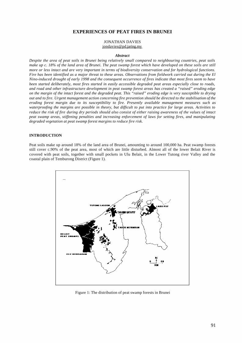
91
EXPERIENCES OF PEAT FIRES IN BRUNEI
JONATHAN DAVIES [email protected]
Abstract
Despite the area of peat soils in Brunei being relatively small compared to neighbouring countries, peat soils make up c. 18% of the land area of Brunei. The peat swamp forest which have developed on these soils are still more or less intact and are very important in terms of biodiversity conservation and for hydrological functions. Fire has been identified as a major threat to these areas. Observations from fieldwork carried out during the El Nino-induced drought of early 1998 and the consequent occurrence of fires indicate that most fires seem to have been started deliberately, most fires started in easily accessible degraded peat areas especially close to roads, and road and other infrastructure development in peat swamp forest areas has created a “raised” eroding edge on the margin of the intact forest and the degraded peat. This “raised” eroding edge is very susceptible to drying out and to fire. Urgent management action concerning fire prevention should be directed to the stabilisation of the eroding forest margin due to its susceptibility to fire. Presently available management measures such as waterproofing the margins are possible in theory, but difficult to put into practice for large areas. Activities to reduce the risk of fire during dry periods should also consist of either raising awareness of the values of intact peat swamp areas, stiffening penalties and increasing enforcement of laws for setting fires, and manipulating degraded vegetation at peat swamp forest margins to reduce fire risk. INTRODUCTION Peat soils make up around 18% of the land area of Brunei, amounting to around 100,000 ha. Peat swamp forests still cover c.90% of the peat area, most of which are little disturbed. Almost all of the lower Belait River is covered with peat soils, together with small pockets in Ulu Belait, in the Lower Tutong river Valley and the coastal plain of Temburong District (Figure 1).
Figure 1: The distribution of peat swamp forests in Brunei
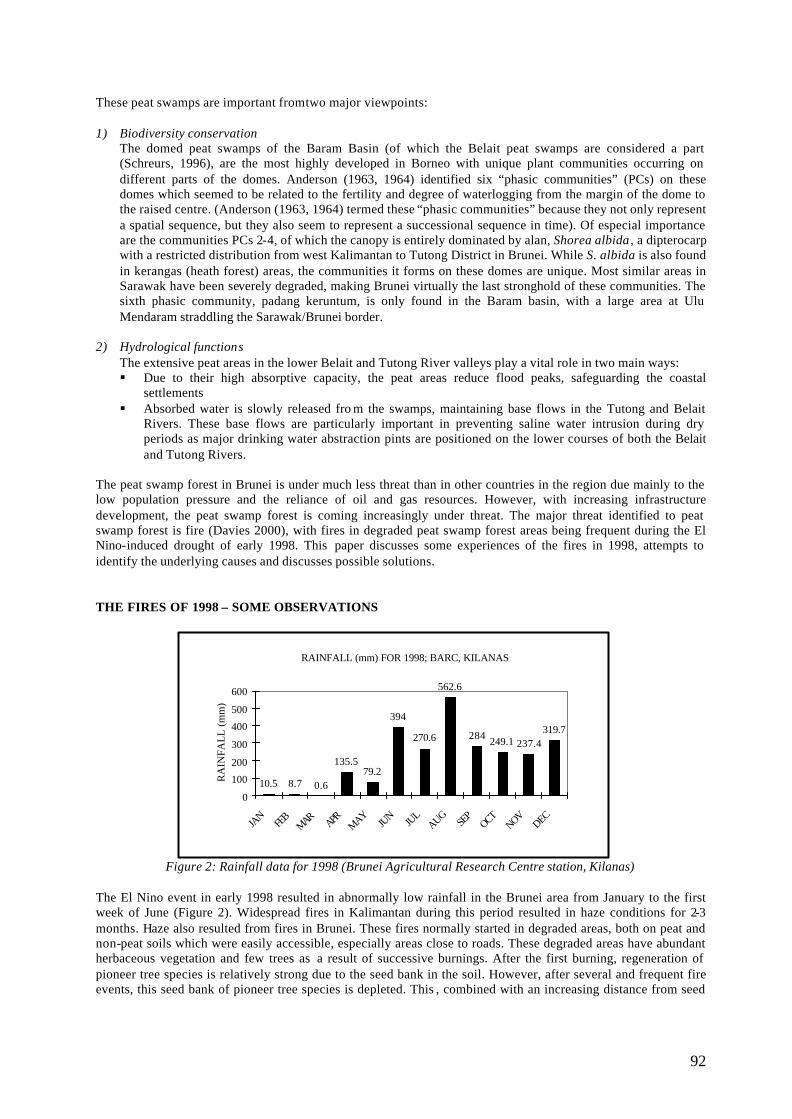
92
These peat swamps are important from two major viewpoints: 1) Biodiversity conservation
The domed peat swamps of the Baram Basin (of which the Belait peat swamps are considered a part (Schreurs, 1996), are the most highly developed in Borneo with unique plant communities occurring on different parts of the domes. Anderson (1963, 1964) identified six “phasic communities” (PCs) on these domes which seemed to be related to the fertility and degree of waterlogging from the margin of the dome to the raised centre. (Anderson (1963, 1964) termed these “phasic communities” because they not only represent a spatial sequence, but they also seem to represent a successional sequence in time). Of especial importance are the communities PCs 2-4, of which the canopy is entirely dominated by alan, Shorea albida , a dipterocarp with a restricted distribution from west Kalimantan to Tutong District in Brunei. While S. albida is also found in kerangas (heath forest) areas, the communities it forms on these domes are unique. Most similar areas in Sarawak have been severely degraded, making Brunei virtually the last stronghold of these communities. The sixth phasic community, padang keruntum, is only found in the Baram basin, with a large area at Ulu Mendaram straddling the Sarawak/Brunei border.
2) Hydrological functions
The extensive peat areas in the lower Belait and Tutong River valleys play a vital role in two main ways: § Due to their high absorptive capacity, the peat areas reduce flood peaks, safeguarding the coastal
settlements § Absorbed water is slowly released fro m the swamps, maintaining base flows in the Tutong and Belait
Rivers. These base flows are particularly important in preventing saline water intrusion during dry periods as major drinking water abstraction pints are positioned on the lower courses of both the Belait and Tutong Rivers.
The peat swamp forest in Brunei is under much less threat than in other countries in the region due mainly to the low population pressure and the reliance of oil and gas resources. However, with increasing infrastructure development, the peat swamp forest is coming increasingly under threat. The major threat identified to peat swamp forest is fire (Davies 2000), with fires in degraded peat swamp forest areas being frequent during the El Nino-induced drought of early 1998. This paper discusses some experiences of the fires in 1998, attempts to identify the underlying causes and discusses possible solutions. THE FIRES OF 1998 – SOME OBSERVATIONS
Figure 2: Rainfall data for 1998 (Brunei Agricultural Research Centre station, Kilanas) The El Nino event in early 1998 resulted in abnormally low rainfall in the Brunei area from January to the first week of June (Figure 2). Widespread fires in Kalimantan during this period resulted in haze conditions for 2-3 months. Haze also resulted from fires in Brunei. These fires normally started in degraded areas, both on peat and non-peat soils which were easily accessible, especially areas close to roads. These degraded areas have abundant herbaceous vegetation and few trees as a result of successive burnings. After the first burning, regeneration of pioneer tree species is relatively strong due to the seed bank in the soil. However, after several and frequent fire events, this seed bank of pioneer tree species is depleted. This , combined with an increasing distance from seed
RAINFALL (mm) FOR 1998; BARC, KILANAS
10.5 8.7 0.6
135.579.2
394
270.6
562.6
284 249.1 237.4319.7
0
100
200
300
400
500
600
JAN
FEB
MARAPR
MAYJU
N JUL
AUGSE
POCT
NOVDEC
RA
INFA
LL
(m
m)
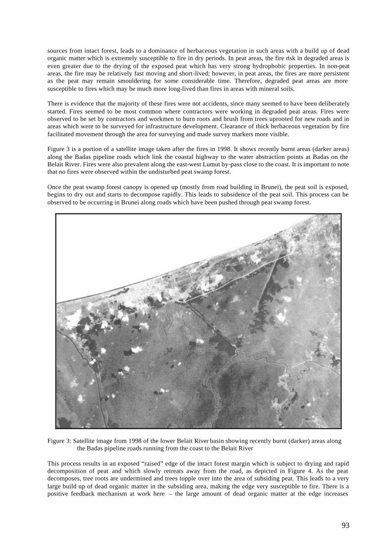
93
sources from intact forest, leads to a dominance of herbaceous vegetation in such areas with a build up of dead organic matter which is extremely susceptible to fire in dry periods. In peat areas, the fire risk in degraded areas is even greater due to the drying of the exposed peat which has very strong hydrophobic properties. In non-peat areas, the fire may be relatively fast moving and short-lived; however, in peat areas, the fires are more persistent as the peat may remain smouldering for some considerable time. Therefore, degraded peat areas are more susceptible to fires which may be much more long-lived than fires in areas with mineral soils. There is evidence that the majority of these fires were not accidents, since many seemed to have been deliberately started. Fires seemed to be most common where contractors were working in degraded peat areas. Fires were observed to be set by contractors and workmen to burn roots and brush from trees uprooted for new roads and in areas which were to be surveyed for infrastructure development. Clearance of thick herbaceous vegetation by fire facilitated movement through the area for surveying and made survey markers more visible. Figure 3 is a portion of a satellite image taken after the fires in 1998. It shows recently burnt areas (darker areas) along the Badas pipeline roads which link the coastal highway to the water abstraction points at Badas on the Belait River. Fires were also prevalent along the east-west Lumut by-pass close to the coast. It is important to note that no fires were observed within the undisturbed peat swamp forest. Once the peat swamp forest canopy is opened up (mostly from road building in Brunei), the peat soil is exposed, begins to dry out and starts to decompose rapidly. This leads to subsidence of the peat soil. This process can be observed to be occurring in Brunei along roads which have been pushed through peat swamp forest.
Figure 3: Satellite image from 1998 of the lower Belait River basin showing recently burnt (darker) areas along
the Badas pipeline roads running from the coast to the Belait River This process results in an exposed “raised” edge of the intact forest margin which is subject to drying and rapid decomposition of peat and which slowly retreats away from the road, as depicted in Figure 4. As the peat decomposes, tree roots are undermined and trees topple over into the area of subsiding peat. This leads to a very large build up of dead organic matter in the subsiding area, making the edge very susceptible to fire. There is a positive feedback mechanism at work here – the large amount of dead organic matter at the edge increases
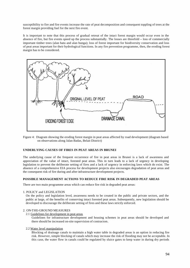
94
susceptibility to fire and fire events increase the rate of peat decomposition and consequent toppling of trees at the forest margin providing fuel for the next fire event. It is important to note that this process of gradual retreat of the intact forest margin would occur even in the absence of fire, but fire events speed up the process substantially. The losses are threefold – loss of commercially important timber trees (alan batu and alan bunga); loss of forest important for biodiversity conservation and loss of peat areas important for their hydrological functions. In any fire prevention programme, then, the eroding forest margin has to be considered.
Figure 4: Diagram showing the eroding forest margin in peat areas affected by road development (diagram based
on observations along Jalan Badas, Belait District)
UNDERLYING CAUSES OF FIRES IN PEAT AREAS IN BRUNEI The underlying cause of the frequent occurrence of fire in peat areas in Brunei is a lack of awareness and appreciation of the value of intact, forested peat areas. This in turn leads to a lack of urgency in developing legislation to prevent the deliberate setting of fires and a lack of urgency in enforcing laws which do exist. The absence of a comprehensive EIA process for development projects also encourages degradation of peat areas and the consequent risk of fire during and after infrastructure development projects. POSSIBLE MANAGEMENT ACTIONS TO REDUCE FIRE RISK IN DEGRADED PEAT AREAS
There are two main programme areas which can reduce fire risk in degraded peat areas: 1. POLICY and LEGISLATION
On the policy and legislation level, awareness needs to be created in the public and private sectors, and the public at large, of the benefits of conserving intact forested peat areas. Subsequently, new legislation should be developed to discourage the deliberate setting of fires and these laws strictly enforced.
2. ON-THE-GROUND MEASURES
2.1 Guidelines for development in peat areas Guidelines for infrastructure development and housing schemes in peat areas should be developed and there should be increased on-site supervision of contractors.
2.2 Water level manipulation
Blocking of drainage canals to maintain a high water table in degraded areas is an option in reducing fire risk. However, simple blocking of canals which may increase the risk of flooding may not be acceptable. In this case, the water flow in canals could be regulated by sluice gates to keep water in during dry periods
95
and to release water in rainy periods to avoid flooding. This assumes there will be a long term management commitment on the part of the responsible agency.
2.3 Rehabilitation of degraded peat land
In Brunei herbaceous vegetation such as sedges (Scleria spp.), grasses (Ischaemum, Imperata) and ferns (Nephrolepis, Stenochlaena palustris and others) seem to be the major primary colonisers of degraded peat land. Tree species coming later include Alstonia sp. and Dryobalanops rappa, although precisely what tree species becomes established is largely dependent on the proximity of the seed source. Both of these species seem to be successful in Brunei in pushing their way above the thick herbaceous vegetation. However, the major problem in re-establishing tree cover is that fire events are becoming more and more frequent in degraded areas with the result that the succession is repeatedly knocked back to the early, herbaceous phase. In this respect, the natural, long term succession after fire in degraded peat areas should be studied in fire-prone areas to identify the natural pioneer tree species in these localities and then these should form the basis of rehabilitation efforts. The use of exotics such as Acacia auriculiformis and A. mangium should be avoided. Fallen leaves of these species are slow to decompose and they accumulate on the ground, increasing the risk of fire. Invasion of degraded areas by these species has been a major factor in the increased frequency of fires in such areas in Brunei.
2.4 Stabilisation of the intact forest margin
Halting the slow retreat of the intact forest margin and the subsequent increased risk of fire is a difficult problem. In sma ll, intensively managed areas sealing or “waterproofing” has been successfully carried out. For example, Woodwalton Fen in eastern England is a small (208 ha) remnant semi -natural peat area which is now isolated in agricultural land. The fen, through subsidence of peat in converted areas, is now higher than the surrounding area and was suffering from peat loss at its margins until they were sealed with clay excavated from nearby. Such measures may not be practical in large areas, yet it is difficult to put forward other effective solutions to halt this very damaging process.
CONCLUSION The major threat to peat areas in Brunei is fire, which is often set deliberately. The main underlying cause is a lack of appreciation of the values of intact peat swamp forest. Actions at the policy/legislation level and practical on-the-ground measures are needed to reduce the risk of fire in peat areas. It is hoped that this brief discussion of experiences with fires in degraded peat areas in Brunei and the putting forward of possible solutions will contribute to the development of practical solutions to prevent fires. ACKNOWLEDGEMENTS This paper was developed after extensive fieldwork and visits to peat areas in Brunei whilst the author was a lecturer at the Biology Department, Universiti Brunei Darussalam. He wishes to thank UBD for its support in undertaking this fieldwork. The Department of Agriculture, Brunei Darussalam, kindly supplied the rainfall data for 1998. REFERENCES Anderson, J. (1963) The flora of the peat swamp forests of Sarawak and Brunei, including a catalogue of all
recorded species of flowering plants, ferns and fern allies. Gardens Bulletin, Singapore 20 131 – 228 Anderson, J. (1964) The structure and development of the peat swamps of Sarawak and Brunei. Journal of
Tropical Geography 18 7 - 16 Davies, J. (2000) Conservation and management of peat swamp forest in Brunei. Paper presented at the
“International Conference and Workshop on Tropical Peat Swamps – Safeguarding a Global Natural Resource”; 27 – 30 July 1999, Penang, Malaysia.
Schreurs, J. (1996) Geographical overview. In: Sandel, S.T. (ed.) (1996) The geology and hydrocarbon resources of Negara Brunei Darussalam. Pp. 22 – 45. Brunei Shell Petroleum and Brunei Museum.

96
ANNEX 1 WORKSHOP ORGANISING COMMITTEE
Chairman
Mr. Thang Hooi Chiew
Members
Mr. Mahmad Rasid Ibrahim
Mr. Roslan Arrifin
Mr. Faizal Parish
Dr. Eswaran Padmanabhan
Mr. David Lee
Mr. Mohd Jinis Abdullah
Mr. Zahari Ibrahim
Mr. Ridzuwan Endot
Mr. Saiful Azmi Mat Aazid
Mr. Mohd Nor Mohd Rashid
Mr. Hairul Abd Hamid
Mr. Azam Daud
Mr. Muhamad Abdullah
Mr. Mohd Kamil Ahmad
The organising Committee wishes to express its sincere appreciation to the numerous public, private organisations and individuals for their untiring support
in organising the workshop

97
ANNEX 2 WORKSHOP PROGRAMME
Registration of participants Opening Ceremony by Y. Bhg. Datuk Zul Mukhshar bin Dato’ Md. Shaari, Director General of Forestry, Peninsular Malaysia Papers Presentations SESSION 1 Chairman : Mr. Razani Ujang Director of Forestry Department, Selangor State SESSION 2 Chairman : Dr. Eswaran Padmanabhan Programme Manager, Global Environment Centre SESSION 3 Chairman : Dr. Salmah Zakaria Director of Corporate Development Division, Drainage and Irrigation Department Briefing on field assessment Field Assessment to Raja Musa Forest Reserve, North Selangor Peat Swamp Forest
Stop 1 PKPS Stop 2 State land near compartment 71 Stop 3 Agrotech
Working Groups Discussion
Group 1 : Chairperson – Dr. Hj. Abd. Rahman Hj. Abd Rahim Group 2 : Chairperson – Mr. Borhan Madon Group 3 : Chairperson – Dr. Shamsudin Ibrahim
Panel Discussion
Chairman : Mr. Thang Hooi Chiew Panel Members : Dr. Hj. Abd. Rahman Hj. Abd Rahim Mr. Borhan Madon Dr. Jonathan Davies Dr. Herbert Diemont Mr. Faizal Parish
Conclusion
19th March 2002 (Tuesday)
20th March 2002 (Wednesday)
21st March 2002 (Thursday)
98
ANNEX 3 PARTICIPANTS LIST AND CONTACT No Name Designation Affiliation Tel / Fax /Email 1. Abdul Rahim
Nik Director- Forest Environment Division
Forest Research Institute Malaysia (FRIM), Kepong, 52109 Kuala Lumpur.
Tel : 03-62707180 Fax : 03-62797807 [email protected]
2. Ahmad Ainuddin Nuruddin
Lecturer Fakulti Perhutanan, Universiti Putra Malaysia, 43400 Serdang, Selangor.
Tel : 03-89467193 Fax : 03-89432514 [email protected]
3. Ahmad B. Shahabudin
Penguasa Kanan Bomba
Jabatan Bomba dan Penyelamat Malaysia, Leboh Perdana Barat, Precinct 7, 62000 Putrajaya.
Tel : 03-88880036 Fax : 03-88880962
4. Ahmad Rizal Khalit
Assistant Secretary Kementerian Perusahaan Utama, Tingkat 6-8, Menara Dayabumi, Jalan Sultan Hishamuddin, 50654 Kuala Lumpur.
Tel : 03-26988244 Fax : 03-26925657
5. Alona C. Linatoc Science Research Specialist II
ASEAN Regional Centre for Biodiversity Conservation (ARCBC), P.O. Box 35015, College of Forestry and Natural Resources, University of the Phillippines, Los Banos.
6. Arianti Atong Research Assistant WWF Malaysia 49, Jalan SS23/15 Taman SEA 47400 Petaling Jaya Selangor
Tel : 03-78033772 Fax : 03-78035157
7. Arumugam a/l Tirumalai
Penolong Pegawai Kawalan Kanan Alam Sekitar
Jabatan Alam Sekitar, Aras 3-7, Blok C4, 62662 Putrajaya.
Tel : 03-88858200
8. Aziz B. Che Ali. Pen. Peg. Ladang Jabatan Perhutanan Negeri Perak, Jalan Panglima Bukit Gantang, 30000 Ipoh, Perak.
Tel : 05-2550020 Fax : 05-2553644
9.10.
Basri Abdul Wahid
Pen. Peg. Ladang. Jabatan Perhutanan Negeri Kelantan, Blok 5, Tingkat 1, Kota Darul Naim, 15503 Kota Bahru, Kelantan.
Tel : 09-7481957 Fax : 09-7445657
11. Borhan Madon Pen. Kanan Penguasa Bomba
Ibu Pejabat Bomba and Penyelamat Negeri Selangor Persiaran Sultan, Seksyen 15 40200 Shah Alam Selangor
Tel : 03-55194444 Fax : 03-55102324
12. Chong Ted Tsiung.
Ag. Controller of Environment Quality
Sarawak National Resources, 18th & 19th Floor, Menara Pelita, Locked Bag 2103, 93050 Kuching, Sarawak.
Tel : 082-319502 Fax : 082-448254 [email protected]
13. David Lee Technical Officer Global Environment Centre 7A, Jalan 19/29 46300 Petaling Jaya Selangor
Tel : 03-79572007 Fax : 03-79577003 [email protected]
14. Eswaran Padmanabhan
Programme Manager
Global Environment Centre 7A, Jalan 19/29 46300 Petaling Jaya
Tel : 03-79572007 Fax : 03-79577003
99
Selangor 15. Faizal Parish Director Global Environment Centre
7A, Jalan 19/29 46300 Petaling Jaya Selangor
Tel : 03-79572007 Fax : 03-79577003 [email protected] or [email protected]
16. Fong Lai Hoy Pen. Peg. Silvikultur Negeri
Jabatan Perhutanan Negeri Kedah, Tingkat 8, Bangunan Sultan Abdul Halim, Jalan Sultan Badlishah, 05000 Alor Setar, Kedah.
Tel : 04-7333844 Fax : 04-7310610
17. Ginny Ng Forest Conservation Officer
WWF Malaysia 49, Jalan SS23/15 Taman SEA 47400 Petaling Jaya Selangor
Tel : 03-78033772 Fax : 03-78035157
18. Herbert Diemont EU STRAPEAT PROJECT, Alterra, Wageningen University & Research Centre
Tel:+31-317-474700 Fax: +31-317-419000 [email protected]
19. Hj. Abd. Rahman Hj. Abd. Rahim
Deputy Director- Forest Plantation
Ibu Pej. Perhutanan Semenanjung Malaysia, Jalan Sultan Salahuddin, 50660 Kuala Lumpur.
Tel : 03-26962561 Fax : 03-26962567 [email protected]
20. Ibrahim Selamat Macres, No. 13, Jalan Tun Ismail, 50480 Kuala Lumpur
Tel: 03-26973400 Fax: 03+26973350 [email protected]
21. Irwansyah Reza Lubis
Wetland Ecologist Wetlands International - Indonesia Programme Jl. A. Yani No 53, Bogor PO Box 254/BOO, Bogor 16002, Jawa Barat Indonesia
Tel : +62-251312189 Fax : +62-251325855 [email protected]
22. Ismail Parlan Research Officer Forest Research Institute Malaysia (FRIM), Kepong, 52109 Kuala Lumpur.
Tel : 03-62797178 Fax : 03-62779643 [email protected]
23. Jonathan Davies Private Consultant 22, SS19/1A, 47500 Subang Jaya, Selangor.
Tel : 03-03-56331599 H/P : 012-3958435 [email protected]
24. Kadri B. Shaari Pen. Peg. Hutan Daerah Johor Utara, Segamat.
Jab. Perhutanan Negeri Johor, Aras 2, Bangunan SultanIbrahim, Jalan Bukit Timbaln, 80000 Johor Bahru.
Tel : 07-2243566 Fax : 07-2243840
25. Kamil Ahmad Pen. Peg. Ladang Jabatan Perhutanan Negeri Selangor, Tingkat 3, Podium Utara, Bangunan Sultan Salahuddin Abdul Aziz Shah, 40660 Shah Alam.
Tel : 03-55447498 Fax : 03-55102358
26. Khairul Najib bin Ibrahim
Meteorological Officer
Unit Satelit, Ibu Pejabat Perkhidmatan Kaji Cuaca Malaysia, Jalan Sultan, 46667 Petaling Jaya.
Tel: 03-79569422 ext 231 Fax: 3-79550964
27. Lars Wollesen Chief Technical Advisor
Danced/Management for Conservation and Sustainable Use of Peat Swamp Forests and Associated Water Regimes in Malaysia,
100
Unit No. 11B, 11th Floor, Block B, Impiana Waterfront Condominiums, 68000 Ampang, Kuala Lumpur
28. Mahindran Singh Pengarah Bhgn. Pencegahan dan Penyelidikan.
Tel : 03-60641464 Fax : 03-60641494
29. Mazwin Bte. Mohamad
Environmental Control Officer
Jabatan Alam Sekitar, Aras 3-7, Blok C4, 62662 Putrajaya.
Tel : 03-88858200 Fax :
30. Mohan Kumar a/l Sammathuria
Meteorological Officer
Unit Satelit, Ibu Pejabat Perkhidmatan Kaji Cuaca Malaysia, Jalan Sultan, 46667 Petaling Jaya.
Tel: 03-79564422 ext 397 Fax: 03-79550964
31. Mohd Zainuddin bin Nasir
Pegawai Kanan Bomba
Tel: 03-60641464 Fax: 03-60641494
32. Mohd Zulhilmi b. Md. Radzi
Pen. Pengarah Operasi
Jabatan Perhutanan Negeri Perlis, Km. 2, Jalan Kaki Bukit, 01000 Kangar.
Tel : 04-9765966 Fax : 04-9767901
33. Mohd. Arnie Mustapha
Environmental Control Officer
Sarawak National Resources, 18th & 19th Floor, Menara Pelita, Locked Bag 2103, 93050 Kuching, Sarawak.
Tel : 082-319502 Fax : 082-448254
34. Mohd. Jinis Bin Abdullah
Asst. Director- Forest Plantation
Ibu Pej. Perhutanan Semenanjung Malaysia, Jalan Sultan Salahuddin, 50660 Kuala Lumpur.
Tel : 03-26962560 Fax : 03-26962567 [email protected]
35. Mohd. Zin B. Yusop
Asst. Director- Forest Plantation
Jabatan Perhutanan Negeri Pahang, Tingkat 5, Kompleks Tun Razak, Bandar Indera Mahkota, 25990 Kuantan.
Tel : 09-5732911 Fax : 09-5733355
36. Muhamat Azman B. Yahya
Pen. Pegawai Perlindungan Ladang Hutan
Ibu Pej. Perhutanan Semenanjung Malaysia, Jalan Sultan Salahuddin, 50660 Kuala Lumpur.
Tel : 03-26962560 Fax : 03-26962567
37. Muhammad B. Noor
Pen. Pengurus Ladang
Jab. Perhutanan Negeri Johor, Aras 2, Bangunan SultanIbrahim, Jalan Bukit Timbaln, 80000 Johor Bahru.
Tel : 07-2243566 Fax : 07-2243840
38. Muhd. Altifaizal Md. Ali
Peg. Silvikultur (Bukan Kayu)
Ibu Pej. Perhutanan Semenanjung Malaysia, Jalan Sultan Salahuddin, 50660 Kuala Lumpur.
Tel : 03-26962560 Fax : 03-26962567
39. Nik Muhd. Najib Nik Jaafar
Pen. Peg. (Pengurusan Hutan)
Ibu Pej. Perhutanan Semenanjung Malaysia, Jalan Sultan Salahuddin, 50660 Kuala Lumpur.
Tel : 03-26962560 Fax : 03-26962567
40. Patrick K.Y. Lee Science Officer AMCAL, Faculty of Science, University of Malaya, 50603 Kuala Lumpur
Tel : 03-79674072 Fax : 03-79674074 [email protected]
41. Pilis Malim Pemelihara Hutan Jabatan Perhutanan Sabah, Peti Surat 311, 90007 Sandakan.
Tel : 089-660811 Fax : 089-669170
42. Puan Rosnelawati Hj. Ismail
Engineer Jabatan Pengairan dan Saliran Malaysia, Jalan Sultan Salahuddin,
Tel : 03-42552670 Fax : 03-42523420
101
50626 Kuala Lumpur. 43. Ramlan Abdul
Rahman Meteorological Officer
Unit Satelit, Ibu Pejabat Perkhidmatan Kaji Cuaca Malaysia, Jalan Sultan, 46667 Petaling Jaya.
Tel: 03-79569422 ext 206 Fax: 03-7955069
44. Razani Ujang Director-Forestry Jabatan Perhutanan Negeri Selangor, Tingkat 3, Podium Utara, Bangunan Sultan Salahuddin Abdul Aziz Shah, 40660 Shah Alam.
Tel : 05-2550020 Fax : 05-2553644
45. Rosilan B. Said Jabatan Perhutanan Negeri Perak, Jalan Panglima Bukit Gantang, 30000 Ipoh, Perak.
Tel : 05-2550020 Fax : 05-2553644
46. Roslan Ariffin Management Officer
Jabatan Perhutanan Negeri Selangor, Tingkat 3, Podium Utara, Bangunan Sultan Salahuddin Abdul Aziz Shah, 40660 Shah Alam.
Tel : 03-55447498 Fax : 03-55102358 [email protected]
47. Saadiah Bte. Din Advocate & Solicitor
c/o Saadiah, Khoo, Lo & Co, 28.2, 2nd Floor, Pekeliling Business Centre, Persiaran 65C, Off Jalan Pahang Barat,, 53000 Kuala Lumpur.
Tel : 03-40239328/9 H/P : 019-3071447 Fax : 03-40232329 [email protected]
48. Salmah Zakaria Director-Corporate Development
Jabatan Pengairan dan Saliran Malaysia, Jalan Sultan Salahuddin, 50626 Kuala Lumpur.
Tel : 03-42552670 Fax : 03-42523420 [email protected]
49. Samsuddin Musa Pegawai Penyelidik Kanan
Forest Research Institute Malaysia (FRIM), Kepong, 52109 Kuala Lumpur.
Tel : 03-62707180 Fax : 03-62797807 [email protected]
50. Santhira Segaran Singaravelu
Senior Metereologist Central Forecast Office
Unit Satelit, Ibu Pejabat Perkhidmatan Kaji Cuaca Malaysia, Jalan Sultan, 46667 Petaling Jaya.
Tel: 03-79564422 ext 397 Fax: 03-79550964
51. Semilan Ripot Jabatan Perhutanan Sarawak, Ibu Pejabat Jabatan Perhutanan, Bangunan Wisma Sumber Alam, Jalan Stadium, Petra Jaya, 93660 Kuching.
Tel : 082-442180 Fax : 082-441377
52. Tn. Hj. Wan Saufi b.
Jabatan Perhutanan Negeri Selangor, Tingkat 3, Podium Utara, Bangunan Sultan Salahuddin Abdul Aziz Shah, 40660 Shah Alam.
Tel : 03-55447498 Fax : 03-55102358
53. Tn. Hj. Zakariah b. Husssin
Jabatan Perhutanan Negeri Selangor, Tingkat 3, Podium Utara, Bangunan Sultan Salahuddin Abdul Aziz Shah, 40660 Shah Alam.
Tel : 03-55447498 Fax : 03-55102358
54. Tuan Hj. Abd. Peg. Hutan Daerah Jabatan Perhutanan Negeri Pahang, Tel : 09-5732911

102
Hamid B. Maarof.
Kuantan Tingkat 5, Kompleks Tun Razak, Bandar Indera Mahkota, 25990 Kuantan Pahang
Fax : 09-5733355
55. Zulkifli Yusop Assoc. Prof., Lecturer
Universiti Teknologi Malaysia, Fakulti Kejuruteraan Sivil, 81310 Skudai, Johor.
Tel : 07-5576160-3231 H/P: 012-7770206 Fax : 07-5566157 [email protected]