feasibility study for using the water ways to transport of solid waste of dhaka city and waste...
TRANSCRIPT
Canadian Journal on Environmental, Construction and Civil Engineering Vol. 3, No. 1, January 2012
52
Feasibility study for using the water ways to transport
of solid waste of Dhaka city and waste transport
route preparation using GIS for DCC solid waste
management Islam. M.S, Pervin .L and Muyeed A.A.
Abstract — This paper presents an overview of the current
solid waste transfer system in Dhaka City and provides an
effective solution to overcome the present and future
challenges in transporting waste. Optimal route including
road network and water ways integrated with Geographic
Information System (GIS) is critically assessed to determine
the minimum distance efficient collection paths for
transporting the solid wastes to the existing landfill sites.
Introduction of waste transfer station near the river side and
use of surrounding river route makes the proposed transport
system more effective for waste hauling of Dhaka City
Corporation (DCC). Waste dumping at the transfer stations
decreases the haul time of the collection trucks 0.1h, 0.7h,
0.8h, 1 h per trip respectively for different DCC zones. From
hydrographic survey data and field survey it is evident that the
navigation facility of the river Buriganga is sufficient for
waste transport using available water barge1.
Key Words — GIS, Water ways, Road Network, Sounding depth,
Landfill Site.
I. INTRODUCTION
In present day’s problems regarding with the waste
management have become one of the top concerning issues,
basically in developing country like Bangladesh because of its
rapid and imbalanced urbanization and industrialization.
Dhaka (latitude 23.77N, longitude 90.38E) is the capital and
the most populous city in Bangladesh. At the present time, it
generates about 3500 – 4000 [9] tons of solid waste per day,
the per capita generation being 0.5 kg/day. DCC Ordinance1 is
the basic law regarding street/drain cleaning, waste collection
and transportation. According to Section 78 of the Ordinance,
DCC is responsible for secondary waste collection to remove
waste from its dustbins/containers, and transport the waste to
final disposal sites. Residents are responsible for bringing their
waste to DCC’s waste collection points where
dustbins/containers are located. Because of limited space, the
siting and construction of new solid waste management
(SWM) facility is a big challenge in Dhaka. The major sources
of municipal solid wastes in Dhaka are domestic, streets,
1 This work was supported by the International Training Network-BUET
(ITN-BUET).
market places, commercial establishments, clinics and
hospitals. The generation of solid waste would be around
8,478 tons/day by the year 2020 [1], [3] which will be a major
challenge for DCC to manage this huge amount with its
existing system. The whole city corporation area comprises 90
wards which are divided into ten zones and DCC maintains
zone wise solid waste collection and transport with its limited
number of trucks. In 2002, DCC introduced an approval
system of NGOs/CBOs/private organization for providing
door-to-door waste collection services in all wards. DCC has
given approvals to 47 NGOs/CBOs, however, not all of them
have started their activities yet. Conservancy department of
DCC is responsible for transporting the solid waste from the
City Corporation dustbin/container to the final disposal site.
There are 343 units of vehicles of DCC allocated for collection
and transportation services [6].The vehicles are placed at three
garages: Saidabad, Zone 7 and Zone 8 offices. In addition to
DCC vehicles, the four service providers operate 19 to 27 units
of 5-ton open trucks in eight wards. Environmental Grant Aid
program (EGAP) provided 100 collection vehicles to Waste
Management Department of Dhaka City Corporation. Out of
these vehicles, DCC is using 29 compactors and 16 arm roll
vehicles quite effectively. On 12 January 2011, one 3 ton
capacity container carrier ran by CNG started its operation [2]
(TABLE I).
TABLE I: WARD WISE NEW COLLECTION VEHICLE
Type Ward Numbers
Arm Rolls 7, 19, 23, 33, 34, 35, 36, 39, 52, 70,
71, 78
Compactors
2, 5, 12, 19, 22, 33, 36, 38, 41, 43, 44, 45, 49,
50, 52, 53, 57, 63, 76
Total number of waste storage facilities is 1,098 units, which
include 341 units of dustbins, 346 units of containers, 402
Temporary collection Points, 7 Trailor Container and 2 units
of 12 m3 containers as summarized in Table II. The storage
capacity of DCC’s dustbins in Zone 9 and Zone 10 is small
since the private service providers are engaged in collection
and transportation services in the two Zones.

Canadian Journal on Environmental, Construction and Civil Engineering Vol. 3, No. 1, January 2012
53
TABLE II: ZONE-WISE EXISTING DUSTBINS AND WASTE CONTAINERS OF DCC
Zone
Dustbin
Container
Temporary
collection
Points (TCP)
Trailor
Container
Illegal
dumping
Total
Zone1 51 29 91 0 0 171
Zone2 91 62 26 0 0 179
Zone3 73 20 45 0 0 138
Zone4 29 77 57 1 0 164
Zone5 41 63 51 0 0 155
Zone6 40 33 62 2 0 137
Zone7 10 16 22 1 0 49
Zone8 3 46 46 3 0 98
Zone9 3 0 2 0 2 7
Total 341 346 402 7 2 1098
DCC has constructed Matuail extension and Amin Bazar
Baliapur as sanitary landfill site. It dumps the waste in above
mentioned landfill sites using the road network only.
According to the clean Dhaka master plan yearly target
collection rate and the waste amount are proposed as shown in
TABLE III.
TABLE III: TARGETS OF WASTE DISPOSAL IN MASTER PLAN
OF DCC
Target for 2015 (t/d)
Collection/ transport 3,054
Final disposal 3,032
Recycling 672
Unidentified disposal 920
The management issue of generated solid waste is not only
multifaceted with its increasing quantities but also with its
inadequate management system [10]. In this study, Geographic
Information System (GIS), a good decision support tool for
waste management planning were used to define the possible
option for efficient solid waste management. The more the
layers in terms of information, the more will be better decision
analysis [7]. Urban solid waste management practices require
collection of decisive information which is for taking
corrective measures as well as for proper planning to ensure
sustainability [8]. Because of huge traffic pressure and long
haul distance of disposal site from some zones road network
based waste transfer system is not sufficient for efficient
management of waste. To collect and transport the solid waste
effectively according to the target new collection and transport
route have to design. In Shanghai 6,000 tones/day waste was
carried by canal barge per day at 2004 [5]. So there is a
possibility to use river for waste transport in Dhaka City since
it almost encircled by the river Burigonga and Turag.
I. METHODOLOGY
The methodology includes the collection of information about
the waste management situations in Dhaka city and preparing a
database about the waste situations of the case study area. This
study includes a discussion and a critical analysis of the new
and old route. On the basis of the present situation analysis, the
data availability of the case study area and the study analysis,
the framing of guidelines for the work to be proposed in
dealing with waste management planning for the DCC was
carried out. By this method some guidelines for the route
preparation was organized which would be the baseline for the
proposed routes and transfer stations. Finally the GIS route
was implemented on Dhaka city’s case study area data for the
analysis and the results will suggest some modification in the
existing system which is expected to reduce the waste
management workload to a certain extent. The over all
methodology is described in the flow diagram in Figure1:
Fig. 1: Flow diagram of Methodology
This study is based on secondary collected data DCC, BIWTA
and Water development board office and performed filed
survey with the conservancy officers of different zones, truck
drivers, water barge driver, and employee of local agency
offices located near aminbazzar landing station to collect
information on the present situation. Collected maps from

Canadian Journal on Environmental, Construction and Civil Engineering Vol. 3, No. 1, January 2012
54
DCC and BIWTA office were digitized using Arc GIS 9.1 to
build GIS database. Other collected data was also incorporated
in the data base file. Map of different zones collected from
DCC was in JPEG format image which was imported in Arc
GIS and georeferenced.
III. FEASIBILITY FOR THE USE OF EXITING WATER WAY
ROUTE IN RIVER BURIGANGA
Dhaka city is almost encircled by the river Buriganga and
Turag. At present Bangladesh Inland Water Transport
Authority (BIWTA) maintains a water way route around
Dhaka. In recent time BIWTA is running a water bus for
public transport from Gabtoli to Shadarghat. BIWTA has 4
landing station site officially on Burigangaa and Turag River.
They are Wise Ghat landing station, Swarighat landing station,
Kholamura landing station and the last Gabtali landing station.
Those sites are usually use for public transportation from
Gabtali to Shadarghat. Gabtali site is also loading unloading
place of construction materials such as river sand, bricks,
sylhet sand and other materials. Field survey shows that there
are around 200 local agency offices who import sand, bricks,
sylhet sand and other materials. They use the Meghna –
Buriganga water ways route to transport their materials. There
is some cement company such as chatak who also uses this
route to transport their product. Usually big and small water
barges are used to transport in this route. A locally made water
barge is usually 50 feet long and 23 feet in width. The goods
containing compartment is 7.5 feet in depth and can carry
4275 cubic feet of sand per trip. Carrying capacity of water
barge and truck is shown in TABLE IV .Total distance from
Shadargagat to Gabtoli is 16 km and a barge take 30 min to
travel the distance. Minimum water depth from sadarghat to
kamrangir char and amin bazaar to ramchandrapur is 8 before
dragging [4]. So it is possible to transport solid waste using
water barges with small modification.
TABLE IV: CAPACITY COMPARISON OF BARGE AND TRUCK
Transport vehicle Water Barge Container
Carrier
Open truck
Capacity 121 tons
(one trip)
9 tons
(3 trips) 4.5 tons
(1.5 trips)
IV. PROPOSED NEW TRANSPORTATION SYSTEM FOR
DHAKA CITY
DCC uses road network for the transport of waste to disposal
site. Conservancy department of DCC has no scientific and
engineering principle based on solid waste management
planning approach. Conservancy department has no solid
waste management specialist (Engineering background).
Present distribution of labor, transport in different areas has no
database demand and conservancy department does not
maintain any data base for generation of waste, transport and
labor requirement. There is no cleanliness standard. Town
planning department is yet to allocate any space for storage of
waste bin, placing of container. Presently transport fleet of
City Corporation is collecting 43% waste by open truck [6].
Open truck collection system needs average 3-5 hr for loading
and unloading the waste to and from the trucks. So disposal by
open truck yield very low efficiency. Although DCC has
introduced Arm Rolls and Compactor trucks into its transport
fleet, these are only covering 31 out of 90 wards. To meet the
present and future demand DCC need to increase its collection
vehicles.
The proposed system includes the use of both water ways and
road network at same time. Some transfer station near the river
side need to construct considering the coverage of different
zones. The collection trucks will collect waste by following the
existing route inside the zone and after collection of waste it
will go the nearest transfer station depending upon the zones.
A water barge will collect the waste from the transfer stations
and dispose to the landing station near the landfill site. Finally
a covered van will collect the waste from the landing station
and dispose to landfill site.
Route Preparation Using GIS:
In this research Network Analyst tool was used to prepare the
route for new waste transfer system. Using ArcCatalog
network datasets were prepared from the shape file of Dhaka
city road networks. The best route was determined for the
order of locations as specified in this case using Network
Analyst tool.
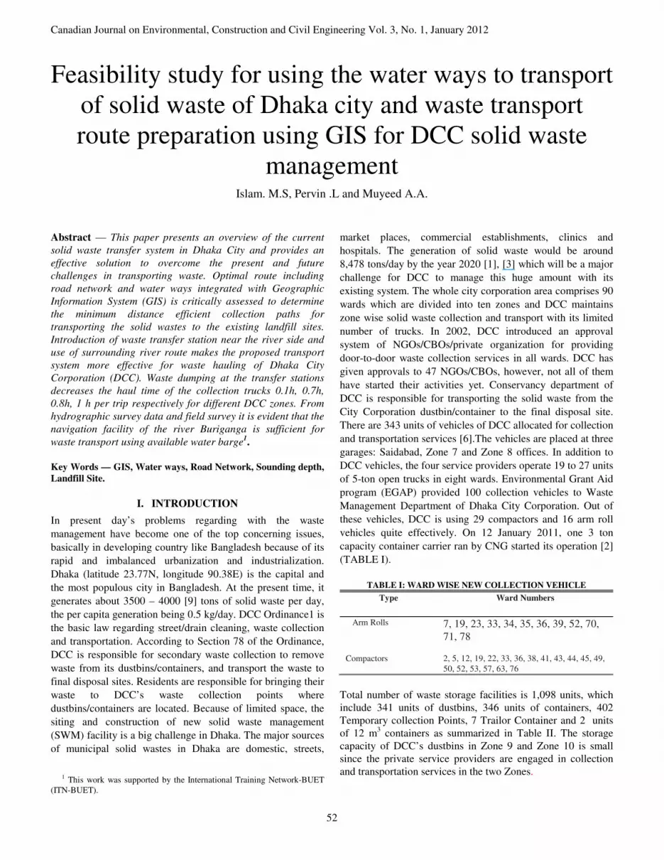
V. RESULTS
At present DCC truck drivers doesn’t follow any particular
route when they transport the waste from different zones to the
land fill/ disposal sites. For a particular zone there some
particular collection routes through which the collection
vehicles travels to collect waste from the dustbins, temporary
collection points, containers but after collection waste there is
no predefined route which the collection truck travels to
disposal site. Field survey was performed with the truck
drivers to know the exact situation. According to the survey
they use different route in different times depending upon the
jam and road situation. So it is very difficult to determine the
haul distance in existing waste transport system. Because of
this condition in this case the shortest haul distance from
different zone boundary to the Matuail land fill site was
determine using the developed network analysis database in
ArcMap. Field survey was also done for the water ways route
and the required transfer station to develop the new waste
transfer system using the river Buriganga. After numerous
surveys some location was identified to build the transfer
stations. Considering the land availability transfer stations near
river side of zone 6, 1 and near aminbazzar landing station was
identified using GPS to design new route. Since zone1 and
zone2 is close to the matuail land fill site, only the waste from
the zone3, 5, 6, 7 and 8 has been considered to bring at the
transfer station1( Figure 3) . The haul distance from the
considered zone boundary to the transfer station1 was
Canadian Journal on Environmental, Construction and Civil Engineering Vol. 3, No. 1, January 2012
55
determined using the developed network data set. The shortest
route in existing transport system and in new system is shown
in fig. From the analysis it is clear the haul distance for zone3,
zone6, zone7 and zone8 decreases significant amount in
proposed system. As haul time mostly depends upon the haul
distance, the haul time of collection vehicle will also reduce
significant amount. The exact amount of haul time reduction
was not possible due to lack of haul constants since DCC truck
drivers doesn’t follow particular route. An approximate haul
constant was determined using the field survey data with the
truck divers. The survey data is presented in TABLE V. The
haul distance and time shown in TABLE VI and TABLE VII.
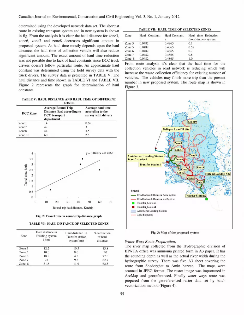
Figure 2 represents the graph for determination of haul
constants
TABLE V: HAUL DISTANCE AND HAUL TIME OF DIFFERENT
ZONES
DCC Zone
Average Round Trip
Distance (km) according to
DCC transport
department
Average haul time
according to the
survey with drivers
Zone1 14 0.66
Zone7 42 3
Zone8 44 3.5
Zone 10 60 2.5
y = 0.0482x + 0.4865
0
0.5
1
1.5
2
2.5
3
3.5
4
0 10 20 30 40 50 60 70
Round-trip haul distance, Km/trip
Tra
vel
tim
e, h
/tri
p
Fig. 2: Travel time vs round-trip distance graph
TABLE VI: HAUL DISTANCE OF SELECTED ZONES
Zone
Haul distance in
Existing system
( km)
Haul distance in
Transfer station
system(km)
% Reduction
of haul
distance
Zone 3 12.2 10.5 13.8
Zone 5 10.0 8.0 20
Zone 6 18.8 4.3 77.0
Zone 7 25 9.3 62.7
Zone 8 31.8 11.9 62.5
TABLE VII: HAUL TIME OF SELECTED ZONES
Zone
Haul Constant,
b
Haul Constant,
a
Haul time Reduction
(hour) in new system
Zone 3 0.0482 0.4865 0.1
Zone 5 0.0482 0.4865 0.58
Zone 6 0.0482 0.4865 0.7
Zone 7 0.0482 0.4865 0.8
Zone 8 0.0482 0.4865 1.0
From route analysis it’s clear that the haul time for the
collection vehicles in road network is reducing which will
increase the waste collection efficiency for existing number of
vehicles. The vehicles may finish more trip than the present
number in new proposed system. The route map is shown in
Figure 3.
Fig. 3: Map of the proposed system
Water Ways Route Preparation:
The river map collected from the Hydrographic division of
BIWTA office was ammonia printed form in A3 paper. It has
the sounding depth as well as the actual river width during the
hydrographic survey. There was five A3 sheet covering the
route from Shadorghat to Amin bazzar. The maps were
scanned in JPEG format. The raster image was importuned in
ArcMap and georeferenced. Finally water ways route was
prepared from the georeferenced raster data set by batch
vectorization method (Figure 4).

Canadian Journal on Environmental, Construction and Civil Engineering Vol. 3, No. 1, January 2012
56
Fig. 4: Water ways route for solid waste transfer
From the route query the following route summary presented
in TABLE VIII and TABLE IX. TABLE VIII: WATER WAYS ROUTE SUMMARY
Route Name
Route Length (Km)
Gabtoli to Salmosi 5
Salmosi to Swarighat 9
Swarighat to Sadaghat 2
Total length 16
TABLE IX: ROAD NETWORK ROUTE LENGTH FOR BALIAPUR
SITE
Route Name
Route Length (Km)
Amin Bazar Landing station
to Baliapur site
4.4
Since DCC uses both Matuail and Balipur landfill site there is
two options in the new system. The existing collection vehicles
of zone 3, 5, 6, 7, 8 will collect waste in the existing collection
route and will dispose the waste to the transfer station1. The
water barge will collect the waste from transfer station1 and
unload to the transfer station near amin bazzar landing station.
Finally a covered van will collect the waste and dispose in the
Baliapur Landfill site. The second option is the water barge
will collect the waste from transfer station1 and then unloads
at transfer station2. A covered van will collect the waste form
the transfer station2 and transport to the disposal site in
Matuail. Since Matuail landfill site can take care of 59% of the
total collected waste (1700 ton/day) of Dhaka City
Corporation (DCC) per day, this amount will be transferred by
the water barge from transfer station1 to 2. The remaining
waste will be transferred by the water barge form transfer
station1 to 3.
V. CONCLUSION
The water ways route presented in this study is efficient for
waste transfer using water barges in the available navigation
facility. Incorporation of the transfer stations increases waste
collection efficiency of existing collection trucks situation.
Recycling and sorting of waste material can be possible in the
proposed transfer station. More details study is required for the
final construction of transfer stations near river side. The use
of Water ways will reduce the pressure on the road traffic
system. In Bangladesh Inland Water Transport (IWT) is a
major mode for the transport of goods and people. IWT is
important for the poor as well as for the competitiveness and
growth of the economy as it is the cheapest mode of transport
compared to road or rail [11]. IWT costs are below the road
and rail tariffs above, confirming that IWT is the cheapest
mode of transport [11]. So waste transportation in the
proposed system may be a comparatively cheap option and it
will reduce the problem of pollution by the open truck mostly
used by DCC. Grab cranes may be used to off-load the
incoming waste from barges and fill up site trucks. More
details study is required for actual economic analysis
considering the transfer station establishment cost, route
operational cost etc which was not possible in the research for
some limitation in the project.
ACKNOWLEDGMENT
The authors are thanks full to ITN-BUET for funding the
research project.
REFERENCES
[1] Bangladesh Center for Advance Studies (BCAS), “Refuse Quantity
Assessment of Dhaka City Corporation for Waste to Electrical Energy
Project”, Final Project Report funded by the World Bank and Power
Cell, Ministry of Energy and Mineral Resources, Government of the
People’s Republic of Bangladesh, 1998.
[2] Clean Dhaka Newsletter, Waste management department, Dhaka City
Corporation, 14th issue, February, 2011.
Web: www.dhakacity.org/cleandhaka
[3] Hai. F. I. and Ali. M., “A Study on Solid Waste Management System of
Dhaka City Corporation: Effect of Composting and Landfill Location”,
UAP Journal of Civil and Environmental Engineering, Vol. 1, No. 1,
2005
[4] Hydrographic Survey Division (HSD) of Bangladesh Inland Water
Transport Authority (BIWTA), Hydrographic survey Maps with
sounding depth of different station sheet no. NEED B2006
784 , sheet no.
NEED A
2006
851
to NEED D
2009
851
, 2011.
[5] Hong Kong Waste Management Association (HKWMA), Report on
“Technical Visit to Waste Management Facilities in Shanghai, China
(15 to 19 February 2004)”, Editor: Ir Lam Cheuk Fung, Chairman,
HKWMA (2003/04), P.12-19, 2004
[6] Japan International Cooperation Agency (JICA), Final Report on “The
Study on the Solid Waste Management in Dhaka City”, 2005

Canadian Journal on Environmental, Construction and Civil Engineering Vol. 3, No. 1, January 2012
57
[7] Ogra, A, “Logistic Management and Spatial Planning for Solid Waste
Management Systems using Geographical Information System”, Map
Asia 2003, India, 2003.
[8] Ramachandra, T. V., Saira, V. K, “Exploring Possibilities of Achieving
Sustainability in Solid Waste Management”, Indian Journal
Environmental Health, 45 (4):255-64, October 2003.
[9] Rahman, S., Rahman, S.H, “Application of GIS Techniques in Urban
Solid Waste Management in a Part of Dhaka City: Mohammadpur
Thana”, Journal of Sustainable Development and Environmental
Protection, Vol.1 No.2, 2011.
[10] Tinmaz, E., Demir, I, “Research on solid waste management systems:
To improve existing situation in Corlu Town of Turkey”, Science
Direct, Volume 26, Issue 3, Pages 307-314, 2006.
[11] World Bank, People’s Republic of Bangladesh “Revival of Inland Water
Transport: Options and Strategies”. Report No. 38009, 2007.
BIOGRAPHIES
Md. Saiful Islam received his B.Sc. (Civil) at
Bangladesh University of Engineering and Technology
(BUET), Dhaka. His professional experience covers
graduate level teaching and research in renowned
universities of Bangladesh. At present he is working as
Lecturer in Civil Engg. Dept. of Ahsanullah University
of Science and Technology, Dhaka-1208.
Lia Pervin received his B.Sc.(WRE) at Bangladesh
University of Engineering and Technology (BUET),
Dhaka. Her professional experience covers graduate level
teaching and research in renowned universities of
Bangladesh. Presently she is working as Lecturer in the
Dept. Water Resources Engg. of BUET.
Abdullah Al-Muyeed received his B.Sc.(Civil) and
M.Sc.(Civil nad Environmental) Eng at Bangladesh
University of Engineering and Technology (BUET),
Dhaka and his Ph.D form the University of Tokyo,
Japan. His professional experience covers graduate and
postgraduate level teaching and research in renowned
universities of Bangladesh. At present he is associate professor in Civil Engg.
Dept. of Ahsanullah University of Science and Technology, Dhaka-1208. He
has more than 30 technical papers in National and International Journal and
Conference Procedding. He is also author of the book “Solid and Hazardous
Waste Management” published by ITN-BUET.