excavations at st james's priory, bristol - oapen
TRANSCRIPT

EXCAVATIONS AT
ST JAMES’S PRIORY, BRISTOL

EXCAVATIONS AT
ST JAMES’S PRIORY, BRISTOL
byReg Jackson
with contributions by
Geraldine Barber, Rod Burchill, Rosie Clarke,Peter Hardie, Sophie Lamb, Louise Loe,
Bruce Williams and David Williams
Oxbow Books
Bristol and Regional Archaeological Services Monograph

Published byOxbow Books, Oxford, UK
© Oxbow Books, Reg Jacksonand the contributors 2006
ISBN 978-1-84217-207-0
A CIP record for this book is available from the British Library
This book is published with the aid of a grantfrom English Heritage.
English Heritage is now Historic England
This book is available to download from
http://books.casematepublishing.com/Excavations_at_St_James_Priory_Bristol.pdf
Summary .......................................................................................................................................................................... viiRésumé ............................................................................................................................................................................ viiiZusammenfassung............................................................................................................................................................ ixAcknowledgements .......................................................................................................................................................... xi
Chapter 1: Introduction .................................................................................................................................. 1Summary Contents of the Report ............................................................................................................................... 1The Background to the Archaeological Excavations ............................................................................................... 1Summary Phasing of Sites 1 and 2 ............................................................................................................................ 3General Historical Introduction .................................................................................................................................. 5The Religious Houses to the North and West of the Medieval City .................................................................... 6
Chapter 2: St James’s Priory .......................................................................................................................... 8Historical Background ................................................................................................................................................. 8The Dissolution and After ......................................................................................................................................... 11St James’s Priory: Its Church, Conventual Buildings and Cemeteries ............................................................... 16
Chapter 3: The St James’s Priory ‘East End’ Excavation Report (Site 1) .............................................. 28Topography and Land Use ........................................................................................................................................ 28Previous Archaeological Work .................................................................................................................................. 28Excavation Methods and Recording ........................................................................................................................ 29Report on the 1989 and 1995 Excavations .............................................................................................................. 30
Chapter 4: The St James’s Priory ‘West Front’ Excavation Report (Site 2) .......................................... 57Topography and Land Use ........................................................................................................................................ 57Previous Archaeological Work .................................................................................................................................. 57Excavation Methods and Recording ........................................................................................................................ 57Report on the Excavations ......................................................................................................................................... 58
Chapter 5: The Burials .................................................................................................................................. 71Introduction ................................................................................................................................................................. 71The Archaeology of the Monastic Cemetery (Site 1) ............................................................................................. 72The Archaeology of the Lay/Parish Burial Ground (Sites 2 and 3) ................................................................... 99Site 2: Adjacent to the West Front of the Church ................................................................................................... 99Site 3: St James’s Place ............................................................................................................................................. 103Burials from Sites 2 and 3: Discussion .................................................................................................................. 104Analysis of the Human Bone from Sites 1 and 2 by Dr Louise Loe .................................................................... 105Analysis of the Human Bone from Site 3 by Sophie Lamb................................................................................... 120
Contents
EXCAVATIONS AT ST JAMES’S PRIORY, BRISTOLvi
Chapter 6: The Finds ................................................................................................................................... 123The Pre-Conquest Pottery (Site 2) by Rod Burchill ............................................................................................... 123The Medieval Pottery by Rod Burchill .................................................................................................................... 123The Medieval Floor Tiles (Sites 1 and 2 and Church House) by Bruce Williams ............................................. 124A Note on the Petrology of Two Medieval Floor Tiles and Three Roof Tiles by Dr David Williams............ 130The Ceramic Roof Tiles (Site 1) by Rod Burchill .................................................................................................... 132The Clay Tobacco Pipes (Site 1) by Reg Jackson .................................................................................................... 133The Coins and Tokens (Site 1) by Rosie Clarke ...................................................................................................... 133Objects of Bone and Ivory (Site 1) by Rod Burchill ............................................................................................... 135Objects of Glass (Site 1) by Rod Burchill ................................................................................................................. 137Objects of Iron (Site 1) by Rod Burchill ................................................................................................................... 138Objects of Copper Alloy (Site 1) by Rod Burchill .................................................................................................. 139Objects of Lead/Lead Alloy (Site 1) by Rod Burchill ........................................................................................... 141Objects of Stone and Fired Clay (Site 1) by Rod Burchill ..................................................................................... 142The Post-Medieval Pit Groups (Site 1) .................................................................................................................. 142The Finds from Pit 1213 ........................................................................................................................................... 143The Finds from Pit 192 ............................................................................................................................................. 151The Finds from Pit 259 ............................................................................................................................................. 153The Finds from Pit 753 ............................................................................................................................................. 161The Finds from Pit 1223 ........................................................................................................................................... 169The Finds from Pit 586 ............................................................................................................................................. 172The Faunal Remains (Site 1) by Geraldine Barber .................................................................................................. 182
Chapter 7: Discussion ................................................................................................................................. 192
Bibliography and References ..................................................................................................................... 196Primary Sources ........................................................................................................................................................ 196Secondary Sources .................................................................................................................................................... 196
Index .............................................................................................................................................................. 201
CONTENTS
INTRODUCTION vii
The Benedictine priory of St James was established inabout 1129 just outside the medieval city. Two areas,one around the east end of the priory church and oneadjacent to its west front, were excavated between1989 and 1995. A watching brief was kept duringlandscaping work on part of the parish burial groundto the south of the church in 1997. The results of theexcavations and watching brief are reported heretogether with a history of the priory and the post-Dissolution occupation of the area compiled fromdocumentary, cartographic and pictorial sources andpublished accounts.
The area around the east end of St James’s Priorychurch, Site 1, was excavated in 1989 and 1995. Theexcavations revealed a sequence of occupation on thesite from at least the 12th century to the present day.The archaeological record, linked to the documentarysources, allows an understanding of the history anddevelopment of this important site.
Of particular interest was the discovery of frag-mentary traces of the east end of the priory churchtogether with a medieval monastic cemetery whichyielded the remains of 245 articulated skeletons, thelargest group of medieval burials excavated andstudied in Bristol.
The excavations also recorded the development ofthe site after the Dissolution of the priory in 1540. Thewalls of the church were largely demolished by theend of the 16th century and pits for the extraction ofsand were dug through the cemetery and thenbackfilled with debris from the priory.
The area remained open throughout the 17th andearly 18th centuries when a number of rubbish andcess pits were dug, presumably for use by theoccupants of the surrounding properties. The qualityof the finds from these pits indicates the presence ofquite affluent households and it is known fromdocumentary sources that part of the priory buildingswere converted into a large mansion house. A numberof the pits also produced evidence of a bone-workingindustry in the form of bone offcuts and partly workedobjects.
In the early 18th century the area of the site wasdeveloped for housing and the foundations, cellars,water tanks, rubbish pits and courtyards of those
houses were recorded. Some of the houses weredemolished for the construction of the ScottishPresbyterian Church and Sunday School in the mid19th century, while the others remained in use untilthe National Farmers’ Union offices were built on theremainder of the site in the 1960s.
An area adjacent to the west front of the priorychurch, Site 2, was excavated in 1994 and 1995. Theexcavation found evidence of the site being in use fromthe late Saxon period to the 20th century. During the12th century the area was part of the lay burial groundfor both the priory and the parish, the nave of thepriory church probably having been in parochial usefrom its inception. A wall running east/west across thenorthern part of the site acted as a boundary betweenthe burial ground and the approach to the west frontof the church. Over the eastern part of the site burialscontinued until the 14th century and the remains of 33articulated skeletons were found. However, in the latterhalf of the 13th century a building was constructed onthe western part of the excavated area and during the14th century burials also ceased in the remaining partof the burial ground between that building and thechurch. Occupation continued until the early 15thcentury when the building went out of use and mayhave been partly demolished.
There was some activity on the site during the 16thcentury after the Dissolution of the priory and early inthe 17th century the medieval building was re-occupied and altered, the area to its east being used asa courtyard or part of an outbuilding. In the early 18thcentury the courtyard or outbuilding was replaced bytwo houses while the late 13th-century building wasmodified.
Alterations were made to the properties during the19th and early 20th centuries before they were alldemolished in the 1950s and 1960s.
In 1997 trenches were excavated by contractorscarrying out a landscaping scheme at the entrance tothe Broadmead shopping centre, Site 3. An archaeo-logical watching brief undertaken during this workrecorded seven medieval burials and a collection ofdisarticulated bone from an area known to haveformerly been part of the St James’s parish burialground.
Summary
Résumé
Le prieuré bénédictin de St James fut établi auxenvirons de l’année 1129, juste en dehors de la citémédiévale. Deux sites, l’un autour de l’extrémité estdu prieuré et l’autre adjacent à son côté ouest, ont étéfouillés entre 1989 et 1995. Par ailleurs, un programmed’observation a été mis en place lors des travauxd’aménagement du paysage sur une partie du cime-tière, au sud de l’église en 1997. Les résultats desfouilles et du programme d’observation sont consignésen cela, ainsi que l’histoire du prieuré et de l’occupationdu site après Dissolution. Ces dernières ont étécompilées à partir de sources documentaires, carto-graphiques et d’illustrations, ainsi que de compte-rendus publiés.
Le site autour de l’extrémité est du prieuré de StJames, le Site 1, a été fouillé en 1989 et en 1995. Lesfouilles ont révélé une séquence d’occupation du site,allant du 12ème siècle jusqu’à nos jours. Les archivesarchéologiques, associées aux sources documentaires,nous permettent de mieux comprendre l’histoire et ledéveloppement de ce site important.
Il faut noter la découverte particulièrement intér-essante de traces fragmentaires de l’extrémité est duprieuré et d’un cimetière monastique moyenâgeux, quia produit les restes de 245 squelettes articulés, le plusgrand groupe d’inhumations médiévales excavées etétudiées à Bristol.
Les fouilles ont aussi noté le développement du siteaprès la Dissolution du prieuré en 1540. Les murs del’église étaient en grande partie démolis à la fin du16ème siècle et des fosses pour l’extraction de sablefurent creusées dans tout le cimetière, puis remplis dedébris provenant du prieuré.
Le site demeura ouvert pendant tout le 17ème siècleet jusqu’au début du 18ème siècle, lorsque plusieursfosses à détritus et à fumier furent creusées, sans doutepar les occupants des propriétés alentours. Lestrouvailles issues de ces fosses indiquent la présencede demeures plutôt prospères et on sait à partir desources documentaires, qu’une partie des bâtimentsdu prieuré fut convertie en un grand hôtel particulier.Plusieurs fosses ont aussi produit des preuves d’in-dustrie du travail des os, sous forme de restes d’os etd’objets en partie ouvragés.
Au début du 18ème siècle, la zone devint le site demaisons et les fondations, caves, réservoirs d’eau,
fosses à détritus et cours ont été notés. Certaines desmaisons furent démolies pour la construction del’église presbytérienne écossaise et le catéchisme dansle milieu du 19ème siècle, tandis que les autres maisonsrestèrent en place jusqu’à la construction des bureauxdu Syndicat national des agriculteurs, sur le reste dusite dans les années 1960.
Une zone adjacente à la façade ouest du prieuré, leSite 2, a été fouillée en 1994 et 1995. Les fouilles ontindiqué que le site était utilisé de la fin de la périodesaxonne jusqu’au 20ème siècle. Pendant le 12ème siècle, lesite faisait partie du cimetière pour le prieuré et laparoisse, la nef de l’église avait sûrement été utiliséepar la paroisse depuis ses débuts. Un mur allant d’esten ouest, à travers la partie nord du site, servait delimite entre le cimetière et l’approche de la façade ouestde l’église. Sur la partie est du site, les enterrementscontinuèrent jusqu’au 14ème siècle et les restes de 33squelettes articulés ont été trouvés. Toutefois, dans ladernière moitié du 13ème siècle, un bâtiment futconstruit sur la partie ouest de la zone excavée etpendant le 14ème siècle, les enterrements cessèrent aussidans la partie restante du cimetière, entre ce bâtimentet l’église. Cette partie continua d’être occupée jusqu’audébut du 15ème siècle, au moment où le bâtiment cessad’être utilisé et fut peut-être partiellement démoli.
Il y a eu des activités sur le site durant le 16ème siècle,après la Dissolution du prieuré et au début du 17ème
siècle le bâtiment médiéval fut réoccupé et modifié,avec la zone à l’est utilisée comme cour ou commepartie d’une dépendance. Au début du 18ème siècle, lacour ou dépendance fut remplacée par deux maisons,tandis que le bâtiment de la fin du 13ème siècle étaitmodifié.
Des modifications furent apportées aux propriétésaux 19ème siècle et au début du 20ème siècle, avantqu’elles ne soient complètement démolies dans lesannées 1950 et 1960.
En 1997, des tranchées furent excavées par desentrepreneurs qui réalisaient des travaux d’amén-agement du paysage, à l’entrée du centre commercialde Broadmead, le Site 3. Un programme d’observationentrepris lors de ces travaux a noté sept cimetièresmédiévaux et une collection d’os désarticulés d’un sitedont on sait qu’il faisait partie auparavant du cimetièredu prieuré de St James.
Das Benediktinerkloster St. James (zum heiligen Jakob)wurde ca. 1129 unmittelbar vor den Mauern dermittelalterlichen Stadt gegründet. In zwei Bereichen,einer am östlichen Ende der Klosterkirche und derandere neben dem Westwerk, wurden zwischen denJahren 1989 und 1995 Ausgrabungen vorgenommen.Bei Landschaftsgestaltungsarbeiten in Teilen desGemeindefriedhofes an der Südseite der Kirchewurden im Jahre 1997 archäologische Untersuchungendurchgeführt und die Befunde festgehalten. Dies istein Bericht über die Ergebnisse der Ausgrabungensowie der archäologischen Untersuchungen, außerdemwird die Geschichte des Klosters sowie die Besiedlungdes Geländes nach der Säkularisierung und Auflösungdes Klosters nach dokumentarischen, kartografischenund bildlichen Quellen, sowie aus veröffentlichtenBerichten beschrieben.
An der im Bereich des Ostendes der Kirche St. Jamesliegenden Ausgrabungsstelle 1 wurden in den Jahren1989 und 1995 archäologische Grabungen vorge-nommen. Aus diesen Grabungen ging hervor, dassdieser Ort mindestens vom 12. Jahrhundert an, bis hinzum heutigen Tage besiedelt war. Aufgrund derarchäologischen Funde und im Zusammenhang mitdokumentarischen Quellen war es möglich, dieGeschichte und Entwicklung dieser wichtigen Aus-grabungsstelle nachzuvollziehen.
Von ganz besonderem Interesse war dabei dieEntdeckung fragmentarischer Überreste von derOstseite der Klosterkirche, sowie eines Kloster-friedhofes aus dem Mittelalter, in dem die Überrestevon 245 vollständig erhaltenen Skeletten gefundenwurden, der größten Gruppe in einer mittelalterlichenGrabstätte, die jemals in Bristol ausgegraben unduntersucht wurde.
Durch die Ausgrabungen konnte außerdem auchdie Entwicklung des Geländes nach der Säkula-risierung bzw. Auflösung des Klosters im Jahre 1540festgehalten werden. Am Ende des 16. Jahrhundertswaren die Mauern der Kirche größtenteils zerstört, undüberall auf dem Friedhof wurden Gruben zur Sand-gewinnung ausgehoben, und mit Abraum aus demKloster wieder neu befüllt.
Das Gelände blieb während des ganzen 17. undfrühen 18. Jahrhunderts offen, als eine Reihe von Abfall-und Klärgruben ausgehoben und höchstwahrscheinlich
von den Bewohnern der umliegenden Anwesenbenutzt wurden. Aus der Qualität der Funde aus diesenGruben läßt sich schließen, dass sich in dieser Gegendrecht wohlhabende Haushaltungen befunden habenmüssen, und aus dokumentarischen Quellen gehthervor, dass ein Teil der Klostergebäude in ein großesHerrenhaus umgebaut wurde. In einer Reihe vonGruben wurden außerdem durch Knochenabschnitteund teilweise bearbeitete Gegenstände, Nachweise füreine knochenverarbeitende Industrie gefunden.
Im frühen 18. Jahrhundert wurde das Gelände zurBebauung freigegeben, und es wurden die Grund-mauern, Keller, Wasserzisternen, Abfallgruben undHofgebäude dieser Häuser archäologisch festgehalten.Einige dieser Häuser wurden beim Bau der schottisch-presbyterianischen Kirche und Sonntagsschule in derMitte des 19. Jahrhunderts abgerissen, während andereauch weiterhin bis zum Bau des Bürogebäudes derNational Farmers’ Union (dem britischen Land-wirtschaftsverband) auf dem Rest des Geländes in densechziger Jahren bestehen blieben und benutzt wurden.
In einem an das Westwerk der Klosterkircheangrenzenden Bereich, der Grabungsstelle 2, wurden1994 und 1995 Ausgrabungen vorgenommen. Indiesem Bereich wurden Nachweise für eine Benutzungseit spätsächsischer Zeit bis hin ins 20. Jahrhundertgefunden. Während des 12. Jahrhunderts war dasGelände Teil einer Laienbegräbnisstätte sowohl für dasKloster als auch die Gemeinde, wobei das Kirchenschiffdes Klosterkirchengebäudes wahrscheinlich vonBeginn an kirchlich genutzt wurde. Eine in west-/östlicher Richtung am nördlichen Teil des Geländesverlaufende Mauer bildete die Grenze zwischen derBegräbnisstätte und der Annäherung zum Westwerkder Kirche. Der östliche Teil des Geländes diente biszum 14. Jahrhundert auch weiterhin als Grabesstätte;dort wurden die Überreste von 33 vollständig er-haltenen Skeletten gefunden. Jedoch wurde in derzweiten Hälfte des 13. Jahrhunderts im westlichen Teildes Ausgrabungsgeländes ein Gebäude errichtet, undim Laufe des 14. Jahrhunderts wurden die Grable-gungen im verbleibenden Teil des Friedhofes zwischendiesem Gebäude und der Kirche ebenfalls eingestellt.Die Besiedlung dauerte bis zum frühen 15. Jahrhundertan, danach wurde das Gebäude nicht mehr benutztund möglicherweise zum Teil abgerissen.
Zusammenfassung

EXCAVATIONS AT ST JAMES’S PRIORY, BRISTOLx
Nach der Auflösung des Klosters sind auch im 16.Jahrhundert noch Anzeichen einer Benutzung auf demGelände vorhanden, und zu Beginn des 17. Jahr-hunderts wurde das aus dem Mittelalter stammendeGebäude neu bezogen und umgebaut, wobei das sichnach Osten daran anschließende Gelände als Hof-gebäude oder als Teil eines Außengebäudes benutztwurde. Im frühen 18. Jahrhundert wurde das Hof- oderAußengebäude durch zwei Häuser ersetzt, währenddas Gebäude aus dem 13. Jahrhundert umgebautwurde.
Im 19. und frühen 20. Jahrhundert wurden Änder-ungen an den Gebäuden vorgenommen, bevor alles in
den fünfziger und sechziger Jahren des 20. Jahr-hunderts abgerissen wurde.
Im Jahre 1997 wurden Stichgrabungen an derAusgrabungsstelle 3 vorgenommen, dies erfolgte imRahmen eines Landschaftsgestaltungsprojektes, dasvon Auftragnehmern am Eingang zum Einkaufs-zentrum Broadmead durchgeführt wurde. Aufgrundder im Laufe dieser Arbeiten durchgeführten archäo-logischen Untersuchungen wurden sieben aus demMittelalter datierende Grabstellen sowie eine Reiheeinzelner Knochen auf einem Gelände gefunden, vondem man weiß, das es einmal Teil des Gemeinde-friedhofs von St. James war.
ZUSAMMENFASSUNG
INTRODUCTION xi
Acknowledgements
The author would like to thank:Scottish Mutual Assurance plc and English Her-
itage for financing the archaeological excavations andpost-excavation work on Sites 1 and 2 respectivelyand for jointly funding the publication of this report.Scottish Mutual generously funded the analysis of theresults of the 1989 excavation at the east end of thepriory church enabling them to be integrated with the1995 excavation report on Site 1. Mr D. McKean ofScottish Mutual co-ordinated their involvement in thearchaeological work.
The Little Brothers of Nazareth who helped withaccess to Site 2 and Stone Ecclesiastical who carriedout the construction work on that site.
Ian Galbraith of Osprey Project Management,consultants to Scottish Mutual, who gave help andassistance throughout the excavation and post-excavation stages of the archaeological work.
Bruce Williams of Bristol and Region Archaeo-logical Services for managing the project and RosieClarke for undertaking the administrative work.
John Bryant, who managed the Site 2 excavation,and gave much advice and assistance.
Bob Jones, Bristol City Archaeologist, for mon-itoring the work on behalf of the planning authorityand giving advice on the results of his 1989 excavationat St James’s Priory.
Ann Linge who drew all the plans and most of thefinds for publication and gave much help, advice andassistance on that aspect of the report.
Davina Ware who drew some of the medieval floortiles.
Frankie Webb for her assistance with the digitalphotography.
The team of archaeologists employed by Bristol andRegion Archaeological Services to carry out theexcavations, plan and record the archaeology andprocess the finds. David Wickes acted as Site Super-visor on Site 1 and ensured the accurate and detailedrecording of the excavation. Lesley Cross, GeorginaFinn, Peter Insole and John Turner were Area Super-visors. Tom Brogden, Rosie Clarke, Frank Coyne, RobCurtis, Tim Longman, Richard Jones, Steve Newmanand Pete Rowlstone worked as Site Assistants.
The many volunteers who gave freely of their time
and energy were Frankie Webb, Robin Stiles, ChrisAnderson, Julia Wilson, Jane Atkinson, Kay Ridgwell,Nic Turner, James Russell, Andy Buchan, Steve Drew,Nick Hanks, Lucy Elliott, Shaun Gibb, Dave Ander-son, Martin Parsons, Christine Dalton, Mary Friend,Mike Baker, Ian Beckey, Juliet Robb, Vikki Staples,Jean Dagnall, Jennifer Pennington, Simon Burchill,Merle Wade, Julie Douglas, Virginia Pearson, EmmaJenkins, Sue Gay, John Perryman, Jennifer Roberts,Annie Marsh, Patrick Rowell, Antigone Blair, EmilyMorgan, Polly Davies, Jane Strachey, Andy Clarke,Paul Harper, Peter Lennox, Rod Mansell, VirginiaRowan, John Vincent, Dennis Coote, Louise Butler,Stan Price, Claire Dieppe, Ian Lewis, John Dutton,Joanne Soppit, Tom Kavell and Andrew Loader.
The archaeology students from Bradford Universitywho kindly gave up their holiday to assist in the work.They were Nigel Melton, Jessica Davies, Nick Harper,Belinda Simmons, Anwen Caffell and Tom Finney.
Louise Loe and Juliet Rogers who gave advice onthe excavation, recording and processing of the humanremains and subsequently provided the detailedspecialist report on the human bones.
Geraldine Barber, Rod Burchill, Rosie Clarke, PeterHardie, Sophia Lamb, Bruce Williams and DavidWilliams for preparing the various finds reports.
Jon Brett for loaning relevant books and pub-lications from his extensive library, digitising theburial plans on computer and also assisting on theexcavation.
Dave Stevens for preparing the burial plans forpublication.
Jeremy Hutchings for on-site conservation andAmanda Wallace who conserved and catalogued thesmall finds in the Bristol City Museum ConservationSection.
Roger Price for his advice on the bone syringes.The Little Brothers of Nazareth for allowing
deposition of the excavated human remains within StJames’s church.
The staff of the Bristol Record Office, BristolReference Library, Bristol University Library, Glou-cestershire Record Office and The National Archivefor providing facilities and advising on the docu-mentary research. Special thanks must go to the Bristol

EXCAVATIONS AT ST JAMES’S PRIORY, BRISTOLxii
Record Office for allowing the publication of itemsfrom their collection.
Louise Loe would like to thank:Dr Juliet Rogers and Dr Geraldine Barber for their
supervision, Rebecca Wiggins for her advice about thenon-adult skeletons, and Sadie Dunne and Dr IainWatt from the Department of Radiology, Bristol RoyalInfirmary for their help with the x-rays.
ACKNOWLEDGEMENTS
1 INTRODUCTION
Summary Contents of the Report
The first chapter of the report takes the form of a briefintroduction to the nature of the archaeological workat St James’s Priory, including a summary of thephasing of the remains found, together with a generalhistorical introduction, which places the priory in thewider context of the development of Bristol in the lateSaxon and post-Conquest periods and shows itsrelationship to other monastic foundations immediate-ly north and west of the medieval city. Details ofarchaeological work undertaken on those monasticfoundations is given together with published sourcesfor their history.
That is followed by a chapter dealing with theorigin and development of St James’s Priory from itsfoundation through to the Dissolution, and the use ofthe site in post-medieval and modern times, obtainedfrom documentary and published sources. An inter-pretation of the layout of the priory church and of theconventual buildings, including a description of thesurviving remains, is then attempted using a varietyof sources and through comparison with other Ben-edictine priories. Information on the priory derivedfrom archaeological excavation, observations madeduring building work and a survey of the standingstructures, some published here for the first time, isalso used to help interpret its plan and history.
Chapters three and four contain reports on thelarge-scale archaeological excavations carried out onSites 1 and 2 in 1989, 1994 and 1995 and describe thestructures, features and sequence of occupation foundon those sites. The main periods of use of the sites aredescribed, ranging from features which may pre-datethe priory through to 20th-century development. Theexcavation reports are accompanied by informationon topography and modern land use, previousarchaeological work on the sites, and the excavationand recording methods used during the excavations.
The report on the excavation of the medievalmonastic and lay cemeteries is dealt with in a separatechapter. This gives details of the layout of the burialgrounds, the burial types, the grouping of burial typeswithin the cemeteries, the date of the burials and the
finds from the graves. Tables summarise the inform-ation obtained from each burial and their relationshipto each other. The section also records the smallnumber of burials recovered during a watching briefcarried out in 1997 within the parish burial ground atSt James’s Place. The skeletal remains have beenexamined by specialists and the full results of thatexamination and an analysis of the findings is given.
Chapter six contains specialist reports on thevarious types of artefacts found during the excav-ations. Only a relatively small number of medievalfinds were recovered, mainly from the grave fills andthe post-Dissolution destruction levels or robbertrenches on Site 1, and these are reported on in full.The majority of finds from the sites were post-medieval in date including some closely dated groupsof finds from 17th- and 18th-century rubbish pits onSite 1. Due to financial constraints the publication ofthe post-medieval finds has had to be limited to acatalogue of objects from pit groups selected for theirdate range and quality of finds. In an attempt to showthe artefacts in use at particular times within the StJames’s households all the finds from the individualpits are published together.
A summary of the results of the excavations andthe significance of the discoveries follows togetherwith views on the potential for future archaeologicalwork on St James’s Priory.
A full bibliography is provided with informationon the documentary and cartographic sources used.
The Background to the ArchaeologicalExcavations
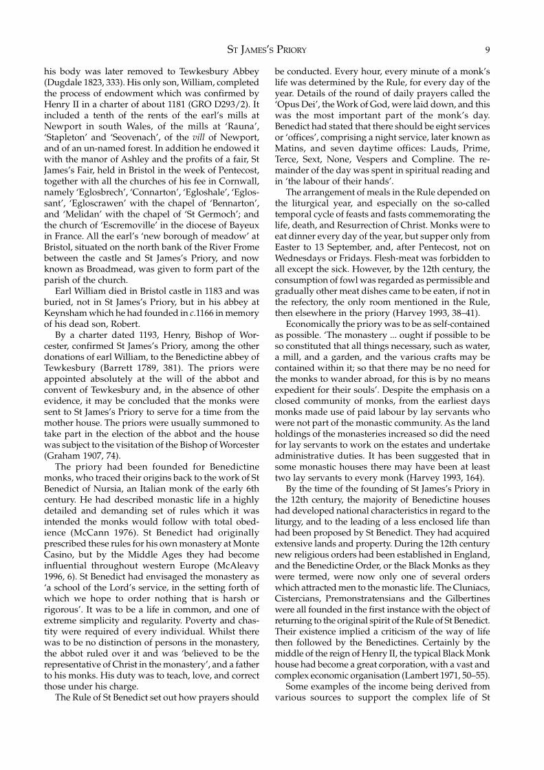
Site 1 (centred on NGR ST 58937345; Fig. 1)In 1989 staff of the Field Archaeology section of BristolCity Museum and Art Gallery undertook the completeexcavation of an area covering 140 square metres tothe north-east of the National Farmers’ Union MutualInsurance (NFU) office building in St James’s Parade.This work was directed by Bob Jones and was

EXCAVATIONS AT ST JAMES’S PRIORY, BRISTOL2
St James's Church
N.F.U.
Scottish P
resbyterian
Church
WelshCongregational
Chapel
St James's Parade
Church
House
Fig. 1 Plan showing the location of St James’s Priory and Sites 1, 2 and 3
occasioned by the proposed redevelopment of the sitefor an extension to the NFU offices. Although nopriory buildings were revealed, a number of medievalburials, including distinctive body-shaped or head-niche burials, were found and interpreted as part ofthe monastic burial ground to the east of the priorychurch. The foundations of 18th-century buildingstogether with 17th-century rubbish pits containingfine groups of ceramics and other objects were alsouncovered. An interim report on this excavation hasbeen published (Jones 1989).
The proposed extension to the NFU building was
never constructed and the offices and adjoining land,which had been the site of the 19th-century ScottishPresbyterian Church, were eventually purchased byScottish Mutual Assurance plc. It was intended todemolish the NFU offices and the smaller Audit Officebuilding on the corner of Cannon Street and constructa new office block with a basement car park coveringthe entire area, an operation which would completelydestroy the archaeological deposits lying just belowthe modern ground surface and which nowhereexceeded more than two metres in depth. The areaproposed for redevelopment, excluding that already
INTRODUCTION 3
destroyed by the basement of the NFU building,covered approximately 1,200 square metres andincluded the site of the 1989 excavation.
As part of the planning process Scottish MutualAssurance commissioned Bristol and Region Archaeo-logical Services to carry out an archaeological desktopassessment (BaRAS 1994a) which was followed in1994 by the excavation of five evaluation trenches(BaRAS 1994b). This assessment and evaluation workconfirmed the results of the 1989 excavation andshowed the medieval burial ground spreading westtowards the supposed location of the east end of thepriory church. It also indicated that the area occupiedby the NFU car park, and possibly that occupied bythe Audit Office, had been badly damaged by modernservice trenches.
Under the provisions of Planning Policy GuidanceNote 16 ‘Archaeology and Planning’, planning consentwas granted to Scottish Mutual Assurance subject totheir funding the total excavation of the site, the costof post-excavation work and the publication of a fullreport. It was agreed that their funding would alsocover post-excavation work on, and the publicationof, the 1989 excavation.
The main aim of the 1995 project was to recover afull history of the use of the site through the totalexcavation of the surviving archaeological depositsand structures before their destruction by redevelop-ment.
The following specific objectives were also in-tended to be fulfilled within the overall excavationstrategy:
a) to discover the extent and date of the pre-burialfeatures found during the 1989 excavation
b) to locate the east end of the priory church and anyassociated structures, such as chapels, to date theirconstruction and recover a plan of those buildings
c) to fully excavate the monastic burial ground to theeast of the priory church, record its extent and, ifpossible, identify its period of use
d) to recover information on the extent of the des-truction of the priory after the Dissolution anddetermine the subsequent use of the site before itsredevelopment for housing in the 18th century and
e) to record in detail the 18th-century and laterbuildings and occupation.
The excavation was carried out by Bristol and RegionArchaeological Services under the direction of thewriter for a period of five months from early January1995.
Site 2 (centred on NGR ST 58877344; Fig. 1)The need for an excavation arose from a proposal bythe Little Brothers of Nazareth, the present occupiersof St James’s Church, to build a rehabilitation unit fordrug users at the west end of the church on the site ofnos. 13–16 St James’s Parade. As a first response to the
planning application an archaeological desktop studywas carried out which was followed by the excavationof evaluation trenches (BaRAS 1993). The trenchesdemonstrated that archaeological levels survived inthe area and it was anticipated that the building workwould cause damage to the archaeology, particularlyat the eastern end of the site.
A specification for further archaeological work wasdrawn up by the City Archaeologist and planningpermission was granted subject to an archaeologicalexcavation on the eastern half of the site where thearchaeological levels lay only 0.25m below the modernground surface. It was considered that during build-ing work the archaeological deposits would beseverely truncated, the tops of the foundationsremoved and localised disturbance caused by minipiles, all of which would render meaningless anyarchaeological material that remained. A watchingbrief was to be kept on the rest of the site duringgroundworks connected with the development. Grantaid was provided by English Heritage due to thecharitable status of the Little Brothers of Nazareth.
The objective of the archaeological work as definedin the City Archaeologist’s specification was that ‘afull range of data from the area under considerationshould be recorded and a subsequent analysis under-taken, to allow for reasoned interpretation to be madeof observed archaeological features’.
The excavation was carried out by Bristol andRegion Archaeological Services under the direction ofJohn Bryant in two phases: from February to April1994 and from April to June 1995.
Work on the construction of the new buildingcommenced in July 1995 and a watching brief waskept, particularly during the machine excavation ofthe archaeological deposits for the insertion of groundbeams.
Site 3 (NGR ST 58967338; Fig. 1)In 1997 Bristol and Region Archaeological Serviceswere commissioned by the Planning, Transport andDevelopment Directorate of Bristol City Council tomonitor contractor’s groundworks associated with theconstruction of a new road layout and ‘gateway’ toBristol’s Broadmead shopping centre to be known asSt James’s Place. The site lay within St James’s parishburial ground and immediately south-west of a groupof medieval burials recovered in 1954 during theconstruction of a department store. The watching briefwas carried out by Rod Burchill.
Summary Phasing of Sites 1 and 2
Period 1 – Pre-priory occupation (late Saxon)Site 1: Two U-shaped gullies which pre-dated the
EXCAVATIONS AT ST JAMES’S PRIORY, BRISTOL4
earliest monastic burials, but were otherwiseundated, may have been related to the lateSaxon features on Site 2.
Site 2: Three shallow features contained late Saxonpottery sherds.
Period 2 – St James’s Priory (c.1129 to 1540)Period 2A (c.1129 to mid 13th century)Site 1: Construction and use of the east end of the
priory church. Establishment and use of themonastic burial ground.
Site 2: Establishment and use of the lay/parish burialground, with an east/west wall across thenorthern part of the site serving as a boundarybetween the burial ground and the approachto the west front of the church.
Period 2B (mid to late 13th century)Site 1: Continued use of the monastic burial ground.Site 2: Continued use of the lay burial ground al-
though its area was restricted by the erectionof a building in the late 13th century (Building10), which incorporated the boundary wall asits north wall. A number of pits and postholesalso date to this period.
Period 2C (14th century)Site 1: A blocking wall to the south transept of the
priory church was probably constructed c.1374. Fragments of a 14th-century occupationlevel survived to the north of the church.Continued use of the monastic burial ground.
Site 2: Occupation of Building 10 continued and wasextended to the west and east. This ended theuse of the area as part of the lay burial groundas occupation layers sealed the interments inthe area between Building 10 and the church.
Period 2D (15th century to the Dissolution in 1540)Site 1: Use of the monastic burial ground probably
continued until the Dissolution.Site 2: A large pit was dug within Building 10 after
its abandonment in the 15th century.
Period 3 – Post Dissolution activity (1540 to early 17thcentury)Site 1: There was evidence for the demolition of the
priory walls and the robbing of their found-ations. Pits were dug, probably for the extrac-tion of sand, within the monastic cemetery. Astone-lined drain and make-up layers to thenorth of the church dated to the 16th century.
Site 2: Postholes, stakeholes and layers dating to the16th and early 17th century indicate possibleoccupation post-dating the Dissolution.
Period 4 – Post-medieval reoccupation (early 17thcentury to the 1990s)Period 4A (early 17th century to early 18th century)Site 1: Cultivation trenches confirm the documented
use of the area as gardens or agricultural land.Rubbish and cess-pits were presumably as-sociated with the buildings outside the excav-ated area depicted on Millerd’s map of 1673.
Site 2: Building 10, which was almost certainly oneof the buildings depicted on Millerd’s map tothe west of the church, was altered andreoccupied and the land to its north wascultivated as gardens. The area to its east wasused as a courtyard or part of an outbuilding,with a partly cobbled floor.
Period 4B (early 18th century to mid 19th century)Site 1: The thoroughfare known initially as ‘The
Churchyard’ and later as St James’s Paradewas laid out in the early 18th century andBuildings 7 and 8 (nos. 7 and 8 St James’sParade) were constructed around that time.The rear of these buildings lay within theexcavated area together with their courtyards,drains, rubbish pits and water tanks.Cannon Street was established to the northand west of the site in the 1740s and Buildings1 to 6 were erected at that time.Alterations were made to these buildings andtheir ancillary structures throughout the late18th and early 19th centuries.
Site 2: Building 10 (no. 15 St James’s Parade) con-tinued to be occupied although it was alteredinternally, while in the early 18th century thecourtyard or outbuilding was replaced by twohouses, Buildings 11 and 12 (nos. 12 and 13 StJames’s Parade).
Period 4C (mid 19th century to 1940)Site 1: Some of the 18th-century houses on the St
James’s Parade and Cannon Street frontageswere demolished for the construction of theScottish Presbyterian Church during the 1850s.The remaining houses continued in use.
Site 2: Buildings 10, 11 and 12 continued to beoccupied with some alterations being made tothe properties.
Period 4D (1940 to the 1990s)Site 1: The Scottish Presbyterian Church was des-
troyed during the 1940 blitz. It was sub-sequently demolished and the Welsh Congre-gational Chapel, Sunday School and MeetingHouse built on part of the site in 1953. Theremaining houses were occupied until theywere demolished for the construction of theNational Farmers’ Union Mutual Insuranceand Audit Office buildings in 1964. TheMeeting House was demolished in 1988.
Site 2: Buildings 10, 11 and 12 were demolishedbetween the 1950s and 1960s and replaced bya garden of remembrance and car park.
INTRODUCTION 5
General Historical Introduction
Bristol was founded during the Saxon period in asuperbly defensible and commercial position at thelowest fording or bridging point on the River Avonwhere it was protected on three sides by the con-fluence of the rivers Avon and Frome. The originalSaxon burh, or fortified township, was sited at thenarrowest point between the two rivers on a 20 acreridge of Triassic sandstone which rose some 10 to 15metres above the surrounding marsh.
Despite its strategic position, the site of the medi-eval town does not appear to have had an earlier,Roman origin as extensive archaeological excavationssince the 1960s have failed to find any clear evidenceof Roman occupation. However, traces of what wasprobably a Romano-British iron-working site havebeen found close to Upper Maudlin Street on the southfacing slope leading from the River Frome to modernKingsdown, some 800 metres north of the centre ofthe medieval town. That was excavated in 1973, 1976and 1999 and found to comprise furnaces and parts ofa building with stone footings within a fenced yardwhich overlay an earlier field boundary. The Romanoccupation spanned the 2nd to the 5th centuries(Ponsford 1975; Jackson 2000).
The earliest documentary and numismatic evidencefor the existence of a settlement on the central site ofBristol itself dates to the 11th century. The survivingwritten records contain no mention of Bristol until1051, when it appeared in the Anglo-Saxon Chronicleas a port used by sea-going ships sailing to and fromIreland (Lobel and Carus-Wilson 1975, 3). It seemslikely that coins were first minted in Bristol c.1010, inthe reign of Aethelred II, although the first definiteevidence is the existence of a number of silver pennieswith the mint mark Bricgstow. All belong to Cnut’sfirst issue and are ascribed to the years 1017–1023(Grinsell 1986, 4; Hinton 1984, 151). The minting ofcoins was not allowed except in a burh so by that timeBristol probably possessed a market and some degreeof trade (Loyn 1962, 137–8).
As it is clear that the Bristol area was virtuallyaceramic before c.940, and even after that pottery wassparse until the late 11th and 12th centuries, it isunlikely that archaeology will be able to prove theexistence of a Saxon settlement at Bristol pre-datingthat indicated by the documentary and numismaticevidence (Watts and Rahtz 1985, 16). However,archaeological excavation has shown that the originallate Saxon settlement was concentrated close to thesite of Bristol Bridge and that it spread along the crestof the natural ridge of Triassic sandstone between thepresent Old Market Street and at least as far west asthe former Mary-le-Port Street. Excavations at thecastle, Peter Street and Mary-le-Port Street haveproduced evidence of pre-Conquest occupation in the
form of timber buildings, fences, pits, pottery andmetal and other objects of both Viking and late Saxontype (Ponsford undated, 145). Late Saxon settlementalso seems to have existed in the area of Broad Streetand Tower Lane, north of the centre of the medievaltown, where late 10th- and early 11th-century cess-pits, postholes and rubbish pits were found duringexcavations between 1979 and 1980 (Boore 1984, 11).
A late Saxon origin is also suggested for the areathat was later to become the site of St Augustine’sAbbey to the west of the medieval town. A sculptureknown as the ‘Harrowing of Hell’, which is believedto date from the first half of the 11th century, wasfound beneath the floor of the abbey’s chapter house(Dickinson 1976, 121). The possibility of Saxonoccupation in that area is supported by finds madeduring the archaeological excavations in 1983 and1984 just to the south of St Augustine’s Abbey, at thechurch of St Augustine the Less. There the earliestarchaeological deposits were six adult burials in cistgraves and another burial in a body-shaped gravewith a head and shoulders profile. These wereinterpreted as Saxo-Norman in date (Boore 1986, 211).
Documentary sources provide some information onthe development of Bristol immediately after theNorman conquest. It seems that by 1067 Bristol hadbecome a strongly fortified burh for in that year itscitizens successfully resisted an invading force fromIreland led by the sons of Harold Godwinson whichhad failed to take the defences (Lobel and Carus-Wilson 1975, 3). The Domesday survey suggests thatin 1086 Bristol was a flourishing settlement andreveals that, while it was situated within the royalmanor of Barton, it had a distinct entity with its owncommunity of burgesses who answered for it to theKing (Whitelock 1961).
During the Norman period there was a shift ofemphasis in the location of the settlement due to theestablishment of an eleven acre fortress on the east/west ridge, the site of part of the late Saxon settle-ment. This meant that the town now became largelylocated at the west end of the ridge on the lowerground at the confluence of the rivers Frome and Avonand during the early 12th century a stone defensivewall was built around the town (Ponsford undated,150).
At the close of the Norman period Bristol wasdescribed as ‘almost the richest city of all in thecountry, receiving merchandise by sailing-ships fromlands near and far. It lies in the most fertile part ofEngland and is by its very situation the most stronglyfortified of all its cities’ (Potter 1955, 37).
It can be seen from this description that Bristol’scastle, which may have started as a ringwork and waslater reinforced with a large motte and ditch, was oneof the finest in Norman Britain. This was due to theextensive building work carried out in the late 11thand early 12th centuries initially by Robert FitzHamon
EXCAVATIONS AT ST JAMES’S PRIORY, BRISTOL6
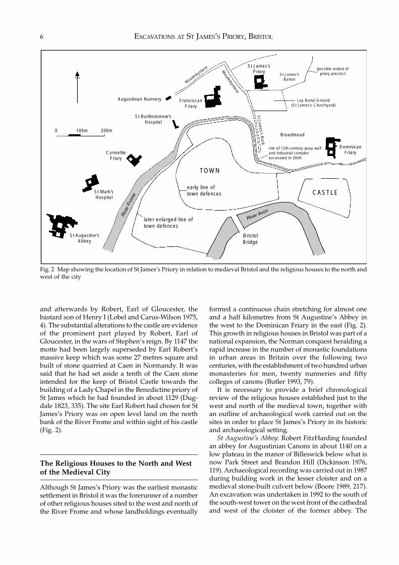
and afterwards by Robert, Earl of Gloucester, thebastard son of Henry I (Lobel and Carus-Wilson 1975,4). The substantial alterations to the castle are evidenceof the prominent part played by Robert, Earl ofGloucester, in the wars of Stephen’s reign. By 1147 themotte had been largely superseded by Earl Robert’smassive keep which was some 27 metres square andbuilt of stone quarried at Caen in Normandy. It wassaid that he had set aside a tenth of the Caen stoneintended for the keep of Bristol Castle towards thebuilding of a Lady Chapel in the Benedictine priory ofSt James which he had founded in about 1129 (Dug-dale 1823, 335). The site Earl Robert had chosen for StJames’s Priory was on open level land on the northbank of the River Frome and within sight of his castle(Fig. 2).
The Religious Houses to the North and Westof the Medieval City
Although St James’s Priory was the earliest monasticsettlement in Bristol it was the forerunner of a numberof other religious houses sited to the west and north ofthe River Frome and whose landholdings eventually
formed a continuous chain stretching for almost oneand a half kilometres from St Augustine’s Abbey inthe west to the Dominican Friary in the east (Fig. 2).This growth in religious houses in Bristol was part of anational expansion, the Norman conquest heralding arapid increase in the number of monastic foundationsin urban areas in Britain over the following twocenturies, with the establishment of two hundred urbanmonasteries for men, twenty nunneries and fiftycolleges of canons (Butler 1993, 79).
It is necessary to provide a brief chronologicalreview of the religious houses established just to thewest and north of the medieval town, together withan outline of archaeological work carried out on thesites in order to place St James’s Priory in its historicand archaeological setting.
St Augustine’s Abbey: Robert FitzHarding foundedan abbey for Augustinian Canons in about 1140 on alow plateau in the manor of Billeswick below what isnow Park Street and Brandon Hill (Dickinson 1976,119). Archaeological recording was carried out in 1987during building work in the lesser cloister and on amedieval stone-built culvert below (Boore 1989, 217).An excavation was undertaken in 1992 to the south ofthe south-west tower on the west front of the cathedraland west of the cloister of the former abbey. The
Fig. 2 Map showing the location of St James’s Priory in relation to medieval Bristol and the religious houses to the north andwest of the city
St Augustine'sAbbey
St Mark'sHospital
CarmeliteFriary
FranciscanFriary
St James'sPriory
Maudeleynlane
St Jam
es's Back
Maudeleynlane
St James'sBarton
Lay Burial Ground(St James's Churchyard)
Broadmead
site of 12th-century quay walland industrial complexexcavated in 2000
possible extent ofpriory precinct
DominicanFriary
CASTLE
BristolBridge
Riv
er F
rom
e
River Avon
later enlarged line oftown defences
early line of town defences
TOWN
St Bartholomew'sHospital
Augustinian Nunnery
0 100m 200m
INTRODUCTION 7
buildings found there were probably the abbot’s houseand the guest-house of the abbey with an adjoiningworkshop, replaced in the 14th century by the abbeycellarium (Rawes 1993, 216).
Augustinian Nunnery: A house of AugustinianCanonesses dedicated to St Mary Magdalen wasfounded by Eva, wife of Robert FitzHarding, possiblyjust before his death in 1170. It was situated at thebottom of what is now St Michael’s Hill opposite StMichael’s Church (Lobel and Carus-Wilson 1975, 8).Eva became the first prioress and continued in thatposition until her death in 1173 (Barrett 1789, 426).Excavations were carried out on part of the nunneryin 2000 when medieval walls were found togetherwith twelve burials in part of the monastic cemetery(Longman 2003, 3–29).
Dominican Friary: This was founded in about 1227within the parish of St James on land granted to theDominicans by Robert FitzHarding’s great grandson,Maurice de Gaunt, who was buried within the friaryon his death in 1230. In 1230 the Bishop of Worcester,in spite of opposition from the priory of St James,dedicated the altar and churchyard (Leighton 1933,152) although building apparently continued on thechurch and friary for over 40 years (Lobel and Carus-Wilson 1975, 8). Two of the conventual buildings,possibly the dorter and infirmary, survive in goodcondition as part of the Quaker’s Friars complex inBroadmead (Dawson 1981, 23). Archaeological eval-uation work on part of the friary complex revealedwhat was probably the southern precinct wall on thebank of the River Frome and walls associated with theGreat Cloister and the church (BaRAS 2002).
St Mark’s Hospital: Maurice de Gaunt, lord of themanor of Billeswick, founded an almonry close to StAugustine’s Abbey sometime before 1230 and en-trusted the administration of his charity to themonastery. The abbot and convent undertook to feedone hundred poor people in the almonry each dayand to maintain a chaplain. After his death in 1230 hisnephew and heir Robert de Gurnay confirmed theendowment. He made the hospital a separate found-ation, independent of the abbey, with a mother andthree chaplains (Graham 1907, 114). The hospital wasalso apparently intended to admit twelve scholars(Taylor 1878, 241). The original chapel of St Mark’sHospital survives as the Lord Mayor’s Chapel onCollege Green.
St Bartholomew’s Hospital: The hospital seems to havebeen founded by Sir John la Warre after 1231 but before1243 and it apparently functioned essentially as analmshouse which also catered for visitors to the town,the community consisting of brethren and sisters(Graham 1907, 118). The site of the hospital wasexcavated in 1977 when extensive remains of a possiblechapel and the main domestic range dating from the13th century were found (Price with Ponsford 1998).
Franciscan Friary: The religious order of mendicantfriars known variously as the Friars Minor, theFranciscans or Greyfriars, first came to England in the1220s. Before 1234 a house of the friars was founded inBristol at the expense of the townspeople and as theorder’s chief house for south Wales and the south-westof England (Dawson 1981, 23). Some time before 1250a new site was found for the friary in Lewin’s Mead onland possibly given by the Benedictine priory of StJames. The site of Greyfriars was bounded by UpperMaudlin Street on the north, Lewin’s Mead on thesouth, Lower Maudlin Street (and St James’s Priory)on the east and St Bartholomew’s Hospital and itslands on the west. Large-scale excavations in 1973revealed the church, cloister, chapter house and otherfriary buildings (Ponsford 1975). Further archaeo-logical excavations were carried out in Deep Street in1989 on a 13th-century ground-floor hall interpretedas a friary lodging or guesthouse (Gaimster et al. 1990,168–9).
Carmelite Friary: The Carmelites or Whitefriarsestablished their friary in 1256 (Lobel and Carus-Wilson 1975, 8) although it is traditionally said that itwas founded by Edward, Prince of Wales in about1267 (Dawson 1981, 8). The 16th-century topographerLeland wrote that it was the fairest of all the houses ofthe friars in Bristol (Graham 1907, 110). When the sitewas cleared for the construction of the Colston Hallearly in the last century fragments of the friary werenoted and recorded (Pritchard 1906, 136–138).
It can be seen from the foregoing that, in additionto St James’s Priory, there were seven other religioushouses situated just to the west and north of themedieval city. Although extensive archaeologicalexcavations and recording have been carried out on anumber of these sites, only two of the excavations,those at St Bartholomew’s Hospital and the August-inian Nunnery, have been published in full (Price withPonsford 1998; Longman 2003).
EXCAVATIONS AT ST JAMES’S PRIORY, BRISTOL8
2 ST JAMES’S PRIORY
(This chapter draws on documentary sources in theBristol Record Office (BRO), the GloucestershireRecord Office (GRO) and the National Archives keptin the Public Record Office (PRO)).
Historical Background
St James’s Priory was built on open land just to thenorth of the medieval city on a low terrace of Triassicsandstone which slopes down to the west and south.It was located at a height of some 15 metres above sealevel to the north of the River Frome at the foot ofKingsdown, a steeply sloping hill which rises to thenorth by a further 50 metres.
The early history of this religious site is obscure.Although there is no archaeological evidence for theexistence of a church in the Saxon period, it has beensuggested that a monastic settlement was foundedthere before the Norman Conquest by an Englishthane called Brictric, the son of Algar (Barrett 1789, 36;Seyer 1821, 261). There may be some historical basisfor this tradition as we know that Brictric was asubstantial landholder in the west at the time of theConquest, his property including the manor ofTewkesbury. His lands passed first to Queen Matildaand, upon her death in 1083, to King William (Moore1982, notes 1,39 & 1,42).
What is certain is that St James’s Priory wasfounded as a cell to the Benedictine monastery ofTewkesbury by Robert, the son of King Henry I andNesta the daughter of Rhees ap Tudor, Prince of SouthWales. Robert, who became Earl of Gloucester, wasone of the most powerful men in the kingdom, and hemarried Mabilia, the eldest daughter of RobertFitzhamon. In the late 13th century Robert of Glou-cester wrote that ‘He [Earl Robert] reared also StJames’s Priory of black monks, a little on the northernside of the town ... that Convent belongs to the Houseof Tewkesbury’ (Seyer 1821, 353–4).
It has been generally accepted that there was aconcurrent building of Bristol castle and St James’sPriory and that Robert put a tenth of the stone whichhad been brought from Normandy for building the
keep of the castle towards the construction of a chapelin his new foundation (Dugdale 1823, 335). However,it was recorded that Robert gave the stone forbuilding, not the priory itself, but the chapel of StMary – ad fabricam capella beata Maria virginis in dictoprioratu sancti Jacobi – and it is possible that the chapelwas built first as a kind of nucleus of the priory (PottoHick 1932, 58). Documentary and archaeologicalevidence shows that temporary buildings usuallypreceded the building of the church and therefore it isnot unlikely that a chapel dedicated to the increasinglypopular cult of the Virgin might have been built beforethe main body of the church (Greene 1992, 58).
The precise date of the foundation of the priory isnot known, but it was certainly during the periodwhen Benedict was the abbot of Tewkesbury, whichplaces it between 1124 and 1137. It was also at the timewhen earl Robert was engaged in building the greatstone keep of the castle, a project which commencedin about 1120 and was sufficiently complete in 1135 tobe able to withstand the assaults of King Stephen(Potto Hick 1932, 58). There is thus good reason toaccept the traditional date of the foundation whichwas given as 1129.
A further document, a confirmation by Simon,Bishop of Worcester, to the abbot and convent ofTewkesbury, refers to the dedication of the cemeteryof the church of St James but the wording makes itclear that the priory church was still in the process ofbeing built at that time. Although the document isundated, it must belong to the period between 1125and 1150 (GRO D293/2). While in any programme ofmonastic building the church was the first permanentstructure to be completed, it is known from arch-aeological excavation and documentary researchelsewhere that the construction of the remainder ofthe priory buildings could be spread over many years(Greene 1992, 58).
The priory church, which was dedicated to the‘honour of God, the blessed Mary, and St James theApostle’ (Evans 1816, 11, 178), was endowed withlands, liberties and possessions by Robert. After hisdeath at Gloucester of a fever on 31 October 1147 hewas buried in the middle of the choir of the priorychurch in a tomb of green marble or jasper, although
ST JAMES’S PRIORY 9
his body was later removed to Tewkesbury Abbey(Dugdale 1823, 333). His only son, William, completedthe process of endowment which was confirmed byHenry II in a charter of about 1181 (GRO D293/2). Itincluded a tenth of the rents of the earl’s mills atNewport in south Wales, of the mills at ‘Rauna’,‘Stapleton’ and ‘Seovenach’, of the vill of Newport,and of an un-named forest. In addition he endowed itwith the manor of Ashley and the profits of a fair, StJames’s Fair, held in Bristol in the week of Pentecost,together with all the churches of his fee in Cornwall,namely ‘Eglosbrech’, ‘Connarton’, ‘Egloshale’, ‘Eglos-sant’, ‘Egloscrawen’ with the chapel of ‘Bennarton’,and ‘Melidan’ with the chapel of ‘St Germoch’; andthe church of ‘Escremoville’ in the diocese of Bayeuxin France. All the earl’s ‘new borough of meadow’ atBristol, situated on the north bank of the River Fromebetween the castle and St James’s Priory, and nowknown as Broadmead, was given to form part of theparish of the church.
Earl William died in Bristol castle in 1183 and wasburied, not in St James’s Priory, but in his abbey atKeynsham which he had founded in c.1166 in memoryof his dead son, Robert.
By a charter dated 1193, Henry, Bishop of Wor-cester, confirmed St James’s Priory, among the otherdonations of earl William, to the Benedictine abbey ofTewkesbury (Barrett 1789, 381). The priors wereappointed absolutely at the will of the abbot andconvent of Tewkesbury and, in the absence of otherevidence, it may be concluded that the monks weresent to St James’s Priory to serve for a time from themother house. The priors were usually summoned totake part in the election of the abbot and the housewas subject to the visitation of the Bishop of Worcester(Graham 1907, 74).
The priory had been founded for Benedictinemonks, who traced their origins back to the work of StBenedict of Nursia, an Italian monk of the early 6thcentury. He had described monastic life in a highlydetailed and demanding set of rules which it wasintended the monks would follow with total obed-ience (McCann 1976). St Benedict had originallyprescribed these rules for his own monastery at MonteCasino, but by the Middle Ages they had becomeinfluential throughout western Europe (McAleavy1996, 6). St Benedict had envisaged the monastery as‘a school of the Lord’s service, in the setting forth ofwhich we hope to order nothing that is harsh orrigorous’. It was to be a life in common, and one ofextreme simplicity and regularity. Poverty and chas-tity were required of every individual. Whilst therewas to be no distinction of persons in the monastery,the abbot ruled over it and was ‘believed to be therepresentative of Christ in the monastery’, and a fatherto his monks. His duty was to teach, love, and correctthose under his charge.
The Rule of St Benedict set out how prayers should
be conducted. Every hour, every minute of a monk’slife was determined by the Rule, for every day of theyear. Details of the round of daily prayers called the‘Opus Dei’, the Work of God, were laid down, and thiswas the most important part of the monk’s day.Benedict had stated that there should be eight servicesor ‘offices’, comprising a night service, later known asMatins, and seven daytime offices: Lauds, Prime,Terce, Sext, None, Vespers and Compline. The re-mainder of the day was spent in spiritual reading andin ‘the labour of their hands’.
The arrangement of meals in the Rule depended onthe liturgical year, and especially on the so-calledtemporal cycle of feasts and fasts commemorating thelife, death, and Resurrection of Christ. Monks were toeat dinner every day of the year, but supper only fromEaster to 13 September, and, after Pentecost, not onWednesdays or Fridays. Flesh-meat was forbidden toall except the sick. However, by the 12th century, theconsumption of fowl was regarded as permissible andgradually other meat dishes came to be eaten, if not inthe refectory, the only room mentioned in the Rule,then elsewhere in the priory (Harvey 1993, 38–41).
Economically the priory was to be as self-containedas possible. ‘The monastery ... ought if possible to beso constituted that all things necessary, such as water,a mill, and a garden, and the various crafts may becontained within it; so that there may be no need forthe monks to wander abroad, for this is by no meansexpedient for their souls’. Despite the emphasis on aclosed community of monks, from the earliest daysmonks made use of paid labour by lay servants whowere not part of the monastic community. As the landholdings of the monasteries increased so did the needfor lay servants to work on the estates and undertakeadministrative duties. It has been suggested that insome monastic houses there may have been at leasttwo lay servants to every monk (Harvey 1993, 164).
By the time of the founding of St James’s Priory inthe 12th century, the majority of Benedictine houseshad developed national characteristics in regard to theliturgy, and to the leading of a less enclosed life thanhad been proposed by St Benedict. They had acquiredextensive lands and property. During the 12th centurynew religious orders had been established in England,and the Benedictine Order, or the Black Monks as theywere termed, were now only one of several orderswhich attracted men to the monastic life. The Cluniacs,Cistercians, Premonstratensians and the Gilbertineswere all founded in the first instance with the object ofreturning to the original spirit of the Rule of St Benedict.Their existence implied a criticism of the way of lifethen followed by the Benedictines. Certainly by themiddle of the reign of Henry II, the typical Black Monkhouse had become a great corporation, with a vast andcomplex economic organisation (Lambert 1971, 50–55).
Some examples of the income being derived fromvarious sources to support the complex life of St
EXCAVATIONS AT ST JAMES’S PRIORY, BRISTOL10
James’s Priory are recorded. In the charter of William,Earl of Gloucester, the priory had been granted theright to receive money from a fair or market he hadestablished at Bristol and which was held during theweek of Pentecost, beginning on the seventh Sundayafter Easter; known as St James’s Fair this was one ofthe leading markets in the south-west of England. Themonks let out pitches on their land for the erection ofstalls and booths, or ‘standings’, where the traders,who came from all over the country, could set up theirwares.
Although no contemporary documents survivefrom the priory archives detailing these transactions,similar accounts were kept concerning the leasing ofland owned by the parishioners of St James and arepreserved in the parish records. For example, inJanuary 1484 the churchwardens leased a pitchconsisting of void land in the west part of thechurchyard, some sixteen feet in length, to a pewterercalled John White at a rent of 2s. 8d. per annum, plusthe annual loan to the church of two dozen pewtervessels (BRO P/St J/F/28/15). In 1409 RichardGladewyn, a hosier, leased a void place eighteen feetlong in the south part of the parish churchyard for 1s.per annum. It was noted that the plot included atombstone, which presumably was an inconveniencethat Gladewyn had to work around when setting uphis stall (BRO P/St J/F/28/15). Even parts of theinside of the church were let out to traders, especiallythose who were selling valuable commodities andmay have required additional security. Harry Warley,a London goldsmith, leased a ‘place for a standing onthe two highest pews in the church’ for 10s. per annum(BRO P/St J/F/28/13).
It is clear that, in addition to receiving any pro-portion of the profits from the fair to which it wasentitled by the charter, the priory also gained anincome from leasing out plots of land to traders on anannual basis and from the cost of erecting standingsfor which the parishioners, at least, provided theservices of a carpenter.
The priory obtained income from goods shippedthrough Bristol and we know that the prior of St Jameshad the full prisage of wines coming to the port ofBristol from twelve o’clock on the Saturday before thefeast of St James to the same hour on the Saturdayfollowing. The right of prisage was granted to theKing and allowed him two tuns of wine from everyship importing twenty tuns or more. The prior’s rightto this privilege was acknowledged by an inquisitiontaken in 1310, when it was found that this had beengranted in the charter of William, Earl of Gloucester,and that the prior could take three pence for everyhogshead imported. The findings of that inquisitionwere used in 1404 when a prohibition was granted byHenry IV in favour of the prior, Richard Wircestre,against Thomas Chaucer, the king’s chief butler, whohad challenged his privilege. The privilege was again
questioned in 1454 when the prior, William Newport,claimed prisage on the cargo of the ship ‘Clement ofBayonne’ and once again the king’s chief butler, JohnSharp, was over-ruled (Bickley 1900, 236–246).
In the later 12th century the majority of the landknown as Broadmead, between the priory and theRiver Frome, was laid out as a suburb of Bristol in acommercial development initiated by the prior of StJames. A charter by Hawisia Countess of Gloucester,of c.1150 to 1183, granted to St James’s Church aburgage in the ‘novo burgo prati ultimum, scilicet aparte orientali ….’, i.e. in the ‘new town of the broadmeadow [or mead], that is on the eastern side’(Patterson 1973, 56; BRO 5139(175)). It is clear that thepriory obtained income from letting out burgage plotsin the new suburb.
The prior always carefully guarded the sources ofincome which enabled the priory to function. In 1230the prior and monks of St James were in conflict withthe Dominicans who had built an oratory within theirparish. When, at the request of the Dominican friars,William of Blois, bishop of Worcester, came to dedicatetheir altar and burial ground, the monks of St Jamesprotested against the dedication. They petitioned thattheir privilege should remain intact, and that the friarsshould be forbidden to receive offerings or to have aburial place. Nevertheless the Annals of Tewkesburyrecord that the bishop went ahead with the dedicatonand the friars carried on building and taking offerings,to the ‘great prejudice and loss’ of the church of StJames (Graham 1907, 74).
It was doubtless to attract such offerings that in1238 the prior and convent persuaded Walter deCantilupe, bishop of Worcester, to institute the Feastof Relics which was celebrated on the Thursday of theweek of Pentecost, when Bristol was thronged withvisitors to St James’s Fair. He granted an indulgenceof fifteen days to all who came to the church and gavealms. Probably the offerings were needed for the fabricof the priory, as some building was then proceeding,and on St Luke’s Day in 1239, Cantilupe dedicated thechurch (Graham 1907, 74).
It seems likely that, as at Tewkesbury, the nave ofthe priory church had always been used by parish-ioners. In addition to providing a perpetual curateand other clergy to serve in St James’s parish, themother house was patron of the vicarage of the parishof SS Philip and Jacob and the rectories of ChristChurch, St Ewen, St John, St Michael and St Peterwithin the city of Bristol (Skeeters 1993, 20, 71).
The close link between the parishioners and themonks was shown in an indenture made in 1346between Lord John, abbot of Tewkesbury, and ‘theparishioners and brethren of the fraternity of the HolyCross of their church and priory of St James’s, Bristol’in which he granted ‘to the said parishioners andbrethren to increase ... their devotion which they haveconceived towards the image of the Saviour of all and
ST JAMES’S PRIORY 11
the Holy Cross situated in the outer church, That theymight repair the site and embellishment before thesaid Holy Cross now almost ruined, and, being sorepaired, to set it up ... and make for it competent andhonest steps without the door of the inner church andat their own costs to maintain that place ... And thesaid parishioners and brethren grant that they willbuild and adorn before the said Holy Cross a beautifuland dedicated altar, and at their own costs andexpenses, will have there ... divine services to thehonour of the image of the Saviour of all and of theHoly Cross ... So nevertheless that the prior of the saidplace ... shall receive the moiety of all the oblationsfrom devotions to the said Holy Cross there coming ...The said parishioners and brethren will also grant thatthey will bear the cost of the repair of the whole outerchurch as far as the belfry, deducting three shillingsand four pence which the parishioners of the saidchurch were in times past accustomed to pay to thesaid prior for the repair of any part between the doorof the outer church as far as the belfry’ (GRO D293/2).
A further document was written in 1374 to form anagreement between Thomas, abbot of the monasteryof Tewkesbury, brother Thomas de Norton, prior of StJames, and the parishioners of St James’s Church overthe erection of a new belfry. ‘That the said religiousmen have granted for themselves and their successorsto the said parishioners that they shall have and heardaily the whole of the divine service in the said parishchurch to wit matins, hours, masses, vespers andcomplin and the other divine offices both for night andfor day as well for the living as for the dead to becelebrated canonically as other parish churches arecommonly wont to have lawfully throughout thediocese, with ringing of bells as often as need be atopportune times. The parishioners were to receive themoiety of the profits arising from the fixing of pales orother things penetrating or occupying the soil of thecemetery of the parish church at the fair happeningyearly on the feast of St James, together with the profitsfrom the tolling of the bells for presenting bodies forburial and for anniversaries of the dead. For whichsame grant the parishioners have granted to thereligiousmen that they will cause to be erected a newand competently built belfry and a quadrangle of stonein the form of a tower with a sufficient roof in a fitplace which within the bounds of the said priory at theproper cost of the said parishioners – the religiousmento provide for the fabric of the belfry until its com-pletion, freestone and other stone with sufficientearthen cement as may conveniently, without loss tothe said priory, be found within the lordship of same,to be carried and wholly removed at the expense andby the labour of the parishioners. If the stone not foundwithin the lordship then the cost to be divided equally.On completion the belfry to serve the common use ofthe said parties and be perpetually sustained by theircommon expenses and that the bells of the said parties
be hung and afterwards sustained at expense inproportion to the parties’ (GRO D293/2).
On 2 July 1409 there was confirmation by Thomas,Bishop of Worcester, of an agreement between theAbbey of Tewkesbury, who were acting for St James’sPriory, and John Sehawe, parson of St John’s, wherebythe latter parish was to be permitted to have acemetery of its own – the parishioners having untilthat time been buried in St James’s churchyard.Nevertheless, the long-established fee paid to StJames’s Priory for the rights of burial were to beincreased from 10s. to 13s. 4d. per annum (BRO StJohn’s Deeds no. 99).
The documentary sources give little personalinformation about the priors of St James and nothingof the monks themselves. However, at least in theearly 16th century, the priors seem to have been of ahigh calibre. In 1523 Robert Cheltenham was priorand he had Batchelor of Divinity and Doctor ofDivinity degrees from Oxford. Robert Cheltenham,who became curate of St James’s parish in 1540, hadalso served at Tewkesbury Abbey and DeerhurstPriory. Robert Circeter was prior of St James in 1535and 1539 and he also held a Batchelor of Divinitydegree from Oxford (Skeeters 1993, 228).
The Dissolution and After
In the 1530s, during the reign of Henry VIII, the life ofthe monastic houses came to an end. The first stage inthis process was a declaration by the king that he wasthe Supreme Head of the Church in England and therequirement in 1534 that the monks and nuns were totake an oath accepting Henry’s new status. It seemsthat at that time there may have been only three monkspresent at St James’s Priory (Skeeters 1993, 12).
In 1535 a bill went through Parliament which leviedan annual tax of ten percent on the income from allspiritual benefices. In order to put this tax into effect,Henry’s chief minister, Thomas Cromwell, organiseda valuation, the Valor Ecclesiasticus, of all churchproperty, including that of the monasteries, andcommissioners were sent out to undertake assess-ments. The valuation of St James’s Priory in 1535provides details of the income derived from varioussources which was said to be worth £55 7s. 4d. perannum. This was made up mainly of rents fromtenants in Bristol, the hundred of Barton, Tockington,Saltmarsh and Cattybrook, a mill in Bristol, rectoriesin Stapleton and Mangotsfield, the revenue from thegranary of the rectory in SS Philip and Jacob parish,personal offerings and tithes at Easter in the parish ofSt James, income from the herbage in St James’scemetery, profits from the revenues of the town ofBristol in Pentecost week, profits from the standingsat St James’s Fair, and the revenue of 48 acres of
EXCAVATIONS AT ST JAMES’S PRIORY, BRISTOL12
pasture and 105 acres of arable land (Potto Hick 1932,203). The Valor Ecclesiasticus shows that there werefive ‘religious’ men in St James’s Priory in 1535.
The Act of Suppression was passed in 1536 where-by the smaller monasteries, with an income of lessthan £200 a year, were closed down. The certificate ofthe commissioners under the terms of the Dispen-sations Act reveal that in 1536 there were by then onlytwo ‘religious’ men in St James’s Priory, apparentlythe prior and one brother, and that they wished tocontinue in religious office. In addition there weretwo servants. The priory’s lead and bells were valuedat 19s. 4d., other goods were valued at £3 12s. 10d.and the woods on the priory lands were valued at £136s. 8d. There were no debts owed by or to the house(Potto Hick 1932, 205)
The abbot and convent of Tewkesbury, seeing theapproach of the inevitable dissolution of their abbeyand its daughter houses, and perhaps fearing the earlyclosure of St James’s Priory, which had been visitedbriefly by the Crown commissioners in 1536, leasedthe priory and its lands and properties to Sir AnthonyKingston on 26 January 1539, a year before thedissolution of Tewkesbury. The lease was extremelydetailed, suggesting that the monks wanted to coveranything the Crown might have wished to takepossession of in regard to the priory. The propertywas described as the ‘hoole pryorye, cell and howse ofSaynte James ... with all syngular howses buyldingsorcheyards gardeyns and demeane landes of the saidPriorye and cell and their appurtenances .... and whichDompne Robert nowe prior of the said priory or cellhathe occupied’. By this agreement, made in thechapter house of Tewkesbury Abbey between King-ston and Abbot John, Kingston was to pay to the abbotand convent and their successors the sum of £35 7s. 8dannually (PRO E315/214 fol.106; Skeeters 1993, 79).The lease may have been intended to prevent the earlyconfiscation of the priory by the Crown. Sir AnthonyKingston was obviously a man of some importance inGloucestershire as in 1552 he was described asSteward of all the king’s possessions in the county, aposition previously held by Richard, Earl of Warwick(Baskerville 1927, 110).
Tewkesbury Abbey survived until the second Actof Suppression was passed in the spring of 1539. ThenTewkesbury with its cells, including St James’s Priory,was surrendered on 9 January 1540; one of the lastmonasteries to be dissolved. However, it has beensuggested that the monks of St James had probablyalready left when the mother house of Tewkesburyleased their priory to Kingston in January 1539(Skeeters 1993, 84). At the Dissolution the monks of StJames received pensions ranging from prior RobertCirceter’s £13 6s. 8d. to £6 per annum for the re-maining monk. Robert was still on the pensions list in1556 (Baskerville 1927, 84).
Kingston did not surrender the lease of the priory
to the Chancellor of the Court of Augmentations until25 April 1543, the intention being that the king shouldgrant Kingston another lease for the remainder of the99 year term at the same annual rent. This re-grantduly took place on the provision that Kingston shouldfind ‘one sufficient and fit chaplain yearly to performdivine service and to observe the cure in the church ofSt James’ and that he should ‘well and sufficientlyrepair sustain and maintain all the premises in allthings’ (PRO E315/214 fol. 106; GRO D293/2).
In 1544 Henry Brayne, a merchant tailor of London,expressed an interest in purchasing the remainingterm of the lease on St James’s Priory from AnthonyKingston but before granting this change of leaseparticulars of the property were prepared on 16 June1544. These show that the annual value of the formerpriory was £35 7s. 8d., but that this included parts ofLlantony Priory near Gloucester which were valuedat £1 13s. 4d. After the deduction of tithes valued at £314s. 1½d. there remained an annual value of £33 6s.10½d. The purchase price of the priory and its landswas calculated on the annual value over a term of 20years and was agreed at the then enormous amount of£666 17s. 6d., the sum of £400 to be paid immediatelyand the rest within three months.
In addition the trees and hedges on the prioryestate, which were used for coppicing and providingtimber for repairing buildings, were valued at 10s. Itwas recorded that ‘there be growing about thesituation of the said cell and divers tenements thereand in the hedges inclosing the lands pertaining to thesame 200 elms, oaks and ashs usually cropped andshrodde by the tenants of the same whereof 160reserved for timber to repair the houses standing uponthe site of the said cell and for stakes for hedgebote tothe said fermor which he hath by covenant and fortimber for 40 tenants there holding lands of the saidcell part by coppie part by indenture and part at willto repair their tenements which they have beenaccustomed to have there, and 40 residue valued at 3dthe tree’ (GRO D293/2).
On 10 September 1544 Anthony Kingston assignedthe residue of the term of his lease to Brayne (PROE318/164 & 165; GRO D293/2) and on 20 December1544 the king granted Brayne the priory, its lands andincome. Besides the site of the priory, the propertyincluded ‘the rectories of Stapleton and Maggersfelde,of St James beside Bristol, of St Philip and St Jamesbeside Bristol and of St Philip and St James in Bristol,with advowsons of the vicarages, annual rents out ofthe rectories or churches of St Peter, Holy Trinity, StJohn, SS Philip and James and St Andrew in Bristol,and St Michael beside Bristol and all possessions ofthe said cell in Stapleton, Mangotsfield, Ichyngton,Tokynton, Cadebrooke, Saltemershe and the hundredof Barton Glouc, and the City and County of Bristoland elsewhere ... Also the lands in tenure of John andWm ap Hopkyn in Haddenocke in the lordship of
ST JAMES’S PRIORY 13
Monmouth, co Monmouth and the fishery in the riverWye, co Monmouth from Martens weir to MonmouthBridge in tenure of Hugh Hunteley and Ric. Morgan... which belongeth to the late monastery of Lanthonyepriory beside Gloucester’ (BRO P/St J/HM/7). In theLetters Patent dated 2 January 1545 confirming thisgrant it was made clear that the king reserved in hispossession ‘All the bells in the church of the said latepriory and all lead in and upon the said church andthe other houses and edifices within the site andprecinct of the said late priory except the lead in theshutes and windows thereof’ (GRO D1799/T34).
On 8 July 1545, the Crown granted a great dealmore Bristol property to Brayne, including some onehundred tenements, messuages, gardens, closes, andpastures formerly belonging to various religioushouses (Skeeters 1993, 80).
The destruction of the east end of the priory churchmust have occurred quite rapidly for in the early 1540sthe topographer John Leland was able to report on StJames’s Priory ‘that it standeth by Brode meade bynorthe from the Castle on a hilly ground, and theruins of it standeth hard buttynge to the easte ende ofthe paroche churche’ (Toulmin Smith 1910, 88).
Henry Brayne converted the conventual buildingsof the priory into a large mansion house. Parallels forthe conversion of former monastic buildings intourban palaces or mansions can be seen in London andelsewhere. Charterhouse Priory in London wasconverted into a palace by Lord North, a privycouncillor, while St Bartholomew’s Priory was turnedinto a splendid mansion by Thomas Audley and laterby Thomas Howard, Duke of Norfolk. By 1545 thechurch of the Blackfriars in Gloucester had beenconverted into a substantial house, known as Bell’sPlace, by Thomas Bell, a wealthy tradesman (Herbert1988, 290). Despite the restricted nature of their sites,these new urban palaces may have demonstratedcurrent fashions in the layout of rooms (Schofield1993, 29–33) and we know that Brayne’s mansion hada great hall, long gallery and a number of bedchambers and other rooms (GRO D1799/T34).
Henry Brayne made his will on 22 August 1558 andin that he referred to his house as being called ‘StJames’s’. He died five days later on 27 August (BROP/St J/HM/7). An inquiry, called an Inquisition PostMortem, was held at Wotton-under-Edge in Glou-cestershire on 29 December 1558 concerning thepossessions of Henry Brayne and to determine hissuccessor. It was stated that Henry Brayne owned 16messuages, four gardens, two water mills, 300 acres ofland, 70 acres of meadow, 160 acres of pasture landand an annual rental income of £3 0s. 8d. in St James’sparish. It was confirmed that Robert Brayne wasHenry’s son and heir (GRO D293/2).
Robert Brayne inherited the property and in hisown will made on 24 March 1569 he left to his wifeGoodith ‘my Mannor Place of Saint James together
withe all manner of buildings howsses Barnes Curt-ilages and edifices thereunto belonging withe all mylandes lyeng to the lane leading from St James towardHorfylde till it runne to Hayles Crosse and so roundeabout to Mawdelyne lane and so to the said St Jamesagaine, to her for terme of her naturall lyfe’ (BRO P/StJ/HM/7).
Robert died childless and his widow, Goodith, latermarried John Seymour. Goodith was not legallyentitled to inherit the property and therefore themansion passed to Henry Brayne’s sons-in-law, GeorgeWinter and Sir Charles Somerset, the fifth son of theEarl of Worcester, who had married his daughtersEmilithys and Ann. Nevertheless at the time of thedivision of the property in 1580 John Seymour andGoodith occupied all the mansion house.
The Deed of Partition, which formally divided themansion house and adjoining property betweenGeorge Winter and Sir Charles Somerset, was agreedby the parties on 27 January 1580 (GRO D1799/T34).
The west portion of the property was to be held byGeorge Winter and his wife Ann. This was describedin the document as ‘the west part of the scite Manorplace or Mansion House of St James ... viz the wholegreat hall from the uppermost end of the samedownwards to the lower end, with the butteryadjoining to the same and all the chambers and roomsupon the west side of the same house, extending to theside of the west end of the long gallery that adjoinethto the church there, with all manner of rooms, edifices& buildings, directly under and above the same house,buttery, chambers and rooms. Also the great greencourt adjoining to the same the great gatehouseentering by the church yard into the said great greencourt together with a dwelling house adjoining to thesaid gatehouse. Also the great stable within the saidgreen court, the little stable within the said green court,the brewhouse and bakehouse near unto the kitchendoor. The little garden adjoining to the same brewhouse& bakehouse, & one other garden lying between thewest end of the church there & the said great gatehouse.Also the little way or lane that leadeth out of the greatcourt by the back side of the brewhouse, to the westpart of the gate entering unto the way which parteththe Mountegewes and Shuters close’.
It has not been possible to determine the location of‘the Mountegewes and Shuters close’ although fieldscalled the Upper and Lower Montagues are known tohave been situated on the lower slopes of Kingsdownto the north of the priory.
The east or back part of the property was allotted toSir Charles Somerset and his wife Emilithys. This wasdescribed as ‘the backer part or east side of the sciteMannor place or Mansion house of St James ... viz therooms from the uppermost part of the hall Eastwardswith the parlor the chambers in the galleries and thesaid galleries from the East part of the said MannorHouse to the west shall be united together with all the
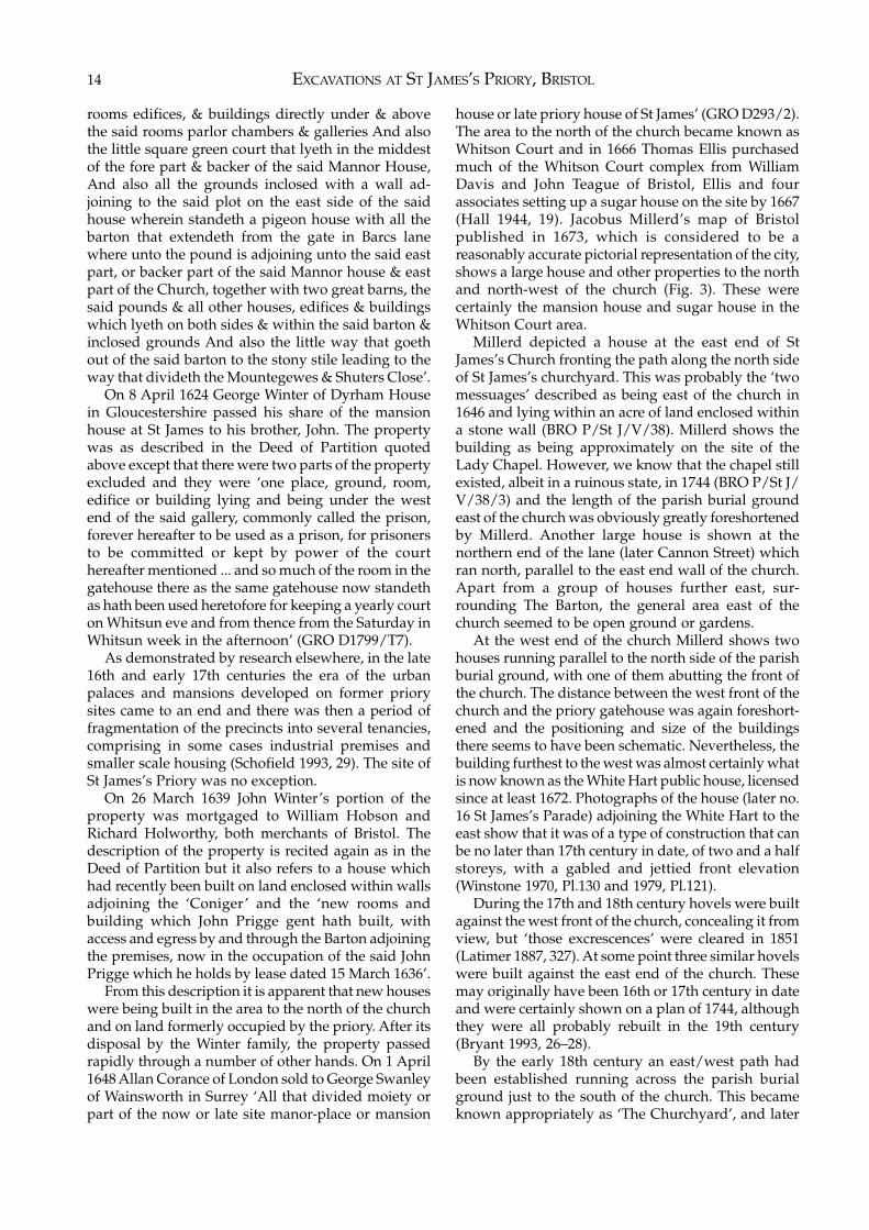
EXCAVATIONS AT ST JAMES’S PRIORY, BRISTOL14
rooms edifices, & buildings directly under & abovethe said rooms parlor chambers & galleries And alsothe little square green court that lyeth in the middestof the fore part & backer of the said Mannor House,And also all the grounds inclosed with a wall ad-joining to the said plot on the east side of the saidhouse wherein standeth a pigeon house with all thebarton that extendeth from the gate in Barcs lanewhere unto the pound is adjoining unto the said eastpart, or backer part of the said Mannor house & eastpart of the Church, together with two great barns, thesaid pounds & all other houses, edifices & buildingswhich lyeth on both sides & within the said barton &inclosed grounds And also the little way that goethout of the said barton to the stony stile leading to theway that divideth the Mountegewes & Shuters Close’.
On 8 April 1624 George Winter of Dyrham Housein Gloucestershire passed his share of the mansionhouse at St James to his brother, John. The propertywas as described in the Deed of Partition quotedabove except that there were two parts of the propertyexcluded and they were ‘one place, ground, room,edifice or building lying and being under the westend of the said gallery, commonly called the prison,forever hereafter to be used as a prison, for prisonersto be committed or kept by power of the courthereafter mentioned ... and so much of the room in thegatehouse there as the same gatehouse now standethas hath been used heretofore for keeping a yearly courton Whitsun eve and from thence from the Saturday inWhitsun week in the afternoon’ (GRO D1799/T7).
As demonstrated by research elsewhere, in the late16th and early 17th centuries the era of the urbanpalaces and mansions developed on former priorysites came to an end and there was then a period offragmentation of the precincts into several tenancies,comprising in some cases industrial premises andsmaller scale housing (Schofield 1993, 29). The site ofSt James’s Priory was no exception.
On 26 March 1639 John Winter’s portion of theproperty was mortgaged to William Hobson andRichard Holworthy, both merchants of Bristol. Thedescription of the property is recited again as in theDeed of Partition but it also refers to a house whichhad recently been built on land enclosed within wallsadjoining the ‘Coniger’ and the ‘new rooms andbuilding which John Prigge gent hath built, withaccess and egress by and through the Barton adjoiningthe premises, now in the occupation of the said JohnPrigge which he holds by lease dated 15 March 1636’.
From this description it is apparent that new houseswere being built in the area to the north of the churchand on land formerly occupied by the priory. After itsdisposal by the Winter family, the property passedrapidly through a number of other hands. On 1 April1648 Allan Corance of London sold to George Swanleyof Wainsworth in Surrey ‘All that divided moiety orpart of the now or late site manor-place or mansion
house or late priory house of St James’ (GRO D293/2).The area to the north of the church became known asWhitson Court and in 1666 Thomas Ellis purchasedmuch of the Whitson Court complex from WilliamDavis and John Teague of Bristol, Ellis and fourassociates setting up a sugar house on the site by 1667(Hall 1944, 19). Jacobus Millerd’s map of Bristolpublished in 1673, which is considered to be areasonably accurate pictorial representation of the city,shows a large house and other properties to the northand north-west of the church (Fig. 3). These werecertainly the mansion house and sugar house in theWhitson Court area.
Millerd depicted a house at the east end of StJames’s Church fronting the path along the north sideof St James’s churchyard. This was probably the ‘twomessuages’ described as being east of the church in1646 and lying within an acre of land enclosed withina stone wall (BRO P/St J/V/38). Millerd shows thebuilding as being approximately on the site of theLady Chapel. However, we know that the chapel stillexisted, albeit in a ruinous state, in 1744 (BRO P/St J/V/38/3) and the length of the parish burial groundeast of the church was obviously greatly foreshortenedby Millerd. Another large house is shown at thenorthern end of the lane (later Cannon Street) whichran north, parallel to the east end wall of the church.Apart from a group of houses further east, sur-rounding The Barton, the general area east of thechurch seemed to be open ground or gardens.
At the west end of the church Millerd shows twohouses running parallel to the north side of the parishburial ground, with one of them abutting the front ofthe church. The distance between the west front of thechurch and the priory gatehouse was again foreshort-ened and the positioning and size of the buildingsthere seems to have been schematic. Nevertheless, thebuilding furthest to the west was almost certainly whatis now known as the White Hart public house, licensedsince at least 1672. Photographs of the house (later no.16 St James’s Parade) adjoining the White Hart to theeast show that it was of a type of construction that canbe no later than 17th century in date, of two and a halfstoreys, with a gabled and jettied front elevation(Winstone 1970, Pl.130 and 1979, Pl.121).
During the 17th and 18th century hovels were builtagainst the west front of the church, concealing it fromview, but ‘those excrescences’ were cleared in 1851(Latimer 1887, 327). At some point three similar hovelswere built against the east end of the church. Thesemay originally have been 16th or 17th century in dateand were certainly shown on a plan of 1744, althoughthey were all probably rebuilt in the 19th century(Bryant 1993, 26–28).
By the early 18th century an east/west path hadbeen established running across the parish burialground just to the south of the church. This becameknown appropriately as ‘The Churchyard’, and later
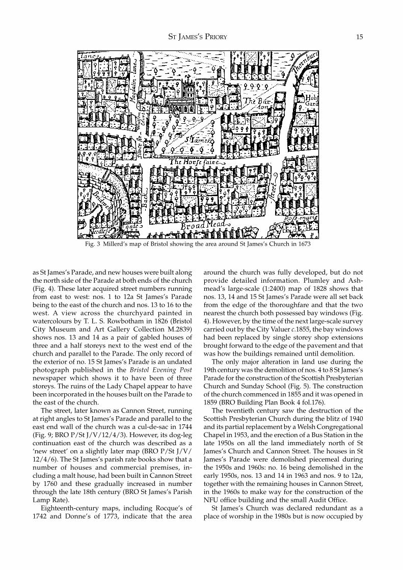
ST JAMES’S PRIORY 15
as St James’s Parade, and new houses were built alongthe north side of the Parade at both ends of the church(Fig. 4). These later acquired street numbers runningfrom east to west: nos. 1 to 12a St James’s Paradebeing to the east of the church and nos. 13 to 16 to thewest. A view across the churchyard painted inwatercolours by T. L. S. Rowbotham in 1826 (BristolCity Museum and Art Gallery Collection M.2839)shows nos. 13 and 14 as a pair of gabled houses ofthree and a half storeys next to the west end of thechurch and parallel to the Parade. The only record ofthe exterior of no. 15 St James’s Parade is an undatedphotograph published in the Bristol Evening Postnewspaper which shows it to have been of threestoreys. The ruins of the Lady Chapel appear to havebeen incorporated in the houses built on the Parade tothe east of the church.
The street, later known as Cannon Street, runningat right angles to St James’s Parade and parallel to theeast end wall of the church was a cul-de-sac in 1744(Fig. 9; BRO P/St J/V/12/4/3). However, its dog-legcontinuation east of the church was described as a‘new street’ on a slightly later map (BRO P/St J/V/12/4/6). The St James’s parish rate books show that anumber of houses and commercial premises, in-cluding a malt house, had been built in Cannon Streetby 1760 and these gradually increased in numberthrough the late 18th century (BRO St James’s ParishLamp Rate).
Eighteenth-century maps, including Rocque’s of1742 and Donne’s of 1773, indicate that the area
around the church was fully developed, but do notprovide detailed information. Plumley and Ash-mead’s large-scale (1:2400) map of 1828 shows thatnos. 13, 14 and 15 St James’s Parade were all set backfrom the edge of the thoroughfare and that the twonearest the church both possessed bay windows (Fig.4). However, by the time of the next large-scale surveycarried out by the City Valuer c.1855, the bay windowshad been replaced by single storey shop extensionsbrought forward to the edge of the pavement and thatwas how the buildings remained until demolition.
The only major alteration in land use during the19th century was the demolition of nos. 4 to 8 St James’sParade for the construction of the Scottish PresbyterianChurch and Sunday School (Fig. 5). The constructionof the church commenced in 1855 and it was opened in1859 (BRO Building Plan Book 4 fol.176).
The twentieth century saw the destruction of theScottish Presbyterian Church during the blitz of 1940and its partial replacement by a Welsh CongregationalChapel in 1953, and the erection of a Bus Station in thelate 1950s on all the land immediately north of StJames’s Church and Cannon Street. The houses in StJames’s Parade were demolished piecemeal duringthe 1950s and 1960s: no. 16 being demolished in theearly 1950s, nos. 13 and 14 in 1963 and nos. 9 to 12a,together with the remaining houses in Cannon Street,in the 1960s to make way for the construction of theNFU office building and the small Audit Office.
St James’s Church was declared redundant as aplace of worship in the 1980s but is now occupied by
Fig. 3 Millerd’s map of Bristol showing the area around St James’s Church in 1673
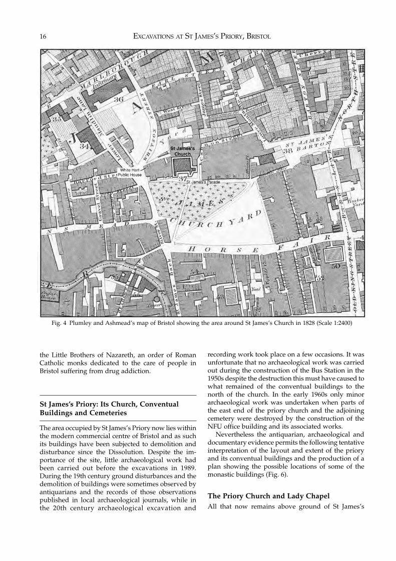
EXCAVATIONS AT ST JAMES’S PRIORY, BRISTOL16
the Little Brothers of Nazareth, an order of RomanCatholic monks dedicated to the care of people inBristol suffering from drug addiction.
St James’s Priory: Its Church, ConventualBuildings and Cemeteries
The area occupied by St James’s Priory now lies withinthe modern commercial centre of Bristol and as suchits buildings have been subjected to demolition anddisturbance since the Dissolution. Despite the im-portance of the site, little archaeological work hadbeen carried out before the excavations in 1989.During the 19th century ground disturbances and thedemolition of buildings were sometimes observed byantiquarians and the records of those observationspublished in local archaeological journals, while inthe 20th century archaeological excavation and
recording work took place on a few occasions. It wasunfortunate that no archaeological work was carriedout during the construction of the Bus Station in the1950s despite the destruction this must have caused towhat remained of the conventual buildings to thenorth of the church. In the early 1960s only minorarchaeological work was undertaken when parts ofthe east end of the priory church and the adjoiningcemetery were destroyed by the construction of theNFU office building and its associated works.
Nevertheless the antiquarian, archaeological anddocumentary evidence permits the following tentativeinterpretation of the layout and extent of the prioryand its conventual buildings and the production of aplan showing the possible locations of some of themonastic buildings (Fig. 6).
The Priory Church and Lady ChapelAll that now remains above ground of St James’s
Fig. 4 Plumley and Ashmead’s map of Bristol showing the area around St James’s Church in 1828 (Scale 1:2400)
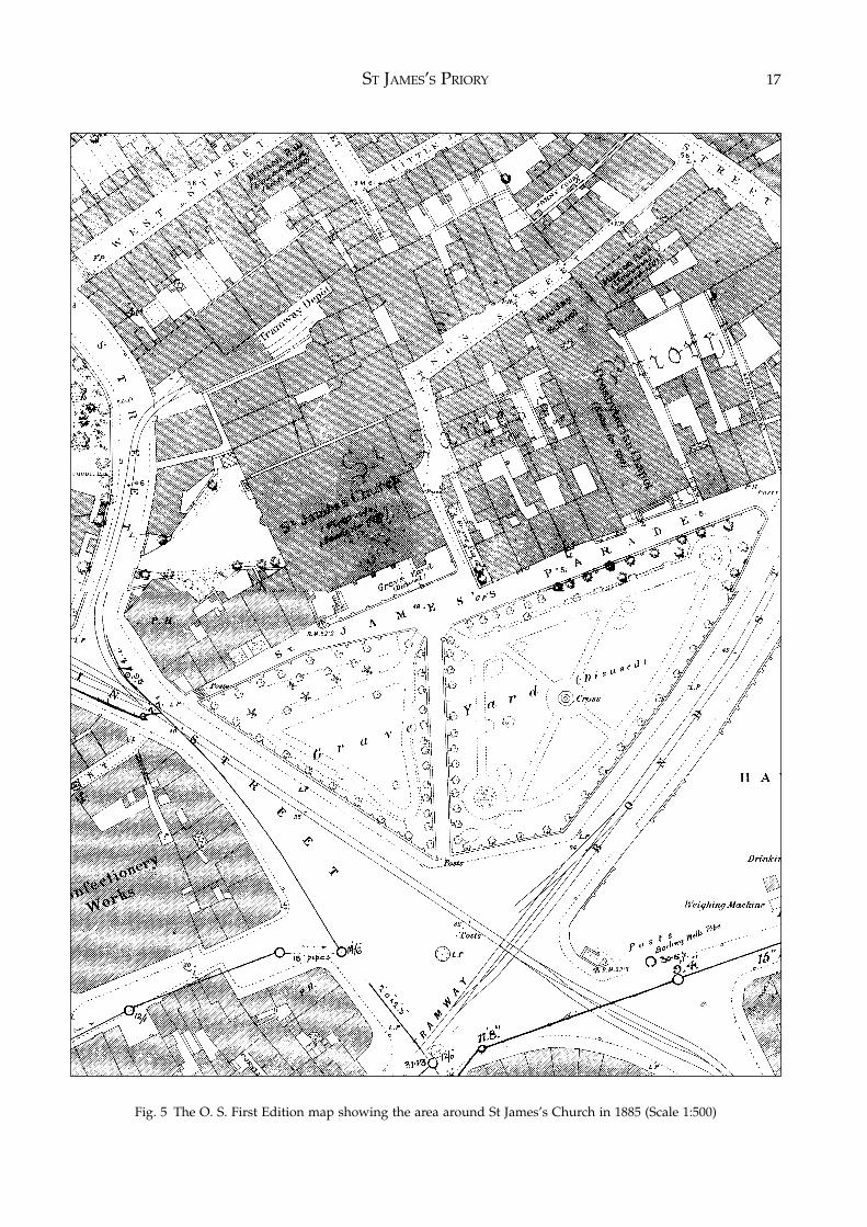
ST JAMES’S PRIORY 17
Fig. 5 The O. S. First Edition map showing the area around St James’s Church in 1885 (Scale 1:500)
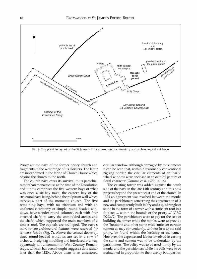
EXCAVATIONS AT ST JAMES’S PRIORY, BRISTOL18
Priory are the nave of the former priory church andfragments of the west range of its cloisters. The latterare incorporated in the fabric of Church House whichadjoins the church to the north.
The church nave owes its survival to its parochialrather than monastic use at the time of the Dissolutionand it now comprises the five western bays of whatwas once a six-bay nave, the eastern bay of thestructural nave being, behind the pulpitum wall whichsurvives, part of the monastic church. The fiveremaining bays, with no triforium and with anunaltered clerestorey of simple, round-headed win-dows, have slender round columns, each with fourattached shafts to carry the unmoulded arches andthe shafts which supported the main members of atimber roof. The capitals are scalloped. The nave’smore ornate architectural features were reserved forits west façade (Fig. 7). Above the central doorway,three round-headed windows are set in a row ofarches with zig-zag moulding and interlaced in a wayapparently not uncommon in West-Country Roman-esque, which it has been thought suggest a date ratherlater than the 1120s. Above them is an unrestored
circular window. Although damaged by the elementsit can be seen that, within a reasonably conventionalzig-zag border, the circular elements of an ‘early’wheel window were enclosed in an octofoil pattern offloral character (Gomme et al. 1979, 14–16).
The existing tower was added against the southside of the nave in the late 14th century and this nowprojects beyond the present east end of the church. In1374 an agreement was reached between the monksand the parishioners concerning the construction of ‘anew and competently built belfry and a quadrangle ofstone in the form of a tower with a sufficient roof in afit place ... within the bounds of the priory ...’ (GROD293/2). The parishioners were to pay for the cost ofbuilding the tower while the monks were to providethe ‘freestone and other stone with sufficient earthencement as may conveniently, without loss to the saidpriory, be found within the lordship of the same’.However, the expense and labour involved in cartingthe stone and cement was to be undertaken by theparishioners. The belfry was to be used jointly by themonks and the parishioners while the bells were to bemaintained in proportion to their use by both parties.
Fig. 6 The possible layout of the St James’s Priory based on documentary and archaeological evidence
Lady Chapel
cloisters
Monasticburial
ground
gatewayLay Burial Ground
(St James's Churchyard)
St James's Back
Maudeleynlane (now Lower Maudlin Street)
precinct wall
possible lin
e of
precinct
wall
north transeptand chapels
possible location ofthe priory barn(s)
location of the prioryfarm
(St James's Barton)probable line of
precinct wall
Great Green Court
precinct of theFranciscan Friary
CHURCH
0 100m
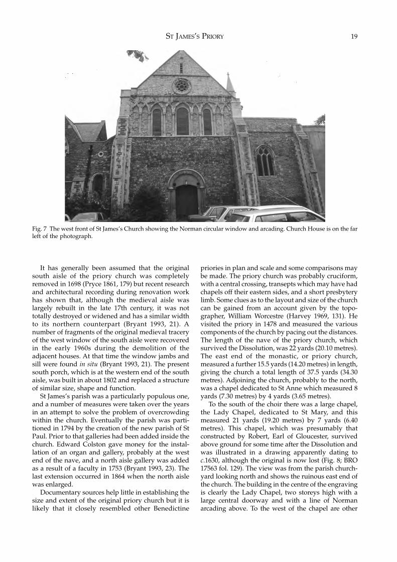
ST JAMES’S PRIORY 19
It has generally been assumed that the originalsouth aisle of the priory church was completelyremoved in 1698 (Pryce 1861, 179) but recent researchand architectural recording during renovation workhas shown that, although the medieval aisle waslargely rebuilt in the late 17th century, it was nottotally destroyed or widened and has a similar widthto its northern counterpart (Bryant 1993, 21). Anumber of fragments of the original medieval traceryof the west window of the south aisle were recoveredin the early 1960s during the demolition of theadjacent houses. At that time the window jambs andsill were found in situ (Bryant 1993, 21). The presentsouth porch, which is at the western end of the southaisle, was built in about 1802 and replaced a structureof similar size, shape and function.
St James’s parish was a particularly populous one,and a number of measures were taken over the yearsin an attempt to solve the problem of overcrowdingwithin the church. Eventually the parish was parti-tioned in 1794 by the creation of the new parish of StPaul. Prior to that galleries had been added inside thechurch. Edward Colston gave money for the instal-lation of an organ and gallery, probably at the westend of the nave, and a north aisle gallery was addedas a result of a faculty in 1753 (Bryant 1993, 23). Thelast extension occurred in 1864 when the north aislewas enlarged.
Documentary sources help little in establishing thesize and extent of the original priory church but it islikely that it closely resembled other Benedictine
priories in plan and scale and some comparisons maybe made. The priory church was probably cruciform,with a central crossing, transepts which may have hadchapels off their eastern sides, and a short presbyterylimb. Some clues as to the layout and size of the churchcan be gained from an account given by the topo-grapher, William Worcestre (Harvey 1969, 131). Hevisited the priory in 1478 and measured the variouscomponents of the church by pacing out the distances.The length of the nave of the priory church, whichsurvived the Dissolution, was 22 yards (20.10 metres).The east end of the monastic, or priory church,measured a further 15.5 yards (14.20 metres) in length,giving the church a total length of 37.5 yards (34.30metres). Adjoining the church, probably to the north,was a chapel dedicated to St Anne which measured 8yards (7.30 metres) by 4 yards (3.65 metres).
To the south of the choir there was a large chapel,the Lady Chapel, dedicated to St Mary, and thismeasured 21 yards (19.20 metres) by 7 yards (6.40metres). This chapel, which was presumably thatconstructed by Robert, Earl of Gloucester, survivedabove ground for some time after the Dissolution andwas illustrated in a drawing apparently dating toc.1630, although the original is now lost (Fig. 8; BRO17563 fol. 129). The view was from the parish church-yard looking north and shows the ruinous east end ofthe church. The building in the centre of the engravingis clearly the Lady Chapel, two storeys high with alarge central doorway and with a line of Normanarcading above. To the west of the chapel are other
Fig. 7 The west front of St James’s Church showing the Norman circular window and arcading. Church House is on the farleft of the photograph.
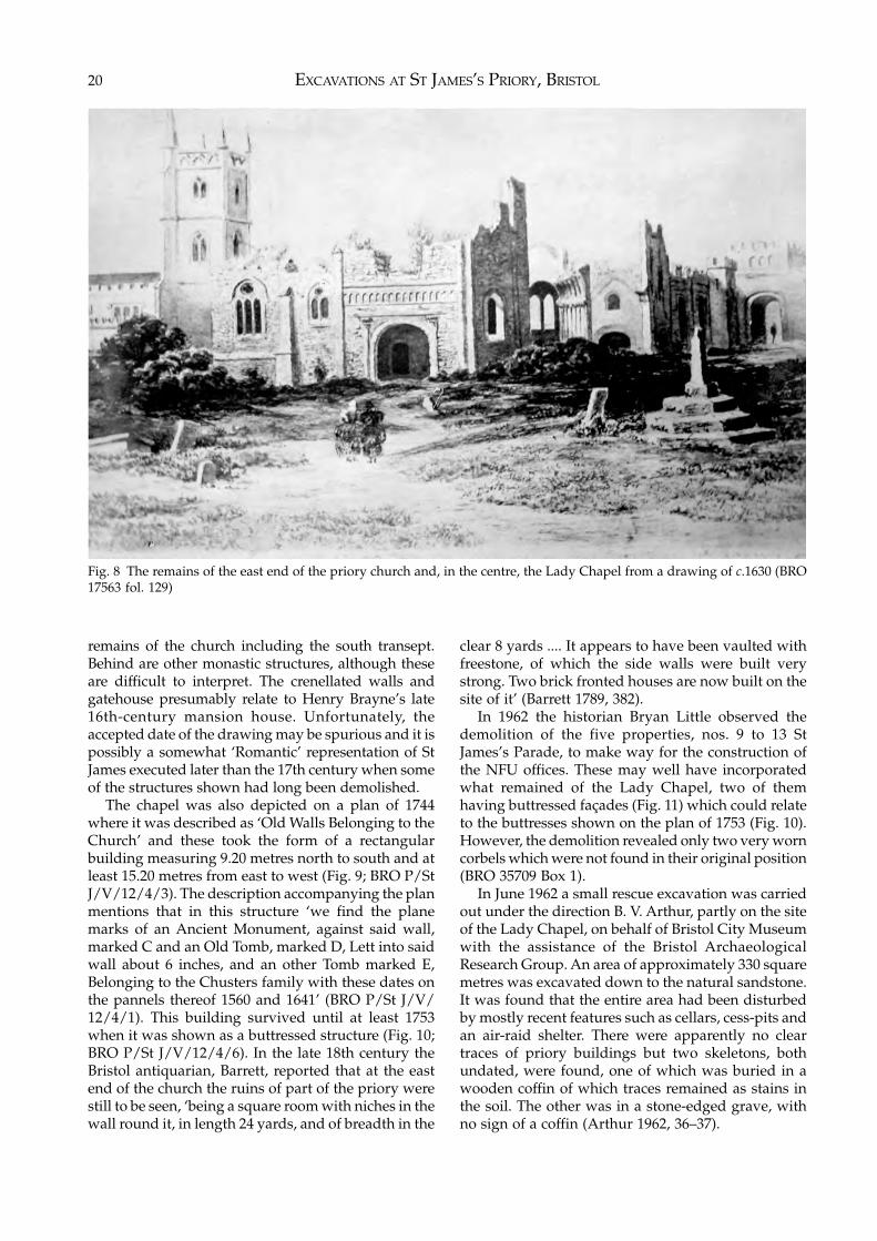
EXCAVATIONS AT ST JAMES’S PRIORY, BRISTOL20
remains of the church including the south transept.Behind are other monastic structures, although theseare difficult to interpret. The crenellated walls andgatehouse presumably relate to Henry Brayne’s late16th-century mansion house. Unfortunately, theaccepted date of the drawing may be spurious and it ispossibly a somewhat ‘Romantic’ representation of StJames executed later than the 17th century when someof the structures shown had long been demolished.
The chapel was also depicted on a plan of 1744where it was described as ‘Old Walls Belonging to theChurch’ and these took the form of a rectangularbuilding measuring 9.20 metres north to south and atleast 15.20 metres from east to west (Fig. 9; BRO P/StJ/V/12/4/3). The description accompanying the planmentions that in this structure ‘we find the planemarks of an Ancient Monument, against said wall,marked C and an Old Tomb, marked D, Lett into saidwall about 6 inches, and an other Tomb marked E,Belonging to the Chusters family with these dates onthe pannels thereof 1560 and 1641’ (BRO P/St J/V/12/4/1). This building survived until at least 1753when it was shown as a buttressed structure (Fig. 10;BRO P/St J/V/12/4/6). In the late 18th century theBristol antiquarian, Barrett, reported that at the eastend of the church the ruins of part of the priory werestill to be seen, ‘being a square room with niches in thewall round it, in length 24 yards, and of breadth in the
clear 8 yards .... It appears to have been vaulted withfreestone, of which the side walls were built verystrong. Two brick fronted houses are now built on thesite of it’ (Barrett 1789, 382).
In 1962 the historian Bryan Little observed thedemolition of the five properties, nos. 9 to 13 StJames’s Parade, to make way for the construction ofthe NFU offices. These may well have incorporatedwhat remained of the Lady Chapel, two of themhaving buttressed façades (Fig. 11) which could relateto the buttresses shown on the plan of 1753 (Fig. 10).However, the demolition revealed only two very worncorbels which were not found in their original position(BRO 35709 Box 1).
In June 1962 a small rescue excavation was carriedout under the direction B. V. Arthur, partly on the siteof the Lady Chapel, on behalf of Bristol City Museumwith the assistance of the Bristol ArchaeologicalResearch Group. An area of approximately 330 squaremetres was excavated down to the natural sandstone.It was found that the entire area had been disturbedby mostly recent features such as cellars, cess-pits andan air-raid shelter. There were apparently no cleartraces of priory buildings but two skeletons, bothundated, were found, one of which was buried in awooden coffin of which traces remained as stains inthe soil. The other was in a stone-edged grave, withno sign of a coffin (Arthur 1962, 36–37).
Fig. 8 The remains of the east end of the priory church and, in the centre, the Lady Chapel from a drawing of c.1630 (BRO17563 fol. 129)
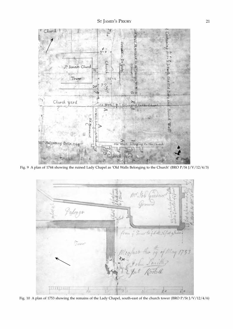
ST JAMES’S PRIORY 21
Fig. 9 A plan of 1744 showing the ruined Lady Chapel as ‘Old Walls Belonging to the Church’ (BRO P/St J/V/12/4/3)
Fig. 10 A plan of 1753 showing the remains of the Lady Chapel, south-east of the church tower (BRO P/St J/V/12/4/6)
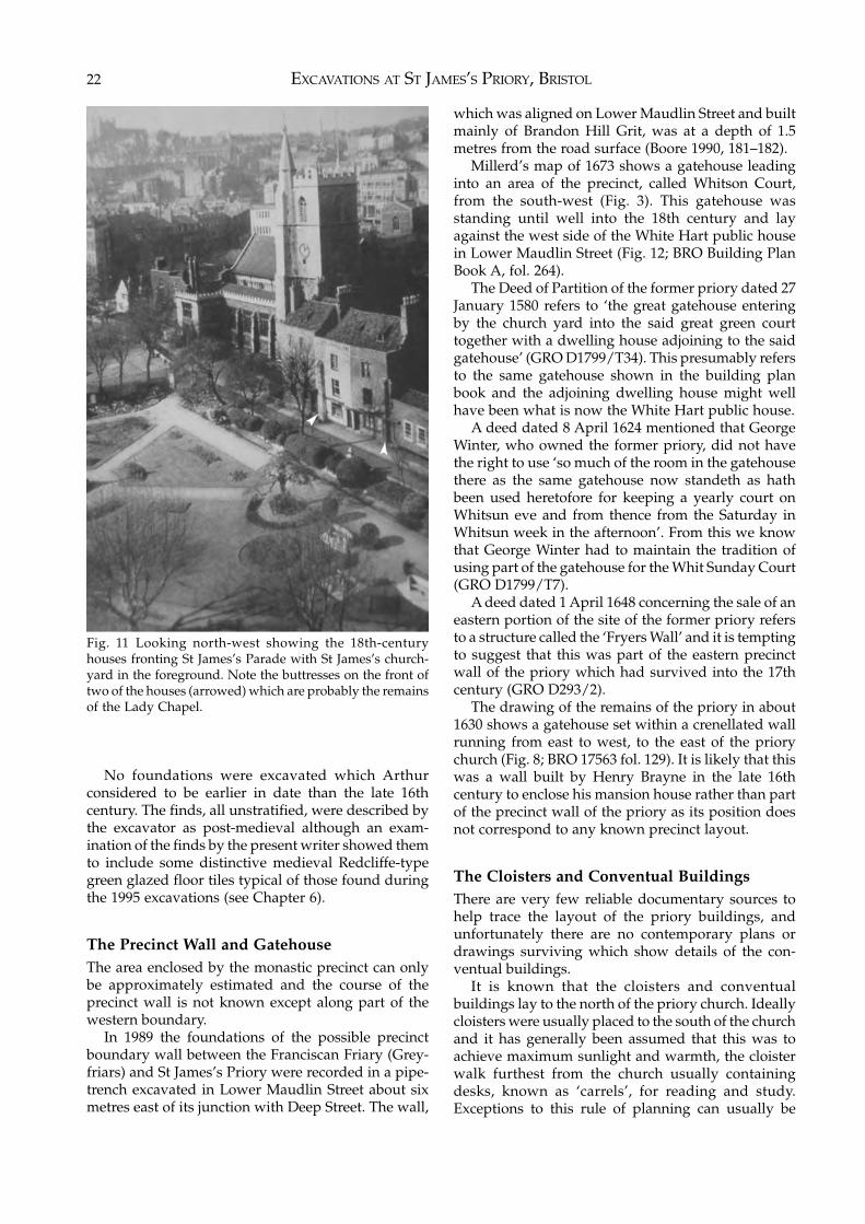
EXCAVATIONS AT ST JAMES’S PRIORY, BRISTOL22
No foundations were excavated which Arthurconsidered to be earlier in date than the late 16thcentury. The finds, all unstratified, were described bythe excavator as post-medieval although an exam-ination of the finds by the present writer showed themto include some distinctive medieval Redcliffe-typegreen glazed floor tiles typical of those found duringthe 1995 excavations (see Chapter 6).
The Precinct Wall and GatehouseThe area enclosed by the monastic precinct can onlybe approximately estimated and the course of theprecinct wall is not known except along part of thewestern boundary.
In 1989 the foundations of the possible precinctboundary wall between the Franciscan Friary (Grey-friars) and St James’s Priory were recorded in a pipe-trench excavated in Lower Maudlin Street about sixmetres east of its junction with Deep Street. The wall,
which was aligned on Lower Maudlin Street and builtmainly of Brandon Hill Grit, was at a depth of 1.5metres from the road surface (Boore 1990, 181–182).
Millerd’s map of 1673 shows a gatehouse leadinginto an area of the precinct, called Whitson Court,from the south-west (Fig. 3). This gatehouse wasstanding until well into the 18th century and layagainst the west side of the White Hart public housein Lower Maudlin Street (Fig. 12; BRO Building PlanBook A, fol. 264).
The Deed of Partition of the former priory dated 27January 1580 refers to ‘the great gatehouse enteringby the church yard into the said great green courttogether with a dwelling house adjoining to the saidgatehouse’ (GRO D1799/T34). This presumably refersto the same gatehouse shown in the building planbook and the adjoining dwelling house might wellhave been what is now the White Hart public house.
A deed dated 8 April 1624 mentioned that GeorgeWinter, who owned the former priory, did not havethe right to use ‘so much of the room in the gatehousethere as the same gatehouse now standeth as hathbeen used heretofore for keeping a yearly court onWhitsun eve and from thence from the Saturday inWhitsun week in the afternoon’. From this we knowthat George Winter had to maintain the tradition ofusing part of the gatehouse for the Whit Sunday Court(GRO D1799/T7).
A deed dated 1 April 1648 concerning the sale of aneastern portion of the site of the former priory refersto a structure called the ‘Fryers Wall’ and it is temptingto suggest that this was part of the eastern precinctwall of the priory which had survived into the 17thcentury (GRO D293/2).
The drawing of the remains of the priory in about1630 shows a gatehouse set within a crenellated wallrunning from east to west, to the east of the priorychurch (Fig. 8; BRO 17563 fol. 129). It is likely that thiswas a wall built by Henry Brayne in the late 16thcentury to enclose his mansion house rather than partof the precinct wall of the priory as its position doesnot correspond to any known precinct layout.
The Cloisters and Conventual BuildingsThere are very few reliable documentary sources tohelp trace the layout of the priory buildings, andunfortunately there are no contemporary plans ordrawings surviving which show details of the con-ventual buildings.
It is known that the cloisters and conventualbuildings lay to the north of the priory church. Ideallycloisters were usually placed to the south of the churchand it has generally been assumed that this was toachieve maximum sunlight and warmth, the cloisterwalk furthest from the church usually containingdesks, known as ‘carrels’, for reading and study.Exceptions to this rule of planning can usually be
Fig. 11 Looking north-west showing the 18th-centuryhouses fronting St James’s Parade with St James’s church-yard in the foreground. Note the buttresses on the front oftwo of the houses (arrowed) which are probably the remainsof the Lady Chapel.
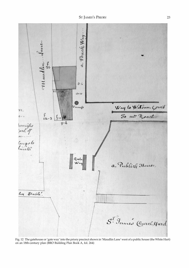
ST JAMES’S PRIORY 23
Fig. 12 The gatehouse or ‘gate way’ into the priory precinct shown in ‘Maudlin Lane’ west of a public house (the White Hart)on an 18th-century plan (BRO Building Plan Book A, fol. 264)
EXCAVATIONS AT ST JAMES’S PRIORY, BRISTOL24
understood according to the functional limitations ofthe site. Rochester and Waltham had north cloistersdue to the restricted nature of the sites while Tinternand Buildwas adopted north cloisters due to theposition of their rivers (Gilchrist 1994, 129 & 131). AtSt James, the priory church, the most importantbuilding, was located on the crest of the slope leadingup from the River Frome, in full view of the castle andmedieval town, and it was therefore necessary to placethe cloisters and conventual buildings on the levelterrace of land to the north. This layout is paralleled atthe Benedictine priory of St Mary’s, Coventry, wherethe church occupied the hill-top site with the cloistersand conventual buildings lying on almost levelground to the north (Hobley 1971, fig. 2). Thus at StJames’s Priory the usual ranges of buildings, such asthe chapter house, dormitory, refectory, cellarer’srange, kitchens, guest quarters and infirmary were allsituated around the cloisters to the north of the church.
Church House, to the north of the church, in-corporates the last standing remains of the east side ofthe west claustral range of the priory, the rearelevation of the house including two arches of thecloister arcade (Fig. 13; Bryant 1993, 28). These archeswould have been the second and third of the westernarcade, the first probably having been destroyed whenthe church was extended in the 1860s. The southcloister arcade was most probably only three arches inlength, and so a square cloister would have ended atthe north end of the third arch in this arcade.
As surviving, the cloister arcade consists of themajority of two segmented pointed arches withbuttresses between: the shape of these arches togetherwith the single surviving fragment of open traceryand the arch mouldings suggesting a 14th-centurydate for their construction. These must have beenreplacements for an earlier arcade. Unlike manycloisters which had pentice roofs, the example at StJames had another storey above the walk (Bryant 1993,29). It is possible that the cloister may have been‘undershot’, that is contained within the body of therange, as is found elsewhere including at the Dom-inican Friary in Bristol (Butler 1984, Fig. 8).
A fragment of the south cloister walk was foundduring limited excavation undertaken inside thechurch in 1974 when the Victorian north aisle wasrefloored. Below the set of pews on the north side ofthe aisle an area of about three metres by one metrewas cleared of Victorian building rubble. Over half ofthe area had been seriously disturbed by the trenchfor a heating duct and holes dug to take piping, butthe rest contained a consolidated deposit of buildingrubble, including very distinctive red mortar andfragments of painted wall plaster. Although nodatable artefacts, such as pottery, were found in thisrubble, its nature and the colour of the mortar stronglysuggested a late medieval date. As the painted wallplaster had not been given a concealing coat of white
limewash, it seemed likely that the rubble had beendeposited either immediately after or at some timebefore the Reformation. This rubble had been com-pacted around a stone foundation which was inter-preted as a buttress of the south cloister walk (Dawson1974; Dawson 1981, 19).
The only other find made in the area of the cloisterswas a carved stone head discovered during ground-works for the extension of the tramway on the northside of the church in 1898. The head was unfortun-ately lost but was considered to be that of ‘an earlyEnglish queen or saint’ (Pritchard 1898, 158).
The Water SupplyUrban monasteries found it especially difficult topreserve unpolluted sources of drinking water andwere frequently driven to bring in a piped watersupply from distant springs to serve the conventualbuildings. It is thought that the priory was originallysupplied from the deep well discovered in about 1940in St James’s Barton, but that this was replaced orsupplemented in the 14th century by a pipe branchingfrom the conduit which ran from a spring on thesouth-west side of Kingsdown to the Franciscan Friaryin Lewin’s Mead. Road works in 1932 and damagecaused by bombing in 1941 apparently revealedsections of masonry tunnels leading towards thepriory (Bond 1993, 58).
The Monastic Burial GroundThe traditional assumption is that members of mon-astic communities were buried in discrete areas. Thehead of a religious house might be buried in the choir,chapter house or cloister walk, while other monkswould be buried in a graveyard to the east of thechurch (Greene 1992, 159).
Before the excavations in 1989 and 1995, thesupposed area of the monastic cemetery had beeninvestigated only briefly by the excavation in 1962.The two burials found then were almost certainlywithin the monastic burial ground at the east end ofthe priory church rather than being part of the parishchurchyard. The results of the 1989 and 1995 excav-ations reported here make it clear that these twoburials were part of an extensive cemetery.
The Priory FarmAn area to the east of St James’s Church is known as StJames’s Barton and derives its name from the medi-eval priory farm or ‘barton’.
A deed of 27 January 1580 described the ‘formerbarton’ to the east of the mansion house built by HenryBrayne on the site of the conventual buildings and atthat time it still contained some of the buildings of thepriory farm. It was referred to as ‘all the grounds
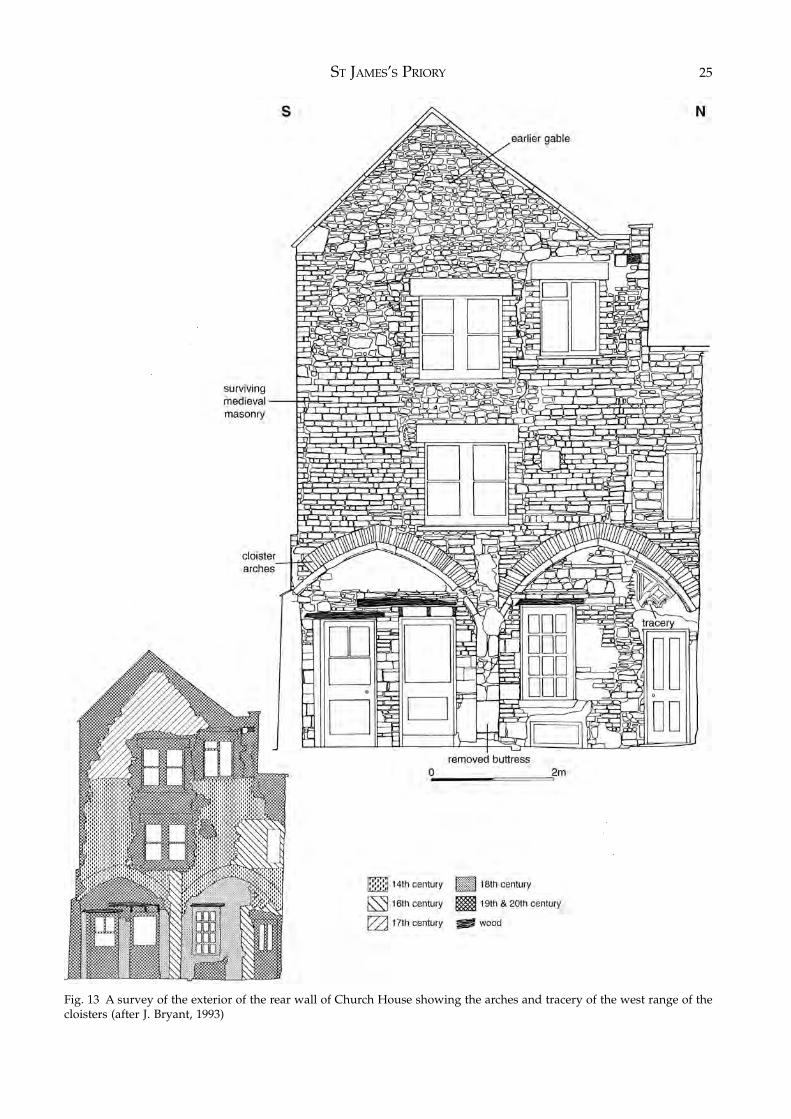
ST JAMES’S PRIORY 25
Fig. 13 A survey of the exterior of the rear wall of Church House showing the arches and tracery of the west range of thecloisters (after J. Bryant, 1993)
EXCAVATIONS AT ST JAMES’S PRIORY, BRISTOL26
inclosed with a wall adjoining to the said plot on theeast side of the said house wherein standeth a pigeonhouse with all the barton that extendeth from the gatein Barcs lane where unto the pound is adjoining untothe said east part, or backer part of the said Mannorhouse & east part of the Church, together with twogreat barns, the said pounds & all other houses,edifices & buildings which lyeth on both sides &within the said barton & enclosed grounds ...’ (GROD1799/T34).
One of these great barns survived until the mid18th century. In a document dated 1646 it wasdescribed as ‘the Great Barn called ye Priory Barn’(BRO P/St J/V/12/4) and a plan of 1744 shows the‘Old Barn’ as lying immediately to the east of the landowned by a Mr Garner which in turn was partly onthe site of the former east end of the priory church(Fig. 9; BRO St J/V/12/4/3). If this was the tithe barnof the priory then it seems to have been located on theland now occupied by the Premier Travel Inn (con-verted from the former Avon House office block), andtherefore now totally destroyed.
The 1580 deed provides some information on theextent of the lands lying within St James’s parish whichwere almost certainly part of the priory farm. Thesewere an un-named mead 1½ acres in extent next toMaudlin Lane, three other un-named meads one ofwhich contained a barn, two meads called the UpperMaudlins, a mead with a pool and orchard called theMontagues, four meads called Culver House Close,Kingsdown, Galls Mead and Foxholes, two meadowscalled Great Earls Mead and Little Earls Mead, aquarter acre of ground adjoining the Horse Church-yard, and a mill called Baggpath (GRO D1799/T34).
A charter of 1373 defining the city boundariesnames fields called ‘Priourescroft’, ‘Priouresorchard’and ‘the close of the Prior of St James’ on the slopes ofKingsdown to the north of the priory (Harding 1930,159).
St James’s Back and QuayThe meadows, known as Broadmead, lying betweenthe priory and the River Frome formed part of thepriory’s landholdings. Crossing these meadows was astreet known as St James’s Back which was probablylaid out very soon after the founding of the priory inorder to connect it with the river, as it seems likely thatsome of the materials required in the priory’s construc-tion would have been transported by ship. In Bristolthe term ‘Back’ refers to a road laid out on or behind aquay, e.g. Welsh Back and St Augustine’s Back.
Archaeological excavations carried out in 2000 atthe southern end of this street where it adjoined theriver (Fig. 2) showed that a wall had been built outinto the river in the early to mid 12th century toprovide a quayside against which vessels could havebeen moored and also confirmed that St James’s Back
had been established at the same time (Jackson forth-coming). The former river-channel behind the wallwas then infilled with red sand and clay which couldhave come from material produced during the level-ling of the site of the priory. The reclaimed area behindthe river-wall and the top of the original river-bankbecame the site of an industrial complex consisting ofhearths and at least one timber building. This con-tinued in use from at least the mid 12th century untilthe late 13th century when it was replaced by asubstantial stone-built house.
The Lay Burial Ground and Parish ChurchyardThe churchyard used by the parishioners of St Jamescovered a large area to the south of the church on landsloping down to the River Frome. Its extent wasdefined by Lower Maudlin Street to the west, theHorsefair to the south and the road known as StJames’s Churchyard to the east. Its northern edge wascrossed in the 18th century by a path originally calledThe Churchyard and later St James’s Parade. In 1478William Worcestre recorded the width of the church-yard as being 130 steps (Harvey 1969, 131).
Evidence for the extent of the churchyard wasfound in 1954 when human remains were uncoveredduring the construction of a department store on thesite bounded by the Horsefair, Bond Street and StJames’s Churchyard (Mason 1957). This area wastraditionally thought to have been the site of a burialpit for the victims of one of the outbreaks of plague inthe 17th century. Despite the limited time availableduring construction work an excavation was carriedout by members of the Folk House ArchaeologicalClub. About 40 skeletons were excavated archaeo-logically while another 260 skeletons were removedby City Council workmen. The depth of the burialsvaried from a few centimetres to 1.5 metres, the bodiesbeing laid mostly on the surface of the bedrock withapparently no graves having been cut into the bed-rock. The shallow depth of some of the burialsindicated that the original ground surface had beenreduced at some time. The human remains were foundto extend under the adjoining roads of the Horsefair,Bond Street and St James’s Churchyard. However, noremains were found on the other side of St James’sChurchyard which would seem to show the easternlimit of the burial ground.
The bodies were oriented east/west and laid inparallel rows, with the distance between the bodiesbeing about 1.2 metres or less. Generally the bodieshad their arms crossed over the chest with the handsresting on opposite shoulders. In a number of casesonly one arm crossed, the other lying horizontallyacross the abdomen. There were few finds in thegraves and there were no coffins or coffin fittingsalthough some nails were found with one or twoskeletons along the north-west boundary of the site.
ST JAMES’S PRIORY 27
One burial had two bronze buckles, one on each hip,which were identified as probably dating to the 14thcentury, and it was suggested by the excavator that allthe burials generally dated to the 13th and 14thcenturies.
There was certainly no evidence of the type of massburial associated with plague victims and the reg-ularity and spacing of the burials confirmed that thesite was part of the parish churchyard.
Millerd’s map of 1673 (Fig. 3) shows a building inthe centre of the churchyard, which was presumably asmall chapel, and a small group of buildings oc-cupying the south-west corner of the churchyard atthe junction of Silver Street and St James’s Back (nowBridewell Street). Demolition in 1894 of the White LionInn at the junction of Bridewell Street and Silver Streetled to the discovery of a tiled pavement beneath theinn (Warren 1896, 95). It was suggested by Warrenthat this pavement belonged to the chapel whichWilliam Worcestre had described as being in thechurchyard of St James ‘going towards the FranciscanFriary’. This he described as ‘a fair chapel, quad-rangular, all built of freestone as well as in thecovering of the roof as in the windows; and it containson either side of the chapel 18 feet square, with 8buttresses’ (Warren 1907, 196). It was postulated thatit may have been a mortuary chapel in St James’schurchyard. However, Warren’s plan showing thelocation of the tiled pavement would appear to placeit just outside the south-west corner of the church-yard, although the precise limits of the churchyard arenot known in that area.
Whatever the use of this alleged chapel, about
seventy-five medieval encaustic floor tiles were foundwhich were of a reddish brown fabric decorated withyellow slip. These probably date to the 14th or early15th centuries although Warren thought three of thetiles may have belonged to the 16th century. It wassuggested that some of these tiles may have beenmanufactured at the Malvern kilns in Worcestershire.The decoration on some of these tiles took the form ofGothic windows, a shield with the lions of Englandand the inscription ‘Fiat voluntas Dei’, the Symbols ofthe Passion, two hearts joined with a four-leavedflower in each lobe, a crowned letter M, the initialsIHC crowned within a double circle and within aborder of eight inverted arches, and the shield ofEdward the Confessor surrounded by foliage (Warren1896, 96–97).
By the mid 19th century the churchyard hadbecome very full, the ground being considerablyelevated and held up on two sides with retainingwalls. In 1850 the state of the churchyard wasmentioned in a report to the General Board of Health(Clark 1850, 162). It was stated that ‘the ground is nowso full, that to make new graves, the grave-digger hasoften to bore the ground for a considerable time tofind a free spot. The side near Lower Maudlin-street isin the worst state. Here I have seen decayed matteroozing through the wall, and many others, in warmweather, have seen ... maggots, crawl over thechurchyard wall, across the street, and into thedwelling-houses of the inhabitants’.
The churchyard is now much reduced in area,having been truncated by main roads, and is used as apublic park.
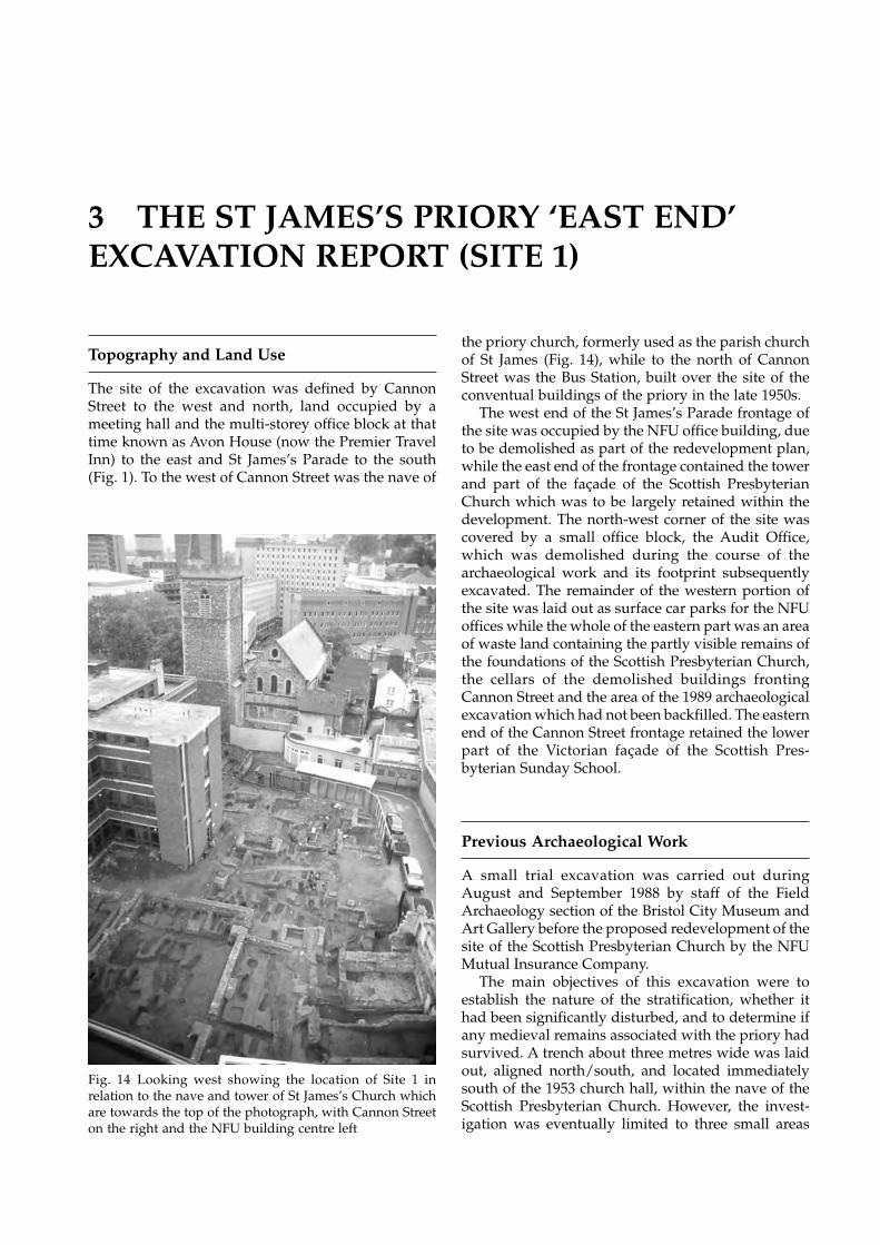
EXCAVATIONS AT ST JAMES’S PRIORY, BRISTOL28
3 THE ST JAMES’S PRIORY ‘EAST END’EXCAVATION REPORT (SITE 1)
Topography and Land Use
The site of the excavation was defined by CannonStreet to the west and north, land occupied by ameeting hall and the multi-storey office block at thattime known as Avon House (now the Premier TravelInn) to the east and St James’s Parade to the south(Fig. 1). To the west of Cannon Street was the nave of
the priory church, formerly used as the parish churchof St James (Fig. 14), while to the north of CannonStreet was the Bus Station, built over the site of theconventual buildings of the priory in the late 1950s.
The west end of the St James’s Parade frontage ofthe site was occupied by the NFU office building, dueto be demolished as part of the redevelopment plan,while the east end of the frontage contained the towerand part of the façade of the Scottish PresbyterianChurch which was to be largely retained within thedevelopment. The north-west corner of the site wascovered by a small office block, the Audit Office,which was demolished during the course of thearchaeological work and its footprint subsequentlyexcavated. The remainder of the western portion ofthe site was laid out as surface car parks for the NFUoffices while the whole of the eastern part was an areaof waste land containing the partly visible remains ofthe foundations of the Scottish Presbyterian Church,the cellars of the demolished buildings frontingCannon Street and the area of the 1989 archaeologicalexcavation which had not been backfilled. The easternend of the Cannon Street frontage retained the lowerpart of the Victorian façade of the Scottish Pres-byterian Sunday School.
Previous Archaeological Work
A small trial excavation was carried out duringAugust and September 1988 by staff of the FieldArchaeology section of the Bristol City Museum andArt Gallery before the proposed redevelopment of thesite of the Scottish Presbyterian Church by the NFUMutual Insurance Company.
The main objectives of this excavation were toestablish the nature of the stratification, whether ithad been significantly disturbed, and to determine ifany medieval remains associated with the priory hadsurvived. A trench about three metres wide was laidout, aligned north/south, and located immediatelysouth of the 1953 church hall, within the nave of theScottish Presbyterian Church. However, the invest-igation was eventually limited to three small areas
Fig. 14 Looking west showing the location of Site 1 inrelation to the nave and tower of St James’s Church whichare towards the top of the photograph, with Cannon Streeton the right and the NFU building centre left
THE ST JAMES’S PRIORY ‘EAST END’ EXCAVATION REPORT (SITE 1) 29
within that trench. The natural subsoil was en-countered at a depth of about one metre below themodern ground surface at the north end of the trenchand the subsoil was noted as sloping away to thesouth. Over the subsoil was a layer of fine red-brownsand which, it was suggested, was either hill-wash orpossibly dumped levelling material, and finds in-dicated it dated to the 14th or 15th centuries. Onefeature was interpreted as a ditch aligned east/west,which may have been cut during the later occupationof the priory but backfilled after the middle of the17th century. A layer sealed this ditch but was cut bya series of 18th-century stone-lined drains. Substantiallayers of sand and limestone fragments overlay thesedrains and had been laid down during the con-struction of the Scottish Presbyterian Church in themid 19th century (Jones 1988a; Jones 1988b, 33).
Following the trial excavations an area of about 140square metres was excavated in 1989 under thedirection of Bob Jones. The main excavation waslocated to the north-east of the NFU office buildingand within the area previously occupied by theScottish Presbyterian Church. A number of medievalburials, including distinctive body-shaped or head-niche burials, were found and indentified as belongingto the monastic burial ground lying to the east of thepriory church. Unfortunately the human skeletalremains were generally in a very poor condition and,in some cases, showed only as stains in the soil. Somepost-medieval deposits were excavated including aseries of 17th-century rubbish pits containing finegroups of ceramics and other objects. Another, smallerarea, was cleared close to the Cannon Street frontageon the site of an 18th-century building, although thearchaeological deposits here were not fully excavated.An interim report on this excavation was published(Jones 1989).
As a result of the proposed redevelopment of thewhole of the site bounded by Cannon Street, AvonHouse and St James’s Parade, Bristol and RegionArchaeological Services were requested to carry out adesk-based assessment in 1994 and this recommendedan evaluation by trial trenching of the areas notexcavated in 1989 (BaRAS 1994a).
The evaluation was undertaken in June 1994 byEric Boore for Bristol and Region ArchaeologicalServices, when four trial trenches were excavated:three beneath the car park to the north of the NFUoffices and one to the east of the NFU offices withinthe area of the former Scottish Presbyterian Church.Two of the trenches below the car park revealed thepresence of burials while the third, in the area of thesupposed east end of the priory church, showed thatthere had been substantial disturbance of the archaeo-logical deposits by service trenches connected withthe NFU offices. The fourth trench, south of the 1989excavation, indicated there was a good survival ofarchaeological deposits of the medieval and post-
medieval periods. A number of recommendationswere made which involved the excavation of thewhole of the area to be disturbed by the constructionof the proposed office building and basement car park(BaRAS 1994b).
Excavation Methods and Recording
From the results of the archaeological excavationcarried out on part of the site in 1989 and theevaluation work undertaken in 1994, it was knownthat the archaeological deposits in the area to beexcavated were relatively shallow, especially beneaththe car park of the NFU office and the Audit Office.The natural bedrock appeared to slope away to thesouth and the archaeology seemed to be deeper andbetter preserved beneath the southern part of theScottish Presbyterian Church. The site was thereforeworked as an open area excavation with relevantsections being recorded before removal.
The excavation was carried out from January toMay 1995. Initially the entire area was stripped of carpark surfaces, modern make-up levels and over-burden using a mechanical excavator. Once archaeo-logical deposits and structures were encountered thesewere cleaned and excavated by hand.
During weekdays the site was excavated by a teamof professional archaeologists, assisted occasionallyby archaeology students from Bristol and Bradforduniversities, working under the overall direction ofthe Project Manager, Reg Jackson, and the supervisionof David Wicks. On one day each weekend the sitewas used as a training excavation for local archaeo-logical societies, especially the Bristol and AvonArchaeological Society and the Clevedon and DistrictArchaeological Society who, together with othervolunteers, worked under the direction of the ProjectManager.
All archaeological deposits, features and structures,including the remains of the mid-19th century ScottishPresbyterian Church, were recorded in detail. Almostthe entire area was excavated to natural and thearchaeological deposits removed. The exceptions wereareas of the site which could not be excavated forsafety reasons due to the proximity of standing walls.These were observed and recorded by means of awatching-brief during the course of the redevelop-ment of the site.
Adverse weather conditions during the earlymonths of 1995, particularly extraordinarily heavy andpersistent rain, caused some delay to the work andrequired the provision of site covers. Demolition of theAudit Office well into the period of the excavation alsocaused some logistical problems and the need for partsof the site to be excavated out of chronologicalsequence. Despite the discovery of over 150 more
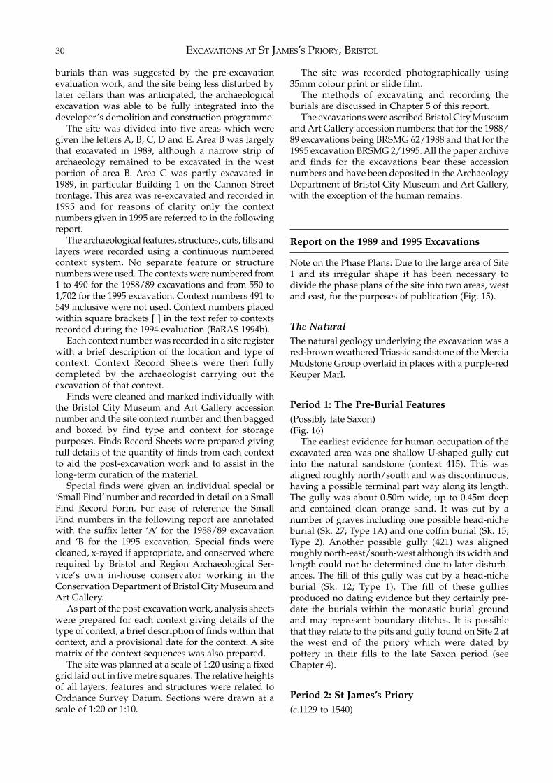
EXCAVATIONS AT ST JAMES’S PRIORY, BRISTOL30
burials than was suggested by the pre-excavationevaluation work, and the site being less disturbed bylater cellars than was anticipated, the archaeologicalexcavation was able to be fully integrated into thedeveloper’s demolition and construction programme.
The site was divided into five areas which weregiven the letters A, B, C, D and E. Area B was largelythat excavated in 1989, although a narrow strip ofarchaeology remained to be excavated in the westportion of area B. Area C was partly excavated in1989, in particular Building 1 on the Cannon Streetfrontage. This area was re-excavated and recorded in1995 and for reasons of clarity only the contextnumbers given in 1995 are referred to in the followingreport.
The archaeological features, structures, cuts, fills andlayers were recorded using a continuous numberedcontext system. No separate feature or structurenumbers were used. The contexts were numbered from1 to 490 for the 1988/89 excavations and from 550 to1,702 for the 1995 excavation. Context numbers 491 to549 inclusive were not used. Context numbers placedwithin square brackets [ ] in the text refer to contextsrecorded during the 1994 evaluation (BaRAS 1994b).
Each context number was recorded in a site registerwith a brief description of the location and type ofcontext. Context Record Sheets were then fullycompleted by the archaeologist carrying out theexcavation of that context.
Finds were cleaned and marked individually withthe Bristol City Museum and Art Gallery accessionnumber and the site context number and then baggedand boxed by find type and context for storagepurposes. Finds Record Sheets were prepared givingfull details of the quantity of finds from each contextto aid the post-excavation work and to assist in thelong-term curation of the material.
Special finds were given an individual special or‘Small Find’ number and recorded in detail on a SmallFind Record Form. For ease of reference the SmallFind numbers in the following report are annotatedwith the suffix letter ‘A’ for the 1988/89 excavationand ‘B for the 1995 excavation. Special finds werecleaned, x-rayed if appropriate, and conserved whererequired by Bristol and Region Archaeological Ser-vice’s own in-house conservator working in theConservation Department of Bristol City Museum andArt Gallery.
As part of the post-excavation work, analysis sheetswere prepared for each context giving details of thetype of context, a brief description of finds within thatcontext, and a provisional date for the context. A sitematrix of the context sequences was also prepared.
The site was planned at a scale of 1:20 using a fixedgrid laid out in five metre squares. The relative heightsof all layers, features and structures were related toOrdnance Survey Datum. Sections were drawn at ascale of 1:20 or 1:10.
The site was recorded photographically using35mm colour print or slide film.
The methods of excavating and recording theburials are discussed in Chapter 5 of this report.
The excavations were ascribed Bristol City Museumand Art Gallery accession numbers: that for the 1988/89 excavations being BRSMG 62/1988 and that for the1995 excavation BRSMG 2/1995. All the paper archiveand finds for the excavations bear these accessionnumbers and have been deposited in the ArchaeologyDepartment of Bristol City Museum and Art Gallery,with the exception of the human remains.
Report on the 1989 and 1995 Excavations
Note on the Phase Plans: Due to the large area of Site1 and its irregular shape it has been necessary todivide the phase plans of the site into two areas, westand east, for the purposes of publication (Fig. 15).
The NaturalThe natural geology underlying the excavation was ared-brown weathered Triassic sandstone of the MerciaMudstone Group overlaid in places with a purple-redKeuper Marl.
Period 1: The Pre-Burial Features(Possibly late Saxon)(Fig. 16)
The earliest evidence for human occupation of theexcavated area was one shallow U-shaped gully cutinto the natural sandstone (context 415). This wasaligned roughly north/south and was discontinuous,having a possible terminal part way along its length.The gully was about 0.50m wide, up to 0.45m deepand contained clean orange sand. It was cut by anumber of graves including one possible head-nicheburial (Sk. 27; Type 1A) and one coffin burial (Sk. 15;Type 2). Another possible gully (421) was alignedroughly north-east/south-west although its width andlength could not be determined due to later disturb-ances. The fill of this gully was cut by a head-nicheburial (Sk. 12; Type 1). The fill of these gulliesproduced no dating evidence but they certainly pre-date the burials within the monastic burial groundand may represent boundary ditches. It is possiblethat they relate to the pits and gully found on Site 2 atthe west end of the priory which were dated bypottery in their fills to the late Saxon period (seeChapter 4).
Period 2: St James’s Priory(c.1129 to 1540)
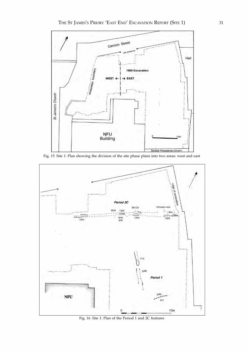
THE ST JAMES’S PRIORY ‘EAST END’ EXCAVATION REPORT (SITE 1) 31
Fig. 15 Site 1: Plan showing the division of the site phase plans into two areas: west and east
Fig. 16 Site 1: Plan of the Period 1 and 2C features
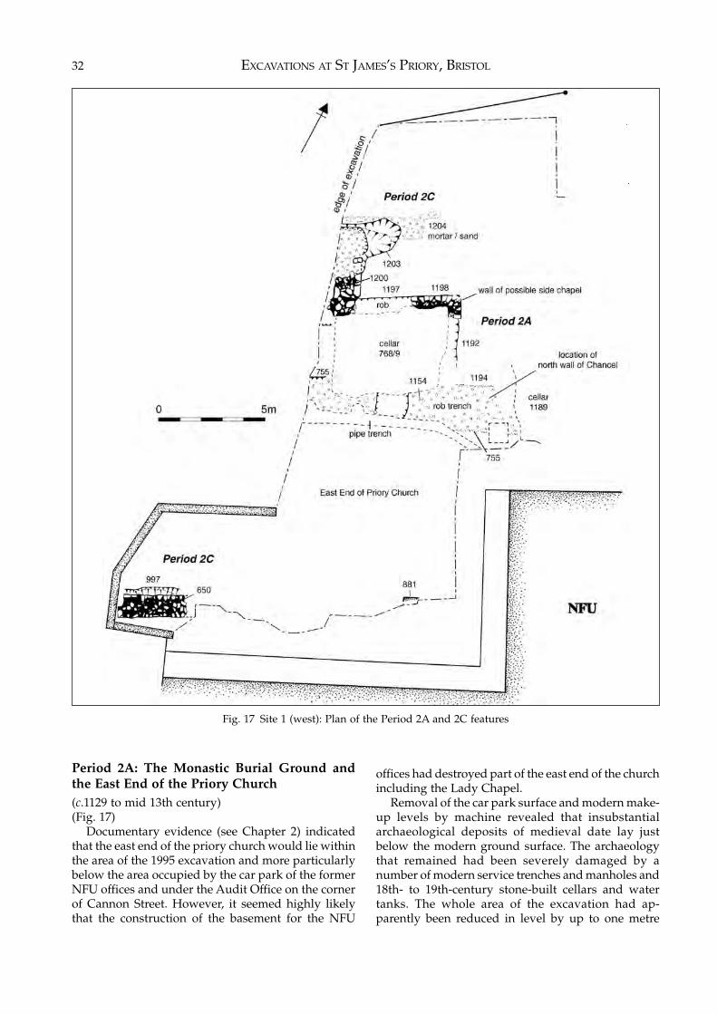
EXCAVATIONS AT ST JAMES’S PRIORY, BRISTOL32
Period 2A: The Monastic Burial Ground andthe East End of the Priory Church(c.1129 to mid 13th century)(Fig. 17)
Documentary evidence (see Chapter 2) indicatedthat the east end of the priory church would lie withinthe area of the 1995 excavation and more particularlybelow the area occupied by the car park of the formerNFU offices and under the Audit Office on the cornerof Cannon Street. However, it seemed highly likelythat the construction of the basement for the NFU
offices had destroyed part of the east end of the churchincluding the Lady Chapel.
Removal of the car park surface and modern make-up levels by machine revealed that insubstantialarchaeological deposits of medieval date lay justbelow the modern ground surface. The archaeologythat remained had been severely damaged by anumber of modern service trenches and manholes and18th- to 19th-century stone-built cellars and watertanks. The whole area of the excavation had ap-parently been reduced in level by up to one metre
Fig. 17 Site 1 (west): Plan of the Period 2A and 2C features
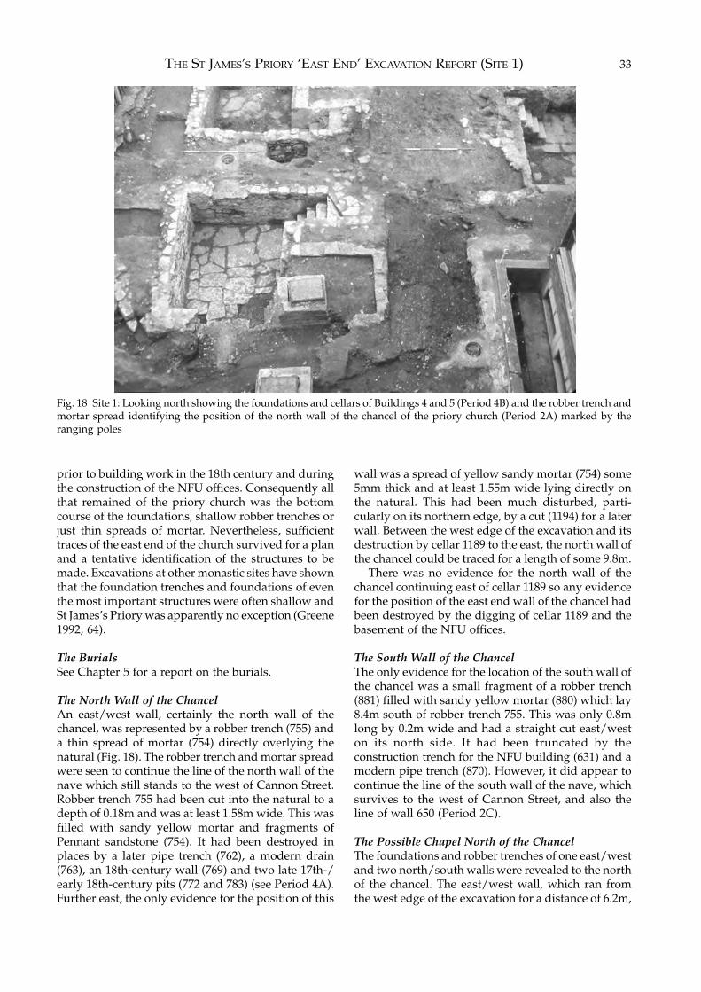
THE ST JAMES’S PRIORY ‘EAST END’ EXCAVATION REPORT (SITE 1) 33
prior to building work in the 18th century and duringthe construction of the NFU offices. Consequently allthat remained of the priory church was the bottomcourse of the foundations, shallow robber trenches orjust thin spreads of mortar. Nevertheless, sufficienttraces of the east end of the church survived for a planand a tentative identification of the structures to bemade. Excavations at other monastic sites have shownthat the foundation trenches and foundations of eventhe most important structures were often shallow andSt James’s Priory was apparently no exception (Greene1992, 64).
The BurialsSee Chapter 5 for a report on the burials.
The North Wall of the ChancelAn east/west wall, certainly the north wall of thechancel, was represented by a robber trench (755) anda thin spread of mortar (754) directly overlying thenatural (Fig. 18). The robber trench and mortar spreadwere seen to continue the line of the north wall of thenave which still stands to the west of Cannon Street.Robber trench 755 had been cut into the natural to adepth of 0.18m and was at least 1.58m wide. This wasfilled with sandy yellow mortar and fragments ofPennant sandstone (754). It had been destroyed inplaces by a later pipe trench (762), a modern drain(763), an 18th-century wall (769) and two late 17th-/early 18th-century pits (772 and 783) (see Period 4A).Further east, the only evidence for the position of this
wall was a spread of yellow sandy mortar (754) some5mm thick and at least 1.55m wide lying directly onthe natural. This had been much disturbed, parti-cularly on its northern edge, by a cut (1194) for a laterwall. Between the west edge of the excavation and itsdestruction by cellar 1189 to the east, the north wall ofthe chancel could be traced for a length of some 9.8m.
There was no evidence for the north wall of thechancel continuing east of cellar 1189 so any evidencefor the position of the east end wall of the chancel hadbeen destroyed by the digging of cellar 1189 and thebasement of the NFU offices.
The South Wall of the ChancelThe only evidence for the location of the south wall ofthe chancel was a small fragment of a robber trench(881) filled with sandy yellow mortar (880) which lay8.4m south of robber trench 755. This was only 0.8mlong by 0.2m wide and had a straight cut east/weston its north side. It had been truncated by theconstruction trench for the NFU building (631) and amodern pipe trench (870). However, it did appear tocontinue the line of the south wall of the nave, whichsurvives to the west of Cannon Street, and also theline of wall 650 (Period 2C).
The Possible Chapel North of the ChancelThe foundations and robber trenches of one east/westand two north/south walls were revealed to the northof the chancel. The east/west wall, which ran fromthe west edge of the excavation for a distance of 6.2m,
Fig. 18 Site 1: Looking north showing the foundations and cellars of Buildings 4 and 5 (Period 4B) and the robber trench andmortar spread identifying the position of the north wall of the chancel of the priory church (Period 2A) marked by theranging poles
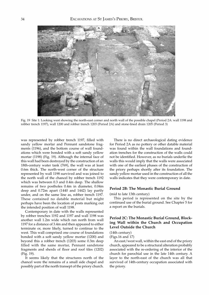
EXCAVATIONS AT ST JAMES’S PRIORY, BRISTOL34
was represented by robber trench 1197, filled withsandy yellow mortar and Pennant sandstone frag-ments (1196), and the bottom course of wall found-ations which were bonded with a soft sandy yellowmortar (1198) (Fig. 19). Although the internal face ofthis wall had been destroyed by the construction of an18th-century water tank (769), the wall was at least0.6m thick. The north-west corner of the structurerepresented by wall 1198 survived and was joined tothe north wall of the chancel by robber trench 1192which was between 0.3 and 0.4m deep. The shallowremains of two postholes 0.4m in diameter, 0.04mdeep and 0.72m apart (1440 and 1442) lay partlyunder, and on the same line as, robber trench 1197.These contained no datable material but mightperhaps have been the location of posts marking outthe intended position of wall 1198.
Contemporary in date with the walls representedby robber trenches 1192 and 1197 and wall 1198 wasanother wall 1.2m wide which ran north from wall1197 for a distance of 3.4m and then appeared to eitherterminate or, more likely, turned to continue to thewest. This wall comprised one course of foundationsbonded with a soft sandy yellow mortar (1200) andbeyond this a robber trench (1203) some 0.3m deepfilled with the same mortar, Pennant sandstonefragments and sherds of floor and roof tiles (1202)(Fig. 19).
It seems likely that the structures north of thechancel were the remains of a small side chapel andpossibly part of the north transept of the priory church.
There is no direct archaeological dating evidencefor Period 2A as no pottery or other datable materialwas found within the wall foundations and found-ation trenches for the construction of the walls couldnot be identified. However, as no burials underlie thewalls this would imply that the walls were associatedwith one of the earliest phases of the construction ofthe priory perhaps shortly after its foundation. Thesandy yellow mortar used in the construction of all thewalls indicates that they were contemporary in date.
Period 2B: The Monastic Burial Ground(mid to late 13th century)
This period is represented on the site by thecontinued use of the burial ground. See Chapter 5 fora report on the burials.
Period 2C: The Monastic Burial Ground, Block-ing Wall within the Church and OccupationLevel Outside the Church(14th century)(Figs.16 and 17)
An east/west wall, within the east end of the priorychurch, appeared to be a structural alteration probablyassociated with the re-ordering of the interior of thechurch for parochial use in the late 14th century. Alayer to the north-east of the church was all thatsurvived of 14th-century occupation associated withthe priory.
Fig. 19 Site 1: Looking west showing the north-east corner and north wall of the possible chapel (Period 2A: wall 1198 androbber trench 1197), wall 1200 and robber trench 1203 (Period 2A) and stone-lined drain 1205 (Period 3)
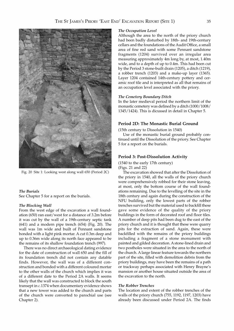
THE ST JAMES’S PRIORY ‘EAST END’ EXCAVATION REPORT (SITE 1) 35
The BurialsSee Chapter 5 for a report on the burials.
The Blocking WallFrom the west edge of the excavation a wall found-ation (650) ran east/west for a distance of 3.2m beforeit was cut by the wall of a 19th-century septic tank(641) and a modern pipe trench (654) (Fig. 20). Thewall was 1m wide and built of Pennant sandstonebonded with a light pink mortar. A cut 0.3m deep andup to 0.36m wide along its north face appeared to bethe remains of its shallow foundation trench (997).
There was no direct archaeological dating evidencefor the date of construction of wall 650 and the fill ofits foundation trench did not contain any datablefinds. However, the wall was of a different con-struction and bonded with a different coloured mortarto the other walls of the church which implies it wasof a different date to the Period 2A walls. It seemslikely that the wall was constructed to block the southtransept in c.1374 when documentary evidence showsthat a new tower was added to the church and partsof the church were converted to parochial use (seeChapter 2).
The Occupation LevelAlthough the area to the north of the priory churchhad been badly disturbed by 18th- and 19th-centurycellars and the foundations of the Audit Office, a smallarea of fine red sand with some Pennant sandstonefragments (1204) survived over an irregular areameasuring approximately 4m long by, at most, 1.40mwide, and to a depth of up to 0.4m. This had been cutby the Period 3 stone-built drain (1205), a ditch (1219),a robber trench (1203) and a make-up layer (1365).Layer 1204 contained 14th-century pottery and cer-amic roof tile and is interpreted as all that remains ofan occupation level associated with the priory.
The Cemetery Boundary DitchIn the later medieval period the northern limit of themonastic cemetery was defined by a ditch (1000/1008/1345/1424). This is dicussed in detail in Chapter 5.
Period 2D: The Monastic Burial Ground(15th century to Dissolution in 1540)
Use of the monastic burial ground probably con-tinued until the Dissolution of the priory. See Chapter5 for a report on the burials.
Period 3: Post-Dissolution Activity(1540 to the early 17th century)(Figs. 21 and 22)
The excavation showed that after the Dissolution ofthe priory in 1540, all the walls of the priory churchwere comprehensively robbed for their stone leaving,at most, only the bottom course of the wall found-ations remaining. Due to the levelling of the site in the18th century and again during the construction of theNFU building, only the lowest parts of the robbertrenches survived but the material used to backfill thesegave some evidence of the quality of the priorybuildings in the form of decorated roof and floor tiles.A number of deep pits had been dug to the east of thepriory church and it is thought that these were quarrypits for the extraction of sand. Again, these werebackfilled with the remains of the priory buildingsincluding a fragment of a stone monument withpainted and gilded decoration. A stone-lined drain andtwo postholes were situated in the area to the north ofthe church. A large linear feature towards the northernpart of the site, filled with demolition debris from thepriory buildings, may have been the remains of a pathor trackway perhaps associated with Henry Brayne’smansion or another house situated outside the area ofthe excavation to the north.
The Robber TrenchesThe location and extent of the robber trenches of thewalls of the priory church (755, 1192, 1197, 1203) havealready been discussed under Period 2A. The finds
Fig. 20 Site 1: Looking west along wall 650 (Period 2C)
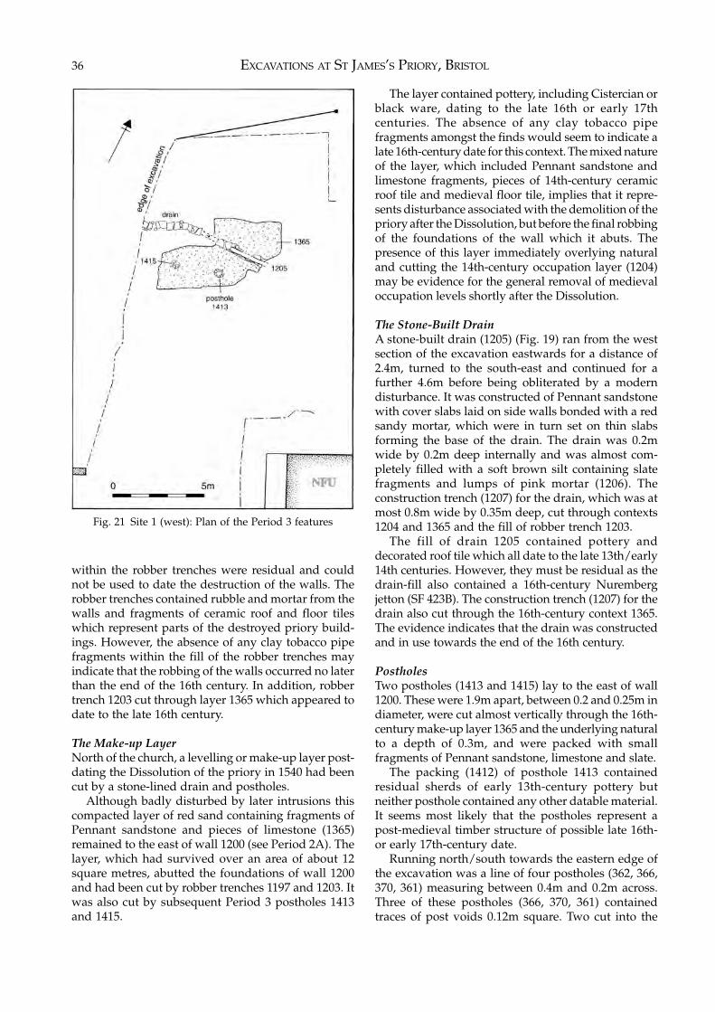
EXCAVATIONS AT ST JAMES’S PRIORY, BRISTOL36
within the robber trenches were residual and couldnot be used to date the destruction of the walls. Therobber trenches contained rubble and mortar from thewalls and fragments of ceramic roof and floor tileswhich represent parts of the destroyed priory build-ings. However, the absence of any clay tobacco pipefragments within the fill of the robber trenches mayindicate that the robbing of the walls occurred no laterthan the end of the 16th century. In addition, robbertrench 1203 cut through layer 1365 which appeared todate to the late 16th century.
The Make-up LayerNorth of the church, a levelling or make-up layer post-dating the Dissolution of the priory in 1540 had beencut by a stone-lined drain and postholes.
Although badly disturbed by later intrusions thiscompacted layer of red sand containing fragments ofPennant sandstone and pieces of limestone (1365)remained to the east of wall 1200 (see Period 2A). Thelayer, which had survived over an area of about 12square metres, abutted the foundations of wall 1200and had been cut by robber trenches 1197 and 1203. Itwas also cut by subsequent Period 3 postholes 1413and 1415.
The layer contained pottery, including Cistercian orblack ware, dating to the late 16th or early 17thcenturies. The absence of any clay tobacco pipefragments amongst the finds would seem to indicate alate 16th-century date for this context. The mixed natureof the layer, which included Pennant sandstone andlimestone fragments, pieces of 14th-century ceramicroof tile and medieval floor tile, implies that it repre-sents disturbance associated with the demolition of thepriory after the Dissolution, but before the final robbingof the foundations of the wall which it abuts. Thepresence of this layer immediately overlying naturaland cutting the 14th-century occupation layer (1204)may be evidence for the general removal of medievaloccupation levels shortly after the Dissolution.
The Stone-Built DrainA stone-built drain (1205) (Fig. 19) ran from the westsection of the excavation eastwards for a distance of2.4m, turned to the south-east and continued for afurther 4.6m before being obliterated by a moderndisturbance. It was constructed of Pennant sandstonewith cover slabs laid on side walls bonded with a redsandy mortar, which were in turn set on thin slabsforming the base of the drain. The drain was 0.2mwide by 0.2m deep internally and was almost com-pletely filled with a soft brown silt containing slatefragments and lumps of pink mortar (1206). Theconstruction trench (1207) for the drain, which was atmost 0.8m wide by 0.35m deep, cut through contexts1204 and 1365 and the fill of robber trench 1203.
The fill of drain 1205 contained pottery anddecorated roof tile which all date to the late 13th/early14th centuries. However, they must be residual as thedrain-fill also contained a 16th-century Nurembergjetton (SF 423B). The construction trench (1207) for thedrain also cut through the 16th-century context 1365.The evidence indicates that the drain was constructedand in use towards the end of the 16th century.
PostholesTwo postholes (1413 and 1415) lay to the east of wall1200. These were 1.9m apart, between 0.2 and 0.25m indiameter, were cut almost vertically through the 16th-century make-up layer 1365 and the underlying naturalto a depth of 0.3m, and were packed with smallfragments of Pennant sandstone, limestone and slate.
The packing (1412) of posthole 1413 containedresidual sherds of early 13th-century pottery butneither posthole contained any other datable material.It seems most likely that the postholes represent apost-medieval timber structure of possible late 16th-or early 17th-century date.
Running north/south towards the eastern edge ofthe excavation was a line of four postholes (362, 366,370, 361) measuring between 0.4m and 0.2m across.Three of these postholes (366, 370, 361) containedtraces of post voids 0.12m square. Two cut into the
Fig. 21 Site 1 (west): Plan of the Period 3 features
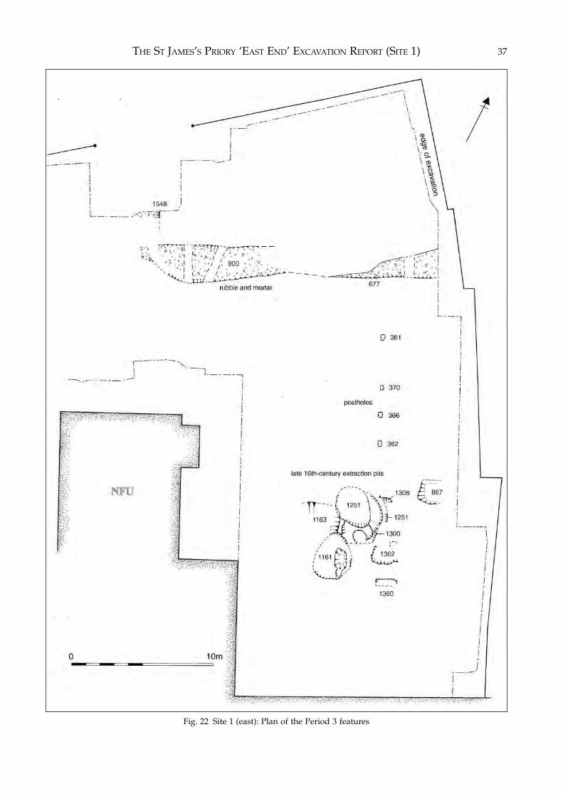
THE ST JAMES’S PRIORY ‘EAST END’ EXCAVATION REPORT (SITE 1) 37
Fig. 22 Site 1 (east): Plan of the Period 3 features
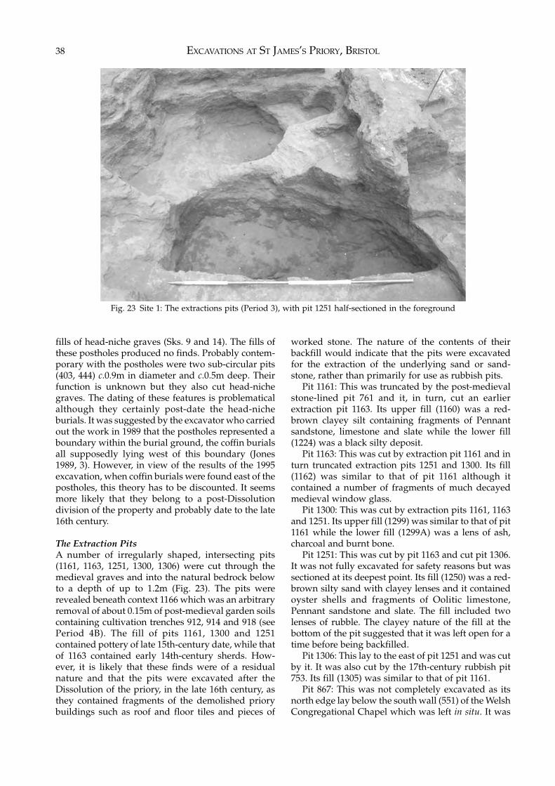
EXCAVATIONS AT ST JAMES’S PRIORY, BRISTOL38
fills of head-niche graves (Sks. 9 and 14). The fills ofthese postholes produced no finds. Probably contem-porary with the postholes were two sub-circular pits(403, 444) c.0.9m in diameter and c.0.5m deep. Theirfunction is unknown but they also cut head-nichegraves. The dating of these features is problematicalalthough they certainly post-date the head-nicheburials. It was suggested by the excavator who carriedout the work in 1989 that the postholes represented aboundary within the burial ground, the coffin burialsall supposedly lying west of this boundary (Jones1989, 3). However, in view of the results of the 1995excavation, when coffin burials were found east of thepostholes, this theory has to be discounted. It seemsmore likely that they belong to a post-Dissolutiondivision of the property and probably date to the late16th century.
The Extraction PitsA number of irregularly shaped, intersecting pits(1161, 1163, 1251, 1300, 1306) were cut through themedieval graves and into the natural bedrock belowto a depth of up to 1.2m (Fig. 23). The pits wererevealed beneath context 1166 which was an arbitraryremoval of about 0.15m of post-medieval garden soilscontaining cultivation trenches 912, 914 and 918 (seePeriod 4B). The fill of pits 1161, 1300 and 1251contained pottery of late 15th-century date, while thatof 1163 contained early 14th-century sherds. How-ever, it is likely that these finds were of a residualnature and that the pits were excavated after theDissolution of the priory, in the late 16th century, asthey contained fragments of the demolished priorybuildings such as roof and floor tiles and pieces of
worked stone. The nature of the contents of theirbackfill would indicate that the pits were excavatedfor the extraction of the underlying sand or sand-stone, rather than primarily for use as rubbish pits.
Pit 1161: This was truncated by the post-medievalstone-lined pit 761 and it, in turn, cut an earlierextraction pit 1163. Its upper fill (1160) was a red-brown clayey silt containing fragments of Pennantsandstone, limestone and slate while the lower fill(1224) was a black silty deposit.
Pit 1163: This was cut by extraction pit 1161 and inturn truncated extraction pits 1251 and 1300. Its fill(1162) was similar to that of pit 1161 although itcontained a number of fragments of much decayedmedieval window glass.
Pit 1300: This was cut by extraction pits 1161, 1163and 1251. Its upper fill (1299) was similar to that of pit1161 while the lower fill (1299A) was a lens of ash,charcoal and burnt bone.
Pit 1251: This was cut by pit 1163 and cut pit 1306.It was not fully excavated for safety reasons but wassectioned at its deepest point. Its fill (1250) was a red-brown silty sand with clayey lenses and it containedoyster shells and fragments of Oolitic limestone,Pennant sandstone and slate. The fill included twolenses of rubble. The clayey nature of the fill at thebottom of the pit suggested that it was left open for atime before being backfilled.
Pit 1306: This lay to the east of pit 1251 and was cutby it. It was also cut by the 17th-century rubbish pit753. Its fill (1305) was similar to that of pit 1161.
Pit 867: This was not completely excavated as itsnorth edge lay below the south wall (551) of the WelshCongregational Chapel which was left in situ. It was
Fig. 23 Site 1: The extractions pits (Period 3), with pit 1251 half-sectioned in the foreground
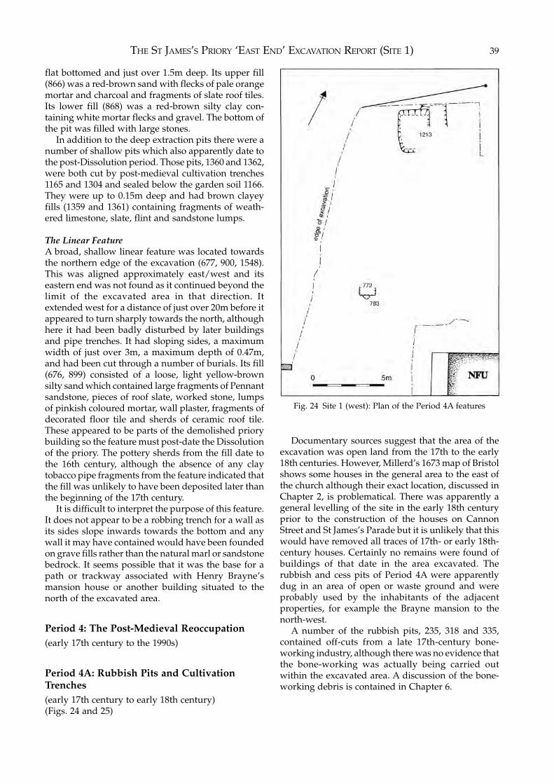
THE ST JAMES’S PRIORY ‘EAST END’ EXCAVATION REPORT (SITE 1) 39
flat bottomed and just over 1.5m deep. Its upper fill(866) was a red-brown sand with flecks of pale orangemortar and charcoal and fragments of slate roof tiles.Its lower fill (868) was a red-brown silty clay con-taining white mortar flecks and gravel. The bottom ofthe pit was filled with large stones.
In addition to the deep extraction pits there were anumber of shallow pits which also apparently date tothe post-Dissolution period. Those pits, 1360 and 1362,were both cut by post-medieval cultivation trenches1165 and 1304 and sealed below the garden soil 1166.They were up to 0.15m deep and had brown clayeyfills (1359 and 1361) containing fragments of weath-ered limestone, slate, flint and sandstone lumps.
The Linear FeatureA broad, shallow linear feature was located towardsthe northern edge of the excavation (677, 900, 1548).This was aligned approximately east/west and itseastern end was not found as it continued beyond thelimit of the excavated area in that direction. Itextended west for a distance of just over 20m before itappeared to turn sharply towards the north, althoughhere it had been badly disturbed by later buildingsand pipe trenches. It had sloping sides, a maximumwidth of just over 3m, a maximum depth of 0.47m,and had been cut through a number of burials. Its fill(676, 899) consisted of a loose, light yellow-brownsilty sand which contained large fragments of Pennantsandstone, pieces of roof slate, worked stone, lumpsof pinkish coloured mortar, wall plaster, fragments ofdecorated floor tile and sherds of ceramic roof tile.These appeared to be parts of the demolished priorybuilding so the feature must post-date the Dissolutionof the priory. The pottery sherds from the fill date tothe 16th century, although the absence of any claytobacco pipe fragments from the feature indicated thatthe fill was unlikely to have been deposited later thanthe beginning of the 17th century.
It is difficult to interpret the purpose of this feature.It does not appear to be a robbing trench for a wall asits sides slope inwards towards the bottom and anywall it may have contained would have been foundedon grave fills rather than the natural marl or sandstonebedrock. It seems possible that it was the base for apath or trackway associated with Henry Brayne’smansion house or another building situated to thenorth of the excavated area.
Period 4: The Post-Medieval Reoccupation(early 17th century to the 1990s)
Period 4A: Rubbish Pits and CultivationTrenches(early 17th century to early 18th century)(Figs. 24 and 25)
Documentary sources suggest that the area of theexcavation was open land from the 17th to the early18th centuries. However, Millerd’s 1673 map of Bristolshows some houses in the general area to the east ofthe church although their exact location, discussed inChapter 2, is problematical. There was apparently ageneral levelling of the site in the early 18th centuryprior to the construction of the houses on CannonStreet and St James’s Parade but it is unlikely that thiswould have removed all traces of 17th- or early 18th-century houses. Certainly no remains were found ofbuildings of that date in the area excavated. Therubbish and cess pits of Period 4A were apparentlydug in an area of open or waste ground and wereprobably used by the inhabitants of the adjacentproperties, for example the Brayne mansion to thenorth-west.
A number of the rubbish pits, 235, 318 and 335,contained off-cuts from a late 17th-century bone-working industry, although there was no evidence thatthe bone-working was actually being carried outwithin the excavated area. A discussion of the bone-working debris is contained in Chapter 6.
Fig. 24 Site 1 (west): Plan of the Period 4A features
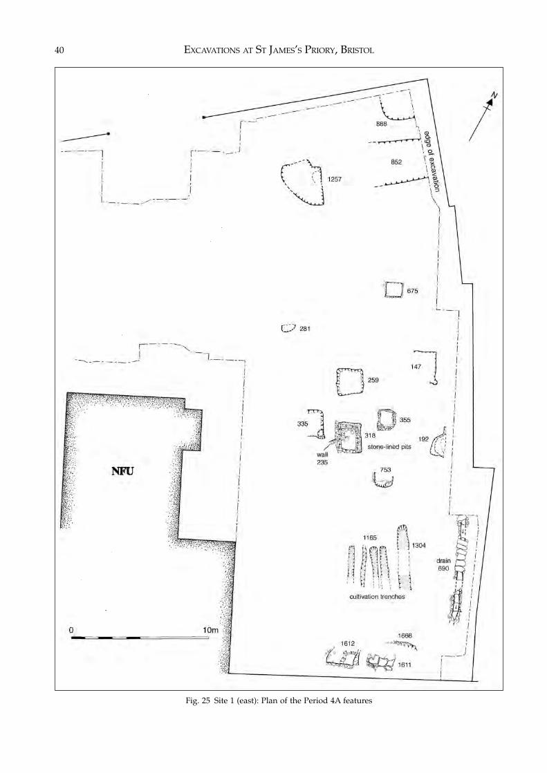
EXCAVATIONS AT ST JAMES’S PRIORY, BRISTOL40
Fig. 25 Site 1 (east): Plan of the Period 4A features
THE ST JAMES’S PRIORY ‘EAST END’ EXCAVATION REPORT (SITE 1) 41
The Rubbish and Cess PitsPit 147: A shallow pit 0.38m deep and roughlyrectangular in shape, measuring 2.2m by 1.6m. Theupper fill (145) was a mixed red-brown sandy loamwith charcoal flecks, while the lower fill (146) was agreyish-green cess material. Both fills contained findsdating to the early 18th century.
Pit 192: A sub-circular pit in the south-east cornerof the 1989 excavation. Only about half the pit couldbe excavated, the rest lying outside the area availablefor excavation. The pit had sloping sides, was at least1.8m across from north to south, and was 1.7m deep.Its upper fill (166) was a dark brown ashy loam, thelower fill (191) being a brown loam with many largeflecks of charcoal and mortar. Both fills containedfinds dating to the second half of the 17th century, theoccurrence of clay pipes made by Llewellin Evansindicating that the deposition of the fill could not havetaken place earlier than 1661. A full report on the findsfrom this pit appears in Chapter 6.
Pit 235: This appeared to have been cut and largelydestroyed by pit 318, only a fragment of it remainingto the south-west of pit 318. The pit was apparentlylined with dry-stone walling although only a frag-ment 0.4m long survived. The remaining fill of the pitconsisted of a mixed brown loam with fragments ofplaster and charcoal (169) overlying a tip layer (214)of red-brown sandy loam containing some workedbone offcuts. The lowest fill of the pit (213) was adump of brown loam flecked with grey mortar whichcontained large quantities of offcuts from bone-working including cut and worked bone, burnt boneand bone dust. The finds from the pit fill indicated adeposition date in the late 17th century, the presenceof clay pipes made by Llewellin Evans from the upperfill (169) confirming that this could not have occurredbefore 1661.
Pit 259: This lay below the modern pit 58 and wasroughly rectangular measuring 1.8m square and about0.2m deep. The upper fill (238) was a compact richbrown loam with charcoal flecks below which was asimilar layer (239) containing many lumps of pinkmortar. The bottom layer of the pit (260) was filledwith a green cess-like material. Both 238 and 260contained much waste from bone-working while thefill of the pit produced finds dating to the late 17thcentury. A full report on the finds from this pit appearsin Chapter 6.
Pit 281: The north side of this sub-circular pit hadbeen removed by the Victorian church pillar 34 and itsconstruction trench 73 while its east side had been cutby drain 163/164. The pit measured 1m east/westand at least 0.5m north/south and had almost verticalsides. Its upper fill (282) consisted of a very mixedsandy loam with lumps of red sandstone, cess andcharcoal. Its lower fill (278 and 283) was a soft darkgrey-green cess material. The finds from the fills datedto the early 18th century and the presence of a pipe
made by George Ebbery from the lowest fill showedthat the backfilling could not have taken place before1721.
Pit 296: This was a roughly rectangular cut withsloping sides measuring 1.4m square. Its fill (294, 295)consisted of red brown sand with many fragments ofLias limestone and plaster but no datable material.However, it lay beneath the remains of the 18th-century boundary wall 830 (see Period 4B) and wastherefore probably late 17th- or early 18th-century indate.
Pit 318: This was at least partly sealed by a 19th-century pit (222). It was a rectangular cut (318) linedwith walling of Pennant sandstone bonded with abuff coloured mortar (135, 216, 217, 220, 336). The pitmeasured 1.8m north/south and 1.4m east/westinternally at the top, reducing to 1.5m and 1.1mrespectively at the bottom. The pit was 0.62m deepand appeared to have been roughly floored withPennant sandstone slabs. The upper fill (215) was asoft red-brown sandy loam with some charcoal fleckswhile the lower fill (331) was a greasy green-brownlayer of cess material. Only fill 215 contained findsincluding a collection of worked bone offcuts andthese date the fill to the late 17th century.
Pit 335: This shallow pit measured 1.9m north/south by at least 1.2m east/west, the west edge beingcut by drain 164/163. The south and west sides werecut vertically to a depth of 0.32m while its north andeast sides sloped inwards towards the bottom. Theupper fill (237 and 293) was a dark brown loam withflecks of lime and plaster and contained worked boneoffcuts. Beneath this were further fills (314 and 315)consisting of red-brown sandy loams, fill 314 beingthickly flecked with plaster and charcoal, and bothcontaining worked bone offcuts. The lower fills (323and 332) were a soft red-brown slightly sandy loamwith large fragments of plaster. The bottom of the pitcontained a grey-green cessy material with fragmentsof Pennant sandstone. There were few finds and theonly datable object was a fragment of an ‘onion’shaped wine bottle indicating a late 17th- to early18th-century date for the backfilling of the pit.
Pit 355: This rectangular pit had a drystone walllining (375) made of Pennant sandstone and smallamounts of brick, the walling being intermittent alongthe west and east sides. The pit measured 1.1m north/south by 0.9m east/west and was cut into the naturalsandstone to a depth of 1.5m. Its fill (359) consisted ofa brown loam with fragments of charcoal and Pennantsandstone. There were few datable finds from this fillbut a late 17th- to early 18th-century date seems likelyfor the backfilling of the pit.
Pit 675: A rectangular pit measuring 1.1m by 1minternally, which had been cut into the medieval layer704 and the underlying natural sandstone to a depthof 0.36m. Its vertical sides had been lined with a singlethickness of unmortared Pennant sandstone (674),
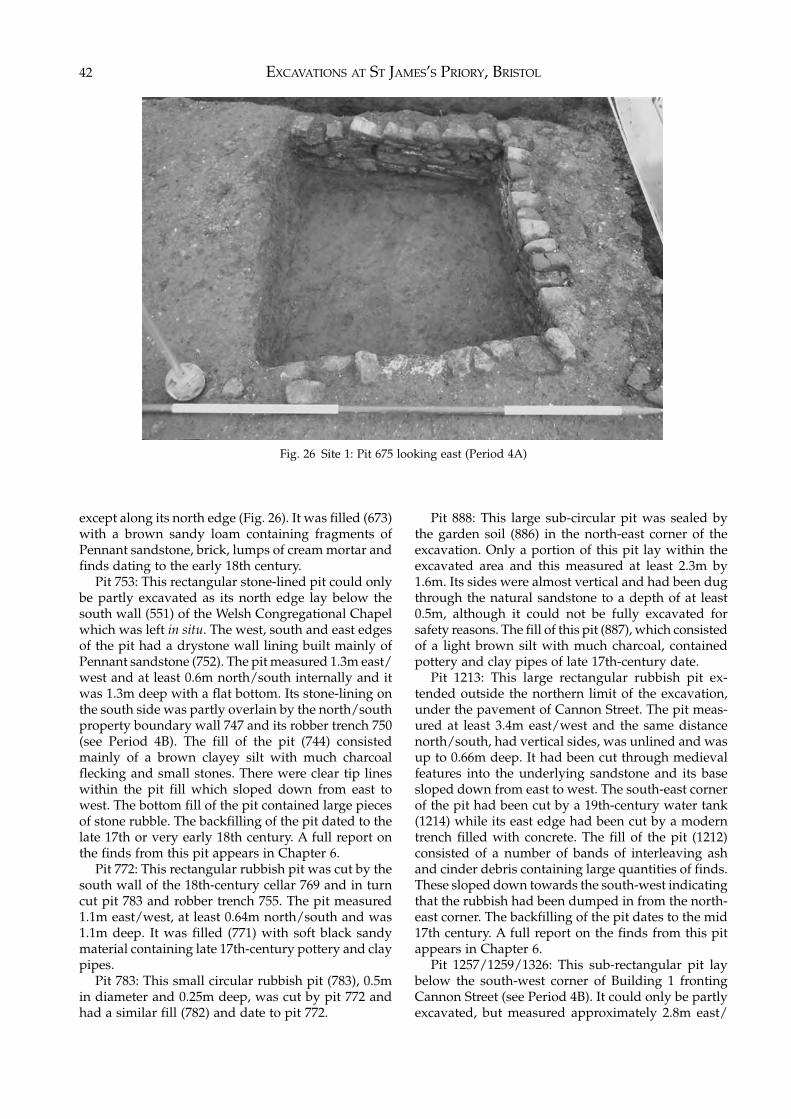
EXCAVATIONS AT ST JAMES’S PRIORY, BRISTOL42
except along its north edge (Fig. 26). It was filled (673)with a brown sandy loam containing fragments ofPennant sandstone, brick, lumps of cream mortar andfinds dating to the early 18th century.
Pit 753: This rectangular stone-lined pit could onlybe partly excavated as its north edge lay below thesouth wall (551) of the Welsh Congregational Chapelwhich was left in situ. The west, south and east edgesof the pit had a drystone wall lining built mainly ofPennant sandstone (752). The pit measured 1.3m east/west and at least 0.6m north/south internally and itwas 1.3m deep with a flat bottom. Its stone-lining onthe south side was partly overlain by the north/southproperty boundary wall 747 and its robber trench 750(see Period 4B). The fill of the pit (744) consistedmainly of a brown clayey silt with much charcoalflecking and small stones. There were clear tip lineswithin the pit fill which sloped down from east towest. The bottom fill of the pit contained large piecesof stone rubble. The backfilling of the pit dated to thelate 17th or very early 18th century. A full report onthe finds from this pit appears in Chapter 6.
Pit 772: This rectangular rubbish pit was cut by thesouth wall of the 18th-century cellar 769 and in turncut pit 783 and robber trench 755. The pit measured1.1m east/west, at least 0.64m north/south and was1.1m deep. It was filled (771) with soft black sandymaterial containing late 17th-century pottery and claypipes.
Pit 783: This small circular rubbish pit (783), 0.5min diameter and 0.25m deep, was cut by pit 772 andhad a similar fill (782) and date to pit 772.
Pit 888: This large sub-circular pit was sealed bythe garden soil (886) in the north-east corner of theexcavation. Only a portion of this pit lay within theexcavated area and this measured at least 2.3m by1.6m. Its sides were almost vertical and had been dugthrough the natural sandstone to a depth of at least0.5m, although it could not be fully excavated forsafety reasons. The fill of this pit (887), which consistedof a light brown silt with much charcoal, containedpottery and clay pipes of late 17th-century date.
Pit 1213: This large rectangular rubbish pit ex-tended outside the northern limit of the excavation,under the pavement of Cannon Street. The pit meas-ured at least 3.4m east/west and the same distancenorth/south, had vertical sides, was unlined and wasup to 0.66m deep. It had been cut through medievalfeatures into the underlying sandstone and its basesloped down from east to west. The south-east cornerof the pit had been cut by a 19th-century water tank(1214) while its east edge had been cut by a moderntrench filled with concrete. The fill of the pit (1212)consisted of a number of bands of interleaving ashand cinder debris containing large quantities of finds.These sloped down towards the south-west indicatingthat the rubbish had been dumped in from the north-east corner. The backfilling of the pit dates to the mid17th century. A full report on the finds from this pitappears in Chapter 6.
Pit 1257/1259/1326: This sub-rectangular pit laybelow the south-west corner of Building 1 frontingCannon Street (see Period 4B). It could only be partlyexcavated, but measured approximately 2.8m east/
Fig. 26 Site 1: Pit 675 looking east (Period 4A)
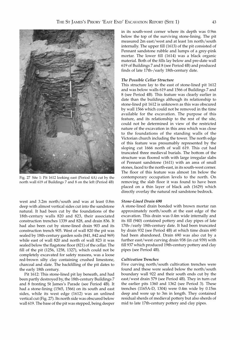
THE ST JAMES’S PRIORY ‘EAST END’ EXCAVATION REPORT (SITE 1) 43
west and 3.2m north/south and was at least 0.8mdeep with almost vertical sides cut into the sandstonenatural. It had been cut by the foundations of the18th-century walls 820 and 823, their associatedconstruction trenches 1339 and 828, and drain 836. Ithad also been cut by stone-lined drain 903 and itsconstruction trench 905. West of wall 820 the pit wassealed by 18th-century garden soils (841, 842 and 969)while east of wall 820 and north of wall 823 it wassealed below the flagstone floor (821) of the cellar. Thefill of the pit (1256, 1258, 1327), which could not becompletely excavated for safety reasons, was a loosered-brown silty clay containing crushed limestone,charcoal and slate. The backfilling of the pit dates tothe early 18th century.
Pit 1612: This stone-lined pit lay beneath, and hadbeen partly destroyed by, the 18th-century Buildings 7and 8 fronting St James’s Parade (see Period 4B). Ithad a stone-lining (1565, 1566) on its south and eastsides, while its west edge (1612) was an unlinedvertical cut (Fig. 27). Its north side was obscured belowwall 619. The base of the pit was stepped, being deeper
in its south-west corner where its depth was 0.9mbelow the top of the surviving stone-lining. The pitmeasured 2m east/west and at least 1m north/southinternally. The upper fill (1613) of the pit consisted ofPennant sandstone rubble and lumps of a grey-pinkmortar. The lower fill (1614) was a black organicmaterial. Both of the fills lay below and pre-date wall619 of Buildings 7 and 8 (see Period 4B) and producedfinds of late 17th-/early 18th-century date.
The Possible Cellar StructureThis structure lay to the east of stone-lined pit 1612and was below walls 619 and 1566 of Buildings 7 and8 (see Period 4B). This feature was clearly earlier indate than the buildings although its relationship tostone-lined pit 1612 is unknown as this was obscuredby wall 1566 which could not be removed in the timeavailable for the excavation. The purpose of thisfeature, and its relationship to the rest of the site,could not be determined in view of the restrictednature of the excavation in this area which was closeto the foundations of the standing walls of theVictorian church including the tower. The north edgeof this feature was presumably represented by thesloping cut 1666 north of wall 619. This cut hadtruncated three medieval burials. The bottom of thestructure was floored with with large irregular slabsof Pennant sandstone (1611) with an area of smallstones, faced to the north-east, in its south-west corner.The floor of this feature was almost 1m below thecontemporary occupation levels to the north. Onremoving the slab floor it was found to have beenplaced on a thin layer of black ash (1629) whichdirectly overlay the natural red sandstone bedrock.
Stone-Lined Drain 690A stone-lined drain bonded with brown mortar ranapproximately north/south at the east edge of theexcavation. This drain was 0.4m wide internally andits fill (940) contained pottery and clay pipes of late17th-/early 18th-century date. It had been truncatedby drain 932 (see Period 4B) at which time drain 690had been abandoned. Drain 690 was also cut by afurther east/west curving drain 938 (in cut 939) withfill 937 which produced 19th-century pottery and claypipes (see Period 4B).
Cultivation TrenchesFive curving north/south cultivation trenches werefound and these were sealed below the north/southboundary wall 922 and their south ends cut by theeast/west drain 579 (see Period 4B). They in turn cutthe earlier pits 1360 and 1362 (see Period 3). Thesetrenches (1165A-D, 1304) were 0.4m wide by 0.15mdeep and were up to 3m in length. They containedresidual sherds of medieval pottery but also sherds ofmid to late 17th-century pottery and clay pipes.
Fig. 27 Site 1: Pit 1612 looking east (Period 4A) cut by thenorth wall 619 of Buildings 7 and 8 on the left (Period 4B)
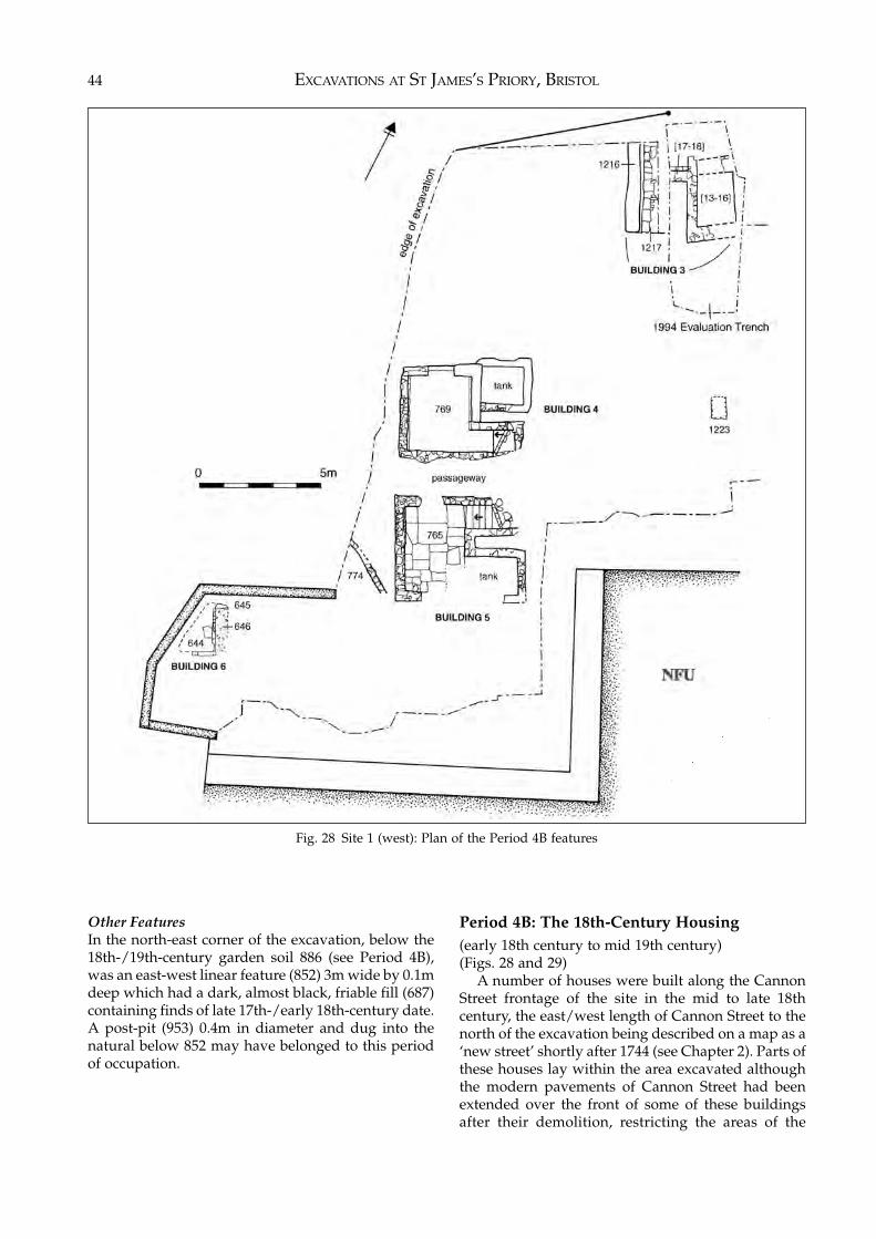
EXCAVATIONS AT ST JAMES’S PRIORY, BRISTOL44
Other FeaturesIn the north-east corner of the excavation, below the18th-/19th-century garden soil 886 (see Period 4B),was an east-west linear feature (852) 3m wide by 0.1mdeep which had a dark, almost black, friable fill (687)containing finds of late 17th-/early 18th-century date.A post-pit (953) 0.4m in diameter and dug into thenatural below 852 may have belonged to this periodof occupation.
Period 4B: The 18th-Century Housing(early 18th century to mid 19th century)(Figs. 28 and 29)
A number of houses were built along the CannonStreet frontage of the site in the mid to late 18thcentury, the east/west length of Cannon Street to thenorth of the excavation being described on a map as a‘new street’ shortly after 1744 (see Chapter 2). Parts ofthese houses lay within the area excavated althoughthe modern pavements of Cannon Street had beenextended over the front of some of these buildingsafter their demolition, restricting the areas of the
Fig. 28 Site 1 (west): Plan of the Period 4B features
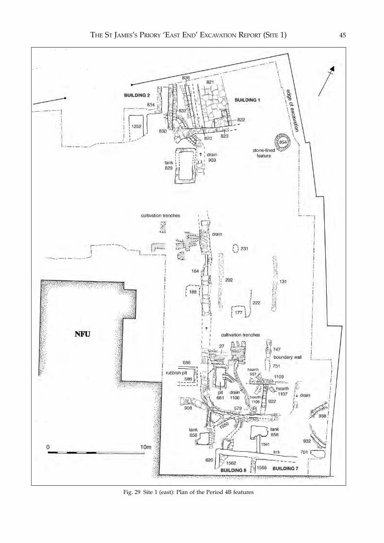
THE ST JAMES’S PRIORY ‘EAST END’ EXCAVATION REPORT (SITE 1) 45
Fig. 29 Site 1 (east): Plan of the Period 4B features
EXCAVATIONS AT ST JAMES’S PRIORY, BRISTOL46
buildings available for excavation. The foundationsand cellars of the houses had also been damaged bylater development on the site, most notably the deepservice trenches connected with the NFU officebuilding.
Houses were also built along St James’s Parade,probably at a slightly earlier date than those on Can-non Street. Only a small part of one of these buildingscould be excavated, the remainder lying under thetower and façade of the Scottish Presbyterian Church.
The 18th-century structures were all of similarconstruction. The foundations and cellar walls, whichwere all that survived, were built mainly of Pennantsandstone and Lias limestone bonded with a hardpink mortar with a high lime content. Brick was onlyoccasionally used. Any variation from this type ofconstruction is mentioned in the text.
In the following report the buildings are describedas complete properties including their associatedboundary walls, drains, rubbish pits, water tanks andother structures. Where features could not be ascribedto a particular property they are described separately.
Buildings 1, 2 and 3 (Cannon Street)The remains of three late 18th-century houses –Buildings 1, 2 and 3 – were found fronting CannonStreet to the north.
The east building, Building 1, which was fullyexcavated, followed the present line of Cannon Street,while Buildings 2 and 3, which had been largelydestroyed by modern service trenches, followed anearlier line of Cannon Street which had been ob-literated by widening the road and pavement inconnection with the construction of the NFU buildingand the Audit Office. The walls of Buildings 2 and 3were therefore at a slightly different angle to those ofBuilding 1. Building 1 was destroyed by the con-struction of the Sunday School associated with theScottish Presbyterian Church (see Period 4C) whileBuildings 2 and 3 apparently survived until they weredemolished during the construction of the NFU officebuilding in 1964.
Building 1The remains of Building 1 consisted of a cellar cut intothe natural sandstone of which only the west andsouth walls survived, the east part of the cellar havingbeen destroyed by the deep, narrow boiler room of theScottish Presbyterian Church (see Period 4C). Thewest wall (820) of the cellar was 0.58m wide and wasbutted against the south wall (823) of the building.Wall 820 had a vertical-sided construction trench(1339) 0.20m wide along its east face, although its fill(1338) did not produce any datable finds. Wall 823was 0.5m wide although its west end (1254), whichprojected some 1.6m beyond the south-west corner ofBuilding 1, was splayed out to a width of over 1mevidently in order to buttress the building which was
sinking into the 17th-century pit (1257/1259/1326)over which it had been constructed (see Period 4A).Wall 823 had a construction trench (828) up to 0.5mwide along its south face. The fill (974) of thisconstruction trench produced mainly 18th-centurypottery and some residual 17th-century material.
Against the south wall (823) of the cellar of Building1 was the base (822) of what were presumably stone-built access steps, the cellar having been backfilledwith modern demolition debris. It was floored withlarge slabs of Pennant sandstone set in mortar (821)and laid directly on natural. The east side of the cellarhad been cut by wall 818 which formed the west sideof the boiler room of the Scottish Presbyterian Church.This boiler room had removed all trace of the earlier18th-century cellar.
Drain 836: Abutting the west face of wall 820, andrunning parallel to it, was a stone-lined drain (836),the southern end of which had been destroyed by alater disturbance. The side walls of this drain werebuilt of Pennant sandstone bonded with pink mortar.The capstones of the drain did not survive but it wasfloored with large Pennant slabs and was 0.36m wide.
Boundary Wall 830: West of wall 820, but at rightangles to Cannon Street and not parallel with wall820, was a wall 0.5m wide which represented theproperty boundary between Buildings 1 and 2. Thiswall terminated approximately level with the southwall (823) of Building 1. It had a foundation trench(832) along its east face, which was some 0.4m wide,and whose fill (831) produced finds ranging in datefrom the 17th to the 19th centuries. Between drain 836and wall 830 was an area of what appeared be gardensoil (841, 842 and 969) containing 17th-, 18th- andearly 19th-century finds.
Water Tank 829/901: In the garden or yard behindBuilding 1, 1.5m south of wall 823, was a water tankwhich measured 3m north/south by 1.3m east/westinternally and was 0.86m deep. Its walls, which were0.4m wide, were constructed of Pennant sandstoneand limestone, and rendered internally with greymortar. The tank had apparently remained in usethroughout the occupation of Building 1 and wasbackfilled at the time of the construction of the ScottishPresbyterian Church when it had been cut by one ofthe walls (824) of the Sunday School associated withthe church. The tank was positioned to respect the lineof the main north/south drain 903 which ran along itseast side.
Garden Area: East of Building 1 was an area ofgarden presumably associated with this property orthe adjoining property to the east which lay outsidethe excavated area. The west portion of the gardenhad been destroyed by the construction of the boilerroom of the Scottish Presbyterian Church while itseastern limit could not be determined. The garden soil(886) produced finds of late 17th- to early 18th-centurydate.
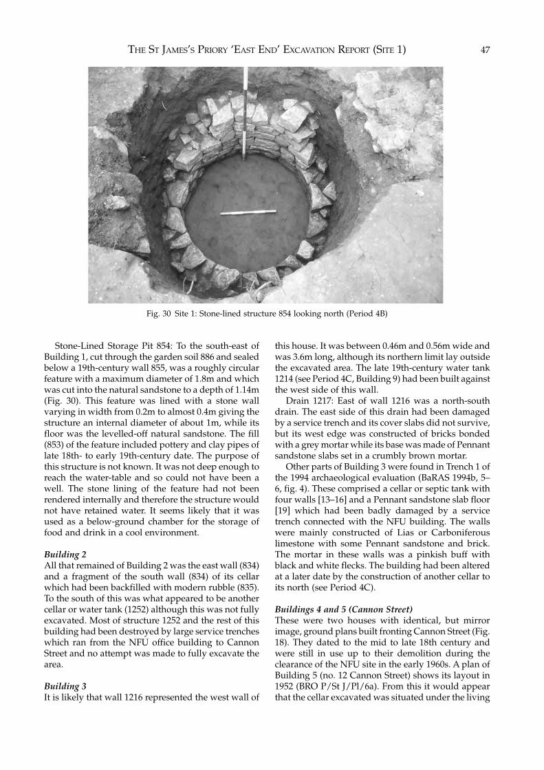
THE ST JAMES’S PRIORY ‘EAST END’ EXCAVATION REPORT (SITE 1) 47
Stone-Lined Storage Pit 854: To the south-east ofBuilding 1, cut through the garden soil 886 and sealedbelow a 19th-century wall 855, was a roughly circularfeature with a maximum diameter of 1.8m and whichwas cut into the natural sandstone to a depth of 1.14m(Fig. 30). This feature was lined with a stone wallvarying in width from 0.2m to almost 0.4m giving thestructure an internal diameter of about 1m, while itsfloor was the levelled-off natural sandstone. The fill(853) of the feature included pottery and clay pipes oflate 18th- to early 19th-century date. The purpose ofthis structure is not known. It was not deep enough toreach the water-table and so could not have been awell. The stone lining of the feature had not beenrendered internally and therefore the structure wouldnot have retained water. It seems likely that it wasused as a below-ground chamber for the storage offood and drink in a cool environment.
Building 2All that remained of Building 2 was the east wall (834)and a fragment of the south wall (834) of its cellarwhich had been backfilled with modern rubble (835).To the south of this was what appeared to be anothercellar or water tank (1252) although this was not fullyexcavated. Most of structure 1252 and the rest of thisbuilding had been destroyed by large service trencheswhich ran from the NFU office building to CannonStreet and no attempt was made to fully excavate thearea.
Building 3It is likely that wall 1216 represented the west wall of
this house. It was between 0.46m and 0.56m wide andwas 3.6m long, although its northern limit lay outsidethe excavated area. The late 19th-century water tank1214 (see Period 4C, Building 9) had been built againstthe west side of this wall.
Drain 1217: East of wall 1216 was a north-southdrain. The east side of this drain had been damagedby a service trench and its cover slabs did not survive,but its west edge was constructed of bricks bondedwith a grey mortar while its base was made of Pennantsandstone slabs set in a crumbly brown mortar.
Other parts of Building 3 were found in Trench 1 ofthe 1994 archaeological evaluation (BaRAS 1994b, 5–6, fig. 4). These comprised a cellar or septic tank withfour walls [13–16] and a Pennant sandstone slab floor[19] which had been badly damaged by a servicetrench connected with the NFU building. The wallswere mainly constructed of Lias or Carboniferouslimestone with some Pennant sandstone and brick.The mortar in these walls was a pinkish buff withblack and white flecks. The building had been alteredat a later date by the construction of another cellar toits north (see Period 4C).
Buildings 4 and 5 (Cannon Street)These were two houses with identical, but mirrorimage, ground plans built fronting Cannon Street (Fig.18). They dated to the mid to late 18th century andwere still in use up to their demolition during theclearance of the NFU site in the early 1960s. A plan ofBuilding 5 (no. 12 Cannon Street) shows its layout in1952 (BRO P/St J/Pl/6a). From this it would appearthat the cellar excavated was situated under the living
Fig. 30 Site 1: Stone-lined structure 854 looking north (Period 4B)
EXCAVATIONS AT ST JAMES’S PRIORY, BRISTOL48
room towards the rear of the property and that thefront of the property lies below the existing pavementof Cannon Street which was extended over part of thebuilding at the time of the construction of the NFUbuilding (see Period 4D).
Building 4The remains of the northern property, Building 4,mainly comprised a cellar (769), measuring 2.5m east/west by 2.9m north/south internally. The cellarappeared to have been constructed by excavating thearea to the required size and depth and then roughlywalling the sides of the hole so there was littleevidence of a construction trench for the cellar wall,which had been faced internally and varied between0.3m to 0.5m in width. The upper, inner edge of thewest wall comprised a single row of bricks whichmight have been the remains of a brick-vaulted cellarroof. A recess in the south-east corner of the cellar,measuring 1.8m by 0.84m, contained a flight of stone-and brick-built steps which turned 90 degrees to thesouth at the top and led into the communal passage-way between Buildings 4 and 5. In the centre of thenorth wall of the cellar was an entrance 1.06m widewhich had been blocked by a narrow wall at a laterdate. This was presumably the remains of a coal chuteor sky-light into the cellar. Adjoining the cellar to thenorth-east, and having a common west wall with thecellar, was a water tank measuring 1.7m by 1.5minternally with walls averaging 0.3m in width. The fillof the water tank was not excavated, while the fill ofthe cellar (768) was partly excavated by machine.Although the cellar had been backfilled in the 1960sduring the development of the NFU site, it containeda number of pieces of medieval worked stone,presumably from the priory buildings, which mayhave been reused in the construction of Building 4 inthe mid to late 18th century. Sufficient fill of the cellarwas removed to show that it was floored with flat Liaslimestone slabs and was 1.25m deep from the existingtop of the cellar wall. The south wall of cellar 769 cutthe robber trench (755) of part of the priory churchwall and also a late 17th-century pit (772) while thenorth walls of the cellar and water tank had damagedmedieval wall 1196 (see Periods 2A and 4A).
Communal Passageway: A passageway runningeast-west and 1.5m wide separated Building 4 fromits mirror image, Building 5, to the south.
Building 5The southern part of this property had been badlydamaged by the construction of sewers serving theNFU building but sufficient remained to show thatthe cellar measured 2.4m east/west by 3.4m north/south internally. A recess in the north-east corner ofthe cellar contained a flight of five stone- and brick-built steps which at the top turned 90 degrees to thenorth to lead out into the communal passageway
separating the properties. The cellar wall (765) variedin width between 0.3m and 0.5m and the internal facesof the walls were unrendered but had beenwhitewashed. The south wall (767) of the cellar hadbeen rebuilt at a later date with Pennant sandstonebonded with a hard red mortar. The inner edge of thewest wall comprised a single row of bricks whichmight have been the remains of the brick-vaulted roofof the cellar. The cellar was 1.25m deep from thepresent top of the cellar wall and was floored with flatLias limestone slabs. A water tank adjoined the cellarto the south-east but only its north and east wallsremained, the rest having been damaged by moderndisturbance. The tank measured 1.7m east/west and,although its north/south dimension could not bedetermined, it was obviously similar in size to thewater tank adjoining Building 4. The cellar had beenbackfilled with rubble (764) during redevelopment ofthe NFU site in the 1960s.
A wall (774) 0.2m wide and of the same con-struction as cellar 765 ran roughly north-west/south-east to the west of cellar 765. Its north-west end layoutside the excavated area while its south-east endhad been cut by pipe-trench 630. The wall wascontemporary with the cellar and was obviously partof Building 5 although its purpose could not bedetermined.
Building 6 (Cannon Street)To the south-west of Building 5 were the remains ofanother mid 18th-century building fronting CannonStreet, although this had been badly damaged by laterdisturbances and the majority of it lay outside thearea available for excavation. The remains compriseda narrow north/south wall (645) 0.2m wide, to thewest of which and abutting it, was a floor of Pennantsandstone slabs (644) laid almost directly on thenatural sandstone. East of wall 645, and cut by it, wasa thin layer of compact sandy orange mortar (646),possibly the make-up for the floor of an earlierbuilding. Presumably Building 6 was served at a laterdate by the adjacent 19th-century septic tank (640)(see Period 4C).
Buildings 7 and 8 (Nos. 7 and 8 St James’s Parade)The back walls and the remains of the side walls ofthese semi-detached properties were found within thearea of the excavation to the north of St James’s Parade(Figs. 27, 31 and 32). Although they were formed fromone building, the division between the properties wasrepresented by a north/south wall within Building 7and 8 and this was continued northward by a bound-ary wall within the rear garden or courtyard area. Theproperties had been demolished for the constructionof the Scottish Presbyterian Church and their found-ations were sealed below context 575, the make-upand levelling layer for its floor (see Period 4C). Thenorth/south walls of the buildings had been cut by
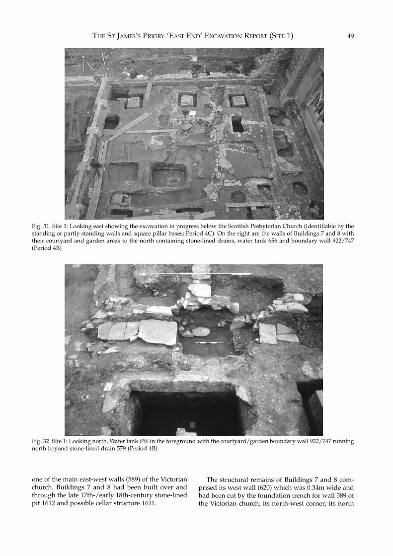
THE ST JAMES’S PRIORY ‘EAST END’ EXCAVATION REPORT (SITE 1) 49
Fig. 31 Site 1: Looking east showing the excavation in progress below the Scottish Prebyterian Church (identifiable by thestanding or partly standing walls and square pillar bases; Period 4C). On the right are the walls of Buildings 7 and 8 withtheir courtyard and garden areas to the north containing stone-lined drains, water tank 656 and boundary wall 922/747(Period 4B)
Fig. 32 Site 1: Looking north. Water tank 656 in the foreground with the courtyard/garden boundary wall 922/747 runningnorth beyond stone-lined drain 579 (Period 4B)
one of the main east-west walls (589) of the Victorianchurch. Buildings 7 and 8 had been built over andthrough the late 17th-/early 18th-century stone-linedpit 1612 and possible cellar structure 1611.
The structural remains of Buildings 7 and 8 com-prised its west wall (620) which was 0.34m wide andhad been cut by the foundation trench for wall 589 ofthe Victorian church; its north-west corner; its north
EXCAVATIONS AT ST JAMES’S PRIORY, BRISTOL50
(rear) wall (619) 0.5m wide and at least 11.2m long;the possible remains of its east wall, although this hadbeen badly damaged by church wall 554; and aninternal north/south dividing wall (1566) 0.5m wide.This building was constructed of roughly squaredpieces of Pennant sandstone bonded with a finecreamy coloured mortar. The west wall (620) andnorth wall (619) were built over and around a stone-lined drain (1562) which passed diagonally beneathwall 620. North of wall 619 the capstones of the drainwere removed and the dark grey organic fill (1671)excavated although it contained no datable finds.
Water Tank 687: This lay to the north-west of therear of Building 8 and consisted of a rectangular stone-built structure (687) bonded with grey mortar meas-uring 1.2m north/south by 1m east/west. It had abrick-vaulted roof, part of which remained on the eastside (580). There was evidence of a drain leading intothe top of the tank in its south-west corner. The fill ofthe tank was not fully removed so its depth could notbe determined. However, its roof had clearly beenbroken in and the tank back-filled in the mid 19th-century prior to the construction of the ScottishPresbyterian Church as its upper levels producedearly to mid 19th-century pottery. Although this areahad been badly disturbed by the construction of theVictorian church a cut for the construction trench ofthe tank was visible on its east and north sides (979).The tank had truncated a north/south stone-lineddrain (see Period 4B) and, because of this and the typeof mortar used in its construction, it was apparentlyan early 19th-century addition to Building 8.
Pit 761: This was a rectangular stone-lined pit tothe rear of Building 8. The dry-stone walls of Pennantsandstone (661) were about 0.2m thick and the pitmeasured 0.9m east/west by 1.9m north/southinternally and it was about 0.9m deep, the base of thepit having been cut into the natural sandstone. Theupper fill of the pit (588) was a black silty materialwith bands of a green cess-like deposit. This overlayfill 658 which consisted of red-brown sand with slatefragments and mortar flecks. The lowest fill (840) wasa thin layer of green cess on the floor of the pit. Allthese fills contained finds of early 19th-century date.
Structures and Features Common to Buildings 7 and 8Property Boundaries: The internal north/south div-ision of the building (wall 1566) was continuednorthwards, although not on the same alignment,through the courtyards or gardens to the rear ofBuildings 7 and 8. Immediately north of the rear wall(619) of the building, the property boundary wasdefined by a drain (1516) consisting of a cast-iron pipebelow a covering of Pennant and slate slabs whichdischarged into water tank 656.
The property division continued north of the tankas a wall (922) 0.4m wide made of Pennant sandstonebonded with a grey-pink mortar (Fig. 32). This wall
partly overlay the east/west drain 579. Only thebottom course of the wall survived and was coveredby the destruction layer (581) associated with demo-lition prior to the construction of the Scottish Pres-byterian Church. There was evidence of a constructiontrench for the wall.
Wall 922 abutted what might have been an east/west boundary wall (1109) at least 0.5m wide andbonded with a hard brown mortar, although therewas scant evidence for that wall as it had been badlydisturbed by a hole for scaffolding (604) associatedwith the construction of the Scottish PresbyterianChurch and also by drain 865 to its east. It was possiblethat the wall pre-dated the Period 4B and 4C struc-tures as it had been partly destroyed by a small hearth(957) which had been built over it and the course ofdrain 582 ignored any east/west boundary definedby wall 1109.
North of wall 1109 the north/south boundarycontinued as a wall (747) of similar construction to922 but bonded with an orange-brown mortar. Thenorth end of this wall had been robbed and its positionwas defined by a robber trench (751).
The positions of further north/south boundarywalls may be shown by two spreads of pink mortarwith some slabs of Pennant sandstone and Liaslimestone (202 and 131), measuring at most 0.4m wideand in length 6m, although their southern limits wereobscured by the south wall (551) of the WelshCongregational Chapel. The mortar spreads wereapproximately parallel and 5m apart. The mortar typewould appear to indicate an 18th-century date. Wall/mortar spread 131 lay within a construction trench(343) although this did not produce any datable finds.
Water Tank 656: This was located 1.4m north of therear wall of Buildings 7 and 8 and straddled theapparent division between the two properties repre-sented by the north/south boundary wall 1561. It mayhave served both houses. The tank (656) was stone-built, rendered internally and had part of the brickvaulted roof still surviving (Fig. 32). It measured 1.7meast/west and 1.45m north/south internally and was1.55m deep. There was evidence of a drain emptyinginto its south-east corner and a possible overflowchannel emptying into a stone-lined drain in its north-east corner. Its upper fill (623) consisted of stone andbrick rubble while its lower fill was a grey-brown siltwhich contained finds of late 17th-/18th-century date.The roof of the tank was deliberately collapsed andthe tank filled in prior to the construction of theScottish Presbyterian Church.
Pit 177: This pit lay partly under wall 551 (seePeriod 4D) and was therefore not fully excavated. Itwas vertical sided and measured at least 1.4m north/south by 1.4m east/west by 1.4m deep. Its fill (176),consisting of rubble and dark grey mortar, producedfinds of early 19th-century date.
Pit 188: This had been cut on its south side by
THE ST JAMES’S PRIORY ‘EAST END’ EXCAVATION REPORT (SITE 1) 51
Victorian pillar base 36 and its construction trench 71(see Period 4C). It was vertical sided, measured atleast 1.1m north/south and 1.4m east/west and was0.94m deep. Its lower fill (187) consisted of greenishcess-like material and contained finds of late 18th-century date.
Pit 222: This was a large shallow, irregularly shapedpit. It appeared to have sealed pit 318 and been partlyconfused with the fill of 318 (see Period 4A). However,it has been possible to differentiate the fill of both pitsas pit 222 was clearly 19th-century in date. It was 3mnorth/south although its south, west and most of itsnorth edge were not recorded probably due to itsconfusion with 318 during excavation. Its upper fillconsisted of bands of red-brown sand containingcharcoal flecks and lumps of plaster together withbands of cess-like material (223, 210, 212, 232, 211,233), while the lower fill (208, 248) comprised mainlygreen cess-like material. The pit produced pottery ofearly to mid 19th-century date.
Pit 231: This sub-circular pit was 0.2m deep andcontained industrial debris (230) of possible early tomid 19th-century date.
Stone-Lined Drains: A complex arrangement ofstone-lined drains crossed the backyards of Buildings7 and 8, running from east to west (579, 841, 908, 923,932, 938, 983, 990, 1019, 1172, 1550) and then fed intoa main drain which ran north across the north-westpart of the site towards Cannon Street (Figs. 31 and32). These drains had been cleaned out, blocked andre-routed on a number of occasions throughout theirperiod of use and a detailed record of this appears inthe site archive. The main north/south drain (584,903, 164) was constructed of Pennant sandstone slabs,the side walls being bonded with a pale orangecoloured mortar. The drain measured 0.8m wideinternally and was approximately 0.26m deep. Thenorth-west end of this drain curved to the west inorder to avoid Building 2 which fronted CannonStreet, although its western end could not be deter-mined due to later disturbances.
Structures and Features Relating to Building 7Tank 701: A further water tank was situated to the eastof Building 7 although this could not be fully excav-ated due to the proximity of the Victorian churchtower and the brick wall bounding the site on the east.The stone built tank (701) was rendered internally andhad a brick vaulted roof. Its size could not bedetermined although it measured at least 1m north/south by almost 2m east/west and was at least 0.7mdeep. For safety reasons only part of the fill (678) wasexcavated and this was a red-brown sand and brickrubble which contained finds dating to the early 19thcentury as well as late 17th- and 18th-century material.The roof of the tank had been deliberately collapsed
and the tank filled in prior to the construction of theScottish Presbyterian Church.
Hearth 1107: A small hearth had been built east ofboundary wall 922 and was constructed of brick andPennant sandstone. Its flue was 0.1m wide internallyand contained soot and ash deposits.
Structures and Features Relating to Building 8Pit 586: This pit lay to the north-west of Building 8. Itwas lined on its north, east and south sides with aroughly built stone wall 0.2m wide bonded with pinkmortar (586/686). The wall was faced internally. Thesouthern edge of the pit had been cut by the con-struction trench (568) for one of the pillar bases of theaisle of the Victorian church (see Period 4C) while thewest edge of the pit lay outside the area available forexcavation. The pit measured 1.4m north/south by atleast 1.5m east/west internally and it was just over0.5m deep. The upper fill of the pit (587) was a coarseblack gritty deposit while the lower fill (679) was adark grey-brown ashy silt. Both fills produced findsdating to the late 18th century. A full report on thefinds from this pit appears in Chapter 6.
Hearths: A small hearth (1106) had been built westof boundary wall 922 and had brick sides with aPennant sandstone base. Its flue was 0.1m wideinternally and contained soot and ash deposits.Another hearth (957) had been constructed west ofwall 922, overlying the east/west wall 1109. Again itwas built of brick and Pennant sandstone. Its flue was0.35m wide internally and contained a gritty blackcharcoal rich fill (956).
Cultivation Trenches: A group of shallow andgenerally intersecting trenches (27, 912, 913, 914, 918)aligned east/west lay within the garden to the rear ofBuilding 8. The trenches ranged from 1.4m to 0.7m inlength and were up to 0.2m deep. These were con-sidered to be cultivation trenches and their fills (863,889, 890) produced animal bones and clay tobaccopipe fragments.
Other Structures and FeaturesPit 1223: To the east of the 19th-century cellar 1189and cut by pipe trench 1190 were the remains of avertical sided, flat bottomed, rectangular pit meas-uring 0.9m by at least 0.6m and up to 0.4m deep(1223). The pit, which was unlined and cut into thered sandstone natural, was filled with a black ashymaterial containing pottery, glass and clay pipesdating to c.1760–70. This pit was presumably situatedin the back yard of nos. 9 or 10 St James’s Paradewhich had been demolished for the construction ofthe NFU building. A full report on the finds from thispit appears in Chapter 6.
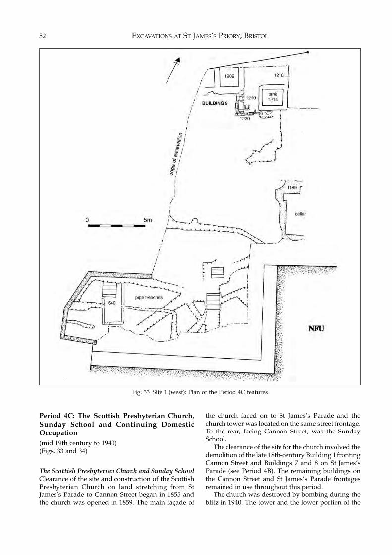
EXCAVATIONS AT ST JAMES’S PRIORY, BRISTOL52
Fig. 33 Site 1 (west): Plan of the Period 4C features
Period 4C: The Scottish Presbyterian Church,Sunday School and Continuing DomesticOccupation(mid 19th century to 1940)(Figs. 33 and 34)
The Scottish Presbyterian Church and Sunday SchoolClearance of the site and construction of the ScottishPresbyterian Church on land stretching from StJames’s Parade to Cannon Street began in 1855 andthe church was opened in 1859. The main façade of
the church faced on to St James’s Parade and thechurch tower was located on the same street frontage.To the rear, facing Cannon Street, was the SundaySchool.
The clearance of the site for the church involved thedemolition of the late 18th-century Building 1 frontingCannon Street and Buildings 7 and 8 on St James’sParade (see Period 4B). The remaining buildings onthe Cannon Street and St James’s Parade frontagesremained in use throughout this period.
The church was destroyed by bombing during theblitz in 1940. The tower and the lower portion of the
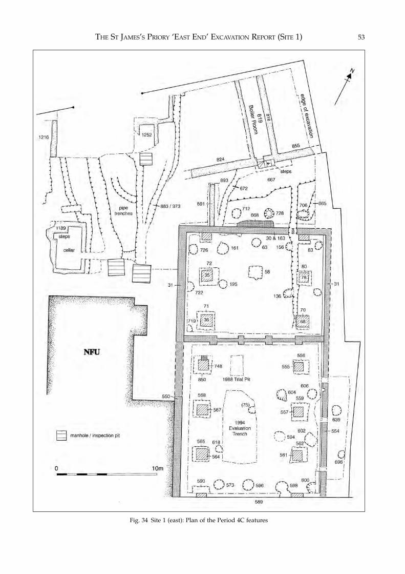
THE ST JAMES’S PRIORY ‘EAST END’ EXCAVATION REPORT (SITE 1) 53
Fig. 34 Site 1 (east): Plan of the Period 4C features
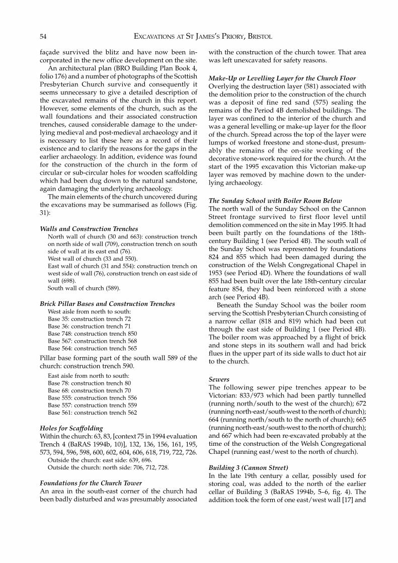
EXCAVATIONS AT ST JAMES’S PRIORY, BRISTOL54
façade survived the blitz and have now been in-corporated in the new office development on the site.
An architectural plan (BRO Building Plan Book 4,folio 176) and a number of photographs of the ScottishPresbyterian Church survive and consequently itseems unnecessary to give a detailed description ofthe excavated remains of the church in this report.However, some elements of the church, such as thewall foundations and their associated constructiontrenches, caused considerable damage to the under-lying medieval and post-medieval archaeology and itis necessary to list these here as a record of theirexistence and to clarify the reasons for the gaps in theearlier archaeology. In addition, evidence was foundfor the construction of the church in the form ofcircular or sub-circular holes for wooden scaffoldingwhich had been dug down to the natural sandstone,again damaging the underlying archaeology.
The main elements of the church uncovered duringthe excavations may be summarised as follows (Fig.31):
Walls and Construction TrenchesNorth wall of church (30 and 663): construction trenchon north side of wall (709), construction trench on southside of wall at its east end (76).West wall of church (33 and 550).East wall of church (31 and 554): construction trench onwest side of wall (76), construction trench on east side ofwall (698).South wall of church (589).
Brick Pillar Bases and Construction TrenchesWest aisle from north to south:Base 35: construction trench 72Base 36: construction trench 71Base 748: construction trench 850Base 567: construction trench 568Base 564: construction trench 565
Pillar base forming part of the south wall 589 of thechurch: construction trench 590.
East aisle from north to south:Base 78: construction trench 80Base 68: construction trench 70Base 555: construction trench 556Base 557: construction trench 559Base 561: construction trench 562
Holes for ScaffoldingWithin the church: 63, 83, [context 75 in 1994 evaluationTrench 4 (BaRAS 1994b, 10)], 132, 136, 156, 161, 195,573, 594, 596, 598, 600, 602, 604, 606, 618, 719, 722, 726.
Outside the church: east side: 639, 696.Outside the church: north side: 706, 712, 728.
Foundations for the Church TowerAn area in the south-east corner of the church hadbeen badly disturbed and was presumably associated
with the construction of the church tower. That areawas left unexcavated for safety reasons.
Make-Up or Levelling Layer for the Church FloorOverlying the destruction layer (581) associated withthe demolition prior to the construction of the churchwas a deposit of fine red sand (575) sealing theremains of the Period 4B demolished buildings. Thelayer was confined to the interior of the church andwas a general levelling or make-up layer for the floorof the church. Spread across the top of the layer werelumps of worked freestone and stone-dust, presum-ably the remains of the on-site working of thedecorative stone-work required for the church. At thestart of the 1995 excavation this Victorian make-uplayer was removed by machine down to the under-lying archaeology.
The Sunday School with Boiler Room BelowThe north wall of the Sunday School on the CannonStreet frontage survived to first floor level untildemolition commenced on the site in May 1995. It hadbeen built partly on the foundations of the 18th-century Building 1 (see Period 4B). The south wall ofthe Sunday School was represented by foundations824 and 855 which had been damaged during theconstruction of the Welsh Congregational Chapel in1953 (see Period 4D). Where the foundations of wall855 had been built over the late 18th-century circularfeature 854, they had been reinforced with a stonearch (see Period 4B).
Beneath the Sunday School was the boiler roomserving the Scottish Presbyterian Church consisting ofa narrow cellar (818 and 819) which had been cutthrough the east side of Building 1 (see Period 4B).The boiler room was approached by a flight of brickand stone steps in its southern wall and had brickflues in the upper part of its side walls to duct hot airto the church.
SewersThe following sewer pipe trenches appear to beVictorian: 833/973 which had been partly tunnelled(running north/south to the west of the church); 672(running north-east/south-west to the north of church);664 (running north/south to the north of church); 665(running north-east/south-west to the north of church);and 667 which had been re-excavated probably at thetime of the construction of the Welsh CongregationalChapel (running east/west to the north of church).
Building 3 (Cannon Street)In the late 19th century a cellar, possibly used forstoring coal, was added to the north of the earliercellar of Building 3 (BaRAS 1994b, 5–6, fig. 4). Theaddition took the form of one east/west wall [17] and
THE ST JAMES’S PRIORY ‘EAST END’ EXCAVATION REPORT (SITE 1) 55
a north/south wall [18], both bonded with blackmortar and faced with brick (Fig. 28).
Building 9 (Cannon Street)In the north-west corner of the excavation were theremains of a mid 19th-century building on the cornerof Cannon Street. This extended outside the excav-ated area to the north and west. It was represented bytwo cellars (1209) the walls of which were constructedof Pennant sandstone blocks bonded with a greymortar containing much lime. The southern east/westwall of the two cellars was 0.62m wide, while the twonorth/south walls were 0.42m wide. Only a fragmentof the west cellar was uncovered while the east cellarmeasured 1.6m east/west by at least 1.7m north/south internally, although its northern wall lay outsidethe excavated area. The cellars were filled with debriscontaining late 19th-century transfer-printed earthen-ware, although the fill was not excavated for safetyreasons as it lay partly below the pavement of CannonStreet. A linear disturbance (1211) 0.5m wide mayhave been a construction trench for the south wall ofthe cellar although it was not excavated.
The south-east corner of Building 9 had apparentlybeen cut in order to key-in a later north/south wall(1210) which continued the line of the east wall of thecellar. This was constructed of Pennant sandstonebonded with white mortar and was 0.9m wide and1.84m in length. East of wall 1210 was the stone-builtbase of a drain 0.5m square, possibly the remains of awater closet. A narrow east/west wall (1220), some0.2m wide and made of Pennant blocks bonded with abrown mortar, linked wall 1210 with the south-eastcorner of water tank 1214. This rectangular water tankmeasured 1.8m by 1.4m internally. The internallyrendered walls of this water tank were 0.4m wide andwere of the same construction as building 1209. Thetank had been cut through the 17th-century pit 1213(see Period 4A) while its south wall had been cutthrough medieval levels. Most of its east wall hadbeen built against the 18th-century west wall (1216) ofBuilding 3 (see Period 4B). The fill of the water tankwas not excavated.
Building 6 (Cannon Street)Septic Tank: A septic tank or cess-pit (640) wasuncovered immediately below the make-up layers forthe NFU car park in the south-west corner of theexcavation close to Cannon Street. It was cut by amanhole and gas pipe trench 628 connected withservices to the NFU building. The septic tank wasconstructed of Pennant sandstone bonded with a hardred mortar and was rendered internally with whiteplaster. It measured 1.5m by at least 3.4m internallyby 1.79m deep with walls 0.2m thick. A north-west/south-east drain (636) 0.22m wide and 0.17m deepwith brick sides and a base of Pennant sandstone slabsemptied into the septic tank through an opening in its
east wall. The upper fill (639) of the septic tankconsisted of loose rubble while the lower fill (655) wasa black organic layer 0.23m thick which produced midto late 19th-century pottery and clay pipes. It seemedlikely that the septic tank served Building 6 on CannonStreet (see Period 4B) although a direct relationshipcould not be established.
Building 7 (No. 7 St James’s Parade)Drain 582: This was presumably associated with theinstallation of a water closet or privy in the courtyardor garden to the rear of Building 7. The drain hadbrick edging set in a clay/sand mixture, a base madeof overlapping roofing slates (582) bedded in a coarsegrey mortar, and was 0.1m wide internally and 0.2mdeep. At the north end there was a rectangular stonefeature which had formed the ‘trap’ of a primitivetoilet ‘U’-bend, while at the south there was a stone-built sluice leading into the side of drain 579. The fillof the drain (583) was a compacted deposit of mixedyellow mortar, cinders, slate and small stones con-taining mid 19th-century pottery.
Drain 660: This drain, which had sides of brick anda base of overlapping roof tiles, ran over the east sideof pit 761 and its fill 588. The drain was 0.2m wide by0.18m deep internally. Its fill (659) consisted of darkbrown silt and dated to the mid 19th century. Its southend had been cut by Trench 4 of the 1994 archaeo-logical evaluation (BaRAS 1994b, 10). Where the draincrossed pit 661 its side walls had been rebuilt withPennant sandstone blocks.
Other StructuresAn isolated cellar (1189), presumably associated witha substantial structure to the rear of the propertiesfronting St James’s Parade, was uncovered im-mediately below the make-up for the NFU car park. Itmeasured 2.44m north/south by 4.2m east/westinternally and was 1.4m deep. The walls were ofuneven thickness, varying between 0.36m to 0.6m inwidth and were of Pennant sandstone blocks bondedwith white mortar, the internal faces of the wall beinglined with brick. The cellar walls had no obviousconstruction trenches. Four brick-built steps led downinto the cellar which was floored with well-cut slabsof Pennant sandstone. A trench (1190) 0.5m wideadjacent and parallel to the east wall of the cellarcontained a sewer pipe which appeared to be con-temporary with the cellar. This pipe trench cut the late18th-century pit 1223 (see Period 4B).
Period 4D: Housing Decline, Office Expansion(1940 to the 1990s)
The Scottish Presbyterian Church was largelydestroyed during the 1940 blitz. All but the façadeand tower on St James’s Parade was demolished andthe Welsh Congregational Chapel, Sunday School and

EXCAVATIONS AT ST JAMES’S PRIORY, BRISTOL56
Meeting House were built on the northern part of thesite in 1953. While the builders of the Welsh Congre-gational Chapel had reused some of the foundationsof the Scottish Presbyterian Church, there wereadditional east/west and north/south walls withconcrete foundations (551, 891). A construction trench(893) for wall 891 had destroyed part of the 18th-century stone-lined drain 903 (see Period 4B).
The remaining properties on the Cannon Street andSt James’s Parade frontages on the western half of thesite continued in use until Buildings 2, 3, 4, 5 and 6 on
the Cannon Street frontage (see Periods 4B and 4C)were demolished and their cellars backfilled to clearthe site for the construction of the NFU office buildingand the smaller Audit Office building which werecompleted in 1964. Nos. 9 to 13 St James’s Parade(outside the excavated area) were demolished at thesame time.
The Welsh Congregational Chapel was demolishedin 1988 and the NFU and Audit offices were occupieduntil shortly before their demolition in 1995.
4 THE ST JAMES’S PRIORY ‘WEST FRONT’EXCAVATION REPORT (SITE 2)
Topography and Land Use
The excavation was carried out on a redevelopmentsite defined by the west front of St James’s Church tothe east, St James’s Parade to the south, the WhiteHart public house in Lower Maudlin Street to thewest and the approach to the church to the north (Fig.1). The eastern end of the site lay on the 15 metrecontour with the land sloping down to the west andsouth.
Until the 1950s the site was occupied by housesnumbered, from east to west, 13, 14, 15 and 16 StJames’s Parade – no. 13 having been built against thewest front of the church and no. 16 against the back ofthe White Hart public house. Since then the majorityof the site was used as a garden of remembrance, witha paved area adjacent to the church and the remainderunder grass, while the western end of the site was acar park. The site was separated from St James’sParade by a stone boundary wall which incorporatedthe lower portion of the façades of nos. 15 and 16. Anarea occupied by recent cremations, adjacent to StJames’s Parade, had to be left outside the excavatedarea.
Previous Archaeological Work
Due to the proposed development of the land as arehabilitation centre for drug users Bristol and RegionArchaeological Services carried out an archaeologicalevaluation in 1993 (BaRAS 1993). The footprint of theproposed building was to occupy about 225 squaremetres and within that area five trial trenches wereexcavated and an engineer’s trial hole was re-excav-ated. The trenches were located close to the churchwithin no.13 St James’s Parade; on the east side of no.15; within no. 16 and extending back into what hadbeen the rear part of the White Hart public house;against the rear wall of the public house; and from no.16 parallel to the street frontage for a distance of 5.8mto the east. The engineer’s trial hole was to the rear ofno. 14.
In all the trenches there were structures andstratigraphy of a fairly complex nature includingmedieval walls and occupation, a large 15th-centurypit, 16th- and 17th-century occupation, and the cellarsof 18th-century buildings. Of significance to the futureof the archaeological resource was its shallow depthbelow the existing ground level and consequently thehigh probability of its destruction during the buildingwork.
On the basis of the results of the 1993 evaluationthe City Archaeologist decided that the easternportion of the development area should be fullyexcavated while a watching brief should be kept onthe remainder during construction work. Bristol andRegion Archaeological Services were commissionedby the Little Brothers of Nazareth to carry out thatwork.
Excavation Methods and Recording
The excavation, covering about 103 square metres,was worked as an open area with relevant sectionsbeing recorded before removal. The work took placein two phases: from February to April 1994 and fromApril to June 1995. Although the western part of thedevelopment area was not excavated, the structuresfound in some of the evaluation trenches are referredto in this report in order to supplement the inform-ation obtained from the main excavation, particularlyconcerning the westward extent of the medieval andpost-medieval buildings.
The site was excavated by a small team of prof-essional archaeologists working under the directionof the Project Manager, John Bryant.
Initially the entire area was stripped of paving andmodern make-up levels using a mechanical excavator.Once archaeological deposits and structures wereencountered these were cleaned and excavated byhand. All archaeological deposits, features and struc-tures, including the remains of the 19th- and 20th-century alterations to the buildings on St James’sParade, were recorded in detail. Almost the entire areawas excavated to natural, the exceptions being the
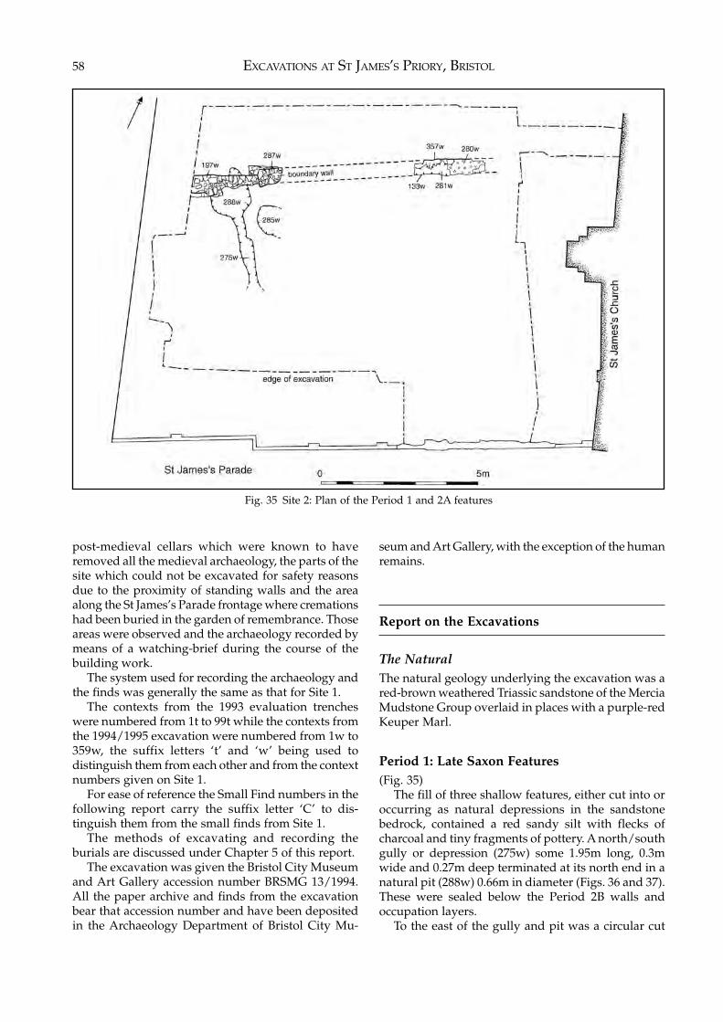
EXCAVATIONS AT ST JAMES’S PRIORY, BRISTOL58
post-medieval cellars which were known to haveremoved all the medieval archaeology, the parts of thesite which could not be excavated for safety reasonsdue to the proximity of standing walls and the areaalong the St James’s Parade frontage where cremationshad been buried in the garden of remembrance. Thoseareas were observed and the archaeology recorded bymeans of a watching-brief during the course of thebuilding work.
The system used for recording the archaeology andthe finds was generally the same as that for Site 1.
The contexts from the 1993 evaluation trencheswere numbered from 1t to 99t while the contexts fromthe 1994/1995 excavation were numbered from 1w to359w, the suffix letters ‘t’ and ‘w’ being used todistinguish them from each other and from the contextnumbers given on Site 1.
For ease of reference the Small Find numbers in thefollowing report carry the suffix letter ‘C’ to dis-tinguish them from the small finds from Site 1.
The methods of excavating and recording theburials are discussed under Chapter 5 of this report.
The excavation was given the Bristol City Museumand Art Gallery accession number BRSMG 13/1994.All the paper archive and finds from the excavationbear that accession number and have been depositedin the Archaeology Department of Bristol City Mu-
seum and Art Gallery, with the exception of the humanremains.
Report on the Excavations
The NaturalThe natural geology underlying the excavation was ared-brown weathered Triassic sandstone of the MerciaMudstone Group overlaid in places with a purple-redKeuper Marl.
Period 1: Late Saxon Features(Fig. 35)
The fill of three shallow features, either cut into oroccurring as natural depressions in the sandstonebedrock, contained a red sandy silt with flecks ofcharcoal and tiny fragments of pottery. A north/southgully or depression (275w) some 1.95m long, 0.3mwide and 0.27m deep terminated at its north end in anatural pit (288w) 0.66m in diameter (Figs. 36 and 37).These were sealed below the Period 2B walls andoccupation layers.
To the east of the gully and pit was a circular cut
Fig. 35 Site 2: Plan of the Period 1 and 2A features
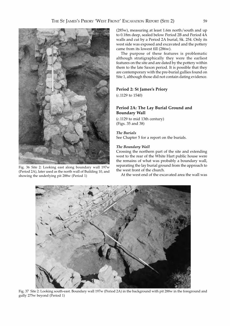
THE ST JAMES’S PRIORY ‘WEST FRONT’ EXCAVATION REPORT (SITE 2) 59
(285w), measuring at least 1.6m north/south and upto 0.18m deep, sealed below Period 2B and Period 4Awalls and cut by a Period 2A burial, Sk. 254. Only itswest side was exposed and excavated and the potterycame from its lowest fill (286w).
The purpose of these features is problematicalthough stratigraphically they were the earliestfeatures on the site and are dated by the pottery withinthem to the late Saxon period. It is possible that theyare contemporary with the pre-burial gullies found onSite 1, although those did not contain dating evidence.
Period 2: St James’s Priory(c.1129 to 1540)
Period 2A: The Lay Burial Ground andBoundary Wall(c.1129 to mid 13th century)(Figs. 35 and 38)
The BurialsSee Chapter 5 for a report on the burials.
The Boundary WallCrossing the northern part of the site and extendingwest to the rear of the White Hart public house werethe remains of what was probably a boundary wall,separating the lay burial ground from the approach tothe west front of the church.
At the west end of the excavated area the wall was
Fig. 36 Site 2: Looking east along boundary wall 197w(Period 2A), later used as the north wall of Building 10, andshowing the underlying pit 288w (Period 1)
Fig. 37 Site 2: Looking south-east. Boundary wall 197w (Period 2A) in the background with pit 288w in the foreground andgully 275w beyond (Period 1)
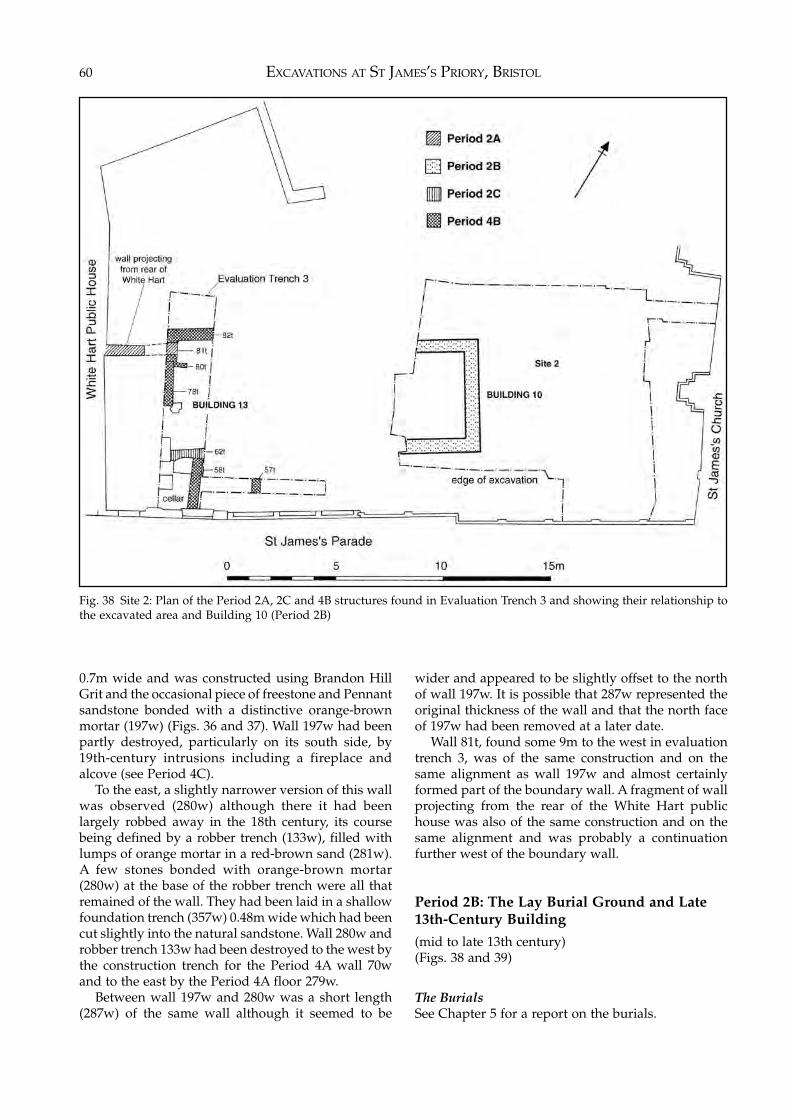
EXCAVATIONS AT ST JAMES’S PRIORY, BRISTOL60
0.7m wide and was constructed using Brandon HillGrit and the occasional piece of freestone and Pennantsandstone bonded with a distinctive orange-brownmortar (197w) (Figs. 36 and 37). Wall 197w had beenpartly destroyed, particularly on its south side, by19th-century intrusions including a fireplace andalcove (see Period 4C).
To the east, a slightly narrower version of this wallwas observed (280w) although there it had beenlargely robbed away in the 18th century, its coursebeing defined by a robber trench (133w), filled withlumps of orange mortar in a red-brown sand (281w).A few stones bonded with orange-brown mortar(280w) at the base of the robber trench were all thatremained of the wall. They had been laid in a shallowfoundation trench (357w) 0.48m wide which had beencut slightly into the natural sandstone. Wall 280w androbber trench 133w had been destroyed to the west bythe construction trench for the Period 4A wall 70wand to the east by the Period 4A floor 279w.
Between wall 197w and 280w was a short length(287w) of the same wall although it seemed to be
wider and appeared to be slightly offset to the northof wall 197w. It is possible that 287w represented theoriginal thickness of the wall and that the north faceof 197w had been removed at a later date.
Wall 81t, found some 9m to the west in evaluationtrench 3, was of the same construction and on thesame alignment as wall 197w and almost certainlyformed part of the boundary wall. A fragment of wallprojecting from the rear of the White Hart publichouse was also of the same construction and on thesame alignment and was probably a continuationfurther west of the boundary wall.
Period 2B: The Lay Burial Ground and Late13th-Century Building
(mid to late 13th century)(Figs. 38 and 39)
The BurialsSee Chapter 5 for a report on the burials.
Fig. 38 Site 2: Plan of the Period 2A, 2C and 4B structures found in Evaluation Trench 3 and showing their relationship tothe excavated area and Building 10 (Period 2B)
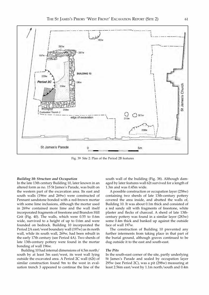
THE ST JAMES’S PRIORY ‘WEST FRONT’ EXCAVATION REPORT (SITE 2) 61
Fig. 39 Site 2: Plan of the Period 2B features
Building 10: Structure and OccupationIn the late 13th century Building 10, later known in analtered form as no. 15 St James’s Parade, was built onthe western part of the excavation area. Its east andsouth walls (196w and 269w) were constructed ofPennant sandstone bonded with a red-brown mortarwith some lime inclusions, although the mortar usedin 269w contained more lime and the wall itselfincorporated fragments of freestone and Brandon HillGrit (Fig. 40). The walls, which were 0.55 to 0.6mwide, survived to a height of up to 0.6m and werefounded on bedrock. Building 10 incorporated thePeriod 2A east/west boundary wall (197w) as its northwall, while its south wall, 269w, had been rebuilt inthe early 17th century (see Period 4A). Two sherds oflate 13th-century pottery were found in the mortarbonding of wall 196w.
Building 10 had internal dimensions of 4.5m north/south by at least 3m east/west, its west wall lyingoutside the excavated area. A Period 2C wall (62t) ofsimilar construction found 9m to the west in eval-uation trench 3 appeared to continue the line of the
south wall of the building (Fig. 38). Although dam-aged by later features wall 62t survived for a length of1.3m and was 0.45m wide.
A possible construction or occupation layer (258w)containing two sherds of late 13th-century potterycovered the area inside, and abutted the walls of,Building 10. It was about 0.1m thick and consisted ofa red sandy silt with fragments of freestone, whiteplaster and flecks of charcoal. A sherd of late 13th-century pottery was found in a similar layer (283w)some 0.4m thick and banked up against the outsideface of wall 197w.
The construction of Building 10 prevented anyfurther interments from taking place in that part ofthe burial ground, although graves continued to bedug outside it to the east and south-east.
The PitsIn the south-east corner of the site, partly underlyingSt James’s Parade and sealed by occupation layer295w (see Period 2C), was a pit (298w) measuring atleast 2.56m east/west by 1.1m north/south and 0.4m
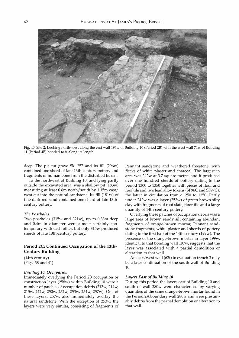
EXCAVATIONS AT ST JAMES’S PRIORY, BRISTOL62
deep. The pit cut grave Sk. 257 and its fill (296w)contained one sherd of late 13th-century pottery andfragments of human bone from the disturbed burial.
To the north-east of Building 10, and lying partlyoutside the excavated area, was a shallow pit (183w)measuring at least 0.6m north/south by 1.15m east/west cut into the natural sandstone. Its fill (181w) offine dark red sand contained one sherd of late 13th-century pottery.
The PostholesTwo postholes (315w and 321w), up to 0.33m deepand 0.4m in diameter were almost certainly con-temporary with each other, but only 315w producedsherds of late 13th-century pottery.
Period 2C: Continued Occupation of the 13th-Century Building(14th century)(Figs. 38 and 41)
Building 10: OccupationImmediately overlying the Period 2B occupation orconstruction layer (258w) within Building 10 were anumber of patches of occupation debris (213w, 214w,215w, 242w, 250w, 252w, 253w, 254w, 257w). One ofthese layers, 257w, also immediately overlay thenatural sandstone. With the exception of 253w, thelayers were very similar, consisting of fragments of
Pennant sandstone and weathered freestone, withflecks of white plaster and charcoal. The largest inarea was 242w at 3.7 square metres and it producedover one hundred sherds of pottery dating to theperiod 1300 to 1350 together with pieces of floor androof tile and two lead alloy tokens (SF96C and SF97C),the latter in circulation from c.1250 to 1350. Partlyunder 242w was a layer (253w) of green-brown siltyclay with fragments of roof slate, floor tile and a largequantity of 14th-century pottery.
Overlying these patches of occupation debris was alarge area of brown sandy silt containing abundantfragments of orange-brown mortar, Pennant sand-stone fragments, white plaster and sherds of potterydating to the first half of the 14th century (199w). Thepresence of the orange-brown mortar in layer 199w,identical to that bonding wall 197w, suggests that thelayer was associated with a partial demolition oralteration to that wall.
An east/west wall (62t) in evaluation trench 3 maybe a later continuation of the south wall of Building10.
Layers East of Building 10During this period the layers east of Building 10 andsouth of wall 280w were characterised by varyingquantities of the same orange-brown mortar found inthe Period 2A boundary wall 280w and were presum-ably debris from the partial demolition or alteration tothat wall.
Fig. 40 Site 2: Looking north-west along the east wall 196w of Building 10 (Period 2B) with the west wall 71w of Building11 (Period 4B) bonded to it along its length
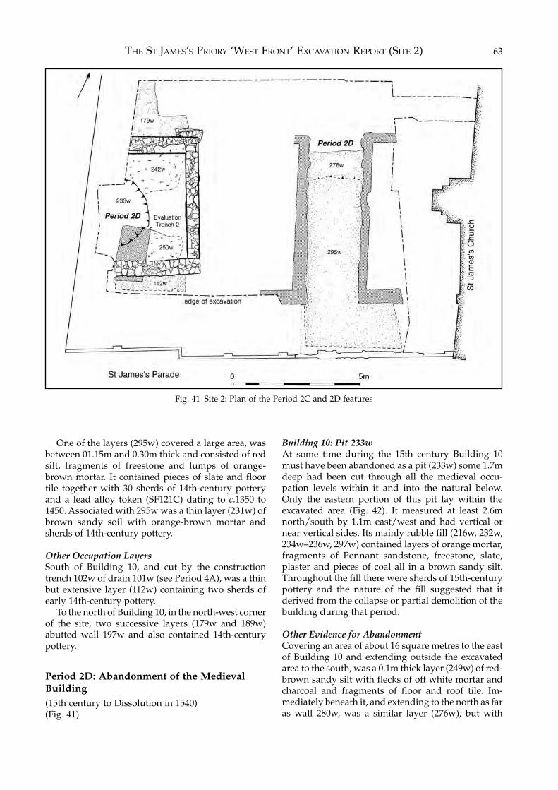
THE ST JAMES’S PRIORY ‘WEST FRONT’ EXCAVATION REPORT (SITE 2) 63
One of the layers (295w) covered a large area, wasbetween 01.15m and 0.30m thick and consisted of redsilt, fragments of freestone and lumps of orange-brown mortar. It contained pieces of slate and floortile together with 30 sherds of 14th-century potteryand a lead alloy token (SF121C) dating to c.1350 to1450. Associated with 295w was a thin layer (231w) ofbrown sandy soil with orange-brown mortar andsherds of 14th-century pottery.
Other Occupation LayersSouth of Building 10, and cut by the constructiontrench 102w of drain 101w (see Period 4A), was a thinbut extensive layer (112w) containing two sherds ofearly 14th-century pottery.
To the north of Building 10, in the north-west cornerof the site, two successive layers (179w and 189w)abutted wall 197w and also contained 14th-centurypottery.
Period 2D: Abandonment of the MedievalBuilding(15th century to Dissolution in 1540)(Fig. 41)
Building 10: Pit 233wAt some time during the 15th century Building 10must have been abandoned as a pit (233w) some 1.7mdeep had been cut through all the medieval occu-pation levels within it and into the natural below.Only the eastern portion of this pit lay within theexcavated area (Fig. 42). It measured at least 2.6mnorth/south by 1.1m east/west and had vertical ornear vertical sides. Its mainly rubble fill (216w, 232w,234w–236w, 297w) contained layers of orange mortar,fragments of Pennant sandstone, freestone, slate,plaster and pieces of coal all in a brown sandy silt.Throughout the fill there were sherds of 15th-centurypottery and the nature of the fill suggested that itderived from the collapse or partial demolition of thebuilding during that period.
Other Evidence for AbandonmentCovering an area of about 16 square metres to the eastof Building 10 and extending outside the excavatedarea to the south, was a 0.1m thick layer (249w) of red-brown sandy silt with flecks of off white mortar andcharcoal and fragments of floor and roof tile. Im-mediately beneath it, and extending to the north as faras wall 280w, was a similar layer (276w), but with
Fig. 41 Site 2: Plan of the Period 2C and 2D features
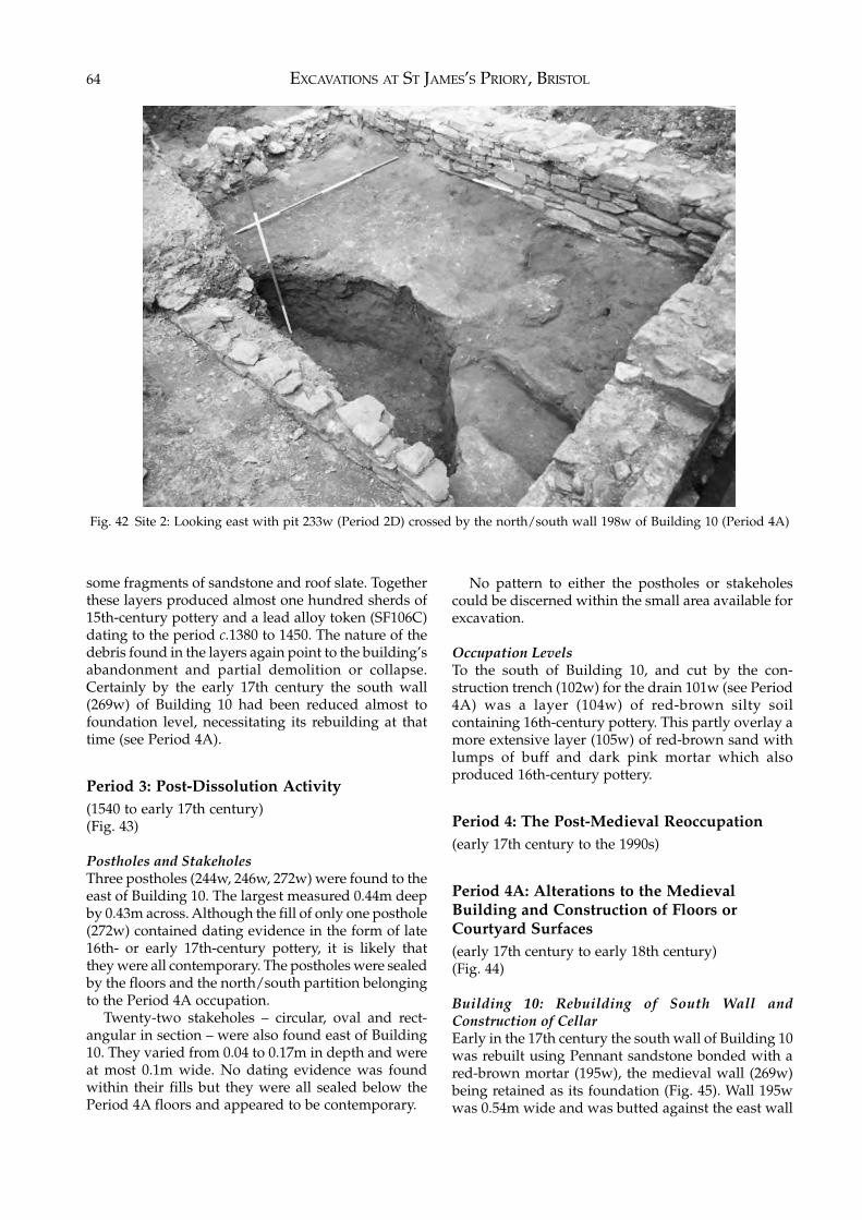
EXCAVATIONS AT ST JAMES’S PRIORY, BRISTOL64
some fragments of sandstone and roof slate. Togetherthese layers produced almost one hundred sherds of15th-century pottery and a lead alloy token (SF106C)dating to the period c.1380 to 1450. The nature of thedebris found in the layers again point to the building’sabandonment and partial demolition or collapse.Certainly by the early 17th century the south wall(269w) of Building 10 had been reduced almost tofoundation level, necessitating its rebuilding at thattime (see Period 4A).
Period 3: Post-Dissolution Activity(1540 to early 17th century)(Fig. 43)
Postholes and StakeholesThree postholes (244w, 246w, 272w) were found to theeast of Building 10. The largest measured 0.44m deepby 0.43m across. Although the fill of only one posthole(272w) contained dating evidence in the form of late16th- or early 17th-century pottery, it is likely thatthey were all contemporary. The postholes were sealedby the floors and the north/south partition belongingto the Period 4A occupation.
Twenty-two stakeholes – circular, oval and rect-angular in section – were also found east of Building10. They varied from 0.04 to 0.17m in depth and wereat most 0.1m wide. No dating evidence was foundwithin their fills but they were all sealed below thePeriod 4A floors and appeared to be contemporary.
No pattern to either the postholes or stakeholescould be discerned within the small area available forexcavation.
Occupation LevelsTo the south of Building 10, and cut by the con-struction trench (102w) for the drain 101w (see Period4A) was a layer (104w) of red-brown silty soilcontaining 16th-century pottery. This partly overlay amore extensive layer (105w) of red-brown sand withlumps of buff and dark pink mortar which alsoproduced 16th-century pottery.
Period 4: The Post-Medieval Reoccupation(early 17th century to the 1990s)
Period 4A: Alterations to the MedievalBuilding and Construction of Floors orCourtyard Surfaces(early 17th century to early 18th century)(Fig. 44)
Building 10: Rebuilding of South Wall andConstruction of CellarEarly in the 17th century the south wall of Building 10was rebuilt using Pennant sandstone bonded with ared-brown mortar (195w), the medieval wall (269w)being retained as its foundation (Fig. 45). Wall 195wwas 0.54m wide and was butted against the east wall
Fig. 42 Site 2: Looking east with pit 233w (Period 2D) crossed by the north/south wall 198w of Building 10 (Period 4A)
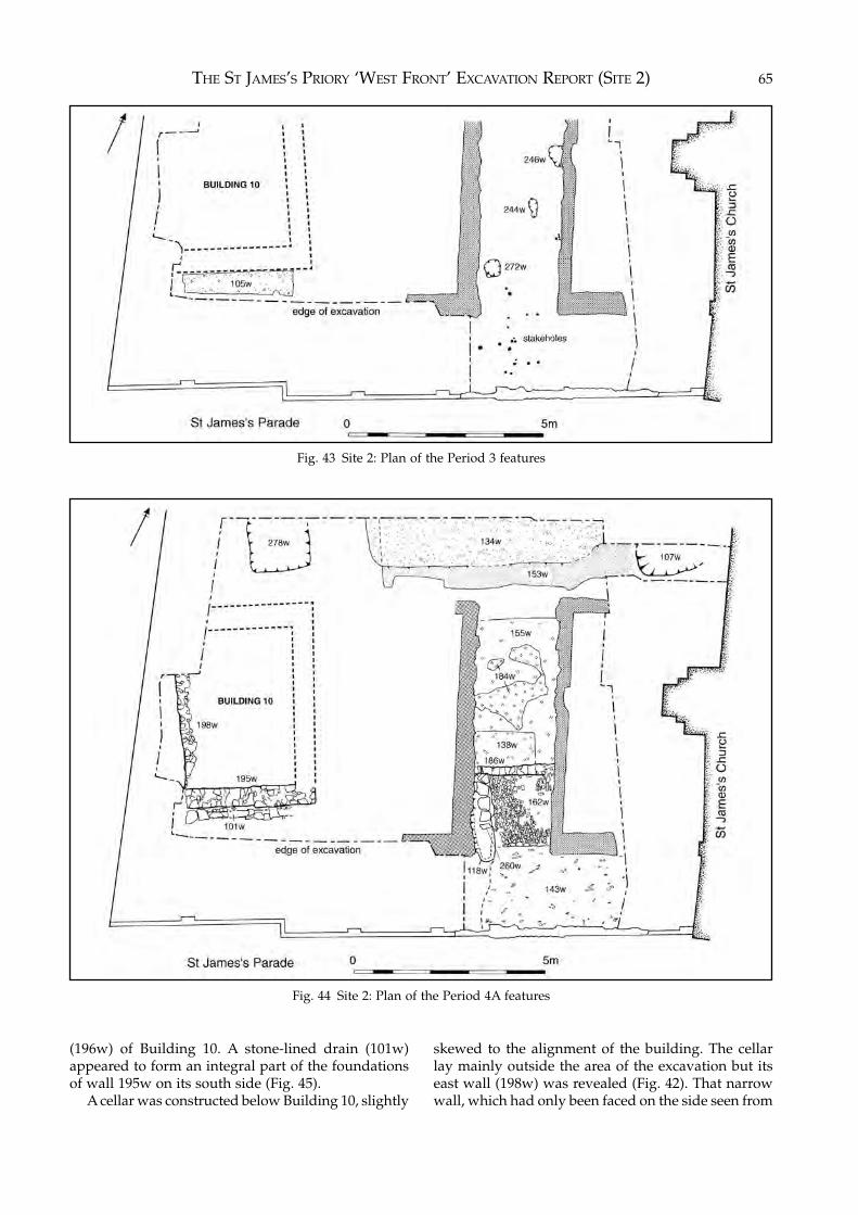
THE ST JAMES’S PRIORY ‘WEST FRONT’ EXCAVATION REPORT (SITE 2) 65
Fig. 43 Site 2: Plan of the Period 3 features
Fig. 44 Site 2: Plan of the Period 4A features
(196w) of Building 10. A stone-lined drain (101w)appeared to form an integral part of the foundationsof wall 195w on its south side (Fig. 45).
A cellar was constructed below Building 10, slightly
skewed to the alignment of the building. The cellarlay mainly outside the area of the excavation but itseast wall (198w) was revealed (Fig. 42). That narrowwall, which had only been faced on the side seen from
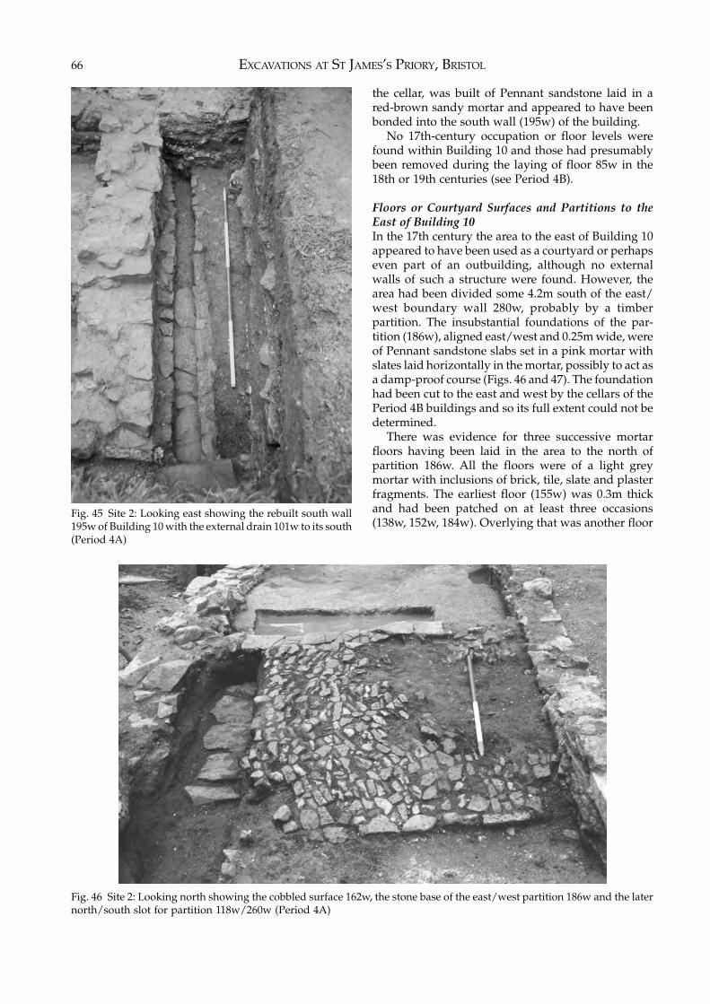
EXCAVATIONS AT ST JAMES’S PRIORY, BRISTOL66
the cellar, was built of Pennant sandstone laid in ared-brown sandy mortar and appeared to have beenbonded into the south wall (195w) of the building.
No 17th-century occupation or floor levels werefound within Building 10 and those had presumablybeen removed during the laying of floor 85w in the18th or 19th centuries (see Period 4B).
Floors or Courtyard Surfaces and Partitions to theEast of Building 10In the 17th century the area to the east of Building 10appeared to have been used as a courtyard or perhapseven part of an outbuilding, although no externalwalls of such a structure were found. However, thearea had been divided some 4.2m south of the east/west boundary wall 280w, probably by a timberpartition. The insubstantial foundations of the par-tition (186w), aligned east/west and 0.25m wide, wereof Pennant sandstone slabs set in a pink mortar withslates laid horizontally in the mortar, possibly to act asa damp-proof course (Figs. 46 and 47). The foundationhad been cut to the east and west by the cellars of thePeriod 4B buildings and so its full extent could not bedetermined.
There was evidence for three successive mortarfloors having been laid in the area to the north ofpartition 186w. All the floors were of a light greymortar with inclusions of brick, tile, slate and plasterfragments. The earliest floor (155w) was 0.3m thickand had been patched on at least three occasions(138w, 152w, 184w). Overlying that was another floor
Fig. 45 Site 2: Looking east showing the rebuilt south wall195w of Building 10 with the external drain 101w to its south(Period 4A)
Fig. 46 Site 2: Looking north showing the cobbled surface 162w, the stone base of the east/west partition 186w and the laternorth/south slot for partition 118w/260w (Period 4A)
THE ST JAMES’S PRIORY ‘WEST FRONT’ EXCAVATION REPORT (SITE 2) 67
(129w) containing late 17th-century pottery. The latestfloor (127w) had been repaired once (93w).
The floors to the south of partition 186w extendedbeyond the excavated area. A layer (191w) of brownashy soil, grey clay, sand and much charcoal, con-tained 17th-century pottery and clay pipe stems andformed the bedding for an area of cobbles (162w)extending 1.85m to the south of partition 186w (Fig.46). Contemporary with the cobbles, and abuttingthem to the south, was a floor (143w) of compactedblack ash, small stones and slate fragments dated byclay pipe bowls found within it to c.1625–50. Partlyoverlying the cobbles 162w and floor 143w were twoareas of mortar floor (137w and 126w). Sealing thecobbles 162w and floors 143w, 126w and 137w, andextending over the whole area to the south of partition186w, was a layer (120w) of black ash, cinders andfragments of coal which contained late 17th-centuryclay pipes and pottery. Within 120w was a hearth(98w) made of flat slabs of Pennant sandstone edgedby vertical slabs and surrounded by black ash.
In the late 17th century the area east of Building 10was again sub-divided by the construction of a north/south partition wall running south from the east/westpartition 186w for a distance of at least 3.8m. Theevidence for the sub-division was a cut (118w) 0.6mwide and up to 0.3m deep, at the base of which werea number of large flat Pennant slabs (260w) laid on athin layer of dark brown sandy silt (261w) containinglate 17th-century clay pipes and pottery (Figs. 46 and
47). The slabs presumably formed the base for anothertimber partition.
Stone-Lined DrainA stone-lined drain (101w) ran east/west to the southof wall 195w of Building 10, and utilised 195w as partof its own north walling (Fig. 45). To the east the drainhad been cut by the Period 4B cellar and to the west itextended outside the edge of the excavation. It wasbuilt of Pennant sandstone, the walls having beenbonded with red mortar. Its fill (74w) contained 17th-century clay pipes and the cover stones of the drainhad been sealed by two thin layers of red-brown sandysilt (54w, 80w) which dated to the late 17th century.
PitsPit 278w lay to the north of Building 10 and extendedoutside the excavated area. Rectangular in shape, itmeasured 1.6m east/west, at least 1.5m north/south,was 0.85m deep and had been cut into the naturalsandstone. It had probably been used as a cess-pit asthe bottom layer of fill (277w) was a typical green-yellow cess-like material. The upper layers of fill(163w, 165w, 166w) contained late 17th-century claypipes and pottery.
Pit 107w, to the north-east of Building 10, extendedunder the northern edge of the excavation. It meas-ured 1.85m east/west, at least 0.7m north/south, was0.4m deep and had been cut through a thin layer ofbrown sandy loam (108w), containing early 17th-
Fig. 47 Site 2: Looking south after the removal of cobbles 162w showing the bases for partitions 186w and 118w (Period 4A)
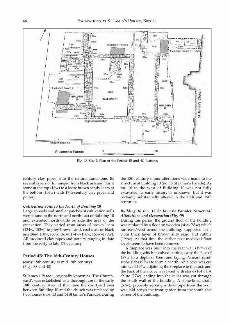
EXCAVATIONS AT ST JAMES’S PRIORY, BRISTOL68
century clay pipes, into the natural sandstone. Itsseveral layers of fill ranged from black ash and burntstone at the top (16w) to a loose brown sandy loam atthe bottom (106w) with 17th-century clay pipes andpottery.
Cultivation Soils to the North of Building 10Large spreads and smaller patches of cultivation soilswere found to the north and north-east of Building 10and extended northwards outside the area of theexcavation. They varied from areas of brown loam(134w, 153w) to grey-brown sand, coal dust or blackash (84w, 158w, 160w, 161w, 174w–176w, 168w–170w).All produced clay pipes and pottery ranging in datefrom the early to late 17th century.
Period 4B: The 18th-Century Houses(early 18th century to mid 19th century)(Figs. 38 and 48)
St James’s Parade, originally known as ‘The Church-yard’, was established as a thoroughfare in the early18th century. Around that time the courtyard areabetween Building 10 and the church was replaced bytwo houses (nos. 13 and 14 St James’s Parade). During
the 18th century minor alterations were made to thestructure of Building 10 (no. 15 St James’s Parade). Asno. 16 to the west of Building 10 was not fullyexcavated its early history is unknown, but it wascertainly substantially altered in the 18th and 19thcenturies.
Building 10 (no. 15 St James’s Parade): StructuralAlterations and Occupation (Fig. 49)During this period the ground floor of the buildingwas replaced by a floor on wooden joists (85w) whichran east/west across the building, supported on a0.5m thick layer of brown silty sand and rubble(199w). At that time the earlier post-medieval floorlevels seem to have been removed.
A fireplace was built into the rear wall (197w) ofthe building which involved cutting away the face of197w to a depth of 0.6m and laying Pennant sand-stone slabs (97w) to form a hearth. An alcove was cutinto wall 197w adjoining the fireplace to the east, andthe back of the alcove was faced with stone (164w). Achute (27w) leading into the cellar was cut throughthe south wall of the building. A stone-lined drain(52w), probably serving a downpipe from the roof,was laid across the front garden from the south-eastcorner of the building.
Fig. 48 Site 2: Plan of the Period 4B and 4C features
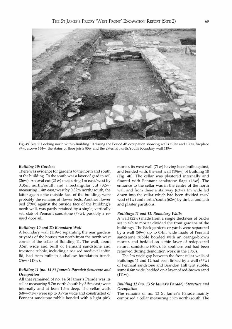
THE ST JAMES’S PRIORY ‘WEST FRONT’ EXCAVATION REPORT (SITE 2) 69
Building 10: GardensThere was evidence for gardens to the north and southof the building. To the south was a layer of garden soil(26w). An oval cut (21w) measuring 1m east/west by0.35m north/south and a rectangular cut (32w)measuring 1.4m east/west by 0.32m north/south, thelatter against the outside face of the building, wereprobably the remains of flower beds. Another flowerbed (79w) against the outside face of the building’snorth wall, was partly retained by a single, verticallyset, slab of Pennant sandstone (78w), possibly a re-used door sill.
Buildings 10 and 11: Boundary WallA boundary wall (119w) separating the rear gardensor yards of the houses ran north from the north-westcorner of the cellar of Building 11. The wall, about0.5m wide and built of Pennant sandstone andfreestone rubble, including a re-used medieval coffinlid, had been built in a shallow foundation trench(76w/117w).
Building 11 (no. 14 St James’s Parade): Structure andOccupationAll that remained of no. 14 St James’s Parade was itscellar measuring 5.7m north/south by 3.5m east/westinternally and at least 1.5m deep. The cellar walls(68w–71w) were up to 0.77m wide and constructed ofPennant sandstone rubble bonded with a light pink
mortar, its west wall (71w) having been built against,and bonded with, the east wall (196w) of Building 10(Fig. 40). The cellar was plastered internally andfloored with Pennant sandstone flags (46w). Theentrance to the cellar was in the centre of the northwall and from there a stairway (63w) 1m wide leddown into the cellar which had been divided east/west (61w) and north/south (62w) by timber and lathand plaster partitions.
Buildings 11 and 12: Boundary WallsA wall (22w) made from a single thickness of bricksset in white mortar divided the front gardens of thebuildings. The back gardens or yards were separatedby a wall (59w) up to 0.4m wide made of Pennantsandstone rubble bonded with an orange-brownmortar, and bedded on a thin layer of redepositednatural sandstone (60w). Its southern end had beenremoved during demolition work in the 1960s.
The 2m wide gap between the front cellar walls ofBuildings 11 and 12 had been linked by a wall (67w)of Pennant sandstone and Brandon Hill Grit rubble,some 0.6m wide, bedded on a layer of red-brown sand(111w).
Building 12 (no. 13 St James’s Parade): Structure andOccupationThe remains of no. 13 St James’s Parade mainlycomprised a cellar measuring 5.7m north/south. The
Fig. 49 Site 2: Looking north within Building 10 during the Period 4B occupation showing walls 195w and 196w, fireplace97w, alcove 164w, the stains of floor joists 85w and the external north/south boundary wall 119w
EXCAVATIONS AT ST JAMES’S PRIORY, BRISTOL70
cellar walls (64w–66w) were up to 0.58m wide andcomposed of Pennant sandstone rubble bonded witha light pink mortar and had been plastered internally.Although the east side of the cellar could not beexposed or the fill of the cellar excavated due to thenearby church wall, it appeared to be a mirror imageof that at no. 14 St James’s Parade.
A north/south wall (132w) of the same constructionas the cellar walls and built against the medieval westwall of the church, was probably part of a rearextension to the building. An area of red-brown sand(51w), which abutted wall 132w and the boundarywall 59w, probably formed a make-up layer for themortar floor (45w) within this extension. Layer 51wsealed pit 107w (see Period 4A).
Building 13 (no. 16 St James’s Parade): Structure andOccupationThis building was only partly excavated during theevaluation work on site in 1993 and consequently itsearly history is not known, although it may date fromthe 17th century. It was certainly substantially alteredin the 18th century and two north/south walls (57tand 58t) found in evaluation trenches 3 and 6 date tothat period (Fig. 38). They were both 0.39m wide and2.25m apart, and constructed of Pennant sandstonerubble in a brown mortar. A number of walls (59t, 78t,80t, 82t) were found in evaluation trench 3 but it wasimpossible to determine how they related to thebuilding in the limited area available for excavation.Fragments of the flagstone floor (63t, 71t) of theproperty were uncovered together with a small cellaror coal-hole to the west of wall 58t.
Period 4C: Alterations to the 18th-CenturyBuildings(mid 19th century to mid 20th century)(Fig. 48)
Building 10 (no. 15 St James’s Parade): StructuralAlterationsThe fireplace and alcove in the north wall of the
building were removed, probably sometime in theearly 20th century. The fireplace was infilled withstone and brick bonded in a black mortar (58w) whilethe alcove was blocked by a brick wall and pier base,again bonded with black mortar (55w).
Building 11 (no. 14 St James’s Parade): StructuralAlterationsThe south-west corner of the cellar was buttressed,probably during the 19th century, by a block of stoneand brick rubble bonded with grey mortar (73w).North of the north-east corner of the cellar, twoparallel lines of single thickness brick laid in greymortar (5w), 0.6m apart and each at least 2m long,probably formed the base of a staircase built in thelate 19th or early 20th century.
Building 12 (no. 13 St James’s Parade): StructuralAlterationsAt some time in the 19th century a canted bay wasadded to the front of the building. That projected 0.9mtowards St James’s Parade and was constructed ofPennant sandstone bonded in a grey mortar (28w).Documentary records show that a similar bay hadbeen added to Building 11 but that lay outside theexcavated area. Later in the 19th century a brick wall(8w), in part represented by a robber trench (9w), wasbuilt running south from the south-west corner of thecellar and may have formed part of a shop extensionfilling the gap between the front of the house and StJames’s Parade. During the 19th century the extensionto the rear of the building was floored with Pennantsandstone flagstones (3w) set in grey mortar (4w).
Period 4D: Demolition of Buildings and Re-use of Land(mid 1950s to the 1990s)
Nos. 13, 14, 15 and 16 St James’s Parade weredemolished in the 1950s and 1960s and layers ofrubble (1w and 2w) covering the site date from thatperiod. The houses were replaced by a garden ofremembrance and a car parking area.
5 THE BURIALS
Introduction
Human remains from three sites are considered in thissection. These came from:Site 1 – inside the east end of the priory church and
the monastic burial ground to its east (245articulated skeletons)
Site 2 – the lay/parish burial ground outside the westend of the church (33 articulated skeletons)
Site 3 – St James’s Place, on the site of the the parishburial ground some 88m south-east of thepriory church (six articulated skeletons).
Methods of Burial Excavation and RecordingThe methods adopted in excavating the burials onSites 1 and 2 varied according to the degree ofstratification present. In some cases the grave cuts,and even the skeletons themselves, lay immediatelybelow the modern make-up levels and were exposedduring removal of those deposits by machine. In otherareas it was possible to excavate the burials in thesequence of their interment by the careful identi-fication of intersecting grave cuts although, due to thenature of their compacted fills, it was sometimesdifficult to distinguish them from the natural subsoil.
During the 1995 excavation of Site 1 the grave cutsand fills were each given separate context numbers,while articulated skeletons were given individualsequential skeleton (Sk.) numbers from 28 to 252 (oneburial was given two Sk. numbers). At the time of the1989 excavation of Site 1 the skeletons found had beengiven context numbers only and so, for ease ofreference, those were also given skeleton numbersfrom 1 to 27, although on specialist examination theactual number of individual skeletons from thatexcavation was found to be twenty-one.
The excavation of Site 2 produced 33 articulatedskeletons which were given individual sequentialskeleton (Sk.) numbers from 253 to 285.
Five articulated skeletons were recovered, while afurther skeleton was noted but not lifted for study,during the watching brief on Site 3. These were giventhe sequential skeleton (Sk.) numbers 286 to 291.
In the following report all numbers relating tograves and skeletons are the sequential Sk. numbersunless otherwise stated.
Each burial was recorded on a Burial Record Formsupplied by the Palaeopathology Study Group. It wasthe responsibility of the archaeologist excavating eachburial to complete that form. The work was super-vised on Sites 1 and 2 by Dr Louise Loe, the humanbone specialist assigned to the project, who examinedthe skeletons in situ in order to gain the maximuminformation available and also for evidence of path-ology which might have required special attentionbefore the skeletons were removed from the graves.She advised the excavation team on the best tech-niques for recording, lifting, cleaning and storage ofthe burials.
The graves were excavated by hand and theskeletons exposed and cleaned for recording. All thegrave cuts, skeletons and disarticulated remains wereplanned at a scale of 1:20 and the majority of skeletonswere also recorded photographically.
Once drawn and photographed, the bones werelifted, labelled and boxed, each individual articulatedskeleton being boxed separately. As a rule, exposedskeletons were never left in the ground overnight, butwere processed and lifted on the day of discovery. Theskeletons were washed and slowly dried, either onsite or in Bristol City Museum and Art Gallery aftercompletion of the excavation, before being re-boxedand delivered to the human bone specialist for study.
Apart from coffin nails, there were few finds in thegraves or associated with the skeletons. The locationsof coffin nails were only planned when they occurredat the bottom of the grave and appeared to give anoutline of the shape and position of the wooden coffin.Generally they were randomly distributed throughthe grave fills where the wooden coffin had graduallydecayed and collapsed. The positions of special finds,such as coins and pewter objects, were also plannedand the objects photographed in situ. Pottery sherdsfound within grave fills were not planned in positionbut were grouped together under the context numberfor each grave fill.
The human remains were excavated under theterms of Home Office Burial Licences and have now
EXCAVATIONS AT ST JAMES’S PRIORY, BRISTOL72
been cremated and the ashes reinterred within StJames’s Church.
The Archaeology of the Monastic Cemetery(Site 1)
It is generally assumed that the area of a prioryprecinct located immediately to the east of the churchwas occupied by the burial ground of the monks andother members of the monastic community. Highstatus members of the lay community were sometimesentitled to be buried in or near the church due to theirpatronage of the religious house, while ordinary laypeople such as servants or tenants of the abbey wouldbe buried outside the church on the far side from thecloister.
This assumed burial pattern is confirmed byinformation obtained from archaeological excavationsof cemeteries where an analysis of skeletal remainshas been carried out, as at the Cistercian abbey ofBordesley, Hereford and Worcester (Coppack 1990,160) and the Gilbertine priory of St. Andrew Fisher-gate, York (Stroud and Kemp 1993, 136). However,few monastic cemeteries have been studied in anydetail and Greene (1992, 159) has pointed out thatthere were no hard-and-fast rules concerning burialwithin the monastic precincts and that they variedbetween orders and over time.
Before the 1995 excavation on Site 1 evidence hadbeen found for the existence of the supposed monasticcemetery east of the church during clearance of thesite for the NFU building in 1962, when two burialswere uncovered, and again in 1989 when 21 skeletonswere excavated.
During the 1995 excavation a further 224 skeletonswere found, two of which came from within the eastend of the church, making a total of 247 skeletonsrecovered from the monastic cemetery and church.The skeletons discovered in 1962 are no longeravailable for study so this section deals with thegraves and human remains from the 1989 and 1995excavations, including five graves in which theskeletal material had not survived.
The Condition of the Human RemainsOf the 245 burials found in 1989 and 1995, only 45(18%) were undisturbed. The majority had either beencut by other burials within the cemetery or had beendisturbed by post-Dissolution activity on the site. Thedigging of rubbish pits in the 17th and 18th centuries,the construction of houses in the later 18th century,the construction of the Scottish Presbyterian Churchin the mid 19th century and the excavation of serviceand foundation trenches in the 20th century had alltruncated the medieval burials. Consequently, in the
majority of cases, the skeletons had portions of theirbodies missing which led to difficulties in ageing andsexing some of the individuals (see below).
The state of preservation of the human bone variedacross the site. In general it was quite good, but insome areas, notably under the Scottish PresbyterianChurch, the bones had been virtually destroyed leavingeither fragmentary remains or just stains in the soil. Insome cases the skeleton had been eroded awaycompletely and the grave contained no evidence ofhuman remains. It is known that dewatering of theground is detrimental to the survival of bone (Millard1998, 99) and the construction of the Scottish Presby-terian Church over some of the burials would certainlyhave caused the drying out of the ground beneath.Nevertheless, all the skeletal remains were removedfor study whatever their state of preservation.
The Cemetery BoundariesTo the west the cemetery was defined by the walls ofthe east end of the priory church and its chapels andno burials were found to be underlying the walls ofthe church (Fig. 51, page 87). Similarly there were noburials in the north-west corner of the excavation, sothe western limit of the cemetery appears to continueon a line north of the church, although no structurewas found defining that boundary.
To the north, the area of the site fronting CannonStreet had been badly disturbed by later buildings butsome areas remained which should have contained anumber of burials had the cemetery continued outsidethe excavated area to the north. Those areas, notablythe garden between Buildings 1 and 2 and the gardento the east of Building 1 (see Chapter 3, Period 4B),contained only two graves, head-niche burial Sk. 145and coffin burial Sk. 62. If a northern boundary existedthen it appears to have been established after theseburials took place. In the late medieval period a V-shaped east/west ditch (contexts 1000, 1008, 1345,1424) (see Chapter 3, Fig. 16 and Fig. 51, page 87)probably formed the northern boundary to thecemetery and this would account for the small numberof burials to its north. Although the ditch had been cutin a number of places by later structures it was foundto be some 0.75m wide and at least 0.50m deep, and itsbackfill produced pottery sherds dating between 1350and 1500 and some fragments of 14th-century Group 2floor tiles (see Chapter 6). The ditch had cut a head-niche burial Sk. 144, a possible head-niche burial Sk.197, two coffin burial Sks. 126 and 182, a simple burialSk. 61 and a burial of uncertain type Sk. 128.
The eastern and southern boundaries of the ceme-tery lay outside the excavated area. In the most easterlyarea of the excavation one burial (Sk. 105) lay partlyoutside the area available for excavation while burialsappeared to continue under the façade of the ScottishPresbyterian Church to the south (Fig. 54, page 90).
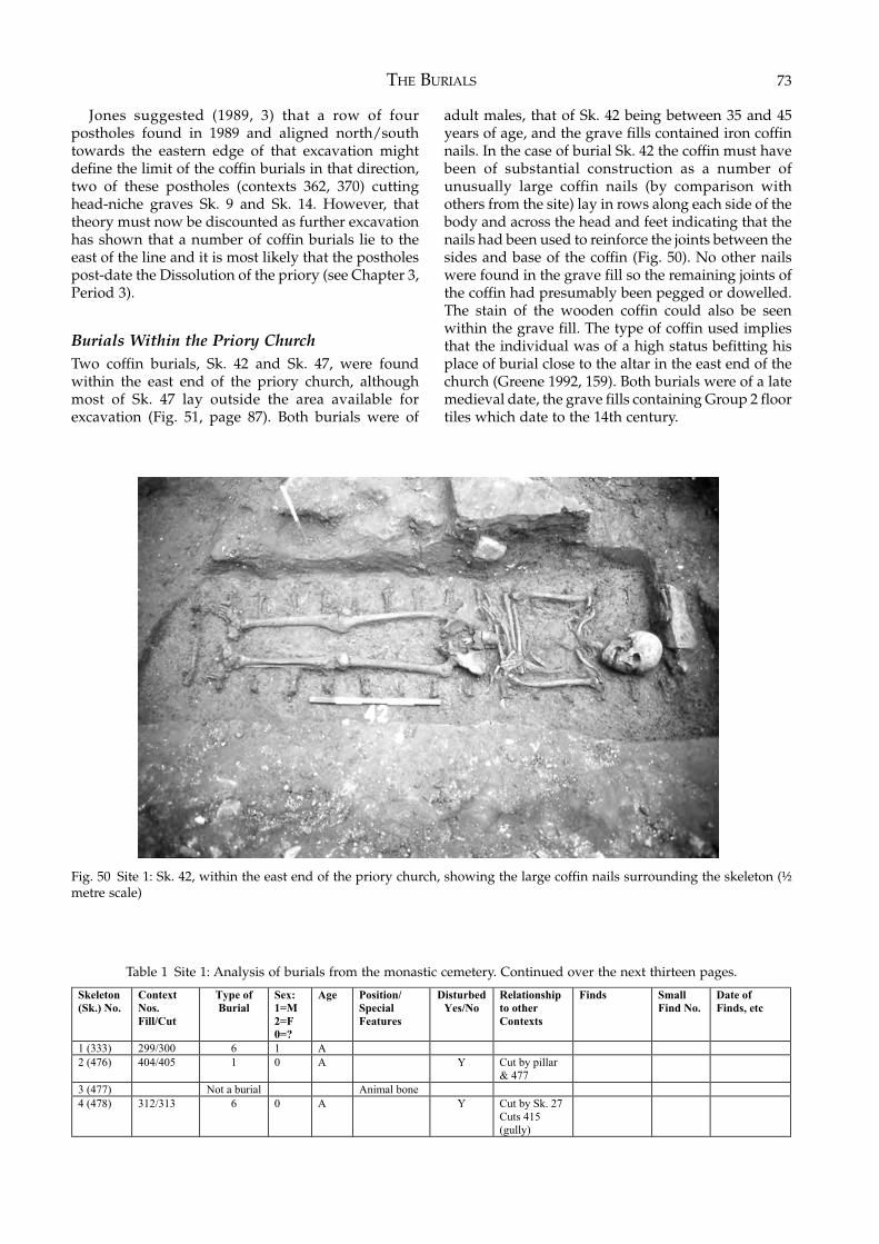
THE BURIALS 73
Jones suggested (1989, 3) that a row of fourpostholes found in 1989 and aligned north/southtowards the eastern edge of that excavation mightdefine the limit of the coffin burials in that direction,two of these postholes (contexts 362, 370) cuttinghead-niche graves Sk. 9 and Sk. 14. However, thattheory must now be discounted as further excavationhas shown that a number of coffin burials lie to theeast of the line and it is most likely that the postholespost-date the Dissolution of the priory (see Chapter 3,Period 3).
Burials Within the Priory ChurchTwo coffin burials, Sk. 42 and Sk. 47, were foundwithin the east end of the priory church, althoughmost of Sk. 47 lay outside the area available forexcavation (Fig. 51, page 87). Both burials were of
adult males, that of Sk. 42 being between 35 and 45years of age, and the grave fills contained iron coffinnails. In the case of burial Sk. 42 the coffin must havebeen of substantial construction as a number ofunusually large coffin nails (by comparison withothers from the site) lay in rows along each side of thebody and across the head and feet indicating that thenails had been used to reinforce the joints between thesides and base of the coffin (Fig. 50). No other nailswere found in the grave fill so the remaining joints ofthe coffin had presumably been pegged or dowelled.The stain of the wooden coffin could also be seenwithin the grave fill. The type of coffin used impliesthat the individual was of a high status befitting hisplace of burial close to the altar in the east end of thechurch (Greene 1992, 159). Both burials were of a latemedieval date, the grave fills containing Group 2 floortiles which date to the 14th century.
Fig. 50 Site 1: Sk. 42, within the east end of the priory church, showing the large coffin nails surrounding the skeleton (½metre scale)
Table 1 Site 1: Analysis of burials from the monastic cemetery. Continued over the next thirteen pages.
Skeleton
(Sk.) No.
Context
Nos.
Fill/Cut
Type of
Burial
Sex:
1=M
2=F
0=?
Age Position/
Special
Features
Disturbed
Yes/No
Relationship
to other
Contexts
Finds Small
Find No.
Date of
Finds, etc
1 (333) 299/300 6 1 A
2 (476) 404/405 1 0 A Y Cut by pillar
& 477
3 (477) Not a burial Animal bone
4 (478) 312/313 6 0 A Y Cut by Sk. 27
Cuts 415
(gully)
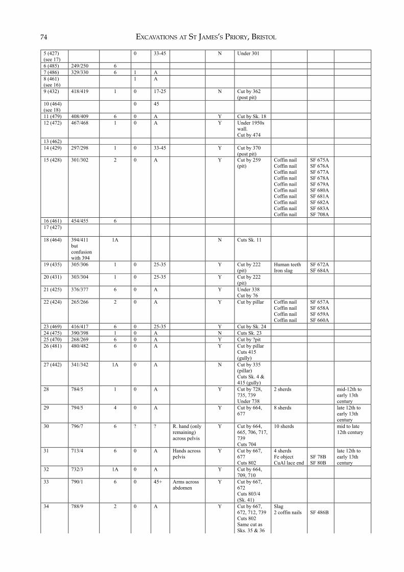
EXCAVATIONS AT ST JAMES’S PRIORY, BRISTOL74
5 (427)
(see 17)
0 33-45 N Under 301
6 (485) 249/250 6
7 (486) 329/330 6 1 A
8 (461)
(see 16)
1 A
9 (432) 418/419 1 0 17-25 N Cut by 362
(post pit)
10 (464)
(see 18)
0 45
11 (479) 408/409 6 0 A Y Cut by Sk. 18
12 (472) 467/468 1 0 A Y Under 1950s
wall.
Cut by 474
13 (462)
14 (429) 297/298 1 0 33-45 Y Cut by 370
(post pit)
15 (428) 301/302 2 0 A Y Cut by 259
(pit)
Coffin nail
Coffin nail
Coffin nail
Coffin nail
Coffin nail
Coffin nail
Coffin nail
Coffin nail
Coffin nail
Coffin nail
SF 675A
SF 676A
SF 677A
SF 678A
SF 679A
SF 680A
SF 681A
SF 682A
SF 683A
SF 708A
16 (461) 454/455 6
17 (427)
18 (464) 394/411
but
confusion
with 394
1A N Cuts Sk. 11
19 (435) 305/306 1 0 25-35 Y Cut by 222
(pit)
Human teeth
Iron slag
SF 672A
SF 684A
20 (431) 303/304 1
0 25-35 Y Cut by 222
(pit)
21 (425) 376/377 6 0 A Y Under 338
Cut by 76
22 (424) 265/266 2 0 A Y Cut by pillar Coffin nail
Coffin nail
Coffin nail
Coffin nail
SF 657A
SF 658A
SF 659A
SF 660A
23 (469) 416/417 6 0 25-35 Y Cut by Sk. 24
24 (475) 390/398 1 0 A N Cuts Sk. 23
25 (470) 268/269 6 0 A Y Cut by ?pit
26 (481) 480/482 6 0 A Y Cut by pillar
Cuts 415
(gully)
27 (442) 341/342 1A 0 A N Cut by 335
(pillar)
Cuts Sk. 4 &
415 (gully)
28 784/5 1 0 A Y Cut by 728,
735, 739
Under 738
2 sherds mid-12th to
early 13th
century
29 794/5 4 0 A Y Cut by 664,
677
8 sherds late 12th to
early 13th
century
30 796/7 6 ? ? R. hand (only
remaining)
across pelvis
Y Cut by 664,
665, 706, 717,
739
Cuts 704
10 sherds mid to late
12th century
31 713/4 6 0 A Hands across
pelvis
Y Cut by 667,
677
Cuts 802
4 sherds
Fe object
CuAl lace end
SF 78B
SF 80B
late 12th to
early 13th
century
32 732/3 1A 0 A Y Cut by 664,
709, 710
33 790/1 6 0 45+ Arms across
abdomen
Y Cut by 667,
672
Cuts 803/4
(Sk. 41)
34 788/9 2 0 A Y Cut by 667,
672, 712, 739
Cuts 802
Same cut as
Sks. 35 & 36
Slag
2 coffin nails
SF 486B
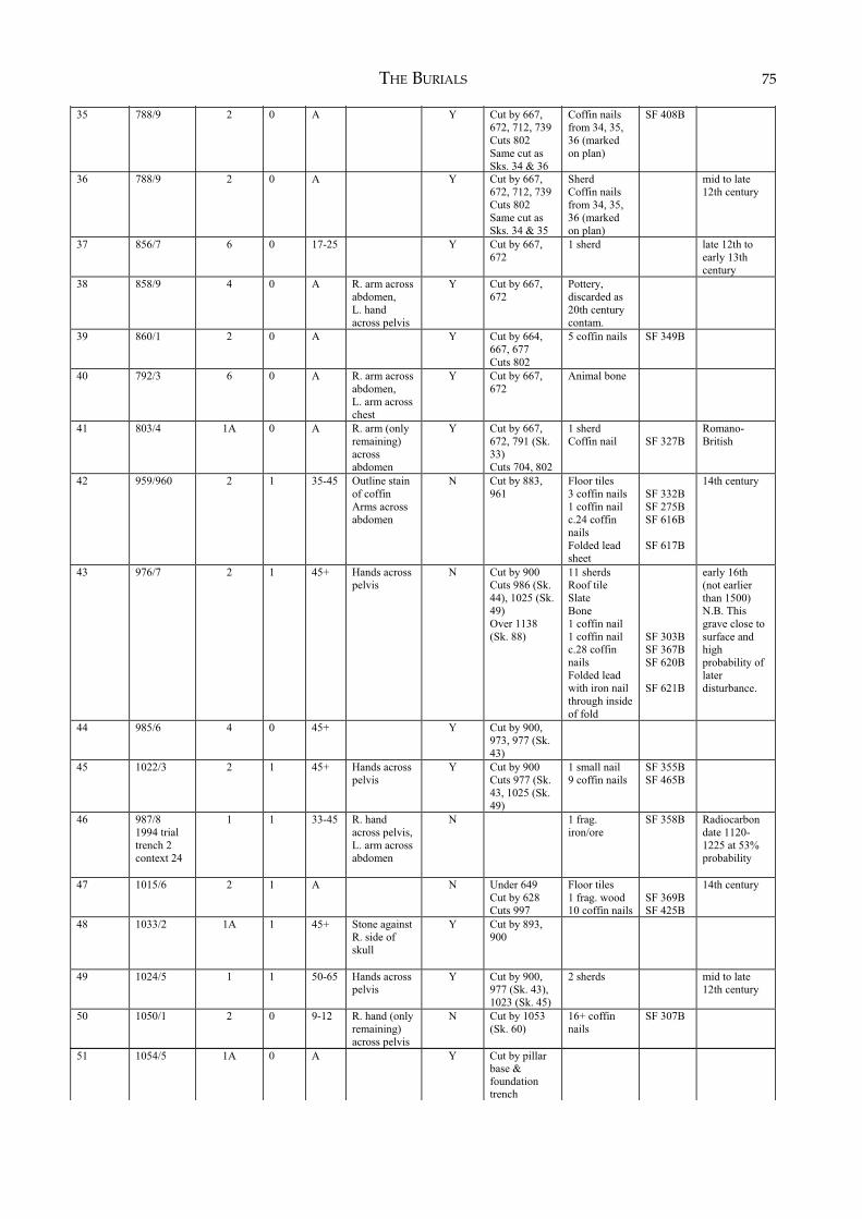
THE BURIALS 75
35 788/9 2 0 A Y Cut by 667,
672, 712, 739
Cuts 802
Same cut as
Sks. 34 & 36
Coffin nails
from 34, 35,
36 (marked
on plan)
SF 408B
36 788/9 2 0 A Y Cut by 667,
672, 712, 739
Cuts 802
Same cut as
Sks. 34 & 35
Sherd
Coffin nails
from 34, 35,
36 (marked
on plan)
mid to late
12th century
37 856/7 6 0 17-25 Y Cut by 667,
672
1 sherd late 12th to
early 13th
century
38 858/9 4 0 A R. arm across
abdomen,
L. hand
across pelvis
Y Cut by 667,
672
Pottery,
discarded as
20th century
contam.
39 860/1 2 0 A Y Cut by 664,
667, 677
Cuts 802
5 coffin nails SF 349B
40 792/3 6 0 A R. arm across
abdomen,
L. arm across
chest
Y Cut by 667,
672
Animal bone
41 803/4 1A 0 A R. arm (only
remaining)
across
abdomen
Y Cut by 667,
672, 791 (Sk.
33)
Cuts 704, 802
1 sherd
Coffin nail
SF 327B
Romano-
British
42 959/960 2 1 35-45 Outline stain
of coffin
Arms across
abdomen
N Cut by 883,
961
Floor tiles
3 coffin nails
1 coffin nail
c.24 coffin
nails
Folded lead
sheet
SF 332B
SF 275B
SF 616B
SF 617B
14th century
43 976/7 2 1 45+ Hands across
pelvis
N Cut by 900
Cuts 986 (Sk.
44), 1025 (Sk.
49)
Over 1138
(Sk. 88)
11 sherds
Roof tile
Slate
Bone
1 coffin nail
1 coffin nail
c.28 coffin
nails
Folded lead
with iron nail
through inside
of fold
SF 303B
SF 367B
SF 620B
SF 621B
early 16th
(not earlier
than 1500)
N.B. This
grave close to
surface and
high
probability of
later
disturbance.
44 985/6 4 0 45+ Y Cut by 900,
973, 977 (Sk.
43)
45 1022/3 2 1 45+ Hands across
pelvis
Y Cut by 900
Cuts 977 (Sk.
43, 1025 (Sk.
49)
1 small nail
9 coffin nails
SF 355B
SF 465B
46 987/8
1994 trial
trench 2
context 24
1 1 33-45 R. hand
across pelvis,
L. arm across
abdomen
N 1 frag.
iron/ore
SF 358B Radiocarbon
date 1120-
1225 at 53%
probability
47 1015/6 2 1 A N Under 649
Cut by 628
Cuts 997
Floor tiles
1 frag. wood
10 coffin nails
SF 369B
SF 425B
14th century
48 1033/2 1A 1 45+ Stone against
R. side of
skull
Y Cut by 893,
900
49 1024/5 1 1 50-65 Hands across
pelvis
Y Cut by 900,
977 (Sk. 43),
1023 (Sk. 45)
2 sherds mid to late
12th century
50 1050/1 2 0 9-12 R. hand (only
remaining)
across pelvis
N Cut by 1053
(Sk. 60)
16+ coffin
nails
SF 307B
51 1054/5 1A 0 A Y Cut by pillar
base &
foundation
trench
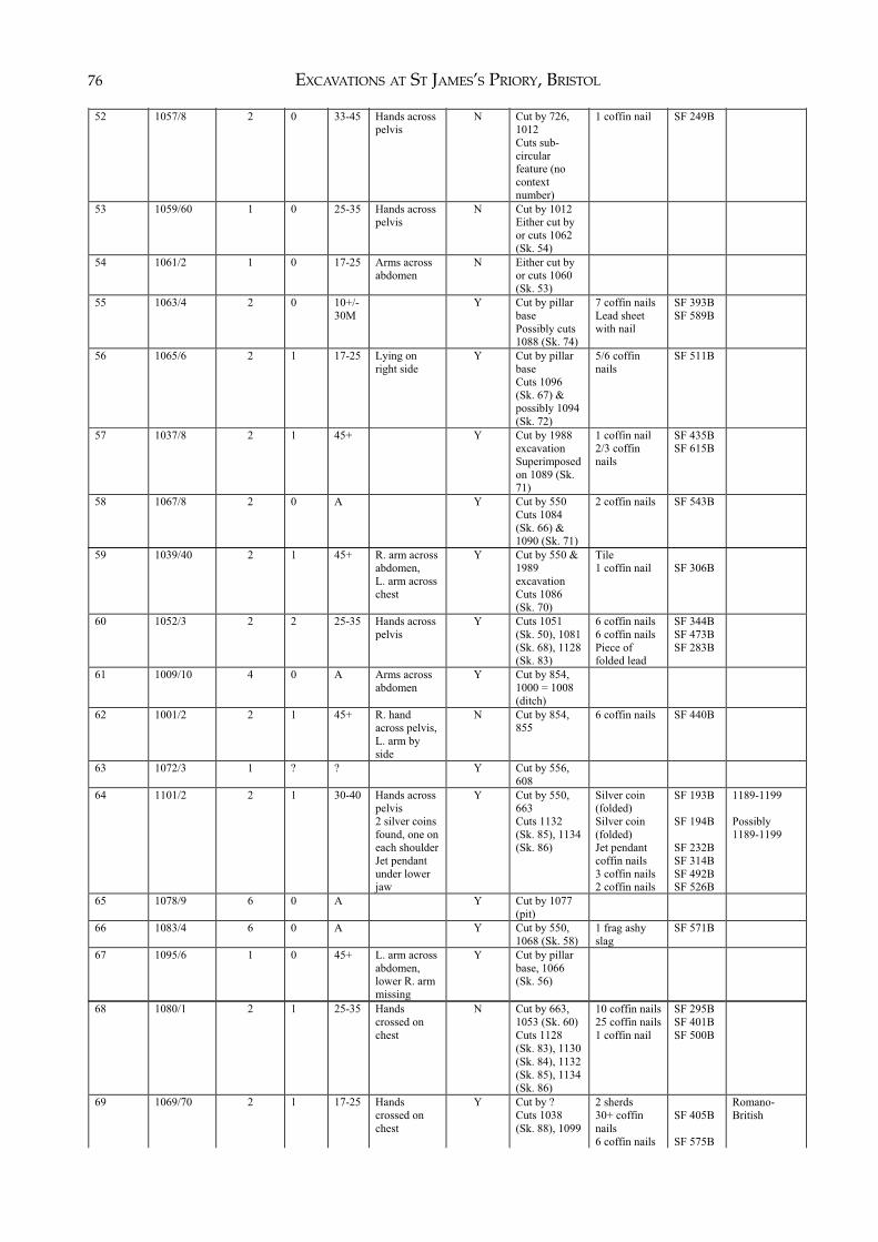
EXCAVATIONS AT ST JAMES’S PRIORY, BRISTOL76
52 1057/8 2 0 33-45 Hands across
pelvis
N Cut by 726,
1012
Cuts sub-
circular
feature (no
context
number)
1 coffin nail SF 249B
53 1059/60 1 0 25-35 Hands across
pelvis
N Cut by 1012
Either cut by
or cuts 1062
(Sk. 54)
54 1061/2 1 0 17-25 Arms across
abdomen
N Either cut by
or cuts 1060
(Sk. 53)
55 1063/4 2 0 10+/-
30M
Y Cut by pillar
base
Possibly cuts
1088 (Sk. 74)
7 coffin nails
Lead sheet
with nail
SF 393B
SF 589B
56 1065/6 2 1 17-25 Lying on
right side
Y Cut by pillar
base
Cuts 1096
(Sk. 67) &
possibly 1094
(Sk. 72)
5/6 coffin
nails
SF 511B
57 1037/8 2 1 45+ Y Cut by 1988
excavation
Superimposed
on 1089 (Sk.
71)
1 coffin nail
2/3 coffin
nails
SF 435B
SF 615B
58 1067/8 2 0 A Y Cut by 550
Cuts 1084
(Sk. 66) &
1090 (Sk. 71)
2 coffin nails SF 543B
59 1039/40 2 1 45+ R. arm across
abdomen,
L. arm across
chest
Y Cut by 550 &
1989
excavation
Cuts 1086
(Sk. 70)
Tile
1 coffin nail
SF 306B
60 1052/3 2 2 25-35 Hands across
pelvis
Y Cuts 1051
(Sk. 50), 1081
(Sk. 68), 1128
(Sk. 83)
6 coffin nails
6 coffin nails
Piece of
folded lead
SF 344B
SF 473B
SF 283B
61 1009/10 4 0 A Arms across
abdomen
Y Cut by 854,
1000 = 1008
(ditch)
62 1001/2 2 1 45+ R. hand
across pelvis,
L. arm by
side
N Cut by 854,
855
6 coffin nails SF 440B
63 1072/3 1 ? ? Y Cut by 556,
608
64 1101/2 2 1 30-40 Hands across
pelvis
2 silver coins
found, one on
each shoulder
Jet pendant
under lower
jaw
Y Cut by 550,
663
Cuts 1132
(Sk. 85), 1134
(Sk. 86)
Silver coin
(folded)
Silver coin
(folded)
Jet pendant
coffin nails
3 coffin nails
2 coffin nails
SF 193B
SF 194B
SF 232B
SF 314B
SF 492B
SF 526B
1189-1199
Possibly
1189-1199
65 1078/9 6 0 A Y Cut by 1077
(pit)
66 1083/4 6 0 A Y Cut by 550,
1068 (Sk. 58)
1 frag ashy
slag
SF 571B
67 1095/6 1 0 45+ L. arm across
abdomen,
lower R. arm
missing
Y Cut by pillar
base, 1066
(Sk. 56)
68 1080/1 2 1 25-35 Hands
crossed on
chest
N Cut by 663,
1053 (Sk. 60)
Cuts 1128
(Sk. 83), 1130
(Sk. 84), 1132
(Sk. 85), 1134
(Sk. 86)
10 coffin nails
25 coffin nails
1 coffin nail
SF 295B
SF 401B
SF 500B
69 1069/70 2 1 17-25 Hands
crossed on
chest
Y Cut by ?
Cuts 1038
(Sk. 88), 1099
2 sherds
30+ coffin
nails
6 coffin nails
SF 405B
SF 575B
Romano-
British
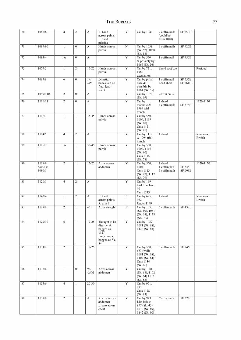
THE BURIALS 77
70 1085/6 4 2 A R. hand
across pelvis,
L. hand
missing
Y Cut by 1040 2 coffin nails
(could be
from 1040)
SF 350B
71 1089/90 1 0 A Hands across
pelvis
N Cut by 1038
(Sk. 57), 1068
(Sk. 58)
6 coffin nails SF 420B
72 1093/4 1A 0 A Y Cut by 550
& possibly by
1066 (Sk. 56)
1 coffin nail SF 450B
73 1074/5 1 2 17-25 Hands across
pelvis
Y Cut by 721,
1988
excavation
Sherd roof tile Residual
74 1087/8 6 0 1+/
-4M
Disartic.
bones laid on
frag. lead
sheet
Y Cut by pillar
base &
possibly by
1064 (Sk. 55)
1 coffin nail
Lead sheet
SF 555B
SF 361B
75 1099/1100 2 0 A Y Cut by 1070
(Sk. 69)
Coffin nails
76 1110/11 2 0 A Y Cut by
manhole &
1994 trial
trench
1 sherd
4 coffin nails
SF 578B
1120-1170
77 1112/3 1 1 35-45 Hands across
pelvis
Y Cut by 550,
1004, 1119
(Sk. 80)
Cuts 1121
(Sk. 81)
78 1114/5 4 2 A Y Cut by 1117
& 1994 trial
trench
1 sherd Romano-
British
79 1116/7 1A 1 33-45 Hands across
pelvis
Y Cut by 550,
1004, 1119
(Sk. 80)
Cuts 1115
(Sk. 78)
80 1118/9
Same as
1090/1
2 1 17-25 Arms across
abdomen
Y Cut by 550,
1004
Cuts 1113
(Sk. 77), 1117
(Sk. 79)
1 sherd
1 coffin nail
3 coffin nails
SF 548B
SF 609B
1120-1170
81 1120/1 4 2 A Y Cut by 1994
trial trench &
971
Cuts 1243
82 1143/4 1 2 A L. hand
across pelvis
R. arm ?
N Cut by 695,
932
Under 1149
1 sherd Romano-
British
83 1127/8 2 1 45+ Arms straight N Cut by 1053
(Sk. 60), 1081
(Sk. 68), 1138
(SK. 83)
5 coffin nails SF 438B
84 1129/30 6 1 17-25 Thought to be
disartic. &
bagged as
1127
Long bones
bagged as Sk.
84
Y Cut by 1052,
1081 (Sk. 68),
1128 (Sk. 83)
85 1131/2 2 1 17-25 Y Cut by 550,
663 (wall)
1081 (Sk. 68),
1102 (Sk. 64)
Cuts 1134
(Sk. 86)
3 coffin nails SF 246B
86 1133/4 1 0 9+/
-24M
Arms across
abdomen
Y Cut by 1081
(Sk. 68), 1102
(Sk. 64) 1132
(Sk. 85)
87 1135/6 4 1 20-30 Y Cut by 971,
973
Cuts 1128
(Sk. 83)
88 1137/8 2 1 A R. arm across
abdomen
L. arm across
chest
Y Cut by 973
Lies below
977 (Sk. 43),
1070 (Sk. 69),
1142 (Sk. 90)
Coffin nails SF 377B
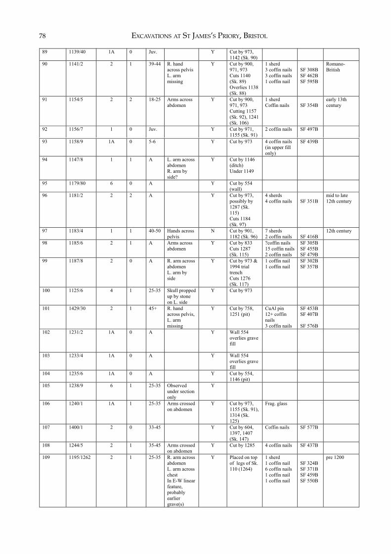
EXCAVATIONS AT ST JAMES’S PRIORY, BRISTOL78( )
89 1139/40 1A 0 Juv. Y Cut by 973,
1142 (Sk. 90)
90 1141/2 2 1 39-44 R. hand
across pelvis
L. arm
missing
Y Cut by 900,
971, 973
Cuts 1140
(Sk. 89)
Overlies 1138
(Sk. 88)
1 sherd
3 coffin nails
3 coffin nails
1 coffin nail
SF 308B
SF 462B
SF 595B
Romano-
British
91 1154/5 2 2 18-25 Arms across
abdomen
Y Cut by 900,
971, 973
Cutting 1157
(Sk. 92), 1241
(Sk. 106)
1 sherd
Coffin nails
SF 354B
early 13th
century
92 1156/7 1 0 Juv. Y Cut by 971,
1155 (Sk. 91)
2 coffin nails SF 497B
93 1158/9 1A 0 5-6 Y Cut by 973 4 coffin nails
(in upper fill
only)
SF 439B
94 1147/8 1 1 A L. arm across
abdomen
R. arm by
side?
Y Cut by 1146
(ditch)
Under 1149
95 1179/80 6 0 A Y Cut by 554
(wall)
96 1181/2 2 2 A Y Cut by 973,
possibly by
1287 (Sk.
115)
Cuts 1184
(Sk. 97)
4 sherds
4 coffin nails
SF 351B
mid to late
12th century
97 1183/4 1 1 40-50 Hands across
pelvis
N Cut by 901,
1182 (Sk. 96)
7 sherds
2 coffin nails
SF 416B
12th century
98 1185/6 2 1 A Arms across
abdomen
Y Cut by 833
Cuts 1287
(Sk. 115)
?coffin nails
15 coffin nails
2 coffin nails
SF 305B
SF 455B
SF 479B
99 1187/8 2 0 A R. arm across
abdomen
L. arm by
side
Y Cut by 973 &
1994 trial
trench
Cuts 1276
(Sk. 117)
1 coffin nail
1 coffin nail
SF 302B
SF 357B
100 1125/6 4 1 25-35 Skull propped
up by stone
on L. side
Y Cut by 973
101 1429/30 2 1 45+ R. hand
across pelvis,
L. arm
missing
Y Cut by 758,
1251 (pit)
CuAl pin
12+ coffin
nails
3 coffin nails
SF 453B
SF 407B
SF 576B
102 1231/2 1A 0 A Y Wall 554
overlies grave
fill
103 1233/4 1A 0 A Y Wall 554
overlies grave
fill
104 1235/6 1A 0 A Y Cut by 554,
1146 (pit)
105 1238/9 6 1 25-35 Observed
under section
only
Y
106 1240/1 1A 1 25-35 Arms crossed
on abdomen
Y Cut by 973,
1155 (Sk. 91),
1314 (Sk.
125)
Frag. glass
107 1400/1 2 0 33-45 Y Cut by 604,
1397, 1407
(Sk. 147)
Coffin nails SF 577B
108 1244/5 2 1 35-45 Arms crossed
on abdomen
Y Cut by 1285 4 coffin nails SF 437B
109 1195/1262 2 1 25-35 R. arm across
abdomen
L. arm across
chest
In E-W linear
feature,
probably
earlier
grave(s)
Y Placed on top
of legs of Sk.
110 (1264)
1 sherd
1 coffin nail
6 coffin nails
1 coffin nail
1 coffin nail
SF 324B
SF 371B
SF 459B
SF 550B
pre 1200
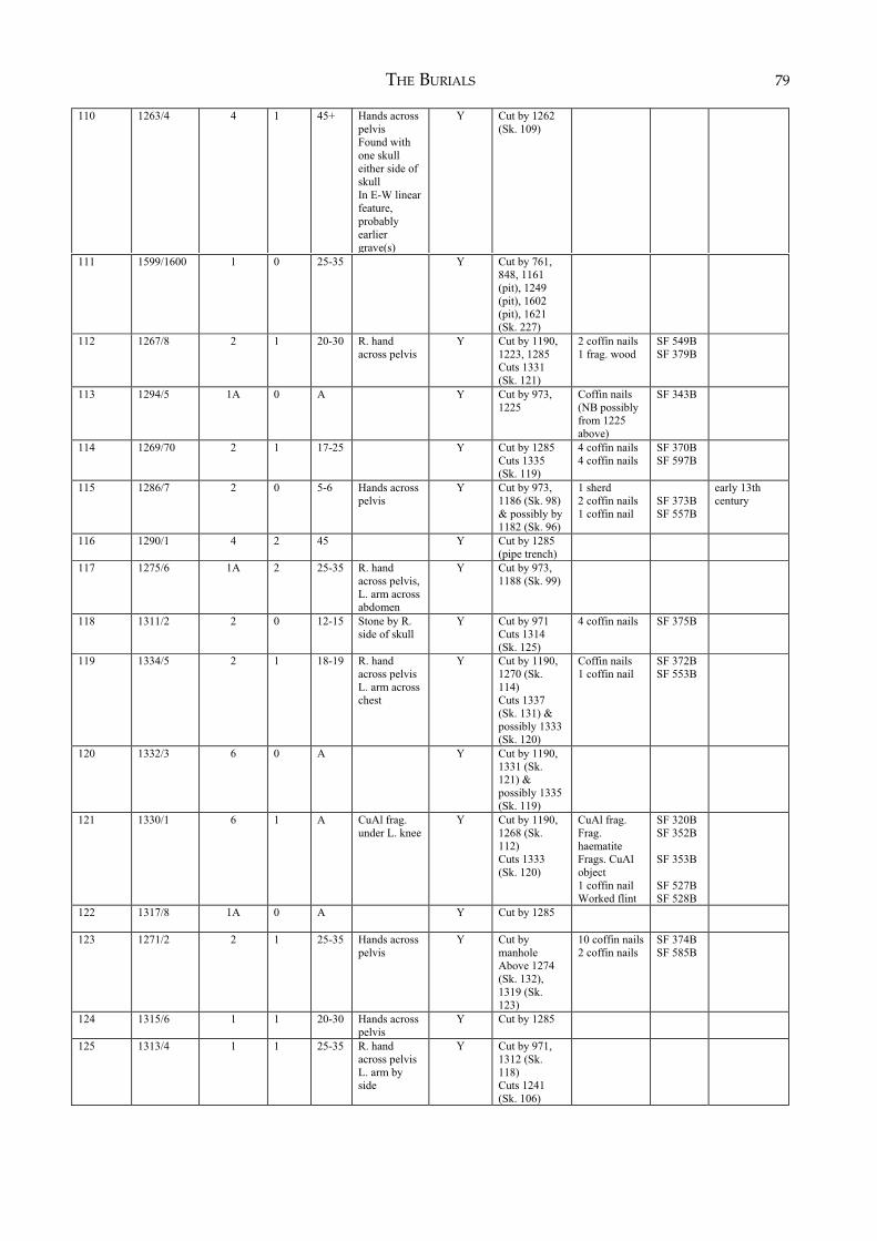
THE BURIALS 79
110 1263/4 4 1 45+ Hands across
pelvis
Found with
one skull
either side of
skull
In E-W linear
feature,
probably
earlier
grave(s)
Y Cut by 1262
(Sk. 109)
111 1599/1600 1 0 25-35 Y Cut by 761,
848, 1161
(pit), 1249
(pit), 1602
(pit), 1621
(Sk. 227)
112 1267/8 2 1 20-30 R. hand
across pelvis
Y Cut by 1190,
1223, 1285
Cuts 1331
(Sk. 121)
2 coffin nails
1 frag. wood
SF 549B
SF 379B
113 1294/5 1A 0 A Y Cut by 973,
1225
Coffin nails
(NB possibly
from 1225
above)
SF 343B
114 1269/70 2 1 17-25 Y Cut by 1285
Cuts 1335
(Sk. 119)
4 coffin nails
4 coffin nails
SF 370B
SF 597B
115 1286/7 2 0 5-6 Hands across
pelvis
Y Cut by 973,
1186 (Sk. 98)
& possibly by
1182 (Sk. 96)
1 sherd
2 coffin nails
1 coffin nail
SF 373B
SF 557B
early 13th
century
116 1290/1 4 2 45 Y Cut by 1285
(pipe trench)
117 1275/6 1A 2 25-35 R. hand
across pelvis,
L. arm across
abdomen
Y Cut by 973,
1188 (Sk. 99)
118 1311/2 2 0 12-15 Stone by R.
side of skull
Y Cut by 971
Cuts 1314
(Sk. 125)
4 coffin nails SF 375B
119 1334/5 2 1 18-19 R. hand
across pelvis
L. arm across
chest
Y Cut by 1190,
1270 (Sk.
114)
Cuts 1337
(Sk. 131) &
possibly 1333
(Sk. 120)
Coffin nails
1 coffin nail
SF 372B
SF 553B
120 1332/3 6 0 A Y Cut by 1190,
1331 (Sk.
121) &
possibly 1335
(Sk. 119)
121 1330/1 6 1 A CuAl frag.
under L. knee
Y Cut by 1190,
1268 (Sk.
112)
Cuts 1333
(Sk. 120)
CuAl frag.
Frag.
haematite
Frags. CuAl
object
1 coffin nail
Worked flint
SF 320B
SF 352B
SF 353B
SF 527B
SF 528B
122 1317/8 1A 0 A Y Cut by 1285
123 1271/2 2 1 25-35 Hands across
pelvis
Y Cut by
manhole
Above 1274
(Sk. 132),
1319 (Sk.
123)
10 coffin nails
2 coffin nails
SF 374B
SF 585B
124 1315/6 1 1 20-30 Hands across
pelvis
Y Cut by 1285
125 1313/4 1 1 25-35 R. hand
across pelvis
L. arm by
side
Y Cut by 971,
1312 (Sk.
118)
Cuts 1241
(Sk. 106)
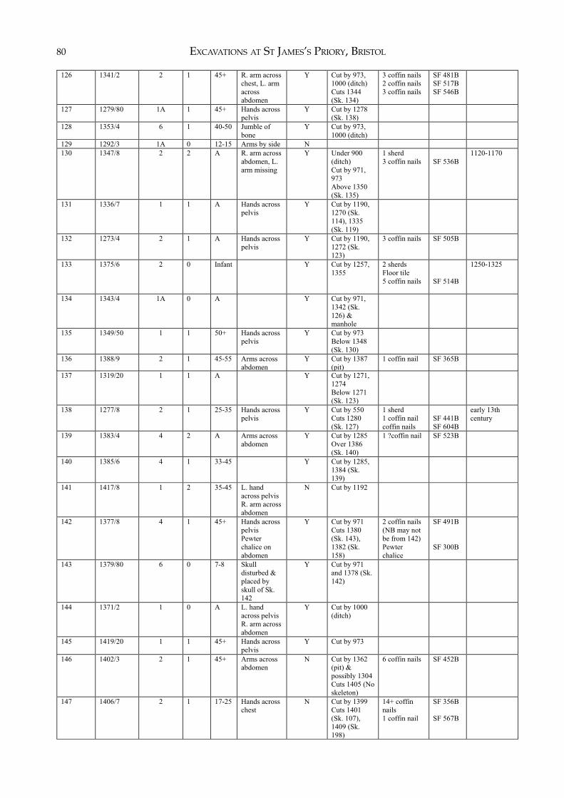
EXCAVATIONS AT ST JAMES’S PRIORY, BRISTOL80
126 1341/2 2 1 45+ R. arm across
chest, L. arm
across
abdomen
Y Cut by 973,
1000 (ditch)
Cuts 1344
(Sk. 134)
3 coffin nails
2 coffin nails
3 coffin nails
SF 481B
SF 517B
SF 546B
127 1279/80 1A 1 45+ Hands across
pelvis
Y Cut by 1278
(Sk. 138)
128 1353/4 6 1 40-50 Jumble of
bone
Y Cut by 973,
1000 (ditch)
129 1292/3 1A 0 12-15 Arms by side N
130 1347/8 2 2 A R. arm across
abdomen, L.
arm missing
Y Under 900
(ditch)
Cut by 971,
973
Above 1350
(Sk. 135)
1 sherd
3 coffin nails
SF 536B
1120-1170
131 1336/7 1 1 A Hands across
pelvis
Y Cut by 1190,
1270 (Sk.
114), 1335
(Sk. 119)
132 1273/4 2 1 A Hands across
pelvis
Y Cut by 1190,
1272 (Sk.
123)
3 coffin nails SF 505B
133 1375/6 2 0 Infant Y Cut by 1257,
1355
2 sherds
Floor tile
5 coffin nails
SF 514B
1250-1325
134 1343/4 1A 0 A Y Cut by 971,
1342 (Sk.
126) &
manhole
135 1349/50 1 1 50+ Hands across
pelvis
Y Cut by 973
Below 1348
(Sk. 130)
136 1388/9 2 1 45-55 Arms across
abdomen
Y Cut by 1387
(pit)
1 coffin nail
SF 365B
137 1319/20 1 1 A Y Cut by 1271,
1274
Below 1271
(Sk. 123)
138 1277/8 2 1 25-35 Hands across
pelvis
Y Cut by 550
Cuts 1280
(Sk. 127)
1 sherd
1 coffin nail
coffin nails
SF 441B
SF 604B
early 13th
century
139 1383/4 4 2 A Arms across
abdomen
Y Cut by 1285
Over 1386
(Sk. 140)
1 ?coffin nail SF 523B
140 1385/6 4 1 33-45 Y Cut by 1285,
1384 (Sk.
139)
141 1417/8 1 2 35-45 L. hand
across pelvis
R. arm across
abdomen
N Cut by 1192
142 1377/8 4 1 45+ Hands across
pelvis
Pewter
chalice on
abdomen
Y Cut by 971
Cuts 1380
(Sk. 143),
1382 (Sk.
158)
2 coffin nails
(NB may not
be from 142)
Pewter
chalice
SF 491B
SF 300B
143 1379/80 6 0 7-8 Skull
disturbed &
placed by
skull of Sk.
142
Y Cut by 971
and 1378 (Sk.
142)
144 1371/2 1 0 A L. hand
across pelvis
R. arm across
abdomen
Y Cut by 1000
(ditch)
145 1419/20 1 1 45+ Hands across
pelvis
Y Cut by 973
146 1402/3 2 1 45+ Arms across
abdomen
N Cut by 1362
(pit) &
possibly 1304
Cuts 1405 (No
skeleton)
6 coffin nails SF 452B
147 1406/7 2 1 17-25 Hands across
chest
N Cut by 1399
Cuts 1401
(Sk. 107),
1409 (Sk.
198)
14+ coffin
nails
1 coffin nail
SF 356B
SF 567B
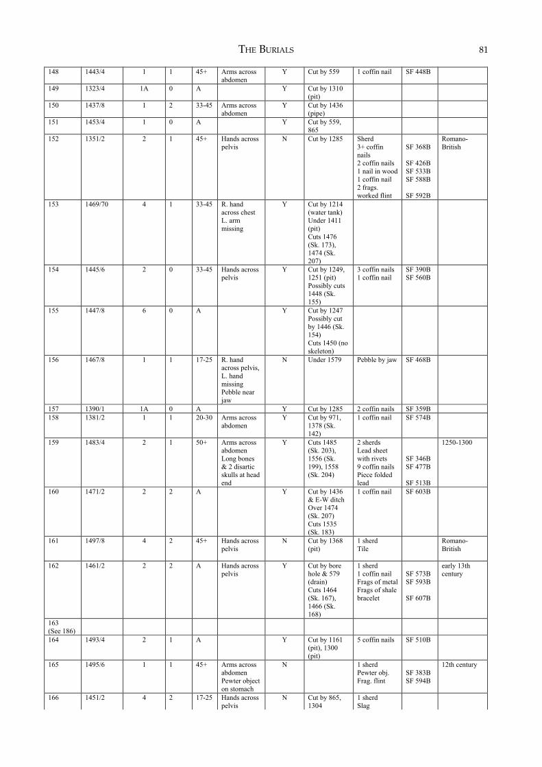
THE BURIALS 81)
148 1443/4 1 1 45+ Arms across
abdomen
Y Cut by 559 1 coffin nail SF 448B
149 1323/4 1A 0 A Y Cut by 1310
(pit)
150 1437/8 1 2 33-45 Arms across
abdomen
Y Cut by 1436
(pipe)
151 1453/4 1 0 A Y Cut by 559,
865
152 1351/2 2 1 45+ Hands across
pelvis
N Cut by 1285 Sherd
3+ coffin
nails
2 coffin nails
1 nail in wood
1 coffin nail
2 frags.
worked flint
SF 368B
SF 426B
SF 533B
SF 588B
SF 592B
Romano-
British
153 1469/70 4 1 33-45 R. hand
across chest
L. arm
missing
Y Cut by 1214
(water tank)
Under 1411
(pit)
Cuts 1476
(Sk. 173),
1474 (Sk.
207)
154 1445/6 2 0 33-45 Hands across
pelvis
Y Cut by 1249,
1251 (pit)
Possibly cuts
1448 (Sk.
155)
3 coffin nails
1 coffin nail
SF 390B
SF 560B
155 1447/8 6 0 A Y Cut by 1247
Possibly cut
by 1446 (Sk.
154)
Cuts 1450 (no
skeleton)
156 1467/8 1 1 17-25 R. hand
across pelvis,
L. hand
missing
Pebble near
jaw
N Under 1579 Pebble by jaw SF 468B
157 1390/1 1A 0 A Y Cut by 1285 2 coffin nails SF 359B
158 1381/2 1 1 20-30 Arms across
abdomen
Y Cut by 971,
1378 (Sk.
142)
1 coffin nail SF 574B
159 1483/4 2 1 50+ Arms across
abdomen
Long bones
& 2 disartic
skulls at head
end
Y Cuts 1485
(Sk. 203),
1556 (Sk.
199), 1558
(Sk. 204)
2 sherds
Lead sheet
with rivets
9 coffin nails
Piece folded
lead
SF 346B
SF 477B
SF 513B
1250-1300
160 1471/2 2 2 A Y Cut by 1436
& E-W ditch
Over 1474
(Sk. 207)
Cuts 1535
(Sk. 183)
1 coffin nail SF 603B
161 1497/8 4 2 45+ Hands across
pelvis
N Cut by 1368
(pit)
1 sherd
Tile
Romano-
British
162 1461/2 2 2 A Hands across
pelvis
Y Cut by bore
hole & 579
(drain)
Cuts 1464
(Sk. 167),
1466 (Sk.
168)
1 sherd
1 coffin nail
Frags of metal
Frags of shale
bracelet
SF 573B
SF 593B
SF 607B
early 13th
century
163
(See 186)
164
1493/4 2 1 A Y Cut by 1161
(pit), 1300
(pit)
5 coffin nails SF 510B
165 1495/6 1 1 45+ Arms across
abdomen
Pewter object
on stomach
N 1 sherd
Pewter obj.
Frag. flint
SF 383B
SF 594B
12th century
166 1451/2 4 2 17-25 Hands across
pelvis
N Cut by 865,
1304
1 sherd
Slag
EXCAVATIONS AT ST JAMES’S PRIORY, BRISTOL82p g
167 1463/4 4 1 A L. hand
across pelvis,
R. hand by
side
Y Cut by 1462
(Sk. 162) &
possibly by
bore-hole
1 sherd
Glass frag.
SF 562B
12th century
168 1465/6 1 1 30-40 L. hand
across pelvis,
R. arm across
abdomen
Strange stone
in pelvis area
N Cut by 579
(drain), 1462
(Sk. 162)
3 coffin nails
SF 447B
169 1455/6 1 0 A Arms by side Y Cut by 556,
1251, 1458
(Sk. 170)
170 1457/8 2 1 45+ R. arm across
abdomen
L. arm
missing
Y Cut by 556
Cuts 1456
(Sk. 169)
9 coffin nails SF 524B
171 1504/5 2 1 17-25 Arms across
abdomen
Y Cuts 1486
(Sk. 203),
1508 (Sk.
177), 1511
(Sk. 184)
Folded lead
7 coffin nails
1 coffin nail
SF 551B
SF 552B
SF 602B
172 1506/7 2 2 17-25 R. arm across
abdomen
L. arm
missing
Y Cut by 1205
(drain)
Cuts 1511
(Sk. 184),
1525 (Sk.
185)
1 coffin nail
Frag. wood
SF 363B
SF 364B
173 1475/6 2 0 2'-6 Y Cut by 1470
(Sk. 153)
3 coffin nails
4 coffin nails
SF 508B
SF 530B
174 1516/7 2 2 15-25 Y Cut by 1212?
May cut 1519
(Sk. 190)
6 coffin nails
1 coffin nail
SF 400B
SF 556B
175 1512/3 2 0 6-9M N Cuts 1521
(Sk. 195)
1 coffin nails
2 coffin nail
SF 449B
SF 569B
176 1459/60 1 2 17-25 N Cut by 1304,
1360 (pit)
177 1508/9 3 1 45+ Hands across
pelvis
N Cut by 1505
(Sk. 171),
1511 (Sk.
184)
178 1489/90 1 1 17-25 Hands across
pelvis
Tightly
bound
skeleton
N
179 1522/3 2 1 17-25 R. hand
across pelvis
L. arm across
abdomen
Y Cut by 1207
(drain)
Cuts 1525
(Sk. 185),
1610 (Sk.
224)
Roof tiles
4 coffin nails
SF 476B
180 1514/5 2 1 A Y Cut by 1424
(ditch)
Cuts 1529
(Sk. 182),
1541 (Sk.
192)?
5 coffin nails
1 coffin nail
1 ?coffin nail
(Combines
Sk. 18coffin
nails)
SF 496B
SF 522B
SF 561B
181 1530/1 2 1 50+ L. hand
across pelvis
R. arm
missing
Y Cuts 1533
(Sk. 194)
1 sherd
10+ coffin
nails
SF 587B
early 13th
century
182 1528/9 2 2 25-35 Arms across
abdomen
N Cut by 1000
(ditch), 1515
(Sk. 180)
Cuts 1546
(Sk. 193)
15+ coffin
nails
1 coffin nail
2 coffin nails
(Combines
Sk. 180 nails)
SF 509B
SF 512B
SF 532B
183 1534/5 6 0 4-6 Y Cut by 1436,
1472 (Sk.
160)
Cuts 1474
(Sk. 207)
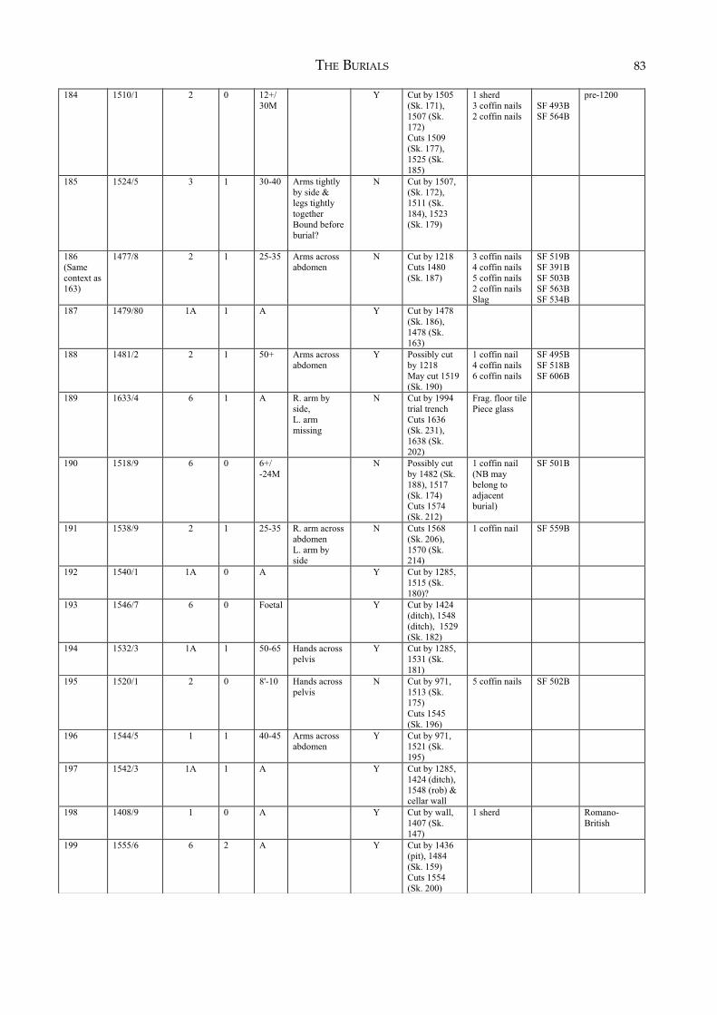
THE BURIALS 83( )
184 1510/1 2 0 12+/
30M
Y Cut by 1505
(Sk. 171),
1507 (Sk.
172)
Cuts 1509
(Sk. 177),
1525 (Sk.
185)
1 sherd
3 coffin nails
2 coffin nails
SF 493B
SF 564B
pre-1200
185 1524/5 3 1 30-40 Arms tightly
by side &
legs tightly
together
Bound before
burial?
N Cut by 1507,
(Sk. 172),
1511 (Sk.
184), 1523
(Sk. 179)
186
(Same
context as
163)
1477/8 2 1 25-35 Arms across
abdomen
N Cut by 1218
Cuts 1480
(Sk. 187)
3 coffin nails
4 coffin nails
5 coffin nails
2 coffin nails
Slag
SF 519B
SF 391B
SF 503B
SF 563B
SF 534B
187 1479/80 1A 1 A Y Cut by 1478
(Sk. 186),
1478 (Sk.
163)
188 1481/2 2 1 50+ Arms across
abdomen
Y Possibly cut
by 1218
May cut 1519
(Sk. 190)
1 coffin nail
4 coffin nails
6 coffin nails
SF 495B
SF 518B
SF 606B
189 1633/4 6 1 A R. arm by
side,
L. arm
missing
N Cut by 1994
trial trench
Cuts 1636
(Sk. 231),
1638 (Sk.
202)
Frag. floor tile
Piece glass
190 1518/9 6 0 6+/
-24M
N Possibly cut
by 1482 (Sk.
188), 1517
(Sk. 174)
Cuts 1574
(Sk. 212)
1 coffin nail
(NB may
belong to
adjacent
burial)
SF 501B
191 1538/9 2 1 25-35 R. arm across
abdomen
L. arm by
side
N Cuts 1568
(Sk. 206),
1570 (Sk.
214)
1 coffin nail SF 559B
192 1540/1 1A 0 A Y Cut by 1285,
1515 (Sk.
180)?
193 1546/7 6 0 Foetal Y Cut by 1424
(ditch), 1548
(ditch), 1529
(Sk. 182)
194 1532/3 1A 1 50-65 Hands across
pelvis
Y Cut by 1285,
1531 (Sk.
181)
195 1520/1 2 0 8'-10 Hands across
pelvis
N Cut by 971,
1513 (Sk.
175)
Cuts 1545
(Sk. 196)
5 coffin nails SF 502B
196 1544/5 1 1 40-45 Arms across
abdomen
Y Cut by 971,
1521 (Sk.
195)
197 1542/3 1A 1 A Y Cut by 1285,
1424 (ditch),
1548 (rob) &
cellar wall
198 1408/9 1 0 A Y Cut by wall,
1407 (Sk.
147)
1 sherd
Romano-
British
199 1555/6 6 2 A Y Cut by 1436
(pit), 1484
(Sk. 159)
Cuts 1554
(Sk. 200)
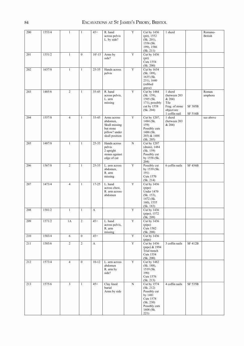
EXCAVATIONS AT ST JAMES’S PRIORY, BRISTOL84
200 1553/4 1 1 45+ R. hand
across pelvis
L. by side?
Y Cut by 1436
(pit), 1552
(Sk. 201),
1556 (Sk.
199), 1586
(Sk. 211)
1 sherd Romano-
British
201 1551/2 1 0 10'-15 Arms by
side?
Y Cut by 1436
(pit)
Cuts 1554
(Sk. 200)
202 1637/8 1 1 25-35 Hands across
pelvis
Y Cut by 1634
(Sk. 189),
1635 (Sk.
231), 1640
(robbed
grave)
203 1485/6 2 1 35-45 R. hand
across pelvis,
L. arm
missing
Y Cut by 1484
(Sk. 159),
1505 (Sk.
171), possibly
cut by 1558
(Sk. 204)
1 sherd
(between 203
& 204)
Tile
Frag. of stone
object/ore
1 coffin nail
SF 385B
SF 516B
Roman
amphora
204 1557/8 4 1 33-45 Arms across
abdomen,
Skull missing
but stone
pillow? under
skull position
Y Cut by 1207,
1484 (Sk.
159)
Possibly cuts
1486 (Sk.
203) & 1488
(Sk. 205)
1 sherd
(between 203
& 204)
see above
205 1487/8 1 1 25-35 Hands across
pelvis
2 upright
stones against
edge of cut
N Cut by 1207
(drain), 1484
(Sk. 159)
Possibly cut
by 1558 (Sk.
204)
206 1567/8 2 1 25-35 L. arm across
abdomen,
R. arm
missing
Y Possibly cut
by 1539 (Sk.
191)
Cuts 1570
(Sk. 214)
6 coffin nails SF 456B
207 1473/4 4 1 17-25 L. hand
across chest,
R. arm across
abdomen
Y Cut by 1436
(pipe)
Under 1470
(Sk. 153),
1472 (Sk.
160), 1535
(Sk. 183)
208 1581/2 1 1 A Y Cut by 1436
(pipe), 1572
(Sk. 209)
209 1571/2 1A 2 45+ L. hand
across pelvis,
R. arm
missing
Y Cut by 1436
(pipe)
Cuts 1582
(Sk. 208)
210 1583/4 6 0 45+ Y Cut by 1436
(pipe)
211 1585/6 2 2 A Y Cut by 1436
(pipe) & 1994
Trial trench
Cuts 1554
(Sk. 200)
3 coffin nails SF 412B
212 1573/4 4 0 10-12 L. arm across
abdomen
R. arm by
side?
Y Cut by 1482
(Sk. 188),
1519 (Sk.
190)
Cuts 1576
(Sk. 213)
213 1575/6 3 1 45+ Clay lined
burial
Arms by side
N Cut by 1574
(Sk. 212)
Possibly cut
by 1481
Cuts 1578
(Sk. 230)
Possibly cuts
1608 (Sk.
221)
4 coffin nails SF 535B
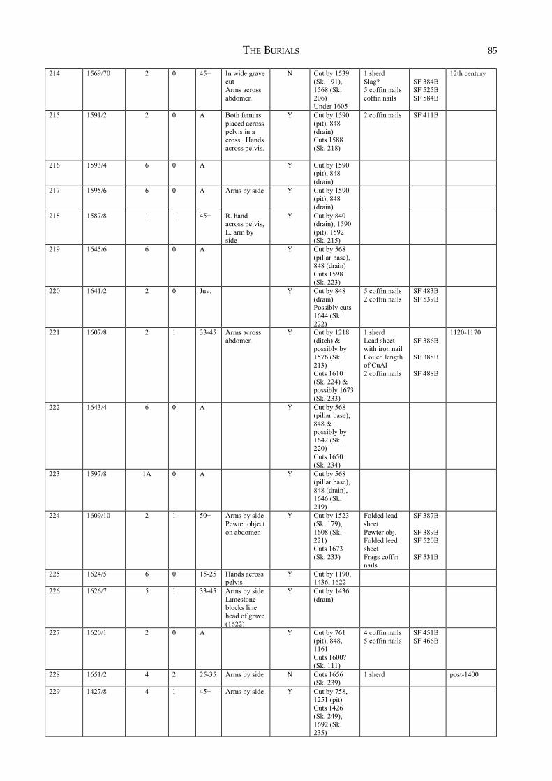
THE BURIALS 85
214 1569/70 2 0 45+ In wide grave
cut
Arms across
abdomen
N Cut by 1539
(Sk. 191),
1568 (Sk.
206)
Under 1605
1 sherd
Slag?
5 coffin nails
coffin nails
SF 384B
SF 525B
SF 584B
12th century
215 1591/2 2 0 A Both femurs
placed across
pelvis in a
cross. Hands
across pelvis.
Y Cut by 1590
(pit), 848
(drain)
Cuts 1588
(Sk. 218)
2 coffin nails SF 411B
216 1593/4 6 0 A Y Cut by 1590
(pit), 848
(drain)
217 1595/6 6 0 A Arms by side Y Cut by 1590
(pit), 848
(drain)
218 1587/8 1 1 45+ R. hand
across pelvis,
L. arm by
side
Y Cut by 840
(drain), 1590
(pit), 1592
(Sk. 215)
219 1645/6 6 0 A Y Cut by 568
(pillar base),
848 (drain)
Cuts 1598
(Sk. 223)
220
1641/2 2 0 Juv. Y Cut by 848
(drain)
Possibly cuts
1644 (Sk.
222)
5 coffin nails
2 coffin nails
SF 483B
SF 539B
221
1607/8 2 1 33-45 Arms across
abdomen
Y Cut by 1218
(ditch) &
possibly by
1576 (Sk.
213)
Cuts 1610
(Sk. 224) &
possibly 1673
(Sk. 233)
1 sherd
Lead sheet
with iron nail
Coiled length
of CuAl
2 coffin nails
SF 386B
SF 388B
SF 488B
1120-1170
222 1643/4 6 0 A Y Cut by 568
(pillar base),
848 &
possibly by
1642 (Sk.
220)
Cuts 1650
(Sk. 234)
223 1597/8 1A 0 A Y Cut by 568
(pillar base),
848 (drain),
1646 (Sk.
219)
224 1609/10 2 1 50+ Arms by side
Pewter object
on abdomen
Y Cut by 1523
(Sk. 179),
1608 (Sk.
221)
Cuts 1673
(Sk. 233)
Folded lead
sheet
Pewter obj.
Folded leed
sheet
Frags coffin
nails
SF 387B
SF 389B
SF 520B
SF 531B
225 1624/5 6 0 15-25 Hands across
pelvis
Y Cut by 1190,
1436, 1622
226 1626/7 5 1 33-45 Arms by side
Limestone
blocks line
head of grave
(1622)
Y Cut by 1436
(drain)
227 1620/1 2 0 A Y Cut by 761
(pit), 848,
1161
Cuts 1600?
(Sk. 111)
4 coffin nails
5 coffin nails
SF 451B
SF 466B
228 1651/2 4 2 25-35 Arms by side N Cuts 1656
(Sk. 239)
1 sherd
post-1400
229 1427/8 4 1 45+ Arms by side Y Cut by 758,
1251 (pit)
Cuts 1426
(Sk. 249),
1692 (Sk.
235)
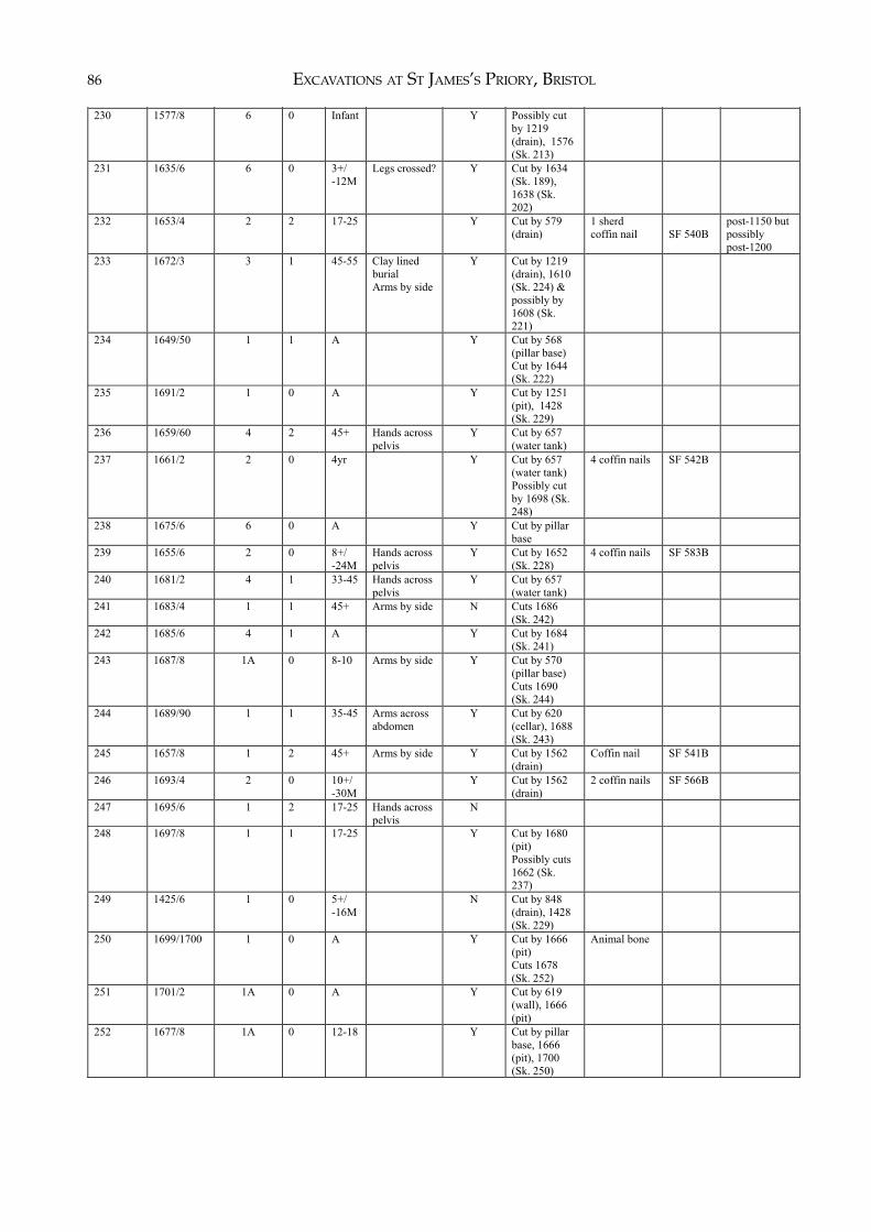
EXCAVATIONS AT ST JAMES’S PRIORY, BRISTOL86)
230 1577/8 6 0 Infant Y Possibly cut
by 1219
(drain), 1576
(Sk. 213)
231
1635/6 6 0 3+/
-12M
Legs crossed? Y Cut by 1634
(Sk. 189),
1638 (Sk.
202)
232 1653/4 2 2 17-25 Y Cut by 579
(drain)
1 sherd
coffin nail
SF 540B
post-1150 but
possibly
post-1200
233 1672/3 3 1 45-55 Clay lined
burial
Arms by side
Y Cut by 1219
(drain), 1610
(Sk. 224) &
possibly by
1608 (Sk.
221)
234 1649/50 1 1 A Y Cut by 568
(pillar base)
Cut by 1644
(Sk. 222)
235 1691/2 1 0 A Y Cut by 1251
(pit), 1428
(Sk. 229)
236 1659/60 4 2 45+ Hands across
pelvis
Y Cut by 657
(water tank)
237 1661/2 2 0 4yr Y Cut by 657
(water tank)
Possibly cut
by 1698 (Sk.
248)
4 coffin nails SF 542B
238 1675/6 6 0 A Y Cut by pillar
base
239 1655/6 2 0 8+/
-24M
Hands across
pelvis
Y Cut by 1652
(Sk. 228)
4 coffin nails SF 583B
240 1681/2 4 1 33-45 Hands across
pelvis
Y Cut by 657
(water tank)
241 1683/4 1 1 45+ Arms by side N Cuts 1686
(Sk. 242)
242 1685/6 4 1 A Y Cut by 1684
(Sk. 241)
243 1687/8 1A 0 8-10 Arms by side Y Cut by 570
(pillar base)
Cuts 1690
(Sk. 244)
244 1689/90 1 1 35-45 Arms across
abdomen
Y Cut by 620
(cellar), 1688
(Sk. 243)
245 1657/8 1 2 45+ Arms by side Y Cut by 1562
(drain)
Coffin nail SF 541B
246 1693/4 2 0 10+/
-30M
Y Cut by 1562
(drain)
2 coffin nails SF 566B
247 1695/6 1 2 17-25 Hands across
pelvis
N
248 1697/8 1 1 17-25 Y Cut by 1680
(pit)
Possibly cuts
1662 (Sk.
237)
249 1425/6 1 0 5+/
-16M
N Cut by 848
(drain), 1428
(Sk. 229)
250 1699/1700 1 0 A Y Cut by 1666
(pit)
Cuts 1678
(Sk. 252)
Animal bone
251 1701/2 1A 0 A Y Cut by 619
(wall), 1666
(pit)
252 1677/8 1A 0 12-18 Y Cut by pillar
base, 1666
(pit), 1700
(Sk. 250)
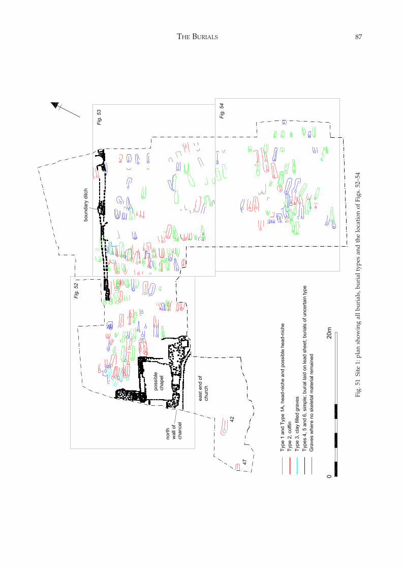
THE BURIALS 87
Fig.
51
Site
1: p
lan
show
ing
all b
uria
ls, b
uria
l typ
es a
nd t
he lo
cati
on o
f Fi
gs. 5
2–54
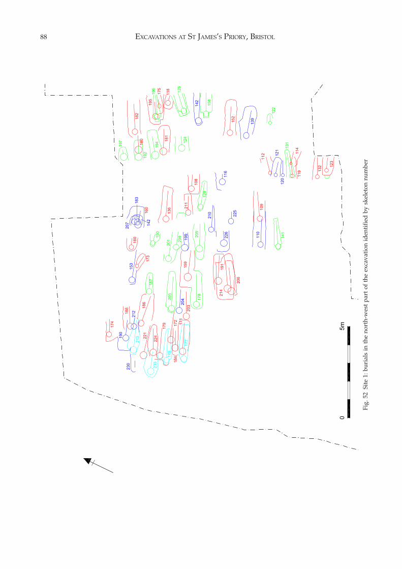
EXCAVATIONS AT ST JAMES’S PRIORY, BRISTOL88
Fig.
52
Site
1: b
uria
ls in
the
nor
th-w
est
part
of
the
exca
vati
on id
enti
fied
by
skel
eton
num
ber
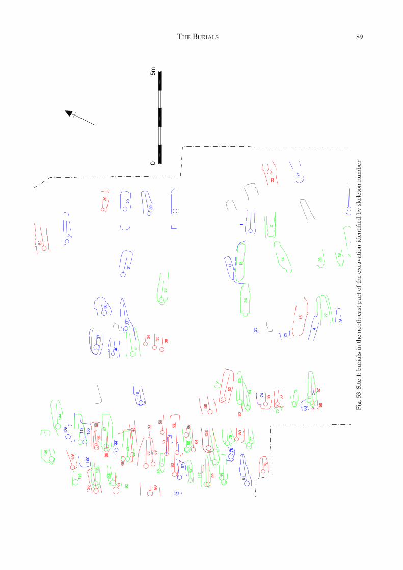
THE BURIALS 89
Fig.
53
Site
1: b
uria
ls in
the
nor
th-e
ast
part
of
the
exca
vati
on id
enti
fied
by
skel
eton
num
ber
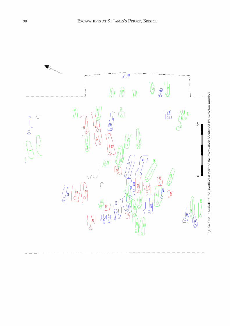
EXCAVATIONS AT ST JAMES’S PRIORY, BRISTOL90
Fig.
54
Site
1: b
uria
ls in
the
sou
th-e
ast
part
of
the
exca
vati
on id
enti
fied
by
skel
eton
num
ber
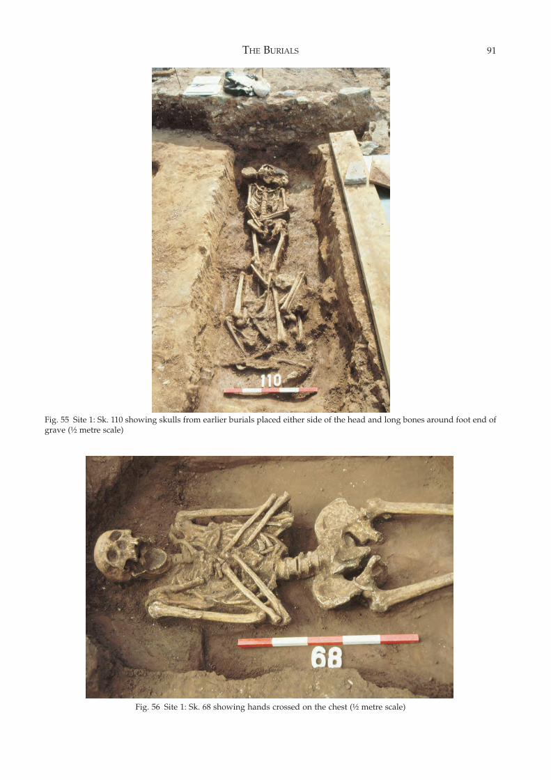
THE BURIALS 91
Fig. 55 Site 1: Sk. 110 showing skulls from earlier burials placed either side of the head and long bones around foot end ofgrave (½ metre scale)
Fig. 56 Site 1: Sk. 68 showing hands crossed on the chest (½ metre scale)
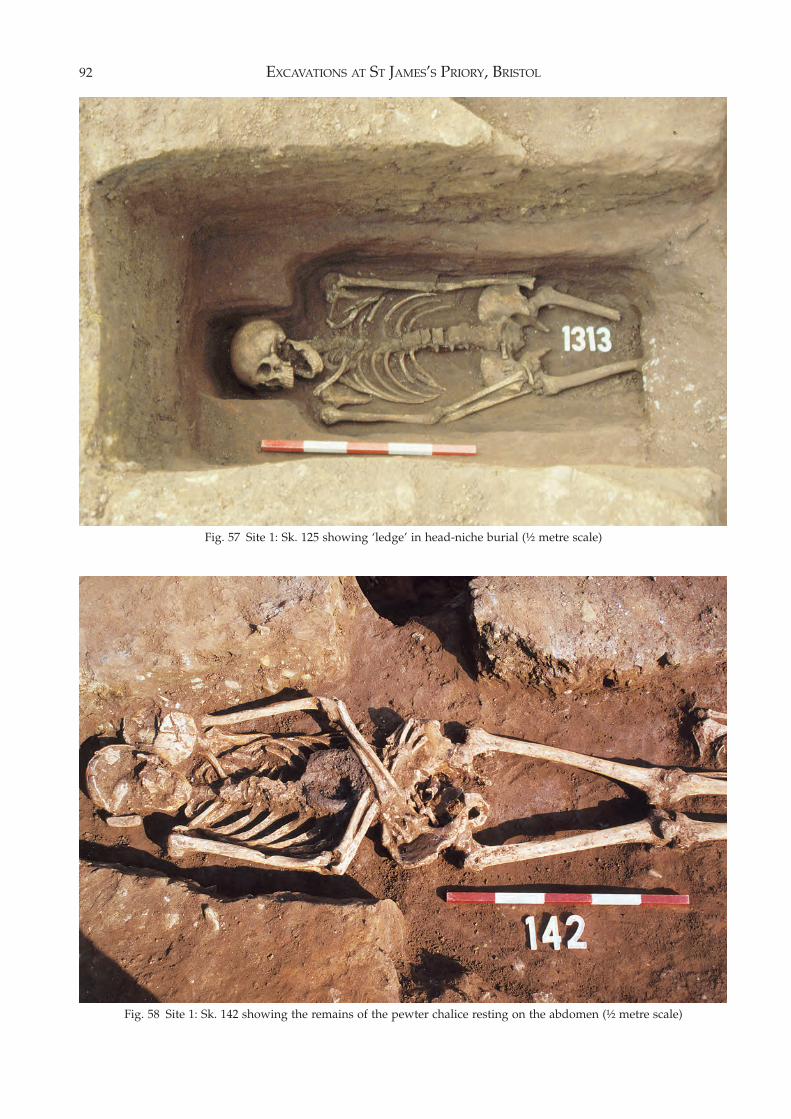
EXCAVATIONS AT ST JAMES’S PRIORY, BRISTOL92
Fig. 58 Site 1: Sk. 142 showing the remains of the pewter chalice resting on the abdomen (½ metre scale)
Fig. 57 Site 1: Sk. 125 showing ‘ledge’ in head-niche burial (½ metre scale)
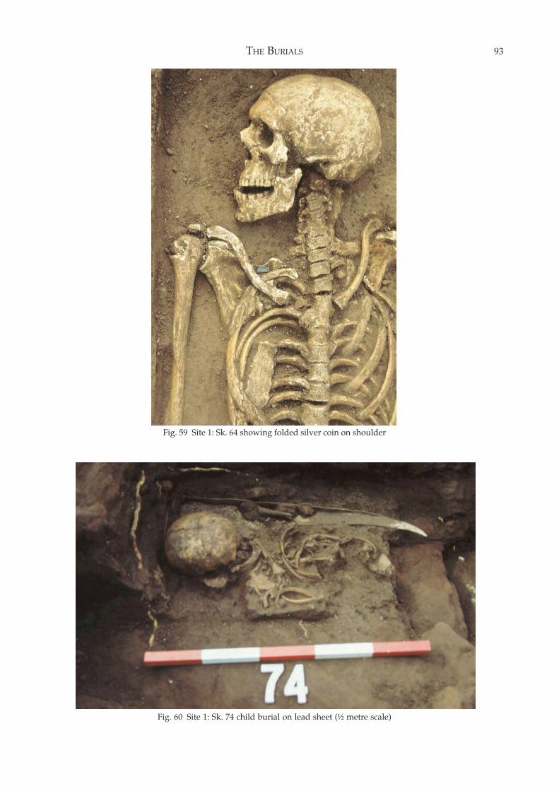
THE BURIALS 93
Fig. 59 Site 1: Sk. 64 showing folded silver coin on shoulder
Fig. 60 Site 1: Sk. 74 child burial on lead sheet (½ metre scale)
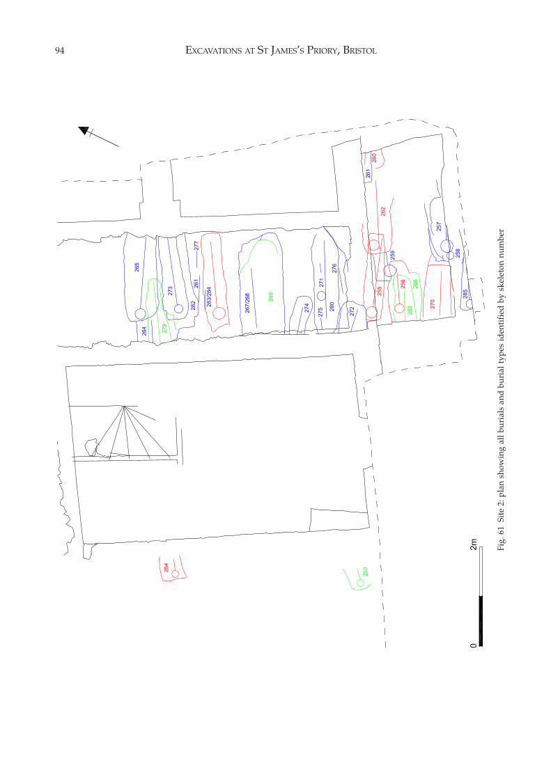
EXCAVATIONS AT ST JAMES’S PRIORY, BRISTOL94
Fig.
61
Site
2: p
lan
show
ing
all b
uria
ls a
nd b
uria
l typ
es id
enti
fied
by
skel
eton
num
ber
THE BURIALS 95
Burial PracticeA total of 244 skeletons form the basis of the followinganalyses and a detailed breakdown of their state ofpreservation, their stratigraphical relationship to eachother, the finds from within their grave fills, thepossible date of burial and the age and sex of theindividual are given in Table 1. Most skeletons werenot intact, subsequent burials and later disturbanceshaving removed parts of the skeletons to varyingdegrees; in some cases only fragments of the skeletonremained, in others the majority of the skeletonsurvived with perhaps only the skull, feet or an armmissing. Thus any grouping by burial type or positioncannot be precise and this must be taken into accountwhen considering the following statistics.
Cemetery Layout, Burial Alignments and GeneralComments (Figs. 51 to 54, pages 87 to 90)All the burials were facing east and were roughlyaligned east/west. The majority of the graves followedthe main axis of the priory church, rather than a trueeast/west orientation. However, some were skewedmarkedly to the general alignment, almost certainlydue to careless digging of the graves rather than forany practical or religious reason.
The relative shallowness of the graves may seemsurprising, some lying almost immediately below thepresent ground surface, even taking into account thatthe topsoil overlying the cemetery had obviously beenreduced in level before the development of the areafor housing in the mid 18th century and during theconstruction of the NFU building. However, theminimal depth of early medieval burials generally iswell recorded. Late Saxon graves cut from a ground-surface excavated at the Holy Trinity Priory site inLondon were generally only 0.4m deep, adult burialsin the late Saxon cemetery at Raunds averaged 0.44min depth and graves in the medieval cemetery atWinchester Cathedral were only up to 1m deep (White1988, 26 in note 7).
There was a marked concentration of burials nearthe east end of the priory church, although notimmediately against its east wall, where severalgraves had been dug on a number of occasions onalmost the same spot resulting in the disturbance ofthe earlier burials (Fig. 55, page 91). The heavy use ofthis part of the cemetery is to be expected on religiousgrounds as there was a desire to be buried as close aspossible to the most sacred position within the church,the high altar. The area directly adjacent to the eastend of the church may have been reserved for specialuse. There was a noticeable thinning out in the concen-tration of graves in the eastern portion of the cemeteryand one area, a band running east/west to the northof burials Sk. 11, 18 and 24 where there were no graves,possibly marked the location of a pathway throughthe burial ground.
Within the apparent jumbled mass of graves theexcavation plan of the cemetery appears to show thatthere were a number of north/south rows of burials.The layout of these rows seems to have been generallymaintained throughout the life of the cemetery,although the positions of the graves within themwandered somewhat from the line of each row. Thisorderly layout suggests the use of a plan of the graveplots or some form of grave marker, although noarchaeological trace of the latter was found. It doesseem to show the controlled use of the cemetery overa long period of time.
While a number of different types of burial werepresent in the cemetery, the bodies, with one excep-tion, were interred in a supine position. The onlydifference in the posture of the bodies were thepositions of the arms and hands. The arms and handswere generally either placed crossed on the chest,abdomen or pelvis or laid straight beside the body. Anumber of combinations of these positions wereobserved with one hand on the pelvis, the other on theabdomen, and so on. There seems to be no particularreason for the different placing of the hands althoughan analysis shows that the majority had their handscrossed on their pelvis, followed by those with handscrossed on the abdomen. The sex or type of burialappears to be largely irrelevant to the positioning ofthe hands and arms, except in the case of those bodieswith their hands crossed on their chest, as if in prayer,as they were exclusively male (Fig. 56, page 91).Similar observations concerning the position of thehands and arms of burials was noted at the cemeteryof the Dominican Friary in Chester. There, the majorityhad their arms crossed on the pelvic region and thereappeared to be no particular correspondence betweenposition and date of burial or between position andsex (Ward 1990, 124). At Hull, a small number ofburials in the area of the chancel, who were probablythe priors of the Augustinian Friary, were buried withtheir hands on their chests (Daniell 1997, 118),seemingly confirming the religious and/or statussignificance of such a posture.
There was evidence for the reburial of the bonesfrom earlier burials which had been disturbed by latergraves. The long and other bones had generally beenthrown back haphazardly in the fill of the later gravebut the skulls were treated with some reverence andwere often placed close to and, in one case, on eitherside of the head of the later burial (e.g. Sk. 110; Fig. 55,page 91).
Burial TypesFive distinct burial types were recognised. Each typeand its occurrence within the burial ground is dis-cussed below and listed in Table 1. Those burialswhich had some of the attributes of Type 1 burials butcould not be ascribed to that category with certaintyare given the sub-type 1A. The typology of forty-one
EXCAVATIONS AT ST JAMES’S PRIORY, BRISTOL96
burials could not be identified and these are recordedas an additional Type 6.
Type 1 – Head-niche Burials:This type of grave has an anthropomorphic shape witha cut-out for the head, and from the shoulders a tapertowards the feet, while the foot end is generallyrounded. On the few occasions where a reasonabledepth of grave-cut remained, it was noted that thegrave was rectangular until it reached the naturalsandstone bedrock and it was only at that point that itassumed the head-niche shape (e.g. Sk. 125; Fig. 57,page 92).
Head-niche burials have been recorded during theexcavation of medieval cemeteries elsewhere. Sevenwere noted at Rivenhall where the vogue for this kindof burial was considered to date to the late 12th orearly 13th centuries (Rodwell and Rodwell 1985, 101).Amongst the burials from Lewes Priory, cists withhead-niches were the predominant type during thelate 11th to 14th centuries (Lyne 1997, 74). At WellsCathedral five head-niche graves were found in theAnglo-Saxon cemetery and were considered to havebeen more prestigious than other burials and perhapsassociated with a distinct social class, one of the gravesbeing lined with plaster and covered with a stone slab(Rodwell 2001, 65–68). In Bristol, a head-niche burialwas found during the excavation of the church of St.Augustine the Less where it was sealed by 12th-century church foundations (Boore 1986, 211).
Head-niche burials were generally distributedthroughout the cemetery, although there appear tohave been concentrations in the southern part of thearea excavated and in the north-west portion of thecemetery. This may indicate grouping around the eastends of the Lady Chapel and the priory church.
There were 59 cases of head-niche burials recog-nised which represent 24% of the total burials excav-ated. Of the burials which could be sexed there were27 male (79%) and 7 female (21%) giving a ratio of 4males to 1 female. Of the burials within this categorywhich could be aged there were 57 adults, one juvenileand one child aged 10 to 15 years. The location offemale and child burials show no concentration andwere evenly distributed throughout the cemetery.
Within the general classification of head-nicheburial a number of variations were noted in the modeof burial. Sk. 77, which was of a male aged 35 to 45years, was in a grave cut considerably wider thannormal. Sk. 156 had a pebble (SF 468B) near its jaw.Sk. 178, of a male aged 30 to 40, was lying in a posturesuggesting the body had probably been tightly boundbefore burial. Another burial, Sk. 185, also appearedto have been tightly bound and the grave had beenfilled with clay, with a layer of mortar-like material atits base (see Burial Type 3). Sk. 205 had two uprightstones against one edge of the grave cut.
Sherds of pottery were found in eight of the graves
and these range in date from Romano-British to theearly 13th century, with the majority being of the 12thcentury. One sherd from Sk. 178 dates to the mid 13thto the mid 14th centuries but may represent a possiblecontamination.
Other finds from these graves were lumps of ironslag from Sks. 19 and 46. A pewter object (SF 300B) onthe abdomen of Sk. 142, a male aged 45+ years, wasfound on x-ray to be a chalice (Fig. 58, page 92).
Some coffin nails were ascribed to the fills of head-niche graves during excavation. Examination of theexcavation archive shows that these were almostcertainly contamination from later Type 2 coffin burialswhich had cut the head-niche graves, although it isjust possible that they may indicate the presence of awooden lid over the grave, the edges of which couldhave rested on the recessed sides. That was the inter-pretation put on nails found in some of the head-nichecist graves from Lewes Priory where the impression ofa wooden lid was also found preserved in a layer ofmortar covering one of the graves (Lyne 1997, 74–75).
Type 1A – Possible Head-niche Burials:This classification has been ascribed where the mostobvious diagnostic attribute of head-niche burials, acut-out for the head, had been destroyed by laterburials or disturbances but the remaining part of thegrave cut exhibited features typical of head-nicheburials, such as a tapering foot.
There were 32 Type 1A burials which represent 13%of the total burials excavated. Of the burials whichcould be sexed there were eight male (25%) and twofemale (6%) which, as with the Type 1 burials, gives aratio of 4 males to 1 female. Due to the definition ofpossible head-niche burials, i.e. generally only thelower tapering end of the burials survived, over 50%of the burials could not be sexed.
Of those which could be aged, 26 were adults andthere were five children (one juvenile, one aged 5 to 6years, one aged 8 to 10 years, one aged 12 to 15 yearsand one aged 12 to 18 years).
Within this general classification a number ofvariations in the mode of burial were noted. Sk. 48 hada stone against the right side of the skull, Sk. 49 was inan abnormally wide grave, while the grave for Sk. 177had been filled with clay (see also Burial Type 3).
One grave fill produced pottery and this wasRomano-British in date, while a fragment of glasscame from the fill of Sk. 106.
Type 2 – Coffin Burials:Here the grave was rectangular or sub-rectangular inshape, sometimes with rounded corners. In order tobe classified as a coffin burial the grave fill had tocontain at least one iron coffin nail.
The coffin nails were generally jumbled in the gravefill, although in some cases their location at the bottomof the grave gave an indication of the position of the
THE BURIALS 97
coffin. The coffins would all have been made of timberalthough generally no trace of this was found, exceptin the cases of Sk. 42 within the church where theoutline stain of the coffin could be seen and fourgraves in the cemetery (Sks. 47, 112, 152 and 172)which contained fragments of wood.
There were 86 coffin burials which represent 35%of the total burials excavated. Of the burials whichcould be sexed 46 (81%) were male and 11 (19%) werefemale which gives a ratio of 4 males to 1 female. Ofthe burials in this category which could be aged, 73were adults and there were 13 children ranging in agefrom 10 months to 15 years.
The coffin burials, and the female and child burialswithin this category, were relatively evenly distrib-uted throughout the cemetery.
There were a number of variations to the straightforward coffin burial. Skeletons 34, 35 and 36 appearedto have been buried side by side in one large grave, Sk.56 was lying on its right side, Sk. 118 had a stone by theright side of its skull and Sk. 214 was in an excep-tionally wide grave.
The grave fills of 25 of the coffin burials producedsherds of pottery and floor and roof tiles ranging indate from Romano-British to the early 14th century.The majority of the grave fills contained pottery nolater than early 13th-century in date.
A number of the grave fills contained pieces offolded lead associated with the skeletons (Sks. 42, 60(see Chapter 6, Fig. 82.149), 159, 171 and 224) and insome cases this had been pierced by an iron nail (Sks.43, 55 and 221) or contained rivets (Sk. 159).
Other finds consisted of a copper alloy pin (Sk. 101,SF 453B), a coiled length of copper alloy (Sk. 221, SF388B) and fragments of a possible shale bracelet (Sk.162, SF 607B). One burial, that of a male aged between30 and 40 years (Sk. 64), contained two silver coinsfolded in half, one on each shoulder of the skeleton(SFs 193B and 194B) (Fig. 59, page 93). These wereboth short-cross pennies and one was certainly ofRichard I and could therefore be dated between 1189and 1199. Under the lower jaw of the same skeletonwas a jet pendant inscribed with a simple cross andother symbols (SF 232B; see Chapter 6, Fig. 85.160).One burial (Sk. 224) had a pewter object (SF 389B)lying on its abdomen. This was in a poor conditionbut was probably a chalice.
Type 3 – Clay Filled Burials:Four graves were filled with clay (Sks. 177, 185, 213and 233) and one of these (Sk. 185) had a mortar-likematerial lining its base and the skeleton appeared tohave been tightly bound before burial. One burial wasin a head-niche grave (Sk. 185) while another was in apossible head-niche grave (Sk. 177).
Type 4 – Simple Burials:The absence of coffin nails from grave fills does not
necessarily imply that the burial was not in a woodencoffin. At the excavation at St Peter’s Church, Barton-upon-Humber, the surviving coffins were securedwith wooden pegs and very few of the Barton coffinsantedating the 17th century employed a full comple-ment of nails in their construction, although a fewnails were employed to strengthen the joints betweenthe sides and base. The coffin timbers were generallyheld with pegs and dowels, and where used nailswere found to be subordinate and supplementary(Rodwell and Rodwell 1982, 301). A similar absence ofcoffin nails was noted at St Andrew Fishergate, Yorkand in the cemetery of the 11th- to 12th-century churchof St Benet, York where coffins were frequently of allwood construction and pegged rather than nailedtogether (Stroud and Kemp 1993, 153). For reasons ofclarity, those graves from St James that did not havecoffin nails in their fills but were rectangular or sub-rectangular in shape and therefore might have con-tained coffins have been classified separately as‘simple burials’. It is possible that these gravescontained burials within shrouds, although no shroudpins were found in any of the grave fills.
There were 26 cases of simple burials whichrepresent 11% of the total burials excavated. Of thosethat could be sexed, 12 (46%) were male, eight (31%)were female and six were unsexed, including a childaged between 10 and 12 years.
Within this classification the only slightly differentmode of burial was where one body had its skullpropped by a stone (Sk. 100) and where a skull restedon a stone (Sk. 204).
Seven grave fills produced pottery and tile sherdsranging in date from Romano-British to post-1400.
One skeleton of a male aged 45+ years (Sk. 142)had a pewter chalice (SF 300B) resting on its abdomen,while another (Sk. 167) had a fragment of glass in thegrave fill (SF 562B).
Type 5 – Burial Laid on a Lead Sheet:In one case the disarticulated bones of a child agedbetween 1 and 4 months (Sk. 74) had been laid on afragment of lead sheet (SF 361B) (Fig. 60, page 93). It ispossible that this burial had been cut by a later burial(Sk. 55) and the disarticulated bones reinterred afterbeing gathered together and placed on the lead sheet.
Type 6 – Burials of Uncertain Type:These are burials which could not be ascribed to Types1 to 5, usually due to the shape of their grave cutshaving been badly disturbed by later graves or otherintrusions such as walls or drains.
There were 41 Type 6 burials, which represent 17%of the total burials excavated. Of those which could besexed there were eight male and one female althoughdue to the nature of this type of burial, which weregenerally fragmentary and badly disturbed, themajority could not be sexed. Amongst the burials were
EXCAVATIONS AT ST JAMES’S PRIORY, BRISTOL98
one foetus and five children ranging in age between 3months and 8 years.
Four grave fills produced pottery and tile sherdsranging in date from the mid 12th to the early 13thcenturies.
The fill of grave Sk. 121 contained two fragments ofan unidentifiable copper alloy object (SF 320B and SF353B) while the fill of Sk. 31 produced a copper alloylace end (SF 80B) and a fragment of an iron object (SF78B).
DiscussionThe excavations have shown that there was anextensive cemetery to the east of the priory church, ofwhich only the western and the northern boundarieshave been defined. The burials appear to have beenlaid out in north/south rows although these had notalways been respected. There was a concentration ofgraves in the area close to the east end of the priorychurch with a ‘thinning out’ of the graves further east.
The burials all belonged to the Period 2 use of thesite, that is during the period of occupation of StJames’s Priory, extending from c.1129 to the Dis-solution of the priory in 1540. The archaeologicalevidence for the date of the burials is limited to thetype of burial, the presence of residual sherds ofpottery within the backfill of the graves, the oneoccurrence of datable finds directly associated with askeleton, and the relative position of the grave withinthe burial sequence. A radiocarbon date was obtainedfrom one of the head-niche burials (Sk. 46).
The Romano-British pottery in the grave fills isresidual and presumably derives from the Romano-British site known to be situated to the north-west, onthe west side of Upper Maudlin Street (see Chapter 1).
The head-niche burials produced pottery datingmainly from the 12th through to the early 13thcenturies, corresponding with the suggested daterange for this type of grave at Rivenhall where theywere dated by pottery in the grave fills to the late12th/early 13th centuries. In every case where arelationship could be observed, head-niche burialswere either cut by other head-niche burials or byBurial Types 2 to 6, indicating that the head-nicheburials were the earliest in the cemetery. In no casewere burials found to underlie the priory church so itseems certain that the head-niche burials post-datethe foundation of the priory. The early date of thehead-niche burials is supported by the result of aradiocarbon test on one of them (Sk. 46) carried outduring the archaeological evaluation of the site. Thework was undertaken by the Department of ScientificResearch in the British Museum under their referenceBM-2931. The calibrated result gave a 68% probabilitythat the true date lay in the range AD 1050 to 1085(15% probability) or AD 1120 to 1225 (53% prob-ability). Their full report is held in the site archive.
The grave fills of Burial Types 2 to 6 produced
pottery dating generally from the 13th century to post-1400. One individual, in a coffin burial, had beeninterred with two folded silver coins, one certainlyminted during the period 1189 to 1199, showing apossible contemporary use of both head-niche andcoffin type burials. Nevertheless it seems that thecoffin and other types of burial generally post-datethe head-niche burials and carried on through untilthe early 15th century. Such a transition from head-niche burials to coffin burials has been observed atWells Cathedral, although there the head-nichegenerally formed part of cist (Rodwell 2001).
Apart from one grave containing 16th-centurypottery, which was probably a contamination as theburial was very close to the surface, there is no archaeo-logical evidence for the excavated portion of thecemetery continuing in use after the early 15th century.
A number of burials provided evidence of specialburial practices or rituals.
Four clay filled graves (Burial Type 3) were foundgrouped in the north-west corner of the cemetery. AtSt Peter’s Church, Barton-upon-Humber, one Saxo-Norman coffin burial was found to be completelyfilled with a stiff clay. It was considered that the clayhad been poured into the coffin as a viscous liquidwhich had enveloped the corpse, and may have beenintended to contain a dangerous disease (Rodwell andRodwell 1982, 302). It is assumed that the clay in thegraves at St James was intended to serve a similarfunction and it may be significant that these fourgraves were grouped together on the edge of thecemetery.
A few burials had stones set on one or both sides ofthe skull and, in one case at least, a stone seemed tohave been placed under the skull in the form of a‘pillow’. The use of pillow or packing stones in graveshas been recorded elsewhere. Their earliest appear-ance is in late ‘pagan’ Saxon cemeteries, a late Saxoncemetery in Norwich having burials where flints hadbeen frequently used to support the skull as a pillow,and there were also occasional flints on either side ofskulls (Ayers 1985, 19). Twenty-eight burials at StOswald’s Priory in Gloucester, including some coffinburials, had support stones placed on either side ofthe head, although they represented a minority burialrite dating from the late 10th century through to c.1230(Heighway and Bryant 1999, 205). At St James’s Priorythere is evidence for the use of a packing stone insidea wooden coffin (Sk. 118). Cobbles holding the skull inposition occurred at Barton-upon-Humber and ac-cording to the Rodwells (1982, 158) are apparentlycommonly found on other sites of 11th- to 12th-century date, their use fading out after the 13thcentury (Ayers 1985, 22). The standard archaeologicalexplanation for these stones is that they kept the faceup-right, so that on Judgement Day, when the bodyrose from the grave, the resurrected body would belooking east at the risen Christ. More recently Daniell
THE BURIALS 99
(1997, 7) has suggested that the inclusion of stonesclose to the head in a grave may well be a symbol ofpenance. When Henry, the eldest son of Henry II laydying he was laid on sack-cloth and ashes, but alsohad stones placed under his head and feet, and thenoose of a condemned criminal around his neck, in anextreme form of penance.
One burial of a male aged between 30 and 40 years(Sk. 64), had two silver coins placed in the region ofeach shoulder. These had been deliberately foldedtightly in half and must have had some religious orsymbolic significance. It has been noted elsewhere thatthere was a curious custom that seems to have derivedfrom the ancient pagan practice of ‘killing’ an object tobe devoted. Apparently, to the accompaniment of aprayer calling on the saint for help, a coin was bentabove a sick person, usually by doubling it over acrossthe middle. Silver pennies were most commonly usedfor this purpose (Merrifield 1987, 91). Daniell (1997,151) has noted that there was a continuation of thepractice of bending, folding or breaking objectsthroughout the Middle Ages to signify death, eventhough they were not always placed in graves. Thesame body which was associated with the folded coinsalso had a jet pendant around its neck. This took theform of a small, irregularly shaped piece of jet whichwas itself a piece of a larger object which hadoriginally been decorated with incised dot and ringmotifs and a number of incised lines extending aroundits edge. The top of this fragment had then been cut toprovide a terminal to accommodate a suspension cord.A crude cross and four pi-like symbols were incisedon one face of the pendant (see Chapter 6, Fig. 85.160).It is tempting to suggest that this pendant had beenpersonally fashioned by its owner and that itsassociation with the two folded coins may indicatethat this was the grave of a particularly religious andpenitent member of the monastic community.
Three burials contained lead alloy objects, onecertainly a chalice and the others either chalices orpattens. These were associated with the skeletons oftwo males aged 45+ years and one male aged 50+years. The most common status and belief symbol tobe buried in graves was that of the priest’s chaliceand/or patten. They are found on many sites aroundthe country, such as Wells Cathedral (Rodwell 2001,523–529) and St Andrew Fishergate, York where oneburial was found holding a lead chalice, whilstanother held a lead patten (Stroud and Kemp 1993,156–7). The role of the chalice or patten in the grave isnot clear. In some instances they may have heldconsecrated wine or bread but it is now consideredthat they were not only a symbol of priestly office, butthat the chalice symbolised Christ’s tomb and thepatten the stone before it (Daniell 1997, 169–70). In the12th and 13th centuries various ordinances made adistinction between chalices made of precious metalsto hold the consecrated wine, and those of base metal,
such as tin, pewter or lead, to bury with the priest(Daniell 1997, 170).
A number of graves contained small pieces of foldedlead but these may have been residual material whichwent into the graves when they were backfilled andconsequently have no particular significance. However,one burial of a woman aged between 25 and 35 years(Sk. 60) had a lead ‘package’ lying on its abdomen (seeChapter 6, Fig. 82.149). This was made out of a smallsheet of lead which had been deliberately cut to enableit to be tightly folded into a rectangular container (SF283B). On opening this package in the conservationlaboratory it was found to contain a granular material,thought to be parchment.
It might be considered surprising that a monasticcemetery contained the burials of women and childrenin addition to the exclusively male members of thereligious community. The majority of the skeletonswere male but, amongst those that could be sexed,there was a ratio of one female to every three maleburials. The monastic cemetery at St James is notunusual in containing female burials. That at BroseleyAbbey in Shropshire had 56 burials which could besexed and amongst them were three possible femalesand five children (Hirst and Wright 1989, 307). Someresearch has been carried out into the practice of burialwithin the precincts of Cistercian monasteries. Theburial of lay-folk in Cistercian precincts, save forcertain exceptions, was not sanctioned until 1217.Early injunctions of the Order only allowed sov-ereigns, prelates, founders, guests and hired workersdying within a monastery to be buried in its precincts.This policy was changed in 1217 to take account ofwhat was by then a prevalent and lucrative practice;henceforth burial of seculars was permitted if theirparish priest agreed (Williams 1991, 104–106). It isknown that married servants lived within monasticprecincts, that women were treated in the lay in-firmary and that women worked within the precincts.In 1349 at Newnham there were only twenty monksand three novices in residence, but in addition thecommunity comprised 88 layfolk of both sexes livingwithin the walls (Williams 1991, 115–116). It seemsmost likely therefore that the female and child burialsin the monastic cemetery of St James were those ofbenefactors of the priory, servants working in thepriory, the relatives of benefactors and servants, orthose who had died in the priory infirmary.
The Archaeology of the Lay/Parish BurialGround (Sites 2 and 3)
Site 2: Adjacent to the West Front of the ChurchThe Condition of the Human RemainsWhile the state of preservation of the human bones
EXCAVATIONS AT ST JAMES’S PRIORY, BRISTOL100
was good, only six of the 33 burials were undisturbed.The majority had been cut by the digging of sub-sequent graves within the cemetery and the con-struction of buildings during the medieval and post-medieval periods. The cellars below the 18th-centurybuildings had removed all the burials in those areasso that the majority of the surviving burials lay in a2m wide strip between the cellars of nos. 13 and 14 StJames’s Parade and in the small area to the south ofno. 13 St James’s Parade.
The Cemetery BoundariesThe priory church had been built on a ridge of rockfrom which the ground sloped down towards the RiverFrome to the south. The bedrock was found just belowthe modern ground surface along the northern edge ofthe excavation and there were no graves in that area:either the presence of bedrock close the the surfaceprevented the excavation of graves or there had been adeliberate policy to keep the approach to the west frontof the church free of burials. At an early date an east/west wall had been built which probably representedthe northern boundary of the burial ground (seeChapter 4, Period 2A). The burials commenced some1.6m south of the northern edge of the excavation andbetween there and the southern limit of the excavationthe burial ground had been intensively used, theburials continuing outside the excavation to the south(Fig. 61, page 94). Figure 62 also shows the complexrelationship between burials at just one level duringthe excavation of the burial ground.
The relationship between the church and the burialscould not be determined as excavation did not takeplace within 2m of the standing walls of the church.However, to the west the extent of the cemetery wasapparently restricted by the construction of a buildingin the late 13th century (see Chapter 4, Period 2B)although one coffin burial, Sk. 254, was found belowthe building and must pre-date it. A head-niche burial,Sk. 253, was situated just to the south of the buildingand, again, might pre-date its construction.
Burial PracticeThe small number of burials recovered and theirgenerally disturbed state prevented a detailed analysisof burial practice but some general comments can bemade. A total of 33 skeletons form the basis of thefollowing analyses and a detailed breakdown of theirstate of preservation, their stratigraphical relationshipto each other, the finds from within their grave fills,the possible date of burial and the age and sex of theindividual are given in Table 2.
All the burials were facing east and were roughlyaligned east/west, although the graves appeared tofollow the main axis of the priory church, rather than atrue east/west orientation. The burials appeared tohave been laid out next to each other in overlappingrows, with the east ends of some graves lying adjacent
to the west ends of others. This could have been theoriginally intended layout of the cemetery or it mightimply that the original burial plan of the cemetery hadto be adapted due to overcrowding, with the insertionof later graves in the generous gaps left between earlierones. However, some graves did not seem to havebeen laid out in any order or with respect for earliergraves and Sks. 256, 259, 260, 262 and 263 overlapalong their lengths forming a continuous line of burials.
As at Site 1, all the bodies were interred in a supineposition, the only difference between the postures ofthe bodies being the positions of the arms and hands.Where this could be determined there were threeexamples of the hands being crossed on the pelvis andone example each of the hands being laid across theabdomen or laid straight down by their sides. Therewere no bodies where the hands had been crossed onthe chest as if in prayer, unlike the monastic cemetery(Site 1) where there were a number of examples, givingweight to the theory that the posture was reservedexclusively for members of the religious community.
The burials have been classified by the typologyaccorded to the burials found on Site 1 and describedabove.
Type 1 – Head-niche Burials:Two examples of head-niche burials were recognised.One of these, Sk. 253, contained the body of a femaleaged 45+ years while the other, Sk. 269, held the bodyof a male again aged 45+ years.
No dating evidence was found in the graves. Sk.253 had been cut by wall 71w of the 18th-centurybuilding (see Chapter 4, Period 4B). Sk. 269 had beencut by a later, undated, grave.
Type 1A – Possible Head-niche Burials:There were three examples of possible head-nicheburials. All of them contained the bodies of adults butthe sex of only one could be determined and that wasa female.
No dating evidence was found in the graves.However, they had all been cut by later graves andonly one, Sk. 263, cut an earlier grave and that wasanother possible head-niche burial, Sk. 266.
Type 2 – Coffin Burials:There were seven examples of coffin burials. The sexof the burials could only be determined in three casesof which two were female and one was male. Of theburials which could be aged, one was of a baby agedthree to four weeks, another was of an infant aged 18months to three years and the remaining five wereadults under the age of 35 years.
Four of the coffin burials (Sks. 255, 260, 262 and278) produced pottery ranging in date from the late13th to the mid 14th centuries. One burial, Sk. 254, laybelow the late 13th-century building and must pre-date it.
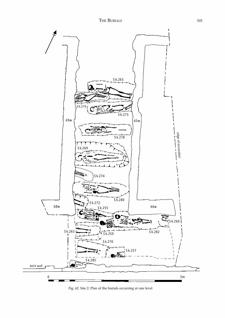
THE BURIALS 101
Fig. 62 Site 2: Plan of the burials occurring at one level
Sk.278
Sk.269
Sk.263
brick wall
Sk.270
Sk.257
Sk.282Sk.259
Sk.274
Sk.272Sk.280
Sk.265
69w 65w
66w68w
Sk.273
Sk.279
Sk.260
Sk.285
Sk.255
edge of excavation
0 5m
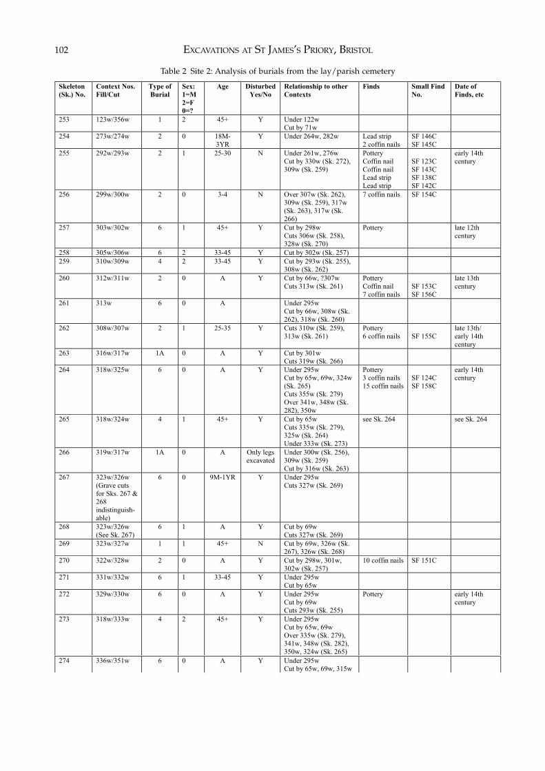
EXCAVATIONS AT ST JAMES’S PRIORY, BRISTOL102
Skeleton
(Sk.) No.
Context Nos.
Fill/Cut
Type of
Burial
Sex:
1=M
2=F
0=?
Age Disturbed
Yes/No
Relationship to other
Contexts
Finds Small Find
No.
Date of
Finds, etc
253 123w/356w 1 2 45+ Y Under 122w
Cut by 71w
254 273w/274w 2 0 18M-
3YR
Y Under 264w, 282w
Lead strip
2 coffin nails
SF 146C
SF 145C
255 292w/293w 2 1 25-30 N Under 261w, 276w
Cut by 330w (Sk. 272),
309w (Sk. 259)
Pottery
Coffin nail
Coffin nail
Lead strip
Lead strip
SF 123C
SF 143C
SF 138C
SF 142C
early 14th
century
256 299w/300w 2 0 3-4 N Over 307w (Sk. 262),
309w (Sk. 259), 317w
(Sk. 263), 317w (Sk.
266)
7 coffin nails SF 154C
257 303w/302w 6 1 45+ Y Cut by 298w
Cuts 306w (Sk. 258),
328w (Sk. 270)
Pottery late 12th
century
258 305w/306w 6 2 33-45 Y Cut by 302w (Sk. 257)
259 310w/309w 4 2 33-45 Y Cut by 293w (Sk. 255),
308w (Sk. 262)
260 312w/311w 2 0 A Y Cut by 66w, ?307w
Cuts 313w (Sk. 261)
Pottery
Coffin nail
7 coffin nails
SF 153C
SF 156C
late 13th
century
261 313w 6 0 A Under 295w
Cut by 66w, 308w (Sk.
262), 318w (Sk. 260)
262 308w/307w 2 1 25-35 Y Cuts 310w (Sk. 259),
313w (Sk. 261)
Pottery
6 coffin nails
SF 155C
late 13th/
early 14th
century
263 316w/317w 1A 0 A Y Cut by 301w
Cuts 319w (Sk. 266)
264 318w/325w
6 0 A Y Under 295w
Cut by 65w, 69w, 324w
(Sk. 265)
Cuts 355w (Sk. 279)
Over 341w, 348w (Sk.
282), 350w
Pottery
3 coffin nails
15 coffin nails
SF 124C
SF 158C
early 14th
century
265 318w/324w
4 1 45+ Y Cut by 65w
Cuts 335w (Sk. 279),
325w (Sk. 264)
Under 333w (Sk. 273)
see Sk. 264 see Sk. 264
266 319w/317w 1A 0 A Only legs
excavated
Under 300w (Sk. 256),
309w (Sk. 259)
Cut by 316w (Sk. 263)
267 323w/326w
(Grave cuts
for Sks. 267 &
268
indistinguish-
able)
6 0 9M-1YR Y Under 295w
Cuts 327w (Sk. 269)
268 323w/326w
(See Sk. 267)
6 1 A Y Cut by 69w
Cuts 327w (Sk. 269)
269 323w/327w 1 1 45+ N Cut by 69w, 326w (Sk.
267), 326w (Sk. 268)
270 322w/328w 2 0 A Y Cut by 298w, 301w,
302w (Sk. 257)
10 coffin nails SF 151C
271 331w/332w 6 1 33-45 Y Under 295w
Cut by 65w
272 329w/330w 6 0 A Y Under 295w
Cut by 69w
Cuts 293w (Sk. 255)
Pottery early 14th
century
273 318w/333w 4 2 45+ Y Under 295w
Cut by 65w, 69w
Over 335w (Sk. 279),
341w, 348w (Sk. 282),
350w, 324w (Sk. 265)
Table 2 Site 2: Analysis of burials from the lay/parish cemetery
274 336w/351w
6 0 A Y Under 295w
Cut by 65w, 69w, 315w
THE BURIALS 103
y
275 336w/351w
(Grave fills
for Sks. 275,
276 & 280
indistinguish-
able)
6 0 Infant Y
276 336w/352w
(See Sk. 275)
6 0 Neonate Y Cut by 315w, ?335w
(Sk. 280)
277 337w/338w 6 0 Neonate Y Under 295w
Over 350w
Pottery 1120-1160s
278 339w/340w 2 2 25-35 N Under 295w
Cuts 344w (Sk. 281),
346w (Sk. 283)
Pottery
5 coffin nails
6 coffin nails
SF 125C
SF 157C
?1300-1350
279 334w/335w 1A 2 A Y Under 333w (Sk. 273)
Cut by 69w, 325w (Sk.
264
280 336w/353w
(See Sk. 275)
6 1 25-35 N Cut by 65w, 69w
Cuts ?352w (Sk. 276)
See Sk. 275 See Sk. 275
281 343w/344w 6 0 25+ N Under 295w
Cut by 340w (Sk. 278)
Cuts 346w (Sk. 283)
282 347w/348w 6 0 Infant Y Under 295w, 318w (Sks.
264 & 265), 333w (Sk.
273)
283 345w/346w
(Grave cuts
for Sks. 283 &
284
indistinguish-
able)
6 0 Infant Y Under 295w
Cut by 340w (Sk. 278),
344w (Sk. 281), 326w
(Sk. 268)
5 coffin nails
(unclear
which grave
contained
coffin nails)
SF 127C
284 345w/346w
(See Sk. 283)
6 0 Neonate Y Under 295w
Cut by 340w (Sk. 278),
344w (Sk. 281)
See Sk. 283 See Sk. 283
285 358w/359w 6 2 45+ Only
partially
excavated.
Noted in watching brief
to south of main area of
excavation.
Two of the burials (Sks. 254 and 255) containedsmall strips of lead of unknown purpose.
Type 4 – Simple Burials:There were three examples of simple burials. Twocontained the bodies of adult females and one thebody of an adult male. None of the burials containeddating evidence.
Type 5 – Burials of Uncertain Type:The remaining 18 burials could not be classified. Theycontained 11 adults, three infants, one child agedbetween nine months and one year, and three neon-ates. Of the burials which could be sexed there werefour males and two females.
Four of the graves produced pottery sherds rangingin date from the early/mid 12th century to the early14th century.
Site 3: St James’s PlaceIntroductionThe following information on the watching brief istaken from a client report prepared by Rod Burchillwho carried out the work (BaRAS 1998). The sitearchive has been deposited with the Bristol City
Museum and Art Gallery under accession numberCMAG.1997.0041.
In the late summer of 1997, Bristol and RegionArchaeological Services were commissioned by thePlanning, Transport and Development Directorate ofBristol City Council to monitor contractor’s ground-works associated with the construction of a new roadlayout and ‘gateway’ to Bristol’s Broadmead shop-ping centre, known as St James’s Place (Fig. 1; NGRST 58967338). The site lay immediately south-west ofa group of burials recovered in 1954 by Edward Mason(1957, 164–171) during the construction of the nearbydepartment store (see Chapter 2).
Articulated human remains were exposed in threetrenches cut by contractors for the foundations ofboundary walls and a large ornamental structure. Theskeletal material recovered comprised six articulatedskeletons with a minimum of five other individualsrepresented by disarticulated bone. Five of the sixarticulated burials were removed after recording asthey would have been destroyed by the foundationswhile the sixth burial (Sk. 288) lay a little below thecontractor’s foundation level and was left in situ.
State of Preservation of the MaterialThe bone was fairly well preserved although none of
Table 2 Site 2: Analysis of burials from the lay/parish cemetery. Continued from opposite
EXCAVATIONS AT ST JAMES’S PRIORY, BRISTOL104
the skeletons was complete; parts of the skeleton eitherlay beyond the excavated area or were truncated bylater burials. The depth of the burials, some 0.5 to0.7m below modern ground level, gave no indicationof their original levels since it was obvious that theland surface had been considerably reduced by 19th-century and later development.
Burial PracticeAll the burials were orientated east/west with theirheads to the west. Grave cuts could not be detectedand no burial sequence could be established, save thatSk. 288 lay immediately below Sk. 287. The bodieshad been laid on their backs with the exception of Sk.289 which appeared to have been interred face down.In only two cases could the positions of the hands bedetermined: Sk. 287 had its hands crossed at the pelvisand Sk. 291 had its arms folded across the abdomen.No remains of coffins or coffin furniture were foundand the burials were mostly resting on the surface ofthe bedrock at between 8.59 to 9.2m above OrdnanceDatum. Details of the burials are given in Table 3.
DatingA sample from Sk. 289 was submitted to the Uni-versity of Waikato in New Zealand for radiocarbondating (laboratory code Wk 6139). This produced aconventional age result of 560± BP. The date has beencalibrated to a two sigma age range (95% confidence)which has produced a date of AD 1290–1440. Thiscompares well with the 14th-century date ascribed tothe only burial from Mason’s 1954 excavation whichcontained dating evidence in the form of two copper-alloy buckles.
Burials from Sites 2 and 3: Discussion
The excavations have shown that the area outside thewest front of the church was probably kept clear ofburials during the medieval period, an east/west
boundary wall being used to define the northern limitof the lay burial ground. However, just to the south ofthe boundary wall, in the area closest to the church,the area had been intensively used for burials. Therewas evidence of order to the burial ground withgraves in overlapping rows although others were laidout in a seemingly haphazard fashion.
Of the bodies that could be sexed from Site 2 therewas an overall male to female ratio of 1:1 which is inkeeping with the use of the area as a lay burial ground.This contrasts well with the overall male to femaleratio of 3:1 from the monastic burial ground excavatedon Site 1.
A number of grave fills contained residual sherdsof pottery which date from the late 12th to the early14th centuries and it seems likely that the burials closeto the church at Site 2 ceased after the 14th century. Itis not known why burials stopped but it was probablyrealised that the area had been too intensively usedand there was no more space available. By that timethe parish burial ground, covering a large area to thesouth of the church, was in use (see Chapter 2).
The 300 or so burials found in 1954 came from partof the parish burial ground, as did the six burials foundduring the watching brief on Site 3 in 1997. Thosefound in 1954 were laid out in parallel rows with adistance of about 1.2m or less between the bodies andthe excavator noted the posture of the bodies: generallythey had their arms crossed over the chest with thehands resting on opposite shoulders, although in anumber of cases only one arm crossed the chest, theother lying horizontally across the abdomen. Inter-ments in that part of the parish burial ground at leasthad been carried out in an orderly fashion implyingthat the graves had some kind of marker and/or that aplan of the graves was being kept.
The only dating evidence for the burials so farrecovered from the parish burial ground comes from apair of 14th-century buckles found in one grave in1954 and a radiocarbon date of AD 1290–1440 fromSk. 288 found in 1997. It does seem likely that use ofthis part of the parish burial ground was restricted to
Skeleton
(Sk.) No.
Context Nos.
Fill/Cut
Type of
Burial
Sex:
1=M
2=F
0=?
Age Position/
Special
Features
Disturbed
Yes/No
Relationship to other
Contexts
Finds Small Find
No.
Date of
Finds, etc
286 4 1 A N
287 4 1 A Hands across
pelvis
N Over Sk. 288
288 4 Not removed,
left in situ
N Under Sk. 287
289 4 1 A Interred face
down
N Radiocarbon
date
AD 1290-
1440
290 4 1 25-35 N
291 4 2 25-35 Arms across
abdomen
N
Table 3 Site 3: Analysis of burials from the lay/parish cemetery
THE BURIALS 105
the medieval period and that no post-medievalinterments took place there.
Analysis of the Human Bone from Sites 1 and 2by Dr Louise Loe
IntroductionIn total, 285 grave cuts were excavated from the burialgrounds situated at the east and west ends of thepriory church of St James (Sites 1 and 2). From these278 skeletons were recovered and these were exam-ined and reported on between 1995 and 1996. This isin addition to a quantity of disarticulated human boneexcavated from various contexts, from both sites. Thiswill be discussed in a separate section.
While excavation was in progress, the author waspresent to make observations on the skeletons in situ.In this way, the amount of information that is in-evitably lost when lifting, washing, and packinghuman bone, was kept to a minimum.
Although the east and west ends of the priory aredifferent sites, both types of burial (the head-nicheand the coffin) occur at each end and they are allthought to date sometime between the foundation ofthe priory in the 11th century and its Dissolution inthe 16th century. They therefore probably representindividuals from the same population. In order tomaximise the results of the skeletal examination bothsites have been examined together.
It has been somewhat difficult to attribute phasingto these burials. The head-niche are thought to predatethe coffin burials and they could be as early as lateSaxon. The coffin burials seem to be later, althoughboth types of burial continue into the later centuries ofthe cemetery’s use. In this report, all head-nicheburials are treated as representing an earlier phase.
The aim of the skeletal examination was to establisha profile of this population sample in terms of age andsex distribution, stature, morphological variants, andevidence for disease. For this, the following questionswere asked:
1. What is the proportion of males to females on bothsites? Do they differ? Is there a difference betweenphases?
2. Is there any evidence to suggest that males and femalesare buried in different parts of the graveyard?
3. Does the average age at death vary over time, andbetween sexes?
4. How many children and juveniles are buried in thegraveyard? Does this vary between both sites and doesthe number of children change with time?
5. What is the range of cranial and post-cranial traitspresent in the sample? Are there any unusual distrib-utions within the graveyard of those traits thought tobe genetically controlled?
6. What diseases are present on the skeletons? Do any ofthe disease frequencies change over time, or betweensexes?
7. What is the average stature of the individuals from thedifferent phases and how do they compare?
8. How does the sample from this site compare to otherlocal sites, and to more distant, but contemporarycollections of skeletal remains?
The Articulated Human BoneNumber of IndividualsMost of the sample was inhumed at the east end of thepriory (Site 1), where there were 245 skeletons, while33 individuals were recovered from Site 2.
Condition and CompletenessBased on the state of preservation of the bone, eachskeleton was recorded as being good, fair or poor(Table 4).
The skeletons that were poorly preserved hadsuffered the most post-mortem damage. They hadabraded joint ends and the surfaces of bones hadundergone considerable post mortem damage. Dam-age was particularly extensive on skulls and vertebrae.‘Fair’ skeletons were characterised by bones that hadreasonably well preserved surfaces and relatively un-abraded joint ends, while ‘Good’ skeletons generallyhad un-abraded joint ends and bone surfaces that werein an excellent state of preservation. Breakage of bonewas frequent across all categories. In general, therewas a greater tendency for bone from Site 1 to be morefriable and abraded than that from Site 2.
The skeletons ranged from being 2% to 95%complete. Skeletons from Site 1 were represented by ahigher percentage of bones and in general more bonesurvived in coffin burials (Fig.63).
SexProvided that most of the skeleton is present, sex can
Location Number of
Skeletons
Number of Poor
Skeletons (%)
Number of Fair
Skeletons (%)
Number of Good
Skeletons (%)
Site 1 245 148 (60.40%) 49 (20%) 48 (19.59%)
Site 2 33 14 (42.42%) 7 (21.21%) 12 (36.36%)
Table 4 Sites 1 and 2: Condition of skeletons
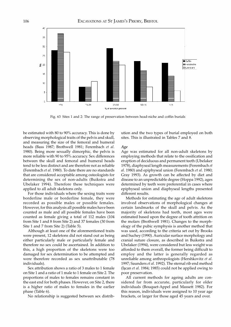
EXCAVATIONS AT ST JAMES’S PRIORY, BRISTOL106
be estimated with 80 to 90% accuracy. This is done byobserving morphological traits of the pelvis and skull,and measuring the size of the femoral and humeralheads (Bass 1987; Brothwell 1981; Ferembach et al.1980). Being more sexually dimorphic, the pelvis ismore reliable with 90 to 95% accuracy. Sex differencesbetween the skull and femoral and humeral headstend to be less distinct and are therefore not as reliable(Ferembach et al. 1980). To date there are no standardsthat are considered acceptable among osteologists fordetermining the sex of non-adults (Buikstra andUbelaker 1994). Therefore these techniques wereapplied to all adult skeletons only.
For those individuals where the sexing traits wereborderline male or borderline female, they wererecorded as possible males or possible females.However, for this analysis all possible males have beencounted as male and all possible females have beencounted as female giving a total of 112 males (104from Site 1 and 8 from Site 2) and 37 females (30 fromSite 1 and 7 from Site 2) (Table 5).
Although at least one of the aforementioned traitswere present, 12 skeletons did not stand out as beingeither particularly male or particularly female andtherefore no sex could be ascertained. In addition tothis, a high proportion of the skeletons were toodamaged for sex determination to be attempted andwere therefore recorded as sex unattributable (78individuals).
Sex attribution shows a ratio of 3 males to 1 femaleon Site 1 and a ratio of 1 male to 1 female on Site 2. Theproportions of males to females remains constant inthe east end for both phases. However, on Site 2, thereis a higher ratio of males to females in the earlierphase (Table 6).
No relationship is suggested between sex distrib-
ution and the two types of burial employed on bothsites. This is illustrated in Tables 7 and 8.
AgeAge was estimated for all non-adult skeletons byemploying methods that relate to the ossification anderuption of deciduous and permanent teeth (Ubelaker1978), diaphyseal length measurements (Ferembach etal. 1980) and epiphyseal union (Ferembach et al. 1980;Gray 1993). As growth can be affected by diet anddisease to an unpredictable degree (Hoppa 1992), agesdetermined by teeth were preferential in cases whereepiphyseal union and diaphyseal lengths presenteddifferent results.
Methods for estimating the age of adult skeletonsinvolved observations of morphological changes atcertain landmarks of the skull and pelvis. As themajority of skeletons had teeth, most ages wereestimated based upon the degree of tooth attrition onthe molars (Brothwell 1981). Changes to the morph-ology of the pubic symphysis is another method thatwas used, according to the criteria set out by Brooksand Suchey (1990). Auricular surface morphology andcranial suture closure, as described in Buikstra andUbelaker (1994), were considered but less weight wasafforded to them overall, the former being difficult toemploy and the latter is generally regarded asunreliable among anthropologists (Hershkovitz et al.1997; Saunders et al. 1992). The sternal rib end method(İşcan et al. 1984; 1985) could not be applied owing topoor preservation.
All current methods for ageing adults are con-sidered far from accurate, particularly for olderindividuals (Bouquet-Appel and Massett 1982). Forthis reason, individuals were assigned to 10 year agebrackets, or larger for those aged 45 years and over.
Fig. 63 Sites 1 and 2: The range of preservation between head-niche and coffin burials
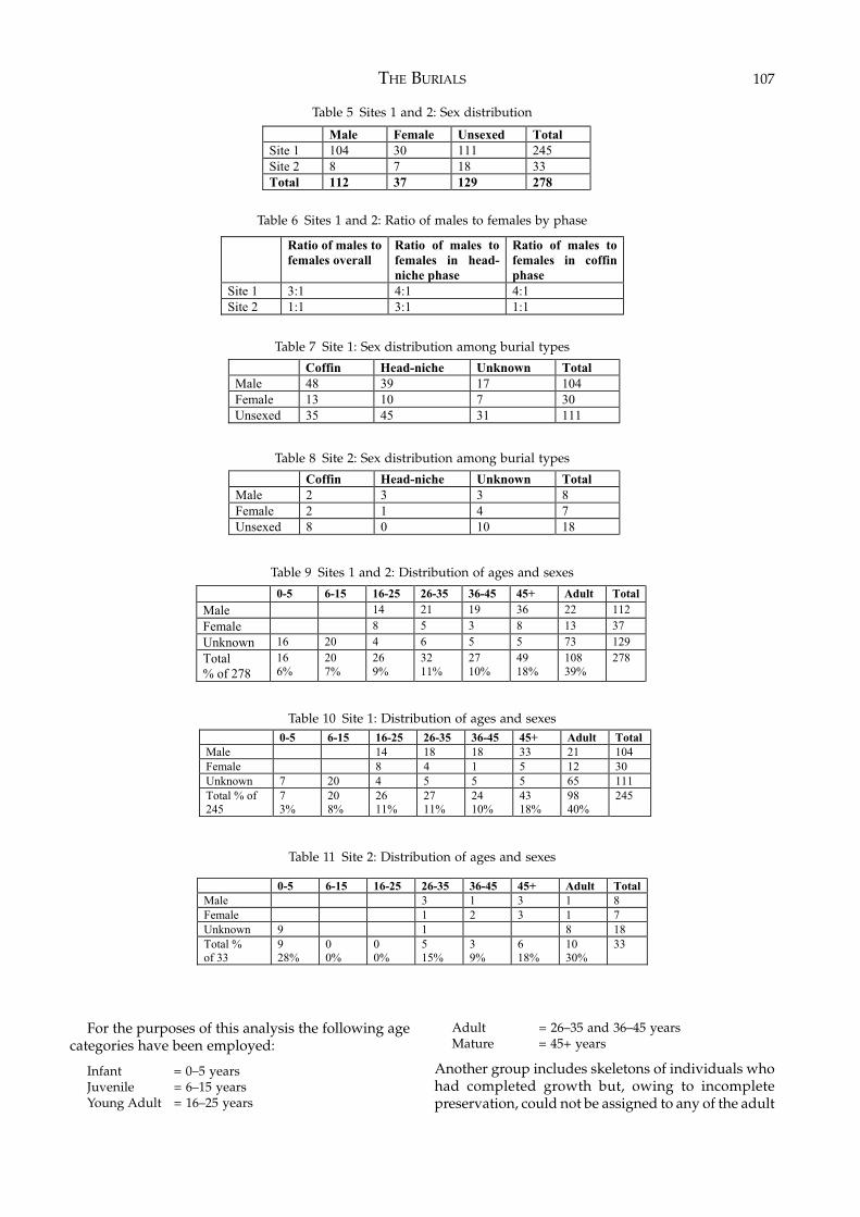
THE BURIALS 107
Male Female Unsexed Total
Site 1 104 30 111 245
Site 2 8 7 18 33
Total 112 37 129 278
Table 5 Sites 1 and 2: Sex distribution
Ratio of males to
females overall
Ratio of males to
females in head-
niche phase
Ratio of males to
females in coffin
phase
Site 1 3:1 4:1 4:1
Site 2 1:1 3:1 1:1
Coffin Head-niche Unknown Total
Male 48 39 17 104
Female 13 10 7 30
Unsexed 35 45 31 111
Table 7 Site 1: Sex distribution among burial types
Table 6 Sites 1 and 2: Ratio of males to females by phase
Coffin Head-niche Unknown Total
Male 2 3 3 8
Female 2 1 4 7
Unsexed 8 0 10 18
Table 8 Site 2: Sex distribution among burial types
For the purposes of this analysis the following agecategories have been employed:
Infant = 0–5 yearsJuvenile = 6–15 yearsYoung Adult = 16–25 years
Adult = 26–35 and 36–45 yearsMature = 45+ years
Another group includes skeletons of individuals whohad completed growth but, owing to incompletepreservation, could not be assigned to any of the adult
0-5 6-15 16-25 26-35 36-45 45+ Adult Total
Male 14 21 19 36 22 112
Female 8 5 3 8 13 37
Unknown 16 20 4 6 5 5 73 129
Total
% of 278
16
6%
20
7%
26
9%
32
11%
27
10%
49
18%
108
39%
278
Table 9 Sites 1 and 2: Distribution of ages and sexes
Table 10 Site 1: Distribution of ages and sexes 0-5 6-15 16-25 26-35 36-45 45+ Adult Total
Male 14 18 18 33 21 104
Female 8 4 1 5 12 30
Unknown 7 20 4 5 5 5 65 111
Total % of
245
7
3%
20
8%
26
11%
27
11%
24
10%
43
18%
98
40%
245
0-5 6-15 16-25 26-35 36-45 45+ Adult Total
Male 3 1 3 1 8
Female 1 2 3 1 7
Unknown 9 1 8 18
Total %
of 33
9
28%
0
0%
0
0%
5
15%
3
9%
6
18%
10
30%
33
Table 11 Site 2: Distribution of ages and sexes
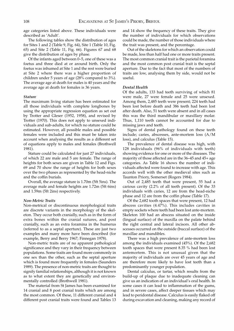
EXCAVATIONS AT ST JAMES’S PRIORY, BRISTOL108
age categories listed above. These individuals weredescribed as ‘Adult’.
The following tables show the distribution of agesfor Sites 1 and 2 (Table 9, Fig. 64), Site 1 (Table 10, Fig.65) and Site 2 (Table 11, Fig. 66). Figures 67 and 68give the distribution of ages by phase.
Of the infants aged between 0–5, one of these was afoetus and three died at or around birth. Only thefoetus was inhumed at Site 1 and the rest were buriedat Site 2 where there was a higher proportion ofchildren under 5 years of age (28% compared to 3%).The average age at death for males is 40 years and theaverage age at death for females is 36 years.
StatureThe maximum living stature has been estimated forall those individuals with complete longbones byusing the appropriate regression equation as set outby Trotter and Gleser (1952, 1958), and revised byTrotter (1970). This does not apply to unsexed indi-viduals and sub-adults, for which no stature could beestimated. However, all possible males and possiblefemales were included and this must be taken intoaccount when analysing the results as a different setof equations apply to males and females (Brothwell1981).
Stature could be calculated for just 27 individuals,of which 22 are male and 5 are female. The range ofheights for both sexes are given in Table 12 and Figs.69 and 70 show the range of heights for both sexesover the two phases as represented by the head-nicheand the coffin burials.
Overall, the average stature is 1.70m (5ft 5ins). Theaverage male and female heights are 1.72m (5ft 6ins)and 1.59m (5ft 2ins) respectively.
Non-Metric TraitsNon-metrical or discontinuous morphological traitsare discrete variants in the morphology of the skel-eton. They occur both cranially, such as in the form ofextra bones within the cranial sutures, and postcranially, such as an extra foramina in the humerus(referred to as a septal aperture). These are just twoexamples and many more have been described (forexample, Berry and Berry 1967; Finnegan 1978).
Non-metric traits are of no apparent pathologicalsignificance and they vary in their frequency betweenpopulations. Some traits are found more commonly inone sex than the other, such as the septal aperturewhich is found more frequently in females (Saunders1989). The presence of non-metric traits are thought tosignify familial relationships, although it is not knownas to what extent they are genetically and environ-mentally controlled (Brothwell 1981).
The material from St James has been examined for14 cranial and 8 post cranial traits which are amongthe most common. Of these, 11 different cranial and 4different post cranial traits were found and Tables 13
and 14 show the frequency of these traits. They givethe number of individuals for which observationscould be made, the number of those individuals wherethe trait was present, and the percentage.
Out of the skeletons for which an observation couldbe made, less than half had one or more traits present.The most common cranial trait is the parietal foraminaand the most common post cranial trait is the septalaperture. Due to the fact that most of the numbers oftraits are low, analysing them by side, would not beuseful.
Dental HealthOf the adults, 133 had teeth surviving of which 81were male, 27 were female and 25 were unsexed.Among them, 2,485 teeth were present; 224 teeth hadbeen lost before death and 386 teeth had been lostafter death. Also, 51 teeth were absent and in all casesthis was the third mandibular or maxillary molar.Thus, 1,110 teeth cannot be accounted for due tomissing jaws and teeth.
Signs of dental pathology found on these teethinclude; caries, abscesses, ante-mortem loss (A/Mloss), and calculus (Table 15).
The prevalence of dental disease was high, with128 individuals (96% of individuals with teeth)showing evidence for one or more of the diseases. Themajority of those affected are in the 36–45 and 45+ agecategories. As Table 16 shows the number of indi-viduals affected were found to increase with age. Thisaccords well with the other medieval sites such asTaunton Priory, Somerset (Rogers 1984).
Out of 2,485 teeth that were present, 55 had acarious cavity (2.2% of all teeth present). Of the 33individuals with caries, 12 are from the head-nichephase and 12 are from the coffin phase (Table 17).
Of the 2,682 tooth spaces that were present, 12 hadabscess cavities (4.47%). This includes cavities inempty sockets where teeth had been lost ante-mortem.Skeleton 100 had an abscess situated on the inside(lingual surface) of the maxilla on the palate behindthe right central and lateral incisors. All other ab-scesses occurred on the outside (buccal surface) of themaxillae and mandibles.
There was a high prevalence of ante-mortem lossamong the individuals examined (45%). Of the 2,682tooth spaces that were present 8.35 % had been lostantemortem. This is not unusual given that themajority of individuals are over 45 years of age andare therefore more likely to have lost teeth than apredominantly younger population.
Dental calculus, or tartar, which results from thebuild-up of plaque due to inadequate cleaning cangive us an indication of an individual’s oral health. Insome cases it can lead to inflammation of the gums,and in severe cases, affect deeper tissues which maylead to peridontal disease. Calculus is easily flaked offduring excavation and cleaning, making any record of
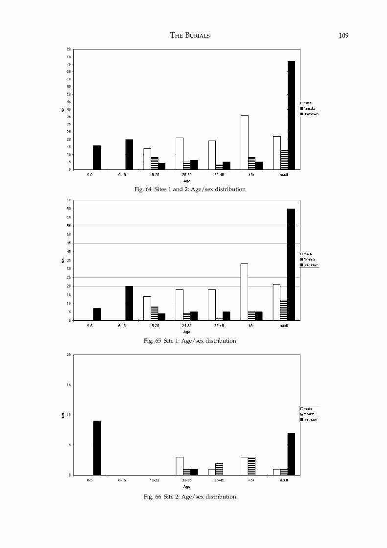
THE BURIALS 109
Fig. 64 Sites 1 and 2: Age/sex distribution
Fig. 65 Site 1: Age/sex distribution
Fig. 66 Site 2: Age/sex distribution
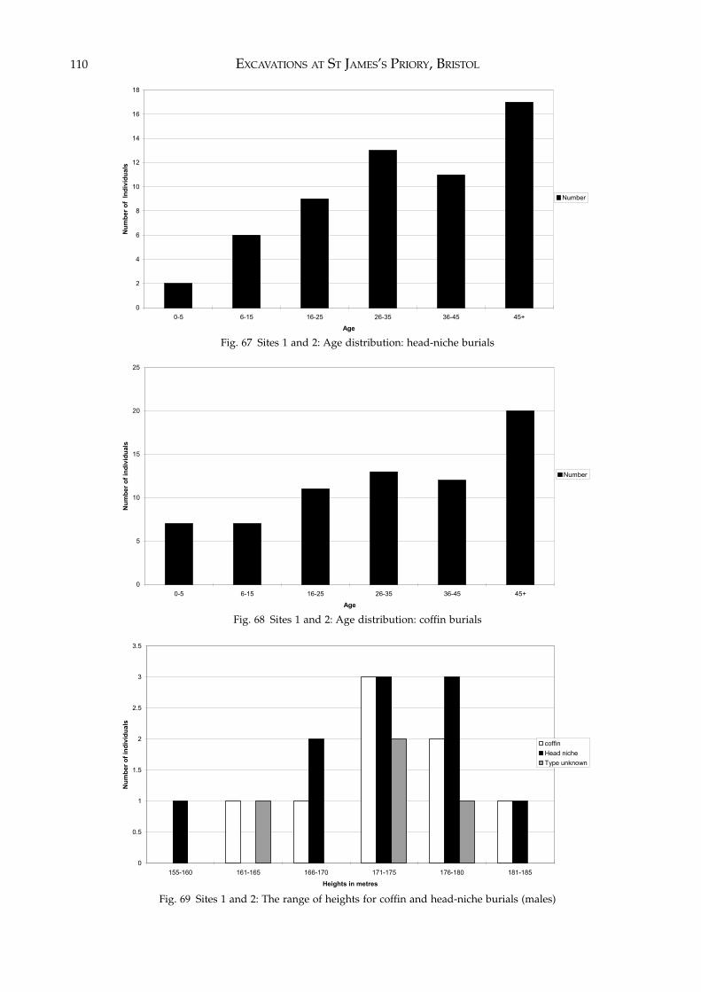
EXCAVATIONS AT ST JAMES’S PRIORY, BRISTOL110
0
2
4
6
8
10
12
14
16
18
0-5 6-15 16-25 26-35 36-45 45+
Age
Nu
mb
er o
f In
div
idu
als
Number
0
5
10
15
20
25
0-5 6-15 16-25 26-35 36-45 45+
Age
Nu
mb
er o
f in
div
idu
als
Number
Fig. 67 Sites 1 and 2: Age distribution: head-niche burials
Fig. 68 Sites 1 and 2: Age distribution: coffin burials
0
0.5
1
1.5
2
2.5
3
3.5
155-160 161-165 166-170 171-175 176-180 181-185
Heights in metres
Nu
mb
er o
f in
div
idu
als
coffin
Head niche
Type unknown
Fig. 69 Sites 1 and 2: The range of heights for coffin and head-niche burials (males)
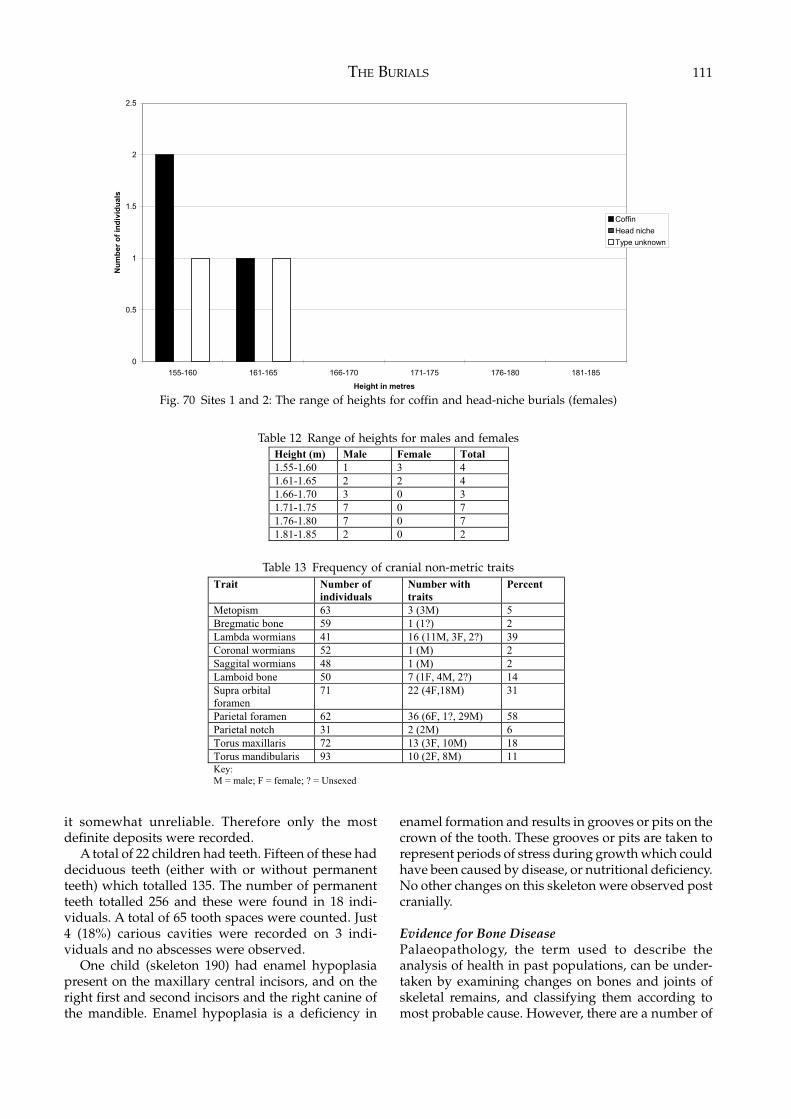
THE BURIALS 111
it somewhat unreliable. Therefore only the mostdefinite deposits were recorded.
A total of 22 children had teeth. Fifteen of these haddeciduous teeth (either with or without permanentteeth) which totalled 135. The number of permanentteeth totalled 256 and these were found in 18 indi-viduals. A total of 65 tooth spaces were counted. Just4 (18%) carious cavities were recorded on 3 indi-viduals and no abscesses were observed.
One child (skeleton 190) had enamel hypoplasiapresent on the maxillary central incisors, and on theright first and second incisors and the right canine ofthe mandible. Enamel hypoplasia is a deficiency in
enamel formation and results in grooves or pits on thecrown of the tooth. These grooves or pits are taken torepresent periods of stress during growth which couldhave been caused by disease, or nutritional deficiency.No other changes on this skeleton were observed postcranially.
Evidence for Bone DiseasePalaeopathology, the term used to describe theanalysis of health in past populations, can be under-taken by examining changes on bones and joints ofskeletal remains, and classifying them according tomost probable cause. However, there are a number of
0
0.5
1
1.5
2
2.5
155-160 161-165 166-170 171-175 176-180 181-185
Height in metres
Nu
mb
er o
f in
div
idu
als
Coffin
Head niche
Type unknown
Height (m) Male Female Total
1.55-1.60 1 3 4
1.61-1.65 2 2 4
1.66-1.70 3 0 3
1.71-1.75 7 0 7
1.76-1.80 7 0 7
1.81-1.85 2 0 2
Fig. 70 Sites 1 and 2: The range of heights for coffin and head-niche burials (females)
Table 12 Range of heights for males and females
Trait Number of
individuals
Number with
traits
Percent
Metopism 63 3 (3M) 5
Bregmatic bone 59 1 (1?) 2
Lambda wormians 41 16 (11M, 3F, 2?) 39
Coronal wormians 52 1 (M) 2
Saggital wormians 48 1 (M) 2
Lamboid bone 50 7 (1F, 4M, 2?) 14
Supra orbital
foramen
71 22 (4F,18M) 31
Parietal foramen 62 36 (6F, 1?, 29M) 58
Parietal notch 31 2 (2M) 6
Torus maxillaris 72 13 (3F, 10M) 18
Torus mandibularis 93 10 (2F, 8M) 11
Key:
M = male; F = female; ? = Unsexed
Table 13 Frequency of cranial non-metric traits
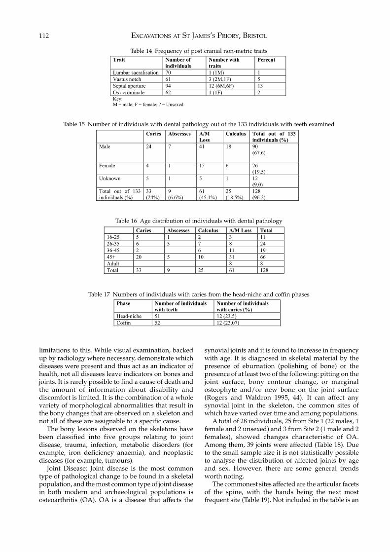
EXCAVATIONS AT ST JAMES’S PRIORY, BRISTOL112
limitations to this. While visual examination, backedup by radiology where necessary, demonstrate whichdiseases were present and thus act as an indicator ofhealth, not all diseases leave indicators on bones andjoints. It is rarely possible to find a cause of death andthe amount of information about disability anddiscomfort is limited. It is the combination of a wholevariety of morphological abnormalities that result inthe bony changes that are observed on a skeleton andnot all of these are assignable to a specific cause.
The bony lesions observed on the skeletons havebeen classified into five groups relating to jointdisease, trauma, infection, metabolic disorders (forexample, iron deficiency anaemia), and neoplasticdiseases (for example, tumours).
Joint Disease: Joint disease is the most commontype of pathological change to be found in a skeletalpopulation, and the most common type of joint diseasein both modern and archaeological populations isosteoarthritis (OA). OA is a disease that affects the
synovial joints and it is found to increase in frequencywith age. It is diagnosed in skeletal material by thepresence of eburnation (polishing of bone) or thepresence of at least two of the following: pitting on thejoint surface, bony contour change, or marginalosteophyte and/or new bone on the joint surface(Rogers and Waldron 1995, 44). It can affect anysynovial joint in the skeleton, the common sites ofwhich have varied over time and among populations.
A total of 28 individuals, 25 from Site 1 (22 males, 1female and 2 unsexed) and 3 from Site 2 (1 male and 2females), showed changes characteristic of OA.Among them, 39 joints were affected (Table 18). Dueto the small sample size it is not statistically possibleto analyse the distribution of affected joints by ageand sex. However, there are some general trendsworth noting.
The commonest sites affected are the articular facetsof the spine, with the hands being the next mostfrequent site (Table 19). Not included in the table is an
Trait Number of
individuals
Number with
traits
Percent
Lumbar sacralisation 70 1 (1M) 1
Vastus notch 61 3 (2M,1F) 5
Septal aperture 94 12 (6M,6F) 13
Os acrominale 62 1 (1F) 2
Key:
M = male; F = female; ? = Unsexed
Table 14 Frequency of post cranial non-metric traits
Caries Abscesses A/M
Loss
Calculus Total out of 133
individuals (%)
Male 24 7
41
18
90
(67.6)
Female 4
1
15
6
26
(19.5)
Unknown 5 1
5
1 12
(9.0)
Total out of 133
individuals (%)
33
(24%)
9
(6.6%)
61
(45.1%)
25
(18.5%)
128
(96.2)
Table 15 Number of individuals with dental pathology out of the 133 individuals with teeth examined
Caries Abscesses Calculus A/M Loss Total
16-25 5 1 2 3 11
26-35 6 3 7 8 24
36-45 2 6 11 19
45+ 20 5 10 31 66
Adult 8 8
Total 33 9 25 61 128
Table 16 Age distribution of individuals with dental pathology
Phase Number of individuals
with teeth
Number of individuals
with caries (%)
Head-niche 51 12 (23.5)
Coffin 52 12 (23.07)
Table 17 Numbers of individuals with caries from the head-niche and coffin phases
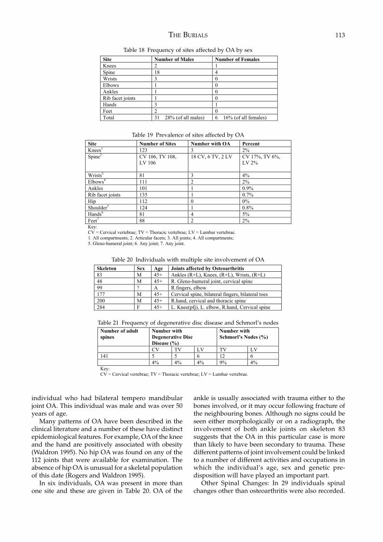
THE BURIALS 113
individual who had bilateral tempero mandibularjoint OA. This individual was male and was over 50years of age.
Many patterns of OA have been described in theclinical literature and a number of these have distinctepidemiological features. For example, OA of the kneeand the hand are positively associated with obesity(Waldron 1995). No hip OA was found on any of the112 joints that were available for examination. Theabsence of hip OA is unusual for a skeletal populationof this date (Rogers and Waldron 1995).
In six individuals, OA was present in more thanone site and these are given in Table 20. OA of the
ankle is usually associated with trauma either to thebones involved, or it may occur following fracture ofthe neighbouring bones. Although no signs could beseen either morphologically or on a radiograph, theinvolvement of both ankle joints on skeleton 83suggests that the OA in this particular case is morethan likely to have been secondary to trauma. Thesedifferent patterns of joint involvement could be linkedto a number of different activities and occupations inwhich the individual’s age, sex and genetic pre-disposition will have played an important part.
Other Spinal Changes: In 29 individuals spinalchanges other than osteoarthritis were also recorded.
Site Number of Males Number of Females
Knees 2 1
Spine 18 4
Wrists 3 0
Elbows 1 0
Ankles 1 0
Rib facet joints 1 0
Hands 3 1
Feet 2 0
Total 31 28% (of all males) 6 16% (of all females)
Table 18 Frequency of sites affected by OA by sex
Site Number of Sites Number with OA Percent
Knees1
123 3 2%
Spine2
CV 106, TV 108,
LV 106
18 CV, 6 TV, 2 LV CV 17%, TV 6%,
LV 2%
Wrists3
81 3 4%
Elbows4
111 2 2%
Ankles 101 1 0.9%
Rib facet joints 135 1 0.7%
Hip 112 0 0%
Shoulder5
124 1 0.8%
Hands6
81 4 5%
Feet7
88 2 2%
Key:
CV = Cervical vertebrae; TV = Thoracic vertebrae; LV = Lumbar vertebrae.
1. All compartments; 2. Articular facets; 3. All joints; 4. All compartments;
5. Gleno-humeral joint; 6. Any joint; 7. Any joint.
Table 19 Prevalence of sites affected by OA
Skeleton Sex Age Joints affected by Osteoarthritis
83 M 45+ Ankles (R+L), Knees, (R+L), Wrists, (R+L)
48 M 45+ R. Gleno-humeral joint, cervical spine
99 ? A R.fingers, elbow
177 M 45+ Cervical spine, bilateral fingers, bilateral toes
200 M 45+ R.hand, cervical and thoracic spine
284 F 45+ L. Knee(pfj), L. elbow, R.hand, Cervical spine
Table 20 Individuals with multiple site involvement of OA
Number of adult
spines
Number with
Degenerative Disc
Disease (%)
Number with
Schmorl’s Nodes (%)
CV TV LV TV LV
141 5 5 6 12 6
4% 4% 4% 9% 4%
Key:
CV = Cervical vertebrae; TV = Thoracic vertebrae; LV = Lumbar vertebrae.
Table 21 Frequency of degenerative disc disease and Schmorl’s nodes
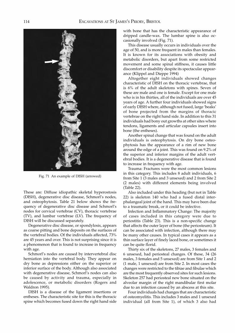
EXCAVATIONS AT ST JAMES’S PRIORY, BRISTOL114
Fig. 71 An example of DISH (arrowed)
These are: Diffuse idiopathic skeletal hyperostosis(DISH), degenerative disc disease, Schmorl’s nodes,and osteophytosis. Table 21 below shows the fre-quency of degenerative disc disease and Schmorl’snodes for cervical vertebrae (CV), thoracic vertebrae(TV), and lumbar vertebrae (LV). The frequency ofDISH will be discussed separately.
Degenerative disc disease, or spondylosis, appearsas coarse pitting and bone deposits on the surfaces ofthe vertebral bodies. Of the individuals affected, 73%are 45 years and over. This is not surprising since it isa phenomenon that is found to increase in frequencywith age.
Schmorl’s nodes are caused by intervertebral discherniation into the vertebral body. They appear ondry bone as depressions either on the superior orinferior surface of the body. Although also associatedwith degenerative disease, Schmorl’s nodes can alsobe caused by activity and trauma, especially inadolescence, or metabolic disorders (Rogers andWaldron 1995).
DISH is a disease of the ligament insertions orentheses. The characteristic site for this is the thoracicspine which becomes fused down the right hand side
with bone that has the characteristic appearance ofdripped candle-wax. The lumbar spine is also oc-casionally involved (Fig. 71).
This disease usually occurs in individuals over theage of 50, and is more frequent in males than females.It is known for its associations with obesity andmetabolic disorders, but apart from some restrictedmovement and some spinal stiffness, it causes littlediscomfort or disability despite its spectacular appear-ance (Klippel and Dieppe 1994)
Altogether eight individuals showed changescharacteristic of DISH on the thoracic vertebrae, thatis 6% of the adult skeletons with spines. Seven ofthese are male and one is female. Except for one malewho is in his thirties, all of the individuals are over 45years of age. A further four individuals showed signsof early DISH where, although not fused, large ‘beaks’of bone projected from the margins of thoracicvertebrae on the right hand side. In addition to this 31individuals had bony out growths at other sites wheretendons, ligaments and articular capsules insert intobone (the entheses).
Another spinal change that was found on the adultindividuals is osteophytosis. On dry bone osteo-phytosis has the appearance of a rim of new bonearound the edge of a joint. This was found on 9.2% ofthe superior and inferior margins of the adult vert-ebral bodies. It is a degenerative disease that is foundto increase in frequency with age.
Trauma: Fractures were the most common lesionsin this category. This includes 8 adult individuals, 6from Site 1 (3 males and 3 unsexed) and 2 from Site 2(2 males) with different elements being involved(Table 22).
Also included under this heading (but not in Table22) is skeleton 140 who had a fused distal inter-phalangeal joint of the hand. This may have been dueto a traumatic break, or it could be infective.
Infection and Inflammatory Change: The majorityof cases included in this category were due toperiostitis (Table 23). This is a non-specific changethat affects the outer layer of bone (the periosteum). Itcan be associated with infection, although there maybe many other causes. In typical cases it appears as athin surface layer of finely laced bone, or sometimes itcan be quite florid.
Thirty six of the skeletons, 27 males, 3 females and6 unsexed, had periosteal changes. Of these, 34 (26males, 3 females and 5 unsexed) are from Site 1 and 2(1 male, 1 unsexed) are from Site 2. In most cases thechanges were restricted to the tibiae and fibulae whichare the most frequently observed sites for such lesions.Skeleton 257 had periosteal new bone situated on thealveolar margin of the right mandibular first molardue to an infection caused by an abscess at this site.
Four individuals had changes that are characteristicof osteomyelitis. This includes 3 males and 1 unsexedindividual (all from Site 1), of which 3 also had
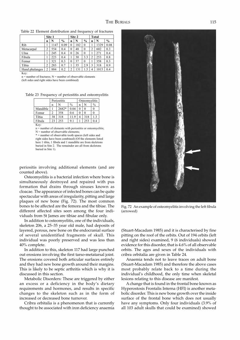
THE BURIALS 115
periositis involving additional elements (and arecounted above).
Osteomyelitis is a bacterial infection where bone issimultaneously destroyed and repaired with pusformation that drains through sinuses known ascloacae. The appearance of infected bones can be quitespectacular with areas of irregularity, pitting and largeplaques of new bone (Fig. 72). The most commonbones to be affected are the femora and the tibiae. Thedifferent affected sites seen among the four indi-viduals from St James are tibiae and fibulae only.
In addition to osteomyelitis, one of the individuals,skeleton 206, a 25–35 year old male, had deposits oflayered, porous, new bone on the endocranial surfaceof several unidentified fragments of skull. Thisindividual was poorly preserved and was less than40% complete.
In addition to this, skeleton 117 had large punchedout erosions involving the first tarso-metatarsal joint.The erosions covered both articular surfaces entirelyand they had new bone growth around their margins.This is likely to be septic arthritis which is why it isdiscussed in this section.
Metabolic Disorders: These are triggered by eitheran excess or a deficiency in the body’s dietaryrequirements and hormones, and results in specificchanges to the skeleton such as in the form ofincreased or decreased bone turnover.
Cribra orbitalia is a phenomenon that is currentlythought to be associated with iron deficiency anaemia
Site 1 Site 2 Total
n N % n N % n N %
Rib 1 1147 0.09 0 182 0 1 1329 0.08
Metacarpal 2 554 0.4 0 48 0 2 602 0.3
Ulna 1 245 0.4 0 26 0 1 271 0.4
Fibula 1 223 0.4 1 30 3.3 2 253 0.8
Femur 1 321 0.3 0 37 0 1 358 0.3
Tibia 2 283 0.7 1 35 2.9 3 318 0.9
Hand phalanges 2 884 0.2 2 131 1.5 4 1015 0.4
Key:
n = number of fractures; N = number of observable elements
(left sides and right sides have been combined)
Table 22 Element distribution and frequency of fractures
Periostitis Osteomyelitis
n N % n N %
Mandible 1 2682* 0.04 0 0 0
Femur 2 358 0.6 0 0 0
Tibia 38 318 11.9 4 318 1.3
Fibula 23 253 9.1 1 253 0.4
Key:
n = number of elements with periostitis or osteomyelitis;
N = number of observable elements;
* = number of observable tooth spaces (left sides and
right sides have been combined) (Of the elements listed
here 1 tibia, 1 fibula and 1 mandible are from skeletons
buried in Site 2. The remainder are all from skeletons
buried in Site 1).
Table 23 Frequency of periostitis and osteomyelitis
(Stuart-Macadam 1985) and it is characterised by finepitting on the roof of the orbits. Out of 194 orbits (leftand right sides) examined, 9 (6 individuals) showedevidence for this disorder, that is 4.6% of all observableorbits. The ages and sexes of the individuals withcribra orbitalia are given in Table 24.
Anaemia tends not to leave traces on adult bone(Stuart-Macadam 1985) and therefore the above casesmost probably relate back to a time during theindividual’s childhood, the only time when skeletallesions relating to this disease are manifest.
A change that is found in the frontal bone known asHyperostosis Frontalis Interna (HFI) is another meta-bolic disorder. This is new bone growth over the insidesurface of the frontal bone which does not usuallyhave any symptoms. Only four individuals (3.9% ofall 103 adult skulls that could be examined) showed
Fig. 72 An example of osteomyelitis involving the left fibula(arrowed)
EXCAVATIONS AT ST JAMES’S PRIORY, BRISTOL116
evidence for this, these being skeletons 79, 148, 108and 206 (Table 25). HFI is a phenomenon that has ahigh prevalence in post-menopausal women (Ortnerand Putschar 1985). The low frequency at St Jamestherefore may be due to the lack of females in thesample.
Rickets is characterised by the bowing of limbbones due to a deficiency in vitamin D. Skeleton 187had very bowed tibiae at the midshaft, although noother changes in the other bones, including the fibulae,were found. Bowing of the fibulae would be expectedif this was rickets. Differential diagnosis wouldinclude fractures although no evidence was found forthis.
Pagets, or osteitis deformans, is due to an im-balance in the cells that break down old bone andmake new bone. In this disease there is an excessiveturn over of new bone which results in the thickeningof the bone’s cortex. The end result is an enlarged anddistorted appearance. These changes were observedon the patellae, tibiae, fibulae and foot bones ofskeleton 113. This individual was an unsexed adult.
Neoplastic Diseases: Skeleton 206 had a smoothivory hard lump of about 20mm in maximum dia-meter situated ectocranially on the left parietal(impinging on the parietal foramina). Skeleton 108also had an identical lump situated in the frontal sinus.These are probably an osteoma, which is a benigntumour. Osteomas mostly consist of dense lamellarbone with vascular channels and they are practicallywithout marrow spaces (Ortner and Putschar 1991,368). Due to their appearance they are referred to asbutton osteomas which are the most common type ofosteoma and are most frequently found on theparietal.
Other evidence for benign neoplastic disease wasfound on the incompletely preserved spine of skeleton132, an adult male. The posterior portion of the bodiesof four lumbar vertebrae and the first sacral vertebrahad scalloped erosions which measured between 4–15mm superior to inferior and 2–6mm medial to
lateral. There were no other apparent changes on theskeleton. Both visual and radiological examinationhave diagnosed a benign long standing intraspinaltumour as the most likely cause for these appearances.The site of the lesions are atypical for tuberculosis andinfection is not a likely cause because of the lack ofother reactive bony change.
Other Diseases and Abnormalities: Some bonychanges which do not fit into the above categories willbe discussed here. The first (skeleton 213) had thebodies of two (unidentified) cervical vertebrae fused,while the other (skeleton 185) had fusion occurringbetween the superior articular facets of C3 and theinferior articular facets of C2 with preserved jointspace between the bodies. Congenital fusion betweenthe cervical vertebrae usually occurs between thebodies and not the articular facet joints. As skeleton185 also had new bone formation and pitting inassociation with the fused articular facets, it is possiblethat this is septic rather than congenital.
In addition to these skeleton 244 had clefting of theposterior arch of the atlas and the neural arch of CV3.Out of 7 cervical, 6 thoracic and 5 lumbar vertebraethat had survived, these were the only abnormalitiesobserved in the spine of this skeleton.
The Disarticulated Human BoneThis includes all human bone that was not excavatedfrom a discrete grave and cannot be assigned to aparticular individual. It represents individuals thatwere disturbed by later burials or construction (ofdrains for example) during the later centuries of thesite’s history and were found in the fills of thesefeatures. The nature of this material means that it ismostly damaged and fragmented and therefore muchless can be derived from it than the articulatedremains.
Minimum NumbersThis was determined by the duplication of any bone,the size of the bone (i.e. if the bone was young oradult), and in some cases the presence of a pair ofbones which obviously belonged to different indi-viduals. These methods determined at least 202individuals.
Age and SexWhere traits survived, ages and sexes were assignedusing the same methods discussed for the articulatedremains. Out of 202 individuals, 48 could be sexed, 36being male, and 12 being female. The distribution ofages are given in Table 26 where the same agecategories are used as before.
StatureThe height of individuals was calculated using the samemethod as discussed before. However, as the bones are
Skeleton Age Sex
123 25-35 M
152 45+ M
168 30-40 M
174 15-25 F
190 6 +/-24 months ?
212 10-12 ?
Table 24 Individuals with cribra orbitalia
Skeleton Age Sex
79 33-45 M
108 35-45 M
148 45+ M
206 25-35 M
Table 25 Individuals with HFI
THE BURIALS 117
disarticulated, this was done using maximum femorallength only. This meant that for all femora used, sexcould be estimated fairly accurately by measuring themaximum diameter of the femoral head.
The stature of six individuals from separate con-texts could be estimated and are given in Table 27.
Non-Metric TraitsWhere relevant, material from this group was exam-
ined for the same traits as the articulated remains.Table 28 shows what traits were observed and wherepossible gives the sex of the individual. No postcranial traits were found.
Evidence for Bone DiseaseThe diseases that were found in this group of bonesfall into the same categories as the articulated remains.Table 29 gives the condition and what bones were
0-5 6-15 16-25 26-35 36-45 45+ Adult
19 22 7 10 8 4 132
Table 26 Age distribution of disarticulated human bone
Context Sex Height (metres)
1271 M 1.82
1528 F 1.59
1154 M 1.68
1069 M 1.75
1263 M 1.79
1351 M 1.70
Table 27 Range of heights
Context Parietal Foramen Supra Orbital foramen Lamboid bone Lamboid Wormians Occipital wormians Torus Maxillarus Sex
1483 R+L - - - - - ?
1503 R+L - Y - - - ?F
1263 R+L - - - - M
1461 R+L - - - Y - M
1224 L - - Y - - ?
339 - L - - - - ?M
336 - L - - - - M
970 R+L - - - - - ?
1341 R+L - - - - - M
1528 R - - - - - F
1528 - - - - - - ?M
1271 - - - - - R+L ?
1366 L L - - - - M
1478 Y (unsided) M
1435 L L - - - - M
1069 L - - - - - ?M
Key:
R = present on right side;
L = present on left side;
Y = present;
- = no data.
Table 28 Prevalence of non-metric traits, cranial and post cranial
Joint Disease Other Spinal
Changes
Trauma Periostitis Metabolic
Disorders
Context Bone Context Disorder Context Bone Context Bone Context Disorder
1271 Knee 322 Schmorl’s
Nodes
294 Broken
Clavicle
1383 Tibia 1279 Cribra
1131 Schmorl’s
Nodes
1027 Femur 607 Cribra
1271 Tibia 1435 HFI
1271 Tibia
336 Radius
1190 Humerus
1483 Tibia
1528 Tibia
Table 29 Prevalence of disease
EXCAVATIONS AT ST JAMES’S PRIORY, BRISTOL118
affected (where context numbers are repeated, thebones may belong to the same individual).
In addition to these diseases, osteophytosis andenthesopathies were also common. The former wasfound on the margins of joints and vertebral bodies,and the latter at sites where tendons, ligaments andarticular capsules insert into bone (the entheses).
Since conclusions as to the severity and distributionof bony changes on an individual depend on thecompleteness of a skeleton, the fragmentary anddisparate nature of disarticulated bone means thatthey are rarely reached. For this reason, it is notpossible to compare the prevalence of the above bonychanges with the rest of the skeletons from St. James.
CommentThe amount of information that we can expect askeletal assemblage to yield is subject to its recoveryrate. All anthropological techniques employed todetermine age, sex and stature depend on the avail-ability of certain bones and when there is evidence fordisease, diagnosis is often dependent on the amountof the skeleton present and its condition. The majorityof skeletons had suffered post-mortem damage to theextent that they were in a poor condition and veryfragmented. Due to this it was not possible to giveexact diagnoses for certain bony changes and nor wasit possible to assign ages, sexes and statures in manycases. However, a large sample such as this means it ispossible to examine the demographic and healthattributes of this population both over time and acrossthe site. It also presents the opportunity to place thisinformation in a wider context by comparison withother medieval bone assemblages from monastic andparish burial grounds.
One hundred and forty-nine out of 278 individualscould be assigned a sex from this sample. An analysisof the distribution of male and female burials for eachsite shows a higher ratio of males to females in theeast end (3:1) compared to the west end (1:1). Thissuggests that the east end was reserved primarily forthe burial of monks and clerics while the west endwas used as a lay cemetery.
A chi square test was carried out using an SPSSpackage (version 6.1) to see if this patterning could besupported. Results show that there is a significantdifference in the distribution of male and femaleburials across the two sites (p = 0.05) and therefore thepatterning is valid. Chi square tests also show thatthere is no significant difference in the distribution ofmale and female burials for each phase in the east end(p = 0.86531) and the west end (p = 0.46521). Thesetests only take into account those individuals whocould be sexed but they suggest that geographicallocation and not spatial organisation nor time wasimportant in determining where a person was buried.
The burial of females and children in the east end is
not unusual despite the fact that it was probably themonastic burial ground. Monastic graveyards werepopular places for burial among those of a highersocial class and bequests of money or goods werefrequently made by the lay community in return for aplace to be buried (Stroud and Kemp 1993). Althoughthe majority of skeletons buried in the eastern andsouthern sides of the east end were particularly poorand could not be sexed, a concentration of femaleburials may be suggested in the southern side.
In general, Sites 1 and 2 show greater numbers inthe older age groups and, by contrast, few childrenand young adults. Children and young adults werealso few in number among the skeletons from StBartholomew’s Hospital, Bristol (Stroud 1998) andcomparison to the late medieval group from StOswald’s Priory, Gloucester (Rogers 1999) shows thatthis is not unusual.
The majority of the adults in this sample were agedusing tooth attrition, a technique that does not enableindividuals to be aged beyond 45 years. It is probablethat many of the skeletons in the 45+ category areolder and this is suggested by the high numbers ofindividuals in this group with changes that areassociated with mature adults.
The peak of female deaths between the ages of 16to 25 is interesting in that it falls at a time whenchildbirth would be most expected, although asfemales are so under-represented in this population,this cannot be statistically proven. In the earlier head-niche phase, there would seem to be significantlyfewer children and there is a higher proportion ofindividuals aged over 45 years (35% compared to 29%for those buried in the coffin phase). This may reflecta change in the function of the burial ground overtime or a rise in child deaths over time.
There does not appear to be any notable trend inthe location of child and infant burials. The distrib-ution of children under five years of age was found tobe concentrated in the western part of the cemeteriesof both Taunton Priory, Somerset and St AndrewsFishergate, York but no such treatment is suggested atSt James.
Poor preservation of long bones has meant thatonly a small number of individuals could have theirheights calculated and therefore the results cannot betaken to be representative of the whole sample.However, in general, the average male and femaleheights for this sample are similar to those at Spital-fields which is shorter than today, but similar toRomano-British and medieval populations (Mollesonand Cox 1993). There is little variation in the range ofheights for both sexes between the two phases.
Non-metric traits have been found both craniallyand post cranially and these have been divided intogroups according to sex. This does not reflect anypattern in their known tendency to be specific to eithersex, although among females the septal aperture is
THE BURIALS 119
more frequent than any other trait. This said, no realsignificance can be attached to these findings since thenumbers are so small. Also, there would appear to benothing unusual in the distribution of traits that arethought to be genetically controlled across the grave-yard and there is no suggestion of family groupings.
In general, the common occurrence of parietalforamen and septal apertures is normal for a site ofthis date and type and this is similar to prevalencesfound among contemporary groups such as St Os-wald’s, Gloucester and St Peter’s, Barton on Humber.However, the prevalence of mandibular and maxillarytori are slightly higher than expected.
Dental conditions were commonly observed thro-ughout the sample. This was largely due to a highpercentage of caries (24% of the individuals with teeth)and antemortem loss (45% of the individuals withteeth). This is not an unusual finding since the majorityof cases concern older individuals. St Bartholomew’sHospital, which has a similar demographic profile,reflects the same trend while a slightly lower prev-alence is seen among the younger population from thelay cemetery at Taunton Priory (Rogers 1984).
Figures for caries and ante-mortem loss among theyounger groups at St James are typical for this period.However, the higher frequency of ante mortem loss infemales (58%), compared to males (48%), is striking asit is a trend that is not typical for a medievalpopulation of this type. The skeletal assemblages fromWells Cathedral, Jarrow and St Andrews all reflect ahigher frequency in males. While this may suggestsomething significant, these results could be biased asthis is a small sample size and most of the individualsare over 45 years of age.
The prevalence of caries between the two phaseswas examined to see if this reflects a difference in dietthrough time. However, the figures suggest no differ-ences here. It is interesting that calculus was found onmore females than males, and this may be indicativeof a difference in diets.
Abscesses are among other dental conditionsobserved. They were found to be more frequentamong males than females but their overall prevalenceis within the normal range for an assemblage of thisdate.
Pathological lesions found on the sample are typicalof those that are commonly found in skeletal assem-blages. In general they are also ranked according toprevalence in an order that is similar to other sites ofthe same type and date (e.g. St Peter’s, Barton onHumber; St Oswald’s, Gloucester; Taunton Priory,Somerset; and St Bartholomew’s Hospital, Bristol).
Osteoarthritis accounts for most of the diseasesfound and the most common sites are the same asthose recorded on a modern population (Waldron1993). Two exceptions are tempero-mandibular jointOA and shoulder OA, which are somewhat rarer sitesfor today and the past (Klippel and Dieppe 1994).
With the exception of one unaged adult, all of theindividuals with multiple joint involvement are over45 years of age. An investigation into the combinationof shoulder, hands and spine OA at the 18th-centuryburial site of Spitalfields found that this was an agerelated phenomenon (Waldron 1993), and the samemay be true at St James.
The patterns of OA found in this sample aredifferent to those found today and this is a commonfinding in archaeological populations. This differencehas often been attributed to a difference in activity.However, since the relationship between OA andactivity is not clearly understood this should beviewed with caution. It is quite possible that thesedifferences are a reflection more on the differentmethods employed by the palaeopathologist and theclinician when observing arthritic joints (Rogers andWaldron 1995)
Osteophytes found on joint margins were alsocommon. These are frequently observed in archaeo-logical and modern populations and they are knownto be an age related phenomenon. Osteophytosis isfound in common with many other joint diseases andit is of no particular significance in its own right.
On the whole, the prevalence of trauma at St Jamesis low for a skeletal assemblage. Furthermore, thecrude prevalence indicates that it may be lower thanmost other contemporary religious sites. At St Barth-olomew’s Hospital 23% (7 out of 30 individuals) of thepopulation showed evidence for fractures (Stroud1998, 178) compared to just 3% (8 out of 278 indi-viduals) of the population from St James. Thisobservation is despite the fact that a number of boneswere examined radiologically in order that thoseinjuries which do not always affect the morphologicalappearance of a bone, could be found. With themajority of this population having an age at death ofover 45 years, this is unusual, since the longer onelives, the more one is likely to experience some formof traumatic injury.
An explanation for this may be sought in terms ofoccupation. This population is by definition a religiousone and therefore one might assume that the activitiesthey undertook did not put them at such a high degreeof risk of injury as, for example, an agriculturalpopulation. It may also suggest a contrast in the typeof activities that the population of St James undertookin comparison to other religious communities (e.g. StBartholomew’s Hospital, Bristol) of a similar date.
In a skeletal population, infection and inflam-matory changes are generally less common thantrauma (Rogers 1999). At St James there is a higherprevalence of the former, although attention must bedrawn to the fact that the majority of cases from thisgroup relate to periostitis, a non-specific infectionwhich could be due to something as common asvaricose veins, a condition which tends to affect olderage groups.
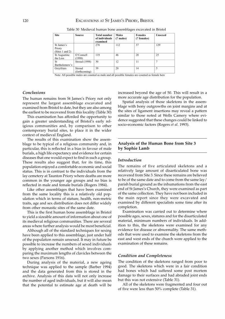
EXCAVATIONS AT ST JAMES’S PRIORY, BRISTOL120
ConclusionsThe human remains from St James’s Priory not onlyrepresent the largest assemblage excavated andexamined from Bristol to date, but they are also amongthe earliest to be recovered from this locality (Table 30)
This examination has afforded the opportunity togain a greater understanding of Bristol’s early rel-igious communities and, by comparison to othercontemporary burial sites, to place it in the widercontext of medieval England.
The results of this examination show the assem-blage to be typical of a religious community and, inparticular, this is reflected in a bias in favour of maleburials, a high life expectancy and evidence for certaindiseases that one would expect to find in such a group.These results also suggest that, for its time, thispopulation enjoyed a comfortable economic and socialstatus. This is in contrast to the individuals from thelay cemetery at Taunton Priory where deaths are morecommon in the younger age groups and no bias isreflected in male and female burials (Rogers 1984).
Like other assemblages that have been examinedfrom the same locality this is a relatively old pop-ulation which in terms of stature, health, non-metrictraits, age and sex distribution does not differ widelyfrom other monastic sites of the same date.
This is the first human bone assemblage in Bristolto yield a sizeable amount of information about one ofits medieval religious communities. There are severalareas where further analysis would be most beneficial.
Although all of the standard techniques for sexinghave been applied to this assemblage, just under halfof the population remain unsexed. It may in future bepossible to increase the numbers of sexed individualsby applying another method which involves com-paring the maximum lengths of clavicles between thetwo sexes (Parsons 1916).
During analysis of the material, a new ageingtechnique was applied to the sample (Barber 1994)and the data generated from this is stored in thearchive. Analysis of this data will not only increasethe number of aged individuals, but it will also meanthat the potential to estimate age at death will be
increased beyond the age of 50. This will result in amore accurate age distribution for the population.
Spatial analysis of those skeletons in the assem-blage with bony outgrowths on joint margins and atthe sites of ligament insertions may reveal a patternsimilar to those noted at Wells Camery where evi-dence suggested that these changes could be linked tosocio-economic factors (Rogers et al. 1993).
Analysis of the Human Bone from Site 3by Sophie Lamb
IntroductionThe remains of five articulated skeletons and arelatively large amount of disarticulated bone wasrecovered from Site 3. Since these remains are believedto be of the same date and to come from the same lay/parish burial ground as the inhumations from the eastend of St James’s Church, they were examined as partof the same collection. They have not been included inthe main report since they were excavated andexamined by different specialists some time after itscompletion.
Examination was carried out to determine wherepossible ages, sexes, statures and for the disarticulatedmaterial, minimum numbers of individuals. In add-ition to this, the skeletons were examined for anyevidence for disease or abnormality. The same meth-ods that were used to examine the skeletons from theeast and west ends of the church were applied to theexamination of these remains.
Condition and CompletenessThe condition of the skeletons ranged from poor togood. The skeletons which were in a fair conditionhad bones which had suffered some post mortemdamage to their surfaces and had abraded joint endsbut this was not extensive (Table 31).
All of the skeletons were fragmented and four outof five were less than 50% complete (Table 31).
Site Source Total number
of individuals
examined
Males
(? males)
Females
(? females)
Unsexed
St James’s
Priory
(Sites 1 and 2)
278 112 37 129
St Augustine
the Less
O’Connell
(1998)
119 46 28 25
St
Bartholomew’s
Stroud (1998) 30 12 11 7
Greyfriars Stroud
(forthcoming)
39 20 14 5
Note: All possible males are counted as male and all possible females are counted as female here
Table 30 Medieval human bone assemblages excavated in Bristol
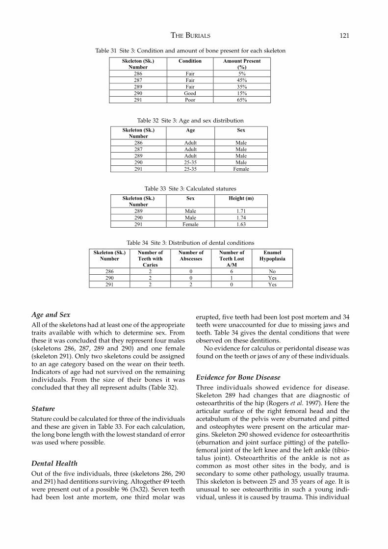
THE BURIALS 121
Age and SexAll of the skeletons had at least one of the appropriatetraits available with which to determine sex. Fromthese it was concluded that they represent four males(skeletons 286, 287, 289 and 290) and one female(skeleton 291). Only two skeletons could be assignedto an age category based on the wear on their teeth.Indicators of age had not survived on the remainingindividuals. From the size of their bones it wasconcluded that they all represent adults (Table 32).
StatureStature could be calculated for three of the individualsand these are given in Table 33. For each calculation,the long bone length with the lowest standard of errorwas used where possible.
Dental HealthOut of the five individuals, three (skeletons 286, 290and 291) had dentitions surviving. Altogether 49 teethwere present out of a possible 96 (3x32). Seven teethhad been lost ante mortem, one third molar was
erupted, five teeth had been lost post mortem and 34teeth were unaccounted for due to missing jaws andteeth. Table 34 gives the dental conditions that wereobserved on these dentitions.
No evidence for calculus or peridontal disease wasfound on the teeth or jaws of any of these individuals.
Evidence for Bone DiseaseThree individuals showed evidence for disease.Skeleton 289 had changes that are diagnostic ofosteoarthritis of the hip (Rogers et al. 1997). Here thearticular surface of the right femoral head and theacetabulum of the pelvis were eburnated and pittedand osteophytes were present on the articular mar-gins. Skeleton 290 showed evidence for osteoarthritis(eburnation and joint surface pitting) of the patello-femoral joint of the left knee and the left ankle (tibio-talus joint). Osteoarthritis of the ankle is not ascommon as most other sites in the body, and issecondary to some other pathology, usually trauma.This skeleton is between 25 and 35 years of age. It isunusual to see osteoarthritis in such a young indi-vidual, unless it is caused by trauma. This individual
Skeleton (Sk.)
Number
Condition Amount Present
(%)
286 Fair 5%
287 Fair 45%
289 Fair 35%
290 Good 15%
291 Poor 65%
Table 31 Site 3: Condition and amount of bone present for each skeleton
Skeleton (Sk.)
Number
Age Sex
286 Adult Male
287 Adult Male
289 Adult Male
290 25-35 Male
291 25-35 Female
Table 32 Site 3: Age and sex distribution
Skeleton (Sk.)
Number
Sex Height (m)
289 Male 1.71
290 Male 1.74
291 Female 1.63
Table 33 Site 3: Calculated statures
Skeleton (Sk.)
Number
Number of
Teeth with
Caries
Number of
Abscesses
Number of
Teeth Lost
A/M
Enamel
Hypoplasia
286 2 0 6 No
290 2 0 1 Yes
291 2 2 0 Yes
Table 34 Site 3: Distribution of dental conditions
EXCAVATIONS AT ST JAMES’S PRIORY, BRISTOL122
also showed evidence of areas of bone necrosis on theleft and right knees. Although its etiology is notcompletely understood, this bone necrosis, known asosteochrondritis dessicans (OCD), is believed to becaused in some cases by trauma during youth (Klippeland Dieppe 1994). Since OCD and OA are both presenton this skeleton, trauma is a possible cause for thesechanges.
Substantial pathological changes to the rightproximal femur and the acetabulum of the hip ofskeleton 291 were also observed. These bones had theclassic appearance of a dislocated hip and this wasprobably congenital in origin (Ortner and Putschar1985). The femoral head was missing, leaving asmooth, flat stump. The articulating acetabulum ofthe hip was deformed, and osteophyte had grownover the original articular surface. A new secondaryarticular surface had been formed over it. There wasno evidence for infection, nor fracture.
The Disarticulated Human BoneThe disarticulated bone comprised material from one
context and probably derives from burials disturbedby a 19th-century drain. It was determined that aminimum of five individuals were represented: fouradults and a sub-adult. Of the adults, two were maleand two were female. One of the females was betweenthe age of 17 to 25 years. It was not possible to assignages to the remaining adults or the sub-adult. Nopathology was noted on any of the fragments.
Comment and ConclusionsThe sample that was examined from Site 3 comprisesfive articulated skeletons (four males and one female)and a minimum of five individuals (two males, twofemales and one sub-adult) within the disarticulatedmaterial. Only three could be aged with any accuracy,and an estimated stature calculated for three indi-viduals. It is interesting to note the high frequency ofpathology on these skeletons, although none of thepathologies are exceptionally rare. On the whole theresults of this examination are consistent with thefindings from the skeletons from the east and westends of the church.
THE FINDS 123
6 THE FINDS
This chapter deals mainly with the finds from Site 1,those from Site 2 having been fully assessed byspecialists and, apart from the pre-Conquest potteryand the medieval floor tiles, thought not of sufficientinterest to merit publication. The quantity of medievalfinds from Site 2 was quite small and the ceramicfinds in particular were generally duplicated by thefinds from Site 1 which are reported in full below. Themajority of the finds from Site 2 were post-medievalceramics which occurred in either quite broadly datedcontexts or residually in later contexts. In any eventmore complete forms of those vessels occurredamongst the material from the closely dated 17th- and18th-century pit groups found on Site 1. The followingassessment reports on the finds from Site 2 areavailable for study in the excavation archive:The medieval and post-medieval pottery (by RodBurchill), the ceramic, stone and slate roof tiles (RodBurchill), the post-medieval wall tiles (Rod Burchill),the clay tobacco pipes (Reg Jackson), the glass (RodBurchill), the coins and tokens (Rosie Clarke), thesmall finds including a note on their conservation andstorage (Amanda Wallace), the stonework, brick,plaster and mortar samples (Reg Jackson) and thefaunal remains (Geraldine Barber).
Apart from the medieval floor tiles and a few otherobjects, only the finds from the post-medieval pitgroups are illustrated.
The letters SF before a number denote that theobject has been recorded and identified in the sitearchive as a Small Find.
Abbreviations:Approx: approximatelyB: breadthD: diameterH: heightL: lengthMax: maximumObv: the obverse side of a coin which normally showsthe monarch’s headRev: the reverse side of a coin
The letters BPT followed by a number refer to theBristol Pottery Fabric Type series in the Bristol CityMuseum and Art Gallery.
The Pre-Conquest Pottery (Site 2)by Rod Burchill
The earliest pottery recovered from the excavationswere four sherds from contexts 286w and 288w onSite 2. These probably represented a single vessel witha shallow curved rim, in a soft grey fabric with buff-brown surfaces containing very common to abundantclear and coloured quartz, moderate iron ores, raremudstones and limestone, and very rare chert.
No clear local parallels were found for this fabric.However, it is similar to the late Saxon Bristol fabricBPT 309 which has been dated to between c.AD 950and 1080. The presence of soft red iron ores andabsence of sandstones distinguish it from that fabric.A possible Saxon date for the vessel is also suggestedby the shallow curved rim which is typical of localpre-Conquest wares, e.g. BPT 2 (Ponsford 1998, 136).
The Medieval Pottery (Site 1) by Rod Burchill
The ceramic material recovered from excavatedcontexts was quantified by sherd count and weight.The fabrics were visually examined using a hand lens(x10 magnification) and, where necessary, a binocularmicroscope (x30) and identified by comparison withthe Bristol Pottery Type Series (BPT).
This small assemblage of 238 sherds weighing 337grams was allocated to two contextual groups. Thefirst was a mostly unrelated group of features, layers,pits, etc; the second a series of grave fills.
Pottery from Contexts other than BurialsThese mostly unrelated contexts contained potterydating from the 12th to the early 17th centuries. Themedieval wares included the 12th-century Ham Green‘A’ type jugs and cookpots and the slightly later HamGreen ‘B’ jugs. From the late 13th and 14th centurieswere the products of the Bristol/Redcliffe kilns,including the post-1350 late Redcliffe ware (BPT 118L).Fifteenth-century pottery included Malvernian wares,
EXCAVATIONS AT ST JAMES’S PRIORY, BRISTOL124
common from around 1400, and the so-called TudorGreen wares. These Surrey Whitewares are known tobe in use in Bristol soon after 1420 as they were foundsealed well below the mid 15th-century demolitiondeposits at Westbury College (Ponsford 1988, 125).Fragments of a black, or very dark green, glazed flaredcup of East Somerset (Wanstrow) origin probably dateto the early 17th century.
A small number of sherds of the later medieval,1350–1500, partially glazed Saintonge jugs (BPT 160)were the only non-native imports.
An unusual fabric recovered from context 1423 wasa smooth red earthenware with a streaky yellow-greeninternal glaze (BPT 222). This material was firstrecognised amongst pottery recovered from theexcavations at Peter Street, Bristol in 1975. However,its source and date range is unclear.
From context 1589 came a sherd in a thick quartzgritted fabric with an external yellow-brown glaze(BPT 245). Ponsford (1979) dated this type between1100–1200 at Bristol Castle. It must be residual in thepresent context.
Pottery Associated with the BurialsThe burials have been assigned to three broad groups:head-niche, coffin and unclassified.
The pottery associated with the head-niche burialswas mostly common mid to late 12th-century HamGreen wares and the ubiquitous flint tempered wareBPT 46. There was a single sherd of the Saxo-Normanware BPT 309. The fill of grave 1184 (Sk. 97) containeda single sherd of BPT 63, a reduced, rough fabric withlarge flint inclusions and a crude, thumb-pinchedhammer head rim. Possibly a variant of BPT 46, thematerial is currently unsourced but probably datesbetween 1100–1200. Six graves contained residualRomano-British pottery.
Pottery from the coffin burials, mostly commonmedieval wares, was generally later in date than thematerial associated with the head-niche graves.Mostly late 13th or early 14th century, with theexception of context 977 (Sk. 43), none was later than1350 in date. Residual pottery, including 12th-centuryHam Green wares and Romano-British material wasrecovered from a number of graves.
Context 977 (Sk. 43) contained sherds of Mal-vernian pottery (BPT 197), Falfield black-glazed ware(BPT 266) and Rhenish stoneware from Cologne (BPT286). The presence of the Cologne vessel suggests thatthe back-filling of this grave must have taken placesometime after 1500.
The fills from the unclassifed group of burials allcontained sherds of 12th- and early 13th-century HamGreen cookpot (BPT 32 and BPT 114). Graves 804 (Sk.41), 1070 (Sk. 69), 1115 (Sk. 78), 1144 (Sk. 82), 1142 (Sk.90), 1352 (Sk. 152), 1498 (Sk. 161), 1409 (Sk. 198), 1554(Sk. 200) and 1486 (Sk. 203) contained residual
Romano-British pottery including a single sherd ofRoman amphora.
DiscussionWith the exception of the sherd of BPT 222 in context1423 and BPT 245 in context 1589, none of the potteryrecovered from the medieval contexts was unusualfor a Bristol site.
None of the pottery associated with the head-nicheburials is later than the end of the 12th century when,the ceramic evidence suggests, the first coffin burialsmake their appearance.
Grave 977 (Sk. 43) is clearly later than the othersand could not have been back-filled earlier than 1500.
The presence of residual Romano-British potteryshould not be considered unexpected, as most sites inBristol produce the odd Roman sherd, and just to thenorth-west of St James’s Priory is a known Romano-British site.
None of the medieval pottery was worthy ofillustration.
The Medieval Floor Tiles (Sites 1 and 2 andChurch House) by Bruce Williams
A total of 289 mostly incomplete tiles were found. Thelargest number (209) were retrieved from the excav-ation of Site 1 in 1995; from Site 2 at the west end ofthe church came 74 fragments; the others came fromthe 1988 excavation of Site 1 and from the evaluationof Site 2 in 1993.
The tiles are divided into three groups according tofabric, size, design and method of manufacture. Allwere from secondary contexts, including grave fills.About 30 tiles of Group 3 were found built into acourtyard wall at the rear of Church House which isadjacent to the north-west corner of the church. Fourwere removed for study and the others were left insitu.
Tile Group 1There are twenty-seven tiles in this group, two of themundecorated. No tiles are complete; in thickness theyvary from 15 to 27mm and the inward bevels on theirsides from 0 to 9 degrees. The depth of the slip used intheir patterns is up to 2mm, glazes are a rich brown,though in some it is pale-green. The backs of the tilescontain shallow scooped-out keys, though only twokeys survive on one tile; probably they had allcontained at least four keys originally.
Tiles with similar designs are known from othersites in Bristol, the castle being one of them (see BristolCity Museum and Art Gallery Accession No. Q614R).They are probably late 13th- to 14th-century in date.
THE FINDS 125
FabricGrey with orange-brown surfaces, sometimes oxidisedorange throughout. Contains abundant fine tomedium quartz, rare red iron ores and occasionallyrare fine to medium white grits. One tile contains asingle fleck of gold mica. A small number of tilesexhibit a white marbling, possibly white firing claysas used in the decoration.
Fig. 731 Site 1, context 1202, fill of rob trench of church wall,
Period 3.2 Site 1, context 1361, fill of extraction pit, Period 3.3 Site 1, context 125, general cleaning layer, Period
4B.4 Site 2, context 276w, layer, Period 2D.5 Site 1, context 1361, fill of extraction pit, Period 3.6 Site 1, context 847, fill of drain, Period 4B.7 Site 2, context 3w, flagstone floor, Period 4C.8 Site 1, context 1161, fill of extraction pit, Period 3.9 Site 1, context 1166, clearance layer, Period 4A.10 Site 2, context 44t, layer, Period 2C.11 Site 2, context 276w, layer, Period 3.12 Site 2, context 136w, fill of foundation trench,
Period 4B.13 Site 2, context 1w, demolition debris, Period 4D.14 Site 2, context 14w, mortar spread, Period 4C.
Tile Group 2This group represents the largest number of tiles fromthe excavations at St James: two hundred and twenty-seven having been found. The tiles are larger thanaverage and none are complete, the largest fragmentmeasuring 184mm across. In thickness they varybetween 21mm and 32mm, though one piece meas-ures 34mm. They were formed on a flat, un-sandedsurface. Most of the tiles’ edges are square, though afew have inward bevels of between 1 and 10 degrees.One tile is a triangle cut from its parent tile while theclay was still soft.
Fifty-eight of the tiles are decorated, all in theincised technique using a blunt instrument which hadpenetrated up to 1mm into the surface of the soft clayquarry. The tile patterns are fairly crude, consisting ofsimple geometric forms comprising roundels orcurved, often intersecting linear shapes, and occasion-ally infilled with pecked or stabbed decoration. Theupper surface of the tiles was usually covered in rich,green glaze, much of which has now worn away, orthey were left unglazed.
As well as the unusual method of manufacture thetiles are characterised by their keys, which werestabbed randomly into their reverse sides. Two joiningfragments contain ten keys, each formed from asquare-sectioned, tapering, pointed tool probablymade of wood. The smallest outer dimension of thekeys is 7mm by 8mm across, others measure 10mmsquare or have sides of 9mm by 12mm. Occasionally
the keys pierce the upper surface of the tiles whichhas allowed glaze to run down through the holes onto their undersides.
Discussion and DateThe floor tiles are crude alternatives to the two-colourfloor tiles commonly found in Bristol. Examples oftiles decorated in the incised technique are notcommon in south-west England, though examples ofthis same type have occurred at other sites in the city– at Bristol Cathedral decorated fragments were foundin the 1980s stored in a box in the undercroft, andspecimens were also noted from an excavation at PeterStreet in 1975.
The paucity of tiles of this type outside Bristol, thecrude nature of their decoration and the close visualsimilarity between the Group 2 floor tiles and rooftiles in a similar fabric commonly found on arch-aeological sites in Bristol, led the writer to suspectthey are of local origin. Two specimens of Group 2floor tiles and three specimens of roof tile weresubsequently submitted to Dr David Williams, at theUniversity of Southampton, for thin section analysis.The full results of that study are given below.
The date of the manufacture of the floor tiles canonly be given by analogy to the roof tiles in the same ora similar fabric, since no floor tiles of this group havebeen found in situ. At excavations at nos. 82–87 RedcliffStreet, Bristol, roof tiles (Type 9) in the above fabric aredated to the 14th century and a similar date may begiven for the floor tiles (Williams forthcoming a).
FabricFor a detailed description of the petrology see the thinsection analysis below.
Fig. 7415 Site 2, context 254w, occupation layer, Period 2C.16 Site 1, context 959, fill of grave Sk. 42 within the
church, Period 2C.17 Site 1, context 894, fill of linear feature, Period 3.18 Site 1, context 1503, fill of ditch, Period 2C/2D.19 Site 1, unstratified.20 Site 1, context 1423, fill of ditch, Period 2C/2D.21 Site 1, context 1423, fill of ditch, Period 2C/2D.
Fig. 7522 Site 2, context 292w, layer, Period 3.23 Site 1, context 754, fill of rob trench of church wall,
Period 3.24 Site 1, context 1423, fill of ditch, Period 2C/2D.25 Site 2, context 154w, layer, Period 3.26 Site 1, context 754, fill of rob trench of church wall,
Period 3.27 Site 1, context 744, fill of pit, Period 4A.28 Site 1, context 1423, fill of ditch, Period 2C/2D.29 Site 1, context 1202, fill of rob trench of church wall,
Period 3.30 Site 1, context 1423, fill of ditch, Period 2C/2D.
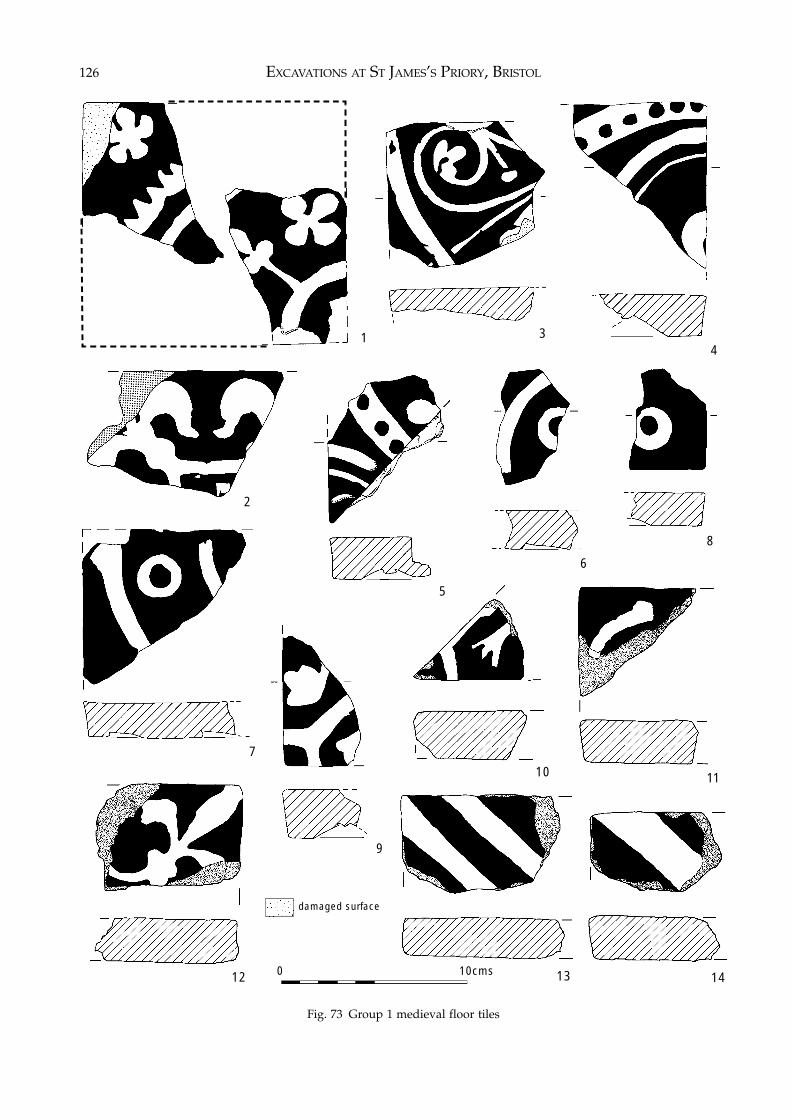
EXCAVATIONS AT ST JAMES’S PRIORY, BRISTOL126
Fig. 73 Group 1 medieval floor tiles
1
2
34
6
7
8
9
10 11
12 13 140 10cms
5
damaged surface
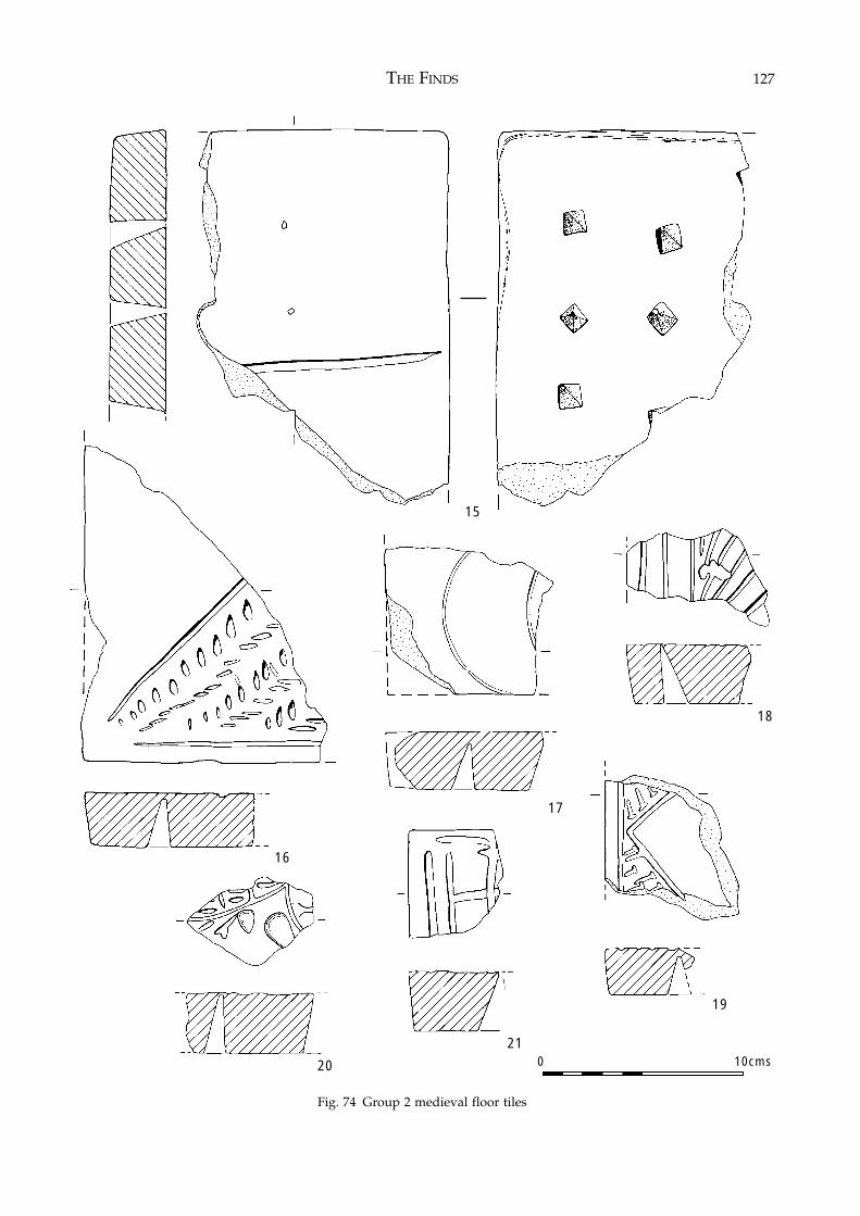
THE FINDS 127
Fig. 74 Group 2 medieval floor tiles
0 10cms
15
16
17
18
19
21
20
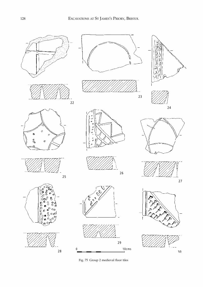
EXCAVATIONS AT ST JAMES’S PRIORY, BRISTOL128
Fig. 75 Group 2 medieval floor tiles
0 10cms
22
23
24
2526
27
29
3028
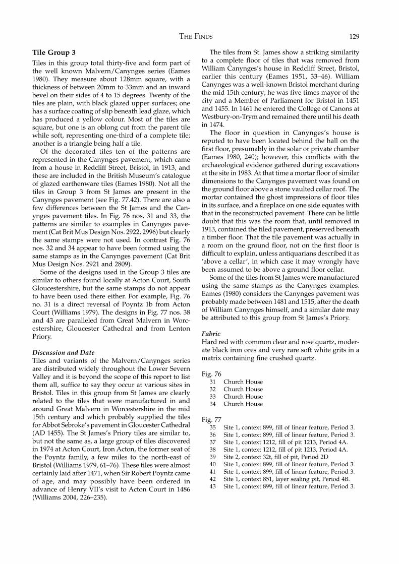
THE FINDS 129
Tile Group 3Tiles in this group total thirty-five and form part ofthe well known Malvern/Canynges series (Eames1980). They measure about 128mm square, with athickness of between 20mm to 33mm and an inwardbevel on their sides of 4 to 15 degrees. Twenty of thetiles are plain, with black glazed upper surfaces; onehas a surface coating of slip beneath lead glaze, whichhas produced a yellow colour. Most of the tiles aresquare, but one is an oblong cut from the parent tilewhile soft, representing one-third of a complete tile;another is a triangle being half a tile.
Of the decorated tiles ten of the patterns arerepresented in the Canynges pavement, which camefrom a house in Redcliff Street, Bristol, in 1913, andthese are included in the British Museum’s catalogueof glazed earthenware tiles (Eames 1980). Not all thetiles in Group 3 from St James are present in theCanynges pavement (see Fig. 77.42). There are also afew differences between the St James and the Can-ynges pavement tiles. In Fig. 76 nos. 31 and 33, thepatterns are similar to examples in Canynges pave-ment (Cat Brit Mus Design Nos. 2922, 2996) but clearlythe same stamps were not used. In contrast Fig. 76nos. 32 and 34 appear to have been formed using thesame stamps as in the Canynges pavement (Cat BritMus Design Nos. 2921 and 2809).
Some of the designs used in the Group 3 tiles aresimilar to others found locally at Acton Court, SouthGloucestershire, but the same stamps do not appearto have been used there either. For example, Fig. 76no. 31 is a direct reversal of Poyntz 1b from ActonCourt (Williams 1979). The designs in Fig. 77 nos. 38and 43 are paralleled from Great Malvern in Worc-estershire, Gloucester Cathedral and from LentonPriory.
Discussion and DateTiles and variants of the Malvern/Canynges seriesare distributed widely throughout the Lower SevernValley and it is beyond the scope of this report to listthem all, suffice to say they occur at various sites inBristol. Tiles in this group from St James are clearlyrelated to the tiles that were manufactured in andaround Great Malvern in Worcestershire in the mid15th century and which probably supplied the tilesfor Abbot Sebroke’s pavement in Gloucester Cathedral(AD 1455). The St James’s Priory tiles are similar to,but not the same as, a large group of tiles discoveredin 1974 at Acton Court, Iron Acton, the former seat ofthe Poyntz family, a few miles to the north-east ofBristol (Williams 1979, 61–76). These tiles were almostcertainly laid after 1471, when Sir Robert Poyntz cameof age, and may possibly have been ordered inadvance of Henry VII’s visit to Acton Court in 1486(Williams 2004, 226–235).
The tiles from St. James show a striking similarityto a complete floor of tiles that was removed fromWilliam Canynges’s house in Redcliff Street, Bristol,earlier this century (Eames 1951, 33–46). WilliamCanynges was a well-known Bristol merchant duringthe mid 15th century; he was five times mayor of thecity and a Member of Parliament for Bristol in 1451and 1455. In 1461 he entered the College of Canons atWestbury-on-Trym and remained there until his deathin 1474.
The floor in question in Canynges’s house isreputed to have been located behind the hall on thefirst floor, presumably in the solar or private chamber(Eames 1980, 240); however, this conflicts with thearchaeological evidence gathered during excavationsat the site in 1983. At that time a mortar floor of similardimensions to the Canynges pavement was found onthe ground floor above a stone vaulted cellar roof. Themortar contained the ghost impressions of floor tilesin its surface, and a fireplace on one side equates withthat in the reconstructed pavement. There can be littledoubt that this was the room that, until removed in1913, contained the tiled pavement, preserved beneatha timber floor. That the tile pavement was actually ina room on the ground floor, not on the first floor isdifficult to explain, unless antiquarians described it as‘above a cellar’, in which case it may wrongly havebeen assumed to be above a ground floor cellar.
Some of the tiles from St James were manufacturedusing the same stamps as the Canynges examples.Eames (1980) considers the Canynges pavement wasprobably made between 1481 and 1515, after the deathof William Canynges himself, and a similar date maybe attributed to this group from St James’s Priory.
FabricHard red with common clear and rose quartz, moder-ate black iron ores and very rare soft white grits in amatrix containing fine crushed quartz.
Fig. 7631 Church House32 Church House33 Church House34 Church House
Fig. 7735 Site 1, context 899, fill of linear feature, Period 3.36 Site 1, context 899, fill of linear feature, Period 3.37 Site 1, context 1212, fill of pit 1213, Period 4A.38 Site 1, context 1212, fill of pit 1213, Period 4A.39 Site 2, context 32t, fill of pit, Period 2D40 Site 1, context 899, fill of linear feature, Period 3.41 Site 1, context 899, fill of linear feature, Period 3.42 Site 1, context 851, layer sealing pit, Period 4B.43 Site 1, context 899, fill of linear feature, Period 3.
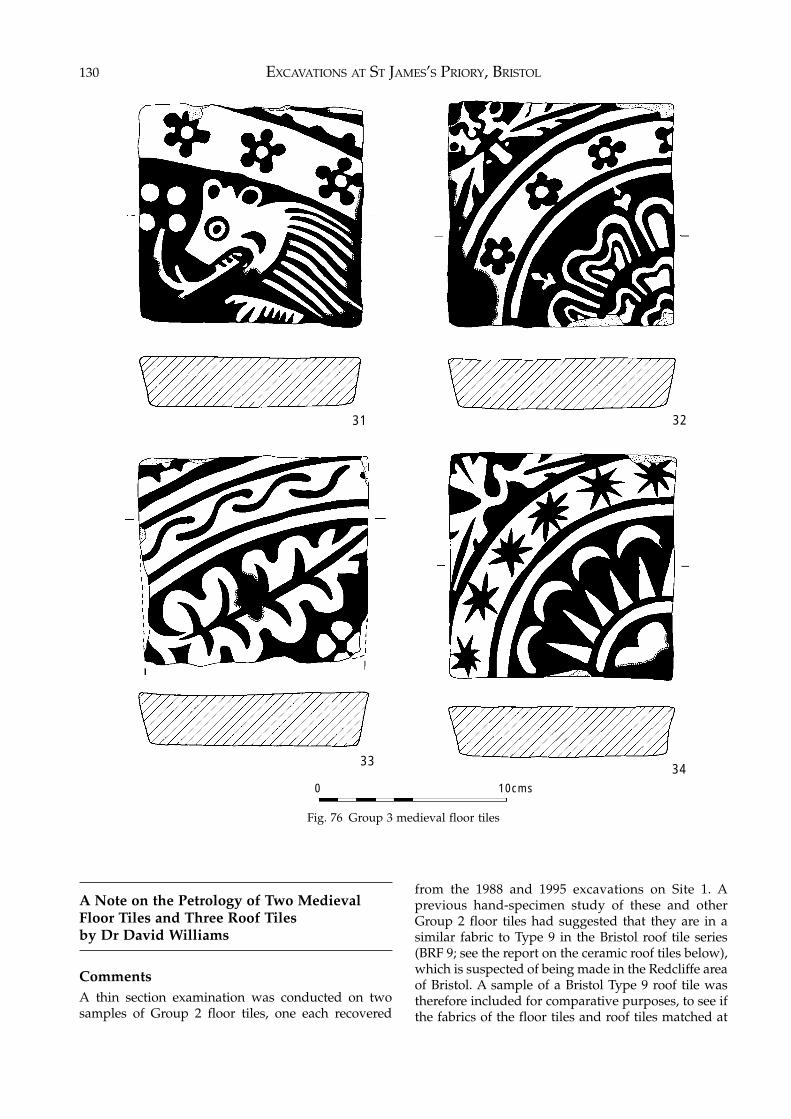
EXCAVATIONS AT ST JAMES’S PRIORY, BRISTOL130
Fig. 76 Group 3 medieval floor tiles
A Note on the Petrology of Two MedievalFloor Tiles and Three Roof Tilesby Dr David Williams
CommentsA thin section examination was conducted on twosamples of Group 2 floor tiles, one each recovered
from the 1988 and 1995 excavations on Site 1. Aprevious hand-specimen study of these and otherGroup 2 floor tiles had suggested that they are in asimilar fabric to Type 9 in the Bristol roof tile series(BRF 9; see the report on the ceramic roof tiles below),which is suspected of being made in the Redcliffe areaof Bristol. A sample of a Bristol Type 9 roof tile wastherefore included for comparative purposes, to see ifthe fabrics of the floor tiles and roof tiles matched at
31
3334
32
0 10cms
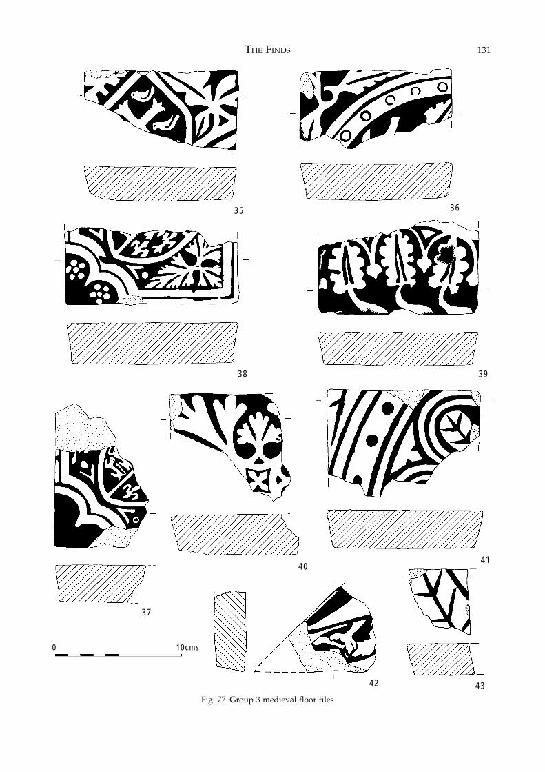
THE FINDS 131
Fig. 77 Group 3 medieval floor tiles
35
37
38 39
43
40
0 10cms
Fig. 77 Group 3 medieval floor tiles
36
42
41
EXCAVATIONS AT ST JAMES’S PRIORY, BRISTOL132
all. Also submitted were samples from the Bristol rooftile series Types 2 and 4 (BRF 2 and 4), to see if theyalso shared the same fabric as Bristol roof tile 9, and byimplication have the same origin in the Redcliffe area.
Petrology1. Group 2 Floor Tile (Site 1, Context 851)The anisotropic clay matrix contains a ground mass ofsilt-sized quartz grains. Scattered throughout this aremoderately frequent, subangular to angular, ill-sortedgrains of quartz, ranging up to over 1mm in size. Someof the larger grains are polycrystalline. Also presentare several small fragments of quartz-arenite, withsome chert, siltstone and a little opaque iron oxide.
2. Group 2 Floor Tile (Site 1, Context 351, SF 628A)A fairly clean anisotropic clay matrix, which isnoticeably micaceous. Scattered throughout are mod-erately frequent, generally ill-sorted, subangular tosubrounded quartz grains, reaching up to over 1mmat times. Some of the larger grains are polycrystalline.Also present are a few small pieces of quartz-arenite,mudstone and sparse chert, with some opaque ironore.
3. Bristol Roof Tile Series – Type 9An isotropic clay matrix containing frequent sub-angular to angular ill-sorted quartz grains, reachingup to 1mm in size. Some of the larger grains arepolycrystalline. Also present are small pieces ofquartz-arenite, chert and mudstone, with a littleopaque iron oxide.
4. Bristol Roof Tile Series – Type 2An isotropic clay matrix containing moderatelyfrequent, subangular to subrounded, grains of well-sorted quartz, only occasionally reaching more than0.40mm in size. Some of the grains are polycrystalline.Pieces of mudstone are common throughout thematrix. Also present are small pieces of chert, a fewsmall fragments of cryptocrystalline limestone and alittle opaque iron oxide.
5. Bristol Roof Tile Series – Type 4In thin section a similar fabric to no. 4.
CommentsThe general range and texture of the non-plasticinclusions present in the two samples of Group 2 floortiles from St James’s Priory and the Bristol Type 9 rooftile are fairly similar. This suggests the possibility thatthe roof tiles may also have been made in the Redcliffearea. There is, however, a noticeable difference in theclay matrix of sample no. 2, in which mica is com-monly found, and samples nos. 1 and 3, which arecomparatively free of mica. These two fabrics, one
rich in mica and one lacking mica, have been notedpreviously in the suspected pottery and tile productsof the Redcliffe kiln area and it would appear thatboth fabrics are common to the site (Vince 1983).
The two Bristol roof tile samples Types 2 and 4appear to share a similar fabric, which is rich inmudstone fragments and also contains small pieces oflimestone. This in turn is noticeably different to thefabrics of two samples of floor tile from St James’sPriory and the Bristol Type 9 roof tile discussed above.However, a mudstone/limestone fabric also seems tobe present amongst the tile fabrics thought to havebeen produced in the Redcliffe area (Vince 1983).
The Ceramic Roof Tiles (Site 1)by Rod Burchill
The Roof TileThe ceramic roof tile recovered from excavatedcontexts was quantified by sherd count and weight.The material was visually examined and identified bycomparison to the Bristol Roof Tile Fabric series (BRF).The original type series (Williams and Ponsford 1988,145) has been enlarged and a complete listing isincluded in this report.
The roof tile recovered from the excavation con-sisted of 316 sherds weighing 26.640kg. Some 55% ofthe material examined was pan-tile, and of theremainder locally made Bristol/Redcliffe tile ac-counted for 24.3% of the assemblage with a further17.4% being tiles from the Malvern Chase area.
Fabrics BRF 1, 2, 4, 5 and 9 are petrologically similarto the Bristol/Redcliffe pottery fabric (BPT 118) andall date to the late 13th and 14th centuries. Thesefabrics are very common, usually forming the majorpart of the medieval component of roof tile assem-blages from Bristol sites.
The Malvernian tiles (BRF 7; Vince 1977) are later,first making their appearance in the 15th century andcontinuing into the 16th century.
The assemblage included seven sherds of BRF 10, apinky orange fabric with purple-brown glaze. Thesource of this type is not known. However, BRF 10 ispossibly similar in date to the Mavernian tiles. Alsopresent were two sherds in the North Devon graveltempered fabric (BRF 11) and part of a single tile in athin, very hard grey fabric with flint inclusions and agrey-green glaze, a type previously unseen in Bristol.
No complete tiles were found and none wereworthy of illustration.
The Bristol Roof Tile Fabric SeriesThe Bristol Roof Tile Fabric series (BRF), based on thework of Williams and Ponsford (1988) and updated
THE FINDS 133
by the present writer, currently consists of 15 fabricswith an additional number, BRF 14, being used as amiscellaneous category for single previously un-known fabrics. A reference collection of typed sherdsis held by Bristol and Region Archaeological Services.
BRF 1 Tiles in a grey/buff fabric containing common largelumps of unhomogenized clay (4–6mm). Green oryellow-green glaze. Knife cut crests, stab or wavy combdecoration. Made in Bristol. 14th century.
BRF 2 Grey fabric similar to BRF 1 with the addition ofcommon lumps of mudstone. Green glaze. Knife cutcrests sometimes with stabbed decoration. Bristol. 14thcentury.
BRF 3 Fabric similar to BPT 123, pink with a grey core.Yellowish green glaze. Bristol. 14th century.
BRF 4 Grey fabric containing abundant white quartz. Thinsection analysis has shown this fabric to be petrol-ogically identical to BRF 2 (see report by DavidWilliams above). Green glaze. Low-profile crests.Bristol. 14th century.
BRF 5 Redcliffe fabric, grey core, common quartz, rarelimestone. Green glaze. Low profile crest. Bristol. 14thcentury.
BRF 6 Deep pink iron-rich fabric. Occasional yellowishglaze. Flat tiles with peg holes. Bristol.
BRF 7 Malvern fabric. 15th to 16th centuries.BRF 8 North-west Wiltshire (Minety) fabric. 14th/15th
century.BRF 9 Macroscopically similar to BRF 2. Thin section
analysis has shown that BRF 9 is noticeably differentfrom that fabric as it contains no limestone (see reportby David Williams above). BRF 9 is similar to potterytype BPT 118. Tall, knife cut crests with thumbedapplied strips. Bristol. 14th century.
BRF 10 A chaotic, poorly mixed, orange fabric with finemica, iron ores and rare clay pellets. Purple-brownglaze.
BRF 11 North Devon gravel tempered roof tile. 17thcentury.
BRF 12 A quartz gritted fabric with orange surfaces andgreen tinged amber glaze. Thumb applied strips.
BRF 13 Pan-tile.BRF 14 A category for miscellaneous types.BRF 15 Pink/orange fabric with abundant rose quartz and
sparse quartzite up to 4mm. Patchy yellow-green glaze.BRF 16 Grey fabric with red surfaces. Inclusions of abun-
dant clear fabric and rare limestone in a matrix of finequartz sand, some reaction with hydrochloric acid. Theglaze, where present, is a purplish greeny-brown.
The Clay Tobacco Pipes (Site 1)by Reg Jackson
The post-medieval contexts produced a large numberof clay pipe stem fragments and pipe bowls datingfrom the 17th to the 19th centuries. The pipes from sixof the 17th- and 18th-century pit groups are describedin more detail, illustrated and quantified later in thischapter.
Those pipes which bore the names or initials ofpipe makers were, with three exceptions, all made byknown Bristol manufacturers while the unmarkedbowls were typical of those known to have been madein Bristol. As Bristol was a major pipe manufacturingcentre and the heart of that industry in the 17th and18th centuries lay just to the south-west of the presentsite in the area around Lewin’s Mead, there wouldhave been no need for the inhabitants to haveimported pipes from elsewhere.
The products of the Bristol pipe makers representedin the clay pipe assemblage are shown in Table 35. Theinformation on the working dates of the pipe makersis taken from Jackson and Price (1974) and Price andJackson (1979).
One bowl, marked with the name ‘IEFFRY.HVNT’incuse on the heel (Fig. 86.162; context 1212, Period4A) was made by the Wiltshire pipe maker JeffreyHunt who is known to have been working in the mid17th century. Another mid 17th-century bowl wasmarked with what appears to be ‘EDMVND HI...’incuse on the heel, although the maker’s identity andplace of work is unknown (Fig. 93.193; context 191,Period 4A).
Only two pipes appear to be of Continental Euro-pean origin. One bowl, which is highly decorated anddepicts a man on horseback, is probably Dutch anddates to the 18th century (context 159, Period 5A).Another stem is marked ‘FIOLET’ and refers to theFrench firm of Fiolet who were working in St Omer inthe 19th century (context 956, Period 5B).
The Coins and Tokens (Site 1) by Rosie Clarke
(Coins and tokens from the major post-medieval pitgroups appear later in this chapter).
None illustrated.A total of 14 items (two being stuck together) aredescribed below.
44. Silver short-cross penny folded in half. The obverseis the only side visible but enables the coin to beidentified as Richard I (1189–99). Class 4b. The faceis grotesque and of degraded style with one largecurl on each side. The eyes are large annulets andthe pearls of the crown run together. Obv: –NRICVS–. (SF 193B, Context 1101, Burial Type 2,Sk. 64).
45. Silver short-cross penny folded in half. The reverseis the only side visible, but the legend is illegible soit is impossible to assign the coin to any particularissue. Rev: Short Cross. (SF 194B, Context 1101,Burial Type 2, Sk. 64).
In 1180 a coinage of new type, known as the ShortCross coinage, replaced the earlier Tealby issue ofpence. The coinage covers not only the latter part of
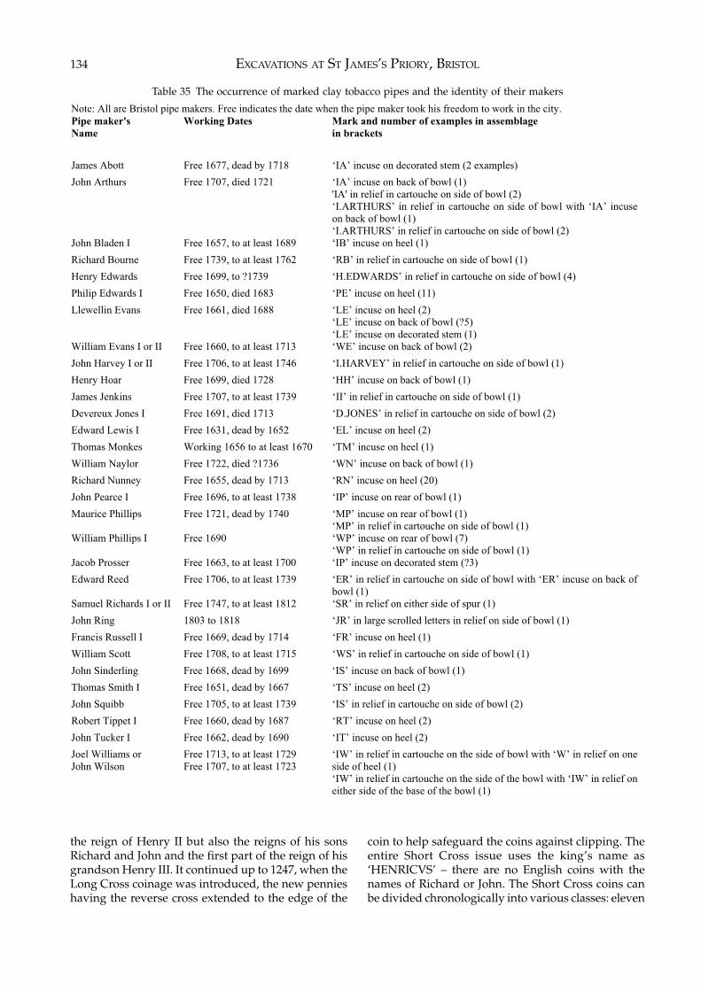
EXCAVATIONS AT ST JAMES’S PRIORY, BRISTOL134
Table 35 The occurrence of marked clay tobacco pipes and the identity of their makers
Note: All are Bristol pipe makers. Free indicates the date when the pipe maker took his freedom to work in the city.
Pipe maker's
Name
Working Dates Mark and number of examples in assemblage
in brackets
James Abott Free 1677, dead by 1718 ‘IA’ incuse on decorated stem (2 examples)
John Arthurs Free 1707, died 1721 ‘IA’ incuse on back of bowl (1)
'IA' in relief in cartouche on side of bowl (2)
‘I.ARTHURS’ in relief in cartouche on side of bowl with ‘IA’ incuse
on back of bowl (1)
‘I.ARTHURS’ in relief in cartouche on side of bowl (2)
John Bladen I Free 1657, to at least 1689 ‘IB’ incuse on heel (1)
Richard Bourne Free 1739, to at least 1762 ‘RB’ in relief in cartouche on side of bowl (1)
Henry Edwards Free 1699, to ?1739 ‘H.EDWARDS’ in relief in cartouche on side of bowl (4)
Philip Edwards I Free 1650, died 1683 ‘PE’ incuse on heel (11)
Llewellin Evans Free 1661, died 1688 ‘LE’ incuse on heel (2)
‘LE’ incuse on back of bowl (?5)
‘LE’ incuse on decorated stem (1)
William Evans I or II Free 1660, to at least 1713 ‘WE’ incuse on back of bowl (2)
John Harvey I or II Free 1706, to at least 1746 ‘I.HARVEY’ in relief in cartouche on side of bowl (1)
Henry Hoar Free 1699, died 1728 ‘HH’ incuse on back of bowl (1)
James Jenkins Free 1707, to at least 1739 ‘II’ in relief in cartouche on side of bowl (1)
Devereux Jones I Free 1691, died 1713 ‘D.JONES’ in relief in cartouche on side of bowl (2)
Edward Lewis I Free 1631, dead by 1652 ‘EL’ incuse on heel (2)
Thomas Monkes Working 1656 to at least 1670 ‘TM’ incuse on heel (1)
William Naylor Free 1722, died ?1736 ‘WN’ incuse on back of bowl (1)
Richard Nunney Free 1655, dead by 1713 ‘RN’ incuse on heel (20)
John Pearce I Free 1696, to at least 1738 ‘IP’ incuse on rear of bowl (1)
Maurice Phillips Free 1721, dead by 1740 ‘MP’ incuse on rear of bowl (1)
‘MP’ in relief in cartouche on side of bowl (1)
William Phillips I Free 1690 ‘WP’ incuse on rear of bowl (7)
‘WP’ in relief in cartouche on side of bowl (1)
Jacob Prosser Free 1663, to at least 1700 ‘IP’ incuse on decorated stem (?3)
Edward Reed Free 1706, to at least 1739 ‘ER’ in relief in cartouche on side of bowl with ‘ER’ incuse on back of
bowl (1)
Samuel Richards I or II Free 1747, to at least 1812 ‘SR’ in relief on either side of spur (1)
John Ring 1803 to 1818 ‘JR’ in large scrolled letters in relief on side of bowl (1)
Francis Russell I Free 1669, dead by 1714 ‘FR’ incuse on heel (1)
William Scott Free 1708, to at least 1715 ‘WS’ in relief in cartouche on side of bowl (1)
John Sinderling Free 1668, dead by 1699 ‘IS’ incuse on back of bowl (1)
Thomas Smith I Free 1651, dead by 1667 ‘TS’ incuse on heel (2)
John Squibb Free 1705, to at least 1739 ‘IS’ in relief in cartouche on side of bowl (2)
Robert Tippet I Free 1660, dead by 1687 ‘RT’ incuse on heel (2)
John Tucker I Free 1662, dead by 1690 ‘IT’ incuse on heel (2)
Joel Williams or
John Wilson
Free 1713, to at least 1729
Free 1707, to at least 1723
‘IW’ in relief in cartouche on the side of bowl with ‘W’ in relief on one
side of heel (1)
‘IW’ in relief in cartouche on the side of the bowl with ‘IW’ in relief on
either side of the base of the bowl (1)
the reign of Henry II but also the reigns of his sonsRichard and John and the first part of the reign of hisgrandson Henry III. It continued up to 1247, when theLong Cross coinage was introduced, the new pennieshaving the reverse cross extended to the edge of the
coin to help safeguard the coins against clipping. Theentire Short Cross issue uses the king’s name as‘HENRICVS’ – there are no English coins with thenames of Richard or John. The Short Cross coins canbe divided chronologically into various classes: eleven
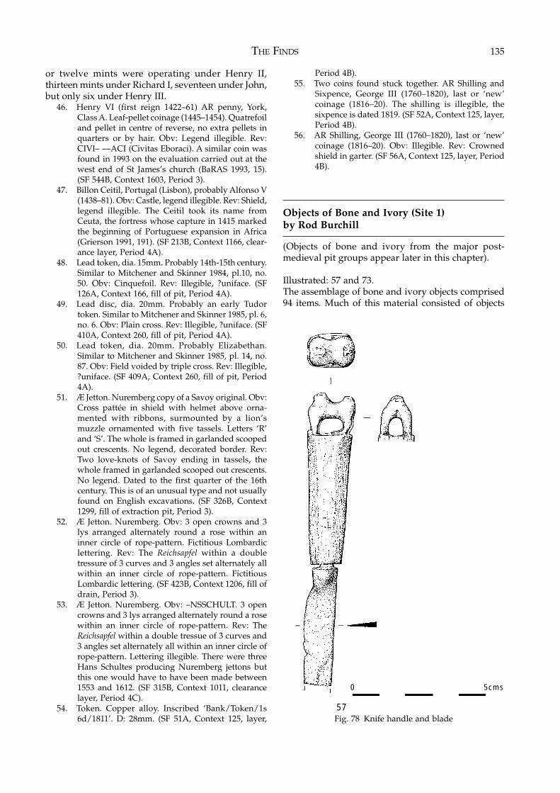
THE FINDS 135
or twelve mints were operating under Henry II,thirteen mints under Richard I, seventeen under John,but only six under Henry III.
46. Henry VI (first reign 1422–61) AR penny, York,Class A. Leaf-pellet coinage (1445–1454). Quatrefoiland pellet in centre of reverse, no extra pellets inquarters or by hair. Obv: Legend illegible. Rev:CIVI– ––ACI (Civitas Eboraci). A similar coin wasfound in 1993 on the evaluation carried out at thewest end of St James’s church (BaRAS 1993, 15).(SF 544B, Context 1603, Period 3).
47. Billon Ceitil, Portugal (Lisbon), probably Alfonso V(1438–81). Obv: Castle, legend illegible. Rev: Shield,legend illegible. The Ceitil took its name fromCeuta, the fortress whose capture in 1415 markedthe beginning of Portuguese expansion in Africa(Grierson 1991, 191). (SF 213B, Context 1166, clear-ance layer, Period 4A).
48. Lead token, dia. 15mm. Probably 14th-15th century.Similar to Mitchener and Skinner 1984, pl.10, no.50. Obv: Cinquefoil. Rev: Illegible, ?uniface. (SF126A, Context 166, fill of pit, Period 4A).
49. Lead disc, dia. 20mm. Probably an early Tudortoken. Similar to Mitchener and Skinner 1985, pl. 6,no. 6. Obv: Plain cross. Rev: Illegible, ?uniface. (SF410A, Context 260, fill of pit, Period 4A).
50. Lead token, dia. 20mm. Probably Elizabethan.Similar to Mitchener and Skinner 1985, pl. 14, no.87. Obv: Field voided by triple cross. Rev: Illegible,?uniface. (SF 409A, Context 260, fill of pit, Period4A).
51. Æ Jetton. Nuremberg copy of a Savoy original. Obv:Cross pattée in shield with helmet above orna-mented with ribbons, surmounted by a lion’smuzzle ornamented with five tassels. Letters ‘R’and ‘S’. The whole is framed in garlanded scoopedout crescents. No legend, decorated border. Rev:Two love-knots of Savoy ending in tassels, thewhole framed in garlanded scooped out crescents.No legend. Dated to the first quarter of the 16thcentury. This is of an unusual type and not usuallyfound on English excavations. (SF 326B, Context1299, fill of extraction pit, Period 3).
52. Æ Jetton. Nuremberg. Obv: 3 open crowns and 3lys arranged alternately round a rose within aninner circle of rope-pattern. Fictitious Lombardiclettering. Rev: The Reichsapfel within a doubletressure of 3 curves and 3 angles set alternately allwithin an inner circle of rope-pattern. FictitiousLombardic lettering. (SF 423B, Context 1206, fill ofdrain, Period 3).
53. Æ Jetton. Nuremberg. Obv: –NSSCHULT. 3 opencrowns and 3 lys arranged alternately round a rosewithin an inner circle of rope-pattern. Rev: TheReichsapfel within a double tressue of 3 curves and3 angles set alternately all within an inner circle ofrope-pattern. Lettering illegible. There were threeHans Schultes producing Nuremberg jettons butthis one would have to have been made between1553 and 1612. (SF 315B, Context 1011, clearancelayer, Period 4C).
54. Token. Copper alloy. Inscribed ‘Bank/Token/1s6d/1811’. D: 28mm. (SF 51A, Context 125, layer,
Period 4B).55. Two coins found stuck together. AR Shilling and
Sixpence, George III (1760–1820), last or ‘new’coinage (1816–20). The shilling is illegible, thesixpence is dated 1819. (SF 52A, Context 125, layer,Period 4B).
56. AR Shilling, George III (1760–1820), last or ‘new’coinage (1816–20). Obv: Illegible. Rev: Crownedshield in garter. (SF 56A, Context 125, layer, Period4B).
Objects of Bone and Ivory (Site 1)by Rod Burchill
(Objects of bone and ivory from the major post-medieval pit groups appear later in this chapter).
Illustrated: 57 and 73.The assemblage of bone and ivory objects comprised94 items. Much of this material consisted of objects
Fig. 78 Knife handle and blade57
0 5cms
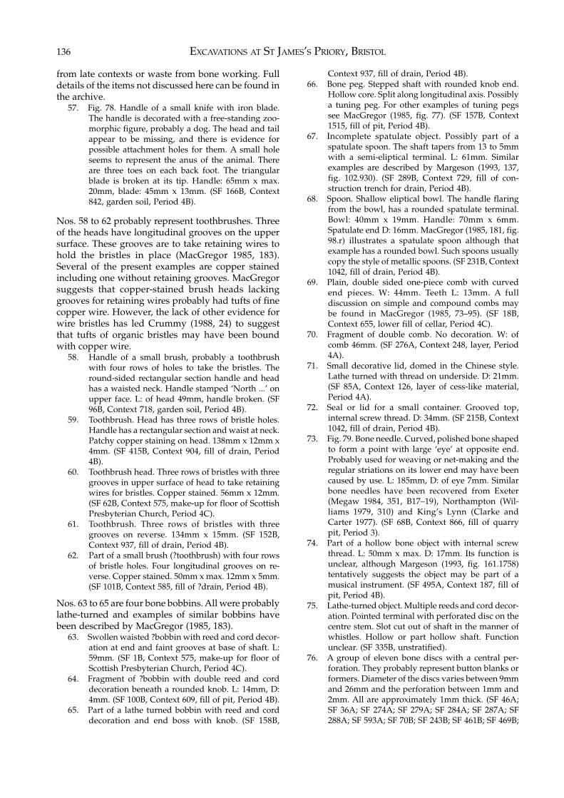
EXCAVATIONS AT ST JAMES’S PRIORY, BRISTOL136
from late contexts or waste from bone working. Fulldetails of the items not discussed here can be found inthe archive.
57. Fig. 78. Handle of a small knife with iron blade.The handle is decorated with a free-standing zoo-morphic figure, probably a dog. The head and tailappear to be missing, and there is evidence forpossible attachment holes for them. A small holeseems to represent the anus of the animal. Thereare three toes on each back foot. The triangularblade is broken at its tip. Handle: 65mm x max.20mm, blade: 45mm x 13mm. (SF 166B, Context842, garden soil, Period 4B).
Nos. 58 to 62 probably represent toothbrushes. Threeof the heads have longitudinal grooves on the uppersurface. These grooves are to take retaining wires tohold the bristles in place (MacGregor 1985, 183).Several of the present examples are copper stainedincluding one without retaining grooves. MacGregorsuggests that copper-stained brush heads lackinggrooves for retaining wires probably had tufts of finecopper wire. However, the lack of other evidence forwire bristles has led Crummy (1988, 24) to suggestthat tufts of organic bristles may have been boundwith copper wire.
58. Handle of a small brush, probably a toothbrushwith four rows of holes to take the bristles. Theround-sided rectangular section handle and headhas a waisted neck. Handle stamped ‘North ...’ onupper face. L: of head 49mm, handle broken. (SF96B, Context 718, garden soil, Period 4B).
59. Toothbrush. Head has three rows of bristle holes.Handle has a rectangular section and waist at neck.Patchy copper staining on head. 138mm x 12mm x4mm. (SF 415B, Context 904, fill of drain, Period4B).
60. Toothbrush head. Three rows of bristles with threegrooves in upper surface of head to take retainingwires for bristles. Copper stained. 56mm x 12mm.(SF 62B, Context 575, make-up for floor of ScottishPresbyterian Church, Period 4C).
61. Toothbrush. Three rows of bristles with threegrooves on reverse. 134mm x 15mm. (SF 152B,Context 937, fill of drain, Period 4B).
62. Part of a small brush (?toothbrush) with four rowsof bristle holes. Four longitudinal grooves on re-verse. Copper stained. 50mm x max. 12mm x 5mm.(SF 101B, Context 585, fill of ?drain, Period 4B).
Nos. 63 to 65 are four bone bobbins. All were probablylathe-turned and examples of similar bobbins havebeen described by MacGregor (1985, 183).
63. Swollen waisted ?bobbin with reed and cord decor-ation at end and faint grooves at base of shaft. L:59mm. (SF 1B, Context 575, make-up for floor ofScottish Presbyterian Church, Period 4C).
64. Fragment of ?bobbin with double reed and corddecoration beneath a rounded knob. L: 14mm, D:4mm. (SF 100B, Context 609, fill of pit, Period 4B).
65. Part of a lathe turned bobbin with reed and corddecoration and end boss with knob. (SF 158B,
Context 937, fill of drain, Period 4B).66. Bone peg. Stepped shaft with rounded knob end.
Hollow core. Split along longitudinal axis. Possiblya tuning peg. For other examples of tuning pegssee MacGregor (1985, fig. 77). (SF 157B, Context1515, fill of pit, Period 4B).
67. Incomplete spatulate object. Possibly part of aspatulate spoon. The shaft tapers from 13 to 5mmwith a semi-eliptical terminal. L: 61mm. Similarexamples are described by Margeson (1993, 137,fig. 102.930). (SF 289B, Context 729, fill of con-struction trench for drain, Period 4B).
68. Spoon. Shallow eliptical bowl. The handle flaringfrom the bowl, has a rounded spatulate terminal.Bowl: 40mm x 19mm. Handle: 70mm x 6mm.Spatulate end D: 16mm. MacGregor (1985, 181, fig.98.r) illustrates a spatulate spoon although thatexample has a rounded bowl. Such spoons usuallycopy the style of metallic spoons. (SF 231B, Context1042, fill of drain, Period 4B).
69. Plain, double sided one-piece comb with curvedend pieces. W: 44mm. Teeth L: 13mm. A fulldiscussion on simple and compound combs maybe found in MacGregor (1985, 73–95). (SF 18B,Context 655, lower fill of cellar, Period 4C).
70. Fragment of double comb. No decoration. W: ofcomb 46mm. (SF 276A, Context 248, layer, Period4A).
71. Small decorative lid, domed in the Chinese style.Lathe turned with thread on underside. D: 21mm.(SF 85A, Context 126, layer of cess-like material,Period 4A).
72. Seal or lid for a small container. Grooved top,internal screw thread. D: 34mm. (SF 215B, Context1042, fill of drain, Period 4B).
73. Fig. 79. Bone needle. Curved, polished bone shapedto form a point with large ‘eye’ at opposite end.Probably used for weaving or net-making and theregular striations on its lower end may have beencaused by use. L: 185mm, D: of eye 7mm. Similarbone needles have been recovered from Exeter(Megaw 1984, 351, B17–19), Northampton (Wil-liams 1979, 310) and King’s Lynn (Clarke andCarter 1977). (SF 68B, Context 866, fill of quarrypit, Period 3).
74. Part of a hollow bone object with internal screwthread. L: 50mm x max. D: 17mm. Its function isunclear, although Margeson (1993, fig. 161.1758)tentatively suggests the object may be part of amusical instrument. (SF 495A, Context 187, fill ofpit, Period 4B).
75. Lathe-turned object. Multiple reeds and cord decor-ation. Pointed terminal with perforated disc on thecentre stem. Slot cut out of shaft in the manner ofwhistles. Hollow or part hollow shaft. Functionunclear. (SF 335B, unstratified).
76. A group of eleven bone discs with a central per-foration. They probably represent button blanks orformers. Diameter of the discs varies between 9mmand 26mm and the perforation between 1mm and2mm. All are approximately 1mm thick. (SF 46A;SF 36A; SF 274A; SF 279A; SF 284A; SF 287A; SF288A; SF 593A; SF 70B; SF 243B; SF 461B; SF 469B;
THE FINDS 137
from contexts 64, 109, 248, 338, 718, 938, 1026,1042).
MacGregor (1985, 99–102) has described the processof making buttons from the long bones of cattle. Hedescribes the method of producing the discs by theuse of a centre-bit drill with a curving profile andprojecting centre point. The bones were drilled fromboth sides using the centre point to align the drill.MacGregor lists a number of sites where similarmaterial has been found, although a number of these
are medieval in date as are the previously excavatedexamples from Bristol (Williams forthcoming b).
Objects of Glass (Site 1) by Rod Burchill
(Objects of glass from the major post-medieval pitgroups appear later in this chapter).
Illustrated: 111.The assemblage of glass small finds, 128 pieces,consisted mostly of domestic utensils such as bottlesand drinking glasses. A number of vessels had aprobable medical function and these included flasksand phials. A glass tube (SF 467A) was probably partof an alembic, used for distillation, possibly ofmedicinal spirits.
Medieval window glass was recovered from sevencontexts. All was in poor condition. A number ofexamples were decorated and in others it was possiblethat the decoration was obscured by degradation ofthe glass surface. Medieval window glass was likelyto have been fitted only to high status buildings andthe present examples were probably derived from thepriory church.
77. Seven fragments of medieval window glass. Verypoor condition. (SF 545B, Context 1224, primaryfill of extraction pit, Period 3).
78. Fragments of smooth black surfaced medievalwindow glass with painted decoration. Conserv-ation analysis suggests a dark blue glass with redand black decoration. (SF 316(a)B, Context 1160,fill of extraction pit, Period 3).
79. Fragments of medieval window glass. Green core,with dark surface weathering but white whereprotected by lead came. (SF 316(b)B, Context 1160,fill of extraction pit, Period 3).
80. Fragment of clear, slightly yellow, medieval glass.(SF 316(c)B, Context 1160, fill of extraction pit,Period 3).
81. Fragment of medieval glass. (SF 316(d)B, Context1160, fill of extraction pit, Period 3).
82. Two fragments of opaque, heavily weathered, latemedieval window glass with painted surfacedecoration. (SF 431B, Context 1202, fill of rob trenchof church wall, Period 3).
83. Fragment of medieval window glass with paintedsurface decoration. (SF 321A, Context 294, layer,Period 3).
84. Fragments of medieval glass. Material very un-stable and has deteriorated to a silica mass. (SF321B, Context 759, layer sealing extraction pits,Period 4A).
85. Two very decayed fragments of medieval glass. (SF398B, Context 1205, stone-lined drain, Period 3).
86. Decorated window glass. One with botanical motifsand bands, the other with simple coloured bands.(SF 547B, Context 580, layer, Period 4B).
87. Small sub-rectangular bottle with simple evertedrim and dimpled sides. Green glass. Height 41mm
Fig. 79 Bone needle
0 5cms
73
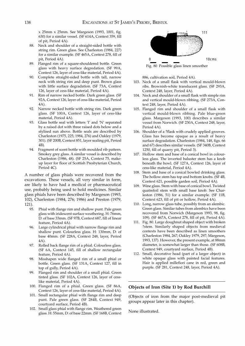
EXCAVATIONS AT ST JAMES’S PRIORY, BRISTOL138
x 25mm x 25mm. See Margeson (1993, 1001, fig.630) for a similar vessel. (SF 614A, Context 359, fillof pit, Period 4A).
88. Neck and shoulder of a straight-sided bottle withstring rim. Green glass. See Charleston (1984, 227)for a similar example. (SF 465A, Context 278, fill ofpit, Period 4A).
89. Flanged rim of a square-shouldered bottle. Greenglass with heavy surface degredation. (SF 99A,Context 126, layer of cess-like material, Period 4A).
90. Complete straight-sided bottle with tall, narrowneck with string rim and deep punt. Brown glasswith little surface degradation. (SF 73A, Context126, layer of cess-like material, Period 4A).
91. Rim of narrow necked bottle. Dark green glass. (SF92A, Context 126, layer of cess-like material, Period4A).
92. Narrow necked bottle with string rim. Dark greenglass. (SF 100A, Context 126, layer of cess-likematerial, Period 4A).
93. Glass bottle seal with letters ‘I’ and ‘N’ separatedby a raised dot with three raised dots below and astylised sun above. Bottle seals are described byCharleston (1975, 225; 1984, 276) and Oakley (1979,301). (SF 200B, Context 851, layer sealing pit, Period4B).
94. Fragment of scent bottle with moulded rib pattern.Smokey grey glass. A similar vessel is described byCharleston (1986, 48). (SF 25A, Context 75, make-up layer for floor of Scottish Presbyterian Church,Period 4C).
A number of glass phials were recovered from theexcavations. These vessels, all very similar in form,are likely to have had a medical or pharmaceuticaluse, probably being used to hold medicines. Similarglass phials have been described by Margeson (1993,102), Charleston (1984, 276; 1986) and Preston (1979,121).
95. Phial with flange rim and shallow punt. Pale greenglass with iridescent surface weathering. H: 76mm,D: of base 33mm. (SF 97B, Context 687, fill of linearfeature, Period 4A).
96. Large cylindrical phial with narrow flange rim andshallow punt. Colourless glass. H: 130mm, D: ofbase 40mm. (SF 228A, Context 248, layer, Period4A).
97. Rolled back flange rim of a phial. Colourless glass.(SF 6A, Context 145, fill of shallow rectangularfeature, Period 4A).
98. Misshapen wide flanged rim of a small phial orbottle. Green glass. (SF 131A, Context 127, fill intop of gully, Period 4A).
99. Flanged rim and shoulder of a small phial. Greentinted glass. (SF 102A, Context 126, layer of cess-like material, Period 4A).
100. Flanged rim of a phial. Green glass. (SF 86A,Context 126, layer of cess-like material, Period 4A).
101. Small rectangular phial with flange rim and deeppunt. Pale green glass. (SF 284B, Context 949,courtyard surface, Period 4B).
102. Small glass phial with flange rim. Weathered greenglass. H: 55mm, D: of base 22mm. (SF 168B, Context
886, cultivation soil, Period 4A).103. Neck of a small flask with vertical mould-blown
ribs. Brownish-white translucent glass. (SF 293A,Context 248, layer, Period 4A).
104. Neck and shoulder of a small flask with simple rimand vertical mould-blown ribbing. (SF 273A, Con-text 248, layer, Period 4A).
105. Flanged rim and shoulder of a small flask withvertical mould-blown ribbing. Pale blue-greenglass. Margeson (1993, 100) describes a similarvessel from Norwich. (SF 230A, Context 248, layer,Period 4A).
106. Shoulder of a ?flask with crudely applied grooves.Glass has become opaque as a result of heavysurface degradation. Charleston (1984, 148, figs. 66and 67) describes similar vessels. (SF 340B, Context1250, fill of quarry pit, Period 3).
107. Hollow stem and base of a conical bowl in colour-less glass. The inverted baluster stem has a knobbeneath the bowl. (SF 127A, Context 126, layer ofcess-like material, Period 4A).
108. Stem and base of a conical bowled drinking glass.The hollow stem has top and bottom knobs. (SF 4B,Context 621, possible garden soil, Period 4A).
109. Wine glass. Stem with base of conical bowl. Twistedquatrefoil stem with small base knob. See Char-leston (1986, 51) for a similar example. (SF 11B,Context 623, fill of pit or hollow, Period 4A).
110. Long, narrow glass tube, possibly from an alembic.Green glass. Similar tubes from alembics have beenrecovered from Norwich (Margeson 1993, 98, fig.109). (SF 467A, Context 278, fill of pit, Period 4A).
111. Fig. 80. Large doughnut shaped object with broken?stem. Similarly shaped objects from medievalcontexts have been described as linen smoothers(Charleston 1984, 267; Oakley 1979, 297; Margeson,1993, 137). However, the present example, at 88mmdiameter, is somewhat larger than those. (SF 608B,Context 949, courtyard surface, Period 4B).
112. Small, decorative head (part of a larger object) inwhite opaque glass with painted facial features.Hair is applied millefiori cane in red, green andpurple. (SF 281, Context 248, layer, Period 4A).
Objects of Iron (Site 1) by Rod Burchill
(Objects of iron from the major post-medieval pitgroups appear later in this chapter).
None illustrated.
Fig. 80 Possible glass linen smoother
0 10cms
111
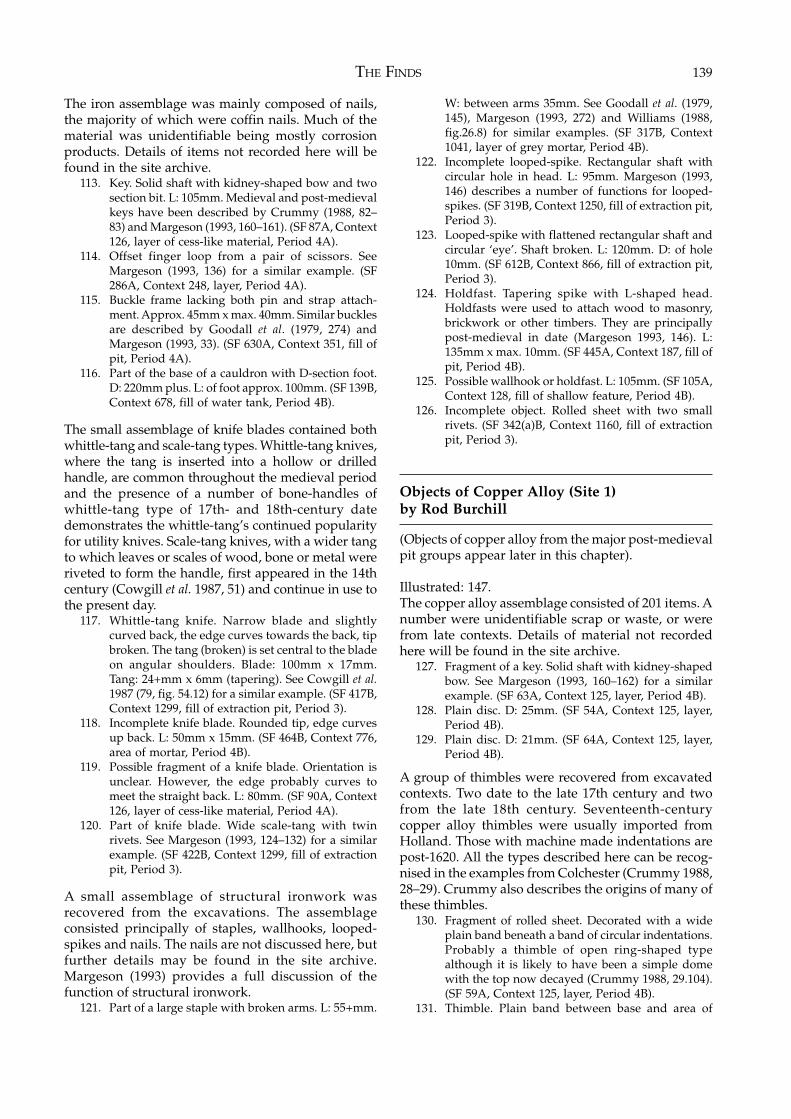
THE FINDS 139
The iron assemblage was mainly composed of nails,the majority of which were coffin nails. Much of thematerial was unidentifiable being mostly corrosionproducts. Details of items not recorded here will befound in the site archive.
113. Key. Solid shaft with kidney-shaped bow and twosection bit. L: 105mm. Medieval and post-medievalkeys have been described by Crummy (1988, 82–83) and Margeson (1993, 160–161). (SF 87A, Context126, layer of cess-like material, Period 4A).
114. Offset finger loop from a pair of scissors. SeeMargeson (1993, 136) for a similar example. (SF286A, Context 248, layer, Period 4A).
115. Buckle frame lacking both pin and strap attach-ment. Approx. 45mm x max. 40mm. Similar bucklesare described by Goodall et al. (1979, 274) andMargeson (1993, 33). (SF 630A, Context 351, fill ofpit, Period 4A).
116. Part of the base of a cauldron with D-section foot.D: 220mm plus. L: of foot approx. 100mm. (SF 139B,Context 678, fill of water tank, Period 4B).
The small assemblage of knife blades contained bothwhittle-tang and scale-tang types. Whittle-tang knives,where the tang is inserted into a hollow or drilledhandle, are common throughout the medieval periodand the presence of a number of bone-handles ofwhittle-tang type of 17th- and 18th-century datedemonstrates the whittle-tang’s continued popularityfor utility knives. Scale-tang knives, with a wider tangto which leaves or scales of wood, bone or metal wereriveted to form the handle, first appeared in the 14thcentury (Cowgill et al. 1987, 51) and continue in use tothe present day.
117. Whittle-tang knife. Narrow blade and slightlycurved back, the edge curves towards the back, tipbroken. The tang (broken) is set central to the bladeon angular shoulders. Blade: 100mm x 17mm.Tang: 24+mm x 6mm (tapering). See Cowgill et al.1987 (79, fig. 54.12) for a similar example. (SF 417B,Context 1299, fill of extraction pit, Period 3).
118. Incomplete knife blade. Rounded tip, edge curvesup back. L: 50mm x 15mm. (SF 464B, Context 776,area of mortar, Period 4B).
119. Possible fragment of a knife blade. Orientation isunclear. However, the edge probably curves tomeet the straight back. L: 80mm. (SF 90A, Context126, layer of cess-like material, Period 4A).
120. Part of knife blade. Wide scale-tang with twinrivets. See Margeson (1993, 124–132) for a similarexample. (SF 422B, Context 1299, fill of extractionpit, Period 3).
A small assemblage of structural ironwork wasrecovered from the excavations. The assemblageconsisted principally of staples, wallhooks, looped-spikes and nails. The nails are not discussed here, butfurther details may be found in the site archive.Margeson (1993) provides a full discussion of thefunction of structural ironwork.
121. Part of a large staple with broken arms. L: 55+mm.
W: between arms 35mm. See Goodall et al. (1979,145), Margeson (1993, 272) and Williams (1988,fig.26.8) for similar examples. (SF 317B, Context1041, layer of grey mortar, Period 4B).
122. Incomplete looped-spike. Rectangular shaft withcircular hole in head. L: 95mm. Margeson (1993,146) describes a number of functions for looped-spikes. (SF 319B, Context 1250, fill of extraction pit,Period 3).
123. Looped-spike with flattened rectangular shaft andcircular ‘eye’. Shaft broken. L: 120mm. D: of hole10mm. (SF 612B, Context 866, fill of extraction pit,Period 3).
124. Holdfast. Tapering spike with L-shaped head.Holdfasts were used to attach wood to masonry,brickwork or other timbers. They are principallypost-medieval in date (Margeson 1993, 146). L:135mm x max. 10mm. (SF 445A, Context 187, fill ofpit, Period 4B).
125. Possible wallhook or holdfast. L: 105mm. (SF 105A,Context 128, fill of shallow feature, Period 4B).
126. Incomplete object. Rolled sheet with two smallrivets. (SF 342(a)B, Context 1160, fill of extractionpit, Period 3).
Objects of Copper Alloy (Site 1)by Rod Burchill
(Objects of copper alloy from the major post-medievalpit groups appear later in this chapter).
Illustrated: 147.The copper alloy assemblage consisted of 201 items. Anumber were unidentifiable scrap or waste, or werefrom late contexts. Details of material not recordedhere will be found in the site archive.
127. Fragment of a key. Solid shaft with kidney-shapedbow. See Margeson (1993, 160–162) for a similarexample. (SF 63A, Context 125, layer, Period 4B).
128. Plain disc. D: 25mm. (SF 54A, Context 125, layer,Period 4B).
129. Plain disc. D: 21mm. (SF 64A, Context 125, layer,Period 4B).
A group of thimbles were recovered from excavatedcontexts. Two date to the late 17th century and twofrom the late 18th century. Seventeenth-centurycopper alloy thimbles were usually imported fromHolland. Those with machine made indentations arepost-1620. All the types described here can be recog-nised in the examples from Colchester (Crummy 1988,28–29). Crummy also describes the origins of many ofthese thimbles.
130. Fragment of rolled sheet. Decorated with a wideplain band beneath a band of circular indentations.Probably a thimble of open ring-shaped typealthough it is likely to have been a simple domewith the top now decayed (Crummy 1988, 29.104).(SF 59A, Context 125, layer, Period 4B).
131. Thimble. Plain band between base and area of
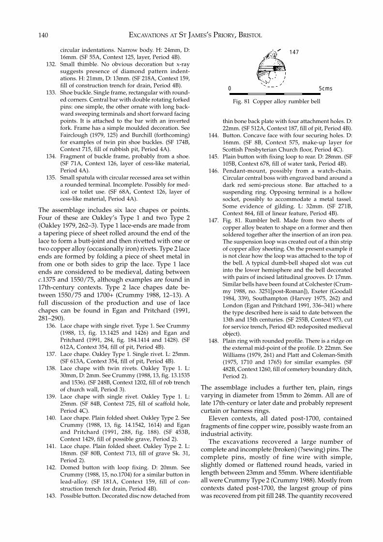
EXCAVATIONS AT ST JAMES’S PRIORY, BRISTOL140
circular indentations. Narrow body. H: 24mm, D:16mm. (SF 55A, Context 125, layer, Period 4B).
132. Small thimble. No obvious decoration but x-raysuggests presence of diamond pattern indent-ations. H: 21mm, D: 13mm. (SF 218A, Context 159,fill of construction trench for drain, Period 4B).
133. Shoe buckle. Single frame, rectangular with round-ed corners. Central bar with double rotating forkedpins: one simple, the other ornate with long back-ward sweeping terminals and short forward facingpoints. It is attached to the bar with an invertedfork. Frame has a simple moulded decoration. SeeFairclough (1979, 125) and Burchill (forthcoming)for examples of twin pin shoe buckles. (SF 174B,Context 715, fill of rubbish pit, Period 4A).
134. Fragment of buckle frame, probably from a shoe.(SF 71A, Context 126, layer of cess-like material,Period 4A).
135. Small spatula with circular recessed area set withina rounded terminal. Incomplete. Possibly for med-ical or toilet use. (SF 68A, Context 126, layer ofcess-like material, Period 4A).
The assemblage includes six lace chapes or points.Four of these are Oakley’s Type 1 and two Type 2(Oakley 1979, 262–3). Type 1 lace-ends are made froma tapering piece of sheet rolled around the end of thelace to form a butt-joint and then rivetted with one ortwo copper alloy (occasionally iron) rivets. Type 2 laceends are formed by folding a piece of sheet metal infrom one or both sides to grip the lace. Type 1 laceends are considered to be medieval, dating betweenc.1375 and 1550/75, although examples are found in17th-century contexts. Type 2 lace chapes date be-tween 1550/75 and 1700+ (Crummy 1988, 12–13). Afull discussion of the production and use of lacechapes can be found in Egan and Pritchard (1991,281–290).
136. Lace chape with single rivet. Type 1. See Crummy(1988, 13, fig. 13.1425 and 1426) and Egan andPritchard (1991, 284, fig. 184.1414 and 1428). (SF612A, Context 354, fill of pit, Period 4B).
137. Lace chape. Oakley Type 1. Single rivet. L: 25mm.(SF 613A, Context 354, fill of pit, Period 4B).
138. Lace chape with twin rivets. Oakley Type 1. L:30mm, D: 2mm. See Crummy (1988, 13, fig. 13.1535and 1536). (SF 248B, Context 1202, fill of rob trenchof church wall, Period 3).
139. Lace chape with single rivet. Oakley Type 1. L:25mm. (SF 84B, Context 725, fill of scaffold hole,Period 4C).
140. Lace chape. Plain folded sheet. Oakley Type 2. SeeCrummy (1988, 13, fig. 14.1542, 1614) and Eganand Pritchard (1991, 288, fig. 188). (SF 453B,Context 1429, fill of possible grave, Period 2).
141. Lace chape. Plain folded sheet. Oakley Type 2. L:18mm. (SF 80B, Context 713, fill of grave Sk. 31,Period 2).
142. Domed button with loop fixing. D: 20mm. SeeCrummy (1988, 15, no.1704) for a similar button inlead-alloy. (SF 181A, Context 159, fill of con-struction trench for drain, Period 4B).
143. Possible button. Decorated disc now detached from
thin bone back plate with four attachment holes. D:22mm. (SF 512A, Context 187, fill of pit, Period 4B).
144. Button. Concave face with four securing holes. D:16mm. (SF 8B, Context 575, make-up layer forScottish Presbyterian Church floor, Period 4C).
145. Plain button with fixing loop to rear. D: 28mm. (SF105B, Context 678, fill of water tank, Period 4B).
146. Pendant-mount, possibly from a watch-chain.Circular central boss with engraved band around adark red semi-precious stone. Bar attached to asuspending ring. Opposing terminal is a hollowsocket, possibly to accommodate a metal tassel.Some evidence of gilding. L: 32mm. (SF 271B,Context 864, fill of linear feature, Period 4B).
147. Fig. 81. Rumbler bell. Made from two sheets ofcopper alloy beaten to shape on a former and thensoldered together after the insertion of an iron pea.The suspension loop was created out of a thin stripof copper alloy sheeting. On the present example itis not clear how the loop was attached to the top ofthe bell. A typical dumb-bell shaped slot was cutinto the lower hemisphere and the bell decoratedwith pairs of incised latitudinal grooves. D: 17mm.Similar bells have been found at Colchester (Crum-my 1988, no. 3251[post-Roman]), Exeter (Goodall1984, 339), Southampton (Harvey 1975, 262) andLondon (Egan and Pritchard 1991, 336–341) wherethe type described here is said to date between the13th and 15th centuries. (SF 255B, Context 973, cutfor service trench, Period 4D: redeposited medievalobject).
148. Plain ring with rounded profile. There is a ridge onthe external mid-point of the profile. D: 22mm. SeeWilliams (1979, 261) and Platt and Coleman-Smith(1975, 1710 and 1765) for similar examples. (SF482B, Context 1260, fill of cemetery boundary ditch,Period 2).
The assemblage includes a further ten, plain, ringsvarying in diameter from 15mm to 26mm. All are oflate 17th-century or later date and probably representcurtain or harness rings.
Eleven contexts, all dated post-1700, containedfragments of fine copper wire, possibly waste from anindustrial activity.
The excavations recovered a large number ofcomplete and incomplete (broken) (?sewing) pins. Thecomplete pins, mostly of fine wire with simple,slightly domed or flattened round heads, varied inlength between 23mm and 55mm. Where identifiableall were Crummy Type 2 (Crummy 1988). Mostly fromcontexts dated post-1700, the largest group of pinswas recovered from pit fill 248. The quantity recovered
Fig. 81 Copper alloy rumbler bell
147
0 5cms
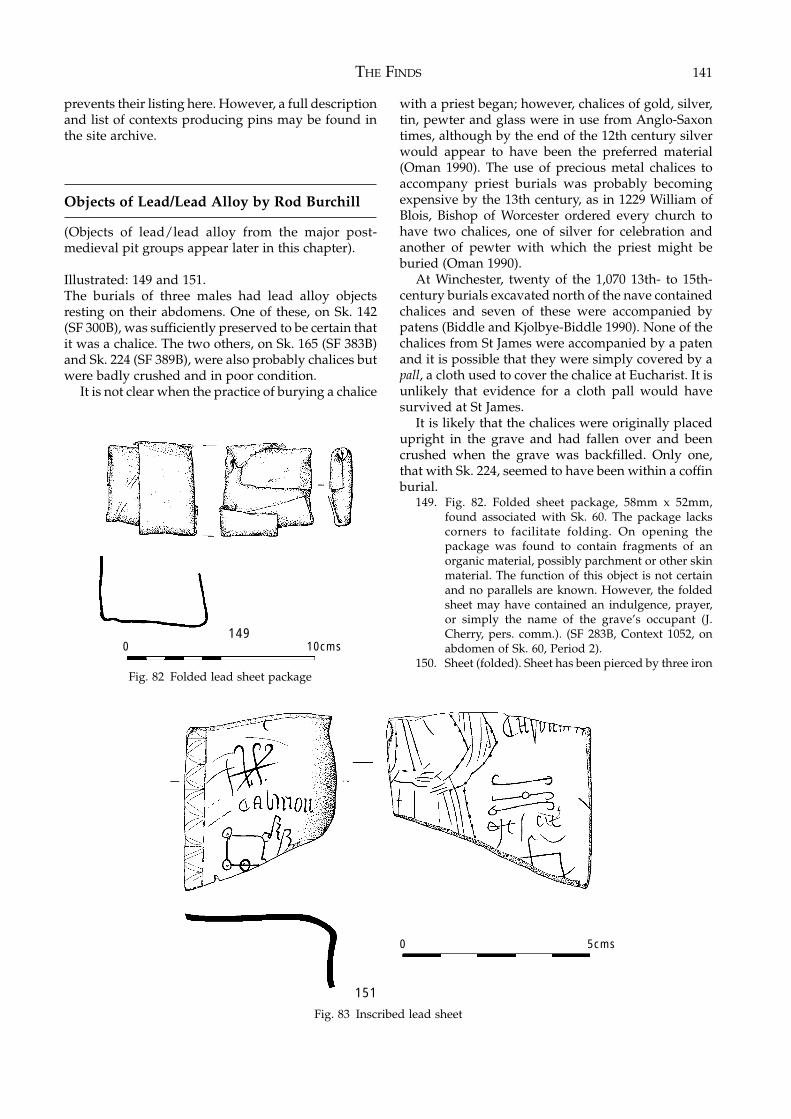
THE FINDS 141
prevents their listing here. However, a full descriptionand list of contexts producing pins may be found inthe site archive.
Objects of Lead/Lead Alloy by Rod Burchill
(Objects of lead/lead alloy from the major post-medieval pit groups appear later in this chapter).
Illustrated: 149 and 151.The burials of three males had lead alloy objectsresting on their abdomens. One of these, on Sk. 142(SF 300B), was sufficiently preserved to be certain thatit was a chalice. The two others, on Sk. 165 (SF 383B)and Sk. 224 (SF 389B), were also probably chalices butwere badly crushed and in poor condition.
It is not clear when the practice of burying a chalice
with a priest began; however, chalices of gold, silver,tin, pewter and glass were in use from Anglo-Saxontimes, although by the end of the 12th century silverwould appear to have been the preferred material(Oman 1990). The use of precious metal chalices toaccompany priest burials was probably becomingexpensive by the 13th century, as in 1229 William ofBlois, Bishop of Worcester ordered every church tohave two chalices, one of silver for celebration andanother of pewter with which the priest might beburied (Oman 1990).
At Winchester, twenty of the 1,070 13th- to 15th-century burials excavated north of the nave containedchalices and seven of these were accompanied bypatens (Biddle and Kjolbye-Biddle 1990). None of thechalices from St James were accompanied by a patenand it is possible that they were simply covered by apall, a cloth used to cover the chalice at Eucharist. It isunlikely that evidence for a cloth pall would havesurvived at St James.
It is likely that the chalices were originally placedupright in the grave and had fallen over and beencrushed when the grave was backfilled. Only one,that with Sk. 224, seemed to have been within a coffinburial.
149. Fig. 82. Folded sheet package, 58mm x 52mm,found associated with Sk. 60. The package lackscorners to facilitate folding. On opening thepackage was found to contain fragments of anorganic material, possibly parchment or other skinmaterial. The function of this object is not certainand no parallels are known. However, the foldedsheet may have contained an indulgence, prayer,or simply the name of the grave’s occupant (J.Cherry, pers. comm.). (SF 283B, Context 1052, onabdomen of Sk. 60, Period 2).
150. Sheet (folded). Sheet has been pierced by three iron
Fig. 83 Inscribed lead sheet
0 10cms149
151
0 5cms
Fig. 82 Folded lead sheet package
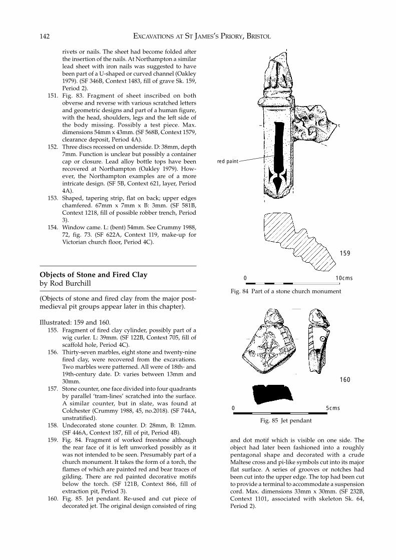
EXCAVATIONS AT ST JAMES’S PRIORY, BRISTOL142
rivets or nails. The sheet had become folded afterthe insertion of the nails. At Northampton a similarlead sheet with iron nails was suggested to havebeen part of a U-shaped or curved channel (Oakley1979). (SF 346B, Context 1483, fill of grave Sk. 159,Period 2).
151. Fig. 83. Fragment of sheet inscribed on bothobverse and reverse with various scratched lettersand geometric designs and part of a human figure,with the head, shoulders, legs and the left side ofthe body missing. Possibly a test piece. Max.dimensions 54mm x 43mm. (SF 568B, Context 1579,clearance deposit, Period 4A).
152. Three discs recessed on underside. D: 38mm, depth7mm. Function is unclear but possibly a containercap or closure. Lead alloy bottle tops have beenrecovered at Northampton (Oakley 1979). How-ever, the Northampton examples are of a moreintricate design. (SF 5B, Context 621, layer, Period4A).
153. Shaped, tapering strip, flat on back; upper edgeschamfered. 67mm x 7mm x B: 3mm. (SF 581B,Context 1218, fill of possible robber trench, Period3).
154. Window came. L: (bent) 54mm. See Crummy 1988,72, fig. 73. (SF 622A, Context 119, make-up forVictorian church floor, Period 4C).
Objects of Stone and Fired Clayby Rod Burchill
(Objects of stone and fired clay from the major post-medieval pit groups appear later in this chapter).
Illustrated: 159 and 160.155. Fragment of fired clay cylinder, possibly part of a
wig curler. L: 39mm. (SF 122B, Context 705, fill ofscaffold hole, Period 4C).
156. Thirty-seven marbles, eight stone and twenty-ninefired clay, were recovered from the excavations.Two marbles were patterned. All were of 18th- and19th-century date. D: varies between 13mm and30mm.
157. Stone counter, one face divided into four quadrantsby parallel ‘tram-lines’ scratched into the surface.A similar counter, but in slate, was found atColchester (Crummy 1988, 45, no.2018). (SF 744A,unstratified).
158. Undecorated stone counter. D: 28mm, B: 12mm.(SF 446A, Context 187, fill of pit, Period 4B).
159. Fig. 84. Fragment of worked freestone althoughthe rear face of it is left unworked possibly as itwas not intended to be seen. Presumably part of achurch monument. It takes the form of a torch, theflames of which are painted red and bear traces ofgilding. There are red painted decorative motifsbelow the torch. (SF 121B, Context 866, fill ofextraction pit, Period 3).
160. Fig. 85. Jet pendant. Re-used and cut piece ofdecorated jet. The original design consisted of ring
Fig. 84 Part of a stone church monument
Fig. 85 Jet pendant
and dot motif which is visible on one side. Theobject had later been fashioned into a roughlypentagonal shape and decorated with a crudeMaltese cross and pi-like symbols cut into its majorflat surface. A series of grooves or notches hadbeen cut into the upper edge. The top had been cutto provide a terminal to accommodate a suspensioncord. Max. dimensions 33mm x 30mm. (SF 232B,Context 1101, associated with skeleton Sk. 64,Period 2).
red paint
159
0 10cms
0 5cms
160
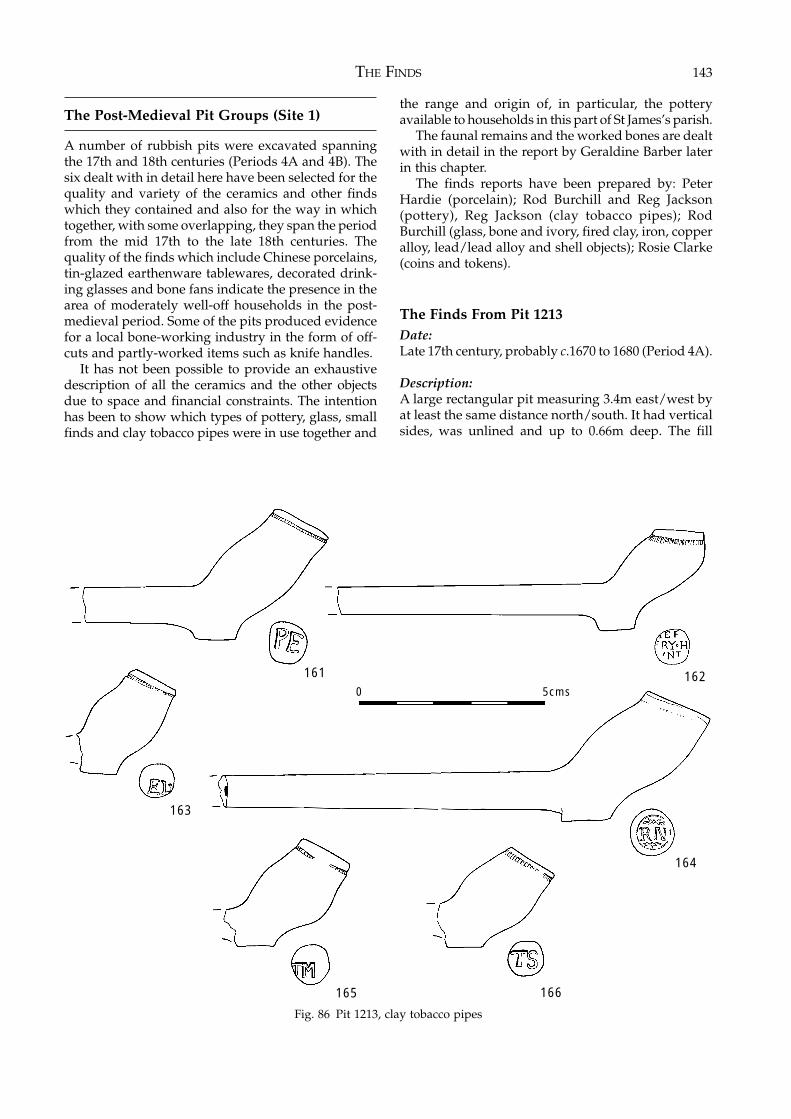
THE FINDS 143
The Post-Medieval Pit Groups (Site 1)
A number of rubbish pits were excavated spanningthe 17th and 18th centuries (Periods 4A and 4B). Thesix dealt with in detail here have been selected for thequality and variety of the ceramics and other findswhich they contained and also for the way in whichtogether, with some overlapping, they span the periodfrom the mid 17th to the late 18th centuries. Thequality of the finds which include Chinese porcelains,tin-glazed earthenware tablewares, decorated drink-ing glasses and bone fans indicate the presence in thearea of moderately well-off households in the post-medieval period. Some of the pits produced evidencefor a local bone-working industry in the form of off-cuts and partly-worked items such as knife handles.
It has not been possible to provide an exhaustivedescription of all the ceramics and the other objectsdue to space and financial constraints. The intentionhas been to show which types of pottery, glass, smallfinds and clay tobacco pipes were in use together and
the range and origin of, in particular, the potteryavailable to households in this part of St James’s parish.
The faunal remains and the worked bones are dealtwith in detail in the report by Geraldine Barber laterin this chapter.
The finds reports have been prepared by: PeterHardie (porcelain); Rod Burchill and Reg Jackson(pottery), Reg Jackson (clay tobacco pipes); RodBurchill (glass, bone and ivory, fired clay, iron, copperalloy, lead/lead alloy and shell objects); Rosie Clarke(coins and tokens).
The Finds From Pit 1213Date:Late 17th century, probably c.1670 to 1680 (Period 4A).
Description:A large rectangular pit measuring 3.4m east/west byat least the same distance north/south. It had verticalsides, was unlined and up to 0.66m deep. The fill
165
161 162
166
164
163
0 5cms
Fig. 86 Pit 1213, clay tobacco pipes
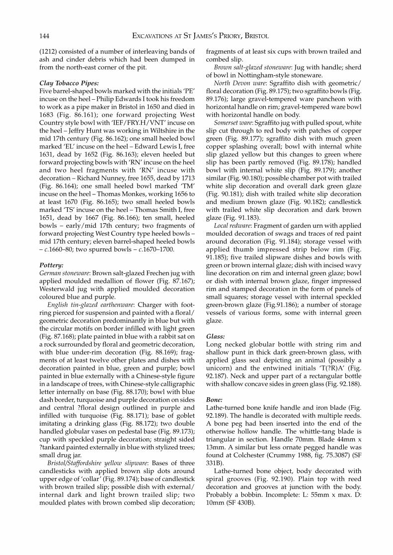
EXCAVATIONS AT ST JAMES’S PRIORY, BRISTOL144
(1212) consisted of a number of interleaving bands ofash and cinder debris which had been dumped infrom the north-east corner of the pit.
Clay Tobacco Pipes:Five barrel-shaped bowls marked with the initials ‘PE’incuse on the heel – Philip Edwards I took his freedomto work as a pipe maker in Bristol in 1650 and died in1683 (Fig. 86.161); one forward projecting WestCountry style bowl with ‘IEF/FRY.H/VNT’ incuse onthe heel – Jeffry Hunt was working in Wiltshire in themid 17th century (Fig. 86.162); one small heeled bowlmarked ‘EL’ incuse on the heel – Edward Lewis I, free1631, dead by 1652 (Fig. 86.163); eleven heeled butforward projecting bowls with ‘RN’ incuse on the heeland two heel fragments with ‘RN’ incuse withdecoration – Richard Nunney, free 1655, dead by 1713(Fig. 86.164); one small heeled bowl marked ‘TM’incuse on the heel – Thomas Monkes, working 1656 toat least 1670 (Fig. 86.165); two small heeled bowlsmarked ‘TS’ incuse on the heel – Thomas Smith I, free1651, dead by 1667 (Fig. 86.166); ten small, heeledbowls – early/mid 17th century; two fragments offorward projecting West Country type heeled bowls –mid 17th century; eleven barrel-shaped heeled bowls– c.1660–80; two spurred bowls – c.1670–1700.
Pottery:German stoneware: Brown salt-glazed Frechen jug withapplied moulded medallion of flower (Fig. 87.167);Westerwald jug with applied moulded decorationcoloured blue and purple.
English tin-glazed earthenware: Charger with foot-ring pierced for suspension and painted with a floral/geometric decoration predominantly in blue but withthe circular motifs on border infilled with light green(Fig. 87.168); plate painted in blue with a rabbit sat ona rock surrounded by floral and geometric decoration,with blue under-rim decoration (Fig. 88.169); frag-ments of at least twelve other plates and dishes withdecoration painted in blue, green and purple; bowlpainted in blue externally with a Chinese-style figurein a landscape of trees, with Chinese-style calligraphicletter internally on base (Fig. 88.170); bowl with bluedash border, turquoise and purple decoration on sidesand central ?floral design outlined in purple andinfilled with turquoise (Fig. 88.171); base of gobletimitating a drinking glass (Fig. 88.172); two doublehandled globular vases on pedestal base (Fig. 89.173);cup with speckled purple decoration; straight sided?tankard painted externally in blue with stylized trees;small drug jar.
Bristol/Staffordshire yellow slipware: Bases of threecandlesticks with applied brown slip dots aroundupper edge of ‘collar’ (Fig. 89.174); base of candlestickwith brown trailed slip; possible dish with external/internal dark and light brown trailed slip; twomoulded plates with brown combed slip decoration;
fragments of at least six cups with brown trailed andcombed slip.
Brown salt-glazed stoneware: Jug with handle; sherdof bowl in Nottingham-style stoneware.
North Devon ware: Sgraffito dish with geometric/floral decoration (Fig. 89.175); two sgraffito bowls (Fig.89.176); large gravel-tempered ware pancheon withhorizontal handle on rim; gravel-tempered ware bowlwith horizontal handle on body.
Somerset ware: Sgraffito jug with pulled spout, whiteslip cut through to red body with patches of coppergreen (Fig. 89.177); sgraffito dish with much greencopper splashing overall; bowl with internal whiteslip glazed yellow but this changes to green whereslip has been partly removed (Fig. 89.178); handledbowl with internal white slip (Fig. 89.179); anothersimilar (Fig. 90.180); possible chamber pot with trailedwhite slip decoration and overall dark green glaze(Fig. 90.181); dish with trailed white slip decorationand medium brown glaze (Fig. 90.182); candlestickwith trailed white slip decoration and dark brownglaze (Fig. 91.183).
Local redware: Fragment of garden urn with appliedmoulded decoration of swags and traces of red paintaround decoration (Fig. 91.184); storage vessel withapplied thumb impressed strip below rim (Fig.91.185); five trailed slipware dishes and bowls withgreen or brown internal glaze; dish with incised wavyline decoration on rim and internal green glaze; bowlor dish with internal brown glaze, finger impressedrim and stamped decoration in the form of panels ofsmall squares; storage vessel with internal speckledgreen-brown glaze (Fig.91.186); a number of storagevessels of various forms, some with internal greenglaze.
Glass:Long necked globular bottle with string rim andshallow punt in thick dark green-brown glass, withapplied glass seal depicting an animal (possibly aunicorn) and the entwined initials ‘T(?R)A’ (Fig.92.187). Neck and upper part of a rectangular bottlewith shallow concave sides in green glass (Fig. 92.188).
Bone:Lathe-turned bone knife handle and iron blade (Fig.92.189). The handle is decorated with multiple reeds.A bone peg had been inserted into the end of theotherwise hollow handle. The whittle-tang blade istriangular in section. Handle 70mm. Blade 44mm x13mm. A similar but less ornate pegged handle wasfound at Colchester (Crummy 1988, fig. 75.3087) (SF331B).
Lathe-turned bone object, body decorated withspiral grooves (Fig. 92.190). Plain top with reeddecoration and grooves at junction with the body.Probably a bobbin. Incomplete: L: 55mm x max. D:10mm (SF 430B).
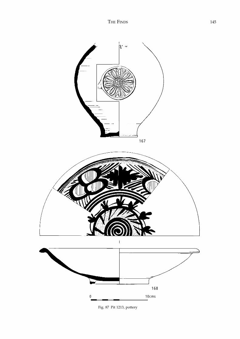
THE FINDS 145
Fig. 87 Pit 1213, pottery
167
168
0 10cms
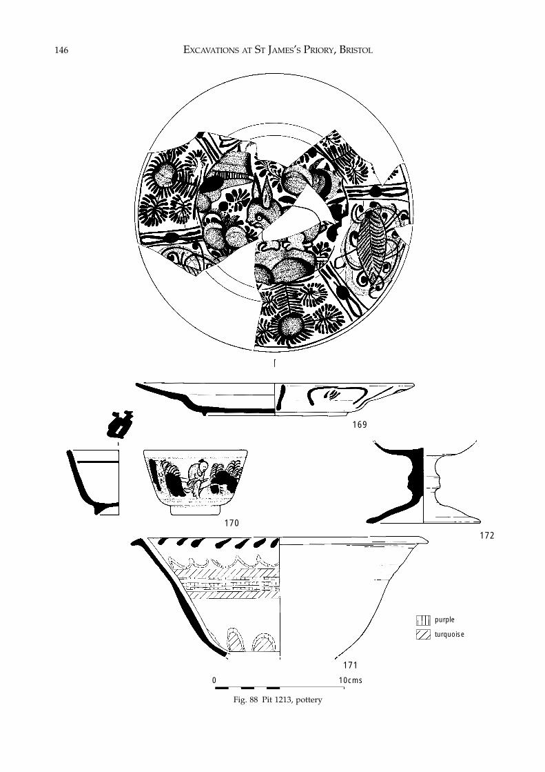
EXCAVATIONS AT ST JAMES’S PRIORY, BRISTOL146
Fig. 88 Pit 1213, potteryg. 88 Pit 1213, pottery
169
170
171
172
0 10cms
purple
turquoise
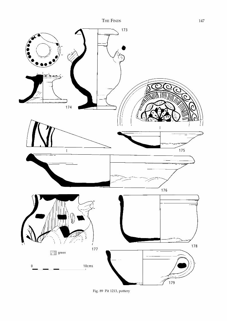
THE FINDS 147
Fig. 89 Pit 1213, pottery
Fig. 89 Pit 1213, pottery
178177
176
0 10cms
174
173
175
green
179
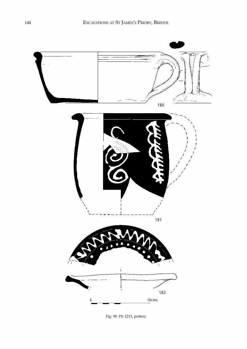
EXCAVATIONS AT ST JAMES’S PRIORY, BRISTOL148
Fig. 90 Pit 1213, pottery
180
182
181
0 10cms
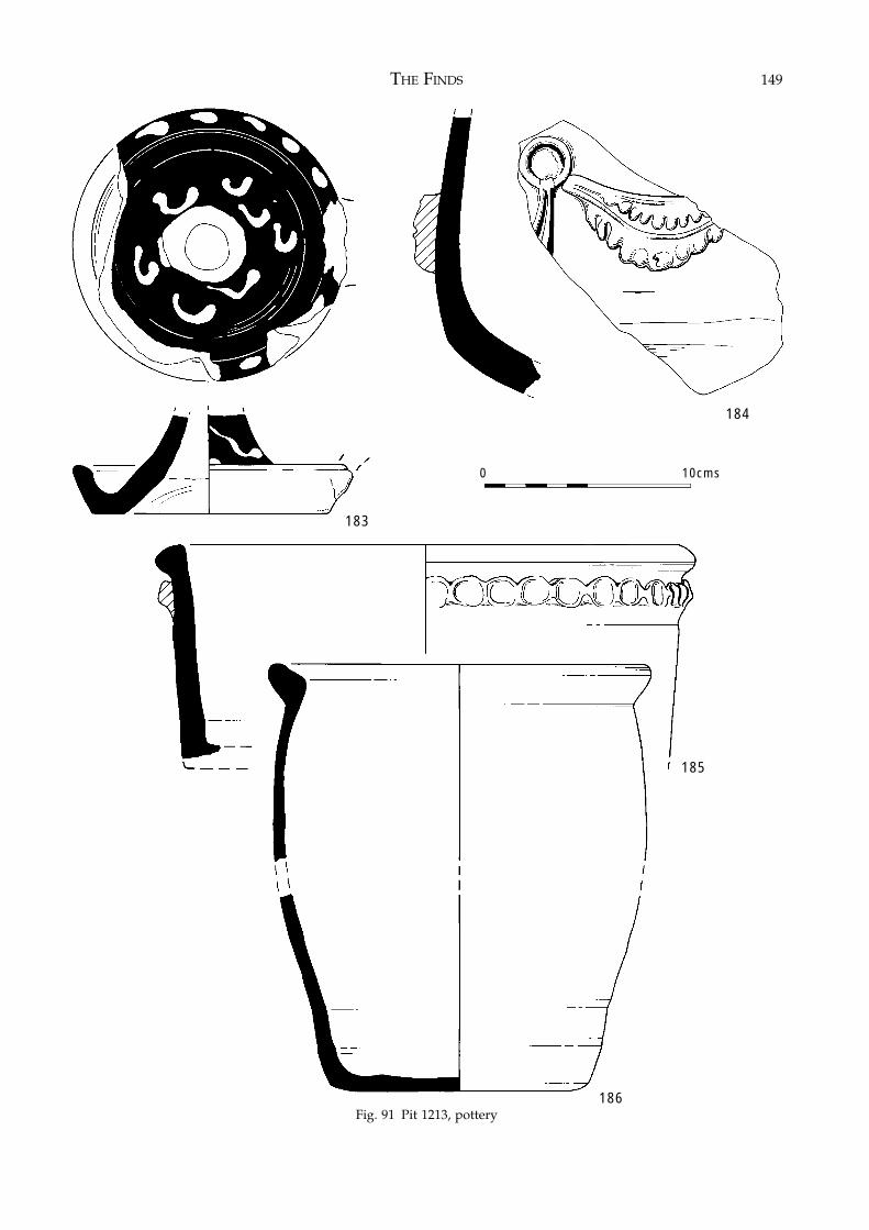
THE FINDS 149
Fig. 91 Pit 1213, pottery
183
184
186
0 10cms
Fig. 91 Pit 1213, pottery
185
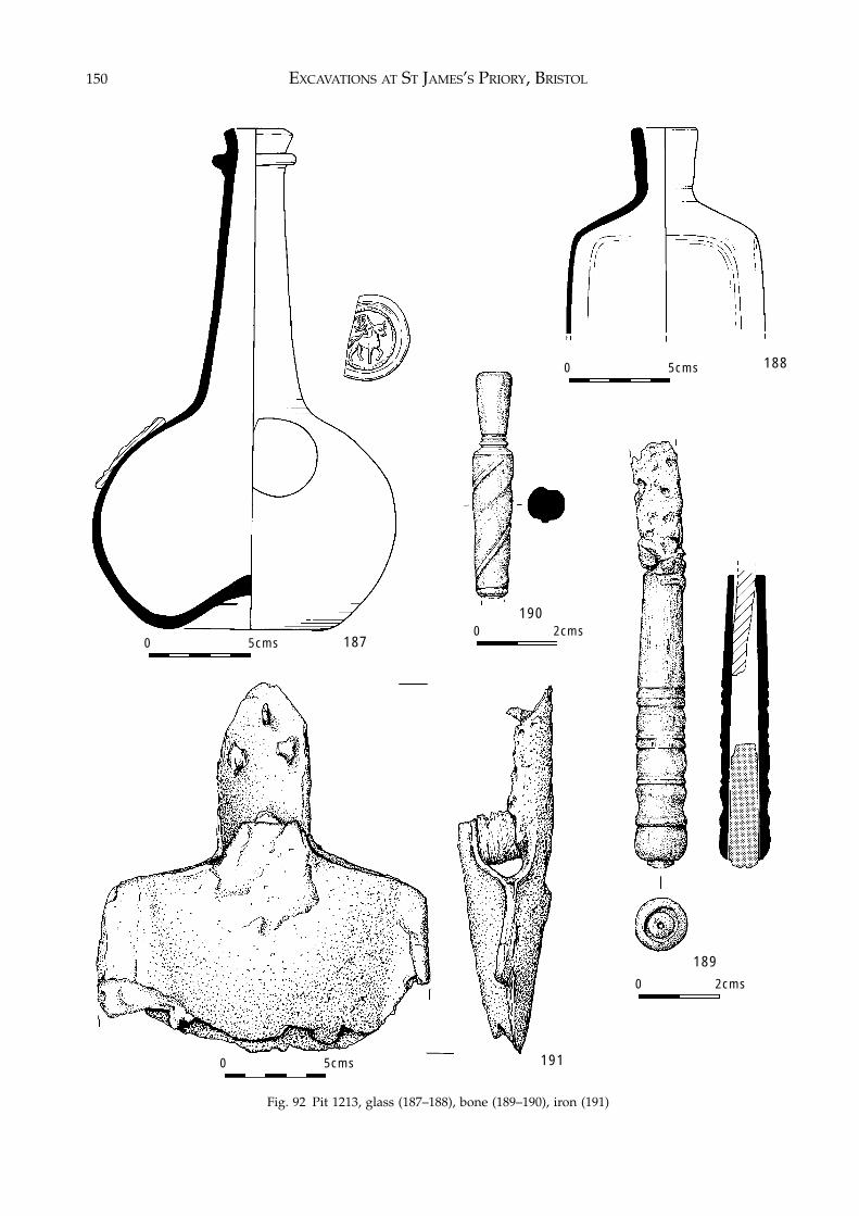
EXCAVATIONS AT ST JAMES’S PRIORY, BRISTOL150
Fig. 92 Pit 1213, glass (187–188), bone (189–190), iron (191)
187
188
190
191
189
0 2cms
0 2cms0 5cms
0 5cms
0 5cms
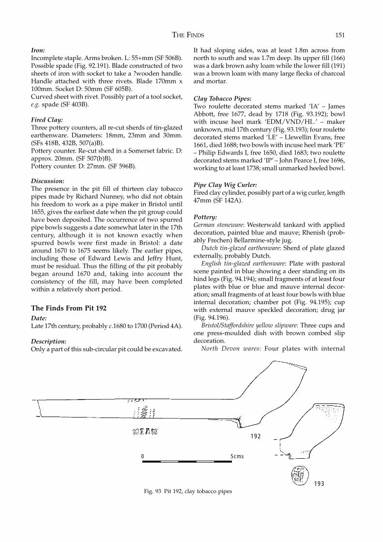
THE FINDS 151
Iron:Incomplete staple. Arms broken. L: 55+mm (SF 506B).Possible spade (Fig. 92.191). Blade constructed of twosheets of iron with socket to take a ?wooden handle.Handle attached with three rivets. Blade 170mm x100mm. Socket D: 50mm (SF 605B).Curved sheet with rivet. Possibly part of a tool socket,e.g. spade (SF 403B).
Fired Clay:Three pottery counters, all re-cut sherds of tin-glazedearthenware. Diameters: 18mm, 23mm and 30mm.(SFs 418B, 432B, 507(a)B).Pottery counter. Re-cut sherd in a Somerset fabric. D:approx. 20mm. (SF 507(b)B).Pottery counter. D: 27mm. (SF 596B).
Discussion:The presence in the pit fill of thirteen clay tobaccopipes made by Richard Nunney, who did not obtainhis freedom to work as a pipe maker in Bristol until1655, gives the earliest date when the pit group couldhave been deposited. The occurrence of two spurredpipe bowls suggests a date somewhat later in the 17thcentury, although it is not known exactly whenspurred bowls were first made in Bristol: a datearound 1670 to 1675 seems likely. The earlier pipes,including those of Edward Lewis and Jeffry Hunt,must be residual. Thus the filling of the pit probablybegan around 1670 and, taking into account theconsistency of the fill, may have been completedwithin a relatively short period.
The Finds From Pit 192Date:Late 17th century, probably c.1680 to 1700 (Period 4A).
Description:Only a part of this sub-circular pit could be excavated.
It had sloping sides, was at least 1.8m across fromnorth to south and was 1.7m deep. Its upper fill (166)was a dark brown ashy loam while the lower fill (191)was a brown loam with many large flecks of charcoaland mortar.
Clay Tobacco Pipes:Two roulette decorated stems marked ‘IA’ – JamesAbbott, free 1677, dead by 1718 (Fig. 93.192); bowlwith incuse heel mark ‘EDM/VND/HI..’ – makerunknown, mid 17th century (Fig. 93.193); four roulettedecorated stems marked ‘LE’ – Llewellin Evans, free1661, died 1688; two bowls with incuse heel mark ‘PE’– Philip Edwards I, free 1650, died 1683; two roulettedecorated stems marked ‘IP’ – John Pearce I, free 1696,working to at least 1738; small unmarked heeled bowl.
Pipe Clay Wig Curler:Fired clay cylinder, possibly part of a wig curler, length47mm (SF 142A).
Pottery:German stoneware: Westerwald tankard with applieddecoration, painted blue and mauve; Rhenish (prob-ably Frechen) Bellarmine-style jug.
Dutch tin-glazed earthenware: Sherd of plate glazedexternally, probably Dutch.
English tin-glazed earthenware: Plate with pastoralscene painted in blue showing a deer standing on itshind legs (Fig. 94.194); small fragments of at least fourplates with blue or blue and mauve internal decor-ation; small fragments of at least four bowls with blueinternal decoration; chamber pot (Fig. 94.195); cupwith external mauve speckled decoration; drug jar(Fig. 94.196).
Bristol/Staffordshire yellow slipware: Three cups andone press-moulded dish with brown combed slipdecoration.
North Devon wares: Four plates with internal
Fig. 93 Pit 192, clay tobacco pipes
192
193
0 5cms
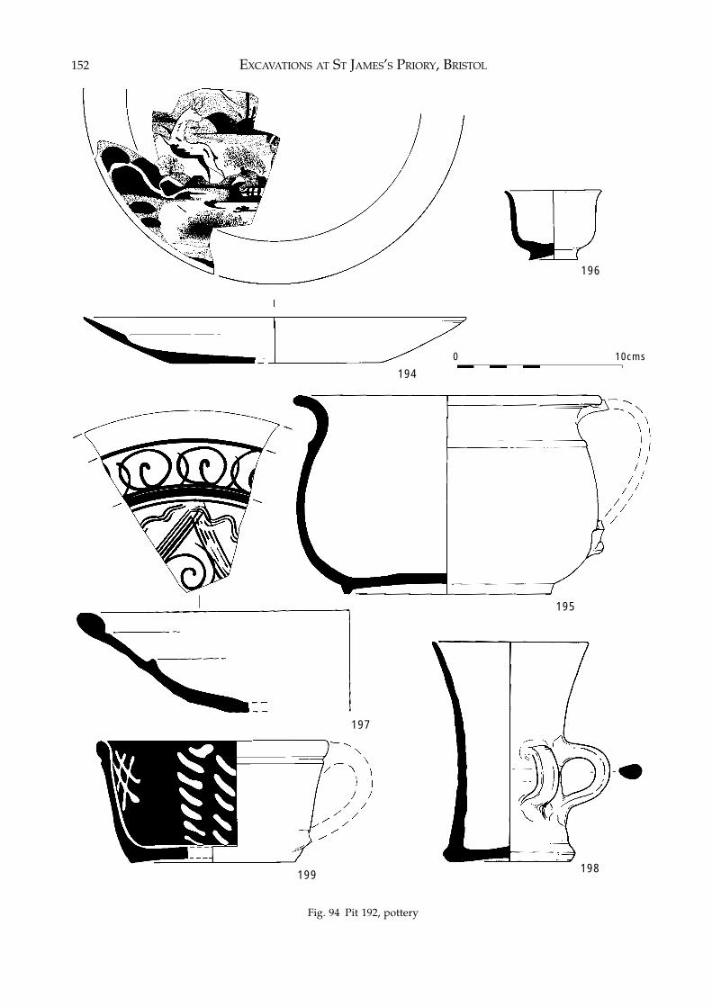
EXCAVATIONS AT ST JAMES’S PRIORY, BRISTOL152
Fig. 94 Pit 192, pottery
194
195
196
197
198199
0 10cms
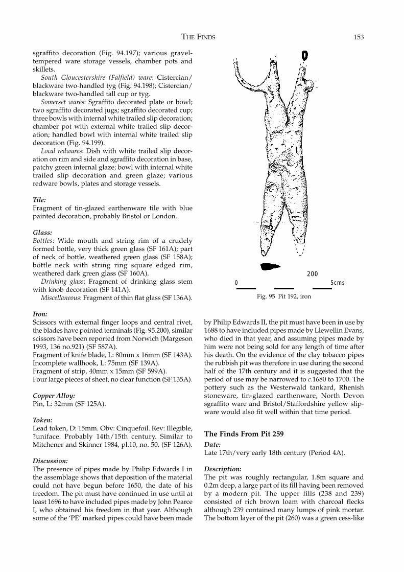
THE FINDS 153
sgraffito decoration (Fig. 94.197); various gravel-tempered ware storage vessels, chamber pots andskillets.
South Gloucestershire (Falfield) ware: Cistercian/blackware two-handled tyg (Fig. 94.198); Cistercian/blackware two-handled tall cup or tyg.
Somerset wares: Sgraffito decorated plate or bowl;two sgraffito decorated jugs; sgraffito decorated cup;three bowls with internal white trailed slip decoration;chamber pot with external white trailed slip decor-ation; handled bowl with internal white trailed slipdecoration (Fig. 94.199).
Local redwares: Dish with white trailed slip decor-ation on rim and side and sgraffito decoration in base,patchy green internal glaze; bowl with internal whitetrailed slip decoration and green glaze; variousredware bowls, plates and storage vessels.
Tile:Fragment of tin-glazed earthenware tile with bluepainted decoration, probably Bristol or London.
Glass:Bottles: Wide mouth and string rim of a crudelyformed bottle, very thick green glass (SF 161A); partof neck of bottle, weathered green glass (SF 158A);bottle neck with string ring square edged rim,weathered dark green glass (SF 160A).
Drinking glass: Fragment of drinking glass stemwith knob decoration (SF 141A).
Miscellaneous: Fragment of thin flat glass (SF 136A).
Iron:Scissors with external finger loops and central rivet,the blades have pointed terminals (Fig. 95.200), similarscissors have been reported from Norwich (Margeson1993, 136 no.921) (SF 587A).Fragment of knife blade, L: 80mm x 16mm (SF 143A).Incomplete wallhook, L: 75mm (SF 139A).Fragment of strip, 40mm x 15mm (SF 599A).Four large pieces of sheet, no clear function (SF 135A).
Copper Alloy:Pin, L: 32mm (SF 125A).
Token:Lead token, D: 15mm. Obv: Cinquefoil. Rev: Illegible,?uniface. Probably 14th/15th century. Similar toMitchener and Skinner 1984, pl.10, no. 50. (SF 126A).
Discussion:The presence of pipes made by Philip Edwards I inthe assemblage shows that deposition of the materialcould not have begun before 1650, the date of hisfreedom. The pit must have continued in use until atleast 1696 to have included pipes made by John PearceI, who obtained his freedom in that year. Althoughsome of the ‘PE’ marked pipes could have been made
by Philip Edwards II, the pit must have been in use by1688 to have included pipes made by Llewellin Evans,who died in that year, and assuming pipes made byhim were not being sold for any length of time afterhis death. On the evidence of the clay tobacco pipesthe rubbish pit was therefore in use during the secondhalf of the 17th century and it is suggested that theperiod of use may be narrowed to c.1680 to 1700. Thepottery such as the Westerwald tankard, Rhenishstoneware, tin-glazed earthenware, North Devonsgraffito ware and Bristol/Staffordshire yellow slip-ware would also fit well within that time period.
The Finds From Pit 259Date:Late 17th/very early 18th century (Period 4A).
Description:The pit was roughly rectangular, 1.8m square and0.2m deep, a large part of its fill having been removedby a modern pit. The upper fills (238 and 239)consisted of rich brown loam with charcoal flecksalthough 239 contained many lumps of pink mortar.The bottom layer of the pit (260) was a green cess-like
Fig. 95 Pit 192, iron
2000 5cms
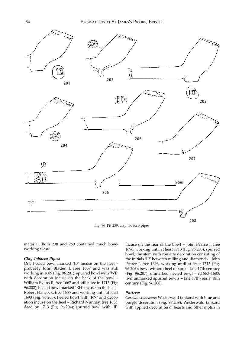
EXCAVATIONS AT ST JAMES’S PRIORY, BRISTOL154
material. Both 238 and 260 contained much bone-working waste.
Clay Tobacco Pipes:One heeled bowl marked ‘IB’ incuse on the heel –probably John Bladen I, free 1657 and was stillworking in 1689 (Fig. 96.201); spurred bowl with ‘WE’with decoration incuse on the back of the bowl –William Evans II, free 1667 and still alive in 1713 (Fig.96.202); heeled bowl marked ‘RH’ incuse on the heel –Robert Hancock, free 1655 and working until at least1693 (Fig. 96.203); heeled bowl with ‘RN’ and decor-ation incuse on the heel – Richard Nunney, free 1655,dead by 1713 (Fig. 96.204); spurred bowl with ‘IP’
Fig. 96 Pit 259, clay tobacco pipes
incuse on the rear of the bowl – John Pearce I, free1696, working until at least 1713 (Fig. 96.205); spurredbowl, the stem with roulette decoration consisting ofthe initials ‘IP’ between milling and diamonds – JohnPearce I, free 1696, working until at least 1713 (Fig.96.206); bowl without heel or spur – late 17th century(Fig. 96.207); unmarked heeled bowl – c.1660–1680;two unmarked spurred bowls – late 17th/early 18thcentury (Fig. 96.208).
Pottery:German stoneware: Westerwald tankard with blue andpurple decoration (Fig. 97.209); Westerwald tankardwith applied decoration of hearts and other motifs in
201202
203
207
208
206
205
204
0 5cms
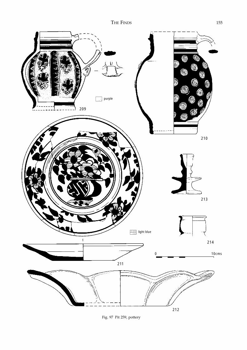
THE FINDS 155
Fig. 97 Pit 259, pottery
210
209
212
214
211
213
0 10cms
Fig. 97 Pit 259, pottery
purple
light blue
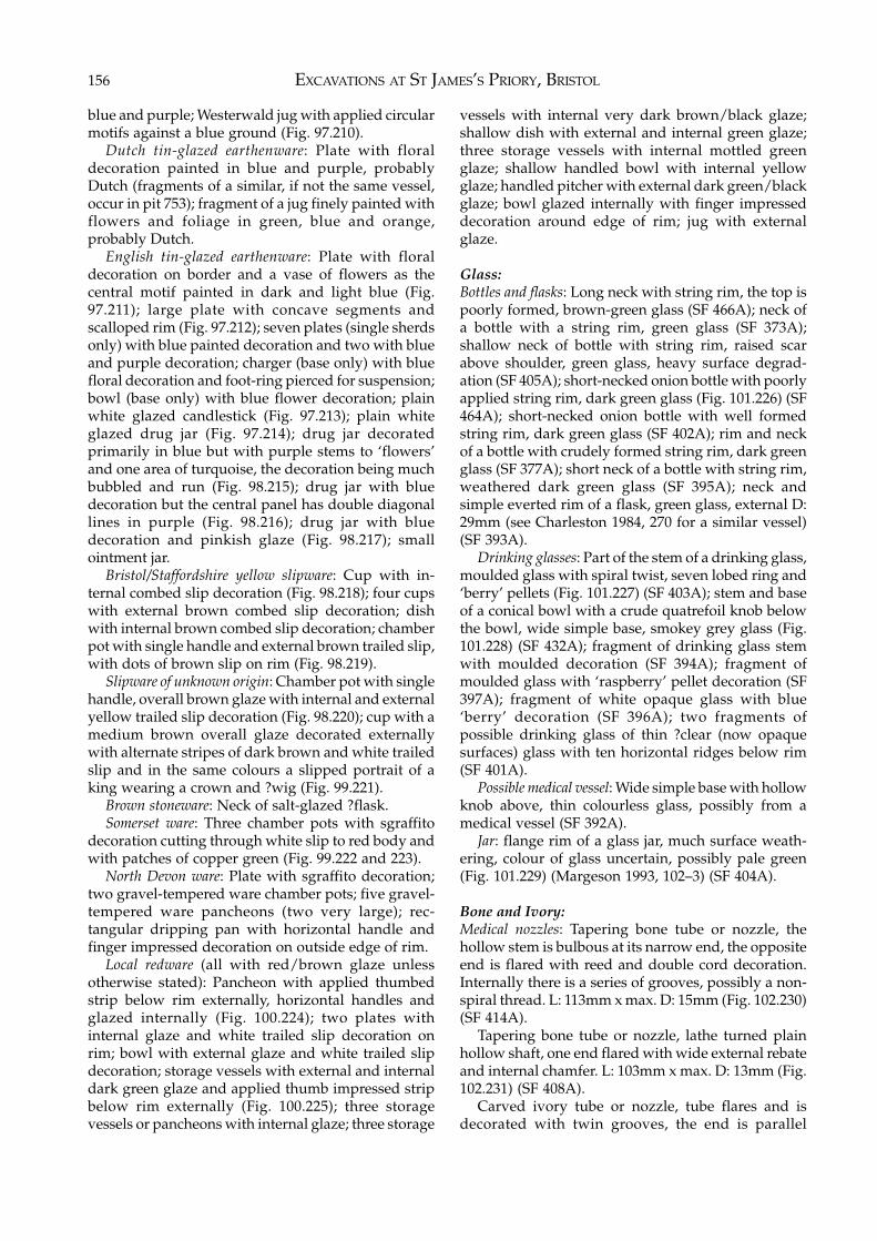
EXCAVATIONS AT ST JAMES’S PRIORY, BRISTOL156
blue and purple; Westerwald jug with applied circularmotifs against a blue ground (Fig. 97.210).
Dutch tin-glazed earthenware: Plate with floraldecoration painted in blue and purple, probablyDutch (fragments of a similar, if not the same vessel,occur in pit 753); fragment of a jug finely painted withflowers and foliage in green, blue and orange,probably Dutch.
English tin-glazed earthenware: Plate with floraldecoration on border and a vase of flowers as thecentral motif painted in dark and light blue (Fig.97.211); large plate with concave segments andscalloped rim (Fig. 97.212); seven plates (single sherdsonly) with blue painted decoration and two with blueand purple decoration; charger (base only) with bluefloral decoration and foot-ring pierced for suspension;bowl (base only) with blue flower decoration; plainwhite glazed candlestick (Fig. 97.213); plain whiteglazed drug jar (Fig. 97.214); drug jar decoratedprimarily in blue but with purple stems to ‘flowers’and one area of turquoise, the decoration being muchbubbled and run (Fig. 98.215); drug jar with bluedecoration but the central panel has double diagonallines in purple (Fig. 98.216); drug jar with bluedecoration and pinkish glaze (Fig. 98.217); smallointment jar.
Bristol/Staffordshire yellow slipware: Cup with in-ternal combed slip decoration (Fig. 98.218); four cupswith external brown combed slip decoration; dishwith internal brown combed slip decoration; chamberpot with single handle and external brown trailed slip,with dots of brown slip on rim (Fig. 98.219).
Slipware of unknown origin: Chamber pot with singlehandle, overall brown glaze with internal and externalyellow trailed slip decoration (Fig. 98.220); cup with amedium brown overall glaze decorated externallywith alternate stripes of dark brown and white trailedslip and in the same colours a slipped portrait of aking wearing a crown and ?wig (Fig. 99.221).
Brown stoneware: Neck of salt-glazed ?flask.Somerset ware: Three chamber pots with sgraffito
decoration cutting through white slip to red body andwith patches of copper green (Fig. 99.222 and 223).
North Devon ware: Plate with sgraffito decoration;two gravel-tempered ware chamber pots; five gravel-tempered ware pancheons (two very large); rec-tangular dripping pan with horizontal handle andfinger impressed decoration on outside edge of rim.
Local redware (all with red/brown glaze unlessotherwise stated): Pancheon with applied thumbedstrip below rim externally, horizontal handles andglazed internally (Fig. 100.224); two plates withinternal glaze and white trailed slip decoration onrim; bowl with external glaze and white trailed slipdecoration; storage vessels with external and internaldark green glaze and applied thumb impressed stripbelow rim externally (Fig. 100.225); three storagevessels or pancheons with internal glaze; three storage
vessels with internal very dark brown/black glaze;shallow dish with external and internal green glaze;three storage vessels with internal mottled greenglaze; shallow handled bowl with internal yellowglaze; handled pitcher with external dark green/blackglaze; bowl glazed internally with finger impresseddecoration around edge of rim; jug with externalglaze.
Glass:Bottles and flasks: Long neck with string rim, the top ispoorly formed, brown-green glass (SF 466A); neck ofa bottle with a string rim, green glass (SF 373A);shallow neck of bottle with string rim, raised scarabove shoulder, green glass, heavy surface degrad-ation (SF 405A); short-necked onion bottle with poorlyapplied string rim, dark green glass (Fig. 101.226) (SF464A); short-necked onion bottle with well formedstring rim, dark green glass (SF 402A); rim and neckof a bottle with crudely formed string rim, dark greenglass (SF 377A); short neck of a bottle with string rim,weathered dark green glass (SF 395A); neck andsimple everted rim of a flask, green glass, external D:29mm (see Charleston 1984, 270 for a similar vessel)(SF 393A).
Drinking glasses: Part of the stem of a drinking glass,moulded glass with spiral twist, seven lobed ring and‘berry’ pellets (Fig. 101.227) (SF 403A); stem and baseof a conical bowl with a crude quatrefoil knob belowthe bowl, wide simple base, smokey grey glass (Fig.101.228) (SF 432A); fragment of drinking glass stemwith moulded decoration (SF 394A); fragment ofmoulded glass with ‘raspberry’ pellet decoration (SF397A); fragment of white opaque glass with blue‘berry’ decoration (SF 396A); two fragments ofpossible drinking glass of thin ?clear (now opaquesurfaces) glass with ten horizontal ridges below rim(SF 401A).
Possible medical vessel: Wide simple base with hollowknob above, thin colourless glass, possibly from amedical vessel (SF 392A).
Jar: flange rim of a glass jar, much surface weath-ering, colour of glass uncertain, possibly pale green(Fig. 101.229) (Margeson 1993, 102–3) (SF 404A).
Bone and Ivory:Medical nozzles: Tapering bone tube or nozzle, thehollow stem is bulbous at its narrow end, the oppositeend is flared with reed and double cord decoration.Internally there is a series of grooves, possibly a non-spiral thread. L: 113mm x max. D: 15mm (Fig. 102.230)(SF 414A).
Tapering bone tube or nozzle, lathe turned plainhollow shaft, one end flared with wide external rebateand internal chamfer. L: 103mm x max. D: 13mm (Fig.102.231) (SF 408A).
Carved ivory tube or nozzle, tube flares and isdecorated with twin grooves, the end is parallel
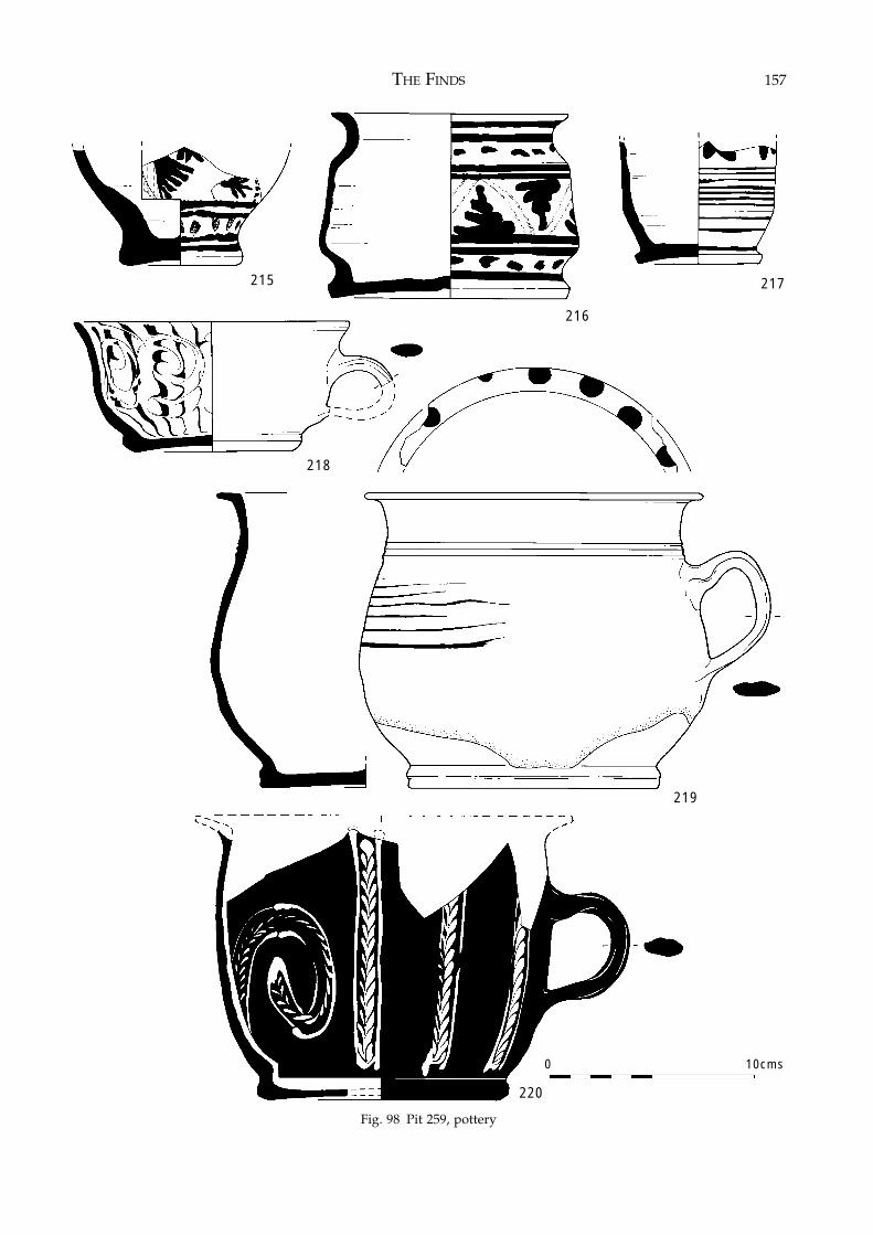
THE FINDS 157
Fig. 98 Pit 259, pottery
215 217
219
Fig. 98 Pit 259, pottery
218
0 10cms
216
220
EXCAVATIONS AT ST JAMES’S PRIORY, BRISTOL158
Fig. 99 Pit 259, pottery
221
223
0 10cms
222
green
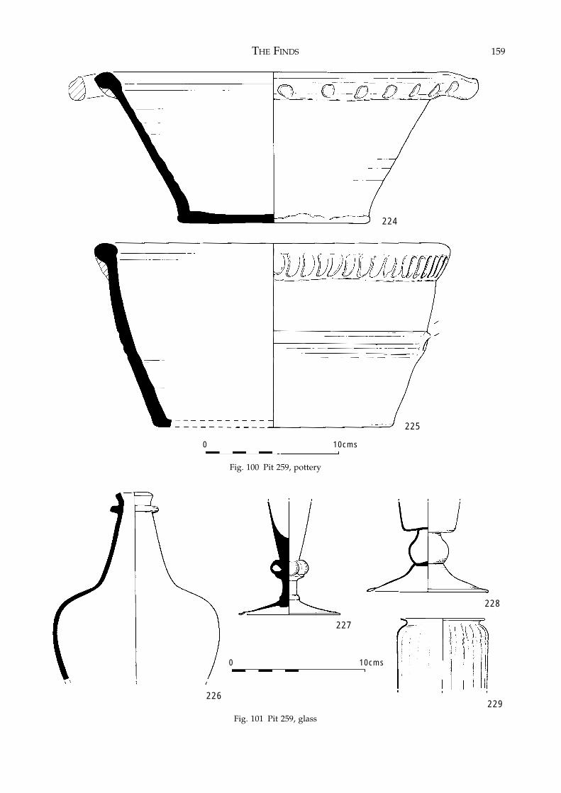
THE FINDS 159
Fig. 100 Pit 259, pottery
Fig. 101 Pit 259, glass
224
225
0 10cms
226
227
228
229
0 10cms
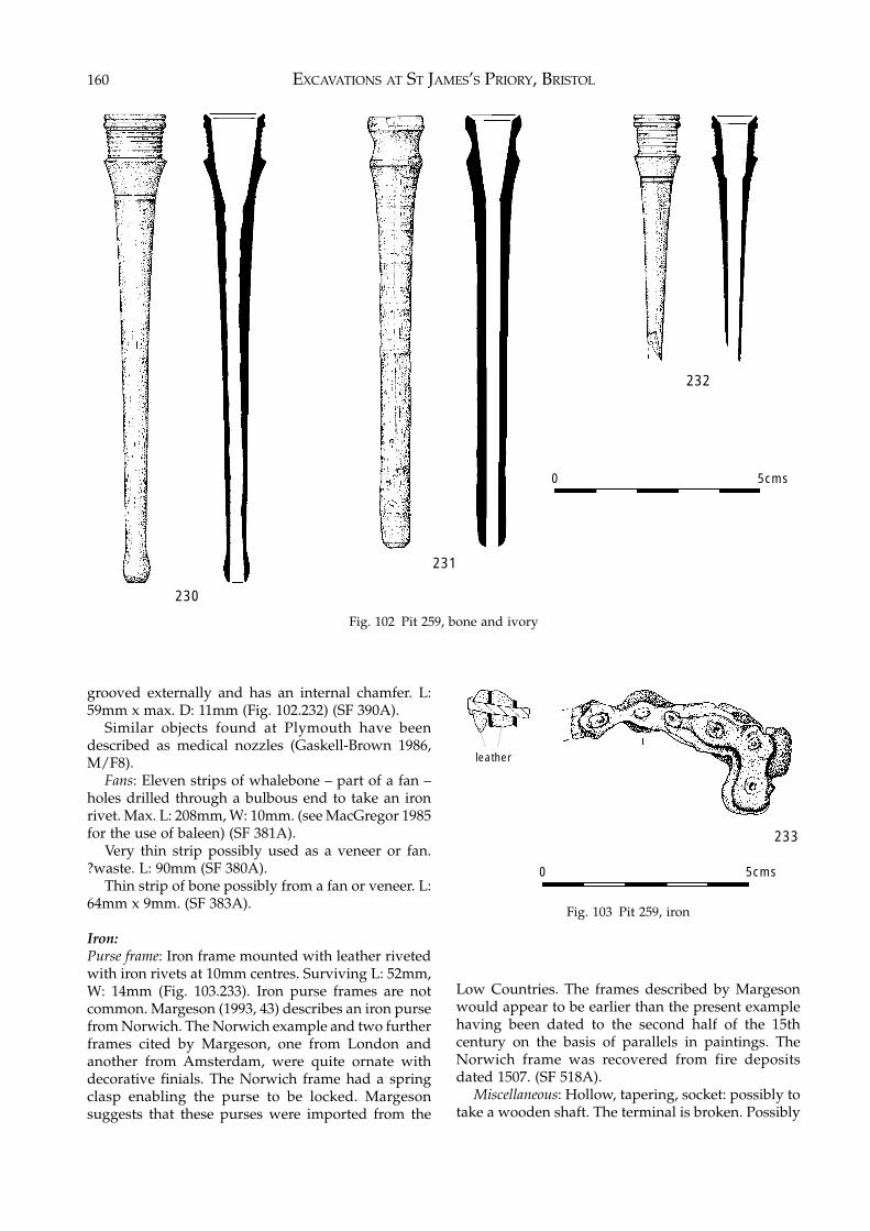
EXCAVATIONS AT ST JAMES’S PRIORY, BRISTOL160
Fig. 102 Pit 259, bone and ivory
grooved externally and has an internal chamfer. L:59mm x max. D: 11mm (Fig. 102.232) (SF 390A).
Similar objects found at Plymouth have beendescribed as medical nozzles (Gaskell-Brown 1986,M/F8).
Fans: Eleven strips of whalebone – part of a fan –holes drilled through a bulbous end to take an ironrivet. Max. L: 208mm, W: 10mm. (see MacGregor 1985for the use of baleen) (SF 381A).
Very thin strip possibly used as a veneer or fan.?waste. L: 90mm (SF 380A).
Thin strip of bone possibly from a fan or veneer. L:64mm x 9mm. (SF 383A).
Iron:Purse frame: Iron frame mounted with leather rivetedwith iron rivets at 10mm centres. Surviving L: 52mm,W: 14mm (Fig. 103.233). Iron purse frames are notcommon. Margeson (1993, 43) describes an iron pursefrom Norwich. The Norwich example and two furtherframes cited by Margeson, one from London andanother from Amsterdam, were quite ornate withdecorative finials. The Norwich frame had a springclasp enabling the purse to be locked. Margesonsuggests that these purses were imported from the
Fig. 103 Pit 259, iron
Low Countries. The frames described by Margesonwould appear to be earlier than the present examplehaving been dated to the second half of the 15thcentury on the basis of parallels in paintings. TheNorwich frame was recovered from fire depositsdated 1507. (SF 518A).
Miscellaneous: Hollow, tapering, socket: possibly totake a wooden shaft. The terminal is broken. Possibly
230
231
232
0 5cms
233
leather
0 5cms
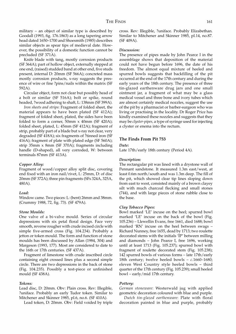
THE FINDS 161
military – an object of similar type is described byGoodall (1993, fig. 176.1863) as a long tapering arrowhead dated 1650–1700 and Shoesmith (1985) describessimilar objects as spear tips of medieval date. How-ever, the possibility of a domestic function cannot beprecluded (SF 371A).
Knife blade with tang, mostly corrosion products(SF 364A); part of hollow object, externally stepped atone end, (raised) studded band at other end, five studspresent, internal D: 20mm (SF 566A); concreted massmostly corrosion products, x-ray suggests the pres-ence of wire or fine ?pins/nails within the matrix (SF592A).
Circular object, form not clear but possibly head ofa bolt or similar (SF 516A); bolt or spike, roundheaded, ?wood adhering to shaft, L: 138mm (SF 399A).
Iron sheets and strips: Fragment of folded sheet, thematerial appears to have been plated (SF 412A);fragment of folded sheet, plated, the sides have beenfolded to form a corner, 50mm x 40mm (SF 420A);folded sheet, plated, L: 45mm (SF 412A); fragment ofstrip, probably part of a blade but x-ray not clear, verydegraded (SF 418A); six fragments of ?tinned iron (SF416A); fragment of plate with plated edge (SF 560A);strip 35mm x 8mm (SF 370A); fragments includinghandle (D-shaped), all very corroded, W: betweenterminals 87mm (SF 413A).
Copper Alloy:Fragment of wood/copper alloy split disc, coveringend fixed with an iron nail/rivet, L: 25mm, D: of disc20mm (SF 372A); three pin fragments (SFs 324A, 325A,480A).
Lead:Window came. Two pieces: L: (bent) 26mm and 38mm.(Crummy 1988, 72, fig. 73). (SF 479A).
Stone Moulds:One valve of a bi-valve mould. Series of circulardepressions with six petal floral design. Face verysmooth, reverse rougher with crude incised circle withsimple five-armed cross (Fig. 104.234). Probably ajetton or token mould. The form and function of stonemoulds has been discussed by Allan (1984, 304) andMargeson (1993, 177). Most are considered to date tothe 16th or 17th centuries. (SF 437A).
Fragment of limestone with crude inscribed circlecontaining eight crossed lines plus a second simplecircle. There are two depressions in the back of stone(Fig. 104.235). Possibly a test-piece or unfinishedmould (SF 438A).
Tokens:Lead disc, D: 20mm. Obv: Plain cross. Rev: Illegible,?uniface. Probably an early Tudor token. Similar toMitchener and Skinner 1985, pl.6, no.6. (SF 410A).
Lead token, D: 20mm. Obv: Field voided by triple
cross. Rev: Illegible, ?uniface. Probably Elizabethan.Similar to Mitchener and Skinner 1985, pl.14, no.87.(SF 409A).
Discussion:The presence of pipes made by John Pearce I in theassemblage shows that deposition of the materialcould not have begun before 1696, the date of hisfreedom. The almost equal mixture of heeled andspurred bowls suggests that backfilling of the pitoccurred at the end of the 17th century and during theearly years of the 18th century. The presence of threetin-glazed earthenware drug jars and one smallointment jar, a fragment of what may be a glassmedical vessel and three bone and ivory tubes whichare almost certainly medical nozzles, suggest the useof the pit by a pharmacist or barber-surgeon who wasliving or practising in the locality. Dr Roger Price haskindly examined these nozzles and suggests that theymay be clyster-pipes, a type of syringe used for injectinga clyster or enema into the rectum.
The Finds From Pit 753Date:Late 17th/early 18th century (Period 4A).
Description:The rectangular pit was lined with a drystone wall ofPennant sandstone. It measured 1.3m east/west, atleast 0.6m north/south and was 1.3m deep. The fill ofthe pit, which showed clear tip lines sloping downfrom east to west, consisted mainly of a brown clayeysilt with much charcoal flecking and small stones(744), and with large pieces of stone rubble close tothe base.
Clay Tobacco Pipes:Bowl marked ‘LE’ incuse on the heel; spurred bowlmarked ‘LE’ incuse on the back of the bowl (Fig.105.236) – Llewellin Evans, free 1661, died 1688; bowlmarked ‘RN’ incuse on the heel between swags –Richard Nunney, free 1655, dead by 1713; two roulettedecorated stems with the initials ‘IP’ between millingand diamonds – John Pearce I, free 1696, workinguntil at least 1713 (Fig. 105.237); spurred bowl withfragment of roulette decorated stem (Fig. 105.238);142 spurred bowls of various forms – late 17th/early18th century; twelve heeled bowls – c.1660–1680;eleven West Country style heeled bowls – thirdquarter of the 17th century (Fig. 105.239); small heeledbowl – early/mid 17th century.
Pottery:German stoneware: Westerwald jug with appliedgeometric decoration coloured with blue and purple.
Dutch tin-glazed earthenware: Plate with floraldecoration painted in blue and purple, probably
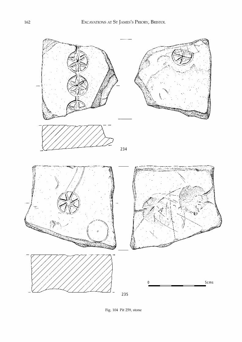
EXCAVATIONS AT ST JAMES’S PRIORY, BRISTOL162
Fig. 104 Pit 259, stone
234
235
0 5cms
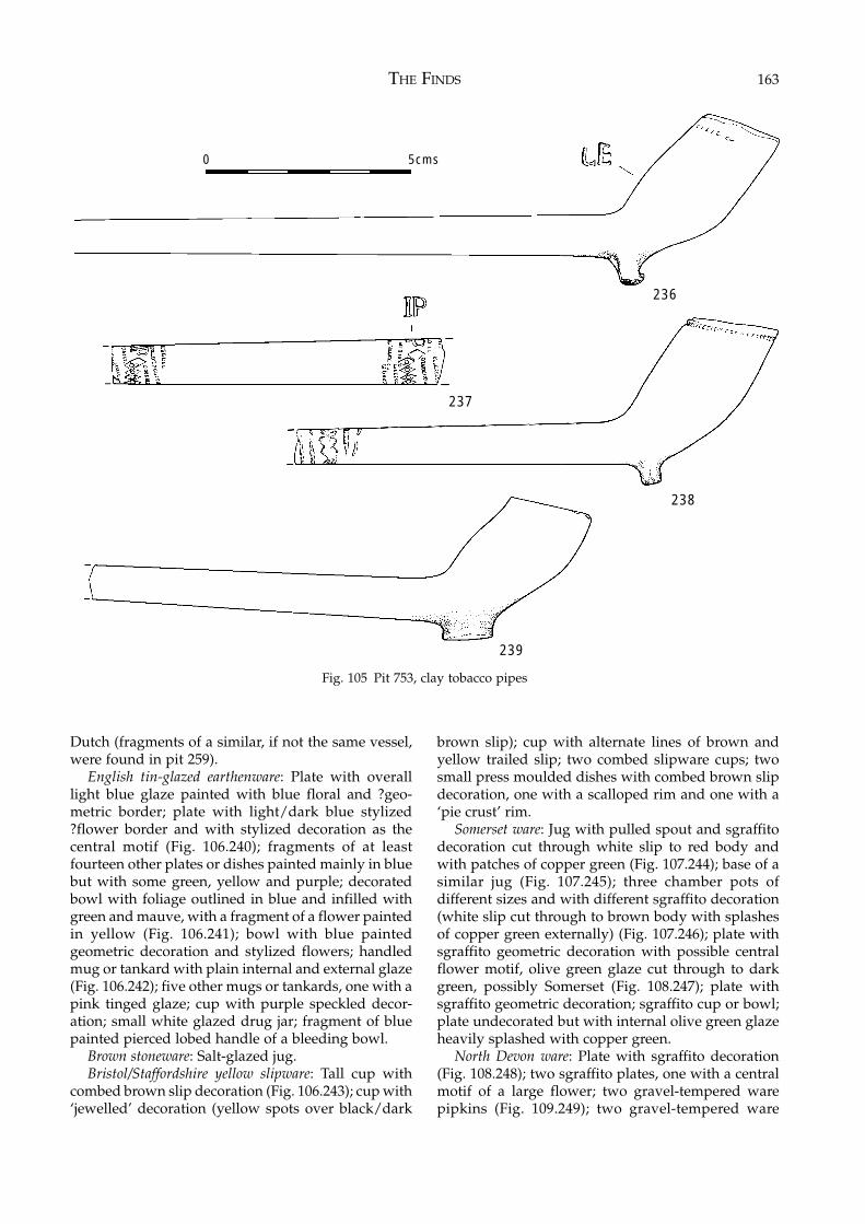
THE FINDS 163
Dutch (fragments of a similar, if not the same vessel,were found in pit 259).
English tin-glazed earthenware: Plate with overalllight blue glaze painted with blue floral and ?geo-metric border; plate with light/dark blue stylized?flower border and with stylized decoration as thecentral motif (Fig. 106.240); fragments of at leastfourteen other plates or dishes painted mainly in bluebut with some green, yellow and purple; decoratedbowl with foliage outlined in blue and infilled withgreen and mauve, with a fragment of a flower paintedin yellow (Fig. 106.241); bowl with blue paintedgeometric decoration and stylized flowers; handledmug or tankard with plain internal and external glaze(Fig. 106.242); five other mugs or tankards, one with apink tinged glaze; cup with purple speckled decor-ation; small white glazed drug jar; fragment of bluepainted pierced lobed handle of a bleeding bowl.
Brown stoneware: Salt-glazed jug.Bristol/Staffordshire yellow slipware: Tall cup with
combed brown slip decoration (Fig. 106.243); cup with‘jewelled’ decoration (yellow spots over black/dark
brown slip); cup with alternate lines of brown andyellow trailed slip; two combed slipware cups; twosmall press moulded dishes with combed brown slipdecoration, one with a scalloped rim and one with a‘pie crust’ rim.
Somerset ware: Jug with pulled spout and sgraffitodecoration cut through white slip to red body andwith patches of copper green (Fig. 107.244); base of asimilar jug (Fig. 107.245); three chamber pots ofdifferent sizes and with different sgraffito decoration(white slip cut through to brown body with splashesof copper green externally) (Fig. 107.246); plate withsgraffito geometric decoration with possible centralflower motif, olive green glaze cut through to darkgreen, possibly Somerset (Fig. 108.247); plate withsgraffito geometric decoration; sgraffito cup or bowl;plate undecorated but with internal olive green glazeheavily splashed with copper green.
North Devon ware: Plate with sgraffito decoration(Fig. 108.248); two sgraffito plates, one with a centralmotif of a large flower; two gravel-tempered warepipkins (Fig. 109.249); two gravel-tempered ware
Fig. 105 Pit 753, clay tobacco pipes
236
238
239
237
0 5cms
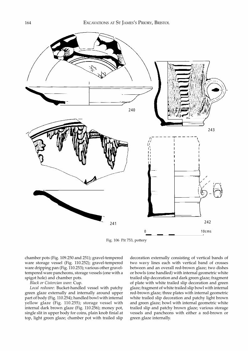
EXCAVATIONS AT ST JAMES’S PRIORY, BRISTOL164
chamber pots (Fig. 109.250 and 251); gravel-temperedware storage vessel (Fig. 110.252); gravel-temperedware dripping pan (Fig. 110.253); various other gravel-tempered ware pancheons, storage vessels (one with aspigot hole) and chamber pots.
Black or Cistercian ware: Cup.Local redware: Bucket-handled vessel with patchy
green glaze externally and internally around upperpart of body (Fig. 110.254); handled bowl with internalyellow glaze (Fig. 110.255); storage vessel withinternal dark brown glaze (Fig. 110.256); money pot,single slit in upper body for coins, plain knob finial attop, light green glaze; chamber pot with trailed slip
Fig. 106 Pit 753, pottery
decoration externally consisting of vertical bands oftwo wavy lines each with vertical band of crossesbetween and an overall red-brown glaze; two dishesor bowls (one handled) with internal geometric whitetrailed slip decoration and dark green glaze; fragmentof plate with white trailed slip decoration and greenglaze; fragment of white trailed slip bowl with internalred-brown glaze; three plates with internal geometricwhite trailed slip decoration and patchy light brownand green glaze; bowl with internal geometric whitetrailed slip and patchy brown glaze; various storagevessels and pancheons with either a red-brown orgreen glaze internally.
242241
243
240
0 10cms
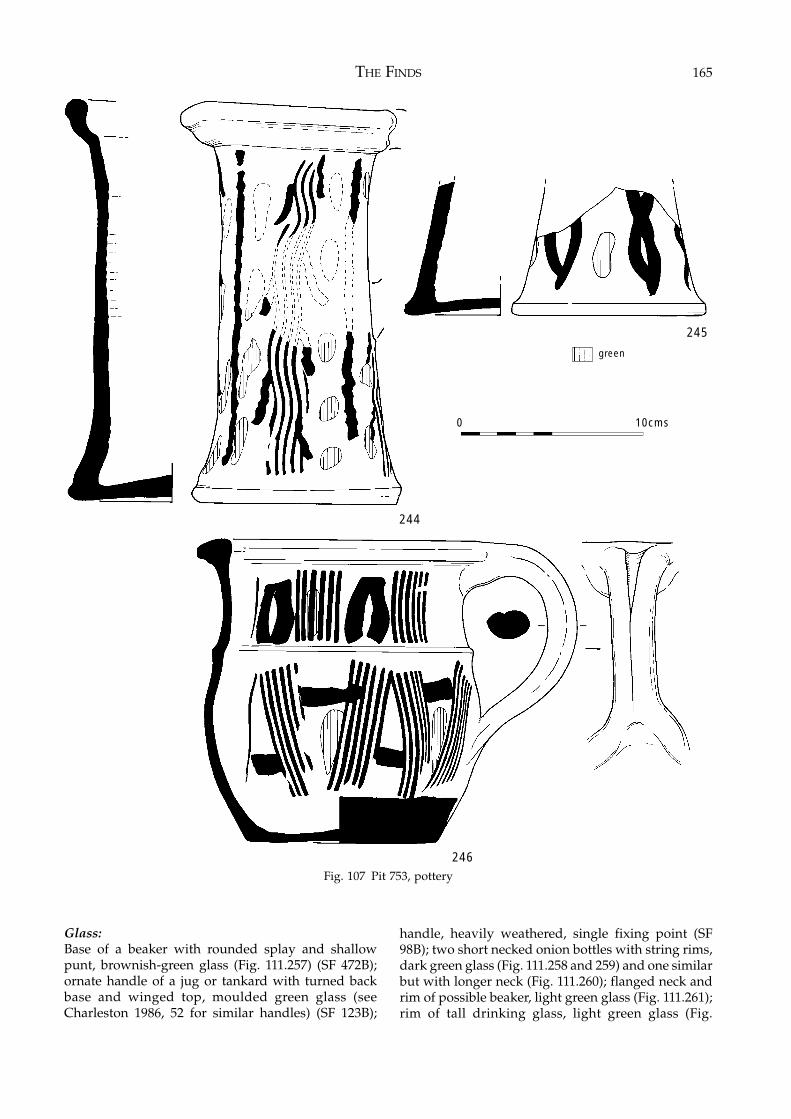
THE FINDS 165
Fig. 107 Pit 753, pottery
Glass:Base of a beaker with rounded splay and shallowpunt, brownish-green glass (Fig. 111.257) (SF 472B);ornate handle of a jug or tankard with turned backbase and winged top, moulded green glass (seeCharleston 1986, 52 for similar handles) (SF 123B);
handle, heavily weathered, single fixing point (SF98B); two short necked onion bottles with string rims,dark green glass (Fig. 111.258 and 259) and one similarbut with longer neck (Fig. 111.260); flanged neck andrim of possible beaker, light green glass (Fig. 111.261);rim of tall drinking glass, light green glass (Fig.
245
246
244
0 10cms
green
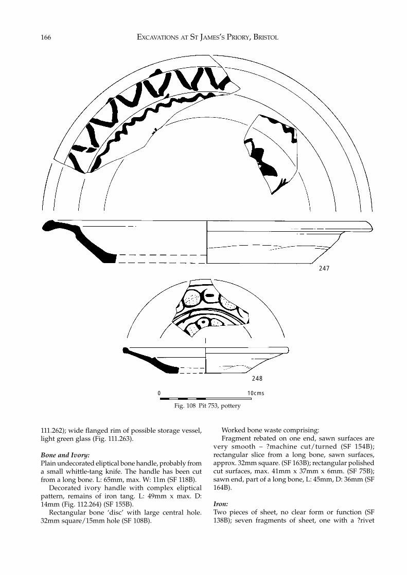
EXCAVATIONS AT ST JAMES’S PRIORY, BRISTOL166
Fig. 108 Pit 753, pottery
111.262); wide flanged rim of possible storage vessel,light green glass (Fig. 111.263).
Bone and Ivory:Plain undecorated eliptical bone handle, probably froma small whittle-tang knife. The handle has been cutfrom a long bone. L: 65mm, max. W: 11m (SF 118B).
Decorated ivory handle with complex elipticalpattern, remains of iron tang. L: 49mm x max. D:14mm (Fig. 112.264) (SF 155B).
Rectangular bone ‘disc’ with large central hole.32mm square/15mm hole (SF 108B).
Worked bone waste comprising:Fragment rebated on one end, sawn surfaces are
very smooth – ?machine cut/turned (SF 154B);rectangular slice from a long bone, sawn surfaces,approx. 32mm square. (SF 163B); rectangular polishedcut surfaces, max. 41mm x 37mm x 6mm. (SF 75B);sawn end, part of a long bone, L: 45mm, D: 36mm (SF164B).
Iron:Two pieces of sheet, no clear form or function (SF138B); seven fragments of sheet, one with a ?rivet
247
248
0 10cms
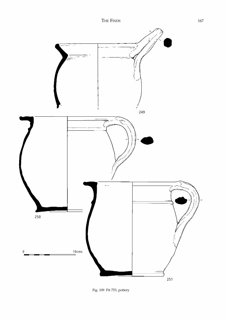
THE FINDS 167
Fig. 109 Pit 753, pottery
249
250
251
0 10cms
Fig. 109 Pit 753, pottery
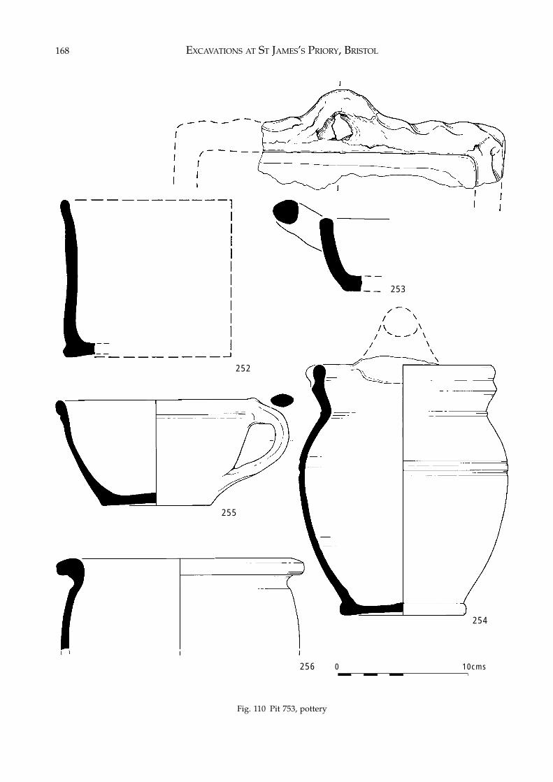
EXCAVATIONS AT ST JAMES’S PRIORY, BRISTOL168
Fig. 110 Pit 753, pottery
252
253
254
256
255
0 10cms
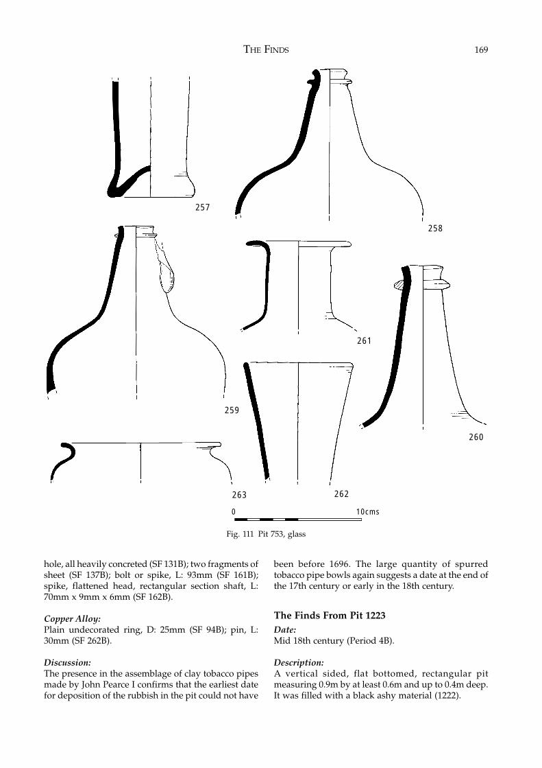
THE FINDS 169
hole, all heavily concreted (SF 131B); two fragments ofsheet (SF 137B); bolt or spike, L: 93mm (SF 161B);spike, flattened head, rectangular section shaft, L:70mm x 9mm x 6mm (SF 162B).
Copper Alloy:Plain undecorated ring, D: 25mm (SF 94B); pin, L:30mm (SF 262B).
Discussion:The presence in the assemblage of clay tobacco pipesmade by John Pearce I confirms that the earliest datefor deposition of the rubbish in the pit could not have
been before 1696. The large quantity of spurredtobacco pipe bowls again suggests a date at the end ofthe 17th century or early in the 18th century.
The Finds From Pit 1223Date:Mid 18th century (Period 4B).
Description:A vertical sided, flat bottomed, rectangular pitmeasuring 0.9m by at least 0.6m and up to 0.4m deep.It was filled with a black ashy material (1222).
Fig. 111 Pit 753, glass
260
257
258
261
262263
0 10cms
259
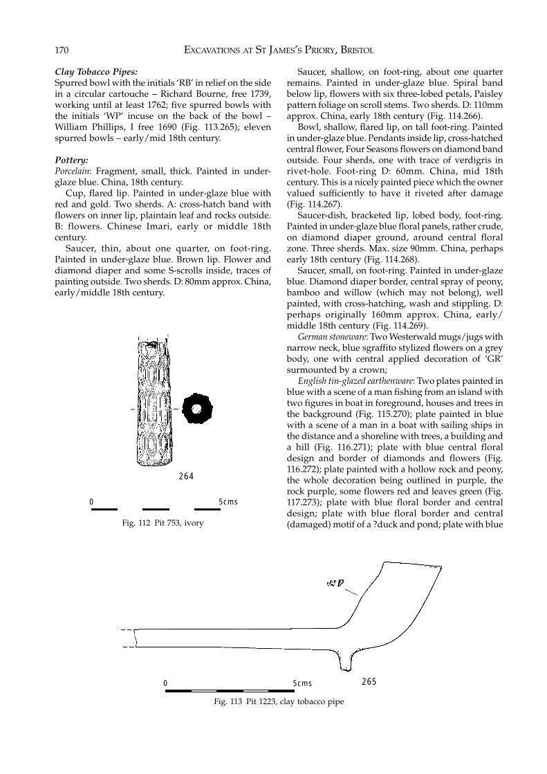
EXCAVATIONS AT ST JAMES’S PRIORY, BRISTOL170
Clay Tobacco Pipes:Spurred bowl with the initials ‘RB’ in relief on the sidein a circular cartouche – Richard Bourne, free 1739,working until at least 1762; five spurred bowls withthe initials ‘WP’ incuse on the back of the bowl –William Phillips, I free 1690 (Fig. 113.265); elevenspurred bowls – early/mid 18th century.
Pottery:Porcelain: Fragment, small, thick. Painted in under-glaze blue. China, 18th century.
Cup, flared lip. Painted in under-glaze blue withred and gold. Two sherds. A: cross-hatch band withflowers on inner lip, plaintain leaf and rocks outside.B: flowers. Chinese Imari, early or middle 18thcentury.
Saucer, thin, about one quarter, on foot-ring.Painted in under-glaze blue. Brown lip. Flower anddiamond diaper and some S-scrolls inside, traces ofpainting outside. Two sherds. D: 80mm approx. China,early/middle 18th century.
Saucer, shallow, on foot-ring, about one quarterremains. Painted in under-glaze blue. Spiral bandbelow lip, flowers with six three-lobed petals, Paisleypattern foliage on scroll stems. Two sherds. D: 110mmapprox. China, early 18th century (Fig. 114.266).
Bowl, shallow, flared lip, on tall foot-ring. Paintedin under-glaze blue. Pendants inside lip, cross-hatchedcentral flower, Four Seasons flowers on diamond bandoutside. Four sherds, one with trace of verdigris inrivet-hole. Foot-ring D: 60mm. China, mid 18thcentury. This is a nicely painted piece which the ownervalued sufficiently to have it riveted after damage(Fig. 114.267).
Saucer-dish, bracketed lip, lobed body, foot-ring.Painted in under-glaze blue floral panels, rather crude,on diamond diaper ground, around central floralzone. Three sherds. Max. size 90mm. China, perhapsearly 18th century (Fig. 114.268).
Saucer, small, on foot-ring. Painted in under-glazeblue. Diamond diaper border, central spray of peony,bamboo and willow (which may not belong), wellpainted, with cross-hatching, wash and stippling. D:perhaps originally 160mm approx. China, early/middle 18th century (Fig. 114.269).
German stoneware: Two Westerwald mugs/jugs withnarrow neck, blue sgraffito stylized flowers on a greybody, one with central applied decoration of ‘GR’surmounted by a crown;
English tin-glazed earthenware: Two plates painted inblue with a scene of a man fishing from an island withtwo figures in boat in foreground, houses and trees inthe background (Fig. 115.270); plate painted in bluewith a scene of a man in a boat with sailing ships inthe distance and a shoreline with trees, a building anda hill (Fig. 116.271); plate with blue central floraldesign and border of diamonds and flowers (Fig.116.272); plate painted with a hollow rock and peony,the whole decoration being outlined in purple, therock purple, some flowers red and leaves green (Fig.117.273); plate with blue floral border and centraldesign; plate with blue floral border and central(damaged) motif of a ?duck and pond; plate with blueFig. 112 Pit 753, ivory
Fig. 113 Pit 1223, clay tobacco pipe
264
0 5cms
2650 5cms
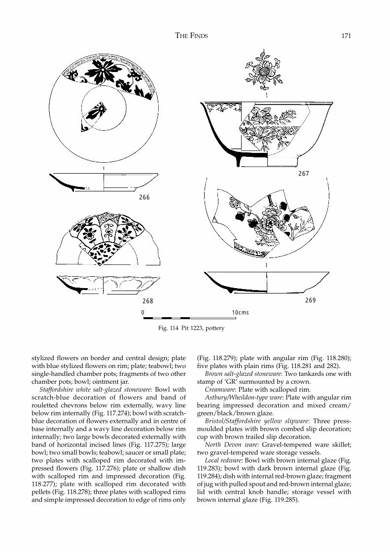
THE FINDS 171
stylized flowers on border and central design; platewith blue stylized flowers on rim; plate; teabowl; twosingle-handled chamber pots; fragments of two otherchamber pots; bowl; ointment jar.
Staffordshire white salt-glazed stoneware: Bowl withscratch-blue decoration of flowers and band ofrouletted chevrons below rim externally, wavy linebelow rim internally (Fig. 117.274); bowl with scratch-blue decoration of flowers externally and in centre ofbase internally and a wavy line decoration below riminternally; two large bowls decorated externally withband of horizontal incised lines (Fig. 117.275); largebowl; two small bowls; teabowl; saucer or small plate;two plates with scalloped rim decorated with im-pressed flowers (Fig. 117.276); plate or shallow dishwith scalloped rim and impressed decoration (Fig.118.277); plate with scalloped rim decorated withpellets (Fig. 118.278); three plates with scalloped rimsand simple impressed decoration to edge of rims only
(Fig. 118.279); plate with angular rim (Fig. 118.280);five plates with plain rims (Fig. 118.281 and 282).
Brown salt-glazed stoneware: Two tankards one withstamp of ‘GR’ surmounted by a crown.
Creamware: Plate with scalloped rim.Astbury/Wheildon-type ware: Plate with angular rim
bearing impressed decoration and mixed cream/green/black/brown glaze.
Bristol/Staffordshire yellow slipware: Three press-moulded plates with brown combed slip decoration;cup with brown trailed slip decoration.
North Devon ware: Gravel-tempered ware skillet;two gravel-tempered ware storage vessels.
Local redware: Bowl with brown internal glaze (Fig.119.283); bowl with dark brown internal glaze (Fig.119.284); dish with internal red-brown glaze; fragmentof jug with pulled spout and red-brown internal glaze;lid with central knob handle; storage vessel withbrown internal glaze (Fig. 119.285).
Fig. 114 Pit 1223, pottery
266
268 269
0 10cms
267
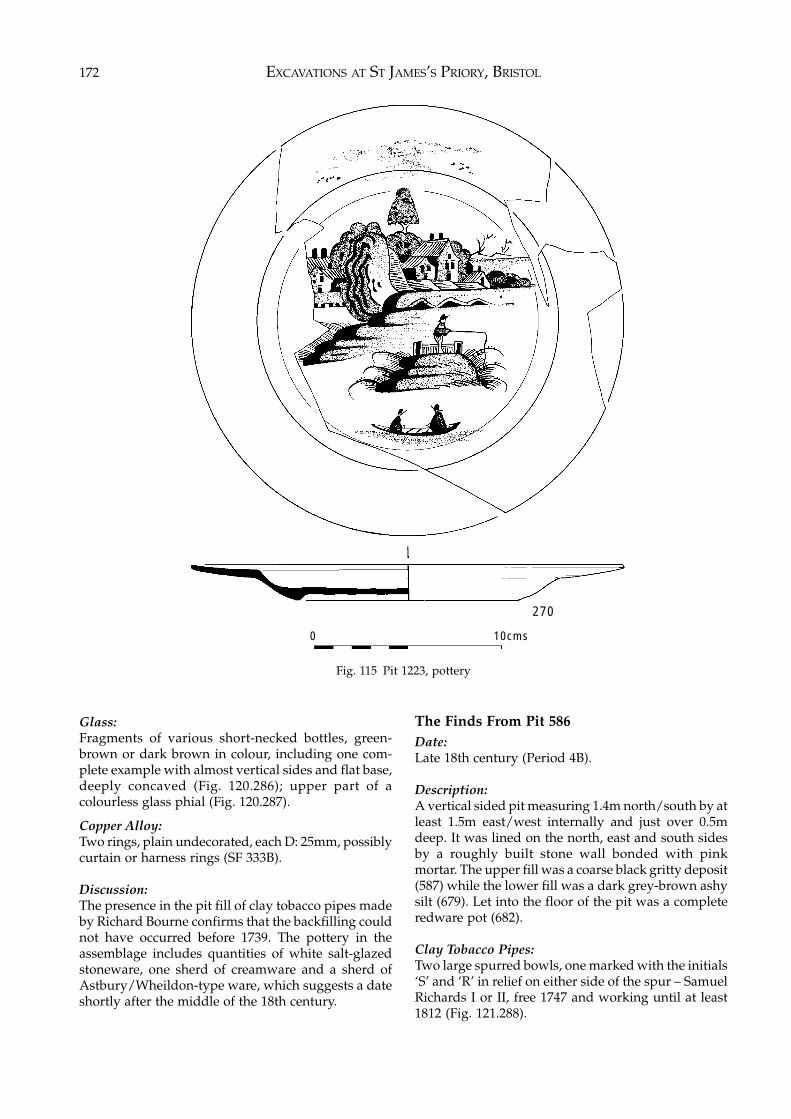
EXCAVATIONS AT ST JAMES’S PRIORY, BRISTOL172
Glass:Fragments of various short-necked bottles, green-brown or dark brown in colour, including one com-plete example with almost vertical sides and flat base,deeply concaved (Fig. 120.286); upper part of acolourless glass phial (Fig. 120.287).
Copper Alloy:Two rings, plain undecorated, each D: 25mm, possiblycurtain or harness rings (SF 333B).
Discussion:The presence in the pit fill of clay tobacco pipes madeby Richard Bourne confirms that the backfilling couldnot have occurred before 1739. The pottery in theassemblage includes quantities of white salt-glazedstoneware, one sherd of creamware and a sherd ofAstbury/Wheildon-type ware, which suggests a dateshortly after the middle of the 18th century.
The Finds From Pit 586Date:Late 18th century (Period 4B).
Description:A vertical sided pit measuring 1.4m north/south by atleast 1.5m east/west internally and just over 0.5mdeep. It was lined on the north, east and south sidesby a roughly built stone wall bonded with pinkmortar. The upper fill was a coarse black gritty deposit(587) while the lower fill was a dark grey-brown ashysilt (679). Let into the floor of the pit was a completeredware pot (682).
Clay Tobacco Pipes:Two large spurred bowls, one marked with the initials‘S’ and ‘R’ in relief on either side of the spur – SamuelRichards I or II, free 1747 and working until at least1812 (Fig. 121.288).
Fig. 115 Pit 1223, pottery
270
0 10cms
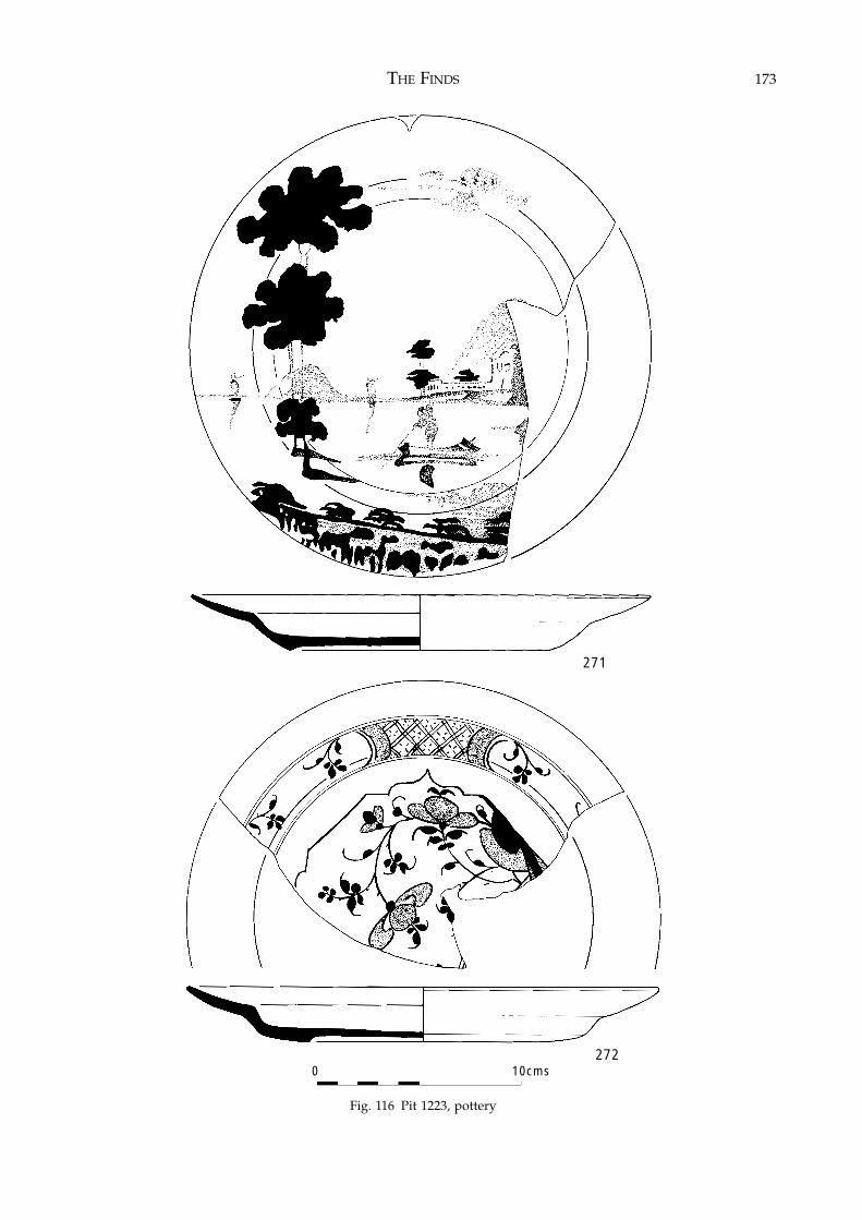
THE FINDS 173
Fig. 116 Pit 1223, pottery
0 10cms
271
272
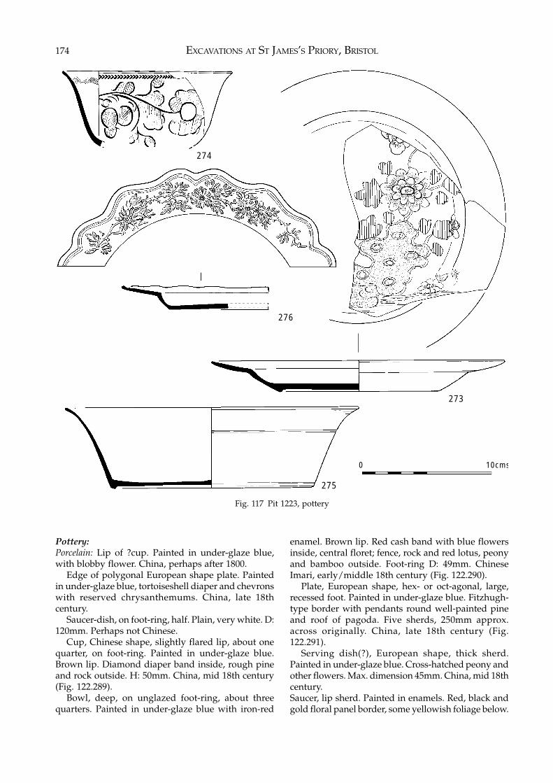
EXCAVATIONS AT ST JAMES’S PRIORY, BRISTOL174
Fig. 117 Pit 1223, pottery
Pottery:Porcelain: Lip of ?cup. Painted in under-glaze blue,with blobby flower. China, perhaps after 1800.
Edge of polygonal European shape plate. Paintedin under-glaze blue, tortoiseshell diaper and chevronswith reserved chrysanthemums. China, late 18thcentury.
Saucer-dish, on foot-ring, half. Plain, very white. D:120mm. Perhaps not Chinese.
Cup, Chinese shape, slightly flared lip, about onequarter, on foot-ring. Painted in under-glaze blue.Brown lip. Diamond diaper band inside, rough pineand rock outside. H: 50mm. China, mid 18th century(Fig. 122.289).
Bowl, deep, on unglazed foot-ring, about threequarters. Painted in under-glaze blue with iron-red
enamel. Brown lip. Red cash band with blue flowersinside, central floret; fence, rock and red lotus, peonyand bamboo outside. Foot-ring D: 49mm. ChineseImari, early/middle 18th century (Fig. 122.290).
Plate, European shape, hex- or oct-agonal, large,recessed foot. Painted in under-glaze blue. Fitzhugh-type border with pendants round well-painted pineand roof of pagoda. Five sherds, 250mm approx.across originally. China, late 18th century (Fig.122.291).
Serving dish(?), European shape, thick sherd.Painted in under-glaze blue. Cross-hatched peony andother flowers. Max. dimension 45mm. China, mid 18thcentury.Saucer, lip sherd. Painted in enamels. Red, black andgold floral panel border, some yellowish foliage below.
273
274
276
0 10cms
275
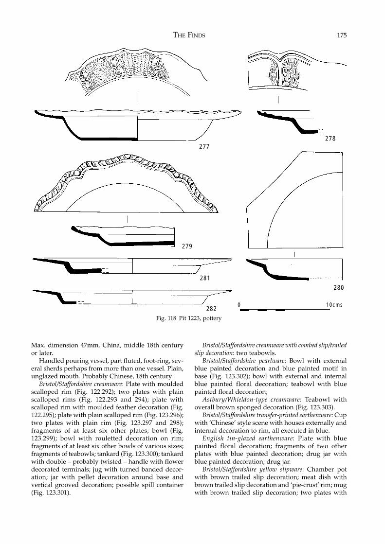
THE FINDS 175
Max. dimension 47mm. China, middle 18th centuryor later.
Handled pouring vessel, part fluted, foot-ring, sev-eral sherds perhaps from more than one vessel. Plain,unglazed mouth. Probably Chinese, 18th century.
Bristol/Staffordshire creamware: Plate with mouldedscalloped rim (Fig. 122.292); two plates with plainscalloped rims (Fig. 122.293 and 294); plate withscalloped rim with moulded feather decoration (Fig.122.295); plate with plain scalloped rim (Fig. 123.296);two plates with plain rim (Fig. 123.297 and 298);fragments of at least six other plates; bowl (Fig.123.299); bowl with rouletted decoration on rim;fragments of at least six other bowls of various sizes;fragments of teabowls; tankard (Fig. 123.300); tankardwith double – probably twisted – handle with flowerdecorated terminals; jug with turned banded decor-ation; jar with pellet decoration around base andvertical grooved decoration; possible spill container(Fig. 123.301).
Bristol/Staffordshire creamware with combed slip/trailedslip decoration: two teabowls.
Bristol/Staffordshire pearlware: Bowl with externalblue painted decoration and blue painted motif inbase (Fig. 123.302); bowl with external and internalblue painted floral decoration; teabowl with bluepainted floral decoration;
Astbury/Whieldon-type creamware: Teabowl withoverall brown sponged decoration (Fig. 123.303).
Bristol/Staffordshire transfer-printed earthenware: Cupwith ‘Chinese’ style scene with houses externally andinternal decoration to rim, all executed in blue.
English tin-glazed earthenware: Plate with bluepainted floral decoration; fragments of two otherplates with blue painted decoration; drug jar withblue painted decoration; drug jar.
Bristol/Staffordshire yellow slipware: Chamber potwith brown trailed slip decoration; meat dish withbrown trailed slip decoration and ‘pie-crust’ rim; mugwith brown trailed slip decoration; two plates with
Fig. 118 Pit 1223, pottery
277278
280
279
281
2820 10cms
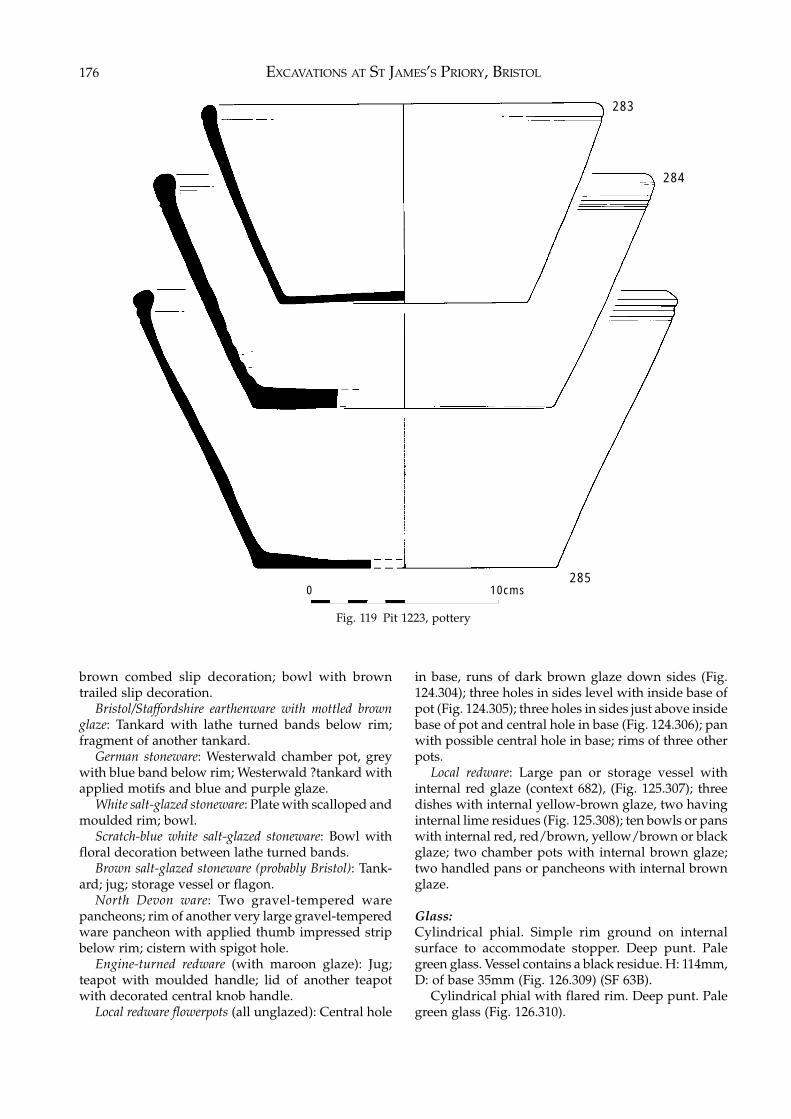
EXCAVATIONS AT ST JAMES’S PRIORY, BRISTOL176
brown combed slip decoration; bowl with browntrailed slip decoration.
Bristol/Staffordshire earthenware with mottled brownglaze: Tankard with lathe turned bands below rim;fragment of another tankard.
German stoneware: Westerwald chamber pot, greywith blue band below rim; Westerwald ?tankard withapplied motifs and blue and purple glaze.
White salt-glazed stoneware: Plate with scalloped andmoulded rim; bowl.
Scratch-blue white salt-glazed stoneware: Bowl withfloral decoration between lathe turned bands.
Brown salt-glazed stoneware (probably Bristol): Tank-ard; jug; storage vessel or flagon.
North Devon ware: Two gravel-tempered warepancheons; rim of another very large gravel-temperedware pancheon with applied thumb impressed stripbelow rim; cistern with spigot hole.
Engine-turned redware (with maroon glaze): Jug;teapot with moulded handle; lid of another teapotwith decorated central knob handle.
Local redware flowerpots (all unglazed): Central hole
in base, runs of dark brown glaze down sides (Fig.124.304); three holes in sides level with inside base ofpot (Fig. 124.305); three holes in sides just above insidebase of pot and central hole in base (Fig. 124.306); panwith possible central hole in base; rims of three otherpots.
Local redware: Large pan or storage vessel withinternal red glaze (context 682), (Fig. 125.307); threedishes with internal yellow-brown glaze, two havinginternal lime residues (Fig. 125.308); ten bowls or panswith internal red, red/brown, yellow/brown or blackglaze; two chamber pots with internal brown glaze;two handled pans or pancheons with internal brownglaze.
Glass:Cylindrical phial. Simple rim ground on internalsurface to accommodate stopper. Deep punt. Palegreen glass. Vessel contains a black residue. H: 114mm,D: of base 35mm (Fig. 126.309) (SF 63B).
Cylindrical phial with flared rim. Deep punt. Palegreen glass (Fig. 126.310).
Fig. 119 Pit 1223, pottery
2850 10cms
283
284
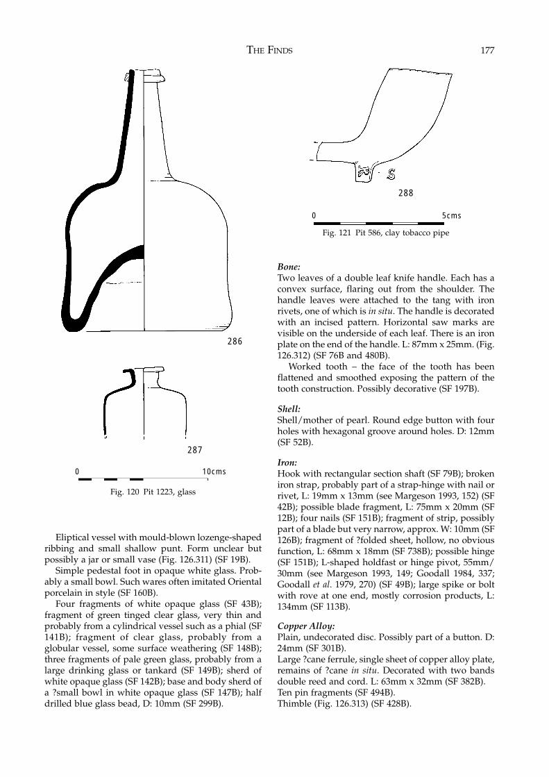
THE FINDS 177
Eliptical vessel with mould-blown lozenge-shapedribbing and small shallow punt. Form unclear butpossibly a jar or small vase (Fig. 126.311) (SF 19B).
Simple pedestal foot in opaque white glass. Prob-ably a small bowl. Such wares often imitated Orientalporcelain in style (SF 160B).
Four fragments of white opaque glass (SF 43B);fragment of green tinged clear glass, very thin andprobably from a cylindrical vessel such as a phial (SF141B); fragment of clear glass, probably from aglobular vessel, some surface weathering (SF 148B);three fragments of pale green glass, probably from alarge drinking glass or tankard (SF 149B); sherd ofwhite opaque glass (SF 142B); base and body sherd ofa ?small bowl in white opaque glass (SF 147B); halfdrilled blue glass bead, D: 10mm (SF 299B).
Bone:Two leaves of a double leaf knife handle. Each has aconvex surface, flaring out from the shoulder. Thehandle leaves were attached to the tang with ironrivets, one of which is in situ. The handle is decoratedwith an incised pattern. Horizontal saw marks arevisible on the underside of each leaf. There is an ironplate on the end of the handle. L: 87mm x 25mm. (Fig.126.312) (SF 76B and 480B).
Worked tooth – the face of the tooth has beenflattened and smoothed exposing the pattern of thetooth construction. Possibly decorative (SF 197B).
Shell:Shell/mother of pearl. Round edge button with fourholes with hexagonal groove around holes. D: 12mm(SF 52B).
Iron:Hook with rectangular section shaft (SF 79B); brokeniron strap, probably part of a strap-hinge with nail orrivet, L: 19mm x 13mm (see Margeson 1993, 152) (SF42B); possible blade fragment, L: 75mm x 20mm (SF12B); four nails (SF 151B); fragment of strip, possiblypart of a blade but very narrow, approx. W: 10mm (SF126B); fragment of ?folded sheet, hollow, no obviousfunction, L: 68mm x 18mm (SF 738B); possible hinge(SF 151B); L-shaped holdfast or hinge pivot, 55mm/30mm (see Margeson 1993, 149; Goodall 1984, 337;Goodall et al. 1979, 270) (SF 49B); large spike or boltwith rove at one end, mostly corrosion products, L:134mm (SF 113B).
Copper Alloy:Plain, undecorated disc. Possibly part of a button. D:24mm (SF 301B).Large ?cane ferrule, single sheet of copper alloy plate,remains of ?cane in situ. Decorated with two bandsdouble reed and cord. L: 63mm x 32mm (SF 382B).Ten pin fragments (SF 494B).Thimble (Fig. 126.313) (SF 428B).
Fig. 120 Pit 1223, glass
Fig. 121 Pit 586, clay tobacco pipe
286
287
0 10cms
288
0 5cms
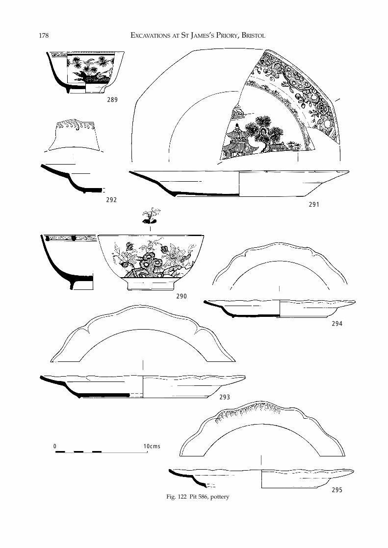
EXCAVATIONS AT ST JAMES’S PRIORY, BRISTOL178
Fig. 122 Pit 586, pottery
289
291292
294
Fig. 122 Pit 586, pottery
293
295
290
0 10cms
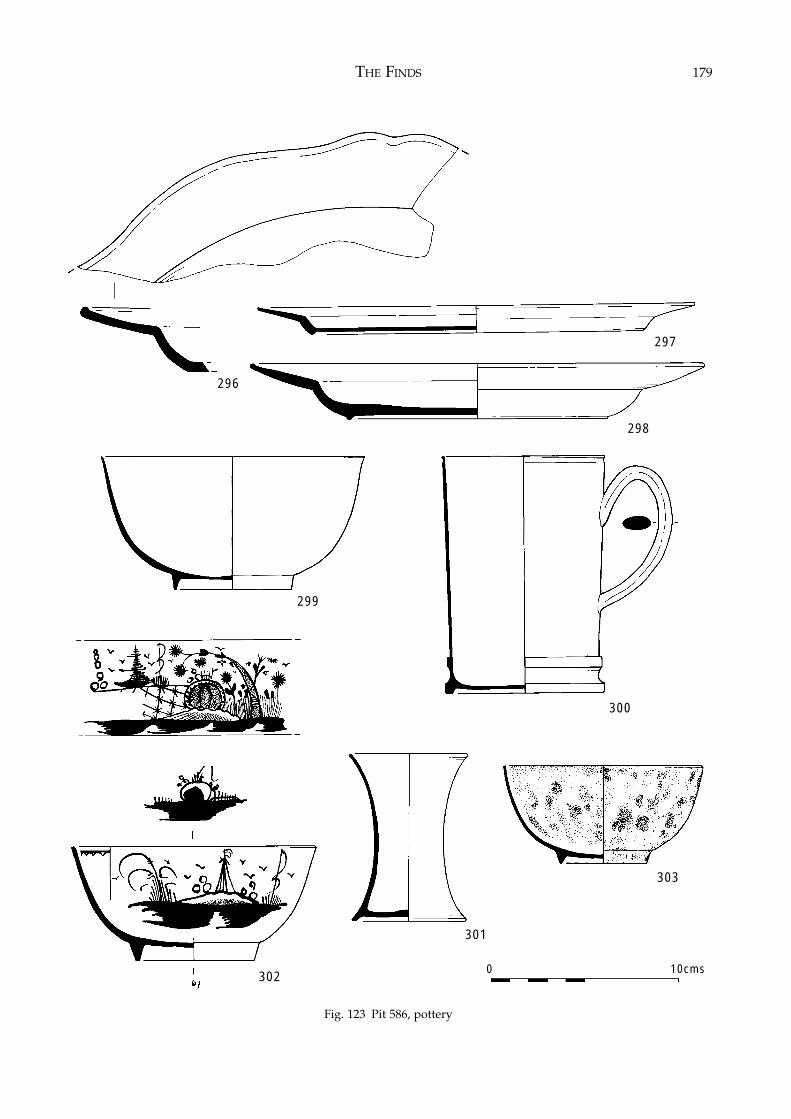
THE FINDS 179
Fig. 123 Pit 586, pottery
296
297
298
300
299
301
302
303
0 10cms
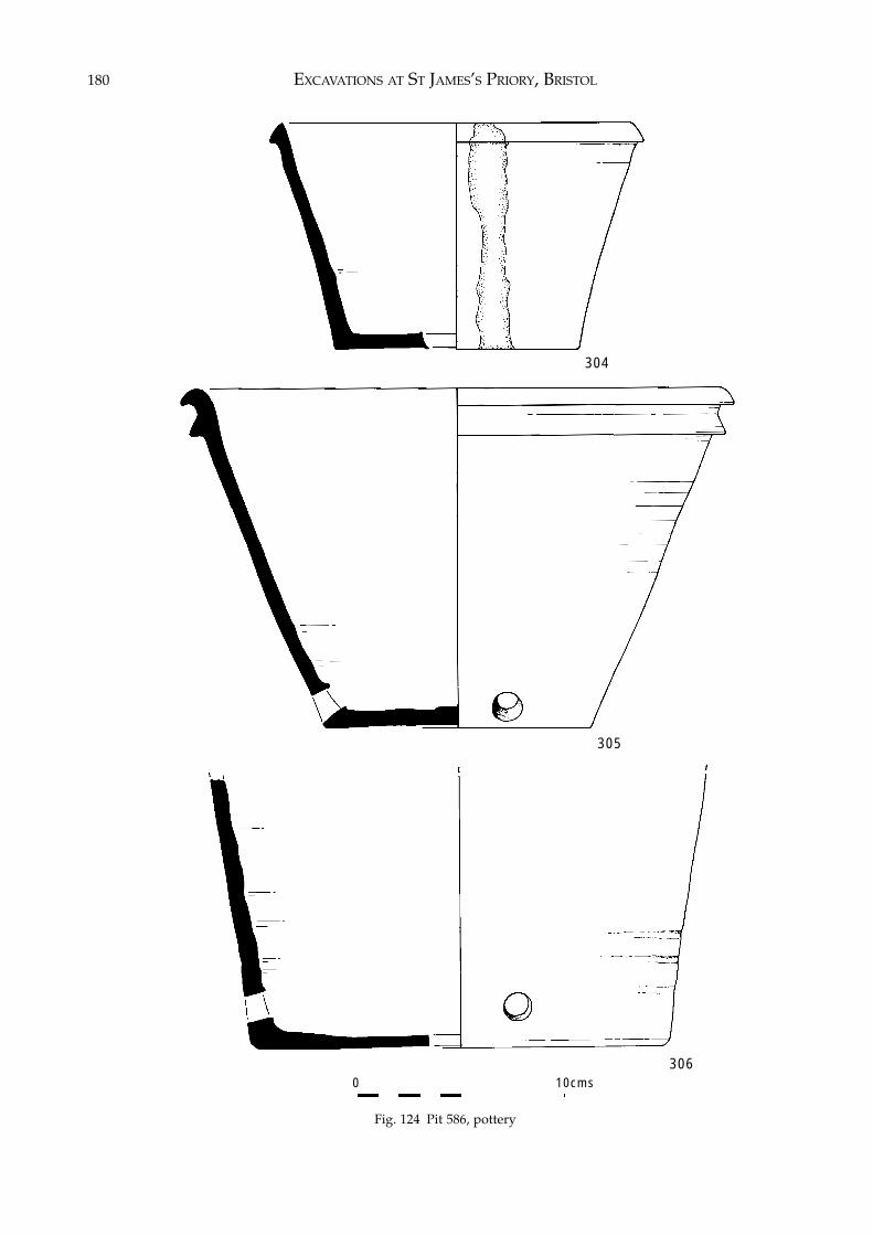
EXCAVATIONS AT ST JAMES’S PRIORY, BRISTOL180
Fig. 124 Pit 586, pottery
304
306
305
0 10cms
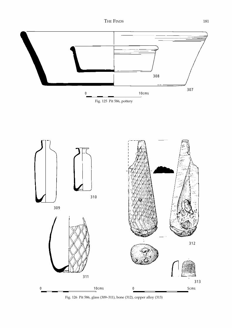
THE FINDS 181
Fig. 125 Pit 586, pottery
Fig. 126 Pit 586, glass (309–311), bone (312), copper alloy (313)
307
308
0 10cms
309
311
310
312
313
0 10cms 0 5cms
EXCAVATIONS AT ST JAMES’S PRIORY, BRISTOL182
Lead:Two lead alloy shallow spoon bowls: bowl 1: L: 75mmx 40mm x approx. 10mm; bowl 2: L: 75mm x 43mm.(SF 381B).
Discussion:The presence of a large collection of Bristol/Stafford-shire creamwares and the almost total absence oftransfer-printed ware (one sherd) indicates a date forthe pit in the latter quarter of the 18th century, beforethe production of transfer-printed wares generally,and especially in the Water Lane Pottery in Bristol,became predominant. This would correspond withthe date range of the two clay tobacco pipe bowls, oneof which was made by Samuel Richards I or II andtherefore cannot pre-date 1747. Their bowl formssuggest a date of manufacture towards the end of the18th century. The redware flowerpots, with drainageholes around the sides close to the base or with asingle central drainage hole in the base, fit in wellwith Currie’s typology for the development of flower-pot design (Currie 1993) and correspond with a late18th-century date for the pit.
The Faunal Remains (Site 1)by Geraldine Barber
IntroductionThe excavation of St James’s Priory, Bristol during1988 and 1995 produced a large quantity of animalbones (over fifteen thousand) in addition to the humanremains recovered. The site itself is made up of thepriory, its adjacent graveyard and subsequent post-medieval occupation, with continuous use from the12th century through to the 20th century.
Parts of the site were truncated by subsequentbuilding and much of the animal bone recovered camefrom reworked deposits and grave cuts. These couldnot be dated with any accuracy. The post-excavationstrategy was to concentrate on the best contexts, whichcould answer specific archaeological questions posedby the site. Only dated contexts were examined.Contexts which had been disturbed or which had fewfragments were discarded before analysis, as werecontexts that had a date range greater than one period.The bones studied came from 304 contexts, ranging innature from drains and gullies to graves and post-holes. Most of the material came from large pits thatwere dominant features of this site. It appeared fromthe pottery and small finds that the pits present on thesite were mainly domestic in nature although somecontained industrial waste.
The site can be divided into five main phases thatcontained animal bone – Medieval, Dissolution, 16th,17th and 18th centuries. These phases have been
further sub-divided in the main report. However, anyfurther sub-division of these phases for the analysis ofthe faunal remains would produce samples too smallto permit interpretation.
The SampleAlmost seven thousand fragments were selected foranalysis. Of these, nearly three and a half thousand(51%) were identified to species. The material was infair to good condition. The bones were well preserved,but in a fragmentary state.
Very few small mammal, bird and fish remainswere present. There was no sieving strategy on site;all bones analysed were hand recovered. It must beassumed that this will have biased the sample towardslarger types of species and skeletal element.
AimsA sample size of three and a half thousand identifiedbones spread over five main phases is too small asample to support lengthy statistical analysis. How-ever, it is large enough to begin to answer severalquestions about the site and animal husbandrypractices in the area. After discussion with thearchaeologists the aims of the post excavation analysiswere agreed as follows:1. To assess the range of species represented on the site.2. To determine if there is any change in relative pro-
portions of species over time.3. To look for evidence of changing animal husbandry
over time in terms of the age of death, butcherypractices and size of the major food species.
4. To compare the results from this site with those ofcontemporary urban sites locally and across thecountry.
5. To look at the animal remains from the large pits witha view to determining the occupations of the localbusinesses which created them.
MethodsRecordingThe methods by which the fragments are identifiedand counted can bias results. It must be always bornein mind that the majority of any animal bone excav-ated is only a fragment of the original assemblage ofbones from a site, and a biased one at that (Levitan1989). Certain bones often preserve better than others,i.e. teeth and phalanges as opposed to the spongyepiphyses (Payne 1975). Other bones can often bedifficult to assign to species such as ribs, vertebraeand some of the less diagnostic skull fragments.
All bones were identified as accurately as possible.For some fragments it was only possible to identifybody part, but not species. These are all recorded inthe database but they are not used for the analysis.
A selected number of skeletal parts were chosen for
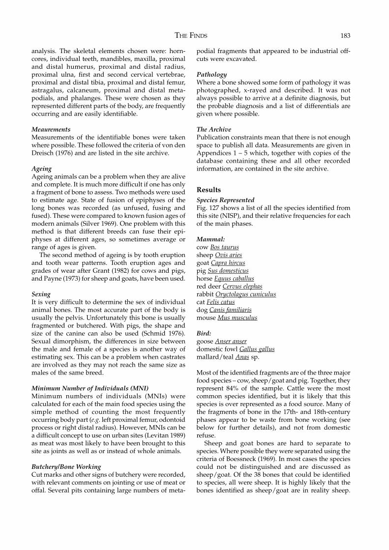
THE FINDS 183
analysis. The skeletal elements chosen were: horn-cores, individual teeth, mandibles, maxilla, proximaland distal humerus, proximal and distal radius,proximal ulna, first and second cervical vertebrae,proximal and distal tibia, proximal and distal femur,astragalus, calcaneum, proximal and distal meta-podials, and phalanges. These were chosen as theyrepresented different parts of the body, are frequentlyoccurring and are easily identifiable.
MeaurementsMeasurements of the identifiable bones were takenwhere possible. These followed the criteria of von denDreisch (1976) and are listed in the site archive.
AgeingAgeing animals can be a problem when they are aliveand complete. It is much more difficult if one has onlya fragment of bone to assess. Two methods were usedto estimate age. State of fusion of epiphyses of thelong bones was recorded (as unfused, fusing andfused). These were compared to known fusion ages ofmodern animals (Silver 1969). One problem with thismethod is that different breeds can fuse their epi-physes at different ages, so sometimes average orrange of ages is given.
The second method of ageing is by tooth eruptionand tooth wear patterns. Tooth eruption ages andgrades of wear after Grant (1982) for cows and pigs,and Payne (1973) for sheep and goats, have been used.
SexingIt is very difficult to determine the sex of individualanimal bones. The most accurate part of the body isusually the pelvis. Unfortunately this bone is usuallyfragmented or butchered. With pigs, the shape andsize of the canine can also be used (Schmid 1976).Sexual dimorphism, the differences in size betweenthe male and female of a species is another way ofestimating sex. This can be a problem when castratesare involved as they may not reach the same size asmales of the same breed.
Minimum Number of Individuals (MNI)Minimum numbers of individuals (MNIs) werecalculated for each of the main food species using thesimple method of counting the most frequentlyoccurring body part (e.g. left proximal femur, odontoidprocess or right distal radius). However, MNIs can bea difficult concept to use on urban sites (Levitan 1989)as meat was most likely to have been brought to thissite as joints as well as or instead of whole animals.
Butchery/Bone WorkingCut marks and other signs of butchery were recorded,with relevant comments on jointing or use of meat oroffal. Several pits containing large numbers of meta-
podial fragments that appeared to be industrial off-cuts were excavated.
PathologyWhere a bone showed some form of pathology it wasphotographed, x-rayed and described. It was notalways possible to arrive at a definite diagnosis, butthe probable diagnosis and a list of differentials aregiven where possible.
The ArchivePublication constraints mean that there is not enoughspace to publish all data. Measurements are given inAppendices 1 – 5 which, together with copies of thedatabase containing these and all other recordedinformation, are contained in the site archive.
ResultsSpecies RepresentedFig. 127 shows a list of all the species identified fromthis site (NISP), and their relative frequencies for eachof the main phases.
Mammal:cow Bos taurussheep Ovis ariesgoat Capra hircuspig Sus domesticushorse Equus caballusred deer Cervus elephasrabbit Oryctolagus cuniculuscat Felis catusdog Canis familiarismouse Mus musculus
Bird:goose Anser anserdomestic fowl Gallus gallusmallard/teal Anas sp.
Most of the identified fragments are of the three majorfood species – cow, sheep/goat and pig. Together, theyrepresent 84% of the sample. Cattle were the mostcommon species identified, but it is likely that thisspecies is over represented as a food source. Many ofthe fragments of bone in the 17th- and 18th-centuryphases appear to be waste from bone working (seebelow for further details), and not from domesticrefuse.
Sheep and goat bones are hard to separate tospecies. Where possible they were separated using thecriteria of Boessneck (1969). In most cases the speciescould not be distinguished and are discussed assheep/goat. Of the 38 bones that could be identifiedto species, all were sheep. It is highly likely that thebones identified as sheep/goat are in reality sheep.
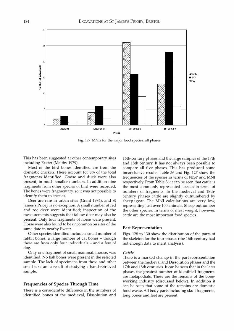
EXCAVATIONS AT ST JAMES’S PRIORY, BRISTOL184
This has been suggested at other contemporary sitesincluding Exeter (Maltby 1979).
Most of the bird bones identified are from thedomestic chicken. These account for 8% of the totalfragments identified. Goose and duck were alsopresent, in much smaller numbers. In addition ninefragments from other species of bird were recorded.The bones were fragmentary, so it was not possible toidentify them to species.
Deer are rare in urban sites (Grant 1984), and StJames’s Priory is no exception. A small number of redand roe deer were identified; inspection of themeasurements suggests that fallow deer may also bepresent. Only four fragments of horse were present.Horse were also found to be uncommon on sites of thesame date in nearby Exeter.
Other species identified include a small number ofrabbit bones, a large number of cat bones – thoughthese are from only four individuals – and a few ofdog.
Only one fragment of small mammal, mouse, wasidentified. No fish bones were present in the selectedsample. The lack of specimens from these and othersmall taxa are a result of studying a hand-retrievedsample.
Frequencies of Species Through TimeThere is a considerable difference in the numbers ofidentified bones of the medieval, Dissolution and
16th-century phases and the large samples of the 17thand 18th century. It has not always been possible tocompare all five phases. This has produced someinconclusive results. Table 36 and Fig. 127 show thefrequencies of the species in terms of NISP and MNIrespectively. From Table 36 it can be seen that cattle isthe most commonly represented species in terms ofnumbers of fragments. In the medieval and 18th-century phases cattle are slightly outnumbered bysheep/goat. The MNI calculations are very low,representing just over 100 animals. Sheep outnumberthe other species. In terms of meat weight, however,cattle are the most important food species.
Part RepresentationFigs. 128 to 130 show the distribution of the parts ofthe skeleton for the four phases (the 16th century hadnot enough data to merit analysis).
CattleThere is a marked change in the part representationbetween the medieval and Dissolution phases and the17th and 18th centuries. It can be seen that in the laterphases the greatest number of identified fragmentsare metapodials. These are the remains of the bone-working industry (discussed below). In addition itcan be seen that some of the remains are domesticfood waste. All body parts including skull fragments,long bones and feet are present.
Fig. 127 MNIs for the major food species: all phases
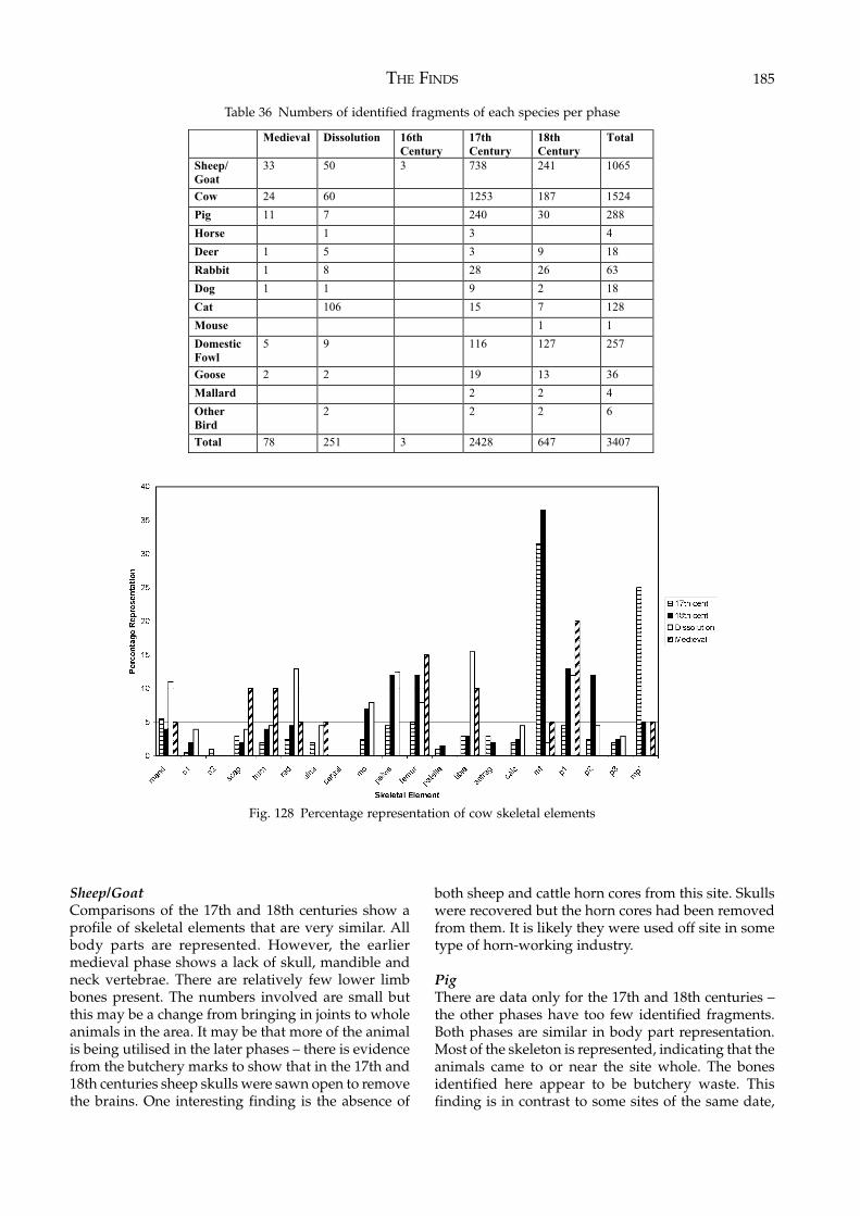
THE FINDS 185
Sheep/GoatComparisons of the 17th and 18th centuries show aprofile of skeletal elements that are very similar. Allbody parts are represented. However, the earliermedieval phase shows a lack of skull, mandible andneck vertebrae. There are relatively few lower limbbones present. The numbers involved are small butthis may be a change from bringing in joints to wholeanimals in the area. It may be that more of the animalis being utilised in the later phases – there is evidencefrom the butchery marks to show that in the 17th and18th centuries sheep skulls were sawn open to removethe brains. One interesting finding is the absence of
both sheep and cattle horn cores from this site. Skullswere recovered but the horn cores had been removedfrom them. It is likely they were used off site in sometype of horn-working industry.
PigThere are data only for the 17th and 18th centuries –the other phases have too few identified fragments.Both phases are similar in body part representation.Most of the skeleton is represented, indicating that theanimals came to or near the site whole. The bonesidentified here appear to be butchery waste. Thisfinding is in contrast to some sites of the same date,
Medieval Dissolution 16th
Century
17th
Century
18th
Century
Total
Sheep/
Goat
33 50 3 738 241 1065
Cow 24 60 1253 187 1524
Pig 11 7 240 30 288
Horse 1 3 4
Deer 1 5 3 9 18
Rabbit 1 8 28 26 63
Dog 1 1 9 2 18
Cat 106 15 7 128
Mouse 1 1
Domestic
Fowl
5 9 116 127 257
Goose 2 2 19 13 36
Mallard 2 2 4
Other
Bird
2 2 2 6
Total 78 251 3 2428 647 3407
Table 36 Numbers of identified fragments of each species per phase
Fig. 128 Percentage representation of cow skeletal elements
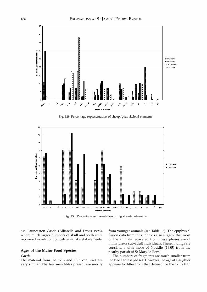
EXCAVATIONS AT ST JAMES’S PRIORY, BRISTOL186
Fig. 129 Percentage representation of sheep/goat skeletal elements
Fig. 130 Percentage representation of pig skeletal elements
e.g. Launceston Castle (Albarella and Davis 1996),where much larger numbers of skull and teeth wererecovered in relation to postcranial skeletal elements.
Ages of the Major Food SpeciesCattleThe material from the 17th and 18th centuries arevery similar. The few mandibles present are mostly
from younger animals (see Table 37). The epiphysialfusion data from these phases also suggest that mostof the animals recovered from these phases are ofimmature or sub-adult individuals. These findings areconsistent with those of Noddle (1985) from thenearby parish of St Mary-le-Port.
The numbers of fragments are much smaller fromthe two earliest phases. However, the age at slaughterappears to differ from that defined for the 17th/18th
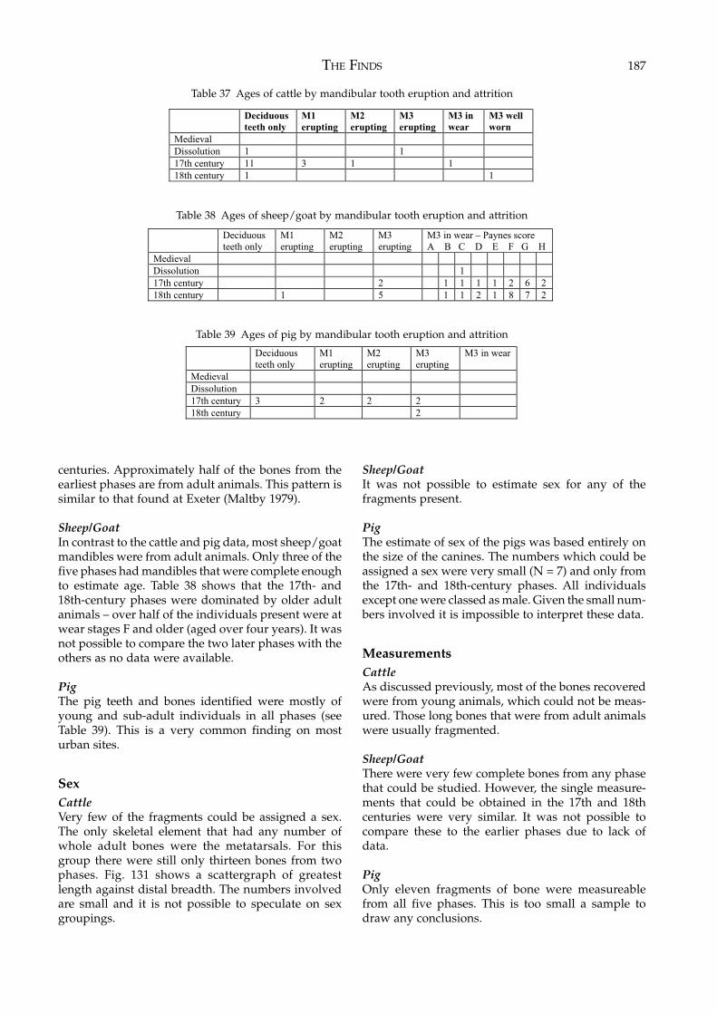
THE FINDS 187
centuries. Approximately half of the bones from theearliest phases are from adult animals. This pattern issimilar to that found at Exeter (Maltby 1979).
Sheep/GoatIn contrast to the cattle and pig data, most sheep/goatmandibles were from adult animals. Only three of thefive phases had mandibles that were complete enoughto estimate age. Table 38 shows that the 17th- and18th-century phases were dominated by older adultanimals – over half of the individuals present were atwear stages F and older (aged over four years). It wasnot possible to compare the two later phases with theothers as no data were available.
PigThe pig teeth and bones identified were mostly ofyoung and sub-adult individuals in all phases (seeTable 39). This is a very common finding on mosturban sites.
SexCattleVery few of the fragments could be assigned a sex.The only skeletal element that had any number ofwhole adult bones were the metatarsals. For thisgroup there were still only thirteen bones from twophases. Fig. 131 shows a scattergraph of greatestlength against distal breadth. The numbers involvedare small and it is not possible to speculate on sexgroupings.
Sheep/GoatIt was not possible to estimate sex for any of thefragments present.
PigThe estimate of sex of the pigs was based entirely onthe size of the canines. The numbers which could beassigned a sex were very small (N = 7) and only fromthe 17th- and 18th-century phases. All individualsexcept one were classed as male. Given the small num-bers involved it is impossible to interpret these data.
MeasurementsCattleAs discussed previously, most of the bones recoveredwere from young animals, which could not be meas-ured. Those long bones that were from adult animalswere usually fragmented.
Sheep/GoatThere were very few complete bones from any phasethat could be studied. However, the single measure-ments that could be obtained in the 17th and 18thcenturies were very similar. It was not possible tocompare these to the earlier phases due to lack ofdata.
PigOnly eleven fragments of bone were measureablefrom all five phases. This is too small a sample todraw any conclusions.
Deciduous
teeth only
M1
erupting
M2
erupting
M3
erupting
M3 in
wear
M3 well
worn
Medieval
Dissolution 1 1
17th century 11 3 1 1
18th century 1 1
Table 37 Ages of cattle by mandibular tooth eruption and attrition
Table 38 Ages of sheep/goat by mandibular tooth eruption and attrition
Deciduous
teeth only
M1
erupting
M2
erupting
M3
erupting
M3 in wear – Paynes score
A B C D E F G H
Medieval
Dissolution 1
17th century 2 1 1 1 1 2 6 2
18th century 1 5 1 1 2 1 8 7 2
Deciduous
teeth only
M1
erupting
M2
erupting
M3
erupting
M3 in wear
Medieval
Dissolution
17th century 3 2 2 2
18th century 2
Table 39 Ages of pig by mandibular tooth eruption and attrition
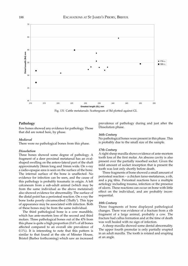
EXCAVATIONS AT ST JAMES’S PRIORY, BRISTOL188
PathologyFew bones showed any evidence for pathology. Thosethat did are noted here, by phase.
MedievalThere were no pathological bones from this phase.
DissolutionThree bones showed some degree of pathology. Afragment of a deer proximal metatarsal has an oval-shaped swelling on the antero-lateral part of the shaftapproximately 24mm long and 16mm wide. On x-raya radio-opaque area is seen on the surface of the bone.The internal surface of the bone is unaffected. Noevidence for infection can be seen, and the cause ofthis pathology is probably traumatic in origin. A leftcalcaneum from a sub-adult animal (which may befrom the same individual as the above metatarsal)also showed evidence for abnormality. The surface ofthe distal point has a periosteal reaction. On x-ray thebone looks poorly circumscribed (‘fluffy’). This typeof appearance may be associated with infection. Bothof these bones may be from the same individual.
The third pathological bone is a cow mandible,which has ante-mortem loss of the second and thirdmolars. Three pathological bones out of the 476 fromthis phase is quite a high proportion (0.6% of all bonesaffected compared to an overall site prevalence of0.1%). It is interesting to note that this pattern issimilar to that found at the site of Minster House,Bristol (Barber forthcoming) which saw an increased
prevalence of pathology during and just after theDissolution phase.
16th CenturyNo pathological bones were present in this phase. Thisis probably due to the small size of the sample.
17th CenturyA right sheep maxilla shows evidence of ante-mortemtooth loss of the first molar. An abscess cavity is alsopresent over the partially resorbed socket. Given themild amount of socket resorption that is present thetooth was lost only shortly before death.
Three fragments of bone showed a small amount ofperiosteal reaction – a chicken tarso-metatarsus, a rib,and a pig tibia. Periosteal reactions have a multipleaetiology including trauma, infection or the presenceof ulcers. These reactions can occur on bone with littleeffect on the individual, and are probably incon-sequential.
18th CenturyThree fragments of bone displayed pathologicalchanges. There was evidence of a fracture from a ribfragment of a large animal, probably a cow. Thefracture had callus formation and at the time of deathwas well healed with no sign of infection.
A sheep maxilla showed some dental abnormality.The upper fourth premolar is only partially eruptedin an adult maxilla. The tooth is rotated and eruptingat an angle.
40
45
50
55
60
65
70
210 215 220 225 230 235 240 245 250 255
Greatest length (GL) mm
Dis
tal b
re
ad
th (
Bd
) m
m
17th c.
18th c.
Fig. 131 Cattle metatarsals: Scattergram of Bd plotted against GL
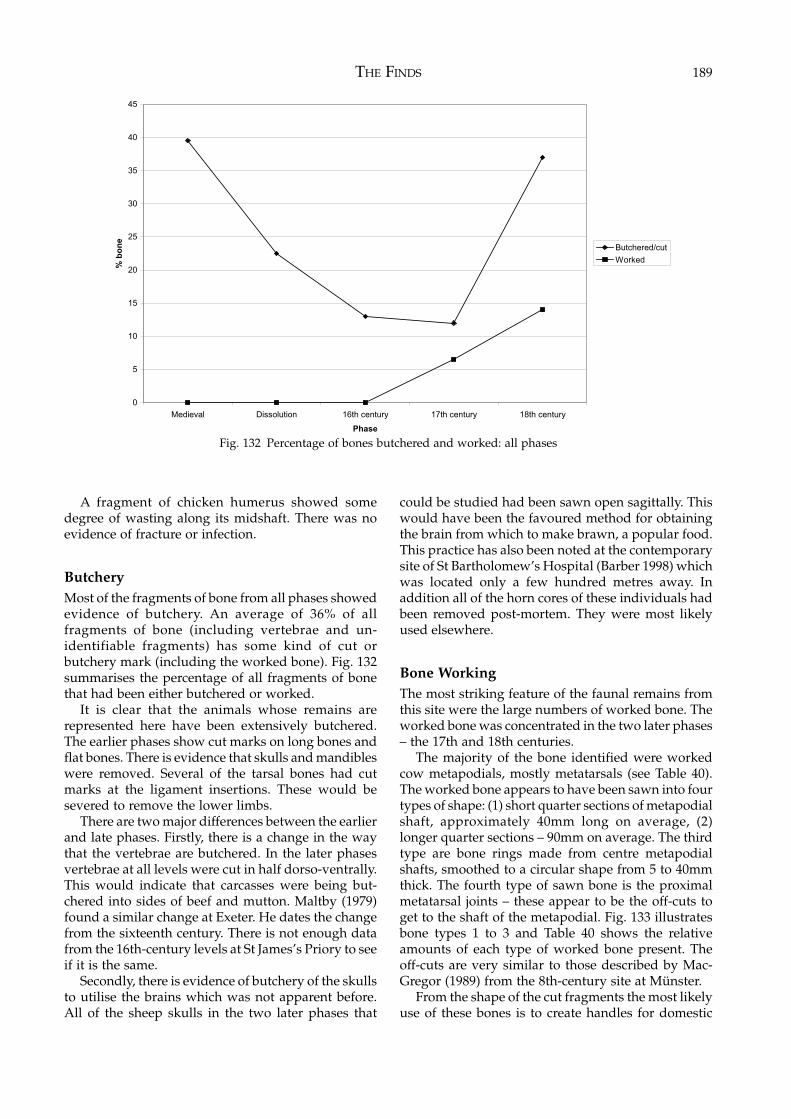
THE FINDS 189
A fragment of chicken humerus showed somedegree of wasting along its midshaft. There was noevidence of fracture or infection.
ButcheryMost of the fragments of bone from all phases showedevidence of butchery. An average of 36% of allfragments of bone (including vertebrae and un-identifiable fragments) has some kind of cut orbutchery mark (including the worked bone). Fig. 132summarises the percentage of all fragments of bonethat had been either butchered or worked.
It is clear that the animals whose remains arerepresented here have been extensively butchered.The earlier phases show cut marks on long bones andflat bones. There is evidence that skulls and mandibleswere removed. Several of the tarsal bones had cutmarks at the ligament insertions. These would besevered to remove the lower limbs.
There are two major differences between the earlierand late phases. Firstly, there is a change in the waythat the vertebrae are butchered. In the later phasesvertebrae at all levels were cut in half dorso-ventrally.This would indicate that carcasses were being but-chered into sides of beef and mutton. Maltby (1979)found a similar change at Exeter. He dates the changefrom the sixteenth century. There is not enough datafrom the 16th-century levels at St James’s Priory to seeif it is the same.
Secondly, there is evidence of butchery of the skullsto utilise the brains which was not apparent before.All of the sheep skulls in the two later phases that
could be studied had been sawn open sagittally. Thiswould have been the favoured method for obtainingthe brain from which to make brawn, a popular food.This practice has also been noted at the contemporarysite of St Bartholomew’s Hospital (Barber 1998) whichwas located only a few hundred metres away. Inaddition all of the horn cores of these individuals hadbeen removed post-mortem. They were most likelyused elsewhere.
Bone WorkingThe most striking feature of the faunal remains fromthis site were the large numbers of worked bone. Theworked bone was concentrated in the two later phases– the 17th and 18th centuries.
The majority of the bone identified were workedcow metapodials, mostly metatarsals (see Table 40).The worked bone appears to have been sawn into fourtypes of shape: (1) short quarter sections of metapodialshaft, approximately 40mm long on average, (2)longer quarter sections – 90mm on average. The thirdtype are bone rings made from centre metapodialshafts, smoothed to a circular shape from 5 to 40mmthick. The fourth type of sawn bone is the proximalmetatarsal joints – these appear to be the off-cuts toget to the shaft of the metapodial. Fig. 133 illustratesbone types 1 to 3 and Table 40 shows the relativeamounts of each type of worked bone present. Theoff-cuts are very similar to those described by Mac-Gregor (1989) from the 8th-century site at Münster.
From the shape of the cut fragments the most likelyuse of these bones is to create handles for domestic
0
5
10
15
20
25
30
35
40
45
Medieval Dissolution 16th century 17th century 18th century
Phase
% b
on
e
Butchered/cut
Worked
Fig. 132 Percentage of bones butchered and worked: all phases
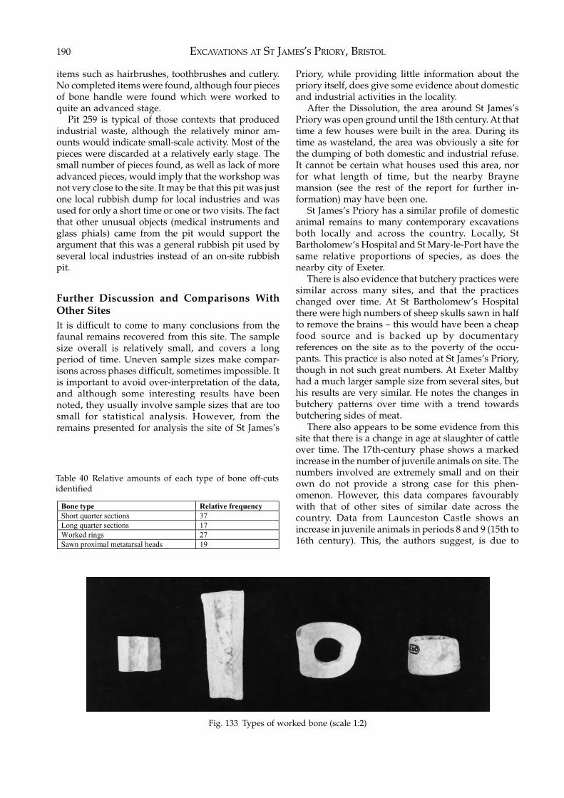
EXCAVATIONS AT ST JAMES’S PRIORY, BRISTOL190
items such as hairbrushes, toothbrushes and cutlery.No completed items were found, although four piecesof bone handle were found which were worked toquite an advanced stage.
Pit 259 is typical of those contexts that producedindustrial waste, although the relatively minor am-ounts would indicate small-scale activity. Most of thepieces were discarded at a relatively early stage. Thesmall number of pieces found, as well as lack of moreadvanced pieces, would imply that the workshop wasnot very close to the site. It may be that this pit was justone local rubbish dump for local industries and wasused for only a short time or one or two visits. The factthat other unusual objects (medical instruments andglass phials) came from the pit would support theargument that this was a general rubbish pit used byseveral local industries instead of an on-site rubbishpit.
Further Discussion and Comparisons WithOther SitesIt is difficult to come to many conclusions from thefaunal remains recovered from this site. The samplesize overall is relatively small, and covers a longperiod of time. Uneven sample sizes make compar-isons across phases difficult, sometimes impossible. Itis important to avoid over-interpretation of the data,and although some interesting results have beennoted, they usually involve sample sizes that are toosmall for statistical analysis. However, from theremains presented for analysis the site of St James’s
Priory, while providing little information about thepriory itself, does give some evidence about domesticand industrial activities in the locality.
After the Dissolution, the area around St James’sPriory was open ground until the 18th century. At thattime a few houses were built in the area. During itstime as wasteland, the area was obviously a site forthe dumping of both domestic and industrial refuse.It cannot be certain what houses used this area, norfor what length of time, but the nearby Braynemansion (see the rest of the report for further in-formation) may have been one.
St James’s Priory has a similar profile of domesticanimal remains to many contemporary excavationsboth locally and across the country. Locally, StBartholomew’s Hospital and St Mary-le-Port have thesame relative proportions of species, as does thenearby city of Exeter.
There is also evidence that butchery practices weresimilar across many sites, and that the practiceschanged over time. At St Bartholomew’s Hospitalthere were high numbers of sheep skulls sawn in halfto remove the brains – this would have been a cheapfood source and is backed up by documentaryreferences on the site as to the poverty of the occu-pants. This practice is also noted at St James’s Priory,though in not such great numbers. At Exeter Maltbyhad a much larger sample size from several sites, buthis results are very similar. He notes the changes inbutchery patterns over time with a trend towardsbutchering sides of meat.
There also appears to be some evidence from thissite that there is a change in age at slaughter of cattleover time. The 17th-century phase shows a markedincrease in the number of juvenile animals on site. Thenumbers involved are extremely small and on theirown do not provide a strong case for this phen-omenon. However, this data compares favourablywith that of other sites of similar date across thecountry. Data from Launceston Castle shows anincrease in juvenile animals in periods 8 and 9 (15th to16th century). This, the authors suggest, is due to
Bone type Relative frequency
Short quarter sections 37
Long quarter sections 17
Worked rings 27
Sawn proximal metatarsal heads 19
Fig. 133 Types of worked bone (scale 1:2)
Table 40 Relative amounts of each type of bone off-cutsidentified
THE FINDS 191
increased specialisation in the cattle industry. Beef andveal are appearing by demand, not solely as a by-product of milk production. They discuss other sitesshowing a similar countrywide pattern in their report– a contemporary increase in juvenile numbers isnoted in Exeter by Maltby (1979), at Sandal Castle byGriffiths et al. (1983) and at St Andrew’s Priory byO’Connor (1993). Grant (1988, 156) also notes thephenomena of increasing numbers of juveniles ‘inlater deposits at some sites’ in her survey of animalresources – she suggests this is due to an increasingimportance of cattle as suppliers of meat, not just milk.
One of the most interesting findings from this siteis that some of the many 17th- and 18th-century pitson the site show evidence of specialised use, includingsome degree of small-scale industrialised bone work-ing. No evidence for any bone-working industry wasnoted in any samples from the earlier periods of thesite (medieval, Dissolution and 16th-century phases),although the numbers of fragments in these sampleswas considerably smaller than those of later dates.This is similar to the site of St Mary-le-Port, Bristol.Here, Noddle (1985) found large numbers of meta-podials on site of a contemporary date. She notes thatthese are the bone workers’ ‘favourite’ material butnone of the metapodials on the site were worked.However, the site did contain a large number of horn-cores which may have been worked. Noddle suggeststhat the material from St Mary-le-Port was derivedfrom slaughterhouses and butchers waste more thandomestic refuse. The comparison with the contents ofsome of the pits on the St James’s Priory site suggestsa similar mix of domestic and industrial waste.
In summary, the remains from St James’s Priory aredifficult to interpret. This is partly due to the smallnumbers of fragments that are involved, but also dueto the fact that the site appears to contain debris from
many different aspects of urban life in Bristol overtime. There are obviously remains from the occupationof the priory, though these are scant and are largelydisturbed by later activity on the site. There is someevidence of changes over time in the urban economyof Bristol city – perhaps a change to using youngercattle more for meat (veal, even) in the 17th and 18thcenturies which can be seen in other areas around thecountry. There is also some evidence for localisedindustries – bone working and tanneries perhaps.Though this site cannot on its own answer many ofthe aims which it set out to complete, when seen inconjunction with other larger sites both locally andnationally, it can help add a few more pieces to the‘jigsaw’.
ConclusionsThe major conclusions of this report are:1. The majority of species identified were from the three
major food species – cow, sheep/goat and pig. Smallernumbers of other species were also present. No unusualor ‘exotic’ species were identified.
2. There is little change in the relative number of speciesacross all phases, however different body parts arerepresented over time. A wider variety of skeletalelements are present in the later phases.
3. There is a change in age at slaughter of cattle towardsyounger animals in the later centuries. Sheep weremostly slaughtered as adults across all phases. Pigswere killed as immature or sub-adults in all phases.
4. Butchery practices change between the Dissolution andthe 17th-century phases. These findings are similar tocontemporary urban sites both in Bristol and in thenearby city of Exeter.
5. The site has several pits that produced evidence forsmall-scale bone working in the 17th and 18th cen-turies. Remains of skulls with horn cores removedsuggests a local horn industry, though not on this site.
EXCAVATIONS AT ST JAMES’S PRIORY, BRISTOL192
7 DISCUSSION
The broad aims of the two excavations at St James’sPriory were set out in Chapter 1 and, despite thedestruction caused to the medieval archaeology bylater interventions on both sites, those aims werelargely achieved.
It was our intention to establish the extent and dateof the U-shaped gullies, located during the 1989excavation on Site 1, which pre-dated the monasticburials and thus may have pre-dated the 12th-centurypriory. In fact, the area of Site 1 excavated in 1995 hadbeen so intensively used for burials and post-medievalhousing that no trace of any pre-burial featuresremained. The gullies excavated in 1989 contained nodating evidence and although the backfill of six of themedieval graves produced residual and much ab-raded sherds of Romano-British pottery, it seemsunlikely that the gullies date to that period, the potteryalmost certainly coming from a settlement some 300mto the north-west of the priory. An interpretation ofthe purpose of the gullies is difficult as the nature oftheir fills did not show signs of gradual silting or abuild-up of organic material as might be expected inditches used for drainage or as land divisions.
An indication of the date of the gullies is perhapsprovided by the three shallow features found on Site 2which, again, pre-dated the medieval activity on thesite and contained a few small sherds of late Saxonpottery. These finds hint at a late Saxon date for theestablishment of a religious community on the site ofSt James’s Priory and may lend support to thesomewhat obscure and possibly unreliable document-ary sources referred to by the 18th- and 19th-centuryantiquarians, Barrett and Seyer. However, in theabsence of a more substantial body of archaeologicalor documentary evidence a pre-Norman date for thefoundation of the priory must remain conjectural.
Whatever the possible Saxon origins of the religioussettlement, we know that the Normans established aBenedictine priory here sometime around 1129. Thereason this location was chosen by the earliest knownmonastic community in Bristol is apparent when thearea can be imagined without the trappings of amodern city. Here was a plateau of Triassic sandstonelying just above the flood plain of the River Fromeand with a southerly aspect overlooking, but safely
removed from, the walled medieval town, the riverforming a natural barrier between the two. Thetopography of the site made it necessary for thecloisters and conventual buildings to be located onthe north, rather than the more usual south, side of thechurch although that layout is paralleled elsewhere.This plan had the advantage of making the priorychurch the most prominent building visible from thetown, standing immediately at the top of the hillslopeabove the river. The river provided food and alsowater power for the priory mill, while the landaround, particularly the south facing slopes of Kings-down, were ideally situated for orchards and vine-yards. The priory’s extensive landholdings includedareas of woodland which provided timber for use inthe construction and repair of the priory buildings,the agricultural activity centring on the priory farmwith its great tithe barn situated to the east at StJames’s Barton.
It is possible that the earliest religious structure onthe site was the Lady Chapel, the construction of thatchapel in advance of the main programme of churchbuilding having been argued by F. W. Potto Hick, anhypothesis supported by discoveries made at othermonastic sites. Unfortunately, this can never be put tothe test archaeologically as the site of the Lady Chapelwas destroyed by office building in the 1960s.
Only ephemeral structural remains of the east endof the priory church survived on Site 1 and thoselargely consisted of spreads of mortar or, at the most,one or two courses of stone foundations, the floorsand any internal structures of the church having beengenerally removed during a reduction in ground levelafter the Dissolution. The position of the east end wallof the church located by excavation compares favour-ably with its supposed position identified from themeasurements given by William Worcestre after hisvisit in 1478. During the 14th century a wall was builtwhich, had it stood to any height, would have blockedthe south transept and this may have been connectedwith the re-ordering of the church after 1374. Onlytwo burials survived within the east end of the church,of which only one could be fully excavated. That wasof a male aged between 35 and 45 years who, judgingby the size and quantity of the coffin nails in the grave
DISCUSSION 193
fill, had been buried in a substantial wooden coffin.That burial, presumably by its proximity to theposition of the high altar, would have been of a personof some importance either within, or as a benefactorto, the religious community.
Although no archaeological dating evidence wasfound for the construction of the church, the wallsappeared to have been of one build, employing adistinctive yellow sandy mortar. The building workon the church was presumably completed within ashort time after the foundation of the priory and it issignificant that no head-niche burials, the earliest typeof burial found in the monastic burial ground,underlie or were cut by the foundations of the church.
The area outside the east end of the church wasused solely as a burial ground from the earliest daysof the priory until at least the 16th century. Thenorthern limit of the burial ground was marked by ashallow ditch but none of its other boundaries werefound. The burials appeared to have been set out inrows indicating the use of grave markers, althoughnone survived, or a burial plan or possibly both. Overthe centuries, and through intensive use of the burialground, these rows became less well defined. In theabsence of any other dating evidence associated withthe bodies, the burials can only be dated by theirrelationship to each other, by the pottery found withintheir fills and, to a limited extent, by the burial type.The prolonged use of the burial ground, which led toovercrowding and the removal of any stratification bywhich burials could be linked, made phasing of theburials virtually impossible, although the head-nichetype were clearly the earliest.
A number of different forms of burial were presentof which the three main types were: head-niche burialswhere the shape of the grave had been cut to take thehead and shoulders and then tapered towards thefeet; coffin burials where the presence of iron nailspoints to the use of a wooden coffin; and simpleburials where the absence of coffin nails or shroudpins could imply the use of wooden coffins heldtogether by wooden dowels or pegs, the use ofshrouds which were not fastened by pins or theabsence of wooden coffins or shrouds. A few burialswere packed with clay or mortar perhaps to seal indisease. The archaic use of stone pillows for the headwas noted with a number of burials. There was ageneral absence of finds associated with the burialsalthough three each had a pewter object, probably achalice – and were almost certainly the burials ofpriests – and one had two folded silver coins in theregion of the shoulders and a jet pendant, decoratedwith an incised cross and other symbols, below thechin. A folded lead package, possibly containingparchment, was found with the burial of an adultfemale.
The three to one ratio of male to female burials onSite 1 indicates that the area around the east end of the
church was indeed mainly reserved for the burial ofthe all male religious community and follows thepattern noted on other monastic sites for the locationof the community’s burial ground. However, thepresence of female and child burials within that burialground is not unusual and has been noted elsewhere:these were almost certainly the burials of layfolk eitherworking as servants of the community themselves orthe wives and children of servants. In addition todefining the sex and age at death of the individualsthe analysis of the skeletal material identified varioustypes of diseases and, perhaps significantly, a lowerproportion of trauma injuries than generally occurs ina contemporary non-monastic community.
Site 2, to the south-west of the priory church, wasalso partly used as a burial ground, its northern extentbeing defined by an east/west boundary wall appar-ently dating from the 12th century. This boundarywall probably divided the monastic community fromthe lay burial ground from the earliest period of thepriory’s existence, the presence of head-niche burialsagain suggesting an early date for some of theinterments. The use of some form of grave markers ora plan of the burial plots is suggested by the orderly,overlapping nature of, at least, the earlier burials. Anexamination of the skeletal remains gives a ratio ofmale to female burials of one to one, as would beexpected in a parish or lay burial ground, and thiscorresponds with the known use of the nave of thepriory church by parishioners from an early period.The burials excavated were part of a much larger layor parish cemetery used throughout the medievalperiod and continuing in use until the 20th century,other groups of medieval burials having been re-covered during a watching brief in another part of thecemetery in 1997 and as a result of rescue excavationsin 1954. The orderly layout of all the graves founddoes not support the popular local story of thediscovery of ‘plague pits’ arising from the publicinterest in the 1954 excavation.
The most westerly area of Site 2 never seems tohave been part of the lay burial ground. A buildingoccupied the site from the late 13th century, but evenbefore that there was no evidence of burials havingtaken place there. A wall found in an evaluation trenchsuggests that the building also extended further to thewest. The building went out of use in the 15th centurybut was then reoccupied in the early 17th century,continuing in use in a modified form until its dem-olition in the 1950s. It is possible that this buildingwas connected with the lay use of this area of thepriory precinct but its purpose is unknown. Littlearchaeological work has been carried out on suchareas of monastic complexes and there appear to beno parallels for a building of this type and in thislocation elsewhere. Close to the west front of St.Augustine’s abbey in Bristol, an excavation in 1992uncovered a building identified as the abbot’s house
EXCAVATIONS AT ST JAMES’S PRIORY, BRISTOL194
and the guest-house of the abbey, but there thebuilding was adjacent to cloisters and other con-ventual buildings rather than on the opposite side ofthe church from them.
The Dissolution of the priory took place in 1540and, while the nave of the church survived because ofits use by the parish, the east end quickly becameruinous, the walls and foundations being compre-hensively robbed away presumably for use as build-ing materials elsewhere, probably in the conversion ofthe cloisters and conventual buildings to the mansionhouse owned by Henry Brayne, a conversion and re-use typical of other urban monastic sites. The LadyChapel almost certainly survived in a ruinous stateinto the 18th century when it was incorporated intothe houses built on the north side of St James’s Parade,only being demolished in the 1960s.
Shortly after the Dissolution pits were dug withinthe monastic cemetery, possibly to extract sand forindustrial purposes, and their backfill included debrisfrom the priory such as decorated floor tiles, roof tilesand a few fragments of decorated window glass.
Much archaeological evidence was found for thepost-medieval development of the areas to the westand east of the church for housing. Millerd’s map of1673 depicts buildings to the west of the church andevidence for these was found, including the re-use ofthe late 13th-century building. No 17th-centurystructures were found to the east of the church and itis assumed that those shown by Millerd in that arealay just outside the excavation. Instead there were anumber of rubbish pits, some stone-lined, which werepresumably within the garden areas or commonground adjacent to the properties. The pottery andother finds from the rubbish pits provide clues as tothe status of the occupants in this area of St James’sparish during the 17th and early 18th centuries. Asmight be expected in an area of urban expansionoutside the confines of the medieval city and adjoiningBrayne’s mansion house, the ceramics, glass, andsmall finds indicate the presence of moderately highstatus households using imported ceramics and highquality local wares – the contents of their tables atleast suggesting they were keeping abreast of contem-porary fashions. The occurrence in one pit of tin-glazed earthenware drug jars, syringes and glassmedical equipment may indicate that an apothecaryor barber-surgeon resided in one of the adjoininghouses. A small scale bone-working industry op-erating locally is suggested by the inclusion of boneworking waste in a number of the pits.
During the 18th century the narrow thoroughfareknown initially as The Churchyard and later as StJames’s Parade was laid out from east to west acrossthe parish churchyard to the south of the church.Development took place along the north side of thisthoroughfare and then to the east and south of CannonStreet. The existing medieval and 17th-century build-
ings to the west of the church and the remains of theLady Chapel were incorporated into this develop-ment, the shell of the Lady Chapel being convertedinto two tenements. The remains of two of these 18th-century houses, mainly their cellars and gardens, wereexcavated to the west of the church while on Site 1 therear of at least two properties fronting St James’sParade and other houses fronting Cannon Street wereuncovered together with ancillary structures. Thedevelopment of these houses is recorded in documentsand on maps and plans but the excavations providedmore detailed information about the houses and theirhouseholds, ranging from the size and position ofwater tanks, the nature and position of the boundariesseparating the back gardens and courtyards and thecomplex nature of the stone-lined drainage systems,to the nature of the tablewares, cooking utensils, claysmoking pipes and other everyday objects collectedfrom their rubbish pits.
Although demolition of some of the houses frontingSt James’s Parade occurred in the mid 19th century tomake way for the construction of the Scottish Pres-byterian Church, the area did not see large-scalechange until the decades following the Second WorldWar. During that period all the 18th-century housesfronting St James’s Parade and Cannon Street in theareas of Sites 1 and 2 were systematically demolished,either to allow the development of the area for officebuildings or simply to clear the ground for carparking. In turn, the 1960s offices have been dem-olished and replaced by a larger office block, this timewith a basement car park, whose construction neces-sitated the archaeological excavation carried out in1995. On Site 2, the car park has been replaced by adrug rehabilitation unit and hostel run by the LittleBrothers of Nazareth, a monastic order based in StJames’s Church who are dedicated to helping thehomeless and needy. After its use as a parish church,and following a period of redundancy, the presence ofa monastic community has enabled the fortunes of thechurch to come full circle since its establishment as areligious centre in the 12th century.
And what of the future? Due to its location on theedge of the city centre the area around St James’sChurch will be subject to constant rebuilding due tothe high value of the land and the changing needs ofthe city’s commercial sector. Although the church itselfand the surviving remains of its parish burial ground,now a public park, should be safe from development,there is still a great deal of potential for archaeologicalwork on St James’s Priory. To the north of the church,on the site of the cloisters and conventual buildings,lies the Bristol Bus and Coach Station which, by thenature of its construction, has probably causedminimal damage to the archaeological resource. Anyfuture development in that area must be preceded byarchaeological excavation which should not only takeaccount of the medieval structures, but the substantial

DISCUSSION 195
alterations made to them in the post-medieval periodto produce the elaborate urban mansion house in-itially owned by Brayne. The site of the priory farmand tithe barn has probably been largely destroyed bythe modern office block formerly known as AvonHouse, now the Premier Travel Inn, and the sunken
roundabout adjoining, but any building work in thatarea should be monitored archaeologically. Indeed,every opportunity should be taken to excavate,observe and record the remains of the priory in thefuture in order that its extent and history may be morefully understood.
EXCAVATIONS AT ST JAMES’S PRIORY, BRISTOL196
BIBLIOGRAPHY AND REFERENCES
Primary Sources
Bristol Record Office (BRO)P/St J/F/28/13P/St J/F/28/15P/St J/HM/4(a–h)P/St J/HM/7P/St J/V/12/4P/St J/V/12/4/1P/St J/V/12/4/3P/St J/V/12/4/6St James’s Parish Lamp RateSt. John’s Parish Deeds No. 99Building Plan Book A. folio 264Building Plan Book 4, folio 17617563, folio 12935709 Box 15139(175)
Gloucestershire Record Office (GRO)D293/2D1799/T34D1799/T7
The National Archives (PRO)E315/214 folio 106E318/164
Bristol City Museum and Art GalleryWatercolour by T. L. S. Rowbotham 1826, Accession No.
M.2839
Bristol City Valuer’s OfficeBristol City Survey, c.1855
Secondary Sources
Addyman, P. and Black, V. (eds.) (1984) Archaeological papers fromYork presented to M. W. Barley. York: York Archaeological Trust.
Albarella, U. and Davies, S. (1996) Mammals and birds from
Launceston Castle, Cornwall: decline in status and the rise ofagriculture. Circaea 12.1, 1–156.
Allan, J. P. (1984) Medieval and post-medieval finds from Exeter,1971–1980. Exeter Archaeological Reports 3.
Arthur, B. V. (1962) St James’s Priory site, Bristol. Bristol Archaeo-logical Research Group Bulletin 1(3), 36–37.
Astill, G. and Grant, A. (eds.) (1988) The countryside of medievalEngland. Oxford, Blackwell.
Aston, M. and Iles, R. (eds.) (undated) The archaeology of Avon: areview from the Neolithic to the Middle Ages. Bristol, Avon CountyCouncil.
Ayers, B. (1985) Excavations within the north-east bailey of NorwichCastle, 1979. East Anglian Archaeology Report 28.
BaRAS (1993) Archaeological evaluation at St James’s Church. Bristoland Region Archaeological Services unpublished client reportno. BA/BO17 (author: J. Bryant).
BaRAS (1994a) Desktop assessment of the former NFU Insurance Officesite, St James Parade/Cannon Street, Bristol. Bristol and RegionArchaeological Services unpublished client report no. BA/C075(author: R. Burchill).
BaRAS (1994b) Archaeological evaluation of St James Parade, CannonStreet, Bristol. Bristol and Region Archaeological Servicesunpublished client report no. BA/C088 (author: E. Boore).
BaRAS (1998) Archaeological watching brief at St James’s Place, Bristol.Bristol and Region Archaeological Services unpublished clientreport no. 294/1998 (author: R. Burchill).
BaRAS (2002) Archaeological evaluation at Quakers Friars, Broadmead,Bristol. Bristol and Region Archaeological Services unpublishedclient report no. 926/2002 (author: R. Jackson).
Barber, G. (1994) Arachnoid granulations and age: a possible correlation?Paper presented to the tenth European Members’ Meeting of thePalaeopathology Association, Gottingen, Germany.
Barber, G. (1998) Animal bones. In R. Price and M. Ponsford, StBartholomew’s Hospital, Bristol. The excavation of a medievalhospital: 1976–8. Council for British Archaeology Research Report110, 181–192.
Barber, G. (forthcoming) The animal bones. In E. Boore Excavationsat Minster House, Bristol Cathedral, 1992.
Barrett, W. (1789). The history and antiquities of the city of Bristol.Bristol.
Baskerville, G. (1927) The dispossessed religious of Gloucestershire.Transactions of the Bristol and Gloucestershire Archaeological Society49, 63–122.
Bass, W. M. (1987) Human osteology: a laboratory and field manual of thehuman skeleton. Missouri Archaeological Society SpecialPublication 2.
Berry, A. C. and Berry, R. J. (1967) Epigenetic variation in the humancranuim. Journal of Anatomy 125, 23–37.
Bickley, F. B. (ed.) (1900) The Little Red Book of Bristol, Volume 1.Bristol, Crofton Hemmons.
Biddle, M. (1990) Artefacts from medieval Winchester. Part II: Object
BIBLIOGRAPHY AND REFERENCES 197
and economy in medieval Winchester, 789–791. Winchester Studies7.ii. Oxford, Clarendon Press.
Biddle, M. and Kjolbye-Biddle, B. (1990) Chalices and patens inburials. In M. Biddle Artefacts from medieval Winchester. Part II:Object and economy in medieval Winchester, 791–799. WinchesterStudies 7.ii. Oxford, Clarendon Press.
Blockley, K. (forthcoming) Excavations at Welsh Back, Bristol, 1995.Boessneck, J. (1969) Osteological differences between sheep and
goats. In D. Brothwell and E. Higgs (eds.) Science in archaeology.London, Thames and Hudson.
Bond, C. J. (1993) Water management in the urban monastery. In R.Gilchrist and H. Mytum (eds.) Advances in monastic archaeo-logy. British Archaeological Reports, British Series 227, 43–78.
Boore, E. (1984) Excavations at Tower Lane, Bristol. Bristol, City ofBristol Museum and Bristol Threatened History Society.
Boore, E. (1986) The church of St Augustine the Less, Bristol: aninterim statement. Transactions of the Bristol and GloucestershireArchaeological Society 104, 211–214.
Boore, E. (1989) The Lesser Cloister and a medieval drain at St.Augustine’s Abbey, Bristol. Transactions of the Bristol andGloucestershire Archaeological Society 107, 217–222.
Boore, E. (1990) Lower Maudlin Street, City. In M. Ponsford, R.Jones, B. Williams, E. Boore, J. Bryant and A. Linge (eds.)Archaeology in Bristol 1989. Transactions of the Bristol andGloucestershire Archaeological Society 108, 181–182.
Boore, E. (forthcoming) Excavations at Minster House, BristolCathedral, 1992.
Bouquet-Appel, J. P. and Masset, C. (1982) Farewell to palaeo-demography. Journal of Human Evolution 11, 321–333.
Brooks, S. T. and Suchey, J. M. (1990) Skeletal age determinationbased on the Os pubis: a comparison of the Ascádi-Nemeskériand Suchey-Brooks methods. Human Evolution 5, 227–238.
Brothwell, D. R. (1981) Digging up bones. 3rd edn. Oxford, OxfordUniversity Press.
Bryant, J. (1993) Architectural recording at St James’s Priory, Bristol.Bristol and Avon Archaeology 11, 18–34.
Buikstra, J. and Ubelaker, D. (eds.) (1994) Standards for datacollection from human skeletal remains. Arkansas ArchaeologicalSurvey Research Series 44.
Burchill, R. (forthcoming) The small finds. In K. Blockley Excav-ations at Welsh Back, Bristol, 1995.
Butler, L. A. S. (1984) The Houses of the Mendicant Order in Britain:recent archaeological work. In P. Addyman and V. Black (eds.)Archaeological papers from York presented to M. W. Barley, 123–136.York: York Archaeological Trust.
Butler, L. A. S. (1993) The archaeology of urban monasteries inBritain. In R. Gilchrist and H. Mytum (eds.) Advances inmonastic archaeology. British Archaeological Reports, British Series227, 79–86.
Charleston, R. J. (1975) The glass. In C. Platt and R. Coleman-SmithExcavations in medieval Southampton 1953–1969. Vol.2 The Finds,204–226. Leicester, Leicester University Press.
Charleston, R. J. (1984) The glass. In J. P. Allan, Medieval and post-medieval finds from Exeter 1971–1980. Exeter ArchaeologicalReports 3, 258–278.
Charleston, R. J. (1986) Glass from Plymouth. In C. Gaskell-Brown,Plymouth excavations: the medieval waterfront, Woolster Street,Castle Street, Finds Catalogues. Plymouth Museum ArchaeologySeries 3, 36–52.
Clark, G. T. (1850) Report to the general Board of Health, on a preliminaryinquiry into the sewerage, drainage and supply of water and thesanitary condition of the inhabitants of the city and county of Bristol.Bristol.
Clarke, H. and Carter, A. (1977) Excavations in medieval King’sLynn 1963–70. Society for Medieval Archaeology Monograph 7.
Clason, A. T. (ed.) (1975) Archaeozoological Studies. Amsterdam, Elsevier.
Coppack, G. (1990) Abbeys and priories. London, Batsford/EnglishHeritage.
Corfield, M., Hinton, P., Nixon, T. and Pollard, M. (eds.) (1998)Preserving archaeological remains in situ. London, Museum ofLondon Archaeology Service.
Cowgill, J., de Neergaard, M. and Griffiths, N. (1987) Knives andscabbards. Medieval finds from excavations in London: 1. London,HMSO.
Crummy, N. (1988) The post-Roman small finds from excavations inColchester 1971–85. Colchester Archaeological Reports 5.
Currie, C. K. (1993) The archaeology of the flowerpot in Englandand Wales, circa 1650–1950. Garden History 21(2), 227–246.
Dallaway, J. (1834) Antiquities of Bristow in the middle centuries,including the topography by William Wycestre and the life of WilliamCanynges. Bristol, Mirror Office.
Daniell, C. (1997) Death and burial in medieval England. London,Routledge.
Dawson, D. (1974) Excavations at Bristol, St. James, Horsefair.Unpublished typescript, Bristol City Museum and Art GalleryArchive.
Dawson, D. (1981) Archaeology and the medieval churches ofBristol, Abbots Leigh and Whitchurch. Bristol ArchaeologicalResearch Group Review 2, 9–24.
Dickinson, J. C. (1976) The origins of St. Augustine’s, Bristol. In P.McGrath and J. Cannon (eds.) Essays in Bristol and Gloucestershirehistory, 109–126. Bristol, Bristol and Gloucestershire Archaeo-logical Society.
Donne, B. (1826) A plan of Bristoll, Clifton, the Hotwells and from anactual survey by B. Donne. Bristol: Donne.
Driesch, A. von den (1976) A guide to the measurement of animalbones from archaeological sites. Peabody Museums Bulletin 1.Peabody Museum of Archaeology and Ethnology, HarvardUniversity, Cambridge (Mass).
Dugdale, W. (1823) Monasticon Angliacanum: A history of the abbiesand other monasteries, hospitals, frieries and cathedral and collegiatechurches, with their dependencies, in England and Wales ... Vol. IV.London.
Eames, E. S. (1951) The Canynges Pavement. Journal of the BritishArchaeological Association 14, 33–36.
Eames, E. S. (1980) Catalogue of medieval lead-glazed earthenware tilesin the Department of Medieval and Later Antiquities. London, BritishMuseum.
Egan, G. and Pritchard, F. (1991) Dress accessories c.1150–c.1450.Medieval finds from excavations in London: 3. London, HMSO.
Evans, J. (1816) History of Bristol, civil and ecclesiastical includingbiographical notices of eminent and distinquished natives. Vol. II.Bristol, M. Bryan.
Fairclough, G. (1979) St Andrews Street, Plymouth. PlymouthMuseum Archaeology Series 2.
Ferembach, D., Schwidetsky, I. and Stloukal, M. (1980) Recommend-ations for age and sex diagnoses of skeletons. Journal of HumanEvolution 9, 517–549.
Finnegan, M. (1978) Non metric variation of the infracranialskeleton. Journal of Anatomy 125, 23–37.
Gaimster, D. R. M., Margeson, S. and Hurley, M. (1990) MedievalBritain and Ireland in 1989. Journal of the Society for MedievalArchaeology 34, 168–169.
Gaskell-Brown, C. (1986) Plymouth excavations: the medievalwaterfront, Woolster Street, Castle Street, Finds Catalogues.Plymouth Museum Archaeology Series 3.
Gilchrist, R. (1994) Gender and material culture. The archaeology ofreligious women. London and New York, Routledge.
Gilchrist, R. and Mytum, H. (eds.) (1993) Advances in monasticarchaeology. British Archaeological Reports, British Series 227.
Gomme, A., Jenner, M. and Little, B. (1979) Bristol – an architecturalhistory. London, Lund Humphries.
EXCAVATIONS AT ST JAMES’S PRIORY, BRISTOL198
Goodall, I., Ellis, B. and Oakley, G.E. (1979) The iron objects. In J. H.Williams St. Peter’s Street, Northampton excavations, 1973–1976,268–277. Northampton, Northampton Development Corp-oration.
Goodall, I. H. (1984) Iron objects. In J. P. Allan, Medieval and post-medieval finds from Exeter, 1971–1980. Exeter ArchaeologicalReports 3, 337.
Goodall, I. H. (1984) Objects of non-ferrous metal. In J. P. Allan,Medieval and post-medieval finds from Exeter, 1971–1980.Exeter Archaeological Reports 3, 337–348.
Goodall, I. H. (1993) Iron weapons and armour. In S. Margeson,Norwich households: the medieval and post-medieval findsfrom the Norwich Survey excavations 1971–1978. East AnglianArchaeology Report 58, 229.
Graham, R. (1907) The religious houses of Gloucestershire. In W.Page (ed.) The Victoria History of the Counties of England:Gloucestershire, vol 2, 113–26. London, Constable.
Grant, A. (1982) The use of tooth wear as a guide to the age ofdomestic ungulates. In B. Wilson, C. Grigson and S. Payne,Ageing and sexing animal bone from archaeological sites. BritishArchaeological Reports, British Series 109, 91–108 .
Grant, A. (1984) Medieval animal husbandry: the archaeozoologicalevidence. In C. Grigson and J. Clutton-Brock, Animals andarchaeology: 4 husbandry in Europe. British ArchaeologicalReports, International Series 227, 179–86.
Grant, A. (1988) Animal resources. In G. Astill and A. Grant (eds.)The countryside of medieval England. Oxford, Blackwell.
Gray, H. F. R. S. (1993) Anatomy descriptive and surgical. London,Magpie Books Ltd.
Greene, J. P. (1992) Medieval monasteries. Leicester, LeicesterUniversity Press.
Grierson, P. (1991) Coins of medieval Europe. London, Seaby.Griffiths, N. J. L., Halstead, P. L. J., MacLean, A. and Rowley-Conwy,
P. A. (1983) Faunal remains and economy. In P. Mayes and L. A.S. Butler. Sandal Castle excavations 1964–1973. Wakefield,Wakefield Historical Publications.
Grinsell, L. V. (1986) The history and coinage of the Bristol mint. Bristol,Bristol City Museum and Art Gallery.
Hall, I. V. (1944) Whitson Court sugar house, Bristol, 1665–1824.Transactions of the Bristol and Gloucestershire Archaeological Society65, 1–97.
Harding, N. D. (ed.) (1930) Bristol charters 1155–1373. Bristol RecordSociety 1.
Harvey, B. (1993) Living and dying in England 1100–1540: The MonasticExperience. Oxford, Clarendon Press.
Harvey, J. H. (ed.) (1969) William Worcestre: Itineraries. Oxford,Clarendon Press.
Harvey, Y. (1975) Catalogue: the bronze. In C. Platt and R. Coleman–Smith Excavations in medieval Southampton 1953–1969. Vol.2 TheFinds, 254–268. Leicester, Leicester University Press.
Haslam, J. (ed.) (1984) Anglo-Saxon towns in Southern England.Chichester, Phillimore.
Heighway, C. and Bryant, R. (1999) The Golden Minster: The Anglo-Saxon and later medieval priory of St Oswald at Gloucester.Council for British Archaeology Research Report 117.
Herbert, N. M. (ed.) (1988) The Victoria County History of the Countyof Gloucester. Vol. IV: The City of Gloucester. Oxford: OxfordUniversity Press.
Hershkovitz, I., Latimer, B., Dutour, O., Jellema, L. M., Wish-Baratz,S., Rothschild, C. and Rothschild, B. M. (1997) Why do we fail inaging the skull from the sagittal suture? American Journal of PhysicalAnthropology 103, 393–399.
Hinton, D. A. (1984) The towns of Hampshire. In J. Haslam (ed.)Anglo-Saxon towns in Southern England, 149–165. Chichester,Phillimore.
Hirst, S. M. and Wright, S. (1989) Bordesley Abbey Church: a long-
term research excavation. In R. Gilchrist, R. and H. Mytum (eds.)The archaeology of rural monasteries. British ArchaeologicalReports, British Series 203, 295–311.
Hobley, B. (1971) Excavations at the Cathedral and BenedictinePriory of St. Mary, Coventry. Transactions of the Birmingham andWarwickshire Archaeological Society 84, 45–139.
Hoppa, R. D. (1992) Evaluating human skeletal growth: an Anglo-Saxon example. International Journal of Human Osteoarchaeology.December 1994, 275–289.
İşcan, M. Y., Loth, S. R. and Wright, R. K. (1984) Age estimation fromthe rib by phase analysis: white males. Journal of Forensic Sciences29, 1094–1104.
İşcan, M. Y., Loth, S. R. and Wright, R. K. (1985) Age estimation fromthe rib by phase analysis: white females. Journal of ForensicSciences 30, 853–863.
Jackson, R. (2000) Archaeological excavations at Upper MaudlinStreet, Bristol, in 1973, 1976 and 1999. Bristol and Avon Archaeo-logy 17, 29–110.
Jackson, R. (forthcoming) Excavations at Union Street, Bristol, 2000.Jackson, R. G. and Price, R. H. (1974) Bristol clay pipes: a study of
makers and their marks. City of Bristol Museum and Art GalleryResearch Monograph 1.
Jones, R. H. (1988a) Trial excavations at the Welsh CongregationalChapel, Aug/Sept 1988. Unpublished typescript, Bristol CityMuseum and Art Gallery Archive.
Jones, R. H. (1988b) Archaeology in Bristol 1988–89: St James Parade.Bristol and Avon Archaeology 7, 33.
Jones, R. H. (1989) Excavations at St James’s Priory, Bristol, 1988–9.Bristol and Avon Archaeology 8, 2–7.
Klippel, J. H. and Dieppe, P. A. (1994) Rheumatology. New York,Mosby.
Lambert, M. W. (1971) The history of the Benedictine Priory of StMary, Coventry. In B. Hobley, Excavations at the Cathedral andBenedictine Priory of St. Mary, Coventry. Transactions of theBirmingham and Warwickshire Archaeological Society 84,50–78.
Latimer, J. (1887) The annals of Bristol in the nineteenth century. Bristol,Morgan.
Leach, P. (ed.) (1984) The archaeology of Taunton: excavations andfieldwork to 1980. Western Archaeological Trust ExcavationMonograph 8.
Leighton, W. (1933) The Black Friars, now Quaker’s Friars, Bristol.Transactions of the Bristol and Gloucestershire Archaeological Society55, 151–190.
Levitan, B. (1989) Bone analysis and urban economy: example ofselectivity and a case for comparison. In D. Serjeantson and T.Waldron, Diet and craft in towns. British Archaeological Reports,British Series 199.
Loades, J. (ed.) (1991) Monastic Studies II. Bangor, Headstart History.Lobel, M. D. and Carus-Wilson, E. M. (1975) Bristol. The atlas of
historic towns 2, 1–27. London, Scolar Press.Longman, T. (2003) Excavations on the site of the priory of St Mary
Magdalen, Upper Maudlin Street, Bristol, 2000. Bristol and AvonArchaeology 18, 3–29.
Loyn, H. R. (1962) Anglo-Saxon England and the Norman Conquest.London, Longman.
Lyne, M. (1997) Lewes Priory. Excavations by Richard Lewis 1969–82.Lewes, Lewes Priory Trust.
MacGregor, A. (1985) Bone, antler, ivory and horn: the technology ofskeletal materials since the Roman period. London.
MacGregor, A. (1989) Bone, antler and horn industries in the urbancontext. In D. Serjeantson and T. Waldron, Diet and crafts intowns. British Archaeological Reports, British Series 199.
Maltby, M. (1979) Faunal studies on urban sites: the animal bonesfrom Exeter 1971–1975. Exeter Archaeological Reports 2.
Margeson, S. (1993) Norwich households: medieval and post-
BIBLIOGRAPHY AND REFERENCES 199
medieval finds from Norwich Survey excavations 1971–1978.East Anglian Archaeology Report 58.
Mason, E. J. (1957) The Horsefair Cemetery, Bristol. Transactions ofthe Bristol and Gloucestershire Archaeological Society 76, 164–171.
Mayes, P. and Butler, L. A. S. (1983) Sandal Castle excavations 1964–1973. Wakefield, Wakefield Historical Publications.
McAleavy, T. (1996) Life in a medieval abbey. London, EnglishHeritage.
McCann, J. (translator) (1976) The Rule of St. Benedict. London, Sheedand Ward.
McGrath, P. and Cannon, J. (eds.) (1976) Essays in Bristol andGloucestershire history, 109–126. Bristol, Bristol and Gloucester-shire Archaeological Society.
Megaw, J. V. (1984) The bone objects. In J. P. Allan, Medieval andpost-medieval finds from Exeter 1971–80. Exeter ArchaeologicalReports 3, 349–351.
Merrifield, R. (1987) The archaeology of ritual and magic. London, B.T.Batsford Ltd.
Millard, A. (1998) Bone in the burial environment. In M. Corfield, P.Hinton, T. Nixon and M. Pollard (eds.) Preserving archaeologicalremains in situ, 93–102. London, Museum of London Archaeo-logy Service.
Millerd, J. (1673) An exact delineation of the famous Citty of Bristoll andSuburbs. Bristol.
Mitchiner, M. and Skinner, A. (1984) English tokens c.1200 to 1425.The British Numismatic Journal 53.
Mitchener, M. and Skinner, A. (1985) English tokens c.1425 to 1672.The British Numismatic Journal 54.
Molleson, T. and Cox, M. (1993) The Spitalfields Project, Volume 2:The anthropology. The middling sort. Council for BritishArchaeology Research Report 86.
Moore, J. S. (ed.) (1982) Domesday Book 15: Gloucestershire. Chichester,Phillimore.
Noddle, B. (1985) Some of the faunal remains from Mary-le-Port,Bristol. In L. Watts and P. Rahtz, Mary-le-Port, Bristol: excav-ations 1962/3. City of Bristol Museum and Art Gallery ResearchMonograph, 7, 177–179.
Oakley, G. E. (1979) The glass; the copper alloy objects; the leadalloy objects. In J. H. Williams St Peter’s Street, Northamptonexcavations, 1973–1976, 296–302; 248–264; 265–267.Northampton, Northampton Development Corporation.
O’Connell, L. (1998) The articulated human skeletal remains from StAugustine the Less, Bristol. Unpublished skeletal report, Bourne-mouth University.
O’Connor, T. (1993) Bone assemblages from monastic sites: manyquestions but few data. In R. Gilchrist and H. Mytum (eds.)Advances in monastic archaeology. British Archaeological Reports,British Series 227, 107–111.
Oman, C. (1990) Chalices and patens: background and typology. InM. Biddle Artefacts from medieval Winchester. Part II: Object andeconomy in medieval Winchester, 789–791. Winchester Studies 7.ii.Oxford, Clarendon Press.
Ortner, D. J. and Putschar, W. J. (1985) Identification of pathologicalconditions in human skeletal remains. Washington DC, SmithsonianInstitution Press.
Page, W. (ed.) (1907) The Victoria History of the Counties of England:Gloucestershire, vol 2. London, Constable.
Parsons, F. G. (1916) On the proportions and characteristics of themodern English clavicle. Journal of Anatomy 51, 71.
Patterson, R. B. (1973) Earldom of Gloucester Charters, the Charters andScribes of the Earls and Countesses of Gloucester to A.D. 1217.Oxford: Clarendon Press.
Payne, S. (1973) Kill-off patterns in sheep and goats: the mandiblesfrom Asvan Kale. Anatolian Studies 23, 281–303.
Payne, S. (1975) Partial recovery and sampling bias. In A. T. Clason(ed.) Archaeozoological Studies. Amsterdam, Elsevier.
Peacock, D. P. S. (ed.) (1977) Pottery and early commerce: character-isation and trade in Roman and later ceramics. London: AcademicPress.
Platt, C. and Coleman-Smith, R. (1975) Excavations in medievalSouthampton 1953–1969. Vol.2 The Finds. Leicester, LeicesterUniversity Press.
Plumley, J. and Ashmead, G. (1828) Plan of the City of Bristol and itssuburbs (6 sheets). Bristol, Ashmead.
Ponsford, M. W. (1975) Excavations at Greyfriars, Bristol. Bristol, Cityof Bristol Museum and Art Gallery and Bristol ThreatenedHistory Society.
Ponsford, M. W. (1979) Bristol Castle: archaeology and the history of aroyal fortress. Unpublished MLitt thesis, University of Bristol.
Ponsford, M. W. (1988) Pottery. In B. Williams, The excavation ofmedieval and post-medieval tenements at 94–102 Temple Street,Bristol, 1975. Transactions of the Bristol and GloucestershireArchaeological Society 106, 124–145.
Ponsford, M. W. (1998) Pottery. In R. H. Price with M. Ponsford, StBartholomew’s Hospital, Bristol. The excavation of a medievalhospital: 1976–8. Council for British Archaeology Research Report110, 136–156.
Ponsford, M. W. (undated) Bristol. In M. Aston and R. Iles (eds.) Thearchaeology of Avon: a review from the Neolithic to the Middle Ages,145–159. Bristol, Avon County Council.
Ponsford, M., Jones, R., Williams, B. Boore, E., Bryant, J. and Linge,A. (eds.) (1990) Archaeology in Bristol 1989. Transactions of theBristol and Gloucestershire Archaeological Society 108, 175–183.
Potter, K. R. (ed.) (1955) Gesta Stephani. The deeds of Stephen. London,Thomas Nelson.
Potto Hick, F. W. (1932) Medieval history of St James, Bristol.Unpublished MA dissertation. Bristol Record Office P/St. J/HM/4(a–h).
Preston, A. (1979) The glass. In G. Fairclough, St Andrews Street,Plymouth. Plymouth Museum Archaeology Series 2, 120–124.
Price, R. H., Jackson, R. G. and Jackson, P. (1979) Bristol clay pipemakers: a revised and enlarged edition. Bristol, privately publishedby the authors.
Price, R. H. with Ponsford, M. (1998) St Bartholomew’s Hospital,Bristol. The excavation of a medieval hospital: 1976–8. Councilfor British Archaeology Research Report 110.
Pritchard, J. E. (1898) Archaeological notes for 1898. Proceedings ofthe Clifton Antiquarian Club 4, 158.
Pritchard, J. E. (1906) Bristol archaeological notes for 1904.Transactions of the Bristol and Gloucestershire Archaeological Society29, 133–141.
Pryce, G. (1861) A popular history of Bristol. Bristol, W. Mack.Rawes, B. (1993) Archaeological review 1992. Transactions of the
Bristol and Gloucestershire Archaeological Society 111, 216–217.Rocque, J. (1743) A plan of the city of Bristol. Survey’d and drawn by
John Rocque. Engrav’d by John Pine 1742. Bristol, Hickey.Rodwell, K. and Bell, R. (2004) Acton Court: the evolution of an early
Tudor courtier’s house. London, English Heritage.Rodwell, W. (2001) Wells Cathedral: excavations and structural
studies, 1978–93. English Heritage Archaeological Report 21.Rodwell, W. and Rodwell, K. (1982) St Peter’s Church, Barton-upon-
Humber: excavation and structural survey 1978–81. AntiquariesJournal 62, 283–315.
Rodwell, W. and Rodwell, K. (1985) Rivenhall: investigation of avilla, church and village, 1950–1977. Council for British Archaeo-logy Research Report 55.
Rogers, J. (1984) Skeletons from the lay cemetery at Taunton Priory.In P. Leach (ed.) The archaeology of Taunton: excavations andfieldwork to 1980. Western Archaeological Trust ExcavationMonograph 8, 194–199.
Rogers, J. (1999) Burials: the human skeletons. In C. Heighway andR. Bryant, The Golden Minster: The Anglo-Saxon and later
EXCAVATIONS AT ST JAMES’S PRIORY, BRISTOL200
medieval priory of St. Oswald at Gloucester. Council for BritishArchaeology Research Report 117, 229–246.
Rogers, J. and Waldron, T. (1995) A field guide to joint disease inarchaeology. London, John Wiley and Sons.
Rogers, J., Waldron, T. and Dieppe, P. (1987) Arthropathies inpalaeopathology: the basis of classification according to the mostprobable cause. Journal of Archaeological Science 14(2), 179–193.
Rogers, J., Young, P. and Dieppe, P. (1993) ‘Bone formers’ – positivecorrelations between osteophyte and enthesophyte formation.British Journal of Rheumatology 32 (suppl. 2), 51.
Saunders, S. R. (1989) Nonmetric skeletal variation. In M. Y. İşcanand K. A. R. Kennedy (eds.) Reconstruction of life from the skeleton,95–108. New York, Wiley-Liss.
Saunders, S.R., Fitzgerald, C., Rogers, T., Dudar, C. and McKillop, H.(1992) A test of several methods of skeletal age estimation usinga documented archaeological sample. Canadian Society ForensicScience Journal 25(2), 97–118.
Schmid, E. (1976) Atlas of animal bones for prehistorians, archaeologistsand Quaternary geologists. Amsterdam, Elsevier.
Schofield, J. (1993) Building in religious precincts in London at theDissolution and after. In R. Gilchrist and H. Mytum (eds.)Advances in monastic archaeology. British Archaeological Reports,British Series 227, 29–41.
Serjeantson, D. and Waldron, T. (1989) Diet and crafts in towns.British Archaeological Reports, British Series 199.
Seyer, S. (1821) Memoirs historical and topographical of Bristol and itsneighbourhood, from the earliest period down to the present time. Vols1 and 2. Bristol.
Shoesmith, R. (1985) Hereford City excavations. Vol. 3: the finds.Council for British Archaeology Research Report 56.
Silver, I. (1969) The ageing of domestic animals. In D. Brothwell andE. Higgs (eds.) Science in Archaeology, 283–302. London, Thamesand Hudson.
Skeeters, M. C. (1993) Community and clergy. Bristol and theReformation c.1530–c.1570. Oxford, Clarendon Press.
Stewart, T. D. (ed.) (1970) Personal identification and mass disasters.Washington DC, Smithsonian Institution.
Stroud, G. (1998) Human bone. In R. Price with M. Ponsford, StBartholomew’s Hospital, Bristol. The excavation of a medievalhospital: 1976–8. Council for British Archaeology Research Report110, 175–181.
Stroud, G. (forthcoming) The human bones from Greyfriars, Bristol.Stroud, G. and Kemp, R. L. (1993) Cemeteries of St. Andrew Fishergate.
London, Council for British Archaeology for York ArchaeologicalTrust (Fascicule AY 12/2).
Stuart-Macadam, P. (1985) Porotic hyperostosis: representative of achildhood condition. American Journal of Physical Anthropology66, 391–398.
Suchey, J. M. (1985) Ageing the male os pubis. Paper presented at the37th Annual Meeting of the American Academy of ForensicSciences, Las Vegas.
Taylor, J. (1878) The Hospital of St. Mark, commonly calledBilleswicke, or Gaunt’s Hospital. Transactions of the Bristol andGloucestershire Archaeological Society 3, 241–245.
Toulmin Smith, L. (ed.) (1910) The itinerary of John Leland in or aboutthe years 1535–1543. Vol. 4. London, Bell and Sons.
Trotter, M. (1970) Estimation of stature from intact limb bones. In T.D. Stewart (ed.) Personal identification and mass disasters, 71–83.Washington DC, Smithsonian Institution.
Trotter, M. and Gleser, G. C. (1952) Estimation of stature from longbones of American white Negroes. American Journal of PhysicalAnthropology 10, 463–514.
Trotter, M. and Gleser, G. C. (1958) A re-evaluation of estimation ofstature based on measurements of stature taken during life andlong bones after death. American Journal of Physical Anthropology16, 79–123.
Ubelaker, D. H. (1978) Human skeletal remains: excavation, analysis,interpretation. 2nd edn. Chicago, Aldine.
Vince, A. G. (1977) The medieval and post-medieval ceramicindustry of the Malvern region: the study of a ware and itsdistribution. In D. P. S. Peacock (ed.) Pottery and early commerce:characterisation and trade in Roman and later ceramics, 257–305.London: Academic Press.
Vince, A. G. (1983) The medieval ceramic industry of the Severn Valley.Unpublished Ph.D. thesis, University of Southampton.
Waldron, T. (1993) The health of the adults. In T. Molleson and M.Cox, The Spitalfields Project Vol. 2: the anthropology. Themiddling sort. Council for British Archaeology Research Report 86,67–89.
Waldron, T. (1995) Changes in the distribution of osteoarthritis overhistorical time. International Journal of Osteoarchaeology 5, 385–390.
Ward, S. W. (1990) Excavations at Chester: The lesser medievalreligious houses. Grosvenor Museum Archaeological ExcavationSurvey Report 6.
Warren, R. H. (1896) On some encaustic tiles recently found inBristol. Proceedings of the Clifton Antiquarian Club 3, 95–98.
Warren, R. H. (1907) The medieval chapels of Bristol. Transactions ofthe Bristol and Gloucestershire Archaeological Society 30, 181–211.
Watts, L. and Rahtz, P. (1985) Mary-le-Port, Bristol: excavations1962/3. City of Bristol Museum and Art Gallery Research Mono-graph 7.
White, W. J. (1988) Skeletal remains from the cemetery of St.Nicholas Shambles, City of London. London and MiddlesexArchaeological Society Special Paper 9.
Whitelock, D. (ed.) (1961) The Anglo-Saxon Chronicle: a revisedtranslation. Rutger University Press.
Williams, B. (1979) Late medieval floor tiles from Acton Court, IronActon, Avon, 1974. City of Bristol Museum and Art Gallery ResearchMonograph 2, 61–76.
Williams, B. (1988) The excavation of medieval and post-medievaltenements at 94–102 Temple Street, Bristol, 1975. Transactions ofthe Bristol and Gloucestershire Archaeological Society 106, 107–168.
Williams, B. (2004) Medieval floor tiles. In K. Rodwell and R. BellActon Court: the evolution of an early Tudor courtier’s house, 226–235. London, English Heritage.
Williams, B. (forthcoming a) Excavations at 82–87 Redcliff Street,Bristol, 1980.
Williams, B. (forthcoming b) Excavations at Bristol Bridge, Bristol 1981.Williams, B. and Ponsford, M. W. (1988) Clay roof-tiles. In B.
Williams, The excavation of medieval and post-medievaltenements at 94–102 Temple Street, Bristol, 1975. Transactions ofthe Bristol and Gloucestershire Archaeological Society 106, 145–149.
Williams, D. H. (1991) Layfolk within Cistercian precincts. In J.Loades (ed.) Monastic Studies II, 87–117. Bangor, HeadstartHistory.
Williams, J. H. (1979) St. Peter’s Street, Northampton excavations, 1973–1976. Northampton, Northampton Development Corporation.
Wilson, B., Grigson, C. and Payne, S. (1982) Ageing and sexinganimal bones from archaeological sites. British ArchaeologicalReports, British Series 109.
Winstone, R. (1970) Bristol in the 1940s. 2nd edn. Bristol.Winstone, R. (1979) Bristol as it was, 1928–33. Bristol.
INDEX
Abbot of Tewkesbury,Benedict, 8John, 10, 12Thomas, 11
Aethelred II, 5Anglo-Saxon Chronicle, 5Annals of Tewkesbury, 10Ashley, manor of, 9Audit Office, see National Farmers’ Union Mutual
Insurance and Audit OfficesAugustinian Nunnery, 7
Barton, royal manor of, 5Benedictine Order, 9Billeswick, manor of, 6Bishop of Worcester, 7
Henry, 9Simon, 8Thomas, 11Walter de Cantilupe, 10William of Blois, 10, 141
Bond Street, 26bone finds, 135–137, 144, 156, 166, 177bone-working, 39, 41, 135, 143, 191, 194Bordesley Abbey, 72Brayne,
Henry, 12–13, 20, 194Robert, 13
Brictric, 8Bristol Archaeological Research Group, 20Bristol and Avon Archaeological Society, 29Bristol and Region Archaeological Services (BaRAS),
3, 29, 57, 103Bristol Castle, 5, 6, 8, 124Bristol Cathedral, 125Bristol City Museum and Art Gallery, 1, 20, 28, 29, 58Broad Street, 5Broadmead, 9, 10, 26Broadmead shopping centre, 3, 103Broseley Abbey, Shropshire, 99burials,
analysis of human remains, 105–8, 116–117, 118–120, 121
burial practice, 95–99, 100–103, 104burial types,
burial laid on a lead sheet, 97
burials of uncertain type, 97–98, 103, 124clay-filled burials, 97, 193coffin burials, 73, 96–97, 100, 105, 124, 193head-niche burials (also body-shaped), 29, 30,
37, 72, 96, 97, 98, 100, 105, 124, 193simple burials, 97, 103, 193
condition of human remains, 72, 95, 99–100, 103–4,105, 120–121
dating, 104excavation and recording, 71–72Lady Chapel site, 20St James’s lay-parish burial ground (Site 2), 26–27,
99–103, 104, 120–122, 193St James’s monastic burial ground (Site 1), 29, 72–
99, 193St James’s Place (Site 3), 103–105, 120–122St James’s Priory Church, 73see also dental health; palaeopathology
Cannon Street, 2, 4, 15, 28housing, 4, 15, 39, 44, 46–48, 52, 54–55, 56, 194
Canynges, William, 125Carmelite Friary, 7Chapel of St Mary, see Lady ChapelChurch House, 18, 24, 124Churchyard, The, 4, 14, 26, 194
see also St James’s Paradeclay tobacco pipes, 41, 43, 133, 144, 151, 153, 154, 161,
169, 170, 172Cleveden and District Archaeological Society, 29Cnut, 5coffin burials, see burialscoins, 5, 97, 98, 99, 133, 193
see also tokensColston Hall, 7copper alloy finds, 97, 139–140, 153, 161, 169, 177Countess of Gloucester, Hawisia, 10
dental health, 108, 111, 119, 121Dissolution, 4, 11–13, 194Domesday survey, 5Dominican Friary, Bristol, 7, 24Dominican Friary, Chester, 95
Earl of Gloucester,Robert, 6, 8–9, 19William, 9, 10
EXCAVATIONS AT ST JAMES’S PRIORY, BRISTOL202
excavation methodology and recording, 29–30, 57–58,71–72
Exeter, 190, 191
faunal remains, 182–191Feast of Relics, 10fired clay finds, 142, 151
pipe clay wig curler, 151see also clay tobacco pipes
FitzHamon, Robert, 5, 8FitzHarding,
Eva, 7Robert, 6
floor tiles, 27, 36, 62, 124–132, 153Folk House Archaeological Club, 26Franciscan Friary, 7
Gaunt, Maurice de, 7glass finds, 137–138, 144, 153, 156, 165, 166, 172, 176–
177Gloucester Cathedral, 125Great Malvern, 125Gurnay, Robert de, 7
Hobson, William, 14Holworthy, Richard, 14Holy Cross, 10–11Holy Trinity Priory, London, 95Horsefair, 26human remains, see burials
iron finds, 97, 138–139, 144, 151, 153, 160–161, 166,169, 177
ivory finds, 135–137, 156, 160, 166
Jarrow, 119
Keynsham Abbey, 9Kingston, Sir Anthony, 12
Lady Chapel (St Mary), 6, 8, 14, 15, 19–21, 32, 192, 194Launceston Castle, 186, 190lead/lead alloy finds, 62, 64, 97, 97, 99, 141–142, 161,
182, 193Lenton Priory, 125Lewes Priory, 96Lewin’s Mead, 7Little Brothers of Nazareth, 3, 16, 57, 194Lord Mayor’s Chapel, 7Lower Maudlin Street, 7, 22, 26, 57
Manor House, see St James’s MansionMansion House of St James, see St James’s Mansionmaps of Bristol (18th–19th c.), 15
see also Millard’s map of 1673Mary-le-Port Street, 5Millerd’s map of 1673, 4, 14, 22, 27, 39, 194Minster House, 188
National Farmers’ Union Mutual Insurance and AuditOffices, 4, 15, 28, 56redevelopment of site, 1–3, 16, 28
Newnham, 99Norman evidence, 5–6, 192
Old Market Street, 5
palaeopathology, 111–116, 117–118, 119, 121–122Peter Street, 5plague, 26post-Dissolution, 13–14, 35–39, 194
buildings/housing, 2, 4, 14, 64pottery,
medieval, 38, 62, 64, 98, 123–124post-medieval, 36, 143, 144, 151, 153, 154, 156, 161,163–164, 170–171, 172, 174–176, 182, 194Romano-British, 98, 124, 192Saxon, 4, 58–59, 123, 124, 192
Priory Farm, 24, 26, 195
Quaker’s Friars complex, 7
Raunds, 95Rivenhall, 96, 98Romano-British iron-working site, 5roof tiles, 36, 62, 130, 132–133
Sandal Castle, 191Saxon (pre-priory) evidence, 3–4, 5, 30, 58–59Scottish Mutual Assurance, 2, 3,Scottish Presbyterian Church, 2, 4, 28, 29, 46, 52–55,
56, 72construction of, 15, 29, 48, 50, 51, 194
Scottish Presbyterian Sunday School, 15, 28, 52–55Seymour,
Goodith (formerly Brayne), 13John, 13
shell finds, 177Site 1, 1–5, 28–56, 72–73, 95–99, 192
see also Cannon Street; National Farmer’s UnionMutual Insurance and Audit offices; St James’sParade; St James’s Priory, monastic burial ground;St James’s Priory Church; Scottish PresbyterianChurch; Welsh Congregational Chapel, SundaySchool and Meeting House
Site 2, 3–5, 57–70, 99–105, 192–193, 194see also St James’s Parade; St James’s Priory Church
lay/parish burial groundSite 3, 3, 103–5, 120
see also St James’s Place; St James’s Priory Church,lay/parish burial ground
Somerset, Sir Charles, 13–14St Andrew Fishergate, York, 72, 97, 99, 118St Andrew’s Priory, 119, 191St Anne’s Chapel, 19St Augustine the Less, 5, 96St Augustine’s Abbey, 5, 6–7, 193–194St Bartholomew’s Hospital, 7, 118, 119, 189, 190St Benedict, 9St Benet, York, 97St James’s Back, 24St James’s Barton, 24
INDEX 203
St James’s Fair, 9, 10, 11St James’s Mansion, 13–14, 20, 24, 35, 39, 190, 194, 195St James’s Parade, 4, 15, 20, 26, 28, 57
housing, 39, 46, 48–54, 55, 56, 61–70, 194see also Churchyard, The
St James’s Place, 3, 103see also St James’s Priory Church, lay/parish burialground
St James’s Priory,cloisters, 22, 24conventual buildings, 13, 22, 24Dissolution, 4, 11–12, 190, 194estate, 12, 192foundation, 4, 8, 192gatehouse, 22historical background 8–11income, 9–10, 11–12location, 8, 192monastic burial ground, 2, 4, 24, 29, 32–35, 72–99,
193; see also burials; Site 1monastic precinct, 22, 72–99post-Dissolution evidence, 4, 11–16, 194post-medieval, 13–16, 194water supply, 24, 192see also Church House; Priory Farm; St James’sPriory Church
St James’s Priory Church, 2, 3, 4, 8, 10, 15–19, 32–35,57, 100altar, 11belfry, 11, 18burials within church, 73, 192–193development of site, 3lay/parish burial ground, 4, 8, 10, 11, 14, 26–27, 99–103, 104–5, 193; see also burialsmortuary chapel(?), 27
nave, 18, 19tower, 18see also Lady Chapel; St Anne’s Chapel
St James’s Quay, 24St John’s parish, 11St Mark’s Hospital, 7St Mary-le-Port, 186, 190, 191St Mary’s Priory, Coventry, 24St Oswald’s Priory, Gloucester, 98, 118, 119St Peter’s Church, Barton-upon-Humber, 97, 98, 119stone finds, 97, 99, 142, 193
stone moulds, 161
Taunton Priory, Somerset, 108, 118, 119, 120Tewkesbury, manor of, 8Tewkesbury Abbey, 8, 9, 12tokens, 62, 64, 135, 153, 161Tower Lane, 5
Upper Maudlin Street, 5
Victorian church, 24, 43, 49, 50, 51Viking evidence, 5
Warre, Sir John la, 7Wells Camery, 120Wells Cathedral, 96, 99, 119Welsh Congregational Chapel, Sunday School and
Meeting House, 4, 15, 38, 42, 50, 55White Hart Public House, 14, 22, 57, 59Whitson Court, 14, 22Winchester Cathedral, 95, 141window glass, see glass findsWinter,
George, 13, 22John, 14
