erosion features along cua dai beach, hoi an
TRANSCRIPT
21
Journal of Marine Science and Technology; Vol. 18, No. 4A; 2018: 21–31 DOI: 10.15625/1859-3097/18/4A/13634
http://www.vjs.ac.vn/index.php/jmst
EROSION FEATURES ALONG CUA DAI BEACH, HOI AN CITY, QUANG NAM PROVINCE, VIETNAM
Le Dinh Mau*, Pham Ba Trung, Tran Van Binh
Institute of Oceanography, VAST, Vietnam *E-mail: [email protected]
Received: 5-8-2018; accepted: 16-12-2018
Abstract. Hoi An is a famous tourist city in Central Vietnam with Cua Dai beach which is a long beautiful swimming beach. In recent years, tourism of the city is developing very fast. The southern part of Cua Dai beach was covered by many resorts which were located close to the beach and protected by hard structures such as seawall, revetment, groin,… At present, all properties closed to the beach and hard protection structures of resort system were destroyed by wave action. And the northern part of Cua Dai beach (public beach) was seriously eroded and has been protected by “Soft structure”. Cua Dai coast erosion problem becomes the hot topic in communication system from central to local governments and it becomes the big concern of Vietnamese and international scientists. This paper presents the initial study results of Cua Dai beach erosion features. Study results show that Cua Dai beach erosion/deposition phenomenon occurred for a long time but the rate of accretion was larger than that of erosion. From the year of 2000 to present the rate of erosion was larger than that of accretion. The main causes of Cua Dai beach erosion are the interaction between hard protection structures and wave action, dredging operation in Thu Bon river mouth... which reduced the longshore sediment transport rate from Thu Bon river mouth to eroded beach.
Keywords: Cua Dai beach, Thu Bon river mouth, coastline, erosion/deposition.
INTRODUCTION
Beach nourishment and shore protection against beach erosion have an important role in the beach sustainable management. Coastline erosion/deposition processes have been studied by various institutes in the world such as DHI, Delft, CERC,... Erosion/deposition phenomena along Vietnamese coast have been studied by several projects such as:
National projects KHCN.08.06 (1997–2000) and KC.09.05 (2000–2003) “Study on erosion/deposition phenomena along Vietnamese coast”, KC.09.24/06–10 “Study on erosion/deposition processes along South Central Vietnamese coast”.
VAST project (2008–2009) “Environmental impact assessment of shore
protection structures along South Central Vietnamese coast”.
Vietnamese-Indian project (2002–2003) “Study on erosion/deposition phenomenon in Hoi An coast”. Vietnamese-Holland project (2005–2007) “Study on the environmental impact assessment from opening/closing of Tu Hien Inlet phenomenon in Tam Giang-Cau Hai Lagoon”, Vietnamese-Sweden project (2005–2011) “Study on the coastal evolution and sustainable management in Vietnam”.
Quang Nam Province project (2013–2015) “Study on erosion/deposition phenomena in Quang Nam province coast”. This study covered the Cua Dai beach erosion problem.
Besides carrying out field investigations, several numerical models for explanation and
Le Dinh Mau, Pham Ba Trung, Tran Van Binh
22
prediction of erosion/deposition processes were applied such as wave models (WAM, SWAN,...), shoreline change model (GENESIS, LITPACK,...), beach profile change and sedimentation models (SBEACH, UNIBEST,...). In recent years, several scholars have published the papers which related to this study [1–8]. These study results show that shoreline erosion occurred at Red and Mekong river deltas especially along South Central Vietnamese coast (from Da Nang to Binh Thuan), the opening/closing of tidal inlet occurred along the coast of Central Vietnam, especially from Hue city to Phu Yen province. In general, along Vietnamese coast almost all the seriously eroded shoreline sections and
changing river/tidal inlet mouths were protected by hard structures with typical types such as seawalls, revetments and groins. However, after construction of protection structures, there are still no measures to maintain the normal operation of these protection structures. Consequently, most of protection structures have impacted on adjacent environment, especially on erosion/deposition processes, and several protection structures were not kept in protection role, even become useless. Therefore, to efficiently manage the coast, the assessment of the status and effects of shore protection structures on adjacent environmental condition is necessary.
: depth contours (m)
0 5 Km
: shoreline changestudy
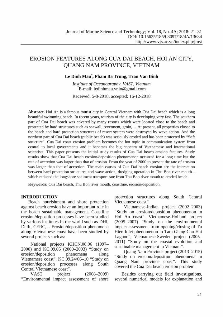
Fig. 1. Location of Cua Dai beach in Quang Nam province
23
Hoi An city is famous tourist city in
Central Vietnam with long beautiful swimming beach. In recent years, tourism of the city is developing very fast. The southern part of Cua Dai beach was covered by many resorts which were located close to the beach and protected by hard structures such as sea-wall, revetment, groin... At present, almost all the hard protection structures of resort system were destroyed by wave action. And the northern part of Cua Dai beach (public beach) was seriously eroded in recent years and was protected by soft structure system (geotextile bags). Cua Dai beach erosion problem becomes the hot topic in communication system from central government to local government. This paper presents the brief information of Cua Dai beach erosion features and it is one content part of Quang Nam province project (2013–2015) results. Study results show that the main causes of Cua Dai beach erosion are the interaction between hard protection structures and wave action, dredging operation in Thu Bon river mouth and hard protection structure system which blocked the longshore sediment transport rate from Thu Bon river mouth to eroded beaches. Location of Cua Dai beach is shown in fig. 1.
DATA AND METHOD Data sources. The main related data on geo-morphology, shoreline change, meteo-hydro-litho-dynamic parameters etc. were collected from different projects which were carried out by the Institute of Oceanography in recent years such as “Study on erosion/deposition phenomena along Vietnamese coast (National projects KHCN.08.06 (1997–2000)”, “Environmental impact assessment of shore protection structures along South-Central Vietnam Coast (VAST Project: 2008–2009)”, “Assessment of the science and technology data to integrated coastal area management and sustainable development in the South-Central Vietnamese coast for the objective of marine economy development (National Project KC.09.24/06–10)”. Most data in this paper were taken from the project “Study on coastal erosion/deposition processes in Quang Nam province and proposal of the necessary measures for coastline protection (Quang Nam Project: 2013–2015)”. Satellite data were collected from website of Geology Organization, USA [9], marine database and GIS Center of the Institute of Oceanography, Vietnam. Satellite images were collected at different times in dry season of study region (table 1).
Table 1. The collected satellite images for Cua Dai beach
No. Type of image Resolution (m) Date Time 1 Landsat_1, MSS 60 30-06-1973 02:37:27 PM 2 Landsat_5, TM 30 17-05-1989 02:34:56 PM 3 Landsat_7, ETM 30 07-05-2000 02:58:39 PM 4 Alos, AVNIR2 10 11-03-2009 10:49.00 AM 5 Landsat_8, OLI_TIRS 30 19-05-2013 03:08:28 PM 6 Landsat_8, OLI_TIRS 30 22-05-2014 03:05:58 PM
Methods. Shoreline positions were measured by DGPS-Promark2 equipment along the line of average value of high tide. These data were validated to National Landmark System. Field surveys for shoreline change processes were carried out for North-East (NE) and South-West (SW) monsoon periods of 2013.
Satellite images were analyzed by ENVI 4.0 soft-ware including geometry adjustment, shoreline split... And all collected shoreline
data were comprehensively analyzed by Band Threshold method. US Nautical Chart issued in 1965, scale 1/50,000 (UTM system) was used to adjust the extracted shoreline by control points. The selected control points were not changed since 1965 (at Cau Lau bridge).
The material balance at different Cua Dai beach transects [8] was used to estimate the erosion rate at different transects.
Le Dinh Mau, Pham Ba Trung, Tran Van Binh
24
Distribution features of wave characteristics of Cua Dai beach during 1987–2012 were estimated by WAM model [10].
STUDY RESULTS Related natural conditions in Hoi An waters. Thu Bon river joins the East Sea at Cua Dai, Hoi An city, Quang Nam province (Central Vietnam). The continental shelf of the study area is relatively narrow with 20 m depth contour occurring at 2 km, 30 m at 10 km and 50 m at 12 km away from the coast, except in the area of Thu Bon river mouth, where shoals
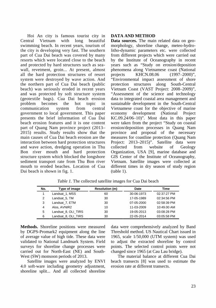
are present. At about 12 km distance from the Thu Bon river mouth in the northeast direction, Cham island of 8 km width is present (fig. 1). Coastline consists of long sandy beaches, with medium to fine sand and with median size approximately ranging from 0.15 mm to 0.2 mm. Wind rose diagram at Da Nang Station (1977–2007) shows that the main wind direction and intensity are in North (N) and East (E) directions (fig. 2).
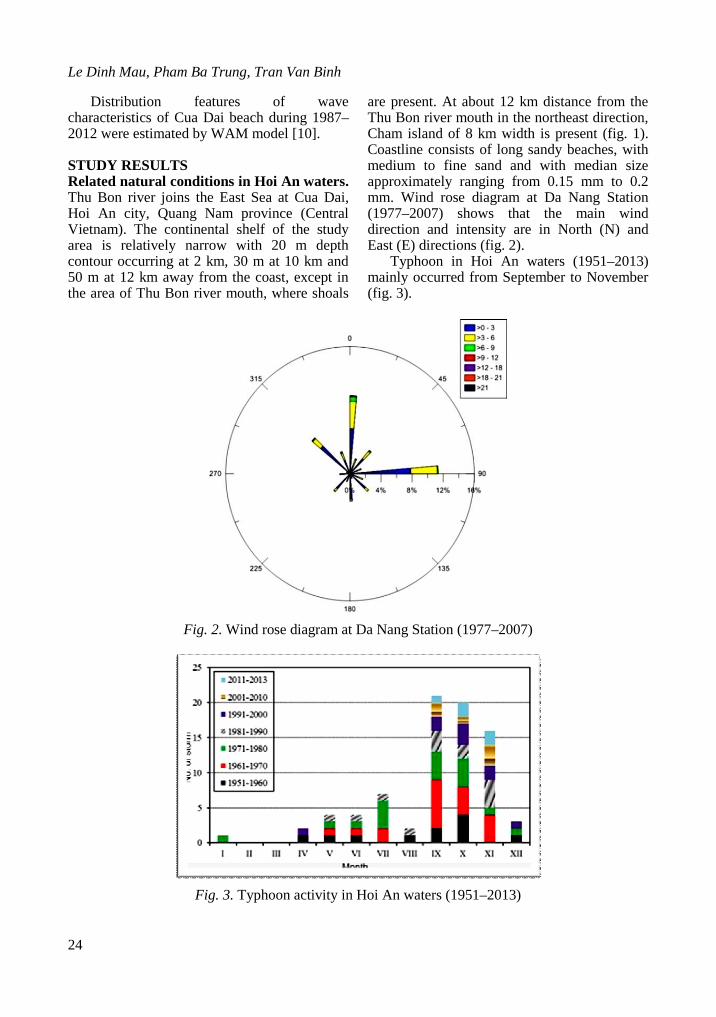
Typhoon in Hoi An waters (1951–2013) mainly occurred from September to November (fig. 3).
Fig. 2. Wind rose diagram at Da Nang Station (1977–2007)
Fig. 3. Typhoon activity in Hoi An waters (1951–2013)
Erosion features along Cua Dai beach,…
25
Monthly distribution of mean Thu Bon river discharge (1977–2007) shows that the highest value of Thu Bon river discharge was
in the months of October, November and December (table 2).
Table 2. Monthly distribution of mean Thu Bon river discharge (1977–2007)
Months Jan. Feb. Mar. Apr. May Jun. Jul. Aug. Sep. Oct. Nov. Dec. Q (m3/s) 214 123 87.9 67.8 98.3 103 72.7 71.8 139 609 826 505 Frequency (%) 7.3 4.2 3.0 2.3 3.4 3.5 2.5 2.5 4.8 20.9 28.3 17.3
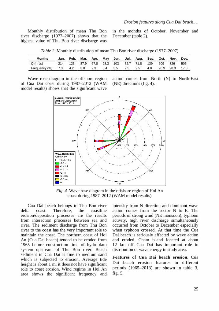
Wave rose diagram in the offshore region
of Cua Dai coast during 1987–2012 (WAM model results) shows that the significant wave
action comes from North (N) to North-East (NE) directions (fig. 4).
Fig. 4. Wave rose diagram in the offshore region of Hoi An
coast during 1987–2012 (WAM model results)
Cua Dai beach belongs to Thu Bon river delta coast. Therefore, the coastline erosion/deposition processes are the results from interaction processes between sea and river. The sediment discharge from Thu Bon river to the coast has the very important role to maintain the coast. The northern coast of Hoi An (Cua Dai beach) tended to be eroded from 1965 before construction time of hydro-dam system upstream of Thu Bon river. Beach sediment in Cua Dai is fine to medium sand which is subjected to erosion. Average tide height is about 1 m, it does not have significant role to coast erosion. Wind regime in Hoi An area shows the significant frequency and
intensity from N direction and dominant wave action comes from the sector N to E. The periods of strong wind (NE monsoon), typhoon activity, high river discharge simultaneously occurred from October to December especially when typhoon crossed. At that time the Cua Dai beach is seriously affected by wave action and eroded. Cham island located at about 12 km off Cua Dai has important role in distribution of wave energy in study area.
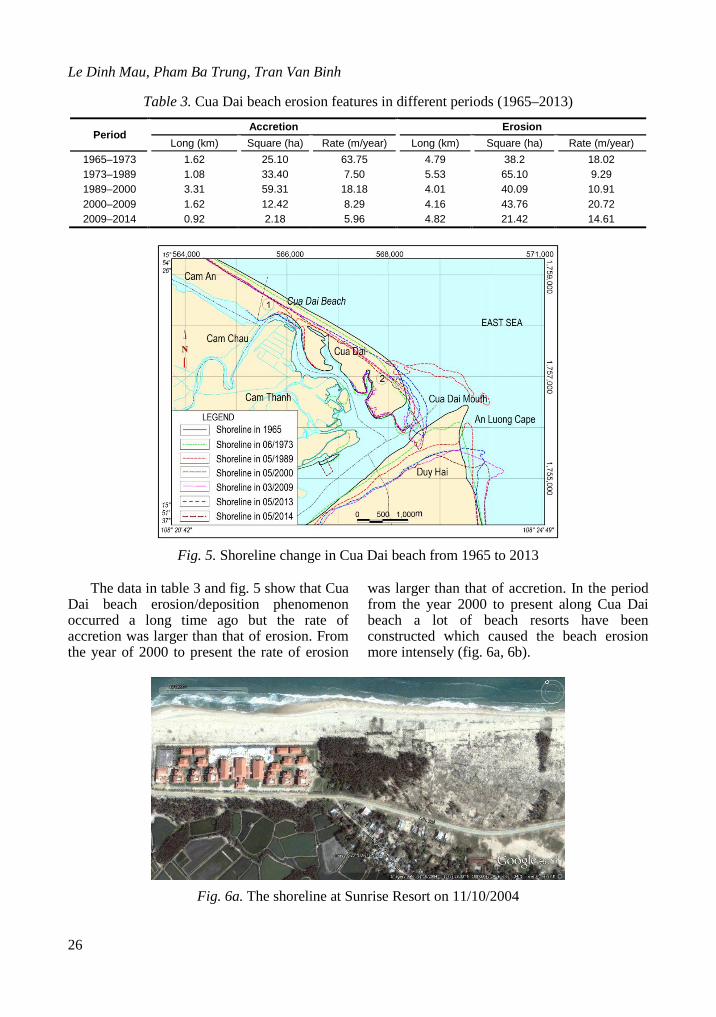
Features of Cua Dai beach erosion. Cua Dai beach erosion features in different periods (1965–2013) are shown in table 3, fig. 5.
Le Dinh Mau, Pham Ba Trung, Tran Van Binh
26
Table 3. Cua Dai beach erosion features in different periods (1965–2013)
Period Accretion Erosion
Long (km) Square (ha) Rate (m/year) Long (km) Square (ha) Rate (m/year) 1965–1973 1.62 25.10 63.75 4.79 38.2 18.02 1973–1989 1.08 33.40 7.50 5.53 65.10 9.29 1989–2000 3.31 59.31 18.18 4.01 40.09 10.91 2000–2009 1.62 12.42 8.29 4.16 43.76 20.72 2009–2014 0.92 2.18 5.96 4.82 21.42 14.61
Fig. 5. Shoreline change in Cua Dai beach from 1965 to 2013
The data in table 3 and fig. 5 show that Cua
Dai beach erosion/deposition phenomenon occurred a long time ago but the rate of accretion was larger than that of erosion. From the year of 2000 to present the rate of erosion
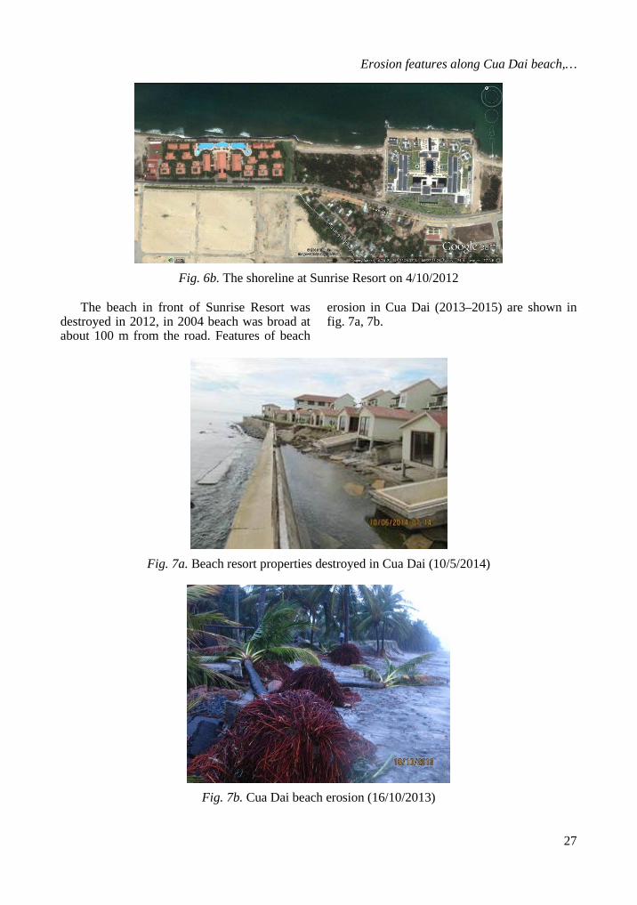
was larger than that of accretion. In the period from the year 2000 to present along Cua Dai beach a lot of beach resorts have been constructed which caused the beach erosion more intensely (fig. 6a, 6b).
Fig. 6a. The shoreline at Sunrise Resort on 11/10/2004
Erosion features along Cua Dai beach,…
27
Fig. 6b. The shoreline at Sunrise Resort on 4/10/2012
The beach in front of Sunrise Resort was
destroyed in 2012, in 2004 beach was broad at about 100 m from the road. Features of beach
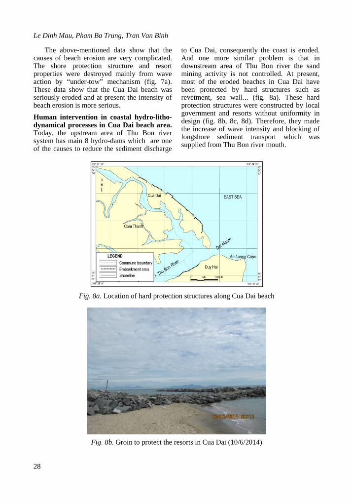
erosion in Cua Dai (2013–2015) are shown in fig. 7a, 7b.
Fig. 7a. Beach resort properties destroyed in Cua Dai (10/5/2014)
Fig. 7b. Cua Dai beach erosion (16/10/2013)
Le Dinh Mau, Pham Ba Trung, Tran Van Binh
28
The above-mentioned data show that the causes of beach erosion are very complicated. The shore protection structure and resort properties were destroyed mainly from wave action by “under-tow” mechanism (fig. 7a). These data show that the Cua Dai beach was seriously eroded and at present the intensity of beach erosion is more serious. Human intervention in coastal hydro-litho-dynamical processes in Cua Dai beach area. Today, the upstream area of Thu Bon river system has main 8 hydro-dams which are one of the causes to reduce the sediment discharge
to Cua Dai, consequently the coast is eroded. And one more similar problem is that in downstream area of Thu Bon river the sand mining activity is not controlled. At present, most of the eroded beaches in Cua Dai have been protected by hard structures such as revetment, sea wall... (fig. 8a). These hard protection structures were constructed by local government and resorts without uniformity in design (fig. 8b, 8c, 8d). Therefore, they made the increase of wave intensity and blocking of longshore sediment transport which was supplied from Thu Bon river mouth.
Fig. 8a. Location of hard protection structures along Cua Dai beach
Fig. 8b. Groin to protect the resorts in Cua Dai (10/6/2014)
Erosion features along Cua Dai beach,…
29
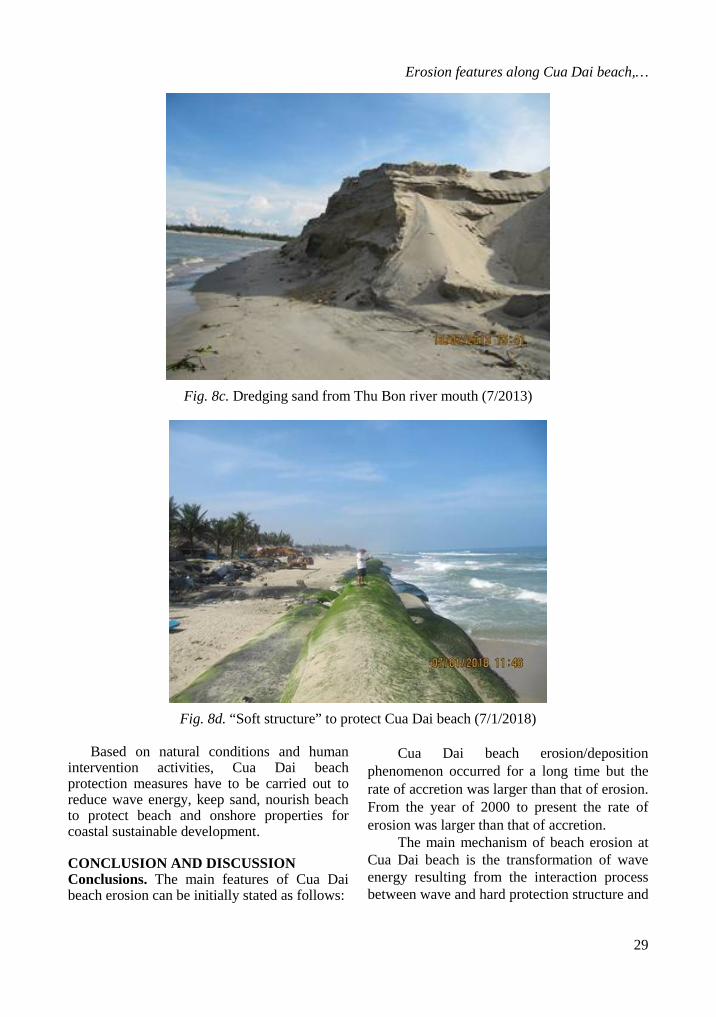
Fig. 8c. Dredging sand from Thu Bon river mouth (7/2013)
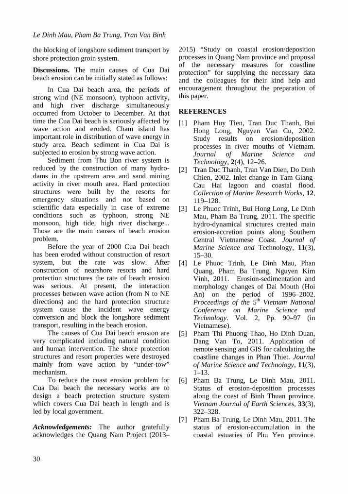
Fig. 8d. “Soft structure” to protect Cua Dai beach (7/1/2018)
Based on natural conditions and human
intervention activities, Cua Dai beach protection measures have to be carried out to reduce wave energy, keep sand, nourish beach to protect beach and onshore properties for coastal sustainable development.
CONCLUSION AND DISCUSSION Conclusions. The main features of Cua Dai beach erosion can be initially stated as follows:
Cua Dai beach erosion/deposition phenomenon occurred for a long time but the rate of accretion was larger than that of erosion. From the year of 2000 to present the rate of erosion was larger than that of accretion.
The main mechanism of beach erosion at Cua Dai beach is the transformation of wave energy resulting from the interaction process between wave and hard protection structure and
Le Dinh Mau, Pham Ba Trung, Tran Van Binh
30
the blocking of longshore sediment transport by shore protection groin system.
Discussions. The main causes of Cua Dai beach erosion can be initially stated as follows:
In Cua Dai beach area, the periods of strong wind (NE monsoon), typhoon activity, and high river discharge simultaneously occurred from October to December. At that time the Cua Dai beach is seriously affected by wave action and eroded. Cham island has important role in distribution of wave energy in study area. Beach sediment in Cua Dai is subjected to erosion by strong wave action.
Sediment from Thu Bon river system is reduced by the construction of many hydro-dams in the upstream area and sand mining activity in river mouth area. Hard protection structures were built by the resorts for emergency situations and not based on scientific data especially in case of extreme conditions such as typhoon, strong NE monsoon, high tide, high river discharge... Those are the main causes of beach erosion problem.
Before the year of 2000 Cua Dai beach has been eroded without construction of resort system, but the rate was slow. After construction of nearshore resorts and hard protection structures the rate of beach erosion was serious. At present, the interaction processes between wave action (from N to NE directions) and the hard protection structure system cause the incident wave energy conversion and block the longshore sediment transport, resulting in the beach erosion.
The causes of Cua Dai beach erosion are very complicated including natural condition and human intervention. The shore protection structures and resort properties were destroyed mainly from wave action by “under-tow” mechanism.
To reduce the coast erosion problem for Cua Dai beach the necessary works are to design a beach protection structure system which covers Cua Dai beach in length and is led by local government.
Acknowledgements: The author gratefully acknowledges the Quang Nam Project (2013–
2015) “Study on coastal erosion/deposition processes in Quang Nam province and proposal of the necessary measures for coastline protection” for supplying the necessary data and the colleagues for their kind help and encouragement throughout the preparation of this paper.
REFERENCES [1] Pham Huy Tien, Tran Duc Thanh, Bui
Hong Long, Nguyen Van Cu, 2002. Study results on erosion/deposition processes in river mouths of Vietnam. Journal of Marine Science and Technology, 2(4), 12–26.
[2] Tran Duc Thanh, Tran Van Dien, Do Dinh Chien, 2002. Inlet change in Tam Giang-Cau Hai lagoon and coastal flood. Collection of Marine Research Works, 12, 119–128.
[3] Le Phuoc Trinh, Bui Hong Long, Le Dinh Mau, Pham Ba Trung, 2011. The specific hydro-dynamical structures created main erosion-accretion points along Southern Central Vietnamese Coast. Journal of Marine Science and Technology, 11(3), 15–30.
[4] Le Phuoc Trinh, Le Dinh Mau, Phan Quang, Pham Ba Trung, Nguyen Kim Vinh, 2011. Erosion-sedimentation and morphology changes of Dai Mouth (Hoi An) on the period of 1996–2002. Proceedings of the 5th Vietnam National Conference on Marine Science and Technology. Vol. 2, Pp. 90–97 (in Vietnamese).
[5] Pham Thi Phuong Thao, Ho Dinh Duan, Dang Van To, 2011. Application of remote sensing and GIS for calculating the coastline changes in Phan Thiet. Journal of Marine Science and Technology, 11(3), 1–13.
[6] Pham Ba Trung, Le Dinh Mau, 2011. Status of erosion-deposition processes along the coast of Binh Thuan province. Vietnam Journal of Earth Sciences, 33(3), 322–328.
[7] Pham Ba Trung, Le Dinh Mau, 2011. The status of erosion-accumulation in the coastal estuaries of Phu Yen province.
Erosion features along Cua Dai beach,…
31
Proceedings of the 5th Vietnam National Conference on Marine Science and Technology. Vol. 3, Pp. 519–527 (in Vietnamese).
[8] Tran Van Binh, Le Dinh Mau, 2016. The change of topographic morphology of beaches and material balance along the coast of Quang Nam Province.
Collection of Marine Research Works. Vol. 22, Pp. 15–28.
[9] http://edcsns17.cr.usgs.gov/EarthExplorer/. [10] Group, T. W., 1988. The WAM model-A
third generation ocean wave prediction model. Journal of Physical Oceanography, 18(12), 1775–1810.
ĐẶC ĐIỂM XÓI LỞ TẠI BÃI BIỂN CỬA ĐẠI HỘI AN, QUẢNG NAM
Lê Đình Mầu, Phạm Bá Trung, Trần Văn Bình Viện Hải dương học, Viện Hàn lâm Khoa học và Công nghệ Việt Nam, Việt Nam
Tóm tắt. Hội An là thành phố du lịch nổi tiếng tại miền Trung với bãi tắm Cửa Đại dài, đẹp nổi tiếng. Trong những năm gần đây, du lịch tại Hội An phát triển rất nhanh. Phần phía nam của bãi Cửa Đại đã được xây dựng hàng loạt resort cao cấp, ngay sát biển và tự bảo vệ tác động của sóng bằng hệ thống các công trình kiên cố như tường biển, kè phủ mái, kè mỏ hàn,… Hiện nay, hầu như toàn bộ hệ thống các công trình nghĩ dưỡng và kè bảo vệ sát biển tại khu vực này đã bị phá hủy nghiêm trọng bởi sóng. Phần phía bắc của bãi Cửa Đại là bãi tắm công cộng hiện cũng đã và đang bị sóng phá hủy và đã được bảo vệ bằng hệ thống công trình “mềm”. Hiện tượng xói lở bờ biển tại Cửa Đại đã và đang trở thành chủ đề tranh luận nóng trên các phương tiện truyền thông từ trung ương đến địa phương cũng như của các nhà khoa học trong và ngoài nước. Bài báo trình bày những kết quả nghiên cứu bước đầu về đặc điểm xói lở bờ biển Cửa Đại. Kết quả nghiên cứu cho thấy trước năm 2000 bãi biển Cửa Đại đã xuất hiện hiện tượng xói lở/bồi tụ nhưng tốc độ bồi tụ lớn hơn xói lở. Tuy nhiên từ năm 2000 đến nay, tốc độ xói lở lớn hơn bồi tụ. Nguyên nhân chính gây ra xói lở bờ biển Cửa Đại là sự tương tác giữa sóng biển với hệ thống các công trình bảo vệ bờ biển, hoạt động nạo vét cát tại cửa sông Thu Bồn, đặc biệt là sự ngăn chặn dòng trầm tích dọc bờ có hướng từ cửa sông Thu Bồn đến bãi Cửa Đại bởi các công trình kè mỏ hàn.
Từ khóa: Bãi biển Cửa Đại, cửa sông Thu Bồn, đường bờ biển, xói lở/bồi tụ.