environmental audit report
TRANSCRIPT
INFORMATION REGARDING ENVIRONMENTAL AUDIT REPORTS August 2007
VICTORIA'S AUDIT SYSTEM
An environmental audit system has operated in Victoria since 1989. The Environmenf Profecfion Acf 1970 (the Act) provides for the appointment by the Environment Protection Authority (EPA Victoria) of environmental auditors and the conduct of independent, high quality and rigorous environmental audits.
An environmental audit is an assessment of the condition of the environment, or the nature and extent of harm (or risk of harm) posed by an industrial process or activity, waste, substance or noise. Environmental audit reports are prepared by EPA- appointed environmental auditors who are highly qualified and skilled individuals.
Under the Act, the function of an environmental auditor is t o conduct environmental audits and prepare environmental audit reports. Where an environmental audit is conducted to determine the condition of a site or its suitability for certain uses, an environmental auditor may issue either a certificate or statement of environmental audit.
A certificate indicates that the auditor is of the opinion that the site is suitable for any beneficial use defined in the Act, whilst a statement indicates that there is some restriction on the use of the site.
Any individual or organisation may engage appointed environmental auditors, who generally operate within the environmental consulting sector, t o undertake environmental audits. The EPA administers the environmental audit system and ensures its ongoing integrity by assessing auditor applications and ensuring audits are independent and conducted with regard t o guidelines issued by EPA.
AUDIT FILES STRUCTURE Environmental audit reports are stored digitally by EPA in three parts: the audit report (part A), report appendices (part B) and, where applicable, the certificate or statement of environmental audit and an executive summary (part C). A report may be in colour and black-and-white formats. Generally, only black- and-white documents are text searchable.
Report executive summaries, findings and recommendations should be read and relied upon only in the context of the document as a whole, including any appendices and, where applicable, any certificate or statement of environmental audit.
AUDIT REPORT CURRENCY
Audit reports are based on the conditions encountered and information reviewed at the time of preparation and do not represent any changes that may have occurred since the date of completion. As i t is not possible for an audit t o present all data that could be of interest t o all readers, consideration should be made to any appendices or referenced documentation for further information.
When information regarding the condition of a site changes from that at the time an audit report is issued, or where an administrative or computation error is identified, environmental audit reports, certificates and statements may be withdrawn or amended by an environmental auditor. Users are advised t o check EPA's website to ensure the currency of the audit document.
PDF SEARCHABILITY AND PRINTING
EPA Victoria can only certify the accuracy and correctness of the audit report and appendices as presented in the hardcopy format. EPA is not responsible for any issues that arise due to problems with PDF files or printing.
Except where PDF normal format is specified, PDF files are scanned and optical character recognised by machine only. Accordingly, while the images are consistent with the scanned original, the searchable hidden text may contain uncorrected recognition errors that can reduce search reliability. Therefore, keyword searches undertaken within the document may not retrieve all references to the queried text.
This PDF has been created using the Adobe-approved method for generating Print Optimised Output. To assure proper results, proofs must be printed, rather than viewed on the screen.
This PDF is compatible with Adobe Acrobat Reader Version 4.0 or any later version which is downloadable free from Adobe's Website, www.adobe.com.
FURTHER I N FORMATION
For more information on Victoria's environmental audit system, visit EPA's website or contact EPA's Environmental Audit Unit.
Web: www.epa.vic.clov.au/envaudit
Email: [email protected]
1 of 211
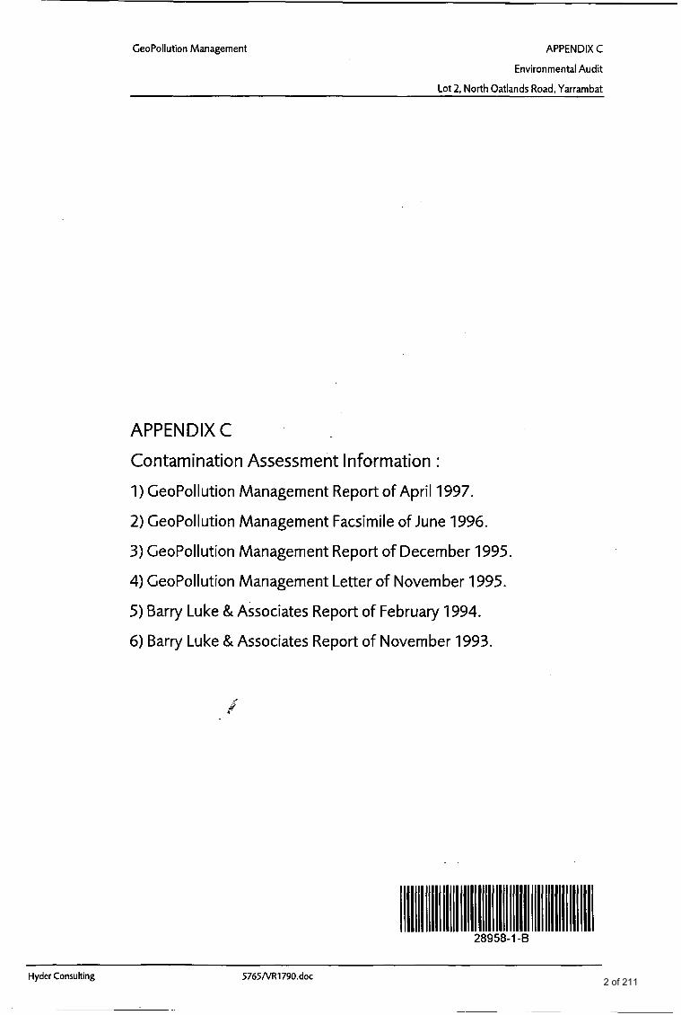
CeoPollution Management APPENDIX C
Environmental Audit
Lot 2, North Oatlands Road, Yarrambat
APPENDIX C
Contamination Assessment Information :
1) CeoPollution Management Report of April 1997.
2) CeoPollution Management Facsimile of June 1996.
3) CeoPollution Management Report of December 1995
4) CeoPollution Management Letter of November 1995.
5) Barry Luke & Associates Report of February 1994.
6) Barry Luke & Associates Report of November 1993.
Hyder Consulting 5765NR1790.doc 2 of 211
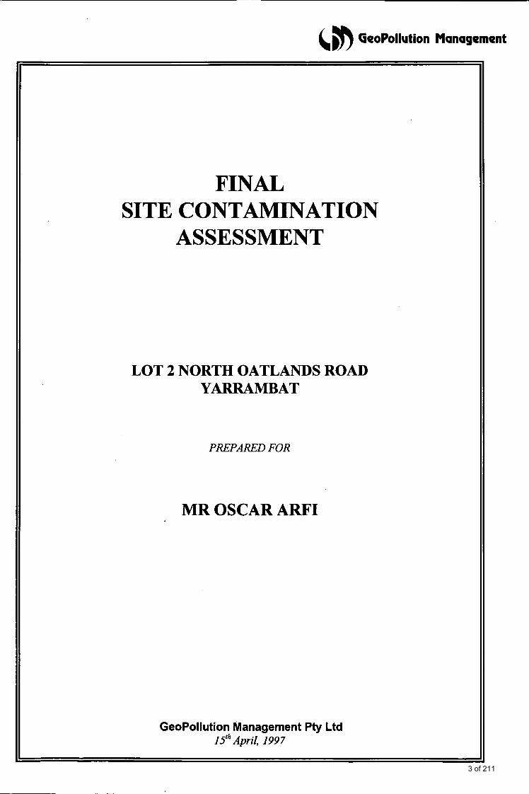
(,#) GeoPollution Management
FINAL SITE CONTAMINATION
ASSESSMENT
LOT 2 NORTH OATLANDS ROAD YARRAMBAT
GeoPollution Management Pty Ltd 15" April, I99 7
PREPARED FOR
MR OSCAR ARFI
3 of 211
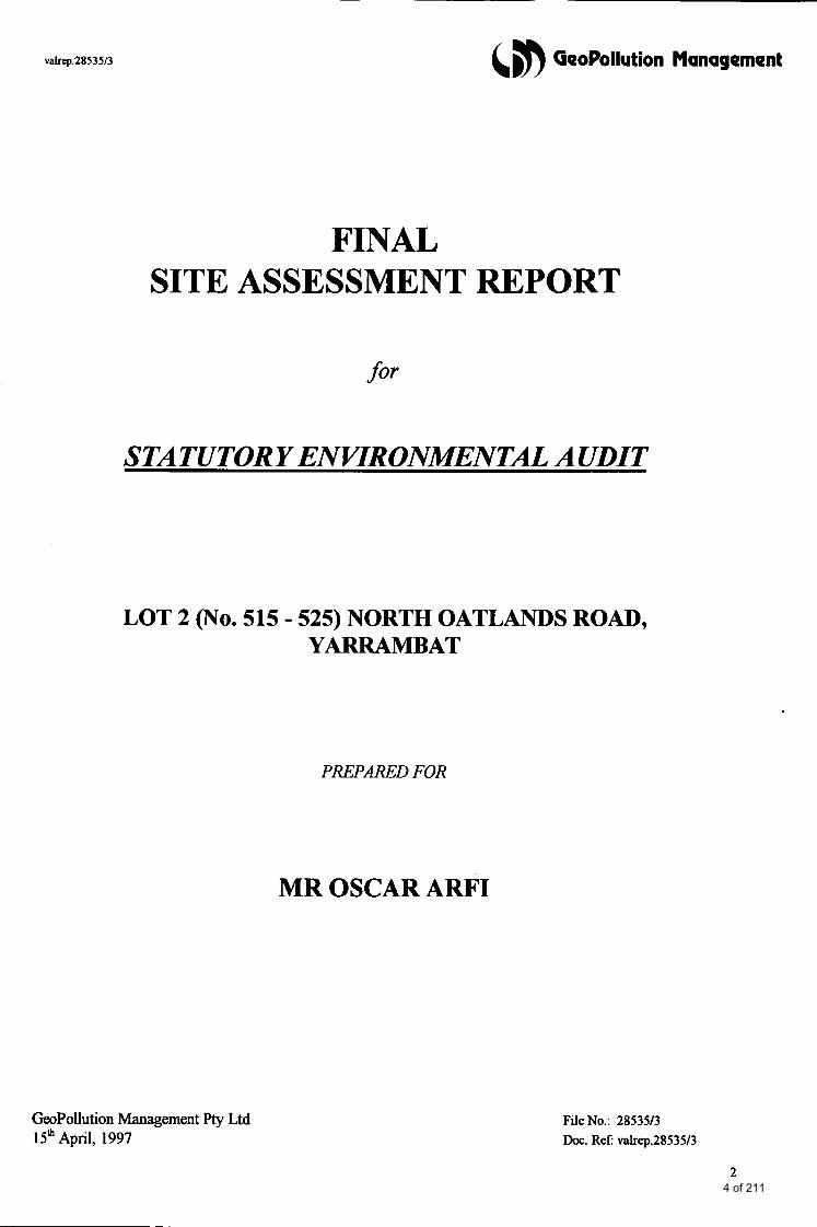
valrep.2853513 6 GeoPollution Management
FINAL SITE ASSESSMENT REPORT
STATUTORY ENVIRONMENTAL AUDIT
LOT 2 (NO. 515 - 525) NORTH OATLANDS ROAD, YARRAMBAT
PREPARED FOR
MR OSCAR ARFI
GeoPollution Management Pty Ltd 15*April, 1997
File No.: 2853513 Doc. Ref: valrep.28535/3
2 4 of 211
valrep.2853513 6 GeoPollution Management
This final site assessment report has been prepared by GeoPollution Management Pty Ltd for Mr Oscar Arfi. This site assessment report satisfies the requirements of the Environmental Audit for the subject site. The report has been reviewed and endorsed by the EPAV approved Environmental Auditor, Mr. Nicholas Withers of HYDER Consulting Pty Ltd, who was appointed by GeoPollution Management for this site audit.
This document has been prepared on behalf of and for the exclusive use of the client, Mr Oscar Arfi.
3 5 of 211

&, #) GeoPollution Management valrep.28535/3
TABLE OF CONTENTS Page
1.0 INTRODUCTION 7
7 8 8
1 . 1 Objectives 1.2 Scope of the Investigation 1.3 Project Stages
2,O BASIS OF THE ASSESSMENT
3.0 BACKGROUND INFORMATION
9
1 1
3.1 3.2
Site Description and Physical Setting Site Identification, Zoning and Proposed Development
1 1 13
4.0 PREVIOUS SITE ASSESSMENT REPORTS 13
5.0 SITE HISTORY 14
16 6.0 REGIONAL SUBSURFACE ENVIRONMENT
6.1 Geology 6.2 Hydrogeology
16 16
7.0 FIELD METHODS 17
7.1 General 7.2 7.3 7.4
Soil Sampling by Solid Flight Auger Drilling or Hand Augering Field Screen for Volatile Organic Compounds (Soil Gas Survey) Excavation Guidance Testing (Grid Survey)
17 17 18 18
8.0 QUALITY ASSURANCE/QUALITY CONTROL 19
8.1 Field Sampling 8.2 Laboratories
19 19
9.0 SAMPLING PROGRAM 19
10.0 CHEMICAL ANALYSIS AND COMPOSITING SCHEDULES 23
1 1 .O RESULTS OF THE INVESTIGATION 24
1 1 .1 Site Subsurface Conditions 1 1 . 1 . 1 Subsurface Profiles (Boreholes) 1 1.1.2 Soil Moisture/Groundwater
24 24 24
4 6 of 211
valrep.28535/3 (,b GeoPollution Management
TABLE OF CONTENTS (cont.)
1 1.2 Field Contamination Assessment 1 1.2.1 Visual and Olfactory Observations 11.2.2 Vapour Survey
11.3 Chemical Analysis 1 1.3.1 Assessment Phase (Phase 1) 1 1.3.2 Validation of Site Clean Up (Phase 2)
12.0 DATA VALIDATION
12.1 Replicate Results 12.2 QNQC Evaluation
13.0 SCOPE OF REMEDIAL WORKS
14.0 FINAL CONDITION OF THE SITE
14.1 Visual Appraisal 14.2 Quality of Soil Remaining On Site
15.0 CONCLUSIONS AND FINAL COMMENTS
16.0 LIMITATIONS OF THIS INVESTIGATION
REFERENCES
TABLES
TABLE 1: TABLE 2a: TABLE 2b: TABLE 2c: TABLE 2d: TABLE 3: TABLE 4a: TABLE 4b: TABLE 5a: TABLE 5b: TABLE 5c: TABLE 5d: TABLE 5e: TABLE 6a: TABLE 6b: TABLE 6c:
24 24 25
25 26 29
29
30 33
34
37
34 36
38
39
39
Soil Quality Acceptance Criteria Depth of Fill and Sampling Program - Initial Sampling Depth of Fill and Sampling Program - Additional Sampling Depth of Fill and Sampling Program - Grid Survey Depth of Fill and Sampling Program - Final Validation Summary of Chemical Analyses Performed Compositing and Analysis Schedules - Area 1 Compositing and Analysis Schedules - Area 2 Summary of Analysis Results - Initial Analysis Summary of Analysis Results - Individual Samples Summary of Analysis Results - Follow-Up Samples Summary of Analysis Results - Natural Soil Summary of Analysis Results - Final Validation Samples QNQA Replicate Results and Evaluation - Composites C3 and C4 QNQA Replicate Results and Evaluation - Samples V26 and V37 QNQA Replicate Results and Evaluation - Samples V27 and V38
5 7 of 211
valrep.28535/3
PLATES
Plate 1: Plate 2: Plate 3: Plate 4: Plate 5:
FIGURES
Figure 1: Figure 2: Figure 3 : Figure 4: Figure 5 : Figure 6:
6 GeoPollution Management
TABLE OF CONTENTS (cont.)
APPENDICES
General view of the site towards the southwest, as on 16* July, 1996 View of the site towards the east, as on 16* July, 1996 View of the lower site boundary towards the south, as on 24* February, 1997 View of the upper site boundary towards the west, as on 24* February, 1997 General view of the site towards the southeast, as on 24* February, 1997
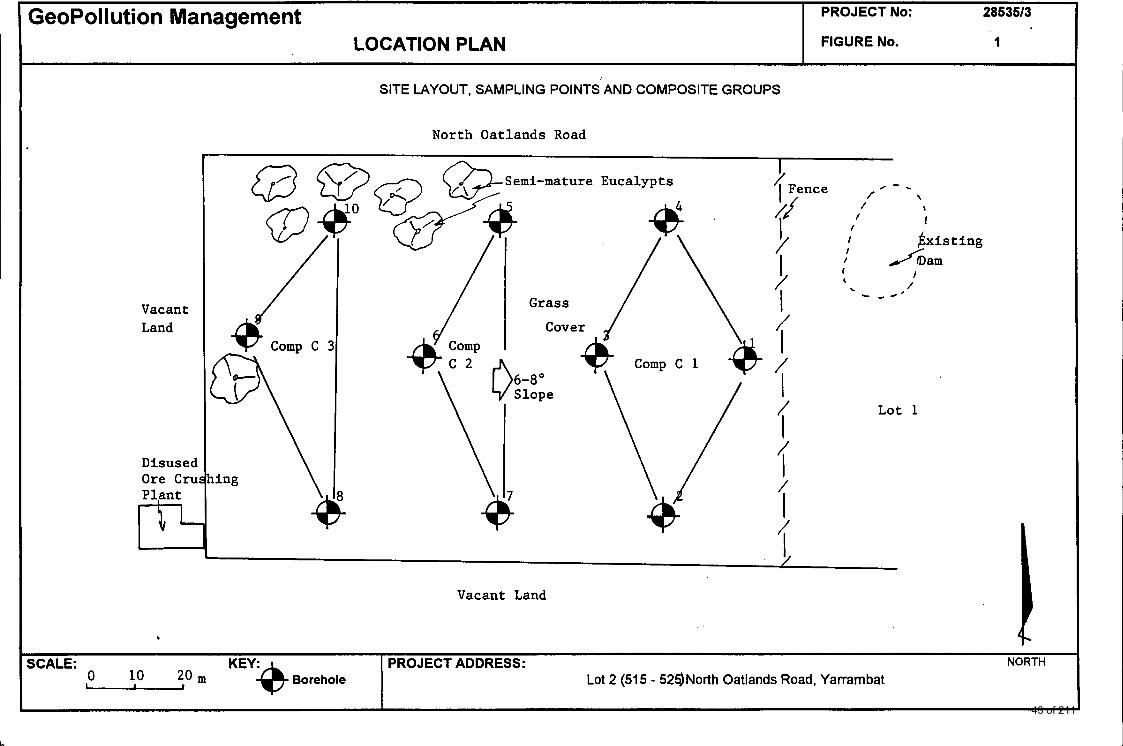
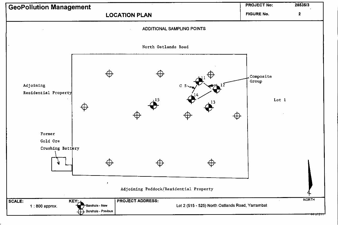
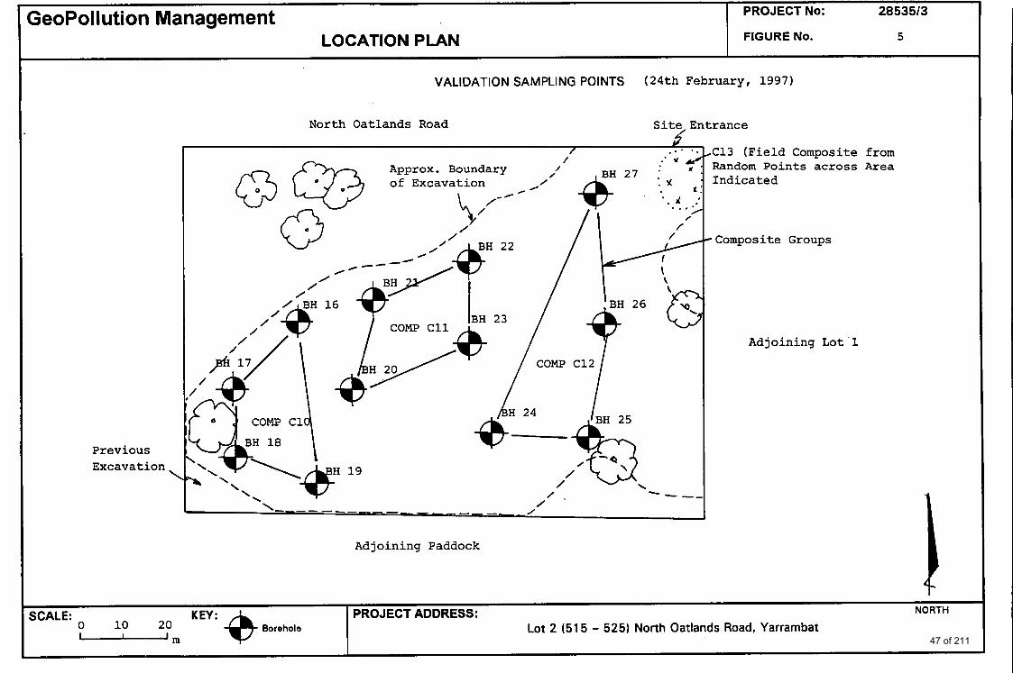
Site Layout, Sampling Points and Composite Groups Additional Sampling Points Contour Plan of Fill Depth and Extent of Remediation Validation Sampling Points (Natural Soil) Additional Validation Sampling Points (24* February, 1997) Final Extent of Excavation and Sampling Locations Representing Soil Remaining On Site
Appendix A: Appendix B: Appendix C: Appendix D: Appendix E: Appendix F: Appendix G: Appendix H: Appendix I:
General Location Map Plan of Subdivision Bore Logs Final (NATA Endorsed) Chemical Analysis Reports Copies of Chain of Custody and Analysis Request Forms Royal Historical Society of Victoria - Supporting Information Aerial Photographs Correspondence Copies of Previous Reports
6 8 of 211
valrep.2853513 &, GeoPollution Management
1.0 INTRODUCTION
GeoPollution Management Pty Ltd was engaged by Mr Oscar M to carry out an Environmental Audit on a former gold mining site, being Lot 2 of No. 5 15 - 525 North Oatlands Road, Yarrambat.
The audit was required to satisfjl a condition of the Council's (Shire of Nillumbik) planning permit (Clause 113A-4A "Use of Land or Buildings or Works") for the subdivision of the former gold mining site. This requirement arose as a result of a Ministerial Directive relating to potentially contaminated sites (Ministerial Directive No. 1, Oct. 1989, under the Planning and Environment Act 1987, amended in May 92). The Ministerial Directive implements provisions of Section 57AA of the Environment Protection Act, 1970.
This investigation has been completed in accordance with our proposals No. QM 553, QM 580, QM 595 and QM 664 dated 23d February, 1996,16* May, 1996,19* June, 1996 and 22"d January, 1997. The work was authorized by written agreement dated 4* April, 16* May, 24* June, 1996 and 20* February, 1997.
The investigation program outlined in this report has been carried out in compliance with the ANZECC (Australian and New Zealand Environment and Conservation Council) and NHMRC (National Health and Medical Research Council), 1992 "Guidelines for the Assessment and Management of Contaminated Sites" and ANZECC 'Draft Guidelines for the Analysis of Contaminated Soils" as adopted by the Environment Protection Authority of Victoria (EPAV).
A draft copy of this report has been reviewed by the EPA Auditor appointed for this project. The Audit report reviewing this final site assessment will incorporate a Statement of Environmental Audit considering the proposed development plan.
1.1 Objectives
This site assessment program was designed to satisfjl the criteria for an environmental audit with the following objectives:
> Determine the degree and extent of potential contaminants through near-surface soils > to determine whether potential contaminants are present at concentrations which would
pose an environmental or health risk > Evaluate the suitability of the site for the proposed future land use > provide all the information including supporting quality control data required for the
preparation of the audit report.
The final site assessment report presents
a review of previous site investigation reports a brief summary of the historical site use, methods used
7 9 of 211
valrep.28535/3 (5n GeoPollution Management
the geological and hydrogeological context, 0 a summary of all field and laboratory results 0 data evaluation to relevant soil quality guideline criteria
quality control data and evaluation a description of site remedial works an appraisal of the final environmental quality of the site prior to residential development.
1.2 Scope of the Investigation
The scope of work for this investigation has been agreed upon with Mr Nick Withers, the EPA appointed Environmental Auditor (Contaminated Land) appointed for this project.
The site was initially covered by ten sampling locations on a triangular grid (Phase 1, see below) with follow-up sampling in the surrounds of two test points. The results required an extensive grid survey across the entire site comprising visual inspection of fill and occasional sampling of underlying natural soil.
Generally, soil sampling covered both existing surface fill or natural top soil and extended 200 - 300 mm into the natural clay base as deemed appropriate. Initial analysis was of surface samples and samples of natural soil underlying tailings material were analysed later in the project.
Additional validation sampling in conjunction with site inspections was carried during and at the end of partial site remediation.
A groundwater investigation was not required at this site.
1.3 Project Stages
The assessment and site validation was essentially carried out in two stages:
Assessment Stage (Phase 1): + + +
Coarse grid survey across entire site, analysis of composite samples and individuals of one composite (April, 1996) Follow-up testing in vicinity of boreholes intersecting tailings mound material (May, 1996) Detailed grid survey (mainly visual appraisal with limited sampling and analysis of underlying natural soils) to delineate the extent of tailings material (July, 1996).
Clean Up Stage (Phase 2): + Site inspections and final validation sampling at the end of site remediation.
8 10 of 211
valrep.2853513
20 3 50 60 300
1 60 200
20 1
50
0.5 1
&m GeoPollution Management
30 5
250 100 300 2
100 500
20 ns
50
ns 1
2.0 BASIS OF THE ASSESSMENT
The decision whether the site is suitable for the proposed land use or whether site clean up is required and to what extent is subject to a site-specific analysis of the data collected against adopted acceptance criteria, which in the case of Environmental Audits, are set by and agreed with the EPA approved Auditor.
Data were assessed against ANZECC B criteria (ANZECC & NHMRC, 1992) and EPA "Clean Fill" criteria (landfill criteria). The 'Clean Fill' criteria are frequently adopted as soil quality acceptance criteria in the context of Environmental Audits. The landfill criteria (upper levels of contaminants for disposal of soil to landfill) are summarized in the Victorian EPA publication "Classification of Wastes" (Bulletin 448, September, 1995).
Criteria relevant to this investigation are shown in the table below (TABLE 1).
TABLE 1: Soil Quality Guideline Criteria [mg/kg dry weight of soil]
Heavy Metals (total) Arsenic (As) Cadmium (Cd) Chromium (Cr) Copper (Cu) L a d (pb) Mercwy (Hg) Nickel (Ni) Zinc (Zn)
Polycyclic Aromatic Hydrocarbons (PAH's) Total Benzo(a)pyrene
I 11 Cyanide (total)
I Organochlorine Pesticides 11 Individual
ll Total ns: notspecified
The criteria listed in the above table are not necessarily identical with the acceptance criteria for this site. These are defined by the Auditor and will be discussed in the Audit report to which this report will be appendixed.
9 11 of 211
(,m GeoPollution Management
For polycyclic aromatic hydrocarbons (associated with incinerated or bituminous material, which are covered by a limit on their totaZ concentration in the EPA landfill criteria, a limit for the individual carcinogenic compound benzo(a)pyrene is adopted which is derived from a set of guideline limits specified by the Dutch government (DUTCH B criteria).
In this investigation, the potential presence of volatile organic compounds is determined by a field vapour screen using a Photoionization Detector (determination as total ionizable organics; refer to Section 6.2). No laboratory confirmation of field readings was required, if these were not elevated above background levels.
For evaluation of composite sample results, the assessment criteria were divided by the number of individual samples comprising the composite samples to account for sample dilution.
10 12 of 211
valrep.28535/3 &,m GeoPollution Management
3.0 BACKGROUND INFORMATION
3.1 Site Description and Physical Setting
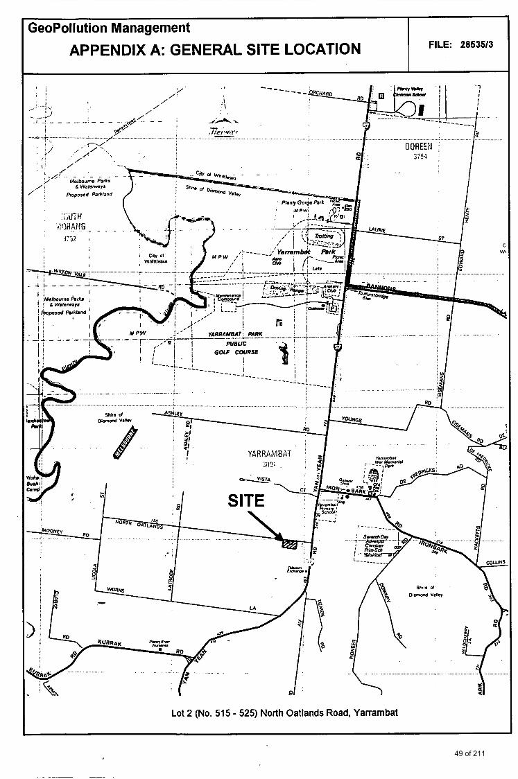
The site is located within the Melbourne Metropolitan Area in’the suburb of Yarrambat (Nillumbik Shire Council), approximately 25 km northeast of the Central Business District. A general location map is attached as Appendix A.
The Lot 2, referred to below as “the site”, occupies an area of approximately 1.037 ha. The site grades at an approximate 4 - 6’ slope angle to the east, ie. towards Lot 1 and Yan Yean Road. Site layout and surrunding land uses are illustrated on the attached Figure 1.
The site is bounded to the east by Lot 1 of the subdivision, which includes a dam near the boundary with Lot 2, and an existing residence near the corner of North Oatlands and Yan Yean Roads. Other large residential sites adjoin the subject site to the west (upslope) and south and to the north side opposite North Oatlands Road. Immediately to the western site boundary, now part of a residential property, an old former gold ore crushing battery, was still present at the time of this investigation.
During the initial sampling and surveying rounds (Phase l), the site surface was mainly covered by grasses with sparse native trees in the northwestern section. Open ground was exposed in some areas, in particular in the western third of the block. In this area part of tailings mounds had been removed and a triangular pocket of highly contaminated soil adjacent to a drain downslope of the abandoned ore crushing plant had been removed previously. The base of this excavation was approximately 200 to 300 mm below the surrounding land surface.
I
The property is located in a rural farmland area with a generally high proportion of exposed ground.
Photographs on the following page show the site as encountered during pahse 1 of this project, ie. prior to site clean up being undertaken. Plate 1 shows a site view towards the southwest with the former ore crushing battery on the adjoining property in the background.
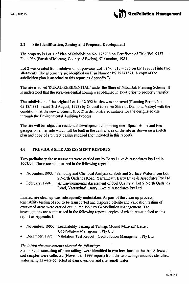
Plate 2 shows a general view of the site, with previously excavated area downslope of crushing battery in the foreground to the east, with Lot 1 including the existing residence in the background.
11 13 of 211
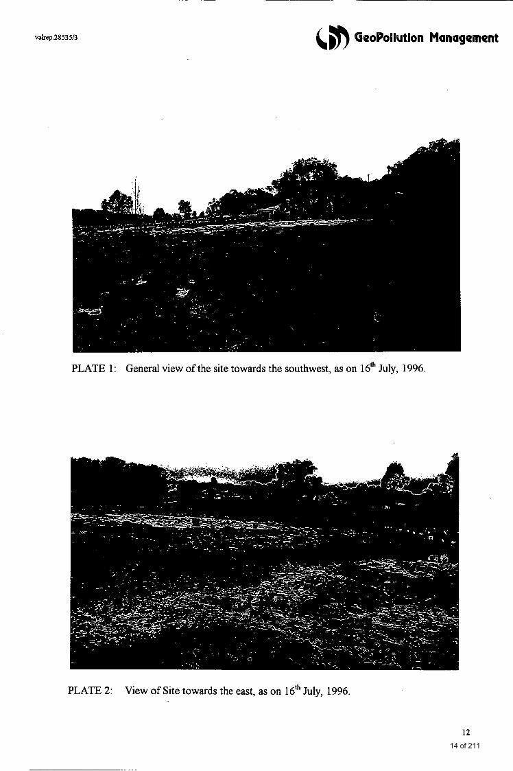
PLATE 1: General view of the site towards the southwest, as on 16* July, 1996.
PLATE 2: View of Site towards the east, as on 16* July, 1996.
12 14 of 211
valrep.28535/3 &m GeoPollution Management
3.2 Site Identification, Zoning and Proposed Development
The property is Lot 1 of Plan of Subdivision No. 128738 on Certificate of Title Vol. 9457 Folio 036 (Parish of Morang, County of Evelyn), 9* October, 198 1.
Lot 2 was created from subdivision of previous Lot 1 (No. 5 15 - 525 on LP 128738) into two allotments. The allotments are identified on Plan Number PS 32341 57J. A copy of the subdivision plan is attached to this report as Appendix B.
The site is zoned ‘RURAL-RESIDENTIAL’ under the Shire of Nillumbik Planning Scheme. It is understood that the rural-residential zoning was obtained in 1994 prior to property transfer.
The subdivision of the original Lot 1 of 2.092 ha size was approved (Planning Permit No. 65.13/4381, issued 3rd August, 1993) by Council (the then Shire of Diamond Valley) with the condition that the new allotment (Lot 2) is demonstrated suitable for the designated use through the Environmental Auditing Process.
The site will be subject to residential development comprising one “Spec” Home and two garages on either side which will be built in the central area of the site as shown on a sketch plan and copy of architect design supplied (not included in this report).
4.0 PREVIOUS SITE ASSESSMENT REPORTS
Two preliminary site assessments were carried out by Barry Luke & Associates Pty Ltd in 1993/94. These are summarized in the following reports.
November,1993: ‘Sampling and Chemical Analysis of Soils and Surface Water From Lot 2 North Oatlands Road, Yarrambat’, Barry Luke & Associates Pty Ltd
February, 1994: ‘An Environmental Assessment of Soil Quality at Lot 2 North Oatlhds Road, Yarrambat’, Barry Luke & Associates Pty Ltd
Limited site clean up was subsequently undertaken. As part of the clean up process, leachability testing of soil to be transported and disposed off-site and validation testing of excavated areas were carried out in late 1995 by GeoPollution Management. The investigations are summarized in the following reports, copies of which are attached to this report as Appendix I:
November, 1995 : ‘Leachability Testing of Tailings Mound Material’ Letter, GeoPollution Management Pty Ltd
December, 1995: ‘Validation Test Report’, GeoPollution Management Pty Ltd
The initial site assessments showed the folIowing: Soil mounds consisting of mine tailings were identified in two locations on the site. Selected soil samples were collected (November, 1993 report) from the two tailings mounds identified, water samples were collected of dam overflow and site runoff water.
13 15 of 211
vakep.28535/3 &, GeoPollution Management
Composite soil samples from the tailings mounds showed potentially elevated arsenic and mercury concentrations, particularly in the westernmost tailings mound. A composite sample from the surrounds of a drain, immediately downslope of the former ore crushing plant, contained elevated cadmium, arsenic as well as high zinc and mercury levels.
Surface waters were shown to contain elevated lead, cadmium, copper, and arsenic levels. Additional field work carried out in February, 1994 included soil sampling to 1.5 m of tailings mound material and to 0.5 m of other soils, and hrther surface water sampling. Soil samples from the southwest of the site, downslope of the gold ore battery contained peak concentrations of 57 ppm of mercury and 63 ppm of arsenic.
Soil from “tailings mound l”, closest to the former crushing battery, contained peak concentrations of 210 ppm of arsenic and 9.3 ppm of mercury. One of these samples contained also 8 ppm of cadmium. Concentrations in the second tailings mound located hrther downslope were a maximum of 25 ppm of arsenic and 9.5 ppm of mercury.
In order to render the site suitable for a hture more sensitive land use, remediation was to comprise localized site clean up of surface soils by excavation and off-site disposal. The need for soil clean up was based on mean values and defined by comparison with “Soil Clean up Criteria” (Dutch C levels). A plan was supplied showing the extent of limited clean up deemed necessary. This comprised the drain downslope of the crushing battery which contained the highest concentration of metals (to 0.6 m), the south-western comer of the site (to 0.3 m) and the north-east portion of tailings mound 1 (to 0.6 m average).
Apart from elevated lead concentrations, the quality of surface runoff water did not appear to be adversely affected.
Subsequent leachability testing for disposal to landfill showed that metals were not leachable. Validation testing of the bases of the excavations (PETROTEST reports appendixed to this document) indicated that the levels of arsenic and mercury in the test areas had decreased in all samples to 8 ppm or less for arsenic and to non-detectable levels for mercury.
5.0 SITEEUSTORY
A detailed review of the history of the site and past land uses has been undertaken. Wormation was sought from the following sources:
> > > Aerial Photographs > > > Previous Site Assessment Reports
Street Directory of Melbourne (Sands & McDougall), State Library of Victoria, The Royal Historical Society (refer to Appendix F)
Department of Minerals and Energy, Library (Journal Articles) Shire of Nillumbk, Town Planning Department
14 16 of 211
(5n GeoPollution Management
The subject site was part of a gold mining operation in the earlier part of this century. Prior to its mining use the land was occupied by an orchard. Reportedly, the “Golden King” Reef was first discovered by Mr W.J. Clayton outcropping in an orchard in 1939. The adjoining gold mine to the north was owned and operated by a Mr Fred (W.A.) Clayton since 1938 under the name of “Golden Crown Mine”.
As reported in various papers in the ‘Mining and Geological Journal’ (e.g. J.P.L. Kenny, 1940), the land to the west of “Tanck’s Corner” was traversed by a north-south porphyry dyke intruded auriferous quartz veins. On the Golden Crown Mine to the north of the subject site, two vertical shafts were initially driven to driven to 95 feet. A third shaft was added later (Whiting, R.G. 1955: Report on the Golden Crown Mine, Yarrambat. Min. & Geol. J. Vic, Vol. 3, No. 1, pp 30 - 3 1). These shafts would have been located to the northwest of the subject Lot 2. Reportedly, the shafts were decommissioned (filled) in the mid seventies. The article by Whiting also mentions the presence of “possible arsenopyrite” in the rock.
The ‘Golden King Mine’, to the south of the larger Golden Crown Mine, also operated two shafts, which were located approximately 400 m to the south of the boundary with the Golden Crown Mine. Visual evidence of at least one the former shaft locations remains on the property adjoining Lot 2 upslope.
Several journal articles report that a three-head battery and amalgamated plates driven by an oil engine was used to crush the ore (in battery housed in shed upslope of subject site). Water was supplied and recycled into a near-by small dam (now part of Lot 1). Larger quantities of water were obtained from the Plenty River, approximately 1.7 km to the west.
The Golden King Mine initially operated until the mid 1950’s, then, following fbrther prospecting, was re-opened in the 1960’s until it finally closed in the 1970’s.
Information obtained from the Royal Historical Society (copies of articles attached as Appendix F to this report) also indicates that, prior to mining for gold, the land at “Tanck’s Corner” may have occupied been an apple orchard (viz. name “Apple Tree Lode”, Diamond Valley News, Sep, 1964).
Other brief accounts of the site history are contained in the previous site assessment reports by Barry Luke & Associates.
Aerial Photographs Aerial photographs from 1951, 1956, 1963 and 1970, attached this report as Appendix G, show the condition of the mine during a large part of its operating We.
195 1: The residence, now occupying Lot 1, has not been built as yet. A vehicle track enters the Mine fiom North Oatlands Road and one branch forks downslope of the crushing battery.
There is evidence of exposed ground in several areas upslope and downslope of the battery, indicating either soil disturbance or dumped mine tailings. At least two small
15 17 of 211
&,b GeoPollution Management
1956:
1963 :
1970:
sheds appear to be present north-west of the battery and the location of a mine shaft may be seen on the property now adjacent to Lot 2 (not in focus). A shed is present downslope on what is now Lot 2.
The residence has been built near the corner of North Oatlands and Yan Yean Roads. It appears that all smaller sheds have been demolished. The tailings mound below the crushing battery has become larger and fans out towards what is now the north-eastern corner of Lot 2. The entrance section of the above mentioned vehicle track has become overgrown.
The dam (now on Lot 1) has been increased in size. While part of the tailings (towards North Oatlands Road have been covered by vegetation, the remainder has been added to and the mounds appear to be higher. The location of the nearest shaft can be seen to the northwest of the battery.
A poppet head above a shaft is clearly noticeable to the north-west of the ore crushing battery. Large sections of the tailings mounds have been covered by vegetation.
The aerial photographs show that a shaft was not present within the boundaries of the present Lot 2.
6.0 REGIONAL SUBSURFACE ENVIRONMENT
6.1 Geology
The site is identified on the Geological Survey of Victoria YAN YEAN Sheet (1:63,360) as being located within the province of Silurian age ‘Dargile Formation’ consisting of laminated and bedded sandstones with interbedded siltstone and shale.
Five mines, including the Golden Crown Mine, are indicated on the geological map (copy dated 1972) with seven shafts present in a north-south alignment approximately 250 m to the west of Yan Yean Road.
6.2 Hydrogeology
The natural clays underlying the site are relatively impermeable, while the overlying natural sands and silts are moderately to highly permeable.
Locally, a seasonally variable perched water table near surface overlies the less permeable clays. Regionally, groundwater is present through fractures in the bedrock.
The local hydraulic gradient is likely to be directed towards Plenty River which flows in a south-westerly direction approximately 1.7 km to the west of the site. A small’tributary feeding into Plenty River originates approximately 1 km to the south-west of the site.
16 18 of 211
valrep.28535/3 &#) GeoPollution Management
7.0 FIELD METHODS
7.1 General
Initial field work for this final site assessment was carried out by technical and scientific staff from our Ringwood office between 16* April and 16* July, 1996. Final validation sampling was carried out on 24* February, 1997.
A soil technician carried out drilling or hand augering and assisted in equipment decontamination. An Environmental Scientist was responsible for soil profile logging, on-site testing and collection of soil samples and ensuring that quality assurance procedures were adhered to. Site inspections during site remediation were conducted by an Environmental Scientist.
All work was carried out in accordance with quality assurance procedures adopted by this company.
7.2 Soil Sampling by Solid Flight Auger Drilling or Hand Augering
Soil was retrieved with a mechanical auger during the first round of sampling using a light truck mounted drill rig with solid flight tungsten augers (April, 1996) and with hand equipment (stainless steel hand augers) during subsequent sampling events.
Initial final drilling depths were determined by the depth to natural clay. The number of samples collected and the sampling intervals from each borehole were guided by the nature of the soil profiles intersected, in particular the depth of any fill, if present, and the depth to clay. A field contamination assessment including on-site vapour detection @ID, see section 6.3) was initially routinely carried out at each test point concurrently with soil sampling.
A total of ten (10) sampling points were located across the entire site for initial site appraisal. During subsequent sampling events in Winter, 1996 the site was inaccessible for vehicles, due to surface water logging. A total of five ( 5 ) boreholes were augered by hand during follow up testing and samples were collected from a total of eleven boreholes during the grid survey (July, 1996).
Maximum investigation depths varied between 0.5 and 1.7m below surface levels.
A total of thuty six (36) routine soil samples and six QNQC samples (field duplicates) were collected during the Phase 1 sampling program. Another thirteen (13) surface samples were collected following site remediation (Phase 2).
Soil samples were collected from the auger cuttings with due care to exclude any cross- contaminated (peripheral and central) layers.
17 19 of 211
valrep.2853513 (, GeoPollution Management
Samples were thoroughly mixed in a tray before transferring them into sample jars. All samples were collected as 'zero-headspace' samples, i.e. the jars were filled to capacity leaving no air gaps. Subsequently, they were sealed with an aluminium foil or teflon-lined plastic screw cap. These precautions are designed to minimize oxidation, loss through evaporation and potential interference from plastic additives.
7.3 Field Screening for Volatile Organic Compounds (Soil Gas Survey)
A vapour screen was routinely conducted during initial sampling in Phase 1 of this site assessment program. At each soil sampling location the probe was inserted into the open bore space immediately after exposure. This method provides a gross assessment of the presence of volatile organics within the entire vertical extent of subsurface material intersected at any given time.
The instrument used for the field screen is a portable Photoionization Detector (PID, Photovac, model Microtip IS-3000) which registers total ionisable organic compounds rather than individual compounds. Prior to commencement of field work, the instrument was calibrated using a gas mix of 105 ppm isobutylene in ultrahigh purity air from a clear plastic sample bag.
Readings represent the total concentration of all photoionizable organics in the sample (in parts per million) and results represent relative concentrations. The instrument response is accurate within +/- 10 ppm. A background reading is taken each time before testing.
If concentrations of volatiles were detected in excess of 10 ppm, special 'headspace' samples were to be collected for laboratory analysis. No elevated PID readings were recorded during the initial survey, and no fbrther vapour tests during subsequent stages of this project were deemed necessary.
7.4 Excavation Guidance Testing (Grid Survey)
A grid survey was carried out across the entire site between 15* and 17* July, 1996, in order to define the spatial extent of the tailings mounds. The site was overlain by a 10m x 10m grid. At each grid intersection a visual assessment of soil profiles was undertaken. The distances between auger holes were decreased to less than 10m as required to define the edges of tailings material. Samples of natural soil were collected at random points during the survey.
The 10 x 10m grid was marked with flagging tape along the fences at commencement of the survey. The perimeter of the mounds was marked on site with stakes. Boundaries of areas to be excavated were marked with lime (temporary marking) to facilitate delineation of the aerial extent of clean up by the client. A contour plan was drawn fiom the site survey and passed on to the client with explanatory instructions for clean up (plan attached as Figure 3 to this report and correspondence attached as part of Appendix H).
18 20 of 211
valrep.28535/3 &, GeoPollution Management
8.0 QUALITY ASSURANCE/QUALITY CONTROL
8.1 Field Sampling
All sampling equipment including flight augers and hand auger equipment that had come into contact with fill or soil was decontaminated between boreholes in accordance with quality assurance protocols adopted by this company.
Hand sampling equipment was cleaned with water containing a phosphate free detergent (Decon 90) and a scraping brush, then rinsed twice with tap water and dried before collection of each sample. Water was brought on site in containers.
8.2 Laboratories
Internal laboratory quality control testing was requested as follows:
Duplicates Blanks Spikes (Recoveries)
Standards
- 10% of all samples analysed or a minimum of 1 - 1 per batch of samples analysed - Duplicates with known spikes. For metals: Spike added to acid digest. For organics: Spike added to soil prior to extraction.
- Instrument calibration standards as required by NATA.
QNQC methods were employed to ensure that the data, as far as possible, were accurate, precise (repeatable and reproducible) and representative.
Field duplicate samples were collected (at a minimum rate of 10 % of total sample numbers) for the purpose of external quality control checks (samples sent to a second laboratory). Duplicates were subsamples of thoroughly mixed bulk samples taken off the auger cuttings.
Initial field duplicates (collected April, 1996) were sent to the primary laboratory along with the routine samples with instructions for compositing and forwarding the composite sample to the secondary laboratory.
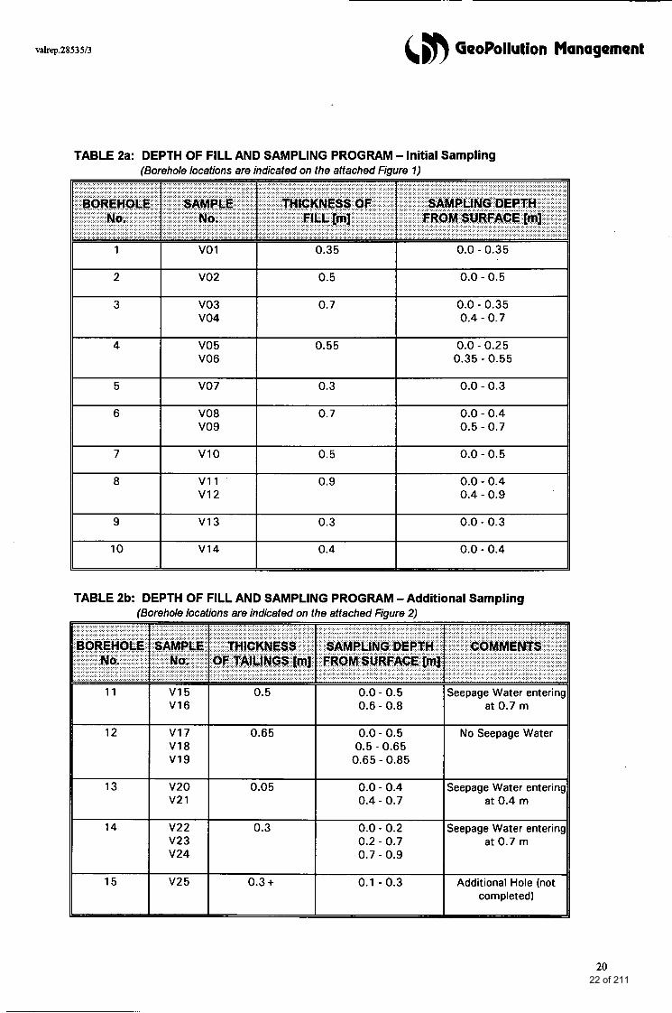
9.0 SAMPLING PROGRAM
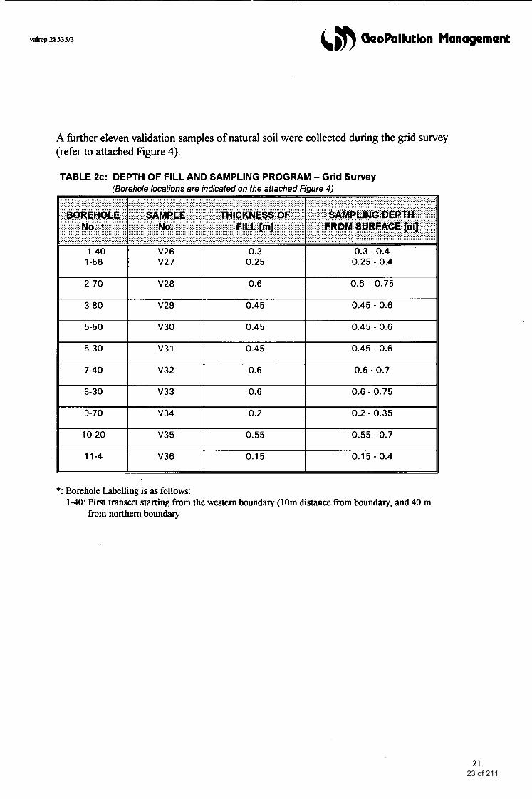
Table 2a (over page) summarizes the fill depth (mine tailings) and the soil samples collected from each borehole during the initial sampling round (April, 1996). Table 2b (over page) summarizes the same for subsequent check samples and Table 2c for samples of natural soil underlying tailings material collected during the grid survey. .
19 21 of 211
valrep.2853513 &, GeoPollution Management
TABLE 2a: DEPTH OF FILL AND SAMPLING PROGRAM - Initial Sampling (Borehole locations are indicated on the attached Fiaure 71
0.0 - 0.25
0.4 - 0.9
TABLE 2b: DEPTH OF FILL AND SAMPLING PROGRAM -Additional Sampling (Borehole locations are indicated on the attached Fiaure 2 )
12
13
14
15
0.5 I 0.0 - 0.5 V16 0.6 - 0.8
V17 0.65 0.0 - 0.5 0.5 - 0.65
0.65 - 0.85
0.0 - 0.4 0.4 - 0.7
0.0 - 0.2 V23 V24 I 0.2 - 0.7
0.7 - 0.9
0.1 - 0.3
v25 I Oe3+ I
Seepage Water enterir at 0.7 m
No Seepage Water
Seepage Water enterir at 0.4 m
Seepage Water enterir at 0.7 m
Additional Hole (not completed)
20 22 of 211
valrep.2853513
2-70
3-80
5-50
(,#) GeoPollution Management
V28 0.6 0.6 - 0.75
V29 0.45 0.45 - 0.6
V30 0.45 0.45 - 0.6
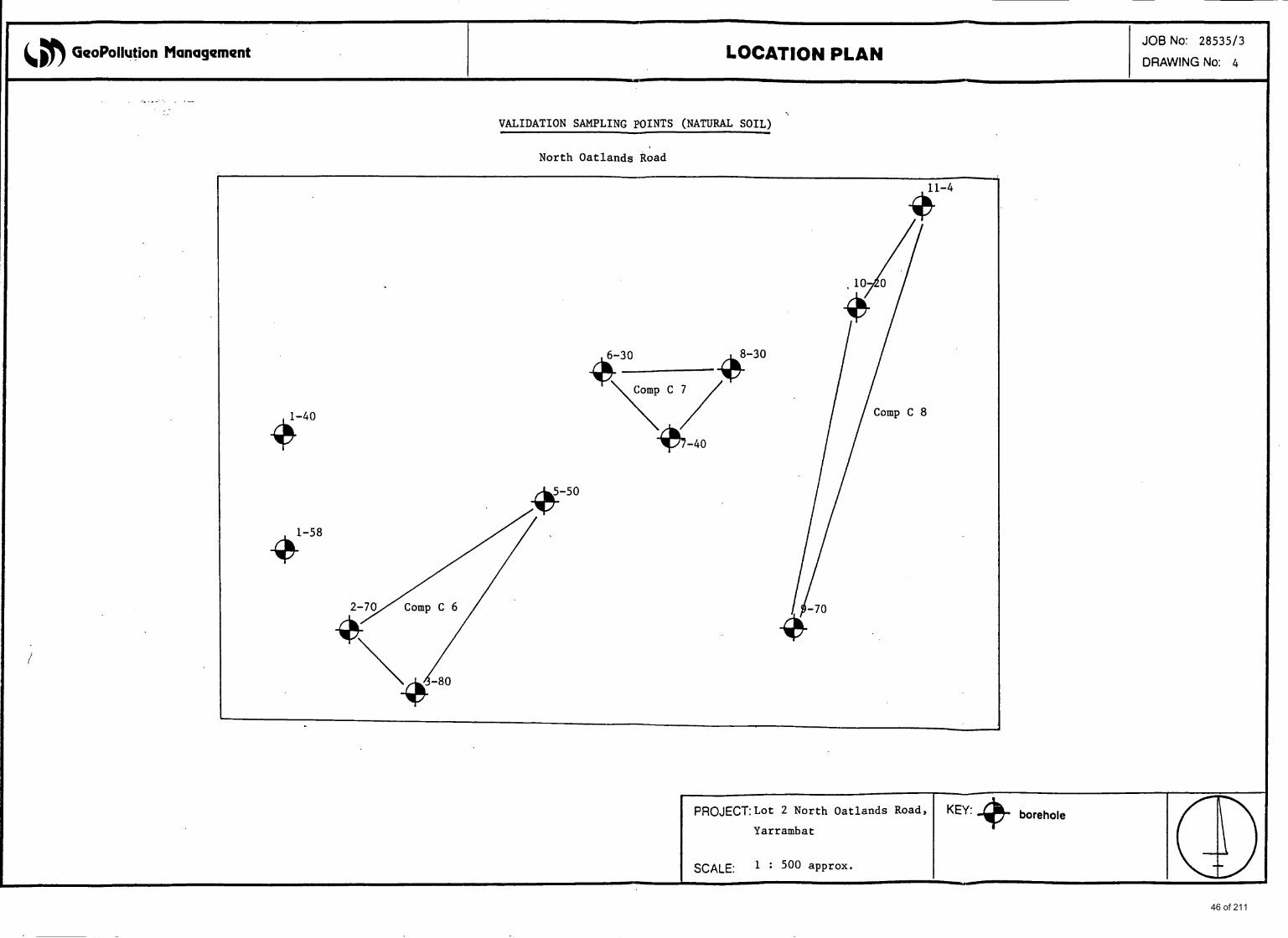
A hrther eleven validation samples of natural soil were collected during the grid survey (refer to attached Figure 4).
6-30
7-40
TABLE 2c: DEPTH OF FILL AND SAMPLING PROGRAM - Grid Survey (Borehole locations are indicated on the attached Figure 4)
V3 1 0.45 0.45 - 0.6
V32 0.6 0.6 - 0.7
0.25 - 0.4 I 0.25 v27 I
8-30 v33 0.6 0.6 - 0.75
9-70 v34 0.2 0.2 - 0.35
0.55 - 0.7 I 0.55 I v35 I 10-20
0.1 5 - 0.4 I 0.15 I v36 I 11-4
*: Borehole Labelling is as follows: 1-40: First transect starting from the western boundary (10m distance from boundary, and 40 m
from northern boundary
21 23 of 211
valrep.28535I3 6 GeoPollution Management
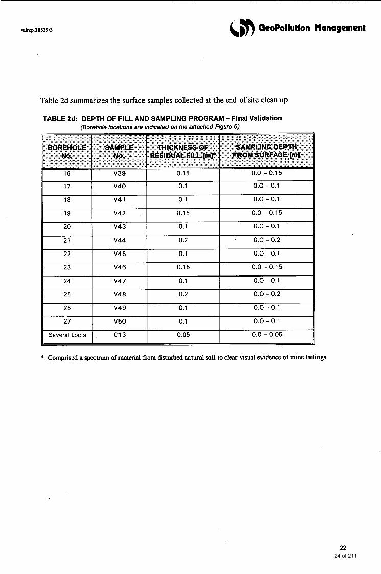
Table 2d summarizes the surface samples collected at the end of site clean up.
TABLE 2d: DEPTH OF FILL AND SAMPLING PROGRAM - Final Validation (Borehole locations are indicated on the attached Figure 5)
*: Comprised a spectrum of material from disturbed natural soil to clear visual evidence of mine tailings
22 24 of 211
valrep.2853513 &, GeoPollution Management
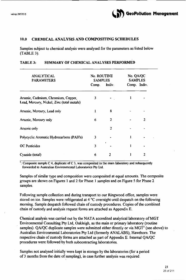
10.0 CHEMICAL ANALYSIS AND COMPOSITING SCHEDULES
Samples subject to chemical analysis were analysed for the parameters as listed below (TABLE 3).
TABLE 3: SUMMARY OF CHEMICAL ANALYSES PERFORMED
ANALYTICAL PARAMETERS
No. ROUTINE No. QAJQC SAMPLES SAMPLES
Comp. Indiv. Comp. Indiv.
Arsenic, Cadmium, Chromium, Copper, 3 - 1 - Lead, Mercury, Nickel, Zinc (total metals)
Arsenic, Mercury, Lead only 1 8 - -
Arsenic, Mercury only 6 2 - 2
Arsenic only 2 - -
Polycyclic Aromatic Hydrocarbons (PAH's) 3 - 1 - 0
OC Pesticides 3 - 1 -
Cyanide (total) 6 2 1 2
: Composite sample C 4, duplicate of C 3, was composited in the main laboratory and subsequently forwarded to Australian Environmental Laboratories pty Ltd.
1
Samples of similar type and composition were composited at equal amounts. The composite groups are shown on Figures 1 and 2 for Phase 1 samples and on Figure 5 for Phase 2 samples.
Following sample collection and during transport to our Ringwood office, samples were stored on ice. Samples were refrigerated at 4 "C overnight until despatch on the following morning. Sample despatch followed chain of custody procedures. Copies of the combined chain of custody and analysis request forms are attached as Appendix E.
Chemical analysis was carried out by the NATA accredited analytical laboratory of MGT Environmental Consulting Pty Ltd, Oakleigh, as the main or primary laboratory (routine samples). QNQC duplicate samples were submitted either directly or via MGT' (see above) to Australian Environmental Laboratories Pty Ltd (formerly ANALABS), Hawthorn. The respective chain of custody forms are attached as part of Appendix E. Internal QNQC procedures were followed by both subcontracting laboratories.
Samples not analysed initially were kept in storage by the laboratories (for a period of 3 months from the date of sampling), in case hrther analysis was required.
23 25 of 211
valrep.28535/3 4 8 GeoPollution Management
11.0 RESULTS OF THE INVESTIGATION
11.1 Site Subsurface Conditions
11.1.1 Subsurface Profiles (Boreholes)
Fill, where present, was composed of
0 Tailings material comprising crushed ore residues of clayey silt texture, light grey/white to yellow orange in colour, occasionally light brown
Natural soil present from surface level towards most of the site perimeter or from the base of the tailings material consisted of
0
0
Clayey SILT, brown, containing some ironstone gravel, underlain by Silty CLAY of medium plasticity, brown-orange brown.
.
The combined bore logs, sampling and field testing records from the initial sampling round are attached as Appendix C.
11.1.2 Soil MoisturdGroundwater
Both fill and natural soil intersected were mostly in a moist condition during initial drilling and sampling (April, 1996). Later in the year 1996, in particular in July, soils were moist to wet.
In winter 1996, seepage water (‘perched water’) was present on the lower slope of the site between 0.4 and 0.7m from surface level and the site surface was boggy towards the eastern (lower) site boundary.
During the Phase 2 site clean up, carried out in Summer 1996/97, surface soils were dry and the immediate surface layer of mostly residual tailings material, at the time of final validation sampling (February, 1997), was very dry and dusty following working over with heavy machinery.
11.2 Field Contamination Assessment
11.2.1 Ksual and Orfactory Observations
During Phase 1 of this project, extensive mine tailings were still present on the site surface immediately downslope of the disused ore crushing battery and continuing downslope towards the northeastern site boundary. Tailings were essentially absent in the northwestern corner of the site (area of sparse tree cover) and in a smaller area in the southeastern corner of the site. The presence of tailings material was later (Phase 2) used as an indicator of potentially contaminated soil and provided the main guidance parameter for site clean up.
No distinct odours were noticeable at any of the bore locations. 24
26 of 211
valrep.28535/3 &, GeoPollution Management
11.2.2 Vapour Survey
Potential vapour phase hazards at the subject site were assessed by conducting a soil gas survey of the open bore space immediately following retrieval of the auger.
Background vapour concentrations in ambient air were zero. Organic vapours were not detected above background levels at any of the test locations. Hence, the collection of samples for laboratory analysis of volatile compounds was not required.
PID readings of total ionizable volatile compounds are shown on the attached bore logs (Appendix C).
11.3 Chemical Analysis
The results of the chemical analyses including QNQC results are attached as Appendix D (NATA endorsed final laboratory reports). Results of routine analyses of composite and individual samples of surface soils from initial sampling during Phase 1 are summarised in Tables 5a and 5b respectively (following page).
Results of analysis of individual and composite samples from follow-up sampling during Phase 1 are shown in Table 5c (page after next). Results of natural soil samples obtained during the grid survey are shown in Table 5d and results of final validation sampling of the site surface after clean up are summarized in Table 5e.
Quality control check results of QNQC duplicate samples are detailed and evaluated in Section 12.0.
The tables also list the following guidance limits for site assessment (as applicable; refer also to Section 2.0 of this report).
0 ANZECC B criteria (or Dutch B criteria where ANZECC B limits have not been specified), ‘Environmental Investigation Limits’, which set the threshold levels above which hrther investigation may be required.
Modified guideline limits for composite samples (number of constituents as applicable).
- Correction of stanciard guideline limits for the number of constituents takes the potential diluting eflect of sample compositing into account.
- Comparison of composite results with uncorrected assessment criteria, on the other hand, assumes that levels reported for composite samples represent average concentrations in individual constituents.
0 EPA ‘Clean Fill’ Criteria (EPA Bulletin 448, Sep 1995), developed for classification of the environmental quality of fill material, but also frequently used for final site validation of residential sites in the context of Environmental Audits.
25 27 of 211
valrep.28535/3 (,m GeoPollution Management
11.3.1 Assessment Phase (Phase 1)
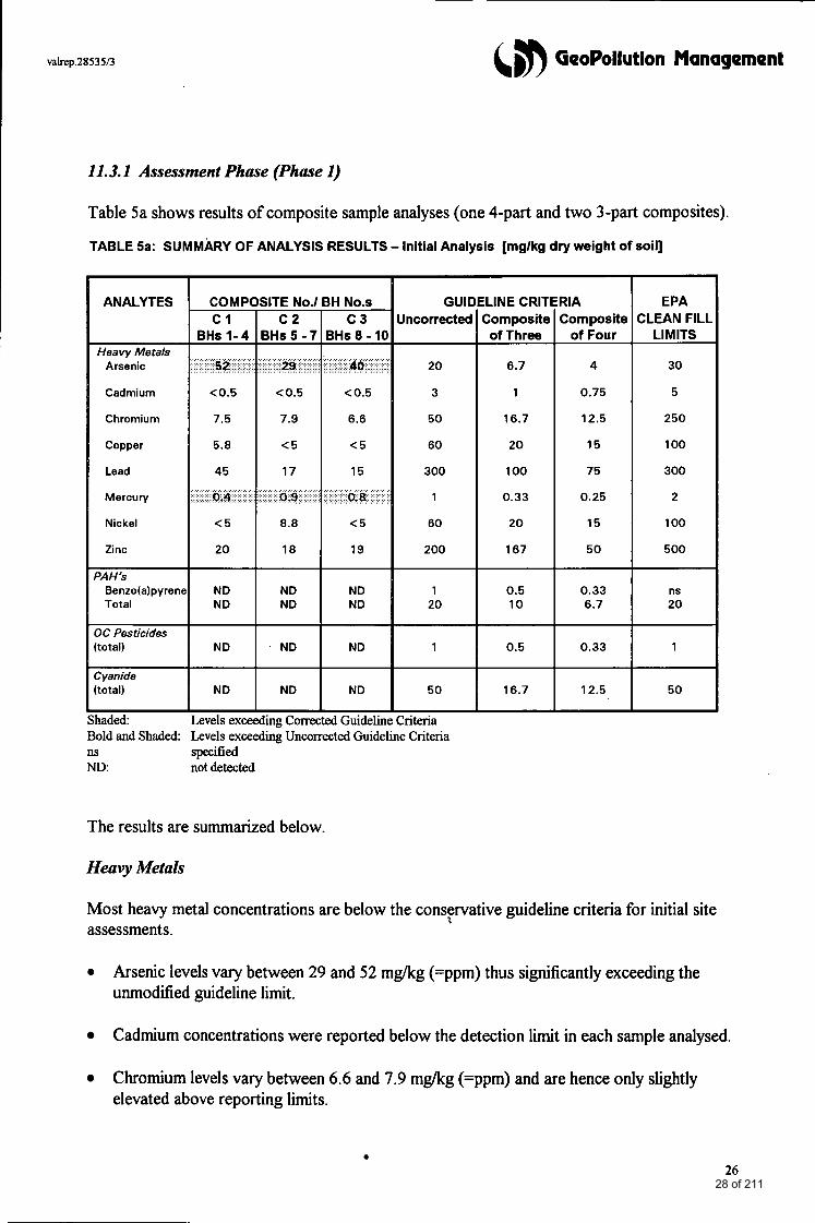
Table 5a shows results of composite sample analyses (one 4-part and two 3-part composites).
TABLE 5a: SUMMARY OF ANALYSIS RESULTS - Initial Analysis [mglkg dry weight of soil]
Chromium
OC Pesticides [total)
[total)
IH No.s GUIt C 3 Uncorrected
3Hs 8 - 10
46 20
< 0.5 3
6.6 50
<5 60
ELINE CRlTiRIA Composite Composite
of Three of Four
6.7 4
1 0.75
16.7 12.5
20 15
EPA CLEAN FILL
LIMITS
30
5
250
100
~~~
Shaded: Levels exceeding Coma Bold and Shaded: Levels exceeding Uncorrected Guideline Criteria I1s specified ND: not detected
The results are summarized below.
Heavy Metals
Most heavy metal concentrations are below the conservative guideline criteria for initial site assessments.
0 Arsenic levels vary between 29 and 52 mgkg (=ppm) thus significantly exceeding the unmodified guideline limit.
Cadmium concentrations were reported below the detection l i t in each sample analysed.
Chromium levels vary between 6.6 and 7.9 mgkg (=ppm) and are hence only slightly elevated above reporting limits.
26 28 of 211
valrep.2853513 &, GeoPollution Management
Both copper, lead nickel and zinc levels are either non-detectable or only slightly above reporting limits in each of the three composite samples.
0 Mercury concentrations exceed the modiJied ANZECC B Investigation Level (divided by number‘of individual constituents) in each composite sample. Levels, however, do not exceed the unmodified limit of 1 ppm.
Polycyclic Aromatic Hydrocarbons (PAH’s)
All individual PA”s including the carcinogenic benzo(a)pyrene were reported below the detection limits.
Organochlorine Pesticides
Organochlorine Pesticides were reported below detection limits in each composite sample analysed.
Cyanide (total)
No cyanide compounds were detected in any of the composite samples analysed.
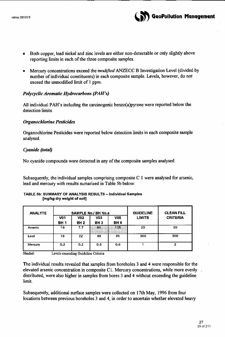
Subsequently, the individual samples comprising composite C 1 were analysed for arsenic, lead and mercury with results sumarized in Table 5b below.
TABLE 5b: SUMMARY OF ANALYSIS RESULTS - Individual Samples [mglkg dry weight of soil]
haded: Levels exceeding Guideline Criteria
The individual results revealed that samples from boreholes 3 and 4 were responsible for the elevated arsenic concentration in composite C 1. Mercury concentrations, while more evenly . distributed, were also higher in samples from bores 3 and 4 without exceeding the guideline limit.
Subsequently, additional surface samples were collected on 17th May, 1996 from four locations between previous boreholes 3 and 4, in order to ascertain whether elevated heavy
27 29 of 211
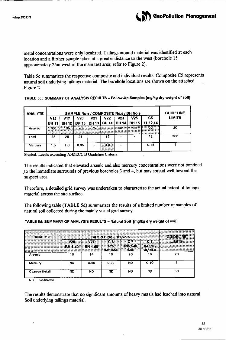
&,b GeoPollution Management
Mercury
Cyanide (total)
metal concentrations were only localized. Tailings mound material was identified at each location and a hrther sample taken at a greater distance to the west (borehole 15 approximately 25m west of the main test area; refer to Figure 2).
ND 0.40 0.22 ND 0.10 1
ND ND ND ND ND 50
Table 5c summarizes the respective composite and individual results. Composite C5 represents natural soil underlying tailings material. The borehole locations are shown on the attached . Figure 2.
TABLE 5c: SUMMARY OF ANALYSIS RESULTS - Follow-Up Samples [mglkg dry weight of soil]
Shaded: Levels exceeding ANZJ3CC B Guideline Criteria
The results indicated that elevated arsenic and also mercury concentrations were not confined ,to the immediate surrounds of previous boreholes 3 and 4, but may spread well beyond the suspect area.
Therefore, a detailed grid survey was undertaken to characterize the actual extent of tailings material across the site surface.
The following table (TABLE 5d) summarizes the results of a limited number of samples of natural soil collected during the mainly visual grid survey.
TABLE 5d: SUMMARY OF ANALYSIS RESULTS - Natural Soil [mglkg dry weight of soil]
The results demonstrate that no s imcan t amounts of heavy metals had leached into natural Soil underlying tailings material.
28 30 of 211
valrep.28535I3 &,n GeoPollution Management
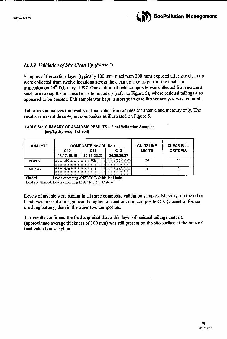
11.3.2 Validation of Site Clean Up (Phase 2)
Samples of the surface layer (typically 100 mm; maximum 200 mm) exposed after site clean up were collected from twelve locations across the clean up area as part of the final site inspection on 24* February, 1997. One additional field composite was collected from across a small area along the northeastern site boundary (refer to Figure 5), where residual tailings also appeared to be present. This sample was kept in storage in case hrther analysis was required.
Table 5e summarizes the results of final validation samples for arsenic and mercury only. The results represent three 4-part composites as illustrated on Figure 5.
TABLE Se: SUMMARY OF ANALYSIS RESULTS - Final Validation Samples [mglkg dry weight of soil]
Shaded: Bold and Shaded: Levels exceeding EPA Clean Fill Criteria
Levels exceeding ANZECC B Guideline Limits
Levels of arsenic were similar in all three composite validation samples. Mercury, on the other hand, was present at a significantly higher concentration in composite C 10 (closest to former crushing battery) than in the other two composites.
The results confirmed the field appraisal that a thin layer of residual tailings material (approximate average thickness of 100 nun) was still present on the site surface at the time of final validation sampling.
29 31 of 211

12.0 DATA VALIDATION
12.1 Replicate Results
The QNQC program comprised, apart fr-m internal lab
&,#) GeoPollution Management
rat ry duplicates, matrix spikes, blanks and known standards, six field replicates (to be analysed individually or as a composite of three individual samples), which were sent to an external check laboratory (QNQC or secondary laboratory).
The results of the replicate analyses provide an interlaboratory comparison with respect to sample accuracy, the precision (subsample variability) and how well the analytical results represent the samples taken.
The analysis results of three sets of field replicate samples are presented below. The replicate sets are as follows:
Sample No. Sample No. (Primary Lab.) Bore No.s (Secondary Lab.)
COMP C 3 8,9, 10 c 4
V26 V27
1-40 1-58
v37 V3 8
30 32 of 211
valrep.28535/3
3C Pesticides
Total Cyanide (CN)
(5n GeoPollution Management
ND ND N/A N /A
<0.5 0.02 0.1 35 85.2
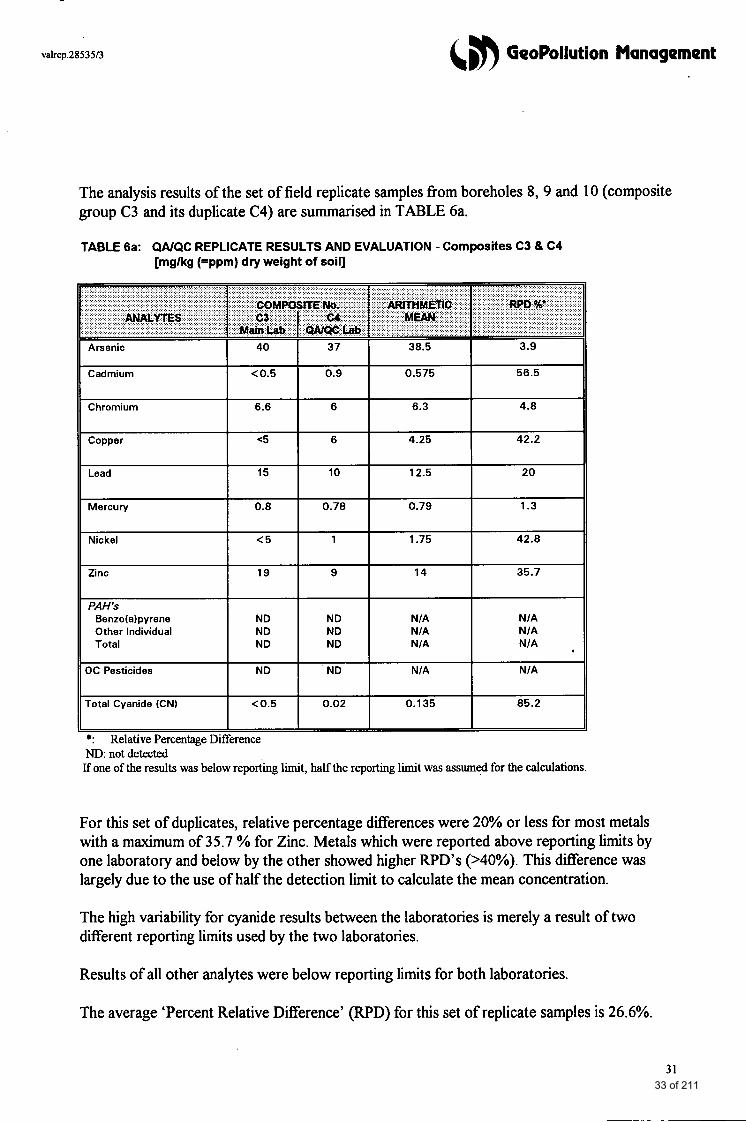
The analysis results of the set of field replicate samples from boreholes 8, 9 and 10 (composite group C3 and its duplicate C4) are summarised in TABLE 6a.
TABLE 6a: W Q C REPLICATE RESULTS AND EVALUATION - Composites C3 8 C4 [mglkg (=ppm) dry weight of soil]
For this set of duplicates, relative percentage differences were 20% or less for most metals with a maximum of 35.7 % for Zinc. Metals which were reported above reporting limits by one laboratory and below by the other showed higher WD’s (>40%). This difference was largely due to the use of half the detection limit to calculate the mean concentration.
The high variability for cyanide results between the laboratories is merely a result of two different reporting limits used by the two laboratories.
Results of all other analytes were below reporting limits for both laboratories.
The average ‘Percent Relative Difference’ (RPD) for this set of replicate samples is 26.6%.
31 33 of 211
valrep.2853513 68 GeoPollution Management
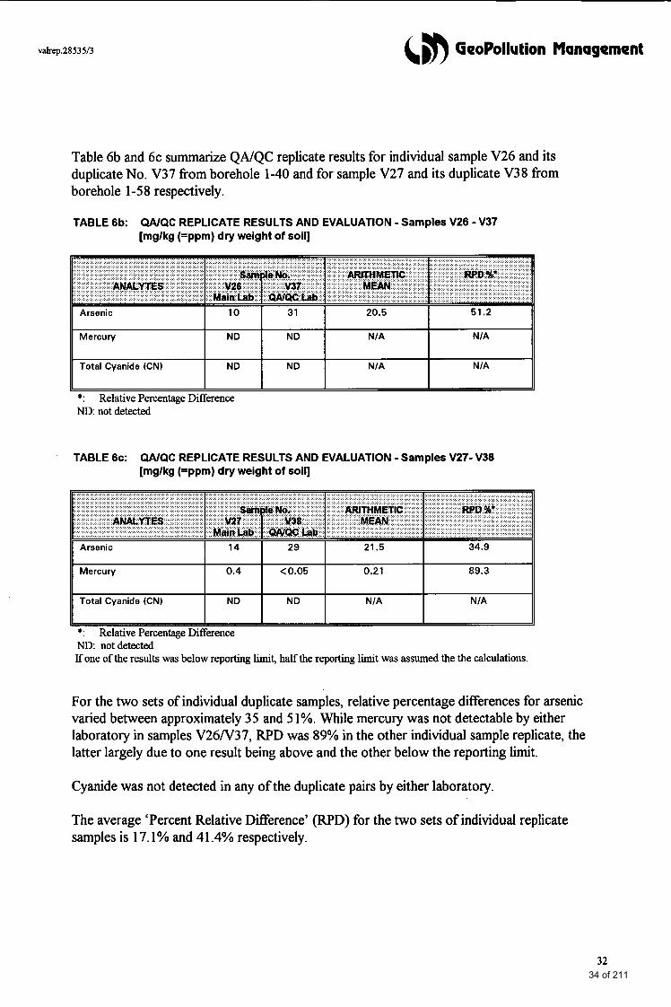
Table 6b and 6c summarize QNQC replicate results for individual sample V26 and its duplicate No. V37 from borehole 1-40 and for sample V27 and its duplicate V38 from borehole 1-58 respectively.
TABLE 6b: W Q C REPLICATE RESULTS AND EVALUATION - Samples V26 - V37 [mglkg (=ppm) dry weight of soil]
*: Relative Percentage Difference ND: not detected
TABLE 6c: QA/QC REPLICATE RESULTS AND EVALUATION - Samples V27- V38 [mglkg (=ppm) dry weight of soil]
*: Relative Percentage Difference ND: notdetected If one of the results was below reporting limit, half the reporting limit was assumed the the calculations.
For the two sets of individual duplicate samples, relative percentage differences for arsenic varied between approximately 35 and 5 1%. While mercury was not detectable by either laboratory in samples V26N37, RPD was 89% in the other individual sample replicate, the latter largely due to one result being above and the other below the reporting limit.
Cyanide was not detected in any of the duplicate pairs by either laboratory.
The average ‘Percent Relative Difference’ (RPD) for the two sets of individual replicate samples is 17.1% and 41.4% respectively.
32 34 of 211
~~
valrep.2853513 (,m GeoPollution Management
12.2 Q N Q C Evaluation
Interlaboratow ComDarison:
Precision: Average RPD’s of results of analysis of field duplicates at primary and secondary laboratories were 26.6, 17.1 % and 41.4 % and thus within the acceptable limit of 50%.
AcceptabiIity : The percentage of replicate analyses performed by primary and secondary laboratories producing acceptable results is 78%. Cadmium in the composite samples and arsenic in one individual sample duplicate and mercury in the other were outside acceptable limits.
Variability between cadmium and mercury results are attributed to different reporting limits, that between arsenic results can only be attributed to sample heterogeneity.
In the case of the cadmium result, concentrations are considered sufficiently low (below guideline criteria) for the RPD% to be considered as of no simcance.
Total cyanide varied significantly in the composite pair C3-C4, however, this was attributed to the very low reporting limit used by Australian Environmental Services and the method for calculating mean concentrations. Cyanide levels reported by both laboratories were below 0.5 ppm.
Laboratory-Internal ComDarison:
Accuracy:
Primary Laboratory: Spike percentage recoveries were between 84 and 104 % and thus within the acceptable range of 75 - 125%.
Seconda7y Laboratory: Spike percentage recoveries were between 75 and 104% and thus just within the acceptable range of 75 - 125%. One spike recovery for mercury is marginal with 75%. One surrogate spike recovery for PA”s was reported at only 67%.
Variabilities between internal duplicates were within the acceptable range of f 20 %.
33 35 of 211
valrep.2853513 (m GeoPollution Management
13.0 SCOPE OF SITE REMEDIAL WORKS
Results of the Phase 1 assessment of this auditing program indicated that hrther site clean up was required to bring the site to a standard which would be satisfactory for a Certificate (or Statement) of Environmental Audit.
Site remediation comprised excavation and off-site disposal of all residual tailings material (low-level contaminated fill) according to a plan and on-site markings provided (refer to contour plan of fill depth attached as Figure 3 and letter and remediation plan provided to client, attached as part of Appendix H).
Site clean up was carried out over a period of five months, approximately between October, 1996 and February 1997.
A final site inspection was scheduled and carried out on 17* December, 1996 but revealed that clean up was not yet completed. Further instructions were passed on to the client to complete site clean up, based on the assumption that a Certificate was to be achieved (copy of Facsimile attached as part of Appendix H). A final site inspection was carried out on 24* February, 1997, accompanied by surface soil sampling (final validation samples following additional clean up effort) and photographic recording.
.
Further correspondence was subsequently required between GPM, client and Auditor due to the presence of a thin layer of residual tailings across almost the entire clean up area. In the course of corresponednce, the outcome of this project was revised from a Certificate to a Statement of Environmental Audit (see hrther details below).
14.0 FINAL CONDITION OF THE SITE
14.1 Visual Appraisal
The final site inspection revealed tha the site had not visually been cleaned up to the extent required for a Certificate of Environmental Audit.
The following photographs (Plates 3 to 5 ) document the visual condition of the site at the time of project completion.
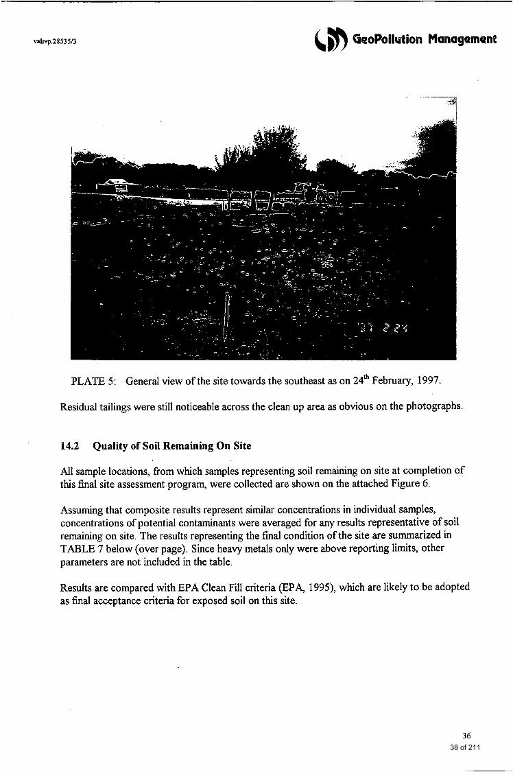
Plate 3 shows a view of the lower site boundary from the site entrance towards the south. Fence posts delineating the boundary between Lots 1 and 2 are in place but the fencing wire had been removed. Plate 4 shows part of the area immediately downslope of the upper site boundary, downslope of the adjoining former crushing battery. Plate 5 shows a general view of the site towards the southeast.
34 36 of 211
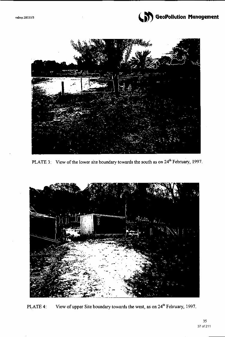
PLATE 3 : View of the lower site boundary towards the south as on 24* February, 1997.
PLATE 4: View of upper Site boundary towards the west, as on 24* February, 1997.
35 37 of 211
valrep.2853513
PLATE 5: General view of the site towards the southeast as on 24* February, 1997
Residual tailings were still noticeable across the clean up area as obvious on the photographs.
14.2 Quality of Soil Remaining On Site
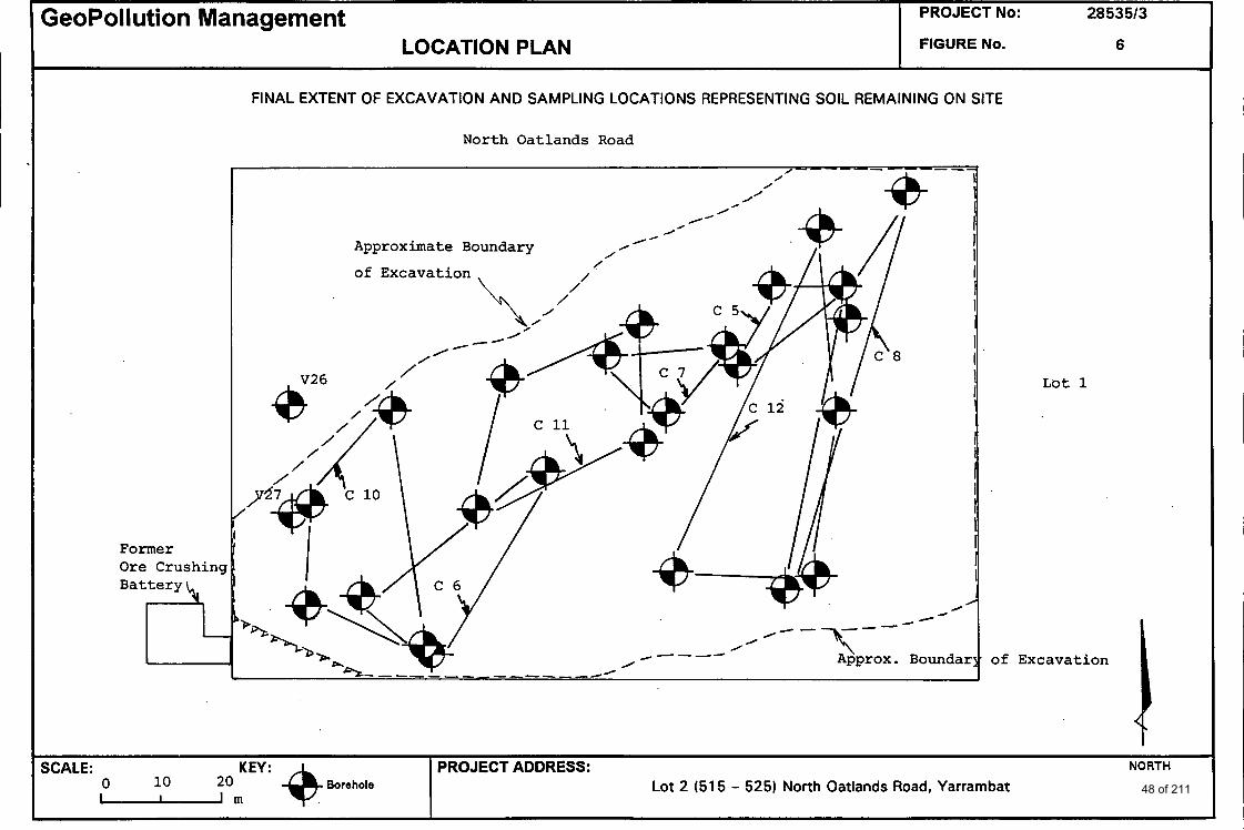
All sample locations, from which samples representing soil remaining on site at completion of this final site assessment program, were collected are shown on the attached Figure 6 .
Assuming that composite results represent similar concentrations in individual samples, concentrations of potential contaminants were averaged for any results representative of soil remaining on site. The results representing the final condition of the site are summarized in TABLE 7 below (over page). Since heavy metals only were above reporting limits, other parameters are not included in the table.
Results are compared with EPA Clean Fill criteria @PA, 1995), which are likely to be adopted as final acceptance criteria for exposed soil on this site.
36 38 of 211
valrep.2853513 &,m GeoPollution Management
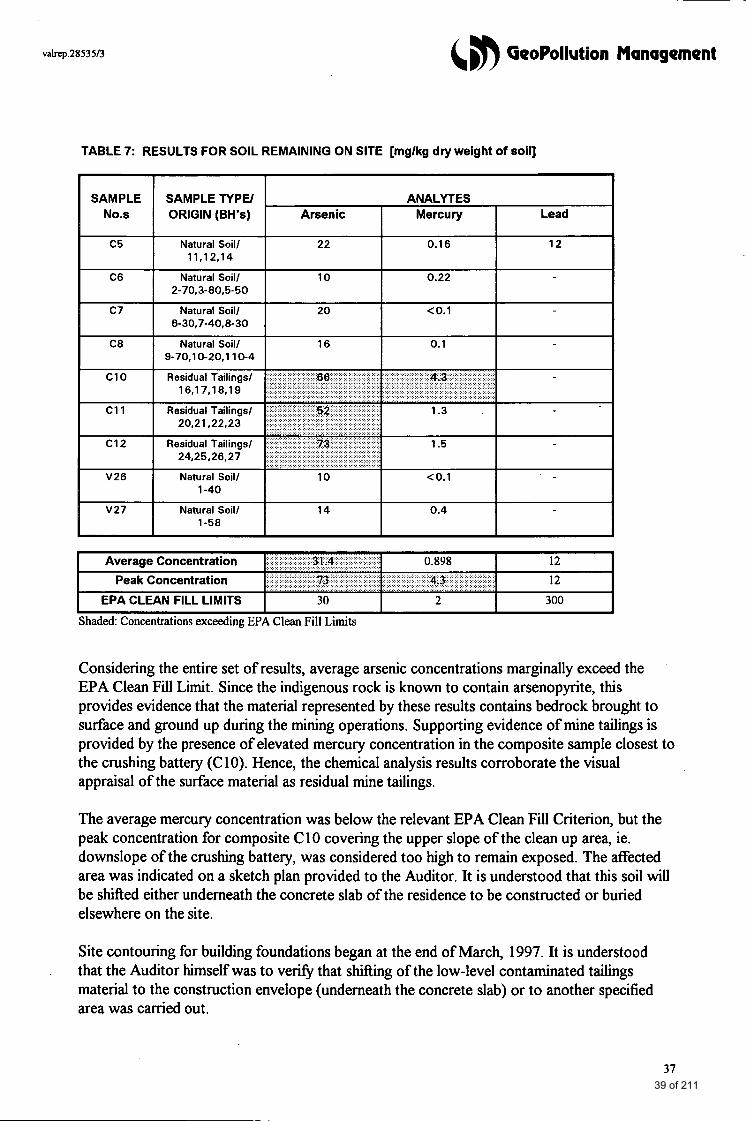
TABLE 7: RESULTS FOR SOIL REMAINING ON SITE [mglkg dry weight of soil]
SAMPLE SAMPLE TYPE/ ANALYTES No.s ORIGIN (BH's) Arsenic Mercury Lead
c 5 Natural Soill 22 0.16 12
C6 Natural Soill 10 0.22
c7 Natural Soill 20 co.1
C8 Natural Soill 16 0.1
1 1.1 2.1 4
2-70.3-80.5-50
6-30,7-40,8- 30
9-70.10-20.1 10-4
1-40
V27 Natural Soill 14 0.4 1-58
Shaded: Concentrations exceeding EPA Clean Fill Limits
Considering the entire set of results, average arsenic concentrations marginally exceed the EPA Clean Fill Limit. Since the indigenous rock is known to contain arsenopyrite, this provides evidence that the material represented by these results contains bedrock brought to surface and ground up during the mining operations. Supporting evidence of mine tailings is provided by the presence of elevated mercury concentration in the composite sample closest to the crushing battery (C 10). Hence, the chemical analysis results corroborate the visual appraisal of the surface material as residual mine tailings.
The average mercury concentration was below the relevant EPA Clean Fill Criterion, but the peak concentration for composite C10 covering the upper slope of the clean up area, ie. downslope of the crushing battery, was considered too high to remain exposed. The aected area was indicated on a sketch plan provided to the Auditor. It is understood that this soil will be shifted either underneath the concrete slab of the residence to be constructed or buried elsewhere on the site.
Site contouring for building foundations began at the end of March, 1997. It is understood that the Auditor himself was to v e w that shifting of the low-level contaminated tailings material to the construction envelope (underneath the concrete slab) or to another specified area was carried out.
.
37 39 of 211
valrep.28535/3 &,m GeoPollution. Management
15.0 CONCLUSIONS AND FINAL COMMENTS
This site validation program focussed on near-surface soils being the relevant stratum for assessing human exposure risks.
Human health risks are important in a site-specific assessment of conditions at this site. Future residents, in particular small children, are most likely to come in contact with near-surface soils. For example, exposure may be either direct via ingestion or indirect by consumption of vegetables grown on the site which may have taken up pollutants.
ANZECC B limits (and Dutch B levels in their absence) were adopted for initial evaluation of analysis results. For this final site assessment, the results were also compared with EPA “Clean Fill” criteria (EPA Bulletin 448, “Classification ofWastes”, 1995) which may be adopted by the Environmental Auditor as acceptance criteria for this site. Compliance with clean fill criteria also implies that no constraints on off-site disposal of soil excavated fiom the site are imposed.
In order to achieve a Certificate of Environmental Audit, this validation program was to show that, prior to residential redevelopment, no segment of the site contained residual contamination in surface soils (viz. mine tailings) at levels which may pose human health or environmental risks. A detailed site-specific risk assessment was beyond the scope of this report. A risk evaluation will be contained in the audit report accompanying this final site assessment report.
The final appraisal of the site surface conditions, both the visual appraisal and the final validation results, indicated that residual tailings remain on the majority of the site surface. These may locally exceed the acceptance criteria for residential use of this site. The final validation indicated that the site was not eligible for a Certificate of Environmental Audit but that a Statement could be issued including conditions specific to the proposed development plan. The health and environmental risks associated with surface soils remaining on site will be negligible, if conditions prescribed by the Auditor under a Statement of Environmental Audit .
are implemented.
Final Comments The abandoned crushing battery was still standing immediately upslope of the western site boundary at the time of project completion. Anecdotal evidence suggests that the shed and its contents will be moved in the near fbture to Yarrambat Park to be put on public display. The immediate surrounds and soil below the shed are bound to be highly contaminated by mercury and arsenic. Unless soil clean up takes place on the adjoining property, runoff onto the subject site cannot be excluded. Erosion and runoff may be greater following removal of the shed than it is at present. We recommend that, should the above appraisal be substantiated, an adequate barrier is installed to prevent re-contamination of the subject site by heavy metals from erosion or runoff or by shallow seepage water.
It is also noted that the triangular excavation downslope of the crushing battery had not been backfilled at completion of this project. Backfilling shall be with clean fill. It is anticipated that some natural soil will become available fiom the excavation and site levelling for building foundations which may be used for this purpose. If any material is to be imported fiom off-site sources, appropriate clean fill documentation needs to be provided.
38 40 of 211
valrep.28535/3 6 GeoPollution Management
16.0 LIMITATIONS OF THIS INVESTIGATION
The precision with which subsurface conditions are indicated depends largely on the frequency and method of sampling as well as the degree of uniformity of subsurface material. The spacing and number of test locations and scope of analytical schedule also reflect budget constraints.
The data reported in this final site assessment report have been derived fiom visual inspections, field instrument measurements and laboratory tests of a limited number of soil samples which are, based on professional judgement, believed to be representative of subsurface conditions.
The borehole logs represent the subsurface conditions at the specific test locations only. Further, boundaries between zones on logs are often not distinct but transitional and have been interpreted. Point data have been extrapolated across the site (or across certain portions of the site) using best available knowledge combined with professional judgement.
Should at any time, a significant variation from the observations and test data underlying this assessment be reported, this office should be contacted.
REFERENCES
ANZECC & NHMRC (1992) Australian and New Zealand Guidelines for the Assessment and ' Management of Contaminated Sites, January
ANZECC & Victoria EPA (1995) Draft Guidelines for the Analysis of Potentially Contaminated Soils, January
Environment Protection Authority (1 995) Classification of Wastes. Bulletin 448, September
39 41 of 211
(,m GeoPollution Management
FIGURES
42 of 211
PROJECT No: 2853513 GeoPollution Management
0 10 2 0 m ""$ Borehole SCALE: -
LOCATION PLAN
PROJECT ADDRESS: NORTH
Lot 2 (515 - 529North Oatlands Road, Yarrambat
I FlGURENo. 1
Vacant Land
Disused Ore Cru Plant
P-
/
SITE LAYOUT, SAMPLING POINTS AND COMPOSITE GROUPS
North Oatlands Road
Eucalypts I
Comp C
I
c
Grass
Cover
Comp C 1
S l o p e /
7 l?nce I I I
/
/
/
/
/
/
/
/
I I I I I I,
I - .
/ \ / I
I f I
I fix i s t ing I ' A a m
Lot 1
/
Vacant Land
43 of 211
PROJECT No: 2853513 GeoPollution Management
SCALE: 1 : 800 approx. Borehole - New
Borehole - Previous
LOCATION PLAN 1 FIGURE No. 2
PROJECT. ADDRESS: NORTH
Lot 2 (515 - 525) North Oatlands Road, Yarrambat
Ad j oining Residential Propertj
Former
Gold Ore
Crushing Bat1
ADDITIONAL SAMPLING POINTS
North Oatlands Road
@- I
Adjoining Paddock/Residential Property
Zompos i te Group
Lot 1
44 of 211
I I I 4 GeoPollution Management LOCATION PLAN No: 28535/3 DRAWINGNO: 3
t 1 I
CONTOUR PLAN OF FILL DEPTH AND EXTENT OF REMEDIATION
North Oatlands Road <
Lot 1
a
PROJECT: Lot 2 North Oatlands Road, Y ar ramb a t
Contours in Metres From Surface Level
0 10 20 m SCALE: I * J
.. borehole
-*-Perimeter of Area
To Be Excavated 8 45 of 211
VALIDATION SAMPLING POINTS (NATURAL SOIL)
&n GeoPollution Management
North Oatlands Road
JOB No: 28535/3
LOCATION PLAN DRAWlNGNo: 4
, 11-4
’ PR0JECT:Lot 2 North Oatlands Road,
Y arramba t
, 1-40
KEY: $- borehole
4 F 3 0 \“e c +-40
IW 46 of 211
PROJECT No: 2053513
FIGURE No. 5 GeoPollution Management
LOCATION PLAN
Borehole SCALE: KEY:
10 20 -m
Previous Excavation
\
NORTH PROJECT ADDRESS: Lot 2 (51 5 - 525) North Oatlands Road, Yarrambat
VALIDATION SAMPLING POINTS (24th February, 1997)
North Oatlands Road Site Entrance
/ . . e * . - ,C13 (Field Composite Approx. Boundary Random Points across of Excavation Indicated
*Composite Groups
-_- /
Adjoining Paddock
from Area
Adjoining Lot '1
47 of 211
LOCATION PLAN
Borehole SCALE: KEY:
0 10 20 U r n
I FlGURENo. 6
PROJECT ADDRESS: NORTH
Lot 2 (51 5 - 525) North Oatlands Road, Yarrambat
Former O r e Crushing Bat te ry
FINAL EXTENT OF EXCAVATION AND SAMPLING LOCATIONS REPRESENTING SOIL REMAINING ON SITE
North Oatlands Road
V26
Approximate Boundary
A’
Boundar
L o t 1
48 of 211
GeoPollution Management
APPENDIX A: GENERAL SITE LOCATION FILE: 2853513
I
Lot 2 (No. 515 - 525) North Oatlands Road, Yarrambat
49 of 211
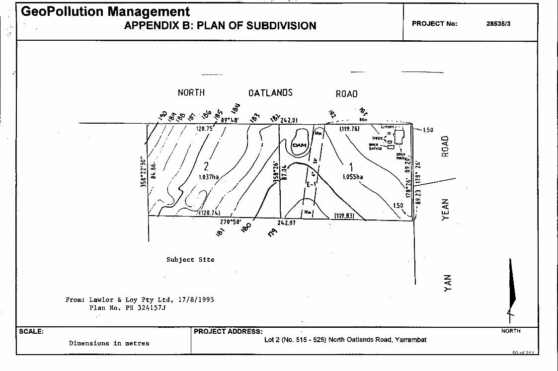
GeoPollution Management APPENDIX B: PLAN OF SUBDIVISION
SCALE:
Dimensions in metres
PROJECT No: I
PROJECT ADDRESS: NORTH Lot 2 (No. 515 - 525) North Oatlands Road, Yarrambat
2853513
NORTH OATLANOS
From: Lawlor & Loy Pty Ltd, 17/8/1993 Plan No. PS 3241575
ROAD
- 1.50 0 a 0 a
a Y
v
z W >
x 0 I I
a
z >- a 1
50 of 211
valrep.28535/3 6 GeoPollution Management
APPENDIX C: BORE LOGS
51 of 211

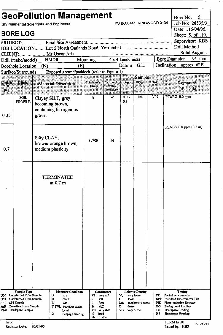
GeoPollution Management BoreNo: 1 Environmental Scientists and Engineers PO BOX 441 RINGWOOD 3134 Job No: 28535/3
Date:. . .16/04/96.. Sheet: . l . of . . lo .
Drill Method
BORE LOG PROJECT:.. ................. Final Site Assessment. JOB LOCATION ......... Lot 2 North Oatlands Road, Yarrambat .......................................
Drill (make/model) Hh4DII I Mounting 4 x 4 Landcruiser Bore Diameter 95 mm Borehole Locat' n (N) (E) Datum G.L. Inclination approx. level
................................................................. Supervisor: KBS
CLIENT: .................... ..Mr Oscar Arfi... .....,. Solid Auger.. ................... ..................................................... .
Surfac 'Surrour
SOL PROFILE
S Clayey SILT, containing some ferruginous gravel, grey, becoming brown
Silty CLAY, brown & orange brown, medium plasticity
TERMINATED at 1.5 m
SWSt M
0.0 - 0.35
vo I PIDBG: 0.0 ppm
PIDBH: 0.0 ppm (0.5 m)
PIDIBH: 0.0 pprn (1.5 m)
Consistency Relative Density vs verysofl VL veryloose PP PodcetPenetrometer s sofl L loose S P T StandardPenetrometerTest
I F f i I MD moderatelydew I PID PhotoionizationDetector
;ample Type US0 UndisturbedTubeSample D dry U63 UndisturbedTubeSample M moist
JAR ZmwHcadspaceSample VSWLStandmgWater st stiff D dense BO Background Reading SPT SPTSample w wet
VIAL HeadspaceSample Level vst vnystiff VD V e s y k BS BorespaceReading 3 Seepageentering H hard HS HeadspaceReadhg
Fb fiiable Issue: 3 FORM Ell01 Revision Date: 30/01/95 Issuedby: KBS 52 of 211
GeoPolIution Management BoreNo: 2 Environmental Scientists and Engineers PO BOX 441 RINGWOOD 3134 Job No: 28535/3
Date:. . .16/04/96.. Sheet: .2. of ..lo. Supervisor: KJ3S Drill Method
BORE LOG PROJECT:. .................. Final Site Assessment.. JOB LOCATION ......... Lot 2 North Oatlands Road, Yarrambat
................................................................ .......................................
I:1 SOIL
PROFILE Clayey SILT, containing some ferruginous gravel, grey, becoming brown
Silty CLAY, brown, orange brown, medium plasticity
TERMINATED at 1.0 m
- - ample Typ
US0 Undisturbed Tube Sample U63 Undisturbed Tube Sample SPT SPTSample JAR Zero-HeadrpaceSample VIAL HeadspsceSample
Moisture Condition D d r y M moist w wet v SWL Standing wata
Level 3 Seepagemtaing
I I
Issue: 3 Revision Date: 30lOll95
S
M
- Densit ase
........... v02 PIDBG: 0.0 ppm
PID/BH: 0.0 ppm (0.5 m)
PID/BH 0.0 ppm (1.0 m)
ockd Penetrometer ;tandard Penetrometer Test hobionization Delec(or
- Corn !ncy
vs verysoil VL ver s soft L loose F fm MD moderatelydease PID s t s t i f f D d e n s c BG thkgroundReading vst verystiff VD V n y Q n S e BS BorespaceReadiing H h a r d HS HeadspaceReadiing F% 6iable
FORM W101 Issuedby: KBS
53 of 211
I GeoPollution Management BoreNo: 3 Job No: 28535/3 Date:. . .16/04/96.. Sheet: .3. of ..lo.
Environmental Scientists and Engineers PO BOX 441 RINGWOOD 3134
BORE LOG PROJECT: ................... Final Site Assessment.. ................................................................ JOB LOCATION.. ...... .Lot 2 North Oatlands Road, Yarrambat .......................................
Supervisor: KBS Drill Method
meter 95 mm n approx. 4"E
..... Solid Auger.. . CLIENT:. .............. .......Mi Oscar Mi ............................................................................. I Mounting 4 x 4 Landcruiser I BoreD
Datum G.L. I IncIinat (refer to Fieure
(E) ock
n - s Exposed groundpar -
V03
VO4
Clayey Silt, light browrdwhite (mine tailings)
PDBG: 0.0ppm MD 0.0 - 0.35
0.4 - 0.7
0.35
1.05
1.6
PID/BS: 0.0 ppm (0.5 m)
PIDBS: 0.0 ppm (1 .O m)
Clayey SILT, grey becoming brown, containing ferruginous gravel
SOIL PROFILE
MD M
Silty CLAY, brown/ orange brown, medium plasticity
SWSt M
TERMINATED at 1.6 m
I -- RelativeDenslty I
VL veryloose L loose MD moderatelydeme D d e m e VD verydeme
ample Type I ~olsto~econdit ion m y vs verysoft s soft F f i r m St stiff VSt vervstiff
T d g PP PodcetPenetrometer SPT StandardPenetrwneterTest PXD Photoionization Deteaor BG Background Readiig BS BonspaceReadimg HS HeadspaceReadmg
FORM El101 Issuedby: KBS
D d r y
v SWL Standing water
M moist w wet
Level
US0 Ur turbedTubeSample U63 Undisturbed Tube. Sample SPT SPTSample JAR Zero-HeadspaceSample VIAL Headspace Sample
Issue: 3 Revision Date: 30/01/95 54 of 211
GeoPollution Management Znvironmental Scientists and Engineers PO BOX 441 RINGWOOD 3134
BORE LOG PROJECT:. ................. .Final Site Assessment.. ................................................................ IOB LOCATION.. ...... .Lot 2 North Oatlands Road, Yarrambat.. ..................................... n ,LENT:. .................... .Mr Oscar MI.. ....................... .:. ................................................. Drill (make/model) HMDII I Mounting 4 x 4 Landcruiser I BoreD
l ( N ) Datum G.L. I Inclinat Borehole Locati Surface/Surrour
PROFILE t s Exposed groundpad
Clayey Silt, light brown/white (mine tailings)
Clayey SILT, grey becoming brown, containing ferruginous gravel
Silty CLAY, brown/ orange brown, medium plasticity
TERMINATED at 1.0 m
Sample Type Moistnre Condition US0 Undisturbed Tube Sample U63 Undisturbed Tube Sample s ~ T SPTSample
ick (refer to Fimre
MD
SWSt
JAR ~ero-~eadspa~sample v SWL Standing water
3 Seepageentering VIAL HeadspaceSample Level
Issue: 3 Revision Date: 30/01/95
~
Y
M/D
M
M
- Con! s n q
vs verysofl s soft F f m s t s t i f f vst verystiff H hard Fb friable
............ - 0.0 - 0.25
0.35 - 0.55
- Relat
vo5
V06
l-
BoreNo: 4 Job No: 28535/3 Date: ... 16/04/96.. Sheet: .4. of ..lo. Supervisor: KBS Drill Method ..... Solid Auger ... imeter 95 mm
~~
In approx. 4" E
PIDiBG: 0.0 ppm
PIDiBS: 0.0 ppm (0.5 m)
PIDiBS: 0.0 ppm ( 1 .O m)
Testing PP Pocket Penetrometer SPT Standard Penetrometer Test
BG Background Reading BS Borespace Reading HS HeadspaceReadmg
VL veryloose
M) verydmse
FORM El101 Issuedby: KBS
55 of 211
I
GeoPol ution Management I BoreNo: 5 Environmental Scientists and Engineers PO BOX 441 RINGWOOD 31 34 No: 2853 5/3
Date:. . .16/04/96.. BORE LOG Sheet: .5. of ..lo. PROJECT:. .................. Final Site Assessment.. Supervisor: KBS COB LOCATION ........ .Lot 2 North Oatlands Road, Yarrambat ....................................... Drill Method
................................................................ ~~~ ~ .~
..................... .............................................................................. CLIENT: .Mr Oscar Arfi I .....Solid Auger... Drill (makdmodel) HMDII I Mounting 4 x 4 Landcruiser I BoreDiameter 95 mm BoreholeLocat: n (N) Datum G.L. [ Inclination approx. 6" E Surface/S urroui
I SOIL PROFILE
0.35
0.7
s Exposed groundpaddock (refer
Clayey SILT, grey becoming brown, containing ferruginous gravel
Silty CLAY, brown/ orange brown, medium plasticity
S
SWSt
TERMINATED at 0.7 m
M
............ - 0.0 - 0.3
- Relatl
U50 UI turbedTubeSample I D dty I vs verysofi- I n V T
-
V07 PIDBG: 0.0 ppm
PIDBS: 0.0 ppm (0.5 m)
- Density T*&? wwe I PP PocketPenetrometer
U63 UndistuMTubeSarnple M moist s soft L loose SPT Standard Penetrometer Test SPT SPTSample w wet F h MD moderatelyh P D PhotoionizationDetector JAR Zero-HeadspaceSarnple VSWLStandmgWater St StifF D dense BO Background Readiig VIAL HcadspaceSarnple Level vst v e r y m VD v e r y h BS BorespaceReadig
3 Seepageentering H hard HS HeadspaceReading Fb Gable
Issue: 3 FORM FA01 Revision Date: 30/0 1/95 Issuedby: KBS
56 of 211
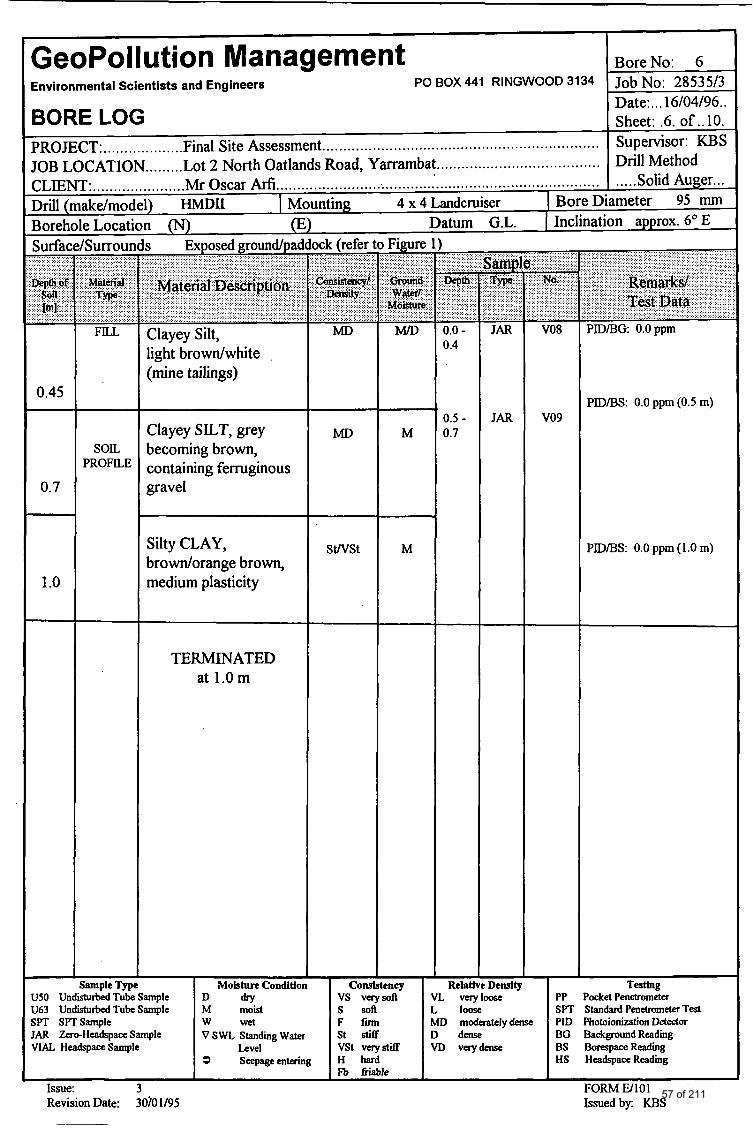
GeoPollution Management BoreNo: 6 Environmental Scientists and Engineers PO BOX 441 RINGWOOD 3134 Job No: 28535/3
Date:. . .16/04/96.. BORE LOG Sheet: .6. of ..lo. PROJECT: Final Site Assessment.. Supervisor: KBS JOB LOCATION ......... Lot 2 North Oatlands Road, Yarrarnbat ....................................... Drill Method CLIENT: ...................... Mr Oscar Arfi .................................................................................... Solid Auger...
................... ................................................................
Drill 6 ake/model) HMDII I Mounting 4 x 4 Landcruiser Bore Diameter 95 mm Boreh eLocati n (N) (E) Datum G.L. Inclination approx. 6' E
U63 Undisturbed Tube Sample
JAR Zero-HeadspaceSample VIAL H-Sanrple
SPT SPTSample
0.45
0.7
1 .o
M moist w wet v SWL Standing water
Level 3 Seepageentering
'Surroun
FILL
s sofl F f m st stiff vst v e r y m H hard F ~ J Sable
SOIL PROFILE
L loose SPT StandardPenetrometerTest MD moderatelydense PID Photoionization Detector D d e n s e BG BackgroundReadiig VD verydmse BS -Reading
HS HeadspaceReadiing
s Exposed groundlpaddock (refer
Clayey Silt, light browdwhite (mine tailings)
Clayey SILT, grey becoming brown, containing ferruginous gravel
Silty CLAY, browdorange brown, medium plasticity
TERMINATED at 1.0m
iample Type I MoistnroCondition
Issue: 3 Revision Date: 30101195
MD
MD
SWSt
M
M
- 0.0 - 0.4
0.5 - 0.7
- Relati
-
V08
V09
PIDIBG: 0.0ppm
PIDIBS: 0.0 ppm (0.5 m)
PIDIBS: 0.0 ppm (1 .O m)
- Density mse I PP PocketPenetrometex
57 of 211

I I
GeoPollution Management BoreNo: 7
Date: ... 16/04/96.. BORE LOG Sheet: .7. of ..lo. PROJECT:. .................. Final Site Assessment.. ................................................................ Supervisor: KBS JOB LOCATION ......... Lot 2 North Oatlands Road, Yarrambat ....................................... Drill Method
Environmental Scientists and Engineers PO BOX 441 RINGWOOD 3134 Job No: 28535/3
CLIENT: ...................... Mr Oscar Mi. ............................................................................. I ..... Solid Auger. .. Drill (make/model) HMDII I Mounting 4 x 4 Landcruiser I BoreDiameter 95 mm Borehole Location (N) (E) Datum G.L. I Inclination approx. 6' East Surface/Surrounds Exposed nroundluaddock (refer
0.7 -
1 .o
SOL I Clayey SILT, grey becoming brown, containing ferruginous I gravel
S
Silty CLAY, brown/ orange brown, medium plasticity
SWSt
I TERMINATED
at 1.0m
I I ample Tyue I ~olstnrecondition I cons
M
0.5
=ney J50 Undistu&T&eSample D dry vs verysofi 163 UndisturbedTubeSample M moist s soft ;PT SPTSample I w wet F fm
Relatl Density VL veryloose PP L loose SPT MD moderatelydeme PID
PID/BG: 0.0 ppm
PID/BS: 0.0 ppm (0.5 m)
odtet Penetrometer Xandard Penetrometer Test hotoionization Detedor
AR Z.er*HeadspaceSample VSWLStandmgWater St stiff D dense BG Ackground Reading /lAL Headspaci?Sample Level vst verystif€ VD V e r y k BS BorespaceReading
3 Seepageentering H hard HS HeadspaceReading n Wablc
Issue: 3 FORM El101 Revision Date: 30/01/95 Issuedby: KBS
58 of 211
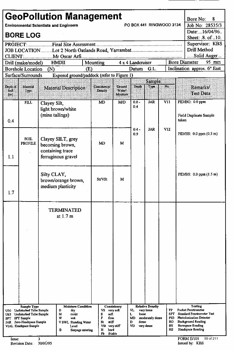
GeoPollution Management Environmental Scientists and Engineers PO BOX 441 RINGWOOD 3134
BORE LOG PROJECT:. .................. Final Site Assessment.. ................................................................ JOB LOCATION ......... Lot 2 North Oatlands Road, Yarrambat ....................................... CLIENT:. ......... Drill (make/moc Borehole Locati Surfac - ...................... .....................
...... ...Mr Oscar Arfi ...................... .....: ................................................. ..... Solid Auger.. . 9 HMDII I Mounting 4 x 4 Landcruiser I BoreDiameter 95 mm 1 (N) Datum G.L. I Inclination approx. 6" East
x k (refer ............
MD
Figure .................
M/D
s Exposed groundpad
. . .
0.4
............. 0.0 - 0.4
0.4 - 0.9
7
Relab
- JAR
JAR
~
Clayey Silt, light browdwhite (mine tailings)
PID/BG: 0.0ppm v11
v12
Field Duplicate Sample taken
PID/BS: 0.0 ppm (0.5 m) Clayey SILT, grey becoming brown, containing trace ferruginous gravel
SOIL PROFILE M
1.1
Silty CLAY, browdorange brown, medium plasticity
PID/BS: 0.0 ppm (1.5 m) SWSt M
1.7
TERMMATED at 1.7 m
- Density
VL velyloose L loose MD moderatelydense D d e n s e VD vqdense
- Sample Type Mofstnre Condition
U63 Undisturbed Tube Sample SPT SPTSample
VIAL HdspaceSample JAR Zero-Hdq=ceSarnple v SWL Standing water
Seepage entering
Cons ency vs velysolt s soft F f i r m st stiff vst VeryStifT H hard Fb friable
PP SP-I PID Photoionizalion Detector BG BadcgroundReadiing BS BorrspaceReadiing HS HeadspaceReadiing
Testink? hket Penetrometer Standard Penetrometer Test
1 FORM EA01 Issuedby: KBS
Issue: 3 Revision Date: 30/01/95
59 of 211
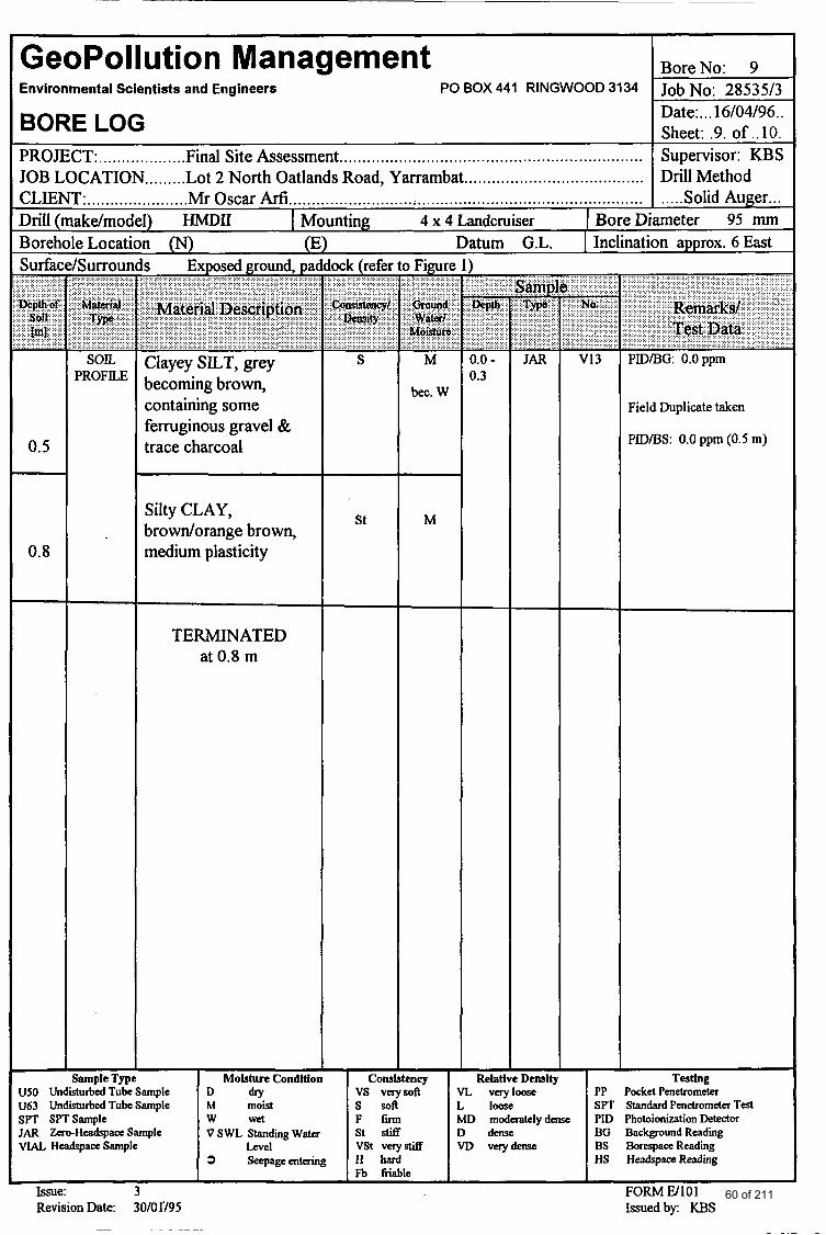
GeoPollution Management 1 BoreNo: 9 -
PO BOX 441 RINGWOOD 3134 1- Environmental Scientists and Engineers
BORE LOG Date:. . .16/04/96.. Sheet: .9. of ..lo.
PROJECT:. .................. Final Site Assessment.. ................................................................ JOB LOCATION ......... Lot 2 North Oatlands Road, Yarrambat ....................................... Drill Method
Supervisor: KBS
CLIENT: ..................... .Mr Oscar Arfi ........................... :. ................................................ I ..... Solid Auger ... Drill (make/model) HMDII ( M indcruiser I BoreDiameter 95 mm
atum G.L. I Inclination approx. 6 East Borehole Locati Surfac
0.5 -
0.8
/Sumour
SOIL PROFILE
n ( N ) 0 s Exposed ground, pal
Clayey SILT, grey becoming brown, containing some ferruginous gravel & trace charcoal
Silty CLAY, browdorange brown, medium plasticity
TERMINATED at 0.8 m
inting 4 x 4
ock (refer
S
St
Figure
M
bec. W
M
1 -
- 0.0 - 0.3
Relati
-
............ - JAR
Density Sample Type Moisture Condition Cons ency US0 UndisturbedTubeSample D dry vs verysoft VL veryloose U63 UndmrbedTubeSample M moist s soft L loose
VIAL HcadspaaSample Level vs1 verystiff VD verydeme
SPT SPTSample w wet F firm MD moderatelydeme JAR Z~~~Headq~accSample V S W L Standingwater st stiff D d e n s e
3 Seepageentering H Fb fiiable
Issue: 3 Revision Date: 30/01'/95
~ ~ ~~~~~~
PDD/BG: 0.0ppm
Field Duplicate taken
PID/BS: 0.0 ppm (0.5 m)
- Testing
PP PodtetPenetrometer SPT StandardPenetrometerTest PID Photoionization Detector BG Background Reading ES BorespaceReadiing HS HeadspaceReading
FORM El101 Issuedby: KBS
60 of 211
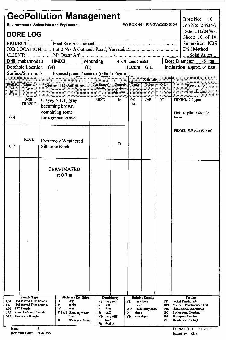
GeoPollution Management Environmental Scientists and Engineers PO BOX 441 RINGWOOD 3134
BORE LOG PROJECT: ................... Final Site Assessment.. ................................................................ JOB LOCATION ......... Lot 2 North Oatlands Road, Yarrambat ....................................... CLIENT:. .................... .Mr Oscar MI.. ........................ ;. .................................................
I) HMDII 1 Mounting 4 x 4 Landcruiser I BoreD n ( N ) (E) Datum G.L. I Inclinat
0.4
0.7
PROFILE
ROCK
s Exposed ground/paa
Clayey SILT, grey becoming brown, containing some ferruginous gravel
Extremely Weathered Siltstone Rock
TERMINATED at 0.7 m
D
Sample Type M o b Condition con! U50 UndisturbcdTubeSample D dry vs verysofl U63 UndisturbcdTubeSample M moist s soft
JAR Zero-HeadspaceSample VSWLStandmgWater St Stitf VIAL HeadspaceSample Level VSt verystiff
SPT SPTSample w wet F fm
9 Seepageentering H hard Fb friable
Issue: . 3 Revision Date: 30/0i/95
-
- 0.0 - 0.4
- Relat
VL vel
BoreNo: 10 Job No: 2853513 Date:. . .16/04/96.. Sheet: .lo. of .lo. Supervisor: KBS Drill Method ..... Solid Auger ... lmeter 95 mm In approx. 6'East
PlDBG: 0.0ppm
Field Duplicate Sample taken
PIDA3S: 0.0 ppm (0.5 m)
- Density
mse I PP PocketPenetrometer L loose MD modedelydeme D dense V D V e r y h
Tesiing
SPT StandardPenetrometerTeSt PID Photoionization m o r BG Background Reading BS Borespace Reading HS HeadspaccReadimg
FORM U101 61 of 211
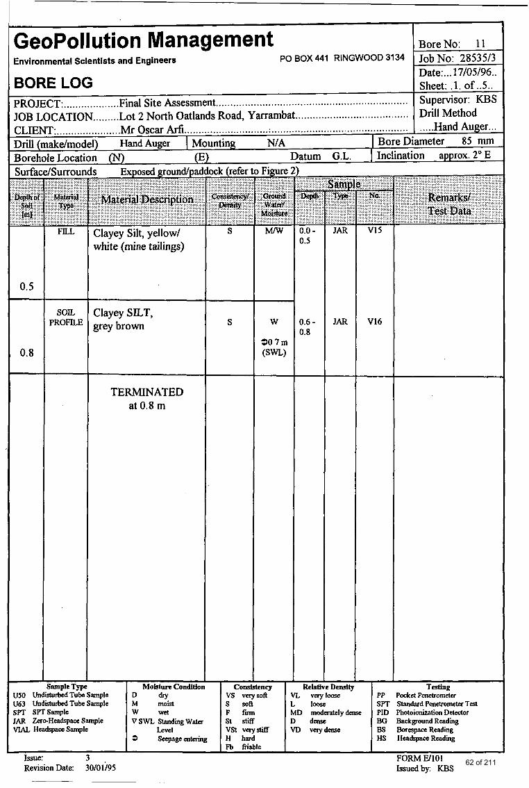
GeoPollution Management BoreNo: 1 1 Environmental Scientists and Engineers PO BOX 441 RINGWOOD 3134 Job No: 28535/3
Date:. . .17/05/96.. BORE LOG Sheet: . l . of . .5 . . PROJECT:. .................. Final Site Assessment.. Supervisor: KBS JOB LOCATION ......... Lot 2 North Oatlands Road, Yarrambat ....................................... Drill Method
................................................................
CLIENT: ...................... Mr Oscar Arfi ............................. ; ............................................... I ..... Hand Auger... Drill (make/model) Hand Auger I Mounting NIA I BoreDiameter 85 mm Borehole Location (N) (E) Datum G.L. I Inclination approx. 20 E
-
0.5
0.8
- LJSO Un
FILL
SOIL PROFILE
Surface/Surroun
Clayey Silt, yellow/ white (mine tailings)
Clayey SILT, grey brown T-
307m ( S W )
TERMINATED at 0.8 m
Sample Type I M o h C o n d l t f o n rturbed Tube Sample
661 Undisturbed Sample spT SPTSample IAR Zero-HeadspaceSample VIAL HeadspaaSample
~ ~
Issue: 3 Revision Date: 30/01;95
D d r y
v SWL Standing water
3 Seepageentering
M moist w wet
Level
- 0.0 - 0.5
0.6 - 0.8
-
- Relatl
V16
PP Pocket Penetrometer SPT Standard Penetrometer Test PID Photoionization Detector BG Background Reading BS BorespaceReadiing HS HeadspaceReading
FORM El101 Issuedby: KBS
62 of 211
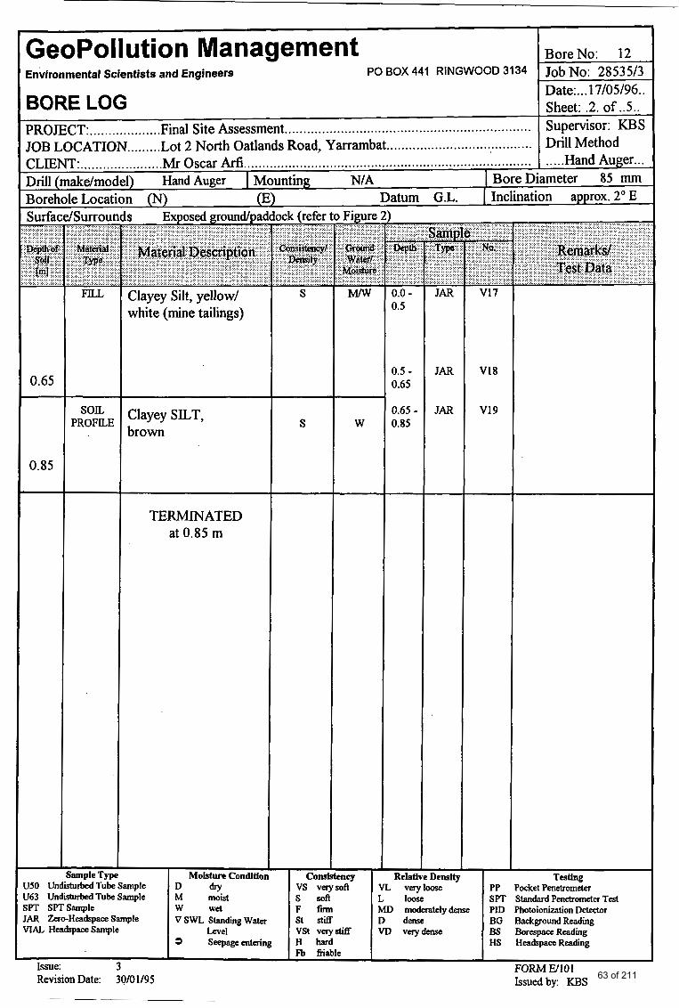
GeoPollution Management BoreNo: 12 Environmental Scientists and Engineers PO BOX 441 RINGWOOD 3134 Job No: 28535/3
Date: ... 17/05/96.. BORE LOG Sheet: .2. of . .5 . .
PROJECT:.. ............... ..Final Site Assessment.. Supervisor: KBS JOB LOCATION ......... Lot 2 North Oatlands Road, Yarrambat ....................................... Drill Method CLIENT:. .................... .Mr Oscar Arfi.. .....Hand Auger.. Drill (make/model) Hand Auger I MI rnthg NIA 1 Bore Diameter 85 mm Borehole Location (N) (E Datum G.L. [ Inclination approx. 20 E
................................................................
........................................................................... .
~
Surface/Surroun
0.65
0.85
SOIL PROFILE
3 Exposed groundpad
Clayey Silt, yellow/ white (mine tailings)
Clayey SILT, brown
TERMINATED at 0.85 m
xk (refer to Figure
MMI
S
iamsle Tme I MoLdurtCondltion I Corn
W
eney US0 UndisturdedT&Sample D dry vs verysoft U63 UndisturbedTubeSample M moist s soft
JAR Zer~HeadspaceSample VSWLStandiingWater st stiff VIAL HcadspaceSample Level vst Verystx
SPT SPTSample w wet F fm
3 Seepageentering H hard Fb fiiable
0.0 - 0.5
0.5 - 0.65
0.65 - 0.85
-
- Reiatj
JAR V18
JAR V19
T d l ? ?&et Penetrometer Standard Penetrometer Test Photoionization Detector MD moderattlydense PID
D dense BG Background Reading VD vetydense BS BorespaceReading
HS HeadspamReading I
FORM W101 Issue: 3 Revision Date: 30/01/95 Issuedby: KBS 63 of 211
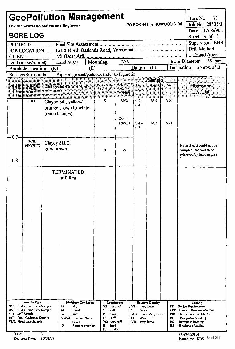
I
-- RelativeDensity I
GeoPollution Management BoreNo: 13 Environmental Scientists and Engineers Job No: 28535/3
Date: ... 17/05/96.. BORE LOG Sheet: .3. of . .5 . . PROJECT:. .................. Final Site Assessment Supervisor: KBS JOB LOCATION ......... Lot 2 North Oatlands Road, Yarrambat ....................................... Drill Method CLIENT:. .................... .Mr Oscar Arfi..
PO BOX 441 RINGWOOD 3134
..................................................................
.............................................................................. . ..Hand Auger.. Drill (makdmoc I) Hand Auger I Mounting NIA I BoreDiameter 85 mm
Surfac BoreholeLocat n (N) 1 atum G.L. I Inclination approx. 20 E
063 U n d d T u b e S a m p l e SPT SPTSample JAR ZemHeadspaceSample VlAL HcadspaceSample
/Surrour . . .
FILL
son PROFILE
M moist s soft L loose SPT Standard Penetrometer Test w wet F fm MD moderatelydense PID Photoionization Detedor VSWLStandingWater St stiff D derw BG Background Reading
Level VSt verystiff V D vcrydense BS BorrspaceReadiing 9 Seepageentering H hard HS HeadspaceReadiing
Fb friable
s Exposed groundlpad
Clayey Silt, yellow/ orange brown to white (mine tailings)
Clayey SILT, grey brown
TERMINATED at 0.8 m
S
;ample Type I ~oistnrecondttion -i7Z
Figure
M l w
304m
W
eney I
- 0.0 - 0.4
0.4 - 0.7
- JAR
JAR
v20
v2 1
Natural soil could not be sampled (too wet to be retrieved by hand auger)
turbedTubeSample I D dry I vs verysoft- I VL veryloose - I PP PocketPenetrom&r
64 of 211
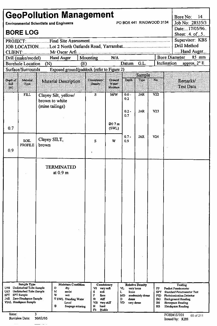
[ GeoPollution Management Environmental Scientists and Engineers
BORE LOG
PO BOX 441 RINGWOOD 3134
PROJECT: ................... Final Site Assessment.. ................................................................ I JOB LOCATION ......... Lot 2 North Oatlands Road, Yarrambat .......................................
BoreNo: 14 ~~
Job No: 28535/3 Date:. . .17/05/96.. Sheet: .4. of . .5 . . Supervisor: KEAS Drill Method .... .Hand Auger.. .
1) HandAuger I M n o 0
CLIENT: ..................... .Mr Oscar Mi.. ........................................................................... Drill (make/moc inting NIA I BoreDiameter 85 mm Borehole Locati Datum G.L. I Inclination approx. 20 E
SOIL PROFILE
Is Exposed groundpac
Clayey Silt, yellow/ brown to white (mine tailings)
Clayey SILT, brown
TERMINATED at 0.9 m
Figure . . . . .
. . . . . . . . . . M r w
30 7m ( S W )
W
) -
0.0 - 0.2
0.2 - 0.7
0.7 - 0.9
- Relatl
- JAR
JAR
JAR
v22
V23
V24
- ample Type Moisture Condition Cons :ncy Density
U50 UndisturbedTubeSample D dry vs verysoft VL veryloose PP PocketPenetrom&r U63 UndisturbcdTubeSample M moist s soft L loose SPT Standard Penetrometer Test SPT SPTSample w wet F f m MD modcratelydense PID Photoionization Detector JAR Zero-HeadspaceSample VSWLStandmgWater st stiff D dense BG Background Reading VlAL HeadspaaSample Level VSt verystitf VD veryderrpe BS BorespaceReading
3 Seepageentering H hard HS HeadspaceReadimg Fb fiiisble
Issue: 3 FORM J3101 Revision Date: 30/0'1/95 Issuedby: KBS
65 of 211

GeoPollution Management BoreNo: 15
Date:. . .17/05/96.. BORE LOG Sheet: .5. of . .5 . . PROJECT:. .................. Final Site Assessment. Supervisor: KBS JOB LOCATION ......... Lot 2 North Oatlands Road, Yarrambat ....................................... Drill Method CLIENT:. .................... .Mr Oscar Arfi.. Hand Auger.. Drill (make/model) Hand Auger I Mounting NIA I BoreDiameter 85 mm Borehole Location (N) (E) : atum G.L. I Inclination approx. 10 E
Environmental Scientists and Engineers PO BOX 441 RINGWOOD 3134 Job No: 28535/3
.................................................................
................................................................................. .
FILL
dSurrounds Exposed groundlpadi
SOIL PROFILE
Clayey Silt, orangehrown (mine tailings)
Clayey SILT, brown
TERMINATED at 0.5 m
MD M
- Sample Type Moisture Condition Consistency
US0 UndisturbedTubeSample D dry vs vcrysoft U63 UndisturbedTubeSample M moist s soft
JAR Zero-HeadspaceSample VSWLStandmgWater St stiff VlAL HeadspaceSample b e l vst vqst i f f
SPT SPTSample w wet F fm
3 Seepageentering H hard Fb fiiable
Issue: 3 Revision Date: 30/01/95
-
0.1 - 0.3
JAR
-
................
V25
Relel !Density VL vcryloose L loose MD moderatelydensc D dense VD verydensc
Testfng PP ?ocket Penetrometer SPI Standard Penetrometer Test PID Photoionization Detector BG Background Reading BS BorespaceReading HS HeadspaceRdmg
FORM W101 Issuedby: KBS
66 of 211
valrep.28535/3 &m GeoPollution Management
APPENDIX D: FINAL (NATA ENDORSED)
CHEMICAL ANALYSIS REPORTS
67 of 211
1 1 1 1 m AC.N. 005 085 521
3 Kingston Town Close, Oakleigh, Victoria, 3166 Postal Address: PO. Box 276, Oakleigh, Victoria, 3166
Telephone: (03) 9564 7055 Fax: (03) 9564 7190
9th May 1996
Dr K Schwab Geo Pollution Management PO Box 441 Ringwood VICTORIA 3134
Dear Madam
Please find enclosed the analysis reports for 28535 / 3 Yarrambat samples received 17.04.96 - MGT Report No. 1 1 1523 and 30.04.96 - MGT Report No. 1 1 1726.
Yours faithllly
68 of 211
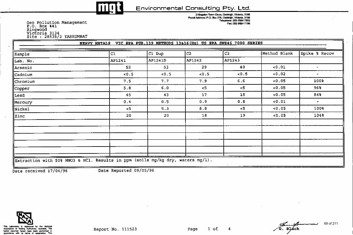
Environmental Consulting Pty. Ltd. 3 Khestm Town Close. Weigh. vicbria. 3166
r - - - Lab. No.
Arsenic
Cadmium
Geo Pollution Management P,O. Box 441 Rinswood
AP1241
52
c0.5
Postal Address: P.O. Box 276. oaldeigh. -lis. 3166 Telephone: (03) 9564 7055
Far (03) 9564 7190
53 c0.5
7.7
Viceoria 3134 Site : 28535/3 YARRUMBAT
HEAVY METALS V I C EPA PW.139 METHODS 1 3 & 1 6 ( H s ) US EPA SW846 7 0 0 0 SERIES
~~~
29 40 eo. 01 - c0.5 CO.5 eo. 02 - 7.9 6.6 c0. 05 100%
Samale I c1 I c2 I c3 IMethod Blank ISpike % Recov
Chromium Comer
7.5
5.8
I 84%
AP1241D ( M I 2 4 2 IAP1243 I I
Mercury Nickel
Zinc
0.4 0.5 0.9 0.8 eo . 01 - c5 5.3 8.8 cs c0. 05 100% 20 20 18 19 co.05 , 104%
6.0 I e5 I C5 I co.05 I 96%
I I I I I I I I I
I I I I I I
Extraction with 50% “03 & HC1. Results in ppm (soils mg/kg dry, waters mg/l).
Date received 17/04/96 Date Reported 09/05/96
Report No. 111523 Page 1 of 4 1%. 7 B ck 69 of 211
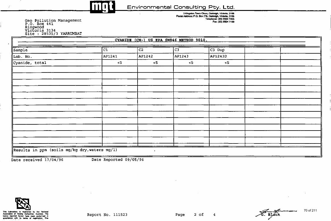
Environmental Consulting Pty. Ltd. 3 T m Ckse. OakleQh. *ria. 3166
%tal AddRss: P.O. BOX 276. W h h . -ria 3166
Sample Lab. No. Cyanide, total
Geo Pollution Management P.O. Box 441
c1 c2 c3 C3 Dup AP1243D AP1241 AP1242 AP1243
<5 c5 <5 <5
Rinawood VicEoria 3134 Site : 28535/3 YARRUMBAT
Results in ppm (soils mg/kg dry,waters mg/l) I' I]
, Date received 17/04/96 Date Reported 09/05/96
Report No. 111523 Page 2 of 4 70 of 211
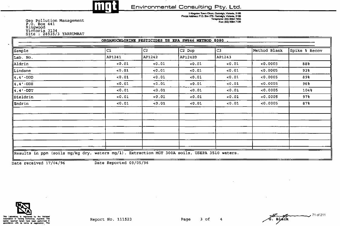
Environmental Consulting Pty. Ltd. 3 Khrrutm Tom Close. Oakleioh. V k b l i a 3166
-~ ORGANOCHLORINE PESTICIDES US EPA SW846 METHOD 8080 .
Sample I c1 I c2 IC2 Dup I c3 IMethod Blank Ispike % Recov
Geo Pollution Manasement
~~
Lab. No. Aldrin
- P:O. Box 441 Ringwood Victoria 3134 S i t e : 28535/3 YARRUMBAT
AP1241 AP1242 AP1242D AP1243
c o . 01 c o . 01 co.01 co. 01 c0.0005 88%
postal pddr;;ss: p.a BOX 276. M e & , -ria. 3166 Telephone: (03) 9554 7055
Fax: (03) 9564 7190
4,4'-DDD 4,4 ' -DDE 4,4 ' -DDT Dieldrin Endrin
co .01 c o . 01 co.01 co. 01 c0.0005 89% co. 01 <o * 01 co. 01 co. 01 co. 0005 96%
co. 01 <o. 01 co. 01 co. 01 c0.0005 104%
co. 01 <o .01 c o . 01 <o. 01 c0.0005 97% co. 01 <o. 01 co. 01 co. 01 co. 0005 87%
~
Results in ppm (soils mg/kg dry, waters mg/l). Extraction MGT 300A soils, USEPA 3510 waters.
1ILindane ~-
I co.01 I co.01 I co.01 I co.01 I <0.0005- --1- ~ 93%
I Date received 17/04/96
'1 Date Reported 09/05/96
Report No. 111523 Page 3 of 4 71 of 211
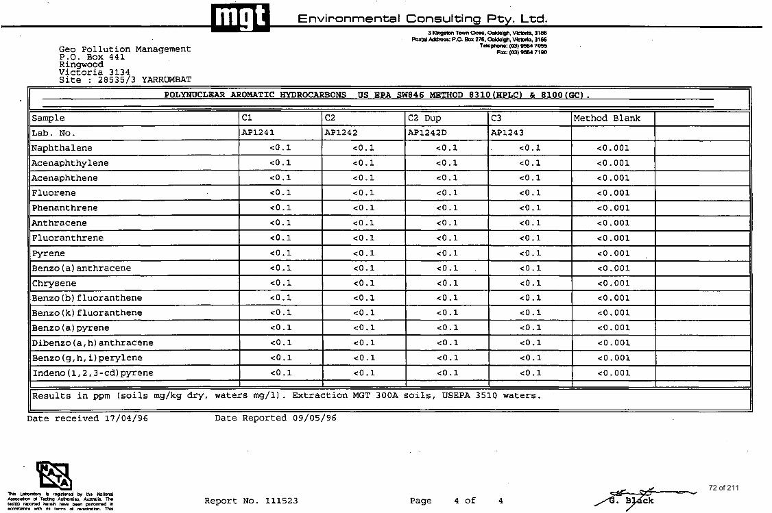
Environmental Consulting Pty. Ltd. 3 Khgstm Tavn Cbse. Oakeigh. \Moria, 3168
ketal Address: P.O. Box 276. Oakleigh. VHDCia. 3166 Telephone: (03) 9564 7055
Fax (03) 9584 71 90 Geo Pollution Management P,O. Box 441 Rinawood
Lab. No. Naphthalene
~- .a ~~~ V4ctoria 3134 Site : 28535/3 YARRUMBAT
-1241 AP1242 AP 12 4 2 D AP1243
co. 001 co.1 co.1 co.1 co.1
POLYNUCLESR AROMATIC HYDROCARBONS US EPA SW846 METHOD 8310(HPLC) & 8100(GC).
Sample 1 c1 I c2 IC2 Dup I c3 IMethod Blank I
Acenaphthylene Acenaphthene
co.1 co.1 co.1 co.1 co. 001 co.1 co.1 co.1 co.1 co. 001
~ ~~ ~~~
co. 001 Fluorene co.1 co.1 co.1 co.1
co. 001 Phenanthrene co.1 co.1 co.1 co.1
Anthracene co.1 co.1 co.1 co.1 co. 001
Fluoranthrene Fyrene
co. 001 co.1 co.1 co.1 co.1
co.1 co.1 co.1 co.1 co. 001
Benzo (a) anthracene Chrysene
~- ~
co.1 co.1 co.1 co.1 co. 001
co.1 co.1 co.1 co.1 co. 001 Benzo (b) f luoranthene- Benzo(k)fluoranthene
~ ~~~~
co.1 co.1 co.1 co.1 co. 001 co.1 co.1 co.1 co.1 co. 001
Report No. 111523
~
Benzo (a) pyrene Dibenzo (a, h) anthracene Benzo (g, h, i) perylene
Page 4 of 4
~ ~~
co.1 co.1 co.1 co.1 co. 001
co. 001 co.1 co.1 co.1 co.1
co.1 co.1 co.1 co.1 co. 001
/Fy--
- Indeno (1,2,3 -cd) pyrene co.1 co.1 co.1 co.1 co. 001 I I
I I I I Results in ppm (soils mg/kg dry, Waters mg/l). Extraction MGT 300A soils, USEPA 3510 waters.
72 of 211
Environmental Consulting Pty. Ltd. 3 Kingston Town Close. Oakleigh. Viaoria. 3166
Postal Address: P.O. Boa 276. OakIeQh. Vior ia, 3166 Telephone: (03) 564 7055
F a : (03) 564 7190
GRITER I A USED T O D S S OU ALITY CONTROL RESULTS
VALIDITY AN D RELlADlL lTY OFTEST RESULTS
The continuing mlidir) and rcliability of rcsults IS accomplishcd by nionitorttig a nuriibcr of factors :
I. Analysis ofduplicates. Duplicates run at a minintum o f 5 % 2. Recovery o f known additions. Spikes mn at a minimum of 5 % with u c h batch of ramplw. 3. Analysis o f reagent b l a h run with each batch of samples.
I. Annlvsis o f Dualicntu
Duplicates m malyred na a mancr o f course M d thc data andysed by means of a nngc chart type system. Thc m g c for each dupliute pair is dctcrmincd nnd 'iionnaliscd' bv dividing by thc avcrngc of thc duplicntc rcsults. Oncc cnough daw ha becn pthcrcd control data for u c h mcdlod can bc dcvclopcd. The mai l rangc (R) is dctcrmincd as :
R = ( Z R i ) -
n
whcrc n = numbcr o f observations M d Ri normaliscd nngC
and the varimcc (square of the standard deviation) is dctcrmincd as :
sr> = ( c 4' .nR:)
n - I The control criteria thus bccomc :
Avcrnge mgC R Wnming Limit R + 2sr Control Limit R + 3s,
The n o d i s c d range for cach duplicatc pair is ulculatcd and coniparcd with thc above criteria. (This can be achicvcd either graphically or by visual comparison o f thc data.) Sincc the l imiu are bvcd on 95 %and 90 % confidcncc lcvcls rcspcctivcly , the following actions am taken, bascd on these statistical parmeters.
Control Limi(
lfonc rnmsurcmcnt cxcccds thc C.L. rcput dic analysis. If the rcpcit IS witliiii tlic C.L continue analyses , If it.cxcccds thc C.L. discontinue ylalyscs and correct the lproblciii.
Wnrnine Limit
If two out o f thrn successive points cxcced thc W.L. m l y s c mothcr saniplc. If the iicst paiiit i s less than the W.L. conunuc analyses. if thc next point cxcceds tlic W.L. discoiitiiiiic analyscs and correct the problem.
***Particular can needs to be takcn with somc soil smplcs with regard to sainplc homogeneity. especially with regard to 'orgmiu' analysu. Statistical analysis inn). indicate a problcm exists whcn in fact thc problm is r d l y only saniplc honiogciicity.
2- n w i i n
The recovery of known additions is uscd to vcrify the nbscncc of matrix cflccts aid abrciicc of interferencrc. Recovery from srandards is uscd to verify mcthod pcrfonnmcc. Rccovcv data is compared agninst acccptancc criteria publirhcd in Stiurdardr Mcthods far E.uitiiisIIon 01' W a r nnd Waste wtcr. or appropriau: US. EPA Methods.
If recoveries fall outside acccptancc crikria, analyses should bc discontinued and the problcni rectified.
3.0 Annlvsis of Rcneent Dlnnkq
Reagent blanks m used to monitor purity o f rwgcnts and thc overall procedural blank. Rmgcnt blanks arc run iu a mancr o f course with each batch for analysis. Unusiial or out o f the harm* rcsulu for b l h arc invutiyslcd and corrcctin: action takcii before analysis of :my batch is complctcd.
73 of 211
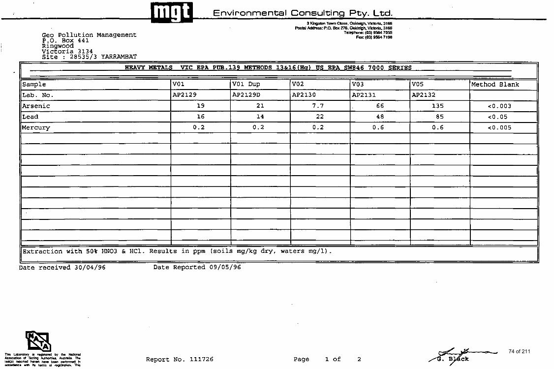
Environmental Consulting Pty. Ltd. 3 KbXlSbn Tom, Close. OaWebh. -ria 3166
Sample vo 1 Lab. No. AP2129
Arsenic 19
Lead 16
VO1 Dup vo 2 VO 3 V05 Method Blank AP2132 AP2130 AP2131 AP2 12 9D
21 7.7 66 135 c0.003 14 22 48 85 c0.05
Mercury
Report No. 111726
0.2 0.2 0.2 0.6 0.6 c0.005
Page 1 of 2 74 of 211
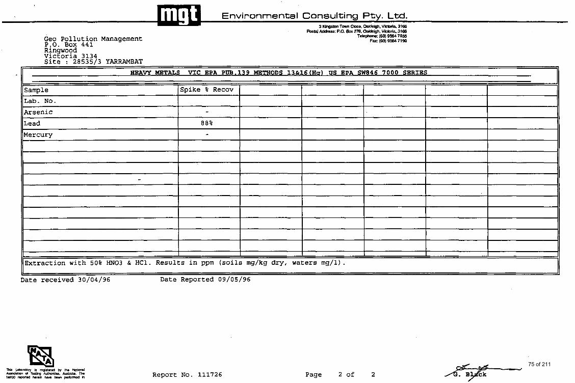
Environmental Consulting Pty. Ltd. 3 Kingstm Tavn Close. W e i g h . \MDlia. 3166
postal ~ d d r e s ~ : P.a BOX 276. Oakleiah. VM 3166
- H g A W METALS V I C EPA PW.139 METHODS 13&16(Hq) US EPA SW846 7000 SERIES
Sample Spike % Recov
Lab. No.
Geo Pollution Management P.O. Box 441
Arsenic
Lead
Mercury
Telephon;;: (03) 9564 7055 Far (03) 9564 7190
- 88% -
Extraction with 50% "03 & HC1. Results in ppm (soils mg/kg dry, waters mg/l).
Date received 30/04/96 Date Reported 09/05/96
Report No. 111726 Page 2 of 2 75 of 211

Environmental Consulting Pty. Ltd. 3 Kingston Town Close. Oahbigh. Vinoria. 3166
Postal Address: P.0. Boa 276. Oakleigh. vinoria. 3166 leleobne: (03) 564 7055
F a : (03) 564 7190 , I - CRITERIA USED TO ASSESS QUALITY CONTROL RESULTS
VALIDITY AND RELIABILITY OFTEST RESULTS
Thc conunuing validity and rcliability of rcsults is accomplished by monitoring a number of factors :
I. Annlysis o f duplicates. Duplicatu run at P minimum of 5 % 2. Rccovery of known additions. Spikes run at a minimum of 5 %with cadi bntch of
3. Analysis o f reagent blanlu run with each batch of samples. samplu.
I . Annlvsis o f Duo lie-
Duplicatu arc analysed Y a mancr of course and thc dam analyscd by mans of a rangc chan t)pc system. Thc range for each duplicate pair is dctcrmincd and 'normaliscd' bv dividing by thc average of thc duplicatc rcsulu. Ona enough dam h u b a n gathcnd control darn for cnch inellrod can be developed. The iiiwir rangc (R) is detcnnincd Y :
R =( TRi ) -
n
whcre n = number of obscrvations and Ri = normalired rnngc
and tho v a r i ~ c c (square of thc smdard deviation) is dctcrmincd as :
s; = -nR')
n - I The control critcria thus bccomc :
Avcragc m g c R Warning Limit R + 2sr Control Limit R + 3s,
The n o d i s c d m g c for cach duplicatc pair is calculated and comparcd with lhc abovc criteria. (This can be achieved cilhcr graphically or by visual comparison of thc dam.) Since the IimiU arc b u d on 95 % and 90 %confidcna lcvcls rcrpcctivcly , lhc following actions arc Inkcn. bvcd on thcs statistical paramctcrs.
Control Limit
If onc meaturwncnt c x d thc C.L. rcpcat tlrc analysis. If tlic rcpmt IS witlii i l the (: I continue d y s u . If i t p d the C.L. discontinue m l y s u and cormct I lto problciir.
Warninn Limit
If two out o f thrn succcssiw poinu e x 4 thc W.L. analysc anothcr snmplc. If tlic iicst poiill i s less than thc W.L. continue mlyscs. if lhc ncxt point cxcccds thc W.L. discoiitiinic ~irnlyncr and correct the pmblun.
'**Particular care n d s to be taken with somc soil smplcs with rcyard to saiii~ilc homogcncity. cspccially with regard to 'organics' mlyscs. Statistical nnalysis nmy iirdicntc J problcm cxisu whcn in fact thc problcm is m l l y only samplc Itornoguncity.
The recovery of known additions is uscd to vcrify thc abscnco of niatrix ctTocts atid absciicc of tntedcrcnm. Rcwvcry from sondards is uscd IO vcrify mcthod pcrfonnmcc. Rccovcry data is compand against acceptance criteria publishcd in Smdards Mcthods for Exmtnation of Water and Waste water. or appmpriatc US. EPA Mcthodr.
If rccoverics fall outsidc acaptylcc criteria. mlyscs should be discontinued and the problcni E C l i f i C d .
3.0 Analvsir ol Rengenr B I M ~
Reagent blanks m uscd to monitor purity of rmgcnts and thc overall procedural blank. Rcagcnt bids arc run u a mancr of coursc with cach batch for analysis. Unusiinl or nut of thc 'norm' rcsulu for blanks JIC invcstrgald =id corrective action tnkcii bcforc aii:rlysis o1';riry batch is complctd.
76 of 211
I v II v u u u u U Y U U V U . --. .--- AC.N. 005 085 521
3 Kingston Town Close, Oakleigh, Victoria, 3166 Postal Address: PO. Box 276. Oakleigh. Victoria, 3166
Telephone: (03) 9564 7055 Fax: (03) 9564 7190
5th June 1996
Geo Pollution Management P 0 Box 441 Ringwood 3134
Attention Dr Karin Schwab
Dear Karin
Please find enclosed the analysis results for Yarrambat 28535/3 - MGT Report No 112140.
Yours faithfully
M. Wright Laboratory Manager
77 of 211
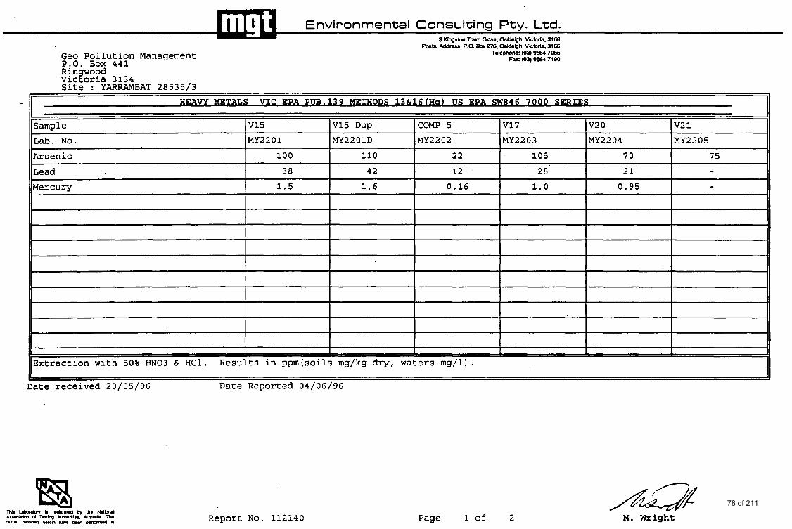
Environmental Consulting Pty. Ltd. 3 KlpSen Tavn Clare, Weigh, Vkbria. 3168
*tal Address: P.O. Box 276. Weigh , Vkbria. 3166
V15 MY2201
Geo Pollution Management P.O. Box 441
V15 Dup COMP 5 MY2201D MY2202
Telephon& (03) 9564 7055 Fax: (03) 9564 7190
VI7 MY2203
Ringwood Victoria 3134 Site : YARRAMBAT 28535/3
I HEAVY METALS VIC EPA PW.139 METHODS 13&16(Hs) US EPA SW846 7000 SERIES 1 v2 0 v2 1 MY2204 MY2205
Sample Lab. No.
I Arsenic Lead ~~
Mercury
100
38 110 22
42 12
105
2 8' 70 75
21 - 1.5 1.6 0.16 1.0
Extraction with 50% "03 & HC1. Results in ppm(soi1s mg/kg dry, waters mg/l).
Date received 20/05/96 Date Reported 04/06/96
0.95 -
Report No. 112140 Page 1 of 2 M. Wright 78 of 211
Sample v2 2 V2 3 Lab. No. MY2206 MY2207 Arsenic 87 42
- - 11 Lead I 17 I I I c0.05 I 96% I
V2 5 Method Blank Spike % Recov MY2208
90 c o . 01 -
Mercury
Extraction with 50% "03 & HC1. Results in ppm(soi1s mg/kg dry, waters mg/l).
Date received 20/05/96 Date Reported 04/06/96
4.6 - - co. 001 -
Report No. 112140 Page 2 of 2 M. Wright
79 of 211
Environmental Consulting P t y . Ltd. 3 Kingston Town Close, Oakleigh. Vinoria. 3166
Postal Address: P.O. Box 276. Oakhigh. Victoria. 3166 Telephone: (03) 564 7055
Fa: (03) 564 7190
CONTROL R E S m
The continuing validity and d i b i l i t y of mulu is accomplished by monitoring a numbcr of facton :
I. Analysis of duplicates. Duplicates run at a minimum of 5 % 2. Recovery of know additions. Sp*a run at a minimum of 5 % with each batch of
3. trnalyxir of reap t blanks run with each batch of samples sample$.
DuplicaIu am d y d 111 a mMtcI of mum and tho dam analyrod by lllco~u of a range chan typc system. Thc w e for cach dupliuto pair ir determined and ‘normaliscd‘ by dividing by thc avcra@ of the d u p l i w raulu. Once cnoua darn has ban @hered m n m l data for mch method cnn k dcvclopcd. Thc m u n range (R) ir dncnnined IU :
R - ( ZRi )
n
where n - number of obscrvntionr rtnd Ri - normalired rnngc
,
and the M ~ ~ M C C (square of the standard dcvinti~) is determined as :
s; - ( Z R i 2 - n R 2 ) I -
n - I Thc control criteria thur bccmne :
, Averageransc R warning Limit R + h , Convol Limit R + 36,
“he normalired m q c for ea191 duplicate pair is dculatcd and compared with thc nbovc crilcria. (This SM be achieved either mphically or by visual comparison of the data.) Since the limita (LIC based on 95 %and 90 %confidence IcveLc ~ p e n i v e l y , the following aclioht aretakcn. basedonthpc ltatirtical pllmmum.
If one mcsrurrmcnf ucads thc C.L. r g s t thc analysis. If thc rcput is within t c C.L continue analyau . If it exceeds thc C.L. discontinue analysu and comt thc problem.
. . . anti-
If Rn) out O f h ruccerrive points exceed thc W.L. analyse anolhcr m p l c . If Ihc next point is less than the W.L. continue analyses. if the next point excads rhc W.L. discontinue analyses and c o r n the problem.
***Particular can d to k &&en with some roil samples with regard to m p l c homogeneity. upccially with re& to ‘organics’ analyses. Statistical analysis may indicate a problem cxisu whm in Esa tbc problem is d l y only sample homogeneity.
Thc rrcovtry of know additions is used to verify thc absence of matrix cffffiu and abscncc of
is compared a g a h acccpmce criteria published in Standards Mcthodr for Examination of Water and W m water, or appropriatC U.S. EPA Methods.
If mver ies fall ouuidc acccptancc criaria, analysu ihould bc discontinued and h e problem , rectified.
w l v r i s of
Reagent blankr are ured to monitor purity of rcagcnl, and thc overall p d u r a l blmk. R a p t blanka (LIC run ar a matter of course with cach batch for analysis. Unusual or out of rhc ‘nom’ mulu for blanks 1110 invuugatod and corrcctivc action d e n bcforc analysis of M)’
batch is complcted.
llu&muu. Recovery fmm rtandardr is used to verify method performance. Rnovcry dam
M . Wright Laboratory Manager 80 of 211
1 1 1 ' 1 A.C.N. 005 085 521
3 Kingston Town Close, Oakleigh, Victoria, 3166 Postal Address: P.O. Box 276, Oakleigh. Victoria, 3166
Telephone: (03) 9564 7055 Fax: (03) 9564 71 90
2nd August 1996
Dr Karin Schwab Geo Pollution Management PO Box 441 RINGWOOD 3134
Dear Karin
Please find enclosed the analysis report for Yarrambat 28535 / 3 samples received 18.07.96 - Mgt Report No. 113220.
Yours fhithllly
M. Wright Laboratory Manager
81 of 211
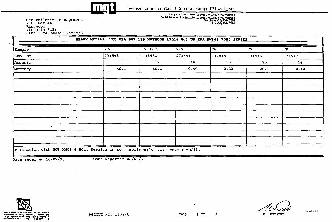
- HEAVY METALS V I C EPA PW.139 METHODS 13&16(Ha) US EPA SW846 7000 SERIES
Sample V2 6 V26 Dup V2 7 C6 c7 C8 Lab. N o . JY1543 J Y 1 5 4 3 D JY1544 JY1545 JY1546 JY1547
Arsenic 1 0 1 2 14 1 0 20 16
Mercury c o . 1
1' 11
Date received 18/07/96 Date Reported 02/08/96
co.1 0 .40 0 .22 co .1 0.10
Report No. 113220 Page 1 of 3 M. Wright 82 of 211

Postal Address: P.O. Box 276, Oaldeigh, Victoria, 3166, Australia Telephone: (03) 9564 7055
Fax: (03) 9564 7190 Geo Pollution Management P:O. Box 441 Rinswood
Sample
Lab. No.
VicEoria 3134 Site : YARRAMBAT 28535/3
V2 6 V2 7 C6 c7 C7 Dup C8 JY1543 JY1544 JY1545 JY1546 JY1546D JY1547
Cyanide, total c5 c5 c5 c5 c5 c5
Report No. 113220 Page 2 of 3 M. Wright 83 of 211
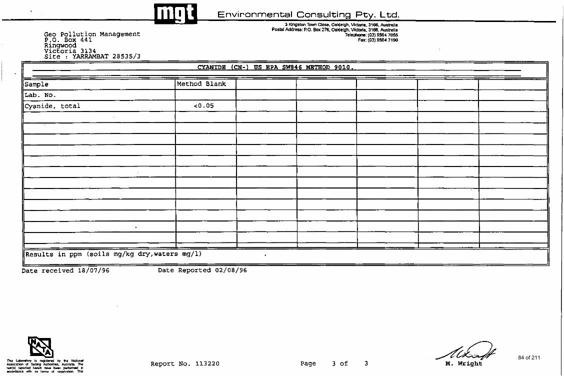
Ringwood Victoria 3134 Site : YARRAMBAT 28535/3
I I I [I CYANIDE (CN-1 US EPA SW846 METHOD 9010.
Sample Lab. No.
Cyanide, total
Method Blank
c0.05
~ ~
Results in ppm (soils mg/kg dry,waters mg/l)
Date received 18/07/96 Date Reported 02/08/96
Report No. 113220 Page 3 of 3 M. Wright 84 of 211
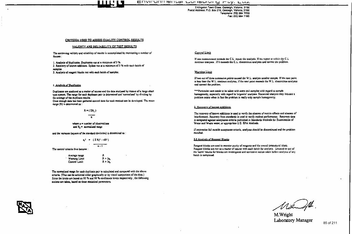
t n v i r u r i r i i e r i u ~ i LWI I=UIL,,II ~y r b y . LUU.
3 Kingrlon Town Close. Oaklelgh. Vlnoria, 3166 POIId Addrers: P.O. Box 276. OaWelph. VLaoria 3166
Telepbne: (03) 564 7055 I Fa: (03) 664 7180
I
The wntinuiq d i d i t y and reliability of resulu is accomplished by monitoring a numbcr of f a a n :
I , M y a b of dupliutu. Dupliutu IWI 81 a minimum of 5 % 1. Rocovvy of known dditions. Spiku IWI a[ a minimum of J Y. with cach batch of
I .- Dupliuto M Mllyrcd u a mancr of souno and tho data lnolyrod by means of a m g c chan rypc lyncm. Ths range for uch dupliute pair is d * C d and ' n o d i s c d ' by dividing by tho average of tho dupliute ruulu. On- mough data hu bocn plhurd control dnln for each wthcd w bc dcvclopcd. Thc mean w e (R) is dcccnnined OJ :
n
md the Wirncc (quam of h e tundard deviation) i: defermind M :
I -
n - I The sonrnl crilcrir (hur kcMle :
Avenge range R wamiq Limit R + 21, Conrnl Limit R t 3 4
Ifonc measuremen1 ucccdr thc C.L. npcnt rlu: nnnlyrir. If Ihc mpcnt is witllia I$ C.L continue onalyru . If it a& Ihc C.L. discontinue nnnlyru and sorrcct rhc problem.
If tw wf of thnc ruccarive poinu c x d tho W.L. ~ a l y r c nnothor ramplc. If thc MXI point is lur lhan Ihc W.L. continue nnnlyru. if thc ncxt point ex& thc W.L. dirsontinuc nnnlyrcs Md wmft tho problem.
***Particular 6(yc d I be IJlu, with some roil m p l u with regard to ramplc homogeneity, upcudly with rtgard to 'orpniu' ~ Y J U . Statistical Malyris mny indicntc a problem cxku whcn in fact tho problem is d l y only ramplc homogcncity.
The rccovcry of known additiw is d (0 veri@ thc obacncc of mnviX cflccu and nbrcncc of interferemu. Rcsovsy from ~lMdnrdr is used IO wiry mcthod pcr fomcc. Rccovely data ir wmparcd againat w p w c c criteria published in Swdardr Mcthadr for Eminntion of W a r and Wuts water. or l p p r o p h US. BPA Melhodr.
If recowriu fall ouuidu r s s e p m w criterin. d y s u rliould be discontinued and the problem Wtified.
Reagent blanlu arc used to monitor purity of rcqcnu nnd Ihc ovcrall proccdurnl blank. Reagent blanks arc run ru a mnmr ofwurrc with en& bntch for nnnlpir. Unusual or out of Ihe 'norm' rcrulrr for bl& a10 invuligatcd Md sorrcclivc action tnkcn bcforc nnnlytis of any batch is uunpleted.
The nomulited ran@ for cach duplicate pair is calculated and compared with thc abovc criterir. Since thc limiu ue based on 95 96 ud 90 % canfidence Icvelr respectively, the following actions arc rJles bud on thaa :uWul parameter:.
CUI bo rshiwcd cilhcr vphically or by visual comparison of tho dntn.)
M.Wright Laboratory Manager 85 of 211
A.E.N. 005 085 521
3 Kingston Town Close, Oakleigh, Victoria, 3166 Postal Address: P.0. Box 276, Oakleigh, Victoria, 3166
Telephone: (03) 9564 7055 Fax: (03) 9564 7190
21st March 1997
Geo Pollution Management P 0 Box 441 Ringwood 3134 .
Attention Dr Karin Schwab
Dear Karin
Please find enclosed the analysis results for Yarrambat - MGT Report No 1 17843.
Yours faithllly
Operations Manager
86 of 211
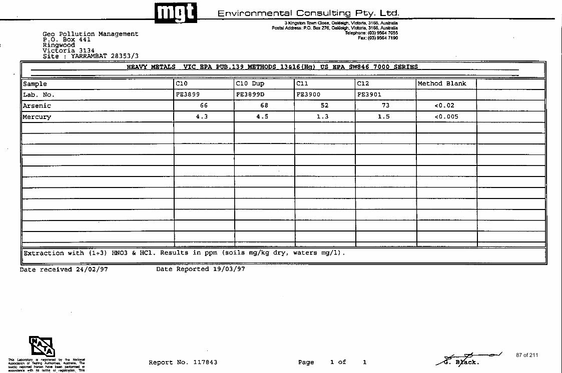
lJ&u I Environmental Consulting Pty. Ltd.
3 Kingston Tmvn Close, Oaldeigh. Victoria. 3166. Australia Postal Address PO Box 276, Oaldeim. Vlctotia, 3166, Australla
Telephone (03) 9564 7055 Fax (03) 9564 7190
Geo Pollution Management P:O. Box 441 Ringwood Victoria 3134 Site : YARRAMBAT 28353/3
~
HEAVY METALS V I C EPA PW.139 METHODS 13&16(Hq) US EPA SW846 7 0 0 0 SERIES II Sample c10 C10 Dup c11 c12 Method Blank
Lab. No. FE3899 FE3 8 9 9D FE3900 FE3901
Arsenic 66 68 52 73 e o . 02
Mercury 4.3 4.5 1.3 1.5 e o . 005
Extraction with (1+3) "03 & HC1. Results in ppm (soils mg/kg dry, waters mg/l) . Date received 24/02/97 Date Reported 19/03/97
Report No. 117843 Page 1 of 1 87 of 211

1 Postal Address: P.O. Box 276. Oaldeigh, Victoria, 3166. Australia Telephone: (03) 9564 7055
Fax: (03) 9564 7190
CRITERIA USED TO ASSESS OUALlTY CONTROL RESULTS
VALIDITY AND RELlADl L I I Y 01: TEST IlESUI.'I'S
The continuing validity and reliability of results 15 accuiiiplishcd by nionitoriiig a iiunibcr of factors :
I . Analysis o f duplicates. Duplicates run at a mininiuni of 5 % 2. Recovery of knoum additions. Spikes run at a minimum ofS % with WCII bxch of
3. Analysis of reagent blanks run with each batch o f sanlplcs. smplcs.
I .Jnnlvsir of Diidicntcs
Duplicates arc analyrcd as a matter of coursc orid thc data analysed by mcaiis o r a raiigc chnri rypc rysrcm. The ranngc for wch dupliwlc pair i s dctcniiiiicd and 'iiormaliscd' by dividing hy thc avcragc o f tlic duplicntc rcsults. Oncc cnough daw hns bccn gathcrul control dnt:~ for cach inctliod caii be dwclopcd. l'lic iiicaii raiigc (R) i s dctcniiincd as :
R = ( Z R i )
n
whcrc n = number of observations and Ri = nornialiscd nngc
and the variancc (squarc of thc rmdard dcviatioii) is dctcnnincd as :
sr: = ( Z Ki' .nR:)
n - I ' l l ic control criteria llius bcconic
Avcrayc rvigc K Warning Limit K + ZS,
Control Limit K + 3sr
Tlic nornialird rannc for wch duplicntc pair i s wlculatcd a i d coniparcd with the abovc critcria. (This wn bc achicvcd cithcr graphically or by visual comparison of the data.) Since thc h i t s arc bnscd on 95 % and 90 % confidence lcvcis rcspcctivcly , thc follotvitig actions arc taken. based on thcsc statistical parmctcrs.
control Linii l
If one mmsurcmcnt cvcrrds the C.L. rcpcat the analysis. If the rcpm is witliiii the C.L continuc analyscs . If it c x c d s thc C.L. disconlinuc mlyscs and corrcct the problcni.
Wernine Limit
If two out of thrcc successive points c a d thc W.L. amlyre anotlicr sample. I f ihc iicsi poiiit i s less than the W.L. wntinuc malyscs. i f thc neat point cxcceds thc W.L. discontiiiuc aialyscs and corrcct thc problcm.
***Panicular earc n d s IO bc takcn with somc soil smplcs with rcgard to samplc homogcncity. especially with rcgard to 'organics' mlyscs. Statistical analysis may indicate a problcm exists when in fact thc problcm is rcally only smplc homogcncity.
2 . Recovcrv a1 known ndditionr,
Thc rcwvcry of know additions is u r d to wri@ the abscncc o f m t r i x cffccts aid abrcncc o f intcrfcrcnccs. Recovery from standards is usd lo veri@ mcthod pcrfonmncc. Rccovcn data is cornpored against a m p m c c criteria publishcd in Standards Methods for Exmimtioii of Watcr and Waste water, or appropriatc U.S. EPA Mcthcds.
If rccoverics fall outsidc a m p m c c criteria. mlyses should bc discontinucd and the problcm rectified.
3.0 Annlvrir of Heneenl Olnnks
Rcagcnt blanks arc uscd to monitor purity of rwgcnts and Uic overall proccdural blank. Ilwgcnr b l d s arc run ss a matfcr o f wursc wiUi each batch for analysis. Unusual or OUI o f the horni' results for blvllrs arc invcrligatcd and corrective actioii takcn bcforc aiialysis o f m y batch is complctul.
88 of 211
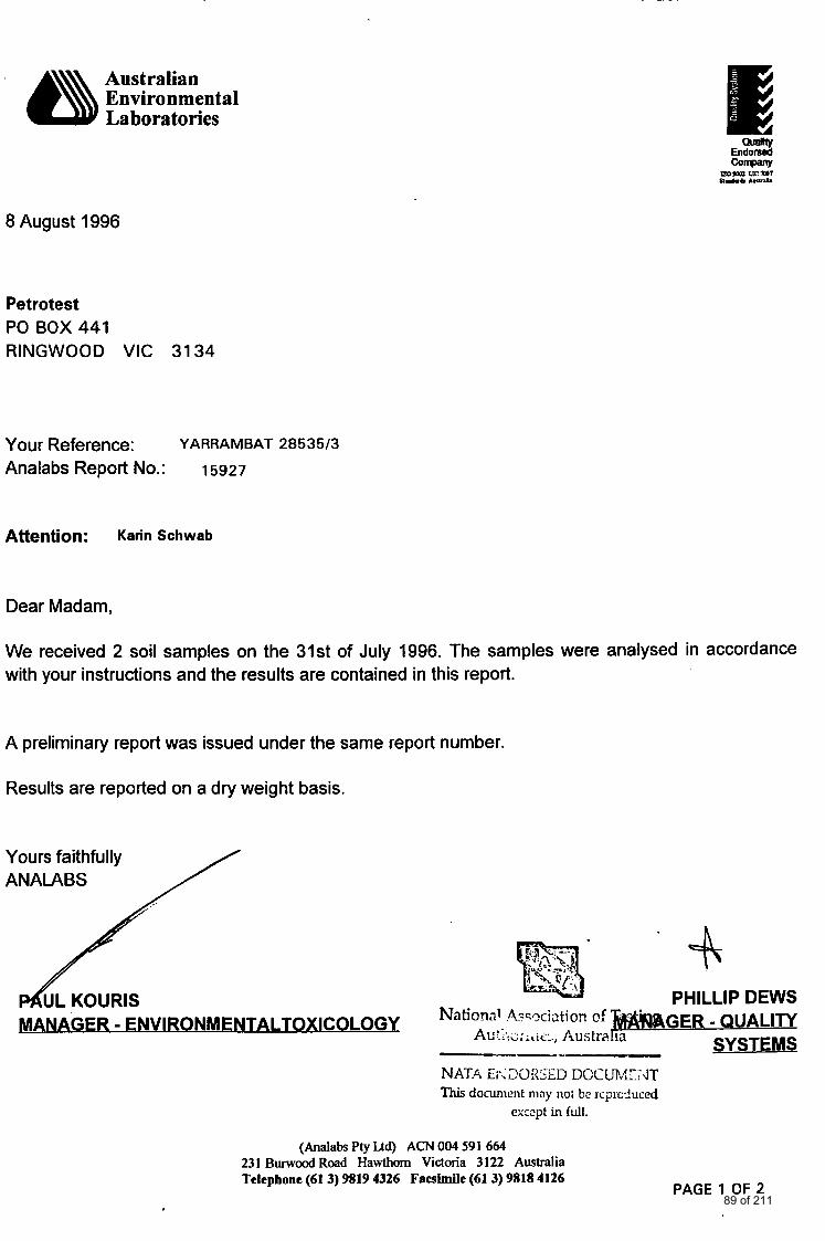
Australian Environment a1 Laboratories
8 August 1996
Petrotest PO BOX 441 RINGWOOD VIC 3134
Your Reference: Analabs Report No.: 15927
Y ARRAM BAT 285 3513
Attention: Karin Schwab
Dear Madam,
We received 2 soil samples on the 31st of July 1996. The samples were analysed in accordance with your instructions and the results are contained in this report.
A preliminary report was issued under the same report number.
Results are reported on a dry weight basis.
Yours faithfully ANAIABS
Q p$ '.:---
b/... ..
PHILLIP DEWS
SYSTEMS National &qciatior! of - QUALITY
Ar: :.>G iric:., Austra MANAGER - ENVIRONMENTALTOXICOLOGY ---- NAT.4 Ei*<L?C)RSE.D DCCUP,.EJT This document may not be Jcpciuced
exczpt in full.
(Analabs Pty Ua) ACN 004 591 664 231 B u r w d Road Hawthorn Victoria 3122 Australia Telephone (61 3) 9819 4326 Facsimile (61 3) 9818 4126
PAGE 1 OF 2 89 of 211
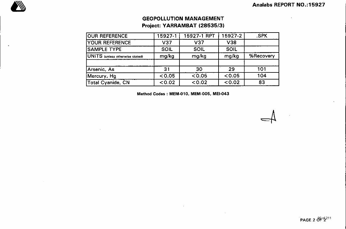
Analabs REPORT NO.:15927
YOUR REFERENCE SAMPLE TYPE
GEOPOLLUTION MANAGEMENT Project: YARRAMBAT (28535/3)
v37 v37 V38 SOIL SOIL SOIL
IOUR REFERENCE I 15927-1 I 15927-1 RPT I 15927-2 I .SPK 1
UNITS (unless otherwise stated) mg/kg mg/kg mg/kg %Recovery
Arsenic, As Mercurv. Ha
31 30 29 101 < 0.05 c 0.05 0.05 104
ITotal Cvanide, CN I c0.02 I c0.02 I c0.02 I 83 I
M e t h o d Codes : MEM-010, M E M - 0 0 5 , MEI-043
PAGE 2 OF 2 90 of 211
6Analabs Analabs Pty. Ltd. ACN 004 591 664 231 Burwood Road Hawthorn, Victoria 3 122 Telephone: (03) 9819 4326 Facsimile: (03) 9818 4126
28 April 1996
Geo-Pollution Management P 0 Box 441 RINGWOOD VIC 3134
Your Reference: Analabs Report No.: 14745
Y ARRAM BAT 285 3513
Attention: Karin Schwab
Dear Madam,
We received 1 soil sample via MGT on the 23rd of April 1996. The sample was analysed in accordance with your instructions and the results are contained in this report.
A preliminary report was issued under the same report number.
Results are reported on a dry weight basis.
Yours faithfully ANALABS
&PETER DIMIS FRACI. FRMIT Chartered Chemist TECHNICAL CONSULTANT
PAUL KOURIS Sc Grad Dip Anal Chem
MANAGER - MRACI
ENVIRONMENTALTOXICOLOGY
PAGE 1 OF 4 91 of 211

Analabs REPORT NO.:14745
OUR REFERENCE YOUR REFERENCE
14745-1 14745-1 RPT . SPK c 4 c4
SAMPLE TYPE u N ITS (unless otherwise stated)
SOIL SOIL mg/kg m d k g %Recovery
Arsenic, As Cadmium, Cd Chromium, Cr Copper, Cu Lead, Pb
37 43 98 0.9 1.1 95 6 8 94 6 6 101 10 11 91
Method Codes : MEM-010, MEM-005, MEI-043
Nickel, Ni Zinc, Zn
PAGE 2 OF 4
1 1 91 9 9 95
Mercury, Hg Total Cyanide, CN
0.78 0.81 75 0.02 - -
92 of 211
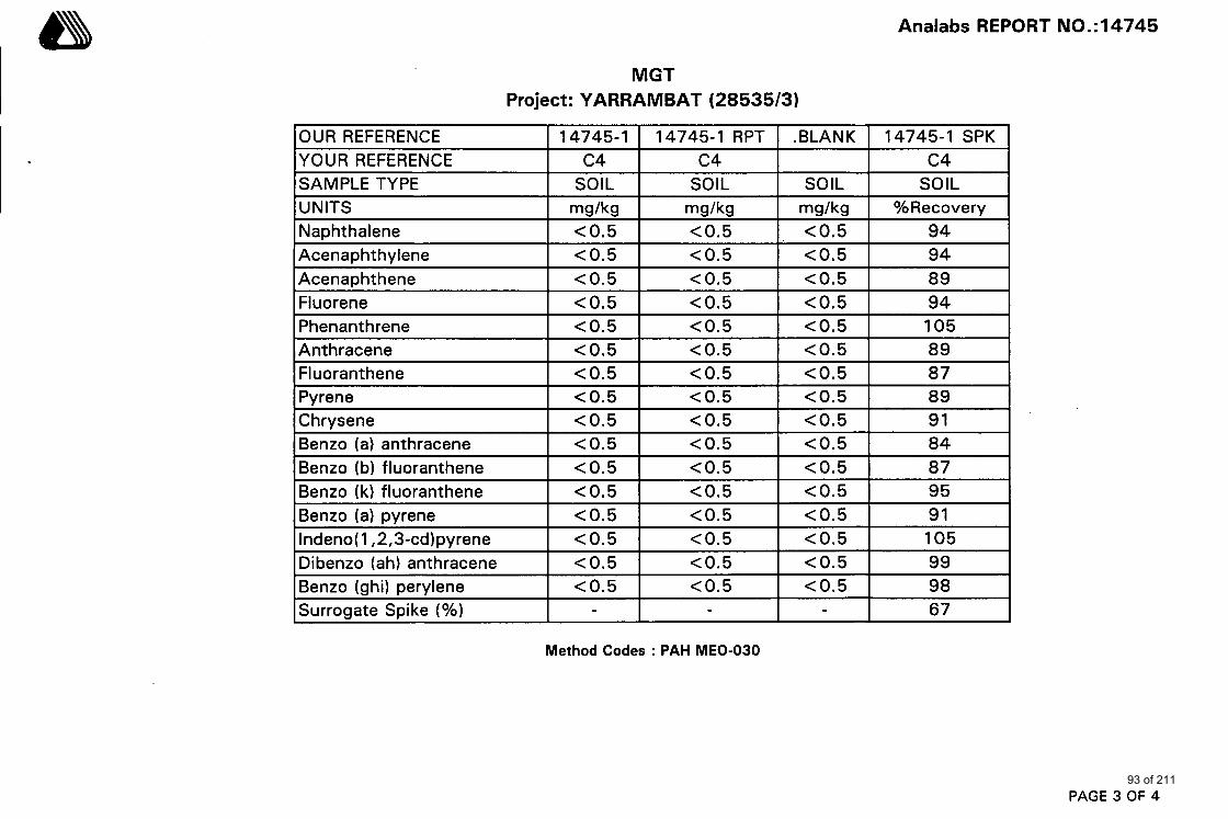
Analabs REPORT NO.:14745
YOUR REFERENCE SAMPLE TYPE
MGT Project: YARRAMBAT (28535/3)
c4 c4 c4 SOIL SOIL SOIL SOIL
OUR REFERENCE I 14745-1 I 14745-1 RPT I .BLANK I 14745-1 SPK
Naphthalene Acenaphthylene Acenaphthene Fluorene Phenanthrene Anthracene
<0.5 <0.5 < 0.5 94 <0.5 <0.5 <0.5 94 <0.5 < 0.5 < 0.5 89 <0.5 < 0.5 <0.5 94 <0.5 <0.5 < 0.5 105 < 0.5 < 0.5 < 0.5 89
Fluoranthene Pyrene C hrysene Benzo (a) anthracene Benzo (b) fluoranthene
<0.5 <0.5 < 0.5 a7 < 0.5 < 0.5 <0.5 89 < 0.5 < 0.5 <0.5 91 < 0.5 < 0.5 <0.5 84 <0.5 <0.5 < 0.5 87
Benzo (k) fluoranthene Benzo (a) pvrene
<0.5 <0.5 < 0.5 95 <0.5 <0.5 < 0.5 91
Indeno( 1,2,3-cd)pyrene Dibenzo (ah) anthracene
Method Codes : PAH MEO-030
<0.5 <0.5 < 0.5 105 <0.5 <0.5 <0.5 99
PAGE 3 OF 4
Benzo (ghi) perylene Surrogate Spike (%)
<0.5 <0.5 <0.5 98 - - - 67
93 of 211
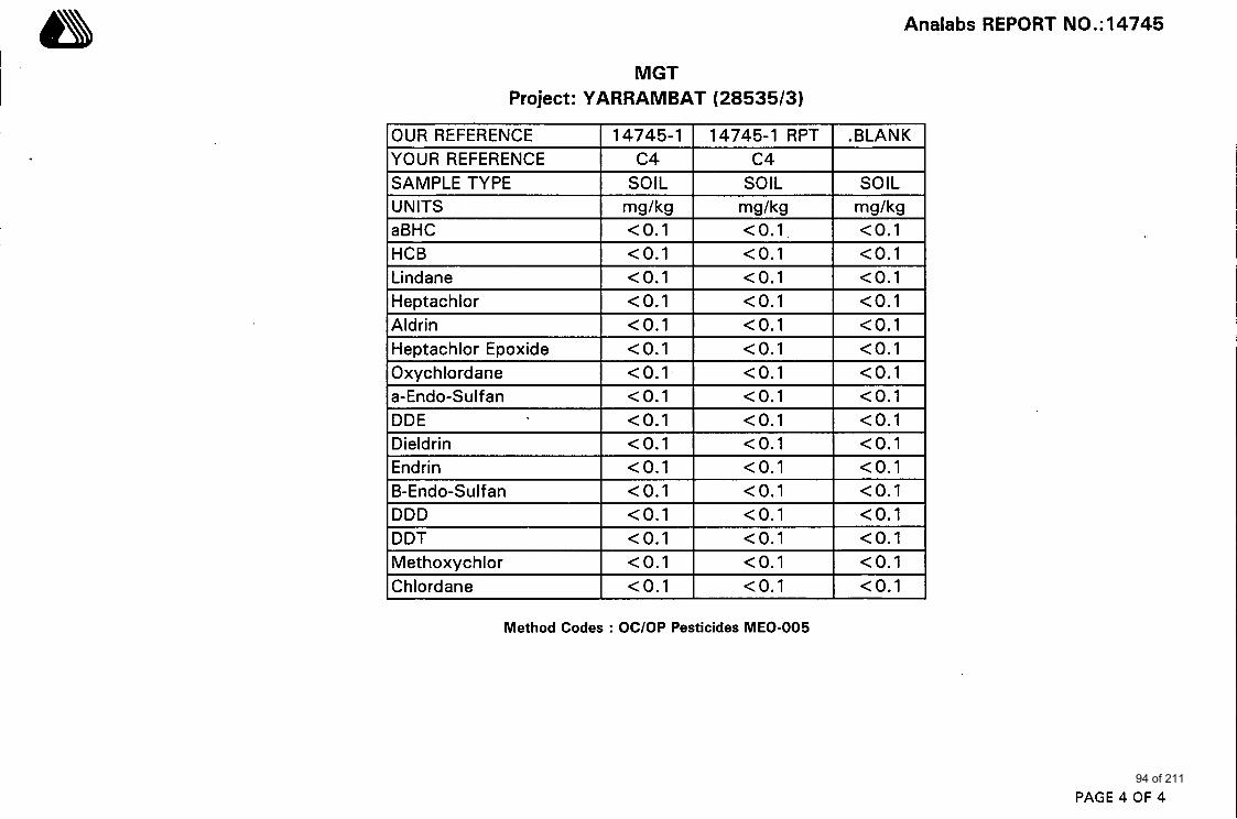
Analabs REPORT NO.:14745
I Dieldrin I <0.1 I <0.1 I <0.1 I
OUR REFERENCE YOUR REFERENCE SAMPLE TYPE UNITS
14745-1 14745-1 RPT .BLANK
SOIL SOIL SOIL mg/kg mg/kg mg/kg
c4 c4
aBHC HCB Lindane
<0.1 <0.1 <0.1 <0.1 <0.1 <0.1 <0.1 <0.1 <0.1
Heptachlor Aldrin
<0.1 <0.1 <0.1 <0.1 <0.1 <0.1
Heptachlor Epoxide Oxyc hlordane
<0.1 <0.1 <0.1 <0.1 <0.1 <0.1
Method Codes : OC/OP Pesticides MEO-005
a-Endo-Sulfan DDE
PAGE 4 OF 4
<0.1 <0.1 <0.1 <0.1 <0.1 <0.1
Endrin 6-Endo-Sulf an DDD DDT
<0.1 <0.1 <0.1 <0.1 <0.1 <0.1 <0.1 <0.1 <0.1 <0.1 <0.1 <0.1
Methoxychlor Chlordane
<0.1 <0.1 <0.1 <0.1 <0.1 <0.1
94 of 211
valrep.28535I3 (, #) GeoPollution Management
APPENDIX E: CHAIN OF CUSTODY DOCUMENTATION
95 of 211
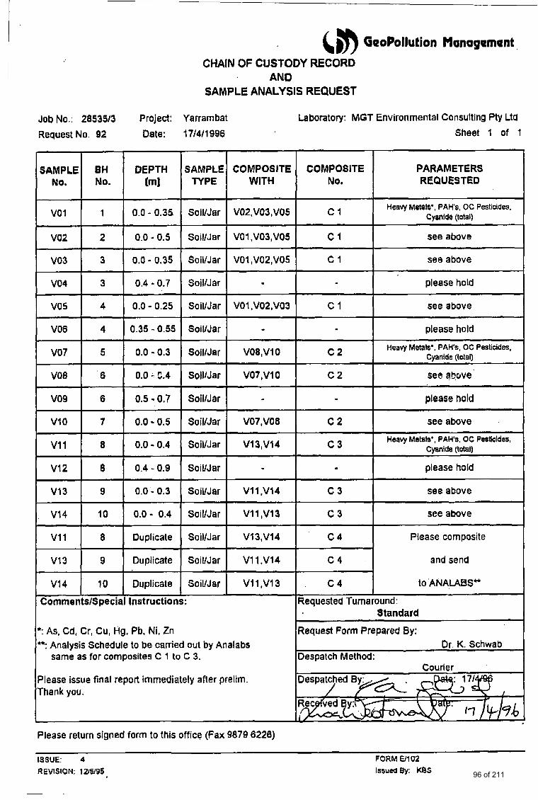
6 8 GeoPollutSon Managamant
vo 1
CHAJN OF CUSTODY RECORD AND
SAMPLE ANALYSIS REQUEST
I
Heavy Metals', PAHs, OC PesticiUes. Cyanlde (total) 1 0.0 - 0.35 Soil/Jar VO2,VO3,VO5 c i
Job No.: 285333 Project: Yarrambat Laboratory: MGT Environmental Consulting Pty Ltd
Request No. 92 Date: 17/4/1996 Sheet 1 of 1
V03
V04
V05
V08
I I I I I I
3 0.0 - 0.35 SoiVJar VO1 ,V02,V05 c 1 see above
3 0.4 - 0.7 SoillJar please hold
4 0.0 - 0.25 SoiVJar VOl ,V02,VO3 c 1 see above
4 0.35 - 0.55 SoiVJar - please hold
PARAMETERS REQUESTED
V07 Heavy Metals', PAH's, OC Pesticides, Cyanide (total) 5 0.0 - 0.3 SoillJar VO8,VIO c2
V02 I 2 1 0.0 - 0.5 I SoillJer [ VOl,V03,VO5 I C 1 I see above
V08
vo9
V l 0
v11
v12
V13
V I 4
v11
6 0.0 - 5.4 SoillJar V07,VlO c2 see above
6 0.5 - 0.7 SoillJar - . please hold
7 0.0 - 0.5 SoiVJar V07,VOa c 2 see above
Heavy Metals', PAHs. OC Pesticides, Cyanide (total) 8 0.0 - 0.4 SoiVJar V13,V14 c3
8 0.4 - 0.9 SoilNar - please hold
9 0.0 - 0.3 Soil/Jar V1 I ,VI4 c 3 see above
10 0.0 - 0.4 SoilNar V I 1 ,V13 c 3 see above
8 Duplicate SoiVJar V13,V14 c 4 Please composite
V14 10 Duplicate SoiVJar V l I ,V13 c 4 to ANA,LABSH
~~ ~ ~~ ~~
V13 I 9 I Duplicate I SoillJar I V l l . V l 4 I C 4 I and send
CornmentslSpecial Instructions: Requested Turnaround: Standard
': As, Cd, Cr, Cu, Hg, Pb, Ni. Zn Form Prepared By: Or. K. Schwab
Despatch Method: - Despatched By>...- Courier
": Analysis Schedule to be carried out by Analabs same as for composites C 1 to C 3.
Please issue final report immediately after prelim. Thank you.
Please return signed form to this office (Fax 9870 6228)
ISSUE: 4 FORM €3102
REVISION; 12/5/95 Issued a/: KBS 96 of 211
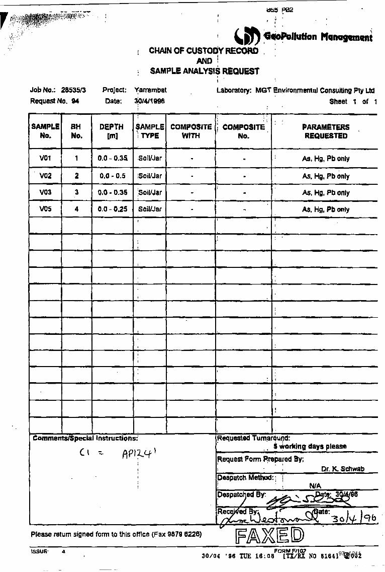
I
DEPTH [ml
0.0 - 0.34
0,O - 0.5
O,b - 0.35
0.0 - 025
~
I
I
1
I Instructions:
, ; a
I
. . * : I 2
SAMPLE COMPOSITE COMPOSITE ' ' PARAMETERS . 'j TYPE WtTH No. REQUESTED
SoiVJar - - As, Hg, Pb only
SoiVJar - As, Hg, Pb only
$oiUJar - A$, Wg, Pb only
Sail/Jar - - As, Hg, Pb only I 1 I
. . L
I
I
9
1
I
I
: !
!
Requested Tumar6ur.W
i CHAINOFCUSTOOYRECOCIO . '
AND : SAMPLE! ANALYSIS REQUEST
I
Job No.: 2W35/3 Project: Yammbat Laboratory: MGT Environmental Consulting Ply UQ RequestNo. 04 Date: 3014l1938 Sheet 1 of 1
I
= A P l Z y '
,
* I S warking days pleasa
Request Form P,repered By:
Despatch Method: : j
. I
, Dr. K SchWb
vo1 I 1
SAMPLE NO.
v02 1 2
8H No,
- ~ I
7
+ * I
Cmments/Specii
e:
Please return signed form to this offlce (Fax 9878 6226)
mSU6. 4 FORM FJ1 W JO/OU ' 9 6 TU€ l6:08 [TX/RX NO 81611 a 0 0 2 97 of 211
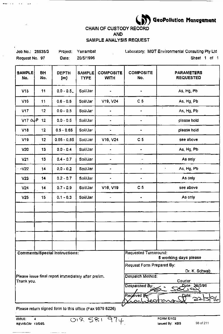
&$) GeoPollutSon Management CHAIN OF CUSTODY RECORD
AND SAMPLE ANALYSIS REQUEST
Job No.: 28535/3 Project: Yarrambat Laboratory: MGT Environmental Consulting Pty Ltd
SAMPLE TYPE
Request No. 97 Date: 20/5/1996
COMPOSITE WITH
0.0 - 0.5,
0.6 - 0.8
V17 12 0.0 - 0.5
.
c5
. -
0.0 - 0.5
0.5 - 0.65
v19 0.65 - 0.85
-~
As, Hg, Pb
please hold
please hold
see above
As, Hg, Pb
As only -
As, Hg, Pb
V20 I 13 I 0.0 - 0.4
SoilNar
Soil/Ja r
SoilIJar
SoiVJat
Soil/Jar
V21 I 13 I 0.4- 0.7 - .
Vl6. V19
-
0.0 4 0.2
0.2 - 0.7
V24
V25
0.7 - 0.9
0.1 - 0.3
I
SoiVJar
Soil/Jar V19, V24 t SoiVJar
Soil/Jar
SoiVJar
Soil/Jar I -
CommentslSpecial Instructions:
Please issue final report immediately after prelim. Thank you.
Sheet 1 of 1
I COMPOSITE
No. PARAMETERS REQUESTED
As, Hg, Pb
As, Hg, Pb
As only
see above
As only
I
iequested Turnaround:
iequest Form Prepared By:
5 working days please
Dr. K..Schwab 2espatch Method;
L Please return signed form to this office (Fax 9879 6226)
ISSUE: 4
REVISION. 1ZS195
FORM El102 0%. ./ IssuedBy: KBS 98 of 211
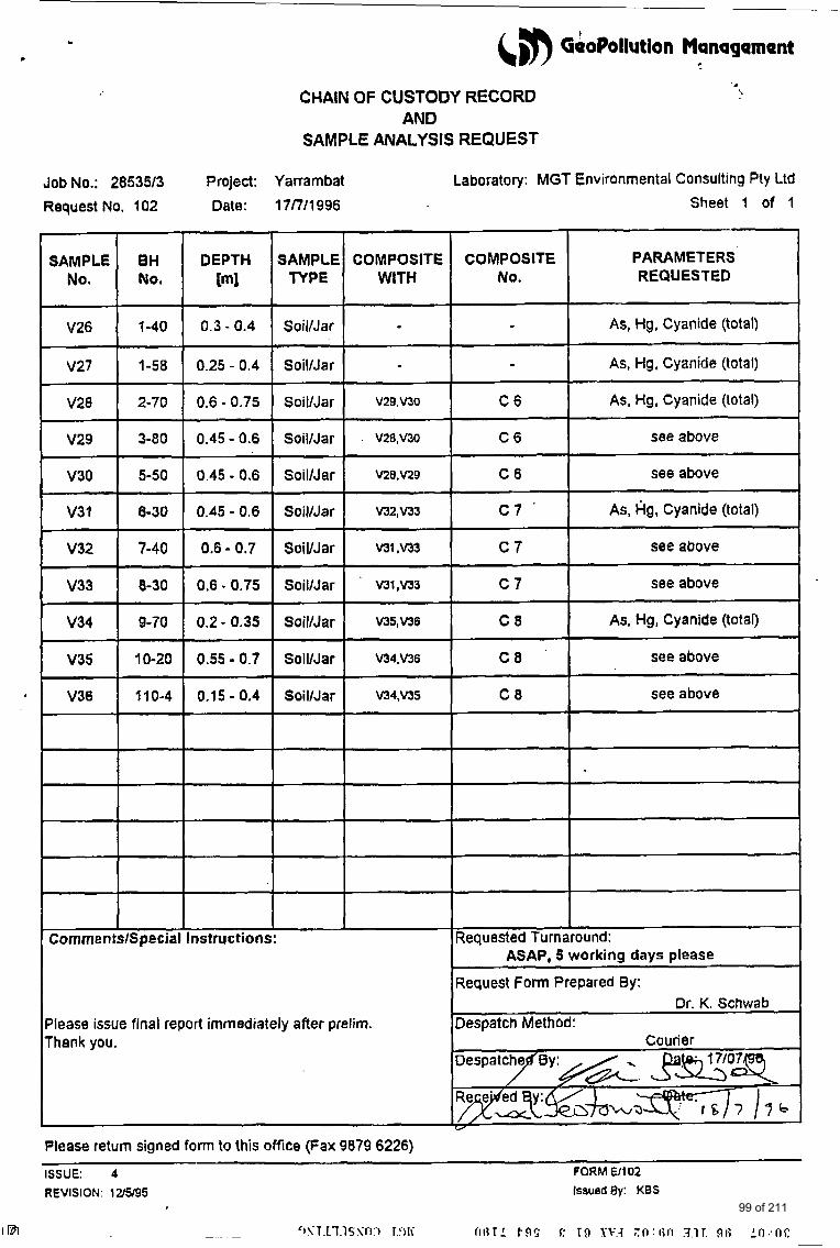
Job No.: 2853513 Request No. 102
SAMPLE TYPE
I COMPOSITE COMPOSITE
WITH No. SAMPLE
No.
V26
V27
v2a -
V29
V30
V3 1
V32
v33
v34
w35
V36
BH NO.
1-40
1-58
2-70
3-80
5-50
8-30
7-40
8-30
9-70
10-20
I 10-4
Soll/Jar
Soil/Jar
r CommentslSpecial
V34,V36 C8 see above
V34,vJS C 8 see above
-
@) GeoPollut!on Management ..
I
CHAIN OF CUSTODY RECORD AND
SAMPLE ANALYSIS REQUEST
Please issue final report immediately after prelim. Thank you.
Project: Yarrambat Laboratory: MGT Environmental Consulting Pty Ltd
Date: 17/7/1996 Sheet 1 of 1
ASAP, 5 working days please
Request Form Prepared By:
Despatch Method: Dr. K. Schwab
Courier
DEPTH m3
0.3 - 0.4
0.25 - 0.4 ~ ~-
0.6 - 0.75 -
0.45 - 0.6
~-
0.45 - 0.6 ~~
0.6 - 0.7 0.6 - 0.75
0.2 - 0.35
0.55 - 0.7
0.15 - 0.4
I I I
PARAMETERS I REQUESTED I
I I I nstructions: \Requested Turnaround:
Please return signed form to this office (Fax 9879 6226) ISSUE: 4 FORM U102 REVISION: 12/5/95 IssuedBy: KBS
99 of 211
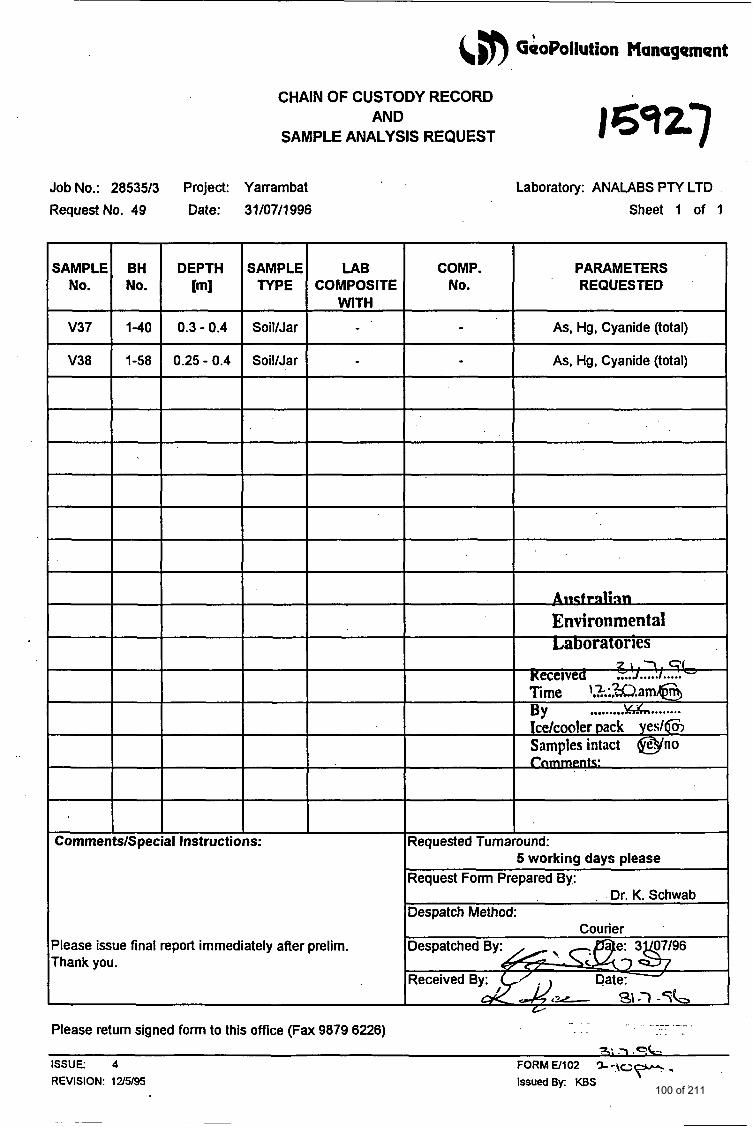
6 GeoPollution Management
- -
CHAIN OF CUSTODY RECORD AND
SAMPLE ANALYSIS REQUEST
As, Hg, Cyanide (total)
As, Hg, Cyanide (total)
Job No.: 285393 Project: Yarrambat
RequestNo. 49 Date: 31/07/1996
V37
V38
WITH
1-40 0.3 - 0.4 Soil/Jar
1-58 0.25 - 0.4 SoiVJar
V37
V38
1-40 0.3 - 0.4 Soil/Jar
1-58 0.25 - 0.4 SoiVJar
v
’lease issue final report immediately after prelim. Thank you.
L borat ry: ANALABS PTY LTD
Sheet 1 of 1
COMP. No.
PARAMETERS REQUESTED
Environmental
I 2 1 . 7 . Cl Keceivea ..... ..... ..... Time k.W.am@ BY Icdcooler pack yes/@ Samples intact @no r m :
Requested Turnaround:
Request Form Prepared By:
Despatch Method:
,Despatched > p q 6
Received By: Date:
5 working days please
Dr. K. Schwab
Courier
<e 31-7 -5e --- _ _ - -
Please retum signed form to this oflice (Fax 9879 6226) ?: .-l .sd
F””- ISSUE: 4 FORMW102 % - t c REVISION: 12/5/95 IssuedBy: KBS
100 of 211
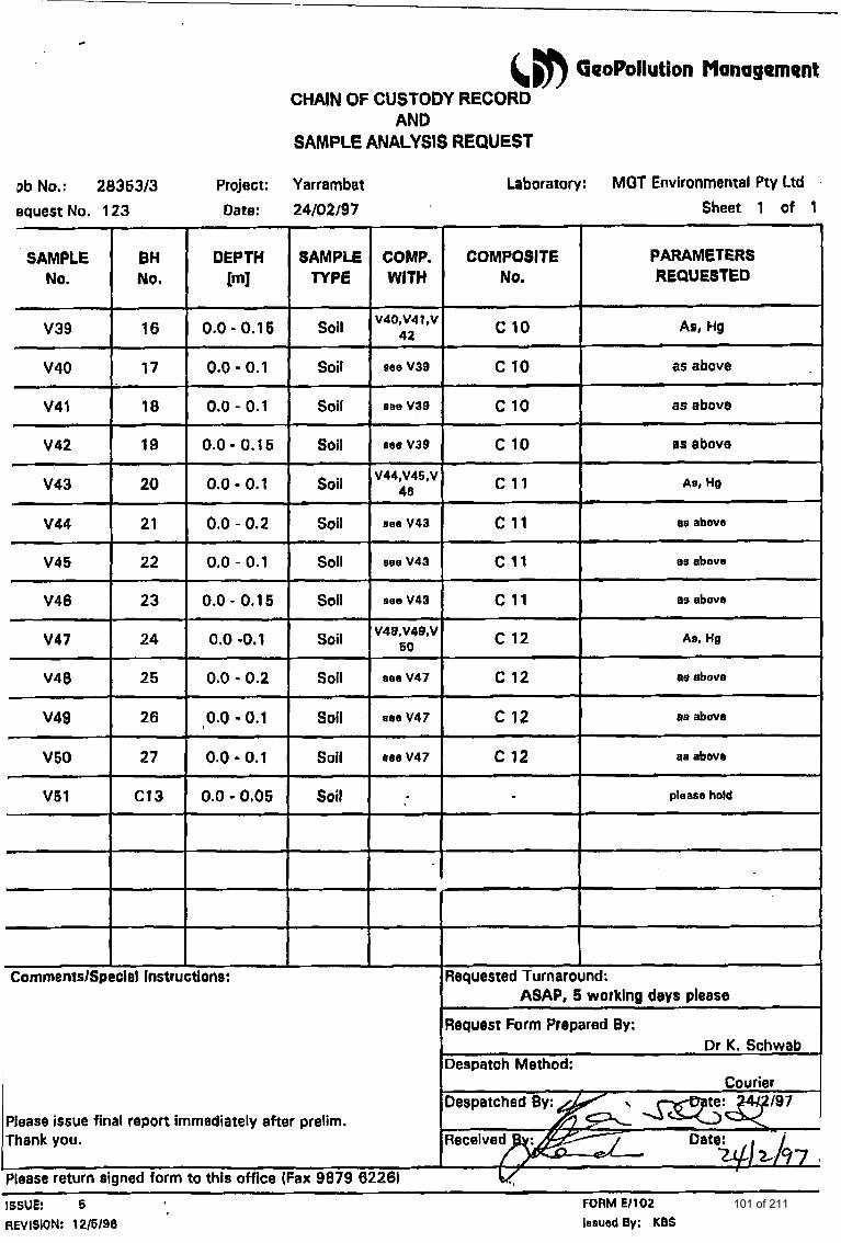
(#) GeoPollution Monagement CHAIN OF CUSTODY RECORD
AND SAMPLE ANALYSIS REQUEST
Db No,: 2836313 Project: Yarrambat equest No. 123 Date: 24/02/97
CommentslSpeciel Instructions:
Please issue final report immediately after prelim. Thank you.
please return signed form to this office (Fax 9879 6226)
Laboratory: MGT Environmental Pty Ltd
COMPOSITE No.
c 10
c 10
c 10
c 10 -~ ~.
c 11
c 11
c 11
c 11
c 12
c 12
c 12
c 12
Sheet 1 of 1
I PARAMETERS REQUESTED
As, Hg
as above
as above
0s above
Am, HQ
- - ~
as abovs
8s abovr
- As, He
as above
aB above
WI above
please held
Requested Turnaround:
ISSUE: 5 FORM E/102 REVISION: 12/6/96 lasued By; KBS
101 of 211
~ ~~ -
valrep.2853513
~
&,n GeoPollution Management
APPENDIX F: ROYAL HISTORICAL SOCIETY OF VICTORIA
- SUPPORTING INFORMATION
102 of 211
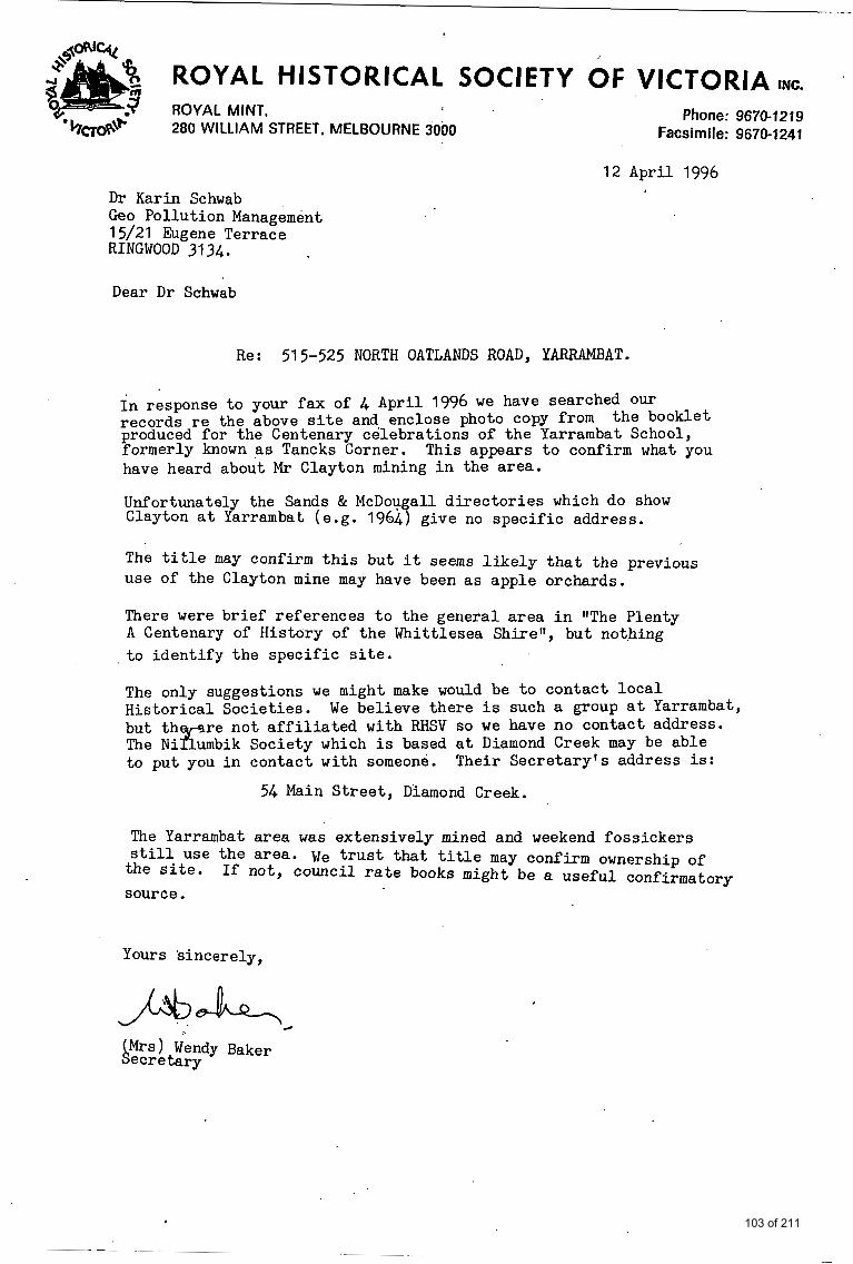
ROYAL HISTORICAL SOCIETY OF VICTORIA INC.
ROYAL MINT, Phone: 9670-1219 280 WILLIAM STREET, MELBOURNE 3000 Facsimile: 9670-1241
D r Karin Schwab Geo Pollution Management 15/21 Eugene Terrace RINGWOOD 3134.
12 April 1996
Dear D r Schwab
Re: 515-525 NORTH OATLANDS ROAD, YARRAMBAT.
I n response t o your f ax of 4 April 1996 w e have searched our records r e the above s i t e and. enclose photo copy from produced f o r the Centenary celebrat ions of the Yarrambat School, formerly known as Tancks Corner. have heard about Mr Clayton mining i n the area.
Unfortunately the Sands & McDou a l l d i r e c t o r i e s which do show
the booklet
This appears t o confirm what you
a t Yarrambat (e.g. 1964 'j give no spec i f ic address.
The t i t l e may confirm t h i s but i t seems l i k e l y t h a t the previous use of the Clayton mine may have been a s apple orchards.
There were br ief references t o the general area i n "The Plenty A Centenary of History of t h e Whittlesea Shire", but nothing t o iden t i fy t h e spec i f i c s i te .
The only suggestions we might make would be t o contact l o c a l Histor ical Societ ies . but t h The N i ?i umbik Society which i s based a t Diamond Creek may be able t o put you i n contact with someone.
We believe there i s such a group a t Yarrambat, %re no t a f f i l i a t e d with RHSV so w e have no contact address.
Their Secretary 's address is:
54 Main S t r ee t , Diamond Creek.
The Yarrambat area was extensively mined and weekend fossickers s t i l l use the area. \]e t r u s t t ha t t i t l e may confirm ownership of
the s i t e . source.
If not, council r a t e books might be a useful confirmatory
Yours s incerely,
c
AMrs) Wendy Baker ecr e tary
103 of 211
. . .' . . *
b
. b . .
I
I
I
!
f
, .
I . .
1
. .___:
.. . . . . . . . . . , . . . .. . . . . . . , .
.. . . ,. . . . . . . .
. . 104 of 211
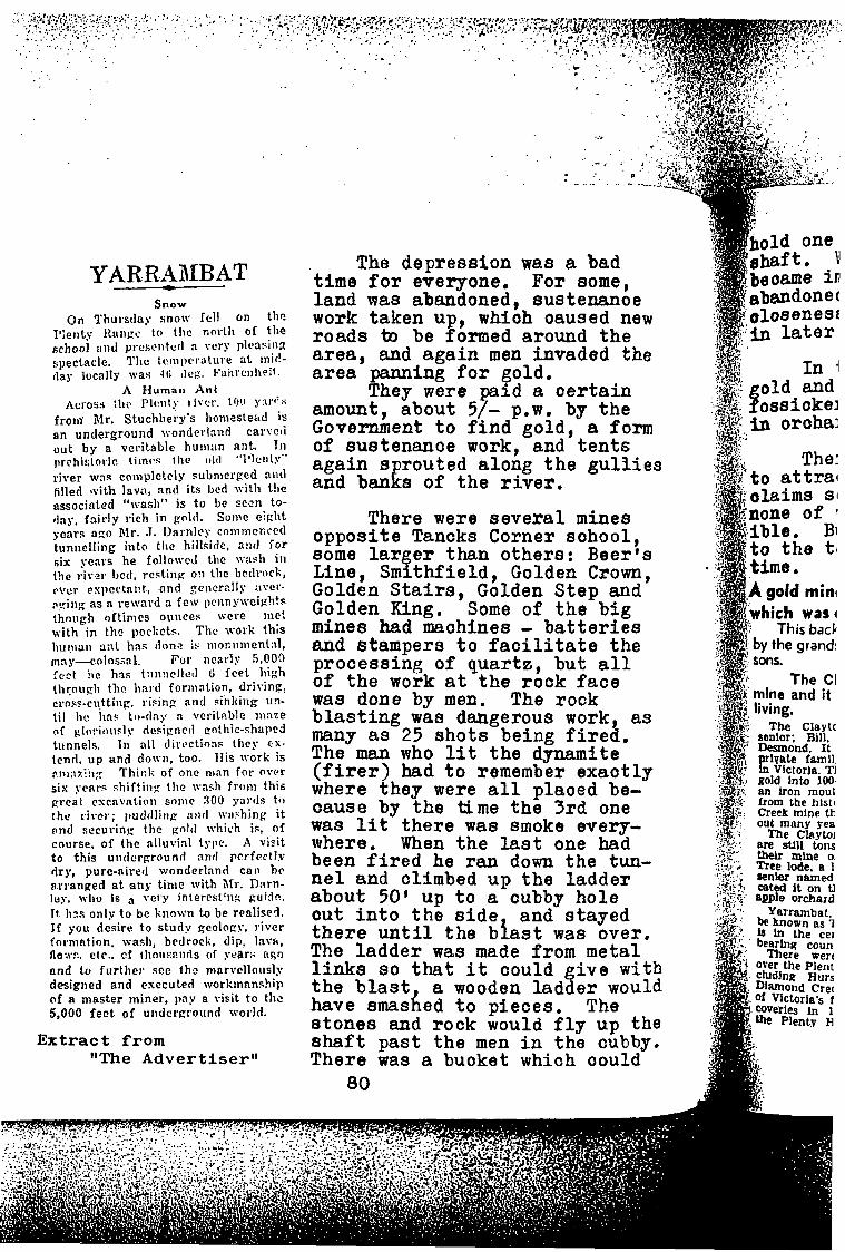
I .
Y A R. R ,4 MB AT - - -
Snow
1';eilty 1<111igc to the north of tlle On ~ h u r s t l a y snow re11 on the
pchoo] a i d yrcscntetl a w r y p1casillZ spectacle. TIic tcinprrature at inid-
A Human A n t cross :hr plc!lity I i vcr . 1!1(1 s:\rf':i
froill' Mr. Stuchbery's honiestead is an underground wonderland carveti out by a veritable human ant. 111 prchistoi.ic 1iinc:n llic o l d "l'kllly'' river W:IR coniplekly submerged 311tl filled s.vith lava, and its bed with t !~e associated "wash" is t o be s w n to- flay. fa i r ly rich in gold. Sonic eirlit gears azo Mr. J. Darnlcy coiiimcnced tunilelling into the hillside, a:itl i o r six years he followcd the \vas11 in the riv.21. I J C ~ I , resting O!I the bctlrock, p v ~ r espcctnnt., .and ~ , c n c r ~ ! I y :IV'CT.
pc'i i ig as n reward 3 few prnny\veigh!a though oftinics oiiiices wcre me! \vith in the poclirts. The work this ~iupiaii 3:it has done is nioi:iiiiient:il, innp--colossaL For nearly 5,000 iect tie hns t:iiiriellcil ci f e e t high tlirouyli the hard foriliation, driving, cross-cutting, rising and sinking 113-
til lie has ti,-tlay n vcrit:~.ble iiinze of glnric~usly dcsicnctl cothic-shapcd tunnels. 111 a11 dirclctions they cx- tend. u p and do\vii, too. Iris work is Piwz3i; : Think of one nian for over six ye81-s shifting the was11 from this preat csrnvatioll sonic 300 yal'ds to the river; pudtllina ant1 wrishing i t and securinc the p d t l \diich is, of course. of the alluvial tylw. A visit t o this uiitlcrgrnund and prrfcctly dry, pure-aired wonderland cnii bc a.rranged at .any tinie with Mr. D:irn- ley, who is very interestkg fiuidp.. 11. hns only to be known to be realised. If you desire t o s t u d v geolopy. river formntion. wash, bedrock, dip. lava, f l a w . etr . . cf tlioiis.?iirls of year:; ago and t o fur ther scc th? mnr\~ellously designed and esccuted workmnnship of 8 niaster miner, pay a visit to the 5,000 f e e t of underground world.
clay locally was 41; tie;. b ' i l h r ~ i ~ h ~ i ~ .
Extract f r o m "The A d v e r t i s e r "
The depres s ion was a bad t i m e , f o r everyone. For some, land was abandoned, sustenanoe work t aken u , whioh oaused new r o a d s tn be fp ormed around t h e area, and again men invaded the a r e a panning f o r gold.
They were p a i d a c e r t a i n amount, about 5/- pew. by t h e Government t o find gold, a form of sustenanoe work, and t e n t s again 8 rou ted a long t h e g u l l i e s and ban E s of t h e r i v e r .
There were s e v e r a l mines o p p o s i t e Tancks Corner sohool , 80me l a r g e r than o the r s : Beer 's Line, Smi th f i e ld , Golden Crown, Golden S t a i r s , Golden Step and Golden King. Some of t h e b i g mines had maohines - b a t t e r i e s and s tampers t o f a c i l i t a t e t h e p rocess ing of q u a r t z , bu t a l l of t h e work a t t h e rock f a c e was done by men. The rock b l a s t i n g was dangerous work, as many as 25 s h o t s being f i r e d . The m a n who l i t t h e dynamite ( f i r e r ) had t o remember e x a o t l y where they were a l l plaoed be- oause by t h e time t h e 3rd one was l i t t h e r e was smoke every- where. When t h e last one had been f i r e d he ran down t h e tw- n e 1 and climbed u p t h e l a d d e r about 50' up t o a cubby h o l e out i n t o t h e side and s t a y e d t h e r e u n t i l t h e b i a s t was over. The l a d d e r was made from meta l links so that i t could g i v e w i t h t h e b l a s t , a wooden l adde r would have smashed t o p i eces . The s t o n e s and rock would fly up the Shaft p a s t t h e men i n t h e cubby. There was a buoket which oould
80
The Claytc
gold into 100. an iron maul from the hlstc
: out many rea 'i'. The Chytoi :. are stlu tons
tbelr mine 0:
aenier named aced it on tl
105 of 211
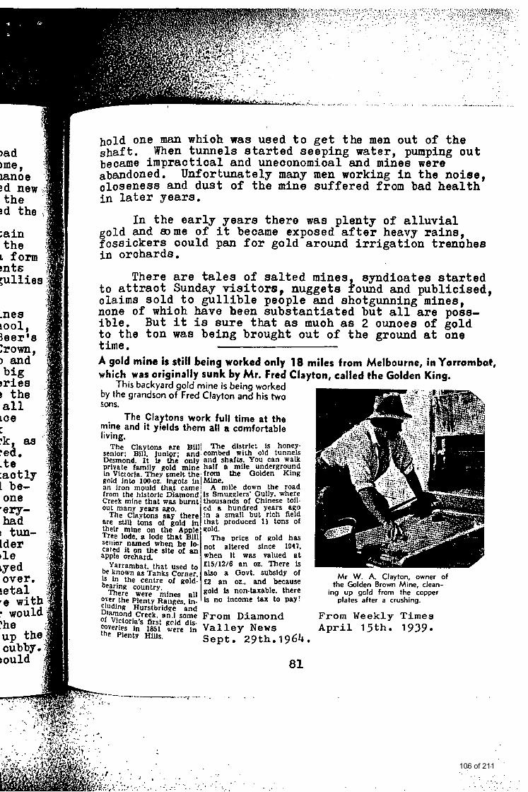
. . . .......... . . . . . . . . . . . . . . . . . . . :;: .f ?.' .y:;, . . . . . . . . . . . . . . . . . . . . . . . . . . -.., !.>..'.' , ,
hold one man whioh was used to get the men out of the shaft. When tunnels started seeping water, pumping out became impractical and uneoonomical and mines were abandoned. oloseness and dust of the mine suffered from bad health in later years.
Unfortunately many men working in the noise,
In the early years there was plenty of alluvial
5ossickers oould pan for gold around irrigation tremhes i n orohards.
old and mme of it became exposed after heavy rains,
There are tales of salted mines syndioates started to attraot Sunday visitors, nuggets Pound and publicised, o l a i m s sold to gullible people and shotgunning mines, none of whioh have heen substantiated but all are poss- ible. to the ton was being brought out of the ground at one time.
But it is sure that as muoh as 2 ounoes of gold
A gold mine i s stil l being worked only 18 miles from Melbourne, in Y a r r a m b ~ t , which was originally sunk by M r . Fred Clayton, called the Golden King.
This backyard gold mine is being worked by the grandson of Fred Clayton and his two LOnS.
The Claytons work full time at the mine and it yields them all a comfortable living.
The Claytom p.re Bill( The dlstric: 1s honey- senfor* Bjll. Junjqr- and. combed W i t h old tunnels m i n d . It only and shafts. you can walk private family Rold mine half a mile underground In Victorla. They smelt the, from fie Golden King gold into 100-oz. jngots jn(kfhe. an iron mould that camel A mile down the road from the historic Diamond is Smugglers' Gully. where Creek mine that WBS burnt thousands of Chinese toll- out many years ago. cd a hundred Years ago
The C h y b n s sag there in a small but rich field are still of goid that produced 13 tons Of their mine on the Apple sold. Tree lode, a lode that Bill m a Drice of gold has
named he I* not altered since 1947, apple orchard. when it wBs valued at cared it on the site of an
. . . . , . . . . . . . . . . . . . . . . . . . . . . . . . . . . . . . . . .. . . . . . 2,:: \ ' . . . . . . . . . . . . . . . . . . .
Mr W. A. Clayton, owner of
plates after a crushing.
From Weekly Times A p r i l 15th. 1939.
the Golden Brown Mine, clean- ing up gcld from the copper
. . . ;. . . - . ; . . . . . . . . ' _
106 of 211
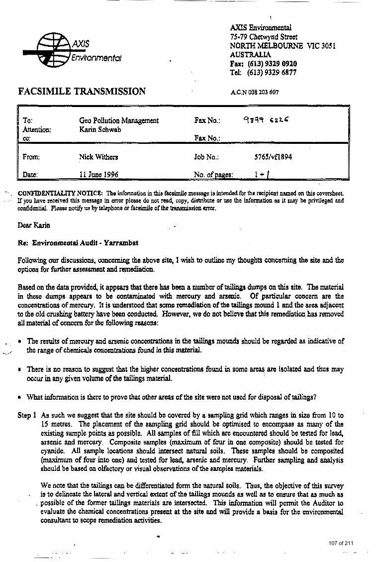
FACSIMILE TRANSMISSION
!
AXIS Enviroment&l 75-79 Chetwynd Street NORTH MELBOURNE MC 305 1 AUSTRALIA Fax: (613) 9329 0920 Tel: (613) 9329 6877
A.C.N 008 203 607
h I To: Gco Pollution Management FaxNo.: q37s S 2 L C
Attention: Karin Schwab cc: Fax No.:
From: Nick Withers Job No.: 5769vfl894
11 June 1996 No. ofp ajJ 8s: 1.1 -
-. . CO"IDENTL4LITY NOTICE: Tho information in th io facsimile message is intended for the recipient rimed on this coversheet . If you have received this message in mor please do not read, copy, distribute or use the idonnation BS it may be privileged and
cuddentid. Plzase notify 11s by telephone or f e c d c of the transmission m,
Dear Karin
Re: Environmental Audit - Yarrambat
Follovrh~ our discussions, concerning the above site, I wish to outline my thoughts concoming the site and the optiom for fbrther assessment and r d a t i o n .
Based on the data provided, it appears tbat there has been a number of tadinge dumps on this site. The material in these dumps appears to be contaminated with mercury and arsenic. Of particular concern are the concentmtiolls of mercury. It is understood that some &ation of the tailings mound 1 and the area adjacent to the old crushing battery bave been conducted. However, we do not believe that this remediation has removed all material of concern for the following reasons:
- .- . ..
The results of mercury and arsenic concatmtions in the tailings m o d s should be regarded as indicative of the range of chemicals ccmcentretions found in this material.
0 There is no reason to suggest that the higher concentrations found in some areas am isolated and thus may mur in any given volume of the tailings material.
what infomution is there to prove that other area9 of the site were not used for disposd of tailings?
Step 1 As such we suggest that the site should ba covered by a sampling grid which ranges in size from 10 to 15 metres. The placement of the samplrng grid should be optimised to oncompass as many of the existing sample points as possible. All samples of fill which are encountered should be tested for lead, arsenic and mercury. Composite samples (maximum of four in one composite) should be tested for cyanide. All sample locations should intersect natural soils. These samples should be compositad (mhum of four into one) and tested for lead, arsenic and mercury. Further sampling and analysis should be bascd on olfactory or visual observations of the aramples materials.
We note that the taihgs can be differentiated hrm the natural soils, Thus, the objective of this sway is to delineate the lateral and vertical extent ofthe tailings mounds as well as to ensure that as much as
. possible of the former tailings materials are intersectsd. This information will pexmit the Auditor to evaluate the cheaical concentrations present at the site and will provide a basis for the environmental consuhanf to scope remediation activities.
.
107 of 211
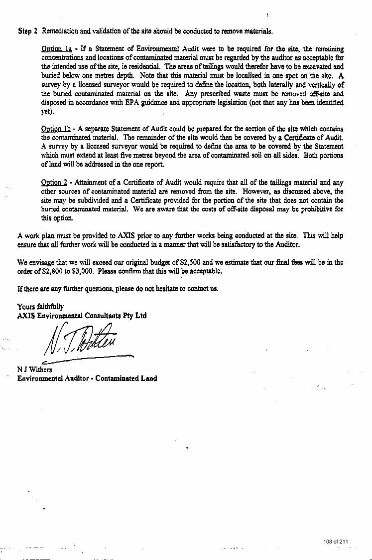
Step 2 Remdation and validation of the sib should be conducted to remove mateds.
Qtltion 14 - If a Statement of Enviranmantal Audit were to be required for the sib, the Wnaining concmtmions and locations of contaminated material must be regardod by the auditor 89 acceptable for the intended use of the site, ie residential. The areas of tailings would therefor have to bt excavated and buried below one metres depth. Note that this material must be localised in one spot an the site, A survey by a licensed surveyor would be required to define the location, both laterally and vertically of the buried contaminated material on the site. Any prescribed waste must be removed &site and disposed in accordance with EPA guidance and appropriate legislation (not that any has been idmtificd w ) .
O u t i d - A separate Statement of Audit could be prepared fbr the section of the site which contains the wntaminatd material, The remainder of the site would then be covered by a Certificate of Audit. A sun-ey by a licensed surveyor would be required to define the area to be covered by the Statement which must extend at least five metres beyond the area of contaminated soil on dl sides. Both portions of land will be addressed in tho one report.
- Attainment of a Certificate of Audit would require that all of the t a i l i q s material and any other sources of contaminated material are removed from t h ~ site. However, as discussed above, the site may be subdivided and a Certificate provided for the portion of the site that does not contain the buried contaminated material. We are aware that the costs of off-sib dispoeal may be prohibitive for this option.
A work plan must be provided to AXIS prior to any futther works being conducted at the site, This will help etlsure that all fimher work will be conducted in a manner that will be satisfictory to the Auditor.
We envisage that we will exceed our original budget of $2,500 and wo astimate that our final fees will be in the order of $2,800 to $3,000. Please confirm that this will be acceptable,
If there arc any m e r questions, plcasa do not hesitate to contact us,
Yours faithfully A X I S Environmental Consultants Pty Ltd
-cI
N J Withen Environmental Auditor = Contaminated Land ~
. . . . ..... ... I
.. -_. . . . . . . .
~~
108 of 211
valrep.28535/3 68 GeoPollution Management
APPENDIX H: CORRESPONDENCE
109 of 211
15/21 Eugene Terrace Ringwood VIC 3134 Ph: (03) 9 879 6612 (03) 9 879 2999 Fax: (03) 9 879 6226
6 #) GeoPollution Management
FACSIMILE TRANSMISSION
No. Pages Following: 1
Job No.: 2853513
Date: 17/07/96
No. Dialled: 9383 6939
Quote No.:
Attention : Mr Oscar Arfi
Corn pan ylorganization :
Sender: Dr Karin Schwab
PLEASE CALL 9 879 2999 OR 9 879 6612 IF PART OR ALL OF THIS TRANSMISSION HAVE NOT BEEN RECEIVED
MESSAGE: RE: CLEAN UP - LOT 2 NORTH OATLANDS ROAD, YARRAMBAT
Dear Oscar,
Based on our grid survey carried out on your property between 12th and 16th July, 96, the area covered by tailings material is outlined on the attached sketch plan. As a guide for the excavation, ten by ten metre grid markers have been placed along each fenceline (pink flagging tape). The perimeter of the excavation has been marked on site with lime and pegs have also been left in place. Approximate zones where the excavation is to go to 0.5 m or deeper and where less than 0.5 rn have to be removed are marked on the attached plan. Towards the perimeter of the excavation, a mere surface scraping of 0.1 m or less is required. The actual extent of excavation will be subject to site inspection.
Where the interrupted line on the sketch plan touches the fenceline, excavation is to be carried out to the very boundary. A small patch of tailings was also detected next to a tree as marked on the plan (surface scrape only). It is also noted that a small amount of residual tailings are still present in the southem cutting of the previous triangular excavation (downslope of former crushing plant). These should also be removed to the very fenceline.
Due to the presence of shallow seepage water, earthworks are to be carried out from the bottom upslope keeping the excavator on dry ground. In the course of the earthworks, adequate drainage for seepage water coming to surface will need to be installed.
The estimated volume of tailings to be excavated is 2240 m3 in ground. Assuming a volume increase of only 10% during excavation, the volume for disposal will be approximately 2500 m3. Allowing a factor of approx. 1.7 for conversion of cubic metres to tonnes, the weight of soil for off-site disposal is estimated as being in the order of 4000 to 4500 t. Actual tonnage will be based on landfill weigh bridge dockets.
Please call me this afternoon to discuss (I will be in a meeting this morning).
110 of 211
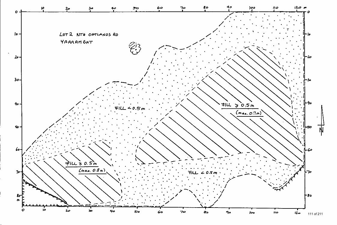
111 of 211
6 GeoPollution Management
15/21 Eugene Terrace Ringwood VIC 3134 Ph: (03) 9 879 6612 Fax: (03) 9 879 6226
FACSIMILE TRANSMISSION
No. Pages Following:
Job No.: 2853513
Quote No.:
Date: 05/03/97
Fax No. Dialled: 9383 6939
Attention: Mr Oscar Arfi
Cornpany/Organization:
Sender: Dr Karin Schwab
PLEASE CALL OR 9 879 6612 IF PART OR ALL OF THIS TRANSMISSION HAVE NOT BEEN RECEIVED
MESSAGE:
RE: RESULTS OF RECENT VALIDATION SAMPLING YARRAMBAT
Dear Oscar,
Attached please find preliminary analysis results for 4-part composites collected across the entire excavated area.
As you already know, the guideline limits are 20 ppm and 1 ppm for arsenic and mercury respectively. These apply for average results. Individual locations may have higher concentrations (up to 4times) than the levels shown for the composites.
Required Action: You are to complete the site clean up as previously advised, ie. remove residual tailings and expose natural brownlorange mottled clay (go approximately 50 mm into the natural soil to be sure). Please advise when this has been completed. Supervision of the final stages of excavation by a professional is strongly advised to avoid additional delays and further expenses to yourself.
Please note: Nick Withers is leaving Hyder Consulting on the 2 5 ~ April. In order for him to complete his Audit report by that time, he will need our report before the 1 lfi April, ie. this leaves us approximately 4 weeks.
Thank you.
A Regards fi>.&* Dr Karin Schwab
112 of 211
Hyder 9 Hydcr Consulting (Australla) Pty Ltd 75-79 Chewynd Straat Nonh Melbourne VIC3051
, Tel: 4 1 (0) 3 9329 7600 Fax: 4-61 (0) 3 9329 6627
Consulting
Faxno ' 6 2 - a Y m d Subject
/- Number of pages (including this one). 11-1 If you have any problems receiving this fax please
contact us on +61(0) 3 9329 7600
Private und confldentlrl The Infomadon contalncd In thlr facdmllc i$ irttcnded for the named redplents only. It may contrin prinlaged snd conldentld Information and if you ER not the addressee or the peoon nrponrible for delivering thls to the rddnrrce. you may not copy, distribute or take r d i o In rellmce en b If you have nceivcd ths fmimile In error, please notlfy us Immediately by 8 n m a d chuge telephone call to +S1 (0) 3 9329 7600 and return the orlglnal tothc render by mail, We will nimbuis you forthe p q e .
113 of 211
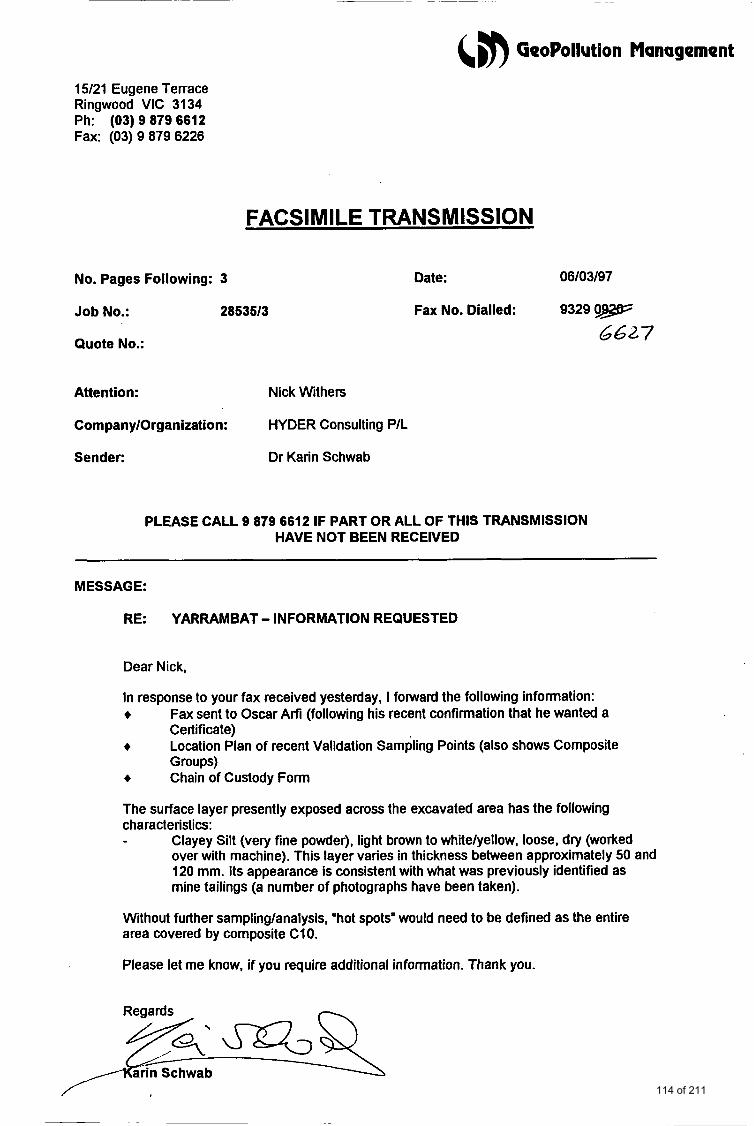
&,m GeoPollution Management
15/21 Eugene Terrace Ringwood VIC 3134 Ph: (03) 9 879 6612 Fax: (03) 9 879 6226
FACSl M I LE TRANSMISSION
No. Pages Following: 3
Job No.: 28535/3
Quote No.:
Date: 06/03/97
Fax No. Dialled: 9329 0-
6627
Attention: Nick Withers
Corn pany/Organization: HYDER Consulting P/L
Sender: Dr Karin Schwab
PLEASE CALL 9 879 6612 IF PART OR ALL OF THIS TRANSMISSION HAVE NOT BEEN RECEIVED
MESSAGE:
RE: YARRAMBAT - INFORMATION REQUESTED
Dear Nick,
In response to your fax received yesterday, I fotward the following information: + + + Chain of Custody Form
Fax sent to Oscar Arfi (following his recent confirmation that he wanted a Certificate) Location Plan of recent Validation Sampling Points (also shows Composite Groups)
The surface layer presently exposed across the excavated area has the following characteristics: - Clayey Silt (very fine powder), light brown to white/yellow, loose, dry (worked
over with machine). This layer vanes in thickness between approximately 50 and 120 mm. Its appearance is consistent with what was previously identified as mine tailings (a number of photographs have been taken).
Without further sampling/analysis, 'hot spots" would need to be defined as the entire area covered by composite CIO.
Please let me know, if you require additional information. Thank you.
Reaards - 114 of 211
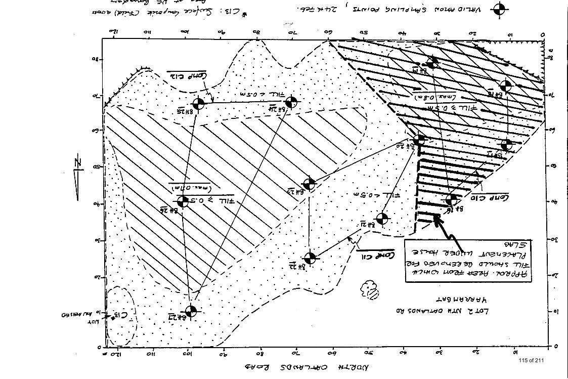
115 of 211
valrep.28535/3 &,#) GeoPollution Management
APPENDIX G: AERIAL PHOTOGRAPHS
116 of 211
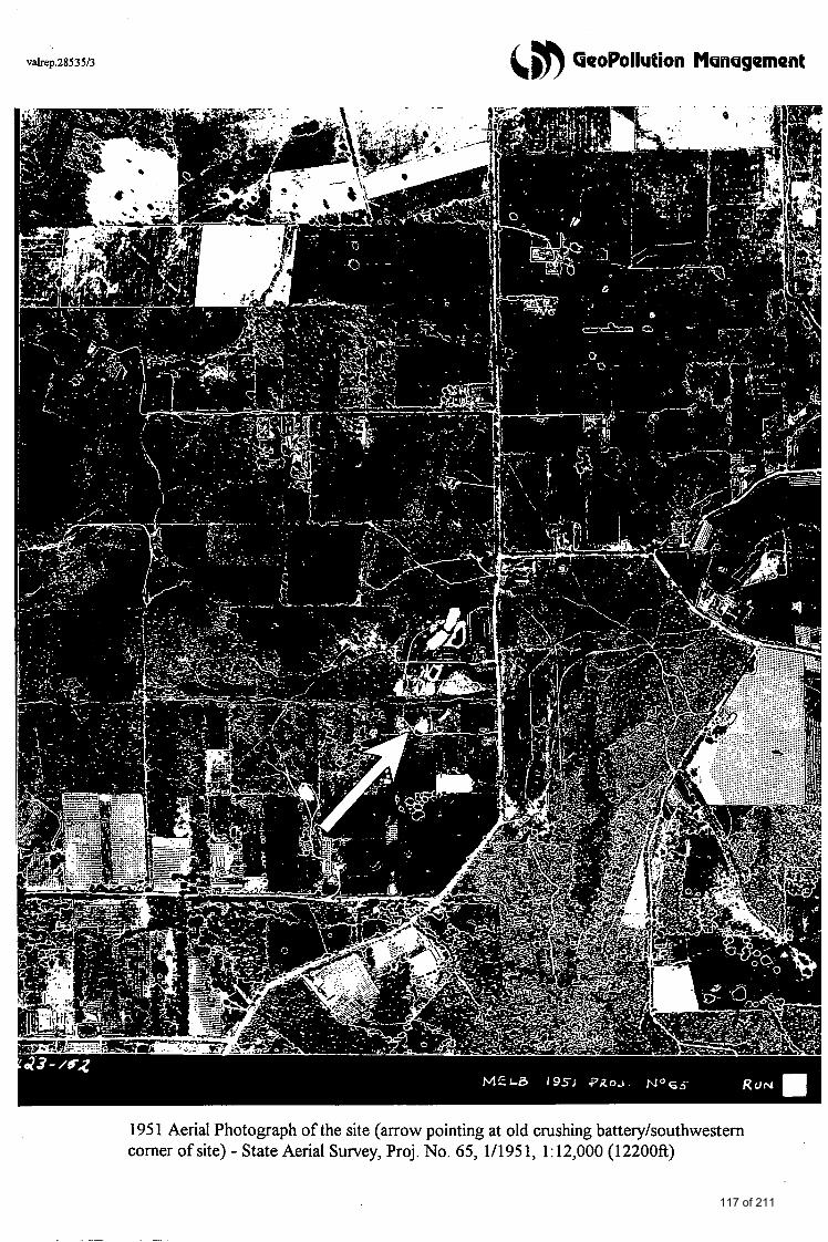
valrep.2853513 &, aeoPollution Msneqement
1951 Aerial Photograph of the site (arrow pointing at old crushing batteqhouthwestem comer of site) - State Aerial Survey, Proj. No. 65, 1/1951, 1:12,000 (12200ft)
117 of 211
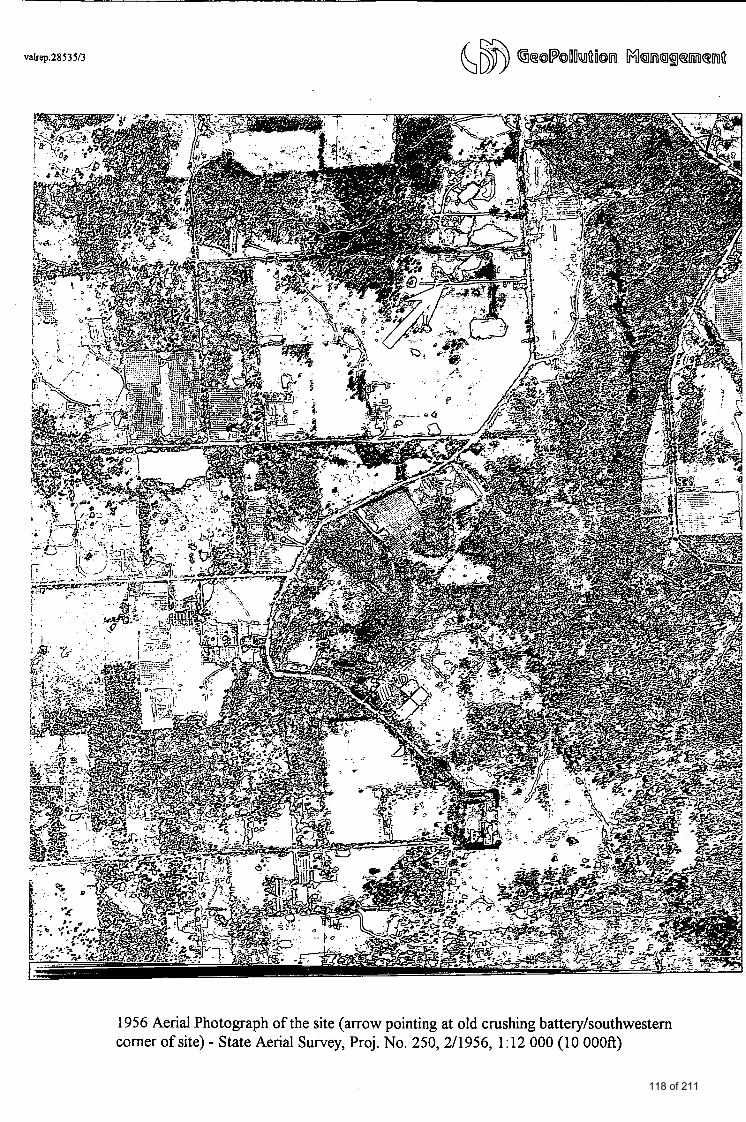
valrep.2853513
1956 Aerial Photograph of the site (arrow pointing at old crushing batteqhouthwestern comer of site) - State Aerial Survey, Proj. No. 250, 2/1956, 1:12 000 (10 OOOft)
118 of 211
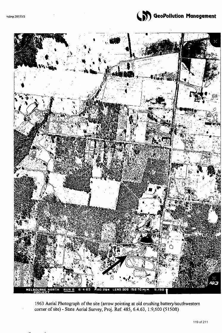
valrep.2853513 (, GeoPollution Management
1963 Aerial Photograph of the site (arrow pointing at old crushing batterjhouthwestern comer of site) - State Aerial Survey, Proj. Ref 485, 6.4.63, 1:9,600 (5150ft)
119 of 211
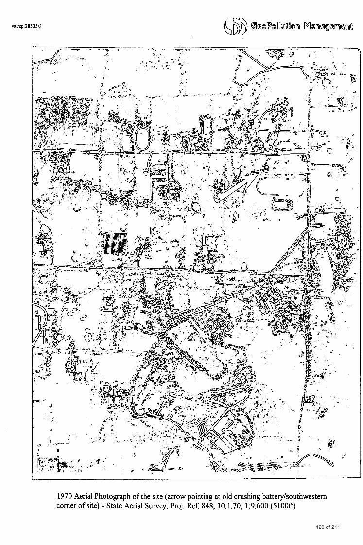
valrep.2853513
1970 Aerial Photograph of the site (arrow pointing at old crushing batteryhouthwestern corner of site) - State Aerial Survey, Proj. Ref 848, 30.1.70; 1:9,600 (5100ft)
120 of 211
valrep.28535I3 (, & GeoPollution Management
APPENDIX I: COPIES OF PREVIOUS REPORTS
\
121 of 211
+
File No.:
GeoPollution Management Environmental Scient ists a n d Engineers
28535 Date: 6 November, 1995
Mr Oscar Arfi 27 Breese Street Brunswick Vic 3056
RE: LEACHABILITY TESTING OF TAILINGS MOUND MATERIAL
Location: Lot 2 North Oatlands Road, Yarrambat
Dear Sir,
GeoPollution Management Pty Ltd was engaged to sample and analyse contaminated soils from three areas in the southwestern comer of Lot 2 which are designated for remediation (refer to Figure 5 in Environmental Assessment Report by Barry Luke & Associates Pty Ltd, February, 1994).
Average levels of total metals in the subject tailings mound 1 (southwestern comer) had been determined as 4.1 ppm for mercury and 42 ppm for arsenic as described in the initial site assessment report. These levels classifjl the soil as low-level contaminated.
Three surface soil samples were collected by stafffrom this office from on 30th October, 1995 for the purpose of elutriation testing of metals. The tests were required prior to transport and disposal of the excavated soil as ‘low-level contaminated’ fill. Locations of sampling points are shown in the attached Figure 1.
Elutriation of the heavy metals arsenic and mercury was determined of a pH 5 soil extract according to USEPA procedures. Analysis results are enclosed as the final laboratory report of MGT Environmental Consulting Pty Ltd, Oakleigh (NATA registered laboratory for the analysis of the constituents of soil and water). A copy of the combined ‘Chain of Custody and Analysis Request Form’ is also attached.
Assessment Criteria
The results are assessed against EPA ‘Landfill Criteria’ (EPA Bulletin WM9 110 1 ‘Off-Site Disposal of Contaminated Soil’). These criteria have been developed for disposal of contaminated soil to landfill and specifjl maximum acceptable levels of contaminants for disposal of soil as low-level contaminated fill.
Criteria relevant to this investigation are shown in the table below (TABLE 1, over page).
GeoPollution Management Pty. Ud. ACN 067 625 754 122 of 211
&,)? GooPoliution Management
Arsenic
Mercuty
TABLE 1: Maximum Elutriable Fractions
0.002 0.003 0.026 5
<0.001 <0.001 <0.001 0.5
Arsenic Mercury
5 .O 0.5
Analysis Results
The following table (TABLE 2) summarizes the analysis results for elutriable fractions.
TABLE 2: SUMMARY OF ANALYSIS RESULTS - [mg/L = ppm in leachate]
Arsenic was detectable in the leachate of each sample submitted, but the proportion of leachable arsenic was well below the acceptable limit. Mercury was not detectable in leachate of any of the samples tested.
Conclusions and Recommendations
The results show that elutriable fractions of metals within each’of the 3 samples tested are well below the adopted EPA threshold levels for disposal of contaminated soil to landfill. Hence, the soil may be disposed to landfill as ‘low-level contaminated’.
Following excavation of the designated areas, the bases of the excavations will be validation tested. This will be the subject of a forthcoming report.
Should you have any queries regarding this report or require further advice, please do not hesitate to contact the undersigned.
Yours faithhlly for and on behalf of GeoPollution Management Pty Ltd
c DR. KARm B. SCHWAB Ph.D., M.Env. Sc. (Senior Environmental Scientist)
Attachments 123 of 211
ATTACHMENTS
124 of 211

PROJECT ,NO: 2853511 GeoPollution Management 1 LOCATION-PLAN I F'GURENo:
Area
Area
SAMPLING LOCATIO N S
Old Gold Ore Crushing Battery
Tailings Mound 1
Area 3
Grass Cover
Tailings Mound 2
Areas designated for Excavation:
Area 1: to 0.6 m depth Area 2: to 0.3 m depth Area 3: tp 0.6 m depth
SCALE: not to scale
Lot 1
Private Residence
4
0 P, n P
a m w 0 P, a
1"
Figure modified after Luke, B. 61 Associates, 1994
- NORTH
PROJECT: Lot 2 North Oatlands Road, Yarrambat
125 of 211
I 1 .
Environmental Consulting Pty. Ltd. 3 KinprtDn Tavn Close. Oaklebh, Vicbda. 3166
Sample Lab. No.
Arsenic
Mercury
Geo Pollution Management P.O. Box 441 Vic R i n Y o d oria 3134
Method Blank 9574 - 1 9574-1 Dup 9574-2 9574-3 9574-3 Dup
OC3339 OC3 3 3 9D OC3340 OC3341 OC3341D - 0.002 0.003 0.003 0.026 co. 001
c o . 001 c o . 001 c o . 001 c o . 001 c o . 001 -
Postal Address: P.O. Box 276. Oaklebh. Vkbria. 3166 Telephone: (03) 9564 7055
Fax: (03) 9564 7190
Report No. 108597 Page 1 of 1 .A-Z 126 of 211
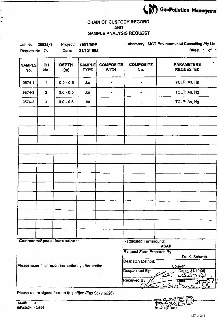
CHAIN OF CUSTODY RECORD AND
SAMPLE ANALYSIS REQUEST
SAMPLE BH DEPTH SAMPLE COMPOSITE COMPOSITE No. No. [ml TYPE WITH No.
9574-1 1 0.0 - 0.6 Jar - 9574-2 2 0.0 - 0.3 Jar -
9574-3 3 0.0 - 0.6 Jar
Job No.: 28535/1 Project: Yarrambat Laboratory: MGT Environmental Consultlng Pty Ltd
Request No. 74 Date: 31/1 0/1995 Sheet 1 of 1
PARAMETERS REQUESTED
TCLP: As, Hg
TCLP: As, Hg
TCLP: As, Hg
.
ISSUE: 4 REVISION: 12395
127 of 211
(5n GooPollution Management
VALIDATION TEST REPORT
LOT 2 NORTH OATLANDS ROAD YARRAMBAT
PREPARED FOR
Mr Oscar Arfi
GeoPollution Management Pty Ltd December, I995
128 of 211

GeoPollution Management Environmental Scientists and Engineers
File No.: 2853512 Date: 5 December, 1995
Mr Oscar Arfi 27 Breese Street Brunswick Vic 3056
RE: VALIDATION TESTING FOLLOWING SITE CLEAN UP
Project: Proposed Residential Development
Location: Lot 2 North Oatlands Road, Yarrambat
Dear Sir,
GeoPollution Management Pty Ltd was engaged to validate the above site following excavation and off-site disposal of contaminated soil. Removal of soil was from three areas in the western portion of the site and followed recommendations for clean up set out in a previous site assessment report (“An Environmental Assessment of Soil Quality At Lot 2 North Oatlands Road, Yarrambat”, Report by Barry Luke & Associates Pty Ltd, February, 1994).
The three areas to be addressed are shown on the attached Figure 1 and the degree and extent of contamination were as follows:
AREA REQUIRED EXCAVATION DEPTH TYPE OF FILL
AREA 1 0.6 m average AREA 2 to 0.3 m AREA 3 to 0.6 m
Low-level contaminated Low-level contaminated Prescribed waste
Soil was excavated and disposed off-site between 24th and 27th November, 1995 in accordance with the recommendations of the previous site assessment report and EPA regulations. A report on the leachabilities of arsenic and mercury was provided by this firm (“Leachability Testing of Tailings Mound Material”, dated 6th November, 1995) prior to transport and disposal, in order to obtain transport approval from the Environment Protection Authority. Soil from AREA 1 and AREA 2 were subsequently disposed off as ‘low-level contaminated’ waste. A volume of 10 m3 from AREA 3 was disposed off as ‘prescribed waste’.
GeoPollution Management Pty. Ltd. ACN 067 625 754
129 of 211
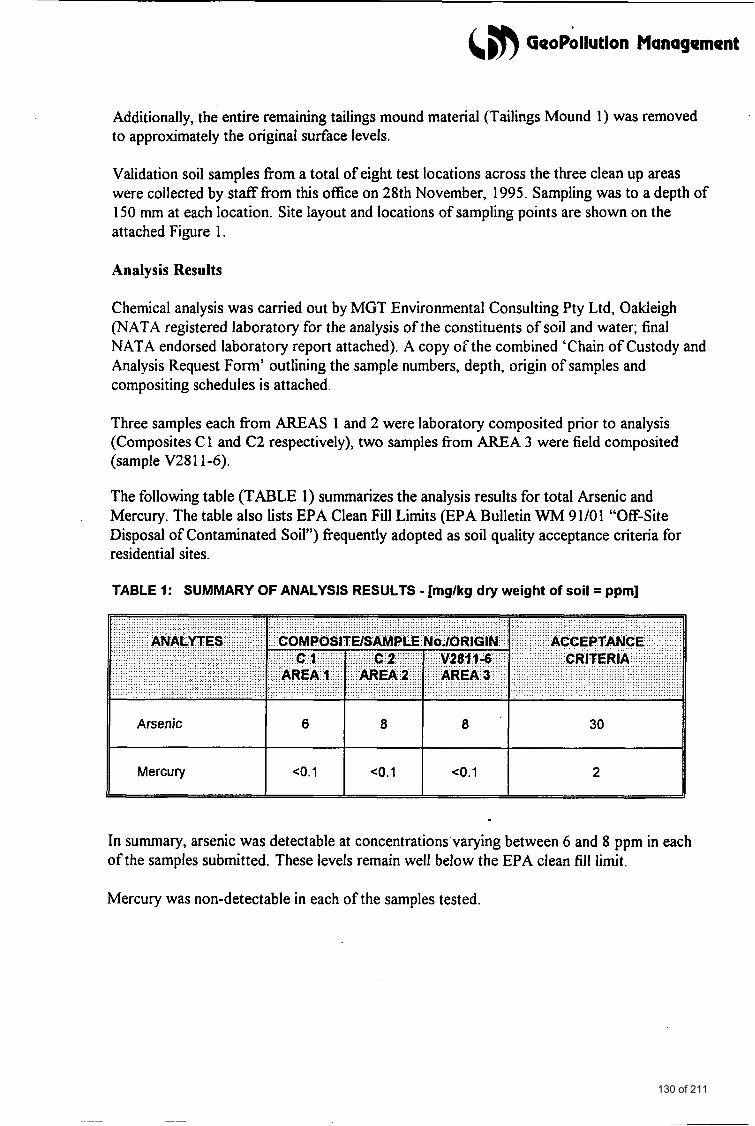
&m GeoPollution Management
Arsenic
Mercury
Additionally, the entire remaining tailings mound material (Tailings Mound 1 ) was removed to approximately the original surface levels.
6 8 8 30
<0.1 co.1 co.1 2
Validation soil samples fiom a total of eight test locations across the three clean up areas were collected by staff fiom this office on 28th November, 1995. Sampling was to a depth of 150 mm at each location. Site layout and locations of sampling points are shown on the attached Figure 1.
Analysis Results
Chemical analysis was carried out by MGT Environmental Consulting Pty Ltd, Oakleigh (NATA registered laboratory for the analysis of the constituents of soil and water; final NATA endorsed laboratory report attached). A copy or“ the combined ‘Chain of Custody and Analysis Request Form’ outlining the sample numbers, depth, origin of samples and compositing schedules is attached.
Three samples each from AREAS 1 and 2 were laboratory composited prior to analysis (Composites C 1 and C2 respectively), two samples fiom AREA 3 were field composited (sample V28 1 1-6).
The following table (TABLE 1) summarizes the analysis results for total Arsenic and Mercury. The table also lists EPA Clean Fill Limits (EPA Bulletin WM 9 1/0 1 “Off-Site Disposal of Contaminated Soil”) fiequently adopted as soil quality acceptance criteria for residential sites.
TABLE 1: SUMMARY OF ANALYSIS RESULTS - [mg/kg dry weight of soil = ppm]
In summary, arsenic was detectable at concentrationswarying between 6 and 8 ppm in each of the samples submitted. These levels remain well below the EPA clean fill limit.
Mercury was non-detectable in each of the samples tested.
130 of 211
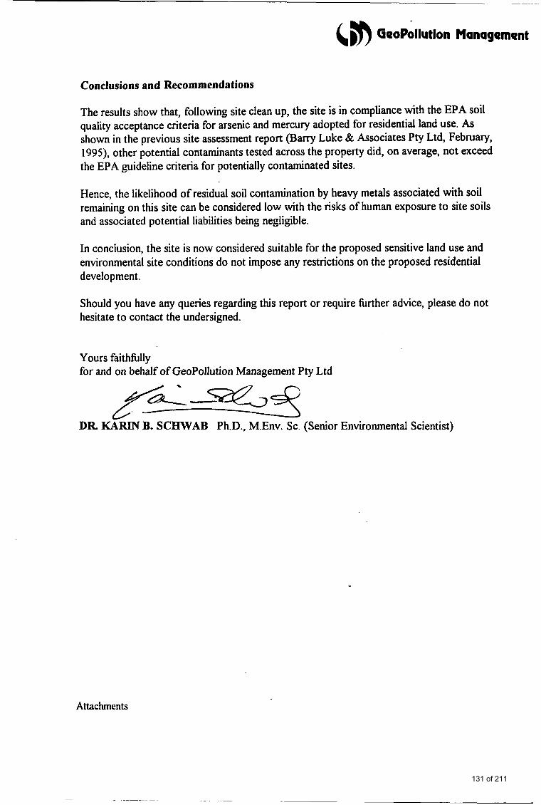
&, GeoPollutlon Management
Conclusions and Recommendations
The results show that, following site clean up, the site is in compliance with the EPA soil quality acceptance criteria for arsenic and mercury adopted for residential land use. As shown in the previous site assessment report (Barry Luke & Associates Pty Ltd, February, 1995), other potential contaminants tested across the property did, on average, not exceed the EPA guideline criteria for potentially contaminated sites.
Hence, the likelihood of residual soil contamination by heavy metals associated with soil remaining on this site can be considered low with the risks of human exposure to site soils and associated potential liabilities being negligible.
In conclusion, the site is now considered suitable for the proposed sensitive land use and environmental site conditions do not impose any restrictions on the proposed residential development.
Should you have any queries regarding this report or require fbrther advice, please do not hesitate to contact the undersigned.
Yours faitffilly for and on behalf of GeoPollution Management Pty Ltd
ZL-S2 DR KARIN B. SCElWAB Ph.D., M.Env. Sc. (Senior Environmental Scientist)
Attachments
131 of 211
ATTACHMENTS
132 of 211
&m GeoPoiiution Management
FIGURE
133 of 211
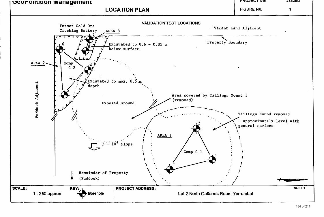
ueuruirurron management LOCATION PLAN
AREA 2.
F'KUJtGI NO: 2853512
FIGURE No. 1
* 7
Property \ Boundary
r/ below surface
Comp
*.-
SCALE: 1 : 250 approx. Borehole
Exriosed Ground
PROJECT ADDRESS: NORTH
Lot 2 North Oatlands Road, Yarrambat
Area covered by T a i l i n g s Mound 1
/
I Remainder of Property
i f I : i :. \ :
4'
. th
134 of 211
&& GeoPollutlon Management
APPENDIX A: FINAL (NATA ENDORSED)
CHEMICAL ANALYSIS REPORT
135 of 211
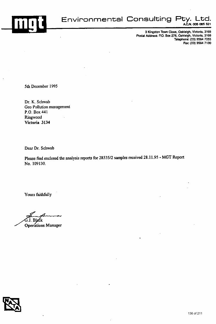
3 Kingston Town Close, Oakleigh, Victoria, 3166 Postal Address: EO. Box 276. Oakleigh, Victoria, 3166
Telephone: (03) 9564 7055 Fax: (03) 9564 7190
5th December 1995
Dr. K. Schwab Geo Pollution management P.O. Box 441 Ringwood Victoria 3134
Dear Dr. Schwab
Please find enclosed the analysis reports for 28535/2 samples received 28.1 1.95 - MGT Report No. 109130.
Yours faithfillly
136 of 211
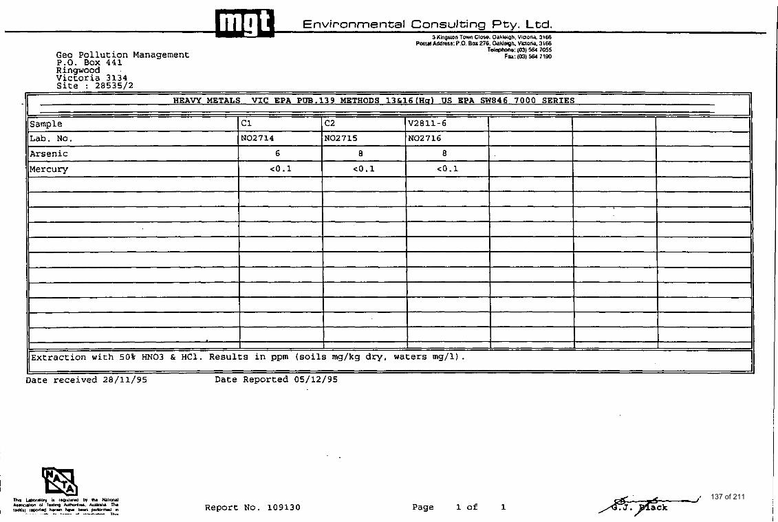
Environmental Consulting Pty. Ltd. 3 Kinaston Town Close. Oakleioh. Viaona. 3166
HEAVY METALS VIC EPA PW.139 METHODS 13&16(Hs) US EPA SW846 7000 SERIES
Sample c1 c2 V28 11-6 NO2714 NO2715 NO2716 Lab. No.
Arsenic 6 8 8
Mercury co.1 co.1 co.1
Extraction with 50% "03 & HC1. Results in ppm (soils mg/kg dry, waters mg/l).
Date received 28/11/95 Date Reported 05/12/95
Geo Pollution Management P.O. Box 441
Postal Addrk : P.O. BOX 276. Oakleigh. ViflOriO 3166 Telephone: (03) 564 7055
Far: (03) 564 7190
Ringwood Victoria 3134 Site : 28535/2
Report No. 109130 Page 1 of 1 137 of 211
Posial Address: P.O. Box 276. OakJegh. Victoria. 3166 Telephone: (03) 564 7055
Fax: (03) 564 7190
CRITERIA USE D TO ASSESS 01 IAI.ITY CONTROL RESULTS
VALIDITY AND RELIADII.ITY OFTEST RESULTS,
'Gw conlinuing validiiy and reliabiliiy of rcsults IS accoiiiplishcd by nioiiitoriiiy a iiuiiibcr of factors
I. Arwlysis of duplicates. Dupliwtcr run at a iuininium of 5 'A 2. Recovery of h o w additions. Spikes run ai a lnininlum of 5 %with u c b batch of samplcs. 3. Analysis o f rcngcni blanks run wilh each batch of sampla.
I JInalvrir o l D u ~ licam
Duplicatcr arc analyscd as a m3KCr o f course and I h c data nnalyscd by mans of a range chan r p c systcm Thc range for wch duplicate pair is dctcrmincd and 'nomliscd' by dividing by thc avcragc of B c dupliwtc ruulu. Once enough Lo hor bccn galhcrcd control &la for wsh m c d d can bc dcvclopcd The mean ranye ( R ) is dctcrmincd as
R E ( ZRi 1
n
where n - number of obscwationr and Ri nornlaliscd rangc
and the variancx (square of lhc standard dcviation) is dctcnnincd or :
s,' * ( Z Ria -nR:) a-
n - I The control criteria rhus bcwmc :
Averagc rangc R Warning Limit K 2s, Control Liiiiit R t 3s,
Thc nonnaliscd rnngc for wch duplicatc pair is calculaicd and coniparcd wih thc abow critcria. ( l h i s can bc achicvcd cilhcr graphically or by visual coniparison of thc data.) . Sincc rhe limits are bvcd on 95 '%ad 90 % confidcncc lcvcls rcspcclivcly , hc folloiviiig actions arc rakcn. bvcd on thcsc statistical paramctcrs.
Control Lima
If ocl(: mcuurcmcni cxcccds Bc C.L. r c p i ihu analysis. If the repcat IS ~v111iiii ilic C L continuc analysu . If ii cxcccdr the C L. discoiitinuc MJIYSCS and correci the problcni
Warninn Limit
If two out of h e c successive points cxcccd rhc W.L. analysc anolhcr smplc. If ihe ncxt poiiit ts IUS than h e W.L. continuc ~ ~ a l y s u . i f thc ncxt point cxcccds the W.L. discontinue uialyscs and wrrcct lhc problun.
'**Paniculu care Radr IO bc taken wilh sonu soil sampla witb rcgard to saniplc homagcncily, apaial ly wilh regard to 'organics' analyscs. Statistical analysis may indicatc a problun uisu when in fact lhc problun is r u l l y only rmp lc homoycncity.
b Rcroverv of known add ition&
Thc rccovcry of known additions is uscd IO verify the abscnrx of matrix c f lc~ is a id absence of intcrfcrcnscr. Rccovcry from standards is urcd to verify mcthod pcrfomncc. Rccovcry data is comparcd against accsptance critcria publirhcd in Standards Mclhodr for Exuiiinatiuii of Watu and Wutc waiu. or appropriaic U.S. EPA M c t h d .
If rccovcria fall outridc acceptance crileria. analyses should be discontinucd ad Bc probluli rcctificd.
J.0 A n e l v r i r n t Dlnnb
Rcagent blanka am urcd lo monitor punty of rwgwu and lhc ovcrall procedural blank Rwgcnt blanks arc run u a maKCr of coursc wilh wch baich for analysis Unusual or out of lhc ' ~ n n ' rcsulu for blanks arc invcsligatcd and corrcclivc action takcn bcforc uialysir of any batch IS wmplctcd
138 of 211
4m GeoPollutlon Management
APPENDIX B: COPY OF CHAIN OF CUSTODY A N D
ANALYSIS REQUEST FORM
.
139 of 211
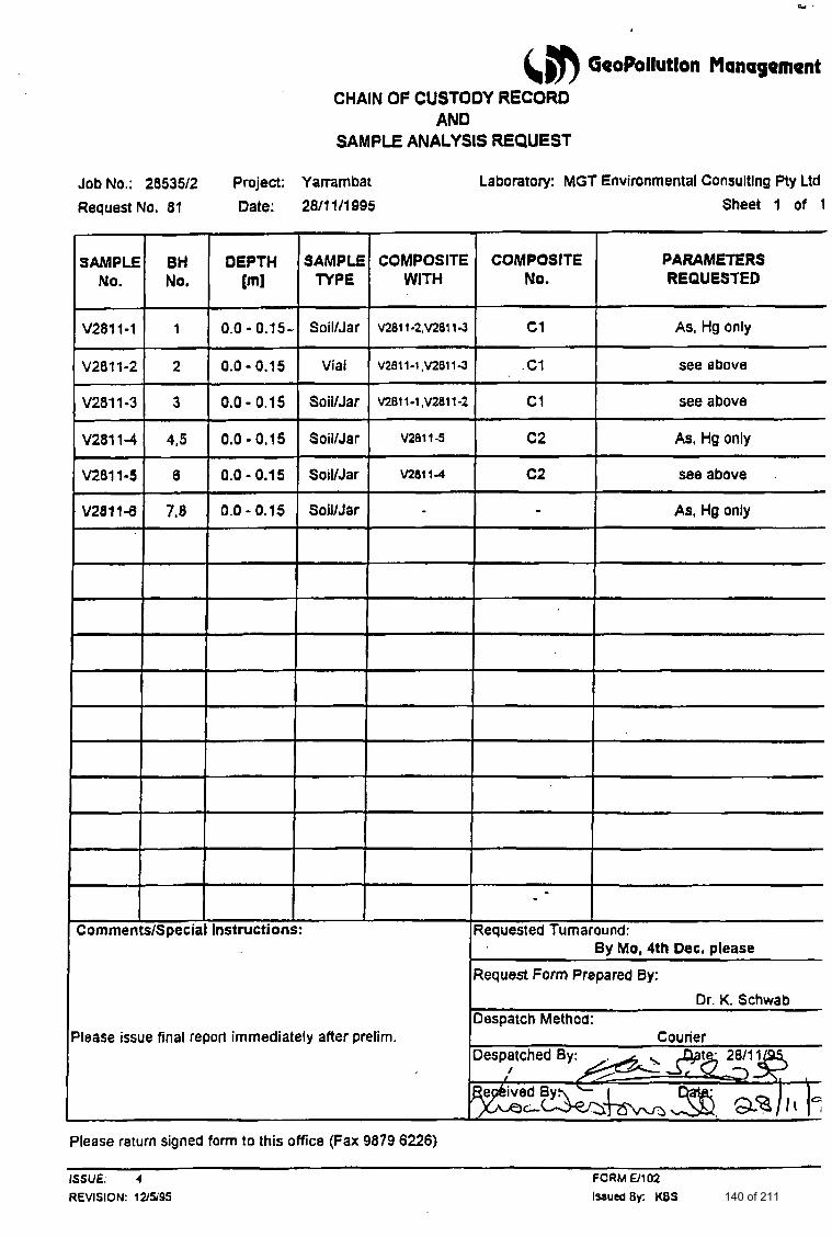
(,m GeoPollutlon Management CHAIN OF CUSTODY RECORD
AND SAMPLE ANALYSIS REQUEST
Job No.: 2853512 Project: Yammbat Laboratory: MGT Environmental Consultlng Pty Ltd
Request No. 81 Date: 2811 111 995
COMPOSITE No.
c1
. C1
c1
c2
c2
Sheet 1 of 1
PARAMETERS REQUESTED
- ~.
As, Hg only
see above
see above
As, HQ only
see above
As, Hg only
By Mo, 4th Dec. please
Please issue final report immediately after prelim.
Please return signed form to this office (Fax 9879 6226)
ISSUE. 4 FORM 0 1 02 REVISION: 12/!%95 l%aucdBy: KBS 140 of 211
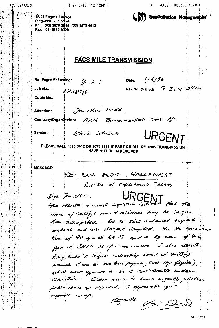
; 3-
fls/21 Eugene Te
F a (03) 9879 6Q6 Ph: (OS) 9879 29as (43)
6-86 ; 1 2 : 1 2 P M ;
9879 6612
. . . . . . ?
' !
1 . .
!
+ A X I S - MELBOURNE;# 1 . ..
! I .
! . . ! . . . . . . .
G
7 i
FACSIMILE TRANSMISSION 1 ! .~
. . 9, . .
. . .I ..
. ..
I :. . . .. j j No. . :Pages Foilowing : . .
- . PLEASE CALL 9879 6612 OR 9879 2999 IF PART OR ALL OF THIS TUANSMISSION ,
HAVE NOT BEEN RECEIVED
i i MESSAGE:
141 of 211
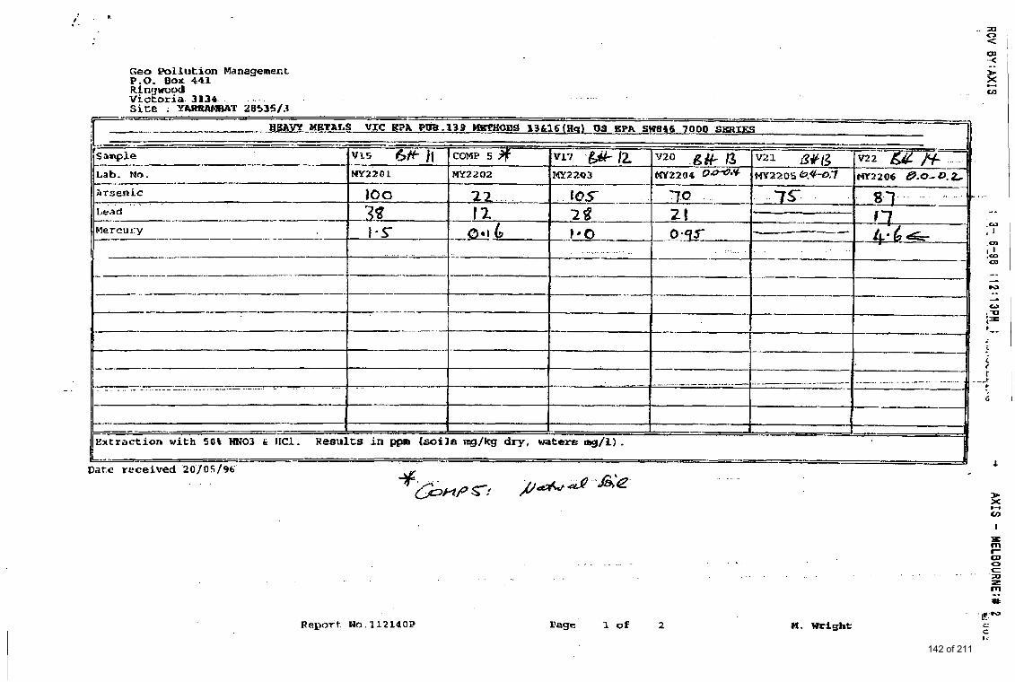
,: . .. .. SD 0 <
Date rcceived '20'/05/96'
Report. Ma. ll214OP
. ..
U. Wright
142 of 211
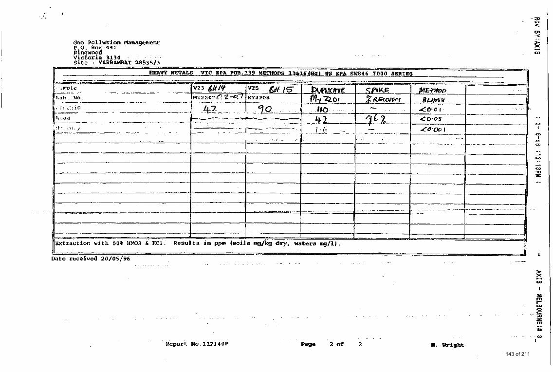
1 . . .' a 0 <
Geo Pollution Wanagment e . 0 . BOW 441 RinswoOd vrctorra 3134 Site : YARRAMBAT 28535/3 _---- I_
WEAW METALS VIC EPA PW.139 METHODS 13616lEUB US 8PA SW816 ?OO--[
.......... ..--I --.. -- I-------- .--------- I
If
.- . .._<.- . - . . . . . . . . ...... _ . . Date received 2 0 / 0 5 / 9 6 . . . . . . . . . . . . . . . . . . . . . . . . . . . . . . .
z H
cn I
. . . .
. . Report NO. i 1 2 i r o P
. . . . . .
page 2 of 2 H. Wright
143 of 211
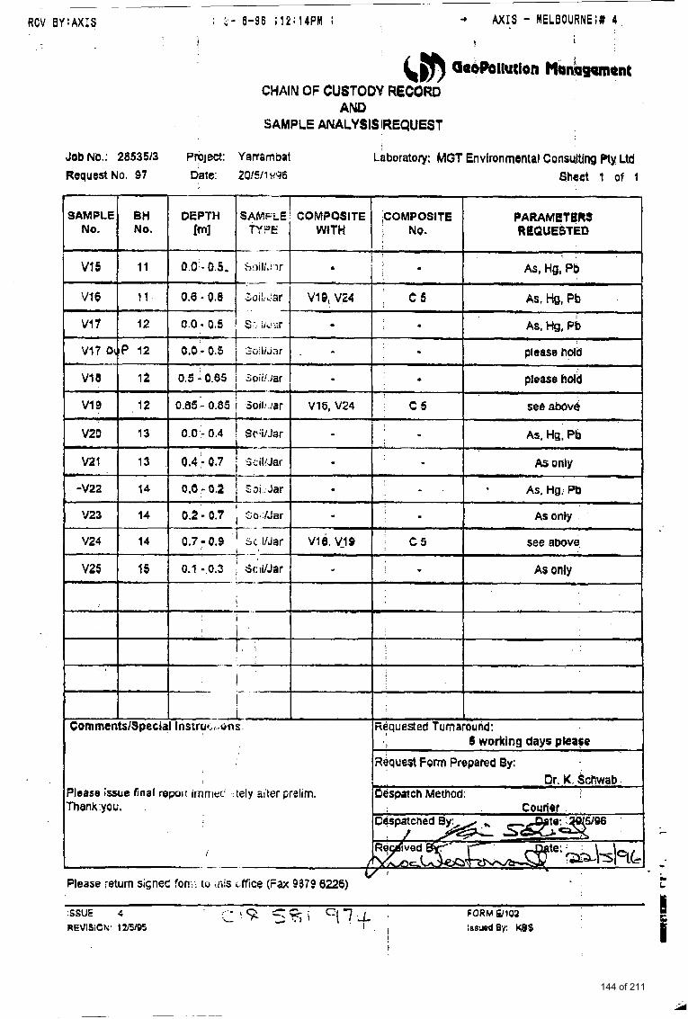
~~
+ A X I S - MELBOURNE;# 4 RCV 0 Y : A X I S . I- 6-96 ; 1 2 : 1 4 P M ;
1 t I &m QaOhllutfon Hanbgom~nt CHAIN OF CUSTODY RECORD
. . - .
! j _ ' -
AND SAMPLE ANALYSIS IREqUEST
t -A,. CommentslSpecial Instrot.., .oris. Rdquested Turnaround:
Request Form Prepared By: I 5 working days please
Please issue final repor: imniar.' ;ieIy zii!er preiim. Or. K. S c h a b I
Pespatch Method: Thank you.
c
/
c -- "
Please return signec fonts to .iiis c:ffice ( F a 9379 6226) t
144 of 211
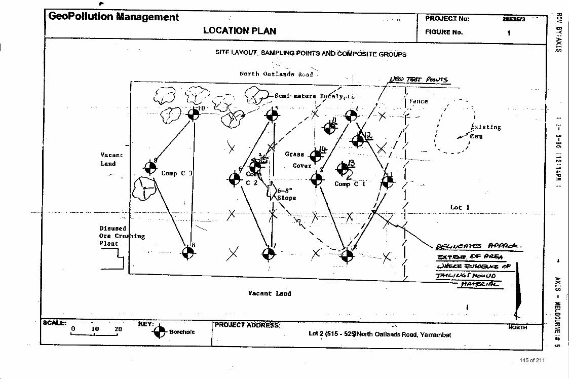
c
GeoPoHution Management 1 PROJECTNO:
I FIWRE No. LOCATION PLAN
SITE LAYOUT SAIJIPLM POINTS AND COMPOSITE GROUPS
.
Vacant Land
....... - ... ...
Dieused Ore Cru Plant
--
Comp C
. .
fw . . . . .-."I,
. . . . .- ........ -.
\
-7-
%
. -. ....... - .. ..... \f + i
.\ ... .. - ...
.\
. . . . . . " "" 'I
. . .
Lot I .. - ....... -. ....... - - - - -. . . . . . - -
...
. . . . . . . . . . . . . . . . . . . . . . . . . . . . . . . . . ,
... . . . . . . . . . . . . . . . . . . . . ~ P ~ ~ ~ I E C f AISbR~.~.s-:. - . . . . . . . . . . . - - . I..., . . . . . NORTH L . - borehole Lol2 (515 - 523North Oallands Roed. Yarrernbet
0 10 20
. . .
CALL:
145 of 211
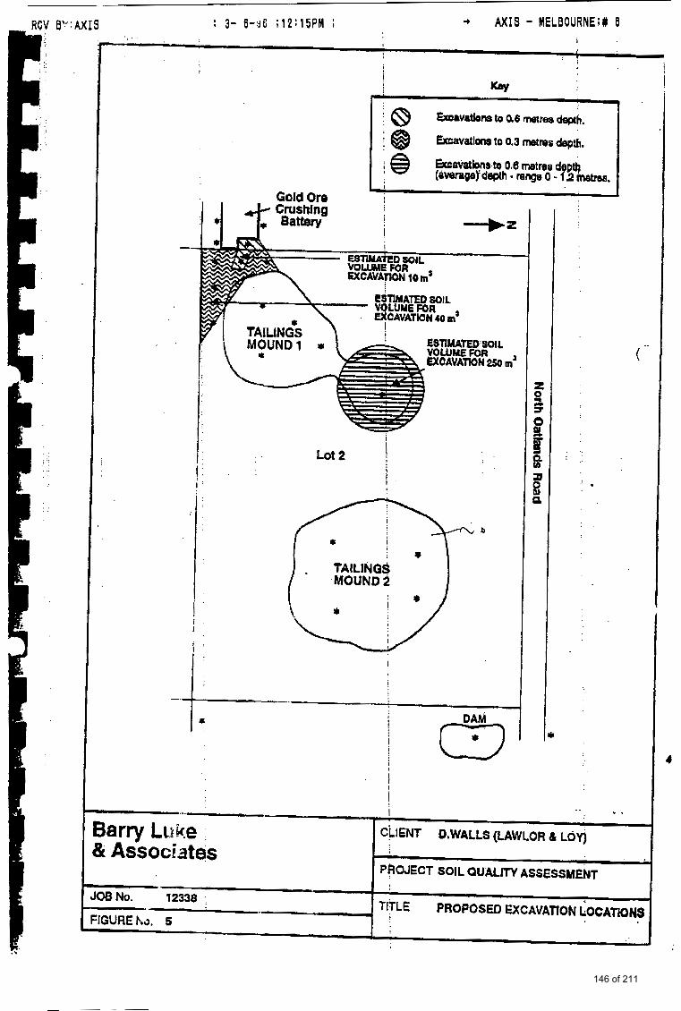
8'": AX1 S ; 3- 6-38 ; 1 2 : 1 5 P M ; + A X I S - MELBOURNE;# 6 t I
t v
Gold Ore 1 *I
i !
Lot 2
!
! 1;
-
(23 j i !
. . ..
. .. . .
I .- Barry Luke CLIENT D,WULLS (LAWLOR L LOY)
PROJECT SOIL auum ASSESSHEEIT & Associates
12338 TITLE PROPOSU) EXCAVATION GOCATiONS FlGUREho. 5 I
146 of 211
;
&#) GaoPollutlon Management
VALIDATION TEST REPORT
LOT 2 NORTH OATLAWS ROAD YARRAMBAT
PREPARED FOR
Mr Oscar Arfi
GeoPollution Management Pty Ltd December, 1995
147 of 211
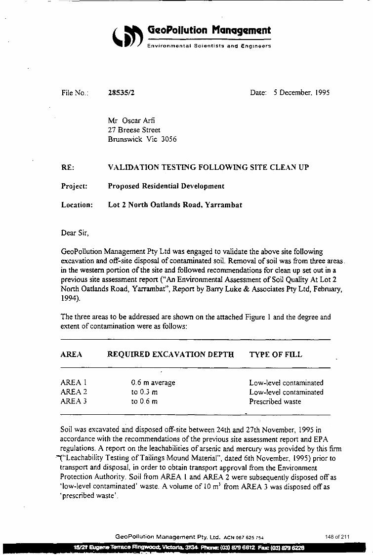
File No.:
RE:
Project:
Location:
GeoPollution Management Environmenta l S c i e n t i s t s a n d E n g i n e e r s
28535/2
Mr O S C a r A r f i 27 Breese Street Brunswick Vic 3056
Date: 5 December. 1995
VALIDATION TESTING FOLLOWING SITE CLE.43 UP
Proposed Residential Development
Lot 2 North Oatlands Road, Yarrarnbat
Dear Sir,
GeoPollution Management Pty Ltd was engaged to validate the above site following excavation and off-site disposal of contaminated soil. Removal of soil was fiom three areas in the western portion of the site and followed recommendations for clean up set out in a previous site assessment report (“An Environmental Assessment of Soil Quality At Lot 2 North Oatlands Road, Yarrambat”, Report by Barry Luke & Associates pty Ltd, February, 1994).
The three areas to be addressed are shown on the attached Figure 1 and the degree and extent of contamination were as follows:
AREA REQUIRED EXCAVATION DEPTH TYPE OF FILL
AREA 1 0.6 m average AREA 2 to 0.3 m AREA 3 to 0.6 m
Low-level contaminated Low-level contaminated Prescribed waste
Soil was excavated and disposed off-site between 24th and 27th November, 1995 in accordance with the recommendations of the previous site assessment report and EPA regulations. A report on the leachabilities of arsenic and mercury was provided by this firm
.-(“Leachability Testing of Tailings Mound Material”, dated 6th November. 1995) prior to transport and disposal, in order to obtain transport approval from the Environment Protection Authority. Soil from AREA 1 and AREA 2 were subsequently disposed off as ‘low-level contaminated’ waste. A volume of 10 m’ from AREA 3 was disposed off as ‘prescribed waste’.
GeoPollution Management Pty. Ltd. ACN 067 62s 754 148 of 211
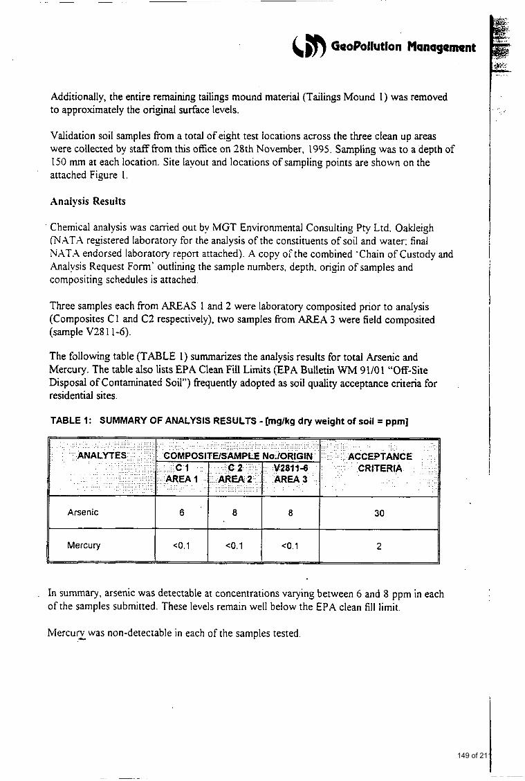
6 #) GeoPollution Management
Additionally, the entire remaining tailings mound material (Tailings Mound 1) was removed to approximately the original surface levels.
Validation soil samples from a total of eight test locations across the three clean up areas were collected by staf€fiom this office on 28th November, 1995. Sampling was to a depth of 150 mm at each location. Site layout and locations of sampling points are shown on the
. attached Figure 1.
Analysis Results
Chemical analysis was camed out by MGT Environmental Consulting Pty Ltd. Oakleigh ('N.AT.4 registered laboratory for the analysis of the constituents of soil and water: final NATA endorsed laboratory report attached). A copy oi" the combined 'Chain of Custody and Analysis Request Form' outlining the sample numbers, depth. origin of samples and compositing schedules is attached.
Three samples each from AREAS 1 and 2 were laboratory composited prior to analysis (Composites C 1 and C2 respectively), two samples fiom AREA 3 were field composited (sample V28 1 1-6).
The following table (TABLE 1) summarizes the analysis results for total Arsenic and Mercury. The table also lists EPA Clean Fill Limits (EPA Bulletin WM 91/01 "Off-Site Disposal of Contaminated Soil") frequently adopted as soil quality acceptance criteria for residential sites.
TABLE 1: SUMMARY OF ANALYSIS RESULTS - [mglkg dry weight of soil = ppm]
ACCEPTANCE
In summary, arsenic was detectable at concentrations varying between 6 and 8 ppm in each of the samples submitted. These levels remain well below the EPA clean f i l l limit.
Mercurv c was non-detectable in each of the samples tested.
149 of 211
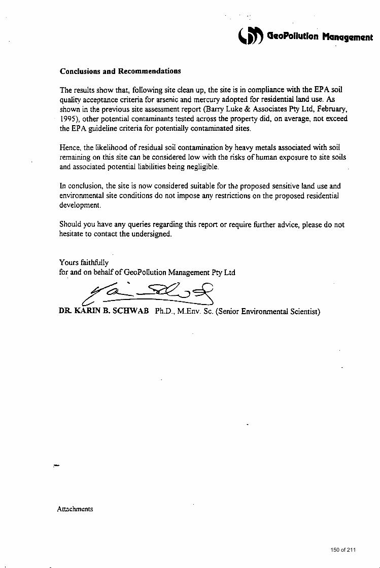
. r
&n GeoPoilutlon Management
Conclusions and Recommendations
The results show that, following site clean up, the site is in compliance with the EPA soil quality acceptance criteria for arsenic and mercury adopted for residential land use. As shown in the previous site assessment report (Barry Luke & Associates Pty Ltd, February, 1995), other potential contaminants tested across the property did, on average, not exceed the EPA guideline criteria for potentially contaminated sites.
Hence, the likelihood of residual soil contamination by heavy metals associated with soil remaining on this site can be considered low with the risks of human exposure to site soils and associated potential liabilities being negligible.
In conclusion, the site is now considered suitable for the proposed sensitive land use and environmental site conditions do not impose any restrictions on the proposed residential development.
Should you have any queries regarding this report or require hrther advice, please do not hesitate to contact the undersigned.
Yours faitffilly for and on behalf of GeoPollution Management Pty Ltd
W J DR KARIN B. SCHWAB Ph.D., M.Env. Sc. (Senior Environmental Scientist)
Anchments
150 of 211
ATTACHMENTS
151 of 211

. . _. &,n GeoPollutlon Management
FIGURE
152 of 211
GeoPollution Management LOCATION PLAN
AREA 2
PROJECT No: 2853512
1 FIGURE No.
. . . a
SCALE: 1 : 250 approx. Borehole
VALIDATION TEST LOCATIONS Vacant Land Adjacent Former Gold Ore
xcavated to 0.6 - 0.85 m elow surface
PROJECT ADDRESS: NORTH Lot 2 North Oatlands Road, Yarrambat
Area covered by Tailings Mound 1
Exposed
5' a_- 1 0 6
removed ) --- - - Ground - \
Tailings Mound removed
general surface
\
.. . . . . . . . . . - . ..... approximately level wi
I : Slope
th
\ . .
Remainder of Property \ . :- / , - .:. /
\ .. 1 (Paddock)
153 of 211
c#) GeoPoilutlon Management
APPENDIX A: FINAL (NATA ENDORSED)
CHEMICAL ANALYSIS REPORT
154 of 211
5th December 1995
Dr. K. Schwab Geo Pollution management P.0. Box 441 Ringwood Victoria 3134
Dear Dr. Schwab
Please find enclosed the aualysis reports for 2853512 samples received 28.11.95 - MGT Report No. 109130.
Yours hiti lfdy
155 of 211
Geo Pollution Management P.O. Box 4 4 1
S amp 1 e Lab. No.
Arsenic
Mercury
Rinswood
c1 c 2 V28 1 1 - 6 NO2714 NO2715 NO2716
6 8 8
c o . 1 c o . 1 c o . 1
VicEoria 3134 f Sice : 28535/2
Pollal Address: P.O. Boa 276. OakJegh. Vinoria. 3166 Tolaphone: (03) 564 7055
F a : (03) 564 7 190
I I I I I I I I I I I
Extraction w i c h 50% tIN03 & HC1. Results in ppm (soils mg/kg dry, waters mg/l).
Date received 2 8 / 1 1 / 9 5 Date Reported 05/12/95
Report No. 109130 Page 1 of 1 156 of 211
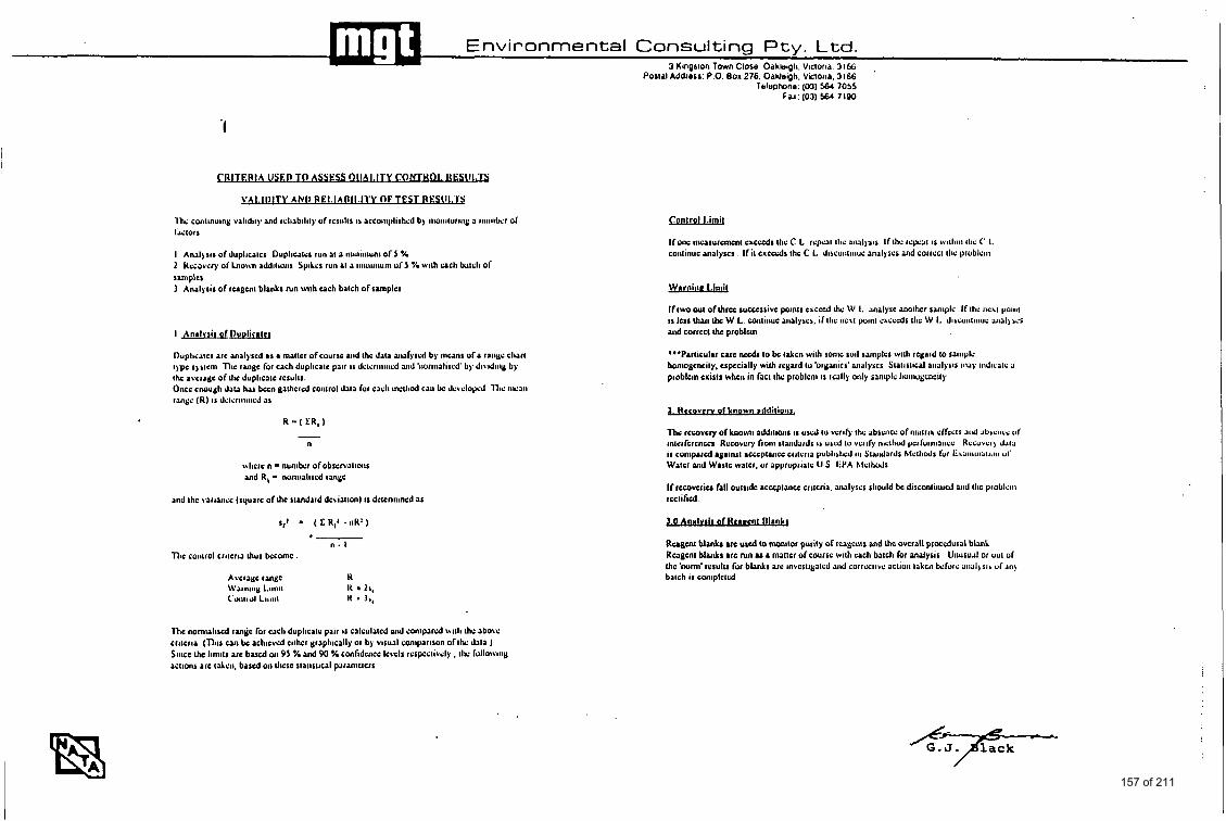
Environmental Consulting Pty . Ltd. 3 Kmarlon Town Close Oahlwoli. Vmorka. 3166
Penal Addriss. P o 001 276. Oaklejh. vanria. 3166 Telephone. (03) 564 7055
Fax 1031 564 7190
'I
W I A USED TO A W S S OI I M T Y C .ONTHOWjESIII.lS
1' ALIDITY ANP RE l . lAll l l . l lY OFTEST R L S W I .
l lw continuing validity and reliability of rcsiilts IS accomplished by iiwiiituriiig a 8iuiiilk.r of f J i l O l l
I Analysis of duplicatcs Dupliwi~.r NII at a iiiiniiiiuni o f 5 % 2 HcCavcq o i b o w addiiioiis Spilcs run at a iiiiiiiiiiuni ui 5 7. with u c l t batch o i sannlpks I Analysis of rcagcnt blanks mn with u c h batch of samples
I Jnrlt.rii of I)unlitrr(l
Ihplicatcs arc analysed as a mrttcr o f course mid thc dau aiafyscd by inuns ora rniiyc chart t)pc s) stcni TIie r ~ g c for cach duplicatc pair i s dctcnniiicd and 'iiorinalisd by dividiiig by thc avcragc ofllic duplicatc ICSUIIJ. Once cMu&h Jaw h u bccn gathcid coiiirol data for each inclliod caii bc d c v c l o ~ d llic iiicaii range (R) IS d e t c n ~ i ~ ~ ~ c J as
R = ( CR, )
n
\\here n - nunihr ofobscnaiioiis and R, - noniialircd range
and thc varianic (square of thc standud dcvialionJ i s dwnnincd as
q - ( c R,' . nn: J
6- n . I
Thc control cratcria ihur hcomc
Avcmgc ran$c H \Vattiin& l.iinit H Is, c ' u r l l l d Llllltl H * I.,
nu nornuliscd ranme for Each duplicatc pair i s calculated yul CMIpard ruth the above criteria (This can bc achicvd cithcr graphically or by visual coniparison ofthe data J SIIICC chc liniits arc based on 95 % ud 90 Y. confidcncc I c~c l r rcspccli\ely , the fullowiiy aitions arc tAcn, b a r d on llicsc statistical patanictctr
r n l r o l I.imi1
Ifolu: incasurcmcni cxccsds the C L rcpcat tlic arwlgsos I f the r e p a i s o.di~ii t l~c C 1. conlinuc analyscr If it c x c d s the C L dlsiuiitiiiuc nnalyscs and COI~CCI tlic prublciii
If two out of thrcc rucccsrivc points cxcced the W I. annlysc another saniplc If the IICAI poiiit i s lcss lhvi chc W L cnntiiiuc ~iialyscs. i f the iic'il point chcccds tlie W 1. diriuiitiiiuc a i d ) ics a id corrcct ihc problun
*"Paniculu UIC nssd, to bc takcn with sonic soil samples wlth regard to saiiiplc honioucncily. cspccially with regard tu brguiics' annlyrcs Statistical uialysis i n i y iiidicatc a prcblcin crirtr when in fact thr: problcni i s really only saniplc Iioinogcncily
2. Rscovcn of known rddilioii&
Thc rccovcry ofknom addiuons i s u s d to veri6 the abscncc ofinatria clTccts atid absciie~: of intcrfcrcnces Recovery fioiii rtuid;rrds ii used IO verify nictliod pcrfuniiaiicc Rccuvciy d:iia ir coniparcd rgainsl accsptuicc ciitcria published iii Staidaids Mcll ids fur E & ~ ~ i i i ~ i i t i ~ i ~ i uI. Water and Wartc wn~cr. ut appropriatc U S EPA hfclhds
If rccovcriu fall outside rcccptancc criteria. ~ ia lyrcs should bc discontiiiuul niid die problciii rcctihcd.
Ruguu bl& arc uscd to ( ~ \ ~ i I o r purity of ccagcnts and thc ovcrall procdural blank Reagent blanks &IC fun u a mallcr of course with each batch for analysis Unusual or out of Ihc 'nom< ICIU~U for blanks arc invcstiyntcd aid corrective action t n h bcfuic aii:il)sir d . i i i y batch IS coliiplctd
157 of 211
.%
&,m GeoPollution Management
APPENDIX B: COPY OF CHAIN OF CUSTODY AND
ANALYSIS REQUEST FORM
158 of 211
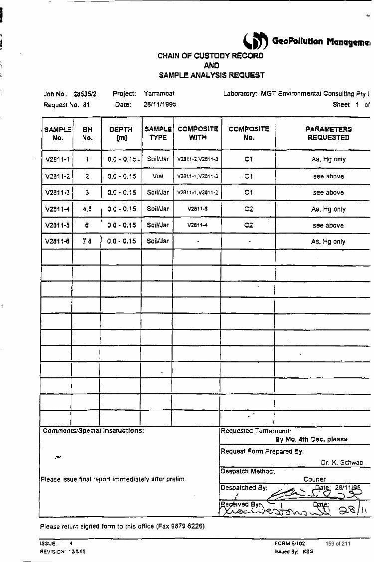
Jaw
SAMPLE TYPE
--
COMPOSITE COMPOSITE WITH NO.
@ GeoPollutlon Managemer
Soil/Jar
CHAIN OF CUSTODY RECORD AND
SAMPLE ANALYSIS REQUEST
1
v2a11-2.v28114 1 C1 1 As, Hg only
40.: 2853512 Project: Yammbat Laboratory: MGT E
Vial I v2911-i.v281:4
Soil/Jar v281 r-l.v2811-; 1 c1
Request No. 81 Date:
__
see above
see above
0.0 - 0.15-
V2811-3 I 3 0.0 - 0.15
SoillJar
SoilIJar
SoilIJar
vimnmental Consultlng P!y L
Sheet 1 or
As. Hg only v2011-5
VZ6114 c2 see above
c2 I - As, Hg only V2811-d
PARAMETERS REQUESTED
7.8 0.0- 0.15
:omrnents/Special Instructions:
- leas2 issue final report immediately after prelim.
Requested Turnaround:
Request Form Prepared By:
Despatch Method:
By Mo, 4th Dec. please
Dr. K. Schwab
Couner
Please return signed form to this office (Fax 9879 6226)
159 of 211
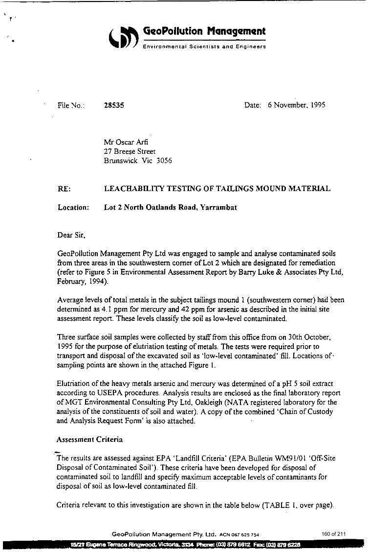
GeoPollution Management Environmental Scientists a n d Engineers
File No.: 28535 Date: 6 November, 1995
Mr Oscar Arf~ 27 Breese Street Brunswick Vic 3056
RE: LEACHABILITY TESTING OF TAILINGS MOUND MATERIAL
Location: Lot 2 North Oatlands Road, Yarrambat
Dear Sir,
GeoPollution Management Pty Ltd was engaged to sample and analyse contaminated soils fiom three areas in the southwestern comer of Lot 2 which are designated for remediation (refer to Figure 5 in Environmental Assessment Report by Barry Luke & Associates Pty Ltd, February, 1994).
Average levels of total metals in the subject tailings mound 1 (Southwestern comer) had been determined as 4.1 ppm for mercury and 42 ppm for arsenic as described in the initial site assessment report. These levels classitjl the soil as low-level contaminated.
Three surface soil samples were collected by stafffrom this office fiom on 30th October, 1995 for the purpose of elutriation testing of metals. The tests were required prior to transport and disposal of the excavated soil as ‘low-level contaminated’ fill. Locations of. sampling points are shown in the- attached Figure 1.
Elutriation of the heavy metals arsenic and mercury was determined of a pH 5 soil extract according to USEPA procedures. Analysis results are enclosed as the final laboratory report of MGT Environmental Consulting Pty Ltd, Oakieigh (NATA registered laboratory for the analysis of the constituents of soil and water). A copy of the combined ‘Chain of Custody and Analysis Request Form’ is also attached.
Assessment Criteria - The results are assessed against EPA ‘Landfill Criteria’ (EPA Bulletin W M 9 110 I ‘Off-Site Disposal of Contaminated Soil’). These criteria have been developed for disposal of contaminated soil to landfill and specitj, maximum acceptable levels of contaminants for disposal of soil as low-level contaminated f i l l .
Criteria relevant to this investigation are shown in the table below (TABLE 1, over page).
GeoPollution Management Pty. Ud. ACN 067 625 754 160 of 211
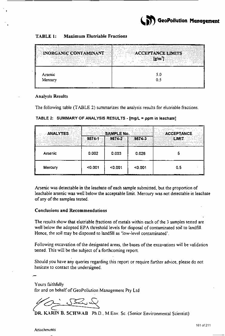
TABLE 1: Maximum Elutriable Fractions
Arsenic 5 .O Mercury 0.5
L
Analysis Results
The following table (TABLE 2) summarizes the analysis results for elutriable fractions.
TABLE 2: SUMMARY OF ANALYSIS RESULTS - [mg/L = ppm in leachate]
5 I I 0.002 I 0.003 I 0.026
Mercury I H 0.5
Arsenic was detectable in the leachate of each sample submitted, but the proportion of leachable arsenic was well below the acceptable limit. Mercury was not detectable in leachate of any of the samples tested.
Conclusions and Recommendations
The results show that elutriable fractions of metals within each of the 3 samples tested are well below the adopted EPA threshold levels for disposal of contaminated soil to landfill. Hence, the soil may be disposed to landfill as ‘low-level contaminated’.
Following excavation of the designated areas, the bases of the excavations will be validation tested. This will be the subject of a forthcoming report.
Should you have any queries regarding this report or require hrther advice, please do not hesitate to contact the undersigned. - Yours faithfilly for and on behalf of GeoPollution Management Pty Ltd
DR. KARIN B. SCHWAB Ph.D.. M.Env. Sc. (Senior Environmental Scientist)
Amchmcnfs 161 of 211
~. . . . ____. ~ .. . . . . .. .- . .. . - -. ..- - ..... . .
. . .. . . '
ATTACHMENTS
162 of 211

*
GeoPollution Management PROJECT No: 28S3wl
1 LOCATION PLAN I I
SAMPLING LOCATIONS
Old Gold Ore I + C r u s h i n g Battery
Area 1-
Area 2'
L-. .... 4
Grass Cover
Area 3
Areas designated for Excavation:
Area 1: Area 2: Area 3:
to 0 .6 m depth to 0 .3 m depth t p 0 . 6 m depth
;EY: Borehole SCALE: not to scale
a Lot 1
Private Residence 4
z 0 1 R 3 0 p1 R )-L
1 a (11
P 0
a
m
m
Figure modified a f ter Luke, B . & Associates, 1994
NORTH
PROJECT: Lot 2 North Oatlands Road, Y arrarn ba t
163 of 211
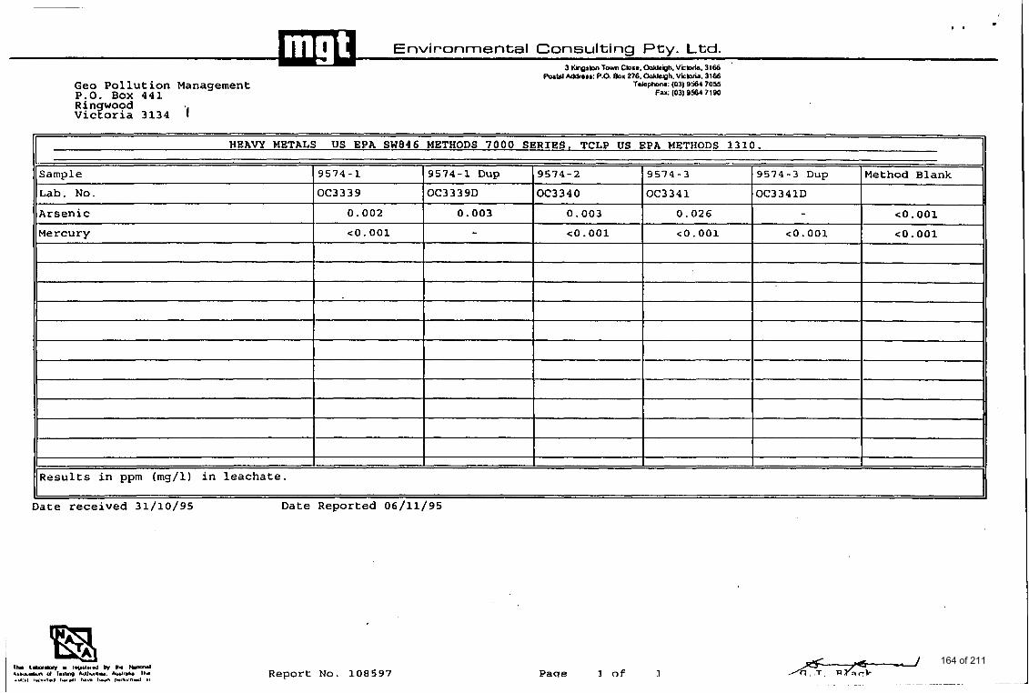
.. * .
Environmental Consulting Pty. Ltd. 3 KhpM Tavn Close. OaklcQh. Vibda, 3166
h L e l Mdrera: P.O. BOK 276. U e n h . Wkbda. 3166
Lab. No.
Arsenic Mercury
~.
Geo Pollution Management P,O. Box 441 Rin wood VicToria 3134 '1
OC3339 OC3 3 3 9D OC3340 OC3341 OC3341D - 0.002 0.003 0.003 0.026 co. 001
co. 001 co. 001 co. 001 c o . 001 - CO. 001
Ti1e-G: (03) o r a i 7055 FY: (03) 9564 7190
II HEAVY METALS US EPA SW846 METHODS 7000 S E R I E S . TCLP US EPA METHODS 1310.
Sample (9574-1 (9574-1 Dup 19574-2 19574-3 (9574-3 Dup 1Method Blank
- I I I - 1 I 1 -
I I I I I I Results in ppm (mg/l) in leachate.
Date received 31/10/95 Date Reported 06/11/95
Report No. 1.08597 Paqe 1 of I 164 of 211
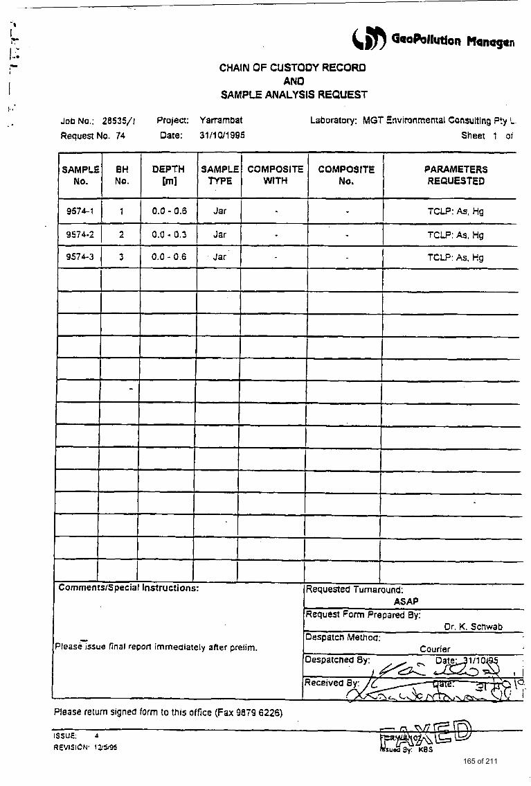
Request No. 74 Date:
DEPTH qqT 95761 1 1 1 0.0 - 0.6
SAMPLE TYPE
CHAIN OF CUSTOOY RECORD AN0
SAMPLE ANALYSIS REQUEST
COMPOSITE COMPOSITE WITH No.
Job NO.: 28535/1 Project: Yarrarnbat Laboratory: MGT Environmental Consultlng ?!y L.
~~
Cornments/Special Instructions:
~easeTssue final report immediately after prelim.
0.0 - 0.3 (
I
Requested Turnaround: ASAP
Request Form Prepared 8y:
Despatch Method: Dr. K. Schwab
Courier
3111 W19Q6 Sheet 1 or
Jar I PARAMETERS REQUESTED
TCLP: As, Hg
TCLP: As, Hg
TCLP. As, Hg I I I
Jar I - Jar
Please return signed form to this office (Fax 9879 6226)
ISSUE: 4
REVISION. tb495
165 of 211
BARRY LUKE & ASSOCIATES ENVIRONMENT ASSESSMENT & REMEDIATION SERVICES
PHONE 038731497 F.iCS 038747880 UOBILE 015 301 471
.AN ENVIRONMIENTAL ASSESSMENT OF
SOIL QUALITY AT LOT 2
SORTH OATLANDS ROAD, YARRAMBAT
FEBRUARY 1994
-
MESDAMES D WALLS, P CULLEN, & J ROBINSON
166 of 211
I 1.0
2.0 -.
ANENvlR0"TAL
SOIL QUALITY
ASSESSMENT OF
AT LOT 2
NORTH OATLANDS ROAD, YARRAMBAT
INTRODUCTION It is understood an application to rezone Lot 2 North Oatlands Road, Yarrambat, to a ruralhesidential classification has been lodged with the Shire of Diamond Valley.
In November 1993 Barry Luke & Associates obtained samples of soil and surface water from or near the property described as Lot 2, North Oatlands Road, Y m b a t . Our report on the results of composite soil analysis indicated a potential for soil contamination due to the presence of metal contamination in tailing mound soil.and a restricted area adjacent to an abandoned ore extraction plant used for gold recovery. The metals of particular concern were arsenic and mercury, but since the data was derived from composite samples only, it was not possible to determine the distribution of contamination nor the associated risks to a planned sub-division.
A proposal to isolate additional, individual soil samples from targeted areas and at other locations of the site was accepted, and this report describes the sampling design and procedures, results of chemical analysis, and an evaluation of the soil quality at Lot 2;
It is vital to examine this current report in conjunction with our earlier report on Sampling and Chemical Analysis of Soils and Surface Water from Lot 2 North Oatlands Road, Yarrambat.
SITE D E S C m O N Lot 2, North Oatlands Road, Yarrambat, is an undeveloped rectangular shaped property with an area of approximately 10,OOO m2. It is situated on the south side of North Oatlands Road about 100 metres-from Yan Yean Road (See Figure l), and has a moderate slope from west to east (see front cover Plate). There is a dam and drainage easement, near the eastern property boundary, which transfers surface water from this region, eventually to the Plenty River.
-
The property contains various grass/weed vegetation with some scattered Eucalyptus trees, mainly along the north western edge. The property is currently used for horse agistment purposes and reportedly one horse in particular has been maintained at Lot 2 for 8 years. There is bountiful evidence of the presence of foxes due to burrows and theremains of chickens at or near these burrows.
In the property to the west of Lot 2 there is an abandoned gold battery within a rusting, galvanised iron shed (see Plate 2), and in several other locations there is evidence of filled in mine shafts. Part of the rear wall of the gold battery forms a
1
167 of 211
common boundary with Lot 2. There are two main tailing mounds of soil on Lot 2 (estimated total volume is 2,000 m3) which are consistent with sluice drains exiting one side of the gold battery and passing, in a shallow sub-surface drain, into Lot 2. These mounds are composed of consolidated, fine, washed sands and are up to a metre above the original soil level. Grass, weeds and blackberry bushes grow within these mounds.
Anecdotal information indicates the gold mine and battery were operated by Mr Clayton, the father of the present owners of Lot 2, who with his brother mined the gold for about 25 years until the mid 1970s. Both men passed on in their late 70s. The gold mine and battery has been idle since that time.
3.0 SCOPE OF WORK The agreed scope of work covers: .
I I Soil sampling to 1.5 metres of the two primary tailing mounds
. Soil sampling to 0.5 metres around the perimeter of the ore crushing plant adjacent to Lot 2
. Soil sampling in the south west comer of Lot 2 immediately south of the ore crushing plant.
. Composite sampling of soil across areas of Lot 2 other than those associated with the gold stamping battery or the tailing mounds
. Sampling of surface waters to the south of the ore crushing plant (in Lot 2), and at three locations along the natural water drainage easement adjacent to the eastern boundary of Lot 2.
. Presention of a report detailing the investigation program and interpretation of the soil quality of Lot 2.
4.0 SOIL AM) WATER SAMPLING 4.1 Locations
4.1.1 Ore Crushing Plant Perimeter The ore crushing plant (Plate 2) is built into the side of the hill such that the eastern (rear) wall is at or about what appears to be the original ground level. The floor of the plant is stepped into the hill in several stages such that there is a 1-1.5 metre cutting along the northern and southern walls of the plant. Water run-off and excess process water would tend to migrate into this cutting and gravity flow across the southern boundary of Lot 2 to the natural drainage
.- easement near the eastern boundary of Lot 2.
Soil was sampled within the cuttings described, at four separate locations (Sl- S4). See Figure 2.
2
168 of 211

Key
S4 Soil Sample, Location 4. TM 15 SW 2 0 A
Tailing Mound Soil, Location 15. Surface Water, Location 2. Individual Locations, Composite SC 1. Individual Locations, Composite SC 2.
jl*
i2*
- 4
- Crushing :* Battery +z
s s / SURFACE CHANNEL (DRAIN)
Barry Luke 81 Associates
5 * sw.s7* 0
8 *
0 9*
0
0
CLIENT D.WALLS (LAWLOR & LOY)
PROJECT SOIL QUALITY ASSESSMENT
SURFACE WATER
RUN OFF I A
A
A
W 0
Lot 2
z s 5
0 z P 3 a. v, z 0 P P
A
A
A
w 3 * S U R FACE
RUN OFF
I I I Y 1 + I V (Marsh) OVERFLOW+-
9 s RFACE WATER DRAINAGE
V WATER I
A A
TITLE SAMPLING LOCATIONS JOB No. 12338
FlGURENo. 2 169 of 211
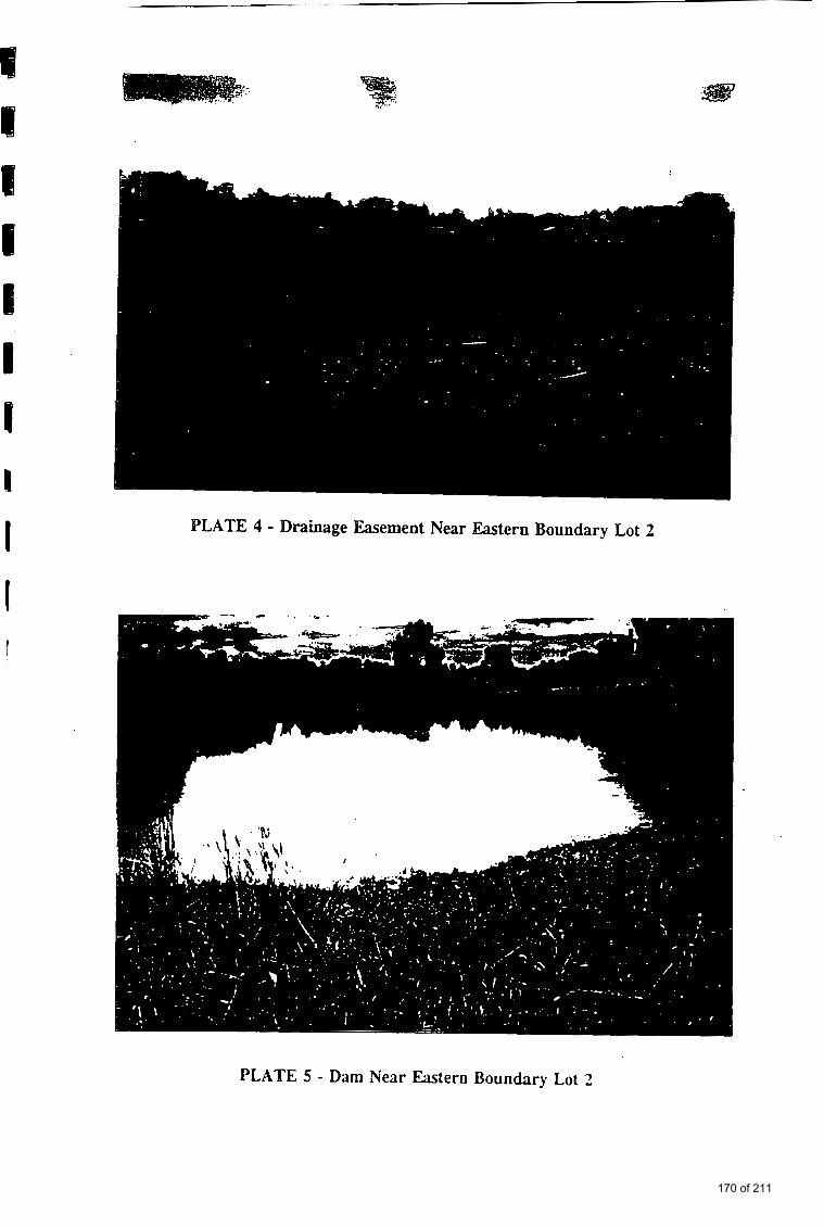
I PLATE 4 - Drainage Easement Near Eastern Boundary Lot 2
PLATE 5 - Dam Near Eastern Boundary Lot 2
170 of 211
RCV 0 V : A X I S
4.1
; 6- 6-96 ; 1 2 : 2 1 P M ; A X I S - MELBOURNE;# 2
. . ' I . , . . ' . . . . . . . .
4.1.2 South West Sector Soil from the area of Lot 2 associaml with the natural Surface water drainage of the ore crushing, p h t was sampIed with a hand auger at five separate locations (s5-s9). see Figure 2. It is dear that this area represents the major surface water drainage pathway from the plant. The sdil samples were generally to 0.5 metres but coarsk rock/aggt.egate,materia p q t e d this depth being reached in all cases.
4.1.3 Tailing Mounds 5
There are two primary tailing mounds on site. t$e F q I 2. Each mound extends
up to about 1 metre above the original gro$nd level. One mound may be described as Iocated in the south west sixtor ojf the Gt 2 not far from the ore crushing plant (Plate 2 shows part of +g mciund l), and measures approximately 25 x 30 metres. Five locations (TM IO-? 14) within this mound were sampled, using a hand auga, at two dbpth pr ,filer. The first profile represented the cruslied sandy ore, and the sebnd thy surface of the original clayham below the tailings. I
. .
. .. J ,
_ .
I
4.1.4 Site Cornpsi@ !
The mid-poin{of the property boundary along Nprth Oal/lands.Road was sedected as a means cif:div&g the property area in half! At ei& locations (see Figure 2) within eac4property half, Soil to 0.5 metres deep acqoss areas not associated wit!! the tailing V u n d s were mixed to provide k c0rrmHite sample. Thus two soil composite! (SC 1 and SC 2) for Lot 2 we'cjprepape)d.J
: ' t An additional soil, sample for organochlorine inpcticidq analysis was prepared ' ...I
!. :
. .
from the abov4 tyo'cornposites. This sample was desig . . i . ' : : ' ,
! . . . . . .
i 4.13 . off si& Coddl i i, a property 0.f.Kmito the west of Lot the ~operty For 16 years, and..to the
a0 gold plining or ex&tion activity at a control soil tpih. w&h to :compare the mils i:. : ' + ' '
!
fmmLot2. : .: I
of Lot 2 (See '
171 of 211
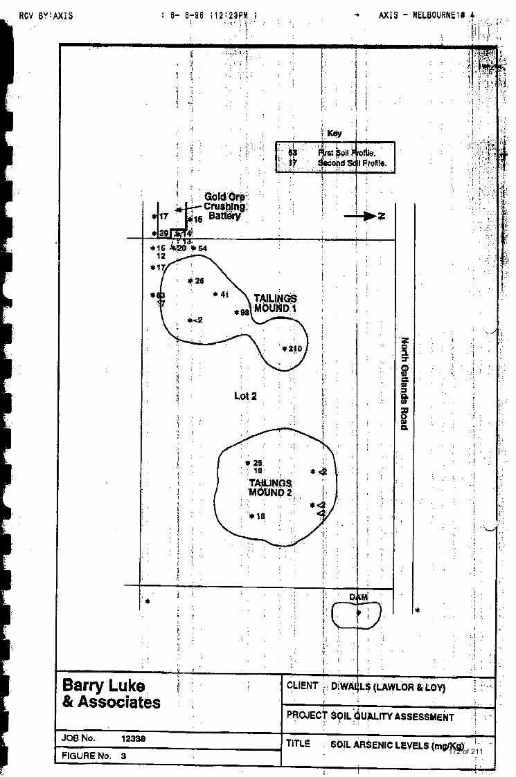
I 6- 6-86 ; 1 2 : 2 3 P M , ; . . , . . . . :: > ' . . I! . .
RCV BYtAXIS
. . . ' : ! .
. .
. . . I I . . . . .
PROJECT SOIL &JALiTY ASSESSMENT -i . . . . .. 1 .
. .
. .
. . . . !
. . . . . . . .
. . . .> ,
. . . I . . . . . .
1 - Lo€ 2 I
I
. . . . . . . : . . . . . . . . . . . i 1 . : I". : . ' . . . 1 .
. . .
. .
. . .J :. . . . . .
i . ! - .
I . : . . . . . . . . . . . b I *
k Associates
I
. .
. .
. . .
. . . .
' I
. .
. .
. . . .
. .
. .
. .
< ' . ' I . .$ (LAWLOR & LOY)
TITLE SOIL ARSENIC LEVUS (msn<g) ' 108 No. 12338
:IGURENo. 3 f .
I . I .
172 of 211
CV B Y t A X I S ; 6- 6-86 ;12;24PM 1 A X I S - MELBOURNE;# 6
SW 2 Dam water (Sec Plate 5). I
. SW 3 Dam inflow water. The actual sampling point is just prior to' the road culvert leading undk North Oatlands bead to thk dam. At the time of sampling th$ water camprisexi w e waW ikom a'much larger dain (0.5 hectare) f r o ~ a propedty on the north $id4 of NoiW Oatlands Road. See Iater comment regarding storm watq m4ff.
. SW 4 Subsurface (0.25 metre) water, k 2, at of gold battery. . I :
Details of the sampling locations are shown in eigure 2, . .
- .. . I SW 5 Tap water control . .
4.2.1 Soils The soil samples were obtained using a hand auger. The soil from each profile at each location were we11 mixed in a polypropylhe b*t .prior to sub-sampling
lined screw about 300g info a clean glass jar, cap. Labels containing information date and sampler were applied in
mber, sample lacation, placed in a chilled .
esky for delivery b the laboratory.
Samples of water were obtained using a stainless steel dipper (500 mL) to transfer the sample into amber coloured glass bottles. These bottles were sealed with teflor! lined screw caps, prior to labelling and placing into a chilled container for transport to the laboratory.
Samples of dam water were taken by plunging q e d i p 4 into the dam from ten locations around the banks of the dam, and mixing the water in a 4 L amber coloured bottle.
All samples were taken 2 days after consistent rain fall and each sample was observed to be from a "flowing" system.
I
4.2.2 Water
bd
5.0 CHEMICAL ANALYSIS 5.1 Laboratory Selection
The water samples and selected soil samples were analysed by National Analytical Laboratories Pty Ltd using methods certified by the National Association of Testing Authorities (NATA). See Appendix 1.
All water and first soil profile samples, together with soil composites and some second profile samples, were analysed for metals (Lcad, cadmium, chromium, copper, arsenic mercury, and zinc).
5.2 Chemicalhgram
i I I
173 of 211
I I I I I I I I I I I I
I I I I I I I
I
The soils were digested with 50% nitric acid at 95°C for 1 hour, filtered and the eluate made up to volume. All metals except mercury were determined using a Perkin Elmer ICP unit. Mercury was determined by flameless atomic absorption spectrophotometry.
The soil (SC 3) prepared from the field composites was analysed for organochlorine insecticides only. The moist sample is extracted with acetone/hexane, concentrated, and the extract cleaned -up using deactivated Florisil. Pesticide determination was carried out using by gas chromatography with an electron capture detector.
Internal laboratory quality assurance programs were in operation and a separate report is attached to the laboratory results. A review of the QA results indicate that the analyses have been carried out with acceptable standards of accuracy and precision.
6.0 RESULTS OF ANALYSIS 6.1 Presentation of Data
The NATA certified report, detailing all analytical results, is shown in Appendix 1. Selected analytical results are shown throughout the text. For soil samples the metal and insecticide concentration units are mg/Kg dry weight. For water the metal concentrations in Appendix 1 are reported in mg/L, whereas in the text they are converted to ug/L units (Table 6).
6.2 Criteria for Interpretation of Results While the Victorian EPA have indicated that soil and ground water criteria are site specific, national and international guidelines are important in assessing the potential for contamination of these resources. In particular, guidelines published by the Australian and New Zealand Environment and Conservation Council, the Dutch government and other governments, are useful in considering criteria for requirements to conduct further investigations and/or to recommend clean-up of soil and ground water where necessary.
With a similar approach adopted by the Dutch government some years ago, the - Victorian EPA have regarded classifications of A, B, and C, to indicate increasing degrees of contamination of soil and ground water. Those at A levels are considered as likely background concentrations. Contaminants at or exceeding B classifications are those requiring further investigation, and those at or exceeding C levels are liable for remediation or clean-up programs. The above protocols for assessment may be varied provided substantive cases can be made for individual circumstances.
Where criteria for specific chemical species are not available then proposed tentative guidelines, based on human health and ecological protection should be estimated. The latter two parameters are often difficult to determine owing to the scarcity of complete toxicological and epidemiological data.
.-
5
174 of 211
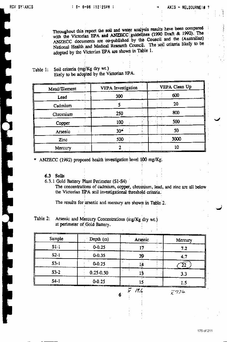
175 of 211
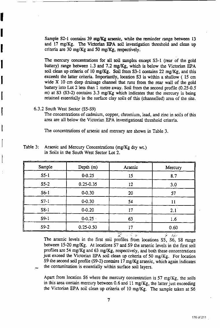
I I I I I I 1 I
I
S8-1
s9- 1
S9-2
Sample S2-1 contains 39 mg/Kg arsenic, while the reminder range between 13 and 17 mg/Kg. The Victorian EPA soil investigation threshold and clean up criteria are 30 mg/Kg and 50 m a g , respectively.
0-0.20 17 2.1
0-0.25 63 1.6
0.25-0.50 17 0.60
The mercury concentrations for all soil samples except S3-1 (rear of the gold battery) range between 1.3 and 7.2 mg/Kg, which is below the Victorian EPA soil clean up criteria of 10 mg/Kg. Soil from S3-1 contains 22 mg/Kg, and this exceeds the latter criteria. Importantly, location S3 is within a shallow ( 15 cm wide X 10 cm deep drainage channel that runs fiom the rear wall of the gold battery into Lot 2 less than 1 metre away. Soil from the second profile (0.25-0.5 m) at S3 (S3-2) contains 3.3 mg/Kg which indicates that the mercury is being retained essentially in the surface clay soils of this (channelled) area of the site.
6.3.2 South West Sector (S5-S9) The concentrations of cadmium, copper, chromium, lead, and zinc in soils of this area are all below the Victorian EPA investigational threshold criteria.
The concentrations of arsenic and mercury are shown in Table 3.
Table 3: Arsenic and Mercury Concentrations (mg/Kg dry wt.) in Soils in the South West Sector Lot 2.
Apart from location S6 where the mercury concentration is 57 mg/Kg, the soils in this area contain mercury between 0.6 and 11 mg/Kg, the latter just exceeding the Victorian EPA soil clean up criteria of 10 mg/Kg. The sample taken at S6
7
176 of 211
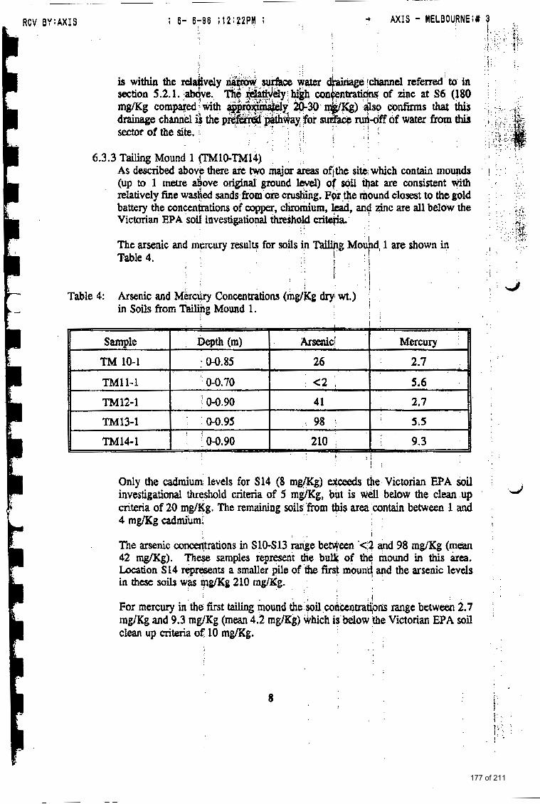
RCV BYtAXIS + AXIS - MELBOURNE;# 3
is within the d & v d y section 5.2.1. - 4 v e . . mg/Kg compared ;'with drainage chanqd 3 the sector of the site. ;. . . .
. . . , . .
6.3.3 Tailing Mound 1 (lMlO-TM14) AS described a50ve there are tvvo major areas Of i the site, which contain mounds (up to 1 metre 4 o v e original ground level) of soil Qat are consistent with relatively fine washed sands &om ore ending. P9r the mound closest to the gold battery the conctntiations of copper, chromium, lead, and zinc are all below the Victorian EPA soil hvestigational threshold cn*
The arsenic and mercury results for soils in Tailing Mo ' d, 1 are shown in Table 4. I Y
! I ' j I ,
Table 4: Arsenic and Mercury Concentrations (rngkg dxy wt.) in Soils f'rom Tailing Mound 1. I
! ' : ; I : 1 :
Only the cadmium levels for S14 (8 mg/Kg) eihxeds the Victorian EPA soil investigational threshold criteria of 5 mg/Kg, but is well below the clean up criteria of 20 mg/Kg. The remaining soils'fiom ws area contain between 1 and 4 mg&g cadmium,
The arsenic concetftrations in SlO-Sl3 range beween '<a and 98 rng/Kg ( m a 42 mg/Kg). These samples represent the bulk of thq mound in this kea. Location S14 represents a smaller pile of the first mound and the arsenic levels in these soils was mg/Kg 210 mglKg.
For mercury in the f i s t tahg mound the kil concentrat&ds range between 2.7 rng/Kg and 9.3 mgKg (mean 4.2 mg/Kg) which is below the Victorian EPA soil clean up criteria of IO mg/Kg.
I
8
177 of 211
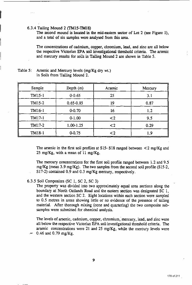
6.3.4 Tailing Mound 2 (TMlS-TM18) The second mound is located in the mideastem sector of Lot 2 (see Figure l), and a total of six samples were analysed from this area.
I The concentrations of cadmium, copper, chromium, lead, and zinc are all below the respective Victorian EPA soil investigational threshold criteria. The arsenic and mercury results for soils in Tailing Mound 2 are shown in Table 5 . !
Table 5: Arsenic and Mercury levels (mg/Kg dry wt.) in Soils from Tailing Mound 2.
The arsenic in the first soil profiles at S15- S18 ranged between < 2 mg/Kg and 25 mg/Kg, with a mean of 11 mg/Kg.
The mercury concentrations for the first soil profile ranged between 1.2 and 9.5 mg/Kg (mean 3.9 mg/Kg). The two samples from the second soil profile (S15-2, S17-2) contained 0.9 and 0.3 mg/Kg mercury, respectively.
6.3.5 Soil Composites (SC 1, SC 2, SC 3) The property was divided into two approximately equal area sections along the boundary at North Oatlands .Road and the eastern section was designated SC 1 , and the western section SC 2. Eight locations within each section were sampled to 0.5 metres in areas showing little or no evidence of the presence of tailing material. After thorough mixing (cone and quartering) the two composite sub- samples were submitted for chemical analysis.
The levels of arsenic, cadmium, copper, chromium, mercury, lead, and zinc were all below the respective Victorian EPA soil investigational threshold criteria. The arsenic concentrations were 21 and 25 mg/Kg, while the mercury levels were
.- 0.46 and 0.79 mg/Kg.
9
178 of 211
b Y
Second Soil Profile.
Barry Luke %t Associates
JOB No. 12338
"IGURENo. 4
t (?)
CLIENT D.WALLS (LAWLOR & LOY)
PROJECT SOIL QUALITY ASSESSMENT
TITLE SOIL MERCURY LEVELS (rngKg)
*
179 of 211
RCV BY:AXIS ; 6- 6-86 ; 1 2 : 2 3 P M ; AXIS - MELBOURNE;# 5
of the above two campsites QelecM at 0.15 mgKg.
ted:ci were less than tile
6.3.6 Off Site Control The off site control sample was analysed for m e 9 along with the field samples from Lot 2. The amcentralions of all metals ?nalysed were at or around the
nd levels, well below the Viqtorian EPA soil investigational example the arstdlic and rrkrcury concentrations were <2 , respedively.
i
I i I
6.4 Surface Water The ori f is of the surface water samples zuc dtscribgd ih 4.1.6. The radu of water analysis art5 shown in Table 5.
Table 6: Metal Concentrations (ug/L) in Surface Waters.
7.0 DISCUSSION 7.1 Statutory Requimnents
Under the Victorian Planning and Environment Act (1987), Section 12 (2) (a), Planning Authorides must satisfy themseJve3 that potentially contaminated land is subject to, and complies with, an env-ental ;assessmeat/audit by a recognised corrsulfant. In these terms potentially;contaminated land is defined as land Known to have been used for industry, q, or s6rage of chemicals, gas, wastes, or liquid fuels,
Where rezoning applications to mare sensitive land uses (residential, child care centre, preschool. M primary school) are involved the phnning authority must ensure that the land is suitable €or the purpose proposed, In most circumstances a Cdficate of Audit will be rcqui~d to be issued by an EPA approved auditor. The certificates of environmental audit are required before construction of buildings or cornemernens of other associated $VCI& take place,
I'
10
180 of 211
The purpose of an environmental assessment is to determine if the land is suitable for the intended developxn-md where si@cant contamination is found, to indicate the extent of the problem and the possible options for remediating the site. Only after the land has been cleaned up, and in their opinion the condition of the land is not detrimental to or potentially detrimental to any beneficial use, will an EPA approved auditor issue a Certificate of Environmental Audit.
7.2 Site Sampling Strategy An environmental site assessment aims to determine whether a defined property contains areas of concern in terms of environmental quality - in this case soil quality. Obviously the greater the number of samples taken and analysed the greater is the probability of detecting possible (isolated) areas of contaminated soil. Equally obvious is the fact that the cost of such investigations increase in proportion to the number of samples. From a practical viewpoint it is important to reach a satisfactory compromise between these two factors.
The strategy adopted for soil sampling at Lot 2 is a combination of strategic and stratified sampling. The position and presence of the gold battery and the tailing mounds set targets of possible contamination mnes which over-ride the use of systematic (grid) sampling protocols. Whilst the number of samples taken from the different targeted zones and other site locations are considered appropriate, the investigation does not infer detection of contaminants beyond the statistical limitations imposed by the sampling strategy.
The intention of the water sampling program was to determine the possible impact of contaminants from Lot 2 and the gold battery on surface waters flowing along the easement just east of the property, eventually to the Plenty River. It was therefore necessary to measure the metal concentrations in water flowing into the dam from properties north of Lot 2, the dam water itself, and surface water near the south east comer of Lot 2 which then flows further south to the Plenty River. Site observation during rain events confirms that run-off water from the gold battery and the tailing mounds will migrate to the easement, east of Lot 2.
7.3 Soil Profile Descriptions The soils from the tailing mounds were straw coloured, fine, washed sands without any visible signs of contamination. The soil beneath the mounds are brown clay loams and were intersected between 0.6 and 1.10 metres below the tailing mound surfaces. Presumably these were the original soils on which the tailing material was piled many (20-50) years ago.
The soils from within the cutting of the gold battery building are heavy orange coloured clays with some rock, and this or a similar profile is expected to exist throughout the equivalent depths of Lot 2.
7.T Extent of Contamination 7.4.1 Gold Battery and South West Sector
It is clear that the two metals of primary concern at Lot 2 are arsenic and mercury. While the former is likely derived from crushing of ore bodies from
11
181 of 211
RCV 6Y:AXIS ; 6- 6-86 ; 1 2 : 2 5 P M ; . .: , A X I S - MELBOURNE;#
the old gold mine, 0- ftom the gold extraction processes used in &e@d b&&+
soil arsenic c o n c e u m around the padmeter of the gold battety art all below the Victdanl PIPA sod clegl up &t&a (50 P a g ) , aod of the 12 fram this area only two exceed this latter c r i e - 54 mg'/Kg at S7-1 and 63 mg/Kg at S9.
Although the samples Sl-S4 are fram the pkrimetdr of the gold battery plant ahd not from within Lot 2, it is important to recogaisetha! the highest mercury value (22 mg/Kg) was obtained from a surface water drain (located in the adjamt p r o p q at the n s of the gold battery) which cohtinUes for several metres hto Lot 2. Location $6 is in Lot 2 and withh'this same d&, and in this location the mercury concerjtration was 57 mglKg. *Since he merbury levels at 10catiOnS S5 and S7, only 8 metres either side of $6, were 3 mg/Kg and 11 mg/Kg, rcspcctivdy, it seems clear the surfice drain is @e primary source of mercury contamination in this area of Lot 2. The mercury concentdons in the second clay soil profiles, at locations 3' (S3-2,25-50 cm) and 5 (s5-2,25-35 cm) were 3.3 mgag and 3.0 rngXg, respectively. 'R i is shows that the mercury contamination is essentially surface contamination which decreases significantly with increasing depth,
7.4.2 Tailing Mound 1 The results of testing of the soil in tailing mound show that for locations 'I'M 10 - TM 13 the mean concentrations of arsenic, c!adm.ium,'coppet, chromium, mercury, lead,and zinc are below their respective Victorfan EPA soil clean up criteria Further, on the basis of the testing so far conducted it appears that the soil in the major d o n of tailing mound 1, ( Z M 10 - TM 13) is within the Victorian EPA soil clean up criteria far arsenic and mercury.
Howcver, based on a single result the d c level (210 mg/Kg) of the northern prtion of this mound (TM 14), the sods of this sector exceed the Vktorian EPA soil clean up criteria. This location is at the northern tip of the f3rst mound, and in fact the latter may be regarded as a separate tailings pile near the first mound. Since the Victorian EPA sail clan up criteria for arsenic is SO rng/Kg there is a need for remediadon of these particular soils so as to move, Or at least limit any associated health and mvhnmental risks to potential residents of this property. See later conments.
Based on the samples analysed the c o n c e n t r a w of all metals, including mercury ( m a 3.9 WKg) and arsenic (mean 11 m@g) are. below the Victorian EPA soil clean up criteria (10 mg/Kg and 50 mg/Kg, respxtivelfl.
Based on our soil composite analyses the remaining ateas of Lot 2 not directly asociated with tailing material, are not contaminated with metals or organochlorine insecticides. It is important to recognke that within a reasonable
7.4.3 Tailing hlound 2
7.4.4 other & of Lot 2
, : . . l2.
182 of 211
budget it is not possible to test every square metre of soil within Lot 2. The conclusion reached above ixidicates that there appears to be no widespread contamination (of metals and organochlorine insecticides) throughout the areas of Lot 2 not associated with tailing material.
7.4.5 Surface Water All the water samples contained relatively small amounts of sediment material. Rather than filter these waters to remove all sediment, the bulk of the sediment was removed by decantation, and the decanted fluid used for analysis. The reason for preparing the samples in this way was to measure the metal concentrations likely to be present in the surface aquifer that actually migrates along the easement to the east of the Lot 2. Since most heavy metals are retained preferentially on sediments we did not want to completely remove this component of the stream flow.
It is reasonable to suggest that the elevated metal concentrations in soils of Lot 2 may, through soiyrain run-off events, cause the surface waters at the easement near the eastern property boundary to also contain elevated concentrations of these Same metals. In the case of lead there does appear to be some evidence that this is so, since the levels in SW 1 are ten times higher than (0.05 mg/L versus 0.005 mg/L) in the surface waters at SW2 and SW 3. The origin of the lead is likely to be the large amount of corroding galvanised iron and other metal materials associated with the gold battery plant.
For cadmium is interesting to note that the levels in the surface waters exiting from the south of the property (Lot 2) are four times lower than those flowing into the dam. One of the major sources of cadmium is (rock phosphate) fertilisers, and it may be that run off from upstream agricultural properties are the origin of this cadmium. However, observations in the ara of the dam during a major rain event confirmed that all the storm water from Yarrambat Road, to the east and immediate west of Lot 2, flows to the dam from which the samples were taken. This situation makes the interpretation of results difficult, but it is possible that the cadmium in the water/sediments flowing into and then out of the dam are being retained in the marsh like vegetation immediately below the dam.
.
Importantly, the results of arsenic, mercury and zinc indicate that the soil contamination and from Lot 2 is not currently having an adverse impact on the water quality of the easement aquifer.
8.0 SOIL & WATER QUALITY ASSESSMENT 8.1 Preamble
It is not within the scope of this investigation to report a specific risk assessment .- for contaminants at this site. However, it is reasonable to comment on the soil
quality at Lot 2 and the implications to the possible impact on the health of potential residents of this property.
13
183 of 211
RCV BY:AXIS ; 6- 6-96 ;12:26PM ; + AXIS - MELBOURNE;# 8
It must be undeastu4 that the tading,mound soils brohles Aysed, generally covered depths from the surface and ktween 0.6 and 1.1 metres depending on the height of the sand mound 3 thegarticular sampling point. It is possible that narrower range dcpths (say, 0.254.5 mebes) could cbntain higher concentrations of metats than those reported in our investigation.
Our environmental assessment i s based on the soils as they exist at the present time. Disturbance of the sods due to house constqction, landscaping or other similar activities may present health risks gteater @an those evaluated in this report"
If the site is rezoned to a rural/residential classifidon there is a high probability that a young child (toddler) will be exposed to the soils within Lot 2 at some ame in the future. Because the investigation shows that some of the surface soils contain two mxic metals, arsenic and mercury, both of which are relatively stable, (elemental mercury is volatile when exposed to air, and can be transformed to orgm mercury compounds by rnicro-organisms) there is a potential for significant ingestion of these contaminants by 8 child residing over the longer term at this property. It is well known that some children have a greater propensity to ingest soil (pica) than others. Ekth metals have the ability to bio- accumulate in body tissues (bone, hair, teeth, soft tissue etc.) and thereby produce harmful health effects. On the other hand arsenfc is present in most meats and even more so in fish p d crustacea, such that the (human) total daily intake may range from below 0.04 mg to 0.2 mg per day.
Whereas there is reasonable knowledge on 'human toxicolo~y of arsenic and mercury individually, there is little informah on the combined or synergistic effects of botb these,two eleinents. For this reason a reliable risk assessment would be difficult to carry out and would have to make many assumptions in the toxicokinetics involved. While not dismissing the possible effects of mercury on human health, it is likely that the association of cancer with elevated arsenic exposure would over-ride the former in setting acceptable soil criteria,
Since the investigation suggests that the contaminants have hot migrated beyond surkce soil layers the threat to groundwater (contarnination) is low.
Clearly the concentrations of metals in soils from the site are greater than those of the control soil sample originating about 0.4 Km away. Never the less, books tracing the gold mining days of the area @iamond Valley, Panton Hills etc) record a large number of gold mines scattered throughout the region. It is likely that the tailings from these mines are also widely distributed throughout this region having been used for filling in dams; tips, and other land forms, over many years. To our knowledge there has beeq no re@* of ill effects Lo children or adults (nor to the environment) in these. areas as a result of these tailing materials.
14
I . . * . , . , . . : . . I
: . < :"
1 : .
, . . ...
.. .
t . j .
. . .
I
184 of 211
6Y:AXIS
,.. : /.. . . , : . .. . . .. : I.. .,
Y
k
A X I S - MELBOURNE;#lO I . , i L * . .
. .
@ ; Exoav@tlana to 0.6 metree depth. . .
:' @ eavstion6to0,3 metreedepth. \ j @ 'i Ejrcavatidnstb 0.6 mtresd&tth .
(averagekdepth - range 0 12 metres. . I
. . . , ' ' 2
:': . . '
Lot 2
- Barry Luke !? Associates
I '
CLIENT D.WALLS (LAWLOR & LOY) .
POOJECT SOIL QUALtTY ASSESSMENT . __ -
FlGURENo. 5 I "
I . . . .
185 of 211
8.2. South West Corner, Lot 2 The drainage of surface water from the gold battery has caused the mercury contamination of surface soils in the south west comer of Lot 2. The mercury contamination is limited primarily to the narrow drain leading from the gold battery several metres into Lot 2. At the present time the levels of mercury in the drain exceed the Victorian EPA soil clean up criteria, and therefore present a high probability of potential adverse (human) health and environmental effects.
Along the south west boundary of Lot 2 the surface (0-35 cm) soils in a few areas contain arsenic concentrations that just exceed the Victorian EPA soil clean up criteria. On this basis the area therefore presents a low probability of adverse (human) health and environmental effects.
8.3 Tailing Mound 1 The presence of elevated levels of arsenic and mercury in the tailing mound soils of Lot 2 are associated with the disposal of crushed ore from the gold battery adjacent to Lot 2.
Although mercury contamination is present in all the soil samples of tailing mound 1, the concentrations (mean 4.1 mg/Kg) are below the Victorian EPA soil clean up criteria.
The levels of arsenic (mean 42 mg/Kg) are generally below the latter criteria, but there appears to be significantly higher arsenic concentrations (210 mg/Kg) in the north east section of this mound, such that they are well above the Victorian EPA soil clean up criteria (50 mg/Kg). The level of mercury in this Same soil sample was 9.3 mg/Kg. In our opinion these soils in the northern section of tailing mound 1 present a high probability of adverse (human) health and environmental effects.
8.4 Tailing Mound 2 The soil in tailing mound 2 appears to contain significantly lower concentrations of both arsenic and mercury than tailing mound 1. The mean concentrations (1 1 mg/Kg and 3.8 mg/Kg, respectively) of these two elements in soil from mound 2 are below the Victorian EPA soil clean up criteria.
8.5 Other Areas of Lot 2 In our opinion there appears to be no widespread contamination of metals in areas of Lot 2 other than those already described.
The finding of 0.15 mg/Kg DDT does not represent a significant threat to the health of potential residents or the immediate environment.
8,6 Surface .Waters The lead levels (50 ug/L) in surface waters at the drainage easement at the eastern boundary of Lot 2 exceed the ANZECC aquatic ecosystem protection guideline level of 5 ug/L. For comparison purposes the ANZECC criteria guidelines for lead in agricultural water is 200 ug/L.
15
186 of 211
RCV BY : A X I S ; 6- 6-86 ;12:2?PM ; . .
me res~lts of water analysis swat the &ted leitd in surfa~r, water at SW I may be due to run& of lead'k surhce water at of near the blre crushing plant. Together with high zinc in these latkr surhce waters it fs clear metal contamhadon at or hear the ore crushing plant has the potential to cause an adverse impact on surface water quality of tk m.
9.0 C W UP OPTIONS 9.1 List of Technologics
The levels of arsenic and mercury in some areas of Lot 2, as described above, e.xcc~d the Victorian EPA clean up crim ad thereifore in our opinion represent an unacceptable h d t h risk to potential residents ofthis property. 'Ihese metals are reasonably stable and are not srpected to deatase si@mtly by natural processes over time.
In order to limit or ieeduce the soif contahhation 6 acceptable levels it will be necessary to undertake some form of d remtvliatidn in the affected arm of Lot 2. In general the options for soil remdiation include:
On site containment (capping)
. Bio-remediation
. Fixation
. Incineration I
, sOlvent/elecualyte extractio~
Excavation and approved off-site disposal
The above treatment options have their relative me& and disadvantages in terms of technical feasibility, efficieny, and cost.
Containment may be suitable in an industrial p r o m where human exposure to the cantamination is limited and flexibility of land use is not of primary importance. It does not offer practical, long' term benefits for this particular site where residential development is likely.
Bibremediation technology is applicable to (qpnia substanox such as petroleum oils and pcsticides, and although research is,taking place for some metals we are not aware of any systems for arsenic and mercury in soils at this time.
Incineration is used by borne overseas cuuntiies for treatment of waste of organic origins. However, it is not an appropriate remediaion technology for inorganic substances such as arsenic and mercury in soils.
j 16
I
I
I . , , $ ' . . '
. . . . . . . , . . . .
. .
.:. I
! . . I a .
. I . . . ' .
. .
187 of 211
Solventlelectrolyte extraction with complexing agents ( eg EDTA and similar chemicals) is in the main experimental and would probably be expensive for these relatively small soil volumes. This option is worthy of further consideration if other options are regarded as unsuitable.
.
Chemical fixation is proposed as a possible clean up option. The tailing material appears be composed of fine washed sands. Depending on expert advice, these sands could possibly be incorporated into cements andor concrete such that the metal contaminations are fixed and not readily available for significant migration. In this way the fixed sands may present minimal health and environmental risks. Use on site or even off site, particularly in building foundations or concrete (garage) floors for example, potentially offers a relatively inexpensive treatment of the surface soils now under consideration.
The latter means of sand disposal would require extensive prior tests as to leachability potential of both arsenic and mercury. This particular approach to fixation may be regarded as radical and will therefore require careful consideration and EPA approval.
While excavation and disposal of contaminated soil at approved sites is not always favoured as a remediation system it appears to be the only viable treatment at Lot 2 at this time. The major disadvantage of adopting this method is the fact it is expensive when there are long distances between the site and the approved disposal site. The costs for the soil disposal will depend on the whether the soil is classified as a low or highly contaminated (prescribed) waste, since in the former instance the EPA may approve disposal at a suitable site in the region (if any), rather than at an approved land fill site licensed to accept prescribed waste flullamarine). Sampling and chemical analysis of the soils, after they are excavated, will determine the classification of the soils for disposal.
9.2 Soil Excavation and Disposal 9.2.1 South West Comer Lot 2
The south west corner of Lot 2 contains contaminated soil. By excavating the soil directly and indirectly associated with the shallow drain, to a depth of 0.6 metres, and preferably including that at the rear of the gold battery, (approximately 10 m3) it is expected that the health and environmental risks of this area will be reduced to acceptable levels (below 50 mgKg). In our opinion it will also be necessary to remove soil from a triangular area 17 metres by 15 metres to a depth of 0.3 metres - 25 m3) in the south west comer of the Lot 2. The shaded areas (Figure 5 ) shows the area proposed for excavation.
.
It must be recognised that the gold battery is the original source of contamination of soil of this area of Lot 2. Without further investigations it is not possible to - predict whether the gold battery itself contains contamination or will continue to . provide a source of contamination to the south west comer of Lot 2 even after the proposed excavations are completed. However, it is about 20 years since the gold battery ceased operations, and although there may still be isolated sources of contamination within the battery, it seems that widespread contaminant migration
17
188 of 211
I I is not occurring or is proceeding at a very slow rate. Clearly, the complete
decommissioning of the gold battery in the adjacent property would minimiSe potential continued contamination of Lot 2.
9.2.2 Tailing Mound 1 The investigation of the soils of tailing mound 1 indicates that the contaminants are present in surface soils up to one metre depth, and therefore the most appropriate means of minimising the health and environmental risks related to the tailing mounds is to remove all tailings from the site. The cost of undertaking this program is expected to be high primarily due the large volume of soil and associated transport and tipping fees.
It is important to note that the transport and disposal of contaminated soil without Victorian EPA approval is regarded as illegal, and carries serious consequences in terms of possible fines and/or imprisonment.
Another option to reduce, but not &mise, the potential risks related to the soils of tailing mound 1 is to remove the most contaminated tailing material from the north east section of mound 1 from the site, as described above. It is estimated that a circular area (22 metres diameter) will need to be excavated to an average depth of 0.6 metres (230 m3). The shaded area (Figure 4) shows the area proposed for excavation.
9.2.3 Tailing Mound 2 Not with standing our earlier comment regarding minimising the health and environmental risks due to the tailing materials on Lot 2, in our opinion the mean concentrations of arsenic and mercury in the soils of tailing mound 2 do not exceed the Victorian EPA soil clean up criteria, and therefore no further action is proposed for these particular soils at this time.
10.0 RECOMMENDATIONS This investigation reveals that some areas of Lot 2 contain significant enviraimental liabilities related to mercury and arsenic residues in soil. After reviewing these reports it is likely that the Shire of Diamond Valley, will be reluctant to proceed with further planning approvals, and will refer this matter to the Victorian EPA. Clearly, the Victorian EPA will also examine and comment on the two environmental assessment reports and their implications.
Rather than regard the site as liable for placement on the Victorian contaminated sites register, the Victorian EPA may be prepared to negotiate with the owners on developing an acceptable clean-up/validation program for Lot 2, thus eliminating or reducing the environmental liabilities to acceptable levels. After a successful clean up operation has been completed (including an appropriate validation program) the EPA mayadvise the .Shire of Diamond Valley the planning approvals can be issued. Alternatively, the EPA may require that a certificate of audit be issued by a Victorian EPA approved auditor prior to allowing the Shire of Diamond Valley to proceed with planning approvals.
18
189 of 211
I-
APPENDIX 1
NATA CERTIFIED RESULTS OF ANALYSIS
190 of 211
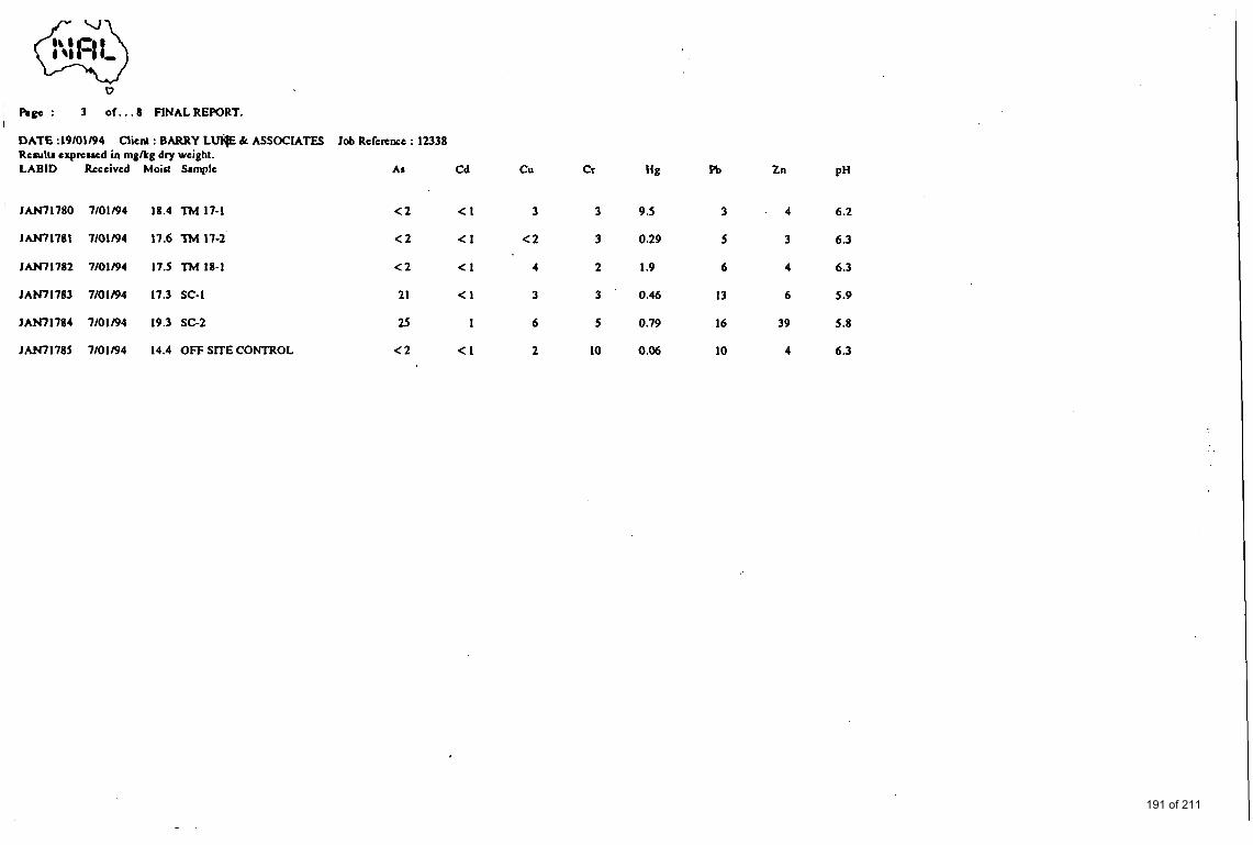
, 0
' Rgc : 3 of . . . 8 FINALREWRT.
DATE :19/01/94 Rcrulu exprewd in mgkg dry weight.
Cliertl : BARRY LUl@ k ASSOCIATES Job Reference : 12338
LABlD Received MoiM Sample A i Cd c u Cr Hg Pb Zn PH
JAN71780 7/01/94 18.4 M 17-1 < 2 < I 3 3 9.5 3 4 6.2
' JAN71781 7/01/94 17.6 TM 17-2 < 2 <I < 2 3 0.29 5 3 6.3
JAN71782 7/01/94 17.5 TM 18-1 < 2 < I 4 2 1.9 6 4 6.3
IAN71783 7/01/94 17.3 SC-I 21 < I 3 3 0.46 13 6 5.9
JAM1784 7/01/94 19.3 SC-2 25 1 6 5 0.79 16 39 5.8
JAN71785 7/01/94 14.4 OFF SmE CONTROL < 2 <I 2 10 0 .M 10 4 6.3
191 of 211
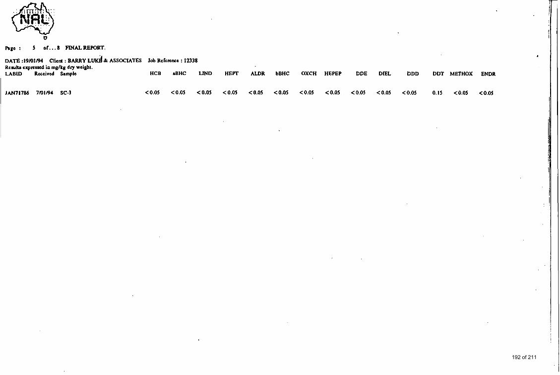
@ . . . . . . . .
. . I -
b
h p o : 5 of...8 FINALREPORT.
DATE :I9101194 Rcruhr exprcued in mglkg dry weight. LABU) Received Samplo HCB aBHC LIND HEFT ALDR bBHC OXCH HEPEP DDE DIEL DDD DDT METHOX ENDR
ClieM : BARRY L d k ASSOCIATES Job Refemnee : 12338
0.15 <0.05 <0.05 1 JMl71786 7/01/94 SC-3 <0.05 <0.05 <0.05 <0.05 <0.05 <0.05 <0.05 <0.05 , <0.05 <0.05 <0.05
192 of 211
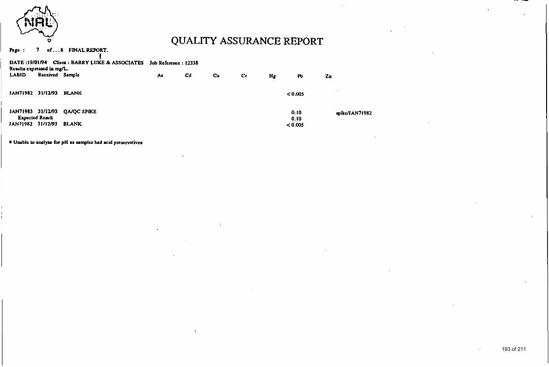
I 6 QUALITY ASSURANCE REPORT 1 Rpc : 7 o f . . . 8 FINALREFORT.
‘I DATE :19/01194 R c m h txprcued & mplL
Client : BARRY LUKE & ASSOCIATES Job Reference : 12338
LABID Received Smple As C d cu Cr Hg Pb zlr
JAN71982 31112l93 BLANK
JAN71983 31112193 QAIQC SPIKE
JAN71982 31112l93 BLANK Expected Rcrull
< 0.00s
0. IO rpikdJAN7 I982 0.10
< 0.00s
I Unable 10 ~RIIYIQ for pH ar sampler had acid prcscrvntivcr
193 of 211
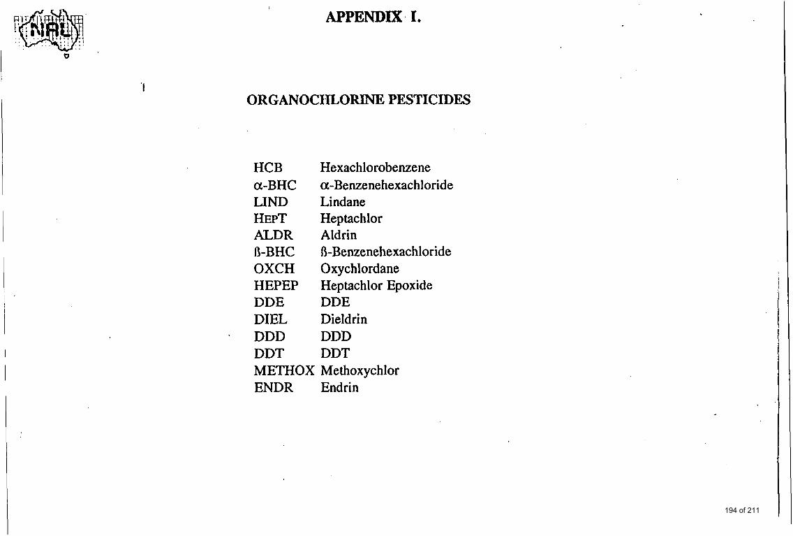
APPENDIX, I.
'I ORGANOCHLORINE PESTICIDES
HCB a-BHC LIND HEPT ALDR
OXCH HEPEP DDE DIEL
- DDD DDT
R-BHC
Hexachlorobenzene a-Benzenehexachloride Lindane Heptachlor Aldrin R-Benzenehexachlor ide Oxychlordane Heptachlor Epoxide DDE Dieldrin DDD DDT
METHOX Methoxychlor ENDR Endrin
194 of 211
9 a * I , BARRYLUI(IE&Assoc:r~res I -d
(-J s P
C h e m i c a l & E n v i r o n m e n t a l C o n s u l t i n g
I SAMPLING AND CHEMICAL ANALYSIS
OF SOILS AND SURFACE WATER
FROM LOT 2, NORTH OATLANDS ROAD, YARRAMBAT
1.0 INTRODUCTION Barry Luke & Associates were invited by Lawlor and Loy Pty Ltd to take selected soil and surface water samples from Lot 2, North Oatlands Road, Yarrambat and have them analysed for a limited number of potential environmental contaminants. It is understood that there are plans to develop the property by sub-division for residential use and that the Shire of Diamond Valley have requested that the results of the sampling and analysis program be reviewed prior to further planning approvals.
It is recognised that the following scope of work is not by itself regarded as a preliminary environmental assessment, but rather it forms an essential part of such assessment.
2.0 SCOPE OF WORK The scope of work undertaken covers:
. soil sampling from the two primary mounds (Lot 2), identified as most likely derived from mine tailings.
. soil sampling on Lot 2 immediately behind the ore crushing battery which is situated on the adjacent property.
surface water sampling of dam water outlet overflow, and run-off water from Lot 2
. chemical analysis for selected, potential environmental contaminants
. a review of the results of analysis in terms of criteria such as those published and/or otherwise recommended as guidelines by the Australian & New Zealand Environment & Conservation Council and the Victorian Environment Protection Authority (EPA).
. presentation of a summary report.
3.0 SITE DESCRIPTION Lot 2, North Oatlands Road is near the intersection of Yan Yean Road and North Oatlands Road, Yarrambat in an area largely composed of open land with a rurallsmall farm/residential profile.
4 H a s l e m e r e R o a d M i t c h a m , V i c t o r i a A u s t r a l i a 3 1 3 2
1
P h o n e 0 3 8 7 3 1497 195 of 211
Lot 2, on the south side of North Oatlands Road has a moderate slope towards the south east, with a dam and surface water drain easement adjacent to the eastern property boundary. See Figure 1. The dam is fed by run-off water from northerly upstream properties, and the overflow passes into the surface drainage system to properties, and possibly aquifers, south of Lot 2.
The property to the west of Lot 2 contain gold mine shafts which were decommissioned (filled) in the mid-seventies, and a partly dismanteled (gold) ore crushing battery and gold extraction plant. Although the battery and extraction plant, housed in a galvanised iron shed, was also decommissioned about 18 years ago much of the crushing equipment and motorskompressors etc remain in reasonable condition.
The rear of the ore crushing battery is within 2 metres of the western boundary of Lot 2, and presumably the wire fence which now separates these properties was non existent when the mine and ore crushing plants were in operation. The evidence for such a presumtion includes: I
. the south west comer of Lot 2 contains a mound of soil to a depth of 1 metre (about 20m x 20m), typical of that expected from gold mine tailings. A further mound, about the same dimensions and volume, is observed in the mid-eastem section of Lot 2, and again appears to be typical of mine tailings.
. an earth covered, surface, metal sluice drain running from the ore crushing battery under the present wire fence to the tailings mound in Lot 2 can still be observed.
Anecdotal information suggests that in the past Lot 2 itself contained buildings including large chicken sheds.
Vegetation across Lot 2 is generally composed of vigorous growing grass and weeds with scattered eucalyptus trees. Reed and similar type plants are present in the marsh growth of the eastern drainage easement. The owners indicate that one chestnut horse (observed to be in good condition) has graised within Lot 2 for the past 8-10 years. Fresh fox and/or rabbit holes in the western tailings mound were extensive.
4.0 GOLD EXTRACTION The following information is provided on the basis that the gold mining industry is one of the oldest industries known, and was certainly one of the first to utilise chemicals in large amounts on a continuous basis. The hazardous nature of some of these chemicals to the environment was not properly recognised until at least 100 years after their introduction to gold mining.
The two main methods of extraction of gold from ore are amalgamation and cyanidation. In the former, 'mercury is used in/on sluice beds or tables to form an amalgam which after washing is pressed to obtain a mixture rich in gold. Removal of residual mercury was achieved by distillation or by furnace treatment, processes which are now known to present extreme occupational hazards.
2
196 of 211
I Since elemental gold is soluble in strong cyanide solutions, treatment with sodium or potassium cyanide represented an alternate or complementary means of isolating the gold from finely crushed ores. After concentrating (thickening) the cyanide solution the gold is precipitated on a stream of zinc in what is known as the Macarthur-Forrest process.
5.0 SITE WORK
5.1 Soil Sampling Barry Luke & Associates attended the site on 8 November 1993 and used a hand auger to obtain soil samples from 0-lm at five locations from the south western tailing mound within Lot 2. The soil is a yellow to off white fine sandy clay (generally to 0.8-0.9m) underlaid by a brown clay loam which probably represents the original soil surface prior to introduction of the tailing material. Free water was detected in two holes at about 0.7 metre.
The soils from each location were mixed (separately) in a polypropylene bucket with a stainless steel trowel prior to sub sampling into 500g glass jars. The aluminium foil lined plastic screw caps were attached and labels detailing the owner, project number, date, sampler, and location were applied. The soils were placed in a chilled container for transport to the laboratory.
Soils from three locations within the mid eastern tailings mound were taken similarly to those described previously. The soil descriptions were almost identical to the above soils, as were the depths to the brown clay loams. Free water was detected in one hole at about.0.8 metre.
5.2 Water sampling Water from the dam overflow (approx 500 mL) was combined with water (500 mL) from site run-off along the southern sector Lot 2. This combined water flows in surface channels to other paddocks and properties south of Lot 2.
6.0 CHEMICAL ANALYSIS
6.1 Preparation of Composites The soil samples were composited by Barry Luke & Associates:
Composite 1 The five separate soil samples from the tailings mound in the south west area of the property, representing soil from 0-1 metre, were composited to one sample for chemical analysis.
Composite 2 Soil from three locations of the tailing mound in the mid-easten area of Lot 2 (0-1 metre) were composited for chemical analysis.
Composite 3 At three separate locations directly to the rear of the ore crushing battery, but within Lot 2 approximately 2 metres from the wire fence, soil samples to 0.5 metre were composited to one sample for chemical analysis.
3
197 of 211
Composite 4 A mixture of composite soils 1-3 were combined.
6.2 Analytical Chemistry Program Excluding composite 4, the above soil and surface water composites were analysed by National Analytical Laboratories Pty Ltd for metals (lead, cadmium, chromium, copper, arsenic, zinc) and mercury. The analytical methods for metals were based on acid (50% nitric acid) digestion followed by atomic absorption spectrophotometry. A hydride genereration technique was applied for measurement of mercury levels.
I I
Analysis of each of the soil composites (#1-3) and surface water composites were analysed for total distilled cyanides by PWT Asia Pacific Pty Ltd using an American Public Health Association, Manual of Analytical Methods (APHA), 17 Edition, 1992.
Composite 4 was analysed by National Analytical Laboratories Pty Ltd for organochlorine insecticides only.
All analytical methods employed by both laboratories were certified by the National Association of Testing Authorities (NATA).
7.0 RESULTS The results of analysis are shown in Appendix 1, and in separate, selected or modified formats (Tables) throughout the text of the report. Note that cyanides and organochlorine insecticides were not detected in the samples analysed.
7.1 Criteria for Interpretation of Results While the Victorian EPA has indicated that soil and ground water criteria are to be regarded as site specific, national and international guidelines are important in assessing the potential for contamination of this important resource. In particular, guidelines published by the Australian and New Zealand Environment and Conservation Council (ANZECC), the Dutch Government and other governments, are useful in considering criteria for requirements to conduct further investigations and/or to request clean-up of soil and ground water where necessary.
In much the same way as the Dutch government set classifications of A, B, and C, to indicate increasing degrees of contamination, the Vicotian EPA have indicated that chemical species at or about background concentrations in a given region or area are designated an A level classification. Contaminants at or exceeding B levels are those requiring further field investigations, and those at or above C levels are liable for remediation or clean-up programs. The above protocols for assessment may be varied provided substantive cases can be made for individual circumstances.
Where criteria for specific chemical species are not available then proposed tentative guidelines, based on human health and ecological protection should be estimated., The latter two parameters are often difficult to determine owing to the scarcity of toxiclological and epidemiololgical data.
4
198 of 211
7.2 Metals The metals and mercury concentrations of soil composite samples are shown in Table 1. The Victorian EPA soil criteria for further investigations and clean-up for the respective elements are also listed in Table 1.
Table 1: Metals and mercury concentration for soil composites
Mercury 2 0.7 4.6 '
PH 6.6 6.1 6.2 -
7.2.1 Composite 1 The levels of metals and mercury are shown in Table 1. Since composites of soils were analysed rather than individual soil samples, we cannot be certain as to the conclusion to be drawn. On the one hand we could surmise that the distribution of contaminants throughout the tailing mound is reasonably uniform and therefore the results in Table 1 are a reflection of the mean (average) concentrations of metals and mercury. Alternatively, it would be reasonable to suggest that the distribution of contaminants in the tailing mound is non- uniform and that the results in Table 1 are therefore not truly representative of the tailing mound. In this second option the worst case scenario is that the respective contaminant is present in only one of the five sub-samples, and that the soil from the remaining four samples merely dilute this fifth sample such that a much lower mean contaminant value is determinedheported. Soil contaminant distributions tend to be non-uniform, and because we are dealing with potentially hazardous (to human health and environmental quality) chemicals it is the normal practise to tentatively accept the worst case scenario until more definitive data is available.
Thus, in Table 2 we have listed the metal and mercury concentrations which have been (mathmatically) adjusted for the respective number of soils making up the composite sample analysed. It is these latter results which are compared with the Victorian EPA soil investigational threshold and clean-up criteria (Table 2).
5
199 of 211

The adjusted results for lead (35 mg/Kg), cadmium (2.5 mg/Kg), chromium (25 mg/Kg), copper (10 mg/Kg), and zinc (30 mg/Kg) are all well below the Victorian EPA soil investigational threshold criteria. This means that there is no need to evaluate these results further at this time.
d Conc. mg/Kg d.wt
Comp2 Comp3
21 330
1 . s 6
12 33
Table 2: Soil Results Adjusted for Composite Treatment.
VEPA Criteria
IIMS~. Clean up
300 600
5 20
250 800
Adjust€
Comp 1 rn Cadmium
Chromium I 25
Copper I IO
Arsenic Y- t+ Mercury 1 10 2.1 14 2 10
* Where the metal concentrations were originally less than the method detection limit, it is statistically correct to assume that the sample contains 50% of that limit and calculate the potential adjusted metal concentration.
The adjusted results for mercury (10mg/Kg) exceed the Victorian EPA soil investigational threshold criteria (2 mg/Kg), and are equivalent to the Victoria EPA clean-up criteria (10 mg/Kg).
The adjusted results for arsenic (1 10 mg/Kg) exceed both the Victorian EPA investigational threshold criteria (30 mg/Kg) and clean-up criteria (50 mg/Kg).
7.2.2 Composite 2 The results for anaysis of soil composite 2 are shown in Table 1 and the adjusted results in Table 2. It should be noted that there were only three soil samples mixed to produce composite 2.
The adjusted results for lead (2lmg/Kg), cadmium 1.5 mg/Kg), chromium (12 mg/Kg), copper (3 mg/Kg), zinc (12 mg/Kg), are all well below the Victorian EPA investigational threshold criteria.
For arsenic (27 mg/Kg), and mercury (2 mg/Kg) the adjusted contaminant concentrations are at or about the Victorian EPA investigational threshold criteria (30 mg/Kg and 2 mg/Kg respectively).
6
200 of 211
7.2.3 Composite 3 The raw data and adjusted results for soil composite 3 are shown in Table 1 and 2. Note that soil from 3 locations were mixed to produce Composite 3.
The adjusted results for chromium (33 mg/Kg), copper (78 mg/Kg), are below the Victorian EPA investigational threshold criteria.
For lead (330 mg/Kg), cadmium (6 mg/Kg), the adjusted results are at or about the Victorian EPA investigational threshold criteria.
The adjusted results for arsenic (93 mg/Kg), mercury (14 mg/Kg), and zinc (3300 mg/Kg), exceed the VIctorian EPA clean-up criteria of 50 mg/Kg, 3000mg/Kg, and 10 mg/Kg, respectively . 7.2.4 Composite 4 Composite 4 was analysed for organochlorine insecticides only. None of the 14 insecticides tested were found above the method detection limits of 0.05 mg/Kg.
7.2.5 Surface Water Composite The composite of dam water overflow and run-off from Lot 2 was analysed for metals, mercury, and cyanides.
It must be understood that the units of measure' for contaminants in water are usually quoted in microgram (ug) per litre, ie ug/L. The metals and mercury results have been reported in Appendix 1 as milligram per litre, ie mg/L. The relationship is that 1 mg/L is equivalent to lo00 ug/L. The results shown in Table 3 have been converted to ug/L for ease of comparison. The adjusted results, assuming the contaminants are present in only one of the water sources, are also listed in Table three along with the Victorian EPA investigational threshold and clean-up criteria.
Table 3: Results and Adjusted Results for Metals in Surface Waters.
7
201 of 211
The adjusted concentrations of.chromium (100 ug/L), zinc (220 ug/L), and mercury (1 ug/L), exceed the respective Victorian EPA investigational threshold criteria. The adjusted levels of lead (1 140 ug/L), cadmium (20 ug/L), copper (240 mg/L), arsenic (240 mg/L), all exceed the respective Victorian EPA clean-up criteria.
8.0 DISCUSSION
8.1 Ecotoxicology
8.1.1 Arsenic Arsenic in various oxidised forms (arsenates, arsenites), is present natually in many ores, rocks and soils. Usually, the oxides of arsenic are, along with other metals, tightly bound in insoluble matrices (ores and rock) such that there is a limited opportunity fir the constituent elements to leach into water systems and the environment generally. However, once these ore bodies are crushed to produce much finer particles which then have the clay removed by washing processes, as is the case with gold extraction, the various elements become much more bio-available, particularly in acid soils and/or with acid rains etc. Thus, the level of heavy metals in the tailing mounds will be related to the concentrations of these metals in the origial ore bodies and will therefore vary with type and location of different geological formations in the region.
Arsenic is regarded as a toxic element. Arsenic compounds have been used extensively in the past as the active contsituent in insecticide formulations, and even today some products rely on these compounds. Whilst the biological issues are complex and not easily predicted, arsenic has been regarded as a confirmed human carcinogen (particularly associated with skin cancer) since 1980, and therefore governments have regulated to reduce human and environmental exposures since that time.
The health risks and environmental liabilities posed by the presence of arsenic (and other metals , mercury) in soils from Lot 2 relate to:
. the potential oral, dermal and inhalation of soil by exposed humans, particularly children.
. the potential migration of arsenic and other contaminants, in soluble and particulate forms, to water resouces of all kinds.
These latter aquatic resources include streams, rivers, lakes, dams etc and apart from the obvious problem of contamination of drinking water, arsenic along with most heavy metals are bio accumulated (concentrated) up the food chain. In fish and crustacea for instance accumulation factors of lo00 to 50,000 are not exceptional. It is therefore necessary to minimise persistent, low level contamination of these systems in order to prevent long term damage to the ecology.
8.1.2 Mercury Mercury, like many other metal is present naturally in the earths crust, but it has also been used extensively in the mining and electrolytic metal extraction industry for many ybrs. The ability of mercury to form amalgams with gold is the basis of extensive use in the gold
8
202 of 211
i I I I I I !
I I i
P L
mining/extraction industry. Whilst the separation physical (pressing) and heat treatment methods, it is
of gold from mercury was based on almost impossible to remove all traces
of the latter from the treated fine ores (tailings). Hence, the problems often associated with mercury in tailing material.
Mercury in elemental, organic and inorganic forms is extremely toxic both to mammals, fish (aquatic species), and bird life. Chronic exposure to mercury vapours causes harmful effects on the central nervous system, with the early signs being tremors, enlargement of the thyroid, labile pulse, and tachycardia. Mercury in the other forms can cause a variety of harmful health effects ranging from blood disorders to cell damage, and organ (liver) failure etc. As with most metals mercury is bioaccumulated and is excreted from the body only over long periods of time.
8.1.3 Zinc Zinc is another metal also found naturally in the earths crust, but is one of the few metals that is not bio-accumulated. Powdered zinc can be used to separate gold from cyanide solutions in a technique referred to as the Macarthur-Forest process. It is most likely the zinc contamination found in the soils to the rear of the ore crushing battery is related to water run-off (drainage) out of the ore treatment plant which would find a natural flow across what is now the south western comer of Lot 2. This suggestion gains credibility from the fact that the levels of zinc in the soils of the tailing mound nearby.
The human body appears to tolerate relatively high body burdens of this metal and nutritionally it is regarded as an essential ingredient of the diet. Toxicity due to ingestion of zinc is uncommon in humans, but never the less fresh water ecologies are sensitive to this heavy metal. While the Victorian EPA guidelines suggest that the investigational threshold criteria for zinc is 200 ug/L, the ANZECC guideline (for fresh and marine waters) is that concentrations of zinc should not exceed 50 ug/L.
9.0 CONCLUSIONS
9.1 Tailing Mounds The levels of arsenic and mercury in the south western tailing mound, and to a lesser extent the mid eastern tailing mound, present a low to medium level environmental liability that requires further investigation. Since the data reported is based on composite samples only there is a need to define the concentrations of zinc and arsenic more precisely. Such work would require additional sampling and analysis of individual samples from different soil profiles used in the current study. At the completion of this new study it would be known whether the soils from the tailing mounds are contaminated to an extent rendering them liable for clean-up according to the Victorian EPA guidelines.
9.2 South West Corner Lot 2 The area immediately behind the old ore crushing battery appears to present a more serious liability than the tailing mounds in that the unadjusted levels of arsenic zinc and mercury are greater. The unadjusted results of the composite samples exceed the Victorian EPA soil
9
203 of 211
I I
investigational threshold criteria. Mathematical extrapolation of the raw data, taking into account the number of individual soils composited, indicates that there is a distinct possibility that the results of analysis of individual samples may render the area liable for clean-up under the Victorian EPA guidelines.
Since the soil samples in this present study were taken from three randomly selected locations, it would be necessary to take additional samples in this area and attempt to define the boundaries (depth and breadth) of the arsenic, zinc and mercury contamination. With this further information it would be possible to make more reliable decisions as to the extent of the metal(s) contaminations, and therefore the extent of environmental risks and liabilities. The commercial ramifications of the findings of these addititional investigations can then be evaluated.
9.3 Surface Water Quality The adjusted levels of several of the metals in soils from Lot 2 are significant, and provide evidence of contamination to the extent the soil is liable for further investigations and possibly clean-up procedures according to the Victorian EPA guidelines. The concentrations of several metals in surface water samples taken from or adjacent to Lot 2 exceed the Victorian EPA clean-up criteria. Without data on the environmental quality of surface waters to the north of Lot 2 it is not possible to conclude that the pollution originates from the latter. Off site sampling of water entering the property would confirm the actual situation. If the contamination is derived from Lot 2 then the impacts on downstream properties and water resources will represent an environmental liability.
10.0 RECOMMENDATIONS
10.1 Options for Further Work, Tailing Mound It is clear from this current investigation that soil in the tailing mounds and in ttie soil west of Lot 2 contain significant levels of toxic metals so as to cause a potential environmental liability. Further soil sampling and analysis is required to confirm the extent of the contamination.
In the case of the tailing mounds there appears to be two approaches worth considering:
. Conduct further soil sampling and analysis and, based on these latest results, make a decision as whether the soils require remediation (clean-up). Even if the contamination proves to be less than that requiring remediation, the soils will remain a low/medium environmental liability if kept within the property.
. Rather than spend time and expense on further soil sampling and analysis it may be more rational to conclude that the soils (from the tailing mounds) should be excavated and disposed of at a Victorian EPA approved land fill site. This option then minimises the environmental liabilities due to the current tailing mounds. Note, that after removal of the tailing mounds some soil sampling and analysis will still have to be undertaken to determine if the soil below the tailing material, and in other site areas, is of acceptable quality. (If the soil from the tailings mound is transferred to another property the risks and liabilities will also be transferred.)
10
204 of 211
In our opinion the latter option, depending on the cost estimates for soil excavation and disposal at an approved land fill, offers the most appropriate course of action.
10.2 Proposal for Further Work, Rear of Crushing Plant in Lot 2 In regard to the area at the rear of the ore crushing plant there is definitely a need to undertake further soil sampling and analysis to determine the extent of metals contamination. In conjunction with this additional work, it will be prudent to take some samples from around the ore crushing building itself, since it is possible that run-off from this area is, and will continue to be, the source of contamination of soils in the south west corner of Lot 2. It is recommended that this program should assume the highest priority so that if excavation is required from this area also, a co-ordinated earth moving schedule can be planned.
A cost estimate to sample, analyse, and report on the extent of soil contamination in the south west comer of Lot 2 is $2250.
The aim of this and any subsequent proposals is to reduce or eliminate any adverse (soil and water) impacts on the environment due to the property designated as Lot 2, North Oatlands Road, Yarrambat. It will be necessary to take soil samples from areas not covered by these targeted investigations.
Barry Luke & Associates
11
205 of 211
APPENDIX 1
CERTIFICATES OF ANALYSIS
206 of 211
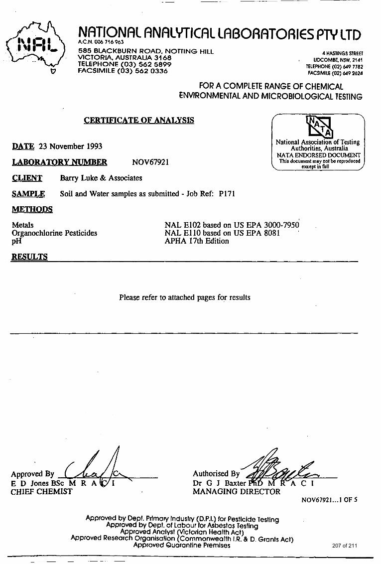
NRTlONRl RNRLYTICRC CRBORRTORIES PTY 1TD A.C.N. 006 716 963
585 BLACKBURN ROAD, NOTTING HILL VICTORIA. AUSTRALIA 31 68 TELEPHONE (03) 562 5899 FACSIMILE (03) 562 0336
4 HASllNGS SlRER
TELEPHONE (02) 649 7782 FACSIMILE (02) 649 2624
8 UDCOMBE. NSW, 2141
FOR A COMPLETE RANGE OF CHEMICAL ENVIRONMENTAL AND MICROBIOLOGICAL TESTING
i CERTIFICATE OF ANALYSIS
DATE 23 November 1993
LABORATORY NUMB m NOV6792 1
CLIENT Barry Luke & Associates
SAMPLE
METHODS
Soil and Water samples as submitted - Job Ref P171
National Assoctatlon of Testing Authorities, Australia
NATA ENDORSED DOCUMENT
Metals Organochlorine Pesticides PH
NAL E102 based on US EPA 3000-7950 NAL E l l 0 based on US EPA 8081 APHA 17th Edition
RESULTS
Please refer to attached pages for results
Authorised By Dr G J Baxte
Approved By
CHIEF CHEMIST MANAGING DIRECTOR NOV67921 ... 1 OF 5
Approved by Dept. Primary Industry (D.P.I.) for Pesticide Testing Approved by Dept. of Labour for Asbestos Testing
Approved Analyst ctorion Health Act) Approved Research Organisation &nmonwealth I.R. & 0. Grants Act)
Approved Quarantine Premises 207 of 211
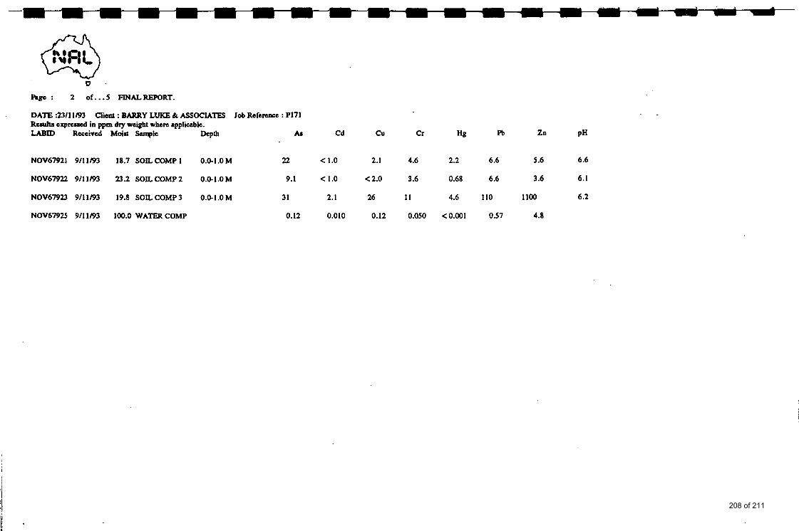
0
hge : 2 of. ..S FINALREPORT.
DATE 9311 1/93 Client : BARRY LUKE & ASSOCIATES Job Refennce : P171 R c d t a expread in ppm dry weight when applicable. LABID Received Moist Sample hPlh
NOV67921 911 1/93 18.7 SOIL COMP 1 0.0-1 .OM 22 < 1.0 2.1 4.6 2.2 6.6 5.6 6.6
NOV67922 911 1/93 23.2 SOIL COMP 2 0.0-1.0 M 9.1 < 1.0 < 2.0 3.6 0.68 6.6 3.6 6.1
NOV67923 911 1/93 19.8 SOIL COMP 3 0.0-1.0 M 31 2.1 26 1 1 4.6 110 1100 6.2
NOV67925 9/11/93 100.0 WATERCOMP 0.12 0.010 0.12 0.050 <0.001 0.51 4.8
208 of 211
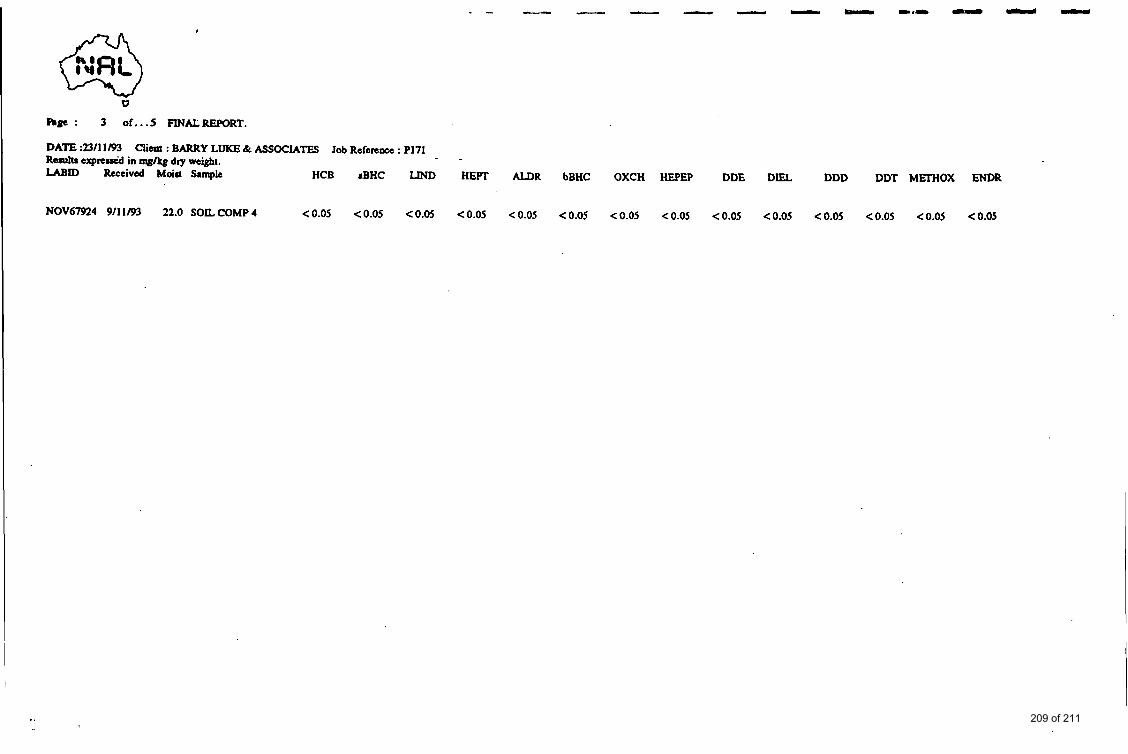
I
v Rge : 3 o f . . . 5 FINALREPORT.
DATE :SI1 1/93 R u u b e x p r e d in mg&g dry weight. LABID Received Moict Sample HCB rBHC LIND
Glia : BARRY LUKE & ASSOCIATES Job Reference : PI71
NOV67924 911 1/93 22.0 SOIL COMP 4 C0.05 c0.05 C0.05
HEIT
< 0.05
ALDR
C 0.05
bBHC
< 0.05
OXCH HEPEP
<0.05 CO.05
DDE
< 0.05
D I U DDD
CO.05 CO.05
DDT METHOX ENDR
C0.05 <0.05 C0.05
209 of 211
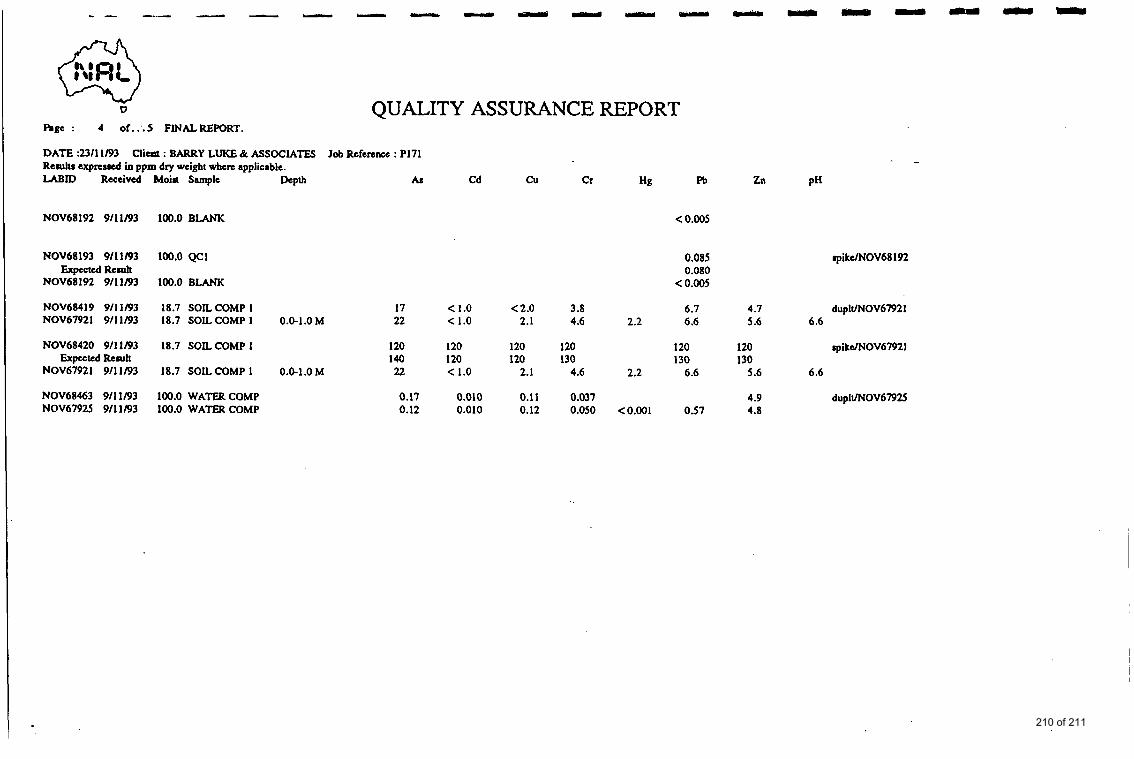
0 QUALITY ASSURANCE REPORT Rge : 4 of.:.5 FINALREPORT.
DATE :23/11/93 Results exprcued io ppm dry weight wbere applicable.
Clia8 : BARRY LUKE & ASSOCIATES Job Reference : PI71
LABID Receivtd- Moim Sample
NOV68192 9/11/93 100.0 BLANK
NOV68193 9/11/93 100.0 QCl
NOV68192 9/11/93 100.0 BLANK Expected Result
NOV68419 911 1/93 18.7 SOIL COMP 1 NOV67921 911 1/93 18.7 SOIL COMP 1
NOV68420 911 1/93 18.7 SOIL COMP 1
NOV67921 911 1/93 18.7 SOIL COMP 1 Expected Result
NOV68463 9/11/93 100.0 WATER COMP NOV67925 9/11/93 100.0 WATER COMP
B P h AS Cd cu Cr Hg
0.0-1 .O M
0.0-1 .O M
F%
< 0.005
0.085 0.080
< 0.005
17 < 1.0 < 2.0 3.8 6 .I 22 < 1.0 2.1 4.6 2.2 6.6
120 120 120 120 120 140 120 120 130 130 22 < 1.0 2.1 4.6 2.2 6.6
0.17 0.010 0.11 0.037 0.12 0.010 0.12 0.050 <0.001 0.57
Zn PH
rpikelNOV68192
4.7 dupll/NOV67921 5.6 6.6
120 spikdNOV6792 I 130
5.6 6.6
4.9 dupIUNOV6792S 4.8
210 of 211

F A
QUALITY ASSURANCE REPORT h g e : 5 of.. .5 FINALREPORT.
DATE :23/11/93 Results expmkstd in mgkg dry weight. LABID Received Moist Sample HCB aBHC LIND HEFT ALDR bBHC OXCH HEPEP
Client : BARRY LUKE & ASSOCIATES Job Reference : P171
NOV68383 9/11/93 0.0 BLANK <o.os <o.os <o.os co.05 <o.os <o.os co.05 <o.os
NOV68386 911 1/93 22.0 SOIL COMP 4 <O.OS <O.OS <O.OS CO.05 <O.OS <0.05 CO.05 CO.05 NOV67924 911 1/93 22.0 SOIL COMP 4 <o.os <o.os co.05 co.05 <o.os <o.os co.05 <o.os
DDE
< 0.0s
< 0.05 < 0.0s
DIEL
< 0.0s
< 0.05 < 0.0s
DDD
< 0.0s
< 0.0s < 0.0s
DDT MEI’HOX ENDR
co.05 <o.os <o.os
< 0.05 < 0.05 < 0.05 duplVNOV67924 <o.os <o.os <o.os
211 of 211