empire in the hold: the british maritime cultural landscape in the western great lakes 1759-1796 by
TRANSCRIPT
EMPIRE IN THE HOLD: THE BRITISH MARITIME CULTURAL LANDSCAPE IN
THE WESTERN GREAT LAKES 1759-1796
by
Thomas Kurt Knoerl
A Dissertation
Submitted to the
Graduate Faculty
of
George Mason University
in Partial Fulfillment of
The Requirements for the Degree
of
Doctor of Philosophy
History
Committee:
Director
Department Chairperson
Program Director
Dean, College of Humanities
and Social Sciences
Date: Fall Semester 2012
George Mason University
Fairfax, VA
Empire in the Hold: The British Maritime Cultural Landscape in the Western Great Lakes
1759-1796
A dissertation submitted in partial fulfillment of the requirements for the degree of
Doctor of Philosophy at George Mason University
by
Thomas Kurt Knoerl
Master of Arts
East Carolina University, 1994
Director: Randolph Scully, Professor
Department of History
Fall Semester 2012
George Mason University
Fairfax, VA

ii
This work is licensed under a creative commons
attribution-noderivs 3.0 unported license.

iii
DEDICATION
This dissertation is dedicated to my mother, Phyllis M. Knoerl, who gave me a love of
history and always encouraged me to travel and see the places where history was made,
both above and beneath the water.
iv
ACKNOWLEDGEMENTS
In 1988 Dr. Stuart and Pat Scott invited me to participate in an underwater archaeological
investigation of the cove area at Old Fort Niagara. It was my first exposure to underwater
archaeology at an inundated colonial site. From the first I was hooked and I will be
forever grateful to them for introducing me to an amazing world of material culture and
the archaeologists and historians that work in this field. Researching and writing this
dissertation led me to amazing places full of incredibly generous people to whom I owe
much. First I would like to thank the numerous research libraries and archives I’ve
visited. Folks like Brian Dunnigan at the William L. Clements Library, Brian Jaeschke at
Fort Michilimackinac, Jere Brubaker at Old Fort Niagara, Thomas Evans at the
Smithsonian Museum of the American Indian, the staff at the Library of Congress, the
Detroit Public Library, historian Roland Nafus, and Fran Robb at Fort St. Joseph gave
their time and guidance. Dr. Keith Widder graciously shared his research materials,
advice, and enthusiasm with me. Moral support came from many individuals including
Dan Horner, Mark Baker, and Maria Stoughton. Doctors Jim Allan, John Jensen, Gordon
Watts Jr., Brad Rodgers, T. Mills Kelly, and Roderick Mather provided me with
examples of academic professionalism that I have tried to emulate. Fellow PhD
candidate Michelle Damian has been a sounding board, a reader during the whole
process, and a great friend. She encouraged me to go for my PhD after taking the class I
taught in underwater archaeology for sport divers many years ago. I am indeed in her
debt. For the past few years my friends Dick Harless, Mary Linhart, Lee Ann Ghajar,
Jerry Prout, Jenny Reeder, Nona Martin, and Jeff Weir, provided encouragement and
sound advice.. I’d also like to acknowledge my dissertation committee for their
comments and advice: Dr. Rosemarie Zagarri, Dr. Christopher Hamner, and my director
Dr. Randolph Scully who taught me much and prodded me to do better when I needed it.
Finally, I’d like to thank my family including my in-laws Charles and Patricia Wright and
my parents John L. and Phyllis Knoerl who provided so much support over the years. My
brother Dr. John J. Knoerl has been my role model since I was born and helped create the
maps in this dissertation. Most importantly, my wife Nancy, my son Ian, and my
daughter Kathryn made the process possible through their patience and love over the last
seven years. They sacrificed much without complaint and understood when I went off on
research trips to the Great Lakes, while I kept the family dining room table covered in
books, articles, logbooks, and countless scraps of paper, and when I sequestered myself
to write. All three of them are great scholars in their own right. Nancy is an experienced
and patient teacher. Ian inspired me with his passion for his own research, and Kathryn
with her love of writing and learning. I hope to emulate all of them over the future
course of my academic career.
v
TABLE OF CONTENTS
Page
List of Tables .................................................................................................................... vii
List of Figures .................................................................................................................. viii
List of Abbreviations AND Symbols................................................................................. ix
Abstract ............................................................................................................................... x
Chapter One: IT’S HARD TO SHIP A COW IN A CANOE ............................................ 1
The Changing Shape of Empire ...................................................................................... 2
Indians, Traders, and Soldiers in the Empire .................................................................. 5
Trade and Material Culture ............................................................................................. 9
Projecting Power into the West..................................................................................... 10
New Perspectives on the British Empire and the Western Great Lakes ....................... 12
The Maritime Cultural Landscape................................................................................. 13
Summary ....................................................................................................................... 25
Chapter Two: THE SMALL CRAFT MARITIME CULTURAL LANDSCAPE ........... 27
Geography ..................................................................................................................... 30
The Indian Maritime Cultural Landscape ..................................................................... 30
The French Period ......................................................................................................... 40
The British Period ......................................................................................................... 46
The British Army .......................................................................................................... 58
Trading in the Far West................................................................................................. 62
Conclusion..................................................................................................................... 73
Chapter Three: EXPANDING THE MARITIME CULTURAL LANDSCAPE ............. 76
A Maritime Cultural Landscape on Paper..................................................................... 80
The Geographic and Environmental Challenges........................................................... 85
Expanding the Maritime Cultural Landscape: The British Enter the Region ............... 90
Navy Island ................................................................................................................. 101
Labor, Disease, and the Chain of Command............................................................... 108

vi
The Role of Conflict in Shaping the Maritime Cultural Landscape ........................... 112
Development of the Maritime Cultural Landscape on the Upper Lakes..................... 127
Conclusion................................................................................................................... 129
Chapter Four: ARMED FOR TRADE: TRANSPORTING EMPIRE INTO THE
WESTERN GREAT LAKES ......................................................................................... 134
Introduction ................................................................................................................. 134
Building Large Sailing Vessels on the Western Great Lakes ..................................... 140
Hull Forms................................................................................................................... 144
Building the Vessels.................................................................................................... 148
Green Wood ................................................................................................................ 150
The Chain of Command .............................................................................................. 154
Life on the Inland Sea ................................................................................................. 164
The British Army and the Development of Merchant Shipping ................................. 176
Revolution and Control ............................................................................................... 182
The Return of Merchant Shipping............................................................................... 188
Conclusion................................................................................................................... 191
Chapter Five: CONFLICT AND CONTROL: BRITISH – INDIAN RELATIONS 1760-
1796................................................................................................................................. 193
Artifacts as Elements of Culture ................................................................................. 196
The Pontiac Uprising................................................................................................... 205
The American Revolution ........................................................................................... 216
The Indian Crisis of the early 1790s ........................................................................... 227
Conclusion................................................................................................................... 241
Chapter Six: CONCLUSION.......................................................................................... 243
References....................................................................................................................... 254
Primary Sources .......................................................................................................... 254
Secondary Sources ...................................................................................................... 257

vii
LIST OF TABLES
Table Page
Table 1. Sample Canoe Cargos Transported to Detroit During the Pontiac Uprising.... 119
Table 2. Lt. Gov. Sinclair's Estimate of Goods Needed for Indians............................... 224
viii
LIST OF FIGURES
Figure Page
Figure 1. Drainage basins of the Great Lakes and Canadian North West. ....................... 31
Figure 2. Birchbark canoe on display at Fort Pitt Museum in Pittsburg........................... 34
Figure 3. Two depictions of the underwater panther. ....................................................... 37
Figure 4. French fur trading post distribution 1600-1760................................................. 43
Figure 5. Crosses mark the scene of fatal travel accidents. .............................................. 45
Figure 6. Major canoe travel routes in the late eighteenth century................................... 47
Figure 7. French and British fur trade posts 1600-1760. .................................................. 49
Figure 8. A portion of a 1753 map of Lake Erie by John Patten. ..................................... 51
Figure 9. A Plan of the Straits of St. Mary, and Michilimackinac. .................................. 82
Figure 10. Line drawing of bateau.. .................................................................................. 94
Figure 11. Remains of bateau recovered from underwater off St. Joseph Island ............. 95
Figure 12. The maritime transport system along the Niagara frontier.............................. 99
Figure 13. Navy Island in 1764....................................................................................... 104
Figure 14. Plan for nine redoubts built along the Niagara portage................................. 124
Figure 15. Fort Erie at the mouth of Lake Erie............................................................... 125
Figure 16. Sloops and schooners achored off Fort Niagara during the 1790s. ............... 142
Figure 17. Schooner anchored off of Fort Erie on Lake Erie in 1796. ........................... 143
Figure 18. British Generals who controlled the Naval Department................................ 146
Figure 19. Line drawings of schooner Nancy ................................................................. 149
Figure 20. Proximity of Navy Island to Niagara Falls.................................................... 151
Figure 21. Sample trade items ........................................................................................ 183
Figure 22. Additional samples of trade items ................................................................. 184
Figure 23. Otter skin medicine bag................................................................................. 201
Figure 24. Indian headdress ............................................................................................ 202
Figure 25. Indian leg bands............................................................................................. 203
Figure 26. Earrings.......................................................................................................... 204
Figure 27. Map of center of Great Lakes region in 1796................................................ 210
Figure 28. Views of and from Fort Mackinac on Mackinaw Island............................... 221
Figure 29. Lt. Governor John Graves Simcoe c. 1791.................................................... 231

ix
LIST OF ABBREVIATIONS AND SYMBOLS
British Pounds......................................................................................................................£
Burton Historical Collection ......................................................................................... BHC
Collections of the State Historical Society of Wisconsin ........................................CSHSW
Library of Congress .......................................................................................................LOC
Michigan Pioneer Historical Society ..........................................................................MPHS
Old Fort Niagara Library ............................................................................................ OFNL
William L. Clements Library..................................................................................... WLCL
x
ABSTRACT
EMPIRE IN THE HOLD: THE BRITISH MARITIME CULTURAL LANDSCAPE IN
THE WESTERN GREAT LAKES 1759-1796
Thomas Kurt Knoerl, Ph.D.
George Mason University, 2012
Dissertation Director: Dr. Randolph Scully
This dissertation draws attention to an aspect of the British Empire in the western
Great Lakes that has, in the past, gone relatively unnoticed despite its importance to
nearly every aspect of the British experience within the region. By looking at the
development of the maritime cultural landscape over time, we can see how different
cultures developed and utilized the same physical landscape. The British Empire in the
western Great Lakes was a maritime empire in which water both facilitated and
undermined British attempts to establish their conception of empire throughout the
region. Reshaping the maritime cultural landscape as they did to accommodate large
sailing vessels aided the British in their efforts to expand westward but their reliance on
their waterborne transport system exposed them to attack at its weakest points. A
schooner could transport greater quantities of goods at faster speeds than a canoe but it
required deeper harbors and was equally imprisoned by ice during the long winter
months. It also required a substantial support system spread over hundreds of miles in

xi
order to function. Studying the British Empire in the western Great Lakes through the
prism of the maritime cultural landscape connects the region to the rest of the empire, one
that came to span the globe, a globe that is predominately covered by water.
1
CHAPTER ONE: IT’S HARD TO SHIP A COW IN A CANOE
In 1970 archaeologist Charles Cleland excavated an eighteenth century British
trash pit at Fort Michilimackinac located on the northern tip of modern day Michigan’s
Lower Peninsula, where Lakes Michigan and Huron meet. It was one of the western most
forts in the empire, hundreds of miles from the nearest British post. Cleland noted in his
report that the trash pit contained far more bones from domesticated animals such as
cattle and pigs than from wild game such as venison and fowl. In an almost offhand
comment, Cleland suggested that the abundance of domesticated animal species
compared to those consumed by the fort’s earlier French inhabitants was made possible
because the British had built large sailing vessels where the French had not: larger cargo
holds made it easier to import domesticated livestock “on the hoof” and in the barrel.
After all, Cleland noted, “it’s hard to ship a cow in a canoe.”1
Although Cleland did not elaborate on this point, his observation draws attention
both to the practical challenges of extending the British Empire deep into the North
American continent and to the British approach of using ships and maritime activities to
overcome those challenges. This dissertation examines how the natural geography both
helped and frustrated the British in their efforts to bring the region under their control. It
1 Charles Cleland, Comparison of the Faunal Remains from French and British Refuse Pitts at Fort
Michilimackinac: A Study in Changing Subsistence Patterns (Ottawa: National Historic Sites Service
National and Historic Parks Branch Deptartment of Indian Affairs and Northern Development, 1970), 16.
2
also calls attention to how the relationship between vessel type, cargos, and reliable
access to trade goods affected British-Indian relations. Finally it explores how the
changes the British made led to the rise of a maritime identity and infrastructure that
would set the stage for explosive economic growth on the Great Lakes in the nineteenth
century.
The Changing Shape of Empire The negotiated settlement at the end of the French and Indian War left Canada in
British hands. The French preferred to regain the lucrative sugar producing islands of
Guadeloupe and Martinique as well as fishing rights off of Newfoundland rather than the
immense northern territory that had been so costly to maintain.2 The transfer radically
altered the balance of power in North America.3 Instead of two contesting European
powers with Indians in the middle the British found themselves between the Indians and
eastern white colonists who were eager to move west and settle land inside Indian
territory.4 Indeed the British Empire at the end of the war had expanded around the world
with newly conquered territories in India, the West Indies, and Africa.5 The British
wished to retain Canada because it removed the French military threat from British
eastern seaboard colonies, captured the northern fur trade, and provided an outlet for
additional migration from England which in turn would spur demand for British
2 Stephen Conway, “Consequences of the Contest: Quebec and British Politics 1760-1774,” in Revisiting
1759: The Conquest of Canada in Historical Perspective, eds. Philip A. Buckner and John G. Reid
(Toronto: University of Toronto Press, 2012), 144; W. J. Eccles, France in America (New York: Harper &
Row, 1973), 215. 3 Fred Anderson, Crucible of War: The Seven Years’ War and the Fate of Empire in British North America,
1754-1766 (New York: Vintage Books, 2001), xx. 4 Daniel K. Richter, Facing East from Indian Country: A Native History of Early America (Cambridge,
Massachusetts: Harvard University Press, 2003), 208. 5 Linda Colley, Britons: Forging the Nation, 1707-1837 (New Haven: Yale University Press, 1992), 76.
3
manufactures. It also displayed Britain’s grandeur with its seemingly infinite expansion
which would, in British eyes, surely preserve Britain’s independence from threats from
continental Europe.6 The empire’s rapid growth, however, meant that more was changing
than just its size.
Historian David Armitage has argued that from the mid 1730s to the mid 1760s
the British Empire could be described as Protestant, commercial, maritime, and free.7 Its
colonies in North America had been primarily populated by white Protestants whose local
governments were based on a system of laws and rights based on British precedents. The
empire’s distribution around the Atlantic naturally meant that the trade was maritime in
nature, connecting colonies that participated in a substantial trade with Britain.8
While the new territories captured in the French and Indian war and the
possibilities they offered for trade meant that the empire’s maritime and commercial
aspects would endure and even expand, the addition of potentially hundreds of thousands
of non-British people who would be placed under military rule, suggested that the empire
had become less homogeneous.9 The empire had no previous experience absorbing such
large populations of non-Britons before.10
In Canada for example, the empire was
absorbing upwards of 90,000 French Canadians and thousands of Indians formerly allied
with France. The result was a society that was markedly different from that in Britain.
6 Jack P. Green, “1759: The Perils of Success,” in Revisiting 1759: The Conquest of Canada in Historical
Perspective, eds. Philip A. Buckner and John G. Reid (Toronto: University of Toronto Press, 2012),
103,107; Conway, "Consequences," 144. 7 David Armitage, The Ideological Origins of the British Empire (Cambridge, Massachusetts: Cambridge
University Press, 2000), 193–194. 8 Armitage, Ideological Origins, 8.
9 Greene, "The Perils of Success," 97.
10 P. J. Marshall, ed., The Oxford History of the British Empire: Volume II: The Eighteenth Century (New
York: Oxford University Press, 2001), 372.
4
The region’s inhabitant’s responses to local conditions, British traders, and British
authority could not be dictated by their new imperial rulers.11
Despite the potential problems of absorbing such a vast new territory, it seemed to
Britons that commerce would flourish as a result of the spoils of war. 12
Such trade was
vital to the British economy, for the government’s revenue, and the maintenance of its
naval power. Trade had helped Britain’s navy become the most formidable sea power in
Europe.13
The potential for economic growth in the new territories meant that retaining
and controlling them was a crucial par of British policy.14
The belief in Britain was that
money spent in British colonies would return to the mother country with interest as
opposed to fighting wars in Europe where men and money would never return.15
While
this was perhaps true for the old settler colonies, the end of the French and Indian war
had brought new unknown variables.
Although, geographically, the western Great Lakes region lay at the edge of the
British Empire in North America in the mid eighteenth century, historiographically, they
straddled a position between what historians refer to as the first and second empires. The
first empire typically refers to Britain’s North American coastal colonies where British
subjects participated as members of a settlement and maritime trade network and were
subject to the protections and laws of the military. It was an empire “defended by ships,
11
John Huxtable Elliott, Empires of the Atlantic World: Britain and Spain in America, 1492-1830 (New
Haven: Yale University Press, 2006), xiv. 12
Colley, Britons, 76; Eliga H. Gould, The Persistence of Empire: British Political Culture in the Age of
the American Revolution (Chapel Hill: University of North Carolina Press, 2000), 56. 13
Gould, The Persistence of Empire, 56. 14
Elliott, Empires of the Atlantic World, 305; Colley, Britons, 110. 15
Gould, The Persistence of Empire, 65.
5
not troops.”16
Historians like Mark Naidis have described the second British Empire as
increasing commerce through conquest which developed at the same time as the start of
the industrial revolution and mass production.17
In addition, subjects of the second empire
such as those in India were often not ethnically British and had no historical tradition of
loyalty to the British crown. The hostile Indian and French inhabitants of the western
Great Lakes region at the close of the French and Indian War who suddenly found
themselves under the authority of the British crown had more in common with
indigenous populations halfway around the world in India in their subjugation to a
foreign power than they did with British colonists only a few hundred miles to the east on
the Atlantic coast. Only after loyalists poured into Canada after the American Revolution
did the population begin to resemble those of the first empire.
Indians, Traders, and Soldiers in the Empire From the beginning of British occupation in the western Great Lakes British
conceptions of empire for the region were drastically different from the former French
inhabitants. In their Atlantic coast colonies the British were more interested in land
acquisition and development, which required removing Indian communities living in the
area.18
The French had a far less intrusive trading economy, which, coupled with a much
smaller European population, lessened the need to dispossess Indians from their lands. In
the French-Indian relationship neither side dominated the other but instead found ways to
16
Armitage, Ideological Origins , 3. 17
Mark Naidis, The Second British Empire1783-1965 A Short History (Reading, Massachusetts: Addison -
Wesley Publishing, 1970), 1; Maya Jasanoff, Edge of Empire: Lives, Culture, and Conquest in the East,
1750-1850 ( New York: Vintage Books, 2006), 21. 18
D. W. Meinig, The Shaping of America: A Geographical Perspective on 500 Years of History, Volume 1:
Atlantic America 1492-1800 (New Haven: Yale University Press, 1986), 284.
6
reach accommodations in what Richard White called the “middle ground”.19
The French
fulfilled a role as mediators between the numerous tribes that inhabited the Great Lakes
region, provided needed trade goods, and formed kinship ties through intermarriage that
benefited both communities.20
They relied on the Indians as allies and understood that the
small French outposts were untenable without the Indian’s consent.21
The British on the
other hand drastically altered their treatment of the Indians once the French had
surrendered and the Indians were no longer needed military allies. 22
The British intended
to dictate the terms of their relationship with the Indians23
The Indians that lived throughout the Great Lakes regions were not considered
British subjects in the full sense of the word, with British rights and freedoms. They and
the territory in which they lived were considered protectorates of the King.24
The Indians,
however, quickly figured out where they would fit in the new order the British Army,
under Lord Jeffery Amherst - commanding officer of British forces in North America,
was trying to impose.25
Historian Gregory Dowd has argued that Amherst believed that
the British had conquered the Indians yet had spared them and would allow them the
opportunity to trade with the British, an opportunity for which they should be grateful.26
This was not a cultural misunderstanding but an attempt to limit their power while
19
Richard White, The Middle Ground: Indians, Empires, and Republics in the Great Lakes Region, 1650-
1815 (Cambridge, Massachusetts: Cambridge University Press, 1991), x. 20
Anderson, Crucible of War, 454. 21
Colin G. Calloway, The Scratch of a Pen: 1763 and the Transformation of North America (Pivotal
Moments in American History (New York: Oxford University Press, 2007), 38,55. 22
White, The Middle Ground, 256. 23
Anderson, Crucible of War, xxiii. 24
Gregory Evans Dowd, War Under Heaven: Pontiac, the Indian Nations, and the British Empire
(Baltimore: The Johns Hopkins University Press, 2004), 211–212. 25
Dowd, War Under Heaven, 66. 26
Ibid., 73.
7
increasing their dependence on trade.27
Even the Covenant Chain between the British and
the Iroquois suffered as Amherst’s disdain for Indians became evident. As the old
allegiances of Great Lakes Indians to the French and Iroquois to the British collapsed
new alliances between Great Lakes Indian tribes arose to challenge the British and
prevent their social and political degradation.
The conflict that erupted known as the Pontiac Uprising showed the limits to
which coercion could be used to enforce the British conception of empire on unwilling
Indians.28
Facing an ideological and military stalemate the British and Indians negotiated
peace terms and brought their relationship back close to the status quo before the
uprising.29
British Indian policy throughout the American Revolution and the Ohio land
crisis of the 1790s never lost sight of the fact that, when organized, the Indians could
harness a “collective power that could not be ignored” as they fought to shape the terms
of their relationship with the empire.30
Just as their French predecessors had, the British
were forced to assume the role of father, mediating intertribal conflicts, assisting Indians
in time of sickness and famine, and protecting them from scurrilous traders and land
encroachment by white colonists as best they could. At the same time the British
continually tried to maintain good order to protect their monopoly on the fur trade and
maintain the Indians as allies in any potential conflict with the United States.31
In the end
the British saw the Indians as an expendable tool to be discarded if needed to protect
27
Ibid., 69. 28
Anderson, Crucible of War, 456. 29
White, The Middle Ground, 289. 30
Colin G. Calloway, Crown and Calumet: British-Indian Relations, 1783-1815 (Norman: University of
Oklahoma Press, 1987), 3; Dowd, War Under Heaven, 274. 31
Calloway, Crown and Calumet, 17.
8
British interests.32
The painful lesson the British had to learn, however, was that their
imperial goals for the western Great Lakes region would always be contingent on factors
outside of their complete control. Indians, French inhabitants, British merchants,
colonists, and their own military personal all established their own spheres of influence
on the ground at the heart of empire.
The French and British living in the western Great Lakes often brought with them
a wide realm of experience. It was not uncommon for members of the British military to
have served in the armed forces of other nations or in British campaigns in other areas of
the globe. For instance, the military Governor of Canada who presided over military
affairs in the first years of British occupation participated in engagements in Germany.
French inhabitants may well have traveled to other parts of the globe and in some cases
retained ties to the old French Empire. Some French inhabitants sailed aboard British
vessels on Lake Erie in the 1780s which caused issues when France allied with the
Rebels during the American Revolution. French sailor Francis Brown for instance felt
that once France had joined the Rebels in the war it would be a betrayal to his deceased
father who had fought against the British in the French and Indian War. 33
The inhabitants
varied backgrounds meant that they brought different points of view to their decision
making and human contacts that could affect the reality of empire.34
As historian Eric
Hinderaker has argued, empires were not formed by imperial policy planners imposing
32
Ibid. 33
Francis Brown to Capt. Alexander Grant (translation) , April 12, 1782 in Historical Collections:
Collections and Researches Made by the Michigan Pioneer and Historical Society, Vol. XX (Lansing, MI:
Wynkoop Hallenbeck Crawford Co. State Printers, 1912), 5, Google ebook, http://books.google.com/
books?id=hxIUAAAAYAAJ. 34
Jasanoff, Edge of Empire, 12–13.
9
systems on distant lands but instead were a series of processes and negotiated systems
where interactions of people on a daily basis shaped the reality of empire through
challenges, resistance, compromise, and conflict.35
Trade and Material Culture The exchange of material culture through trade relationships between Indians and
whites was the most powerful catalytic agent that exerted influence and change on all
parties throughout the Great Lakes region during the British occupation period. Even in
the heart of the Great Lakes global markets facilitated a free flow of ideas, germs,
animals, people, and goods that connected Indians and British alike to fellow members of
the empire’s trade network.36
British policies for trade in the western Great Lakes had
both positive and negative effects for Native Americans, including causing declining
game reserves from over hunting, transmission of disease through concentration of trade
at British posts, and the slow collapse of native culture through alcoholism and
dependence on European goods.37
Indians, however, were successful at taking trade
goods from Europe, completely foreign at first, and transformed them into objects to fit
into existing social niches. As Richard White points out, “Symbol and utility merged here
to give European trade goods an influence far beyond their simple use value.”38
35
Eric Hinderaker, Elusive Empires: Constructing Colonialism in the Ohio Valley, 1673-1800 (Cambridge,
Massachusetts: Cambridge University Press, 1999), xi. 36
Rosemarie Zagarri, “The Significance of the ‘Global Turn’ for the Early American Republic:
Globalization in the Age of Nation-Building,” Journal of the Early Republic 31, no. 1 (2011): 3; Jasanoff,
Edge of Empire, 12–13. 37
Matthew Ward, Charles-Michel Mouet de Langlade: Warrior, Soldier, and Intercultural ‘Window’ on
the Sixty Years’War for the Great Lakes in The Sixty Years’ War for the Great Lakes, 1754-1814, eds.
David Curtis Skaggs and Larry L. Nelson (East Lansing: Michigan State University Press, 2001), xx. 63-
78. 38
White, The Middle Ground, 104.
10
British officer Major Andrew Foster used his time stationed in the Great Lakes in
the 1790s as an opportunity to collect Indian material culture. Maya Jasanoff’s study,
Edge of Empire looks at empire “from the inside out” and suggests that artifacts collected
and associated with empire provide “evidence of the human contacts that underpinned the
otherwise intangible quantities of globalization and empire.”39
. Examining the items
Foster collected provides evidence of his priorities, tastes, and world view. Similarly,
evidence recorded by fur traders traveling deep into the North American interior, made
possible due to European adoption of native small craft, supports elements of all of these
perspectives and suggests that contact between Natives and the British Empire resulted in
complex and often misunderstood relationships.
Projecting Power into the West Establishing the empire in such geographically remote regions while difficult was
not a new practice for the British. In his discussion on Britain’s global approach to
empire, historian Alan Frost argued that English ships in the seventeenth century
prepared the way by exploring new areas of the globe and acquiring crucial information
necessary for safe navigation about currents, shorelines, and harbors. With this
information in hand merchants, naval, and military forces soon followed.40
To project
British power into the newly acquired region in North America the British would take a
similar approach but not without first overcoming numerous geographic obstacles.
The British believed that securing their new conquests and imposing their desired
form of empire on the region’s inhabitants required stationing a substantial number of
39
Jasanoff, Edge of Empire, 12–13. 40
Alan Frost, The Global Reach of Empire: Britain’s Maritime Expansion in the Indian and Pacific Oceans
1764-1815 (Carlton, Victoria: The Miegunyah Press, 2003), 1-3.
11
troops in North America. This was especially true in the western Great Lakes where the
Indians had not been conquered in battle as their French allies to the east had been.41
While they could make use of existing sailing vessels to transport the enormous amount
of men and materials to Quebec on the St. Lawrence River and Fort Niagara at the
western end of Lake Ontario, no large vessels could reach the remaining Great Lakes of
Erie, Huron, Michigan, and Superior. Niagara Falls with its 150 foot drop barred their
way. They needed to find an efficient and safe way to reach the newly acquired posts and
to keep them supplied in order to maintain control over the coming decades. To build
large sailing vessels above Niagara Falls the British had to import all the support facilities
and personnel from outside the Great Lakes region. As with native resistance to British
imposed forms of empire, British attempts to force their will on the landscape were
reshaped by local geography. In this case the natural rapids, escarpments, chokepoints,
and shallows of the western Great Lakes exerted a tremendous influence over events. The
vast distance from eastern colonial centers and the coast and the lack of roads meant that
the waterways formed by the Great Lakes drainage basin were realistically the only travel
route into the region.
Once the army reached the western posts they managed to maintain their hold on
the Great Lakes region until the late eighteenth century despite challenges posed by
distance, geography, violent summer storms, harsh winter weather, an Indian uprising,
and the American Revolution. When they finally surrendered land to the fledgling United
States it was not the result of enemy conquest over British forces but of diplomatic
41
Gould, The Persistence of Empire, 111.
12
negotiations and weak alliances. The United States Army’s victory over Indian warriors
during the 1790s Ohio Indian crisis along with the surrender of British posts in the
western Great effectively broke the British monopoly on the maritime transportation in
the region. As with the end of the French and Indian War, new power relationships
between all parties would have to be formed thus taking the western lakes into a new era.
New Perspectives on the British Empire and the Western Great Lakes Studying the Western Great Lakes maritime history during the British occupation
period (1759-1796) offers an opportunity to examine various themes, including global
trade networks, contrasts between the first and second British Empire, Indian and British
relations, and the general expansion of British power in North America. While these are
important aspects of the empire it is also important to understand the reality of daily life
on the ground. Empires were made by soldiers, traders, local inhabitants, enemies, and
allies. Battles that decided the fate of millions were dependent on supply logistics, the
soldiers’ health, the word of a French or Indian informant, the weather, the depth of water
from spring thaws, the generosity or racism of a general, the relationship between a post
commandant and a schooner captain, or the accuracy of a musket. The higher-level
themes of empire therefore were played out at a local level. When studying empire at that
level one also needs to examine the environment and geography in which events took
place. Not surprisingly in the Western Great Lakes the natural environment was
dominated by water including large lakes, connecting rivers, streams, ponds, portages
around rapids, rain, snow, and ice. From the interplay of environment, daily life, and
Imperial objectives we can gain a more realistic picture of how well the empire
13
functioned and how Imperial goals were modified to fit the geographic and political
realities on the ground.
Historians have examined numerous aspects of the British Empire in the Great
Lakes region and beyond but none have examined the early maritime phase which
coincided with Britain’s expansion into the western Great Lakes.42
Yet this was a
formative period where new approaches to waterborne transportation were tried. Some
were discarded after disastrous results while others succeeded, saving lives and making
fortunes for others. All of these efforts involved engaging the landscape, accommodating
it in some places, shaping it in others. With each failure and success the British added
knowledge to their understanding of western Great Lakes navigation. Each bit of data
helped transform the unknown dangers of deep and shallow water into known safe
channels, harbors, anchorages, and sailing practices which aided the mariner as he
transported the King’s vessels deep into the west.
The Maritime Cultural Landscape One cannot fully understand the development of the British Empire in the
western Great Lakes without understanding how and why the maritime environment
changed under British control. James Feldman and Lynne Heasley’s article entitled:
42
Carol MacCleod’s unfortunately unpublished Canadian government report, The Tap of the Garrison
Drum: the Marine Service in British North America 1755-1813, is the most comprehensive work. At
nearly 500 pages it represents a phenomenal amount of research. It predominately tells the military
narrative rather than placing both the merchant and military communities in context of operating within the
same maritime landscape and offers little analysis of the ties between landscape and Empire. Historians
such as the late Robert Malcomson have focusd on the later Great Lakes naval battles of the War of 1812
which occur well after the initial development of the maritime cultural landscape. Malcomson’s brief article
on the development of the Provincial Marine, as the Naval Department came to be called by the end of the
eighteenth century and a an article by W.A.B. Douglas, “The Anatomy of Naval Incompetence: the
Provincial Marine in Defense of Upper Canada Before 1813,” along with MacCleod’s work are the only
secondary sources that address the early years of the British Army’s Naval Department directly.
14
“Reentering North American Environmental History: Pedagogy and Scholarship in the
Great Lakes Region” is one of the few that encourages a greater use of environmental
historical analysis. The authors build on the environmental history approach of William
Cronon. 43
Feldman and Heasley focus on urging historians to examine the Great Lakes
from several environmental perspectives. This dissertation pays particular attention to
how the British attempted to adapt to the natural environment by both adopting native
small craft technology while almost immediately constructing large sailing vessels and
the support facilities they required for use throughout the western Great Lakes.
This dissertation has been influenced greatly by the aforementioned works and in
particular by those that view the British Empire as a global and inter-related system with
regional variations. Because the first large sailing vessels and their cargos were the
physical embodiment of the British Empire an analysis of their origins and the natural
and manmade environment in which they functioned sheds light on numerous aspects of
empire including trade, diplomatic relations between the British, French, and Indians,
warfare, class, culture, and the role of geography on regional development. Whether one
wishes to assess the Great Lakes’ connection to the Atlantic world or as a part of a wider
global empire, the framework that best ties all of these concerns together and is the
cornerstone of this dissertation is the maritime cultural landscape.
Christer Westerdahl’s 1992 article “The Maritime Cultural Landscape” defined
“maritime cultural landscape” as the human utilization of maritime spaces through boats,
43
See William Cronon’s Changes in the Land: Indians, Colonists, and the Ecology of New England (New
York: Hill and Wang, 1983) and Nature’s Metropolis: Chicago and the Great West (New York: W.W.
Norton, 1991).
15
and attendant uses such as wharves, settlements, shipping, fishing, lighthouses, and other
related activities. 44
He also argued for the inclusion of cognitive elements that could be
found within maritime landscapes such as place names. In the Great Lakes region for
instance places like Whitefish Point or Burnt Ships Creek signify the connection between
human culture and geographic features, in this case a useful natural resource and a
significant event. The concept of the maritime cultural landscape ties together human
activities and the landscapes in which they take place. Each element shapes and
influences the other. Beyond connections of place to activity, however, the concept of the
maritime cultural landscape also ties multiple places and activities together into unified
systems. The British Army, for instance, constructed a series of fortifications,
warehouses, wharves, forts, and shipyards along the Niagara River’s thirty mile shoreline
all for the purpose of moving men and materials from Lake Ontario to Lake Erie in order
to get past the navigational obstruction posed by Niagara Falls. Each component did not
work in isolation but was part of a system. Even those elements that were operated by
different groups such as trader’s warehouses and military shipyards were all part of the
empire and the British desire to control and profit from the western Great Lakes. The
maritime cultural landscape of the western Great Lakes, of which the Niagara portage
was a part, offers a useful unit of analysis in that it helps to see broader patterns and
systems that tied the region together. This unity of purpose and administrative
interdependence is rarely emphasized in interpretive displays at historic sites today. This
is due partly to the political boundaries between the United States and Canada that
44
Christer Westerdahl, “The Maritime Cultural Landscape," The International Journal of Nautical
Archaeology 21, no. 1 (1992): 5.
16
separates the surviving elements of the eighteenth century maritime cultural landscape, a
division which did not exist during the colonial period.
Westerdahl’s ground breaking article sparked a conversation among historians
and anthropologists about the importance of understanding ties between maritime
geography and human activity. Books such as Seascapes: Maritime Histories, Littoral
Cultures, and Transoceanic Exchanges, examined how humans’ perceptions and
understanding of land and sea has changed over time. With the Age of Discovery for
instance, oceans became something that connected people to the world rather than
separated them.45
This concept of connections is especially important when considering
the geography of the western Great Lakes during the British occupation period.
As mentioned earlier, Niagara Falls prevented Europeans from being able to sail
from the eastern settlements around Lake Ontario to the rest of the Great Lakes. During
this period there were no roads leading into the western regions surrounding the Great
Lakes. French and later British outposts were islands of European occupation in a sea of
forests. Archaeologist Paul Rainbird’s book The Archaeology of Islands, explored the
development of maritime societies and how such people saw themselves as distinct from
the larger society of which they may be a part. Rainbird discusses the common perception
that “islands” equals isolation and argues instead that islands in reality are connected with
the rest of the world because of their access to water.46
There were important differences
for the early sailors on the western Great Lakes, however, in that they were not at sea as
45
Jerry H. Bentley, Renate Bridenthal, and Karen Wigen, Seascapes: Maritime Histories, Littoral Cultures,
and Transoceanic Exchanges, illustrated ed. (Honolulu: University of Hawaii Press, 2007). 46
Paul Rainbird, The Archaeology of Islands (Cambridge, Massachusetts: Cambridge University Press,
2007), 64–65.
17
long, per voyage, as oceanic sailors and were confined to the shore during the long winter
period when the lakes and rivers were impassible due to ice. Therefore the Great Lakes
sailors had far stronger ties to the land based communities with whom they interacted.
Nevertheless, there is evidence that a maritime identity did develop. To date no studies
have been done on the creation of maritime identity for the earliest sailing communities
in the western Great Lakes. The creation of such communities and identities are a side
effect of the process of empire formation in the region. Those who came to be identified
as being part of the sailing community for example exerted an influence over the safe
passage of much needed goods. That power was recognized by the merchant community
and impacted the way sailors were treated while in port.
The British Army was, from 1760 through 1796 the sole armed European power
in the western Great Lakes region. When their forces took command of western French
fortifications they immediately began to utilize the existing small craft maritime cultural
landscape. Comprised of Native American and French designed small craft such as
birchbark canoes and bateaux, traditional portage routes, native agriculture, seasonal
fishing camps, and trading locations the British Army and traders took advantage of
traditions and practices that in some cases were thousands of years old. The French had
made only small adjustments to the maritime cultural landscape when they moved into
the region and the British would also make only a few changes to the small craft
landscape. The British, however, introduced the construction of large sailing vessels and
this necessitated a vast change to the overall maritime cultural landscape in a very short
time.
18
Historians and anthropologists like Rainbird, Westerdahl, and others often study
maritime societies that evolved over hundreds if not thousands of years. The oldest
elements of those landscapes are difficult to study due to lack of written sources although
archaeological investigations provide some evidence of early development. The British
experience in the western Great Lakes, however, offers a unique opportunity to study the
development of a particular maritime landscape from the very beginning.
Constructing large sailing vessels for the Great Lakes was a priority from the
moment the British Army captured Fort Niagara in 1759 and because vessels do not
operate in isolation the British also began building support facilities.47
This meant
building shipyards, wharves, soldiers quarters, warehouses, logistics networks, and
numerous other pieces of infrastructure and organizations. It also meant importing
craftsmen and building materials from North America’s eastern seaboard and Europe.
All aspects of this developing maritime cultural landscape were responses to
obstacles the natural and cultural environment posed to the spread of empire. Ships were
designed and built to traverse hundreds of miles of open water and enter and exit the
Great Lakes’ shallow harbors and rivers. Portage routes were improved to facilitate
shipment of men and materials around obstructions to navigation and to protect them
from geographic choke points between lakes that offered inviting opportunities for
enemies to attack supply trains. The story of the maritime cultural landscape then is the
story of how the British Empire adapted to the environments it attempted to control and
because the cultural landscape was designed and constructed by individuals and
47
Amherst to Gage, August 14, 1759, Vol. 4, "Amherst Papers," Old Fort Niagara Library, Youngstown,
New York.
19
organizations not always familiar with maritime environments it is also the story of how
the empire handled mistakes and setbacks. It is a story of how empires are actually built
at ground level.
Therefore based on a study of the maritime cultural landscape, this dissertation
will argue that the British Empire in the western Great Lakes was a maritime empire in
which water both facilitated and undermined British attempts to establish their
conception of empire throughout the region. Reshaping the maritime cultural landscape
as they did to accommodate large vessels aided the British in their efforts to expand
westward but their sole reliance on that system exposed them to attack at its weakest
points. Fear of such attacks revealed how dependent British were on good relations with
the Indians. For the Indians the British maritime cultural landscape provided access to the
trade goods they so desired and gave them the ability to threaten the same transport
system upon which the British were also dependent. Unfortunately for the Indians their
influence would disappear once the Americans arrived on the lakes and defeated them at
the Battle of Fallen Timbers. The British in turn would lose their influence over the
Indians once the Americans broke the British shipping monopoly on the lakes. With the
Americans’ arrival on the Great Lakes a new era of American dominance would begin,
one that was built on the systems and practices the British had put in place. The British
built large craft maritime cultural landscape transcended their occupation period and
shaped the development of the region’s Indians, the United States, Britain, and Canada
for the next two hundred years by providing the infrastructure needed to begin the
American era of Great Lakes shipping.
20
Chapter two examines the natural geography and environment in which the
Indians developed the first and arguably the most influential, maritime cultural landscape.
The technology and practices they developed over thousands of years allowed them to
travel great distances to gather resources and build pre contact trade networks. The
seasonal fishing camps and agricultural settlements they established played a key role in
supporting the fur trade which the French expanded after their arrival. Both the British
and the French, having no European maritime technology better suited to the
environment than the Indian’s birchbark canoe fully adopted it and numerous other tools
and practices with only slight alterations. The European pursuit of profits from the fur
trade combined with the small shallow draft vessels they utilized meant that the spread of
empire extended far beyond the boundaries of the Great Lakes region. Traveling great
distances, however, meant leaving behind the protection of European forts. In that
environment the nature of empire would be substantially different. By studying all of the
elements that made up the small craft maritime cultural landscape we gain an
appreciation for the complex role they played in shaping the British Empire both
furthering and frustrating the aims of the merchants and the military alike. The immense
distances involved, the geography of the landscape, and the particular water craft utilized
by all parties, together created relationships, both positive and negative, that were beyond
any one group’s power to control.
In 1759 when the British captured Fort Niagara and the adjacent portage no one in
living memory had seen the only large vessel built on western lakes by the French in
1679. The Griffon, built by French explorer Rene Robert Cavelier Seur de LeSalle never
21
returned from its maiden voyage to Green Bay.48
The French never repeated LeSalle’s
experiment but chose instead to rely on small craft such as canoes and bateaux for their
transport needs, a decision that the last commandant at Niagara regretted.49
The Great
Lakes west of Niagara Falls was barren of any of the facilities needed to support large
vessels when the British Army decided to construct sloops and schooners for use in
Expanding the empire into the region.
Chapter three examines how the British brought a new conception of empire to
the western Great Lakes. Their approach was to develop an expanded maritime cultural
landscape based not solely on small craft like canoes and bateaux but on larger sailing
vessels like sloops and schooners. Whereas the small craft maritime cultural landscape
developed over thousands of years and was adopted by European powers with little
change the British almost immediately began construction of large sailing vessels on the
waters above Niagara Falls for use on the western Great Lakes. No vessel, however,
operates in a vacuum. For a sloop to be successful it requires numerous support elements
such as shipyards to construct them, sail and rope makers, blacksmiths to produce
elements of the rigging, cargo to be warehoused near the shore, wharves to facilitate
loading and unloading, supplies of food for the crew, navigational aids such as charts and
warning markers, fortifications to guard the vessels while moored, and a crew to sail the
vessel from one port to the next. None of this existed prior to the British occupation.
48
Frank Hayward Severance, An Old Frontier of France: The Niagara Region and Adjacent Lakes Under
French Control (New York: Dodd, Mead and Company, 1917), 57. 49
Pierre Pouchot, Memoir Upon the Late War in North America Between the French and English, Vol. 2,
ed. Franklin Benjamin Hough (Roxbury, Massachusetts: Printed for W.E. Woodward, 1866), 157, 159,
Google ebook, http://books.google.com/books/about/Memoir_upon_the_late_war_in_North_Americ.
html?id=7HIOAAAAYAAJ
22
The Niagara River portage provides an excellent case study for analysis as the
British constructed nearly every type of facility needed to support a large sailing vessel
transport service along its banks which ran from Lake Ontario to Lake Erie. By
examining the changes along the Niagara portage and at similar facilities constructed
throughout the western Great Lakes, including the Detroit region, Lake St. Clair, Lake
Huron, and Lake Superior, chapter three will show how British plans for creating a
maritime empire adapted to the natural environment, with varying degrees of success.
Both successes and failures influenced relations between British, French, and Indian
inhabitants. The newly constructed large vessel based maritime cultural landscape was
also an enormous investment in money and manpower for the British which in turn shows
its importance to the empire. These changes which represent imperial priorities and goals
were reflected in the changing face of the landscape, changes which launched an era of
commercial and military activity that began with the British in the late eighteenth century
that continues today.
Chapter four utilizes the first large vessels built on the western Great Lakes as
tools for examining several facets of the British Empire. A key to understanding their
importance is to look beyond boats as mere pieces of technology but rather to see them as
tools for imperial objectives. This chapter will examine their attempts to carry out their
missions of military transport, commercial shipping, exploration and survey, and work on
behalf of the British Indian Department. The army was seldom able to keep more than
two or three vessels afloat on the western lakes at any one time thus stretching their
23
resources to the limit. How such valuable assets were put to use demonstrates which
activities were most important to the British.
In addition to shedding light on imperial goals studying the large vessels provides
insights on how expanding the maritime cultural landscape impacted daily life for the
region’s inhabitants as well as for those who served aboard ship. As Charles Cleland
points out through his excavations at Fort Michilimackinac large vessels provide
opportunities to import different types of cargos and greater quantities. Changing the
nature of material culture in a frontier region can have a profound impact on the nature of
society for those involved including the British, French, and Indian inhabitants. As the
chapter will demonstrate the British struggled continuously to attract and maintain sailors
to serve on these important vessels. Their quality of life had much to do with their labor
shortages. As some vessels were laid up for lack of crews this meant that their
experiences had a direct impact on provisioning western posts and thus the execution of
empire.
The British Army struggled to manage an inland navy, a proposition that led to
much confusion regarding chains of command, priorities, tactics, and costs. Despite the
mistakes and setbacks that resulted from disease, shipwrecks, and bureaucratic
inefficiencies it is clear that the presence of the large vessels impacted the region in
profound ways. One additional aspect of the British sloops and schooners in particular,
even if rarely used, materially and symbolically made all the difference – they were
armed.
24
Chapter five examines the role British control of the maritime cultural landscape
played in British – Indian relations during the British occupation period. It examines
three pivotal events: the Pontiac Uprising, the American Revolution, and the 1790s Ohio
Indian crisis. In each case threats to British control of the maritime cultural landscaped
had direct consequences for British – Indian relations and consequently the empire
throughout the region. British responses to those threats revealed strengths and
weaknesses on both sides as well as how each side valued the other.
The Pontiac Uprising tested the British Army’s ability to use its maritime
transport system to preserve the empire in the western Great Lakes. Within months Indian
forces had attacked and captured every Great Lakes post west of Fort Niagara except for
Detroit. Large sailing vessels provided the means to break the siege and weaken Pontiac’s
Indian alliance. Although Pontiac’s Uprising is the only time British vessels fired their
cannon in anger during the eighteenth century in the Great Lakes the event brought to
light the interdependence between trade and security.
During the American Revolution British hegemony over the western lakes
prevented the Colonists from mounting any real challenge to British control. The threat of
attack via the Great Lakes, however, revealed British insecurity about their position and
in doing so drove the British to cultivate Indian alliances.
The 1790s Ohio Indian crisis in which Great Lakes Indian tribes banded together
to oppose United States entry into the northern Ohio territory, once again revealed the
importance of British control or lack thereof over water transportation on the western
lakes. When the Indians lost the Battle of Fallen Timbers and learned that the British
25
were unwilling to commit fully to war with the United States, the Indians realized that
they had no choice but to develop a new exchange relationship with the Americans. The
crisis revealed that to a large degree the British were actually dependent on Indian
military power to retain control over the British maritime cultural landscape. Once that
control was lost they actually chose to partially turn away from the water which had
changed from being a guarantor of British power in the region to a threat to be mitigated.
Chapter six concludes the dissertation by tying the elements of the maritime
cultural landscape together to show how the British Empire in the western Great Lakes
was a maritime empire. Every aspect of life and empire revolved around control over the
maritime transport system. It impacted the region’s inhabitants not only by transporting
the material culture upon which they depended but by shaping the relationships between
Indians, French inhabitants and British traders and soldiers. The vessels and the facilities
that supported them were the physical embodiment of the British Empire linking their
posts which were “islands” in a sea of forests with Britain’s global empire and trading
networks.
Summary At the end of the French and Indian War the British Empire was in its ascendency
around the globe. This was made possible partly due to the strength and reach of Britain’s
sea power. It is not surprising then that when the British captured Canada from the
French and needed to project their power into the heart of the continent via the Great
Lakes that they immediately utilized the existing maritime cultural landscape. It is
significant that they almost immediately began construction of large sailing vessels and
26
the support facilities they required in a region where no such infrastructure had ever
existed before. This was such a revolutionary moment for the region and the degree to
which the British Army depended upon water transport was so great that it is nearly
incomprehensible that historians have largely ignored not only the history of these vessels
but the relationship between the maritime cultural landscape and the expansion and
retention of the British Empire in the western Great Lakes. The creation of this landscape
shaped future international borders and the lives of millions of its inhabitants. From the
defense and destruction of life to expanding connections with the world abroad, the
maritime cultural landscape was the cornerstone of the daily reality of empire in the
region. It was a landscape that shaped the future of the region and which has its roots
deep in the past thus tying together through its prism the experiences of countless
generations.
27
CHAPTER TWO: THE SMALL CRAFT MARITIME CULTURAL LANDSCAPE
In 1760, almost immediately after the British Army had captured Montreal and
gained Canada for the British Empire, twenty-one year old Alexander Henry set off in a
canoe in what the preface to his published journal referred to as a “premature attempt to
share in the fur trade of Canada.”1 Henry’s trade voyage into the western Great Lakes
was indeed premature on several levels. He preceded even the British Army’s arrival at
Fort Michilimackinac, situated at the strait between Lakes Michigan and Huron, and had
little to no experience with the American Indians of the region, nor was he experienced
with navigating his way across the thousands of miles between his home on the eastern
seaboard of the British colonies in North America and the fur trade regions of the Great
Lakes and northern Canada. Henry, like many of the fur traders that came after him,
sought to explore the frontier and secure his fortune.2
What allowed Henry and others like him to even conceive of attempting such an
enterprise was that they were not venturing into virgin territory. The trade networks,
pathways across the continent, equipment, and trade preferences of his target customers
were all well known to the French traders who had operated in the region for well over a
hundred years prior to the British capture of New France. Even the French did not have to
1 David A. Armour, Attack At Michilimackinac 1763 - Alexander Henry’s Travel & Adventures in Canada
& the Indian Territories Between 1760 & 1764, 1st ed. (Mackinaw Island State Park Commision, 1971), vi. 2 Daniel W. Harmon, A Journal of Voyages and Travels in the Interior of North America (Andover: Flagg
and Gould, 1820), 35. Google ebook. http://books.google.com/books?id=4aUN AAAAQAAJ
28
invent many of the tools and practices necessary to conduct the trade. American Indians
living in the Great Lakes and Northwest Canada had developed and built much of the
support system for trade centuries if not a millennium beforehand.3 In particular they
invented birchbark canoes which, along with other small craft introduced by Europeans
such as bateaux, were the key to overcoming the physical obstacles that separated tribes,
European military forces, and merchants. Such early craft provided the ability to connect
distant cultures otherwise isolated by dense forests and distance. While the material
culture exchanged prior to and after the contact period differed the general purposes of
exchange had both practical and cultural significance. From a practical standpoint
exchange allowed for the spread resources that were abundant in some areas and scarce
or not easily obtained in others. But on a cultural level, for Indians at least, exchange had
for millennia sealed social and political relationships by spreading ideas, beliefs,
ceremonies, practices, and genetic diversity through intermarriage. This remained the
case even in the first few years of the British occupation prior to the construction of
larger sailing vessels although fur traders and the British Army may not always have been
aware of the cultural importance of exchange.4
Taken together, the small vessels, waterborne pathways, supply resources, trading
posts, farms, myths, traditions, and other elements that supported trade and military
movements through the Great Lakes and northwest Canada all comprised the small craft
maritime cultural landscape. Conceptualizing it as such reminds us that each segment of
3 D.W. Moodie, “Agriculture and the Fur Trade,” in Rethinking the Fur Trade: Cultures of Exchange in an
Atlantic World (Lincoln: University of Nebraska Press, 2009), 93–94. 4 Neal Salisbury, “The Indians’ Old World: Native Americans and the Coming of Europeans,” The William
and Mary Quarterly 53, no. 3, Third Series (July 1, 1996): 436–444.
29
the maritime cultural landscape needs to be studied within the context of the other
elements. This chapter will argue that the small craft maritime cultural landscape, whose
origin predates the contact period and that persisted throughout the French era, played a
complex role in shaping the British Empire, both furthering and frustrating the aims of
the merchants and the military alike. The immense distances involved, the geography of
the landscape, and the particular water craft utilized by all parties, together created
relationships, both positive and negative, that were beyond any one group’s power to
control. This collectively shaped the nature of the British Empire in the region as well as
the lives and livelihoods of the region’s American Indian and French inhabitants during
the early years of British occupation. The British adoption of the small craft maritime
landscape and its ability to extend the British Empire into the far north and west of North
America gave rise to a segment of the British Empire that ranged far beyond the British
Army’s ability to control. This meant that the maritime empire the British were
establishing was made up of two distinct elements: a large and a small craft maritime
cultural landscape, i.e. a commercial segment and a military-political one. The British
Army maintained political, military, and commercial control over the large craft transport
system for most of the late eighteenth century. The small craft maritime empire, however,
was far more egalitarian and commercial as both the Indians and Métis had far more
control over their relationship with the British. This was directly related to the natural
geography and the watercraft used to reach the fur trade regions beyond the Great Lakes.
30
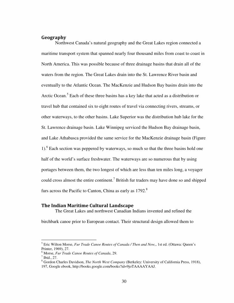
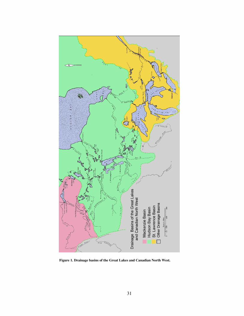
Geography Northwest Canada’s natural geography and the Great Lakes region connected a
maritime transport system that spanned nearly four thousand miles from coast to coast in
North America. This was possible because of three drainage basins that drain all of the
waters from the region. The Great Lakes drain into the St. Lawrence River basin and
eventually to the Atlantic Ocean. The MacKenzie and Hudson Bay basins drain into the
Arctic Ocean.5 Each of these three basins has a key lake that acted as a distribution or
travel hub that contained six to eight routes of travel via connecting rivers, streams, or
other waterways, to the other basins. Lake Superior was the distribution hub lake for the
St. Lawrence drainage basin. Lake Winnipeg serviced the Hudson Bay drainage basin,
and Lake Athabasca provided the same service for the MacKenzie drainage basin (Figure
1).6 Each section was peppered by waterways, so much so that the three basins hold one
half of the world’s surface freshwater. The waterways are so numerous that by using
portages between them, the two longest of which are less than ten miles long, a voyager
could cross almost the entire continent.7 British fur traders may have done so and shipped
furs across the Pacific to Canton, China as early as 1792.8
The Indian Maritime Cultural Landscape The Great Lakes and northwest Canadian Indians invented and refined the
birchbark canoe prior to European contact. Their structural design allowed them to
5 Eric Wilton Morse, Fur Trade Canoe Routes of Canada / Then and Now,, 1st ed. (Ottawa: Queen’s
Printer, 1969), 27. 6 Morse, Fur Trade Canoe Routes of Canada, 29.
7 Ibid., 27.
8 Gordon Charles Davidson, The North West Company (Berkeley: University of California Press, 1918),
197, Google ebook, http://books.google.com/books?id=9joTAAAAYAAJ.
31
Figure 1. Drainage basins of the Great Lakes and Canadian North West.
32
navigate the countless lakes, rivers, and shallow streams that connected their trade
network. Bark canoes were strong enough to hold cargo, provisions, and crew yet were
light enough to carry across overland portages and provide the shallow draft needed for
the local waterways.9
Paddling rather than rowing was another innovation that accounted for the
birchbark canoes’ success. This allowed the crew to face forward and see where to
navigate which is especially important when traveling through rapids. 10
The canoe was
constructed with tree bark, sewn with wattape (spruce roots), stiffened with cedar or pine
slats that helped the vessel maintain its double ended shape, and sealed with pine gum.11
While birchbark canoes were notoriously fragile and required frequent repairs, spare parts
and supplies were either carried in the canoe or were readily available since they grew
throughout the region (Figure 2).12
The bark canoe’s technological success certainly contributed to its importance in
aboriginal culture in the Great Lakes and Canadian northwest region but as maritime
historian Hans Van Tilburg has argued,
…it would be a shame and a loss to constrain the interpretation of ships to
the category of technological development, of purely inanimate
functionality. They [the vessels] were and are intimately involved in
almost everything that takes place at sea and are in inseparable part of our
social construction of the maritime realm. ...Ships are, though both unique
9 Edwin Tappan Adney and Howard Chappelle, The Bark Canoes and Skin Boats of North America
(Washington: Smithsonian Books, 1983), 8. While its cultural comments are dated this is the best source
for bark canoe construction information. 10
Adney and Chappelle, Bark, Canoes and Skin Boats, 3. 11
Morse, Fur Trade Canoe Routes, 21–22. 12
Harmon, A Journal of Voyages and Travels, 26.
33
features of the maritime realm and appropriate fascinating symbol of
transoceanic cultural exchanges.13
Although Van Tilburg is specifically referring to vessels that crossed the Pacific
Ocean, rather than the Great Lakes, what matters is that they crossed cultural boundaries.
The same can be said for bark canoes even before the contact period when they facilitated
trade between the numerous tribes that lived in the Great Lakes and Canadian northwest
regions. Therefore we must place the canoe in its proper context within the larger
maritime cultural landscape to understand its importance not only to the Indians but to the
French and British fur traders who adopted the vessel during the European fur trade era.
Humans have dwelled near and traveled upon waters in the Great Lakes region for
thousands of years. Around 8000 BC North American glaciers retreated toward the polar
caps leaving the lakes and rivers that evolved into the waterways that constitute the
present Great Lakes region. Mammoths and caribou were attracted to and drank along
those early shorelines. Paleo-indians hunted these big game animals and migrated along
with them.14
Throughout the ensuing millennia Great Lakes and northern indigenous
tribes learned to utilize the water’s natural resources and created seasonal fishing camps,
harvested wild rice, and hunted water fowl. They also invented and developed the bark
canoe which remained the dominant craft in the region until the early nineteenth century.
Even as the period of European contact began, small craft such as canoes and bateaux, a
French vessel type, were virtually the only watercraft to ply the four Great Lakes and
13
Jerry H. Bentley, Renate Bridenthal, and Karen Wigen, Seascapes: Maritime Histories, Littoral Cultures,
and Transoceanic Exchanges, illustrated ed. (Honolulu: University of Hawaii Press, 2007), 50. 14
Stuart D. Scott and Patricia Kay Scott, An Archaeological Survey of Artpark and the Lower Landing,
Lewiston, New York (Lewiston, New York: Edwin Mellen Pr, 1993), 19.
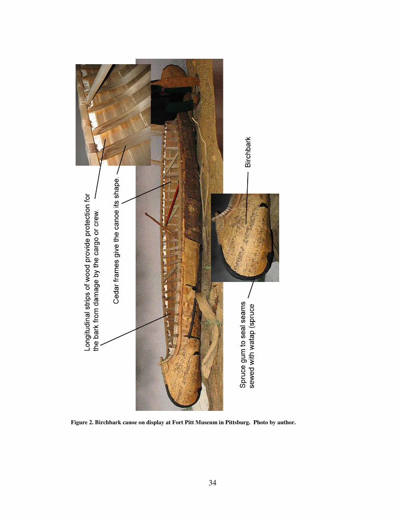
34
Figure 2. Birchbark canoe on display at Fort Pitt Museum in Pittsburg. Photo by author.
35
connected waterways west of Niagara Falls.15
Their construction had little impact on the
land and could be built wherever the abundant natural resources could be found.
Piecing together the extent and nature of the aboriginal pre-contact maritime
cultural landscape is difficult because of a lack of written primary sources.
Archaeological reports and oral traditions recorded during the nineteenth century,
however, provide the bulk of what is known.16
In addition early historic sources suggest
that many of the elements associated with aboriginal maritime traditions were established
firmly enough at the time of contact that we can assume they did not spontaneously
appear at the moment Europeans arrived on the scene. For instance the first mention of
bark canoes in the historic record is attributed to Jacques Cartier in 1535.17
Some evidence for the maritime nature of aboriginal society comes from the oral
traditions regarding their mythology. While each tribe such as the Ojibway, Chippeway,
Ottawa, and Huron have slightly different creation myths and stories of the spirits or
Manitou that lived among them, there are numerous areas of common ground.18
Most tell
stories of the character Manabush, known by several different versions of the same name,
who was the grandson of the earth. His role amongst aboriginal tribes was something
akin to a universal uncle that looked out for mankind.19
Many of his adventures involved
the water such as when he outwitted evil Manitou that lived in the deeps or when he
15
LeSalle’s large sailing vessel, Griffin, constructed on the upper Niagara River made one voyage in 1679
to the Green Bay region and disappeared on its return trip. The French authorities and colonists relied
solely on bateaux and bark canoes on the western Great Lakes until the fall of New France to the British in
1760. 16
Salisbury, “The Indians’ Old World,” 436. 17
Adney and Chappelle, Bark Canoes, 7. 18
William Warren, History of the Ojibway People, 2nd ed. (St. Paul: Minnesota Historical Society Press,
2009), 63. 19
Warren, Ojibway People, 67.
36
paddled his canoe across vast waters to mythic islands. Indeed the importance of water
transportation to Indian cultures is evident in the story of Hiawatha, the Iroquois version
of Manabush, wherein he assisted in clearing rivers and streams of obstructions to
navigation.20
The Indians’ maritime mythology played out in the physical world. Dogs,
tobacco, and other offerings were sometimes thrown into the water before starting canoe
journeys or in response to spirits that appeared in dreams. Water transport was so
important to their culture that paddles were included, among other important items, as
grave goods.21
Myths like those of Manabush and his travels in magic canoes across spirit
filled lakes may have help native communities so dependent on water for fish, travel, and
trade, make sense of a natural resource that on one hand provided so many of the
essentials of life while on the other brought death to those caught too far from the shore
in sudden terrible storms.
For many Great Lakes regional tribes the universe was divided into three parts.
The sky was the world above, the earth the Indians lived on was the middle world, and
the underworld lay below and was dominated by water. Creatures such as the underwater
panther and the thunder bird were zoological manifestations of the power that ruled in
their realms which helped explain how nature worked (Figure 3). The underwater panther
for instance could stir up the water and create great waves by twitching its long tail.
Native art work traditionally shows the underwater panther with an extremely long tail
that extends around its body . To the Ojibway the underwater panther or Micipijiu was
20
Henry Rowe Schoolcraft, The Myth of Hiawatha: And Other Oral Legends, Mythologic and Allegoric, of
the North American Indians (Philadelphia: J. B. Lippincott & co., 1856), 79, Google ebook,
http://books.google.com/books?id=9AUOAAAAQAAJ. 21
Armour, Attack At Michilimackinac, 81, 94; Warren, Ojibway People, 64-65.
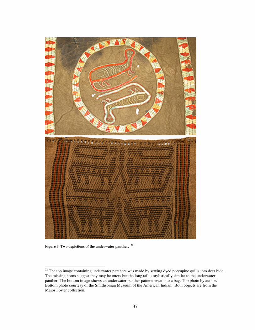
37
Figure 3. Two depictions of the underwater panther. 22
22
The top image containing underwater panthers was made by sewing dyed porcupine quills into deer hide.
The missing horns suggest they may be otters but the long tail is stylistically similar to the underwater
panther. The bottom image shows an underwater panther pattern sewn into a bag. Top photo by author.
Bottom photo courtesy of the Smithsonian Museum of the American Indian. Both objects are from the
Major Foster collection.
38
the most monstrous creature from Lake Superior, the most monstrous of lakes.23
It ruled
the underworld which could only be accessed through caves, rivers, lakes, streams or by
following the path of souls.24
In one Iroquoian story a woman is taken by the panther into
the lake to become its wife. The cry from the woman’s child from the shore attracts her to
the surface where her husband is able to break the panther tail’s grip around her waist.
She had symbolically died when she went to the underwater panther’s realm but rose
from the dead to return to her family. Significantly, the underwater panther’s domain
extended to any water that was potentially dangerous to cross which help explain why
Indians made sacrifices to the spirits that lived in the water prior to beginning their
journies.25
Stories that related journeys across great expanses of water no doubt helped
tame Indians’ fear of the seemingly bottomless and immensely wide waters of the Great
Lakes thus fostering the cultural contact that helped tribes survive in the wilderness.26
These practices suggest that the maritime environment shaped the very identities
of many the Great Lakes and Canadian northwest region’s Indian tribes. For instance, of
the fifteen to twenty clan totems (family divisions) of the Ojibway tribe, who lived in the
lands surrounding Lake Superior, recorded by nineteenth century historian William
Warren, nearly half were related either to fish, water related fowl, or water related mythic
23
Victoria Brehm, “The Metamorphoses of an Ojibwa Manido,” American Literature 68, no. 4 (December
1, 1996): 677. 24
Richard F. Townsend, Hero, Hawk, and Open Hand: American Indian Art of the Ancient Midwest and
South (New Haven: Yale University Press, 2004), 128. 25
Brehm, “The Metamorphoses of an Ojibwa Manido,” 679. 26
Lake Superior, the largest and deepest of the Great Lakes for instance, is over 1000 feet deep.
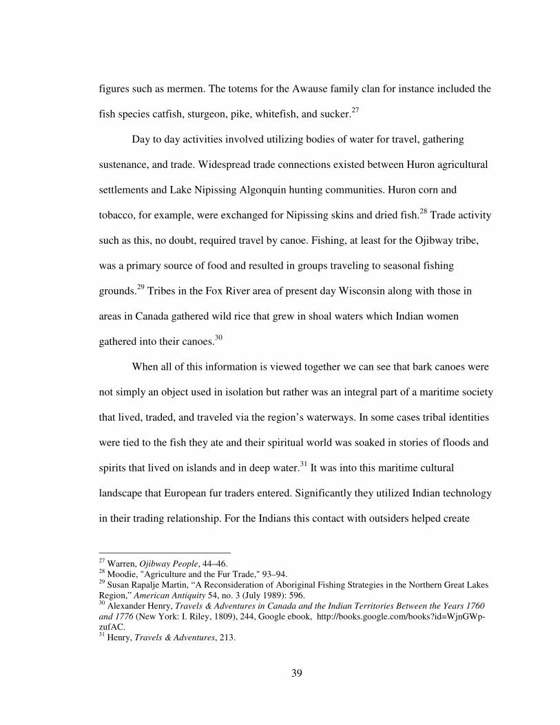
39
figures such as mermen. The totems for the Awause family clan for instance included the
fish species catfish, sturgeon, pike, whitefish, and sucker.27
Day to day activities involved utilizing bodies of water for travel, gathering
sustenance, and trade. Widespread trade connections existed between Huron agricultural
settlements and Lake Nipissing Algonquin hunting communities. Huron corn and
tobacco, for example, were exchanged for Nipissing skins and dried fish.28
Trade activity
such as this, no doubt, required travel by canoe. Fishing, at least for the Ojibway tribe,
was a primary source of food and resulted in groups traveling to seasonal fishing
grounds.29
Tribes in the Fox River area of present day Wisconsin along with those in
areas in Canada gathered wild rice that grew in shoal waters which Indian women
gathered into their canoes.30
When all of this information is viewed together we can see that bark canoes were
not simply an object used in isolation but rather was an integral part of a maritime society
that lived, traded, and traveled via the region’s waterways. In some cases tribal identities
were tied to the fish they ate and their spiritual world was soaked in stories of floods and
spirits that lived on islands and in deep water.31
It was into this maritime cultural
landscape that European fur traders entered. Significantly they utilized Indian technology
in their trading relationship. For the Indians this contact with outsiders helped create
27
Warren, Ojibway People, 44–46. 28
Moodie, "Agriculture and the Fur Trade," 93–94. 29
Susan Rapalje Martin, “A Reconsideration of Aboriginal Fishing Strategies in the Northern Great Lakes
Region,” American Antiquity 54, no. 3 (July 1989): 596. 30
Alexander Henry, Travels & Adventures in Canada and the Indian Territories Between the Years 1760
and 1776 (New York: I. Riley, 1809), 244, Google ebook, http://books.google.com/books?id=WjnGWp-
zufAC. 31
Henry, Travels & Adventures, 213.
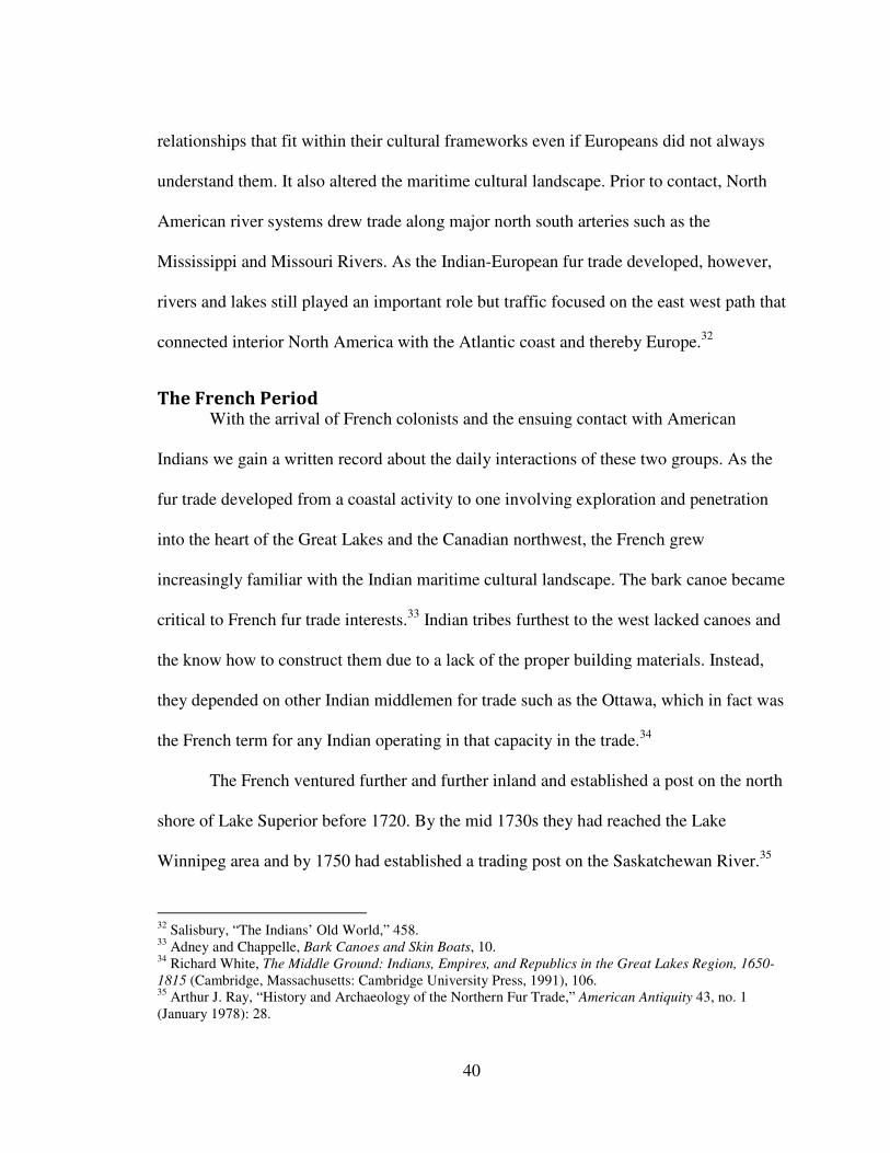
40
relationships that fit within their cultural frameworks even if Europeans did not always
understand them. It also altered the maritime cultural landscape. Prior to contact, North
American river systems drew trade along major north south arteries such as the
Mississippi and Missouri Rivers. As the Indian-European fur trade developed, however,
rivers and lakes still played an important role but traffic focused on the east west path that
connected interior North America with the Atlantic coast and thereby Europe.32
The French Period With the arrival of French colonists and the ensuing contact with American
Indians we gain a written record about the daily interactions of these two groups. As the
fur trade developed from a coastal activity to one involving exploration and penetration
into the heart of the Great Lakes and the Canadian northwest, the French grew
increasingly familiar with the Indian maritime cultural landscape. The bark canoe became
critical to French fur trade interests.33
Indian tribes furthest to the west lacked canoes and
the know how to construct them due to a lack of the proper building materials. Instead,
they depended on other Indian middlemen for trade such as the Ottawa, which in fact was
the French term for any Indian operating in that capacity in the trade.34
The French ventured further and further inland and established a post on the north
shore of Lake Superior before 1720. By the mid 1730s they had reached the Lake
Winnipeg area and by 1750 had established a trading post on the Saskatchewan River.35
32
Salisbury, “The Indians’ Old World,” 458. 33
Adney and Chappelle, Bark Canoes and Skin Boats, 10. 34
Richard White, The Middle Ground: Indians, Empires, and Republics in the Great Lakes Region, 1650-
1815 (Cambridge, Massachusetts: Cambridge University Press, 1991), 106. 35
Arthur J. Ray, “History and Archaeology of the Northern Fur Trade,” American Antiquity 43, no. 1
(January 1978): 28.
41
As they expanded their reach and established trading relationships they became more and
more familiar with and involved in the maritime cultural landscape alongside the Indians.
French traders purchased canoes from Indians but also developed canoe factories largely
staffed by Indians.36
Marriage between native women and French traders arose as a
mutual effort to extend kin networks that insured fair prices and a steady supply of goods
for tribal relatives and a loyal customer base and a greater sense of security for the
trader.37
Increased exposure to the maritime cultural landscape occasionally resulted in
slight alterations to equipment and customs. For instance French voyageurs (licensed
traders) and coureurs de bois (unlicensed traders) made few changes to how birchbark
canoes were constructed other than extending their size to over thirty-five feet in length
in order to carry as much as three tons or more of cargo.38
French records show that
common crew sizes increased from three men in 1700 to five in 1725, seven by 1737, and
seven or eight or more by 1747.39
Other non fur items of native manufacture became part
of the subsidiary trade system that made it possible for French traders to travel the great
distances between Montreal and the far west. For instance numerous Great Lake tribes
cultivated corn or gathered wild rice to trade or produced tools such as snowshoes and
pipes. If the French did manage to alter the maritime landscape it was by introducing
36
Timothy Kent, “Manufacture of Birchbark Canoes for the Fur Trade in the St. Lawrence,” in The Canoe
in Canadian Cultures, eds., Bruce W. Hodgins, John Jennings, and Doreen Small, (Winnipeg: Natural
Heritage Books, 1999), 102. 37
Jacqueline Peterson cited in Bruce M. White, “The Woman Who Married a Beaver: Trade Patterns and
Gender Roles in the Ojibwa Fur Trade,” Ethnohistory 46, no. 1 (Winter 1999): 128. 38
Lynn L. M. Evans, “Technology Crossroads: An Historical Archaeological Perspective on the Use of
Native American Technology in the Fur Trade” (presented at the Midwestern American Society for
Eighteenth Century Studies, Mackinaw City, Michigan, n.d.), 4. 39
Adney and Chappelle, Bark Canoes and Skin Boats, 10.
42
their metis offspring, produced by marriages between French fur traders and native
women, into the region. Their hybrid culture and kinship networks would remain part of
the landscape to the present day. In addition the placement of French trading posts on key
travel routes would have increased the importance of those places. It is probable too,
however, that the Indians may have dictated some if not most of those locations based on
their past practices and preferences in which case the French augmented the importance
of those locations rather than dictated their placement. A map of French fur trade post
placements shows their west and northward expansion over time. This would have at
least reoriented Indians to focus on traveling to those areas over others (Figure 4).
French traders introduced customs reflecting their own religious outlook that
became part of the maritime experience as they traveled along the lakes, streams, and
rivers. Even these, however, were quite similar to native practices. British traders
operating in Canada after the fall of New France often hired French Canadians as their
canoe men and guides and witnessed their habits. Alexander Henry for instance recorded
that after leaving Montreal it was a French custom to stop at Lachine, which was
considered the launching point for travel west via the Ottawa river, and attend mass at St.
Anne’s church, named for the patroness saint of Canadian travelers. The French Catholic
chapel at Michilimackinac was also dedicated to St. Anne for the same reason.40
Traders
attended confession and made donations to the church prior to heading up river. This
practice was similar to a Great Lakes Indian custom of tying a dog’s legs together and
tossing it into the water as an offering to the Great Spirit for a safe journey or to appease
40
Armour, Attack At Michilimackinac, 8.

43
Figure 4. French fur trading post distribution 1600-1760. Map by John J. Knoerl.41
41
The data contained in this map and the map shown in Figure 5, were based on an Atlas of Canada map
published in 1974. The original map displayed a vast amount of information about each post but the exact
sources for each data point are no longer available to researchers. Nevertheless I believe the data as shown
44
any Manitou that might reside in the lake.42
One observer noted that native appeals to,
and belief in, the many Manitou was similar to the French Catholic belief in a pantheon
of interceding saints.43
British trader Daniel Harmon recorded that upon entering new
streams his French companions made the sign of the cross and recited a prayer in each
canoe and noted that they never prayed as much as when they were traveling.44
Harmon
paddled past memorials to drowned travelers placed along the shore near dangerous
rapids and wrote, “for every such poor person who drowned whether they find the body
or not a cross is erected by his companions agreeably to a custom of the Roman
Catholics…This is a melancholy sight." 45
In one instance he counted over 30 crosses at
one location.46
The custom is strikingly similar to the present day practice of placing a
cross or wreath at the site of an automobile accident (Figure 5).
The same waterways that were fraught with danger and death also provided life
giving food and independence to those venturing so far from colonial centers. A fur
trader’s ability to acquire needed resources while traveling through the maritime
landscape may have frustrated French colonial government attempts to control the fur
trade.47
For those traders operating outside of the trade licensing system it was possible to
on the map is reliable. Of the over 800 posts listed on the original map just over 100 were removed
because of a lack of information. Despite this, the map shown above is worth reviewing. Dr. John J.
Knoerl geo-referenced the Atlas of Canada map, created a GIS data set, and produced both this map and
Figure 5 in response to my research questions. The data set he created can now be used for future research. 42
Ibid., 81. 43
Warren, Ojibway People, 63. 44
Harmon, A Journal of Voyages and Travels, 34. 45
Ibid., 31. 46
Ibid., 35. 47
While Richard White does not directly relate the breakdown of the French licensing system to the
maritime cultural landscape he does point to the ability of coureurs de bois to successfully travel where
they wished to trade without licenses. It was the network of lakes, rivers, and streams that made such
movements possible. For more information see White, The Middle Ground, 108–109.

45
Figure 5. Crosses mark the scene of fatal travel accidents today much as they did in the eighteenth century.
Photo by author.
repair their canoes with locally available materials or trade for repair services from local
aboriginal women who often performed such work. Provisions could be obtained, again,
either through trade or hunting and fishing along the way. Kin networks and trading
relationships could assist one in securing winter quarters typically located along travel
routes.
All of this was dependent on the trader’s ability to transport himself and his cargo
into the best trading regions which typically, over time, meant traveling further and
46
further west. During the seventeenth and eighteenth centuries as the French relied on
small craft they gained an intimate knowledge of the natural and cultural resources
available to them. It is little wonder then that when the first British traders entered the
western Great Lakes region in the 1760s in search of fur trade profits, they took after the
French and acquainted themselves with the same resources available in the maritime
cultural landscape.
The British Period British traders, like their French predecessors, utilized small craft such as
birchbark canoes and bateaux to overcome the environmental challenges presented by
geography and distance. There were two primary routes used by fur traders leaving
Montreal. The first was via the Ottawa River to the carrying place at Lake Nipissing and
down the French River to Lake Huron (Figure 6).48
From there traders could travel to
both Michilimackinac and points west or to the St. Mary’s River, Lake Superior and the
Canadian northwest. The second route was via Lake Ontario, over the Niagara Falls
portage, up the Niagara River to Lake Erie and then to Detroit. From there traders could
travel either south and west to rivers in the Ohio valley or north to Michilimackinac via
Lake St. Clair and Lake Huron. By 1787 sixty percent of furs were carried by the Ottawa
River route with the remaining forty percent transported over lakes Erie and Ontario.49
48
Peter Pond, “Journal of Peter Pond ,” in Collections - State Historical Society of Wisconsin, Vol. XVIII,
ed. Reuben G. Thwaites (Madison: State Historical Society of Wisconsin, 1908), 327. Google Book,
http://books.google.com/books?id=cjEUAAAAYAAJ. 49
Davidson, The North West Company, 19.
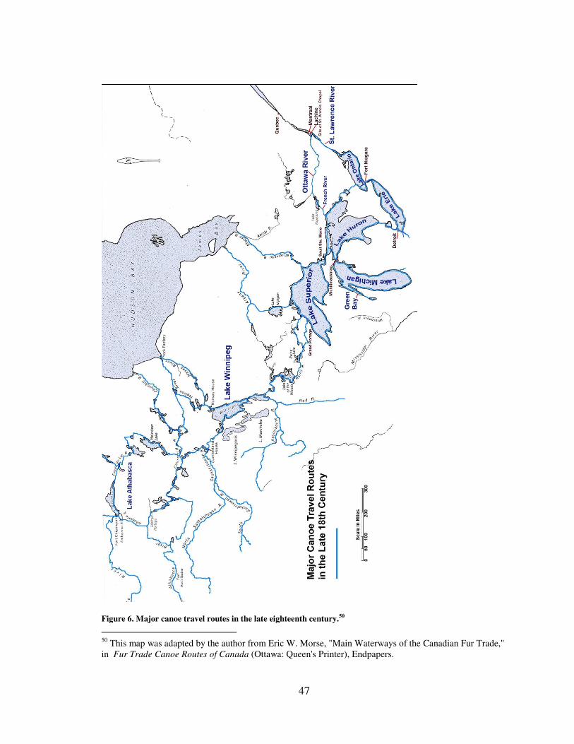
47
Figure 6. Major canoe travel routes in the late eighteenth century.50
50
This map was adapted by the author from Eric W. Morse, "Main Waterways of the Canadian Fur Trade,"
in Fur Trade Canoe Routes of Canada (Ottawa: Queen's Printer), Endpapers.
48
The Ottawa River route was favored because it was faster although it was not without its
physical challenges as traders had to cross 36 portages between Lachine and Lake
Huron.51
Throughout the British occupation period British traders with their French crews
and guides built upon the trade networks established by the French and Indians centuries
before. The British greatly expanded the extent of the commercial maritime empire by
establishing trading posts far beyond previous French efforts (Figure 7). As with the
French before them, the British utilized the birchbark canoe to make this expansion
possible. You can see clearly in the map how the fur trade posts cluster around lakes and
rivers.
While rapids and white water were certainly dangerous for the lightly built bark
canoes, traders did have the option to get out of the water and either carry both the canoes
and their contents around rapids, remove a portion of the canoe’s cargo and drag the
canoe via ropes along shore, or empty the vessel completely and, again, drag it along
shore. They faced a different problem when traveling over any of the Great Lakes. Travel
diaries of numerous traders recount frequently losing travel days due to inclement
weather, high winds and seas that could appear suddenly with little notice. Bark canoes
and bateaux had little freeboard and could be swamped by waves easily, and so were not
designed to travel far from shore while on the lakes.52
British Trader Alexander Henry
51
Ibid., 211. 52
Adney and Chappelle, Bark Canoes and Skin Boats, 8.

49
Figure 7. French and British fur trade posts 1600-1760. Map by John J. Knoerl.
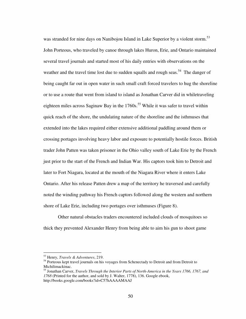
50
was stranded for nine days on Nanibojou Island in Lake Superior by a violent storm.53
John Porteous, who traveled by canoe through lakes Huron, Erie, and Ontario maintained
several travel journals and started most of his daily entries with observations on the
weather and the travel time lost due to sudden squalls and rough seas.54
The danger of
being caught far out in open water in such small craft forced travelers to hug the shoreline
or to use a route that went from island to island as Jonathan Carver did in whiletraveling
eighteen miles across Saginaw Bay in the 1760s.55
While it was safer to travel within
quick reach of the shore, the undulating nature of the shoreline and the isthmuses that
extended into the lakes required either extensive additional paddling around them or
crossing portages involving heavy labor and exposure to potentially hostile forces. British
trader John Patten was taken prisoner in the Ohio valley south of Lake Erie by the French
just prior to the start of the French and Indian War. His captors took him to Detroit and
later to Fort Niagara, located at the mouth of the Niagara River where it enters Lake
Ontario. After his release Patten drew a map of the territory he traversed and carefully
noted the winding pathway his French captors followed along the western and northern
shore of Lake Erie, including two portages over isthmuses (Figure 8).
Other natural obstacles traders encountered included clouds of mosquitoes so
thick they prevented Alexander Henry from being able to aim his gun to shoot game
53
Henry, Travels & Adventures, 219. 54
Porteous kept travel journals on his voyages from Schenectady to Detroit and from Detroit to
Michilimackinac. 55
Jonathan Carver, Travels Through the Interior Parts of North-America in the Years 1766, 1767, and
1768 (Printed for the author, and sold by J. Walter, 1778), 136. Google ebook,
http://books.google.com/books?id=C57hAAAAMAAJ
51
Figure 8. A portion of a 1753 map of Lake Erie by John Patten showing the route traveled
that hugged the north shore of the lake. Map courtesy of the Library of Congress.
52
needed for provisions.56
At one point the mosquitoes and small black flies were so
numerous Henry and his companions, “were obliged at the carrying places to make fires
and stand in the smoke.”57
No doubt many early British fur traders habits were influenced by the French
guides they hired. Despite the fact that the British Empire projected its commercial and
military might into the region, British subjects participated in or at least acquiesced to
their French servants’ cultural traditions. Henry stopped with his French Canadian crew
at St. Anne’s chapel so his men could attend church and offer up their vows. Afterwards
Henry carried out another fur trade tradition by distributing eight gallons of alcohol to
each canoe for the trip which the men drank immediately resulting in much singing and
fighting and what must have been a rough departure the next morning.58
Along the way
the French Canadians would smoke and sing traveling songs. Some recorded distances by
how many pipes they completed and rested every two hours or so for five to ten minutes
while the refilled their pipes.59
British merchants witnessed just how deeply ingrained the
fur trade was in French Canadian culture. Peter Pond’s French servant reported that he
wanted to confess his sins but that the local French priest required four otter skins to
grant him absolution.60
Travelling with French traders in the far northwest, British trader Daniel Harmon
developed a poor opinion of French Canadian culture. Unlike Pond’s repentant servant,
they seemed to Harmon to be without Christian values at all. Harmon noted in his diary
56
Henry, Travels & Adventures, 246. 57
Armour, Attack At Michilimackinac, 16. 58
Ibid., 8–9. 59
Davidson, The North West Company, 218–219. 60
Pond, “Journal of Peter Pond," 328–329.
53
that his canoe men were “common laborers" much intoxicated and upon admonishing
them for playing cards on the Sabbath his men responded, "there is no sabbath in this
country, and they added, no God nor devil; and their behaviour but too plainly shows,
that they spoke as they think." Harmon seems to have resigned himself to their cultural
differences. He spoke little French but hardly regretted it believing that even if he could
speak it fluently it would afford him little satisfaction to converse with the "ignorant
Canadians” around him. Harmon confided to his diary that, “All their chat is about
horses, dogs, canoes, women and strong men, who can fight a good battle. I have,
therefore, only one way left to spend my time rationally, and that is reading."61
This mix of cultures is especially interesting when considered within the context
of the small confines of the canoes they traveled in. Former members of the French
empire served as guides, as did some Indians, who now had to answer to British
employers. Harmon described canoe travel as having an organizational structure and
customs similar to vessels at sea with an established hierarchy. Guides picked the best
courses to navigate safely through lakes and streams and were in some ways responsible
for property on board as well as for overseeing needed repairs.62
Engages were at bottom
of a canoe’s social order and made as little as one fifth the pay that the guides or stern
men earned.63
Hazing rituals not unlike those at sea when sailors cross the equator for the
first time took place when canoe crew members passed through new territory for the first
time. More experienced crew members were to be treated to a drink by those undergoing
61
Harmon, A Journal of Voyages and Travels, 88–89. 62
Ibid., 26. 63
Carolyn Podruchny, “Unfair Masters and Rascally Servants? Labour Relations Among Bourgeois, Clerks
and Voyageurs in the Montréal Fur Trade, 1780-1821,” Labour / Le Travail 43 (Spring 1999): 48.
54
the hazing or the new members were “baptized” by being tossed into the water.64
Canoe
Masters during this period relied on an accepted paternal authority structure to enforce
discipline, occasionally using public shaming, whipping, starvation, and firing.65
Firing
could in fact end up being the most severe punishment. An employee released from
service in the middle of the Canadian northwest was likely to starve to death.
Despite this mixed maritime cultural landscape with all its established traditions
both aboriginal and French, British traders poured into the region. Some, as Alexander
Henry acknowledged, did so somewhat prematurely, lured by the potential for substantial
profit. In 1761 Lord Jeffrey Amherst, commander of British forces in North America
observed,
The Thoughts of trade and making money catches hold of allmost every
Inhabitant in this Province, and they would willingly employ every
Frenchman they can pick up, little thinking of the fatal consequences that
may hereafter arise to these Provinces, from their making the Enemys of
it...66
In truth there were opportunities. In the early years of British rule, furs accounted
for tenpercent of colonial exports to England – roughly five percent of Britain’s
imports.67
For the years 1782 to 1786 for instance the value of Canadian fur sales in
London averaged nearly £196,000.68
In addition to the traditional Indian customers, British merchants traveling along
the maritime highways supplied both the British army and the Indian Department.
64
Harmon, A Journal of Voyages and Travels, 26. 65
Podruchny, “Unfair Masters and Rascally Servants?,” 53,63. 66
Amherst to Gage, June 16, 1761, Vol. 5 “Amherst Papers,” Old Fort Niagara Library (OFNL),
Youngstown, New York. 67
Walter S. Dunn, The New Imperial Economy: The British Army and the American Frontier, 1764-1768
(Westport, Connecticut: Praeger Publishers, 2000), 46. 68
Davidson, The North West Company, 17–18.
55
Whereas the French had stationed approximately 2000 men across Canada prior to the
French and Indian War the British deployed nearly 10,000 soldiers in North America at
an expense of roughly £264,000 by the end of 1763. In the conduct of their diplomatic
mission to the numerous tribes the British Indian Department distributed presents, many
of a consumable nature such as rum, clothing, blankets, guns, and ammunition. The
department purchased £300,000 a year in goods from colonial merchants.69
Far from being a remote and empty landscape, traders traveling the lakes, rivers,
and streams throughout the Great Lakes and Canadian northwest recorded the daily
passage of fellow traders bound east and west, occasionally camping together, trading for
provisions, or exchanging news. During a three day period while traveling by canoe
between Michilimackinac and Detroit in 1766, for example, John Porteous came across
two Indian families camped on an island with whom he traded for sturgeon and duck,
eight more Indians traveling to Detroit in a canoe, two French traders sailing in a canoe
on their way to Michilimackinac, and still more traders on their way to Detroit. 70
In 1775
Alexander Henry came across fellow traders traveling by canoe in the Lake Winnipeg
region and through combining their brigades of canoes found they had a small fleet of
thirty vessels and one hundred thirty men.71
Even Iroquois Indians and their families
could be found in the Canadian northwest, far from their home lands south of lakes
69
Dunn, The New Imperial Economy, 4–5. 70
John Porteous, September 21–23, 1766, "Diary of John Porteous Volume 4, 1766 From Michilimackinac
to Detroit," Burton Historical Collection Detroit Public Library (BHC), Detroit, Michigan. 71
Henry, Travels & Adventures, 253.
56
Ontario and Erie.72
Descriptions of such encounters are not uncommon throughout fur
trader travel journals of the period.
Official reports and memorials written to colonial officials corroborate the
anecdotal evidence found in travel diaries. A petition to Frederick Haldimand, the
Governor of the Province of Quebec in 1779, stated there were approximately 800 men
employed in that trade although this may have included warehousemen and shipping
agents in Montreal and Quebec.73
The Northwest Company at one point, however,
routinely employed nearly 1,000 men, half of whom traveled by small craft from
Montreal to the Grand Portage on Lake Superior.74
While the territory that supplied furs
for the European trade was enormous, the waterways along the maritime cultural
landscape concentrated those activities so that it is not surprising that groups of traders
could cross paths in the middle of a continent.
Historian Walter S. Dunn has suggested that the Great Lakes and Canadian
northwest fur trade exemplified the two goals of empire. The first was to obtain raw
materials to be sent to England for processing and resale, both for a domestic and
European market. The second was to have the colonies serve as a market for England’s
finished goods.75
The fur trade definitely filled those roles by gathering furs for export
and importing Britain’s cloth, rum, iron tools, and other items. An examination of fur
trader journals suggests an additional insights, however, as to how the high level goals of
expanding the empire really depended on the day to day personal interactions between
72
Harmon, A Journal of Voyages and Travels, 44. 73
Davidson, The North West Company, 9. 74
Ibid., 22. 75
Dunn, The New Imperial Economy, 60.
57
traders and Indian customers and the mechanics of operating small craft through an
expansive networks of streams, lakes, and portages. The very presence of commercially
minded Europeans in unfamiliar territory meant that new markets might develop in a
newly expanding empire. The small craft landscape much of which lay outside of the
protection of British forts really exemplified the commercial aspects of empire. Its
expansion lay more in the hands of fur traders and in the holds of their canoes.
It could take weeks if not months for merchants to paddle their canoes into the
western regions which provided ample time for entrepreneurial minds to dream of
additional opportunities for profit. Throughout numerous journals, merchants recorded
their observations on the raw materials and potential opportunities that passed by as their
canoes glided by the landscape. John Porteous for instance noted the apparent fertility of
the lands he saw along with areas for good anchorages for vessels, the quantity and
quality of the timber for masts, fruits, and sugar production.76
Peter Pond proclaimed the
land around the Fox River to be excellent and detailed the corn and wild rice that the
local Indians cultivated and harvested in abundance.77
Jonathan Carver took time out
from his travels to sound portions of Green Bay and disputed previous claims that large
vessels would not be able to pass safely over its shoals. Upon seeing the abundance of
copper on the shores of Lake Superior Carver imagined,
It might in future times be made a very advantageous trade, as the metal
which costs nothing on the spot, and requires but little expence to get it on
board, could be conveyed in boats or canoes... The cheapness and ease
with which any quantity of it may be procured, will make up for the length
76
John Porteous, September 22–25, 1766, "Diary of John Porteous Volume 4, 1766 From Michilimackinac
to Detroit," BHC. 77
Pond, "Journal of Peter Pond," 329; John Porteous, August 16, 1767, “John Porteous Papers,” BHC.
58
of way that it is necessary to transport it before it reaches the sea-coast,
and enable the proprietors to send it to foreign markets on as good terms
as it can be exported from other countries.78
Fur traders drifting through the continent were the eyes and ears of the
commercial empire. The information that they collected and shared with their business
associates fueled the fires of commerce and hastened the level of contact between them
and the Indians. The fast pace of commercial expansion coincidentally provided a
challenge for the empire’s instrument of power, the British army.
The British Army At the end of the French and Indian War the British government had nearly
doubled the national debt rising from £75 million in 1755 to £140 million by 1763.
Budgets were cut back for the army and the Indian Department. The financial troubles of
the empire had very real implications for the inhabitants of the Great Lakes and Canadian
northwest region. 79
Following strict orders for economy Lord Jeffery Amherst eagerly
sought to reduce expenditures for gifts for Indians including food, clothing, ammunition
and especially rum. British Northern Indian Superintendent Sir William Johnson
attempted to improve relations with the region’s tribes by controlling what he believed
would be abuses by traders that would agitate native tribes that had been allied with the
French during the war. The Indians made it quite clear that the French defeat did not
include them. Trader Alexander Henry recorded in his journal that shortly after his arrival
at Fort Michilimackinac a visiting Ottawa chief informed him that although the British
78
Carver, Travels Through the Interior, 139–140. 79
Dunn, The New Imperial Economy, 4.
59
had conquered the French, they had not conquered the Indians.80
While the various
French allied tribes were angry they also desired renewed trade, a fact that traders were
eager to exploit.
British policies for the new territory which ostensibly were meant to solidify and
spread the empire actually created conflict with the new Indian and French subjects as
well as with British merchants. The Army initially garrisoned many of the French posts
throughout the region, although budgetary and practical limitations led General Thomas
Gage to recommend to Amherst that many of the posts be abandoned.81
Amherst’s cut
back on presents and restrictions on trading alcohol angered the Indians and created a
situation that lead to deadly confrontations such as the Pontiac Uprising in 1763 as well
as conflicts between the merchants and the British Army. Indians were angry over the
new policies because they resulted in reduced access to much needed goods. Their
response was to attack the very maritime cultural landscape that brought trade goods to
the region. The Indians curtailed their ability to continue the fight since they relied on
captured powder and shot to supply their military needs. The British suffered from their
own policies as well through the loss of life from Indian attacks during the uprising. They
created a climate that during the American Revolution led to concern over Indian loyalty.
There was also conflict between the commercial and military spheres of the British
empire in the region as well, since the objectives of merchants and the Army diverged.
80
Armour, Attack At Michilimackinac, 25–27. 81
Frank E. Ross, “The Fur Trade of the Western Great Lakes Region,” Minnesota History 19, no. 3
(September 1938): 291.
60
As any restriction on trade could potentially impinge on the merchants’ ability to
secure a profit, conflicts arose with the army as traders tested the boundaries if not
disregarded them outright in order get a competitive advantage. Henry for instance did in
fact possess a pass to trade at the upper posts but wasted no time in getting there before
the army, which was charged with overseeing trade.
Throughout the first decade of British control over the western Lakes and
Canadian northwest, post commandants were frustrated in their attempts to control
traders. The maritime nature of the landscape and the British army’s centralized locations
at specific posts meant that traders could slip past the Army’s watchful eye. Almost
immediately British military authorities began to suspect traders might engage in
practices harmful to the empire. In 1762 Jeffery Amherst requested that his subordinates
hinder any trader’s efforts to sell rum to the Indians. Only two years later, in the
aftermath of the Indian uprising, General Gage already suspected traders were bringing in
ammunition for trade from Montreal.82
Upon learning that traders had bypassed Fort
Michilimackinac and gone straight to Lake Superior to trade, one frustrated post
commandant wrote to General Gage, "I Really should be at a Loss to find out what use
we are for here."83
Post commandants were aware of the situation and in some cases attempted to
apprehend offenders. When Montreal fur trader Francois Mollere received a pass from
the British commander at Detroit to return directly to Montreal Mollere instead
82
Amherst to Gage, May 9, 1762, Vol. 6, "Amherst Papers," OFNL; Gage to Gladwin, January 9, 1764,
“Thomas Gage Papers,” William Clements Library (WLCL), Ann Arbor, Michigan. 83
Turnbull to Gage, June 27, 1771, Vol. 104, “Thomas Gage Papers,” WLCL.
61
immediately turned south and headed off to trade with the Miami Indians that lived south
of Lake Erie. The Detroit commandant sent a party of Indians and French traders after
Mollere but returned with only “Lame Excuses” for why they couldn’t overtake Mollere.
General Gage commented dryly that perhaps British soldiers should have been sent
instead of expecting Frenchmen to arrest one of their own.84
In some instances rather than defying authorities outright traders “stretched” the
boundaries of what was authorized. In 1771 a group of investors made enquiries with
military authorities regarding a possible copper mining operation on the shores of Lake
Superior. The traders not only went ahead and traveled to Lake Superior without
authorization but began their own negotiations with local Indians for permission to
operate in the region. Captain Turnbull at Fort Michilimackinac questioned the miners
about this and other reports that they were trading with the Indians and informed them
they needed to show their pass as well as check in at the fort before doing so. Turnbull
forbade them to hold any more councils. The miners claimed they were only trading for
food but admitted they just happened to have brought rum and blankets which were two
of the items most in demand by Indians. Disgusted by his inability to control the actions
of hundreds of traders flooding into the region, Turnbull vented his frustration to General
Gage and complained about the “immense quantities of rum” being sold to the Indians.
Turnbull believed it made them unfit for hunting, He suspected supplies were sold to
fugitives who operated outside of British regulations in the area and that traders passing
through the area were unwilling to stop and report in at the fort. Under the circumstances
84
Turnbull to Gage, August 2, 1768, Vol. 79 “Thomas Gage Papers,” WLCL.
62
Turnbull felt he should not be held responsible for what occurred in his district.85
Gage in
turn pointed out in a letter to the Lake Superior miners that they had no authority to
conduct any operations in the region and that if they offended the Indians they should not
expect any assistance from the His Majesty’s troops and that Gage would not, “risk
involving the Nation in a War with the Indians for the Protection of those who will not
Submit to any Regulations.”86
As fur supplies became increasingly scarce traders had to
travel further and further west passing out of the direct view and protection of military
posts. In those regions, where British troops were not available, the fur traders were on
their own.
Traders lived in both the commercial and military spheres of empire. They sought
to achieve their goals of profit which occasionally were at odds with the Army’s goal of
control and the Indians’ goal of survival. It is little wonder there was conflict. Traders
had to adjust their behavior depending on which sphere of empire they were in. The
maritime cultural landscape enabled traders to flow from one to the other.
Trading in the Far West The combination of the long distances traveled to reach the fur trade regions
northwest of Lake Superior, the lack of British military oversight and protection, and the
technical characteristics of the birchbark canoe greatly influenced the relationships
between fur traders and Indians. This in turn affected how Indians, French canoe-men,
and British traders viewed the British Empire. The Indians in the far off regions were in a
position of power and recognized that fact. In some cases they took advantage of the
85
Turnbull to Gage, June 12, 1771, Vol. 104, “Thomas Gage Papers,” WLCL. 86
Gage to Baxter, September 21, 1770, Vol. 96, “Thomas Gage Papers,” WLCL.
63
situation. This is in direct contrast to British officer’s depictions of helpless drunk Indians
being cheated and duped by fur traders.
In less than one year after the British captured Montreal, English traders were
already pushing west beyond Lake Superior.87
As they traveled further into the Canadian
northwest region they faced several challenges posed by the natural environment. Their
large freight canoes, or canot de maitré, used on the Great Lakes were too big for the
shallow rivers, creeks, and ponds that lay beyond Lake Superior. Instead, they used a
canot de nord, or north canoe, which was smaller in size. Consequently this reduced the
amount of cargo each canoe could carry and the number of men in each canoe. Some
traders switched canoes once they reached the Grand Portage near the western end of
Lake Superior.88
From there they carried their smaller canoes, provisions, and cargos
over a nine mile portage to the Pigeon River and began their journey through the myriad
of waterways.
The second challenge came from the long northern winters which dictated that
traders had effectively only about five months of open navigation which was too brief a
time to travel from Montreal to the northwest, conduct their trade, and return east. They
solved this problem by having two sets of traders, one would spend the winter living and
trading in the cold regions during the winter months. The other would ferry materials
from Montreal to the Grand Portage where they would meet each spring to exchange
87
Davidson, The North West Company, 3. 88
Morse, Fur Trade Canoe Routes, 18.
64
trade goods for furs. Each side would set off around mid May and depart from the
entrepôt around July to head back to start the cycle again.89
The bark canoes had to be carefully packed in order to maximize the potential
profits needed to offset the costs of traveling so far. In addition to trade goods, canoes
might carry a mast and sail, a ten foot setting pole shod with iron for poling a canoe when
paddling wouldn’t work, towing line for pulling canoes up rapids, paddles, a camp kettle,
bundles of wattape (spruce roots) for sewing tears in the birch bark, gum for sealing
seams in the canoe, and a roll of spare bark for patching damaged areas.90
All of this left
little room for provisions for the crew. Some traders like Daniel Harmon ate concentrated
foods like pemmican: a mixture of dried meat pounded fine and mixed with fat and
occasionally sugar and or dried berries. Alexander Henry provided his crews with a
bushel of dried mashed Indian corn mixed with two pounds of fat. Henry believed that
that would feed a man for a month and argued that traveling great distances in such small
vessels would not allow for anything more bulky. In his opinion this mode of victualling
the canoes was “essential to the trade.”91
Even this method though was unable to supply
canoe crews completely for such long voyages. Their solution was to depend on hunting,
fishing, and trading for provisions along the way.
The types of concentrated foods like pemmican described in fur trade diaries were
reserved for times when local sources were not available. Canoe crews were hunters of
opportunity since wild game caught along the way could be eaten immediately and hence
89
Ibid. 90
Davidson, The North West Company, 216–217. 91
Armour, Attack At Michilimackinac, 33.
65
not take up additional space in the crowded canoes. This practice was common for
travelers in both the Great Lakes and Canadian northwest regions. Traveling on short
provisions, however, carried risks such as starvation or as in Alexander Henry’s case
having no choice but to travel into hostile territory in order to find food. As one of the
first traders to venture into formerly French territory he received warning after warning
that upon reaching Michilimackinac he would be killed by hostile Indians. By the time
Henry came to believe the stories might be true it was too late to turn back since he knew
he no longer had enough food to make the return trip.92
It comes as no surprise then that duck and venison were taken whenever possible
while traveling. One journal mentioned coming across and killing deer swimming in the
water on three different occasions. Fishing was perhaps a more readily available food
source as the crews were, after all, traveling on the water. In passing through the Lake
Superior region one canoe party became lost and greatly distressed at the possibility of
wandering from island to island “destroying” their provisions. Their first reaction was to
immediately drop their nets into the water to fish.93
The most common method of
obtaining additional provisions, however, was to trade with the Indians they encountered
along the way. By examining exchanges of this nature, conducted along the water ways
that took traders far from the protection of the British army, we can get a close up view of
one of the first levels of engagement between British subjects of the empire and the
region’s aboriginal inhabitants.
92
Ibid., 19. 93
Edward Umfreville, Journal of a Passage in a Canoe from Pais Plat in Lake Superior to Portage de
I'Isle in River Ouinipique, 28 July 1784, MS 472, MFTP 0030, Rare Books and Special Collections
Division, McGill University Libraries, http://digital.library.mcgill.ca/nwc/search/search.htm.
66
Throughout the early British occupation period of the Canadian northwest Indian
department personnel and military officials were concerned with unscrupulous fur traders
using alcohol to practically steal furs from Indians. While this may have happened some
historians have recently called this view into question.94
In previous historical treatments,
Indians have been given little credit for their roles as selective consumers within the
empire. When those trade relationships are viewed on the Indian’s own ground a different
picture emerges. Fur traders utilized bark canoes to insert themselves into the interior’s
maritime cultural landscape and consciously abandoned themselves to some degree
through their decision to pack few provisions, to the mercy of the environment and the
willingness of Indians to trade for food. This shifted an element of control to the Indians
who at times exploited that power to lesser or greater degrees. Abuses by traders no doubt
still occurred but the penalties for those abuses and misunderstanding could be fatal. One
trader operating on the north side of the Saskatchewan River in what may have been an
attempt to render medical aid gave an Indian laudanum mixed in alcohol which
unfortunately for the Indian and the trader caused the Indian’s death. In retaliation other
Indians killed the trader and his associates. A separate group of traders living near by had
to abandon everything and flee for their lives.95
Some traders were well aware of the risks
and in situations when their lives were threatened, they chose to cut their losses and move
on.
94
For recent work on the subject see Dean L. Anderson’s chapter: “The Flow of European Trade Goods
into the Western Great Lakes Region, 1715-1760,” in Rethinking the Fur Trade: Cultures of Exchange in
an Atlantic World, ed. Sleeper-Smith (Lincoln: University of Nebraska Press, 2009), 385-410. 95
David Thompson, David Thompson’s Narrative of His Explorations in Western America: 1784-1812,
ed. J.B Tyrrell (Toronto: The Champlain society, 1916), 320. Google ebook,
http://books.google.com/books?id=Crg1AAAAIAAJ
67
Alexander Henry encountered this several times. In one instance after what
appeared to be a friendly trade of a few small items the Indians he was visiting told him
that should he continue his journey he would certainly be killed. That being the case, they
felt entitled to a share in the pillage and demanded he give them a keg of rum or they
would proceed to take it anyway. Henry, “judged it prudent to comply.”96
In another
instance Henry visited a village of Chippewa [Indians to buy canoes. After doing so the
Indians insisted he also provide goods on credit and additional presents. They argued that
the presents were tribute to them on account of their ability to stop all trade with the
interior that passed by them. Henry gave them rum with which they became drunk but
rather than try to take advantage of them he waited until nightfall and left.97
In some
cases the Indians were even open about their intentions.
While trading in a Pasquayah village near the Saskatchewan River a Chief told
Henry he was glad he had arrived as they had long been in want of many of the things
Henry brought. The Chief remarked that Henry must be aware that it was within their
power to prevent him from going further and even if he did they could kill him as he
passed by on his way home. Under the circumstances the Chief felt an exceedingly liberal
amount of presents was in order and being a reasonable man who liked to avoid quarrels
he would avoid confusion and simply tell Henry exactly what they expected. Henry
offered up the requested casks of gunpowder, bags of shot and ball, bales of tobacco,
kegs of rum, guns, knives, flints, and a few other articles, smoked a pipe with the Chief
96
Armour, Attack At Michilimackinac, 19. 97
Henry, Travels & Adventures, 242.
68
and then asked for permission to leave. Upon receiving said permission he hastened away
but not before having to provide yet another keg of rum.98
Other travelers hoped to avoid the scenarios Henry faced by offering signs of
submission and respect even when not outnumbered. Edward Umfreville was hired by the
Northwest Company to search for an alternative route between Lake Superior and Lake
Winnipeg when he came across Indians that appeared friendly but Umfreville felt it
necessary to disclose the purpose of his voyage without any disguise. In another chance
meeting with two Chiefs while traveling, Umfreville gave them presents of tobacco, gun
powder, shot, and a gallon of liquor because he felt it only made sense to make friends
with men of influence while traveling.99
Certainly some outright plundering occurred but
as a constant state of hostility would only serve to end their supply of trade goods some
Indians policed themselves even to point of fighting battles with other tribes.100
Another
reason not to attack traders was to prevent the loss of opportunities to act as middlemen
in the trade. To do so required a reliable supply of trade goods. In the late eighteenth
century Andrew Graham of the Hudson Bay Company reported that less than ten percent
of the Indians that came to trade had acquired the furs themselves. Many traded their
worn out goods acquired in previous years with tribes that were beyond the reach of
European traders.101
Other tribes sought ever more reliable and fair opportunities for
trade through intermarriage or extended quasi-marital relationships as they had the
98
Ibid., 257. 99
Umfreville, Journal of a Passage, July 16, 1784. 100
Harmon, A Journal of Voyages and Travels, 34. 101
Ray, “History and Archaeology of the Northern Fur Trade,” 26, 31.
69
French. Finally another reason for not attacking and plundering traders traveling through
a tribal area was the possibility that traders might fight back.
The reality of the situation, however, was that many white travelers were simply
at the Indian’s mercy even in situations where the Indians were employed by the British.
Edward Umfreville recorded his frustration and sense of helplessness with his Indian
guide who insisted on bringing his family, taxing Umfreville’s dwindling supply of
provisions.
The distress we are in for a Guide is very great. This fellow possesses all
the duplicity of the devil himself. One day he knows our way better than
any Indian in the Country, the next day he knows nothing abt it, at one
time he is ready to do us any Service, & soon after will Threaten our lives
but our Situation is such, we must accept of him or give up the
Journey[.]102
Throughout many of the fur trader narratives alcohol plays a central role. There
were destructive repercussions from including rum as a staple in the fur trade. Although
some historians such as Bruce White suggest that goods such as alcohol and tobacco were
not part of the actual trade for furs but rather were more often a part of the symbolic
exchange of presents, the end result was the same.103
Daniel Harmon found the impact on
Indian families disturbing after witnessing an incident wherein several groups of adults
became inebriated in front of their frightened, screaming, and crying children who
watched as the adults began fighting, staggering, vomiting, and eventually collapsing to
102
Umfreville, Journal of a Passage, 26 June 1784. 103
Bruce M. White, “A Skilled Game of Exchange: Ojibway Fur Trade Protocol,” Minnesota History 50,
no. 6 (Summer 1987): 236.
70
the ground.104
Yet scenes such as this do not prove traders sought this end nor that
Indians were helpless in controlling the outcome of drinking.
Harmon and several other traders discussed the problems associated with
supplying alcohol to the Indians. They all agreed that the fewer spirits they could bring
with them the better. Harmon acknowledged, however, that the Indian’s strong demand
for rum made bringing it a necessity. Alexander Henry actually refused to sell rum when
he sensed it would lead to violence and in another incident buried his supply of rum after
which the situation calmed down. In some cases, however, Indians demonstrated their
awareness of the potential for trouble and appointed designated guardians who remained
sober to protect traders from abuse by their fellow tribesmen. 105
Both sides of trade were
clearly aware of what the presence of alcohol could do within the trading community but
once it had been introduced into the culture neither side seemed able to control it
completely.
As the fur traders paddled and portaged their way through their customers’
maritime cultural landscape, the traders discovered that the Indians held the fate of
British subjects in their hands. This must have been an unsettling thought for subjects of
the world’s most powerful empire. Traders were also exposed to the role women played
within the aboriginal community and were forced to deal with Indian women on their
terms, even if the traders were not always able to separate what they witnessed from their
own frame of reference. The French traders had come to understand the role of women to
some degree as they entered into marriage with them to obtain the benefits of a woman’s
104
Harmon, A Journal of Voyages and Travels, 62. 105
Henry, Travels & Adventures, 251.
71
place in native culture but for the newly arrived British traders there was much for them
to learn.
Most Indian women did not participate in trading ceremonies or receive credit
from European traders but they were able to trade the fruits of their labors such as
agricultural provisions, which were perhaps the most essential non fur element of the
entire fur trade system.106
Because fur traders relied on obtaining food along the way
their very survival depended on this aspect of the trade. This provided native women with
an opportunity to take a resource under their own control and use it to obtain trade goods
they desired. Traders in need of provisions then were forced to negotiate with women,
something they might not have done as often with white women in the east. In some
instances the exchange of provisions began as ceremonial gift giving but developed into
more extensive trading for additional materials or services. Alexander Henry for instance
exchanged rum for a few bags of rice with women at a village near the Lake of the
Woods. The village men went off to drink while Henry began more extensive trading
with the women for one hundred bags of rice.107
During the same evening that Henry conducted his trade for rice some of his men
and the village women engaged in sexual relations. From Henry’s point of view the
women had “abandoned themselves” to his Canadians and fearing danger from a
misunderstanding when the Indian men awoke he roused his men and “lost no time in
leaving the place.”108
The misunderstanding, however, was probably on Henry’s part.
106
White, “The Woman Who Married a Beaver,” 138. 107
Henry, Travels & Adventures, 243–244. 108
Ibid., 244.
72
Historian Richard White has suggested that Europeans had no equivalent in colonial
society for the type of sexual freedom enjoyed by unmarried Indian women and so they
attempted to fit it into their own frame of reference, often in unflattering terms.109
Rather
than abandoning themselves to his Canadians in some form of prostitution it is possible
that the women were courting possibilities for creating relationships that might lead to
trading ties for themselves and their kin networks. In some instances native women,
married or single, would make arrangements to leave their village and travel with traders
for a year or more.110
In the case of marriage, arrangements might be made with the
consent of the woman’s family but here too she had the power to leave at any time. Such
marriages were welcomed by some tribes because of the economic advantages it could
bring.111
The strangeness with which new traders may have viewed the cultures they
came in contact must have at times left many feeling out of their element and worlds
away from all that seemed “normal.”
The Introduction to this dissertation compared the trading posts and villages of the
Great Lakes and Canadian northwest to islands in a sea of forests and like islands they
were not isolated by water but rather were connected by it. This comparison fails in one
important way. During the winter the very water highways that brought imperial and
aboriginal culture together froze over and confined them to the region. In this sense then
the isolation returned and for some it was overwhelming. As travel came to a near halt so
too did contact with friends, loved ones, and business associates in the east. In addition
109
Richard White, “The Middle Ground,” in Rethinking the Fur Trade Cultures of Exchange in an Atlantic
World, ed. Sleeper-Smith (Lincoln: University of Nebraska Press, 2009), 260–261. 110
Henry, Travels & Adventures, 249. 111
Harmon, A Journal of Voyages and Travels, 49–50.
73
for the improperly prepared trading post there were far fewer opportunities for finding
provisions. Alexander Henry recalls traveling in the far west on foot in late January with
his crew near starvation when they were saved by finding the bones of an elk several
months dead yet preserved by the frigid temperatures.112
For some traders no matter what
time of year they were in the far west the distance alone was enough to depress them.
They received occasional reminders of just how far from home they really were. After
visiting the remains of an abandoned Hudson Bay Company outpost Daniel Harmon
wrote in his journal,
I then went to a spot, where a number of their people had been interred, far
from their native country, their friends and relations! And while I was
lamenting their sad fate, my blood chilled at the thought, that what had
happened to them might, very probably, befal me also.113
With the return of spring, however, the travel cycle would start again as Indians and
traders alike navigated their way through the maritime cultural landscape.
Conclusion As the British Empire spread west through North America after defeating the French in
the French and Indian War, the British Army and British merchants attempted to utilize
the only pathways available to them, namely the waterways that crisscrossed the Great
Lakes and Canadian northwest territories. For merchants this predominately meant
entering the small craft maritime cultural landscape. Rather than creating this landscape
from scratch British merchants adopted many of the tools, techniques, personnel, and
112
Henry, Travels & Adventures, 271. 113
Harmon, A Journal of Voyages and Travels, 75.
74
customs created by American Indians hundreds of years earlier that had only modestly
been altered by over one hundred years of French trade.
The vast distances traveled, the geography of the landscape, and the cultures they
encountered meant that once British traders had paddled beyond the view and limited
protection of the British army, they were entering a new realm of empire, one more
commercial in nature that lay outside the military control of the British Army where
Indians held great power over their survival. By packing their canoes to maximize profits
fur traders made a conscious decision to abandon themselves to the hope of gaining
additional provisions along the way through hunting, fishing, and trade. They entered the
cultural trading sphere of native women for agricultural products and a few items of
specialized equipment. They also placed themselves in the sphere of Indian men who
quite literally held the traders’ lives in their hands. Examining the small craft maritime
cultural landscape provides the lens with which to see how decisions on the ground or in
this case on the water influenced the shape of empire far from the power centers of
London and colonial centers on the eastern seaboard of North America. It also
emphasizes the dual nature of the British Empire and the conflicts that arose from the
different objectives of the Indians, traders, and soldiers that inhabited the region.
The British army also utilized some small craft such as bateaux in its efforts to
spread its power throughout the Great Lakes region but from the outset commanding
officers like Jeffery Amherst knew that the power of the British army would be
vulnerable traveling in such craft. Larger vessels capable of mounting cannon would be
required but the existing small craft maritime cultural landscape offered little in the way

75
of support for such vessels. In this case the British would have to construct a new large
vessel maritime cultural landscape designed specifically for that task and they did so
almost immediately and on a large scale, one befitting the British Empire.
76
CHAPTER THREE: EXPANDING THE MARITIME CULTURAL LANDSCAPE
When the British Army captured Montreal in late 1760 the French surrendered not
only the city but all of their Canadian possessions to the west as well. It was, on paper at
least, an enormous addition to an expanding British Empire. The war had grown into a
global conflict for empire with battles on land and sea in North America, West Africa,
India, the Caribbean Islands, and continental Europe.1 Unlike previous eighteenth century
wars between France and Britain the French and Indian war ended in a decisive defeat
and a dramatic change in imperial power in North America.2 As a result of peace
negotiations the British retained Canada not just for the lucrative fur trade but to prevent
a future war over the same territory.3
Popular publications like maps and magazine articles released shortly thereafter
proudly showed the conquered territory. Although the British conceptually saw
themselves as masters of the newly acquired Great Lakes territory, they had virtually no
commercial or military presence in the region, and knew little of the geography. Despite
this British merchants immediately wanted to take advantage of the lucrative fur and
military provisioning trades thus establishing the British commercial empire while the
Army wanted to cement their military-political control to ensure stability for the newest
1 Colin G. Calloway, The Scratch of a Pen: 1763 and the Transformation of North America American (New
York: Oxford University Press, 2006), 4. 2 Fred Anderson, Crucible of War: The Seven Years’ War and the Fate of Empire in British North America,
1754-1766 (New York: Vintage Books, 2001), xx. 3 Calloway, The Scratch of a Pen, 8.
77
addition to a growing global British Empire. Until that happened the territory’s
inhabitants would not provide raw materials to Britain or buy goods from other areas of
the British Empire. To achieve these goals both the merchants and British military would
need to physically move into the area and to do that required knowledge of and safe
passage over the waterways that would carry them west. They would have to utilize and
develop the maritime cultural landscape to best suit their needs.
Both the Army and merchants were quick to utilize the existing small craft
maritime cultural landscape in their efforts to move into the western Great Lakes. As
previously described, the merchants used small craft to expand their commercial reach far
into the Canadian northwest. Their shallow draft and light weight meant canoes were
perfectly adapted for traveling through and over the numerous streams, ponds, rivers,
lakes and portages north and west of Lake Superior. The British Army also initially used
shallow craft such as canoes and bateaux to begin transporting the troops and supplies
into the region but in the Army’s case this was because bateaux and canoes were the only
vessel types available to them on the western lakes.
One way the British approach to empire was different from that of the French was
that the British shipped far more troops and materials to the western Great Lakes in an
effort to solidify their control over both the commercial and military-political aspects of
empire. The French in contrast relied more on maintaining cordial relations with the
western Indians.4 The existing French and Indian transport system, based on small craft,
was not well suited to handle the heavier volume of cargo and troops the British Army
4 Anderson, Crucible of War, 454.
78
needed to ship to the western lakes . Transporting troops and materials in small craft
exposed the British to the potentially hostile Indians formerly allied with the French and
to violent seas as bateaux and canoes traveled along the Lake Erie shoreline. A small
vessel caught in a Great Lakes squall far from shore had little chance of survival.
British commanding officer, Lord Jeffery Amherst needed to find a way to
transport sufficient quantities of the men and materials needed to secure and maintain
former French posts in the west, encourage and at the same time control trade with the
area’s Indians, explore and map the region, cut costs as the French and Indian war wound
down, and ensure the loyalty of the French and native inhabitants. The British transport
system needed to overcome the enormous distances, geographic obstacles, and potentially
hostile non British inhabitants that stood in their way. To solve these issues the British
built large armed sailing vessels such as sloops and schooners to cross the western Great
Lakes. Before they could do so, however, they would have to greatly expand the
maritime cultural landscape.
As important as the large vessels were it is important to examine the other
elements of the maritime cultural landscape to understand the context in which the
vessels operated. This includes the physical components such as shipyards and bateaux,
geographic spaces such as portages and rivers, and cultural influences such as trade and
warfare. How people organized, used, and viewed their world in this region with regard
to waterways collectively comprised the maritime cultural landscape.5 When the British
took control of the western Great Lakes region there were no shipyards, wharves, rope or
5 Christer Westerdahl, “The Maritime Cultural Landscape," The International Journal of Nautical
Archaeology 21, no. 1 (1992): 6.
79
sail lofts, or warehouses sufficient to the task. In short there was no large sailing craft
infrastructure anywhere west of Niagara Falls. For Amherst, using large vessels to
achieve imperial goals meant that he would need to create all of the necessary
components from scratch hundreds of miles from the nearest colonial cities and the
eastern seaboard. What’s more, he would have to do so without any significant
contribution from the Royal Navy, which had washed its hands of the inland fleet when
the Army had inexplicably let two vessels it helped build fall into French hands earlier in
the war at Fort Oswego.6 The landscape west of Fort Niagara was, from a large craft
maritime perspective, an undeveloped wilderness.
Missing too were the men skilled in constructing and sailing large vessels. This
was no insignificant problem as the wrecking of several vessels on Lake Ontario showed
that the sailing on the Great Lakes was “not to be trifled with.”7 There were no
communities of sailors, shipbuilders, longshoreman, and few individuals with sufficient
knowledge to act as pilots for vessels arriving at western posts like Detroit or
Michilimackinac. There was no deepwater maritime culture native to the region that the
British could bring to the effort.
The lack of the numerous facilities needed to connect one end of the desired Great
Lakes transport chain to the other, thus enabling the movement of men and materials that
would secure the region for the empire, shows the disconnect between British
conceptions of their new Great Lakes and Canadian addition to the empire and reality.
6 Carol MacLeod, “The Tap of the Garrison Drum: The Marine Service in British North America 1755-
1813,” Unpublished Manuscript (Parks Canada, Historical Research & Records Unit, 1983), 46. 7 Gage to Haldiman, May 5, 1760, "Thomas Gage Papers, Gage Letterbook," Old Fort Niagara Library
(OFNL), Youngstown, New York.
80
Just as marking territorial boundaries on a map does not actually confer control over the
region indicated, one cannot simply order a transport system into existence. Tensions
existed between what was desired and what was or could be built.
This chapter will argue that the British large craft maritime cultural landscape was
not solely a product of British conceptions of how the empire’s water transport system
should be constructed and operated but was also shaped by the challenges that arose in its
construction from naval inexperience, geographic obstacles, distance, and cultural
conflict. In this sense the large craft maritime cultural landscape mirrored the empire in
the Great Lakes region as a whole in that it too was shaped by outside forces.
A Maritime Cultural Landscape on Paper In February 1761, only six months after the surrender of Montreal, the cover of
The London Magazine, or, Gentleman's Monthly Intelligencer advertised that it contained
“a Fine Large PLAN of the STRAITS of St. MARY, and MICHILIMAKINAC, shewing
the Importance of the Two Westernmost SETTLEMENTS of CANADA, for the FUR
TRADE.”8 It was not uncommon during the late eighteenth to find maps being publicized
in this way. Broadsides, book inserts, almanacs and magazines like the London Magazine
were widely distributed to audiences in Europe and North America.9 By publishing the
map and a short article that described the importance of the region to the French regime
the magazine called attention to the fact that the region depicted was now conquered
territory and projected a message of imperial expansion to its audience. This was despite
8 Richard Baldwin, “A Short Account of the Straits of St. Mary, and Michilimackinac," The London
Magazine, or, Gentleman’s Monthly Intelligencer, February 1761, 64, Google ebook,
http://books.google.com/books?id=w8QqAAAAYAAJ. 9 Martin Bru ̈ckner, The Geographic Revolution in Early America: Maps, Literacy, and National Identity
(Chapel Hill:University of North Carolina Press, 2006), 57.
81
the fact that the British Army had not yet entered the territory and would not do so for
another ten months. British map makers had had little access to the area prior to the
French and Indian war.10
French maps, therefore, likely provided the source for the one
published by the London Magazine (Figure 9).
Martin Bru ̈ckner has argued that maps are political texts that demonstrated power
and ownership rights of an expanding empire. The Plan of the Straits of St. Mary and
Michilimackinac is an excellent example of such a map. It is an explicit attempt to show
dominance over natural resources and the French and Indian cultures present in the
region. The short article credits Jesuit Father Pierre Charlevoix for some of the details
printed in the article.11
Charlevoix published an account of his travels through Canada in
1744 which included a map of the Great Lakes made by French cartographer Jacques
Nicolas Bellin. Bellin’s maps were widely copied throughout the period and since the
London Magazine probably referred to Charlevoix’s published journal rather than a direct
interview (Charlevoix died the very month the London Magazine printed the map) they
probably based their map on Bellin’s.
An important difference between Bellin’s map and the London Magazine’s is the
inclusion of additional information related to Indian culture. Under the label for Lake
Superior it reads, “Worshiped as a Divinity by the Indians.” Other Indian influences are
discernable on the map as well. Indian travel maps were more likely to resemble route
10
Paul W. Mapp, The Elusive West and the Contest for Empire, 1713-1763 (Chapel Hill: University of
North Carolina Press, 2011), 265. 11
Baldwin, "A Short Account," 64.
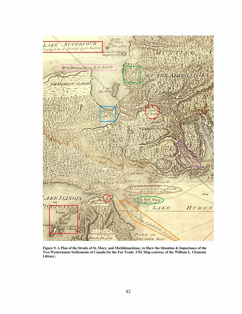
82
Figure 9. A Plan of the Straits of St. Mary, and Michilimackinac, to Shew the Situation & Importance of the
Two Westernmost Settlements of Canada for the Fur Trade. 1761 Map courtesy of the William L. Clements
Library.
83
descriptions wherein they pointed out features travelers could look for along the way.12
No doubt fur traders learned how to travel through the area from talking to local Indians
since maps of the period were drawn at far too small a scale to be used for navigation.13
Nor would maps have lasted long traveling through the harsh and wet environment of the
Great Lakes and Canada. The map of the straits of St. Mary’s includes geographic and
travel notes more likely recorded by Charlevoix during his travels in the region than from
cartographers. For instance one island has the following notation, “This Isle is very high
& may be seen at 12 Leagues distance.” Other examples are the directions around St.
Joseph’s island. On the eastern channel around the island the map reads, “Passage for the
canoes” while on the west side it reads, “Passage for the Vessels.”14
All of these
descriptions are written in English whereas all of the other labels on the map such as the
names for islands, bays, points, and rivers are written in French or both French and
English suggesting that the French names were copied off the French map and translated
while the Indian cultural information was added later and only in English. By making the
effort to add the Indian information the London Magazine map makers accomplished two
things. First they added entertaining information for their readers on native culture and
secondly they emphasized their view that the British had not only defeated the French but
the empire now included the western Great Lakes Indians as well. Notice too that the
cartouche states that the territory displayed is measured in “British Statue Miles” rather
12
J. P. D. Dunbabin, “Motives for Mapping the Great Lakes: Upper Canada, 1782-1827,” Michigan
Historical Review 31, no. 1 (April 1, 2005): 2. 13
Dunbabin,"Motives for Mapping," 3. 14
The word vessels here, probably refers to bateaux since large sailing vessels would not reach northern
Lake Huron until 1764.
84
than the original French, “Lieues Communes de France” (common French leagues)
further emphasizing the Britain controlled how the area would be viewed.
While the first British vessels did not reach Lake Huron until after the Pontiac
Uprising British subjects were already creating their own perception of the maritime
cultural landscape, sometimes from maps like this one. The title itself indicates the
region’s importance to Canada and the fur trade. While French made, the map captures
information about the landscape that would have been important to the British as well.
Noted throughout the map are the direct ties between landscape and culture, several of
which have been identified with colored borders.
The most obvious political landmarks are fortifications which are signified by two
red circles: St. Mary’s Mission, both a religious and commercial center, and Fort
Michilimackinac. Indian political influence is shown by Iroquois Point which is signified
by the blue square. It may indicate a seasonal fishing ground for members of that eastern
confederacy or may just be a tribute to honor them. Another important category depicted
on the map includes natural resources such as “Pt. aux Cheries” (Cherry Point)
highlighted by the green square. Other natural resources contained in but not highlighted
on the map include Mapletrees Island, Oak Point, and Fish River. Some of the natural
resources are recorded on the map in both French and English such as White Fish Point
shown in the pink rectangle. Isles au Castor indicated by the red square, refers to Beaver
Islands but is only recorded in French. This may simply have been missed due to the
short timeframe from when news of the surrender reached London and the publication
date. The orange pentagon contains information leading out of the mapped area itself and
85
reads, “Common Track of the Vessels to the Detroit...” Like the natural resources
mentioned earlier there are numerous other pieces of information such as the locations of
rapids, harbors, and rivers that would have been important for anyone traveling and living
within the region to know. Maps such as this one were guides to a maritime cultural
landscape in transition. The physical landscape may not have changed much within the
last 300 years but different cultural groups perceived and utilized the space in different
ways, retaining some traditions, altering others, and introducing new ones all at the same
time.
The map captures a region in transition where the British Empire was attempting
to establish hegemony yet in reality they had not yet done so. So much depended on how
well the British could move into the area and supply their forces. French maps would not
provide them with the level of detail they needed to develop the maritime transport
system they would need. Their goals for empire would face the reality of the region’s
rapids, storms, violence, and remoteness. The story of the British attempt to build their
own version of the maritime cultural landscape is not the story of how they imposed their
will on the land, water, and French and Indian inhabitants but on how those elemental
and cultural forces shaped the empire.
The Geographic and Environmental Challenges The natural geography and environment were significant factors affecting British
plans for the development of a water transport system. Without firsthand knowledge of
conditions throughout the western lakes there was no way to know if they were realistic
or not. Like it or not the British would have to adapt as they went along.
86
French cartographers like Bellin produced maps of the Great Lakes during the
seventeenth and eighteen centuries but none of them were navigational charts. Although
they had contemplated constructing vessels several times to assist with shipping trade
goods to Detroit via Lake Erie, their plans were never carried out. The last French
commandant of Fort Niagara, Pierre Pouchot, expressed regret over this when he wrote,
It would have been useful to have built a small vessel with which from the
month of May to the end of September, when the weather is always good,
to sound and reconnoiter all the shelters around the lake [Erie] , and then
we might build vessels proper for this navigation, which would have saved
great labor and expense.15
There was little navigational information for the British to rely on, an important
concern prior to building vessels with a much deeper draft than a canoe or bateau. No
doubt they did the best they could with information from French and Indian inhabitants as
well as the few British traders who had spent time in the region. Throughout the early
years of the British occupation of the Great Lakes territory they slowly filled in the gaps
through coastal surveys and the harsh lessons that experience provided. British officials
understood how important it was to have accurate cartographic data. Indeed Amherst
ordered engineer and map maker Dietrich Brehm to accompany British forces headed
west to take possession of surrendered French posts, and to "Explore the Country in the
15
Pierre Pouchot, Memoir Upon the Late War in North America Between the French and English, Vol. 2,
ed. Franklin Benjamin Hough (Roxbury, Massachusetts: Printed for W.E. Woodward, 1866), 160, Google
ebook, http://books.google.com/books/about/Memoir_upon_the_late_war_in_North_Americ.html?id=
7HIOAAAAYAAJ.
87
best Manner” he could.16
Among his discoveries Brehm reported finding a suitably deep
enough channel in Lake St. Clair for large vessels to pass into Lake Huron.
Such geographic and hydrographic information was the key to safe navigation.
Although the Great Lakes are enormous in size, nearly two hundred miles long in most
cases they are, relatively speaking, narrow. Lake Erie for instance is no more than fifty
miles wide which means that sailing on the lakes nearly always required a pilot’s level of
knowledge as drifting off course only a few miles could easily bring one close to shore.17
Sloop and schooner captains would need to know water depths throughout the lakes and
rivers, and specifically at the military posts at which they would come to anchor. Posts
such as Detroit and Michilimackinac were located at choke points between lakes. In the
case of Detroit this meant captains had to deal with navigating through river currents
which offered challenges while sailing both up and downstream. Captain Patrick Sinclair
for instance noted while surveying Lake St. Clair just north of Detroit, how difficult it
was to stop a vessel that is being carried downstream.18
Other captains noted significant
delays while waiting for sufficient winds needed to sail against the current.19
16
Keith Widder, “The Cartography of Dietrich Brehm and Thomas Hutchins and the Establishment of
British Authority in the Western Great Lakes Region, 1760 -1763,” Cartographica 36, no. 1 (Spring 1999):
2–3. 17
Pilots are experienced sailors with intimate knowledge of a port’s navigational hazards and are typically
hired to guide vessels safely to anchorage. 18
Patrick Sinclair to unknown, October 3, 1764, Fort Michilimackinac Research Library, Mackinaw City,
Michigan. 19
Franklin Benjamin Hough, ed., Diary of the Siege of Detroit in the War with Pontiac (Albany:J.
Munsell, 1860), 13 November.
88
In addition to currents, rivers contained islands surrounded by shallows and
sandbars that shifted from place to place.20
Rapidly changing water levels only
aggravated the problem. A team surveying the southern shore of Lake Erie in 1789 for
instance noted a four to five foot difference from one year to the next. British Engineer
John Montresor noted a change in water depth of two feet in the Niagara River that
occurred overnight due to a gale from the southwest.21
Such drastic changes could mean
the difference between a safe anchorage and a wrecking event.22
Perhaps the largest impediment to creating the infrastructure needed to support
large vessels were the sudden changes in elevation that caused rapids. The Niagara
escarpment, for example is a roughly one hundred and eighty foot drop off that runs
hundreds of miles from modern New York State through Ontario, Canada. Not only did it
create the impediment to sailing known as Niagara Falls but it also increased the
difficulty of portaging around the cataract by forcing anyone transporting men or
materials to climb the steep cliff face. While no other falls of its size occur on the Great
Lakes other areas of rapids such as those between Lake Superior and Huron near present
day Sault Ste. Marie and those at the mouth of Lake Erie near present day Buffalo were,
at times, no less an impediment to sailing.
Even in cases where there was sufficient water depth the materials that made up
the river and lake beds could pose problems. The flat and rocky bottom of Lake Erie near
20
Frank H. Severance, "Journal of a Survey of the South Shore of Lake Erie, Made in 1789," in
Publications of the Buffalo Historical Society, Vol. VII (Buffalo, N.Y: Buffalo Historical Society, 1904),
373. 21
John Montresor, “The Montresor Journals," in Collections of the New-York Historical Society, Vol 14,
ed. G. D. Scull (New York: New York Historical Society, 1882), 277, Google ebook, http://books.google.
com/books?id=CQG7pe9b6uEC 22
Severance, "Journal of a Survey," 366.
89
Fort Erie made anchoring supply vessels difficult and caused numerous anchors to be
irretrievable. Softball size rocks along Great Lakes shorelines often beat smaller vessels
to pieces and caused the loss of goods, great expense in repairs, and the exasperation of
British officers trying to reduce the cost of the maintaining a British military presence in
the region.23
Letters from the western posts reveal a nearly constant tension between
administrators in the east looking to cut costs and post commanders on the scene that had
to deal with the realities of the natural environment that were so destructive to the
bateaux.
The problems that came with establishing a working maritime system for large
vessels on the western lakes were compounded by yet another element of nature, namely
the weather. The navigation season could last as long as March through November but
captains could only depend on five good months each year.24
During the winter and
spring months, efforts to build and maintain wharves were hampered if not completely
crushed by winter ice or destroyed by floes that could sweep down the river during spring
thaws.25
The list of geographic and environmental obstacles that lay before General
Amherst’s plans to construct and use sloops and schooners were enormous and perhaps
accounted for why the French had failed at the same task. The British lacked the
knowledge and perhaps more importantly time to fully consider what they were up
against and so went ahead with their plans to build large sailing vessels on the western
23
Turnbull to Gage, 8/24/1771, Vol. 105, “Thomas Gage Papers,” William L. Clements Library (WLCL) ,
Ann Arbor, Michigan. 24
Montresor, "The Montresor Journals," 317. 25
Campbell to Gage, April 28, 1765, Vol. 35, “Thomas Gage Papers,” WLCL.
90
lakes. Reports of disease and starvation among the soldiers during the early years no
doubt added to the sense of urgency and pushed the British to carry on with the building
program despite the difficulties. Amherst’s officers like Joshua Loring and Alexander
Grant had had success on Lakes Ontario, Champlain, and George. While they complained
at times about the incompetence of other officers they rarely claimed the building project
would fail which must have encouraged Amherst to push ahead. Along the way, however,
ignorance and impatience would exact a cost as they applied manpower and resources to
the task.
Expanding the Maritime Cultural Landscape: The British Enter the
Region In 1788 a report on commerce and navigation on the Great Lakes stated that it
was the wish and desire of every Briton to “establish the Empire of the British Flag upon
the Fresh water Oceans of the New World and under that powerful protection to send
freedom, light and commerce to its remotest parts…”26
Lord Jeffrey Amherst held similar
sentiments and expressed his support for land settlements in the region near British
garrisons. Amherst had to withdraw his permission to settle lands near Niagara, however,
when Indians and competing traders complain about a possible trade monopoly at the
Niagara portage.27
No such restrictions held back British troops and within two years
26
Grant to Lord Dorchester, January 19, 1789, in Historical Collections Made by the Pioneer Society of the
State of Michigan, Vol. XII, Second, ed. Henry S. Bartholomew (Lansing, Michigan: Wynkoop
Hallenbeck Crawford Co., 1908), 8, Google ebook, http://books.google.com/books?id=-Q8UAAAAYAAJ. 27
Amherst to Sharpe, October 20, 1762, in Documents Relative to the Colonial History of the State of New
York, Vol. 7, ed. by E.B. O’Callaghan, (Albany: Weed, Parsons and Company, 1857), 508, Google ebook,
http://books.google.com/books?id=zob26Nu7sbgC
91
over 4000 soldiers were stationed across Canada, western Pennsylvania, and modern day
Michigan.28
The most immediate and pressing need for the British Army after capturing
Niagara was to secure and open communications and supply routes to their posts in the
Ohio valley.29
Amherst hoped that forces from Pittsburgh could be used to relieve troops
at Niagara who could then be used in the final effort to capture Montreal and Quebec.
There was an immediate request from British officers that marched up to Presque Isle for
water transport east along the Lake Erie southern shoreline to the Niagara River.30
There
is some evidence that they constructed a sailing scow, which was likely a type of barge
fitted with a mast, but that the vessel was driven to the north side of the lake in a storm
and wrecked upon the shore. Supplying Presque Isle proved difficult in periods of low
water and so the relief force planned for Niagara was unable to make their way east.31
At Niagara, however, the post commandant Eyre was busy acting on Amherst’s
orders trying to find the best ways to communicate with Presque Isle as well. Amherst
was emphatic and wrote to Eyre, “You cannot therefore Exert Yourself too much in any
Endeavours to find out and form such a communication.”32
In preparation for traffic
across the Niagara portage the British began to reconstruct earlier French facilities along
the thirty mile river between lakes Ontario and Erie.
The French had constructed small posts at various points along the route starting
with several forts which were occupied and later abandoned at times at the mouth of the
28
Walter S. Dunn, “The Frontier on the Eve of the Revolution,” Niagara Frontier 20, no. 4 (1973): 106. 29
Brian Leigh Dunnigan, “Portaging Niagara,” Inland Seas 42 (1986), 181. 30
MacLeod, “The Tap of the Garrison Drum," 59. 31
Stanwix to Amherst, August 16, 1759, Vol. 4, "Amherst Papers," OFNL. 32
Amherst to Eyre, October 31, 1759, Vol. 4 "Amherst Papers," OFNL.
92
river in 1679, 1712, and finally in 1726. French traders constructed a storehouse at the
lower landing at the base of the escarpment in 1678 and again in 1715. By 1718 the
French employed Seneca Indians to carry trade goods across the portage for them. The
final piece of the French portage included a house, stable, and barn above the falls called
Little Niagara where traders could re-enter the river to travel west.33
Because it was crucial for imperial expansion into the west the British explored
the area and began to reconstruct posts in approximately the same locations along the
portage. They built a storehouse at Little Niagara in 1760 garrisoned by a dozen soldiers.
Between 1762 and 1764 the lower landing was rebuilt and fortified with defensive
structures, storehouses, and tramways to help haul goods up from the river all the way to
the top of the escarpment. An additional defensive post at the summit guarded the
transition point from the tramway to wagons that carried the goods to Little Niagara.
These facilities, designed to aid the movement of materials and people through the
portage, were used extensively. The changes the British made to the landscape were
important because they connected maritime traffic on Lake Ontario to Lake Erie and as
such they were part of the maritime transport system that facilitated movement from east
to west. British traders quickly moved into and through the region in order to take
advantage of this system. The zeal they showed for expanding the commercial aspect of
the empire had both positive and negative repercussions for the military authorities.
As traders and merchandise poured through the region the small posts along the
Niagara portage were overrun with goods and people, prompting Col. William Eyre to
33
Stuart D. Scott and Patricia Kay Scott, An Archaeological Survey of Artpark and the Lower Landing,
Lewiston, New York (Lewiston, New York: Edwin Mellen Press, 1993), 81–98.
93
construct two rows of buildings along the shore just outside Fort Niagara for the traders’
convenience.34
While managing so many traders was a daunting task their presence was
beneficial in that Indians that had been allied with the French were at least benefitting
from a plentiful supply of trade goods. In May of 1760 for instance 300 Indians
converged at the fort and were allowed to visit the new trading facilities. In addition
merchants from Detroit assisted in developing the portage by constructing their own
storage facilities near Little Niagara in 1761. Even this was a mixed blessing in that local
Indians became alarmed at the growing sight of buildings on their land, sparking fears
that the British were after their lands. Concern over this issue continued to fester over the
next two years but British enthusiasm for developing a reliable transport system meant
that construction and traffic along the Niagara River would continue
Unable to sail large vessels from Lake Ontario because of the geologic barrier
posed by Niagara Falls and lacking the infrastructure to immediately produce sailing
vessels on the western lakes, the British utilized and improved the existing small craft
maritime landscape established by the French. They reestablished portage facilities
around Niagara Falls and used bateaux to answer immediate transport needs (Figure 10
and Figure 11). These large, flat bottomed, double ended, shallow draft vessels, often
more than thirty feet in length, could carry twenty to thirty barrels of provisions and ten
or more crew members depending on the size of the cargo. They could be poled, sailed,
or rowed and during times of conflict the army often mounted small cannon or swivel
34
Wilfred B. Kerr, “Fort Niagara 1759-1763,” New York History 15 (July 1934), 292.
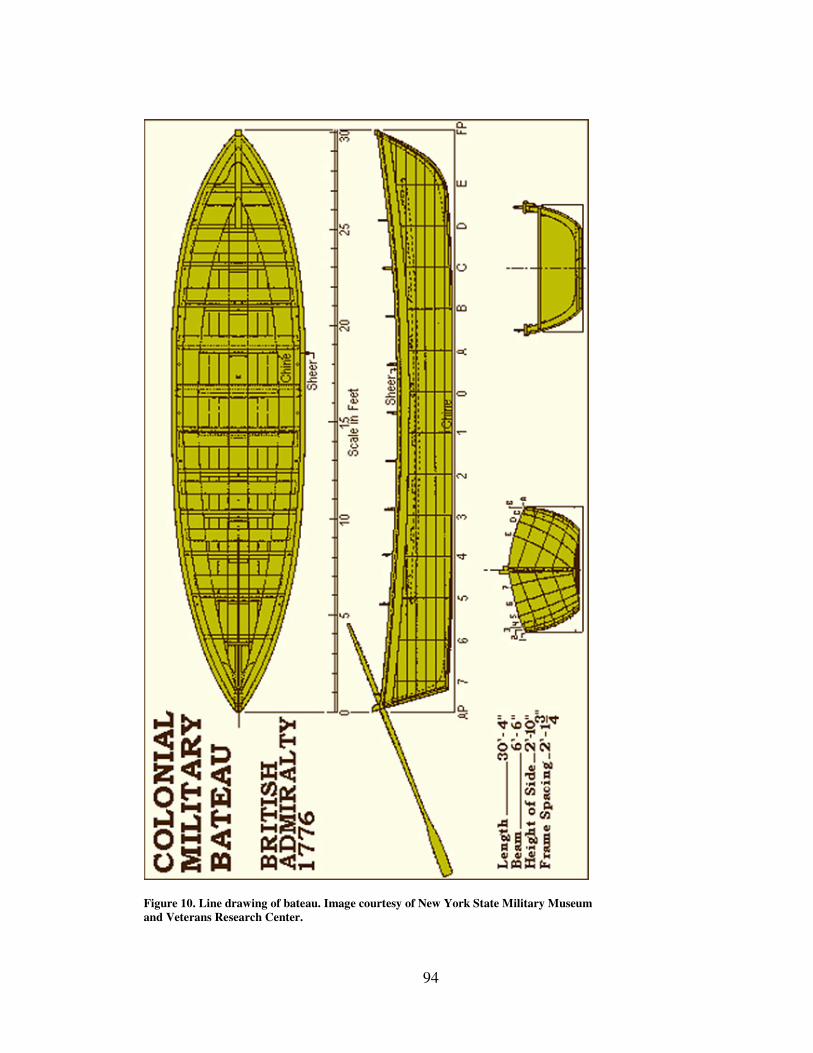
94
Figure 10. Line drawing of bateau. Image courtesy of New York State Military Museum
and Veterans Research Center.
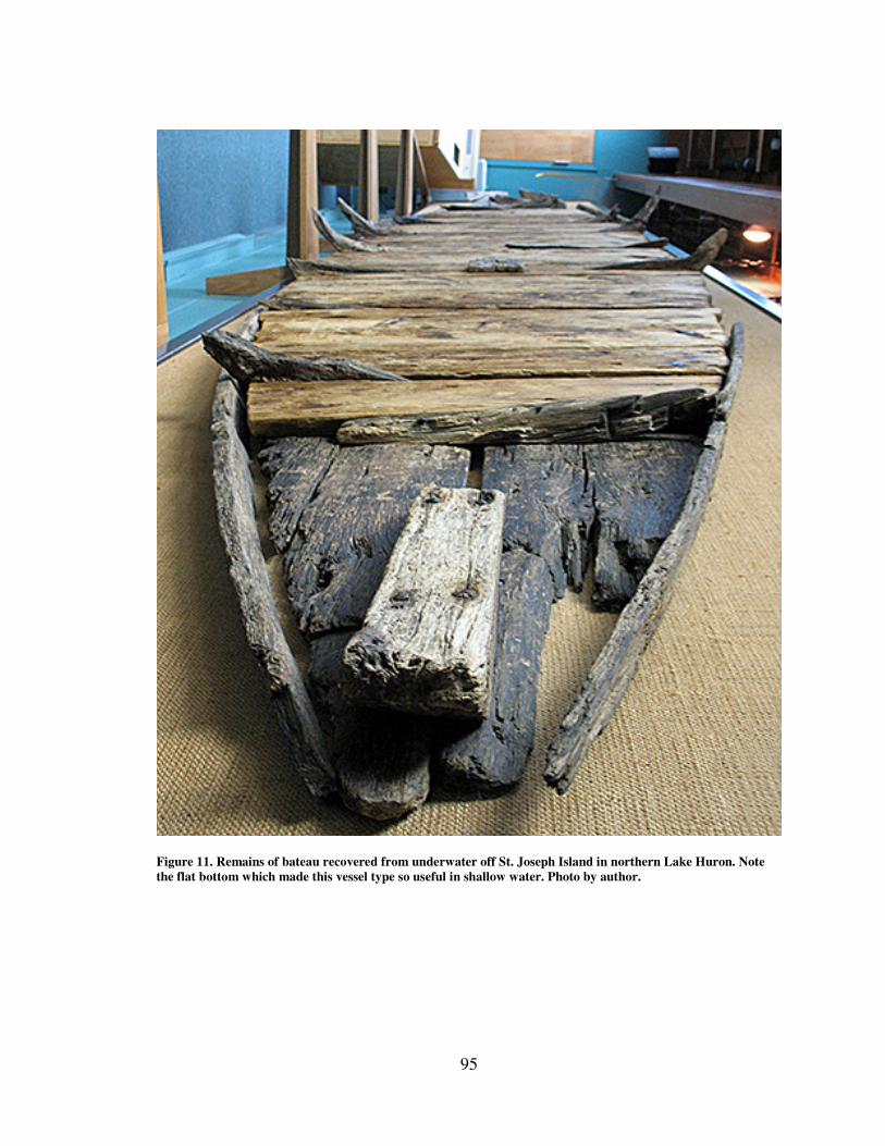
95
Figure 11. Remains of bateau recovered from underwater off St. Joseph Island in northern Lake Huron. Note
the flat bottom which made this vessel type so useful in shallow water. Photo by author.
96
guns in the bow. In a region that had virtually no roads but thousands of miles of
connective waterways they were the work horse of both the French and British empires
on the lakes for both the Army and merchants alike. Indeed they remained an important
part of the maritime cultural landscape into the early nineteenth century.
The Army used bateaux at every British post on the Great Lakes for numerous
tasks including fetching firewood, limestone for construction, produce from local garden
plots, fishing, express communications, ferrying men and materials across rivers and
lakes, conducting patrols, surveying river channels and lake shorelines, and transporting
men and supplies from one post to another. The commandant of Fort Niagara described
their importance to General Thomas Gage, who had replaced Amherst as commander of
North American forces in 1763, in this way,
more [bateaux] will be wanted here next spring…the necessity of some
English warlike bateaux is evident, where we cannot have communication
one place to another but by water or go to our garden but in bateaux nor in
short almost do any one thing without them, they are wanted almost every
hour of the day.35
Brown, however, acknowledged that while they were useful, and in some ways
well suited to the shallow channels and harbors near the British posts they were also ill-
suited for other elements of the natural environment. While they were built of wood and
therefore more durable than birchbark canoes they also weighed considerably more and
so were more difficult to portage. They were also subject to dangers posed by storms,
high waves, and stony beaches, a fact that became evident early on as the British took
control of the western posts. Commandants from Niagara, Detroit, Michilimackinac, and
35
Brown to Gage, September 27, 1770, Vol. 96 “Thomas Gage Papers,” OFNL.
97
Fort St. Joseph defended their continuous expenditures to generals Gage and Amherst at a
time when the army sought to reduce costs associated with a standing army in North
America. Engineer John Montresor for instance recorded in his journal a harrowing round
trip along Lake Erie where time after time bateaux were damaged by rocky beaches while
others were swamped and destroyed in the surf. In October 1764 Montresor described
how the weather changed from a “rather calm surf” to a destructive squall that sank 25
boats, damaged great quantities of their ammunition and provisions and washed away a
great part of their baggage.36
As the group struggled back toward the Niagara River from
Detroit many were forced to walk due to a lack of boats. As their provisions dwindled
along the way hungry soldiers experimented with eating roots that resembled parsnips,
resulting in the poisoning death of two soldiers. Montresor acknowledged that they had
not been prepared to deal with the dangers that lake travel in small open craft posed
noting that, “no allowance [was] made for damaged Provisions in this calculation.”37
Yet
despite the dangers small open boats faced on the lakes and rivers their wide spread use
as part of the maritime transport system continued.
Merchants traveling west from Montreal and La Chine to posts in the northwest
like Michilimackinac often used birchbark canoes along the Ottawa River route discussed
in Chapter one, but those who headed for Detroit or the Ohio River valley often used
bateaux to transport their goods for several reasons. By traveling west via Lake Erie they
could take advantage of the protection offered by the British Army’s well defended
Niagara portage system (Figure 12). Bateaux also provided cargo capacities for large
36
Montresor, "The Montresor Journals," 312. 37
Ibid., 316.
98
cargos of profitable items such as liquor, clothes, gun powder, and lead shot purchased by
western Indians as well as goods needed by the British Army, officials of the Indian
Department, and other merchants.
Using bateaux as a transport solution for the vast distances covered by the Great
Lakes helped the British military and merchant communities extend their reach. The
natural dangers noted above, however, along with the strenuous labor needed to load the
heavy barrels no doubt contributed to a major source of frustration for those eagerly
awaiting the arrival of their items. In many instances goods were either stolen along the
way or spoiled in transit. In the spring of 1762 the commandant of Fort Niagara wrote to
Amherst to complain that he had to condemn barrels of food that had spoiled because the
bungs had been removed and the preservative brines had been drained by bateauxmen to
lighten the load.38
One can only imagine the detrimental impact this could have on pork
that had been salted and shipped in some cases over a year before from England not to
mention the smell that must have greeted those charged with opening the barrels at posts
throughout the Great Lakes. Yet so important and costly were these shipments that
General Gage wrote to one officer "…tho' there may be now & then a piece found in a
Barrel a little damaged, the whole is not to be Lost: Your men must not be too nice.”39
The maritime transport system stretched such vast distances and passed through so many
hands that it was difficult to determine where the fault lay and therefore difficult to
38
Walters to Amherst (extract) with Reply by Amerhst to Walters, April 27, 1762, Vol. 6, "Amherst
Papers," OFNL. 39
Gage to Turnbull, June 21, 1768, Vol.78, "Thomas Gage Papers.” WLCL.
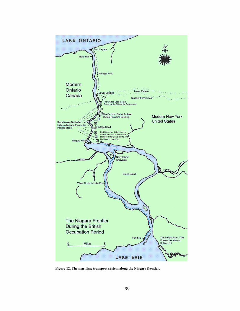
99
Figure 12. The maritime transport system along the Niagara frontier.
100
correct. This in turn encouraged the purchase of local foodstuff from merchants and
Indians and may have encouraged an increase in the number of local suppliers.40
Throughout the 1760s it was not uncommon for the Army to buy or borrow provisions of
meat, corn, and flour from private merchants despite at times suspicions that they were
being gouged. Such incidents provide clear examples of the dual and sometimes
conflicting nature of the empire when the commercial elements profited at the expense of
the military-political ones. Officers complained about being at the merchant’s mercy at
times and even made attempts to hide how desperate the Army’s situation could be. In at
least one case an officer ordered supplies through the vendor that victualed the Naval
Department and pretended they were for the ships so as not to expose the situation.41
From the beginning of the British occupation of the western Great Lakes military
commanders such as Amherst and Gage had their own conceptions about how the empire
should function and maintain itself in the Great Lakes that were not based on experience
in region. The British sought to establish a transport network to connect their posts in the
west with power centers in the east that could handle the volume of traffic in men and
materials that the Army needed establish a firm grip on the area in establish their
hegemony and promote trade. The French method of using bateaux had a limited cargo
capacity and was too unreliable. Losses due to storms, corruption, and damage from
rocky river and lake beds meant that for shipping to escalate to the levels needed to
extend the empire west, larger craft such as sloops and schooners were needed. To
40
Turnbull to Gage, May 12, 1767, Vol.64, "Thomas Gage Papers.” WLCL. 41
Turnbull to Gage, July 24, 1768, Vol. 79, “Thomas Gage Papers,” WLCL.
101
remedy this Amherst ordered shipwrights and engineers to Niagara in 1761 to construct a
shipyard to build vessels for the upper Great Lakes.42
He had never been to the region –
few British had – and so had little idea what natural obstacles might hinder the execution
of his orders.
Navy Island Lord Jeffery Amherst had already won honors and recognition for his conduct
during the French and Indian war by the time he ordered Lieutenant Charles Robertson to
go to the Niagara River to build vessels for the upper Great Lakes. Amherst’s initial
success came from his coordination of the attack on the fortress at Louisbourg in 1758. It
was a remarkable appointment for an officer as junior as Amherst who had previously
never led men into battle. A key component was Amherst’s excellent working
relationship with British Admiral Edward Boscawen. The extraordinary cooperation
between the two branches may have made an impression on Amherst and convinced him
of the utility of having a maritime transport service.43
Maritime logistics played a crucial
role in his battles for control of Lake Champlain and the attacks on Fort Lévis which in
turn led to his capture of Montreal (and with it the rest of Canada). No doubt it influenced
his approach for obtaining the imperial goals he sought to achieve which included
establishing and maintaining control over western French posts in North America,
encouragement of trade for British firms, mollifying Indians formerly allied with the
French, and reducing costs as the war wound down. All of these goals were dependent on
42
Amherst to Robertson, May 6, 1761, "Amherst Papers," Library of Congress (LOC), Washington, DC. 43
William R. Nester, Haughty Conquerors Amherst and the Great Indian Uprsing of 1763 (Westport,
Connecticut: Praeger, 2000), 7-8.
102
a British military presence throughout the western Great Lakes region and to do that
Amherst believed he needed to develop a transport fleet for the Great Lakes.
Amherst was noted for his thoroughness and preparation, qualities that would be
needed in trying to achieve his imperial objectives.44
It is no surprise then that he not only
pushed for the construction of vessels for the western lakes but also for the necessary
elements that had to be put into place beforehand. The other goals of cost reductions and
changes in British relations with western Indian tribes, while seemingly unrelated or at
best tangential, would prove to be intimately connected to the development of an
expanded maritime cultural landscape. Geography, distance, and cultural contact would
influence the outcome of all of these goals in both positive and negative ways.
As we have seen the Army’s initial efforts at expanding west involved developing
the existing pieces of the maritime cultural landscape, namely bateaux, fortifications,
portages, and shipping on Lake Ontario which would be needed to supply materials and
manpower to build vessels for the western lakes. Much of Amherst’s correspondence
with the first commandants at Fort Niagara dealt with outfitting and finishing the French
vessels captured there that could be used to secure control over Lake Ontario.45
In
addition he requested subordinates to begin preparations for ship building above Niagara
Falls. Joshua Loring for instance who had commanded vessels in the Lake Champlain
and Fort Levis offensive was ordered to coordinate supplies and artificers.
Officers at Niagara were instructed to discover the best pathways for
communication, the temperament of the local Indians, and the nature of the surrounding
44
Nester, Haughty Conquerors, 7. 45
Amherst to Gage, August 14, 1759, Vol. 4, "Amherst Papers ," OFNL.
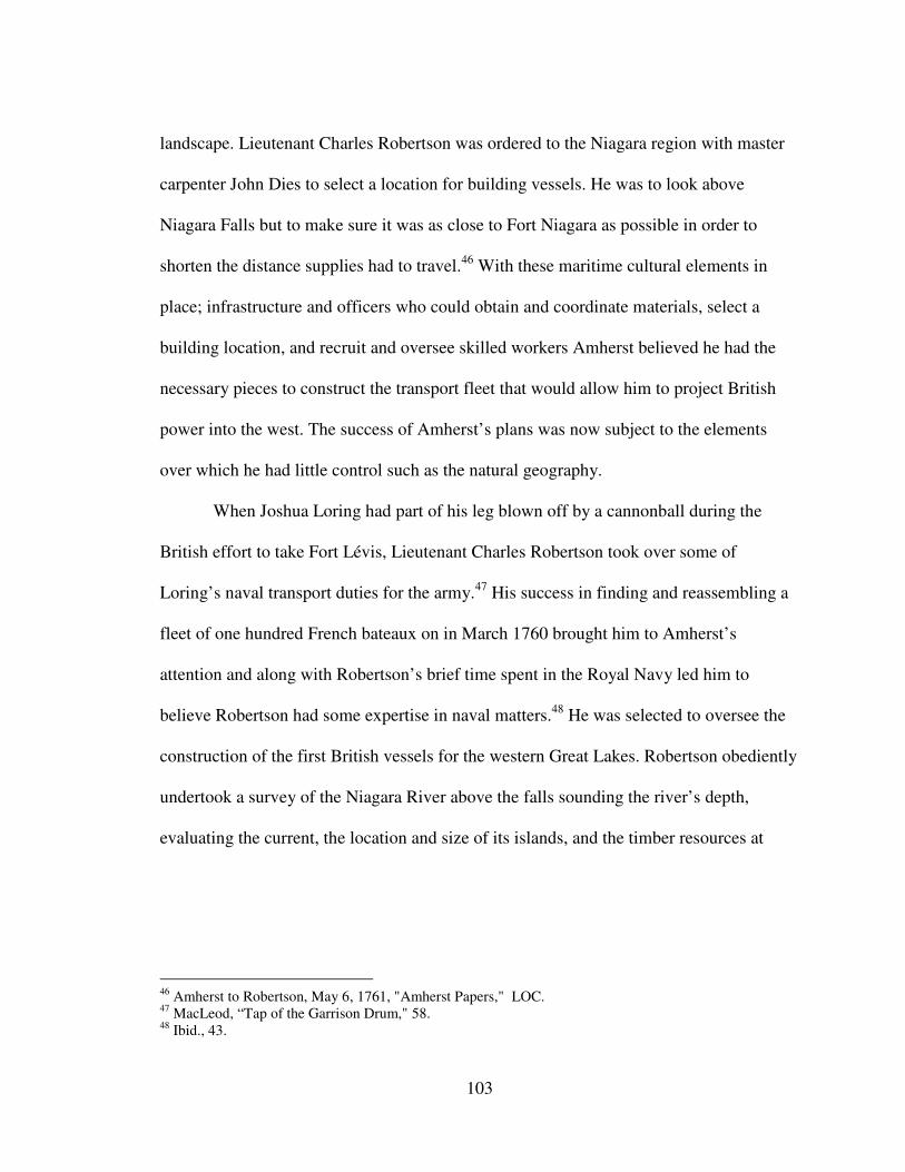
103
landscape. Lieutenant Charles Robertson was ordered to the Niagara region with master
carpenter John Dies to select a location for building vessels. He was to look above
Niagara Falls but to make sure it was as close to Fort Niagara as possible in order to
shorten the distance supplies had to travel.46
With these maritime cultural elements in
place; infrastructure and officers who could obtain and coordinate materials, select a
building location, and recruit and oversee skilled workers Amherst believed he had the
necessary pieces to construct the transport fleet that would allow him to project British
power into the west. The success of Amherst’s plans was now subject to the elements
over which he had little control such as the natural geography.
When Joshua Loring had part of his leg blown off by a cannonball during the
British effort to take Fort Lévis, Lieutenant Charles Robertson took over some of
Loring’s naval transport duties for the army.47
His success in finding and reassembling a
fleet of one hundred French bateaux on in March 1760 brought him to Amherst’s
attention and along with Robertson’s brief time spent in the Royal Navy led him to
believe Robertson had some expertise in naval matters.48
He was selected to oversee the
construction of the first British vessels for the western Great Lakes. Robertson obediently
undertook a survey of the Niagara River above the falls sounding the river’s depth,
evaluating the current, the location and size of its islands, and the timber resources at
46
Amherst to Robertson, May 6, 1761, "Amherst Papers," LOC. 47
MacLeod, “Tap of the Garrison Drum," 58. 48
Ibid., 43.

104
Figure 13. Navy Island as drawn by Bernard Ratzer in 1764. Map courtesy of the
William L. Clements Library.
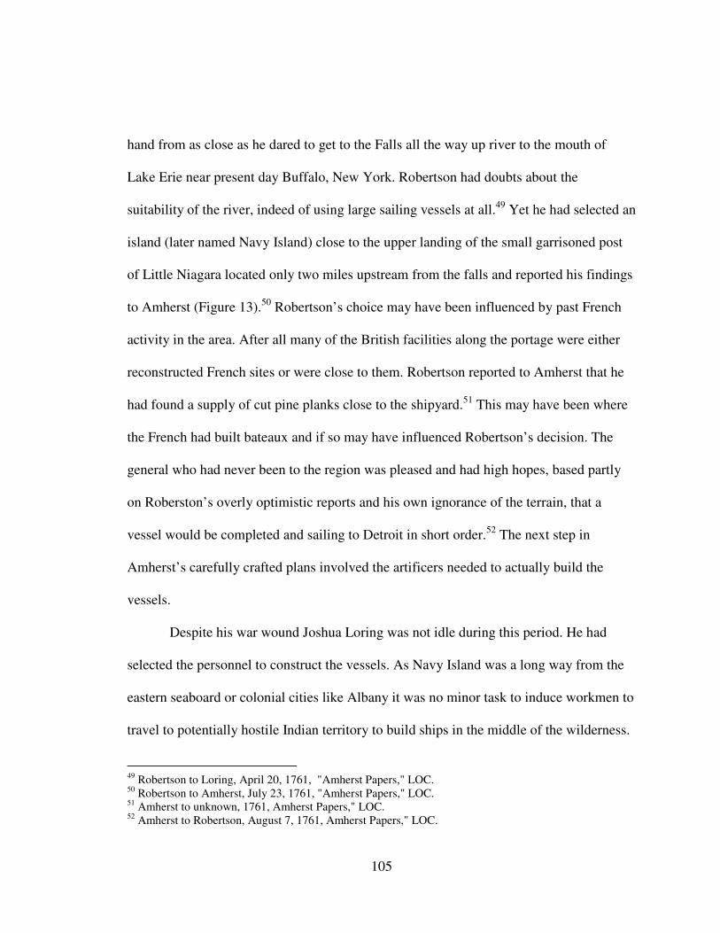
105
hand from as close as he dared to get to the Falls all the way up river to the mouth of
Lake Erie near present day Buffalo, New York. Robertson had doubts about the
suitability of the river, indeed of using large sailing vessels at all.49
Yet he had selected an
island (later named Navy Island) close to the upper landing of the small garrisoned post
of Little Niagara located only two miles upstream from the falls and reported his findings
to Amherst (Figure 13).50
Robertson’s choice may have been influenced by past French
activity in the area. After all many of the British facilities along the portage were either
reconstructed French sites or were close to them. Robertson reported to Amherst that he
had found a supply of cut pine planks close to the shipyard.51
This may have been where
the French had built bateaux and if so may have influenced Robertson’s decision. The
general who had never been to the region was pleased and had high hopes, based partly
on Roberston’s overly optimistic reports and his own ignorance of the terrain, that a
vessel would be completed and sailing to Detroit in short order.52
The next step in
Amherst’s carefully crafted plans involved the artificers needed to actually build the
vessels.
Despite his war wound Joshua Loring was not idle during this period. He had
selected the personnel to construct the vessels. As Navy Island was a long way from the
eastern seaboard or colonial cities like Albany it was no minor task to induce workmen to
travel to potentially hostile Indian territory to build ships in the middle of the wilderness.
49
Robertson to Loring, April 20, 1761, "Amherst Papers," LOC. 50
Robertson to Amherst, July 23, 1761, "Amherst Papers," LOC. 51
Amherst to unknown, 1761, Amherst Papers," LOC. 52
Amherst to Robertson, August 7, 1761, Amherst Papers," LOC.
106
With the fall of Fort Niagara, Loring had rushed workers to the fort to complete a French
vessel that was still under construction for use on Lake Ontario. Many of them had built
vessels for the British in other areas around Lake Ontario. Shipwright John Dies who had
constructed bateaux for the army and twenty-five carpenters were dispatched by
Robertson to Navy Island.53
Amherst later sent additional workers and blacksmiths from
Albany to help with the vessels’ ironwork.54
All seemed to be proceeding according to Amherst’s plans. Initial fears about
Indian hostilities in Detroit that surfaced soon after the British occupied the post
prompted Amherst to send Major Henry Gladwin to Detroit with 300 hundred additional
troops to solidify their position.55
Amherst hoped that as Gladwin moved through the
Niagara region on his way west he could use the two vessels under construction at Navy
Island to facilitate transport, explore the western lakes, and offer a show of force that
only a large vessel with cannon could.56
It would be a sight not seen in the Detroit River
in living memory. All that would be required was for the vessel to be finished, launched
into the Niagara River, moved upstream to the mouth of Lake Erie and safely sailed west
across the lake to the Detroit River. This was easier said than done.
Robertson had dutifully obeyed Amherst’s orders to place the shipyard as close to
Fort Niagara as possible in order to shorten the trip for supplies but in doing so he
disregarded his own misgivings that came from his survey of the river in November
53
Henry R Howland, "Navy Island and the First Successors to the Griffon," in Publications of the Buffalo
Historical Society, Vol. 6, ed. Frank Severance (Buffalo, New York: Buffalo Historical Society, 1903), 23,
Google ebook, http://books.google.com/books?id=G8o0AQAAMAAJ. 54
MacLeod, “Tap of the Garrison Drum," 61. 55
Amherst to Gage, June 16, 1761, Vol. 5, "Amherst Papers," OFNL. 56
Amherst to Gage, June 26, 1761, Vol. 5, "Amherst Papers," OFNL.
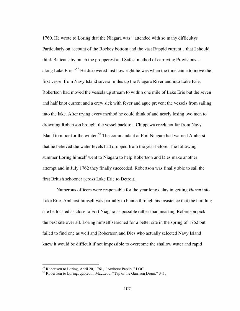
107
1760. He wrote to Loring that the Niagara was “ attended with so many difficultys
Particularly on account of the Rockey bottom and the vast Rappid current…that I should
think Batteaus by much the propperest and Safest method of carreying Provisions…
along Lake Erie.”57
He discovered just how right he was when the time came to move the
first vessel from Navy Island several miles up the Niagara River and into Lake Erie.
Robertson had moved the vessels up stream to within one mile of Lake Erie but the seven
and half knot current and a crew sick with fever and ague prevent the vessels from sailing
into the lake. After trying every method he could think of and nearly losing two men to
drowning Robertson brought the vessel back to a Chippewa creek not far from Navy
Island to moor for the winter.58
The commandant at Fort Niagara had warned Amherst
that he believed the water levels had dropped from the year before. The following
summer Loring himself went to Niagara to help Robertson and Dies make another
attempt and in July 1762 they finally succeeded. Robertson was finally able to sail the
first British schooner across Lake Erie to Detroit.
Numerous officers were responsible for the year long delay in getting Huron into
Lake Erie. Amherst himself was partially to blame through his insistence that the building
site be located as close to Fort Niagara as possible rather than insisting Robertson pick
the best site over all. Loring himself searched for a better site in the spring of 1762 but
failed to find one as well and Robertson and Dies who actually selected Navy Island
knew it would be difficult if not impossible to overcome the shallow water and rapid
57
Robertson to Loring, April 20, 1761, "Amherst Papers," LOC. 58
Robertson to Loring, quoted in MacLeod, “Tap of the Garrison Drum,” 341.
108
currents at the head of the Niagara River.59
Amherst’s orders and the best efforts of his
officers to carry them out were frustrated by their lack of experience in the geographic
environment in which they intended to operate. An examination of specific vessel
histories throughout the first decade of British ship building on the western lakes
(discussed in chapter 4) will show how this pattern was repeated throughout the lakes.
Labor, Disease, and the Chain of Command The very waters that allowed an army to move so quickly into the interior of a
continent were consequently taking soldiers further and further away from their homes
and colonial centers. This had implications for supply that could make an already difficult
duty post even tougher. Shipping provisions to posts even as far as Fort Niagara was
difficult and the first few winters at the fort found many men ill with scurvy. During their
first spring at the post they tried various concoctions to overcome the disease including
providing a half gallon per man each day of brewed sassafras, hickory, and maple.60
Shipwrights and soldiers brought in to work on the vessels for the western lakes also
suffered from scurvy which contributed to the vessels not being completed when Gladwin
needed them to go to Detroit. To remedy the soldiers’ and workmen’s poor health
Amherst shipped seeds to encourage soldiers to plant gardens, fishing nets to let them
supplement their diets, and occasionally barrels of lime juice and vinegar.
Service for the common soldiers in North America was already physically
demanding. Analysis of skeletons excavated at Fort William Henry for instance showed
59
MacLeod, “The Tap of the Garrison Drum,” 65. 60
Amherst to Gage, April 10, 1760, Vol.5, "Amherst Papers," OFNL.
109
evidence of herniated disks and scars on bones where muscles were torn away. 61
For
those working on elements of the transportation system duties included clearing forests,
sawing and chopping wood, digging trenches, rowing bateaux and canoes. Injuries
included accidents with axes and other tools and as one might expect working around
boats – drowning. Such hardships combined with a poor diet certainly made them
susceptible to disease and thus reduced the available workforce. The remoteness of their
location also meant that there was little available in the way of hospital care. Indeed
Amherst felt there was little point in shipping sick soldiers further east as there the sick
were not likely to receive better treatment than whatever they could come up with at
Niagara.62
The harsh winters that prevented shipments of food to Niagara and other posts on
the western lakes also meant that soldiers who fell behind on patrols, or got lost in the
surrounding woods often froze to death. Whether it was because, or in spite, of these
harsh conditions some soldiers did desert, an option for only the most desperate. The
same thought must have occurred to Amherst who upon hearing of two deserters from
Fort Niagara asked incredulously "Where could they go to?"63
It was a good question
considering the distance from the nearest cities although some made the effort. Others
went to the Indians and were either accepted or made prisoner. Still others may have, as
Lt. Colonel Campbell at Detroit believed, died of hunger in the woods.64
61
Stephen Brumwell, Redcoats: The British Soldier and War in the Americas, 1755-1763 (Cambridge,
Massachusetts: Cambridge University Press, 2006), 143. 62
Amherst to Browning, October 6, 1763, "Amherst Papers," LOC. 63
Amherst to unknown, 1761, "Amherst Papers," LOC. 64
Campbell to Gage, May 21, 1765, Vol. 36, "Thomas Gage Papers," WLCL; Hough, ed., Diary of the
Siege of Detroit, 100.
110
Despite Amherst’s eager hopes that the Navy Island vessels would be quickly
completed the same environmental factors that slowed shipments of food impacted the
arrival of construction materials as well. Robertson complained he lacked needed
supplies.65
Such problems would plague ship construction throughout the British
occupation of the great lakes primarily due to the length of time it took to receive
requests. Orders for supplies typically had to be received in Montreal early enough that
they could be filled and ready to ship as soon as the ice began to break up in the spring.66
The British attempt to build their first large vessels on the western Great Lakes
brought to light many of the issues that would plague them for decades. The difficulties
in shipping building materials, men, and provisions such great distances were perhaps
readily apparent to anyone who had made the journey west. Other equally challenging,
but perhaps less obvious problems emerged as the vessels on Navy Island took shape.
The construction of the British Army’s transport fleet meant that the Army was building
and operating in essence its own navy. Without an independent naval command structure
in place, officers overseeing construction at the shipyards and later the vessels’ captains
as well would find themselves caught between the conflicting orders of local post
commandants and other Naval Department (as it was known early on) officers who
supposedly were, at least to some degree, in charge of managing the little fleet.
Conflicts over orders arose even before the first vessels were completed.
Robertson received orders from Amherst to take the Huron to Detroit with Major
Gladwin and his forces and to receive his future orders from Gladwin. Upon arrival at
65
Robertson to Loring, April 20, 1761, "Amherst Papers," LOC. 66
Gage to Stevenson, June 17, 1771, Vol. 104, "Thomas Gage Papers," WLCL.
111
Navy Island, however, Gladwin ordered construction on Huron halted so that the
shipbuilders could repair bateaux for Sir William Johnson who was also on his way to
Detroit, and to construct a small pinnace for Gladwin’s use.67
This delay set Robertson
back such that he was unable to get Huron into Lake Erie that year which subsequently
meant he could not accompany Gladwin and carry out his orders. Similar confusion
occurred over who was responsible for bateaux construction. Traditionally it came under
the domain of the Quarter Master General’s Department headed by Colonel John
Bradstreet. Amherst had tapped Loring and Robertson to oversee the larger vessels for
the upper lakes but both groups used the same artificers. Conflict over who the men
would answer to ensued.68
With the tremendous amount of activity along the Niagara portage during the
1760s there was a great demand for labor. Confusion over the chain of command led to
problems for Loring who continued to oversee vessel construction for the Army. His
workers were being pulled in multiple directions. Some were pulled away to build
barracks, a storehouse, and the newly constructed Fort Erie. Others were sent to Fort
Niagara to build bateaux. While all of these were vital parts of the maritime cultural
landscape Loring was greatly concerned that some of the immediate maritime needs were
not being met. He complained to General Gage in 1764 (who had by then replaced
Amherst as the commander of British forces in North America) that they had not yet
67
The term “pinnance” has meant many different vessel and rig types over time but in this case Gladwin
likely had a ship’s pinnance in mind which was a small boat used to transport personal to and from shore to
a larger vessel. This was common in the mid eighteenth century and would have been a faster option for
Gladwin than to wait for Huron to be completed and moved into Lake Erie which ended up taking almost a
year to get into the lake. 68
MacLeod, “Tap of the Garrison Drum,” 249.
112
begun needed work on a wharf because of a lack of men. Conflicts over his ability to
command the work men led him to complain, “I had not the liberty to command a single
Carpenter or seaman so that it was out of my power to do the least thing what ever."69
This was a bit of an overstatement as a total of seven vessels were constructed at Navy
Island between 1761 and 1767 after which the British moved their shipyard to Detroit
partially to overcome the geographical obstacles presented by the Niagara River. Loring’s
complaint, however, had merit. Historian Carol MacLeod who studied the Naval
Department extensively has suggested that its confusing and conflict ridden command
structure was perhaps the biggest obstacle the British would face throughout the Naval
Department’s existence.70
In the formative years of the developing British maritime
cultural landscape of the western Great Lakes this was certainly the case.
Throughout those years the maritime cultural landscape along the Niagara
Portage, Detroit, and Michilimackinac would continue to develop. The forces of
geography, distance, and British military cultural all affected its shape but another
element also influenced the maritime cultural landscape. British relations with the
western Indian tribes and Amherst’s imperial goals for their role in the expanding empire
in particular, would greatly alter its shape for much of the eighteenth century.
The Role of Conflict in Shaping the Maritime Cultural Landscape Thus far this chapter has examined the physical and cultural elements that made
up an expanded British maritime cultural landscape. They were designed to facilitate the
movement of men and materials that supported and expanded the British Empire into the
69
Loring to Gage, September 9, 1764, Vol. 24, WLCL. 70
MacLeod, “Tap of the Garrison Drum,” 238.
113
western Great Lakes region. Many but not all of these pieces were specifically built to
help build and operate larger sailing vessels such as sloops and schooners. Portages,
shipyards, bateaux, men, provisions, bureaucratic structure and command all had to be in
place before the first vessels could effectively operate. Once in place the British hoped to
firmly establish the empire throughout the region in peaceful and profitable relationships
with the French and Indian inhabitants that would become part of Britain’s global trade
network. But just as each element of the maritime cultural landscape was influenced and
in some cases radically altered by the forces of geography and distance, cultural conflict
would also make an impression and show the British that despite the power of the empire
they could not control all aspects of even their own system. This section will examine
how cultural conflict both destroyed some elements of the maritime cultural landscape as
well as gave rise to new ones that would not otherwise have existed.
Numerous authors have examined the causes of the Indian uprising and while
some specific aspects vary between authors there is general consensus that Indian fears of
British territorial ambitions was a major concern of western tribes. Once the French had
been defeated the Indians had lost the counterpoint that kept the Europeans at bay.
Indians were increasingly alarmed at the power of the British Empire.71
While historians
often point to colonists’ encroachment on Indian lands as a cause for the uprising,
historians such as Gregory Evans Dowd point out that the British Army itself was the
chief culprit. Dowd notes that not only did the British occupy all of the former French
Great Lakes posts but that they rebuilt some that were previously abandoned by the
71
Calloway, The Scratch of a Pen, 50.
114
French years earlier such as at Sandusky at the west end of Lake Erie. The additional
facilities built along the Niagara portage were also likely to be seen as territorial
expansion as well.72
Other issues included the change in British policy regarding giving presents to
Indians and the restriction of rum sales. Amherst was vehemently opposed to both and
wrote often on the subject to post commandants at Niagara and Detroit. While he
acknowledged such gifts and rum sales had been the practice in the past as the war turned
in Britain’s favor he warned the commandant at Fort Niagara in August 1760,
…under the present circumstances many Indians will be coming to You,
and that they will make professions of repentance for their past Conduct;
they will say anything to get provisions and Ammunition; It is prudent
however to be sparing of both; too much kindness may be prejudicial.73
Already suspicious Indians saw limiting ammunition as one way to impoverish
them since they would be unable to feed themselves. Post commandants who dealt with
the Indians directly saw the danger in denying Indians the traditional exchanges that
helped to heal old wounds and reported rumors to Amherst that he dismissed. Responding
to one rumor he wrote, “I think it impossible, wild as they are, that they can Conceive to
themselves that they can Execute it; I don’t believe they will Attempt the least part of
it.”74
Amherst continued to downplay any possible hostilities even one month before the
first attacks. When they began those British military and traders that lived and worked
within the maritime cultural landscape were not immune.
72
Gregory Evans Dowd, War Under Heaven: Pontiac, the Indian Nations, and the British Empire
(Baltimore: The Johns Hopkins University Press, 2004), 79. 73
Amherst to Walters, August 9, 1760, "Amherst Papers," LOC. 74
Amherst to unknown, July 8, 1761, " Amherst Papers," LOC.
115
On 2 May 1763 Charles Robertson set out from Detroit in a bateaux with six
soldiers, two sailors, two other gentleman and one Indian slave on their way to the Lake
St. Claire and the Huron River to search for a channel with sufficient water depth to sail
the schooner Robertson had navigated from Navy Island through to Lake Huron. A few
days into their mission they came upon an Indian village where the river narrowed and
the current increased. In such circumstances the only way to proceed upstream is to stay
close to the shore where slower currents and back eddies are easier to work with. The
native women who had been standing along the shore enticing the small group to stop
without success suddenly moved away and the warriors that stood behind them on higher
ground opened fire. Robertson was struck twice and died along with several of the others
in the bateaux. His body was scalped, roasted and fed to the survivors who had all been
taken captive.75
It was one of the first actions of the Pontiac Uprising which over the next
year would see nearly every British post on the Great Lakes except for Detroit and
Niagara fall into Indian hands.
Throughout the Great Lakes elements of the maritime cultural landscape that had
been so essential to the spread of empire were captured and in many cases destroyed.
Reports came in to Amherst about the hundreds that had died at forts like Sandusky
which was burned to the ground, Fort St. Joseph, and Michilimackinac which was taken
completely by surprise. The trail of forts between Fort Pitt and Lake Erie: Venango,
LeBoef, and Presque Isle all fell within days. Convoys of boats making routine
provisioning trips to Detroit were destroyed when they made camp on shore along the
75
Thomas Rutherford, "Rutherford’s Narrative: An Episode in the Pontiac War, 1763," in Transactions of
the Canadian Institute, Vol. 3 (Toronto: Canadian Institute, 1893), 231–232.
116
way.76
Detroit did not fall because the British received a tip regarding the impending
attack but still came under siege.
For merchants at Detroit business came to a near standstill. The army remained a
profitable customer, however, and amazingly despite the siege traders still petitioned the
Army for permission to send canoe loads of good through to Detroit. Citing the hardship
that the uprising was causing some merchants, General Thomas Gage granted passes in
August 1763 to several firms. Gage was possibly motivated to grant the passes as the
Army too was feeling the pinch. By the end of August the Detroit garrison was reportedly
down to their last eight weeks of provisions.77
In the pass Gage made out for merchant
Thomas Lottridge , Gage noted that Lottridge believed the Indians would be dispersed
from Detroit. Whether Lottridge believed this or was just trying to convince Gage to let
him go, he was tragically wrong. In September hundreds of Indians attacked the schooner
Huron.78
The merchants were under strict restrictions on the route they were to travel, the
numbers of personnel they could send along and the contents they could carry. Each
trader was required to obey all post commandants and their officers with regard to how
they stored their ammunition and were strictly forbidden to stop anywhere along the way
to “break bulk” and trade. After reaching Detroit they were still forbidden to trade with
Indians until the Army gave permission.79
The way goods were packaged varied from manifest to manifest. For instance
some list wine by the keg while others reference barrels. Biscuits were listed either by the
76
Edward W. Ahrens, The Devil’s Hole Massacre (Sanborn, New York: Rissa Productions, 2004), 42–46. 77
Hough, ed., Diary of the Siege of Detroit, 70. 78
Gage to Lottridge, August 22, 1763, Vol. 9, "Thomas Gage Papers," WLCL. 79
Ibid.

117
bag, weight, or raw count. Despite this variation however the basic contents of each
canoe were very similar and were spelled out in the Army-issued pass, no doubt
reflecting which items were needed most.
Table 1 shows cargo lists from four passes granted by Gage in August 1763. It
reveals that the traders, both British and French, carried goods that were most likely
meant for either the British Army or merchants at the fort. Traders were prohibited from
selling ammunition and fusils, which were a type of gun, to the Indians during the
uprising. The food items such as pork, peas, biscuits, and flour are typical items on
British Army provision requests.80
Rum, a traditional fur trade commodity does not
appear in any of the cargo lists. Wine, however, does and may have been intended for
British Army officers.
There were some cargo items that in fact probably were intended for the Indian
trade such as vermillion which they used to make red paint. Tobacco, brassware,
ironware and the dry goods, which were transported in large quantities and even some of
the gun powder and ammunition, may have been intended for the fur trade as well when
it eventually resumed. A portion of the cargos may have been intended for bribes for the
French inhabitants whom the Indians were not attacking because of the Indians’
continued hope that France would attack the British and recapture the Canada. Merchant
James Sterling for instance wrote to a colleague that he had bribed a Frenchman in order
to help a prisoner escape from the Indians.81
The most likely scenario though, given that
the British forbade Indian trade in order to keep food, arms, and ammunition out of their
80
Brown to Gage, August 26, 1771, Vol. 105, "Thomas Gage Papers," WLCL. 81
Sterling to Duncan, July 25, 1763, “Sterling Letterbook,” WLCL.
118
enemies’ hands, is that these cargos shipped as they were in vulnerable canoes represent
how desperate merchants like Thomas Lottridge were to continue business rather face
financial ruin.82
The various elements of the maritime cultural landscape including
military forts, portages, and in some cases armed bateaux escorts allowed at least some
merchants to stay connected with the trading partners both east and west despite
potentially deadly Indian attacks.
The collections of tribes that Amherst could not imagine working in concert had
done just that, including coordinated attacks that showed the Indians had thought out not
only how best to eject the British from the region but also to try to prevent their return.
Amherst’s hatred of the Indians and his desire to crush the uprising increased and he
instructed the commandant at Fort Niagara in October 1763 that if any Indians should
come near Niagara they were to be treated as enemies and “instantly put to death.”83
For
Amherst the “Grand point” now was to furnish Detroit with a supply of provisions, re
establish Presque Isle if possible, and for all officers to work for the safety and protection
of their “posts and communications.”84
In other words they were to utilize the vessels to
preserve and restore elements of the maritime cultural landscape that made the empire
possible. The Niagara region contained numerous elements that were important to the
transport system and thus proved to be an attractive target.
On 14 September 1763 John Stedman the portage master, twenty five guards, and
a mostly empty wagon train traveled from Little Niagara above Niagara Falls back
82
Gage to Lottridge, August 22, 1763, Vol. 9, "Thomas Gage Papers,” WLCL. 83
Amherst to Browning, October 6, 1763, "Amherst Papers," LOC. 84
Amherst to Browning, October 1, 1763, "Amherst Papers," LOC.
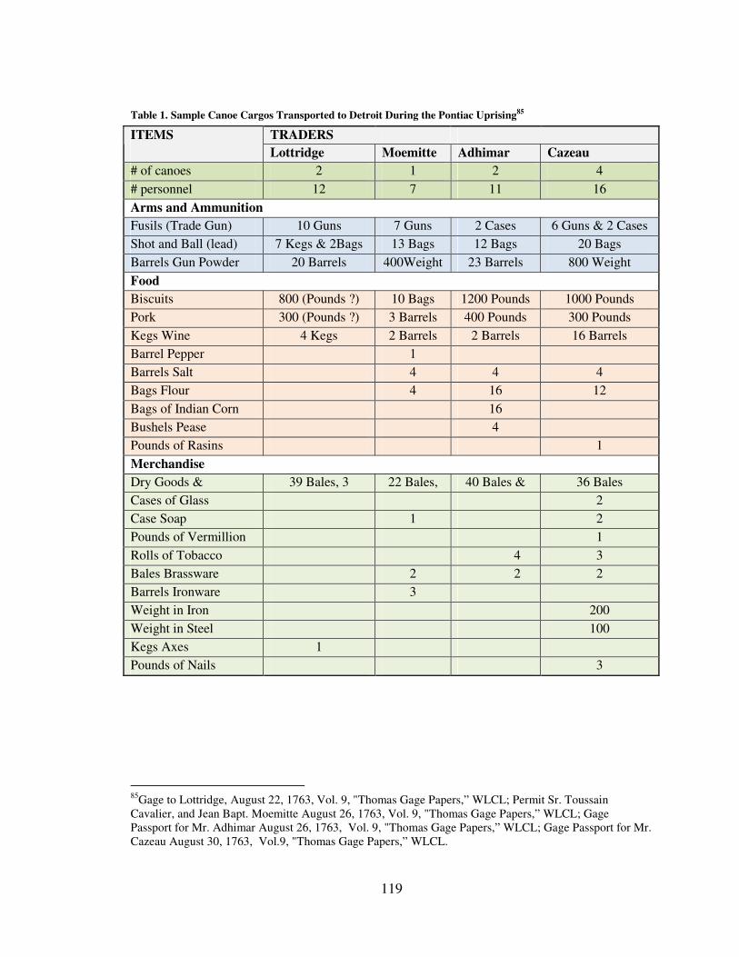
119
Table 1. Sample Canoe Cargos Transported to Detroit During the Pontiac Uprising85
85
Gage to Lottridge, August 22, 1763, Vol. 9, "Thomas Gage Papers,” WLCL; Permit Sr. Toussain
Cavalier, and Jean Bapt. Moemitte August 26, 1763, Vol. 9, "Thomas Gage Papers,” WLCL; Gage
Passport for Mr. Adhimar August 26, 1763, Vol. 9, "Thomas Gage Papers,” WLCL; Gage Passport for Mr.
Cazeau August 30, 1763, Vol.9, "Thomas Gage Papers,” WLCL.
TRADERS ITEMS
Lottridge Moemitte Adhimar Cazeau
# of canoes 2 1 2 4
# personnel 12 7 11 16
Arms and Ammunition
Fusils (Trade Gun) 10 Guns 7 Guns 2 Cases 6 Guns & 2 Cases
Shot and Ball (lead) 7 Kegs & 2Bags 13 Bags 12 Bags 20 Bags
Barrels Gun Powder 20 Barrels 400Weight 23 Barrels 800 Weight
Food
Biscuits 800 (Pounds ?) 10 Bags 1200 Pounds 1000 Pounds
Pork 300 (Pounds ?) 3 Barrels 400 Pounds 300 Pounds
Kegs Wine 4 Kegs 2 Barrels 2 Barrels 16 Barrels
Barrel Pepper 1
Barrels Salt 4 4 4
Bags Flour 4 16 12
Bags of Indian Corn 16
Bushels Pease 4
Pounds of Rasins 1
Merchandise
Dry Goods & 39 Bales, 3 22 Bales, 40 Bales & 36 Bales
Cases of Glass 2
Case Soap 1 2
Pounds of Vermillion 1
Rolls of Tobacco 4 3
Bales Brassware 2 2 2
Barrels Ironware 3
Weight in Iron 200
Weight in Steel 100
Kegs Axes 1
Pounds of Nails 3
120
toward the lower landing at the base of the escarpment when they were attacked by an
Indian war party. Stedman was one of only three people who escaped the attack. He rode
back to Fort Schlosser to raise the alarm that the portage route was under attack. In the
meantime two officers and eighty soldiers from the lower landing who had heard the
commotion attempted to come to the rescue but they too were ambushed and killed. The
loss of life was devastating and much of the equipment such as wagons and horses and
oxen were thrown into the Niagara gorge.86
The attack, so close to Fort Niagara,
demonstrated just how vulnerable the British were even as far east as the Niagara region.
The maritime transport system’s infrastructure was severely damaged. The series
of attacks across the Great Lakes and along the Niagara portage had within months
severely crippled the empire’s ability to transfer men and materials safely into the heart
of the region. In the weeks that followed the Devil’s Hole massacre, as the Niagara
portage ambush was called, the entire portage came under a type of siege where soldiers
who ventured too far from the small posts at the lower landing and Fort Schlosser
occasionally were found dead and scalped. On 12 October 1763, fifty Seneca Indians
attacked the cattle guard at Fort Schlosser and killed most of the oxen stored there.87
To
make matters worse the sloop Michigan had wrecked on the south shore of Lake Erie that
summer leaving only the schooner Huron left to transport provisions and troops to
Detroit from Niagara.88
As 1763 came to a close much of what had been built in the first
few years of British occupation was in shambles. Although the Indians around Detroit
86
Ahrens, The Devil’s Hole Massacre, 63–70. 87
Ibid., 82. 88
MacLeod, “Tap of the Garrison Drum,” 70.
121
began to seek peace terms as their inter-tribal alliances began to crumble, Amherst
himself returned to England in November with his reputation tarnished.89
General
Thomas Gage assumed command. The tools built to obtain Britain’s imperial goals
across so vast a distance would not only have to be rebuilt but the experience would
reshape them to be stronger than they had been before.
Recovery from the attacks required breaking the siege at Detroit, reoccupation of
captured posts, and reconstruction of the damage to the maritime cultural landscape.
These steps were needed to restore British military political strength but also to restore
the relationship between the British Empire and its new subjects. With Amherst’s
departure and Gage’s ascendency to the head of the British Army in North American the
British needed to address the issues that had lead to the war and restore a working
relationship with the Indians. It was clear that trade goods and presents must flow and
that it must do so fairly. The Indians had demonstrated that despite British military
power, the British system of empire in the western Great Lakes depended on peaceful
relations with the Indians. In November 1763 the Indians lifted the siege around Detroit.
Although hostile acts were decreasing in number the British began rebuilding the
maritime cultural landscape designed with the recent attacks in mind.
On 22 April 1764 Chief Engineer John Montresor received orders to proceed to
the Niagara carrying place to fortify its facilities in order to keep up communications with
the west.90
It was clear the old posts and pathways were not secure and despite the peace
negotiations with the western Indians that were taking place steps had to be taken to
89
Calloway, The Scratch of a Pen, 90. 90
Montresor, "The Montresor Journals," 254.
122
improve security. Montresor supervised the rebuilding and improvement of elements of
the maritime cultural landscape. Outside of Fort Niagara the chief components were the
lower landing at the base of the escarpment, the cradles that hauled materials up the side
of the hill, the road from there to Fort Schlosser with its few buildings, and the shipyard
at Navy Island.
The weakest component of the portage system was the road through the woods at
the top of the escarpment that paralleled a portion of the deep Niagara gorge. Montessor
brought with him over 600 men to help with construction and guard the workers.
Montresor’s plan was to construct a series of redoubts (a form of blockhouse) along the
road located no more than 1000 yards apart (Figure 14). Each redoubt was immediately
garrisoned as they were completed with some of them receiving cannon. Nine redoubts in
all were built along the road. To help minimize any chance of concealment along the
portage route groups of soldiers were assigned to clear away brush from 150 yards on
each side of the road.
Throughout the summer Montresor’s men were utilized throughout the portage.
At the lower landing for instance they improved the fortifications, worked on the cradles,
and built a wharf at the river’s edge.91
At the top of the escarpment he fortified the top of
the cradles with pickets and cannon to cover them from any attack. At the other end of
the portage at Fort Schlosser his men constructed a 100 foot wharf. Fort Schlosser was an
incredibly important staging area as the volume of relief supplies poured in. Montresor
91
Scott and Scott, An Archaeological Survey, 108.
123
reported in his journal that at one point in June there were over 4,600 barrels awaiting
shipment at the post.92
Additional elements of the maritime cultural landscape also received Montresor’s
attention. The shipyard at Navy Island, which was busy constructing new vessels, was
entrenched and surrounded by pickets. They built carriages for light six pounder cannon
for the boats and as a final element to complete the portage system Montresor traveled up
to the mouth of Lake Erie where it enters the Niagara River and selected a location to
build Fort Erie (Figure 15).93
By placing a final storage facility there the sloops and
schooners from Navy Island could pick up their cargos without having to pass through
the rapids and shallows that often delayed their re-entrance into the lake.
Several issues complicated the enormous amount of work Montresor’s men were
able to accomplish during the summer of 1764 along the Niagara Portage. For one thing
hostilities while winding down, had not ceased completely. Sir William Johnson had not
been idle and convinced the Seneca faction of the Iroquois Confederacy to not only stop
their attacks but to take up the hatchet against the western Indians that were still at war
with Britain. Montresor assigned some of these friendly Indians to conduct scouting
missions for a twelve mile radius yet some attacks still occurred. One soldier was scalped
and left with a tomahawk in his skull between the fourth and fifth redoubts. The culprits
were suspected of leaving escape canoes up the nearby Buffalo River which lies on the
southern side of Lake Erie just before it enters the Niagara River.
92
Montresor, "The Montresor Journals," 260–265. 93
Ibid., 270–272.
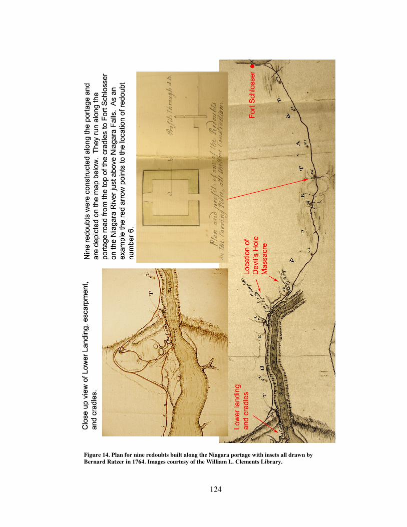
124
Figure 14. Plan for nine redoubts built along the Niagara portage with insets all drawn by
Bernard Ratzer in 1764. Images courtesy of the William L. Clements Library.
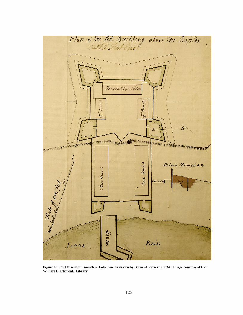
125
Figure 15. Fort Erie at the mouth of Lake Erie as drawn by Bernard Ratzer in 1764. Image courtesy of the
William L. Clements Library.
126
To complicate matters Sir William Johnson held a peace conference at Fort
Niagara which meant that hundreds of Indians were passing through the region on their
way to the conference at the same time that vast quantities of goods were headed west
over the portage, all of which had to be guarded. Tensions were running high and on at
least one occasion nervous British soldiers fired at three allied Indians, shooting one
through the leg.94
A final complication for Montresor was the same problem Naval
Department officers would face as the number of vessels on the lakes increased, namely
confusion of command. Montresor recorded in his journal how disorganized the
command seemed to be. In his view there was a “Total Discord in the Service at Niagara
Fort & in all orders from it. Disunion prevalent more Troops than are necessary yet none
to spare. In short Dissension predominant.”95
Yet despite all of these difficulties,
including the chaos of managing workmen assigned to several different projects miles
apart at the same time along the portage route, Montresor managed, in one summer, to
repair the elements of the maritime cultural landscape destroyed by the Indian attacks and
actually improve and increase them significantly. Cultural conflict created by Indian
resistance to British conceptions of the Indian’s place in the empire had reshaped the
landscape and exposed vulnerabilities on both sides. By the end of 1764 the British
Empire began expanding the maritime cultural landscape beyond Detroit into the furthest
reaches of the western Great Lakes in an attempt to secure their position.
Thus far this chapter has primarily been concerned with examples of the maritime
cultural landscape of the Niagara portage area. It contained examples of almost all of the
94
Ibid., 262. 95
Ibid., 261–262.
127
elements that were built or expanded by the British in their efforts to project power into
the western regions. Much of that landscape that developed in the western regions
occurred after the Pontiac Uprising when life and liberty were far less at risk while
developing new maritime resources. Many of the changes that took place to the maritime
cultural landscape over the next thirty years occurred as the number of vessels built to ply
the westernmost lakes grew and so will be discussed in chapter four’s discussion of the
vessels themselves. There are a few developments, though, that took place within the first
five years that are appropriate to mention here with regard to the regions around Detroit,
Michilimackinac, and St. Mary’s near Lake Superior.
Development of the Maritime Cultural Landscape on the Upper Lakes The French established Detroit in 1701. It was a key fur trade post located on the
Detroit River for nearly sixty years when the British took control of the post. Its small
craft maritime landscape connected the community to colonial cities in the east such as
Montreal and Quebec. Throughout the French period and the first few years of British
occupation the fort relied on a steady traffic of bateaux traveling up and down the river
ferrying firewood, stone for building, and men to islands where livestock were kept and
crops raised.
There were no facilities for large vessels. When the first British schooner arrived
in 1762 they had to drop anchor in the river as close to the fort as they could for
protection. After the siege ended wharves were built near the fort and defensive posts
constructed near the Rouge River to moor vessels. A similar situation existed at
Michilimackinac. Commanders at both posts used bateaux to ferry goods to and from
128
vessels to the shore. The practice was expensive in that the small craft were often worn
out quickly and constantly had to be replaced. Experimentation with other small craft
types such as pettiaugers had only limited success.96
The only long term solution was the
continued development of the maritime landscape by adding infrastructure such as
wharves. While such development took place early on and quickly in the Niagara region,
Pontiac’s Uprising brought infrastructure construction to a standstill in the more remote
posts like Detroit and Michilimackinac. In the earliest years of the British occupation in
these more western posts the process started almost from scratch.
Any and all information the British could gather on the natural geography was
crucial. Until such data could be gathered the first sloops and schooners had to operate
using local firsthand knowledge. When the first large vessels approached the Detroit
River at its mouth at Lake Erie for instance they had to learn to pass to the east side of
Bois Blanc Island which brought ships extremely close to the eastern shore near present
day Amherstburg. Without channel markers captains and local waterman had to quickly
develop and share this knowledge in order to preserve life and property. The development
of a maritime understanding of the landscape became important not only to those aboard
deep draft vessels but to those onshore such as soldiers in need of provisions, traders
awaiting their merchandise, and Indian Department officials looking for the
communications and Indian gifts they needed. In 1764 the Gladwin managed to pass over
the sandbar in Lake St. Clair and passed into the Huron River and Lake Huron bringing
96
Campbell to Gage, January 18, 1765, Vol. 30, ”Thomas Gage Papers," WLCL
129
not only provisions but the beginning of a large craft maritime cultural landscape to
Lakes Huron and Michigan.
Conclusion The British Army sought to expand the empire into the western Great Lakes
region in the closing years of the French and Indian war to establish control over former
French posts. For half a century both the French and British had sought to control Ohio
region south of Lake Erie, both sides believing it was the key to securing the rest of the
continent.97
By controlling the waterways that flowed through the region the British
could take advantage of new opportunities to create trade and diplomatic relationships
with western Indians . In doing so the British could enhance commerce and military
security. To do this they had to at first adopt the existing small craft maritime cultural
landscape but they also sought to expand it to include large sailing craft such as sloops
and schooners which provided more efficient means to transport large numbers of troops
and materials needed. One could look at a map of the western Great Lakes region and
draw lines that indicate the extent to which the empire grew throughout the region. Its
physical shape would be determined largely by the shorelines of lakes, rivers, ponds, and
geological features such as drainage basins, mountains, and escarpments. These
geographic features gain importance for the British because they had also influenced
where western Indians lived and how they traveled. The extent, however, that the empire
is able to reach those geographic boundaries was determined, at least within the Great
Lakes region, by the shape of the maritime cultural landscape which was a human
97
Calloway, The Scratch of a Pen, 4.
130
construction. The geography was of course something the British built their empire on
and around but it was influenced more than where things appear on a map. The natural
landscape the British faced in the early 1760s posed challenges for those who sought to
build a maritime system that would help move men and materials across hundreds of
miles of water. How they dealt with those challenges not only shaped the empire but the
lives of those who tried to overcome them.
Officers and soldiers developed portages, built ships, wharves, storehouses, and
explored new areas sometimes successfully. At other times their decisions met with
failure as when Charles Robertson misjudged the depth of water needed to move the first
schooner out of the Niagara River into Lake Erie. Nature’s changing water levels
frustrated his and General Amherst’s plans. Storms that wrecked ships and winter ice that
delayed shipments meant scurvy and sometimes death for those caught in their grip. It
was a cycle of adapting to nature, learning its lessons, sometimes painfully so, and
readapting to survive.
As the British built their expanded maritime cultural landscape they not only
interacted with the natural geography but with other cultures as well. Attempts to impose
the terms of their relationships with Great Lakes Indians and to expand their presence in
places like the Niagara portage were seen as a threat to Indian security and culture. The
ensuing conflicts with the Indians exerted their influence on the built environment. Some
elements were destroyed, others altered, and some newly created in yet another cycle of
build, learn lessons, and readapt to survive. Each iteration provides evidence of conflicts
and conditions under which the maritime cultural landscape developed. As Eric
131
Hinderaker has argued, eighteenth century empires in North America can be better
understood as processes created by interactions of peoples who could shape, challenge,
and resist colonialism in many ways all of which affected their final shape.98
The same
can be said for the development of the maritime cultural landscape in that it demonstrates
that it was not something the British could impose with impunity on the land and
inhabitants without being affected by people and natural geography involved.
In the Niagara portage area the facilities they developed such as the cradles,
storehouse, shipyards, defensive structures, and fortifications tell the story of British
objectives. Their decisions on where to build showed how ignorance of the geography by
those in authority caused severe delays in transporting needed provisions, Soldiers
thousands of miles from their homes found themselves caught in the midst of cultural
conflict created partially by British efforts to change the landscape along the portage
route. The physical structures help paint a picture of how the British tried to utilize the
landscape.
Christer Westerdahl’s article on maritime cultural landscapes, however, suggests
that we must look beyond just the human utilization of maritime spaces through boats,
and attendant uses such as wharves, settlements, shipping, fishing, lighthouses, and other
related activities. We need to see how people thought about the landscape as well.99
These cognitive aspects while not always visible in the natural environment are recorded
in place names and on maps such as “A Plan of the Straits of St. Mary, and
98
Eric Hinderaker, Elusive Empires: Constructing Colonialism in the Ohio Valley, 1673-1800 (Cambridge:
Cambridge University Press, 1999), xi. 99
Westerdahl, “Maritime Cultural Landscape,” 5.
132
Michilimakinac,” There we see the things that mattered to people most such as natural
resources, what was learned from and about other cultures, how to travel to far shores and
how to return safely home again.
All aspects and elements of the British maritime cultural landscape were designed
to operate within that environment. Bateaux were built to move men, materials, and
information upon the water, barrels were designed to keep water out and their contents in,
wharves to transition on and off shore, portages to travel from one body of water to the
next, and maps and oral piloting traditions, to safely span the enormous distances that
defined the boundaries of the empire.
Missing from this discussion of the British maritime cultural landscapes were the
schooners and sloops that much of that landscape was dedicated to support. This chapter,
however, intended to show that there was a complex network that worked with and in
support of the large vessels themselves. This is often overlooked by historians and
archaeologists who take a particularistic view of large vessels. This may be due to the
fact the vessels, by their ability to move from one shore to another along with their
human crews, have mobility other elements of the maritime cultural landscape do not.
Their travels connect elements of the maritime cultural landscape and their arrival in port
acts as a catalyst for actions in other regions. Vessels are often anthropomorphized to the
extent they are named, often have faces carved on the bows, referred to as “she” and can
share in a sailors’ sad fate by sinking to the bottom of the lake, facing a sort of death of
their own.

133
Despite this romantic view, large vessels were in fact only one part of the
maritime cultural landscape, both depended upon and dependent on the other elements.
Their stories, however, are complex and also inextricably linked to the empire which they
served and as such require closer study than can be provided within the scope of this
chapter. Chapter four provides a study of the British sloops and schooners constructed on
While much of their history and usage is covered in earlier chapters, one attribute of their
usefulness for cultural study has not yet been discussed. Naming practices for large
vessels provide insights as to what the British valued and how they attempted to influence
Indian tribes.
134
CHAPTER FOUR: ARMED FOR TRADE: TRANSPORTING EMPIRE INTO
THE WESTERN GREAT LAKES
Introduction Chapters two and three of this dissertation laid out the numerous elements that
comprised the maritime cultural landscape including wharves, portages, small craft,
seasonal fishing camps, and shipyards to name just a few. On their own each of these
places would have only local significance. Together, however, they are capable of acting
as catalysts for change in regions far and near. Farmers in Ireland shipped pork that
eventually made its way into the stomachs of so soldiers in the western Great Lakes thus
enabling the British Empire to maintain troop strength to enforce imperial goals in the
region.1 Merchants imported West Indian rum that in some cases devastated Indian
families and weakened tribal strength. British officers collected and shipped thousands of
native produced items back to England thus shaped their own persona and represented
Indian culture to the home audience shaping their views of American Indians.2 The
movement of these materials sparked the changes just described and in many cases on the
western Great Lakes during the British period it was the King’s sloops and schooners that
made these connections possible.
1 Campbell to Gage, April 27, 1764, "Thomas Gage Papers," William L Clements Library (WLCL), Ann
Arbor, Michigan. 2 Maya Jasanoff, Edge of Empire: Lives, Culture, and Conquest in the East, 1750-1850 (New York:
Vintage Books, 2006), 8.
135
Of course the British-built sloops and schooners that sailed the western Great
Lakes during the late eighteenth century would not have been able to perform their
functions had it not been for the other elements that made up the transport system. They
needed shipyards to exist, wharves to receive and unload their cargos, sailors and
captains to guide them across the lakes, warehouses and forts to store and protect their
cargoes. Finally they needed consumers and suppliers to create the cargos they
transported. This perspective of vessels as part of a larger transport system that allowed
them to act as catalysts of change allow can help one to view the vessels in context in
which they operated.
Just as the Great Lakes region in the late eighteenth century should not be viewed
merely as a geographic container in which human events take place, vessels such as the
British sloops and schooners built on the western Great Lakes should not be seen as just
floating boxes moving from one wharf to another. While it’s important to remember the
context in which they operated, i.e. as an element of the maritime cultural landscape, they
also hold a unique place in that they were the mobile components that connected distant
landscapes to each other and allowed them to act as one cohesive system. They served
multiple functions in the British Army’s efforts to expand the empire into the heart of
North America and because of that they can be studied from several different
perspectives, perhaps more so than any other element of the maritime cultural landscape.
In his book Maritime Archaeology underwater archaeologist Keith Muckelroy
sought to offer frameworks for studying ships archaeologists could use to take them
136
beyond particularistic investigations of a shipwreck’s remains.3 Muckelroy suggested
researchers view ships in broader contexts and offered three suggestions for analysis:
1. Ship as machine designed to harness wind power to act as a means of
transport
2. Ship as element in a military or economic system
3. Ship as closed community with its own hierarchy, customs, and
conventions.4
This offers a useful starting point for understanding the British sloops and
schooners built on the western Great Lakes during the late eighteenth century. Each of
Muckelroy’s three frameworks can easily be applied to the British vessels. For instance,
the sloops and schooners were of course machines that provided a means of transport. As
such they can be viewed as an artifact utilized by both the British Army and private
merchants. How they were constructed, what criteria influenced their design, the
materials used, and perhaps most importantly how those these elements changed over
time will shed light on how the British Army approached asserting control over the
region.
The first British vessels on the western Great Lakes were built and operated by
the British Army and operated as armed transports yet they also carried merchant goods
from the very start. In this sense then they encompassed both aspects of Muckelroy’s
second function: ship as element in a military or economic system.5 This chapter will
examine how British military leaders balanced these roles and the value they placed on
3 While the term “ship” technically refers to a three masted squared rigged vessel it is often used as a
generic term for large sailing vessels as Muckelroy does here. Muckelroy’s comments can be applied to
any shipwreck or vessel study regardless of rigging or vessel design. When possible, however, I refer to a
specific rig such as sloop or schooner. 4 Keith Muckelroy, Maritime Archaeology (Cambridge: Cambridge University Press, 1979), 216.
5 Muckelroy, Maritime Archaeology, 216.
137
these two aspects of empire: political control and economic dominance. Initially all large
sailing vessels built on the western lakes were owned and operated by the British Army
but within ten years private ship building also began. This divergence highlights the
different goals of the Army and merchants within the region as to how they approached
developing and using the maritime cultural landscape. A detailed analysis of how the
military and naval functions of the King’s vessels impacted power relationships in the
region will be discussed in Chapter five.
Throughout the eighteenth century the British Army struggled to man their
vessels. High desertion rates and competition from private shipping meant that the sailing
workforce was quite fluid. In this sense it might seem that British vessels might not have
been the closed communities that Muckelroy suggests yet, as will be discussed later in
this chapter, over time the manner in which the British Army manned and operated their
vessels did in fact create unique cultural characteristics and attitudes about the crews that
lived, sailed and died aboard the sloops and schooners that plied the lakes. Evidence
suggests that these vessels were also places of cultural conflict for the British sailors,
soldiers, French, Indians, and free and slave blacks that were either crew members or
passengers. Incidents aboard the vessels shed light on the culture developing the region.
Due to the unique circumstances, compressed time frames and the geographic
region in which they operated, however, when studied as a group the vessels built there
during this period offer these and many additional avenues for investigation. Such an
analysis sheds light on how the British Empire functioned within the western Great Lakes
on both macro and micro historical levels. In addition to Muckelroy’s three avenues for
138
exploration and their subdivisions already mentioned, the vessels were elements in a
convoluted chain of command. Studying how well or how poorly the British Army ran its
own inland navy reveals much about their efforts to project power into a relatively
unknown (to the British at least) and somewhat hostile territory and maritime
environment. Different authority figures, both civil and military, attempted to shape the
chain of command to suit their needs. The degree to which the service was formalized
changed over time.
The vessels can also be examined in light of their function as a carrier of material
culture. This chapter will examine the types of cargos both military and merchant vessels
carried into and out of the region in order to gain insights into the values its inhabitants
placed on materials goods. Merchants, farmers, soldiers, sailors, Indians, and Indian
department personnel all imported and exported goods for political, diplomatic, business,
and personal reasons. Examining this material will shed light on how this seemingly
remote region was connected both to the empire and the world.
Muckelroy’s groundbreaking work was published thirteen years before Christer
Westerdahl introduced the concept of the maritime cultural landscape. Although
Muckelroy does discuss the concept of a vessel’s place within military and commercial
systems it still does so in a rather ship specific and isolated way. The concept of the
maritime cultural landscape seeks to unify the elements that were part of maritime culture
within a geographic region. Combining these two approaches in this chapter allows us to
see how examining all of Muckelroy’s views of vessels and placing them in context
within the maritime cultural landscape will reflect the British experience of trying to
139
build an empire in a maritime region. The cargos that sloops and schooners carried across
the lakes can also tell us about empire on a personal level. Consumers awaited shipments
of food, fiddle strings, and thousands of other items all of which had to be imported into
the region via the maritime cultural landscape. As the vessels were the unifying element
in those geographically distant segments of maritime landscapes their movements from
one port to another brought all of the aspects of their existence described above into one
overarching role not really described by either Muckelroy or Westerdahl alone, that is,
vessel as catalyst. Their arrival in port sparked change, sometimes by bringing life-giving
food, news of war, the tools of commerce, or the chance to return home to England or the
eastern seaboard. Their story connects the high level plans of imperial planners to the
reality of empire on the ground. Storms, corruption, violence, sickness were the chaotic
variables that few could accurately plan for but had the power to cancel the best of plans.
This chapter argues that it is the ship’s role as catalyst that makes the earliest sloops and
schooners, both military and commercial, worthy of study and offers the potential to see
the expansion of the British Empire in the western Great Lakes in new ways as they were
a critical component in the development of the region’s maritime culture.6 It wasn’t just
the successful or unsuccessful arrival of a vessel that made it a catalyst for change but the
knowledge or lack thereof of a vessel’s success by the parties who it most concerned that
could impact the shape of empire as well. Indian’s besieging Detroit during Pontiac’s
Uprising for instance were concerned not only about schooners bringing relief supplies
6 For a detailed narrative of individual ships and personnel across all of the Great Lakes and Lakes
Champlain and George see Carol MacLeod’s 1983 unpublished manuscript, “Tap of the Garrison Drum”
produced for Parks Canada’s Historical Research & Records Unit.
140
but about how knowledge of those vessels would impact Indian moral and the
cohesiveness of the pan Indian alliance.
Building Large Sailing Vessels on the Western Great Lakes No plans exist and little is known for certain about the way the earliest British
vessels on the western Great Lakes were built from a nautical architectural perspective.
Ship designs have to be sensitive to the environment in which the vessels operate but for
the British, the navigational characteristics of the western Great Lakes were relatively
unknown. Therefore studying the construction process they used and the decisions they
made shows the level of risk they were willing to expose men and materials to in their
quest to expand the empire.
Initially the British Army’s most pressing concern was quickly projecting power
in the western Great Lakes region. This haste influenced numerous aspects of ship
building such as location selection, materials, manpower and design. As time passed the
sense of urgency declined. Indian conflicts such as the Pontiac Uprising subsided and the
merchants and military presence grew. These changes were reflected in the ways ships
were constructed throughout the mid to late eighteenth century in the region. Between
1761 when the British Army first started building large sailing vessels for the western
Great Lakes and 1796 when they turned over their military posts at Niagara, Detroit, and
Michilimackinac to the United States, the British Army and British merchants built
approximately twenty three large vessels: eleven schooners, seven sloops, three gunboats,
141
and two snows.7 The main difference between the two most predominant types, sloops
and schooners as well as snows is in the manner in which they were rigged (the types and
configurations of sails installed on a vessel).
For the purposes of this discussion it is helpful to understand that technically hulls
could be either sloop or schooner rigged although over this thirty five year period
schooners were typically slightly larger vessels averaging 81 tons compared to 65 tons
for sloops. Vessel captains, in consultation with their superiors, could make rigging
changes based on their experience with the vessels. A bad decision could have disastrous
consequences and lead to shipwrecks and the loss of life and cargos. The two snows for
which we have tonnage figures were both over 100 tons.8 As can be seen from the above
numbers schooners were the dominate rig and continued to be so into the nineteenth
century due to their sailing qualities, which were well suited for the conditions on the
Great Lakes where vessels were rarely ever more than fifty miles from shore. While the
sailing qualities of the different rigs in the early British vessels were certainly important
so too was the size and shape of their hulls (Figure 16 and Figure 17).
British General Jeffery Amherst had stressed the need to build vessels quickly in
order to project British power into the west. Although Amherst sent cartographers to
survey Lake Erie and the entrance to the Huron River he had expected the first of the
7 Carol MacLeod, “The Tap of the Garrison Drum: The Marine Service in British North America 1755-
1813,” Unpublished Manuscript (Parks Canada, Historical Research & Records Unit, 1983), 369. 8 Tonnage figures for sailing vessels typically refer to an estimate of the amount of cargo the vessel can
carry. It is calculated by a formula that takes the vessel’s length, maximum beam, and depth of hold into
account. The exact formula has changed over time including by an Act of Parliament in 1773. In some
cases when referring to military vessels tonnage refers to the tonnage of water displaced by the vessel as
military vessels were not typically employed as cargo carriers. In the case of the British Army vessels on
the western Great Lakes it is likely that comments on tonnage in contemporary documents refer to cargo
capacity since the vessels were used primarily as transports.
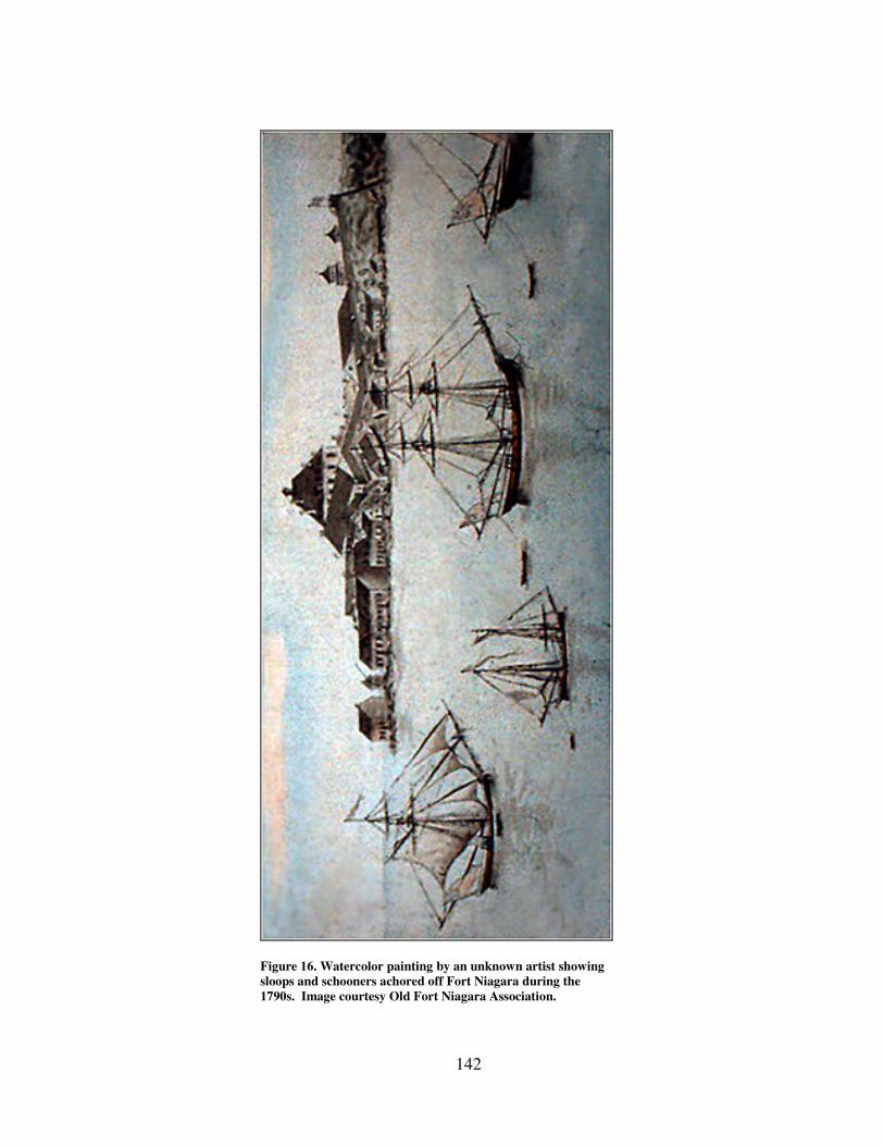
142
Figure 16. Watercolor painting by an unknown artist showing
sloops and schooners achored off Fort Niagara during the
1790s. Image courtesy Old Fort Niagara Association.
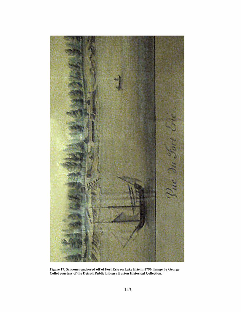
143
Figure 17. Schooner anchored off of Fort Erie on Lake Erie in 1796. Image by George
Collot courtesy of the Detroit Public Library Burton Historical Collection.
144
sailing vessels to have already been launched. In other words he had not planned on
waiting for their report prior to building the vessels. Amherst’s rush to build the vessels
would cause problems that plagued the British for years.
Hull Forms Unacquainted with the western lakes’ bathometry as they were, almost all of the
vessels built before 1770, and most of which were built before 1765, had deep drafts that
caused them problems in many shallow areas of the lakes. All of these early vessels were
built at Navy Island in the Niagara River. The first two almost never got out of the river
and into Lake Erie due to the shallow rapids at the mouth of the lake.
Amherst had intended the first vessels to go beyond Detroit up into Lakes Huron
and Michigan to explore. River channels recorded in one of the earliest surveys using
bateaux had indicated there was sufficient depth for large vessels to pass into the Huron
River but upon his arrival with the first schooner, Lt. Charles Robertson was unable to
find it. Consequently neither of the first two built – the schooner Huron nor the sloop
Michigan – were able to clear the sand bar that separated Lake St. Claire from the Huron
River which leads to Lake Huron.9 It was not until 1764 that the schooner Gladwin
sailing under Captain Sinclair had somehow managed to make it over the sand bar in an
attempt to take provisions north to Fort Michilimackinac. Sinclair informed the
commandant at Detroit that it would be unsafe to try and bring the vessel back over the
bar to reach Detroit.10
9 Amherst to Robertson, June 22, 1761, "Amherst Papers," Library of Congress (LOC), Washington, DC.
10 Gage to Campbell, November 10, 1764, Vol. 26, “Thomas Gage Papers,” WLCL.
145
The practice put in place was for vessels to sail north from Detroit to the sand bar
and to transfer their goods via bateaux to the Gladwin on the other side of the bar. In
General Gage’s opinion it was an unsatisfactory arrangement that exposed men and
materials to attack while busy transferring cargo. Gage had taken command of British
North American forces after General Amherst had returned to England in late 1763. In
Gage’s correspondence with post commandants and ship captains he expressed his
disgust that the first ships had not been properly designed to clear the bar. He felt that the
project had been “bungled.”11
In fairness, Lt. Charles Robertson and Naval Department
Superintendent Joshua Loring, who had overseen the construction of vessels built prior to
1765, had had little accurate information to work with. Widely fluctuating water levels
also made designing the proper hull difficult. By the end of the 1760s members of the
maritime community, both military and commercial, working in the region accumulated
the firsthand knowledge needed to build a vessel that could pass back and forth from
Detroit through Lake St. Claire and up through Lake Huron to Fort Michilimackinac.
Even with shallower draft vessels, however, the vessels were never able to anchor close
to Fort Michilimackinac. Their cargos had to be offloaded to bateaux and ferried to shore
until the post was relocated to Mackinaw Island with its deeper harbor in the 1780s.
By the late 1780s both the military and merchants understood the geographic
constraints shallow water placed on hull design. The most significant architectural change
instituted was the use of a more flat bottomed hull to reduce the depth of hold. What we
know about specific construction details come from the only known example of an
11
Gage to Turnbull, June 21, 1768, Vol. 78, “Thomas Gage Papers,” WLCL.
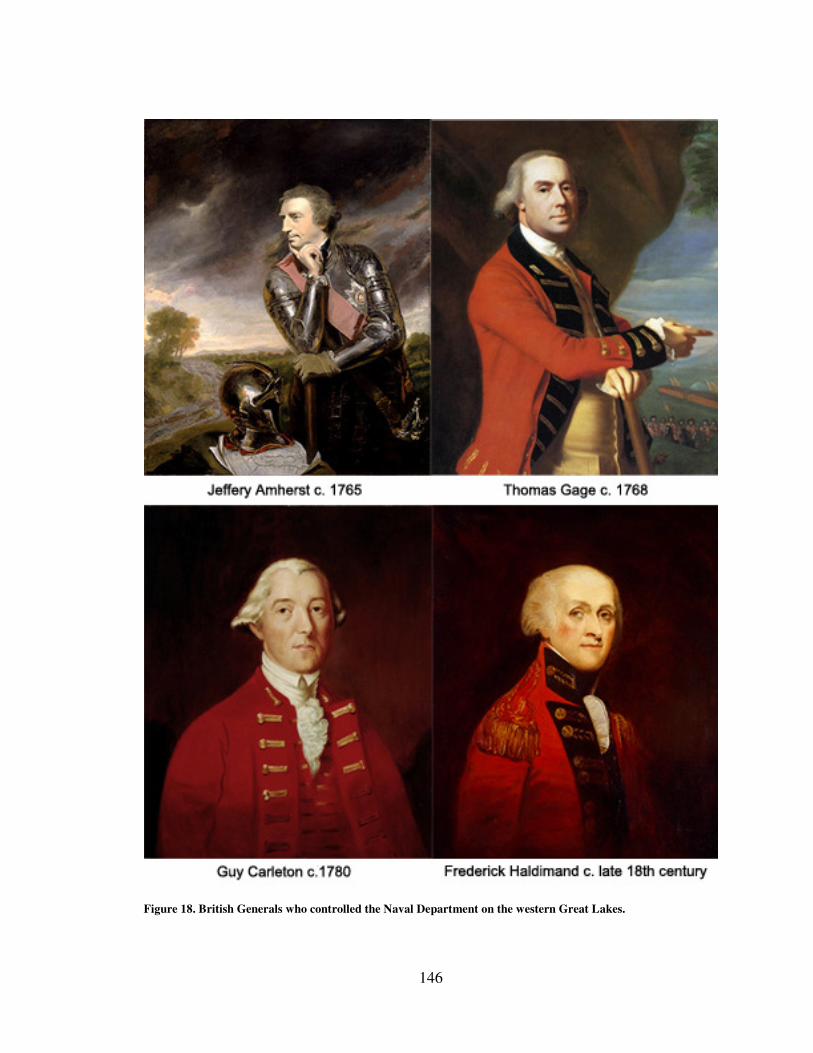
146
Figure 18. British Generals who controlled the Naval Department on the western Great Lakes.
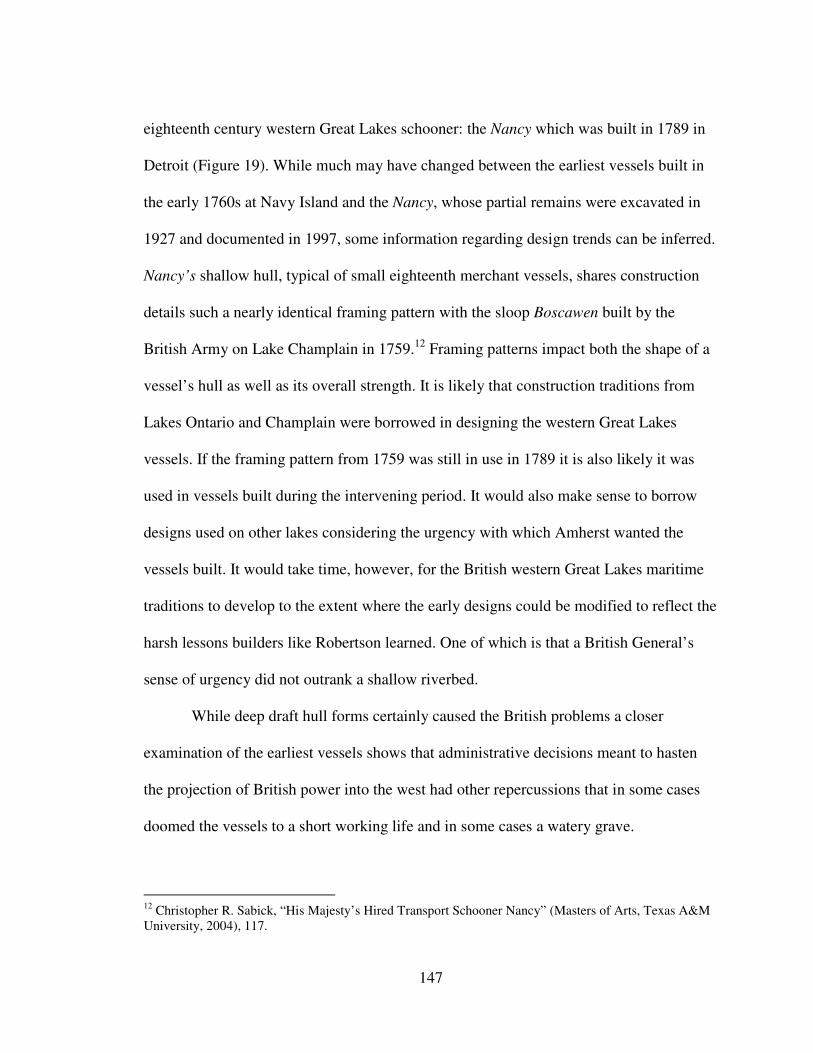
147
eighteenth century western Great Lakes schooner: the Nancy which was built in 1789 in
Detroit (Figure 19). While much may have changed between the earliest vessels built in
the early 1760s at Navy Island and the Nancy, whose partial remains were excavated in
1927 and documented in 1997, some information regarding design trends can be inferred.
Nancy’s shallow hull, typical of small eighteenth merchant vessels, shares construction
details such a nearly identical framing pattern with the sloop Boscawen built by the
British Army on Lake Champlain in 1759.12
Framing patterns impact both the shape of a
vessel’s hull as well as its overall strength. It is likely that construction traditions from
Lakes Ontario and Champlain were borrowed in designing the western Great Lakes
vessels. If the framing pattern from 1759 was still in use in 1789 it is also likely it was
used in vessels built during the intervening period. It would also make sense to borrow
designs used on other lakes considering the urgency with which Amherst wanted the
vessels built. It would take time, however, for the British western Great Lakes maritime
traditions to develop to the extent where the early designs could be modified to reflect the
harsh lessons builders like Robertson learned. One of which is that a British General’s
sense of urgency did not outrank a shallow riverbed.
While deep draft hull forms certainly caused the British problems a closer
examination of the earliest vessels shows that administrative decisions meant to hasten
the projection of British power into the west had other repercussions that in some cases
doomed the vessels to a short working life and in some cases a watery grave.
12
Christopher R. Sabick, “His Majesty’s Hired Transport Schooner Nancy” (Masters of Arts, Texas A&M
University, 2004), 117.
148
Building the Vessels After the fall of Montreal and the surrender of the French posts on the Great
Lakes Amherst was eager to man the fortifications and establish British sovereignty in
the region.13
He wanted the first vessels to accompany the troops sent west to occupy
Detroit and Michilimackinac. Because shipbuilding supplies and contracted shipbuilders
had to be sent into the region Amherst ordered Lieutenant Charles Robertson to build the
first shipyard as close to Fort Niagara as possible on Navy Island (Figure 20). This not
only reflected the Army’s need to control costs, which during the war had added
enormous debt to the British government, but also the geographic limit of the Army’s
control. Had they tried to build the vessels any further west before establishing a secure
military presence, they would have been in grave danger from attack from hostile
Indians. The enormous effort it took to establish a shipyard above Niagara Falls and the
close tabs Amherst kept on its progress illustrates how important large vessels were to his
plans for the west. He believed that maintaining posts at Detroit and Michilimackinac
required the larger cargo capacities that sloops and schooners could carry compared with
smaller bateaux. The sloop Michigan for instance could carry up to 500 barrels of
provisions compared to thirty or forty in a bateau depending on its size.14
Despite the
sense of urgency that Amherst tried to impart to his officers, artificers at the small
shipyard at Navy Island in the Niagara River had not completed the first vessel by the
13
MacLeod, "The Tap of the Garrison Drum," 60. 14
Ibid., 66.

149
Figure 19. Line drawings of schooner Nancy built at Detroit
in 1789. Drawing by Christopher Sabick.
150
time the troops bound for Detroit arrived, greatly disappointing Amherst.15
British troops
used bateaux to reach Detroit instead. After the first vessel, Huron, was completed and
sailed to Detroit under Lieutenant Charles Robertson, Amherst ordered Joshua Loring to
go to Niagara to build additional vessels hopefully faster than the first two had been
constructed. Amherst, however, ever mindful of expenses, was not willing to spend
unlimited funds to forward his project. Although he did allow Loring to hire one caulker
and four sawyers the rest of his crew were soldiers taken from local regiments stationed
in the area.
Green Wood In May 1763 an alliance of western Great Lakes Indians attacked Detroit in an
effort to remove the British from the region thus resisting the British attempt to impose
empire upon them. The newly launched schooner Huron transported men and supplies to
Detroit during the Indian siege thus keeping a lifeline open to the distant post. The sloop
Michigan which was the second vessel launched at Navy Island wrecked in1763 and was
a total loss. General Thomas Gage, who had replaced Amherst when he was recalled to
England, requested additional vessels built at Navy Island in 1764. Three schooners were
launched and brought into service that year. Like the earlier vessels though they were
built in great haste.
15
Amherst to Walters, November 23, 1761, “Amherst Papers,” LOC.
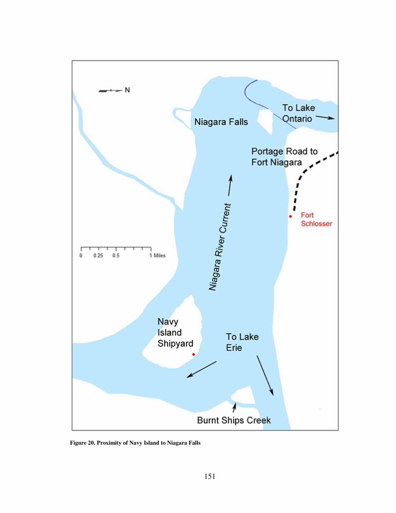
151
Figure 20. Proximity of Navy Island to Niagara Falls
152
The Army’s imperial goal of quickly creating vessels to support the western posts
meant that short cuts were taken, the worst of which was the need to use green
unseasoned timber to build the vessels. This turned one of Navy Island’s chief assets, a
plentiful supply of hardwoods to use as ship’s timbers, into a liability. Green or
unseasoned wood refers to freshly cut wood that still contains natural moisture that helps
maintain the plant’s cell structure. As the wood dries it shrinks and warps. In a sailing
vessel this means that watertight joints become loose which creates leaks. Gage himself
recognized the issue and when told one of the vessels might be unfit for service after only
a few years commented, “she is not an old vessel, but being built with green wood, they
will not last so long as if the wood was properly seasoned.”16
The issue continued to
plague the British during the 1760s as the vessels’ decks had to be occasionally be wetted
down to help preserve their shape.17
In fact during the winter when the vessels could not
sail due to ice it was not uncommon to purposely sink them in order to preserve them for
future use.18
Although at least five vessels were built at Navy Island during the 1760s the
issues that came with the remoteness of the shipyard’s location contributed to the
destruction of two vessels and the removal of the shipyard to Detroit. The Niagara
portage, however, was still an intensely busy stretch of land between Lakes Erie and
Ontario. Vessels were moored near Navy Island, across the river in a small creek at the
tip of Grand Island, or up the Chippewa Creek that feeds the Niagara River to the west.
16
Gage to Turnbull, June 21,1768, Vol. 78, “Thomas Gage Papers,” WLCL. 17
Sinclair to Gage, May 15, 1766, Vol. 51, "Thomas Gage Papers," WLCL. 18
MacLeod, "The Tap of the Garrison Drum," 63.
153
These mooring locations lay almost mid way between Fort Erie and Fort Niagara. The
small post at Fort Schlosser was the closest to Navy Island but even that was
approximately two miles away. In 1766 and again in 1768 vessels, moored for the winter,
were accidentally burned by persons passing through the area who may have taken refuge
aboard the vessels for the night and built a fire on board to stay warm that was not
properly extinguished. In the case of the 1766 vessel an officer had visited it only two
weeks prior and complained about its sad condition.19
It was clear that the Army’s
attention had shifted to Detroit by this point since that post had grown. No vessels were
ever built at Navy Island again.
When in 1770 Gage briefly considered building new vessels at Navy Island two
of his subordinate officers quickly pointed out the benefits of building at Detroit. Ships
could be built a few yards from the fort at Detroit thus offering greater security and
Detroit had a supply of seasoned wood prepared. The substantial settlement at Detroit
would prove far less troublesome than the isolated island in the Niagara River.20
In short
the empire had grown beyond the need to make do with green timber built in a location
difficult to support. Detroit had grown to a point where at least some of the equipment
needed for the vessels could be provided locally. This elevated the Detroit region into the
true center of the British Great Lakes compared to the Niagara region which still had did
not have the settler population on the scale of Detroit. Suppliers at Detroit were better
situated to quickly ship materials north to Michilimackinac, east to Niagara, or southwest
to post in the Illinois region. The maritime cultural landscape had matured in the Detroit
19
Ibid., 87. 20
Gage to Commanding Officer at Detroit, September 29, 1770, Vol. 96, “Thomas Gage Papers,” WLCL.
154
region to better suit British needs. The Niagara River region wouldn’t develop to that
extent until nearly the nineteenth century.
The Chain of Command Expanding and maintaining the British Empire throughout the world required the
intellectual and physical resources of millions of people including policy planners in
London, British generals on the scene, common soldiers and sailors, farmers, artisans,
and merchants along with many more. In regions like the western Great Lakes perhaps no
one individual could play such an important role as the General in charge of British
forces in North America and in later years the civil governors. Men like Amherst, who
despised the Indians and was frugal to a fault, and Gage who was perhaps slightly more
pragmatic did much to influence those that served underneath them. Later leaders like
Frederick Haldimand and Guy Carleton had the benefit of not having to start a transport
fleet on the western lakes from scratch nor face the Indian uprising that Amherst and
Gage did. Carleton and Haldimand’s objectives for the maritime aspects of the empire
included introducing more professional and formal practices as they sought to bring order
to the seemingly rag tag collection of vessels, captains and sailors that made up the Naval
Department (as it came to be called) on the Great Lakes. The chain of command that all
these leaders presided over with regard to the vessels certainly influenced both the
military and the merchants that made up the forward most forces of the British Empire.
By the time the first vessels were built at Navy Island in the early 1760s the Royal
Navy had already withdrawn its support of the inland fleet that served the British Army.
All of the Navy’s efforts to support the Army in Lake Ontario in the early years of the
155
French and Indian War had been for naught. After the fall of Oswego to the French and
the surrender of the vessels the Navy had helped build, the Army was on its own.
Running a navy was apparently not something that came naturally to the Army, and as
important as having a waterborne transport service was to spreading British imperial
power through a region dominated by lakes and rivers, the Army struggled with how to
reconcile the chain of command between vessel captains and post commandants. Many
aspects of the organization’s structure were confusing and inconsistent despite periodic
efforts to create a more formal military culture.
Amherst had created and fostered a waterborne transport service initially on the
Lakes Champlain, George, and Ontario to serve two primary goals: first to transport men
and materials and second to counter any French vessels that could hinder his troop
movements.21
To do that, however, he needed someone with logistics and naval
experience. He turned to Joshua Loring of Massachusetts who had been an agent for
coordinating transports leaving England to head to North America during the early years
of the French and Indian War. Amherst had tasked him with preparing vessels on Lake
Champlain and Lake George. Afterwards Loring reported directly to Amherst and
provided advice and on site assistance with constructing vessels and finding officers to
command them for the western Great Lakes.22
Loring searched the army regiments looking for officers with any Royal Navy
experience and found two who had served for a brief period as midshipmen, Lt. Charles
21
Early cargos included Indian presents needed to entice Indians to join the British cause. In later years
members of the Indian Department would acquire their own vessels. 22
MacLeod, "The Tap of the Garrison Drum," 76.
156
Robertson and Alexander Grant. Navy personnel were not attracted to the region because
serving under the Army on the lakes offered no opportunities for advancement in the
Royal Navy. A few army officers, however, were attracted to the service, such as Patrick
Sinclair who would serve on Lake Huron and at Fort Michilimackinac in the hopes of
advancing his career in the army. Attracting sailors to man the vessels was another
matter. Amherst at first tried contracting sailors but had little success. Instead he
seconded them from the regular army regiments but refused to pay them for the
additional duty.23
Throughout the eighteenth century regardless of the commanding officer or
civilian governors the single greatest cause of confusion and disagreements came from
the structure of the chain of command for vessel captains. Although various officers such
as Joshua Loring and Alexander Grant were responsible for of all vessels on Lakes Erie,
Huron, and Michigan the vessel captains underneath them took sailing and cargo orders
from the post commandants at Niagara, Detroit, and Michilimackinac. This resulted in
countermanded orders and changed priorities.
From the beginning Amherst pushed Robertson to complete the first vessels at
Navy Island with all dispatch yet Robertson was also ordered to sail the first vessel to
Detroit under Major Gladwin who was to take command of the post at Detroit.24
Upon
Gladwin’s arrival at Navy Island he ordered a halt to work on the vessels and ordered
Robertson to work on different small craft.25
Even Loring, who answered to directly to
23
Ibid. 24
Robertson to Amherst, July 23, 1761, "Amherst Papers," LOC; Amherst to Robertson, May 6, 1761,
“Amherst Papers,” LOC. 25
MacLeod, "The Tap of the Garrison Drum," 62.
157
Amherst and then to Gage, at times had his shipyard workers taken away to work on
other projects by order of the commandant at Fort Niagara.26
The situation must have been frustrating for Loring. Gage ordered Loring in 1765
to head up the lakes to visit every vessel and make sure the crews were properly
disciplined and that the vessels were operating in good order, servicing both the Army’s
transport needs and those of the post commanders. For good measure he was also
directed to send Captain Sinclair on a mission to explore Lakes Huron and Michigan.27
Gage himself caused much of the confusion. In a letter to the commandant at Detroit only
a few months after sending his letters to Loring, Gage ordered the commandant to make
sure to order the vessel to supply Michilimackinac but added, “when she is not otherwise
employed you can’t do better than to Order her to explore every part of Lake Huron as
well as Lake Michigan.”28
Captain Howard, who commanded at Michilimackinac had
demanded that his needs be met prior to any survey of the lake.29
Yet Gage had also
written that Howard would have to make do and that the vessels couldn’t “be wanted all
summer to transport provisions alone.” 30
Vessel superintendents and post commanders disagreed over who had the
authority to direct where the vessels wintered. Gage forbid army officers from interfering
with the vessels or conduct of sailors while onboard yet several times post commanders
sent orders dictating where the vessels were to winter. In one case, however, Captain
Sinclair refused to risk bringing the schooner Gladwin back across the sand bar at the
26
Loring to Gage, September 2, 1764, Vol. 24, “Thomas Gage Papers,” WLCL. 27
Gage to Loring, April 22, 1765, Vol. 34, “Thomas Gage Papers,” WLCL. 28
Gage to Campbell, July 15, 1765, Vol. 39, “Thomas Gage Papers,” WLCL. 29
Campbell to Gage, May 31,1765, Vol.37, “Thomas Gage Papers,” WLCL.. 30
Gage to Campbell, April 20, 1765, Vol. 34, “Thomas Gage Papers,” WLCL.
158
entrance to Lake St. Claire and instead created his own wintering post on the Pine River
near Lake Huron. Even in later years the advice and concerns of those directly
responsible for maintaining the vessels was ignored if a post commander had other plans.
In the late 1770’s Captain Sinclair had by then become the Lt. Governor stationed at
Michilimackinac and insisted that the sloop Welcome winter there at his fort despite the
wishes of Alexander Grant who at that time was senior officer in charge of all vessels on
the western Great Lakes. Grant believed the vessels needed to come down to a safer
mooring location near Detroit but was overruled by Sinclair. A winter storm drove the
Welcome out of the harbor and damaged the vessel beyond repair proving Grant right.31
Even in sailing matters vessel captains who arguably knew best when to take
advantage of the weather to set sail found themselves in trouble with post commandants
who felt it was their responsibility to give the final order. As late as 1792 vessel captains
were still complaining of the trouble this system gave them. Alexander Harrow, Captain
of the Chippawa wrote,
I daresay you will admit there is reason in my anxiety to be satisfied In
this when I tell you that hitherto orders have been through so many
Different channels and in so many ways communicated to me that I am
afraid of doing wrong in losing of moments Fair wind which I am
enjoined not to do by an order from the commander...32
Although the vessels played a critical role in provisioning the posts, transporting
men and communications, and occasionally merchant goods, army officers sometimes
made decisions that countermanded those of the vessel superintendents. This caused
31
MacLeod, “The Tap of the Garrison Drum," 146. 32
Alexander Harrow, “On Board the Dunmore,” October 23 1792, Detroit Public Library. Burton
Historical Collection, Detroit, Michigan.
159
confusion and hindered the British Army’s ability to use the vessels efficiently. The
resulting conflicts which incurred delays, arrests, and even shipwrecks prevented the
empire from operating throughout the western Great Lakes to its utmost potential. The
Naval Department’s inefficient management likely prevented execution of some of the
early goals that even Amherst had for the western lakes. Early goals for exploration and
fuller development of the region’s resources could not take place so long as the vessels
were continuously operating on a limited budget, were under manned, and poorly
organized. The potential for tapping the resources of Lake Superior, the largest of the
lakes was also delayed and in fact the first large vessel constructed on that lake in the
British period was built by merchants and not the Naval Department.33
By 1767 the enormous costs associated with keeping a standing army in North
America strained the British treasury. In the wake of failed efforts to raise additional
funds such as the Stamp Act, the government looked to cut costs where possible. In a
manner more reminiscent of the late twentieth century the British Army decided to
outsource the cost of maintaining the vessels on the Great Lakes. London merchant John
Blackburn signed a contract to take over management of the vessels in 1767. For £3,200
per annum Blackburn’s agent on the lakes would take receipt of the King’s vessels,
delivered in good order, and manage their maintenance and operation. This included
manning the vessels and making normal repairs. This was meant to relieve the Army
from the frequent problems of a shortage of qualified sailors, high labor costs, and the
33
Alexander Henry, Travels & Adventures in Canada and the Indian Territories Between the Years 1760
and 1776 (New York: I. Riley, 1809), 226, Google ebook, http://books.google.com/books?id=WjnGWp-
zufAC.
160
numerous repairs needed. 34
The contract called for Blackburn to operate one vessel on
each lake. He was not, however, responsible for major repairs or if any of the vessels
were lost due to storm, fire, or capture. While this helped standardize some aspects of the
service the vessels were still under the command of the Army and the crews were still
subject to military orders. The three year contract must have been viewed as successful to
some extent in that it was renewed several times, although it was ended in 1776 when the
Army took back command of the vessels due to the start of the Revolutionary War.
Years of minimal repair budgets took their toll, however, as Gage himself noted
that the Army had a difficult time in turning the vessels over in good condition. As
Blackburn was not responsible for major repairs the army tried to make do but each year
the delayed repairs only grew worse and worse.35
A second problem was that not all of
the vessels were kept in service, and although they were supposedly maintained at least to
the extent that they could be brought back into service if needed they suffered through
neglect. The two vessels that had burned in 1766 and 1768 near Navy Island were
evidence of such neglect.36
The American Revolutionary War brought new leadership to the Naval
Department from Frederick Haldimand. His goal was to establish a more professional
force, standardize reporting procedures and establish the department’s own regulations.
In 1777 a slew of reports poured in written by ship captains, the master shipbuilder,
34
MacLeod, “The Tap of the Garrison Drum,” 90. 35
Gage to Turnbull, February 22, 1769, Vol. 84, “Thomas Gage Papers,” WLCL. 36
Roland Nafus, Navy Island Historic Treasure of the Niagara Heritage – Archaeology – Folklore ,
(Youngstown, New York: Old Fort Niagara Association, 1998), 36-37.
161
storekeeper, the Lt. Governor at Detroit, and the commandant at Fort Niagara.37
The
memorandums, Returns, Remarks, and Opinions produced by these men paint a picture
of a naval force that lacked the formality and discipline that would be required during a
time of war. The various documents offer a glimpse of a service whose place in the
running of the empire was changing from one of a transport service with limited
oversight, run to suit local conditions, with little money for repairs to that of a branch of
the Army actively engaged in war that expected military discipline and efficiency.
The various writers of the 1777 reports believed the most common problems they
faced were issues related to pay, rank, rations, healthcare, lodgings, and protection from
liability when transporting merchant goods. In a memorandum written jointly in 1778 by
an inspector for the Naval Department and four vessel captains seven of their nine points
dealt with these issues while the other two offered suggestions for improving the system
for transporting goods.38
In another memo written the same year by another ship captain
nine of his twelve points dealt with similar issues including in particular requests for
information on how the Royal Navy handled certain costs attributed to boatswains as well
as requests to be included under hospital coverage allotted to sailors in the Royal Navy.39
While on their face these requests and concerns might seem self serving they were
in truth needed to improve the service by providing an environment that retained sailors
37
Henry Hamilton et al., “Remarks on the Present State of the Naval Department, on the Lakes Superior,
Michigan, Huron & Erie,” October 27, 1777, in Collections of the State Historical Society of Wisconsin
(CSHSW), Vol. XI, ed. Reuben G. Thwaites (Madison, Wisconsin: State Historical Society of Wisconsin,
1888), 185–202. Google ebook, http://books.google.com/books?id=tiYLAAAAIAAJ 38
Zach Thompson et al., May 13, 1778, "Memorandums, Relative to the Naval Department of the Upper
Lakes," in CSHSW, 191–193. 39
James Andrews, "Memorandum Relative to the Naval Department on the Upper Lakes for Capt
Thompson," May 13, 1778, in CSHSW, 190–191.
162
and established a more effective force. Their other requests illustrate that goal perhaps
more clearly such as when they pointed out the need for clarifying the ranks and
subordination of officers as well as formally appointing a “Supervisor of the department
for the Lakes Erie, Huron, Michigan, & Superior.” Without these and other suggested
measures the service could not be put on a proper footing which they believed led to a
lack of discipline.40
One captain even suggested that the General recruit boatswains and
gunners from Royal Navy vessels serving in the St. Lawrence River. Men with such
experience and training would, “carry their officers Orders into execution with spirit” and
on them the “discipline of ships crews in a great measure depends.”41
Haldimand responded by issuing General Orders and Regulations for the better
Government of His Majesty’s Armed Vessels &c., &c., employ;d on the different Lakes as
well as guidelines for payment for the naval forces in July 1778.42
For the first time since
the British began constructing vessels for the upper lakes the commander in chief was
taking concrete steps to professionally organize and administer the small transport fleet.
The orders appointed a commodore to command over all the vessels. They also divided
the fleet into geographic commands with Lakes George and Champlain into one district,
Lake Ontario by itself in another, and Lakes Erie, Huron, Michigan, and Superior in the
third. Each district had its own senior naval officer. In addition Articles of War were to
be read on board each vessel to the crew once a month.43
While these and other changes
were intended to help professionalize the service and clarify the chain of command the
40
Hamilton et al., "Remarks on the Lakes Superior, Michigan, Huron & Erie,” in CSHSW, 188. 41
Andrews, "Memorandum on the Upper Lakes for Capt Thompson," in CSHSW, 190. 42
Frederick Haldimand, "General Orders and Regulations for the better Government of His Majestys
Armed Vessels &c., &c., employ'd on the different Lakes," in CSHSW, 193–197. 43
Haldimand, "General Orders," in CSHSW, 194.
163
orders failed to correct one of the biggest issues of contention in that they explicitly
stated that the senior naval officer on each lake was not only under the command of the
commander in chief but also the “Eldest Land Officer serving in the same district.”44
The conflicts continued. Only two years after the new “General Orders” were
issued Capt. Grant received letters such as the one he received from Normand McKay,
Master of the Felicity in which McKay complained that Governor Sinclair at Fort
Michilimackinac was ordering him to sail back and forth from the fort to Mackinac Island
sometimes carrying nothing but a letter or one passenger. McKay threatened that if he did
was not relieved of the monotonous duty soon he would leave the vessel, “upon the
Governor’s hands.”45
The Governor’s insistence that the vessel serve his needs, McKay
complained, was preventing the vessel from being properly maintained. There was “not a
Cabble Belonging to the Vessel that is fit to be trusted to…”46
When a fellow vessel
officer, Capt. Harrow gave the unhappy McKay orders to sail to Detroit, Sinclair was so
infuriated that he had Harrow arrested and confined to the fort.47
Resources were clearly
being wasted.
Thus the conflict between land and lake officers continued for the remainder of
the eighteenth century. At the same time the orders also forbade interference with internal
vessel matters by land officers. Establishing the daily routine and shaping the quality of
life for the crew was deemed the purview of the vessel’s captain.
44
Ibid., 195. 45
McKay to Grant, 29 July 1780, in Pioneer Collections: Report of the Pioneer Society of the State of
Michigan Together with Reports of Country Pioneer Societies, vol. IX, 2nd ed. (Lansing, MI: Wynkoop
Hallenbeck Crawford Co. State Printers, 1908), 606. 46
McKay to Grant, July 29, 1780, in Pioneer Collections, Vol. IX, 606. 47
Harrow to Grant, 31 July 1780, in Pioneer Collections, Vol. IX, 601.
164
Throughout the eighteenth century British Army leaders like Amherst, Gage,
Carleton, and Haldimand left their imprint on the Naval Department on the western Great
Lakes. Their leadership, or lack thereof, impacted the culture of those who served below
them. Poor wages dissuaded experienced sailors from either joining or re-enlisting. A
confused chain of command created doubt and disruption impacting the vessel’s ability to
aid both the Army and merchants. Orders from above flowed down the ranks to the
common sailors who manned the vessels throughout the shipping season shaping the
nature of their existence and identity. The chain of command was one element that helped
shape the maritime culture that emerged on the lakes. The habits and decisions of those
men who served under the officer corp. was another.
Life on the Inland Sea By studying the nature of crew life we can see how the transport needs of the
British Empire in the western Great Lakes region shaped the newly developing maritime
culture and in turn how its development impacted the success or failure of the British
Army to achieve its goals in the region. Such an examination also provides a better
understanding of human activities that helped merge maritime culture with the physical
geography in which the mariners operated, thus creating the maritime cultural landscape.
In his book The Archaeology of Islands author Paul Rainbird examines the development
of a ‘mariners’ perspective’ where individuals associated with life on the sea develop a
distinct identity that is separate from those only associated with land activities.48
An
examination of crew life aboard the British Naval Department vessels, however, shows
48
Paul Rainbird, The Archaeology of Islands (Cambridge: Cambridge University Press, 2007), 48–49.
165
how their experiences in the western Great Lakes region created a culture that was, at
least initially, less stringent in its identity. While a maritime community did develop over
time the reinforcing authority structures were not the conventional ones associated with
say the Royal Navy or oceanic merchant vessels. The primary forces were their activities
and time spent sailing on the lakes, the environmental constraints associated with the
geographic region in which they operated, the British Army’s oversight of operations,
and the backgrounds of the men who served aboard ship. All of these factors show how
the physical environment and sailing activities changed an Army based culture into a
maritime one.
In his seminal work The Influence of Sea Power on History, historian Alfred
Thayer Mahan argued that one of the keys to Britain’s success as a naval power was the
size and extent of its merchant fleet. Commercial vessels on the oceans acted as a nursery
for skilled seamen that provided the navy with the skilled manpower needed to dominate
the waves.49
When the British began building and manning vessels in the western Great
Lakes there was no merchant fleet other than one of canoes and bateaux which was
wholly inadequate to meet the needs of the British Army. Building vessels in the middle
of the continent was one challenge, manning them to sail uncharted waters safely was
another.
One of the first tasks that Joshua Loring had to face as senior naval officer for the
British Army’s inland fleet was recruiting enough trained sailors to make use of the
newly constructed vessels launched at Navy Island in the early 1760s. Without a local
49
Alfred Thayer Mahan, The Influence Of Sea Power Upon History 1660-1783 (Boston: Little, Brown and
Company, 1889), 82.
166
maritime population to tap into, Loring had to travel to the Atlantic coast to hire sailors to
travel to the lakes.50
At first the early vessels were manned with volunteers but as the war
went on that source dried up as few sailors reenlisted. Provincial soldiers and sailors were
tapped next but as the war came to an end in 1763 that resource also disappeared. Loring
struggled to find replacements.51
General Amherst, however, was not willing to pay high
wages which meant that Loring’s attempts met with limited success and many of those
that did travel to the lakes to be sailors ended up deserting.52
Historian Carol MacLeod
has estimated that between 1759 and 1763 few sailors served aboard the lake vessels for
more than one year, citing Amherst’s frugality not only with wages but with his
unwillingness to provide winter clothing (or additional funds to buy them) or additional
rum rations.53
This left Loring and future officers with few options other than seconding
soldiers from the army to man the vessels which provided a less than ideally skilled
crew.54
The problem was so difficult in the first few years that Loring needed to shift men
around from vessel to vessel as needed. Captains rarely had a consistent sized crew or in
some cases even the same men from one trip to the next.55
Even at the best of times it was
not uncommon to send men from one vessel to the next to help fill gaps in the crew.56
Manning the fleet would be a continuous struggle throughout the Naval Department’s
50
MacLeod, “The Tap of the Garrison Drum,” 27. 51
Ibid., 240,260,291–295. 52
Ibid., 76. 53
Ibid., 294. 54
Campbell to Gage, April 27, 1764, Vol. 17,”Thomas Gage Papers,” WLCL. 55
Loring to Gage, September 9, 1764, Vol. 24, "Thomas Gage Papers," WLCL. 56
The log-book of the sloop Welcome records numerous instances when crew members were sent to other
vessels in need of additional hands. See entries dated 10-22-1779 and 11-11-1780 in Log-book of His
Majesty's Arm'd Sloop Welcome, The Detroit Public Library Burton Historical Collection, Detroit, MI.
167
history remedied only near the end of the eighteenth century as the size of the fleet
dwindled to only a few vessels.
As mentioned, the source for new sailors changed over time but the ethnic make
up seemed to contain a mix not unlike the colonies themselves. At different times in the
Naval Department’s history crews were comprised of Scots, Irish, Danes, a Cuban and
other ethnicities. Names like McGarvie, Dupie, Finnigan, Jacobsen, Vino, Gogie, and
Brown appear in the log books. Black slaves owned by Captain Alexander Grant, senior
naval officer on the western lakes for decades, served aboard some of the vessels as
well.57
While one might not think of the western Great Lakes as an area for slaves,
Detroit contained over eighty Black and Indian slaves in 1773.58
Somewhat under
represented, however, were the French inhabitants. Only seventeen percent of western
lake crews were French in 1787 and despite efforts to recruit them into the lake services
that number only increased to twenty four percent by 1791.59
The Army’s need to man its
vessels to help spread and maintain the empire overcame any concerns about maintaining
a strictly British or provincial crew.
Crews on the Army’s vessels on the western Great Lakes spent much of their
sailing season transferring men and materials for both the Army and private merchants
between a handful of posts. Until the late 1760s all but one of the western Great Lakes
British vessels sailed on Lake Erie, most often traveling between Fort Erie at the east end
57
MacLeod, “The Tap of the Garrison Drum,” 116. 58
Phillip Dejean, “A General Return of all the Inhabitants of Detroit, their Possessions, Cattle Houses
Servants and Slaves,” September 22, 1773, in Pioneer Collections, Vol. IX, 649. 59
Exactly why this was the case is unknown although as a conquered people past loyalties to France may
account for their unwillingness to serve in the British military. MacLeod, “The Tap of the Garrison Drum,”
116.
168
of the lake and Detroit on the Detroit River at the western end. In good weather the trip
could be completed in under five days. With contrary winds, however, it could take more
than two weeks. At times Fort Schlosser on the Niagara River, Fort Sandusky at the
southwest end of Lake Erie, and Presque Isle in the southeast end of Lake Erie were some
of the other destinations. Over time, however, the list of connected posts would grow
bringing with it the influence of new maritime traditions and influences.
The schooner Gladwin was the first and for a while the only vessel that was able
to pass over the sandbar into Lake Huron. It spent the majority of its time sailing back
and forth from Fort Michilimackinac at the northern tip of Michigan’s Lower Peninsula
and the sand bar where cargos had to be transferred via small craft over the bar to another
vessel that could then complete the voyage to Detroit. Most trips took nine to ten days to
complete. Crews usually unloaded and reloaded the vessel, made necessary repairs, and
weighed anchor for the return trip in a matter of days repeating this cycle as often as
possible in order to keep the communications and materials of empire flowing throughout
the region. Great Lakes sailors differed from their ocean sailing colleagues in being “at
sea” for far shorter periods. Although the ports they visited were fairly limited in
population and variety there would have been opportunities for staying in touch with any
family they might have or their favorite taverns.
During the sailing season which extended from approximately April through
November, crews worked six days a week with Sundays off unless they were under sail.
Liberty was granted for Christmas and a few select holidays when possible including St.
Patrick’s and St. Andrews day as well as Gunpowder Treason day (also known as Guy
169
Fawkes night). The daily routine included the loading and unloading of cargo which was
chiefly comprised of provisions for the upper posts. In 1770 for instance the King’s
vessels, large and small, transported winter provisions to the upper posts which included
1,420 barrels (315,679 lbs.) of flour 860 barrels (178,880 lbs.) of pork, over 16,000 lbs.
of butter, 2,133 barrels of peas, and 106 barrels (22,765 lbs.).60
Other duties the crew
performed included washing out of the holds between loads, maintaining and repairing
the rigging, sails, and hull structures, managing the sails during the voyage, cleaning
swivel guns, cannon, and small arms and decks, watching for navigational hazards,
recording depths and bottom conditions for the captain to enter into the log, taking care of
passengers and their baggage, and in some cases guarding prisoners being transferred
between posts. They also stopped frequently along the way to gather firewood; in some
cases every three or four days.61
With each trip more data was collected and the
geographic environment became less of a mystery.
During the winter months when sailors signed multi-year contracts they were kept
active in some cases building their winter shelter, cutting timber for the King’s dockyards
and firewood for themselves, sewing fishing nets, protecting the vessels from ice damage,
and making brooms. One of the winter activities most frequently mentioned in the log
books, however, was the almost nonstop baking of biscuits and bread for the upcoming
sailing season. Although active sailing came to a halt during the frozen months of the
60
Maxwell to Gage, "Abstract of Provisions," April 27, 1771, Fort Michilimackinac Research Library,
Mackinaw City, Michigan. 61
Alexander Harrow, “Log-book of His Majesty’s Arm’d Sloop Welcome” 1779, BHS.
170
year maritime activities continued thus maintaining sailors ties to the lakes and their
maritime identities.
The quantity and quality of the rations served throughout the late eighteenth
century on the western Great Lakes had always been an issue of concern for sailors. Until
the mid 1770s sailors received slightly more daily rations than land based soldiers along
with a slightly larger daily ration of rum but as the service became more formalized
during the American Revolution rations were cut to the same levels as the army. A
typical daily ration included a half pint of rum, one and a half pounds of flour (the
equivalent of about one and a quarter pounds of biscuit), “1 pound beef or 8 ounces pork,
1/4 pint peas, 1 ounce butter and 1ounce oatmeal or rice.”62
This diet was supplemented
by occasional catches of fish which they could troll for while underway or catch during
hold over stops. Some sailors maintained gardens at some of the posts that they could
tend in between voyages.63
In a few cases crews including the captain would drop anchor
and go ashore to hunt.64
Unlike saltwater sailors then western Great Lakes crews could
maintain some connection to the land as it was almost never out of sight. It would not be
surprising if this contributed to a less rigid maritime identity as a closed community than
those studied by Christer Westerdahl.
With limited time off, hard work during the summer and winter, and food that was
often insufficient without additional personal effort one might ask what kept the sailors in
their positions. It was not the money. From the beginning Amherst tried to keep expenses
62
MacLeod, “The Tap of the Garrison Drum,” 306. 63
MacLeod, “The Tap of the Garrison Drum,” 92. 64
Samuel Roberts, “Remarks on Board his Majestys Sloop Felicity,” in CSHSW, 205.
171
low. Future senior officers such as Gage, Haldimand, and Carleton all felt the same
pressure to reduce expenses. In 1766 Seamen earned three and a half pounds per month.
By 1777 it had dropped to two pounds per month.65
In the Army there was a tradition that soldiers could earn extra pay through
volunteering for additional work. This meant activities like gathering firewood for their
winter quarters and rolling barrels of provisions into storehouses.66
Sailors expected the
same treatment but officers like Gage refused to pay for any additional duty if the sailors
were likely to benefit from it. It was one thing when the Army was the only organization
hiring sailors but during the early 1770s and after 1788 when merchants began operating
their own vessels sailors could earn far more working for the private sector. The result of
the poor pay, food, and long working hours was, not surprisingly, desertion and failure to
reenlist. Desertion was blamed for holding up shipments of provisions for lack of crews
which put pressure on other vessels to quickly prepare for additional voyages.67
Problems
like this meant that more soldiers had to be seconded to serve aboard vessels in order to
maintain the more distant outposts of empire.68
While soldiers stationed at posts along the Great Lakes were certainly exposed to
dangers from attack from hostile Indians during periods of war, sailors serving in the
Naval Department on the western Great Lakes were also exposed to hazards that in some
cases resulted in fatalities. The first and perhaps most obvious cause was shipwreck
65
“Estimate of the Naval Department on the Lakes for the Year 1766, “ Fort Michilimackinac Research
Library, Mackinaw City, Michigan; General Establishment for the better Government and Payment of the
Naval Force employ’d on the different Lakes,” July 1, 1778, in CSHSW, 194. 66
Gage to Campbell, November 20, 1764, Vol. 27, "Thomas Gage Papers," WLCL. 67
Stephenson to Gage, September 3, 1770, Vol. 95, “Thomas Gage Papers,” WLCL. 68
Campbell to Gage, April 27, 1764, Vol. 17, “Thomas Gage Papers,” WLCL.
172
which was always a threat, especially in the first few years when vessels had been built in
a hurry with green wood and there were no reliable navigation charts or markers. Even
later built vessels such as the Beaver, owned privately by Captain Grant, was not immune
and wrecked with the loss of everyone on board. Beyond shipwrecks however, sailors too
had to worry about Indian attacks in the years immediately before, during, and after the
Pontiac Uprising. The captain of the sloop Huron and two crewmen died when Indians in
over 300 canoes attacked the vessel as it approached the Detroit River.69
Even after the
Indian uprising a soldier guarding a vessel at anchor in the Rouge River near Detroit was
taken prisoner by Indians prompting orders that no one was to go ashore without a
covering party for their protection and that vessels should be anchored further out in the
river.70
Other hazards for sailors included freak accidents such as when John Donald, a
sailor serving aboard the sloop Welcome, was on watch guarding cargo on a pier when he
fell into the water and drowned. The log-book indicates there was little time to mourn,
“Tuesday 24th
October: Wind E. fresh Breeze – In the morning buried the corps, about 8
A.M. got under way and work’d over to Makinac Isld.”71
Winter, however, was the
unhealthiest period for sailors. In the cold Great Lakes’ winters sailors seem to rotate
through the Welcome’s log-book’s nearly daily list of the sick or maimed from accidents
with axes used to cut ship timbers and firewood. With little fresh food, bitingly cold
weather, and constant work it is perhaps surprising that more didn’t die.
69
Franklin Benjamin Hough, ed., Diary of the Siege of Detroit in the War with Pontiac (Albany:J. Munsell,
1860), 61. 70
Campbell to Gage, April 28, 1765, Vol. 35, “Thomas Gage Papers,” WLCL. 71
Harrow, “Log-book of His Majesty’s Arm’d Sloop Welcome,” 24 October 1780.
173
Despite the hazards and desertions the sailors were not hapless souls with no
ability to affect the outcomes of their lives. As part of the Army they were subject to
strict discipline including punishments like flogging and confinement, although such
incidents rarely appear in the logs. They had several options available to them to resist
what they considered to be unfair treatment. Contract sailors could opt not to reenlist.
Some chose desertion, others actively walked of the job en masse, sometimes with their
officer’s support.72
They could not be taken for granted. In one case the commandant of
Detroit desperately wrote to his commanding officer Brig. General Allan Maclean that
when the post’s supply of rum ran out the “Naval Department begin to cry out.” Maclean
in turn bitterly complained, “I declare I have more Plague with Rum than all other
Business I have to do, the seamen must have it for it’s a part of their wages, and they will
desert or mutiny if they do not get it.”73
Service aboard the vessels brought with it
dangers, discipline and hardships but it also helped to create their own identity as
mariners that was recognized by other elements of society in the region including the
Army and the merchant class.
Despite being an arm of the British Army the crews aboard the Naval
Department’s vessels were immersed in maritime culture, one that stood apart from those
who worked on shore, so that regardless of whether or not they had been sailors prior to
entering the service they became sailors by the time they left it. Vessel captains in general
had experience at sea, a few like Alexander Grant and Alexander Harrow had actual
72
MacLeod, “The Tap of the Garrison Drum,” 310. 73
Maclean to Mathews, August 17, 1783, in Historical Collections: Collections and Researches Made by
the Michigan Pioneer and Historical Society (Historical Collections), Vol. XX (Lansing, MI: Wynkoop
Hallenbeck Crawford Co. State Printers, 1912), 170.
174
Royal Navy Service and despite the constant shortages there were usually a few crew
members who were sailors by trade. No doubt they indoctrinated those without
experience in the methods and terminology of life at sea. A review of the sloop
Welcome’s log-book shows the terminology used in giving orders to the crew was part of
the mariner’s vernacular. Warping the vessel, reefing and bending sails, heaving down
the hull, and numerous other nautical terms became part of the daily language spoken
between the crew members that would have seemed quite foreign to some only months
before.74
Merchants that shipped their goods on the King’s vessels and Army officers that
were forced to send soldiers to fill crew positions understood that the experience would
affect the men. The commandant of Detroit complained that they would be “spoiled for
soldiers” if they remain long in the marine service.75
While he did not expound on how
they were spoiled one can imagine that after being afforded the opportunity to sail to
different locations, guard duty might seem boring by comparison. There is some evidence
that sailors might have taken advantage of their position as transporters of goods to help
themselves by embezzling some of the goods they transported. In a rare instance of
discipline sailors were found responsible for stealing “spirits” from one merchant’s
shipment aboard the King’s vessel and were “heartily flogged” for it and made to pay for
the loss. It was difficult, however, to pinpoint who might have stolen the goods since they
passed through so many hands and both captains and sailors often refused to be held
74
Harrow, “Log-book of His Majesty’s Arm’d Sloop Welcome.” 1779-1782 BHS. 75
Campbell to Gage, April 27, 1764, Vol. 17, ”Thomas Gage Papers,” WLCL.
175
responsible for losses.76
Perhaps because of the difficulty in fixing accountability some
merchants understood that sailors were in a position to undermine their profits and
advocated amongst their peers special treatment for seamen. Merchant James Sterling
wrote to his colleague John Porteous not to be too severe with sailors he might, “have in
his power” as they were “very good friends” to them and he reminded Porteous that when
in port they “spend their money freely.”77
In creating their own transport fleet of sloops and schooners on the western Great
Lakes the British Army created the environment that fostered the development of a
maritime culture and influenced the identities of those that sailed aboard their vessels.
They were groups of men pulled from various backgrounds that were indoctrinated into
naval discipline, isolated from the shore for days at a time where the suddenness of Great
Lakes squalls provided the ever present possibility of drowning. It was an environment
where each man had to do their part to ensure the safety of his fellow crew mates. Some
evidence for this team spirit is evident in their demand for rum rations they were due and
in mass desertions. In 1783 for instance eight sailors deserted their vessel together and,
stealing another boat, traveled more than twenty miles before landing it and heading
inland.78
In the years after 1788 when merchants were allowed to resume shipping goods
on private vessels many of the Army’s sailors left the service to work for private ship
owners. These were the pioneers of the maritime community that would grow with the
76
Sterling to Porteous, September 29, 1765, “Sterling Letterbook,” WLCL. 77
Sterling to Porteous, October 2, 1765, “Sterling Letterbook,” WLCL. 78
DePeyster to Maclean, 1 August 1783, in Historical Collections, XX , 158.
176
explosion of shipping on the Great Lakes in the nineteenth century. The empire through
its efforts to expand its reach into the western region had unwittingly given birth to a
maritime culture that continues today through the merchant marine community.
The British Army and the Development of Merchant Shipping From the beginning of the British occupation of the western Great Lakes region
the Army was often accompanied and in some cases preceded by merchants seeking to do
business either with Indians, fur traders, or the Army itself. For instance, fur traders
arrived at Fort Michilimackinac before the Army. Traders, through their importation of
goods, either on Army vessels or later their own, significantly contributed to the
development of the maritime cultural landscape. Their presence meant that Army vessels
participated in bringing material culture from around the world into the western Great
Lakes. They altered vessel missions, introduced new goods to the various inhabitants in
the region, provided opportunities for profit and corruption, and competed for manpower
and resources. In essence they diluted a purely military environment adding yet another
influencing factor that helped shape the maritime cultural landscape.
Almost immediately, trade goods flooded into Fort Niagara taking up an
enormous amount of space causing consternation to the Army. Trade, however, was the
reason the Army maintained a presence in the Western Great Lakes. It contributed to the
British economy and helped maintain peaceful relations with the Indians. It was so
important that the Army transported merchant goods aboard the King’s vessels when
space was available often for no charge. Merchants also helped supply the Army when
supplies shipped on military vessels either failed to arrive or were damaged. At the same
177
time many British officers held poor opinions of the traders whom they saw as having
little loyalty to the crown.79
British Army leaders like Amherst, Gage, and Haldimand were forced to support
the traders while never fully trusting them. Early on Amherst found himself condemning
merchants and traders while nearly at the same time defending his efforts to help them. In
1761 he complained that merchants were so engrossed in thoughts of making money that
they gave little thought to their potentially fatal consequences should they make enemies
among the Indians.80
Only a year later Amherst argued to authorities back in England that
he had done everything that lay in his power, “to keep a free Trade with the Indians, by
giving passes to everyone who applied…”81
Local post commanders like Colonel Bolton
and later Brigadier General Powell at Fort Niagara complained about, “what a plague and
trouble” the trader’s goods were since they sent them to the post without anyone there to
care for them yet Bolton and Powell both provided traders land upon which to construct
storehouses. Bolton also tried to send goods west in a fair rotation for he believed that
“the least stop to sending goods into the Indian country may be prejudicial to the interests
of those who trade there.”82
General Gage heard from commanders at the far posts who
were perhaps more sensitive to importance of trade. In 1765 Detroit’s commandant Lt.
Colonel Campbell complained to Gage that Detroit was, “thoroughly destitute of goods
79
Ernest Cruikshank, “Early Traders and Trade Routes,” Transactions of the Canadian Institute IV (1893
1892): 304. 80
Amherst to Gage, June 16, 1761, Vol. 5, "Amherst Papers," Old Fort Niagara Library (OFNL),
Youngstown, New York. 81
Amherst to Sharpe, October 20, 1762, in Documents Relative to the Colonial History of the State of New-
York: Procured in Holland, England, and France, ed. John Romeyn Brodhead (Weed, Parsons and
Company, 1856), 510. 82
Cruikshank, “Early Traders and Trade Routes,” 302–303.
178
of any kind which the Indian’s complain very Much of.” A desperate sounding Campbell
continued, “I wish with all my heart traders may be able to get [there] in proper time to
prevent any discontentment amongst them [the Indians].”83
Until 1769 only the Army built and operated large sailing vessels on the western
Great Lakes. For much of this period traders were confined to operating at the posts
rather than going among the tribes in their villages. Indian Superintendent Sir William
Johnson and General Gage believed these restrictions were necessary to prevent traders
abusing Indians. Although merchants continued to operate bateaux and canoes they did
take advantage of space aboard the King’s vessels both large and small when it was
available. By providing some transport services the Army hoped to help enforce
Johnson’s regulations.84
They met with limited success for where there was opportunity
for profit there was opportunity for corruption.
As British merchants moved into the western Great Lakes they sought any
advantage they could in order to maximize profits. Prices rose when warfare or the
natural environment brought shipping to a halt in winter and dropped when the shipping
season opened in late spring. Even the rumor of impending shortages could cause inflated
prices.85
Those who could get their goods to market first had an advantage before a
flooded supply brought prices down. In the first years of British occupation some trading
firms like Rutherford and Duncan sought advantages and opportunities to control supply
lines. Amherst had granted their request to use land along the Niagara portage for trade
83
Campbell to Gage, January 18, 1765, Vol. 30, "Thomas Gage Papers," WLCL. 84
MacLeod, “The Tap of the Garrison Drum,” 85. 85
The commandant at Michlimackinac reported that the rumor that little to no rum would be shipped from
Detroit caused prices to jump dramatically to twelve pounds ten shillings per keg. De Peyster to Carleton,
May 30, 1778, Pioneer Collections, Vol. IX, 365.
179
and settlement. In the eyes of other merchants this was tantamount to providing a
monopoly. Twenty seven merchants from Albany, New York, joined in writing a
memorial to the Lords of Trade to complain.86
Rutherford and Duncan’s grant was
revoked and Amherst had to write a letter explaining his actions. Joshua Loring and
Charles Robertson of the Naval Department were suspected of being involved in trade
through their relationship with Detroit merchant James Sterling.87
Even during the
Pontiac Uprising when Detroit was under siege Sterling managed to secure space aboard
the King’s vessels but warned his brother in regard to, “getting the goods brought in the
vessel I desire you will keep it as the greatest secret from every person whatsoever.”88
To
combat this British generals like Gage forbade captains and members of vessel crews
from having any interest in trade on pain of dismissal.89
When the British Army contracted with John Blackburn in 1767 to manage the
vessels on the Great Lakes the western fleet was reduced to one vessel each for Lakes
Erie and Huron. This greatly reduced the cargo capacity that could be sent west and by
1769 Alexander Grant, who had been hired by Blackburn to be the onsite agent for the
company, constructed his own private vessel. Other merchants such as James Sterling,
John Askin, and Phyn Ellice constructed vessels for private trade but Grant’s official
position with the government contract and his contacts in the Army gave him great
86
Petitions of Merchants of Albany to the Lords of Trade, January 28, 1762, in Documents Relative to the
Colonial History of the State of New York, Vol. VIII, ed. E.B. O’Callaghan (Albany: Weed, Parsons and
Company, 1857), 488–489. 87
MacLeod, “The Tap of the Garrison Drum,” 66. 88
Ibid., 67. 89
Ibid., 83.
180
influence over shipping. Within a few years he had bought out most of his competitors
and had a near monopoly on private shipping on the western lakes.
While merchants continued to rely on bateaux to transport their trade goods many
took advantage of large vessels when they could. Their world was highly influenced by
the maritime cultural landscape, especially the coming and going of the large vessels.
They noted in their letters and private diaries the arrivals of the first vessels of spring,
which ones were laid up for repairs, and looked for those that they hoped brought their
needed supplies.90
The vessels were connections to the outside world and helped
transform their culture. By importing a wide range of goods they used material culture to
influence their daily lives (Figure 21 and Figure 22). Hundreds of miles away from
eastern colonial cities and thousands of miles away from Europe merchants like John
Askin at Michilimackinac obtained country dance books to help them while away the
cold and dark winters when navigation was cut off. Askin’s daughter Kitty was able to
wear a wedding gown made for her in, “the French fashion, of a light blue Satin.”91
And
while some goods would run short from time to time they found substitutes like barley
for coffee and had chocolate for breakfast.92
Askin, as a wealthy merchant, certainly did not represent the average inhabitant of
Michilimackinac but a review of his estate’s inventory illustrates the variety of goods that
were available in the western Great Lakes during the late eighteenth century because of
the waterways that made shipping over such great distances possible. In addition to the
90
Sterling to Porteous, September 29, 1765, “Sterling Letterbook,” WLCL; John Askin, The John Askin
Papers 1747-1795, Vol. 1, ed. Milo M. Quaife (Detroit Library Commission, 1928), 53. . 91
Askin to Todd and McGill, May 28, 1778, in Ibid,, 102. 92
Askin to Fleming, April 28, 1778, in Ibid., 79.
181
items already mentioned Askin owned livestock, tools, crystal salt cellars, maps, a gold
watch, violin strings, books on Algebra and navigation, fine furniture, Queensware
dishes, Japaned candlesticks, chamber pots, mice traps, and two negro slaves, one named
Pompe and another named Charles, each valued at 100 pounds sterling .93
Askin also
owned Indian slaves including Panis boys named Derrey and Francois as well as two
Panis women named Charlotte and Clariss. His merchant business imported clothing,
thread, tallow candles, nails, paint, putty, beads, jaw harps, women’s shoes (which Askin
ordered by the dozen), ribbons, green tea, pipes, soap, vermillion, rum, scalping knives
and pages and pages of additional goods. By surrounding himself, his family, and his
customers with the trappings of refinement Askin created an identity of elevated class
rather than frontier primitivism demonstrating how much he had in common with wealthy
families living on the eastern seaboard.94
The material culture found in his home
proclaimed his connections to the distant corners of the British Empire.
Prices were extremely sensitive to timing and supply. While merchants borrowed
from each other to fill orders and replaced the goods when their own shipments arrived, if
the scarcity was severe enough they would sell all their goods while the prices were high
rather than lend them to another merchant.95
Such volatility meant that shipping could
mean the difference between wealth and bankruptcy. It was in every merchant’s interest
to secure reliable transportation but while officially the Army supported free trade its
influence over private shipping was at times detrimental and at the very least restrictive
93
John Askin, Inventory of My Estate Viz, 1776, Fort Michilimackinac Research Library, Mackinaw City,
Michigan. 94
T. H. Breen, The Marketplace of Revolution: How Consumer Politics Shaped American Independence
(New York: Oxford University Press, , 2005), xiii, xv, 150. 95
Sterling to Howard, April 13, 1765, “Sterling Letterbook,” WLCL.
182
as the needs of security had to be balanced against profit. This became especially
important during the American Revolution.
Revolution and Control On 20 May 1775 General Gage wrote a letter to the commandant at Fort
Michilimackinac informing him that the rebellion that was now underway in the eastern
colonies had made it impossible for him to send or receive orders to the western posts.
They were to take their orders from General Carleton in Canada.96
In writing this Gage
was acknowledging that the Great Lakes and Canada were effectively cut off from the
rest of the eastern colonies and that the waterways of the lakes region connected the
western posts to Quebec. Although posts like Michilimackinac and Detroit were far from
the hotbeds of revolution the Army intended to keep them and the goods that moved
through the region out of rebel hands. In his short letter acknowledging the change in the
chain of command Gage only raised one other topic in his final sentence which revealed
the Army’s priorities, “You will do well to cultivate the Friendship of the Indians on all
Occasions, as they may be wanted for his Majesty’s Service.”97
The best way to keep the
Indians happy was to allow for the free and fair flow of trade goods. Here again the Army
faced its continual struggle between conflicting goals, controlling traffic on the lakes
while promoting trade.
96
Gage to DePeyster, May 20, 1775, Vol.127, “Thomas Gage Papers,” WLCL. 97
Ibid.
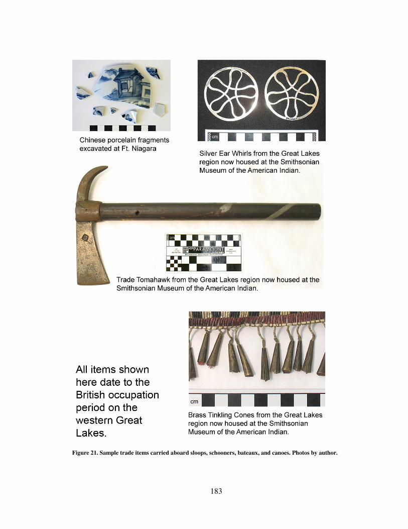
183
Figure 21. Sample trade items carried aboard sloops, schooners, bateaux, and canoes. Photos by author.

184
Figure 22. Additional samples of trade items carried aboard sloops, schooners, bateaux, and canoes.
Photos by author.
185
As the Revolution began General Guy Carleton took stock of the situation on the
western lakes and took steps to control the movement of both the Army’s and merchant
goods. In September 1776 Carleton’s Deputy Adjutant General sent a letter to the
Lieutenant Governor at Detroit requesting information on, among other things, an
account of all the vessels on the lakes including their names, the names of vessel
commanders, the number of guns they carried as well as information about vessels that
were not in the King’s service. The increase in merchant shipping at the end of the 1760s
and early 1770s meant that there were far more vessels in private hands than in the
Army’s working fleet. The Blackburn contract had reduced the active vessels down to
one per lake on the western Great Lakes while private vessel owners like Alexander
Grant built and owned several vessels across the lakes. Other merchants and firms like
John Askin and Messrs. Barth & Son built vessels for the western lakes as well.98
Carleton began reshaping components of the maritime cultural landscape by
altering the distribution and use of the region’s shipping capital. Carleton abrogated the
Blackburn contract thus returning control of the vessels to the crown and informed the
post commandants and vessel commanders that crews now needed to take an oath of
allegiance to the British King.99
Some vessels such as Grant’s were leased to the crown
while others were purchased out right or seconded as needed for the Army. In 1776 new
restrictions prohibited boats of any size, other than Indian owned canoes, to operate on
the lakes without passes from the post commandants nor were any new private vessels to
98
Cruikshank, “Early Traders and Trade Routes,” 311. 99
Carleton to Hamilton, May 22, 1777, Collections Report of the Pioneer Society of the State of Michigan,
Vol. IX, 348, Google ebook, http://books.google.com/books?id=xkDVAAAAMAAJ.
186
be built unless they were intended for the King’s service.100
A year later the restrictions
were tightened and only armed vessels operated by the King’s forces were allowed on the
lakes at all except, again, for Indians and their canoes.101
The lack of restrictions for
Indians demonstrates both the Army’s need to maintain good relations with the various
tribes as well as perhaps an acknowledgment that much of their western empire wasn’t
truly under the Army’s control.
Carleton was attempting to prevent merchants from spreading insurrection or
supplying rebels that might be in the western Great Lakes region. But as with other
military leaders he had to walk a fine line between controlling trade and damaging it and
relations with the Indians. When he informed Lt. Governor Hamilton at Detroit of the
new restrictions he requested intelligence on the traders there including names of those
Hamilton felt were “firmly attached to Government” as opposed to those “well affected
to the American cause.” Hamilton was to include information on what colonies the
traders came from and where there sources of goods were located prior to the
Revolution.102
Trade, however, must not come to a halt.
Carleton followed up the new restrictions with letters clearly stating that since
private shipping had been prohibited the Army’s vessels would have to come to the
merchant’s aid. A review of Carleton’s letters from the spring and summer of 1777 shows
increasingly stronger and stronger language with regard to what extent vessels should be
used to transport merchant’s goods. In his letter of 22 May 1777 Carleton states, “the
100
Foy to Hamilton, undated, Collections Report, Vol. IX, 345. 101
Carleton to Hamilton, May 22, 1777, Collections Report, Vol. IX, 348.
102
Carleton to Hamilton, May 22, 1777, Collections Report, Vol. IX, 348.
187
Traders may be accommodated with a passage on Board of these Vessels, provided the
same can be done without the least inconvenience to the King’s Service, this indulgence
is only for the pres[ent].103
In July Carleton again wrote to Hamilton that the King’s
Service should try to “remedy as much as possible all inconvenience to the Merchants...”
when any of the vessels could be spared.104
In September Carleton reasserted the
commitment to transporting private goods by again writing to Hamilton that with respect
to freight “the Vessels might assist the Trade as much as possible…”105
It was important
that the region’s Indians see that the British could provide them with a reliable supply of
trade goods rather than let them be lured to the Americans. By 1779 restrictions had
eased slightly. Merchants could now get passes to take their canoes destined for the
northwest Great Lakes via the Ottawa River route which was considered outside the
reach of the rebels.106
In some cases merchants were granted passes for their canoes
provided they transported materials for the Army as well. When Messrs. Todd and
McGill failed to live up to that stipulation an angry General Frederick Haldimand, who
took over command of British forces in the Great Lakes after Carleton, wrote that if the
merchants neglected their duties they were “but little entitled to the Indulgences shewn
them…”107
Despite the occasional, and probably to British officers, unsurprising,
misconduct by the traders, the army even went so far as to acquiesce to merchant requests
to supply an officer and soldiers to travel to the Grand Portage fur trading post located at
the northwest corner of Lake Superior to provide protection and authority for settling
103
Carleton to Hamilton, May 22, 1777, Collections Report, Vol. IX, 348. 104
Carleton to Hamilton, May 22, 1777, Collections Report, Vol. IX, 349. 105
Carleton to Hamilton, September 26, 1777, Collections Report, Vol. IX, 351. 106
Haldimand to De Peyster, July 3, 1779, Collections Report, Vol. IX , 361. 107
General Haldimand to De Peyster, July 3, 1779, Collections Report, Vol. IX , 363.
188
disputes. It is a measure of the merchant’s influence that the Army, stretched thin as it
was during the Revolution, spared men and materials for this purpose.108
When the Revolution came to an end the British had agreed to relinquish territory
south of the Great Lakes to the newly created United States but later disputes led the
British to retain possession of the territory until 1796. The British were not keen on
relinquishing the economic resources from the region to the Americans. The restrictions
on private shipping were left in force after the war as a means to prevent British
merchants from sending their furs to the United States, showing once again the empire’s
desire to protect trade yet to put measures in place to restrict their own merchants in order
to prevent illegal trade.
The Return of Merchant Shipping During the American Revolution the British Army’s senior officers actively
shaped the maritime cultural landscape by nationalizing shipping while at the same time
attempting to protect trade. As the immediate threats to their shipping system abated
private elements would seek to exercise their influence over the system. The Army,
however, would not relinquish its control easily. The two competing forces continued to
shape the maritime cultural landscape over the remaining years of the eighteenth century.
At the end of the American Revolution the British Army under General Frederick
Haldimand decided to scale back the size of the Great Lakes fleet in order to cut
expenses. The western lakes were to have only two vessels in service to both transport
military goods and personnel and merchant goods. A backlog of trader merchandise at a
108
De Peyster to Carleton, June 29, 1778, Collections Report, Vol. IX ,376.
189
military depot on Lake Ontario, however, prompted a group of sixteen merchants in
Montreal to write a memorial to Haldimand. In the memorial the merchants detailed that
although they anticipated private shipping to resume after the war, it had not and that at
the very least the Army needed to maintain three vessels in order to clear the backlog.109
Despite the ongoing prohibition against merchant vessels, however, Detroit’s Lt.
Governor Jehu Hay had already granted permission to several firms to sail small vessels
on Lake Erie to carry as much peltry as they could before the close of the season, and
once completed he revoked further permission.110
Haldimand, who granted the Montreal
Merchants’ request for a third vessel instructed Hay to strictly adhere to the private
shipping prohibition.111
Haldimand’s fear was that British commerce would begin
flowing into the United States. This is probably why he violated his own restrictions and
allowed merchants trading in the northwest to construct a vessel at Detroit for the
purposes of transporting it north past the falls near St. Mary’s and into Lake Superior.
Haldimand was “willing to give every encouragement in his power to ye Merchants
trading to the North West…” there was far less risk in so distant a territory.112
By 1788,
however, British authorities lifted restrictions against private shipping in response to
merchant’s complaints. Trade in the region was growing and the government needed new
ways to oversee it.
109
Memorial of Merchants at Montreal to Frederick Haldimand, 4 August 1784, in Historical Collections,
Vol. XX, 342-343. 110
Hay to Haldimand, October 9, 1784, Historical Collections, Vol. XX , 265. 111
Haldimand to Hay, 31 August 1784, Historical Collections, Vol. XX , 249-250. 112
Mathews to Frobisher, October 11, 1784, Report on Canadian Archives Brymner, Douglas, ed. (Ottawa:
Public Archives of Canada, 1889), 72, Google ebook, books.google.com/books?id=aJ0-AAAAYAAJ.
190
In 1788 a committee comprised of prominent merchants was charged to give their
opinion on how to provide for a stricter audit of accounts of the provincial revenue. Their
first report dealt with inland navigation and commerce.113
The document noted that there
were two private sloops and one private schooner operating on the western Great Lakes
employing fifteen men. The committee noted the need for the government to understand
the level of commerce carried on with the numerous Indian nations and the growth of
agriculture from the new settlements established by loyalists coming from the United
States. As an example the report provided information on various cargos such as that
carried west on board the sloop Sagina in August which included eleven hundred pounds
of shot and ball, seventy three casks of wine and spirits, and one hundred twenty three
boxes of dry goods. Eastbound cargos for the three vessels included 47 barrels of fish
from St. Mary’s Falls between Lakes Superior and Huron, over three hundred packs of
furs, and thirteen barrels of ginseng. The committee felt that stricter record keeping at the
various posts would help detect smuggling into the United States,114
a goal they shared
with Haldimand. What became clear by the end of the eighteenth century was that trade
would flourish and as port records of the period show, vessels and their cargos would
indeed cross the international boundaries that ran through the Western Great Lakes as
boats traveled from Canadian posts at Fort Erie to American ports in Pennsylvania, Ohio,
and Michigan.115
The commercial aspects of the maritime cultural landscape were in
113
Henry S. Bartholomew, ed., “Inland Navigation and Interior Commerce,” 19 January 1789, Historical
Collections Made by the Pioneer Society of the State of Michigan, XII, second ed. (Lansing: Michigan State
Historical Society, 1908), 4, Google ebook, http://books.google.com/books?id=-Q8UAAAAYAAJ. 114
Bartholomew , ed., “Inland Navigation and Interior Commerce,” 4-7. 115
Danial Dobbins, Impost Books 1799-1806, “Daniel Dobbins Papers,” Buffalo and Erie County
Historical Society, Buffalo, New York.

191
ascendency and would experience explosive growth despite another war in the nineteenth
century.
Conclusion When French, Indian, Metis, and British cultures came into contact with each
other in the western Great Lakes after the British captured Canada from the French in
1760 each segment of the new society was influenced through their interactions with the
other. Further, the natural landscape played a significant role in shaping the region’s
culture because waterways were the primary conduit for the flow of men, materials, and
communications. Unlike the French, the British Army immediately began expanding the
maritime cultural landscape to support the use of large vessels on the western lakes thus
creating a maritime empire.
While there are many components that made up the British maritime cultural
landscape such as shipyards, warehouses, wharves, and defensive posts, the large sailing
vessels themselves were another element in the maritime system. They do, however, hold
a unique position in that they were the mobile element that connected the geographically
distant components. This affords historians a lens with which to examine how the British
Army chose to project military power and empire into the western Great Lakes region.
The vessels can be studied as artifacts used to transport goods, components of a military
and economic system, a contributing factor in the newly developing maritime identity for
those that associated with the transport system, an element in the somewhat dysfunctional
chain of command, and a carrier of material culture that brought global influences to the
region. The combination of these functions along with their place within the developing

192
maritime cultural landscape meant that the arrival of the King’s sloops and schooners and
other merchant vessels acted as a catalyst for change for both the empire and the daily
lives of its inhabitants. The arrival of food, trade goods, information, and reinforcements
altered the course of lives and doing so collectively shaped the face of empire throughout
the western Great Lakes.
The first four chapters of this dissertation laid out the background and
development of the maritime cultural landscape in the western Great Lakes from its
origins in the traditions and beliefs of generations of Indians through the French
development of an expanded small craft transport system to British introduction of
support facilities and the large vessels they serviced. Chapter five examines the British
maritime cultural landscape as a whole and its impact on the power relationships
throughout the region in the mid to late eighteenth century thus shaping the British
Empire in the western Great Lakes.
193
CHAPTER FIVE: CONFLICT AND CONTROL: BRITISH – INDIAN
RELATIONS 1760-1796
From 1760 to 1796 the British Army was the sole European power occupying the
western Great Lakes region. During this period the British maintained a presence in
region despite an Indian uprising, the American Revolution, and US General Anthony
Wayne’s march north through the Ohio territory and defeat of Indian warriors at the
Battle of Fallen Timbers. By the end of British monopoly over the lakes in 1796, His
Majesty’s government had retained the loyalty of most of the Indian tribes living nearby.
British – Indian relations throughout these events were not merely a product of military
victories during the Indian uprising, although those were important, for there were few
victories on the British side. Indeed in 1763 the Indians nearly wiped out every British
post on the western Great Lakes. The Indians were not a defeated people unconditionally
submitting to British rule. They were in fact capable of manipulating events to suit their
own needs and based decisions on what they felt was in their own best interests rather
than blindly following the wishes of the British Army or agents from the British Indian
Department.1 The war was fought in large part over how the Indians and British related to
1 David Curtis Skaggs and Larry L. Nelson, The Sixty Years’ War for the Great Lakes, 1754-1814 (East
Lansing: Michigan State University Press, 2001), xx.
194
each other socially and politically and an Indian desire to resist what they perceived as a
British attempt to master them.2
Indian dependence on trade items certainly played a role in shaping the
relationship with the British as winter hunting depended on a supply of gunpowder and
shot as well as on the ability to get their weapons repaired. It would be a mistake,
however, to evaluate the nature of their contact as a strictly one sided affair where Indians
responded to a monolithic British commercial and military presence. The British soldiers,
officers, Army, and empire were influenced by the policies and actions of the Indians
with whom they came in contact. Perhaps one of the most succinct and accurate
appraisals of the nature of British – Indian interactions was written by fur trader Daniel
Harmon in his diary after parting with Indians with whom he had conducted business. He
and the Indians were, “nearly as good friends as the Indians and traders generally are.
With few exceptions, that friendship is little more, than their fondness for our property,
and our eagerness to obtain their furs.”3 Each side clearly looked out for their own
interests. For the British, trade meant a market for British goods and political alliance in
time of war. For the Indians, it meant access to materials that could be incorporated into
their belief systems and rituals in ways that may have surpassed the locally produced
materials they used.4 It also meant opportunities for trade with other natives.
2 Gregory Evans Dowd, War Under Heaven: Pontiac, the Indian Nations, and the British Empire
(Baltimore: The Johns Hopkins University Press, 2004), 2, 63. 3 Daniel W. Harmon, A Journal of Voyages and Travels in the Interiour of North America (Andover, MD:
Flagg and Gould., 1820), 89, Google ebook, http://books.google.com/books?id=4aUNAAAAQAAJ. 4 Tim Murray, The Archaeology of Contact in Settler Societies (Cambridge: Cambridge University Press,
2004).
195
It is not enough to understand the military and commercial aspects of British-
Indian interactions. One must understand how those elements were executed within the
natural environment where they took place. As chapter two discussed, the nature of
negotiations between a fur trader and an Indian tribe were extremely sensitive to the
location in which they occurred. A trader had less to fear for his life if the King’s 8th
regiment was standing behind him in a well armed fort than if he were alone hundreds of
miles away from the nearest post. Indian men and women too had greater control over
their relations with traders on their home ground where they had the support of their
village and kinship network. So too one must examine British-Indian relations within the
context of maritime environment deep into the interior of the continent. This chapter will
argue that as British control over the maritime cultural landscape strengthened or waned,
so too did the sense of security they enjoyed in their dealings with the Indians. British
control over the maritime transport system gave them the ability to ship goods the Indians
wanted as well as the military power to enforce their rule. Once that control was in
jeopardy their relationship with the Indians began to change as well. To illustrate this
argument this chapter will examine how material culture, transported by watercraft both
large and small, exercised influence over all parties involved in trade. It will also examine
three pivotal events that occurred during the British occupation period; the Pontiac
Uprising, the American Revolution, and the Ohio Indian crisis of the early 1790s.
Examining the British response to challenges to their military presence and their control
of the transport system will tell us much about how each side viewed each other during
196
times of conflict and stress. It is at moments when the interests of each side potentially
diverge that the true picture of how each side values the other emerges.
Artifacts as Elements of Culture During the British occupation of the Great Lakes, the empire had obtained a
global reach, thus the cultural influences the British brought with them aboard their
vessels came not only from Britain but from around the world.5 It could be seen in the
tobacco from Brazil, vermillion from China, ceramics from Germany, and opium from
India. In return peltries from across North America and Indian trade goods such as canoes
and snowshoes made their way into European hands, some of which were shipped to
Europe and Asia. Much of this activity took place aboard artifacts built by the British as
part of the maritime cultural landscape: bateaux, sloops, and schooners.
The arrival of sloops and schooners into port was an important event to those who
needed the cargo they contained be it goods, men, or information. Fully armed they were
powerful and visible symbols of the British Empire. Naming practices for large vessels
provide insights as to what the British valued and how they attempted to influence Indian
tribes. Several early vessels were named after Indian tribes and as such may have been
meant to both flatter local natives as well as gain their approval for the vessels’ presence
in their midst. British Indian Superintendent for the northern American colonies Sir
William Johnson, for instance, intervened and insisted that an early vessel named Apollo
be rechristened Onondaga.6 Other vessel names based on Indian culture include the
5 Walter S. Dunn, The New Imperial Economy: The British Army and the American Frontier, 1764-1768
(Westport, Connecticut: Praeger Publishers, 2000), 7. 6 Carol MacLeod, “The Tap of the Garrison Drum: The Marine Service in British North America 1755-
1813,” Unpublished Manuscript (Parks Canada, Historical Research & Records Unit, 1983), 54.
197
Huron and Ottawa. This practice continued throughout the British period. In 1793 for
instance an Indian Department vessel was used to transport so many provisions for
Indians preparing to fight US General Anthony Wayne that it was at first named, Indian
Feeder. A more diplomatically useful name was suggested to Indian Department agent
Alexander McKee and it was rechristened Shawanoe after one of the tribes participating
in the campaign against the Americans.7 The change may indicate that some British,
members of the Indian Department at least, were aware to take their Indian allies’
sensibilities into account which is in itself an acknowledgment of British dependence on
Indian military power.
Not all vessels were named after Indian tribes. In fact some were possibly used to
make a statement against Indian hostility. During the Pontiac uprising in 1763 the
schooner Huron was attacked by 340 Indians in canoes but survived the attack despite the
death of its captain and a crew member. There is some evidence that the vessel was
renamed Victory in honor of its successful defense against the Indians. As the vessel was
used to bring much needed supplies to the besieged fort at Detroit it was a reminder of
British resolve. It is also possible the vessel was renamed in honor of Britain’s victory in
the French and Indian War.8
Other vessel names were intended to honor superior officers and influential
persons such as the Gage named after General Thomas Gage, Johnson named after Sir
William Johnson, and, Dunmore after Lord Dunmore, royal governor of Virginia.
7 Elliott to McKee, October 20, 1793, Correspondence of Lieut. Governor John Graves Simcoe, with Allied
Documents Relating to His Administration of the Government of Upper Canada. 1792 - 1796
(Supplementary)., Vol. V, ed. Cruikshank (Toronto: Ontario Historical Society, 1931), 78–79. 8 Robert Malcomson, Warships of the Great Lakes 1754-1834 (Edison, New Jersey: Knickerbocker Press,
2004), 22.
198
Merchants also used the opportunity to honor individuals such as when trader John Askin
named one of his vessels Archange after his wife. Some merchants were inclined to
political flattery, such as when one named his vessel the Governor Simcoe after Lt.
Governor John Graves Simcoe who arrived in 1792 to administer the new loyalist colony
of Upper Canada.9 Although the names and the motives differed it is clear that the vessels
were important artifacts whose value transcended mere functionality and took on
symbolic significance that was meant to have meaning and influence for both the British
and Indians. The same could be said for the cargoes those vessels carried as well.
Many scholars have written about the impact trade goods had on Indian societies
as old ways of subsisting were forgotten and dependence on European guns and clothing
grew.10
Much of the new scholarship has pointed out that Indians were selective
consumers and had strong opinions about the types and quality of goods that they
exchanged for their furs. Similarly the devastating effects of the alcohol trade have also
been examined. What has received less attention, but deserves analysis however, has
been on goods that Europeans acquired for their personal collections. Individuals like
Major Andrew Foster who was stationed in the western Great Lakes in the early 1790s
collected Indian goods for his private collection and shipped hundreds of items back to
9 Elizabeth Simcoe, Mrs.Simcoe’s Diary ed. Mary Quayle Innis (Toronto: MacMillan of Canada, 1965),
123. 10
See Richard White, The Middle Ground: Indians, Empires, and Republics in the Great Lakes Region,
1650-1815 (Cambridge: Cambridge University Press, 1991); Susan Sleeper-Smith, ed., Rethinking the Fur
Trade: Cultures of Exchange in an Atlantic World (Lincoln: University of Nebraska Press, 2009); Colin G.
Calloway, Crown and Calumet: British-Indian Relations, 1783-1815, 1st ed. (Norman: University of
Oklahoma Press, 1987); Daniel K. Richter, Facing East from Indian Country: A Native History of Early
America (Cambridge, Massachusetts: Harvard University Press, 2003).
199
England. Researchers like Maya Jasanoff argue that collectors within the British Empire
from 1750 – 1850 used objects to “advertise, hone, or shape their social persona.”11
The Major Foster Indian artifact collection, now housed at the Smithsonian
National Museum of the American Indian, contains a wide variety of Indian and trade
artifacts including some manufactured completely by Indians as well as those only
customized by or for them. The collection provides a unique opportunity to see how
materials transported via the British maritime cultural landscape from around the world
were integrated into the Indians’ cultural world view. It also offers insights on how one
British officer perceived one aspect of Indian society with which he was at least
nominally familiar. Another valuable aspect of the collection is that it contains many
artifacts that would not typically survive in the archaeological records due to their
fragility such as feathers and fur.
It is possible that Foster selected his items for aesthetic value rather than as
representative examples of typical Indian culture, thus one could question what definitive
facts about Indian craftwork may be gleaned from the collection. What the collection
does show is not only Foster’s taste but it also provides clues to what it was in essence
that he was collecting. Consider the following items from the collection: a medicine bag,
a headdress, leggings, and earrings (See Figure 23 through 26). Each of these items was
made of differing combinations of Indian and European materials. The medicine bag, an
important spiritual item in Indian culture, is comprised of an otter skin, dyed porcupine
quills, tin tinkling cones, metal buttons, dyed deer fur, and beads. The headdress was
11
Maya Jasanoff, Edge of Empire: Lives, Culture, and Conquest in the East, 1750-1850 (New York:
Vintage Books, 2006), 7.
200
made from birchbark, satin, eagle feather/feathers, silver brooches, and porcupine quills.
The leggings were made of wool yarn, glass pony beads, porcupine quills, metal cones,
deer hair, metal wire, cotton tape, silk ribbon, linen thread, and sinew. The earrings were
made of silver, silver beads, and metal wire. The first three items were constructed of
both native and European materials while the earrings were made solely by a non Indian
silversmith but were designed for Indian tastes. Major Foster may have been interested in
Indian goods but most of the items in his collection were made of both Indian and
European materials. He had, in a sense, collected excellent examples of the cultural
imprint of Indian society on European materials. The collection represents the
intersection of two cultures brought together via currents of trade borne in the holds of
watercraft both large and small. The maritime cultural landscape connected wool mills in
Britain, for instance, with tribes in North America and altered their lives as they adapted
new materials into their culture. Like a receding tide the cultural mix flowed both ways as
Foster transported the physical manifestation of Indian culture back to Europe.
The Foster collections illustrates how deeply ingrained into Indian culture
European materials had become. The enormous desire for and dependence on trade goods
such as those included within the Foster artifacts, along with weapons, ammunition, and
liquor helps to explain the nature of Indian-British relations throughout the mid to late
eighteenth century. British control over the maritime cultural landscape played a key role
in those relations precisely because it guaranteed the flow of those trade goods as well as
the military means to enforce British political will. The remainder of this chapter

201
Figure 23. Otter skin medicine bag from the Smithsonian Museum of the American
Indian's Foster Collection. Photos by author.

202
Figure 24. Indian headdress from the Smithsonian Museum of the American Indian's
Foster Collection. Photo courtesy of the Smithsonian Museum of the American Indian.
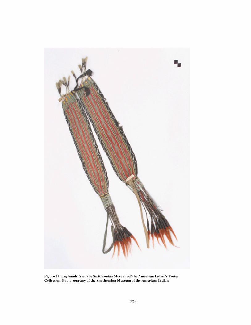
203
Figure 25. Leg bands from the Smithsonian Museum of the American Indian's Foster
Collection. Photo courtesy of the Smithsonian Museum of the American Indian.

204
Figure 26. Earrings from the Smithsonian Museum of the American Indian's Foster
Collection. Photo courtesy of the Smithsonian Museum of the American Indian.
205
examines how and why both groups handled periods of conflict wherein either military or
commercial control of the maritime cultural landscape was threatened.
The Pontiac Uprising Just prior to the end of the French and Indian war, before Canada was captured
from the French, several Great Lakes Indian chiefs including an Ottawa Indian named
Pontiac, believing the British would win, traveled to British posts including Fort Pitt.
They wished to enquire as to how they would be treated by the British. They were told
that the rivers would “run with rum” and that the British King would send an unlimited
number of presents. Trade goods would be very cheap. A blanket for instance would only
cost two beaver skins.12
Promises like these helped convince Great Lakes Indian chiefs to
allow the British to take possession of the far western French posts. Shortly thereafter
when the promises had not come to pass Pontiac accused the English of being liars.13
They began to understand that the British were making an assumption of conquest over
the Indians rather than seeing them as allies.14
After the French surrendered Canada to the British, General Jeffery Amherst,
commander of His Majesty’s forces in North America, immediately began to implement
cost cutting measures. He instructed the commandants at posts throughout the Great
Lakes to cut back on the amount of presents distributed to local tribes. In numerous
letters he reiterated his belief that the Indians should no longer be able to count on British
12
Gladiwn to Gage, May 12, 1764, inclusion in letter by James Grant, Vol. 18, "Thomas Gage Papers,"
William L Clements Library (WLCL) Ann Arbor, Michigan. 13
Ibid. 14
Dowd, War Under Heaven, 75.
206
supplies including gunpowder. He was also opposed to the practice of traders selling rum.
He was in essence trying to change the underlying meaning of gift giving. Rather than
being a gesture of gratitude to their Indian benefactors or turning enemies into friends by
demonstrating that the British spoke from the heart, Amherst wanted gifts to be seen as
acts of charity from the British to the Indians.15
The flow of gratitude was to be
reversed.16
Amherst did not understand that gift giving was “essential to Indian morality
as well as diplomacy.”17
While the French had understood this Amherst did not.18
British
Indian agents and Sir William Johnson understood this but their warnings were dismissed
by Amherst as well.19
Amherst did not believe the Indians would ever put together a
coordinated attack.20
Even efforts to use gift giving to foster peaceful relations by those who disagreed
with Amherst like Indian agent Sir William Johnson were hampered by the difficulties of
transporting goods so great a distance and by corruption in the Quartermasters office.
Johnson wrote to General Thomas Gage in 1760 angrily complaining that the transport
service needed to be reformed so that his efforts would, “not be wantonly obstructed by a
Set of low lived self interested and overbearing Deputy Quarter Masters, most of them, if
15
Colin G. Calloway, The Scratch of a Pen: 1763 and the Transformation of North America (Pivotal
Moments in American History (Cambridge, Massachusetts: Oxford University Press, 2007), 67; Dowd, War
Under Heaven, 72. 16
Dowd, War Under Heaven, 72. 17
William R. Nester, Haughty Conquerors (Westport, Connecticut: Praeger Publishers, 2000), 10. 18
Ibid. 19
Ibid., 7. 20
Jeffery Amherst to unknown, July 8, 1761, “Amherst Papers,” Library of Congress, (LOC) Washington,
DC.
207
not all,” he was convinced, “would sacrifice the Interest of their King & Country, to
gratify their resentment. This is notorious.”21
Because of the perceived ill treatment the Indians, despite Amherst’s opinion, did
attack in 1763, capturing nine forts throughout the Great Lakes region and leaving only
Detroit, Fort Niagara, and Fort Pitt in Pennsylvania. As most British troops were fighting
in the Caribbean there was little chance of an immediate major counter attack.22
Amherst
was furious and his disdain for the Indians turned to deep hatred and a thirst for revenge.
He believed any Indians near British posts were enemies. He wrote to Fort Niagara’s
commandant that, “If any [Indians] should Come near your Post, they are to be treated as
such [enemies] & Instantly put to Death.”23
The problem for the British, however, was
the inherent weakness of their position, spread out so far as they were across the lakes
with their maritime transport system still in the earliest stages of development. The
maritime cultural landscape, such as it was at the time would prove to be both
vulnerability as well as their savior.
When the Pontiac Uprising began the British had only constructed one sloop and
one schooner on the western lakes. They proved to be too large to pass over the sand bar
at the head of Lake St. Claire so there were no large vessels operating in Lakes Huron or
Michigan. As the uprising began then only small craft such as bateaux and canoes were
available at posts north and west of Detroit. Bateaux had no great military advantage over
Indian canoes and were easily captured since they had to stay close to shorelines on the
21
Johnson to Gage, April 25, 1760, in The Papers of Sir William Johnson, Vol. 3, ed. James Sullivan,
(Albany: The University of the State of New York, 1921), 226. 22
Nester, Haughty Conquerors, ix. 23
Amherst to Browning, 6 October 1763, “Amherst Papers,” LOC.
208
larger lakes. They were also vulnerable while within firing distance of Indians along river
shorelines. Michilimackinac fell easily to a surprise attack. Much smaller posts were
overwhelmed by large Indian war parties. Detroit survived initially due to its size and
greater number of troops and because of a tip that an attack was coming.24
Small vessels such as traders’ bateaux and canoes that were in transit at the time
the surprise attacks began fell victim as they approached the posts. A trader named
Chapman for instance traveling with five vessels to Detroit was captured, netting the
Indians sixteen half barrels of gunpowder and some rum.25
On 29 May 1763 two bateaux
coming from Michilimackinac with nineteen soldiers and one woman were cut off on the
Huron River and captured. The next day Indians captured eight bateaux carrying
provisions. They waited in hiding for traders coming up from Lake Erie.26
It was
Pontiac’s goal to cut off communications to the post. Captures such as these along with
possible trade from Detroit’s French inhabitants provided a supply of arms and
ammunition the Indians needed to maintain their siege of Detroit. It was imperative for
the Indians that Detroit fall quickly as the supply of vulnerable small craft would dry up.
While the small craft transport system imperiled the British, Detroit’s survival depended
on the larger sloops and schooners.
When the Pontiac Uprising began one of its first victims was Lt. Charles
Robertson who, at the time, was searching for a deep water channel in Lake St. Claire
through which he could sail the sloop Michigan into Lake Huron. Robertson was killed
24
Robert Rogers, Journal of the Siege of Detroit, ed. Franklin Benjamin Hough (Albany:J. Munsell, 1860),
126. 25
Franklin Benjamin Hough, ed., Diary of the Siege of Detroit in the War with Pontiac (Albany:J. Munsell,
1860), 7. 26
Ibid., 16–18.
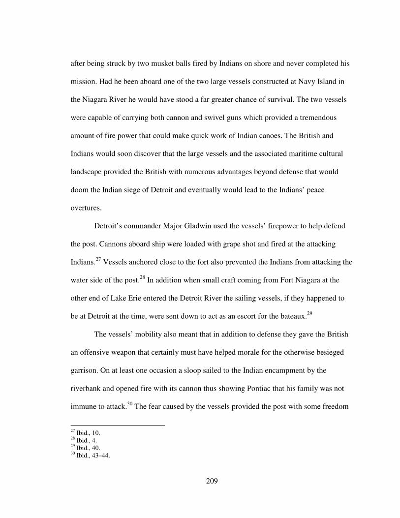
209
after being struck by two musket balls fired by Indians on shore and never completed his
mission. Had he been aboard one of the two large vessels constructed at Navy Island in
the Niagara River he would have stood a far greater chance of survival. The two vessels
were capable of carrying both cannon and swivel guns which provided a tremendous
amount of fire power that could make quick work of Indian canoes. The British and
Indians would soon discover that the large vessels and the associated maritime cultural
landscape provided the British with numerous advantages beyond defense that would
doom the Indian siege of Detroit and eventually would lead to the Indians’ peace
overtures.
Detroit’s commander Major Gladwin used the vessels’ firepower to help defend
the post. Cannons aboard ship were loaded with grape shot and fired at the attacking
Indians.27
Vessels anchored close to the fort also prevented the Indians from attacking the
water side of the post.28
In addition when small craft coming from Fort Niagara at the
other end of Lake Erie entered the Detroit River the sailing vessels, if they happened to
be at Detroit at the time, were sent down to act as an escort for the bateaux.29
The vessels’ mobility also meant that in addition to defense they gave the British
an offensive weapon that certainly must have helped morale for the otherwise besieged
garrison. On at least one occasion a sloop sailed to the Indian encampment by the
riverbank and opened fire with its cannon thus showing Pontiac that his family was not
immune to attack.30
The fear caused by the vessels provided the post with some freedom
27
Ibid., 10. 28
Ibid., 4. 29
Ibid., 40. 30
Ibid., 43–44.
210
Figure 27. Map of center of Great Lakes region in 1796.
as the British gained the ability to obtain resources from the surrounding area such as
retrieving fire wood from islands in the river.31
Resupplying Detroit was perhaps the most important element for survival. The
attacks started in May 1763 so the post needed to transport supplies to prepare for the
31
Ibid., 77.
211
oncoming winter when the waterways would be blocked by ice. Huron and Michigan
could carry a combined 650 barrels of provisions which could go a long way to keeping
the post in good health.32
The actual amount of cargo carried, of course, depended on the
type of cargo and the number of men and their baggage that might also need to be
transported. In August another cargo arrived including eighty barrels of provisions and
significantly a “great deal of naval stores.” What this meant was that the British were not
only getting past the siege by continuing to supply the post they were actually working on
expanding the maritime aspects of their operation.33
Diaries written during the siege
noted that Joshua Loring arrived to assess the naval situation. The British worked on
building additional vessels such as armed row galleys which were good for maneuvering
in the Detroit River’s currents. Bateaux were armed with cannon loaded with grape shot
and used for reconnoitering Indian positions, and in one case cruised back and forth near
an Indian encampment taunting the Indians to come out in their canoes.34
Pontiac was aware of the important defensive, offensive, and supply capabilities
the vessels provided the British as well as their psychological significance on the various
tribes in the Indian alliance. Throughout the siege as the Indians periodically opened fire
on the fort they almost always concentrated some fire on any vessels that happened to be
there at the time. In some cases their attacks were strictly focused on the vessels. There is
some evidence that the French inhabitants at Detroit were aiding and/or advising the
Indians. On several occasions the Indians launched fireboats, which was a European
32
MacLeod, “The Tap of the Garrison Drum,” 68. 33
Hough, ed., Diary of the Siege of Detroit, 58. 34
Ibid., 73–74.
212
method of attacking vessels. The Indians would raft together small craft full of fuel, set
them on fire and release them to drift down river towards the British vessels.35
The
British, however, were able to swing the vessels at anchor to avoid the attacking
fireships. The Indians also gathered on islands in narrow parts of the river and fired on
the vessels as they passed by, as well as set up diversions by attacking one part of the fort
while sending out parties to simultaneously attack the vessels.36
The vessels played a psychological role during the siege. Their success
disheartened the Indians and threatened the coalition. To counter this Pontiac told his
allies that the British only pretended to send vessels to Niagara and that when they saw
soldiers and provisions arriving it was only a ruse. Pontiac argued that the soldiers were
actually hidden in the small craft that rowed out to the vessels at anchor. They would
pretend to have just arrived and shout “Huzza!” The French had told Pontiac something
similar when twenty bateaux arrived carrying 260 men, possibly in an effort to keep their
spirits up. The French suggested that the soldiers were really from the fort and had snuck
out to the river under the cover of fog in an effort to appear as they had just arrived. 37
It
is little wonder then that one of the first offers the Indians made to Major Gladwin was to
let the British leave the fort to travel East provided they left the large vessels at Detroit.38
Perhaps one of the biggest blows to Indian morale came when they launched a
major but failed attack against the schooner Huron. In September 1763 Captain Horssey
sailed from Fort Erie with men and supplies for Detroit. At approximately 9:00 PM the
35
Ibid., 44–46. 36
Ibid., 21. 37
Ibid., 61. 38
Rogers, Journal of the Siege of Detroit, 129.
213
vessel lay in a narrow channel when 340 Indians embarked in canoes and bateaux and
attacked the vessel. A crew of only twelve including the captain fought off the Indians
although Captain Horssey and one crew member were killed. Amherst expressed surprise
that the ship had set off for Detroit with such a small crew considering the danger and
with his typical sensitivity accused the deceased captain of infatuated stupidity.39
The vessels had demonstrated that the British could resupply and man the
besieged garrison even if they could not defeat the Indians surrounding the post. An
attempt to march out and attack the Indians had led to a disastrous rout that temporarily
gave the Indians a morale boost but even that could not overcome the reality that the
Indians needed the supplies that came through the British transport system. Tribes
continued to arrive at Detroit to trade, possibly with the French, but with loss of trading
goods they had fewer and fewer sources. French posts in the Illinois region received word
of the peace treaty between France and England ending the French and Indian War and so
refused to arm the Indian attackers. In essence the Indians had attacked the British for the
way Britain had managed trade. As part of their strategy Pontiac’s attacked elements of
the maritime cultural landscape but in doing so the Indians now found their cause
imperiled by those very attacks which ultimately prevented new shipments of supplies
from entering the region. The Indians offered to release prisoners for supplies but the
British rejected this offer.40
39
Amherst to Wilkins, October 6, 1763, "Amherst Papers," LOC; MacLeod, “The Tap of the Garrison
Drum,” 71. 40
Hough, ed., Diary of the Siege of Detroit, 45.
214
By October of 1763 the home government had had enough of Amherst’s approach
to the war and management of the Indians. The Earl of Halifax wrote to Amherst what
had to be a difficult letter for a career officer to read.
It is a matter of Concern to His Majesty, to find that the measure you had
taken for putting an end to the Indian war, have not yet produced the
desired effects; but that on the contrary the Insurrections of the Indians are
considerably increased and almost become general…41
By November Amherst had sailed for England and was replaced by General Thomas
Gage.
Gage and Indian Superintendent Sir William Johnson held similar views on how
to end the uprising that were drastically different from Amherst’s. They believe that it
costs less to feed than fight the Indians.42
They also believed it was best to divide the
Indians and “raise all the jealousies and sow all the Dissention” they could “betwixt them
and their allies.”43
Gage wrote to Gladwin in Detroit and advised him to separate the
Indians who came to him with overtures of peace: “No peace will be worth concluding
which does not arise from motives of their own. …the more we treat separately with the
several nations, the better in my opinion it will always be.”44
Gladwin for his part also
reminded the Indians what they had to lose by warring with those who controlled the
waterborne transport system and told them that if they took his advice and did as he
wished, “they might live for the Future in Tranquility as they had done before, and see
41
Earl of Halifax to Amherst, October 18, 1763, Documents Relative to the Colonial History of the State of
New-York: Procured in Holland, England, and France, Vol. VII, ed. E. B. O'Callahgan (Albany: Weed,
Parsons and Company, 1856), 570. 42
Nester, Haughty Conquerors, 281. 43
Gage to Gladwin, January 9, 1764, Vol.12, "Thomas Gage Paper," WLCL. 44
Gage to Gladwin, December 22, 1763, Vol. 11, "Thomas Gage Papers," WLCL.
215
the Ottawas starving in the Woods for want of the Necessaries of Life that they cou’d no
ways get but from us.”45
By late 1764 Indian enthusiasm for the ongoing war was dwindling and several
factors led the Indians to give up the fight. The British had held out at Detroit and even
constructed more vessels at Navy Island to transport men and materials across Lake Erie.
Sir William Johnson had convinced the Seneca Indians to not only stop fighting the
British but to attack the other western tribes. Colonel Henry Bouquet had defeated the
Indians at the Battle of Bushy Run and relieved the besieged garrison at Fort Pitt. The
Indians faced another winter with few supplies to conduct their critical hunt. Tribes split
off and made individual treaties with the British. The Seneca for instance gave the British
even more control over the maritime landscape when they gave a four mile strip of land
along the Niagara River and all islands in the river to the crown. The home government
supported Johnson’s strategy and had ironically already convinced King George to make
the Proclamation of 1763 that forbid settlers from clearing land west of the Appalachian
Mountains. Trade was open to all but traders had to post a bond to secure their good
behavior. These measures along with the Indian Departments diplomacy had settled most
Indian disputes and culminated in the Treaty of Fort Stanwix in October 1768.
The Pontiac Uprising had shown the British that their posts in the western Great
Lakes were vulnerable to Indian attacks without proper supply lines and armed vessels to
guard them. While they could not defeat the Indians they were able to use their control of
the maritime cultural landscape to withhold the trade goods upon which the Indians
45
Hough, ed., Diary of the Siege of Detroit, 28.

216
depended. For the Indians it had to be a sober realization that they could not remove the
British although they were not without some power and their wishes could not be
ignored. With the French relegated to a few posts in the Illinois region (soon to become
Spanish territory) the British became the undisputed power in North America. In a few
short years that power would be put to the test.
The American Revolution The British Army had fought hard to survive the Pontiac Uprising. Their control
over the maritime cultural landscape had ensured their survival and, so it seemed, their
hegemony over the Great Lakes Indians. Regional tribes depended on the British traders
and Army for the goods and presents that helped them feed themselves. It seemed the
British were securely in control. During the American Revolution no battles took place
on the shores or water of the western Great Lakes, but the war itself, however, would
expose the extent to which the reverse was true. Threats to British survival exposed
cracks in the system for all parties to see.
In the years between the Pontiac Uprising in 1763 and the American Revolution
several changes took place in the maritime cultural landscape of the western Great Lakes.
By 1777 for instance there were eleven vessels sailing on the western lakes, some of
which had been privately owned by merchants (See Chapter 4).46
One example is trader
John Askin’s sloop Welcome built at Michilimackinac in 1775. Commodore Alexander
Grant had developed a private shipping concern that include his schooners Hope and
46
David A. Armour and Keith R. Widder, At the Crossroads: Michilimackinac During the American
Revolution (Mackinac Island, Michigan: Mackinac State Historic Parks Commission, 1978), 66.
217
Faith and sloops Angelica and Adventure.47
The British Army had also changed the
management of their vessels by contracting out their care and operation to private
merchant John Blackburn of London. In some ways the Army had relinquished a small
amount of control over the maritime transport system.
What had not changed was the British impression of the Indians and the need to
supply them with presents in order to retain their friendship. In 1769 the commandant at
Michilimackinac wrote to Thomas Gage about the practical needs for keeping the Indians
peaceful which included giving presents and services such as gun repair,
My acting otherwise would be accounted a Declaration of war which we
are by no means Prepared for Being obliged to Detach a small Party of
Soldiers Eight miles from the garrison to cut wood another at the Distance
of twelve miles to burn Lime for repairing the Barracks. The Bringing
home of these articles Likewise Exposes the men and is in everybody’s
opinion here upon the spot.48
The initial British reaction on the western Great Lakes to the start of the American
Revolution was to reestablish control over the maritime cultural landscape. The
populations in Quebec, Detroit, and at Michilimackinac did not join in the insurrection
and the British wanted to keep it that way. By August 1776 Guy Carleton abrogated the
Blackburn contract and returned responsibility for the King’s vessels to the army.49
By
1777 only armed vessels operated by the King’s forces were allowed on the lakes at all
47
Frank E. Ross, “The Fur Trade of the Western Great Lakes Region,” Minnesota History 19, no. 3
(September 1938): 105. 48
Turnbull to Gage, September 9, 1769, Vol. 87, "Thomas Gage Papers," WLCL. 49
Ross, “The Fur Trade of the Western Great Lakes Region,” 105.
218
except for Indians and their canoes.50
This was an effort to prevent smuggling and or
capture by rebel forces.
In July 1778 Rebel Colonel George Rogers Clark won a string of victories in the
Illinois territory taking posts at Kaskaskia, Cahokia, and Vincennes with little
opposition.51
The British now feared attacks on Detroit. Rumors reached
Michilimackinac that the Rebels were busy building boats on Lake Michigan near
Milwaukee as well as gathering at “Chicagou.”52
Clark and his Virginians were said to
have orders to march on Detroit and in fact Congress did want this done. Thomas
Jefferson even suggested that Clark time his arrival so precisely that he could use the
region’s rivers as the ice broke up but before the Lake Erie opened up for navigation. By
using the natural environment the Americans could “acquire possession of Lake Erie.”53
The civil governor of Detroit Henry Hamilton took a force and marched against the
Rebels but was captured causing even further fears to the British posts on the lakes.54
Concerns over American rebel attacks led the British to attempt to control
cognitive elements of the maritime cultural landscape. For instance, those who the British
felt could not be trusted who had particular knowledge of the maritime cultural landscape
were ushered out of the region so that their familiarity with the, “lakes and country”
50
Carleton to Hamilton, May 22, 1777, in Pioneer Collections: Report of the Pioneer Society of the State of
Michigan Together with Reports of Country Pioneer Societies, Vol. IX, 2nd ed. (Lansing, Michigan:
Wynkoop Hallenbeck Crawford Company, 1908), 348, Google ebook, http://books.google.com/books?id=
xkDVAAAAMAAJ 51
Armour and Widder, At the Crossroads, 83–84. 52
De Peyster to Haldimand, May 2, 1779, Pioneer Collections, Vol. IX , 379-380. 53
Jefferson to Clarke, December 25, 1780, George Rogers Clark Papers, 1771-1781Vol. VIII, ed. Clarence
W. Alvord (Springfield, Illinois: Trustees of the Illinois State Historical Library, 1912), 485–486, Google
ebook, http://books.google.com/books?id=2SBCAAAAIAAJ. 54
Peyster to Haldimand, May 1779, Pioneer Collections, Vol. IX , 379–380.
219
would not fall into American rebel hands.55
One French sailor, Francis Brown whose
father died in the service of the French King, begged for a discharge once his France
entered the war on the Rebels behalf and preferred imprisonment to dishonoring his
family. British removal of individuals with knowledge of the lakes clearly indicated that
their fear of the Rebels attacking Detroit was real.
Further north at Michilimackinac Colonel Arent Schuyler De Peyster took steps to
augment the Naval Department. He had complained to his superior Frederick Haldimand
in Quebec that he needed a vessel assigned specifically to his post rather than wait for
one of the Naval Department’s vessels to become available between provision runs. He
suggested to Haldimand that an armed boat could be sent to reconnoiter the bays and
creeks in Lake Michigan.56
He purchased and armed trader John Askin’s sloop Welcome
to not only search for the Rebels but to take messages down to Ft. St. Joseph on the St.
Joseph River that flows into the east side of Lake Michigan. By using the Welcome he
could cut the turnaround time for answers to his letters from at least a month by canoe to
as little as eight days.57
As the war went on, the British made other changes to the maritime cultural
landscape to counter threats to their control over the region. Commodore Grant had
goneto the Miami River and constructed a blockhouse to guard provisions that might
have been needed by the ill-fated Hamilton expedition. Fearing the Rebels might use the
55
Grant to Powell, June 6, 1782, in Historical Collections: Collections and Researches Made by the
Michigan Pioneer and Historical Society, Vol. XX (Lansing, MI: Wynkoop Hallenbeck Crawford
Company, 1912), 23. 56
De Peyster to Haldimand, October 24, 1778, Pioneer Collections, Vol. IX , 375–376. 57
Ibid.
220
river to aid their march on Detroit two vessels were stationed at its mouth.58
The sloop
Adventure was sent to the Niagara River to help keep supplies moving from Ft. Schlosser
to Ft. Erie on Lake Erie. In 1779 the British tried to improve Ft. Michilimackinac
defenses by removing sand hills that overlooked the post. They also ensured that all the
barracks were surrounded by pickets. Despite his efforts to improve Michilimackinac’s
defenses, concern over his supply lines led De Peyster to believe that should Detroit fall
Michilimackinac “must of course fall though they should not send a man against it.”59
In
1782, however, then Lt. Governor Patrick Sinclair moved the entire post to a high bluff
on Mackinac Island where the fort could command the harbor (Figure 28). What the
British were forced to realize was that perhaps their best defense was the Indians.
Although they had defeated the Indians in the Pontiac Uprising and attempted to
rebuild good relations with them the British were even more concerned with where the
Indians’ loyalties lay. Fear that the Indians might side with the Rebels was in truth part of
the reason for the initial repairs to Ft. Michilimackinac. Intelligence reached De Peyster
that the Rebels had had several councils with Indians possibly gathered in the Illinois
region near Kaskaskia.60
Thomas Bennet at Ft. St. Joseph had little faith in their loyalty
and wrote to De Peyster that he had not twenty who were still attached to the British
cause and referred to the rest as a “set of treacherous poltroons.”61
When word spread that
France had aligned with the Rebels the British became even more suspicious that their
French inhabitants might reach out to the Indians and suggest that the French Army
58
Powell to Haldimand, August 7, 1782, Historical Collections, Vol. XX 39. 59
De Peyster to Brehm, June 20, 1779, Pioneer Collections, Vol. IX , 387. 60
De Peyster to Haldimand, June 27, 1779, Pioneer Collections, Vol. IX ,389. 61
Thomas Bennett to De Peyster, August 9, 1779, Pioneer Collections, Vol. IX ,393.

221
Figure 28. Views of and from Fort Mackinac on Mackinaw Island. Photos by author.
222
might yet still return. For the British the way was clear – the Indians had to be convinced
to stay loyal to Britain. Haldimand went so far as to suggest to De Peyster that their
“existence almost entirely depends on the disposition of the Indians.”62
This was
probably not news to De Peyster as Haldimand praised him for how he had, “acquired the
affections of the different nations around” him and his “perfect knowledge of the
Management” of the Indians.63
The British tried to create a united front throughout the Great Lakes. Prior to
turning over the management of the lakes to Haldimand, Guy Carleton told Haldimand
that, “one general and uniform Plan of Policy [should] be adopted for the numerous
Tribes inhabiting the present Limits of this Province.” In addition whenever a council
was held copies of the notes from the meeting minutes were to be sent to Carleton. Proper
communication was to be maintained with both the military as well as members of the
Indian Department at neighboring posts. 64
That plan involved reminding the Indians who truly controlled the maritime
transport system and thus who could supply their needs best. The British used a mixture
of generosity and thinly veiled threats as well as an appeal to the Indians to see through
Rebel promises. In truth the Rebels may have been their own worst enemies. De Peyster
reported to Haldimand that he believed the Rebels had met with the Indians but had
nothing to give them and treated the Indians with great contempt in an attempt to
intimidate them.65
62
Haldimand to De Peyster, June 12, 1779, Pioneer Collections, Vol. IX ,360. 63
Ibid., 64
Carleton to Haldimand, February 2, 1777, Pioneer Collections, Vol. IX ,345–346. 65
De Peyster to Haldimand, June 27, 1779, Pioneer Collections, Vol. IX ,389.
223
De Peyster was not above a little intimidation himself and reminded the Indians
that the Rebels might make a show of presents at first but could not, “furnish the different
nations with their necessary wants.”66
De Peyster “requested” the Indians not to have the
“least connection” with the Rebels but to keep themselves quietly at home. He told the
Indians, “that should they misbehave during the winter they may expect I will send to
order every Canoe loads of goods back to Montreal.” This threat, he believed, seemed to
have great force with the Indians. Yet his comments to Haldimand belied his worry about
losing the Indians’ loyalty. He asked Haldimand to not detain canoe loads of goods from
traveling to Michilimackinac any longer than was necessary. De Peyster wanted to fill the
Indians with great confidence that the British could furnish their wants.67
To further this end it was important that despite the war, trade goods and presents
continue to flow. Even as Carleton began restricting navigation to strictly the King’s
vessels he issued a circular to the western posts that whenever the vessels could spare the
room they should endeavor to transport traders’ goods. 68
Haldimand for his part wrote to
England requesting large quantities of goods for presents and promised De Peyster that
he would pay every attention in his power to support the upper posts and forward the
Indian presents without delay.69
The river of presents continued throughout the war
(Table 2). In 1782 for instance Lt. Governor Sinclair prepared an extensive list of goods
he felt was needed for the Indians. The list included items for aspects of Indian life
66
De Peyster to Haldimand, September 21, 1778, Pioneer Collections, Vol. IX ,371–374. 67
De Peyster to Haldimand, September 21, 1778, Pioneer Collections, Vol. IX ,371–372. 68
Circular from Guy Carleton, July 2, 1777, Pioneer Collections, Vol. IX ,348–349. 69
Haldimand to De Peyster, April 8,1779, Pioneer Collections, Vol. IX ,356–357; Haldimand to De
Peyster, May 20, 1779, Pioneer Collections, Vol. IX ,359.

224
Table 2. Lt. Gov. Sinclair's Estimate of Goods
Needed for Indians1
645 pairs of 3 & 2 ½ point blankets
80 pairs 2 point blankets
80 pairs 1 ½ point blankets
40 pairs of 1 point blankets
4000 lbs. Gunpowder
2000 lbs Shott assorted
1000 lb. Ball 28 to lb.
12 dozen Powder Horns
250 Fusils G.R.
50 doz. Fine for Chiefs
12 M. Gun Flints
30 Cullasses
30 Gro. Gun Worms
30 do. Fired Steels
20 do. Indian Awls
12 do. Scalping Knives
4 do. Clasp Ditto
4 do. Spear pointed Buck Handled Do.
4 do wood handled folding do.
1 do crooked do.
2 Gro Razors
30 do Brass Rings
30 do Stone do
6 double groce steel inlaid Buttons
6 groce Thimbles
50 Brass wire
3 gro. Horn Combs
4 doz Box do.
2 doz Ivory do
10 Nests Copper Kettles
10 do Brass do
.6 do Tin do
330 lb. Vermillion
2000 lbs Brazil Tobacco
1500 lbs Carrott Do
6 Nests Gilt Trunks
4 do Seal Skin do.
40 Doz Paper snuff Boxes
12 M Needles assorted
3 ps. Aurora Strouds
10 Do Scarlet Cloth 1/3 & 2/3 coarse30 do Blue
Molton20 do White do15 do Embossed Serge4 do
Blue Bath Coating4 do Green Baize6 White Flannel15
do. Striped Callimanco10 do 6-4 Cotton
50 do Irish Linnen
50 do Callico.
10 Ps. Scotch Sheeting
15 do. Ozenaburg
20 do. Russia Sheeting
40 Gro. Gartering
100 Ps. Ribband assorted12 Gro. Ferriting
1 Lt. Gov. Sinclair’s Estimate of Goods Needed
for Indians, 1782, Historical Collections, Vol.
XX, 51.
12 doz. Black Silk Handkerchiefs
6 Doz. Checked ditto
12 doz. Common Romals
60 lb White Sewing Thread
60 lb All Colours
560 lb Net Thread
300 lb Beads assorted
200 Bunches Barley Corn Ditto
30 lb Worsted Assorted
150 Cod Lines
12 Doz Mens Strong Leather Shoes
12 Doz Buckles
12 Groce Brass Jews Harps
630 Mens Callico Shirts
250 Womens ditto
450 Mens white Ruffled ditto
250 Womens ditto
130 Boys white & Callico ditto
150 Childrens do. Do.
150 Mens striped Cotton do
100 do Trowsers
100 Callimanco Manties 4 ½ ells a
100 ditto 3 ½ do
50 ditto 3 do
50 ditto 2 do
50 1 ½ do
100 Molton Cassoles Laced green & blue
200 do assorted
60 Scarlet Laced Coats for Chiefs
60 Hats for ditto
200 Childrens Robes
80 Felt Hatts
140 Flat Feathers for ditto
100 Plumes different colours
60 Indian Flags
50 doz Looking Glasses
50 Axes
250 Half Axes
300 Tomahawks
250 pr. Canadian Spears
150 Daggs
200 Fa Cutters
100 Hoes
50 Beaver Traps
222 Kegs Rum 1 gall ea
222 Kegs do 2 do.
Silver Works:
150 Large & 100 Small Arm Bands
300 wrist ditto
60 Gorgets
200 Car Wheels
3000 Ear Bobs
10000 Common Broaches
200 Large ditto
200 double Crosses Assorted
150 Boxes
225
from essentials for survival such as blankets and gunpowder to luxury items such as
scarlet laced coats destined specifically for chiefs. Decorative items like silver arm bands,
children’s clothing, black silk handkerchiefs, and jaw harps were also included.
The extent of the list and depth of penetration in to so many aspects of life from
political appeals to the Indian chiefs destined to receive the scarlet laced coats to
children’s robes and every day tools like awls, is such a far cry from the prohibition
against gift giving that Amherst tried to institute only twenty years earlier. Exchanges
such as these were exchanges of power but coming at a time when the British feared for
the loss of empire one could ask who held the power in this exchange. The British may
have been attempting to show their ability to bestow abundance but it could just have
easily been seen through Indian eyes as an expression of indebtedness wherein the British
were acknowledging to the Indians that they were dependent on their military alliance.1
In addition to presents the British found themselves supporting large numbers of
Indians when their winter hunts were unsuccessful. British troops at Michilimackinac for
instance had to give the Indians the fish they caught. At other times they transported
chiefs aboard Naval Department vessels on their way from one post to another. Yet
despite even these efforts some Indians felt they were being coerced into assisting the
British by threats from other Indian tribes such as the Poteawatamies.2
All of these efforts were directed at retaining their Indian loyalty and their
willingness to fight for the British. That goal was shared by ministers in England.
1 David Murray, Indian Giving: Economies of Power in Early Indian-White Exchanges (Amherst,
Massachusetts: University of Massachusetts Press, 2000), 15, 53. 2 De Peyster to Haldimand, June 1, 1779, Pioneer Collections, Vol. IX, 382–383; Bennett to De Peyster,
August 9, 1779, Pioneer Collections, Vol. IX 393.
226
Secretary of State for America Lord George Germain issued instructions to Carleton early
on in the war to assemble Indians to raid the Virginia and Pennsylvania frontier in an
effort to divide the rebels’ attention, bring the war to a speedy conclusion, and restore
“those deluded People to their former state of Happiness and prosperity.”3 The British
were successful in getting some Indians to fight on their behalf though they worried about
possible unfortunate consequences. De Peyster for instance was reluctant to send the
Indians far in case they were needed to defend Detroit or Michilimackinac. They were
also concerned about the Indians engaging in barbaric cruelties that might rally potential
loyalist settlers to the Rebels cause. There was also the possibility that some tribes might
argue with others resulting in Indian wars, an eventuality the British strongly wished to
avoid if they were to keep the tribes focused on aiding the British. They also wanted to
avoid any disaffected Indians from being attracted to the Rebels as allies.4
The British Army was successful in keeping the Rebels from reaching the western
Great Lakes. Detroit and Michilimackinac were never attacked and, except for a brief
period early in the war when the Americans had held Montreal, trade goods and Indian
presents had continued to flow. This seemingly successful period of British – Indian
diplomacy, however, revealed British weaknesses. While they might have felt they were
masters of the region exercising imperial control over all the western Great Lakes
inhabitants it was clear that in reality the rumors of Rebels reaching the lakes had brought
to light just how dependent they were on both the loyalty of Indians as well as the need to
3 Lord George Germain to Carleton, March 26, 1777, Pioneer Collections, Vol. IX 346–347.
4 De Peyster to Haldimand, March 29, 1779, Pioneer Collections, Vol. IX, 378–379; Haldimand to De
Peyster, July 3, 1779, Pioneer Collections, Vol. IX, 361–362.
227
maintain complete control of the maritime cultural landscape. If they could not maintain
the steady flow of trade goods and Indian presents then they would have lost their most
valuable weapon and ally. As it was, the Indians demanded much in the way of presents
and direct support and the British had little choice but to deliver or face total defeat in
Canada as well as the thirteen colonies. It may be that after witnessing what happened on
the western lakes that the British wondered what would happen if their ability to control
the maritime cultural landscape were in serious doubt. How would the empire react? The
Indian crisis in the Ohio region during the early 1790s would bring all of those issues to
light.
The Indian Crisis of the early 1790s By the early 1790s the enormous distance between the east coast of the United
States and the shores of Lake Erie was slowly overcome by the young nation eager for
western lands to develop. The forests, so insurmountable a decade earlier gave way
despite the violent exertions of the native Indians that called the area home. With every
tree that was cut down and every path that was cleared the British grip on the maritime
cultural landscape grew ever more imperiled. The advance of United States Army under
General Anthony Wayne through the Ohio territory brought the United States closer to
access to the Great Lakes waterways that had fueled the fur trade. As masters of the lakes
the British had reached deep into the continent’s interior bringing trade goods and
military power and through that effort they had won the attachment of the Great Lakes
Indians. Dependent on a supply of trade goods yet not totally without power the Indians
sought to protect their land from the Americans. They relied on their British “fathers”
228
who had built the maritime cultural landscape that helped them defeat the Indians in
battle and had not been conquered in the late Revolutionary War. But the treaty that
ended the revolution on paper had set in motion great changes in the maritime cultural
landscape of the North American Interior. With the handover of Great Lakes posts to the
United States delayed for more than a decade, the Indian crisis of the early 1790s
heralded changes in the Great Lakes that would end British hegemony forever.
At the end of the American Revolution British Indian agents gathered with their
Indian allies to explain the ramifications of the peace treaty between Great Britain and the
United States. John Johnson, son of the late Sir William Johnson, assured the Indians that
the British would continue their patronage.5 Just like at the end of the French and Indian
War a contest between two white powers would have an impact on Indian tribes of the
Great Lakes. The British did in fact want to prevent any changes to the situation on the
Great Lakes. Frederick Haldimand kept the restrictions to shipping in place fearing that
merchants would begin trading with United States citizens. Haldimand did not want to
encourage any Americans to come to the region.6 Rather the British hoped to protect their
empire and the valuable fur trade by trying to confine the United States to the east coast.7
An American presence on the Great Lakes would end the British monopoly over the
transportation system they used to bring in trade goods for Indians dependent on those
items. If Indians could now play the Americans off the British in this regard then military
5 Wiley Sword, President Washington’s Indian War (Norman, Oklahoma: University of Oklahoma Press,
1993), 20. 6 MacLeod, "The Tap of the Garrison Drum," 164.
7 Sword, President Washington’s Indian War, 14–15.
229
alliances could collapse as well.8 To that end the British refused to honor the peace treaty
terms that required them to turn over territory and fortifications south of the Great Lakes
including Detroit, Ft. Niagara, and Ft. Michilimackinac.
The British pointed out that treaty provisions stipulated that creditors on both
sides of the war would be able to collect debts. Individual states, however, passed their
own laws limiting British rights to do so. It was a convenient excuse for the British to
retain control of the Great Lakes and the associated fur trade. In addition the British
encouraged Indians from the region to continue fighting land encroachments by
Americans in the Ohio territory. The British hoped that the Indians could form a buffer
state between the Great Lakes and the rest of the United States thus affording the British
protection.9 As the violence grew more frequent in the early 1790s the United States took
military action to suppress the Indians and negotiate a peace treaty to settle the land
disputes. Into this volatile situation stepped British Lt. Governor John Graves Simcoe in
1792 (Figure 29).
Simcoe, a veteran of the American Revolution, had a vision for the newly created
province of Upper Canada, which included the peninsula bordered by Lakes Huron, St.
Claire, Erie, and Ontario, wherein the inhabitants of the province would, “consider
themselves as the maritime power of interior America.” 10
Simcoe felt that the population
8 Alan Taylor, The Divided Ground: Indians, Settlers, and the Northern Borderland of the American
Revolution (New York: Vintage Books, 2007), 326. 9 Alan D. Gaff, Bayonets in the Wilderness: Anthony Wayne’s Legion in the Old Northwest (Norman:
University of Oklahoma Press, 2004), 235–236. 10
Simcoe to the Committee of the Privy Council for Trade and Plantations, September 1, 1794, in
Correspondence of Lieut. Governor John Graves Simcoe, with Allied Documents Relating to His
Administration of the Government of Upper Canada. 1794 - 1795., Vol. III, ed. E. A. Cruikshank
(Toronto: Ontario Historical Society, 1925), 51.
230
would be condensed by the geographic boundaries rather than spread out over vast
distances as he believed the Americans would be.11
After arriving in Canada Simcoe
assessed the situation and reported his impressions to the home government. Of great
interest to him was the state of the maritime cultural landscape.
With war brewing between the Indians and the Americans in the Ohio territory
Simcoe cast an eye to not only the commercial but military assets throughout the Great
Lakes. In his view the fur trade was the staple of Canada and its protection had been the
primary object of all that had been built in the past. Simcoe believed the trade would
continue to be the most valuable element of commerce.12
Settlements like Detroit were
crucial to maintaining the trade. The farms around Detroit supplied British subjects and
military in the northwest with 80,000 barrels of flour each year. The Miami River was an
important conduit for furs coming to Detroit from the south. In Simcoe’s view much of
the fur trade that came to the Niagara region was already being smuggled into the United
States where they attracted higher prices. Simcoe worried that the contraband trade in that
region was growing as the population increased. Smugglers had even brought “East
Indian goods frequently of British Manufacture” into the province.13
Simcoe also pointed
out to the home government that while the lake fisheries had not yet developed
11
Ibid., Correspondence, Vol. III, 51. 12
Ibid., 55. 13
Ibid.
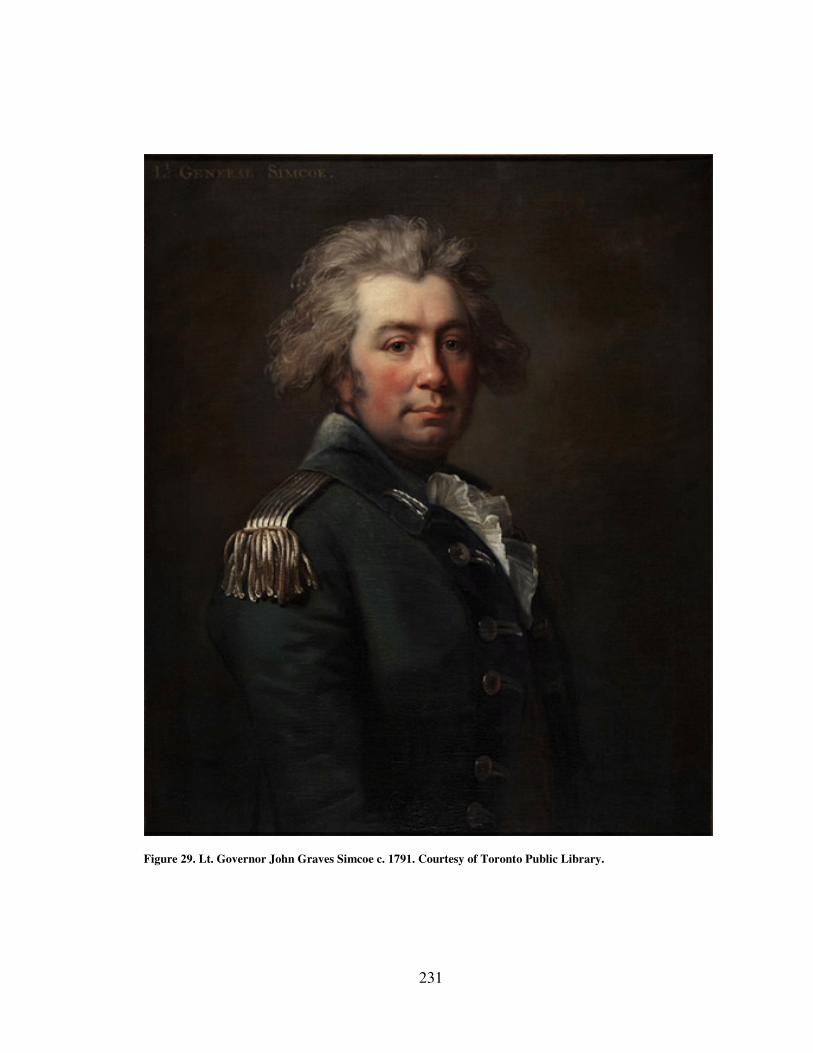
231
Figure 29. Lt. Governor John Graves Simcoe c. 1791. Courtesy of Toronto Public Library.
232
into a major article of commerce the level of imports and exports at Detroit and
Michilimackinac were on the rise.14
With an eye to security Simcoe reported on the condition of the merchant fleet on
the western Great Lakes noting vessel tonnages, the lakes in which they operated, the
number of men required to navigate them, the owners names, and the number of guns
they could carry if armed. There were three schooners and six sloops on Lakes Erie,
Huron, and Michigan but there was only one sloop owned by the Northwest Company on
Lake Superior.15
In contrast to the growing merchant fleet, in 1793 the Naval Department
operated only four vessels on Lakes Erie and Huron: the snows Ottawa and Chippewa,
the schooner Dunmore, each with twenty crewmen, and the much smaller sloop Felicity
with only eleven.16
The complexion of the maritime cultural landscape was progressing
to one more commercial in nature. If a naval war were to break out the Army would have
numerous vessels it could bring into the service as it did during the American Revolution.
In 1793 negotiators from the United States and representatives of numerous Great
Lakes Indian tribes attempted to create a framework for peace in the Ohio Territory.
When they failed to reach an agreement war seemed inevitable. After an initial defeat at
the hands of a combined Indian force US General Anthony Wayne was ordered to
prepare another offensive and moved his troops into the Ohio territory. As no roads
existed Wayne’s forces had to build their own, preposition supplies, and rendezvous with
14
Ibid., 56–57. 15
Ibid., 69. 16
Lord Dorchester, “Return of the Marine Establishment in the Provinces of Lower and Upper Canada,”
October 24, 1793, in Historical Collections - Collections and Researches Made by the Michigan Pioneer
and Historical Society, Vol. XXIV (Lansing: Michigan Pioneer and Historical Society, 1895). 618, Google
ebook, http://books.google.com/books?id=P5cUAAAAYAAJ.
233
reinforcements, all of which had to be coordinated in the woods.17
Slowly, however, they
made their way toward the Miami River and the region just south of Lake Erie and
Detroit, a fact that kept British forces at Detroit and aboard Naval Department vessels on
guard.18
As General Wayne’s troops made their way calls went out to Great Lakes tribes to
gather and oppose the United States Army. The Indians turned to the British for
gunpowder and shot which they received through British Indian agent Alexander McKee.
Shipments went out in a new large vessel operated by the Indian Department.19
As in the
American Revolution the British used the maritime transport system to recruit, arm, and
provision the Indians. Arms, ammunition, and provisions poured through the Niagara
portage and were shipped aboard the Naval Department’s vessels west to Detroit while
other department vessels cruised off the south shore of Lake Erie on alert. From the
Captain to the crews, everyone had to be prepared. Even the rumor of an American
advance called for action. Captain Alexander Harrow for instance recorded in his log on
April 1st, 1795, “News having last night arrived that the Americans were on their way
here the people cleaning and mounting 8 guns on the end of the Wharf & was desired to
sleep on board and the watches doubled.”20
In the previous war the goal was to get the Indians to support the British. In this
case the British were ostensibly supporting the Indians but in truth Simcoe felt the
Indians were the means by which the British could keep the Americans at bay without
17
Sword, President Washington’s Indian War, 250. 18
MacLeod, “The Tap of the Garrison Drum,” 164. 19
Sword, President Washington’s Indian War, 254. 20
Alexander Harrow, “Alexander Harrow Family Papers – Log Books of the British Fleet,” April 1, 1795,
Detroit Public Library, Burton Historical Collection, Detroit, Michigan.
234
starting a war between Great Britain and the United states.21
The British wanted very
much to mediate a treaty between the United States and the Indians as the outcome would
impact the British Empire in North America, possibly forcing the British to surrender
their Great Lakes posts. Through diplomatic efforts they inveigled the Indians into
wanting British involvement.22
The British extended transportation services to the United
States negotiators aboard the Dunmore.23
Yet despite their efforts the British were not
asked to mediate the talks.
When negotiations broke down between the Indians and the United States and
Simcoe heard that General Wayne was on the march he devised his own strategies for
defense. He believed that the British possessed a great asset in the maritime cultural
landscape. In a letter to the Duke of Portland Simcoe suggested that the best defense was
a good offense. Simcoe was busy gathering artillery, boats, and troops at Ft. Erie. He
used lake vessels to send detachments to Turtle Island in the Miami River to help guard
provisions and a recently reestablished post on the Miami River. Simcoe believed the
vessels gave him not only the ability to dispatch troops and cannon where needed quickly
but that they also provided a distinct advantage with regard to communications. He could
receive news and react long before the information could be conveyed to the United
States government.24
21
Sword, President Washington’s Indian War, 231. 22
MacLeod, “The Tap of the Garrison Drum,” 180. 23
Sword, President Washington’s Indian War, 246. 24
Simcoe to the Duke of Portland, December 20, 1794, Correspondence, Vol.III, 232.
235
As part of this plan Simcoe wanted the ultimate defense of Canada not to rely on
the Indians but on the Naval Department.25
He laid the foundations for building a fleet of
small gunboats that he believed would give Britain a naval power that would command
the commerce of the region for ages to come which he believed would help obtain the
colonies true object: becoming a naval empire on the lakes.26
Simcoe had grand plans to
build arsenals and shipyards on the lakes that could produce the small gun boats capable
of carrying six pounder cannons which could be used throughout the lakes due to their
shallow draft. Because of their light weight and size Simcoe believed the vessels could be
kept in storage building when not in use thus preserving them for 30 years or more. He
imagined the vessel type being used on the Mississippi at New Orleans and on the
Chesapeake Bay as well if needed.27
Unfortunately for Simcoe shortages in manpower meant that soldiers had to be
used aboard the vessels.28
Simcoe was quite enterprising, however, in his efforts to
overcome a shortage of shipwrights to build the vessels. He even sent an agent to recruit
them from New York.29
Boat yards were to be established up the Grand River that flows
into Lake Erie west of Ft. Erie while another naval establishment was proposed for Long
Point which juts out into Lake Erie thus providing flexibility to move where needed.30
Simcoe felt only a superior naval force, strategically located, would act as a deterrent that
25
MacLeod, “The Tap of the Garrison Drum,” 180. 26
Simcoe to the Duke of Portland, October 23, 1794, Correspondence, Vol. III, 142. 27
Simcoe to Lord Grenville, October 30, 1794, Correspondence, Vol. III, 163. 28
MacLeod, “The Tap of the Garrison Drum,” 180. 29
Simcoe to Dundas, Correspondence of Lieut. Governor John Graves Simcoe, with Allied Documents
Relating to His Administration of the Government of Upper Canada. 1793 - 1794, Vol. II, ed. E. A
Cruikshank (Toronto: Ontario Historical Society, 1924), 354. 30
MacLeod, “The Tap of the Garrison Drum,” 184.
236
would stop the Americans from marching on Detroit and establishing other posts on the
lakes.31
In other words Simcoe felt that if the British wanted to retain their posts and
control the fur trade it was imperative they continued to be the sole power controlling the
maritime cultural landscape. To a large degree, however, keeping the Americans away
from the lakes would depend on how well the Indians did in battle.
As General Wayne continued to move his American troops closer and closer to
the Miami River, British Indian agent Alexander McKee worked to encourage the Indians
to mobilize. In May 1793 the Indians told McKee that after they tended to the business of
planting corn and taking care of their villages they would gather on the Miami River.
McKee wrote to Detroit requesting provisions be sent on a large boat he had left for the
purpose. His original vessel was damaged and he had not yet located anyone to fix it.32
Over the summer months vessels traveled back and forth from Detroit to the Miami River
carrying Indians, British Indian Department personnel, and provisions.33
In October 1793
for instance the commander at Detroit sent McKee an Indian Department vessel carrying
ten barrels of gunpowder, twenty cases of shot, two hundred pounds of tobacco, forty
pairs of blankets, six pieces of Molton, two thousand flints, twelve dozen knives, six
barrels of pork, six barrels of flour, and two barrels of Peas.34
The British were in fact
offering all the support they could short of participating in any battles.35
Simcoe did not
want war and had hoped negotiations would at least delay it but as the British had rebuilt
31
Ibid., 180. 32
McKee to England, May 16, 1793, Correspondence of Lieut. Governor John Graves Simcoe, with Allied
Documents Relating to His Administration of the Government of Upper Canada. 1792 - 1796
(Supplementary), Vol. V, ed. E. A. Cruikshank (Toronto: Ontario Historical Society, 1931), 40–41. 33
Elliot to McKee, June 5, 1793, Correspondence, Vol. V, 48. 34
Elliot to McKee, October, 20, 1793, Correspondence, Vol. V,78–79. 35
MacLeod, “The Tap of the Garrison Drum,” 180.
237
a post on the Miami River and the United States and the Indians appeared to be on the
verge of engaging in battle in close proximity, it seemed inevitable.36
In July 1794 just as all the pieces were in motion and war between the Indians and
the United States seemed to be coming ever closer Simcoe received instructions from the
home government that he was to maintain peace with the Americans. Negotiations were
underway between British officials and John Jay from the United States. Simcoe was
informed that he could defend Detroit but it was likely that British troops would
eventually withdraw from the post.37
The timing was problematic and events were
unfolding that could very well lead to war between the two nations regardless of the
peace negotiations. On 20 August 1794 the United States Army and a coalition of Indian
warriors from throughout the Great Lakes fought what came to be known as the Battle of
Fallen Timbers near the British post on the Miami River. The battle turned in favor of the
Americans and the Indians retreated seemingly to the protection of the British fort.
Unfortunately the British chose at this time to demonstrate conclusively that they were
unable or unwilling to provide shelter or engage in the battle. The fort doors remained
closed to the Indians who were outraged.38
General Wayne requested the fort’s surrender
but the British inside were prepared to fight and had in fact loaded and aimed cannon and
had a light ready to set it off, but Wayne retired from the field and did not press the
issue.39
The British were in a better position defensively, well armed, and had ready
access to supplies via vessels that could draw on British assets from around Lake Erie.
36
Sword, President Washington’s Indian War, 292. 37
Ibid., 294. 38
Ibid., 306. 39
Simcoe, Mrs.Simcoe’s Diary, 134.
238
This was small comfort to the Indians who were now left in a poor position to negotiate
new boundary lines with the United States.40
Although Simcoe still hoped that he could play some role in negotiations between
the Indians and the United States the opportunity had passed and he found himself
dealing with new problems. The retreating Indians still turned to the British but now
many of their villages were destroyed and with the end of the summer came fresh worries
about provisions. Lt. Colonel England commanding at Detroit estimated that 1,300
barrels of flour and as many of pork would be required to supply the 2,556 Indian men,
women, and children now in need because of the war.41
Since the United States was about to reach Lake Erie, Simcoe began to imagine
what the maritime landscape might look like now that it was not solely a British
possession. In addition to deciding what to do about the Indians, Simcoe had to follow
orders and halt preparations for war. He directed Lt. Colonel England to halt construction
on a gunboat at Detroit for fear of antagonizing the Americans. He saw the waterways,
now a shared resource, in a new light. What had once brought advantage now brought
threat. He recommended to the Privy Council for Trade and Plantations that the, “seat of
government should be removed from all immediate apprehension of danger, contingent to
a maritime situation; and that its military protection should depend upon its difficulty of
access and interjacent fortresses.”42
This was a radical departure from the way the British
had viewed the waterways. Although he still believed in keeping a naval force on the
40
Alan Taylor, The Civil War of 1812: American Citizens, British Subjects, Irish Rebels, & Indian Allies,
Reprint. (New York: Alfred A. Knopf, 2010), 55. 41
Sword, President Washington’s Indian War, 312. 42
Simcoe to the Privy Council for Trade and Plantations, September 1,1794, Correspondence, Vol. III, 51.
239
lakes the loss of total control meant that some aspects of the maritime cultural landscape
were changing as Simcoe sought to distance British waterborne traffic from the
Americans.
By late summer 1794 Simcoe had already begun to search out alternative routes
between Lake Ontario and Lake Huron that took advantage of Lake Simcoe thus avoiding
Lake Erie. By remapping the maritime landscape he hoped it would draw traders away
from Detroit and American Influence. He suggested a port be established on Lake Huron
at the terminus of the new route and believed it might “become rapidly of great
importance…” In assessing the proposed route he recognized the importance of maritime
resources that would fit into both the large and small craft maritime landscape. Lake
Simcoe for example contained water “capable of admitting any vessels and its banks
afford Birch of sufficient size for the largest canoes.”43
News of Jay’s treaty eased tensions along the western lakes but also meant that
the British would have to evacuate Ft. Michilimackinac, Detroit, and Ft. Niagara by June
1796. This meant a search for new locations on the Canadian side of the lakes and
building many elements of the British maritime transport system from scratch. Troops at
Ft. Niagara were moved across the Niagara River to newly constructed Ft. George. Ft.
Malden and the new Royal Dockyard at the village of Amherstburg located at the mouth
of the Detroit River replaced Detroit. British traders and troops moved from the post at
Mackinac island to the southern tip of St. Joseph’s Island in Lake Huron which was
convenient to the passages to the Sault Ste. Marie and Lake Superior.
43
Ibid., 58.
240
Lt. Governor Simcoe departed Canada for England in 1796 but prior to doing so
he made recommendations to the home government regarding the merchant vessels that
now shared the western lakes with the Americans. In his last attempt to shape the
maritime cultural landscape Simcoe expressed his belief that the merchant vessels were
now abundant enough to haul their own peltries but the King’s vessels could be used to
transport American goods both for merchants and for the United States Army as they had
no vessels of their own. In this way British subjects could capture the carrying trade. He
also recommended that provincial subjects not be allowed to ship goods on any American
vessels thus offering additional support for British shipping. In perhaps his final plea for
the naval force he loved Simcoe wrote to the Duke of Portland that despite the new treaty
with the Americans,
…no Military reason can justify the weakening the force, Naval or
Military, in this Province so I hope no civil Necessity will contribute to the
diminution of what is the most essential Instrument if properly managed,
of Its rapid and increasing Prosperity.44
The 1790s Indian crisis in the Ohio territory at the western end of Lake Erie
brought to light several disturbing aspects of the British maritime cultural landscape. As
the United States Army approached the British hold on the maritime cultural landscape
weakened and with it their ability to maintain the close military ties with the region’s
Indians. The treaty that had ended the American Revolution had set the stage for the
withdrawal of British forces from their western posts. When the British evacuated from
44
Simcoe to Duke of Portland, November 8, 1795, Correspondence of Lieut. Governor John Graves
Simcoe, with Allied Documents Relating to His Administration of the Government of Upper Canada. 1795
- 1796, Vol. IV, E. A. Cruikshank (Toronto: Ontario Historical Society, 1926), 135.
241
the American posts, they also relinquished sole control over the maritime transport
system in the western Great Lakes and in some ways retreated from it.
In 1794 Lt. Governor Simcoe had a visit from explorer and merchant Alexander
McKenzie who had just returned from an overland trip to the Pacific Ocean. McKenzie
had suggested that British fur traders who were ever increasingly pushing westward to
find more abundant and better quality furs, should begin transporting their furs to the
Pacific coast rather than through the Great Lakes to the St. Lawrence seaway.45
In the
aftermath of the Indian defeat at Fallen Timbers Simcoe wrote to the Committee of the
Privy Council for Trade and Foreign Plantations describing his belief that a post
established at Cook’s River could secure the whole western fur trade for the British. After
all, he reasoned, the British fur traders had more experience dealing with Indians than the
Russians. Simcoe looked to the East India Company and the Chinese market and the
amount of silver that could be gained for Britain. He was already looking past the Great
Lakes and the coming era where the western lakes would become international bodies of
water.
Conclusion The British Army controlled and expanded the maritime cultural landscape on the
western Great Lakes from 1760 to 1796. They had exercised sole control and developed a
trade that the Indians could not live without and a naval presence that ensured their
ability to force their will on the region’s inhabitants. The quick mobility and capacity that
the large vessels gave the British Army and merchants helped break the siege of Detroit
45
Alan Taylor, “Continental Crossings,” Journal of the Early Republic 24, no. 2 (July 1, 2004): 182.
242
during Pontiac’s Uprising. The British held significant influence over the Indians only as
long as their hold on the maritime transport system lasted. While the Pontiac Uprising
demonstrated British strength the American Revolution showed British fear. The
Americans seemingly were coming from all directions causing the British to scramble to
defend their maritime boundaries and recruit Indian aid. Although American attacks on
the lakes never materialized, it had exposed a different side to the British – Indian
relationship not seen before.
The British maintained possession of American western Great Lakes posts in an
effort to retain control of the lakes and the fur trade for more than a decade after the
American Revolution ended. The Americans had, up until that point, lacked any way to
challenge British control. This helped the British retain their alliance with western
Indians but as United States General Anthony Wayne and his troops marched closer and
closer to the southern shores of Lake Erie the British were caught between a desire to
retain the lakes and to avoid war with both France and the United States. While they
could still use the maritime landscape to transport goods to the region they no longer
were the only power capable of doing so.
With the signing of Jay’s Treaty the British began their withdrawal from the
maritime cultural landscape. The fur trade would continue of course along with the
exchange of material culture and the influences they had on all parties involved. In less
than twenty years another war would come but in the intervening period the United States
would begin to build its own version of the maritime cultural landscape, one that would
economically dominate the western Great Lakes region well into the twentieth century.
243
CHAPTER SIX: CONCLUSION
The history of the British Empire in the western Great Lakes from the beginning
of their occupation in 1759 until Britain surrendered their posts to the United States in
1796 is the history of a maritime empire. All of their goals and objectives were dependent
on how well they constructed and managed the maritime cultural landscape. The
maritime transport system which they utilized to construct and extend the elements of
empire in the Great Lakes influenced everything from the British economy to aspects of
everyday life for all of the region’s inhabitants. By studying the British Empire through
the lens of the maritime cultural landscape we gain new perspectives and views of empire
that might otherwise be missed as indeed the historiography of the early British
occupation period in the western Great Lakes demonstrates.
A maritime focus immediately draws attention to the physical landscape and
environment and the importance they had in the spread of empire. As lakes and rivers
dominate the region’s topography it would seem an obvious area of focus but they have,
in the past, been treated more like a geographical container for human activity to be
outlined on a map as a boundary line rather than an interactive player in human actions.1
The lakes were not placid pools to be leisurely sailed or paddled across but were at times
every bit as stormy and violent as any North Atlantic sea. Combined with climatological
1 John J Bukowczyk, The Production of History, the Becoming of Place in Permeable Border: The Great
Lakes Basin As Transnational Region, 1650-1990 (Pittsburgh: University of Pittsburgh Press, 2005), 3.
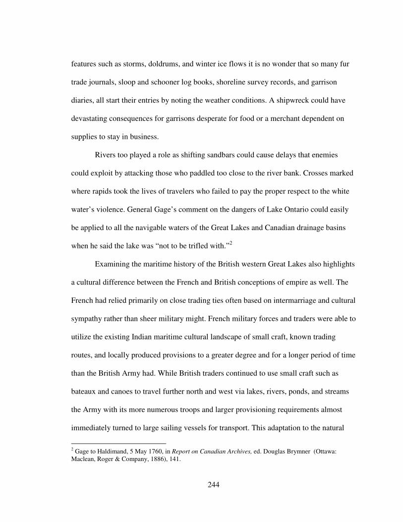
244
features such as storms, doldrums, and winter ice flows it is no wonder that so many fur
trade journals, sloop and schooner log books, shoreline survey records, and garrison
diaries, all start their entries by noting the weather conditions. A shipwreck could have
devastating consequences for garrisons desperate for food or a merchant dependent on
supplies to stay in business.
Rivers too played a role as shifting sandbars could cause delays that enemies
could exploit by attacking those who paddled too close to the river bank. Crosses marked
where rapids took the lives of travelers who failed to pay the proper respect to the white
water’s violence. General Gage’s comment on the dangers of Lake Ontario could easily
be applied to all the navigable waters of the Great Lakes and Canadian drainage basins
when he said the lake was “not to be trifled with.”2
Examining the maritime history of the British western Great Lakes also highlights
a cultural difference between the French and British conceptions of empire as well. The
French had relied primarily on close trading ties often based on intermarriage and cultural
sympathy rather than sheer military might. French military forces and traders were able to
utilize the existing Indian maritime cultural landscape of small craft, known trading
routes, and locally produced provisions to a greater degree and for a longer period of time
than the British Army had. While British traders continued to use small craft such as
bateaux and canoes to travel further north and west via lakes, rivers, ponds, and streams
the Army with its more numerous troops and larger provisioning requirements almost
immediately turned to large sailing vessels for transport. This adaptation to the natural
2 Gage to Haldimand, 5 May 1760, in Report on Canadian Archives, ed. Douglas Brymner (Ottawa:
Maclean, Roger & Company, 1886), 141.
245
environment was a double edged sword in that it allowed the army to project British
power in greater force than the French ever did, but it also tied the Army to those
locations that could provide protected anchorages for larger vessels. It is no surprise then
that only those posts on the Great Lakes such as Detroit and Niagara that had regular
service via sloops and schooners, survived the initial attacks and sieges during the
Pontiac Uprising. Seen in this light, a map of the British Empire in western Great Lakes
region would more closely resemble a series of nodes connected by lines and paths that
follow water routes of major bodies of water rather than of a polygon shape covering
thousands of square miles.
The commercial extent of the British Empire, however, was much larger. British
traders who utilized Indian birchbark canoes traveled well beyond the immediate
oversight of British forts. This was an entirely different type of empire. Traders recorded
in their diaries and letters that they found Indians along the thousands of miles of
waterways to be aware of the power they held over the traders. Fur trade journals record
few tribes that grossly abused the position of advantage because doing so would result in
traders refusing to bring them the much needed supplies of gunpowder and shot, clothing,
food, and metal tools. The dependence on trade goods was a powerful motivating factor.
At times it even induced Indians to surrender members of their own tribes who had
crossed the line and attacked traders.3 The Indians were, however, clearly in charge of
their own destinies. By examining the maritime cultural landscape we can see that while
3 William Warren, History of the Ojibway People, 2nd ed. (St. Paul: Minnesota Historical Society Press,
2009), 294–296.
246
the British commercial empire spanned the vast Canadian territories much of the political
and military power in those areas resided with the Indians.
The same network of streams and lakes that allowed fur traders like Alexander
Henry, Jonathan Carver, Daniel Harmon, and Alexander McKenzie to travel by canoe to
the Canadian northwest also allowed them to elude the control and oversight of the
British Army. As Figure 1 shows, British traders virtually flooded the remote regions of
Canada to an extent that dwarfed prior French efforts. A major objective of the British
Empire was to obtain raw materials for the mother country while providing additional
markets for England’s manufactures. The Army, however, found itself in the difficult
position of both assisting the traders that so successfully spread the commercial aspect of
empire but who also ignored the Army’s attempts to establish military and political
authority when it conflicted with traders’ ability to make a profit. The tensions this
created between the two elements of empire is clearly visible in the complaints Army
officers raised with regard to traders traveling through their regions on their way to
territories beyond the Army’s ability to control.
In addition to struggling with merchants who would not follow regulations the
Army itself struggled with its own identity crisis. The absence of Royal Navy’s expertise
in managing a sailing fleet meant the British Army ventured into uncharted waters in
overseeing the construction and operation of marine transport vessels. From insufficient
funding to ignorance of the environment, the Army’s attempt to spread the empire
through the western Great Lakes region illustrated how the desire to project British power
was nearly a self defeating force. The British misunderstood the landscape in much the
247
same way that they misunderstood the Indians that lived throughout the region. Rushing
to establish their hegemony over the Great Lakes meant selecting poor locations for
building ships, green materials, improper hull designs, inexperienced officers and crews.
The result was delays, shipwrecks, lost provisions and lives. Jeffrey Amherst’s
rush to establish a dominant relationship over the Indians almost immediately after taking
possession of French posts elicited much the same result in the Pontiac Uprising. The
Indians rejected Amherst’s policies and the British attempt to impose its will and
conception of empire rather on them rather than establishing a mutually accepted middle
ground of cultural relations, led to the loss of hundreds of lives, destroyed property, and a
challenge to the geographic extent of empire.4 By studying the Naval Department over
the course of Britain’s occupation of the Great Lakes in the late eighteenth century,
however, we see that despite a difficult and painful beginning the Army learned from
many of their mistakes, although not all, and increasingly sought to establish a more
professional force that was better adapted to the environment in which they operated.
They thus secured control over the waterways that were so vital to the empire’s continued
existence.
Through the British Army’s Naval Department the empire gave birth not only to
a maritime cultural landscape that included shipyards, wharves, portages, small and large
vessels, warehouses, and defensive structures but also to a maritime culture and identity
for those who took part in transporting men and materials across the lakes. While most
naval and maritime historians of the Great Lakes tend to focus on the War of 1812 and its
4 Eric Hinderaker, Elusive Empires: Constructing Colonialism in the Ohio Valley, 1673-1800 (Cambridge,
Massachusetts: Cambridge University Press, 1999), xxi.
248
ship to ship actions or the explosion of commercial shipping of the nineteenth century,
the British expanded the ancient Indian system and developed a maritime cultural
landscape and maritime identity based on large sailing vessels. British, Irish, Scottish,
African-American, and French sailors, soldiers, and slaves served aboard the sloops and
schooners that sailed the western lakes for half a century before the War of 1812 and the
first steamboats to cruise the lakes. During that period they developed knowledge,
vocabulary, traditions, and practices that would continue to evolve to the present day.
They built the infrastructure that was used in the War of 1812, established shipping
routes that nineteenth century captains would follow, explored harbors and recorded the
resources others would come to exploit like Lake Superior copper, Wisconsin agriculture,
Michigan lumber, and perhaps the most significant was the use of the lakes for
transportation. By 1810 villages like Buffalo at the east end of Lake Erie, across from
British Fort Erie, already had five hundred residents and had begun its long period as an
embarkation point for millions immigrants in the nineteenth century.5
Even those who were not directly involved in operating sailing vessels were
affected by the arrival of vessels with their cargos, soldiers, provisions, and
communications. Merchants and Indians in particular depended on the cargos for their
livelihoods. The trade goods imported into the region supplied the “necessaries of life”
for Indians, merchants, and farmers alike.6 By studying the material culture that vessels
large and small brought to the region we get a sense that the British Empire during this
5 Alan Taylor, The Divided Ground: Indians, Settlers, and the Northern Borderland of the American
Revolution (New York: Vintage Books, 2007), 316. 6 Franklin Benjamin Hough, ed., Diary of the Siege of Detroit in the War with Pontiac (Albany: J. Munsell,
1860), 24.
249
period had already established a global reach. Merchants like Pond and Williams in
Detroit in the mid 1780s were connected to that global trade network. Their records show
us how the empire affected people at a local level and brought inhabitants from the
Detroit region into that network. They used money, crops, pelts, or bartered services to
purchase goods from distant places. People like Madame Nate’ who purchased two dozen
white ruffled shirts. Anone’ Selfleur clapboarded Pond and Williams’ store, made a
cupboard, and installed a floor in the company stables to pay for his goods. Other patrons
took advantage of the global trade network to purchase china tea pots and soup tureens,
glassware, cheese, hinges, and spelling books.7 Indians also took part in the network and
prized the goods that came from over the sea often burying their dead with their
possessions such as jaw harps and Chinese blue and white porcelain.8 The influence of
the maritime transport system was so great that some archaeologists such as George
Quimby suggest that Indian dependence on and use of trade goods helped create a shared
pan Indian culture.9
By studying the impact of the maritime cultural landscape on the Indians we can
see where the two elements of empire, trade and power, intersect in a revealing way. The
extent of British control over the maritime cultural landscape shaped the relationship
between the British and the Indians. When British control over that system was
threatened the true nature of that relationship was exposed, including Indian dependence
on trade goods and British dependence on Indian support. Utilizing the lakes for transport
7 Thomas Williams, July 15 - October 20, 1785, Vol. 1, “Thomas Williams Papers,” Burton Historical
Collection Detroit Public Library, Detroit, Michigan. 8 George Irving Quimby, Indian Life in the Upper Great Lakes: 11,000 B.C. TO A.D. 1800 (Chicago:
University of Chicago Press, 1961), 157. 9 Quimby, Indian Life, 147–148.
250
was a double edged sword that aided imperial expansion but also created dependence on
that transport for survival. The British created similar conflicts by fostering Indian
dependence on a sole supply of trade goods that the military could threaten to cut off. In
doing so the British created a situation wherein the Indians would only remain allied with
the British so long as the British retained control of the transport system. Once the British
had negotiated away their western Great Lakes posts to the United States at the end of the
American Revolution they had given away the strongest bargaining tool they had with the
Indians. British diplomatic efforts and threats to the Indians during the American
Revolution illustrated this. When they believed the Americans were about to challenge
them on the lakes they quickly sought to enlist Indian aid for fear the Rebels would
capture Detroit and Michilimackinac. During the Ohio Indian Crisis of the early 1790s
the United States finally broke through to the lakes and exposed Britain’s unwillingness
to fight for the Indians. The British knew it was only a matter of time before they
surrendered their posts. The Indians realized that the British were no longer the only
power on the lakes and that they would have to negotiate with the United States. When it
became clear to the British that they had to evacuate from their western Great Lakes posts
they consciously began they sought to reshape the maritime cultural landscape to fit their
new reality. They turned their eyes inland and looked for other waterways to utilize
including continuing their march westward across the continent and other areas of the
global empire. Simcoe, for instance, pondered the possibilities of a Pacific Northwest
251
American fur trade with China.10
Not surprisingly though they did so by looking again to
the sea and other elements of the maritime cultural landscape.11
This dissertation seeks to draw attention to an aspect of the British Empire in the
western Great Lakes that has, in the past, gone relatively unnoticed despite its importance
to nearly every aspect of the British experience within the region. By looking at the
development of the maritime cultural landscape over time, we can see how different
cultures developed and utilized the same physical landscape. It helps see commonalities
and differences between people who were living the empire on a daily basis be they
British merchants selling rum, French inhabitants raising cattle, or Indians hunting beaver
pelts destined to become fashionable hats in Europe. The water united and humbled all of
them. It exposed common fears for survival in the face of a watery grave as Indians and
French voyagers made their sacrifices and confessions prior to beginning their journeys
and British captains raced to find a safe port in a Lake Erie squall. The dependence on the
waterways gave advantages and exposed weaknesses for all to see. A schooner could
transport greater quantities of goods at faster speeds than a canoe but it required deeper
harbors and was equally imprisoned by ice during the long winter months. It also
required a substantial support system spread over hundreds of miles in order to function.
Perhaps the greatest advantage of studying the British Empire in the western Great Lakes
through the prism of the maritime cultural landscape is that it connects the region to the
10
Elizabeth Simcoe, Mrs. Simcoe’s Diary, ed. Mary Quayle Innis (Toronto: MacMillan of Canada, 1965),
134–135. 11
Simcoe, Mrs.Simcoe’s Diary, 134-135.

252
rest of the empire, one that came to span the globe, a globe that is predominately covered
in water.

253
REFERENCES

254
REFERENCES
Primary Sources Amherst, Jeffery. Baron Amherst Papers, 1740-1783. Library of Congress, Washington,
DC.
_____. Baron Amherst Papers, 1740-1783. Old Fort Niagara Library, Youngstown, New
York.
Askin, John. Inventory of My Estate Viz. Fort Michilimackinac Research Library,
Mackinac City, MI, 1776.
Baldwin, Richard. “A Short Account of the Straits of St. Mary, and Michilimackinac."
The London Magazine, or, Gentleman’s Monthly Intelligencer, February 1761,
64. Google ebook. http://books.google.com/books?id=w8QqAAAAYAAJ.
Brodhead, John Romeyn, ed. Documents Relative to the Colonial History of the State of
New-York: Procured in Holland, England, and France. Vol. VII. Albany: Weed,
Parsons and Company, 1856.
Brymner, Douglas, ed. Report on Canadian Archives. Ottawa: Maclean, Roger & Co.,
1886.
Carver, Jonathan. Travels Through the Interior Parts of North-America in the Years
1766, 1767, and 1768. 1778. Google ebook.
http://books.google.com/books?id=C57h AAAAMAAJ.
Collections of the State Historical Society of Wisconsin. Vol. XI. Ed. Reuben G.Thwaites.
Madison, Wisconsin: State Historical Society of Wisconsin, 1888. Google ebook.
http://books.google.com/books?id=tiYLAAAAIAAJ.
Collections: Report of the Pioneer Society of the State of Michigan Together with Reports
of Country Pioneer Societies. Vol. IX. 2nd ed. Lansing, MI: Wynkoop Hallenbeck
Crawford Co. State Printers, 1908. Google ebook.
http://books.google.com/books?id= xkDVAAAAMAAJ
Cruikshank, Brig Gen’l E. A. (Ed ), ed. Correspondence of Lieut. Governor John Graves
Simcoe, with Allied Documents Relating to His Administration of the Government

255
of Upper Canada. 1793 - 1794. Vol. II. Toronto: Ontario Historical Society,
1924.
_____. Correspondence of Lieut. Governor John Graves Simcoe, with Allied Documents
Relating to His Administration of the Government of Upper Canada. 1794 -
1795. Vol. III. Toronto: Ontario Historical Society, 1925.
_____.Correspondence of Lieut. Governor John Graves Simcoe, with Allied Documents
Relating to His Administration of the Government of Upper Canada. 1792 - 1796
(Supplementary). Vol. V. Toronto: Ontario Historical Society, 1931.
Dobbins, Daniel. Daniel Dobbins Papers. Buffalo and Erie County Historical Society,
Buffalo, New York.
Gage, Thomas. Thomas Gage Papers. William L Clements Library, Ann Arbor, MA.
Harmon, Daniel Williams. A Journal of Voyages and Travels in the Interiour of North
America. Andover: 1820. Google ebook.
http://books.google.com/books?id=4aUN AAAAQAAJ.
Harrow, Alexander. Alexander Harrow Family Papers. Detroit Public Library Burton
Historical Collection, Detroit.
Henry, Alexander. Attack At Michilimackinac 1763 - Alexander Henry’s Travel &
Adventures in Canada & the Indian Territories Between 1760 & 1764. Edited by
David A. Armour. Mackinac Island, MI, Mackinac State Historic Parks, 1971.
_____. Travels & Adventures in Canada and the Indian Territories Between the Years
1760 and 1776. New York: I. Riley, 1809.
Historical Collections: Collections and Researches Made by the Michigan Pioneer and
Historical Society. Vol. XX. Lansing, MI: Wynkoop Hallenbeck Crawford Co.
State Printers, 1912.
Historical Collections Made by the Pioneer Society of the State of Michigan Audit of
Accounts. Vol. XII, 2nd ed. Ed. Henry S.Bartholomew. Lansing, MI: Wynkoop
Hallenbeck Crawford Co. State Printers, 1908.
Hough, Franklin B., ed. Diary of the Siege of Detroit in the War with Pontiac: Also a
Narrative of the Principal Events of the Siege. Albany: J. Munsell, 1860.
Montresor, John. The Montresor Journals. Edited by G. D. Scull. New York: New York
Historical Society, 1882. Google ebook.
http://books.google.com/books?id=CQG7 pe9b6uEC.
256
O’Callaghan, E. B. Documents Relative to the Colonial History of the State of New York,
Procured by J.R. Brodhead, Ed. by E.B. O’Callaghan. Vol. VIII. Albany: Weed,
Parsons and Company, 1857.
Porteous, John. John Porteous Papers. Burton Historical Collection Detroit Public
Library, Detroit.
Pond, Peter. Peter Pond’s Journal. In Collections of the State Historical Society of
Wisconsin, Vol. XVIII. edited by Reuben G. Thwaites, 314-54. Madison, WI:
State Historical Society of Wisconsin, 1908. Google ebook.
http://books.google.com/books ?id=cjEUAAAAYAAJ.
Porteous, John. Diary of John Porteous Volume 4, 1766 From Michilimackinac to
Detroit. Burton Historical Collection Detroit Public Library, Detroit.
Pouchot, Pierre, Memoir Upon the Late War in North America Between the French and
English. Vol. 2. Edited by Franklin B. Hough. Roxbury, MA: W.E. Woodward,
1866. Google ebook.
http://books.google.com/books/about/Memoir_upon_the_late_war_in_
North_Americ.html?id=7HIOAAAAYAAJ
Publications of the Buffalo Historical Society. Vol. VI, Ed. by Frank H. Severance.
Buffalo, N.Y: Buffalo Historical Society, 1903.
Quaife, Milo, ed. The John Askin Papers, Volume I: 1747-1795. Vol. 1. 2 vols. Detroit
Library Commission, 1928.
Rutherford, Thomas. Rutherford’s Narrative: An Episode in the Pontiac War, 1763. In
Transactions of the Canadian Institute, Vol. 3. 229-52. Toronto: Canadian
Institute, 1893. Google ebook.
http://books.google.com/books?id=EI5RAAAAYAAJ.
Severance, Frank, ed. Journal of a Survey of the South Shore of Lake Erie, Made in
1789. In Publications of the Buffalo Historical Society, Vol. VII. 365-76. Buffalo,
N.Y: Buffalo Historical Society, 1904.
Simcoe, Elizabeth. Mrs. Simcoe’s Diary. Edited by Mary Quayle Innis. Toronto:
MacMillan of Canada, 1965.
Sterling, James. Sterling Letterbook. William Clements Library, Ann Arbor, MA.
Sullivan, James, ed. The Papers of Sir William Johnson. Vol. 3. Albany: The University
of the State of New York, 1921.

257
Thompson, David, David Thompson’s Narrative of His Explorations in Western
America: 1784-1812. Edited by J. B. Tyrrell. Toronto: The Champlain Society,
1916. Google ebook. http://books.google.com/books?id=Crg1AAAAIAAJ.
Umfreville, Edward. “Journal of a Passage in a CAnoe from Pais Plat in Lake Superior to
Portage De I’Isle in River Ouinipique, 1784 An Electronic Transcription
MFTP#0030”, n.d. http://digital.library.mcgill.ca/nwc/search/search.htm.
Williams, Thomas. Thomas Williams Papers. Burton Historical Collection Detroit Public
Library, Detroit.
Secondary Sources Adney, Edwin Tappan, and Howard Chappelle. The Bark Canoes and Skin Boats of
North America. Washington, DC: Smithsonian Books, 1983.
Ahrens, Edward W. The Devil’s Hole Massacre. Sanborn, NY: Rissa Productions, 2004.
Allen, Robert. His Majesty’s Indian Allies: British Indian Policy in the Defence of
Canada 1774-1815. Toronto: Dundurn Press, 1992.
Anderson, Fred. Crucible of War: The Seven Years’ War and the Fate of Empire in
British North America, 1754-1766. New York: Vintage Books, 2001.
Armitage, David. The Ideological Origins of the British Empire. Cambridge, MA:
Cambridge University Press, 2000.
Armour, David A., and Keith R. Widder. At the Crossroads: Michilimackinac During the
American Revolution. Mackinac Island, MI: Mackinac State Historic Parks
Commission, 1978.
Bentley, Jerry H., Renate Bridenthal, and Karen Wigen. Seascapes: Maritime Histories,
Littoral Cultures, and Transoceanic Exchanges. illustrated ed. Honolulu:
University of Hawaii Press, 2007.
Breen, T. H. The Marketplace of Revolution: How Consumer Politics Shaped American
Independence. New York: Oxford University Press, USA, 2005.
Brehm, Victoria. “The Metamorphoses of an Ojibwa Manido.” American Literature 68,
no. 4 (December 1, 1996): 677–706.
Bru ̈ckner, Martin. The Geographic Revolution in Early America: Maps, Literacy, and
National Identity. Chapel Hill: University of North Carolina Press, 2006.
258
Brumwell, Stephen. Redcoats: The British Soldier and War in the Americas, 1755-1763.
Cambridge, MA: Cambridge University Press, 2006.
Bukowczyk, John J, Nora Faires, David R Smith, Randy William Widdis, Randy William
Widdis, and David R. Smith. Permeable Border: The Great Lakes Basin As
Transnational Region, 1650-1990. Pittsburgh: University of Pittsburgh Press,
2005.
Calloway, Colin G. Crown and Calumet: British-Indian Relations, 1783-1815. Norman:
University of Oklahoma Press, 1987.
_____. The Scratch of a Pen: 1763 and the Transformation of North America. New York:
Oxford University Press, USA, 2007.
Cleland, Charles. Comparison of the Faunal Remains from French and British Refuse
Pits at Fort Michilimackinac�: a Study in Changing Subsistence Patterns.
Ottawa: National Historic Sites Service National and Historic Parks Branch
Dept. of Indian Affairs and Northern Development, 1970.
Colley, Linda. Britons: Forging the Nation, 1707-1837. New Haven: Yale University
Press, 1992.
Conway, Stephen. "The Consequences of the Conquest: Quebec and British Politics." In
Revisiting 1759: The Conquest of Canada in Historical Perspective, edited by
Phillip Buckner and John G. Reid, 141-165. Toronto: University of Toronto Press,
2012.
Cruikshank, Ernest. “Early Traders and Trade Routes.” Transactions of the Canadian
Institute IV (1892): 299–313.
Davidson, Gordon Charles. The North West Company. 1918. Google ebook. http://books.
google.com/books?id=9joTAAAAYAAJ.
Dowd, Gregory Evans. War Under Heaven: Pontiac, the Indian Nations, and the British
Empire. Baltimore: The Johns Hopkins University Press, 2004.
Dunbabin, J. P. D. “Motives for Mapping the Great Lakes: Upper Canada, 1782-1827.”
Michigan Historical Review 31, no. 1 (April 1, 2005): 1–43.
Dunn, Walter S. “The Frontier on the Eve of the Revolution.” Niagara Frontier 20, no. 4
(1973): 96–111.
259
_____. The New Imperial Economy: The British Army and the American Frontier, 1764-
1768. Westport, CT: Praeger Publishers, 2000.
Dunnigan, Brian Leigh. “Portaging the Niagara.” Inland Seas Quarterly Journal of the
Great Lakes Historical Society 42, no. 3 (Fall 1986): 177–183, 216–223.
Eccles, W. J. France in America. New York: Harper & Row, 1973.
Elliott, John Huxtable. Empires of the Atlantic World: Britain and Spain in America,
1492-1830. New Haven: New Haven, CT: Yale University Press, 2006.
Evans, Lynn L. M. "Technology Crossroads: An Historical Archaeological Perspective
on the Use of Native American Technology in the Fur Trade." Paper presented at
the Midwestern American Society for Eighteenth Century Studies. Mackinaw.
City, Michigan, n.d.
Frost, Alan. The Global Reach of Empire: Britain’s Maritime Expansion in the Indian
and Pacific Oceans, 1764-1814. Carlton, Victoria, Australia: Melbourne
University Publishing, 2003.
Gaff, Alan D. Bayonets in the Wilderness: Anthony Wayne’s Legion in the Old
Northwest. Norman: University of Oklahoma Press, 2004.
Gould, Eliga H. The Persistence of Empire: British Political Culture in the Age of the
American Revolution. Chapel Hill: University of North Carolina Press, 2000.
Green, Jack P. "1759: The Perils of Success." In Revisiting 1759: The Conquest of
Canada in Historical Perspective, edited by Phillip Buckner and John G. Reid,
95-114. Toronto: University of Toronto Press, 2012.
Hinderaker, Eric. Elusive Empires: Constructing Colonialism in the Ohio Valley, 1673-
1800. Cambridge, MA: Cambridge University Press, 1999.
Hodgins, Bruce W., John Jennings, and Doreen Small. The Canoe in Canadian Cultures.
Winnipeg: Natural Heritage Books, 1999.
Howland, Henry R. Navy Island and the First Successors to the Griffon, edited by Frank
Severance, 17-34. Buffalo, New York: Buffalo Historical Society, 1903.
Innis, Harold Adams. The Fur Trade in Canada; an Introduction to Canadian Economic
History. Rev. ed. Toronto: University of Toronto Press, 1973.
Jasanoff, Maya. Edge of Empire: Lives, Culture, and Conquest in the East, 1750-1850.
New York: Vintage Books, 2006.
260
Kerr, Wilfred B. “Fort Niagara 1759-1763.” New York History 15 (July 1934): 281–301.
MacLeod, Carol. “The Tap of the Garrison Drum: The Marine Service in British North
America 1755-1813.” Unpublished Manuscript. Parks Canada, Historical
Research & Records Unit. Ottawa,1983.
Mahan, Alfred Thayer. The Influence Of Sea Power Upon History 1660-1783, 12th
ed.
Boston: Little Brown and Company, 1890.
Malcomson, Robert. “Not Very Much Celebrated: The Evolution and Nature of the
Provincial Marine 1755-1813.” The Northern Mariner 11, no. 1 (January 2001):
25–37.
_____. Warships of the Great Lakes 1754-1834. Edison, NJ: Knickerbocker Press, 2004.
Mapp, Paul W. The Elusive West and the Contest for Empire, 1713-1763. Chapel Hill:
University of North Carolina Press, 2011.
Marshall, P. J., ed. The Oxford History of the British Empire: Volume II: The Eighteenth
Century. New York: Oxford University Press, 2001.
Martin, Susan Rapalje. “A Reconsideration of Aboriginal Fishing Strategies in the
Northern Great Lakes Region.” American Antiquity 54, no. 3 (July 1989): 594–
604.
Meinig, D. W. The Shaping of America: A Geographical Perspective on 500 Years of
History, Volume 1: Atlantic America 1492-1800. New Haven: Yale University
Press, 1986.
Morse, Eric Wilton. Fur Trade Canoe Routes of Canada / Then and Now,. 1st ed.
Ottawa: Queen’s Printer, 1969.
Muckelroy, Keith. Maritime Archaeology. Cambridge, MA: Cambridge University Press,
1979.
Murray, David. Indian Giving�: Economies of Power in Early Indian-White Exchanges.
Amherst: Univ of Massachusetts Pr, 2000.
Murray, Tim. The Archaeology of Contact in Settler Societies. Cambridge, MA:
Cambridge University Press, 2004.
Naidis, Mark. The Second British Empire. Reading, MA: Addison - Wesley Publishing,
1970.
261
Nafus, Roland L. Navy Island-Historic Treasure of the Niagara. Youngstown, NY: Old
Fort Niagara Publications, 1998.
Nester, William R. Haughty Conquerors Amherst and the Great Indian Uprsing of 1763.
Westport, CT: Praeger Publishers, 2000.
Podruchny, Carolyn. “Unfair Masters and Rascally Servants? Labour Relations Among
Bourgeois, Clerks and Voyageurs in the Montréal Fur Trade, 1780-1821.” Labour
/ Le Travail 43 (Spring 1999): 43–70.
Quimby, George Irving. Indian Life in the Upper Great Lakes: 11,000 B.C. TO A.D.
1800. Chicago: University of Chicago Press, 1961.
Rainbird, Paul. The Archaeology of Islands. 1st ed. Cambridge University Press, 2007.
Ray, Arthur J. “History and Archaeology of the Northern Fur Trade.” American
Antiquity 43, no. 1 (January 1978): 26–34.
Richter, Dr. Daniel K. Facing East from Indian Country: A Native History of Early
America. Cambridge, MA:Harvard University Press, 2003.
Ross, Frank E. “The Fur Trade of the Western Great Lakes Region.” Minnesota History
19, no. 3 (September 1938): 271–307.
Sabick, Christopher R. “His Majesty’s Hired Transport Schooner Nancy.” MA thesis,
Texas A&M University, 2004.
Salisbury, Neal. “The Indians’ Old World: Native Americans and the Coming of
Europeans.” The William and Mary Quarterly 53, no. 3. Third Series (July 1,
1996): 435–458.
Schoolcraft, Henry Rowe. The Myth of Hiawatha: And Other Oral Legends, Mythologic
and Allegoric, of the North American Indians. Philadelphia: J. B. Lippincott &
Co., 1856.
Scott, Stuart D., and Patricia Kay Scott. An Archaeological Survey of Artpark and the
Lower Landing, Lewiston, New York. Lewiston, New York: Edwin Mellen Pr,
1993.
Severance, Frank Hayward. An Old Frontier of France: The Niagara Region and
Adjacent Lakes Under French Control. New York: Dodd, Mead and Company,
1917.

262
Skaggs, David Curtis, and Larry L. Nelson. The Sixty Years’ War for the Great Lakes,
1754-1814. East Lansing: Michigan State University Press, 2001.
Sleeper-Smith, Susan, ed. Rethinking the Fur Trade: Cultures of Exchange in an Atlantic
World. Lincoln: University of Nebraska Press, 2009.
Sword, Wiley. President Washington’s Indian War. Norman: University of Oklahoma
Press, 1993.
Taylor, Alan. The Civil War of 1812: American Citizens, British Subjects, Irish Rebels, &
Indian Allies. Reprint. New York: Vintage Books, 2011.
_____. The Divided Ground: Indians, Settlers, and the Northern Borderland of the
American Revolution. New York: Vintage Books, 2006.
Townsend, Richard F. Hero, Hawk, and Open Hand: American Indian Art of the Ancient
Midwest and South. New Haven: Yale University Press, 2004.
Warren, William. History of the Ojibway People. 2nd ed. St. Paul: Minnesota Historical
Society Press, 2009.
Westerdahl, Christer. “The Maritime Cultural Landscape.” The International Journal of
Nautical Archaeology 21, no. 1 (1992): 5 – 14.
White, Bruce M. “A Skilled Game of Exchange: Ojibway Fur Trade Protocol.”
Minnesota History 50, no. 6 (Summer 1987): 229–240.
_____. “The Woman Who Married a Beaver: Trade Patterns and Gender Roles in the
Ojibwa Fur Trade.” Ethnohistory 46, no. 1 (Winter 1999): 109–147.
White, Richard. The Middle Ground: Indians, Empires, and Republics in the Great Lakes
Region, 1650-1815. Cambridge, MA: Cambridge University Press, 1991.
Whitfield, Carol et al."Alexander Grant." Dictionary of Canadian Biography Online.
http://www.biographi.ca/009004-119.01-e.php?&id_nbr=2427.
Widder, Keith. “The Cartography of Dietrich Brehm and Thomas Hutchins and the
Establishment of British Authority in the Western Great Lakes Region, 1760 -
1763.” Cartographica 36, no. 1 (Spring 1999): 1 – 23.
Zagarri, Rosemarie. “The Significance of the ‘Global Turn’ for the Early American
Republic: Globalization in the Age of Nation-Building.” Journal of the Early
Republic 31, no. 1 (2011): 1–37.
263
CURRICULUM VITAE
Thomas Kurt Knoerl graduated from Herndon High School, Herndon, Virginia, in 1983.
He received his Bachelor of Arts from the State University of New York at Buffalo in
1987 and his Master of Arts in History from East Carolina University in 1994.