douglas ouma odero.pdf
TRANSCRIPT
INTEGRATED COMMUNITY AND PARTICIPATORY GIS IN
MANAGEMENT OF YALA WETLAND ECOSYSTEM, LAKE VICTORIA
BASIN, KENYA
BY
DOUGLAS OUMA ODERO
A THESIS SUBMITTED IN PARTIAL FULFILLMENT OF THE
REQUIREMENTS FOR THE DEGREE OF DOCTOR OF PHILOSOPHY IN
ENVIRONMENTAL INFORMATION SYSTEMS IN THE SCHOOL OF
ENVIRONMENTAL STUDIES, DEPARTMENT OF ENVIRONMENTAL
MONITORING, PLANNING AND MANAGEMENT,
UNIVERSITY OF ELDORET, KENYA
JUNE, 2021
ii
DECLARATION
Declaration by the Student
This thesis is my original work and has not been submitted for any academic award in any
institution; and shall not be reproduced in part or full, or in any format without prior written
permission from the author and/or University of Eldoret.
Douglas Ouma Odero_______________________Signature______________Date
SES/DPHIL/08/13
Declaration by the supervisors
This thesis has been submitted with our approval as University Supervisors.
____________________________ Date _____________________
Dr. Victor A.O. Odenyo
University of Eldoret, Kenya
____________________________ Date ______________________
Professor Paul Omondi
Moi University
_______________________ Date _______________________
Dr. Washington Ocholla
Africa Lead/DAI/USAID Nairobi/ Egerton University
iii
DEDICATION
This study is dedicated to local community members of Yala Swamp and Africa especially
those who pose this question, “Does my (village) community feel the value of my
education? What change can I bring that can profoundly touch their lives positively?” And
then seek to align their academic, entrepreneurial and development pursuits to provide
solutions to their communities’ complex challenges.
iv
ACKNOWLEDGEMENT
1. This five-year research journey has been a long one and the work is a product of
many people’s support, acts and efforts along the way. I am deeply grateful to them
all.
2. I am sincerely grateful to University of Eldoret, School of Environmental Studies
for providing me with an amazing learning opportunity and for allowing enough
flexibility for me to conduct this action research whereas the university traditionally
conducts fundamental research.
3. My profound appreciation to my Supervisors Dr. Victor Odenyo, Dr. Washington
Ocholla and Professor Paul Omondi for guiding me so well along the way. I am
grateful to the Department of Environmental Monitoring, Planning and
Management (EMPM) faculty led by Dr. Fatuma Abdirahman, Dr. Job Ng’etich
and Dr. Andrew Kiplagat for their valuable input into this thesis. I also wish to
acknowledge Retouch Africa Consulting (RAI) for financially supporting the
research, without which this would not have happened. The thesis is truly a shared
team effort with my research colleagues and institutions that enabled the research
to piggy back on their programmes namely the County Governments of Siaya and
Busia and the National Government Departments of Environment, National
Environment Management Authority (NEMA), National Land Commission (NLC)
and other Non-governmental agencies namely Nature Kenya and Yala Wetland Site
support Group as well as Institutions that supported conservation competitions in
schools which include Kenya Commercial Bank (Buru Buru Branch), Faulu Kenya
Bank (Ngong Road Branch), WWF Africa Office, and MC Painter in Kisumu.
4. My deepest gratitude goes to my Research Assistants namely; George Onyango,
Wycliffe Ngoko, Phidel Hazel Arunga, Edwin Ochieng, Damaris Mboi and Yala
Swamp Site Group officials who spent many days with wetland communities
collecting data and learning with them. I am equally grateful to my many Research
colleagues for their analytical input in this research journey.
v
5. I am grateful to Dr Gatechew of Addis Ababa University who brought a farmer to
share his farming experience and summed his talk with “what is the use of your
degree if your village cannot feel its value” during transformative leadership
training I was delivering at Adama, Nazareth Ethiopia in 2014. This gave birth to
tailoring my research back to my communities’ serious challenge of conflict over
utilization of Yala Wetland resources. It is the discussions and interactions with
professionals and communities over the years as well as colleagues within Retouch
Africa International Consulting (RAI) programs in different parts of Africa that
gave birth to this inquiry and that continually have inspired me to learn more,
understand better and achieve further for transformation of our societies.
I am especially thankful to all the wetland communities who allowed me to step
into their world and gain insight into their lives. These interactions had been truly
transformative for me. Lastly am grateful to my family members who became part
of my research team in different capacities including being Research Assistants in
data collection, analysis and dissemination and who were a source of inspiration
and extreme challenge during my entire academic life.
vi
ABSTRACT
Wetlands are one of the world’s most important environmental assets which provide homes for
large, diverse biota as well as economic, social and cultural benefits. Optimal use of these
benefits requires good planning and meaningful participation of riparian communities in their
management. Yala Wetland ecosystem, located at the confluence of Yala and Nzoia rivers
where they discharge into Lake Victoria in Siaya and Busia counties, is a valuable resource
that directly benefits over 180,000 persons and covers approximately 20,276 hectares.
Empirical evidence show accelerated Yala wetland ecosystem degradation with dismal
community participation its management. Further, the dynamics of effective and meaningful
community participation are not clearly understood despite wetland’s continued loss in size
and value. This research aimed at developing a framework to optimize community participation
in the ongoing Yala LUP, which was using the Yala Public Advisory Committee (YPAC) as
the principal route for public participation. Being a multidisciplinary research, the study used
case study design that employed exploratory action research with both qualitative and
quantitative methods of data collection and analysis, remote sensing and GIS analysis to
determine land cover/landuse changes, and a Spectrum of Public Participation and World Bank
10 indicators to analyze the extent and effectiveness of community participation of the existing
YPAC framework. The feedback was used to design an improved framework for optimizing
community participation. A total of 410 respondents from 60 community organizations
engaged in wetland conservation provided information through focus group discussions, 34
key informant interviews provided historical, contextual and indigenous ecological knowledge
and 187 students from 18 schools provided wetland status and envisioned future through
essays, debates and artworks. The Spectrum Model revealed community participation in
SEA/LUP processes was at Inform (17%) and Consult (83%) levels while the 10 indicators of
effectiveness revealed that YPAC framework was poor (20%) and unsatisfactory (80) and thus
not meaningful and effective. Consequently, an improved Community Participation
Framework (Yala RAPPEF-CF-IR-Hub Framework) was developed and tested to improve
community participation, occasioning significant improvements in LUP (Consult 80% and
Collaborate 20%) and designed in participatory manner an equitable benefit sharing
mechanism of wetland resources. The Yala Hub Framework was further incorporated in Siaya
County Integrated Development Planning 2018-2022 (CIDP), where it also occasioned a
significant improvement (creation of a public participation directorate). It was also used in
preparation of Yala Wetland Indigenous Community Conservation Areas Management (ICCA)
Plan to implement LUP recommendations where wetland communities have so far planted 100
ha papyrus to restore degraded wetland areas. The study concludes that effective community
participation determines and influences effective implementation of decisions made; and that
increased participation will eventually increase the effectiveness of community development.
The Yala Hub Framework is a tool that significantly improves local community participation
in managing their wetland resources. The study recommends strengthening of Yala Swamp
Management Committee governance; adoption of equitable benefit sharing mechanisms of
wetland resources; and systematic documentation and preservation of Yala Wetland local
communities’ knowledge systems and integrating it with remotely sensed data to monitor Yala
land use/landcover changes. The need for recognition and valuing of Community Facilitator
(CF) and Information Resources Hub (IR-Hub); strengthening Yala Wetland Information
System starting with IR-Hub sub-component; and deploying Yala Hub Framework in future
LUP processes in other wetlands with similar challenges as Yala Wetland should be
implemented.
vii
TABLE OF CONTENTS
DECLARATION ......................................................................................................................... ii
DEDICATION ............................................................................................................................ iii
ACKNOWLEDGEMENT .......................................................................................................... iv
ABSTRACT................................................................................................................................. vi
TABLE OF CONTENTS ........................................................................................................... vii
LIST OF TABLES ..................................................................................................................... xv
LIST OF FIGURES .................................................................................................................. xvi
LIST OF PLATES .................................................................................................................. xviii
ABBREVIATIONS, ACRONYMS, AND SYMBOLS ........................................................... xix
CHAPTER ONE .......................................................................................................................... 1
INTRODUCTION........................................................................................................................ 1
1.1 Overview of the Chapter .................................................................................................... 1
1.2 Background Information ................................................................................................... 1
1.3 Statement of the Problem .................................................................................................. 5
1.4 Objectives of the Study ...................................................................................................... 9
1.4.1 General Objective ........................................................................................................ 9
1.4.2 Specific Objectives ...................................................................................................... 9
1.5. Research Questions ........................................................................................................... 9
1.6 Scope of the Study ............................................................................................................ 12
1.7 Justification of the Study ................................................................................................. 13
CHAPTER TWO ....................................................................................................................... 14
LITERATURE REVIEW .......................................................................................................... 14
2.1 Introduction ...................................................................................................................... 14
2.2 Wetlands ........................................................................................................................... 14
2.3 Public Participation ......................................................................................................... 16
2.3.1The Concept of Public Participation ......................................................................... 16
2.3.2 Participation Models ................................................................................................. 20
2.3.3 Spectrum Model of Public Participation ................................................................. 21
2.3.4 Participation Paradigm ............................................................................................. 23
2.3.5 The Place of Public Participation in Environmental Planning and Management 24
2.3.6 Objectives of Community Participation in Decision Making ................................. 25
viii
2.3.7 Forms of Participation .............................................................................................. 27
2.3.8 Techniques of Public Participation and their Challenges ...................................... 27
2.3.9 Critique of Community Participation ...................................................................... 30
2.3.10 Emerging Lessons and Good Practices of Public Participation .......................... 32
2.3.11 Evaluation of Public Participation using Emerging Lessons and World Bank
Indicators ............................................................................................................................ 33
2.4 Policy, Legal and Institutional Framework .................................................................... 34
2.4.1 Global and Regional Context ................................................................................... 34
2.4.2 Policy and Legal Context in Kenya .......................................................................... 37
2.4.3 Legal and Institutional Framework for Wetlands .................................................. 41
2.4.4 Legal and Institutional Framework for Community Conservation Areas ........... 42
2.5 Overview of Related Studies ............................................................................................ 44
2.6 Theoretical Framework ................................................................................................... 49
2.6.1 Systems Theory.......................................................................................................... 50
2.6.2 The Ecosystem Approach Theory ............................................................................ 51
2.6.3 Post-Modernism Theory ........................................................................................... 52
2.6.4 Green Social Theory.................................................................................................. 53
2.6.5 Theory of Change ...................................................................................................... 54
2.6.6 Theory U .................................................................................................................... 55
2.6.7 Empowerment Theory .............................................................................................. 57
2.6.8 Transformative Learning Theory ............................................................................ 59
2.7 Conceptual Framework ................................................................................................... 60
2.8 Conclusions and Gaps in Knowledge .............................................................................. 62
CHAPTER THREE ................................................................................................................... 64
RESEARCH METHODOLOGY .............................................................................................. 64
3.1 Introduction ...................................................................................................................... 64
3.2 The Study Area................................................................................................................. 64
3.2.1 Location of Yala Wetland and Challenges .............................................................. 64
3.2.2 Population and Demography .................................................................................... 67
3.2.3 Topography................................................................................................................ 68
3.2.4 Soils and Geology ...................................................................................................... 69
3.2.5 Biodiversity ................................................................................................................ 70
3.2.5.1 Mammalian Species ................................................................................................ 71
ix
3.2.5.2 Fish Species ............................................................................................................. 71
3.2.6 Climate ....................................................................................................................... 72
3.2.7 Hydrology and Drainage ........................................................................................... 73
3.2.8 Infrastructure and Development .............................................................................. 75
3.2.9 Carbon Sequestration ............................................................................................... 81
3.2.10 Legal Status of Yala Wetland Land ....................................................................... 82
3.3 Research Design ............................................................................................................... 83
3.3.1 Action Research ......................................................................................................... 83
3.3.2 Paulo Freire's Participatory Action Research......................................................... 86
3.3.3 Action Research in Organization Development ...................................................... 87
3.3.4 Justification for Action Research Methodology ...................................................... 90
3.4 Research Strategy ............................................................................................................ 90
3.5 Case Study ........................................................................................................................ 91
3.6 Research Assistants and training on data collection ...................................................... 92
3.7 Target Population, Sampling Procedures and Sample Size .......................................... 92
3.7.1 Target Population ...................................................................................................... 92
3.7.2 Sampling Techniques ............................................................................................... 93
3.8 Data Collection Methods ................................................................................................. 98
3.8.1 Focus Group Discussions (FGDs) ............................................................................. 99
3.8.2 Key Informant Interviews (KIIs) ............................................................................. 99
3.8.3 Appreciative Inquiry Methodology ........................................................................ 100
3.8.4 Schools Creative Essays, Debates and Artworks Competitions ........................... 101
3.8.5 Religious Leaders Conservation based Sermons ................................................... 102
3.8.6 Direct Observations................................................................................................. 102
3.8.7 Remote Sensing and GIS ........................................................................................ 103
3.8.8 Community Maps .................................................................................................... 103
3.8.9 Experts Panel Review and Input ............................................................................ 104
3.8.10 Spectrum of Public Participation Model and the 10 indicators of evaluating
Public Participation Effectiveness ................................................................................... 104
3.8.11 Explorative Participatory Workshop................................................................... 104
3.8.12 Journal Writing ..................................................................................................... 105
3.8.13 Photographic Documentation ............................................................................... 105
3.8.15 Land Use Plan Methodology ................................................................................. 106
x
3.8.16 Summary of Methods Used ................................................................................... 109
3.9 Data Analysis and Presentation .................................................................................... 113
3.9.1 Analysis of Interviews, Focus Group Discussions and Community Meetings .... 113
3.9.2 Adjudication of Yala Swamp Competitions .......................................................... 115
3.9.3 Analysis of Remote Sensing, GIS and Community Maps Data ............................ 116
3.10 Validity and Reliability ................................................................................................ 118
3.12 Ethical Considerations ................................................................................................. 120
CHAPTER FOUR .................................................................................................................... 122
RESULTS ................................................................................................................................. 122
4.1 Introduction ........................................................................................................................ 122
4.2 The Status of Community Participation in Yala Wetland Ecosystem Management . 122
4.2.1 Communities’ Historical account on the Formation of Yala Wetland ................ 122
4.2.2 Wetland Communities interest in Wetland management and participation ...... 124
4.2.3 Yala Wetland Ecosystem Benefits derived by Wetland Communities and how
their influence on their Participation in its Management ............................................. 125
4.2.4 Indigenous Knowledge Systems used by Communities to Participate in Managing
Yala Wetland Ecosystem ................................................................................................. 129
4.2.5 Participation Structures and Processes in Yala LUP/SEA ................................... 131
4.2.6 Level of Communities’ Participation in LUP/SEA Process using Spectrum of
Public Participation ......................................................................................................... 139
4.2.7 Determination of effectiveness of Community participation in SEA/LUP process
........................................................................................................................................... 143
4.2.8 Governance Structure for Community Participation in Yala Wetland Ecosystem
Management ..................................................................................................................... 150
4.3 Environmental Issues for inclusion in Yala Wetland Land Use Planning and
Management ......................................................................................................................... 155
4.3.1 Environmental Issues facing Yala Wetland and their causes as identified by
Wetland Communities ..................................................................................................... 155
4.3.2 Causes of Environmental Challenges identified by Wetland Communities ........ 157
4.3.3 Environmental Issues facing Yala Wetland through Community Mapping ....... 160
4.3.4 Conflict Prevention, Resolution and Management of Yala Wetland Resources . 166
4.3.5 Aspirations and Dreams of a Future Yala Wetland.............................................. 171
4.3.5.1 Envisioning a future Yala Wetland by Wetland Communities ......................... 171
4.3.5.2 Envisioning a future perfect Yala Wetland in 2063 by Wetland by Students
through School Essays, Debates and Artworks .............................................................. 174
xi
4.3.6 Turning Environment Problems and Challenges into Opportunities-Appreciative
Enquiry Lenses /Mindset Shift ........................................................................................ 177
4.3.7 Communities Environmental Mitigation measures for Yala Wetland Ecosystem
Plans .................................................................................................................................. 179
4.3.8 Information Access and Seeking Behaviours among Yala Wetland Communities
........................................................................................................................................... 182
4.4 Yala Wetland Environmental Issues for LUP/SEA using Remote Sensing and GIS
Analysis ................................................................................................................................. 182
4.4.1The Extent and Impact Yala Wetland Land Use/Land Cover changes between
1960 and 2014 ................................................................................................................... 183
4.4.2. Impact of Reclamation on the Yala Wetland ..................................................... 191
4.5 A Framework to Optimize Community Participation in Yala Wetland Planning and
Ecosystem Management ...................................................................................................... 196
4.5.1 A Framework to Optimize Community Participation .......................................... 196
4.5.2 YPAC Limitations and Challenges ........................................................................ 196
4.5.3 Design of The YALA RAPPEF-CF-IR-Hub Framework-The Yala Hub
Framework ....................................................................................................................... 197
4.5.4 Application of Yala RAPPEF- CF-IR Hub Framework in SEA/LUP Process ... 204
4.5.4.1 Outcomes of Application of Yala RAPPEF-CF-IR-Hub in SEA/LUP steps 1
and 2 .............................................................................................................................. 204
4.5.4.2 Application of steps 3 and 4 of the Yala Community Participation Framework
to SEA/LUP processes-Preparation and Community Participation ......................... 210
4.5.4.3 Outcomes of application of the Community Facilitator and Information
Resources Hub .............................................................................................................. 218
4.5.4.4 Outcome of Step 5. Review, Evaluate and Follow-up in SEA-LUP Process 222
4.5.5 Yala Wetland Land Use Plan Developed through a Participatory Process ........ 226
4.5.5.1 Settlements Zone .............................................................................................. 229
4.5.5.2 Agricultural Production Area Zone ................................................................ 230
4.5.5.3 Conservation Areas Zone ................................................................................. 230
4.5.5.4 Threats in Land Use /Land Cover Areas in Yala Wetland Planning Areas..231
4.5.5.5 Potential Land Uses in the Core Planning Area ............................................. 231
4.5.6 Deployment of the Yala RAPPEF–CF-IR Hub Framework to Siaya County
Integrated Development Plan ......................................................................................... 232
4.5.6.1 Application of the Yala RAPPEF–CF-IR Hub Framework to Siaya CIDP . 232
4.5.6.2 Outcomes of deploying Yala RAPPEF-CF-IR Hub Framework on CIDP. 244
4.5.7 Application of the Yala RAPPEF–CF-IR Hub Framework to Indigenous
Community Conservation Area Management Plan Development ................................ 246
xii
4.5.7.1 Introduction and Overview.............................................................................. 246
4.5.7.2 ICCA Development and Use of Yala Hub Framework .................................. 246
4.5.7.3 Issues for ICCA Management Plan Development .......................................... 248
4.5.7.4 The Core of ICCA Management Plan ............................................................. 251
4.5.7.5 The Governance ICCA..................................................................................... 252
CHAPTER FIVE ..................................................................................................................... 253
DISCUSSIONS ......................................................................................................................... 253
5.1 Introduction ........................................................................................................................ 253
5.2 State of Community Participation in Yala Wetland Ecosystem Management .......... 253
5.2.1 How History of Yala Wetland has informed current Utilization of its Resources
........................................................................................................................................... 253
5.2.2 Yala Wetland Ecosystem Benefits derived by local communities and their
influence on Wetland Management ................................................................................ 254
5.2.3 Preservation of Indigenous Knowledge System and its use in Managing Yala
Wetland ............................................................................................................................. 256
5.2.4 YPAC as a primary Community Participation Structure in SEA/LUP Processes
........................................................................................................................................... 257
5.2.5 Level of Community Participation in LUP/SEA Process using the Spectrum of
Public Participation ......................................................................................................... 260
5.2.6 Effectiveness of Community Participation in Yala SEA/LUP Processes............. 261
5.2.7 Governance Framework for Yala Wetland Ecosystems Management ................ 263
5.3 Yala Wetland Environmental Issues to be considered in LUP by Communities ....... 264
5.3.1 Environmental Issues by Local Communities ....................................................... 265
5.3.2 Conflict Prevention, Resolution and Management over Yala Wetland Resources
........................................................................................................................................... 265
5.3.3 Designing the future Yala Wetland by Communities ........................................... 267
5.3.4 Access to Information and Utilization in SEA/LUP Processes by Community
Organizations ................................................................................................................... 268
5.4 Yala Wetland Environmental issues for LUP/SEA by Remote Sensing and GIS
analysis .................................................................................................................................. 269
5.4.1 Impact of Land Use/Land Cover on the Extent of Yala Ecosystem..................... 269
5.4.2 Impacts of Land Use Change on Global Warming and Climate Regulation
Potential ............................................................................................................................ 271
5.4.3 Impact of Land Use Change on Water Use and Water Quality ........................... 272
5.4.4 Impacts of Harvesting Natural Products on Biodiversity Conservation ............. 273
5.4.5 Impact of Reclamation on the Wetland ................................................................. 274
xiii
5.5. Data Integration and Yala Wetland Information System .......................................... 275
5.6. The modified Yala Community Participation Framework ........................................ 276
5.6.1 Designing the modified framework-The Yala Hub framework ........................... 276
5.6.2 Integration of Local Communities’ Knowledge and Scientific Knowledge Systems
through a Framework ...................................................................................................... 278
5.6.3 Governance Framework for Yala Wetland Ecosystem ........................................ 279
5.6.4 Using Participatory Methodologies to design the future Yala Wetland Ecosystem
Plan ................................................................................................................................... 280
5.6.5 Drivers of Participation in the Yala Community Participation Framework ...... 281
5.6.6 Information Resources Hub for Accessing Relevant Information to make
Informed Decisions that are Evidence and Outcome Based ......................................... 288
5.6.7 Information Access, Information Seeking Behavior and Opportunities to
Optimize Participation ..................................................................................................... 289
5.6.8 Unique Wetland Issues brought out by the Improved Community Participation
Framework ....................................................................................................................... 290
5.6.9 The Application of Yala RAPPEF -CF-IR-Hub Framework as a System and the
Relative Weight of its Subsystems ................................................................................... 290
CHAPTER SIX ........................................................................................................................ 292
CONCLUSIONS AND RECOMMENDATIONS .................................................................. 292
6.1 Introduction ........................................................................................................................ 292
6.2 The Problem ................................................................................................................... 292
6.3 Research Conclusions by Objectives ............................................................................. 294
6.4 Conclusions ..................................................................................................................... 301
6.5 Recommendations .......................................................................................................... 302
6.6 Suggestions for Future Research .................................................................................. 303
6.7 Contribution to Knowledge ........................................................................................... 304
REFERENCES......................................................................................................................... 306
APPENDIX I: PHOTO GALLERY OF RESEARCH PROCESS AND OUTCOMES IN
YALA .................................................................................................................................... 336
APPENDIX II. DATA COLLECTION TOOLS ............................................................... 340
APPENDIX III: LIST OF COMMUNITY BASED ORGANIZATIONS INTERVIEWED
AND LEARNING INSTITUTIONS AND THEIR GPS COORDINATES ..................... 360
APPENDIX IV: LIST OF KEY INFORMANTS .............................................................. 364
APPENDIX V: PERMISSION TO CONDUCT RESEARCH ......................................... 366
APPENDIX VI: PLANT SPECIES RECORDED IN YALA WETLAND ...................... 367
xiv
APPENDIX VII: SOME BIRD SPECIES COMMONLY RECORDED IN YALA
WETLAND ........................................................................................................................... 371
APPENDIX VIII: FISH SPECIES RECORDED IN YALA WETLAND ....................... 378
APPENDIX IX: REPTILE AND AMPHIBIAN SPECIES RECORDED IN YALA BASIN
............................................................................................................................................... 380
APPENDIX X: SOME MAMMAL SPECIES FOUND IN YALA WETLAND .............. 383
APPENDIX XI: DESCRIPTION OF SOME OF THE SMALL WATER BODIES IN
LOWER YALA .................................................................................................................... 386
APPENDIX XII: PAPYRUS PLANTING IN YALA SWAMP ........................................ 387
APPENDIX XIII: SIMILARITY REPORT ...................................................................... 388
xv
LIST OF TABLES
Table 2.1: Types of Participation 17
Table 3.1: Breakdown of community members who took part in the study 96
Table 3.2: Summary of Research Methods used 110
Table 3.3: Grading Responses for YPAC effectiveness on 10 indicators 115
Table 3.4: Adjudication criteria for Essay writing, Poems, Artworks and Sermons 116
Table 4.1: Birds in Yala Wetland and Communities Attached Values 130
Table 4.2: Consultations on Yala Land Use Plan 132
Table 4.3: Level of Yala Wetland Communities’ Participation in SEA/LUP activities using the
Spectrum of Public Participation Model 140
Table 4.4: Community Participation effectiveness in SEA/LUP using 10 best practice indicators
144
Table 4.5: Yala Swamp ICCAs Management Committee Membership 153
Table 4.6: The Opportunities presented by Environmental Challenges in Yala Wetland 178
Table 4.7: Key Environmental Issues in Yala Wetland and their Mitigation Measures 180
Table 4.8: Land use Land Cover Changes 1990-2014 in Yala wetland and its buffer zones 186
Table 4.9: Yala Wetland Land Use/Land Cover Areas in 2014 188
xvi
LIST OF FIGURES
Figure 2.1: Spectrum of Public Participation 22
Figure 2.2: Components of Theory U 56
Figure 2.3: Conceptual Framework of the study 62 Figure 3.1: Location of Yala Wetland in Lake Victoria Basin 66
Figure 3.2: Yala Wetland across two counties and key towns within the wetland 67
Figure 3.3: Population settlement in the Yala Wetland and its buffer zone 68
Figure 3.4: The topography of the Yala Swamp 69
Figure 3.5: Yala Wetland Catchment 73
Figure 3.6: Lake Victoria North Catchment Area (LVNCA) 80
Figure 3.7: Proposed Lower Nzoia Irrigation Scheme in relation to Yala Wetland 81
Figure 3.8: Action research cycle 85
Figure 3.9: Systems model of action-research process 88
Figure 3.10: Geolocations of Community Organizations and Schools in Yala 97
Figure 3.11: Planning framework 108
Figure 4.1: Key steps in both SEA and LUP Processes 132
Figure 4.2: Key Players for Conducting Yala Wetland SEA/LUP 133
Figure 4.3: Applying modified Yala Community Participation Framework to SEA/LUP
142
Figure 4.4: The effect of Yala Hub on SEA/LUP 149
Figure 4. 5: Governance Structure for Managing Yala Wetland Conservation Areas
152 Figure 4.6: Environmental Issues identified by Wetland Communities 157
Figure 4.7: Ranked Causes of Environmental Challenges in Yala Wetland 159
Figure 4.8: Conflict areas in Yala Wetland 167
Figure 4.9: Wetland Communities envisioned future of a perfect Yala Wetland 172
Figure 4.10: Students aspirations for future Yala Wetland 175
Figure 4.14: Land use land cover image results for the year 1990 in Yala wetland 184
Figure 4.15: Land use land cover image results for the year 2000 in Yala wetland 184
Figure 4.16: Land use land cover image results for the year 2010 in Yala wetland 185
Figure 4.17: Land use land cover image results for the year 2014 in Yala wetland 185
Figure 4.18: Yala Wetland Condition in 2014 187
Figure 4.19: Relative Extent of various Land Uses/Land Cover 189
Figure 4.20: Major Habitat and Land-Uses in Yala Wetland 190
Figure 4.21: Yala Wetland in 1984 191
Figure 4.22: Close up of the reclamation area on 31st December 1984 192
Figure 4.23: Southern Diversion of River Yala ending in Bulungo Village 192
Figure 4.24: River Yala discharge point into the Middle Swamp in 1960- 2003 193
Figure 4.25: Bulungo Peninsula old and current alignments of the southern canal 194
Figure 4.26: Yala Wetland in 1989 194
Figure 4.27: Yala Wetland in 1994 195
Figure 4.28: Yala Wetland in 1999 195
Figure 4.29: The YALA RAPPEF-CF-IR-Hub Framework to Optimize Community
Participation in Yala Land Use Plan Development and Implementation 198 Figure 4.30: Yala Wetland Yala Land Use Plan – Recommended Land Uses 228
Figure 4.31: Proportion of Land Uses and Habitat Types within Yala Wetland 229
Figure 4.32: Threats in different land Use /land cover areas in the Yala Wetland
Conservation Areas zone 231
Figure 4.33: Potential Land Uses in Yala Wetland Planning Zones 232
xvii
Figure 4.34: Pairwise Ranking for problems facing Fishing Communities 238
Figure 4.35: Public Participation Structure for Siaya County 239
xviii
LIST OF PLATES
Plate 3.1: Yala SSG Chairperson presents a certificate oat Nyakado School. 102
Plate 4.1: Kanyamaji village 160
Plate 4.2: Gendro village 161
Plate 4.3: Ulutho village 162
Plate 4.4: Swila Village 162
Plate 4.5: Uyingi Village 163
Plate 4.6: Nyandheho Village 163
Plate 4.7: Mudaho Village 164
Plate 4.8: Muhuru village 165
Plate 4.9: Misori village 166
Plate 4.10: Envisioned the future swamp 176
Plate 4.11: Research Team in Wetland Day of 2016 to launch school’s LUP competition. 210
Plate 4.12: The Researcher during WWD celebration at Hawinga Primary School, 212
Plate 4.13: Nyiego Women Group extolling the Benefits of Yala Swamp in a song 213
Plate 4.14: Rasugu Primary School Pupils during WWD Celebration 2017 214
Plate 4.15: Empathy Walks at Osieko and meeting Islanders 215
Plate 4.16: Pupils from Maduwa Island returning to School 216
Plate 4.17 Focus Group Discussion with Fishermen and traders at Yimbo 217
Plate 4.18 A Community meeting at Iyanga Island, Bunyala 218
Plate 4.19: Second Stakeholders’ consultations and validation of ICCA Plan 224
Plate 4.20: Syndicate groups discussion during the second consultative meeting in 2020 225
Plate 7.1 Public Participation training workshop ina in Siaya in 2018 336
Plate 7.2 Researcher at a CIDP development session. 336
Plate 7.3 CIDP public Participation conducted in 30 wards 337
Plate 7.4 Sample pairwise ranking for problems facing the fishing communities 337
Plate 7.5 Sector working group feedback to the CIDP public consultation 338
Plate 7.6 Siaya CECM Education public participation feedback session 338
Plate 7.7 Stakeholder who attended the public consultation Sigomore the ward 339
Plate 7.8 MCA of East Asembo at CIDP public participation event 339
Plate 7.9: Permission to conduct research 366
xix
ABBREVIATIONS, ACRONYMS, AND SYMBOLS
3AGT Africa Accelerated Agricultural Growth and Transformation
AHADI Agile and Harmonized Assistance for Devolved Institutions
AI Appreciative Inquiry
AU African Union
BMU Beach Management Unit
BUCAWRUA Bunyala Catchment Water Resource User Association
CAADP Comprehensive African Agriculture Development Programme
CACs Catchment Advisory Committees
CBOs Community Based Organizations
CCAs Community Conservation Areas
CCCMA Canadian Centre for Climate Modelling and Analysis
CDM Conventional Development Model
CECM County Executive Committee Member
CF Community Facilitator
CFSP County Fiscal Strategy Paper
CGB County Government of Busia
CGS County Government of Siaya
CIDP County Integrated Development Plan
CPST Centre for Parliamentary Studies and Training
CS County Secretary
CSIRO Commonwealth Scientific and Industrial Research Organization
model
DAI Development Alternatives, Inc. (DAI)
xx
DBRM Directory of Business Research Methods
DETR Department of the Environment, Transport and the Regions
DRSRS Department of Resource Surveys and Remote Sensing
EANHS East Africa Natural History Society
EIA Environmental Impact Assessment
EMCA Environmental Management and Co-ordination Act
EPA Environmental Protection Agency
ESD Education for Sustainable Development
EU European Union
FAO Food and Agriculture Organization of the United Nations
FGD Focus Group Discussion
GIS Geographic Information Systems
GoK Government of Kenya
GPS Global Positioning Systems
ha Hectares
HadCM3 Hadley Centre Coupled Model, version 3
IAP2 International Association of Public Participation
ICCA Indigenous Community Conservation Areas
ICRAF World Agroforestry Centre (ICRAF)
ICSC Inter-County Land Use Plan Steering Committee
IGA Income Generating Activities
ILACO Dutch Consulting Company
IMTC Inter-Ministerial Technical Committee
IR Information Resources
IR-Hub Information Resources Hub
xxi
IUCN International Union for Conservation of Nature
IWMI International Water Management Institute
JICA Japan International Cooperation Agency
KEFRI Kenya Forestry Research Institute
KFS Kenya Forest Service
km Kilometer
KWS Kenya Wildlife Service
KWTA Kenya Water Towers Agency
LA Local Authorities
LBDA Lake Basin Development Authority
LUP Land Use Plan
M&E Monitoring and Evaluation
MCA Member of County Assembly
MEA Millennium Ecosystem Assessment
MUWERICWRA Muweri Catchment Water Resource User Association
NACOSTI The National Commission for Science Technology and Innovation
n.d No date
NEMA National Environment Management Authority
NGO Non-Governmental Organization
NIB National Irrigation Board
NK Nature Kenya
NLC National Lands Commission
NMK National Museums of Kenya
OD Organization Development
ODPM Office of Disaster Preparedness and Management
xxii
OECD Organization for Economic Co-operation and Development
ORS Organizational Research Services
PAR Participatory Action Research
PPGIS Participatory Geographic Information Systems
PREPARED Planning for Resilience in East Africa through Policy, Adaptation
PRLA Participatory Rapid Learning Appraisal
RAI Retouch Africa International
RIVM National Institute for Public Health and the Environment
RUAs Resource Users Associations
SDG Sustainable Development Goals
SEA Strategic Environmental Assessment
SES School of Environmental Studies
STRP Scientific and Technical Review Panel
TL Transformative Learning
TMAR Total Mean Annual Rainfall
TOF Training of Facilitators
UN United Nations
UNDP United Nations Development Programme
UNEP United Nations Environmental Programme
UNESCO United Nations Educational, Scientific and Cultural Organization
USAID United States Agency for International Development
UWN University World News
WARMA Water Resources Management Authority
WCT Wetland Conservation Toolkit
WI Wetlands International
xxiii
WRA Water Resources Authority
WRI World Resources Institute
WSA Whole School Approach
WUF World Urban Forum
WWF World Wildlife Fund
YPAC Yala Project Advisory Committee
YSLWMC Yala Wetland Land and Water Management Committee
YSSG Yala Site Support Group
YSCAMC Yala Management Conservation Areas Management Committee
xxiv
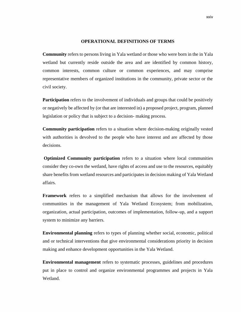
OPERATIONAL DEFINITIONS OF TERMS
Community refers to persons living in Yala wetland or those who were born in the in Yala
wetland but currently reside outside the area and are identified by common history,
common interests, common culture or common experiences, and may comprise
representative members of organized institutions in the community, private sector or the
civil society.
Participation refers to the involvement of individuals and groups that could be positively
or negatively be affected by (or that are interested in) a proposed project, program, planned
legislation or policy that is subject to a decision- making process.
Community participation refers to a situation where decision-making originally vested
with authorities is devolved to the people who have interest and are affected by those
decisions.
Optimized Community participation refers to a situation where local communities
consider they co-own the wetland, have rights of access and use to the resources, equitably
share benefits from wetland resources and participates in decision making of Yala Wetland
affairs.
Framework refers to a simplified mechanism that allows for the involvement of
communities in the management of Yala Wetland Ecosystem; from mobilization,
organization, actual participation, outcomes of implementation, follow-up, and a support
system to minimize any barriers.
Environmental planning refers to types of planning whether social, economic, political
and or technical interventions that give environmental considerations priority in decision
making and enhance development opportunities in the Yala Wetland.
Environmental management refers to systematic processes, guidelines and procedures
put in place to control and organize environmental programmes and projects in Yala
Wetland.
xxv
Environmental governance refers to planning and management, institutional structures,
frameworks, policies, legislations and operations, participating stakeholders to mitigate
environmental challenges and risks in Yala Wetland.
Wetland refers to areas of marsh, fen, peatland or water, whether natural or artificial,
permanent or temporary, with water that is static or flowing, fresh, brackish or salt,
including areas of marine water the depth of which at low tide does not exceed six metres”
(GoK, 2015a).
Ecosystem refers to a dynamic complex of plant, animal and microorganism communities
and their non-living environment (water, air, mineral soils) interacting as a functional unit.
Ecosystem services refer to the benefits people and life support systems obtained from
ecosystems including provision of services such as food and water; regulating services such
as regulation of floods, drought, land degradation, and disease; support services such as
soil formation and nutrient cycling; and cultural services such as recreational, spiritual,
religious, and other non-material benefits.
Yala Wetland refer to an ecological feature found at the confluence of rivers Yala and
Nzoia in Lake Victora Basin shared between Siaya and Busia counties. It is commonly to
referred as Yala swamp but has many features like the swamp, lakes, rivers, papyrus,
riverine vegetations, and various biodiversity.
An ecosystems approach is a strategy for the integrated management of land, water and
living resources that provides sustainable delivery of ecosystem services in an equitable
way which requires mindset-change, government buy-in, sound planning and effective
action based on the latest science (CBD, 2006).
Action research is a disciplined process of inquiry conducted by and for those taking the
action and the primary reason is to assist the “actor” in improving and/or refining his or
her actions (Stringer, 1999).
Conservation means the protection, maintenance, rehabilitation, restoration and
enhancement of the environment for sustainable use.
xxvi
Wetland Conservation is the use of measures and strategies to promote wetlands
protection to maintain its original (pristine) state and control the wetland resources over-
exploitation to ensure sustainability.
Stakeholder is a person, group or organization that has interest or concern in an issue.
Yala RAPPEF-CF-IR-Hub Framework. This the framework developed to optimize
community participation in Yala Wetland Ecosystems Management. The letters describe
the 5 steps of the applying the framework. For ease of reference, the framework shall be
called framework shall be called the Yala Hub Framework.
1
CHAPTER ONE
INTRODUCTION
1.1 Overview of the Chapter
This chapter lays out background information to the study, which entails the statement of
the problem, general and specific objectives of the study, research questions, scope of the
study and justification of the study.
1.2 Background Information
Wetlands occur where the ground water table is at or near the land surface, or where the
land is covered by water (Ramsar Convention Secretariat, 2016), and are one of the world’s
most important environmental assets which provide homes for large, diverse biota as well
as significant economic, social and cultural benefits related to timber, fisheries, hunting,
recreational and tourist activities.
The Convention on Wetlands (Ramsar, 1971a) defines wetlands as:
“Areas of marsh, fen, peatland or water, whether natural or artificial, permanent or
temporary, with water that is static or flowing, fresh, brackish or salt, including areas of
marine water the depth of which at low tide does not exceed six metres (Ramsar
Convention on Wetlands, 1996)”.
The Kenyan Environmental Management and Coordination Act 2015 defines Wetlands as
“...areas permanently or seasonally flooded by water where plants and animals have
become adapted” (GoK, 2015a).
Wetlands are therefore the link between water and land and the zones of transition between
these different environments with water being the most important factor affecting its
environment and the associated plant and animal life (Springate-Baginski et al., 2009).
Wetlands cover about 6-7 per cent of the world’s surface; 44% of the wetlands are located
in the northern latitudes, 30% in the tropical and sub-tropical areas of which 30% occur in
arid and sub-arid ecosystems (Melton et al., 2013; Lehner and Doll, 2004; OECD, 1996).
2
Wetlands in Africa, Asia and South America are estimated to cover between 125 and 131
million hectares (Mha), between 204 and 286 Mha and approximately 179 Mha
respectively (Harmsen, 2018; Melton et al., 2013; Lehner & Döll, 2004; Finlayson et
al.,1999). About 1.3X10⁶ km2 of the world’s wetland area is located in Africa (Beuel et al.,
2016), and Kenya has 2,737,790 ha of wetlands (Harmsen, 2018).
Wetlands are invaluable elements of a functioning earth system as they provide a range of
environmental services including provisioning, regulating, cultural and supporting services
(EANHS, 2018, Finlayson & D’Cruz, 2005; Harmsen, 2018; Ramsar Convention, 2016,
Gordon, 2009). The global value of wetlands was estimated to be US $ 70 billion a year
(Schuyt and Brander, 2004). Wetlands are known to be among the most productive
ecosystems of the Earth (Mitsch and Gossellink 2000; Dugan, 1993). They have high
potential for all season agricultural activity that provides both food and income as well as
a wide range of other ecosystem services for riparian communities (Millennium Ecosystem
Assessment Report 2005; Barbier et al., 1998)
Despite their importance in providing ecological services and supporting livelihoods of
local communities, wetlands are currently threatened by degradation. The estimated inland
wetland loss in some parts of the world is placed at more than 50% as a consequence of
human activities with resultant wetland species loss and negative impact on the livelihoods
of local communities (EANHS, 2018; Springate-Baginski et al., 2009; Millennium
Ecosystem Assessment, 2005; Otieno et al., 2001).
Empirical evidence shows that enabling local communities living in and around wetlands
to share ideas, knowledge, skills, and labour, to meaningfully participate in managing the
resources and the ecosystem services they provide ( Ramsar Convention Secretariat, 2016;
Zsufa et al., 2014) is key to attaining their sustainable use.
Effective community participation is therefore central to sustainable natural resource
management at all levels. Community participation in natural resource management has
evolved from the realization that people who live adjacent to natural resources should be
responsible for their management, and benefit by using the natural resources (GoK, 2010a;
Lockie and Sonnenfeld, 2008; WWF, 2006; Ostrom,1990). The Aarhus Convention of
3
1998 states that citizens must not only have access to information but must also be entitled
to participate in decision making and have access to justice in environmental matters
(DETR, 2000; Stec et al., 2000). However, community participation remains a challenge
as facilitators of participation processes engage in low level consultations that do not
translate into real empowerment of local communities to co-manage shared resources such
as wetlands including Yala Wetland alongside government agencies with legal mandates
to do so (GoK, 2010a; Springate-Baginski, et al., 2009; World Bank, 1999). Cumulatively,
small wetlands play a significant role in supporting both livelihoods and biodiversity, and
reducing poverty (IWMI, 2014).
Wetland’s degradation and loss has been a persistent global challenge mainly because of
population growth, which exerts great pressure on water resources, leads to excessive
resource exploitation and poor ecosystem management and undeveloped land areas for
settlements, higher agricultural and industrial production and infrastructure expansion
(IUCN, 2009; Ruthenberg, 1976; Binswanger and McIntire, 1987; Pingali et al., 1987;
Harmsen, 2018; Ogello et al., 2013). Additionally, governance of wetlands has been
characterized by under representation of local communities. Rather than representing the
interests of those who use them for provision of ‘public goods’, this has favoured those
whose interests are to convert the wetlands to increase private gain (Springate-Baginski et
al., 2009).
Even though wetlands cover only around 6 per cent of the Earth’s land surface, 40 per cent
of all plant and animal species live or breed in wetlands, but they are disappearing three
times faster than forests due to human activities and global heating (UNEP, 2020).
According to Convention on Wetlands Secretariat, we have lost 87% of the world’s
wetlands since 1900 and that we are losing them faster than forests, making them the most
threatened ecosystem on Earth (Convention on Wetlands, 2020).
Wetlands form an important part of nature and are valuable multifunctional habitats that
nurture a great diversity of life, provide water and other resources, control flooding and act
as giant filters easing pollution. But nature is declining globally at rates unprecedented in
4
human history—and the rate of species extinctions is accelerating, with grave impacts on
people around the world (UNEP, 2020).
In Africa, with wetland area estimated between 1% to 16% of the total area of the continent,
wetlands degradation is on the increase as wetland ecosystems are relied upon to lessen
industrial, urban and agricultural pollution and supply numerous services and resources (
Nasongo et al., 2015; Kansiime et al., 2007; Millennium Ecosystem Assessment Report,
2005; Spiers, 1999; Hughes and Hughes, 1992). Similarly, lack of recognition of the
traditional values of these wetlands, desire for modernisation and failure to appreciate their
ecological role aggravates their degradation (Panayotou, 1994; Maclean et al., 2003).
Wetlands in Kenya are experiencing unprecedented threats due to human activities and
impacts of climate change. Kenya has seven main delta-wetlands, namely Tana, Yala,
Omo, Malewa, Nyando, Sondu-Miriu and Nzoia whose conflicts have increased over the
years due to increasing population, competition for land, declining natural resources,
encroachment into fragile ecosystems, escalating poverty and climate change (Odhengo et
al., 2018a, 2018b).
Lake Victoria basin has many wetlands that cover extensive area and support a wide range
of economic activities that sustain a significant proportion of the population and
biodiversity in western Kenya region (Raburu, 2012; Kairu, 2001). The wetlands support
plants, animals, birds and provides physical stability to the shores besides performing
critical filtration functions for Lake Victoria which is presently facing a major threat of
pollution from land based human activities (Ondere, 2016).
Yala Wetland is the largest freshwater delta wetland in Kenya and is crucial to Lake
Victoria’s survival. It is Kenya’s largest papyrus wetland, acting as a filter for rivers
flowing into Lake Victoria. In addition, it is an Important Bird and Biodiversity Area (IBA)
for its large flocks of birds and species restricted to papyrus swamps (EANHS, 2018;
IUCN, 2018; Envertek Africa Consult, 2015; CGS, 2019; CGB, 2014; GoK, 2013b;
Okondo,1989; JICA, 1987).
5
Yala Wetland Ecosystem is threatened by over-exploitation of its natural resources by
competing local communities and the establishment of large-scale agricultural operations.
The agricultural conversion work carried out to date has destroyed natural habitats directly
and caused detrimental hydrological changes over a wider area. Issues that the wetland
currently faces include: high human population density with low agricultural productivity
and widespread poverty; drainage for commercial irrigation at the swamp and upstream;
intensified use of agrochemicals; alien invasive species; biodiversity loss; water and air
pollution; soil erosion and siltation; burning and haphazard harvesting of papyrus;
persistent and prolonged drought; wetland reclamation and encroachment for development
projects without assessment of potential impacts on environment and society; declining
water levels, soil erosion and silting of the dams and water pans; climate change and weak
frameworks for stakeholder participation especially the local communities in resources
management which has created suspicion and tension among various interest groups;
(Odhengo et al., 2018a; County Government of Siaya, 2018; Raburu, 2012;Onywere et
al., 2011; Kenya Wetland Forum, 2006; Lihanda et al., 2003; Otieno et al., 2001). Most of
these challenges have wetland communities’ inclination to them, they are either exploiting
the resources for their livelihoods or undertaking development which they use the wetland
resources but which affects its ecological value. Their participation in decision making,
frameworks, policies, institutions, development and implementation of plans is crucial for
sustainable management of Yala ecosystem.
1.3 Statement of the Problem
A synthesis of research and policy priorities for papyrus wetlands presented at the
Wetlands Conference in 2012 documented by van Dam et al, (2014) concluded that (1)
there is a need for better estimates of the area covered by papyrus wetlands. Limited
evidence however, suggests that the loss of papyrus wetlands is rapid in some areas; (2)
there is a need for a better understanding and modelling of the regulating services of
papyrus wetlands to support trade-off analysis and improve economic valuation; (3)
research on papyrus wetlands should include assessment of all ecosystem services so that
trade-offs can be determined as the basis for sustainable management strategies (‘wise
use’); and (4) more research on the governance, institutional and socio-economic aspects
6
of papyrus wetlands is needed to assist African governments in dealing with the challenges
of conserving wetlands in the face of growing food security needs and climate change.
Nearly 65% of Yala wetland is occupied by papyrus dominated vegetation (Odhengo et al.,
2018a). Yala wetland and the livelihoods it sustains have become more threatened and their
ecological integrity endangered by various anthropogenic and hydrodynamic causes during
the last half of the century. The anthropogenic causes include land use, increased human
population and the relations between lake/water level dynamics, weak wetland
management and coordination frameworks, underrepresentation of local communities in
wetland decisions making processes. Cumulatively, these have created the enabling
environment that is accelerating degradation and loss of these ecosystems, loss of
livelihoods and increased poverty among the wetland resource dependent communities
(Odhengo et al., 2018a; Davis, 2010; Krhoda, 1992). Further, there has been a weak
framework of coordination among the Yala Wetland stakeholders to ensure effective
wetland communities’ participation in wetland ecosystems management processes.
According to Onywere et al. (2011) the overall loss in the area under Yala Wetland was 54
Km2 from 186 Km2 in 1973 to 132 Km2 in 2009. Wetland encroachment had significant
changes on the wellbeing of Yala Wetland ecosystem. Various studies done in Yala
Wetland and River Nzoia Basin (Raburu, 2012; Kenya Wetland Forum, 2006; Ondere,
2016; Muoria et al., 2015; van Heukelom, 2013; Odenyo et al., 2018; Odero, 2015a,
2015b) recommended that the governance of Yala Wetland should have local communities
as co-owners and managers; resolve conflicts of wetland resources use, improve quality of
community participation in wetland resources management, and develop of an integrated
watershed management plan for effective management of Yala Wetland .
Studies on Yala Wetland by KEFRI (2015) has pointed the reasons for under
representation of local communities in Yala Wetland management to include dispossession
of community lands by a Dutch company and LVBDA without compensation and wetland
residents’ denied access to their ancestral lands. Other reasons include incidences of water
pollution causing sickness to community members; death of livestock and poultry as result
of contact with agro-chemicals; lack of awareness / baseline information on Yala wetland
7
inventories and variable climatic conditions and destructive practices by community like
perennial flooding; and overharvesting wetland plants. As result locals have no interest in
Yala wetland management.
Evidence from literature reviewed shows that in Yala Wetland the population of wetland
residents are increasing constantly as they carry out their livelihoods activities that are
dependent on natural resources from the wetland. The County Governments of Siaya and
Busia and the National Government are interested in uplifting the wetland communities’
livelihood and have planning and inventory techniques for valuing wetland resources that
local people do not know. The riparian communities also have vast local knowledge which
can be of benefit to government planning. The challenge therefore is how to combine all
these to uplift their livelihoods and not degrade resources in Yala Wetland Ecosystem of
Lake Victoria, Kenya.
Further, the dynamics of community participation that would make their participation
effective and meaningful in Yala ecosystem management as their population increase and
many stakeholders increasingly get involved in the wetland are yet to be clearly
understood. If they are not well understood, then design for sustainable management
actions will not be attainable thereby posing a major threat to the existence of the Lake
Victoria wetland ecosystem.
This brings into sharp focus the role riparian communities in the continued wetland
degradation as well as the change needed to reverse this trend. However, the dynamics of
communities’ participation and their activities on the wetland are not clearly understood
despite wetland’s continued degradation in size and value (Dobiesz et al., 2009; Dugan
1993). This study therefore sought to bring clear understanding on and enhance community
participation in the planning and management of Yala Wetland ecosystem.
The Yala Wetland challenges discussed above pointed to the need for a well-considered
Land Use Plan (LUP) that would provide a rational and scientific basis for future
development and use of Yala wetland resources. This situation prompted and encouraged
the County Governments of Siaya and Busia, and the Inter-ministerial Technical
Committee on the Sustainable Management of Kenyan Deltas (IMTC) to initiate processes
8
that culminated in the effort to prepare a LUP that will help resolve these challenges so that
Yala Wetland will be able to sustainably support livelihoods of local residents while its
ecological integrity and that of its associated ecosystems is protected.
Preliminary processes implemented by IMTC prepared a LUP Framework to guide the
planning process and was agreed upon by stakeholders. The IMTC’s responsibility is
coordination, policy and planning processes of major deltas in Kenya. The Framework was
a result of a participatory and collaborative process that involved various stakeholders at
the local, county and national levels. As required by Kenya Constitution article 69(1) and
part VIII section 87-92 and 115 of County Government Act, 2012 on devolution provisions,
and part 2 section 6 (1-2) Public Participation Bill, 2020 provided for participation of local
communities in the Yala SEA and LUP process through a Yala Project Advisory
Committee (YPAC) (GoK, 2020; GoK, 2012a, 2012b; GoK, 2010a, 2010b). The LUP
process also benefited from a concurrent Strategic Environmental Assessment (SEA)
process that served to assess the environmental implications of the LUP. However,
participation of local communities in seeking solutions to wetlands resources use remains
a grave challenge as managers of participation processes engage in low level consultations
that do not empower them to co-manage these resources alongside government agencies
mandated to do so (GoK, 2010a; Springate-Baginski, et al, 2009; Okello et al., 2009;
Thenya, 2001; Olson, 1965). Therefore, this research sought to fill the knowledge gap on
how to improve effectiveness of wetland communities’ participation in managing Yala
wetland ecosystem resources sustainably.
This study sought to contribute towards improving the livelihoods of Yala Wetland
communities by offering a greater understanding on community participation in wetlands’
planning and management processes and then designed a community participation
framework that optimizes their participation in planning and subsequent management of
the Yala Wetland land use plan and integrated management plans.
9
1.4 Objectives of the Study
1.4.1 General Objective
The general objective of the action research was to assess and strengthen participation of
Yala Wetland communities so that they can co-own the outcomes of the LUP/SEA process
and ensure their stake in future implementation of the results in the management of the
wetland ecosystem.
1.4.2 Specific Objectives
1. To assess the status of community participation in Yala Wetland ecosystem
management.
2. To identify environmental issues using Remote Sensing and Community GIS for
inclusion in Yala Wetland Land Use planning and management.
3. To develop a framework for optimizing community participation in the Yala Wetland
ecosystem management.
1.5. Research Questions
Objective 1: To assess the status of community participation in Yala Wetland
Ecosystem Management.
Research Questions
1. Do the local communities participate in Yala wetland ecosystem management?
1.1 What is the historical account of the formation of Yala wetland and how has that history
informed current utilization of its resources?
1.2 What benefits do the local communities derive from Yala wetland and how has this
influenced their participation in its management?
1.3 What indigenous knowledge systems are used by local communities to manage Yala
Wetland ecosystem?
10
1.4 What participation structures and processes exist in carrying out Yala wetland LUP/SEA
processes?
1.5 What is the current level of community participation in Yala Wetland LUP processes
measured using the spectrum model of public participation?
1.6 How effective is the community participation framework in Yala Wetland LUP measured
using the 10-point World Bank indicators of public participation effectiveness?
1.7 What governance structure exists for managing Yala Wetland ecosystem?
Objective 2: To identify environmental issues using Remote Sensing and Community
GIS for inclusion in Yala Wetland Land Use Planning and Management.
Research Questions
2.What are the environmental issues of Yala Wetland to be considered in Yala Wetland
Land Use planning and integrated management plan?
2a. i.What are environmental issues to be considered, in Yala wetland LUP and
management plan?
ii. What is the communities’ vision for Yala Wetland Ecosystem in 50 years’ time? And
what should be done to attain this envisioned future?
iii.What role will local knowledge play in the management of the envisioned Yala Wetland
ecosystem?
2b. What are the local communities’ environmental issues (spatial data) for inclusion in
SEA/LUP and Yala wetland ecosystem management plan? using Public Participatory GIS
2c.i. What are the environmental issues/challenges related to Yala Wetland
landcover/landuse changes between 1960 and 2014?
ii. What is the extent and (ecological) impact of Yala Wetland landcover/landuse changes
between 1960 and 2014?
11
iii.What is the extent of the ecosystem and threats to biodiversity, impact on global
warming and impact on water use?
Objective 3: To develop a framework for optimizing community participation in Yala
Wetland Ecosystems Management.
Research Questions
Part one: Designing the framework
3a. What mechanism would optimize community participation in Yala Wetland planning
and management processes?
i. What are the weakness and challenges identified in the YPAC participation mechanism?
ii. What kind of community participation in Yala Wetland planning and management
would make the communities feel that they co-own the wetland (by owning some land,
having access to the swamp and having rights of access and use to the resources from the
swamp, and are fully involved in decisions for managing the swamp affairs)?
Part Two: Applying the framework in SEA/LUP processes
3b. Target for evaluation: i. Local community leaders ii. Wetland community members iii.
SEA/LUP Technical team members iv. Government officials v. other Yala Wetland
stakeholders
i.What is the feedback from testing the modified framework for optimizing community
participation in Yala Wetland Planning and Management?
ii. How can this framework be improved to make it even better and to be applied in planning
other wetlands?
Part Three: Deploying the framework in Siaya County Integrated Development
(CIDP)
12
3c. How can this framework be applied in community development programs particularly
County CIDP development?
Part Four: Deploying the framework in developing Yala Wetland Indigenous
Community Conservation Areas Management Plan (ICCA)
3d. How can this framework be applied in community development programs particularly
County CIDP development?
1.6 Scope of the Study
The study focused on communities living inside the wetland and within 5km from the
wetland boundaries because their propensity to use the wetland is inversely related to travel
distance (Abila, 2003, 1998). The study also extended to communities living in the upper
Yala cluster (lower catchment of river Yala) whose activities affect the Yala Wetland water
flow and quality
The study extended to Yala Wetland catchment areas of Yala and Nzoia rivers and a
number of constructed dams such as Ufinga, Giriwa, Oranga, Lebo, Tinga Kuodo, Mwer
and Kalenjuok Tinga and activities happening on smaller streams that drain into the
wetland and Lake Kanyaboli. Other wetlands included Nyamawin-Luand river feeding into
Lake Kanyaboli and Oking River feeding Yala river (IMWI, 2014; Owuor, et al., 2012;
Abila, 2003, 2005).
The planned activities on Nzoia River catchment like the location and the type of
development and management plans for the whole of Lake Victoria North Catchment area
(LVNCA) were also considered in the study (GoK, JICA, 2013; GoK, 2007); IUCN,
UNEP, WWF, 1991).
Whereas geographic focus is Yala Wetland and its surroundings, the study incorporated
some of the communities’ members residing outside the wetland who could make
significant contributions to improve on the outcome of Yala Wetland ecosystems
management.
13
1.7 Justification of the Study
The study aims at contributing towards improving the livelihoods of Yala Wetland
communities by studying the effectiveness of community participation and availing a
framework that shall optimize their participation in the management of the ecosystem and
accruing benefits. While conceptualizing the research topic and study area, the Yala
Wetland Land Use planning processes had started and therefore offered an opportunity to
anchor the study to provide real time feedback, improve the process and eventual outcome.
The process of conducting SEA to inform subsequent Yala Wetland LUP was a
collaborative effort between the National Government, County Governments of Siaya and
Busia, and Conservation Non-Governmental Organizations. The study was thus carried out
alongside the Yala Wetland SEA and LUP process. This influenced the choice of research
(Action Research method) to ensure that its outcomes informed the final LUP that
eventually had local communities’ meaningful contribution on how to sustainably manage
Yala Wetland ecosystem. The action research type choice with its learning element
provided advice and support for practitioners and policy makers in the two counties of
Siaya and Busia and in the broader conservation sector.
Moreover, global competitiveness demands that universities should work in conjunction
with research agencies, industry, governments and non-governmental organizations
(NGOs) to collaboratively generate knowledge and innovation which are essential
ingredients for economic growth in the twenty first century (de la Reyn, 2018; UWN,
2014). This was a major consideration for this research type and methodology.
Thus, this study brought in teamwork in research by bringing on board the University of
Eldoret, School of Environmental Studies, Development Organizations
(USAID/DAI/Africa Lead) my co-supervisor, and other key stakeholders not identified
when the processes started like professionals from the Yala Wetland community, students,
religious leaders and change makers. Furthermore, since there were multiple stakeholders
with varying interests, this promoted the need for a sound coordinating framework for
sustainable management of Yala Wetland ecosystem.
14
CHAPTER TWO
LITERATURE REVIEW
2.1 Introduction
This chapter reviews literature relevant to the study and is organized into subsections as
wetlands, participation, participation paradigm and public participation; policy, legal and
institutional framework; and related studies. Thereafter, theoretical and conceptual
frameworks of the study are presented which integrates systems theory and
transformational learning theory in a wetland ecosystems management context.
2.2 Wetlands
For billions of people throughout the world, especially the rural poor, wetlands are critical
for livelihoods, providing vital supplies of water, food and materials as well as ecological
services. However, wetlands are suffering from extreme levels of degradation, a wetland
loss and drainage at more than 50% resulting not only in a tragic loss of the wetland species
but is also impacting heavily on those people whose livelihoods depend upon
wetlands(Springate-Baginski et al., 2009). Additionally, national and regional economies
also lose from the loss of hydrological services, such as flood control and water
purification, and of material goods such as those provided through fisheries.
The ecological value of wetlands results from the sum and interaction of biological,
physical, and chemical components that maintain wetland characteristics and functions.
The interaction of these components and the high productivity of wetland ecosystems
typically lead to rich and varied habitats and food resources for numerous types of
organisms (IWMI, 2014;Springate-Baginski et al., 2009; Khorda,1912).
There are two types of wetlands: natural and artificial wetlands. Natural wetlands are either
permanent or seasonal because they take the characteristics of a distinct ecosystem. Their
vegetation cover consists of aquatic plants adapted to the unique hydric soils. They are the
most biologically diverse of all ecosystems, serving as a home to a wide range of plants
and animal life. They can further be categorized as inland and coastal wetlands (Harmsen,
2018). Inland wetlands include: permanent and temporary rivers and streams; permanent
15
lakes and reservoirs, seasonal lakes, marshes, and swamps including floodplains, forested
wetlands, Alpine and tundra wetlands, springs and oases, geothermal wetlands and
underground wetlands, including caves and groundwater systems. Coastal wetlands on the
other hand include estuaries and marshes, mangroves, lagoons, including salt ponds,
intertidal flats, beaches and dunes, kelp, rock and shell reefs, seagrass beds and coral reefs
(Harmsen, 2018; Springate-Baginski et al., 2009).
Artificial wetlands on the other hand are water storage areas; reservoirs, barrages, hydro-
electric dams’ impoundments and are designed to simulate the water quality improvement
function of natural wetlands to treat and contain surface water runoff pollutants and
decrease loadings to surface water. They can be used to treat municipal and industrial
wastewater as well as storm water runoff. Besides, they do not replicate all the ecological
functions of natural wetland (Harmsen, 2018; Ramsar Convention, 2016).
The complexity of wetland landscapes thus involves interplay of several key factors:
hydrology and topography of the physical wetland, biodiverse wetland ecosystems, and
ecosystem services to human communities both local and more distant, local livelihood
systems, policies, governance, institutions, and markets. Each of these elements needs to
be understood to understand the overall management challenge (Springate-Baginski et al.,
2009; Ramsar Convention on Wetlands, 1996).
Wetlands can be classified based on the environment where they are found and the nature
of their formation. In Kenya they are marine, estuarine, lacustrine, riverine palustrine and
human-made (Crafter et al., 1992). Marine wetlands are exposed to waves and currents
of the open ocean and include mangroves, mudflats, coral reefs and salt marshes. Examples
include the Mombasa Marine National Park and the Watamu Marine National Reserve.
Estuarine wetlands occur where fresh water and salt water mix and this results in deltas,
mangroves and tidal marshes. Examples are the Tana River Delta, Turtle Bay and Shimo
La Tewa. Lacustrine wetlands occur in and around lakes; examples are Lakes Nakuru,
Elementaita, Baringo, Bogoria, Naivasha, Victoria, Jipe, Chala, Magadi and Turkana.
Riverine wetlands are found along rivers and streams; examples are the Athi, Ewaso
Ng’iro, Nyando, Yala and Tana rivers. Palustrine wetlands are characterised by the absence
16
of flowing water and tides and this results in marshes, swamps, bogs and floodplains.
Examples are the Nyando floodplains and King’wal swamp. Lastly, human-made wetlands
include rice paddies, saltpans, gravel pits, water treatment ponds, dams, reservoirs and
canals (Harmsen, 2018; Ramsar Convention, 2016).
2.3 Public Participation
2.3.1The Concept of Public Participation
"Participation" is one of those words that can be interpreted in many different ways – it can
mean finding something out and proceeding as originally planned; or developing processes
of collective learning that change the way that people think and act (Harrison et al., 2001).
Essentially, public participation is the process of ensuring that those who have an interest
or stake in a decision are involved in making that decision. The many ways that
organisations interpret and use the term public participation has resulted into a range of
different types of participation. These range from passive participation, where people are
told what is to happen and act out predetermined roles, to self-mobilisation, where people
take initiatives largely independent of external institutions (Table 2.1).

17
Table 2.1 Types of Participation
Types of Participation Characteristics
Informing People participate by being informed what has been decided
or has already happened. Or participation is used to gather
information from those involved to develop solutions based
on their knowledge. The decisions however are made by
those initiating the participation process
Consultation People participate by being consulted or by answering
questions. The process does not concede any share in
decision-making, and professionals are under no obligation to
take on board people's views
Implementing Participation is seen by those initiating it as a means to
achieve their goals, especially reduced costs. People
participate to meet objectives decided by those starting the
process.
Shared Decisions People participate in the joint analysis of situations and the
development of plans to act. Such a process involves capacity
building – the formation or strengthening of local groups or
institutions
Self Determination People participate by taking initiatives independently to
change systems– such as plans and policies. They develop
contacts with external institutions for resources and technical
advice they need but retain control over how resources are
used
Source: Harrison et al., 2001
18
In essence the types of participation move from situations in which stakeholders are largely
passive in the process and the power lies with those in control to stakeholders becoming
active and in control of the process themselves.
One type of participation may not in itself be ‘better’ than another. Different types of public
participation are appropriate in different situations, with different objectives and with
different stakeholders. Some stakeholders have a greater right to more control of the
process than others, some have greater capacity to participate than others and some are
quite happy to participate less in some decisions- allowing others such as representative
organisations or politicians to take decisions for them.
According to the International Association of Public Participation (IAP2, 2008) public
participation consist of five levels: Information (lowest level, where participation does not
go beyond information provision), consultation, involvement, collaboration and
empowerment (highest level, where the public are given a final say on the project decision.
Participation has become a key element in the discussion concerning development
particularly in natural resources management (Cooke and Kothari, 2001). The concept is
seen as a magic bullet by development agencies who are making participation one, if not
the core element of development (Michener, 1998). As Cleaver (1999) in her various
studies on participation notes the drive for participatory approaches seems to stem from the
perceived paradigm shift in development that supports participation as a way forward in
development. Promoters of participatory approaches observe the traditional top-down
management style to be inefficient, corrupt, and exploitative as far as the poor and the
marginalized are concerned (World Bank, 1998). As a result, participation is presented as
a feasible response to these problems.
Participation has been defined variously depending on who is doing the defining and what
the objectives are for participation. Wilson (2003) posits that different types of
participation are more important than defining it, while other scholars prefer evaluating
participation according to the nature and quantity of benefits derived. For example,
Michener (1998) defines participation as a process that lies on a continuum from a planner-
centred to a people-centred approach. A planner-centred approach focuses on
19
administrative and financial efficiency. From this viewpoint, the motivation for promoting
participation is that user involvement makes projects more likely to succeed in meeting
their objectives. It is also perceived by planners that this form of participation increases
local people’s acceptance of new interventions promoted from outside.
In contrast, the people-centred participation is based on the perception that participation is
both a means and an end in itself. According to Chambers (1997), participation is supposed
to be a means to meet locally felt needs and to redistribute scarce resources. It is also seen
as having a practical value as a process that empowers the poor and the marginalized by
enhancing local management capacity, increasing confidence of participants, and raising
collective consciousness. In this regard, the people-centred participation is closely related
to the concept of “strong” participation, as initially promoted by Chambers (1983). From
these viewpoints, the people-centred participation is seen as a way to substitute
emancipation to empower the deprived and the excluded to take their own decisions.
Although other classifications of participation have been developed (for example Wilson,
2003; Deshler and Sock, 1985 Cohen and Uphoff, 1980), it is the people-centred
participation that is highly promoted, by donors and development agencies. This is mainly
because it embodies powerful and appealing terms such as “community”, “empowerment”,
and “poverty reduction” (Cleaver, 2001). Nevertheless, those who argue for the people-
centred participation have been criticized for their simplistic approach to society. For
example, Brett (2000) argues that those who claim that mere peoples’ participation can
fundamentally alter the nature of power structure that sustains complex societies are simply
ignoring the well-established in-sights of modern social science. In particular, leading
authors of participatory approaches assert that participation has shown how local people
understand the socio-political conditions under which they live and possess the relevant
knowledge for solutions to many local level problems (Doelle and Sinclair, 2005; Narayan,
2002; Chambers, 1997; Chambers, 1994; Uphoff, 1992). However, the authors point out
that in some cases, local people can become a “ghostly” presence within the planning
process. They are visible, can be even heard but in essence they are only there because
their involvement lends credibility and legitimacy to decisions that have already been
made. It is also observed that people-centred participatory theorists often make unrealistic
20
assumptions about the ability of the poor to access joint decision-making processes
(McCay and Acheson, 1987).
Jacobs (1961) documented how neighbourhoods attain vitality through the collective
efforts of individuals who care about their common place. Castells (1983) provided
evidence that community-based action has occurred in a wide variety of cultures and is
universal. Participants in such organizations see opportunities to achieve individual goals
through collective action (Thomas et al., 2016; Miriti, 2016; Raburu et al., 2012; Olson,
1965).
2.3.2 Participation Models
Participation has been studied and different models offered to show the levels and
challenges therein. The models include the ladder of citizen participation (Arnstein, 1969)
which show the hierarchies of participation from non-participation, to tokenism and to
citizen power with meaningful happening at the apex (citizen control); to the wheel model
with four levels namely inform, consult, participate and empower (Davidson,1998); and
the spectrum model with five levels from inform, consult, involve, collaborate and
empower (Stuart, 2017; ODPM, 2004). Finally, there is citizen as partners model which
has five levels from Information and transaction, consultation, deliberative involvement,
government – led active participation and citizen-led active participation (OECD, 2001).
Participation in policy formulation and strategic planning is a recent phenomenon. This is
where decision making originally vested with authorities is being taken down to the people
who have interest, and are affected by those decisions (OECD, 2001). Participation is also
related to the theories of communication, which emphasize that the rationale of decision-
making is also expressed through communication that is constitutive of social identity. In
the Hebermas theory, the rational action does not come from expected results of action, but
it only derives from communication itself. Therefore, one can already consider key role of
information (i.e. understanding) and moral aspects (i.e. honesty, truth, correctness) in any
participatory processes (Niskanen and Vayrenen, 1999).
Public participation is important in community planning and has been practiced in ways
that range from evasion to full empowerment. This is seen in the ladder of increasing of
21
public participation where on the lowest rung the citizens are (sometimes) provided with
requested information and at the top of the rung, the public has full voice in the final
decision making usually through a community organization.
The barriers to participation by the poor include among other things, gender, class, poverty
or access to social, political and economic resources and the fact that participatory
processes can also be subverted by small groups whose interests do not coincide with those
of society as a whole (Agrawal and Gupta, 2005). Studying forest management in India,
Agrawal (2002) observes that social status was a crucial point in determining who could
and who could not participate. The study concludes that the key factor affecting the
performance of governance is not the degree of participation per se; rather the nature of the
institutional constraints that determine who can participate, how, and when.
2.3.3 Spectrum Model of Public Participation
The Spectrum of Public Participation was developed by the International Association of
Public Participation (IAP2) to help clarify the role of the public (or community) in planning
and decision-making, and how much influence the community has over planning or
decision-making processes (Stuart, 2017). It identifies five levels of public participation
(or community engagement) as shown in Figure 2.1.
22
INFORM
CONSULT
INVOLVE
COLLABORATE
EMPOWER
GOAL To provide
balanced
and
objective
information
in a timely
manner.
To obtain
feedback on
analysis,
issues,
alternatives
and
decisions.
To work
with the
public to
make sure
that
concerns
and
aspirations
are
considered
and
understood.
To partner with the
public in each
aspect of the
decision-making.
To place
final decision
making in the
hands of the
public.
PROMISE “We will
keep you
informed”
“We will
listen to and
acknowledge
your
concerns”
“We will
work with
you to
ensure your
concerns
and
aspirations
are directly
reflected in
the
decisions
made
“We will look to
you for advice and
innovations and
incorporate this in
decisions as much
as possible”
“We will
implement
what you
decide”
Figure 2.1: Spectrum of Public Participation (Adapted from IAP2 Spectrum of public
participation, Stuart, 2017)
23
The further to the right on the Spectrum, the more influence the community has over
decisions, and each level can be appropriate depending on the context. It is important to
recognise that these are levels, not steps. For each level it articulates the public participation
goal and the promise to the public. The first level of public participation which is the
Inform level does not actually provide the opportunity for public participation at all, but
rather provides the public with the information they need to understand the agency
decision-making process. Some practitioners suggest that the Inform level should be placed
across the Spectrum (e.g. above or below it) to demonstrate that “effective engagement
with stakeholders at all levels on the Spectrum requires a strategic flow of information”
(Chappell, 2016).
Since Arnstein (1969) proposed a ladder of citizen participation almost 50 years ago
(ranging from manipulation and therapy, to delegated power and citizen control) there have
been several attempts to classify levels of community engagement with the Spectrum of
Public Participation gaining more popularity (Stuart, 2017).
2.3.4 Participation Paradigm
There are two main sociologist epistemological models for participation in decision-
making. The first is the rationalist model, which is based on deductive chain of decision
taken by the public authority in charge of making public choices for society. In this model,
common interest is defined by a rationalist norm in extra-societal way, without any
considerations on the needs and interests expressed by the users. The second one is the
incremental model, which considers decision as a set of actions taken by a network of
relations between the stakeholders and the representative structures of public authority
(Niskanen and Vayrenen, 1999). This framework defines common interest as the results of
all needs and interests expressed by stakeholders. The public authority has a passive role
of translation of social expressions. Some of the position expressed will be opposite; hence,
the solution is not a consensus, but a compromise. Therefore, the paradigm of participation
theoretically refers to either of the two frameworks, but it is generally used in the frame of
incremental viewpoint.
24
Citizen-led active participation is the ultimate aim of public participation in which citizens
are actively engaged in decision-making processes, alongside government and or
facilitating agency; citizen decisions become binding; citizens share ownership and
responsibility over outcomes (OECD, 2001). Although participation is a process, and one
that may have a temporal component to it, participation is not linear. Issues are frequently
place-based and so are participants.
2.3.5 The Place of Public Participation in Environmental Planning and Management
Why is public participation important in planning and management? A key factor that
underscores the role of public participation is the political nature of most decisions. Even
decisions on strictly technical choices are often not made exclusively based on logical and
independent analysis of technical data and multicriteria equations. Instead, they are
regularly the result of political expediency, a bargain element in the negotiation of other
goods and agreements, a market opportunity, a rapport of forces between vested interests
(Ferraz de Abreu, 2002). In such situations, the active participation of the community itself
in the planning and management processes brings some balance into the decision process
and thus avoid decisions that will harm community interests (i.e. the "common good")
(Hardin, 1968).
Decision-making processes on technical matters are therefore attractive situations to study
the community participation occurrence. In particular, they raise inevitably the issue of the
role of the expert. Ordinarily seen as the source for an independent, objective, interest-
neuter, rational planning by some, and as the voice of the interests that appoint them by
other. Experts are nevertheless at the centre of the decision process because expertise and
technical knowledge is required, and because expertise will be called to defend each side.
So, the question of what public participation becomes, is a great measure of the question
of how a lay community can give a meaningful, valid input, with real weight in a final
decision based on technical arguments and evidence (Ferraz de Abreu, 2002). This brings
the corresponding question on the importance of a modified framework: “can a proposed
modified community participation framework in Yala Wetland contribute in a significant
way to "level the field by optimizing community participation", reduce the gap between
25
local communities, the experts and policy makers, and thus facilitate a more informed and
knowledgeable input from local communities?”
2.3.6 Objectives of Community Participation in Decision Making
Selznick identified two views about the purpose of participation namely administrative and
substantive participation. "Administrative participation" attempts to transform the citizen
into a reliable instrument for the achievement of administrative goals (as cited in Ferraz de
Abreu, 1992). "Substantive participation" on the other hand attempts to provide citizens
with an actual role in the determination of policy. Whereas there are different ways to
promote community participation, and that understanding of these agendas are essential to
understand the tactics and techniques adopted for public participation; the formulation of
dual views tends itself to weaken the argument, because it is also reasonable to expect
circumstances where both strategies are not contradictory.
Vlachos (1993) proposes a model that focuses on levels of participation, instead of
objectives of participation. The difference is creative since it does not imply a prior
judgment on intentions. He makes a distinction between public awareness, public
involvement and public participation.
Public awareness implies one-way information and alerting to community issues. Public
involvement implies two-way communication and a means of engaging community
members in the exchange of information (dialogue). Finally, public participation is the
most intense form of interaction between authorities, experts and citizens and implies more
than anything else truly joint planning and democratic delegation of power and shared
leadership.
Another critical issue in the literature is "Public vs. Expert" dichotomy. According to
Frankena (1988) there is "the emergent social role and political impact of the voluntary
technical expert". In some circumstances, this distinction becomes irrelevant. Kennard
points out that "when it comes to values, we are all experts" (as cited by Ferraz de Abreu,
2002), therefore, if the issue is essentially dependent on value judgments, everyone is
qualified. Besides Frankena's and Kennard's arguments, citizens and NGOs can engage
their own experts; and the exponential mass access to education and science increased the
26
likelihood of finding qualified experts among individual citizens in the targeted locations.
Inspite of the foregoing, this remains an open issue, because of the inequalities in the
distribution of human and institutional resources, and in the scope of the projects being
assessed. Vlachos, for instance, differs from Frankena on the relevance of the voluntary
expert.
Within the last decade or so, society has tended to advocate the simultaneous growth of
participatory democracy and of expertise in decision-making. It becomes difficult to
maximize both of these value preferences and strains appear between the idealized
conceptions of citizen participation and the harsh demands of public policy making and
implementation (Vlachos, 1993). If both Frankena and Vlachos have a point, what is the
major pattern? It is important and relevant to collect evidence of the level of expertise
reached in public participation processes.
Additionally, Glass (1979) proposed a model focusing on the function of each kind of
public participation. He itemized five objectives of citizen participation: information
exchange, education, support building, decision-making supplement and representational
input. Considering Glass approach, Ferraz de Abreu (2002) added by suggesting a way of
evaluating the scope of each objective by assessing the way it relates to the potential
problems resulting from not having public participation namely: weak legitimacy of some
decisions (interests of majority may be neglected; interests of minorities may be ignored);
weak accountability, easier corruption; weak constituency to support development effort
and costs; no public help and cooperation in development tasks; project plan and its review
may miss aspects dependent on local knowledge that otherwise would have been an
improvement; later antagonism may block project, with added costs; and no public
education gains. An important task of developing a land use plan in an area that has
experienced grave conflicts with investors in Yala Wetland would wish to benefit from
minimizing potential participation problems starting with weak legitimacy of fundamental
land use decisions.
The identification of the objectives of community participation and respective problems
associated with each is crucial in developing "criteria of success", which forms the basis
27
of improving the process framework of public participation. Similarly, it can help to
identify the specific requirements that an improved community participation framework
should satisfy.
2.3.7 Forms of Participation
Sarah White’s (1996) work on the forms and functions of participation distinguishes four
forms of participation: nominal, instrumental, representative and transformative. She
reasons that each form has different functions, and argues actors ‘at the top’ (more
powerful) and ‘at the grass roots’ (less powerful) have different perceptions of and interests
in each form. Nominal participation is often used by more powerful actors to give
legitimacy to development plans. Less powerful people become involved in it through a
desire for inclusion. However, it is little more than a display, and does not result in change.
Instrumental participation sees community participation being used as a means towards
a stated end – often the efficient use of the skills and knowledge of community members
in project implementation. Representative participation involves giving community
members a voice in the decision-making and implementation process of projects or policies
that affect them. For the more powerful, representative participation increases the chances
of their intervention being sustainable; for the less powerful, it may offer a chance for
leverage. Transformative participation results in the empowerment of those involved,
and as a result alters the structures and institutions that lead to marginalisation and
exclusion.
White’s work helps us to think about the politics of participation that is hidden agendas
and the dynamic relationships between more and less powerful actors. It is only in
‘transformative participation’ that the power holders are in solidarity with the less powerful
to take actions and shape decisions. White emphasizes that this framework needs to be seen
as something dynamic, and that a single intervention can include more than one form of
participation.
2.3.8 Techniques of Public Participation and their Challenges
The different techniques used in public participation include focus groups discussions,
advisory committees, dedicated telephone lines, interviews, talks, conferences, workshops,
28
surveys, and referendum (Sapienza cited by Ferraz de Abreu, 2002; World Bank, 1998;
Joanaz de Melo, 1993; Innes, 1992; EPA, 1990). Many factors are considered in choosing
which technique to apply in each situation. However, they have challenges that efforts to
improve community participation should consider namely: it requires full-time dedication
from members, for a long period of time (advisory committee); if it allows to estimate
emotional responses, it does not provide any indication about the duration of focus groups,
it depends on public willingness to call (dedicated phone line); it does not facilitate
dialogue; it allows exacerbation of differences of opinion (talks); dialogue is still limited
and may require even more time (and people) to organize (e.g. conferences); it is not
adequate for large audiences, organizing in several places and on several topics, requires
plenty of people and time (e.g. workshops); provides a still image of public opinion,
requires professionals and a very expensive technique (e.g. survey); requires long and
expensive phase of information and debate, community susceptible to emotional assertions
than to reasoned opinions (e.g. referendum).
Other emerging techniques that help with capturing diversity and complexity of issues and
dynamics for the local community as documented by Smith (2002, 2006) and Odero,
(2015a) include:
a. Open space technology. This uses plenary circles (i.e., participants sit in a circle) and
has a few, simple rules. Breakout sessions are organized, led and reported on by self-
selected participants. This technique can maximize the creativity, energy, vision and
leadership of all participants, and is egalitarian and inclusive. It can be used to set strategic
direction, plan or initiate a project, and develop standards, criteria or regulations. It has the
ability to maximize teamwork.
b. Future search conferences are workshop conferences at which 40-80 people join forces
to visualize a desired future and then design the steps needed to get the organization there.
This technique uses a whole system approach and places emphasis on self-managed, small-
group discussions. It can be used when the solution to an issue or problem resolution may
require a change in organizational mission, functions or structure.
29
c. E-participation includes a wide range of specific individual techniques, including e-
mail, provision of Web site information, bulletin boards, chat and news groups, dialogue
groups and virtual communities. These low-cost approaches are only available to those
who have access to a computer and are useful when the policy community is spread over a
broad geographic area, or where open information-sharing is important.
d. Public policy dialogue involves in-depth, detailed work with a variety of stakeholders
in a committee or workshop format, usually to achieve consensus on diverse views,
interests and values. In the policy development process, dialogue is especially useful at the
value and goal clarification stage and during option selection if tradeoffs are required.
Dialogue may last from two days to two years, commonly two days per month for three to
12 months. Inclusive representation of key stakeholders, often including the sponsor, is
essential.
e. Appreciative inquiry focuses on the positive aspects of a situation, opportunities,
strengths, proven capacities and skills, resources and affirms, appreciates and builds on
existing strengths. Appreciative inquiry is a very effective way to get people to think about
their demonstrated abilities instead of listing and dwelling on problems or challenges
(Copperrider, 2008).
f. Study circles explore a critical public issue in a democratic way; analyze a problem,
develop strategies and actions; and look at issues from multiple viewpoints. Small-group
discussion among peers is often facilitated. Study circles have eight to 12 members and
meet regularly over a period of weeks or months. This technique is especially useful at the
problem definition, values and goal clarification, option generation, and selection stages of
policy development.
In the use of the above techniques, remotely sensed data and resultant spatial information
can be used to help communities visualize the status of natural resources, trends, causes,
effects and model future scenarios to animate the discussions (Odero, 2015a). These
analyses show evidence of some obvious key factors for enhancement through improved
frameworks and better use of technology to help minimize time and staff requirements.
However, it also points to other important element of how can improved community
30
participation framework help to facilitate reasoned and in-depth debates, and to enlarge the
space of solutions versus the space of conflicts?
2.3.9 Critique of Community Participation
Several decision makers are cynical towards community participation and have, pointed to
typical problems found in current community consultations. One, the foundation for a
decision being of technical nature, it is best left for qualified experts. Second, the scope of
the projects being assessed are vast, therefore they need expert multidisciplinary
facilitators not always available to most local communities, or even to most CBOs/NGOs,
sometimes not even to government agencies. Third, credibility in the process is low as
people do not believe that their input will make a difference regarding the final decision.
Fourth, citizen perspective is often limited sometimes due to lack of interest whatsoever
or local or individual bias leads to a limited view of the impact of a development decision
(i.e. no "common good" perspective). Fifth, discussions turn to generic or ideological
debate "off the mark" of the relevant issue (which may also reflect a deficit on forums for
another level of debate); and finally, time consumed in public consultation is expensive,
particularly from the point of view of developers.
Is the current justification of many decision makers against more public participation -
particularly one with more weight over the final decision outdated? Better decision-making
processes and better use of available technology may not only allow improving on fairness,
but there may also exist many situations where there is a larger space of dialogue and
compromise leading to acceptable solutions that are not being investigated. Conversely, it
is a fact that there have been many decisions, serving the public interest prudently well,
without any public participation; and it is questionable, at least in some cases, whether the
conflict of multiple narrow-minded interests would have obstructed any decision at all, had
the public been called to participate. It is therefore helpful to briefly characterize classes of
problems, from both the point of view of decision makers and citizens (Ferraz de Abreu,
2002).
Most decision-making processes fall within one of the following cases:
31
a) When more community participation is mandatory for a more authentic decision, for
instance, in high-risk projects. There are clear-cut cases where there is a well-defined
population whose lives will be deeply affected by the decision. Therefore, a better-
informed population and improved community participation will be a better guarantee of
the adequacy of the decision by those affected by it. This may not be welcome by decision
makers but they are increasingly aware of the potentially high political costs of alienating
the people.
b) When too much information to the community is feared because it will generate stronger
opposition from people that will suddenly realize that some of their interests will be put in
question; it is possible that these fears are well founded, meaning, more access to
information and more diluted decision powers will paralyze some developments needed
for the common good, or at least increase difficulty and costs.
c) When people's interests will not be put in question by a decision or will be even favoured
by it, but people may fear it anyway, because of fear of change and the always existing
degree of doubt of outcome. In these cases, decision makers also tend to avoid too much
community participation, too much spread of information, at least beforehand, or in the
least they try to control the process limiting the boundaries for the community participation
like one month of access to a non-technical summary in some hard-to-reach place, and
where there is little room for changes.
Except for the type a cases discussed above, where decision makers will probably welcome
better frameworks, and better use of technology, meaning institutional processes more
suitable for this technology, the challenge is to show that in any event people today have
already a wide access to information, and given the competition between political forces
and/or economic interests, it is likely that at least one of them will use and spread the
information; and precisely because it will be used with a narrow political/or economic
motivation, it may very well be filtered out in a less favorable and more hostile fashion
than the original data would have been (Vasconcelos, 1993). Vlachos reminds us that "the
communication revolution is making more central the observation that public officials and
32
public decision makers are now existing in a fishbowl compared to earlier times” (Vlachos,
1993).
In the first class of cases (a), if there is an irreducible conflict of interests, that becomes
essentially a matter of democracy, and the interests of the majority should prevail over less
legitimate interests. The other cases are more interesting by the greater challenge they
represent. When there is a fear of conflicting interests (well-founded or not), there is a
space of contradiction, of conflict; but the use of adequate public participation processes
may also uncover a previously unknown and unexplored space of solutions that could be
more satisfactory or at least increase the legitimacy of the decision. This could happen by
increasing in a significant way the number of people positively affected, as well of the
spread of different communities (minorities, for instance) that will be favored by a better
decision emerging from this larger space of solutions.
2.3.10 Emerging Lessons and Good Practices of Public Participation
Good practices and lessons learnt in public participation are vital in improving community
participation practice. From six project areas carried in Participation in Planning Water
management options, the European Union (EU) life environment wise use of flood plain
project notes that the following six early lessons are emerging on when to do participation
(Harrison et al., 2001).
One, scale: Participation exercises have taken place at a variety of scales with some areas
involving communities to consider issues at river catchment level whilst others have
broken down into sub catchments or even more local areas along the catchment. Catchment
level discussions have generally taken place more with organisations than with individual
members of the community. Second, Context: Always the degree to which participation
has been successful in involving people, getting views, or even aiming at consensus, has
depended greatly on issues of context. These include political contexts, employment
contexts, issues contexts, such as flooding, water quality and on cultural contexts relating
to a history or not of co-operation and participation. Third, Transferability: Many of the
methods including mapping, surveys, timelines etc.) have been used in the WUF project
areas and the experience has been valuable to test different techniques for different issues
33
and with different stakeholders. Flexibility of using techniques is essential and so it is
important to have a wide range of techniques. Techniques are transferable but need to be
applied and adapted to local circumstances.
Fourth, Training/ capacity/resources: Participation can be resource hungry though some
areas have saved costs through using local networks and facilities. The main resource
investment is usually time. Techniques for participation vary and the more complex ones
need careful training and professional implementation. Fifth, Processes of participation –
early involvement of communities in the decision making process has led to gradual
decision making and planning and helped achieve consensus amongst stakeholders. Sixth,
partnership working – using local host organisations can not only save time and money but
also help build up trust and ongoing relationships – especially in cross border situations if
the host has a history of cross border working. These parameters will be used in evaluating
the effectiveness of Yala wetland community participation framework.
2.3.11 Evaluation of Public Participation using Emerging Lessons and World Bank
Indicators
From the application of participatory approaches in various projects and subsequent
emerging lessons and the World Bank public participation lessons (World Bank,
1998:2002, Harrison et al., 2001) some 10 indicators have been identified as key in
evaluating public participation effectiveness namely: 1. Objectives – why do
participation? what are the objectives – this is a vital reference point for evaluation. 2.
Contexts for the participation – helps evaluation. Was participation, for example, part of a
larger strategy. Political contexts, economic. 3. Levels of Involvement – all to do with how
early you involve people, how much power is handed over and when. 4. Who was
involved, how chosen – mistakes made (by who?) 5. What methods were used, maps,
interviews etc. – did they work? 6. Innovation –of method or just participation itself for
the area 7. Commitment – to use or not? 8. Inputs – time, money etc. and results in relation
to those inputs 9. Outputs, hard outputs, reports, posters, press, completed survey forms
10. Outcome – most important culmination of the evaluation.
34
The above indicators point at different elements of public participation and this study used
these 10 indicators as well as the spectrum of public participation to evaluate the
community participation framework of Yala Land Use Plan. The synergy of the two
methods was envisaged to bring the best of each other as well as complement each where
they have weaknesses.
The World Bank's Internal Learning Group on Participatory Development conducted a
study in 1994 to measure the benefits and costs of their participatory projects. A total of 42
participatory projects were analysed and compared with equivalents. The principal benefits
were found to be increased uptake of services; decreased operational costs; increased rate
of return; and increased incomes of stakeholders. But it was also found that the absolute
costs of participation were greater, though these were offset by benefits: the total staff time
in the design phase (42 projects) was 10-15% more than non-participatory projects; and the
total staff time for supervision was 60% more than non-participatory projects (loaded at
front end). It is increasingly clear that if the process is sufficiently interactive, then benefits
can arise both within local communities and for external agencies and their professional
staff (World Bank, 1998, 2002).
2.4 Policy, Legal and Institutional Framework
The relevant policies, laws and institutions that guide wetland planning from the global,
regional, national and county levels are discussed below.
2.4.1 Global and Regional Context
The Aarhus Convention of 1998 avers that citizens must not only have access to
information but must also be entitled to participate in decision making and have access to
justice in environmental matters (DETR, 2000); and thereby assert their right to live in a
safe environment and protect and improve the environment for the benefit of future
generations (Stec et al., 2000).The Convention stipulates three basic pillars of public
participation namely: access to information, public participation in decision making and
access to justice (Hartley and Wood, 2005).
35
The global development agenda of sustainable development goals (SDGs) provide global
context for this study as 11 out of 17 goals relate to issues within the Yala wetland including
hunger, good health and wellbeing, clean water and sanitation, gender equality, climate
action, life below water and on land, sustainable cities and communities, and peace and
justice strong institutions (United Nations, 2015).The Africa Union Agenda 2063 provide
continental relevance and the aspirations include a prosperous Africa based on inclusive
growth and sustainable development, an integrated continent, politically united and based
on the ideals of Pan Africanism and vision of Africa’s Renaissance, an Africa of good
governance, democracy, respect for human rights, justice and the rule of law; a peaceful
and secure Africa; Africa with a strong cultural identity, common heritage, values and
ethics; Africa as a strong, united, resilient and influential global partner and player; and an
Africa whose development is people driven, relying on the potential of the African People,
particularly its Women and Youth and caring for children (African Union, 2013).The Yala
wetland’s aspirations of a sustainable ecosystem management is in compliance with the
AU Vision 2063.
In 2005, Countries across the globe adopted the Hyogo Framework for Action in Japan
(UN, 2005). In 2015, lessons from the progress review of The Hyogo Framework revealed
that more dedicated action needed to be focused on tackling underlying disaster risk drivers
such as poor land management and compounding factors such as demographic change,
weak institutional arrangements, non-risk-informed policies, lack of regulation and
incentives for private disaster risk reduction investment, complex supply chains, limited
availability of technology, unsustainable uses of natural resources, declining ecosystems,
pandemics and epidemics. Additional risk drivers are the consequences of poverty and
inequality, climate change and variability, and unplanned and rapid urbanization.
The Sendai Framework for Disaster Risk Reduction 2015–2030 was adopted at the Third
United Nations World Conference on Disaster Risk Reduction in Sendai, Miyagi, Japan
(UN, 2005). Building on the Hyogo Framework for Action, the Sendai Framework aims to
achieve the following outcome over the next 15 years: The substantial reduction of disaster
risk and losses in lives, livelihoods and health and in the economic, physical, social,
cultural and environmental assets of persons, businesses, communities and countries. This
36
will be achieved by preventing new and reducing existing disaster risk through the
implementation of integrated and inclusive measures that prevent and reduce hazard
exposure and vulnerability to disaster, increase preparedness for response and recovery and
thus strengthen resilience (MacOpiyo, 2005). These frameworks support the need for Yala
wetland as fragile ecosystem to be given the urgency for its planning and subsequent
management that responds to these global framework’s timelines.
The African Union (AU) adopted the “Malabo Declaration”, a Declaration on Accelerated
Agricultural Growth and Transformation for Shared Prosperity and Improved Livelihoods
(Doc. Assembly/AU/2(XXIII) (The Africa Union Commission, 2014). The Malabo
Declaration launched the second generation of 10 years of Comprehensive African
Agriculture Development Programme (CAADP) by adopting the following seven key
commitments encompassing the 2025 vision and goals of Africa Accelerated Agricultural
Growth and Transformation (3AGT) (The Africa Union Commission, 2014);
Recommitment to the Principles and Values of the CAADP Process; Commitment to
Enhancing Investment Finance in Agriculture; Commitment to Ending Hunger in Africa
by 2025; Commitment to Halving Poverty by the year 2025, through Inclusive Agricultural
Growth and Transformation, Commitment to Boosting Intra-African Trade in Agricultural
commodities and services; Commitment to Enhancing Resilience of Livelihoods and
Production Systems to Climate Variability and other related risks; and Commitment to
Mutual Accountability to Actions and Results. The CAADP Results Framework for
CAADP commitments implementation has three levels of results namely: Level one: To
contribute to wealth creation, reducing poverty, improving food and nutrition security,
creating jobs, and increasing resilience of individuals and communities to various shocks;
Level two: Sustained agriculture growth, jobs and poverty reduction; Level three:
Strengthening systemic capacity for effective execution and delivery of results. The overall
goal of CAADP is to “Help African countries reach a higher path of economic growth
through agriculture-led development. The results framework above itemizes the following
chain of results which provide grounding for this study on wetlands management:
Increased ecosystem resilience and sustainability (level 1) and Improved governance and
management of natural resources (level 3). The Yala wetland being a host to the third
largest oxbow lake in Africa as indicated earlier presents an opportunity for this study to
37
contribute development of sound management plan and governance that will respond to
the CAADP commitments above and ultimately improve the livelihoods of Yala wetland
communities while maintaining the ecological integrity of the wetland and associated
ecosystems.
2.4.2 Policy and Legal Context in Kenya
A review of Kenya’s policies and legislations below shows how participatory natural
resources management is guided in the country.
2.4.2.1 The Kenya Constitution, 2010
The Constitution 2010 created a new governance dispensation, creating county
governments and devolving management of some resources which were initially managed
by the central government while some are shared (GoK, 2010a). The Constitution is robust
and gives guidance to legal, policy and institutional frameworks for managing the country
and its resources and how public participation shall be conducted. The key aspects of the
constitution that gives frame to the current Yala wetland ecosystem study include: Article
1(2) which states that “all sovereign power belongs to the people of Kenya. The people
may exercise their sovereignty directly or through their elected representatives”. Article 10
(2) a, b and c elaborate on the national values and principles of governance which include
democracy and participation of the people; inclusiveness; good governance, integrity,
transparency and accountability. Article 27 guarantees equality and non-discrimination,
hence, public participation should ensure equality and non-discrimination while Article 33
directs that public participation should respect the freedom of expression of all participants.
Further Article 35 guarantees the right to access information by citizens.
The Constitution 2010 lays out the principles of public participation in Articles 1(2), 10(2),
33(1)(a), 35, 69(1)(d, 118, 174(c) and (d) 184(1)(c), 196, 201(a) and 232(1)(d) while Public
Participation Bill 2020 gives details on operationalizing these in Kenya’s governance
processes. The County Government Act 2012 also spells out how the county governments are
to conduct public affairs in their jurisdictions.
38
Article 60 sets the principles on which land be held, used and managed that is equitable,
efficient, productive and sustainable. Article 66(1) regulates the use of land in the interest
of defense, public safety, public order, public morality, public health, or land use planning.
Article 67(1) (h) establishes National Land Commission in charge of monitoring and have
oversight responsibilities over land use planning in Kenya. Article 69 empowers the
government to ensure sustainable exploitation, utilization and management of natural
resources (GoK, 2010a).
Article 42 of the Bill of rights provides that every person has the right to a clean and healthy
environment, thus environment is recognised as an inherent resource and article 70(1)
provides for citizen’s redress mechanism. Chapter 5 of the Constitution (Articles 70, 71
and 72) recognises the need for sustainable utilization, exploitation, management and
conservation of environment and natural resources including protection of ecologically
sensitive areas like Yala Wetland. Thus, the 2010 Constitution has spelt out the powers of
the wetland communities in the ownership and delegated responsibility given the
government agencies like National Land Commission and the County Governments. It has
provided the right for public participation in management of government affairs including
land use planning and management which this study sought on how to improve its
effectiveness.
2.4.2.2 Relevant Policies and Laws
The National Land Policy 2009 guides the country towards efficient, sustainable and
equitable use of land for prosperity (GoK, 2009a). It deals with access to land, land tenure,
land administration, land use management and land information management thereby gives
guidance on how to handle Yala Wetland ownership issues.
Kenya Vision 2030 (GoK, 2007) is Kenya’s development blueprint to help the country
transform to a middle income and newly industrialized county by the year 2030. It is
anchored on three pillars namely social, economic and political. Water is a key driver in
sustainable management of the wetland and thus ecosystems management plans must factor
that and eventually contribute to Vision 2030 goals. Therefore, Yala wetland LUP and
other related ecosystem management plans will be contributing to attainment of this vision.
39
The National Environmental Policy 2013 provides an appropriate legal and institutional
framework for the management of environmental issues and seeks to integrate
environmental issues in national economic and social development goals. The revised
EMCA of 2015 goes further to expand the definition of wetland as “areas of marsh, fen,
peatland or water, whether natural or artificial, permanent or temporary, with water that is
static or flowing, fresh, brackish or salt, including areas of marine water the depth of which
at low tide does not exceed six metres” (GoK, 2015a).This revised definition would help
in delineating the extent of Yala Wetland to provide the basis for the LUP development.
The National Land Commission Act (2012) established the National Land Commission
(NLC) which facilitates the linkages between the commission, county governments and
other institutions dealing with land and land related resources (GoK, 2012a) .
The Agriculture, Fisheries and Food Authority Act 2013 (GoK, 2013c) provides for
consolidation of laws on the regulations and promotion of agriculture, establishment of
Agriculture and Food Authority, promotes soil and water conservation and prevents
destruction of vegetation. This will guide agricultural activities envisaged in Yala wetland,
its buffer zones and watershed catchments.
The Intergovernmental Relations Act, 2012 provides the framework for consultations
between National and County governments. Yala Wetland ecosystem management
requires transboundary/inter-county collaboration among the two counties of Siaya and
Busia who share the wetland and other neighbouring counties (Uasin Gishu, Nandi,
Kakamega and Vihiga, Kisumu) whose activities affect Yala Wetland such as the water
catchment areas for river Yala that affect environmental flows into the wetland (GoK,
2012c).
The Forest Conservation and Management Act (2016) gives effect to Article 69 of the
Constitution by providing for development and sustainable management of forest resources
(GoK, 2016a). This includes conservation and utilization of forest resources; restoration of
watershed, restoration and conservation of riparian areas, and promotion of agroforestry
practices in Yala Wetland, its buffer and watershed catchment areas.
40
The County Government Act (2012) section 87-92 and 115 provides for County Planning
framework that shall integrate economic, physical, social, environmental and spatial
planning (GoK, 2012b). This legislation mandates Siaya and Busia counties to develop and
implement Yala Wetland land use plan and other plans for managing the wetland
ecosystem.
The Community Land Act (2016) lays the framework for recognizing, registering,
administering and management of community owed land. The law further guides on how
to convert community lands to private or public land and vice versa. The rights and
entitlements of community members and principles for natural resource management and
dispute resolution. It is worth noting that most wetland communities have not registered
their ancestral lands as community lands, thus still being managed by respective county
governments (GoK, 2016b).
The Climate Change Act (2016) seeks to ensure that development, management,
implementation and regulation mechanism to enhance climate change resilience and low
carbon development for sustainable development of Kenya (GoK, 2016c). The Act seeks
to mainstream climate change in all sectors of Kenya’s economy and in the school
curricula.
The Physical Planning Act, 2012 and its Amendment No. 3 of 2019 provides for
preparation, approval and implementation of physical development plans. The Act
mandates Local Authorities to regulate development within their areas of jurisdiction to
foster orderly and sustainable development. Section 36 guides on how to conduct an EIA
for any development likely to have negative effect on environment (GoK, 2012d, GoK,
2019).
The Water Act (2016) which repealed the Water Act 2002 seeks to ensure sustainable water
management which has devolved water and sanitation services to county governments
(GoK, 2016d). It further created Water Resources Authority (WRA) for regulation and
Basin Water Resources Committee to replace Catchment Advisory Committees (CACs).
The legislation provides for catchment protection, drainage of land, carrying out soil
conservation measures or control of vegetation of effectively preserving purity and quantity
41
of water. Water reserve is defined in the legislation as the water that must be retained in
the environment to guarantee sustainability of water supply for proper ecological and
biophysical functions. Thus, determination of Yala Wetland water reserve is critical in
various proposed land uses to ensure ecological water balance.
Wildlife Conservation and Management Act (2013) provides for sustainable use of land
and prohibits all activities that may have adverse effects on the environment (GoK 2013b).
It further provides declaration of a wetland as an important habitat or ecosystem for wildlife
conservation a protected wetland such as Yala Wetland Indigenous Community
Conservation Areas (ICCA), declaration of a national reserve for conservation of
biodiversity like Lake Kanyaboli, migratory routes or catchment protection. The
regulations recognises nationally threatened species such as Sitatunga antelopes, hippos
and other threatened fish species found in Yala wetland.
2.4.2.3 Legal and Institutional Framework for Wetlands
The Kenya Government does not have one ratified legally binding institutional framework
for managing wetland ecosystems. Rather, different government agencies and departments
have handled different aspects of wetland conservation and management. A review of
twenty natural resources conservation and management functions indicate sharing of these
functions by Kenya Wildlife Service (16 mandates), Kenya Forestry Service (13
mandates); NEMA (9 mandates) and KWTA (6 mandates); NMK (7), KEFRI (6) and
DRSRS (4).
The Environment Management and Coordination Act (EMCA, 2015) provides for the
conservation and management of wetlands while NEMA only coordinates as the principal
custodian of the environment (GoK,1999; GoK, 2015a). With their various mandates and
priorities, the different government agencies and departments often clash in their attempts
to use, protect and restore degraded wetland areas. The Inter-Ministerial Technical
Committee (IMTC) on Sustainable Management of Deltas in Kenya was formed to
coordinate wetlands management and had put forth its Delta Planning Framework in 2012
within which Tana Delta’s Land Use plan was developed preceded by a SEA.
42
The IMTC coordinated the development of Yala Wetland Land Use Plan and SEA between
National Government and the County government of Busia and Siaya and key stakeholders
(NGOs, Development partners). The Kenya Constitution 2010 with new systems of
governance (Article 14 Devolution and Public Participation) presented yet another fresh
set challenges and opportunities to wetland management in Kenya (GoK, 2010a). There
was therefore an urgent need to harmonize the different roles played by different
departments and agencies. These fragile ecosystems will also benefit greatly if the counties
came up with appropriate co-management approaches for the same.
2.4.2.4 Legal and Institutional Framework for Community Conservation Areas
Indigenous Community Conservation Areas (ICCA) refers to areas set aside that were
previously used for other purposes but are now protected by local communities through
stakeholder consultations. ICCAs can include ecosystems with minimum to substantial
human influence as well as cases of continuation, revival or modification of traditional
practices or new initiatives taken up by communities in the face of new threats or
opportunities. Their sizes may range from very small to large stretches of land and
waterscapes (IUCN, 2009).
Three important features that define CCAs are: one or more communities closely relate to
the ecosystems and species culturally and/or because of survival and dependence for
livelihood; the community management decisions and efforts lead to the conservation of
habitats, species, ecological services and associated cultural values, although the conscious
objective of management may be different (e.g. livelihood, water security, safeguarding of
cultural and spiritual places); and the communities are the major players in decision-
making and implementation regarding the management of the site, implying that
community institutions have the capacity to enforce regulations; in many situations there
may be other stakeholders in collaboration or partnership, but primary decision-making is
with the community. Indigenous local communities have for millennia played a critical role
in conserving a variety of natural environments and species. They have done this for a
variety of purposes such as economic, cultural, spiritual or aesthetic appeal.
43
Today, there are many thousands of Community Conserved Areas (CCAs) across the
world, including sacred forests, wetlands, and landscapes, village lakes, catchment forests,
river and coastal stretches and marine areas. In Kenya there are various types of CCAs such
those in: Pastoralist Landscapes such as where pastoral communities like Borana,
Turkana, Maasai protect and conserve critical resources like pasture and water sources for
their livestock; Loita Forest in Narok District where the Maasai communities living
alongside it have protected the forest it from external encroachment and other development
threats; Forests the sacred forests of the Mijikenda people of the coastal zone. These
groves, known as Kayas, range in size from about 30 to 300 ha and are found along much
of the Kenyan coast in Kilifi, Kwale and Mombasa Counties. Eleven representative Kayas
spread along the coast were officially inscribed in 2008 as one of Kenya’s six World
Heritage Sites (UNESCO, 2011); Community Conservancies (e.g. land explicitly for
wildlife, often on the basis of tourism investments made by outside companies that enter
into contractual agreements with the local community. Examples are found in Maasai
Mara, Amboseli, Laikipia, NRT in Northern Kenya and Kenya’s North Coast, and; Locally
Managed Marine Areas (e.g. Kuruwitu, Iweni, Kibuyuni, Mradi, Bureni, Mwarembo and
Wasini formed to improve the health of reef ecosystem, reduce over exploitation and
improve livelihoods. See
http://www.icriforum.org/sites/default/files/Grant_Kenya_Briefing_note.pdf
2.4.5 Policy and Legal Framework for Public Participation
The Constitution calls for Public Participation under article 69(1) and part VIII section 87-
92 and 115 of the County Government Act, 2012 (GoK, 2010a; GoK, 2012b) and part 2 of
Public Participation Bill, 2020 (GoK, 2020). The Yala LUP processes sought public
participation to ensure statutory compliance and also to enhance the quality envisaged in
the final outcome. Public participation would therefore; create awareness and interest in
LUP, provide public opportunity to influence decisions on development planning matters
that affect them, ensure sustainability through community ownership of the plan, empower
the stakeholders to take responsibility for sustainable management of the wetland,
minimize conflicts during plan preparation and implementation and increase transparency,
44
inclusivity and accountability in land use planning process (GoK, 2010a; Busia County
Government, 2015, Siaya County Government, 2015).
However, studies and development interventions prior to the commencement of Yala SEA/
LUP showed challenges with community participation in Yala Wetland ecosystem
management. The challenges included: community’s reduced interest in wetland’s
management, strained relationship between the community and the investor (i.e. Dominion
Farms Ltd) whom they accused of having been allocated their ancestral land without
adequate consultation, previous lack of a comprehensive Yala Wetland LUP, lack of
political goodwill (choice of community activities versus political leaders priorities)
(personal communication with the Vice Chair Luo Council of Elder and a former councilor
(elected leader and petitioner during Yala Wetland phase 3 expansion in May 2016),
limited awareness on ecological and economical importance of the wetland and resultant
contribution to the unsustainable utilization of the wetland (Nature Kenya, 2015; GoK,
1987).
Participation therefore seeks to provide for matters necessary or convenient to give effect
to chapter eleven of the Kenya Constitution 2010 and the Public Participation Bill 2020.
Public participation seeks to provide a framework for the direct exercise of sovereignty by
the people through actively informing the form and content of legislation, policy and
development plans. It provides for a framework for informed, effective, efficient and
sustainable engagement of persons in policy, legislation and development plans and
programmes. Finally, it gives effect to the principles of public participation as set out in
Articles 1(2), 10, Chapter 4, Article 35, 61, 69, 118, 119, 196, 174, 184, 201, 232. Fourth
Schedule of the Constitution; and the Principles of Public Participation under Section 87
of the County Governments Act.
2.5 Overview of Related Studies
A study of public participation during environmental assessments in Kenya by Okello et
al., (2009), noted the barriers of public participation in environmental decision making to
include: inadequate enforcement of regulations that promulgate public participation in
EIA, information inaccessibility in terms of readability and physical access; inadequate
45
awareness of the public on their roles and rights during EIA; and incomprehensible
language and incomplete regulation for public participation during SEA. The researchers
recommended that these undoings have to be surmounted if public participation was to
improve to collaboration and empowerment levels. This study sought to contribute to
improving public participation levels by designing a framework that will help improve the
various models that are applicable but still falling short of the expected quality of public
participation.
Studies on Yala Wetland among them Odenyo et al., (2017); Owiyo et al., (2014), Raburu
et al., (2012), Raburu (2012) van Heukelom (2011), Guya et al., (2006); Abila (2006,
2005,1998); Awange et al., (2007); Osumba (2010), Otieno (2004), Otieno et al., (2001),
Thenya et al,.(2001) reveal that the wetland integrity has been affected adversely over the
last 60 years through diversion and other uses of water in the upper and middle catchment
of the River Basin and by irrigation schemes and clearance for agriculture within the
wetland itself. Additionally, there has also been a very important external influence through
the construction of the Owen Falls dam on the outfall of Lake Victoria to the White Nile
and operation of a hydropower plant in Uganda (Wehling, 2020). At the beginning, these
engineering works led to a rise of more than 2 metres in the overall lake level, but recently
increased power generation has contributed to a fall (Abila, 2003; Odhengo et al., (2018a),
Odhengo et al., (2018b).
The studies by Obiero et al. (2012) and KEFRI (2015) point that community participation
Yala Wetland management has been affected specifically by lack of interest in wetland
management due to disposition of land without compensation and later denying them
access to their ancestral lands (currently block 899) locally known as Ojuk Chuon, lower
camp and upper camp, lack of wetland management plan, lack of political goodwill,
unclear land tenure and ownership of the wetland, lack of baseline Information on
comprehensive inventories on Yala wetland to equip communities to participate with data,
limited awareness on ecological/economical importance of wetland thus use skewed on
limited consumptive use of some of the wetland resources, variable climatic conditions and
destructive practices by community i.e. the Yala wetland is situated in an area which
experience extremes in climatic conditions with perennial flooding during the rainy and
46
drought during the dry seasons and consequent resources use conflicts. Additionally, lack
of appropriate Institutional Framework- no ratified and legally binding institutional
framework for management of wetland ecosystems (but a draft wetland policy is awaiting
ratification as of May 2021). Different aspects of wetland conservation and management
are currently handled by different government agencies and departments such as Kenya
Wildlife Service, Ministry of Fisheries, Water Resources Management Authority; Ministry
of Agriculture, National Environment Management Authority (NEMA), County and
communities without a clear legal framework. The Environment Management and
Coordination Act (GoK, 1999) provides for the conservation and management of wetlands
while NEMA only coordinates as the principal custodian of the environment.
Researchers Davis et al. (2013) note that there is increasing attention to formal recognition
of indigenous and community conserved areas (ICCAs) as part of national and/or global
protected area systems where they are generating novel encounters between the customary
institutions through which indigenous peoples and local communities manage these
traditional estates and the bureaucratic institutions of protected area management planning.
Although management plans are widely considered to be important to effective
management of protected areas, little guidance has been available about how their form
and content can effectively reflect the distinctive socio-cultural and political characteristics
of ICCAs. This gap has been particularly apparent in Australia where a trend to rapidly
increased formal engagement of indigenous people in environmental management resulted,
by 2012, in 50 indigenous groups voluntarily declaring their intent to manage all or part of
their estates for conservation in perpetuity, as an indigenous protected area (IPA).
Development and adoption of a management plan is central to the process through which
the Australian Government recognizes these voluntary declarations and invests resources
in IPA management.
Davis and team identified four types of innovations, apparent in some recent IPA plans,
which reflect the distinctive socio-cultural and political characteristics of ICCAs and
support indigenous people as the primary decision makers and drivers of knowledge
integration in IPAs. These are (1) a focus on customary institutions in governance; (2)
strategic planning approaches that respond to interlinkages of stewardship between people,
47
place, plants, and animals; (3) planning frameworks that bridge scales by considering
values and issues across the whole of an indigenous people’s territory; and (4) varied
communication modes appropriate to varied audiences, including an emphasis on visual
and spatial modes. Further research is warranted into how governance and management of
IPAs, and the plans that support these processes, can best engender adaptive management
and diverse strong partnerships while managing the risk of partners eroding local control.
Since Yala wetland conservation is gearing towards having more wetland community
control in managing it’s resource, these global emerging good practices would be vital
lessons to consider in Yala Wetland ecosystem management plans.
Research by Newaz and Rahman (2019) in Bangladesh on wetland resource governance
where rural communities depend on natural resources and cause their over-exploitation. In
response to centralized resources management system, community-based co-management
emerged mainly to ensure the sustainability of natural resources through benefiting the
local communities. Based on the study in Tanguar Haor, a unique wetland ecosystem in
the northeastern region of Bangladesh, the research revealed that co-management approach
can promote greater participation of the local community in resource management but
establishing such governance arrangements take time depending on the potential of
community organizations.
The study revealed the initiative of establishing co-management is still a challenge in
Tanguar Haor, where there is a high dependency on resources given the socio-economic
conditions. Also, the ineffectiveness of the existing community organization, largely due
to a lack of leadership at the local level, is an obstacle to governing this wetland. Therefore,
the findings of this study broadly highlight the necessity for strengthening the community
organization through a collaborative process. In line with the commitment of government
as well as its realization at the community level, the need for responsible, legitimate and
effective roles of the community people including leaders has been further urged towards
sustainable management of the wetland resources.
48
These Bangledesh unique wetland study lessons will be relevant to Yala Wetland as they
study seeks to understand the dynamics of local communities in managing the wetland and
design a mechanism that will eventually optimize their participation in its management.
Khan and Hannan (2011) in their study of Participatory wetland resource governance in
Bangladesh found that the community-based organizations (CBOs) were capable of
contributing effectively to the community-based or co-management approach in wetland
resource management. Establishing a multi-level stakeholder governance system as an
institutional structure and process was necessary to sustain CBOs’ operations in decision-
making. The participation of local resource users would require appropriate degree of
integration of the “bottom-up” and “top-down” approaches to include all relevant
stakeholders in the decision-making processes at multiple levels of social organizations.
This alternative approach could be an effective instrument to facilitate the deliberations of
stakeholders and to strengthen institutional linkages to engender benefits to the local
resource users. A set of PRA methods, which included baseline surveys, focus group
discussions, key informant interviews, semi-structured interviews, individual discussion
meetings, addah (informal chatting with friends and fellows), and workshops, was used
during the research to attain the objective of the study.
A rapid assessment of anthropogenic disturbances in East African wetlands was conducted
by Beuel et al,(2016) using WET Health. WET-health is an indicator-based rapid wetland
assessment approach developed in South Africa. It allows determining the conditions of
wetlands in four assessment modules (hydrology, geomorphology, vegetation, and water
quality) by observing the degree of deviation of a wetland from its anticipated natural
reference state.
Researchers tested the transferability of the WET-health concept for East African inland
valley swamps and floodplain wetlands based on 114 assessment units at four study sites.
Due to large wetland areas and different environmental settings in East Africa, they
modified the original approach using a random selection of assessment units and an
assessment scheme based on disturbance types. Estimated WET-health impact scores were
49
matched with biophysical and socioeconomic variables using a generalized linear mixed
model.
The researchers found that the use of East African freshwater wetlands for agriculture has
increased in recent decades, raising concerns about potential impacts on wetlands and the
long-term sustainability of such land use trends. Land use included largely undisturbed
wetland units occurring side by side with seasonally cropped or grazed units, and drained,
permanently cultivated units. A strong differentiation of impact scores between the four
assessment modules was apparent with highest scores for vegetation and lowest scores for
geomorphology. Vegetation and water quality responded most sensitively to land use
changes. The magnitude of wetland disturbance was predominantly determined by
management factors such as land use intensity, soil tillage, drainage intensity, and the
application of agrochemicals and influences vegetation attributes and the provision of
ecosystem services.
The proposed modification of WET-health enables users to assess large wetland areas
during relatively short periods of time. While further studies will be required, WET-health
appears to be a promising concept to be applied to wetlands in East Africa and possibly
beyond. These parameters that WET health assesses would be looked with respect to how
Yala wetland communities engage with them in the course of managing the wetland and
their impacts of their actions with respect to its degradation level.
2.6 Theoretical Framework
Theories are constructed in order to explain, predict and master phenomena such as
behaviour, events, scenarios, or relationships. A theory makes generalizations about
observations and consists of an interrelated, coherent set of ideas and models. The
theoretical framework of a study is the structure that can hold or support a theory of
research work. It shows the theory that explains why the problem under study exists. It
helps in bringing understanding of how the world is experienced. It provides a lens that
shapes and frames what the investigator looks at and includes in a study and how the study
is conducted (Murgor, 2015; Mertz and Anfara, 2006).
50
This study is grounded on the Systems Theory and its related Ecosystems, the Post-
Modernism and Green Social Theories for handling complex systems, Theory U and
Transformational Learning Theory for initiating and nurturing fundamental changes.
Whereas systems, ecosystem approach and transformative learning were the main theories
guiding the study, other theories related with different aspects of the study was brought
help the study deal with complexity of the issues in Yala Wetland and in designing the
framework for optimizing community participation.
2.6.1 Systems Theory
This study is guided first by the Systems Theory advanced by Von Bertalanffy (1968).
Free Management Library defines a system as an organized collection of parts
(subsystems) that are highly integrated to accomplish an overall goal. The system has
various inputs which go through certain processes to produce certain outputs, which
together accomplish the overall desired goal for the systems. If one part of the system is
changed, the nature of the overall system is changed as well. Examining the system by
observing the component parts is a reductionist approach. A systems approach, by contrast,
implies that we need to think in terms of the whole, while paying attention also to the parts
of the system and how they interact with each other (UNEP, 2016; Hayombe, 2010).
A system approach posits that the performance of the whole is greater than the sum of the
performance of its parts. It seeks to identify all parts of the organized activity and how they
interact. The fundamental systems-interactive paradigm of organizational analysis features
the continual stages of input, throughput and output, which shows the concept of openness
or closedness. A closed system does not interact with its environment. It does not take in
information and therefore is likely to vanish. On the other hand, an open system receives
information, which it uses to interact dynamically with its environment. Openness
increases its likelihood to survive and prosper (UNEP, 2016).
This study takes the view that Yala Wetland ecosystem as a whole system with various
components (people, animals, plants, water, other wetland components) which need to
work together to give proper functioning of the wetland and this combination requires good
care to eventually deliver sustainable management of the wetland (Newaz and Rahman,
51
2019). The people part of the system is where public participation come in and this study
seeks investigate and propose how to secure optimal community participation in the
planning and management of Yala wetland ecosystem.
Further, this study is grounded on theories that explain complex subsystems aspects of the
wetland mainly ecological, economic and social subsystems and they include Ecosystem
Approach Theory, Post Modernism Theory and Green Social Theory.
2.6.2 The Ecosystem Approach Theory
The Ecosystem Approach Theory for wetland management is anchored in the Convention
on Biological Diversity (2006) which explains that the ecosystem approach is a strategy
for the integrated management of land, water, and living resources that promotes
conservation and sustainable use in an equitable way.
According to Shepherd (2004) ecosystem approach is framework for thinking ecologically
that results in actions that are based on holistic decision-making but not a set of regulations
to manage various ecosystems. It combines all the wetland stakeholders and depicts a
holistic interdisciplinary perspective with the wetland as the core in ecosystem approach
implementation. It furthers shows linkages between society and the natural environment;
and environmental management (Hahn et al., 2007). The relationship should be realized
by way of the role wetlands have in ecosystem functioning, the water cycle, spatial
associations and policies and fit into the management of water resources, use and
conservation of wetland resources, connectivity and vulnerability in the landscape, social
significance and the economic values of wetlands in providing ecosystem services. The
environment and society interrelate and priority concerns of society, linking natural and
social science thereby achieving good management of the ecosystems.
Environmental problems are often described as “wicked problems” to highlight their
complexity and the difficulties they entail. Finding answers to current crises such as
fisheries collapse, climate change, biodiversity loss, infectious diseases, and inequitable
access to resources will be among the greatest challenges of our time. The ecosystem
approach applies systems thinking to gain a better understanding of how ecosystems

52
function. It can help identify potential solutions to a myriad of problems inspired in part
by the complex dynamics of ecosystems themselves (UNEP, 2016).
Thus, Yala Ecosystem management plan needs to give due consideration to the ecological,
economic and social subsystems as vital foundations for sustainable management of the
ecosystem. As such, social sustainability of the wetland system can only proceed from
meaningful involvement of the local communities through a participation procedure. This
study analyzed this procedure, YPAC, and proffers ways to optimize communities’
meaningful participation in its planning and subsequent implementation.
Similarly, by adopting an ecosystem approach to the wetland’s planning, a strategy that
provides for the integrated management of land, water and living resources that provide
sustainable delivery of ecosystem services in an equitable way further buttresses the
application of the system theory for complex systems. This requires change of mindset,
government buy-in, sound planning and effective action based on the latest science which
should be considered in the study to obtain a framework that optimize communities’
participation in Yala Wetland planning and management. Further elucidation of these
subsystems’ theories are Post-Modernism Theory and Green social Theory for natural
sciences on one hand and, Theory of Change, Theory U and Transformational Learning
Theory for the social sciences aspects of the wetland ecosystem management.
2.6.3 Post-Modernism Theory
This emerging theory of social and environmental relations seeks to replace the modernism
theory which has been associated with deterioration of the environment. Beck and Wynne
(1992) the proponents of post-modernism and environmentalism thoughts on present day
environmental crisis (known as Risk Society Hypothesis) postulate that the environmental
crisis associated with modernity cannot be solved within modernity but requires a
postmodern solution.
They further note that environmental risks are side effects or cost of development and
modernization. Consequently, they itemize the four categories of risks: (i) ecological risks
which include biodiversity loss, global warming, ozone depletion and ecosystem
53
destruction; (ii) health risks which include skin pollution related illnesses such as asthma,
cancer and heart diseases, and genetically modified foodstuff; (iii) economic risks,
including unemployment and lack of job security, and (iv) social risk including increase in
crime, family break downs and deviant behaviours. The Risk Society Hypothesis describes
modern sense of fear, distrust and unease with scientific and technological development as
seen in Yala wetland communities’ relationship with the commercial farming investor the
Dominion’s farms and implicitly supports the Precautionary Principle in Sustainable
Development (Barry, 1999).
Therefore, the failure of modernism theory to cater for environmental concerns led to the
new post modernism theory, where the Risk Society Hypothesis calls for Precautionary
Principle (Barry, 1999; O’Riodan and Jordan, 1995). The principle avers that development
within the modernization process leads to injury to the environment and requires that
precautions be taken. The principle is based on environmental risks assessment where
uncertainty provides for a justification to prevent environmental injury before it occurs.
Likewise, the development of Yala wetland LUP and associated ecosystems management
plans are therefore being guided by environmental assessments like SEA, Environmental
Impact Assessments (EIAs) and Environmental Audits (EAs) to bring environmental
caution into the overall governance of the ecosystem.
2.6.4 Green Social Theory
Barry (1999) proposes the Green Social Theory as a pivotal social theory and a body of
knowledge that methodically analyzes the modernization and its internal dynamic
processes. The theory is applied in sustainable development principles namely: by reducing
the separation between society and environment, appreciating the biological linkages of
human beings and human society, viewing human being as natural being with particular
species-specific needs and characteristics, and accepting ecological scarcity, finite natural
resources and fixed limits of the environment to absorb human produced wastes (Kituyi
and Wakhungu, 2004).
Green Social theory is therefore a critique of economic growth that dominates
modernization with no moral concern for environment. To change course demands
54
restructuring social, economic and political institutions to produce a more ecologically
sustainable world (Allmendinger, 2001). The concerns for future generations based on
ecological science that guarantees sustainability is embedded in the principle. The Green
social theory is critical in analyzing the sour relationship between local communities and
the commercial farmer (Dominion farms) whom they accused of reneging on the
agreements they had with the company and further denying them access to some their
ancestral shrines for warship like Sigulu. It will also be used in showing the local
communities the interrelationships between their livelihood provisions from the wetland
and the urgent need for their participation in conserving the wetland natural resources as
in individual and groups including learning intuitions to instill ecological values and ethos
to students.
The Conventional Development Model (CDM) shows that the interaction of economic and
social system creates pressure to the environmental systems resulting in unsustainable
development (WRI, 2002; RIVM/UNEP, 1997). Thus, the Green Social Theory champions
a philosophy and an ethical underpinning that should influence the formulation of
environmental plans and management of sensitive ecosystems like wetlands. The
philosophy is also entrenched in the emerging sustainable development paradigm and Yala
Wetland planning takes cognizance of this and thereby carries SEA to inform ongoing Yala
Wetland LUP. This study underlines this by seeking to ensure local communities concerns
are seriously taken on board in Yala Wetland planning and subsequent ecosystems
management plan implementation processes.
2.6.5 Theory of Change
A theory of change defines the building blocks required to bring about a given long-term
goal. This set of connected building blocks–interchangeably referred to as outcomes,
results, accomplishments, or preconditions is depicted on a map known as a pathway of
change, which is a graphic representation of the change process. Stakeholders value Theory
of Change as part of program planning and evaluation because they create a commonly
understood vision of the long-term goals, how they will be reached, and what will be used
to measure progress along the way (Organizational Research Services (ORS), 2004).
55
The Theory of Change differs from other methods of describing initiatives in a few ways.
It shows a causal pathway from one point to another point by specifying what is needed for
goals to be achieved; it requires one to articulate underlying assumptions which can be
tested and measured; and changes the way of thinking about initiatives from what one is
doing to what one wants to achieve and starts from that point. Ultimately, the Theory of
Change and associated frameworks are direct responses to the urge for results and impact.
The Theory of Change helps identify the specific combination of action areas expected to
deliver the desired change and transformation (Rhydderch et al., 2004; Bushe, 1998).
In this study, the Theory of Change aided in the development of the desired vision of Yala
Wetland and subsequently guided SEA as a precursor to LUP development and finally LUP
and other wetland management plans implementation to attain sustainably managed
wetland ecosystems. For this study the main activities were obtaining contextual and
historical information about the Yala wetland from the communities to inform LUP/SEA
processes, generating their desired vision of the wetland and what actions to carry to realize
that, co-creating the LUP/SEA with government technical team and ensuring their concerns
were embedded in the final LUP and SEA and eventually factored in related wetland
ecosystem management plans like the ICCA and creation of wetland wide governance
system with communities at the centre.
2.6.6 Theory U
Further demands of developing participation framework that optimizes community
participation as noted earlier require change of mindsets and effective action based on the
latest science, thus provides the principles of Theory U to guide the process. Since it
emerged around 2006, Theory U has come to be understood in three primary ways: first as
a framework; second, as a method for leading profound change; and third, as a way of
being- connecting to the more authentic of higher aspects of our self (Scharmer, 2016). The
theory proposes that the quality of the results that we create in any kind of social system is
a function of the quality of awareness, attention, or consciousness that the participants in
the system operate from (Monkelbaan, 2019).
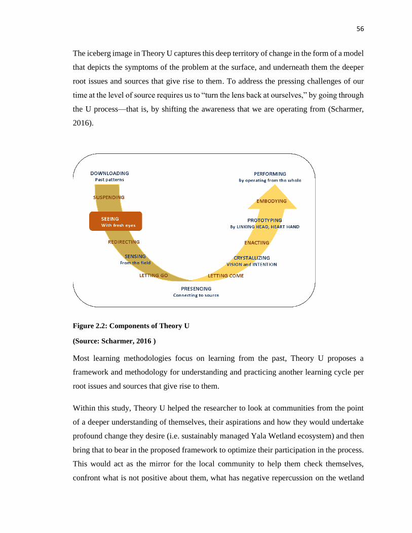
56
The iceberg image in Theory U captures this deep territory of change in the form of a model
that depicts the symptoms of the problem at the surface, and underneath them the deeper
root issues and sources that give rise to them. To address the pressing challenges of our
time at the level of source requires us to “turn the lens back at ourselves,” by going through
the U process—that is, by shifting the awareness that we are operating from (Scharmer,
2016).
Figure 2.2: Components of Theory U
(Source: Scharmer, 2016 )
Most learning methodologies focus on learning from the past, Theory U proposes a
framework and methodology for understanding and practicing another learning cycle per
root issues and sources that give rise to them.
Within this study, Theory U helped the researcher to look at communities from the point
of a deeper understanding of themselves, their aspirations and how they would undertake
profound change they desire (i.e. sustainably managed Yala Wetland ecosystem) and then
bring that to bear in the proposed framework to optimize their participation in the process.
This would act as the mirror for the local community to help them check themselves,
confront what is not positive about them, what has negative repercussion on the wetland

57
and bring out what is good from within themselves to the world and use that to improve
the planning and management of the Wetland. Their behaviours on Yala Wetland, their
attitudes and beliefs that are responsible for the current challenges and then what mindsets
would be required to cause profound change as contained in the new vision for Yala
Wetland Ecosystem. In this study, the use of participatory methods that apply emotional
intelligence like sympathy walks and appreciative enquiry methods were used to help
respondents and researchers delve into the root causes of the Yala Wetland challenges and
their contributions therein; their aspirations of the future (next 50 years) in line with the
Africa Union aspirations of Agenda 2063 of a prosperous Africa and how they could co-
create that future. These methods enabled the community to confront their attitudes
responsible for the current challenges and to make bold decisions on what profound
changes they should make to attain that new vision.
2.6.7 Empowerment Theory
If power means control, then empowerment means the process of gaining control (Sen,
1997). Empowerment is primarily about power; changing power relations in favour of
those who previously exercised little power over their own lives. This means that
facilitating empowerment means supporting people in becoming agents in their own
development (Duveskog, 2013). Lightfoot (2002) showed that local communities like
farmers cannot be empowered by order from above, but that empowerment, comes through
self-realisation, self-organisation and collective action.
The debate on power and knowledge postulates that power is not a zero-sum game but a
process that occurs in relationships. Thus, if power is created in relationships, then power
and power relations can change (Page and Czuba, 1999). Empowerment should not be seen
as equal to decentralization, participation or “bottom-up” approaches. It is a more powerful
process (Sen, 1997) that relates to the outcome or the end product of the meanings of such
terms.
For community participation in land use and natural resources’ planning, this concept is
important since community organizations include individuals of mixed ages, gender,
occupations and abilities who strive to gain more power over their own lives and
58
surroundings. It is thus interesting to explore to what extent gaining power might have on
the management of natural resources where they are involved.
Community organizations’ empowerment is further seen to be important for developing
land use plans with households articulating their concerns on the basis of improved
knowledge and analysis of their situations. Further, in implementation, these communities
are expected to lead in the management of Indigenous Community Conservation Areas
(ICCAs) where the government cedes control to the communities and just provide technical
support (UNESCO, 2011; IUCN, 2009). Consequently, communities’ substantial
involvement in the zonation of land use plan to agree on the conservation areas and the
principles of managing these during land use plan development is sine quo non for
successful implementation of ICCAs management plan. This leadership requires officials
to demonstrate their love for conservation and transformative and authentic grassroot
leadership skills. Shamir and Eilan (2005) defined authentic leaders as genuine, principled,
and original while George (2003) points five characteristics of authentic leadership namely
having a clear purpose, having strong ethical values, establishing trusting relationships,
demonstrating self-discipline and action, and having passion. Linked to community
organisations, this can secure better service delivery and more efficient use of public
resources they have co-created.
The term empowerment is often difficult to define in action as it takes different forms in
different people and contexts (Page and Czuba, 1999). Some of the definitions of
empowerment suggested in recent literature are: a multi-dimensional social process that
helps people gain control over their own lives. It is a process that fosters power in people
for use in their own lives, their community, and in their society by acting on issues that
they define as important (Page and Czuba, 1999).
A person’s capacity to make effective choices; that is the capacity to transform choices into
desired actions and outcomes (Alsop and Heinsohn, 2005). Empowerment, therefore, is a
social process because it occurs in relationships with others. It can happen at individual,
group and community levels. Besides, it can be seen as an advanced form of participation.
However, the concepts are to some extent contradicting in the sense that participation
59
means people being given a greater role in our agenda, while empowerment is all about
them taking control of their own agenda (Bartlett, 2005).
In the various levels of participation developed by Pretty (1997) the highest level of
participations mentioned is self-mobilization where people participate by taking initiatives
independently of external institutions to change systems. They develop contacts with
external institutions for resources and technical advice they need, but retain control over
how resources are used. When participation goes to this level, a process of empowerment
can be assumed to be underway. In reality though empowerment is often promoted under
some kind of boundaries, which in fact end up restricting the level of empowerment.
Development agents, aiming to facilitate and support empowerment must accept to engage
in a process of transformation of themselves, since if we want local communities to gain
power, we must accept to lose some ourselves. Programmes also have to be flexible and
open-ended to allow people to take control and exercise agency. This means that
development partners cannot decide the precise outcomes of empowerment. Predetermined
desired outcomes of SEA planning such as conservation, development and hybrid scenarios
etc. thereby contradict empowerment since the opportunities for self-determination among
stakeholders are limited from the outset (Bartlett, 2005).
2.6.8 Transformative Learning Theory
In seeking to understand the change in the daily lives of Yala Wetland communities,
particularly how they make sense of their learning experience, Transformative learning
(TL) theory provides useful lens for analysing the findings of this study. The TL theory
was pioneered by Jack Mezirow with influences from Paulo Freire and Habermas and is
one of the most established theories for making sense of the adult learning process (Taylor,
2007). While there are multiple dimensions of TL, this study draws mainly on Mezirow’s
and Freire’s thoughts. Human beings naturally tend to make meaning of their daily lives
and continuously change their perceptions based on new experiences.
Transformative learning (Mezirow, 1997, 1996, 1995,1991; Cranton, 1996) focuses on the
process of change in individuals’ interpretation of a new experience. A central concept in
this theoretical approach is frame of reference; i.e. the mental structures by which new
60
experiences are filtered such as values, associations, feelings and conditioned responses.
This frame of reference both limits and shapes individuals’ perceptions, filtering the
experiences they choose to give meaning to and how they construct that meaning.
Individuals often tend to reject ideas that do not fit in the existing frame of reference
labelling them as irrelevant or not making sense, within their worldview.
A frame of reference is composed of two dimensions: habits of mind and a point of view.
Habits of mind are habitual ways of thinking, feeling, and acting based on the cultural,
social, education, economic, political or psychological standpoints of the learner. Habits of
mind become articulated in a specific point of view—the assemblage of belief, value
judgment, attitude, and feelings that shape a particular interpretation (Mezirow, 1997).
The commonly observed gendered and conservation roles and responsibilities among
wetland communities is an example of habit of mind, where a conditioned response is
triggered based on deep held cultural beliefs linked to the societal group that the individual
belongs to. While points of view are subject to continuing change accessible to awareness
and to feedback from others; habits of mind are more durable, since they often are tacit and
operate outside the awareness of the individual. They reflect collectively held,
unintentionally or assimilated shared cultural values and beliefs.
2.7 Conceptual Framework
The conceptual framework attempts to lace together relationships that the study considers
are critical for the expansion of community participation in the management of wetland
ecosystem.
The status of today’s wetland ecosystems reflects intricate interactions of physical and
biological processes, as well as human activities over time. Virtually all of the earth’s
wetlands have been influenced and changed by patterns of intense human use. There has
been increased consciousnesses about areas where indigenous and traditional people live,
and have done so for hundreds of years, the authority for resource and ecosystem
management should be devolved as much as possible to the local level (Macharia et al.,
2010; Claridge et al., 1997).
61
For a community-based wetland management program to be effective the following
variables have to be put into consideration within the context of sustainability model of
social, economy and environmental pillars. The social context includes historical and
contextual information, indigenous knowledge, attitudes, mindsets and practices/behaviors
towards wetlands ecosystems management, participation processes and capabilities,
institutions. The environmental context includes ecological health, water levels,
biodiversity, wetland’s unique resources, carbon sequestration, socio-economic and
technological). The economic context includes community livelihood
improvements/economic activities such as employment, wealth creation, income
generation.
The understanding of the past and current, wetland communities’ participation in the
management of the wetland ecosystem; understanding the environmental factors at play in
the conservation of the wetland ecosystem; and the livelihood improvements arising from
communities’ participation coalesce together through a modified framework to optimize
community participation and ultimately result in improved wetland conservation. The
outcome is evidenced by an improved wellbeing of the wetland communities, community
centred multistakeholder governance framework, ecosystem management plans, improved
biodiversity and water levels, adoption of positive attitudes and growth mindsets by
communities and technicians on wetland ecosystem management equitable benefit sharing
mechanism as shown in Figure 2.3.
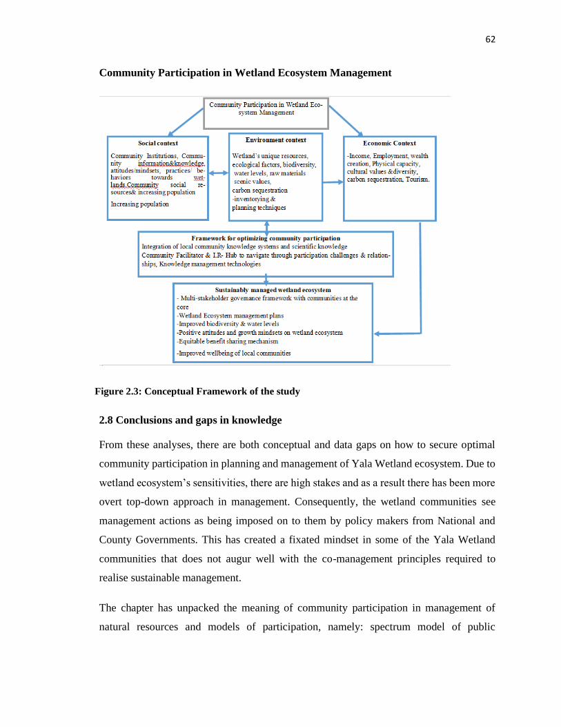
62
Community Participation in Wetland Ecosystem Management
2.8 Conclusions and gaps in knowledge
From these analyses, there are both conceptual and data gaps on how to secure optimal
community participation in planning and management of Yala Wetland ecosystem. Due to
wetland ecosystem’s sensitivities, there are high stakes and as a result there has been more
overt top-down approach in management. Consequently, the wetland communities see
management actions as being imposed on to them by policy makers from National and
County Governments. This has created a fixated mindset in some of the Yala Wetland
communities that does not augur well with the co-management principles required to
realise sustainable management.
The chapter has unpacked the meaning of community participation in management of
natural resources and models of participation, namely: spectrum model of public
Figure 2.3: Conceptual Framework of the study
63
participation and the 10 indicators of evaluating public participation effectiveness, which
will be used in analysing the community participation in Yala Wetland ecosystem.
The theories to ground the study were two, namely: systems theory and its related
adaptations to deal with complex systems including Ecosystems Approach Theory, Post-
Modernism, Theory U for leading profound changes; and Empowerment and
Transformational Learning Theory to anchor the learning element of the social
sustainability of aspect the wetland management. Also, these theories will used designing
the framework that seeks to optimize community contribution in Yala wetland
management.
This chapter has also reviewed the legal and policy framework for the study. The Kenya
Constitution 2010 that gives sovereign power to the people and how they can exercise
their sovereignty directly or through their elected representatives, national values and
principles of governance, bills of rights including the right to a clean environment and
participation of communities in any development interventions that affect their lives as
well as Public Participation Bill 2020 and County Government Act 2012 which spells out
procedures for conducting public participation as envisioned in the Constitution 2010.
Besides, it looked at various legal and policies regimes that guide wetlands management
and how people and institutions interact in wetlands management. Thus, largely there was
an enabling policy and legal environment for Yala Wetland management except for
studious, innovative implementation.
This study sought to contribute towards improving the livelihoods of Yala Wetland
communities by offering a greater understanding on community participation in wetlands
planning and management processes and then designed a community participation
framework that optimizes their participation in planning and subsequent management of
the Yala Wetland land use plan and integrated management plans.
64
CHAPTER THREE
RESEARCH METHODOLOGY
3.1 Introduction
This chapter presents the study area, the type of research and methods adopted for the
study. Specifically, it describes the research design and finally methods used to collect and
analyze data. Given the nature of the problem that needed to be solved, it was clear that the
most relevant route was through Action Research. This chapter therefore explains what
action research is and then presents research methods used in the study.
3.2 The Study Area
3.2.1 Location of Yala Wetland and challenges
The study area is Yala Wetland located on the north eastern shoreline of Lake Victoria
between 330 50’ E to 340 25’E longitudes to 0o 7’S to 0o 10’N latitude (Figures 3.1 and3.2).
Yala wetland is highly valued by local communities (NEMA, 2016) and is Kenya’s third
largest wetland after Lorian Swamp and Tana Delta and has a very delicate ecosystem. It
is shared between Siaya and Busia counties and covers an area of about 20,756 ha (about
207 Km2) (Odhengo et al., 2018a; LBDA, 1989; JICA, 1987). Yala Wetland is situated on
the deltaic sediments of the confluence of Nzoia and Yala Rivers where they enter the
north-eastern corner of Lake Victoria. The Yala Wetland, which is the largest papyrus
swamp in the Kenyan portion of Lake Victoria, is an exceptionally rich and diverse
ecosystem, containing many rare, vulnerable and endangered species of plants and animals
(EANHS, 2018). The wetland is almost entirely covered in stands of papyrus.
The benefits from the Yala Wetland include food production which made the people food
secure in the region in the 1970s and early 1980s; abundant wetland resources which they
use for food, income generation, house construction, production of multiple papyrus
products for local use and sale, a variety of fish, including rare fish species, and multiple
social benefits (Thenya & Ngecu, 2017; Onywere et al., 2011; Kareri, 1992).
65
Despite these benefits, Yala Wetland faces numerous challenges and threats. One, the
reclamation of the land for agriculture has led to habitat loss thereby affecting the
endangered species. The wetland is a habitat to 41 fish species (IUCN, 2018; Aloo, 2003).
Most of the species that disappeared from the main lake (Lake Victoria) are found in the
Yala Wetland and mostly in Lake Kanyaboli. Seeger et al. (2003) and Witte and Van
(1995) have documented the list and status of fish species in the wetland. There is also
inadequate freshwater flow replenishment from river Yala after it was diverted to Lake
Victoria and dammed by the Dominion Group for commercial farming. This has changed
the water chemistry in the wetland, consequently affecting the fish population by
interfering with breeding zones (Nature Kenya, 2015; OSIENALA, 1998). Other factors
that have led to the decline of endemic species include intensive non-selective fishing,
extreme changes in the drainage basin and increased eutrophication (Aloo, 2003). Use of
unorthodox fishing methods has also been a major challenge in Lake Kanyaboli, leading
to harvesting of fingerlings and breeding stock. Other studies on the wetlands have pointed
out that ecosystem services are not optimal thereby denying utilisation of the wetlands’ full
potential and thus threaten biodiversity forms and welfare of surrounding communities
(Thenya, 2012; Raburu, 2012). These communities, mainly the Luo and Luhya in Siaya
and Busia counties respectively, are from Kaugagi-Hawinga, Usenge, Obaro, Rukala
Magombe, Rugunga, Kadenge, Senje, Othach, Kanyango, Bar Kanyango, Got Ramogi,
Usigu, Usenge Got Agulu, Nyomonye, Bar Olengo West, Bulwani and Lugare (CGS,2015;
CGS, 2019; CGB, 2015; CGB, 2019). Figures 3.1 and 3.2 show the location of the study
area.
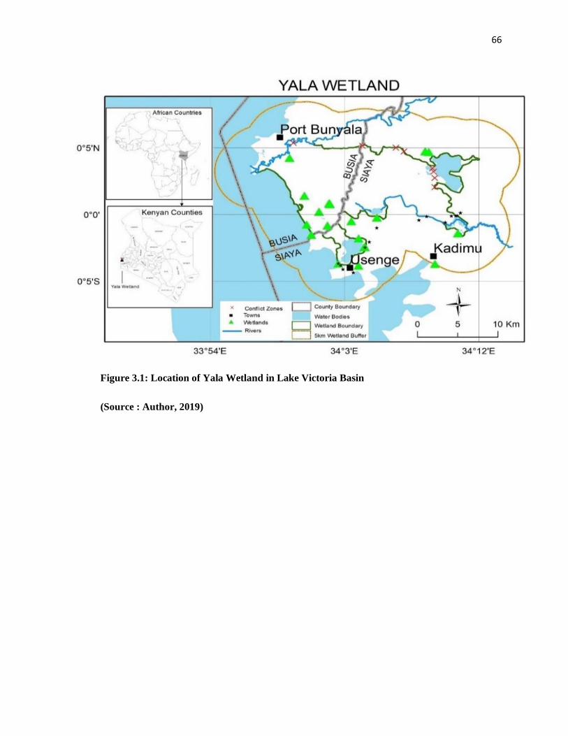
66
Figure 3.1: Location of Yala Wetland in Lake Victoria Basin
(Source : Author, 2019)
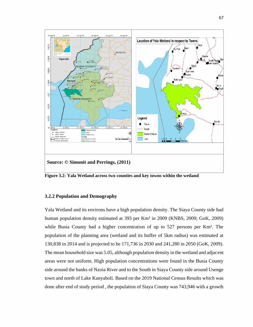
67
Source: © Simonit and Perrings, (2011)
Figure 3.2: Yala Wetland across two counties and key towns within the wetland
3.2.2 Population and Demography
Yala Wetland and its environs have a high population density. The Siaya County side had
human population density estimated at 393 per Km² in 2009 (KNBS, 2009; GoK, 2009)
while Busia County had a higher concentration of up to 527 persons per Km². The
population of the planning area (wetland and its buffer of 5km radius) was estimated at
130,838 in 2014 and is projected to be 171,736 in 2030 and 241,280 in 2050 (GoK, 2009).
The mean household size was 5.05, although population density in the wetland and adjacent
areas were not uniform. High population concentrations were found in the Busia County
side around the banks of Nzoia River and to the South in Siaya County side around Usenge
town and north of Lake Kanyaboli. Based on the 2019 National Census Results which was
done after end of study period , the population of Siaya County was 743,946 with a growth
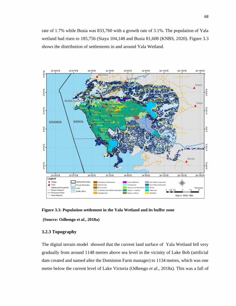
68
rate of 1.7% while Busia was 833,760 with a growth rate of 3.1%. The population of Yala
wetland had risen to 185,756 (Siaya 104,148 and Busia 81,608 (KNBS, 2020). Figure 3.3
shows the distribution of settlements in and around Yala Wetland.
Figure 3.3: Population settlement in the Yala Wetland and its buffer zone
(Source: Odhengo et al., 2018a)
3.2.3 Topography
The digital terrain model showed that the current land surface of Yala Wetland fell very
gradually from around 1148 metres above sea level in the vicinity of Lake Bob (artificial
dam created and named after the Dominion Farm manager) to 1134 metres, which was one
metre below the current level of Lake Victoria (Odhengo et al., 2018a). This was a fall of
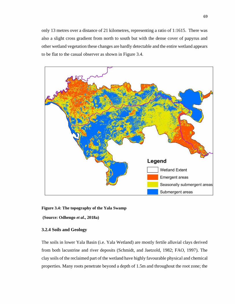
69
only 13 metres over a distance of 21 kilometres, representing a ratio of 1:1615. There was
also a slight cross gradient from north to south but with the dense cover of papyrus and
other wetland vegetation these changes are hardly detectable and the entire wetland appears
to be flat to the casual observer as shown in Figure 3.4.
Figure 3.4: The topography of the Yala Swamp
(Source: Odhengo et al., 2018a)
3.2.4 Soils and Geology
The soils in lower Yala Basin (i.e. Yala Wetland) are mostly fertile alluvial clays derived
from both lacustrine and river deposits (Schmidt, and Jaetzold, 1982; FAO, 1997). The
clay soils of the reclaimed part of the wetland have highly favourable physical and chemical
properties. Many roots penetrate beyond a depth of 1.5m and throughout the root zone; the
70
soil is friable with fine sub-angular blocky structure and high visible porosity (Odhengo et
al., 2018a; NEMA, 2016).
Large quantities of silt are carried down the main rivers during annual floods and thus the
floodplain is comprised of silt and other deposited material and is very fertile. The
floodplain as well as the swamp receives high nutrients and fertilizer from upstream sub
basins making them attractive for agricultural encroachment. Some spot measurements of
sediment and stream flow discharges in the Yala at Kadenge gauging station in the months
of September and November of 2017 were 1355 tons/day and 1195 tons/day for flows
above 353m3/s and 360m3/s respectively (Odhengo et al., 2018a).
3.2.5 Biodiversity
The Yala Wetland is an exceptionally rich and diverse ecosystem, containing many rare,
vulnerable and endangered species of plants and animals. Four vegetation types, i.e.
Aquatic plants, Riparian plants, Grassland and Terrestrial weeds, characterize the wetland.
This unique system therefore holds species of diverse ecological significance and
specialised habitat and micro-habitat needs.
The most ecologically important vegetation in Yala Wetland is the papyrus (Cyperus
papyrus) with Phragmites mauritianus in shallower areas and swamp grasses around the
periphery. Over 100 vascular plants have been recorded within Yala Wetland of which 13
are invasive (Thomas et al., 2016; Mulwa et al., 2014). A checklist of plant species found
within the Yala Wetland and lower Yala Basin is presented in Appendix 6.
Almost the entire area of the remaining wetland comprises of stands of papyrus which
requires high temperatures and constantly saturated soil or stagnant water to thrive. The
growth of papyrus results in the formation of a dense vegetation matt which impedes
surface water movement and helps to create ideal wetland conditions. It also traps sediment
and acts as a natural water purifier, which is of great importance in protecting the water
quality of Lake Victoria. Papyrus is, however very demanding in terms of water and evapo-
transpiration which exceeds 4.5 litres a day from one square metre, which is 40% higher
71
than the already high evaporation from open water (Odhengo et al., 2018a; Thomas et al.,
2016; Osumba, 2010; KWS, 2010; Nature Kenya, 2009; Boye et al., 2008).
The analysis of soils, topography and vegetation confirms that roughly a quarter of the
wetland lying closest to Lake Victoria is maintained by a combination of river flow and
back-flow from Lake Victoria. Any reduction in lake level or inflows from upper parts of
the wetland would therefore threaten the existence of this permanently flooded area. The
remaining two thirds are extending back to Lake Kanyaboli is totally dependent on water
which flows into the area from the River Yala and on seepage which occurs from the River
Nzoia which flows into the wetland.
3.2.5.1 Mammalian Species
Over 30 mammal species have been recorded in Yala Wetland. They include the Sitatunga
(Tragecephalus spekeii), a shy and rare semi-aquatic antelope that is nationally listed as
Endangered (Wildlife Act, 2013). The Sitatunga is endangered with high level of threats
from unsustainable hunting and draining of swamps in the country (Thomas et al., 2016,
KWS, 2010).
The other mammalian fauna found in Yala Wetland include Hippopotamus, wild pigs,
vervet monkeys (Cercopithecus aethiops) also listed as vulnerable in Kenya by IUCN
(IUCN, 2016). A checklist of mammal species recorded in Yala Wetland is presented in
Appendix 10. Few species of herpetofauna such as snakes, lizards and chameleons and
frogs among others have been recorded largely due to the fact that few studies have been
conducted for these taxa (See Appendix 9). Little invertebrate surveys have been conducted
at Yala Wetland and include for example a rapid assessment conducted by Kenya Wetland
Forum in 2006 indicated the presence of Oligochaetes (Branchiura sowerbyi), Stoneflies
(Plecoptera), Dragonflies (Odonates), and May flies (Ephemeroptera).
3.2.5.2 Fish Species
The Wetland provides an important refuge for Lake Victoria cichlid fish, many of which
have been exterminated in the main lake by the introduction of Nile Perch (Lates niloticus),
a non-native predatory fish. Recent surveys in Lake Kanyaboli recorded 19 fish species
72
within nine families, which included all the two critically endangered cichlids species
thought to be extirpated in Lake Victoria; namely Oreochromis esculentus and
Oreochromis variabilis (IUCN, 2018; KWS, 2010; Njiru et al., 2005; Ogutu, 1987a,
1987b). The fishes use the wetland as a breeding ground, nursery, and feeding grounds
(CGS, 2015; CGS, 2019; CGB, 2015; CGB, 2019; Aloo, 2003). A list of fish species
recorded in Yala Wetland is presented in Appendix 8.
3.2.6 Climate
The Yala Wetland climate is largely typical of the Lake Victoria region without a clear
distinct dry season. The region has a variable rainfall pattern that generally increases from
the lake shore to the hinterland (Awange et al., 2007; Ekirapa and Kinyanjui, 1987).
Annual rainfall pattern in Lake Victoria Basin is bimodal, with ‘long rains’ from March to
April and ‘short rains’ from October to November. The Yala/ Nzoia catchment has high
precipitation in the Northern highland (1,800-2,000 mm per annum) and low in the South-
Western lowlands (800-1,600 mm per annum). With the average rainfall around lowland
Yala Wetland being approximately 760mm (Odhengo et al., 2018a; Kiluva et al., 2011).
The long rains and short rains contribute 44% and 25% of the total mean annual rainfall
(TMAR) respectively while January-February and June to September contribute 11% and
20% TMAR respectively. The mean annual daily maximum and minimum temperatures
are 28.9o C and 15.9o C respectively – giving a mean annual temperature of 24.4o C
(Luedeling, 2011; Semenov, 2008).
Yala Wetland residents have been experiencing many climate change impacts including
frequent flooding, droughts and increased incidences of diseases. A healthy wetland would
help local communities adapt to these impacts of climate change by regulating diseases,
controlling flooding and providing alternative livelihoods through ecotourism, papyrus
products industry and fishing. Climate change is also expected to impact biodiversity
conservation negatively. The various Yala Wetland management plans should therefore
recognize the importance of environmental conservation as a means to build the resilience
of the ecosystem and the dependent local stakeholders and biodiversity to the impacts of
climate change.
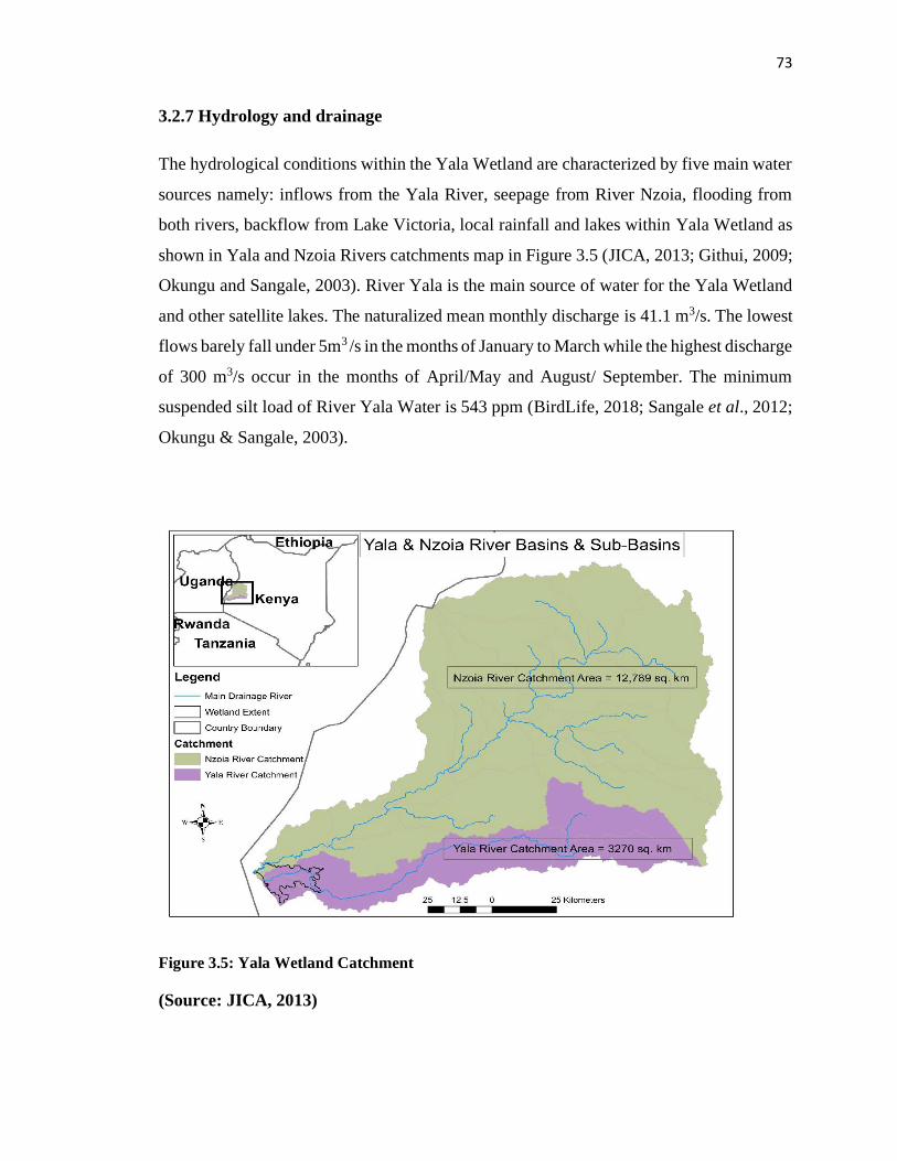
73
3.2.7 Hydrology and drainage
The hydrological conditions within the Yala Wetland are characterized by five main water
sources namely: inflows from the Yala River, seepage from River Nzoia, flooding from
both rivers, backflow from Lake Victoria, local rainfall and lakes within Yala Wetland as
shown in Yala and Nzoia Rivers catchments map in Figure 3.5 (JICA, 2013; Githui, 2009;
Okungu and Sangale, 2003). River Yala is the main source of water for the Yala Wetland
and other satellite lakes. The naturalized mean monthly discharge is 41.1 m3/s. The lowest
flows barely fall under 5m3 /s in the months of January to March while the highest discharge
of 300 m3/s occur in the months of April/May and August/ September. The minimum
suspended silt load of River Yala Water is 543 ppm (BirdLife, 2018; Sangale et al., 2012;
Okungu & Sangale, 2003).
Figure 3.5: Yala Wetland Catchment
(Source: JICA, 2013)
74
Originally, the Yala river flowed through the eastern part of the wetland (now ‘reclaimed’)
into Lake Kanyaboli, then into the main wetland, and finally into Lake Victoria via a small
gulf. The Yala river flow is now diverted directly into the main wetland, and a silt-clay
dike cuts off Lake Kanyaboli, which receives its water from the surrounding catchment
and through back-seepage from the wetland. A culvert across the mouth of Yala river,
some metres above the level of Lake Victoria, has cut off the gulf on the lake and, through
back-flooding, created Lake Sare (BirdLife, 2018; Gichuki et al., 2005).
This river flows on a very shallow gradient through small wetlands and saturated ground
over its last 30 kilometres before entering Lake Victoria through its own delta. Although
the soils in this region have a very high clay content that impedes ground water flow, there
is seepage of water into the northern fringes of the Yala Wetland. Proposals to use the
intervening area for irrigation will have a significant bearing on how water from the River
Nzoia reaches the Yala Wetland (BirdLife, 2018; Sangale et al., 2012; Githui, 2009).
Flooding occurs annually and the very high discharge rates overtop the river channels with
floodwater passing into Yala Wetland. Efforts are made to prevent floodwater reaching
areas of habitation and drained agricultural areas, but in extreme events, even the flood
protection dykes are often overwhelmed. Flooding is an entirely natural and necessary
process for contributing vast quantities of nutrient-rich silt to the wetland. Parts of the
western side of the wetland lie below the level of Lake Victoria and are constantly filled
with backflow in addition to being subjected to flooding from the lake and upper
catchment.
The water balance for Yala Wetland also includes the water retained within the three
freshwater lakes found within the wetland namely, Kanyaboli, Sare and Namboyo (Figure
3.2). Of these lakes, Lake Kanyaboli is the largest covering 10.5 Km2 with a catchment
area of 175 Km2 and a mean depth of 3 metres. It lies to the northeastern end of the wetland
in Area I (Figure 4.5). Lake Sare which now forms the southern outlet of River Yala covers
5 Km2 and is an average of 5 metres deep. Lake Namboyo is only 1 Km2 and has a depth
of between 10 to 15 metres (NEMA, 2016; Owiyo et al., 2014; Dominion Farms EIA,
2003).
75
In terms of water quality, recent studies indicate presence of high levels of nitrates in some
parts of the Yala Wetland as evidence of eutrophication that confirms deteriorating water
quality (Mulwa et al., 2014). For example, in Lake Bob, where Yala river stagnates before
diverting into Dominion farm and Lake Kanyaboli then flows further on. On the converse,
phosphates were within the expected limits but still highest in Lake Bob. This calls for
checks in the use of inorganic fertilizers along the river Yala basin.
Lake Sare distinctly showed high water quality characteristics such as high dissolved
oxygen, low nitrates and low turbidity compared to other sites upstream implying that the
papyrus vegetation indeed does play a role in purifying the water. All the sites with running
water had lower nitrates and higher dissolved oxygen levels compared to still waters.
Running waters were also less turbid showing that there is proliferation of phytoplanktons
in still waters (BirdLife, 2018).
A detailed description of some water bodies in the lower Yala is given in Appendix 11.Yala
Wetland performance is also be influenced by a number of constructed dams such as
Ufinga, Giriwa, Oranga, Lebo, Tinga Kuodo, Mwer and Kalenjuok Tinga and activities
happening on smaller streams that drain into the wetland and Lake Kanyaboli. Other
wetlands include Nyamawin-Luand River feeding into Lake Kanyaboli and Oking River
feeding Yala River.
3.2.8 Infrastructure and Development
The first proposal to reclaim Yala Wetland for food production and other agricultural
purposes was in 1950. However, it was not implemented because conservationists wanted
the wetland conserved due to its biodiversity. The first feasibility study for the reclamation
commissioned by the Kenya Nile Water Resources and undertaken by Sir Alexander Gibbs
in 1954 recommended reclamation of Yala Wetland due to its agricultural potential
(Reconcile, n.d).
In 1963, the feasibility report was used by the Kenya Government to appeal to UNDP to
facilitate a pilot irrigation scheme. In 1965, the Kenyan government and the UNDP made
an agreement on the plan for the reclamation of the wetland and a partnership was
76
established setting the stage for the actual work, which started in 1967 when UNDP brought
FAO on board. During this phase, Area I of the wetland (Figure 4.5) was reclaimed before
the project ran out of funds in 1970. There was no opposition encountered from the
community during the first reclamation activities and communities were involved and
consulted. The following activities were undertaken during that phase.
First, diversion of River Yala and construction of the protection dyke (this was 7.2 km
long). The diversion of the river led to the change of natural boundaries between Alego
and Yimbo. Given that all these developments were falling under Siaya district, it was not
an issue then. However, in the wake of the creation of Bondo District and the coming of
Dominion Farms into the wetland, it became a thorny issue in that the size of the wetland
falling within the districts was used to calculate the revenues each county council would
get from Dominion Farms Limited. Siaya County Council ended up getting more than 70%
of the revenues. Bondo District felt that it was unfair.
Secondly, the construction of Lake Kanyaboli retention dykes (2.5km long) on the western
part and Lake Kanyaboli feeder canal (7.2 km long). Thirdly, reclamation of 2,300 ha of
land in the wetland and establishment of Bunyala Irrigation Scheme. These last two were
responsible for displacement of local population from using the reclaimed land, access to
their shrines like in Sigulu, lack of access to grazing areas in the reclaimed areas during
dry season and birds poisoning by wetland communities in the irrigation schemes.
During the period of 1970-1975, there was not much work done in the wetland. There was
cat clay soil –site- evaluation for the Kenya soil survey by WG Sombroek and RF van de
Veg from the Netherlands Wageningen—Kenya Soil Survey Project (Report of a site
evaluation of cat clay hazards, Yala Wetland June 1972).
Then Ekirapa and Kinyanjui (1987) did a semi detailed soil survey of the Yala Wetland
farm and found that the reclaimed section of the wetland remained idle and lay fallow. The
wetland communities and those in the buffer zones started using the reclaimed area for
grazing their livestock during the dry seasons. In 1975, the government revisited the
reclamation of the wetland and contracted the Dutch Consulting Company, ILACO, to
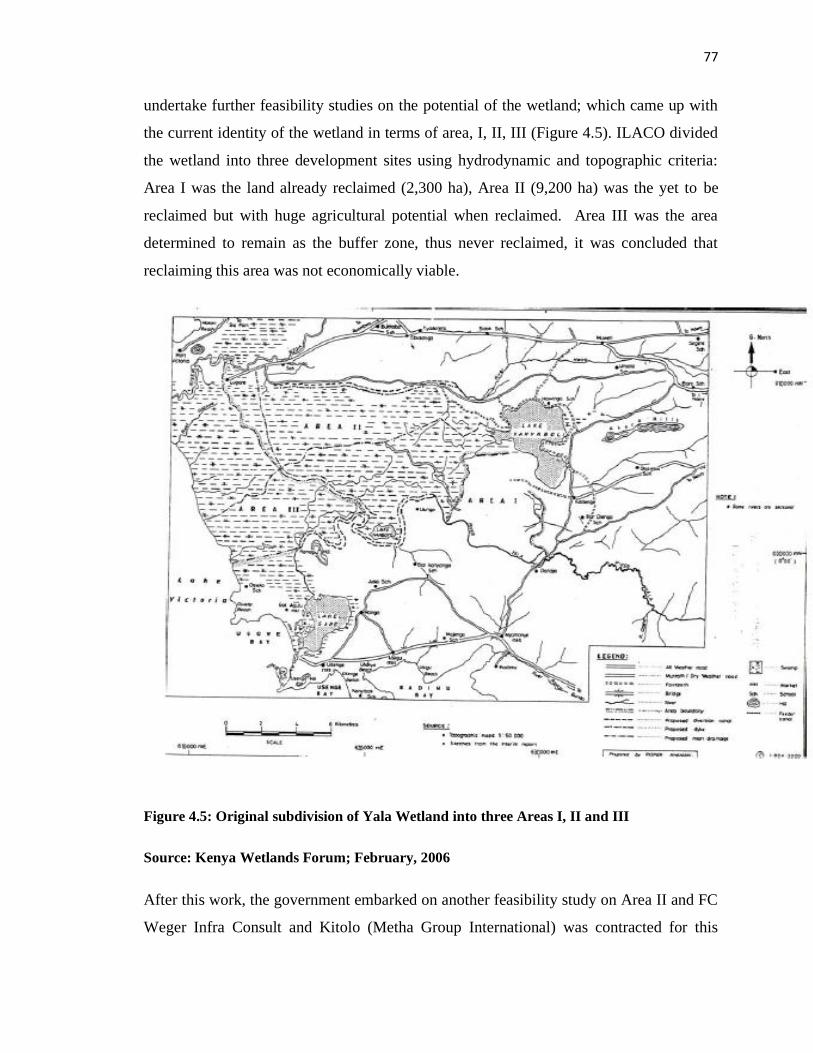
77
undertake further feasibility studies on the potential of the wetland; which came up with
the current identity of the wetland in terms of area, I, II, III (Figure 4.5). ILACO divided
the wetland into three development sites using hydrodynamic and topographic criteria:
Area I was the land already reclaimed (2,300 ha), Area II (9,200 ha) was the yet to be
reclaimed but with huge agricultural potential when reclaimed. Area III was the area
determined to remain as the buffer zone, thus never reclaimed, it was concluded that
reclaiming this area was not economically viable.
Figure 4.5: Original subdivision of Yala Wetland into three Areas I, II and III
Source: Kenya Wetlands Forum; February, 2006
After this work, the government embarked on another feasibility study on Area II and FC
Weger Infra Consult and Kitolo (Metha Group International) was contracted for this
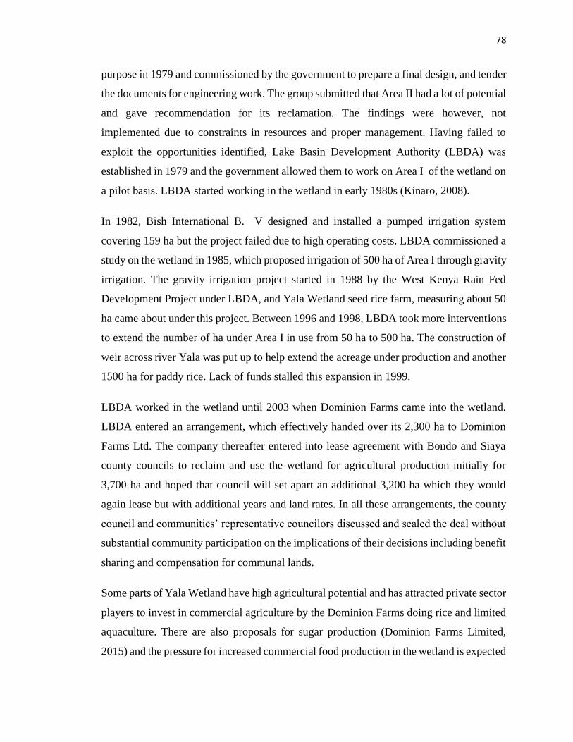
78
purpose in 1979 and commissioned by the government to prepare a final design, and tender
the documents for engineering work. The group submitted that Area II had a lot of potential
and gave recommendation for its reclamation. The findings were however, not
implemented due to constraints in resources and proper management. Having failed to
exploit the opportunities identified, Lake Basin Development Authority (LBDA) was
established in 1979 and the government allowed them to work on Area I of the wetland on
a pilot basis. LBDA started working in the wetland in early 1980s (Kinaro, 2008).
In 1982, Bish International B. V designed and installed a pumped irrigation system
covering 159 ha but the project failed due to high operating costs. LBDA commissioned a
study on the wetland in 1985, which proposed irrigation of 500 ha of Area I through gravity
irrigation. The gravity irrigation project started in 1988 by the West Kenya Rain Fed
Development Project under LBDA, and Yala Wetland seed rice farm, measuring about 50
ha came about under this project. Between 1996 and 1998, LBDA took more interventions
to extend the number of ha under Area I in use from 50 ha to 500 ha. The construction of
weir across river Yala was put up to help extend the acreage under production and another
1500 ha for paddy rice. Lack of funds stalled this expansion in 1999.
LBDA worked in the wetland until 2003 when Dominion Farms came into the wetland.
LBDA entered an arrangement, which effectively handed over its 2,300 ha to Dominion
Farms Ltd. The company thereafter entered into lease agreement with Bondo and Siaya
county councils to reclaim and use the wetland for agricultural production initially for
3,700 ha and hoped that council will set apart an additional 3,200 ha which they would
again lease but with additional years and land rates. In all these arrangements, the county
council and communities’ representative councilors discussed and sealed the deal without
substantial community participation on the implications of their decisions including benefit
sharing and compensation for communal lands.
Some parts of Yala Wetland have high agricultural potential and has attracted private sector
players to invest in commercial agriculture by the Dominion Farms doing rice and limited
aquaculture. There are also proposals for sugar production (Dominion Farms Limited,
2015) and the pressure for increased commercial food production in the wetland is expected
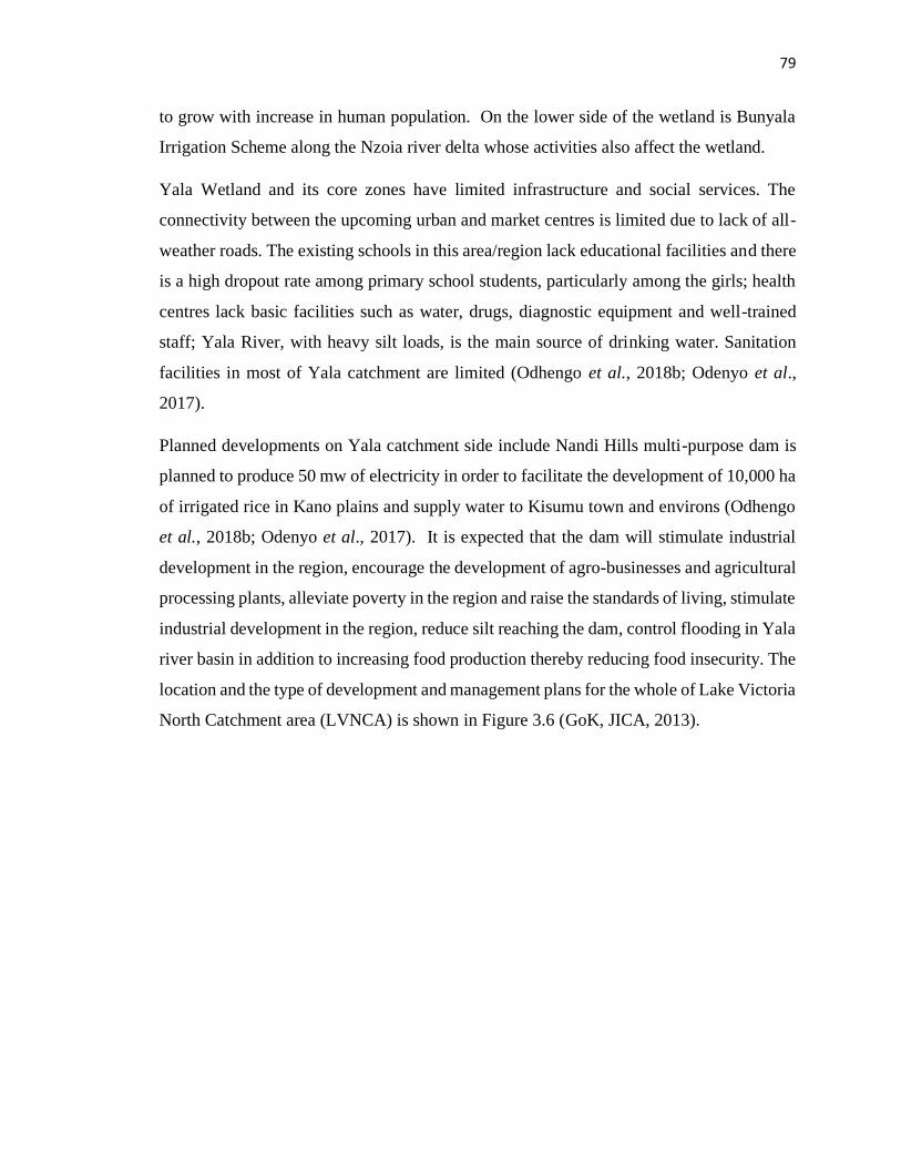
79
to grow with increase in human population. On the lower side of the wetland is Bunyala
Irrigation Scheme along the Nzoia river delta whose activities also affect the wetland.
Yala Wetland and its core zones have limited infrastructure and social services. The
connectivity between the upcoming urban and market centres is limited due to lack of all-
weather roads. The existing schools in this area/region lack educational facilities and there
is a high dropout rate among primary school students, particularly among the girls; health
centres lack basic facilities such as water, drugs, diagnostic equipment and well-trained
staff; Yala River, with heavy silt loads, is the main source of drinking water. Sanitation
facilities in most of Yala catchment are limited (Odhengo et al., 2018b; Odenyo et al.,
2017).
Planned developments on Yala catchment side include Nandi Hills multi-purpose dam is
planned to produce 50 mw of electricity in order to facilitate the development of 10,000 ha
of irrigated rice in Kano plains and supply water to Kisumu town and environs (Odhengo
et al., 2018b; Odenyo et al., 2017). It is expected that the dam will stimulate industrial
development in the region, encourage the development of agro-businesses and agricultural
processing plants, alleviate poverty in the region and raise the standards of living, stimulate
industrial development in the region, reduce silt reaching the dam, control flooding in Yala
river basin in addition to increasing food production thereby reducing food insecurity. The
location and the type of development and management plans for the whole of Lake Victoria
North Catchment area (LVNCA) is shown in Figure 3.6 (GoK, JICA, 2013).
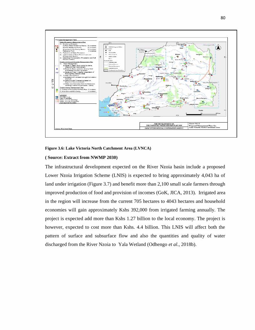
80
Figure 3.6: Lake Victoria North Catchment Area (LVNCA)
( Source: Extract from NWMP 2030)
The infrastructural development expected on the River Nzoia basin include a proposed
Lower Nzoia Irrigation Scheme (LNIS) is expected to bring approximately 4,043 ha of
land under irrigation (Figure 3.7) and benefit more than 2,100 small scale farmers through
improved production of food and provision of incomes (GoK, JICA, 2013). Irrigated area
in the region will increase from the current 705 hectares to 4043 hectares and household
economies will gain approximately Kshs 392,000 from irrigated farming annually. The
project is expected add more than Kshs 1.27 billion to the local economy. The project is
however, expected to cost more than Kshs. 4.4 billion. This LNIS will affect both the
pattern of surface and subsurface flow and also the quantities and quality of water
discharged from the River Nzoia to Yala Wetland (Odhengo et al., 2018b).
81
Figure 3.7: Proposed Lower Nzoia Irrigation Scheme in relation to Yala Swamp
( Source: Odhengo et al., 2018b )
3.2.9 Carbon sequestration
Wetlands are very effective ecosystems for carbon storage. The Yala Wetland vegetation
takes up carbon from the atmosphere and converts it into plant biomass during the process
of photosynthesis. The Yala Wetland can therefore be seen as a giant ‘sink’ which is
recovering the greenhouse gas, carbon dioxide, from the atmosphere. In many wetlands,
waterlogged soil conditions prevent decomposition of the plant material thereby retaining
carbon in the form of un-decomposed organic matter (i.e. Peat) (NEMA, 2016). The long
retention of carbon in wetlands prevents excessive amounts of atmospheric carbon, thereby
reducing global warming. The retained carbon is easily released into the atmosphere
wherever peat lands are drained and exposed to fires. A detailed study of carbon storage in
82
the Yala Wetland in 2015 confirmed that the present wetland is storing close to 15 million
tonnes of carbon within the papyrus wetland, with less than 1 million tonnes stored in the
remaining areas of reclaimed farmland and immature papyrus (Muoria et al., 2015).
3.2.10 Legal status of Yala Wetland Land
According to the Kenya Constitution 2010, the ownership of Yala Wetland is currently
vested under the County Governments of Siaya and Busia under a previous Trust land Act.
However, some areas are perceivably communally owned while others are privately
owned. Some local people have acquired land through self-allocation and later passed it on
through inheritance along their kinship (Thenya, 2006).
The Kenya Constitution 2010 and the Community Land Act 2016 requires that all Trust
Lands must be registered according to the Act (GoK, 2010a; GoK, 2016b). If communities
do not register their lands themselves, the law indicates that County Governments must
plan to register community lands but they might include local people in the registration
process and communities might lose some of their lands and might not be able to make
their own rules for governing and managing their lands.
The Dominion Farms Ltd leased about 6,900 hectares (about 40%, of the wetland) to
undertake agriculture from 2003 for 25 years (Dominion Farms, 2015; Owiyo et al.,
2014b; Kenyan Wetlands Forum Report, 2006).This matter has often resulted in numerous
conflicts and tensions, partly due to the lack of information on how the process of leasing
actually took place. Consequently, many people in the communities feel that the process
was flawed and rid by corruption and bribery (van Heukelom, 2011). The conflicts
surrounding the Yala Wetland revolves around three structural problems: poor
communication, cultural and social misunderstanding, and political involvement (van
Heukelom, 2013). Dominion Farms ceased its operations in 2017 in Yala Wetland and its
place taken up by the Lake Agro Limited who have vast interest in sugar in Western Kenya.
Lake Kanyaboli was gazetted as a National Reserve through Legal Notice No 158 of 2010
(GoK, 2010b). The total area of the reserve is 41.42 km2 and is legally under the
management of Siaya County Government with technical and policy support from Kenya
83
Wildlife Service. In addition, Kenya Wildlife Service has initiated the process of having
the site listed as a Wetland of International Importance under the Ramsar Convention.
Responsibility for the management of water resources within Yala Wetland falls under the
Water Resources Authority (WRA), although other agencies like the Kenya Wildlife
Service have parallel commitments and the private sector plays a disproportionate role in
directing water flows to different parts of the wetland. The Yala LUP proposes formation
of a Land and Water Management Committee to oversee both land and water management
in the Yala Plan Area (Odhengo et al., 2018b; NEMA, 2016). A task force of specialist of
Yala Swamp Water management committee shall record and regulate water flows and
water availability in all areas of the Plan Area.
3.3 Research Design
3.3.1 Action Research
Action research is a disciplined process of inquiry conducted by and for those taking the
action (DBRM, n.d). The primary reason for engaging in action research is to assist the
“actor” in improving and/or refining his or her actions (Stringer, 1999).
Best and Kahn (1998) define “Action research as an inquiry that is focused on the
immediate application and not on the development of theory. It places its emphasis on a
real problem in a local setting. Its findings are to be evaluated in terms of local applicability,
as opposed to universal validity”.
Action Research seeks transformative change through the simultaneous process of taking
action and doing research, linked together by critical reflection. Kurt Lewin, then a
professor at MIT, first coined the term "action research" in 1944. In his 1946 paper "Action
Research and Minority Problems" he described action research as "a comparative research
on the conditions and effects of various forms of social action and research leading to social
action" that uses "a spiral of steps, each of which is composed of a circle of planning, action
and fact-finding about the result of the action.
84
According to the Association for Supervision and Curriculum Development (ASCD) and
Sagor (2000) Action Research has seven main steps. These include: first, selecting a focus
- What element(s) of our practice or what aspect of student learning or another field do we
wish to investigate. Secondly, clarifying theories- identifying the values, beliefs, and
theoretical perspectives the researchers hold relating to their focus. Thirdly, identifying
research questions- generating a set of personally meaningful research questions to guide
the inquiry. Fourthly, collecting data- data used to justify their actions as valid (i.e. meaning
the information represents what the researchers’ say it does) and reliable (i.e. meaning the
researcher is confident about the accuracy of his/her data). Action research uses a
triangulation process to enhance the validity and reliability of their findings i.e. using
multiple independent sources of data to answer one's questions. Fifthly, analyzing data-
identify the trends and patterns in action research data. The researcher methodically sort,
sift, rank, and examine the data to answer two generic questions: What is the story told by
these data? and Why did the story play itself out this way. Sixthly, reporting results- the
reporting of action research most often occurs in informal settings that are far less
intimidating than the venues where scholarly research has traditionally been shared.
More and more action research results are being written up for publication or to help fulfill
requirements in graduate programmes. Ultimately, contributing to a collective knowledge
base regarding teaching and learning. Seventh, taking informed action- action researchers
find that the research process liberates them from continuously repeating their past
mistakes. More importantly, with each refinement of practice, action researchers gain valid
and reliable data on their developing virtuosity. Figure 3.8 depicts the Action research
cycle.
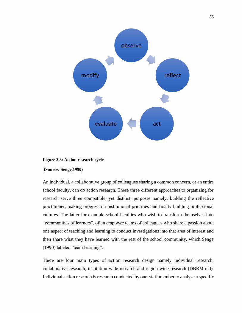
85
Figure 3.8: Action research cycle
(Source: Senge,1990)
An individual, a collaborative group of colleagues sharing a common concern, or an entire
school faculty, can do action research. These three different approaches to organizing for
research serve three compatible, yet distinct, purposes namely: building the reflective
practitioner, making progress on institutional priorities and finally building professional
cultures. The latter for example school faculties who wish to transform themselves into
“communities of learners”, often empower teams of colleagues who share a passion about
one aspect of teaching and learning to conduct investigations into that area of interest and
then share what they have learned with the rest of the school community, which Senge
(1990) labeled “team learning”.
There are four main types of action research design namely individual research,
collaborative research, institution-wide research and region-wide research (DBRM n.d).
Individual action research is research conducted by one staff member to analyze a specific
observe
reflect
act
evaluate
modify
86
task. The researcher alone performs research by implementing a group activity for a certain
length of time. After the action is performed, the researcher analyzes the results,
implements changes, or discards the programme if not found to be helpful.
Collaborative research involves a group of people researching a specified topic. Many
times, collaborative research involves both researchers and team leaders of institutions.
This type of research offers the collaboration of many people working jointly on one
subject. The joint collaboration often offers more benefits than an individual action
research approach.
Institution-wide action research design are created for a problem found within an entire
institution. This can be lack of parental involvement or research to increase students'
performance in a certain subject. The entire staff work together through this research to
study the problem, implement changes, and correct the problem or increase performance.
Region-wide action research is used for an entire region or a specified geographical area
such as Yala wetland. This action research is usually more community-based than the other
types of action research design. This type may also be used to address organizational
problems within the entire region.
3.3.2 Paulo Freire's Participatory Action Research
Participatory Action Research (PAR) has lately appeared as an important methodology for
intervention, development and change within groups and communities. Many international
development agencies, university programs and local community organizations around the
world are not only promoting but also implementing it with satisfactory transformative
results. PAR builds on the critical pedagogy put forward by Freire Souto-Manning (2010)
as a response to the traditional formal models of learning where the "teacher" “researcher”
stands at the front and "imparts" information to the "students" “wetland communities” who
are passive recipients. This was further developed in "adult education" models throughout
Latin America.
Fals-Borda (1925–2008) was one of the principal promoters of participatory action
research in Latin America and published a "double history of the coast" book that compares
87
the official "history" and the non-official "story" of the north coast of Colombia. For Yala
wetland PAR would bring out the two perspectives of issues from wetland communities
and the technical team to inform the planning and implementation of wetland management
plans.
Duveskog (2013) in her doctoral research titled “Farmer Field Schools as transformative
learning space in the rural African Setting” used participatory action research
methodologies, which called for the need for investment in human capacity and the
importance of an appropriate mix of technological and social advancement for
development. It contributed knowledge on how to measure empowerment in a poverty
setting. For Yala Wetland PAR will be key in establishing the nexus between the poverty
level and wetland degradation and subsequently design mitigation measures in a
participatory manner with the communities.
3.3.3 Action Research in Organization Development
According to French and Bell (1973) Organization Development (OD) is simply
"organization improvement through action research". Moreover, Lewin’s (1958)
conceptualization aptly summarizes OD's underlying philosophy which was later
elaborated and expanded on by other behavioral scientists. Concerned with social change
and, more particularly, with effective, permanent social change, Lewin believed that the
motivation to change was strongly related to action. If people are active in decisions
affecting them, they are more likely to adopt new ways. Likewise, if Yala Wetland
communities are actively involved in planning for sustainable wetland management, they
would adopt the news ways the plan requires of them and their governance institutions
would have to change accordingly. "Rational social management", he said, "proceeds in a
spiral of steps, each of which is composed of a circle of planning, action and fact-finding
about the result of action" (Lewin, 1958).
Lewin's description of the process of change involves three steps: First, Unfreezing, faced
with a dilemma or disconfirmation, the individual or group becomes aware of a need to
change. Second, Changing, the situation is diagnosed and new models of behavior are
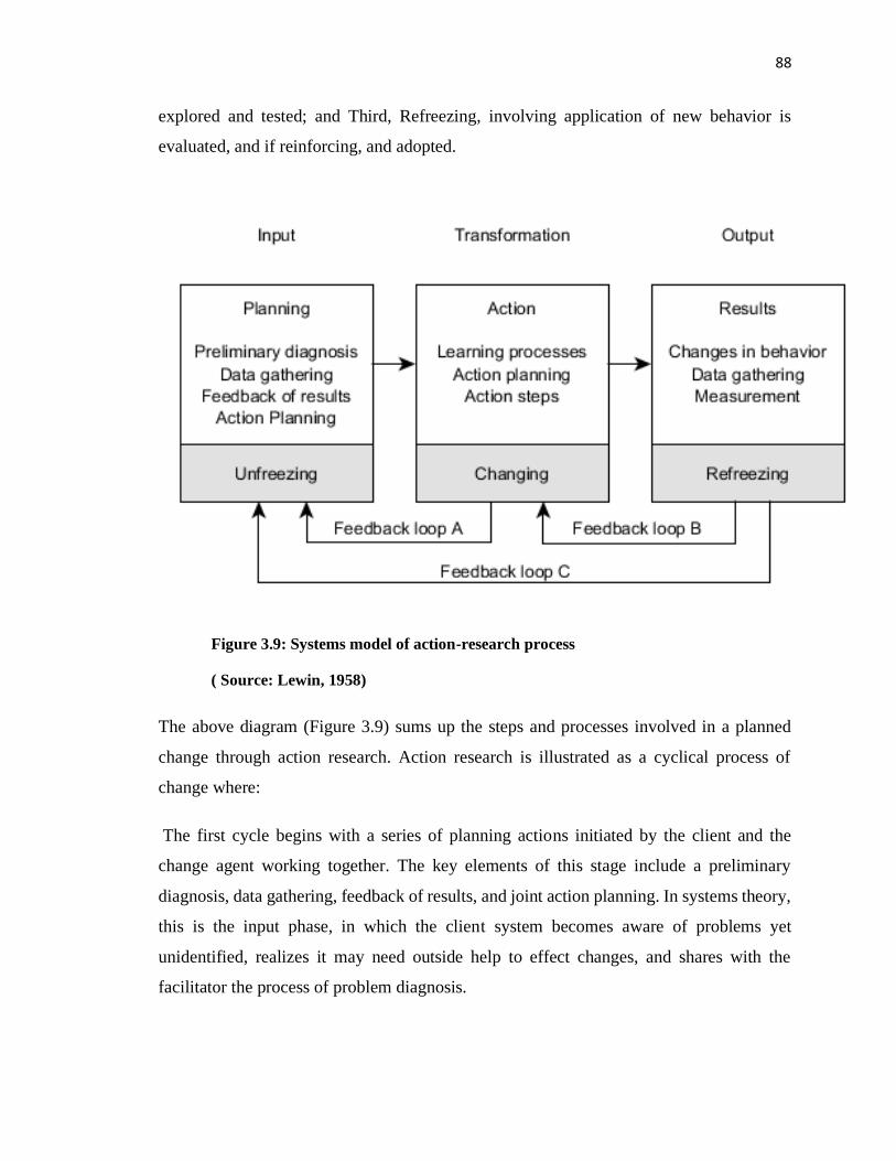
88
explored and tested; and Third, Refreezing, involving application of new behavior is
evaluated, and if reinforcing, and adopted.
Figure 3.9: Systems model of action-research process
( Source: Lewin, 1958)
The above diagram (Figure 3.9) sums up the steps and processes involved in a planned
change through action research. Action research is illustrated as a cyclical process of
change where:
The first cycle begins with a series of planning actions initiated by the client and the
change agent working together. The key elements of this stage include a preliminary
diagnosis, data gathering, feedback of results, and joint action planning. In systems theory,
this is the input phase, in which the client system becomes aware of problems yet
unidentified, realizes it may need outside help to effect changes, and shares with the
facilitator the process of problem diagnosis.
89
The second stage of action research is the action or transformation phase. This stage
includes actions relating to learning processes perhaps in the form of role analysis and to
planning and executing behavioral changes in the client organization. As shown in Figure
3.9 feedback at this stage would move via feedback loop A and would have the effect of
altering previous planning to bring the learning activities of the client system into better
alignment with change objectives. Included in this stage is action-planning activity carried
out jointly by the facilitator and members of the client system. Following the workshop or
learning sessions, these action steps are carried out on the job as part of the transformation
stage (Johnson, 1976).
The third stage of action research is the output or results phase. This stage includes actual
changes in behavior (if any) resulting from corrective action steps taken following the
second stage. Data are again gathered from the client system so that progress can be
determined and necessary adjustments in learning activities can be made. Minor
adjustments of this nature can be made in learning activities via feedback loop B (Figure
3.9).
Major adjustments and re-evaluations would return the OD project to the first or planning
stage for basic changes in the program. The action-research model shown in Figure 3.5
closely follows Lewin's repetitive cycle of planning, action, and measuring results. It also
illustrates other aspects of Lewin's general model of change. As indicated in the diagram,
the planning stage is a period of unfreezing or problem awareness. The action stage is a
period of changing that is, trying out new forms of behavior in an effort to understand and
cope with the system's problems. There is inevitable overlap between the stages, since the
boundaries are not clear cut and cannot be in a continuous process.
The results stage is a period of refreezing, in which new behaviors are tried out on the job
and, if successful and reinforcing, become a part of the system's repertoire of problem-
solving behavior. Action research is problem centered, client centered, and action oriented.
It involves the client system in a diagnostic, active-learning, problem-finding and problem-
solving process. Thus, this Yala wetland study seeks to understand the challenges of
90
community participation in Yala wetland ecosystem management and collaboratively solve
those challenges through action research methodology.
3.3.4 Justification for Action Research Methodology
From an analysis of low levels of communities’ participation in Yala Wetland management
to date as demonstrated in reviewed studies and in the ongoing land use planning processes
up to generation of draft one copies of SEA and LUP, it was clear that some further
investigation of the participation process and its subsequent improvement would add value
to the community participation framework and final outcome. The value addition to an
ongoing Yala LUP could be best done by action research and not fundamental research.
The researcher, therefore chose action research methodology for this study.
Action research accorded the opportunity to bring changes into the planning process arising
from critical reflection of wetland communities based on their increased levels of
involvement in the various stages of SEA/LUP and ICCA. They became learners and doers
and the final plan benefitted from the processes with its feedback loops A, B,C of action
research methodology as indicated in Figure 3.9 above.
In addition, Yala wetland represents unique ecological system and therefore an
interdisciplinary research that would avail real-time feedback from multiple perspectives
to the planning process and to inform next course of action added great value to wetlands
ecosystem management. Action research unlike fundamental research provided this rare
opportunity.
3.4 Research Strategy
The study used the exploratory research strategy to investigate, clarify and test the modified
community participation framework in Yala Wetland planning and management. As Olsen
(2008) argues, “to explore is to observe and to invent useful information about the situation
and the elements in a research question. Adopting an explorative approach entails, among
other things, wanting to understand a phenomenon and shed light on a complex situation.”
Ideally, exploratory research strategy has three main characteristics which are very useful
for this study.
91
First, it does not primarily focus on numbers, it mainly focuses on understanding social
reality through qualitative methods, such as focus group discussions, observations and in-
depth interviews. Second, exploratory research strategy opens the research problem to
allow in-depth investigation of factors by using different types of data and explanations
from different participants (Baxter and Jack, 2008; Vaus, 2005). In-depth investigation of
the problem is especially possible by using a case study research design like the Yala
Wetland case study.
Lastly, exploratory research strategy permits studying problems that are interdisciplinary
in character (Vaus, 2005) – for instance unique ecological systems like. Wetlands; land use
planning and participatory processes (land, water and biodiversity therein in the wetlands),
and information systems used by the local communities interacting with the wetlands
(Indigenous knowledge, community maps, students’ artworks and their mosaic data).
Interdisciplinary studies are especially very useful as they often provide higher quality
scientific findings and a broad understanding of social reality from the point of view of two
or more disciplines (Nissan, 1997). Additionally, other types of research strategy,
especially descriptive research strategy was occasionally used to respond to questions that
required documentation of the historical information about the Yala Wetland.
3.5 Case Study
This action research focused on public participation in Yala Wetland Ecosystem. Being
region-wide type of action research, it defined it reach as Yala Wetland and its buffer zone
region to enable it address governance and management challenges within the entire
wetland ecosystem.
Yin (2009, p. 18) defines case study research design as:
“An empirical inquiry that investigates a contemporary phenomenon in depth and within
its real-life context, especially when the boundaries between phenomenon and context are
not clearly evident.” It “copes with the technically distinctive situation in which there will
be many more variables of interest than data points and one result”. Additionally, case
study research design “relies on multiple sources of evidence, with data needing to
92
converge in a triangulating fashion, and as another result” and “benefits from the prior
development of theoretical propositions to guide data collection and analysis.”
The definition of case study research design by Yin (2009) captures at least three
interrelated aspects that are associated with this study. First, it explores in-depth the extent
of community participation in Yala Wetland management. The second point of this study
is that of employing qualitative research methods like in-depth interviews, Focus Group
Discussions (FGDs), content analysis and observation of social and physical artifacts to
fully understand and document the wetland management dynamics and land use conflicts
therein. The final part of the definition of case study according to Yin (2009) in relation to
this study is that case study research designs benefit from theoretical propositions that
guide data collection and analysis.
3.6 Research Assistants and training on data collection
Five Research Assistants were trained to equip them with requisite skills for fieldwork
tasks mainly co-facilitating community level meetings, interviewing respondents,
moderating focus group discussions, using participatory tools for community data capture,
field observations and reflection, journaling, data capture through Geographic Positioning
Systems (GPS), photography and videography on key issues relevant to the study. The
training focused on seeking background information on wetland ecosystems, key
challenges and how to turn those into opportunities; visioning skills; facilitation skills
including handling difficult respondents; data capture; empathy walks methods;
assessment of key environmental issues in the wetland; organizing essays competitions and
designing artwork briefs.
3.7 Target Population, Sampling Procedures and Sample Size
3.7.1 Target Population
The Yala Wetland and its buffer zone had a population of 130,834 persons in 2014 (KNBS,
2009) and 185,766 persons in 2019 (KNBS, 2020). The Wetland over 200 community
organizations with ony 70 active on environmental conservation; 64 primary schools and
13 secondary schools. The study data was collected from 34 key informants, 410
93
respondents drawn from 60 community organizations and187 students from 19 learning
institutions in the study area.
The study targeted local communities through leaders of their various community
formations like beach management units, women groups, youth groups, smallholder
farmer’s cooperatives, religious leaders’ associations, and sand harvestors living in Yala
Wetland and its buffer zone. The groups’ qualification and criteria selection criteria
included: active in conservation for the last 5 years; has been affected in one way of the
other with projects undertaken within Yala Wetland, has been a member of an interest
group during a LUP/SEA studies in Yala Wetland and has been involved in research and
training in in Environmental conservation, EIA or SEA.
Additionally, the LUP project formed a Yala Project Advisory Committee (YPAC) where
Yala Ecosystem Site Support Group (YESSG), whose members acted as the communities’
voices in the planning and management of the Yala Wetland, represented communities.
The schools in the upper Yala catchment where river Yala draws its water were also
involved in the study because of the direct effect of their activities on the wetland water
flows.
3.7.2 Sampling Techniques
The study used both non-random purposive and stratified sampling techniques to select
respondents from whom data was collected.
Non-Random Purposive Sampling
Key informants who provided information on historical and current state of community
participation in the management of Yala Wetland were selected purposively. These
included elders and change makers (highly respected individuals by communities for
bringing changes in their community) who had great wealth of knowledge particularly
historical, cultural and indigenous knowledge on Yala Wetland. The YESSG members
and village elders helped in identifying the elders and changemakers who were thereafter
interviewed in their homesteads. In the course of interacting with groups, the researcher
further identified other key informants who were subsequently added to the initial list.
94
Cumulatively, 34 key informants purposively selected were interviewed and were drawn
from Usenge, Usigu, Kombo, Hawinga, Uhembo and Bunyala.
The second category were community organizations who carried out conservation
activities in the study area. Yala Wetland planning process had done stakeholder an
analysis and provided a list of groups. These processes also identified groups whose leaders
formed the YESSG who represented communities in SEA and LUP processes. The
researcher started with these groups but later expanded to 60, deliberately ensuring all
community groups considered active in conservation of Yala Wetland were represented
and that every sublocation in the wetland and adjacent buffer zone were represented in the
study.
The 60 community organizations were drawn from all the sub-locations/wards of Yala
wetland and buffer zones. Each community organization had only one group of 10 persons
participating in FGD irrespective of its total membership. The community organizations’
membership ranged between 8-60 persons with mixed economic abilities but drawn by the
mission and ideals of the specific group. The age of members ranged between 15-85 years;
the youngest organization was five years while the oldest was 30 years old. The 10
respondents invited to participate in the FDGs were chosen to represent diversity within
the groups and the FGDs were held in locations convenient for local communities. They
were mainly group members, active and retired civil servants, teachers, retired teachers,
respectable elders who were deemed as custodian of communities’ information and
religious leaders. Natasha et. al. (2005) maintains that FDGs are very advantageous as they
allow collecting substantial data from many people within a very short period. The
structure of these FGDs was kept open, allowing feelings and characterizations to emerge
from the participants themselves (Yin, 2009; Krueger and Casey, 2008; Dawson et al.,
1993) on background information about the wetland, their opinions, ideas, perceptions, and
beliefs and experiences that influenced their interactions in the wetland and their
involvement in its management over the years (Likert,1932).
95
In total, 410 respondents from local community groups participated in focus group
discussions of 7-10 persons per FGD and included Men, Women, Youth (under 35 years
old) and persons with disability as shown in Table 3.1.
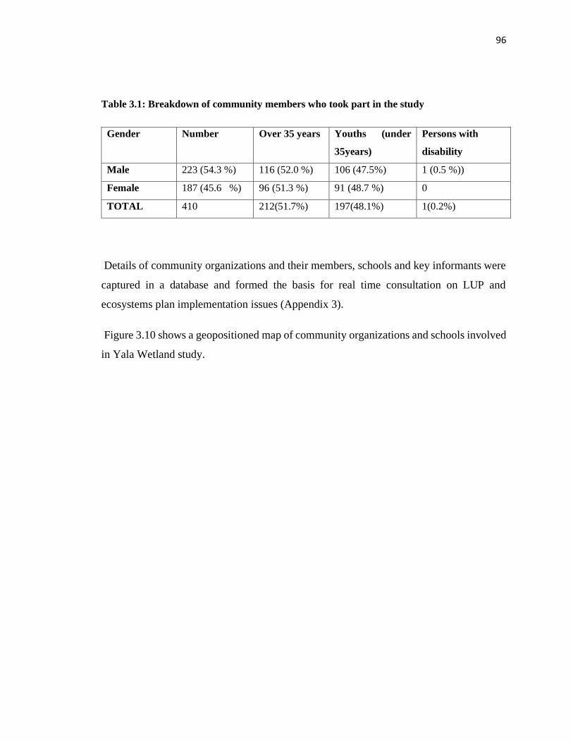
96
Table 3.1: Breakdown of community members who took part in the study
Gender Number Over 35 years Youths (under
35years)
Persons with
disability
Male 223 (54.3 %) 116 (52.0 %) 106 (47.5%) 1 (0.5 %))
Female 187 (45.6 %) 96 (51.3 %) 91 (48.7 %) 0
TOTAL 410 212(51.7%) 197(48.1%) 1(0.2%)
Details of community organizations and their members, schools and key informants were
captured in a database and formed the basis for real time consultation on LUP and
ecosystems plan implementation issues (Appendix 3).
Figure 3.10 shows a geopositioned map of community organizations and schools involved
in Yala Wetland study.
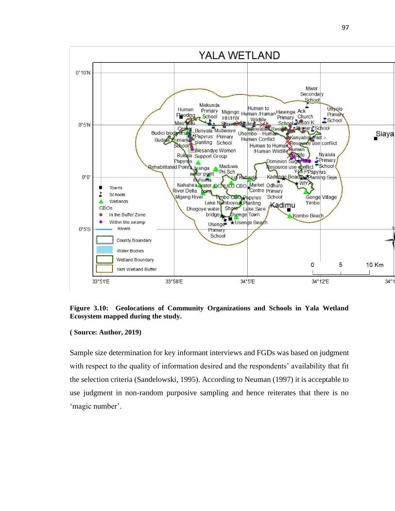
97
Figure 3.10: Geolocations of Community Organizations and Schools in Yala Wetland
Ecosystem mapped during the study.
( Source: Author, 2019)
Sample size determination for key informant interviews and FGDs was based on judgment
with respect to the quality of information desired and the respondents’ availability that fit
the selection criteria (Sandelowski, 1995). According to Neuman (1997) it is acceptable to
use judgment in non-random purposive sampling and hence reiterates that there is no
‘magic number’.
98
Stratified Sampling
Data was also collected through stratified sampling from institutions of learning which
were clustered as: primary (11), secondary (5) and post- secondary polytechnics and
colleges (2) and a total of 187 submissions received from students. Learning institutions
were brought on board as part of the modified participation framework which brought data
on wetland challenges and what they envision of Yala wetland in 2063 through essays,
debates, songs and artworks. It accorded students an opportunity to become co-creators of
SEA/LUP and other wetlands plans, provided intergenerational perspectives Yala wetland
issues. Therefore, learners would be involved in implementation of plans they understand
as translation of images of possibilities into realities, and, beliefs into practice as value
added by appreciative enquiry methodology applications to the wetland ecosystem
management. Primary schools sampled were: Mukhobola, Usenge, Bridge International
Academy (Usenge), Musoma A.I.C, Bubamba, Hawinga, Misori Kaugagi, Nyakado,
Maduwa, Thomas Burke and the Cottage School. Secondary schools included Hawinga
Girl's High school, Musoma Mixed Secondary School, Uwasi Mixed Secondary, Bunyore
Girls School and St Mary's School Yala, while post- secondary schools were Siaya Institute
of Technology and Busagwa Youth Polytechnic (Figure 3.10).
3.8 Data Collection Methods
The study mainly used qualitative research data collection methods supported by
quantitative methods whenever necessary. Strauss and Corbin (1990) note that quantitative
and qualitative methods are tools that complement each other. Quantitative methods can
be used to obtain patterns of various aspects of interest to the study, whereas qualitative
methods can provide means of exploring perceptions and gaining deeper insights of
specific issues. This study employed both tools and this provided an understanding of how
contextual factors and processes affected the planning and management of Yala Wetland
ecosystem.
Qualitative studies are especially very useful as they allow “exploring and understanding
the meaning of individuals or groups ascribe to a social or human problem” (Creswell,
99
2009) such as wetland resources and how humans interact with them to pursue their
livelihoods.
3.8.1 Focus Group Discussions (FGDs)
Sixty focus group discussions of 7-10 community members per session from community
organizations operating in the study area were conducted to collect data as guided by the
focus group discussions (FGDs) schedule (Appendix 2). The target organizations were
those identified as active in wetland conservation, drawn from the 60 villages spatially
spread in the study area and were therefore considered representative of the Yala Wetland.
Figure 3.10 shows their locational map while Appendix 4 provides their GPS coordinates.
The total number of FGD respondents was 410. The 10 respondents per group invited to
participate in the FDGs were chosen based on women, men, youth, responsibility such as
official and membership to represent diversity within the group.
The FGDs were held in convenient locations for local communities. The FGDs are very
advantageous, as Natasha et. al. (2005) maintains since they allow collecting of substantial
data from many people within a very short period. The structure of these FGDs was kept
to open, allowing feelings and characterizations to emerge from the participants themselves
(Krueger and Casey, 2008; Dawson et al., 1993) on background information about the
wetland, their opinions, ideas, perceptions, and beliefs and experiences that influenced their
interactions in the wetland and their involvement in its management over the years (Likert,
1932). Data was recorded both by written notes and by video recordings.
3.8.2 Key Informant Interviews (KIIs)
Key informant interviews with 34 highly respected elders and change makers from Usenge,
Usigu, Kombo, Hawinga, Uhembo, Bunyala were conducted between April and June 2016.
The elders identified by communities were considered as custodians of Yala Wetland
historical, cultural and indigenous knowledge information. Information received was
corroborated with other literature on Yala Wetland to provide historical and contextual
information.
100
The Luo Council of Elders was represented by its Deputy Chairperson from Yimbo. The
elders were from Kombo beach management unit who had also established a Yala Wetland
community museum in Kombo beach at the shores of Lake Kanyaboli; an elder from
Misori Kaugagi; and an elder and a youth from Bunyala. They narrated the history of the
Wetland, significant events and trends, and their implications.
An interview schedule which had open ended questions that included understanding the
formation of the Wetland, local /or indigenous knowledge used by local communities to
manage Yala Wetland; challenges in Yala Wetland, their causes and what could be done
to turn them into opportunities for sound management of the wetland, their thoughts on the
level and effectiveness in the communities’ participation in Yala Wetland land use
planning processes was used.
They narrated the history of the wetland, significant events and trends and their
implications. These interviews were video recorded and later used for analysis of the
research data. At the end of each interview session and end of the day the researcher set
aside time to record research activities for the day, his observations and experiences for the
day and critical reflection in the researcher’s journal (Deveskog, 2013; Leggo, 2008;
Greene, 1995).
3.8.3 Appreciative Inquiry Methodology
Appreciative inquiry (AI) is a mobilizing philosophy built on the recollection of peak
experiences, recognition of strengths and qualities in the most debilitating circumstances,
and a belief in better future possibilities. It is commonly defined as the “art of discovering
and valuing those factors that give life to an organization, community or group.” As a
capacity building approach, AI supports innovation and change by translating images of
possibility into reality and beliefs into practice (Dweck, 2008; Cooperrider, et al., 2008;
Cooperrider, et al., 2000). Groups were facilitated to develop proactive propositions that
expressed their boldest ideals and commitments to deal with the challenges that Yala
Wetland pose in their lives.
Appreciative Inquiry methodology was applied in framing the questions and discussion set
up to get what local communities and students envisioned as their desired future Yala
101
Wetland in 50 years’ time. Appreciative inquiry in organizational and community
development has successfully been used worldwide to cultivate hope, build capacity,
unleash collective appreciation and imagination, and bring about positive change. It is
premised on the fact that human beings move in the direction of what researchers and
practitioners ask about. Therefore, AI deliberately asks positive questions around
affirmative topics to ignite constructive dialogue and inspired action within organizations
and communities. Change research shows that innovative methods that evoke stories, and
affirm and compel groups of people to envision positive images of the future that is
grounded in the best of the past; have the greatest potential to produce deep and sustaining
change and inspire collective action (Browne, 2015; Cooperrider et al., 2008; Smith, 2003;
Cooperrider, et al., 2000).
3.8.4 Schools Creative Essays, Debates and Artworks Competitions
Data was also collected from 18 learning institutions, secondary schools (5), primary
schools (11) and post-secondary technical vocational institutions (2) found within the
wetland and its buffer zone. Students’ data were presented in essays , debates, poems, and
artistic works on the Yala Wetland issues and they were rewarded for outstanding
performance as shown in Plate 3.1. This data was part of what the modified community
participation Yala community participation framework brought to the SEA/LUP processes
as intergenerational perspectives.
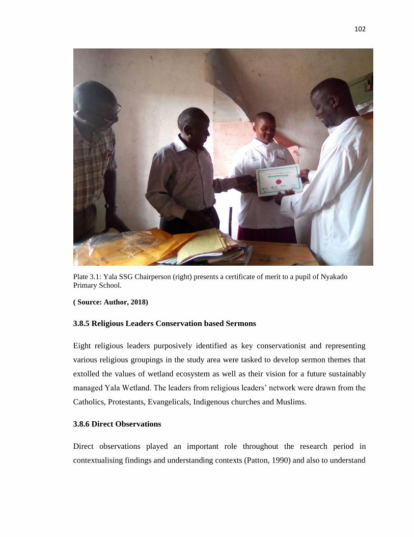
102
Plate 3.1: Yala SSG Chairperson (right) presents a certificate of merit to a pupil of Nyakado
Primary School.
( Source: Author, 2018)
3.8.5 Religious Leaders Conservation based Sermons
Eight religious leaders purposively identified as key conservationist and representing
various religious groupings in the study area were tasked to develop sermon themes that
extolled the values of wetland ecosystem as well as their vision for a future sustainably
managed Yala Wetland. The leaders from religious leaders’ network were drawn from the
Catholics, Protestants, Evangelicals, Indigenous churches and Muslims.
3.8.6 Direct Observations
Direct observations played an important role throughout the research period in
contextualising findings and understanding contexts (Patton, 1990) and also to understand
103
relationships and interactions among individuals, community groups and institutions
involved in Yala Wetland Ecosystem Management.
The observations were made during focus group discussion sessions, en route to villages
visited, and stakeholder and community events attended. The researcher also made
observations while moving around the wetland on key environmental issues such as land
degradation, landuse/landcover changes, papyrus cover and used camera, GPS device and
video to capture some of those. In particular, observations were useful in understanding
gender dynamics by observing the interactions between men and women group sessions
and events and government officials and local communities during consultative meetings
at various stages of the LUP development.
3.8.7 Remote Sensing and GIS
The researcher used satellite images from Google Earth which provided detailed
photographic evidence of the condition of the wetland and various land use changes in Yala
Wetland for years 1984,1989,1994,1999, 2001, 2014 and 2016. Remote sensing was used
to determine the current size of the wetland in line with revised definition of the wetland
and various land cover/use changes in the wetland over the years (GoK, 2015; Ampofo et
al., 2015; Chambers, 2006; Turner, 1998; Liverman et al., 1998; Lillesand and Kiefer,
1987).
The GPS locations of the various community organizations and institutions involved in
data collection were recorded and later used to create a presence map with their contact
details using Google Earth. This map allows for instant identification and seeking
participation of local communities in LUP implementation and other Yala Wetland
ecosystem conservation matters as seen in Figure 3.10. Google Earth computer programme
provides valuable records of historic land use change throughout the world.
3.8.8 Community maps
During focus group discussions and community meetings, some community organizations
were asked to map out their villages and the resources they have in their villages. This was
a basis for determining the wealth and recognition of community assts which they need to
104
manage effectively on their part to conserve Yala wetland. Community mapping was done
in 8 villages in Siaya and Busia Counties locations namely (Central Alego, South Central
Alego, Usonga and North Yimbo) and eight sub-locations (Ojwando “A”, Kadenge,
Kaugagi Hawinga, Nyadorera “A”, Nyadorera “B”, Nyamonye and Bar Kanyango).
3.8.9 Experts Panel Review and Input
The expert panel professionals from the area among them land use planners,
environmentalists, spatial planners and strategic planners were also contacted t to give
input and review the drafts before adoption. Collaborative tools such as google document
were used to moderate the discussions and to solicit inputs from these experts on the SEA
and LUP drafts contents.
3.8.10 Spectrum of public participation model and the 10 indicators of evaluating
public participation effectiveness
To determine the extent of wetland community participation in SEA/LUP processes, the
researcher used spectrum model of public participation and its five levels from informing,
consulting, involving, collaborating to empowering; and the 10 emerging good practice for
indicators for measuring public participation to determine the effectiveness of YPAC
framework (Stuart, 2017; World Bank, 1998, 1999, 2002).
3.8.11 Explorative Participatory Workshop
The researcher conducted a workshop with key community organization leaders at the start
of the study for a more in-depth review and framing for key informant interviews and focus
group discussion data collection tools. The team refined the tools to enable easy
comprehension by the Research Assistants and leaders who were then eventually involved
in the data collection.
105
3.8.12 Journal Writing by the Researcher
In the context of viewing the study as an action research alongside Yala Wetland LUP
development, a journal (diary) was used recording descriptive accounts of the researcher’s
activities, experiences and in-depth reflections. Journaling one’s experience and using that
to reflect and make meanings during the research has been used in various collaborative
research studies (Deveskog, 2013).
Journal writing helps one to write freely, to learn about oneself and to find his/her own
voice. Greene (1995) who used journaling as one of the methodologies in her doctoral
research says, “learning to write is a matter of learning to shatter the silences, of making
meaning, of learning to learn” (p.108). The researcher kept a journal where he recorded his
experiences and events that captured the entire duration of fieldwork. The journal was used
to corroborate reflections and experiences with emerging themes and issues from
communities and other stakeholders that the research team interacted with.
Leggio (1995) in her PhD dissertation titled Magic wand notes:
Over the years, I have kept track of my work thoughts and notes about activities in
work journals. I have also kept personal journals to help me think through directions
and decisions about where to go next in my work and life. In the last decade, I made
some major transitions in my life and the process of writing has helped me think
through some of the decisions involved. Writing is a powerful way to create one’s
life as well as to record and reflect on it (p.82.)
3.8.13 Photographic Documentation
The researcher also used digital photography to record observable features that helped in
explaining the various issues addressed by the objectives of the study. Photographs are
accurate and reliable as they reflected the actual situation on the ground. The photographs
enhanced the perception of results from other data collection procedures to show, for
example, the form and type of land use activities, key activities local communities
undertake in conserving the wetland, the vegetation loss in the wetland, students’
106
conservation activities and communities’ involvement in Yala wetland planning processes.
The data helped to pictorially explain the results.
3.8.14 Secondary Data Sources
Literature review was conducted on public participation, policies, laws and relevant studies
that provided secondary data and a valuable source of additional information for
triangulation of data generated by other means during the research and this has also been
used by many researchers (IYSLP, 2017; Friis-Hansen and Duveskog, 2012;).
Documents reviewed helped with understanding the subject matter, issues within the Yala
Wetland and studies that were conducted as a precursor to land-use planning processes.
Secondary data was gathered at various stages of the research, reviewed and analysed,
including that on policy and legal frameworks, wetland ecosystem management guidelines
and procedures, relevant studies to Yala Wetland and other sensitive ecosystems elsewhere.
The aim was to gain a deeper understanding of Yala Wetland management processes and
how institutional issues had influenced its management. Additionally, background
materials about the biophysical, socio-economic and cultural contexts of the study area
were analysed to gain a better understanding of the local situation and validate information
provided through key informant interviews, FGDs, and observations.
3.8.15 Land Use Plan Methodology
The Yala LUP was prepared following the land use planning framework (Figure 3.11)
developed by Busia and Siaya County Governments and relevant stakeholders with
technical support from the National Government. The development of the Yala LUP
adopted FAO (1993) guidelines to the site and county and national legal, policy and
political circumstances. The process was informed by lessons learnt during Tana River
Delta LUP (Odhengo et al., 2014) formulation process. According to the revised EMCA
(2015) all Policies, Plans and Programmes both at national and county level that are likely
to have significant effect on the environment shall be subjected SEA. The LUP falls in this
category and as such the LUP process ran parallel to a SEA process such that SEA
107
processes informed LUP. The planning framework outlined the steps to be followed to
arrive final LUP (Waweru and Muoria, 2015).
Consultations for Plan Development
Public participation is a constitutional requirement under article 69 (1) of the constitution
of Kenya and Part VIII section 87-92 and 115 of County Government Act, 2012 and Part
2 section 6 (1) a-e, 2(1) of Public Participation Bill, 2020. Yala LUP process was therefore
made as participatory as possible. The planning team made deliberate efforts to ensure
public/or stakeholder participation with YPAC as the primary vehicle for communities
participation in order to: create awareness and interest in Yala LUP; provide public
opportunity to influence decisions on development planning as to what, where, when and
how, matters that affect them; ensure sustainability through ownership of the plan,
empower the stakeholders to take responsibility for sustainable management of Yala
Wetland, minimize conflicts during plan preparation and implementation; increase
transparency, inclusivity and accountability in land use planning process.
Therefore, the researcher’s entry point into the process was at “consult with public” where
the modified Yala Community participation framework integrated into the process to arrive
at the final LUP benefiting from improved community participation.
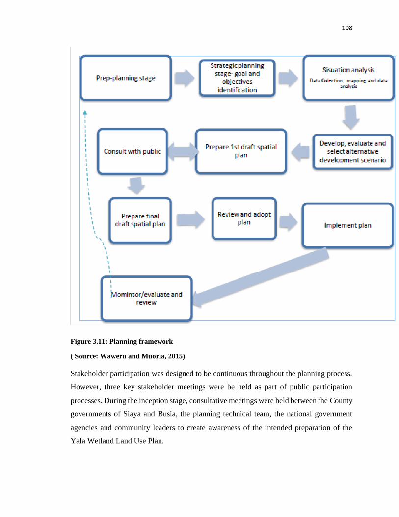
108
Figure 3.11: Planning framework
( Source: Waweru and Muoria, 2015)
Stakeholder participation was designed to be continuous throughout the planning process.
However, three key stakeholder meetings were be held as part of public participation
processes. During the inception stage, consultative meetings were held between the County
governments of Siaya and Busia, the planning technical team, the national government
agencies and community leaders to create awareness of the intended preparation of the
Yala Wetland Land Use Plan.
109
The purpose of the first stakeholder meeting which included local community leaders
sought to create awareness among stakeholders on the land use plan; to build consensus on
key issues; capture stakeholder aspirations and expectations, and set the vision of Yala
Wetland and objectives of the land use plan.
The purpose of the second stakeholder meeting was to present the situation analysis,
validate baseline report and review vision and objectives of the spatial illustration of Yala
Wetland. Wetland communities were consulted in some of the technical team’s activities
and were therefore required to validate the outcomes at the meeting.
A third stakeholder meeting was held to present the draft Yala Wetland land use plan for
review, receive comments to add value to the draft and finally adopt the plan. Thereafter,
a validated draft land use plan was subjected to debate and finally approved by the Siaya
and Busia County Assemblies.
3.8.16 Summary of Methods Used
The research methods used by the study are summarized in Table 3.2.
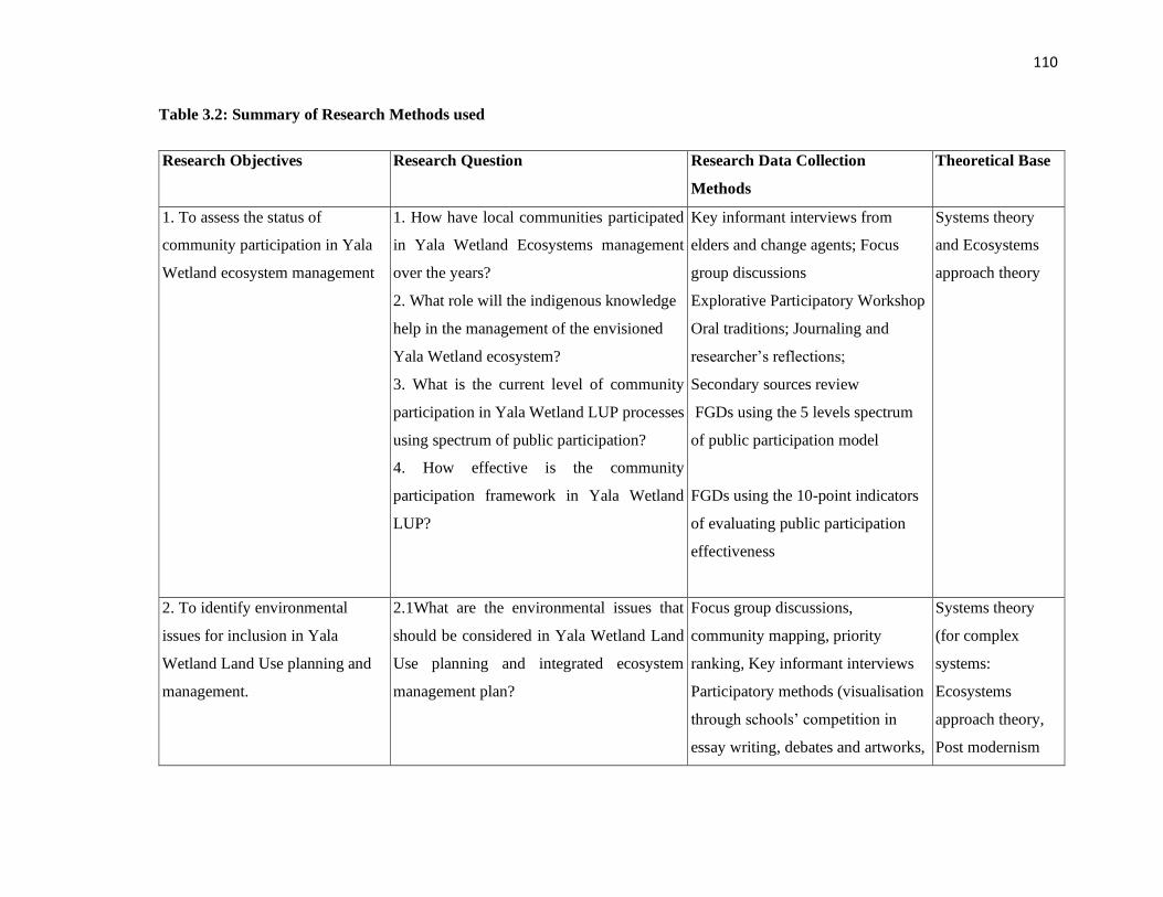
110
Table 3.2: Summary of Research Methods used
Research Objectives Research Question Research Data Collection
Methods
Theoretical Base
1. To assess the status of
community participation in Yala
Wetland ecosystem management
1. How have local communities participated
in Yala Wetland Ecosystems management
over the years?
2. What role will the indigenous knowledge
help in the management of the envisioned
Yala Wetland ecosystem?
3. What is the current level of community
participation in Yala Wetland LUP processes
using spectrum of public participation?
4. How effective is the community
participation framework in Yala Wetland
LUP?
Key informant interviews from
elders and change agents; Focus
group discussions
Explorative Participatory Workshop
Oral traditions; Journaling and
researcher’s reflections;
Secondary sources review
FGDs using the 5 levels spectrum
of public participation model
FGDs using the 10-point indicators
of evaluating public participation
effectiveness
Systems theory
and Ecosystems
approach theory
2. To identify environmental
issues for inclusion in Yala
Wetland Land Use planning and
management.
2.1What are the environmental issues that
should be considered in Yala Wetland Land
Use planning and integrated ecosystem
management plan?
Focus group discussions,
community mapping, priority
ranking, Key informant interviews
Participatory methods (visualisation
through schools’ competition in
essay writing, debates and artworks,
Systems theory
(for complex
systems:
Ecosystems
approach theory,
Post modernism
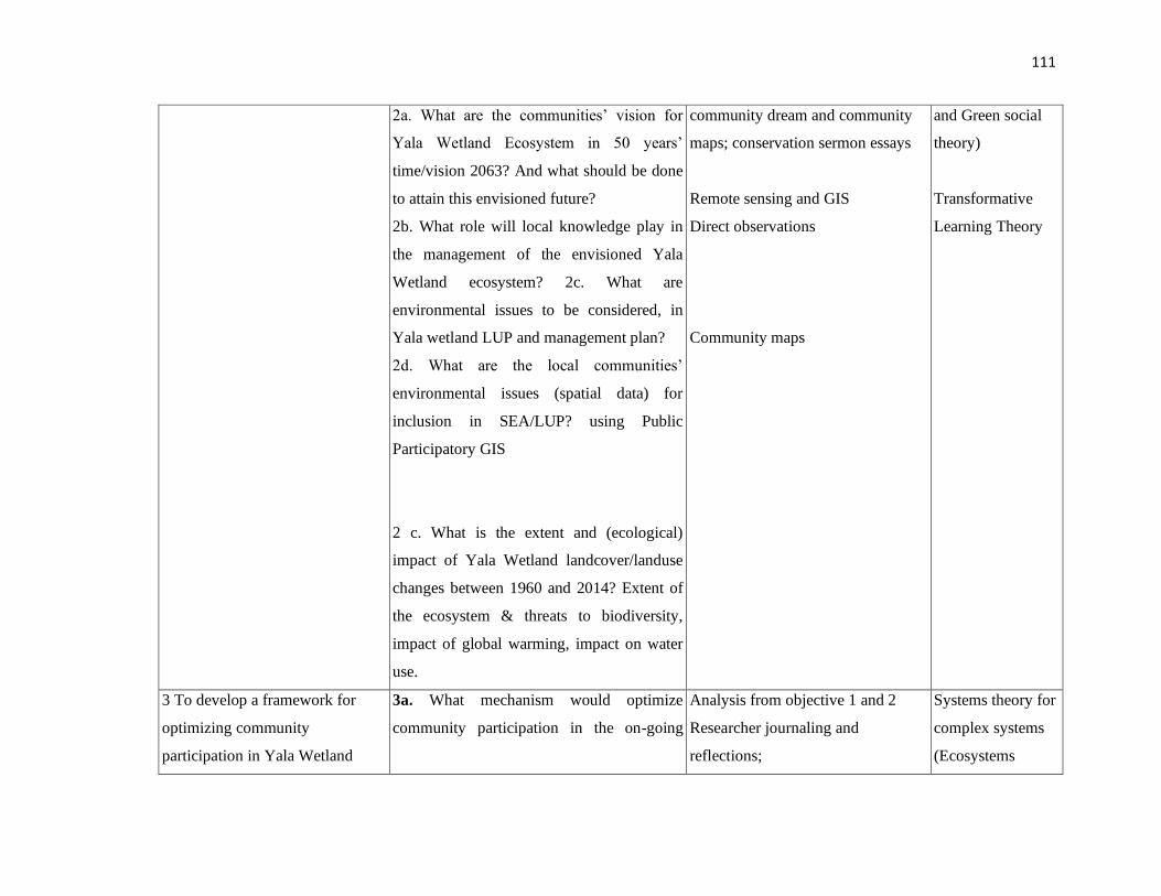
111
2a. What are the communities’ vision for
Yala Wetland Ecosystem in 50 years’
time/vision 2063? And what should be done
to attain this envisioned future?
2b. What role will local knowledge play in
the management of the envisioned Yala
Wetland ecosystem? 2c. What are
environmental issues to be considered, in
Yala wetland LUP and management plan?
2d. What are the local communities’
environmental issues (spatial data) for
inclusion in SEA/LUP? using Public
Participatory GIS
2 c. What is the extent and (ecological)
impact of Yala Wetland landcover/landuse
changes between 1960 and 2014? Extent of
the ecosystem & threats to biodiversity,
impact of global warming, impact on water
use.
community dream and community
maps; conservation sermon essays
Remote sensing and GIS
Direct observations
Community maps
and Green social
theory)
Transformative
Learning Theory
3 To develop a framework for
optimizing community
participation in Yala Wetland
3a. What mechanism would optimize
community participation in the on-going
Analysis from objective 1 and 2
Researcher journaling and
reflections;
Systems theory for
complex systems
(Ecosystems
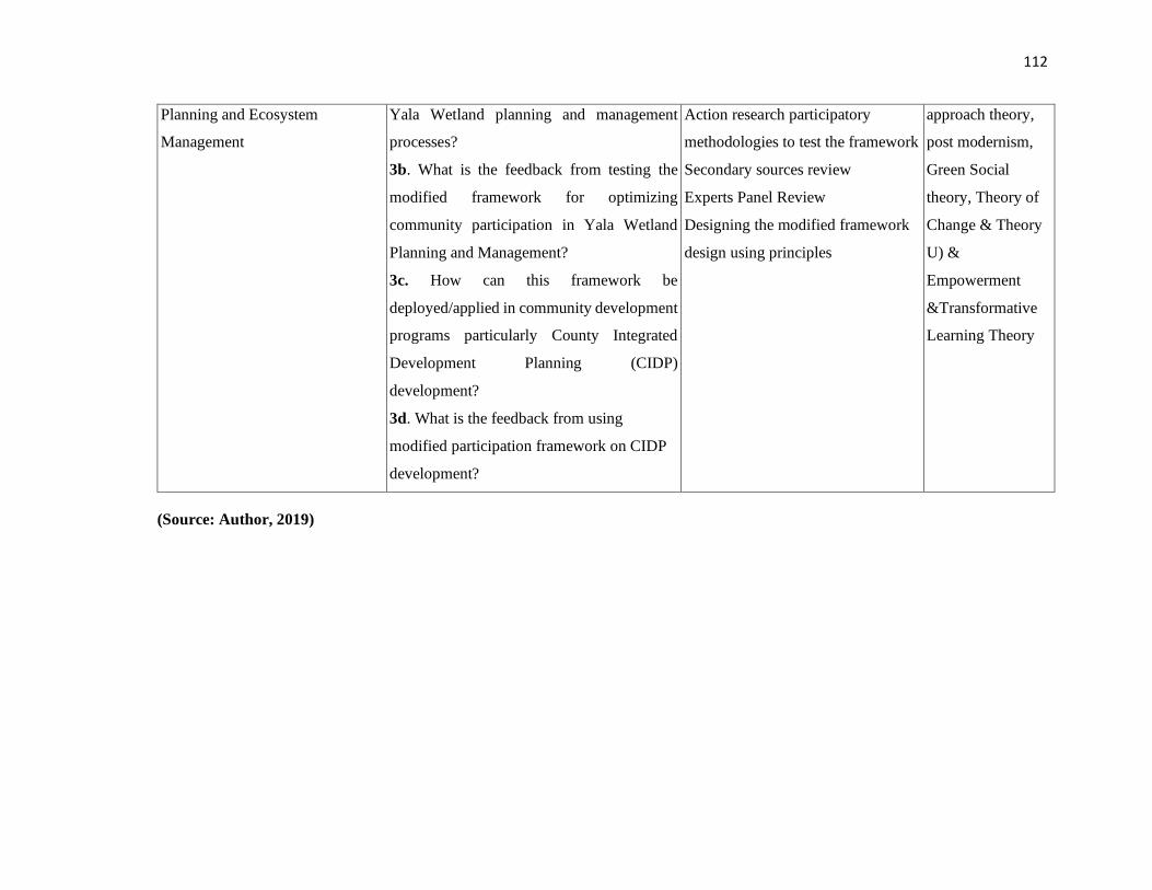
112
Planning and Ecosystem
Management
Yala Wetland planning and management
processes?
3b. What is the feedback from testing the
modified framework for optimizing
community participation in Yala Wetland
Planning and Management?
3c. How can this framework be
deployed/applied in community development
programs particularly County Integrated
Development Planning (CIDP)
development?
3d. What is the feedback from using
modified participation framework on CIDP
development?
Action research participatory
methodologies to test the framework
Secondary sources review
Experts Panel Review
Designing the modified framework
design using principles
approach theory,
post modernism,
Green Social
theory, Theory of
Change & Theory
U) &
Empowerment
&Transformative
Learning Theory
(Source: Author, 2019)
113
3.9 Data Analysis and Presentation
Data collected through interviews, FGDs, essays writing and document reviews was
analyzed using content and contextual analysis techniques. Content analysis as a method,
according to Babbie (2015) is useful since it captures well the content of communications
generated through interviews, essays and FGDs. Content analysis technique allowed the
researcher to categorize and code the collected information based on participants’
responses to each question or major themes that emerged from in-depth interviews, essays
and FGDs (Kumar, 2011). This made it easy according to Creswell (2009, 2012), Natasha
et. al. (2005) and Likert, (1932), to interpret and explain the meaning of respective themes
and perspectives raised by respondents. Contextual analysis, on the other hand was used to
analyze participants’ shared meanings and images on Yala Wetland challenges, its
formations and resource use conflicts in respective contexts of Busia and Siaya counties.
Likewise, essays were analyzed to itemize common themes and key messages.
3.9.1 Analysis of Interviews, Focus Group Discussions and Community Meetings
Interviews, focus group discussions and community meetings’ data were analysed in an
inductive manner and themes generated based on emerging similarities of expression in the
data material. All individual interviews and focus group discussions were recorded. Many
of these elements provided quotations in the write-up of research findings and other similar
elements were quantified using descriptive statistics to give a sense of the emerging themes
and their relative importance according to the respondents. Direct quotations from the
interviews were used for presentation to justify conclusions about various ideas and
themes.
All the transcripts were systematically reviewed and responses coded based on common
themes identified and sub grouped thematically. Analysis continued until there was a
consensus on interpretation and each category was ‘saturated’ which meant further
analysis appeared to yield no new information (Lincoln and Guba, 1985). Many of the sub-
headings in the findings section of this thesis represent themes that emerged through this
analysis process.
114
Secondary data reviewed and analyzed included: legislations, policy documents, strategies,
management guidelines and procedures and study site related studies at the local and
national level, and background materials about the biophysical, socio-economic and
cultural contexts in the study area. These secondary data provided a valuable source of
additional information for triangulation of data generated by other means during the
research (IYSLP, 2017; Friis-Hansen and Duveskog, 2012).
Great care was taken to ensure that necessary information regarding research questions was
collected, noted and properly verified before subsequent report writing. Data that needed
numerical calculations was analyzed by the SPSS software and was presented in form of
tables and charts.
The study dealt more with respondents’ perception rather than with statistically
quantifiable outputs. Data analysis to guide perceptions in spectrum and evaluating public
participation effectiveness was done by calculating percentage responses (Neuman, 1997).
The response rates were calculated using the following formula.
𝑅𝑒𝑠𝑝𝑜𝑛𝑠𝑒(%) =𝑥
𝑦 ∗ 100
Where x-respondents who gave feedback and y total number of respondent groups.
To grade the percentage response, a modification of Lee’s (2000) EIS study report review
package was used as shown in Table 3.3.
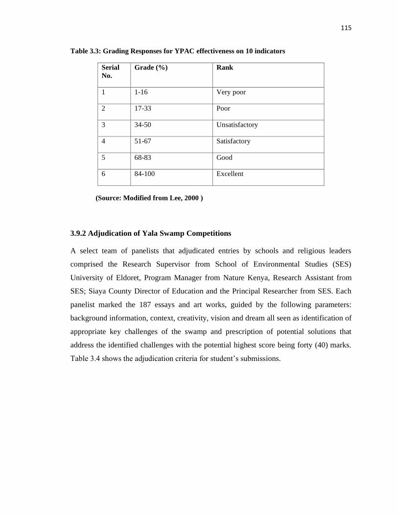
115
Table 3.3: Grading Responses for YPAC effectiveness on 10 indicators
Serial
No.
Grade (%) Rank
1 1-16 Very poor
2 17-33 Poor
3 34-50 Unsatisfactory
4 51-67 Satisfactory
5 68-83 Good
6 84-100 Excellent
(Source: Modified from Lee, 2000 )
3.9.2 Adjudication of Yala Swamp Competitions
A select team of panelists that adjudicated entries by schools and religious leaders
comprised the Research Supervisor from School of Environmental Studies (SES)
University of Eldoret, Program Manager from Nature Kenya, Research Assistant from
SES; Siaya County Director of Education and the Principal Researcher from SES. Each
panelist marked the 187 essays and art works, guided by the following parameters:
background information, context, creativity, vision and dream all seen as identification of
appropriate key challenges of the swamp and prescription of potential solutions that
address the identified challenges with the potential highest score being forty (40) marks.
Table 3.4 shows the adjudication criteria for student’s submissions.
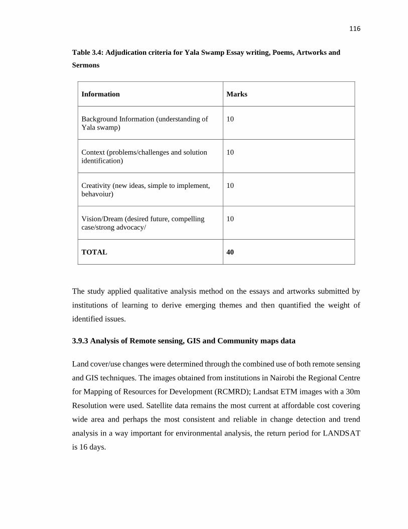
116
Table 3.4: Adjudication criteria for Yala Swamp Essay writing, Poems, Artworks and
Sermons
Information Marks
Background Information (understanding of
Yala swamp)
10
Context (problems/challenges and solution
identification)
10
Creativity (new ideas, simple to implement,
behavoiur)
10
Vision/Dream (desired future, compelling
case/strong advocacy/
10
TOTAL 40
The study applied qualitative analysis method on the essays and artworks submitted by
institutions of learning to derive emerging themes and then quantified the weight of
identified issues.
3.9.3 Analysis of Remote sensing, GIS and Community maps data
Land cover/use changes were determined through the combined use of both remote sensing
and GIS techniques. The images obtained from institutions in Nairobi the Regional Centre
for Mapping of Resources for Development (RCMRD); Landsat ETM images with a 30m
Resolution were used. Satellite data remains the most current at affordable cost covering
wide area and perhaps the most consistent and reliable in change detection and trend
analysis in a way important for environmental analysis, the return period for LANDSAT
is 16 days.
117
LANDSAT ETM imagery was the primary data source was used to determine and map the
landscape characteristics particularly plant communities of Yala Wetland. The study
utilized, ARC GIS 10, and ERDAS 9.3 in combination with ENVI 4.7 or IDRISI. Landsat-
ETM images acquired were already corrected.
Since each image consists of about six bands. Resampling of the images was the undertaken
in ERDAS using the "Layer Stack" module. Layer stacking enables band combination thus
enabling the image combination in true color combination (bands 3, 2, 1) or false color
composition (4, 3, and 2).
The images were then clipped using the subset module as defined above so as to attain only
the study area to be classified, this was done in ARC GIS 10 with the aid of a shape file of
the study area, this was done in the data management module-raster processing – clip
module in ARC GIS or the subset module in ERDAS 9.3. The shape file used in sub setting
the image was obtained from the boundaries of the locations surrounding the wetland.
Image classification was then undertaken, unsupervised classification was undertaken for
the clipped images using ERDAS 9.3 software to generate classes that are found in area.
This was computer generated and gave a general view of the number of classes that were
within the study area. Using the classes obtained and the prior knowledge of the area,
tentative classes of ten land uses were assigned to the auto generated classes.
ERDAS 9.3 maximum likelihood module method was adopted to undertake supervised
classification and the method assumed that the training area digital numbers were normally
distributed. The probability of a pixel value occurring in each class would then be
computed therefore assigning the pixels to the class with the highest probability (likelihood
of being a member). This was repeated for all the images and the results were presented as
figures. This process was also aided by a Google earth image for the area, which was
considered real time and ensured that the classified class was a true representation with the
situation on the ground.
118
3.10 Validity and Reliability
Validity is the ability of measures such as in-depth interviews and FGDs to measure what
they are envisioned to measure (Yin, 2009). In particular, did the key informant interviews
and FGDs respond to the stated study objectives and questions? Reliability on the other
hand is the ‘dependability or consistency’ of a research approach across other studies.
According to Yin (2009, p. 38) reliability helps to reduce bias and errors by ensuring that
“if a later investigation followed the same procedures as described by an earlier researcher
and conducted the same case study all over again, the later researcher should arrive at the
same findings and conclusions.” Multiple qualitative research methods namely key
informant interviews, FGDs, community mapping, artworks, essays and debates and
document reviews were triangulated to ensure that the selected measures and findings were
valid.
The use of multiple methods of data collection was a key feature of the action research on
Yala Wetland ecosystem. The researcher and his assistants spent more time in the field in
order to familiarize themselves with participants, wetland environmental issues and
community dynamics in the study area. The researcher being a native of the wetland,
enjoyed some legitimacy to discuss the identified issues frankly knowing that ultimately,
it was for their betterment as one of their own sons worked with technical teams from the
National Government, County Government and University of Eldoret in developing Yala
LUP. The population data was obtained from KNBS census data, the custodian of
government data and Siaya and Busia County statistical offices. LANDASAT-TM images
were considered appropriate for the study due there relatively good resolution of 30 metres
which were further be resampled to a higher resolution to cost effectively cover the needs
of the study.
From the onset the researcher conducted a reconnaissance of the study area, pre-tested the
data collection instruments among them interview schedules, FGDs guides and observation
checklist and used feedback to refine the tools in line with the study objectives and
questions. During data analysis, the researcher involved doctorate student colleagues who
119
were not involved in the previous the study, in order to provide a continuous check on the
research findings and conclusions to contain researcher biases.
3.11 Justification of the Methodology and Action Research within Workspace
The study focused on communities and their activities as they interact with Yala Wetland
ecosystem and its buffer zone. The buffer zones were restricted to a distance of 5km from
the wetland boundary because the propensity to use wetland resources is inversely related
to travel distance (Odhengo et al., 2018a; Abila, 2003). Besides, the wider Yala and Nzoia
basins and adjacent Lake Victoria key interconnected activities and their impact were
considered in wetland plans development and governance framework arising from this
study
The application of participatory methodologies among them FGDs, Key informant
interviews, visualization of the future through artworks, songs, debates, community
mapping fused with appreciative enquiry framing of questions, trainings, coaching,
empathy walks with communities, lived with the people/total immersion helped to get very
deep people issues and infuse creativity in the process (Dweck, 2008; Involve, 2005;
Cooperrider et al., 2000; Piaget, 1950; Likert, 1932).
Action Research within the Workspace
Some components of research were carried out as an action research process within
workspace. For much of the study period the researcher played a multi-faceted role as
investigator, an advisor to SEA/LUP development and a mentor to Siaya County Integrated
Development Plan (CIDP) development and implementation. To some extent while these
multiple roles provided challenges in terms ensuring true objectivity of the research, it also
provided a range of opportunities for ensuring direct impact of the research in informing
practice. The aim was to generate concrete and practical knowledge to enable those
responsible for making policy, managing programs and delivering services to make more
informed judgements about their activities, thereby making services more appropriate and
effective for the people they serve.
120
The above perspective is fully consistent with the intentions and objectives of participatory
action research as Stringer (1999) and Reason (1994) explained where apart from
producing knowledge and action useful to the community, it also emboldens people to
construct and use their own knowledge. This denotes less emphasis on uncovering
generalizable truths but puts more focus and emphasis on the realities of individuals and
communities in local contexts (Stringer, 1999). This action research perspective allowed
the investigator to be a researcher while at the same time acting as a change agent and
assume benefits related to his role as ‘insider’ (transformational learning). As noted by
Stringer (1999), research that operates at a distance from the everyday lives of practitioners
largely fails to penetrate the experienced reality of their day-to-day work. Reason (1994)
points out the fact that “we can only understand our world as whole if we are part of it, as
soon as we stand outside, we divide and separate”. In action research there is no functional
distinction between the researcher and the researched. They are all defined as participants,
and have equal footing in determining which questions to be asked, information to be
analysed, and conclusions to be made (Stringer, 1999).
To mitigate the possible drawbacks of problems in objectivity, the researcher deliberately
teamed up with research colleagues (i.e. doctorate student colleagues who did not have any
involvement with the Yala Wetland) for data analysis and this provided a continuous check
on researcher’s findings and conclusions, ensured that the researcher’s own biases did not
undermine the research. Reason (1994) argues that true objectivity does not exist and that
the observer is always inseparable from what is observed. Instead, he refers to the term
‘critical subjectivity’, arguing that the validity of our encounters with experience rests on
the high quality, critical, self-aware, discriminating and informed joint judgements of the
research actors and subjects (Scharmer, 2016).
3.12 Ethical Considerations
The researcher was conscious of ethical issues related to the study and to himself,
participants and institutions which he was affiliated to particularly University of Eldoret
and Retouch Africa Consulting (RAI) and institutions where data were collected. In order
to ensure trust by participants and organizations in which data was collected from, an
121
official letter introducing the researcher was provided by University of Eldoret and a
research permit from The National Commission for Science Technology and Innovation
(NACOSTI) (Appendix 5). Respondents’ information was treated with utmost
confidentiality and were informed that they were free to disclose or conceal their identities.
To avoid misinterpretation and distortion of information, the researcher ensured that no
other person(s) had access to the data during the data collection process. There were short
debriefing sessions after every interview or FGD in order to cross check the collected data.
This helped eliminate wrongly presented or recorded data. The researcher was so conscious
on the use of words or phrases to avoid asking questions, which, according to Creswell
(2009) would sound offensive or discriminatory in terms of “gender, sex, race, disability
and ethnic minorities.”
Research questions were pretested with peers and other experts to ensure that they were
not offensive. Since this study also examined wetland’s resource conflicts that could have
contributed to deaths, injuries and bad memories; questions touching these very sensitive
issues were carefully handled. The issue of acknowledgment was considered and any piece
of work consulted was acknowledged. The identities of interviewees have been concealed
in the thesis report and resultant publications to ensure no victimization for any contrarian
opinions expressed during the study. The researcher also acknowledged the contribution of
individuals in the execution of this study. Most importantly, any piece of information that
is deemed classified/or confidential by the government or non-government organizations
was not to be accessed unless consent was granted by respective institutions.
122
CHAPTER FOUR
RESULTS
4.1 Introduction
This chapter presents the results of the study. The results are presented based on the study
objectives and include results on the assessment of the status of community participation
in Yala Wetland management, those on identified environmental issues for inclusion in
Yala Wetland Land Use planning and management and the development of a modified
framework for optimizing community participation in Yala Wetland ecosystem
management.
4.2 The Status of Community Participation in Yala Wetland Ecosystem
Management
The first objective of the study was to assess the status of community participation in Yala
Wetland Ecosystem management and this section presents the results on communities
account of Yala Wetland’s formation and how that affects their involvement in its
management. The essential indigenous knowledge system used by the communities in
managing the wetland, their level of participation in SEA/LUP processes, effectiveness of
community participation in SEA/LUP processes and the governance framework for
managing Yala Wetland ecosystem are discussed.
4.2.1 Communities’ Historical account on the Formation of Yala Wetland
According to the key informants in the study, the history of Yala Wetland dates back to
many years ago when the wetland was a flat ground inhabited by the local people. Things
changed in the 1960s with heavy rains which became the climax of the wetland’s formation
according to the local communities’ recollection.
Before the 1960s, the wetland was a water body, which later disappeared allowing the local
populations to move in and undertook cultivation. There have been three cycles of water
drying/reducing significantly namely cycle one of 1917-1920s; cycle two of 1960-1970s
and cycle three of the 1980s onwards. Likewise, the communities also reported that they
123
had heard from their forefathers that Lake Victoria had also dried completely twice in its
history of existence. This proposition has been corroborated by studies on Lake Victoria
by Awange and Obiero-Ong’anga, 2001.
Secondly, the wetland partly formed from the flooding experienced in the 1960s which
was believed to be a curse from the gods by the local communities. The flooding continued
until 1972 causing malaria and other challenges that forced most people to move to high
grounds. Yala Wetland residents recalled that in December 1962 and much of 1963 there
were heavy rains (kodh uhuru meaning the rain at independence) which is equivalent to
today’s El Nino rains. Initially, there was a small opening by the lakeside at Goye in
Usenge, but with the 1963 rains for two years widening the two sides and later a causeway
was built to link the two landmasses in Usenge. The ferry was brought but with increased
rains, the ferry was swept to Mageta islands. The local people then continued using boats
to link the two areas. The inhabitants of Mageta were driven away by tsetse fly infestation
in 1929 but returned after successful government tsetse eradication project in the islands in
the mid-sixties. Respondents stated that the local communities created beliefs out of some
experiences and some believed going back to Mageta was not was not going to be fraught
with bad omen. The families in Yimbo dispersed over time and some of them moved to
other places in Bunyala, Alego, Gem and other far off places. They retain the names from
Yimbo like Nyamonye, Usenge, and Uriri in Alego.
Respondents reported that Lake Kanyaboli is a mystery (en hono). When the water dried
from Sigulu area an elder known as Wanjiri Kosiemo discovered the dried land and people
of West Alego moved in to farm. There were a lot of indigenous fish species like mudfish
(Kamongo), a lot of food from the farms and there was no stealing.” An elder from Kombo
beach remembered this and stated that Ikwaloga mana kaonge meaning people steal food
only when there is lack of it. In 1968, a road was constructed through Yala Wetland and
Lolwe Bus Company passed through the wetland while River Yala drained into Lake
Kanyaboli at Wango Chula.
Respondents from the community further explained that Lake Sare was formed as a result
of the backflow of River Yala entering Lake Victoria. Later, River Yala course was
124
diverted forcefully into Lake Namboyo and the wetland communities attributed this act to
wetland expansion as the waters spread into the wetland without going directly into Lakes
Kanyaboli and Victoria as was before.
A third respondents’ explanation on the formation of Yala Wetland was linked to the
construction of Owen Falls dam in Uganda in 1954 thus resulting into the beginning of a
backflow water challenge that was due to flooding in 1960, 1962 and 1963 with water from
Kasese in Uganda.
The Bunyala respondents provided an additional explanation, linking the flooding to River
Nzoia channel expansion during Webuye Paper factory construction. In Musoma where
river Nzoia enters Lake Victoria, there is a backflow that is partly responsible for
submerging villages in the wetland. There were 10 Yala wetland islands inhabited by 36
clans spread across 39 villages. Among the Banyala subclans living in those 10 wetland
islands include: Bulwani, Maduwa, Bukhuma, Siagiri, Iyanga, Khumabwa, Maanga,
Bungeni, Runyu, Rukaza, Kholokhongo, Nababusu, Gendero, Mauko, Bubamba, Buongo,
Siagwede, Siunga, Bunofu, Busucha, Mugasa, Isumba, Ebukani, Bumudondu, Erugufu,
Ebuyundi and Khamabwa.
These wetland formation and expansion propositions determine how the wetland
communities use and manage the wetland resources and the current level of degradation
will require their active involvement to reverse course.
4.2.2 Wetland Communities interest in Wetland management and participation
FDGs and key informant interviews identified the following reasons in order of priority 1-
7 for their interests and participation in Yala wetland management: Major source of water,
food and income; benefits present and future generations(a tourist site); conservation of
environment, flood control, awareness on environment and rainfall, Fish farming and
farming in the swamp, papyrus reeds, papyrus products, raw materials for building,
firewood, alternative source of income; a community land for development purpose; and
Shelter for wild animals such as Sitatunga and breeding ground for fish.
125
They also expressed how they wanted to be involved in management as follows:
Community involvement and be part of conservation; creation of
awareness/sensitization/advocate sustainable management of the swamp including use of
right fishing gears; Improve species diversity by planting trees, fruit trees and papyrus;
Farming at the swamp; management of canal for easy flow of water and control of floods;
implement land use plan/policy at Yala swamp; employment, register the swamp as a
community land; participate in Swamp reclamation, and protect wild animals.
4.2.3 Yala Wetland Ecosystem Benefits derived by Wetland Communities and how
these influenced their Participation in its Management
The wetland communities identified the following benefits which they derive from the
wetland and in turn affect their level of participation in the wetland’s management.
Food Provisions
Yala wetland has been a source of plenty and a variety of foods including crops, animals,
and fish from both commercial and smallholding farming all year round for the local
communities. All the 60 FGD groups confirmed they get various foods from the wetland
which include: arrow roots, sweet potatoes, millet, maize, pumpkins, traditional vegetables
like nyasigumba, and fish lung fish (kamongo).
Papyrus Resources
The papyrus resources were used by 80% of the FDG groups in various ways such as
thatching houses, making granary (dero) for storing foods, ropes (togo), baskets, utencils
(adita, andiw), hats and mats (par). Mats are used for a variety of things including drying
farm produce, as sleeping accessories and roof boards for houses. The wetland also serves
the purpose of water filtration and some wetland residents prefer its water to Lake
Victoria’s.
Biodiversity Hotspot
Yala Wetland has been a biodiversity hot spot with a rich source indigenous knowledge on
resources such as birds, butterflies, sitatunga and monkeys. It is considered as remnant
126
ecosystem which hosts some endemic Cichlid fish species. Lake Kanyaboli is a critical
habit for two endemic species Oreochromis variabilis and O. esculentus; the wetland is
also a wildlife corridor and brings nature to communities by providing recreational
opportunities, supporting learning environments and creating economic benefits.
During a bird count held in March 2016 in Goye causeway the researcher together with
Yala Site Support Group (YSSG) and Wetland International (WI) visitors from different
African and Asia countries managed to identify 60 bird species including the following:
usofi, siwiri, owiny, nyamaha, aging, opir, obirgogo, oningo, okok, opija. Table 4. 6 shows
various birds found in the wetland and their values to the local communities.
Various bird species known to perform various functions were also found in Yala Wetland
among them Magungu for early warning on the onset of rains. During the study, the
communities cited seeing the birds in the fourth week of March, 2016 and then the rain
began in the first week of April 2016 confirming their beliefs on applying their indigenous
knowledge. Other birds were Owls (Tula nyangoro), Shoebill (Arum) and (Munglu which
spell death and calamities;(Tel tel) good fortunes but also indicates bad fortune when it
chirps repeatedly (anouya), and Arum koga denotes bad omen. The communities while
explaining the beliefs noted that these beliefs were rooted in some previous experiences
and therefore had been taken forward as a representation of what was likely to happen.
There was absence of a systematic way of sharing benefits from the wetland especially
where a private entity (investors) had leased the swamp for commercial purposes. As a
result, the local communities could neither access some of the birds in the leased lands and
therefore could not conserve them as they did not benefit them but would want to trap them
and use for food.
Cultural and Spiritual Services Provision
The communities of Yala Wetland had diverse cultural practices and beliefs, some of which
could be exploited for tourism and conservation. Local communities had strong
attachments to the wetland because of their social, cultural and spiritual importance. They
had shrines such as Sigulu and Muduha which they used for baptism, traditional passage
rites and cleansing of evil spirits. The communities also promoted indigenous knowledge
127
and practices on environmental functions and values that are essential for their survival
such as the use of medicinal herbs.
Some places in the wetland were considered homes of clan spirits hence the residents took
it as their duty to protect them. Some of these were shrines and grave sites. However, some
of these sites like Sigulu had been taken by Dominion Farms and were inaccessible for
local communities.
Benefits Prioritization and how it determines Community Participation in Wetland
Ecosystems Management
During community consultations and meetings, the following were identified as what the
local communities valued most of Yala Wetland. First, the provisions wetland communities
obtain from the wetland were papyrus ranked as the highest at 35%. It was used by local
communities in multiple ways ranging from thatching houses, filtration of water for use by
wetland communities; basketry and habitat for numerous biodiversity found in the wetland
like the endangered sitatunga, birds, butterflies and monkeys. Second, farming (30%)
which provided food for local communities living within and outside the wetland. When
water level receded in the wetland local people moved in started farming here. Third, for
settlement within the wetland particularly on the Busia County side in Bunyala and within
the buffer zone of the wetland on the Siaya County side (20%). Fourth, medicinal value for
herbs to treat various ailments as well as other wetland resources such as ant bear dung
(chieth muok) to treat cholera (15%).
The role of communities has been mainly wetland resource users. They have been
organized in different formations at community levels and always strove to ensure
sustainable use of the wetland’s resources. However, this cautious use has changed over
time due to increased population and entry of commercial investors.
Equitable Benefit Sharing and Utilization of Yala Wetland Resources
While appreciating the diverse benefits from the wetland, the communities were
unequivocal in having equitable benefit sharing of Yala Wetland resources. They
recommended that the benefits accruing from investments in the Yala Wetland should be
128
shared among the investors, wetland communities and county governments at the
proportion of 70%:30%. The wetland communities and County government portion
thereafter should be shared at 60%: 40%. This was done through priority ranking at group
level and then validated at communities’ workshop which brought together representatives
of the groups. The financial benefits should then be utilized on the following community
priorities:
1. Provide safe and portable water for communities in Yala Wetland and its surroundings
within a radius of 5km. The water should be at designated points such as water kiosk where
wetland communities can easily access it. However, wetland residents with requisite
resources to tap could extend it to their homes while over time the county governments
should strive to extend to all homesteads. They suggested that investors in the wetland
should contribute to this Water Provision Fund.
2. Allocate part of high potential agricultural areas of the Wetland as guided by the final
land use plan for food production; and adopt modern and sustainable farming methods to
raise the food and nutritional security in the region. The investors should have mechanisms
for providing mechanized labour and warehousing on pro-rata basis. The agricultural
produce should be accessible at subsided rates and regulated to tame abuse while
guaranteeing food and nutritional security as well as food safety. Food security
organizations could help support this mechanism and continuously innovate on it.
3. Provide health care support for the local community by equipping and operationalizing
the existing health facilities especially provision of medicines, health equipment and
medical staff. On the health front glaring gaps that compromise effectiveness and
efficiency such as inadequate staff, drastic timely measures such the investors’ kitty could
be used pay for the remuneration of the medical staff while the government provides the
drugs and equipment including high-level capacity to handle medical emergencies
including novel diseases.
4. Support education fund to help the needy children pay for school fees and maintenance.
The contributions for education bursary scheme should be channeled to schools where
students can pursue their education and be exposed to enabling environments. This support
129
should target students to complete secondary education and their absorption in post-
secondary education and mentorship programs in their areas of interest and talent. The fund
should be synchronized with other existing bursary systems to ensure efficiency and high
impact of the education benefit.
5. Support centres and mechanisms that seek to improve social life and environment of the
disadvantaged children from the communities and eventually strive to see that all children
enjoy favourable environment and opportunities to develop their minds. This intervention
is supported by Eric Turkheimer’s research on heritability that found that environmental
factors are the major cause of Intelligent Quotient (I.Q) disparity and therefore deliberately
improving social life and environment of the poor and disadvantaged children has the
potential of increasing their I.Qs significantly within short period of time (Turkheimer et
al., (2003).
6. Support action research in learning institutions that address key challenges of the local
people in the wetland and its environs. Funding county’s centres of excellence in Siaya
County, translating research into practice to address counties key challenges such as
extension programmes and environmental education for sustainability.
7. Support community projects of the investor’s choice which address the local
communities felt needs and in line with their aspirations as itemized during the LUP study.
4.2.4 Indigenous Knowledge Systems used by Communities to Participate in
Managing Yala Wetland Ecosystem
Local communities and key informant respondents reported having been managing the
wetland ecosystem using various indigenous knowledge systems that promote wise
utilization and concern for the other users like the government, wildlife and aquatic
animals. However, not every community member ascribes to these ideals hence conflicts
over the wetland resources. For example, the traditional totems and taboos system which
are positive conservation practices arising from attaching some significance to the various
animals and birds and thereby regulating their exploitation is close to the culling practice
of sustainable harvesting of wildlife resources practiced in formal wildlife management.
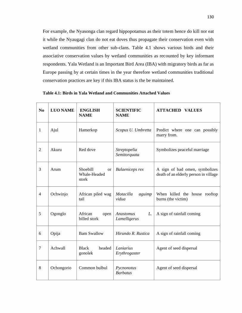
130
For example, the Nyasonga clan regard hippopotamus as their totem hence do kill nor eat
it while the Nyaugagi clan do not eat doves thus propagate their conservation even with
wetland communities from other sub-clans. Table 4.1 shows various birds and their
associative conservation values by wetland communities as recounted by key informant
respondents. Yala Wetland is an Important Bird Area (IBA) with migratory birds as far as
Europe passing by at certain times in the year therefore wetland communities traditional
conservation practices are key if this IBA status is the be maintained.
Table 4.1: Birds in Yala Wetland and Communities Attached Values
No LUO NAME ENGLISH
NAME
SCIENTIFIC
NAME
ATTACHED VALUES
1 Ajul Hamerkop Scopus U. Umbretta Predict where one can possibly
marry from.
2 Akuru Red dove Streptopelia
Semitorquata
Symbolizes peaceful marriage
3 Arum Shoebill or
Whale-Headed
stork
Balaeniceps rex A sign of bad omen, symbolizes
death of an elderly person in village
4 Ochwinjo African piled wag
tail
Motacilla aguimp
vidua
When killed the house rooftop
burns (the victim)
5 Ogonglo African open
billed stork
Anastomus L.
Lamelligerus
A sign of rainfall coming
6 Opija Bam Swallow Hirundo R. Rustica A sign of rainfall coming
7 Achwall Black headed
gonolek
Laniarius
Erythrogaster
Agent of seed dispersal
8 Ochongorio Common bulbul Pycnonotus
Barbatus
Agent of seed dispersal
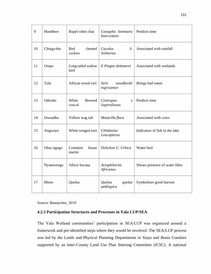
131
9 Hundhwe Rupel robin chat Cossypha Seminara
Intercedens
Predicts time
10 Chiega-tho Red chested
cuckoo
Cuculus S.
Solitarius
Associated with rainfall
11 Orepa Long tailed widow
bird
E Piogne delamerei Associated with wetlands
12 Tula African wood owl Strix woodfordii
nigricantor
Brings bad omen
13 Odwido White Browed
coucal
Centropus s
Superaliosus
Predicts time
14 Owuadha Yellow wag tail Motacilla flara Associated with cows
15 Angwayo White winged turn Chlidonias
Leucopterus
Indicators of fish in the lake
16 Obur ngogo Common house
martin
Delichon U. Urbica Water bird
Nyamwenge Africa Sacana Actophilornis
Africanus
Shows presence of water lilies
17 Miree Quelea Quelea quelae
aethiopica
Symbolizes good harvest
Source: Researcher, 2019
4.2.5 Participation Structures and Processes in Yala LUP/SEA
The Yala Wetland communities’ participation in SEA/LUP was organized around a
framework and pre-identified steps where they would be involved. The SEA/LUP process
was led by the Lands and Physical Planning Departments in Siaya and Busia Counties
supported by an Inter-County Land Use Plan Steering Committee (ICSC). A national
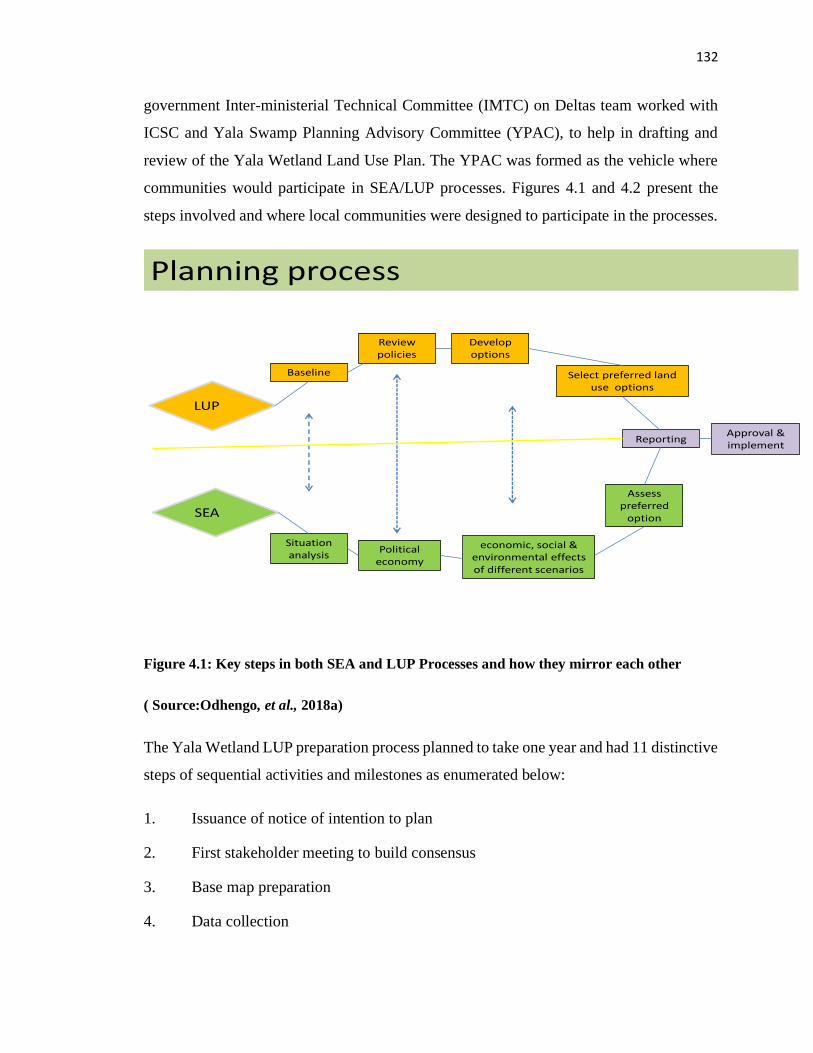
132
government Inter-ministerial Technical Committee (IMTC) on Deltas team worked with
ICSC and Yala Swamp Planning Advisory Committee (YPAC), to help in drafting and
review of the Yala Wetland Land Use Plan. The YPAC was formed as the vehicle where
communities would participate in SEA/LUP processes. Figures 4.1 and 4.2 present the
steps involved and where local communities were designed to participate in the processes.
Planning process
LUP
SEA
Baseline
Review policies
Develop options
Select preferred land use options
Reporting
Situation analysis
Political economy
economic, social & environmental effects of different scenarios
Assess preferred
option
Approval & implement
Figure 4.1: Key steps in both SEA and LUP Processes and how they mirror each other
( Source:Odhengo, et al., 2018a)
The Yala Wetland LUP preparation process planned to take one year and had 11 distinctive
steps of sequential activities and milestones as enumerated below:
1. Issuance of notice of intention to plan
2. First stakeholder meeting to build consensus
3. Base map preparation
4. Data collection
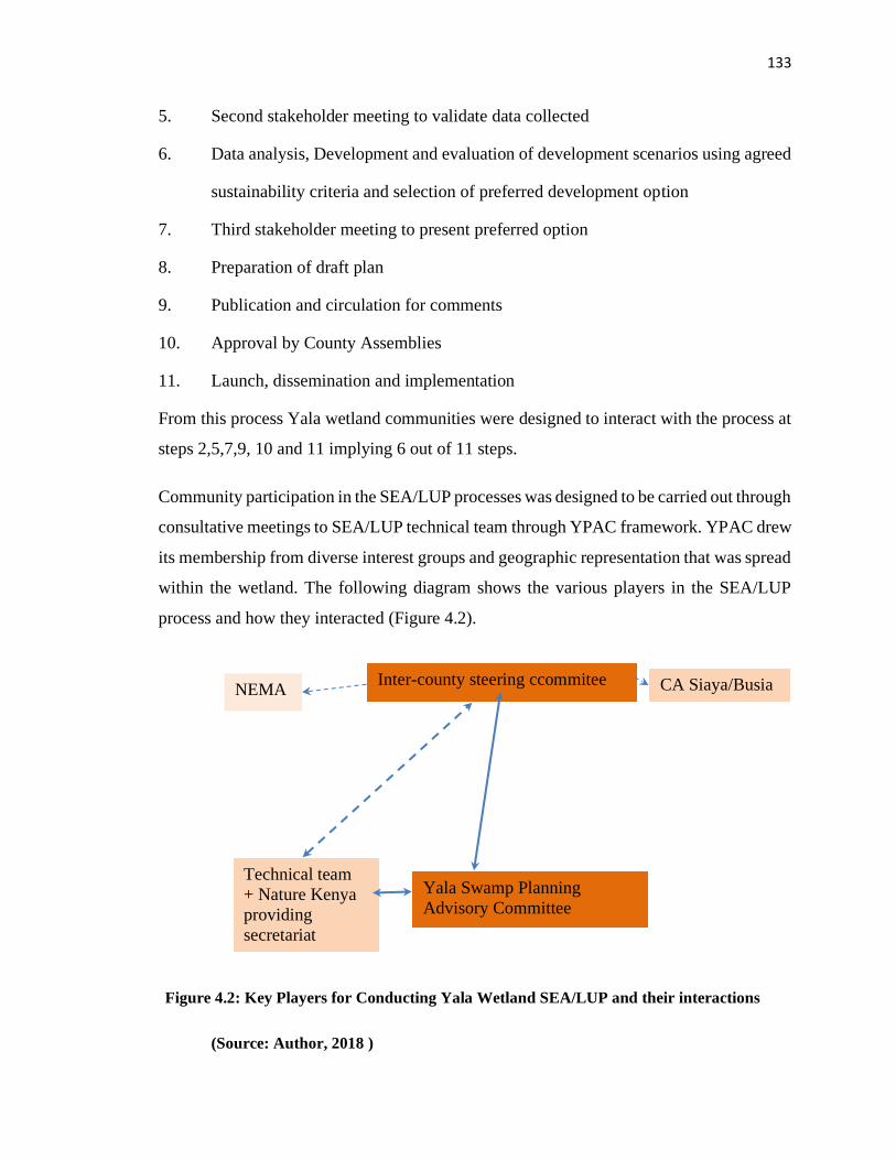
133
5. Second stakeholder meeting to validate data collected
6. Data analysis, Development and evaluation of development scenarios using agreed
sustainability criteria and selection of preferred development option
7. Third stakeholder meeting to present preferred option
8. Preparation of draft plan
9. Publication and circulation for comments
10. Approval by County Assemblies
11. Launch, dissemination and implementation
From this process Yala wetland communities were designed to interact with the process at
steps 2,5,7,9, 10 and 11 implying 6 out of 11 steps.
Community participation in the SEA/LUP processes was designed to be carried out through
consultative meetings to SEA/LUP technical team through YPAC framework. YPAC drew
its membership from diverse interest groups and geographic representation that was spread
within the wetland. The following diagram shows the various players in the SEA/LUP
process and how they interacted (Figure 4.2).
Figure 4.2: Key Players for Conducting Yala Wetland SEA/LUP and their interactions
(Source: Author, 2018 )
Inter-county steering ccommitee
Yala Swamp Planning
Advisory Committee
Technical team
+ Nature Kenya
providing
secretariat
CA Siaya/Busia NEMA
Figure STYLEREF 1 \s 4. SEQ Figure \* ARABIC \s 1 2: Key Players for
Conducting Yala Wetland SEA/LUP and their interactions

134
Table 4.2 shows all the consultations that took place during the life of the SEA/LUP
processes with slight modifications to the initial plan particularly in timing and the number
and breath of community consultations.
Table 4.2: Consultations on Yala Land Use Plan
Date Venue Key Event Results
19th -20th August
2015
Siaya Validation of Land Use Planning (LUP) method
(framework) and Strategic Environment Assessment
(SEA) scoping report.
25th-26th
November 2015
Busia Presentation of baselines.
Formation Inter-County technical coordination team
Agreement on composition of Yala Wetland Planning
Advisory Committee (YPAC).
9th March 2015
Monday
Kakamega
Town
Threats and vulnerability assessment for Upper Yala
River catchment.
10th March 2015
Tuesday
Yala Market Threats and vulnerability assessment for Mid Yala River
catchment.
11th -13th March
2015
Siaya Town Threats and vulnerability assessment analysis of Lower
Yala catchment.
16th March 2015
Monday
Bondo Town,
Siaya
Threats and vulnerability assessment for Lower Yala
catchment.
22nd -23rd March
2016
Siaya Town Formation of YPAC
Presentation and validation of Planning Scenarios.
Adoption of planning scenario by Inter-County Technical
Committee and YPAC.
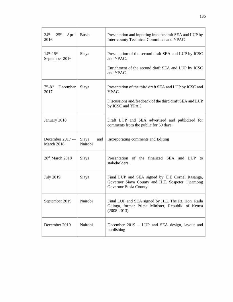
135
24th -25th April
2016
Busia Presentation and inputting into the draft SEA and LUP by
Inter-county Technical Committee and YPAC
14th-15th
September 2016
Siaya Presentation of the second draft SEA and LUP by ICSC
and YPAC.
Enrichment of the second draft SEA and LUP by ICSC
and YPAC.
7th-8th December
2017
Siaya Presentation of the third draft SEA and LUP by ICSC and
YPAC.
Discussions and/feedback of the third draft SEA and LUP
by ICSC and YPAC.
January 2018 Draft LUP and SEA advertised and publicized for
comments from the public for 60 days.
December 2017 -–
March 2018
Siaya and
Nairobi
Incorporating comments and Editing
28th March 2018 Siaya Presentation of the finalized SEA and LUP to
stakeholders.
July 2019 Siaya Final LUP and SEA signed by H.E Cornel Rasanga,
Governor Siaya County and H.E. Sospeter Ojaamong
Governor Busia County.
September 2019
Nairobi Final LUP and SEA signed by H.E. The Rt. Hon. Raila
Odinga, former Prime Minister, Republic of Kenya
(2008-2013)
December 2019 Nairobi December 2019 – LUP and SEA design, layout and
publishing
136
Inter-County Steering Committee (ICSC)
This organ was responsible for overseeing the development of Yala Wetland Land Use
Plan. The 87 members were drawn from both the Executive and County Assembly of Siaya
and Busia Counties, NEMA, National Government, KWS, Kenya Forestry Research
Institute, Kenya Forest Service, National Lands Commission and Jaramogi Oginga Odinga
University of Science and Technology. The organ conducted its business through meetings
and on demand consultations.
SEA /LUP Secretariat and Funders
Nature Kenya, a conservation NGO provided the secretariat to the process, which became
an interface for the technical team, wetland communities, development partners and other
players in SEA/LUP process. The funding support for SEA and LUP processes came from
the PREPARED Program of the United States Agency for International Development
(USAID) East Africa Regional Mission; Darwin Initiative; and MacArthur Foundation to
the Counties of Siaya and Busia.
Yala Wetland Project Advisory Committee (YPAC) and the Community
Participation Framework
YPAC was the main mechanism for representing Yala Wetland communities in the
SEA/LUP processes and its role was to discuss the findings of the SEA/LUP and obtain
views from wetland communities. The YPAC members were tasked to guide and instruct
their own communities on the role and purpose of the LUP and SEA; to provide effective
communication vertically and horizontally; to minimize misinformation and were
collectively responsible for common good.
YPAC consisted of 46 members drawn from local communities and reported to the Inter-
County Technical Committee (ICTC). The YPAC organ represented various interests
namely ecotourism, cultural groupings/heritage; conservation; religion; islanders;
fisherman; hunters; persons with disability, transporters; handicraft; farmers; investors;
wildlife (honorary warden); county technical officers of Lands, Livestock, Water,
Fisheries, Crops and Forests); sand harvesters; youth; administration (ward, sub-county);
137
and voluntary scouts.The National and the County Government officers participated in
YPAC meetings as observers, adjudicated on any internal disagreements and gave a
greater sense of the government’s commitment to listening to the views of the
communities.
The meeting chairpersons rotated between the different counties and interest groups.
Additionally, routine meetings were scheduled and held at monthly intervals to review
progress and give advice on specific outputs while ad hoc meetings were called from time
to time for specific needs. However, the meetings did not take place every month as
planned but rather as agreed upon by the members during its consultative meetings. In these
meetings, the technical team presented various SEA/LUP outcomes and sought their inputs.
They were expected upon return discuss the same with the communities they represented
and provide feedback to the technical team.
The role of the committee was defined by the technical team and entailed discussion of
findings of the LUP and SEA as each draft was prepared and discussed the views emanating
from the individual communities. There was Yala Wetland Planning Secretariat that was
housed and headed by Nature Kenya that supported the process to all the organs working
towards developing the SEA and LUP. Nature Kenya played a facilitating role to the
County Governments of Siaya and Busia to come up with a LUP for Yala Wetland. The
aim of facilitating the SEA and LUP process was to ensure that sustainable management
regimes are established, supported by relevant stakeholders, and ensured that the needs of
the industry, local people and biodiversity are met.
The YPAC members were expected to act as ambassadors to SEA/LUP processes. Every
YPAC member was tasked as guide and instructor in their own community to explain the
role and purpose of the LUP and SEA; to provide effective communication vertically and
horizontally; to minimize misinformation and collectively responsible for common good.
The YPAC members were reimbursed actual cost of transport to attend meetings and
provided with lunch during the meetings. There was no provision for sitting allowance.
In spite of this, YPAC members had challenges with this arrangement on how to play their
expected roles effectively. They noted that they needed facilitation beyond transport to
138
move around, call for meetings to debrief their communities after YPAC meetings.
Likewise, they needed the technical materials printed to be shared with communities which
they were never facilitated to do and this hampered their dual communication roles.
During the period of SEA/LUP development, YPAC held over six meetings. Their
challenges were how to reach a large number of their constituencies to report the
deliberations from the YPAC meetings. Likewise, they could not meet their constituencies
to seek inputs and relay their views to YPAC meetings. As such they presented their views
and inputs from those around them into the process hoping that it represented their
constituencies.
Siaya and Busia Members of County Assembly
This was another component of this framework and aimed at getting wetland communities
representatives at ward level to articulate their constituents’ issues and also get their
opinions as their leaders. The Members of County Assembly (MCAs) involved came from
wards that were located in Yala Wetland and its buffer zones.
As reported earlier, SEA and LUP key steps that wetland communities had to position
themselves to meaningfully participate through YPAC framework were at steps 2, 4, 5, 7,
8, and 11 which was done with mixed results on the participation levels and effectiveness
of wetland community participation in SEA and LUP as shown in Table 4.3. MCAs
participated in the ICSC consultations and provided their feedbacks to the SEA/LUP drafts
reports. They did not get opportunities for level ward discussions over these draft
SEA/LUP documents with their representatives. Their feedback was merely their own
views as representatives of the wetland communities without further public participation
as required by Public participation requirements in the County Government Act (2012) and
public participation guidelines of the Busia and Siaya Counties.
The researcher having reviewed the community participation framework and the
challenges inherent in it including inclusivity and inability to reach out to the significant
number of intended communities and obtain their voices, further mapped the representation
of local communities and reached out to them as a way of increasing community
139
participation occasioned by the necessity of taking action to improve practice which is the
essence of action research.
4.2.6 Level of Communities’ Participation in LUP/SEA Process using Spectrum of
Public Participation
FGD respondents were introduced to the spectrum model of public participation and its
five levels of informing, consulting, involving, collaborating and empowering. Table 4.3
shows key SEA/LUP activities and FGD respondents’ feedback on their levels of
participation based on the spectrum model while Figure 4.3 shows the effect of applying
the modified Yala Community participation framework on SEA/LUP processes.
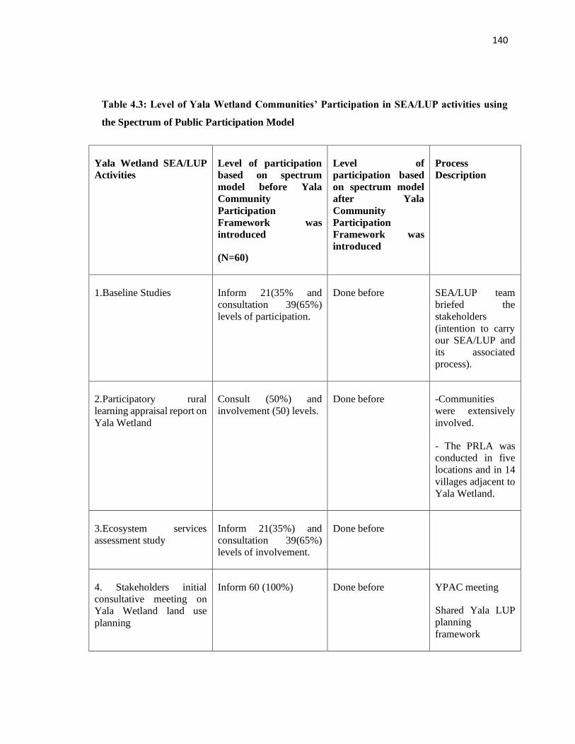
140
Table 4.3: Level of Yala Wetland Communities’ Participation in SEA/LUP activities using
the Spectrum of Public Participation Model
Yala Wetland SEA/LUP
Activities
Level of participation
based on spectrum
model before Yala
Community
Participation
Framework was
introduced
(N=60)
Level of
participation based
on spectrum model
after Yala
Community
Participation
Framework was
introduced
Process
Description
1. 1.Baseline Studies Inform 21(35% and
consultation 39(65%)
levels of participation.
Done before SEA/LUP team
briefed the
stakeholders
(intention to carry
our SEA/LUP and
its associated
process).
2. 2.Participatory rural
learning appraisal report on
Yala Wetland
Consult (50%) and
involvement (50) levels.
Done before -Communities
were extensively
involved.
- The PRLA was
conducted in five
locations and in 14
villages adjacent to
Yala Wetland.
3. 3.Ecosystem services
assessment study
Inform 21(35%) and
consultation 39(65%)
levels of involvement.
Done before
4. Stakeholders initial
consultative meeting on
Yala Wetland land use
planning
Inform 60 (100%) Done before YPAC meeting
Shared Yala LUP
planning
framework
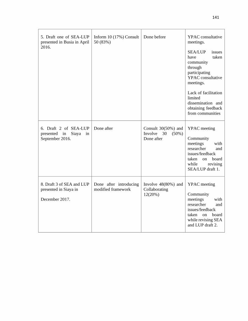
141
5. Draft one of SEA-LUP
presented in Busia in April
2016.
Inform 10 (17%) Consult
50 (83%)
Done before YPAC consultative
meetings.
SEA/LUP issues
have taken
community
through
participating
YPAC consultative
meetings.
Lack of facilitation
limited
dissemination and
obtaining feedback
from communities
6. Draft 2 of SEA-LUP
presented in Siaya in
September 2016.
Done after Consult 30(50%) and
Involve 30 (50%)
Done after
YPAC meeting
Community
meetings with
researcher and
issues/feedback
taken on board
while revising
SEA/LUP draft 1.
8. Draft 3 of SEA and LUP
presented in Siaya in
December 2017.
Done after introducing
modified framework
Involve 48(80%) and
Collaborating
12(20%)
YPAC meeting
Community
meetings with
researcher and
issues/feedback
taken on board
while revising SEA
and LUP draft 2.
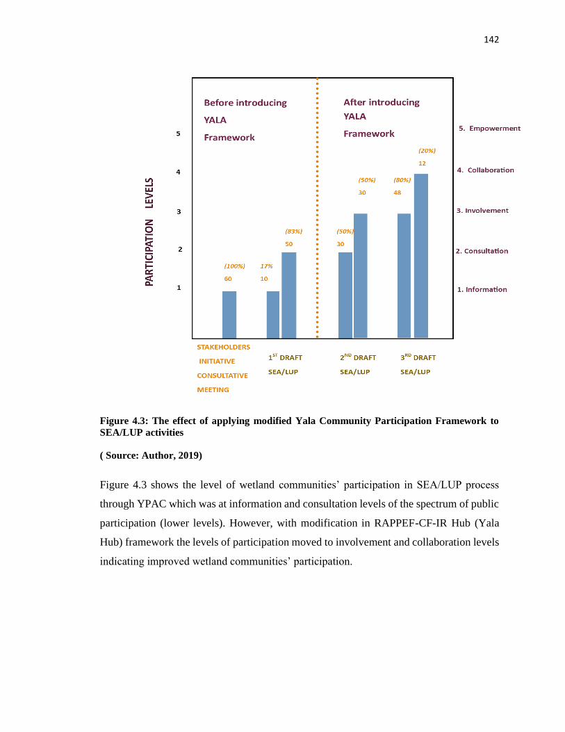
142
Figure 4.3: The effect of applying modified Yala Community Participation Framework to
SEA/LUP activities
( Source: Author, 2019)
Figure 4.3 shows the level of wetland communities’ participation in SEA/LUP process
through YPAC which was at information and consultation levels of the spectrum of public
participation (lower levels). However, with modification in RAPPEF-CF-IR Hub (Yala
Hub) framework the levels of participation moved to involvement and collaboration levels
indicating improved wetland communities’ participation.
143
4.2.7 Determination of effectiveness of Community participation in SEA/LUP
process
The YPAC framework was assessed to determine its effectiveness using the 10 Indicators
of good practices/World Bank for evaluating effectiveness of public participation and the
results are shown in Table 4.4.
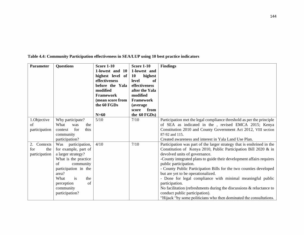
144
Table 4.4: Community Participation effectiveness in SEA/LUP using 10 best practice indicators
Parameter Questions Score 1-10
1-lowest and 10
highest level of
effectiveness
before the Yala
modified
Framework
(mean score from
the 60 FGDs
N=60
Score 1-10
1-lowest and
10 highest
level of
effectiveness
after the Yala
modified
Framework
(average
score from
the 60 FGDs)
Findings
1.Objective
of
participation
Why participate?
What was the
context for this
community
participation?
5/10 7/10 Participation met the legal compliance threshold as per the principle
of SEA as indicated in the , revised EMCA 2015; Kenya
Constitution 2010 and County Government Act 2012, VIII section
87-92 and 115.
Created awareness and interest in Yala Land Use Plan.
2. Contexts
for the
participation
Was participation,
for example, part of
a larger strategy?
What is the practice
of community
participation in the
area?
What is the
perception of
community
participation?
4/10 7/10 Participation was part of the larger strategy that is enshrined in the
Constitution of Kenya 2010, Public Participation Bill 2020 & in
devolved units of governance.
-County integrated plans to guide their development affairs requires
public participation.
- County Public Participation Bills for the two counties developed
but are yet to be operationalized.
- Done for legal compliance with minimal meaningful public
participation.
No facilitation (refreshments during the discussions & reluctance to
conduct public participation).
“Hijack “by some politicians who then dominated the consultations.
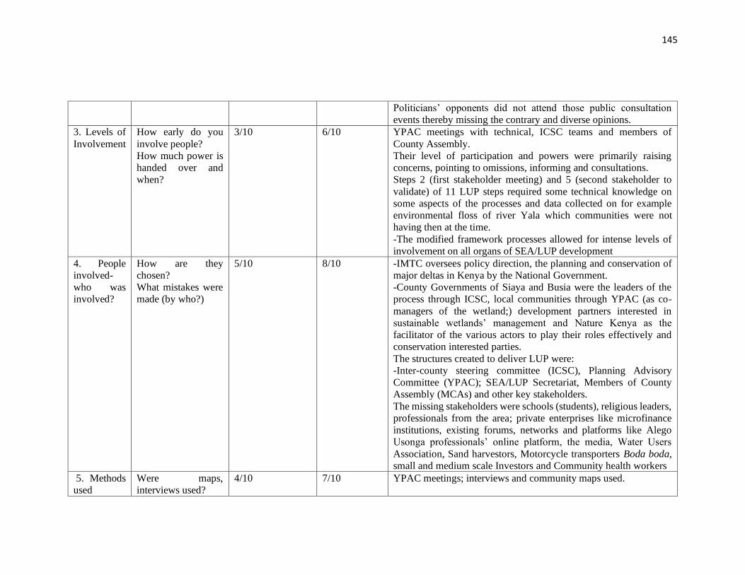
145
Politicians’ opponents did not attend those public consultation
events thereby missing the contrary and diverse opinions.
3. Levels of
Involvement
How early do you
involve people?
How much power is
handed over and
when?
3/10 6/10 YPAC meetings with technical, ICSC teams and members of
County Assembly.
Their level of participation and powers were primarily raising
concerns, pointing to omissions, informing and consultations.
Steps 2 (first stakeholder meeting) and 5 (second stakeholder to
validate) of 11 LUP steps required some technical knowledge on
some aspects of the processes and data collected on for example
environmental floss of river Yala which communities were not
having then at the time.
-The modified framework processes allowed for intense levels of
involvement on all organs of SEA/LUP development
4. People
involved-
who was
involved?
How are they
chosen?
What mistakes were
made (by who?)
5/10 8/10 -IMTC oversees policy direction, the planning and conservation of
major deltas in Kenya by the National Government.
-County Governments of Siaya and Busia were the leaders of the
process through ICSC, local communities through YPAC (as co-
managers of the wetland;) development partners interested in
sustainable wetlands’ management and Nature Kenya as the
facilitator of the various actors to play their roles effectively and
conservation interested parties.
The structures created to deliver LUP were:
-Inter-county steering committee (ICSC), Planning Advisory
Committee (YPAC); SEA/LUP Secretariat, Members of County
Assembly (MCAs) and other key stakeholders.
The missing stakeholders were schools (students), religious leaders,
professionals from the area; private enterprises like microfinance
institutions, existing forums, networks and platforms like Alego
Usonga professionals’ online platform, the media, Water Users
Association, Sand harvestors, Motorcycle transporters Boda boda,
small and medium scale Investors and Community health workers
5. Methods
used
Were maps,
interviews used?
4/10 7/10 YPAC meetings; interviews and community maps used.
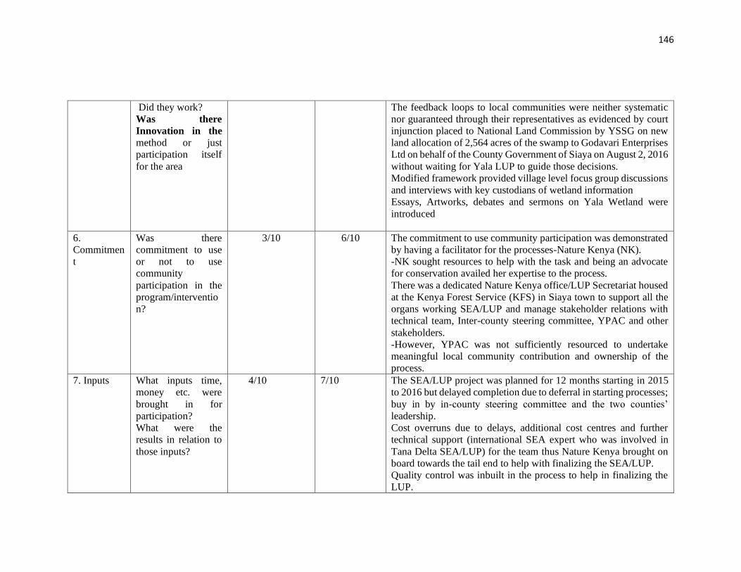
146
Did they work?
Was there
Innovation in the
method or just
participation itself
for the area
The feedback loops to local communities were neither systematic
nor guaranteed through their representatives as evidenced by court
injunction placed to National Land Commission by YSSG on new
land allocation of 2,564 acres of the swamp to Godavari Enterprises
Ltd on behalf of the County Government of Siaya on August 2, 2016
without waiting for Yala LUP to guide those decisions.
Modified framework provided village level focus group discussions
and interviews with key custodians of wetland information
Essays, Artworks, debates and sermons on Yala Wetland were
introduced
6.
Commitmen
t
Was there
commitment to use
or not to use
community
participation in the
program/interventio
n?
3/10 6/10 The commitment to use community participation was demonstrated
by having a facilitator for the processes-Nature Kenya (NK).
-NK sought resources to help with the task and being an advocate
for conservation availed her expertise to the process.
There was a dedicated Nature Kenya office/LUP Secretariat housed
at the Kenya Forest Service (KFS) in Siaya town to support all the
organs working SEA/LUP and manage stakeholder relations with
technical team, Inter-county steering committee, YPAC and other
stakeholders.
-However, YPAC was not sufficiently resourced to undertake
meaningful local community contribution and ownership of the
process.
7. Inputs What inputs time,
money etc. were
brought in for
participation?
What were the
results in relation to
those inputs?
4/10 7/10 The SEA/LUP project was planned for 12 months starting in 2015
to 2016 but delayed completion due to deferral in starting processes;
buy in by in-county steering committee and the two counties’
leadership.
Cost overruns due to delays, additional cost centres and further
technical support (international SEA expert who was involved in
Tana Delta SEA/LUP) for the team thus Nature Kenya brought on
board towards the tail end to help with finalizing the SEA/LUP.
Quality control was inbuilt in the process to help in finalizing the
LUP.
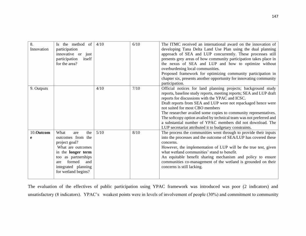
147
8.
Innovation
Is the method of
participation
innovative or just
participation itself
for the area?
4/10 6/10 The ITMC received an international award on the innovation of
developing Tana Delta Land Use Plan using the dual planning
approach of SEA and LUP concurrently. These processes still
presents grey areas of how community participation takes place in
the nexus of SEA and LUP and how to optimize without
overburdening local communities.
Proposed framework for optimizing community participation in
chapter six, presents another opportunity for innovating community
participation.
9. Outputs 4/10 7/10 Official notices for land planning projects; background study
reports, baseline study reports, meeting reports; SEA and LUP draft
reports for discussions with the YPAC and ICSC.
Draft reports from SEA and LUP were not repackaged hence were
not suited for most CBO members
The researcher availed some copies to community representatives.
The softcopy option availed by technical team was not preferred and
a substantial number of YPAC members did not download. The
LUP secretariat attributed it to budgetary constraints.
10.Outcom
e
What are the
outcomes from the
project goal?
What are outcomes
in the longer term
too as partnerships
are formed and
integrated planning
for wetland begins?
5/10 8/10 The process the communities went through to provide their inputs
into the processes and the outcome of SEA/LUP has covered these
concerns.
However, the implementation of LUP will be the true test, given
what wetland communities’ stand to benefit.
An equitable benefit sharing mechanism and policy to ensure
communities co-management of the wetland is grounded on their
concerns is still lacking.
The evaluation of the effectives of public participation using YPAC framework was introduced was poor (2 indicators) and
unsatisfactory (8 indicators). YPAC’s weakest points were in levels of involvement of people (30%) and commitment to community
148
participation (30%). However, the effect of applying the modified community participation (Yala Hub) framework moved effectiveness
by 3 points to satisfactory (3 indicators) and good (7 indicators) in SEA/LUP processes as illustrated further in Figure 4.4.
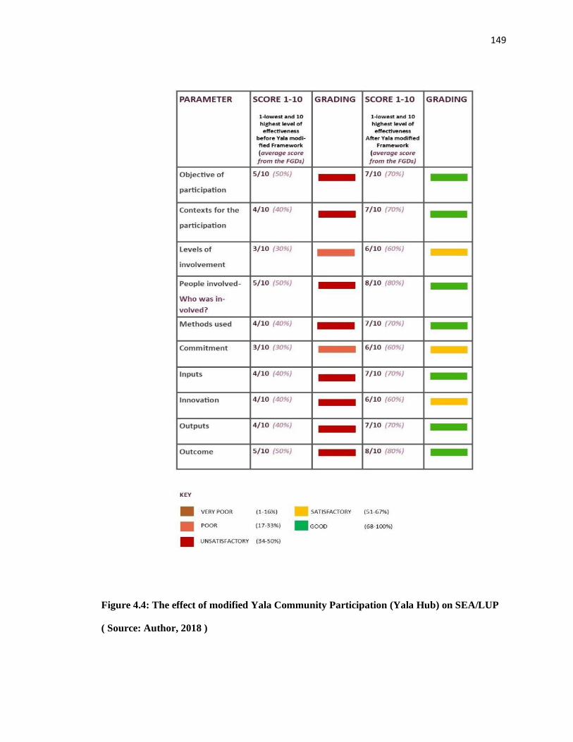
149
Figure 4.4: The effect of modified Yala Community Participation (Yala Hub) on SEA/LUP
( Source: Author, 2018 )
150
4.2.8 Governance structures for community participation in Yala Wetland
Ecosystem Management
Local communities have participated in the governance and management of Yala Wetland
alongside other actors. They had done this through their community-based organizations,
religious networks, schools and cooperative societies. Political institutions which included
local Members of Parliament and civic leaders were found to dominate key decision
making on the wetland as evidenced in the decision to lease part of the wetland to
Dominion Farms Limited which was done solely by the political class through the then
local authorities, formerly County Council and District Development Committees of Siaya.
This process did not include direct participation of the wetland communities. Likewise,
communities had been consulted at Inform level of the spectrum of public participation
through existing community based organisations (CBOs), chiefs’ meetings/or open public
gatherings and religious groups without having a substantial stake in the management of
Yala Wetland Ecosystem. The participation of some meetings were determined by the
relationship one had with the meeting convenors further compromising the quality of
participation.
The FGD and key informant interview respondents confirmed that there has been no
organized wetland-wide functional institutional framework where their Yala Wetland
issues are discussed and channeled for decision making in the management of the Yala
Wetland. Rather, small group community formations such as CBOs, sector specific groups
that lack the larger wetland clout to influence key environmental decisions have been the
norm. Instead, political players have dominated key decision making on the wetland
ecosystem issues and decision done solely by the political class. This weak framework and
low-level community participation in the management of Yala Wetland ecosystem affairs
have continued over time despite significant increase in wetland challenges. This has led
to continued utilization of wetland resources for immediate livelihood needs with less
concern for other users hence continued Yala Wetland degradation.
Therefore, it was necessary to deal with those concerns, demonstrate how those concerns
had been dealt with, and give assurance that their voices/issues would be taken seriously.
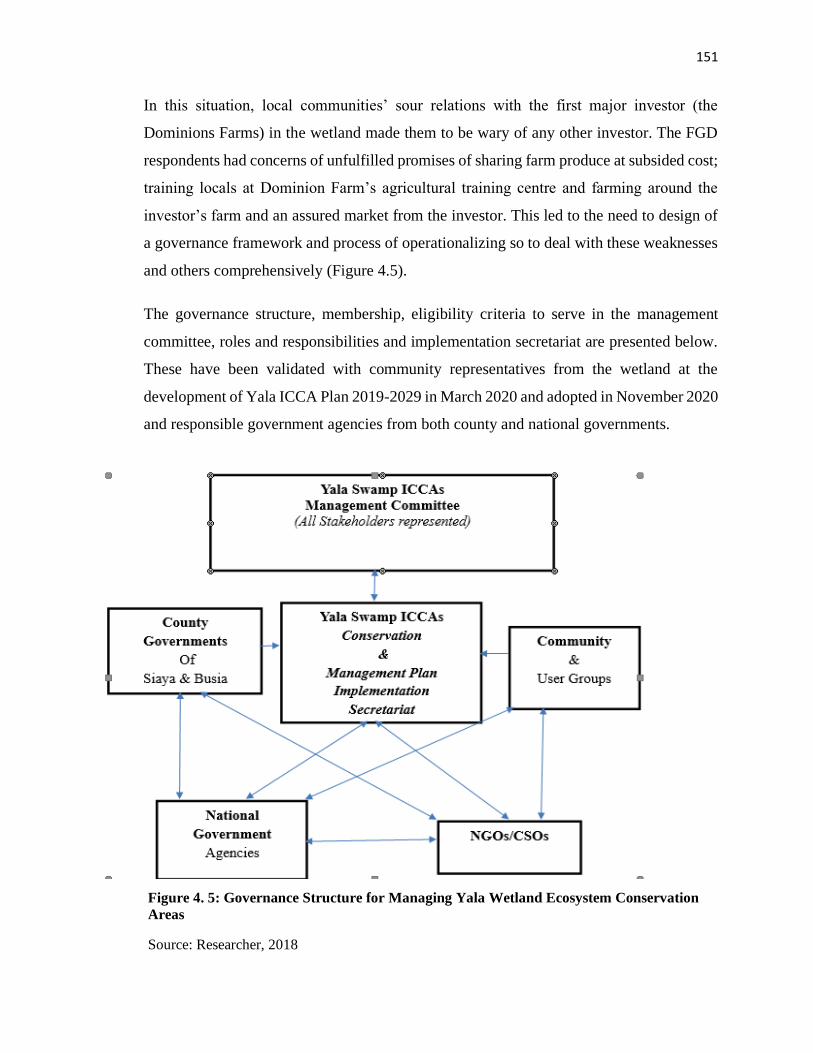
151
In this situation, local communities’ sour relations with the first major investor (the
Dominions Farms) in the wetland made them to be wary of any other investor. The FGD
respondents had concerns of unfulfilled promises of sharing farm produce at subsided cost;
training locals at Dominion Farm’s agricultural training centre and farming around the
investor’s farm and an assured market from the investor. This led to the need to design of
a governance framework and process of operationalizing so to deal with these weaknesses
and others comprehensively (Figure 4.5).
The governance structure, membership, eligibility criteria to serve in the management
committee, roles and responsibilities and implementation secretariat are presented below.
These have been validated with community representatives from the wetland at the
development of Yala ICCA Plan 2019-2029 in March 2020 and adopted in November 2020
and responsible government agencies from both county and national governments.
Figure 4. 5: Governance Structure for Managing Yala Wetland Ecosystem Conservation
Areas
Source: Researcher, 2018
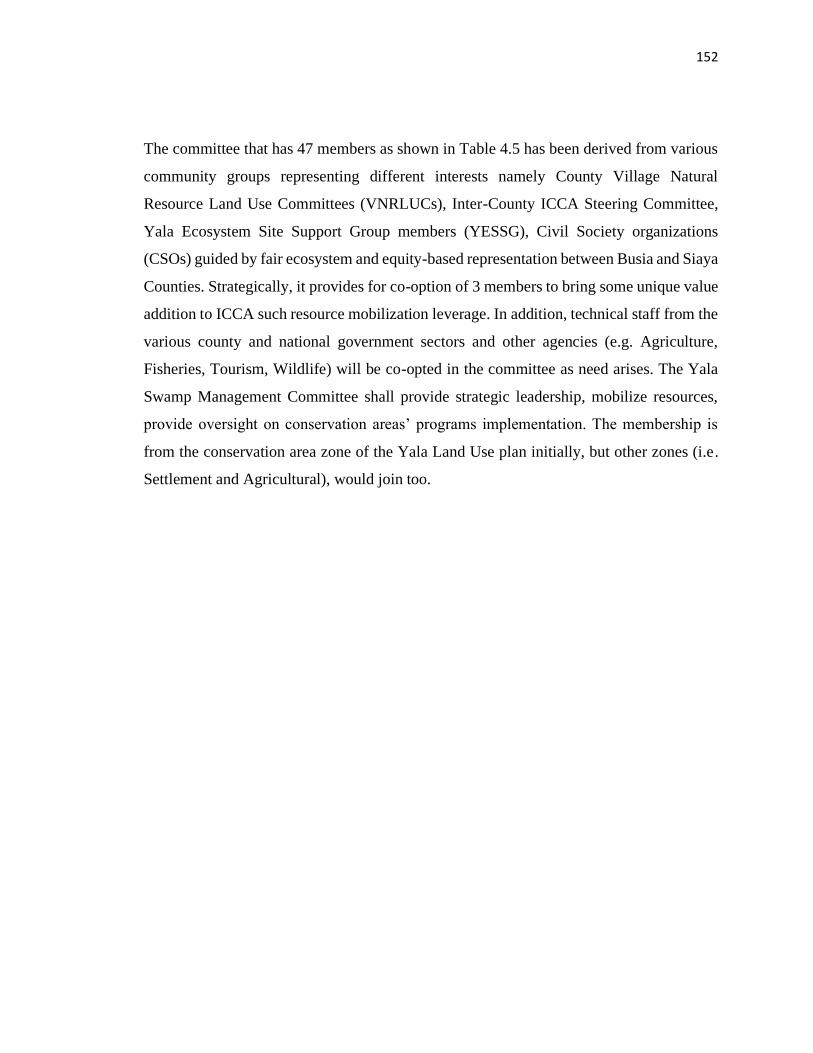
152
The committee that has 47 members as shown in Table 4.5 has been derived from various
community groups representing different interests namely County Village Natural
Resource Land Use Committees (VNRLUCs), Inter-County ICCA Steering Committee,
Yala Ecosystem Site Support Group members (YESSG), Civil Society organizations
(CSOs) guided by fair ecosystem and equity-based representation between Busia and Siaya
Counties. Strategically, it provides for co-option of 3 members to bring some unique value
addition to ICCA such resource mobilization leverage. In addition, technical staff from the
various county and national government sectors and other agencies (e.g. Agriculture,
Fisheries, Tourism, Wildlife) will be co-opted in the committee as need arises. The Yala
Swamp Management Committee shall provide strategic leadership, mobilize resources,
provide oversight on conservation areas’ programs implementation. The membership is
from the conservation area zone of the Yala Land Use plan initially, but other zones (i.e.
Settlement and Agricultural), would join too.
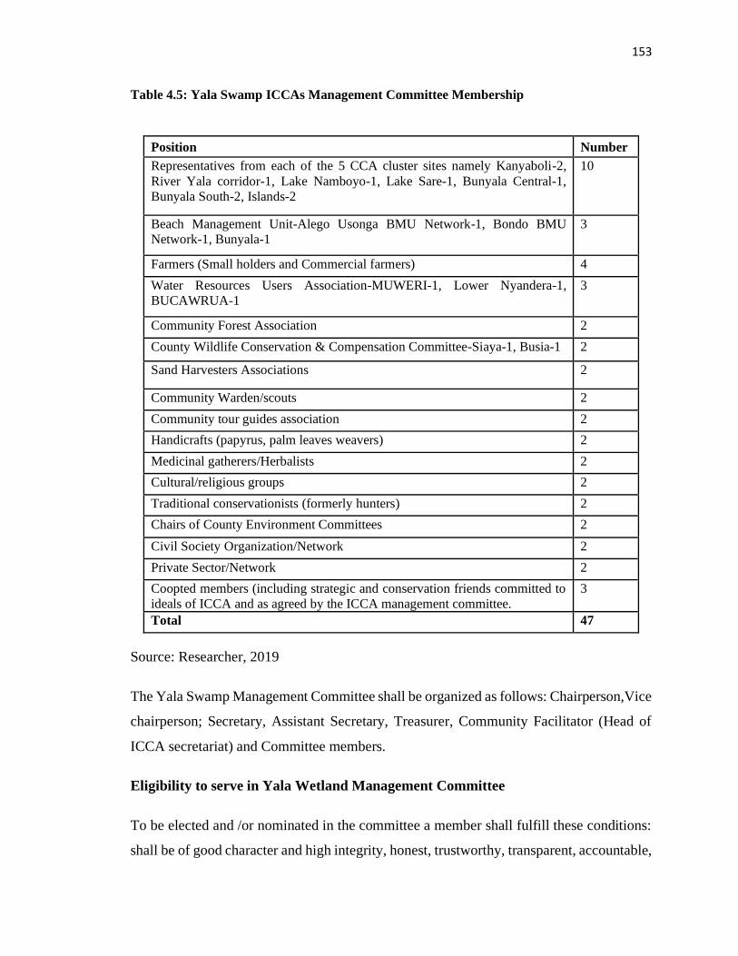
153
Table 4.5: Yala Swamp ICCAs Management Committee Membership
Position Number
Representatives from each of the 5 CCA cluster sites namely Kanyaboli-2,
River Yala corridor-1, Lake Namboyo-1, Lake Sare-1, Bunyala Central-1,
Bunyala South-2, Islands-2
10
Beach Management Unit-Alego Usonga BMU Network-1, Bondo BMU
Network-1, Bunyala-1
3
Farmers (Small holders and Commercial farmers) 4
Water Resources Users Association-MUWERI-1, Lower Nyandera-1,
BUCAWRUA-1
3
Community Forest Association 2
County Wildlife Conservation & Compensation Committee-Siaya-1, Busia-1 2
Sand Harvesters Associations 2
Community Warden/scouts 2
Community tour guides association 2
Handicrafts (papyrus, palm leaves weavers) 2
Medicinal gatherers/Herbalists 2
Cultural/religious groups 2
Traditional conservationists (formerly hunters) 2
Chairs of County Environment Committees 2
Civil Society Organization/Network 2
Private Sector/Network 2
Coopted members (including strategic and conservation friends committed to
ideals of ICCA and as agreed by the ICCA management committee.
3
Total 47
Source: Researcher, 2019
The Yala Swamp Management Committee shall be organized as follows: Chairperson,Vice
chairperson; Secretary, Assistant Secretary, Treasurer, Community Facilitator (Head of
ICCA secretariat) and Committee members.
Eligibility to serve in Yala Wetland Management Committee
To be elected and /or nominated in the committee a member shall fulfill these conditions:
shall be of good character and high integrity, honest, trustworthy, transparent, accountable,
154
and with a good track record. There shall be co-opted members who will be called upon on
a need basis. These are members from County government and National government
agencies as technical matter specialists and advisors) namely: NEMA, KWS, KFS, WRA,
relevant departments; Agriculture, Livestock, Fisheries, Tourism, Lands, Education,
Culture; MCA, Schools/Learning institutions, National Irrigation Board (NIB).
The Functions of Yala Swamp Management Committee
The specific roles and responsibilities to include:
1) Facilitate the development and implementation of Yala Swamp community
conservation area management plans.
2) Organize Yala conservation area members to perform the communities’ functions
effectively in terms of election and co-option of members to perform their duties-chair,
secretary, assistant secretary, treasurer, Program Coordinator/Community facilitator.
3) Provide strategic leadership, mobilize resources and offer oversight on programs
implementation.
4) Recommend/issue user-rights in line with the management guidelines and
government legal framework.
5) Monitoring and provision of general oversight role over activities and resource use
taking place within Yala community conservation areas.
6) Provide mediation or arbitration on disputes arising from the use of resources
within the Yala community conservation areas.
7) Ensure that benefits derived from the use of Yala community conservation areas
resources are distributed in accordance with the provisions of the agreed guidelines to
ensure fairness and equity.
8) To ensure compliance to Yala community conservation areas rules and guidelines
9) Maintaining up-to-date records for all permits, licenses and fees paid including
RUAs
10) Seek to amend Yala community conservation areas guidelines in line with the its
vision and mission.
155
11) To tap other emerging issues critical to improving the Yala ICCA such as circular
and blue economies and nominate persons to be coopted to serve in the ICCA management
committee.
The Yala Community Conservation Area Secretariat
The Community Conservation secretariat will be headed by Community Facilitator and
technical staff including Environmentalist/Ecologist, Agriculturalists, Enterprise
development specialist to ensure the plan is implemented. The secretariat shall develop
organizational systems to operationalize its implementation functions. The secretariat shall
be the primary vehicle to support the Yala Swamp ICCA Management Committee to
implement the ICCA management plan. It shall promote communication, education and
public awareness among stakeholders to enhance their appreciation and participation in
Yala Wetland conservation and participatory management. For a start, ICCA management
committee shall consider outsourcing from established conservation organization to
initially provide secretariat services while it mobilizes resources.
4.3 Environmental Issues using Remote Sensing and Community GIS for inclusion
in Yala Wetland Land Use Planning and Management
This section presents results of environmental issues for inclusion in the Yala LUP from
two perspectives. One from local communities and two from remote sensing and GIS
analysis on landcover/landuse cover, the envisioned future of Yala Wetland and their roles
in the envisioned Yala Wetland.
4.3.1 Environmental Issues facing Yala Wetland and their causes as identified by
Wetland Communities
The FGD groups identified key environmental issues that should inform SEA and LUP
development processes of the wetland management. The main environmental challenges
identified in order of priority (from the highest to lowest) are: encroachment and
reclamation of the wetland by the local people for development projects (83 %); burning
of papyrus resulting in the loss of biodiversity, fish breeding grounds, bird habitats and
livelihoods (80%; high human population density (76%); resource use and related conflicts
156
such as human and wildlife conflicts (75%); conflicts among the local communities on
boundary issues and perception of unequitable benefit sharing from Dominion Farm among
Alego and Yimbo communities (66%); conflicts between the local community, the
investors, government and third parties like NGOs, CBOs and Media (66%));
disappointment and apathy due to unfulfilled promises by Dominion Farms like subsidized
price of rice; broken promises to pastors fellowship forum (50%); declining water levels in
Lake Kanyaboli (46%); flooding and its negative effects (45%); weak framework for local
communities participation (50%); incoherent implementation of wetland policies(41%);
Nile Treaty constraints on Lake Victoria catchments and River Nile utilization (33%); low
agricultural productivity and resultant food insecurity (33%); threats to wetland wildlife
species as large chunks of land have been taken by Usonga communities in Migingo for
agriculture (30%); birds poisoning using chemicals around Bunyala irrigation
scheme(26%); and pollutants channeled into the wetland; poverty and associated
inequalities (25%); and alien invasive species (21%). Figure 4.6 shows prioritisation of
environmental issues by FGD respondents.
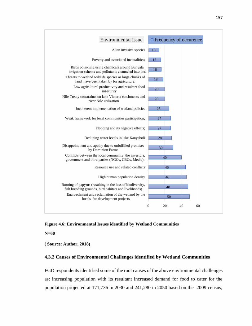
157
Figure 4.6: Environmental Issues identified by Wetland Communities
N=60
( Source: Author, 2018)
4.3.2 Causes of Environmental Challenges identified by Wetland Communities
FGD respondents identified some of the root causes of the above environmental challenges
as: increasing population with its resultant increased demand for food to cater for the
population projected at 171,736 in 2030 and 241,280 in 2050 based on the 2009 census;
50
48
46
45
40
30
28
27
27
25
20
20
18
16
15
13
0 20 40 60
Encroachment and reclamation of the wetland by the
locals for development projects
Burning of papyrus (resulting in the loss of biodiversity,
fish breeding grounds, bird habitats and livelihoods)
High human population density
Resource use and related conflicts
Conflicts between the local community, the investors,
government and third parties (NGOs, CBOs, Media);
Disappointment and apathy due to unfulfilled promises
by Dominion Farms
Declining water levels in lake Kanyaboli
Flooding and its negative effects;
Weak framework for local communities participation;
Incoherent implementation of wetland policies
Nile Treaty constraints on lake Victoria catchments and
river Nile utilization
Low agricultural productivity and resultant food
insecurity
Threats to wetland wildlife species as large chunks of
land have been taken by for agriculture;
Birds poisoning using chemicals around Bunyala
irrigation scheme and pollutants channeled into the…
Poverty and associated inequalities;
Alien invasive species
Environmental Issue Frequency of occurence
158
underground streams flowing back into the wetland causing flooding; high cases of malaria
due to breeding zones for mosquitoes created by the wetland during rainy seasons; the
drying of Lake Kanyaboli attributed to diversion of water for use by the Dominion Farms
and absence of proper inlet of water into the lake as shown in Figure 4.24; water
contamination by effluents discharged from the commercial farm; reduced rainfall due to
climate change over years; direct flow of Yala River water into Lake Namboyo causing
flooding from its back flow and displacement of wetland residents; wetland residents
intruding into fish breeding zones and other sensitive sites causing loss of biodiversity;
conflicts between the local community, the investors, government and other parties;
absence of research institution to undertake action research on the wetland challenges to
inform its management; lack of relay of research feedback to wetland communities and
management; burning the papyrus to create land for agriculture leading to habitat and
biodiversity loss; laxity in implementation of wetland policies; and conflicts among the
local communities on boundary issues (Figure 4.7).
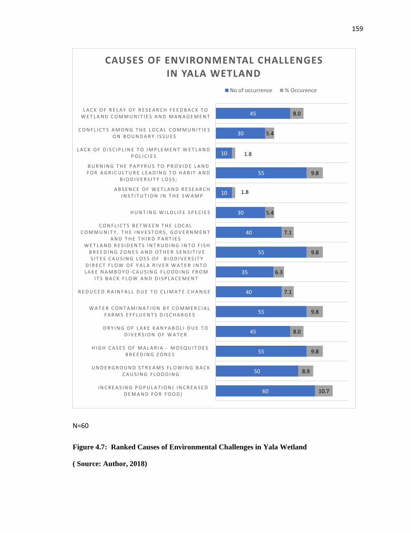
159
N=60
Figure 4.7: Ranked Causes of Environmental Challenges in Yala Wetland
( Source: Author, 2018)
60
50
55
45
55
40
35
55
40
30
10
55
10
30
45
10.7
8.9
9.8
8.0
9.8
7.1
6.3
9.8
7.1
5.4
1.8
9.8
1.8
5.4
8.0
I N C R E A S I N G P O P U L A T I O N ( I N C R E A S E D D E M A N D F O R F O O D )
U N D E R G R O U N D S T R E A M S F L O W I N G B A C K C A U S I N G F L O O D I N G
H I G H C A S E S O F M A L A R I A - M O S Q U I T O E S B R E E D I N G Z O N E S
D R Y I N G O F L A K E K A N Y A B O L I D U E T O D I V E R S I O N O F W A T E R
W A T E R C O N T A M I N A T I O N B Y C O M M E R C I A L F A R M S E F F L U E N T S D I S C H A R G E S
R E D U C E D R A I N F A L L D U E T O C L I M A T E C H A N G E
D I R E C T F L O W O F Y A L A R I V E R W A T E R I N T O L A K E N A M B O Y O - C A U S I N G F L O O D I N G F R O M
I T S B A C K F L O W A N D D I S P L A C E M E N T
W E T L A N D R E S I D E N T S I N T R U D I N G I N T O F I S H B R E E D I N G Z O N E S A N D O T H E R S E N S I T I V E S I T E S C A U S I N G L O S S O F B I O D I V E R S I T Y
C O N F L I C T S B E T W E E N T H E L O C A L C O M M U N I T Y , T H E I N V E S T O R S , G O V E R N M E N T
A N D T H E T H I R D P A R T I E S
H U N T I N G W I L D L I F E S P E C I E S
A B S E N C E O F W E T L A N D R E S E A R C H I N S T I T U T I O N I N T H E S W A M P
B U R N I N G T H E P A P Y R U S T O P R O V I D E L A N D F O R A G R I C U L T U R E L E A D I N G T O H A B I T A N D
B I O D I V E R S I T Y L O S S ;
L A C K O F D I S C I P L I N E T O I M P L E M E N T W E T L A N D P O L I C I E S
C O N F L I C T S A M O N G T H E L O C A L C O M M U N I T I E S O N B O U N D A R Y I S S U E S
L A C K O F R E L A Y O F R E S E A R C H F E E D B A C K T O W E T L A N D C O M M U N I T I E S A N D M A N A G E M E N T
CAUSES OF ENVIRONMENTAL CHALLENGES IN YALA WETLAND
No of occurrence % Occurence
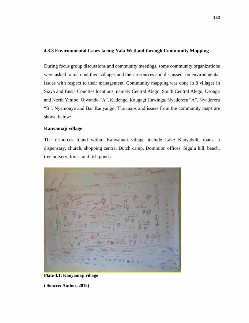
160
4.3.3 Environmental Issues facing Yala Wetland through Community Mapping
During focus group discussions and community meetings, some community organizations
were asked to map out their villages and their resources and discussed on environmental
issues with respect to their management. Community mapping was done in 8 villages in
Siaya and Busia Counties locations namely Central Alego, South Central Alego, Usonga
and North Yimbo, Ojwando “A”, Kadenge, Kaugagi Hawinga, Nyadorera “A”, Nyadorera
“B”, Nyamonye and Bar Kanyango. The maps and issues from the community maps are
shown below:
Kanyamaji village
The resources found within Kanyamaji village include Lake Kanyaboli, roads, a
dispensary, church, shopping centre, Dutch camp, Dominion offices, Sigulu hill, beach,
tree nursery, forest and fish ponds.
Plate 4.1: Kanyamaji village
( Source: Author, 2018)
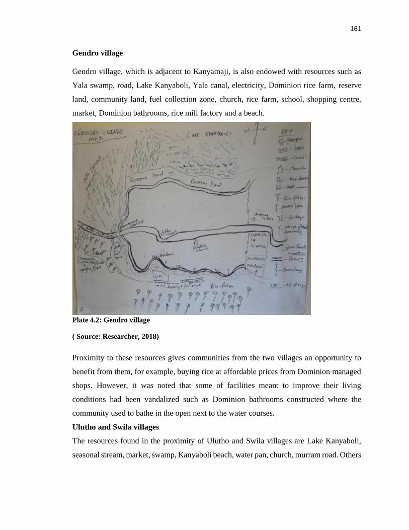
161
Gendro village
Gendro village, which is adjacent to Kanyamaji, is also endowed with resources such as
Yala swamp, road, Lake Kanyaboli, Yala canal, electricity, Dominion rice farm, reserve
land, community land, fuel collection zone, church, rice farm, school, shopping centre,
market, Dominion bathrooms, rice mill factory and a beach.
Plate 4.2: Gendro village
( Source: Researcher, 2018)
Proximity to these resources gives communities from the two villages an opportunity to
benefit from them, for example, buying rice at affordable prices from Dominion managed
shops. However, it was noted that some of facilities meant to improve their living
conditions had been vandalized such as Dominion bathrooms constructed where the
community used to bathe in the open next to the water courses.
Ulutho and Swila villages
The resources found in the proximity of Ulutho and Swila villages are Lake Kanyaboli,
seasonal stream, market, swamp, Kanyaboli beach, water pan, church, murram road. Others
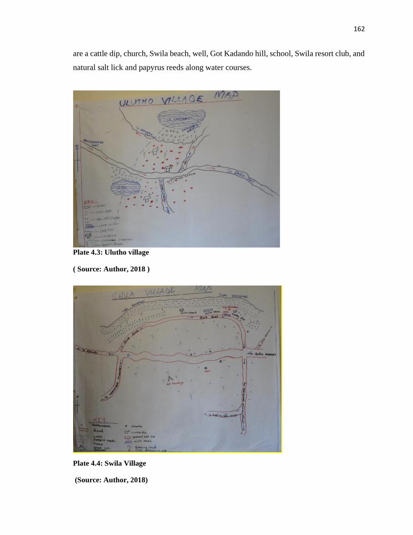
162
are a cattle dip, church, Swila beach, well, Got Kadando hill, school, Swila resort club, and
natural salt lick and papyrus reeds along water courses.
Plate 4.3: Ulutho village
( Source: Author, 2018 )
Plate 4.4: Swila Village
(Source: Author, 2018)
163
Uyingi and Nyandheho villages
The main features in Uyingi village were: Hwiro swamp, market centre, all weather road,
churches and borehole whereas in Nyandheho village, the resources were a river, school,
road, beach, church, posho-mill, Yala swamp, grazing land and farming land.
Plate 4.5: Uyingi Village
Plate 4.6: Nyandheho Village
(Source: Author, 2018)
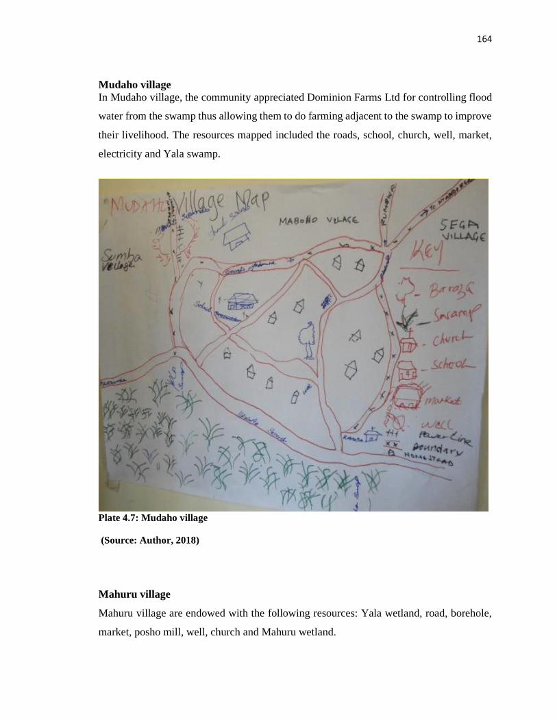
164
Mudaho village
In Mudaho village, the community appreciated Dominion Farms Ltd for controlling flood
water from the swamp thus allowing them to do farming adjacent to the swamp to improve
their livelihood. The resources mapped included the roads, school, church, well, market,
electricity and Yala swamp.
Plate 4.7: Mudaho village
(Source: Author, 2018)
Mahuru village
Mahuru village are endowed with the following resources: Yala wetland, road, borehole,
market, posho mill, well, church and Mahuru wetland.
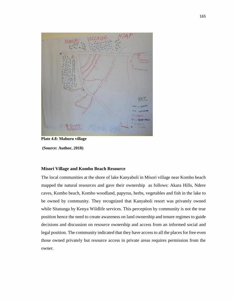
165
Plate 4.8: Mahuru village
(Source: Author, 2018)
Misori Village and Kombo Beach Resource
The local communities at the shore of lake Kanyaboli in Misori village near Kombo beach
mapped the natural resources and gave their ownership as follows: Akara Hills, Ndere
caves, Kombo beach, Kombo woodland, papyrus, herbs, vegetables and fish in the lake to
be owned by community. They recognized that Kanyaboli resort was privately owned
while Sitatunga by Kenya Wildlife services. This perception by community is not the true
position hence the need to create awareness on land ownership and tenure regimes to guide
decisions and discussion on resource ownership and access from an informed social and
legal position. The community indicated that they have access to all the places for free even
those owned privately but resource access in private areas requires permission from the
owner.
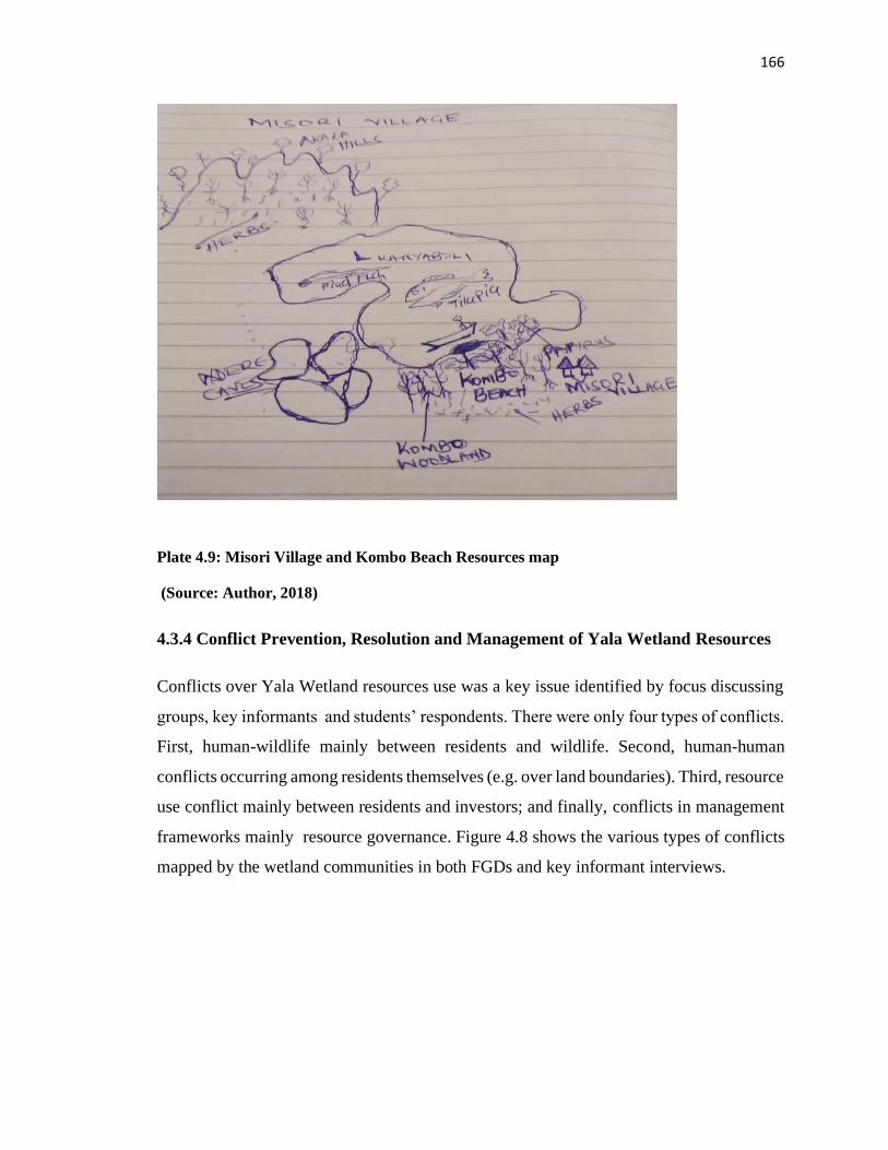
166
Plate 4.9: Misori Village and Kombo Beach Resources map
(Source: Author, 2018)
4.3.4 Conflict Prevention, Resolution and Management of Yala Wetland Resources
Conflicts over Yala Wetland resources use was a key issue identified by focus discussing
groups, key informants and students’ respondents. There were only four types of conflicts.
First, human-wildlife mainly between residents and wildlife. Second, human-human
conflicts occurring among residents themselves (e.g. over land boundaries). Third, resource
use conflict mainly between residents and investors; and finally, conflicts in management
frameworks mainly resource governance. Figure 4.8 shows the various types of conflicts
mapped by the wetland communities in both FGDs and key informant interviews.

167
Figure 4.8: Conflict areas in Yala Wetland
(Source: Author, 2018)
Key: 1. Human-wildlife 2. Human-human conflicts occurring among residents themselves
3. Resource use conflict such as between residents and investors 4. Conflicts in
management frameworks
Examples the Conflicts in Yala Wetland
a. Conflict between Wetland Communities and the Dominion Farms
There was apathy by a section of the local community resulting from the way the Dominion
Farms investor had handled them. The FGDs consisting religious leaders network narrated
how at the beginning the company manager had built a church in the company compound
and founded a pastor’s network where they would fellowship together. In the process of
this fellowship, the manager promised that some company’s farm produce would be given
to local communities. Later, when things changed and they raised it with the management,
they quoted the pastor manager saying “I am a businessman who paid the government to
do business, I am not here for religious pursuits”. The local community also felt that the
168
company increased the price of rice without consideration of the local communities’
preferential treatment as had been done before. As a result, many local communities could
not afford to buy the rice.
b. Conflicts in Management Frameworks on Resource Governance
Under the emerging structures for devolved governments at County level, the governance
of the Yala Wetland is not clear. Article 63(3) of the Constitution provides that “any
unregistered community land shall be held in trust by the County governments on behalf
of the communities for which it is held”. Section 20 provides that “County Governments
shall approve plans for the development, management and use of community land”. Yala
Wetland straddles across the County Governments of Siaya and Busia. Most of this
wetland is unprotected community land which has been held in trust by Siaya and Busia
County Governments under the pre-2010 Constitution. However, with the Constitution of
2010 and Community Land Act of 2016 that require all Trust Lands to be registered
according to the Act. If communities do not register their lands themselves, the law says
the County Government must plan to register community lands but they might not include
local people in the registration process and communities might lose some of their lands and
might not be able to make their own rules for governing and managing their lands.
The FGD and key informant interview respondents identified laxity in implementing the
existing wetland policy and enforcing existing regulations. They noted the effect of the
Nile Treaty which limited what could be done in Lake Victoria catchments and River Nile.
This raised yet another opportunity on the management of transboundary natural resources
where conflicts arise on resource use within and under different management jurisdictions.
Yala Wetland is an example of a resource spanning two counties within Kenya and
therefore LUP and SEA processes had deliberately taken the development with dual
ownership and leadership of the processes. For example, the national government provided
technical support but steering the processes was left to the county governments leadership.
This dual ownership also had its challenges including two separate channels of making
decisions before joint decisions were made at the intercounty steering committee level.
169
c. Establishment of Lake Kanyaboli National Game Reserve Conflict
Lake Kanyaboli was gazetted as a National Reserve through Legal Notice No 158 of 2010
(GoK, 2010b). The total area of the reserve is 41.42 km2 and is legally under the
management of Siaya County Government with technical and policy support from Kenya
Wildlife Service (KWS). In addition, KWS has initiated the process of having the site listed
as a Wetland of International Importance under the Ramsar Convention.
However, some local communities had not welcomed that development. The Usonga
communities did not welcome the creation of Lake Kanyaboli reserve and as a result made
it difficult to operationalize it. Their concerns were that the reserve would take away some
portion of Yala Wetland from them hence would not available for their use (farming,
accessing wetland resources) and they feared that having the KWS staff around would
result in controlling their activities in the wetland including hunting. They also felt that the
wetland was part of their ancestral land hence could not be taken away. Consequently, the
Usonga communities from obtained a court injunction challenging the decision.
Despite these concerns and decision to pull out their representative from Yala Wetland
LUP process where communities voices are factored in the plan development; the
researcher accessed some insiders among them and got limited entry to get them back in
the SEA/LUP processes.
d. Wetland Size Discrepancy and Land Tenure
The Yala community participation framework pointed out the discrepancy on wetland size
which the LUP team estimated as 20,276 ha (207.6 Km2) by using latest remote sensing
and GIS techniques (Odhengo et al., 2018b) whereas earlier survey records estimated the
wetland at 17,500ha (NEMA, 2016). The later has formed the basis of utilization of the
wetland and allocation to users like the Dominion Farms and other land uses over the years.
This lends credence to the concerns raised by a panel wetland specialist as the gaps in
wetlands being determination of the size of papyrus wetlands (van Dam, et al., 2014). The
physical survey of the wetland is therefore urgently needed and should involve both the
170
County governments of Busia and Siaya and Yala Wetland community representatives to
resolve the tension.
e. Land Disputes and Land Adjudication Conflicts
Conflicts of land disputes and land adjudication issues were spread throughout the area and
highly visible in Kadenge, Bunyala south and around Lake Kanyaboli. For instance,
between Alego and Yimbo regions there was conflict due to the claims that only Alego
people benefited from Dominion Farms.
Yala Wetland Conflict Resolution and Management
The conflicts in Yala Wetland have many faces and complexities. For example, on the
conflict over the creation Lake Kanyaboli National reserve, which the Uhembo community
objected to and thereafter obtained a court injunction. A community leader, expressing
suspicion of ill motive, had this to say to one Research Assistant during the community
consultations, “since you came from very far from South Nyanza, you cannot have the
intention of taking away our land, we shall give you audience to explain to us the land use
issues you want to hear from us. Otherwise, we have sent away the CBOs working on Yala
Wetland since we don’t trust them”.
Later, they requested more time in order to consult one of their own an expert who was a
Dean at the Department of Spatial Planning and Natural Resources Management at
Jaramogi Oginga Odinga University of Science and Technology (JOOUST) over the land
allocation for the game reserve which had a court injunction. Again, the feeling of trust,
empathizing with them and mutual respect were key in aiding the local communities to
increase their participation.
The FGD and key informant interview respondents identified the main causes of conflicts
in the wetland as follows as population increase resulting into inter-community conflicts
as they share available resources; land conflicts by different communities on disputed
boundaries, disputed ownership among individuals as they subdivide the bigger parcels for
inheritance from their parents tenures; perceived ownership of Yala Wetland by the
communities as cited by the Usonga communities, insufficient capital to undertake
171
commercial agriculture and inadequate funds to support commercially viable farming
practices by the local communities.
Yala Wetland communities had resolved some of their previous conflicts using varied
strategies namely community resource-based management; law enforcement; county land
management board and surveys and adjudication. However, those interventions had not
been fully utilized nor had they been sufficient thereby calling for other innovative ways
of managing emerging and future conflicts.
4.3.5 Aspirations and Dreams of a Future Yala Wetland
The FGD respondents were tasked to envision the future they would desire of Yala Wetland
as basis for their input into SEA and LUP processes using appreciative enquiry methods.
The following are results from wetland communities and students from learning
institutions.
4.3.5.1 Envisioning a future Yala Wetland by Wetland Communities
The qualitative analysis of the dreams and aspirations from the communities brought out a
clear picture of what they would like the wetland to look like in 2063 in line with the
African Union’s Agenda 2063 timeframe for attaining prosperity for the continent. The
highest emerging key themes on their dreams and aspirations were biodiversity
conservation (8%); enforceable laws and regulations to protect the wetland (7%);
mechanized commercial farming and with robust extension system (7%); unique habitat
conserved including the one for varieties butterflies (7%); developed recreational and
tourism facilities in harmony with nature (7%). The other desired aspirations occurrences
by priority as revealed in the qualitative analysis results are shown in Figure 4.9.
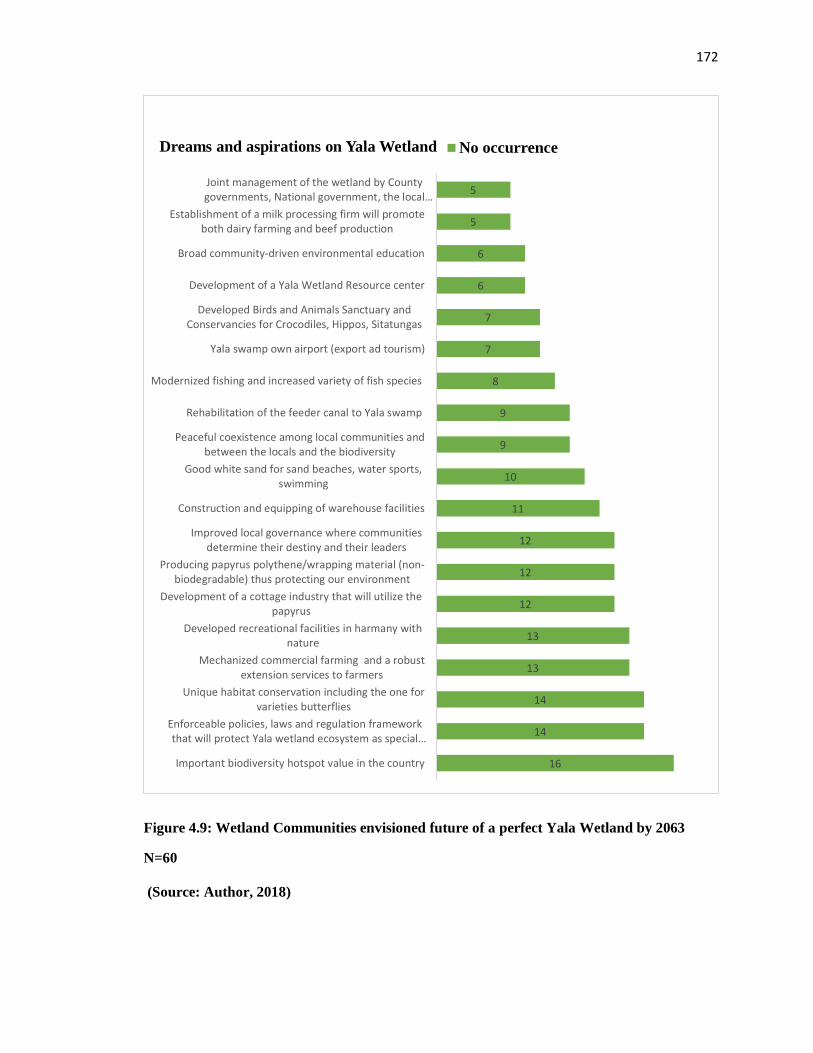
172
Figure 4.9: Wetland Communities envisioned future of a perfect Yala Wetland by 2063
N=60
(Source: Author, 2018)
16
14
14
13
13
12
12
12
11
10
9
9
8
7
7
6
6
5
5
Important biodiversity hotspot value in the country
Enforceable policies, laws and regulation frameworkthat will protect Yala wetland ecosystem as special…
Unique habitat conservation including the one forvarieties butterflies
Mechanized commercial farming and a robustextension services to farmers
Developed recreational facilities in harmany withnature
Development of a cottage industry that will utilize thepapyrus
Producing papyrus polythene/wrapping material (non-biodegradable) thus protecting our environment
Improved local governance where communitiesdetermine their destiny and their leaders
Construction and equipping of warehouse facilities
Good white sand for sand beaches, water sports,swimming
Peaceful coexistence among local communities andbetween the locals and the biodiversity
Rehabilitation of the feeder canal to Yala swamp
Modernized fishing and increased variety of fish species
Yala swamp own airport (export ad tourism)
Developed Birds and Animals Sanctuary andConservancies for Crocodiles, Hippos, Sitatungas
Development of a Yala Wetland Resource center
Broad community-driven environmental education
Establishment of a milk processing firm will promoteboth dairy farming and beef production
Joint management of the wetland by Countygovernments, National government, the local…
Dreams and aspirations on Yala Wetland No occurrence
173
Focus group discussions respondents were asked to itemize what needed to be done to
actualize their dreams and aspirations starting with actions at community level. The actions
they recommended include continuous sensitization and capacity strengthening of local
communities on the importance of conserving and protecting the wetland by local
communities and the new wetland LUP; embracing continuous dialogue and genuine
engagement that balances conservation and livelihoods, implementation of LUP;
developing appropriate policies and legislations to guide its implementation; establish a
documentation centre for information resources and cultural artifacts; exposure visits by
the community leadership and county officials to some of the best practices in wetlands
management and managing land based conflicts.
The researcher with the help of local communities identified role models who were
recognized by communities as change makers in the community and sought their views
about Yala Wetland management. Some feedback was used to create the history of the
wetland in objective one. The other aspects of that information sought their views on the
envisaged future and what it shall take to deliver those aspirations.
A retired civil servant and once a Councilor of Bunyala ward respondent had this to say;
“I have a compelling desire for change and development and with this I will encourage
community leaders and youths to take initiative of sustainable livelihood programmes and
stop lamenting for help. During my tenure as the Councilor, I initiated Ndekwe Bridge,
which was constructed. I also wrote a letter to the Minister for Lands in the National
Government expressing communities’ views that Yala Wetland should be converted from
trust land to community land” (Interview with former elected leader, 2016).The
changemaker advised that Yala Wetland management should be guided by the philosophy
that “every step you take towards a goal/ success requires implementation of brilliant ideas
and determination to achieve what you believe in.”
The chairperson, Kaugagi Hawinga Yala Wetland Farmers Association pointed out the
following: “If the community would know the value of wealth, they have in their hands in
Yala Wetland, they would neither experience hunger nor poverty. Enhancing equity within
the community is important since this will harmonize every community member's potential
174
in the development of our community”. Other change makers including the Luo Council
of Elders’ leadership, youth and women role models emphasized that Yala Wetland
communities must be intentional in mainstreaming gender equity in development issues
while the younger generation should be mentored for them to meet their future needs. They
agreed on the need to transform Yala Wetland communities’ perception on the importance
of agriculture as a key driver of the wetland’s economy. Finally, they recommended
functional cooperatives by farmers to boost their level of production and income.
In addition, Focus Group Discussions and sermon write-ups by religious leaders on what
they saw as God’s dream of a perfect Yala Wetland identified the following key themes:
preservation of sacred sites and shrines; protection of biodiversity in the wetland, good
stewards of God’s creation on animals and plants; communicating with God through nature
in Yala Wetland, the helplessness mentality and the need to change that mindset.
4.3.5.2 Envisioning a future perfect Yala Wetland in 2063 by Wetland by Students
through School Essays, Debates and Artworks
The study expanded to reach out to primary and secondary schools, and post-secondary
institutions through writing essays, artworks; and debating on the topic of Yala Wetland.
The results of what they envision as the future of Yala wetland from essays, debates and
songs are shown in Figures 4.10, 4.11 and Plate 4.12 their artwork visualizing the same.
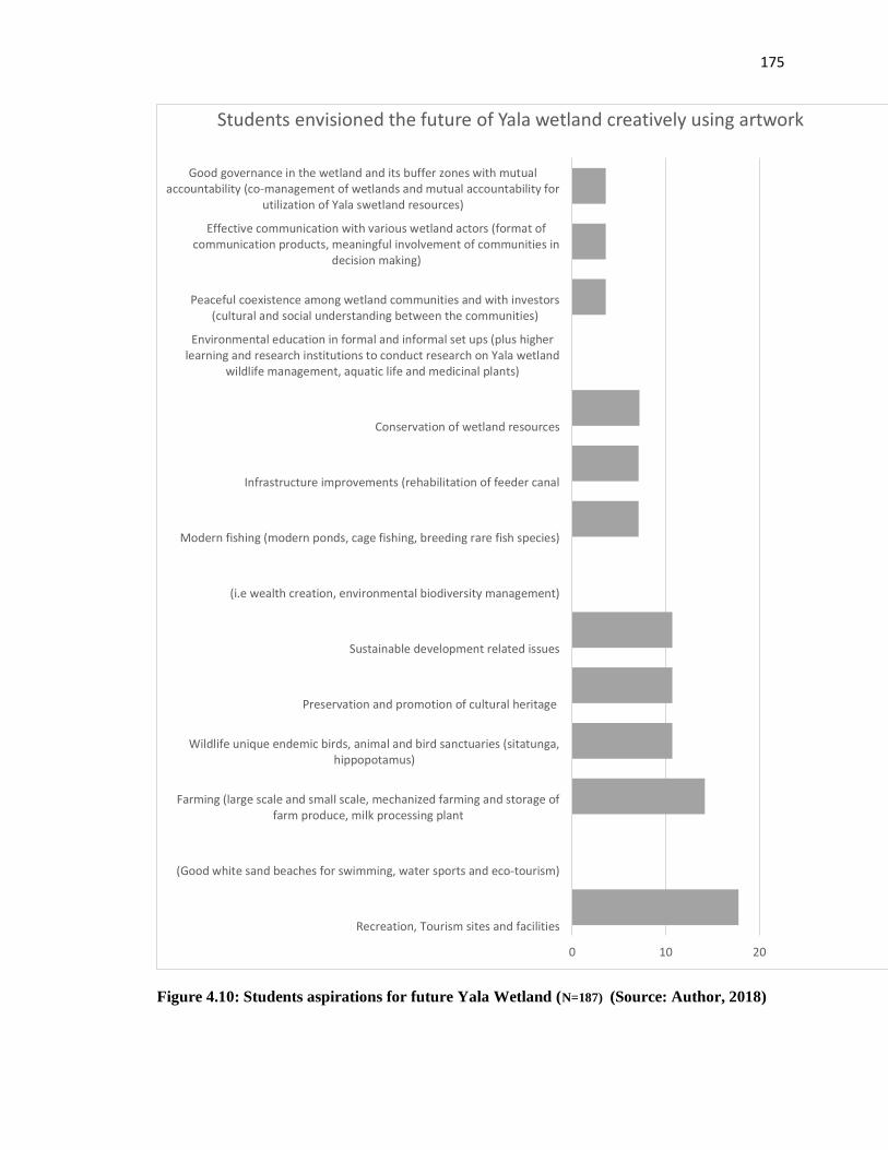
175
Figure 4.10: Students aspirations for future Yala Wetland (N=187) (Source: Author, 2018)
0 10 20
Recreation, Tourism sites and facilities
(Good white sand beaches for swimming, water sports and eco-tourism)
Farming (large scale and small scale, mechanized farming and storage offarm produce, milk processing plant
Wildlife unique endemic birds, animal and bird sanctuaries (sitatunga,hippopotamus)
Preservation and promotion of cultural heritage
Sustainable development related issues
(i.e wealth creation, environmental biodiversity management)
Modern fishing (modern ponds, cage fishing, breeding rare fish species)
Infrastructure improvements (rehabilitation of feeder canal
Conservation of wetland resources
Environmental education in formal and informal set ups (plus higherlearning and research institutions to conduct research on Yala wetland
wildlife management, aquatic life and medicinal plants)
Peaceful coexistence among wetland communities and with investors(cultural and social understanding between the communities)
Effective communication with various wetland actors (format ofcommunication products, meaningful involvement of communities in
decision making)
Good governance in the wetland and its buffer zones with mutualaccountability (co-management of wetlands and mutual accountability for
utilization of Yala swetland resources)
Students envisioned the future of Yala wetland creatively using artwork
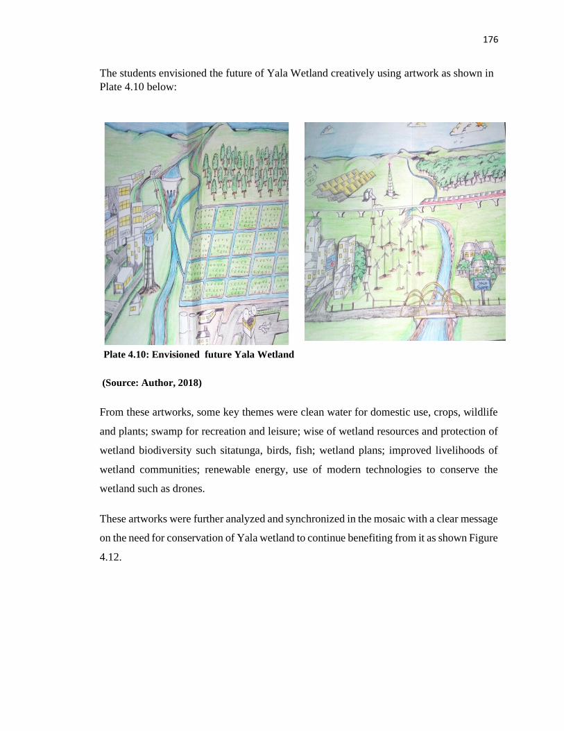
176
The students envisioned the future of Yala Wetland creatively using artwork as shown in
Plate 4.10 below:
and the
(Source: Author, 2018)
From these artworks, some key themes were clean water for domestic use, crops, wildlife
and plants; swamp for recreation and leisure; wise of wetland resources and protection of
wetland biodiversity such sitatunga, birds, fish; wetland plans; improved livelihoods of
wetland communities; renewable energy, use of modern technologies to conserve the
wetland such as drones.
These artworks were further analyzed and synchronized in the mosaic with a clear message
on the need for conservation of Yala wetland to continue benefiting from it as shown Figure
4.12.
Plate 4.10: Envisioned future Yala Wetland
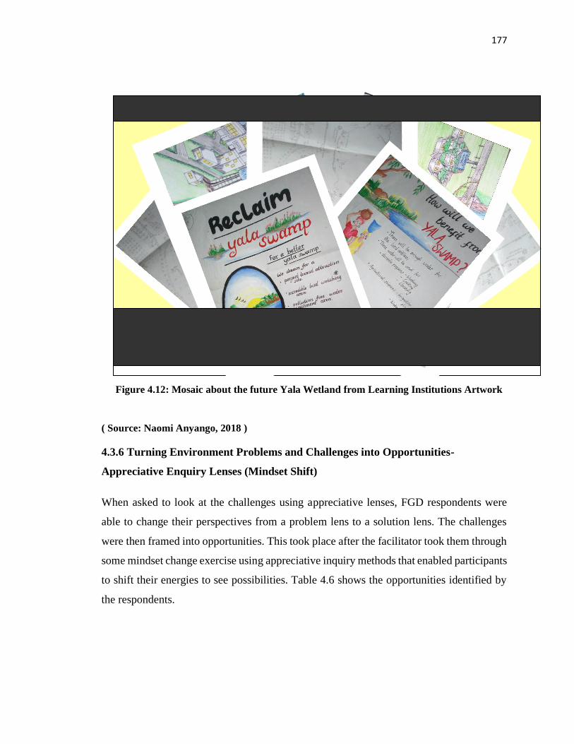
177
( Source: Naomi Anyango, 2018 )
4.3.6 Turning Environment Problems and Challenges into Opportunities-
Appreciative Enquiry Lenses (Mindset Shift)
When asked to look at the challenges using appreciative lenses, FGD respondents were
able to change their perspectives from a problem lens to a solution lens. The challenges
were then framed into opportunities. This took place after the facilitator took them through
some mindset change exercise using appreciative inquiry methods that enabled participants
to shift their energies to see possibilities. Table 4.6 shows the opportunities identified by
the respondents.
Figure 4.12: Mosaic about the future Yala Wetland from Learning Institutions Artwork
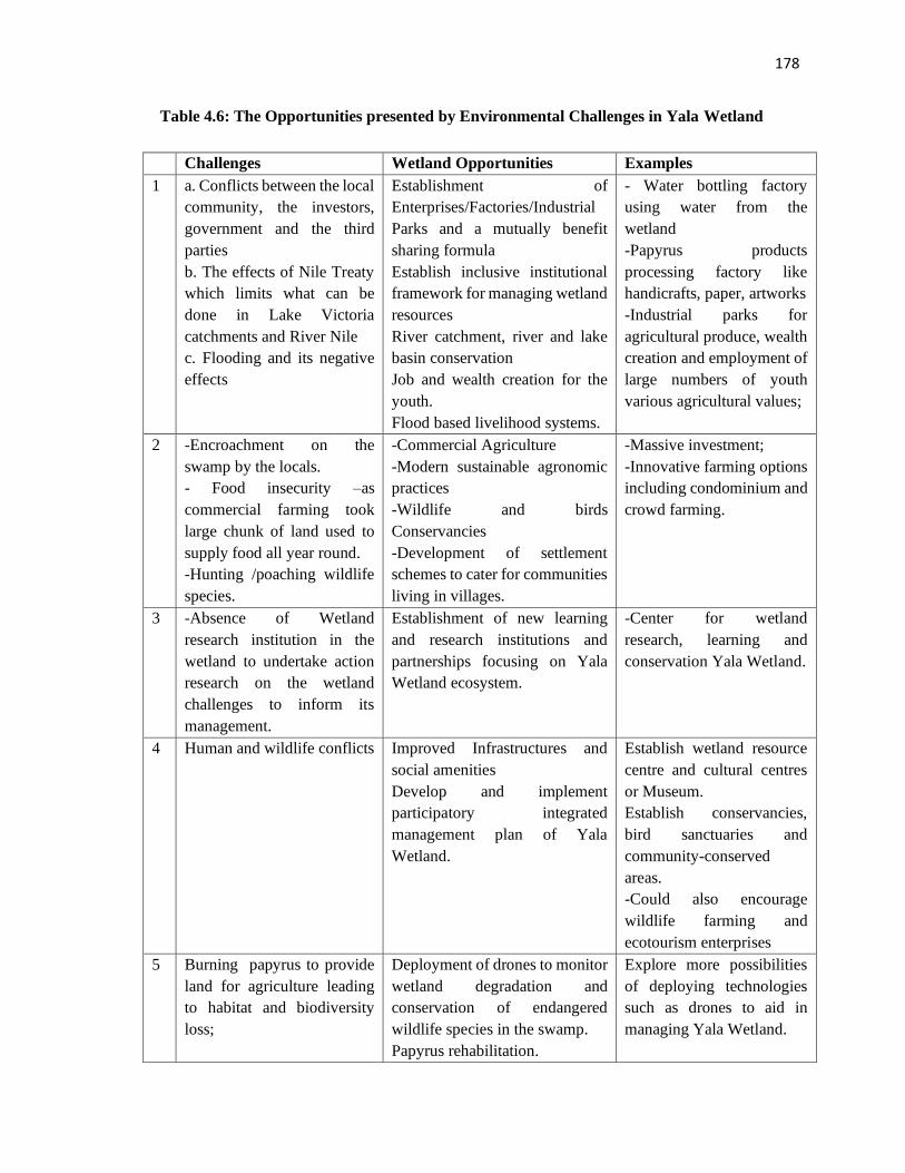
178
Table 4.6: The Opportunities presented by Environmental Challenges in Yala Wetland
Challenges Wetland Opportunities Examples
1 a. Conflicts between the local
community, the investors,
government and the third
parties
b. The effects of Nile Treaty
which limits what can be
done in Lake Victoria
catchments and River Nile
c. Flooding and its negative
effects
Establishment of
Enterprises/Factories/Industrial
Parks and a mutually benefit
sharing formula
Establish inclusive institutional
framework for managing wetland
resources
River catchment, river and lake
basin conservation
Job and wealth creation for the
youth.
Flood based livelihood systems.
- Water bottling factory
using water from the
wetland
-Papyrus products
processing factory like
handicrafts, paper, artworks
-Industrial parks for
agricultural produce, wealth
creation and employment of
large numbers of youth
various agricultural values;
2 -Encroachment on the
swamp by the locals.
- Food insecurity –as
commercial farming took
large chunk of land used to
supply food all year round.
-Hunting /poaching wildlife
species.
-Commercial Agriculture
-Modern sustainable agronomic
practices
-Wildlife and birds
Conservancies
-Development of settlement
schemes to cater for communities
living in villages.
-Massive investment;
-Innovative farming options
including condominium and
crowd farming.
3 -Absence of Wetland
research institution in the
wetland to undertake action
research on the wetland
challenges to inform its
management.
Establishment of new learning
and research institutions and
partnerships focusing on Yala
Wetland ecosystem.
-Center for wetland
research, learning and
conservation Yala Wetland.
4 Human and wildlife conflicts Improved Infrastructures and
social amenities
Develop and implement
participatory integrated
management plan of Yala
Wetland.
Establish wetland resource
centre and cultural centres
or Museum.
Establish conservancies,
bird sanctuaries and
community-conserved
areas.
-Could also encourage
wildlife farming and
ecotourism enterprises
5 Burning papyrus to provide
land for agriculture leading
to habitat and biodiversity
loss;
Deployment of drones to monitor
wetland degradation and
conservation of endangered
wildlife species in the swamp.
Papyrus rehabilitation.
Explore more possibilities
of deploying technologies
such as drones to aid in
managing Yala Wetland.
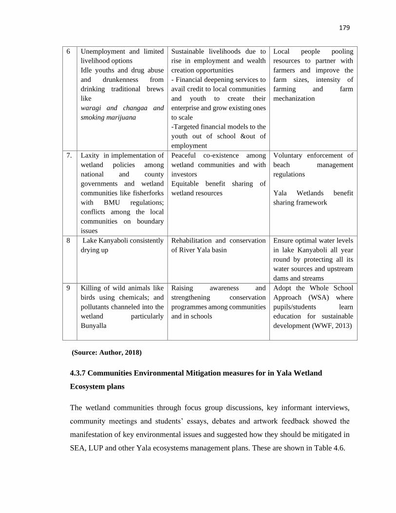
179
6 Unemployment and limited
livelihood options
Idle youths and drug abuse
and drunkenness from
drinking traditional brews
like
waragi and changaa and
smoking marijuana
Sustainable livelihoods due to
rise in employment and wealth
creation opportunities
- Financial deepening services to
avail credit to local communities
and youth to create their
enterprise and grow existing ones
to scale
-Targeted financial models to the
youth out of school &out of
employment
Local people pooling
resources to partner with
farmers and improve the
farm sizes, intensity of
farming and farm
mechanization
7. Laxity in implementation of
wetland policies among
national and county
governments and wetland
communities like fisherforks
with BMU regulations;
conflicts among the local
communities on boundary
issues
Peaceful co-existence among
wetland communities and with
investors
Equitable benefit sharing of
wetland resources
Voluntary enforcement of
beach management
regulations
Yala Wetlands benefit
sharing framework
8 Lake Kanyaboli consistently
drying up
Rehabilitation and conservation
of River Yala basin
Ensure optimal water levels
in lake Kanyaboli all year
round by protecting all its
water sources and upstream
dams and streams
9 Killing of wild animals like
birds using chemicals; and
pollutants channeled into the
wetland particularly
Bunyalla
Raising awareness and
strengthening conservation
programmes among communities
and in schools
Adopt the Whole School
Approach (WSA) where
pupils/students learn
education for sustainable
development (WWF, 2013)
(Source: Author, 2018)
4.3.7 Communities Environmental Mitigation measures for in Yala Wetland
Ecosystem plans
The wetland communities through focus group discussions, key informant interviews,
community meetings and students’ essays, debates and artwork feedback showed the
manifestation of key environmental issues and suggested how they should be mitigated in
SEA, LUP and other Yala ecosystems management plans. These are shown in Table 4.6.
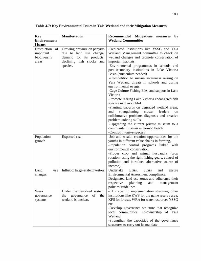
180
Table 4.7: Key Environmental Issues in Yala Wetland and their Mitigation Measures
Key
Environmenta
l Issues
Manifestation Recommended Mitigations measures by
Wetland Communities
Destruction of
important
biodiversity
areas
Growing pressure on papyrus
due to land use change,
demand for its products;
declining fish stocks and
species.
-Dedicated Institutions like YSSG and Yala
Wetland Management committee to check on
wetland changes and promote conservation of
important habitats.
-Environmental programmes in schools and
post-secondary institutions in Lake Victoria
Basin (curriculum needed)
-Competition to sustain awareness raising on
Yala Wetland threats in schools and during
environmental events.
-Cage Culture Fishing EIA; and support in Lake
Victoria
-Promote rearing Lake Victoria endangered fish
species such as cichlid
-Planting papyrus on degraded wetland areas;
and strengthening cluster leaders on
collaborative problems diagnosis and creative
problem-solving skills.
-Upgrading the current private museum to a
community museum in Kombo beach.
-Control invasive species
Population
growth
Expected rise
-Job and wealth creation opportunities for the
youths in different value chains in farming,
-Population control programs linked with
environmental conservation.
-Proper crop and animal husbandry (crop
rotation, using the right fishing gears, control of
pollution and introduce alternative source of
income).
Land use
changes
Influx of large-scale investors Undertake EIAs, SEAs and ensure
Environmental Assessment compliance.
Designated land use zones and adherence their
respective planning and management
policies/guidelines
Weak
governance
systems
Under the devolved system,
the governance of the
wetland is unclear.
-LUP specific implementation structure; other
institutions like KWS for the game reserve area;
KFS for forests, WRA for water resources YSSG
etc.
-Develop governance structure that recognize
local communities’ co-ownership of Yala
Wetland
-Strengthen the capacities of the governance
structures to carry out its mandate
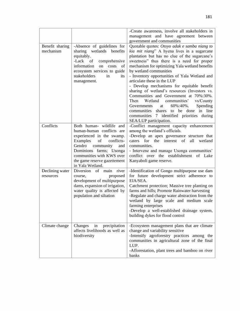
181
-Create awareness, involve all stakeholders in
management and have agreement between
government and communities
Benefit sharing
mechanism
-Absence of guidelines for
sharing wetlands benefits
equitably.
-Lack of comprehensive
information on costs of
ecosystem services to guide
stakeholders in its
management.
Quotable quotes: Otoyo adak e samba niang to
kia mit niang” A hyena lives in a sugarcane
plantation but has no clue of the sugarcane’s
sweetness” thus there is a need for proper
mechanism for optimizing Yala wetland benefits
by wetland communities
- Inventory opportunities of Yala Wetland and
articulate these in the LUP
- Develop mechanisms for equitable benefit
sharing of wetland’s resources (Investors vs.
Communities and Government at 70%:30%.
Then Wetland communities’ vs/County
Governments at 60%:40%. Spending
communities shares to be done in line
communities 7 identified priorities during
SEA/LUP participation.
Conflicts Both human- wildlife and
human-human conflicts are
experienced in the swamp.
Examples of conflicts-
Gendro community and
Dominions farms; Usonga
communities with KWS over
the game reserve gazettement
in Yala Wetland.
-Conflict management capacity enhancement
among the wetland’s officials.
-Develop an apex governance structure that
caters for the interest of all wetland
communities.
- Intervene and manage Usonga communities’
conflict over the establishment of Lake
Kanyaboli game reserve.
Declining water
resources
Diversion of main river
course, proposed
development of multipurpose
dams, expansion of irrigation,
water quality is affected by
population and siltation
-Identification of Gongo multipurpose use dam
for future development strict adherence to
EIA/SEA.
Catchment protection; Massive tree planting on
farms and hills; Promote Rainwater harvesting
-Regulate and charge water abstraction from the
wetland by large scale and medium scale
farming enterprises
-Develop a well-established drainage system,
building dykes for flood control
Climate change Changes in precipitation
affects livelihoods as well as
biodiversity
-Ecosystem management plans that are climate
change and variability sensitive
-Intensify agroforestry practices among the
communities in agricultural zone of the final
LUP.
-Afforestation, plant trees and bamboo on river
banks
182
4.3.8 Information Access and Seeking Behaviours among Yala Wetland
Communities
Information generated on access and seeking behaviors of the wetland community leaders
was diverse. The common approaches used to get information included peer talks,
authoritative policy orders and regulations from administrators. Further, all the leaders had
mobile phones and in some groups all the members also had telephone connectivity thereby
providing greatest opportunity for telephone communication. The telephone was both a
tool for communication and money transaction. Various groups had their different and
unique information seeking behaviours and had different interactions among these
categories and how they influenced one another.
The student respondents were found to be highly influential on their parents and guardians
with conservation messages shared in schools like tree planting and wetland conservation.
When students were made to plant trees in schools and given seedlings to plant at home,
they reported that their guardians helped them to care for them while they were in school
by watering and preventing domestic animals from damaging them.
4.4 Yala Wetland Environmental Issues for LUP/SEA using Remote Sensing and
GIS Analysis
The environmental issues of Yala Wetland identified using Remote Sensing and GIS
analysis presented here include land use/landcover changes and its impact on Yala Wetland
ecosystem, wetland reclamation, water use, biodiversity conservation and climate change
especially on the environmental issues identified by communities to determine their
relative weight in LUP development.
The satellite images provided by Google Earth of various dates in this study provide a
valuable record of historic land use changes in Yala Wetland area in the last 40 years
although detailed photographic evidence of the condition of the wetland was not available
prior to 1984.
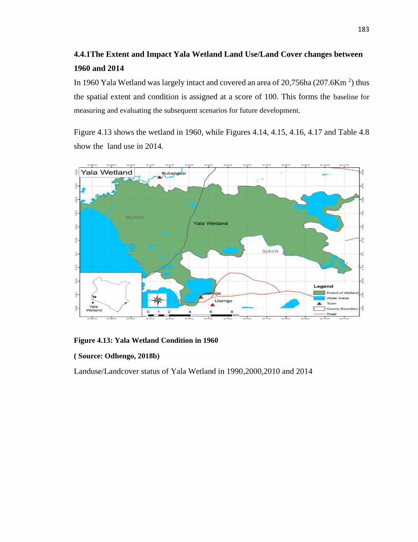
183
4.4.1The Extent and Impact Yala Wetland Land Use/Land Cover changes between
1960 and 2014
In 1960 Yala Wetland was largely intact and covered an area of 20,756ha (207.6Km 2) thus
the spatial extent and condition is assigned at a score of 100. This forms the baseline for
measuring and evaluating the subsequent scenarios for future development.
Figure 4.13 shows the wetland in 1960, while Figures 4.14, 4.15, 4.16, 4.17 and Table 4.8
show the land use in 2014.
Figure 4.13: Yala Wetland Condition in 1960
( Source: Odhengo, 2018b)
Landuse/Landcover status of Yala Wetland in 1990,2000,2010 and 2014
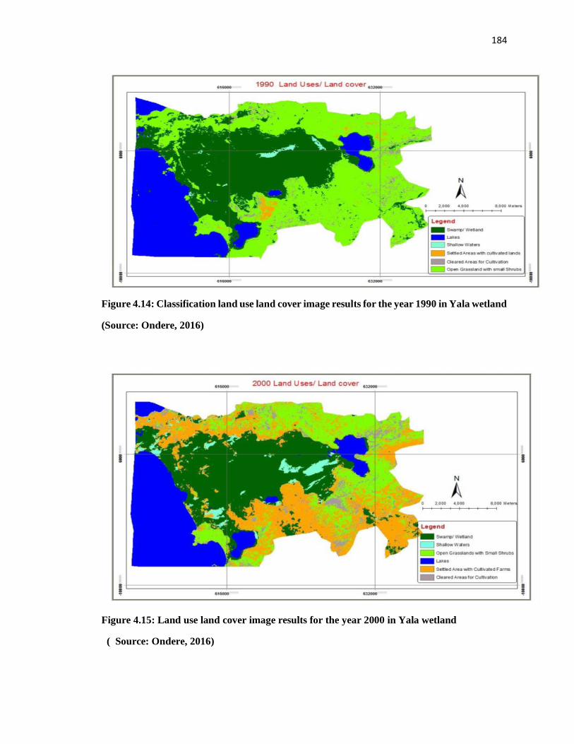
184
Figure 4.14: Classification land use land cover image results for the year 1990 in Yala wetland
(Source: Ondere, 2016)
Figure 4.15: Land use land cover image results for the year 2000 in Yala wetland
( Source: Ondere, 2016)
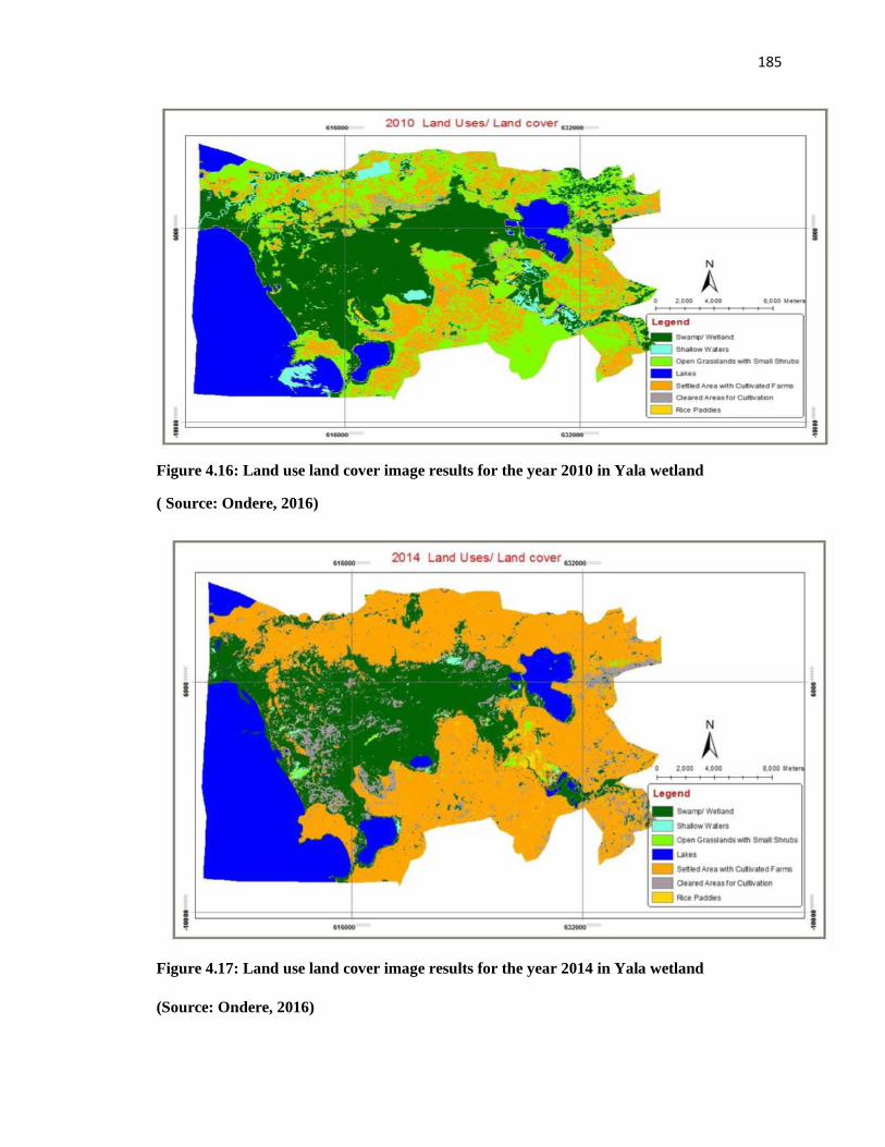
185
Figure 4.16: Land use land cover image results for the year 2010 in Yala wetland
( Source: Ondere, 2016)
Figure 4.17: Land use land cover image results for the year 2014 in Yala wetland
(Source: Ondere, 2016)
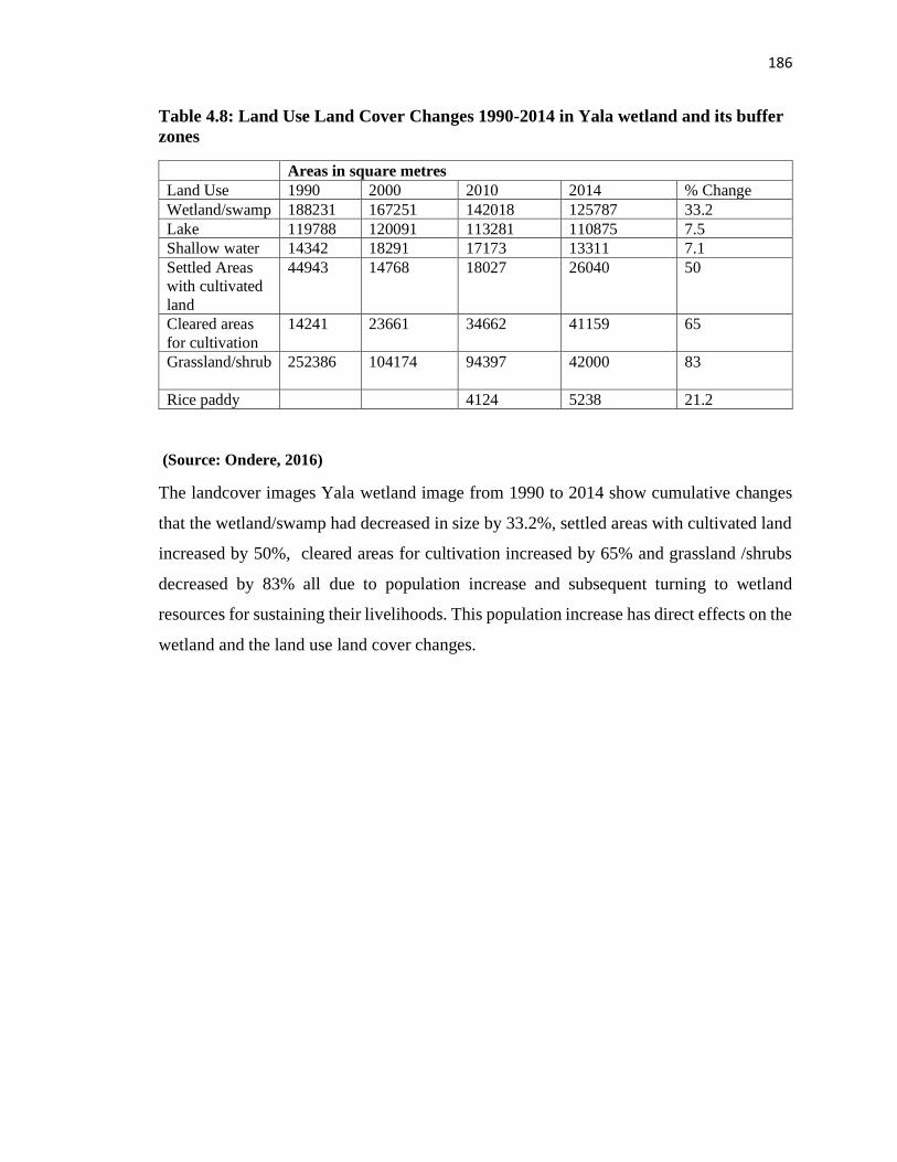
186
Table 4.8: Land Use Land Cover Changes 1990-2014 in Yala wetland and its buffer
zones
Areas in square metres
Land Use 1990 2000 2010 2014 % Change
Wetland/swamp 188231 167251 142018 125787 33.2
Lake 119788 120091 113281 110875 7.5
Shallow water 14342 18291 17173 13311 7.1
Settled Areas
with cultivated
land
44943 14768 18027 26040 50
Cleared areas
for cultivation
14241
23661 34662 41159 65
Grassland/shrub 252386
104174 94397 42000 83
Rice paddy 4124 5238 21.2
(Source: Ondere, 2016)
The landcover images Yala wetland image from 1990 to 2014 show cumulative changes
that the wetland/swamp had decreased in size by 33.2%, settled areas with cultivated land
increased by 50%, cleared areas for cultivation increased by 65% and grassland /shrubs
decreased by 83% all due to population increase and subsequent turning to wetland
resources for sustaining their livelihoods. This population increase has direct effects on the
wetland and the land use land cover changes.
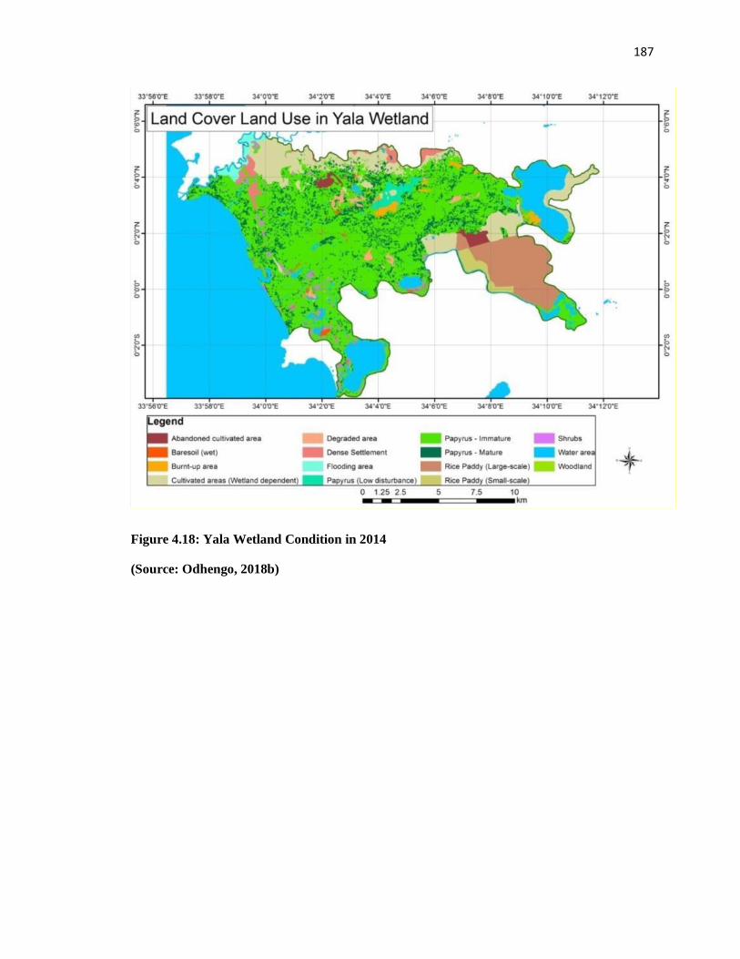
187
Figure 4.18: Yala Wetland Condition in 2014
(Source: Odhengo, 2018b)
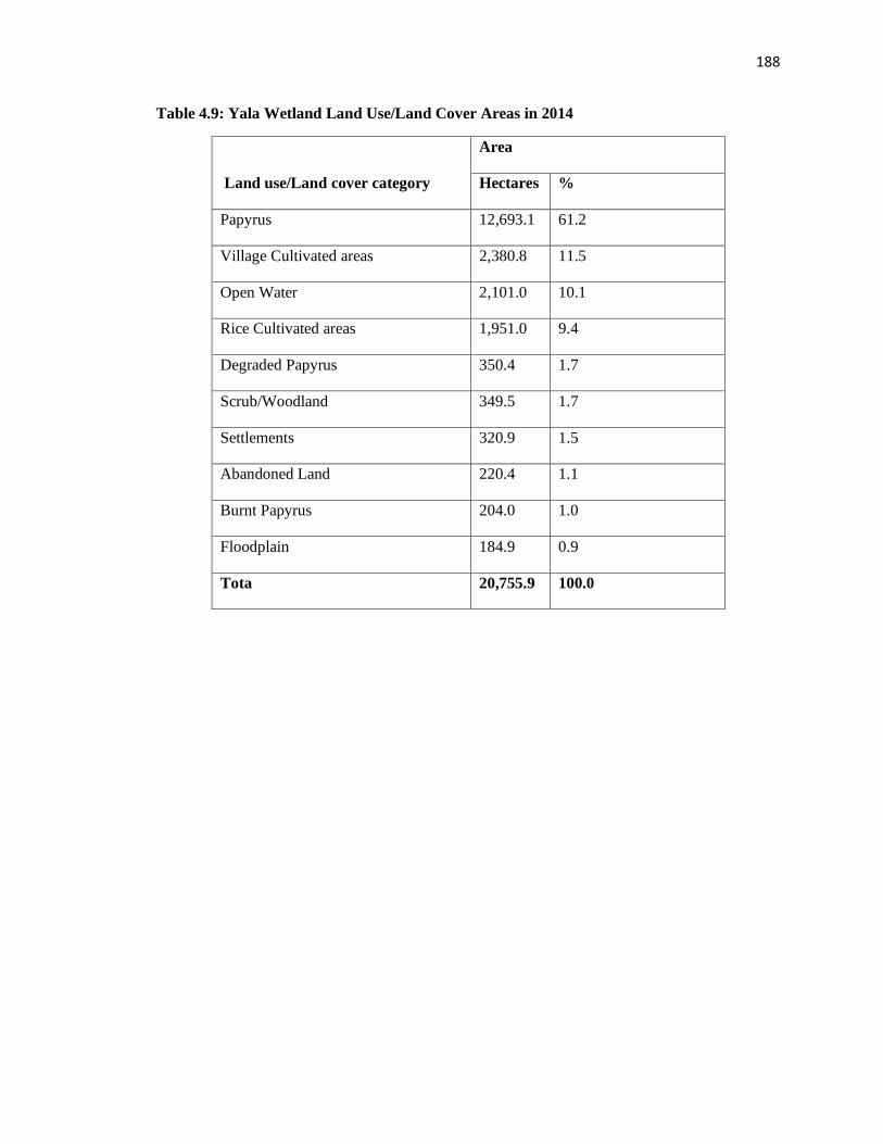
188
Table 4.9: Yala Wetland Land Use/Land Cover Areas in 2014
Land use/Land cover category
Area
Hectares %
Papyrus 12,693.1 61.2
Village Cultivated areas 2,380.8 11.5
Open Water 2,101.0 10.1
Rice Cultivated areas 1,951.0 9.4
Degraded Papyrus 350.4 1.7
Scrub/Woodland 349.5 1.7
Settlements 320.9 1.5
Abandoned Land 220.4 1.1
Burnt Papyrus 204.0 1.0
Floodplain 184.9 0.9
Tota 20,755.9 100.0

189
Figure 4.19: Relative Extent of various Land Uses/Land Cover
The landcover changes show degraded papyrus (350.4 ha) areas and burnt papyrus (204.0
ha) Table 4.9. These satellite maps (Figure 4.13 to 4.18) were shown to the communities
who had drawn community maps on areas close to their villages where they managed to
identify and gave their reasons for degradation of the wetland associated with their
activities shown in community maps. The respondents’ reasons included encroachment in
the wetland to get land for farming crops, overharvesting of papyrus and reeds for weaving
baskets and to get lungfish during dry seasons which interferes with breeding sites for fish,
bush meat hunting hippo, sitatunga, otter, bushbuck, bush duiker, and certain species of
birds as a cheap source of proteins and income, overfishing using unauthorised fishing nets
in Lake Kanyaboli. The wetland communities were able to engage in wetland restoration
like planting papyrus when it was clear the to them of their role in degradation when
satellite and GIS analysis information/evidence was shown to be them. Hence, restoration
of papyrus requires community participation with a clear demonstration linkage to their
PapyrusSmall scale farming
Open water
Large scale farming
Scrub/woodland
SettlementsFallow land Floodplain
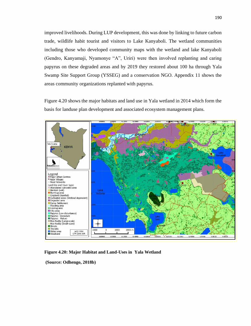
190
improved livelihoods. During LUP development, this was done by linking to future carbon
trade, wildlife habit tourist and visitors to Lake Kanyaboli. The wetland communities
including those who developed community maps with the wetland and lake Kanyaboli
(Gendro, Kanyamaji, Nyamonye “A”, Uriri) were then involved replanting and caring
papyrus on these degraded areas and by 2019 they restored about 100 ha through Yala
Swamp Site Support Group (YSSEG) and a conservation NGO. Appendix 11 shows the
areas community organizations replanted with papyrus.
Figure 4.20 shows the major habitats and land use in Yala wetland in 2014 which form the
basis for landuse plan development and associated ecosystem management plans.
Figure 4.20: Major Habitat and Land-Uses in Yala Wetland
(Source: Odhengo, 2018b)
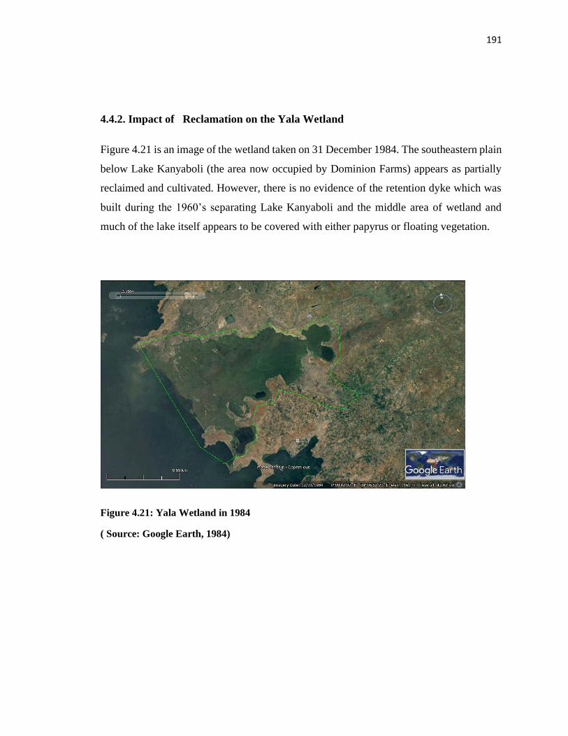
191
4.4.2. Impact of Reclamation on the Yala Wetland
Figure 4.21 is an image of the wetland taken on 31 December 1984. The southeastern plain
below Lake Kanyaboli (the area now occupied by Dominion Farms) appears as partially
reclaimed and cultivated. However, there is no evidence of the retention dyke which was
built during the 1960’s separating Lake Kanyaboli and the middle area of wetland and
much of the lake itself appears to be covered with either papyrus or floating vegetation.
Figure 4.21: Yala Wetland in 1984
( Source: Google Earth, 1984)
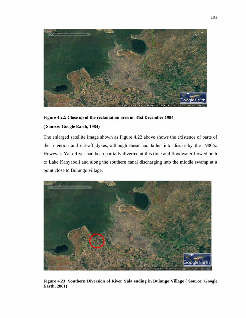
192
Figure 4.22: Close up of the reclamation area on 31st December 1984
( Source: Google Earth, 1984)
The enlarged satellite image shown as Figure 4.22 above shows the existence of parts of
the retention and cut-off dykes, although these had fallen into disuse by the 1980’s.
However, Yala River had been partially diverted at this time and floodwater flowed both
to Lake Kanyaboli and along the southern canal discharging into the middle swamp at a
point close to Bulungo village.
Figure 4.23: Southern Diversion of River Yala ending in Bulungo Village ( Source: Google
Earth, 2001)
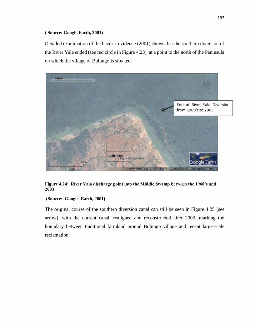
193
( Source: Google Earth, 2001)
Detailed examination of the historic evidence (2001) shows that the southern diversion of
the River Yala ended (see red circle in Figure 4.23) at a point to the north of the Peninsula
on which the village of Bulungo is situated.
Figure 4.24: River Yala discharge point into the Middle Swamp between the 1960’s and
2003
(Source: Google Earth, 2001)
The original course of the southern diversion canal can still be seen in Figure 4.25 (see
arrow), with the current canal, realigned and reconstructed after 2003, marking the
boundary between traditional farmland around Bulungo village and recent large-scale
reclamation.
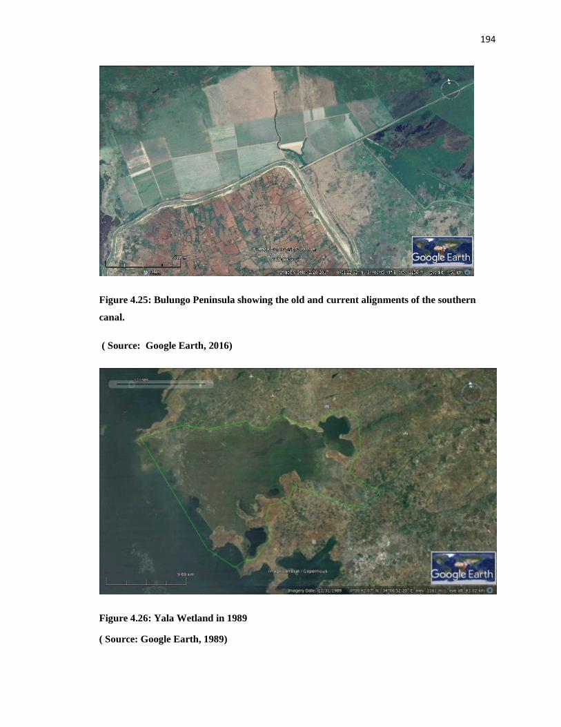
194
Figure 4.25: Bulungo Peninsula showing the old and current alignments of the southern
canal.
( Source: Google Earth, 2016)
Figure 4.26: Yala Wetland in 1989
( Source: Google Earth, 1989)
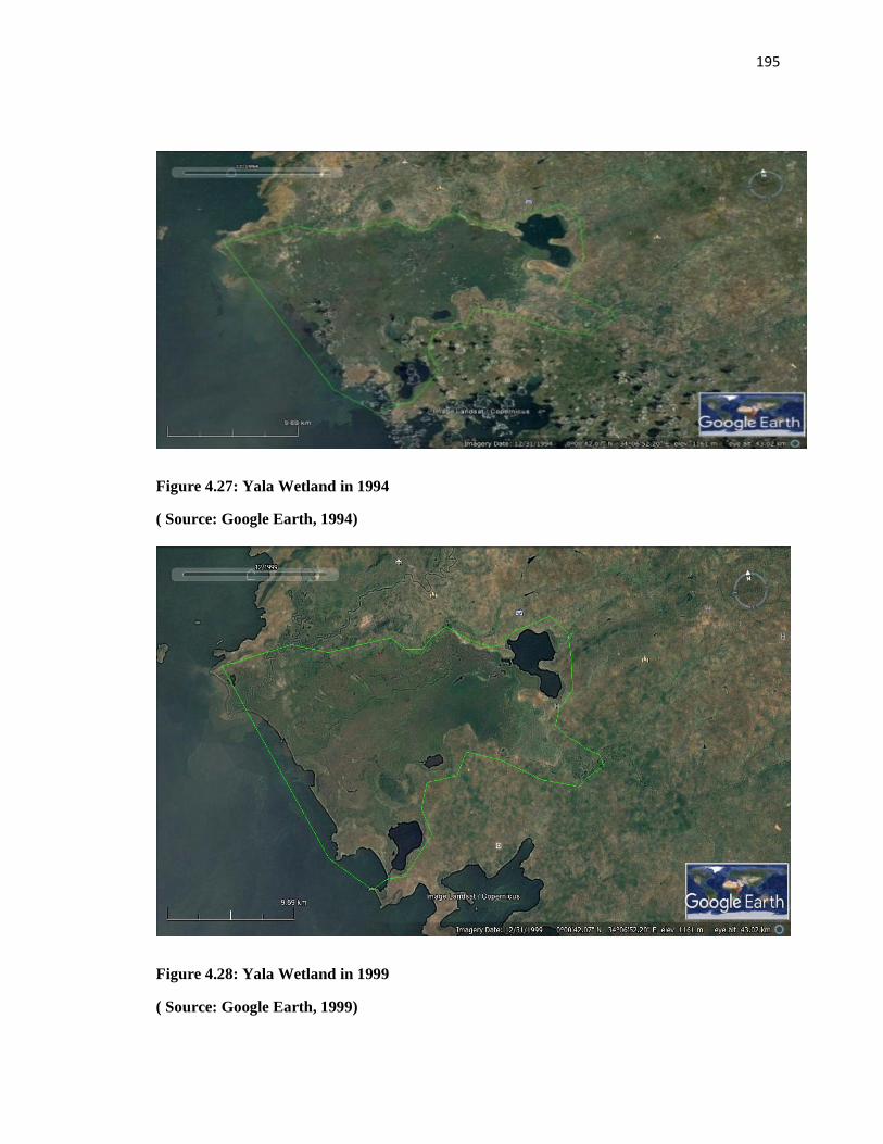
195
Figure 4.27: Yala Wetland in 1994
( Source: Google Earth, 1994)
Figure 4.28: Yala Wetland in 1999
( Source: Google Earth, 1999)
196
The satellite images show very minimal change in the main characteristics of Yala
Wetland between 1984 and 1994, as revealed by a comparison of Figures 4.26 - 4.28.
However, towards the end of this period the image suggests that revegetation has occurred
across the lower part of the area now leased to Dominion Farms without direct community
involvement with that portion of the wetland.
4.5 A Framework to Optimize Community Participation in Yala Wetland Planning
and Ecosystem Management
The section has three parts: the development of the framework; application of the
framework to the remaining SEA and LUP processes and the deployment of the framework
in a Siaya County Integrated Development Plan preparation and Yala Wetland Indigenous
Community and Conservation Area Management Plan Development.
4.5.1 A Framework to Optimize Community Participation
Part one looks at issues from community participation in Yala Wetland’s management and
identification of environmental issues for inclusion to SEA/LUP to design a modification
of the community participation framework.
4.5.2 YPAC Limitations and Challenges
Results from two objectives namely objective one on assessment of local communities’
participation in Yala Wetland ecosystem management, and objective two on environmental
issues to be included in Yala Wetland LUP were used as a basis to design the framework
discussed below. The level and effectiveness of community participation in SEA and LUP
process revealed strengths and challenges of the existing YPAC framework.
The analysis of SEA and LUP processes itemized the following 12 limitations and
challenges with YPAC framework: narrow membership of YPAC against the various
interests to be represented; low quality of participation by YPAC members due to inherent
weaknesses; inadequate points/places of community participation in the planning processes
at six (steps 2, 4, 5, 7, 9 and 10) out of eleven steps in the LUP process; low level of
community involvement based on the spectrum levels; unsatisfactory participation based
197
on the 10 indicators for evaluation of public participation results; the challenge of
communicating scientific and technical information to communities; dominant fixed and
negative mindsets about the wetland. Others include lack of methodology for integration
of indigenous knowledge with scientific information; absence of an organized Yala
Wetland-wide agency with communities’ strong representation; disconnect between
wetland decision-making and provision of adequate scientific and technical evidence/or
information;; lack transformational and value driven leadership at the community level on
wetland issues; and absence of comprehensive wetland wide information system since what
was available was rather ad hoc and scattered pieces of data and information. These 12
limitations compromised the ability of YPAC to represent wetland communities
meaningfully and effectively in SEA/LUP process and therefore provided the justification
for designing a modified framework to optimize the existing YPAC framework in
SEA/LUP processes and implementation plans.
4.5.3 Design of The YALA RAPPEF-CF-IR-Hub Framework-The Yala Hub
Framework
This is a framework designed to optimize community participation in Yala Wetland
planning and ecosystem management. The framework sought to remedy the weaknesses of
the original YPAC mechanism as well as tap opportunities presented as an outcome of the
action research. The framework is called Yala RAPPEF-CF-IR Hub Framework based on
the various steps on using it and shall be referred to in short form as the Yala Hub
Community Framework. The five steps are: 1. React/Act. 2. Restructure/Adjust the
participation framework based on the reactions. 3. Participation Preparations. 4.
Community Participation and 5. Review, Evaluate and Follow-up. These are supported by
a base of a Community Facilitator (CF) with a supportive Information Resources Hub (IR-
Hub) to support its execution, as presented in Figure 4.29.
.
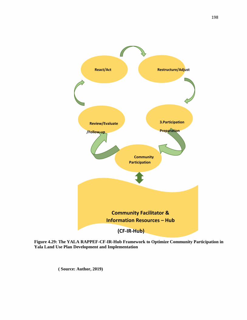
198
( Source: Author, 2019)
React/Act Restructure/Adjust
Community
Participation
Review/Evaluate
/Follow-up
3.Participation
Preparation
Community Facilitator &
Information Resources – Hub
(CF-IR-Hub)
(CF & IR- HUB)
CF & IR-HUB
Figure 4.29: The YALA RAPPEF-CF-IR-Hub Framework to Optimize Community Participation in
Yala Land Use Plan Development and Implementation
199
It is notable that if the project and program or process is new and therefore starting from
scratch, then it moves from step 1 to step 3 and by passes step 2.
Step 1. React or Act.
The first thing is to gain entry to participate in the process with a high degree of acceptance
if the process is already ongoing. The intervener has to find appropriate entry point which
depends on the context and how the facilitator(researcher) positions self. For examples, as
a researcher with their interest at heart, their own representative with technical expertise in
the process, conservationist of good reputation with community and application of
emotional intelligence to penetrate the ongoing process such as understanding their areas
of greatest need to participate in the process.
If the process is starting, then conduct a stakeholder analysis to check on representation
particularly of the local wetland communities. If it is in progress then conduct a stakeholder
analysis tier two, which reviews existing stakeholders and their level of participation, and
special preference for local communities. The key guiding question is how effective the
processes is in representing the local communities.
The guiding questions for this step include:
1. What does this community regard highly that can lead to high degree of acceptance of
an outsider/ a facilitator?
2. Who is participating in this process? Who is missing on the decision-making table?
Which other important voices are not being heard on this planning agenda? Are the
divergent voices included in this process? Does participation ensure fair geographic
representation? The process facilitator should identify these and ensure their inclusion.
3. What are the strengths and challenges of the community participation framework
currently being implemented?
200
4. Using the 10 indicators for public participation effectiveness, what are strengths and
weaknesses of the current community participation framework in the SEA and LUP
processes? How do you ensure the weaknesses are mitigated going forward?
The 10 indicators are: Objective of participation; Contexts for the participation; Levels of
Involvement; Who was involved, how were they chosen and by who? What methods were
used (maps, interviews) if they did work? Innovation of the methods used; Commitment to
community participation; Inputs (time, money etc. and results in relation to those inputs);
Outputs (hard outputs, reports, posters, press, completed survey forms); and Outcome.
Step 2. Restructure or Adjust the Participation Framework based on the stepwise
Feedback and Reactions
The outcome of step one forms the basis for adjustment and restructuring at this stage. If
the project or program is new, then it moves from step 1 to step 3, by passing step 2.
The guiding questions for this step include:
1. Who needs to be added to the participation processes? What uniqueness do they bring
on board?
2. How can one ensure meaningful participation from the people joining an ongoing
process?
3. How are the elements that were hampering community participation effectiveness being
tackled in the adjusted mechanism?
4. How can one use participatory methodologies to improve participation?
5. What should one do to improve the environment for participation and harness creativity?
In the SEA and LUP processes, the researcher adjusted the participation process by
bringing to the decision- making table the stakeholders who were not initially on board.
This expanded the representation of local communities to include community formations
and organizations and learning institutions at their bases in addition to YPAC. Both
preparations and actual implementation methodologies were modified and new ones added
based on the feedback from step one.
201
Step 3. Participation Preparation
The third step called for thorough preparation before the actual participation. Consequently,
this step evaluated participation readiness and ensured the process was ready.
The guiding questions for this step include:
1. What is the community participation process in this activity? Does the process provide
local communities with room to articulate their interests and concerns?
2. What are the units of participation? What is the smallest unit for participation in this
case? How are they organized to enable smooth flow of information and receive timely
feedback?
3. What type of persons will be required to facilitate this participation process?
4. What type of skills and training are required to equip facilitators of this process?
5. What logistical support and budget will be required to conduct this participation?
6. How does one frame issues for effective discussion with the identified stakeholders in
step 1 above?
7. Which participatory methodologies and how will one use these in community
participation processes?
8. What creativity and innovations will one bring to this community participation process?
For SEA/LUP process preparations entailed identifying other community co-facilitators
and equipping them to manage the process effectively; practical training on facilitation
skills including mock training amongst facilitators; enabling logistical support, and
framing issues for discussion with the identified stakeholders in step one using appreciative
lenses focusing on root causes and suggesting the possibilities of tackling them.
Step 4. Community Participation
202
This step is where the wetland communities interact with the planning processes and relay
the feedback to the main LUP technical team.
The guiding questions were:
1. How does one conduct community consultations that will allow participation of the new
groups to smoothly integrate with other existing teams?
2. Summarize the key issues about (SEA/LUP) process to date? What are the areas of
convergence? What are the areas of disagreement? What other concerns do the wetland
communities have about Yala wetland?
3. What participation tools are appropriate for the targeted community and why?
4. How are the processes outcomes documented, validated by the communities and relayed
to the LUP technical team for inclusion?
5. What do the wetland communities’ value most about the wetland and why? What are the
communities’ non- negotiables on the wetland ecosystem resources?
6. Identify sites of environmental significance and conduct empathy walks with
communities to pool out their issues /feelings on those sites?
7. Immerse oneself in the community to experience their issues and ensure that the
participation process brings out what one has experienced even if not comfortable to talk
about?
The Community Facilitator manages the community participation processes using various
participatory methodologies and resolves any participation challenges to ensure maximum
interaction of communities in the planning process and relaying critical feedback to the
technical team and other planning organs outside the formal consultation sessions. For
example, by empathy walks; consulting in communities’ local languages; artistic works
where talented community members express themselves; and cultural artifacts to express
themselves.
Step 5. Review, Evaluate and Follow-up: Participants feedback about participation
processes
203
At this stage stakeholders evaluate the participation processes and outcomes guided by the
following questions:
1. a. What went very well? b. What could be done even better/improved next time?
2: How does one feel about the final outcome of Yala Wetland Land Use Plan and
ecosystem management plan?
3. What follow-up mechanism is in place to ensure community participation issues
/outcomes in the plan are later implemented?
4. How does one get the community as a key player in the implementation processes?
5. How does one ensure that the benefits from Yala wetland are shared equitably with the
wetland communities and other key wetland actors with a mutual accountability system?
In SEA/LUP process, evaluation was done with the Wetland communities, Researchers,
LUP Technical team, County officials from departments of Lands, Professionals, teachers
and students in schools
Community Facilitator (CF)
At the core of optimizing community participation in SEA/LUP processes is the CF who
helps communities navigate those five steps, which is supported by an IR-Hub. The Yala
RAPPEF-CF-IR-Hub Framework is a facilitative model with the community facilitator
being key to its execution. The CF should have relevant attributes and skills in interpreting
scientific and technical information to the community.
For Yala Wetland the following attributes were needed namely: skills and capabilities in
planning and management; environmental sciences knowledge; networking and advocacy,
proximity and access to decision makers; and, community acceptance to generate a feeling
that it was a safe environment of trust and mutual respect. The CF uses these skills and
emotional intelligence to help communities see and overcome their barriers to
participation. Finally, the CF provides new feedbacks loops and leverage points for
community interventions.
204
Information Resources Hub (IR-Hub)
The IR-Hub was vital in gathering, processing and relaying timely data and information
required to inform the processes. The resources gathered included previous related studies
on Yala Wetland, feedback from community meetings, validation feedback of various
SEA/LUP outputs and draft reports; vital networks or contact persons who were called to
inform and input the various parts of the process. In the IR-Hub, facilitators used
multifaceted but audience appropriate channels in communicating with them. For example,
CF relayed technical process outputs through graphical images, storytelling, folklores,
sayings, proverbs and metaphors. Constant feedback by CF using appropriate target
audience information and channel was key in applying the framework. The IR- Hub was
opportunity for new forms of information to flow into the process and therefore should
remain a ‘live’ entity, constantly growing and replenished with current information.
4.5.4 Application of Yala RAPPEF- CF-IR Hub Framework in SEA/LUP Process
The Yala RAPPEF-CF-IR-Hub Framework was applied within an on-going SEA/LUP
process after draft one of SEA and LUP report had been generated. The remaining
processes were mainly reviewing draft 1, providing feedback, generating contents and
review feedback for SEA and LUP drafts 2 and 3.
4.5.4.1 Outcomes of Application of Yala RAPPEF-CF-IR-Hub in SEA/LUP steps 1
and 2
The Yala RAPPEF-CF-IR-Hub steps 1 and 2 in SEA/LUP processes entailed:
The Step 1. React or Act focuses on smooth entry into the participation process, checking
out its community inclusivity and effectiveness of the process while Step 2. Restructure or
Adjust focusing on using the feedback from step one to restructure and adjust the
participation processes to accommodate more community’s representation, and their
contributions and concerns.
YPAC’s strength include it demonstrated that community concerns would be addressed
and their participation guaranteed in the SEA/LUP processes. However, the following
205
shortcomings were noted that hindered maximum community participation in the
SEA/LUP processes:
1. YPAC members noted that they needed facilitation beyond transport to move around
and call for meetings to debrief their communities after meeting technical team.
2. They needed the technical materials printed to be shared with communities but this had
been overlooked in planning hence not budgeted for thereby hampering their effective
communication role. This challenge hampered their reach to a significant number of their
constituents to report back the deliberations from the YPAC meetings and seek inputs
which they would relay to YPAC meetings, as a result they presented their views and inputs
from those around them into the process, thereby narrowing representation.
3. The people from Usonga ward were not represented in the YPAC committee. Although
they were initially in the YPAC they were later replaced when they became a challenge to
the process. The initial officials had a challenge of understanding the LUP processes and
conveying the correct messages and feedback to the grassroots level to allay fears and
reduce political tension from their area of Yala Wetland.
Therefore, the researcher cum community facilitator in this framework purposely reached
out to people in their circles including a retired chief and a primary school headmaster who
arranged for a meeting where they gave their input. However, the process was very tense
as illustrated in some of the exchanges below. While some were direct, other used
metaphors to convey the messages leaving the research team to interpret their meanings
and take appropriate action. For example, the statements below capture the various feelings
from communities about the Yala Wetland conflicts:
- “The LUP process must end with immediate effect because people will die and I don’t
want to die. I am just one person and I can’t talk on behalf of my community; they will
even kill me if they hear that I attended this meeting” Interview with respondent one.
- “The Dominion Farm came to Yala Wetland in 2003 and without consulting the
community, proceeded to acquire the land. May God punish the initiators of LUP if they
206
also have ill and demonic idea of taking our land away from us like Dominion Farms
did?” Interview with respondent two.
- “The camera man, you are still very young and have a bright future ahead of you, I hope
you have not come all the way from South Nyanza with ill motive of initiating how the
swamp will be grabbed from us.” (Interview with respondent two referring to one of the
Research Assistants).
- John 1:1-3, “In the beginning was the word and the word was with God and the word
was God. The same Bible states that, there was a time people cried in the wilderness,
that a person is coming whose shoes laces we cannot untie, this is how the foreigners
came to displace us in our land” respondent three.
- “The wetland has plenty of resources both in the dry season and rainy season, we get a
lot of income from the swamp, therefore, it is our mother” respondent four
- “I don’t know who my parents are, neither my mother nor my father, the first person to
cloth me and buy me a blanket is the swamp, the swamp is my only parent I have ever
known” Interview with respondent five.
- “Since we started cultivating in the swamp, we don’t beg for food anymore, no more big
lorries from Uganda and other provinces come in our mother land bringing us food, we
have enough now from our precious swamp” (Interview with respondent six).
-
- “One day it was very cold outside and the elephant was freezing helplessly and he could
not survive, it moved to a nearby home seeking for help, it requested the owner of the
house to allow only one of its feet into the house which was very warm, the owner
showed mercy and agreed, it requested the 2nd foot, the 3rd one and the 4th foot. Finally,
the elephant occupied the whole house in the end displacing the owner of the house,
ruthlessly. The elephant symbolizes the government” (Interview with respondent seven).
It was clear that the community felt they have been used, cheated on, and lied to by some
NGOs working in the area. Some of those organizations had betrayed the community
trust and as a result they had developed negative attitude to any kind of development in
Yala Wetland. Likewise, the above statements clearly show that because of the conflicts
in the swamp, the wetland planning required ability to understand the various conflict
207
dynamics and participatorily proffer resolution and management strategies that would
be delivered as Yala Wetland ecosystem management plans are being implemented.
Further weakness of the YPAC framework was that the process did not deliberately reach
out to professionals in the area and other key community voices as schools and religious
leaders for their inputs into the process. For example, the YPAC did not map out previous
studies that had been done to cross check with what had been gathered by the technical
team. As a result, the researcher who was acting as the CF managed to avail study findings
where he was a team member of Nile Basin researchers on identification of Multipurpose
Water Resources Development Projects in Gucha-Migori and Yala River Basins in Kenya
in 2011-2012 period on proposed multipurpose dam at Gongo on River Yala that would
affect environmental flows of River Yala when it is finally constructed.
The application of Yala Community Participation Framework led to expanded scope and
depth of local community participation in later stages SEA/LUP process phase two and
three. Likewise, some of the processes were iterative hence, data and information generated
enriched even process that were done before application of this framework. The additional
groups brought on board included the following eleven groups/key stakeholders.
1. The researcher reached out to elders’ formation in the communities like the Luo Council
of Elders and respected elders who are viewed as custodians of communities’ heritage.
They brought on board historical information; land tenure issues; gender issues and societal
meaning around them including land ownership.
2. Schools: In understanding the communities and how they have changed over time,
education and learning institutions have played a significant role. Therefore, where changes
were expected schools played a catalytic role. In this study schools developed
environmental ethos for sound management of wetlands, created awareness about the
sensitivity of the Yala Wetland, envisioned the future of Yala Wetland through essays,
debates and artwork as seen in Figure 4. 12. These included nursery , primary, secondary
and post-secondary schools.
208
3. Change Makers in the Community. Yala Wetland land use plan is a key driver in
bringing change in the area. The researcher reached out to respectable change makers on
what it takes to bring change and how their experiences could be harnessed for
implementing Yala Wetland vision. Their inclusion brought new planning issues: herbal
trees and how to preserve them, land tenure involving cultural dynamics including
engendering landuse planning; traditional weather forecasting and social cultural subtleties
that determine how local communities relate with land and thus its subsequent care.
As one female change maker revealed during our data collection meeting in Yimbo with
the elders, while narrating why women are prevented from owning land. She stressed that
“We cannot obtain land title deeds without the permission of our husbands or male
guardians. Communities fear losing their land to strangers from different clans when their
women are inherited upon the death of a husband or if a woman remarries in a different
clan”.
Consequently, Yala Wetland change makers helped dig deeper into cultural nuances in
land ownership issues especially property owners and tenants’ relationship and how it
affected their utilization which in turn affects sustainable use.
4. Professionals from Yala Wetland and its surroundings. These included experts on land,
water, environmental sciences, academia, scientists and researchers. These brought a
deeper analysis of the issues with the entry of commercial farmers, lessons learnt and best
practices from elsewhere, interrogated drafts and gave their expert views and
recommendations. A key input from them was the need for proper understanding of
environmental water flows and soil health in agricultural interventions. The professionals
from Yala Wetland and its buffer zone among them retired and active experts would be
key in the implementation of the LUP plan and therefore their ownership at the design stage
was core. Similarly, the Yala Wetland residents in the diaspora were critical in identifying
overlooked issues like mental health.
5. Local Administrators including current and retired chiefs, sub-chiefs, and village elders
(mlangos) were key entry points into the communities as well as resolving communal
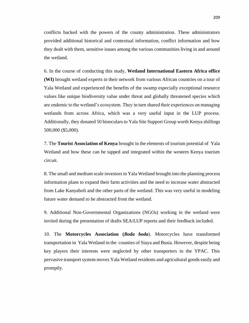
209
conflicts backed with the powers of the county administration. These administrators
provided additional historical and contextual information, conflict information and how
they dealt with them, sensitive issues among the various communities living in and around
the wetland.
6. In the course of conducting this study, Wetland International Eastern Africa office
(WI) brought wetland experts in their network from various African countries on a tour of
Yala Wetland and experienced the benefits of the swamp especially exceptional resource
values like unique biodiversity value under threat and globally threatened species which
are endemic to the wetland’s ecosystem. They in turn shared their experiences on managing
wetlands from across Africa, which was a very useful input in the LUP process.
Additionally, they donated 50 binoculars to Yala Site Support Group worth Kenya shillings
500,000 ($5,000).
7. The Tourist Association of Kenya brought in the elements of tourism potential of Yala
Wetland and how these can be tapped and integrated within the western Kenya tourism
circuit.
8. The small and medium scale investors in Yala Wetland brought into the planning process
information plans to expand their farm activities and the need to increase water abstracted
from Lake Kanyaboli and the other parts of the wetland. This was very useful in modeling
future water demand to be abstracted from the wetland.
9. Additional Non-Governmental Organizations (NGOs) working in the wetland were
invited during the presentation of drafts SEA/LUP reports and their feedback included.
10. The Motorcycles Association (Boda boda). Motorcycles have transformed
transportation in Yala Wetland in the counties of Siaya and Busia. However, despite being
key players their interests were neglected by other transporters in the YPAC. This
pervasive transport system moves Yala Wetland residents and agricultural goods easily and
promptly.
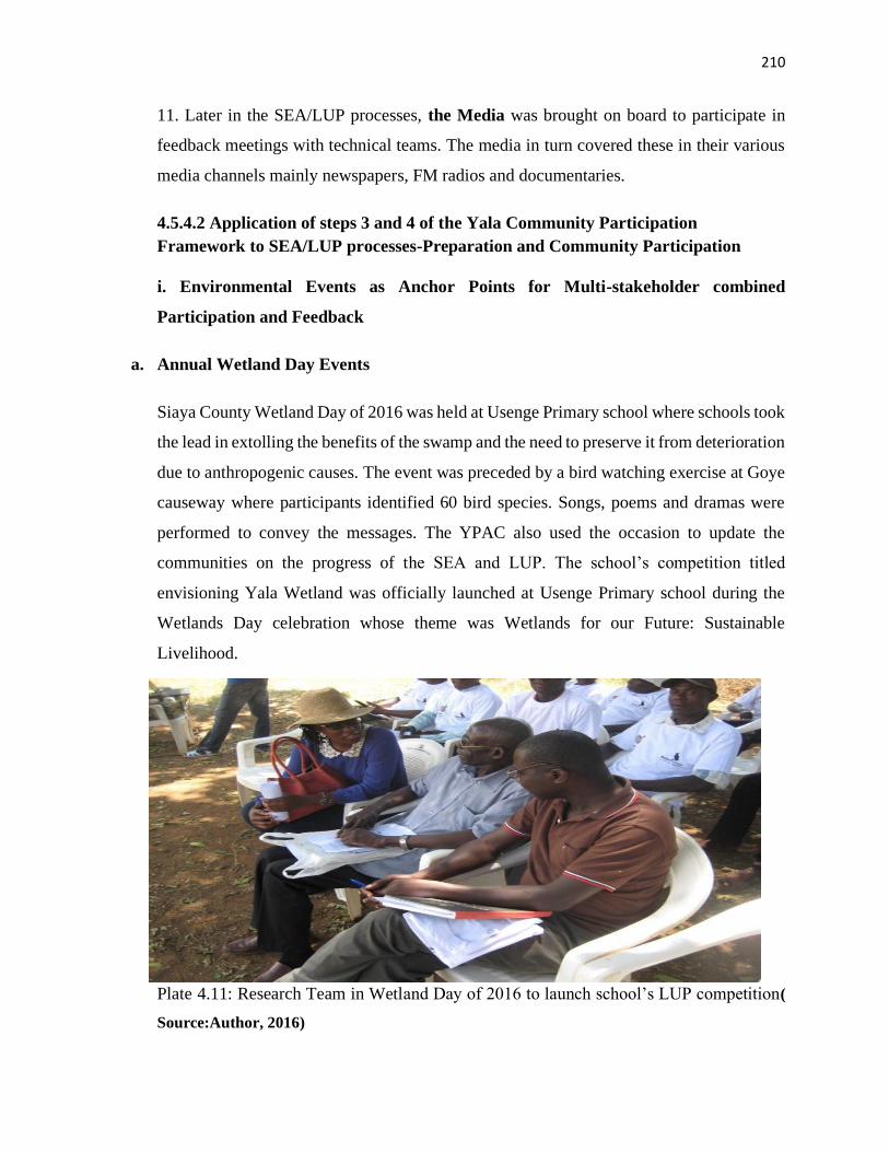
210
11. Later in the SEA/LUP processes, the Media was brought on board to participate in
feedback meetings with technical teams. The media in turn covered these in their various
media channels mainly newspapers, FM radios and documentaries.
4.5.4.2 Application of steps 3 and 4 of the Yala Community Participation
Framework to SEA/LUP processes-Preparation and Community Participation
i. Environmental Events as Anchor Points for Multi-stakeholder combined
Participation and Feedback
a. Annual Wetland Day Events
Siaya County Wetland Day of 2016 was held at Usenge Primary school where schools took
the lead in extolling the benefits of the swamp and the need to preserve it from deterioration
due to anthropogenic causes. The event was preceded by a bird watching exercise at Goye
causeway where participants identified 60 bird species. Songs, poems and dramas were
performed to convey the messages. The YPAC also used the occasion to update the
communities on the progress of the SEA and LUP. The school’s competition titled
envisioning Yala Wetland was officially launched at Usenge Primary school during the
Wetlands Day celebration whose theme was Wetlands for our Future: Sustainable
Livelihood.
Plate 4.11: Research Team in Wetland Day of 2016 to launch school’s LUP competition(
Source:Author, 2016)
211
The Wetlands’ Day of 2017 was celebrated at Hawinga Primary school and themed on the
importance of world migratory birds where the researcher seized the occasion to discuss
the progress of SEA and LUP and then sought community contributions on the same.
Results of these participation processes included: strengthening environmental awareness
programmes in schools through clubs, tree planting and post planting care, promoting
hygienic practices and protection of Lake Kanyaboli and water springs; a deeper
understanding on the Yala Wetland challenges and the role of the wetland communities in
solving them.
This seizing of key environmental events offered wetland communities with an opportunity
to reconfirm the challenges, their aspirations and dialogue on preliminary findings of
SEA/LUP processes. During these occasions, some of elders gave talks on the values Yala
communities attached to various types of birds and how they treated them based on these
understanding (indigenous knowledge and passing that to schools during the event). The
interaction between pupils, parents and guardians and technical staff from the government
continued to offer opportunity for cross learning from all the subsets of communities
represented. Plate 4.12 shows the researcher giving a synopsis of draft 2 of SEA and LUP
reports to Hawinga communities during the Annual Wetlands Day celebration while Plate
4.13 shows Nyiego Women Group participating in the wetland’s day held at Hawinga
where they got presentations of the draft SEA and LUP reports and they provided their
feedback.
Plate STYLEREF 1 \s 4. SEQ Plate \* ARABIC \s 1 11: Researcher, Supervisor and
Research Assistant following the proceedings of Wetland Day in February 2016 and
launched school’s participation in LUP competition.
Source: Researcher, 2018
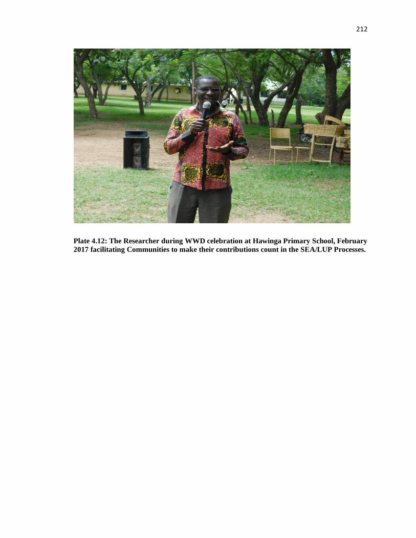
212
Plate 4.12: The Researcher during WWD celebration at Hawinga Primary School, February
2017 facilitating Communities to make their contributions count in the SEA/LUP Processes.
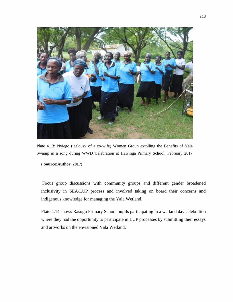
213
( Source:Author, 2017)
Focus group discussions with community groups and different gender broadened
inclusivity in SEA/LUP process and involved taking on board their concerns and
indigenous knowledge for managing the Yala Wetland.
Plate 4.14 shows Rasugu Primary School pupils participating in a wetland day celebration
where they had the opportunity to participate in LUP processes by submitting their essays
and artworks on the envisioned Yala Wetland.
Plate 4.13: Nyiego (jealousy of a co-wife) Women Group extolling the Benefits of Yala
Swamp in a song during WWD Celebration at Hawinga Primary School, February 2017
Source: Researcher, 2018
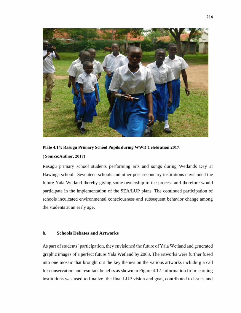
214
Plate 4.14: Rasugu Primary School Pupils during WWD Celebration 2017:
( Source:Author, 2017)
Rasugu primary school students performing arts and songs during Wetlands Day at
Hawinga school. Seventeen schools and other post-secondary institutions envisioned the
future Yala Wetland thereby giving some ownership to the process and therefore would
participate in the implementation of the SEA/LUP plans. The continued participation of
schools inculcated environmental consciousness and subsequent behavior change among
the students at an early age.
b. Schools Debates and Artworks
As part of students’ participation, they envisioned the future of Yala Wetland and generated
graphic images of a perfect future Yala Wetland by 2063. The artworks were further fused
into one mosaic that brought out the key themes on the various artworks including a call
for conservation and resultant benefits as shown in Figure 4.12. Information from learning
institutions was used to finalize the final LUP vision and goal, contributed to issues and
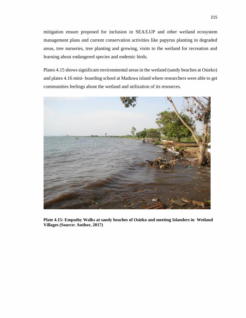
215
mitigation ensure proposed for inclusion in SEA/LUP and other wetland ecosystem
management plans and current conservation activities like papyrus planting in degraded
areas, tree nurseries, tree planting and growing, visits to the wetland for recreation and
learning about endangered species and endemic birds.
Plates 4.15 shows significant environmental areas in the wetland (sandy beaches at Osieko)
and plates 4.16 mini- boarding school at Maduwa island where researchers were able to get
communities feelings about the wetland and utilization of its resources.
Plate 4.15: Empathy Walks at sandy beaches of Osieko and meeting Islanders in Wetland
Villages (Source: Author, 2017)
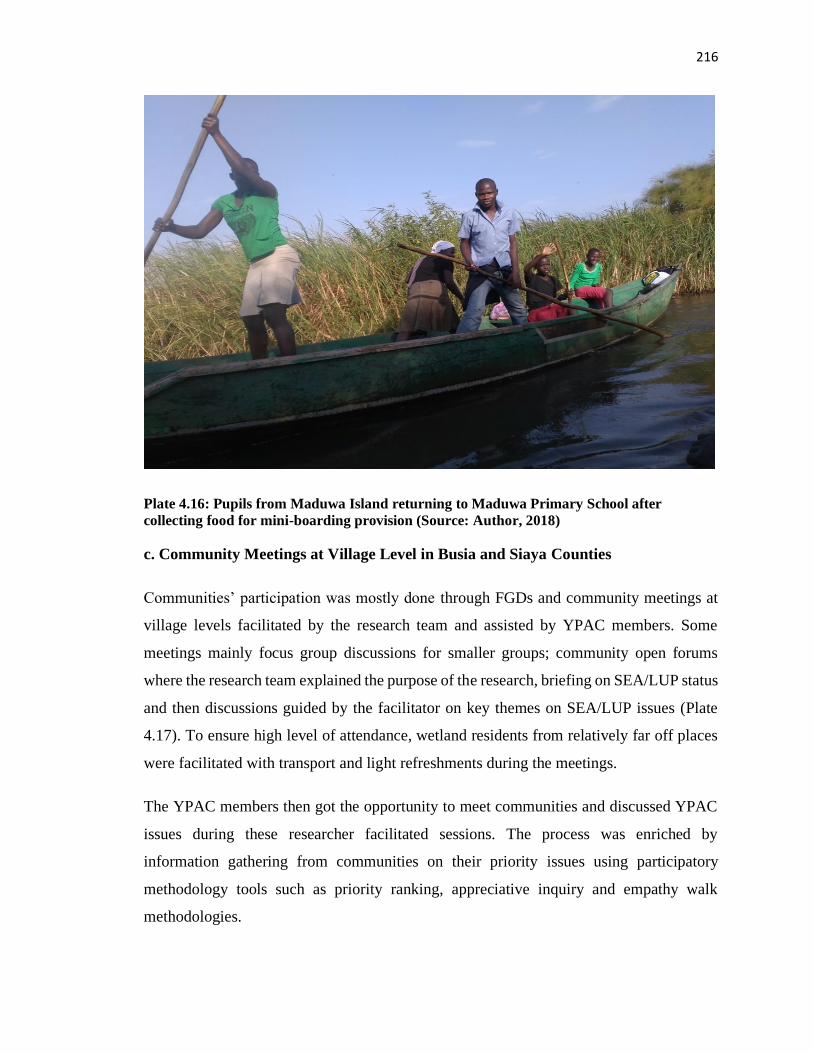
216
Plate 4.16: Pupils from Maduwa Island returning to Maduwa Primary School after
collecting food for mini-boarding provision (Source: Author, 2018)
c. Community Meetings at Village Level in Busia and Siaya Counties
Communities’ participation was mostly done through FGDs and community meetings at
village levels facilitated by the research team and assisted by YPAC members. Some
meetings mainly focus group discussions for smaller groups; community open forums
where the research team explained the purpose of the research, briefing on SEA/LUP status
and then discussions guided by the facilitator on key themes on SEA/LUP issues (Plate
4.17). To ensure high level of attendance, wetland residents from relatively far off places
were facilitated with transport and light refreshments during the meetings.
The YPAC members then got the opportunity to meet communities and discussed YPAC
issues during these researcher facilitated sessions. The process was enriched by
information gathering from communities on their priority issues using participatory
methodology tools such as priority ranking, appreciative inquiry and empathy walk
methodologies.
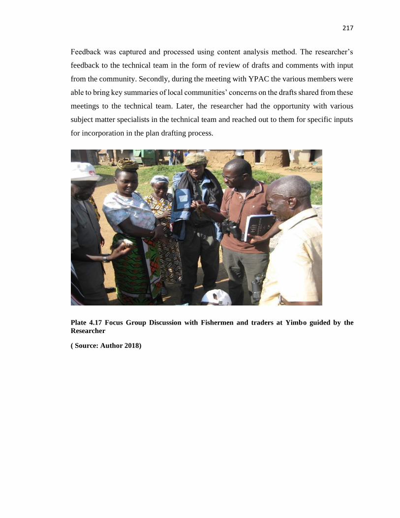
217
Feedback was captured and processed using content analysis method. The researcher’s
feedback to the technical team in the form of review of drafts and comments with input
from the community. Secondly, during the meeting with YPAC the various members were
able to bring key summaries of local communities’ concerns on the drafts shared from these
meetings to the technical team. Later, the researcher had the opportunity with various
subject matter specialists in the technical team and reached out to them for specific inputs
for incorporation in the plan drafting process.
Plate 4.17 Focus Group Discussion with Fishermen and traders at Yimbo guided by the
Researcher
( Source: Author 2018)
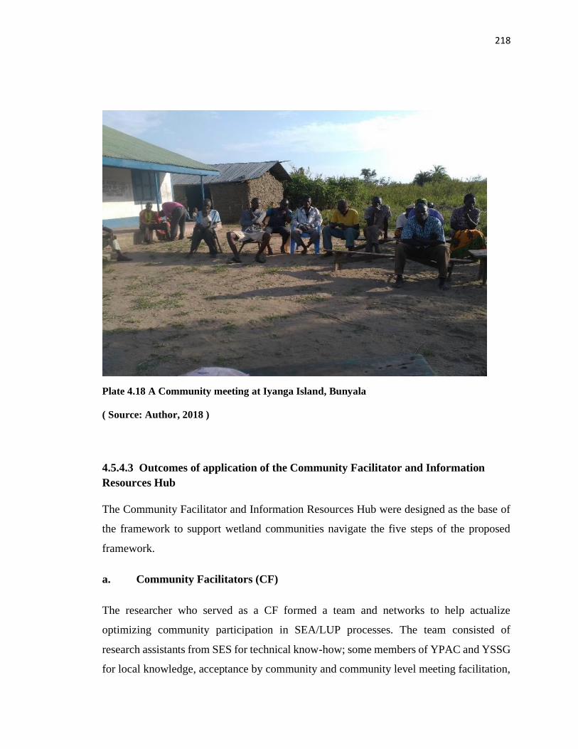
218
Plate 4.18 A Community meeting at Iyanga Island, Bunyala
( Source: Author, 2018 )
4.5.4.3 Outcomes of application of the Community Facilitator and Information
Resources Hub
The Community Facilitator and Information Resources Hub were designed as the base of
the framework to support wetland communities navigate the five steps of the proposed
framework.
a. Community Facilitators (CF)
The researcher who served as a CF formed a team and networks to help actualize
optimizing community participation in SEA/LUP processes. The team consisted of
research assistants from SES for technical know-how; some members of YPAC and YSSG
for local knowledge, acceptance by community and community level meeting facilitation,
219
linkage with networks of professionals with interest in Yala Wetland for technical expertise
and genuine involvement in determining the development paths of their communities.
Additional team members that CF linked up with include development facilitators and
partners to allow for navigation into the processes without hindrances mainly Nature
Kenya, the IMTC Deltas Secretariat and County Government of Siaya and Busia Leaders
at both the Executive and County Assemblies
The Research Assistants were trained on requisite skills for fieldwork tasks including
facilitating community level meetings, interviewing respondents, moderating focus group
discussions, use of participatory tools for community data capture and data capture through
photography and videography of some key issues relevant to the study as well as visioning
skills.
The type of stakeholders targeted determined the type of data collection tool used. For
example, the youth preferred a mix of media at the same time using audiovisuals, social
media like whatsapp, facebook, instagram, group work sent to their phones directly. In
schools the team opted for artwork, debates, essays with queries that focused on challenges
and what future they envisioned of Yala Wetland, for environmental events days the team
choose gallery walks on artistic works display on Yala Wetland, wetland products display,
creative performances like poems and dramas with conservation messages, display of
ecotourism sites and thematic songs delivered with aid of traditional instruments such
nyatiti, ohangla, orutu, pekee, tung and talks by both government and community leaders
based on the theme of the event. The researcher also seized the occasion to update
participants on SEA/LUP progress, key planning issues, and also obtained their feedback.
In addition, the steps intentionally involved the use of local leaders to co-facilitate the
meetings with the researchers after being trained on SEA/LUP specific issues to guide
focus group discussions and community meetings. This gave them the opportunity to relay
SEA/LUP updates from Inter-county steering committee and technical team, which had
been a challenge before due logistical reasons. Each team was furnished with the latest
copies of SEA and LUP and YPAC meeting minutes during community meetings.

220
The community facilitator of the process had to be a respected and trusted person, who was
influential enough to engage at all stages and structures of SEA/LUP processes involving
ICSC, YPAC, Technical Team, Learning and Research Institutions, various organs and
players in policy making space. Consequently, the researcher being from the area fitted in
well and facilitated the process.
b. Information Resources Hub for Accessing Relevant Information to make
Informed Decisions that are Evidence and Outcome based
LUP and SEA processes required a lot of data and information. The data was scattered
among various stakeholders that required identification and availing to the team. Some data
like for water abstraction by investors was just not available. On the contrary to availability,
some collated information was not easily discernable by local communities to support their
informed participation, yet information access is a critical component for increasing the
quality of community participation in managing Yala Wetland ecosystem. In increasing
access to technical information, the communities required less text and tables but rather
more visuals, graphics and intuitive information delivered mostly in consultative and
experiential processes with adequate time for questioning, reflection and responding.
On framing issues, the team used appreciative words of being positive, optimistic and
desired result focus to guide the information gathering among some respondents. For
community organizations to elicit feedback, the researcher framed guiding questions for
each category. For the students, the essay topic was “what is your dream for the future of
Yala Wetland in 50 years’ time if money is not a problem? The religious leaders were asked
to reflect with their leadership teams and thereafter prepare a compelling God inspired
sermon on the theme of a better Yala Wetland; while the professionals were asked to give
back to their communities their expertise in developing Yala Wetland land use plan, to
which some responded by reviewing the SEA/LUP drafts.
The team used empathy walks methodology as they moved into the wetland with
inhabitants who narrated their issues. For instance, an elderly woman showing the
graveyard of her husband and reasserting her unwillingness to leave the grave in the
wetland if the residents were to be relocated; have mini-boarding schools in the wetland
221
so that pupils return home over the weekends to replenish food supplies as depicted in Plate
4.16; and in those situations researchers just engaged in deep listening to derive deeper
meanings which they reflected in their journals and was key in designing the logical steps
of this framework.
The research team also lived with the communities during the study period, which extended
for over one year starting from 2016 to2018 since the LUP processes delayed. This gave
them the opportunity to immerse themselves into the communities to experience their lives
firsthand, obtain people issues very deeply, and to infuse creativity in the participation
process based on these experiences.
Some communities were very hostile to the LUP but through participatory processes, the
researcher was able to get their inputs and concerns. The Usonga communities’
representatives had been edged from the SEA/LUP process and as a result the communities
were hostile to the research team. They did not welcome the creation of Lake Kanyaboli
National reserve which would take away some portion of Yala Wetland and hence would
not be available for their use for farming, or accessing wetland resources. They also had
fear of having KWS staff in Lake Kanyaboli post that will control their activities in the
wetland including hunting. The researcher had to use some insiders among them to get
limited entry and their fears and strong opinions over the wetland management. They also
felt that Yala Wetland was part of their ancestral land hence could not be taken away from
them.
During the process, the SEA/LUP secretariat and the researcher carried out some of these
tasks to fill in the information gap. In the IR-Hub, facilitators used multifaceted but
audience appropriate channels in communicating with them. For example, the CF relayed
technical process outputs through graphical images, community maps, storytelling,
folklores, sayings, proverbs and metaphors. Constant feedback by the CF using appropriate
target audience information and channels was key in applying the framework. Thus, the
IR-Hub was a support mechanism that enabled communities and their agents to access
relevant, timely information and contributed to the SEA/LUP processes. The IR-Hub
functions executed included sourcing, processing, repackaging, storing, retrieving, targeted
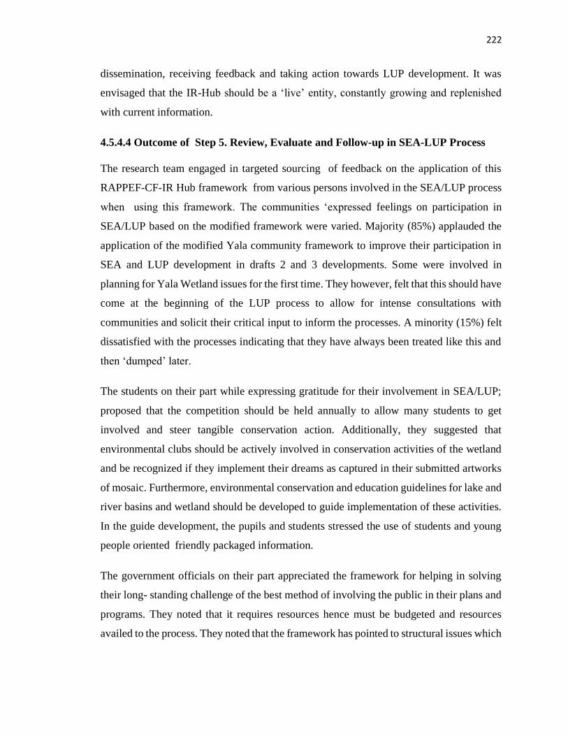
222
dissemination, receiving feedback and taking action towards LUP development. It was
envisaged that the IR-Hub should be a ‘live’ entity, constantly growing and replenished
with current information.
4.5.4.4 Outcome of Step 5. Review, Evaluate and Follow-up in SEA-LUP Process
The research team engaged in targeted sourcing of feedback on the application of this
RAPPEF-CF-IR Hub framework from various persons involved in the SEA/LUP process
when using this framework. The communities ‘expressed feelings on participation in
SEA/LUP based on the modified framework were varied. Majority (85%) applauded the
application of the modified Yala community framework to improve their participation in
SEA and LUP development in drafts 2 and 3 developments. Some were involved in
planning for Yala Wetland issues for the first time. They however, felt that this should have
come at the beginning of the LUP process to allow for intense consultations with
communities and solicit their critical input to inform the processes. A minority (15%) felt
dissatisfied with the processes indicating that they have always been treated like this and
then ‘dumped’ later.
The students on their part while expressing gratitude for their involvement in SEA/LUP;
proposed that the competition should be held annually to allow many students to get
involved and steer tangible conservation action. Additionally, they suggested that
environmental clubs should be actively involved in conservation activities of the wetland
and be recognized if they implement their dreams as captured in their submitted artworks
of mosaic. Furthermore, environmental conservation and education guidelines for lake and
river basins and wetland should be developed to guide implementation of these activities.
In the guide development, the pupils and students stressed the use of students and young
people oriented friendly packaged information.
The government officials on their part appreciated the framework for helping in solving
their long- standing challenge of the best method of involving the public in their plans and
programs. They noted that it requires resources hence must be budgeted and resources
availed to the process. They noted that the framework has pointed to structural issues which
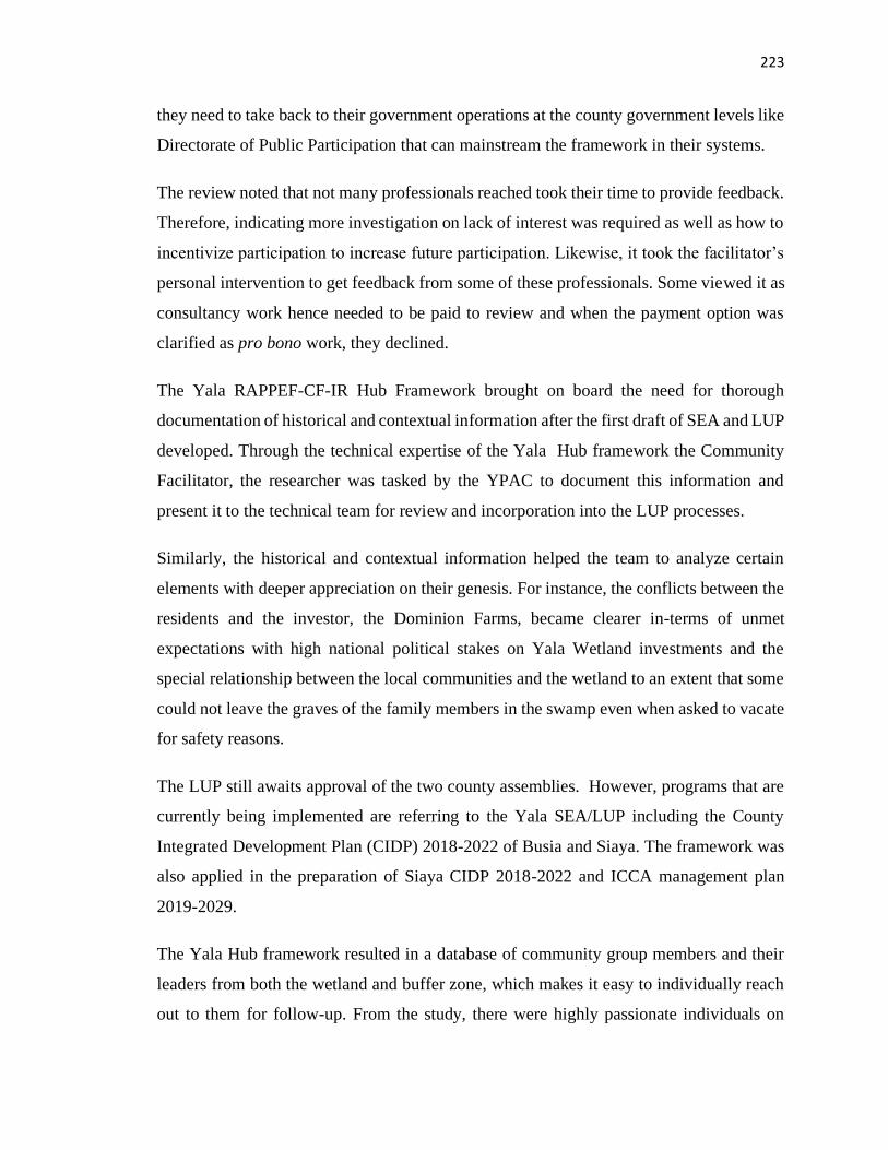
223
they need to take back to their government operations at the county government levels like
Directorate of Public Participation that can mainstream the framework in their systems.
The review noted that not many professionals reached took their time to provide feedback.
Therefore, indicating more investigation on lack of interest was required as well as how to
incentivize participation to increase future participation. Likewise, it took the facilitator’s
personal intervention to get feedback from some of these professionals. Some viewed it as
consultancy work hence needed to be paid to review and when the payment option was
clarified as pro bono work, they declined.
The Yala RAPPEF-CF-IR Hub Framework brought on board the need for thorough
documentation of historical and contextual information after the first draft of SEA and LUP
developed. Through the technical expertise of the Yala Hub framework the Community
Facilitator, the researcher was tasked by the YPAC to document this information and
present it to the technical team for review and incorporation into the LUP processes.
Similarly, the historical and contextual information helped the team to analyze certain
elements with deeper appreciation on their genesis. For instance, the conflicts between the
residents and the investor, the Dominion Farms, became clearer in-terms of unmet
expectations with high national political stakes on Yala Wetland investments and the
special relationship between the local communities and the wetland to an extent that some
could not leave the graves of the family members in the swamp even when asked to vacate
for safety reasons.
The LUP still awaits approval of the two county assemblies. However, programs that are
currently being implemented are referring to the Yala SEA/LUP including the County
Integrated Development Plan (CIDP) 2018-2022 of Busia and Siaya. The framework was
also applied in the preparation of Siaya CIDP 2018-2022 and ICCA management plan
2019-2029.
The Yala Hub framework resulted in a database of community group members and their
leaders from both the wetland and buffer zone, which makes it easy to individually reach
out to them for follow-up. From the study, there were highly passionate individuals on
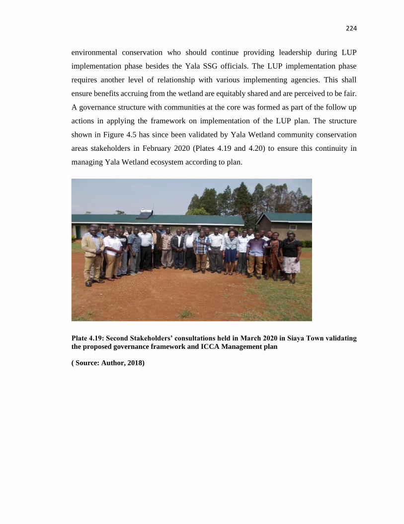
224
environmental conservation who should continue providing leadership during LUP
implementation phase besides the Yala SSG officials. The LUP implementation phase
requires another level of relationship with various implementing agencies. This shall
ensure benefits accruing from the wetland are equitably shared and are perceived to be fair.
A governance structure with communities at the core was formed as part of the follow up
actions in applying the framework on implementation of the LUP plan. The structure
shown in Figure 4.5 has since been validated by Yala Wetland community conservation
areas stakeholders in February 2020 (Plates 4.19 and 4.20) to ensure this continuity in
managing Yala Wetland ecosystem according to plan.
Plate 4.19: Second Stakeholders’ consultations held in March 2020 in Siaya Town validating
the proposed governance framework and ICCA Management plan
( Source: Author, 2018)
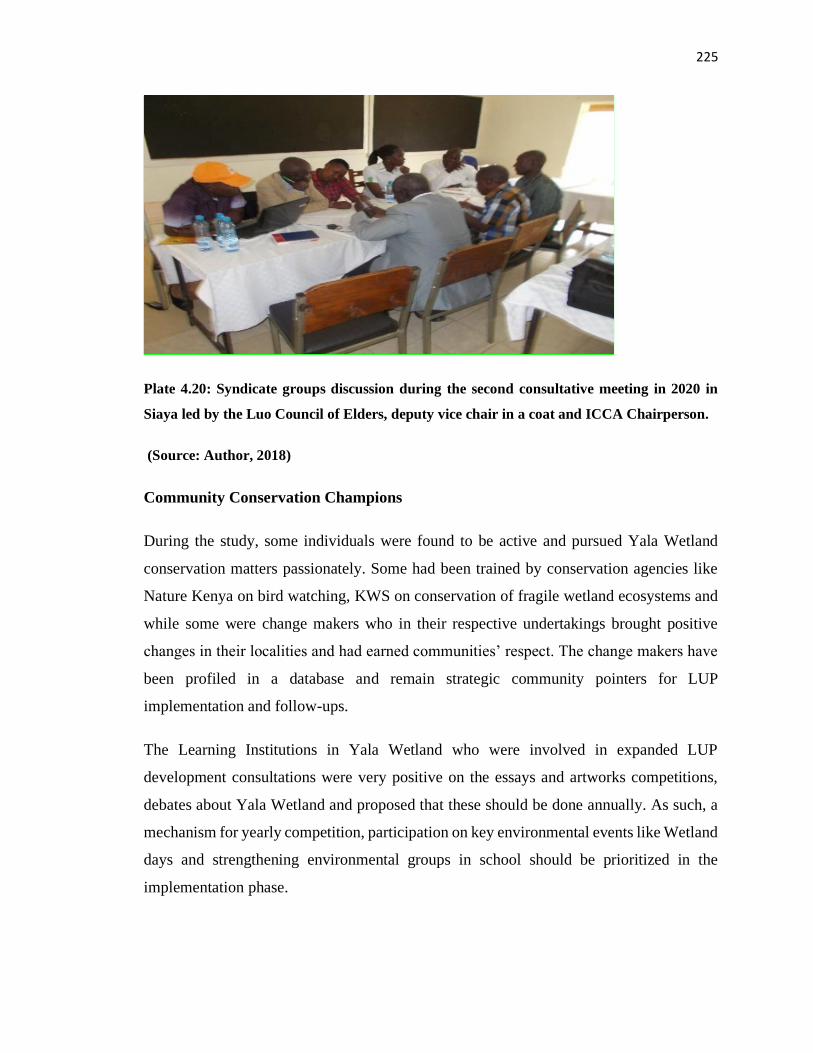
225
Plate 4.20: Syndicate groups discussion during the second consultative meeting in 2020 in
Siaya led by the Luo Council of Elders, deputy vice chair in a coat and ICCA Chairperson.
(Source: Author, 2018)
Community Conservation Champions
During the study, some individuals were found to be active and pursued Yala Wetland
conservation matters passionately. Some had been trained by conservation agencies like
Nature Kenya on bird watching, KWS on conservation of fragile wetland ecosystems and
while some were change makers who in their respective undertakings brought positive
changes in their localities and had earned communities’ respect. The change makers have
been profiled in a database and remain strategic community pointers for LUP
implementation and follow-ups.
The Learning Institutions in Yala Wetland who were involved in expanded LUP
development consultations were very positive on the essays and artworks competitions,
debates about Yala Wetland and proposed that these should be done annually. As such, a
mechanism for yearly competition, participation on key environmental events like Wetland
days and strengthening environmental groups in school should be prioritized in the
implementation phase.
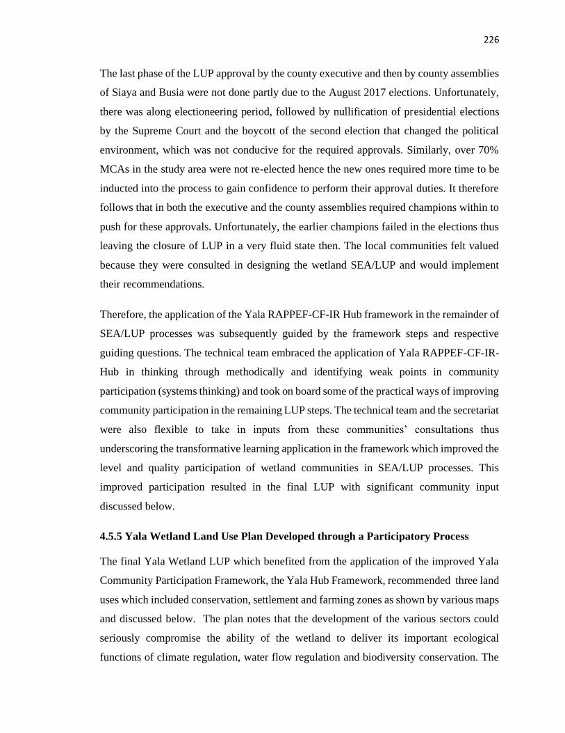
226
The last phase of the LUP approval by the county executive and then by county assemblies
of Siaya and Busia were not done partly due to the August 2017 elections. Unfortunately,
there was along electioneering period, followed by nullification of presidential elections
by the Supreme Court and the boycott of the second election that changed the political
environment, which was not conducive for the required approvals. Similarly, over 70%
MCAs in the study area were not re-elected hence the new ones required more time to be
inducted into the process to gain confidence to perform their approval duties. It therefore
follows that in both the executive and the county assemblies required champions within to
push for these approvals. Unfortunately, the earlier champions failed in the elections thus
leaving the closure of LUP in a very fluid state then. The local communities felt valued
because they were consulted in designing the wetland SEA/LUP and would implement
their recommendations.
Therefore, the application of the Yala RAPPEF-CF-IR Hub framework in the remainder of
SEA/LUP processes was subsequently guided by the framework steps and respective
guiding questions. The technical team embraced the application of Yala RAPPEF-CF-IR-
Hub in thinking through methodically and identifying weak points in community
participation (systems thinking) and took on board some of the practical ways of improving
community participation in the remaining LUP steps. The technical team and the secretariat
were also flexible to take in inputs from these communities’ consultations thus
underscoring the transformative learning application in the framework which improved the
level and quality participation of wetland communities in SEA/LUP processes. This
improved participation resulted in the final LUP with significant community input
discussed below.
4.5.5 Yala Wetland Land Use Plan Developed through a Participatory Process
The final Yala Wetland LUP which benefited from the application of the improved Yala
Community Participation Framework, the Yala Hub Framework, recommended three land
uses which included conservation, settlement and farming zones as shown by various maps
and discussed below. The plan notes that the development of the various sectors could
seriously compromise the ability of the wetland to deliver its important ecological
functions of climate regulation, water flow regulation and biodiversity conservation. The
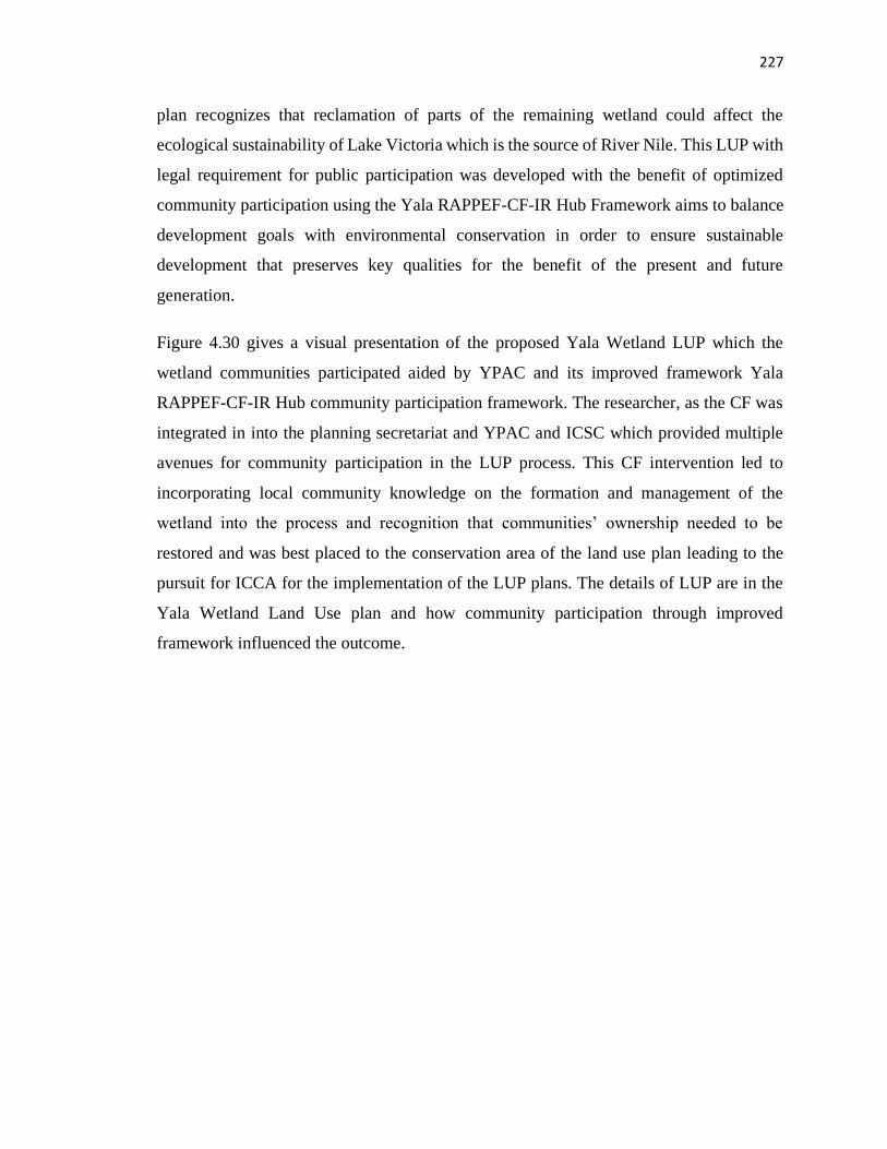
227
plan recognizes that reclamation of parts of the remaining wetland could affect the
ecological sustainability of Lake Victoria which is the source of River Nile. This LUP with
legal requirement for public participation was developed with the benefit of optimized
community participation using the Yala RAPPEF-CF-IR Hub Framework aims to balance
development goals with environmental conservation in order to ensure sustainable
development that preserves key qualities for the benefit of the present and future
generation.
Figure 4.30 gives a visual presentation of the proposed Yala Wetland LUP which the
wetland communities participated aided by YPAC and its improved framework Yala
RAPPEF-CF-IR Hub community participation framework. The researcher, as the CF was
integrated in into the planning secretariat and YPAC and ICSC which provided multiple
avenues for community participation in the LUP process. This CF intervention led to
incorporating local community knowledge on the formation and management of the
wetland into the process and recognition that communities’ ownership needed to be
restored and was best placed to the conservation area of the land use plan leading to the
pursuit for ICCA for the implementation of the LUP plans. The details of LUP are in the
Yala Wetland Land Use plan and how community participation through improved
framework influenced the outcome.
228
Figure 4.30: Yala Wetland Yala Land Use Plan – Recommended Land Uses
(Source : Odhengo et al., 2018b)
The main planning areas including the buffer and core were divided into the following
subzones:
i. Core zone (Wetland) includes Agricultural production areas, both subsistence and
commercial farming, Conservation areas (The river channels (corridors); riparian area,
Papyrus zones, Open water); scrub/woodland and human settlement
ii. Buffer zone includes the following subzones (Agriculture (commercial and subsistence);
Settlement (towns and villages); Industrial development; River corridors and channels, and
Public utilities.
The core planning area of Yala Wetland is about 20,756 ha (about 207 Km2). About 64%
of the wetland area is occupied by papyrus dominated vegetation while 11.5% and 9.4 %
229
of the wetland is under subsistence agricultural and large scale commercial agricultural
production respectively as shown in Figures 4.31 and 4.32. About 10% of Yala wetland
is covered by open water comprising of lakes Kanyaboli, Sare and Namboyo. Settlements
only occupy about 2% of the wetland.
Figure 4.31: Proportion of various Land Uses and Habitat Types within Yala Wetland Area
The following planning zones can be recognized in the wetland (the core planning area):
Settlements, Agricultural production land, Conservation areas (water corridors and riparian
zones, Permanently flooded area–papyrus areas, and Open waters) with their issues for
planning considerations.
4.5.5.1 Settlements Zone
A few human settlements are found within the wetland. However, it is expected that these
settlements will continue increasing as human population increase. These settlements lack
basic social infrastructure including access to schools and health facilities. Transport is also
a major challenge. Other issues include high incidences of diseases including malaria and
water borne diseases because of poor sanitation.
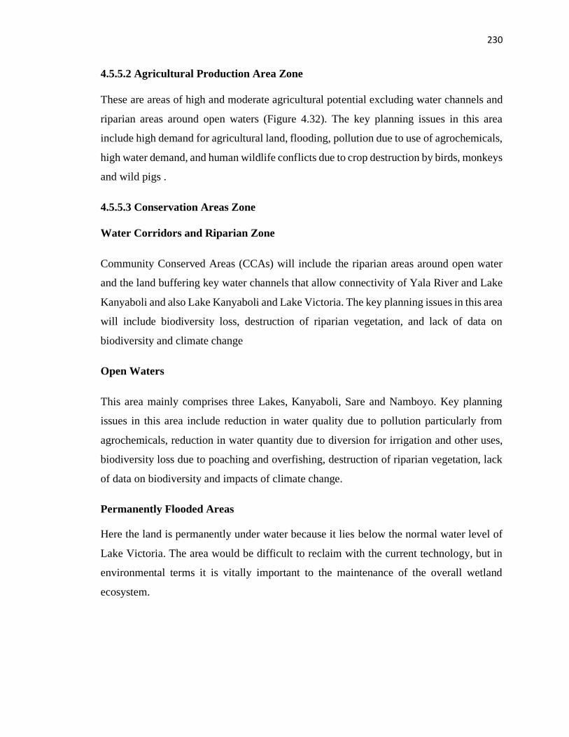
230
4.5.5.2 Agricultural Production Area Zone
These are areas of high and moderate agricultural potential excluding water channels and
riparian areas around open waters (Figure 4.32). The key planning issues in this area
include high demand for agricultural land, flooding, pollution due to use of agrochemicals,
high water demand, and human wildlife conflicts due to crop destruction by birds, monkeys
and wild pigs .
4.5.5.3 Conservation Areas Zone
Water Corridors and Riparian Zone
Community Conserved Areas (CCAs) will include the riparian areas around open water
and the land buffering key water channels that allow connectivity of Yala River and Lake
Kanyaboli and also Lake Kanyaboli and Lake Victoria. The key planning issues in this area
will include biodiversity loss, destruction of riparian vegetation, and lack of data on
biodiversity and climate change
Open Waters
This area mainly comprises three Lakes, Kanyaboli, Sare and Namboyo. Key planning
issues in this area include reduction in water quality due to pollution particularly from
agrochemicals, reduction in water quantity due to diversion for irrigation and other uses,
biodiversity loss due to poaching and overfishing, destruction of riparian vegetation, lack
of data on biodiversity and impacts of climate change.
Permanently Flooded Areas
Here the land is permanently under water because it lies below the normal water level of
Lake Victoria. The area would be difficult to reclaim with the current technology, but in
environmental terms it is vitally important to the maintenance of the overall wetland
ecosystem.
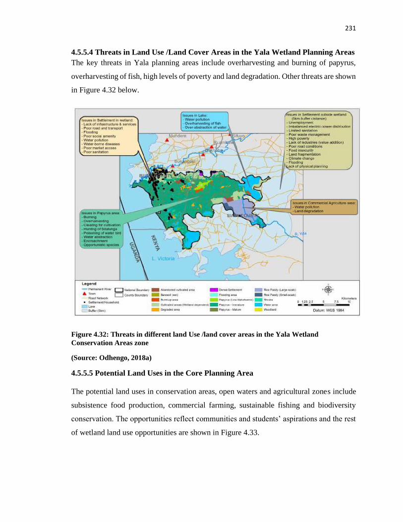
231
4.5.5.4 Threats in Land Use /Land Cover Areas in the Yala Wetland Planning Areas
The key threats in Yala planning areas include overharvesting and burning of papyrus,
overharvesting of fish, high levels of poverty and land degradation. Other threats are shown
in Figure 4.32 below.
Figure 4.32: Threats in different land Use /land cover areas in the Yala Wetland
Conservation Areas zone
(Source: Odhengo, 2018a)
4.5.5.5 Potential Land Uses in the Core Planning Area
The potential land uses in conservation areas, open waters and agricultural zones include
subsistence food production, commercial farming, sustainable fishing and biodiversity
conservation. The opportunities reflect communities and students’ aspirations and the rest
of wetland land use opportunities are shown in Figure 4.33.
232
Figure 4.33: Potential Land Uses in Yala Wetland Planning Zones
( Source: Odhengo, 2018a)
DEPLOYMENT OF THE FRAMEWORK
4.5.6 Deployment of the Yala RAPPEF–CF-IR Hub Framework to Siaya County
Integrated Development Plan (CIDP) 2018-2022
4.5.6.1 Application of the Yala RAPPEF–CF-IR Hub Framework to Siaya CIDP
The County Government Act (2012) provides for development of a County Integrated
Development Planning (CIDP) in a participatory manner. Whereas this is a constitutional
requirement, Siaya County government had been grappling with how best to conduct this
besides including it in the budgeting process where the County staff faced many challenges
including being chased away by citizens. During the development of the CIDP 2018-2022
233
from September 2017 to April 2018, the Yala RAPPEF-CF-IR Hub framework for
optimizing community participation was however, applied in CIDP development process
starting with step 1.
Step 1. React/Act
The researcher joined the process as the lead mentor to the County government to provide
technical skills and build their capacity for County Integrated Development Planning as
component of Public Expenditure Management (PEM) Cycle. This process had started
earlier and even generated draft one of CIDP 2018-2022 by November 2017. In providing
technical assistance, the researcher as the Process Facilitator reviewed the processes that
had taken place up until then. It was found that the process had a technically skewed
membership of CIDP secretariat and departmental technical specialists. They had reviewed
previous plans, generated sector plans like Environment, Agriculture, Health, Lands,
Education, Trade and Industries which touched on conservation and utilization of Yala
Wetland resources.
The researcher applied the stakeholder analysis tier two of Yala Hub Framework which
identified the following as missing or underrepresented: students, professionals both from
within and outside the county, and members of the county who were in the diaspora. The
later eventually organized themselves and their submissions were considered as inputs
from the diaspora ward number 31 given that the county has only 30 wards.
The team conducted public participation for the County Fiscal Strategy Paper (CFSP) and
Budgeting process only to meet legal compliance as per the Public Finance Management
Act (PFM) (2016) section 52. In the first generation of CIDP 2013-2017 the team did not
conduct public participation citing time pressure to deliver the plan to enable the national
government to release funds to counties to start operationalizing devolved governance
units. Thus, the CIDP secretariat, where the researcher mentored the team, agreed to
conduct public participation by applying Yala Community Participation Framework to
improve the quality of the participation in the remainder of the CIDP process.
234
Thus, from the analysis of how the county had done public participation for CFSP and
Budgeting processes; it was determined that improving community participation would
require broadening representation at the planning secretariat, the departments, wards and
village levels, and the non-governmental agencies working within the county. It further
needed good linkage with the national government to ensure compliance and to benefit
from lessons learnt from the first generation of CIDP planning cycle.
Step 2. Restructure/Adjust the Participation Framework based on the feedback from
reaction step 1 on improved framework
Informed by the above analysis, the CIDP secretariat improved the consultation
framework. The stakeholder’s analysis tier two was done at the public participation training
of trainers targeting ward administrators, technical staff, sub-county administrators and
representatives of civil society to prepare them for the task. Each ward mapped out their
own stakeholders with respect to the planning functions expected for generating an
integrated county plan, required resources and their sources.
Among the stakeholders left out initially but second level of identification brought on the
fore included: Motor cycle operators of boda boda; supporters of leaders who lost in the
general election of August 2017; people who were not in groups such as older persons in
the society; students in schools; and county residents who were out of the county and
country.
Step 3. Participation Preparations
This entailed preparing draft document arising from plans from various county sector and
departmental plans; previous CIDP reviews and peer reviews inputs. The CIDP
development facilitators at the ward level were trained on CIDP planning process;
facilitation skills, data collection and processing, documentation.
The team identified facilitators from county government departments, CIDP secretariat and
non-state actors. The ward administrators with the help of the CIDP secretariat, subject
matter specialists and non-state actors managed the participation processes at each ward
235
level. The facilitators received a two-day training of training of facilitators (TOF) to
familiarize them with the new approach to county planning as reflected in Plate 4.21.
The content of the training included: Understanding the County Integrated Planning
Processes; Review of 2013-2017 CIDP at ward levels; Why Public Participation? Public
Participation Data Collection Tools involving Stakeholder mapping and analysis, Problem
Analysis using the problem tree tool, Appreciative Inquiry, the Opportunity Tree; Group
work and simulation; Facilitation skills for public fora; Ward based Action planning and
development of a road map for public participation.
The County Secretary (CS) challenged the TOF trainees about the lack of money
mindset, stating that it was a hindrance to creativity in planning and implementation, “It
is a good thing to plan when you are broke” while the County Executive Committee
Member (CECM) of finance spelt out his expectation as “Siaya County needs to come up
with a bankable CIDP”.
Plate 4.21: Stakeholder mapping and analysis tool simulation session by trainees during
TOF on public participation for CIDP development
( Source: Author, 2018)
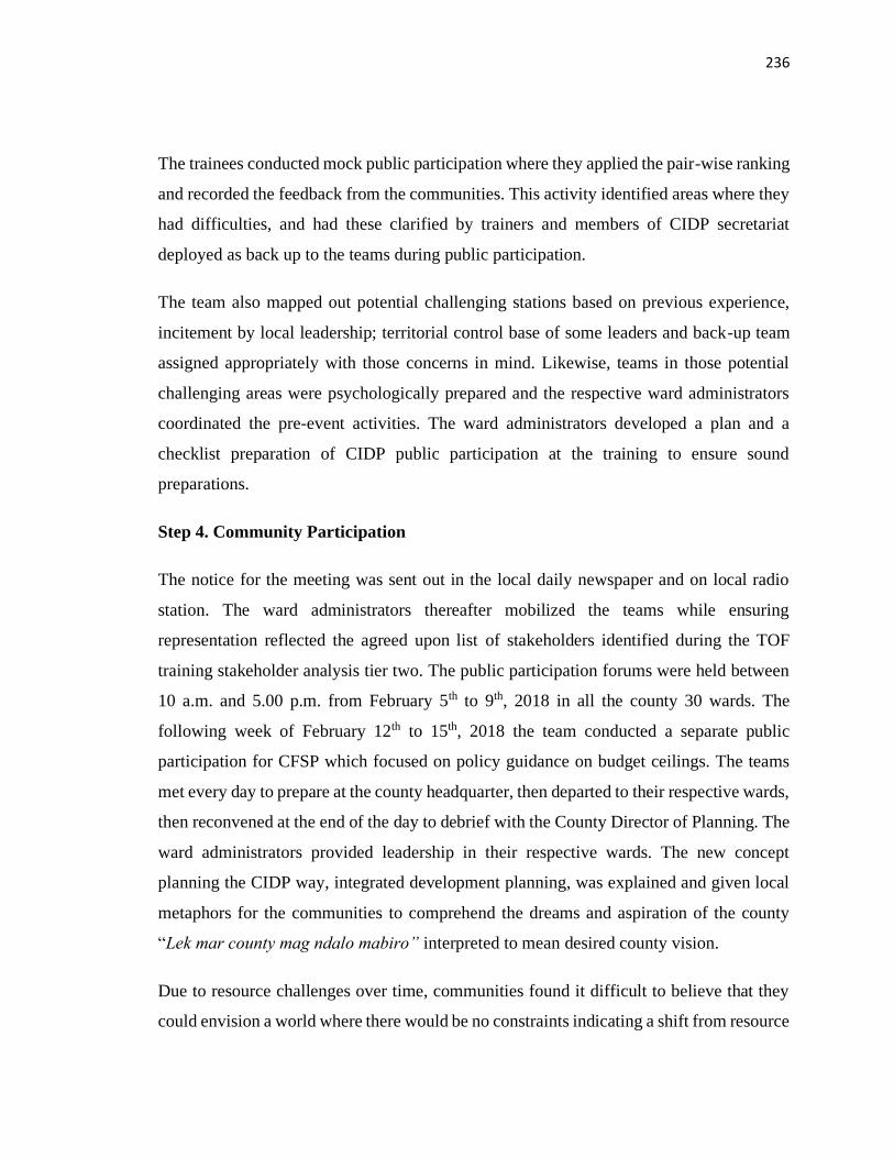
236
The trainees conducted mock public participation where they applied the pair-wise ranking
and recorded the feedback from the communities. This activity identified areas where they
had difficulties, and had these clarified by trainers and members of CIDP secretariat
deployed as back up to the teams during public participation.
The team also mapped out potential challenging stations based on previous experience,
incitement by local leadership; territorial control base of some leaders and back-up team
assigned appropriately with those concerns in mind. Likewise, teams in those potential
challenging areas were psychologically prepared and the respective ward administrators
coordinated the pre-event activities. The ward administrators developed a plan and a
checklist preparation of CIDP public participation at the training to ensure sound
preparations.
Step 4. Community Participation
The notice for the meeting was sent out in the local daily newspaper and on local radio
station. The ward administrators thereafter mobilized the teams while ensuring
representation reflected the agreed upon list of stakeholders identified during the TOF
training stakeholder analysis tier two. The public participation forums were held between
10 a.m. and 5.00 p.m. from February 5th to 9th, 2018 in all the county 30 wards. The
following week of February 12th to 15th, 2018 the team conducted a separate public
participation for CFSP which focused on policy guidance on budget ceilings. The teams
met every day to prepare at the county headquarter, then departed to their respective wards,
then reconvened at the end of the day to debrief with the County Director of Planning. The
ward administrators provided leadership in their respective wards. The new concept
planning the CIDP way, integrated development planning, was explained and given local
metaphors for the communities to comprehend the dreams and aspiration of the county
“Lek mar county mag ndalo mabiro” interpreted to mean desired county vision.
Due to resource challenges over time, communities found it difficult to believe that they
could envision a world where there would be no constraints indicating a shift from resource
237
constraint mindset to resource abundance mindset. Interestingly, some community
meetings within the wetland were able to present issues they presented during SEA/LUP
meetings like expanding the fishing industry, protection of Yala Wetland while deriving
benefits from the swamp, co-management of wetland resources with government agencies,
fear of the wetland being taken by the government as a protected area thereby allowing
only limited community access to its benefits.
In one ward, the local communities and their MCA warned the CIDP public participation
team by stating their pre-conditions for participation. Firstly, that they would participate
only if the facilitators guaranteed that discussion from the communities will be taken
seriously. Secondly, that they would not be rushed but rather take the meeting to its logical
conclusion. When the meeting started, they stated that they had been mobilized for budget
presentation and not CIDP hence they will have to go back and prepare for the CIDP
meeting on a later date. With a bit of persuasion and through the intervention of local
communities who understood and thus explained new form planning; and with the respect
they had for the local chief, the communities agreed to proceed with the meeting.
The communities engaged in prioritisation of their issues using pair wise ranking tool
(Figure 4.34) and appreciated how different choices coalesce to give priority having taken
everybody’s opinion on board without conflicts. They also identified transformative
projects in the County’s 10 departments as per the Executive Order No 1 of 2017(County
Government of Siaya, 2017).
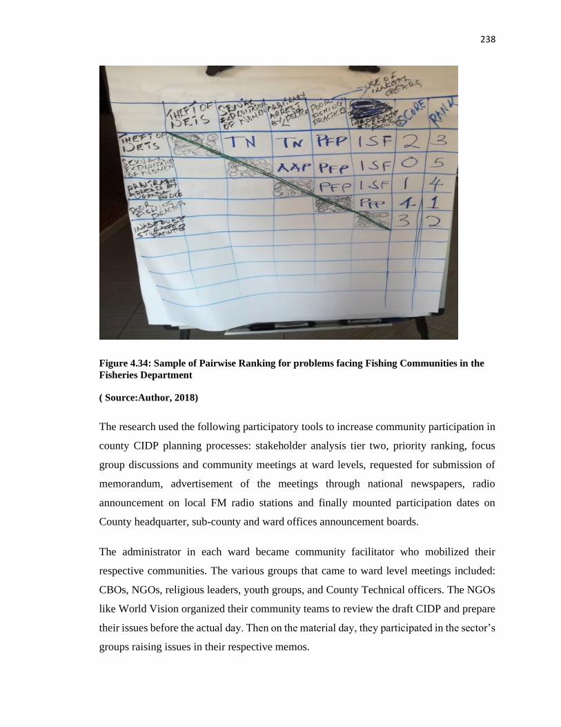
238
Figure 4.34: Sample of Pairwise Ranking for problems facing Fishing Communities in the
Fisheries Department
( Source:Author, 2018)
The research used the following participatory tools to increase community participation in
county CIDP planning processes: stakeholder analysis tier two, priority ranking, focus
group discussions and community meetings at ward levels, requested for submission of
memorandum, advertisement of the meetings through national newspapers, radio
announcement on local FM radio stations and finally mounted participation dates on
County headquarter, sub-county and ward offices announcement boards.
The administrator in each ward became community facilitator who mobilized their
respective communities. The various groups that came to ward level meetings included:
CBOs, NGOs, religious leaders, youth groups, and County Technical officers. The NGOs
like World Vision organized their community teams to review the draft CIDP and prepare
their issues before the actual day. Then on the material day, they participated in the sector’s
groups raising issues in their respective memos.
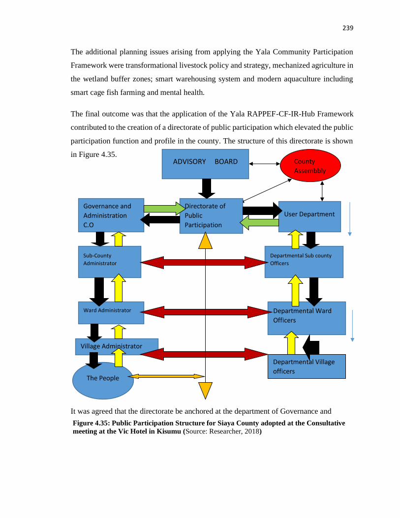
239
The additional planning issues arising from applying the Yala Community Participation
Framework were transformational livestock policy and strategy, mechanized agriculture in
the wetland buffer zones; smart warehousing system and modern aquaculture including
smart cage fish farming and mental health.
The final outcome was that the application of the Yala RAPPEF-CF-IR-Hub Framework
contributed to the creation of a directorate of public participation which elevated the public
participation function and profile in the county. The structure of this directorate is shown
in Figure 4.35.
It was agreed that the directorate be anchored at the department of Governance and
It was agreed that the directorate be anchored at the department of Governance a
Village Administrator
Departmental Ward
Officers
ADVISORY BOARD
Directorate of
Public
Participation
Governance and
Administration
C.O
Sub-County
Administrator
Ward Administrator
The People
User Department
Departmental Sub county
Officers
Departmental Village
officers
County
Assembbly
Figure 4.35: Public Participation Structure for Siaya County adopted at the Consultative
meeting at the Vic Hotel in Kisumu (Source: Researcher, 2018)
240
Secondly, the framework provided for consultation at village level with village
administrators to deepen the level of consultation. Thirdly, the structure comprises of
county employees and non-government employees to ensure diversity in membership as
well as provide mechanism for mutual accountability among the citizens and the county
government.
Community Facilitator Support
A key element of Yala RAPPEF-CF-IR HUB framework was to have a dedicated
community facilitator who seizes the concerns of local communities in planning
processes. The CF provides a safe environment of trust and mutual respect for participation.
In the CIDP this function was done by the lead mentor for CIDP process who was also
researcher in SEA/LUP and his assistants. As discussed earlier, the researcher was native
of Siaya County, Planner and Environmentalist and had access to decision makers on short
notice such as some the CECs and CCOs, Directors and development partners based on the
rapport built while undertaking Yala Wetland research. The American Government
through USAID/AHADI gave some leverage in accessing top leadership. The CF as the
lead mentor was key in finalizing the CIDP with views from the expanded stakeholders
brought on the planning process.
The Information Resources Hub (IR- Hub)
The researcher used information resources from the mentoring toolkit available for mentors
who were supporting Kenya Devolution Support Programme and personal information
resources relevant for mentoring demands of the county. Mentoring toolkit and information
resources held on the cloud (dropbox for easy access at all times:
https://www.dropbox.com/sh/4ji6ldfqsvuchhz/AAAS-P4t71rl-Q0vWju3Zanxa?dl=0).
The information and tools contained in the mentoring toolkit were mainly: The
Constitution of Kenya 2010; Devolution policy, CIDP guidelines, CIDP review, Planning
tools, Sector Planning Process, Sector working groups, Public participation toolkit, Sector
Tool for Climate change and Disaster Risk Screening, Gender and Climate Change, Rapid
Results Initiative. This IR- HUB was very useful during the plan development and
241
implementation phase of the plan. The facilitating team updated this with new resources
and lessons learnt in the process of executing the task.
Step 5. Review and Evaluation: Participants feedback about participation
The preparation TOF for Public participation was evaluated and feedback used to finetune
planning processes by the ward administrators. Some of the feedback about the training
include: “Complaints might not be the issue but how to turn them into something positive”
a member of CIDP secretariat and subcounty administrator.
The ward level consultations were done for five days. They involved mobilization of
communities by announcements through vernacular FM radios on Mayienga and Ramogi
FM Radio stations; word of mouth by the ward administrators; chiefs and their assistants
at local community meetings (barazas). Participants said the consultations made them feel
like co-owners of the CIDP plan hence would actively participate in plans’ implementation.
The following quotations capture their feedback on application of the framework from all
the 30 wards based on draft CIDP:
“There is need to establish the County Budget and Economic Forum to facilitate public
participation, have a comprehensive civic education in relation to key policy documents
and the departments should take the process very seriously to facilitate early release of the
technical staff”.
“There should be adequate funds which should be set aside for the public participation
process while public participation forms and language should be simplified”.
“The county should use the bottom-up approach that is from the village-Ward, Sub-County
then finish at the County level for the PP process with more time allocated to the PP process
not just one day”.
“Comprehensive M&E should be done and given a true picture on the ground while there
should be a feedback mechanism back to the public and periodic oversight on the
implementation of CIDP”.
242
“Commercialization of agriculture has not been factored in and internal issues within
Agriculture should be addressed urgently”
“What lessons have been learnt from the current irrigation systems”.
“Some major flagship projects may have been left out yet they are very political and they
include Fish Processing factory in Ratiya, Dominion Farms after the Mzungu left and the
cold storage structures in Usenge and Wichlum being underutilized”.
“The cover page should have a collage of more transformative pictures that will show what
Siaya would look like in 2022”.
“Public Service was not subjected to Public Participation”.
“Public and Community land missing in the CIDP and the theme of Research and
Development that would transform the County through Research Development”.
Despite some of these positive feedbacks, some citizens did not trust that the county
government was genuine in seeking their views as expressed by some community
members. While conducting CFSP public participation in West Ugenya a ward
administrator was insulted by a member of the public who said “Tunajua unatafuta per
diem, ndara ma ugero no, iko kwa tumbo yako” meaning “we know you are looking for
per diem and allowances, the road you purport you want to build is in your stomach”. This
clearly underscores the mistrust the communities had on the ward administrator and the
county government officials conducting community consultations on government plans
and budgeting process.
Some feedback from professionals and county citizens from the diaspora are captured in
the quotation below.
“The CIDP is well written and provides sufficient information which if implemented can
give the County a proper take-off. However, a document of this nature is worthless unless
the Siaya executive and legislature can internalize and implement it. So far, the executive
in Siaya has been relatively inert, now six years down the road. One key observation is the
lack of recognition of possible roles of Professionals from the County who are both retired
243
and active in backing up the implementation of the plan, be it formally or informally.
Similarly, the County people in the Diaspora and their possible involvement is lacking in
the proposal. You need to look at other County’s CIDPs and see how they have addressed
these resources. Finally, there is need to link the CIDP with Agenda four of the current
government. Development is politically driven and Siaya county must see itself as a
microcosm of the Kenya nation in development” a professor of agriculture and rural
development at a Kenyan public university.
Further challenges identified while using Yala Community Participation Framework
include:
The members of county assembly requested for documentation of public participation
feedback from their respective wards as evidence to countercheck the final CIDP during
the second County Assembly training on CIDP Scrutiny, Budget and Approvals held in
Kisumu. The mentor availed the excel sheets where the feedback was captured as well as
gave them an overview of the CIDP process and content as part of the training delivered
by AHADI and Centre for Parliamentary Studies and Training (CPST).
The public consultation mechanism was designed to serve the CIDP development but was
not institutionalized for other development interventions since there was no directorate
with staff to continue public participation processes.
The two-day TOF training for public participation was inadequate for course content and
practicum required for facilitators.
There were logistical challenges particularly limited and late release of vehicles to take the
secretariat teams to public participation sites, inadequate stationary for facilitators,
inadequate funding to facilitate the processes such as staff allowances, mobilization of
residents to attend, and refreshments while in attendance as some sessions started at 10.00
a.m. up to 4.00p.m.
The forms provided for use were not simple for public use especially on prioritization on
issues.

244
There was a superiority complex associated with power conflicts between the Executive
and the County Assembly played out in the field and thereby derailed the process in some
areas as the citizens demanded that their MCAs must be present for the process to continue.
The absence of Project Management Committees (PMCs) finance made this structure
nonfunctional resulting into lack of community participation in project implementation and
subsequently high rate on uncompleted projects.
Finally, there was outright hostility towards some county staff based on previous unfilled
promises by the same staff thereby delaying the process which called for use of conflict
resolution skills and mindsets among the facilitation team.
4.5.6.2 Outcomes of deploying the Yala RAPPEF-CF-IR Hub Framework on CIDP
Development
The application of the Yala RAPPEF-CF-IR Hub Framework on CIDP development
brought out the following lessons to improve this process in future. First, the local
communities appreciated their involvement in the developmental processes of their county
and asked that similar intense and facilitative consultations should continue going forward.
Second, on language used in the public participation, the data collection forms were not
user friendly to communities, therefore required simplification and use of multiple
communication channels for mobilization including “pavement” radios for older
generation and social media platform for the younger generation.
Third, the community had very high expectations of devolution outcomes and had
unrealistic timelines for achieving these.
Fourth, given the various conflicts the team had to deal with, it would have been
appropriate for the training contents to include conflict resolution and risk management
and mindsets. Meaningful public participation per se is a way of resolving conflicts on
projects, programs and policies as concerns raised are addressed.
The outcomes showed ways of improving public participation for CIDP development using
RAPPEF-CF-IR Hub Framework needs to consider and frame the 5-steps guiding or
245
coaching questions; adapt the Community Facilitator and Information Resource Hub to
reflect these:
First, provision of continuous comprehensive civic education in relation to key government
policy documents; technical staff availability as part of public participation support team,
language simplification in data capture and use of participatory tools, availing resources
for undertaking public participation, allocating adequate time for the process rather than
being a one-day affair, growth mindsets, embedding consultation in day-to-day
development activities of the communities at village levels.
Second, using the inverted pyramid model for participation. This entails using the bottom-
up approach that is from the village with more consultation from projects or services
innovation conceptualization, prioritisation and implementation. Then proceed to ward,
sub-county then finish at the county level with public participation process with a clear
feedback and accountability mechanism to the public. This has been embedded in the
directorate of public participation structure.
Third, the lower level consultations at village level with community organizations require
support of a community facilitator who would take lead to relate with various stakeholders
taking part in the development consultations.
Fourth, the community facilitator has to meet some predetermined criteria and for Siaya
County this included: must be someone the community respects, trust and has the power to
engage with at all stages and structures of CIDP development, mainly heads of two arms
of county government. In addition, good networking and advocacy capabilities with
development partners, national government and the business community. For example, it
took the facilitator’s professional reputation to negotiate with the hotel to avail the facility
for the team for one more day at no cost to the county government nor the development
partner.
Fifth, Information Resources Hub to aid CIDP preparation process entailed availing the
previous CIDP 2013-2017 documents and related implementation reports, guidelines from
national government, some case studies of what worked well with devolution; challenges,
246
lessons and access to technical resources for CIDP secretariat, and updated county data.
The researcher had a mentoring toolkit developed by AHADI to support devolution and
mentors’ own network in 22 counties in Kenya who provided additional resources.
Sixth, use appropriate participatory methodologies including the ones that are emotionally
intelligent. These included trainings and guidance for various stages of CIDP development
that were packed with materials, coaching with emotional intelligence, empathy walks with
communities, living with the people in total immersion, previous experience, and societal
structures to get people-issues very deeply and infuse creativity in the process.
4.5.7 Application of the Yala RAPPEF–CF-IR Hub Framework to Indigenous
Community Conservation Area Management Plan Development and
Implementation
4.5.7.1 Introduction and Overview
The LUP recommended land use on Conservation areas zone A requires a management
plan. The wetland communities through the leadership of Yala Swamp ICCA Management
Committee developed a 10-year management plan. This ICCA plan seeks to ensure a
balance between socio-economic development and environmental conservation in order to
secure the livelihoods of the residents of Yala Wetland ICCA members, other people and
entities that directly and indirectly benefit from the wetland.
4.5.7.2 ICCA Development and Use of Yala Hub Framework
ICCA management plan development process begin in February 2018 with review of all
available literature on the conservancy, gathering spatial data/Remote sensing and
Geographical Information System (GIS), community spatial information (community
maps, artworks), historical and contextual information, indigenous knowledge on
conservation of Yala Wetland.
The next steps that followed were first stakeholder meeting held in February 2018, a
second stakeholder meeting in March 2020 (Plate 4.22); community level meetings 2018-
2019, Community validation meeting in November 2020 and technical team (government
technical officers from Siaya and Busia consultations in November 2020 (Plate 4.23 ).
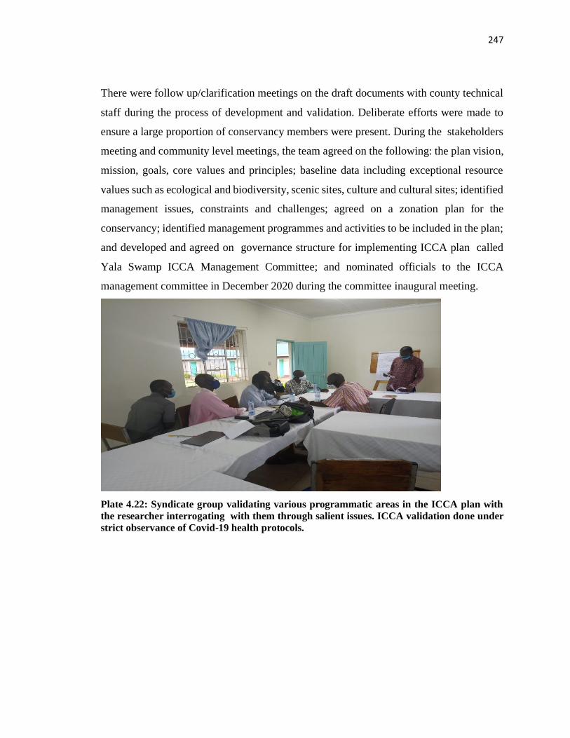
247
There were follow up/clarification meetings on the draft documents with county technical
staff during the process of development and validation. Deliberate efforts were made to
ensure a large proportion of conservancy members were present. During the stakeholders
meeting and community level meetings, the team agreed on the following: the plan vision,
mission, goals, core values and principles; baseline data including exceptional resource
values such as ecological and biodiversity, scenic sites, culture and cultural sites; identified
management issues, constraints and challenges; agreed on a zonation plan for the
conservancy; identified management programmes and activities to be included in the plan;
and developed and agreed on governance structure for implementing ICCA plan called
Yala Swamp ICCA Management Committee; and nominated officials to the ICCA
management committee in December 2020 during the committee inaugural meeting.
Plate 4.22: Syndicate group validating various programmatic areas in the ICCA plan with
the researcher interrogating with them through salient issues. ICCA validation done under
strict observance of Covid-19 health protocols.
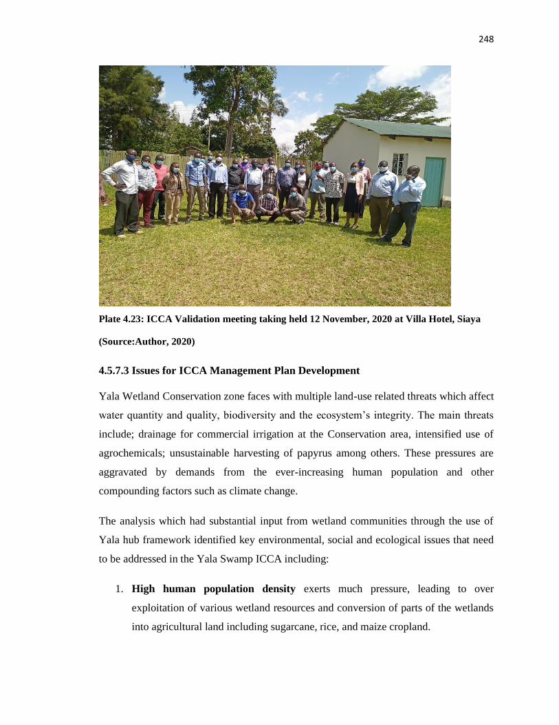
248
Plate 4.23: ICCA Validation meeting taking held 12 November, 2020 at Villa Hotel, Siaya
(Source:Author, 2020)
4.5.7.3 Issues for ICCA Management Plan Development
Yala Wetland Conservation zone faces with multiple land-use related threats which affect
water quantity and quality, biodiversity and the ecosystem’s integrity. The main threats
include; drainage for commercial irrigation at the Conservation area, intensified use of
agrochemicals; unsustainable harvesting of papyrus among others. These pressures are
aggravated by demands from the ever-increasing human population and other
compounding factors such as climate change.
The analysis which had substantial input from wetland communities through the use of
Yala hub framework identified key environmental, social and ecological issues that need
to be addressed in the Yala Swamp ICCA including:
1. High human population density exerts much pressure, leading to over
exploitation of various wetland resources and conversion of parts of the wetlands
into agricultural land including sugarcane, rice, and maize cropland.
249
2. Poverty and associated inequalities: According to the Welfare Monitoring
Survey of 1994 and the National Poverty Eradication Plan 1999 – 2015), by 1994,
Siaya and Bondo were ranked among the 10 poorest districts (based on total
expenditure on food and non-food requirements). Yala Wetland area is further
aggravated by having only major source of income as subsistence farming despite
the abundant irrigation potential in the area. Besides, the existing schools in wetland
area lack educational facilities and has a high dropout rate among primary school
students, particularly among the girls; health centres lack basic facilities such as
water, drugs, diagnostic equipment and trained staff; Yala and Nzoia rivers heavy
silt loads contaminate water resulting in high incidences of water borne diseases
(Heukelom, 2011). Yet the poverty-environment nexus is well documented (e.g.
UNEP, 2005; SOE, 2010) and has resulted it in conflicts over wetland resources
and use that local communities over depend on.
3. Alien invasive Species: The Water Hyacinth Eichhornia crassipes continue to
cover the open waters in Lake Victoria (Johnston and Githongo, 1997) and also
Yala Wetland. The introduction of the non-native predatory fish, Nile perch (Lates
niloticus) in Lake Victoria has led to decline of several native Cichlid fishes.
4. Biodiversity Loss: The major threats to Yala Wetland that affect biodiversity
include: pressure caused by high population densities on its edges, over-harvesting
of papyrus for thatching and making products such as mats and baskets, clearing of
papyrus beds for agriculture by the local people rendering them less suitable for
birds, grazing ground for cattle at times of drought. Illegal fishing methods poses a
danger of extinction especially to the two endemic species Oreochromis variabilis
and O. esculentus found only in Lake Kanyaboli.
5. Water pollution through run-off from the upper catchment of the basin with
fertilizer, agro-chemicals and industrial waste (from factories that discharge
directly into the river) lead to eutrophication and affects fish, amphibians, birds etc.
at the swamp.
6. Air Pollution through aerial chemical spraying at rice farms
250
7. Soil erosion and siltation caused by flooding: Poor farming practices and
deforestation on the upper Yala River catchment area has led to heavy siltation in
the rivers and the silt is eventually deposited in the wetland.
8. High incidence of poverty: most residents of Yala Wetland rely entirely on the
wetland and papyrus in particular for their livelihoods.
9. Flooding leads to excessive siltation which causes loss of wetland area and is a
major cause of food insecurity and poverty as it destroys crops, washes away houses
and shrinks grazing and farming areas
10. Burning of Papyrus: During the dry season, much of the papyrus are destroyed by
burning. In the burnt and grazed areas, dry papyrus rhizomes and culms are
collected as fuelwood. The burning causes degradation of wetland vegetation,
resulting in the loss of biodiversity, fish breeding grounds, bird habitats and
livelihoods.
11. Persistent and prolonged drought: leads to food and water shortages (GoK,
2002a) forcing people to invade the wetlands for farming and grazing.
12. Wetland reclamation and encroachment: Increased human population has led to
intensified agricultural activities leading to reclamation of papyrus wetland hence
land cover change. The growing interests for Yala resources particularly land from
large scale investors threaten its sustainability. Often decisions on land allocations
are taken without good knowledge of the capacity of the wetland to accommodate
new developments and on the potential impacts on the environment and society.
Weak frameworks for stakeholder participation like the local communities have
created suspicion and tension among various interest groups. Other challenges
include the impacts of the proposed dams upstream, declining water levels, soil
erosion and silting of the dams and water pans, as well as low agricultural
productivity.
13. Lack of sound documentation and uptake of indigenous knowledge in biodiversity
conservation.
14. Inadequate harmonization between policies across sectors on environmental
conservation and management in the Yala wetland ecosystem
251
4.5.7.4 The Core of ICCA Management Plan
The 14 issues identified above through SEA/LUP processes, community consultations,
community maps, community meetings, schools, key informant interviews, consultation
with government agencies and validation of 3 drafts with communities and technical
validation by government technical team formed the basis for the following five
programmes:
Programme one: Governance and Conservancy operations which includes Environmental
governance and Environmental conservation education.
Programme two: Food and Nutritional Security which entails Fisheries, Limited Crop
production in the islands and Controlled Livestock Access through access to grazing lands
during drought and controlled livestock keeping and grazing.
Programme three: Wildlife, Water and habitat conservation and management. This
includes Wild animals, Water, Papyrus and Waste management.
Programme four: Socio–Economic Development including Tourism and recreation,
Beekeeping/aquaculture, Carbon trading, Wildlife utilization and other Conservation
enterprises
Programme five: Resource Mobilization Programme from various sources including
National and County Government Resources; Payment for Ecosystem Services, Yala
Swamp Community Conservation Fund, Private sector partnerships, Development
partners, High networth individuals/Conservation Friends of Yala ICCA, Equitable benefit
sharing mechanism from investments on Yala Wetland.
The issues from community maps and other community level consultations have been
factored in the five programmes such as access to shrines and cultural places within the
wetland, access to grazing designated zones during dry seasons, equitable benefit sharing
of wetland natural resources and controlled farming for the island communities.
Contributions from learning institutions such schools’ artwork, essays, songs and debate
themes on what they envision for Yala wetland in 2063 in line with Africa Union’s Vision
for the Africa we want.
252
4.5.7.5 The Governance ICCA
The ICCA management committee presented in section 4.28 and illustrated in Figure 4.5
has an implementation secretariat heading with Community Facilitator and Information
Resources Hub. The hub will seek to document indigenous knowledge of Yala wetland and
community spatial information generated during this study and seek to integrate with other
planning and management information for sensitive ecosystem like Yala Wetland.
253
CHAPTER FIVE
DISCUSSIONS
5.1 Introduction
The chapter discusses the results of the study in relation to both the theoretical
fundamentals of the profession and the specific objectives one, two and three. It further
explains the weaknesses of the YPAC community participation mechanism and discusses
that the modified framework designed to address community participation challenges.
5.2 State of Community Participation in Yala Wetland Ecosystem Management
The first objective of this study was to assess the state of community participation in Yala
Wetland Ecosystem management. A discussion of the objective is given below.
5.2.1 How History of Yala Wetland has informed current Utilization of its Resources
From data provided by local communities’ respondents, it can be stated that the utilization
of Yala Wetland resources has been partly informed by how the local communities perceive
its formation. For those who perceived it as God’s gift to them, they utilize wetland
resources as their own and as such take genuine care of the resources therein. For example,
they view Lake Kanyaboli and the Yala Wetland as a rare fish gene bank. Additionally, it
has religious and cultural values for them. The Yala Wetland is a historical site that
comprises of important components of the Luo and Luhyia cultural heritage (Got Ramogi
where the Luos first settled in Kenya having come from Uganda before dispersing to other
parts of Kenya; Gunda Adimo (historical sites). For the Bunyala communities including 36
villages in the wetland, the wetland is their home from where they derive their entire
livelihoods. Besides, their ancestors and recent family members who died have been buried
there, thus bestowing special recognition of the spirits of their family members whom they
insist they have obligation to care for. Other communities’ wetland formation postulations
do not support sustainable utilization of Yala wetland resources because they consider it a
menace which causes floods and a government resource which it decides on how to use
254
without regard to the local communities; and thus, requires mindset change if they have to
change to support sustainable interventions for the wetland. These findings are consistent
with the challenges of managing common pool resources as elucidated by the three models
of The tragedy of the commons, the prisoner’s dilemma game and the logic of collective
action (Ostrom, 1990; Hardin, 1968). Further, the findings are in line with increasing
global attention being given to formal recognition of indigenous and community conserved
areas as part of national and/or global protected area systems. These systems are
generating novel encounters between the customary institutions through which indigenous
peoples and local communities manage these traditional estates and the bureaucratic
institutions of protected area management planning (Davis et al., 2012; Wood et al., 2002)
These ought to reflect the distinctive socio-cultural and political characteristics of
community conservation areas and support indigenous people as the primary decision
makers and drivers of knowledge integration in indigenous protected areas with a focus
on customary institutions in governance and strategic planning approaches that respond to
interlinkages of stewardship between people, place, plants, and animals.
Therefore, improvements to sustainably manage the wetland ecosystem ought to factor the
historical and contextual information and mindset change among wetland communities
towards the wetland. In the final SEA and LUP reports, this historical and contextual
information was included as chapter 4 in the SEA report, titled understanding the Yala
Wetland, a recent History of the Yala Wetland that shaped the final LUP plan and its
implementation plan and other related ecosystem management plans like the Yala Wetland
Indigenous Conservation Area Management (ICCA) for 2019-2029.
5.2.2 Yala Wetland Ecosystem Benefits derived by local communities and their
influence on Wetland Management
It begs the questions; Who benefits? Does participation equate with benefit sharing?
“Otoyo adak e samba niang to okia mit niang” A hyena lives in a sugarcane plantation but
has no clue of the sweetness of the sugarcane. This quote a from Yala Wetland community
youth leader captures the communities’ perception of their relationship with the wetland’s
resources, thus underscoring that they do not derive optimal benefits from the wetland.
255
As communities participated in wetland protection and conservation activities, they had
not received commensurate benefits. As a result, conflicts over wetland resources had risen
as demonstrated by cases witnessed during the study. At the core of these conflicts was the
skewed access and utilization of the wetland resources by the wetland communities.
Furthermore, equitable utilization of the wetland benefits had been constrained by lack of
an equitable benefit sharing guideline (Reconcile n.d).
Equitable benefit sharing of Yala wetland’s resources would help resolve some of the
current conflicts while making anticipated future ones manageable. The modified Yala
community participation framework sought deeper understanding of the wetland resources
and its actors, roles and responsibilities of the actors and their stakes in the resources and
thereafter proposed how to apportion fair share of the wetland resources to benefit the
wetland communities, governments and investors. From the findings, it was clear that
wetland communities considered elements of equitable benefit sharing to include clear
identification of who benefits from the resources and what portion of the resource pool
would be assigned to them. Further, they considered community participation to be
effective only if it entailed an honest discussion and agreement of benefit sharing where
local communities felt needs, fears and concerns were addressed in the agreed
mechanism. The equitable benefit sharing demands certain fundamentals such as
inventorying the benefits found in the entire wetland and its buffer zones including Yala,
Nzoia and Hwiro river basins taking into account its sensitivity based on ecological and
anthropogenic factors and a trusted organization to oversee it. For Yala Wetland it is the
Yala Swamp Management Committee that communities gave the mandate to oversee its
implementation.
Thus, Yala Wetland communities proposed benefit sharing of formula of 70%:30%
between investors and government and wetland communities and further sharing between
government and community at 60%:40% with clear 7 priorities of utilizing the benefits is
a clear attempt to resolve the long-standing conflict in Yala Wetland with investors,
government agencies and the wetland communities. However, this requires piloting and
nurturing to see its full potential. These findings are consistent with European Union Life
Environment Wise Use of Flood Plan project lessons that recognises that participation
256
requires time investment (nurturing he proposed benefit sharing) and partnership working
especially local host organization to help build up trust and ongoing relationship especially
for crossborder situations (transboubdary wetland resources for Yala wetland) (Harrison et
al., 2001).
5.2.3 Preservation of Indigenous Knowledge System and its use in Managing Yala
Wetland
During the study, two relatively older members of the community (aged 89 and another 78
years old) narrated the historical events that have occurred but very few young people like
one aged 27 years could. Furthermore, there was no documentation of these historical
information of how the wetland communities used to manage the wetland and yet this
information was needed to inform SEA/LUP plans and subsequent implementation and in
other Yala wetland ecosystem management plans. The indigenous information for
conserving birds, wild animals and medicinal trees provided some elders who are
custodians of wetland information helped the technical team in generating management
options for the wetland. However, there were not readily available and, in some cases, they
had to be commissioned for SEA/LUP process. These valuable indigenous ecological
knowledge were shared during Wetlands and Environment days to raise the consciousness
of the rest of wetland communities so as to uphold positive attitude towards the birds, other
wild animals, plant species and conserve them for their utility to the communities.
Therefore, there is urgent need to document and preserve this information and disseminate
it for planning and management purposes of the wetland ecosystem and other land uses in
the area. In addition, the Kenya Constitution 2010 article 69(1) and part VIII section 87-92
and 115 of The County Government Act, 2012 on devolution provisions provided for
participation of local communities in the development of the five-year County Integrated
Development Plan (CIDP) and other county plans such as Land Use Plans, 10 -years Spatial
Plans and Cities and Urban Centres Plans.
The CIDP espouses the principle of integration by linking various sectors such as Health,
Agriculture, Environment and Trade; various levels of governance such as National,
County and Regional economic entities and demands public participation in planning and
257
management of the county affairs. These findings further give a framework on how to
integrate in the county planning and management processes with local community
knowledge and scientific information for sustainable management of the Yala Wetland
ecosystem.
These indigenous knowledge systems have since been recognized and used in the
implementation of LUP and other ecosystem management plans. The key environmental
events such as Wetland days and Environmental days are currently being used to
disseminate information and LUP plans have been allocating sessions where elders share
this knowledge. Likewise, in school’s environmental awareness and education sessions in
the wetland region are also starting to incorporate these but still targeted research and
documentation is needed to preserve these.
These findings are consistent with Berkes (2007) who point that scientific input is
important to ensure that community conservation management plans support conservation
given new threats from globalization and habitat loss to biodiversity values that may have
formerly been conserved as an indirect consequence of indigenous or local people’s
management for tangible and intangible livelihood needs. Berkes further suggest that cross-
sectoral and cross-scale partnerships are important because local management alone cannot
address new and pervasive threats to biodiversity and cultural heritage that emanate from
deeper level institutions and larger scale systems. However, if they are to be the primary
decision makers, indigenous people need to be the prime drivers of knowledge integration,
as is also increasingly acknowledged in other contexts (Bohensky and Maru, 2011).
5.2.4 YPAC as a primary Community Participation Structure in SEA/LUP
Processes
YPAC was formed at the onset of SEA/LUP as the main mechanism for representing the
communities of Yala Wetland in the SEA/LUP processes whose role was to discuss the
findings of the SEA/LUP and obtain views from the wetland communities. The YPAC
members were tasked to guide and instruct their own communities on the role and purpose
of the LUP and SEA; to provide effective communication vertically and horizontally; to
minimize misinformation and were collectively responsible for common good. Of the
258
various structure as created to facilitate the SEA/LUP processes, YPAC was the weakest
link. They were not sufficiently capacitated to perform these functions. For instance, they
could not even organize community level meetings to disseminate LUP information nor
receive community feedback to relay to LUP structures.
The main challenge YPAC’s members faced was how to report back the deliberations and
seek inputs from a large number of their constituencies (e.g. some over 200 persons).
Owing to logistical constraints, they presented their own views and received inputs from
only those around them. This offered limited local community participation. Similarly, they
were unable to seek broader views of their representation to enrich YPAC meetings and
feedback to draft SEA and LUP reports thereby limiting the quality of community
participation in SEA and LUP development. Thus, YPAC framework membership was
narrow with respect to representation and quality of participation.
The foregoing created a serious weakness in the process of public participation as required
by the Kenya Constitution 2010 article 69 (1) and part VIII section 87-92 and 115 of
County Government Act, 2012, EMCA 2015 and Public Participation Bill, 2020. Further
analysis revealed that most YPAC leaders were mainly teachers in secondary and primary
schools, entrepreneurs, fisher folks, conservationists, current and retired civil servants,
respected elders, and farmers. These varied backgrounds and experiences helped in
bringing different perspectives to the issues in SEA/LUP processes. For instance, an elder
who worked with surveyors was able to share some old maps he had before the diversion
of river Yala. The youth raised concerns of unemployment while some recalled days when
they were food secure while they cultivated the wetland in the 1970s and 1980s.
However, the technical aspects of the SEA and LUP information required repackaging in
a simple language that could be easily communicated to the rest of the wetland
communities after their consultative meetings with planning technical team. This
repackaging to suite the target audience context and the appropriate channel reveal the
content was lacking. As a result, the process up to draft 1 of SEA and LUP documents
received inadequate feedback attributed to lack of strong grassroot mobilization and
leadership. Not all YPAC leaders were specially equipped with requisite leadership and
259
technical skills to provide this extra responsibility needed to make community participation
effective.
The technical reports in draft SEA, draft LUP, baseline data and studies were sent by email
to the YPAC members and most of them cited financial and technical constraints hence
they did not download them. In addition, the representatives hardly printed those
documents for sharing with communities. They relied on brief presentations done by
technical staff and their quick input during the meeting. Thus, the technical information
did not benefit from deep reflection, as well as critical and analytical review of the drafts
expected from the community’s representatives.
YPAC consisted of 46 members drawn from local communities and reported to the Inter-
County Technical Committee (ICTC). The YPAC organ represented various interests
namely ecotourism, cultural groupings/heritage; conservation; religion; islanders;
fisherman; hunters; persons with disability, transporters; handicraft; farmers; investors;
wildlife (honorary warden); county technical officers (lands, livestock, water, fisheries,
crops, forests); sand harvesters; the youth; administration (ward, sub-county); and
voluntary scout.The National Government and the County Government officers
participated in YPAC meetings as observers and adjudicated on any internal
disagreements. However, at YPAC the interests of some stakeholders were still not
represented and there were doubts on the capacity of some persons nominated in YPAC to
adequately articulate issues on their behalf.
The researcher thus conducted further stakeholder analysis, tier two, with a view to identify
and seek to fill in the gaps so that their voices could not miss out completely. Tier two
analysis obtained some key voices for substantial involvement in the Yala Wetland
planning namely schools and colleges, religious leaders, professionals, other conservation
groups, communities organized in villages in the islands, change makers, motorcycle
operators and elders and some community organizations that had been left out of the
process.
Community members required transportation facilitation and lunches to enable them
participate in the meeting, which was provided by the researcher especially for those who
260
had travelled from far off distances to get to the meeting venues. The team also visited
villages in the wetland and experienced their unique challenges like flooding and
destruction of their cultural artifacts and heritage.
The above weaknesses of YPAC provided room for improvements within the life of LUP
development which the modified framework (Yala Hub Framework) sought to cater for
and used to improve the final SEA and LUP outcomes, their implementation and
implementation of other Yala wetland ecosystem management plans.
5.2.5 Level of Community Participation in LUP/SEA Process using the Spectrum of
Public Participation
The level of participation by local communities was analyzed using the spectrum of public
participation model. Whereas the level of participation started at “informing” level, with
the application of a modified Yala community participation framework (Yala Hub), it
progressively moved to both “Consult” and “Involve” levels by the time the second draft
of SEA and LUP reports were released.
Further application of the modified Yala framework on SEA/LUP draft three development,
the community participation substantially moved to “Involve” level and slightly to
“Collaboration” level. This confirms that using the modified Yala community participation
framework in the LUP/SEA processes was both a diagnostic tool and an optimizer to
YPAC in the LUP development that understood the Yala Wetland context to enhance
wetland communities’ participation. The wetland communities’ groups had group level
discussion in their local language about SEA/LUP information and had these relayed to the
LUP technical team through their representatives and community facilitators. The
communities had opportunities to contribute through environmental events’ days as well
as through their children in schools. Their religious leaders also had sermons based on the
wetland hence multiple points about the importance of conserving the wetland as they get
livelihood benefits from it. The communities felt that the modified process ensured their
concerns and aspirations were directly reflected in SEA and LUP and that together with
the Governments they would implement the resultant LUP recommendations and other
associated management plans.
261
These findings are supported by best practices in public participation as identified by World
Bank Public Participation lessons and in compliance with the requirements of the Kenya
Public Participation Bill 2020 that recognize the need to overcome personal and
institutional barriers to public participation, understanding the participation context like
political contexts, employment contexts, issues contexts such as flooding and cultural
contexts relating to a history of co-operation and participation (World Bank, 1998:2002;
Harrison et al., 2001;, GoK, 2020). The wetland communities were able to participate in
the process directly through FGDs in their villages, key informant interviews, community
meetings, empathy walks with community facilitators, participation in environmental
events, students in school debates, essays, songs and artworks to express their future desires
(vision) for wetland using appreciative enquiry methods unlike before the framework when
it was through YPAC representatives and LUP researchers obtaining data from them (by
asking them questions). This time they drew maps, composed songs about the wetland and
drew their vision maps. They also participated in planting papyrus in degraded areas with
some incentives of labour compensation that was sensitive to high poverty levels that
pressure then to over exploit wetland resources.
5.2.6 Effectiveness of Community Participation in Yala SEA/LUP Processes
The overall score of YPAC framework on effectiveness of community participation was
unsatisfactory (41%) but this moved to good (68%) with the application of the modified
framework. The Yala Hub framework moved communities’ participation effectiveness
from poor (2 indicators) and unsatisfactory (8 indicators) to satisfactory (3 indicators) and
good (7 indicators) in SEA/LUP processes. The modified framework moved virtually all
the 10 indicators by three scores out of 10 therefore enhanced the Yala Wetland community
participation in SEA/LUP processes. Further, it revealed very specific interventions that
should improve the ongoing LUP processes especially early involvement, determining
with local communities the level of participation expected (how much power is handed
over and when) which then influence the methods of participation, level of commitment to
participation processes by all concerned parties; and measures to overcoming barriers to
participation including incentivizing participation, and clear identification of participation
benefits and how to share equitably.
262
The use of two models as a standard of analysis on effectiveness of YPAC brings some
innovation of internal quality control into Yala Hub framework. It gives independent but
related feedback on the framework being assessed. The two validate and augment each
other especially on reinforcing their strengths and making up for potential weaknesses of
either model. The effectiveness of YPAC framework based on 10 indicators on SEA and
LUP preparation were consistent with the results of spectrum of participation model which
was at Inform and Consult levels of participation on the draft 1 SEA/LUP reports. The
indicators model provided specific areas that require attention to improve overall
effectiveness of the model being assessed.
For YPAC, early wetland communities’ involvement and commitment were key to the
desired outcome of the participation process in SEA/LUP. As a result, these had then to be
rectified very urgently if the process was to achieve the desired outcome with the
communities’ meaningful participation hence consequent design of Yala Hub framework.
This result shows that community participation in LUP and SEA processes is a living
(‘alive’) process that requires constant checking and modification to respond to the
emerging issues on the content of the plan and community involvement processes in the
plan’s development.
Previously, there were ownership issues dealing with the history of conflict with
communities and Dominion Farms. Intrinsically, this Yala Hub framework in the SEA and
LUP processes gave a second chance to Yala Wetland communities to seek the way of
resolving those outstanding conflicts. Since, Dominions Farms has since left, new investors
should seek to remedy this by engaging with the Yala Swamp Management Committee
directly and ensure the equitable benefit sharing mechanism proposed in this study is
agreed by all the parties (wetland communities, governments and their agencies with
mandate on Yala wetland and the investors). Some restitution of the previous misdoings
should be considered.
Further, the foregoing evaluation shows that community participation in planning takes
place in a continuum and therefore multiple participation avenues should be provided such
as Wetlands’ Day, Environmental Day and Migratory Birds Day as well as incentivized
263
like happened during the study through facilitation of community meetings, schools’
participation prizes and conservation publications. The process is iterative and therefore
must be properly managed by the Community Facilitator with Information resources in
facilitating the 5-steps of the framework. Thus, the application of the Yala Hub framework
enhanced community participation effectiveness in the final LUP.
The application of Yala Hub framework to improve original YPAC framework resulted in
some immediate benefits such as induced sustainability through ownership of Yala LUP
and ICCA plans; empowered the stakeholders to take responsibility for sustainable
management of Yala Wetland ecosystem; created institutional structure to help overcome
some institutional barriers of community participation; minimized conflicts during plans
preparation; increased transparency, inclusivity of various interests and accountability in
Yala Wetland land use plan and Yala Wetland ecosystem management decision making
process. The emerging good practices in public participation show that early involvement
of communities in decision making and partnership working using local host organisations
to build trust and ongoing relationships to improve participation (Harrison et al., 2001)
which are in line with the findings of the modified Yala community participation
framework.
5.2.7 Governance Framework for Yala Wetland Ecosystems Management
In order to remedy weak framework for community participation in Yala Wetland, this
study therefore designed a governance structure named Yala Swamp Management
Committee with a wide membership representation and has put wetland communities at
the core of the managing Community Conservation Areas in Yala Wetland Ecosystem.
The governance structure provides for co-option where umbrella bodies of Nzoia and Yala
river catchment organizations will be represented to provide the linkage for the whole Yala
wetland and its catchment. It also has fluidity to bring very passionate members on board
who can provide linkages for resources, thoughts leadership and innovations.
The analysis identified that governance gap extends to quality of leadership to lead the
conservation efforts at community level when wetland ownership is substantially
transferred to them. Thus, the qualities required here are strong, passionate and
264
transformational leadership at the community level on wetland issues with a philosophy
and vision to rally other group members around that vision. This corroborates with
George’s (2003) five characteristics of authentic leadership especially on the need for a clear
purpose, strong ethical values, establishing trusting relationships, demonstrating self-
discipline and action and having passion. Thus, while identifying the leaders to
operationalize Yala Wetland governance structure, this quality of leadership criteria will
be a practical indicator for nominating, electing and even capacitating committee leaders.
The membership is to be drawn from the conservation area zone of the Yala LUP initially,
but other zones such as Settlement and Agricultural would join too. The 11-point
management committee’s roles and responsibilities spelt out are adequate to deliver their
Yala Swamp ICCA Management Plan 2019-2029. This governance structure has put
wetland communities at the core for managing conservation areas of Yala Wetland
Ecosystem which has been their ultimate desire; being co-owners and co-creators of the
sustainable Yala Wetland ecosystem. This governance structure fills in the existing gap for
managing Yala Wetland Ecosystem identified by previous studies and fits into the
proposed governance framework for implementing the Yala Wetland LUP namely Yala
Wetland Land and Water Management Committee (YSLWMC) (Odhengo et al., 2018b),
NEMA’s proposed governance framework for implementing the Yala Wetland Integrated
Management Plan 2016-2026 (NEMA, 2016) and is also compliant with provisions of the
Kenya Government Wildlife Conservation and Management Act of 2013 on community
conservancies.
5.3 Yala Wetland Environmental Issues using Remote Sensing and Community GIS
to be considered in LUP by Communities
The second objective was to identify environmental issues for inclusion in Yala Wetland
Land Use Planning and Management both by the local communities and by Remote sensing
and GIS methods. A discussion on this is given in subsequent sections.
265
5.3.1 Environmental Issues cited by Local Communities
Findings indicated that Yala wetland communities’ main environmental issues were
encroachment and reclamation of the wetland this being the highest ranked, burning of
papyrus (second highest ranked), resource use conflicts (third highest ranked), weak
framework of their participation in wetland management was the eighth highest ranked
while poverty effects and invasion of alien species was the least ranked. It is interesting to
note that communities confirmed their weak participation in LUP and wetland management
due to a weak framework.
Respondents were able to identify the root causes of these environmental issues which
formed the basis for designing the desired future using the appreciative learning
methodology which turned challenges into opportunities. The root causes were used with
the help of appreciative enquiry to change the world view and look at the opportunities in
the challenges which became the basis for their contributions on what LUP and the future
Yala Wetland should look like. As Dweck (2008) notes mindset change is key in how one
views the desirable future for them to create it. These results pointed to priority issues that
LUP processes had to incorporate like improving the participation structures and processes
as well as issues that should be included in the final LUP plan. Thus, the framework to
optimize community participation became an urgent matter in the Yala SEA/LUP
processes.
5.3.2 Conflict Prevention, Resolution and Management over Yala Wetland
Resources
Results showed four types of conflicts and their locations within the wetland. Efforts for
managing the conflicts and resolving them have however been dismal particularly
resolving some of the outstanding conflicts which have trigged other conflicts. Thus, an
equitable benefit sharing mechanism developed with local communities’ meaningful
participation would be key in resolving these outstanding conflicts and potential future
ones. As communities were designing the formula for benefit sharing at 70%:30% between
investor and community and government, and 60%:40% for community and government,
they prioritized areas for using the benefits (see section 4.1.2), it became apparent that
266
they would need to be part of the institution that ensures implementation of the mechanism
with an effective monitoring and evaluation of conflicts and the wetland benefits being
derived and shared accordingly.
The study identified various conflicts and only highlighted some of the key conflicts. The
main conflicts related to Yala Wetland study on ecosystems management included:
conflicts between the local community and investors, with the government and other third
parties; size of Yala Wetland, ownership/land tenure of Yala Wetland, lack of participation
in planning and management of the wetland; creation of Lake Kanyaboli game reserve,
boundary issues conflicts among the local communities, inequitable benefit sharing
accruing from wetland resources; over-abstraction of water from the wetland including
Lake Kanyaboli (Lake Kanyaboli inlet),which will eventually dry up if the status quo
remained, the effects of the Nile Treaty particularly with constraints of water use/water
conflicts either in the wetland or on the wetland as communities go for encroachment on
rich fertile alluvial soils.
From the analysis of results, it was clear that there was weak governance system in Yala
Wetland that was neither acceptable to all stakeholders nor meaningfully represented local
communities in wetland decision making and management processes. This study came up
with Yala Swamp Management Committee with resource based guidelines/code of conduct
that would give institutional mechanism for resolving and managing the wetland’s resource
use conflicts. This governance would oversee the implementation of the proposed equitable
benefit sharing mechanism. Secondly, communities’ representation and meaningful
participation on the management of those wetland-based conflicts also required special
attention and a link person in those processes. The framework provides for community
facilitator that would provide that linkage. Thirdly, lack of access to wetland resources and
equitable benefit sharing guidelines/mechanism has also exacerbated the conflicts. With
those glaring gaps, the modified Yala Community Participation framework applied in Yala
SEA and LUP became a mechanism for Yala Wetland conflict resolution and management.
Likewise, its resultant Yala Wetland Management Committee governance structure is also
compliant with provisions of the Kenya Government Wildlife Conservation and
267
Management Act of 2013 for community conservation areas as a mechanism to help
manage their human wildlife conflicts.
5.3.3 Designing the future Yala Wetland by Communities using a Mindset Shift
Methodology
The Yala Wetland communities in using transformational learning methodologies such as
appreciative enquiry methodologies were able to reflect and act upon their world (problem-
based view) to transform it to future aspiration (opportunity- based view). The wetland
communities with students were able to use opportunities as the basis of the priorities
identified for inclusion in LUP. When the respondents shifted their lenses and energies
because of applying appreciative enquiry methods, they were able to identify possibilities
for sustainable wetland ecosystems management. This changed world- view (mindset)
became the basis for their inputs in the Yala Wetland LUP. This points to the fact that in
planning and management of the wetland, it is important to set the frame that derive the
possibilities rather than lack from the communities. This empowerment will be taken to the
implementation which will require their highest level of involvement at collaboration and
empowerment levels of public participation levels.
The communities and students were able to envision the Yala Wetland they would like
LUP to help in designing and eventual attainment. Whereas FGD respondents were able
to identify their top 3 priorities as biodiversity conservation, enforcement of policies, laws
and regulations and agriculture; these were different from students’ top priorities on the
envisioned future which were recreation and tourist facilities, agriculture and then
biodiversity conservation in that order. This shows how different actors within the wetland
experience the services it offers and aligns these with their life needs. Therefore, designing
actions for implementation will have to factor in the various stakeholders’ priorities,
perspectives and sensitivities and purpose to develop targeted and aligned interventions to
those needs. For example, schools’ interventions for managing the same will include
recreational elements while local communities target biodiversity conservation actions that
also provide food to the increasing wetland population.
268
The Community Facilitator inducted the wetland communities on the application of
opportunity-based view/lenses through appreciative inquiry methodology, empathy walk
and community maps which they quickly adopted and used to generate their inputs into the
plan. The broader wetland community representation through CF intervention using
framework for bringing fundamental changes as provided in Theory U (Scharmer, 2009)
and Post-Modernism Theory (Beck and Wynne (1992) enabled local communities to
envision, dream, and articulate their aspirations of the future Yala Wetland using
possibility-based mindset and eventually provided for wider co-ownership which is a
prerequisite for the sustainable management of Yala Wetland ecosystem. Significant
wetland communities’ perspectives were incorporated in the final SEA and LUP reports
and depicted in the final Yala Land Use Plan and Indigenous Community Conservation
Areas Management Plan (2019-2029).
5.3.4 Access to Information and Utilization in SEA/LUP Processes by different
Community Organizations
There were interactions among various community members and some had influenced each
other as they sought and accessed SEA/LUP information. For example, the students were
found to have substantial influence on their parents and guardians with conservation
messages and actions from schools such as tree planting and preserving Lake Kanyaboli
biodiversity. When students were requested to plant their tree seedlings in schools and
given some to plant at home, they reported that their guardians helped them in taking care
of the ones at home when they were in school or away, for example with watering and
preventing any damages from domestic animals.
For the community leaders, when they needed information on the wetland especially
documented findings of previous studies on Yala Wetland, they resorted to multiple
sources with different levels of access. They consulted amongst themselves especially their
acquaintances, then moved to school teachers and then government officers closer to them.
They also looked at publications within their reach such as newspaper features and pull
outs, listened to vernacular FM radios and subsequent talks about what was aired with
colleagues in pavement radio and from meetings they had been invited to attend by virtue
269
of the position as group leaders. Thus, user convenience was a major factor in what data
and information these leaders accessed and used to contribute to SEA/LUP processes.
Okello et al., (2009) noted that the reason for unsatisfactory accessibility of information to
the public to participate in EIA/SEAs were inadequate availability and low access to
information dissemination media. The study suggests translations into indigenous
languages with simple explanations and illustrations and meeting them in churches and
markets where they carry their livelihoods.
The different information seeking behaviours and outcomes of interactions among wetland
communities offer opportunity on what factors and nuances are key in ensuring effective
community participation in management of Yala wetland ecosystem.
5.4 Yala Wetland Environmental issues for LUP/SEA by Remote Sensing and GIS
analysis
5.4.1 Impact of Land Use/Land Cover on the Extent of Yala Ecosystem
The wetland which covered an area of 20,756 ha in 1960 had reduced by 4,652.7 ha to
16,103.3 ha in 2014, a decline of 22.4%. Therefore, the wetland’s ecological value had
fallen from 100 to 77.6. The condition of the wetland had also declined in absolute terms
as a result of this loss to the same score but unfortunately an estimated 20% of the
remaining papyrus swamp is now in very poor condition due to desiccation and the spread
of both wild fires and deliberate burning. This was been confirmed by the wetland
communities FGDs as the second highest ranked environmental issue. Consequently, at the
time of this study Yala Wetland had a cumulative value of only 57.6. leaving it with a
moderate status which formed the basis for LUP development and other Yala Wetland
ecosystem management plans like ICCA 2019-2029.
Evidently areas of prime habitat occupied by papyrus wetland still remain and support
critically endangered species like the Sitatunga antelopes, and these areas can still be
regarded as having a value of 100 but they are coming under increasing threat due
overharvesting of papyrus, opening grounds for fishing and farming during dry seasons
270
and it takes increasingly smaller increments of development to have a disproportionate
effect on these sanctuaries.
Sustained use of the wetland for agricultural production has negative impacts on
biodiversity. These include habitat loss for the wetland dependent species like the Sitatunga
and papyrus endemic birds; the use of artificial fertilizers leading to nutrient loading in the
wetland’s aquatic systems with undesirable consequences on the chemistry of the wetland’s
satellite lakes including Lake Kanyaboli currently a habitat for many endangered fish
species that have been exterminated in Lake Victoria. This wetland reclamation for
agriculture was the highest ranked environmental issue while drying and alteration of water
chemistry in Lake Kanyaboli were seventh and eight ranked by wetland communities. The
satellite images analysis information corroborated some of the findings from communities
on FGDs, key informant interviews, student essays and artworks and community maps.
The community participatory GIS was used to come up with the status and changes of the
wetland as indicated by the community maps and artworks from students. These enriched
the vision of the desired Yala wetland finally stated as “Yala Swamp is supporting
sustainable livelihoods of the residents of Siaya and Busia counties while its ecological
integrity and that of its associated ecosystems is protected” and goal captured as “Yala
Swamp resources are allocated and used in a manner that improves the livelihoods of the
residents of Siaya and Busia Counties while promoting ecological sustainability and equity
in order to strengthen local and national economy”. They also provided a basis for
involvement of communities that rehabilitated 340.71ha along River Yala through planting
and caring for indigenous trees and 100ha of papyrus planted to rehabilitate degraded areas
within Yala Wetland and plant 100 ha restoration of degraded papyrus and commitment
to provide post planting care by end of 2019 (Odero, 2020). They kept the satellite images
and alongside their own maps which they will use for training, keep track of changes in
Yala Wetland and manage the resources going forward. To ensure that there is continuity
of this interface of communities in implementation of LUP and other ecosystem plans,
there is need for respective County Governments of Siaya and Busia to have their GIS
departments incorporate Participatory GIS in their development planning including CIDP
and monitoring evaluation and learning systems. Likewise, the Yala Swamp Management
271
Committee secretariat should also continue generating, keep the community spatial data
and continue strengthening wetland communities’ application of spatial data in their day-
to-day management of the wetland and its catchment areas.
Increase in small scale farming in the wetland has also led to increased human -wildlife
conflicts due to increased incidences of crop raiding by wild animals especially wild pigs,
hippos and monkeys. This has led to negative attitudes towards wildlife. Other issues cited
include increased hunting while increased use of agrochemicals can affect biodiversity
negatively. The communities also identified human-wildlife conflicts among top the 10
priority issue for consideration in LUP development shown in Table 4.6. Similarly, the
communities identified and ranked as number one increasing human population as the
leading cause of environmental challenges of Yala Wetland which puts pressure on
utilization of its resources and the need to reclaim more land for food production.
5.4.2 Impacts of Land Use Change on Global Warming and Climate Regulation
Potential
The reduction of the wetland by 4,652.7 ha which translates to a decline of 22.4%, has had
a significant effect on the amount of carbon released back to the atmosphere from the
wetland thus contributing to global warming. The mean amount of carbon locked up in the
wetland soils and papyrus vegetation in 1960 was estimated at 23.2 million tonnes (Muoria
et al., 2015). This declined to around 11.8 million tonnes in 2014, representing a release
of 11.4 million tonnes to the atmosphere, or almost 50 % of the original amount. At the
time of this study, the prices for sequestering carbon (i.e. introducing schemes for paying
investors to leave carbon in the ground) this represents a loss of 59.8 million dollars
(Carbon futures market 1 tonne = $5.247 as of 13th April, 2015 (Muoria et al., 2015).
Ninety two percent (92%) of the remaining carbon is stored in the Papyrus vegetation
mainly as part of soil carbon. Areas of degraded and burnt papyrus contain roughly 2.3%
of the carbon stocks while the rest of the carbon stocks are in land converted to agricultural
use. It is important to note that increased drainage of the swamp leads to release of the
stored carbon through oxidation. In addition, other greenhouse gases particularly nitrogen
oxides and methane, particularly from rice paddies and livestock are released to the
272
atmosphere reducing the climate regulation potential of the wetland. Further expansion of
agricultural activities in the wetland would lead to reduced climate regulation potential.
While harvesting of fish and other animals will have very little impacts on climate
regulation potential, harvesting of papyrus, firewood and thatching material can have a big
impact on climate change regulation potential through reduction of above ground carbon
stocks and reduction of the carbon sequestration potential thereby reducing the climate
cooling potential of the wetland hence community based conservation activities should be
intensified and urgently develop a greater appreciation of the wetland value by the wetland
communities. There ought to be strong environmental education in schools to instill
environmental ethos required for caring for the wetland and using its resources wisely by
the students.
This implies that for the Yala wetland to continue performing its climate regulation
function, then degraded papyrus vegetation should be rehabilitated and local communities
made to see carbon potential and benefits. Whereas, local communities were involved in
rehabilitation through facilitation from a conservation organization, further carbon benefits
should come from selling carbon in the International Carbon market. Further, the income
to be used to further implementation of ICCA management plan and utilized based on the
equitable benefit sharing mechanism proposed in this study.
5.4.3 Impact of Land Use Change on Water Use and Water Quality
The primary use of water from River Yala is for rice production and other agricultural
crops. The allowable rate of abstraction is 5cum/sec under the agreement for the 25-year
lease of the upper wetland. However, no payment is made for water abstraction. As an
increasingly scarce resource, water has a real monetary value and around the world charges
are increasingly being made for abstraction for irrigation. The Water Resources Authority
(WRA) has power for water abstraction and licensing as per Water Act (2016) Article 72
and should enforce the regulation. WRA should introduce water charging for agricultural
use and in line with payment for ecosystem services to ensure the resources from the Yala
wetland are used to conserve it while improving residents’ livelihoods. The wetland
degradation is deeply rooted in high poverty levels of the wetland resident hence the uses
273
ecosystem services such as water abstraction by commercial investors should be paid for
and used to conserve the same where communities engaging in such also get livelihood
improvements.
The use of water for irrigation results in the return of around 20% of the water from
drainage ditches. This water contains nutrients leached from the soil, including residual
fertiliser and pesticides. By comparison, small scale agricultural production in the wetland
does not rely on irrigation so it is not expected to increase water demand to any significant
extent.
The continued expansion of agricultural activities is a threat to fish breeding areas and to
fishing both in Yala Wetland and in Lake Victoria. Similarly, harvesting of papyrus, thatch
grass and firewood can lead to reduced water quality regulation resulting lower water
quality. This will impact negatively on fish and other biodiversity. This corroborates with
communities’ findings identify water declining water levels of Lake Kanyaboli and
pollution arising from large scale farming activities from Dominion Farms and other
farmers around Lake Kanyaboli. Therefore, designated land uses in the wetland with clear
guidelines is key to ensuring that the quantity and quality of water in the wetland remains
at optimal levels. Likewise, communities living in Yala and Nzoia reiver catchment areas
should be actively involved on protection and rehabilitation activities particularly
agroforestry, rain water harvesting, planting and nurturing trees and ensuring that 30% of
tree cover regulation is implemented; protection of water pans and streams. The community
resources maps would help local communities identify areas to increase their conservation
actions such agroforestry practices and evaluate their performance to report on their
community scorecard for conservation of Yala wetland to Yala Swamp management
committee.
5.4.4 Impacts of Harvesting Natural Products on Biodiversity Conservation
Natural products being harvested from the wetland are part of biodiversity and this reduces
their abundance. This is particularly important when globally threatened species are
involved. For example, indiscriminate fishing is a danger to the Critically Endangered
Haplochromine fish (Lipochromis maxilaris and Xystichromis phytophagus) of Lake
274
Kanyaboli and the Vulnerable Oreocromis esculentus. Hunting of the nationally
Endangered Sitatunga is also a major issue in the wetland. This study found indiscriminate
fishing and hunting to be driven by pressures for livelihoods and family legacies (hunting
families) therefore supporting alternative livelihood options such as Cage fish farming,
pond fish farming and strengthening BMUs to enforce their code of conduct would release
the pressure from unstainable harvesting of wetland natural products. For hunters who
consider it as part of their family heritage, they will need to be converted (total conversion
using transformation learning and empowerment models) to be the champions for anti-
hunting after giving them alternative livelihood options agreeable to them to forgo their
hunting trade. They can provide known wildlife routes and habitats to be mapped to help
with conservation activities of the endangered species in Yala Wetland.
Apart from the direct threat of harvesting, the plant or animal, biodiversity is also affected
by habitat loss associated with harvesting of some of the wetland’s products. For example,
unsustainable harvesting of papyrus for the mat making industry destroys habitats for the
wetland dependent species. Local communities also highly ranked papyrus harvesting as a
root cause of the environmental challenges of the wetland. Therefore, wetland communities
will need high level of awareness of impacts of harvesting wetland natural resources and
their impacts on biodiversity and then develop their action plans to mitigate identified
habitat losses. Part of payments for ecosystem services should then be channeled to support
those community action plans. This wetland ecosystem restoration approach is consistent
with empowerment and transformational learning theories (Taylor, 2007; Sen, 1997;
Mezirow, 1991).
5.4.5 Impact of Reclamation on the Wetland
The satellite images analyzed showed very minimal change in the main characteristics of
Yala Wetland between 1984 and 1994, as revealed by a comparison of figures 4.17-4.23.
However, towards the end of this period, the image suggests that revegetation had occurred
across the lower part of the area leased to Dominion Farms. The remote sensing data
confirm that the most significant changes to the Upper Yala Wetland were made in the
latter half of the 20th Century because of engineering works carried out by the Government
275
of Kenya assisted by international agencies. However, Dominion Farms, the immediate
former investor, had either rebuilt or substantially extended that earlier infrastructure much
more effectively with the result that the environmental, social and economic consequences
of the original plans have become more apparent.
On the converse, the foregone benefits expected from the large-scale investor has caused a
lot of conflicts between the wetland communities, the elected leaders and the investor. This
was discussed exhaustively under conflict prevention and resolution. The conflicts
contributed significantly to the departure of Dominions Farms. The investor also felt the
benefit sharing did not favour their investment interests since they were many unofficial
demands placed on the investor by the political class on one hand while on the other hand
community hostilities continued. The communities felt very unhappy with the benefit
sharing arising from the investment into the wetland and suggested developing an equitable
benefit sharing formula of 70:30% and 60:40% as discussed in section 4.12. Going
forward, any investor should seek agreement on benefit sharing before committing their
investments in the wetland which conforms with Yala Wetland Land Use Plan and ICCA
management plan.
5.5. Data Integration and Yala Wetland Information System
To a large extent the local communities’ environmental issues and their causes from FGDs,
key informant interviews, community meetings and students’ essays, debates, songs and
artwork corroborates with those of remote sensing and GIS information used for
developing Yala LUP. Local communities’ knowledge and satellite data have been
integrated to support wetland ecosystem planning. The key environmental issues depicted
by wetland communities using community participatory approaches like appreciative
enquiry methods, community maps and priority ranking such as trends of changes in the
wetland ecosystem over time have augmented what remote sensing data such as the extent
of wetland degradation and ecosystem value by 2014 as the basis for LUP and other
ecosystem plans. Further, the envisioned future of Yala Wetland in 2063 captured in a
mosaic (Figure 4.12) from different artworks submitted by students crystalized the issues
from the perspective of learners thereby providing another crucial data set for integration
276
of wetland issues. Likewise, the presentation of wetland information spatially helped the
wetland communities to visualize the magnitude of the environmental challenges and
opportunities, specific spatial locations the challenges, variety of planning data and
information required to plan Yala LUP and ecosystem management plans. The process of
integration was evident when the planning processes provided many nodes of obtaining
their inputs into the planning processes both official and informal channels. The formal
channels included stakeholders’ meetings, community meetings, FGDs, key informant
interviews while informal channels used were participation in environmental days, wetland
days, schools’ competitions through essays, artwork, debates and songs. Additionally, the
process provided for various feedback loops which expanded wetlands communities space
for participating into the planning and management of Yala ecosystem. These feedback
loops accorded wetland communities opportunities to correct (data) anomalies as seen in
satellite images and GIS analysis data which amplified what communities had and then
used as the basis for corrective measures like participating in restoration of degraded
papyrus by planting more papyrus upto 100 ha out of 410 ha targeted area. This confirms
the benefit of data integration between community held data and spatial information
provided by remote sensing and GIS analysis for use in wetland ecosystem planning and
management.
The analysis also pointed out to an existing gap in Yala Wetland Information System, for
collating existing relevant information, information generated by SEA and LUP studies
and processes information; and others for LUP finalization and implementation. Similarly,
community spatial information needs to be strengthened for managing the wetland
ecosystem and therefore should be integrated in Siaya and Busia County GIS departments
and ICCA Yala wetland information system.
5.6. The modified Yala Community Participation Framework
5.6.1 Designing the modified framework-The Yala Hub framework
This section looks at how 11 shortcomings and challenges identified in YPAC framework
were improved and potential weaknesses mitigated in a design of a modified Yala
Community Participation Framework called RAPPEF-CF-IR Hub (shortened as Yala Hub
277
Framework) to optimize community participation in Yala Wetland Ecosystem
management. The Yala Hub framework design was done through a rigorous analysis of
context of participation and review of the quality of YPAC representation of wetland
communities (Spectrum of participation model and World Bank 10 indicators of public
participation effectiveness). This knowledge plus the application of the foundations of the
following theories Ecosystems approach theory (complex systems and holistic decision
making); post modernism (current environmental problems require postmodern
solutions//pacesetter thinking); Green Social theory (concern for environment and
sustainable development principles in modernization) during implementation of Yala
wetland plans; theory of change (ability of the framework to mobilize wetland communities
to envision the future and preconditions to overcome to realise the vision guided by Africa
Unions Agenda 2063 and SDGs hence CF and IR Hub to help manage those personal and
institutional barriers to participation; Theory U (where wetland communities enabled to go
through a profound change including mindset from a wasteland mindset to a rich ecological
feature mindset to be managed to get benefits for now and future generation and connecting
to more authentic higher aspects of self/consciousness) and transformative learning theory
(frame of reference which limits and shapes individual’s perception and cultural values that
determine how they relate with their environment and appreciative enquiry thinking of
giving and adding value).
Action research methodology of action, reflection, learning and refining/improving was
very key in design of the framework, testing it real life in generation of drafts 2 and 3 of
SEA/LUP and making modifications until the current Yala Hub framework. It has been
validated and refined by application in developing CIDP and ICCA management plans.
The Yala Hub framework therefore is both diagnostic and optimizing tool that requires
capacity strengthening support to implement. These include resources (Human (CF) and
assistants),Technical (computer, internet connectivity, cellphone, airtime, GPS, Financial,)
Leadership, Time).
278
5.6.2 Integration of Local Communities’ Knowledge and Scientific Knowledge
Systems through a Framework
In objective one the issue of community participation in Yala Wetland management the
analysis demonstrated the importance of historical and context information and local
communities’ knowledge on Yala Wetland planning. Further, the analysis showed the need
for integrating local communities’ knowledge and scientific knowledge in the planning and
management of the ecosystem.
The modified framework has provided for this integration through inclusivity using
stakeholder’s analysis tier two, documentation of indigenous knowledge systems,
Community Facilitator and Information Resources Hub for processing wetland community
contributions and application of remotely sensed data and GIS analysis on Yala Wetland
on environmental issues for planning the Yala Wetland Land use plan and other ecosystem
management plans. However, this integration demands among others; communicating
scientific information and knowledge to some local communities, and it requires
repackaging in a way they understand particularly in their own language and contexts. The
language goes further in the way certain concepts are expressed such as the use of
metaphors, proverbs, wise sayings, songs and artifacts. The Yala Hub Participation
Framework caters for this through its CF and IR- Hub components that eventually account
for 35% of the framework’s total effectiveness.
The CF-IR-Hub was able to provide feedback in ways that communities could understand
the information easily. The community focused facilitation helped with simplifying the
SEA/LUP processes, languages, and simulations of the issues at community meeting.
Likewise, local communities were able to draw simple maps to give their inputs, used their
proverbs and sayings to pass their concerns on the LUP which were then repackaged by
the researcher and relayed to the technical team. Thus, repackaging SEA/LUP information
this way for communities helped to educate them and sharpened their contribution in LUP
remaining phases using different channels namely: community channels, radio, music,
religious leader sermon, local administration barazas, funerals, special community events,
special events such as World Wetlands Days, Environment Days, Partners’ Field days,
279
and competition in learning institutions through essays, debates, performances such
dramas, songs, and artwork among others
This framework hence responded to “the how to” of the study call on public participation
during EIA in Kenya that recommended that EIA study reports should not only be widely
available but also translated into indigenous languages with simple explanations and
illustrations (Okello et al., 2009).
The final SEA /LUP added historical and contextual information in its chapter one thereby
providing necessary planning context for Yala Wetland and local community knowledge
integration in the wetland ecosystem management (Odhengo, 2018b).
5.6.3 Governance Framework for Yala Wetland Ecosystem
There has been no organized agency in the study area, Yala Wetland wide institutional
framework, where communities’ wetland ecosystem issues are discussed and channeled
for decision making in its management. Rather, small group community formations such
as CBOs, sector specific groups that lack the larger wetland clout to influence key
environmental decisions. This weak framework for community participation in the
management of the ecosystem has continued over time despite significant increases in Yala
Wetland development interventions.
Community participation in the original SEA/LUP framework through YPAC took place
at 6 out of 11 steps, specifically at steps 2, 4, 5, 7, 9 and 10. Each step required different
sets of information for appropriate input and feedback to the draft information shared but
this was found to be inadequate. Similarly, at YPAC the interests of some stakeholders
were not represented while some YPAC members could not comprehensively articulate
issues on behalf of their represented wetland communities.
Thus, a framework for governing wetland ecosystem resources with wetland communities
being at the core has been proposed by this study called Yala Wetland Conservation Areas
Management Committee (YSCAMC) will fill this gap. The committee shall comprise of
47 members initially drawn from the conservation area zone of the Yala LUP, but other
zones Settlement and Agricultural, would join too. The governance structure has been
280
validated by stakeholders in Siaya Town and agreed that it included the concerns raised in
objectives 1 and 2. The 11-point committee’s roles and responsibilities are adequate to
deliver their Yala Wetland Conservation Management Plan. This structure is designed to
put the wetland communities at the core of conservation area zone management of the Yala
Wetland is within the purview of Wildlife Conservation and Management Act, 2013;
NEMA, 2016 and in line with proactive management of common pool resources challenge
of “free riders” (Ostrom,1990; Hardin,1968).
5.6.4 Using Participatory Methodologies to design the future Yala Wetland
Ecosystem Plan
In objective two the Yala Wetland communities used transformational learning
methodologies to reflect and act upon their world in order to change it to future aspiration.
The process incorporated deeper interaction participatory community participatory tools
like empathy walks, community maps, pair-wise ranking and appreciative enquiry
methodologies to gather expanded stakeholders’ inputs from different shades of local
communities: young and the old, males and females; persons living with disabilities, and
the poorest of the poor into planning process. The empathy walks underscored identifying
with respondents by going through their experiences with them such as walks into the
wetland island villages with the affected residents. For example, as indicated elsewhere in
this thesis during one of the empathy walks session with an old lady in Buhuma Village
Island, she said. “I cannot leave the body of my husband buried in the island here just
because of the fear of being submerged by floods”.
This changed worldview arising from the use of these participatory methodologies became
the basis for their inputs in the Yala Wetland LUP. In the modified framework, the CF
inducted the wetland communities on the application of opportunity-based view through
appreciative inquiry methodology and empathy walks which was quickly adopted and used
to generate their inputs into the plan. The broader wetland community representation
through this modified Yala community participation framework enabled local communities
to envision, dream, and articulate their aspirations of the future Yala Wetland from the
opportunities presented by the root causes of the environmental challenges they identified.
281
It eventually provided for wider ownership for the sustainable Yala Wetland as most of
their recommendations are reflected in the recommended land uses (Odhengo et al., 2018b)
and proposed institution for implementing the ICCA plan (Odero, 2020). These findings
corroborate with previous studies on techniques of public participation which noted the
need for different techniques while specifically calling for the use of emerging technologies
such as open space technology, future search conferences, e-participation, appreciative
enquiry and study circles to capture diversity and complexity of issues and dynamics of
local community (Odero, 2015; Smith, 2002, 2006; Ferraz de Abreu, 2002,World Bank,
1998).
The study also identified other participatory methodologies and situations where they are
best applicable that would be useful in optimizing communities’ participation in various
development interventions. These include watering plants and circles and stars tools for
financial data and services; the extension river tool for community advisory services; the
food diary tool for dietary diversity; the ideal job tool for youth job opportunities; the land
access and control matrix tool for women empowerment; and the social protection traffic
light tool for community social protection.
5.6.5 Drivers of Participation in the Yala Community Participation Framework
5.6.5.1 Stakeholder Analysis Tier Two
The second stakeholder analysis substantially brought important but initially left out actors
in the SEA/LUP process to the decision table. Consideration for this stakeholder tier two
analysis was given to subject matter representation, meaningful geographic representation;
the first stakeholder analysis assumptions which did not hold that YPAC would represent
the communities and have seamless flow of SEA/LUP information to the local
communities; and empathy walks to have a feeling for the community on the Wetland.
These eleven additional actors and the value they added to the framework and processes
were: the Luo Council of Elders (custodians of communities’ heritage); Schools (nursery
schools, primary, secondary and post-secondary) played catalytic role of learning and
implementing ethos and plans for sound management of the wetlands, awareness raising
282
about the Yala Wetland sensitivity, envisioning Yala Wetland future through essays,
debates and artwork. Change makers who brought new planning issues such preservation
of herbal trees, land tenure socio-cultural dynamics and how it determines its subsequent
care. The professionals (experts on land, water, environmental conservation, scientists and
researchers) who brought a deeper analysis of the planning issues, lessons learnt and best
practices from elsewhere, interrogated drafts and gave their expert views and
recommendations; The local administrators (chiefs, sub-chiefs, village elders (mlangos)-
(current and retired) were key entry points into the communities as well as resolving
communal conflicts besides providing additional historical and contextual information;
The Wetland International Eastern Africa office (WI) visiting wetland expert guests
from various African countries who added unique biodiversity value on threatened species
which are endemic to the delta ecosystem; The Tourist Association of Kenya tourism
potential of the Yala Wetland and its integration with western Kenya tourism circuit; the
small and medium scale investors on their plans to expand their farm activities and the need
to increase water abstracted from the wetland. Additional NGOs giving valuable feedback
to draft plans; The Motorcycles Association (Boda boda); and the media who covered
subsequent process outcomes in their various media channels mainly newspapers, FM
radios and documentaries.
The stakeholder analysis tier two further revealed primary influencers of decision makers
as an avenue of participation which is central to information transmission continuum at
both community and county leadership levels and should be utilized as participation entry
points appropriately. This avenue is very important based in different information seeking
behaviours of decision makers involved in Yala Wetland. However, since these are not
official channels, they must be used very carefully without jeorpadising the intended
outcome of using them because such a channel utilizes and maximizes power relations
based on prevailing goodwill.
Thus, stakeholder’s analysis tier two tool increased wetland communities’ participation
into the SEA/LUP process by broadening the scope representation (11 additional categories
and 60 focus group discussions and community meetings; and the quality of participation
based on the various unique contributions these 11 stakeholders brought on board and the
283
community level feedback as demonstrated by the shift in spectrum levels of participation
from information (17%) and consultation (83%) in draft 1 SEA/LUP report to involvement
(80%) and collaboration (20%) in SEA/LUP draft 3 and the 10 indicators of effective
public participation from poor and unsatisfactory to satisfactory and good.
These findings are consistent with Theory U, which is a methodology for leading profound
change and away connecting to a more authentic aspects our self (Scharmer, 2016). Theory
U calls for an in-depth understanding of problems, going beyond the surface which only
depicts symptoms, to underneath them where deeper root issues and sources that give rise
to them. This requires shifting one’s awareness that one is operating from by improving
his/her quality of attention or consciousness and these tools helped to identify stakeholder
tier two level analysis and brought to public participation space the primary influencers of
decision makers (invisible stakeholders) as part of public participation continuum that has
to be utilized sufficiently but cautiously since they lie outside decision makers legitimate
accountability mechanism. The invisible stakeholders could be compromising the overall
effectiveness of community participation when activities are implemented but do not
translate to expected community outcomes. This would be interesting area to follow
through especially as public participation practice evolve with deepening of devolution in
Kenya’s governance space.
5.6.5.2 Levers for Increasing Community Participation Rates
The Yala Hub framework provided avenues for participation in multi-stakeholder events
which included Annual Wetland Day Events, World Migratory Birds’ Day and
Environment Days. Additionally, schools became another key participation avenue that
enabled students to participate through essay writing, debates and artworks which gave
them fun and incentives from the competition. Further avenues were the organized
community meetings at village levels that required its own facilitation that is sensitive to
the community dynamics. These avenues of participation were revealed by stakeholder
analysis tier two feedback and the community facilitator joining the SEA/LUP process.
The researcher used them and subsequently widened the participation avenues, added
284
intergenerational perspectives and new feedback loops, blended learning, iterations and
actioning from participation on SEA/LUP processes.
This finding is consistent with Lewin’s action research in organizational development
assertion that motivation to change is strongly related to action hence when they are active
in decision that affect them, they are more likely to adopt new ways (Lwein,1958). Thus,
increasing participation avenue that Yala Hub framework added to the LUP and Ecosystem
management planning expanded their involvement in the planning as various segments of
the wetland community who will be called upon to implement the plans. And since
implementation of plans has been a challenge in Yala Wetland, involvement at
conceptualization and design with many feedback loops in readiness for joint
implementation of ecosystem management plans broadened their ownership for wetland
communities through groups, schools, religious networks, professionals, traditional
institutions and investors.
5.6.5.3 Learning Institutions’ Active Involvement, Changing Mindsets and updating
Environmental Education Curriculum
The Learning Institutions who were involved in expanded LUP development consultations
were very positive on the essays and artworks competitions, debates about Yala Wetland
and proposed that these should be done annually. As such, a mechanism for yearly
competitions, participation on key environmental events like Wetland days and
strengthening environmental groups in school should be prioritized in the implementation
phase. This will require wetland customized environmental education guide.
The substantial involvement of learning institutions in SEA/LUP processes revealed
weakness in the existing Education for Sustainable Development for Schools in Lake
Victoria Basin region given to participating schools as incentive for participation. The
submissions, their analysis of the current wetland challenges and their propositions for a
sustainable wetland would call for expanding the curriculum to incorporate the following
aspects: mindset change and mindsets for planning conservation and integration of local
285
communities’ knowledge with sustainability ethos and values for managing the wetland
ecosystem that provide for required deep changes. Others include transformative
leadership for Yala Wetland conservation, transformational learning methodologies
(appreciative inquiry and applying Theory U for leading deep changes); incentivizing
participation in wetlands conservation, the student, the teacher and parent nexus for sound
conservation; innovative avenues mobilizing local communities to participate in wetland’s
management such as the Wetlands Day Celebrations, Environment day and World
Migratory Birds. The upgraded curriculum should aim at instilling higher level
environmental consciousness and stewardship among the learners in Yala Wetland. This is
in line with recommendations of learning and equipping students for 21st century by
embracing innovative pedagogies, tailored to particular education settings; hybrid learning
environments, which blend formal and nonformal schooling, and; promoting the pivotal
role of the “missing middle,” or “meso,” layer of education—consisting of networks,
chains of schools, and communities of practice—to scale deep change (Istance and
Paniagua, 2019).
5.6.5.4 Incentivizing Participation
Students looked forward to giving their best with a view to winning the prizes announced
on the competition advertisement. The prizes were Polo T-shirts and certificates of
recognition. Therefore, incentivizing the participation contributed to enabling them to
focus and give their best during the exercise.
As a reward for participation, schools received booklets for Environmental Studies
Curriculum for upper primary and secondary schools developed by Retouch Africa
Consulting (RAI) done for WWF for their Lake Victoria Basin Environmental Programme
(WWF, 2012). The schools were also given Model Schools Best Practices on Education
for Sustainable Development, Income Generating Activities (IGA) and Education for
Sustainable Development (ESD) village concept in project areas. The students were
awarded certificates of participation while the winners got Polo T-shirts with wetland
conservation messages. This recognition triggered further demand for the annual
286
competition to give others a chance to participate and hence the need for annual
competition to showcase the learners’ conservation activities.
The YPAC officials were also able to conduct community meetings when the researcher
facilitated them by paying associated meeting costs of refreshments and transport
reimbursements. These confirmed that effective participation requires resources and should
therefore be budgeted for upfront in SEA/LUP and other community development planning
processes. Consequently, lack of resources for participation despite existence guidelines
will not translate into meaningful community participation. In addition, support should be
designed that are cost effective to ensure their sustainability.
These findings are consistent with Harrison’s emerging lessons and good practices of
public participation that identify a need for understanding the context of participation
(YPAC members issues) and participation resources which if not availed in sufficient
quantities would compromise its outcome (Harrison, et al., 2001).
5.6.5.5 Technical and Institutional support provided by -the Community Facilitator
The creation of a Community Facilitator in the Yala Community Participation
Framework served many practical concerns of the wetland communities. The CF, who was
the researcher formed a team and networks to enhance community participation in
SEA/LUP processes. The team consisted of Research Assistants from SES, University of
Eldoret (for technical know-how); some members of YPAC and YSSG (for local
knowledge, acceptance by community and community level meeting facilitation) and
linkage with networks of professionals from and/ or with interest in Yala Wetland (for
technical expertise and genuine involvement in determining the development paths of their
communities); development facilitators and partners to allow for navigation into the
processes without hindrances (Nature Kenya, The IMTC and County Government
Leadership).
287
A key feature CF also provided was a safe environment of trust, inspired confidence
and mutual respect for participation. This is confirmed by top-level leadership
respondents’ remarks “you are our son please tell us, will our ideas be taken seriously or
they will do like what Dominion Farms did” at Siaya MCA leaders meeting on
consultations on CIDP 2018-2022 preparation. This further confirms the need for inspired
confidence to participate in Yala Wetland LUP and CIDP in which the researcher and
mentor played the role of the Community Facilitator and Process Facilitator respectively.
The researcher had conducted end term evaluation of Tana River Basin SEA/LUP hence
brought in some experience and emerging good practices from that premier SEA/LUP
process in Kenya. Thus, relationship building was vital aspect of increasing community
participation and the CF brought this aspect to SEA/LUP process. The CF component of
this framework has to deal with relationship building and nurturing trust required in
optimizing community participation processes. The CF will have to apply emotional
intelligence skills to hasten this process.
The type of stakeholders targeted determined the type data collection tool adopted. For
example, the youth preferred a mix of media at the same time (audiovisuals, social media
whatsapp, facebook, instagram, group work sent to their phones directly), while in schools
the team opted for artwork, debates, essays with queries that focused on challenges and
what future they envisioned of the future Yala Wetland, for environmental events days the
team choose gallery walks on artistic works display of Yala Wetland, wetland products
display, live performances like poems and dramas with conservation messages, display of
ecotourism sites and thematic songs delivered with aid of traditional instruments (such
nyatiti, ohangla, orutu, pekee, tung) and talks by both government and community leaders
based on the theme of the event. The CF also seized these occasions to update on SEA/LUP
progress, key planning issues and obtained their feedback on the same (leveraged
participation points and new feedback loops).
In addition, the steps intentionally involved the use of local leaders to co-facilitate the
meetings with the researchers after being trained on SEA/LUP specific issues to guide
focus group discussions and community meetings. This gave them the opportunity to relay
SEA/LUP updates from Inter-county steering committee and technical team, which had
288
been a challenge before. Each team was also provided with the latest copies of SEA and
LUP and YPAC meeting minutes to equip them while conducting community meetings.
The CF of the process therefore needed to be somebody whom they respected, trusted and
had the power to engage at main stages and structures of SEA/LUP processes (ICSC,
YPAC, Technical team, Learning and Research institutions, various players of
policymakers) leverage points for community interventions and creates new feedbacks
loops. The CF brought certain attributes to the process that were harmonious with Yala
Wetland context. The skills and capabilities in planning and management; environmental
sciences knowledge; networking and advocacy, proximity and access to decision makers
and community acceptance. Thus, CF-IR-Hub component of the framework helped reduce
the disconnect between decision makers and provision of scientific and technical
information for Yala Wetland.
In addition, the CF also helped with collating historical and contextual information, and
indigenous knowledge which were used in planning as well as in implementation of LUP
recommendations. The CF became a very important empowerment enabler for local
communities to participate in wetland’s issues at multiple levels. This happened within
themselves in FGDs, personal interviews, environmental events, schools and outside with
other agencies (technical teams, county executives and elected leaders MCAs,
development partners). The CF has to marshal some power that would be needed to
penetrate other powers within planning and management processes as transformative
learning theory pointed that empowerment is changing power relations in favour of those
who previously exercised little power. The CF needed to be creative on how to gain and
remobilize this power and then use it to empower wetland communities in decision making
about the wetland. For instance, CF became part of the technical team and had access to
the decision makers hence would weigh in to provide this nexus.
5.6.6 Information Resources Hub for Accessing Relevant Information to make
Informed Decisions that are Evidence and Outcome Based
The Yala Wetland Information System gap to help with the implementation was filled by
the SEA/LUP secretariat and the researcher who carried out some of required functions.
289
The information resources gathered related studies on Yala Wetland, feedback from
community meetings, validation feedback of various SEA/LUP outputs and draft reports;
vital networks or contact to review the various parts of the process.
The IR-Hub also provided feedback in ways that communities could understand the
information easily. The community focused facilitation helped with simplifying the
SEA/LUP processes, languages and simulations of the issues at community meeting.
Likewise, local communities were able to draw simple maps to give their inputs, used their
proverbs and sayings to pass their concerns on the LUP were then repackaged and relayed
to the technical team. Thus, repackaging SEA/LUP information this way for communities
helped to educate them and then sharpened their contribution in the LUP remaining phases
using different channels namely: community channels, radio, music, religious leaders
sermons, local administration meetings (barazas), funerals, special community events,
special events such as World Wetlands Days, Environment Days, and Partners Field days,
and competition in learning institutions through essays, debates, performances such
dramas, songs, and artwork among others.
Overall, the IR-Hub sub-component of the Yala Hub framework provided timely access to
relevant, repackaged information and kept new forms of information flowing into the
process and thus evidence and outcome-based decision making.
5.6.7 Information Access, Information Seeking Behavior and Opportunities to
Optimize Participation
The information access and seeking behaviors of the wetland community leaders showed
diversity. However, common approaches they use to get information include peer talks,
authoritative policy orders and regulations from administrators. Moreover, all the leaders
had cellphones and, in some groups, all the members had telephone connectivity thereby
providing greatest opportunity for telephone communication. The telephone was both a
tool for communication and money transaction. The analysis revealed that various groups
had their different and unique information seeking behaviours, and had different
interactions among themselves and how they influenced one another. Thus, the different
information seeking behaviours and outcomes of interactions among wetland communities
290
offer opportunity on what factors and nuances are key in ensuring effective community
participation.
5.6.8 Unique Wetland Issues brought out by the Improved Community
Participation Framework
The Yala RAPPEF-CF-IR Hub framework identified the following new issues: enactment
and enforcement of livestock policy and regulation, establishment of irrigation schemes
alongside the wetland, multipurpose feed processing plant for both dairy and poultry; and
development of cereal stores in the wards; installation and equipping of fish cages. It also
revealed the relative importance of the issues which the LUP plan ought to give weight to
in terms of implementation priorities when sharing wetland benefits including safe and
portable water for communities, modern farming methods, health care support, education
fund for vulnerable children, action research that address key challenges of the local
people; and community projects of the investor’s choice but which address the local
communities felt needs.
The Yala Hub Framework pointed out the discrepancy on wetland size which the LUP team
estimated as 20,276 ha (207.6 km2) using latest remote sensing and GIS techniques
(Odhengo et al., 2018b) whereas earlier survey records estimated the wetland at 17,500ha
(NEMA, 2016). The later has formed the basis of utilization of the wetland and allocation
to users like the Dominion Farms and other land uses over the years. This lends credence
to the concerns on wetlands raised by a panel wetland specialist as the gaps in wetlands
being determination of the size of papyrus wetlands (van Dam et al., 2014). The Physical
survey of the wetland is urgently needed and should involve both the county governments
of Busia and Siaya and Yala Wetland community representatives.
5.6.9 The Application of Yala RAPPEF -CF-IR-Hub Framework as a System and
the Relative Weight of its Subsystems
The Yala RAPPEF-CF-IR Hub Framework operates as a complete system that has relative
weights for each sub-component that cumulatively determine the overall effectiveness of
291
community participation based level of effort that was put in the various stages and
recorded in researchers journal compared across the action research outcomes in SEA/LUP
drafts 2 and 3 processes, Siaya CIDP 2018-2022 development and Yala ICCA management
plan 2019-2029. The relative weights were Step 1. React/Act; (10%) step 2.
Restructure/Adjust the participation framework based on the reactions of step 1 (7%); step
3. Participation Preparations (20%), step 4. Community Participation (16%) step 5:
Review, evaluation and follow-up (12%) and the base CF-IR-HUB (35%). Whereas the
processes are sequential, the application could be iterative as feedback from preceding
steps provides insights and revelations that may take the user back to mine more data and
information before proceeding to the next step.
This proposition is supported by the works of Dr. Brent Peterson of Columbia University
(2004) who found that learning effectiveness is a product of three subsystems namely pre-
work (26%); learning event (24%) and follow-up/post learning event (50%), thus pre-
course work and post-event follow-up contributes a combined total of 86% of learning
effectiveness.
292
CHAPTER SIX
CONCLUSIONS AND RECOMMENDATIONS
6.1 Introduction
This chapter starts with a general summary of the research findings based on the three
research objectives followed by conclusions, recommendations and suggestions for further
research in Yala Wetland and in the public participation domain.
Summary of the research findings
6.2 The Problem
A synthesis of research and policy priorities for papyrus wetlands presented at the Wetlands
Conference in 2012 documented by van Dam et al, (2014) concluded that (1) there is a
need for better estimates of the area covered by papyrus wetlands. Limited evidence
however, suggests that the loss of papyrus wetlands is rapid in some areas; (3) research on
papyrus wetlands should include assessment of all ecosystem services so that trade-offs
can be determined as the basis for sustainable management strategies (‘wise use’); and (4)
more research on the governance, institutional and socio-economic aspects of papyrus
wetlands is needed to assist African governments in dealing with the challenges of
conserving wetlands in the face of growing food security needs and climate change.
Nearly 65% of Yala wetland is occupied by papyrus dominated vegetation (Odhengo et al.,
2018a). Yala wetland and the livelihoods it sustains have become more threatened and their
ecological integrity endangered by various anthropogenic and hydrodynamic causes during
the last half of the century. The anthropogenic causes include land use, increased human
population and the relations between lake/water level dynamics, weak wetland
management and coordination frameworks, underrepresentation of local communities in
wetland decisions making processes. Cumulatively, these have created the enabling
environment that is accelerating degradation and loss of these ecosystems, loss of
livelihoods and increased poverty among the wetland resource dependent communities
293
(Odhengo et al., 2018a; Davis, 2010). Further, there has been a weak framework of
coordination among the Yala Wetland stakeholders to ensure effective wetland
communities’ participation in wetland ecosystems management processes.
Studies on Yala Wetland by KEFRI (2015) has pointed the reasons for under
representation of local communities in Yala Wetland management to include dispossession
of community lands by a Dutch company and LVBDA without compensation and wetland
residents’ denied access to their ancestral lands. Other reasons include incidences of water
pollution causing sickness to community members; death of livestock and poultry as result
of contact with agro-chemicals; lack of awareness / baseline information on Yala wetland
inventories and variable climatic conditions and destructive practices by community like
perennial flooding; and overharvesting wetland plants. As result locals have no interest in
Yala wetland management.
Evidence from literature reviewed shows that in Yala Wetland the population of wetland
residents are increasing constantly as they carry out their livelihoods activities that are
dependent on natural resources from the wetland. The County Governments of Siaya and
Busia and the National Government are interested in uplifting the wetland communities’
livelihood and have planning and inventory techniques for valuing wetland resources that
local people do not know. The riparian communities also have vast local knowledge which
can be of benefit to government planning. The challenge therefore is how to combine all
these to uplift their livelihoods and not degrade resources in Yala Wetland Ecosystem of
Lake Victoria, Kenya.
Further, the dynamics of community participation that would make their participation
effective and meaningful in Yala ecosystem management as their population increase and
many stakeholders increasingly get involved in the wetland are yet to be clearly
understood. If they are not well understood, then design for sustainable management
actions will not be attainable thereby posing a major threat to the existence of the Lake
Victoria Wetland ecosystem.
This brings into sharp focus the role riparian communities in the continued wetland
degradation as well as the change needed to reverse this trend. However, the dynamics of
294
communities’ participation and their activities on the wetland are not clearly understood
despite wetland’s continued degradation in size and value (Dobiesz et al., 2009; Dugan
1993). This study therefore sought to bring clear understanding on and how to enhance
community participation in the planning and management of Yala Wetland ecosystem.
The action research sought to enhance and strengthen the participation of the local
communities so that they would co-own the outcomes of the LUP/SEA process and ensure
their stake in future implementation of the results in the management of the wetland. The
study sought to achieve this by analyzing the current status of community participation in
the management of Yala Wetland Ecosystem that is provided for in the YPAC framework,
identifying environmental issues to inform LUP/SEA development, and subsequently
developing a framework to optimize their participation in Yala Wetland Ecosystem
Management.
6.3 Research Conclusions by Objectives
Objective 1: Status of Community Participation in Yala Wetland Management
Communities’ participation in Yala Wetland ecosystem management was determined by
their interactions with the wetland resources and agencies therein as they seek for support
their livelihoods and this affected the wetland either positively or negatively. It is the
negative impact of their interactions which exacerbates wetland degradation necessitating
development and execution of management plans seek to remedy this.
The local communities had participated in the management of the Yala wetland in various
ways alongside other actors. They had done this through their community-based
organizations, through chiefs’ meetings/open public gatherings, religious groups/networks,
schools and cooperative societies and by carrying subsistence farming, fishing, harvesting
papyrus and making crafts for use and sale, hunting wild animals and birds in the wetland,
sand harvesting, harvesting herbs, working for investors in the wetland and other agencies
doing various development projects in the wetland among others.
There has not been a Yala wetland wide institutional framework where communities’
wetland ecosystem issues were discussed and channeled for decision making in the
295
management of the wetland ecosystem. Rather, small group community formations such
as CBOs, sector specific groups that lacked the larger wetland clout to influence key
environmental decisions had been the norm. Further, political players had dominated key
decision making on the wetland ecosystem issues and decision done solely by the political
class. This gap for community participation in the management of Yala Wetland ecosystem
affairs had continued over time despite significant increase in wetland challenges. The
study has proposed, validated and now operational a governance structure called Yala
Swamp Management Committee, defined its membership (47 members), identified its roles
and responsibilities that puts communities at the centre of conservation alongside other
agencies. It has a secretariat led by a Community Facilitator to undertake day-to-day
activities of implementing the indigenous community conservation area management plan.
The study found that conflicts over Yala wetland resources had risen partly due to the
skewed access and utilization by the wetland communities. It recommended an equitable
benefit sharing of the wetland’s resources based on the formula of 70%:30% Investor and
Community and Government and 60%:40% local communities and county governments
respectively developed in participatory manner would help resolve some of the conflicts
and requires wetland communities be represented in the governance system.
Findings further revealed that utilization of Yala Wetland resources has been partly
informed by how the local communities perceive its formation based on the four
postulations advanced by the communities. These were: existence of the wetland was from
a water body that disappeared miraculously; from flooding experienced in the 1960s and
believed as a curse from the gods; the construction of Owen Falls Dam in Uganda in 1954
resulting in backflow water challenge; and flooding to River Nzoia channel expansion for
construction of Webuye Paper Factory resulting in floods around Musoma thus submerging
the island villages. For those who perceived it as God’s gift for them, they utilize wetland
resources as their own and as such take genuine care of the resources therein. Other
community postulations do not support sustainable utilization of the wetland resources
because it is menace and a government resource that uses it without consulting the local
communities and this requires a mindset change if they have to change to support
sustainable interventions for the wetland. Thus, improvements to sustainably manage the
296
wetland ecosystem ought to factor in the historical and contextual information. In the final
SEA and LUP reports, this historical and contextual information was included as chapter
4 in the SEA report, titled understanding the Yala Wetland, recent History of Yala Wetland
that shaped the final LUP plan and its implementation plan and other related ecosystem
management plans like the Yala Wetland ICCA 2019-2029.
The study revealed that local communities had developed positive conservation practices
by attaching defined significance to the various wildlife species. For example, some birds
are totems and therefore cannot be eaten by those communities. However, there was no
documentation of these local knowledge for managing the wetland. Yet, this was needed
to integrate local communities’ conservation knowledge and SEA/LUP planning
information used by technical team.
The level of wetland communities’ participation in SEA/LUP processes based on the
Spectrum of Public Participation Model revealed that community participation in
SEA/LUP was at Inform (17%) and Consult (83%) levels, and the 10 indicators of
effectiveness revealed that YPAC framework was poor (20%) and unsatisfactory (80%)
and thus not meaningful and effective. But, with design and application of Yala
Community Participation Framework (Yala Hub) to remedy this occasioning a significant
improvements of community participation in LUP (Consult 80% and Collaborate 20%);
while effectiveness moved to satisfactory (3 indicators) and good (7 indicators).
In drawing a conclusion for objective one component of study, the analysis thus
demonstrated the complementary role of community indigenous knowledge and planning
science in management of wetland ecosystems. Yala Wetland ecosystem planning requires
a thorough understanding of the area particularly history and context of the area, political
economy, past planning and management initiatives and future aspirations of the local
communities. Additionally, practical experience showed a disconnect between decision
making and adequate scientific evidence as a guide in the two counties of Siaya and Busia,
but broader stakeholder education, involvement and participation was core for making
wetland management decisions. The study succeeded in integrating various sets of
information on local communities’ knowledge for conserving the wetland, its formation
297
and their aspirations for the future toward providing complementary information to the
SEA/LUP.
Objective 2: Environmental Issues using Remote Sensing and Community GIS for
Inclusion in Yala Wetland Land Use Plan
The local communities’ main environmental issues were prioritized as encroachment and
reclamation of the wetland, burning of papyrus, resource use conflicts, weak framework
for their participation in wetland management, poverty effects and invasion of alien
species. The Yala Wetland communities while applying transformational learning
methodologies managed to reflect and act upon their world from problem-based view
dimension and transformed it to future aspiration an opportunity- based view. This changed
world- view of mindset became the basis for their inputs in the Yala Wetland LUP.
The efforts for managing and resolving the identified four types of conflicts have been
dismal even triggering further conflicts. Thus, an equitable benefit sharing mechanism
developed with local communities in participatory manner is key to resolving these
outstanding conflicts and potential future ones. As communities were designing the
formula for benefit sharing at 70%:30% and 60%:40% and priority areas for using the
benefits, it became evident that they would need to be part of the institution that ensures
implementation of the mechanism with an effective monitoring and evaluation of conflicts
and the wetland benefits being derived and shared accordingly.
On application of remotely sensed data and GIS analysis, the wetland land cover reduced
by 4,652.7 ha occasioning a fall in its ecological value by 22.4%. Further, an estimated
20% of the remaining papyrus swamp was in very poor condition due to desiccation and
the spread of both wildfires and deliberate burning thus leaving Yala Wetland ecological
value at 57.6% of moderate status.
The harvesting of the wetland’s natural products had led to loss of biodiversity of such
critically endangered Haplochromine fish (Lipochromis maxilaris and Xystichromis
phytophagus) of Lake Kanyaboli and the vulnerable Oreocromis esculentus and poaching
of the nationally endangered Sitatunga.
298
The satellite data showed that reclamation engineering works had environmental, social
and economic impacts of the original plans, with some adverse than anticipated. The
foregone benefits expected from the large-scale investor the Dominion Farms has caused
a lot of conflicts between the wetland communities, the elected leaders and the investor.
To a large extent the local communities’ environmental issues and their causes
corroborated with remote sensing and GIS information used for developing Yala LUP.
Local communities’ knowledge, community resources maps, students’ artworks on the
vision of Yala Wetland and satellite data had been integrated to support wetland ecosystem
planning. The key environmental issues depicted by the community using community
participatory approaches like appreciative enquiry methods, community maps, and priority
ranking had augmented what remote sensing data made available to the planning team.
Further, the envisioned future of Yala Wetland in 2063 captured in a mosaic from different
artworks submitted by students crystalized the issues from the perspective of learners
thereby providing another crucial set of data for integration of wetland issues. Likewise,
the presentation of wetland information spatially helped the wetland communities to
visualize location specific planning information, their inputs into the processes as well as
opportunity to correct data anomalies. This confirms the benefit of data integration between
community held data and information with and remote sensing and GIS information for
use in wetland ecosystem planning and management.
Objective 3: Development of a Framework to Optimize Community Participation in
Yala Wetland Ecosystems Management
The initial community participation framework, YPAC, was found to be narrow in its
membership not representing all key community actors in Yala wetland, low quality of
participation by YPAC members due to inherent weaknesses ; inadequate points/places of
community participation in the planning processes at six (steps 2, 4, 5, 7, 9 and 10) out of
eleven steps in the LUP process; low level of community involvement based on the
spectrum levels; unsatisfactory participation based on the 10 indicators for evaluation of
public participation results; the challenge of communicating scientific and technical
information to communities; dominant fixed and negative mindsets about the wetland;.
299
Others include lack of methodology for integration of indigenous knowledge with scientific
information; absence of an organized Yala Wetland-wide agency with communities’ strong
representation; disconnect between wetland decision-making and provision of adequate
scientific and technical evidence/or information; absence of a governance framework for
effective community representation; lack transformational and value driven leadership at
the community level on wetland issues; and absence of comprehensive wetland wide
information system since what is available is rather ad hoc and scattered pieces of data and
information.
Those limitations compromised the ability of YPAC to meaningfully and effectively
represent wetland communities in the SEA/LUP process, thus providing the basis for
developing a framework to optimize wetland communities’ participation in the ongoing
Yala SEA/LUP processes.
The designed Yala RAPPEF-CF-IR-Hub Framework (Yala Hub Framework) has 5- steps
with a Community Facilitator and an Information Resources Hub at its base. Further, it
has guiding questions for every step that help analyze the public participation framework
being evaluated for optimization. This was subsequently applied to improve the remaining
SEA/LUP processes and generated the final Yala Wetland LUP. The application brought
in more inclusivity of wetland communities in the process and ensured their high level of
participation that is Involvement (80%) and Collaboration (20%) from the lowest level that
is Inform level based on the spectrum of public participation model; and an overall
assessment on 10 indicators of effectiveness at good (68%) from unsatisfactory (41%) on
Yala LUP preparation; designed for the first-time a wetland wide governance framework
for managing Yala Wetland Ecosystems called Yala Swamp Management Committee for
conservation zone, developed an equitable benefit sharing mechanism of 70%:30%
(Investor/Community and Government) and 60%:40% (local community/county
government) in a participatory manner.
The Framework’s Community Facilitator opened other avenues that increased participation
rates and added new feedback loops, blended learning, iterations and actioning from
300
participation; and, provided a safe environment of trust, inspired confidence and mutual
respect for participation which was highly valued by the Yala Wetland communities.
Similarly, Information Resources Hub sub-component provided timely access to relevant
information, repackaged technical information to the level of communities, kept new forms
information flowing in the process thereby allowing evidence and outcome-based
participation in the process and subsequent decision making.
The Yala RAPPEF -CF-IR-Hub Framework is a system that optimizes public participation
in environmental planning and management therefore the relative weight of its subsystems
are: step 1. React/Act; (10%) step 2. Restructure/Adjust the participation framework based
on the reactions of step 1 (7%); step 3. Participation Preparations (20%), step 4.
Community Participation (16%) step 5: Review, evaluation and follow-up (12%) and the
base CF-IR-HUB (35%).
The application of Yala RAPPEF-CF-IR Hub Framework in Yala LUP therefore induced
sustainability in Yala Wetland ecosystem through ownership of the land use and ecosystem
management plans; empowered the stakeholders to take responsibility for sustainable
management of Yala Wetland ecosystem; minimized conflicts during plan preparations;
increased transparency, inclusivity and accountability in Yala Wetland ecosystem
management decision making process. The Framework was further deployed in Siaya
County CIDP 2018-2022, where it also occasioned a significant improvement in public
participation processes through a creation of a public participation directorate. The
framework was applied in the development of ICCA management plan 2019-2029 leading
to the creation of Yala Swamp Management Committee and a secretariat lead by
community facilitator to spearhead its implementation. The implementation of ICCA plan
will ensure these pathways to sustainability are maintained and remain responsive to the
changing dynamics in Yala Wetland ecosystem.
However, the application of the framework requires a mindset shift among the local
communities, technical teams and county government staff; and requisite resources like
human, finances, time and leadership to be operationalized optimally.
301
6.4 Conclusions
Community participation in Yala Wetland ecosystem management study was conceived
and designed to ensure a collaborative solution generation to Yala wetland degradation
challenges. The over-exploitation of natural resources by competing local communities
and the establishment of large-scale agricultural operations has not only destroyed natural
habitats but caused detrimental hydrological changes. Further, it was recognized that Yala
wetland communities’ participation was underrepresented in its management and therefore
required methodical attention and proposed intervention to ensure they become core
solution to the wetland present and future challenges. This necessitated action research
conducted alongside the SEA and LUP process to assess community participation in the
management of Yala Wetland ecosystem using spectrum of public participation and the 10
indicators for evaluating public participation effectiveness, identified key environmental
issues for inclusion in final SEA/LUP by the communities and remote sensing,
subsequently designed a framework to optimize community participation named the Yala
RAPPEF-CF-IR-Hub (a Yala Hub Framework) aimed at remedying the challenges in the
YPAC communities participation framework in SEA/LUP processes. The framework was
further deployed in Yala ecosystem management plan and Siaya county integrated
development plan development.
From the foregoing, it is evident that action research design made it possible to
collaboratively generate and refine solutions leading modification of YPAC participation
framework through Yala Hub framework which was applied in the remaining steps of LUP
development with improved community participation in the final LUP outcome. It also led
to establishment of a wetland wide governance framework- Yala Swamp Management
Committee with a plan a 10- year Yala Wetland ICCA management plan 2019-2029 to
implement LUP recommendations in the conversation areas of the wetland.
This study has therefore demonstrated that effective community participation substantially
determines and influences development of ecosystems management plans and the
subsequent effective implementation of decisions made therein; and that increased
participation through deliberate intervention, in the case of Yala Wetland the Yala
RAPPEF-CF-IR Hub (Yala Hub) Framework as an optimizer and a diagnostic tool, will
302
eventually increase the effectiveness of community development. However, the application
of Yala Hub framework requires a mindset shift among the local communities, technical
teams and county government staff; and requisite resources to be operationalized
optimally.
6.5 Recommendations
Based on the findings, the study recommends the following:
First, strengthen the capacities of Yala Swamp Management Committee to deliver Yala
Wetland Ecosystem management plans to restore Yala wetland ecological health and
ensure sustainable management thereafter.
Second, a timely tracking of land use/landcover changes should be instituted every three
years to monitor the changes in Yala Wetland ecosystem and subsequently inform the
implementation of the Yala Wetland ecosystem management plans. Additionally,
systematically document and preserve Yala Wetland local communities’ knowledge
systems and integrate with other management data during the implementation of LUP and
other Yala Wetland ecosystem management plans.
Third, since the Yala RAPPEF-CF-IR Hub (Yala Hub) Framework has different sub-
components with the Community Facilitator and Information Resources Hub as its base
accounting for 35% overall effectiveness, there is need for and valuing of a Community
Facilitator (CF) and an Information Resources Hub (IR-Hub) in Yala Wetland ecosystem
management.
Fourth, there is need to strengthen Yala Wetland Information System that collates, stores
and disseminates existing relevant wetland information, research studies and processes
generated information; and others to help with the implementation of Yala Wetland
Management plans. The Yala Community Participation Framework’s IR-Hub sub-
component developed during this study therefore becomes part of this Yala Wetland
Information system.
303
Fifth, County Governments of Siaya and Busia to incorporate Participatory GIS from this
study in their GIS departments and help wetland communities with more GIS training and
subsequent use of participatory community GIS with County GIS and other emerging
technologies. Consequently, the wetland communities should track wetland land cover/
land use changes and conservation activities such as mapping wetlands exceptional
resources and conserving them, papyrus restoration and surveillance, wildlife census and
surveillance, protection water catchments, protection of fisheries breeding sites among
others and to mainstream these in their county development planning in CIDPs and other
relevant sector plans to guide the sustainable use and management of wetland resources.
Sixth, deploy Yala Community Participation Framework in future LUP processes to
wetlands with “similar challenges” as Yala (such Omo, Malewa, Nyando, Sondu-Miriu
and Nzoia) and to continue validating the framework.
Seventh, widely disseminate, validate and adopt the proposed equitable benefit sharing
mechanisms of wetland resources accruing from investment in the Yala Wetland to be
shared at the proportion of 70%:30% Investor and the Community and County
Government. The Community and County Government should in turn share be at the
proportion of 60%:40%, for Communities and County Government. This will help manage
the various outstanding resource use conflicts in Yala Wetland.
6.6 Suggestions for Future Research
Since this study focused on optimizing community participation in the Yala Wetland
ecosystem management, it did not focus on community organizing per se but rather how
their participation effectively informed the SEA/LUP planning processes and ecosystem
management. However, future work needs to be directed at community organizing for
effective participation of wetland ecosystems management, sensitive spaces, and other
development interventions.
There is need to develop and test ICT based application for the Yala RAPPEF-CF-IR-Hub
(I-Yala Hub) to be used in future development planning of wetland ecosystems and other
community development interventions including design, implementation and evaluation
304
for optimization of community participation. This should be then linked to the newly
developed and currently being tested E-Riparian application for providing information
about the wetlands in Kenya.
Further studies that need to be conducted in Yala wetland should include mapping,
documenting and repackaging indigenous knowledge and innovations systems for
managing Yala wetland systems; and, integrating it with planning knowledge systems;
Ornithological investigation targeting both migratory and resident bird species; models for
sustainable conservation enterprises identified in Yala wetland; Conflict resolution and
management options for human wildlife conflicts; capacity assessment and targeted
strengthening of community governance community Conservation Areas and codifying
the emerging Yala wetland lessons, and resource use efficiency modelling for Yala wetland
natural resources.
6.7 Contribution to Knowledge
This study has contributed to providing a greater understanding on community
participation in wetlands planning and management processes using Yala Wetland
Ecosystem case study. The study developed the Yala Community Participation
Framework, The Yala RAPPEF-CF-IR-Hub (Yala Hub) Framework, to optimize
community participation in planning and management of natural resources starting with
the wetland’s resources thereby stimulating knowledge production as a driver of socio-
economic and ecological development. It showed how equitable benefit sharing of the
wetland’s resources is a key outcome of a meaningful community participation in Yala
LUP processes. The Yala Hub framework is both a diagnostic and optimizing tool for
public participation processes that requires learning environment to maximize it benefits.
The Yala RAPPEF-CF-IR-Hub framework was also applied in the development of Siaya
CIDP 2018-2022 resulting in increased participation rates of the public and brought out
critical issues for the decision-making using the structured mechanism thereby making
special contribution to formative stages of Kenya devolved governance system. The Public
Participation Bill 2020 (Part 2 section 6.1a-e; 6.2(1) requires that a responsible authority
305
(national and county governments) aid interested persons in accessing and giving their
views on proposals and therefore modified Yala Community Participation Framework
provides a mechanism to aid the various governments meet this requirement.
In addition, the Yala Hub framework was used in the development of a 10- year Yala
Wetland ICCA Management Plan as part of Yala LUP implementation which led to
formation of Yala Swamp Management Committee governance structure and defined the
kind of transformative and authentic leadership ethos required to implement it. This
governance framework will ensure that wetland communities are part and parcel of Yala
wetland resource decision making processes, on ground actions and eventual custodians of
its sustainability.
This study has increased understanding on community participation as one category of the
“publics” in shared natural resources planning and management of Yala Wetland, which
spans two counties of Siaya and Busia. The resultant database of Community Knowledge
in-house experts and networks with crucial contacts and biographies are vital for future
planning and management of Yala Wetland Ecosystem. Doing this research alongside the
researcher’s work practice provided him with rare opportunities along the way to improve
actions and development practice based on information and lessons gained from Yala
Wetland SEA/LUP, actual public participation as per the devolved governance systems and
application of the modified framework in the development of ICCA as part of
implementation of Yala LUP.
306
REFERENCES
Abila, R. (1998). Utilization and economic valuation of the Yala Wetland, Kenya. In.
Gawler, M. ed. Best practices in participatory management; Proceedings of a workshop
held at the 2nd International Conference on Wetlands and Development, November
1998, Dakar, Senegal. Wetlands International, IUCN, WWF Publications No. 56,
Wageningen, The Netherlands.
Abila, R.O. (2003). A Socio-Economic Study of the Yala Wetland Fisheries. Paper
presented at ECOTOOLS Scientific Workshop on Yala Wetland. Switel Hotel, Bondo,
Kenya. 9th–10th December, 2003.
Abila, R. (2005). Biodiversity and Sustainable Management of a Tropical Wetland Lake
Ecosystem: A case study of Lake Kanyaboli, Yala Wetland, Kenya. FWU Water
Resource Publication 200:3.
Abila, R. and Othina, A. (2006). What is the socio-economic value of the wetland’s
fisheries? The case of Yala Wetland in Kenya. 11TH World Lakes Conference,
Nairobi, Kenya, 31 October to 4th November 2005. Proceedings Volume I, Edited By:
Eric O https://sustainabledevelopment.un.org/?menu=1300
Ampofo, S., Ampadu, B., & Abanyie, S.K. (2015). Landcover Change Patterns in the Volta
Gorge Area, Ghana: Interpretations from Satellite Imagery. Journal of Natural
Sciences Research, Vol.5 (4), 2224-3186 (Paper), 2225-0921.
Aloo, P. A (2003). Biological Diversity of the Yala Wetland Lakes, with special emphasis
on fish species composition in relation to change in L. Victoria Basin: Threats and
conservation measures. Biodiversity and Conservation 12: 905-920.
Allmendinger, P. (2001). Planning in postmodern times. London: Routledge.
Alsop, R., & Heinsohn, N. (2005). Measuring empowerment in practice: structuring
analysis and framing indicators. Washington DC: The World Bank.
307
Agrawal, A. & Gupta, K. (2005). Decentralization and participation: The governance of
common pool resources in Nepal’s Terai. World Development 33: 1011-1114.
Agrawal, A. (2002). Common resources and institutional sustainability. In: Ostrom E,
Dietz, T, Dolsak, N, Stern PC, Stonich, S, Weber, EU, (Eds). Drama of the
Commons. Washington DC: National Academy Press; P. 271-98
African Union (2013). Agenda 2063: The Africa we want. AU. Retrieved March 31,2016,
from https://au.int/en/agenda2063/overview.
Arnstein, A. (1969). A ladder of citizen participation, Journal of the American Planning
Association, 35(4), 216-224.
Association for Supervision and Curriculum Development & Sagor, R. (2000). Guiding
school improvement with action research. 6th ed. Alexandria: ASCD.
Awange, J. L., Aluoch, J., Ogallo, L. A., Omulo, M., & Omondi, P. (2007). Frequency and
severity of drought in the Lake Victoria region (Kenya) and its effects on food
security. Climate Research, 33(2), 135-142.
Awange J.L. & Obiero-Ong’ang’a (2001). Lake Victoria: Ecology, Resources,
Environment. ISBN: 978-3-540-32574-1 (Print) 978-3-540-32575-8 (Online), John
Reader (2001). Africa. Washington, D.C. National Geographic Society. pp. 227–228.
ISBN 0-7922-7681-7.
Babbie, E. R. (2015). The practice of social research. 14th Edition. Boston, Massachusetts:
Wadsworth Publishing.
Barry, J. (1999). Rethinking green politics: Nature, virtue and progress. London: Sage.
Bartlett, A. (2005). No more adoption rates! Looking for empowerment in agricultural
programmes. CIMMYT Impact Assessment Workshop, Mexico. 19-21 October, 2005.
Baxter, P., & Jack, S. (2008). Qualitative case study methodology: Study design and
implementation for novice researchers. The Qualitative Report, 13(4), 544-559.
308
Beck, U., Lash, S., & Wynne, B. (1992). Risk society: Towards a new modernity. Sage
Publications: London.
Best, J.W & Khan, J.V. 8th ed. (1998). Research in education. Allyn and Bacon: Boston
Beuel, S., Alvarez, M., Amler, E., Behn, K., Kotze, D., Kreye, C., ... & Becker, M. (2016).
A rapid assessment of anthropogenic disturbances in East African
wetlands. Ecological Indicators, 67, 684-692.
Berkes, F. (2007). Community-based conservation in a globalized world. PNAS 104(39):
15188-15193. Retrieved September 11, 2018, from
http://www.pnas.org/cgi/doi/10.1073/pnas.0702098104
Berkes, F., & C. Folke, (eds.) (1998). Linking social and ecological systems: management
practices and social mechanisms for building resilience. Cambridge: Cambridge
University Press, United Kingdom.
Berkes, F., George, P.J., & Preston, R.J., (1991). The evolution of theory and practice of
the joint administration of living resources. Alternatives 18(2), 12–18.
Binswanger, H. P., & McIntire, J. (1987). Behavioral and material determinants of
production relations in land-abundant tropical agriculture. Economic Development and
Cultural Change, 36(1),73-99.
BirdLife International (2018). Important Bird Areas Factsheet. Yala Wetland complex.
Retrieved January 22, 2018, from http://www.birdlife.org
Boye, A., Verchot, L. & Zomer, R. (2008). Baseline Report Yala and Nzoia River Basins
Western Kenya Integrated Ecosystem Management Project Findings from the Baseline
Surveys. International Centre for Research in Agroforestry Nairobi, Kenya 5 March
2008.
Brett, Jeanne M. "Culture and negotiation." International journal of psychology 35.2
(2000): 97-104.
309
Browne, W.B. Imagine Chicago. Retrieved May 10, 2015, from
http://www.imaginechicago.org/inquiry.html
Bushe, G.R (1998). Five theories of change embedded in appreciative inquiry. Presentation
at 18th Annual World Congress of Organization Development, Dublin, Ireland, July
14-18, 1998.
Castells, M. (1983). The city and the grassroots: A cross-cultural theory of urban social
movements. Los Angeles: University of California Press.
Chambers, R. (1983). Rural development: Putting the last first. London: Longman
House.
Chambers, R. (1997). Whose reality counts? Putting the last first. London: Intermediate
Technology Publications.
Chambers, R. (1994). The poor and the environment: Whose reality counts? Working
Paper 3. Institute of Development Studies, Brighton, UK
Chambers, R. (2006). Participatory Mapping and Geographic Information Systems:
Whose Map? Who is Empowered and Who Disempowered? Who Gains and Who
Loses? Electronic Journal of Information Systems in Developing Countries 25 (2): 1-
11. Retrieved May 20, 2018, from
http://www.ejisdc.org/ojs/include/getdoc.php?id=247&article=264&mode=pdf
Chappell, B. (2016). Community engagement handbook: A model framework for leading
practice in local government in South Australia. Adelaide: Local Government
Association of South Australia. Retrieved May 10, 2018, from
https://www.lga.sa.gov.au/webdata/resources/project/2016_LGA%20Community%20
Engagement%20Handbook%20Revised%204th%20Edition%20June%202016_Final.
310
Claridge, G. & O’Callaghan. B. (1997). Making co-management of wetland resources
work. In: Claridge, G.F & B. O’Callaghan (eds.) Community Involvement in Wetland
Management: Lessons from the Field. Kuala Lumpur. Wetlands International, 8 (25-
66).
Cleaver, F. (2001). Institutions, Agency, and the Limitations of Participation Approach to
Development. In B. Cooke and U. Kothari (Eds). Participation: The New Tyranny?
London: Zed Books.
Cleaver, F. (1999). Paradoxies of Participation: Questioning Participatory Approaches to
Development. Journal of International Development (11), 597-612.
Cohen, J.M. & Uphoff, N.T. (1980). Participation’s place in rural development: seeking
clarity through specificity. World Development 8(3), 213-235.
Convention on Biological Diversity (CBD) (2006). Guidelines for the rapid ecological
assessment of biodiversity in inland water, coastal and marine areas. CBD Technical
Series No. 22 / Ramsar Technical Report No. 1. Joint publication of the Secretariat of
the Convention on Biological Diversity, Montreal, Canada, and the Secretariat of the
Ramsar Convention, Gland, Switzerland, from www.cbd.int/doc/publications/cbd-ts-
22.pdf
Convention on Wetlands. (2020). A New Toolkit for National Wetlands Inventories.
Gland, Switzerland: Convention on Wetlands Secretariat.
Cooke, B. & Kothari, U. (Eds.) (2001). The Case for Participation as Tyranny. London:
Zed Books.
County Government of Siaya (2017). Executive Order 1, 2017.
County Government of Siaya (2014). County Integrated Development Plan 2013-2017.
County Government of Siaya (2015). Annual Development Plan 2015-2016.
County Government of Siaya (2019). County Integrated Development Plan 2018-2022.
311
County Government of Busia (2013). Busia County Integrated Development Plan (2013-
2017). https:// roggkenya.org/wp-content/uploads/docs/CIDPs/ Busia-County-
Integrated Development-Plan- CIDP_2013-2017.pdf
County Government of Busia (2014). County Integrated Development Plan 2013-2017
County Government of Busia (2015). Annual Development Plan 2015-2016
County Government of Busia (2019). County Integrated Development Plan 2018-2022.
Cooperrider, D. L. and Whitney, D. (2000). A positive revolution in change: Appreciative
inquiry. In Golembiewski, R.T, Handbook in organizational behaviour. 2nd ed. New York:
Routledge.
Cooperrider, D. L., Whitney, D., & Stavros, J. (2008). Appreciative inquiry handbook:
For leaders of change.(2nd ed.). Ohio: Crown Custom Publishing and Berrett-Koehler
Publishers
Crafter, S.A., S.G. Njuguna & G.W. Howard (eds) (1992). Wetlands of Kenya:
Proceedings of the KWWG Seminar on Wetlands of Kenya. National Museums of
Kenya. Nairobi, Kenya, 3 5 July, 1991. Pp. 8- 183.
Cranton, (1996). Professional Development as Transformative Learning: New
Perspectives for Teachers of Adults. San Francisco: Jossey-Bass Publication.
Creswell, J. W. (2009). Research design. Sage. Retrieved March 4, 2015, from
http://rub.ruc.dk/_rub/summa/save_mendeley.php?id=9781412965569
Creswell, J. W. (2012). Educational research: Planning, conducting, and evaluating
quantitative and qualitative research (4th ed.). Boston, MA: Pearson.
Davidson, S. (1998) `Spinning the wheel of empowerment’, Planning, vol 1262, 3 April,
pp14–15.
Davies, J., Hill, R., Walsh, F. J., Sandford, M., Smyth, D. & Holmes, M. C.
312
(2012). Innovation in management plans for community conserved areas:
experiences from Australian indigenous protected areas. Ecology and Society
18(2): 14. http://dx.doi.org/10.5751/ES-05404-180214
Dawson, S., Manderson, L., & Tallo, V. L. (1993). A manual for the use of focus groups.
Boston: International Nutrition Foundation for Developing Countries.
DBRM (n.d). Directory of Business Research Methods.
Deshler, D. & Sock, D. (1985). Community Development Participation: A concept review
of the international literature. Paper prepared for the International League for Social
Commitment in Adult Education.
De la Reyn, C. (2018): Reshaping African PhDs for development. Retrieved December 5,
2018 from, http://www.scidev.net/global/article-series.africas-phd- renaissance.html
DETR, Department of the Environment, Transport and Regions (2000). Public
Participation in making local environmental decisions. The Aarhus Convention
Newcastle Workshop Good Practice Handbook, London. Retrieved May 3, 2018,
from www.unece.org/env/pp/enaces/handbook.pdf>.
Dietz, T., & Stern, P. (1998). Science, Values, and Biodiversity. BioScience, 48(6), 441-
444. doi:10.2307/1313241
Doelle, M and Sinclair , J. (2005). Time for a new approach to public participation in EA:
Promoting cooperation and consensus for sustainability. Environmental Impact
Assessment Review, 26, 185-205.
Dominion Farms (2003). The EIA Report. Dominion Farms Limited.
Dominion Farms (2015). Proposed sugarcane plantation and processing mill for Dominion
Farms Limited in Siaya County location, from http://www.nema. go.ke
Duveskog, D. (2012). Farmer Field Schools as transformative learning space in the rural
African setting. Doctoral thesis, Department of Urban and Rural Development,
Swedish University of Agricultural Sciences, Uppsala.
313
Dweck, C.S. (2008). Mindset: the new psychology of success. New York: Ballantine Books.
East Africa Natural History Society (EANHS) (2018). Balancing Conservation and
Development in Yala Wetland. Posted on January 30, 2018.
Envertek Africa Consult Limited (2015). Proposed sugarcane plantation and processing mill
for Dominion Farms Limited in Siaya county location: reclaimed section of Yala
Wetland on longitude 34.171380 east and latitude 0.022992 north in the flood plain of
river Yala in Siaya and Bondo sub counties in Siaya county, Kenya. Environmental and
Social Impact Assessment Report. Dominion Farms Limited.
Environmental Protection Agency (EPA) (1990). Sites for Our Solid Waste - A Guidebook
for Effective Public Involvement. Environmental Protection Agency, USA. March
1990.
Ekirapa A. E & Kinyanjui, H. C. K. (1987). The Kenya Soil Survey. Ministry of
Agriculture, National Soil Laboratories.
Fals- Borda, O. & Rahman, M. A. (1991). Action and knowledge: Breaking the monopoly
with Participatory Action-Research. New York: The Apex Press.
Food Agriculture Organization of the United Nations (FAO) (1993). Guidelines for Land
Use Planning. Rome, Italy
Food Agriculture Organization of the United Nations (FAO) (1997). A Digital Soil Map of
the World. CDROM. Rome, Italy
Ferraz de Abreu, P.M.B. (2002). New Information Technologies in Public Participation: A
Challenge to Old Decision-Making Institutional Frameworks. Doctoral dissertation,
Massachusetts Institute of Technology.
Frankena, F. (1988). "The Emergent Social Role and Political Impact of the Voluntary
Expert". Environmental Impact Assessment Rev. 1988; 8, pg. 73-82.
314
Freire Souto-Manning, M. (2010). Freire, teaching, and learning: Culture circles across
Contexts. New York. Peter Lang.
French, W.L. & Bell, C.H. (1973). Organization development: Behavioral Science
Interventions for Organization Improvement. Prentice-Hall, Englewood Cliffs.
Finlayson, C.M., Davidson, N.C., Spiers, A.G. & Stevenson, N. J. (1999). Global wetland
inventory– status and priorities. Marine and Freshwater Research 50: 717-727.
Finlayson, C.M. & D’Cruz, R. (2005). Inland water systems. In: Ecosystems and human
well-being: Current state and trends, eds., Hassan, R.; Scholes, R.; Ash, N. Findings
of the Condition and Trends Working Group. Washington, DC, USA: Island Press. Pp.
551-584.
Friis-Hansen, E. & Duveskog. D. (2012). The Empowerment Route to Well-being: An
Analysis of Farmer Field Schools in East Africa, World Development. 40(2): 414-
427.
Gichuki J., Maithya, J., & Masai, D. M. (2005). Recent ecological changes in Lake Sare,
Western Kenya. In: (eds). Odada, E.O., Olago, D.O., Ochola, W., Ntiba, M., Wandiga,
S., Gichuki, N., & Oyieke, H. Proceedings of the 11th World Lakes Conference,
Nairobi, Kenya. Vol II. Ministry of Water and Irrigation; International Lake
Environment Committee (ILEC).
Githui, F. W. (2009). Assessing the impacts of environmental change on the hydrology of
the Nzoia catchment, in the Lake Victoria Basin. Doctoral dissertation. Vrije
Universiteit, Brussels.
George, B. (2003). Authentic leadership: Rediscovering the secrets to creating lasting
value. San Francisco, CA: Jossey-Bass.
Gordon, L.J., Finlayson, C.M., & Falkenmark, M. (2009). Managing water in agriculture
for food production and other ecosystem services. Agricultural Water Management,
doi: 10.1016/j.agwat.2009.03.017.
315
Government of Kenya (1987). Yala Wetland Reclamation and Development Project:
Inception Report. The Government of Kenya and the Government of Netherlands. Lake
Basin Development Authority.
Government of Kenya (1999). The Environment Management and Coordination Act
(EMCA). Nairobi: Government Printer.
Government of Kenya (2007). Kenya Vision 2030 popular version. Retrieved on April
20,2016 from http://www.vision2030.go.ke/cms/ vds/Popular_Version.pdf
Government of Kenya (2009a). Sessional Paper on National Land Policy, Nairobi.
Government Printer.
Government of Kenya (2009b). Kenya Population and Housing Census Vol 1A. Kenya
National Bureau of Statistics, Nairobi.
Government of Kenya (2010a). Constitution of Kenya, 2010. Retrieved May 10, 2015, from
http:// www.kenyalaw.org:8181/exist/kenyalex/actview. xql?actid=const2010
Government of Kenya (2010b). Schedule-Lake Kanyaboli National Reserve, Nairobi:
Government Printer.
Government of Kenya (2011). The Urban Areas and Cities Act, No. 13 of 2011. Nairobi.
Government Printer.
Government of Kenya (2012a). The National Land Commission Act, 2012. Nairobi.
Government Printer.
Government of Kenya (2012b). The County Governments (Amendment) Act, 2012.
Nairobi. Government Printer.
Government of Kenya (2012c). The Intergovernmental Relations Act, 2012. Retrieved
May 20,2015, from http://www.cickenya.org/index.php/ legislation/acts/item/227-the-
intergovernmental-relations-act-2012
Government of Kenya (2012d). Physical Planning Act, 2012. www. kenyalaw.org.
316
Government of Kenya (2013a). National Environment Policy, 2013. Retrieved February
20, 2016, from http://faolex.fao.org/docs/pdf/ken147906.pdf
Government of Kenya (2013b). Wildlife Conservation and Management Act, 2013.
Retrieved June 7, 2016 http://www.cickenya. org/index.php/legislation/acts/item/364-
the-wildlife conservation-and-management-act-2013#. V4NVzvl97IU
Government of Kenya (2013c). The Agriculture, Fisheries and Food Authority Act, 2013.
Nairobi. Government Printer.
Government of Kenya (2015a). The Environmental Management and Co-ordination
(Amendment) Act, EMCA (2015). Retrieved May 10, 2015, from
http://extwprlegs1.fao.org/docs/pdf/ken41653.pdf
Government of Kenya (2016a). Forest Conservation and Management Act 2016. Nairobi.
Government Printer.
Government of Kenya (2016b). Community Lands Act 2016. Nairobi. Government
Printer.
Government of Kenya (2016c). The Climate Act 2016. Nairobi. Government Printer.
Government of Kenya (2016d). The Water Act 2016. Nairobi. Government Printer.
Government of Kenya (2019). Physical Planning Act, 2019. Nairobi. Government Printer.
Government of Kenya (2020). The Public Participation Bill 2020. Nairobi. Government
Printer.
Government of Kenya -Japan International Cooperation Agency (2013). The
Development of the National Water Master Plan 2030. Final Report Executive
Summary. Government Printer.
Glass, J.J. (1979). "Citizen Participation in Planning: The Relationship Between
Objectives and Techniques". Journal of American Planning Association, Vol. 45 No.
2, April 1979.
317
Greene, M. (1995). Releasing the imagination: Essays on education, the arts, and social
change. San Francisco: Jossey-Bass Publishers.
Graham, M. (1929). The Victoria Nyanza and its Fisheries. A report on the fishing surveys
of Lake Victoria (1927-28). London: Crown Agents Colonies.
Hahn, B. A. & Silverman, E. D. (2007). "Managing breeding forest songbirds with
conspecific song playbacks." Animal Conservation 10.4: 436-441
Hardin, G. (1968). The tragedy of the commons. Science 162, 1243 – 1248.
Harrison, A., Schmidt, G., & Hauser, R. (2001). WWF's preliminary comments on Public
Participation in the context of the Water Framework Directive and Integrated River
Basin Management. WWF.
Hayombe, P.O. (2010). Environmental planning and management implications of urban
development within a city-lake interface: A case study of Kisumu municipality Kenya.
Doctoral dissertation, Moi University, Eldoret, Kenya.
Harmsen, H. (2018). Kenyan wetlands: going, going, gone. Technical Report February
2018. Wangari Maathai Institute for Peace and Environmental Studies| University of
Nairobi. Retrieved July 1, 2019, from
https://www.researchgate.net/publication/323906128
Hartley, N &Wood, C. (2005). Public participation in environmental impact assessment:
implementing the Aarhus Convention. Environmental Impact Assessment Review, 25,
319-340.
Heukelom, T. S (2011): "Dominion Farms: The intricacies of foreign agricultural
investment in the Yala Wetland" in The Link, June 2011.
IAP2 (2008). International Association of Public Participation; Public Participation
Spectrum. Retrieved March 6, 2018 from,
http://www.iap2.org/associations/4748/files/spectrum.pdf.
318
ILACO (1983). Yala Integrated Development Plan: Design Report – Pilot Irrigation Project.
Innes, J.E. (1992). Group Processes and the Social Construction of Growth Management.
Department of City and Regional Planning, University of California, Berkeley. Journal
of the American Planning Association, Autumn 1992.
International Water Management Institute (IWMI) (2014). Wetlands and people. Colombo:
IWMI.
International Union for Conservation of Nature (IUCN) SSC Antelope Specialist Group.
(2016) Tragelaphus spekii. The IUCN Red List of Threatened Species 2016:
e.T22050A50195827. Retrieved April 8,2017, from
http://dx.doi.org/10.2305/IUCN.UK.2016-3.RLTS. T22050A50195827.en.
IUCN (2009). Indigenous and community conserved areas: a bold new frontier for
conservation. IUCN, Geneva, Switzerland.\ Retrieved July 7, 2019, from
www.iucn.org/about/union/commissions/ceesp/topics/governance/icca/
IUCN (2018). Protected planet report. IUCN, Geneva, Switzerland. IUCN (2009).
Indigenous and community conserved areas: a bold new frontier for conservation.
IUCN, Geneva, Switzerland. Retrieved September 1, 2018, from
www.iucn.org/about/union/commissions/ceesp/topics/governance/icca/
IUCN, UNEP. "WWF (International Union for the Conservation of Nature, United Nations
Environment Programme and World Wide Fund for Nature) (1991)." Caring for
the earth: a strategy for sustainable living.
Involve (2005). People and Participation: How to Put Citizens at the heart of Decision-
Making. London: Involve. Retrieved April 3, 2015, from http://www.involving.org/
IYSLP (2017). International Yearbook of Soil Law and Policy 2016. Springer Science and
Business Media LLC.
Jacobs, J. (1961). The Death and Life of Great American Cities. New York: Vintage Books.
319
Jacobson, N. (2006). Tenure, diversity and commitment: Community participation for urban
service provision, Journal of Development Studies, 40(3), 1-26.
JICA (1987). The Study of Integrated Regional Development Master Plan for the Lake
Basin Development Area. Japan International Cooperation Agency.
JICA (2013). Development of the National Water Master Plan 2030. Workshop on Report.
JICA, Nairobi, Kenya.
Joanaz de Melo, J. (1993). "Metodologia de decisão, informação e consulta publica para
ainstalação do sistema de gestão de residuos perigosos em Portugal". João Joanaz de
Melo, Conceição Martins, Marlene Marques. GEOTA - Grupo de Estudos de
Ordenamento do Territorioe Ambiente, para o Ministerio de Ambiente e Recursos
Naturais, Portugal, Dezembro 1993.
Johnson, R.A (1976). Management, systems, and society: An introduction. California:
Goodyear Publication Company.
Kansiime, F., Saunders, M. J., & Loiselle, S. A. (2007). Functioning and dynamics of
wetland vegetation of Lake Victoria: an overview. Wetlands Ecology and
Management, 15(6), 443-451.
Kareri, R.W. (1992). The sociological and economic values of Kenya’s wetlands. In Crafter,
S.A., Njuguna, S. G and Howard, G. W. eds., 1992. Wetlands of Kenya. Proceedings
of the Kenya Wetlands Working Group Seminar on Wetlands of Kenya, National
Museums of Kenya, Nairobi, Kenya 3-5 July 1991.
Kenya Wildlife Service (2010). Resource Mapping Lake Kanyaboli Ecosystem. Nairobi:
KWS.
Kenya National Bureau of Statistics (KNBS) (2010). 2009 Population and Housing Census.
Nairobi: Government Printer.
Kenya National Bureau of Statistics (KNBS) (2020). 2019 Population and Housing Census.
Nairobi: Government Printer.
320
Kenya Wetland Forum (2006). Rapid assessment of the Yala Wetland. East African
Wildlife Society, Nairobi, Kenya.
Kenya Forestry Research Institute (KEFRI) (2015). Participatory Rapid Appraisal Learning
of Yala Wetland Siaya County, January 2015, Kakamega, KEFRI.
Khan, S. M. & Hannan, M. (2011). Participatory wetland resource governance in
Bangladesh: an analysis of community-based experiments in Hakaluki Haor. AGRIS.
FAO.
Kiluva, V., Mutua, F., Makhanu, S. & Ong’or, B., (2011). Rainfall runoff modeling in Yala
River Basin of Western Kenya. Journal of Meteorology and Related Sciences. Special
Issue Volume 5(1).
Kinaro, Z. (2008). Wetland Conversion to large-scale agricultural production; implications
on the livelihoods of rural communities, Yala Wetland, Lake Victoria Basin, Kenya.
Unpublished MSc. Thesis; Linköping University, Sweden.
Kitchin, R. (1998). ‘Towards Geographies of Cyberspace’ Progress in Human Geography
22(3):385-406.
Kituyi, E., & Wakhungu, J. W. (2004). Harnessing life cycle approaches for Africa's
development: institutional and policy challenges (No. 12). ACTS Press.
Krhoda, G.O. (1992). The Hydrological functions of wetlands: in crafter, S.A, Njuguna S.G.
and Howard, G.W (Eds 1992), Wetlands of Kenya. Proceedings of the Kenya Wetlands
Working Group Seminar on Wetlands of Kenya, National Museums of Kenya, Nairobi,
Kenya 3-5 July 1991, pp 183.
Krueger R.A., Casey M.A. (2008). Focus Groups: A Practical Guide for Applied Research
(4th ed.). Los Angeles: Sage Publications.
Kumar, R. (2011). Research Methodology: A step-by-Step Guide for Beginners (3rd ed.).
London: Sage Publications.
321
Lake Basin Development Authority (LBDA) (1989). Reclaiming the Yala Wetland.
Resources 1(1):9-11.
Lee, N. (2000). Reviewing the quality of environmental impact assessment in Africa. In
Environmental Assessment in Developing and Transitional Countries, eds. Lee, N. and
George, C. Chichester: John Wiley and Sons.
Leggo, C. (2008). Astonishing silence. Handbook of the arts in qualitative research.
Canadian Journal of Education. (41)1: 165-174.
Lehner, B., & Döll, P. (2004). Development and validation of a global database of lakes,
reservoirs and wetlands. Journal of Hydrology 296(1-4):1-22.
Lewin, K. (1946). Action Research and Minority Problems. Journal of Social Issues 2(4):
34-46.
Lewin, K. (1958). Group Decision and Social Change. New York: Holt, Rinehart and
Winston.
Lightfoot, C. (2002). Catalytic action for the emergence of farmer empowerment for
'Demand driven' extension: experiences from East Africa. Volume 3, Demand-Driven
Approaches to Agricultural Extension. In: W.M. Rivera & G. Alex (eds.), Extension
Reform for Rural Development 3:16-22. Washington DC: The World Bank.
Lihanda M., Aseto O., & Atera, F. (2003). Environmental Assessment Study Report of the
Proposed Rice Irrigation Scheme at Yala Wetland – Socio-cultural and Economics
Survey, Vol. III.
Lillesand, T. M., & Kiefer, R. W. (1987). Remote sensing image interpretation (2nd ed.).
Chichester and New York: John Wiley.
Lincoln, Y., & Guba, E. (1985). Naturalistic Inquiry. New York: Sage Publications.
Likert, R. (1932). A technique for the measurement of attitudes. Archives of Psychology
140:1-55.
322
Liverman, D.; Moran, E.F.; Rindfuss, R.R; & Stern, P.C (Eds.) (1998). People and Pixels:
Linking Remote Sensing and Social Science. Committee on the Human Dimensions
of Global Change, National Research Council. Washington DC. National Academy of
Sciences
Lockie, S. & Sonnenfeld, D. A (2008). Communities, natural resources, and
environments: African and Asian experiences. Local Environment. 13(5):385-391.
Luedeling, E., (2011). Climate Change Impacts on Crop Production in Busia and Homa
Bay. Kenya World Agroforestry Centre.
Macharia, J. M, Thenya, T. & Ndiritu, G.G. (2010). "Management of highland wetlands in
central Kenya: the importance of community education, awareness and eco-tourism in
biodiversity conservation", Biodiversity, 2010.
MacOpiyo, L.A (2005). Spatially explicit, individual-based modelling of pastoralists’
mobility in the Rangelands of East Africa. Doctoral dissertation, Texas A&M
University.
McCay, B.J. & Acheson, J. (1987). (Eds). The Question of the Commons: The Culture and
Ecology of Communal Resources. Tucson: University of Arizona Press.
Melton, J. R., Wania, R., Hodson, E.L., Poulter, B. (2013). Present state of global wetland
extent and wetland methane modelling: conclusions from a model inter-comparison
project (WETCHIMP). Biogeosciences, 10, 753–788.
Mertz, N.T., & Anfara, Jr., V.A. (2006). Conclusion: Coming in full circle. In: V.A. Anfara,
Jr. & Mertz, N.T. (Eds.). Theoretical frameworks in qualitative research, Thousand
Oaks, CA: Sage, p189-196.
Mezirow, J. (1991). Transformative dimensions of adult learning and fostering critical
Reflection in adulthood: a guide to transformative and emancipatory learning. San
Francisco: Jossey Bass Publication.
323
Mezirow, J. (1995). Transformative Theory of Adult Learning. In: Welton, M. (Ed.).
Defense of the Lifeworld. Albany: State University of New York Press.
Mezirow, J. (1996). Contemporary Paradigms of Learning. Adult Education Quarterly
46:158-172.
Mezirow, J. (1997). Transformative Learning: Theory to Practice. New Directions for Adult
and Continuing Education 74:5–12.
Michener, V. (1998). The Participatory Approach: Contradictions and co-option in Burkina
Faso. World Development 26 (12): 2105-2118.
Millennium Ecosystem Assessment (MEA) (2005). Ecosystems and human well-being:
wetlands and water. World Resources Institute.
Mitsch, W.J. and Gossellink, J.G. (2009). The value of wetlands: Importance of scale and
landscape setting. Ecological Economics, 35 (1): 25-33.
Mitsch, W. J., and Gosselink, J.G (2015). Wetlands. John Wiley & Sons.
Miriti, E.M. (2016). Assessment of effectiveness of community participation in the
management of Ondiri Swamp, Kiambu county. Unpublished Master’s Thesis,
University of Nairobi.
Monkelbaan, J. (2019). Governance for the Sustainable Development Goals. Springer
Science and Business Media LLC, 2019.
Muoria, P., Field R., Matiku, P., Munguti, S., Mateche, E., Shati, S. (2015). Yala Wetland
Ecosystem Service Assessment. Siaya and Busia County Governments.
Mulwa, R. K. (2012). Spatial and temporal fluctuations in bird communities along a forest-
farmland gradient in western Kenya. Doctoral dissertation Johann Wolfgang Goethe
University Frankfurt, Germany.
Mulwa, R. K., Njagi, E., Adhola, T., Kosgei, G., Chesire, D., Mateche, E. (2014). Baseline
biodiversity survey at the Yala Wetland complex. Technical Report. Nature Kenya.
324
Mulwa, R., Opaa, B., Mnyamwezi, E., Nyangena, J., Malombe, I., Malonza, P. (2015).
Baseline information report towards developing a strategic environment assessment
and land use plan for the Yala Wetland ecosystem. Nature Kenya.
Murgor, K. D. (2015). Farmers access to climate and weather information and its impact
on maize and wheat production in Uasin Gishu County, Kenya. Doctoral dissertation,
University of Eldoret, Kenya.
Nasongo, A. A. S., Zaal, F., Dietz, T., & Okeyo-Owuor, J. B. (2015). Institutional
Pluralism, access and use of wetland resources in Nyando papyrus, Kenya. Journal of
Ecology and the Natural Environment. Vol 7(3), 56-71.
Narayan, D. (2002). Empowerment and Poverty Reduction: A Sourcebook. Washington
DC: The World Bank.
Nature Kenya (2009). Yala Wetland Important Bird Area Conservation. Nature Kenya.
NEMA (2016). Yala Wetland Integrated Management Plan (2016-2026): Enhancing
Environmental Management through Devolved Governance. Nairobi: NEMA
Neuman, W. L. (1997). Social Research Methods: Quantitative and Qualitative Approaches
(3rd ed.) Boston. MA: Allyn and Bacon.
Newaz, M.W & Rahman, S. (2019). Wetland resource governance in Bangladesh: An
analysis of community-based co-management approach. Environmental Development,
32, (1-12).
Niskanen, A., & Vayrynen, J. (1999). Regional forest programmes. European Forest
Institute.
Nissan, M. (1997). Ten cheers for interdisciplinarity: The case for interdisciplinary
knowledge and research. The Social Science Journal, 34 (2), 201-216.
Njiru, M., Waithaka, E., Muchiri, M., van Knaap, M., & Cowx, I. G. (2005). Management
of Lake Victoria fisheries. Exotic introductions to the fishery of Lake Victoria: What
325
are the management options for lakes and reservoirs: Research and Management, 10,
147-155.
Obiero K. O., Philip O. Raburu., J. B. Okeyo-Owuor. and Raburu, E (2012). Community
Perceptions on the Impact of the Recession of Lake Victoria Waters on Nyando
Wetland. Scientific Research and Essays Vol. 7(16), pp. 1647-1661.
Odero, D.O. (2015a). Promoting Community Participation in Transboundary Natural
Resource Management in Mt Elgon Ecosystem using Geographic Information Systems:
Case study of Mount Elgon Regional Ecosystem Conservation Programme. Graduate
Seminar Paper, University of Eldoret.
Odero, D.O. (2015b). The Application of Remote Sensing in Community Participation for
Managing Mt Elgon Transboundary Natural Resources: Case study of Mount Elgon
Regional Ecosystem Conservation Programme. Graduate Seminar Paper, University of
Eldoret.
Odero, D.O. (2020). Yala Swamp Indigenous and Community Conservation Area
Management Plan 2019-2029. Yala ICCA.
Odhengo, P., Matiku, P., Waweru, P., Guda, D., Kinara, T., Kathike, S., (2014). Tana River
Delta land Use Plan. The Tana River and Lamu County Governments
Odhengo, P., Matiku, P., Muoria, J, K., Nyangena, J., Waweru, P., Munguti, S. (2015). Yala
Wetland Strategic Environmental Assessment, Version (7).
Odhengo, P., Matiku, P., Muoria, J, K., Nyangena, J., Wawereu, P., Mnyamwezi, E.
(2018a). Yala Delta Strategic Environmental Assessment. Siaya and Busia County
Governments, Siaya and Busia.
Odhengo, P., Matiku, P., Muoria, J, K., Nyangena, J., Wawereu, P., Mnyamwezi, E.
(2018b). Yala Delta Land use Plan. Siaya and Busia County Governments, Siaya and
Busia.
OECD (2001). Citizens as Partners: Information, Consultation and Public Participation in
Policymaking. Paris, France.
326
OECD (1996). Guidelines for aid agencies for improved conservation and sustainable use
of tropical and sub-tropical wetlands. Technical Report. Organization for Economic
Co-operation and Development, Paris, France.
ODPM (2004). Models of Participation-the spectrum.
Ogello, E. O., Obiero, K., & Munguti, J. M. (2013). Lake Victoria and the Common
Property Debate: Is the Tragedy of the Commons a Threat to its Future? Lakes,
Reservoirs and Ponds, Vol. 7(2), 101-126.
Ogutu M. A. (1987a). Fisheries and fishing. Siaya District Socio-Cultural Profile. Ministry
of Planning and National Development and Institute of Agricultural Studies, University
of Nairobi, Republic of Kenya, Kenya, pp. 86-105.
Ogutu, M.A. (1987b). Fisheries and fishing. Pages 86-105. In: Republic of Kenya (1987)
Siaya District Socio-cultural Profile. Ministry of Planning and National Development
and Institute of Agricultural Studies, University of Nairobi, Kenya.
Ondere, L. A. (2016). Spatial-temporal changes of landcover types in response to
anthropogenic dynamics in Yala Wetland, Siaya County, Kenya. Master’s
dissertation, Kenyatta University, Kenya.
Onywere, S.M., Getenga, Z.M., Mwakalila, S.S., Twesigy, C.K., & Nakiranda, J.K
(2011). Assessing the Challenge of Settlement in Budalangi and Yala Wetland Area
in Western Kenya Using Landsat Satellite Imagery. The Open Environmental
Engineering Journal, 4, 97-104.
Okello, N., Beevers, L. Douven, W. & Leentvaar, J. (2009). The doing and un-doing of
public participation during environmental impact assessments in Kenya. Impact
Assessment and Project Appraisal Journal, 27 (3)217-226.
Okungu, J., & Sangale, F., (2003). Water quality and hydrology of Yala Wetlands.
ECOTOOLS Scientific Workshop on Yala Wetland. Switel Hotel, Bondo, Kenya. 9th–
10th December.
327
Okondo, P. (1989). The Yala Wetland is Useless. Resources 1:16-19.
Olsen, B. (2008). Introducing teacher identity and this volume. Teacher Education
Quarterly, 3-6.
Olson, M. (1965). The Logic of Collective Action: Public Goods and the Theory of Groups.
Havard Economic Studies 124. Cambridge, M.A. Havard University Press.
Osumo, W. (2006). "Effects of physical mixing on the environment of satellite lakes and
dams of Lake Victoria, Kenya." Proceedings volume II: 183.
Organizational Research Services (ORS) (2004). Theory of Change: A Practical Tool For
Action, Results and Learning prepared for Annie E. Casey Foundation (www.aecf.org
and www.organizationalresearch.com).
O'riordan, T., & Jordan, A. (1995). The precautionary principle in contemporary
environmental politics. Environmental Values, 4(3), 191-212.
Otieno, M. N., Odenyo, V. O. A., & Okeyo, J. B. (2001). The capabilities of multispectral
Landsat TM for mapping spatial landscape characteristics of a tropical wetland. The
case of Yala Wetland, Kenya. In Proceedings of LVEMP, First Regional Scientific
Conference 3rd-7th December 2001, Kisumu, Kenya.
Otieno, M.N (2004). Mapping Landscape Characteristics of Yala Wetland, Kenya.
Unpublished master’s dissertation, Moi University.
Owiyo, P., Bor, E. K., & Sutter, P. (2014). The Effect of Dominion Irrigation Project on
Environmental Conservation in Yala Swamp, Siaya District, Kenya. International
Journal of Science and Research, 3(10), 83-86.
Owuor, J. B., Raburu, P. O., & Kwena, F. (2012). Community based approach to the
management of Nyando wetland, Lake Victoria Basin, Kenya.
OSIENALA, (1998). Lake Kanyaboli Conservation and Rehabilitation Program. Draft
Report, October 1998. Kisumu.
328
Osumba, J., Okeyo-Owuor, J. and Raburu, P., (2010). Effect of harvesting on temporal
papyrus (Cyperus papyrus) biomass regeneration potential among swamps in Winam
Gulf wetlands of Lake Victoria Basin, Kenya. Wetlands Ecology and Management,
18(3): 333-341.
Ostrom, E. (1990). Governing the commons: The Evolution of Institutions for collective
action. New York: Cambridge University Press.
Patton, M. (1990). Qualitative evaluation and research methods. Beverly Hills: Sage.
Piaget, J. (1950). The Psychology of Intelligence. London: Routledge and Kegan Paul.
Pretty, J. (1995). Regenerating Agriculture. London: Earthscan Publications Ltd.
Raburu, P.O. (2012). Conservation and rehabilitation of Kanyaboli wetland, Kenya. In
Streever W.J (EDs). An International Perspective on Wetland Rehabilitation. Springer
Science & Business Media, 6 December 2012 - Technology &Engineering. 167-172.
Raburu, P.O. Okeyo-Owuor, J.B. and Kwena, F. (2012). Community Based Approach to
the Management of Nyando Wetland, Lake Victoria Basin, Kenya. Nairobi: First
Edition Printers.
Ramsar Convention on Wetlands (1996). Resolution VI.1: Working definitions of
ecological character, guidelines for describing and maintaining the ecological character
of listed sites, and guidelines for operation of the Montreux Record. 6th Meeting of the
Conference of the Contracting Parties, Brisbane, Australia, March 19-27, 1996.
Retrieved May 30, 2017, from www.ramsar.org/cda/en/ramsar-documents-resol-
resolution-vi-1-working/main/ramsar/1-31-107%5E20929_4000_0
Ramsar (1971a). The Ramsar Convention Definition of Wetland and Classification System
for Wetland Type. Rue Mauverney 28, CH 1196 Gland, Switzerland. Retrieved May
30, 2015, from http://www.ramsar.org
329
Ramsar (1971b). What are Wetlands? Ramsar Information paper no.1. accessed on June ,
2017 from https://www.ramsar.org/sites/default/files/documents/library/info2007-01-
e.pdf
Ramsar Convention Secretariat (2016). An overview of the Ramsar Convention. Gland,
Switzerland.
Reason, P. (Ed). (1994). Participation in human inquiry. London: SAGE.
Reconcile (n.d). How to invest on a Multi-User Natural Resources without Conflicts: A case
study of Yala Wetland. Nakuru : Reconcile.
Rhydderch. M.G., Elwyn, M.& Marshall, R. G. (2004). Organisational change theory and
the use of indicators in general practice. Quality and Safety in Health 13;213-217, from
http://www.bmjjournals.com/subscriptions
RIVM/UNEP (1997). The Future of the Global Environment: A model-based Analysis
Supporting UNEP’s First Global Environmental Outlook.
Ruthenberg, H. (1976). Farming systems in the tropics (2nd ed.). Oxford, England: Oxford
University Press.
Sandelowski, M. (1995). Sample size in qualitative research. Journal of Research in
Nursing and Health,18(2):179-183.
Sangale, F., Okungu, J., & Opango, P. (2012). Variation of flow of water from Rivers Nzoia,
Yala and Sio into Lake Victoria. Ministry of Environment and Natural Resources
(LVEMP).
Scharmer, C. O. (2016). Theory U: Leading from the Future as It Emerges.
Oakland, CA: Berrett-Koehler Publishers
Scharmer, C. O. (2009). Theory U: Learning from the Future as it Emerges. Berrett-
Koehler: San Francisco.
330
Schmidt, H. & Jaetzold, R. (1982). Farm management handbook of Kenya (No. 630.96762
JAE v. 2. CIMMYT).
Seegers, L.; De Vos, L. & Okeyo, D.O. (2003). Annotated checklist of the freshwater fishes
of Kenya (excluding the lacustrine haplochromines from L. Victoria). East African
Natural History Society, 92, pp.11–47.
Semenov, M.A., (2008). Simulation of extreme weather events by a stochastic weather
generator. Climate Resources, 35(3): 203-212.
Sen, A. (1999). Development as Freedom. Oxford: Oxford University Press.
Senge, P. (1990). The fifth discipline: The art and practice of organizational learning. New
York
Shamir, B., & Eilam, G. (2005). “What’s your story?” A life-stories approach to authentic
leadership development. Leadership Quarterly, 16, 395–417
Simonit, S., and Perrings, C. (2011). Sustainability and the value of the ‘regulating’
services: Wetlands and water quality in Lake Victoria. Ecological Economics 70:
1189–1199.
Smith, S. (2002). Participatory Approaches Using Geographic Information (PAUGI):
Towards a Trans-Atlantic Research Agenda. 5th AGILE Conference on Geographic
Information Science, Palma (Balearic Islands, Spain) April 25th-26th, 2002.
Smith, S. (2006). Theories of Digital Participation (Ch. 3). In Campagna M. (Ed.). GIS for
Sustainable Development. London; CRC/Taylor & Francis.
Stec, S., Casey-Lefkowitz, S. & Jendroska, J. (2000). The Aarhus Convention: An
implementation guide. Geneva: United Nations Economic Commission for Europe.
Retrieved April 20, 2018, from http://www.unece.org/env/pp/acig.pdf>
331
Stuart, G. (2017). What is the Spectrum of Public Participation? Retrieved June 30,2020,
from https://sustainingcommunity.wordpress.com/2017/02/14/spectrum-of-public
participation
Stringer, E. T. (1999). Action research. United States of America, SAGE Publications.
Schuyt, K. & Brander, L. (2004). The economic values of the world’s wetlands. Gland
Switzerland: WWF.
Sen, G. (1997). Empowerment as an approach to poverty. Bangalore: Indian Institute of
Management.
Shadrack K.R., (2013). Factors involving level of community participation on restoration
of Kenyan wetlands: a case study on Yala Wetland.
Shepherd, G. (2004). The ecosystem approach: five steps to implementation. Gland : IUCN.
Sonja, B., Miguel, A., Esther, A., Kai, B., Donovan, K., Christine, K, Constanze, L. (2016).
A rapid assessment of anthropogenic disturbances in East African wetlands. Ecological
Indicators, 67:684–692, 2016. ISSN 1470160X. doi: 10.1016/j.ecolind.2016.03.034.
Spiers, A. G. (1999) "Review of international/continental wetland resources." Global
review of wetland resources and priorities for wetland inventory (1999): 63-104.
Springate-Baginski, O., Allen, D. and Darwall, W.R.T. (eds.) (2009). An Integrated Wetland
Assessment Toolkit: A guide to good practice. Gland, Switzerland: IUCN and
Cambridge, UK: IUCN Species Programme xv.
Strauss, A. & Corbin, J. (1990). Basics of qualitative research: grounded theory procedures
and techniques. Newbury Park, CA: Sage.
Taylor, E. W. (2007). An update of transformative learning theory: a critical review of the
empirical research (1999-2005). International Journal of Lifelong Education 26: 173-
191.
332
Thenya, T. (2006), Analysis of Mycrophyte Biomass Productivity, utilization and impacts
of various ecotypes of Yala Wetland, Lake Victoria basin, Kenya. Ecology and
Development Series No.45, Cuvillier Verlag Gottingen.
Thenya, T., Wassmann, R., Verchot, L. & Mungai, D. (2001). Degradation of the riparian
wetlands in the Lake Victoria basin - Yala Wetland case study. Retrieved March 28,
2016, from
http://www.indiaenvironmentportal.org.in/files/file/riparian%20wetlands%20in%20the%20
Lake%20Victoria%20basin.pdf
Thenya, T., & Ngecu, W.M. (2017). Dynamics of resource utilisation in a tropical wetland,
Yala Wetland, Lake Victoria Basin: Statistical analysis of land use change.
International Journal of Science Arts and Commerce Vol.2 No.3, May-2017:12-38.
Thomas, D., Kariuki, M., Magero, C. & Schenk, A. (2016). Local people and Tool For
Action, Results and Learning prepared for Annie E. Casey Foundation (www.aecf.org
and www.organizationalresearch.com)
Turkheimer, E., Haley, A., Waldron, M., D'Onofrio, B & Gottesman, I. (2003).
Socioeconomic Status Modifies Heritability of IQ in Young Children.
https://doi.org/10.1046/j.0956-7976.2003.psci_1475.x
Turner, B. L. II. (1998). Frontiers of Exploration: Remote Sensing and Social Science
Research., Pecora 13 Symposium, Human interaction with the Environment:
Perspectives from Space (August 20-22, 1996, Souix Falls, SD), pp. 15-19.
UN (2015). The Sendai Framework for Disaster Risk Reduction 2015–2030, Adopted at
the Third United Nations World Conference on Disaster Risk Reduction, held from 14
to 18 March2015 in Sendai, Miyagi, Japan.
UNEP (2020). Wetlands and biodiversity is the theme for Wetland 2020. Retrieved April
4, 2020, from https://www.unep.org/news-and-stories/story/wetlands-and-biodiversity-
theme-world-wetlands-day-2020
333
UNEP (2016). Online Learning Opportunity Ecosystems Approach. Retrieved August 4,
2016,from http://web.unep.org/ecosystems/news/events/online-learning-opportunity-
ecosystems-approach
UNEP 2020. Wetlands and biodiversity is the theme for Wetland 2020.
https://www.unep.org/news-and-stories/story/wetlands-and-biodiversity-theme-
world-wetlands-day-2020
UNESCO (2011). Sacred Mijikenda Kaya Forests. Retrieved July 14, 2018, from
http://whc.unesco.org/en/list/1231
United Nations (2015). Sustainable Development Goals. UN. Retrieved May 5,2016, from
https://www.un.org/development/desa/disabilities/envision2030.html
University World News (UWN) (2014). New Partnership to support 10,000 new PhDs in
Africa. July 11, 2014 Issue No: 328.
Van Dam, A. A., Kipkemboi, J., Mazvimavi, D., & Irvine, K. (2014). A synthesis of past,
current and future research for protection and management of papyrus (Cyperus
papyrus L.) wetlands in Africa. Wetlands Ecology and Management, 22(2), 99-114.
Van Heukelom, S. T. (2013). Security: The controversy of foreign agricultural investment
in the Yala Wetland, Kenya. Doctoral Thesis. Centre for International Security Studies,
Business School University of Sydney.
Vasconcelos, L.T. (1993). Difficulties in Integrating 'Hostile' Data in Environmental
Decisions: the case of the new bridge over the Tagus river. ACSP.
Vlachos, E. (1993). "North American Experiences with Public Participation". Colorado
State.
Von Bertalanffy, L. (1968). General system theory. New York, 41973 (1968), 40.
Waweru, P. and Muoria, P. (2015). Yala Wetland Land Use Planning Framework. Nairobi.
Nature Kenya.
334
Wehling, P. (2020). Nile Water Rights. Springer Science and Business Media LLC,
White, S. (1996). Levels of Participation. Retrieved June 30, 2020, from
https://www.participatorymethods.org/method/levels-participation
Wilson, D.C. (2003). Community Development Tradition and Fisheries Co-management:
In Wilson, D.C., Nielsen J.R., Degnbol, P. 2003 The Fisheries Co-management
Experience, Challenges and Prospects. Kluwer Academic Publishers.
Witte, F., & Van Densen, W. L. (1995). Fish stock and fisheries of Lake Victoria: a
handbook for field observations.
Wood, A., Hailu, A., Abbot, P., Dixon, A., (2002). Sustainable management of wetlands in
Ethiopia: Local knowledge versus government policy. In: Gawler, M. (ed.), Strategies
for wise use of wetlands: best practices in participatory management. Proceedings of
2nd International Conference on Wetlands and Development, Dakar, Senegal.
Wetlands International IUCN, WWF Publications No. 56, Wageningen, The
Netherlands.
World Bank (1998). Participation and civil engagement group. Retrieved November 1,
2016, from http/www.worldbank.org/participation/
World Bank (1999). Report from the International Workshop on Community-Based natural
Resource Management (CBNRM), Washington, DC, 10–14 May 1998. Retrieved June
6, 2015, from http://www.worldbank.org/wbi/conatrem/
World Bank (2002). Indicators of Public Participation Effectiveness. Washington DC. The
World Bank.
WWF (2006). Community-based Natural Resource Management Manual. Nairobi: WWF.
WWF (2012). Thematic Education for Sustainable Development Resource Booklet For
Schools in the Lake Victoria Basin. Nairobi: WWF.
335
WWF (2013). Education for Sustainable Development. ESD Model Schools Report.
Nairobi: WWF.
Yin, R. K. (2009). Qualitative research from start to finish. Guilford Publications.
Zsuffa, I., Van Dam, A. A., Kaggwa, R. C., Namaalwa, S., Mahieu, M., Cools, J., &
Johnston, R. (2014). Towards decision support-based integrated management planning
of papyrus wetlands: a case study from Uganda. Wetlands Ecology and Management,
22(2), 199-213.
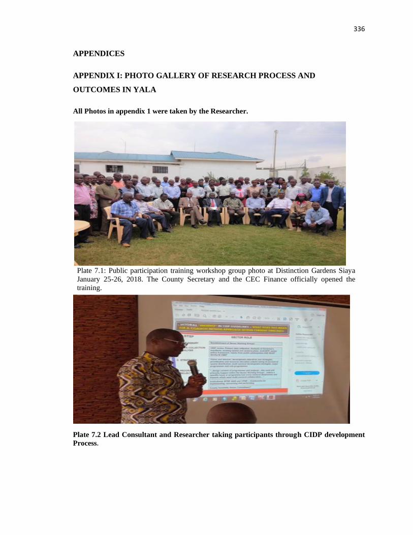
336
APPENDICES
APPENDIX I: PHOTO GALLERY OF RESEARCH PROCESS AND
OUTCOMES IN YALA
All Photos in appendix 1 were taken by the Researcher.
Plate 7.2 Lead Consultant and Researcher taking participants through CIDP development
Process.
Plate 7.1: Public participation training workshop group photo at Distinction Gardens Siaya
January 25-26, 2018. The County Secretary and the CEC Finance officially opened the
training.
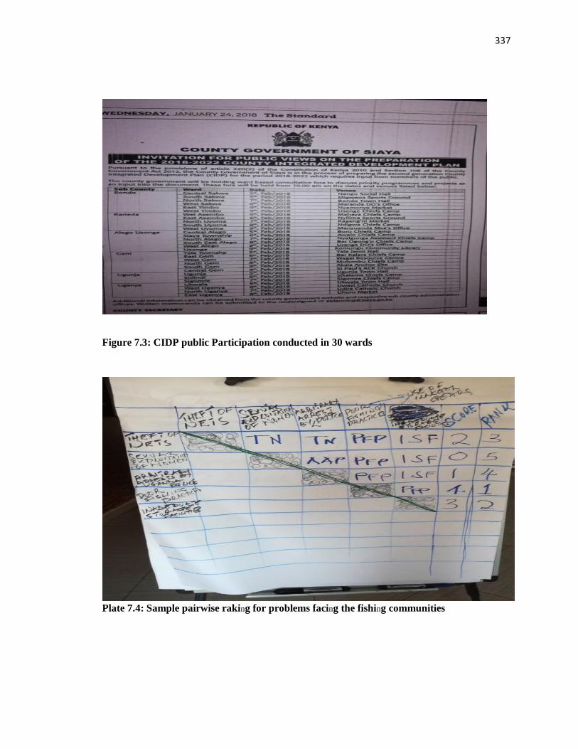
337
Figure 7.3: CIDP public Participation conducted in 30 wards
Plate 7.4: Sample pairwise raking for problems facing the fishing communities
Plate STYLEREF 1 \s 7. SEQ Plate \* ARABIC \s 1 4 Sample pairwise ranking for problems
facing the fishing communities in the fisheries department.
Plate STYLEREF 1 \s 7. SEQ Plate \* ARABIC \s 1 3 CIDP public participation conducted
in 30 wards and submissions and other interest were covered under ward 31 (diaspora
ward).

338
Plate 7.5 Presentation of sector working group feedback to the CIDP public consultation in
Boro, West Alego sub-county.
Plate 7.6: Siaya CECM Education public participation feedback session
(Source Author)
Plate STYLEREF 1 \s 7. SEQ Plate \* ARABIC \s 1 6 Siaya CECM Education facilitating
incorporation of public participation feedback into the draft CIDP.
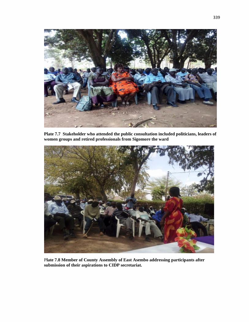
339
Plate 7.7 Stakeholder who attended the public consultation included politicians, leaders of
women groups and retired professionals from Sigomore the ward
Plate 7.8 Member of County Assembly of East Asembo addressing participants after
submission of their aspirations to CIDP secretariat.
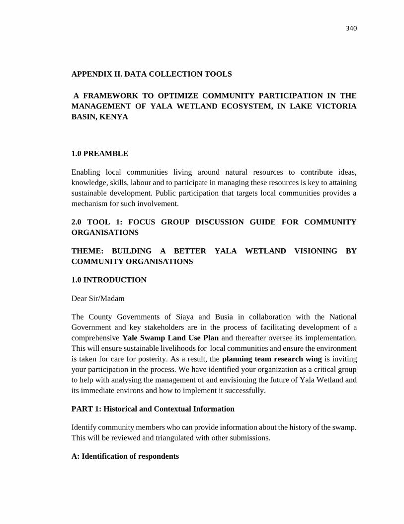
340
APPENDIX II. DATA COLLECTION TOOLS
A FRAMEWORK TO OPTIMIZE COMMUNITY PARTICIPATION IN THE
MANAGEMENT OF YALA WETLAND ECOSYSTEM, IN LAKE VICTORIA
BASIN, KENYA
1.0 PREAMBLE
Enabling local communities living around natural resources to contribute ideas,
knowledge, skills, labour and to participate in managing these resources is key to attaining
sustainable development. Public participation that targets local communities provides a
mechanism for such involvement.
2.0 TOOL 1: FOCUS GROUP DISCUSSION GUIDE FOR COMMUNITY
ORGANISATIONS
THEME: BUILDING A BETTER YALA WETLAND VISIONING BY
COMMUNITY ORGANISATIONS
1.0 INTRODUCTION
Dear Sir/Madam
The County Governments of Siaya and Busia in collaboration with the National
Government and key stakeholders are in the process of facilitating development of a
comprehensive Yale Swamp Land Use Plan and thereafter oversee its implementation.
This will ensure sustainable livelihoods for local communities and ensure the environment
is taken for care for posterity. As a result, the planning team research wing is inviting
your participation in the process. We have identified your organization as a critical group
to help with analysing the management of and envisioning the future of Yala Wetland and
its immediate environs and how to implement it successfully.
PART 1: Historical and Contextual Information
Identify community members who can provide information about the history of the swamp.
This will be reviewed and triangulated with other submissions.
A: Identification of respondents
341
i. Name of the Group-------------------------------------
ii. ii. Location --------------------------------------------------
iii. iii. Village name-------------------------------------------
iv. Distance from the Wetland------------------------------
B: Demographic and Socio-Economic Information of respondents
i. (a)Name of the Leader of the group----------------------(b)-Gender (M /F) ------
ii. (a) Age ------------ -------------------------(b) Highest education level attained ---
iii. What do you do for a living---- -------------------------------------------------------?
iv. What is your average total income per year (in Kshs) -----------------------------------
v. For farming what type of farming do you practice (subsistence or commercial, semi-
commercial);
vi. What is the size of your farm in acres----------------------------------? vii. How are the
various activities of the farm distributed (land use types and areas allocated for each)
C: WETLAND MANAGEMENT
i. How satisfied are you with the current management of Yala Wetland?
Very satisfied --- --Satisfied ---Somewhat satisfied Not satisfied -Very
dissatisfied
Explain your response above-------------------------------------------------------------------------
How satisfied are you with your current use of the land in Yala Wetland?
Very satisfied --- --Satisfied ---Somewhat satisfied Not satisfied ---Very dissatisfied
Explain your response above-------------------------------------------------------------------------
iii. What could be done to create your ideal land use for Yala Wetland? ----------------------
D: COMMUNITY LEADERS GIVING HISTORICAL INFORMATION
i. Who owns Yala Wetland? (legal and legitimate) ----------------------------------------------
ii. What are the significant events/milestones of the community that have happened in
relation to Yala Wetland?
e.g. How did the swamp come about? What changes you have witnessed over time?
-------------------------------------------------------------------------------------------------------
342
iii. What are the key challenges of Yala Wetland with respect to use of wetland resources,
conservation and management?
a. How would you as a community member quantify population increase in the last 30
years? Do community members see this as a challenge? How has it manifested itself? Are
there any conflicts?
b. Has the swamp shrank in extent in the recent years?-------------------------------------------
c. Have the outer boundaries changed (apart from the reclaimed sections)? Quantifiable?
Sketch the map -----------------------------------------------------------------------------------------
d. What are some of the Indigenous knowledge tools that have been used to maintain the
swamp healthy so that it continues to provide its services for all that depend of the swamp?
---------------------------------------------------------------------------------------------------------
C: STORY TELLING SESSION ON YALA WETLAND
A. Storytelling: Thinking back on your years, please share a high point when you were
very happy with Yala Wetland
B. What do you love most about this Yala Wetland community?
-----------------------------------------------------------------------------------------------------------
C. What first drew you here and what has most encouraged you to be here?
------------------------------------------------------------------------------------------------------------
D. What do you consider some of the most significant trends, events, and developments
shaping the future of this Yala Wetland community?
i. Trends-------------------------------------------------------------------------------------------------
ii. Events------------------------------------------------------------------------------------------------
iii. Developments--------------------------------------------------------------------------------------
E. Who are the local communities of Yala Wetland as far back as you can remember? State
where they used to reside? Explain their migration patterns ------------------------------------
F. What do local communities value most about Yala Wetland as a resource?
------------------------------------------------------------------------------------------------------------
343
G. Who are the key influencers (those who determine how things are done and may not be
in the position of authority e.g. housemaid, watchman, spouse of an elder) and key power
holders (those with authority to do certain things on behalf of the group (e.g. a chief, head
teacher, MCAs, Governor) in the Yala Wetland community issues.
ii. Where are their present/available (location, village, contact details e.g. phone/e-
mail/nearest phone access to leave them a message). --------------------------------------------
G. What is the extent of communities’ participation in Strategic Environmental
Assessment (SEA) and Land Use Plan(LUP) processes? -----------------------------------
i. Explain your level of involvement and your recommendations for improving your
participation in the SEA/LUP process? ------------------------------------------------------------
PART 2: WHO ARE THE STAKEHOLDERS AND THE EXTENT OF
COMMUNITY PARTICIPATION IN SEA-_LUP PROCESSES?
Stakeholder defined as “One who directly or indirectly uses any form of resources
associated with the swamp. Key stakeholders are those whose actions can affect the swamp
in a big way like swamp drying up completely by using the water for commercial farming
and stop access to the swamp”
Q1: Who are the stakeholders of Yala Wetland SEA-Land use Plan?
How do they benefit from Yala Wetland?
What is their orientation to SEA_LUP processes?
What is their degree of influence and importance on Yala Wetland?
(Capture the responses in the table below)
Stakeholders
Name
Type/Category
1-Government
2-Non-
Governmental
Organizations
3-Private
Type of
benefits
received
from
Yala
Wetland
Effect on
Yala
Wetland
1-Positively
2-
Negatively
3-None
Orientation to
Yala Land
Use Plan
Process
1-Support
2-Oppose
3-None
Degree of
influence/imp
ortance to
Yala Wetland
1-High level
2.Medium
2-Low level
Remarks
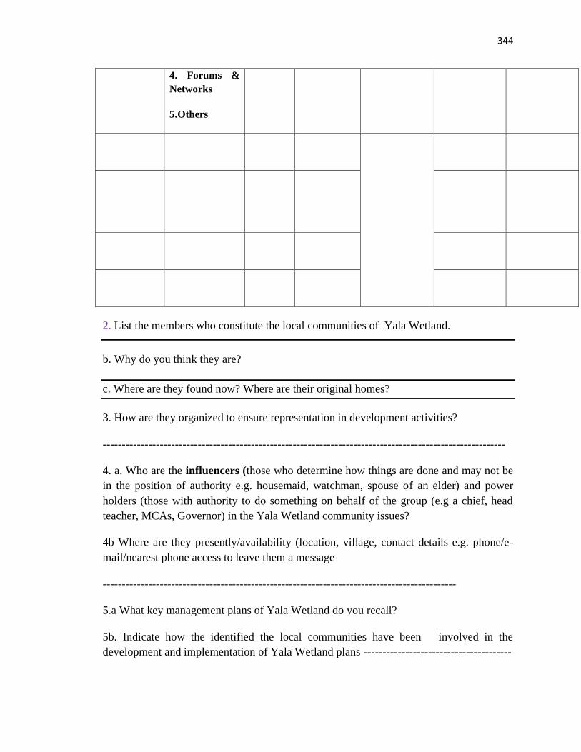
344
4. Forums &
Networks
5.Others
2. List the members who constitute the local communities of Yala Wetland.
b. Why do you think they are?
c. Where are they found now? Where are their original homes?
3. How are they organized to ensure representation in development activities?
----------------------------------------------------------------------------------------------------------
4. a. Who are the influencers (those who determine how things are done and may not be
in the position of authority e.g. housemaid, watchman, spouse of an elder) and power
holders (those with authority to do something on behalf of the group (e.g a chief, head
teacher, MCAs, Governor) in the Yala Wetland community issues?
4b Where are they presently/availability (location, village, contact details e.g. phone/e-
mail/nearest phone access to leave them a message
---------------------------------------------------------------------------------------------
5.a What key management plans of Yala Wetland do you recall?
5b. Indicate how the identified the local communities have been involved in the
development and implementation of Yala Wetland plans ---------------------------------------
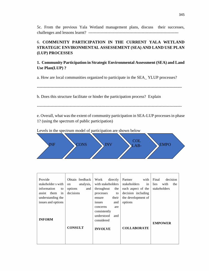
345
5c. From the previous Yala Wetland management plans, discuss their successes,
challenges and lessons learnt? ------------------------------------------------------------------
6. COMMUNITY PARTICIPATION IN THE CURRENT YALA WETLAND
STRATEGIC ENVIRONMENTAL ASSESSEMENT (SEA) AND LAND USE PLAN
(LUP) PROCESSES
1. Community Participation in Strategic Environmental Assessment (SEA) and Land
Use Plan(LUP) ?
a. How are local communities organized to participate in the SEA_ YLUP processes?
----------------------------------------------------------------------------------------------------------
b. Does this structure facilitate or hinder the participation process? Explain
----------------------------------------------------------------------------------------------------------
e. Overall, what was the extent of community participation in SEA-LUP processes in phase
1? (using the spectrum of public participation)
Levels in the spectrum model of participation are shown below
Provide
stakeholder s with
information to
assist them in
understanding the
issues and options
INFORM
Obtain feedback
on analysis,
options and
decisions
CONSULT
Work directly
with stakeholders
throughout the
processes to
ensure their
issues and
concerns are
consistently
understood and
considered
INVOLVE
Partner with
stakeholders in
each aspect of the
decision including
the development of
options
COLLABORATE
Final decision
lies with the
stakeholders
EMPOWER
INF
ORM
CONS
ULT
INV
OLV
COL
LAB-
ORA EMPO
WER
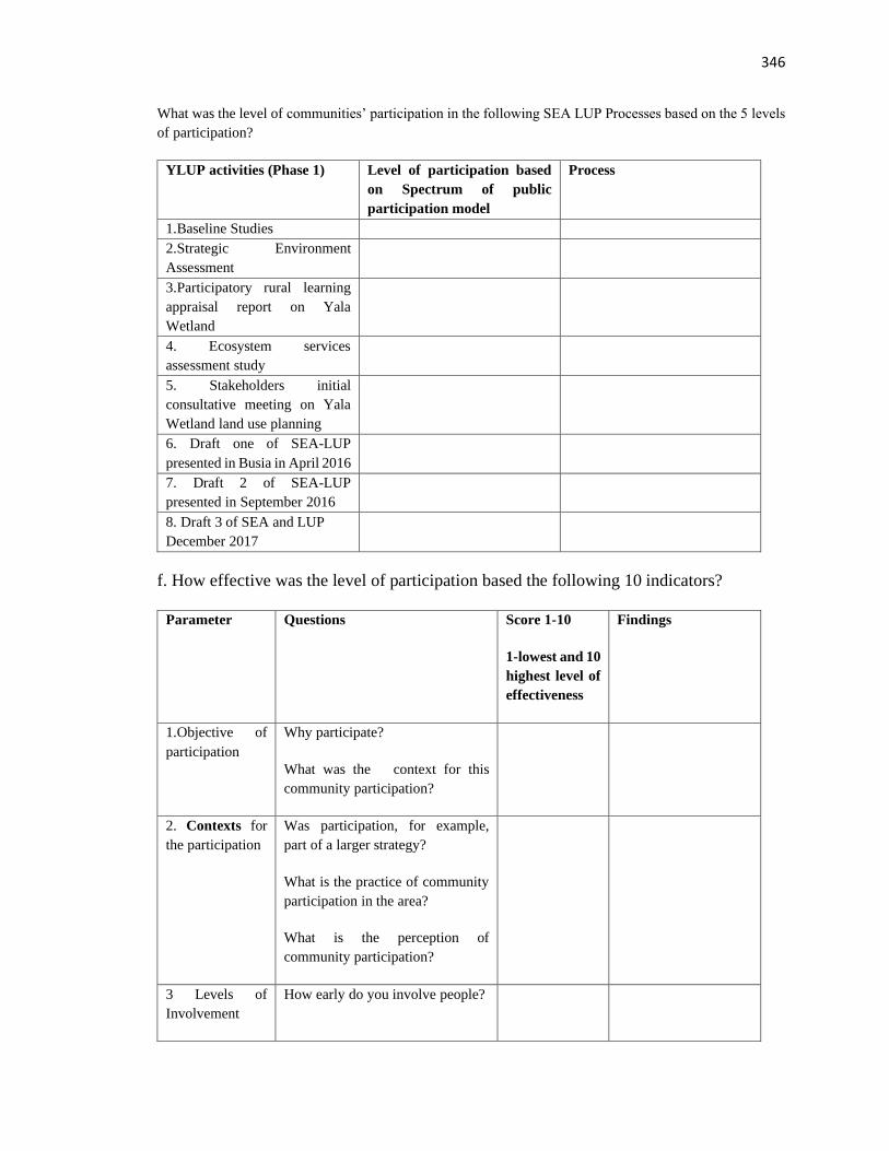
346
What was the level of communities’ participation in the following SEA LUP Processes based on the 5 levels
of participation?
YLUP activities (Phase 1) Level of participation based
on Spectrum of public
participation model
Process
1.Baseline Studies
2.Strategic Environment
Assessment
3.Participatory rural learning
appraisal report on Yala
Wetland
4. Ecosystem services
assessment study
5. Stakeholders initial
consultative meeting on Yala
Wetland land use planning
6. Draft one of SEA-LUP
presented in Busia in April 2016
7. Draft 2 of SEA-LUP
presented in September 2016
8. Draft 3 of SEA and LUP
December 2017
f. How effective was the level of participation based the following 10 indicators?
Parameter Questions Score 1-10
1-lowest and 10
highest level of
effectiveness
Findings
1.Objective of
participation
Why participate?
What was the context for this
community participation?
2. Contexts for
the participation
Was participation, for example,
part of a larger strategy?
What is the practice of community
participation in the area?
What is the perception of
community participation?
3 Levels of
Involvement
How early do you involve people?
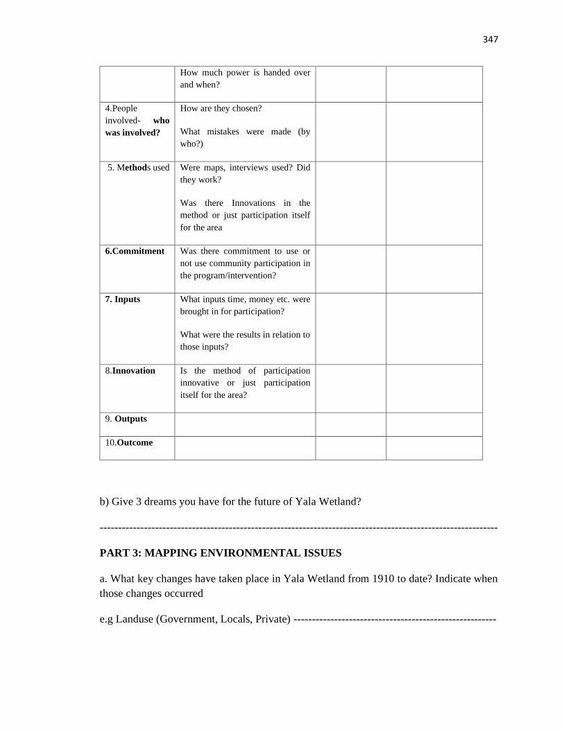
347
How much power is handed over
and when?
4.People
involved- who
was involved?
How are they chosen?
What mistakes were made (by
who?)
5. Methods used Were maps, interviews used? Did
they work?
Was there Innovations in the
method or just participation itself
for the area
6.Commitment Was there commitment to use or
not use community participation in
the program/intervention?
7. Inputs What inputs time, money etc. were
brought in for participation?
What were the results in relation to
those inputs?
8.Innovation Is the method of participation
innovative or just participation
itself for the area?
9. Outputs
10.Outcome
b) Give 3 dreams you have for the future of Yala Wetland?
------------------------------------------------------------------------------------------------------------
PART 3: MAPPING ENVIRONMENTAL ISSUES
a. What key changes have taken place in Yala Wetland from 1910 to date? Indicate when
those changes occurred
e.g Landuse (Government, Locals, Private) -------------------------------------------------------
348
b. What are some of the key environmental issues and resources that Yala Wetland
communities value?
(Can draw these on Yala Wetland map)
c. What are some of Yala Wetland ecosystem’s services/benefits? (list these here)
-------------------------------------------------------------------------------------------------------
D. Please draw and map the following environmental issues as they relate to Yala Wetland
i. Conflict areas and the nature of conflict
ii. Cultural values/sites
iii. Wildlife habitat conservation (on endangered species sitatunga antelope, papyrus birds)
iv. Biodiversity hotspots
v. Other environmental issues identified in b (community resources)
h. What are future developmental preferences of local communities’ choice that balance
development and conservation
------------------------------------------------------------------------------------------------------------
PART 4: ENVISIONING YALA WETLAND/DREAMING FOR A FUTURE
BETTER YALA WETLAND
4.1What is your dream of Yala Wetland in the next 50(2063) years? (draw the maps, can
get person who know how to draw and they give their ideas then the person captures their
aspirations)
i. Community organizations participating in YLUP process; YPAC and sample
Community Organisations (CO).
ii. Non participating Community Organisations but identified as key in the process
iii. Self-appointed Groups/Community Organisations
iv. Nominated Groups/Community Organisations
4.2 Describe your feelings about that vision ------------------------------------------------------
4.3 What can you do to achieve the dream above? What can you do immediately/now?
349
------------------------------------------------------------------------------------------------------------
4.4 How would you actively participate in the creation and realization of this Yala
Wetland’s future/dream? -----------------------------------------------------------------------------
-
PART 6: COMMUNITY INFORMATION SYSTEM
a. What is the current state of Yala Wetland /Wetland Community Information System?
------------------------------------------------------------------------------------------------------------
b. What are your current and anticipated Yala Wetland information needs? (list as many
as possible)
Current Yala Wetland information needs Anticipated Yala Wetland information
needs
c. What are some of the Information seeking behaviors of community organization
leaders that you are aware of (e.g. when I need (state type) information I go to the
teacher, clan elder, newspaper, women group)
d. What type of resources do community organizations need to engage in YLUP
processes?
e. What limits local communities’ full participation in YLUP process?
f. What should be done to overcome these challenges?
-----------------------------------------------------------------------------------------------------------
TOOL 2: KEY INFORMANT INTERVIEW SCHEDULE (FOR OBJECTIVE 1)
1. What is the history of and how would you explain the formation of Yala Wetlands?
350
2. How has Yala Wetland’s history informed/influenced current use/activities by local
communities of/around Yala Wetland?
3.What local knowledge has been used by local communities to manage Yala Wetlands?
4.What local knowledge is still useful to be used with modern knowledge in planning and
managing the wetlands?
5. What are the challenges of Yala Wetland and their causes, and what can be done to turn
them into opportunities for sound management of the wetlands?
6. What is the vision/desired future for Yala Wetlands?
7. What is the role of community science in sustainable management of Yala Wetlands?
351
TOOL 3: FOR COMMUNITY CHANGE AGENTS envisioning the future Yala
Wetland
For leaders involved in facilitating change in the communities e.g. Chair for Technical
community, other change agents in the area (religious leaders), Community activists,
Elders who are change agents.
A. Imagine a time in the future when people look to your community as an exceptional
example of a thriving, attractive community where citizens of all ages engage as leaders
and see themselves as owners of the community’s future.
i. In this exciting future, how would citizens/communities be engaged in community life?
------------------------------------------------------------------------------------------------------------
ii. What is sustaining community leaders’ dedication in terms of service to the Yala
Wetland society?”
(Starting with you) ------------------------------------------------------------------------------------
iii.What kinds of systems and structures are most encouraging to communities/citizen
engagement in Yala Wetland management (planning and implementation)?
------------------------------------------------------------------------------------------------------------
iv. What are you most proud of having helped the community accomplish?
-----------------------------------------------------------------------------------------------------------
v. How can local communities be meaningfully represented in future development
activities in Yala Wetland and its surroundings? -------------------------------------------------
B. What has inspired you to get engaged as a civic leader? What do you most hope you
can contribute? -----------------------------------------------------------------------------------------
C. As an engaged citizen, there are inevitably high points and low points, successes and
frustrations. What stands out for you as a high point when you were part of an outstanding
community effort here? ------------------------------------------------------------------------------
i. Please describe what happened and who was involved. ---------------------------------------
ii. What difference were you able to make working together? ---------------------------------
352
iii. Which of your strengths and talents were called upon? -------------------------------------
iv. What contributed most to the success of the effort? -----------------------------------------
v. What did you learn about community change? -------------------------------------------------
D. What are the areas where you feel more community engagement could have the most
impact on improving the quality life in Yala Wetland community?
------------------------------------------------------------------------------------------------------------
E. As you reflect on successful ways the community are currently engaged in improving
their community, what initiatives stand out as being exceptionally promising in expanding
local citizen leadership and why? -------------------------------------------------------------------
F. What small changes could we make right now that would really encourage more families
to get engaged with improving our community? --------------------------------------------------
G. How would you personally like to be involved in expanding citizen leadership here?
------------------------------------------------------------------------------------------------------------
H. What has inspired you to get engaged in Yala Land Use Planning (LUP)? What do you most
hope to contribute to Yala LUP process? ----------------------------------------------------------
Storytelling: Thinking back on your year, please share a high point when you were very
happy with Yala Wetland?
e.g Obaro time
A Reflection Worksheet 1: Connecting a Whole Yala Wetland (Imagine Yala
Wetland)
What if your job was…
1. To create a Yala Wetland economy in which nothing and no one is wasted by:
● helping people develop their imagination and skills as wetland creators.
● creating meaningful opportunities for everyone, especially groups on the margin and young
people, to invest themselves in the Swamp’s future.
2.To help your Yala Wetland learn to think of itself as a whole rather than in divided terms?
---------------------------------------------------------------------------------------------------------
353
3. Reflecting on the above design some key elements of the process you would create to
make this happen: -------------------------------------------------------------------------------------
i.What would you do first?----------------------------------------------------------------------------
ii. Whom would you invite to participate? (Think especially of people who would find this
exciting and worthwhile, and with whom you would really like to work)
------------------------------------------------------------------------------------------------------------
iii. What organizations would you try to get involved? (e.g. schools, businesses, community
groups, government, etc.)
iv.What would motivate you to want to do this work? -------------------------------------------
354
Worksheet #2: Connections that Matter
A. Connections that Matter
Working with a partner, spend 30 minutes (15 minutes each person) addressing the
following questions:
As you reflect on connecting your work to the work of a broader community, think back to
an experience in a community project that was a personal highpoint for you, a time where
you said to yourself that people really can connect, really can make a difference.
i.What happened?-------------------------------------------------------------------------------------
ii.What were the vital connections that got made? ------------------------------------------------
iii.Why did they matter? ------------------------------------------------------------------------------
iv.Where did they lead? -------------------------------------------------------------------------------
v.What do you now see as possible as a result of those connections? --------------------------
vi.What connections are you most interested in developing to move forward on the work
in your community you would most like to see happen? ----------------------------------------
vii.What connections do you already have that could lead you to the new connections you
seek?
B. Innovations
Think of a project you have been involved in that has been a personal highpoint…when
you were part of creating something new.
i.What got created? -----------------------------------------------------------------------------------
ii. What contributed to making the innovation possible? ----------------------------------------
iii.What vital connections got made? ---------------------------------------------------------------
iv.Why did they matter? -----------------------------------------------------------------------------
iv.Where did they lead? ------------------------------------------------------------------------------
v.What do you now see as possible as a result of those new connections?---------------------
355
vi.What is an innovation that you think holds particular promise for transcending traditional
divides in Yala Wetland community? ---------------------------------------------------------
vii.What current practices in Yala Wetland community now stand in most need of
innovation? --------------------------------------------------------------------------------------------
viii.How might Yala Wetland Land use plan and Indigenous Conservation management
plan processes help unlock the local community’s potential for innovation?
An Appreciative Inquiry for Imagining Community Futures…
High Point Story
What stands out for you at a time you felt you were involved in a really “good”community
team effort-- something significant, empowering, and effective—which gave everyone
involved a way to contribute their talent and make a difference?
------------------------------------------------------------------------------------------------------------
i. How and why did you get involved?--------------------------------------------------------------
ii.Who else was involved?----------------------------------------------------------------------------
iii. How did you work together?---------------------------------------------------------------------
iv.What made it a powerful experience?-----------------------------------------------------------
v.What were some challenges you had to deal with and did you deal with those
challenges?----------------------------------------------------------------------------------------------
vi.What did you accomplish and how did it feel?------------------------------------------------
vii.What was especially meaningful to you about the process and result?--------------------
viii.What did you learn about how positive community change happens?---------------------
Best qualities and skills
Yourself: Without being too humble, what is it that you value most about yourself as an
active community builder? What are your best qualities, skills, values, etc.?
-----------------------------------------------------------------------------------------------------------
356
Others: Why does working together make sense? What are the benefits and outcomes of
forming strong community partnerships across generations?
------------------------------------------------------------------------------------------------------------
Core “life-giving” factors
As you think about what it takes to build great partnerships, (especially across cultures or
generations), what is the “life-giving” factor in such partnerships (without this, good
community partnerships would not be possible)? -------------------------------------------------
Dreams for the Future
What three dreams do you have for the future of Yala Wetland and its community?
------------------------------------------------------------------------------------------------------------
Design: What do you think are some of the essential conditions to enable Yala Wetland
community as a whole to prosper? ------------------------------------------------------------------
Destiny:
a.What do you consider important next steps that should be taken in Yala Wetland?
i. How do you get more people involved in making a positive difference in Yala Wetland?-
------------------------------------------------------------------------------------------------------------
ii.How do you get develop more productive, inspiring community partnerships?------------
iii.To improve communication?----------------------------------------------------------------------
iv.What support do you most need to plant your highest dream for the future of Yala
wetland?-------------------------------------------------------------
v.Who do you most want/need as your dream team/ dream keepers?--------------------------
b. What do you want to do more of towards achieving your dream for Yala wetland?------
TOOL 4: BUILDING A BETTER YALA WETLAND COMPETITION FOR
SCHOOLS
1.0 INTRODUCTION
357
Dear Sir/ madam
The County governments of Siaya and Busia in collaboration with the National government
and key stakeholders are in the process of facilitating the development of a comprehensive
Yala Wetland Land Use Plan and thereafter ensure its studious implementation. This will
ensure sustainable livelihoods for the local communities and the environment is taken of
care for posterity. As a result, the planning team research wing is inviting your
participation in the process. We have identified a critical group to help with envisioning
the future of Yala Wetland by schools and institutions around the Yala Wetland. Kindly
allow your students to take part in these competitions whose theme is a better Yala
Wetland as per the details given below. There will be prizes for the top three (3) students
and the top three (3) schools with highest number of student responses and producing the
winning essay/composition, drawings/artwork and debates. Schools (primary and
secondary, vocational, tertiary) with environmental clubs, wildlife clubs, and 4k clubs are
encouraged to have the debates in their respective clubs.
Eligibility: Eligible Primary, Secondary and Post- Secondary Institutions located in
Yala Wetland and its surroundings
Prize categories;
A. Best essay, First runners up and second runner up
b. Schools with highest entries; First runners up and second runner up
c. Best Artwork/Drawing:First runners up and second runners up, Schools with highest
entries in artwork/drawings
Best debating schools and best debating students; first and second runners up
2.0 CATEGORY ONE: ESSAYS AND COMPOSITIONS
a. What should Yala Wetland look like in 50 years’ time (if money is not a problem)?
-What is your dream for the future of Yala Wetland?
b. What can be done to achieve the above dream?
3.0 CATEGORY TWO: CREATIVE WORKS AND ARTWORKS, DREAM
DRAWINGS
358
a. What three dreams do you have for the future of Yala Wetland? Draw these on a large
sheet of paper.
b. What can be done to achieve these dreams?
4.0 CATEGORY THREE: DEBATES (Eligible upper primary, Secondary and
tertiary)
TOPIC: Creating a perfect Yala Wetland
The debates were moderated by senior teachers after briefing by the researcher and given
guidelines to use for the sessions to ensure validity and relevance to the Yala wetland.
Top three students in this debate will be invited for County level debate in Siaya.
Deadline for Submission: May 6, 2016
Submission to be endorsed by your respective school (stamp and signed by club patrons).
Submit to Cluster leaders who will submit to Nature Kenya Office in Siaya.
1. Upper Yala Cluster, Gem Subcounty-David Marenya 0724297256
2. Lake Kanyaboli Cluster, Alego-Usonga Subcounty-Ibrahim Onyango 0716423651
3. Yimbo Cluster-Bondo Subcounty-Samson Okuku 0726226286/Ayiro Lwala 0722522192
4. Bunyala Cluster-Bunyala South Subcounty-Edwin Ochieng’ 0707839287
For further enquires: Call George Onyango Tel. 0725471402
Committee Leader, Environmental Education and Awareness Creation, for Yala
Ecosystem Site Support Group.
359
FOR RELIGIOUS COMMUNITY
TOOL 5: BUILDING BETTER YALA WETLAND VISIONING BY RELIGIOUS
COMMUNITIES
1.0 INTRODUCTION
Dear Sir/ madam
The County governments of Siaya and Busia in collaboration with the National government
and key stakeholders are in the process of facilitating the development of a comprehensive
Yala Wetland Land Use Plan and thereafter ensure its studious implementation. This will
ensure sustainable livelihoods for the local communities and the environment is taken of
care for posterity. As a result, the planning team research wing is inviting your
participation in the process. We have identified a critical group to help with envisioning
the future of Yala Wetland by religious leaders and institutions around the swamp. Kindly
reflect with your religious team and congregations and prepare a compelling God inspired
sermon on the theme of a better Yala Wetland. There will be round table talks and focus
group discussions about your submissions at the County after you have submitted and the
adjudicating team to review your write-up and prequalify it. There will be rewards/ prizes
for the top 3 sermons. We appreciate your taking time to be in this rare God given
opportunity to shape the future of Yala Wetland.
SERMON GUIDE (8-15 pages)
a. What is God’s dream for Yala Wetland?
b. What can be done to achieve this God’s dream?
Deadline for Submission: May 6, 2016
Submit to Cluster leaders who will submit to Nature Kenya Office in Siaya.
For further enquires: Call George Onyango tel 0725471402/Stephen Okumu
0721989229/Emily Mateche 0724550006
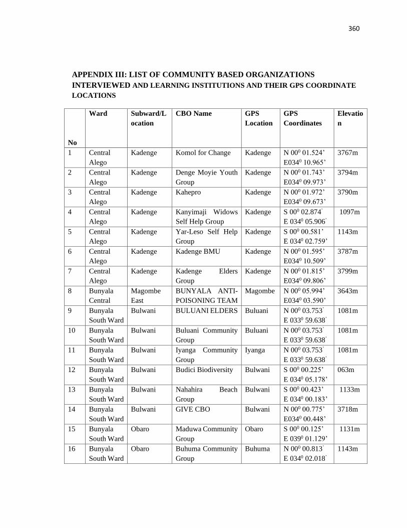
360
APPENDIX III: LIST OF COMMUNITY BASED ORGANIZATIONS
INTERVIEWED AND LEARNING INSTITUTIONS AND THEIR GPS COORDINATE
LOCATIONS
No
Ward Subward/L
ocation
CBO Name GPS
Location
GPS
Coordinates
Elevatio
n
1 Central
Alego
Kadenge Komol for Change Kadenge N 000 01.524’
E0340 10.965’
3767m
2 Central
Alego
Kadenge Denge Moyie Youth
Group
Kadenge N 000 01.743’
E0340 09.973’
3794m
3 Central
Alego
Kadenge Kahepro Kadenge N 000 01.972’
E0340 09.673’
3790m
4 Central
Alego
Kadenge Kanyimaji Widows
Self Help Group
Kadenge S 000 02.874’
E 0340 05.906’
1097m
5 Central
Alego
Kadenge Yar-Leso Self Help
Group
Kadenge S 000 00.581’
E 0340 02.759’
1143m
6 Central
Alego
Kadenge Kadenge BMU Kadenge N 000 01.595’
E0340 10.509’
3787m
7 Central
Alego
Kadenge Kadenge Elders
Group
Kadenge N 000 01.815’
E0340 09.806’
3799m
8 Bunyala
Central
Magombe
East
BUNYALA ANTI-
POISONING TEAM
Magombe N 000 05.994’
E0340 03.590’
3643m
9 Bunyala
South Ward
Bulwani BULUANI ELDERS Buluani N 000 03.753’
E 0330 59.638’
1081m
10 Bunyala
South Ward
Bulwani Buluani Community
Group
Buluani N 000 03.753’
E 0330 59.638’
1081m
11 Bunyala
South Ward
Bulwani Iyanga Community
Group
Iyanga N 000 03.753’
E 0330 59.638’
1081m
12 Bunyala
South Ward
Bulwani Budici Biodiversity Bulwani S 000 00.225’
E 0340 05.178’
063m
13 Bunyala
South Ward
Bulwani Nahahira Beach
Group
Bulwani S 000 00.423’
E 0340 00.183’
1133m
14 Bunyala
South Ward
Bulwani GIVE CBO Bulwani N 000 00.775’
E0340 00.448’
3718m
15 Bunyala
South Ward
Obaro Maduwa Community
Group
Obaro S 000 00.125’
E 0390 01.129’
1131m
16 Bunyala
South Ward
Obaro Buhuma Community
Group
Buhuma N 000 00.813’
E 0340 02.018’
1143m
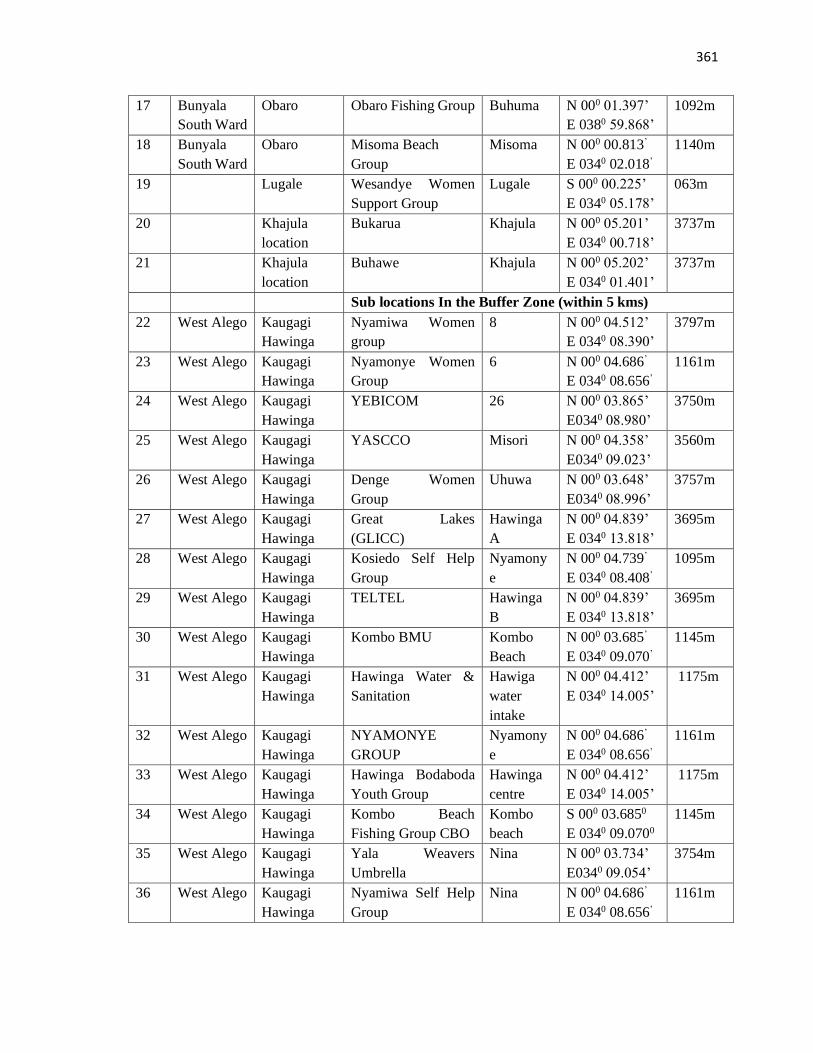
361
17 Bunyala
South Ward
Obaro Obaro Fishing Group Buhuma N 000 01.397’
E 0380 59.868’
1092m
18 Bunyala
South Ward
Obaro Misoma Beach
Group
Misoma N 000 00.813’
E 0340 02.018’
1140m
19 Lugale Wesandye Women
Support Group
Lugale S 000 00.225’
E 0340 05.178’
063m
20 Khajula
location
Bukarua Khajula N 000 05.201’
E 0340 00.718’
3737m
21 Khajula
location
Buhawe Khajula N 000 05.202’
E 0340 01.401’
3737m
Sub locations In the Buffer Zone (within 5 kms)
22 West Alego Kaugagi
Hawinga
Nyamiwa Women
group
8 N 000 04.512’
E 0340 08.390’
3797m
23 West Alego Kaugagi
Hawinga
Nyamonye Women
Group
6 N 000 04.686’
E 0340 08.656’
1161m
24 West Alego Kaugagi
Hawinga
YEBICOM 26 N 000 03.865’
E0340 08.980’
3750m
25 West Alego Kaugagi
Hawinga
YASCCO Misori N 000 04.358’
E0340 09.023’
3560m
26 West Alego Kaugagi
Hawinga
Denge Women
Group
Uhuwa N 000 03.648’
E0340 08.996’
3757m
27 West Alego Kaugagi
Hawinga
Great Lakes
(GLICC)
Hawinga
A
N 000 04.839’
E 0340 13.818’
3695m
28 West Alego Kaugagi
Hawinga
Kosiedo Self Help
Group
Nyamony
e
N 000 04.739’
E 0340 08.408’
1095m
29 West Alego Kaugagi
Hawinga
TELTEL Hawinga
B
N 000 04.839’
E 0340 13.818’
3695m
30 West Alego Kaugagi
Hawinga
Kombo BMU Kombo
Beach
N 000 03.685’
E 0340 09.070’
1145m
31 West Alego Kaugagi
Hawinga
Hawinga Water &
Sanitation
Hawiga
water
intake
N 000 04.412’
E 0340 14.005’
1175m
32 West Alego Kaugagi
Hawinga
NYAMONYE
GROUP
Nyamony
e
N 000 04.686’
E 0340 08.656’
1161m
33 West Alego Kaugagi
Hawinga
Hawinga Bodaboda
Youth Group
Hawinga
centre
N 000 04.412’
E 0340 14.005’
1175m
34 West Alego Kaugagi
Hawinga
Kombo Beach
Fishing Group CBO
Kombo
beach
S 000 03.6850
E 0340 09.0700
1145m
35 West Alego Kaugagi
Hawinga
Yala Weavers
Umbrella
Nina N 000 03.734’
E0340 09.054’
3754m
36 West Alego Kaugagi
Hawinga
Nyamiwa Self Help
Group
Nina N 000 04.686’
E 0340 08.656’
1161m
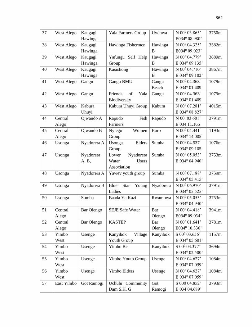
362
37 West Alego Kaugagi
Hawinga
Yala Farmers Group Uwihwa N 000 03.865’
E0340 08.980’
3750m
38 West Alego Kaugagi
Hawinga
Hawinga Fishermen Hawinga
B
N 000 04.325’
E0340 09.023’
3582m
39 West Alego Kaugagi
Hawinga
Yafungu Self Help
Group
Hawinga
B
N 000 04.779’
E 0340 09.135’
3889m
40 West Alego Kaugagi
Hawinga
Kasichong’ Hawinga
B
N 000 04.710’
E 0340 09.102’
3867m
41 West Alego Gangu Gangu BMU Gangu
Beach
N 000 04.363’
E 0340 01.409’
1079m
42 West Alego Gangu Friends of Yala
Biodiversity
Gangu N 000 04.363’
E 0340 01.409’
1079m
43 West Alego Kabura
Uhuyi
Kabura Uhuyi Group Kabura N 000 07.281’
E 0340 08.827’
4015m
44 Central
Alego
Ojwando A Rapudo Fish
Farmers
Rapudo N 00. 03 601’
E 034 11.165
3791m
45 Central
Alego
Ojwando B Nyiego Women
Group
Boro N 000 04.441’
E 0340 14.005’
1193m
46 Usonga Nyadorera A Usonga Elders
Group
Sumba N 000 04.537’
E 0340 09.105’
1076m
47 Usonga Nyadorera
A, B,
Lower Nyadorera
Water Users
Association
Sumba N 000 05.053’
E 0340 04.940’
3753m
48 Usonga Nyadorera A Yawev youth group Sumba N 000 07.188’
E 0340 05.415’
3759m
49 Usonga Nyadorera B Blue Star Young
Ladies
Nyadorera N 000 06.970’
E 0340 05.525’
3791m
50 Usonga Sumba Baada Ya Kazi Rwambwa N 000 05.053’
E 0340 04.940’
3753m
51 Central
Alego
Bar Olengo SEJE Safe Water Bar
Olengo
N 000 04.418’
E0340 09.034’
3941m
52 Central
Alego
Bar Olengo KASTEP Bar
Olengo
N 000 01.641’
E0340 10.330’
3781m
53 Yimbo
West
Usenge Kanyibok Village
Youth Group
Kanyibok S 000 03.656’
E 0340 05.601’
1157m
54 Yimbo
West
Usenge Yimbo Ber Kanyibok S 000 03.377’
E 0340 02.500’
3694m
55 Yimbo
West
Usenge Yimbo Youth Group Usenge N 000 04.627’
E 0340 07.059’
1084m
56 Yimbo
West
Usenge Yimbo Elders Usenge N 000 04.627’
E 0340 07.059’
1084m
57 East Yimbo Got Ramogi Uchulu Community
Dam S.H. G
Got
Ramogi
S 000 04.852’
E 034 04.689’
3793m
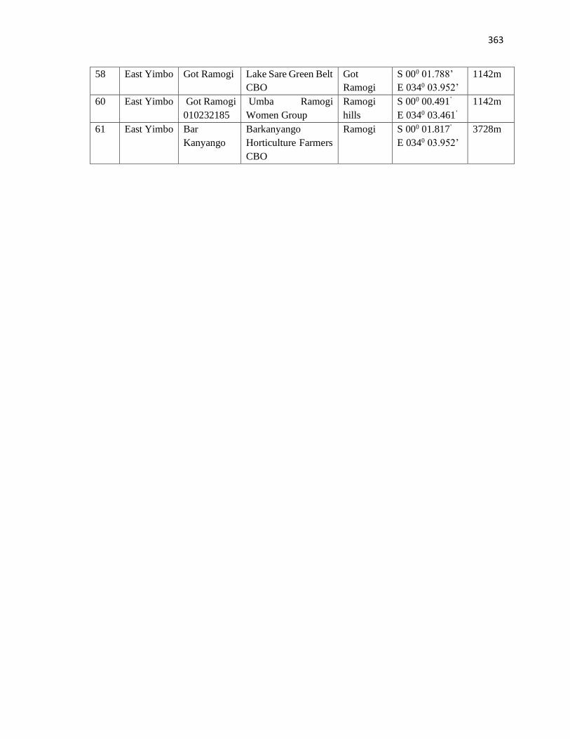
363
58 East Yimbo Got Ramogi Lake Sare Green Belt
CBO
Got
Ramogi
S 000 01.788’
E 0340 03.952’
1142m
60 East Yimbo Got Ramogi
010232185
Umba Ramogi
Women Group
Ramogi
hills
S 000 00.491’
E 0340 03.461’
1142m
61 East Yimbo Bar
Kanyango
Barkanyango
Horticulture Farmers
CBO
Ramogi S 000 01.817’
E 0340 03.952’
3728m
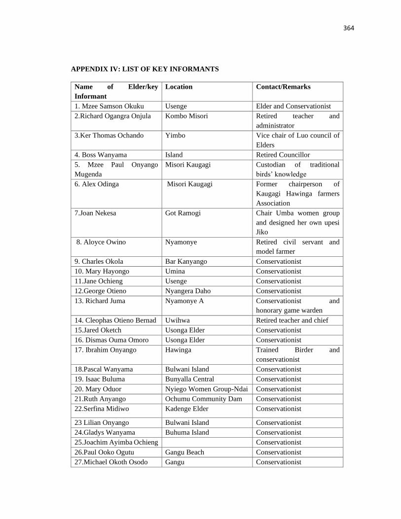
364
APPENDIX IV: LIST OF KEY INFORMANTS
Name of Elder/key
Informant
Location Contact/Remarks
1. Mzee Samson Okuku Usenge Elder and Conservationist
2.Richard Ogangra Onjula Kombo Misori Retired teacher and
administrator
3.Ker Thomas Ochando Yimbo Vice chair of Luo council of
Elders
4. Boss Wanyama Island Retired Councillor
5. Mzee Paul Onyango
Mugenda
Misori Kaugagi Custodian of traditional
birds’ knowledge
6. Alex Odinga Misori Kaugagi Former chairperson of
Kaugagi Hawinga farmers
Association
7.Joan Nekesa Got Ramogi Chair Umba women group
and designed her own upesi
Jiko
8. Aloyce Owino Nyamonye Retired civil servant and
model farmer
9. Charles Okola Bar Kanyango Conservationist
10. Mary Hayongo Umina Conservationist
11.Jane Ochieng Usenge Conservationist
12.George Otieno Nyangera Daho Conservationist
13. Richard Juma Nyamonye A Conservationist and
honorary game warden
14. Cleophas Otieno Bernad Uwihwa Retired teacher and chief
15.Jared Oketch Usonga Elder Conservationist
16. Dismas Ouma Omoro Usonga Elder Conservationist
17. Ibrahim Onyango
Hawinga Trained Birder and
conservationist
18.Pascal Wanyama Bulwani Island Conservationist
19. Isaac Buluma Bunyalla Central Conservationist
20. Mary Oduor Nyiego Women Group-Ndai Conservationist
21.Ruth Anyango Ochumu Community Dam Conservationist
22.Serfina Midiwo Kadenge Elder Conservationist
23 Lilian Onyango Bulwani Island Conservationist
24.Gladys Wanyama Buhuma Island Conservationist
25.Joachim Ayimba Ochieng Conservationist
26.Paul Ooko Ogutu Gangu Beach Conservationist
27.Michael Okoth Osodo Gangu Conservationist
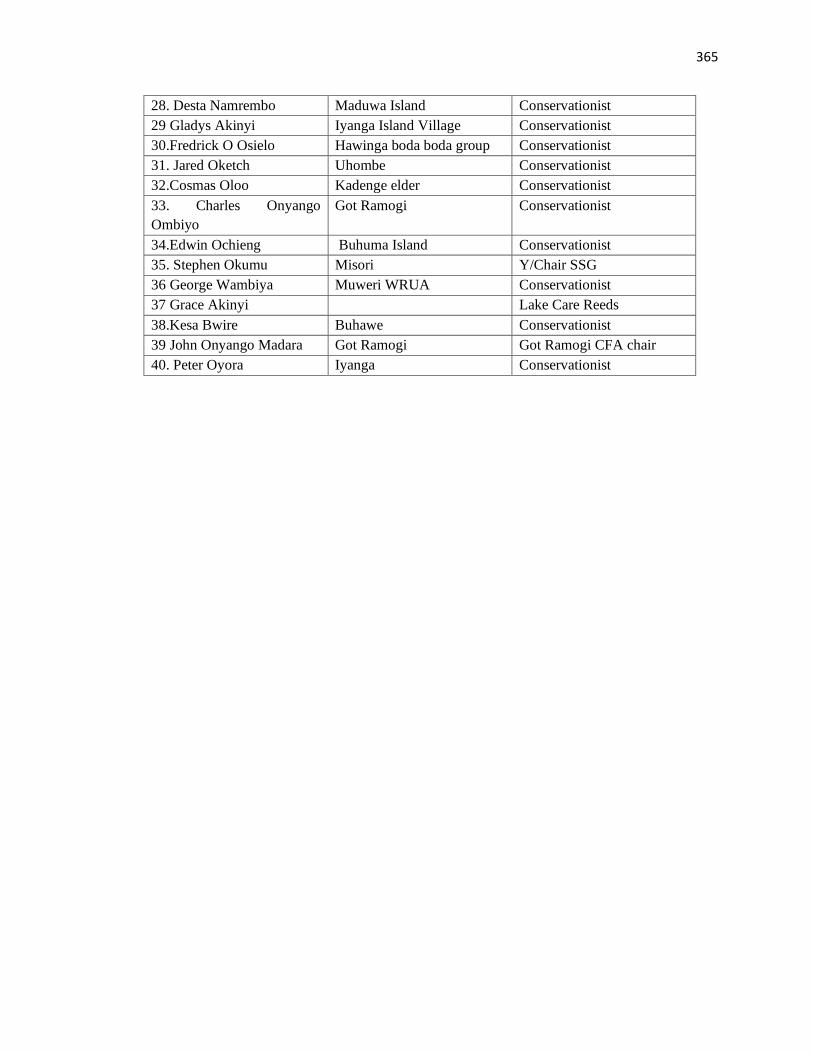
365
28. Desta Namrembo Maduwa Island Conservationist
29 Gladys Akinyi Iyanga Island Village Conservationist
30.Fredrick O Osielo Hawinga boda boda group Conservationist
31. Jared Oketch Uhombe Conservationist
32.Cosmas Oloo Kadenge elder Conservationist
33. Charles Onyango
Ombiyo
Got Ramogi Conservationist
34.Edwin Ochieng Buhuma Island Conservationist
35. Stephen Okumu Misori Y/Chair SSG
36 George Wambiya Muweri WRUA Conservationist
37 Grace Akinyi Lake Care Reeds
38.Kesa Bwire Buhawe Conservationist
39 John Onyango Madara Got Ramogi Got Ramogi CFA chair
40. Peter Oyora Iyanga Conservationist
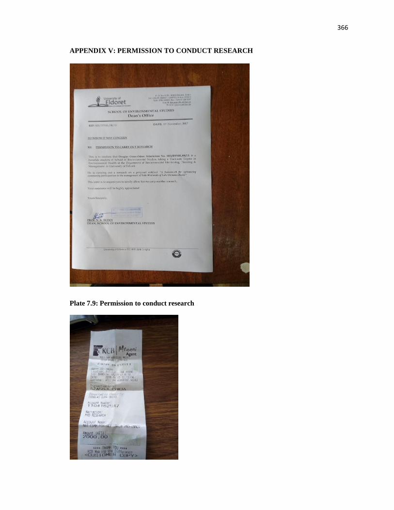
366
APPENDIX V: PERMISSION TO CONDUCT RESEARCH
Plate 7.9: Permission to conduct research
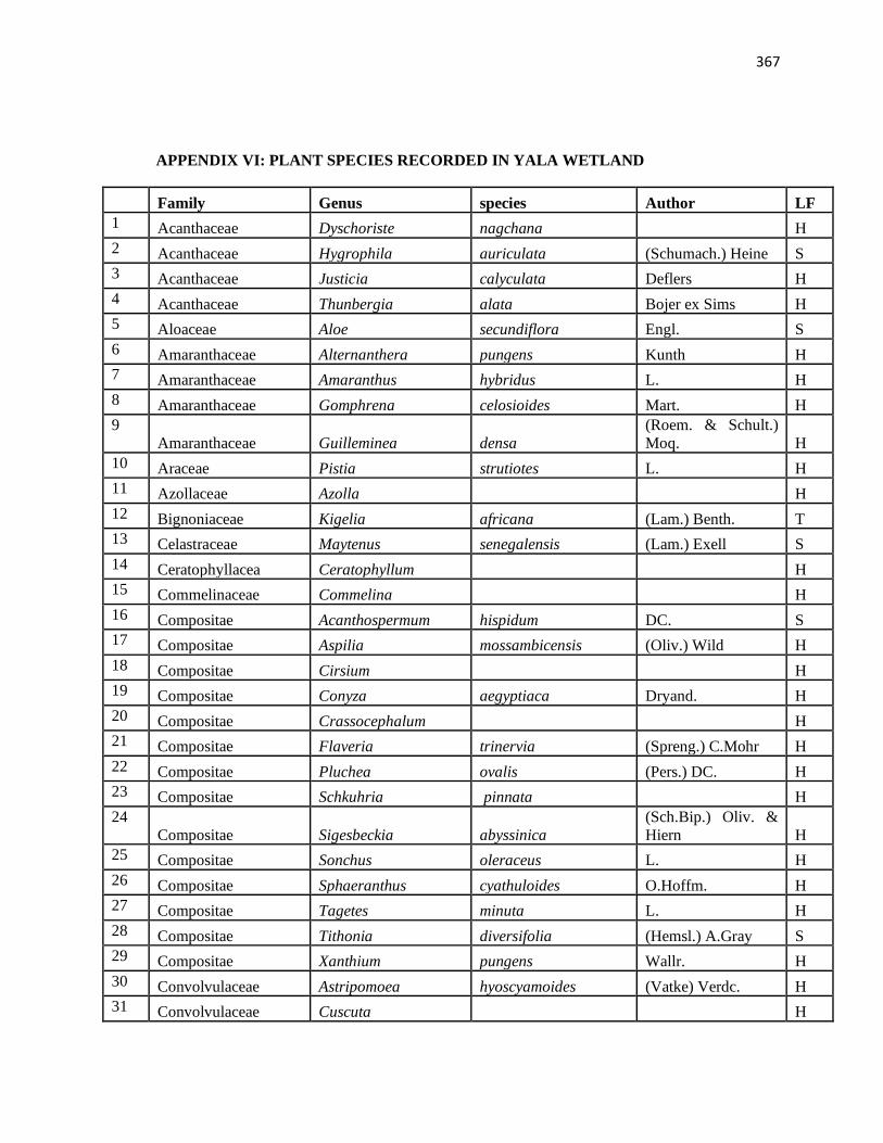
367
APPENDIX VI: PLANT SPECIES RECORDED IN YALA WETLAND
Family Genus species Author LF
1 Acanthaceae Dyschoriste nagchana H
2 Acanthaceae Hygrophila auriculata (Schumach.) Heine S
3 Acanthaceae Justicia calyculata Deflers H
4 Acanthaceae Thunbergia alata Bojer ex Sims H
5 Aloaceae Aloe secundiflora Engl. S
6 Amaranthaceae Alternanthera pungens Kunth H
7 Amaranthaceae Amaranthus hybridus L. H
8 Amaranthaceae Gomphrena celosioides Mart. H
9
Amaranthaceae Guilleminea densa
(Roem. & Schult.)
Moq. H
10 Araceae Pistia strutiotes L. H
11 Azollaceae Azolla H
12 Bignoniaceae Kigelia africana (Lam.) Benth. T
13 Celastraceae Maytenus senegalensis (Lam.) Exell S
14 Ceratophyllacea Ceratophyllum H
15 Commelinaceae Commelina H
16 Compositae Acanthospermum hispidum DC. S
17 Compositae Aspilia mossambicensis (Oliv.) Wild H
18 Compositae Cirsium H
19 Compositae Conyza aegyptiaca Dryand. H
20 Compositae Crassocephalum H
21 Compositae Flaveria trinervia (Spreng.) C.Mohr H
22 Compositae Pluchea ovalis (Pers.) DC. H
23 Compositae Schkuhria pinnata H
24
Compositae Sigesbeckia abyssinica
(Sch.Bip.) Oliv. &
Hiern H
25 Compositae Sonchus oleraceus L. H
26 Compositae Sphaeranthus cyathuloides O.Hoffm. H
27 Compositae Tagetes minuta L. H
28 Compositae Tithonia diversifolia (Hemsl.) A.Gray S
29 Compositae Xanthium pungens Wallr. H
30 Convolvulaceae Astripomoea hyoscyamoides (Vatke) Verdc. H
31 Convolvulaceae Cuscuta H
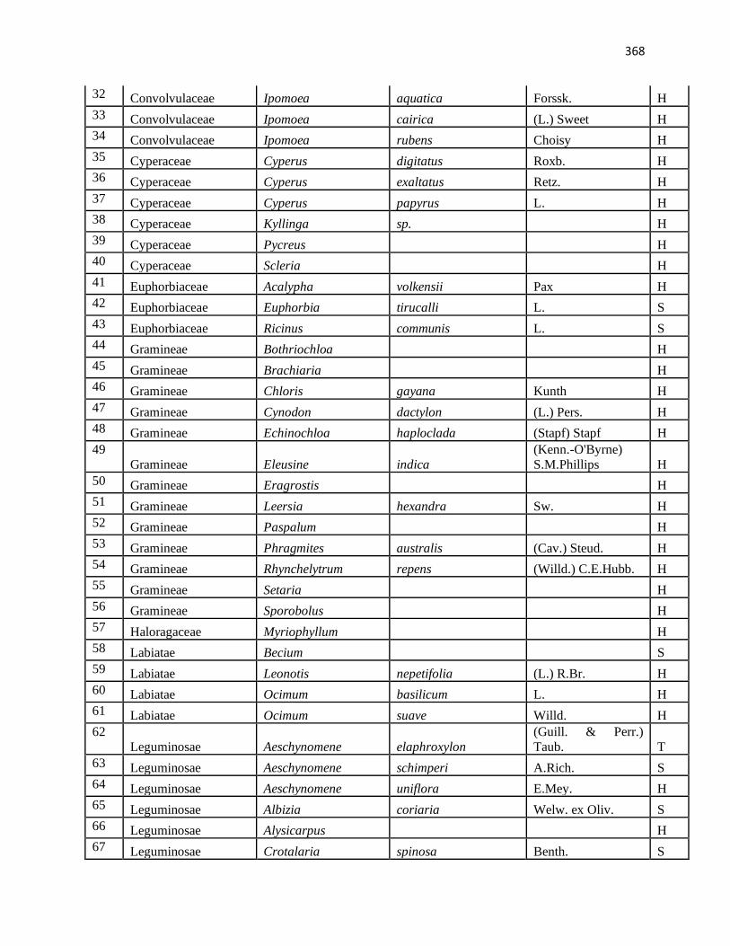
368
32 Convolvulaceae Ipomoea aquatica Forssk. H
33 Convolvulaceae Ipomoea cairica (L.) Sweet H
34 Convolvulaceae Ipomoea rubens Choisy H
35 Cyperaceae Cyperus digitatus Roxb. H
36 Cyperaceae Cyperus exaltatus Retz. H
37 Cyperaceae Cyperus papyrus L. H
38 Cyperaceae Kyllinga sp. H
39 Cyperaceae Pycreus H
40 Cyperaceae Scleria H
41 Euphorbiaceae Acalypha volkensii Pax H
42 Euphorbiaceae Euphorbia tirucalli L. S
43 Euphorbiaceae Ricinus communis L. S
44 Gramineae Bothriochloa H
45 Gramineae Brachiaria H
46 Gramineae Chloris gayana Kunth H
47 Gramineae Cynodon dactylon (L.) Pers. H
48 Gramineae Echinochloa haploclada (Stapf) Stapf H
49
Gramineae Eleusine indica
(Kenn.-O'Byrne)
S.M.Phillips H
50 Gramineae Eragrostis H
51 Gramineae Leersia hexandra Sw. H
52 Gramineae Paspalum H
53 Gramineae Phragmites australis (Cav.) Steud. H
54 Gramineae Rhynchelytrum repens (Willd.) C.E.Hubb. H
55 Gramineae Setaria H
56 Gramineae Sporobolus H
57 Haloragaceae Myriophyllum H
58 Labiatae Becium S
59 Labiatae Leonotis nepetifolia (L.) R.Br. H
60 Labiatae Ocimum basilicum L. H
61 Labiatae Ocimum suave Willd. H
62
Leguminosae Aeschynomene elaphroxylon
(Guill. & Perr.)
Taub. T
63 Leguminosae Aeschynomene schimperi A.Rich. S
64 Leguminosae Aeschynomene uniflora E.Mey. H
65 Leguminosae Albizia coriaria Welw. ex Oliv. S
66 Leguminosae Alysicarpus H
67 Leguminosae Crotalaria spinosa Benth. S
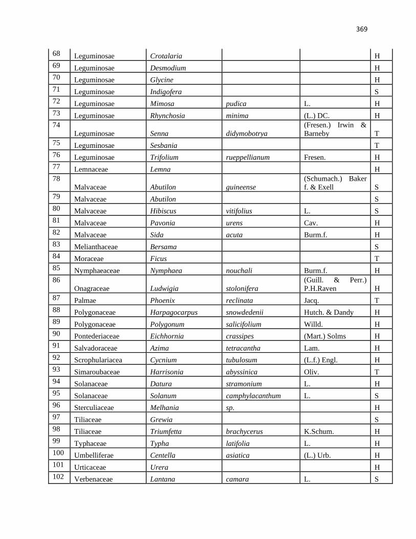
369
68 Leguminosae Crotalaria H
69 Leguminosae Desmodium H
70 Leguminosae Glycine H
71 Leguminosae Indigofera S
72 Leguminosae Mimosa pudica L. H
73 Leguminosae Rhynchosia minima (L.) DC. H
74
Leguminosae Senna didymobotrya
(Fresen.) Irwin &
Barneby T
75 Leguminosae Sesbania T
76 Leguminosae Trifolium rueppellianum Fresen. H
77 Lemnaceae Lemna H
78
Malvaceae Abutilon guineense
(Schumach.) Baker
f. & Exell S
79 Malvaceae Abutilon S
80 Malvaceae Hibiscus vitifolius L. S
81 Malvaceae Pavonia urens Cav. H
82 Malvaceae Sida acuta Burm.f. H
83 Melianthaceae Bersama S
84 Moraceae Ficus T
85 Nymphaeaceae Nymphaea nouchali Burm.f. H
86
Onagraceae Ludwigia stolonifera
(Guill. & Perr.)
P.H.Raven H
87 Palmae Phoenix reclinata Jacq. T
88 Polygonaceae Harpagocarpus snowdedenii Hutch. & Dandy H
89 Polygonaceae Polygonum salicifolium Willd. H
90 Pontederiaceae Eichhornia crassipes (Mart.) Solms H
91 Salvadoraceae Azima tetracantha Lam. H
92 Scrophulariacea Cycnium tubulosum (L.f.) Engl. H
93 Simaroubaceae Harrisonia abyssinica Oliv. T
94 Solanaceae Datura stramonium L. H
95 Solanaceae Solanum camphylacanthum L. S
96 Sterculiaceae Melhania sp. H
97 Tiliaceae Grewia S
98 Tiliaceae Triumfetta brachycerus K.Schum. H
99 Typhaceae Typha latifolia L. H
100 Umbelliferae Centella asiatica (L.) Urb. H
101 Urticaceae Urera H
102 Verbenaceae Lantana camara L. S
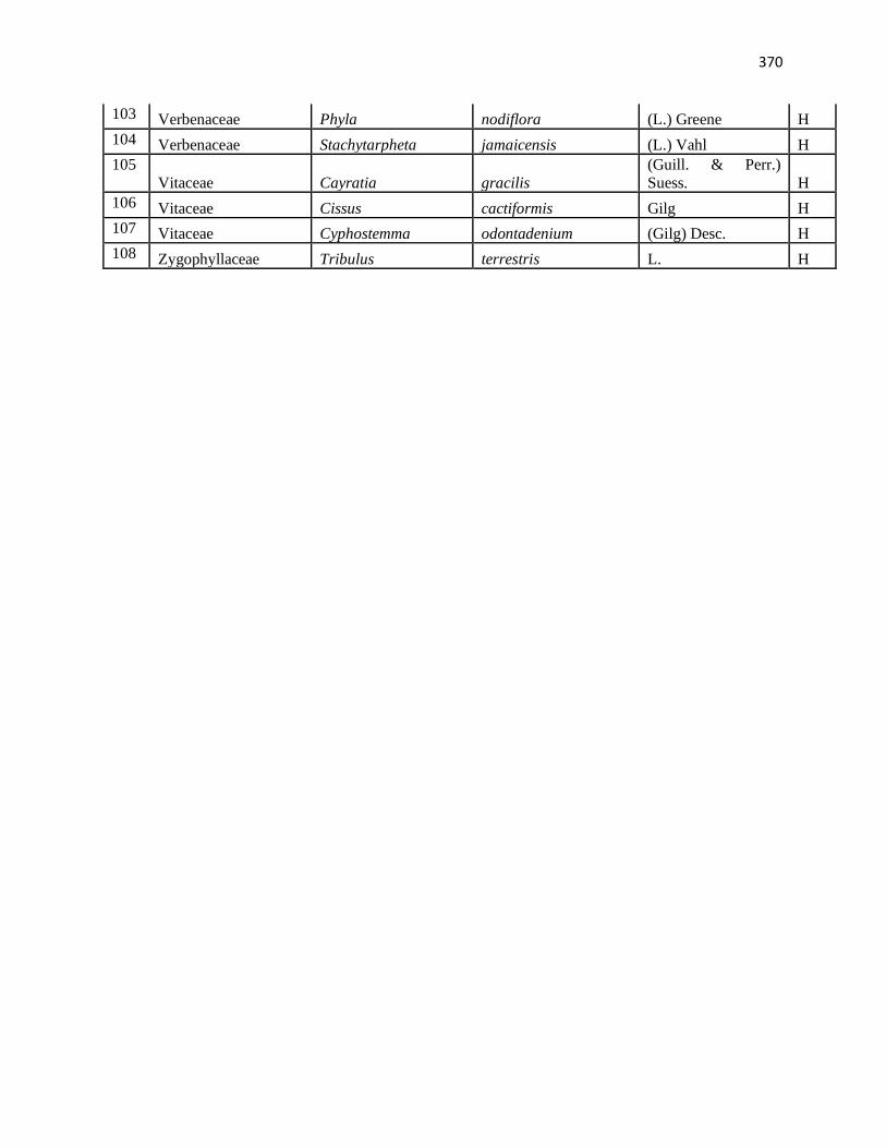
370
103 Verbenaceae Phyla nodiflora (L.) Greene H
104 Verbenaceae Stachytarpheta jamaicensis (L.) Vahl H
105
Vitaceae Cayratia gracilis
(Guill. & Perr.)
Suess. H
106 Vitaceae Cissus cactiformis Gilg H
107 Vitaceae Cyphostemma odontadenium (Gilg) Desc. H
108 Zygophyllaceae Tribulus terrestris L. H
371
APPENDIX VII: SOME BIRD SPECIES COMMONLY RECORDED IN YALA
WETLAND
NB: NT- near threatened, VU – Vulnerable, PM – Parlaeractic, AM – Afro-tropical
migrants, MM - Malagasy migrant, am, pm, mm lower case imply that some population
stay around
Species Scientific Name Status
Anatidae: ducks and geese
1 White-faced Whistling Duck Dendrocygna viduata am
2 Egyptian Goose Alopochen aegyptiaca am
Ciconiidae: storks
3 Yellow-billed Stork Mycteria ibis am
4 Abdim's Stork Ciconia abdimii AM
Threskiornithidae: ibises and spoonbills
5 Sacred Ibis Threskiornis aethiopicus am
6 Glossy Ibis Plegadis falcinellus am
7 African Spoonbill Platalea alba am
Ardeidae: herons, egrets and bitterns
8 Squacco Heron Ardeola ralloides AM/pm
9 Cattle Egret Bubulcus ibis am
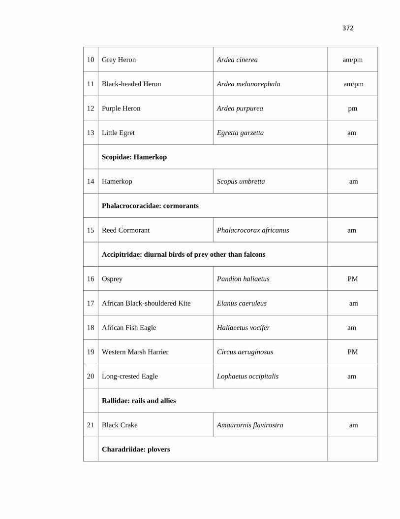
372
10 Grey Heron Ardea cinerea am/pm
11 Black-headed Heron Ardea melanocephala am/pm
12 Purple Heron Ardea purpurea pm
13 Little Egret Egretta garzetta am
Scopidae: Hamerkop
14 Hamerkop Scopus umbretta am
Phalacrocoracidae: cormorants
15 Reed Cormorant Phalacrocorax africanus am
Accipitridae: diurnal birds of prey other than falcons
16 Osprey Pandion haliaetus PM
17 African Black-shouldered Kite Elanus caeruleus am
18 African Fish Eagle Haliaeetus vocifer am
19 Western Marsh Harrier Circus aeruginosus PM
20 Long-crested Eagle Lophaetus occipitalis am
Rallidae: rails and allies
21 Black Crake Amaurornis flavirostra am
Charadriidae: plovers
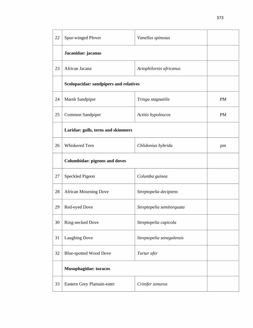
373
22 Spur-winged Plover Vanellus spinosus
Jacanidae: jacanas
23 African Jacana Actophilornis africanus
Scolopacidae: sandpipers and relatives
24 Marsh Sandpiper Tringa stagnatilis PM
25 Common Sandpiper Actitis hypoleucos PM
Laridae: gulls, terns and skimmers
26 Whiskered Tern Chlidonias hybrida pm
Columbidae: pigeons and doves
27 Speckled Pigeon Columba guinea
28 African Mourning Dove Streptopelia decipiens
29 Red-eyed Dove Streptopelia semitorquata
30 Ring-necked Dove Streptopelia capicola
31 Laughing Dove Streptopelia senegalensis
32 Blue-spotted Wood Dove Turtur afer
Musophagidae: turacos
33 Eastern Grey Plantain-eater Crinifer zonurus
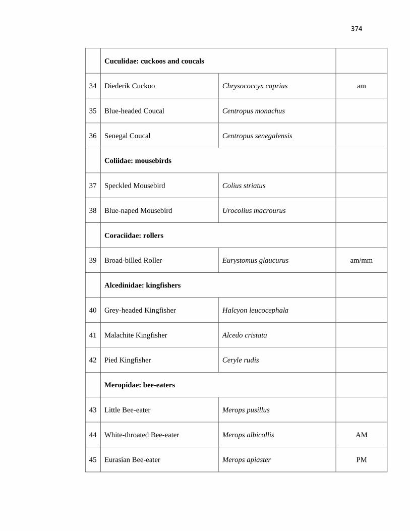
374
Cuculidae: cuckoos and coucals
34 Diederik Cuckoo Chrysococcyx caprius am
35 Blue-headed Coucal Centropus monachus
36 Senegal Coucal Centropus senegalensis
Coliidae: mousebirds
37 Speckled Mousebird Colius striatus
38 Blue-naped Mousebird Urocolius macrourus
Coraciidae: rollers
39 Broad-billed Roller Eurystomus glaucurus am/mm
Alcedinidae: kingfishers
40 Grey-headed Kingfisher Halcyon leucocephala
41 Malachite Kingfisher Alcedo cristata
42 Pied Kingfisher Ceryle rudis
Meropidae: bee-eaters
43 Little Bee-eater Merops pusillus
44 White-throated Bee-eater Merops albicollis AM
45 Eurasian Bee-eater Merops apiaster PM
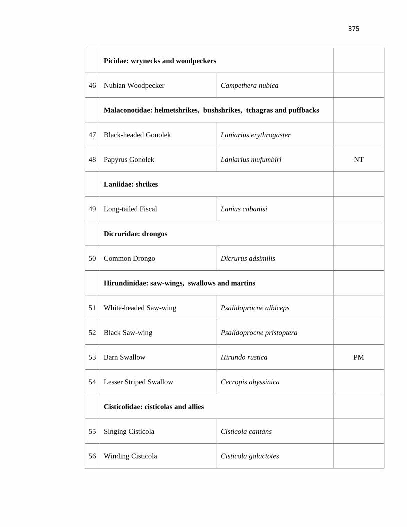
375
Picidae: wrynecks and woodpeckers
46 Nubian Woodpecker Campethera nubica
Malaconotidae: helmetshrikes, bushshrikes, tchagras and puffbacks
47 Black-headed Gonolek Laniarius erythrogaster
48 Papyrus Gonolek Laniarius mufumbiri NT
Laniidae: shrikes
49 Long-tailed Fiscal Lanius cabanisi
Dicruridae: drongos
50 Common Drongo Dicrurus adsimilis
Hirundinidae: saw-wings, swallows and martins
51 White-headed Saw-wing Psalidoprocne albiceps
52 Black Saw-wing Psalidoprocne pristoptera
53 Barn Swallow Hirundo rustica PM
54 Lesser Striped Swallow Cecropis abyssinica
Cisticolidae: cisticolas and allies
55 Singing Cisticola Cisticola cantans
56 Winding Cisticola Cisticola galactotes
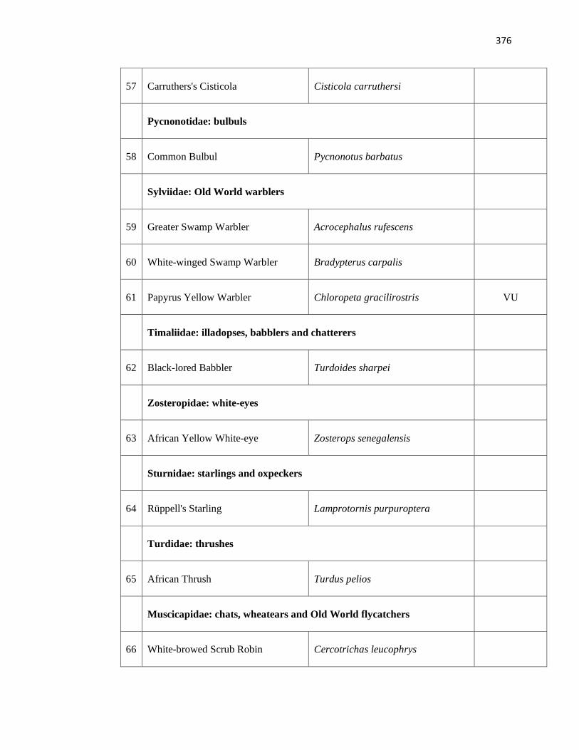
376
57 Carruthers's Cisticola Cisticola carruthersi
Pycnonotidae: bulbuls
58 Common Bulbul Pycnonotus barbatus
Sylviidae: Old World warblers
59 Greater Swamp Warbler Acrocephalus rufescens
60 White-winged Swamp Warbler Bradypterus carpalis
61 Papyrus Yellow Warbler Chloropeta gracilirostris VU
Timaliidae: illadopses, babblers and chatterers
62 Black-lored Babbler Turdoides sharpei
Zosteropidae: white-eyes
63 African Yellow White-eye Zosterops senegalensis
Sturnidae: starlings and oxpeckers
64 Rüppell's Starling Lamprotornis purpuroptera
Turdidae: thrushes
65 African Thrush Turdus pelios
Muscicapidae: chats, wheatears and Old World flycatchers
66 White-browed Scrub Robin Cercotrichas leucophrys
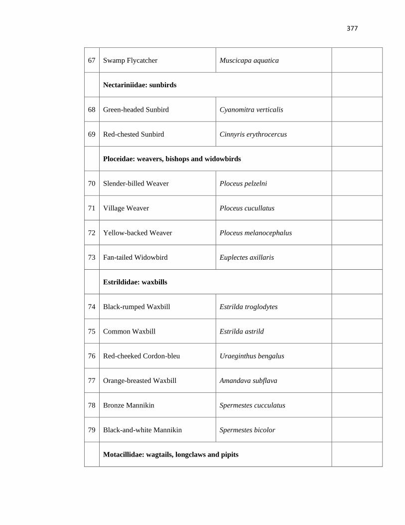
377
67 Swamp Flycatcher Muscicapa aquatica
Nectariniidae: sunbirds
68 Green-headed Sunbird Cyanomitra verticalis
69 Red-chested Sunbird Cinnyris erythrocercus
Ploceidae: weavers, bishops and widowbirds
70 Slender-billed Weaver Ploceus pelzelni
71 Village Weaver Ploceus cucullatus
72 Yellow-backed Weaver Ploceus melanocephalus
73 Fan-tailed Widowbird Euplectes axillaris
Estrildidae: waxbills
74 Black-rumped Waxbill Estrilda troglodytes
75 Common Waxbill Estrilda astrild
76 Red-cheeked Cordon-bleu Uraeginthus bengalus
77 Orange-breasted Waxbill Amandava subflava
78 Bronze Mannikin Spermestes cucculatus
79 Black-and-white Mannikin Spermestes bicolor
Motacillidae: wagtails, longclaws and pipits
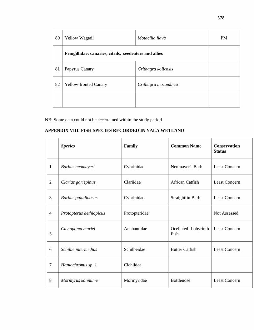
378
80 Yellow Wagtail Motacilla flava PM
Fringillidae: canaries, citrils, seedeaters and allies
81 Papyrus Canary Crithagra koliensis
82 Yellow-fronted Canary Crithagra mozambica
NB: Some data could not be accertained within the study period
APPENDIX VIII: FISH SPECIES RECORDED IN YALA WETLAND
Species Family Common Name Conservation
Status
1 Barbus neumayeri Cyprinidae Neumayer's Barb Least Concern
2 Clarias gariepinus Clariidae African Catfish Least Concern
3 Barbus paludinosus Cyprinidae Straightfin Barb Least Concern
4 Protopterus aethiopicus Protopteridae Not Assessed
5
Ctenopoma muriei Anabantidae Ocellated Labyrinth
Fish
Least Concern
6 Schilbe intermedius Schilbeidae Butter Catfish Least Concern
7 Haplochromis sp. 1 Cichlidae
8 Mormyrus kannume Mormyridae Bottlenose Least Concern
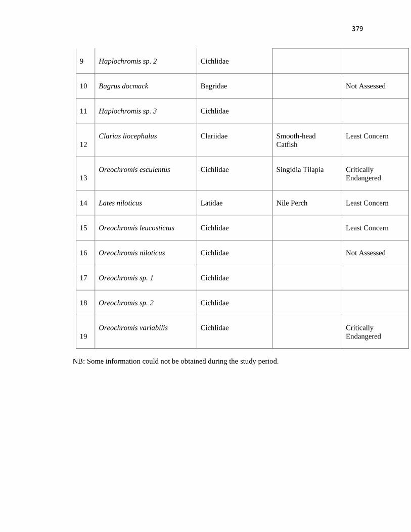
379
9 Haplochromis sp. 2 Cichlidae
10 Bagrus docmack Bagridae Not Assessed
11 Haplochromis sp. 3 Cichlidae
12
Clarias liocephalus Clariidae Smooth-head
Catfish
Least Concern
13
Oreochromis esculentus Cichlidae Singidia Tilapia Critically
Endangered
14 Lates niloticus Latidae Nile Perch Least Concern
15 Oreochromis leucostictus Cichlidae Least Concern
16 Oreochromis niloticus Cichlidae Not Assessed
17 Oreochromis sp. 1 Cichlidae
18 Oreochromis sp. 2 Cichlidae
19
Oreochromis variabilis Cichlidae Critically
Endangered
NB: Some information could not be obtained during the study period.
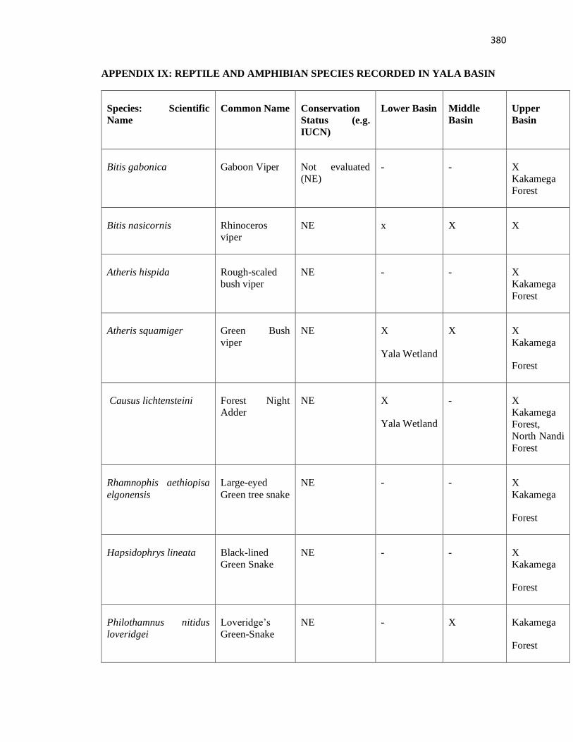
380
APPENDIX IX: REPTILE AND AMPHIBIAN SPECIES RECORDED IN YALA BASIN
Species: Scientific
Name
Common Name Conservation
Status (e.g.
IUCN)
Lower Basin Middle
Basin
Upper
Basin
1. Bitis gabonica Gaboon Viper Not evaluated
(NE)
- - X
Kakamega
Forest
2. Bitis nasicornis Rhinoceros
viper
NE x X X
3. Atheris hispida Rough-scaled
bush viper
NE - - X
Kakamega
Forest
4. Atheris squamiger Green Bush
viper
NE X
Yala Wetland
X X
Kakamega
Forest
5. Causus lichtensteini Forest Night
Adder
NE X
Yala Wetland
- X
Kakamega
Forest,
North Nandi
Forest
6. Rhamnophis aethiopisa
elgonensis
Large-eyed
Green tree snake
NE - - X
Kakamega
Forest
7. Hapsidophrys lineata Black-lined
Green Snake
NE - - X
Kakamega
Forest
8. Philothamnus nitidus
loveridgei
Loveridge’s
Green-Snake
NE - X Kakamega
Forest
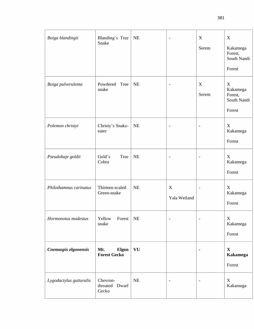
381
9. Boiga blandingii Blanding’s Tree
Snake
NE - X
Serem
X
Kakamega
Forest,
South Nandi
Forest
10. Boiga pulverulenta Powdered Tree
snake
NE - X
Serem
X
Kakamega
Forest,
South Nandi
Forest
11. Polemon christyi Christy’s Snake-
eater
NE - - X
Kakamega
Forest
12. Pseudohaje goldii Gold’s Tree
Cobra
NE - - X
Kakamega
Forest
13. Philothamnus carinatus Thirteen-scaled
Green-snake
NE X
Yala Wetland
- X
Kakamega
Forest
14. Hormonotus modestus Yellow Forest
snake
NE - - X
Kakamega
Forest
15. Cnemaspis elgonensis Mt. Elgon
Forest Gecko
VU - X
Kakamega
Forest
16. Lygodactylus gutturalis Chevron-
throated Dwarf
Gecko
NE - - X
Kakamega
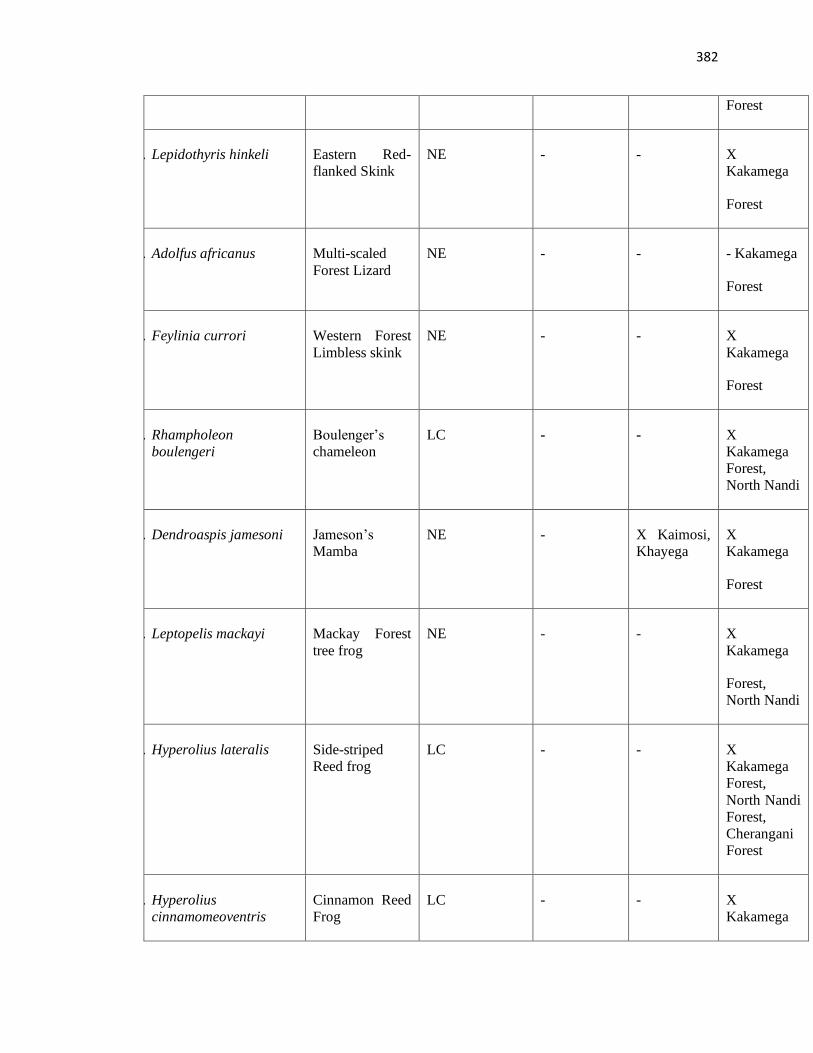
382
Forest
17. Lepidothyris hinkeli Eastern Red-
flanked Skink
NE - - X
Kakamega
Forest
18. Adolfus africanus Multi-scaled
Forest Lizard
NE - - - Kakamega
Forest
19. Feylinia currori Western Forest
Limbless skink
NE - - X
Kakamega
Forest
20. Rhampholeon
boulengeri
Boulenger’s
chameleon
LC - - X
Kakamega
Forest,
North Nandi
21. Dendroaspis jamesoni Jameson’s
Mamba
NE - X Kaimosi,
Khayega
X
Kakamega
Forest
22. Leptopelis mackayi Mackay Forest
tree frog
NE - - X
Kakamega
Forest,
North Nandi
23. Hyperolius lateralis Side-striped
Reed frog
LC - - X
Kakamega
Forest,
North Nandi
Forest,
Cherangani
Forest
24. Hyperolius
cinnamomeoventris
Cinnamon Reed
Frog
LC - - X
Kakamega
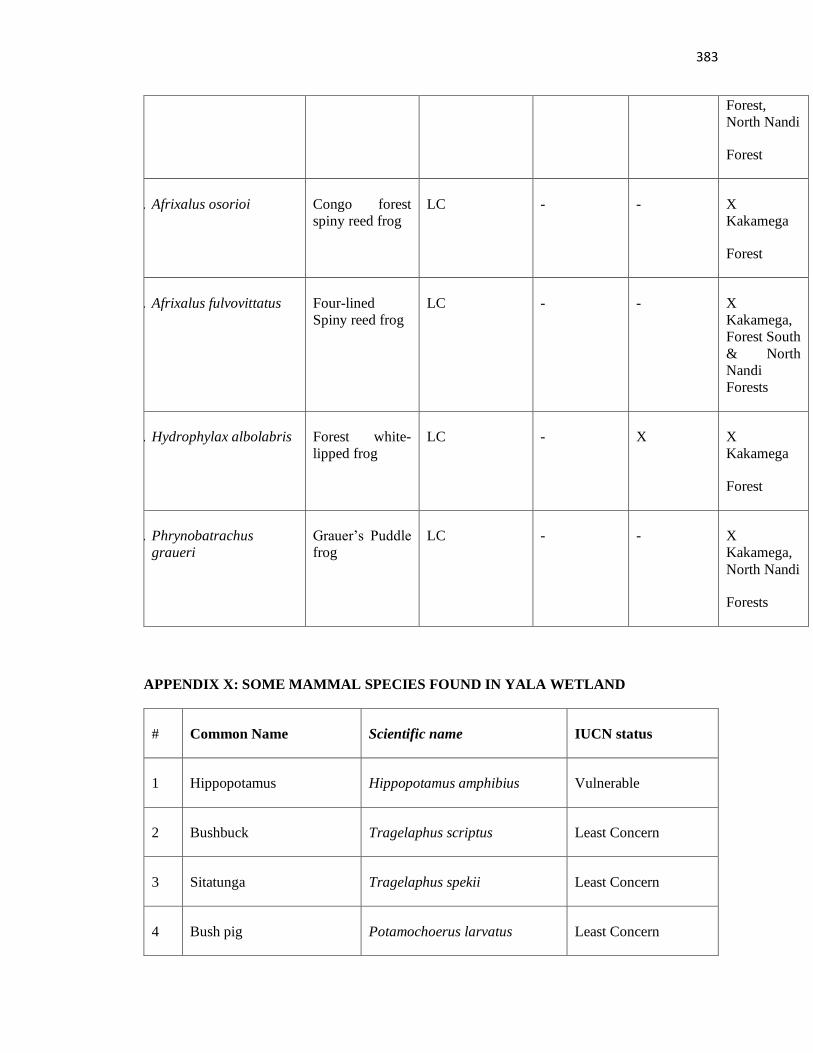
383
Forest,
North Nandi
Forest
25. Afrixalus osorioi Congo forest
spiny reed frog
LC - - X
Kakamega
Forest
26. Afrixalus fulvovittatus Four-lined
Spiny reed frog
LC - - X
Kakamega,
Forest South
& North
Nandi
Forests
27. Hydrophylax albolabris Forest white-
lipped frog
LC - X X
Kakamega
Forest
28. Phrynobatrachus
graueri
Grauer’s Puddle
frog
LC - - X
Kakamega,
North Nandi
Forests
APPENDIX X: SOME MAMMAL SPECIES FOUND IN YALA WETLAND
# Common Name Scientific name IUCN status
1 Hippopotamus Hippopotamus amphibius Vulnerable
2 Bushbuck Tragelaphus scriptus Least Concern
3 Sitatunga Tragelaphus spekii Least Concern
4 Bush pig Potamochoerus larvatus Least Concern
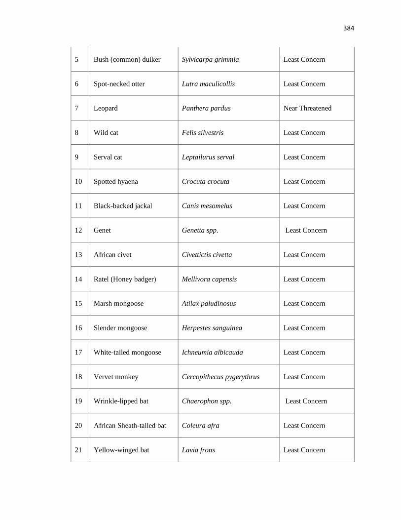
384
5 Bush (common) duiker Sylvicarpa grimmia Least Concern
6 Spot-necked otter Lutra maculicollis Least Concern
7 Leopard Panthera pardus Near Threatened
8 Wild cat Felis silvestris Least Concern
9 Serval cat Leptailurus serval Least Concern
10 Spotted hyaena Crocuta crocuta Least Concern
11 Black-backed jackal Canis mesomelus Least Concern
12 Genet Genetta spp. Least Concern
13 African civet Civettictis civetta Least Concern
14 Ratel (Honey badger) Mellivora capensis Least Concern
15 Marsh mongoose Atilax paludinosus Least Concern
16 Slender mongoose Herpestes sanguinea Least Concern
17 White-tailed mongoose Ichneumia albicauda Least Concern
18 Vervet monkey Cercopithecus pygerythrus Least Concern
19 Wrinkle-lipped bat Chaerophon spp. Least Concern
20 African Sheath-tailed bat Coleura afra Least Concern
21 Yellow-winged bat Lavia frons Least Concern
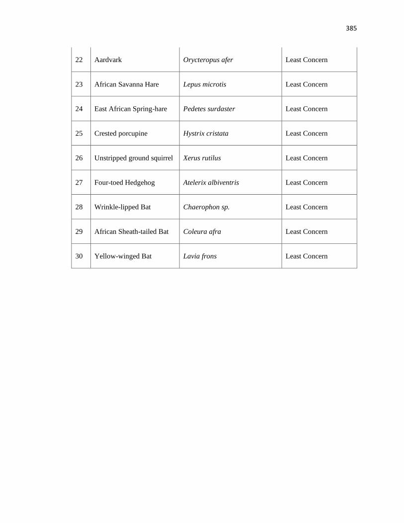
385
22 Aardvark Orycteropus afer Least Concern
23 African Savanna Hare Lepus microtis Least Concern
24 East African Spring-hare Pedetes surdaster Least Concern
25 Crested porcupine Hystrix cristata Least Concern
26 Unstripped ground squirrel Xerus rutilus Least Concern
27 Four-toed Hedgehog Atelerix albiventris Least Concern
28 Wrinkle-lipped Bat Chaerophon sp. Least Concern
29 African Sheath-tailed Bat Coleura afra Least Concern
30 Yellow-winged Bat Lavia frons Least Concern
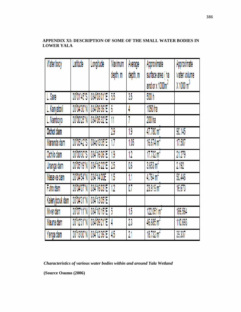
386
APPENDIX XI: DESCRIPTION OF SOME OF THE SMALL WATER BODIES IN
LOWER YALA
Characteristics of various water bodies within and around Yala Wetland
(Source Osumo (2006)
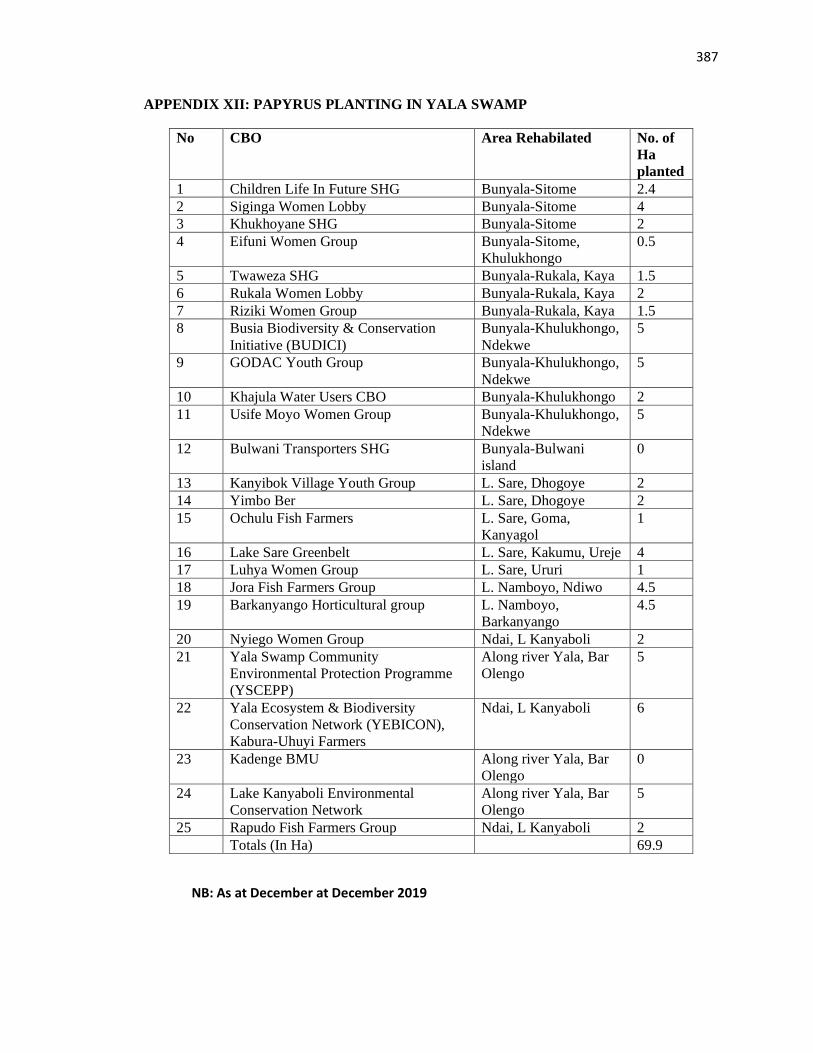
387
APPENDIX XII: PAPYRUS PLANTING IN YALA SWAMP
No CBO Area Rehabilated No. of
Ha
planted
1 Children Life In Future SHG Bunyala-Sitome 2.4
2 Siginga Women Lobby Bunyala-Sitome 4
3 Khukhoyane SHG Bunyala-Sitome 2
4 Eifuni Women Group Bunyala-Sitome,
Khulukhongo
0.5
5 Twaweza SHG Bunyala-Rukala, Kaya 1.5
6 Rukala Women Lobby Bunyala-Rukala, Kaya 2
7 Riziki Women Group Bunyala-Rukala, Kaya 1.5
8 Busia Biodiversity & Conservation
Initiative (BUDICI)
Bunyala-Khulukhongo,
Ndekwe
5
9 GODAC Youth Group Bunyala-Khulukhongo,
Ndekwe
5
10 Khajula Water Users CBO Bunyala-Khulukhongo 2
11 Usife Moyo Women Group Bunyala-Khulukhongo,
Ndekwe
5
12 Bulwani Transporters SHG Bunyala-Bulwani
island
0
13 Kanyibok Village Youth Group L. Sare, Dhogoye 2
14 Yimbo Ber L. Sare, Dhogoye 2
15 Ochulu Fish Farmers L. Sare, Goma,
Kanyagol
1
16 Lake Sare Greenbelt L. Sare, Kakumu, Ureje 4
17 Luhya Women Group L. Sare, Ururi 1
18 Jora Fish Farmers Group L. Namboyo, Ndiwo 4.5
19 Barkanyango Horticultural group L. Namboyo,
Barkanyango
4.5
20 Nyiego Women Group Ndai, L Kanyaboli 2
21 Yala Swamp Community
Environmental Protection Programme
(YSCEPP)
Along river Yala, Bar
Olengo
5
22 Yala Ecosystem & Biodiversity
Conservation Network (YEBICON),
Kabura-Uhuyi Farmers
Ndai, L Kanyaboli 6
23 Kadenge BMU Along river Yala, Bar
Olengo
0
24 Lake Kanyaboli Environmental
Conservation Network
Along river Yala, Bar
Olengo
5
25 Rapudo Fish Farmers Group Ndai, L Kanyaboli 2
Totals (In Ha) 69.9
NB: As at December at December 2019
388
APPENDIX XIII: SIMILARITY REPORT