development of lighthouses as beacons of tourism
TRANSCRIPT


Directorate General of Lighthouses & Lightships Ministry of ShippingGovernment of India
DEVELOPMENT OF LIGHTHOUSES AS BEACONS OF TOURISM
DEVELOPMENT OF LIGHTHOUSES AS BEACONS OF TOURISM


1
Message from Hon’ble Minister of Shipping, Road Transport & Highways
Message from Hon’ble Minister of State for Shipping, Road Transport & Highways Message from Secretary, Ministry of Shipping Promoting Tourism at Lighthouses
List of Lighthouses identified for tourism development Location of Lighthouses
Lighthouse Tourism: Field of Activities
Profile of 78 Lighthouses
Index02
03
04
06-07
09
05
08
10-164

2
NITIN GADKARI
(Nitin Gadkari)
MESSAGE
MINISTER OF ROAD TRANSPORTHIGHWAYS & SHIPPINGGOVERNMENT OF INDIA
PARIVAHAN BHAVAN, NEW DELHI-110 001
ea=h lM+d ifjogu jktekxZ ,oa iksr ifjoguHkkjr ljdkj]
ifjogu Hkou] ubZ fnYyh&110 001
Lighthouses, apart from being principally engaged in providing Aids to Navigation, is now being universally recognized as centres of tourist attraction owing to their unique location and sylvan surroundings. The tourism potential of our innumerable lighthouses has so far remained untapped. With 189 lighthouse dotting our long coastline along the shore, on islands, on reefs and even submerged rocks, the scope of transforming them into vibrant tourist destination is immense.
The Ministry of Shipping has identified 78 lighthouse including Island lighthouses for development of tourism amenities. Directorate General of Lighthouses and Lightships (DGLL) is organising an Investor’s Summit to present the potential to private players and potential investors for developing lighthouse tourism in the Public Private Partnership mode. This is another concerted step forward of the Sagarmala initiative of developing island and coastal tourism.
I am happy to present this information booklet prepared by DGLL, both in printed and e-book from, which will provide insight to prospective investors and developers and will help in making this ambitions programme of developing lighthouse tourism a success story.

3
PON. RADHAKRISHNAN
(Pon. Radhakrishnan)
MESSAGE
MINISTER OF STATEFOR
ROAD TRANSPORT, HIGHWAYS AND SHIPPING
GOVERNMENT OF INDIA
jkT; ea=h lM+d ifjogu] jktekxZ ,oa
iksr ifjogu ea=ky;Hkkjr ljdkj
It gives me immense pleasure to note that the Directorate General of Lighthouses and Lightships have embarked upon developing their lighthouses across the vast coastline as tourism destinations. The lighthouses, standing majestically against sparkling blue sky and clear horizon, command a panoramic view, thus making them irresistible centres of attraction for tourists. By opening up these structures for public, it will provide a unique opportunity for visitors to experience the maritime heritage which has been conserved by lighthouse over time.
The publication of this informative booklet both in printed and e – book form is an excellent idea for enthusing potential private sector investors to become active partners in giving shape to this ambitious programme of making Lighthouses the new beacons of tourism.

4
(Rajive Kumar)
MESSAGE
Most lighthouses in India are located in places marked by scenic beauty and serene ambience with high potential for tourism. Some of the lighthouse structures are iconic architectural landmarks with heritage value and rich historic background. The Ministry of Shipping through the Directorate General of Lighthouse and Lightships (DGLL) is endeavouring to bring 78 lighthouses on the national and international tourism circuit on Public Private Partnership mode. This initiative will not only pull out the lighthouses from their stoic and mystic isolation but add to the eagerness of Lighthouse lovers to travel up and down the coastline, admiring the old giants that still stand sentinel between the sea and the land.
I am happy that DGLL is organising Road-shows and Investor’s Summit to generate interest amongst private entities to take up the new challenge of developing tourism at lighthouses. The Information Booklet in printed and e-book form will be a handy tool for all the interested stakeholders in getting comprehensive and relevant information on these lighthouses and help in taking prudent investment decisions.
I wish the DGLL a big success in all their efforts in this direction.
SECRETARYMINISTRY OF SHIPPINGGOVERNMENT OF INDIA
lfpo iksr ifjogu ea=ky;
Hkkjr ljdkj
RAJIVE KUMAR

5
Promoting Tourism at Lighthouses
Traditionally a beacon of navigation for mariners for centuries, lighthouses are going through a transformation in the 21st Century. Shedding their solitary image, lighthouses are emerging as a serious destination for travellers. They have captivated the attention
of tourists smitten by the scenic and serene surroundings of the exotic location of these Lighthouses.
India has as many as 189 lighthouses dotting its vast coastline of 7517 km, including the Andaman and Nicobar Islands in the Bay of Bengal and Lakshadweep Islands in the Arabian Sea. Interestingly, each lighthouse is distinct in itself. Steeped in rich maritime heritage, each lighthouse has a story to tell; and has tremendous tourism potential just waiting to be tapped. Domestic and international lighthouse lovers are eager to traverse our coastline and explore these old giants that stand sentinel between the sea and the land.
The Directorate General of Lighthouses and Lightships (DGLL) has successfully developed 4 lighthouses as tourist attraction centres; the Madras and Mahabalipuram lighthouses in Tamil Nadu and the Alleppy and Cannanore lighthouses in Kerala which have seen substantial footfall in tourist visit, over the past few years. The Ministry of Shipping has now embarked on the initiative of bringing lighthouses closer to the people by turning them into enthralling and adventurous tourist destinations.
The Ministry of Shipping through the DGLL has drawn up an ambitious programme for developing tourism in the land adjacent to these 78 lighthouses, in the first phase, under Public Private Partnership (PPP). Addition of Hotels, Resorts, Viewing galleries, Adventure sports, Thematic restaurants and allied tourism facilities will convert these maritime landmarks into unique tourism destinations.
The DGLL has already invited Request for Qualifications (RFQ) from prospective and potential developers for 8 lighthouses at Aguada (Goa), Chandrabhaga (Odisha), Mahabalipuram, Kanya Kumari and Muttom (Tamil Nadu), Kadalur Point (Thikkodi, Kerala), Kanhoji Angre and Sunk Rock (Maharashtra) and Minicoy (Lakshadweep). An Expression of Interest (EOI) has also been issued by the DGLL for another set of 70 lighthouses.
5
6
DEVELOPMENT OF LIGHTHOUSES AS BEACONS OF TOURISM
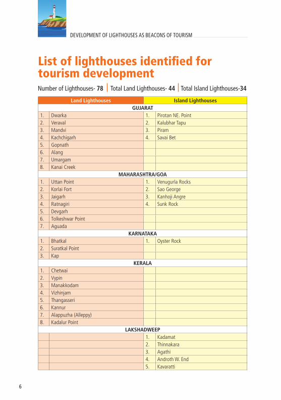
List of lighthouses identified for tourism development
Land Lighthouses Island LighthousesGUJARAT
1. Dwarka 1. Pirotan NE. Point2. Veraval 2. Kalubhar Tapu3. Mandvi 3. Piram4. Kachchigarh 4. Savai Bet5. Gopnath6. Alang7. Umargam8. Kanai Creek
MAHARASHTRA/GOA1. Uttan Point 1. Venugurla Rocks2. Korlai Fort 2. Sao George3. Jaigarh 3. Kanhoji Angre4. Ratnagiri 4. Sunk Rock5. Devgarh6. Tolkeshwar Point7. Aguada
KARNATAKA1. Bhatkal 1. Oyster Rock2. Suratkal Point3. Kap
KERALA1. Chetwai2. Vypin3. Manakkodam4. Vizhinjam5. Thangasseri6. Kannur7. Alappuzha (Alleppy)8. Kadalur Point
LAKSHADWEEP1. Kadamat2. Thinnakara3. Agathi4. Androth W. End5. Kavaratti
Number of Lighthouses- 78 Total Land Lighthouses- 44 Total Island Lighthouses-34

7
6. Suhelipar7. Chetlat8. Kalpeni9. Kiltan10. Minicoy
TAMILNADU1. Manappad Point2. Kilakkarai3. Kodikkarai4. Porto Novo5. Pulicat6. Mahabalipuram7. Kanya Kumari – Muttam Point
PUDUCHERRY1. Pondicherry
ANDHRA PRADESH1. Antervedi 1. Nagayalanka2. Sacremanto3. Vakalpudi4. Santapile5. Kalingapatnam
ODISHA1. Gopalpur 1. False Point2. Puri3. Paradip4. Chandrabhaga
WEST BENGAL1. Dariapur 1. Sagar Island
ANDAMAN & NICOBAR ISLANDS1. North Point2. North Cinque 3. Port Cornwallis4. Sir Hugh Rose5. Aves6. East Island7. Chidya Tapu8. Little Andaman9. Rutland10. Keating Point11. South Sentinel12. Narcondam
Land Lighthouses Island Lighthouses

8
Location of Lighthouses

9
Lighthouse Tourism: Field of Activities
l Resorts/Hotels
l Cafes and Restaurants
l Viewing Deck
l Spa and Rejuvenation Centres
l Light & Sound shows, Laser shows
l Maritime Museum
l Beach based recreational activities
l Water Sports and Adventure Tourism
l Eco-tourism
l Souvenir shops

10
DEVELOPMENT OF LIGHTHOUSES AS BEACONS OF TOURISM
DWARKA LIGHTHOUSE

11
PROFILELocation: Distt.- Devbhumi Dwarka, State- GujaratLat- 22°14.2’N Long- 68°57.5’E
S. No. FEATURES
1. Area of the Lighthouse premises 18000 sq. Meter2. Status of land Freehold3. Ownership of land DGLL
4. Climate (Avetage Temperature/rainfall) Temp. - 27°C Rainfall- 578mm
5. Tidal range Not available 6. History of Natural Disasters Earthquake in 2001
7. Distance from nearest port/harbour ( if located on an island) NA
8. Distance from nearest airport/nearest railwaystation
Railway station -Dwarka- 3 Kms.Airport- Jamnagar- 130 Kms.
9. Distance from main city located nearby Dwarka- 2 Kms.10. Availability of roads /access to Lighthouse Motorable road upto Lighthouse11. Availability and facility of public transport Yes
12. Existence of natural harbours/berthing facility / landing arrangement (if located on islands) NA
13. Telecom coverage and availability of electricity Yes14. Availability of potable water Yes
15. Existing BuildingsStaff quarters, Power House, Inspection Quarters, Holiday Home
16. Presence of unique flora and fauna Nil
17. Presence of natural features- waterfalls, streams, mountains, etc. Nil
18. Potential for adventure and water sports Nil19. Presence of local/tribal/folk art Garbha dance, Dandiya dance
20. Nearest tourist destination and distance
Dwarkadish temple -2 kmsGomti Ghat- 2 kms Byet Dwarka- 31 kmsAmphitheatre – 3 kms
21.In case, tourism has to be developed on PPP mode , then the statutory permissions that would be required and from which agencies
CRZ from MOEFApproval of Dwarka Town and Country Planning Dept., Gujarat Tourism

12
DEVELOPMENT OF LIGHTHOUSES AS BEACONS OF TOURISM
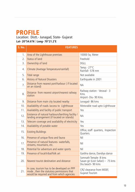
VERAVAL LIGHTHOUSE
13
S. No. FEATURES
1. Area of the Lighthouse premises 10000 Sq. Meter
2. Status of land Freehold
3. Ownership of land DGLL
4. Climate (Avetage Temperature/rainfall) Temp.- 27°CRainfall- 578 mm
5. Tidal range Not available
6. History of Natural Disasters Earthquake in 2001
7. Distance from nearest port/harbour ( if located on an island) NA
8. Distance from nearest airport/nearest railwaystation
Railway station - Veraval - 3 Kms.Airport- Diu- 90 Kms.
9. Distance from main city located nearby Junagad- 86 kms
10. Availability of roads /access to Lighthouse Motorable road upto Lighthouse
11. Availability and facility of public transport Yes
12. Existence of natural harbours/berthing facility / landing arrangement (if located on islands) NA
13. Telecom coverage and availability of electricity Yes
14. Availability of potable water Yes
15. Existing Buildings Office, staff quarters, Inspection Quarters.
16. Presence of unique flora and fauna Nil
17. Presence of natural features- waterfalls, streams, mountains, etc. Nil
18. Potential for adventure and water sports Nil
19. Presence of local/tribal/folk art Garbha dance, Dandiya dance
20. Nearest tourist destination and distanceSomnath Temple- 8 kmsSasan gir (Lion Safari) – 75 kmsDiu beach- 90 kms
21.In case, tourism has to be developed on PPP mode , then the statutory permissions that would be required and from which agencies
CRZ clearance from MOEF, Gujarat Tourism
PROFILELocation: Distt.- Junagad, State- Gujarat Lat- 20°54.6’N Long- 70°21.2’E

14
DEVELOPMENT OF LIGHTHOUSES AS BEACONS OF TOURISM
MANDVI LIGHTHOUSE & VTS STATION

15
S. No. FEATURES
1. Area of the Lighthouse premises 4180 Sq. Meter
2. Status of land Free hold
3. Ownership of land DGLL
4. Climate (Avetage Temperature/rainfall) Temp. -36°CRainfall - 300 mm
5. Tidal range 4-5 Meter
6. History of Natural Disasters Earthquake 2001
7. Distance from nearest port/harbour ( if located on an island) Nil
8. Distance from nearest airport/nearest railwaystation 1.30hr, 75km, Bhuj
9. Distance from main city located nearby 60km, Bhuj
10. Availability of roads /access to Lighthouse Well connected by road
11. Availability and facility of public transport 2 km from LH
12. Existence of natural harbours/berthing facility / landing arrangement (if located on islands) Nil
13. Telecom coverage and availability of electricity Yes
14. Availability of potable water Municipality water supply line available
15. Existing Buildings Technical Building, Inspection Quarters, Staff Quarters
16. Presence of unique flora and fauna Nil
17. Presence of natural features- waterfalls, streams, mountains, etc. Nil
18. Potential for adventure and water sports Yes
19. Presence of local/tribal/folk art Nil
20. Nearest tourist destination and distance Ravalpir temple-5 km,Swaminarayan temple
21.In case, tourism has to be developed on PPP mode , then the statutory permissions that would be required and from which agencies
CRZ clearance from MOEF, Gujarat Tourism
PROFILELocation: Distt.- Kachchh, State- GujaratLat- 22°49.8’N Long- 69°20.8’E

16
DEVELOPMENT OF LIGHTHOUSES AS BEACONS OF TOURISM
KACHCHIGARH LIGHTHOUSE

17
S. No. FEATURES
1. Area of the Lighthouse premises 13530 Sq. Meter
2. Status of land Freehold
3. Ownership of land DGLL
4. Climate (Avetage Temperature/rainfall) Temp. - 31° CRainfall - 350 mm
5. Tidal range 4.49 Meter
6. History of Natural Disasters Earthquake, Zone IV
7. Distance from nearest port/harbour ( if located on an island) N/A
8. Distance from nearest airport/nearest railwaystation Dwarka, 20 km
9. Distance from main city located nearby Dwarka, 20 km
10. Availability of roads /access to Lighthouse Yes
11. Availability and facility of public transport Yes
12. Existence of natural harbours/berthing facility / landing arrangement (if located on islands) NA
13. Telecom coverage and availability of electricity Yes
14. Availability of potable water Yes
15. Existing Buildings Inspection Quarters, Power House, Staff quarters
16. Presence of unique flora and fauna Nil
17. Presence of natural features- waterfalls, streams, mountains, etc. Nil
18. Potential for adventure and water sports Yes
19. Presence of local/tribal/folk art Yes
20. Nearest tourist destination and distance Dwarka, 20 km
21.In case, tourism has to be developed on PPP mode , then the statutory permissions that would be required and from which agencies
Environmental and CRZ clearance from MOEF, Gujarat Tourism
PROFILELocation: Distt.- Dev Bhoomi Dwaraka, State- GujaratLat- 22°56.5’N Long- 69°13.9’E

18
DEVELOPMENT OF LIGHTHOUSES AS BEACONS OF TOURISM
GOPNATH LIGHTHOUSE

19
S. No. FEATURES
1. Area of the Lighthouse premises 17300 Sq. Meter
2. Status of land Freehold
3. Ownership of land DGLL
4. Climate (Avetage Temperature/rainfall) Temp. - 32° CRainfall - 350 mm
5. Tidal range 4 Meter
6. History of Natural Disasters Earthquake, Zone IV
7. Distance from nearest port/harbour ( if located on an island) NA
8. Distance from nearest airport/nearest railwaystation Bhavnagar, 80 km
9. Distance from main city located nearby Bhavnagar, 80 km
10. Availability of roads /access to Lighthouse Yes
11. Availability and facility of public transport Yes
12. Existence of natural harbours/berthing facility / landing arrangement (if located on islands) NA
13. Telecom coverage and availability of electricity Yes
14. Availability of potable water Well
15. Existing Buildings Inspection Quarters, Power House, Staff quarters
16. Presence of unique flora and fauna Nil
17. Presence of natural features- waterfalls, streams, mountains, etc. Nil
18. Potential for adventure and water sports Yes
19. Presence of local/tribal/folk art Yes
20. Nearest tourist destination and distance Gopnath
21.In case, tourism has to be developed on PPP mode , then the statutory permissions that would be required and from which agencies
Environmental and CRZ clearance from MOEF, Gujarat Tourism
PROFILELocation: Distt.- Bhavnagar, State- GujaratLat- 21°12.2’N Long- 72°06.6’E

20
DEVELOPMENT OF LIGHTHOUSES AS BEACONS OF TOURISM
ALANG LIGHTHOUSE

21
S. No. FEATURES
1. Area of the Lighthouse premises 52100 Sq. Meter
2. Status of land Freehold
3. Ownership of land DGLL
4. Climate (Avetage Temperature/rainfall) Temp. - 31° CRainfall - 375 mm
5. Tidal range 4 meter
6. History of Natural Disasters Earthquake, Zone IV
7. Distance from nearest port/harbour ( if located on an island) NA
8. Distance from nearest airport/nearest railwaystation Bhavnagar, 60 km
9. Distance from main city located nearby Bhavnagar, 60 km
10. Availability of roads /access to Lighthouse Yes
11. Availability and facility of public transport Yes
12. Existence of natural harbours/berthing facility / landing arrangement (if located on islands) NA
13. Telecom coverage and availability of electricity Yes
14. Availability of potable water Well
15. Existing Buildings Inspection Quarters, Power House, Staff quarters
16. Presence of unique flora and fauna No
17. Presence of natural features- waterfalls, streams, mountains, etc. Nil
18. Potential for adventure and water sports Nil
19. Presence of local/tribal/folk art Yes
20. Nearest tourist destination and distance Biggest ship breaking yard,Alang- 2 km
21.In case, tourism has to be developed on PPP mode , then the statutory permissions that would be required and from which agencies
Environmental and CRZ clearance from MOEF, Gujarat Tourism
PROFILELocation: Distt.- Bhavnagar, State- GujaratLat- 21°24.2’N Long- 72°11.1’E

22
DEVELOPMENT OF LIGHTHOUSES AS BEACONS OF TOURISM
UMARGAM LIGHTHOUSE

23
S. No. FEATURES
1. Area of the Lighthouse premises 3000 Sq. Meter2. Status of land Freehold3. Ownership of land DGLL
4. Climate (Avetage Temperature/rainfall) Temp. - 35°CRainfall - 2500 mm
5. Tidal range 2 to 8 Meter6. History of Natural Disasters Nil
7. Distance from nearest port/harbour ( if located on an island) NA
8. Distance from nearest airport/nearest railwaystation
Railway station-Umargam-10Kms.Airport - Surat - 154 Kms.
9. Distance from main city located nearby Umargam - 10 kms 10. Availability of roads /access to Lighthouse Motorable road upto Lighthouse
11. Availability and facility of public transport Bus service upto 0.5 kms. from Lighthouse
12. Existence of natural harbours/berthing facility / landing arrangement (if located on islands) NA
13. Telecom coverage and availability of electricity Yes
14. Availability of potable water Well & Gram Panchayat Water Supply
15. Existing Buildings Inspection Quarters, Office / Store room, Staff quarters
16. Presence of unique flora and fauna Nil
17. Presence of natural features- waterfalls, streams, mountains, etc. Nil
18. Potential for adventure and water sports Nil19. Presence of local/tribal/folk art Nil
20. Nearest tourist destination and distanceUmargam Beach – 1 kms.Vrindavan Studio – 6 kms.
21.In case, tourism has to be developed on PPP mode , then the statutory permissions that would be required and from which agencies
CRZ clearance from MOEF and local bodies
PROFILELocation: Distt.- Valsad, State- GujaratLat- 20°11.7’N Long- 72°45.0’E

24
DEVELOPMENT OF LIGHTHOUSES AS BEACONS OF TOURISM
KANAI CREEK LIGHTHOUSE

25
S. No. FEATURES
1. Area of the Lighthouse premises 10000 Sq. Meter2. Status of land Freehold3. Ownership of land DGLL
4. Climate (Avetage Temperature/rainfall) Temp. - 35°C Rainfall - 2500 mm
5. Tidal range 2 to 8 Meter6. History of Natural Disasters NIL
7. Distance from nearest port/harbour ( if located on an island) NA
8. Distance from nearest airport/nearest railwaystation
Railway station- Navsari- 25 Kms.Airport - Surat - 72 Kms.
9. Distance from main city located nearby Navsari - 22 kms
10. Availability of roads /access to Lighthouse Motorable road upto Lighthouse
11. Availability and facility of public transport Bus service upto 0.5 kms. away from Lighthouse
12. Existence of natural harbours/berthing facility / landing arrangement (if located on islands) NA
13. Telecom coverage and availability of electricity Yes14. Availability of potable water Well Water
15. Existing Buildings Inspection Quarters, Power House, Staff quarters
16. Presence of unique flora and fauna NIL
17. Presence of natural features- waterfalls, streams, mountains, etc. NIL
18. Potential for adventure and water sports NIL19. Presence of local/tribal/folk art NIL20. Nearest tourist destination and distance Dandi – 15 kms
21.In case, tourism has to be developed on PPP mode , then the statutory permissions that would be required and from which agencies
CRZ clearance from MOEF
PROFILELocation: Distt.- Navasari, State- GujaratLat- 20°48.7’N Long- 72°49.7’E

26
DEVELOPMENT OF LIGHTHOUSES AS BEACONS OF TOURISM
PIROTAN NORTH EAST POINT LIGHTHOUSE

27
S. No. FEATURES
1. Area of the Lighthouse premises 6760 Sq. Meter
2. Status of land Freehold
3. Ownership of land DGLL
4. Climate (Avetage Temperature/rainfall) Temp. - 32° CRainfall - 400 mm
5. Tidal range 4.17 Meter
6. History of Natural Disasters Earthquake, Zone IV
7. Distance from nearest port/harbour ( if located on an island) Bedi Port, 12 Nautical Miles
8. Distance from nearest airport/nearest railwaystation Jamnagar 4 km from Bedi Port
9. Distance from main city located nearby Jamnagar, 4 km
10. Availability of roads /access to Lighthouse By Boat, 12 Nautical Miles
11. Availability and facility of public transport No
12. Existence of natural harbours/berthing facility / landing arrangement (if located on islands) Yes for small boats only
13. Telecom coverage and availability of electricity Telecom coverage availableGenerator & Solar Power
14. Availability of potable water Rain Water Harvesting
15. Existing Buildings Staff quarters
16. Presence of unique flora and fauna Yes
17. Presence of natural features- waterfalls, streams, mountains, etc. Marine National Park
18. Potential for adventure and water sports Yes
19. Presence of local/tribal/folk art Nil
20. Nearest tourist destination and distance Jamnagar 4 km from Bedi Port
21.In case, tourism has to be developed on PPP mode , then the statutory permissions that would be required and from which agencies
Environmental and CRZ clearance from MOEF, Gujarat Tourism
PROFILELocation: Distt.- Jamnagar, State- GujaratLat- 22°36.2’N Long- 69°57.1’E

28
DEVELOPMENT OF LIGHTHOUSES AS BEACONS OF TOURISM
KALUBHAR TAPU LIGHTHOUSE

29
S. No. FEATURES
1. Area of the Lighthouse premises 773 Sq. Meter
2. Status of land Freehold
3. Ownership of land DGLL
4. Climate (Avetage Temperature/rainfall) Temp. - 32° CRainfall - 400 mm
5. Tidal range 4.17 Meter
6. History of Natural Disasters Earthquake, Zone IV
7. Distance from nearest port/harbour ( if located on an island) Salaya Port, 12 km
8. Distance from nearest airport/nearest railwaystation
Khambhalia 11 km from Salaya Port
9. Distance from main city located nearby Khambhalia, 11 km
10. Availability of roads /access to Lighthouse By Boat, 8 Nautical Miles
11. Availability and facility of public transport Nil
12. Existence of natural harbours/berthing facility / landing arrangement (if located on islands) Yes for small boats only
13. Telecom coverage and availability of electricity YesSolar Power
14. Availability of potable water Rain Water Harvesting
15. Existing Buildings Nil
16. Presence of unique flora and fauna Nil
17. Presence of natural features- waterfalls, streams, mountains, etc. Nil
18. Potential for adventure and water sports Nil
19. Presence of local/tribal/folk art Nil
20. Nearest tourist destination and distance Nil
21.In case, tourism has to be developed on PPP mode , then the statutory permissions that would be required and from which agencies
Environmental and CRZ clearance from MOEF, Gujarat Tourism
PROFILELocation: Near Chudeshwar Town, GujaratLat- 22°26.3’N Long- 69°35.2’E

30
DEVELOPMENT OF LIGHTHOUSES AS BEACONS OF TOURISM
PIRAM LIGHTHOUSE

31
S. No. FEATURES
1. Area of the Lighthouse premises 25255 Sq. Meter
2. Status of land Freehold
3. Ownership of land DGLL
4. Climate (Avetage Temperature/rainfall) Temp. - 32° CRainfall - 350 mm
5. Tidal range 4.0 Meter
6. History of Natural Disasters Earthquake
7. Distance from nearest port/harbour ( if located on an island) Gogha Jetty, 7 nautical mile
8. Distance from nearest airport/nearest railwaystation Bhavnagar, 40 km from Gogha
9. Distance from main city located nearby Bhavnagar, 40 km from Gogha
10. Availability of roads /access to Lighthouse By small boats from Gogha Jetty
11. Availability and facility of public transport Nil
12. Existence of natural harbours/berthing facility / landing arrangement (if located on islands) For small boats only
13. Telecom coverage and availability of electricity YesGenerator & Solar Power
14. Availability of potable water Rain Water Harvesting
15. Existing Buildings Staff quarters
16. Presence of unique flora and fauna Nil
17. Presence of natural features- waterfalls, streams, mountains, etc. Nil
18. Potential for adventure and water sports Yes
19. Presence of local/tribal/folk art Nil
20. Nearest tourist destination and distance Bhavnagar, 40km from Gogha
21.In case, tourism has to be developed on PPP mode , then the statutory permissions that would be required and from which agencies
Environmental and CRZ clearance from MOEF, Gujarat Tourism
PROFILELocation: Distt. - Bhavnagar, State- GujaratLat- 21°35.9’N Long- 72°21.2’E

32
DEVELOPMENT OF LIGHTHOUSES AS BEACONS OF TOURISM
SEVAI BET LIGHTHOUSE

33
S. No. FEATURES
1. Area of the Lighthouse premises 6750 Sq. Meter
2. Status of land Freehold
3. Ownership of land DGLL
4. Climate (Avetage Temperature/rainfall) Temp. - 32°Rainfall - 300 mm
5. Tidal range 3.6 Meter
6. History of Natural Disasters Earthquake, Zone IV
7. Distance from nearest port/harbour ( if located on an island) Pipava Port, 3 Nautical
8. Distance from nearest airport/nearest railwaystation Veraval, 98 km from Pipava port
9. Distance from main city located nearby Veraval, 98 km from Pipava port
10. Availability of roads /access to Lighthouse No
11. Availability and facility of public transport Small Boats
12. Existence of natural harbours/berthing facility / landing arrangement (if located on islands) Small boats only
13. Telecom coverage and availability of electricity YesGenerator & Solar Power
14. Availability of potable water Rain Water Harvesting
15. Existing Buildings Staff quarters
16. Presence of unique flora and fauna Nil
17. Presence of natural features- waterfalls, streams, mountains, etc. Nil
18. Potential for adventure and water sports Nil
19. Presence of local/tribal/folk art Nil
20. Nearest tourist destination and distance Somnath, 105 km from Pipava port
21.In case, tourism has to be developed on PPP mode , then the statutory permissions that would be required and from which agencies
Environmental and CRZ clearance from MOEF, Gujarat Tourism
PROFILELocation: Distt. - Amreli, State- GujaratLat- 20°54.2’N Long- 71°31.6’E

34
DEVELOPMENT OF LIGHTHOUSES AS BEACONS OF TOURISM
UTTAN POINT LIGHTHOUSE

35
S. No. FEATURES
1. Area of the Lighthouse premises 46500 Sq. Meter2. Status of land Freehold3. Ownership of land DGLL
4. Climate (Avetage Temperature/rainfall) Temp. - 38°CRainfall - 2500 mm
5. Tidal range 2 to 8 Meter. 6. History of Natural Disasters Nil
7. Distance from nearest port/harbour ( if located on an island) NA
8. Distance from nearest airport/nearest railwaystation
Railway station- Bhayander- 10kms Airport - Mumbai - 40 kms
9. Distance from main city located nearby Bhayander - 10 kms 10. Availability of roads /access to Lighthouse Motorable road upto Lighthouse 11. Availability and facility of public transport Bus service upto Lighthouse
12. Existence of natural harbours/berthing facility / landing arrangement (if located on islands) NA
13. Telecom coverage and availability of electricity NA
14. Availability of potable water PWD water supply and rain water storage tank
15. Existing BuildingsInspection Quarters, Power House, Store Room & Staff quarters
16. Presence of unique flora and fauna Nil
17. Presence of natural features- waterfalls, streams, mountains, etc. Nil
18. Potential for adventure and water sports Nil19. Presence of local/tribal/folk art Nil
20. Nearest tourist destination and distance
Valankini Temlpe – 03 kms Uttan Beach – Near to LHEssel World & Water Kingdom – 22 Kms.
21.In case, tourism has to be developed on PPP mode , then the statutory permissions that would be required and from which agencies
CRZ clearance from MOEF and local bodies
PROFILELocation: Distt. - Thane, State- MaharashtraLat- 19°16.5’N Long- 72°46.8’E
36
DEVELOPMENT OF LIGHTHOUSES AS BEACONS OF TOURISM
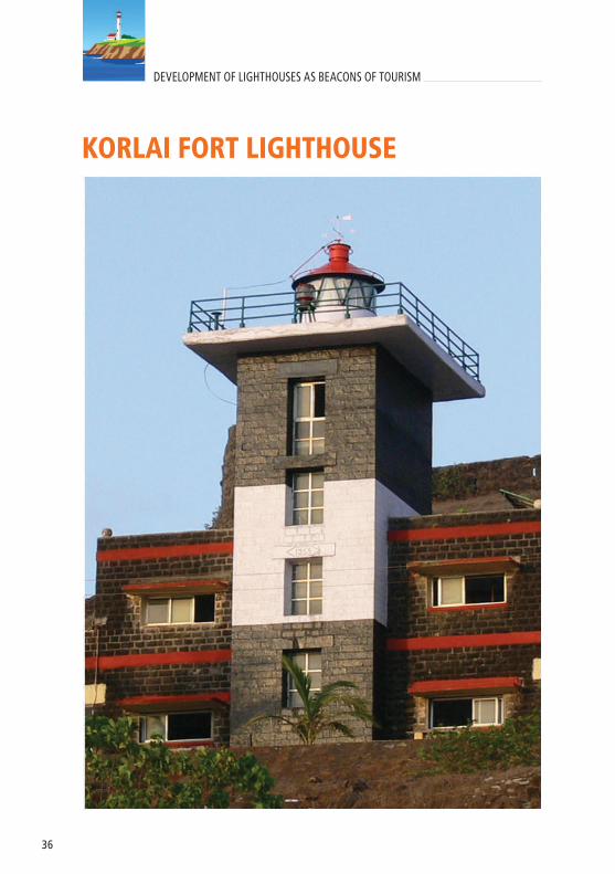
KORLAI FORT LIGHTHOUSE

37
S. No. FEATURES
1. Area of the Lighthouse premises 60700 Sq. Meter
2. Status of land Freehold
3. Ownership of land DGLL
4. Climate (Avetage Temperature/rainfall) Temp. -32°CRainfall -3000 mm
5. Tidal range 3 to 8 Meter.
6. History of Natural Disasters Nil
7. Distance from nearest port/harbour ( if located on an island) NA
8. Distance from nearest airport/nearest railwaystation
Railway station - Panvel – 81 Kms. to LH Airport - 120 Kms. LH
9. Distance from main city located nearby Alibag - 25 Kms. from LH
10. Availability of roads /access to Lighthouse Motorable road upto LH
11. Availability and facility of public transport Bus Service 3 kms away from LH
12. Existence of natural harbours/berthing facility / landing arrangement (if located on islands) NA
13. Telecom coverage and availability of electricity Yes
14. Availability of potable water Open Well Water Supply
15. Existing Buildings Inspection Quarters, Power House, Office, Staff quarters
16. Presence of unique flora and fauna Nil
17. Presence of natural features- waterfalls, streams, mountains, etc. Nil
18. Potential for adventure and water sports Nil
19. Presence of local/tribal/folk art Nil
20. Nearest tourist destination and distance Korlai Fort – Near to LH
21.In case, tourism has to be developed on PPP mode , then the statutory permissions that would be required and from which agencies
CRZ clearance from MOEF and local bodies
PROFILELocation: Distt. - Raigadh, State- MaharashtraLat- 18°32.3’N Long- 72°54.5’E

38
DEVELOPMENT OF LIGHTHOUSES AS BEACONS OF TOURISM
JAIGARH LIGHTHOUSE

39
S. No. FEATURES
1. Area of the Lighthouse premises 18000 Sq. Meter 2. Status of land Freehold3. Ownership of land DGLL
4. Climate (Avetage Temperature/rainfall) Temp. - 32°CRainfall- 3000 mm
5. Tidal range 3 to 8 Meter6. History of Natural Disasters Nil
7. Distance from nearest port/harbour ( if located on an island) NA
8. Distance from nearest airport/nearest railwaystation
Railway station - Ratnagiri – 50 Kms. Airport – Goa - 310 Kms.
9. Distance from main city located nearby Ratnagiri - 55 Kms. from LH10. Availability of roads /access to Lighthouse Motorable road upto LH
11. Availability and facility of public transport Bus Service 06 Kms away from LH
12. Existence of natural harbours/berthing facility / landing arrangement (if located on islands) Nil
13. Telecom coverage and availability of electricity Yes14. Availability of potable water Open Well Water Supply
15. Existing Buildings Inspection Quarters, Power House, Staff quarters
16. Presence of unique flora and fauna Nil
17. Presence of natural features- waterfalls, streams, mountains, etc. Nil
18. Potential for adventure and water sports Nil19. Presence of local/tribal/folk art Nil
20. Nearest tourist destination and distanceJaigad Fort – 06 kms., Ganpati Phule Temple & Beach – 25 Kms
21.In case, tourism has to be developed on PPP mode , then the statutory permissions that would be required and from which agencies
CRZ clearance from MOEF and local bodies
PROFILELocation: Distt. - Ratnagiri, State- MaharashtraLat- 17°17.8’N Long- 73°11.6’E

40
DEVELOPMENT OF LIGHTHOUSES AS BEACONS OF TOURISM
RATNAGIRI LIGHTHOUSE

41
S. No.
FEATURES
1. Area of the Lighthouse premises 11820 Sq. Meter 2. Status of land Freehold3. Ownership of land DGLL
4. Climate (Avetage Temperature/rainfall) Temp. - 32°CRainfall- 3000 mm
5. Tidal range 3 to 8 Meter6. History of Natural Disasters Nil
7. Distance from nearest port/harbour ( if located on an island) NA
8. Distance from nearest airport/nearest railwaystation
Railway station-Ratnagiri-14Kms.Airport – Goa - 260 Kms.
9. Distance from main city located nearby Ratnagiri - 5 Kms.10. Availability of roads /access to Lighthouse Motorable road upto LH11. Availability and facility of public transport Bus Service 06 Kms away from LH
12. Existence of natural harbours/berthing facility / landing arrangement (if located on islands) Nil
13. Telecom coverage and availability of electricity Yes
14. Availability of potable water Open Well Water Supply & Municipal Water Supply
15. Existing Buildings Inspection Quarters, Power House, Staff quarters
16. Presence of unique flora and fauna Nil
17. Presence of natural features- waterfalls, streams, mountains, etc. Nil
18. Potential for adventure and water sports Nil19. Presence of local/tribal/folk art Nil
20. Nearest tourist destination and distance
Bhagwati Temple – 01 Kms.Mandovi Beach – 02 Kms.Bhatya Beach – 04 Kms.Ganpati Phule Temple & Beach – 30 Kms.
21.In case, tourism has to be developed on PPP mode , then the statutory permissions that would be required and from which agencies
CRZ clearance from MOEF and local bodies
PROFILELocation: Distt. - Ratnagiri, State- MaharashtraLat- 16°59.2’N Long- 73°16.4’E

42
DEVELOPMENT OF LIGHTHOUSES AS BEACONS OF TOURISM
DEVGARH LIGHTHOUSE

43
S. No. FEATURES
1. Area of the Lighthouse premises 9910 Sq. Meter 2. Status of land Freehold3. Ownership of land DGLL
4. Climate (Avetage Temperature/rainfall) Temp. - 32°CRainfall- 3000 mm
5. Tidal range 3 to 8 Meter6. History of Natural Disasters Nil
7. Distance from nearest port/harbour ( if located on an island) NA
8. Distance from nearest airport/nearest railwaystation
Railway station - Kankavali – 60 Kms. Airport – Goa - 200 Kms.
9. Distance from main city located nearby Devgad - 05 Kms. 10. Availability of roads /access to Lighthouse Motorable road upto LH
11. Availability and facility of public transport Bus Service 05 Kms away from LH
12. Existence of natural harbours/berthing facility / landing arrangement (if located on islands) NA
13. Telecom coverage and availability of electricity Yes14. Availability of potable water Open Well Water Supply
15. Existing Buildings Inspection Quarters, Power House, Staff quarters
16. Presence of unique flora and fauna Nil
17. Presence of natural features- waterfalls, streams, mountains, etc. Nil
18. Potential for adventure and water sports Nil19. Presence of local/tribal/folk art Nil
20. Nearest tourist destination and distance Devgad Fort – Near LHKunkeshwar Temple – 25 Kms.
21.In case, tourism has to be developed on PPP mode , then the statutory permissions that would be required and from which agencies
CRZ clearance from MOEF and local bodies
PROFILELocation: Distt. - Sindhudurg, State- MaharashtraLat- 16°23.3’N Long- 73°22.6’E
44
DEVELOPMENT OF LIGHTHOUSES AS BEACONS OF TOURISM
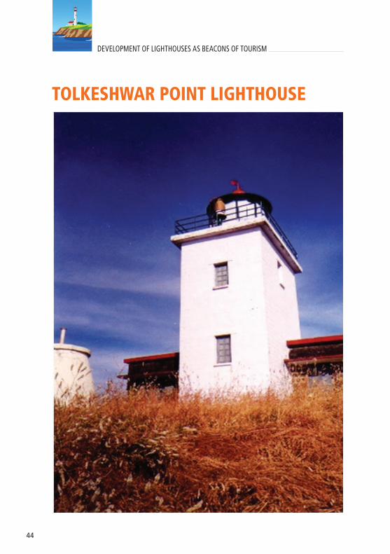
TOLKESHWAR POINT LIGHTHOUSE

45
S. No. FEATURES
1. Area of the Lighthouse premises 2500 Sq. Meter
2. Status of land Freehold
3. Ownership of land DGLL
4. Climate (Avetage Temperature/rainfall) Temp. - 32°CRainfall- 3000 mm
5. Tidal range 3 to 8 Meter
6. History of Natural Disasters Nil
7. Distance from nearest port/harbour ( if located on an island) NA
8. Distance from nearest airport/nearest railwaystation
Railway station - Chiplun – 60 Kms. Airport – Mumbai - 320 Kms.
9. Distance from main city located nearby Chiplun - 60 Kms.
10. Availability of roads /access to Lighthouse Motorable road upto LH
11. Availability and facility of public transport Bus Service 05 Kms away from LH
12. Existence of natural harbours/berthing facility / landing arrangement (if located on islands) NA
13. Telecom coverage and availability of electricity Yes
14. Availability of potable water Open Well Water Supply
15. Existing Buildings Inspection Quarters, Staff quarters
16. Presence of unique flora and fauna Nil
17. Presence of natural features- waterfalls, streams, mountains, etc. Nil
18. Potential for adventure and water sports Nil
19. Presence of local/tribal/folk art Nil
20. Nearest tourist destination and distance Tolkeshwar Fort – 02 Kms.
21.In case, tourism has to be developed on PPP mode , then the statutory permissions that would be required and from which agencies
CRZ clearance from MOEF and local bodies
PROFILELocation: Distt. - Ratnagiri, State- MaharashtraLat- 17°33.9’N Long- 73°08.5’E

46
DEVELOPMENT OF LIGHTHOUSES AS BEACONS OF TOURISM
AGUADA LIGHTHOUSE

47
S. No. FEATURES
1. Area of the Lighthouse premises 8156 Sq. Meter
2. Status of land Freehold
3. Ownership of land DGLL
4. Climate (Avetage Temperature/rainfall) Temp. - 32°CRainfall- 3000 mm
5. Tidal range 3 to 8 Meter
6. History of Natural Disasters Nil
7. Distance from nearest port/harbour ( if located on an island) NA
8. Distance from nearest airport/nearest railwaystation
Railway station - Thivim – 22 Kms. Airport – Goa - 50 Kms.
9. Distance from main city located nearby Panjim - 16 Kms.
10. Availability of roads /access to Lighthouse Motorable road upto LH
11. Availability and facility of public transport Bus Service 03 Kms away from LH
12. Existence of natural harbours/berthing facility / landing arrangement (if located on islands) NA
13. Telecom coverage and availability of electricity Yes
14. Availability of potable water PWD Water Supply
15. Existing Buildings Inspection Quarters, Power House cum office, staff quarters.
16. Presence of unique flora and fauna Nil
17. Presence of natural features- waterfalls, streams, mountains, etc. Nil
18. Potential for adventure and water sports Nil
19. Presence of local/tribal/folk art Nil
20. Nearest tourist destination and distance Goa
21.In case, tourism has to be developed on PPP mode , then the statutory permissions that would be required and from which agencies
CRZ clearance from MOEF and ASI
PROFILELocation: Distt. - Condolim, State- GoaLat- 15°29.5’N Long- 73°46.4’E

48
DEVELOPMENT OF LIGHTHOUSES AS BEACONS OF TOURISM
VENGURLA ROCKS LIGHTHOUSE

49
S. No. FEATURES
1. Area of the Lighthouse premises NA
2. Status of land Freehold
3. Ownership of land DGLL
4. Climate (Avetage Temperature/rainfall) Temp. - 31°CRainfall- 3000 mm
5. Tidal range 3 to 8 Meter
6. History of Natural Disasters Nil
7. Distance from nearest port/harbour ( if located on an island) 1 hour from Nivti Jetty
8. Distance from nearest airport/nearest railwaystation
Railway station - Kudal – 25 Kms. Airport – Goa - 100 Kms.
9. Distance from main city located nearby Vengurla - 25 Kms.
10. Availability of roads /access to Lighthouse NA
11. Availability and facility of public transport Nil
12. Existence of natural harbours/berthing facility / landing arrangement (if located on islands) Nil
13. Telecom coverage and availability of electricity YesSolar Power
14. Availability of potable water Rain Water storage tanks
15. Existing BuildingsInspection Quarters, Power House, Store room, Staff quarters
16. Presence of unique flora and fauna Nil
17. Presence of natural features- waterfalls, streams, mountains, etc. Nil
18. Potential for adventure and water sports Nil
19. Presence of local/tribal/folk art Nil
20. Nearest tourist destination and distance NA
21.In case, tourism has to be developed on PPP mode , then the statutory permissions that would be required and from which agencies
CRZ clearance from MOEF and local bodies
PROFILELocation: Distt. - Sindhudurg, State- MaharashtraLat- 15°53.4’N Long- 73°27.7’E

50
DEVELOPMENT OF LIGHTHOUSES AS BEACONS OF TOURISM
SAO GEORGE LIGHTHOUSE

51
S. No. FEATURES
1. Area of the Lighthouse premises NA
2. Status of land Freehold
3. Ownership of land DGLL
4. Climate (Avetage Temperature/rainfall) Temp. - 30°CRainfall- 3000 mm
5. Tidal range 3 to 8 Meter
6. History of Natural Disasters Nil
7. Distance from nearest port/harbour ( if located on an island) 6.5 Kms. from Mormugao Port
8. Distance from nearest airport/nearest railwaystation
Railway station - Murmogoa – 30 Kms.Airport – Goa - 15 Kms.
9. Distance from main city located nearby Vasco - 8 Kms. from LH
10. Availability of roads /access to Lighthouse NA
11. Availability and facility of public transport Nil
12. Existence of natural harbours/berthing facility / landing arrangement (if located on islands) Nil
13. Telecom coverage and availability of electricity YesSolar Power
14. Availability of potable water Nil
15. Existing Buildings Nil
16. Presence of unique flora and fauna Nil
17. Presence of natural features- waterfalls, streams, mountains, etc. Nil
18. Potential for adventure and water sports Nil
19. Presence of local/tribal/folk art Nil
20. Nearest tourist destination and distance Vasco – da – Gama Fort - 7 Kms.
21.In case, tourism has to be developed on PPP mode , then the statutory permissions that would be required and from which agencies
CRZ clearance from MOEF and local bodies
PROFILELocation: Near Aguada LH, State- GoaLat- 15°21.1’N Long- 73°45.8’E

52
DEVELOPMENT OF LIGHTHOUSES AS BEACONS OF TOURISM
KANHOJI ANGRE LIGHTHOUSE

53
S. No. FEATURES
1. Area of the Lighthouse premises Approx. 8000 Sq. Meter2. Status of land Leased land3. Ownership of land MbPT
4. Climate (Avetage Temperature/rainfall) Temp. - 32°CRainfall- 3000 mm
5. Tidal range 4 to 9 Meter6. History of Natural Disasters Nil
7. Distance from nearest port/harbour ( if located on an island)
Approx. 1.5 Hour journey from Gate Way of India to Thal Jetty then 45 minutes journey by boat to Khanderi Lighthouse
8. Distance from nearest airport/nearest railwaystation
Rail - Panvel – 70 Kms.Airport – Goa - 15 Kms., Airport - Mumbai - 100 Kms. upto Thal
9. Distance from main city located nearby10 Kms. from Alibag to Thal Jetty then By boat to Khanderi Lighthouse
10. Availability of roads /access to Lighthouse NA11. Availability and facility of public transport NA
12. Existence of natural harbours/berthing facility / landing arrangement (if located on islands) Nil
13. Telecom coverage and availability of electricity YesSolar Power
14. Availability of potable water Open water Pond
15. Existing Buildings Combined building of Inspection Quarters & Power House
16. Presence of unique flora and fauna Nil
17. Presence of natural features- waterfalls, streams, mountains, etc. Nil
18. Potential for adventure and water sports Nil19. Presence of local/tribal/folk art Nil20. Nearest tourist destination and distance Thal
21.In case, tourism has to be developed on PPP mode , then the statutory permissions that would be required and from which agencies
CRZ clearance from MOEF and local bodies
PROFILELocation: Distt. - Raigad, State- MaharashtraLat- 18°42.1’N Long- 72°48.8’E

54
DEVELOPMENT OF LIGHTHOUSES AS BEACONS OF TOURISM
SUNK ROCK LIGHTHOUSE

55
PROFILE
No Land area is available around the Lighthouse
Location: Mumbai Harbour off the coast of Mumbai

56
DEVELOPMENT OF LIGHTHOUSES AS BEACONS OF TOURISM
BHATKAL LIGHTHOUSE

57
S. No. FEATURES1. Area of the Lighthouse premises Land Area – 6780 Sq. Meter2. Status of land Freehold3. Ownership of land DGLL
4. Climate (Avetage Temperature/rainfall) Temp. - 32°CRainfall- 3000 mm
5. Tidal range 3 to 8 Meter6. History of Natural Disasters Nil
7. Distance from nearest port/harbour ( if located on an island) NA
8. Distance from nearest airport/nearest railwaystation
Railway station - Bhatkal – 10 Kms. Airport – Manglore - 160 Kms.
9. Distance from main city located nearby Bhatkal city 7 Kms.
10. Availability of roads /access to Lighthouse Motorable road upto staff quarter
11. Availability and facility of public transport Bus Service upto 1 Km away from LH
12. Existence of natural harbours/berthing facility / landing arrangement (if located on islands) NA
13. Telecom coverage and availability of electricity Yes14. Availability of potable water Spring Water
15. Existing BuildingsPower House, Inspection Quarters, Store room, Staff quarters.
16. Presence of unique flora and fauna Nil
17. Presence of natural features- waterfalls, streams, mountains, etc. Nil
18. Potential for adventure and water sports Nil19. Presence of local/tribal/folk art Nil
20. Nearest tourist destination and distance
Byndoor Beach 21 Kms. from LHMurudeshwar Temple 16 Kms. from LH
21.In case, tourism has to be developed on PPP mode , then the statutory permissions that would be required and from which agencies
CRZ clearance from MOEF and local bodies.
PROFILELocation: Distt. - North Kanara, State- KarnatakaLat- 13°57.9’N Long- 74°32.0’E

58
DEVELOPMENT OF LIGHTHOUSES AS BEACONS OF TOURISM
SURATKAL POINT LIGHTHOUSE

59
S. No. FEATURES1. Area of the Lighthouse premises Land Area – 5337 Sq. Meter
2. Status of land Freehold
3. Ownership of land DGLL
4. Climate (Avetage Temperature/rainfall) Temp. - 34°CRainfall- 3000 mm
5. Tidal range 3 to 9 Meter
6. History of Natural Disasters Nil
7. Distance from nearest port/harbour ( if located on an island) NA
8. Distance from nearest airport/nearest railwaystation
Railway Station- Suratkal-5 Kms. Airport – Manglore - 35 Kms.
9. Distance from main city located nearby Suratkal 05 Kms.
10. Availability of roads /access to Lighthouse Motorable upto LH
11. Availability and facility of public transport Bus Service upto 1 Kms. away from LH
12. Existence of natural harbours/berthing facility / landing arrangement (if located on islands) NA
13. Telecom coverage and availability of electricity Yes
14. Availability of potable water Municipal Water Supply & Open Well
15. Existing BuildingsInspection Quarters, Power House, Store Room, Staff quarters .
16. Presence of unique flora and fauna Nil
17. Presence of natural features- waterfalls, streams, mountains, etc. Nil
18. Potential for adventure and water sports Nil
19. Presence of local/tribal/folk art Nil
20. Nearest tourist destination and distance Tourist spot
21.In case, tourism has to be developed on PPP mode , then the statutory permissions that would be required and from which agencies
CRZ clearance from MOEF and local bodies.
PROFILELocation: Distt.- South Kanara, State- KarnatakaLat- 13°00.2’N Long- 74°47.4’E

60
DEVELOPMENT OF LIGHTHOUSES AS BEACONS OF TOURISM
KAP LIGHTHOUSE

61
S. No. FEATURES
1. Area of the Lighthouse premises Land Area – 11501 Sq. Meter
2. Status of land Freehold
3. Ownership of land DGLL
4. Climate (Avetage Temperature/rainfall) Temp. -34°CRainfall- 3000 mm
5. Tidal range 3 to 9 Meter
6. History of Natural Disasters Nil
7. Distance from nearest port/harbour ( if located on an island) NA
8. Distance from nearest airport/nearest railwaystation
Railway station - Kaup – 8 Kms. Airport – Manglore - 50 Kms.
9. Distance from main city located nearby Udupi 13 Kms.
10. Availability of roads /access to Lighthouse Motorable road upto LH
11. Availability and facility of public transport Bus Service upto LH
12. Existence of natural harbours/berthing facility / landing arrangement (if located on islands) NA
13. Telecom coverage and availability of electricity YesSolar power
14. Availability of potable water Open well
15. Existing Buildings Inspection Quarters, Power House, Staff quarters
16. Presence of unique flora and fauna Nil
17. Presence of natural features- waterfalls, streams, mountains, etc. Nil
18. Potential for adventure and water sports Nil
19. Presence of local/tribal/folk art Nil
20. Nearest tourist destination and distance Udipi and Manipal
21.In case, tourism has to be developed on PPP mode , then the statutory permissions that would be required and from which agencies
CRZ clearance from MOEF and local bodies.
PROFILELocation: Distt.- Udupi, State- KarnatakaLat- 13°13.4’N Long- 74°44.2’E

62
DEVELOPMENT OF LIGHTHOUSES AS BEACONS OF TOURISM
OYSTER ROCKS LIGHTHOUSE

63
S. No. FEATURES
1. Area of the Lighthouse premises Land Area – 18000 Sq. Meter2. Status of land Freehold3. Ownership of land DGLL
4. Climate (Avetage Temperature/rainfall) Temp. -35°CRainfall- 3000 mm
5. Tidal range 3 to 8 Meter6. History of Natural Disasters Nil
7. Distance from nearest port/harbour ( if located on an island) 45 min. journey from Karwar Jetty
8.Distance from nearest airport/nearest railwaystation
Railway station - Karwar – 15 Kms. Airport – Goa - 120 Kms.
9. Distance from main city located nearby Karwar - 4 Kms. from Karwar Jetty
10. Availability of roads /access to Lighthouse NA
11. Availability and facility of public transport Bus Service upto Karwar Jetty
12.Existence of natural harbours/berthing facility / landing arrangement (if located on islands)
NA
13. Telecom coverage and availability of electricity Yes, Solar power
14. Availability of potable water Rain water Harvesting Tanks
15. Existing Buildings Inspection Quarters, Store room, Staff quarters.
16. Presence of unique flora and fauna Nil
17. Presence of natural features- waterfalls, streams, mountains, etc. Nil
18. Potential for adventure and water sports Nil19. Presence of local/tribal/folk art Nil
20. Nearest tourist destination and distance
Devbagh Beach – 3 Kms. From Karwar JettyWarship museum – 3 Kms. From Karwar Jetty
21.
In case, tourism has to be developed on PPP mode , then the statutory permissions that would be required and from which agencies
CRZ clearance from MOEF and local bodies.
PROFILELocation: Distt.- Kanera, State- KarnatakaLat- 14°49.2’N Long- 74°03.7’E

64
DEVELOPMENT OF LIGHTHOUSES AS BEACONS OF TOURISM
CHETWAI LIGHTHOUSE

65
S. No. FEATURES
1. Area of the Lighthouse premises 3606 Sq. Meter
2. Status of land Freehold
3. Ownership of land DGLL
4. Climate (Avetage Temperature/rainfall) Temp. -27°CRainfall- 329 mm
5. Tidal range 0.60 Meter
6. History of Natural Disasters Nil
7. Distance from nearest port/harbour ( if located on an island) NA
8. Distance from nearest airport/nearest railwaystation
Guruvayur Railway station – 8 KmCalicut Airport -85 Km
9. Distance from main city located nearby Guruvayur – 8 Km
10. Availability of roads /access to Lighthouse Motorable road upto LH
11. Availability and facility of public transport Bus Service upto LH
12. Existence of natural harbours/berthing facility / landing arrangement (if located on islands) Ponnani Harbour
13. Telecom coverage and availability of electricity Yes
14. Availability of potable water KWA water supply
15. Existing Buildings Inspection Quarters, Power House, staff quarters.
16. Presence of unique flora and fauna Coconut trees, Flower plants, shade trees
17. Presence of natural features- waterfalls, streams, mountains, etc. Nil
18. Potential for adventure and water sports Nil
19. Presence of local/tribal/folk art Nil
20. Nearest tourist destination and distance Guruvayoor temple 8 Km
21.In case, tourism has to be developed on PPP mode , then the statutory permissions that would be required and from which agencies
Orumanayur Grama Panchayat and CRZ from MOEF
PROFILELocation: Distt.- Trissur, State- KeralaLat- 10°33.10’N Long- 76°01.10’E

66
DEVELOPMENT OF LIGHTHOUSES AS BEACONS OF TOURISM
VYPIN LIGHTHOUSE

67
S. No. FEATURES
1. Area of the Lighthouse premises 3167 Sq. Meter
2. Status of land Freehold
3. Ownership of land DGLL
4. Climate (Avetage Temperature/rainfall) Temp. -37°CRainfall- 329 mm
5. Tidal range 0.60 Meter
6. History of Natural Disasters Nil
7. Distance from nearest port/harbour ( if located on an island) NA
8. Distance from nearest airport/nearest railwaystation
Cochin Air port -45 Km Ernakulam Railway station 2 Km
9. Distance from main city located nearby Ernakulam– 12 Km
10. Availability of roads /access to Lighthouse Motorable road upto LH
11. Availability and facility of public transport Bus service up to Lighthouse
12. Existence of natural harbours/berthing facility / landing arrangement (if located on islands) NA
13. Telecom coverage and availability of electricity Yes
14. Availability of potable water KWA water supply
15. Existing Buildings Inspection Quarters, Power House, Staff quarters
16. Presence of unique flora and fauna Coconut trees, Flower plants, shade trees
17. Presence of natural features- waterfalls, streams, mountains, etc. Nil
18. Potential for adventure and water sports Nil
19. Presence of local/tribal/folk art Nil
20. Nearest tourist destination and distance Cherai beach 17 Km
21.In case, tourism has to be developed on PPP mode , then the statutory permissions that would be required and from which agencies
Elamkunnapuzha Grama Panchayat and CRZ from MOEF
PROFILELocation: Distt.- Ernakulam, State- KeralaLat- 09°59.8’N Long- 76°13.3’E

68
DEVELOPMENT OF LIGHTHOUSES AS BEACONS OF TOURISM
MANAKKODAM LIGHTHOUSE

69
S. No. FEATURES
1. Area of the Lighthouse premises 6686 Sq. Meter
2. Status of land Freehold
3. Ownership of land DGLL
4. Climate (Avetage Temperature/rainfall) Temp. -27°CRainfall- 329 mm
5. Tidal range 0.60 Meter
6. History of Natural Disasters Nil
7. Distance from nearest port/harbour ( if located on an island) NA
8. Distance from nearest airport/nearest railwaystation
Cochin Air port -65 KmVayalar Railway station 5 Km
9. Distance from main city located nearby Chertthala– 10 Km
10. Availability of roads /access to Lighthouse Motorable road upto LH
11. Availability and facility of public transport Bus service up to Lighthouse
12. Existence of natural harbours/berthing facility / landing arrangement (if located on islands) NA
13. Telecom coverage and availability of electricity Yes
14. Availability of potable water KWA water supply
15. Existing Buildings Inspection Quarters, Staff quarters .
16. Presence of unique flora and fauna Coconut trees, Flower plants, shade trees
17. Presence of natural features- waterfalls, streams, mountains, etc. Nil
18. Potential for adventure and water sports Nil
19. Presence of local/tribal/folk art Nil
20. Nearest tourist destination and distance Anthakaranazhi – 500 m
21.In case, tourism has to be developed on PPP mode , then the statutory permissions that would be required and from which agencies
Pattanakkad Grama Panchayat and CRZ from MOEF
PROFILELocation: Distt.- Alappuzha, State- KeralaLat- 09°45.0’N Long- 76°17.10’E

70
DEVELOPMENT OF LIGHTHOUSES AS BEACONS OF TOURISM
VIZHINJAM LIGHTHOUSE

71
S. No. FEATURES1. Area of the Lighthouse premises 17770 Sq. Meter
2. Status of land Freehold
3. Ownership of land DGLL
4. Climate (Avetage Temperature/rainfall) Temp. -27°CRainfall- 329 mm
5. Tidal range 0.60 Meter
6. History of Natural Disasters Nil
7. Distance from nearest port/harbour ( if located on an island) NA
8. Distance from nearest airport/nearest railwaystation
Trivandrum Airport -12KmTrivandrum Railway station 15 Km
9. Distance from main city located nearby Thiruvananthapuram– 12 Km
10. Availability of roads /access to Lighthouse Motorable road upto LH
11. Availability and facility of public transport Bus service up to Lighthouse
12. Existence of natural harbours/berthing facility / landing arrangement (if located on islands) NA
13. Telecom coverage and availability of electricity Yes
14. Availability of potable water KWA water supply
15. Existing Buildings Inspection Quarters, Staff quarters
16. Presence of unique flora and fauna Coconut trees, Flower plants, shade trees
17. Presence of natural features- waterfalls, streams, mountains, etc. Nil
18. Potential for adventure and water sports Nil
19. Presence of local/tribal/folk art Nil
20. Nearest tourist destination and distance Kovalam beach
21.In case, tourism has to be developed on PPP mode , then the statutory permissions that would be required and from which agencies
Corporation of Thiruvananthapuran and CRZ from MOEF
PROFILELocation: Distt.- Thiruvananthapuram, State- KeralaLat- 08°22.9’N Long- 76°58.8’E

72
DEVELOPMENT OF LIGHTHOUSES AS BEACONS OF TOURISM
THANGASSERI LIGHTHOUSE

73
S. No. FEATURES
1. Area of the Lighthouse premises 4161 Sq. Meter
2. Status of land Freehold
3. Ownership of land DGLL
4. Climate (Avetage Temperature/rainfall) Temp. -27°CRainfall- 329 mm
5. Tidal range 0.60 Meter
6. History of Natural Disasters Nil
7. Distance from nearest port/harbour ( if located on an island) NA
8. Distance from nearest airport/nearest railwaystation
Trivandrum Airport -65KmKollam Railway station 6 Km
9. Distance from main city located nearby Kollam– 6 Km
10. Availability of roads /access to Lighthouse PWD road
11. Availability and facility of public transport Bus service up to Lighthouse
12. Existence of natural harbours/berthing facility / landing arrangement (if located on islands) NA
13. Telecom coverage and availability of electricity Yes
14. Availability of potable water KWA water supply
15. ExistingBuildings Inspection Quarters, Staff quarters .
16. Presence of unique flora and fauna Coconut trees, Flower plants, shade trees
17. Presence of natural features- waterfalls, streams, mountains, etc. Nil
18. Potential for adventure and water sports Nil
19. Presence of local/tribal/folk art Nil
20. Nearest tourist destination and distance Thangasery/Asram - 5 Km
21.In case, tourism has to be developed on PPP mode , then the statutory permissions that would be required and from which agencies
Corporation of Kollam and CRZ from MOEF
PROFILELocation: Distt.- Kollam, State- KeralaLat- 08°52.7’N Long- 76°34.0’E

74
DEVELOPMENT OF LIGHTHOUSES AS BEACONS OF TOURISM
KANNUR LIGHTHOUSE

75
S. No. FEATURES
1. Area of the Lighthouse premises 8334 Sq. Meter
2. Status of land Freehold
3. Ownership of land DGLL
4. Climate (Avetage Temperature/rainfall) Temp. -27°CRainfall - 329 mm
5. Tidal range 0.60 Meter
6. History of Natural Disasters Nil
7. Distance from nearest port/harbour ( if located on an island) NA
8. Distance from nearest airport/nearest railwaystation
Manglore Airport -110 KmKannur Railway Station 2.5 Km
9. Distance from main city located nearby Kannur – 1 Km
10. Availability of roads /access to Lighthouse Motorable road upto LH
11. Availability and facility of public transport Bus service up to 1.0 Km of Lighthouse
12. Existence of natural harbours/berthing facility / landing arrangement (if located on islands) NA
13. Telecom coverage and availability of electricity Yes
14. Availability of potable water KWA water supply
15. Existing Buildings Inspection Quarters, Staff quarters, LH Museum
16. Presence of unique flora and fauna Coconut trees, Flower plants, shade trees
17. Presence of natural features- waterfalls, streams, mountains, etc. Nil
18. Potential for adventure and water sports Nil
19. Presence of local/tribal/folk art Nil
20. Nearest tourist destination and distance Bakel fort 25 Km
21.In case, tourism has to be developed on PPP mode , then the statutory permissions that would be required and from which agencies
Cantonment Cannanore and CRZ from MOEF
PROFILELocation: Distt.- Kannur, State- KeralaLat- 11°51.5’N Long- 75°21.4’E

76
DEVELOPMENT OF LIGHTHOUSES AS BEACONS OF TOURISM
ALLEPPY LIGHTHOUSE

77
S. No. FEATURES
1. Area of the Lighthouse premises 3161 Sq. Meter
2. Status of land Freehold
3. Ownership of land DGLL
4. Climate (Avetage Temperature/rainfall) Temp. -27°CRainfall- 329 mm
5. Tidal range 0.60 Meter
6. History of Natural Disasters Nil
7. Distance from nearest port/harbour ( if located on an island) NA
8. Distance from nearest airport/nearest railwaystation
Cochin Airport -95 KmAlleppy Railway Station. 2 Km
9. Distance from main city located nearby Alleppy – 3 Km
10. Availability of roads /access to Lighthouse Motorable road upto LH
11. Availability and facility of public transport Bus service up to Lighthouse
12. Existence of natural harbours/berthing facility / landing arrangement (if located on islands) NA
13. Telecom coverage and availability of electricity Yes
14. Availability of potable water KWA water supply
15. Existing Buildings Inspection Quarters, Staff quarters .
16. Presence of unique flora and fauna Coconut trees, Flower plants, shade trees
17. Presence of natural features- waterfalls, streams, mountains, etc. Nil
18. Potential for adventure and water sports Nil
19. Presence of local/tribal/folk art Nil
20. Nearest tourist destination and distance Thangasery/Asram - 5 Km
21.In case, tourism has to be developed on PPP mode , then the statutory permissions that would be required and from which agencies
Alleppy Municipality and CRZ from MOEF
PROFILELocation: Distt.- Alappuzha, State- KeralaLat- 09°29.5’N Long- 76°19.3’E

78
DEVELOPMENT OF LIGHTHOUSES AS BEACONS OF TOURISM
KADALUR POINT LIGHTHOUSE

79
S. No. FEATURES1. Area of the Lighthouse premises 110600 Sq. Meter2. Status of land Freehold3. Ownership of land DGLL
4. Climate (Avetage Temperature/rainfall) Temp. -27°CRainfall- 329 mm
5. Tidal range 0.60 Meter6. History of Natural Disasters Nil
7. Distance from nearest port/harbour ( if located on an island) NA
8. Distance from nearest airport/nearest railwaystation
Calicut Airport -57 KmKoyilandy Railway station 12 Km
9. Distance from main city located nearby Koyilandy – 11 Km10. Availability of roads /access to Lighthouse Motorable road upto LH 11. Availability and facility of public transport Bus service up to Lighthouse
12. Existence of natural harbours/berthing facility / landing arrangement (if located on islands) NA
13. Telecom coverage and availability of electricity Yes14. Availability of potable water KWA water supply
15. Existing Buildings Inspection Quarters, Power House, Staff quarters.
16. Presence of unique flora and fauna Coconut trees, Flower plants, shade trees
17. Presence of natural features- waterfalls, streams, mountains, etc. Nil
18. Potential for adventure and water sports Nil19. Presence of local/tribal/folk art Nil
20. Nearest tourist destination and distanceKapad beach 20 KmCraft Village Iringal -22 KM
21.In case, tourism has to be developed on PPP mode , then the statutory permissions that would be required and from which agencies
Mudady Grama PanchayatCRZ from MOEF
PROFILELocation: Distt.- Kozhikode, State- KeralaLat- 11°28.0’N Long- 75°38.3’E

80
DEVELOPMENT OF LIGHTHOUSES AS BEACONS OF TOURISM
KADAMAT LIGHTHOUSE

81
S. No. FEATURES
1. Area of the Lighthouse premises 2000 Sq. Meter
2. Status of land Freehold
3. Ownership of land DGLL
4. Climate (Avetage Temperature/rainfall) Temp. -27°CRainfall- 329 mm
5. Tidal range 0.60 Meter
6. History of Natural Disasters Nil
7. Distance from nearest port/harbour ( if located on an island) Kadamat jetty 5 Km
8. Distance from nearest airport/nearest railwaystation Agathi Airport - 50 Km
9. Distance from main city located nearby Cochin - 400 km
10. Availability of roads /access to Lighthouse Panchayat Road
11. Availability and facility of public transport Nil
12. Existence of natural harbours/berthing facility / landing arrangement (if located on islands) Nil
13. Telecom coverage and availability of electricity Yes
14. Availability of potable water Rain water
15. Existing Buildings Inspection Quarters, Staff quarters.
16. Presence of unique flora and fauna Coconut trees, Flower plants, shade trees
17. Presence of natural features- waterfalls, streams, mountains, etc. Nil
18. Potential for adventure and water sports Water sports available
19. Presence of local/tribal/folk art Nil
20. Nearest tourist destination and distance Kadamat beach
21.In case, tourism has to be developed on PPP mode , then the statutory permissions that would be required and from which agencies
Kadamat village Dweep Panchayat and CRZ from MOEF
PROFILELocation: UT of LakshadweepLat- 11°15.4’N Long- 72°47.4’E

82
DEVELOPMENT OF LIGHTHOUSES AS BEACONS OF TOURISM
THINNAKARA LIGHTHOUSE

83
S. No. FEATURES1. Area of the Lighthouse premises 2900 Sq. Meter2. Status of land Freehold3. Ownership of land DGLL
4. Climate (Avetage Temperature/rainfall) Temp. -27°CRainfall- 329 mm
5. Tidal range 0.60 Meter6. History of Natural Disasters Nil
7. Distance from nearest port/harbour ( if located on an island) Nil
8. Distance from nearest airport/nearest railwaystation Agathi Airport – 15 NM
9. Distance from main city located nearby Cochin – 400 Km10. Availability of roads /access to Lighthouse By boat
11. Availability and facility of public transport Nil
12. Existence of natural harbours/berthing facility / landing arrangement (if located on islands) Nil
13. Telecom coverage and availability of electricity No electricity 14. Availability of potable water Rain water
15. Existing Buildings Inspection Quarters, Staff quarters.
16. Presence of unique flora and fauna Coconut trees, Flower plants, shade trees
17. Presence of natural features- waterfalls, streams, mountains, etc. Nil
18. Potential for adventure and water sports Water sports available in Bangaram Island about 10Nm
19. Presence of local/tribal/folk art Nil
20. Nearest tourist destination and distanceThinnnakara beach Bangaram beach
21.In case, tourism has to be developed on PPP mode , then the statutory permissions that would be required and from which agencies
Agathi village Dweep Panchayat and CRZ from MOEF
PROFILELocation: UT of LakshadweepLat- 10°56.6’N Long- 72°19.0’E

84
DEVELOPMENT OF LIGHTHOUSES AS BEACONS OF TOURISM
AGATHI LIGHTHOUSE

85
S. No. FEATURES
1. Area of the Lighthouse premises 2320 Sq. Meter
2. Status of land Freehold
3. Ownership of land DGLL
4. Climate (Avetage Temperature/rainfall) Temp. -27°CRainfall- 329 mm
5. Tidal range 0.60 Meter
6. History of Natural Disasters Nil
7. Distance from nearest port/harbour ( if located on an island) Agathi jetty 5 Km
8. Distance from nearest airport/nearest railwaystation Agathi Airport 6 Km
9. Distance from main city located nearby Cochin – 248 NM
10. Availability of roads /access to Lighthouse Panchayat Road
11. Availability and facility of public transport Nil
12. Existence of natural harbours/berthing facility / landing arrangement (if located on islands) Nil
13. Telecom coverage and availability of electricity Yes
14. Availability of potable water Rain water
15. Existing Buildings Inspection Quarters, Staff quarters.
16. Presence of unique flora and fauna Coconut trees, Flower plants, shade trees
17. Presence of natural features- waterfalls, streams, mountains, etc. Nil
18. Potential for adventure and water sports Water sports available in Bangaram Island about 10NM
19. Presence of local/tribal/folk art Nil
20. Nearest tourist destination and distance Agathi beach
21.In case, tourism has to be developed on PPP mode , then the statutory permissions that would be required and from which agencies
Agathi village Dweep Panchayat and CRZ from MOEF
PROFILELocation: UT of LakshadweepLat- 10°52.5’N Long- 72°12.3’E

86
DEVELOPMENT OF LIGHTHOUSES AS BEACONS OF TOURISM
ANDROTH WEST END LIGHTHOUSE

87
S. No. FEATURES
1. Area of the Lighthouse premises 3027 Sq. Meter
2. Status of land Freehold
3. Ownership of land DGLL
4. Climate (Avetage Temperature/rainfall) Temp. -27°CRainfall- 329 mm
5. Tidal range 0.60 Meter
6. History of Natural Disasters Nil
7. Distance from nearest port/harbour ( if located on an island) Androth Jetty 6.5 Km
8. Distance from nearest airport/nearest railwaystation Agathi Airport - 100 Km
9. Distance from main city located nearby Cochin – 158 NM
10. Availability of roads /access to Lighthouse Panchayat Road
11. Availability and facility of public transport Nil
12. Existence of natural harbours/berthing facility / landing arrangement (if located on islands) Androth Harbour
13. Telecom coverage and availability of electricity Yes
14. Availability of potable water Rain water
15. Existing Buildings Inspection Quarters, Staff quarters.
16. Presence of unique flora and fauna Coconut trees, Flower plants, shade trees
17. Presence of natural features- waterfalls, streams, mountains, etc. Nil
18. Potential for adventure and water sports Nil
19. Presence of local/tribal/folk art Nil
20. Nearest tourist destination and distance Androth break water / beach
21.In case, tourism has to be developed on PPP mode , then the statutory permissions that would be required and from which agencies
Androth village Dweep Panchayat and CRZ from MOEF
PROFILELocation: UT of LakshadweepLat- 10°48.8’N Long- 73°39.7’E

88
DEVELOPMENT OF LIGHTHOUSES AS BEACONS OF TOURISM
KAVARATTI LIGHTHOUSE

89
S. No. FEATURES
1. Area of the Lighthouse premises 1420 Sq. Meter
2. Status of land Freehold
3. Ownership of land DGLL
4. Climate (Avetage Temperature/rainfall) Temp. -27°CRainfall- 329 mm
5. Tidal range 0.60 Meter
6. History of Natural Disasters Nil
7. Distance from nearest port/harbour ( if located on an island) Kavarathi Jetty 4Km
8. Distance from nearest airport/nearest railwaystation
Can reach by ship (Time required 24Hrs)
9. Distance from main city located nearby Cochin – 358 Km
10. Availability of roads /access to Lighthouse Panchayat Road
11. Availability and facility of public transport Nil
12. Existence of natural harbours/berthing facility / landing arrangement (if located on islands) Kavarathi Harbour
13. Telecom coverage and availability of electricity Yes
14. Availability of potable water Rain water
15. Existing Buildings Inspection Quarters, Staff quarters.
16. Presence of unique flora and fauna Coconut trees, Flower plants, shade trees
17. Presence of natural features- waterfalls, streams, mountains, etc. Nil
18. Potential for adventure and water sports Nil
19. Presence of local/tribal/folk art Nil
20. Nearest tourist destination and distance Suhalipar beach
21.In case, tourism has to be developed on PPP mode , then the statutory permissions that would be required and from which agencies
Kavarathi village Dweep Panchayat and CRZ from MOEF
PROFILELocation: UT of LakshadweepLat- 10°33.7’N Long- 72°38.9’E

90
DEVELOPMENT OF LIGHTHOUSES AS BEACONS OF TOURISM
SUHELIPAR LIGHTHOUSE

91
S. No. FEATURES1. Area of the Lighthouse premises 0.090 Hectors
2. Status of land Freehold
3. Ownership of land DGLL
4. Climate (Avetage Temperature/rainfall) Temp. -27°CRainfall- 329 mm
5. Tidal range 0.60 Meter
6. History of Natural Disasters Nil
7. Distance from nearest port/harbour ( if located on an island) Nil
8. Distance from nearest airport/nearest railwaystation
Can reach by ship (Time required 24Hrs)
9. Distance from main city located nearby Cochin – 380Km
10. Availability of roads /access to Lighthouse Nil
11. Availability and facility of public transport Nil
12. Existence of natural harbours/berthing facility / landing arrangement (if located on islands) Nil
13. Telecom coverage and availability of electricity Nil
14. Availability of potable water Rain water
15. Existing Buildings Inspection Quarters, Staff quarters.
16. Presence of unique flora and fauna Coconut trees, Flower plants, shade trees
17. Presence of natural features- waterfalls, streams, mountains, etc. Nil
18. Potential for adventure and water sports Nil
19. Presence of local/tribal/folk art Nil
20. Nearest tourist destination and distance Suhalipar beach
21.In case, tourism has to be developed on PPP mode , then the statutory permissions that would be required and from which agencies
Kavarathi village Dweep Panchayat and CRZ from MOEF
PROFILELocation: UT of LakshadweepLat- 10°02.0’N Long- 72°17.0’E

92
DEVELOPMENT OF LIGHTHOUSES AS BEACONS OF TOURISM
CHETLAT LIGHTHOUSE

93
S. No. FEATURES
1. Area of the Lighthouse (Area) 2020 Sq. Meter
2. Status of the land , Freehold/lease etc Freehold
3. Ownership of the lad DGLL
4. Climatic condition – Temperature& Rainfall Temp-27° C.Rainfall- 329 mm
5. Tidal range 0.60m
6. History of natural disaster Nil
7. Distance from nearest Port/Harbour( if located on island) Nil
8. Distance from nearest Air port/rail head Can reach by ship (Time required 24Hrs)
9. Distance from main cities located nearby Cochin – 380 Km
10. Availability of roads/access to Lighthouse Panchayat road
11. Availability and facility of Public transport Nil
12. Existences of Natural harbour/berthing facility /landing arrangement(If located in the Island) Nil
13. Telecom coverage and availability of electricity Yes
14. Availability of potable water Rain water
15. Housing infrastructure Inspection Quarters, Staff quarters.
16. Presence of unique Flora and fauna Coconut trees , Flower plants, shade trees
17. Presence of Natural Features ,waterfalls, streams, mountain etc Nil.
18. Potential of adventure and water sports Nil
19. Presence of local/tribal/folk arts Nil
20. Nearest Tourist destination and distance Chetlat beach
21.In case, tourism has to be developed on PPP mode , then the statutory permissions that would be required and from which agencies
Chetlat village Dweep Panchayat and CRZ from MOEF
PROFILELocation: UT of LakshadweepLat- 11°41.8’N Long- 72°43.1’E

94
DEVELOPMENT OF LIGHTHOUSES AS BEACONS OF TOURISM
KALPENI LIGHTHOUSE

95
S. No. FEATURES
1. Area of the Lighthouse (Area) 2530 Sq. Meter
2. Status of the land , Freehold/lease etc Freehold
3. Ownership of the lad DGLL
4. Climatic condition – Temperature& Rainfall Temp-27° C.Rainfall- 329 mm
5. Tidal range 0.60m
6. History of natural disaster Nil
7. Distance from nearest Port/Harbour( if located on island) Kalpeni Jetty 4Km
8. Distance from nearest Air port/rail head Can reach by ship (Time required 16Hrs)
9. Distance from main cities located nearby Cochin – 280 Km
10. Availability of roads/access to Lighthouse Panchayat road
11. Availability and facility of Public transport Nil
12. Existences of Natural harbour/berthing facility /landing arrangement(If located in the Island) Kalpeni Harbour
13. Telecom coverage and availability of electricity Yes
14. Availability of potable water Rain water
15. Housing infrastructure Inspection Quarters, Staff quarters.
16. Presence of unique Flora and fauna Coconut trees , Flower plants, shade trees
17. Presence of Natural Features ,waterfalls, streams, mountain etc Nil.
18. Potential of adventure and water sports Nil
19. Presence of local/tribal/folk arts Nil
20. Nearest Tourist destination and distance Kalpeni beach
21.In case, tourism has to be developed on PPP mode , then the statutory permissions that would be required and from which agencies
Kalpeni village Dweep Panchayat and CRZ from MOEF
PROFILELocation: UT of LakshadweepLat- 10°04.9’N Long- 73°38.9’E

96
DEVELOPMENT OF LIGHTHOUSES AS BEACONS OF TOURISM
KILTAN LIGHTHOUSE

97
S. No. FEATURES
1. Area of the Lighthouse premises 3280 Sq. Meter
2. Status of land Freehold
3. Ownership of land DGLL
4. Climate (Avetage Temperature/rainfall) Temp. -27°CRainfall- 329 mm
5. Tidal range 0.60 Meter
6. History of Natural Disasters Nil
7. Distance from nearest port/harbour ( if located on an island) Kiltan Jetty 5 Km
8. Distance from nearest airport/nearest railwaystation Agathi Airport – 50 Km
9. Distance from main city located nearby Cochin – 400 Km
10. Availability of roads /access to Lighthouse Panchayat Road
11. Availability and facility of public transport Nil
12. Existence of natural harbours/berthing facility / landing arrangement (if located on islands) Kiltan Harbour
13. Telecom coverage and availability of electricity Yes
14. Availability of potable water Rain water
15. Existing Buildings Inspection Quarters, Staff quarters.
16. Presence of unique flora and fauna Coconut trees, Flower plants, shade trees
17. Presence of natural features- waterfalls, streams, mountains, etc. Nil
18. Potential for adventure and water sports Nil
19. Presence of local/tribal/folk art Nil
20. Nearest tourist destination and distance Kiltan beach
21.In case, tourism has to be developed on PPP mode , then the statutory permissions that would be required and from which agencies
Kiltan village Dweep Panchayat and CRZ from MOEF
PROFILELocation: UT of LakshadweepLat- 11°28.2’N Long- 73°00.5’E

98
DEVELOPMENT OF LIGHTHOUSES AS BEACONS OF TOURISM
MINICOY LIGHTHOUSE

99
S. No. FEATURES
1. Area of the Lighthouse premises 25885 Sq. Meter
2. Status of land Freehold
3. Ownership of land DGLL
4. Climate (Avetage Temperature/rainfall) Temp. -27°CRainfall- 329 mm
5. Tidal range 0.60 Meter
6. History of Natural Disasters Nil
7. Distance from nearest port/harbour ( if located on an island) Minicoy 6Km
8. Distance from nearest airport/nearest railwaystation Cochin Airport – 400 Km
9. Distance from main city located nearby Cochin - 400 Km
10. Availability of roads /access to Lighthouse Panchayat Road
11. Availability and facility of public transport Nil
12. Existence of natural harbours/berthing facility / landing arrangement (if located on islands) Minicoy Harbour
13. Telecom coverage and availability of electricity Yes
14. Availability of potable water Rain water
15. Existing Buildings Inspection Quarters, Power House, Staff quarters.
16. Presence of unique flora and fauna Coconut trees, Flower plants, shade trees
17. Presence of natural features- waterfalls, streams, mountains, etc. Nil
18. Potential for adventure and water sports Water sports available
19. Presence of local/tribal/folk art Nil
20. Nearest tourist destination and distance Minicoy beach – 1 Km
21.In case, tourism has to be developed on PPP mode , then the statutory permissions that would be required and from which agencies
Minicoy village Dweep Panchayat CRZ from MOEF
PROFILELocation: UT of LakshadweepLat- 08°16.0’N Long- 73°01.6’E

100
DEVELOPMENT OF LIGHTHOUSES AS BEACONS OF TOURISM
MANAPPAD POINT LIGHTHOUSE

101
S. No. FEATURES1. Area of the Lighthouse premises 37030 Sq. Meter2. Status of land Freehold3. Ownership of land DGLL
4. Climate (Avetage Temperature/rainfall) Temp. -27°CRainfall- 330 mm
5. Tidal range 0.50 Meter6. History of Natural Disasters Nil
7. Distance from nearest port/harbour ( if located on an island) NA
8. Distance from nearest airport/nearest railwaystation
Tiruchendur Railway Station-18 Km.Tuticorin Airport-58 Km
9. Distance from main city located nearby Tiruchendur -18Km.10. Availability of roads /access to Lighthouse Motorable road upto lighthouse.
11. Availability and facility of public transport 2 Km from Lighthouse to Bus stand
12. Existence of natural harbours/berthing facility / landing arrangement (if located on islands) Not applicable
13. Telecom coverage and availability of electricity Yes14. Availability of potable water Municipal water Connection
15. Existing Buildings Inspection Quarters, Power House, Staff quarters
16. Presence of unique flora and fauna Nil
17. Presence of natural features- waterfalls, streams, mountains, etc. Nil
18. Potential for adventure and water sports Water surfing already available nearby.
19. Presence of local/tribal/folk art Nil
20. Nearest tourist destination and distanceTiruchendur -18 Km, Tirunelveli- 68Km, Uvari-28Km
21.In case, tourism has to be developed on PPP mode , then the statutory permissions that would be required and from which agencies
CRZ Clearance, Tamilnadu Government and Tamilnadu Tourism Development Corporation
PROFILELocation: Distt.- Tuticorin, State- TamilnaduLat- 08°22.3’N Long- 78°03.9’E

102
DEVELOPMENT OF LIGHTHOUSES AS BEACONS OF TOURISM
KILAKKARAI LIGHTHOUSE

103
S. No. FEATURES
1. Area of the Lighthouse premises 12700 Sq. Meter
2. Status of land Freehold
3. Ownership of land DGLL
4. Climate (Avetage Temperature/rainfall) Temp. -27°C
5. Tidal range 0.20 to 0.70 Meter
6. History of Natural Disasters Nil
7. Distance from nearest port/harbour ( if located on an island) NA
8. Distance from nearest airport/nearest railwaystation
Ramanathapuram Railway Station-17 Km.
9. Distance from main city located nearby Within city limit
10. Availability of roads /access to Lighthouse Motorable road upto lighthouse.
11. Availability and facility of public transport 0.5 Km from Lighthouse
12. Existence of natural harbours/berthing facility / landing arrangement (if located on islands) NA
13. Telecom coverage and availability of electricity Yes
14. Availability of potable water Municipal water Connection
15. Existing Buildings Inspection Quarters, Power House, Staff quarters
16. Presence of unique flora and fauna Nil
17. Presence of natural features- waterfalls, streams, mountains, etc. Nil
18. Potential for adventure and water sports Nil
19. Presence of local/tribal/folk art Nil
20. Nearest tourist destination and distance Pamban Bridge -57 Km,
21.In case, tourism has to be developed on PPP mode , then the statutory permissions that would be required and from which agencies
CRZ Clearance, Tamilnadu Government and Tamilnadu Tourism Development Corporation
PROFILELocation: Distt.- Ramanathapuram, State- TamilnaduLat- 09°13.5’N Long- 78°47.0’E

104
DEVELOPMENT OF LIGHTHOUSES AS BEACONS OF TOURISM
KODIAKKARAI LIGHTHOUSE

105
S. No. FEATURES1. Area of the Lighthouse premises 10200 Sq. Meter2. Status of land Freehold3. Ownership of land DGLL4. Climate (Avetage Temperature/rainfall) Temp. -28°C, Rainfall -1300 mm5. Tidal range 0.15 to 0.3 Meter6. History of Natural Disasters Tsunami – 2004
7. Distance from nearest port/harbour ( if located on an island) NA
8. Distance from nearest airport/nearest railway station
Tiruchirapalli Airport-170 Km Nagapattinam Railway station - 60 Km
9. Distance from main city located nearby Vedaranyam-12 Km, Nagapattinam - 60 Km
10. Availability of roads /access to Lighthouse Motorable road upto lighthouse.
11. Availability and facility of public transport Bus Service up to 0.5 Km from lighthouse.
12.Existence of natural harbours/berthing facility / landing arrangement (if located on islands)
NA
13. Telecom coverage and availability of electricity Yes
14. Availability of potable water Panchayat Water supply and Rain Water Sump
15. Existing Buildings Power House, Inspection Quarters, Staff quarters, Pump house
16. Presence of unique flora and fauna Manikara Hexandra/ Black Buck
17. Presence of natural features- waterfalls, streams, mountains, etc.
Natural forest (2Kms. away) Pointe calimere, having wildlife sanctuary and birds sanctuary.Mangrove forest-Avicenia marina at Muthupettai-(53Km away)
18. Potential for adventure and water sports
If feasible, connecting and operating a rope car by linking kodikkarai and point calimere Lighthouse(5 Km dist.) for viewing wild life and sea
19. Presence of local/tribal/folk art Nil
20. Nearest tourist destination and distance Point Calimere
21.
In case, tourism has to be developed on PPP mode , then the statutory permissions that would be required and from which agencies
CRZ Clearance, Tamilnadu Government and Tamilnadu Tourism Development Corporation, Environment and Forest department
PROFILELocation: Distt.- Nagapattinam, State - TamilnaduLat- 10°16.7’N Long- 79°49.6’E

106
DEVELOPMENT OF LIGHTHOUSES AS BEACONS OF TOURISM
PORTO NOVO LIGHTHOUSE

107
S. No. FEATURES1. Area of the Lighthouse premises 37140 Sq. Meter2. Status of land Freehold3. Ownership of land DGLL
4. Climate (Avetage Temperature/rainfall) Temp. -30°C, Rainfall - 1249mm
5. Tidal range 0.5 to 1.15 Meter
6. History of Natural Disasters Tsunami 2004Thane Cyclone 2011
7. Distance from nearest port/harbour ( if located on an island) NA
8. Distance from nearest airport/nearest railwaystation
Puducherry Airport-60 Km.,Tiruchirapalli Airport- 180 Km., Chidambaram Railwaystation.-20 Km
9. Distance from main city located nearby Chidambaram-20 Km10. Availability of roads /access to Lighthouse Motorable road upto lighthouse.
11. Availability and facility of public transport Bus Service up to 3.5 Km away from lighthouse.
12. Existence of natural harbours/berthing facility / landing arrangement (if located on islands) NA
13. Telecom coverage and availability of electricity Yes 14. Availability of potable water Panchayat Water supply
15. Existing Buildings Power House, Inspection Quarters, Staff quarters, Pump house
16. Presence of unique flora and fauna Nil
17. Presence of natural features- waterfalls, streams, mountains, etc. Nil
18. Potential for adventure and water sports At Pichavaram Mangrove forest, water sports is already available.
19. Presence of local/tribal/folk art Nil
20. Nearest tourist destination and distancePichavaram Mangrove forest -10 Km, Chidambaram Temple-20 Km, Silver beach, Cuddalore-38 Km, Puducherry – 54 Km
21.In case, tourism has to be developed on PPP mode , then the statutory permissions that would be required and from which agencies
CRZ Clearance, Tamilnadu Government and Tamilnadu Tourism Development Corporation
PROFILELocation: Distt.- Cuddalore, State- TamilnaduLat- 11°30.2’N Long- 79°46.2’E

108
DEVELOPMENT OF LIGHTHOUSES AS BEACONS OF TOURISM
PULICAT LIGHTHOUSE AND DGPS STATION

109
S. No. FEATURES1. Area of the Lighthouse premises 20000 Sq. Meter2. Status of land Freehold3. Ownership of land DGLL
4. Climate (Avetage Temperature/rainfall) Temp. -31°CRainfall - 1300 mm
5. Tidal range 0.20 to 0.70 Meter6. History of Natural Disasters Nil
7. Distance from nearest port/harbour ( if located on an island)
Kattupalli Port-17 Km, Chennai Port-57 Km
8. Distance from nearest airport/nearest railwaystation
Ponneri Railway Station - 20 Km Chennai Airport-74 Km
9. Distance from main city located nearby Chennai – 57 Km10. Availability of roads /access to Lighthouse Road approach 5 min walk
11. Availability and facility of public transportBus Service available upto Pazhaverkadu (0.5 Km from Lighthouse)
12. Existence of natural harbours/berthing facility / landing arrangement (if located on islands) Chennai Harbour
13. Telecom coverage and availability of electricity Yes
14. Availability of potable water Local Open Well inside of compound
15. Existing Buildings Power House, Inspection Quarters, Staff quarters, Pump house.
16. Presence of unique flora and faunaLocal fisherman making special type of prawn culture and lake fish culture.
17. Presence of natural features- waterfalls, streams, mountains, etc. Bird sanctuary, Pulicat Lake
18. Potential for adventure and water sports Boating 19. Presence of local/tribal/folk art Nil20. Nearest tourist destination and distance Dutch cemetery-1.5 Km
21.In case, tourism has to be developed on PPP mode , then the statutory permissions that would be required and from which agencies
CRZ Clearance, Tamilnadu Government and Tamilnadu Tourism Development Corporation
PROFILELocation: Distt.- Tiruvallur, State- TamilnaduLat- 13°25.2’N Long- 80°19.7’E

110
DEVELOPMENT OF LIGHTHOUSES AS BEACONS OF TOURISM
MAHABALIPURAM LIGHTHOUSE

111
S. No. FEATURES1. Area of the Lighthouse premises 3280 Sq. Meter2. Status of land Freehold3. Ownership of land DGLL
4. Climate (Avetage Temperature/rainfall) Temp. - 28°CRainfall - 1300 mm
5. Tidal range 0.2 to 0.7 Meter6. History of Natural Disasters Nil
7. Distance from nearest port/harbour ( if located on an island) Not applicable
8. Distance from nearest airport/nearest railwaystation
Chennai airport -59 Km,Puducherry airport-95 Km, Chennai Egmore RailwayStation- 56 Km
9. Distance from main city located nearby Chennai Egmore- 56 Km
10. Availability of roads /access to Lighthouse Motorable road going along with lighthouse.
11. Availability and facility of public transport Frequent Bus service up to Lighthouse is there.
12. Existence of natural harbours/berthing facility / landing arrangement (if located on islands) Nil
13. Telecom coverage and availability of electricity Yes
14. Availability of potable water Corporation water supply available
15. Existing Buildings
Power House, Inspection Quarters, Staff Quarters, Heritage Museum, Maritime Museum
16. Presence of unique flora and fauna Nil
17. Presence of natural features- waterfalls, streams, mountains, etc. Nil
18. Potential for adventure and water sports Nil 19. Presence of local/tribal/folk art Nil
20. Nearest tourist destination and distance
Mahabalipuram, Muttukadu Boat House-23 Km, Pazhavanthangal bird Sanctuary-48 Km
21.In case, tourism has to be developed on PPP mode , then the statutory permissions that would be required and from which agencies
CRZ Clearance, Tamilnadu Government and Tamilnadu Tourism Development Corporation
PROFILELocation: Distt.- Kanchipuram, State- TamilnaduLat- 12°36.8’N Long- 80°11.5’E

112
DEVELOPMENT OF LIGHTHOUSES AS BEACONS OF TOURISM
KANYAKUMARI LIGHTHOUSE

113
S. No. FEATURES1. Area of the Lighthouse premises 114100 Sq. Meter2. Status of land Freehold3. Ownership of land DGLL
4. Climate (Avetage Temperature/rainfall) Temp. -25°CRainfall - 700 mm
5. Tidal range 0.50 to 1 Meter6. History of Natural Disasters Nil
7. Distance from nearest port/harbour ( if located on an island) Nil
8. Distance from nearest airport/nearest railwaystation
Nagercoil Railway Station - 18 Km. Tuticorin Airport-121 Km
9. Distance from main city located nearby Nagercoil-19Km10. Availability of roads /access to Lighthouse Available
11. Availability and facility of public transport Motorable road upto lighthouse.
12. Existence of natural harbours/berthing facility / landing arrangement (if located on islands) NA
13. Telecom coverage and availability of electricity Yes14. Availability of potable water Municipal water Connection
15. Existing Buildings Inspection Quarters, Power House, Staff quarters
16. Presence of unique flora and fauna Nil
17. Presence of natural features- waterfalls, streams, mountains, etc. Nil
18. Potential for adventure and water sports Nil19. Presence of local/tribal/folk art Nil
20. Nearest tourist destination and distanceNagaraja Temple-18Km,Suchindram Thanumalayan Temple-21Km.
21.In case, tourism has to be developed on PPP mode , then the statutory permissions that would be required and from which agencies
CRZ Clearance, Tamilnadu Government and Tamilnadu Tourism Development Corporation
PROFILELocation: Distt.- Kannyakumari, State- TamilnaduLat- 08°07.4’N Long- 77°19.1’E

114
DEVELOPMENT OF LIGHTHOUSES AS BEACONS OF TOURISM
PONDICHERRY LIGHTHOUSE

115
S. No. FEATURES1. Area of the Lighthouse premises 7550 Sq. Meter2. Status of land Freehold3. Ownership of land DGLL
4. Climate (Avetage Temperature/rainfall) Temp. -27°CRainfall - 1300 mm
5. Tidal range 0.5 to 1 Meter
6. History of Natural Disasters Tsunami –Dec.2004, Thane Cyclone- Dec.2011
7. Distance from nearest port/harbour ( if located on an island) NA
8. Distance from nearest airport/nearest railwaystation
Puducherry Airport- 8 Km., Puducherry Railway station -1.5 Km
9. Distance from main city located nearby 2Km from Lighthouse10. Availability of roads /access to Lighthouse Motorable road upto lighthouse.
11. Availability and facility of public transport Bus Service up to 1.5 Km away from lighthouse.
12. Existence of natural harbours/berthing facility / landing arrangement (if located on islands) NA
13. Telecom coverage and availability of electricity Yes14. Availability of potable water Bore well
15. Existing Buildings Power House, Inspection Quarters, Staff quarters, Pump house
16. Presence of unique flora and fauna Nil
17. Presence of natural features- waterfalls, streams, mountains, etc. Nil
18. Potential for adventure and water sports Nil19. Presence of local/tribal/folk art Nil
20. Nearest tourist destination and distance
Puducherry Beach-1 Km, Arobindo Ashram-5 Km, Aurovil-12 Km, Chunnambar Boat House – 7 KmMahabalipuram-97 Km,
21.In case, tourism has to be developed on PPP mode , then the statutory permissions that would be required and from which agencies
CRZ Clearance, Tamilnadu Government and Tamilnadu Tourism Development Corporation
PROFILELocation: Union Territory of PuducheryLat- 11°54.9’N Long- 79°49.9’E

116
DEVELOPMENT OF LIGHTHOUSES AS BEACONS OF TOURISM
ANTERVEDI LIGHTHOUSE

117
S. No. FEATURES1. Area of the Lighthouse premises 21680 Sq. Meter
2. Status of land Freehold
3. Ownership of land DGLL
4. Climate (Avetage Temperature/rainfall) Temp. -37°CRainfall - 1280 mm
5. Tidal range Not available
6. History of Natural Disasters Hud-Hud, cyclone
7. Distance from nearest port/harbour ( if located on an island) Located on main land
8. Distance from nearest airport/nearest railwaystation
90 Kms. from Rajahmundry Airport90 Kms. from Rajahmundry railway station
9. Distance from main city located nearby 90 Kms. from Rajahmundry
10. Availability of roads /access to Lighthouse Available
11. Availability and facility of public transport Bus service upto 3km away from LH
12. Existence of natural harbours/berthing facility / landing arrangement (if located on islands) NA
13. Telecom coverage and availability of electricity Yes
14. Availability of potable water Not available
15. Existing Buildings Inspection Quarters, Power House, Staff quarters.
16. Presence of unique flora and fauna Nil
17. Presence of natural features- waterfalls, streams, mountains, etc. Nil
18. Potential for adventure and water sports Nil
19. Presence of local/tribal/folk art Nil
20. Nearest tourist destination and distance Lord Visnu Temple, Antervedi
21.In case, tourism has to be developed on PPP mode , then the statutory permissions that would be required and from which agencies
CRZ clearance and state port department and local panchayat
PROFILELocation: Distt. - East Godavari, State - Andhra PradeshLat- 16°19.04’N Long- 81°43.53’E

118
DEVELOPMENT OF LIGHTHOUSES AS BEACONS OF TOURISM
SACREMANTO LIGHTHOUSE

119
S. No. FEATURES
1. Area of the Lighthouse premises 271000 Sq. Meter
2. Status of land Freehold
3. Ownership of land DGLL
4. Climate (Avetage Temperature/rainfall) Temp. -34°CRainfall - 1280 mm
5. Tidal range Not available
6. History of Natural Disasters Cyclone
7. Distance from nearest port/harbour ( if located on an island) NA
8. Distance from nearest airport/nearest railwaystation Rajahmundry-70 Kms.
9. Distance from main city located nearby Kakinada-70 Kms.
10. Availability of roads /access to Lighthouse Motorable upto 3 km away from LH
11. Availability and facility of public transport Nil
12. Existence of natural harbours/berthing facility / landing arrangement (if located on islands) NA
13. Telecom coverage and availability of electricity Yes
14. Availability of potable water Not available
15. Existing Buildings Inspection Quarters, Staff quarters
16. Presence of unique flora and fauna Nil
17. Presence of natural features- waterfalls, streams, mountains, etc. Nil
18. Potential for adventure and water sports Nil
19. Presence of local/tribal/folk art Nil
20. Nearest tourist destination and distance Nil
21.In case, tourism has to be developed on PPP mode , then the statutory permissions that would be required and from which agencies
CRZ clearances from MOEF and forest department
PROFILELocation: Distt. - Kakinada, East Godavari, State – Andhra PradeshLat- 16°35.20’N Long- 82°16.8’E

120
DEVELOPMENT OF LIGHTHOUSES AS BEACONS OF TOURISM
VAKALPUDI LIGHTHOUSE

121
S. No. FEATURES
1. Area of the Lighthouse premises 24000 Sq. Meter
2. Status of land Freehold
3. Ownership of land DGLL
4. Climate (Avetage Temperature/rainfall) Temp. -40°CRainfall - 1280 mm
5. Tidal range Not available
6. History of Natural Disasters Nil
7. Distance from nearest port/harbour ( if located on an island) Kakinada port – 10 Kms.
8. Distance from nearest airport/nearest railwaystation
Rajahmundry Airport-100 Kms.Samalkota – 20 Kms.
9. Distance from main city located nearby Kakinada-15 Kms.
10. Availability of roads /access to Lighthouse By Auto-15 Kms. to Lighthouse
11. Availability and facility of public transport Auto
12. Existence of natural harbours/berthing facility / landing arrangement (if located on islands) NA
13. Telecom coverage and availability of electricity Yes
14. Availability of potable water No
15. Existing Buildings Power House, office, store, record room, staff quarters.
16. Presence of unique flora and fauna Nil
17. Presence of natural features- waterfalls, streams, mountains, etc. Nil
18. Potential for adventure and water sports Nil
19. Presence of local/tribal/folk art Nil
20. Nearest tourist destination and distance Samalkot - 15 KmAnnavaram - 40 Km
21.In case, tourism has to be developed on PPP mode , then the statutory permissions that would be required and from which agencies
CRZ clearance from MOEF and Port Dept.
PROFILELocation: Distt. - East Godavari, State - Andhra PradeshLat- 17°00.90’N Long- 82°16.95’E

122
DEVELOPMENT OF LIGHTHOUSES AS BEACONS OF TOURISM
SANTAPILLE LIGHTHOUSE

123
S. No. FEATURES
1. Area of the Lighthouse premises 46240 Sq. Meter
2. Status of land Freehold
3. Ownership of land DGLL
4. Climate (Avetage Temperature/rainfall) Temp. -34°CRainfall - 900 mm
5. Tidal range Not available
6. History of Natural Disasters Cyclone
7. Distance from nearest port/harbour ( if located on an island) NA
8. Distance from nearest airport/nearest railwaystation Visakhapatnam Airport-80 Kms.
9. Distance from main city located nearby Vizianagaram – 40 Kms.
10. Availability of roads /access to Lighthouse Motorable road upto LH
11. Availability and facility of public transport Upto 1.5 km from LH
12. Existence of natural harbours/berthing facility / landing arrangement (if located on islands) NA
13. Telecom coverage and availability of electricity Yes
14. Availability of potable water Bore well
15. Existing Buildings Inspection Quarters, Staff quarters.
16. Presence of unique flora and fauna Nil
17. Presence of natural features- waterfalls, streams, mountains, etc. Nil
18. Potential for adventure and water sports Nil
19. Presence of local/tribal/folk art Nil
20. Nearest tourist destination and distance Geeta Mandir-10 Kms. from LH
21.In case, tourism has to be developed on PPP mode , then the statutory permissions that would be required and from which agencies
CRZ and state port department
PROFILELocation: Distt. - Vizianagaram, State - Andhra PradeshLat- 18°03.95’N Long- 83°38.40’E

124
DEVELOPMENT OF LIGHTHOUSES AS BEACONS OF TOURISM
KALINGAPATNAM LIGHTHOUS

125
S. No. FEATURES
1. Area of the Lighthouse premises 10000 Sq. Meter 2. Status of land Freehold
3. Ownership of land DGLL
4. Climate (Avetage Temperature/rainfall) Temp. -32°CRainfall 974 mm
5. Tidal range 2.17 Meters6. History of Natural Disasters Nil
7. Distance from nearest port/harbour ( if located on an island) NA
8. Distance from nearest airport/nearest railwaystation
Visakhapatnam Airport - 145 Kms.Srikakulam Railway station 60 Kms.
9. Distance from main city located nearby Srikakulam 60 Kms.
10. Availability of roads /access to Lighthouse Motorable Road upto Lighthosue.
11. Availability and facility of public transport Bus service upto 1 km. from Lighthouse
12. Existence of natural harbours/berthing facility / landing arrangement (if located on islands) NA
13. Telecom coverage and availability of electricity Yes
14. Availability of potable water Bore well
15. Existing Buildings Inspection Quarters, Staff quarters.
16. Presence of unique flora and fauna Nil
17. Presence of natural features- waterfalls, streams, mountains, etc. Nil
18. Potential for adventure and water sports Nil
19. Presence of local/tribal/folk art Nil
20. Nearest tourist destination and distance Nil
21.In case, tourism has to be developed on PPP mode , then the statutory permissions that would be required and from which agencies
CRZ clearance from MOEF and local bodies
PROFILELocation: Distt. - Srikakulam, State - Andhra PradeshLat- 18°20.4’N Long- 84°07.6’E

126
DEVELOPMENT OF LIGHTHOUSES AS BEACONS OF TOURISM
NAGAYALANKA LIGHTHOUSE

127
S. No. FEATURES1. Area of the Lighthouse premises 10000 Sq. Meter 2. Status of land Freehold3. Ownership of land DGLL
4. Climate (Avetage Temperature/rainfall) Temp. - 35°CRainfall - 700 mm
5. Tidal range 2 Meters6. History of Natural Disasters Leher in 2013
7. Distance from nearest port/harbour ( if located on an island)
Machilipatnam Port about 80 Kms.
8. Distance from nearest airport/nearest railwaystation
Gannavaram Air Port (Vijayawada)about 100 Kms.Machilipatnam Railway station 80 Kms.
9. Distance from main city located nearby Machilipatnam 72 Kms.
10. Availability of roads /access to Lighthouse Road is available upto Nagayalanka village, thereafter by launch only
11. Availability and facility of public transport Public transport available up to Nagayalanka Village Jetty
12. Existence of natural harbours/berthing facility / landing arrangement (if located on islands)
From Nagayalanka village,30 Kms. by hiring mechanised boat up to Lighthouse.
13. Telecom coverage and availability of electricity Mobile coverage only, No electricity.
14. Availability of potable water Not Available, rain water collection.
15. Existing Buildings Inspection Quarters, Staff quarters.
16. Presence of unique flora and fauna Nil
17. Presence of natural features- waterfalls, streams, mountains, etc. Nil
18. Potential for adventure and water sports Nil19. Presence of local/tribal/folk art Nil
20. Nearest tourist destination and distance Vijayawada 95 Kms.
21.In case, tourism has to be developed on PPP mode , then the statutory permissions that would be required and from which agencies
Local panchayat, District Collector, Krishna.
PROFILELocation: Distt. - Krishna, State- Andhra PradeshLat- 15°47.11’N Long- 80°59.22’E

128
DEVELOPMENT OF LIGHTHOUSES AS BEACONS OF TOURISM
GOPALPUR LIGHTHOUSE

129
S. No. FEATURES1. Area of the Lighthouse premises 11300 Sq. Meter 2. Status of land Freehold
3. Ownership of land DGLL
4. Climate (Avetage Temperature/rainfall) Temp. - 27°CRainfall - 1489 mm
5. Tidal range Not available
6. History of Natural Disasters Super Cyclone in 1999 Phalin in 2013
7. Distance from nearest port/harbour ( if located on an island) NA
8. Distance from nearest airport/nearest railwaystation
Railway station Berhampur-16 Kms.Airport- Bhubaneswar- 170 Kms.
9. Distance from main city located nearby Berhampur- 16 Kms.10. Availability of roads /access to Lighthouse Motorable road upto LH11. Availability and facility of public transport Public transport available
12. Existence of natural harbours/berthing facility / landing arrangement (if located on islands) NA
13. Telecom coverage and availability of electricity Yes
14. Availability of potable water Yes
15. Existing Buildings Inspection Quarters, Power House, Staff quarters
16. Presence of unique flora and fauna Nil
17. Presence of natural features- waterfalls, streams, mountains, etc.
Hot water spring at Taptapani- 70 Kms.
18. Potential for adventure and water sports Nil
19. Presence of local/tribal/folk art Sand art
20. Nearest tourist destination and distance Gopalpur- Sea beachTaptapani- 70 km
21.In case, tourism has to be developed on PPP mode , then the statutory permissions that would be required and from which agencies
CRZ from MOEF
PROFILELocation: Distt. - Ganjam, State- OdishaLat- 19°15.3’N Long- 84°54.5’E

130
DEVELOPMENT OF LIGHTHOUSES AS BEACONS OF TOURISM
PURI LIGHTHOUSE

131
S. No. FEATURES1. Area of the Lighthouse premises 2400 Sq. Meter
2. Status of land Freehold
3. Ownership of land DGLL
4. Climate (Avetage Temperature/rainfall) Temp. - 27°CRainfall - 1489 mm
5. Tidal range 2.25 Meter
6. History of Natural Disasters Hudhud 2014
7. Distance from nearest port/harbour ( if located on an island) NA
8. Distance from nearest airport/nearest railwaystation
Airport Bhubneswar 65 Kms.Puri Railway station 08 Kms.
9. Distance from main city located nearby Bhubaneswar 65 Kms.
10. Availability of roads /access to Lighthouse Motorable road upto LH
11. Availability and facility of public transport Bus services from Puri / Bhubaneswar
12. Existence of natural harbours/berthing facility / landing arrangement (if located on islands) NA
13. Telecom coverage and availability of electricity Yes
14. Availability of potable water Bore well and municipality supply
15. Existing Buildings Inspection Quarters, Staff Quarters
16. Presence of unique flora and fauna Nil
17. Presence of natural features- waterfalls, streams, mountains, etc. Nil
18. Potential for adventure and water sports Nil
19. Presence of local/tribal/folk art Nil
20. Nearest tourist destination and distanceLord Jagannath Temple 04 Kms. from LighthousePuri Beach
21.In case, tourism has to be developed on PPP mode , then the statutory permissions that would be required and from which agencies
CRZ clearance from MOEF and local bodies
PROFILELocation: Distt. - Puri, State- - OdishaLat- 19°47.4’N Long- 85°48.4’E

132
DEVELOPMENT OF LIGHTHOUSES AS BEACONS OF TOURISM
PARADIP LIGHTHOUSE

133
S. No. FEATURES1. Area of the Lighthouse premises 12200 Sq. Meter2. Status of land Lease3. Ownership of land Paradip Port Trust
4. Climate (Avetage Temperature/rainfall) Temp- 25.5°C Rainfall - 1439 mm
5. Tidal range 2.67 Meter6. History of Natural Disasters Cyclone
7. Distance from nearest port/harbour ( if located on an island) NA
8. Distance from nearest airport/nearest railwaystation
Bhubaneswar Airport 107 Km. Paradip Railway station 20 Kms.
9. Distance from main city located nearby About 95 km by road from Cuttack./ Bhubaneswar
10. Availability of roads /access to Lighthouse Motorable road upto Lighthouse
11. Availability and facility of public transport Train / Buses from Cuttack and Bhubaneswar.
12. Existence of natural harbours/berthing facility / landing arrangement (if located on islands) NA
13. Telecom coverage and availability of electricity Land line/Mobile network coverage.
14. Availability of potable water Supply from Port Trust and Bore well
15. Existing Buildings Inspection Quarters, Staff quarters.
16. Presence of unique flora and fauna Nil
17. Presence of natural features- waterfalls, streams, mountains, etc. Nil
18. Potential for adventure and water sports Nil19. Presence of local/tribal/folk art Nil
20. Nearest tourist destination and distance Nil
21.In case, tourism has to be developed on PPP mode , then the statutory permissions that would be required and from which agencies
CRZ clearance from MOEF, Paradip Port Trust
PROFILELocation: Distt. - Jagatsinghpur, State- OdishaLat- 20°15.3’N Long- 86°39.5’E

134
DEVELOPMENT OF LIGHTHOUSES AS BEACONS OF TOURISM
CHANDRABHAGA LIGHTHOUSE

135
S. No. FEATURES1. Area of the Lighthouse premises 18680 Sq. Meter2. Status of land Leased land3. Ownership of land State Govt.
4. Climate (Avetage Temperature/rainfall) Temp- 27°C, Rainfall - 1489 mm
5. Tidal range Not available
6. History of Natural Disasters Super cyclone 1999, Phalin 2013
7. Distance from nearest port/harbour ( if located on an island) NA
8. Distance from nearest airport/nearest railwaystation
Railway station Puri-32 Kms.Airport Bhubaneswar- 64 Kms.
9. Distance from main city located nearby Puri 32 Kms.10. Availability of roads /access to Lighthouse Motorable road upto lighthouse 11. Availability and facility of public transport Available
12. Existence of natural harbours/berthing facility / landing arrangement (if located on islands) NA
13. Telecom coverage and availability of electricity Yes
14. Availability of potable water Yes
15. Existing Buildings Power House, Inspection Quarters . Staff quarters.
16. Presence of unique flora and fauna Nil
17. Presence of natural features- waterfalls, streams, mountains, etc.
At the north and south portion of the land forest area exists
18. Potential for adventure and water sports Nil
19. Presence of local/tribal/folk art Stone work by artisans / centre for Odishi dance festival
20. Nearest tourist destination and distance
Sun temple-3Kms. Lord Jagannatha temple- 32 Kms. ASI Museum- 3 Kms.Konark beach -05 Kms
21.In case, tourism has to be developed on PPP mode , then the statutory permissions that would be required and from which agencies
CRZ clearance subject to confirmation State Govt. for change of ownership of land Puri Konark Development Authority.
PROFILELocation: Distt. - Puri, State- OdishaLat- 19°52.1’N Long- 86°06.6’E

136
DEVELOPMENT OF LIGHTHOUSES AS BEACONS OF TOURISM
FALSE POINT LIGHTHOUSE

137
Location: Distt. - Kendrapara, State- OdishaLat- 20°19.8’N Long- 86°44.5’E
S. No. FEATURES1. Area of the Lighthouse premises 104000 Sq. Meter2. Status of land Freehold3. Ownership of land DGLL
4. Climate (Avetage Temperature/rainfall) Temp- 27°C Rainfall - 1489 mm
5. Tidal range Not available
6. History of Natural Disasters Super cyclone 1999Phalin 2013
7. Distance from nearest port/harbour ( if located on an island) Paradip - 16 Kms.
8. Distance from nearest airport/nearest railwaystation
Railway station Paradip – 16 Kms.Airport –Bhubaneswar- 115 Kms.
9. Distance from main city located nearby Paradip- 16 Kms.
10. Availability of roads /access to Lighthouse Nil at present (road link is under progress)
11. Availability and facility of public transport Nil
12. Existence of natural harbours/berthing facility / landing arrangement (if located on islands) Paradip
13. Telecom coverage and availability of electricity Yes
14. Availability of potable water Yes
15. Existing Buildings Staff quarter, Inspection Quarters
16. Presence of unique flora and fauna Mangrove forest
17. Presence of natural features- waterfalls, streams, mountains, etc. Nil
18. Potential for adventure and water sports Nil19. Presence of local/tribal/folk art Odishi dance
20. Nearest tourist destination and distance Paradip aquarium – 16 Kms.Maritime museum- 16 Kms.
21.In case, tourism has to be developed on PPP mode , then the statutory permissions that would be required and from which agencies
CRZ clearance from MOEF
PROFILE

138
DEVELOPMENT OF LIGHTHOUSES AS BEACONS OF TOURISM
DARIAPUR LIGHTHOUSE

139
S. No. FEATURES1. Area of the Lighthouse premises 10200 Sq. Meter2. Status of land Freehold3. Ownership of land DGLL
4. Climate (Avetage Temperature/rainfall) Temp- 24°C Rainfall - 1908 mm
5. Tidal range 2.5 to 4.5 Meter
6. History of Natural Disasters Aila Cyclone 2009Low intensity earthquake 2015.
7. Distance from nearest port/harbour ( if located on an island) NA
8. Distance from nearest airport/nearest railwaystation
Kolkata Air Port 175 km Rail Station- Kanthi 21Kms.
9. Distance from main city located nearbyKontai-25 Kms. Khargpur- 50 Kms. Kolkata - 175 Km.
10. Availability of roads /access to Lighthouse Rural motorable Road up to lighthouse
11. Availability and facility of public transport Bus up to Kontai 25 Kms. before LH.
12. Existence of natural harbours/berthing facility / landing arrangement (if located on islands) NA
13. Telecom coverage and availability of electricity Yes
14. Availability of potable water Bore well
15. Existing Buildings Inspection Quarters, Staff quarters.
16. Presence of unique flora and fauna Nil
17. Presence of natural features- waterfalls, streams, mountains, etc. Nil
18. Potential for adventure and water sports Nil19. Presence of local/tribal/folk art Nil
20. Nearest tourist destination and distance Digha distance 50 Kms.
21.In case, tourism has to be developed on PPP mode , then the statutory permissions that would be required and from which agencies
Local Panchayat
Location: Distt. - East Midnapur, State- West BengalLat- 21°47.4’N Long- 87°51.9’E
PROFILE

140
DEVELOPMENT OF LIGHTHOUSES AS BEACONS OF TOURISM
SAGAR ISLAND LIGHTHOUSE

141
S. No. FEATURES1. Area of the Lighthouse premises 24000 Sq. Meter2. Status of land Freehold3. Ownership of land DGLL
4. Climate (Avetage Temperature/rainfall) Temp. - 24°C Rainfall - 1908 mm
5. Tidal range 4.5 Meter
6. History of Natural Disasters Aila Cyclone 2009Low intensity earthquake 2015.
7. Distance from nearest port/harbour ( if located on an island) Haldia Port. 30 Nm
8. Distance from nearest airport/nearest railwaystation
Airport 150 Kms., Railway station Kak Dweep 50 Kms.
9. Distance from main city located nearby Kolkata 150 Km.
10. Availability of roads /access to Lighthouse Rural brick Road motorable upto to 3 Kms. before Lighthouse
11. Availability and facility of public transport Bus service upto 8 Kms. before lighthouse
12. Existence of natural harbours/berthing facility / landing arrangement (if located on islands)
Located on island but after crossing by ferry motorable road upto 3Kms. before lighthouse
13. Telecom coverage and availability of electricity Mobile coverage
14. Availability of potable water Bore well
15. Existing Buildings Inspection Quarters, Staff quarters.
16. Presence of unique flora and fauna Nil
17. Presence of natural features- waterfalls, streams, mountains, etc. Nil
18. Potential for adventure and water sports Nil19. Presence of local/tribal/folk art Nil
20. Nearest tourist destination and distance Ganga Sagar is approximately 25 Kms. from lighthouse.
21.In case, tourism has to be developed on PPP mode , then the statutory permissions that would be required and from which agencies
Local Panchayat CRZ clearance from MOEF and local bodies.
Location: Distt. - 24 Pargana (South), State - West BengalLat- 21°39..4’N Long- 88°02.9’E
PROFILE

142
DEVELOPMENT OF LIGHTHOUSES AS BEACONS OF TOURISM
NORTH POINT LIGHTHOUSE

143
S. No. FEATURES1. Area of the Lighthouse premises 42080 Sq. Meter2. Status of land Freehold3. Ownership of land DGLL
4. Climate (Avetage Temperature/rainfall) Temp. - 28°C Rainfall – 2600 mm.
5. Tidal range 1.5 to 3.0 Meter. 6. History of Natural Disasters Tsunami 2004
7. Distance from nearest port/harbour ( if located on an island) Port Blair - 3 km
8. Distance from nearest airport/nearest railwaystation
Veer Sarvarkar Airport, Port Blair – 9 km
9. Distance from main city located nearby Port Blair – 5 km
10. Availability of roads /access to Lighthouse
Kachha approach pathway of 365 m from North Bay Beach and CC pathway up to lighthouse.
11. Availability and facility of public transport No Public transport, Private Ferry Facility available.
12. Existence of natural harbours/berthing facility / landing arrangement (if located on islands) Nil
13. Telecom coverage and availability of electricity Yes
14. Availability of potable water Rain water storage
15. Existing Buildings Staff quarter.16. Presence of unique flora and fauna Corals, Deers & Birds
17. Presence of natural features- waterfalls, streams, mountains, etc. Nil
18. Potential for adventure and water sports
A small (Not well Established) water sports complex including sea walk features, operated by private tourism
19. Presence of local/tribal/folk art Nil
20. Nearest tourist destination and distance North Bay Beach, Carbyn’s Cove Beach, Ross Island
21.In case, tourism has to be developed on PPP mode , then the statutory permissions that would be required and from which agencies
Forest and CRZ clearance from Department of Forest and wildlife, Andaman & Nicobar Administration
Location: Port Blair, South Andaman, Andaman & Nicobar IslandsLat- 11°42.2’N Long- 92°45.4’E
PROFILE

144
DEVELOPMENT OF LIGHTHOUSES AS BEACONS OF TOURISM
NORTH CINQUE LIGHTHOUSE

145
S. No. FEATURES
1. Area of the Lighthouse premises 225 Sq. Meter
2. Status of land Freehold
3. Ownership of land DGLL
4. Climate (Avetage Temperature/rainfall) Temp. - 28°C Rainfall – 2600 mm.
5. Tidal range 1.5 to 3.0 Meter.
6. History of Natural Disasters Tsunami 2004
7. Distance from nearest port/harbour ( if located on an island) Port Blair - 65 Km
8. Distance from nearest airport/nearest railwaystation Veer Sarvarkar Airport – 69 Km
9. Distance from main city located nearby Port Blair
10. Availability of roads /access to Lighthouse Kachcha approach way about 3.5 Km from shoreline
11. Availability and facility of public transport Nil
12. Existence of natural harbours/berthing facility / landing arrangement (if located on islands) Nil
13. Telecom coverage and availability of electricity Nil
14. Availability of potable water Nil
15. Existing Buildings Nil
16. Presence of unique flora and fauna Corals & Birds
17. Presence of natural features- waterfalls, streams, mountains, etc. Nil
18. Potential for adventure and water sports Scuba diving
19. Presence of local/tribal/folk art Nil
20. Nearest tourist destination and distance Jolly Buoy & Red Skin about 30 Km
21.In case, tourism has to be developed on PPP mode , then the statutory permissions that would be required and from which agencies
CRZ clearance from MOEF and local bodies.
Location: North Cinque, South Andaman, Andaman & Nicobar IslandsLat- 11°19.6’N Long- 92°43.4’E
PROFILE

146
DEVELOPMENT OF LIGHTHOUSES AS BEACONS OF TOURISM
PORT CORNWALLIS LIGHTHOUSE

147
S. No. FEATURES
1. Area of the Lighthouse premises 377 Sq. Meter
2. Status of land Freehold
3. Ownership of land DGLL
4. Climate (Avetage Temperature/rainfall) Temp. - 28°C Rainfall – 2600 mm.
5. Tidal range 1.5 to 3.0 Meter.
6. History of Natural Disasters Tsunami 2004
7. Distance from nearest port/harbour ( if located on an island) Diglipur - 8 Km
8. Distance from nearest airport/nearest railwaystation
Veer Sarvarkar Airport, Port Blair – 315 Km
9. Distance from main city located nearby Diglipur – 17 Km
10. Availability of roads /access to Lighthouse Kachcha approach Pathway of 600 m from Ross Beach
11. Availability and facility of public transport No
12. Existence of natural harbours/berthing facility / landing arrangement (if located on islands) Smith Island Jetty
13. Telecom coverage and availability of electricity Telecom Services of BSNL and Airtel.
14. Availability of potable water Nil
15. Existing Buildings Nil
16. Presence of unique flora and fauna Corals, Deers & Birds
17. Presence of natural features- waterfalls, streams, mountains, etc. Nil
18. Potential for adventure and water sports Nil
19. Presence of local/tribal/folk art Nil
20. Nearest tourist destination and distance Ross & Smith Beach 600 m
21.In case, tourism has to be developed on PPP mode , then the statutory permissions that would be required and from which agencies
Forest and CRZ clearance from Department of Forest and wildlife, Andaman & Nicobar Administration
Location: Ross & Smith Island, Diglipur, Andaman & Nicobar IslandsLat- 13°17.9’N Long- 93°04.6’E
PROFILE

148
DEVELOPMENT OF LIGHTHOUSES AS BEACONS OF TOURISM
SIR HUGH ROSE LIGHTHOUSE

149
S. No. FEATURES
1. Area of the Lighthouse premises 150 Sq. Meter
2. Status of land Freehold
3. Ownership of land DGLL
4. Climate (Avetage Temperature/rainfall) Temp. - 28°C Rainfall – 2600 mm.
5. Tidal range 1.5 to 3.0 Meter.
6. History of Natural Disasters Tsunami 2004
7. Distance from nearest port/harbour ( if located on an island) Niel - 20 Km
8. Distance from nearest airport/nearest railwaystation Veer Sarvarkar Airport - 52Km
9. Distance from main city located nearby Neil Island
10. Availability of roads /access to Lighthouse CC approach way from shoreline about 150 m
11. Availability and facility of public transport No
12. Existence of natural harbours/berthing facility / landing arrangement (if located on islands) Nil
13. Telecom coverage and availability of electricity Yes
14. Availability of potable water Nil
15. Existing Buildings Nil
16. Presence of unique flora and fauna Nil
17. Presence of natural features- waterfalls, streams, mountains, etc. Nil
18. Potential for adventure and water sports Nil
19. Presence of local/tribal/folk art Nil
20. Nearest tourist destination and distance Nil
21.In case, tourism has to be developed on PPP mode , then the statutory permissions that would be required and from which agencies
CRZ clearance from Department of Forest and wildlife, Andaman & Nicobar Administration
Location: Sir Hugh Rose, Andaman & Nicobar IslandsLat- 11°47.2’N Long- 93°05.1’E
PROFILE

150
DEVELOPMENT OF LIGHTHOUSES AS BEACONS OF TOURISM
AVES LIGHTHOUSE

151
S. No. FEATURES
1. Area of the Lighthouse premises 225 Sq. Meter
2. Status of land Freehold
3. Ownership of land DGLL
4. Climate (Avetage Temperature/rainfall) Temp. - 28°C Rainfall – 2600 mm.
5. Tidal range 1.5 to 3.0 Meter.
6. History of Natural Disasters Tsunami 2004
7. Distance from nearest port/harbour ( if located on an island) Mayabundar - 3 Km
8. Distance from nearest airport/nearest railwaystation
Veer Sarvarkar Airport, Port Blair 170 Km
9. Distance from main city located nearby Mayabunder – 3 Km
10. Availability of roads /access to Lighthouse Kachcha approach way from shoreline about 1.0 km
11. Availability and facility of public transport No
12. Existence of natural harbours/berthing facility / landing arrangement (if located on islands) Nil
13. Telecom coverage and availability of electricity BSNL & Airtel, Solar supply only
14. Availability of potable water Nil
15. Existing Buildings Nil
16. Presence of unique flora and fauna Nil
17. Presence of natural features- waterfalls, streams, mountains, etc. Nil
18. Potential for adventure and water sports Nil
19. Presence of local/tribal/folk art Nil
20. Nearest tourist destination and distance Nil
21.In case, tourism has to be developed on PPP mode , then the statutory permissions that would be required and from which agencies
Forest and CRZ clearance from Department of Forest and wildlife, Andaman & Nicobar Administration
Location: Aves Island, Andaman & Nicobar IslandsLat- 12°54.87’N Long- 92°56.10’E
PROFILE

152
DEVELOPMENT OF LIGHTHOUSES AS BEACONS OF TOURISM
EAST ISLAND LIGHTHOUSE

153
S. No. FEATURES1. Area of the Lighthouse premises 5600 Sq. Meter2. Status of land Freehold3. Ownership of land DGLL
4. Climate (Avetage Temperature/rainfall) Temp. - 28°C Rainfall – 2600 mm.
5. Tidal range 1.5 to 3.0 Meter. 6. History of Natural Disasters Tsunami 2004
7. Distance from nearest port/harbour ( if located on an island)
East Island jetty -700 mDiglipur to East Island - 45 Km
8. Distance from nearest airport/nearest railwaystation
Veer Sarvarkar Airport, Port Blair 340Km.
9. Distance from main city located nearby Diglipur – 45 Km Sea Route, accessible by Dhingy / ICG Vessels
10. Availability of roads /access to Lighthouse Kachcha/CC Pathway of 700 Mtr. from Jetty
11. Availability and facility of public transport No
12. Existence of natural harbours/berthing facility / landing arrangement (if located on islands) East Island Jetty
13. Telecom coverage and availability of electricity Telecom Service - BSNL (WLL),
14. Availability of potable water Electricity - DG Sets Supply/ solar Supply by DGLL
15. Existing Buildings Rain water Storage/Rain water Harvesting
16. Presence of unique flora and fauna Corals, Deer & Birds
17. Presence of natural features- waterfalls, streams, mountains, etc. Nil
18. Potential for adventure and water sports Yes19. Presence of local/tribal/folk art Nil
20. Nearest tourist destination and distance Ross & Smith Island, Diglipur 40 Km
21.In case, tourism has to be developed on PPP mode , then the statutory permissions that would be required and from which agencies
Forest and CRZ clearance from Department of Forest and wildlife, Andaman & Nicobar Administration
Location: Diglipur, North Andaman, Andaman & Nicobar IslandsLat- 13°37.8’N Long- 93°03.0’E
PROFILE

154
DEVELOPMENT OF LIGHTHOUSES AS BEACONS OF TOURISM
CHIDIYA TAPU LIGHTHOUSE

155
S. No. FEATURES
1. Area of the Lighthouse premises 225 Sq. Meter
2. Status of land Freehold
3. Ownership of land DGLL
4.Climate (Avetage Temperature/rainfall) Temp. - 28°C
Rainfall – 2600 mm.
5. Tidal range 1.5 to 3.0 Meter.
6. History of Natural Disasters Tsunami 2004
7. Distance from nearest port/harbour ( if located on an island) Port Blair - 32 Km
8.Distance from nearest airport/nearest railwaystation
Veer Sarvarkar Airport, Port Blair – 29 Km
9. Distance from main city located nearby Port Blair
10.Availability of roads /access to Lighthouse Kachcha approach way from
shoreline about 1.5 Km
11.Availability and facility of public transport Public transport available 4 Km
before Lighthouse
12. Existence of natural harbours/berthing facility / landing arrangement (if located on islands) Nil
13. Telecom coverage and availability of electricity Nil
14. Availability of potable water Nil
15. Existing Buildings Nil
16. Presence of unique flora and fauna Corals, Deers & Birds
17. Presence of natural features- waterfalls, streams, mountains, etc. Nil
18.Potential for adventure and water sports Yes, Good areas for adventure
& Water sports.
19. Presence of local/tribal/folk art Local Population.
20. Nearest tourist destination and distance Nil
21.In case, tourism has to be developed on PPP mode , then the statutory permissions that would be required and from which agencies
CRZ clearance from Department of Forest and wildlife, Andaman & Nicobar Administration
Location: Port Blair, South Andaman, Andaman & Nicobar IslandsLat- 11°47.2’N Long- 93°05.1’E
PROFILE

156
DEVELOPMENT OF LIGHTHOUSES AS BEACONS OF TOURISM
LITTLE ANDAMAN LIGHTHOUSE

157
S. No. FEATURES1. Area of the Lighthouse premises 1500 Sq. Meter2. Status of land Freehold3. Ownership of land DGLL
4. Climate (Avetage Temperature/rainfall) Temp. - 28°C Rainfall – 2600 mm.
5. Tidal range 1.5 to 3.0 Meter. 6. History of Natural Disasters Tsunami 2004
7. Distance from nearest port/harbour ( if located on an island) Hut Bay Jetty - 19 Km ww
8. Distance from nearest airport/nearest railway station
Veer Sarvarkar Airport, Port Blair-140 KmInter-Island Heli Service also Available
9. Distance from main city located nearby Hutbay – 19 Km
10. Availability of roads /access to Lighthouse
Kachcha approach Pathway of 16Km from Hut Bay.
11. Availability and facility of public transport No Public transport
12.Existence of natural harbours/berthing facility / landing arrangement (if located on islands)
Hut Bay Jetty
13. Telecom coverage and availability of electricity Not Available.
14. Availability of potable water Rain water Storage and Open Wells
15. Existing Buildings Staff Quarters 16. Presence of unique flora and fauna Marine Turtles, Corals, Monitor Lizard & Birds
17. Presence of natural features- waterfalls, streams, mountains, etc.
Butler Bay, 14 km from the Hut Bay Jetty, is a beautiful beach suitable for sun basking, coral viewing, surfing etc., White Surf waterfall in the midst of the evergreen rainforest is 6.5 km from the Hut Bay
18. Potential for adventure and water sports
Little Andaman is a famous tourist place in A & N Islands. There is a good potential for adventure & water sports.
19. Presence of local/tribal/folk art The island is home to the Onge aboriginal tribes.
20. Nearest tourist destination and distance South Bay Beach, 500 m from Lighthouse
21.In case, tourism has to be developed on PPP mode , then the statutory permissions that would be required and from which agencies
Forest and CRZ clearance from Department of Forest and wildlife, Andaman & Nicobar Administration
Location: Little Andaman, Andaman & Nicobar IslandsLat- 10°30.8’N Long- 90°30.2’E
PROFILE

158
DEVELOPMENT OF LIGHTHOUSES AS BEACONS OF TOURISM
RUTLAND LIGHTHOUSE

159
S. No. FEATURES
1. Area of the Lighthouse premises 7300 Sq. Meter
2. Status of land Freehold
3. Ownership of land DGLL
4. Climate (Avetage Temperature/rainfall) Temp. - 28°C Rainfall – 2600 mm.
5. Tidal range 1.5 to 3.0 Meter.
6. History of Natural Disasters Tsunami 2004
7. Distance from nearest port/harbour ( if located on an island) Port Blair - 55 Km
8. Distance from nearest airport/nearest railwaystation
Veer Sarvarkar Airport, Port Blair - 57 Km
9. Distance from main city located nearby Port Blair – 55 Km
10. Availability of roads /access to Lighthouse Kachcha approach way about 500 m from shoreline
11. Availability and facility of public transport No Public transport
12. Existence of natural harbours/berthing facility / landing arrangement (if located on islands) Nilv
13. Telecom coverage and availability of electricity Nil
14. Availability of potable water Nil
15. Existing Buildings Nil
16. Presence of unique flora and fauna Nil
17. Presence of natural features- waterfalls, streams, mountains, etc. Nil
18. Potential for adventure and water sports Nil
19. Presence of local/tribal/folk art Locals
20. Nearest tourist destination and distance Nil
21.In case, tourism has to be developed on PPP mode , then the statutory permissions that would be required and from which agencies
CRZ clearance from Department of Forest and wildlife, Andaman & Nicobar Administration
Location: South Andaman, Andaman & Nicobar IslandsLat- 11°20.6’N Long- 92°37.2’E
PROFILE
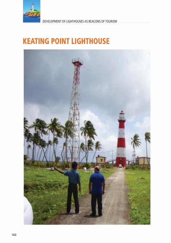
160
DEVELOPMENT OF LIGHTHOUSES AS BEACONS OF TOURISM
KEATING POINT LIGHTHOUSE

161
S. No. FEATURES
1. Area of the Lighthouse premises 52000 Sq. Meter ( partly submerged in sea)
2. Status of land Freehold3. Ownership of land DGLL
4. Climate (Avetage Temperature/rainfall) Temp. - 28°C Rainfall – 2600 mm.
5. Tidal range 1.5 to 3.0 Meter. 6. History of Natural Disasters Tsunami 2004
7. Distance from nearest port/harbour ( if located on an island) Mus Jetty - 3 Km
8. Distance from nearest airport/nearest railwaystation Car Nicobar Airport - 16Km
9. Distance from main city located nearby Car Nicobar - 25 km
10. Availability of roads /access to Lighthouse Road up to Lighthouse Complex from Mus Jetty.
11. Availability and facility of public transport Public transport available up to 2 km from Lighthouse.
12. Existence of natural harbours/berthing facility / landing arrangement (if located on islands) Mus Jetty
13. Telecom coverage and availability of electricity Yes
14. Availability of potable water Rain water Storage, APWD Water Supply and Open Well
15. Existing Buildings Inspection Quarters, Staff quarters, Power House
16. Presence of unique flora and fauna Nil
17. Presence of natural features- waterfalls, streams, mountains, etc. Nil
18. Potential for adventure and water sports Nil19. Presence of local/tribal/folk art Yes- Nicobari tribals
20. Nearest tourist destination and distance Nil
21.In case, tourism has to be developed on PPP mode , then the statutory permissions that would be required and from which agencies
Permission from Local Tribe Captain, Forest and CRZ clearance from Department of Forest and wildlife, Andaman & Nicobar Administration
Location: Car Nicobar, Andaman & Nicobar IslandsLat- 09°15.4’N Long- 92°46.5’E
PROFILE

162
DEVELOPMENT OF LIGHTHOUSES AS BEACONS OF TOURISM
SOUTH SENTINEL LIGHTHOUSE

163
S. No. FEATURES
1. Area of the Lighthouse premises 400 Sq. Meter
2. Status of land Freehold
3. Ownership of land DGLL
4. Climate (Avetage Temperature/rainfall) Temp. - 28°C Rainfall – 2600 mm.
5. Tidal range 1.5 to 3.0 Meter.
6. History of Natural Disasters Tsunami 2004
7. Distance from nearest port/harbour ( if located on an island) 27 Km
8. Distance from nearest airport/nearest railwaystation Veer Sarvarkar Airport - 132Km
9. Distance from main city located nearby Hut Bay
10. Availability of roads /access to Lighthouse Kachcha approach way of 1 Km from shoreline
11. Availability and facility of public transport No
12. Existence of natural harbours/berthing facility / landing arrangement (if located on islands) Nil
13. Telecom coverage and availability of electricity Nil
14. Availability of potable water Nil
15. Existing Buildings Nil
16. Presence of unique flora and fauna Coral reef
17. Presence of natural features- waterfalls, streams, mountains, etc. Nil
18. Potential for adventure and water sports Nil
19. Presence of local/tribal/folk art Nil
20. Nearest tourist destination and distance Nil
21.In case, tourism has to be developed on PPP mode , then the statutory permissions that would be required and from which agencies
CRZ clearance from Department of Forest and wildlife, Andaman & Nicobar Administration
Location: South Sentinel, Andaman & Nicobar IslandsLat: 10°58.9’N Long : 92°13.6’E
PROFILE

164
DEVELOPMENT OF LIGHTHOUSES AS BEACONS OF TOURISM
NARCONDUM LIGHTHOUSE
S. No. FEATURES1. Area of the Lighthouse premises 100 Sq. Meter2. Status of land Freehold3. Ownership of land DGLL
4. Climate (Avetage Temperature/rainfall) Temp. - 28°C Rainfall – 2600 mm.
5. Tidal range 1.5 to 3.0 Meter.
6. History of Natural Disasters Tsunami 2004Extinct Volcano
7. Distance from nearest port/harbour ( if located on an island) Diglipur, 150 Km
8. Distance from nearest airport/nearest railwaystation
Veer Sarvarkar Airport, Port Blair – 270 Km.
9. Distance from main city located nearby Nil
10. Availability of roads /access to Lighthouse Kachcha approach way from shoreline
11. Availability and facility of public transport No
12. Existence of natural harbours/berthing facility / landing arrangement (if located on islands) Nil
13. Telecom coverage and availability of electricity Nil
14. Availability of potable water Nil
15. vBuildings Nil
16. Presence of unique flora and faunaCorals & The Narcondam hornbill is an endangered hornbill that is endemic.
17. Presence of natural features- waterfalls, streams, mountains, etc.
Narcondam Island’s mountain, at 710 meters is the second tallest point in the Andaman and Nicobar Islands.
18. Potential for adventure and water sportsThe waters surrounding Narcondam Island are a diving destination.
19. Presence of local/tribal/folk art Nil
20. Nearest tourist destination and distance Nil
21.In case, tourism has to be developed on PPP mode , then the statutory permissions that would be required and from which agencies
Forest and CRZ clearance from Department of Forest and wildlife, Andaman & Nicobar Administration
PROFILELocation: Narcondum Island, Andaman & Nicobar IslandsLat- 13°27.4’N Long- 94°15.3’E


www.dgll.nic.inshipmin_india www.shipping.nic.in