development of 8-lane spur starting from - environmental
TRANSCRIPT
Volume – I
Final Environment Impact
Assessment Report
Project Proponent
NATIONAL HIGHWAYS AUTHORITY OF INDIA
Ministry of Road Transport and Highways, Government of India
EIA Consultant
Development of 8-lane SPUR Starting from
Km 26.582 of Vadodara - Mumbai Expressway Main
Alignment (Design Chainage 0+000) and terminating at
proposed Junction with the Multi-Modal Corridor of MMRDA
(Design Chainage 79+783) in the state of Maharashtra
(MoEFCC F. No. No. 10-29/2019-IA.III)
Sector as per EIA Notification: 7(f); Category “A”
ICT/E&S/VME-SPUR/567/Final EIA Rev: R1 Month: August 2021
Intercontinental Consultants and Technocrats Pvt. Ltd. A-8, Green Park, New Delhi-110016, India
NABET Certificate No.: NABET/EIA/1922/RA 0202
Valid till: Nov 20,2022
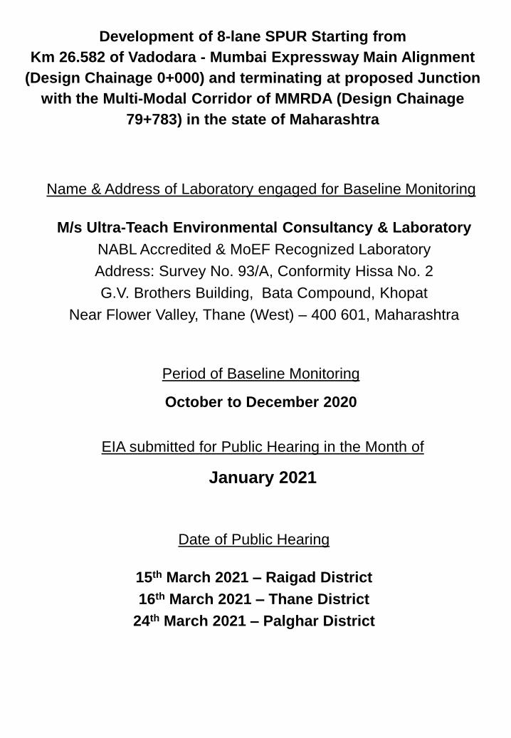
Period of Baseline Monitoring
October to December 2020
Name & Address of Laboratory engaged for Baseline Monitoring
M/s Ultra-Teach Environmental Consultancy & Laboratory
NABL Accredited & MoEF Recognized Laboratory
Address: Survey No. 93/A, Conformity Hissa No. 2
G.V. Brothers Building, Bata Compound, Khopat
Near Flower Valley, Thane (West) – 400 601, Maharashtra
Development of 8-lane SPUR Starting from
Km 26.582 of Vadodara - Mumbai Expressway Main Alignment
(Design Chainage 0+000) and terminating at proposed Junction
with the Multi-Modal Corridor of MMRDA (Design Chainage
79+783) in the state of Maharashtra
Date of Public Hearing
15th March 2021 – Raigad District
16th March 2021 – Thane District
24th March 2021 – Palghar District
EIA submitted for Public Hearing in the Month of
January 2021
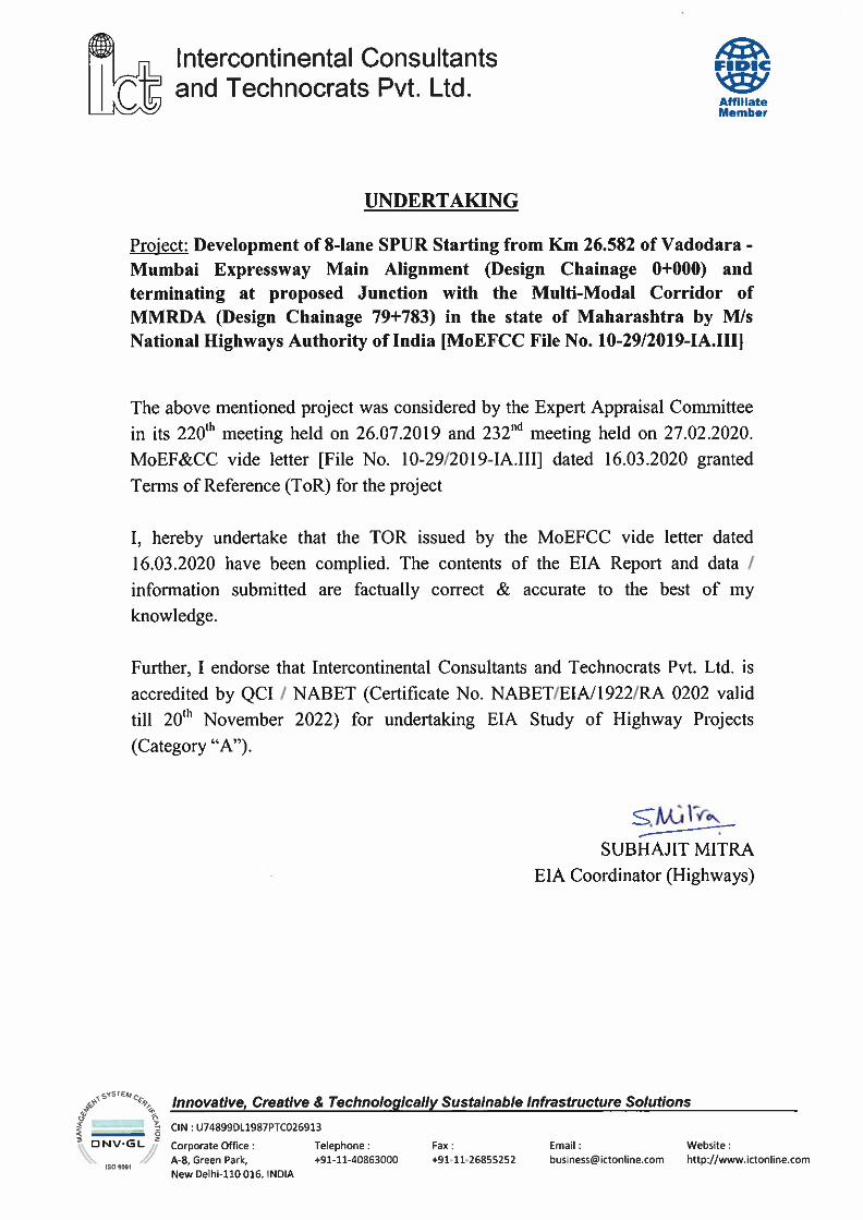
Project : Development of 8-lane SPUR Starting from Km 26.582 of Vadodara - Mumbai Expressway Main
Alignment (Design Chainage 0+000) and terminating at proposed Junction with the Multi-Modal Corridor
of MMRDA (Design Chainage 79+783) in the state of Maharashtra
Document : ICT/E&S/VME-SPUR/567/ Final EIA Report (Volume-I) Date: Aug 2021
Table of Contents Revision: R1
Page - I
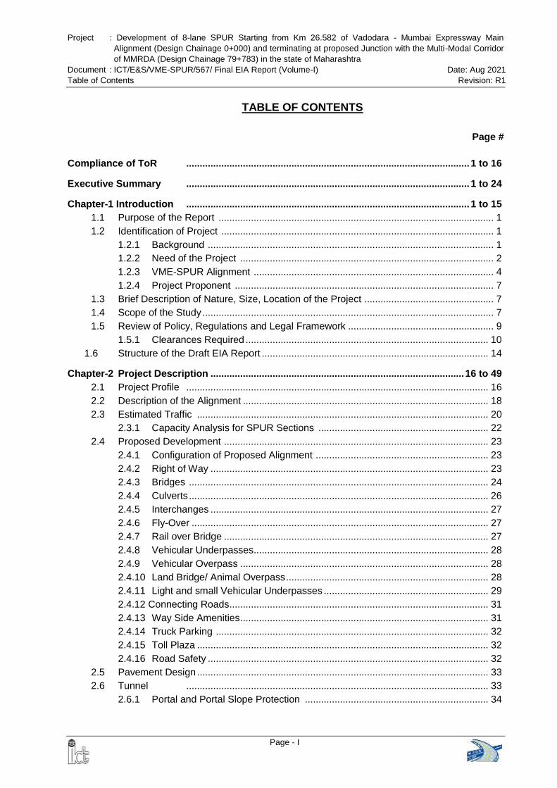
TABLE OF CONTENTS
Page #
Compliance of ToR ......................................................................................................... 1 to 16
Executive Summary ......................................................................................................... 1 to 24
Chapter-1 Introduction ......................................................................................................... 1 to 15
1.1 Purpose of the Report ...................................................................................................... 1
1.2 Identification of Project ..................................................................................................... 1
1.2.1 Background .......................................................................................................... 1
1.2.2 Need of the Project .............................................................................................. 2
1.2.3 VME-SPUR Alignment ......................................................................................... 4
1.2.4 Project Proponent ................................................................................................ 7
1.3 Brief Description of Nature, Size, Location of the Project ................................................ 7
1.4 Scope of the Study ............................................................................................................ 7
1.5 Review of Policy, Regulations and Legal Framework ...................................................... 9
1.5.1 Clearances Required .......................................................................................... 10
1.6 Structure of the Draft EIA Report .................................................................................... 14
Chapter-2 Project Description .............................................................................................. 16 to 49
2.1 Project Profile ................................................................................................................ 16
2.2 Description of the Alignment ........................................................................................... 18
2.3 Estimated Traffic ............................................................................................................ 20
2.3.1 Capacity Analysis for SPUR Sections ............................................................... 22
2.4 Proposed Development .................................................................................................. 23
2.4.1 Configuration of Proposed Alignment ................................................................ 23
2.4.2 Right of Way ....................................................................................................... 23
2.4.3 Bridges ............................................................................................................... 24
2.4.4 Culverts ............................................................................................................... 26
2.4.5 Interchanges ....................................................................................................... 27
2.4.6 Fly-Over .............................................................................................................. 27
2.4.7 Rail over Bridge .................................................................................................. 27
2.4.8 Vehicular Underpasses ....................................................................................... 28
2.4.9 Vehicular Overpass ............................................................................................ 28
2.4.10 Land Bridge/ Animal Overpass ........................................................................... 28
2.4.11 Light and small Vehicular Underpasses ............................................................. 29
2.4.12 Connecting Roads ................................................................................................ 31
2.4.13 Way Side Amenities ............................................................................................ 31
2.4.14 Truck Parking ..................................................................................................... 32
2.4.15 Toll Plaza ............................................................................................................ 32
2.4.16 Road Safety ........................................................................................................ 32
2.5 Pavement Design ............................................................................................................ 33
2.6 Tunnel ................................................................................................................ 33
2.6.1 Portal and Portal Slope Protection .................................................................... 34
Project : Development of 8-lane SPUR Starting from Km 26.582 of Vadodara - Mumbai Expressway Main
Alignment (Design Chainage 0+000) and terminating at proposed Junction with the Multi-Modal Corridor
of MMRDA (Design Chainage 79+783) in the state of Maharashtra
Document : ICT/E&S/VME-SPUR/567/ Final EIA Report (Volume-I) Date: Aug 2021
Table of Contents Revision: R1
Page - II
Page #
2.6.2 Tunnel Health Monitoring System ...................................................................... 34
2.6.3 Muck Dump Disposal .......................................................................................... 35
2.6.4 Blasting ............................................................................................................... 38
2.7 Mode of Implementation ................................................................................................. 41
2.8 Sources of Construction Materials .................................................................................. 41
2.8.1 Borrow Areas ...................................................................................................... 41
2.8.2 Stone / Coarse Aggregate Material .................................................................... 42
2.8.3 Sand / Fine Aggregate Material ......................................................................... 42
2.8.4 Fly Ash ................................................................................................................ 43
2.8.5 Cement................................................................................................................ 43
2.8.6 Bitumen ............................................................................................................... 44
2.8.7 Steel ............................................................................................................... 44
2.9 Project Cost ................................................................................................................ 44
2.10 Development Process ..................................................................................................... 44
2.10.1 Stages & Activities of the Proposed Project ....................................................... 44
2.10.2 Infrastructure Requirement ................................................................................. 46
2.10.3 Resource Requirement ....................................................................................... 46
2.10.4 Pollutant Sources during Construction Phase .................................................... 48
2.10.5 Pollutant Sources during Operation Phase ........................................................ 49
Chapter-3 Description of the Environment ...................................................................... 50 to 156
3.1 General ................................................................................................................ 50
3.2 Study Area and Period ................................................................................................... 50
3.3 Physiography And Terrain ............................................................................................... 50
3.4 Geology and Seismicity ................................................................................................... 52
3.4.1 Geology ............................................................................................................... 52
3.4.2 Seismicity ............................................................................................................ 53
3.5 Hydrology ................................................................................................................ 53
3.5.1 Hydrogeological Features of the Study Area ...................................................... 53
3.5.2 Hydrological Investigations of the Proposed Alignment ..................................... 54
3.5.3 River, Nala and Canal Crossings En-route ........................................................ 56
3.5.4 Hydro-Meteorologically Homogenous Sub Zones .............................................. 57
3.5.5 Design Rainfall .................................................................................................... 57
3.5.6 Catchment Area and Drainage Network ............................................................ 58
3.6 Agriculture and Irrigation Practices ................................................................................. 59
3.7 Land Use ................................................................................................................ 60
3.7.1 Method of Data Preparation ............................................................................... 60
3.7.2 Land use within PROW ....................................................................................... 60
3.7.3 Land Use within the Study Area ......................................................................... 61
3.8 Soil Quality ................................................................................................................ 62
3.8.1 Soil Types of the Study Area .............................................................................. 62
3.8.2 Soil Monitoring Stations ...................................................................................... 63
3.8.3 Soil Characteristics of the Study Area ................................................................ 63
Project : Development of 8-lane SPUR Starting from Km 26.582 of Vadodara - Mumbai Expressway Main
Alignment (Design Chainage 0+000) and terminating at proposed Junction with the Multi-Modal Corridor
of MMRDA (Design Chainage 79+783) in the state of Maharashtra
Document : ICT/E&S/VME-SPUR/567/ Final EIA Report (Volume-I) Date: Aug 2021
Table of Contents Revision: R1
Page - III
Page #
3.9 Climate & Meteorology .................................................................................................... 65
3.9.1 Climatic Conditions of the Study Area ................................................................ 65
3.9.2 On-site Meteorological Monitoring ...................................................................... 68
3.10 Ambient Air Quality .......................................................................................................... 71
3.10.1 Ambient Air Quality Monitoring Locations .......................................................... 71
3.10.2 Parameters Monitored & Monitoring Period ....................................................... 73
3.10.3 Monitoring Results ............................................................................................. 73
3.11 Ambient Noise Level ....................................................................................................... 81
3.11.1 Noise Monitoring Stations ................................................................................... 81
3.11.2 Methodology of Noise Monitoring ....................................................................... 81
3.11.3 Ambient Noise Levels in the Study Area ............................................................ 81
3.12 Surface Water ................................................................................................................ 83
3.12.1 Surface Water Quality of the Study Area ........................................................... 83
3.12.2 Surface Water Sampling Location ...................................................................... 84
3.12.3 Analysis Results.................................................................................................. 85
3.13 Ground Water ................................................................................................................ 89
3.13.1 Depth of Ground Water ....................................................................................... 89
3.13.2 Ground Water Resources and Category ............................................................ 89
3.13.3 Ground Water Quality of the Study Area ............................................................ 90
3.13.4 Ground Water Sampling Locations .................................................................... 91
3.13.5 Analysis Results.................................................................................................. 92
3.14 Ecology and Biodiversity ................................................................................................. 95
3.14.1 Introduction ......................................................................................................... 95
3.14.2 Ecology Biodiversity Study ................................................................................. 95
3.14.3 Threatened Species of Flora ........................................................................... 112
3.14.4 Forest .............................................................................................................. 112
3.14.5 Faunal Composition .......................................................................................... 116
3.14.6 Aquatic Ecology ................................................................................................ 125
3.14.7 Protected Areas ................................................................................................ 126
3.14.7.1 Tungareshwar Wildlife Sanctuary ..................................................... 126
3.14.7.2 Tansa Wildlife Sanctuary ................................................................... 129
3.14.7.3 Matheran Eco- Sensitive Zone (ESZ)................................................ 129
3.15 Coastal Regulation Zone .............................................................................................. 133
3.16 Archaeological Sites ...................................................................................................... 138
3.17 Environmentally Sensitive Receptors ........................................................................... 138
3.18 Socio-Economic Profile ................................................................................................. 143
3.18.1 Demographic Features of Project Influence District ......................................... 144
3.18.2 Socio Economic Profile of the Project Area ...................................................... 149
3.18.3 Conclusion ........................................................................................................ 155
Chapter-4 Anticipated Environmental Impacts and Mitigation Measures .................. 157 to 234
4.1 Introduction ................................................................................................................... 157
4.2 Land Environment ........................................................................................................ 157
Project : Development of 8-lane SPUR Starting from Km 26.582 of Vadodara - Mumbai Expressway Main
Alignment (Design Chainage 0+000) and terminating at proposed Junction with the Multi-Modal Corridor
of MMRDA (Design Chainage 79+783) in the state of Maharashtra
Document : ICT/E&S/VME-SPUR/567/ Final EIA Report (Volume-I) Date: Aug 2021
Table of Contents Revision: R1
Page - IV
Page #
4.2.1 Topography & Geology .................................................................................... 157
4.2.1.1 Construction Phase ............................................................................. 157
4.2.1.2 Operation Phase .................................................................................. 160
4.2.2 Soil ................................................................................................................... 160
4.2.3 Land Use .......................................................................................................... 165
4.2.3.1 Construction Phase ............................................................................. 165
4.2.3.2 Operation Phase .................................................................................. 166
4.3 Water Environment ....................................................................................................... 166
4.3.1 Drainage & Hydrological Flow ......................................................................... 166
4.3.2 Water Use ........................................................................................................ 177
4.3.3 Water Quality ................................................................................................... 177
4.3.3.1 Construction Phase ............................................................................. 177
4.3.3.2 Operation Phase .................................................................................. 181
4.4 Air Environment ............................................................................................................ 183
4.4.1 Construction Phase ......................................................................................... 183
4.4.1.1 Hot Mix Plant ....................................................................................... 183
4.4.1.2 Stone Crushers .................................................................................... 184
4.4.1.3 Other Impacts ...................................................................................... 187
4.4.1.4 Mitigation Measures ............................................................................ 187
4.4.2 Operation Phase .............................................................................................. 188
4.5 Noise Environment ....................................................................................................... 196
4.5.1 Construction Phase ......................................................................................... 196
4.5.2 Operation Phase .............................................................................................. 199
4.5.2.1 Source of Noise……………………………………………….…………… 199
4.5.2.2 Prediction of Impacts……………………………………….………………200
4.5.2.3 Mitigation Measures……………………………………………………….. 203
4.6 Flora .......................................................................................................................... 211
4.6.1 Construction Phase ......................................................................................... 211
4.6.1.1 Diversion of Forest Land……………………………….…………………. 211
4.6.1.2 Trees within Proposed Right of Way………………………..……...........212
4.6.1.3 Mitigation Measures…………………………………………..…………… 215
4.6.2 Operation Phase .............................................................................................. 216
4.6.2.1 Impacts……………………………………………………………………… 216
4.6.2.2 Mitigation Measures……………………………………………………….. 216
4.7 Fauna .......................................................................................................................... 218
4.7.1 Construction Phase ......................................................................................... 218
4.7.1.1 Impacts……………………………………………………………………… 218
4.7.1.2 Mitigation Measures………………………………………………………. .218
4.7.2 Operation Phase .............................................................................................. 219
4.7.2.1 Road Killing of Wild animals within study area………………………… .219
4.7.2.2 Other Impacts……………………………………………………...……… .221
4.7.2.3 Mitigation Measures…………………………………………...…………. .221
4.8 Protected Area ............................................................................................................. 227
Project : Development of 8-lane SPUR Starting from Km 26.582 of Vadodara - Mumbai Expressway Main
Alignment (Design Chainage 0+000) and terminating at proposed Junction with the Multi-Modal Corridor
of MMRDA (Design Chainage 79+783) in the state of Maharashtra
Document : ICT/E&S/VME-SPUR/567/ Final EIA Report (Volume-I) Date: Aug 2021
Table of Contents Revision: R1
Page - V
Page #
4.8.1 Construction Phase .......................................................................................... 227
4.8.2 Operation Phase ............................................................................................... 228
4.9 Solid Waste Management ............................................................................................ 229
4.10 Employment & Trading Opportunities .......................................................................... 231
4.11 Construction Camp ....................................................................................................... 231
4.12 Occupational Health & Safety ...................................................................................... 232
4.13 Road Safety .................................................................................................................. 232
4.13.1 Construction Phase ......................................................................................... 232
4.13.2 Operation Phase .............................................................................................. 233
4.14 Migration ....................................................................................................................... 234
4.15 Positive & Beneficial Impacts ....................................................................................... 234
4.15.1 Construction Phase ......................................................................................... 234
4.15.2 Operation Phase .............................................................................................. 234
Chapter-5 Analysis of Alternatives .................................................................................. 235 to 245
5.1 Introduction .............................................................................................................. 235
5.2 Alternatives Alignments ................................................................................................. 235
5.2.1 Compression of Various Alternative Alignments of SPUR .................................. 242
5.2.2 Selection of the Final Alignment .......................................................................... 243
5.3 “With” and “Without” Project Scenario .......................................................................... 244
Chapter-6 Environment Monitoring Program .................................................................. 246 to 254
6.1 Introduction .............................................................................................................. 246
6.2 Performance Indicators ................................................................................................. 246
6.3 Monitoring Schedule...................................................................................................... 248
Chapter-7 Additional Studies ........................................................................................... 255 to 333
7.0 Intoduction .............................................................................................................. 255
7.1 Risk Assessment And Disaster Management Plan ..................................................... 258
7.1.1 Environmental Risk of Green Field Project ...................................................... 259
7.1.2 Assessment of Risk .......................................................................................... 260
7.1.3 Disaster Scenarios of Expressway ................................................................... 278
7.1.4 Disaster Management Plan .............................................................................. 280
7.4.1.1 Introduction ........................................................................................... 280
7.4.1.2 Scope of DMP ...................................................................................... 280
7.4.1.3 Objective of DMP ................................................................................. 281
7.4.1.4 Planning Factor ..................................................................................... 281
7.4.1.5 Onsite Disaster Management Plan ...................................................... 282
7.4.1.6 Off-site Disaster Management Plan ..................................................... 285
7.2 Geophysical Surveys.................................................................................................... 291
7.2.1 Seismic Refraction Tomography (SRT) ............................................................ 291
7.2.2 Electrical Resistivity Tomography (ERT) .......................................................... 292
7.2.3 Results .............................................................................................................. 294
7.2.4 Summary and conclusions:............................................................................... 295
Project : Development of 8-lane SPUR Starting from Km 26.582 of Vadodara - Mumbai Expressway Main
Alignment (Design Chainage 0+000) and terminating at proposed Junction with the Multi-Modal Corridor
of MMRDA (Design Chainage 79+783) in the state of Maharashtra
Document : ICT/E&S/VME-SPUR/567/ Final EIA Report (Volume-I) Date: Aug 2021
Table of Contents Revision: R1
Page - VI
Page #
7.3 Hydrogeological & Aquifer Study and 3-D Modelling ................................................... 296
7.3.1 Study Area ........................................................................................................ 296
7.3.2 Materials and Methods ..................................................................................... 297
7.3.3 Topography and Drainage ................................................................................ 298
7.3.4 Geology ............................................................................................................. 300
7.3.5 Hydrogeology .................................................................................................... 302
7.3.6 Geotechnical Investigation Results .................................................................. 303
7.3.7 Rock mass Classification & Geological Matrix along Tunnel Alignment .......... 303
7.3.8 3D Model of the Area ........................................................................................ 307
7.3.9 Conclusions ...................................................................................................... 312
7.4 Vibration Impact Assessment of Proposed Tunnel ...................................................... 316
7.5 Social Impact Assessment ........................................................................................... 318
7.6 Traffic Study .............................................................................................................. 320
7.6.1 Validation of Classified Traffic Volume Counts ................................................ 320
7.6.2 Regional Connectivity ....................................................................................... 323
7.7 Public Hearing .............................................................................................................. 324
7.7.1 Process of Public Hearing ................................................................................ 324
7.7.2 Public Hearing in Raigad District ...................................................................... 324
7.7.3 Public Hearing in Thane District ....................................................................... 327
7.7.4 Public Hearing in Palghar District ..................................................................... 330
Chapter-8 Project Benefit .................................................................................................. 334 to 336
8.1 General .............................................................................................................. 334
8.2 Direct Benefits .............................................................................................................. 335
8.2.1 Fast Connectivity .............................................................................................. 335
8.2.2 Reductions in Vehicle Operating Cost & Travel Time ...................................... 335
8.2.3 Benefit to Local Trade and Economy ............................................................... 335
8.2 Indirect Benefits ............................................................................................................. 336
8.2.1 Employment Opportunity .................................................................................. 336
8.2.2 Development of Agriculture .............................................................................. 336
Chapter-9 Environmental Management Plan .................................................................. 337 to 393
9.1 Introduction .............................................................................................................. 337
9.2 Stage wise Environmental Management Measures ..................................................... 337
9.3 Greenbelt Development Plan ........................................................................................ 367
9.3.1 Avenue and Median Plantation ........................................................................ 367
9.3.2 Species Suggested for Plantation .................................................................... 369
9.3.3 Protection Measures ......................................................................................... 371
9.3.4 Precautionary Measures ................................................................................... 371
9.3.5 Maintenance .................................................................................................... 371
9.4 Institutional Arrangements ............................................................................................ 371
9.4.1 Reporting Protocol ............................................................................................ 372
9.5 Implementation Arrangements ...................................................................................... 373
9.5.1 Authority Engineer (AE)/ Independent Engineer .............................................. 373
Project : Development of 8-lane SPUR Starting from Km 26.582 of Vadodara - Mumbai Expressway Main
Alignment (Design Chainage 0+000) and terminating at proposed Junction with the Multi-Modal Corridor
of MMRDA (Design Chainage 79+783) in the state of Maharashtra
Document : ICT/E&S/VME-SPUR/567/ Final EIA Report (Volume-I) Date: Aug 2021
Table of Contents Revision: R1
Page - VII
Page #
9.5.2 Contractor ......................................................................................................... 375
9.6 Institutional Capacity Building ....................................................................................... 377
9.6.1 Training Components ...................................................................................... 377
9.6.2 Training Program .............................................................................................. 377
9.7 Time Frame for EMP Implementation ........................................................................... 378
9.8 Environmental Budget ................................................................................................... 378
9.9 Financial Allocation for Wildlife Conservation Measure……………………………..….. 385
9.10 Corporate Environment Responsibility………………………………………………..….. 391
9.10.1 Commitments by the Project Proponent ......................................................... 391
Chapter-10 Summary & Conclusion ................................................................................. 394 to 397
Chapter-11 Disclosure of Consultant .............................................................................. 398 to 400
Project : Development of 8-lane SPUR Starting from Km 26.582 of Vadodara - Mumbai Expressway Main
Alignment (Design Chainage 0+000) and terminating at proposed Junction with the Multi-Modal Corridor
of MMRDA (Design Chainage 79+783) in the state of Maharashtra
Document : ICT/E&S/VME-SPUR/567/ Final EIA Report (Volume-I) Date: Aug 2021
Table of Contents Revision: R1
Page - VIII
LIST OF TABLE
Table 1-1 Applicable IRC Codes
Table 1-2 Clearances required to be obtained by the Contractor
Table 2-1 Taluka wise break-up of Length of Proposed Expressway
Table 2-2 Project Coordinates
Table 2-3 Section wise Estimated AADT for SPUR (PCU per day with toll 1.8 times NH toll),
rev.2017
Table 2-4 Capacity and Service Volumes at Various LOS for 4, 6 and 8 lane Expressway
Table 2-5 Configuration of Proposed SPUR Alignment
Table 2-6 Reduction in ROW as suggested by the MoEFCC
Table 2-7 Details of Major Bridge
Table 2-8 Details of Minor Bridges over Rivers / Streams / Nallas / Utility
Table 2-9 Details of Bridges at Interchange
Table 2-10 Details of Bridges over Gas Pipeline
Table 2-11 Summary of Culvert
Table 2-12 Details of Interchanges
Table 2-13 Details of Fly-overs
Table 2-14 Details of Rail over bridge
Table 2-15 Details of Vehicular Underpass
Table 2-16 Details of Vehicular Overpass
Table 2-17 Location of Land Bridge / Animal Overpass
Table 2-18 Details of Light Vehicular / Pedestrian Underpass
Table 2-19 Details of Small Vehicular / Animal Underpass
Table 2-20 Location of Connecting Roads
Table 2-21 Details of Way Side Amenities
Table 2-22 Details of Truck Parking
Table 2-23 Location of cross passages for the tunnel portion as below
Table 2-24 Location of Proposed Borrow Areas
Table 2-25 Location of Stone / Coarse Aggregate Material
Table 2-26 Location of Sand / Fine Aggregate Material
Table 2-27 Summary of Project Cost
Table 2-28 Raw Materials requirement during Construction
Table 2-29 Breakup of Water requirement during Construction Period
Table 3- 1 HFL Information gathered from Local Enquiry
Table 3- 2 List of River and Stream Crossings en-route
Table 3- 3 Return Period and Rainfall Adopted for Expressway Bridges
Table 3- 4 Catchment Area of Rivers & Local Streams along the Proposed Expressway
Table 3-5 Agro-ecological Situations of the Study Area
Table 3-6 Secondary Data and Images Used for Preparation of Land Use Map
Table 3-7 Land Use distribution within PROW
Table 3-8 Land Use within 15 km Radius of the Proposed SPUR Alignment
Table 3-9 Details of Soil Monitoring Stations
Table 3-10 Soil Analysis Result
Table 3- 11 Summaries of Climatological Data of the Study Area
Project : Development of 8-lane SPUR Starting from Km 26.582 of Vadodara - Mumbai Expressway Main
Alignment (Design Chainage 0+000) and terminating at proposed Junction with the Multi-Modal Corridor
of MMRDA (Design Chainage 79+783) in the state of Maharashtra
Document : ICT/E&S/VME-SPUR/567/ Final EIA Report (Volume-I) Date: Aug 2021
Table of Contents Revision: R1
Page - IX
Table 3- 12 Monthly Rainfall, Wind Speed and Relative Humidity in the Study Area
Table 3- 13 Numbers of days with Extreme Weather Condition in the Study Area
Table 3- 14 Location of Meteorological Station and Monitored Parameters
Table 3- 15 Summary of Meteorological Data of the Study Area
Table 3- 16 Details of Ambient Air Quality Monitoring Locations
Table 3- 17 Summary of PM2.5 levels in Study Area
Table 3- 18 Summary of PM10 levels in Study Area
Table 3- 19 Summary of SO2 levels in Study Area
Table 3- 20 Summary of NO2 levels in Study Area
Table 3- 21 Summary of CO levels in Study Area
Table 3- 22 Summary of Benzene levels in Study Area
Table 3- 23 Statistical Analysis of Ambient Air Quality in the Study Area
Table 3-24 Air Quality Index (AQI) of the Study Area
Table 3- 25 Details of Noise Monitoring Locations
Table 3- 26 Ambient Noise Levels of the Study Area
Table 3- 27 Classification of Water Quality for Surface Water
Table 3- 28 Surface Water Monitoring Stations at West Flowing Rivers
Table 3- 29 Water Quality Index of Selected WQMS on West Flowing Rivers
Table 3- 30 Details of Surface Water Sampling Locations
Table 3- 31 Salient Surface Water Quality Features
Table 3- 32 Surface Water Quality Analysis Results
Table 3- 33 Ground water Resources (as on March 2009)
Table 3- 34 Classification of Ground Water based on the CGWA Classification
Table 3- 35 Details of Ground Water Sampling Locations
Table 3-36 Ground Water Quality Analysis Results
Table 3-37 List of Flora observed in the Study Area
Table 3-38 Dependence of Local Inhabitants on Plants
Table 3-39 Bird Species Sighted during Field Survey
Table 3-40 Fauna of Tungareshwar Wildlife Sanctuary
Table 3-41 Common Fresh Water Fishes
Table 3-42 Common Marine Fishes
Table 3-43 Village wise Length of VME-SPUR alignment in CRZ Crossing areas
Table 3-44 Village wise Break-up CRZ Categories in VME-SPUR Crossing Points
Table 3-45 List of Educational Institutions along the alignment of Proposed Expressway
Table 3-46 List of Medical Facilities along the alignment of Proposed Expressway
Table 3-47 List of Religious Places along the alignment of Proposed Expressway
Table 3-48 Socio-Economic Indicators of Maharashtra State and India
Table 3-49 Tehsil wise Demographic Profile of Palghar District
Table 3-50 Tehsil wise Demographic Profile of Palghar District
Table 3-51 Tehsil wise Demographic Profile of Raigarh District
Table 3-52 Details of Villages falling under Municipal Corporation/Councils
Table 3-53 Demographic Features of the Project Affected Villages
Table 3-54 Distribution of Workforce in Project Affected Area
Table 3-55 Village and Category-wise Distribution of Main Workforce
Table 4-1 Materials requirement during Construction
Project : Development of 8-lane SPUR Starting from Km 26.582 of Vadodara - Mumbai Expressway Main
Alignment (Design Chainage 0+000) and terminating at proposed Junction with the Multi-Modal Corridor
of MMRDA (Design Chainage 79+783) in the state of Maharashtra
Document : ICT/E&S/VME-SPUR/567/ Final EIA Report (Volume-I) Date: Aug 2021
Table of Contents Revision: R1
Page - X
Table 4-2 Location of Proposed Borrow Areas
Table 4-3 Hydrological Computation of 1st Order Streams crossing the proposed Expressway
Table 4-4 Hydrological Computation of 2nd Order Streams crossing the proposed Expressway
Table 4-5 Breakup of Water requirement during Construction Period
Table 4-6 Typical Points where Water to be sprayed or dust to be extracted
Table 4-7 Homogeneous Traffic Sections considered for Air Prediction Models
Table 4-8 Predicted GLC of CO in HS-01 at Peak Traffic Hour
Table 4-9 Typical Noise Level during Construction Activities
Table 4-10 Typical Noise Level of Construction Equipment
Table 4-11 Minimum Distance Required from Stationary Noise Source
Table 4-12 Sensitive Receptor Wise Predicted Noise Levels
Table 4-13 Details of proposed Noise Barriers
Table 4-14 Predicted Noise Levels after installation of Noise Barriers
Table 4-15 Predicted Noise level at Parallel Barrier Location
Table 4-16 Location of Roadside Noise barriers
Table 4-17 Details of Forest Land Proposed to be diverted
Table 4-18 Village wise & Girth Class wise Number of Trees in Forest Land
Table 4-19 Village wise & Girth Class wise Number of Trees in Non-Forest Land
Table 4-20 Wild Animals killed in road accident along NH-48 (old NH-8) (within Study Area)
Table 4-21 Total Number of Structures Proposed from Crossing the Expressway
Table 4-22 Chainage & Village wise Location of Proposed Animal Crossing
Table 4-23 Location of Land Bridge / Animal Overpass
Table 4-24 Chainage & Village wise Location of Small Vehicular / Animal Underpasses
Table 4-25 Cost of Animal Overpass, Dedicated Animal Crossing and Animal Underpass
Table 5.1 Traffic Estimates for various Alternative Alignments of SPUR
Table 5.2 Cost of various Alternative Alignments of SPUR
Table-5.3 Comparison of Various Alternative Alignments
Table 5-4 “With” and “Without” Project Scenario
Table 6-1 Performance Indicators
Table 6-2 Environmental Monitoring Program
Table 7-1 Civil Construction Work Proposed In VME-SPUR
Table 7-2 Qualitative Risk Assessment: Construction Activities
Table 7-3 Emission of benzo(a)Pyrene concentration
Table 7-4 Casus of fire during Construction Period
Table 7-5 Risk Assessment of TBM Operation
Table 7-6 Details of the Data Acquisition
Table 7-7 Characterization of the Proposed Tunnelling Area based on Impact Indicators
Table 7-8 Criteria for Assessment of the Impact caused by Tunnel Excavation
Table 7-9 Impacts of Tunnel Construction and their Mitigations
Table 7-10 Comparison of Traffic Volume Counts Carried out by ICT And IHMC
Table 9-2 Typical Cross Section and Construction Package wise Number of Trees to be planted
Table 9-3 Typical Cross Section and Construction Package wise Number of Hedges to be
planted
Table 9-4 Tree Species Suggested for Plantation near Forest Area
Table 9-5 Tree Species Suggested for Plantation outside Forest Area
Project : Development of 8-lane SPUR Starting from Km 26.582 of Vadodara - Mumbai Expressway Main
Alignment (Design Chainage 0+000) and terminating at proposed Junction with the Multi-Modal Corridor
of MMRDA (Design Chainage 79+783) in the state of Maharashtra
Document : ICT/E&S/VME-SPUR/567/ Final EIA Report (Volume-I) Date: Aug 2021
Table of Contents Revision: R1
Page - XI
Table 9-6 Technical Specifications for Plantation
Table 9-7 Reporting and Reviewing Matrix
Table 9-8 List of Training Institutes
Table 9-9 Summary of Environmental Budget
Table 9-10 Financial Allocation for Wildlife Conservation Measures by DCF (WL) Thane
Table 9-11 Financial Allocation for Wildlife Conservation Measures by Conservator of Forests and
Director, SNGP, Boriwali
Table 9-12 Financial Allocation for Wildlife Conservation Measures by DM, FDCM Thane
Table 9-13 Financial Allocation for Wildlife Conservation Measures by Dy. Conservator of
Forests, Dahanu Forest Division, Dahanu
Table 9-14 Financial Allocation for Wildlife Conservation Measures by Dy Conservator of Forests
(T), Thane Forest Division, Thane
Table 9-15 Total Financial Allocation proposed by the Forest Department
Table 9-16 Cost of Animal Overpass, Dedicated Animal Crossing and Animal Underpass
Table 9-17 Approved Financial Allocation for Wildlife Conservation Measures
Table 9-18 Sectors Identified for Skill Development
Table 9-19 Budget for Corporate Environment Responsibility
Project : Development of 8-lane SPUR Starting from Km 26.582 of Vadodara - Mumbai Expressway Main
Alignment (Design Chainage 0+000) and terminating at proposed Junction with the Multi-Modal Corridor
of MMRDA (Design Chainage 79+783) in the state of Maharashtra
Document : ICT/E&S/VME-SPUR/567/ Final EIA Report (Volume-I) Date: Aug 2021
Table of Contents Revision: R1
Page - XII
LIST OF FIGURE
Figure 1-1 Index Map showing various phases of Proposed Vadodara Mumbai Expressway
Figure 1-2 Map showing the VME-SPUR alignment on Mumbai Metropolitan Regional Plan 2016-
36
Figure 1-3 Index Map showing the location of the Proposed VME-SPUR
Figure 2-1 Proposed Expressway alignment marked on Satellite Imagery (Google Earth)
Figure 2-2 Layout Plan
Figure 2-3 Typical Cross Section of Expressway in Tunnel Section
Figure 2-4 Typical Cross Section of Tunnel Cross Passage
Figure 2-5 Activities in the Typical Expressway Development Project
Figure 3-1 Elevation Profile of the Project Area
Figure 3-2 Land use map
Figure 3-3 Land Use Pattern within the Proposed Right of Way
Figure 3-4 Monthly Ambient Temperature Profile
Figure 3-5 Monthly Rainfall, Rainy Days, Wind Speed and Relative Humidity of Dahanu IMD
Figure 3-6 Wind Rose Diagram of the Study Area
Figure 3-7 Map Showing Locations of Ambient Air Quality Monitoring Locations
Figure 3-8 Spatial Distribution of EC and Chloride in ground water in the Study Area
Figure 3-9 Distance of VME-SPUR Alignment from Tungareshwar WLS and it’s Eco -Sensitive
Zone
Figure 3-10 Map Showing VME-SPUR alignment through Matheran Eco-Sensitive Zone
Figure 3-11 Proposed Development in CRZ Area in Kashid Kopar Village
Figure 3-12 Proposed Development in CRZ Area in Sange - Konderi Village
Figure 3-13 Proposed Development in CRZ Area in Sangode - Balyani Village
Figure 4-1 Typical Cross section of embankment with alternate layer of fly ash and soil
Figure 4-2 Typical Drawing of Rainwater Harvesting Structure
Figure 4-3
Figure 4-4 GLC Contours of CO (g/m3) for Homogeneous Traffic Section-02
Figure 4-5 GLC Contours of CO (g/m3) for Homogeneous Traffic Section-02
Figure 4-6 GLC Contours of CO (g/m3) for Homogeneous Traffic Section-03
Figure 4-7 GLC Contours of CO (g/m3) for Homogeneous Traffic Section-04
Figure 4-8 Comparison of Noise Level Separated by Component [Donovan, 2007]
Figure 4-9 Noise Contour Map
Figure 4-10 Distance-wise No of Receptors and Predicted Noise Level in dB(A)
Figure 4-11 Predicted Noise Levels before and after installation of Noise Barriers
Figure 4-12 Typical Drawing of Solid Noise Barrier
Figure 4-13 Noise Level Contours with and without Barrier Scenario (year 2025)
Figure 4-14 Sample View of Polycarbonate / Acrylic Noise Barrier
Figure 4-15 Map Showing Locations of Wildlife Killed in the Study Area of VME-SPUR
Figure 4-16 Typical Layout of Animal Crossing including Animal Walkway
Figure 5.1 Road network 2031 MMR
Figure 5-2 Various Alternative Alignments of Proposed SPUR of Vadodara – Mumbai
Expressway
Figure 7-1 Natural Underground Water Movement
Project : Development of 8-lane SPUR Starting from Km 26.582 of Vadodara - Mumbai Expressway Main
Alignment (Design Chainage 0+000) and terminating at proposed Junction with the Multi-Modal Corridor
of MMRDA (Design Chainage 79+783) in the state of Maharashtra
Document : ICT/E&S/VME-SPUR/567/ Final EIA Report (Volume-I) Date: Aug 2021
Table of Contents Revision: R1
Page - XIII
Figure 7-2 Cycle of Disaster Management
Figure 7.3 Schematic diagram of a ERT data acquisition and a possible sequence of
measurements to create a 2-D pseudosection (Loke et al., 2000).
Figure 7.4 Geomorphology of the area, showing the elongated ridge of Matheran-Malang Gadh
Hills, drainage pattern of the area and the alignment of the proposed tunnel
Figure 7-5 Geological Longitudinal Section along the Proposed Tunnel Alignment
Figure 7-6 Delineation of Groundwater Level from different wells in the Region
Figure 7-7 Longitudinal geological section along the proposed tunnel alignment
Figure 7-8 Relationship of Physical Geography, Geology & Engineering aspects of the proposed
tunnel
Figure 7-9 Locations of two measurement points
Figure 7-10 ICT Traffic Survey Locations
Project : Development of 8-lane SPUR Starting from Km 26.582 of Vadodara - Mumbai Expressway Main
Alignment (Design Chainage 0+000) and terminating at proposed Junction with the Multi-Modal Corridor
of MMRDA (Design Chainage 79+783) in the state of Maharashtra
Document : ICT/E&S/VME-SPUR/567/ Final EIA Report (Volume-I) Date: Aug 2021
List of Abbreviation Revision: R1
Page - I
LIST OF ABBREVIATION
AADT : Annual Average Daily Traffic
AASHTO : The American Association of State Highway Officials
ADT : Average Daily Traffic
AE : Authority Engineer
AH : Affected Households
AM : Arithmetic Mean
AP : Affected Person
AQ : Air Quality
ARAI : The Automotive Research Association of India
ASI : Archaeological Survey of India
ATMS : Advanced Traffic Management System
BC : Bituminous Concrete
BDL : Below Detection Limit
BOD : Biological Oxygen Demand
C/L : Centre Line
Ca : Calcium
CA : Compensatory Afforestation
CALINE 4 : California Line Source Dispersion Model Version 4
CBR : California Bearing Ratio
CD : Cross Drainage
CEF : Composite Emission Factor
CER : Corporate Environmental Responsibility
CGWA : Central Ground Water Authority
CGWB : Central Ground Water Board
CI : Chlorine
CO : Carbon Monoxide
CoI : Corridor of Impact
CPCB : Central Pollution Control Board
CPR : Common Property Resources
CRTN : Calculation of Road Traffic Noise
CRZ : Coastal Regulation Zone
Cu : Copper
CWC : Central Water Commission
CZMP : Coastal Zone Management Plan
dB : Decibel
DFO : Divisional Forest Officer
DO : Dissolved Oxygen
DPR : Detailed Project Report
EA : Executive Agency
EAC : Expert Appraisal Committee
Project : Development of 8-lane SPUR Starting from Km 26.582 of Vadodara - Mumbai Expressway Main
Alignment (Design Chainage 0+000) and terminating at proposed Junction with the Multi-Modal Corridor
of MMRDA (Design Chainage 79+783) in the state of Maharashtra
Document : ICT/E&S/VME-SPUR/567/ Final EIA Report (Volume-I) Date: Aug 2021
List of Abbreviation Revision: R1
Page - II
EC : Electrical Conductivity
EHS : Environment Health and Safety
EIA : Environmental Impact Assessment
EMP : Environment Management plan
EO : Environmental Officer
EPA : Environment (Protection) Act
ES : Environmental Specialist
ESZ Eco-sensitive Zone
Fe : Iron
FLS : Finite Line Source
G.I. Sheet : Galvanized Iron Sheet
GIS : Geographical Information System
GLC : Ground Level Concentration
GoI : Government of India
GSB : Granular Sub Base
GSDA : Groundwater Surveys and Development Agency
GW : Ground Water
HAM : Hybrid Annuity Mode
HDPE : High Density Polyethylene
HFL : High Flood Level
Hg : Mercury
HS : Homogeneous Section
ICAP : Indian Clean Air Program
IMD : India Meteorological Department
IRC : Indian Road Congress
IS : Indian Standards
IUCN : International Union for Conservation of Nature
IVI : Important Value Index
JMR : Joint Measurement Record
JMS : Joint Measurement Survey
JNPT : Jawaharlal Nehru Port Trust
LA : Land Acquisition
LAP : Land Acquisition Plan
LHS : Left hand Side
LPG : Liquid Petroleum Gas
MCZMA : Maharashtra Coastal Zone Management Authority
M.S. Sheet : Mild Steel Sheets
MDR : Major District Road
Mg : Magnesium
MI : Monitoring Indicators
Mn : Manganese
Project : Development of 8-lane SPUR Starting from Km 26.582 of Vadodara - Mumbai Expressway Main
Alignment (Design Chainage 0+000) and terminating at proposed Junction with the Multi-Modal Corridor
of MMRDA (Design Chainage 79+783) in the state of Maharashtra
Document : ICT/E&S/VME-SPUR/567/ Final EIA Report (Volume-I) Date: Aug 2021
List of Abbreviation Revision: R1
Page - III
MO : Medical Officer
MOEF&CC : Ministry of Environment, Forest and Climate Change
MoRT&H : Ministry of Road Transport and highways
MPCB : Maharashtra Pollution Control Board
MPN : Most Probable Number
MSL : Mean Sea Level
NAAQS : National Ambient Air Quality Standards
NABL : National Accreditation Board for Testing and Calibration Laboratories
NBWL : National Board for Wildlife
NE : Not Evaluated
NGO : Non-Government Organization
NH : National Highway
NHAI : National Highways Authority of India
NHDP : National Highway Development Program
NO2 : Nitrogen Dioxide
NOC : No Objection Certificate
NPV : Net Present Value
NQ : Noise Quality
NTU : Nephelometric Turbidity Unit
NWMP : National Water Quality Monitoring Program
OBC : Other Backward Caste
Pb : Lead
PCU : Passenger Car Unit
PD : Project Director
PIA : Project Influence Area
PIU : Project Implementation Unit
PM : Particulate Matter
POL : Petroleum, Oil & Lubricants.
PP : Project Proponent
PPE : Personal Protective Equipment
PT : Performance Target
PTV : Percent Time Violation
PUC : Pollution under Control
RAP : Reclaimed Asphalt Pavement
RCC : Roller Compacted Concrete
RHS : Right Hand Side
RoW : Right of Way
SAR : Sodium Absorption Ratio
SC : Schedule Caste
SCZMA : State Coastal Zone Management Authority
SD : Standard Deviation
Project : Development of 8-lane SPUR Starting from Km 26.582 of Vadodara - Mumbai Expressway Main
Alignment (Design Chainage 0+000) and terminating at proposed Junction with the Multi-Modal Corridor
of MMRDA (Design Chainage 79+783) in the state of Maharashtra
Document : ICT/E&S/VME-SPUR/567/ Final EIA Report (Volume-I) Date: Aug 2021
List of Abbreviation Revision: R1
Page - IV
SH : State Highway
SIA : Social Impact Assessment
SO : Safety Officer
SO2 : Sulphur Dioxide
SPL : Sound Pressure Level
ST : Schedule Tribes
SW : Surface Water
SWM : Solid Waste Management
TCS : Typical Cross Section
TDS : Total Dissolved Solids
ToR : Terms of Reference
TWLS : Tungareshwar Wildlife Sanctuary
VDF : Vehicle Damage Factor
VME : Vadodara Mumbai Expressway
VOC : Vehicle Operating Costs
WQI : Water Quality Index
WEIGHTS AND MEASURES
Cum : Cubic Meter
dB(A) : A Weighted Decibel
gm/cm3 : Gram per Centimeter Cube
g/km : Gram Per Kilometer
ha : Hectare
ham : Hectare meter
km : Kilometer
Km/l : Kilometer Per Liter
Km2 : Square Kilometer
Leq : Equivalent Continuous Noise Level
µg : Microgram
µg/m3 : Microgram Per Cubic Meter
m : Meter
mg/kg : Milligram per Kilogram
mg/l : Milligram per Liter
mg/m3 : Milligram Per Cubic Meter
mbgl : Meter Below Ground Level
PM2.5 : Particulate Matter of 2.5 Micron size
PM10 : Particulate Matter of 10 Micron size
ppm : Parts Per Million
Sq. m. : Square Meter
Project : Development of 8-lane SPUR Starting from Km 26.582 of Vadodara - Mumbai Expressway Main
Alignment (Design Chainage 0+000) and terminating at proposed Junction with the Multi-Modal Corridor
of MMRDA (Design Chainage 79+783) in the state of Maharashtra
Document : ICT/E&S/VME-SPUR/567/ Final EIA Report (Volume-I) Date: Aug 2021
Compliance of ToR issued by the MoEFCC Revision: R1
Page - 1
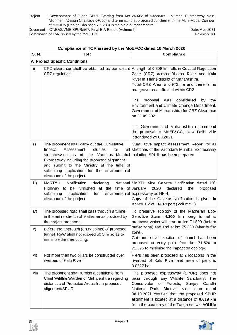
Compliance of TOR issued by the MoEFCC dated 16 March 2020
S. N. ToR Compliance
A. Project Specific Conditions
i) CRZ clearance shall be obtained as per extant
CRZ regulation
A length of 0.609 km falls in Coastal Regulation
Zone (CRZ) across Bhatsa River and Kalu
River in Thane district of Maharashtra.
Total CRZ Area is 6.972 ha and there is no
mangrove area affected within CRZ.
The proposal was considered by the
Environment and Climate Change Department,
Government of Maharashtra for CRZ Clearance
on 21.09.2021.
The Government of Maharashtra recommend
the proposal to MoEF&CC, New Delhi vide
letter dated 29.09.2021.
ii) The proponent shall carry out the Cumulative
Impact Assessment studies for all
stretches/sections of the Vadodara-Mumbai
Expressway including the proposed alignment
and submit to the Ministry at the time of
submitting application for the environmental
clearance of the project.
Cumulative Impact Assessment Report for all
stretches of the Vadodara Mumbai Expressway
including SPUR has been prepared
iii) MoRT&H Notification declaring National
Highway to be furnished at the time of
submitting application for environmental
clearance of the project.
MoRTH vide Gazette Notification dated 10th
January 2020 declared the proposed
expressway as NE-4.
Copy of the Gazette Notification is given in
Annex-1.2 of EIA Report (Volume-II)
iv) The proposed road shall pass through a tunnel
in the entire stretch of Matheran as provided by
the project proponent.
To preserve ecology of the Matheran Eco-
Sensitive Zone, 4.160 km long tunnel is
proposed which will start at km 71.520 (before
buffer zone) and end at km 75.680 (after buffer
zone).
Cut and cover section of tunnel has been
proposed at entry point from km 71.520 to
71.675 to minimise the impact on ecology.
v) Before the approach (entry points) of proposed
tunnel, RoW shall not exceed 50.5 m so as to
minimise the tree cutting.
vi) Not more than two pillars be constructed over
riverbed of Kalu River
Piers has been proposed at 2 locations in the
riverbed of Kalu River and area of piers is
0.0627 ha
vii) The proponent shall furnish a certificate from
Chief Wildlife Warden of Maharashtra regarding
distances of Protected Areas from proposed
alignment/SPUR
The proposed expressway (SPUR) does not
pass through any Wildlife Sanctuary. The
Conservator of Forests, Sanjay Gandhi
National Park, Bborivali vide letter dated
08.10.2021 certified that the proposed SPUR
alignment is located at a distance of 0.619 km
from the boundary of the Tungareshwar Wildlife
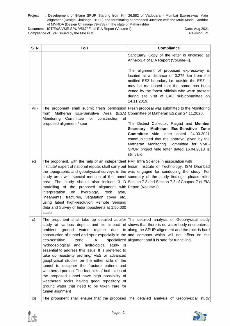
Project : Development of 8-lane SPUR Starting from Km 26.582 of Vadodara - Mumbai Expressway Main
Alignment (Design Chainage 0+000) and terminating at proposed Junction with the Multi-Modal Corridor
of MMRDA (Design Chainage 79+783) in the state of Maharashtra
Document : ICT/E&S/VME-SPUR/567/ Final EIA Report (Volume-I) Date: Aug 2021
Compliance of ToR issued by the MoEFCC Revision: R1
Page - 2
S. N. ToR Compliance
Sanctuary. Copy of the letter is enclosed as
Annex-3.4 of EIA Report (Volume-II).
The alignment of proposed expressway is
located at a distance of 0.275 km from the
notified ESZ boundary i.e. outside the ESZ. It
may be mentioned that the same has been
vetted by the forest officials who were present
during site visit of EAC sub-committee on
14.11.2019.
viii) The proponent shall submit fresh permission
from Matheran Eco-Sensitive Area (ESA)
Monitoring Committee for construction of
proposed alignment / spur
Fresh proposal was submitted to the Monitoring
Committee of Matheran ESZ on 24.11.2020.
The District Collector, Raigad and Member
Secretary, Matheran Eco-Sensitive Zone
Committee vide letter dated 24.03.2021
communicated that the approval given by the
Matheran Monitoring Committee for VME-
SPUR project vide letter dated 16.04.2013 is
still valid.
ix) The proponent, with the help of an independent
institute/ expert of national repute, shall carry out
the topographic and geophysical surveys in the
study area with special mention of the tunnel
area. The study should also include 3 D
modelling of the proposed alignment with
interpretation on hydrology, rock type,
lineaments, fractures, vegetation cover etc.
using latest high-resolution Remote Sensing
data and Survey of India toposheets at 1:50,000
scale.
PMT Infra Science in association with
Indian Institute of Technology, ISM Dhanbad
was engaged for conducting the study. For
summary of the study findings, please refer
Section 7.2 and Section 7.2 of Chapter-7 of EIA
Report (Volume-I)
x) The proponent shall take up detailed aquifer
study at various depths and its impact of
ambient ground water regime due to
construction of tunnel and spur especially in the
eco-sensitive zone. A specialized
hydrogeological and hydrological study is
essential to address this issue. It is preferred to
take up resistivity profiling/ VES or advanced
geophysical studies on the either side of the
tunnel to decipher the fracture pattern and
weathered portion. The foot hills of both sides of
the proposed tunnel have high possibility of
weathered rocks having good repository of
ground water that need to be taken care for
tunnel alignment
The detailed analysis of Geophysical study
shows that there is no water body encountered
along the SPUR alignment and the rock is hard
and compact which will not affect on the
alignment and it is safe for tunnelling.
xi) The proponent shall ensure that the proposed The detailed analysis of Geophysical study
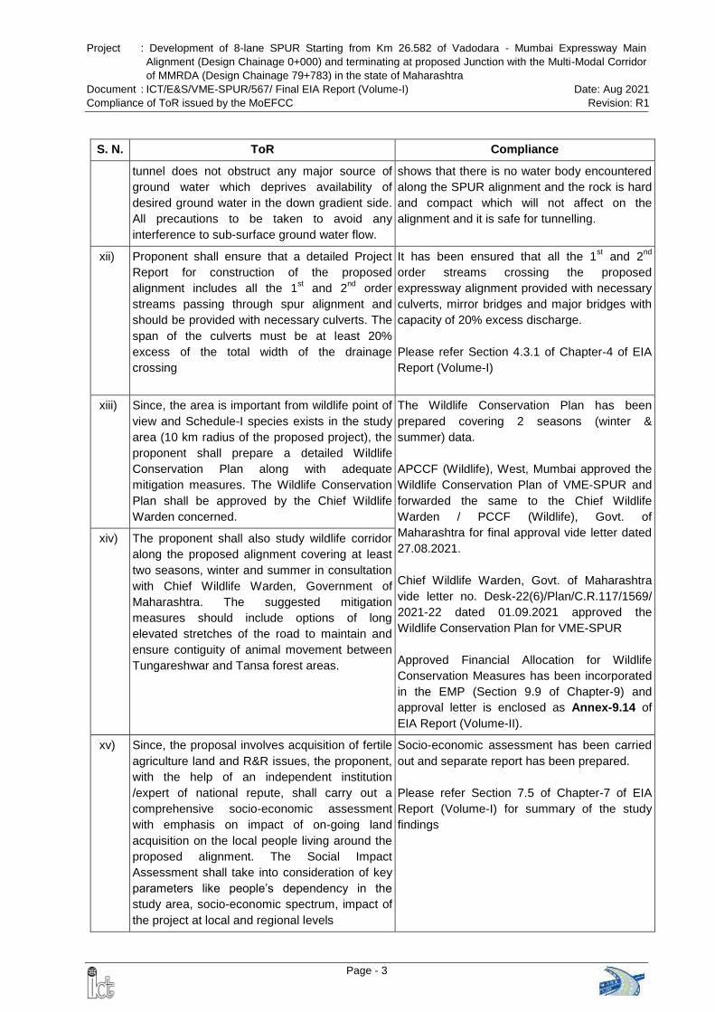
Project : Development of 8-lane SPUR Starting from Km 26.582 of Vadodara - Mumbai Expressway Main
Alignment (Design Chainage 0+000) and terminating at proposed Junction with the Multi-Modal Corridor
of MMRDA (Design Chainage 79+783) in the state of Maharashtra
Document : ICT/E&S/VME-SPUR/567/ Final EIA Report (Volume-I) Date: Aug 2021
Compliance of ToR issued by the MoEFCC Revision: R1
Page - 3
S. N. ToR Compliance
tunnel does not obstruct any major source of
ground water which deprives availability of
desired ground water in the down gradient side.
All precautions to be taken to avoid any
interference to sub-surface ground water flow.
shows that there is no water body encountered
along the SPUR alignment and the rock is hard
and compact which will not affect on the
alignment and it is safe for tunnelling.
xii) Proponent shall ensure that a detailed Project
Report for construction of the proposed
alignment includes all the 1st and 2
nd order
streams passing through spur alignment and
should be provided with necessary culverts. The
span of the culverts must be at least 20%
excess of the total width of the drainage
crossing
It has been ensured that all the 1st and 2
nd
order streams crossing the proposed
expressway alignment provided with necessary
culverts, mirror bridges and major bridges with
capacity of 20% excess discharge.
Please refer Section 4.3.1 of Chapter-4 of EIA
Report (Volume-I)
xiii) Since, the area is important from wildlife point of
view and Schedule-I species exists in the study
area (10 km radius of the proposed project), the
proponent shall prepare a detailed Wildlife
Conservation Plan along with adequate
mitigation measures. The Wildlife Conservation
Plan shall be approved by the Chief Wildlife
Warden concerned.
The Wildlife Conservation Plan has been
prepared covering 2 seasons (winter &
summer) data.
APCCF (Wildlife), West, Mumbai approved the
Wildlife Conservation Plan of VME-SPUR and
forwarded the same to the Chief Wildlife
Warden / PCCF (Wildlife), Govt. of
Maharashtra for final approval vide letter dated
27.08.2021.
Chief Wildlife Warden, Govt. of Maharashtra
vide letter no. Desk-22(6)/Plan/C.R.117/1569/
2021-22 dated 01.09.2021 approved the
Wildlife Conservation Plan for VME-SPUR
Approved Financial Allocation for Wildlife
Conservation Measures has been incorporated
in the EMP (Section 9.9 of Chapter-9) and
approval letter is enclosed as Annex-9.14 of
EIA Report (Volume-II).
xiv) The proponent shall also study wildlife corridor
along the proposed alignment covering at least
two seasons, winter and summer in consultation
with Chief Wildlife Warden, Government of
Maharashtra. The suggested mitigation
measures should include options of long
elevated stretches of the road to maintain and
ensure contiguity of animal movement between
Tungareshwar and Tansa forest areas.
xv) Since, the proposal involves acquisition of fertile
agriculture land and R&R issues, the proponent,
with the help of an independent institution
/expert of national repute, shall carry out a
comprehensive socio-economic assessment
with emphasis on impact of on-going land
acquisition on the local people living around the
proposed alignment. The Social Impact
Assessment shall take into consideration of key
parameters like people’s dependency in the
study area, socio-economic spectrum, impact of
the project at local and regional levels
Socio-economic assessment has been carried
out and separate report has been prepared.
Please refer Section 7.5 of Chapter-7 of EIA
Report (Volume-I) for summary of the study
findings
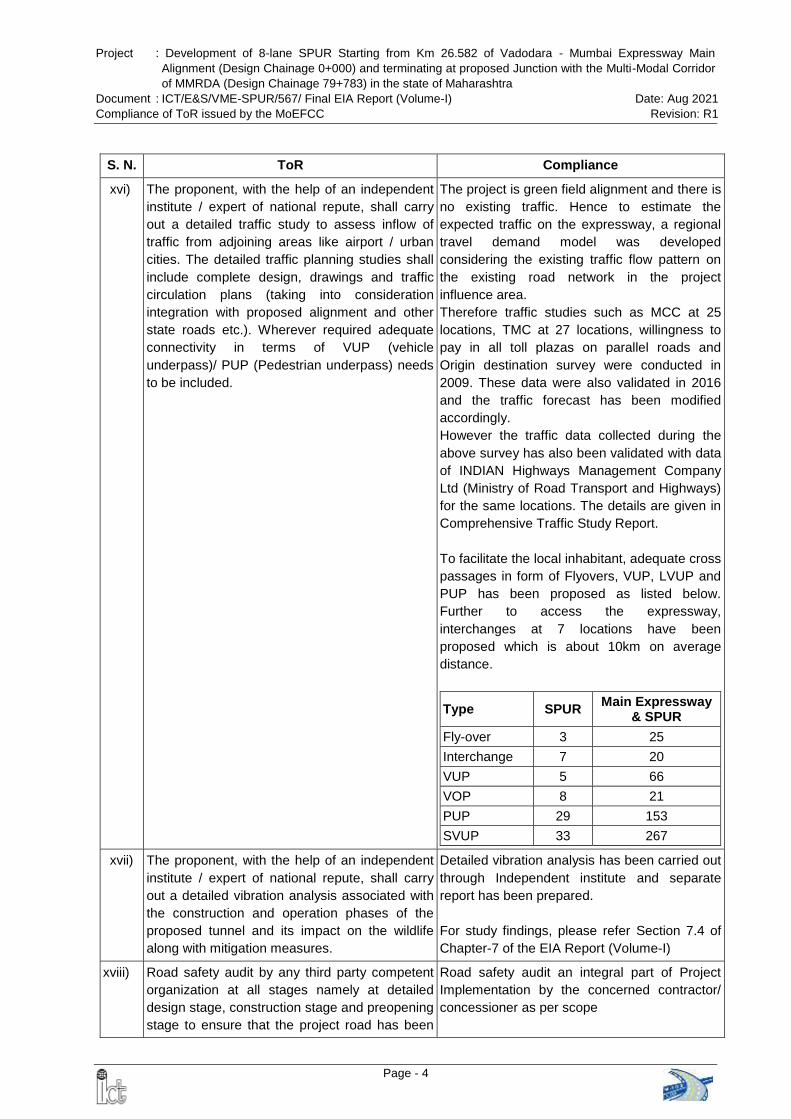
Project : Development of 8-lane SPUR Starting from Km 26.582 of Vadodara - Mumbai Expressway Main
Alignment (Design Chainage 0+000) and terminating at proposed Junction with the Multi-Modal Corridor
of MMRDA (Design Chainage 79+783) in the state of Maharashtra
Document : ICT/E&S/VME-SPUR/567/ Final EIA Report (Volume-I) Date: Aug 2021
Compliance of ToR issued by the MoEFCC Revision: R1
Page - 4
S. N. ToR Compliance
xvi) The proponent, with the help of an independent
institute / expert of national repute, shall carry
out a detailed traffic study to assess inflow of
traffic from adjoining areas like airport / urban
cities. The detailed traffic planning studies shall
include complete design, drawings and traffic
circulation plans (taking into consideration
integration with proposed alignment and other
state roads etc.). Wherever required adequate
connectivity in terms of VUP (vehicle
underpass)/ PUP (Pedestrian underpass) needs
to be included.
The project is green field alignment and there is
no existing traffic. Hence to estimate the
expected traffic on the expressway, a regional
travel demand model was developed
considering the existing traffic flow pattern on
the existing road network in the project
influence area.
Therefore traffic studies such as MCC at 25
locations, TMC at 27 locations, willingness to
pay in all toll plazas on parallel roads and
Origin destination survey were conducted in
2009. These data were also validated in 2016
and the traffic forecast has been modified
accordingly.
However the traffic data collected during the
above survey has also been validated with data
of INDIAN Highways Management Company
Ltd (Ministry of Road Transport and Highways)
for the same locations. The details are given in
Comprehensive Traffic Study Report.
To facilitate the local inhabitant, adequate cross
passages in form of Flyovers, VUP, LVUP and
PUP has been proposed as listed below.
Further to access the expressway,
interchanges at 7 locations have been
proposed which is about 10km on average
distance.
Type SPUR Main Expressway
& SPUR
Fly-over 3 25
Interchange 7 20
VUP 5 66
VOP 8 21
PUP 29 153
SVUP 33 267
xvii) The proponent, with the help of an independent
institute / expert of national repute, shall carry
out a detailed vibration analysis associated with
the construction and operation phases of the
proposed tunnel and its impact on the wildlife
along with mitigation measures.
Detailed vibration analysis has been carried out
through Independent institute and separate
report has been prepared.
For study findings, please refer Section 7.4 of
Chapter-7 of the EIA Report (Volume-I)
xviii) Road safety audit by any third party competent
organization at all stages namely at detailed
design stage, construction stage and preopening
stage to ensure that the project road has been
Road safety audit an integral part of Project
Implementation by the concerned contractor/
concessioner as per scope
Project : Development of 8-lane SPUR Starting from Km 26.582 of Vadodara - Mumbai Expressway Main
Alignment (Design Chainage 0+000) and terminating at proposed Junction with the Multi-Modal Corridor
of MMRDA (Design Chainage 79+783) in the state of Maharashtra
Document : ICT/E&S/VME-SPUR/567/ Final EIA Report (Volume-I) Date: Aug 2021
Compliance of ToR issued by the MoEFCC Revision: R1
Page - 5
S. N. ToR Compliance
constructed considering all the elements of road
safety.
xix) The RoW shall not exceed 70m at any point of
the proposed 8-lane alignment, except for the
junction improvement at the intersections of the
other roads. The area of land for forest diversion
shall be reduced accordingly
The proposed RoW of VME-SPUR is 100 m in
general After ToR, design has been modified
and ROW has been reduced from 100 m to 70
m in 8.756 km stretch in the Forest Area and
24.276 ha forest land has been saved
Please refer Section 2.4.2 of Chapter-2 of EIA
Report (Volume-I)
xx) The alignment of road should be such that the
cutting of trees is kept at bare minimum and for
this the proponent shall obtain permission from
the competent authorities
Cutting of trees has been kept at bare minimum
xxi) A comprehensive plan for plantation of three
rows of native species, as per IRC guidelines,
shall be provided. Such plantation alongside of
forest stretch will be over and above the
compensatory afforestation. Tree species should
be same as per the forest type.
Please refer Section 9.3 of Chapter-9 of EIA
Report (Volume-I)
xxii) Rain water harvesting structures to be
constructed at the either sides of the road with
special precaution of oil filters and de-silting
chambers.
As per MoEFCC Notification and MoRTH
Guidelines, the construction of rain water
harvesting structure is mandatory in and
around Water Crisis area, notified by the
Central Ground Water Board. All the Talukas
through which the proposed expressway is
passing are fall under safe category. However,
75 numbers (1 structure in every km excluding
tunnel area) of Rain water harvesting with
provision of oil filters and de-silting chambers
shall be provided along project road as per
requirement of IRC SP: 42-2014 and IRC SP:
50-2013. The location shall be finalized in
consultation with IE/ AE as per requirement of
IRC: SP-42. If there is any requirement of
additional structures, the same is to be
constructed by the Contractor during
implementation of the EMP
xxiii) Provide compilation of road kill data on existing
roads (national and state highways) in the
vicinity of the proposed project
Please refer Section 4.8.1 of Chapter-4 of EIA
Report (Volume-I)
xxiv) Provide measures to avoid road kills of wildlife
by the way of road kill management plan
xxv) The PP shall not use groundwater/surface water
without obtaining approval from CGWA/SGWA
as the case may be. The project proponent shall
Will be complied at the time of Construction
Project : Development of 8-lane SPUR Starting from Km 26.582 of Vadodara - Mumbai Expressway Main
Alignment (Design Chainage 0+000) and terminating at proposed Junction with the Multi-Modal Corridor
of MMRDA (Design Chainage 79+783) in the state of Maharashtra
Document : ICT/E&S/VME-SPUR/567/ Final EIA Report (Volume-I) Date: Aug 2021
Compliance of ToR issued by the MoEFCC Revision: R1
Page - 6
S. N. ToR Compliance
apply to the Central Ground Water Authority
(CGWA)/State Ground Water Authority
(SGWA)/Competent Authority, as the case may
be, for obtaining No Objection Certificate (NOC),
for withdrawal of ground water.
xxvi) The Action Plan on the compliance of the
recommendations of the CAG as per Ministry’s
Circular No. J-11013/71/2016-IA.I (M), dated
25th October, 2017 needs to be submitted at the
time of appraisal of the project and included in
the EIA/EMP Report.
All directions and guidelines of MoEF&CC in
compliance to the Circular shall be adhered
xxvii) The activities and budget earmarked for
Corporate Environmental Responsibility (CER)
shall be as per ministry’s O.M No 22-65/2017-
IA.II (M) dated 1st May, 2018 and the action plan
on the activities proposed under CER shall be
submitted at the time of appraisal of the project
included in the EIA/EMP Report. The CER shall
be computed on slab basis
MoEFCC vide Office Memorandum (OM)
dated 30th September 2020 suspended the
OM dated 1st May 2018 i.e. guidelines in
respect of CRE
A capital cost provision of about Rs. 40.5
Crore has been proposed under CER
Please refer Section 9.10 of Chapter-9 of
EIA Report (Volume-I)
General Conditions
i) A brief description of the project, project name,
nature, size, its importance to the region / state
and the country shall be submitted
Project description provided in Chapter 2 of the
EIA report (Volume-I)
ii) In case the project involves diversion of forests
land, guidelines under OM dated 20.03.2013
may be followed and necessary action taken
accordingly.
The proposed project involves diversion of
forest land. Proposal has been uploaded on 6th
November 2020 (FC Proposal No.
FP/MH/ROAD/53857/2020) and it is under
examination with the State Government.
iii) Details of any litigation(s) pending against the
project and/or any directions or orders passed
by any court of law/any statutory authority
against the project to be detailed out.
No litigation pending
iv) Submit detailed alignment plan, with details such
as nature of terrain (plain, rolling, hilly), land use
pattern, habitation, cropping pattern, forest area,
environmentally sensitive places, mangroves,
notified industrial areas, sand dunes, sea, river,
lake, details of villages, teshils, districts and
states, latitude and longitude for important
locations falling on the alignment by employing
remote sensing techniques followed by ground
truthing and also through secondary data
sources.
The land use pattern within the study area and
along the proposed expressway has been
given in Section 3.7 of Chapter 3 of EIA Report
(Volume-I)
v) Describe various alternatives considered,
procedures and criteria adopted for selection of
The details of the alternatives considered have
been presented in Chapter 5 of EIA Report
Project : Development of 8-lane SPUR Starting from Km 26.582 of Vadodara - Mumbai Expressway Main
Alignment (Design Chainage 0+000) and terminating at proposed Junction with the Multi-Modal Corridor
of MMRDA (Design Chainage 79+783) in the state of Maharashtra
Document : ICT/E&S/VME-SPUR/567/ Final EIA Report (Volume-I) Date: Aug 2021
Compliance of ToR issued by the MoEFCC Revision: R1
Page - 7
S. N. ToR Compliance
the final alternative with reasons. (Volume-I)
vi) Submit Land use map of the study area to a
scale of 1: 25,000 based on recent satellite
imagery delineating the crop lands (both single
and double crop), agricultural plantations, fallow
lands, waste lands, water bodies, built-up areas,
forest area and other surface features such as
railway tracks, ports, airports, roads, and major
industries etc. and submit a detailed ground
surveyed map on 1:2000 scale showing the
existing features falling within the right of way
namely trees, structures including
archaeological & religious, monuments etc. if
any.
The land use map of the study area covering
15 km on either side of the expressway in
1:25,000 scale is provided in Section 3.7 of
Chapter 3 of EIA Report (Volume-I)
vii) If the proposed route is passing through any hilly
area, examine and submit the stability of slopes,
If the proposed road is to pass through cutting or
embankment / control of soil erosion from
embankment. Landslide, rock fall protection
measures to be indicated.
5.623 km of the SPUR alignment lies in hilly zone in the eastern part of the Raigad district. 4.160 km tunnel has been proposed at this location. A special care has been taken for slope
stabilization at and above the portal where
system such as sprayed concrete with bolts,
retaining cable nets, anchoring of boulders,
removal of instable boulders to avoid any rick of
rock falling during construction and even during
tunnel operation.
viii) If the proposed route involves tunnelling, the
details of the tunnel and locations of tunnelling
with geological structural fraction should be
provided. In case the road passes through a
flood plain of the river, the details of micro
drainage, flood passages and information on
high levels flood periodicity at least of last 50
years in the area should be examined.
Please refer Section 2.6 of Chapter-2 of EIA
Report (Volume-I)
ix) The projects is located within 10km. of the
sanctuary a map duly authenticated by Chief
Wildlife Warden showing these features vis-à-vis
the project location and the recommendations or
comments of the Chief Wildlife Warden thereon
should be furnished at the stage of EC.
The proposed expressway does not pass through any Wildlife Sanctuary. Proposed alignment is located at a distance of
0.619 km from the boundary of the
Tungareshwar Wildlife Sanctuary and 0.275 km
from the notified ESZ boundary.
As per MoEFCC Office Memorandum dater 8th
August 2019 (F. No. 22-43/2018-IA.III),
“Proposal involving developmental activity /
project located outside the stipulated boundary
limit of notified ESZ and located within 10km of
National Park / Wildlife Sanctuary, prior
clearance from Standing Committee of the
Project : Development of 8-lane SPUR Starting from Km 26.582 of Vadodara - Mumbai Expressway Main
Alignment (Design Chainage 0+000) and terminating at proposed Junction with the Multi-Modal Corridor
of MMRDA (Design Chainage 79+783) in the state of Maharashtra
Document : ICT/E&S/VME-SPUR/567/ Final EIA Report (Volume-I) Date: Aug 2021
Compliance of ToR issued by the MoEFCC Revision: R1
Page - 8
S. N. ToR Compliance
National Board for Wildlife may not be
applicable. However, such proposal
………would be examined by the sector
specific Expert Appraisal Committee and
appropriate conservation measures ….. shall
be made.”
Hence, Not required
x) Study regarding the Animal bypasses /
underpasses etc. across the habitation areas
shall be carried out. Adequate cattle passes for
the movement of agriculture material shall be
provided at the stretches passing through
habitation areas.
Total 364 structures (which includes 2 animal overpass, 53 numbers of dedicated animal crossings and 33 numbers of animal underpasses) have been proposed along the entire stretch of the VME-SPUR Total length of the structures is 13.447 km and in every km stretches of the VME-SPUR; around 5 structures have been proposed. Circular issued by the Principle Chief Conservator of Forest, Maharashtra State dated 24.09.2020 has been complied. All underpass and animal crossing having a minimum size of width 4.00 m and height 3.00 m has been proposed Cost of construction of the animal overpass, dedicated animal crossing & animal underpass is Rs. 173.39 Crore.
Chief Wildlife Warden, Govt. of Maharashtra
vide letter dated 01.09.2021 approved the
Wildlife Conservation Plan for VME-SPUR
xi) Study regarding in line with the recent guidelines
prepared by Wildlife Institute of India for linear
infrastructure with strong emphasis on animal
movement and identifying crossing areas and
mitigation measures to avoid wildlife mortality.
xii) The information shall be provided about the
details of the trees to be cut including their
species and whether it also involves any
protected or endangered species. Measures
taken to reduce the number of the trees to be
removed should be explained in detail. Submit
the details of compensatory plantation. Explore
the possibilities of relocating the existing trees.
Animal and wild life crossings to be provided in
areas inhabited by wild life.
Details are provided in Section 4.6.1 of
Chapter-4 of EIA Report (Volume-I)
xiii) Necessary green belt shall be provided on both
sides of the highway with proper central verge
and cost provision should be made for regular
maintenance.
The Green Belt Development Plan has been
presented in Section 9.3 of Chapter 9 of EIA
Report (Volume-I)
The cost of Green Belt Development has been
included in EMP budget.
xiv) If the proposed route is passing through a city or
town, with houses and human habitation on the
either side of the road, the necessity for
It is a greenfield expressway and major land
use (73%) within RoW of the expressway is
agricultural and allied uses. human habitations
Project : Development of 8-lane SPUR Starting from Km 26.582 of Vadodara - Mumbai Expressway Main
Alignment (Design Chainage 0+000) and terminating at proposed Junction with the Multi-Modal Corridor
of MMRDA (Design Chainage 79+783) in the state of Maharashtra
Document : ICT/E&S/VME-SPUR/567/ Final EIA Report (Volume-I) Date: Aug 2021
Compliance of ToR issued by the MoEFCC Revision: R1
Page - 9
S. N. ToR Compliance
provision of bypasses/diversions/under passes
shall be examined and submitted. The proposal
should also indicate the location of wayside
amenities, which should include petrol
station/service centre, rest areas including public
conveyance etc. Noise reduction measures
should also be indicated.
are away from the alignment.
Details of wayside amenities are provided in
Section 2.4.11 of Chapter-2 of Final EIA Report
(Page 20)
xv) Details about measures taken for the pedestrian
safety and construction of underpasses and
foot-over bridges along with flyovers and
interchanges shall be submitted
For the pedestrian safety - 5 Vehicular Underpasses, 8 vehicular overpasses, 29 Light Vehicular / Pedestrian Underpasses, 33 Small Vehicular / Animal Underpasses, 7 Interchanges and 3 Flyovers have been proposed. To improve the safety, Thrie beam metal crash barriers shall be provided in entire length on both sides of each main carriageway Advanced Traffic Management System (ATMS) for entire expressway have been proposed to facilitate the road users
xvi) The possibility that the proposed project will
adversely affect road traffic in the surrounding
areas (e.g. by causing increases in traffic
congestion and traffic accidents) shall be
addressed.
The project will enhance traffic movement and
the design of the proposed expressway shall
address safety concerns and reduce accidents.
xvii) The details of use of fly ash in the road
construction, if the project road is located within
the 100 km from the Thermal Power Plant.
83,12,133 cum fly ash will be required for
construction of the expressway.
With the aim to use fly ash / pond ash in
embankment construction, three sources of fly
ash within 300 Km were visited. One is Tata
Power Plant located at Mahul, Trombay
(Bombay) which is about 80 km from Km.
38.300 of the SPUR. On enquiry, we
understand that the quality of fly-ash is very
good and the fly Ash generation of the plant in
2018-19 is 50,312 MT per annum. The other
source is Reliance Thermal Power Plant (250
MW) located at Dahanu, Maharashtra which is
about 150 Km and its production of fly-ash in
2018-19 is around 5,64,376 MT per annum.
The third source is Nashik Thermal Power
plant, Ekalahre which is around 170 Km from
project road and its fly ash production in 2018-
19 is around 7,02,227 MT per annum. The fly
Ash for the embankment construction can be
used from these sources as per guidelines of
MoEFCC and IRC:SP:58.
Project : Development of 8-lane SPUR Starting from Km 26.582 of Vadodara - Mumbai Expressway Main
Alignment (Design Chainage 0+000) and terminating at proposed Junction with the Multi-Modal Corridor
of MMRDA (Design Chainage 79+783) in the state of Maharashtra
Document : ICT/E&S/VME-SPUR/567/ Final EIA Report (Volume-I) Date: Aug 2021
Compliance of ToR issued by the MoEFCC Revision: R1
Page - 10
S. N. ToR Compliance
xviii) The possibilities of utilizing the debris/ waste
materials available in and around the project
area.
The waste generated during the construction
shall be used under subgrade as per it’s
suitability.
xix) Submit the details on compliance with respect to
Research Track Notification of MoRTH
This project is being compiled all the Guidelines
& Notifications issued by MoRTH
xx) The details of sand quarry and borrow area as
per OM no.2-30/2012-IA-III dated 18.12.2012 on
'Rationalization of procedure for Environmental
Clearance for Highway Projects involving borrow
areas for soil and earth" as modified vide OM of
even no. dated March 19, 2013 shall be
examined and submitted.
Details of Sand Quarry and Borrow Area
(proposed for the project) is given in Section
2.8 of Chapter-2 of EIA report
The Extraction or sourcing or borrowing of
ordinary earth for the linear projects such as
roads, pipelines, etc. has been exempted
from Environmental Clearance as per
MoEF&CC Notification dated 28th March
2020.
Quarry material shall be arranged from
already approved quarries.
xxi) Climate and meteorology (max and min
temperature, relative humidity, rainfall,
frequency of tropical cyclone and snow fall); the
nearest IMD meteorological station from which
climatological data have been obtained to be
indicated.
The details have been presented in Section 3.9
of Chapter 3 of EIA Report (Volume-I)
xxii) The air quality monitoring shall be carried out as
per the notification issued on 16th Nov, 2009.
Input data used for Noise and Air quality
modelling shall be clearly delineated.
Details of ambient air quality monitoring have
been presented in section 3.10 of Chapter 3 of
EIA Report (Volume-I)
Input data used for Air quality and Noise
modelling has been defined in section 4.4.2 &
4.5.2 of Chapter-4 of EIA report
xxiii) The project activities during construction and
operation phases, which will affect the noise
levels and the potential for increased noise
resulting from this project. Discuss the effect of
noise levels on nearby habitation during the
construction and operational phases of the
proposed highway. Identify noise reduction
measures and traffic management strategies to
be deployed for reducing the negative impact if
any. Prediction of noise levels should be done
by using mathematical modelling at different
representative locations.
The impact on the noise levels during
construction and operation phase has been
presented in section 4.5 of Chapter 4 of EIA
Report (Volume-I)
xxiv) Impact during construction activities due to
generation of fugitive dust from crusher units, air
emissions from hot mix plants and vehicles used
for transportation of materials and prediction of
impact on ambient air quality using appropriate
The impact on the air quality during
construction and operation phase has been
presented in section 4.4 of Chapter 4 of EIA
Report (Volume-I)
Project : Development of 8-lane SPUR Starting from Km 26.582 of Vadodara - Mumbai Expressway Main
Alignment (Design Chainage 0+000) and terminating at proposed Junction with the Multi-Modal Corridor
of MMRDA (Design Chainage 79+783) in the state of Maharashtra
Document : ICT/E&S/VME-SPUR/567/ Final EIA Report (Volume-I) Date: Aug 2021
Compliance of ToR issued by the MoEFCC Revision: R1
Page - 11
S. N. ToR Compliance
mathematical model, description of model, input
requirement and reference of derivation,
distribution of major pollutants and presentation
in tabular form for easy interpretation shall be
carried out.
xxv) Details about the protection to existing
habitations from dust, noise, odour etc. during
construction stage. Shall be examined and
submitted
Protection to existing habitations from dust and
noise during construction stage has been
examined and mitigation measures have been
suggested. Details are given in Section 4.4 and
4.5 of EIA Report (Volume-I)
IRC guidelines have been followed for traffic
safety while passing through the habitat.
xxvi) If the proposed route involves cutting of earth,
the details of area to be cut, depth of cut,
locations, soil type, volume and quantity of earth
and other materials to be removed with location
of disposal/dump site along with necessary
permission.
Details have been provided in Section 4.2 of
Chapter-4 of EIA Report (Volume-I)
xxvii) If the proposed route is passing through low
lying areas, details of fill materials and initial and
final levels after filling above MSL, should be
examined and submit.
The proposed expressway is passing through
mainly plain and rolling terrain. There is no
stretches having level below MSL. However,
the final FRL/ embankment height is designed
based on the HFL as per IRC:SP:99-2013.
The fill material for the embankment has been
considered from selected quarry which confirm
IS codes and MoRTH specification.
xxviii) The water bodies including the seasonal ones
within the corridor of impacts along with their
status, volumetric capacity, quality likely impacts
on them due to the project along with mitigation
measures shall be examined and submitted
Details are provided in Section 4.3.1 of
Chapter-4 of EIA Report (Volume-I)
xxix) Details of water quantity required and source of
water including water requirement during the
construction stage with supporting data and also
categorization of ground water based on the
CGWB classification.
The total demand of water for construction
phase will be about 23,75,760 KL. In
compliance to the Sub-Clause 111.8.3 of
MoRTH Specifications, the Contractor will
identify the nearest source of water body and
shall source the water preferably from
surface water bodies, rivers, canals and
tanks in the project area.
Only at locations where surface water
sources are not available, the Contractor
shall contemplate extraction of ground water,
after intimation and consent from the CGWB
As per the CGWA classification, all the
Talukas, through which the proposed
expressway is passing, fall under safe
category.
Project : Development of 8-lane SPUR Starting from Km 26.582 of Vadodara - Mumbai Expressway Main
Alignment (Design Chainage 0+000) and terminating at proposed Junction with the Multi-Modal Corridor
of MMRDA (Design Chainage 79+783) in the state of Maharashtra
Document : ICT/E&S/VME-SPUR/567/ Final EIA Report (Volume-I) Date: Aug 2021
Compliance of ToR issued by the MoEFCC Revision: R1
Page - 12
S. N. ToR Compliance
xxx) The details of measures taken during
constructions of bridges across river / canal /
major or minor drains keeping in view the
flooding of the rivers and the life span of the
existing bridges. Provision of speed breakers,
safety signals, service lanes and foot paths
should be examined at appropriate locations
throughout the proposed road to avoid the
accidents.
13 major bridges and 23 minor bridges have
been proposed. The details provision of safety
signals, service lanes and foot paths to avoid
accidents has been presented in chapter 2 of
EIA Report (Volume-I).
Provision of diversions with direction signs and
other safety requirements followed as per IRC
& MoRTH guidelines
xxxi) If there will be any change in the drainage
pattern after the proposed activity, details of
changes shall be examined and submitted.
No change in the drainage pattern is envisaged
for the project. Bridges have been designed for
a return period of 100 years and culverts have
been designed for a return period of 50 years
with capacity of minimum 20% excess
discharge
xxxii) Rain water harvesting pit should be at least 3 - 5
m. above the highest ground water table.
Provision shall be made for oil and grease
removal from surface runoff.
As per the CGWA classification, all the
Talukas, through which the proposed
expressway is passing, fall under safe
category.
However, rainwater harvesting structure has
been proposed along the expressway, toll plaza
and wayside amenities as per MoRTH
requirement. Total number of Rainwater
Harvesting structures proposed is 75 and cost
of the same has been included in the EMP
budget.
xxxiii) If there is a possibility that the construction/
widening of road will cause impact such as
destruction of forest, poaching, reductions in
wetland areas, if so, examine the impact and
submit details.
The impact on the Flora, Fauna and Forest due
to the construction of the expressway and its
mitigation measures has been presented in
Section 4.6, 4.7 and 4.8 of Chapter 4 of EIA
Report (Volume-I)
xxxiv) The details of road safety, signage, service
roads, vehicular under passes, accident prone
zone and the mitigation measures shall be
submitted
The details provision for road safety has been
presented in Section 2.4.15 chapter 2 of EIA
Report (Volume-I).
xxxv) IRC guidelines shall be followed for widening &
up-gradation of road.
Complied
xxxvi) Submit details of social impact assessment due
to the proposed construction of road.
Infer Development Consulting Pvt. Ltd., New
Delhi was engaged for conducting Social
Impact Assessment for the project and
standalone report has been prepared. The
summary of the social impacts is given below:
Total land acquisition: 1045.1492 ha
Total private land unit affected: 10,526
Fully displaced land owner: 526 no.
Total number of structures affected of all
Project : Development of 8-lane SPUR Starting from Km 26.582 of Vadodara - Mumbai Expressway Main
Alignment (Design Chainage 0+000) and terminating at proposed Junction with the Multi-Modal Corridor
of MMRDA (Design Chainage 79+783) in the state of Maharashtra
Document : ICT/E&S/VME-SPUR/567/ Final EIA Report (Volume-I) Date: Aug 2021
Compliance of ToR issued by the MoEFCC Revision: R1
Page - 13
S. N. ToR Compliance
categories
(Including Private, Government and
Religious) : 1,130 no.
Total number of affected private structures:
1,110
Number of fully affected structure owner :
955
Total number of Govt. /Communities
properties: 6
Total number of religious properties: 14
xxxvii) Examine road design standards, safety
equipment specifications and Management
System training to ensure that design details
take account of safety concerns and submit the
traffic management plan.
All relevant guideline has been followed for
designing the expressway as per traffic,
pedestrian and accident safety.
The proposed project is a greenfield alignment
and there is no normal operating traffic as in
the case of existing highways. Therefore, there
is no specific standard requirement for traffic
management plan during construction phase. It
is normally the construction vehicles, which will
be plying on temporary roads for the
constriction works. Wherever the proposed
expressway is crossing any existing road,
during construction phase, the Contractor shall
provide and maintain a passage for traffic either
along a part of the proposed RoW or along a
temporary diversion constructed close to the
crossing. The Contractor shall take prior
approval of the Authority Engineer regarding
traffic arrangements during construction.
Guideline for Preparing of Traffic Management
Plan is given in Annex-9.10 of EIA Report
(Volume-II)
xxxviii) Accident data and geographic distribution should
be reviewed and analysed to predict and identify
trends – in case of expansion of the existing
highway and provide Post accident emergency
assistance and medical care to accident victims.
Proposed expressway is green field alignment.
However, provision for accident emergency
assistance and medical care to accident victims
has been considered as road safety measures.
xxxix) If the proposed project involves any land
reclamation, details to be provided for which
activity land to reclaim and the area of land to be
reclaimed.
The proposed project does not involve any land
reclamation.
xl) Details of the properties, houses, businesses
religious and social places etc. activities likely to
be effected by land acquisition and their financial
loses annually.
Compensation will be determined in
accordance with First Schedule, rehabilitation
and resettlement assistance specified in the
Second & Third Schedule of RFCTLARR Act,
2013 applicable to the land acquisition under
Project : Development of 8-lane SPUR Starting from Km 26.582 of Vadodara - Mumbai Expressway Main
Alignment (Design Chainage 0+000) and terminating at proposed Junction with the Multi-Modal Corridor
of MMRDA (Design Chainage 79+783) in the state of Maharashtra
Document : ICT/E&S/VME-SPUR/567/ Final EIA Report (Volume-I) Date: Aug 2021
Compliance of ToR issued by the MoEFCC Revision: R1
Page - 14
S. N. ToR Compliance
the National Highways Act, 1956
xli) Detailed R&R plan with data on the existing
socio-economic status of the population in the
study area and broad plan for resettlement of
the displaced population, site for the
resettlement colony, alternative livelihood
concerns/employment and rehabilitation of the
displaced people, civil and housing amenities
being offered etc., and the schedule of the
implementation of the project specific, shall be
submitted
Land will be acquired by the CALA (Competent
Authority for Land Acquisition) as per National
Highways Act, 1956 and relevant provisions of
the Right to Fair Compensation and
Transparency in Land Acquisition,
Rehabilitation and Resettlement (RFCTLARR)
Act, 2013 & amendment of State Government.
Compensation will be determined in
accordance with First Schedule, rehabilitation
and resettlement assistance specified in the
Second & Third Schedule of RFCTLARR Act,
2013 applicable to the land acquisition under
the National Highways Act, 1956
xlii) The environment management and monitoring
plan for construction and operation phases of
the project shall be submitted. A copy of your
corporate policy on environment management
and sustainable development, shall also be
submitted.
The details of Environmental Monitoring Plan is provided in Chapter-6 of the EIA Report (Volume-I) The details of Environmental Management Plan
is provided in Chapter-9 of the EIA Report
(Volume-I)
xliii) Estimated cost of the project including
environmental management plan and source of
funding, Also mode of execution of the project
viz. EPC, BOT etc. shall be submitted
Total Project Cost including Centage & Pre-construction Cost – Rs. 10,510 Cr.
EMP Budget – Rs. 56.98 Cr. The proposed project will be implemented on
Hybrid Annuity mode under Bharatmala Pariyojana
xliv) A copy of your CSR Policy and Plan for meeting
the expenditure to address the issues raised
during Public Hearing shall be submitted.
NHAI abides by the Central Govt. CSR Policy.
Please refer Section 9.10 of Chapter-9 of EIA
Report (Volume-I)
xlv) Details of blasting if any, methodology/
technique adopted, applicable regulations /
permissions, timing of blasting, mitigation
measures proposed keeping in view mating
season of wild life.
The permission for blasting will be taken from
the concerned authorities by the Contractor /
Concessionaire before start of tunnelling work
with methodology, technique, timing of blasting
and mitigation measures.
The Concessionaire shall comply the following
rules in respect of controlled perimeter blasting:
Indian Explosives Act 1884 Indian Explosive Rules 2008 and further
amendment in Jan.2009 The Manufacture and Storage of Explosives
Regulations 2005 BS 5607:1998 Code of practice for the safe
use of explosives in the construction industry Control of Explosives Regulations 1991 Carriage of Explosives by Road. Road Traffic
(Carriage of Explosives) Regulations 1996 PD CLC/TR 50426:2004 Assessment of
Project : Development of 8-lane SPUR Starting from Km 26.582 of Vadodara - Mumbai Expressway Main
Alignment (Design Chainage 0+000) and terminating at proposed Junction with the Multi-Modal Corridor
of MMRDA (Design Chainage 79+783) in the state of Maharashtra
Document : ICT/E&S/VME-SPUR/567/ Final EIA Report (Volume-I) Date: Aug 2021
Compliance of ToR issued by the MoEFCC Revision: R1
Page - 15
S. N. ToR Compliance
inadvertent initiation of bridge wire electro-explosive devices by radio- frequency radiation. Guide Quarries (Explosives) Regulations 1988, as far as it is relevant to tunnel works
xlvi) In case of river/ creek crossing, details of the
proposed bridges connecting on either banks,
the design and traffic circulation at this junction
with simulation studies.
There is no intersection at location where the
bridge ends at the river banks. There are no at-
grade junctions in the expressway and all entry
and exits are through grade-separated
interchanges with loops and ramps, which are
designed for the traffic capacity based on traffic
forecasts.
xlvii) Details to ensure free flow of water in case the
alignment passes through water bodies/river/
streams etc.
It has been ensured that free flow of water is
maintained wherever the expressway alignment
crosses river / local streams / nallah etc., as
detailed in Section 4.3 of Chapter-4 of EIA
Report (Volume-I)
xlviii) In case of bye passes, the details of access
control from the nearby habitation / habitation
which may come up after the establishment of
road.
Proposed expressway is access controlled and
bypassing all major habitations
xlix) Bridge design in eco sensitive area / mountains
be examined keeping in view the rock
classification hydrology etc.
The proposed expressway is not passing
through eco sensitive area.
5.623 km of the SPUR alignment lies in hilly
zone in the eastern part of the Raigad district
where tunnel has been proposed
l) Details of litigation pending against the project, if any, with direction / order passed by any Court of Law against the Project should be given
No litigation pending
li) The cost of the Project (capital cost and recurring cost) as well as the cost towards implementation of EMP should be clearly spelt out.
Total Project Cost including Centage & Pre-construction Cost – Rs. 10,510 Cr. EMP Budget – Rs. 56.98 Cr.
lii) In case of alignment passing through coastal
zones
CRZ map and report has been prepared by the National Centre for Earth Science Studies (NCESS), Thiruvananthapuram, a MoEFCC approved agency.
No area in CRZ-IA and no cutting of mangrove
Area in CRZ-1B - 0.713 ha No labour camp, machinery in CRZ area The proposal was considered by the
Environment and Climate Change Department, Government of Maharashtra for CRZ Clearance on 21.09.2021.
The Government of Maharashtra recommend the proposal to MoEF&CC, New Delhi vide letter dated 29.09.2021.
a) HTL/LTL map prepared by authorized
agencies superimposed with alignment and
recommendation of Coastal Zone
Management Authority
b) Details of CRZ-I (I) areas, mangroves
required to be removed for the project along
with the compensatory afforestation, area
and location with budget
c) Details of road on stilt in CRZ-I areas, design
details to ensure free tidal flow
d) Details of Labour camps, machinery location
Project : Development of 8-lane SPUR Starting from Km 26.582 of Vadodara - Mumbai Expressway Main
Alignment (Design Chainage 0+000) and terminating at proposed Junction with the Multi-Modal Corridor
of MMRDA (Design Chainage 79+783) in the state of Maharashtra
Document : ICT/E&S/VME-SPUR/567/ Final EIA Report (Volume-I) Date: Aug 2021
Compliance of ToR issued by the MoEFCC Revision: R1
Page - 16
S. N. ToR Compliance
liii) Any further clarification on carrying out the
above studies including anticipated impacts due
to the project and mitigative measure, project
proponent can refer to the model ToR available
on Ministry website
http://moef.nic.in/Manual/Highways".
Referred as advised
Project : Development of 8-lane SPUR Starting from Km 26.582 of Vadodara - Mumbai Expressway Main
Alignment (Design Chainage 0+000) and terminating at proposed Junction with the Multi-Modal Corridor
of MMRDA (Design Chainage 79+783) in the state of Maharashtra
Document : ICT/E&S/VME-SPUR/567/ Final EIA Report (Volume-I) Date: Aug 2021
Executive Summary Revision: R1
Page - 1
EXECUTIVE SUMMARY
E.1 INTRODUCTION
The proposed project is 8 lane access controlled green field SPUR of Vadodara Mumbai
Expressway. As per the EIA Notification, 2006 and its subsequent amendments, it falls
in item. No 7 (f) of the Schedule to the Notification and is a category “A” project,
requires Prior Environment Clearance from the Ministry of Environment, Forest and
Climate Change (MoEFCC), GOI.
Form-I for obtaining ToR from the MoEFCC was submitted on 13th July 2019. The
project was considered in 220th meeting of Expert Appraisal Committee (EAC) of
MoEFCC held on 26th July 2019. After detailed deliberation, the EAC decided to carry
out site inspection before issuing the ToR.
Accordingly a Sub-committee of EAC was constituted and the Sub-committee visited the
proposed site from 13th to 15th November 2019. The site visit report of the Sub-
committee was discussed and approved in the 227th EAC meeting held on 28th
November, 2019 and compliance of the same was submitted on 18th February 2020.
The project was further considered in 232nd meeting of EAC held on 27th February 2020
and the EAC recommended for grant of ToR. Accordingly, the MoEFCC issued the ToR
for conducting EIA Study vide letter dated 16th March 2020 (MoEFCC File No. 10-
29/2019-IA.III). This EIA Report has been prepared in accordance with the approved
ToR.
E.2 NEED OF THE PROJECT
During the draft Feasibility Study of the Mumbai – Vadodara Expressway, it was felt that
the starting point of proposed Vadodara Mumbai Expressway on NH-8 near Dahisar at
Mumbai end would pose a serious problem for safe and quick dispersal of traffic from
the Expressway and also would not serve the purpose of connecting to major traffic
generators like JNPT Port and to Mumbai-Pune expressway. Currently, the traffic bound
for Gujarat and further north from JNPT, NH-4 and Mumbai – Pune Expressway follows
Thane-Ghodbandar Road which is already congested and passes through / close to
Sanjay Gandhi National Park. Widening of this stretch as per IRC standard is not
feasible. This traffic has to pass through congested road network of Mumbai Metropolis
from southward destination and the goods earmarked for export and import also find
difficulty in commuting to and from JNPT, Navi Mumbai. Therefore it would be prudent to
connect the proposed Vadodara Mumbai Expressway to major traffic generators like
JNPT and Mumbai – Pune Expressway.
Keeping view of the above, provision of SPUR to VME was explored. The spur will not
Project : Development of 8-lane SPUR Starting from Km 26.582 of Vadodara - Mumbai Expressway Main
Alignment (Design Chainage 0+000) and terminating at proposed Junction with the Multi-Modal Corridor
of MMRDA (Design Chainage 79+783) in the state of Maharashtra
Document : ICT/E&S/VME-SPUR/567/ Final EIA Report (Volume-I) Date: Aug 2021
Executive Summary Revision: R1
Page - 2
only connect to these major traffic generators but will also result in better dispersal of
traffic in the Mumbai Metropolitan Region. Therefore, the Consultants proposed that the
VM Expressway should be connected to JNPT and Mumbai-Pune expressway via NH-3,
NH-8 NH-222 and NH4B for proper traffic dispersal.
The project highway will provide smooth, safe and uninterrupted traffic movement
between Vadodara to Mumbai in respect to the alternative road NH 48. The NH 48 (Old
NH8) is currently carrying more than 100,000 PCUs with much substandard geometry
and is heavily congested. It will reduce the travel time about 3 to4 hours between
Vadodara to Mumbai. The proposed expressway falls in the Delhi-Mumbai Industrial
Corridor. It will connect to the largest container port, JNPT near Mumbai with northern
part and Dahej port, other ports in Gujarat. Surat is at the heart of the world's diamond-
polishing industry contributing billions of dollars to the Indian GDP. Vapi, Daman and
Silvassa are the major industrial hub will be connected. Development of this section will
reduce the existing distance between Vadodara-Mumbai by about 22 km and ultimately
there will be reduction in distance between Delhi-Mumbai.
The SPUR connects the main expressway to JNPT, Maha Samrudhi Marg (Mumbai-
Nagpur Expressway) and Mumbai Pune Expressway. Therefore the traffic bound for
JNPT, Nagpur and Pune will ply on SPUR and will not enter the Mumbai city. This will
reduce both traffic congestion and pollution in the city. The proposed SPUR of VME will
be linking Vadodara – Mumbai Expressway, Ahmedabad- Vadodara Expressway,
Mumbai –Nagpur Expressway and Mumbai - Pune Expressway and thus will provide
expressway connectivity from Delhi – Ahmedabad – Mumbai – Nagpur - Pune.
This will further improve connectivity in terms of achieving smooth and safe traffic flow
and improve level of service. In addition to above, substantial economic gain, this would
eventually lead to reduction in the travel time and savings in terms of time, fuel and
maintenance cost of vehicles. Further this stretch will be a part of Delhi- Mumbai
expressway corridor.
E.3 PROJECT PROPONENT
National Highways Authority of India (NHAI), an autonomous agency of the Government
of India is the project proponent.
E.4 LOCATION OF THE PROJECT
The proposed VME – SPUR is a Greenfield alignment, which starts at km 26.582 of
main alignment of the Vadodara Mumbai Expressway at Koshimb village of Palghar
district at Ch. 0+000 and terminate at the proposed junction with the Multi-Modal
Corridor of Mumbai Metropolitan Region Development Authority (MMRDA) in Morbe
village of Raigad district at Ch. 79+783. Total length of the SPUR alignment is 79.783
km; out of which 18.900 km lies in Palghar district, 55.260 km lies in Thane district and
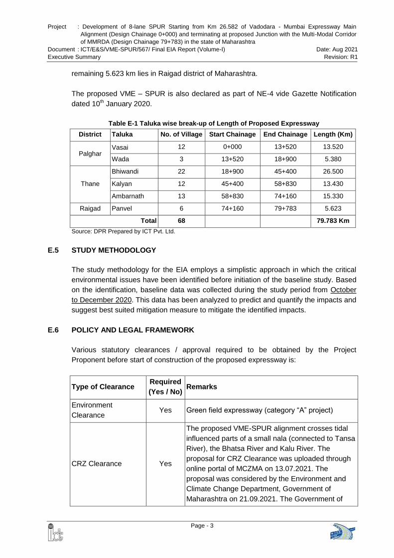
Project : Development of 8-lane SPUR Starting from Km 26.582 of Vadodara - Mumbai Expressway Main
Alignment (Design Chainage 0+000) and terminating at proposed Junction with the Multi-Modal Corridor
of MMRDA (Design Chainage 79+783) in the state of Maharashtra
Document : ICT/E&S/VME-SPUR/567/ Final EIA Report (Volume-I) Date: Aug 2021
Executive Summary Revision: R1
Page - 3
remaining 5.623 km lies in Raigad district of Maharashtra.
The proposed VME – SPUR is also declared as part of NE-4 vide Gazette Notification
dated 10th January 2020.
Table E-1 Taluka wise break-up of Length of Proposed Expressway
District Taluka No. of Village Start Chainage End Chainage Length (Km)
Palghar Vasai 12 0+000 13+520 13.520
Wada 3 13+520 18+900 5.380
Thane
Bhiwandi 22 18+900 45+400 26.500
Kalyan 12 45+400 58+830 13.430
Ambarnath 13 58+830 74+160 15.330
Raigad Panvel 6 74+160 79+783 5.623
Total 68 79.783 Km
Source: DPR Prepared by ICT Pvt. Ltd.
E.5 STUDY METHODOLOGY
The study methodology for the EIA employs a simplistic approach in which the critical
environmental issues have been identified before initiation of the baseline study. Based
on the identification, baseline data was collected during the study period from October
to December 2020. This data has been analyzed to predict and quantify the impacts and
suggest best suited mitigation measure to mitigate the identified impacts.
E.6 POLICY AND LEGAL FRAMEWORK
Various statutory clearances / approval required to be obtained by the Project
Proponent before start of construction of the proposed expressway is:
Type of Clearance Required
(Yes / No) Remarks
Environment
Clearance Yes Green field expressway (category “A” project)
CRZ Clearance Yes
The proposed VME-SPUR alignment crosses tidal
influenced parts of a small nala (connected to Tansa
River), the Bhatsa River and Kalu River. The
proposal for CRZ Clearance was uploaded through
online portal of MCZMA on 13.07.2021. The
proposal was considered by the Environment and
Climate Change Department, Government of
Maharashtra on 21.09.2021. The Government of
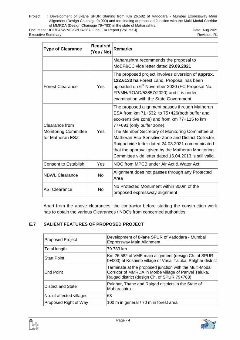
Project : Development of 8-lane SPUR Starting from Km 26.582 of Vadodara - Mumbai Expressway Main
Alignment (Design Chainage 0+000) and terminating at proposed Junction with the Multi-Modal Corridor
of MMRDA (Design Chainage 79+783) in the state of Maharashtra
Document : ICT/E&S/VME-SPUR/567/ Final EIA Report (Volume-I) Date: Aug 2021
Executive Summary Revision: R1
Page - 4
Type of Clearance Required
(Yes / No) Remarks
Maharashtra recommends the proposal to
MoEF&CC vide letter dated 29.09.2021
Forest Clearance Yes
The proposed project involves diversion of approx.
122.6133 ha Forest Land. Proposal has been
uploaded on 6th November 2020 (FC Proposal No.
FP/MH/ROAD/53857/2020) and it is under
examination with the State Government
Clearance from
Monitoring Committee
for Matheran ESZ
Yes
The proposed alignment passes through Matheran
ESA from km 71+532 to 75+426(both buffer and
eco-sensitive zone) and from km 77+115 to km
77+691 (only buffer zone).
The Member Secretary of Monitoring Committee of
Matheran Eco-Sensitive Zone and District Collector,
Raigad vide letter dated 24.03.2021 communicated
that the approval given by the Matheran Monitoring
Committee vide letter dated 16.04.2013 is still valid.
Consent to Establish Yes NOC from MPCB under Air Act & Water Act
NBWL Clearance No Alignment does not passes through any Protected
Area
ASI Clearance No No Protected Monument within 300m of the
proposed expressway alignment
Apart from the above clearances, the contractor before starting the construction work
has to obtain the various Clearances / NOCs from concerned authorities.
E.7 SALIENT FEATURES OF PROPOSED PROJECT
Proposed Project Development of 8-lane SPUR of Vadodara - Mumbai Expressway Main Alignment
Total length 79.783 km
Start Point Km 26.582 of VME main alignment (design Ch. of SPUR 0+000) at Koshimb village of Vasai Taluka, Palghar district
End Point Terminate at the proposed junction with the Multi-Modal Corridor of MMRDA in Morbe village of Panvel Taluka, Raigad district (design Ch. of SPUR 79+783)
District and State Palghar, Thane and Raigad districts in the State of Maharashtra
No. of affected villages 68
Proposed Right of Way 100 m in general / 70 m in forest area
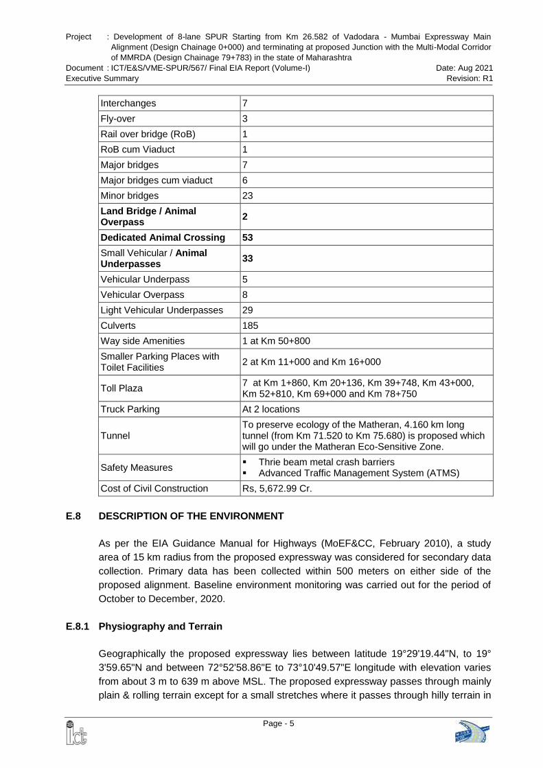
Project : Development of 8-lane SPUR Starting from Km 26.582 of Vadodara - Mumbai Expressway Main
Alignment (Design Chainage 0+000) and terminating at proposed Junction with the Multi-Modal Corridor
of MMRDA (Design Chainage 79+783) in the state of Maharashtra
Document : ICT/E&S/VME-SPUR/567/ Final EIA Report (Volume-I) Date: Aug 2021
Executive Summary Revision: R1
Page - 5
Interchanges 7
Fly-over 3
Rail over bridge (RoB) 1
RoB cum Viaduct 1
Major bridges 7
Major bridges cum viaduct 6
Minor bridges 23
Land Bridge / Animal Overpass
2
Dedicated Animal Crossing 53
Small Vehicular / Animal Underpasses
33
Vehicular Underpass 5
Vehicular Overpass 8
Light Vehicular Underpasses 29
Culverts 185
Way side Amenities 1 at Km 50+800
Smaller Parking Places with Toilet Facilities
2 at Km 11+000 and Km 16+000
Toll Plaza 7 at Km 1+860, Km 20+136, Km 39+748, Km 43+000, Km 52+810, Km 69+000 and Km 78+750
Truck Parking At 2 locations
Tunnel To preserve ecology of the Matheran, 4.160 km long tunnel (from Km 71.520 to Km 75.680) is proposed which will go under the Matheran Eco-Sensitive Zone.
Safety Measures Thrie beam metal crash barriers Advanced Traffic Management System (ATMS)
Cost of Civil Construction Rs, 5,672.99 Cr.
E.8 DESCRIPTION OF THE ENVIRONMENT
As per the EIA Guidance Manual for Highways (MoEF&CC, February 2010), a study
area of 15 km radius from the proposed expressway was considered for secondary data
collection. Primary data has been collected within 500 meters on either side of the
proposed alignment. Baseline environment monitoring was carried out for the period of
October to December, 2020.
E.8.1 Physiography and Terrain
Geographically the proposed expressway lies between latitude 19°29'19.44"N, to 19°
3'59.65"N and between 72°52'58.86"E to 73°10'49.57"E longitude with elevation varies
from about 3 m to 639 m above MSL. The proposed expressway passes through mainly
plain & rolling terrain except for a small stretches where it passes through hilly terrain in
Project : Development of 8-lane SPUR Starting from Km 26.582 of Vadodara - Mumbai Expressway Main
Alignment (Design Chainage 0+000) and terminating at proposed Junction with the Multi-Modal Corridor
of MMRDA (Design Chainage 79+783) in the state of Maharashtra
Document : ICT/E&S/VME-SPUR/567/ Final EIA Report (Volume-I) Date: Aug 2021
Executive Summary Revision: R1
Page - 6
Matheran area.
E.8.2 Seismicity
The project area is situated in the Zone III (having moderate seismic intensity) of the
Seismic Map of India (as per IS: 1893, Part I, 2002) and therefore has a moderate risk
of potential damage due to earthquake.
E.8.3 Hydrology
The proposed SPUR alignment runs along River Tansa mainly over its right bank
between chainage 0+000 to 18+800. The alignment crosses Tansa river twice at Ch.
3+400 and again at Ch. 18+850. No major tributary of Tansa crosses the proposed
alignment within this stretch of about 18.8 km.
Between chainage 19+000 to 45+000 the proposed alignment crosses only one
major river namely Kamvadi River at Ch. 33+334.
Between Ch. 45+000 to 67+400 the proposed alignment crosses major rivers
namely River Bhatsa (Ch. 45+400), River Kalu (Km 47+300), River Barvi (Km
57+619) and River Ulhas (Km 67+470).
From Km 70+000 onwards, the proposed alignment runs through Matheran hills upto
Km 76+200. Rolling / Plain terrains are visible where the alignment approaches
Panvel
Rocks are visible in the beds and banks of almost all the rivers crossing the
proposed alignment.
Major Rivers of the study area are Tansa, Bhatsa, Kalu, Kamvadi, Barvi and Ulhas
River.
The Study area comes under Sub zone 5(a) for West Coast Region (Konkan
Coasts) as per classification of The Central Water Commission.
E.8.4 Land Use
Land Use within PROW: Agricultural and allied uses occupied largest part
amounting 63.93% of the total area, followed by barren / waste land (16.06%), forest
(11.91%), industrial area (4.31%), built-up area (2.46%) and water bodies (1.33%).
Land Use within Study Area: Total study area is 301296.21 ha. Agriculture land
occupied major part (36.53%) of the total area, followed by forest (31.06%), barren/
waste land (15.25%), built-up area (9.6%), water bodies (5.37%) and industrial area
(2.19%)
E.8.5 Soil Quality
M/s Ultra-Teach Environmental Consultancy & Laboratory, Thane (A NABL Accredited
and MoEFCC recognized laboratory) was engaged for collection and analysis of Soil
samples. Four (4) sampling locations of different land use (forest, agricultural &
Project : Development of 8-lane SPUR Starting from Km 26.582 of Vadodara - Mumbai Expressway Main
Alignment (Design Chainage 0+000) and terminating at proposed Junction with the Multi-Modal Corridor
of MMRDA (Design Chainage 79+783) in the state of Maharashtra
Document : ICT/E&S/VME-SPUR/567/ Final EIA Report (Volume-I) Date: Aug 2021
Executive Summary Revision: R1
Page - 7
residential) within 500 meters on either side of the proposed alignment were collected
for studying soil characteristics.
Analysis of samples reveals that soil is slightly acidic in nature except soil of residential
area. Soil is moderately good in terms of nutrient availability. Low quantities of nitrogen,
phosphorus and organic matter content estimated for the soil of residential area as
compared to forest and agriculture areas. Soil quality is good for limited varieties of
agricultural crops but addition of nitrogen, phosphorus and organic matter will help in
improving the soil fertility and thereby obtaining variety of agricultural crops.
E.8.6 Climate
Past climatic data show that May is the hottest month with the mean daily maximum
temperature around 34.4C and January is recorded to be the coldest month with the
mean daily minimum temperature of 17.3C. The normal annual rainfall in the study
area ranges from 1900 mm to 2600 mm and mean annual rainfall during the year 1981
to 2010 is 1874.6 mm.
A maximum temperature of 36.2C and minimum temperature of 19C was observed
during the monitoring period (October to December 2020). Maximum Relative humidity
is found to be 93.5% while minimum relative humidity was about 16.6%. Total rainfall
during this period was 155.3 mm.
E.8.7 Ambient Air Quality
Six sampling stations were set up for monitoring ambient air quality within the study
area. Monitoring locations were selected following the CPCB guidelines for ambient air
quality monitoring so as to accord an overall idea of the ambient air quality scenario in
the study area. The ambient air quality at the monitored locations does not exceed
National Standards and well within the limits. No industrial sources of air emission are
observed along the proposed alignment of the SPUR. Air quality data of the study area
generated through manual monitoring network has been utilized to calculate the
monitoring date wise AQI of the study area and it can be concluded that 68.5% time of
the monitoring period air quality of the area was satisfactory while 29% time of the
monitoring period air quality of the area was good and 2.5% time of the monitoring
period air quality of the area was moderately polluted.
E.8.8 Ambient Noise Level
To assess the background noise levels in the study area ambient noise monitoring was
conducted at six locations. The daytime and night time equivalent noise levels show that
the ambient noise levels are within the stipulated noise standards of residential and
silence area. Maximum equivalent noise level during day time [54.3 dB(A)] is observed
Project : Development of 8-lane SPUR Starting from Km 26.582 of Vadodara - Mumbai Expressway Main
Alignment (Design Chainage 0+000) and terminating at proposed Junction with the Multi-Modal Corridor
of MMRDA (Design Chainage 79+783) in the state of Maharashtra
Document : ICT/E&S/VME-SPUR/567/ Final EIA Report (Volume-I) Date: Aug 2021
Executive Summary Revision: R1
Page - 8
and during night time [43.9 dB(A)] is observed at at Kuske Village (NQ3). The measured
and calculated values of the study area indicate that ambient noise levels not
exceeding the threshold limits
E.8.9 Surface Water
Surface water samples (grab samples) were collected once in the month of November
2020 from 6 locations covering river and pond and analyzed for physical, chemical and
bacteriological parameters as per established standard methods and procedures. pH
values of the surface water are varies between 7.1-7.9 which is within the tolerance limit
of 8.5. The slight alkalinity of the water may be associated with alkaline soil of the
region. Dissolved Oxygen (DO) levels are found to be in the range of 5.9-6.8 mg/l. BOD
ranges from 2.1-2.9 mg/l while COD ranges are found to be 8.1-18.2 mg/l. The values of
BOD indicate that greater amount of oxidizable organic material in the water resulting
increase of oxygen demand and thereby, lowering of dissolved oxygen levels. The BOD
level in river water can be attributed to use of fertilizers in the agricultural fields of river
catchment as well as industrial activities in the surrounding area. Chloride and sulphate
contents were 19-880 mg/l and 21-440 mg/l respectively. Calcium content varied
between 16-150 mg/l, magnesium ranged between 5-87 mg/l. Level of iron in all
samples were less than 0.06 mg/l while arsenic, chromium, cadmium, copper,
manganese, zinc and mercury are found to be below detectable limit. Fecal coliforms
are also present in all the samples
E.8.10 Ground Water
Depth of Ground Water: In the study area, pre monsoon depth to water level (May-
2012) ranging between 2 to 5 mbgl and 5 to 10 mbgl while post-monsoon depth to
water level (Nov- 2012) ranging between 2 to 5 mbgl in major part of the study area..
Ground Water Category: As per the CGWA classification, all the Talukas, through
which the proposed SPUR is passing, fall under safe category.
Ground Water Quality: Ground water samples were collected once in the month of
November 2020 from 6 locations comprising hand operated tube wells (hand-
pumps) and analyzed for physical, chemical and bacteriological parameters as per
established standard methods and procedures. The physico-chemical qualities of
the ground water satisfy the acceptable limit as stipulated in Drinking Water
Standards of India (IS 10500 : 2012) and suitable for human consumption.
E.8.11 Ecology and Biodiversity
Quadrat Study of Flora: Entire stretch of the proposed alignment comprises various
land uses; Forest, forest land, human settlement, agricultural land etc. The survey was
carried out between 19.12.2020 to 23.12.2020. For vegetation sampling quadrate
Project : Development of 8-lane SPUR Starting from Km 26.582 of Vadodara - Mumbai Expressway Main
Alignment (Design Chainage 0+000) and terminating at proposed Junction with the Multi-Modal Corridor
of MMRDA (Design Chainage 79+783) in the state of Maharashtra
Document : ICT/E&S/VME-SPUR/567/ Final EIA Report (Volume-I) Date: Aug 2021
Executive Summary Revision: R1
Page - 9
method was used. For trees 10x 10m, for shrub 3x 3m while for herbs and grasses 1x
1m size of quadrate was used. A total 25 quadrates were laid out and calculated
species’ frequency, density abundance, diversity indices etc. Analysis of trees data
shows that among six sites Acacia auriculiformis was the most frequent species
followed by Tectona grandis. Density of Tectona grandis was also recorded highest
among the tree species followed by Acacia auriculiformis.
Analyzing the shrub layer data it was found that the most frequent and dominant shrub
species were Calotropis procera, and Cassia siamea among the six sampling sites.
Data of herbaceous layer showed that in all the six sites most frequent and dominant
herb species were Cynodon dactylon, and Dactyloctenium aegypticum, in all the six
sampling sites, these species were also observed to be the densest species among the
six forest sites.
Diversion of Forest Land: The proposed project involves diversion of 122.6133 ha of
forest land, which includes reserved forest (48.4616 ha), protected forest (49.6245 ha)
and section-35 forest (24.5272 ha). Proposal has been uploaded on 6th November 2020
(FC Proposal No. FP/MH/ROAD/53857/2020) and it is under examination with the State
Government
Mangrove: Proposed project does not involve diversion of mangrove forest. Hence,
there will be no impact on mangrove.
Faunal Composition: The fauna of project area is based on direct sighting during field
survey, stakeholder consultation, review of Forest working plans of Dahanu Division,
Thane Division and Alibag Division, Wildlife Management plan of Tungeshwar Wildlife
Sanctuary and published literature. During filed visit no direct sighting of wildlife was
occurred, except some birds. Hence local people and concerned forest departments
were approached and information on wild life was gathered. It was noted that in areas
which come within buffer zone, some Schedule-I species were reported. It was noted
that total 24 Schedule-I species are noted in the buffer zone of the proposed alignment.
E.8.12 Protected Areas
The proposed SPUR does not pass through any protected areas. The Conservator of
Forests, Sanjay Gandhi National Park, Bborivali vide letter dated 08.10.2021
certified that the proposed SPUR alignment is located at a distance of 0.619 km from
the boundary of the Tungareshwar Wildlife Sanctuary and outside it’s ESZ. The
alignment of proposed expressway is located at a distance of 0.275 km from the notified
ESZ boundary i.e. outside the ESZ. It may be mentioned that the same has been vetted
by the forest officials who were present during site visit of EAC sub-committee on
14.11.2019.
Project : Development of 8-lane SPUR Starting from Km 26.582 of Vadodara - Mumbai Expressway Main
Alignment (Design Chainage 0+000) and terminating at proposed Junction with the Multi-Modal Corridor
of MMRDA (Design Chainage 79+783) in the state of Maharashtra
Document : ICT/E&S/VME-SPUR/567/ Final EIA Report (Volume-I) Date: Aug 2021
Executive Summary Revision: R1
Page - 10
Tansa Wildlife Sanctuary is located at a distance of approx. 13.6 km from the proposed
alignment of SPUR.
The proposed alignment passes through Matheran ESA from km 71+532 to 75+426
(both buffer and eco-sensitive zone) and from km 77+115 to km 77+691 (only buffer
zone). To preserve ecology of the Matheran, 4.160 km long tunnel is proposed in this
section which will go under the Matheran Eco-Sensitive Zone. The start point of the
tunnel is at km 71.520 (before buffer zone) and end point of the tunnel is at km 75.680
(after buffer zone). The Monitoring Committee for Matheran ESZ has approved the
SPUR alignment inside the Matheran ESZ vide letter dated 16.04. 2013. However, as
suggested by the MoEFCC in the approved ToR, fresh application was submitted on
24.11.2020. The District Collector, Raigad and Member Secretary, Matheran Eco-
Sensitive Zone Committee vide letter dated 24.03.2021 communicated that the
approval given by the Matheran Monitoring Committee vide letter dated 16.04.2013 is
still valid.
E.8.13 Coastal Regulation Zone (CRZ)
The proposed VME-SPUR crosses Tansa River, Bhatsa River and Kalu River, which are
regulated under CRZ Notification. CRZ map and report has been prepared by the
National Centre for Earth Science Studies (NCESS), Thiruvananthapuram, a MoEFCC
approved agency. Village wise length of VME – SPUR alignment in CRZ crossing area
and category wise breakup of CRZ area are given in Table E-2 and Table E-3.
Table E-2 Village wise length of VME-SPUR Alignment in CRZ Crossing Areas
Proposed Chainage Length (km) Village River
From To
45+256 45+535 0.278 Sange – Konderi Bhatsa River
47+124 47+455 0.331 Sangode - Balyani Kalu River
0.609
Source: CRZ Map & Report prepared by NCESS, July 2021
Table E-3 Village wise Break-up CRZ Categories in VME SPUR Crossing Points (in Sq. m.)
Location
CRZ IA
CRZ IB CRZ II CRZ III CRZ IVA
CRZ IVB Mangrove
Mangrove Buffer
Kashid Kopar - - 141.19 - 1533.8 - 280.47
Sange - - 2161.09 - 9093.73 - 4810.18
Konderi - - 938.22 - 9355.1 - 1488.8
Sangode - - 3889.35 - 16573.49 - 10472.23
Balyani - - 0 8978.1 0 - 0
Total (in sq. m.) 7129.85 8978.1 36556.12 17051.68
Project : Development of 8-lane SPUR Starting from Km 26.582 of Vadodara - Mumbai Expressway Main
Alignment (Design Chainage 0+000) and terminating at proposed Junction with the Multi-Modal Corridor
of MMRDA (Design Chainage 79+783) in the state of Maharashtra
Document : ICT/E&S/VME-SPUR/567/ Final EIA Report (Volume-I) Date: Aug 2021
Executive Summary Revision: R1
Page - 11
Location
CRZ IA
CRZ IB CRZ II CRZ III CRZ IVA
CRZ IVB Mangrove
Mangrove Buffer
Total (in ha) 0.713 0.898 3.656 1.705
Grand Total = 69715.75 Sq. m / 6.972 ha
Source: CRZ Map & Report prepared by NCESS, July 2021
The proposal for CRZ Clearance was uploaded through online portal of MCZMA on 13th
July 2021. The proposal was considered by the Environment and Climate Change
Department, Government of Maharashtra on 21.09.2021 and recommended the
proposal for grant of CRZ clearance vide letter dated 29.09.2021
E.8.14 Archaeological Sites:
There are no archaeological sites within 300 m on either side of the proposed
expressway.
E.8.15 Socio-Economic Profile
The proposed alignment is passing through 68 villages and 6 Talukas (Vasai, Wada,
Bhiwandi, Kalyan, Ambarnath and Panvel) in the State of Maharashtra. Out of 68
villages / towns only 62 villages are affected in terms of loss of private land.
Total Population: Out of total 68 affected villages 11 villages of Vasai, Kalyan and
Ambarnath tehsil fall under Municipal Corporations / Councils. The population details
of these villages are not available separately. Total population of remaining 57
villages is 63,383 out of which 32,252 are male and 31,131 are female. The
composition of schedule caste (SC) and schedule tribe (ST) is 2,418 and 23,526
respectively.
Distribution of Workforce: In general, 43.64% of the total affected population is
working. Majority of work force belongs to the category of main workers (74.19% of
the total workers). Around 55.36% of total affected population is non-workers.
Around 54.66% of total main workers are engaged in agriculture production and of
them 24.6% are cultivators. Due growing industrialization many of the people
(42.92%) are engaged in other work in cities
Project : Development of 8-lane SPUR Starting from Km 26.582 of Vadodara - Mumbai Expressway Main
Alignment (Design Chainage 0+000) and terminating at proposed Junction with the Multi-Modal Corridor
of MMRDA (Design Chainage 79+783) in the state of Maharashtra
Document : ICT/E&S/VME-SPUR/567/ Final EIA Report (Volume-I) Date: Aug 2021
Executive Summary Revision: R1
Page - 12
E.9 ANTICIPATED ENVIRONMENTAL IMPACTS AND MITIGATION MEASURES
A summary of the anticipated environmental impacts during construction and operation
phase along with recommended mitigation measures is summarized in Table-E.4:
Table E-4 Summary of Anticipated Impacts and Recommended Mitigation Measures
Area Impacts Mitigation Measures
Construction Phase:
Topography
and geology
Disfiguration & change in
existing profile of the land due
to borrow pits & construction of
realignments.
Disturbance on geological
setting due to quarrying.
Uncontrolled digging of borrow
pits resulting in water
accumulation & breeding of
vector disease.
Establishment of construction
camp
Borrow pits shall be allowed at only pre-identified
locations with prior permission from competent
authority
Borrow pits shall be restricted to 1 m depth
followed by resurfacing of pits.
Road building materials shall be procured from
approved and licensed quarries.
Suitable seismic design of the structures shall be
adopted to mitigate the earthquake impacts.
Soil Disruption & loss of productive
top soil from agricultural fields
Soil erosion and contamination
Adequate measures like drainage, embankment
consolidation & slope stabilization shall be taken
to avoid soil erosion.
Top soils (15 cm) of borrow pit sites shall be
conserved and restored after excavation is over.
Accidental spills of lubricants/oil and molten
asphalt shall be avoided by adherence to good
practices.
Oil Interceptor shall be provided for wash down,
refueling areas
Vehicle parking area of the construction camp will
be made impervious using 75 mm thick P.C.C.
bed over 150 mm thick rammed brick bats.
Land use Changes in existing land use
pattern of the PROW for
construction of the expressway
Loss of agricultural land, forest
land etc. due to land acquisition
Earth material generated from excavation shall be
reused for embankment construction and site
development.
Construction debris will be disposed of in suitable
pre-identified dumping areas.
Dumping areas will be biologically reclaimed.
Construction camp will be provided to avoid
indiscriminate settlement of construction workers.
Construction activities shall be kept confined to
PROW only
Drainage &
Hydrology
The drainage network along the
expressway is subject to
impacts due to construction of
embankment
A pond is located at chainage 37+420. Major
bridges has been proposed at this location.
Hence, there will be no impact on pond.
To minimize the impact drainage & hydrological
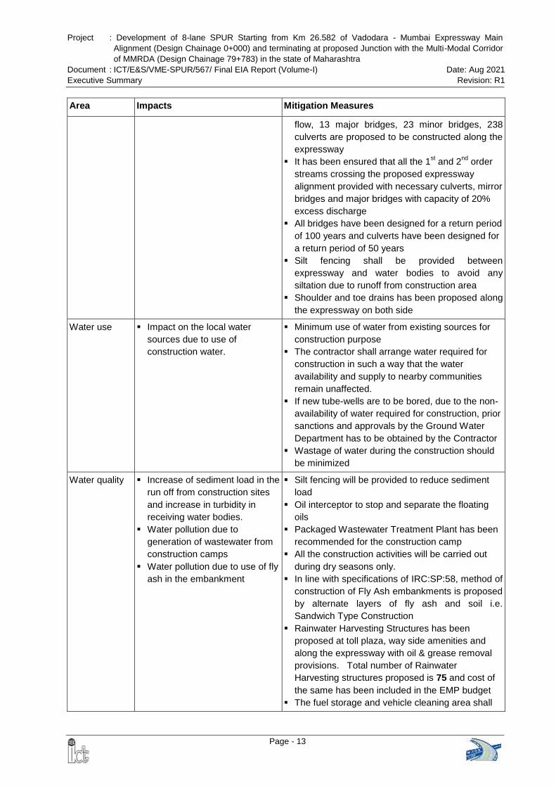
Project : Development of 8-lane SPUR Starting from Km 26.582 of Vadodara - Mumbai Expressway Main
Alignment (Design Chainage 0+000) and terminating at proposed Junction with the Multi-Modal Corridor
of MMRDA (Design Chainage 79+783) in the state of Maharashtra
Document : ICT/E&S/VME-SPUR/567/ Final EIA Report (Volume-I) Date: Aug 2021
Executive Summary Revision: R1
Page - 13
Area Impacts Mitigation Measures
flow, 13 major bridges, 23 minor bridges, 238
culverts are proposed to be constructed along the
expressway
It has been ensured that all the 1st and 2
nd order
streams crossing the proposed expressway
alignment provided with necessary culverts, mirror
bridges and major bridges with capacity of 20%
excess discharge
All bridges have been designed for a return period
of 100 years and culverts have been designed for
a return period of 50 years
Silt fencing shall be provided between
expressway and water bodies to avoid any
siltation due to runoff from construction area
Shoulder and toe drains has been proposed along
the expressway on both side
Water use Impact on the local water
sources due to use of
construction water.
Minimum use of water from existing sources for
construction purpose
The contractor shall arrange water required for
construction in such a way that the water
availability and supply to nearby communities
remain unaffected.
If new tube-wells are to be bored, due to the non-
availability of water required for construction, prior
sanctions and approvals by the Ground Water
Department has to be obtained by the Contractor
Wastage of water during the construction should
be minimized
Water quality Increase of sediment load in the
run off from construction sites
and increase in turbidity in
receiving water bodies.
Water pollution due to
generation of wastewater from
construction camps
Water pollution due to use of fly
ash in the embankment
Silt fencing will be provided to reduce sediment
load
Oil interceptor to stop and separate the floating
oils
Packaged Wastewater Treatment Plant has been
recommended for the construction camp
All the construction activities will be carried out
during dry seasons only.
In line with specifications of IRC:SP:58, method of
construction of Fly Ash embankments is proposed
by alternate layers of fly ash and soil i.e.
Sandwich Type Construction
Rainwater Harvesting Structures has been
proposed at toll plaza, way side amenities and
along the expressway with oil & grease removal
provisions. Total number of Rainwater
Harvesting structures proposed is 75 and cost of
the same has been included in the EMP budget
The fuel storage and vehicle cleaning area shall
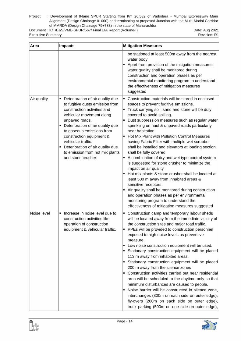
Project : Development of 8-lane SPUR Starting from Km 26.582 of Vadodara - Mumbai Expressway Main
Alignment (Design Chainage 0+000) and terminating at proposed Junction with the Multi-Modal Corridor
of MMRDA (Design Chainage 79+783) in the state of Maharashtra
Document : ICT/E&S/VME-SPUR/567/ Final EIA Report (Volume-I) Date: Aug 2021
Executive Summary Revision: R1
Page - 14
Area Impacts Mitigation Measures
be stationed at least 500m away from the nearest
water body
Apart from provision of the mitigation measures,
water quality shall be monitored during
construction and operation phases as per
environmental monitoring program to understand
the effectiveness of mitigation measures
suggested
Air quality Deterioration of air quality due
to fugitive dusts emission from
construction activities and
vehicular movement along
unpaved roads.
Deterioration of air quality due
to gaseous emissions from
construction equipment &
vehicular traffic.
Deterioration of air quality due
to emission from hot mix plants
and stone crusher.
Construction materials will be stored in enclosed
spaces to prevent fugitive emissions.
Truck carrying soil, sand and stone will be duly
covered to avoid spilling.
Dust suppression measures such as regular water
sprinkling on haul & unpaved roads particularly
near habitation
Hot Mix Plant with Pollution Control Measures
having Fabric Filter with multiple wet scrubber
shall be installed and elevators at loading section
shall be fully covered
A combination of dry and wet type control system
is suggested for stone crusher to minimize the
impact on air quality
Hot mix plants & stone crusher shall be located at
least 500 m away from inhabited areas &
sensitive receptors
Air quality shall be monitored during construction
and operation phases as per environmental
monitoring program to understand the
effectiveness of mitigation measures suggested
Noise level Increase in noise level due to
construction activities like
operation of construction
equipment & vehicular traffic.
Construction camp and temporary labour sheds
will be located away from the immediate vicinity of
the construction sites and major road traffic.
PPEs will be provided to construction personnel
exposed to high noise levels as preventive
measure.
Low noise construction equipment will be used.
Stationary construction equipment will be placed
113 m away from inhabited areas.
Stationary construction equipment will be placed
200 m away from the silence zones
Construction activities carried out near residential
area will be scheduled to the daytime only so that
minimum disturbances are caused to people.
Noise barrier will be constructed in silence zone,
interchanges (300m on each side on outer edge),
fly-overs (200m on each side on outer edge),
truck parking (500m on one side on outer edge),
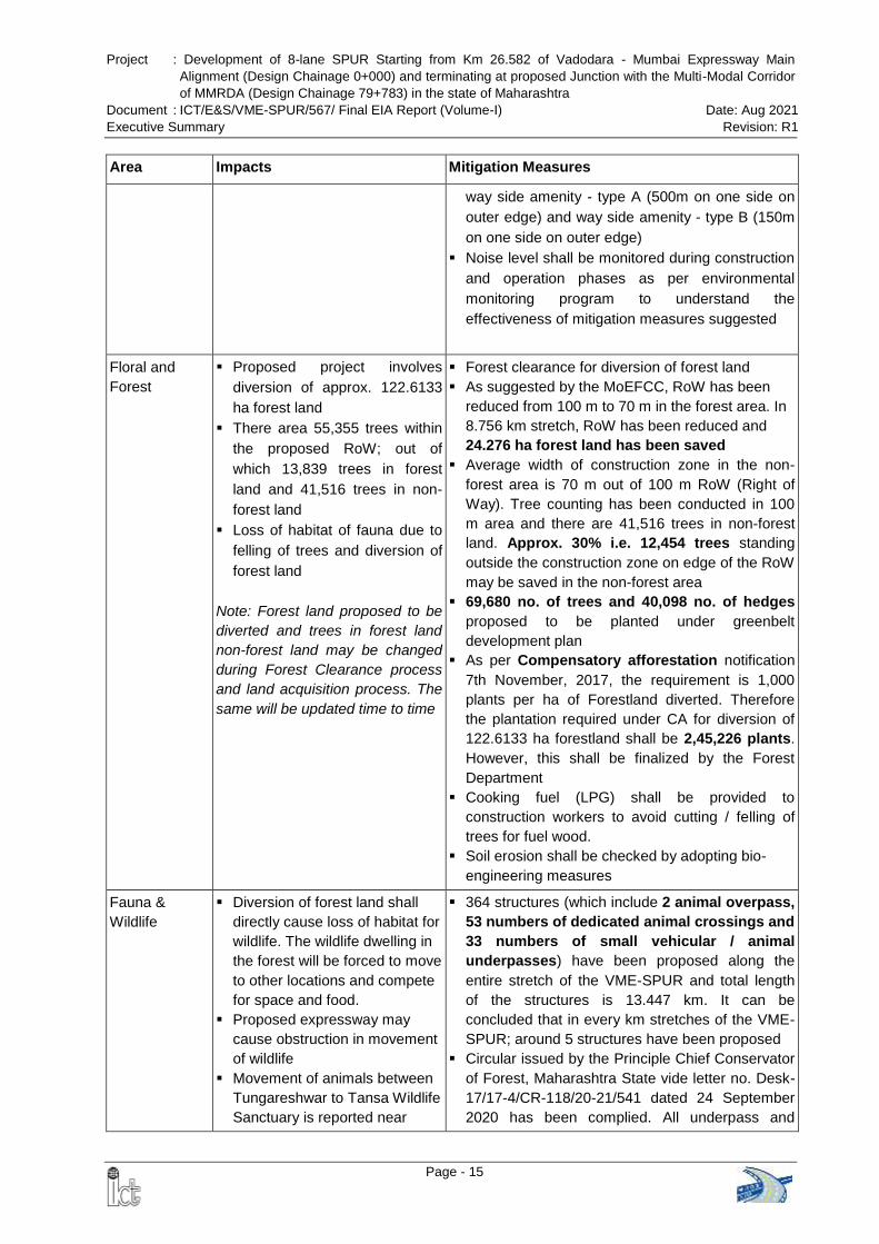
Project : Development of 8-lane SPUR Starting from Km 26.582 of Vadodara - Mumbai Expressway Main
Alignment (Design Chainage 0+000) and terminating at proposed Junction with the Multi-Modal Corridor
of MMRDA (Design Chainage 79+783) in the state of Maharashtra
Document : ICT/E&S/VME-SPUR/567/ Final EIA Report (Volume-I) Date: Aug 2021
Executive Summary Revision: R1
Page - 15
Area Impacts Mitigation Measures
way side amenity - type A (500m on one side on
outer edge) and way side amenity - type B (150m
on one side on outer edge)
Noise level shall be monitored during construction
and operation phases as per environmental
monitoring program to understand the
effectiveness of mitigation measures suggested
Floral and
Forest
Proposed project involves
diversion of approx. 122.6133
ha forest land
There area 55,355 trees within
the proposed RoW; out of
which 13,839 trees in forest
land and 41,516 trees in non-
forest land
Loss of habitat of fauna due to
felling of trees and diversion of
forest land
Note: Forest land proposed to be
diverted and trees in forest land
non-forest land may be changed
during Forest Clearance process
and land acquisition process. The
same will be updated time to time
Forest clearance for diversion of forest land
As suggested by the MoEFCC, RoW has been
reduced from 100 m to 70 m in the forest area. In
8.756 km stretch, RoW has been reduced and
24.276 ha forest land has been saved
Average width of construction zone in the non-
forest area is 70 m out of 100 m RoW (Right of
Way). Tree counting has been conducted in 100
m area and there are 41,516 trees in non-forest
land. Approx. 30% i.e. 12,454 trees standing
outside the construction zone on edge of the RoW
may be saved in the non-forest area
69,680 no. of trees and 40,098 no. of hedges
proposed to be planted under greenbelt
development plan
As per Compensatory afforestation notification
7th November, 2017, the requirement is 1,000
plants per ha of Forestland diverted. Therefore
the plantation required under CA for diversion of
122.6133 ha forestland shall be 2,45,226 plants.
However, this shall be finalized by the Forest
Department
Cooking fuel (LPG) shall be provided to
construction workers to avoid cutting / felling of
trees for fuel wood.
Soil erosion shall be checked by adopting bio-
engineering measures
Fauna &
Wildlife
Diversion of forest land shall
directly cause loss of habitat for
wildlife. The wildlife dwelling in
the forest will be forced to move
to other locations and compete
for space and food.
Proposed expressway may
cause obstruction in movement
of wildlife
Movement of animals between
Tungareshwar to Tansa Wildlife
Sanctuary is reported near
364 structures (which include 2 animal overpass,
53 numbers of dedicated animal crossings and
33 numbers of small vehicular / animal
underpasses) have been proposed along the
entire stretch of the VME-SPUR and total length
of the structures is 13.447 km. It can be
concluded that in every km stretches of the VME-
SPUR; around 5 structures have been proposed
Circular issued by the Principle Chief Conservator
of Forest, Maharashtra State vide letter no. Desk-
17/17-4/CR-118/20-21/541 dated 24 September
2020 has been complied. All underpass and
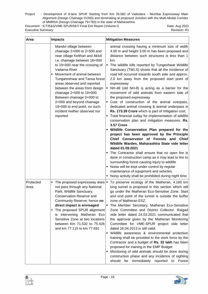
Project : Development of 8-lane SPUR Starting from Km 26.582 of Vadodara - Mumbai Expressway Main
Alignment (Design Chainage 0+000) and terminating at proposed Junction with the Multi-Modal Corridor
of MMRDA (Design Chainage 79+783) in the state of Maharashtra
Document : ICT/E&S/VME-SPUR/567/ Final EIA Report (Volume-I) Date: Aug 2021
Executive Summary Revision: R1
Page - 16
Area Impacts Mitigation Measures
Mandvi village between
chainage 2+000 to 2+500 and
near village Kelthan and Akloli
i.e. chainage between 18+000
to 19+000 near the crossing of
Vaitarna River
Movement of animal between
Tungareshwar and Tansa forest
areas observed and reported
between the areas from design
chainage 2+000 to 19+000.
Between chainage 0+000 to
2+000 and beyond chainage
19+000 to end point, no such
incident neither observed nor
reported
animal crossing having a minimum size of width
4.00 m and height 3.00 m has been proposed and
distance between such structures is less than 1
km
The wildlife kills reported by Tungeshwar Wildlife
Sanctuary (TWLS) shows that all the incidence of
road kill occurred towards south side and approx.
2.0 km away from the proposed start point of
expressway
NH-48 (old NH-8) is acting as a barrier for the
movement of wild animals from eastern side of
the proposed expressway
Cost of construction of the animal overpass,
dedicated animal crossing & animal underpass is
Rs. 173.39 Crore which is part of mitigation cost.
Total financial outlay for implementation of wildlife
conservation plan and mitigation measures, Rs.
3.57 Crore
Wildlife Conservation Plan prepared for the
project has been approved by the Principle
Chief Conservator of Forests and Chief
Wildlife Warden, Maharashtra State vide letter
dated 01.09.2021
The Contractor shall ensure that no open fire is
done in construction camp as it may lead to fire to
surrounding forest causing injury to wildlife
Noise will be kept under control by regular
maintenance of equipment and vehicles.
Noisy activity shall be prohibited during night time
Protected
Area
The proposed expressway does
not pass through any National
Park, Wildlife Sanctuary,
Conservation Reserve and
Community Reserve; hence no
direct impact is envisaged
The proposed SPUR alignment
is intervening Matheran Eco
Sensitive Zone at two locations
between Km 71.532 to 75.426
and km 77.115 to km 77.691
To preserve ecology of the Matheran, 4.160 km
long tunnel is proposed in this section which will
go under the Matheran Eco-Sensitive Zone. Start
and end point of the tunnel is outside the buffer
zone of Matheran ESZ.
The Member Secretary, Matheran Eco-Sensitive
Zone Committee and District Collector, Raigad
vide letter dated 24.03.2021 communicated that
the approval given by the Matheran Monitoring
Committee for VME-SPUR project vide letter
dated 16.04.2013 is still valid.
Wildlife awareness & environmental protection
training shall be provided to the work force by the
Contractor and a budget of Rs. 32 lakh has been
proposed for training in the EMP Budget
Monitoring of wild animals should be done during
construction phase and any incidence of sighting
should be immediately reported to Forest
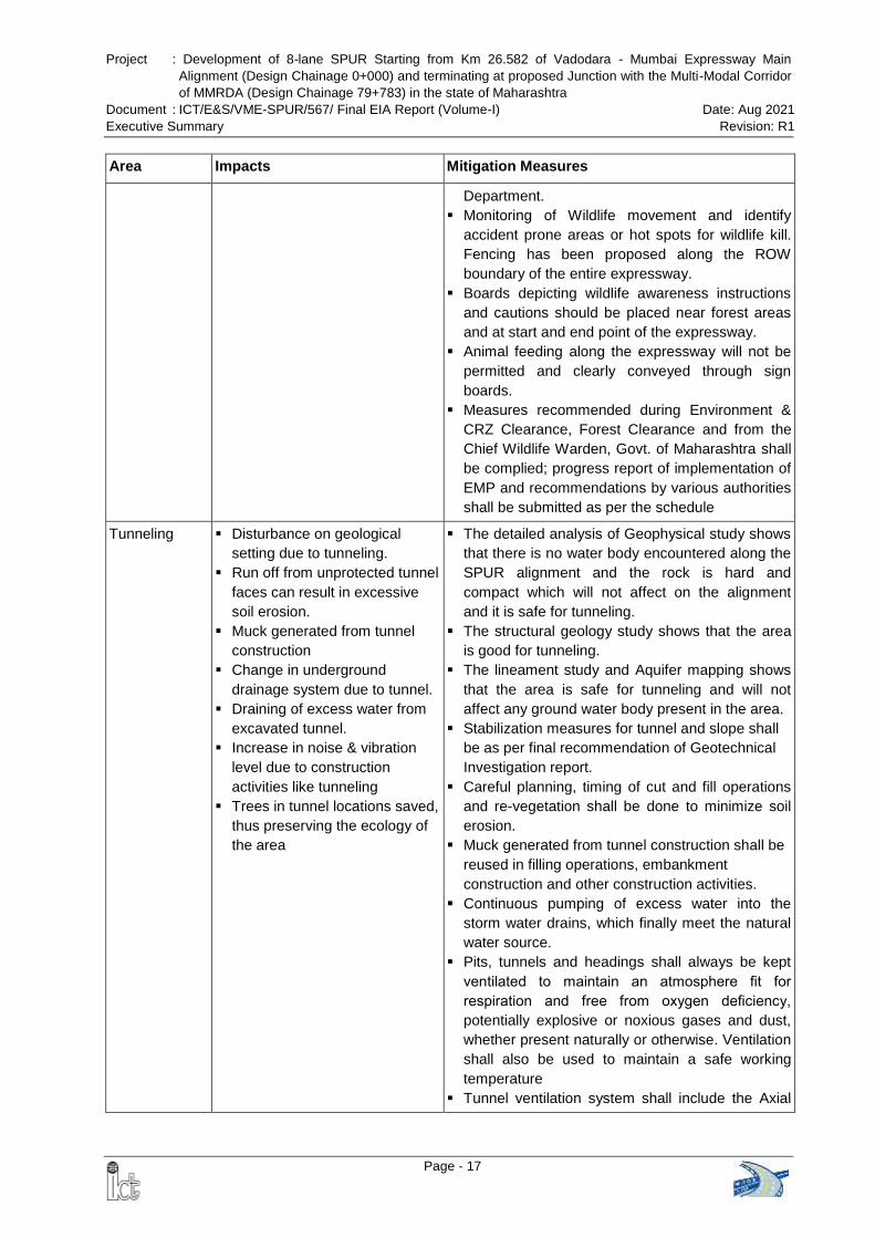
Project : Development of 8-lane SPUR Starting from Km 26.582 of Vadodara - Mumbai Expressway Main
Alignment (Design Chainage 0+000) and terminating at proposed Junction with the Multi-Modal Corridor
of MMRDA (Design Chainage 79+783) in the state of Maharashtra
Document : ICT/E&S/VME-SPUR/567/ Final EIA Report (Volume-I) Date: Aug 2021
Executive Summary Revision: R1
Page - 17
Area Impacts Mitigation Measures
Department.
Monitoring of Wildlife movement and identify
accident prone areas or hot spots for wildlife kill.
Fencing has been proposed along the ROW
boundary of the entire expressway.
Boards depicting wildlife awareness instructions
and cautions should be placed near forest areas
and at start and end point of the expressway.
Animal feeding along the expressway will not be
permitted and clearly conveyed through sign
boards.
Measures recommended during Environment &
CRZ Clearance, Forest Clearance and from the
Chief Wildlife Warden, Govt. of Maharashtra shall
be complied; progress report of implementation of
EMP and recommendations by various authorities
shall be submitted as per the schedule
Tunneling Disturbance on geological
setting due to tunneling.
Run off from unprotected tunnel
faces can result in excessive
soil erosion.
Muck generated from tunnel
construction
Change in underground
drainage system due to tunnel.
Draining of excess water from
excavated tunnel.
Increase in noise & vibration
level due to construction
activities like tunneling
Trees in tunnel locations saved,
thus preserving the ecology of
the area
The detailed analysis of Geophysical study shows
that there is no water body encountered along the
SPUR alignment and the rock is hard and
compact which will not affect on the alignment
and it is safe for tunneling.
The structural geology study shows that the area
is good for tunneling.
The lineament study and Aquifer mapping shows
that the area is safe for tunneling and will not
affect any ground water body present in the area.
Stabilization measures for tunnel and slope shall
be as per final recommendation of Geotechnical
Investigation report.
Careful planning, timing of cut and fill operations
and re-vegetation shall be done to minimize soil
erosion.
Muck generated from tunnel construction shall be
reused in filling operations, embankment
construction and other construction activities.
Continuous pumping of excess water into the
storm water drains, which finally meet the natural
water source.
Pits, tunnels and headings shall always be kept
ventilated to maintain an atmosphere fit for
respiration and free from oxygen deficiency,
potentially explosive or noxious gases and dust,
whether present naturally or otherwise. Ventilation
shall also be used to maintain a safe working
temperature
Tunnel ventilation system shall include the Axial
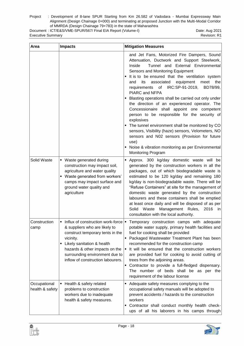
Project : Development of 8-lane SPUR Starting from Km 26.582 of Vadodara - Mumbai Expressway Main
Alignment (Design Chainage 0+000) and terminating at proposed Junction with the Multi-Modal Corridor
of MMRDA (Design Chainage 79+783) in the state of Maharashtra
Document : ICT/E&S/VME-SPUR/567/ Final EIA Report (Volume-I) Date: Aug 2021
Executive Summary Revision: R1
Page - 18
Area Impacts Mitigation Measures
and Jet Fans, Motorized Fire Dampers, Sound
Attenuation, Ductwork and Support Steelwork,
Inside Tunnel and External Environmental
Sensors and Monitoring Equipment
It is to be ensured that the ventilation system
and its associated equipment meet the
requirements of IRC:SP-91-2019, BD78/99,
PIARC and NFPA
Blasting operations shall be carried out only under
the direction of an experienced operator. The
Concessionaire shall appoint one competent
person to be responsible for the security of
explosives
The tunnel environment shall be monitored by CO
sensors, Visibility (haze) sensors, Velometers, NO
sensors and N02 sensors (Provision for future
use)
Noise & vibration monitoring as per Environmental
Monitoring Program
Solid Waste Waste generated during
construction may impact soil,
agriculture and water quality
Waste generated from workers’
camps may impact surface and
ground water quality and
agriculture
Approx. 300 kg/day domestic waste will be
generated by the construction workers in all the
packages, out of which biodegradable waste is
estimated to be 120 kg/day and remaining 180
kg/day is non-biodegradable waste. There will be
“Refuse Containers” at site for the management of
domestic waste generated by the construction
labourers and these containers shall be emptied
at least once daily and will be disposed of as per
Solid Waste Management Rules, 2016 in
consultation with the local authority.
Construction
camp
Influx of construction work-force
& suppliers who are likely to
construct temporary tents in the
vicinity.
Likely sanitation & health
hazards & other impacts on the
surrounding environment due to
inflow of construction labourers.
Temporary construction camps with adequate
potable water supply, primary health facilities and
fuel for cooking shall be provided
Packaged Wastewater Treatment Plant has been
recommended for the construction camp
It will be ensured that the construction workers
are provided fuel for cooking to avoid cutting of
trees from the adjoining areas.
Contractor to provide a full-fledged dispensary.
The number of beds shall be as per the
requirement of the labour license
Occupational
health & safety
Health & safety related
problems to construction
workers due to inadequate
health & safety measures.
Adequate safety measures complying to the
occupational safety manuals will be adopted to
prevent accidents / hazards to the construction
workers
Contractor shall conduct monthly health check-
ups of all his laborers in his camps through
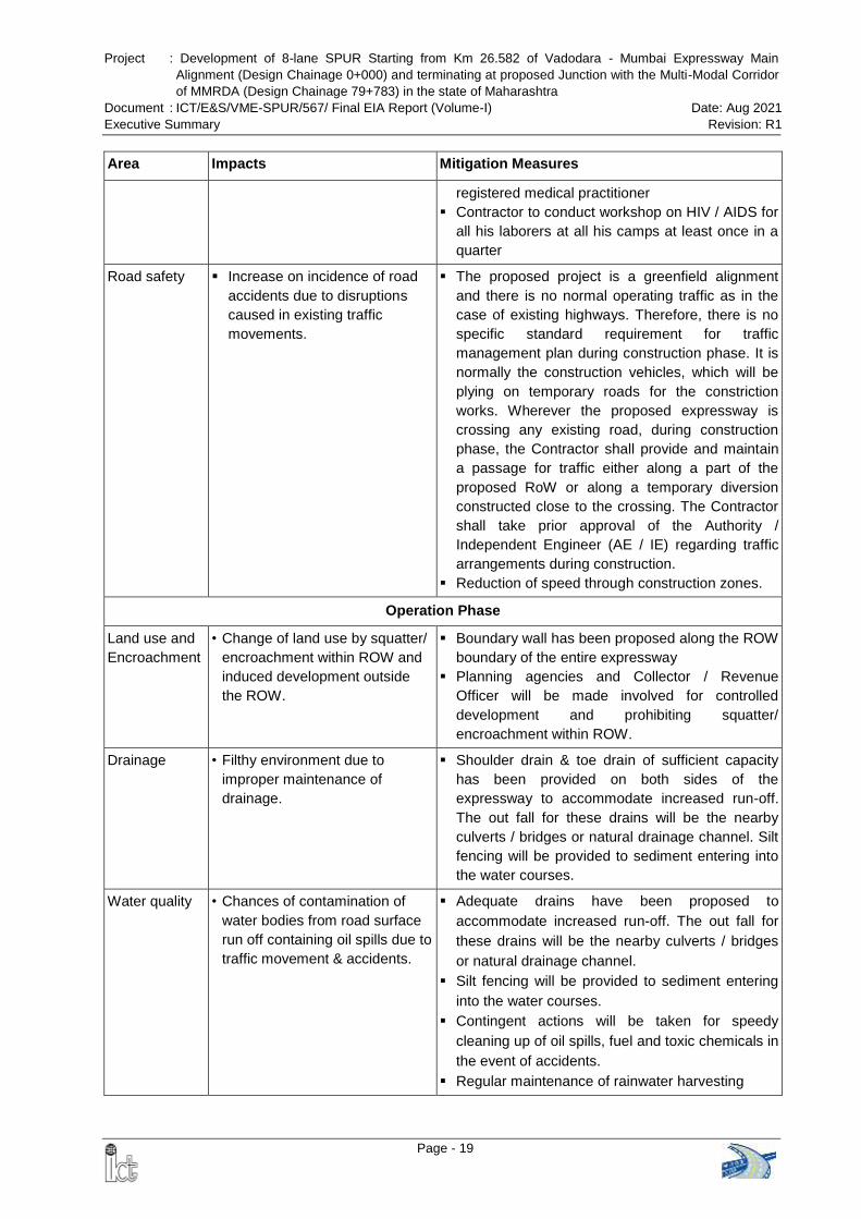
Project : Development of 8-lane SPUR Starting from Km 26.582 of Vadodara - Mumbai Expressway Main
Alignment (Design Chainage 0+000) and terminating at proposed Junction with the Multi-Modal Corridor
of MMRDA (Design Chainage 79+783) in the state of Maharashtra
Document : ICT/E&S/VME-SPUR/567/ Final EIA Report (Volume-I) Date: Aug 2021
Executive Summary Revision: R1
Page - 19
Area Impacts Mitigation Measures
registered medical practitioner
Contractor to conduct workshop on HIV / AIDS for
all his laborers at all his camps at least once in a
quarter
Road safety Increase on incidence of road
accidents due to disruptions
caused in existing traffic
movements.
The proposed project is a greenfield alignment
and there is no normal operating traffic as in the
case of existing highways. Therefore, there is no
specific standard requirement for traffic
management plan during construction phase. It is
normally the construction vehicles, which will be
plying on temporary roads for the constriction
works. Wherever the proposed expressway is
crossing any existing road, during construction
phase, the Contractor shall provide and maintain
a passage for traffic either along a part of the
proposed RoW or along a temporary diversion
constructed close to the crossing. The Contractor
shall take prior approval of the Authority /
Independent Engineer (AE / IE) regarding traffic
arrangements during construction.
Reduction of speed through construction zones.
Operation Phase
Land use and
Encroachment
• Change of land use by squatter/
encroachment within ROW and
induced development outside
the ROW.
Boundary wall has been proposed along the ROW
boundary of the entire expressway
Planning agencies and Collector / Revenue
Officer will be made involved for controlled
development and prohibiting squatter/
encroachment within ROW.
Drainage • Filthy environment due to
improper maintenance of
drainage.
Shoulder drain & toe drain of sufficient capacity
has been provided on both sides of the
expressway to accommodate increased run-off.
The out fall for these drains will be the nearby
culverts / bridges or natural drainage channel. Silt
fencing will be provided to sediment entering into
the water courses.
Water quality • Chances of contamination of
water bodies from road surface
run off containing oil spills due to
traffic movement & accidents.
Adequate drains have been proposed to
accommodate increased run-off. The out fall for
these drains will be the nearby culverts / bridges
or natural drainage channel.
Silt fencing will be provided to sediment entering
into the water courses.
Contingent actions will be taken for speedy
cleaning up of oil spills, fuel and toxic chemicals in
the event of accidents.
Regular maintenance of rainwater harvesting
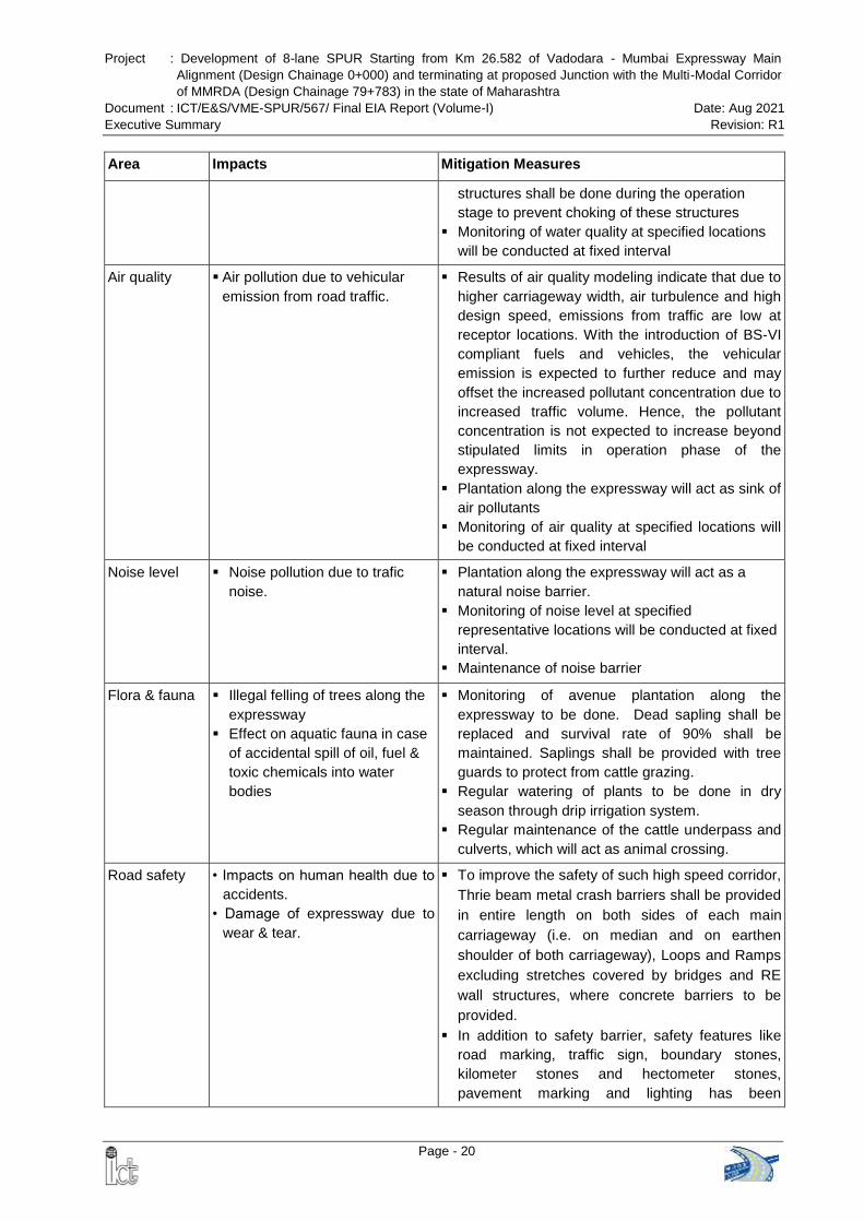
Project : Development of 8-lane SPUR Starting from Km 26.582 of Vadodara - Mumbai Expressway Main
Alignment (Design Chainage 0+000) and terminating at proposed Junction with the Multi-Modal Corridor
of MMRDA (Design Chainage 79+783) in the state of Maharashtra
Document : ICT/E&S/VME-SPUR/567/ Final EIA Report (Volume-I) Date: Aug 2021
Executive Summary Revision: R1
Page - 20
Area Impacts Mitigation Measures
structures shall be done during the operation
stage to prevent choking of these structures
Monitoring of water quality at specified locations
will be conducted at fixed interval
Air quality Air pollution due to vehicular
emission from road traffic.
Results of air quality modeling indicate that due to
higher carriageway width, air turbulence and high
design speed, emissions from traffic are low at
receptor locations. With the introduction of BS-VI
compliant fuels and vehicles, the vehicular
emission is expected to further reduce and may
offset the increased pollutant concentration due to
increased traffic volume. Hence, the pollutant
concentration is not expected to increase beyond
stipulated limits in operation phase of the
expressway.
Plantation along the expressway will act as sink of
air pollutants
Monitoring of air quality at specified locations will
be conducted at fixed interval
Noise level Noise pollution due to trafic
noise.
Plantation along the expressway will act as a
natural noise barrier.
Monitoring of noise level at specified
representative locations will be conducted at fixed
interval.
Maintenance of noise barrier
Flora & fauna Illegal felling of trees along the
expressway
Effect on aquatic fauna in case
of accidental spill of oil, fuel &
toxic chemicals into water
bodies
Monitoring of avenue plantation along the
expressway to be done. Dead sapling shall be
replaced and survival rate of 90% shall be
maintained. Saplings shall be provided with tree
guards to protect from cattle grazing.
Regular watering of plants to be done in dry
season through drip irrigation system.
Regular maintenance of the cattle underpass and
culverts, which will act as animal crossing.
Road safety • Impacts on human health due to
accidents.
• Damage of expressway due to
wear & tear.
To improve the safety of such high speed corridor,
Thrie beam metal crash barriers shall be provided
in entire length on both sides of each main
carriageway (i.e. on median and on earthen
shoulder of both carriageway), Loops and Ramps
excluding stretches covered by bridges and RE
wall structures, where concrete barriers to be
provided.
In addition to safety barrier, safety features like
road marking, traffic sign, boundary stones,
kilometer stones and hectometer stones,
pavement marking and lighting has been
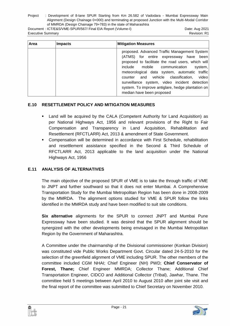
Project : Development of 8-lane SPUR Starting from Km 26.582 of Vadodara - Mumbai Expressway Main
Alignment (Design Chainage 0+000) and terminating at proposed Junction with the Multi-Modal Corridor
of MMRDA (Design Chainage 79+783) in the state of Maharashtra
Document : ICT/E&S/VME-SPUR/567/ Final EIA Report (Volume-I) Date: Aug 2021
Executive Summary Revision: R1
Page - 21
Area Impacts Mitigation Measures
proposed. Advanced Traffic Management System
(ATMS) for entire expressway have been
proposed to facilitate the road users, which will
include mobile communication system,
meteorological data system, automatic traffic
counter and vehicle classification, video
surveillance system, video incident detection
system. To improve antiglare, hedge plantation on
median have been proposed
E.10 RESETTLEMENT POLICY AND MITIGATION MEASURES
Land will be acquired by the CALA (Competent Authority for Land Acquisition) as
per National Highways Act, 1956 and relevant provisions of the Right to Fair
Compensation and Transparency in Land Acquisition, Rehabilitation and
Resettlement (RFCTLARR) Act, 2013 & amendment of State Government.
Compensation will be determined in accordance with First Schedule, rehabilitation
and resettlement assistance specified in the Second & Third Schedule of
RFCTLARR Act, 2013 applicable to the land acquisition under the National
Highways Act, 1956
E.11 ANALYSIS OF ALTERNATIVES
The main objective of the proposed SPUR of VME is to take the through traffic of VME
to JNPT and further southward so that it does not enter Mumbai. A Comprehensive
Transportation Study for the Mumbai Metropolitan Region has been done in 2008-2009
by the MMRDA. The alignment options studied for VME & SPUR follow the links
identified in the MMRDA study and have been modified to suit site conditions.
Six alternative alignments for the SPUR to connect JNPT and Mumbai Pune
Expressway have been studied. It was desired that the SPUR alignment should be
synergized with the other developments being envisaged in the Mumbai Metropolitan
Region by the Government of Maharashtra.
A Committee under the chairmanship of the Divisional commissioner (Konkan Division)
was constituted vide Public Works Department Govt. Circular dated 24-5-2010 for the
selection of the greenfield alignment of VME including SPUR. The other members of the
committee included CGM NHAI; Chief Engineer (NH) PWD; Chief Conservator of
Forest, Thane; Chief Engineer MMRDA; Collector Thane; Additional Chief
Transportation Engineer, CIDCO and Additional Collector (Tribal), Jawhar, Thane. The
committee held 5 meetings between April 2010 to August 2010 after joint site visit and
the final report of the committee was submitted to Chief Secretary on November 2010.
Project : Development of 8-lane SPUR Starting from Km 26.582 of Vadodara - Mumbai Expressway Main
Alignment (Design Chainage 0+000) and terminating at proposed Junction with the Multi-Modal Corridor
of MMRDA (Design Chainage 79+783) in the state of Maharashtra
Document : ICT/E&S/VME-SPUR/567/ Final EIA Report (Volume-I) Date: Aug 2021
Executive Summary Revision: R1
Page - 22
Considering technical aspects brought out from the visit made by the NHAI, Forest
Department. PWD and CIDCO and taking into account the merits of the outer
alignments, the Committee recommends the outer alignment (Node No. 1-2-4-11-12-9-
10-14) of SPUR of the main Vadodara Mumbai Expressway in Maharashtra. The
Government of Maharashtra accepted the recommendations of the committee. A formal
approval of the alignment was granted by the Government of Maharashtra in February
2011. The alignment of SPUR has also been included in the Mumbai Metropolitan
Regional Plan 2016-36 of MMRDA
E.12 ENVIRONMENTAL MONITORING PROGRAM
Environmental monitoring involves regular checking of the environmental management
issues detailed in the EMP and to ascertain whether the mitigation measures are
achieving their objectives, according to the EMP, with the progress of the works.
To mitigate the potential negative impacts of proposed development and measurement
the performance of mitigation measures, an Environmental Monitoring and Management
Plan is developed. Contractor is the main executor of the implementation activities. The
contractor will report to the Sr. Environmental Specialist of Authority / Independent
Engineer (AE / IE) who in turn shall report to the PIU. The Contractor will submit monthly
and quarterly environmental compliance reports to the AE / IE. The AE / IE will submit
separate quarterly environmental monitoring reports to Project Implementation Unit
(PIU) of NHAI and PIU will be responsible for preparation of the targets for non-
compliances identified by the AE / IE.
E.13 ENVIRONMENTAL MANAGEMENT PLAN
EMP has been prepared addressing the following issues:
Stage wise (design & pre-construction stage, construction stage & operation stage)
environmental management measures;
Environmental monitoring program during construction and operation phase
including performance indicator, monitoring schedule (parameters, locations,
frequency of monitoring & institutional responsibility) and reporting system;
Green belt development plan
Institutional & implementation arrangement and capacity building
Various guidelines such as Top Soil Conservation and Reuse, Siting and Layout of
Construction Camp, Slope Stabilization, Management of Borrow and Quarry Area,
Sediment Control, Comprehensive Waste Management Plan, Traffic Management
Plan, Worker’s Safety during Construction, Storage, Handling, Use and Emergency
Response for Hazardous Substances etc.
Environmental Budget: A capital cost provision of about Rs. 56.98 Crore has been
kept towards implementation of environmental management plan.
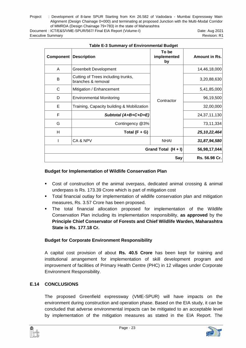
Project : Development of 8-lane SPUR Starting from Km 26.582 of Vadodara - Mumbai Expressway Main
Alignment (Design Chainage 0+000) and terminating at proposed Junction with the Multi-Modal Corridor
of MMRDA (Design Chainage 79+783) in the state of Maharashtra
Document : ICT/E&S/VME-SPUR/567/ Final EIA Report (Volume-I) Date: Aug 2021
Executive Summary Revision: R1
Page - 23
Table E-3 Summary of Environmental Budget
Component Description To be
implemented by
Amount in Rs.
A Greenbelt Development
Contractor
14,46,18,000
B Cutting of Trees including trunks, branches & removal
3,20,88,630
C Mitigation / Enhancement 5,41,85,000
D Environmental Monitoring 96,19,500
E Training, Capacity building & Mobilization 32,00,000
F Subtotal (A+B+C+D+E) 24,37,11,130
G Contingency @3% 73,11,334
H Total (F + G) 25,10,22,464
I CA & NPV NHAI 31,87,94,580
Grand Total (H + I) 56,98,17,044
Say Rs. 56.98 Cr.
Budget for Implementation of Wildlife Conservation Plan
Cost of construction of the animal overpass, dedicated animal crossing & animal
underpass is Rs. 173.39 Crore which is part of mitigation cost
Total financial outlay for implementation of wildlife conservation plan and mitigation
measures, Rs. 3.57 Crore has been proposed.
The total financial allocation proposed for implementation of the Wildlife
Conservation Plan including its implementation responsibility, as approved by the
Principle Chief Conservator of Forests and Chief Wildlife Warden, Maharashtra
State is Rs. 177.18 Cr.
Budget for Corporate Environment Responsibility
A capital cost provision of about Rs. 40.5 Crore has been kept for training and
institutional arrangement for implementation of skill development program and
improvement of facilities of Primary Health Centre (PHC) in 12 villages under Corporate
Environment Responsibility.
E.14 CONCLUSIONS
The proposed Greenfield expressway (VME-SPUR) will have impacts on the
environment during construction and operation phase. Based on the EIA study, it can be
concluded that adverse environmental impacts can be mitigated to an acceptable level
by implementation of the mitigation measures as stated in the EIA Report. The
Project : Development of 8-lane SPUR Starting from Km 26.582 of Vadodara - Mumbai Expressway Main
Alignment (Design Chainage 0+000) and terminating at proposed Junction with the Multi-Modal Corridor
of MMRDA (Design Chainage 79+783) in the state of Maharashtra
Document : ICT/E&S/VME-SPUR/567/ Final EIA Report (Volume-I) Date: Aug 2021
Executive Summary Revision: R1
Page - 24
mitigation measures suggested and the Environment Management Plan (EMP)
prepared for this project seems sound enough to mitigate the present as well future
consequences if any during implementation and operation phase.
The proposed VME-SPUR will reduce the traffic load on NH-48 (Old NH-8), NH-3 & NH-
222; which will mitigate the safety issues, reduce pollution load in the surrounding area,
increase employment opportunity and improve economic development of the region.
Further, the expressway will be linking Vadodara – Mumbai Expressway, Ahmedabad-
Vadodara Expressway, Mumbai – Nagpur Expressway and Mumbai - Pune Expressway
and thus will provide expressway connectivity from Delhi – Ahmedabad – Mumbai –
Nagpur - Pune.
Project : Development of 8-lane SPUR Starting from Km 26.582 of Vadodara - Mumbai Expressway Main
Alignment (Design Chainage 0+000) and terminating at proposed Junction with the Multi-Modal Corridor
of MMRDA (Design Chainage 79+783) in the state of Maharashtra
Document : ICT/E&S/VME-SPUR/567/ Final EIA Report (Volume-I) Date: Aug 2021
Chapter-1 : Introduction Revision: R1
Page - 1
CHAPTER-1: INTRODUCTION
1.1 PURPOSE OF THE REPORT
Intercontinental Consultants and Technocrats Private limited (ICT) has been appointed
as a Consultant by the National Highways Authority of India (NHAI) through agreement
dated 29th January, 2009 for carrying out the consultancy services for “Preparation of
Feasibility cum Preliminary Design Report for Vadodara Mumbai Expressway under
NHDP Phase-VI”.
This Environment Impact Assessment (EIA) Report has been prepared as a part of this
consultancy services for “Development of 8-lane SPUR Starting from Km 26.582 of
Vadodara - Mumbai Expressway Main Alignment (Design Chainage 0+000) and
terminating at proposed Junction with the Multi-Modal Corridor of MMRDA
(Design Chainage 79+783) in the state of Maharashtra” and purpose of the report are
as follows:
Establishment of present environmental conditions along the proposed corridor of
the expressway through available data / information supported by field studies /
monitoring, wherever necessary;
Prediction of impacts on various environmental attributes due to the construction &
operation of the proposed expressway;
Recommendation of mitigation measures to minimize / reduce adverse impacts on
the environment;
Preparation of Environmental Monitoring Program;
Preparation of an Environmental Management Plan (EMP) to make the project
environmentally sound and sustainable.
Obtaining statutory clearances from the concerned authorities
(ToR) issued by the Minister of Environment, Forest and Climate Change This EIA
Report has been prepared in accordance with the Terms of Reference (MoEFCC) vide
letter dated 16th March 2020. Copy of the approved ToR is given as Annex-1.1.
1.2 IDENTIFICATION OF PROJECT
1.2.1 Background
The Mumbai–Ahmedabad Corridor in the western part of the country is one of the
important transport corridors of the country. On one side of this corridor is Mumbai
which is the financial capital of the country and on the other side is Vadodara, an
important commercial and business city. Many industries like, textile, gems & jewelries,
petrochemical & fertilizer etc. have been established along this corridor. This corridor
also serves SEZ areas and ports. New NH 48 (old NH 8) is of great significance for
transportation in this corridor starting from the country’s administrative capital of Delhi to
financial capital of Mumbai.
Project : Development of 8-lane SPUR Starting from Km 26.582 of Vadodara - Mumbai Expressway Main
Alignment (Design Chainage 0+000) and terminating at proposed Junction with the Multi-Modal Corridor
of MMRDA (Design Chainage 79+783) in the state of Maharashtra
Document : ICT/E&S/VME-SPUR/567/ Final EIA Report (Volume-I) Date: Aug 2021
Chapter-1 : Introduction Revision: R1
Page - 2
Keeping in view of the importance of the National Highways for the economic
development, the Government of India has taken up an ambitious program of
development of the National Highways under different phases of National Highway
Development Program (NHDP). The construction of about 379 km long proposed
Vadodara Mumbai Expressway along with SPUR is envisaged to fulfill this objective and
decided to be implemented under NHDP (Phase-VI). The proposed Vadodra - Mumbai
Expressway has been divided into three phases for implementation (Figure 1-1):
A. Phase I: From proposed chainage 104+700 to chainage 378+722 in the State of
Gujarat, Union Territory of Dadra and Nagar Haveli and Maharashtra. Environment
& CRZ Clearance has been obtained from the MoEF&CC vide letter dated 11th
February 2016 for Phase-I development.
B. Phase II (Main Expressway): This section starts from chainage 26+320 near Vasai
(revised to chainage 26+582 in March 2019). It terminates at chainage 104+700 on
the junction with new NH-48 [km.390.864 of new NH-48 (old NH-8)]. Environment &
CRZ Clearance has been obtained from the MoEF&CC vide letter dated 7th
December 2020 for Phase-II Main Expressway.
C. Phase II (SPUR): Start point of SPUR (Ch. 0+000) is chainage 26+320 of the main
expressway (revised to Ch. 26+582 in March 2019). It ends at chainage 94+390 at
km 24.476 of NH-4B near JNPT (length 94.390 km) in the state of Maharashtra.
D. Phase III: From proposed chainage 0+000 to 26+320 in Thane District of
Maharashtra. It was recommended to delete this stretch to avoid large scale
displacement of people & demolition of residential, commercial and industrial
establishments at Mira-Bhaynder & Vasai-Virar Municipal area. This
recommendation has been accepted by the PWD, Government of Maharashtra
Gazette Notification of the Expressway dated 10.01.2020 is given as Annex 1.2.
1.2.2 Need of the Project
The main objective of the proposed SPUR of VME is to take the through traffic of VME
to JNPT and further southward so that it does not enter Mumbai. A Comprehensive
Transportation Study for the Mumbai Metropolitan Region has been done in 2008-2009
by the MMRDA. The alignment options studied for VME & SPUR follow the links
identified in the MMRDA study and have been modified to suit site conditions.
During the draft Feasibility Study of the Mumbai – Vadodara Expressway, it was felt that
the starting point of proposed Vadodara Mumbai Expressway on NH-8 near Dahisar at
Mumbai end would pose a serious problem for safe and quick dispersal of traffic from
the Expressway and also would not serve the purpose of connecting to major traffic
generators like JNPT Port and to Mumbai-Pune expressway. Currently, the traffic bound
for Gujarat and further north from JNPT, NH-4 and Mumbai – Pune Expressway follows
Thane-Ghodbandar Road which is already congested and passes through / close to
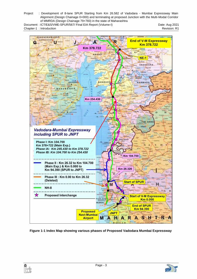
Project : Development of 8-lane SPUR Starting from Km 26.582 of Vadodara - Mumbai Expressway Main
Alignment (Design Chainage 0+000) and terminating at proposed Junction with the Multi-Modal Corridor
of MMRDA (Design Chainage 79+783) in the state of Maharashtra
Document : ICT/E&S/VME-SPUR/567/ Final EIA Report (Volume-I) Date: Aug 2021
Chapter-1 : Introduction Revision: R1
Page - 3
Figure 1-1 Index Map showing various phases of Proposed Vadodara Mumbai Expressway
End of V-M Expressway Km 378.722
Km 378.722
Phase I: Km 104.700
Km 378+722 (Main Exp.) Phase IA: Km 245.430 to Km 378.722
Phase IB: Km 104.700 to Km 254.430
Project : Development of 8-lane SPUR Starting from Km 26.582 of Vadodara - Mumbai Expressway Main
Alignment (Design Chainage 0+000) and terminating at proposed Junction with the Multi-Modal Corridor
of MMRDA (Design Chainage 79+783) in the state of Maharashtra
Document : ICT/E&S/VME-SPUR/567/ Final EIA Report (Volume-I) Date: Aug 2021
Chapter-1 : Introduction Revision: R1
Page - 4
Sanjay Gandhi National Park. Widening of this stretch as per IRC standard is not
feasible. This traffic has to pass through congested road network of Mumbai Metropolis
from southward destination and the goods earmarked for export and import also find
difficulty in commuting to and from JNPT, Navi Mumbai. Therefore it would be prudent to
connect the proposed Vadodara Mumbai Expressway to major traffic generators like
JNPT and Mumbai – Pune Expressway. Keeping view of the above, provision of SPUR
to VME was explored. The spur will not only connect to these major traffic generators
but will also result in better dispersal of traffic in the Mumbai Metropolitan Region.
Therefore, the Consultants proposed that the VM Expressway should be connected to
JNPT and Mumbai-Pune expressway via NH-3, NH-8 NH-222 and NH4B for proper
traffic dispersal.
The project highway will provide smooth, safe and uninterrupted traffic movement
between Vadodara to Mumbai in respect to the alternative road NH 48. The NH 48 (Old
NH8) is currently carrying more than 100,000 PCUs with much substandard geometry
and is heavily congested. It will reduce the travel time about 3 to4 hours between
Vadodara to Mumbai. The proposed expressway falls in the Delhi-Mumbai Industrial
Corridor. It will connect to the largest container port, JNPT near Mumbai with northern
part and Dahej port, other ports in Gujarat. Surat is at the heart of the world's diamond-
polishing industry contributing billions of dollars to the Indian GDP. Vapi, Daman and
Silvassa are the major industrial hub will be connected. Development of this section will
reduce the existing distance between Vadodara-Mumbai by about 22 km and ultimately
there will be reduction in distance between Delhi-Mumbai.
The SPUR connects the main expressway to JNPT, Maha Samrudhi Marg (Mumbai-
Nagpur Expressway) and Mumbai Pune Expressway. Therefore the traffic bound for
JNPT, Nagpur and Pune will ply on SPUR and will not enter the Mumbai city. This will
reduce both traffic congestion and pollution in the city. The proposed SPUR of VME will
be linking Vadodara – Mumbai Expressway, Ahmedabad- Vadodara Expressway,
Mumbai –Nagpur Expressway and Mumbai - Pune Expressway and thus will provide
expressway connectivity from Delhi – Ahmedabad – Mumbai – Nagpur - Pune.
This will further improve connectivity in terms of achieving smooth and safe traffic flow
and improve level of service. In addition to above, substantial economic gain, this would
eventually lead to reduction in the travel time and savings in terms of time, fuel and
maintenance cost of vehicles. Further this stretch will be a part of Delhi- Mumbai
expressway corridor.
1.2.3 VME-SPUR Alignment
Year- 2009: During the feasibility study of VME, it was noted that the proposed start
point of VME on NH8 at Mumbai would pose a serious problem of safe and quick
dispersal of traffic from the expressway and would not serve the purpose of connecting
the major traffic generators like Jawaharlal Nehru Port and to Mumbai-Pune
expressway. To ensure proper dispersal of traffic a proposal for providing a SPUR
connection to the VME originating at about km 27 of the expressway and connecting to
Project : Development of 8-lane SPUR Starting from Km 26.582 of Vadodara - Mumbai Expressway Main
Alignment (Design Chainage 0+000) and terminating at proposed Junction with the Multi-Modal Corridor
of MMRDA (Design Chainage 79+783) in the state of Maharashtra
Document : ICT/E&S/VME-SPUR/567/ Final EIA Report (Volume-I) Date: Aug 2021
Chapter-1 : Introduction Revision: R1
Page - 5
Jawaharlal Nehru Port and Mumbai Pune expressway was mooted in the year 2009.
Year- 2011: Government of Maharashtra approved SPUR alignment in the year 2011,
which starts from the main alignment of Vadodara Mumbai Expressway near Koshimb
village and ends at km 24.476 of NH-4B at Panvel near JNPT. Length of the SPUR
alignment was 94.390 km
Year-2013: A meeting was held on 13th September 2013 under the Chairmanship of
Secretary, MoRTH regarding Vadodara-Mumbai Expressway (VME). Based on the
progress of land acquisition and other pre-construction activities, NHAI asked
repackaging of the project. As decided by the NHAI, the development of SPUR has
been included in Phase II of the VM Expressway project.
Year- 2014 to 2019: In further stage it was observed that, ribbon development occurred
along the alignment of Main expressway from Km 0 to Km 26.3 (Phase-III) and land
acquisition in this stretch could not be taken up due to large scale development and
public resistance. To avoid large scale demolition of residential & commercial structures,
Government of Maharashtra gave NOC to delete Phase-III (Km 0 to Km 26.3) of main
expressway. Hence, the SPUR is to be designed in continuity of the Vadodara Mumbai
Expressway (main expressway) at meeting point.
In later stage, MMRDA planned to develop a Multi-Modal Corridor (MMC) which
connects SPUR alignment at km 79+800 and further connect at JNPT and Aulibag.
During the meeting between MMRDA & NHAI, it was decided to have a common
corridor of MMC & SPUR beyond km 79+780 (village Morbe) to JNPT.
During the meeting held on 22nd March 2019 in the office of Regional Officer (NHAI)
Mumbai, it is decided that:
Start point of SPUR will be at Km 26+582 after introduction of one curve for free flow
traffic from expressway to SPUR and vice versa;
SPUR will be initially developed up to km 79+783 i.e. the proposed junction with the
Multi-Modal Corridor of MMRDA.
Development of the remaining section (up to JNPT) shall be clubbed with the
development of Multi-Modal Corridor and shall be taken up later.
Hence, length of the SPUR alignment to be developed in the initial stage (Phase-II) is
79.783 km. The alignment of SPUR has already been included in the Mumbai
Metropolitan Regional Plan 2016-36 of MMRDA. A map showing the VME-SPUR
alignment on Mumbai Metropolitan Regional Plan 2016-36 is shown in Figure 1-2. This
EIA Report deals with SPUR of Vadodara Mumbai Expressway from Km 0+000 to
Km 79+783.
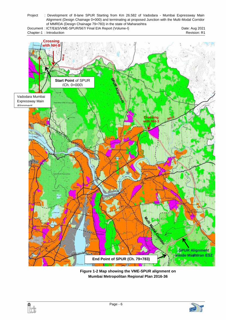
Project : Development of 8-lane SPUR Starting from Km 26.582 of Vadodara - Mumbai Expressway Main
Alignment (Design Chainage 0+000) and terminating at proposed Junction with the Multi-Modal Corridor
of MMRDA (Design Chainage 79+783) in the state of Maharashtra
Document : ICT/E&S/VME-SPUR/567/ Final EIA Report (Volume-I) Date: Aug 2021
Chapter-1 : Introduction Revision: R1
Page - 6
Start Point of SPUR (Ch. 0+000)
End Point of SPUR (Ch. 79+783)
SPUR Alignment
inside Matheran ESZ
Crossing with NH-8
Crossing with NH-3
Vadodara Mumbai
Expressway Main
Alignment
Figure 1-2 Map showing the VME-SPUR alignment on
Mumbai Metropolitan Regional Plan 2016-36
Project : Development of 8-lane SPUR Starting from Km 26.582 of Vadodara - Mumbai Expressway Main
Alignment (Design Chainage 0+000) and terminating at proposed Junction with the Multi-Modal Corridor
of MMRDA (Design Chainage 79+783) in the state of Maharashtra
Document : ICT/E&S/VME-SPUR/567/ Final EIA Report (Volume-I) Date: Aug 2021
Chapter-1 : Introduction Revision: R1
Page - 7
1.2.4 Project Proponent
National Highways Authority of India (NHAI) is an autonomous body and nodal agency
of the Ministry of Road Transport and Highways (MoRTH), Government of India. NHAI is
the project proponent for the development of the proposed SPUR of Vadodara Mumbai
Expressway.
1.3 BRIEF DESCRIPTION OF NATURE, SIZE, LOCATION OF THE PROJECT
The proposed VME – SPUR is a greenfield alignment, which starts at km 26.582 of main
alignment of the Vadodara Mumbai Expressway at Koshimb village of Palghar district at
Ch. 0+000 and terminate at the proposed junction with the Multi-Modal Corridor of
Mumbai Metropolitan Region Development Authority (MMRDA) in Morbe village of
Raigad district at Ch. 79+783. Total length of the SPUR alignment is 79.783 km; out
of which 18.900 km lies in Palghar district, 55.260 km lies in Thane district and
remaining 5.623 km lies in Raigad district of Maharashtra. The proposed alignment is
passing through 68 villages and 6 Talukas (Vasai, Wada, Bhiwandi, Kalyan, Ambarnath
and Panvel) in the State of Maharashtra. Chainage wise village list is given in Annex
1.3. The predominant land use along the alignment is agricultural followed by vegetation
cover. An Index Map showing the location of the proposed expressway is presented in
Figure 1-3.
1.4 SCOPE OF THE STUDY
The proposed project is 8 lane access controlled green field expressway. Applicability of
various environmental laws, regulations and guidelines was reviewed for the proposed
project and its allied activities. As per the EIA Notification, 2006 and its subsequent
amendments, it falls in item. No 7 (f) of the Schedule to the Notification and is a
category “A” project, requires Prior Environment Clearance from the MoEFCC, GOI.
Form-I for obtaining ToR from the MoEFCC was submitted on 13th July 2019. The
project was considered in 220th meeting of Expert Appraisal Committee (EAC) of
MoEFCC held on 26th July 2019. After detailed deliberation, the EAC deferred the
proposal for want of additional information / documents and decided to carry out site
inspection before issuing the ToR.
Accordingly a Sub-committee of EAC was constituted and the Sub-committee visited the
proposed site from 13th to 15th November 2019. The site visit report of the Sub-
committee was discussed and approved in the 227th EAC meeting held on 28th
November, 2019 and compliance of the same was submitted on 18th February 2020.
The project was further considered in 232nd meeting of EAC held on 27th February 2020
and the EAC recommended for grant of ToR. Accordingly, the MoEFCC issued the ToR
for conducting EIA Study vide letter dated 16th March 2020 (MoEFCC File No. 10-
29/2019-IA.III).
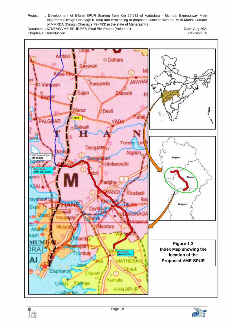
Project : Development of 8-lane SPUR Starting from Km 26.582 of Vadodara - Mumbai Expressway Main
Alignment (Design Chainage 0+000) and terminating at proposed Junction with the Multi-Modal Corridor
of MMRDA (Design Chainage 79+783) in the state of Maharashtra
Document : ICT/E&S/VME-SPUR/567/ Final EIA Report (Volume-I) Date: Aug 2021
Chapter-1 : Introduction Revision: R1
Page - 8
Figure 1-3
Index Map showing the
location of the
Proposed VME-SPUR
Project : Development of 8-lane SPUR Starting from Km 26.582 of Vadodara - Mumbai Expressway Main
Alignment (Design Chainage 0+000) and terminating at proposed Junction with the Multi-Modal Corridor
of MMRDA (Design Chainage 79+783) in the state of Maharashtra
Document : ICT/E&S/VME-SPUR/567/ Final EIA Report (Volume-I) Date: Aug 2021
Chapter-1 : Introduction Revision: R1
Page - 9
This EIA Report has been prepared as per the approved ToR and compliance of the
ToR is given in the beginning of this EIA report.
1.5 REVIEW OF POLICY, REGULATIONS AND LEGAL FRAMEWORK
The relevant / applicable sections of following acts, policy guidelines, regulations and
legislations framed by the Government of India / Government of Maharashtra for
environmental safeguards are to be followed:
Environment (Protection) Act and Rules, 1986
EIA Notification, 14th September 2006 and its subsequent amendments
The Water (Prevention and Control of Pollution) Act and Rules, 1974, 1975
The Air (Prevention and Control of Pollution) Act, Rules and Amendment, 1981,
1982, 1983, 1987
Noise Pollution (Regulation & Control) Rules, 2003 and amended in 2010
Forest (Conservation) Act, 1980 and its amendments
Forest (Conservation) Rules, 2003 and its amendments
Forest (Conservation) Second Amendment Rules,2014
The Schedule Tribes and other Traditional Forest Dwellers (Recognition of Forest
Rights) Act, 2006
The Schedule Tribes and other Traditional Forest Dwellers (Recognition of Forest
Rights) Amendment Rules, 2012
Maharashtra Felling of Trees (Regulation) Act, 1964 and its amendments
Wildlife (Protection) Act, 1972 and its amendments
Coastal Regulation Zone (CRZ) Notification, 2011 & 2019
MoEFCC approved CZMP Coastal Zone Management Plan of Palghar & Thane
district, dated 28.02.2019
Solid Waste Management Rules, 2016 and amendments
Construction and Demolition Waste Management Rules, 2016
The Hazardous and Other Waste (Management and Transboundary Movement)
Rules, 2016
Maharashtra Plastic and Thermocol Products (Manufacture, Usage, Sale, Transport,
Handling and Storage) Notification, 2018
Chemical Accident (Emergency Planning, Preparedness and Response) Rules,
1996
Ancient Monuments and Archaeological Sites and Remains (Amendment and
Validation) Act, 2010
Disposal of Fly Ash Notification 2009 and its amendments on 25th January 2016
MoEFCC Office Memorandum (File No. 22-13/2019-IA.III) dated 28th August 2019
regarding Fly Ash Notification and subsequent amendments
The Motor Vehicles (Amendment) Act, 2019
The Motor Vehicles (Amendment) Bill, 2019
The Explosive Act, 1884 and The Explosive Rules, 2008
Public Liability Insurance Act, 1991
The Mines Act. 1952
Mines and Minerals (Development and Regulation) Amendment Act, 2015
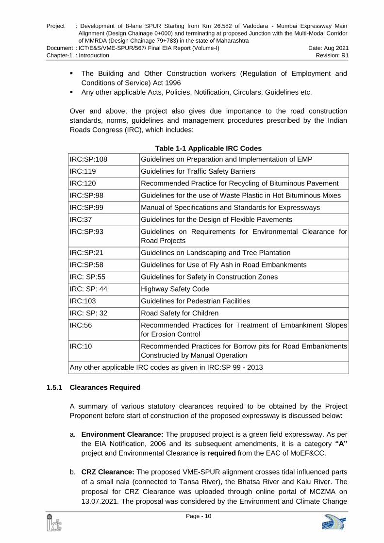
Project : Development of 8-lane SPUR Starting from Km 26.582 of Vadodara - Mumbai Expressway Main
Alignment (Design Chainage 0+000) and terminating at proposed Junction with the Multi-Modal Corridor
of MMRDA (Design Chainage 79+783) in the state of Maharashtra
Document : ICT/E&S/VME-SPUR/567/ Final EIA Report (Volume-I) Date: Aug 2021
Chapter-1 : Introduction Revision: R1
Page - 10
The Building and Other Construction workers (Regulation of Employment and
Conditions of Service) Act 1996
Any other applicable Acts, Policies, Notification, Circulars, Guidelines etc.
Over and above, the project also gives due importance to the road construction
standards, norms, guidelines and management procedures prescribed by the Indian
Roads Congress (IRC), which includes:
Table 1-1 Applicable IRC Codes
IRC:SP:108 Guidelines on Preparation and Implementation of EMP
IRC:119 Guidelines for Traffic Safety Barriers
IRC:120 Recommended Practice for Recycling of Bituminous Pavement
IRC:SP:98 Guidelines for the use of Waste Plastic in Hot Bituminous Mixes
IRC:SP:99 Manual of Specifications and Standards for Expressways
IRC:37 Guidelines for the Design of Flexible Pavements
IRC:SP:93 Guidelines on Requirements for Environmental Clearance for
Road Projects
IRC:SP:21 Guidelines on Landscaping and Tree Plantation
IRC:SP:58 Guidelines for Use of Fly Ash in Road Embankments
IRC: SP:55 Guidelines for Safety in Construction Zones
IRC: SP: 44 Highway Safety Code
IRC:103 Guidelines for Pedestrian Facilities
IRC: SP: 32 Road Safety for Children
IRC:56 Recommended Practices for Treatment of Embankment Slopes
for Erosion Control
IRC:10 Recommended Practices for Borrow pits for Road Embankments
Constructed by Manual Operation
Any other applicable IRC codes as given in IRC:SP 99 - 2013
1.5.1 Clearances Required
A summary of various statutory clearances required to be obtained by the Project
Proponent before start of construction of the proposed expressway is discussed below:
a. Environment Clearance: The proposed project is a green field expressway. As per
the EIA Notification, 2006 and its subsequent amendments, it is a category “A”
project and Environmental Clearance is required from the EAC of MoEF&CC.
b. CRZ Clearance: The proposed VME-SPUR alignment crosses tidal influenced parts
of a small nala (connected to Tansa River), the Bhatsa River and Kalu River. The
proposal for CRZ Clearance was uploaded through online portal of MCZMA on
13.07.2021. The proposal was considered by the Environment and Climate Change
Project : Development of 8-lane SPUR Starting from Km 26.582 of Vadodara - Mumbai Expressway Main
Alignment (Design Chainage 0+000) and terminating at proposed Junction with the Multi-Modal Corridor
of MMRDA (Design Chainage 79+783) in the state of Maharashtra
Document : ICT/E&S/VME-SPUR/567/ Final EIA Report (Volume-I) Date: Aug 2021
Chapter-1 : Introduction Revision: R1
Page - 11
Department, Government of Maharashtra on 21.09.2021. The Government of
Maharashtra recommends the proposal to MoEF&CC vide letter dated 29.09.2021
subject to compliance of the specific and general conditions.
c. Forest Clearance: The proposed project involves diversion of approx. 122.6133 ha
Forest Land. Hence, Forest Clearance is required. Proposal has been uploaded on
6th November 2020 (FC Proposal No. FP/MH/ROAD/53857/2020) and it is under
examination with the State Government.
d. NBWL Clearance: The proposed SPUR does not pass through any protected
areas and is located at a distance of 0.698 km from the boundary of the
Tungeshwar Wildlife Sanctuary. Final ESZ Notification of Tungeshwar Wildlife
Sanctuary has been published on [S.O.3250 (E)] 11th September 2019. The
proposed expressway is located at a distance of 0.275 km from the notified ESZ
boundary i.e. outside ESZ. It may be mentioned that the same has been vetted by
the forest officials who were present during site visit of EAC sub-committee on
14.11.2019. Further, the distance has been verified from the office of the Chief
Wildlife Warden, Govt. of Maharashtra while approving the Wildlife Conservation
Plan for VME-SPUR. As per MoEFCC Office Memorandum dater 8th August 2019
(F. No. 22-43/2018-IA.III), clearance from Standing Committee of NBWL is not
required.
e. Clearance from Monitoring Committee for Matheran ESZ: The proposed
alignment passes through Matheran ESA from km 71+532 to 75+426(both buffer
and eco-sensitive zone) and from km 77+115 to km 77+691 (only buffer zone). The
Monitoring Committee for Matheran ESZ has approved the SPUR alignment inside
the Matheran ESZ vide letter dated 16th April 2013. However, as suggested by the
MoEFCC in the approved ToR, fresh application was submitted on 24.11.2020. The
District Collector, Raigad and Member Secretary of Monitoring Committee of
Matheran Eco-Sensitive Zone vide letter dated 24.03.2021 communicated that
the approval given by the Matheran Monitoring Committee vide letter dated
16.04.2013 is still valid.
f. Consent to Establish: NOC under Air Act & Water Act from Maharashtra Pollution
Control Board (MPCB) is required for the proposed greenfield expressway before
start of construction.
g. ASI Clearance: No ASI Protected Monument or World Heritage Monument is
located within 300m of the proposed expressway alignment. Therefore, ASI
Clearance is not required.
Apart from the clearances as mentioned above, the contractor before starting the
construction work has to obtain the Clearances / NOCs as listed in Table 1-2 for
operating his equipment and starting construction activity.
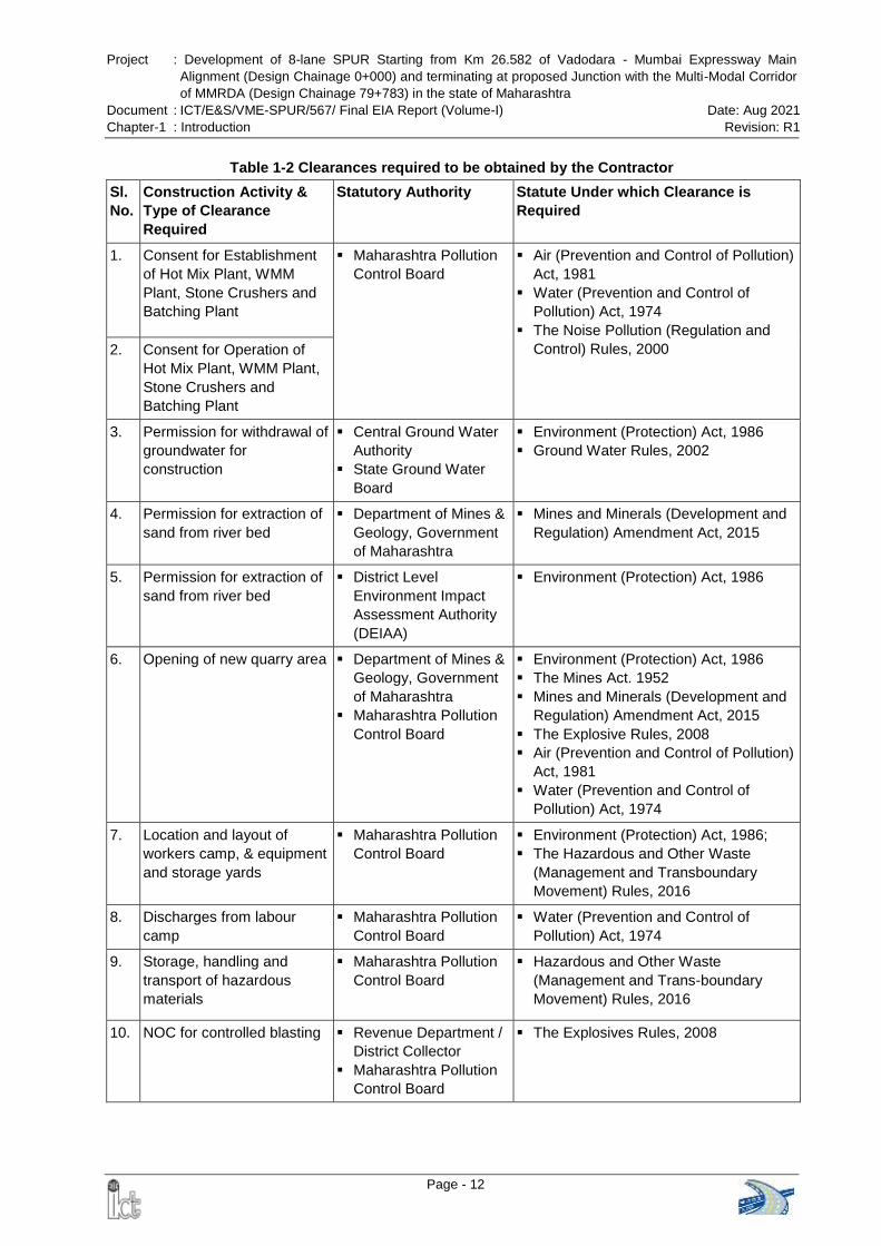
Project : Development of 8-lane SPUR Starting from Km 26.582 of Vadodara - Mumbai Expressway Main
Alignment (Design Chainage 0+000) and terminating at proposed Junction with the Multi-Modal Corridor
of MMRDA (Design Chainage 79+783) in the state of Maharashtra
Document : ICT/E&S/VME-SPUR/567/ Final EIA Report (Volume-I) Date: Aug 2021
Chapter-1 : Introduction Revision: R1
Page - 12
Table 1-2 Clearances required to be obtained by the Contractor
Sl.
No.
Construction Activity &
Type of Clearance
Required
Statutory Authority Statute Under which Clearance is
Required
1. Consent for Establishment
of Hot Mix Plant, WMM
Plant, Stone Crushers and
Batching Plant
Maharashtra Pollution
Control Board
Air (Prevention and Control of Pollution)
Act, 1981
Water (Prevention and Control of
Pollution) Act, 1974
The Noise Pollution (Regulation and
Control) Rules, 2000 2. Consent for Operation of
Hot Mix Plant, WMM Plant,
Stone Crushers and
Batching Plant
3. Permission for withdrawal of
groundwater for
construction
Central Ground Water
Authority
State Ground Water
Board
Environment (Protection) Act, 1986
Ground Water Rules, 2002
4. Permission for extraction of
sand from river bed
Department of Mines &
Geology, Government
of Maharashtra
Mines and Minerals (Development and
Regulation) Amendment Act, 2015
5. Permission for extraction of
sand from river bed
District Level
Environment Impact
Assessment Authority
(DEIAA)
Environment (Protection) Act, 1986
6. Opening of new quarry area Department of Mines &
Geology, Government
of Maharashtra
Maharashtra Pollution
Control Board
Environment (Protection) Act, 1986
The Mines Act. 1952
Mines and Minerals (Development and
Regulation) Amendment Act, 2015
The Explosive Rules, 2008
Air (Prevention and Control of Pollution)
Act, 1981
Water (Prevention and Control of
Pollution) Act, 1974
7. Location and layout of
workers camp, & equipment
and storage yards
Maharashtra Pollution
Control Board
Environment (Protection) Act, 1986;
The Hazardous and Other Waste
(Management and Transboundary
Movement) Rules, 2016
8. Discharges from labour
camp
Maharashtra Pollution
Control Board
Water (Prevention and Control of
Pollution) Act, 1974
9. Storage, handling and
transport of hazardous
materials
Maharashtra Pollution
Control Board
Hazardous and Other Waste
(Management and Trans-boundary
Movement) Rules, 2016
10. NOC for controlled blasting Revenue Department /
District Collector
Maharashtra Pollution
Control Board
The Explosives Rules, 2008
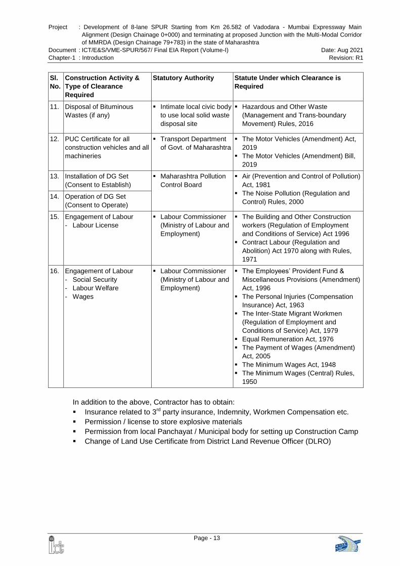
Project : Development of 8-lane SPUR Starting from Km 26.582 of Vadodara - Mumbai Expressway Main
Alignment (Design Chainage 0+000) and terminating at proposed Junction with the Multi-Modal Corridor
of MMRDA (Design Chainage 79+783) in the state of Maharashtra
Document : ICT/E&S/VME-SPUR/567/ Final EIA Report (Volume-I) Date: Aug 2021
Chapter-1 : Introduction Revision: R1
Page - 13
Sl.
No.
Construction Activity &
Type of Clearance
Required
Statutory Authority Statute Under which Clearance is
Required
11. Disposal of Bituminous
Wastes (if any)
Intimate local civic body
to use local solid waste
disposal site
Hazardous and Other Waste
(Management and Trans-boundary
Movement) Rules, 2016
12. PUC Certificate for all
construction vehicles and all
machineries
Transport Department
of Govt. of Maharashtra
The Motor Vehicles (Amendment) Act,
2019
The Motor Vehicles (Amendment) Bill,
2019
13. Installation of DG Set
(Consent to Establish)
Maharashtra Pollution
Control Board
Air (Prevention and Control of Pollution)
Act, 1981
The Noise Pollution (Regulation and
Control) Rules, 2000 14. Operation of DG Set
(Consent to Operate)
15. Engagement of Labour
- Labour License
Labour Commissioner
(Ministry of Labour and
Employment)
The Building and Other Construction
workers (Regulation of Employment
and Conditions of Service) Act 1996
Contract Labour (Regulation and
Abolition) Act 1970 along with Rules,
1971
16. Engagement of Labour
- Social Security
- Labour Welfare
- Wages
Labour Commissioner
(Ministry of Labour and
Employment)
The Employees’ Provident Fund &
Miscellaneous Provisions (Amendment)
Act, 1996
The Personal Injuries (Compensation
Insurance) Act, 1963
The Inter-State Migrant Workmen
(Regulation of Employment and
Conditions of Service) Act, 1979
Equal Remuneration Act, 1976
The Payment of Wages (Amendment)
Act, 2005
The Minimum Wages Act, 1948
The Minimum Wages (Central) Rules,
1950
In addition to the above, Contractor has to obtain:
Insurance related to 3rd party insurance, Indemnity, Workmen Compensation etc.
Permission / license to store explosive materials
Permission from local Panchayat / Municipal body for setting up Construction Camp
Change of Land Use Certificate from District Land Revenue Officer (DLRO)
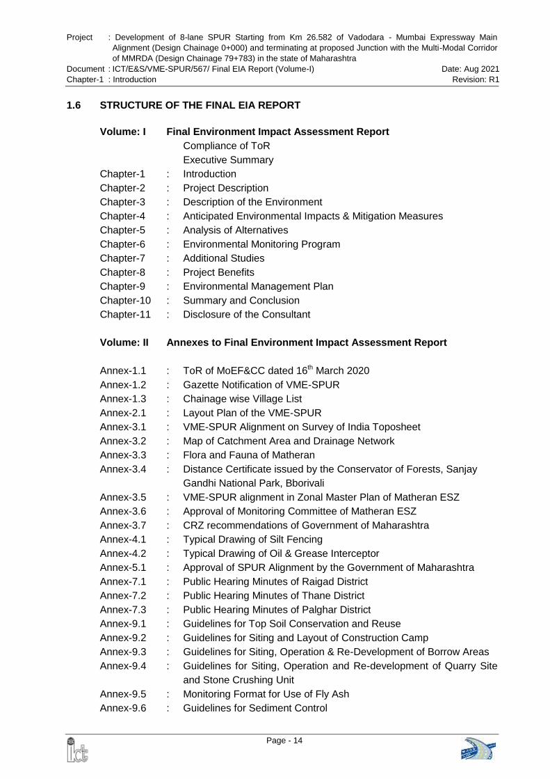
Project : Development of 8-lane SPUR Starting from Km 26.582 of Vadodara - Mumbai Expressway Main
Alignment (Design Chainage 0+000) and terminating at proposed Junction with the Multi-Modal Corridor
of MMRDA (Design Chainage 79+783) in the state of Maharashtra
Document : ICT/E&S/VME-SPUR/567/ Final EIA Report (Volume-I) Date: Aug 2021
Chapter-1 : Introduction Revision: R1
Page - 14
1.6 STRUCTURE OF THE FINAL EIA REPORT
Volume: I Final Environment Impact Assessment Report
Compliance of ToR
Executive Summary
Chapter-1 : Introduction
Chapter-2 : Project Description
Chapter-3 : Description of the Environment
Chapter-4 : Anticipated Environmental Impacts & Mitigation Measures
Chapter-5 : Analysis of Alternatives
Chapter-6 : Environmental Monitoring Program
Chapter-7 : Additional Studies
Chapter-8 : Project Benefits
Chapter-9 : Environmental Management Plan
Chapter-10 : Summary and Conclusion
Chapter-11 : Disclosure of the Consultant
Volume: II Annexes to Final Environment Impact Assessment Report
Annex-1.1 : ToR of MoEF&CC dated 16th March 2020
Annex-1.2 : Gazette Notification of VME-SPUR
Annex-1.3 : Chainage wise Village List
Annex-2.1 : Layout Plan of the VME-SPUR
Annex-3.1 : VME-SPUR Alignment on Survey of India Toposheet
Annex-3.2 : Map of Catchment Area and Drainage Network
Annex-3.3 : Flora and Fauna of Matheran
Annex-3.4 : Distance Certificate issued by the Conservator of Forests, Sanjay
Gandhi National Park, Bborivali
Annex-3.5 : VME-SPUR alignment in Zonal Master Plan of Matheran ESZ
Annex-3.6 : Approval of Monitoring Committee of Matheran ESZ
Annex-3.7 : CRZ recommendations of Government of Maharashtra
Annex-4.1 : Typical Drawing of Silt Fencing
Annex-4.2 : Typical Drawing of Oil & Grease Interceptor
Annex-5.1 : Approval of SPUR Alignment by the Government of Maharashtra
Annex-7.1 : Public Hearing Minutes of Raigad District
Annex-7.2 : Public Hearing Minutes of Thane District
Annex-7.3 : Public Hearing Minutes of Palghar District
Annex-9.1 : Guidelines for Top Soil Conservation and Reuse
Annex-9.2 : Guidelines for Siting and Layout of Construction Camp
Annex-9.3 : Guidelines for Siting, Operation & Re-Development of Borrow Areas
Annex-9.4 : Guidelines for Siting, Operation and Re-development of Quarry Site
and Stone Crushing Unit
Annex-9.5 : Monitoring Format for Use of Fly Ash
Annex-9.6 : Guidelines for Sediment Control
Project : Development of 8-lane SPUR Starting from Km 26.582 of Vadodara - Mumbai Expressway Main
Alignment (Design Chainage 0+000) and terminating at proposed Junction with the Multi-Modal Corridor
of MMRDA (Design Chainage 79+783) in the state of Maharashtra
Document : ICT/E&S/VME-SPUR/567/ Final EIA Report (Volume-I) Date: Aug 2021
Chapter-1 : Introduction Revision: R1
Page - 15
Annex-9.7 : Guidelines for Waste Water Treatment in Construction Camp
Annex-9.8 : Guidelines for Siting and Management of Debris Disposal Site
Annex-9.9 : Guidelines for Preparing Comprehensive Waste Management Plan
Annex-9.10 : Guidelines for Traffic Management Plan
Annex-9.11 : Guidelines to Ensure Worker’s Safety during Construction
Annex-9.12 : Guidelines for Storage, Handling, Use and Emergency Response for
Hazardous Substances
Annex-9.13 : Reporting Formats of EMP Implementation
Annex-9.14 : Approval of Chief Wildlife Warden, Maharashtra State
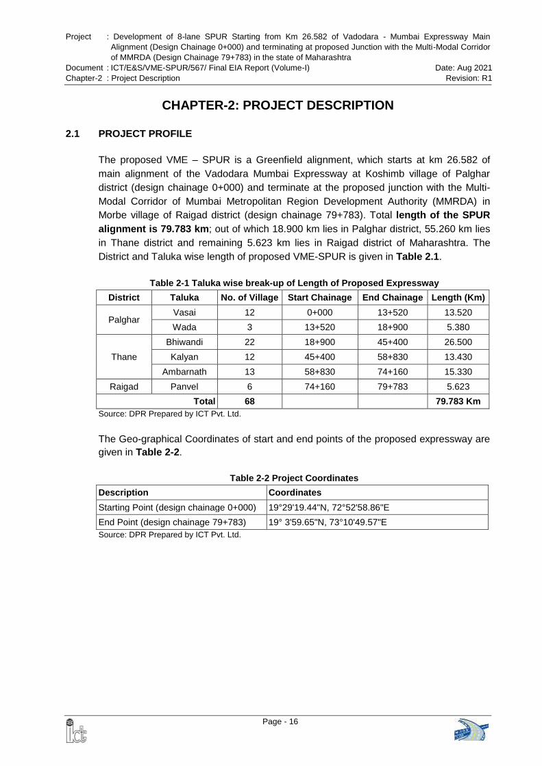
Project : Development of 8-lane SPUR Starting from Km 26.582 of Vadodara - Mumbai Expressway Main
Alignment (Design Chainage 0+000) and terminating at proposed Junction with the Multi-Modal Corridor
of MMRDA (Design Chainage 79+783) in the state of Maharashtra
Document : ICT/E&S/VME-SPUR/567/ Final EIA Report (Volume-I) Date: Aug 2021
Chapter-2 : Project Description Revision: R1
Page - 16
CHAPTER-2: PROJECT DESCRIPTION
2.1 PROJECT PROFILE
The proposed VME – SPUR is a Greenfield alignment, which starts at km 26.582 of
main alignment of the Vadodara Mumbai Expressway at Koshimb village of Palghar
district (design chainage 0+000) and terminate at the proposed junction with the Multi-
Modal Corridor of Mumbai Metropolitan Region Development Authority (MMRDA) in
Morbe village of Raigad district (design chainage 79+783). Total length of the SPUR
alignment is 79.783 km; out of which 18.900 km lies in Palghar district, 55.260 km lies
in Thane district and remaining 5.623 km lies in Raigad district of Maharashtra. The
District and Taluka wise length of proposed VME-SPUR is given in Table 2.1.
Table 2-1 Taluka wise break-up of Length of Proposed Expressway
District Taluka No. of Village Start Chainage End Chainage Length (Km)
Palghar Vasai 12 0+000 13+520 13.520
Wada 3 13+520 18+900 5.380
Thane
Bhiwandi 22 18+900 45+400 26.500
Kalyan 12 45+400 58+830 13.430
Ambarnath 13 58+830 74+160 15.330
Raigad Panvel 6 74+160 79+783 5.623
Total 68 79.783 Km
Source: DPR Prepared by ICT Pvt. Ltd.
The Geo-graphical Coordinates of start and end points of the proposed expressway are
given in Table 2-2.
Table 2-2 Project Coordinates
Description Coordinates
Starting Point (design chainage 0+000) 19°29'19.44"N, 72°52'58.86"E
End Point (design chainage 79+783) 19° 3'59.65"N, 73°10'49.57"E
Source: DPR Prepared by ICT Pvt. Ltd.
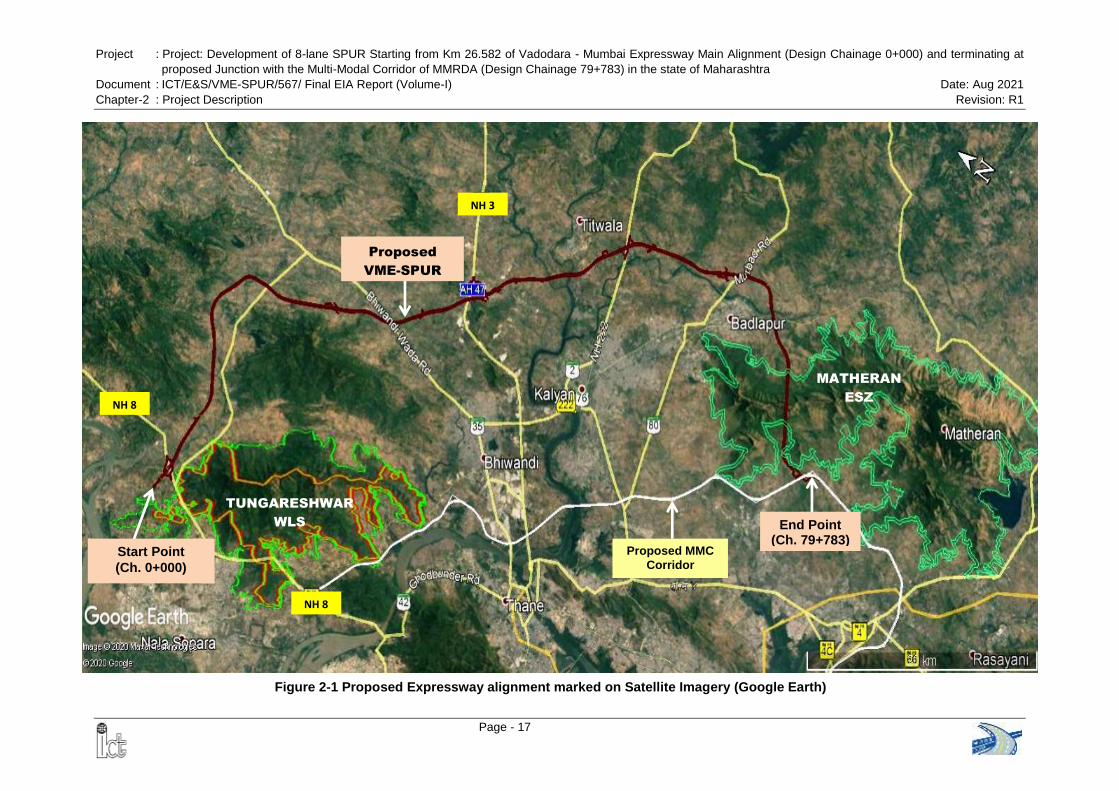
Project : Project: Development of 8-lane SPUR Starting from Km 26.582 of Vadodara - Mumbai Expressway Main Alignment (Design Chainage 0+000) and terminating at
proposed Junction with the Multi-Modal Corridor of MMRDA (Design Chainage 79+783) in the state of Maharashtra
Document : ICT/E&S/VME-SPUR/567/ Final EIA Report (Volume-I) Date: Aug 2021
Chapter-2 : Project Description Revision: R1
Page - 17
Tungareshwar
Wildlife Sanctuary
Figure 2-1 Proposed Expressway alignment marked on Satellite Imagery (Google Earth)
MATHERAN
ESZ
Start Point
(Ch. 0+000)
End Point (Ch. 79+783)
NH 8
NH 8
NH 3
Proposed
VME-SPUR
Proposed MMC
Corridor
TUNGARESHWAR
WLS
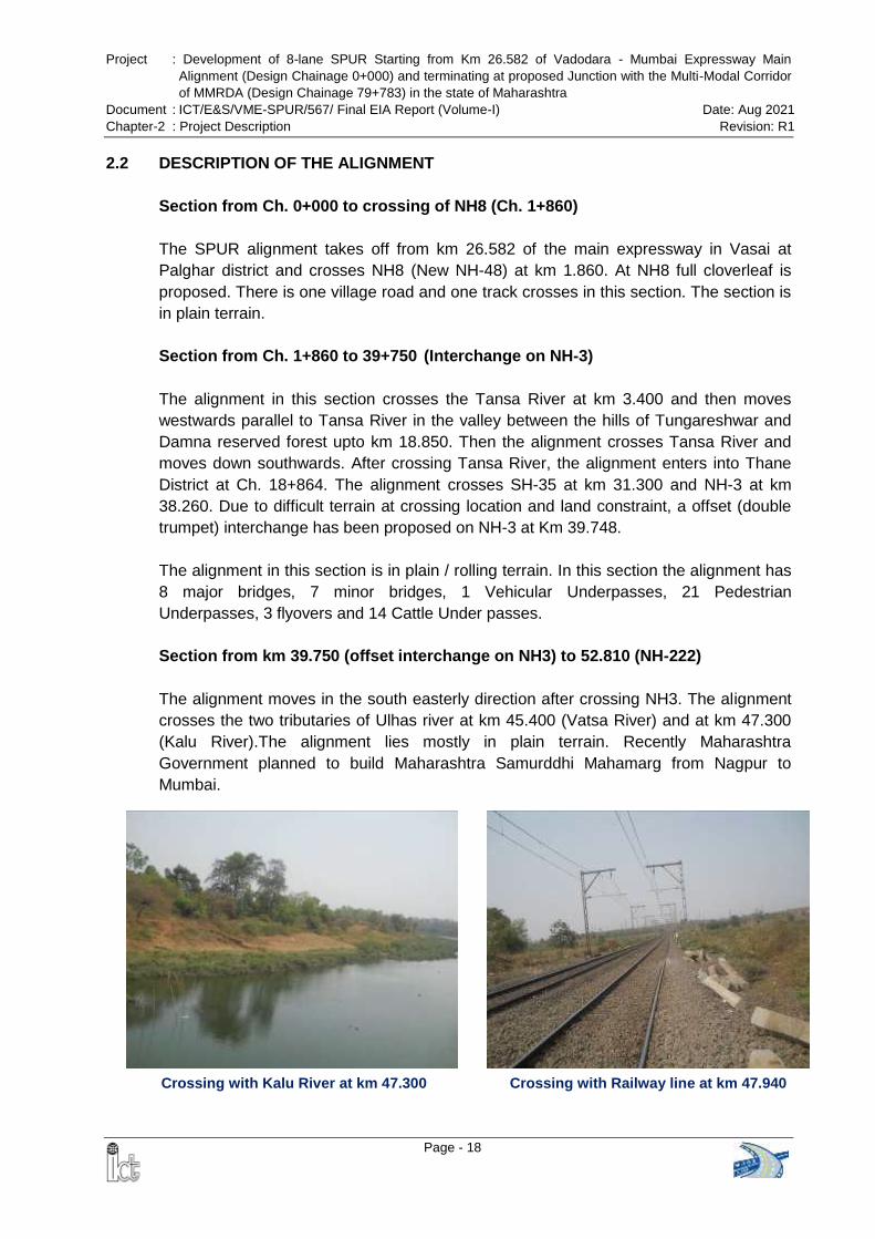
Project : Development of 8-lane SPUR Starting from Km 26.582 of Vadodara - Mumbai Expressway Main
Alignment (Design Chainage 0+000) and terminating at proposed Junction with the Multi-Modal Corridor
of MMRDA (Design Chainage 79+783) in the state of Maharashtra
Document : ICT/E&S/VME-SPUR/567/ Final EIA Report (Volume-I) Date: Aug 2021
Chapter-2 : Project Description Revision: R1
Page - 18
Crossing with Kalu River at km 47.300 Crossing with Railway line at km 47.940
2.2 DESCRIPTION OF THE ALIGNMENT
Section from Ch. 0+000 to crossing of NH8 (Ch. 1+860)
The SPUR alignment takes off from km 26.582 of the main expressway in Vasai at
Palghar district and crosses NH8 (New NH-48) at km 1.860. At NH8 full cloverleaf is
proposed. There is one village road and one track crosses in this section. The section is
in plain terrain.
Section from Ch. 1+860 to 39+750 (Interchange on NH-3)
The alignment in this section crosses the Tansa River at km 3.400 and then moves
westwards parallel to Tansa River in the valley between the hills of Tungareshwar and
Damna reserved forest upto km 18.850. Then the alignment crosses Tansa River and
moves down southwards. After crossing Tansa River, the alignment enters into Thane
District at Ch. 18+864. The alignment crosses SH-35 at km 31.300 and NH-3 at km
38.260. Due to difficult terrain at crossing location and land constraint, a offset (double
trumpet) interchange has been proposed on NH-3 at Km 39.748.
The alignment in this section is in plain / rolling terrain. In this section the alignment has
8 major bridges, 7 minor bridges, 1 Vehicular Underpasses, 21 Pedestrian
Underpasses, 3 flyovers and 14 Cattle Under passes.
Section from km 39.750 (offset interchange on NH3) to 52.810 (NH-222)
The alignment moves in the south easterly direction after crossing NH3. The alignment
crosses the two tributaries of Ulhas river at km 45.400 (Vatsa River) and at km 47.300
(Kalu River).The alignment lies mostly in plain terrain. Recently Maharashtra
Government planned to build Maharashtra Samurddhi Mahamarg from Nagpur to
Mumbai.
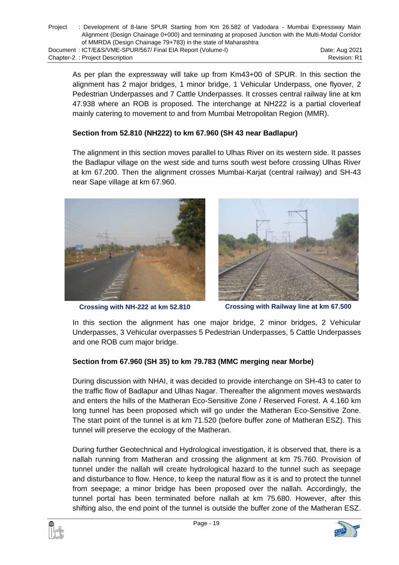
Project : Development of 8-lane SPUR Starting from Km 26.582 of Vadodara - Mumbai Expressway Main
Alignment (Design Chainage 0+000) and terminating at proposed Junction with the Multi-Modal Corridor
of MMRDA (Design Chainage 79+783) in the state of Maharashtra
Document : ICT/E&S/VME-SPUR/567/ Final EIA Report (Volume-I) Date: Aug 2021
Chapter-2 : Project Description Revision: R1
Page - 19
Crossing with NH-222 at km 52.810 Crossing with Railway line at km 67.500
As per plan the expressway will take up from Km43+00 of SPUR. In this section the
alignment has 2 major bridges, 1 minor bridge, 1 Vehicular Underpass, one flyover, 2
Pedestrian Underpasses and 7 Cattle Underpasses. It crosses central railway line at km
47.938 where an ROB is proposed. The interchange at NH222 is a partial cloverleaf
mainly catering to movement to and from Mumbai Metropolitan Region (MMR).
Section from 52.810 (NH222) to km 67.960 (SH 43 near Badlapur)
The alignment in this section moves parallel to Ulhas River on its western side. It passes
the Badlapur village on the west side and turns south west before crossing Ulhas River
at km 67.200. Then the alignment crosses Mumbai-Karjat (central railway) and SH-43
near Sape village at km 67.960.
In this section the alignment has one major bridge, 2 minor bridges, 2 Vehicular
Underpasses, 3 Vehicular overpasses 5 Pedestrian Underpasses, 5 Cattle Underpasses
and one ROB cum major bridge.
Section from 67.960 (SH 35) to km 79.783 (MMC merging near Morbe)
During discussion with NHAI, it was decided to provide interchange on SH-43 to cater to
the traffic flow of Badlapur and Ulhas Nagar. Thereafter the alignment moves westwards
and enters the hills of the Matheran Eco-Sensitive Zone / Reserved Forest. A 4.160 km
long tunnel has been proposed which will go under the Matheran Eco-Sensitive Zone.
The start point of the tunnel is at km 71.520 (before buffer zone of Matheran ESZ). This
tunnel will preserve the ecology of the Matheran.
During further Geotechnical and Hydrological investigation, it is observed that, there is a
nallah running from Matheran and crossing the alignment at km 75.760. Provision of
tunnel under the nallah will create hydrological hazard to the tunnel such as seepage
and disturbance to flow. Hence, to keep the natural flow as it is and to protect the tunnel
from seepage; a minor bridge has been proposed over the nallah. Accordingly, the
tunnel portal has been terminated before nallah at km 75.680. However, after this
shifting also, the end point of the tunnel is outside the buffer zone of the Matheran ESZ.
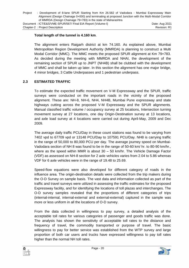
Project : Development of 8-lane SPUR Starting from Km 26.582 of Vadodara - Mumbai Expressway Main
Alignment (Design Chainage 0+000) and terminating at proposed Junction with the Multi-Modal Corridor
of MMRDA (Design Chainage 79+783) in the state of Maharashtra
Document : ICT/E&S/VME-SPUR/567/ Final EIA Report (Volume-I) Date: Aug 2021
Chapter-2 : Project Description Revision: R1
Page - 20
Total length of the tunnel is 4.160 km.
The alignment enters Raigarh district at km 74.160. As explained above, Mumbai
Metropolitan Region Development Authority (MMRDA) is planning to construct a Multi
Modal Corridor (MMC). The MMC meets the proposed SPUR alignment at Km 79+783.
As decided during the meeting with MMRDA and NHAI, the development of the
remaining section of SPUR up to JNPT (NH4B) shall be clubbed with the development
of MMC and shall be taken up later. In this section the alignment has one major bridge,
4 minor bridges, 3 Cattle Underpasses and 1 pedestrian underpass.
2.3 ESTIMATED TRAFFIC
To estimate the expected traffic movement on V-M Expressway and the SPUR, traffic
surveys were conducted on the important roads in the vicinity of the proposed
alignment. These are: NH-8, NH-6, NH4, NH4B, Mumbai Pune expressway and state
highways cutting across the proposed V-M Expressway and the SPUR alignments.
Manual classified traffic volume / occupancy survey at 25 locations, Intersection turning
movement survey at 27 locations, one day Origin-Destination survey at 13 locations,
and axle load survey at 4 locations were carried out during April-May, 2009 and Dec
2009.
The average daily traffic PCU/Day in these count stations was found to be varying from
7402 vpd to 67709 vpd or 13148 PCU/Day to 107591 PCU/Day. NH8 is carrying traffic
in the range of 50,000 to 80,000 PCU per day. The average journey speed on Mumbai-
Vadodara section of NH 8 was found to be in the range of 50-60 km/ hr. to 80-90 km/hr.,
where as the speed within MMR is about 30 – 50 km/hr. The Vehicle Damage Factor
(VDF) as assessed on NH-8 section for 2 axle vehicles varies from 2.04 to 5.86 whereas
VDF for 6 axle vehicles were in the range of 19.48 to 25.69.
Speed-flow equations were also developed for different category of roads in the
influence area. The origin-destination details were collected from the trip makers during
the O-D Survey on sample basis. The vast data and information collected as part of the
traffic and travel surveys were utilized in assessing the traffic estimates for the proposed
Expressway facility, and for identifying the locations of toll plazas and interchanges. The
O-D survey samples revealed that the proportions of different categories of trips
(internal-internal, internal-external and external-external) captured in the sample was
more or less uniform in all the locations of O-D survey.
From the data collected in willingness to pay survey, a detailed analysis of the
acceptable toll rates for various categories of passenger and goods traffic was done.
The analysis has shown the sensitivity of acceptable toll rates to the distance and
frequency of travel, the commodity transported or purpose of travel. The basic
willingness to pay for better service was established from the WTP survey and large
proportion of both car users and trucks have expressed willingness to pay toll rates
higher than the normal NH toll rates.
Project : Development of 8-lane SPUR Starting from Km 26.582 of Vadodara - Mumbai Expressway Main
Alignment (Design Chainage 0+000) and terminating at proposed Junction with the Multi-Modal Corridor
of MMRDA (Design Chainage 79+783) in the state of Maharashtra
Document : ICT/E&S/VME-SPUR/567/ Final EIA Report (Volume-I) Date: Aug 2021
Chapter-2 : Project Description Revision: R1
Page - 21
The traffic zone system developed for the study area comprises of 89 traffic zones. The
traffic zone system has been developed in such a manner so as to identify the traffic
originating and destined from various important cities, ports and industrial areas located
in the influence area of proposed expressway. The district level zoning system has been
adopted outside the immediate influence area of expressway alignment while the block
level zoning system has been developed to study the traffic demand pattern from/to the
areas located close to the alignment. This zoning scheme has been used for the
development of the Regional Transport Demand Model (RTDM).
The consultant developed a RTDM (i.e. the influence area of the proposed expressway)
considering number of parameters during the process of transport demand generation,
distribution and assignment on the road network of study area.
In order to consider comprehensive network deterrence, the parameters which
encompass the main cost component of travel between a pair of zones, accounted in
the Generalised Cost equation were developed for various modes and road categories.
The generalized cost equation adopted for the RTDM has the following form:
GC = (CFt*VOCt) + (CFd*VOCd) + Toll Fee
Where, CFt is the cost function affecting the VOT and CFd is the cost function
influencing the VOC. The toll charges for using a particular link of the network is
considered in the overall cost of travel in the network for a particular mode. The
generalized cost equation therefore captures both the direct and indirect cost to the road
user in the adopted network. The toll rate for the expressway is considered as 1.25
times the NH8 toll rates.
The equilibrium assignment technique has been used for traffic assignment in this study.
In this method, the trip matrices derived are assigned on the network based on All-or-
Nothing assignment before updating the cost. Once the trips are assigned on the
network, the cost is updated using the generalized cost function which has an in-built
V/C function (speed-flow function) in it. With the updated cost of each link, the trips are
again getting reassigned in the way that no trip maker can reduce his path costs by
switching routes on the network based on the user equilibrium concept. The model
assignment was validated using data on NH-8.
The error level was within + 10%, the model and is considered validated for use in the
forecast. Using the growth rates estimated from transport elasticity and the trend, mode
wise trip ends were projected for different horizon years (2015, 2020, 2025, 2030, 2035
and 2045).
Based on the traffic survey conducted in year 2009, and the DPR for VM Expressway
was submitted in 2012. Further as per the instruction of NHAI, the Consultant carried out
traffic surveys on selected locations in 2016 to update the traffic figures, analysis and
forecast. Based on the observed traffic volumes in the year 2016, the estimated traffic of
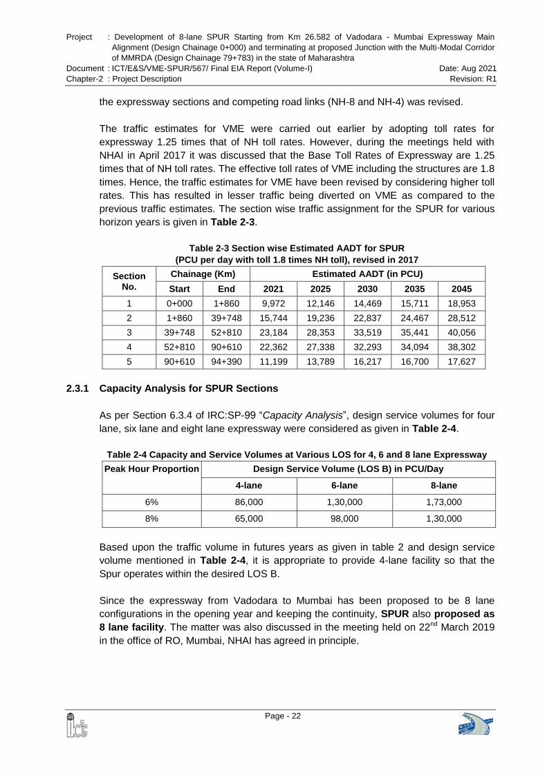
Project : Development of 8-lane SPUR Starting from Km 26.582 of Vadodara - Mumbai Expressway Main
Alignment (Design Chainage 0+000) and terminating at proposed Junction with the Multi-Modal Corridor
of MMRDA (Design Chainage 79+783) in the state of Maharashtra
Document : ICT/E&S/VME-SPUR/567/ Final EIA Report (Volume-I) Date: Aug 2021
Chapter-2 : Project Description Revision: R1
Page - 22
the expressway sections and competing road links (NH-8 and NH-4) was revised.
The traffic estimates for VME were carried out earlier by adopting toll rates for
expressway 1.25 times that of NH toll rates. However, during the meetings held with
NHAI in April 2017 it was discussed that the Base Toll Rates of Expressway are 1.25
times that of NH toll rates. The effective toll rates of VME including the structures are 1.8
times. Hence, the traffic estimates for VME have been revised by considering higher toll
rates. This has resulted in lesser traffic being diverted on VME as compared to the
previous traffic estimates. The section wise traffic assignment for the SPUR for various
horizon years is given in Table 2-3.
Table 2-3 Section wise Estimated AADT for SPUR
(PCU per day with toll 1.8 times NH toll), revised in 2017
Section No.
Chainage (Km) Estimated AADT (in PCU)
Start End 2021 2025 2030 2035 2045
1 0+000 1+860 9,972 12,146 14,469 15,711 18,953
2 1+860 39+748 15,744 19,236 22,837 24,467 28,512
3 39+748 52+810 23,184 28,353 33,519 35,441 40,056
4 52+810 90+610 22,362 27,338 32,293 34,094 38,302
5 90+610 94+390 11,199 13,789 16,217 16,700 17,627
2.3.1 Capacity Analysis for SPUR Sections
As per Section 6.3.4 of IRC:SP-99 “Capacity Analysis”, design service volumes for four
lane, six lane and eight lane expressway were considered as given in Table 2-4.
Table 2-4 Capacity and Service Volumes at Various LOS for 4, 6 and 8 lane Expressway
Peak Hour Proportion Design Service Volume (LOS B) in PCU/Day
4-lane 6-lane 8-lane
6% 86,000 1,30,000 1,73,000
8% 65,000 98,000 1,30,000
Based upon the traffic volume in futures years as given in table 2 and design service
volume mentioned in Table 2-4, it is appropriate to provide 4-lane facility so that the
Spur operates within the desired LOS B.
Since the expressway from Vadodara to Mumbai has been proposed to be 8 lane
configurations in the opening year and keeping the continuity, SPUR also proposed as
8 lane facility. The matter was also discussed in the meeting held on 22nd March 2019
in the office of RO, Mumbai, NHAI has agreed in principle.
Project : Development of 8-lane SPUR Starting from Km 26.582 of Vadodara - Mumbai Expressway Main
Alignment (Design Chainage 0+000) and terminating at proposed Junction with the Multi-Modal Corridor
of MMRDA (Design Chainage 79+783) in the state of Maharashtra
Document : ICT/E&S/VME-SPUR/567/ Final EIA Report (Volume-I) Date: Aug 2021
Chapter-2 : Project Description Revision: R1
Page - 23
2.4 PROPOSED DEVELOPMENT
2.4.1 Configuration of Proposed Alignment
The proposed SPUR of Vadodara Mumbai Expressway is to be built as an access
controlled expressway with access allowed only at proposed interchanges. It will be an 8
lane divided carriageway and all structures will be eight lanes from the opening year.
The details of proposed cross sections for 8 lanes are given in Table 2-5.
Table 2-5 Configuration of Proposed SPUR Alignment
Sl. No. Element Section Description
1. Carriage way Dual carriageway : 4 x 3.75 x 2 (8 lane)
2. Paved shoulder 3.0 m on outer edge of each carriageway
3. Earthen shoulder 2.0 m on outer edge of each carriageway
4. Flushed Median 6.0 m including edge strip
Further it is proposed to build connecting roads along the expressway at some locations
to facilitate movement of local traffic. The expressway has been designed as per IRC
SP 99-2013. The typical cross sections are shown in Figure 2-2. Layout Plan of the
proposed VME-SPUR is given in Annex 2.1.
2.4.2 Right of Way
The proposed Right of Way (RoW) of VME-SPUR is 100 m in general except at
interchanges, highway amenities, truck parking, where additional land shall be required
as per actual design.
MoEFCC at the time of issue of the ToR suggested reducing the RoW to 70 m except
for the junction improvement at the intersections of the other roads. Accordingly, the
design of the expressway has been further revised and efforts were made to reduce the
RoW to 70 m to the extent possible, especially in the forest stretches to minimize the
diversion of the forest land.
Chainage wise stretches, where ROW has been reduced from 100 m to 70 m as
suggested by the MoEFCC is presented in Table 2-6.
Table 2-6 Reduction in ROW as suggested by the MoEFCC
Stretches Village Name
Forest land saved (ha)
Forest Type From (Ch.) To (Ch.) Length (m)
0+000 0+250 250 Koshimb 0.356 Protected Forest
0+400 0+800 400 Khardi, Shirsad 1.060 Protected Forest
3+038 3+343 305 Chandip 1.420 Protected Forest
10+912 11+100 188 Kalambhon 1.105 Protected Forest
13+660 14+185 525 Nimbvali 3.538
Reserved & Protected Forest 14+600 15+100 500 Nimbvali
16+100 16+260 160 Gorad 1.350 Protected Forest
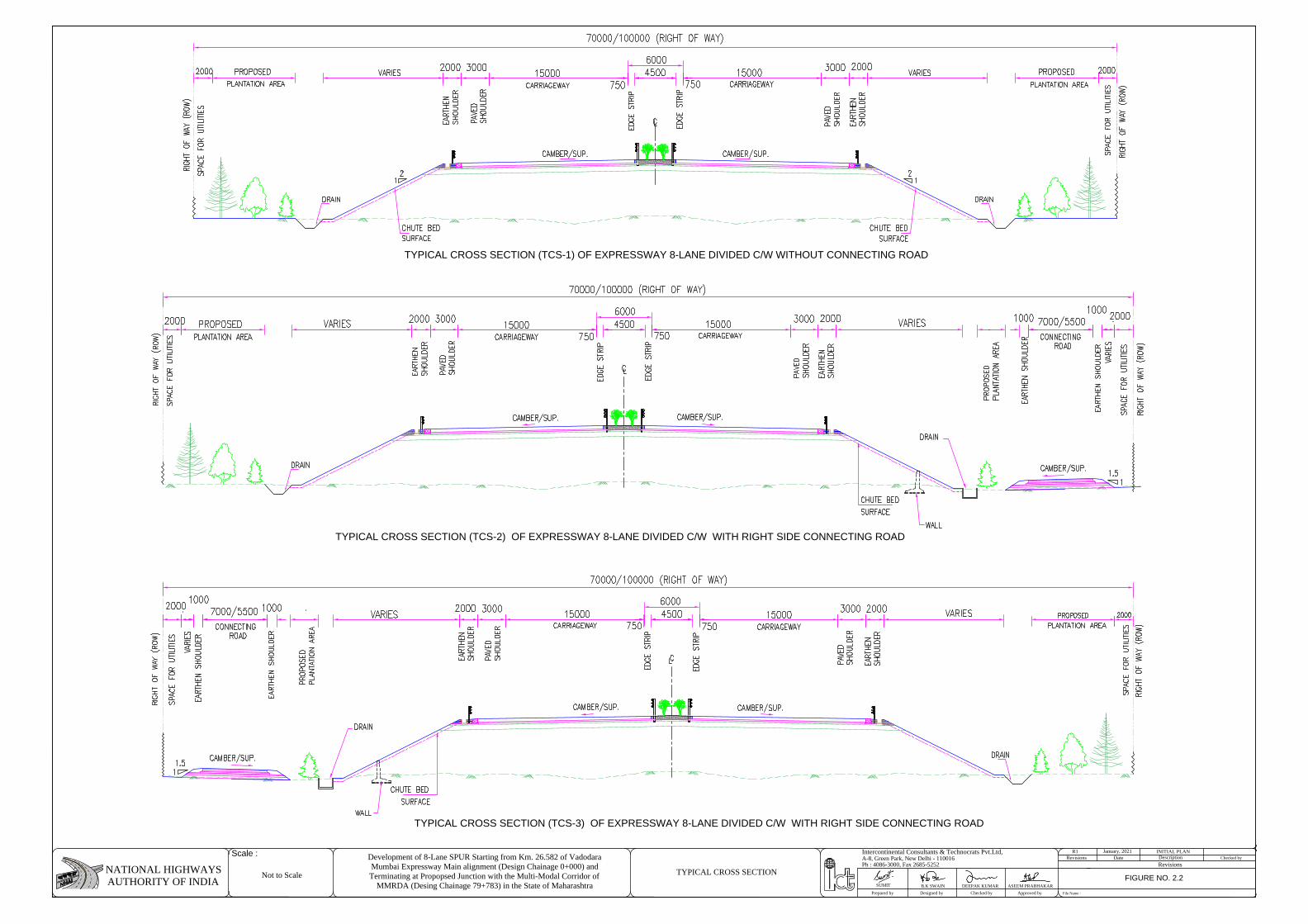
TYPICAL CROSS SECTION (TCS-1) OF EXPRESSWAY 8-LANE DIVIDED C/W WITHOUT CONNECTING ROAD
TYPICAL CROSS SECTION (TCS-2) OF EXPRESSWAY 8-LANE DIVIDED C/W WITH RIGHT SIDE CONNECTING ROAD
TYPICAL CROSS SECTION (TCS-3) OF EXPRESSWAY 8-LANE DIVIDED C/W WITH RIGHT SIDE CONNECTING ROAD
RevisionsPh : 4086-3000, Fax 2685-5252
Prepared by Designed by Checked by Approved by File Name :
A-8, Green Park, New Delhi - 110016Intercontinental Consultants & Technocrats Pvt.Ltd,
NATIONAL HIGHWAYSAUTHORITY OF INDIA DEEPAK KUMARB.K SWAIN ASEEM PRABHAKAR
R1DateRevisions
INITIAL PLANDescription Checked by
Scale : Development of 8-Lane SPUR Starting from Km. 26.582 of VadodaraMumbai Expressway Main alignment (Design Chainage 0+000) andTerminating at Propopsed Junction with the Multi-Modal Corridor of
MMRDA (Desing Chainage 79+783) in the State of Maharashtra
January, 2021
SUMIT
Not to ScaleFIGURE NO. 2.2
TYPICAL CROSS SECTION
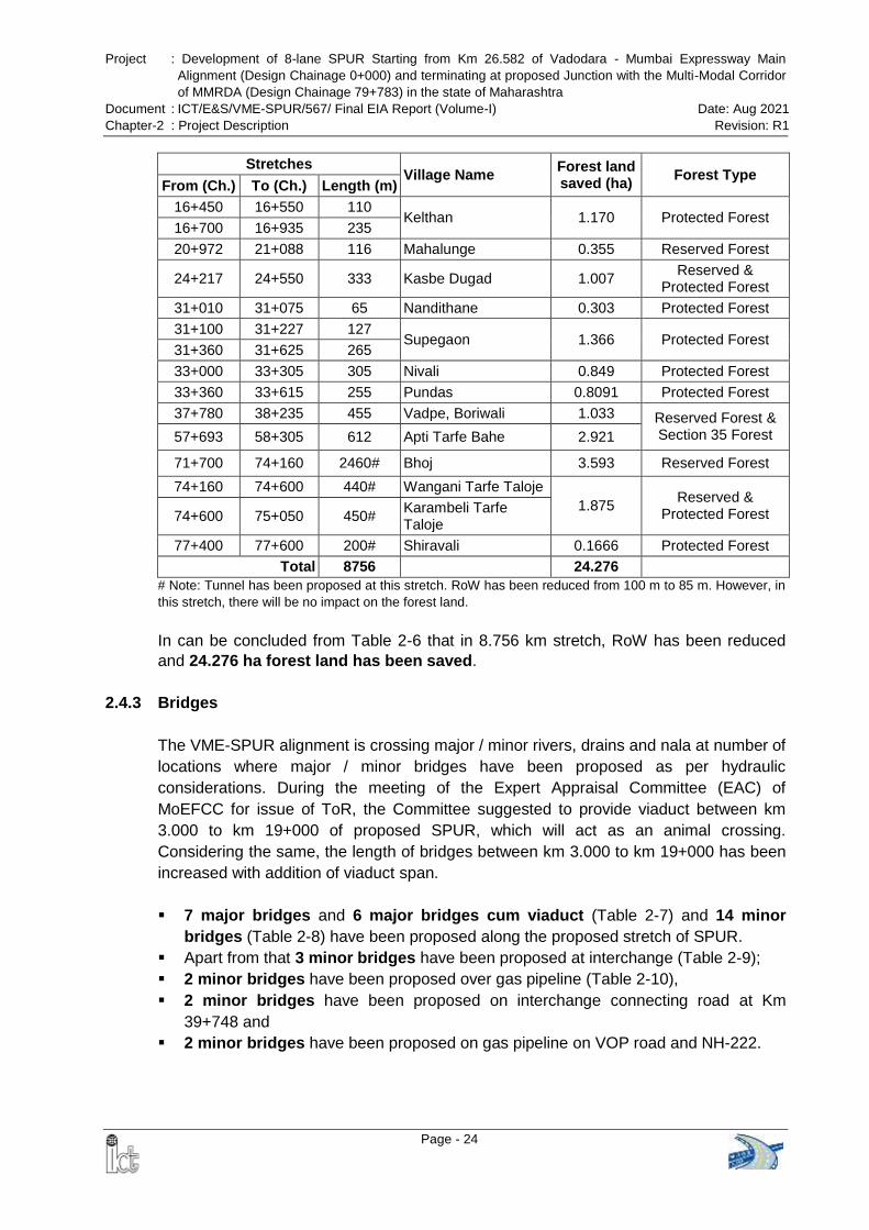
Project : Development of 8-lane SPUR Starting from Km 26.582 of Vadodara - Mumbai Expressway Main
Alignment (Design Chainage 0+000) and terminating at proposed Junction with the Multi-Modal Corridor
of MMRDA (Design Chainage 79+783) in the state of Maharashtra
Document : ICT/E&S/VME-SPUR/567/ Final EIA Report (Volume-I) Date: Aug 2021
Chapter-2 : Project Description Revision: R1
Page - 24
Stretches Village Name
Forest land saved (ha)
Forest Type From (Ch.) To (Ch.) Length (m)
16+450 16+550 110 Kelthan 1.170 Protected Forest
16+700 16+935 235
20+972 21+088 116 Mahalunge 0.355 Reserved Forest
24+217 24+550 333 Kasbe Dugad 1.007 Reserved &
Protected Forest
31+010 31+075 65 Nandithane 0.303 Protected Forest
31+100 31+227 127 Supegaon 1.366 Protected Forest
31+360 31+625 265
33+000 33+305 305 Nivali 0.849 Protected Forest
33+360 33+615 255 Pundas 0.8091 Protected Forest
37+780 38+235 455 Vadpe, Boriwali 1.033 Reserved Forest & Section 35 Forest 57+693 58+305 612 Apti Tarfe Bahe 2.921
71+700 74+160 2460# Bhoj 3.593 Reserved Forest
74+160 74+600 440# Wangani Tarfe Taloje
1.875 Reserved &
Protected Forest 74+600 75+050 450# Karambeli Tarfe Taloje
77+400 77+600 200# Shiravali 0.1666 Protected Forest
Total 8756
24.276
# Note: Tunnel has been proposed at this stretch. RoW has been reduced from 100 m to 85 m. However, in
this stretch, there will be no impact on the forest land.
In can be concluded from Table 2-6 that in 8.756 km stretch, RoW has been reduced
and 24.276 ha forest land has been saved.
2.4.3 Bridges
The VME-SPUR alignment is crossing major / minor rivers, drains and nala at number of
locations where major / minor bridges have been proposed as per hydraulic
considerations. During the meeting of the Expert Appraisal Committee (EAC) of
MoEFCC for issue of ToR, the Committee suggested to provide viaduct between km
3.000 to km 19+000 of proposed SPUR, which will act as an animal crossing.
Considering the same, the length of bridges between km 3.000 to km 19+000 has been
increased with addition of viaduct span.
7 major bridges and 6 major bridges cum viaduct (Table 2-7) and 14 minor
bridges (Table 2-8) have been proposed along the proposed stretch of SPUR.
Apart from that 3 minor bridges have been proposed at interchange (Table 2-9);
2 minor bridges have been proposed over gas pipeline (Table 2-10),
2 minor bridges have been proposed on interchange connecting road at Km
39+748 and
2 minor bridges have been proposed on gas pipeline on VOP road and NH-222.
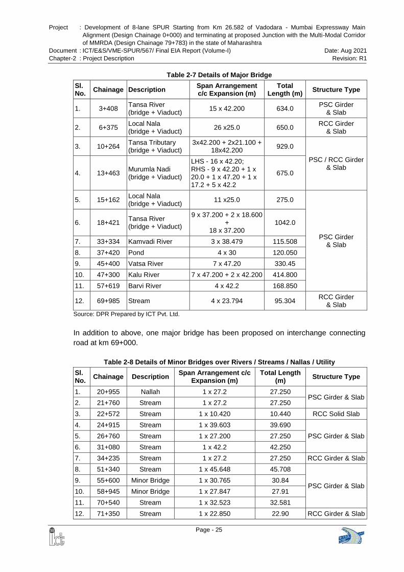
Project : Development of 8-lane SPUR Starting from Km 26.582 of Vadodara - Mumbai Expressway Main
Alignment (Design Chainage 0+000) and terminating at proposed Junction with the Multi-Modal Corridor
of MMRDA (Design Chainage 79+783) in the state of Maharashtra
Document : ICT/E&S/VME-SPUR/567/ Final EIA Report (Volume-I) Date: Aug 2021
Chapter-2 : Project Description Revision: R1
Page - 25
Table 2-7 Details of Major Bridge
Sl. No.
Chainage Description Span Arrangement c/c Expansion (m)
Total Length (m)
Structure Type
1. 3+408 Tansa River (bridge + Viaduct)
15 x 42.200 634.0 PSC Girder
& Slab
2. 6+375 Local Nala (bridge + Viaduct)
26 x25.0 650.0 RCC Girder
& Slab
3. 10+264 Tansa Tributary (bridge + Viaduct)
3x42.200 + 2x21.100 + 18x42.200
929.0
PSC / RCC Girder & Slab
4. 13+463 Murumla Nadi (bridge + Viaduct)
LHS - 16 x 42.20; RHS - 9 x 42.20 + 1 x 20.0 + 1 x 47.20 + 1 x 17.2 + 5 x 42.2
675.0
5. 15+162 Local Nala (bridge + Viaduct)
11 x25.0 275.0
PSC Girder & Slab
6. 18+421 Tansa River (bridge + Viaduct)
9 x 37.200 + 2 x 18.600 +
18 x 37.200 1042.0
7. 33+334 Kamvadi River 3 x 38.479 115.508
8. 37+420 Pond 4 x 30 120.050
9. 45+400 Vatsa River 7 x 47.20 330.45
10. 47+300 Kalu River 7 x 47.200 + 2 x 42.200 414.800
11. 57+619 Barvi River 4 x 42.2 168.850
12. 69+985 Stream 4 x 23.794 95.304 RCC Girder
& Slab
Source: DPR Prepared by ICT Pvt. Ltd.
In addition to above, one major bridge has been proposed on interchange connecting
road at km 69+000.
Table 2-8 Details of Minor Bridges over Rivers / Streams / Nallas / Utility
Sl. No.
Chainage Description Span Arrangement c/c
Expansion (m) Total Length
(m) Structure Type
1. 20+955 Nallah 1 x 27.2 27.250 PSC Girder & Slab
2. 21+760 Stream 1 x 27.2 27.250
3. 22+572 Stream 1 x 10.420 10.440 RCC Solid Slab
4. 24+915 Stream 1 x 39.603 39.690
PSC Girder & Slab 5. 26+760 Stream 1 x 27.200 27.250
6. 31+080 Stream 1 x 42.2 42.250
7. 34+235 Stream 1 x 27.2 27.250 RCC Girder & Slab
8. 51+340 Stream 1 x 45.648 45.708
PSC Girder & Slab 9. 55+600 Minor Bridge 1 x 30.765 30.84
10. 58+945 Minor Bridge 1 x 27.847 27.91
11. 70+540 Stream 1 x 32.523 32.581
12. 71+350 Stream 1 x 22.850 22.90 RCC Girder & Slab
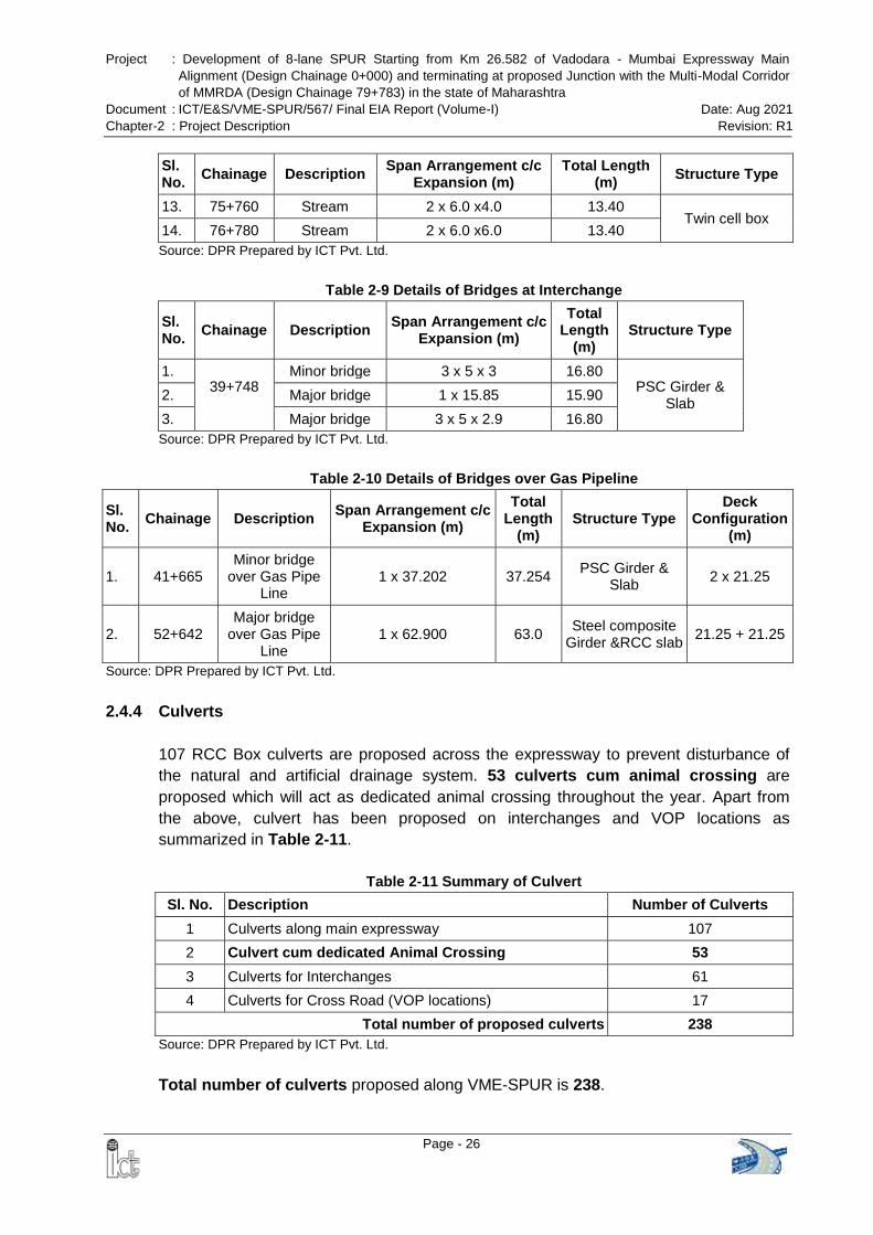
Project : Development of 8-lane SPUR Starting from Km 26.582 of Vadodara - Mumbai Expressway Main
Alignment (Design Chainage 0+000) and terminating at proposed Junction with the Multi-Modal Corridor
of MMRDA (Design Chainage 79+783) in the state of Maharashtra
Document : ICT/E&S/VME-SPUR/567/ Final EIA Report (Volume-I) Date: Aug 2021
Chapter-2 : Project Description Revision: R1
Page - 26
Sl. No.
Chainage Description Span Arrangement c/c
Expansion (m) Total Length
(m) Structure Type
13. 75+760 Stream 2 x 6.0 x4.0 13.40 Twin cell box
14. 76+780 Stream 2 x 6.0 x6.0 13.40
Source: DPR Prepared by ICT Pvt. Ltd.
Table 2-9 Details of Bridges at Interchange
Sl. No.
Chainage Description Span Arrangement c/c
Expansion (m)
Total Length
(m) Structure Type
1. 39+748
Minor bridge 3 x 5 x 3 16.80 PSC Girder &
Slab 2. Major bridge 1 x 15.85 15.90
3. Major bridge 3 x 5 x 2.9 16.80
Source: DPR Prepared by ICT Pvt. Ltd.
Table 2-10 Details of Bridges over Gas Pipeline
Sl. No.
Chainage Description Span Arrangement c/c
Expansion (m)
Total Length
(m) Structure Type
Deck Configuration
(m)
1. 41+665 Minor bridge
over Gas Pipe Line
1 x 37.202 37.254 PSC Girder &
Slab 2 x 21.25
2. 52+642 Major bridge
over Gas Pipe Line
1 x 62.900 63.0 Steel composite
Girder &RCC slab 21.25 + 21.25
Source: DPR Prepared by ICT Pvt. Ltd.
2.4.4 Culverts
107 RCC Box culverts are proposed across the expressway to prevent disturbance of
the natural and artificial drainage system. 53 culverts cum animal crossing are
proposed which will act as dedicated animal crossing throughout the year. Apart from
the above, culvert has been proposed on interchanges and VOP locations as
summarized in Table 2-11.
Table 2-11 Summary of Culvert
Sl. No. Description Number of Culverts
1 Culverts along main expressway 107
2 Culvert cum dedicated Animal Crossing 53
3 Culverts for Interchanges 61
4 Culverts for Cross Road (VOP locations) 17
Total number of proposed culverts 238
Source: DPR Prepared by ICT Pvt. Ltd.
Total number of culverts proposed along VME-SPUR is 238.
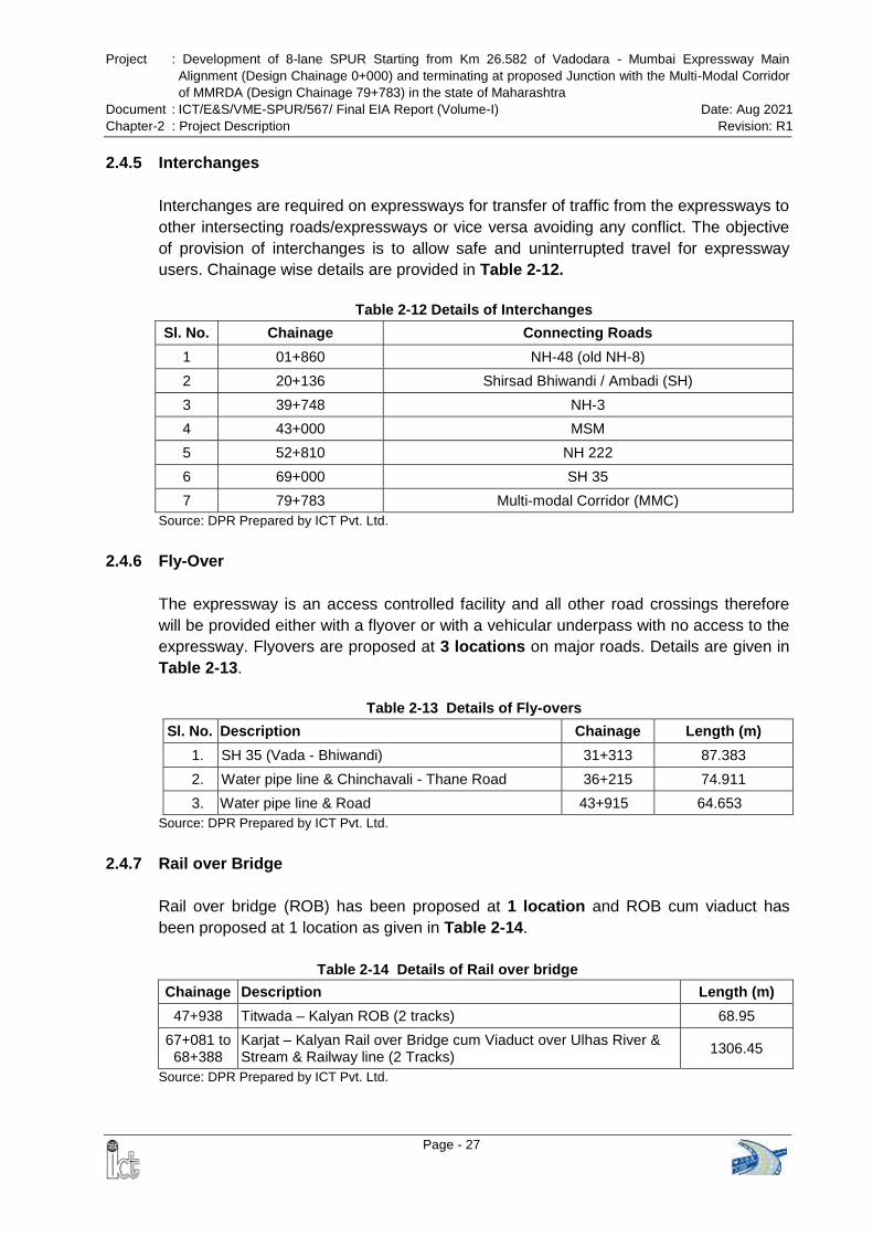
Project : Development of 8-lane SPUR Starting from Km 26.582 of Vadodara - Mumbai Expressway Main
Alignment (Design Chainage 0+000) and terminating at proposed Junction with the Multi-Modal Corridor
of MMRDA (Design Chainage 79+783) in the state of Maharashtra
Document : ICT/E&S/VME-SPUR/567/ Final EIA Report (Volume-I) Date: Aug 2021
Chapter-2 : Project Description Revision: R1
Page - 27
2.4.5 Interchanges
Interchanges are required on expressways for transfer of traffic from the expressways to
other intersecting roads/expressways or vice versa avoiding any conflict. The objective
of provision of interchanges is to allow safe and uninterrupted travel for expressway
users. Chainage wise details are provided in Table 2-12.
Table 2-12 Details of Interchanges
Sl. No. Chainage Connecting Roads
1 01+860 NH-48 (old NH-8)
2 20+136 Shirsad Bhiwandi / Ambadi (SH)
3 39+748 NH-3
4 43+000 MSM
5 52+810 NH 222
6 69+000 SH 35
7 79+783 Multi-modal Corridor (MMC)
Source: DPR Prepared by ICT Pvt. Ltd.
2.4.6 Fly-Over
The expressway is an access controlled facility and all other road crossings therefore
will be provided either with a flyover or with a vehicular underpass with no access to the
expressway. Flyovers are proposed at 3 locations on major roads. Details are given in
Table 2-13.
Table 2-13 Details of Fly-overs
Sl. No. Description Chainage Length (m)
1. SH 35 (Vada - Bhiwandi) 31+313 87.383
2. Water pipe line & Chinchavali - Thane Road 36+215 74.911
3. Water pipe line & Road 43+915 64.653
Source: DPR Prepared by ICT Pvt. Ltd.
2.4.7 Rail over Bridge
Rail over bridge (ROB) has been proposed at 1 location and ROB cum viaduct has
been proposed at 1 location as given in Table 2-14.
Table 2-14 Details of Rail over bridge
Chainage Description Length (m)
47+938 Titwada – Kalyan ROB (2 tracks) 68.95
67+081 to 68+388
Karjat – Kalyan Rail over Bridge cum Viaduct over Ulhas River & Stream & Railway line (2 Tracks)
1306.45
Source: DPR Prepared by ICT Pvt. Ltd.
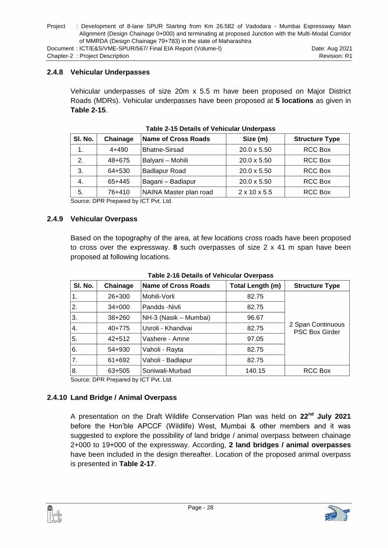
Project : Development of 8-lane SPUR Starting from Km 26.582 of Vadodara - Mumbai Expressway Main
Alignment (Design Chainage 0+000) and terminating at proposed Junction with the Multi-Modal Corridor
of MMRDA (Design Chainage 79+783) in the state of Maharashtra
Document : ICT/E&S/VME-SPUR/567/ Final EIA Report (Volume-I) Date: Aug 2021
Chapter-2 : Project Description Revision: R1
Page - 28
2.4.8 Vehicular Underpasses
Vehicular underpasses of size 20m x 5.5 m have been proposed on Major District
Roads (MDRs). Vehicular underpasses have been proposed at 5 locations as given in
Table 2-15.
Table 2-15 Details of Vehicular Underpass
Sl. No. Chainage Name of Cross Roads Size (m) Structure Type
1. 4+490 Bhatne-Sirsad 20.0 x 5.50 RCC Box
2. 48+675 Balyani – Mohili 20.0 x 5.50 RCC Box
3. 64+530 Badlapur Road 20.0 x 5.50 RCC Box
4. 65+445 Bagani – Badlapur 20.0 x 5.50 RCC Box
5. 76+410 NAINA Master plan road 2 x 10 x 5.5 RCC Box
Source: DPR Prepared by ICT Pvt. Ltd.
2.4.9 Vehicular Overpass
Based on the topography of the area, at few locations cross roads have been proposed
to cross over the expressway. 8 such overpasses of size 2 x 41 m span have been
proposed at following locations.
Table 2-16 Details of Vehicular Overpass
Sl. No. Chainage Name of Cross Roads Total Length (m) Structure Type
1. 26+300 Mohili-Vorli 82.75
2 Span Continuous PSC Box Girder
2. 34+000 Pandds -Nivli 82.75
3. 38+260 NH-3 (Nasik – Mumbai) 96.67
4. 40+775 Usroli - Khandvai 82.75
5. 42+512 Vashere - Amne 97.05
6. 54+930 Vaholi - Rayta 82.75
7. 61+692 Vaholi - Badlapur 82.75
8. 63+505 Soniwali-Murbad 140.15 RCC Box
Source: DPR Prepared by ICT Pvt. Ltd.
2.4.10 Land Bridge / Animal Overpass
A presentation on the Draft Wildlife Conservation Plan was held on 22nd July 2021
before the Hon’ble APCCF (Wildlife) West, Mumbai & other members and it was
suggested to explore the possibility of land bridge / animal overpass between chainage
2+000 to 19+000 of the expressway. According, 2 land bridges / animal overpasses
have been included in the design thereafter. Location of the proposed animal overpass
is presented in Table 2-17.
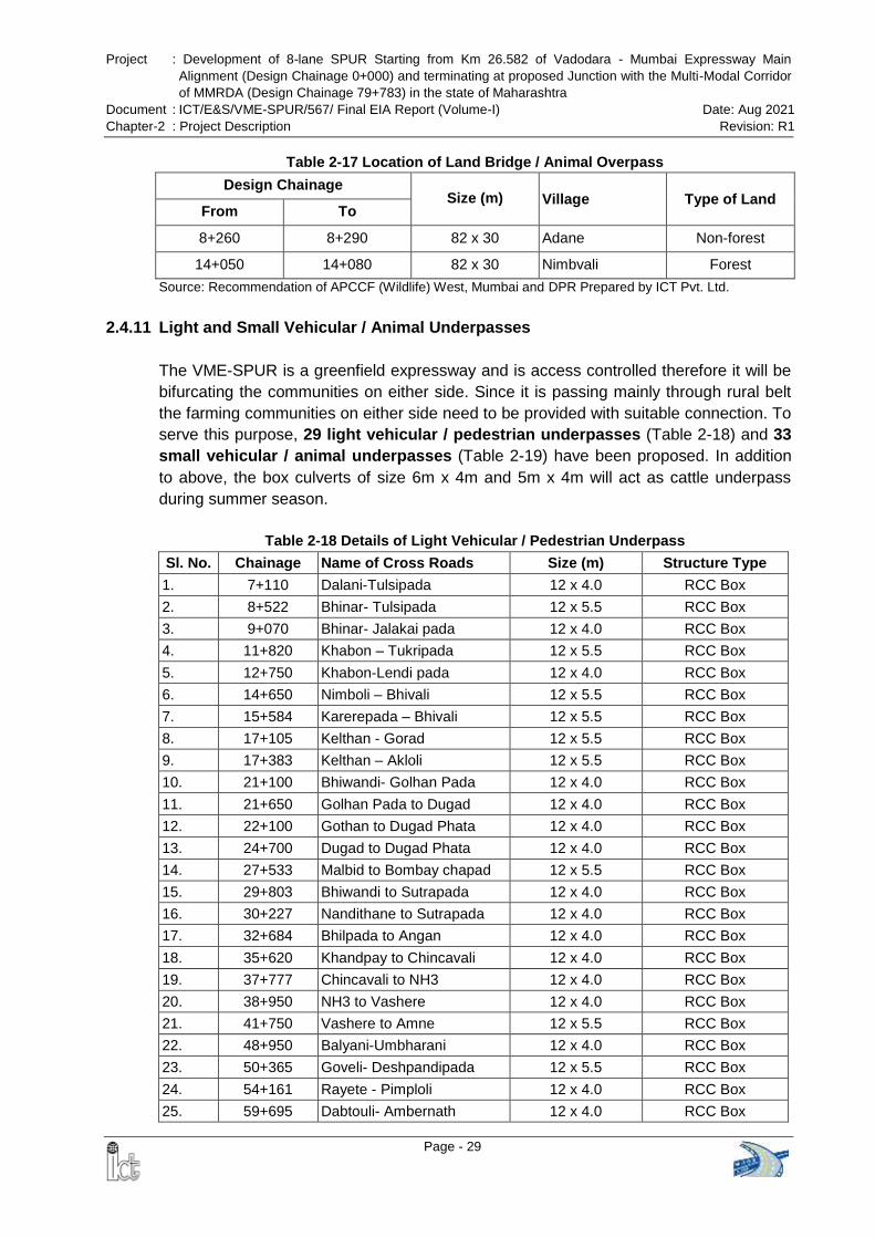
Project : Development of 8-lane SPUR Starting from Km 26.582 of Vadodara - Mumbai Expressway Main
Alignment (Design Chainage 0+000) and terminating at proposed Junction with the Multi-Modal Corridor
of MMRDA (Design Chainage 79+783) in the state of Maharashtra
Document : ICT/E&S/VME-SPUR/567/ Final EIA Report (Volume-I) Date: Aug 2021
Chapter-2 : Project Description Revision: R1
Page - 29
Table 2-17 Location of Land Bridge / Animal Overpass
Design Chainage Size (m) Village Type of Land
From To
8+260 8+290 82 x 30 Adane Non-forest
14+050 14+080 82 x 30 Nimbvali Forest
Source: Recommendation of APCCF (Wildlife) West, Mumbai and DPR Prepared by ICT Pvt. Ltd.
2.4.11 Light and Small Vehicular / Animal Underpasses
The VME-SPUR is a greenfield expressway and is access controlled therefore it will be
bifurcating the communities on either side. Since it is passing mainly through rural belt
the farming communities on either side need to be provided with suitable connection. To
serve this purpose, 29 light vehicular / pedestrian underpasses (Table 2-18) and 33
small vehicular / animal underpasses (Table 2-19) have been proposed. In addition
to above, the box culverts of size 6m x 4m and 5m x 4m will act as cattle underpass
during summer season.
Table 2-18 Details of Light Vehicular / Pedestrian Underpass
Sl. No. Chainage Name of Cross Roads Size (m) Structure Type
1. 7+110 Dalani-Tulsipada 12 x 4.0 RCC Box
2. 8+522 Bhinar- Tulsipada 12 x 5.5 RCC Box
3. 9+070 Bhinar- Jalakai pada 12 x 4.0 RCC Box
4. 11+820 Khabon – Tukripada 12 x 5.5 RCC Box
5. 12+750 Khabon-Lendi pada 12 x 4.0 RCC Box
6. 14+650 Nimboli – Bhivali 12 x 5.5 RCC Box
7. 15+584 Karerepada – Bhivali 12 x 5.5 RCC Box
8. 17+105 Kelthan - Gorad 12 x 5.5 RCC Box
9. 17+383 Kelthan – Akloli 12 x 5.5 RCC Box
10. 21+100 Bhiwandi- Golhan Pada 12 x 4.0 RCC Box
11. 21+650 Golhan Pada to Dugad 12 x 4.0 RCC Box
12. 22+100 Gothan to Dugad Phata 12 x 4.0 RCC Box
13. 24+700 Dugad to Dugad Phata 12 x 4.0 RCC Box
14. 27+533 Malbid to Bombay chapad 12 x 5.5 RCC Box
15. 29+803 Bhiwandi to Sutrapada 12 x 4.0 RCC Box
16. 30+227 Nandithane to Sutrapada 12 x 4.0 RCC Box
17. 32+684 Bhilpada to Angan 12 x 4.0 RCC Box
18. 35+620 Khandpay to Chincavali 12 x 4.0 RCC Box
19. 37+777 Chincavali to NH3 12 x 4.0 RCC Box
20. 38+950 NH3 to Vashere 12 x 4.0 RCC Box
21. 41+750 Vashere to Amne 12 x 5.5 RCC Box
22. 48+950 Balyani-Umbharani 12 x 4.0 RCC Box
23. 50+365 Goveli- Deshpandipada 12 x 5.5 RCC Box
24. 54+161 Rayete - Pimploli 12 x 4.0 RCC Box
25. 59+695 Dabtouli- Ambernath 12 x 4.0 RCC Box
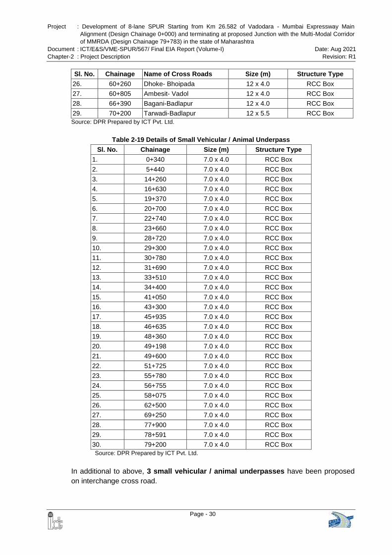
Project : Development of 8-lane SPUR Starting from Km 26.582 of Vadodara - Mumbai Expressway Main
Alignment (Design Chainage 0+000) and terminating at proposed Junction with the Multi-Modal Corridor
of MMRDA (Design Chainage 79+783) in the state of Maharashtra
Document : ICT/E&S/VME-SPUR/567/ Final EIA Report (Volume-I) Date: Aug 2021
Chapter-2 : Project Description Revision: R1
Page - 30
Sl. No. Chainage Name of Cross Roads Size (m) Structure Type
26. 60+260 Dhoke- Bhoipada 12 x 4.0 RCC Box
27. 60+805 Ambesit- Vadol 12 x 4.0 RCC Box
28. 66+390 Bagani-Badlapur 12 x 4.0 RCC Box
29. 70+200 Tarwadi-Badlapur 12 x 5.5 RCC Box
Source: DPR Prepared by ICT Pvt. Ltd.
Table 2-19 Details of Small Vehicular / Animal Underpass
Sl. No. Chainage Size (m) Structure Type
1. 0+340 7.0 x 4.0 RCC Box
2. 5+440 7.0 x 4.0 RCC Box
3. 14+260 7.0 x 4.0 RCC Box
4. 16+630 7.0 x 4.0 RCC Box
5. 19+370 7.0 x 4.0 RCC Box
6. 20+700 7.0 x 4.0 RCC Box
7. 22+740 7.0 x 4.0 RCC Box
8. 23+660 7.0 x 4.0 RCC Box
9. 28+720 7.0 x 4.0 RCC Box
10. 29+300 7.0 x 4.0 RCC Box
11. 30+780 7.0 x 4.0 RCC Box
12. 31+690 7.0 x 4.0 RCC Box
13. 33+510 7.0 x 4.0 RCC Box
14. 34+400 7.0 x 4.0 RCC Box
15. 41+050 7.0 x 4.0 RCC Box
16. 43+300 7.0 x 4.0 RCC Box
17. 45+935 7.0 x 4.0 RCC Box
18. 46+635 7.0 x 4.0 RCC Box
19. 48+360 7.0 x 4.0 RCC Box
20. 49+198 7.0 x 4.0 RCC Box
21. 49+600 7.0 x 4.0 RCC Box
22. 51+725 7.0 x 4.0 RCC Box
23. 55+780 7.0 x 4.0 RCC Box
24. 56+755 7.0 x 4.0 RCC Box
25. 58+075 7.0 x 4.0 RCC Box
26. 62+500 7.0 x 4.0 RCC Box
27. 69+250 7.0 x 4.0 RCC Box
28. 77+900 7.0 x 4.0 RCC Box
29. 78+591 7.0 x 4.0 RCC Box
30. 79+200 7.0 x 4.0 RCC Box
Source: DPR Prepared by ICT Pvt. Ltd.
In additional to above, 3 small vehicular / animal underpasses have been proposed
on interchange cross road.
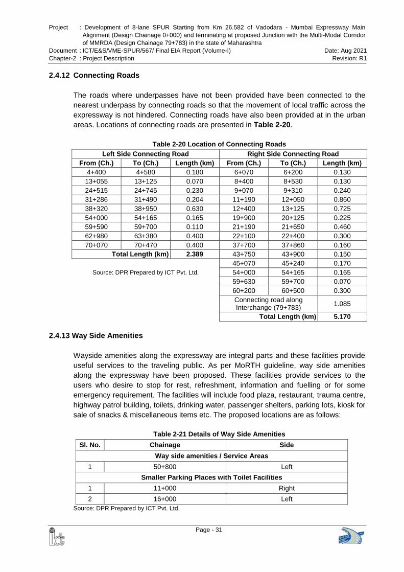
Project : Development of 8-lane SPUR Starting from Km 26.582 of Vadodara - Mumbai Expressway Main
Alignment (Design Chainage 0+000) and terminating at proposed Junction with the Multi-Modal Corridor
of MMRDA (Design Chainage 79+783) in the state of Maharashtra
Document : ICT/E&S/VME-SPUR/567/ Final EIA Report (Volume-I) Date: Aug 2021
Chapter-2 : Project Description Revision: R1
Page - 31
2.4.12 Connecting Roads
The roads where underpasses have not been provided have been connected to the
nearest underpass by connecting roads so that the movement of local traffic across the
expressway is not hindered. Connecting roads have also been provided at in the urban
areas. Locations of connecting roads are presented in Table 2-20.
Table 2-20 Location of Connecting Roads
Left Side Connecting Road Right Side Connecting Road
From (Ch.) To (Ch.) Length (km) From (Ch.) To (Ch.) Length (km)
4+400 4+580 0.180 6+070 6+200 0.130
13+055 13+125 0.070 8+400 8+530 0.130
24+515 24+745 0.230 9+070 9+310 0.240
31+286 31+490 0.204 11+190 12+050 0.860
38+320 38+950 0.630 12+400 13+125 0.725
54+000 54+165 0.165 19+900 20+125 0.225
59+590 59+700 0.110 21+190 21+650 0.460
62+980 63+380 0.400 22+100 22+400 0.300
70+070 70+470 0.400 37+700 37+860 0.160
Total Length (km) 2.389 43+750 43+900 0.150
45+070 45+240 0.170
Source: DPR Prepared by ICT Pvt. Ltd. 54+000 54+165 0.165
59+630 59+700 0.070
60+200 60+500 0.300
Connecting road along Interchange (79+783)
1.085
Total Length (km) 5.170
2.4.13 Way Side Amenities
Wayside amenities along the expressway are integral parts and these facilities provide
useful services to the traveling public. As per MoRTH guideline, way side amenities
along the expressway have been proposed. These facilities provide services to the
users who desire to stop for rest, refreshment, information and fuelling or for some
emergency requirement. The facilities will include food plaza, restaurant, trauma centre,
highway patrol building, toilets, drinking water, passenger shelters, parking lots, kiosk for
sale of snacks & miscellaneous items etc. The proposed locations are as follows:
Table 2-21 Details of Way Side Amenities
Sl. No. Chainage Side
Way side amenities / Service Areas
1 50+800 Left
Smaller Parking Places with Toilet Facilities
1 11+000 Right
2 16+000 Left
Source: DPR Prepared by ICT Pvt. Ltd.
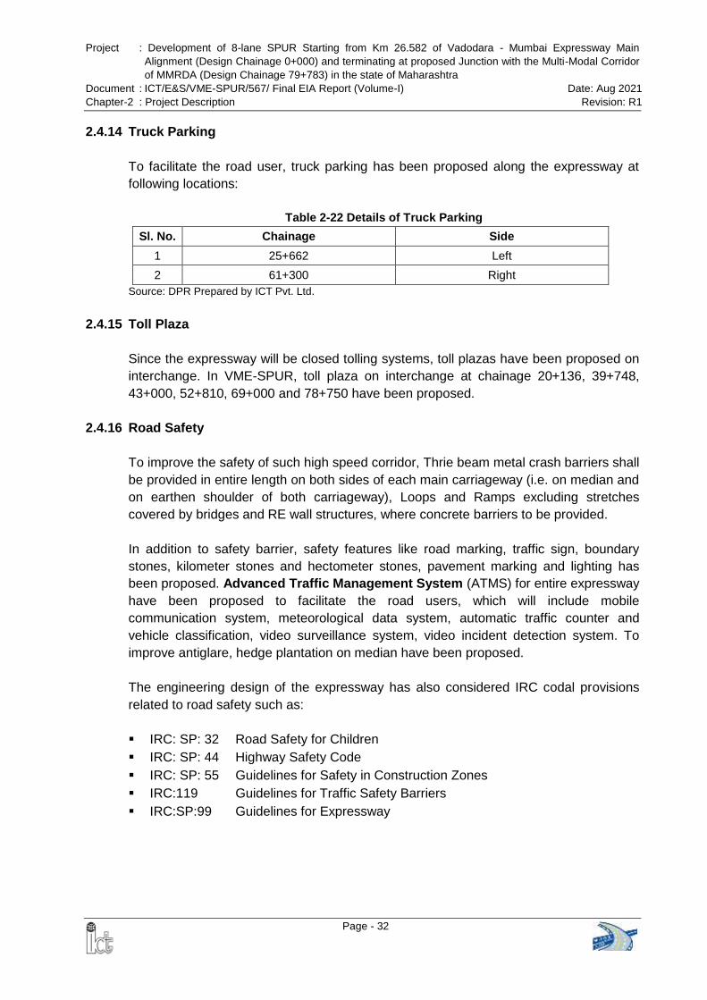
Project : Development of 8-lane SPUR Starting from Km 26.582 of Vadodara - Mumbai Expressway Main
Alignment (Design Chainage 0+000) and terminating at proposed Junction with the Multi-Modal Corridor
of MMRDA (Design Chainage 79+783) in the state of Maharashtra
Document : ICT/E&S/VME-SPUR/567/ Final EIA Report (Volume-I) Date: Aug 2021
Chapter-2 : Project Description Revision: R1
Page - 32
2.4.14 Truck Parking
To facilitate the road user, truck parking has been proposed along the expressway at
following locations:
Table 2-22 Details of Truck Parking
Sl. No. Chainage Side
1 25+662 Left
2 61+300 Right
Source: DPR Prepared by ICT Pvt. Ltd.
2.4.15 Toll Plaza
Since the expressway will be closed tolling systems, toll plazas have been proposed on
interchange. In VME-SPUR, toll plaza on interchange at chainage 20+136, 39+748,
43+000, 52+810, 69+000 and 78+750 have been proposed.
2.4.16 Road Safety
To improve the safety of such high speed corridor, Thrie beam metal crash barriers shall
be provided in entire length on both sides of each main carriageway (i.e. on median and
on earthen shoulder of both carriageway), Loops and Ramps excluding stretches
covered by bridges and RE wall structures, where concrete barriers to be provided.
In addition to safety barrier, safety features like road marking, traffic sign, boundary
stones, kilometer stones and hectometer stones, pavement marking and lighting has
been proposed. Advanced Traffic Management System (ATMS) for entire expressway
have been proposed to facilitate the road users, which will include mobile
communication system, meteorological data system, automatic traffic counter and
vehicle classification, video surveillance system, video incident detection system. To
improve antiglare, hedge plantation on median have been proposed.
The engineering design of the expressway has also considered IRC codal provisions
related to road safety such as:
IRC: SP: 32 Road Safety for Children
IRC: SP: 44 Highway Safety Code
IRC: SP: 55 Guidelines for Safety in Construction Zones
IRC:119 Guidelines for Traffic Safety Barriers
IRC:SP:99 Guidelines for Expressway
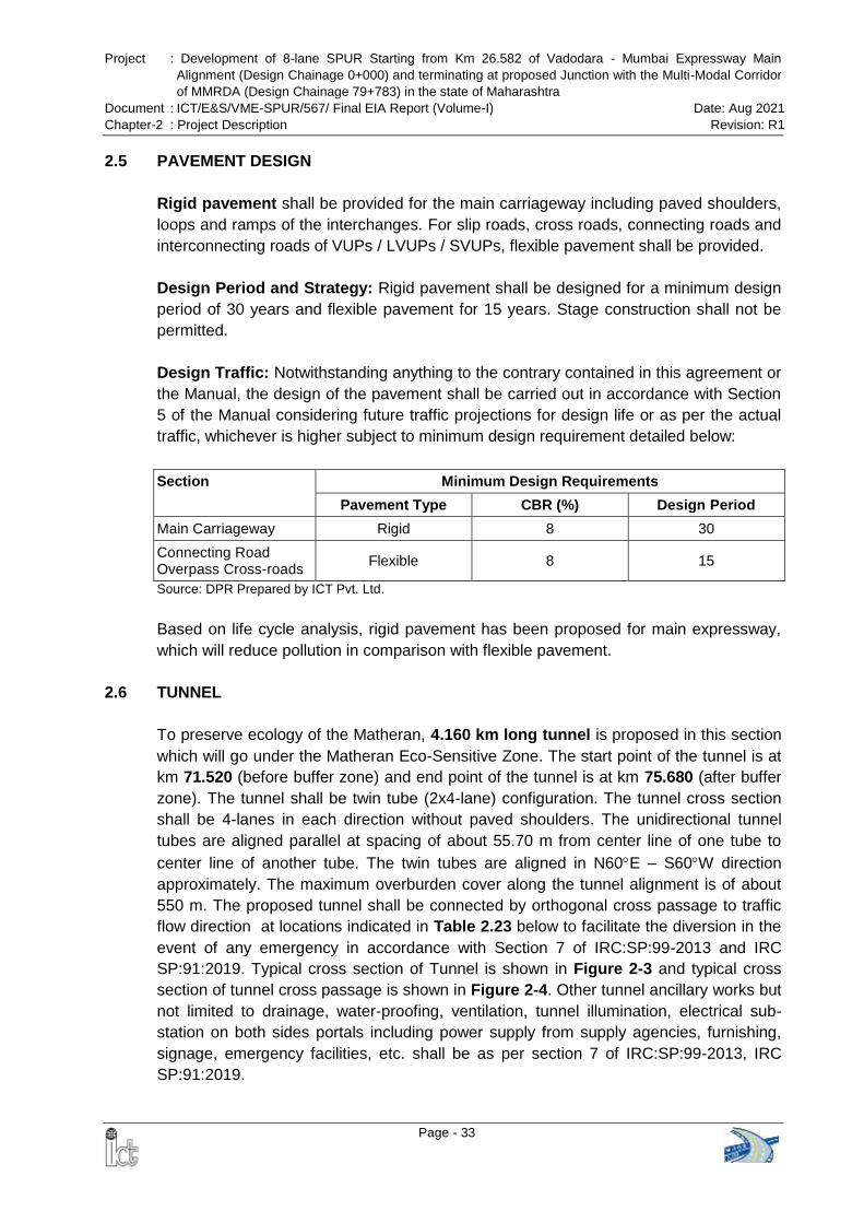
Project : Development of 8-lane SPUR Starting from Km 26.582 of Vadodara - Mumbai Expressway Main
Alignment (Design Chainage 0+000) and terminating at proposed Junction with the Multi-Modal Corridor
of MMRDA (Design Chainage 79+783) in the state of Maharashtra
Document : ICT/E&S/VME-SPUR/567/ Final EIA Report (Volume-I) Date: Aug 2021
Chapter-2 : Project Description Revision: R1
Page - 33
2.5 PAVEMENT DESIGN
Rigid pavement shall be provided for the main carriageway including paved shoulders,
loops and ramps of the interchanges. For slip roads, cross roads, connecting roads and
interconnecting roads of VUPs / LVUPs / SVUPs, flexible pavement shall be provided.
Design Period and Strategy: Rigid pavement shall be designed for a minimum design
period of 30 years and flexible pavement for 15 years. Stage construction shall not be
permitted.
Design Traffic: Notwithstanding anything to the contrary contained in this agreement or
the Manual, the design of the pavement shall be carried out in accordance with Section
5 of the Manual considering future traffic projections for design life or as per the actual
traffic, whichever is higher subject to minimum design requirement detailed below:
Section Minimum Design Requirements
Pavement Type CBR (%) Design Period
Main Carriageway Rigid 8 30
Connecting Road Overpass Cross-roads
Flexible 8 15
Source: DPR Prepared by ICT Pvt. Ltd.
Based on life cycle analysis, rigid pavement has been proposed for main expressway,
which will reduce pollution in comparison with flexible pavement.
2.6 TUNNEL
To preserve ecology of the Matheran, 4.160 km long tunnel is proposed in this section
which will go under the Matheran Eco-Sensitive Zone. The start point of the tunnel is at
km 71.520 (before buffer zone) and end point of the tunnel is at km 75.680 (after buffer
zone). The tunnel shall be twin tube (2x4-lane) configuration. The tunnel cross section
shall be 4-lanes in each direction without paved shoulders. The unidirectional tunnel
tubes are aligned parallel at spacing of about 55.70 m from center line of one tube to
center line of another tube. The twin tubes are aligned in N60E – S60W direction
approximately. The maximum overburden cover along the tunnel alignment is of about
550 m. The proposed tunnel shall be connected by orthogonal cross passage to traffic
flow direction at locations indicated in Table 2.23 below to facilitate the diversion in the
event of any emergency in accordance with Section 7 of IRC:SP:99-2013 and IRC
SP:91:2019. Typical cross section of Tunnel is shown in Figure 2-3 and typical cross
section of tunnel cross passage is shown in Figure 2-4. Other tunnel ancillary works but
not limited to drainage, water-proofing, ventilation, tunnel illumination, electrical sub-
station on both sides portals including power supply from supply agencies, furnishing,
signage, emergency facilities, etc. shall be as per section 7 of IRC:SP:99-2013, IRC
SP:91:2019.
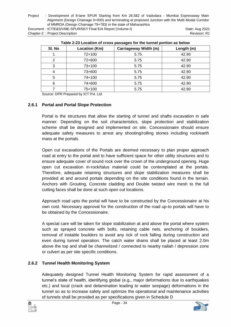
Project : Development of 8-lane SPUR Starting from Km 26.582 of Vadodara - Mumbai Expressway Main
Alignment (Design Chainage 0+000) and terminating at proposed Junction with the Multi-Modal Corridor
of MMRDA (Design Chainage 79+783) in the state of Maharashtra
Document : ICT/E&S/VME-SPUR/567/ Final EIA Report (Volume-I) Date: Aug 2021
Chapter-2 : Project Description Revision: R1
Page - 34
Table 2-23 Location of cross passages for the tunnel portion as below
Sl. No Location (Km) Carriageway Width (m) Length (m)
1 72+100 5.75 42.90
2 72+600 5.75 42.90
3 73+100 5.75 42.90
4 73+600 5.75 42.90
5 74+100 5.75 42.90
6 74+600 5.75 42.90
7 75+100 5.75 42.90
Source: DPR Prepared by ICT Pvt. Ltd.
2.6.1 Portal and Portal Slope Protection
Portal is the structures that allow the starting of tunnel and shafts excavation in safe
manner. Depending on the soil characteristics, slope protection and stabilization
scheme shall be designed and implemented on site. Concessionaire should ensure
adequate safety measures to arrest any shooting/rolling stones including rock/earth
mass at the portals.
Open cut excavations of the Portals are deemed necessary to plan proper approach
road at entry to the portal and to have sufficient space for other utility structures and to
ensure adequate cover of sound rock over the crown of the underground opening. Huge
open cut excavation in-rock/talus material could be contemplated at the portals.
Therefore, adequate retaining structures and slope stabilization measures shall be
provided at and around portals depending on the site conditions found in the terrain.
Anchors with Grouting, Concrete cladding and Double twisted wire mesh to the full
cutting faces shall be done at such open cut locations.
Approach road upto the portal will have to be constructed by the Concessionaire at his
own cost. Necessary approval for the construction of the road up-to portals will have to
be obtained by the Concessionaire.
A special care will be taken for slope stabilization at and above the portal where system
such as sprayed concrete with bolts, retaining cable nets, anchoring of boulders,
removal of instable boulders to avoid any rick of rock falling during construction and
even during tunnel operation. The catch water drains shall be placed at least 2.0m
above the top and shall be channelized / connected to nearby nallah / depression zone
or culvert as per site specific conditions.
2.6.2 Tunnel Health Monitoring System
Adequately designed Tunnel Health Monitoring System for rapid assessment of a
tunnel’s state of health, identifying global (e.g., major deformations due to earthquakes
etc.) and local (crack and delamination leading to water seepage) deformations in the
tunnel so as to increase safety and optimize the operational and maintenance activities
of tunnels shall be provided as per specifications given in Schedule D
Project : Development of 8-lane SPUR Starting from Km 26.582 of Vadodara - Mumbai Expressway Main
Alignment (Design Chainage 0+000) and terminating at proposed Junction with the Multi-Modal Corridor
of MMRDA (Design Chainage 79+783) in the state of Maharashtra
Document : ICT/E&S/VME-SPUR/567/ Final EIA Report (Volume-I) Date: Aug 2021
Chapter-2 : Project Description Revision: R1
Page - 35
Tunnel Wall Painting: The inner surface of tunnel tubes shall be painted with florescent
paint to improve the Aesthetic view of tunnel portal.
2.6.3 Muck Dump Disposal
The proposed project would involve a number of civil engineering activities leading to
production of large quantities of muck. The Concessionaire will have to present a Muck
Disposal Plan according to the applicable rules and regulations of Government of
Maharashtra and Government of India. The excavated material available from
excavation (tunnel, etc.) can be used by the Concessionaire for the construction of
project related works provided it meets the standards and specifications as defined in
the bid document and after payments of all applicable royalties and levies including
taxes on excavated material as per Government of Maharashtra and Government of
India rules and regulations. The proposed Muck Disposal Plan must indicate the
expected quantities of muck materials, the reusable expected quantities and the
volumes of material that will need to be relocated and dumped.
The Concessionaire shall also have to identify the suitable area in or around the project
site, as directed by authority, at his own cost to relocate and dump the excess material,
if any, in the way to avoid any negative impact on terrestrial and aquatic environment.
The excess excavated material shall be property of the Authority. For stabilization of
dumped material engineering and/or phyto-remedial measures must be proposed by the
Concessionaire, with individual plans and cross sections for any muck disposable area
proposed.
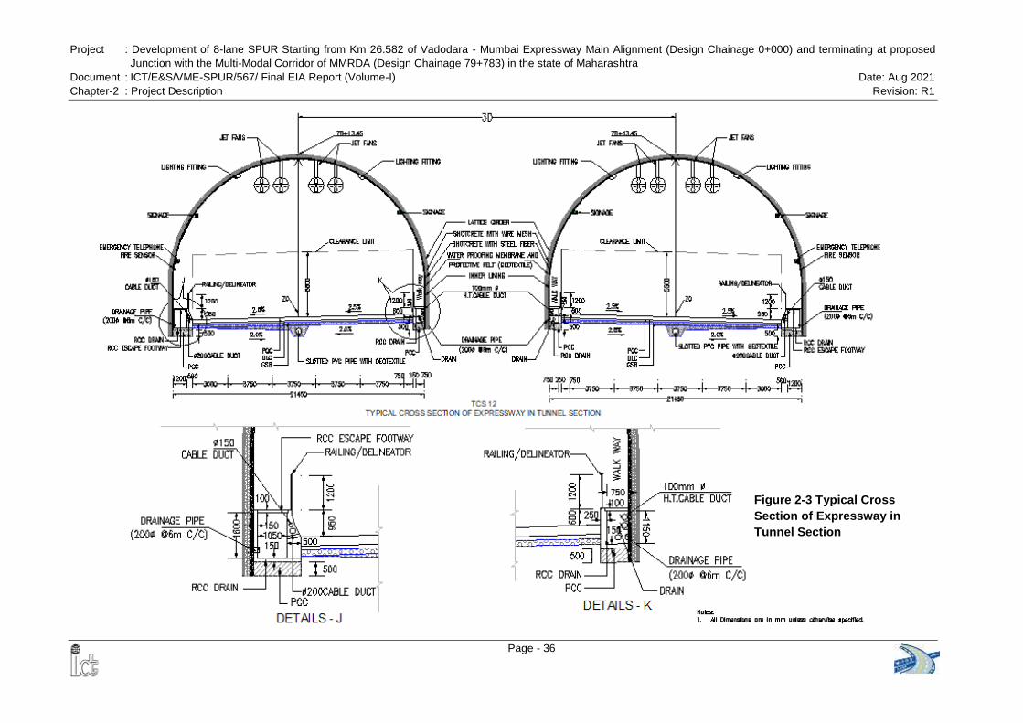
Project : Development of 8-lane SPUR Starting from Km 26.582 of Vadodara - Mumbai Expressway Main Alignment (Design Chainage 0+000) and terminating at proposed
Junction with the Multi-Modal Corridor of MMRDA (Design Chainage 79+783) in the state of Maharashtra
Document : ICT/E&S/VME-SPUR/567/ Final EIA Report (Volume-I) Date: Aug 2021
Chapter-2 : Project Description Revision: R1
Page - 36
Figure 2-3 Typical Cross
Section of Expressway in
Tunnel Section
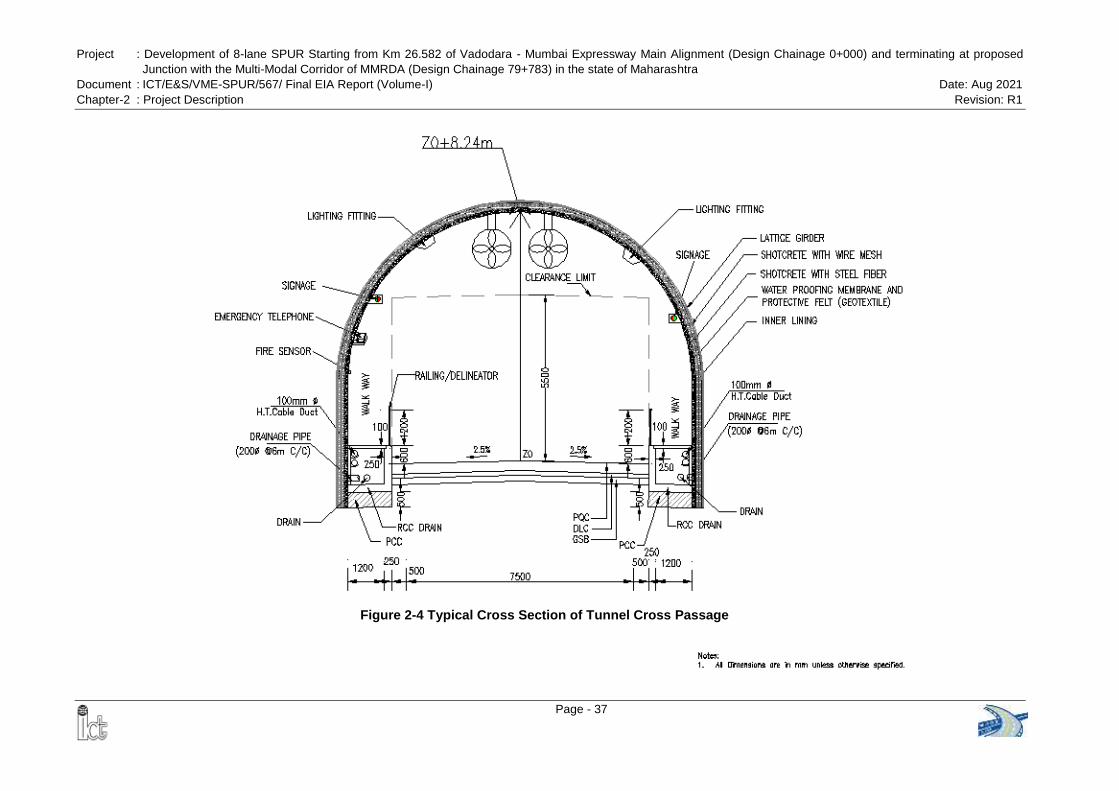
Project : Development of 8-lane SPUR Starting from Km 26.582 of Vadodara - Mumbai Expressway Main Alignment (Design Chainage 0+000) and terminating at proposed
Junction with the Multi-Modal Corridor of MMRDA (Design Chainage 79+783) in the state of Maharashtra
Document : ICT/E&S/VME-SPUR/567/ Final EIA Report (Volume-I) Date: Aug 2021
Chapter-2 : Project Description Revision: R1
Page - 37
Figure 2-4 Typical Cross Section of Tunnel Cross Passage
Project : Development of 8-lane SPUR Starting from Km 26.582 of Vadodara - Mumbai Expressway Main
Alignment (Design Chainage 0+000) and terminating at proposed Junction with the Multi-Modal Corridor
of MMRDA (Design Chainage 79+783) in the state of Maharashtra
Document : ICT/E&S/VME-SPUR/567/ Final EIA Report (Volume-I) Date: Aug 2021
Chapter-2 : Project Description Revision: R1
Page - 38
2.6.4 Blasting
Not less than 40 days prior to commencement of rock excavation in each area, the
Concessionaire shall submit, for review by the Authority’s Representative, details of the
drilling and blasting methods which he intends to use in that area. If, at any time in a
specific area, a plan which has been previously adopted does not produce conditions at
the excavated rock face that conform to the requirements of these Specifications, the
Concessionaire shall submit a revised plan to the Authority’s Representative before
continuing excavation in adjacent areas.
The Concessionaire shall develop controlled blasting techniques, which will satisfy the
excavation requirements specified herein. In each different type of rock conditions, the
Concessionaire's initial blasts shall be performed as trials, and the burden, drill hole
pattern and depth, explosive type and quantity, blasting sequence and drill delay pattern
shall be modified to achieve the requirements specified herein. Blasting means have to
follow the licensing requirements and orders as well as the manufacturer’s instructions.
Blasting operations shall be carried out only under the direction of an experienced
operator. The Concessionaire shall appoint one competent person to be responsible for
the security of explosives. Blasting shall be carried out carefully so as to avoid loosening
or shattering rock beyond the required line of excavation, and loose or shattered rock
(where it does not contribute to stability of the excavation) shall be removed by scaling
down or other means before personnel will be permitted to restart operations after
blasting. Notices of blasting operations shall be posted at site. Before each firing, the
Concessionaire shall give audible warning, clear the area and shall take positive
measures to prevent personnel from entering the danger area.
The Concessionaire shall monitor the results of blasting closely and, where it is proper
to do so, shall propose changes to his blasting operation for the agreement of the
Authority’s Representative. Under no circumstances shall any holes be charged until
completion of all drilling operations at the face.
After each blasting operation the tunnel drive shall be sufficiently ventilated to remove
any nitrous gases and the atmospheric conditions shall be constantly checked prior to
personnel accessing the excavated face.
No person shall be allowed to approach the face and no face operation shall commence
until the Concessionaire’s authorized person in charge of the operation has given
permission after blasting round. As soon as practicable after blasting and without undue
delay the Concessionaire shall erect such support as may be necessary to safeguard
the excavation and personnel.
The shot-firer must keep a record of the number of shots fired, their time of firing, type
and weights of explosives used, and the type and number of detonators used, together
with a record of the post-blast situation for each and every location. A copy of the record
shall be available to the Authority’s Representative at the end of every shift on which
Project : Development of 8-lane SPUR Starting from Km 26.582 of Vadodara - Mumbai Expressway Main
Alignment (Design Chainage 0+000) and terminating at proposed Junction with the Multi-Modal Corridor
of MMRDA (Design Chainage 79+783) in the state of Maharashtra
Document : ICT/E&S/VME-SPUR/567/ Final EIA Report (Volume-I) Date: Aug 2021
Chapter-2 : Project Description Revision: R1
Page - 39
shots are fired.
Controlled Perimeter Blasting: Controlled perimeter blasting techniques shall be used
to produce rock faces conforming to the required excavation lines, slopes, elevations
and dimensions shown on the drawings with a minimum of disturbance to the rock at, or
outside of, the excavation pay lines.
Drill holes for controlled perimeter blasting shall not be less than 42 millimeters in
diameter and shall be a single row of closely spaced holes drilled to a maximum depth
of one round length along the excavation pay lines and a spacing of 0.4 to 0.6 m
depending on the ground condition. The spacing of the perimeter holes may be modified
on the basis of results obtained and in agreement with the Authority’s Representative.
All blast holes within a distance of 5 meters normal to the excavation pay lines shall be
less than 75 millimeters in diameter and shall be loaded in a manner and detonated in a
sequence to ensure that a minimum of damage will result to the face when the main
charge is fired.
Explosives: The Concessionaire shall use explosives only in circumstances where it is
safe to do so having due regard to the safety of persons, third-party property and the
safety of the Works. Explosives shall not be used without the agreement of the
Authority’s Representative.
The Concessionaire shall obtain all necessary licences and consents and shall provide
secure storage facilities for all explosives and equipment in accordance with Indian or
International Standards Code of practice for the safe use of explosives in the
construction industry and the requirements of the local Authorities and the Authority’s
Representative.
Explosives shall be handled and used only by the Concessionaire’s duly authorized
personnel. The names and qualifications of such personnel shall be submitted to the
Authority’s Representative in writing in advance of any possible use of explosives.
At an early stage, in advance of the proposed use of explosives, the Concessionaire shall
notify the Authority’s Representative, third parties, statutory authorities and services
which have an interest in or are likely to be affected by blasting operations, of the
general nature of the operation. The Concessionaire shall subsequently give a
minimum of 14 days’ notice to the Authority’s Representative and others described
above of the proposed use of explosives. With this notification the Concessionaire shall
submit to the Authority’s Representative a detailed method statement on all aspects of
the proposed use of explosives, including the treatment of misfires.
The Concessionaire shall comply with the following documents in respect of the use of
explosives:
Project : Development of 8-lane SPUR Starting from Km 26.582 of Vadodara - Mumbai Expressway Main
Alignment (Design Chainage 0+000) and terminating at proposed Junction with the Multi-Modal Corridor
of MMRDA (Design Chainage 79+783) in the state of Maharashtra
Document : ICT/E&S/VME-SPUR/567/ Final EIA Report (Volume-I) Date: Aug 2021
Chapter-2 : Project Description Revision: R1
Page - 40
Indian Explosives Act 1884
Indian Explosive Rules 2008 and further amendment in Jan.2009
The Manufacture and Storage of Explosives Regulations 2005
BS 5607:1998 Code of practice for the safe use of explosives in the construction
industry
Control of Explosives Regulations 1991
Carriage of Explosives by Road. Road Traffic (Carriage of Explosives) Regulations
1996
PD CLC/TR 50426:2004 Assessment of inadvertent initiation of bridge wire electro-
explosive devices by radio- frequency radiation. Guide Quarries (Explosives)
Regulations 1988, as far as it is relevant to tunnel works
Blasting Vibrations: For structures in the proximity of blasting, the peak particle
velocity shall be measured at the locations immediately adjacent to the structure nearest
to the face being blasted or any other location where it is necessary to limit vibration.
Vibration monitoring proposals shall be submitted to the Authority’s Representative.
The measurement of peak particle velocity shall be obtained from instruments capable
of measuring along three orthogonal axes, one of them shall be aligned parallel to the
center line of the excavation and another shall be vertical. The Concessionaire has to
provide supports for the measuring instrument if so, required by the manufacturer’s
instructions. The measurements of the particle velocities shall be the responsibility of
the Concessionaire. Copies of the readings in an agreed form shall be supplied to the
Authority’s Representative.
Prior to the commencement of blasting in any location, the Concessionaire shall
demonstrate using test firings, or by other means, that neither the peak particle
velocities given in the particular Standards and Specifications will be exceeded.
The maximum allowable blasting vibrations shall be defined by the Concessionaire for
every influenced structure with reference to the applicable Standards and Specifications
for the relevant structure. The allowable blasting vibrations shall be approved by the
Authority’s Representative prior to any blasting operations.
Geological Mapping: Geological mapping shall be performed by qualified geologist to
provide a documentation of rock and rock mass condition encountered during
excavation. Additionally, all exposed rock surfaces of the open and underground
excavations shall be washed down for inspection and geological mapping. Exposed
rock surfaces at the required excavation pay lines shall be mapped after preparation but
before shotcrete application. Tunnel and other underground faces shall be mapped just
before the start of drilling. The Concessionaire shall allow in his construction procedure
and schedule for the geological mapping of each tunnel face not less than 30 minutes.
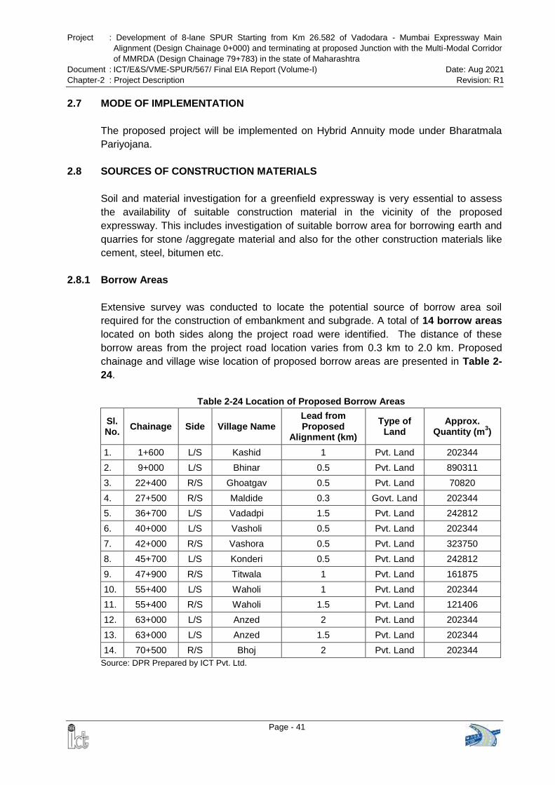
Project : Development of 8-lane SPUR Starting from Km 26.582 of Vadodara - Mumbai Expressway Main
Alignment (Design Chainage 0+000) and terminating at proposed Junction with the Multi-Modal Corridor
of MMRDA (Design Chainage 79+783) in the state of Maharashtra
Document : ICT/E&S/VME-SPUR/567/ Final EIA Report (Volume-I) Date: Aug 2021
Chapter-2 : Project Description Revision: R1
Page - 41
2.7 MODE OF IMPLEMENTATION
The proposed project will be implemented on Hybrid Annuity mode under Bharatmala
Pariyojana.
2.8 SOURCES OF CONSTRUCTION MATERIALS
Soil and material investigation for a greenfield expressway is very essential to assess
the availability of suitable construction material in the vicinity of the proposed
expressway. This includes investigation of suitable borrow area for borrowing earth and
quarries for stone /aggregate material and also for the other construction materials like
cement, steel, bitumen etc.
2.8.1 Borrow Areas
Extensive survey was conducted to locate the potential source of borrow area soil
required for the construction of embankment and subgrade. A total of 14 borrow areas
located on both sides along the project road were identified. The distance of these
borrow areas from the project road location varies from 0.3 km to 2.0 km. Proposed
chainage and village wise location of proposed borrow areas are presented in Table 2-
24.
Table 2-24 Location of Proposed Borrow Areas
Sl. No.
Chainage Side Village Name Lead from Proposed
Alignment (km)
Type of Land
Approx. Quantity (m
3)
1. 1+600 L/S Kashid 1 Pvt. Land 202344
2. 9+000 L/S Bhinar 0.5 Pvt. Land 890311
3. 22+400 R/S Ghoatgav 0.5 Pvt. Land 70820
4. 27+500 R/S Maldide 0.3 Govt. Land 202344
5. 36+700 L/S Vadadpi 1.5 Pvt. Land 242812
6. 40+000 L/S Vasholi 0.5 Pvt. Land 202344
7. 42+000 R/S Vashora 0.5 Pvt. Land 323750
8. 45+700 L/S Konderi 0.5 Pvt. Land 242812
9. 47+900 R/S Titwala 1 Pvt. Land 161875
10. 55+400 L/S Waholi 1 Pvt. Land 202344
11. 55+400 R/S Waholi 1.5 Pvt. Land 121406
12. 63+000 L/S Anzed 2 Pvt. Land 202344
13. 63+000 L/S Anzed 1.5 Pvt. Land 202344
14. 70+500 R/S Bhoj 2 Pvt. Land 202344
Source: DPR Prepared by ICT Pvt. Ltd.
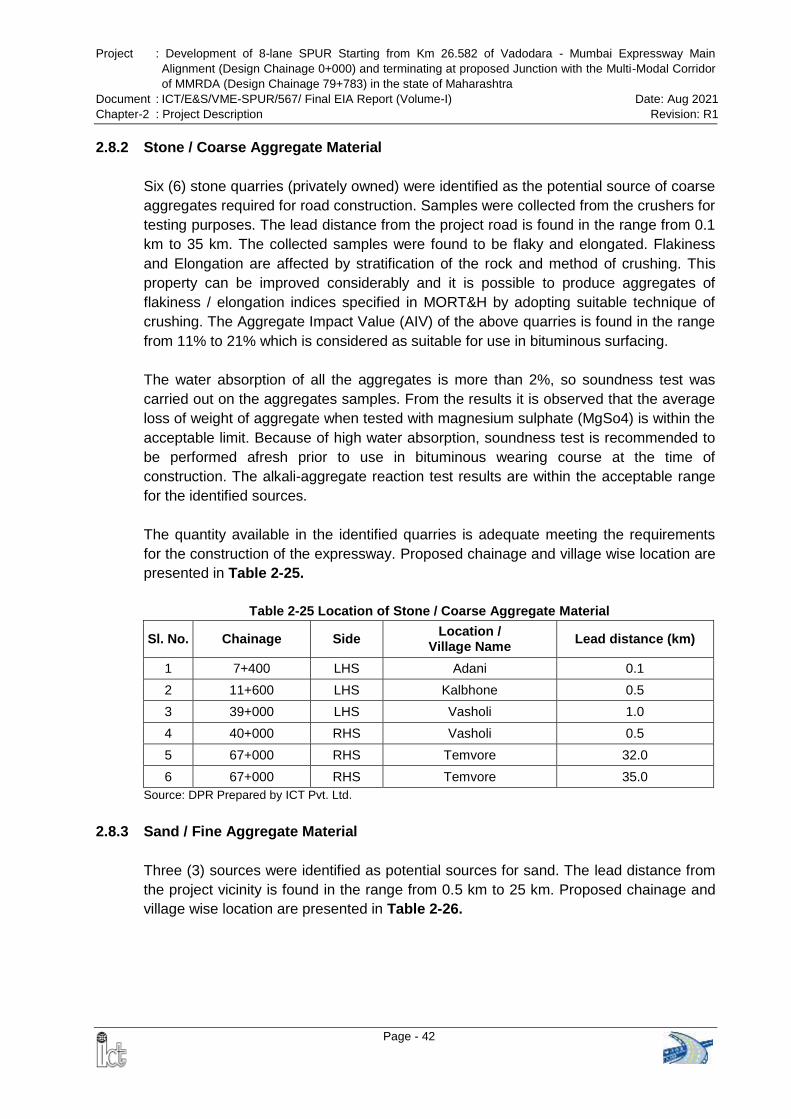
Project : Development of 8-lane SPUR Starting from Km 26.582 of Vadodara - Mumbai Expressway Main
Alignment (Design Chainage 0+000) and terminating at proposed Junction with the Multi-Modal Corridor
of MMRDA (Design Chainage 79+783) in the state of Maharashtra
Document : ICT/E&S/VME-SPUR/567/ Final EIA Report (Volume-I) Date: Aug 2021
Chapter-2 : Project Description Revision: R1
Page - 42
2.8.2 Stone / Coarse Aggregate Material
Six (6) stone quarries (privately owned) were identified as the potential source of coarse
aggregates required for road construction. Samples were collected from the crushers for
testing purposes. The lead distance from the project road is found in the range from 0.1
km to 35 km. The collected samples were found to be flaky and elongated. Flakiness
and Elongation are affected by stratification of the rock and method of crushing. This
property can be improved considerably and it is possible to produce aggregates of
flakiness / elongation indices specified in MORT&H by adopting suitable technique of
crushing. The Aggregate Impact Value (AIV) of the above quarries is found in the range
from 11% to 21% which is considered as suitable for use in bituminous surfacing.
The water absorption of all the aggregates is more than 2%, so soundness test was
carried out on the aggregates samples. From the results it is observed that the average
loss of weight of aggregate when tested with magnesium sulphate (MgSo4) is within the
acceptable limit. Because of high water absorption, soundness test is recommended to
be performed afresh prior to use in bituminous wearing course at the time of
construction. The alkali-aggregate reaction test results are within the acceptable range
for the identified sources.
The quantity available in the identified quarries is adequate meeting the requirements
for the construction of the expressway. Proposed chainage and village wise location are
presented in Table 2-25.
Table 2-25 Location of Stone / Coarse Aggregate Material
Sl. No. Chainage Side Location /
Village Name Lead distance (km)
1 7+400 LHS Adani 0.1
2 11+600 LHS Kalbhone 0.5
3 39+000 LHS Vasholi 1.0
4 40+000 RHS Vasholi 0.5
5 67+000 RHS Temvore 32.0
6 67+000 RHS Temvore 35.0
Source: DPR Prepared by ICT Pvt. Ltd.
2.8.3 Sand / Fine Aggregate Material
Three (3) sources were identified as potential sources for sand. The lead distance from
the project vicinity is found in the range from 0.5 km to 25 km. Proposed chainage and
village wise location are presented in Table 2-26.
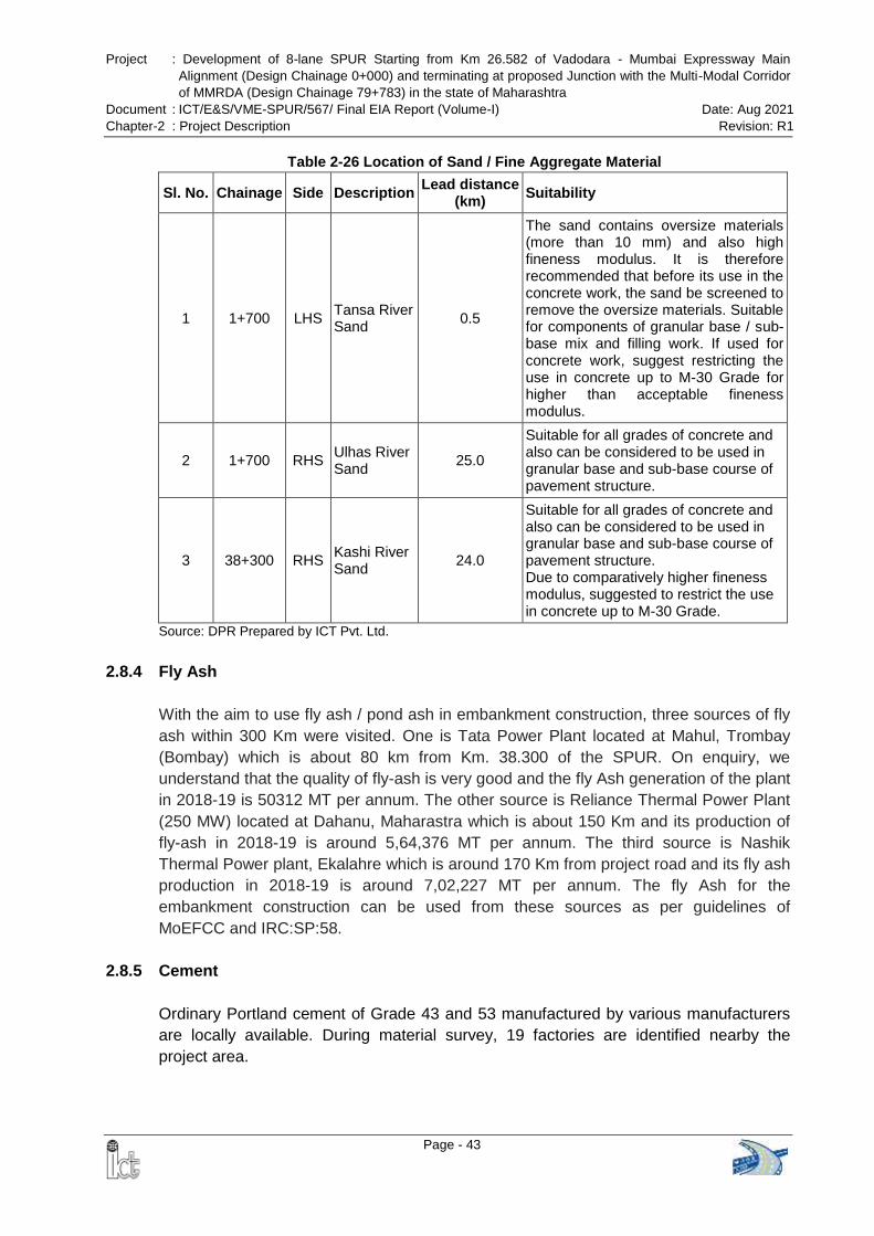
Project : Development of 8-lane SPUR Starting from Km 26.582 of Vadodara - Mumbai Expressway Main
Alignment (Design Chainage 0+000) and terminating at proposed Junction with the Multi-Modal Corridor
of MMRDA (Design Chainage 79+783) in the state of Maharashtra
Document : ICT/E&S/VME-SPUR/567/ Final EIA Report (Volume-I) Date: Aug 2021
Chapter-2 : Project Description Revision: R1
Page - 43
Table 2-26 Location of Sand / Fine Aggregate Material
Sl. No. Chainage Side Description Lead distance
(km) Suitability
1 1+700 LHS Tansa River Sand
0.5
The sand contains oversize materials (more than 10 mm) and also high fineness modulus. It is therefore recommended that before its use in the concrete work, the sand be screened to remove the oversize materials. Suitable for components of granular base / sub-base mix and filling work. If used for concrete work, suggest restricting the use in concrete up to M-30 Grade for higher than acceptable fineness modulus.
2 1+700 RHS Ulhas River Sand
25.0
Suitable for all grades of concrete and also can be considered to be used in granular base and sub-base course of pavement structure.
3 38+300 RHS Kashi River Sand
24.0
Suitable for all grades of concrete and also can be considered to be used in granular base and sub-base course of pavement structure. Due to comparatively higher fineness modulus, suggested to restrict the use in concrete up to M-30 Grade.
Source: DPR Prepared by ICT Pvt. Ltd.
2.8.4 Fly Ash
With the aim to use fly ash / pond ash in embankment construction, three sources of fly
ash within 300 Km were visited. One is Tata Power Plant located at Mahul, Trombay
(Bombay) which is about 80 km from Km. 38.300 of the SPUR. On enquiry, we
understand that the quality of fly-ash is very good and the fly Ash generation of the plant
in 2018-19 is 50312 MT per annum. The other source is Reliance Thermal Power Plant
(250 MW) located at Dahanu, Maharastra which is about 150 Km and its production of
fly-ash in 2018-19 is around 5,64,376 MT per annum. The third source is Nashik
Thermal Power plant, Ekalahre which is around 170 Km from project road and its fly ash
production in 2018-19 is around 7,02,227 MT per annum. The fly Ash for the
embankment construction can be used from these sources as per guidelines of
MoEFCC and IRC:SP:58.
2.8.5 Cement
Ordinary Portland cement of Grade 43 and 53 manufactured by various manufacturers
are locally available. During material survey, 19 factories are identified nearby the
project area.
Project : Development of 8-lane SPUR Starting from Km 26.582 of Vadodara - Mumbai Expressway Main
Alignment (Design Chainage 0+000) and terminating at proposed Junction with the Multi-Modal Corridor
of MMRDA (Design Chainage 79+783) in the state of Maharashtra
Document : ICT/E&S/VME-SPUR/567/ Final EIA Report (Volume-I) Date: Aug 2021
Chapter-2 : Project Description Revision: R1
Page - 44
2.8.6 Bitumen
Since the project road will be subjected to high intensity of traffic during the design
period, it is recommended to use elastomeric type of Polymer Modified Bitumen (PMB –
Styrene Butadiene Styrene i.e. SBS) in the bituminous wearing course. Elastomeric type
of PMB is preferred over plastomeric type PMB as the former has the ability to resist
permanent deformation as well as to minimize fatigue cracking, thermal cracking and
ageing. The strength of bituminous mix of SBS type of PMB increases with elongation
and hence will be more suitable for high traffic growth.
For binder course, viscosity grade of bitumen conforming to IS: 73 – 2006 is suggested.
Considering the climatic condition prevailing in the project influence area, VG-40 grade
will be suitable.
Three (3) sources are identified as nearest sources of bitumen one is HPCL, Mumbai in
Maharashtra State, IOCL, Vadodara and Jamnagar in Gujarat State.
2.8.7 Steel
High strength deformed bars manufactured by various steel manufacturing companies
conforming to IS 1786 are available with local traders.
2.9 PROJECT COST
Total Project Cost for the proposed expressway is summarized below:
Table 2-27 Summary of Project Cost
S No. Description Amount in Crores
1 Cost of Civil Construction 5,627.99
2 Total Project Cost including Centage & Pre-construction Cost
10,510
2.10 DEVELOPMENT PROCESS
2.10.1 Stages & Activities of the Proposed Project
The development process of the proposed expressway has three distinct stages and
each of the stage has several activities and sub-activities. These three stages are:
A) Design and Pre-Construction Stage
B) Construction Stage
C) Post-Construction / Operations & Maintenance Stage
The activities and sub-activities which would be undertaken in each of the three stages
are detailed in Figure 2-5.
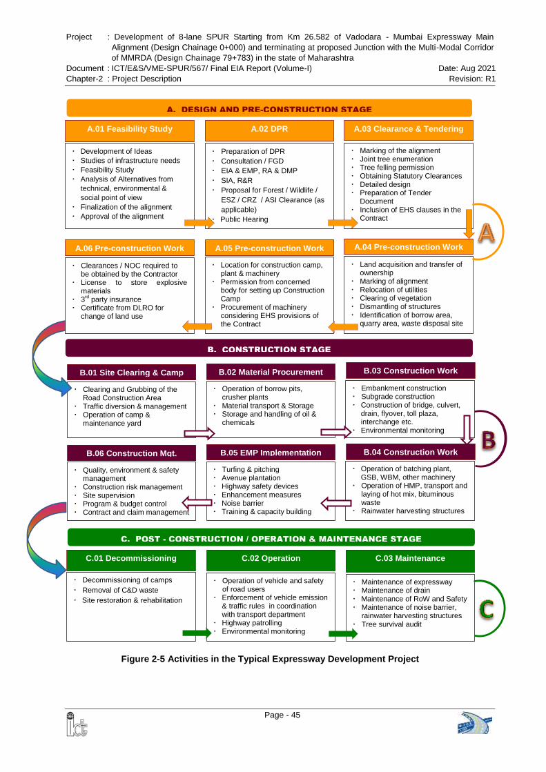
Project : Development of 8-lane SPUR Starting from Km 26.582 of Vadodara - Mumbai Expressway Main
Alignment (Design Chainage 0+000) and terminating at proposed Junction with the Multi-Modal Corridor
of MMRDA (Design Chainage 79+783) in the state of Maharashtra
Document : ICT/E&S/VME-SPUR/567/ Final EIA Report (Volume-I) Date: Aug 2021
Chapter-2 : Project Description Revision: R1
Page - 45
C. POST - CONSTRUCTION / OPERATION & MAINTENANCE STAGE
C.01 Decommissioning
Decommissioning of camps
Removal of C&D waste
Site restoration & rehabilitation
Operation of vehicle and safety of road users
Enforcement of vehicle emission & traffic rules in coordination with transport department
Highway patrolling Environmental monitoring
C.02 Operation C.03 Maintenance
Maintenance of expressway Maintenance of drain Maintenance of RoW and Safety Maintenance of noise barrier,
rainwater harvesting structures Tree survival audit
B.01 Site Clearing & Camp
Clearing and Grubbing of the Road Construction Area
Traffic diversion & management Operation of camp &
maintenance yard
Operation of borrow pits, crusher plants
Material transport & Storage Storage and handling of oil &
chemicals
Embankment construction Subgrade construction Construction of bridge, culvert,
drain, flyover, toll plaza, interchange etc.
Environmental monitoring
B.02 Material Procurement B.03 Construction Work
B. CONSTRUCTION STAGE
B.06 Construction Mgt.
Quality, environment & safety management
Construction risk management Site supervision Program & budget control Contract and claim management
Turfing & pitching Avenue plantation Highway safety devices Enhancement measures Noise barrier Training & capacity building
Operation of batching plant, GSB, WBM, other machinery
Operation of HMP, transport and laying of hot mix, bituminous waste
Rainwater harvesting structures
B.05 EMP Implementation B.04 Construction Work
A. DESIGN AND PRE-CONSTRUCTION STAGE
A.01 Feasibility Study
Development of Ideas
Studies of infrastructure needs
Feasibility Study
Analysis of Alternatives from
technical, environmental &
social point of view
Finalization of the alignment
Approval of the alignment
Preparation of DPR
Consultation / FGD
EIA & EMP, RA & DMP
SIA, R&R
Proposal for Forest / Wildlife /
ESZ / CRZ / ASI Clearance (as
applicable)
Public Hearing
Marking of the alignment Joint tree enumeration Tree felling permission Obtaining Statutory Clearances Detailed design Preparation of Tender
Document Inclusion of EHS clauses in the
Contract
A.02 DPR A.03 Clearance & Tendering
A.06 Pre-construction Work
Clearances / NOC required to be obtained by the Contractor
License to store explosive materials
3rd party insurance
Certificate from DLRO for change of land use
Location for construction camp, plant & machinery
Permission from concerned body for setting up Construction Camp
Procurement of machinery considering EHS provisions of the Contract
Land acquisition and transfer of ownership
Marking of alignment Relocation of utilities Clearing of vegetation Dismantling of structures Identification of borrow area,
quarry area, waste disposal site
A.05 Pre-construction Work A.04 Pre-construction Work
Figure 2-5 Activities in the Typical Expressway Development Project
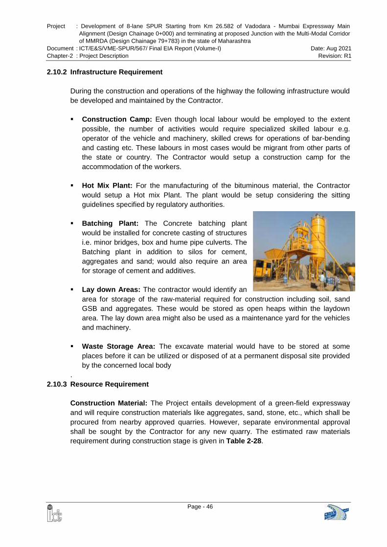
Project : Development of 8-lane SPUR Starting from Km 26.582 of Vadodara - Mumbai Expressway Main
Alignment (Design Chainage 0+000) and terminating at proposed Junction with the Multi-Modal Corridor
of MMRDA (Design Chainage 79+783) in the state of Maharashtra
Document : ICT/E&S/VME-SPUR/567/ Final EIA Report (Volume-I) Date: Aug 2021
Chapter-2 : Project Description Revision: R1
Page - 46
2.10.2 Infrastructure Requirement
During the construction and operations of the highway the following infrastructure would
be developed and maintained by the Contractor.
Construction Camp: Even though local labour would be employed to the extent
possible, the number of activities would require specialized skilled labour e.g.
operator of the vehicle and machinery, skilled crews for operations of bar-bending
and casting etc. These labours in most cases would be migrant from other parts of
the state or country. The Contractor would setup a construction camp for the
accommodation of the workers.
Hot Mix Plant: For the manufacturing of the bituminous material, the Contractor
would setup a Hot mix Plant. The plant would be setup considering the sitting
guidelines specified by regulatory authorities.
Batching Plant: The Concrete batching plant
would be installed for concrete casting of structures
i.e. minor bridges, box and hume pipe culverts. The
Batching plant in addition to silos for cement,
aggregates and sand; would also require an area
for storage of cement and additives.
Lay down Areas: The contractor would identify an
area for storage of the raw-material required for construction including soil, sand
GSB and aggregates. These would be stored as open heaps within the laydown
area. The lay down area might also be used as a maintenance yard for the vehicles
and machinery.
Waste Storage Area: The excavate material would have to be stored at some
places before it can be utilized or disposed of at a permanent disposal site provided
by the concerned local body
.
2.10.3 Resource Requirement
Construction Material: The Project entails development of a green-field expressway
and will require construction materials like aggregates, sand, stone, etc., which shall be
procured from nearby approved quarries. However, separate environmental approval
shall be sought by the Contractor for any new quarry. The estimated raw materials
requirement during construction stage is given in Table 2-28.
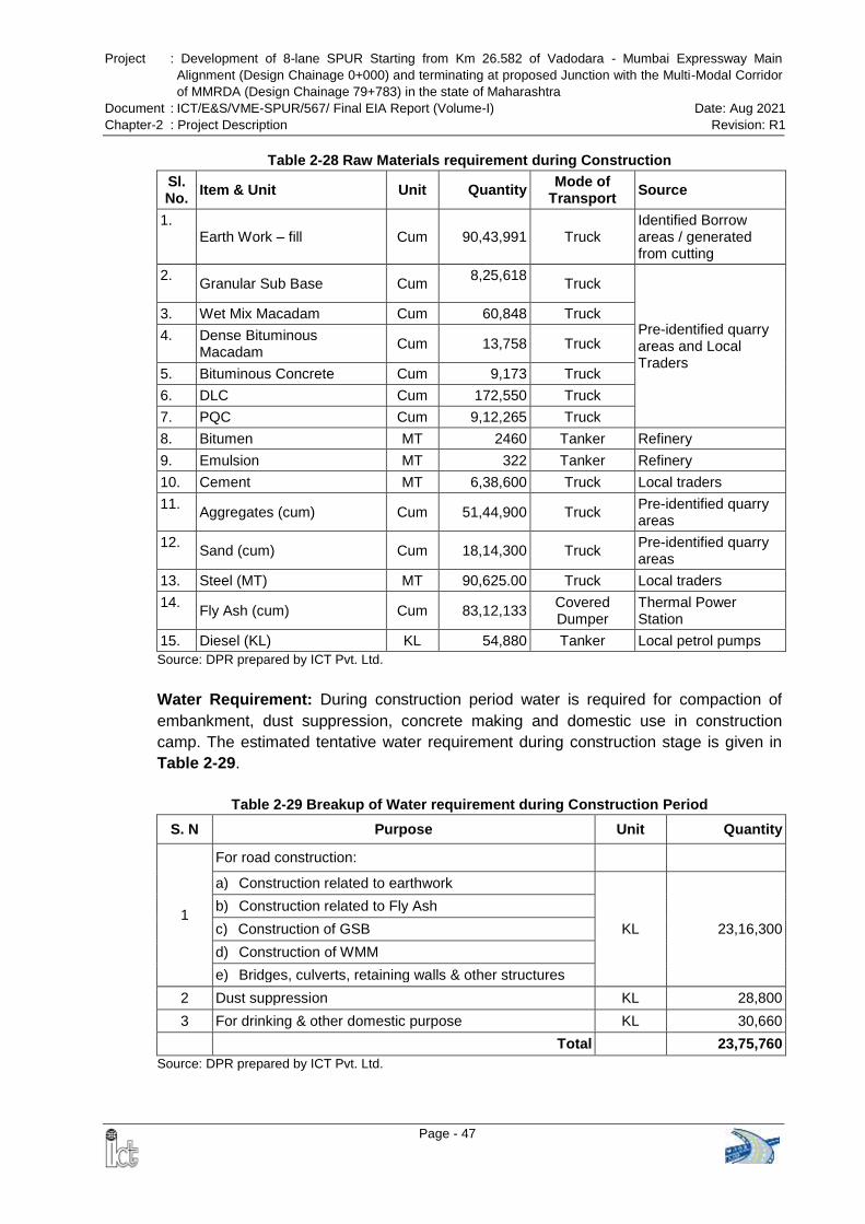
Project : Development of 8-lane SPUR Starting from Km 26.582 of Vadodara - Mumbai Expressway Main
Alignment (Design Chainage 0+000) and terminating at proposed Junction with the Multi-Modal Corridor
of MMRDA (Design Chainage 79+783) in the state of Maharashtra
Document : ICT/E&S/VME-SPUR/567/ Final EIA Report (Volume-I) Date: Aug 2021
Chapter-2 : Project Description Revision: R1
Page - 47
Table 2-28 Raw Materials requirement during Construction
Sl. No.
Item & Unit Unit Quantity Mode of
Transport Source
1. Earth Work – fill Cum 90,43,991 Truck
Identified Borrow areas / generated from cutting
2. Granular Sub Base Cum
8,25,618
Truck
Pre-identified quarry areas and Local Traders
3. Wet Mix Macadam Cum 60,848 Truck
4. Dense Bituminous Macadam
Cum 13,758 Truck
5. Bituminous Concrete Cum 9,173 Truck
6. DLC Cum 172,550 Truck
7. PQC Cum 9,12,265 Truck
8. Bitumen MT 2460 Tanker Refinery
9. Emulsion MT 322 Tanker Refinery
10. Cement MT 6,38,600 Truck Local traders
11. Aggregates (cum) Cum 51,44,900 Truck
Pre-identified quarry areas
12. Sand (cum) Cum 18,14,300 Truck
Pre-identified quarry areas
13. Steel (MT) MT 90,625.00 Truck Local traders
14. Fly Ash (cum) Cum 83,12,133
Covered Dumper
Thermal Power Station
15. Diesel (KL) KL 54,880 Tanker Local petrol pumps
Source: DPR prepared by ICT Pvt. Ltd.
Water Requirement: During construction period water is required for compaction of
embankment, dust suppression, concrete making and domestic use in construction
camp. The estimated tentative water requirement during construction stage is given in
Table 2-29.
Table 2-29 Breakup of Water requirement during Construction Period
S. N Purpose Unit Quantity
1
For road construction:
a) Construction related to earthwork
KL 23,16,300
b) Construction related to Fly Ash
c) Construction of GSB
d) Construction of WMM
e) Bridges, culverts, retaining walls & other structures
2 Dust suppression KL 28,800
3 For drinking & other domestic purpose KL 30,660
Total 23,75,760
Source: DPR prepared by ICT Pvt. Ltd.
Project : Development of 8-lane SPUR Starting from Km 26.582 of Vadodara - Mumbai Expressway Main
Alignment (Design Chainage 0+000) and terminating at proposed Junction with the Multi-Modal Corridor
of MMRDA (Design Chainage 79+783) in the state of Maharashtra
Document : ICT/E&S/VME-SPUR/567/ Final EIA Report (Volume-I) Date: Aug 2021
Chapter-2 : Project Description Revision: R1
Page - 48
During the operations phase the water would be required primarily for drinking and
domestic use at the toll plaza and for landscaping.
Power Requirement: Power required at the construction camp would be drawn from
the grid where it is available else DG sets would be used to supply the power to the
Construction & Labour Camps.
Land Requirement: The land required for construction of proposed expressway is
tentatively 1031.91 ha, which includes 122.6133 ha forest land and 909.2967 ha non-
forest land. Joint measurement of both private and forest land is ongoing and the above
data may revise during the process of forest clearance and preparation of Joint
Measurement Records (JMR).
Manpower Requirement: The manpower requirement would vary over the construction
period depending on the quantum and type of work involved. About 600 (150 persons
per construction package) persons would be required during the construction phase.
Construction Period: The proposed VME-SPUR has been divided into 4 construction
packages (package XIV, XV, XVI & XVII) for implementation. Construction period of
package XIV to package XVI shall be 2 years / 24 months and construction period of
package XVII shall be 2.5 years / 30 months.
2.10.4 Pollutant Sources during Construction Phase
During construction phase environmental impacts are likely to result primarily from
operation of heavy machinery and equipment’s, vehicular movement and from
construction camp. The potential pollutant sources for construction phase and their
characterization has been discussed in the subsequent section.
Operations of Heavy Machineries & Vehicular Movement: The operations of
construction vehicles, diesel generators and machineries would contribute to particulate
matter (PM), sulphur dioxides (SO2), oxides of nitrogen (NOX), carbon monoxide (CO)
and hydrocarbons (HC). In addition, fugitive emissions are envisaged from plying of
vehicles and also from storage, handling and transportation of materials during the
construction phase. Dust will be emitted during material transport and loading-unloading
activities. Noise will be generated from operating heavy machineries and from vehicular
movement. During construction phase, spillage of construction materials, such as,
cement, POL, bitumen etc. could lead to an increase in water pollution level of the
receiving water body.
Generation of Construction Waste: There would be waste from the batching plant, hot
mix plant, demolition of structures within proposed ROW. Some of the material would be
recycled and used for back filling. Material which cannot be recycled would be
considered as construction and demolition waste and has to be disposed of as per the
Project : Development of 8-lane SPUR Starting from Km 26.582 of Vadodara - Mumbai Expressway Main
Alignment (Design Chainage 0+000) and terminating at proposed Junction with the Multi-Modal Corridor
of MMRDA (Design Chainage 79+783) in the state of Maharashtra
Document : ICT/E&S/VME-SPUR/567/ Final EIA Report (Volume-I) Date: Aug 2021
Chapter-2 : Project Description Revision: R1
Page - 49
Construction and Demolition Waste Management Rules, 2016 as well as “Guidelines on
Environmental Management of Construction & Demolition (C&D) Wastes” of Central
Pollution Control Board, March 2017.
Construction Camp: liquid & solid waste will be generated from construction camps.
2.10.5 Pollutant Sources during Operation Phase
During operation phase of the proposed expressway, liquid & solid (municipal) waste
would be primarily generated from toll plaza and rest area. Bituminous layer would be
excavated during the repair of pavement, which is hazardous in nature.
Project : Development of 8-lane SPUR Starting from Km 26.582 of Vadodara - Mumbai Expressway Main
Alignment (Design Chainage 0+000) and terminating at proposed Junction with the Multi-Modal Corridor
of MMRDA (Design Chainage 79+783) in the state of Maharashtra
Document : ICT/E&S/VME-SPUR/567/ Final EIA Report (Volume-I) Date: Aug 2021
Chapter-3 : Description of the Environment Revision: R1
Page - 50
CHAPTER-3: DESCRIPTION OF THE ENVIRONMENT
3.1 GENERAL
Baseline environmental status outlines the existing environment conditions of the project
area. EIA is a formal process for identifying the likely impacts of particular activities or
projects on the environment, human health and welfare. EIA also encompasses the
development of mitigation measures to address these impacts and suggested
approaches for implementation of mitigation and monitoring measures. EIA is not to be
regarded as an academic exercise as this has to ensure that environmental values and
factors have to be integrated into the decision-making process. EIAs convey information
about environmental impacts of a project to decision makers at a stage when such
information can materially affect the output. As a precursor for the prediction of various
types of environmental impacts likely to arise due to implementation of the project, it is
essential to establish the baseline environmental status of the physical and biological
parameters in the Direct and Indirect Area of Influence. Details of baseline environment
parameters are required for decision making for the project are discussed in this
chapter.
3.2 STUDY AREA & PERIOD
As per the EIA Guidance Manual for Highways (MoEF&CC, February 2010), a study
area of 15 km radius from the proposed expressway was considered for secondary data
collection. Primary data has been collected within 500 meters on either side of the
proposed alignment. Baseline environment monitoring was carried out for the period of
October to December, 2020.
3.3 PHYSIOGRAPHY AND TERRAIN
The proposed expressway (VME-SPUR) is passing through 2 Talukas (Vasai & Wada)
of Palghar district, 3 Talukas (Bhiwandi, Kalyan & Ambarnath) of Thane district and 1
Taluka (Panvel) of Raigad district in the state of Maharashtra.
Geographically the proposed SPUR lies between latitude 19°29'19.44"N, to 19°
3'59.65"N, and between 72°52'58.86"E to 73°10'49.57"E longitude with elevation varies
from about 3 m to 639 m above MSL (Figure 3-1).
Physiographically, the study area of Palghar & Thane districts can be divided into two
broad divisions - Undulating Hilly Tract and Coastal Plain in western part. 18.900 km
stretch of the SPUR alignment lies in Palghar district, 55.260 km lies in Thane district.
The area is drained by innumerable streams and tributaries of Vaitarna and Ulhas River.
The four main tributaries of river Vaitarna are Surya, Tansa, Deharaja and Pinjal Rivers.
Ulhas River is the other important river in the district.
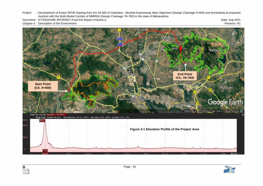
Project : Development of 8-lane SPUR Starting from Km 26.582 of Vadodara - Mumbai Expressway Main Alignment (Design Chainage 0+000) and terminating at proposed
Junction with the Multi-Modal Corridor of MMRDA (Design Chainage 79+783) in the state of Maharashtra
Document : ICT/E&S/VME-SPUR/567/ Final EIA Report (Volume-I) Date: Aug 2021
Chapter-3 : Description of the Environment Revision: R1
Page - 51
Start Point
(Ch. 0+000)
End Point (Ch. 79+783)
Figure 3-1 Elevation Profile of the Project Area
Project : Development of 8-lane SPUR Starting from Km 26.582 of Vadodara - Mumbai Expressway Main
Alignment (Design Chainage 0+000) and terminating at proposed Junction with the Multi-Modal Corridor
of MMRDA (Design Chainage 79+783) in the state of Maharashtra
Document : ICT/E&S/VME-SPUR/567/ Final EIA Report (Volume-I) Date: Aug 2021
Chapter-3 : Description of the Environment Revision: R1
Page - 52
Coastal Plain Region: The Coastal Plain Region, adjacent to the sea, is flat and is
therefore subject to flooding and periodic inundation both by the sea and the rivers. It is
characterized by mud flats, rice paddy and in some locations, the marshes support
mangrove vegetation. These estuaries and tidal marshes provide fishing grounds, as
well as feeding and breeding areas for a wide variety of aquatic plant and animal life.
Rolling Terrain Region: The rolling terrain region is characterized by undulating
landscape and soils with good constructability.
5.623 km of the SPUR alignment lies in hilly zone in the eastern part of the Raigad
district. This area is highly uneven in altitude and covered with forest. This hill range is
characterized by ruggedness and uneven topography, with crestline of peaks and
saddles forming the eastern horizon.
3.4 GEOLOGY AND SEISMICITY
3.4.1 Geology
Palghar & Thane region is underlain by basaltic rocks. Basalt flow forms the
predominant formation capped at a few places by laterite at higher levels. A number of
hot springs occur in Palghar district which have positive relation with the geology of the
area. However, there is no hot spring within the RoW of the proposed SPUR. The hill
ranges in the area are predominantly aligned north-south and have more or less
escarpments. Basalt flows, popularly known as Deccan traps, forms the predominant
formation. It is capped by laterite on a few high plateaus and covered by shore sands
along the coast. The topographical sheets, superimposed with the alignment of
proposed expressway and its 10 & 15 km radius are provided in Annex 3.1.
Geological Conditions at the Tunnel Site: The area around the proposed tunnel site
is occupied by extensive lava flows, popularly known as the Deccan traps of
Cretaceous-Eocene Age. The dendritic drainage pattern of the area is controlled by
structural lineaments along the Western Coast. The local surface water along the ridge
through which the tunnel is aligned is characterized by the western drainage of the
stream debouching into the mud flats and end in Panvel creek. The eastward drainage
is in the form of local streams.
The regional geological and tectonic studies of the area show that the Western Ghats of
the area lie in tectonically disturbed zone of weakness which developed as a
consequence of west coast rifting, volcanic eruptions and subsequent effects.
The individual rock types are basalts, vesicular basalts, amygdaloidal basalts with
cavities filled with secondary minerals, agglomerates, flow and tuff breccia and red bole.
The basalts often exhibit slicken-siding, close spaced fractures and crisscross pattern of
veins filled with iron oxide. The term massive basalt is generally applied to uniform,
medium to fine grained basalts with practically no vesicles. Vesicular basalts have
vesicles ranging from 4-6 mm in diameter, sometimes lined with zeolites, calcite. Tuff
breccia is a fragmentary volcanic rock consisting of pieces of basalt, tuff and ash with
Project : Development of 8-lane SPUR Starting from Km 26.582 of Vadodara - Mumbai Expressway Main
Alignment (Design Chainage 0+000) and terminating at proposed Junction with the Multi-Modal Corridor
of MMRDA (Design Chainage 79+783) in the state of Maharashtra
Document : ICT/E&S/VME-SPUR/567/ Final EIA Report (Volume-I) Date: Aug 2021
Chapter-3 : Description of the Environment Revision: R1
Page - 53
zeolites. Bole is a local name given to amorphous fine grained clay like material baked
into hard and dense beds, usually occurring between two successive flows and marks
the top of a flow. The Deccan traps are intruded by dolerites. The dyke swarms occur
along N-S trending fracture system. Pronounced shearing along the dykes has been
noticed. Dolerite dykes dip steeply about 60o to 80o towards east and vary in thickness
from 1 m to 6 m.
The thickness of Deccan Traps increases from east to west with sub-horizontal attitude
of about 40 to 100 m and that changes around Panvel and Kalyan area, where minor
flexures and undulations in the basaltic flows have been noticed. These flexures
trending NNW – SSE is a monoclonal structure with its western limb dipping towards
west. Although there are several faults lineaments in and around Mumbai-Panvel-
Kalyan, the most conspicuous is the Panvel flexure. The major geo-fracture of this
terrain is west coast fault which occurs about 10 km west of the tunnel site.
3.4.2 Seismicity
The project area is situated in the Zone III (having moderate seismic intensity) of the
Seismic Map of India (as per IS: 1893, Part I, 2002) and therefore has a moderate risk
of potential damage due to earthquake.
3.5 HYDROLOGY
3.5.1 Hydrogeological Features of the Study Area
Deccan trap Basalt of Upper Cretaceous to Lower Eocene age is the major rock type in
the study area while coastal alluvium is occurring in western end of the alignment.
Deccan Trap Basalt: Ground water in Deccan Trap Basalt occurs mostly in the upper
weathered and fractured parts down to 10 – 15 m bgl under unconfined condition. The
water bearing strata at deeper depth exists under semi confined to confined conditions.
The dugwells in these areas show rapid decline in water level during postmonsoon
period and practically go dry in peak summer. In foot hill zones the water table is
relatively shallower near water course. The yield of dugwells tapping upper phreatic
aquifer ranges between 45 to 60 m3/day, whereas that of borewells varies form 0.50 to >
20 m3/hour depending upon the local hydrogeological conditions, however in most of the
borewells it is up to 5 m3/hour.
Alluvium: These are developed in the western part of the area along the coast and river
courses and are lacustrine in nature. Along the coast, alluvium consists of clayey and
mud deposits. The quality of water is slightly brackish. The alluvium constitutes the
potential aquifer in the area. The river alluvium is highly stable and has high water
holding capacity. Alluvium forms good aquifer with high degree of porosity and
permeability. Alluvium has lesser vertical and more horizontal permeability due to
deposition of material in horizontal layers.
Project : Development of 8-lane SPUR Starting from Km 26.582 of Vadodara - Mumbai Expressway Main
Alignment (Design Chainage 0+000) and terminating at proposed Junction with the Multi-Modal Corridor
of MMRDA (Design Chainage 79+783) in the state of Maharashtra
Document : ICT/E&S/VME-SPUR/567/ Final EIA Report (Volume-I) Date: Aug 2021
Chapter-3 : Description of the Environment Revision: R1
Page - 54
In Thane & Palghar districts, the coastal alluvium occurs from north of Chikhaley to
Dahanu and extends to Palghar, Virar, Vasai and Nalasopara in the south. The beach
sands are less than half a km wide but the mud flats have width upto 5 km and
thickness up to 36 m. It comprises clay, silt, sands, and gravel. The yield potential of
dug wells ranges from 150 to 900 m3/day in winter to 100 to 230 m3/day in summer. The
fluviatile alluvial deposits occur along river courses (Vaitarna and Ulhas Rivers) and
form locally significant hydrogeological units wherever they have adequate thickness
(more than 10 m) and considerable lateral extent. The alluvium generally comprises
silts, clays, sands, gravels and occasionally the cobble beds. Due to higher topographic
gradients the extent of alluvial deposits is rather restricted and the thickness along the
riverbanks seldom exceeds 4 to 6 m. The quality of ground water in areas experiencing
tidal backwater effects is brackish or saline but fresh in the elevated lands.
3.5.2 Hydrological Investigations of the Proposed Alignment
The proposed SPUR alignment starts at km 26.582 (Ch. 0+000 of SPUR) of the
Main Expressway alignment at Koshimb village. From Chainage 0+000 to Chainage
18+800 of SPUR, it runs along River Tansa mainly over its right bank. The alignment
crosses Tansa at two places namely at Ch. 3+400 and again at Ch. 18+850. The
HFL of River Tansa may have a bearing on the vertical profile of the proposed
embankment of SPUR depending on the depth of overbank flow during flood. Road
to Vajreswari runs parallel to Tansa on the other side (over Left Bank) of it. This road
is known to have been affected significantly from the flood spread of Tansa during
1998 when the road was overtopped near Chandip village.
No major tributary of Tansa crosses the proposed alignment within this stretch of
about 18.8 km. Between Ch. 19+000 and Ch. 45+000 the proposed alignment
crosses only one major river namely Kamvadi River at Ch. 33+334.
Between Ch. 45+000 to 67+400 the proposed alignment crosses major rivers
namely River Bhatsa (Ch. 45+400), River Kalu (Km 47+300), River Barvi (Km
57+619) and River Ulhas (Km 67+470).
From Km 70+000 onwards, the proposed alignment runs through Matheran hills upto
Km 76+200. Rolling / Plain terrains are visible where the alignment approaches
Panvel near Vichumbe.
Rocks are visible in the beds and banks of almost all the rivers crossing the
proposed alignment.
Major Rivers namely Tansa – Crossing 1 (3+400), Bhatsa (45+400) and Kalu
(47+300) experience tidal flow at the proposed points of crossings. Other Major
Rivers crossing the proposed alignment are Kamvadi River (33+334), Barvi River
(57+619) and Ulhas River (67+470).
Sand mining, wherever feasible, in the river beds of Kalu, Bhatsa, Ulhas is very
common as observed during site investigation.
Most of the existing bridges upstream or downstream of the proposed crossings
were overtopped a number of times during their lifespan. Many of these bridges are
causeways or low level bridges. The following existing bridges were known to have
not been overtopped even during the critical flood year of 2005:
Bridge across River Tansa at Ganeshpuri near km 14 (134m, 7 Spans),
Project : Development of 8-lane SPUR Starting from Km 26.582 of Vadodara - Mumbai Expressway Main
Alignment (Design Chainage 0+000) and terminating at proposed Junction with the Multi-Modal Corridor
of MMRDA (Design Chainage 79+783) in the state of Maharashtra
Document : ICT/E&S/VME-SPUR/567/ Final EIA Report (Volume-I) Date: Aug 2021
Chapter-3 : Description of the Environment Revision: R1
Page - 55
Bridge across River Kalu just downstream of its confluence with River Bhatsa at
Ambivli (308m, 10 Spans)
Some of the prominent / major bridges known to have been overtopped during the
flood of 1998 / 2005 are as follows:
Bridge across River Tansa (near km 19) at Akloli (130m, 13 Spans)
Bridge across local stream near km 33 (40m, 8 spans)
Bridge across River Kalu over Sangoda Road near km 47 (150m, 15 Spans)
Bridge across River Barvi near km 58 (160m, 16 Spans)
Bridge across River Ulhas near km 63 (Satsang, 120m, 5 Spans)
Bridge across Tributary of River Ulhas near km 67+400 (32m, 3 Spans)
HFL information during the critical Flood Year of 2005 (1998 for Tansa), as gathered
through local enquiry and topographical survey, are tabulated below:
Table 3- 1 HFL Information gathered from Local Enquiry
S. N. Reference Structure
HFL from local enquiry and topo survey (mGTS)
Location Remarks
Latitude Longitude
1. Existing Bridge across Tansa over NH-8, Khanivade
7.3 190 29‘ 35‘‘ 72
0 54‘ 30‘‘
VC encroached
2. Submersible Bridge across Tansa, Sai Vatika Road
8.5 190 28‘ 31‘‘ 72
0 55‘ 46‘‘ Overtopped
3.
Submersible Bridge cum gated structure across Tansa, Medha Road
11.17 190 29‘ 08‘‘ 72
0 58‘ 32‘‘ Overtopped
4. Existing Bridge across Tansa near Ganeshpuri
13.574 190 30‘ 08‘‘ 73
0 00‘ 36‘‘
Not Overtopped
5. Submersible Bridge across Tansa, Akloli
16.479 190 29‘ 30‘‘ 73
0 01‘ 56‘‘ Overtopped
6. Weir across Tansa near km 19, Vajreswari
18.41 190 29‘ 34‘‘ 73
0 02‘ 49‘‘ --
7.
Existing bridge across Kalu after confluence with Bhatsa near Ambivli
10.329 190 16‘ 39‘‘ 73
0 10‘ 38‘‘
Not Overtopped
8. Existing bridge across Kalu over Sangoda Road
11.87 190 18‘ 24‘‘ 73
0 11‘ 30‘‘ Overtopped
9. Existing bridge across River Barvi
18.29 190 12‘ 30‘‘ 73
0 15‘ 32‘‘ Overtopped
10. Existing bridge across River Ulhas, Satsang
23.6 190 10‘ 47‘‘ 73
0 14‘ 45‘‘ Overtopped
11. Railway Bridge over 24.21 190 08‘ 23‘‘ 73
0 15‘ 28‘‘ Overtopped
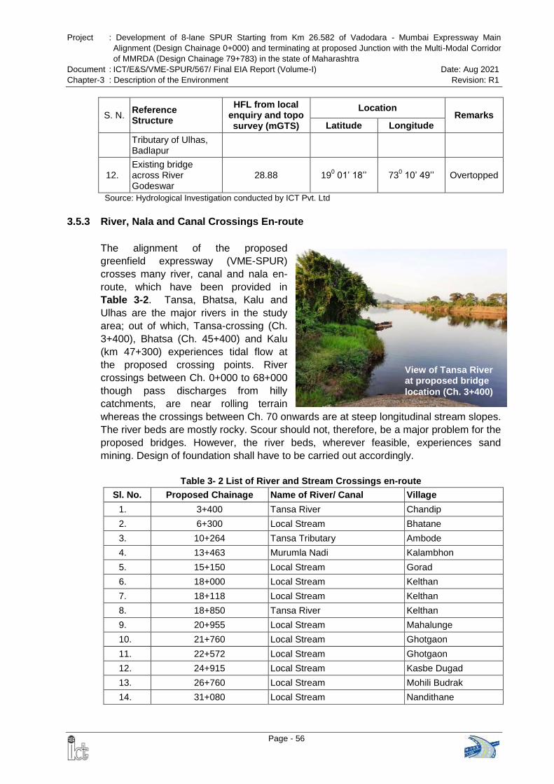
Project : Development of 8-lane SPUR Starting from Km 26.582 of Vadodara - Mumbai Expressway Main
Alignment (Design Chainage 0+000) and terminating at proposed Junction with the Multi-Modal Corridor
of MMRDA (Design Chainage 79+783) in the state of Maharashtra
Document : ICT/E&S/VME-SPUR/567/ Final EIA Report (Volume-I) Date: Aug 2021
Chapter-3 : Description of the Environment Revision: R1
Page - 56
View of Tansa River at proposed bridge
location (Ch. 3+400)
S. N. Reference Structure
HFL from local enquiry and topo survey (mGTS)
Location Remarks
Latitude Longitude
Tributary of Ulhas, Badlapur
12. Existing bridge across River Godeswar
28.88 190 01‘ 18‘‘ 73
0 10‘ 49‘‘ Overtopped
Source: Hydrological Investigation conducted by ICT Pvt. Ltd
3.5.3 River, Nala and Canal Crossings En-route
The alignment of the proposed
greenfield expressway (VME-SPUR)
crosses many river, canal and nala en-
route, which have been provided in
Table 3-2. Tansa, Bhatsa, Kalu and
Ulhas are the major rivers in the study
area; out of which, Tansa-crossing (Ch.
3+400), Bhatsa (Ch. 45+400) and Kalu
(km 47+300) experiences tidal flow at
the proposed crossing points. River
crossings between Ch. 0+000 to 68+000
though pass discharges from hilly
catchments, are near rolling terrain
whereas the crossings between Ch. 70 onwards are at steep longitudinal stream slopes.
The river beds are mostly rocky. Scour should not, therefore, be a major problem for the
proposed bridges. However, the river beds, wherever feasible, experiences sand
mining. Design of foundation shall have to be carried out accordingly.
Table 3- 2 List of River and Stream Crossings en-route
Sl. No. Proposed Chainage Name of River/ Canal Village
1. 3+400 Tansa River Chandip
2. 6+300 Local Stream Bhatane
3. 10+264 Tansa Tributary Ambode
4. 13+463 Murumla Nadi Kalambhon
5. 15+150 Local Stream Gorad
6. 18+000 Local Stream Kelthan
7. 18+118 Local Stream Kelthan
8. 18+850 Tansa River Kelthan
9. 20+955 Local Stream Mahalunge
10. 21+760 Local Stream Ghotgaon
11. 22+572 Local Stream Ghotgaon
12. 24+915 Local Stream Kasbe Dugad
13. 26+760 Local Stream Mohili Budrak
14. 31+080 Local Stream Nandithane
Project : Development of 8-lane SPUR Starting from Km 26.582 of Vadodara - Mumbai Expressway Main
Alignment (Design Chainage 0+000) and terminating at proposed Junction with the Multi-Modal Corridor
of MMRDA (Design Chainage 79+783) in the state of Maharashtra
Document : ICT/E&S/VME-SPUR/567/ Final EIA Report (Volume-I) Date: Aug 2021
Chapter-3 : Description of the Environment Revision: R1
Page - 57
Sl. No. Proposed Chainage Name of River/ Canal Village
15. 33+334 Kamvadi River Nivali
16. 34+235 Local Stream Pundas
17. 45+400 Bhatsa River Sange
18. 47+300 Kalu River Sangode
19. 51+340 Local Stream Manivali
20. 55+600 Local Stream Vaholi Tarf Bahe
21. 57+619 Barvi River Apti Tarfe Bahe
22. 58+945 Local Stream Dapivali
23. 67+300 Ulhas River Chamtoli
24. 69+985 Local Stream Bhoj
25. 70+540 Local Stream Bendshil
26. 71+350 Local Stream Bendshil
Source: Field Survey conducted by ICT Pvt. Ltd
Apart from the above, the proposed SPUR alignment crosses 1st order streams at
several locations.
3.5.4 Hydro-Meteorologically Homogenous Sub Zones
The Central Water Commission (CWC) has divided the Geographical Territory of India
into 26 distinct hydro-meteorologically homogenous sub zones. The Study area comes
under Sub zone 5(a) for West Coast Region (Konkan Coasts). River bridges of the
study area shall come under relevant Hydro-Meteorologically Homogenous Sub zone
based on the locations of proposed crossing.
3.5.5 Design Rainfall
The Design Rainfall (24 hr. maximum) of the study area has been judiciously selected
from the following:
The 50 Year / 100 Year Isopluvial Map of the Sub zone concerned
The recorded and published daily maximum rainfalls of Palghar district
The recorded daily maximum rainfall as collected during reconnaissance survey
The following Table 3-3 reflects the return periods and corresponding maximum 24 hour
rainfall adopted for design of the proposed major bridges of expressway.
Table 3- 3 Return Period and Rainfall Adopted for Expressway Bridges
Sl. No. Proposed bridge over River
Proposed Chainage
100-Year / 24-Hr rainfall (mm)
50-Year / 24-Hr rainfall (mm)
1. Tansa River 3+400 480 440
2. Murumla Nadi 13+463 500 460
3. Tansa River 18+850 480 440
4. Kamvadi River 33+334 480 420
Project : Development of 8-lane SPUR Starting from Km 26.582 of Vadodara - Mumbai Expressway Main
Alignment (Design Chainage 0+000) and terminating at proposed Junction with the Multi-Modal Corridor
of MMRDA (Design Chainage 79+783) in the state of Maharashtra
Document : ICT/E&S/VME-SPUR/567/ Final EIA Report (Volume-I) Date: Aug 2021
Chapter-3 : Description of the Environment Revision: R1
Page - 58
Sl. No. Proposed bridge over River
Proposed Chainage
100-Year / 24-Hr rainfall (mm)
50-Year / 24-Hr rainfall (mm)
5. Bhatsa River 45+400 440 410
6. Kalu River 47+300 400 360
7. Barvi River 57+619 440 400
8. Ulhas River 67+300 520 480
Source: DPR prepared by ICT Pvt. Ltd
3.5.6 Catchment Area and Drainage Network
The watersheds of the rivers at the proposed crossing points have been delineated with
the help of ArcGIS 9.2 Software. The watershed area, total and centroidal stream
lengths, segmental stream length and corresponding falls have been determined with
the help of GIS Software. The superimposition of delineated catchment areas over the
digitized Isopluvial Maps (50 Year / 100 Year-24 hr.) has also been done. For small
watersheds not traceable in Digital Elevation Model, catchment areas, stream lengths
and falls have been estimated through study of toposheets of the concerned area and
satellite imagery. Annex-3.2 reflects the catchment areas over the whole study are of
the proposed expressway including drainage network, delineated with the help of
ArcGIS Software and details of catchment area is presented in Table 3-4.
Table 3- 4 Catchment Area of Rivers & Local Streams along the Proposed Expressway
Sl. No. Proposed Chainage Name of River/ Canal Village Catchment
Area (sq.km)
27. 3+400 Tansa River Chandip 640.2
28. 6+300 Local Stream Bhatane 8.16
29. 10+264 Tansa Tributary Ambode 19.2
30. 13+463 Murumla Nadi Kalambhon 19.87
31. 15+150 Local Stream Gorad 12.4
32. 18+000 Local Stream Kelthan 4.87
33. 18+118 Local Stream Kelthan 15.71
34. 18+850 Tansa River Kelthan 443.27
35. 20+955 Local Stream Mahalunge 2.62
36. 21+760 Local Stream Ghotgaon 3.41
37. 22+572 Local Stream Ghotgaon 1.21
38. 24+915 Local Stream Kasbe Dugad 2.38
39. 26+760 Local Stream Mohili Budrak 4.18
40. 31+080 Local Stream Nandithane 19.58
41. 33+334 Kamvadi River Nivali 67.93
42. 34+235 Local Stream Pundas 5.7
43. 45+400 Bhatsa River Sange 984.1
44. 47+300 Kalu River Sangode 1232.28
45. 51+340 Local Stream Manivali 10.92
46. 55+600 Local Stream Vaholi Tarf Bahe
2.62
Project : Development of 8-lane SPUR Starting from Km 26.582 of Vadodara - Mumbai Expressway Main
Alignment (Design Chainage 0+000) and terminating at proposed Junction with the Multi-Modal Corridor
of MMRDA (Design Chainage 79+783) in the state of Maharashtra
Document : ICT/E&S/VME-SPUR/567/ Final EIA Report (Volume-I) Date: Aug 2021
Chapter-3 : Description of the Environment Revision: R1
Page - 59
Sl. No. Proposed Chainage Name of River/ Canal Village Catchment
Area (sq.km)
47. 57+619 Barvi River Apti Tarfe Bahe 406.65
48. 58+945 Local Stream Dapivali 4.11
49. 67+300 Ulhas River Chamtoli 873.24
50. 69+985 Local Stream Bhoj 7.96
51. 70+540 Local Stream Bendshil 4.69
52. 71+350 Local Stream Bendshil 2.3
Source: DPR prepared by ICT Pvt. Ltd
3.6 AGRICULTURE AND IRRIGATION PRACTICES
In the study area agriculture is a primary source of livelihood activity. The area is
predominantly rainfed and receives an annual rainfall of more than 2500 mm, but steep
slopes and rocky terrain results in poor water retention. According to 2011 Census the
land use pattern indicates that 41.93% is the net sown area and only 1.9% of the total
area is sown more than once. In order to overcome the problem, Social Forestry
Department and Agriculture Department of Govt. of Maharashtra have undertaken small
schemes of water conservation and artificial recharge.
Agro-ecological situations of the study area including their characteristics and coverage
are given in the Table 3-5
Table 3-5 Agro-ecological Situations of the Study Area
Items Description
Agro Ecological Sub Region (ICAR)
Western Ghats and Coastal Plain, Hot Humid-Perhumid Eco-Region (19.1) Western Ghats And Coastal Plain, Hot Humid-Perhumid Eco-Region (19.3)
Soil Type Medium black soil
Irrigation source available Medium irrigated conditions
Special Features Coastal zone resulting in soil affected by salt
Major Field crops Paddy, Finger millet, Proso millet, Pulses (Cowpea, blackgram,
pigeon pea, chick pea, etc.), ground nut etc.
Horticultural crops – Fruits Mango, Sapota, Cashew
Horticulture crops – Vegetables
Okra, Brinjal, Chilli and Leafy vegetables
Plantation crops Coconut
Source: Dept. of Agriculture, Govt. of Maharashtra
Project : Development of 8-lane SPUR Starting from Km 26.582 of Vadodara - Mumbai Expressway Main
Alignment (Design Chainage 0+000) and terminating at proposed Junction with the Multi-Modal Corridor
of MMRDA (Design Chainage 79+783) in the state of Maharashtra
Document : ICT/E&S/VME-SPUR/567/ Final EIA Report (Volume-I) Date: Aug 2021
Chapter-3 : Description of the Environment Revision: R1
Page - 60
3.7 LAND USE
3.7.1 Method of Data Preparation
The land use / land cover of the study area i.e. covering aerial distance of 15 Km from
the alignment of proposed expressway has been presented in the form of a map on 1:
25,000 scale as per requirement of the MoEFCC. The map has been prepared using
Survey of India Topographical sheet (1:50000 scale), satellite images, maps of forest
division etc. as listed in Table 3-6.
Table 3-6 Secondary Data and Images Used for Preparation of Land Use Map
Sr. No. Data/Maps Source
1
SOI Toposheets at 1:50000 scale (47A10, 47A11,
47A14, 47A15, 47E2, 47E3, 47E4, 47E7, 47E8,
47F1, 47F5)
Survey of India
2
Remote Sensing Data:
Satellite Imagery- Resourcesat- LISS - III Data
Year- 2015
Spatial Resolution- 24 meter
Bhuvan Open Data Service
National Remote Sensing Center
(NRSC)
3 Tungreshwar Wildlife Sanctuary Boundary Map
Final Notification declaring Eco
Sensitive Zone 11th September
2019
4 Matheran Eco Sensitive Area
Zonal Master Plan Report for
Matheran ESZ, 2016-36 dated 7th
August, 2019
5 Others Google Earth Images
Source: EIA Study carried out by ICT Pvt. Ltd.
The data has been processed using geo-processing software ArcGIS and Erdas
Imagine software supported with ground truth verification. Area and distance
calculations have been carried out using the software after geo-referencing the
interpreted data with the help of the topographical maps. The land use map of the
study area covering 15 km on either side is provided in Figure 3-2.
3.7.2 Land Use within PROW
Agricultural and allied uses occupied largest part amounting to 659.57 ha. (63.92%) of
the total area, followed by followed by barren / waste land 165.76 ha (16.06%), forest
122.61 ha (11.91%), Industrial Area 44.51 ha (4.31%), built-up area 25.43 ha (2.46%)
and water bodies 13.72 ha (1.33%). Land use distribution with in proposed RoW is
presented in Table 3-7. This has been graphically represented in Figure 3-3. Based on
analysis of data and ground verification, it can be concluded is that majority portion of
the alignment is passing through agricultural land followed by barren land with plain /
rolling terrain. The main agricultural activities within PROW are plantation, cropland and
pasture.
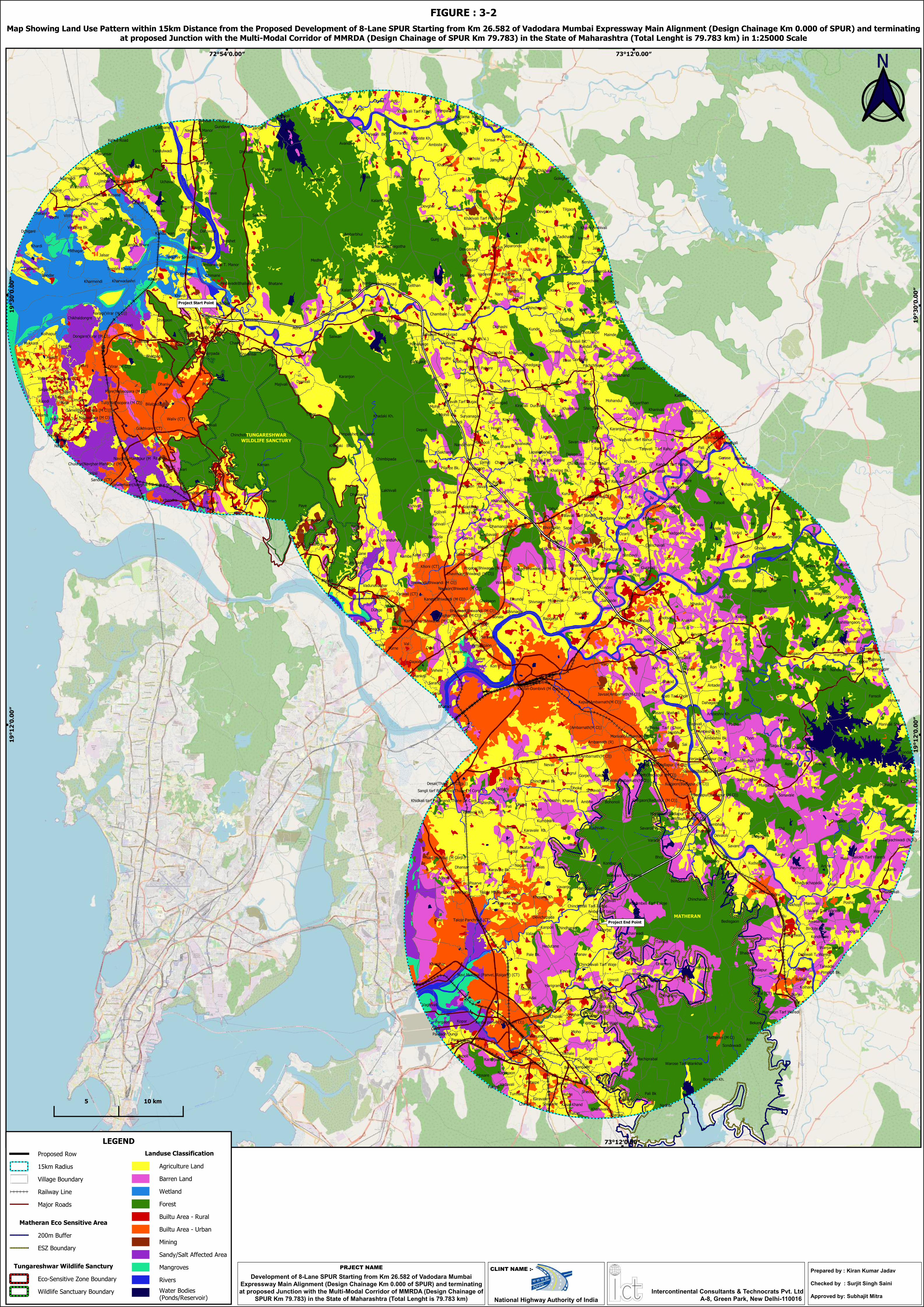
Project Start Point
Project End Point
Proposed Row
15km Radius
Village Boundary
Railway Line
Major Roads
Matheran Eco Sensitive Area
200m Buffer
ESZ Boundary
Tungareshwar Wildlife Sanctury
Eco-Sensitive Zone Boundary
Wildlife Sanctuary Boundary
Landuse Classification
Agriculture Land
Barren Land
Wetland
Forest
Builtu Area - Rural
Builtu Area - Urban
Mining
Sandy/Salt Affected Area
Mangroves
Rivers
Water Bodies(Ponds/Reservoir)
LEGEND
Map Showing Land Use Pattern within 15km Distance from the Proposed Development of 8-Lane SPUR Starting from Km 26.582 of Vadodara Mumbai Expressway Main Alignment (Design Chainage Km 0.000 of SPUR) and terminatingat proposed Junction with the Multi-Modal Corridor of MMRDA (Design Chainage of SPUR Km 79.783) in the State of Maharashtra (Total Lenght is 79.783 km) in 1:25000 Scale
Development of 8-Lane SPUR Starting from Km 26.582 of Vadodara MumbaiExpressway Main Alignment (Design Chainage Km 0.000 of SPUR) and terminatingat proposed Junction with the Multi-Modal Corridor of MMRDA (Design Chainage of
SPUR Km 79.783) in the State of Maharashtra (Total Lenght is 79.783 km)
PRJECT NAME
National Highway Authority of India
TUNGARESHWARWILDLIFE SANCTURY
CLINT NAME :-
Intercontinental Consultants & Technocrats Pvt. LtdA-8, Green Park, New Delhi-110016
FIGURE : 3-2
Prepared by : Kiran Kumar Jadav
Checked by : Surjit Singh Saini
Approved by: Subhajit Mitra
MATHERAN
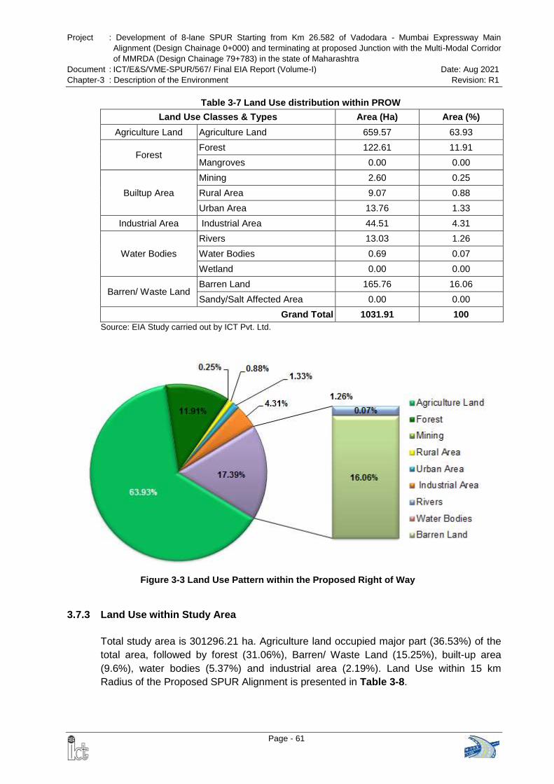
Project : Development of 8-lane SPUR Starting from Km 26.582 of Vadodara - Mumbai Expressway Main
Alignment (Design Chainage 0+000) and terminating at proposed Junction with the Multi-Modal Corridor
of MMRDA (Design Chainage 79+783) in the state of Maharashtra
Document : ICT/E&S/VME-SPUR/567/ Final EIA Report (Volume-I) Date: Aug 2021
Chapter-3 : Description of the Environment Revision: R1
Page - 61
Figure 3-3 Land Use Pattern within the Proposed Right of Way
Table 3-7 Land Use distribution within PROW
Land Use Classes & Types Area (Ha) Area (%)
Agriculture Land Agriculture Land 659.57 63.93
Forest Forest 122.61 11.91
Mangroves 0.00 0.00
Builtup Area
Mining 2.60 0.25
Rural Area 9.07 0.88
Urban Area 13.76 1.33
Industrial Area Industrial Area 44.51 4.31
Water Bodies
Rivers 13.03 1.26
Water Bodies 0.69 0.07
Wetland 0.00 0.00
Barren/ Waste Land Barren Land 165.76 16.06
Sandy/Salt Affected Area 0.00 0.00
Grand Total 1031.91 100
Source: EIA Study carried out by ICT Pvt. Ltd.
3.7.3 Land Use within Study Area
Total study area is 301296.21 ha. Agriculture land occupied major part (36.53%) of the
total area, followed by forest (31.06%), Barren/ Waste Land (15.25%), built-up area
(9.6%), water bodies (5.37%) and industrial area (2.19%). Land Use within 15 km
Radius of the Proposed SPUR Alignment is presented in Table 3-8.
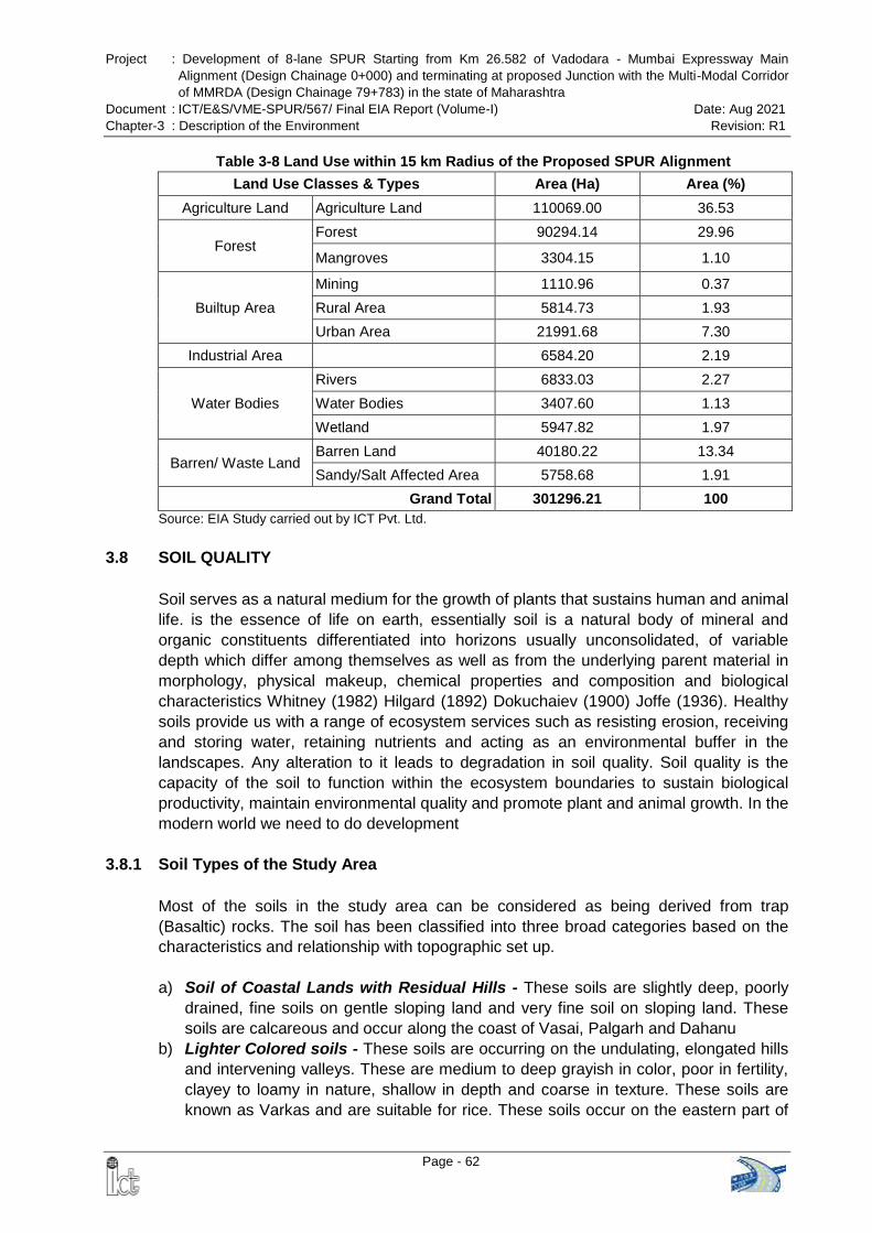
Project : Development of 8-lane SPUR Starting from Km 26.582 of Vadodara - Mumbai Expressway Main
Alignment (Design Chainage 0+000) and terminating at proposed Junction with the Multi-Modal Corridor
of MMRDA (Design Chainage 79+783) in the state of Maharashtra
Document : ICT/E&S/VME-SPUR/567/ Final EIA Report (Volume-I) Date: Aug 2021
Chapter-3 : Description of the Environment Revision: R1
Page - 62
Table 3-8 Land Use within 15 km Radius of the Proposed SPUR Alignment
Land Use Classes & Types Area (Ha) Area (%)
Agriculture Land Agriculture Land 110069.00 36.53
Forest Forest 90294.14 29.96
Mangroves 3304.15 1.10
Builtup Area
Mining 1110.96 0.37
Rural Area 5814.73 1.93
Urban Area 21991.68 7.30
Industrial Area 6584.20 2.19
Water Bodies
Rivers 6833.03 2.27
Water Bodies 3407.60 1.13
Wetland 5947.82 1.97
Barren/ Waste Land Barren Land 40180.22 13.34
Sandy/Salt Affected Area 5758.68 1.91
Grand Total 301296.21 100
Source: EIA Study carried out by ICT Pvt. Ltd.
3.8 SOIL QUALITY
Soil serves as a natural medium for the growth of plants that sustains human and animal
life. is the essence of life on earth, essentially soil is a natural body of mineral and
organic constituents differentiated into horizons usually unconsolidated, of variable
depth which differ among themselves as well as from the underlying parent material in
morphology, physical makeup, chemical properties and composition and biological
characteristics Whitney (1982) Hilgard (1892) Dokuchaiev (1900) Joffe (1936). Healthy
soils provide us with a range of ecosystem services such as resisting erosion, receiving
and storing water, retaining nutrients and acting as an environmental buffer in the
landscapes. Any alteration to it leads to degradation in soil quality. Soil quality is the
capacity of the soil to function within the ecosystem boundaries to sustain biological
productivity, maintain environmental quality and promote plant and animal growth. In the
modern world we need to do development
3.8.1 Soil Types of the Study Area
Most of the soils in the study area can be considered as being derived from trap
(Basaltic) rocks. The soil has been classified into three broad categories based on the
characteristics and relationship with topographic set up.
a) Soil of Coastal Lands with Residual Hills - These soils are slightly deep, poorly
drained, fine soils on gentle sloping land and very fine soil on sloping land. These
soils are calcareous and occur along the coast of Vasai, Palgarh and Dahanu
b) Lighter Colored soils - These soils are occurring on the undulating, elongated hills
and intervening valleys. These are medium to deep grayish in color, poor in fertility,
clayey to loamy in nature, shallow in depth and coarse in texture. These soils are
known as Varkas and are suitable for rice. These soils occur on the eastern part of
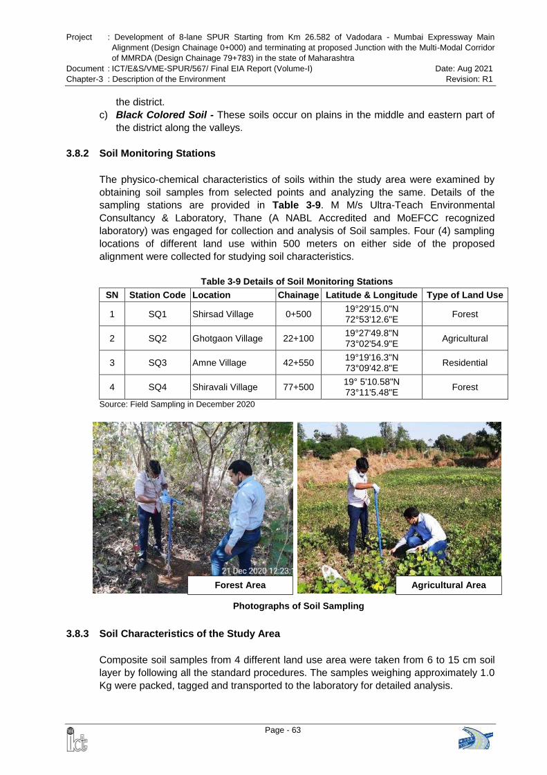
Project : Development of 8-lane SPUR Starting from Km 26.582 of Vadodara - Mumbai Expressway Main
Alignment (Design Chainage 0+000) and terminating at proposed Junction with the Multi-Modal Corridor
of MMRDA (Design Chainage 79+783) in the state of Maharashtra
Document : ICT/E&S/VME-SPUR/567/ Final EIA Report (Volume-I) Date: Aug 2021
Chapter-3 : Description of the Environment Revision: R1
Page - 63
Forest Area Agricultural Area
Photographs of Soil Sampling
the district.
c) Black Colored Soil - These soils occur on plains in the middle and eastern part of
the district along the valleys.
3.8.2 Soil Monitoring Stations
The physico-chemical characteristics of soils within the study area were examined by
obtaining soil samples from selected points and analyzing the same. Details of the
sampling stations are provided in Table 3-9. M M/s Ultra-Teach Environmental
Consultancy & Laboratory, Thane (A NABL Accredited and MoEFCC recognized
laboratory) was engaged for collection and analysis of Soil samples. Four (4) sampling
locations of different land use within 500 meters on either side of the proposed
alignment were collected for studying soil characteristics.
Table 3-9 Details of Soil Monitoring Stations
SN Station Code Location Chainage Latitude & Longitude Type of Land Use
1 SQ1 Shirsad Village 0+500 19°29'15.0"N 72°53'12.6"E
Forest
2 SQ2 Ghotgaon Village 22+100 19°27'49.8"N 73°02'54.9"E
Agricultural
3 SQ3 Amne Village 42+550 19°19'16.3"N 73°09'42.8"E
Residential
4 SQ4 Shiravali Village 77+500 19° 5'10.58"N 73°11'5.48"E
Forest
Source: Field Sampling in December 2020
3.8.3 Soil Characteristics of the Study Area
Composite soil samples from 4 different land use area were taken from 6 to 15 cm soil
layer by following all the standard procedures. The samples weighing approximately 1.0
Kg were packed, tagged and transported to the laboratory for detailed analysis.
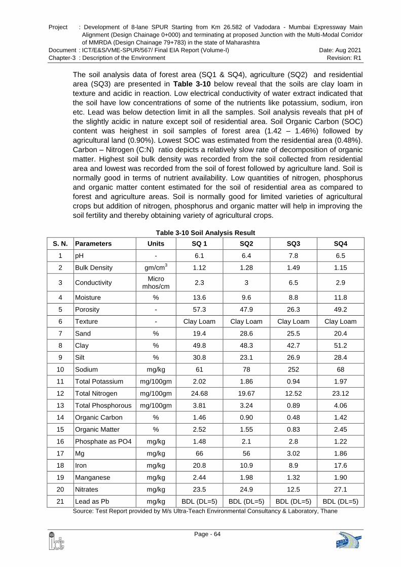
Project : Development of 8-lane SPUR Starting from Km 26.582 of Vadodara - Mumbai Expressway Main
Alignment (Design Chainage 0+000) and terminating at proposed Junction with the Multi-Modal Corridor
of MMRDA (Design Chainage 79+783) in the state of Maharashtra
Document : ICT/E&S/VME-SPUR/567/ Final EIA Report (Volume-I) Date: Aug 2021
Chapter-3 : Description of the Environment Revision: R1
Page - 64
The soil analysis data of forest area (SQ1 & SQ4), agriculture (SQ2) and residential
area (SQ3) are presented in Table 3-10 below reveal that the soils are clay loam in
texture and acidic in reaction. Low electrical conductivity of water extract indicated that
the soil have low concentrations of some of the nutrients like potassium, sodium, iron
etc. Lead was below detection limit in all the samples. Soil analysis reveals that pH of
the slightly acidic in nature except soil of residential area. Soil Organic Carbon (SOC)
content was heighest in soil samples of forest area (1.42 – 1.46%) followed by
agricultural land (0.90%). Lowest SOC was estimated from the residential area (0.48%).
Carbon – Nitrogen (C:N) ratio depicts a relatively slow rate of decomposition of organic
matter. Highest soil bulk density was recorded from the soil collected from residential
area and lowest was recorded from the soil of forest followed by agriculture land. Soil is
normally good in terms of nutrient availability. Low quantities of nitrogen, phosphorus
and organic matter content estimated for the soil of residential area as compared to
forest and agriculture areas. Soil is normally good for limited varieties of agricultural
crops but addition of nitrogen, phosphorus and organic matter will help in improving the
soil fertility and thereby obtaining variety of agricultural crops.
Table 3-10 Soil Analysis Result
S. N. Parameters Units SQ 1 SQ2 SQ3 SQ4
1 pH - 6.1 6.4 7.8 6.5
2 Bulk Density gm/cm3 1.12 1.28 1.49 1.15
3 Conductivity Micro
mhos/cm 2.3 3 6.5 2.9
4 Moisture % 13.6 9.6 8.8 11.8
5 Porosity - 57.3 47.9 26.3 49.2
6 Texture - Clay Loam Clay Loam Clay Loam Clay Loam
7 Sand % 19.4 28.6 25.5 20.4
8 Clay % 49.8 48.3 42.7 51.2
9 Silt % 30.8 23.1 26.9 28.4
10 Sodium mg/kg 61 78 252 68
11 Total Potassium mg/100gm 2.02 1.86 0.94 1.97
12 Total Nitrogen mg/100gm 24.68 19.67 12.52 23.12
13 Total Phosphorous mg/100gm 3.81 3.24 0.89 4.06
14 Organic Carbon % 1.46 0.90 0.48 1.42
15 Organic Matter % 2.52 1.55 0.83 2.45
16 Phosphate as PO4 mg/kg 1.48 2.1 2.8 1.22
17 Mg mg/kg 66 56 3.02 1.86
18 Iron mg/kg 20.8 10.9 8.9 17.6
19 Manganese mg/kg 2.44 1.98 1.32 1.90
20 Nitrates mg/kg 23.5 24.9 12.5 27.1
21 Lead as Pb mg/kg BDL (DL=5) BDL (DL=5) BDL (DL=5) BDL (DL=5)
Source: Test Report provided by M/s Ultra-Teach Environmental Consultancy & Laboratory, Thane
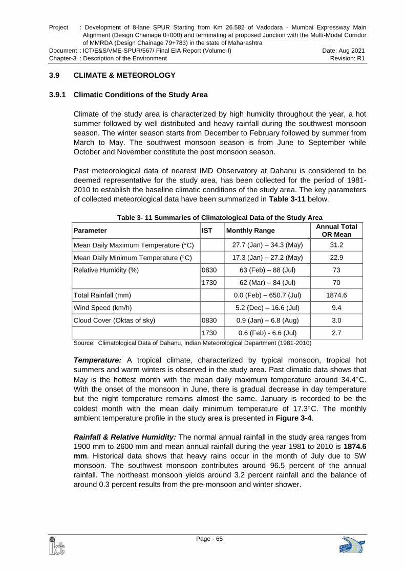
Project : Development of 8-lane SPUR Starting from Km 26.582 of Vadodara - Mumbai Expressway Main
Alignment (Design Chainage 0+000) and terminating at proposed Junction with the Multi-Modal Corridor
of MMRDA (Design Chainage 79+783) in the state of Maharashtra
Document : ICT/E&S/VME-SPUR/567/ Final EIA Report (Volume-I) Date: Aug 2021
Chapter-3 : Description of the Environment Revision: R1
Page - 65
3.9 CLIMATE & METEOROLOGY
3.9.1 Climatic Conditions of the Study Area
Climate of the study area is characterized by high humidity throughout the year, a hot
summer followed by well distributed and heavy rainfall during the southwest monsoon
season. The winter season starts from December to February followed by summer from
March to May. The southwest monsoon season is from June to September while
October and November constitute the post monsoon season.
Past meteorological data of nearest IMD Observatory at Dahanu is considered to be
deemed representative for the study area, has been collected for the period of 1981-
2010 to establish the baseline climatic conditions of the study area. The key parameters
of collected meteorological data have been summarized in Table 3-11 below.
Table 3- 11 Summaries of Climatological Data of the Study Area
Parameter IST Monthly Range Annual Total
OR Mean
Mean Daily Maximum Temperature (C) 27.7 (Jan) – 34.3 (May) 31.2
Mean Daily Minimum Temperature (C) 17.3 (Jan) – 27.2 (May) 22.9
Relative Humidity (%) 0830 63 (Feb) – 88 (Jul) 73
1730 62 (Mar) – 84 (Jul) 70
Total Rainfall (mm) 0.0 (Feb) – 650.7 (Jul) 1874.6
Wind Speed (km/h) 5.2 (Dec) – 16.6 (Jul) 9.4
Cloud Cover (Oktas of sky) 0830 0.9 (Jan) – 6.8 (Aug) 3.0
1730 0.6 (Feb) - 6.6 (Jul) 2.7
Source: Climatological Data of Dahanu, Indian Meteorological Department (1981-2010)
Temperature: A tropical climate, characterized by typical monsoon, tropical hot
summers and warm winters is observed in the study area. Past climatic data shows that
May is the hottest month with the mean daily maximum temperature around 34.4C.
With the onset of the monsoon in June, there is gradual decrease in day temperature
but the night temperature remains almost the same. January is recorded to be the
coldest month with the mean daily minimum temperature of 17.3C. The monthly
ambient temperature profile in the study area is presented in Figure 3-4.
Rainfall & Relative Humidity: The normal annual rainfall in the study area ranges from
1900 mm to 2600 mm and mean annual rainfall during the year 1981 to 2010 is 1874.6
mm. Historical data shows that heavy rains occur in the month of July due to SW
monsoon. The southwest monsoon contributes around 96.5 percent of the annual
rainfall. The northeast monsoon yields around 3.2 percent rainfall and the balance of
around 0.3 percent results from the pre-monsoon and winter shower.
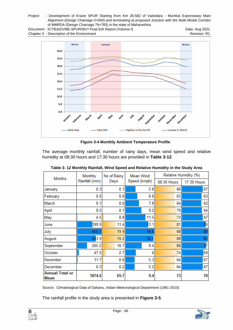
Project : Development of 8-lane SPUR Starting from Km 26.582 of Vadodara - Mumbai Expressway Main
Alignment (Design Chainage 0+000) and terminating at proposed Junction with the Multi-Modal Corridor
of MMRDA (Design Chainage 79+783) in the state of Maharashtra
Document : ICT/E&S/VME-SPUR/567/ Final EIA Report (Volume-I) Date: Aug 2021
Chapter-3 : Description of the Environment Revision: R1
Page - 66
Figure 3-4 Monthly Ambient Temperature Profile
The average monthly rainfall, number of rainy days, mean wind speed and relative
humidity at 08:30 hours and 17:30 hours are provided in Table 3-12.
Table 3- 12 Monthly Rainfall, Wind Speed and Relative Humidity in the Study Area
Source: Climatological Data of Dahanu, Indian Meteorological Department (1981-2010)
The rainfall profile in the study area is presented in Figure 3-5.
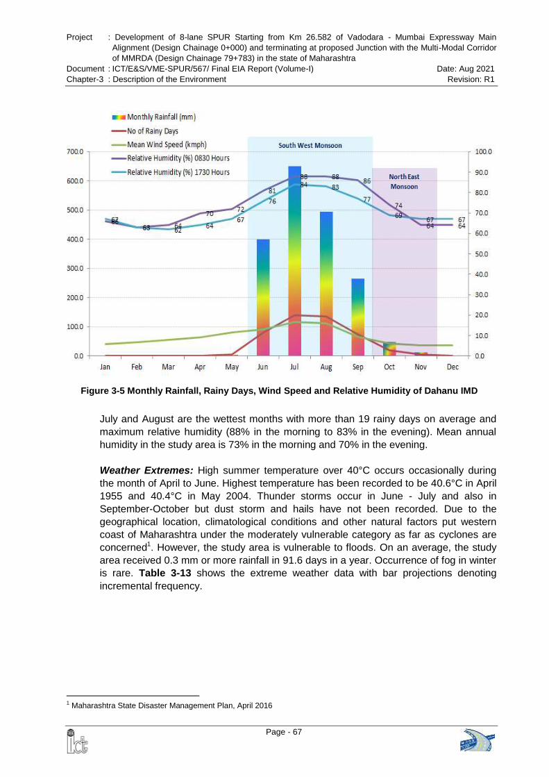
Project : Development of 8-lane SPUR Starting from Km 26.582 of Vadodara - Mumbai Expressway Main
Alignment (Design Chainage 0+000) and terminating at proposed Junction with the Multi-Modal Corridor
of MMRDA (Design Chainage 79+783) in the state of Maharashtra
Document : ICT/E&S/VME-SPUR/567/ Final EIA Report (Volume-I) Date: Aug 2021
Chapter-3 : Description of the Environment Revision: R1
Page - 67
Figure 3-5 Monthly Rainfall, Rainy Days, Wind Speed and Relative Humidity of Dahanu IMD
July and August are the wettest months with more than 19 rainy days on average and
maximum relative humidity (88% in the morning to 83% in the evening). Mean annual
humidity in the study area is 73% in the morning and 70% in the evening.
Weather Extremes: High summer temperature over 40°C occurs occasionally during
the month of April to June. Highest temperature has been recorded to be 40.6°C in April
1955 and 40.4°C in May 2004. Thunder storms occur in June - July and also in
September-October but dust storm and hails have not been recorded. Due to the
geographical location, climatological conditions and other natural factors put western
coast of Maharashtra under the moderately vulnerable category as far as cyclones are
concerned1. However, the study area is vulnerable to floods. On an average, the study
area received 0.3 mm or more rainfall in 91.6 days in a year. Occurrence of fog in winter
is rare. Table 3-13 shows the extreme weather data with bar projections denoting
incremental frequency.
1 Maharashtra State Disaster Management Plan, April 2016
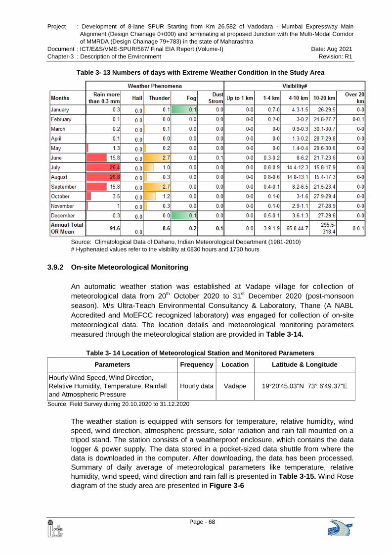
Project : Development of 8-lane SPUR Starting from Km 26.582 of Vadodara - Mumbai Expressway Main
Alignment (Design Chainage 0+000) and terminating at proposed Junction with the Multi-Modal Corridor
of MMRDA (Design Chainage 79+783) in the state of Maharashtra
Document : ICT/E&S/VME-SPUR/567/ Final EIA Report (Volume-I) Date: Aug 2021
Chapter-3 : Description of the Environment Revision: R1
Page - 68
Table 3- 13 Numbers of days with Extreme Weather Condition in the Study Area
Source: Climatological Data of Dahanu, Indian Meteorological Department (1981-2010) # Hyphenated values refer to the visibility at 0830 hours and 1730 hours
3.9.2 On-site Meteorological Monitoring
An automatic weather station was established at Vadape village for collection of
meteorological data from 20th October 2020 to 31st December 2020 (post-monsoon
season). M/s Ultra-Teach Environmental Consultancy & Laboratory, Thane (A NABL
Accredited and MoEFCC recognized laboratory) was engaged for collection of on-site
meteorological data. The location details and meteorological monitoring parameters
measured through the meteorological station are provided in Table 3-14.
Table 3- 14 Location of Meteorological Station and Monitored Parameters
Parameters Frequency Location Latitude & Longitude
Hourly Wind Speed, Wind Direction,
Relative Humidity, Temperature, Rainfall
and Atmospheric Pressure
Hourly data Vadape 19°20'45.03"N 73° 6'49.37"E
Source: Field Survey during 20.10.2020 to 31.12.2020
The weather station is equipped with sensors for temperature, relative humidity, wind
speed, wind direction, atmospheric pressure, solar radiation and rain fall mounted on a
tripod stand. The station consists of a weatherproof enclosure, which contains the data
logger & power supply. The data stored in a pocket-sized data shuttle from where the
data is downloaded in the computer. After downloading, the data has been processed.
Summary of daily average of meteorological parameters like temperature, relative
humidity, wind speed, wind direction and rain fall is presented in Table 3-15. Wind Rose
diagram of the study area are presented in Figure 3-6
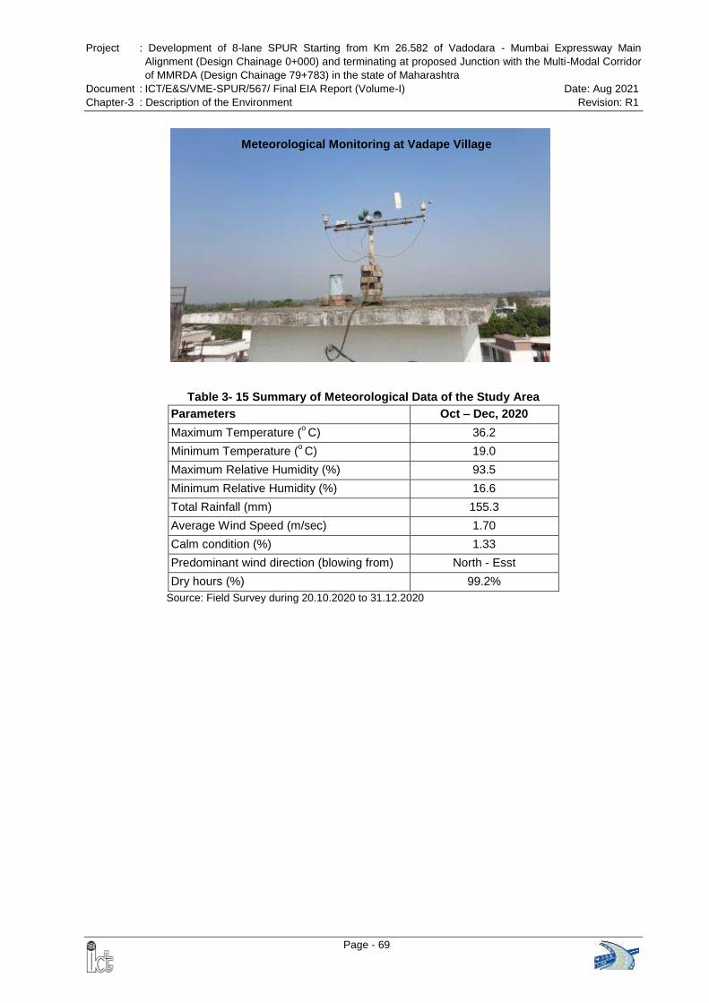
Project : Development of 8-lane SPUR Starting from Km 26.582 of Vadodara - Mumbai Expressway Main
Alignment (Design Chainage 0+000) and terminating at proposed Junction with the Multi-Modal Corridor
of MMRDA (Design Chainage 79+783) in the state of Maharashtra
Document : ICT/E&S/VME-SPUR/567/ Final EIA Report (Volume-I) Date: Aug 2021
Chapter-3 : Description of the Environment Revision: R1
Page - 69
Table 3- 15 Summary of Meteorological Data of the Study Area
Parameters Oct – Dec, 2020
Maximum Temperature (o C) 36.2
Minimum Temperature (o C) 19.0
Maximum Relative Humidity (%) 93.5
Minimum Relative Humidity (%) 16.6
Total Rainfall (mm) 155.3
Average Wind Speed (m/sec) 1.70
Calm condition (%) 1.33
Predominant wind direction (blowing from) North - Esst
Dry hours (%) 99.2%
Source: Field Survey during 20.10.2020 to 31.12.2020
Meteorological Monitoring at Vadape Village
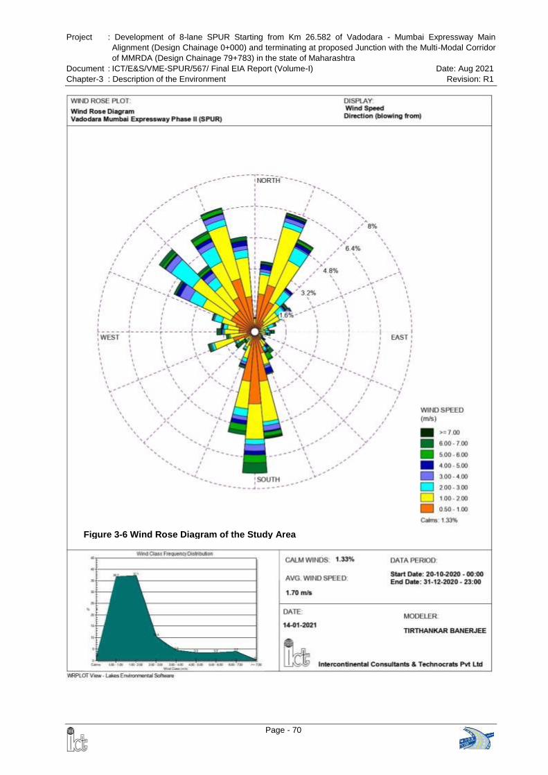
Project : Development of 8-lane SPUR Starting from Km 26.582 of Vadodara - Mumbai Expressway Main
Alignment (Design Chainage 0+000) and terminating at proposed Junction with the Multi-Modal Corridor
of MMRDA (Design Chainage 79+783) in the state of Maharashtra
Document : ICT/E&S/VME-SPUR/567/ Final EIA Report (Volume-I) Date: Aug 2021
Chapter-3 : Description of the Environment Revision: R1
Page - 70
Figure 3-6 Wind Rose Diagram of the Study Area
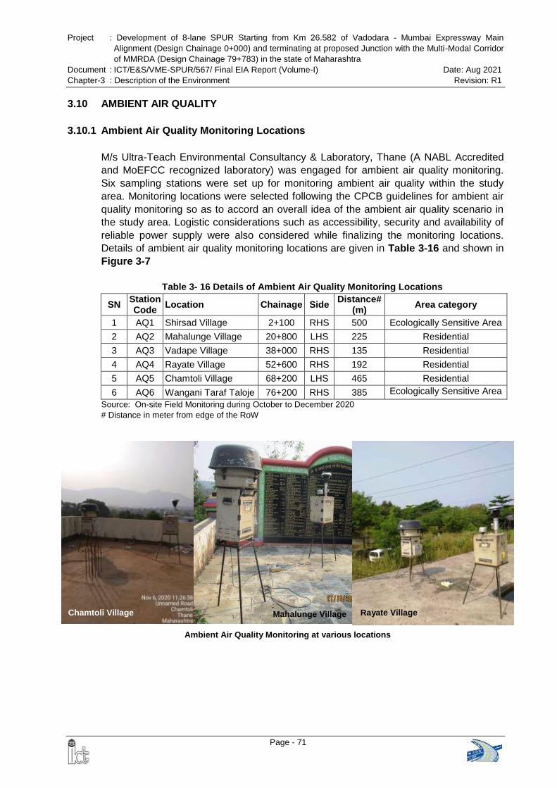
Project : Development of 8-lane SPUR Starting from Km 26.582 of Vadodara - Mumbai Expressway Main
Alignment (Design Chainage 0+000) and terminating at proposed Junction with the Multi-Modal Corridor
of MMRDA (Design Chainage 79+783) in the state of Maharashtra
Document : ICT/E&S/VME-SPUR/567/ Final EIA Report (Volume-I) Date: Aug 2021
Chapter-3 : Description of the Environment Revision: R1
Page - 71
3.10 AMBIENT AIR QUALITY
3.10.1 Ambient Air Quality Monitoring Locations
M/s Ultra-Teach Environmental Consultancy & Laboratory, Thane (A NABL Accredited
and MoEFCC recognized laboratory) was engaged for ambient air quality monitoring.
Six sampling stations were set up for monitoring ambient air quality within the study
area. Monitoring locations were selected following the CPCB guidelines for ambient air
quality monitoring so as to accord an overall idea of the ambient air quality scenario in
the study area. Logistic considerations such as accessibility, security and availability of
reliable power supply were also considered while finalizing the monitoring locations.
Details of ambient air quality monitoring locations are given in Table 3-16 and shown in
Figure 3-7
Table 3- 16 Details of Ambient Air Quality Monitoring Locations
SN Station Code
Location Chainage Side Distance#
(m) Area category
1 AQ1 Shirsad Village 2+100 RHS 500 Ecologically Sensitive Area
2 AQ2 Mahalunge Village 20+800 LHS 225 Residential
3 AQ3 Vadape Village 38+000 RHS 135 Residential
4 AQ4 Rayate Village 52+600 RHS 192 Residential
5 AQ5 Chamtoli Village 68+200 LHS 465 Residential
6 AQ6 Wangani Taraf Taloje 76+200 RHS 385 Ecologically Sensitive Area
Source: On-site Field Monitoring during October to December 2020 # Distance in meter from edge of the RoW
Chamtoli Village Mahalunge Village Rayate Village
Ambient Air Quality Monitoring at various locations
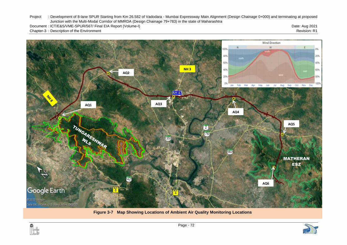
Project : Development of 8-lane SPUR Starting from Km 26.582 of Vadodara - Mumbai Expressway Main Alignment (Design Chainage 0+000) and terminating at proposed
Junction with the Multi-Modal Corridor of MMRDA (Design Chainage 79+783) in the state of Maharashtra
Document : ICT/E&S/VME-SPUR/567/ Final EIA Report (Volume-I) Date: Aug 2021
Chapter-3 : Description of the Environment Revision: R1
Page - 72
Figure 3-7 Map Showing Locations of Ambient Air Quality Monitoring Locations
AQ2
MATHERAN
ESZ
AQ3
AQ4
AQ5
AQ6
AQ1
NH 3
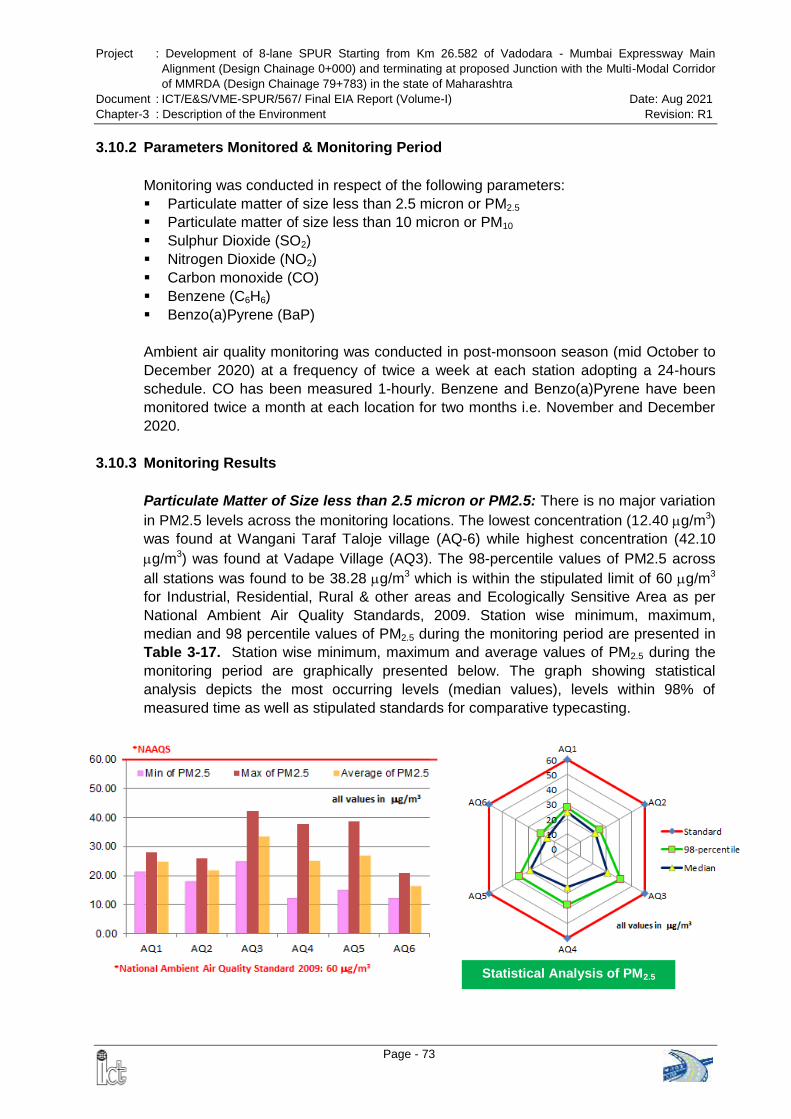
Project : Development of 8-lane SPUR Starting from Km 26.582 of Vadodara - Mumbai Expressway Main
Alignment (Design Chainage 0+000) and terminating at proposed Junction with the Multi-Modal Corridor
of MMRDA (Design Chainage 79+783) in the state of Maharashtra
Document : ICT/E&S/VME-SPUR/567/ Final EIA Report (Volume-I) Date: Aug 2021
Chapter-3 : Description of the Environment Revision: R1
Page - 73
Statistical Analysis of PM2.5
3.10.2 Parameters Monitored & Monitoring Period
Monitoring was conducted in respect of the following parameters:
Particulate matter of size less than 2.5 micron or PM2.5
Particulate matter of size less than 10 micron or PM10
Sulphur Dioxide (SO2)
Nitrogen Dioxide (NO2)
Carbon monoxide (CO)
Benzene (C6H6)
Benzo(a)Pyrene (BaP)
Ambient air quality monitoring was conducted in post-monsoon season (mid October to
December 2020) at a frequency of twice a week at each station adopting a 24-hours
schedule. CO has been measured 1-hourly. Benzene and Benzo(a)Pyrene have been
monitored twice a month at each location for two months i.e. November and December
2020.
3.10.3 Monitoring Results
Particulate Matter of Size less than 2.5 micron or PM2.5: There is no major variation
in PM2.5 levels across the monitoring locations. The lowest concentration (12.40 g/m3)
was found at Wangani Taraf Taloje village (AQ-6) while highest concentration (42.10
g/m3) was found at Vadape Village (AQ3). The 98-percentile values of PM2.5 across
all stations was found to be 38.28 g/m3 which is within the stipulated limit of 60 g/m3
for Industrial, Residential, Rural & other areas and Ecologically Sensitive Area as per
National Ambient Air Quality Standards, 2009. Station wise minimum, maximum,
median and 98 percentile values of PM2.5 during the monitoring period are presented in
Table 3-17. Station wise minimum, maximum and average values of PM2.5 during the
monitoring period are graphically presented below. The graph showing statistical
analysis depicts the most occurring levels (median values), levels within 98% of
measured time as well as stipulated standards for comparative typecasting.
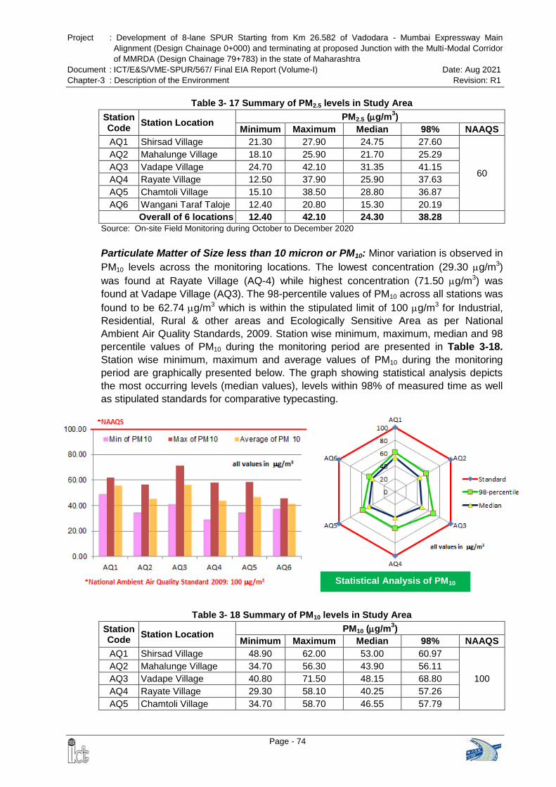
Project : Development of 8-lane SPUR Starting from Km 26.582 of Vadodara - Mumbai Expressway Main
Alignment (Design Chainage 0+000) and terminating at proposed Junction with the Multi-Modal Corridor
of MMRDA (Design Chainage 79+783) in the state of Maharashtra
Document : ICT/E&S/VME-SPUR/567/ Final EIA Report (Volume-I) Date: Aug 2021
Chapter-3 : Description of the Environment Revision: R1
Page - 74
Statistical Analysis of PM10
Table 3- 17 Summary of PM2.5 levels in Study Area
Station Code
Station Location PM2.5 (g/m
3)
Minimum Maximum Median 98% NAAQS
AQ1 Shirsad Village 21.30 27.90 24.75 27.60
60
AQ2 Mahalunge Village 18.10 25.90 21.70 25.29
AQ3 Vadape Village 24.70 42.10 31.35 41.15
AQ4 Rayate Village 12.50 37.90 25.90 37.63
AQ5 Chamtoli Village 15.10 38.50 28.80 36.87
AQ6 Wangani Taraf Taloje 12.40 20.80 15.30 20.19
Overall of 6 locations 12.40 42.10 24.30 38.28
Source: On-site Field Monitoring during October to December 2020
Particulate Matter of Size less than 10 micron or PM10: Minor variation is observed in
PM10 levels across the monitoring locations. The lowest concentration (29.30 g/m3)
was found at Rayate Village (AQ-4) while highest concentration (71.50 g/m3) was
found at Vadape Village (AQ3). The 98-percentile values of PM10 across all stations was
found to be 62.74 g/m3 which is within the stipulated limit of 100 g/m3 for Industrial,
Residential, Rural & other areas and Ecologically Sensitive Area as per National
Ambient Air Quality Standards, 2009. Station wise minimum, maximum, median and 98
percentile values of PM10 during the monitoring period are presented in Table 3-18.
Station wise minimum, maximum and average values of PM10 during the monitoring
period are graphically presented below. The graph showing statistical analysis depicts
the most occurring levels (median values), levels within 98% of measured time as well
as stipulated standards for comparative typecasting.
Table 3- 18 Summary of PM10 levels in Study Area
Station Code
Station Location PM10 (g/m
3)
Minimum Maximum Median 98% NAAQS
AQ1 Shirsad Village 48.90 62.00 53.00 60.97
100
AQ2 Mahalunge Village 34.70 56.30 43.90 56.11
AQ3 Vadape Village 40.80 71.50 48.15 68.80
AQ4 Rayate Village 29.30 58.10 40.25 57.26
AQ5 Chamtoli Village 34.70 58.70 46.55 57.79
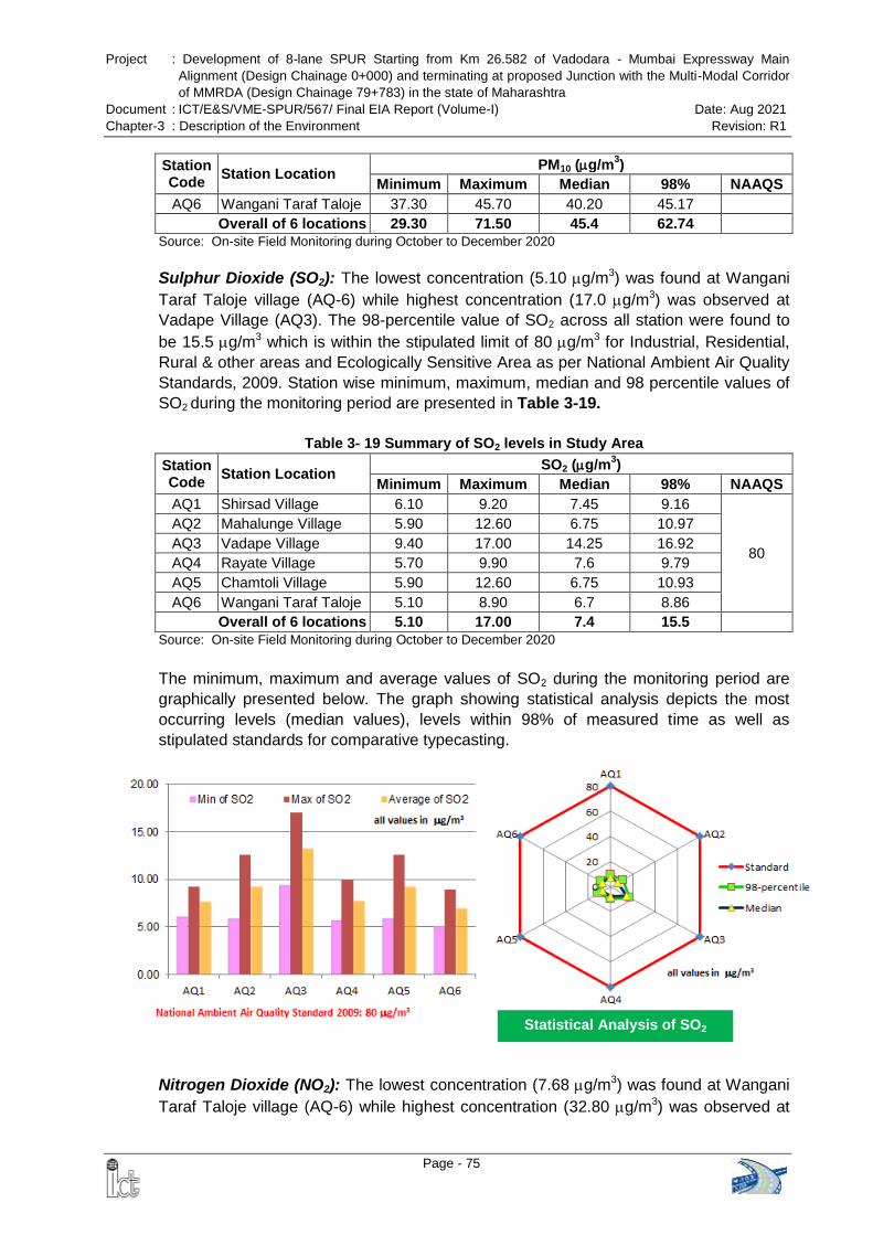
Project : Development of 8-lane SPUR Starting from Km 26.582 of Vadodara - Mumbai Expressway Main
Alignment (Design Chainage 0+000) and terminating at proposed Junction with the Multi-Modal Corridor
of MMRDA (Design Chainage 79+783) in the state of Maharashtra
Document : ICT/E&S/VME-SPUR/567/ Final EIA Report (Volume-I) Date: Aug 2021
Chapter-3 : Description of the Environment Revision: R1
Page - 75
Statistical Analysis of SO2
Station Code
Station Location PM10 (g/m
3)
Minimum Maximum Median 98% NAAQS
AQ6 Wangani Taraf Taloje 37.30 45.70 40.20 45.17
Overall of 6 locations 29.30 71.50 45.4 62.74
Source: On-site Field Monitoring during October to December 2020
Sulphur Dioxide (SO2): The lowest concentration (5.10 g/m3) was found at Wangani
Taraf Taloje village (AQ-6) while highest concentration (17.0 g/m3) was observed at
Vadape Village (AQ3). The 98-percentile value of SO2 across all station were found to
be 15.5 g/m3 which is within the stipulated limit of 80 g/m3 for Industrial, Residential,
Rural & other areas and Ecologically Sensitive Area as per National Ambient Air Quality
Standards, 2009. Station wise minimum, maximum, median and 98 percentile values of
SO2 during the monitoring period are presented in Table 3-19.
Table 3- 19 Summary of SO2 levels in Study Area
Station Code
Station Location SO2 (g/m
3)
Minimum Maximum Median 98% NAAQS
AQ1 Shirsad Village 6.10 9.20 7.45 9.16
80
AQ2 Mahalunge Village 5.90 12.60 6.75 10.97
AQ3 Vadape Village 9.40 17.00 14.25 16.92
AQ4 Rayate Village 5.70 9.90 7.6 9.79
AQ5 Chamtoli Village 5.90 12.60 6.75 10.93
AQ6 Wangani Taraf Taloje 5.10 8.90 6.7 8.86
Overall of 6 locations 5.10 17.00 7.4 15.5
Source: On-site Field Monitoring during October to December 2020
The minimum, maximum and average values of SO2 during the monitoring period are
graphically presented below. The graph showing statistical analysis depicts the most
occurring levels (median values), levels within 98% of measured time as well as
stipulated standards for comparative typecasting.
Nitrogen Dioxide (NO2): The lowest concentration (7.68 g/m3) was found at Wangani
Taraf Taloje village (AQ-6) while highest concentration (32.80 g/m3) was observed at
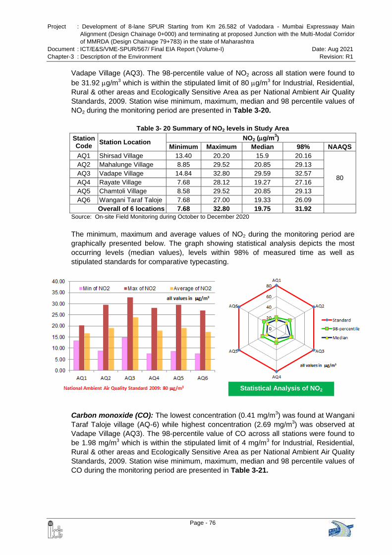
Project : Development of 8-lane SPUR Starting from Km 26.582 of Vadodara - Mumbai Expressway Main
Alignment (Design Chainage 0+000) and terminating at proposed Junction with the Multi-Modal Corridor
of MMRDA (Design Chainage 79+783) in the state of Maharashtra
Document : ICT/E&S/VME-SPUR/567/ Final EIA Report (Volume-I) Date: Aug 2021
Chapter-3 : Description of the Environment Revision: R1
Page - 76
Statistical Analysis of NO2
Vadape Village (AQ3). The 98-percentile value of NO2 across all station were found to
be 31.92 g/m3 which is within the stipulated limit of 80 g/m3 for Industrial, Residential,
Rural & other areas and Ecologically Sensitive Area as per National Ambient Air Quality
Standards, 2009. Station wise minimum, maximum, median and 98 percentile values of
NO2 during the monitoring period are presented in Table 3-20.
Table 3- 20 Summary of NO2 levels in Study Area
Station Code
Station Location NO2 (g/m
3)
Minimum Maximum Median 98% NAAQS
AQ1 Shirsad Village 13.40 20.20 15.9 20.16
80
AQ2 Mahalunge Village 8.85 29.52 20.85 29.13
AQ3 Vadape Village 14.84 32.80 29.59 32.57
AQ4 Rayate Village 7.68 28.12 19.27 27.16
AQ5 Chamtoli Village 8.58 29.52 20.85 29.13
AQ6 Wangani Taraf Taloje 7.68 27.00 19.33 26.09
Overall of 6 locations 7.68 32.80 19.75 31.92
Source: On-site Field Monitoring during October to December 2020
The minimum, maximum and average values of NO2 during the monitoring period are
graphically presented below. The graph showing statistical analysis depicts the most
occurring levels (median values), levels within 98% of measured time as well as
stipulated standards for comparative typecasting.
Carbon monoxide (CO): The lowest concentration (0.41 mg/m3) was found at Wangani
Taraf Taloje village (AQ-6) while highest concentration (2.69 mg/m3) was observed at
Vadape Village (AQ3). The 98-percentile value of CO across all stations were found to
be 1.98 mg/m3 which is within the stipulated limit of 4 mg/m3 for Industrial, Residential,
Rural & other areas and Ecologically Sensitive Area as per National Ambient Air Quality
Standards, 2009. Station wise minimum, maximum, median and 98 percentile values of
CO during the monitoring period are presented in Table 3-21.
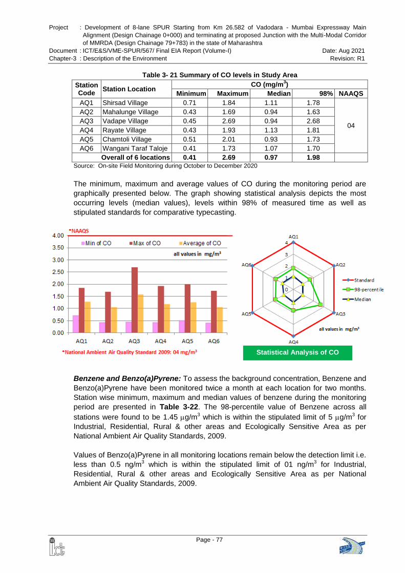
Project : Development of 8-lane SPUR Starting from Km 26.582 of Vadodara - Mumbai Expressway Main
Alignment (Design Chainage 0+000) and terminating at proposed Junction with the Multi-Modal Corridor
of MMRDA (Design Chainage 79+783) in the state of Maharashtra
Document : ICT/E&S/VME-SPUR/567/ Final EIA Report (Volume-I) Date: Aug 2021
Chapter-3 : Description of the Environment Revision: R1
Page - 77
Statistical Analysis of CO
Table 3- 21 Summary of CO levels in Study Area
Station Code
Station Location CO (mg/m
3)
Minimum Maximum Median 98% NAAQS
AQ1 Shirsad Village 0.71 1.84 1.11 1.78
04
AQ2 Mahalunge Village 0.43 1.69 0.94 1.63
AQ3 Vadape Village 0.45 2.69 0.94 2.68
AQ4 Rayate Village 0.43 1.93 1.13 1.81
AQ5 Chamtoli Village 0.51 2.01 0.93 1.73
AQ6 Wangani Taraf Taloje 0.41 1.73 1.07 1.70
Overall of 6 locations 0.41 2.69 0.97 1.98
Source: On-site Field Monitoring during October to December 2020
The minimum, maximum and average values of CO during the monitoring period are
graphically presented below. The graph showing statistical analysis depicts the most
occurring levels (median values), levels within 98% of measured time as well as
stipulated standards for comparative typecasting.
Benzene and Benzo(a)Pyrene: To assess the background concentration, Benzene and
Benzo(a)Pyrene have been monitored twice a month at each location for two months.
Station wise minimum, maximum and median values of benzene during the monitoring
period are presented in Table 3-22. The 98-percentile value of Benzene across all
stations were found to be 1.45 g/m3 which is within the stipulated limit of 5 g/m3 for
Industrial, Residential, Rural & other areas and Ecologically Sensitive Area as per
National Ambient Air Quality Standards, 2009.
Values of Benzo(a)Pyrene in all monitoring locations remain below the detection limit i.e.
less than 0.5 ng/m3 which is within the stipulated limit of 01 ng/m3 for Industrial,
Residential, Rural & other areas and Ecologically Sensitive Area as per National
Ambient Air Quality Standards, 2009.
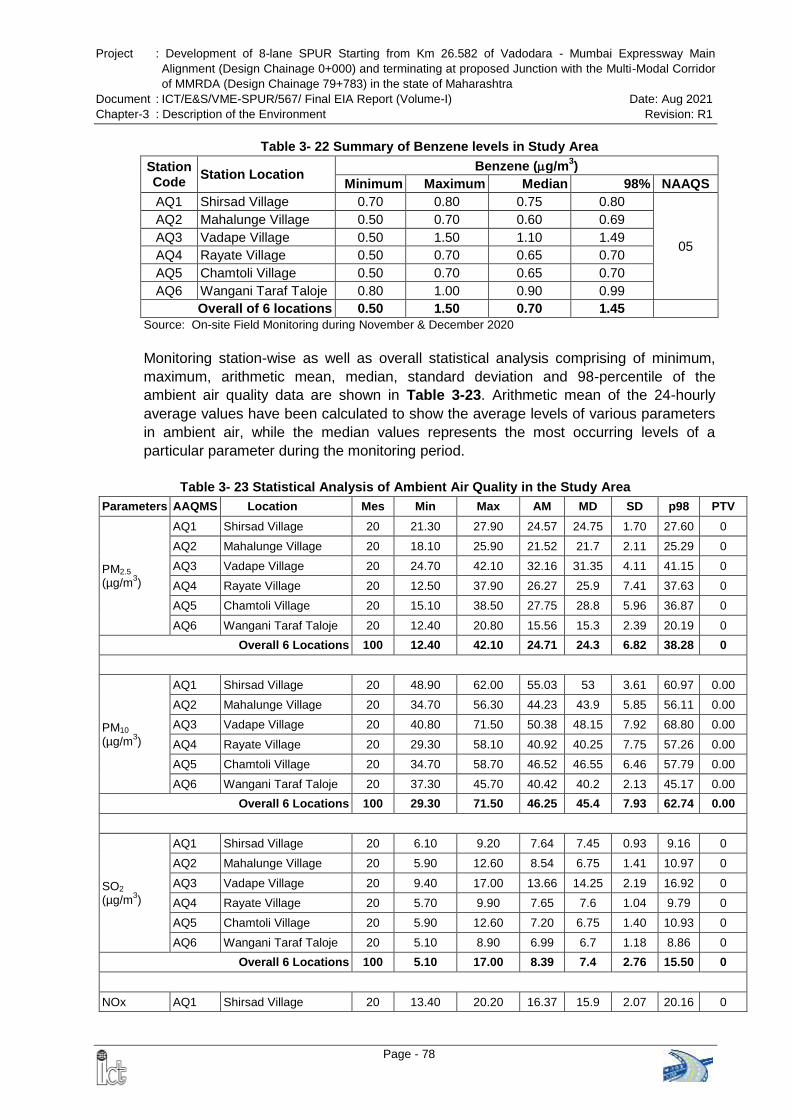
Project : Development of 8-lane SPUR Starting from Km 26.582 of Vadodara - Mumbai Expressway Main
Alignment (Design Chainage 0+000) and terminating at proposed Junction with the Multi-Modal Corridor
of MMRDA (Design Chainage 79+783) in the state of Maharashtra
Document : ICT/E&S/VME-SPUR/567/ Final EIA Report (Volume-I) Date: Aug 2021
Chapter-3 : Description of the Environment Revision: R1
Page - 78
Table 3- 22 Summary of Benzene levels in Study Area
Station Code
Station Location Benzene (g/m
3)
Minimum Maximum Median 98% NAAQS
AQ1 Shirsad Village 0.70 0.80 0.75 0.80
05
AQ2 Mahalunge Village 0.50 0.70 0.60 0.69
AQ3 Vadape Village 0.50 1.50 1.10 1.49
AQ4 Rayate Village 0.50 0.70 0.65 0.70
AQ5 Chamtoli Village 0.50 0.70 0.65 0.70
AQ6 Wangani Taraf Taloje 0.80 1.00 0.90 0.99
Overall of 6 locations 0.50 1.50 0.70 1.45
Source: On-site Field Monitoring during November & December 2020
Monitoring station-wise as well as overall statistical analysis comprising of minimum,
maximum, arithmetic mean, median, standard deviation and 98-percentile of the
ambient air quality data are shown in Table 3-23. Arithmetic mean of the 24-hourly
average values have been calculated to show the average levels of various parameters
in ambient air, while the median values represents the most occurring levels of a
particular parameter during the monitoring period.
Table 3- 23 Statistical Analysis of Ambient Air Quality in the Study Area
Parameters AAQMS Location Mes Min Max AM MD SD p98 PTV
PM2.5 (µg/m
3)
AQ1 Shirsad Village 20 21.30 27.90 24.57 24.75 1.70 27.60 0
AQ2 Mahalunge Village 20 18.10 25.90 21.52 21.7 2.11 25.29 0
AQ3 Vadape Village 20 24.70 42.10 32.16 31.35 4.11 41.15 0
AQ4 Rayate Village 20 12.50 37.90 26.27 25.9 7.41 37.63 0
AQ5 Chamtoli Village 20 15.10 38.50 27.75 28.8 5.96 36.87 0
AQ6 Wangani Taraf Taloje 20 12.40 20.80 15.56 15.3 2.39 20.19 0
Overall 6 Locations 100 12.40 42.10 24.71 24.3 6.82 38.28 0
PM10 (µg/m
3)
AQ1 Shirsad Village 20 48.90 62.00 55.03 53 3.61 60.97 0.00
AQ2 Mahalunge Village 20 34.70 56.30 44.23 43.9 5.85 56.11 0.00
AQ3 Vadape Village 20 40.80 71.50 50.38 48.15 7.92 68.80 0.00
AQ4 Rayate Village 20 29.30 58.10 40.92 40.25 7.75 57.26 0.00
AQ5 Chamtoli Village 20 34.70 58.70 46.52 46.55 6.46 57.79 0.00
AQ6 Wangani Taraf Taloje 20 37.30 45.70 40.42 40.2 2.13 45.17 0.00
Overall 6 Locations 100 29.30 71.50 46.25 45.4 7.93 62.74 0.00
SO2 (µg/m
3)
AQ1 Shirsad Village 20 6.10 9.20 7.64 7.45 0.93 9.16 0
AQ2 Mahalunge Village 20 5.90 12.60 8.54 6.75 1.41 10.97 0
AQ3 Vadape Village 20 9.40 17.00 13.66 14.25 2.19 16.92 0
AQ4 Rayate Village 20 5.70 9.90 7.65 7.6 1.04 9.79 0
AQ5 Chamtoli Village 20 5.90 12.60 7.20 6.75 1.40 10.93 0
AQ6 Wangani Taraf Taloje 20 5.10 8.90 6.99 6.7 1.18 8.86 0
Overall 6 Locations 100 5.10 17.00 8.39 7.4 2.76 15.50 0
NOx AQ1 Shirsad Village 20 13.40 20.20 16.37 15.9 2.07 20.16 0

Project : Development of 8-lane SPUR Starting from Km 26.582 of Vadodara - Mumbai Expressway Main
Alignment (Design Chainage 0+000) and terminating at proposed Junction with the Multi-Modal Corridor
of MMRDA (Design Chainage 79+783) in the state of Maharashtra
Document : ICT/E&S/VME-SPUR/567/ Final EIA Report (Volume-I) Date: Aug 2021
Chapter-3 : Description of the Environment Revision: R1
Page - 79
Parameters AAQMS Location Mes Min Max AM MD SD p98 PTV
(µg/m3) AQ2 Mahalunge Village 20 8.85 29.52 20.45 20.85 6.39 29.13 0
AQ3 Vadape Village 20 14.84 32.80 26.93 29.59 5.52 32.57 0
AQ4 Rayate Village 20 7.68 28.12 18.80 19.27 6.12 27.16 0
AQ5 Chamtoli Village 20 8.58 29.52 19.99 20.85 6.86 29.13 0
AQ6 Wangani Taraf Taloje 20 7.68 27.00 18.68 19.33 4.52 26.09 0
Overall 6 Locations 100 7.68 32.80 20.23 19.75 6.40 31.92 0
CO (mg/m
3)
AQ1 Shirsad Village 20 0.71 1.84 1.15 1.11 0.34 1.78 0
AQ2 Mahalunge Village 20 0.43 1.69 1.00 0.94 0.33 1.63 0
AQ3 Vadape Village 20 0.45 2.69 1.14 0.94 0.65 2.68 0
AQ4 Rayate Village 20 0.43 1.93 1.08 1.13 0.41 1.81 0
AQ5 Chamtoli Village 20 0.51 2.01 0.95 0.93 0.30 1.73 0
AQ6 Wangani Taraf Taloje 20 0.41 1.73 1.06 1.07 0.38 1.70 0
Overall 6 Locations 100 0.41 2.69 1.06 0.97 0.42 1.98 0
Source: On-site Field Monitoring during October to December 2020
Note: AAQMS: Ambient Air Quality Monitoring Station Code, Mes: Number of Measurements, Min: Minimum; Max: Maximum, AM:
Arithmetic Mean; MD: Median; SD: Standard Deviation, p98: 98-Percentile Value, PTV: Percent time violation with respect to the
Indian standards
As evident from Table 3-23 and the discussion above, the ambient air quality at the
monitored locations does not exceed National Standards and is well within the limits. No
industrial sources of air
emission are observed
along the proposed
alignment of the
expressway.
Indian Air Quality Index
(IND - AQI): An AQI
scheme transforms
weighted values of
individual air pollutant
concentrations into a
single number or set of
numbers. AQI is a number used by government agencies to communicate to the public
how polluted the air currently is or how polluted it is forecast to become. There are six
AQI categories, namely Good, Satisfactory, Moderately Polluted, Poor, Very Poor, and
Severe. The AQI considered various pollutants for which short-term (up to 24-hourly
averaging period) National Ambient Air Quality Standards are prescribed. Based on the
measured ambient concentrations, corresponding standards and likely health impact, a
sub-index is calculated for each of these pollutants. The worst sub-index reflects overall
AQI.
AQI of the Study Area: Air quality data of the study area generated through manual
monitoring network has been utilized to calculate the monitoring date wise AQI of the
study area and presented in Table 3-24.
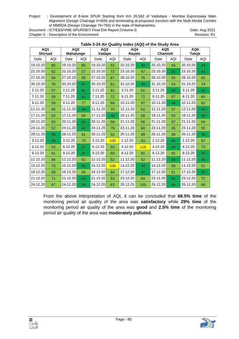
Project : Development of 8-lane SPUR Starting from Km 26.582 of Vadodara - Mumbai Expressway Main
Alignment (Design Chainage 0+000) and terminating at proposed Junction with the Multi-Modal Corridor
of MMRDA (Design Chainage 79+783) in the state of Maharashtra
Document : ICT/E&S/VME-SPUR/567/ Final EIA Report (Volume-I) Date: Aug 2021
Chapter-3 : Description of the Environment Revision: R1
Page - 80
Table 3-24 Air Quality Index (AQI) of the Study Area
AQ1 Shirsad
AQ2 Mahalunge
AQ3 Vadape
AQ4 Rayate
AQ5 Chamtoli
AQ6 Taloje
Date AQI Date AQI Date AQI Date AQI Date AQI Date AQI
19.10.20 80 19.10.20 85 19.10.20 51 20.10.20 40 20.10.20 64 20.10.20 44
22.10.20 92 22.10.20 57 22.10.20 72 23.10.20 67 23.10.20 40 23.10.20 42
27.10.20 59 27.10.20 55 27.10.20 67 28.10.20 76 28.10.20 55 28.10.20 82
30.10.20 76 30.10.20 47 30.10.20 81 31.10.20 40 31.10.20 53 31.10.20 74
2.11.20 57 2.11.20 41 2.11.20 91 3.11.20 61 3.11.20 48 3.11.20 41
7.11.20 59 7.11.20 43 7.11.20 72 6.11.20 71 6.11.20 57 6.11.20 60
9.11.20 59 9.11.20 77 9.11.20 66 10.11.20 97 10.11.20 44 10.11.20 62
11.11.20 66 11.11.20 44 11.11.20 70 12.11.20 62 12.11.20 57 12.11.20 40
17.11.20 53 17.11.20 66 17.11.20 48 18.11.20 68 18.11.20 53 18.11.20 46
20.11.20 53 20.11.20 46 20.11.20 58 21.11.20 56 21.11.20 57 21.11.20 64
24.11.20 52 24.11.20 42 24.11.20 76 23.11.20 60 23.11.20 65 23.11.20 55
28.11.20 49 28.11.20 61 28.11.20 52 26.11.20 69 26.11.20 59 26.11.20 48
3.12.20 39 3.12.20 75 3.12.20 109 1.12.20 63 1.12.20 45 1.12.20 87
6.12.20 53 6.12.20 37 6.12.20 53 4.12.20 116 4.12.20 44 4.12.20 73
9.12.20 61 9.12.20 47 9.12.20 60 8.12.20 81 8.12.20 55 8.12.20 40
12.12.20 84 12.12.20 62 12.12.20 52 11.12.20 52 11.12.20 49 11.12.20 40
15.12.20 70 15.12.20 49 15.12.20 108 14.12.20 43 14.12.20 56 14.12.20 52
18.12.20 58 18.12.20 56 18.12.20 64 17.12.20 47 17.12.20 51 17.12.20 45
21.12.20 71 21.12.20 43 21.12.20 53 23.12.20 64 23.12.20 50 23.12.20 72
24.12.20 67 24.12.20 48 24.12.20 63 26.12.20 100 26.12.20 44 26.12.20 68
From the above interpretation of AQI, it can be concluded that 68.5% time of the
monitoring period air quality of the area was satisfactory while 29% time of the
monitoring period air quality of the area was good and 2.5% time of the monitoring
period air quality of the area was moderately polluted.
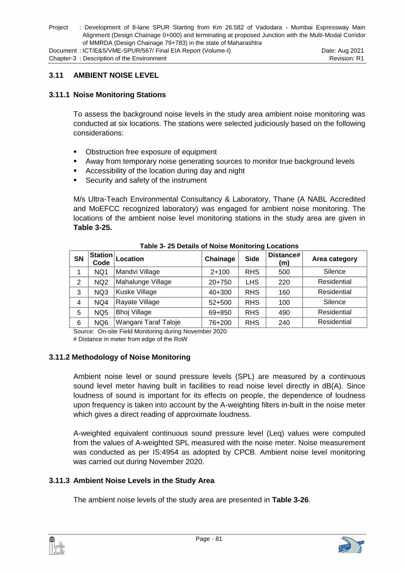
Project : Development of 8-lane SPUR Starting from Km 26.582 of Vadodara - Mumbai Expressway Main
Alignment (Design Chainage 0+000) and terminating at proposed Junction with the Multi-Modal Corridor
of MMRDA (Design Chainage 79+783) in the state of Maharashtra
Document : ICT/E&S/VME-SPUR/567/ Final EIA Report (Volume-I) Date: Aug 2021
Chapter-3 : Description of the Environment Revision: R1
Page - 81
3.11 AMBIENT NOISE LEVEL
3.11.1 Noise Monitoring Stations
To assess the background noise levels in the study area ambient noise monitoring was
conducted at six locations. The stations were selected judiciously based on the following
considerations:
Obstruction free exposure of equipment
Away from temporary noise generating sources to monitor true background levels
Accessibility of the location during day and night
Security and safety of the instrument
M/s Ultra-Teach Environmental Consultancy & Laboratory, Thane (A NABL Accredited
and MoEFCC recognized laboratory) was engaged for ambient noise monitoring. The
locations of the ambient noise level monitoring stations in the study area are given in
Table 3-25.
Table 3- 25 Details of Noise Monitoring Locations
SN Station Code
Location Chainage Side Distance#
(m) Area category
1 NQ1 Mandvi Village 2+100 RHS 500 Silence
2 NQ2 Mahalunge Village 20+750 LHS 220 Residential
3 NQ3 Kuske Village 40+300 RHS 160 Residential
4 NQ4 Rayate Village 52+500 RHS 100 Silence
5 NQ5 Bhoj Village 69+850 RHS 490 Residential
6 NQ6 Wangani Taraf Taloje 76+200 RHS 240 Residential
Source: On-site Field Monitoring during November 2020
# Distance in meter from edge of the RoW
3.11.2 Methodology of Noise Monitoring
Ambient noise level or sound pressure levels (SPL) are measured by a continuous
sound level meter having built in facilities to read noise level directly in dB(A). Since
loudness of sound is important for its effects on people, the dependence of loudness
upon frequency is taken into account by the A-weighting filters in-built in the noise meter
which gives a direct reading of approximate loudness.
A-weighted equivalent continuous sound pressure level (Leq) values were computed
from the values of A-weighted SPL measured with the noise meter. Noise measurement
was conducted as per IS:4954 as adopted by CPCB. Ambient noise level monitoring
was carried out during November 2020.
3.11.3 Ambient Noise Levels in the Study Area
The ambient noise levels of the study area are presented in Table 3-26.
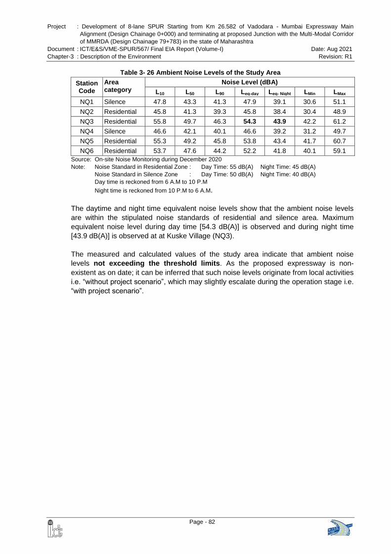
Project : Development of 8-lane SPUR Starting from Km 26.582 of Vadodara - Mumbai Expressway Main
Alignment (Design Chainage 0+000) and terminating at proposed Junction with the Multi-Modal Corridor
of MMRDA (Design Chainage 79+783) in the state of Maharashtra
Document : ICT/E&S/VME-SPUR/567/ Final EIA Report (Volume-I) Date: Aug 2021
Chapter-3 : Description of the Environment Revision: R1
Page - 82
Table 3- 26 Ambient Noise Levels of the Study Area
Station Code
Area category
Noise Level (dBA)
L10 L50 L90 Leq-day Leq- Night LMin LMax
NQ1 Silence 47.8 43.3 41.3 47.9 39.1 30.6 51.1
NQ2 Residential 45.8 41.3 39.3 45.8 38.4 30.4 48.9
NQ3 Residential 55.8 49.7 46.3 54.3 43.9 42.2 61.2
NQ4 Silence 46.6 42.1 40.1 46.6 39.2 31.2 49.7
NQ5 Residential 55.3 49.2 45.8 53.8 43.4 41.7 60.7
NQ6 Residential 53.7 47.6 44.2 52.2 41.8 40.1 59.1
Source: On-site Noise Monitoring during December 2020
Note: Noise Standard in Residential Zone : Day Time: 55 dB(A) Night Time: 45 dB(A)
Noise Standard in Silence Zone : Day Time: 50 dB(A) Night Time: 40 dB(A) Day time is reckoned from 6 A.M to 10 P.M
Night time is reckoned from 10 P.M to 6 A.M.
The daytime and night time equivalent noise levels show that the ambient noise levels
are within the stipulated noise standards of residential and silence area. Maximum
equivalent noise level during day time [54.3 dB(A)] is observed and during night time
[43.9 dB(A)] is observed at at Kuske Village (NQ3).
The measured and calculated values of the study area indicate that ambient noise
levels not exceeding the threshold limits. As the proposed expressway is non-
existent as on date; it can be inferred that such noise levels originate from local activities
i.e. ―without project scenario‖, which may slightly escalate during the operation stage i.e.
―with project scenario‖.
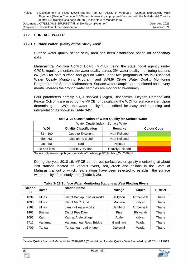
Project : Development of 8-lane SPUR Starting from Km 26.582 of Vadodara - Mumbai Expressway Main
Alignment (Design Chainage 0+000) and terminating at proposed Junction with the Multi-Modal Corridor
of MMRDA (Design Chainage 79+783) in the state of Maharashtra
Document : ICT/E&S/VME-SPUR/567/ Final EIA Report (Volume-I) Date: Aug 2021
Chapter-3 : Description of the Environment Revision: R1
Page - 83
3.12 SURFACE WATER
3.12.1 Surface Water Quality of the Study Area2
Surface water quality of the study area has been established based on secondary
data.
Maharashtra Pollution Control Board (MPCB), being the state nodal agency under
CPCB, regularly monitors the water quality across 294 water quality monitoring stations
(WQMS) for both surface and ground water under two programs of NWMP (National
Water Quality Monitoring Program) and SWMP (State Water Quality Monitoring
Program) in the State of Maharashtra. Surface water samples are monitored once every
month whereas the ground water samples are monitored bi-annually.
Four parameters namely pH, Dissolved Oxygen, Biochemical Oxygen Demand and
Feacal Coliform are used by the MPCB for calculating the WQI for surface water. Upon
determining the WQI, the water quality is described for easy understanding and
interpretation as shown in Table 3-27.
Table 3- 27 Classification of Water Quality for Surface Water
Water Quality Index – Surface Water
WQI Quality Classification Remarks Colour Code
63 – 100 Good to Excellent Non-Polluted
50 – 63 Medium to Good Non-Polluted
38 – 50 Bad Polluted
38 and less Bad to Very Bad Heavily Polluted
Source: http://www.mpcb.gov.in/envtdata/Ebulletin_pdf/E_bulletin_Oct2016.pdf
During the year 2018-19, MPCB carried out surface water quality monitoring at about
228 stations located on various rivers, sea, creek and nallahs in the State of
Maharashtra. out of which, few stations have been selected to establish the surface
water quality of the study area (Table 3-28).
Table 3- 28 Surface Water Monitoring Stations at West Flowing Rivers
Station
ID River
Station Name Village Taluka District
1094 Ulhas U/s of Badlapur water works Kulgaon Ambernath Thane
1093 Ulhas U/s of NRC Bund Mohane Kalyan Thane
2162 Ulhas Jambhul water works Jambhul Ambernath Thane
1461 Bhatsa D/s of Pise Dam Pise Bhiwandi Thane
1092 Kalu Kalu at Atale village Atale Kalyan Thane
2712 Vaitarna Vaitarna near Road Bridge Gandhare Wada Thane
2709 Tansa Tansa near road bridge Dakewali Wada Thane
2 Water Quality Status of Maharashtra 2018-2019 (Compilation of Water Quality Data Recorded by MPCB), Jul 2019
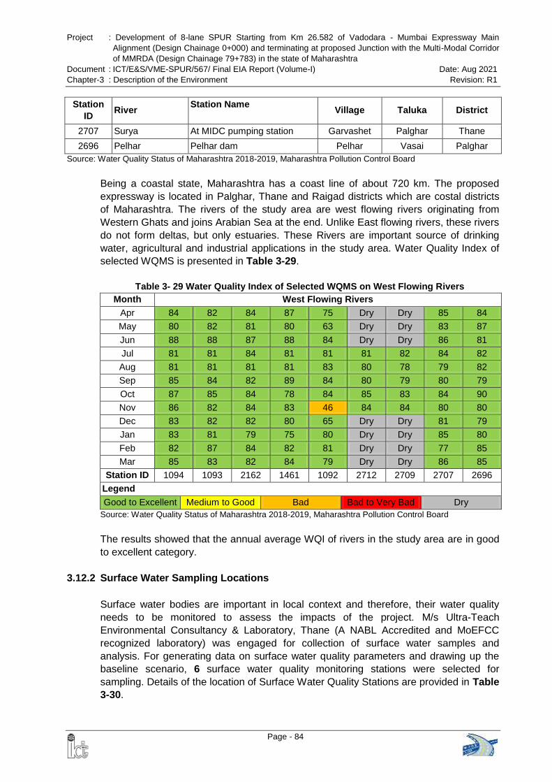
Project : Development of 8-lane SPUR Starting from Km 26.582 of Vadodara - Mumbai Expressway Main
Alignment (Design Chainage 0+000) and terminating at proposed Junction with the Multi-Modal Corridor
of MMRDA (Design Chainage 79+783) in the state of Maharashtra
Document : ICT/E&S/VME-SPUR/567/ Final EIA Report (Volume-I) Date: Aug 2021
Chapter-3 : Description of the Environment Revision: R1
Page - 84
Station
ID River
Station Name Village Taluka District
2707 Surya At MIDC pumping station Garvashet Palghar Thane
2696 Pelhar Pelhar dam Pelhar Vasai Palghar
Source: Water Quality Status of Maharashtra 2018-2019, Maharashtra Pollution Control Board
Being a coastal state, Maharashtra has a coast line of about 720 km. The proposed
expressway is located in Palghar, Thane and Raigad districts which are costal districts
of Maharashtra. The rivers of the study area are west flowing rivers originating from
Western Ghats and joins Arabian Sea at the end. Unlike East flowing rivers, these rivers
do not form deltas, but only estuaries. These Rivers are important source of drinking
water, agricultural and industrial applications in the study area. Water Quality Index of
selected WQMS is presented in Table 3-29.
Table 3- 29 Water Quality Index of Selected WQMS on West Flowing Rivers
Month West Flowing Rivers
Apr 84 82 84 87 75 Dry Dry 85 84
May 80 82 81 80 63 Dry Dry 83 87
Jun 88 88 87 88 84 Dry Dry 86 81
Jul 81 81 84 81 81 81 82 84 82
Aug 81 81 81 81 83 80 78 79 82
Sep 85 84 82 89 84 80 79 80 79
Oct 87 85 84 78 84 85 83 84 90
Nov 86 82 84 83 46 84 84 80 80
Dec 83 82 82 80 65 Dry Dry 81 79
Jan 83 81 79 75 80 Dry Dry 85 80
Feb 82 87 84 82 81 Dry Dry 77 85
Mar 85 83 82 84 79 Dry Dry 86 85
Station ID 1094 1093 2162 1461 1092 2712 2709 2707 2696
Legend
Good to Excellent Medium to Good Bad Bad to Very Bad Dry
Source: Water Quality Status of Maharashtra 2018-2019, Maharashtra Pollution Control Board
The results showed that the annual average WQI of rivers in the study area are in good
to excellent category.
3.12.2 Surface Water Sampling Locations
Surface water bodies are important in local context and therefore, their water quality
needs to be monitored to assess the impacts of the project. M/s Ultra-Teach
Environmental Consultancy & Laboratory, Thane (A NABL Accredited and MoEFCC
recognized laboratory) was engaged for collection of surface water samples and
analysis. For generating data on surface water quality parameters and drawing up the
baseline scenario, 6 surface water quality monitoring stations were selected for
sampling. Details of the location of Surface Water Quality Stations are provided in Table
3-30.
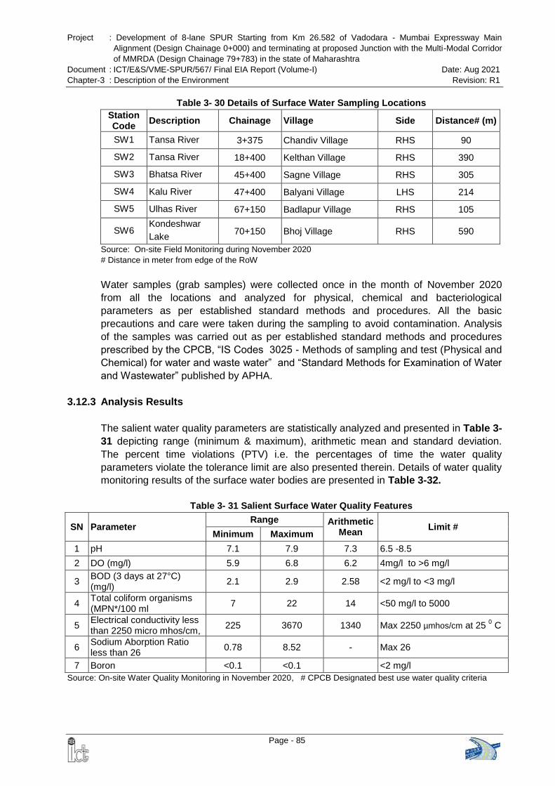
Project : Development of 8-lane SPUR Starting from Km 26.582 of Vadodara - Mumbai Expressway Main
Alignment (Design Chainage 0+000) and terminating at proposed Junction with the Multi-Modal Corridor
of MMRDA (Design Chainage 79+783) in the state of Maharashtra
Document : ICT/E&S/VME-SPUR/567/ Final EIA Report (Volume-I) Date: Aug 2021
Chapter-3 : Description of the Environment Revision: R1
Page - 85
Table 3- 30 Details of Surface Water Sampling Locations
Station Code
Description Chainage Village Side Distance# (m)
SW1 Tansa River 3+375 Chandiv Village RHS 90
SW2 Tansa River 18+400 Kelthan Village RHS 390
SW3 Bhatsa River 45+400 Sagne Village RHS 305
SW4 Kalu River 47+400 Balyani Village LHS 214
SW5 Ulhas River 67+150 Badlapur Village RHS 105
SW6 Kondeshwar
Lake 70+150 Bhoj Village RHS 590
Source: On-site Field Monitoring during November 2020
# Distance in meter from edge of the RoW
Water samples (grab samples) were collected once in the month of November 2020
from all the locations and analyzed for physical, chemical and bacteriological
parameters as per established standard methods and procedures. All the basic
precautions and care were taken during the sampling to avoid contamination. Analysis
of the samples was carried out as per established standard methods and procedures
prescribed by the CPCB, ―IS Codes 3025 - Methods of sampling and test (Physical and
Chemical) for water and waste water‖ and ―Standard Methods for Examination of Water
and Wastewater‖ published by APHA.
3.12.3 Analysis Results
The salient water quality parameters are statistically analyzed and presented in Table 3-
31 depicting range (minimum & maximum), arithmetic mean and standard deviation.
The percent time violations (PTV) i.e. the percentages of time the water quality
parameters violate the tolerance limit are also presented therein. Details of water quality
monitoring results of the surface water bodies are presented in Table 3-32.
Table 3- 31 Salient Surface Water Quality Features
SN Parameter Range Arithmetic
Mean Limit #
Minimum Maximum
1 pH 7.1 7.9 7.3 6.5 -8.5
2 DO (mg/l) 5.9 6.8 6.2 4mg/l to >6 mg/l
3 BOD (3 days at 27°C) (mg/l)
2.1 2.9 2.58 <2 mg/l to <3 mg/l
4 Total coliform organisms (MPN*/100 ml
7 22 14 <50 mg/l to 5000
5 Electrical conductivity less than 2250 micro mhos/cm,
225 3670 1340 Max 2250 µmhos/cm at 25 0 C
6 Sodium Aborption Ratio less than 26
0.78 8.52 - Max 26
7 Boron <0.1 <0.1 <2 mg/l
Source: On-site Water Quality Monitoring in November 2020, # CPCB Designated best use water quality criteria
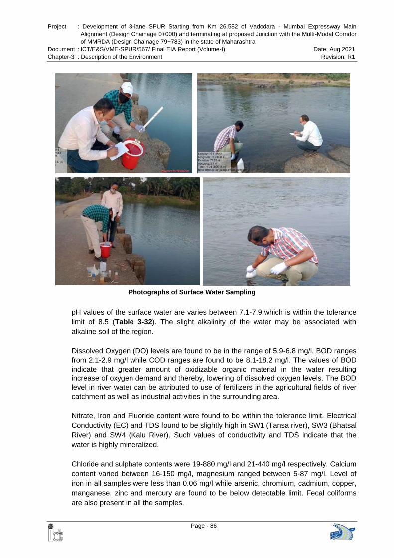
Project : Development of 8-lane SPUR Starting from Km 26.582 of Vadodara - Mumbai Expressway Main
Alignment (Design Chainage 0+000) and terminating at proposed Junction with the Multi-Modal Corridor
of MMRDA (Design Chainage 79+783) in the state of Maharashtra
Document : ICT/E&S/VME-SPUR/567/ Final EIA Report (Volume-I) Date: Aug 2021
Chapter-3 : Description of the Environment Revision: R1
Page - 86
Photographs of Surface Water Sampling
pH values of the surface water are varies between 7.1-7.9 which is within the tolerance
limit of 8.5 (Table 3-32). The slight alkalinity of the water may be associated with
alkaline soil of the region.
Dissolved Oxygen (DO) levels are found to be in the range of 5.9-6.8 mg/l. BOD ranges
from 2.1-2.9 mg/l while COD ranges are found to be 8.1-18.2 mg/l. The values of BOD
indicate that greater amount of oxidizable organic material in the water resulting
increase of oxygen demand and thereby, lowering of dissolved oxygen levels. The BOD
level in river water can be attributed to use of fertilizers in the agricultural fields of river
catchment as well as industrial activities in the surrounding area.
Nitrate, Iron and Fluoride content were found to be within the tolerance limit. Electrical
Conductivity (EC) and TDS found to be slightly high in SW1 (Tansa river), SW3 (Bhatsal
River) and SW4 (Kalu River). Such values of conductivity and TDS indicate that the
water is highly mineralized.
Chloride and sulphate contents were 19-880 mg/l and 21-440 mg/l respectively. Calcium
content varied between 16-150 mg/l, magnesium ranged between 5-87 mg/l. Level of
iron in all samples were less than 0.06 mg/l while arsenic, chromium, cadmium, copper,
manganese, zinc and mercury are found to be below detectable limit. Fecal coliforms
are also present in all the samples.
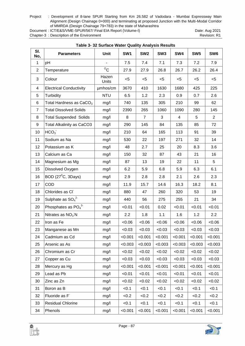
Project : Development of 8-lane SPUR Starting from Km 26.582 of Vadodara - Mumbai Expressway Main
Alignment (Design Chainage 0+000) and terminating at proposed Junction with the Multi-Modal Corridor
of MMRDA (Design Chainage 79+783) in the state of Maharashtra
Document : ICT/E&S/VME-SPUR/567/ Final EIA Report (Volume-I) Date: Aug 2021
Chapter-3 : Description of the Environment Revision: R1
Page - 87
Table 3- 32 Surface Water Quality Analysis Results
Sl. No,
Parameters Unit SW1 SW2 SW3 SW4 SW5 SW6
1 pH - 7.5 7.4 7.1 7.3 7.2 7.9
2 Temperature OC 27.9 27.9 26.8 26.7 26.2 26.4
3 Colour Hazen Units
<5 <5 <5 <5 <5 <5
4 Electrical Conductivity µmhos/cm 3670 410 1630 1680 425 225
5 Turbidity NTU 6.5 1.2 2.3 0.9 0.7 2.6
6 Total Hardness as CaCO3 mg/l 740 135 305 210 99 62
7 Total Dissolved Solids mg/l 2390 265 1060 1090 280 145
8 Total Suspended Solids mg/l 8 7 3 4 5 2
9 Total Alkalinity as CaCO3 mg/l 290 145 84 135 85 72
10 HCO3- mg/l 210 64 165 113 91 39
11 Sodium as Na mg/l 530 22 197 271 32 14
12 Potassium as K mg/l 48 2.7 25 20 8.3 3.6
13 Calcium as Ca mg/l 150 32 87 43 21 16
14 Magnesium as Mg mg/l 87 13 19 22 11 5
15 Dissolved Oxygen mg/l 6.2 5.9 6.8 5.9 6.3 6.1
16 BOD (270C, 3Days) mg/l 2.9 2.8 2.8 2.1 2.6 2.3
17 COD mg/l 11.9 15.7 14.6 16.3 18.2 8.1
18 Chlorides as Cl- mg/l 880 47 260 320 53 19
19 Sulphate as SO42-
mg/l 440 56 275 255 21 34
20 Phosphates as PO43-
mg/l <0.01 <0.01 0.02 <0.01 <0.01 <0.01
21 Nitrates as NO3-N mg/l 2.2 1.8 1.1 1.6 1.2 2.2
22 Iron as Fe mg/l <0.06 <0.06 <0.06 <0.06 <0.06 <0.06
23 Manganese as Mn mg/l <0.03 <0.03 <0.03 <0.03 <0.03 <0.03
24 Cadmium as Cd mg/l <0.001 <0.001 <0.001 <0.001 <0.001 <0.001
25 Arsenic as As mg/l <0.003 <0.003 <0.003 <0.003 <0.003 <0.003
26 Chromium as Cr mg/l <0.02 <0.02 <0.02 <0.02 <0.02 <0.02
27 Copper as Cu mg/l <0.03 <0.03 <0.03 <0.03 <0.03 <0.03
28 Mercury as Hg mg/l <0.001 <0.001 <0.001 <0.001 <0.001 <0.001
29 Lead as Pb mg/l <0.01 <0.01 <0.01 <0.01 <0.01 <0.01
30 Zinc as Zn mg/l <0.02 <0.02 <0.02 <0.02 <0.02 <0.02
31 Boron as B mg/l <0.1 <0.1 <0.1 <0.1 <0.1 <0.1
32 Fluoride as F- mg/l <0.2 <0.2 <0.2 <0.2 <0.2 <0.2
33 Residual Chlorine mg/l <0.1 <0.1 <0.1 <0.1 <0.1 <0.1
34 Phenols mg/l <0.001 <0.001 <0.001 <0.001 <0.001 <0.001
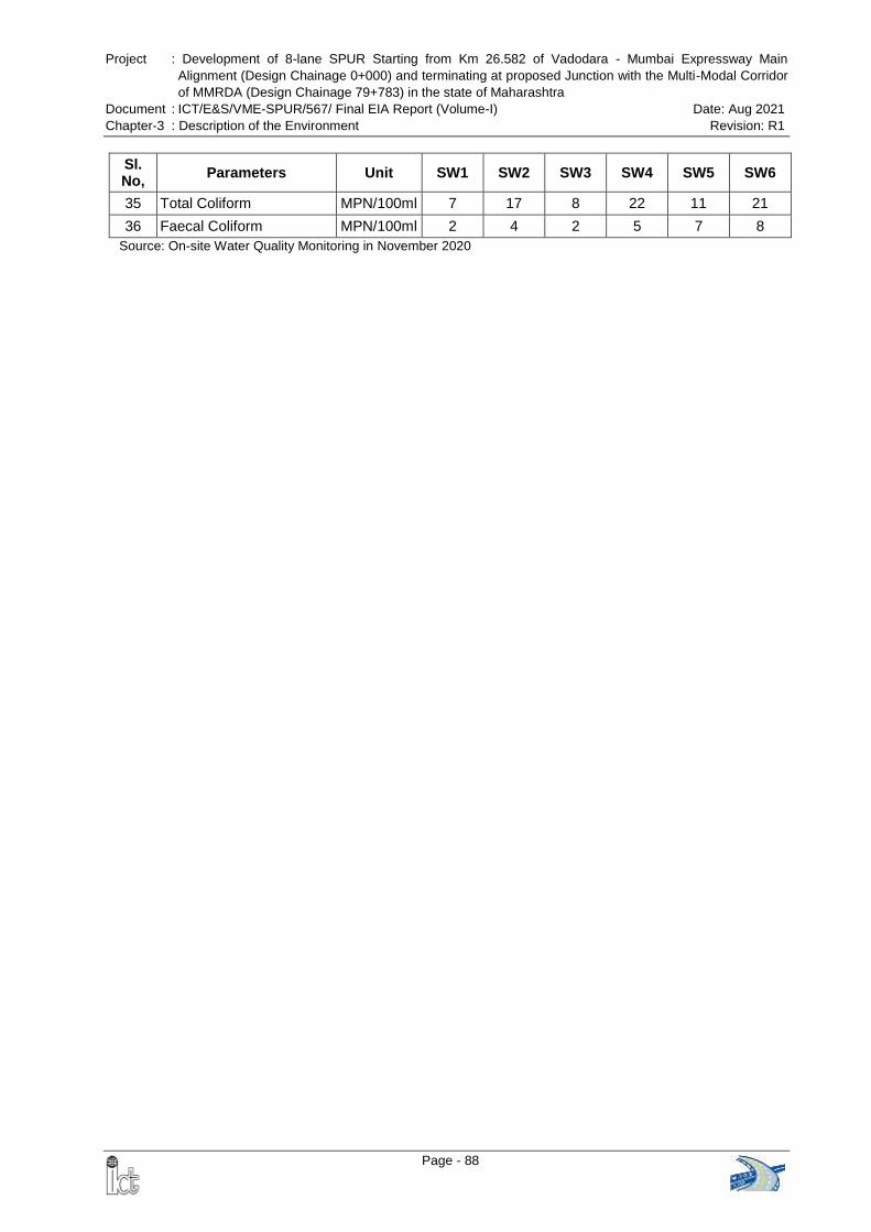
Project : Development of 8-lane SPUR Starting from Km 26.582 of Vadodara - Mumbai Expressway Main
Alignment (Design Chainage 0+000) and terminating at proposed Junction with the Multi-Modal Corridor
of MMRDA (Design Chainage 79+783) in the state of Maharashtra
Document : ICT/E&S/VME-SPUR/567/ Final EIA Report (Volume-I) Date: Aug 2021
Chapter-3 : Description of the Environment Revision: R1
Page - 88
Sl. No,
Parameters Unit SW1 SW2 SW3 SW4 SW5 SW6
35 Total Coliform MPN/100ml 7 17 8 22 11 21
36 Faecal Coliform MPN/100ml 2 4 2 5 7 8
Source: On-site Water Quality Monitoring in November 2020
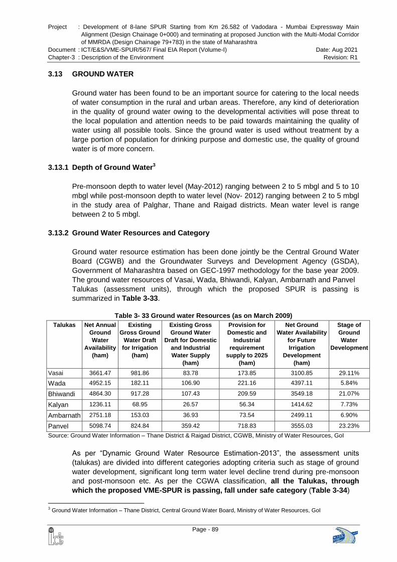
Project : Development of 8-lane SPUR Starting from Km 26.582 of Vadodara - Mumbai Expressway Main
Alignment (Design Chainage 0+000) and terminating at proposed Junction with the Multi-Modal Corridor
of MMRDA (Design Chainage 79+783) in the state of Maharashtra
Document : ICT/E&S/VME-SPUR/567/ Final EIA Report (Volume-I) Date: Aug 2021
Chapter-3 : Description of the Environment Revision: R1
Page - 89
3.13 GROUND WATER
Ground water has been found to be an important source for catering to the local needs
of water consumption in the rural and urban areas. Therefore, any kind of deterioration
in the quality of ground water owing to the developmental activities will pose threat to
the local population and attention needs to be paid towards maintaining the quality of
water using all possible tools. Since the ground water is used without treatment by a
large portion of population for drinking purpose and domestic use, the quality of ground
water is of more concern.
3.13.1 Depth of Ground Water3
Pre-monsoon depth to water level (May-2012) ranging between 2 to 5 mbgl and 5 to 10
mbgl while post-monsoon depth to water level (Nov- 2012) ranging between 2 to 5 mbgl
in the study area of Palghar, Thane and Raigad districts. Mean water level is range
between 2 to 5 mbgl.
3.13.2 Ground Water Resources and Category
Ground water resource estimation has been done jointly be the Central Ground Water
Board (CGWB) and the Groundwater Surveys and Development Agency (GSDA),
Government of Maharashtra based on GEC-1997 methodology for the base year 2009.
The ground water resources of Vasai, Wada, Bhiwandi, Kalyan, Ambarnath and Panvel
Talukas (assessment units), through which the proposed SPUR is passing is
summarized in Table 3-33.
Table 3- 33 Ground water Resources (as on March 2009)
Talukas Net Annual
Ground
Water
Availability
(ham)
Existing
Gross Ground
Water Draft
for Irrigation
(ham)
Existing Gross
Ground Water
Draft for Domestic
and Industrial
Water Supply
(ham)
Provision for
Domestic and
Industrial
requirement
supply to 2025
(ham)
Net Ground
Water Availability
for Future
Irrigation
Development
(ham)
Stage of
Ground
Water
Development
Vasai 3661.47 981.86 83.78 173.85 3100.85 29.11%
Wada 4952.15 182.11 106.90 221.16 4397.11 5.84%
Bhiwandi 4864.30 917.28 107.43 209.59 3549.18 21.07%
Kalyan 1236.11 68.95 26.57 56.34 1414.62 7.73%
Ambarnath 2751.18 153.03 36.93 73.54 2499.11 6.90%
Panvel 5098.74 824.84 359.42 718.83 3555.03 23.23%
Source: Ground Water Information – Thane District & Raigad District, CGWB, Ministry of Water Resources, GoI
As per ―Dynamic Ground Water Resource Estimation-2013‖, the assessment units
(talukas) are divided into different categories adopting criteria such as stage of ground
water development, significant long term water level decline trend during pre-monsoon
and post-monsoon etc. As per the CGWA classification, all the Talukas, through
which the proposed VME-SPUR is passing, fall under safe category (Table 3-34)
3 Ground Water Information – Thane District, Central Ground Water Board, Ministry of Water Resources, GoI
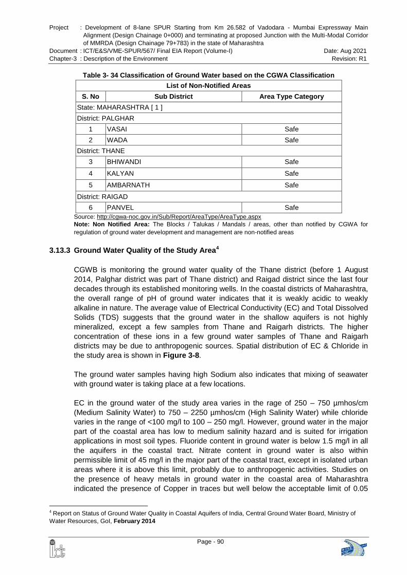
Project : Development of 8-lane SPUR Starting from Km 26.582 of Vadodara - Mumbai Expressway Main
Alignment (Design Chainage 0+000) and terminating at proposed Junction with the Multi-Modal Corridor
of MMRDA (Design Chainage 79+783) in the state of Maharashtra
Document : ICT/E&S/VME-SPUR/567/ Final EIA Report (Volume-I) Date: Aug 2021
Chapter-3 : Description of the Environment Revision: R1
Page - 90
Table 3- 34 Classification of Ground Water based on the CGWA Classification
List of Non-Notified Areas
S. No Sub District Area Type Category
State: MAHARASHTRA [ 1 ]
District: PALGHAR
1 VASAI Safe
2 WADA Safe
District: THANE
3 BHIWANDI Safe
4 KALYAN Safe
5 AMBARNATH Safe
District: RAIGAD
6 PANVEL Safe
Source: http://cgwa-noc.gov.in/Sub/Report/AreaType/AreaType.aspx
Note: Non Notified Area: The Blocks / Talukas / Mandals / areas, other than notified by CGWA for
regulation of ground water development and management are non-notified areas
3.13.3 Ground Water Quality of the Study Area4
CGWB is monitoring the ground water quality of the Thane district (before 1 August
2014, Palghar district was part of Thane district) and Raigad district since the last four
decades through its established monitoring wells. In the coastal districts of Maharashtra,
the overall range of pH of ground water indicates that it is weakly acidic to weakly
alkaline in nature. The average value of Electrical Conductivity (EC) and Total Dissolved
Solids (TDS) suggests that the ground water in the shallow aquifers is not highly
mineralized, except a few samples from Thane and Raigarh districts. The higher
concentration of these ions in a few ground water samples of Thane and Raigarh
districts may be due to anthropogenic sources. Spatial distribution of EC & Chloride in
the study area is shown in Figure 3-8.
The ground water samples having high Sodium also indicates that mixing of seawater
with ground water is taking place at a few locations.
EC in the ground water of the study area varies in the rage of 250 – 750 µmhos/cm
(Medium Salinity Water) to 750 – 2250 µmhos/cm (High Salinity Water) while chloride
varies in the range of <100 mg/l to 100 – 250 mg/l. However, ground water in the major
part of the coastal area has low to medium salinity hazard and is suited for irrigation
applications in most soil types. Fluoride content in ground water is below 1.5 mg/l in all
the aquifers in the coastal tract. Nitrate content in ground water is also within
permissible limit of 45 mg/l in the major part of the coastal tract, except in isolated urban
areas where it is above this limit, probably due to anthropogenic activities. Studies on
the presence of heavy metals in ground water in the coastal area of Maharashtra
indicated the presence of Copper in traces but well below the acceptable limit of 0.05
4 Report on Status of Ground Water Quality in Coastal Aquifers of India, Central Ground Water Board, Ministry of
Water Resources, GoI, February 2014
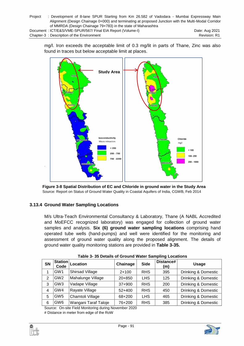
Project : Development of 8-lane SPUR Starting from Km 26.582 of Vadodara - Mumbai Expressway Main
Alignment (Design Chainage 0+000) and terminating at proposed Junction with the Multi-Modal Corridor
of MMRDA (Design Chainage 79+783) in the state of Maharashtra
Document : ICT/E&S/VME-SPUR/567/ Final EIA Report (Volume-I) Date: Aug 2021
Chapter-3 : Description of the Environment Revision: R1
Page - 91
mg/l. Iron exceeds the acceptable limit of 0.3 mg/lit in parts of Thane, Zinc was also
found in traces but below acceptable limit at places.
.
3.13.4 Ground Water Sampling Locations
M/s Ultra-Teach Environmental Consultancy & Laboratory, Thane (A NABL Accredited
and MoEFCC recognized laboratory) was engaged for collection of ground water
samples and analysis. Six (6) ground water sampling locations comprising hand
operated tube wells (hand-pumps) and well were identified for the monitoring and
assessment of ground water quality along the proposed alignment. The details of
ground water quality monitoring stations are provided in Table 3-35.
Table 3- 35 Details of Ground Water Sampling Locations
SN Station Code
Location Chainage Side Distance#
(m) Usage
1 GW1 Shirsad Village 2+100 RHS 395 Drinking & Domestic
2 GW2 Mahalunge Village 20+850 LHS 125 Drinking & Domestic
3 GW3 Vadape Village 37+900 RHS 200 Drinking & Domestic
4 GW4 Rayate Village 52+400 RHS 450 Drinking & Domestic
5 GW5 Chamtoli Village 68+200 LHS 465 Drinking & Domestic
6 GW6 Wangani Taraf Taloje 76+200 RHS 385 Drinking & Domestic
Source: On-site Field Monitoring during November 2020
# Distance in meter from edge of the RoW
Study Area
Figure 3-8 Spatial Distribution of EC and Chloride in ground water in the Study Area
Source: Report on Status of Ground Water Quality in Coastal Aquifers of India, CGWB, Feb 2014
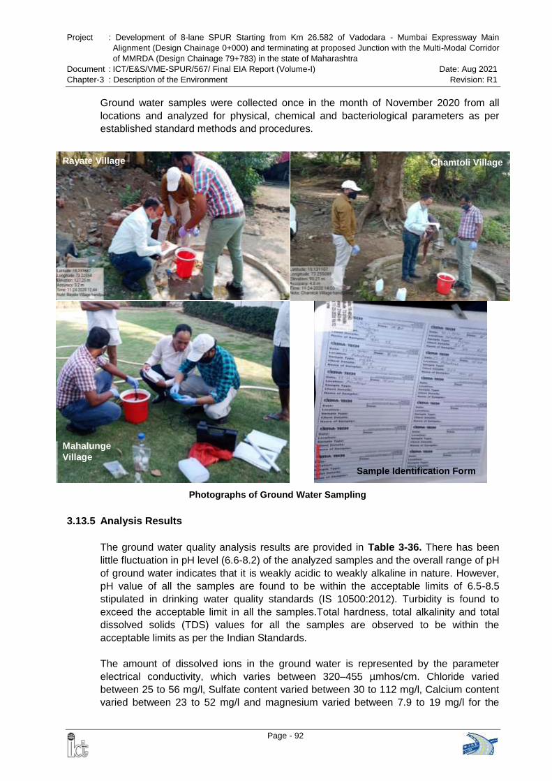
Project : Development of 8-lane SPUR Starting from Km 26.582 of Vadodara - Mumbai Expressway Main
Alignment (Design Chainage 0+000) and terminating at proposed Junction with the Multi-Modal Corridor
of MMRDA (Design Chainage 79+783) in the state of Maharashtra
Document : ICT/E&S/VME-SPUR/567/ Final EIA Report (Volume-I) Date: Aug 2021
Chapter-3 : Description of the Environment Revision: R1
Page - 92
Photographs of Ground Water Sampling
Rayate Village Chamtoli Village
Mahalunge
Village
Sample Identification Form
Ground water samples were collected once in the month of November 2020 from all
locations and analyzed for physical, chemical and bacteriological parameters as per
established standard methods and procedures.
3.13.5 Analysis Results
The ground water quality analysis results are provided in Table 3-36. There has been
little fluctuation in pH level (6.6-8.2) of the analyzed samples and the overall range of pH
of ground water indicates that it is weakly acidic to weakly alkaline in nature. However,
pH value of all the samples are found to be within the acceptable limits of 6.5-8.5
stipulated in drinking water quality standards (IS 10500:2012). Turbidity is found to
exceed the acceptable limit in all the samples.Total hardness, total alkalinity and total
dissolved solids (TDS) values for all the samples are observed to be within the
acceptable limits as per the Indian Standards.
The amount of dissolved ions in the ground water is represented by the parameter
electrical conductivity, which varies between 320–455 µmhos/cm. Chloride varied
between 25 to 56 mg/l, Sulfate content varied between 30 to 112 mg/l, Calcium content
varied between 23 to 52 mg/l and magnesium varied between 7.9 to 19 mg/l for the
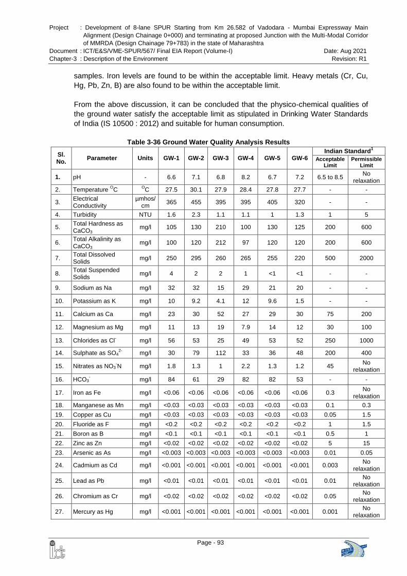
Project : Development of 8-lane SPUR Starting from Km 26.582 of Vadodara - Mumbai Expressway Main
Alignment (Design Chainage 0+000) and terminating at proposed Junction with the Multi-Modal Corridor
of MMRDA (Design Chainage 79+783) in the state of Maharashtra
Document : ICT/E&S/VME-SPUR/567/ Final EIA Report (Volume-I) Date: Aug 2021
Chapter-3 : Description of the Environment Revision: R1
Page - 93
samples. Iron levels are found to be within the acceptable limit. Heavy metals (Cr, Cu,
Hg, Pb, Zn, B) are also found to be within the acceptable limit.
From the above discussion, it can be concluded that the physico-chemical qualities of
the ground water satisfy the acceptable limit as stipulated in Drinking Water Standards
of India (IS 10500 : 2012) and suitable for human consumption.
Table 3-36 Ground Water Quality Analysis Results
Sl. No.
Parameter Units GW-1 GW-2 GW-3 GW-4 GW-5 GW-6 Indian Standard
1
Acceptable Limit
Permissible Limit
1. pH - 6.6 7.1 6.8 8.2 6.7 7.2 6.5 to 8.5 No
relaxation
2. Temperature OC
OC 27.5 30.1 27.9 28.4 27.8 27.7 - -
3. Electrical Conductivity
µmhos/ cm
365 455 395 395 405 320 - -
4. Turbidity NTU 1.6 2.3 1.1 1.1 1 1.3 1 5
5. Total Hardness as CaCO3
mg/l 105 130 210 100 130 125 200 600
6. Total Alkalinity as CaCO3
mg/l 100 120 212 97 120 120 200 600
7. Total Dissolved Solids
mg/l 250 295 260 265 255 220 500 2000
8. Total Suspended Solids
mg/l 4 2 2 1 <1 <1 - -
9. Sodium as Na mg/l 32 32 15 29 21 20 - -
10. Potassium as K mg/l 10 9.2 4.1 12 9.6 1.5 - -
11. Calcium as Ca mg/l 23 30 52 27 29 30 75 200
12. Magnesium as Mg mg/l 11 13 19 7.9 14 12 30 100
13. Chlorides as Cl- mg/l 56 53 25 49 53 52 250 1000
14. Sulphate as SO42-
mg/l 30 79 112 33 36 48 200 400
15. Nitrates as NO3-N mg/l 1.8 1.3 1 2.2 1.3 1.2 45
No relaxation
16. HCO3- mg/l 84 61 29 82 82 53 - -
17. Iron as Fe mg/l <0.06 <0.06 <0.06 <0.06 <0.06 <0.06 0.3 No
relaxation
18. Manganese as Mn mg/l <0.03 <0.03 <0.03 <0.03 <0.03 <0.03 0.1 0.3
19. Copper as Cu mg/l <0.03 <0.03 <0.03 <0.03 <0.03 <0.03 0.05 1.5
20. Fluoride as F mg/l <0.2 <0.2 <0.2 <0.2 <0.2 <0.2 1 1.5
21. Boron as B mg/l <0.1 <0.1 <0.1 <0.1 <0.1 <0.1 0.5 1
22. Zinc as Zn mg/l <0.02 <0.02 <0.02 <0.02 <0.02 <0.02 5 15
23. Arsenic as As mg/l <0.003 <0.003 <0.003 <0.003 <0.003 <0.003 0.01 0.05
24. Cadmium as Cd mg/l <0.001 <0.001 <0.001 <0.001 <0.001 <0.001 0.003 No
relaxation
25. Lead as Pb mg/l <0.01 <0.01 <0.01 <0.01 <0.01 <0.01 0.01 No
relaxation
26. Chromium as Cr mg/l <0.02 <0.02 <0.02 <0.02 <0.02 <0.02 0.05 No
relaxation
27. Mercury as Hg mg/l <0.001 <0.001 <0.001 <0.001 <0.001 <0.001 0.001 No
relaxation
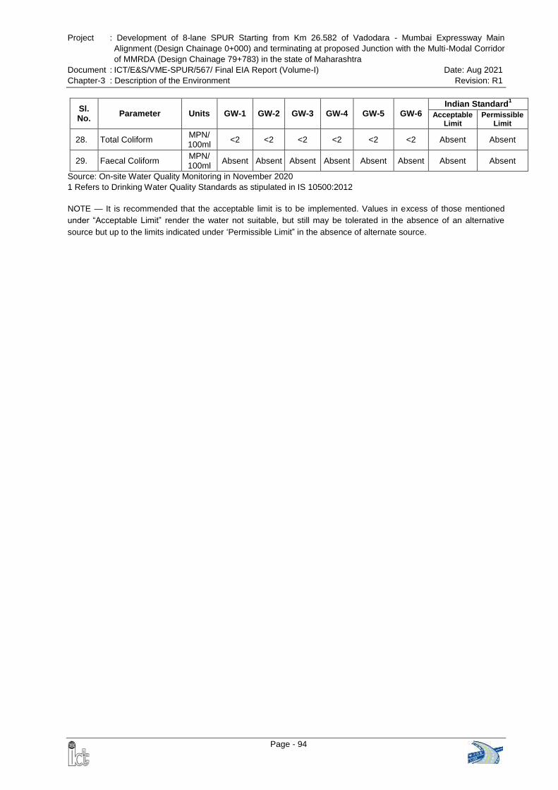
Project : Development of 8-lane SPUR Starting from Km 26.582 of Vadodara - Mumbai Expressway Main
Alignment (Design Chainage 0+000) and terminating at proposed Junction with the Multi-Modal Corridor
of MMRDA (Design Chainage 79+783) in the state of Maharashtra
Document : ICT/E&S/VME-SPUR/567/ Final EIA Report (Volume-I) Date: Aug 2021
Chapter-3 : Description of the Environment Revision: R1
Page - 94
Sl. No.
Parameter Units GW-1 GW-2 GW-3 GW-4 GW-5 GW-6 Indian Standard
1
Acceptable Limit
Permissible Limit
28. Total Coliform MPN/ 100ml
<2 <2 <2 <2 <2 <2 Absent Absent
29. Faecal Coliform MPN/ 100ml
Absent Absent Absent Absent Absent Absent Absent Absent
Source: On-site Water Quality Monitoring in November 2020
1 Refers to Drinking Water Quality Standards as stipulated in IS 10500:2012
NOTE — It is recommended that the acceptable limit is to be implemented. Values in excess of those mentioned
under ―Acceptable Limit‖ render the water not suitable, but still may be tolerated in the absence of an alternative
source but up to the limits indicated under ‗Permissible Limit‖ in the absence of alternate source.
Project : Development of 8-lane SPUR Starting from Km 26.582 of Vadodara - Mumbai Expressway Main
Alignment (Design Chainage 0+000) and terminating at proposed Junction with the Multi-Modal Corridor
of MMRDA (Design Chainage 79+783) in the state of Maharashtra
Document : ICT/E&S/VME-SPUR/567/ Final EIA Report (Volume-I) Date: Aug 2021
Chapter-3 : Description of the Environment Revision: R1
Page - 95
3.14 ECOLOGY AND BIODIVERSITY
3.14.1 Introduction
It is imperative to study the ecology of an area, essentially, how organisms are
dependent on the area in terms of resource, habitat etc, and also how organisms affect
the area. The proposed project area falls under agro-climatic zone namely western
plateau hills and west coast plains and hills bio-geographic zone of India.
The climate of the tract is generally hot and humid during summer. The temperature
varies between a minimum of 12C and a maximum of 45C. The climate is pleasant
during the winter, i.e. from January to February when the humidity is low; summer lasts
from March to June. During this season climate is very warm particularly in the eastern
region of the tract. The rains are brought by the South-West Monsoon, which breaks by
the 2nd week of June. Regular rainy season starts from the 3rd week of June and lasts
until middle of October. Heaviest rainfall occurs during July and August. Average Annual
rainfall in this region is 3200 mm (Working plan of Thane Forest Division, 2009-10 to
2018-19).
As the area is characterized by dry climate with hot and humid seasons, such climatic
conditions provide opportunity to the flora for the development of significant
morphological structures, even birds and animals also adapt themselves as per the
climate of the region. To avoid excessive amount of moisture loss from the surface,
vegetation of the region develop barbs or thorns on their branches, leaves or even bole
etc. As per the revised classification of Champion and Seth following forests have been
grouped as follows:
3B/C1 : Southern Tropical moist teak bearing forests.
3B/C2 : Southern Tropical moist mixed deciduous forests.
8A/C2 : Western sub-tropical hill forests.
4B/TS1: Mangrove scrub forests
3.14.2 Ecology Biodiversity Study
It is crucial to understand the structure and function of particular vegetation and its
composition in an ecosystem. The temporal and spatial changes happen due to
immediate or micro-climatic conditions. These factors exert significant influences on
plant development, distribution, composition and association, which in turn improve
the micro-habitat by regulating the community structure and ecosystem functioning. To
analyzed floristic composition of the area, frequency, density, abundance and
importance value index (IVI) values were calculated; simultaneously Shannon-weiner
diversity index (H‘) and dominance index (Cd) were calculated.
Floral Survey: Entire stretch of the proposed alignment comprises various land uses;
forest land, human settlement, agricultural land etc. The survey was carried out between
19.12.2020 to 23.12.2020. Some photographs showing various land uses are given
below:
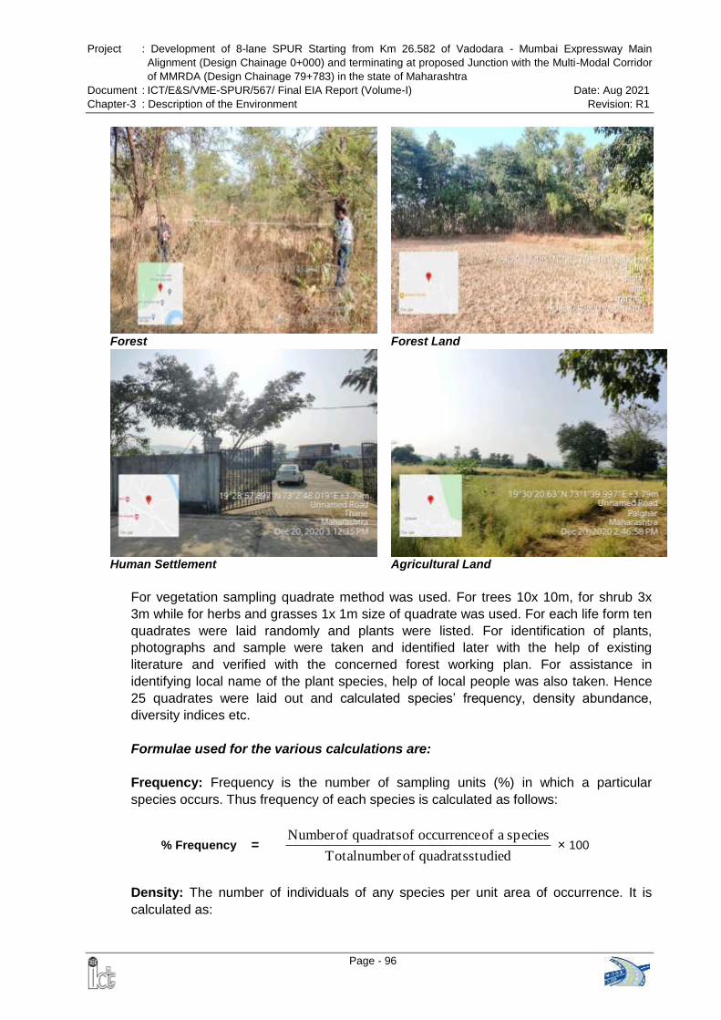
Project : Development of 8-lane SPUR Starting from Km 26.582 of Vadodara - Mumbai Expressway Main
Alignment (Design Chainage 0+000) and terminating at proposed Junction with the Multi-Modal Corridor
of MMRDA (Design Chainage 79+783) in the state of Maharashtra
Document : ICT/E&S/VME-SPUR/567/ Final EIA Report (Volume-I) Date: Aug 2021
Chapter-3 : Description of the Environment Revision: R1
Page - 96
Forest Forest Land
Human Settlement Agricultural Land
For vegetation sampling quadrate method was used. For trees 10x 10m, for shrub 3x
3m while for herbs and grasses 1x 1m size of quadrate was used. For each life form ten
quadrates were laid randomly and plants were listed. For identification of plants,
photographs and sample were taken and identified later with the help of existing
literature and verified with the concerned forest working plan. For assistance in
identifying local name of the plant species, help of local people was also taken. Hence
25 quadrates were laid out and calculated species‘ frequency, density abundance,
diversity indices etc.
Formulae used for the various calculations are:
Frequency: Frequency is the number of sampling units (%) in which a particular
species occurs. Thus frequency of each species is calculated as follows:
% Frequency = studied quadrats ofnumber Total
species a of occurrence of quadrats ofNumber × 100
Density: The number of individuals of any species per unit area of occurrence. It is
calculated as:
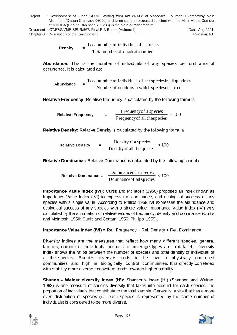
Project : Development of 8-lane SPUR Starting from Km 26.582 of Vadodara - Mumbai Expressway Main
Alignment (Design Chainage 0+000) and terminating at proposed Junction with the Multi-Modal Corridor
of MMRDA (Design Chainage 79+783) in the state of Maharashtra
Document : ICT/E&S/VME-SPUR/567/ Final EIA Report (Volume-I) Date: Aug 2021
Chapter-3 : Description of the Environment Revision: R1
Page - 97
Density = studied quadrats ofnumber Total
species a of individual ofnumber Total
Abundance: This is the number of individuals of any species per unit area of
occurrence. It is calculated as:
Abundance = occurred speciesin which quadrats ofNumber
quadrats allin species theof sindividual ofnumber Total
Relative Frequency: Relative frequency is calculated by the following formula
Relative Frequency = species theall ofFrequency
species a ofFrequency × 100
Relative Density: Relative Density is calculated by the following formula
Relative Density = species theall ofDensity
species a ofDensity × 100
Relative Dominance: Relative Dominance is calculated by the following formula
Relative Dominance = species all of Dominance
species a of Dominance × 100
Importance Value Index (IVI): Curtis and McIntosh (1950) proposed an index known as
Importance Value Index (IVI) to express the dominance, and ecological success of any
species with a single value. According to Philips 1959 IVI expresses the abundance and
ecological success of any species with a single value. Importance Value Index (IVI) was
calculated by the summation of relative values of frequency, density and dominance (Curtis
and McIntosh, 1950; Curtis and Cottam, 1956; Phillips, 1959).
Importance Value Index (IVI) = Rel. Frequency + Rel. Density + Rel. Dominance
Diversity indices are the measures that reflect how many different species, genera,
families, number of individuals, biomass or coverage types are in dataset. Diversity
index shows the ratios between the number of species and total density of individual of
all the species. Species diversity tends to be low in physically controlled
communities and high in biologically control communities. It is directly correlated
with stability more diverse ecosystem tends towards higher stability.
Shanon - Weiner diversity Index (H’): Shannon‘s Index (H´) (Shannon and Weiner,
1963) is one measure of species diversity that takes into account for each species, the
proportion of individuals that contribute to the total sample. Generally, a site that has a more
even distribution of species (i.e. each species is represented by the same number of
individuals) is considered to be more diverse.
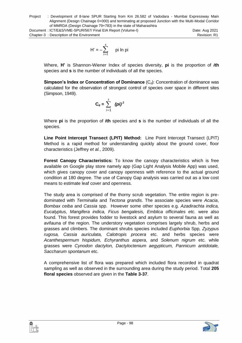
Project : Development of 8-lane SPUR Starting from Km 26.582 of Vadodara - Mumbai Expressway Main
Alignment (Design Chainage 0+000) and terminating at proposed Junction with the Multi-Modal Corridor
of MMRDA (Design Chainage 79+783) in the state of Maharashtra
Document : ICT/E&S/VME-SPUR/567/ Final EIA Report (Volume-I) Date: Aug 2021
Chapter-3 : Description of the Environment Revision: R1
Page - 98
H‘ = –
s
i 1 pi ln pi
Where, H’ is Shannon-Wiener Index of species diversity, pi is the proportion of ith
species and s is the number of individuals of all the species.
Simpson’s Index or Concentration of Dominance (Cd): Concentration of dominance was
calculated for the observation of strongest control of species over space in different sites
(Simpson, 1949).
Cd =
s
i 1
(pi) 2
Where pi is the proportion of ith species and s is the number of individuals of all the
species.
Line Point Intercept Transect (LPIT) Method: Line Point Intercept Transect (LPIT)
Method is a rapid method for understanding quickly about the ground cover, floor
characteristics (Jeffrey et al., 2009).
Forest Canopy Characteristics: To know the canopy characteristics which is free
available on Google play store namely app (Gap Light Analysis Mobile App) was used,
which gives canopy cover and canopy openness with reference to the actual ground
condition at 180 degree. The use of Canopy Gap analysis was carried out as a low cost
means to estimate leaf cover and openness.
The study area is comprised of the thorny scrub vegetation. The entire region is pre-
dominated with Terminalia and Tectona grandis. The associate species were Acacia,
Bombax ceiba and Cassia spp. However some other species e.g. Azadirachta indica,
Eucalyptus, Mangifera indica, Ficus bengalesis, Emblica officinales etc. were also
found. This forest provides fodder to livestock and asylum to several fauna as well as
avifauna of the region. The understory vegetation comprises largely shrub, herbs and
grasses and climbers. The dominant shrubs species included Euphorbia Spp, Zyzypus
rugosa, Cassia auriculata, Calotropis procera etc. and herbs species were
Acanthespermum hispidum, Echyranthus aspera, and Solenum nigrum etc. while
grasses were Cynodon dactylon, Dactyloctenium aegypticum, Pannicum antidotale,
Saccharum spontanum etc.
A comprehensive list of flora was prepared which included flora recorded in quadrat
sampling as well as observed in the surrounding area during the study period. Total 205
floral species observed are given in the Table 3-37.
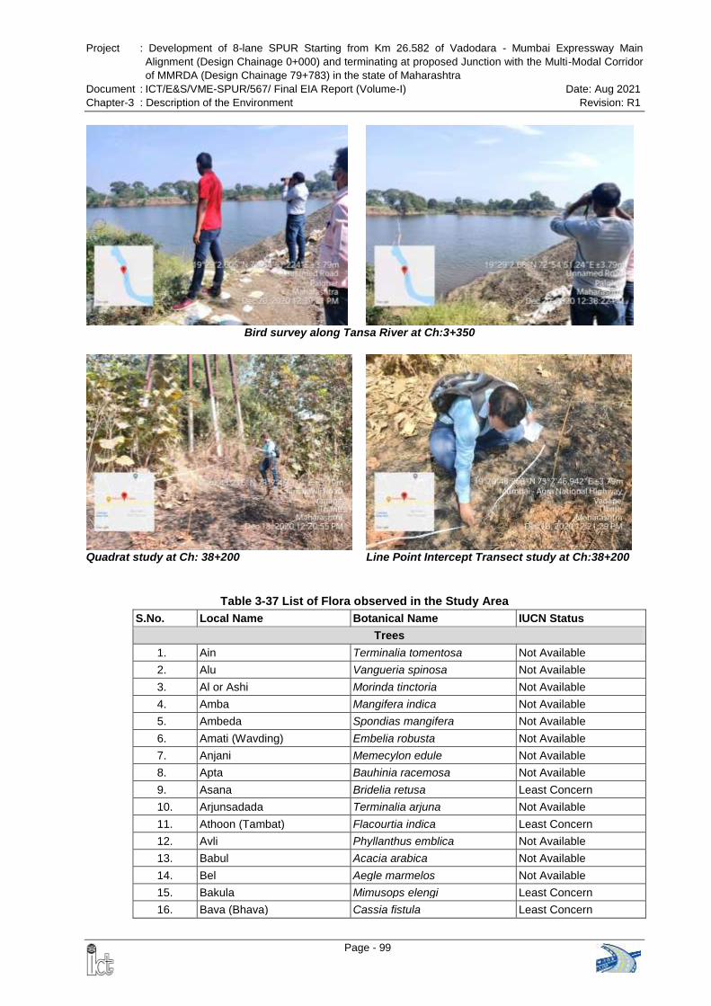
Project : Development of 8-lane SPUR Starting from Km 26.582 of Vadodara - Mumbai Expressway Main
Alignment (Design Chainage 0+000) and terminating at proposed Junction with the Multi-Modal Corridor
of MMRDA (Design Chainage 79+783) in the state of Maharashtra
Document : ICT/E&S/VME-SPUR/567/ Final EIA Report (Volume-I) Date: Aug 2021
Chapter-3 : Description of the Environment Revision: R1
Page - 99
Bird survey along Tansa River at Ch:3+350
Quadrat study at Ch: 38+200 Line Point Intercept Transect study at Ch:38+200
Table 3-37 List of Flora observed in the Study Area
S.No. Local Name Botanical Name IUCN Status
Trees
1. Ain Terminalia tomentosa Not Available
2. Alu Vangueria spinosa Not Available
3. Al or Ashi Morinda tinctoria Not Available
4. Amba Mangifera indica Not Available
5. Ambeda Spondias mangifera Not Available
6. Amati (Wavding) Embelia robusta Not Available
7. Anjani Memecylon edule Not Available
8. Apta Bauhinia racemosa Not Available
9. Asana Bridelia retusa Least Concern
10. Arjunsadada Terminalia arjuna Not Available
11. Athoon (Tambat) Flacourtia indica Least Concern
12. Avli Phyllanthus emblica Not Available
13. Babul Acacia arabica Not Available
14. Bel Aegle marmelos Not Available
15. Bakula Mimusops elengi Least Concern
16. Bava (Bhava) Cassia fistula Least Concern
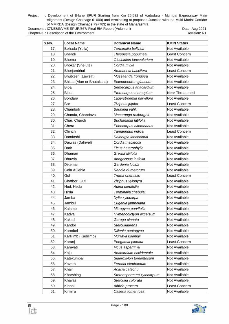
Project : Development of 8-lane SPUR Starting from Km 26.582 of Vadodara - Mumbai Expressway Main
Alignment (Design Chainage 0+000) and terminating at proposed Junction with the Multi-Modal Corridor
of MMRDA (Design Chainage 79+783) in the state of Maharashtra
Document : ICT/E&S/VME-SPUR/567/ Final EIA Report (Volume-I) Date: Aug 2021
Chapter-3 : Description of the Environment Revision: R1
Page - 100
S.No. Local Name Botanical Name IUCN Status
17. Behada (Yella) Terminalia bellirica Not Available
18. Bhendi Thespesia populnea Least Concern
19. Bhoma Glochidion lanceolarium Not Available
20. Bhokar (Shelute) Cordia myxa Not Available
21. Bhorjambhul Ammannia baccifera Least Concern
22. Bhutkesh (Lawsat) Mussaenda frondosa Not Available
23. Bhittia (Alan or Bhutaksha) Elaeodendron glaucum Not Available
24. Biba Semecarpus anacardium Not Available
25. Bibla Pterocarpus marsupium Near Threatened
26. Bondara Lagerstroemia parviflora Not Available
27. Bor Ziziphus jujuba Least Concern
28. Chambuli Bauhinia vahlii Not Available
29. Chanda, Chandava Macaranga roxburghii Not Available
30. Char, Charoli Buchanania latifolia Not Available
31. Chera Erinocarpus nimmoanus Not Available
32. Chinch Tamarindus indica Least Concern
33. Dandoshi Dalbergia lanceolaria Not Available
34. Daiwas (Dahivel) Cordia macleodii Not Available
35. Datir Ficus heterophylla Not Available
36. Dhaman Grewia tiliifolia Not Available
37. Dhavda Anogeissus latifolia Not Available
38. Dikemali Gardenia lucida Not Available
39. Gela &Gehla Randia dumetorum Not Available
40. Gol Trema orientalis Least Concern
41. Ghatbor, Guti Ziziphus xylopyra Not Available
42. Hed, Hedu Adina cordifolia Not Available
43. Hirda Terminalia chebula Not Available
44. Jamba Xylia xylocarpa Not Available
45. Jambul Eugenia jambolana Not Available
46. Kalamb Mitragyna parvifolia Not Available
47. Kadvai Hymenodictyon excelsum Not Available
48. Kakad Garuga pinnata Not Available
49. Kandol Sterculiaurens Not Available
50. Karmbel Dillenia pentagyna Not Available
51. Karlilimb (Kadilimb) Murraya koenigii Not Available
52. Karanj Pongamia pinnata Least Concern
53. Karavati Ficus asperrima Not Available
54. Kaju Anacardium occidentale Not Available
55. Katekumbal Sideroxylon tomentosum Not Available
56. Kavath Feronia elephantum Not Available
57. Khair Acacia catechu Not Available
58. Kharshing Stereospermum xylocarpum Not Available
59. Khavas Sterculia colorata Not Available
60. Kinhai Albizia procera Least Concern
61. Kirmira Caseria tomentosa Not Available
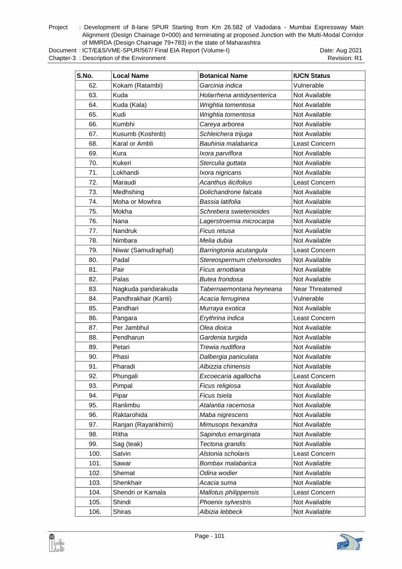
Project : Development of 8-lane SPUR Starting from Km 26.582 of Vadodara - Mumbai Expressway Main
Alignment (Design Chainage 0+000) and terminating at proposed Junction with the Multi-Modal Corridor
of MMRDA (Design Chainage 79+783) in the state of Maharashtra
Document : ICT/E&S/VME-SPUR/567/ Final EIA Report (Volume-I) Date: Aug 2021
Chapter-3 : Description of the Environment Revision: R1
Page - 101
S.No. Local Name Botanical Name IUCN Status
62. Kokam (Ratambi) Garcinia indica Vulnerable
63. Kuda Holarrhena antidysenterica Not Available
64. Kuda (Kala) Wrightia tomentosa Not Available
65. Kudi Wrightia tomentosa Not Available
66. Kumbhi Careya arborea Not Available
67. Kusumb (Koshinb) Schleichera trijuga Not Available
68. Karal or Ambli Bauhinia malabarica Least Concern
69. Kura Ixora parviflora Not Available
70. Kukeri Sterculia guttata Not Available
71. Lokhandi Ixora nigricans Not Available
72. Maraudi Acanthus ilicifolius Least Concern
73. Medhshing Dolichandrone falcata Not Available
74. Moha or Mowhra Bassia latifolia Not Available
75. Mokha Schrebera swietenioides Not Available
76. Nana Lagerstroemia microcarpa Not Available
77. Nandruk Ficus retusa Not Available
78. Nimbara Melia dubia Not Available
79. Niwar (Samudraphal) Barringtonia acutangula Least Concern
80. Padal Stereospermum chelonoides Not Available
81. Pair Ficus arnottiana Not Available
82. Palas Butea frondosa Not Available
83. Nagkuda pandarakuda Tabernaemontana heyneana Near Threatened
84. Pandhrakhair (Kanti) Acacia ferruginea Vulnerable
85. Pandhari Murraya exotica Not Available
86. Pangara Erythrina indica Least Concern
87. Per Jambhul Olea dioica Not Available
88. Pendharun Gardenia turgida Not Available
89. Petari Trewia nudiflora Not Available
90. Phasi Dalbergia paniculata Not Available
91. Pharadi Albizzia chinensis Not Available
92. Phungali Excoecaria agallocha Least Concern
93. Pimpal Ficus religiosa Not Available
94. Pipar Ficus tsiela Not Available
95. Ranlimbu Atalantia racemosa Not Available
96. Raktarohida Maba nigrescens Not Available
97. Ranjan (Rayankhirni) Mimusops hexandra Not Available
98. Ritha Sapindus emarginata Not Available
99. Sag (teak) Tectona grandis Not Available
100. Satvin Alstonia scholaris Least Concern
101. Sawar Bombax malabarica Not Available
102. Shemat Odina wodier Not Available
103. Shenkhair Acacia suma Not Available
104. Shendri or Kamala Mallotus philippensis Least Concern
105. Shindi Phoenix sylvestris Not Available
106. Shiras Albizia lebbeck Not Available
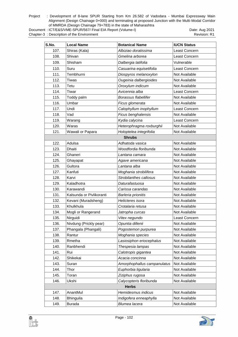
Project : Development of 8-lane SPUR Starting from Km 26.582 of Vadodara - Mumbai Expressway Main
Alignment (Design Chainage 0+000) and terminating at proposed Junction with the Multi-Modal Corridor
of MMRDA (Design Chainage 79+783) in the state of Maharashtra
Document : ICT/E&S/VME-SPUR/567/ Final EIA Report (Volume-I) Date: Aug 2021
Chapter-3 : Description of the Environment Revision: R1
Page - 102
S.No. Local Name Botanical Name IUCN Status
107. Shiras (Kala) Albiziao doratissima Least Concern
108. Shivan Gmelina arborea Least Concern
109. Shisham Dalbergia latifolia Vulnerable
110. Suru Casuarina equisetifolia Least Concern
111. Tembhurni Diospyros melanoxylon Not Available
112. Tiwas Ougeinia dalbergioides Not Available
113. Tetu Oroxylum indicum Not Available
114. Tiwar Avicennia alba Least Concern
115. Toddy palm Borassus flabellifer Not Available
116. Umbar Ficus glomerata Not Available
117. Undi Calophyllum inophyllum Least Concern
118. Vad Ficus benghalensis Not Available
119. Warang Kydia calycina Least Concern
120. Waras Heterophragma roxburghii Not Available
121. Wawali or Papara Holoptelea integrifolia Not Available
Shrubs
122. Adulsa Adhatoda vasica Not Available
123. Dhaiti Woodfordia floribunda Not Available
124. Ghaneri Lantana camara Not Available
125. Ghayapat Agave americana Not Available
126. Gultora Lantana alba Not Available
127. Kanfuti Moghania strobilifera Not Available
128. Karvi Strobilanthes callosus Not Available
129. Kaladhotra Daturafastuosa Not Available
130. Karawandi Carissa carandas Not Available
131. Kalsunda or Pivlikoranti Barleria prionitis Not Available
132. Kevani (Muradsheng) Helicteres isora Not Available
133. Khulkhula Crotalaria retusa Not Available
134. Mogli or Rangerand Jatropha curcas Not Available
135. Nirguidi Vitex negundo Least Concern
136. Nivdung (Prickly pear) Opuntia dillenii Not Available
137. Phangala (Phangali) Pogostemon purpurea Not Available
138. Rantur Moghania species Not Available
139. Rmetha Lasiosiphon eriocephalus Not Available
140. Ranbhendi Thespesia lampas Not Available
141. Rui Calotropis gigantea Not Available
142. Shikekai Acacia concinna Not Available
143. Suran Amorphophallus campanulatus Not Available
144. Thor Euphorbia ligularia Not Available
145. Toran Ziziphus rugosa Not Available
146. Ukshi Calycopteris floribunda Not Available
Herbs
147. AnantMul Hemidesmus indicus Not Available
148. Bhinguila Indigofera enneaphylla Not Available
149. Burada Blumea lacera Not Available
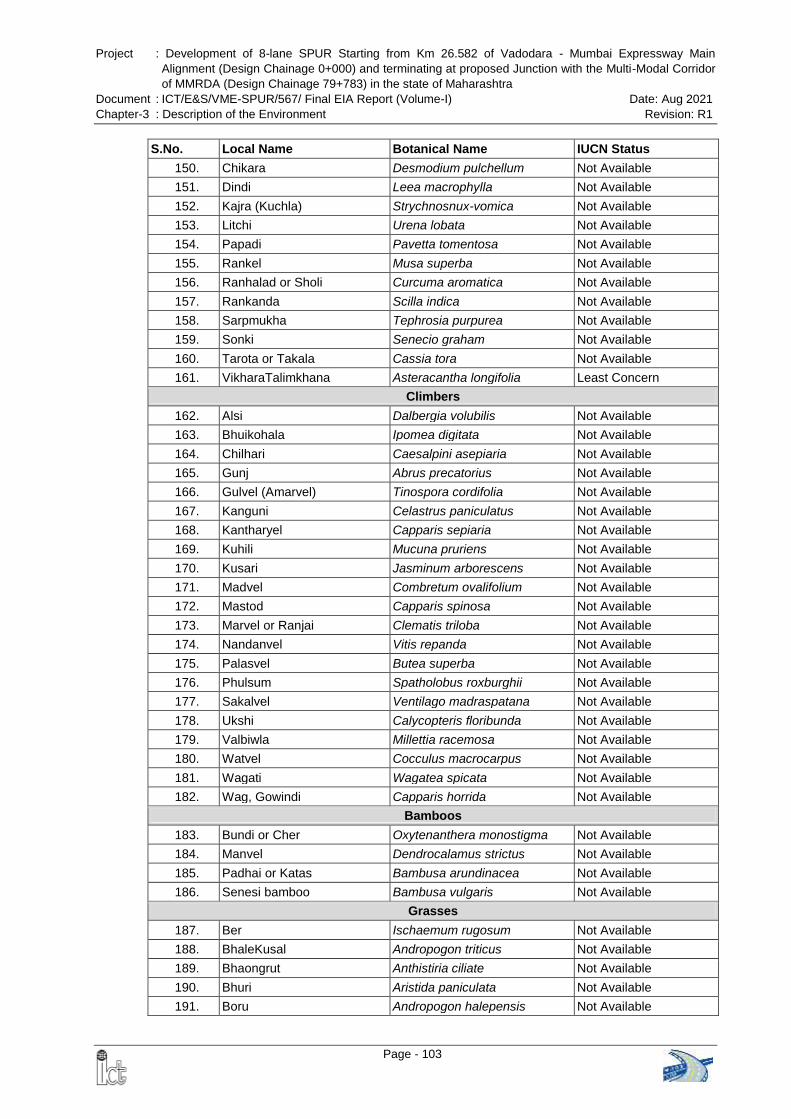
Project : Development of 8-lane SPUR Starting from Km 26.582 of Vadodara - Mumbai Expressway Main
Alignment (Design Chainage 0+000) and terminating at proposed Junction with the Multi-Modal Corridor
of MMRDA (Design Chainage 79+783) in the state of Maharashtra
Document : ICT/E&S/VME-SPUR/567/ Final EIA Report (Volume-I) Date: Aug 2021
Chapter-3 : Description of the Environment Revision: R1
Page - 103
S.No. Local Name Botanical Name IUCN Status
150. Chikara Desmodium pulchellum Not Available
151. Dindi Leea macrophylla Not Available
152. Kajra (Kuchla) Strychnosnux-vomica Not Available
153. Litchi Urena lobata Not Available
154. Papadi Pavetta tomentosa Not Available
155. Rankel Musa superba Not Available
156. Ranhalad or Sholi Curcuma aromatica Not Available
157. Rankanda Scilla indica Not Available
158. Sarpmukha Tephrosia purpurea Not Available
159. Sonki Senecio graham Not Available
160. Tarota or Takala Cassia tora Not Available
161. VikharaTalimkhana Asteracantha longifolia Least Concern
Climbers
162. Alsi Dalbergia volubilis Not Available
163. Bhuikohala Ipomea digitata Not Available
164. Chilhari Caesalpini asepiaria Not Available
165. Gunj Abrus precatorius Not Available
166. Gulvel (Amarvel) Tinospora cordifolia Not Available
167. Kanguni Celastrus paniculatus Not Available
168. Kantharyel Capparis sepiaria Not Available
169. Kuhili Mucuna pruriens Not Available
170. Kusari Jasminum arborescens Not Available
171. Madvel Combretum ovalifolium Not Available
172. Mastod Capparis spinosa Not Available
173. Marvel or Ranjai Clematis triloba Not Available
174. Nandanvel Vitis repanda Not Available
175. Palasvel Butea superba Not Available
176. Phulsum Spatholobus roxburghii Not Available
177. Sakalvel Ventilago madraspatana Not Available
178. Ukshi Calycopteris floribunda Not Available
179. Valbiwla Millettia racemosa Not Available
180. Watvel Cocculus macrocarpus Not Available
181. Wagati Wagatea spicata Not Available
182. Wag, Gowindi Capparis horrida Not Available
Bamboos
183. Bundi or Cher Oxytenanthera monostigma Not Available
184. Manvel Dendrocalamus strictus Not Available
185. Padhai or Katas Bambusa arundinacea Not Available
186. Senesi bamboo Bambusa vulgaris Not Available
Grasses
187. Ber Ischaemum rugosum Not Available
188. BhaleKusal Andropogon triticus Not Available
189. Bhaongrut Anthistiria ciliate Not Available
190. Bhuri Aristida paniculata Not Available
191. Boru Andropogon halepensis Not Available
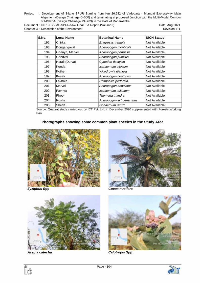
Project : Development of 8-lane SPUR Starting from Km 26.582 of Vadodara - Mumbai Expressway Main
Alignment (Design Chainage 0+000) and terminating at proposed Junction with the Multi-Modal Corridor
of MMRDA (Design Chainage 79+783) in the state of Maharashtra
Document : ICT/E&S/VME-SPUR/567/ Final EIA Report (Volume-I) Date: Aug 2021
Chapter-3 : Description of the Environment Revision: R1
Page - 104
S.No. Local Name Botanical Name IUCN Status
192. Chirka Eragrostis tremula Not Available
193. Dongarigavat Andropogon monticola Not Available
194. Ghanya, Marvel Andropogon pertussis Not Available
195. Gondval Andropogon pumilus Not Available
196. Harali (Durva) Cynodon dactylon Not Available
197. Kunda Ischaemum pilosum Not Available
198. Kother Woodrowia diandra Not Available
199. Kusali Andropogon contortus Not Available
200. Lavhala Rottboellia perforata Not Available
201. Marvel Andropogon annulatus Not Available
202. Pavnya Ischaemum sulcatum Not Available
203. Phool Themeda triandra Not Available
204. Rosha Andropogon schoenanthus Not Available
205. Sheda Ischaemum laxum Not Available
Source: Quadrat study carried out by ICT Pvt. Ltd. in December 2020 supplemented with Forests Working
Pan
Photographs showing some common plant species in the Study Area
Zyziphus Spp
Cocos nucifera
Acacia catechu Calotropis Spp
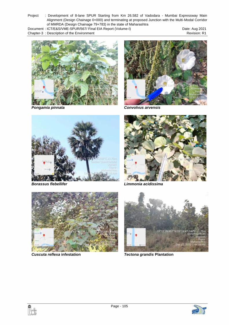
Project : Development of 8-lane SPUR Starting from Km 26.582 of Vadodara - Mumbai Expressway Main
Alignment (Design Chainage 0+000) and terminating at proposed Junction with the Multi-Modal Corridor
of MMRDA (Design Chainage 79+783) in the state of Maharashtra
Document : ICT/E&S/VME-SPUR/567/ Final EIA Report (Volume-I) Date: Aug 2021
Chapter-3 : Description of the Environment Revision: R1
Page - 105
Pongamia pinnata Convolvus arvensis
Borassus flebellifer Limmonia acidissima
Cuscuta reflexa infestation Tectona grandis Plantation
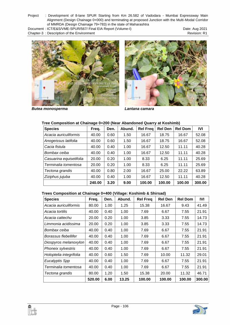
Project : Development of 8-lane SPUR Starting from Km 26.582 of Vadodara - Mumbai Expressway Main
Alignment (Design Chainage 0+000) and terminating at proposed Junction with the Multi-Modal Corridor
of MMRDA (Design Chainage 79+783) in the state of Maharashtra
Document : ICT/E&S/VME-SPUR/567/ Final EIA Report (Volume-I) Date: Aug 2021
Chapter-3 : Description of the Environment Revision: R1
Page - 106
Butea monosperma Lantana camara
Tree Composition at Chainage 0+200 (Near Abandoned Quarry at Koshimb)
Species Freq. Den. Abund. Rel Freq Rel Den Rel Dom IVI
Acacia auriculiformis 40.00 0.60 1.50 16.67 18.75 16.67 52.08
Anogeissus latifolia 40.00 0.60 1.50 16.67 18.75 16.67 52.08
Cacia fistula 40.00 0.40 1.00 16.67 12.50 11.11 40.28
Bombax ceiba 40.00 0.40 1.00 16.67 12.50 11.11 40.28
Casuarina equisetifolia 20.00 0.20 1.00 8.33 6.25 11.11 25.69
Terminalia tomentosa 20.00 0.20 1.00 8.33 6.25 11.11 25.69
Tectona grandis 40.00 0.80 2.00 16.67 25.00 22.22 63.89
Ziziphus jujuba 40.00 0.40 1.00 16.67 12.50 11.11 40.28
240.00 3.20 9.00 100.00 100.00 100.00 300.00
Trees Composition at Chainage 0+400 (Village: Koshimb & Shirsad)
Species Freq. Den. Abund. Rel Freq Rel Den Rel Dom IVI
Acacia auriculiformis 80.00 1.00 1.25 15.38 16.67 9.43 41.49
Acacia tortilis 40.00 0.40 1.00 7.69 6.67 7.55 21.91
Acacia cattechu 20.00 0.20 1.00 3.85 3.33 7.55 14.73
Limmonia acidissima 20.00 0.20 1.00 3.85 3.33 7.55 14.73
Bombax ceiba 40.00 0.40 1.00 7.69 6.67 7.55 21.91
Borassus flebellifer 40.00 0.40 1.00 7.69 6.67 7.55 21.91
Diospyros melanoxylon 40.00 0.40 1.00 7.69 6.67 7.55 21.91
Phoneix sylvestris 40.00 0.40 1.00 7.69 6.67 7.55 21.91
Holoptelia integrifolia 40.00 0.60 1.50 7.69 10.00 11.32 29.01
Eucalyptis Spp 40.00 0.40 1.00 7.69 6.67 7.55 21.91
Terminalia tomentosa 40.00 0.40 1.00 7.69 6.67 7.55 21.91
Tectona grandis 80.00 1.20 1.50 15.38 20.00 11.32 46.71
520.00 6.00 13.25 100.00 100.00 100.00 300.00
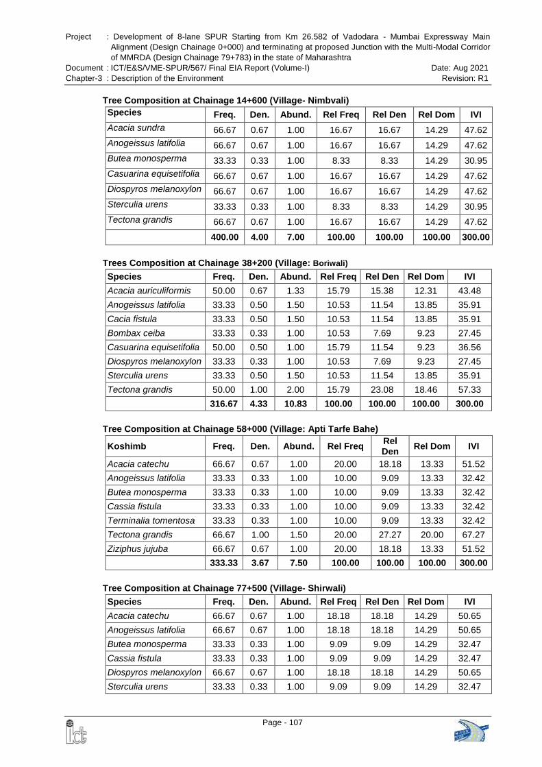
Project : Development of 8-lane SPUR Starting from Km 26.582 of Vadodara - Mumbai Expressway Main
Alignment (Design Chainage 0+000) and terminating at proposed Junction with the Multi-Modal Corridor
of MMRDA (Design Chainage 79+783) in the state of Maharashtra
Document : ICT/E&S/VME-SPUR/567/ Final EIA Report (Volume-I) Date: Aug 2021
Chapter-3 : Description of the Environment Revision: R1
Page - 107
Tree Composition at Chainage 14+600 (ViIlage- Nimbvali)
Species Freq. Den. Abund. Rel Freq Rel Den Rel Dom IVI
Acacia sundra 66.67 0.67 1.00 16.67 16.67 14.29 47.62
Anogeissus latifolia 66.67 0.67 1.00 16.67 16.67 14.29 47.62
Butea monosperma 33.33 0.33 1.00 8.33 8.33 14.29 30.95
Casuarina equisetifolia 66.67 0.67 1.00 16.67 16.67 14.29 47.62
Diospyros melanoxylon 66.67 0.67 1.00 16.67 16.67 14.29 47.62
Sterculia urens 33.33 0.33 1.00 8.33 8.33 14.29 30.95
Tectona grandis 66.67 0.67 1.00 16.67 16.67 14.29 47.62
400.00 4.00 7.00 100.00 100.00 100.00 300.00
Trees Composition at Chainage 38+200 (Village: Boriwali)
Species Freq. Den. Abund. Rel Freq Rel Den Rel Dom IVI
Acacia auriculiformis 50.00 0.67 1.33 15.79 15.38 12.31 43.48
Anogeissus latifolia 33.33 0.50 1.50 10.53 11.54 13.85 35.91
Cacia fistula 33.33 0.50 1.50 10.53 11.54 13.85 35.91
Bombax ceiba 33.33 0.33 1.00 10.53 7.69 9.23 27.45
Casuarina equisetifolia 50.00 0.50 1.00 15.79 11.54 9.23 36.56
Diospyros melanoxylon 33.33 0.33 1.00 10.53 7.69 9.23 27.45
Sterculia urens 33.33 0.50 1.50 10.53 11.54 13.85 35.91
Tectona grandis 50.00 1.00 2.00 15.79 23.08 18.46 57.33
316.67 4.33 10.83 100.00 100.00 100.00 300.00
Tree Composition at Chainage 58+000 (Village: Apti Tarfe Bahe)
Koshimb Freq. Den. Abund. Rel Freq Rel Den
Rel Dom IVI
Acacia catechu 66.67 0.67 1.00 20.00 18.18 13.33 51.52
Anogeissus latifolia 33.33 0.33 1.00 10.00 9.09 13.33 32.42
Butea monosperma 33.33 0.33 1.00 10.00 9.09 13.33 32.42
Cassia fistula 33.33 0.33 1.00 10.00 9.09 13.33 32.42
Terminalia tomentosa 33.33 0.33 1.00 10.00 9.09 13.33 32.42
Tectona grandis 66.67 1.00 1.50 20.00 27.27 20.00 67.27
Ziziphus jujuba 66.67 0.67 1.00 20.00 18.18 13.33 51.52
333.33 3.67 7.50 100.00 100.00 100.00 300.00
Tree Composition at Chainage 77+500 (ViIlage- Shirwali)
Species Freq. Den. Abund. Rel Freq Rel Den Rel Dom IVI
Acacia catechu 66.67 0.67 1.00 18.18 18.18 14.29 50.65
Anogeissus latifolia 66.67 0.67 1.00 18.18 18.18 14.29 50.65
Butea monosperma 33.33 0.33 1.00 9.09 9.09 14.29 32.47
Cassia fistula 33.33 0.33 1.00 9.09 9.09 14.29 32.47
Diospyros melanoxylon 66.67 0.67 1.00 18.18 18.18 14.29 50.65
Sterculia urens 33.33 0.33 1.00 9.09 9.09 14.29 32.47
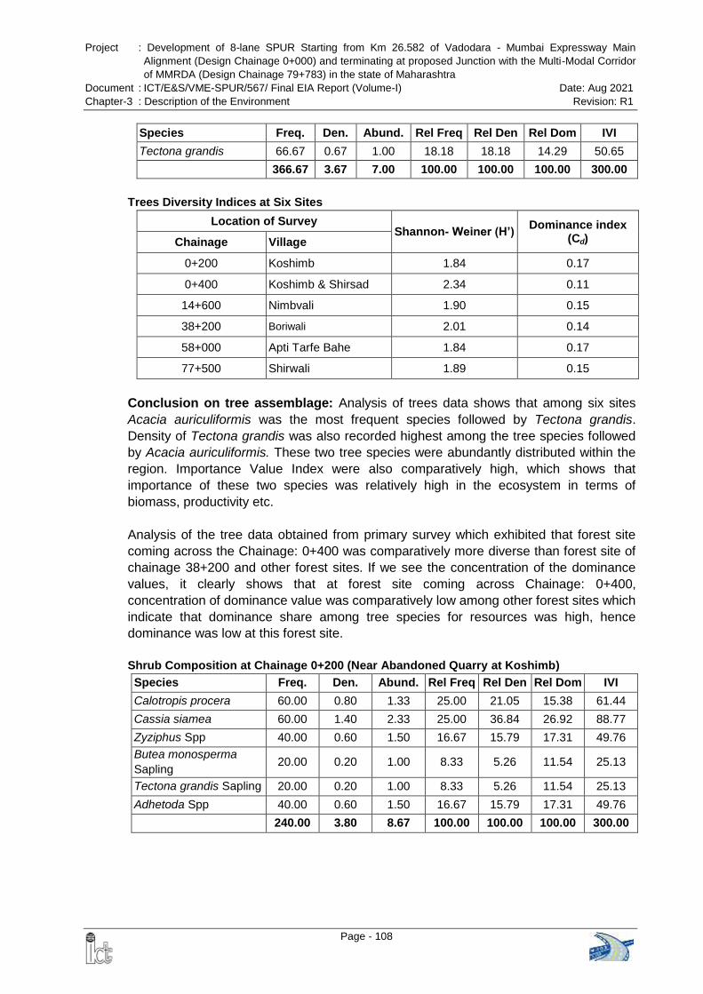
Project : Development of 8-lane SPUR Starting from Km 26.582 of Vadodara - Mumbai Expressway Main
Alignment (Design Chainage 0+000) and terminating at proposed Junction with the Multi-Modal Corridor
of MMRDA (Design Chainage 79+783) in the state of Maharashtra
Document : ICT/E&S/VME-SPUR/567/ Final EIA Report (Volume-I) Date: Aug 2021
Chapter-3 : Description of the Environment Revision: R1
Page - 108
Species Freq. Den. Abund. Rel Freq Rel Den Rel Dom IVI
Tectona grandis 66.67 0.67 1.00 18.18 18.18 14.29 50.65
366.67 3.67 7.00 100.00 100.00 100.00 300.00
Trees Diversity Indices at Six Sites
Location of Survey Shannon- Weiner (H’)
Dominance index (Cd) Chainage Village
0+200 Koshimb 1.84 0.17
0+400 Koshimb & Shirsad 2.34 0.11
14+600 Nimbvali 1.90 0.15
38+200 Boriwali 2.01 0.14
58+000 Apti Tarfe Bahe 1.84 0.17
77+500 Shirwali 1.89 0.15
Conclusion on tree assemblage: Analysis of trees data shows that among six sites
Acacia auriculiformis was the most frequent species followed by Tectona grandis.
Density of Tectona grandis was also recorded highest among the tree species followed
by Acacia auriculiformis. These two tree species were abundantly distributed within the
region. Importance Value Index were also comparatively high, which shows that
importance of these two species was relatively high in the ecosystem in terms of
biomass, productivity etc.
Analysis of the tree data obtained from primary survey which exhibited that forest site
coming across the Chainage: 0+400 was comparatively more diverse than forest site of
chainage 38+200 and other forest sites. If we see the concentration of the dominance
values, it clearly shows that at forest site coming across Chainage: 0+400,
concentration of dominance value was comparatively low among other forest sites which
indicate that dominance share among tree species for resources was high, hence
dominance was low at this forest site.
Shrub Composition at Chainage 0+200 (Near Abandoned Quarry at Koshimb)
Species Freq. Den. Abund. Rel Freq Rel Den Rel Dom IVI
Calotropis procera 60.00 0.80 1.33 25.00 21.05 15.38 61.44
Cassia siamea 60.00 1.40 2.33 25.00 36.84 26.92 88.77
Zyziphus Spp 40.00 0.60 1.50 16.67 15.79 17.31 49.76
Butea monosperma
Sapling 20.00 0.20 1.00 8.33 5.26 11.54 25.13
Tectona grandis Sapling 20.00 0.20 1.00 8.33 5.26 11.54 25.13
Adhetoda Spp 40.00 0.60 1.50 16.67 15.79 17.31 49.76
240.00 3.80 8.67 100.00 100.00 100.00 300.00
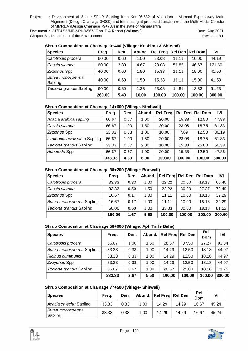
Project : Development of 8-lane SPUR Starting from Km 26.582 of Vadodara - Mumbai Expressway Main
Alignment (Design Chainage 0+000) and terminating at proposed Junction with the Multi-Modal Corridor
of MMRDA (Design Chainage 79+783) in the state of Maharashtra
Document : ICT/E&S/VME-SPUR/567/ Final EIA Report (Volume-I) Date: Aug 2021
Chapter-3 : Description of the Environment Revision: R1
Page - 109
Shrub Composition at Chainage 0+400 (Village: Koshimb & Shirsad)
Species Freq. Den. Abund. Rel Freq Rel Den Rel Dom IVI
Calotropis procera 60.00 0.60 1.00 23.08 11.11 10.00 44.19
Cassia siamea 60.00 2.80 4.67 23.08 51.85 46.67 121.60
Zyziphus Spp 40.00 0.60 1.50 15.38 11.11 15.00 41.50
Butea monosperma
Sapling 40.00 0.60 1.50 15.38 11.11 15.00 41.50
Tectona grandis Sapling 60.00 0.80 1.33 23.08 14.81 13.33 51.23
260.00 5.40 10.00 100.00 100.00 100.00 300.00
Shrub Composition at Chainage 14+600 (ViIlage- Nimbvali)
Species Freq. Den. Abund. Rel Freq Rel Den Rel Dom IVI
Acacia arabica sapling 66.67 0.67 1.00 20.00 15.38 12.50 47.88
Cassia siamea 66.67 1.00 1.50 20.00 23.08 18.75 61.83
Zyziphus Spp 33.33 0.33 1.00 10.00 7.69 12.50 30.19
Limmonia acidissima Sapling 66.67 1.00 1.50 20.00 23.08 18.75 61.83
Tectona grandis Sapling 33.33 0.67 2.00 10.00 15.38 25.00 50.38
Adhetoda Spp 66.67 0.67 1.00 20.00 15.38 12.50 47.88
333.33 4.33 8.00 100.00 100.00 100.00 300.00
Shrub Composition at Chainage 38+200 (Village: Boriwali)
Species Freq. Den. Abund. Rel Freq Rel Den Rel Dom IVI
Calotropis procera 33.33 0.33 1.00 22.22 20.00 18.18 60.40
Cassia siamea 33.33 0.50 1.50 22.22 30.00 27.27 79.49
Zyziphus Spp 16.67 0.17 1.00 11.11 10.00 18.18 39.29
Butea monosperma Sapling 16.67 0.17 1.00 11.11 10.00 18.18 39.29
Tectona grandis Sapling 50.00 0.50 1.00 33.33 30.00 18.18 81.52
150.00 1.67 5.50 100.00 100.00 100.00 300.00
Shrub Composition at Chainage 58+000 (Village: Apti Tarfe Bahe)
Species Freq. Den. Abund. Rel Freq Rel Den Rel
Dom IVI
Calotropis procera 66.67 1.00 1.50 28.57 37.50 27.27 93.34
Butea monosperma Sapling 33.33 0.33 1.00 14.29 12.50 18.18 44.97
Ricinus cummunis 33.33 0.33 1.00 14.29 12.50 18.18 44.97
Zyzyphus Spp 33.33 0.33 1.00 14.29 12.50 18.18 44.97
Tectona grandis Sapling 66.67 0.67 1.00 28.57 25.00 18.18 71.75
233.33 2.67 5.50 100.00 100.00 100.00 300.00
Shrub Composition at Chainage 77+500 (ViIlage- Shirwali)
Species Freq. Den. Abund. Rel Freq Rel Den Rel
Dom IVI
Acacia catechu Sapling 33.33 0.33 1.00 14.29 14.29 16.67 45.24
Butea monosperma
Sapling 33.33 0.33 1.00 14.29 14.29 16.67 45.24
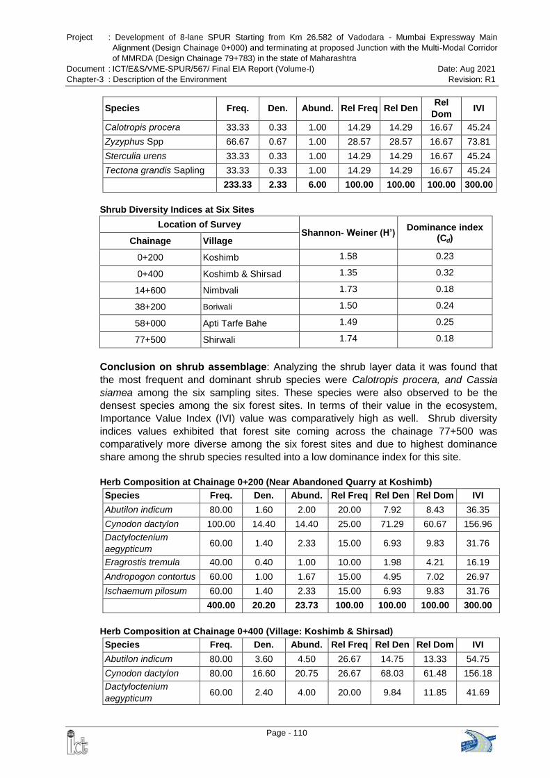
Project : Development of 8-lane SPUR Starting from Km 26.582 of Vadodara - Mumbai Expressway Main
Alignment (Design Chainage 0+000) and terminating at proposed Junction with the Multi-Modal Corridor
of MMRDA (Design Chainage 79+783) in the state of Maharashtra
Document : ICT/E&S/VME-SPUR/567/ Final EIA Report (Volume-I) Date: Aug 2021
Chapter-3 : Description of the Environment Revision: R1
Page - 110
Species Freq. Den. Abund. Rel Freq Rel Den Rel
Dom IVI
Calotropis procera 33.33 0.33 1.00 14.29 14.29 16.67 45.24
Zyzyphus Spp 66.67 0.67 1.00 28.57 28.57 16.67 73.81
Sterculia urens 33.33 0.33 1.00 14.29 14.29 16.67 45.24
Tectona grandis Sapling 33.33 0.33 1.00 14.29 14.29 16.67 45.24
233.33 2.33 6.00 100.00 100.00 100.00 300.00
Shrub Diversity Indices at Six Sites
Location of Survey Shannon- Weiner (H’)
Dominance index (Cd) Chainage Village
0+200 Koshimb 1.58 0.23
0+400 Koshimb & Shirsad 1.35 0.32
14+600 Nimbvali 1.73 0.18
38+200 Boriwali 1.50 0.24
58+000 Apti Tarfe Bahe 1.49 0.25
77+500 Shirwali 1.74 0.18
Conclusion on shrub assemblage: Analyzing the shrub layer data it was found that
the most frequent and dominant shrub species were Calotropis procera, and Cassia
siamea among the six sampling sites. These species were also observed to be the
densest species among the six forest sites. In terms of their value in the ecosystem,
Importance Value Index (IVI) value was comparatively high as well. Shrub diversity
indices values exhibited that forest site coming across the chainage 77+500 was
comparatively more diverse among the six forest sites and due to highest dominance
share among the shrub species resulted into a low dominance index for this site.
Herb Composition at Chainage 0+200 (Near Abandoned Quarry at Koshimb)
Species Freq. Den. Abund. Rel Freq Rel Den Rel Dom IVI
Abutilon indicum 80.00 1.60 2.00 20.00 7.92 8.43 36.35
Cynodon dactylon 100.00 14.40 14.40 25.00 71.29 60.67 156.96
Dactyloctenium
aegypticum 60.00 1.40 2.33 15.00 6.93 9.83 31.76
Eragrostis tremula 40.00 0.40 1.00 10.00 1.98 4.21 16.19
Andropogon contortus 60.00 1.00 1.67 15.00 4.95 7.02 26.97
Ischaemum pilosum 60.00 1.40 2.33 15.00 6.93 9.83 31.76
400.00 20.20 23.73 100.00 100.00 100.00 300.00
Herb Composition at Chainage 0+400 (Village: Koshimb & Shirsad)
Species Freq. Den. Abund. Rel Freq Rel Den Rel Dom IVI
Abutilon indicum 80.00 3.60 4.50 26.67 14.75 13.33 54.75
Cynodon dactylon 80.00 16.60 20.75 26.67 68.03 61.48 156.18
Dactyloctenium
aegypticum 60.00 2.40 4.00 20.00 9.84 11.85 41.69
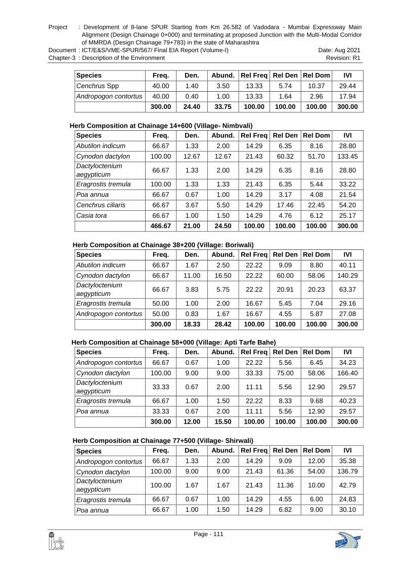
Project : Development of 8-lane SPUR Starting from Km 26.582 of Vadodara - Mumbai Expressway Main
Alignment (Design Chainage 0+000) and terminating at proposed Junction with the Multi-Modal Corridor
of MMRDA (Design Chainage 79+783) in the state of Maharashtra
Document : ICT/E&S/VME-SPUR/567/ Final EIA Report (Volume-I) Date: Aug 2021
Chapter-3 : Description of the Environment Revision: R1
Page - 111
Species Freq. Den. Abund. Rel Freq Rel Den Rel Dom IVI
Cenchrus Spp 40.00 1.40 3.50 13.33 5.74 10.37 29.44
Andropogon contortus 40.00 0.40 1.00 13.33 1.64 2.96 17.94
300.00 24.40 33.75 100.00 100.00 100.00 300.00
Herb Composition at Chainage 14+600 (ViIlage- Nimbvali)
Species Freq. Den. Abund. Rel Freq Rel Den Rel Dom IVI
Abutilon indicum 66.67 1.33 2.00 14.29 6.35 8.16 28.80
Cynodon dactylon 100.00 12.67 12.67 21.43 60.32 51.70 133.45
Dactyloctenium
aegypticum 66.67 1.33 2.00 14.29 6.35 8.16 28.80
Eragrostis tremula 100.00 1.33 1.33 21.43 6.35 5.44 33.22
Poa annua 66.67 0.67 1.00 14.29 3.17 4.08 21.54
Cenchrus ciliaris 66.67 3.67 5.50 14.29 17.46 22.45 54.20
Casia tora 66.67 1.00 1.50 14.29 4.76 6.12 25.17
466.67 21.00 24.50 100.00 100.00 100.00 300.00
Herb Composition at Chainage 38+200 (Village: Boriwali)
Species Freq. Den. Abund. Rel Freq Rel Den Rel Dom IVI
Abutilon indicum 66.67 1.67 2.50 22.22 9.09 8.80 40.11
Cynodon dactylon 66.67 11.00 16.50 22.22 60.00 58.06 140.29
Dactyloctenium
aegypticum 66.67 3.83 5.75 22.22 20.91 20.23 63.37
Eragrostis tremula 50.00 1.00 2.00 16.67 5.45 7.04 29.16
Andropogon contortus 50.00 0.83 1.67 16.67 4.55 5.87 27.08
300.00 18.33 28.42 100.00 100.00 100.00 300.00
Herb Composition at Chainage 58+000 (Village: Apti Tarfe Bahe)
Species Freq. Den. Abund. Rel Freq Rel Den Rel Dom IVI
Andropogon contortus 66.67 0.67 1.00 22.22 5.56 6.45 34.23
Cynodon dactylon 100.00 9.00 9.00 33.33 75.00 58.06 166.40
Dactyloctenium
aegypticum 33.33 0.67 2.00 11.11 5.56 12.90 29.57
Eragrostis tremula 66.67 1.00 1.50 22.22 8.33 9.68 40.23
Poa annua 33.33 0.67 2.00 11.11 5.56 12.90 29.57
300.00 12.00 15.50 100.00 100.00 100.00 300.00
Herb Composition at Chainage 77+500 (ViIlage- Shirwali)
Species Freq. Den. Abund. Rel Freq Rel Den Rel Dom IVI
Andropogon contortus 66.67 1.33 2.00 14.29 9.09 12.00 35.38
Cynodon dactylon 100.00 9.00 9.00 21.43 61.36 54.00 136.79
Dactyloctenium
aegypticum 100.00 1.67 1.67 21.43 11.36 10.00 42.79
Eragrostis tremula 66.67 0.67 1.00 14.29 4.55 6.00 24.83
Poa annua 66.67 1.00 1.50 14.29 6.82 9.00 30.10
Project : Development of 8-lane SPUR Starting from Km 26.582 of Vadodara - Mumbai Expressway Main
Alignment (Design Chainage 0+000) and terminating at proposed Junction with the Multi-Modal Corridor
of MMRDA (Design Chainage 79+783) in the state of Maharashtra
Document : ICT/E&S/VME-SPUR/567/ Final EIA Report (Volume-I) Date: Aug 2021
Chapter-3 : Description of the Environment Revision: R1
Page - 112
Species Freq. Den. Abund. Rel Freq Rel Den Rel Dom IVI
Casia tora 66.67 1.00 1.50 14.29 6.82 9.00 30.10
466.67 14.67 16.67 100.00 100.00 100.00 300.00
Herb Diversity Indices at Six Sites
Location of Survey Shannon- Weiner (H’)
Dominance index (Cd) Chainage Village
0+200 Koshimb 1.03 0.52
0+400 Koshimb & Shirsad 1.00 0.49
14+600 Nimbvali 1.24 0.40
38+200 Boriwali 1.15 0.41
58+000 Apti Tarfe Bahe 0.90 0.57
77+500 Shirwali 1.27 0.40
Conclusion on herb assemblage: Data of herbaceous layer showed that in all the six
sites most frequent and dominant herb species were Cynodon dactylon, and
Dactyloctenium aegypticum, in all the six sampling sites, these species were also
observed to be the densest species among the six forest sites. The Importance Value
Index (IVI) value was comparatively high for these species.
Highest herbs and grasses were found in the forest site adjacent to the Chainage
77+500, reason being that the forest of this site was comparatively more open which
allows more sunlight to reach to the forest floor and provide opportunity to thrive the
ground vegetation. Hence more dominance share for resources and habitat gives low
dominance index of herbaceous vegetation of this site.
3.14.3 Threatened Species of Flora
As per primary survey of the proposed area, no threatened floral species was recorded
along the proposed alignment during the field survey. The enlisted flora was also cross
checked with the existing secondary literatures, no taxa were found in the Red Data List
of Indian plants as well. This categorization was done according to IUCN, Red Data
Book (Walter and Gillett, 1998), and Red Data Book published by the Botanical
Survey of India (Nayar and Shastry, 1987).
Other species falling in low risk category are:
Pterocarpus marsupium (Bibla) : Near Threatened,
Tabernaemontana heyneana (Nagkuda pandarakuda): Near Threatened
3.14.4 Forest
The Forests of Dhanu Division are classified into following categories as per the
Classification of Indian Forest Types by Champion and Seth (1968).
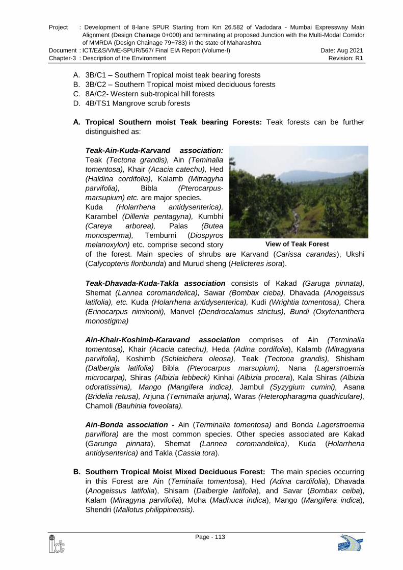
Project : Development of 8-lane SPUR Starting from Km 26.582 of Vadodara - Mumbai Expressway Main
Alignment (Design Chainage 0+000) and terminating at proposed Junction with the Multi-Modal Corridor
of MMRDA (Design Chainage 79+783) in the state of Maharashtra
Document : ICT/E&S/VME-SPUR/567/ Final EIA Report (Volume-I) Date: Aug 2021
Chapter-3 : Description of the Environment Revision: R1
Page - 113
A. 3B/C1 – Southern Tropical moist teak bearing forests
B. 3B/C2 – Southern Tropical moist mixed deciduous forests
C. 8A/C2- Western sub-tropical hill forests
D. 4B/TS1 Mangrove scrub forests
A. Tropical Southern moist Teak bearing Forests: Teak forests can be further
distinguished as:
Teak-Ain-Kuda-Karvand association:
Teak (Tectona grandis), Ain (Teminalia
tomentosa), Khair (Acacia catechu), Hed
(Haldina cordifolia), Kalamb (Mitragyha
parvifolia), Bibla (Pterocarpus-
marsupium) etc. are major species.
Kuda (Holarrhena antidysenterica),
Karambel (Dillenia pentagyna), Kumbhi
(Careya arborea), Palas (Butea
monosperma), Temburni (Diospyros
melanoxylon) etc. comprise second story
of the forest. Main species of shrubs are Karvand (Carissa carandas), Ukshi
(Calycopteris floribunda) and Murud sheng (Helicteres isora).
Teak-Dhavada-Kuda-Takla association consists of Kakad (Garuga pinnata),
Shemat (Lannea coromandelica), Sawar (Bombax cieba), Dhavada (Anogeissus
latifolia), etc. Kuda (Holarrhena antidysenterica), Kudi (Wrightia tomentosa), Chera
(Erinocarpus niminonii), Manvel (Dendrocalamus strictus), Bundi (Oxytenanthera
monostigma)
Ain-Khair-Koshimb-Karavand association comprises of Ain (Terminalia
tomentosa), Khair (Acacia catechu), Heda (Adina cordifolia), Kalamb (Mitragyana
parvifolia), Koshimb (Schleichera oleosa), Teak (Tectona grandis), Shisham
(Dalbergia latifolia) Bibla (Pterocarpus marsupium), Nana (Lagerstroemia
microcarpa), Shiras (Albizia lebbeck) Kinhai (Albizia procera), Kala Shiras (Albizia
odoratissima), Mango (Mangifera indica), Jambul (Syzygium cumini), Asana
(Bridelia retusa), Arjuna (Ternimalia arjuna), Waras (Heteropharagma quadriculare),
Chamoli (Bauhinia foveolata).
Ain-Bonda association - Ain (Terminalia tomentosa) and Bonda Lagerstroemia
parviflora) are the most common species. Other species associated are Kakad
(Garunga pinnata), Shemat (Lannea coromandelica), Kuda (Holarrhena
antidysenterica) and Takla (Cassia tora).
B. Southern Tropical Moist Mixed Deciduous Forest: The main species occurring
in this Forest are Ain (Teminalia tomentosa), Hed (Adina cardifolia), Dhavada
(Anogeissus latifolia), Shisam (Dalbergie latifolia), and Savar (Bombax ceiba),
Kalam (Mitragyna parvifolia), Moha (Madhuca indica), Mango (Mangifera indica),
Shendri (Mallotus philippinensis).
View of Teak Forest
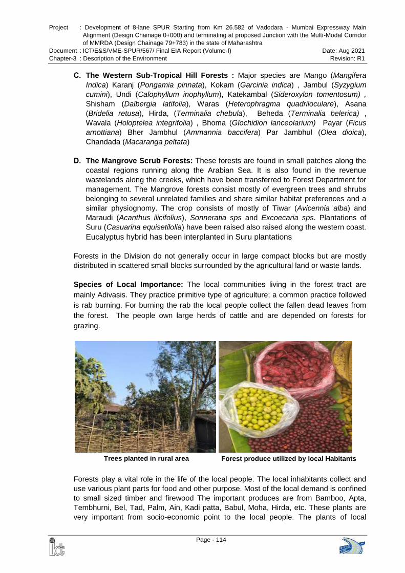
Project : Development of 8-lane SPUR Starting from Km 26.582 of Vadodara - Mumbai Expressway Main
Alignment (Design Chainage 0+000) and terminating at proposed Junction with the Multi-Modal Corridor
of MMRDA (Design Chainage 79+783) in the state of Maharashtra
Document : ICT/E&S/VME-SPUR/567/ Final EIA Report (Volume-I) Date: Aug 2021
Chapter-3 : Description of the Environment Revision: R1
Page - 114
Trees planted in rural area Forest produce utilized by local Habitants
C. The Western Sub-Tropical Hill Forests : Major species are Mango (Mangifera
Indica) Karanj (Pongamia pinnata), Kokam (Garcinia indica) , Jambul (Syzygium
cumini), Undi (Calophyllum inophyllum), Katekambal (Sideroxylon tomentosum) ,
Shisham (Dalbergia latifolia), Waras (Heterophragma quadriloculare), Asana
(Bridelia retusa), Hirda, (Terminalia chebula), Beheda (Terminalia belerica) ,
Wavala (Holoptelea integrifolia) , Bhoma (Glochidion lanceolarium) Payar (Ficus
arnottiana) Bher Jambhul (Ammannia baccifera) Par Jambhul (Olea dioica),
Chandada (Macaranga peltata)
D. The Mangrove Scrub Forests: These forests are found in small patches along the
coastal regions running along the Arabian Sea. It is also found in the revenue
wastelands along the creeks, which have been transferred to Forest Department for
management. The Mangrove forests consist mostly of evergreen trees and shrubs
belonging to several unrelated families and share similar habitat preferences and a
similar physiognomy. The crop consists of mostly of Tiwar (Avicennia alba) and
Maraudi (Acanthus ilicifolius), Sonneratia sps and Excoecaria sps. Plantations of
Suru (Casuarina equisetilolia) have been raised also raised along the western coast.
Eucalyptus hybrid has been interplanted in Suru plantations
Forests in the Division do not generally occur in large compact blocks but are mostly
distributed in scattered small blocks surrounded by the agricultural land or waste lands.
Species of Local Importance: The local communities living in the forest tract are
mainly Adivasis. They practice primitive type of agriculture; a common practice followed
is rab burning. For burning the rab the local people collect the fallen dead leaves from
the forest. The people own large herds of cattle and are depended on forests for
grazing.
Forests play a vital role in the life of the local people. The local inhabitants collect and
use various plant parts for food and other purpose. Most of the local demand is confined
to small sized timber and firewood The important produces are from Bamboo, Apta,
Tembhurni, Bel, Tad, Palm, Ain, Kadi patta, Babul, Moha, Hirda, etc. These plants are
very important from socio-economic point to the local people. The plants of local
Project : Development of 8-lane SPUR Starting from Km 26.582 of Vadodara - Mumbai Expressway Main
Alignment (Design Chainage 0+000) and terminating at proposed Junction with the Multi-Modal Corridor
of MMRDA (Design Chainage 79+783) in the state of Maharashtra
Document : ICT/E&S/VME-SPUR/567/ Final EIA Report (Volume-I) Date: Aug 2021
Chapter-3 : Description of the Environment Revision: R1
Page - 115
importance are provided in the Table 3-38.
Table 3-38 Dependence of Local Inhabitants on Plants
S. No. Botanical Name Local Name Parts Used Remarks
1. Acacia catechu Khair Stem Fuel , wood ash manure, making hubs and axles of carts
2. Acacia nilotica Babul Stems , twigs Fuel, toothbrush
3. Acacia auriculiformis Acacia Tree Fuel and Fodder
4. Acacia concinna Shikekai Fruit Washing, shampoo
5. Aegle marmelos Bel Fruits, leaves Fruit used in diarrhea and stomach ache, drink as sarbat, religious functions
6. Agave sisilana Agave Whole plant Agave leaves used as fibers
7. Aloe vera Korphad Leaves Apply on injuries and burns
8. Annona squamosa Sitaphal Bark, fruit Bark decoction used in diarrhea, fruit consumed
9. Asparagus recemosus Shatawari Root Juice of roots used in diarrhea, piles and cough
10. Avicennia officinalis Tiwar Bark Tannin and timber
11. Azadirachta indica Neem Leaves, twigs, bark
Twigs used as tooth brush, neem cakes, for shade, mosquito repellant
12. Bauhinia racemosa Apta Leaves Leaves used for making beedi, cure for digestive diseases
13. Borassus flabellifer Toddy Palm Fruit, Sap Unfermented sweet sap – Neeru, Fermented drink -Todi, leaves used for thatching roofs, mat, broom etc
14. Butea monosperma Palas Flower , Leaves, bark
Leaves used as plate , flowers for dye, gum
15. Carica papaya Papaya Fruit, Leaves Fruit, extracts of papaya leaf used in dengue fever
16. Carissa carandas Karwand Fruit, stems and leaves
Fruit, rab purpose - ash manure
17. Carvia callosa Karvi Leaves, stem Cure stomach ailment, poles and fencing material, ash manure
18. Cassia tora Takla/Tarota Seeds Seeds used to get relief from stomach pain
19. Casuarina equisetifolia Suru Whole tree Fuel, wind shelter
20. Cocos nucifera Naryal Leaves, fruit
Mats & thatching,coconut water, oil, husk and shells used for fuel
21. Dendrocalamus strictus
Bamboo Whole plant Fencing, basket making, thatching, ash manure
22. Diospyros melanoxylon Tembhurni leaves Leaves used for making beedi
23. Emblica officinalis Awla Fruit Fruit, pickle, powder form
24. Eucalyptus sps Nilgiri Leaves, stem Fuel , commercial species
25. Ficus benghalensis Vad Whole tree Religious, shade
26. Ficus religiosa Pimpal Whole tree Religious
27. Garcinia indica Kokam Powder Kokam drink, pickle, dye
28. Jasminum arborescens Kusari Flowers Religious work, women put on hair
29. Lawsonia inermis Heena Leaves Dye, Mehndi powder
30. Leucaena leucocephala
Subabul Whole plant Fuel and Fodder
31. Madhuca longifolia Moha Flower , Seeds Flower used to prepare a local brew , oil
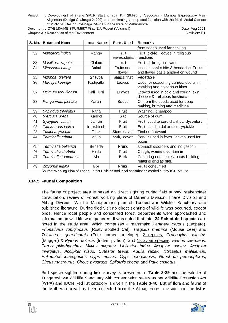
Project : Development of 8-lane SPUR Starting from Km 26.582 of Vadodara - Mumbai Expressway Main
Alignment (Design Chainage 0+000) and terminating at proposed Junction with the Multi-Modal Corridor
of MMRDA (Design Chainage 79+783) in the state of Maharashtra
Document : ICT/E&S/VME-SPUR/567/ Final EIA Report (Volume-I) Date: Aug 2021
Chapter-3 : Description of the Environment Revision: R1
Page - 116
S. No. Botanical Name Local Name Parts Used Remarks
from seeds used for cooking
32. Mangifera indica Mango Fruit, leaves,stems
Fruit, pickle , leaves in religious functions
33. Manilkara zapota Chikoo fruit Fruit, chikoo juice, wine
34. Mimusops elengi Bakul Fruits and flower
Used in snake bite & headache. Fruits and flower paste applied on wound
35. Moringa oleifera Shevga Seeds, fruit Vegetable
36. Murraya koeingii Kadipatta Leaves Used for seasoning curries, useful in vomiting and poisonous bites
37. Ocimum tenuiflorum Kali Tulsi Leaves Leaves used in cold and cough, skin disease & religious functions
38. Pongammia pinnata Karanj Seeds Oil from the seeds used for soap making, burning and medicine
39. Sapindus trifoliatus Ritha Fruit Washing / shampoo
40. Sterculia urens Kandol Sap Source of gum
41. Syzygium cumini Jamun Fruit Fruit, used to cure diarrhea, dysentery
42. Tamarindus indica Imli/chinch Fruit Fruit, used in dal and curry/pickle
43. Tectona grandis Teak Stem leaves Timber, firewood
44. Terminalia arjuna Arjun bark, leaves Bark is used in fever, leaves used for pooja
45. Terminalia bellerica Behada Fruits stomach disorders and indigestion
46. Terminalia chebula Hirda Fruit Cough, wound ulcer,tannin
47. Terminalia tomentosa Ain Bark Colouring nets, poles, boats building material and as fuel.
48. Zizyphus jujuba Bor Fruits Fruits consumed
Source: Working Plan of Thane Forest Division and local consultation carried out by ICT Pvt. Ltd.
3.14.5 Faunal Composition
The fauna of project area is based on direct sighting during field survey, stakeholder
consultation, review of Forest working plans of Dahanu Division, Thane Division and
Alibag Division, Wildlife Management plan of Tungeshwar Wildlife Sanctuary and
published literature. During filed visit no direct sighting of wildlife was occurred, except
birds. Hence local people and concerned forest departments were approached and
information on wild life was gathered. It was noted that total 24 Schedule-I species are
noted in the study area, which comprises 4 mammals; Panthera pardus (Leopard),
Prionailurus rubiginosus (Rusty spotted Cat), Tragulus merrima (Mouse deer) and
Tetracerus quadricornis (Four horned antelope). 2 reptiles; Crocodylus palustris
(Mugger) & Pythus molurus (Indian python), and 18 avian species; Elanus caeruleus,
Pernis ptilorhynchus, Milvus migrans, Haliastur indus, Accipiter badius, Accipiter
trivirgatus, Accipiter nisus, Butastur teesa, Aquila rapax, Ictinaetus malaiensis,
Haliaeetus leucogaster, Gyps indicus, Gyps bengalensis, Neophron percnopterus,
Circus macrourus, Circus pygargus, Spilornis cheela and Pavo cristatus.
Bird specie sighted during field survey is presented in Table 3-39 and the wildlife of
Tungareshwar Wildlife Sanctuary with conservation status as per Wildlife Protection Act
(WPA) and IUCN Red list category is given in the Table 3-40. List of flora and fauna of
the Matheran area has been collected from the Alibag Forest division and the list is
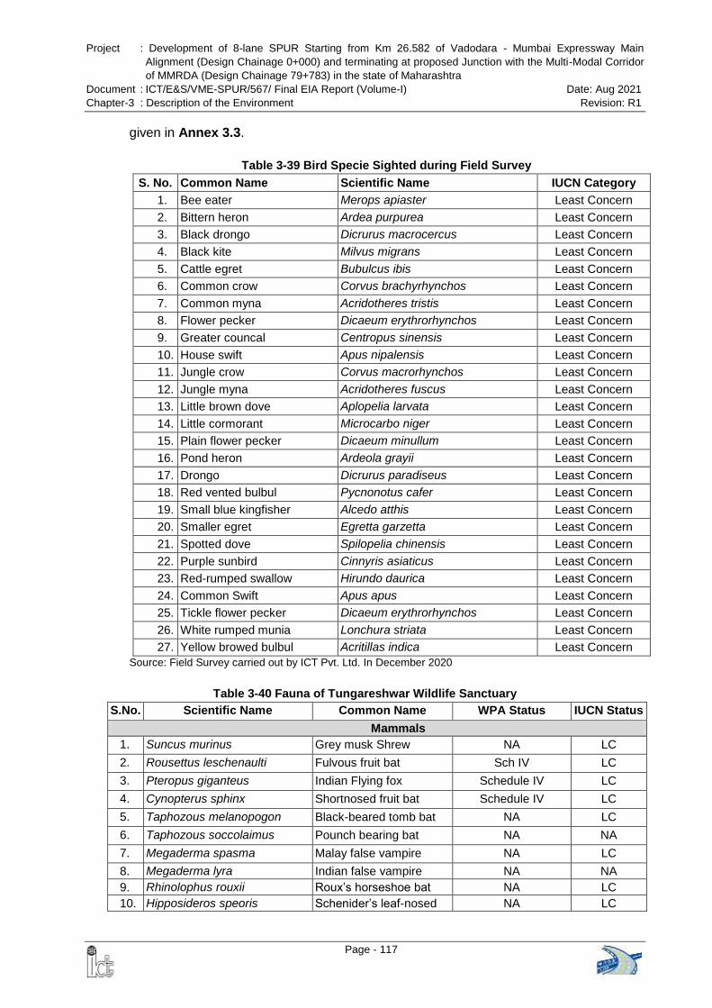
Project : Development of 8-lane SPUR Starting from Km 26.582 of Vadodara - Mumbai Expressway Main
Alignment (Design Chainage 0+000) and terminating at proposed Junction with the Multi-Modal Corridor
of MMRDA (Design Chainage 79+783) in the state of Maharashtra
Document : ICT/E&S/VME-SPUR/567/ Final EIA Report (Volume-I) Date: Aug 2021
Chapter-3 : Description of the Environment Revision: R1
Page - 117
given in Annex 3.3.
Table 3-39 Bird Specie Sighted during Field Survey
S. No. Common Name Scientific Name IUCN Category
1. Bee eater Merops apiaster Least Concern
2. Bittern heron Ardea purpurea Least Concern
3. Black drongo Dicrurus macrocercus Least Concern
4. Black kite Milvus migrans Least Concern
5. Cattle egret Bubulcus ibis Least Concern
6. Common crow Corvus brachyrhynchos Least Concern
7. Common myna Acridotheres tristis Least Concern
8. Flower pecker Dicaeum erythrorhynchos Least Concern
9. Greater councal Centropus sinensis Least Concern
10. House swift Apus nipalensis Least Concern
11. Jungle crow Corvus macrorhynchos Least Concern
12. Jungle myna Acridotheres fuscus Least Concern
13. Little brown dove Aplopelia larvata Least Concern
14. Little cormorant Microcarbo niger Least Concern
15. Plain flower pecker Dicaeum minullum Least Concern
16. Pond heron Ardeola grayii Least Concern
17. Drongo Dicrurus paradiseus Least Concern
18. Red vented bulbul Pycnonotus cafer Least Concern
19. Small blue kingfisher Alcedo atthis Least Concern
20. Smaller egret Egretta garzetta Least Concern
21. Spotted dove Spilopelia chinensis Least Concern
22. Purple sunbird Cinnyris asiaticus Least Concern
23. Red-rumped swallow Hirundo daurica Least Concern
24. Common Swift Apus apus Least Concern
25. Tickle flower pecker Dicaeum erythrorhynchos Least Concern
26. White rumped munia Lonchura striata Least Concern
27. Yellow browed bulbul Acritillas indica Least Concern
Source: Field Survey carried out by ICT Pvt. Ltd. In December 2020
Table 3-40 Fauna of Tungareshwar Wildlife Sanctuary
S.No. Scientific Name Common Name WPA Status IUCN Status
Mammals
1. Suncus murinus Grey musk Shrew NA LC
2. Rousettus leschenaulti Fulvous fruit bat Sch IV LC
3. Pteropus giganteus Indian Flying fox Schedule IV LC
4. Cynopterus sphinx Shortnosed fruit bat Schedule IV LC
5. Taphozous melanopogon Black-beared tomb bat NA LC
6. Taphozous soccolaimus Pounch bearing bat NA NA
7. Megaderma spasma Malay false vampire NA LC
8. Megaderma lyra Indian false vampire NA NA
9. Rhinolophus rouxii Roux‘s horseshoe bat NA LC
10. Hipposideros speoris Schenider‘s leaf-nosed NA LC
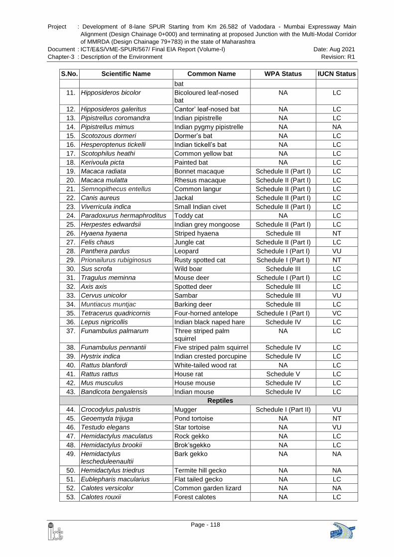
Project : Development of 8-lane SPUR Starting from Km 26.582 of Vadodara - Mumbai Expressway Main
Alignment (Design Chainage 0+000) and terminating at proposed Junction with the Multi-Modal Corridor
of MMRDA (Design Chainage 79+783) in the state of Maharashtra
Document : ICT/E&S/VME-SPUR/567/ Final EIA Report (Volume-I) Date: Aug 2021
Chapter-3 : Description of the Environment Revision: R1
Page - 118
S.No. Scientific Name Common Name WPA Status IUCN Status
bat
11. Hipposideros bicolor Bicoloured leaf-nosed bat
NA LC
12. Hipposideros galeritus Cantor‘ leaf-nosed bat NA LC
13. Pipistrellus coromandra Indian pipistrelle NA LC
14. Pipistrellus mimus Indian pygmy pipistrelle NA NA
15. Scotozous dormeri Dormer‘s bat NA LC
16. Hesperoptenus tickelli Indian tickell‘s bat NA LC
17. Scotophilus heathi Common yellow bat NA LC
18. Kerivoula picta Painted bat NA LC
19. Macaca radiata Bonnet macaque Schedule II (Part I) LC
20. Macaca mulatta Rhesus macaque Schedule II (Part I) LC
21. Semnopithecus entellus Common langur Schedule II (Part I) LC
22. Canis aureus Jackal Schedule II (Part I) LC
23. Viverricula indica Small Indian civet Schedule II (Part I) LC
24. Paradoxurus hermaphroditus Toddy cat NA LC
25. Herpestes edwardsii Indian grey mongoose Schedule II (Part I) LC
26. Hyaena hyaena Striped hyaena Schedule III NT
27. Felis chaus Jungle cat Schedule II (Part I) LC
28. Panthera pardus Leopard Schedule I (Part I) VU
29. Prionailurus rubiginosus Rusty spotted cat Schedule I (Part I) NT
30. Sus scrofa Wild boar Schedule III LC
31. Tragulus meminna Mouse deer Schedule I (Part I) LC
32. Axis axis Spotted deer Schedule III LC
33. Cervus unicolor Sambar Schedule III VU
34. Muntiacus muntjac Barking deer Schedule III LC
35. Tetracerus quadricornis Four-horned antelope Schedule I (Part I) VC
36. Lepus nigricollis Indian black naped hare Schedule IV LC
37. Funambulus palmarum Three striped palm squirrel
NA LC
38. Funambulus pennantii Five striped palm squirrel Schedule IV LC
39. Hystrix indica Indian crested porcupine Schedule IV LC
40. Rattus blanfordi White-tailed wood rat NA LC
41. Rattus rattus House rat Schedule V LC
42. Mus musculus House mouse Schedule IV LC
43. Bandicota bengalensis Indian mouse Schedule IV LC
Reptiles
44. Crocodylus palustris Mugger Schedule I (Part II) VU
45. Geoemyda trijuga Pond tortoise NA NT
46. Testudo elegans Star tortoise NA VU
47. Hemidactylus maculatus Rock gekko NA LC
48. Hemidactylus brookii Brok‘sgekko NA LC
49. Hemidactylus lescheduleenaultii
Bark gekko NA NA
50. Hemidactylus triedrus Termite hill gecko NA NA
51. Eublepharis macularius Flat tailed gecko NA LC
52. Calotes versicolor Common garden lizard NA NA
53. Calotes rouxii Forest calotes NA LC
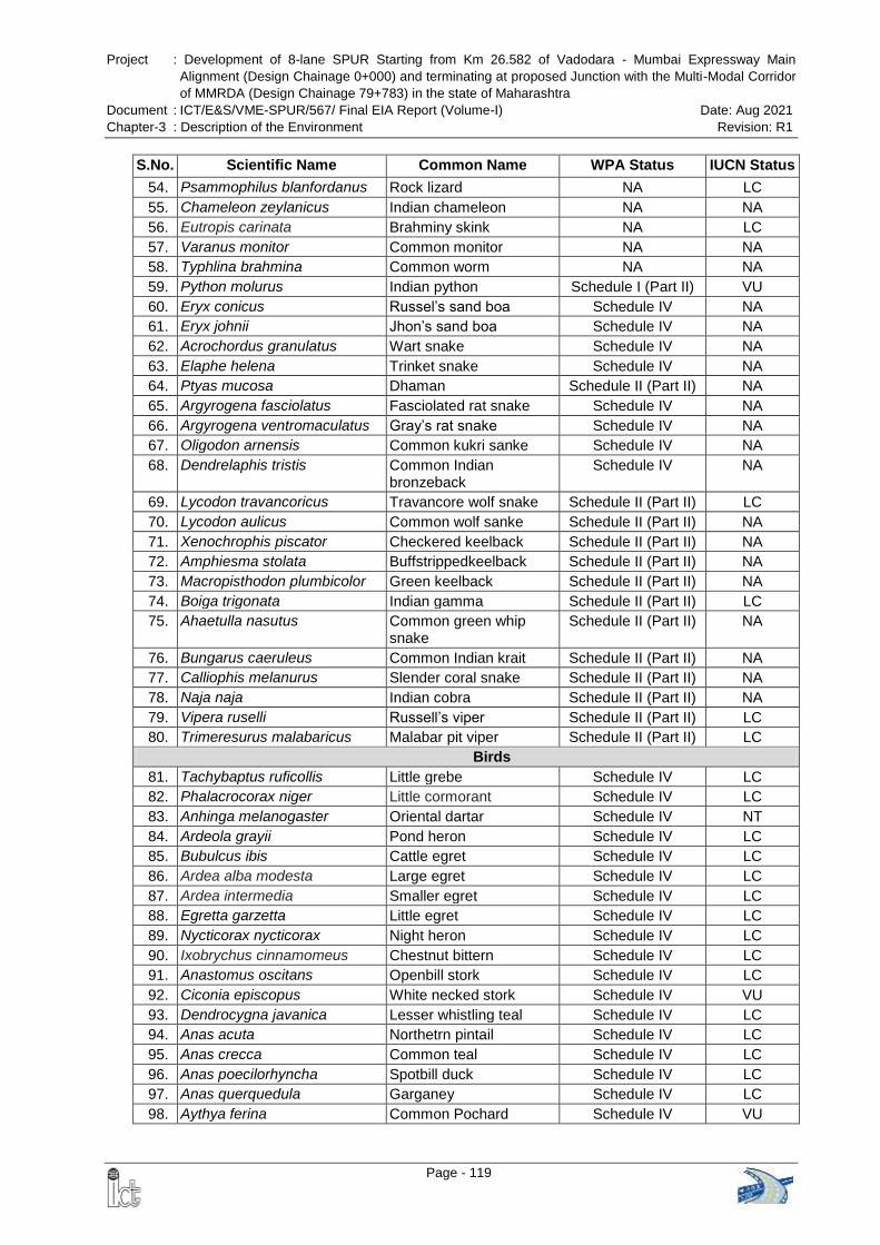
Project : Development of 8-lane SPUR Starting from Km 26.582 of Vadodara - Mumbai Expressway Main
Alignment (Design Chainage 0+000) and terminating at proposed Junction with the Multi-Modal Corridor
of MMRDA (Design Chainage 79+783) in the state of Maharashtra
Document : ICT/E&S/VME-SPUR/567/ Final EIA Report (Volume-I) Date: Aug 2021
Chapter-3 : Description of the Environment Revision: R1
Page - 119
S.No. Scientific Name Common Name WPA Status IUCN Status
54. Psammophilus blanfordanus Rock lizard NA LC
55. Chameleon zeylanicus Indian chameleon NA NA
56. Eutropis carinata Brahminy skink NA LC
57. Varanus monitor Common monitor NA NA
58. Typhlina brahmina Common worm NA NA
59. Python molurus Indian python Schedule I (Part II) VU
60. Eryx conicus Russel‘s sand boa Schedule IV NA
61. Eryx johnii Jhon‘s sand boa Schedule IV NA
62. Acrochordus granulatus Wart snake Schedule IV NA
63. Elaphe helena Trinket snake Schedule IV NA
64. Ptyas mucosa Dhaman Schedule II (Part II) NA
65. Argyrogena fasciolatus Fasciolated rat snake Schedule IV NA
66. Argyrogena ventromaculatus Gray‘s rat snake Schedule IV NA
67. Oligodon arnensis Common kukri sanke Schedule IV NA
68. Dendrelaphis tristis Common Indian bronzeback
Schedule IV NA
69. Lycodon travancoricus Travancore wolf snake Schedule II (Part II) LC
70. Lycodon aulicus Common wolf sanke Schedule II (Part II) NA
71. Xenochrophis piscator Checkered keelback Schedule II (Part II) NA
72. Amphiesma stolata Buffstrippedkeelback Schedule II (Part II) NA
73. Macropisthodon plumbicolor Green keelback Schedule II (Part II) NA
74. Boiga trigonata Indian gamma Schedule II (Part II) LC
75. Ahaetulla nasutus Common green whip snake
Schedule II (Part II) NA
76. Bungarus caeruleus Common Indian krait Schedule II (Part II) NA
77. Calliophis melanurus Slender coral snake Schedule II (Part II) NA
78. Naja naja Indian cobra Schedule II (Part II) NA
79. Vipera ruselli Russell‘s viper Schedule II (Part II) LC
80. Trimeresurus malabaricus Malabar pit viper Schedule II (Part II) LC
Birds
81. Tachybaptus ruficollis Little grebe Schedule IV LC
82. Phalacrocorax niger Little cormorant Schedule IV LC
83. Anhinga melanogaster Oriental dartar Schedule IV NT
84. Ardeola grayii Pond heron Schedule IV LC
85. Bubulcus ibis Cattle egret Schedule IV LC
86. Ardea alba modesta Large egret Schedule IV LC
87. Ardea intermedia Smaller egret Schedule IV LC
88. Egretta garzetta Little egret Schedule IV LC
89. Nycticorax nycticorax Night heron Schedule IV LC
90. Ixobrychus cinnamomeus Chestnut bittern Schedule IV LC
91. Anastomus oscitans Openbill stork Schedule IV LC
92. Ciconia episcopus White necked stork Schedule IV VU
93. Dendrocygna javanica Lesser whistling teal Schedule IV LC
94. Anas acuta Northetrn pintail Schedule IV LC
95. Anas crecca Common teal Schedule IV LC
96. Anas poecilorhyncha Spotbill duck Schedule IV LC
97. Anas querquedula Garganey Schedule IV LC
98. Aythya ferina Common Pochard Schedule IV VU
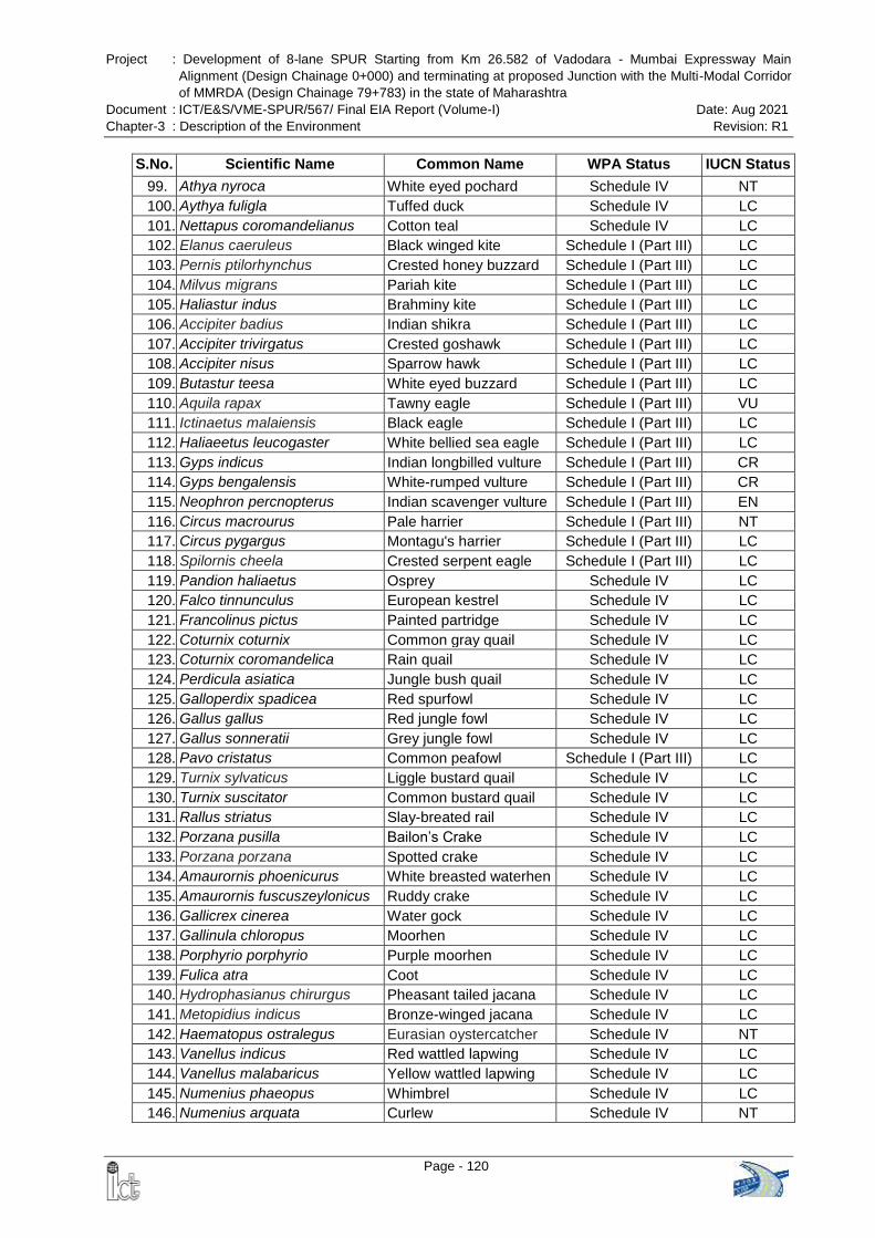
Project : Development of 8-lane SPUR Starting from Km 26.582 of Vadodara - Mumbai Expressway Main
Alignment (Design Chainage 0+000) and terminating at proposed Junction with the Multi-Modal Corridor
of MMRDA (Design Chainage 79+783) in the state of Maharashtra
Document : ICT/E&S/VME-SPUR/567/ Final EIA Report (Volume-I) Date: Aug 2021
Chapter-3 : Description of the Environment Revision: R1
Page - 120
S.No. Scientific Name Common Name WPA Status IUCN Status
99. Athya nyroca White eyed pochard Schedule IV NT
100. Aythya fuligla Tuffed duck Schedule IV LC
101. Nettapus coromandelianus Cotton teal Schedule IV LC
102. Elanus caeruleus Black winged kite Schedule I (Part III) LC
103. Pernis ptilorhynchus Crested honey buzzard Schedule I (Part III) LC
104. Milvus migrans Pariah kite Schedule I (Part III) LC
105. Haliastur indus Brahminy kite Schedule I (Part III) LC
106. Accipiter badius Indian shikra Schedule I (Part III) LC
107. Accipiter trivirgatus Crested goshawk Schedule I (Part III) LC
108. Accipiter nisus Sparrow hawk Schedule I (Part III) LC
109. Butastur teesa White eyed buzzard Schedule I (Part III) LC
110. Aquila rapax Tawny eagle Schedule I (Part III) VU
111. Ictinaetus malaiensis Black eagle Schedule I (Part III) LC
112. Haliaeetus leucogaster White bellied sea eagle Schedule I (Part III) LC
113. Gyps indicus Indian longbilled vulture Schedule I (Part III) CR
114. Gyps bengalensis White-rumped vulture Schedule I (Part III) CR
115. Neophron percnopterus Indian scavenger vulture Schedule I (Part III) EN
116. Circus macrourus Pale harrier Schedule I (Part III) NT
117. Circus pygargus Montagu's harrier Schedule I (Part III) LC
118. Spilornis cheela Crested serpent eagle Schedule I (Part III) LC
119. Pandion haliaetus Osprey Schedule IV LC
120. Falco tinnunculus European kestrel Schedule IV LC
121. Francolinus pictus Painted partridge Schedule IV LC
122. Coturnix coturnix Common gray quail Schedule IV LC
123. Coturnix coromandelica Rain quail Schedule IV LC
124. Perdicula asiatica Jungle bush quail Schedule IV LC
125. Galloperdix spadicea Red spurfowl Schedule IV LC
126. Gallus gallus Red jungle fowl Schedule IV LC
127. Gallus sonneratii Grey jungle fowl Schedule IV LC
128. Pavo cristatus Common peafowl Schedule I (Part III) LC
129. Turnix sylvaticus Liggle bustard quail Schedule IV LC
130. Turnix suscitator Common bustard quail Schedule IV LC
131. Rallus striatus Slay-breated rail Schedule IV LC
132. Porzana pusilla Bailon‘s Crake Schedule IV LC
133. Porzana porzana Spotted crake Schedule IV LC
134. Amaurornis phoenicurus White breasted waterhen Schedule IV LC
135. Amaurornis fuscuszeylonicus Ruddy crake Schedule IV LC
136. Gallicrex cinerea Water gock Schedule IV LC
137. Gallinula chloropus Moorhen Schedule IV LC
138. Porphyrio porphyrio Purple moorhen Schedule IV LC
139. Fulica atra Coot Schedule IV LC
140. Hydrophasianus chirurgus Pheasant tailed jacana Schedule IV LC
141. Metopidius indicus Bronze-winged jacana Schedule IV LC
142. Haematopus ostralegus Eurasian oystercatcher Schedule IV NT
143. Vanellus indicus Red wattled lapwing Schedule IV LC
144. Vanellus malabaricus Yellow wattled lapwing Schedule IV LC
145. Numenius phaeopus Whimbrel Schedule IV LC
146. Numenius arquata Curlew Schedule IV NT
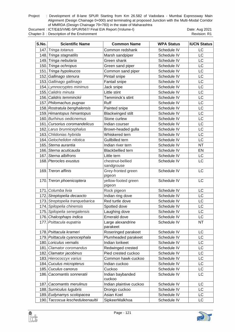
Project : Development of 8-lane SPUR Starting from Km 26.582 of Vadodara - Mumbai Expressway Main
Alignment (Design Chainage 0+000) and terminating at proposed Junction with the Multi-Modal Corridor
of MMRDA (Design Chainage 79+783) in the state of Maharashtra
Document : ICT/E&S/VME-SPUR/567/ Final EIA Report (Volume-I) Date: Aug 2021
Chapter-3 : Description of the Environment Revision: R1
Page - 121
S.No. Scientific Name Common Name WPA Status IUCN Status
147. Tringa totanus Common redshank Schedule IV LC
148. Tringa stagnatilis Marsh sandpiper Schedule IV LC
149. Tringa nebularia Green shank Schedule IV LC
150. Tringa ochropus Green sand piper Schedule IV LC
151. Tringa hypoleucos Common sand piper Schedule IV LC
152. Gallinago stenura Pintail snipe Schedule IV LC
153. Gallinago gallinago Fantail snipe Schedule IV LC
154. Lymnocryptes minimus Jack snipe Schedule IV LC
155. Calidris minuta Little stint Schedule IV LC
156. Calidris temminckii Temminck‘s stint Schedule IV LC
157. Philomachus pugnax Ruff Schedule IV LC
158. Rostratula benghalensis Painted snipe Schedule IV LC
159. Himantopus himantopus Blackwinged stilt Schedule IV LC
160. Burhinus oedicnemus Stone curlew Schedule IV LC
161. Cursorius coromandelicus Indian courser Schedule IV LC
162. Larus brunnicephalus Brown-headed gulla Schedule IV LC
163. Chlidonias hybrida Whiskered tern Schedule IV LC
164. Gelochelidon nilotica Gullbilled tern Schedule IV LC
165. Sterna aurantia Indian river tern Schedule IV NT
166. Sterna acuticauda Blackbellied tern Schedule IV EN
167. Sterna albifrons Little tern Schedule IV LC
168. Pterocles exustus chestnut-bellied sandgrouse
Schedule IV LC
169. Treron affinis Grey-fronted green pigeon
Schedule IV LC
170. Treron phoenicoptera yellow-footed green pigeon
Schedule IV LC
171. Columba livia Rock pigeon Schedule IV LC
172. Streptopelia decaocto Indian ring dove Schedule IV LC
173. Streptopelia tranquebarica Red turtle dove Schedule IV LC
174. Spilopelia chinensis Spotted dove Schedule IV LC
175. Spilopelia senegalensis Laughing dove Schedule IV LC
176. Chalcophaps indica Emerald dove Schedule IV LC
177. Psittacula eupatria Large alexandrine parakeet
Schedule IV NT
178. Psittacula krameri Roseringed parakeet Schedule IV LC
179. Psittacula cyanocephala Plumheaded parakeet Schedule IV LC
180. Loriculus vernalis Indian lorikeet Schedule IV LC
181. Clamator coromandus Redwinged crested Schedule IV LC
182. Clamator jacobinus Pied crested cuckoo Schedule IV LC
183. Hierococcyx varius Common hawk-cuckoo Schedule IV LC
184. Cuculus micropterus Indian cuckoo Schedule IV LC
185. Cuculus canorus Cuckoo Schedule IV LC
186. Cacomantis sonneratii Indian baybanded cuckoo
Schedule IV LC
187. Cacomantis merulinus Indian plaintive cuckoo Schedule IV LC
188. Surniculus lugubris Drongo cuckoo Schedule IV LC
189. Eudynamys scolopacea Asian Koel Schedule IV LC
190. Taccocua lescheduleenaultii SipkeerMalkhoa Schedule IV LC
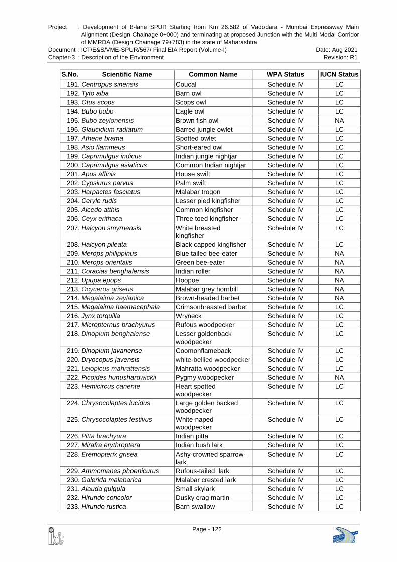
Project : Development of 8-lane SPUR Starting from Km 26.582 of Vadodara - Mumbai Expressway Main
Alignment (Design Chainage 0+000) and terminating at proposed Junction with the Multi-Modal Corridor
of MMRDA (Design Chainage 79+783) in the state of Maharashtra
Document : ICT/E&S/VME-SPUR/567/ Final EIA Report (Volume-I) Date: Aug 2021
Chapter-3 : Description of the Environment Revision: R1
Page - 122
S.No. Scientific Name Common Name WPA Status IUCN Status
191. Centropus sinensis Coucal Schedule IV LC
192. Tyto alba Barn owl Schedule IV LC
193. Otus scops Scops owl Schedule IV LC
194. Bubo bubo Eagle owl Schedule IV LC
195. Bubo zeylonensis Brown fish owl Schedule IV NA
196. Glaucidium radiatum Barred jungle owlet Schedule IV LC
197. Athene brama Spotted owlet Schedule IV LC
198. Asio flammeus Short-eared owl Schedule IV LC
199. Caprimulgus indicus Indian jungle nightjar Schedule IV LC
200. Caprimulgus asiaticus Common Indian nightjar Schedule IV LC
201. Apus affinis House swift Schedule IV LC
202. Cypsiurus parvus Palm swift Schedule IV LC
203. Harpactes fasciatus Malabar trogon Schedule IV LC
204. Ceryle rudis Lesser pied kingfisher Schedule IV LC
205. Alcedo atthis Common kingfisher Schedule IV LC
206. Ceyx erithaca Three toed kingfisher Schedule IV LC
207. Halcyon smyrnensis White breasted kingfisher
Schedule IV LC
208. Halcyon pileata Black capped kingfisher Schedule IV LC
209. Merops philippinus Blue tailed bee-eater Schedule IV NA
210. Merops orientalis Green bee-eater Schedule IV NA
211. Coracias benghalensis Indian roller Schedule IV NA
212. Upupa epops Hoopoe Schedule IV NA
213. Ocyceros griseus Malabar grey hornbill Schedule IV NA
214. Megalaima zeylanica Brown-headed barbet Schedule IV NA
215. Megalaima haemacephala Crimsonbreasted barbet Schedule IV LC
216. Jynx torquilla Wryneck Schedule IV LC
217. Micropternus brachyurus Rufous woodpecker Schedule IV LC
218. Dinopium benghalense Lesser goldenback woodpecker
Schedule IV LC
219. Dinopium javanense Coomonflameback Schedule IV LC
220. Dryocopus javensis white-bellied woodpecker Schedule IV LC
221. Leiopicus mahrattensis Mahratta woodpecker Schedule IV LC
222. Picoides hunushardwickii Pygmy woodpecker Schedule IV NA
223. Hemicircus canente Heart spotted woodpecker
Schedule IV LC
224. Chrysocolaptes lucidus Large golden backed woodpecker
Schedule IV LC
225. Chrysocolaptes festivus White-naped woodpecker
Schedule IV LC
226. Pitta brachyura Indian pitta Schedule IV LC
227. Mirafra erythroptera Indian bush lark Schedule IV LC
228. Eremopterix grisea Ashy-crowned sparrow-lark
Schedule IV LC
229. Ammomanes phoenicurus Rufous-tailed lark Schedule IV LC
230. Galerida malabarica Malabar crested lark Schedule IV LC
231. Alauda gulgula Small skylark Schedule IV LC
232. Hirundo concolor Dusky crag martin Schedule IV LC
233. Hirundo rustica Barn swallow Schedule IV LC
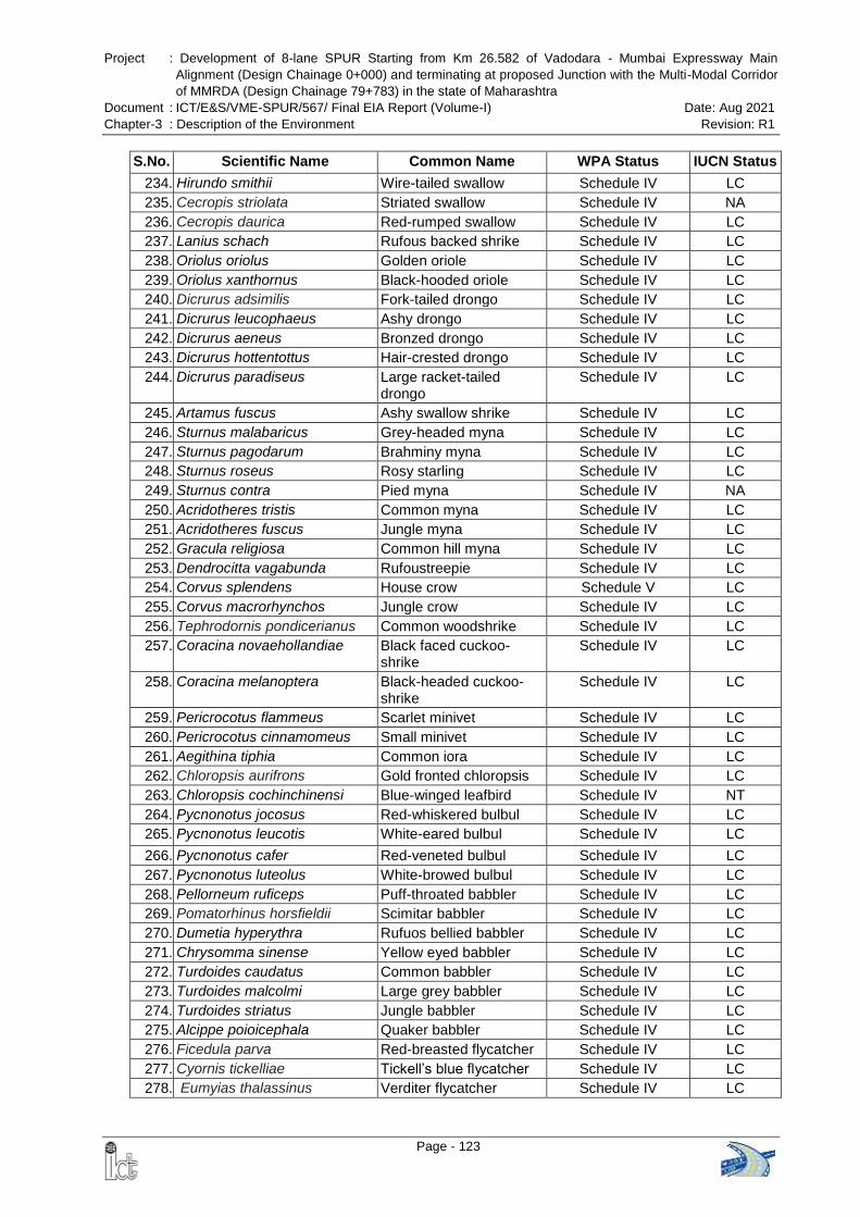
Project : Development of 8-lane SPUR Starting from Km 26.582 of Vadodara - Mumbai Expressway Main
Alignment (Design Chainage 0+000) and terminating at proposed Junction with the Multi-Modal Corridor
of MMRDA (Design Chainage 79+783) in the state of Maharashtra
Document : ICT/E&S/VME-SPUR/567/ Final EIA Report (Volume-I) Date: Aug 2021
Chapter-3 : Description of the Environment Revision: R1
Page - 123
S.No. Scientific Name Common Name WPA Status IUCN Status
234. Hirundo smithii Wire-tailed swallow Schedule IV LC
235. Cecropis striolata Striated swallow Schedule IV NA
236. Cecropis daurica Red-rumped swallow Schedule IV LC
237. Lanius schach Rufous backed shrike Schedule IV LC
238. Oriolus oriolus Golden oriole Schedule IV LC
239. Oriolus xanthornus Black-hooded oriole Schedule IV LC
240. Dicrurus adsimilis Fork-tailed drongo Schedule IV LC
241. Dicrurus leucophaeus Ashy drongo Schedule IV LC
242. Dicrurus aeneus Bronzed drongo Schedule IV LC
243. Dicrurus hottentottus Hair-crested drongo Schedule IV LC
244. Dicrurus paradiseus Large racket-tailed drongo
Schedule IV LC
245. Artamus fuscus Ashy swallow shrike Schedule IV LC
246. Sturnus malabaricus Grey-headed myna Schedule IV LC
247. Sturnus pagodarum Brahminy myna Schedule IV LC
248. Sturnus roseus Rosy starling Schedule IV LC
249. Sturnus contra Pied myna Schedule IV NA
250. Acridotheres tristis Common myna Schedule IV LC
251. Acridotheres fuscus Jungle myna Schedule IV LC
252. Gracula religiosa Common hill myna Schedule IV LC
253. Dendrocitta vagabunda Rufoustreepie Schedule IV LC
254. Corvus splendens House crow Schedule V LC
255. Corvus macrorhynchos Jungle crow Schedule IV LC
256. Tephrodornis pondicerianus Common woodshrike Schedule IV LC
257. Coracina novaehollandiae Black faced cuckoo-shrike
Schedule IV LC
258. Coracina melanoptera Black-headed cuckoo-shrike
Schedule IV LC
259. Pericrocotus flammeus Scarlet minivet Schedule IV LC
260. Pericrocotus cinnamomeus Small minivet Schedule IV LC
261. Aegithina tiphia Common iora Schedule IV LC
262. Chloropsis aurifrons Gold fronted chloropsis Schedule IV LC
263. Chloropsis cochinchinensi Blue-winged leafbird Schedule IV NT
264. Pycnonotus jocosus Red-whiskered bulbul Schedule IV LC
265. Pycnonotus leucotis White-eared bulbul Schedule IV LC
266. Pycnonotus cafer Red-veneted bulbul Schedule IV LC
267. Pycnonotus luteolus White-browed bulbul Schedule IV LC
268. Pellorneum ruficeps Puff-throated babbler Schedule IV LC
269. Pomatorhinus horsfieldii Scimitar babbler Schedule IV LC
270. Dumetia hyperythra Rufuos bellied babbler Schedule IV LC
271. Chrysomma sinense Yellow eyed babbler Schedule IV LC
272. Turdoides caudatus Common babbler Schedule IV LC
273. Turdoides malcolmi Large grey babbler Schedule IV LC
274. Turdoides striatus Jungle babbler Schedule IV LC
275. Alcippe poioicephala Quaker babbler Schedule IV LC
276. Ficedula parva Red-breasted flycatcher Schedule IV LC
277. Cyornis tickelliae Tickell‘s blue flycatcher Schedule IV LC
278. Eumyias thalassinus Verditer flycatcher Schedule IV LC
Project : Development of 8-lane SPUR Starting from Km 26.582 of Vadodara - Mumbai Expressway Main
Alignment (Design Chainage 0+000) and terminating at proposed Junction with the Multi-Modal Corridor
of MMRDA (Design Chainage 79+783) in the state of Maharashtra
Document : ICT/E&S/VME-SPUR/567/ Final EIA Report (Volume-I) Date: Aug 2021
Chapter-3 : Description of the Environment Revision: R1
Page - 124
S.No. Scientific Name Common Name WPA Status IUCN Status
279. Muscicapa latirostris Brown flycatcher Schedule IV LC
280. Culicicapa ceylonensis Grey headed flycatcher Schedule IV LC
281. Rhipidura albicollis White-throated fantail Schedule IV LC
282. Terpsiphone paradisi Paradise flycatcher Schedule IV LC
283. Hypothymis azurea Blacknaped flycatcher Schedule IV LC
284. Cisticola juncidis Streaked fantail warbler Schedule IV LC
285. Prinia hodgsonii Franklin‘s wren warbler Schedule IV LC
286. Prinia inornata Plain wren warbler Schedule IV LC
287. Prinia socialis Ashy wren warbler Schedule IV LC
288. Prinia sylvatica Jungle wren warbler Schedule IV LC
289. Orthotomus sutorius Tailor bird Schedule IV LC
290. Acrocephalus stentoreus Clamorous reed warbler Schedule IV LC
291. Acrocephalus dumetorum Blyth‘s reed warbler Schedule IV LC
292. Acrocephalus agricola Paddyfield warbler Schedule IV LC
293. Hippolais caligata Booted treewarbler Schedule IV LC
294. Sylvia curruca Lesser whitethroat Schedule IV LC
295. Phylloscopus collybita Common chiffchaff Schedule IV LC
296. Phylloscopus tytleri Tytler‘s leas warbler Schedule IV NT
297. Phylloscopus inornatus Yellow browed warbler Schedule IV LC
298. Phylloscopus trochiloides Greenish warbler Schedule IV LC
299. Copsychus saularis Magpie robin Schedule IV LC
300. Copsychus malabaricus White-rumpedshama Schedule IV NA
301. Saxicola torquatus Stone chat Schedule IV LC
302. Oenanthe deserti Desert wheatear Schedule IV LC
303. Saxicoloides fulicatus Indian robin Schedule IV LC
304. Monticola cinclorhynchus Blue-capped rock thrush Schedule IV NA
305. Monticola solitarius Blue rock-thrush Schedule IV LC
306. Myophonus horsfieldii Malabar whistling thrush Schedule IV LC
307. Geokichla citrina Orange-headed thrush Schedule IV LC
308. Turdus merula Common blackbird Schedule IV LC
309. Anthus trivialis Tree pipit Schedule IV LC
310. Anthus godlewskii Blyth‘s pipit Schedule IV LC
311. Motacilla citreola Citrine wagtail Schedule IV LC
312. Motacilla alba White wagtail Schedule IV LC
313. Dicaeum erythrorhynchos Tickell's flowerpecker Schedule IV LC
314. Dicaeum agile Thickbilledflowerpecker Schedule IV LC
315. Leptocoma zeylonica Purplerumped sunbird Schedule IV LC
316. Cinnyris lotenius Loten‘s sunbird Schedule IV LC
317. Cinnyris asiaticus Purple sunbird Schedule IV LC
318. Aethopyga siparaja Crimson sunbird Schedule IV LC
319. Passer domesticus House sparrow Schedule IV LC
320. Petronia xanthocollis Yellow throated sparrow Schedule IV LC
321. Ploceus philippinus Baya Schedule IV LC
322. Estrilda amandava Red munia Schedule IV LC
323. Euodice malabarica White throated munia Schedule IV LC
324. Lonchura striata White-rumpedmunia Schedule IV LC
325. Lonchura punctulata Spotted munia Schedule IV LC
326. Lonchura malacca Blackheadedmunia Schedule IV LC
Project : Development of 8-lane SPUR Starting from Km 26.582 of Vadodara - Mumbai Expressway Main
Alignment (Design Chainage 0+000) and terminating at proposed Junction with the Multi-Modal Corridor
of MMRDA (Design Chainage 79+783) in the state of Maharashtra
Document : ICT/E&S/VME-SPUR/567/ Final EIA Report (Volume-I) Date: Aug 2021
Chapter-3 : Description of the Environment Revision: R1
Page - 125
S.No. Scientific Name Common Name WPA Status IUCN Status
327. Carpodacus erythrinus Common rosefinch Schedule IV LC
328. Emberiza melanocephala Black-headed bunting Schedule IV LC
Source – Management Plan for Tungareshwar Wildlife Sanctuary, Period – 2018-19 to 2027-28
Note: WPA – Wildlife Protection Act, IUCN - International Union for Conservation of Nature, LC – Least
Concern, NA – Not Available, NT – Near Threatened, EN – Endangered, VU – Vulnerable, CR – Critically
Endangered
3.14.6 Aquatic Ecology
The main drainage is heading towards west into Arabian Sea. Major rivers are Ulhas
and Vaitarna River. Their tributaries are Kalu, Bhatsa and Tansa. There are major
creeks; some of them are extending inland upto 25 km. The main creeks are the Vasai
Creek, the Vaitarna Creek and the Thane Creek.
During the aquatic survey, both fresh water as well as marine water fish species are
found in the rivers, tributaries and ponds. The same was confirmed through public
consultation and cross cheched with concernd forest working plan. Some common fresh
water and marine water fish species found in the study area are given in Table 3-41 and
Table 3-42 respectively. .
Table 3-41 Common Fresh Water Fishes
Sl. Scientific Name Common Name English Name
1 Seccobranchus fossilis Nal Singali Stinging Cat Fish
2 Aystus gulic Shingala Cat Fish
3 Chana gachus Mureel Dhokh, Daku
4 Gobius giupeoides Kharadi Fresh Water Goby
5 Catla catla Catla Major Carp
6 Labio rhita Rohu Major Carp
7 Wallago attu Shivda Wallago
8 Puntins spp. Khavlya, Khavil Carps
Source: Study carried out by ICT Pvt. Ltd. in December 2020 supplemented with Forests Working Pan
Table 3-42 Common Marine Fishes
Sl. Scientific Name Common Name English Name
1 Mugil cephalus Boi, Pilsa Mullet
2 Harpodon nehereus Bombil Bombay Duck
3 Techysurus Spp Shingala Cat Fish
4 Coilia dussumieri Mandeli Golden Anchoy
5 Boleophithalmus spp. Nivti Mudskippers
6 Trichiurus spp. Vagti Ribbon Fish
Source: Study carried out by ICT Pvt. Ltd. in December 2020 supplemented with Forests Working Pan
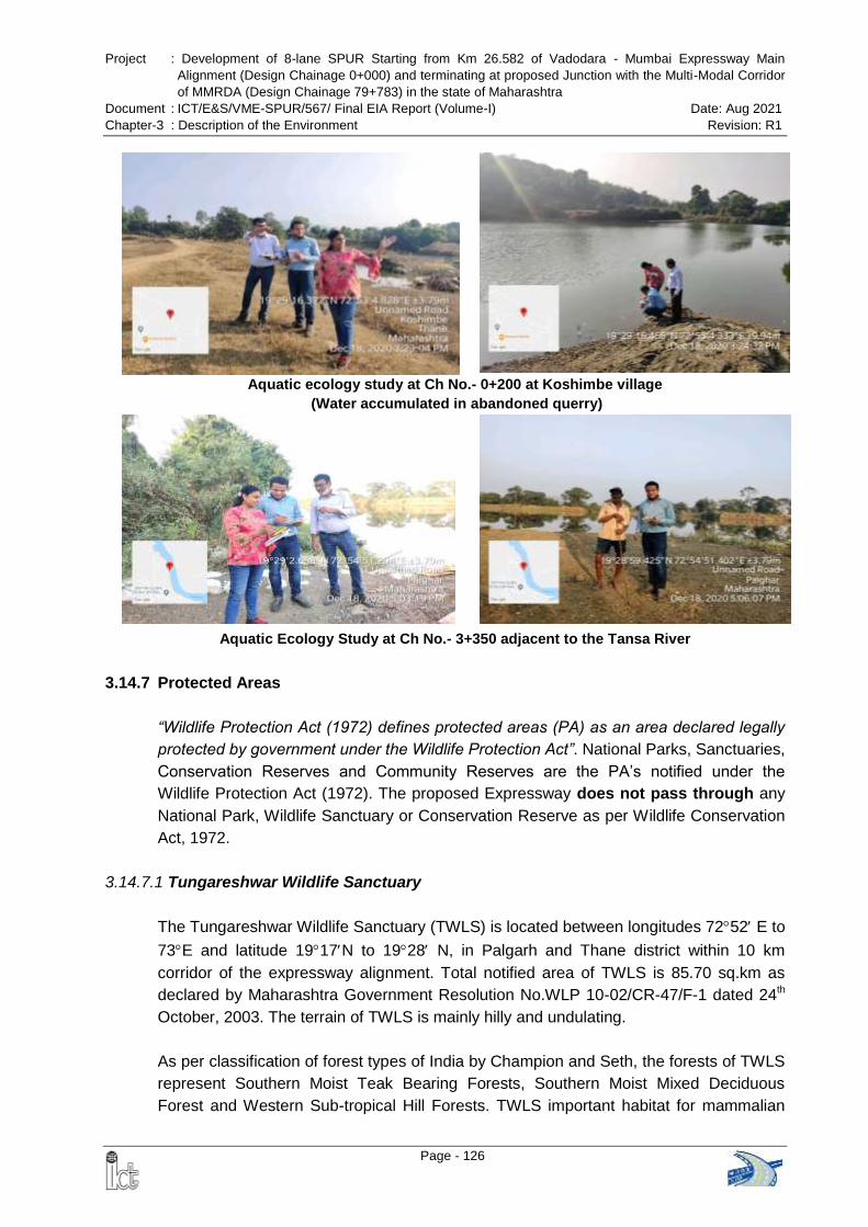
Project : Development of 8-lane SPUR Starting from Km 26.582 of Vadodara - Mumbai Expressway Main
Alignment (Design Chainage 0+000) and terminating at proposed Junction with the Multi-Modal Corridor
of MMRDA (Design Chainage 79+783) in the state of Maharashtra
Document : ICT/E&S/VME-SPUR/567/ Final EIA Report (Volume-I) Date: Aug 2021
Chapter-3 : Description of the Environment Revision: R1
Page - 126
Aquatic ecology study at Ch No.- 0+200 at Koshimbe village
(Water accumulated in abandoned querry)
Aquatic Ecology Study at Ch No.- 3+350 adjacent to the Tansa River
3.14.7 Protected Areas
“Wildlife Protection Act (1972) defines protected areas (PA) as an area declared legally
protected by government under the Wildlife Protection Act”. National Parks, Sanctuaries,
Conservation Reserves and Community Reserves are the PA‘s notified under the
Wildlife Protection Act (1972). The proposed Expressway does not pass through any
National Park, Wildlife Sanctuary or Conservation Reserve as per Wildlife Conservation
Act, 1972.
3.14.7.1 Tungareshwar Wildlife Sanctuary
The Tungareshwar Wildlife Sanctuary (TWLS) is located between longitudes 7252 E to
73E and latitude 1917N to 1928 N, in Palgarh and Thane district within 10 km
corridor of the expressway alignment. Total notified area of TWLS is 85.70 sq.km as
declared by Maharashtra Government Resolution No.WLP 10-02/CR-47/F-1 dated 24th
October, 2003. The terrain of TWLS is mainly hilly and undulating.
As per classification of forest types of India by Champion and Seth, the forests of TWLS
represent Southern Moist Teak Bearing Forests, Southern Moist Mixed Deciduous
Forest and Western Sub-tropical Hill Forests. TWLS important habitat for mammalian
Project : Development of 8-lane SPUR Starting from Km 26.582 of Vadodara - Mumbai Expressway Main
Alignment (Design Chainage 0+000) and terminating at proposed Junction with the Multi-Modal Corridor
of MMRDA (Design Chainage 79+783) in the state of Maharashtra
Document : ICT/E&S/VME-SPUR/567/ Final EIA Report (Volume-I) Date: Aug 2021
Chapter-3 : Description of the Environment Revision: R1
Page - 127
species like leopard (Panthera pardus - Bibtya), wild boar (Sus scrofa – Raan Dukkar),
four headed antelope (Tetracero squadricornis - Bhekar), blacknaped hare (Lepus
nigricollis), wild cat (Raanmanjar), jackals (Kolha), porcupines (salu), bonnet macaques
(Makad), etc. The fauna of the sanctuary comprise of 43 species of mammals, 38
reptiles, 9 amphibians and 250 birds (source: Management Plan for TWLS, 2018-19 to
2027 -28). Reptiles of the tract are Indian pond terrapin (Kasav), common garden lizard,
Indian chameleon (Chameleon zeylanicus), ghorpud (Varanus bengalensisis), rough-
scaled sand boa (Eryxconisus), durkyaghoonas (Lycodon aulicus), striped keelback
(Amphiesma stolata), dhaman (Ptays mucosus), common Indian krait (Bungarum
caeruleus), Indian cobra, Indian rock python, viper, etc. Seven species of bats are
reported (Ref: Brosset, 1962).
Ancient Tungareshwar Mahadev temple, Parashuram kund, Ishwarpuri Mahadev Mandir
are located within the wildlife sanctuary. Lakhs of pilgrims visit Tungrashwer Mahedev
Temple during Maha Shivratri and auspicious Shravan month. Major Threat to the
TWLS are:
Poaching of wild pigs is a problem in the area. Poaching is mostly done for wild pig
for meat for local consumption.
Illicit cutting of trees
Illegal removal of Non Timber Forest Produce
Wild Fires
Threats from quarries
NH 8 runs parallel to the sanctuary there have been leopard and other Wild animal
deaths on this Highway
The proposed expressway (SPUR) does not pass through the Wildlife Sanctuary. The
Conservator of Forests, Sanjay Gandhi National Park, Bborivali vide letter dated
08.10.2021 certified that the proposed SPUR alignment is located at a distance of
0.619 km from the boundary of the Tungareshwar Wildlife Sanctuary and outside it‘s
ESZ. Copy of the letter is enclosed as Annex-3.4.
Government of India, vide Gazettee Notification [S.O. 3250(E)] dated 11th September
2019 finalized the Eco-sensitive Zone (ESZ) of the Tungareshwar Wildlife Sanctuary
and the ESZ shall be to an extent of 100 meters to 4.0 kilometers around the boundary
of the Sanctuary and the area of the ESZ is 67.26 square kilometres. The alignment of
proposed expressway is located at a distance of 0.275 km from the notified ESZ
boundary i.e. outside the ESZ. It may be mentioned that the same has been vetted by
the forest officials who were present during site visit of EAC sub-committee on
14.11.2019.
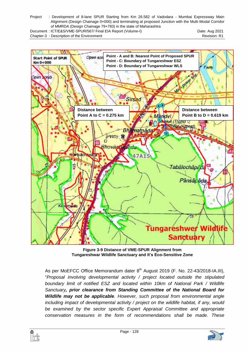
Project : Development of 8-lane SPUR Starting from Km 26.582 of Vadodara - Mumbai Expressway Main
Alignment (Design Chainage 0+000) and terminating at proposed Junction with the Multi-Modal Corridor
of MMRDA (Design Chainage 79+783) in the state of Maharashtra
Document : ICT/E&S/VME-SPUR/567/ Final EIA Report (Volume-I) Date: Aug 2021
Chapter-3 : Description of the Environment Revision: R1
Page - 128
Point - A and B: Nearest Point of Proposed SPUR
Point - C: Boundary of Tungareshwar ESZ
Point - D: Boundary of Tungareshwar WLS
Distance between
Point A to C = 0.275 km
Distance between
Point B to D = 0.619 km
Figure 3-9 Distance of VME-SPUR Alignment from
Tungareshwar Wildlife Sanctuary and it’s Eco-Sensitive Zone
As per MoEFCC Office Memorandum dater 8th August 2019 (F. No. 22-43/2018-IA.III),
―Proposal involving developmental activity / project located outside the stipulated
boundary limit of notified ESZ and located within 10km of National Park / Wildlife
Sanctuary, prior clearance from Standing Committee of the National Board for
Wildlife may not be applicable. However, such proposal from environmental angle
including impact of developmental activity / project on the wildlife habitat, if any, would
be examined by the sector specific Expert Appraisal Committee and appropriate
conservation measures in the form of recommendations shall be made. These
Project : Development of 8-lane SPUR Starting from Km 26.582 of Vadodara - Mumbai Expressway Main
Alignment (Design Chainage 0+000) and terminating at proposed Junction with the Multi-Modal Corridor
of MMRDA (Design Chainage 79+783) in the state of Maharashtra
Document : ICT/E&S/VME-SPUR/567/ Final EIA Report (Volume-I) Date: Aug 2021
Chapter-3 : Description of the Environment Revision: R1
Page - 129
recommendations shall be explicitly mentioned in the environmental clearance letter and
shall be ensured by the member secretary concerned.‖
3.14.7.2 Tansa Wildlife Sanctuary
Tansa Wildlife Sanctuary is located between Longitudes 7310‘00‖ to 732500 and
Latitudes 1925‘00‖ to 1950‘00‖ in Shahapur, Wada and Mokhada taluka of Thane
district of Maharashtra State and extends over an area of 304.81 square kilometers.
Leopard (Panther pardus) is the species of vital importance in Tansa Wildlife sanctuary,
besides some of the most endangered species like Rusty-Spotted Cat, Jungle Cat,
Small Indian Civet, Common Palm Civet, Mouse deer, Indian Rock Python, Rat Snake,
Indian Cobra, Russel‘s Viper, Checkered keelback, Common monitor, etc., are also
found in this Sanctuary.
Avi fauna such as Little Grebe, Cormorant, Indian Shag, Little Cormorant, Darter, Pond
Heron, Cattle Egret, Large Egret, Little Egret, Night Heron, Chestout Bittern, Painted
Stork, Openbill Stork, Whitencked Stork, Blacknecked Stork, Black lbis, Glossy lbis,
Spoonbill, Lesser Flamingo, Lesser Whistling Teal, Pintail, Common Teal, Spotbill Duck,
Mallared, Gadwal, Wigeon, Garganey, Shoveller, Common Pochard, White-Eyed
Pochard, Cotton Teal, Comb Duck, Blackwinged Kite, Black Kite, Blackeared Kite,
Brahminy Kite, Shikra, Sparrowhawk, White-eye buzzard Eagle, Bonelli's Eagle, Eastern
Steppe Eagle, Tawny Eagle, Palla's Fishing Eagle, Indian Longbilled Vulture, Indian
Whitebacked Vulture, Marsh Harrier, Montagu's Harrier, Pale Harrier, Crested Serpent
Eagle, Peregrine Falcon, etc. are found in the Sanctuary.
Tansa Wildlife Sanctuary is located at a distance of approx. 13.6 km from the proposed
alignment of SPUR.
3.14.7.3 Matheran Eco-Sensitive Zone
In exercise of powers conferred by clause (v) of sub-section (2) of section 3 of the
Environment (Protection) Act, 1986 (29 of 1986), the Central Government, in
consultation with the Government of Maharashtra, declared Matheran Eco-Sensitive
Zone vide Notification No. S.O. 133 (E) dated 4th February, 2003. This notification has
imposed restrictions on industries, operations, processes and other developmental
activities in the said zone. Though road construction is not prohibited as it a Green Zone
activity, but it is required to obtain clearance from the Monitoring Committee which is
constituted under sub-section (3) of section 3 of the Environment (Protection) Act, 1986
(29 of 1986) to monitor and ensure compliance with the provisions of this notification.
At an elevation of around 800 m (2,625 ft) above sea level, Matheran is a hill station
located about 100 km from Mumbai in the western state of Maharashtra. The Eco-
Sensitive Area covers an area of 214.73 sq km and a 200 m buffer zone and consists of
the area of the Matheran Municipal Council and its environs.
Project : Development of 8-lane SPUR Starting from Km 26.582 of Vadodara - Mumbai Expressway Main
Alignment (Design Chainage 0+000) and terminating at proposed Junction with the Multi-Modal Corridor
of MMRDA (Design Chainage 79+783) in the state of Maharashtra
Document : ICT/E&S/VME-SPUR/567/ Final EIA Report (Volume-I) Date: Aug 2021
Chapter-3 : Description of the Environment Revision: R1
Page - 130
Bio-geographically, the region is important on account of being an outlier of the main
Western Ghats mountain chain and in effect sheltering a pocket of evergreen forest
isolated in geological past. The forest ecosystem at Matheran is unique and remarkable
in many respects - its dense and lofty arboreal growth, peculiar blending of evergreen
and moist deciduous species and moreover a high percentage of endemism and almost
undisturbed natural climatic climax formations.
SPUR Alignment in Matheran ESZ - 2013
As per the initial proposal, the length of SPUR alignment was 94.390 km and was
passing through the Matheran Eco-Sensitive Zone (ESZ). In the year 2012, a proposal
was submitted to the Monitoring Committee of Matheran ESZ for obtaining NOC for the
VME-SPUR. This included construction of Tunnel (4.390 km) and VME-SPUR alignment
in Matheran Eco-Sensitive Zone and Buffer Zone. The Monitoring Committee
approved the VME-SPUR alignment through Matheran Eco-Sensitive Zone vide
letter dated 16th April 2013.
The SPUR alignment has also been included in the Zonal Master Plan for Matheran
Eco-Sensitive Zone (2016-36) which is attached in Annex-3.5.
Simultaneously, MMRDA planned to develop a Multi-Modal Corridor (MMC) which was
crossing SPUR alignment at Morbe village at km 79+800, which would further connect
with JNPT and Alibag. MD, CIDCO has represented to MoRTH stating that it may not be
correct to have two corridors of 100m in NAINA area, hence after deliberation of issues
along with Hon‘ble Minister, MoRTH, Representatives of CIDCO/MMRDA/NHAI and
Govt. of Maharashtra, it was decided to omit NHAI‘s alignment in NAINA area and have
a common corridor of MMC & SPUR connecting JNPT beyond km 79+783.
Further, during Geotechnical and Hydrological investigations, it was observed that a
nallah in Matheran area is crossing the alignment at km 75.760, just before the end
point of the tunnel. Provision of tunnel under the nallah might have created hydrological
hazard such as seepage in the tunnel and might have disturbed the natural flow of the
stream. Hence, the tunnel portal was required to be shifted 254 m before the nallah at
km 75.680, which still lies outside the buffer zone of the Matheran ESZ. A minor bridge
has been proposed over the nallah. Due to this change, tunnel length has been
reduced to 4.160 km (previously 4.390 km) and the impacted area due to the tunnel
has also been reduced.
SPUR Alignment in Matheran ESZ - 2019:
The proposed SPUR alignment is intervening Matheran Eco Sensitive Zone at two
locations as detailed below and shown in Figure 3-10.
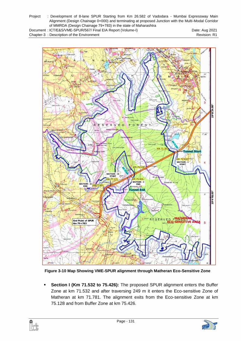
Project : Development of 8-lane SPUR Starting from Km 26.582 of Vadodara - Mumbai Expressway Main
Alignment (Design Chainage 0+000) and terminating at proposed Junction with the Multi-Modal Corridor
of MMRDA (Design Chainage 79+783) in the state of Maharashtra
Document : ICT/E&S/VME-SPUR/567/ Final EIA Report (Volume-I) Date: Aug 2021
Chapter-3 : Description of the Environment Revision: R1
Page - 131
Section I (Km 71.532 to 75.426): The proposed SPUR alignment enters the Buffer
Zone at km 71.532 and after traversing 249 m it enters the Eco-sensitive Zone of
Matheran at km 71.781. The alignment exits from the Eco-sensitive Zone at km
75.128 and from Buffer Zone at km 75.426.
Figure 3-10 Map Showing VME-SPUR alignment through Matheran Eco-Sensitive Zone
Project : Development of 8-lane SPUR Starting from Km 26.582 of Vadodara - Mumbai Expressway Main
Alignment (Design Chainage 0+000) and terminating at proposed Junction with the Multi-Modal Corridor
of MMRDA (Design Chainage 79+783) in the state of Maharashtra
Document : ICT/E&S/VME-SPUR/567/ Final EIA Report (Volume-I) Date: Aug 2021
Chapter-3 : Description of the Environment Revision: R1
Page - 132
To preserve ecology of the Matheran, 4.160 km long tunnel is proposed in this
section which will go under the Matheran Eco-Sensitive Zone. The start point of the
tunnel is at km 71.520 (before buffer zone) and end point of the tunnel is at km
75.680 (after buffer zone).
Section II (km 77.115 to km 77.691): Based on the suggestions of the Monitoring
Committee of the Matheran ESZ in the year 2012, the proposed alignment was
modified and shifted on the right side to minimize the impact. The width of the RoW
at this location has also been reduced. Hence, in this section, the alignment is only
passing through the Buffer Zone from km 77.115 to km 77.691 for a length of 576 m.
Fresh Approval from Matheran Monitoring Committee
The Project Specific Conditions of TOR for the VME-SPUR issued by the MoEFCC vide
letter dated 16th March 2020 says that
(viii) “The proponent shall submit fresh permission from Matheran Eco-Sensitive Area
(ESA) Monitoring Committee for construction of proposed alignment / spur”
In view of this specific condition, a fresh proposal was submitted to the competent
authority on 24.11.2020. The comparative statement of old & new proposal is presented
in the following table
Components Proposal approved by the Monitoring Committee of
Matheran ESZ in 2013
Revised proposal submitted on 24.11.2020
Length of Tunnel 4.390 km 4.160 km
Impacted Area in ESZ 39.318 ha 33.4836 ha
Impacted Area in Buffer Zone 27.529 ha 11.1991 ha
Length of SPUR Alignment 94.390 km 79.783 km
The District Collector, Raigad and Member Secretary, Matheran Eco-Sensitive Zone
Committee vide letter dated 24.03.2021 communicated that the approval given by the
Matheran Monitoring Committee for VME-SPUR project vide letter dated
16.04.2013 is still valid. Copy of the letter is given in Annex-3.6.
Project : Development of 8-lane SPUR Starting from Km 26.582 of Vadodara - Mumbai Expressway Main
Alignment (Design Chainage 0+000) and terminating at proposed Junction with the Multi-Modal Corridor
of MMRDA (Design Chainage 79+783) in the state of Maharashtra
Document : ICT/E&S/VME-SPUR/567/ Final EIA Report (Volume-I) Date: Aug 2021
Chapter-3 : Description of the Environment Revision: R1
Page - 133
3.15 COASTAL REGULATION ZONE (CRZ)
The proposed VME-SPUR alignment crosses tidal influenced parts of a small nala
(connected to Tansa River), the Bhatsa River and Kalu River. CRZ map and report has
been prepared by the National Centre for Earth Science Studies (NCESS),
Thiruvananthapuram based on CRZ Notification 2011 and Coastal Zone Management
Plan (CZMP) of Thane and Palghar district (approved by MoEFCC on 28.02.2019).
The CRZ categories identified along the proposed alignment are CRZ IB, CRZ II, CRZ
III, and CRZ IVB and length of SPUR alignment in CRZ crossing areas is 0.609 km.
Village wise length of VME-SPUR alignment in CRZ area and breakup of CRZ
categories in the crossing locations are given in Table 3-43 and Table 3-44.
Table 3-43 Village wise Length of VME-SPUR alignment in CRZ Crossing areas
Proposed Chainage Length (km) Village River
From To
45+256 45+535 0.278 Sange – Konderi Bhatsa River
47+124 47+455 0.331 Sangode - Balyani Kalu River
Total 0.609
Source: CRZ Map & Report prepared by NCESS, July 2021
Table 3-44 Village wise Break-up CRZ Categories in VME-SPUR Crossing Points
Location
CRZ IA
CRZ IB CRZ II CRZ III CRZ IVA
CRZ IVB Mangrove
Mangrove Buffer
Kashid Kopar - - 141.19 - 1533.8 - 280.47
Sange - - 2161.09 - 9093.73 - 4810.18
Konderi - - 938.22 - 9355.1 - 1488.8
Sangode - - 3889.35 - 16573.49 - 10472.23
Balyani - - 0 8978.1 0 - 0
Total (in sq. m.) 7129.85 8978.1 36556.12 17051.68
Total (in ha) 0.713 0.898 3.656 1.705
Grand Total = 69715.75 Sq. m / 6.972 ha
Source: CRZ Map & Report prepared by NCESS, July 2021
Proposed development in the CRZ area is shown in Figure 3-11, Figure 3-12 and
Figure 3-13.
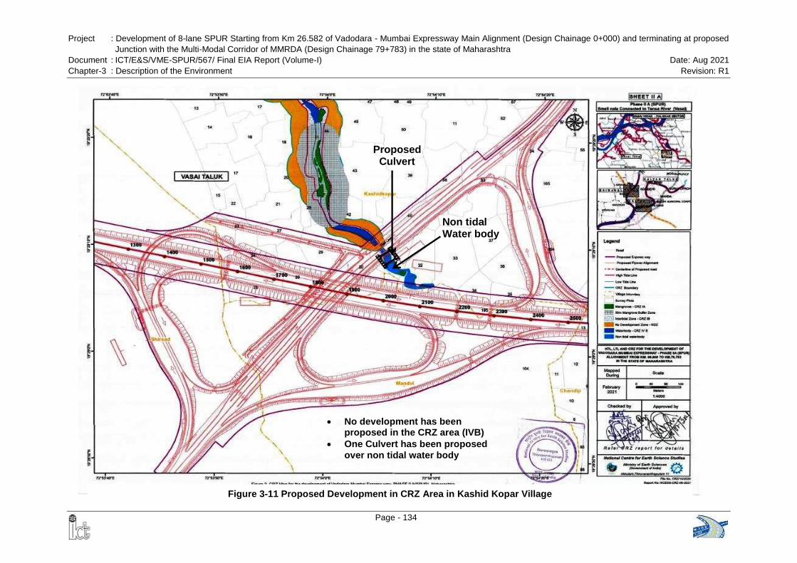
Project : Development of 8-lane SPUR Starting from Km 26.582 of Vadodara - Mumbai Expressway Main Alignment (Design Chainage 0+000) and terminating at proposed
Junction with the Multi-Modal Corridor of MMRDA (Design Chainage 79+783) in the state of Maharashtra
Document : ICT/E&S/VME-SPUR/567/ Final EIA Report (Volume-I) Date: Aug 2021
Chapter-3 : Description of the Environment Revision: R1
Page - 134
Non tidal Water body
Proposed Culvert
Figure 3-11 Proposed Development in CRZ Area in Kashid Kopar Village
No development has been proposed in the CRZ area (IVB)
One Culvert has been proposed
over non tidal water body
Project : Development of 8-lane SPUR Starting from Km 26.582 of Vadodara - Mumbai Expressway Main Alignment (Design Chainage 0+000) and terminating at proposed
Junction with the Multi-Modal Corridor of MMRDA (Design Chainage 79+783) in the state of Maharashtra
Document : ICT/E&S/VME-SPUR/567/ Final EIA Report (Volume-I) Date: Aug 2021
Chapter-3 : Description of the Environment Revision: R1
Page - 135
Figure 3-12 Proposed Development in CRZ Area in Sange - Konderi Village

Project : Development of 8-lane SPUR Starting from Km 26.582 of Vadodara - Mumbai Expressway Main Alignment (Design Chainage 0+000) and terminating at proposed
Junction with the Multi-Modal Corridor of MMRDA (Design Chainage 79+783) in the state of Maharashtra
Document : ICT/E&S/VME-SPUR/567/ Final EIA Report (Volume-I) Date: Aug 2021
Chapter-3 : Description of the Environment Revision: R1
Page - 136
Figure 3-13 Proposed Development in CRZ Area in Sangode - Balyani Village
Project : Development of 8-lane SPUR Starting from Km 26.582 of Vadodara - Mumbai Expressway Main
Alignment (Design Chainage 0+000) and terminating at proposed Junction with the Multi-Modal Corridor
of MMRDA (Design Chainage 79+783) in the state of Maharashtra
Document : ICT/E&S/VME-SPUR/567/ Final EIA Report (Volume-I) Date: Aug 2021
Chapter-3 : Description of the Environment Revision: R1
Page - 137
The proposal for CRZ Clearance was uploaded through online portal of MCZMA on 13th
July 2021. The proposal was considered by the Environment and Climate Change
(Env&CC) Department, Government of Maharashtra on 21.09.2021.
The Env&CC Department, Government of Maharashtra recommends the proposal to
MoEF&CC, New Delhi vide letter dated 29.09.2021 subject to compliance of the specific
and general conditions as given below. Copy of the recommendation letter of
Government of Maharashtra is given in Annex 3.7.
Specific Conditions:
i. Project Proponent should ensure that proposed activities in CRZ areas are as
per provisions of CRZ Notification, 2011 (amended time to time).
ii. Project Proponent to ensure the tidal flow of coastal water body should not be
affected due to proposed activities.
iii. Project Proponent to ensure the debris (C&D Waste) should not be disposed in
CRZ area and should follow C&D Waste Rules, 2016.
iv. Project Proponent to ensure that no ground water shall be tapped to meet with
water requirement during construction & / or operation phase from CRZ area.
v. Project Proponent to ensure there shall no discharge of any untreated sewage /
untreated effluent in CRZ area.
vi. Best engineering practices & construction should be followed for fire safety
measures and for conservation of coastal environment.
vii. Project Proponent to ensure that the much disposal should not be in CRZ area
and should be as per standard.
viii. Project Proponent to implement the Environment Management Plan effectively
during the implementation and operation phase of the project and PP to ensure
that Separate budget shall be allotted for the same.
ix. Project Proponent to ensure that the Noise level during Construction & operation
phase should not exceed the permissible limit.
x. All other required permissions should be obtained before the commencement of
the project.
General Conditions:
i. The Department reserves the right to revoke this recommendation, if the
conditions stipulated are not complied with to the satisfaction of the MCZMA or
Environment Department.
ii. The Department or any other competent authority, concerned planning authority
may stipulate any additional conditions subsequently, if deemed necessary, for
environmental protection, which shall be complied with.
Project : Development of 8-lane SPUR Starting from Km 26.582 of Vadodara - Mumbai Expressway Main
Alignment (Design Chainage 0+000) and terminating at proposed Junction with the Multi-Modal Corridor
of MMRDA (Design Chainage 79+783) in the state of Maharashtra
Document : ICT/E&S/VME-SPUR/567/ Final EIA Report (Volume-I) Date: Aug 2021
Chapter-3 : Description of the Environment Revision: R1
Page - 138
iii. The clearance accorded to the projects under this notification shall be valid for a
period of seven years from the date of issue of such clearance: Provided that the
construction activities shall commence within a period of five years from the date
of the issue of clearance and the construction be completed and the operations
be commenced within seven years from the date of issue of such clearance.
iv. The recommendation from CRZ point of view is being issued without prejudice to
the action initiated under EP Act or any court case pending in the court of law
and it does not mean that project propene has not violated any environmental
laws in the past and whatever decision under EP Act or of the Hon’ble court will
be binding on the project proponent. Hence this recommendation does not give
immunity to the project proponent in the case filed against him, if any or action
initiated under EP Act.
3.16 ARCHAEOLOGICAL SITES
There are no archaeological sites within 300 m on either side of the proposed
expressway.
3.17 ENVIRONMENTALLY SENSITIVE RECEPTORS
Educational Institutions: During the field survey, 37 educational institutions were
identified, which are located within 1.0 km from the centre line on either side of the
proposed expressway (VME-SPUR). Chainage wise list of educational institutions along
with its location, side and distance from the proposed center (C/L) line of the
expressway are given in Table 3-45.
Table 3-45 List of Educational Institutions along the alignment of Proposed Expressway
SL. No.
Description Chainage Dist. From
Proposed C/L (m) Side Village
1. Zila Parisad Primary School 1+419 719 RHS Shirsad
2. Govt Lower Primary School 2+100 850 RHS Mandvi
3. Zila Parisad Upper Primary School
4+830 252 LHS Bhatane
4. Primary School 4+850 268 LHS Bhatane
5. Lower Primary School 9+129 103 LHS Bhinar
6. Lower primary school 9+950 231 LHS Ambode
7. S.K.Chaudhari Memorial School & J.R. College of Arts commerce
10+700 590 LHS Ambode
8. Lower primary school 11+600 212 LHS Kalambhon
9. Govt Upper Primary School 17+250 221 LHS Kelthan
10. High School 17+520 366 RHS Kelthan
11. Zila Parisad Primary School 20+759 306 LHS Mahalunge
Project : Development of 8-lane SPUR Starting from Km 26.582 of Vadodara - Mumbai Expressway Main
Alignment (Design Chainage 0+000) and terminating at proposed Junction with the Multi-Modal Corridor
of MMRDA (Design Chainage 79+783) in the state of Maharashtra
Document : ICT/E&S/VME-SPUR/567/ Final EIA Report (Volume-I) Date: Aug 2021
Chapter-3 : Description of the Environment Revision: R1
Page - 139
SL. No.
Description Chainage Dist. From
Proposed C/L (m) Side Village
12. Primary School 21+950 200 LHS Ghotgaon
13. Lower Primary School 25+000 388 LHS Kasbe Dugad
14. Lower Primary School 26+370 315 RHS Mohili
15. Lower Primary School 27+170 214 RHS Mohili Budrak
16. Lower Primary School 27+470 150 LHS Malbidi
17. Lower Primary School 28+380 147 LHS Malbidi
18. Lower Primary School 30+570 297 LHS Nandithane
19. Primary School 31+360 162 RHS Supegaon
20. Primary School Interchange with NH-3
165 LHS Bhoyargaon
21. Upper primary school 40+230 327 LHS Kuske
22. Lower Primary School 42+800 514 RHS Amane
23. Sitaram Rama Patil School 43+900 152 LHS Kivarli Tarf Amne
24. Primary School 44+070 183 RHS Kivarli Tarf Amane
25. Primary School 45+000 510 RHS Kivarli Tarf Aman
26. Zila Parisad School 50+300 121 RHS Manivali
27. Primary School 52+800 483 RHS Rayate
28. High School 52+900 695 RHS Rayate
29. Upper primary school 59+630 170 LHS Dapivali
30. Primary School 62+519 603 RHS Yeranjad
31. Sunrise Happy Children's Home
67+900 294 LHS Chamtoli
32. Primary School 68+080 717 LHS Sape
33. Primary School 69+200 358 RHS Dahivali
34. Primary School 69+769 554 RHS Bhoj
35. Mahanaim Bible College 70+500 149 LHS Khuntvali
36. Zila Parisad School 70+670 219 LHS Bendshil
37. Primary School 70+800 343 LHS Bendshil
Source: Field Survey carried out by ICT Pvt. Ltd.
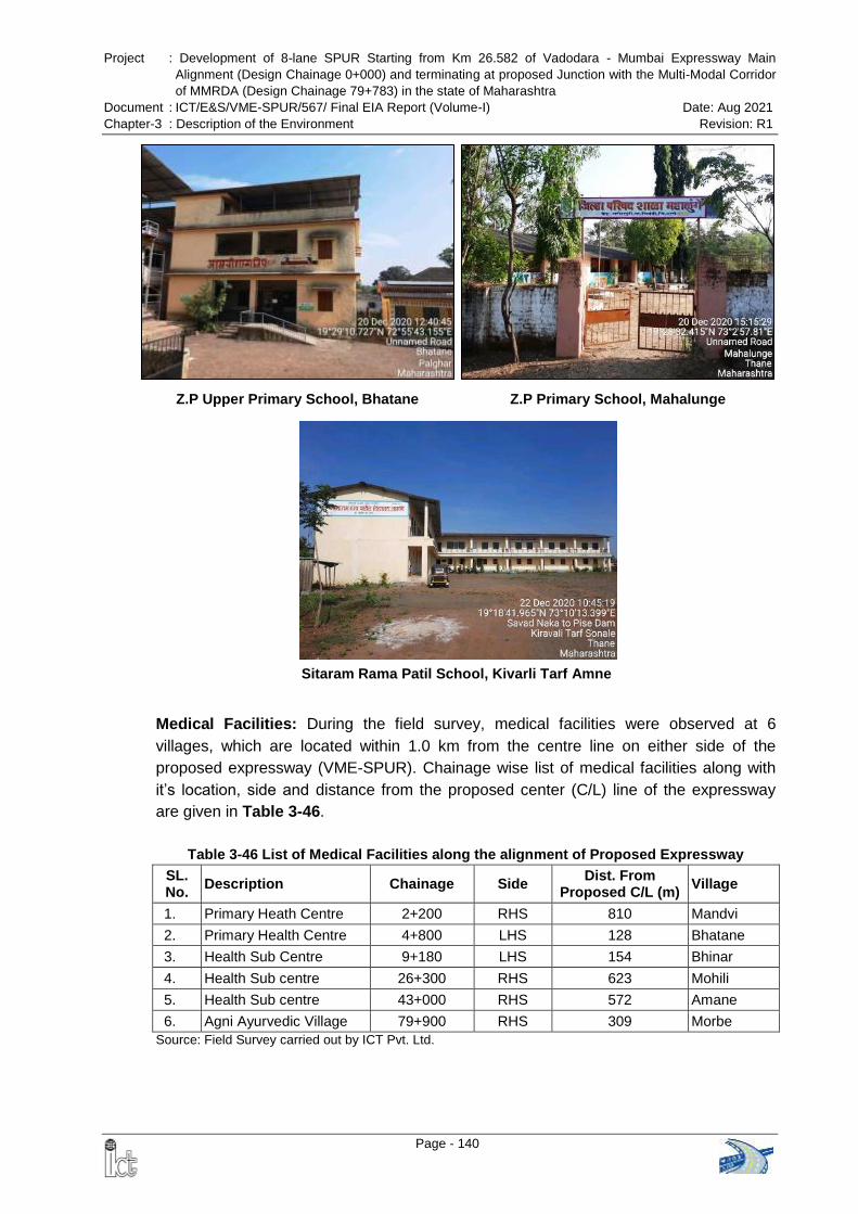
Project : Development of 8-lane SPUR Starting from Km 26.582 of Vadodara - Mumbai Expressway Main
Alignment (Design Chainage 0+000) and terminating at proposed Junction with the Multi-Modal Corridor
of MMRDA (Design Chainage 79+783) in the state of Maharashtra
Document : ICT/E&S/VME-SPUR/567/ Final EIA Report (Volume-I) Date: Aug 2021
Chapter-3 : Description of the Environment Revision: R1
Page - 140
Medical Facilities: During the field survey, medical facilities were observed at 6
villages, which are located within 1.0 km from the centre line on either side of the
proposed expressway (VME-SPUR). Chainage wise list of medical facilities along with
it’s location, side and distance from the proposed center (C/L) line of the expressway
are given in Table 3-46.
Table 3-46 List of Medical Facilities along the alignment of Proposed Expressway
SL. No.
Description Chainage Side Dist. From
Proposed C/L (m) Village
1. Primary Heath Centre 2+200 RHS 810 Mandvi
2. Primary Health Centre 4+800 LHS 128 Bhatane
3. Health Sub Centre 9+180 LHS 154 Bhinar
4. Health Sub centre 26+300 RHS 623 Mohili
5. Health Sub centre 43+000 RHS 572 Amane
6. Agni Ayurvedic Village 79+900 RHS 309 Morbe
Source: Field Survey carried out by ICT Pvt. Ltd.
Z.P Upper Primary School, Bhatane Z.P Primary School, Mahalunge
Sitaram Rama Patil School, Kivarli Tarf Amne
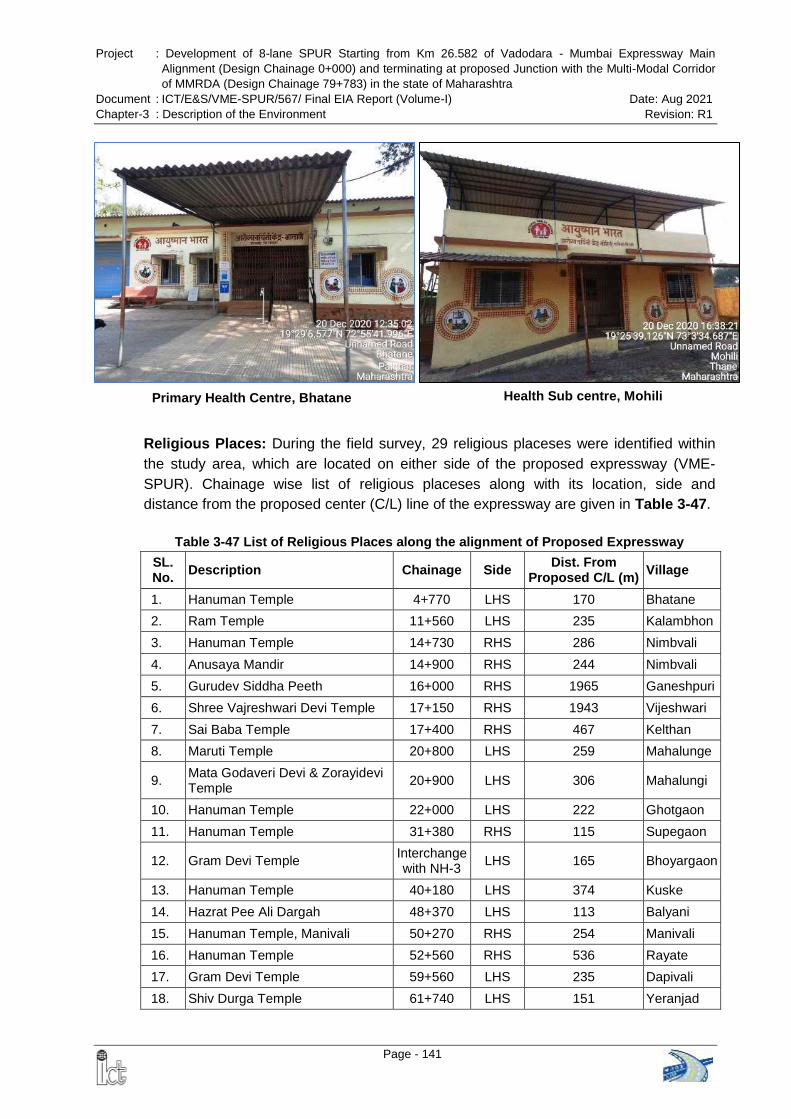
Project : Development of 8-lane SPUR Starting from Km 26.582 of Vadodara - Mumbai Expressway Main
Alignment (Design Chainage 0+000) and terminating at proposed Junction with the Multi-Modal Corridor
of MMRDA (Design Chainage 79+783) in the state of Maharashtra
Document : ICT/E&S/VME-SPUR/567/ Final EIA Report (Volume-I) Date: Aug 2021
Chapter-3 : Description of the Environment Revision: R1
Page - 141
Religious Places: During the field survey, 29 religious placeses were identified within
the study area, which are located on either side of the proposed expressway (VME-
SPUR). Chainage wise list of religious placeses along with its location, side and
distance from the proposed center (C/L) line of the expressway are given in Table 3-47.
Table 3-47 List of Religious Places along the alignment of Proposed Expressway
SL. No.
Description Chainage Side Dist. From
Proposed C/L (m) Village
1. Hanuman Temple 4+770 LHS 170 Bhatane
2. Ram Temple 11+560 LHS 235 Kalambhon
3. Hanuman Temple 14+730 RHS 286 Nimbvali
4. Anusaya Mandir 14+900 RHS 244 Nimbvali
5. Gurudev Siddha Peeth 16+000 RHS 1965 Ganeshpuri
6. Shree Vajreshwari Devi Temple 17+150 RHS 1943 Vijeshwari
7. Sai Baba Temple 17+400 RHS 467 Kelthan
8. Maruti Temple 20+800 LHS 259 Mahalunge
9. Mata Godaveri Devi & Zorayidevi Temple
20+900 LHS 306 Mahalungi
10. Hanuman Temple 22+000 LHS 222 Ghotgaon
11. Hanuman Temple 31+380 RHS 115 Supegaon
12. Gram Devi Temple Interchange with NH-3
LHS 165 Bhoyargaon
13. Hanuman Temple 40+180 LHS 374 Kuske
14. Hazrat Pee Ali Dargah 48+370 LHS 113 Balyani
15. Hanuman Temple, Manivali 50+270 RHS 254 Manivali
16. Hanuman Temple 52+560 RHS 536 Rayate
17. Gram Devi Temple 59+560 LHS 235 Dapivali
18. Shiv Durga Temple 61+740 LHS 151 Yeranjad
Primary Health Centre, Bhatane Health Sub centre, Mohili
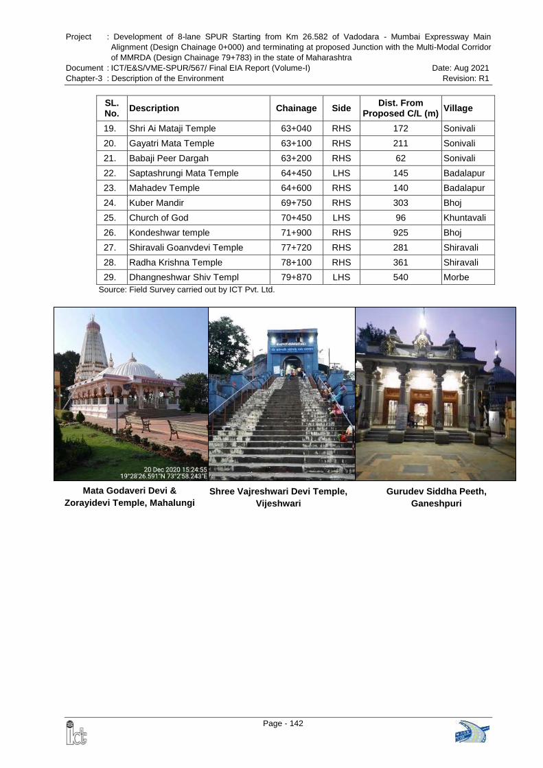
Project : Development of 8-lane SPUR Starting from Km 26.582 of Vadodara - Mumbai Expressway Main
Alignment (Design Chainage 0+000) and terminating at proposed Junction with the Multi-Modal Corridor
of MMRDA (Design Chainage 79+783) in the state of Maharashtra
Document : ICT/E&S/VME-SPUR/567/ Final EIA Report (Volume-I) Date: Aug 2021
Chapter-3 : Description of the Environment Revision: R1
Page - 142
Mata Godaveri Devi &
Zorayidevi Temple, Mahalungi
Shree Vajreshwari Devi Temple,
Vijeshwari
Gurudev Siddha Peeth,
Ganeshpuri
SL. No.
Description Chainage Side Dist. From
Proposed C/L (m) Village
19. Shri Ai Mataji Temple 63+040 RHS 172 Sonivali
20. Gayatri Mata Temple 63+100 RHS 211 Sonivali
21. Babaji Peer Dargah 63+200 RHS 62 Sonivali
22. Saptashrungi Mata Temple 64+450 LHS 145 Badalapur
23. Mahadev Temple 64+600 RHS 140 Badalapur
24. Kuber Mandir 69+750 RHS 303 Bhoj
25. Church of God 70+450 LHS 96 Khuntavali
26. Kondeshwar temple 71+900 RHS 925 Bhoj
27. Shiravali Goanvdevi Temple 77+720 RHS 281 Shiravali
28. Radha Krishna Temple 78+100 RHS 361 Shiravali
29. Dhangneshwar Shiv Templ 79+870 LHS 540 Morbe
Source: Field Survey carried out by ICT Pvt. Ltd.
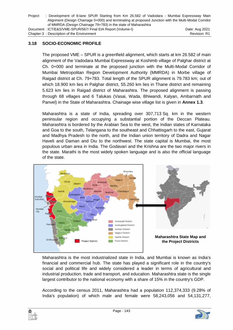
Project : Development of 8-lane SPUR Starting from Km 26.582 of Vadodara - Mumbai Expressway Main
Alignment (Design Chainage 0+000) and terminating at proposed Junction with the Multi-Modal Corridor
of MMRDA (Design Chainage 79+783) in the state of Maharashtra
Document : ICT/E&S/VME-SPUR/567/ Final EIA Report (Volume-I) Date: Aug 2021
Chapter-3 : Description of the Environment Revision: R1
Page - 143
Maharashtra State Map and
the Project Districts
3.18 SOCIO-ECONOMIC PROFILE
The proposed VME – SPUR is a greenfield alignment, which starts at km 26.582 of main
alignment of the Vadodara Mumbai Expressway at Koshimb village of Palghar district at
Ch. 0+000 and terminate at the proposed junction with the Multi-Modal Corridor of
Mumbai Metropolitan Region Development Authority (MMRDA) in Morbe village of
Raigad district at Ch. 79+783. Total length of the SPUR alignment is 79.783 km; out of
which 18.900 km lies in Palghar district, 55.260 km lies in Thane district and remaining
5.623 km lies in Raigad district of Maharashtra. The proposed alignment is passing
through 68 villages and 6 Talukas (Vasai, Wada, Bhiwandi, Kalyan, Ambarnath and
Panvel) in the State of Maharashtra. Chainage wise village list is given in Annex 1.3.
Maharashtra is a state of India, spreading over 307,713 Sq. km in the western
peninsular region and occupying a substantial portion of the Deccan Plateau.
Maharashtra is bordered by the Arabian Sea to the west, the Indian states of Karnataka
and Goa to the south, Telangana to the southeast and Chhattisgarh to the east, Gujarat
and Madhya Pradesh to the north, and the Indian union territory of Dadra and Nagar
Haveli and Daman and Diu to the northwest. The state capital is Mumbai, the most
populous urban area in India. The Godavari and the Krishna are the two major rivers in
the state. Marathi is the most widely spoken language and is also the official language
of the state.
Maharashtra is the most industrialized state in India, and Mumbai is known as India's
financial and commercial hub. The state has played a significant role in the country's
social and political life and widely considered a leader in terms of agricultural and
industrial production, trade and transport, and education. Maharashtra state is the single
largest contributor to the national economy with a share of 15% in the country's GDP.
According to the census 2011, Maharashtra had a population 112,374,333 (9.28% of
India's population) of which male and female were 58,243,056 and 54,131,277,
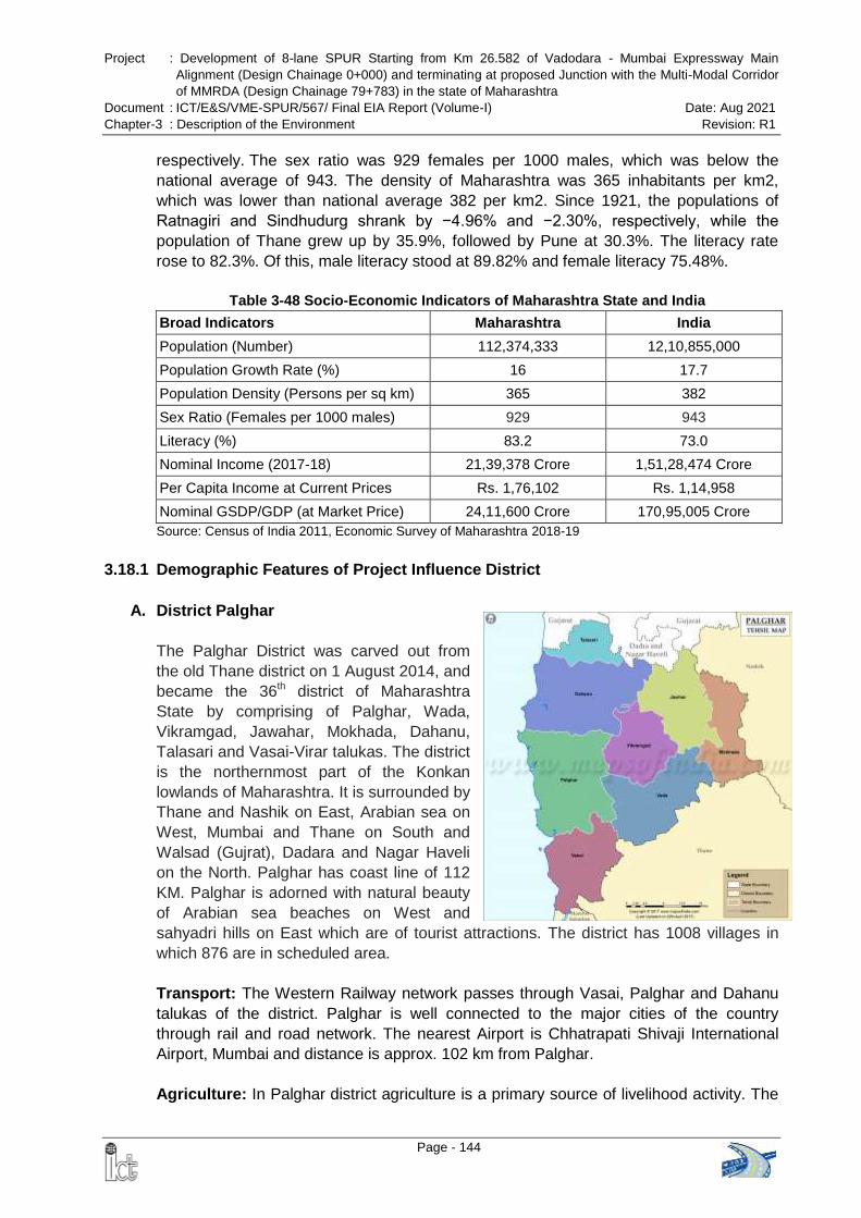
Project : Development of 8-lane SPUR Starting from Km 26.582 of Vadodara - Mumbai Expressway Main
Alignment (Design Chainage 0+000) and terminating at proposed Junction with the Multi-Modal Corridor
of MMRDA (Design Chainage 79+783) in the state of Maharashtra
Document : ICT/E&S/VME-SPUR/567/ Final EIA Report (Volume-I) Date: Aug 2021
Chapter-3 : Description of the Environment Revision: R1
Page - 144
respectively. The sex ratio was 929 females per 1000 males, which was below the
national average of 943. The density of Maharashtra was 365 inhabitants per km2,
which was lower than national average 382 per km2. Since 1921, the populations of
Ratnagiri and Sindhudurg shrank by −4.96% and −2.30%, respectively, while the
population of Thane grew up by 35.9%, followed by Pune at 30.3%. The literacy rate
rose to 82.3%. Of this, male literacy stood at 89.82% and female literacy 75.48%.
Table 3-48 Socio-Economic Indicators of Maharashtra State and India
Broad Indicators Maharashtra India
Population (Number) 112,374,333 12,10,855,000
Population Growth Rate (%) 16 17.7
Population Density (Persons per sq km) 365 382
Sex Ratio (Females per 1000 males) 929 943
Literacy (%) 83.2 73.0
Nominal Income (2017-18) 21,39,378 Crore 1,51,28,474 Crore
Per Capita Income at Current Prices Rs. 1,76,102 Rs. 1,14,958
Nominal GSDP/GDP (at Market Price) 24,11,600 Crore 170,95,005 Crore
Source: Census of India 2011, Economic Survey of Maharashtra 2018-19
3.18.1 Demographic Features of Project Influence District
A. District Palghar
The Palghar District was carved out from
the old Thane district on 1 August 2014, and
became the 36th district of Maharashtra
State by comprising of Palghar, Wada,
Vikramgad, Jawahar, Mokhada, Dahanu,
Talasari and Vasai-Virar talukas. The district
is the northernmost part of the Konkan
lowlands of Maharashtra. It is surrounded by
Thane and Nashik on East, Arabian sea on
West, Mumbai and Thane on South and
Walsad (Gujrat), Dadara and Nagar Haveli
on the North. Palghar has coast line of 112
KM. Palghar is adorned with natural beauty
of Arabian sea beaches on West and
sahyadri hills on East which are of tourist attractions. The district has 1008 villages in
which 876 are in scheduled area.
Transport: The Western Railway network passes through Vasai, Palghar and Dahanu
talukas of the district. Palghar is well connected to the major cities of the country
through rail and road network. The nearest Airport is Chhatrapati Shivaji International
Airport, Mumbai and distance is approx. 102 km from Palghar.
Agriculture: In Palghar district agriculture is a primary source of livelihood activity. The
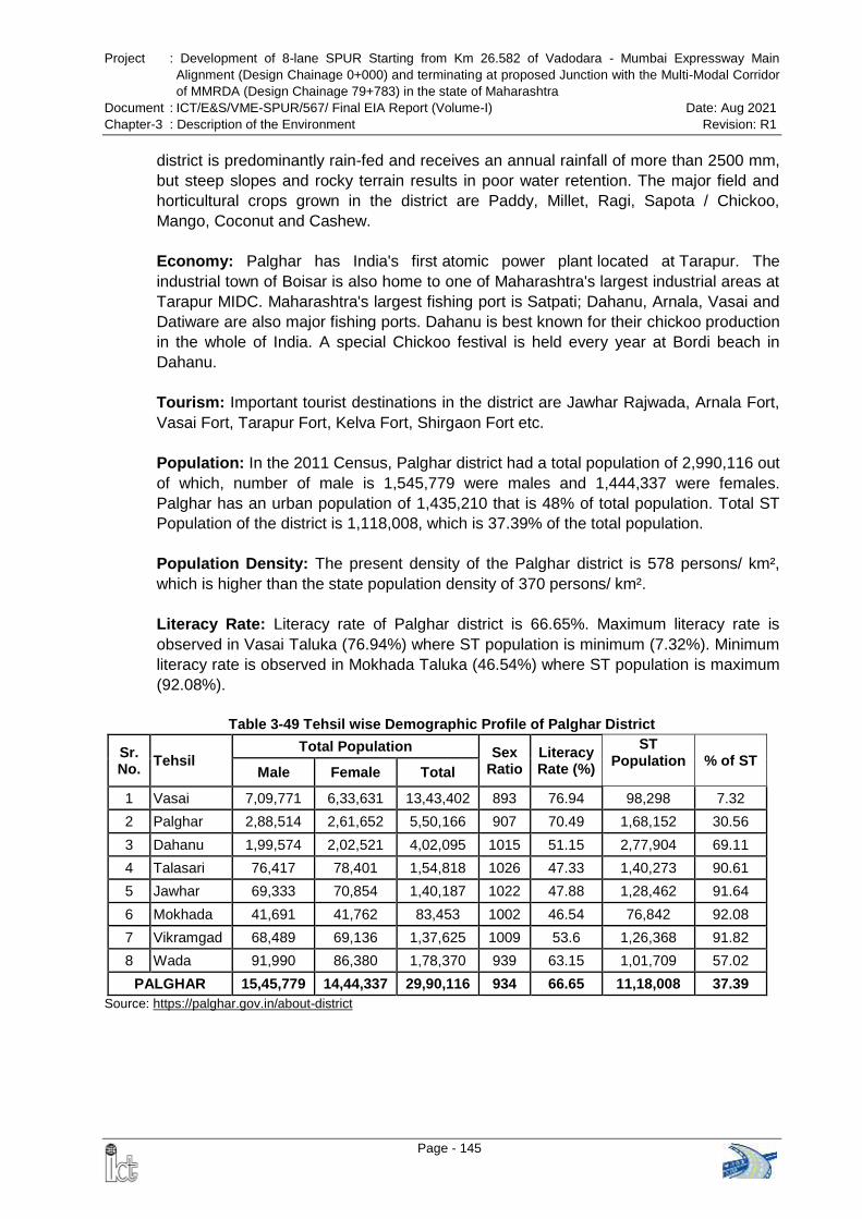
Project : Development of 8-lane SPUR Starting from Km 26.582 of Vadodara - Mumbai Expressway Main
Alignment (Design Chainage 0+000) and terminating at proposed Junction with the Multi-Modal Corridor
of MMRDA (Design Chainage 79+783) in the state of Maharashtra
Document : ICT/E&S/VME-SPUR/567/ Final EIA Report (Volume-I) Date: Aug 2021
Chapter-3 : Description of the Environment Revision: R1
Page - 145
district is predominantly rain-fed and receives an annual rainfall of more than 2500 mm,
but steep slopes and rocky terrain results in poor water retention. The major field and
horticultural crops grown in the district are Paddy, Millet, Ragi, Sapota / Chickoo,
Mango, Coconut and Cashew.
Economy: Palghar has India's first atomic power plant located at Tarapur. The
industrial town of Boisar is also home to one of Maharashtra's largest industrial areas at
Tarapur MIDC. Maharashtra's largest fishing port is Satpati; Dahanu, Arnala, Vasai and
Datiware are also major fishing ports. Dahanu is best known for their chickoo production
in the whole of India. A special Chickoo festival is held every year at Bordi beach in
Dahanu.
Tourism: Important tourist destinations in the district are Jawhar Rajwada, Arnala Fort,
Vasai Fort, Tarapur Fort, Kelva Fort, Shirgaon Fort etc.
Population: In the 2011 Census, Palghar district had a total population of 2,990,116 out
of which, number of male is 1,545,779 were males and 1,444,337 were females.
Palghar has an urban population of 1,435,210 that is 48% of total population. Total ST
Population of the district is 1,118,008, which is 37.39% of the total population.
Population Density: The present density of the Palghar district is 578 persons/ km²,
which is higher than the state population density of 370 persons/ km².
Literacy Rate: Literacy rate of Palghar district is 66.65%. Maximum literacy rate is
observed in Vasai Taluka (76.94%) where ST population is minimum (7.32%). Minimum
literacy rate is observed in Mokhada Taluka (46.54%) where ST population is maximum
(92.08%).
Table 3-49 Tehsil wise Demographic Profile of Palghar District
Sr. No.
Tehsil Total Population Sex
Ratio Literacy Rate (%)
ST Population % of ST
Male Female Total
1 Vasai 7,09,771 6,33,631 13,43,402 893 76.94 98,298 7.32
2 Palghar 2,88,514 2,61,652 5,50,166 907 70.49 1,68,152 30.56
3 Dahanu 1,99,574 2,02,521 4,02,095 1015 51.15 2,77,904 69.11
4 Talasari 76,417 78,401 1,54,818 1026 47.33 1,40,273 90.61
5 Jawhar 69,333 70,854 1,40,187 1022 47.88 1,28,462 91.64
6 Mokhada 41,691 41,762 83,453 1002 46.54 76,842 92.08
7 Vikramgad 68,489 69,136 1,37,625 1009 53.6 1,26,368 91.82
8 Wada 91,990 86,380 1,78,370 939 63.15 1,01,709 57.02
PALGHAR 15,45,779 14,44,337 29,90,116 934 66.65 11,18,008 37.39
Source: https://palghar.gov.in/about-district
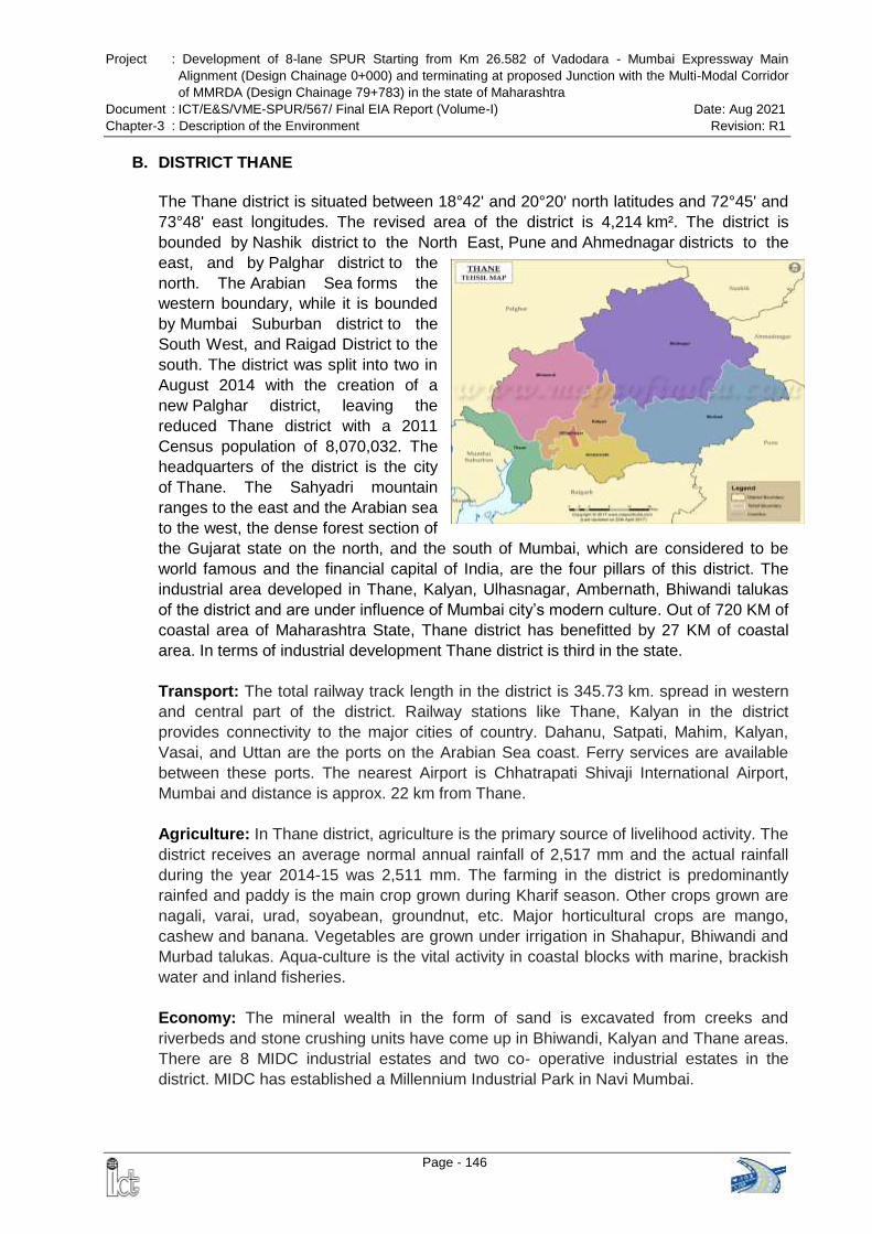
Project : Development of 8-lane SPUR Starting from Km 26.582 of Vadodara - Mumbai Expressway Main
Alignment (Design Chainage 0+000) and terminating at proposed Junction with the Multi-Modal Corridor
of MMRDA (Design Chainage 79+783) in the state of Maharashtra
Document : ICT/E&S/VME-SPUR/567/ Final EIA Report (Volume-I) Date: Aug 2021
Chapter-3 : Description of the Environment Revision: R1
Page - 146
B. DISTRICT THANE
The Thane district is situated between 18°42' and 20°20' north latitudes and 72°45' and
73°48' east longitudes. The revised area of the district is 4,214 km². The district is
bounded by Nashik district to the North East, Pune and Ahmednagar districts to the
east, and by Palghar district to the
north. The Arabian Sea forms the
western boundary, while it is bounded
by Mumbai Suburban district to the
South West, and Raigad District to the
south. The district was split into two in
August 2014 with the creation of a
new Palghar district, leaving the
reduced Thane district with a 2011
Census population of 8,070,032. The
headquarters of the district is the city
of Thane. The Sahyadri mountain
ranges to the east and the Arabian sea
to the west, the dense forest section of
the Gujarat state on the north, and the south of Mumbai, which are considered to be
world famous and the financial capital of India, are the four pillars of this district. The
industrial area developed in Thane, Kalyan, Ulhasnagar, Ambernath, Bhiwandi talukas
of the district and are under influence of Mumbai city’s modern culture. Out of 720 KM of
coastal area of Maharashtra State, Thane district has benefitted by 27 KM of coastal
area. In terms of industrial development Thane district is third in the state.
Transport: The total railway track length in the district is 345.73 km. spread in western
and central part of the district. Railway stations like Thane, Kalyan in the district
provides connectivity to the major cities of country. Dahanu, Satpati, Mahim, Kalyan,
Vasai, and Uttan are the ports on the Arabian Sea coast. Ferry services are available
between these ports. The nearest Airport is Chhatrapati Shivaji International Airport,
Mumbai and distance is approx. 22 km from Thane.
Agriculture: In Thane district, agriculture is the primary source of livelihood activity. The
district receives an average normal annual rainfall of 2,517 mm and the actual rainfall
during the year 2014-15 was 2,511 mm. The farming in the district is predominantly
rainfed and paddy is the main crop grown during Kharif season. Other crops grown are
nagali, varai, urad, soyabean, groundnut, etc. Major horticultural crops are mango,
cashew and banana. Vegetables are grown under irrigation in Shahapur, Bhiwandi and
Murbad talukas. Aqua-culture is the vital activity in coastal blocks with marine, brackish
water and inland fisheries.
Economy: The mineral wealth in the form of sand is excavated from creeks and
riverbeds and stone crushing units have come up in Bhiwandi, Kalyan and Thane areas.
There are 8 MIDC industrial estates and two co- operative industrial estates in the
district. MIDC has established a Millennium Industrial Park in Navi Mumbai.
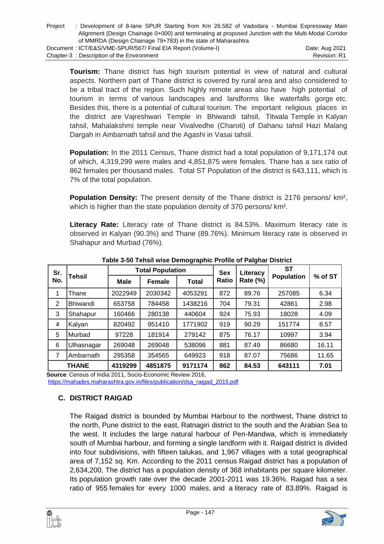
Project : Development of 8-lane SPUR Starting from Km 26.582 of Vadodara - Mumbai Expressway Main
Alignment (Design Chainage 0+000) and terminating at proposed Junction with the Multi-Modal Corridor
of MMRDA (Design Chainage 79+783) in the state of Maharashtra
Document : ICT/E&S/VME-SPUR/567/ Final EIA Report (Volume-I) Date: Aug 2021
Chapter-3 : Description of the Environment Revision: R1
Page - 147
Tourism: Thane district has high tourism potential in view of natural and cultural
aspects. Northern part of Thane district is covered by rural area and also considered to
be a tribal tract of the region. Such highly remote areas also have high potential of
tourism in terms of various landscapes and landforms like waterfalls gorge etc.
Besides this, there is a potential of cultural tourism. The important religious places in
the district are Vajreshwari Temple in Bhiwandi tahsil, Titwala Temple in Kalyan
tahsil, Mahalakshmi temple near Vivalvedhe (Charoti) of Dahanu tahsil Hazi Malang
Dargah in Ambarnath tahsil and the Agashi in Vasai tahsil.
Population: In the 2011 Census, Thane district had a total population of 9,171,174 out
of which, 4,319,299 were males and 4,851,875 were females. Thane has a sex ratio of
862 females per thousand males. Total ST Population of the district is 643,111, which is
7% of the total population.
Population Density: The present density of the Thane district is 2176 persons/ km²,
which is higher than the state population density of 370 persons/ km².
Literacy Rate: Literacy rate of Thane district is 84.53%. Maximum literacy rate is
observed in Kalyan (90.3%) and Thane (89.76%). Minimum literacy rate is observed in
Shahapur and Murbad (76%).
Table 3-50 Tehsil wise Demographic Profile of Palghar District
Sr. No.
Tehsil Total Population Sex
Ratio Literacy Rate (%)
ST Population % of ST
Male Female Total
1 Thane 2022949 2030342 4053291 872 89.76 257085 6.34
2 Bhiwandi 653758 784458 1438216 704 79.31 42861 2.98
3 Shahapur 160466 280138 440604 924 75.93 18028 4.09
4 Kalyan 820492 951410 1771902 919 90.29 151774 8.57
5 Murbad 97228 181914 279142 875 76.17 10997 3.94
6 Ulhasnagar 269048 269048 538096 881 87.49 86680 16.11
7 Ambarnath 295358 354565 649923 918 87.07 75686 11.65
THANE 4319299 4851875 9171174 862 84.53 643111 7.01
Source: Census of India 2011, Socio-Economic Review 2016,
https://mahades.maharashtra.gov.in/files/publication/dsa_raigad_2015.pdf
C. DISTRICT RAIGAD
The Raigad district is bounded by Mumbai Harbour to the northwest, Thane district to
the north, Pune district to the east, Ratnagiri district to the south and the Arabian Sea to
the west. It includes the large natural harbour of Pen-Mandwa, which is immediately
south of Mumbai harbour, and forming a single landform with it. Raigad district is divided
into four subdivisions, with fifteen talukas, and 1,967 villages with a total geographical
area of 7,152 sq. Km. According to the 2011 census Raigad district has a population of
2,634,200, The district has a population density of 368 inhabitants per square kilometer.
Its population growth rate over the decade 2001-2011 was 19.36%. Raigad has a sex
ratio of 955 females for every 1000 males, and a literacy rate of 83.89%. Raigad is
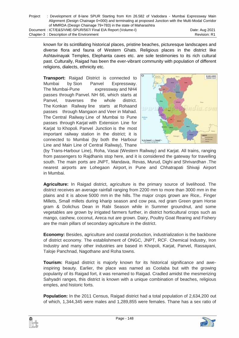
Project : Development of 8-lane SPUR Starting from Km 26.582 of Vadodara - Mumbai Expressway Main
Alignment (Design Chainage 0+000) and terminating at proposed Junction with the Multi-Modal Corridor
of MMRDA (Design Chainage 79+783) in the state of Maharashtra
Document : ICT/E&S/VME-SPUR/567/ Final EIA Report (Volume-I) Date: Aug 2021
Chapter-3 : Description of the Environment Revision: R1
Page - 148
known for its scintillating historical places, pristine beaches, picturesque landscapes and
diverse flora and fauna of Western Ghats. Religious places in the district like
Ashtavinayak Temples, Elephanta caves etc. are sole testimonies to its rich cultural
past. Culturally, Raigad has been the ever-vibrant community with population of different
religions, dialects, ethnicity etc.
Transport: Raigad District is connected to
Mumbai by Sion Panvel Expressway.
The Mumbai-Pune expressway and NH4
passes through Panvel. NH 66, which starts at
Panvel, traverses the whole district.
The Konkan Railway line starts at Rohaand
passes through Mangaon and Veer in Mahad.
The Central Railway Line of Mumbai to Pune
passes through Karjat with Extension Line for
Karjat to Khopoli. Panvel Junction is the most
important railway station in the district; it is
connected to Mumbai (by both the Harbour
Line and Main Line of Central Railway), Thane
(by Trans-Harbour Line), Roha, Vasai (Western Railway) and Karjat. All trains, ranging
from passengers to Rajdhanis stop here, and it is considered the gateway for travelling
south. The main ports are JNPT, Mandava, Revas, Murud, Dighi and Shrivardhan .The
nearest airports are Lohegaon Airport, in Pune and Chhatrapati Shivaji Airport
in Mumbai.
Agriculture: In Raigad district, agriculture is the primary source of livelihood. The
district receives an average rainfall ranging from 2200 mm to more than 3000 mm in the
plains and it is above 5000 mm in the hills. The major crops grown are Rice,. Finger
Millets, Small millets during kharip season and cow pea, red gram Green gram Horse
gram & Dolichus Dean in Rabi Season while in Summer groundnut, and some
vegetables are grown by irrigated farmers further, in district horticultural crops such as
mango, cashew, coconut, Areca nut are grown. Dairy, Poultry Goat Rearing and Fishery
are the main pillars of secondary agriculture in the district.
Economy: Besides, agriculture and coastal production, industrialization is the backbone
of district economy. The establishment of ONGC, JNPT, RCF. Chemical Industry, Iron
Industry and many other industries are based in Khopoli, Karjat, Panvel, Rassayani,
Taloje Panchnad, Nagothane and Roha towns.
Tourism: Raigad district is majorly known for its historical significance and awe-
inspiring beauty. Earlier, the place was named as Coolaba but with the growing
popularity of its Raigad fort, it was renamed to Raigad. Cradled amidst the mesmerizing
Sahyadri ranges, this district is known with a unique combination of beaches, religious
emples, and historic forts.
Population: In the 2011 Census, Raigad district had a total population of 2,634,200 out
of which, 1,344,345 were males and 1,289,855 were females. Thane has a sex ratio of
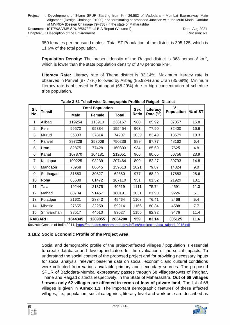
Project : Development of 8-lane SPUR Starting from Km 26.582 of Vadodara - Mumbai Expressway Main
Alignment (Design Chainage 0+000) and terminating at proposed Junction with the Multi-Modal Corridor
of MMRDA (Design Chainage 79+783) in the state of Maharashtra
Document : ICT/E&S/VME-SPUR/567/ Final EIA Report (Volume-I) Date: Aug 2021
Chapter-3 : Description of the Environment Revision: R1
Page - 149
959 females per thousand males. Total ST Population of the district is 305,125, which is
11.6% of the total population.
Population Density: The present density of the Raigad district is 368 persons/ km²,
which is lower than the state population density of 370 persons/ km².
Literacy Rate: Literacy rate of Thane district is 83.14%. Maximum literacy rate is
observed in Panvel (87.77%) followed by Alibag (85.92%) and Uran (85.69%). Minimum
literacy rate is observed in Sudhagad (68.29%) due to high concentration of schedule
tribe population.
Table 3-51 Tehsil wise Demographic Profile of Raigarh District
Sr. No.
Tehsil Total Population Sex
Ratio Literacy Rate (%)
ST Population % of ST
Male Female Total
1 Alibag 119254 116913 236167 980 85.92 37357 15.8
2 Pen 99570 95884 195454 963 77.90 32400 16.6
3 Murud 36393 37814 74207 1039 83.49 13579 18.3
4 Panvel 397228 353008 750236 889 87.77 48162 6.4
5 Uran 82875 77428 160303 934 85.69 7625 4.8
6 Karjat 107870 104181 212051 966 80.65 50756 23.9
7 Khalapur 109225 98239 207464 899 82.27 30793 14.8
8 Mangaon 78968 80645 159613 1021 79.87 14324 9.0
9 Sudhagad 31553 30827 62380 977 68.29 17853 28.6
10 Roha 85638 81472 167110 951 81.52 21929 13.1
11 Tala 19244 21375 40619 1111 75.74 4591 11.3
12 Mahad 88734 91457 180191 1031 81.90 9226 5.1
13 Poladpur 21621 23843 45464 1103 76.41 2466 5.4
14 Mhasla 27655 32259 59914 1166 80.34 4588 7.7
15 Shrivardhan 38517 44510 83027 1156 82.32 9476 11.4
RAIGARH 1344345 1289855 2634200 959 83.14 305125 11.6
Source: Census of India 2011, https://mahades.maharashtra.gov.in/files/publication/dsa_raigad_2015.pdf
3.18.2 Socio Economic Profile of the Project Area
Social and demographic profile of the project-affected villages / population is essential
to create database and develop indicators for the evaluation of the social impacts. To
understand the social context of the proposed project and for providing necessary inputs
for social analysis, relevant baseline data on social, economic and cultural conditions
were collected from various available primary and secondary sources. The proposed
SPUR of Badodara-Mumbai expressway passes through 68 villages/towns of Palghar,
Thane and Raigad districts respectively, in the State of Maharashtra. Out of 68 villages
/ towns only 62 villages are affected in terms of loss of private land. The list of 68
villages is given in Annex 1.3. The important demographic features of these affected
villages, i.e., population, social categories, literacy level and workforce are described as
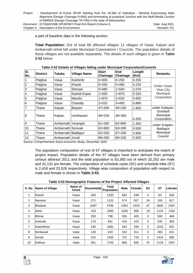
Project : Development of 8-lane SPUR Starting from Km 26.582 of Vadodara - Mumbai Expressway Main
Alignment (Design Chainage 0+000) and terminating at proposed Junction with the Multi-Modal Corridor
of MMRDA (Design Chainage 79+783) in the state of Maharashtra
Document : ICT/E&S/VME-SPUR/567/ Final EIA Report (Volume-I) Date: Aug 2021
Chapter-3 : Description of the Environment Revision: R1
Page - 150
a part of baseline data in the following section.
Total Population: Out of total 68 affected villages 11 villages of Vasai, Kalyan and
Ambarnath tehsil fall under Municipal Corporations / Councils. The population details of
these villages are not available separately. The details of such villages is given in Table
3-52 below
Table 3-52 Details of Villages falling under Municipal Corporation/Councils
Sl. No.
District Taluka Village Name Start Chainage
End Chainage
Length (Km)
Remarks
1 Palghar Vasai Koshimb 0+000 0+250 0.250
Under Vasai-Virar City Municipal
Corporation
2 Palghar Vasai Khardi 0+250 0+480 0.230
3 Palghar Vasai Shirsad 0+480 1+550 1.070
4 Palghar Vasai Kashid Kopar 1+550 1+870 0.320
5 Palghar Vasai Mandvi 1+870 2+520 0.650
6 Palghar Vasai Chandip 2+520 3+400 0.880
7 Thane Kalyan Balyani 47+300 49+150 1.850 under Kalayan-Dombivli Municipal
Corporation 8 Thane Kalyan Umbharani 49+150 49+350
0.200
9 Thane Ambarnath Yeranjad 61+350 62+800 1.450 under Kulgam-Badlapur Municipal Counsil
10 Thane Ambarnath Sonivali 62+800 63+300 0.500
11 Thane Ambarnath Badlapur 63+300 67+200 3.900
12 Thane Ambarnath Joveli 68+300 69+230 0.930
Source: Comprehensive Socio-economic Study, December 2020
The population composition of rest of 57 villages is important to anticipate the extent of
project impact. Population details of the 57 villages have been derived from primary
census abstract 2011 and the total population is 63,383 out of which 32,252 are male
and 31,131 are female. The composition of schedule caste (SC) and schedule tribe (ST)
is 2,418 and 23,526 respectively. Village wise composition of population with respect to
male and female is shown in Table 3-53.
Table 3-53 Demographic Features of the Project Affected Villages
S. No. Name of Village Name of Tehsil
Households Total
Population Male Female SC ST Literate
1 Khardi Vasai 283 1293 655 638 0 60 926
2 Navasai Vasai 271 1131 574 557 34 165 817
3 Bhatane Vasai 1097 4786 2353 2433 87 3830 2307
4 Adne Vasai 419 1995 1036 959 19 1124 1254
5 Bhinar Vasai 200 798 393 405 0 508 469
6 Ambode Vasai 176 831 416 415 0 540 383
7 Kalambhon Vasai 236 1081 542 539 0 1023 622
8 Nimbavali Vada 139 633 322 311 5 483 341
9 Gorad Vada 315 1455 737 718 0 1414 686
10 Kelthan Vada 361 1702 866 836 37 1118 1097
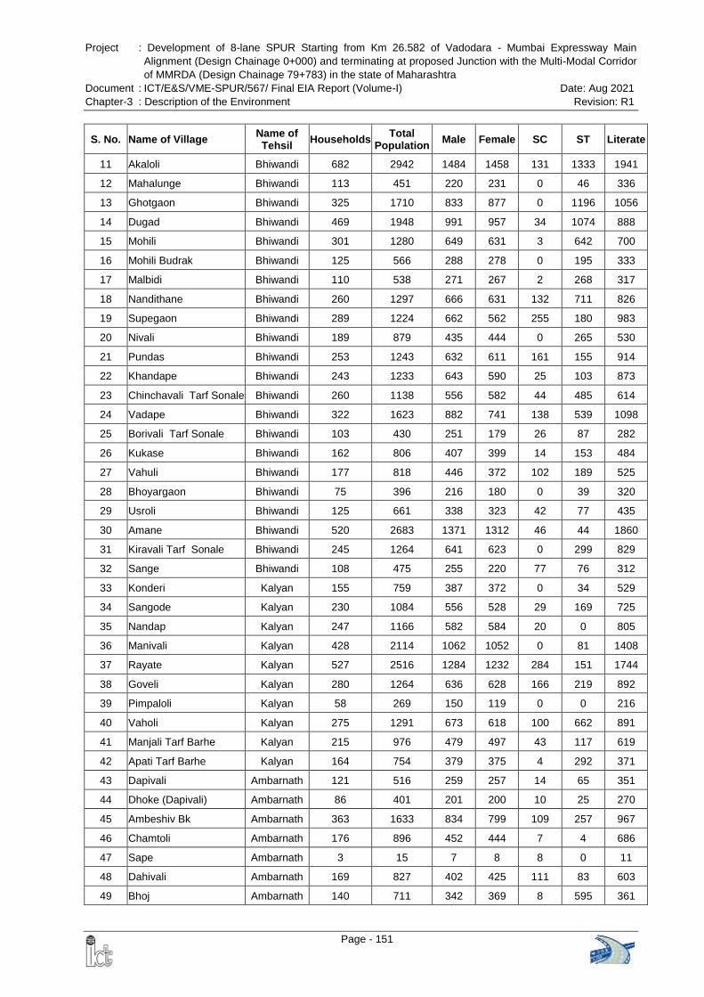
Project : Development of 8-lane SPUR Starting from Km 26.582 of Vadodara - Mumbai Expressway Main
Alignment (Design Chainage 0+000) and terminating at proposed Junction with the Multi-Modal Corridor
of MMRDA (Design Chainage 79+783) in the state of Maharashtra
Document : ICT/E&S/VME-SPUR/567/ Final EIA Report (Volume-I) Date: Aug 2021
Chapter-3 : Description of the Environment Revision: R1
Page - 151
S. No. Name of Village Name of Tehsil
Households Total
Population Male Female SC ST Literate
11 Akaloli Bhiwandi 682 2942 1484 1458 131 1333 1941
12 Mahalunge Bhiwandi 113 451 220 231 0 46 336
13 Ghotgaon Bhiwandi 325 1710 833 877 0 1196 1056
14 Dugad Bhiwandi 469 1948 991 957 34 1074 888
15 Mohili Bhiwandi 301 1280 649 631 3 642 700
16 Mohili Budrak Bhiwandi 125 566 288 278 0 195 333
17 Malbidi Bhiwandi 110 538 271 267 2 268 317
18 Nandithane Bhiwandi 260 1297 666 631 132 711 826
19 Supegaon Bhiwandi 289 1224 662 562 255 180 983
20 Nivali Bhiwandi 189 879 435 444 0 265 530
21 Pundas Bhiwandi 253 1243 632 611 161 155 914
22 Khandape Bhiwandi 243 1233 643 590 25 103 873
23 Chinchavali Tarf Sonale Bhiwandi 260 1138 556 582 44 485 614
24 Vadape Bhiwandi 322 1623 882 741 138 539 1098
25 Borivali Tarf Sonale Bhiwandi 103 430 251 179 26 87 282
26 Kukase Bhiwandi 162 806 407 399 14 153 484
27 Vahuli Bhiwandi 177 818 446 372 102 189 525
28 Bhoyargaon Bhiwandi 75 396 216 180 0 39 320
29 Usroli Bhiwandi 125 661 338 323 42 77 435
30 Amane Bhiwandi 520 2683 1371 1312 46 44 1860
31 Kiravali Tarf Sonale Bhiwandi 245 1264 641 623 0 299 829
32 Sange Bhiwandi 108 475 255 220 77 76 312
33 Konderi Kalyan 155 759 387 372 0 34 529
34 Sangode Kalyan 230 1084 556 528 29 169 725
35 Nandap Kalyan 247 1166 582 584 20 0 805
36 Manivali Kalyan 428 2114 1062 1052 0 81 1408
37 Rayate Kalyan 527 2516 1284 1232 284 151 1744
38 Goveli Kalyan 280 1264 636 628 166 219 892
39 Pimpaloli Kalyan 58 269 150 119 0 0 216
40 Vaholi Kalyan 275 1291 673 618 100 662 891
41 Manjali Tarf Barhe Kalyan 215 976 479 497 43 117 619
42 Apati Tarf Barhe Kalyan 164 754 379 375 4 292 371
43 Dapivali Ambarnath 121 516 259 257 14 65 351
44 Dhoke (Dapivali) Ambarnath 86 401 201 200 10 25 270
45 Ambeshiv Bk Ambarnath 363 1633 834 799 109 257 967
46 Chamtoli Ambarnath 176 896 452 444 7 4 686
47 Sape Ambarnath 3 15 7 8 8 0 11
48 Dahivali Ambarnath 169 827 402 425 111 83 603
49 Bhoj Ambarnath 140 711 342 369 8 595 361
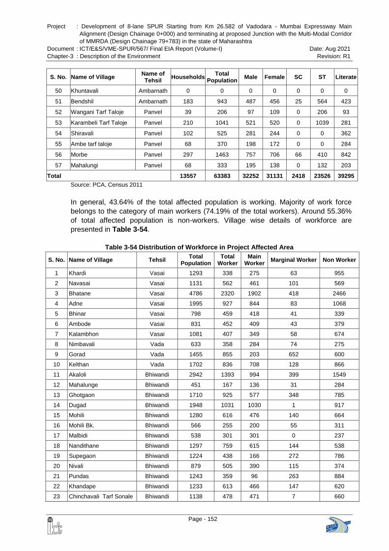
Project : Development of 8-lane SPUR Starting from Km 26.582 of Vadodara - Mumbai Expressway Main
Alignment (Design Chainage 0+000) and terminating at proposed Junction with the Multi-Modal Corridor
of MMRDA (Design Chainage 79+783) in the state of Maharashtra
Document : ICT/E&S/VME-SPUR/567/ Final EIA Report (Volume-I) Date: Aug 2021
Chapter-3 : Description of the Environment Revision: R1
Page - 152
S. No. Name of Village Name of Tehsil
Households Total
Population Male Female SC ST Literate
50 Khuntavali Ambarnath 0 0 0 0 0 0 0
51 Bendshil Ambarnath 183 943 487 456 25 564 423
52 Wangani Tarf Taloje Panvel 39 206 97 109 0 206 93
53 Karambeli Tarf Taloje Panvel 210 1041 521 520 0 1039 281
54 Shiravali Panvel 102 525 281 244 0 0 362
55 Ambe tarf taloje Panvel 68 370 198 172 0 0 284
56 Morbe Panvel 297 1463 757 706 66 410 842
57 Mahalungi Panvel 68 333 195 138 0 132 203
Total 13557 63383 32252 31131 2418 23526 39295
Source: PCA, Census 2011
In general, 43.64% of the total affected population is working. Majority of work force
belongs to the category of main workers (74.19% of the total workers). Around 55.36%
of total affected population is non-workers. Village wise details of workforce are
presented in Table 3-54.
Table 3-54 Distribution of Workforce in Project Affected Area
S. No. Name of Village Tehsil Total
Population Total
Worker Main
Worker Marginal Worker Non Worker
1 Khardi Vasai 1293 338 275 63 955
2 Navasai Vasai 1131 562 461 101 569
3 Bhatane Vasai 4786 2320 1902 418 2466
4 Adne Vasai 1995 927 844 83 1068
5 Bhinar Vasai 798 459 418 41 339
6 Ambode Vasai 831 452 409 43 379
7 Kalambhon Vasai 1081 407 349 58 674
8 Nimbavali Vada 633 358 284 74 275
9 Gorad Vada 1455 855 203 652 600
10 Kelthan Vada 1702 836 708 128 866
11 Akaloli Bhiwandi 2942 1393 994 399 1549
12 Mahalunge Bhiwandi 451 167 136 31 284
13 Ghotgaon Bhiwandi 1710 925 577 348 785
14 Dugad Bhiwandi 1948 1031 1030 1 917
15 Mohili Bhiwandi 1280 616 476 140 664
16 Mohili Bk. Bhiwandi 566 255 200 55 311
17 Malbidi Bhiwandi 538 301 301 0 237
18 Nandithane Bhiwandi 1297 759 615 144 538
19 Supegaon Bhiwandi 1224 438 166 272 786
20 Nivali Bhiwandi 879 505 390 115 374
21 Pundas Bhiwandi 1243 359 96 263 884
22 Khandape Bhiwandi 1233 613 466 147 620
23 Chinchavali Tarf Sonale Bhiwandi 1138 478 471 7 660
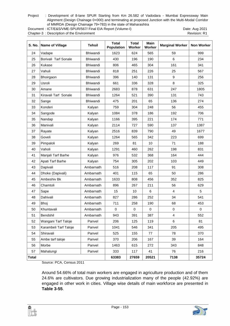
Project : Development of 8-lane SPUR Starting from Km 26.582 of Vadodara - Mumbai Expressway Main
Alignment (Design Chainage 0+000) and terminating at proposed Junction with the Multi-Modal Corridor
of MMRDA (Design Chainage 79+783) in the state of Maharashtra
Document : ICT/E&S/VME-SPUR/567/ Final EIA Report (Volume-I) Date: Aug 2021
Chapter-3 : Description of the Environment Revision: R1
Page - 153
S. No. Name of Village Tehsil Total
Population Total
Worker Main
Worker Marginal Worker Non Worker
24 Vadape Bhiwandi 1623 624 565 59 999
25 Borivali Tarf Sonale Bhiwandi 430 196 190 6 234
26 Kukase Bhiwandi 806 465 304 161 341
27 Vahuli Bhiwandi 818 251 226 25 567
28 Bhoirgaon Bhiwandi 396 140 131 9 256
29 Usroli Bhiwandi 661 336 328 8 325
30 Amane Bhiwandi 2683 878 631 247 1805
31 Kiravali Tarf Sonale Bhiwandi 1264 521 390 131 743
32 Sange Bhiwandi 475 201 65 136 274
33 Konderi Kalyan 759 304 248 56 455
34 Sangode Kalyan 1084 378 186 192 706
35 Nandap Kalyan 1166 395 221 174 771
36 Manivali Kalyan 2114 727 590 137 1387
37 Rayate Kalyan 2516 839 790 49 1677
38 Goveli Kalyan 1264 565 342 223 699
39 Pimpaloli Kalyan 269 81 10 71 188
40 Vaholi Kalyan 1291 460 262 198 831
41 Manjali Tarf Barhe Kalyan 976 532 368 164 444
42 Apati Tarf Barhe Kalyan 754 305 202 103 449
43 Dapivali Ambarnath 516 208 117 91 308
44 Dhoke (Dapivali) Ambarnath 401 115 65 50 286
45 Ambeshiv Bk Ambarnath 1633 808 456 352 825
46 Chamtoli Ambarnath 896 267 211 56 629
47 Sape Ambarnath 15 10 6 4 5
48 Dahivali Ambarnath 827 286 252 34 541
49 Bhoj Ambarnath 711 258 190 68 453
50 Khuntavali Ambarnath 0 0 0 0 0
51 Bendshil Ambarnath 943 391 387 4 552
52 Wangani Tarf Taloje Panvel 206 125 119 6 81
53 Karambeli Tarf Taloje Panvel 1041 546 341 205 495
54 Shiravali Panvel 525 155 77 78 370
55 Ambe tarf taloje Panvel 370 206 167 39 164
56 Morbe Panvel 1463 615 272 343 848
57 Mahalungi Panvel 333 117 41 76 216
Total 63383 27659 20521 7138 35724
Source: PCA, Census 2011
Around 54.66% of total main workers are engaged in agriculture production and of them
24.6% are cultivators. Due growing industrialization many of the people (42.92%) are
engaged in other work in cities. Village wise details of main workforce are presented in
Table 3-55.
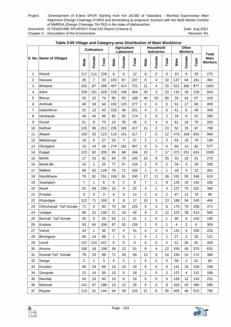
Project : Development of 8-lane SPUR Starting from Km 26.582 of Vadodara - Mumbai Expressway Main
Alignment (Design Chainage 0+000) and terminating at proposed Junction with the Multi-Modal Corridor
of MMRDA (Design Chainage 79+783) in the state of Maharashtra
Document : ICT/E&S/VME-SPUR/567/ Final EIA Report (Volume-I) Date: Aug 2021
Chapter-3 : Description of the Environment Revision: R1
Page - 154
Table 3-55 Village and Category-wise Distribution of Main Workforce
S. No. Name of Villages
Cultivators Agriculture Labourers
Household Industries
Other Workers
Total Main
Workers
Ma
le
Fe
ma
le
To
tal
Ma
le
Fe
ma
le
To
tal
Ma
le
Fe
ma
le
To
tal
Ma
le
Fe
ma
le
To
tal
1 Khardi 117 111 228 6 6 12 6 0 6 23 6 29 275
2 Navasai 26 7 33 150 87 237 6 4 10 137 44 181 461
3 Bhatane 202 87 289 407 314 721 11 4 15 521 356 877 1902
4 Adne 228 101 329 218 146 364 20 3 23 110 18 128 844
5 Bhinar 42 32 74 95 93 188 46 43 89 33 34 67 418
6 Ambode 46 18 64 152 125 277 0 0 0 51 17 68 409
7 Kalambhon 31 12 43 155 96 251 4 2 6 41 8 49 349
8 Nimbavali 46 40 86 82 92 174 2 0 2 16 6 22 284
9 Gorad 61 9 70 10 35 45 5 4 9 61 18 79 203
10 Kelthan 125 86 211 235 182 417 11 2 13 52 15 67 708
11 Akaloli 103 20 123 116 101 217 7 5 12 473 169 642 994
12 Mahalunge 19 8 27 20 7 27 2 1 3 63 16 79 136
13 Ghotgaon 19 19 38 276 181 457 0 0 0 69 13 82 577
14 Dugad 123 82 205 96 88 184 10 7 17 373 251 624 1030
15 Mohili 17 23 40 84 76 160 16 9 25 33 18 51 276
16 Mohili Bk. 24 1 25 77 57 134 2 0 2 34 5 39 200
17 Malbidi 66 62 128 79 71 150 1 0 1 18 4 22 301
18 Nandithane 70 81 151 109 81 190 17 11 28 151 95 246 615
19 Supegaon 7 1 8 6 2 8 7 1 8 126 16 142 166
20 Nivali 91 68 159 16 9 25 3 1 4 127 75 202 390
21 Pundas 3 0 3 9 3 12 2 0 2 67 12 79 96
22 Khandape 122 71 193 9 8 17 10 3 13 189 54 243 466
23 Chinchavali Tarf Sonale 71 9 80 70 55 125 5 3 8 179 79 258 471
24 Vadape 68 32 100 21 19 40 9 3 12 375 38 413 565
25 Borivali Tarf Sonale 25 0 25 50 11 61 1 0 1 95 8 103 190
26 Kukase 93 65 158 87 52 139 1 0 1 4 2 6 304
27 Vahuli 34 1 35 37 4 41 0 0 0 141 9 150 226
28 Bhoirgaon 85 14 99 1 0 1 0 1 1 27 3 30 131
29 Usroli 137 110 247 0 0 0 0 0 0 51 30 81 328
30 Amane 180 18 198 39 12 51 8 4 12 330 40 370 631
31 Kiravali Tarf Sonale 78 20 98 71 28 99 13 6 19 150 24 174 390
32 Sange 2 1 3 0 1 1 0 0 0 58 3 61 65
33 Konderi 40 29 69 10 10 20 0 0 0 141 18 159 248
34 Sangode 21 14 35 13 5 18 2 0 2 127 4 131 186
35 Nandap 44 16 60 10 6 16 5 0 5 128 12 140 221
36 Manivali 141 47 188 13 12 25 5 3 8 326 43 369 590
37 Rayate 113 31 144 64 39 103 21 9 30 465 48 513 790
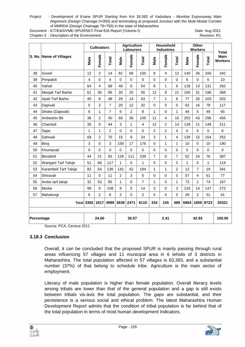
Project : Development of 8-lane SPUR Starting from Km 26.582 of Vadodara - Mumbai Expressway Main
Alignment (Design Chainage 0+000) and terminating at proposed Junction with the Multi-Modal Corridor
of MMRDA (Design Chainage 79+783) in the state of Maharashtra
Document : ICT/E&S/VME-SPUR/567/ Final EIA Report (Volume-I) Date: Aug 2021
Chapter-3 : Description of the Environment Revision: R1
Page - 155
S. No. Name of Villages
Cultivators Agriculture Labourers
Household Industries
Other Workers
Total Main
Workers
Ma
le
Fe
ma
le
To
tal
Ma
le
Fe
ma
le
To
tal
Ma
le
Fe
ma
le
To
tal
Ma
le
Fe
ma
le
To
tal
38 Goveli 12 2 14 82 68 150 8 4 12 140 26 166 342
39 Pimpaloli 4 0 4 0 0 0 0 0 0 6 0 6 10
40 Vaholi 64 4 68 48 6 54 8 1 9 118 13 131 262
41 Manjali Tarf Barhe 61 35 96 30 25 55 12 9 21 165 31 196 368
42 Apati Tarf Barhe 40 8 48 29 14 43 7 1 8 77 26 103 202
43 Dapivali 5 2 7 20 12 32 0 0 0 62 16 78 117
44 Dhoke (Dapivali) 6 1 7 6 2 8 1 0 1 44 5 49 65
45 Ambeshiv Bk 38 2 40 69 36 105 11 4 15 253 43 296 456
46 Chamtoli 35 9 44 3 1 4 12 2 14 128 21 149 211
47 Sape 1 1 2 0 0 0 2 2 4 0 0 0 6
48 Dahivali 68 2 70 15 9 24 3 1 4 139 15 154 252
49 Bhoj 3 0 3 159 17 176 0 1 1 10 0 10 190
50 Khuntavali 0 0 0 0 0 0 0 0 0 0 0 0 0
51 Bendshil 44 21 65 128 111 239 7 0 7 52 24 76 387
52 Wangani Tarf Taloje 51 66 117 1 0 1 0 0 0 1 0 1 119
53 Karambeli Tarf Taloje 82 54 136 142 42 184 1 1 2 12 7 19 341
54 Shiravali 11 0 11 2 3 5 0 0 0 57 4 61 77
55 Ambe tarf taloje 32 53 85 1 6 7 1 0 1 73 1 74 167
56 Morbe 99 9 108 9 5 14 3 0 3 133 14 147 272
57 Mahalungi 6 2 8 2 0 2 0 0 0 29 2 31 41
Total 3382 1617 4999 3639 2471 6110 334 155 489 6864 1859 8723 20321
Percentage 24.60 30.07 2.41 42.93 100.00
Source: PCA, Census 2011
3.18.3 Conclusion
Overall, it can be concluded that the proposed SPUR is mainly passing through rural
areas influencing 57 villages and 11 municipal area in 6 tehsils of 3 districts in
Maharashtra. The total population affected in 57 villages is 63,383, and a substantial
number (37%) of that belong to schedule tribe. Agriculture is the main sector of
employment.
Literacy of male population is higher than female population. Overall literacy levels
among tribals are lower than that of the general population and a gap is still exists
between tribals vis-àvis the total population. The gaps are substantial, and their
persistence is a serious social and ethical problem. The latest Maharashtra Human
Development Report admits that the condition of tribal population is far behind that of
the total population in terms of most human development Indicators.
Project : Development of 8-lane SPUR Starting from Km 26.582 of Vadodara - Mumbai Expressway Main
Alignment (Design Chainage 0+000) and terminating at proposed Junction with the Multi-Modal Corridor
of MMRDA (Design Chainage 79+783) in the state of Maharashtra
Document : ICT/E&S/VME-SPUR/567/ Final EIA Report (Volume-I) Date: Aug 2021
Chapter-3 : Description of the Environment Revision: R1
Page - 156
The proposed project will provide better connectivity; establish linkages between distant
cities; increase employment opportunity and thereby enhance the quality of life. The
construction of the SPUR of Vadodara-Mumbai expressway will also help the farmers in
getting good prices of their produce by way of quick and fast transportation of perishable
goods to the market places. The SPUR connectivity will also help in import of new
techniques of agriculture to the backward areas.
Project : Development of 8-lane SPUR Starting from Km 26.582 of Vadodara - Mumbai Expressway Main
Alignment (Design Chainage 0+000) and terminating at proposed Junction with the Multi-Modal Corridor
of MMRDA (Design Chainage 79+783) in the state of Maharashtra
Document : ICT/E&S/VME-SPUR/567/ Final EIA Report (Volume-I) Date: Aug 2021
Chapter-4 : Anticipated Environmental Impacts and Mitigation Measures Revision: R1
Page - 157
CHAPTER - 4: ANTICIPATED ENVIRONMENTAL IMPACTS AND
MITIGATION MEASURES
4.1 INTRODUCTION
The proposed project will have impacts on the environment in two distinct phases.
During the construction phase which may be regarded as temporary or short-term; the
other during the operation stage which will have long term effects. The negative impacts
can be reduced or minimized only if proper safeguards are put in place during the
design and construction stage itself. These can include reducing pollutant discharge
from the harmful activities at source or protecting the sensitive receptor. An effective
mitigation strategy will utilize a combination of both options to arrive at practically
implementable measures. Conscious efforts have been worked out to minimize any
adverse impacts on the various environmental and social components. Where the
impacts on various environmental components have been unavoidable, mitigation
measures have been worked out.
4.2 LAND ENVIRONMENT
4.2.1 Topography & Geology
4.2.1.1 Construction Phase
The impacts on existing topographical setting originate primarily from embankment
preparation and opening up borrow pits to fulfill the requirement of earth material.
Disfiguration of land may result from unplanned opening up of borrow pits / quarry sites.
Aggregate and sand will be procured from the authorized suppliers and prevalent rules
will be followed for borrowing of soil. Hence the impact on geology of the region outside
the Sanctuary area is insignificant.
Impacts:
Disfiguration & change in existing profile of the land due to proposed greenfield
expressway
Disfiguration of topography due to indiscriminate digging of borrow pits
Uncontrolled digging of borrow pits resulting in water accumulation & breeding of
vector disease
Disturbance on geological setting due to quarrying
Establishment of Construction Camp
Seismological Characteristics of the Area: The proposed expressway is in Zone III
(having moderate seismic intensity) of the Seismic Map of India (as per IS: 1893, Part I,
2002) and therefore has a moderate risk of potential damage due to earthquake. The
bridges are designed for seismic force as per provisions of IRC: 6-2014.
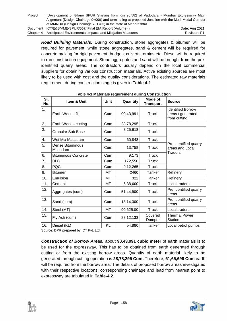
Project : Development of 8-lane SPUR Starting from Km 26.582 of Vadodara - Mumbai Expressway Main
Alignment (Design Chainage 0+000) and terminating at proposed Junction with the Multi-Modal Corridor
of MMRDA (Design Chainage 79+783) in the state of Maharashtra
Document : ICT/E&S/VME-SPUR/567/ Final EIA Report (Volume-I) Date: Aug 2021
Chapter-4 : Anticipated Environmental Impacts and Mitigation Measures Revision: R1
Page - 158
Road Building Materials: During construction, stone aggregates & bitumen will be
required for pavement, while stone aggregates, sand & cement will be required for
concrete making for rigid pavement, bridges, culverts, drains etc. Diesel will be required
to run construction equipment. Stone aggregates and sand will be brought from the pre-
identified quarry areas. The contractors usually depend on the local commercial
suppliers for obtaining various construction materials. Active existing sources are most
likely to be used with cost and the quality considerations. The estimated raw materials
requirement during construction stage is given in Table 4-1.
Table 4-1 Materials requirement during Construction
Sl. No.
Item & Unit Unit Quantity Mode of
Transport Source
1. Earth Work – fill Cum 90,43,991 Truck
Identified Borrow areas / generated from cutting
2. Earth Work – cutting Com 28,78,295 Truck
3. Granular Sub Base Cum
8,25,618
Truck
Pre-identified quarry areas and Local Traders
4. Wet Mix Macadam Cum 60,848 Truck
5. Dense Bituminous Macadam
Cum 13,758 Truck
6. Bituminous Concrete Cum 9,173 Truck
7. DLC Cum 172,550 Truck
8. PQC Cum 9,12,265 Truck
9. Bitumen MT 2460 Tanker Refinery
10. Emulsion MT 322 Tanker Refinery
11. Cement MT 6,38,600 Truck Local traders
12. Aggregates (cum) Cum 51,44,900 Truck
Pre-identified quarry areas
13. Sand (cum) Cum 18,14,300 Truck
Pre-identified quarry areas
14. Steel (MT) MT 90,625.00 Truck Local traders
15. Fly Ash (cum) Cum 83,12,133
Covered Dumper
Thermal Power Station
16. Diesel (KL) KL 54,880 Tanker Local petrol pumps
Source: DPR prepared by ICT Pvt. Ltd.
Construction of Borrow Areas: about 90,43,991 cubic meter of earth materials is to
be used for the expressway. This has to be obtained from earth generated through
cutting or from the existing borrow areas. Quantity of earth material likely to be
generated through cutting operation is 28,78,295 Cum. Therefore, 61,65,696 Cum earth
will be required from the borrow area. The details of proposed borrow areas investigated
with their respective locations; corresponding chainage and lead from nearest point to
expressway are tabulated in Table-4.2.
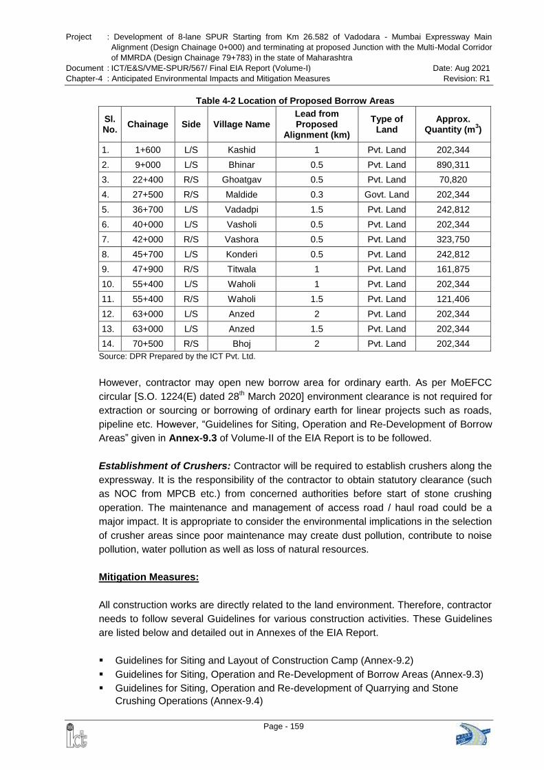
Project : Development of 8-lane SPUR Starting from Km 26.582 of Vadodara - Mumbai Expressway Main
Alignment (Design Chainage 0+000) and terminating at proposed Junction with the Multi-Modal Corridor
of MMRDA (Design Chainage 79+783) in the state of Maharashtra
Document : ICT/E&S/VME-SPUR/567/ Final EIA Report (Volume-I) Date: Aug 2021
Chapter-4 : Anticipated Environmental Impacts and Mitigation Measures Revision: R1
Page - 159
Table 4-2 Location of Proposed Borrow Areas
Sl. No.
Chainage Side Village Name Lead from Proposed
Alignment (km)
Type of Land
Approx. Quantity (m
3)
1. 1+600 L/S Kashid 1 Pvt. Land 202,344
2. 9+000 L/S Bhinar 0.5 Pvt. Land 890,311
3. 22+400 R/S Ghoatgav 0.5 Pvt. Land 70,820
4. 27+500 R/S Maldide 0.3 Govt. Land 202,344
5. 36+700 L/S Vadadpi 1.5 Pvt. Land 242,812
6. 40+000 L/S Vasholi 0.5 Pvt. Land 202,344
7. 42+000 R/S Vashora 0.5 Pvt. Land 323,750
8. 45+700 L/S Konderi 0.5 Pvt. Land 242,812
9. 47+900 R/S Titwala 1 Pvt. Land 161,875
10. 55+400 L/S Waholi 1 Pvt. Land 202,344
11. 55+400 R/S Waholi 1.5 Pvt. Land 121,406
12. 63+000 L/S Anzed 2 Pvt. Land 202,344
13. 63+000 L/S Anzed 1.5 Pvt. Land 202,344
14. 70+500 R/S Bhoj 2 Pvt. Land 202,344
Source: DPR Prepared by the ICT Pvt. Ltd.
However, contractor may open new borrow area for ordinary earth. As per MoEFCC
circular [S.O. 1224(E) dated 28th March 2020] environment clearance is not required for
extraction or sourcing or borrowing of ordinary earth for linear projects such as roads,
pipeline etc. However, “Guidelines for Siting, Operation and Re-Development of Borrow
Areas” given in Annex-9.3 of Volume-II of the EIA Report is to be followed.
Establishment of Crushers: Contractor will be required to establish crushers along the
expressway. It is the responsibility of the contractor to obtain statutory clearance (such
as NOC from MPCB etc.) from concerned authorities before start of stone crushing
operation. The maintenance and management of access road / haul road could be a
major impact. It is appropriate to consider the environmental implications in the selection
of crusher areas since poor maintenance may create dust pollution, contribute to noise
pollution, water pollution as well as loss of natural resources.
Mitigation Measures:
All construction works are directly related to the land environment. Therefore, contractor
needs to follow several Guidelines for various construction activities. These Guidelines
are listed below and detailed out in Annexes of the EIA Report.
Guidelines for Siting and Layout of Construction Camp (Annex-9.2)
Guidelines for Siting, Operation and Re-Development of Borrow Areas (Annex-9.3)
Guidelines for Siting, Operation and Re-development of Quarrying and Stone
Crushing Operations (Annex-9.4)
Project : Development of 8-lane SPUR Starting from Km 26.582 of Vadodara - Mumbai Expressway Main
Alignment (Design Chainage 0+000) and terminating at proposed Junction with the Multi-Modal Corridor
of MMRDA (Design Chainage 79+783) in the state of Maharashtra
Document : ICT/E&S/VME-SPUR/567/ Final EIA Report (Volume-I) Date: Aug 2021
Chapter-4 : Anticipated Environmental Impacts and Mitigation Measures Revision: R1
Page - 160
Guidelines for Siting and Management of Debris Disposal Site (Annex-9.8)
Guidelines for Preparing Comprehensive Waste Management Plan (Annex-9.9)
Some of the important provisions are given below:
Earthquake resistance structures with seismic restrainers are being planned to be
constructed under the project as per IRC: 6-2014. Design of all structures like
bridges and cross drainage structures have taken the area‟s seismic characteristics
into account.
Opening up new borrow pits will be in accordance with the IRC: 10-1961
specifications. Topsoil from the new borrow pits should be preserved and reused in
restoring the pits to the satisfaction of the Authority Engineer (AE). Opening up of
new borrow pits will be restricted to 1 m depth followed by resurfacing of pits with
top soil (15 cm).
No borrow pits will be allowed within 1.0 km of the forest area.
Uncontrolled digging of borrow pits will be avoided to prevent water accumulation in
abandoned pits which results in breeding ground of vector disease.
Construction materials will be procured from existing approved and licensed quarries
only where crusher is already operating. Therefore, mitigative measure for the
environmental impacts due to quarrying and rehabilitation plan of the quarries is the
responsibility and scope of the licence holder of the quarry.
On owner‟s choice, borrow pits will be converted to water bodies (pond) with proper
landscaping (i.e. rectangular in shape, proper sloping and plantation on the bank)
which will add scenic beauty in those localities.
4.2.1.2 Operation Phase
During operation phase of the expressway, no impact is anticipated on the topography
and geology of the area.
4.2.2 Soil
Impacts:
Soil Erosion: Erosion of topsoil can be considered a moderate, direct and long term
negative impact resulting from construction and maintenance of the expressway.
Erosion problems may occur on newly constructed slops and fills depending on the soil
type, angle of slope, height of slope and climatic factors like wind (direction, speed &
frequency) and rain (intensity & duration). Total length of embankment is 70.617 km and
average height of embankment is more than 3.5 m throughout the expressway. Slope
protection measures (stone pitching or turfing with Coir Geotextile & Vetiver grasses)
form part of good engineering practice and therefore, it has been proposed.
Construction of Bridges & Culverts: Along the expressway a number of bridges (7
major bridges, 6 major bridges cum viaduct and 23 minor bridges) and culverts (238)
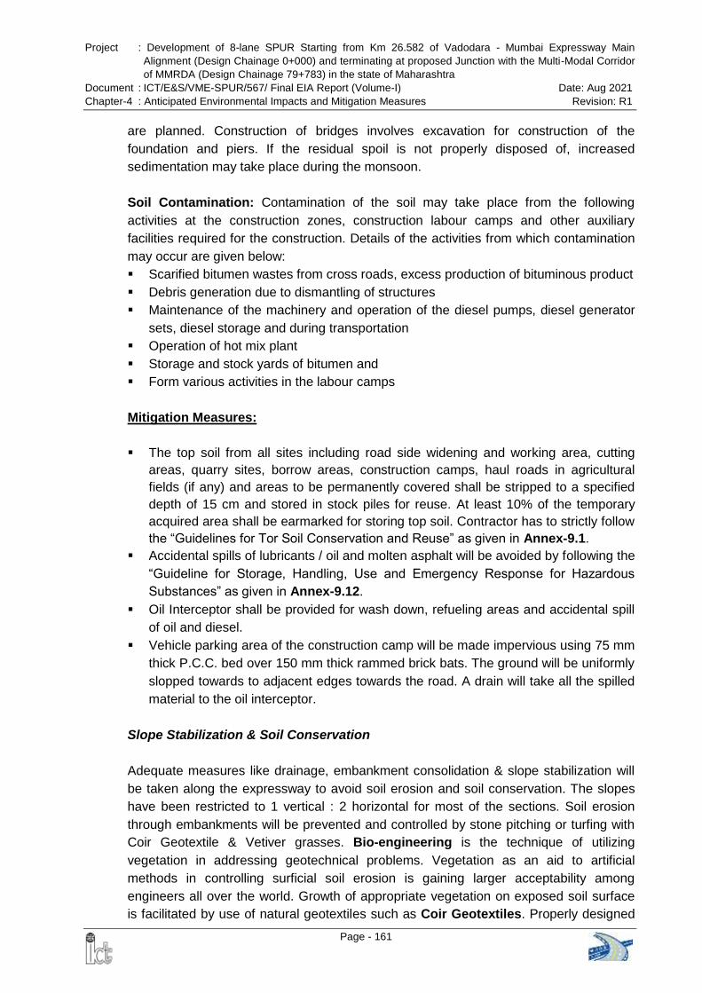
Project : Development of 8-lane SPUR Starting from Km 26.582 of Vadodara - Mumbai Expressway Main
Alignment (Design Chainage 0+000) and terminating at proposed Junction with the Multi-Modal Corridor
of MMRDA (Design Chainage 79+783) in the state of Maharashtra
Document : ICT/E&S/VME-SPUR/567/ Final EIA Report (Volume-I) Date: Aug 2021
Chapter-4 : Anticipated Environmental Impacts and Mitigation Measures Revision: R1
Page - 161
are planned. Construction of bridges involves excavation for construction of the
foundation and piers. If the residual spoil is not properly disposed of, increased
sedimentation may take place during the monsoon.
Soil Contamination: Contamination of the soil may take place from the following
activities at the construction zones, construction labour camps and other auxiliary
facilities required for the construction. Details of the activities from which contamination
may occur are given below:
Scarified bitumen wastes from cross roads, excess production of bituminous product
Debris generation due to dismantling of structures
Maintenance of the machinery and operation of the diesel pumps, diesel generator
sets, diesel storage and during transportation
Operation of hot mix plant
Storage and stock yards of bitumen and
Form various activities in the labour camps
Mitigation Measures:
The top soil from all sites including road side widening and working area, cutting
areas, quarry sites, borrow areas, construction camps, haul roads in agricultural
fields (if any) and areas to be permanently covered shall be stripped to a specified
depth of 15 cm and stored in stock piles for reuse. At least 10% of the temporary
acquired area shall be earmarked for storing top soil. Contractor has to strictly follow
the “Guidelines for Tor Soil Conservation and Reuse” as given in Annex-9.1.
Accidental spills of lubricants / oil and molten asphalt will be avoided by following the
“Guideline for Storage, Handling, Use and Emergency Response for Hazardous
Substances” as given in Annex-9.12.
Oil Interceptor shall be provided for wash down, refueling areas and accidental spill
of oil and diesel.
Vehicle parking area of the construction camp will be made impervious using 75 mm
thick P.C.C. bed over 150 mm thick rammed brick bats. The ground will be uniformly
slopped towards to adjacent edges towards the road. A drain will take all the spilled
material to the oil interceptor.
Slope Stabilization & Soil Conservation
Adequate measures like drainage, embankment consolidation & slope stabilization will
be taken along the expressway to avoid soil erosion and soil conservation. The slopes
have been restricted to 1 vertical : 2 horizontal for most of the sections. Soil erosion
through embankments will be prevented and controlled by stone pitching or turfing with
Coir Geotextile & Vetiver grasses. Bio-engineering is the technique of utilizing
vegetation in addressing geotechnical problems. Vegetation as an aid to artificial
methods in controlling surficial soil erosion is gaining larger acceptability among
engineers all over the world. Growth of appropriate vegetation on exposed soil surface
is facilitated by use of natural geotextiles such as Coir Geotextiles. Properly designed
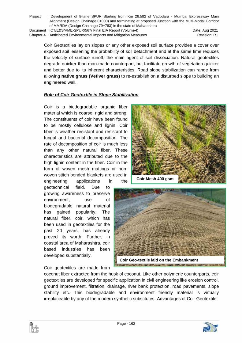
Project : Development of 8-lane SPUR Starting from Km 26.582 of Vadodara - Mumbai Expressway Main
Alignment (Design Chainage 0+000) and terminating at proposed Junction with the Multi-Modal Corridor
of MMRDA (Design Chainage 79+783) in the state of Maharashtra
Document : ICT/E&S/VME-SPUR/567/ Final EIA Report (Volume-I) Date: Aug 2021
Chapter-4 : Anticipated Environmental Impacts and Mitigation Measures Revision: R1
Page - 162
Coir Geo-textile laid on the Embankment
Coir Mesh 400 gsm
Coir Geotextiles lay on slopes or any other exposed soil surface provides a cover over
exposed soil lessening the probability of soil detachment and at the same time reduces
the velocity of surface runoff, the main agent of soil dissociation. Natural geotextiles
degrade quicker than man-made counterpart, but facilitate growth of vegetation quicker
and better due to its inherent characteristics. Road slope stabilization can range from
allowing native grass (Vetiver grass) to re-establish on a disturbed slope to building an
engineered wall.
Role of Coir Geotextile in Slope Stabilization
Coir is a biodegradable organic fiber
material which is coarse, rigid and strong.
The constituents of coir have been found
to be mostly cellulose and lignin. Coir
fiber is weather resistant and resistant to
fungal and bacterial decomposition. The
rate of decomposition of coir is much less
than any other natural fiber. These
characteristics are attributed due to the
high lignin content in the fiber. Coir in the
form of woven mesh mattings or non-
woven stitch bonded blankets are used in
engineering applications in the
geotechnical field. Due to
growing awareness to preserve
environment, use of
biodegradable natural material
has gained popularity. The
natural fiber, coir, which has
been used in geotextiles for the
past 20 years, has already
proved its worth. Further, in
coastal area of Maharashtra, coir
based industries has been
developed substantially.
Coir geotextiles are made from
coconut fiber extracted from the husk of coconut. Like other polymeric counterparts, coir
geotextiles are developed for specific application in civil engineering like erosion control,
ground improvement, filtration, drainage, river bank protection, road pavements, slope
stability etc. This biodegradable and environment friendly material is virtually
irreplaceable by any of the modern synthetic substitutes. Advantages of Coir Geotextile:
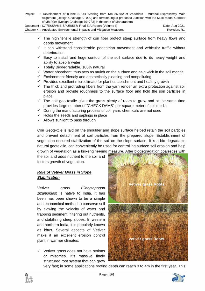
Project : Development of 8-lane SPUR Starting from Km 26.582 of Vadodara - Mumbai Expressway Main
Alignment (Design Chainage 0+000) and terminating at proposed Junction with the Multi-Modal Corridor
of MMRDA (Design Chainage 79+783) in the state of Maharashtra
Document : ICT/E&S/VME-SPUR/567/ Final EIA Report (Volume-I) Date: Aug 2021
Chapter-4 : Anticipated Environmental Impacts and Mitigation Measures Revision: R1
Page - 163
Vetiver grass Roots
Vetiver grass Roots
The high tensile strength of coir fiber protect steep surface from heavy flows and
debris movement
It can withstand considerable pedestrian movement and vehicular traffic without
deterioration
Easy to install and huge contour of the soil surface due to its heavy weight and
ability to absorb water
Totally Biodegradable, 100% natural
Water absorbent, thus acts as mulch on the surface and as a wick in the soil mantle
Environment friendly and aesthetically pleasing and nonpolluting
Provides excellent microclimate for plant establishment and healthy growth
The thick and protruding fibers from the yarn render an extra protection against soil
erosion and provide roughness to the surface floor and hold the soil particles in
place.
The coir geo textile gives the grass plenty of room to grow and at the same time
provides large number of "CHECK DAMS" per square meter of soil media
During the manufacturing process of coir yarn, chemicals are not used
Holds the seeds and saplings in place
Allows sunlight to pass through
Coir Geotextile is laid on the shoulder and slope surface helped retain the soil particles
and prevent detachment of soil particles from the prepared slope. Establishment of
vegetation ensured stabilization of the soil on the slope surface. It is a bio-degradable
natural geotextile, can conveniently be used for controlling surface soil erosion and help
growth of vegetation as a bio-engineering measure. After biodegradation coalesces with
the soil and adds nutrient to the soil and
fosters growth of vegetation.
Role of Vetiver Grass in Slope
Stabilization
Vetiver grass (Chrysopogon
zizanioides) is native to India. It has
been has been shown to be a simple
and economical method to conserve soil
by slowing the velocity of water and
trapping sediment, filtering out nutrients,
and stabilizing steep slopes. In western
and northern India, it is popularly known
as khus. Several aspects of Vetiver
make it an excellent erosion control
plant in warmer climates:
Vetiver grass does not have stolons
or rhizomes. It‟s massive finely
structured root system that can grow
very fast; in some applications rooting depth can reach 3 to 4m in the first year. This
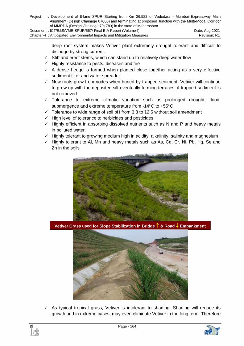
Project : Development of 8-lane SPUR Starting from Km 26.582 of Vadodara - Mumbai Expressway Main
Alignment (Design Chainage 0+000) and terminating at proposed Junction with the Multi-Modal Corridor
of MMRDA (Design Chainage 79+783) in the state of Maharashtra
Document : ICT/E&S/VME-SPUR/567/ Final EIA Report (Volume-I) Date: Aug 2021
Chapter-4 : Anticipated Environmental Impacts and Mitigation Measures Revision: R1
Page - 164
deep root system makes Vetiver plant extremely drought tolerant and difficult to
dislodge by strong current.
Stiff and erect stems, which can stand up to relatively deep water flow
Highly resistance to pests, diseases and fire
A dense hedge is formed when planted close together acting as a very effective
sediment filter and water spreader
New roots grow from nodes when buried by trapped sediment. Vetiver will continue
to grow up with the deposited silt eventually forming terraces, if trapped sediment is
not removed.
Tolerance to extreme climatic variation such as prolonged drought, flood,
submergence and extreme temperature from -14C to +55C
Tolerance to wide range of soil pH from 3.3 to 12.5 without soil amendment
High level of tolerance to herbicides and pesticides
Highly efficient in absorbing dissolved nutrients such as N and P and heavy metals
in polluted water.
Highly tolerant to growing medium high in acidity, alkalinity, salinity and magnesium
Highly tolerant to Al, Mn and heavy metals such as As, Cd, Cr, Ni, Pb, Hg, Se and
Zn in the soils
As typical tropical grass, Vetiver is intolerant to shading. Shading will reduce its
growth and in extreme cases, may even eliminate Vetiver in the long term. Therefore
Vetiver Grass used for Slope Stabilization in Bridge & Road Embankment

Project : Development of 8-lane SPUR Starting from Km 26.582 of Vadodara - Mumbai Expressway Main
Alignment (Design Chainage 0+000) and terminating at proposed Junction with the Multi-Modal Corridor
of MMRDA (Design Chainage 79+783) in the state of Maharashtra
Document : ICT/E&S/VME-SPUR/567/ Final EIA Report (Volume-I) Date: Aug 2021
Chapter-4 : Anticipated Environmental Impacts and Mitigation Measures Revision: R1
Page - 165
Vetiver grows best in the open and weed free environment, weed control may be
needed during establishment phase. On erodible or unstable ground Vetiver first
reduces erosion, stabilizes the erodible ground (particularly steep slopes), then
because of nutrient and moisture conservation, improves its microenvironment so
other volunteered or sown plants can establish later. Because of these
characteristics Vetiver can be considered as a nurse plant on disturbed lands.
Vetiver is useful to treat pollution due to its capacity to quickly absorb nutrients and
heavy metals, and its tolerance to elevated levels of these elements. Although the
concentrations of these elements in Vetiver plants is often not as high as those of
hyper-accumulators, it‟s very fast growth and high yield allows Vetiver to remove a
much higher volume of nutrients and heavy metals from contaminated lands than
most hyper-accumulators.
When planted closely together, Vetiver plants form dense hedges that reduce flow
velocity, spread and divert runoff water and create a very effective filter that controls
erosion. The hedges slow down the flow and spreads it out, allowing more time for
water to soak into the ground.
Acting as a very effective filter, Vetiver hedges help to reduce the turbidity of surface
run-off. Since new roots develop from nodes when buried by trapped sediment,
Vetiver continues to rise with the new ground level. Terraces form at the face of the
hedges, this sediment should never be removed. The fertile sediment typically
contains seeds of local plants, which facilitates their re-establishment
4.2.3 Land Use
4.2.3.1 Construction Phase
The proposed expressway will lead to change in land use pattern of areas that comes
under the proposed ROW. Agricultural and allied uses occupied 63.93% of the total
area, followed by followed by barren / waste land (16.06%), forest (11.91%), Industrial
Area (4.31%), built-up area (2.46%) and water bodies (1.33%).
Preparatory activities like clearing of ROW, construction of temporary construction
camps, storage of construction materials etc. will be confined within the camp & PROW.
This will not hamper the land use aspects outside ROW. However, indirectly there may
be some change in the land use pattern of the proximate area due to influx of
construction work-force and supplier who are likely to construct temporary tents in the
vicinity.
Impacts:
Changes in existing land use pattern of the PROW for construction of the
expressway
Loss of agricultural land, forest land etc. due to land acquisition
Project : Development of 8-lane SPUR Starting from Km 26.582 of Vadodara - Mumbai Expressway Main
Alignment (Design Chainage 0+000) and terminating at proposed Junction with the Multi-Modal Corridor
of MMRDA (Design Chainage 79+783) in the state of Maharashtra
Document : ICT/E&S/VME-SPUR/567/ Final EIA Report (Volume-I) Date: Aug 2021
Chapter-4 : Anticipated Environmental Impacts and Mitigation Measures Revision: R1
Page - 166
Mitigation Measures:
Earth material generated from excavation shall be reused to the maximum possible
extent as filling material during site development.
Construction debris shall be disposed of by mechanical transport in suitable pre-
identified (jointly by project proponent & local administration) dumping areas in tune
with the local condition to avoid land degradation & water logging due to
indiscriminate dumping.
Siting and management of debris disposal site shall be as per the guideline provided
in Annex-9.8.
Construction camp shall be provided for construction personnel to avoid
indiscriminate settlement of construction workers & labourers.
Regular inspection of haul roads and construction site shall be carried out to ensure
regular and timely removal of construction debris to the designated dumping sites.
Construction activities shall be kept confined to PROW only.
4.2.3.2 Operation Phase
Impacts:
Likely change of land use due to squatter / encroachment within ROW
Likely change of land use due to induced development outside the ROW
Mitigation Measures:
Fencing has been proposed along the ROW boundary of the entire expressway
Immediately after the construction phase, it is necessary to ensure that no further
deterioration or major land use changes such as ribbon development takes place in
a manner that will jeopardize the interests of the State.
Squatter development along the expressway shall be strictly avoided by proper
regulation and vigilance.
Land use control measures shall be prepared & administered to avoid occurrence of
induced development as far as possible.
Planning agencies and Collector/ Revenue Officer shall be made involved for
controlled development and prohibiting squatter / encroachment within ROW.
4.3 WATER ENVIRONMENT
4.3.1 Drainage & Hydrological Flow
Impacts:
The alignment of the proposed Greenfield expressway crosses Tansa River,
Murumla Nadi, Kamvadi River, Bhatsa River, Kalu River, Barvi River, Ulhas River &
streams at several locations.
Project : Development of 8-lane SPUR Starting from Km 26.582 of Vadodara - Mumbai Expressway Main
Alignment (Design Chainage 0+000) and terminating at proposed Junction with the Multi-Modal Corridor
of MMRDA (Design Chainage 79+783) in the state of Maharashtra
Document : ICT/E&S/VME-SPUR/567/ Final EIA Report (Volume-I) Date: Aug 2021
Chapter-4 : Anticipated Environmental Impacts and Mitigation Measures Revision: R1
Page - 167
Increased incidence and duration of floods due to obstruction of natural drainage
courses by the embankment
Chances of filling of existing drainage courses during earth filling
Establishments of construction camps and various plants such as hot mix plant,
batching & asphalt mixing plants etc. drainage impacts at these locations may result
in loss of top soil.
Mitigation Measures:
A pond is located at chainage 37+420. Major bridges has been proposed at this
location. Hence, there will be no impact on pond.
To minimize the impact drainage & hydrological flow, 13 major bridges, 23 minor
bridges, 238 culverts are proposed to be constructed along the expressway. It has
been ensured that free flow of water is maintained wherever the expressway
alignment crosses river / local streams / nallah etc.
It has been ensured that all the 1st and 2nd order streams crossing the proposed
expressway alignment provided with necessary culverts, mirror bridges and major
bridges with minimum capacity of 20% excess discharge. Hydrological
Computation of 1st order streams and 2nd order streams are presented in Table 4-3
and Table 4-4 respectively.
Design made to avoid physical loss to the water bodies to the extent possible.
Scope for further design modification is being explored to minimize the physical loss
of the pond likely to be partially affected due to proposed alignment. Compensatory
digging (in case acquisition is unavoidable) to the other side of pond is proposed to
prevent the volumetric capacity loss.
Silt fencing shall be provided between expressway and water bodies to avoid any
siltation due to runoff from construction area
Shoulder and toe drains shall be provided along the expressway to facilitate its
better maintenance and increase in the life of the carriageway. This will also help in
avoiding soil erosion and land degradation due to water stagnation on the either side
of the expressway.
Detailed drainage survey and hydrological investigations have been carried out and
accordingly capacity of cross drainage (CD) structures have been designed to
accommodate high discharges to avoid flooding & formation of water pool
All bridges have been designed for a return period of 100 years and culverts have
been designed for a return period of 50 years
Construction works of culverts and bridge (cross drainage structures) are taken up
during the lean flow periods in summer to minimize the impacts on drainage.
Construction work near natural drainage channels have to be carried out in such a
way that flow of water is not blocked and even if it has to be blocked then the
contractor must ensure that the local communities are informed about the same in
advance
Suitable drainage at construction camp will be provided to eliminate the chances of
formation of stagnant water pools that leads to soil erosion & breeding of
mosquitoes
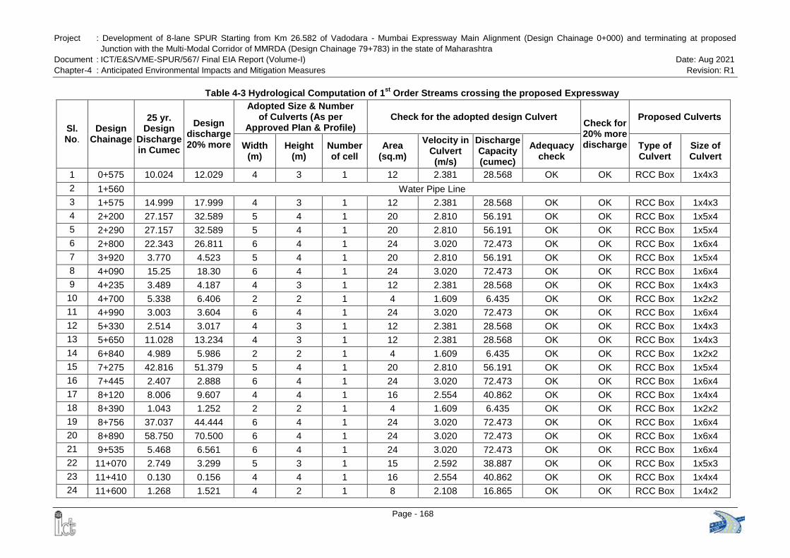
Project : Development of 8-lane SPUR Starting from Km 26.582 of Vadodara - Mumbai Expressway Main Alignment (Design Chainage 0+000) and terminating at proposed
Junction with the Multi-Modal Corridor of MMRDA (Design Chainage 79+783) in the state of Maharashtra
Document : ICT/E&S/VME-SPUR/567/ Final EIA Report (Volume-I) Date: Aug 2021
Chapter-4 : Anticipated Environmental Impacts and Mitigation Measures Revision: R1
Page - 168
Table 4-3 Hydrological Computation of 1st
Order Streams crossing the proposed Expressway
Sl. No.
Design Chainage
25 yr. Design
Discharge in Cumec
Design discharge 20% more
Adopted Size & Number of Culverts (As per
Approved Plan & Profile) Check for the adopted design Culvert
Check for 20% more discharge
Proposed Culverts
Width (m)
Height (m)
Number of cell
Area (sq.m)
Velocity in Culvert (m/s)
Discharge Capacity (cumec)
Adequacy check
Type of Culvert
Size of Culvert
1 0+575 10.024 12.029 4 3 1 12 2.381 28.568 OK OK RCC Box 1x4x3
2 1+560 Water Pipe Line
3 1+575 14.999 17.999 4 3 1 12 2.381 28.568 OK OK RCC Box 1x4x3
4 2+200 27.157 32.589 5 4 1 20 2.810 56.191 OK OK RCC Box 1x5x4
5 2+290 27.157 32.589 5 4 1 20 2.810 56.191 OK OK RCC Box 1x5x4
6 2+800 22.343 26.811 6 4 1 24 3.020 72.473 OK OK RCC Box 1x6x4
7 3+920 3.770 4.523 5 4 1 20 2.810 56.191 OK OK RCC Box 1x5x4
8 4+090 15.25 18.30 6 4 1 24 3.020 72.473 OK OK RCC Box 1x6x4
9 4+235 3.489 4.187 4 3 1 12 2.381 28.568 OK OK RCC Box 1x4x3
10 4+700 5.338 6.406 2 2 1 4 1.609 6.435 OK OK RCC Box 1x2x2
11 4+990 3.003 3.604 6 4 1 24 3.020 72.473 OK OK RCC Box 1x6x4
12 5+330 2.514 3.017 4 3 1 12 2.381 28.568 OK OK RCC Box 1x4x3
13 5+650 11.028 13.234 4 3 1 12 2.381 28.568 OK OK RCC Box 1x4x3
14 6+840 4.989 5.986 2 2 1 4 1.609 6.435 OK OK RCC Box 1x2x2
15 7+275 42.816 51.379 5 4 1 20 2.810 56.191 OK OK RCC Box 1x5x4
16 7+445 2.407 2.888 6 4 1 24 3.020 72.473 OK OK RCC Box 1x6x4
17 8+120 8.006 9.607 4 4 1 16 2.554 40.862 OK OK RCC Box 1x4x4
18 8+390 1.043 1.252 2 2 1 4 1.609 6.435 OK OK RCC Box 1x2x2
19 8+756 37.037 44.444 6 4 1 24 3.020 72.473 OK OK RCC Box 1x6x4
20 8+890 58.750 70.500 6 4 1 24 3.020 72.473 OK OK RCC Box 1x6x4
21 9+535 5.468 6.561 6 4 1 24 3.020 72.473 OK OK RCC Box 1x6x4
22 11+070 2.749 3.299 5 3 1 15 2.592 38.887 OK OK RCC Box 1x5x3
23 11+410 0.130 0.156 4 4 1 16 2.554 40.862 OK OK RCC Box 1x4x4
24 11+600 1.268 1.521 4 2 1 8 2.108 16.865 OK OK RCC Box 1x4x2
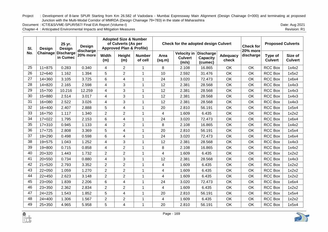
Project : Development of 8-lane SPUR Starting from Km 26.582 of Vadodara - Mumbai Expressway Main Alignment (Design Chainage 0+000) and terminating at proposed
Junction with the Multi-Modal Corridor of MMRDA (Design Chainage 79+783) in the state of Maharashtra
Document : ICT/E&S/VME-SPUR/567/ Final EIA Report (Volume-I) Date: Aug 2021
Chapter-4 : Anticipated Environmental Impacts and Mitigation Measures Revision: R1
Page - 169
Sl. No.
Design Chainage
25 yr. Design
Discharge in Cumec
Design discharge 20% more
Adopted Size & Number of Culverts (As per
Approved Plan & Profile) Check for the adopted design Culvert
Check for 20% more discharge
Proposed Culverts
Width (m)
Height (m)
Number of cell
Area (sq.m)
Velocity in Culvert (m/s)
Discharge Capacity (cumec)
Adequacy check
Type of Culvert
Size of Culvert
25 11+875 0.283 0.340 4 2 1 8 2.108 16.865 OK OK RCC Box 1x4x2
26 12+640 1.162 1.394 5 2 1 10 2.592 31.476 OK OK RCC Box 1x5x2
27 14+360 3.105 3.725 6 4 1 24 3.020 72.473 OK OK RCC Box 1x6x4
28 14+820 2.165 2.598 4 3 1 12 2.381 28.568 OK OK RCC Box 1x4x3
29 15+700 10.216 12.259 4 3 1 12 2.381 28.568 OK OK RCC Box 1x4x3
30 15+880 2.514 3.017 4 3 1 12 2.381 28.568 OK OK RCC Box 1x4x3
31 16+080 2.522 3.026 4 3 1 12 2.381 28.568 OK OK RCC Box 1x4x3
32 16+400 2.407 2.888 5 4 1 20 2.810 56.191 OK OK RCC Box 1x5x4
33 16+750 1.117 1.340 2 2 1 4 1.609 6.435 OK OK RCC Box 1x2x2
34 17+022 1.795 2.153 6 4 1 24 3.020 72.473 OK OK RCC Box 1x6x4
35 17+310 0.945 1.133 4 2 1 8 2.108 16.865 OK OK RCC Box 1x4x2
36 17+725 2.808 3.369 5 4 1 20 2.810 56.191 OK OK RCC Box 1x5x4
37 19+290 0.498 0.598 6 4 1 24 3.020 72.473 OK OK RCC Box 1x6x4
38 19+575 1.043 1.252 4 3 1 12 2.381 28.568 OK OK RCC Box 1x4x3
39 19+800 0.715 0.858 4 2 1 8 2.108 16.865 OK OK RCC Box 1x4x2
40 20+320 1.443 1.732 2 2 1 4 1.609 6.435 OK OK RCC Box 1x2x2
41 20+550 0.734 0.880 4 3 1 12 2.381 28.568 OK OK RCC Box 1x4x3
42 21+520 2.793 3.352 2 2 1 4 1.609 6.435 OK OK RCC Box 1x2x2
43 22+050 1.059 1.270 2 2 1 4 1.609 6.435 OK OK RCC Box 1x2x2
44 22+450 2.623 3.148 2 2 1 4 1.609 6.435 OK OK RCC Box 1x2x2
45 23+050 1.839 2.206 6 4 1 24 3.020 72.473 OK OK RCC Box 1x6x4
46 23+350 2.362 2.834 2 2 1 4 1.609 6.435 OK OK RCC Box 1x2x2
47 24+225 1.543 1.852 5 4 1 20 2.810 56.191 OK OK RCC Box 1x5x4
48 24+400 1.306 1.567 2 2 1 4 1.609 6.435 OK OK RCC Box 1x2x2
49 25+350 4.965 5.958 5 4 1 20 2.810 56.191 OK OK RCC Box 1x5x4

Project : Development of 8-lane SPUR Starting from Km 26.582 of Vadodara - Mumbai Expressway Main Alignment (Design Chainage 0+000) and terminating at proposed
Junction with the Multi-Modal Corridor of MMRDA (Design Chainage 79+783) in the state of Maharashtra
Document : ICT/E&S/VME-SPUR/567/ Final EIA Report (Volume-I) Date: Aug 2021
Chapter-4 : Anticipated Environmental Impacts and Mitigation Measures Revision: R1
Page - 170
Sl. No.
Design Chainage
25 yr. Design
Discharge in Cumec
Design discharge 20% more
Adopted Size & Number of Culverts (As per
Approved Plan & Profile) Check for the adopted design Culvert
Check for 20% more discharge
Proposed Culverts
Width (m)
Height (m)
Number of cell
Area (sq.m)
Velocity in Culvert (m/s)
Discharge Capacity (cumec)
Adequacy check
Type of Culvert
Size of Culvert
50 25+760 2.462 2.954 4 2 1 8 2.108 16.865 OK OK RCC Box 1x4x2
51 26+000 8.372 10.046 4 3 1 12 2.381 28.568 OK OK RCC Box 1x4x3
52 26+350 3.453 4.143 2 2 1 4 1.609 6.435 OK OK RCC Box 1x2x2
53 27+093 0.779 0.934 5 4 1 20 2.810 56.191 OK OK RCC Box 1x5x4
54 27+275 0.394 0.473 5 4 1 20 2.810 56.191 OK OK RCC Box 1x5x4
55 27+650 1.819 2.183 5 4 1 20 2.810 56.191 OK OK RCC Box 1x5x4
56 28+140 0.452 0.543 5 4 1 20 2.810 56.191 OK OK RCC Box 1x5x4
57 28+365 2.107 2.529 4 3 1 12 2.381 28.568 OK OK RCC Box 1x4x3
58 29+100 2.165 2.598 2 2 1 4 1.609 6.435 OK OK RCC Box 1x2x2
59 29+420 1.066 1.280 2 2 1 4 1.609 6.435 OK OK RCC Box 1x2x2
60 29+590 0.888 1.066 4 3 1 12 2.381 28.568 OK OK RCC Box 1x4x3
61 30+110 8.148 9.778 5 4 1 20 2.810 56.191 OK OK RCC Box 1x5x4
62 30+625 5.206 6.247 2 2 1 4 1.609 6.435 OK OK RCC Box 1x2x2
63 31+730 1.369 1.642 2 2 1 4 1.609 6.435 OK OK RCC Box 1x2x2
64 31+965 1.419 1.702 4 3 1 12 2.381 28.568 OK OK RCC Box 1x4x3
65 32+450 1.046 1.256 4 3 1 12 2.381 28.568 OK OK RCC Box 1x4x3
66 32+655 1.145 1.374 5 4 1 20 2.810 56.191 OK OK RCC Box 1x5x4
67 33+035 1.641 1.969 2 2 1 4 1.609 6.435 OK OK RCC Box 1x2x2
68 33+800 6.360 7.632 4 3 1 12 2.381 28.568 OK OK RCC Box 1x4x3
69 34+520 1.857 2.229 3 3 1 9 2.108 18.974 OK OK RCC Box 1x3x3
70 35+150 4.955 5.946 5 4 1 20 2.810 56.191 OK OK RCC Box 1x5x4
71 35+220 4.974 5.968 5 3 1 15 2.592 38.887 OK OK RCC Box 1x5x3
72 35+650 3.712 4.454 4 3 1 12 2.381 28.568 OK OK RCC Box 1x4x3
73 35+970 1.240 1.488 4 3 1 12 2.381 28.568 OK OK RCC Box 1x4x3
74 36+440 2.748 3.298 4 3 1 12 2.381 28.568 OK OK RCC Box 1x4x3

Project : Development of 8-lane SPUR Starting from Km 26.582 of Vadodara - Mumbai Expressway Main Alignment (Design Chainage 0+000) and terminating at proposed
Junction with the Multi-Modal Corridor of MMRDA (Design Chainage 79+783) in the state of Maharashtra
Document : ICT/E&S/VME-SPUR/567/ Final EIA Report (Volume-I) Date: Aug 2021
Chapter-4 : Anticipated Environmental Impacts and Mitigation Measures Revision: R1
Page - 171
Sl. No.
Design Chainage
25 yr. Design
Discharge in Cumec
Design discharge 20% more
Adopted Size & Number of Culverts (As per
Approved Plan & Profile) Check for the adopted design Culvert
Check for 20% more discharge
Proposed Culverts
Width (m)
Height (m)
Number of cell
Area (sq.m)
Velocity in Culvert (m/s)
Discharge Capacity (cumec)
Adequacy check
Type of Culvert
Size of Culvert
75 36+610 2.523 3.028 4 2 1 8 2.108 16.865 OK OK RCC Box 1x4x2
76 36+860 3.358 4.030 4 2 1 8 2.108 16.865 OK OK RCC Box 1x4x2
77 37+000 0.825 0.990 4 3 1 12 2.381 28.568 OK OK RCC Box 1x4x3
78 37+210 0.900 1.080 6 4 1 24 3.020 72.473 OK OK RCC Box 1x6x4
79 37+440 2.449 2.939 3 2 1 6 1.902 11.414 OK OK RCC Box 1x3x2
80 38+850 1.995 2.394 5 2 1 10 2.262 22.616 OK OK RCC Box 1x5x2
81 39+030 3.273 3.928 6 4 1 24 3.020 72.473 OK OK RCC Box 1x6x4
82 39+525 3.853 4.624 4 3 1 12 2.381 28.568 OK OK RCC Box 1x4x3
83 39+785 7.041 8.449 5 3 1 15 2.592 38.887 OK OK RCC Box 1x5x3
84 40+190 5.143 6.172 4 3 1 12 2.381 28.568 OK OK RCC Box 1x4x3
85 40+400 0.632 0.759 4 3 1 12 2.381 28.568 OK OK RCC Box 1x4x3
86 40+750 9.995 11.993 4 3 1 12 2.381 28.568 OK OK RCC Box 1x4x3
87 41+150 1.581 1.897 4 2 1 8 2.108 16.865 OK OK RCC Box 1x4x2
88 41+495 3.674 4.409 5 4 1 20 2.810 56.191 OK OK RCC Box 1x5x4
89 42+025 4.827 5.792 4 3 1 12 2.381 28.568 OK OK RCC Box 1x4x3
90 43+120 3.239 3.886 3 2 1 6 1.902 11.414 OK OK RCC Box 1x3x2
91 43+450 8.263 9.916 5 4 1 20 2.810 56.191 OK OK RCC Box 1x5x4
92 44+280 6.086 7.303 6 4 1 24 3.020 72.473 OK OK RCC Box 1x6x4
93 44+490 1.190 1.427 4 3 1 12 2.381 28.568 OK OK RCC Box 1x4x3
94 44+800 3.105 3.726 6 4 1 24 3.020 72.473 OK OK RCC Box 1x6x4
95 45+190 12.18 14.616 5 4 1 20 2.810 56.191 OK OK RCC Box 1x5x4
96 45+790 1.013 1.216 5 4 1 20 2.810 56.191 OK OK RCC Box 1x5x4
97 46+190 1.101 1.321 6 4 1 24 3.020 72.473 OK OK RCC Box 1x6x4
98 46+560 1.214 1.457 4 2 1 8 2.108 16.865 OK OK RCC Box 1x4x2
99 46+910 0.826 0.992 4 2 1 8 2.108 16.865 OK OK RCC Box 1x4x2

Project : Development of 8-lane SPUR Starting from Km 26.582 of Vadodara - Mumbai Expressway Main Alignment (Design Chainage 0+000) and terminating at proposed
Junction with the Multi-Modal Corridor of MMRDA (Design Chainage 79+783) in the state of Maharashtra
Document : ICT/E&S/VME-SPUR/567/ Final EIA Report (Volume-I) Date: Aug 2021
Chapter-4 : Anticipated Environmental Impacts and Mitigation Measures Revision: R1
Page - 172
Sl. No.
Design Chainage
25 yr. Design
Discharge in Cumec
Design discharge 20% more
Adopted Size & Number of Culverts (As per
Approved Plan & Profile) Check for the adopted design Culvert
Check for 20% more discharge
Proposed Culverts
Width (m)
Height (m)
Number of cell
Area (sq.m)
Velocity in Culvert (m/s)
Discharge Capacity (cumec)
Adequacy check
Type of Culvert
Size of Culvert
100 47+835 1.596 1.916 5 4 1 20 2.810 56.191 OK OK RCC Box 1x5x4
101 48+140 3.092 3.710 5 4 1 20 2.810 56.191 OK OK RCC Box 1x5x4
102 48+720 1.043 1.252 3 2 1 6 1.902 11.414 OK OK RCC Box 1x3x2
103 49+335 1.684 2.021 2 2 1 4 1.609 6.435 OK OK RCC Box 1x2x2
104 50+280 1.008 1.210 4 3 1 12 2.381 28.568 OK OK RCC Box 1x4x3
105 50+890 7.683 9.220 5 4 1 20 2.810 56.191 OK OK RCC Box 1x5x4
106 51+575 1.907 2.288 4 2 1 8 2.108 16.865 OK OK RCC Box 1x4x2
107 52+440 0.967 1.160 6 4 1 24 3.020 72.473 OK OK RCC Box 1x6x4
108 53+130 4.306 5.167 6 4 1 24 3.020 72.473 OK OK RCC Box 1x6x4
109 53+350 5.596 6.715 4 3 1 12 2.381 28.568 OK OK RCC Box 1x4x3
110 53+530 7.327 8.792 4 3 1 12 2.381 28.568 OK OK RCC Box 1x4x3
111 54+470 4.737 5.685 5 4 1 20 2.810 56.191 OK OK RCC Box 1x5x4
112 55+295 1.055 1.266 2 2 1 4 1.609 6.435 OK OK RCC Box 1x2x2
113 56+130 2.039 2.447 5 4 1 20 2.810 56.191 OK OK RCC Box 1x5x4
114 56+475 7.111 8.534 5 4 1 20 2.810 56.191 OK OK RCC Box 1x5x4
115 57+090 4.780 5.736 5 4 1 20 2.810 56.191 OK OK RCC Box 1x5x4
116 57+450 0.651 0.781 2 2 1 4 1.609 6.435 OK OK RCC Box 1x2x2
117 57+930 2.002 2.402 5 4 1 20 2.810 56.191 OK OK RCC Box 1x5x4
118 58+240 1.342 1.611 4 3 1 12 2.381 28.568 OK OK RCC Box 1x4x3
119 58+470 2.855 3.426 5 4 1 20 2.810 56.191 OK OK RCC Box 1x5x4
120 59+400 1.111 1.333 5 4 1 20 2.810 56.191 OK OK RCC Box 1x5x4
121 59+575 0.818 0.982 4 2 1 8 2.108 16.865 OK OK RCC Box 1x4x2
122 59+750 0.972 1.167 4 2 1 8 2.108 16.865 OK OK RCC Box 1x4x2
123 59+900 2.039 2.447 4 3 1 12 2.381 28.568 OK OK RCC Box 1x4x3
124 60+300 1.889 2.266 2 2 1 4 1.609 6.435 OK OK RCC Box 1x2x2
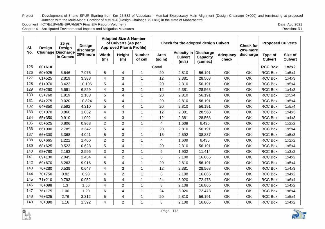
Project : Development of 8-lane SPUR Starting from Km 26.582 of Vadodara - Mumbai Expressway Main Alignment (Design Chainage 0+000) and terminating at proposed
Junction with the Multi-Modal Corridor of MMRDA (Design Chainage 79+783) in the state of Maharashtra
Document : ICT/E&S/VME-SPUR/567/ Final EIA Report (Volume-I) Date: Aug 2021
Chapter-4 : Anticipated Environmental Impacts and Mitigation Measures Revision: R1
Page - 173
Sl. No.
Design Chainage
25 yr. Design
Discharge in Cumec
Design discharge 20% more
Adopted Size & Number of Culverts (As per
Approved Plan & Profile) Check for the adopted design Culvert
Check for 20% more discharge
Proposed Culverts
Width (m)
Height (m)
Number of cell
Area (sq.m)
Velocity in Culvert (m/s)
Discharge Capacity (cumec)
Adequacy check
Type of Culvert
Size of Culvert
125 60+610 Canal RCC Box 1x2x2
126 60+925 6.646 7.975 5 4 1 20 2.810 56.191 OK OK RCC Box 1x5x4
127 61+525 2.819 3.383 4 3 1 12 2.381 28.568 OK OK RCC Box 1x4x3
128 61+970 8.422 10.106 5 4 1 20 2.810 56.191 OK OK RCC Box 1x5x4
129 62+260 5.691 6.829 4 3 1 12 2.381 28.568 OK OK RCC Box 1x4x3
130 63+760 1.819 2.183 5 4 1 20 2.810 56.191 OK OK RCC Box 1x5x4
131 64+275 9.020 10.824 5 4 1 20 2.810 56.191 OK OK RCC Box 1x5x4
132 64+850 3.592 4.310 5 4 1 20 2.810 56.191 OK OK RCC Box 1x5x4
133 65+070 0.860 1.032 4 3 1 12 2.381 28.568 OK OK RCC Box 1x4x3
134 65+350 0.910 1.092 4 3 1 12 2.381 28.568 OK OK RCC Box 1x4x3
135 65+525 0.806 0.968 2 2 1 4 1.609 6.435 OK OK RCC Box 1x2x2
136 66+000 2.785 3.342 5 4 1 20 2.810 56.191 OK OK RCC Box 1x5x4
137 66+300 3.368 4.041 5 3 1 15 2.592 38.887 OK OK RCC Box 1x5x3
138 66+665 1.222 1.466 2 2 1 4 1.609 6.435 OK OK RCC Box 1x2x2
139 68+625 0.523 0.628 5 4 1 20 2.810 56.191 OK OK RCC Box 1x5x4
140 68+780 2.163 2.596 3 2 1 6 1.902 11.414 OK OK RCC Box 1x3x2
141 69+130 2.045 2.454 4 2 1 8 2.108 16.865 OK OK RCC Box 1x4x2
142 69+670 8.263 9.916 5 4 1 20 2.810 56.191 OK OK RCC Box 1x5x4
143 70+280 0.539 0.647 4 3 1 12 2.381 28.568 OK OK RCC Box 1x4x3
144 70+750 0.82 0.98 4 2 1 8 2.108 16.865 OK OK RCC Box 1x4x2
145 71+210 0.793 0.952 6 4 1 24 3.020 72.473 OK OK RCC Box 1x6x4
146 76+098 1.3 1.56 4 2 1 8 2.108 16.865 OK OK RCC Box 1x4x2
147 76+175 1.00 1.20 6 4 1 24 3.020 72.473 OK OK RCC Box 1x6x4
148 76+325 2.76 3.312 5 4 1 20 2.810 56.191 OK OK RCC Box 1x5x4
149 76+390 1.16 1.392 4 2 1 8 2.108 16.865 OK OK RCC Box 1x4x2
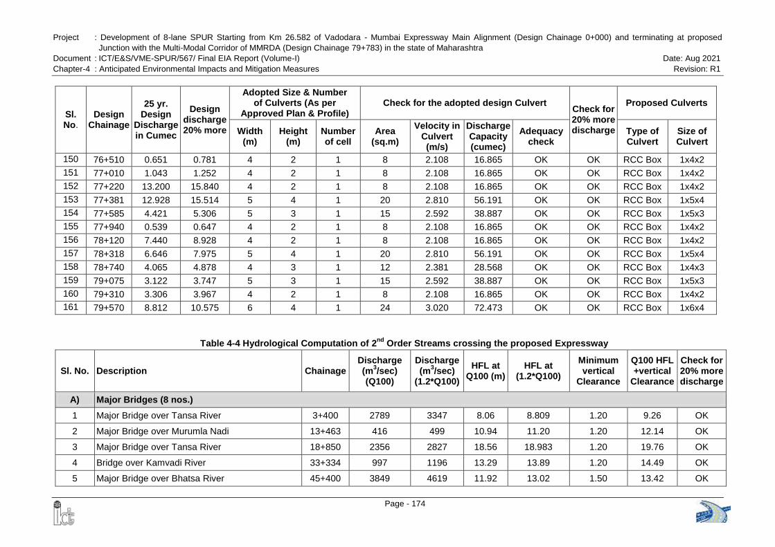
Project : Development of 8-lane SPUR Starting from Km 26.582 of Vadodara - Mumbai Expressway Main Alignment (Design Chainage 0+000) and terminating at proposed
Junction with the Multi-Modal Corridor of MMRDA (Design Chainage 79+783) in the state of Maharashtra
Document : ICT/E&S/VME-SPUR/567/ Final EIA Report (Volume-I) Date: Aug 2021
Chapter-4 : Anticipated Environmental Impacts and Mitigation Measures Revision: R1
Page - 174
Sl. No.
Design Chainage
25 yr. Design
Discharge in Cumec
Design discharge 20% more
Adopted Size & Number of Culverts (As per
Approved Plan & Profile) Check for the adopted design Culvert
Check for 20% more discharge
Proposed Culverts
Width (m)
Height (m)
Number of cell
Area (sq.m)
Velocity in Culvert (m/s)
Discharge Capacity (cumec)
Adequacy check
Type of Culvert
Size of Culvert
150 76+510 0.651 0.781 4 2 1 8 2.108 16.865 OK OK RCC Box 1x4x2
151 77+010 1.043 1.252 4 2 1 8 2.108 16.865 OK OK RCC Box 1x4x2
152 77+220 13.200 15.840 4 2 1 8 2.108 16.865 OK OK RCC Box 1x4x2
153 77+381 12.928 15.514 5 4 1 20 2.810 56.191 OK OK RCC Box 1x5x4
154 77+585 4.421 5.306 5 3 1 15 2.592 38.887 OK OK RCC Box 1x5x3
155 77+940 0.539 0.647 4 2 1 8 2.108 16.865 OK OK RCC Box 1x4x2
156 78+120 7.440 8.928 4 2 1 8 2.108 16.865 OK OK RCC Box 1x4x2
157 78+318 6.646 7.975 5 4 1 20 2.810 56.191 OK OK RCC Box 1x5x4
158 78+740 4.065 4.878 4 3 1 12 2.381 28.568 OK OK RCC Box 1x4x3
159 79+075 3.122 3.747 5 3 1 15 2.592 38.887 OK OK RCC Box 1x5x3
160 79+310 3.306 3.967 4 2 1 8 2.108 16.865 OK OK RCC Box 1x4x2
161 79+570 8.812 10.575 6 4 1 24 3.020 72.473 OK OK RCC Box 1x6x4
Table 4-4 Hydrological Computation of 2nd
Order Streams crossing the proposed Expressway
Sl. No. Description Chainage Discharge (m
3/sec)
(Q100)
Discharge (m
3/sec)
(1.2*Q100)
HFL at Q100 (m)
HFL at (1.2*Q100)
Minimum vertical
Clearance
Q100 HFL +vertical
Clearance
Check for 20% more discharge
A) Major Bridges (8 nos.)
1 Major Bridge over Tansa River 3+400 2789 3347 8.06 8.809 1.20 9.26 OK
2 Major Bridge over Murumla Nadi 13+463 416 499 10.94 11.20 1.20 12.14 OK
3 Major Bridge over Tansa River 18+850 2356 2827 18.56 18.983 1.20 19.76 OK
4 Bridge over Kamvadi River 33+334 997 1196 13.29 13.89 1.20 14.49 OK
5 Major Bridge over Bhatsa River 45+400 3849 4619 11.92 13.02 1.50 13.42 OK
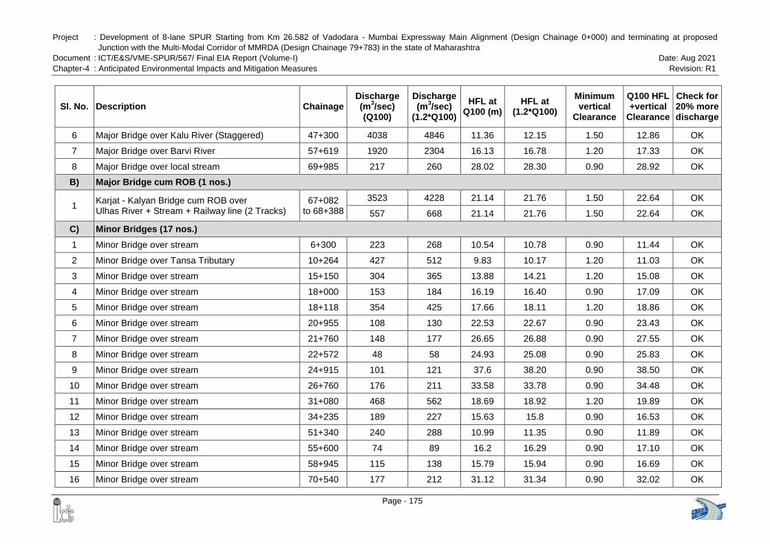
Project : Development of 8-lane SPUR Starting from Km 26.582 of Vadodara - Mumbai Expressway Main Alignment (Design Chainage 0+000) and terminating at proposed
Junction with the Multi-Modal Corridor of MMRDA (Design Chainage 79+783) in the state of Maharashtra
Document : ICT/E&S/VME-SPUR/567/ Final EIA Report (Volume-I) Date: Aug 2021
Chapter-4 : Anticipated Environmental Impacts and Mitigation Measures Revision: R1
Page - 175
Sl. No. Description Chainage Discharge (m
3/sec)
(Q100)
Discharge (m
3/sec)
(1.2*Q100)
HFL at Q100 (m)
HFL at (1.2*Q100)
Minimum vertical
Clearance
Q100 HFL +vertical
Clearance
Check for 20% more discharge
6 Major Bridge over Kalu River (Staggered) 47+300 4038 4846 11.36 12.15 1.50 12.86 OK
7 Major Bridge over Barvi River 57+619 1920 2304 16.13 16.78 1.20 17.33 OK
8 Major Bridge over local stream 69+985 217 260 28.02 28.30 0.90 28.92 OK
B) Major Bridge cum ROB (1 nos.)
1 Karjat - Kalyan Bridge cum ROB over Ulhas River + Stream + Railway line (2 Tracks)
67+082 to 68+388
3523 4228 21.14 21.76 1.50 22.64 OK
557 668 21.14 21.76 1.50 22.64 OK
C) Minor Bridges (17 nos.)
1 Minor Bridge over stream 6+300 223 268 10.54 10.78 0.90 11.44 OK
2 Minor Bridge over Tansa Tributary 10+264 427 512 9.83 10.17 1.20 11.03 OK
3 Minor Bridge over stream 15+150 304 365 13.88 14.21 1.20 15.08 OK
4 Minor Bridge over stream 18+000 153 184 16.19 16.40 0.90 17.09 OK
5 Minor Bridge over stream 18+118 354 425 17.66 18.11 1.20 18.86 OK
6 Minor Bridge over stream 20+955 108 130 22.53 22.67 0.90 23.43 OK
7 Minor Bridge over stream 21+760 148 177 26.65 26.88 0.90 27.55 OK
8 Minor Bridge over stream 22+572 48 58 24.93 25.08 0.90 25.83 OK
9 Minor Bridge over stream 24+915 101 121 37.6 38.20 0.90 38.50 OK
10 Minor Bridge over stream 26+760 176 211 33.58 33.78 0.90 34.48 OK
11 Minor Bridge over stream 31+080 468 562 18.69 18.92 1.20 19.89 OK
12 Minor Bridge over stream 34+235 189 227 15.63 15.8 0.90 16.53 OK
13 Minor Bridge over stream 51+340 240 288 10.99 11.35 0.90 11.89 OK
14 Minor Bridge over stream 55+600 74 89 16.2 16.29 0.90 17.10 OK
15 Minor Bridge over stream 58+945 115 138 15.79 15.94 0.90 16.69 OK
16 Minor Bridge over stream 70+540 177 212 31.12 31.34 0.90 32.02 OK
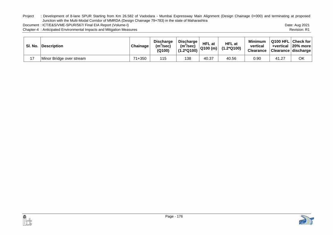
Project : Development of 8-lane SPUR Starting from Km 26.582 of Vadodara - Mumbai Expressway Main Alignment (Design Chainage 0+000) and terminating at proposed
Junction with the Multi-Modal Corridor of MMRDA (Design Chainage 79+783) in the state of Maharashtra
Document : ICT/E&S/VME-SPUR/567/ Final EIA Report (Volume-I) Date: Aug 2021
Chapter-4 : Anticipated Environmental Impacts and Mitigation Measures Revision: R1
Page - 176
Sl. No. Description Chainage Discharge (m
3/sec)
(Q100)
Discharge (m
3/sec)
(1.2*Q100)
HFL at Q100 (m)
HFL at (1.2*Q100)
Minimum vertical
Clearance
Q100 HFL +vertical
Clearance
Check for 20% more discharge
17 Minor Bridge over stream 71+350 115 138 40.37 40.56 0.90 41.27 OK
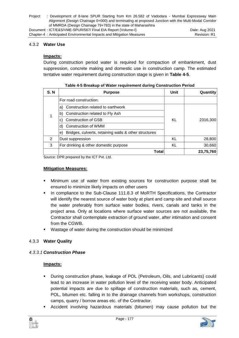
Project : Development of 8-lane SPUR Starting from Km 26.582 of Vadodara - Mumbai Expressway Main
Alignment (Design Chainage 0+000) and terminating at proposed Junction with the Multi-Modal Corridor
of MMRDA (Design Chainage 79+783) in the state of Maharashtra
Document : ICT/E&S/VME-SPUR/567/ Final EIA Report (Volume-I) Date: Aug 2021
Chapter-4 : Anticipated Environmental Impacts and Mitigation Measures Revision: R1
Page - 177
4.3.2 Water Use
Impacts:
During construction period water is required for compaction of embankment, dust
suppression, concrete making and domestic use in construction camp. The estimated
tentative water requirement during construction stage is given in Table 4-5.
Table 4-5 Breakup of Water requirement during Construction Period
S. N Purpose Unit Quantity
1
For road construction:
a) Construction related to earthwork
KL 2316,300
b) Construction related to Fly Ash
c) Construction of GSB
d) Construction of WMM
e) Bridges, culverts, retaining walls & other structures
2 Dust suppression KL 28,800
3 For drinking & other domestic purpose KL 30,660
Total 23,75,760
Source: DPR prepared by the ICT Pvt. Ltd.
Mitigation Measures:
Minimum use of water from existing sources for construction purpose shall be
ensured to minimize likely impacts on other users
In compliance to the Sub-Clause 111.8.3 of MoRTH Specifications, the Contractor
will identify the nearest source of water body at plant and camp site and shall source
the water preferably from surface water bodies, rivers, canals and tanks in the
project area. Only at locations where surface water sources are not available, the
Contractor shall contemplate extraction of ground water, after intimation and consent
from the CGWB.
Wastage of water during the construction should be minimized
4.3.3 Water Quality
4.3.3.1 Construction Phase
Impacts:
During construction phase, leakage of POL (Petroleum, Oils, and Lubricants) could
lead to an increase in water pollution level of the receiving water body. Anticipated
potential impacts are due to spillage of construction materials, such as, cement,
POL, bitumen etc. falling in to the drainage channels from workshops, construction
camps, quarry / borrow areas etc. of the Contractor.
Accident involving hazardous materials (bitumen) may cause pollution but the
Project : Development of 8-lane SPUR Starting from Km 26.582 of Vadodara - Mumbai Expressway Main
Alignment (Design Chainage 0+000) and terminating at proposed Junction with the Multi-Modal Corridor
of MMRDA (Design Chainage 79+783) in the state of Maharashtra
Document : ICT/E&S/VME-SPUR/567/ Final EIA Report (Volume-I) Date: Aug 2021
Chapter-4 : Anticipated Environmental Impacts and Mitigation Measures Revision: R1
Page - 178
occurrence of large scale spillage of bitumen is not anticipated.
Increase of sediment load in the run off from construction sites and increase in
turbidity in receiving water bodies
Water pollution due to use of flyash in the embankment
Water pollution due to generation of wastewater from construction camps
Mitigation Measures:
Quality of construction wastewater emanating from the construction site will be
controlled through suitable drainage system with silt traps for arresting the silt /
sediment load before its disposal into the main natural drainage system around the
site
An effective traffic management plan is to be implemented to avoid any accidental
spillage of hazardous materials.
All the construction and preparatory activities including construction of culverts and
bridges will be carried out preferable during dry seasons
The CD structures should not be drained to the agricultural and horticultural farms or
to the immediate vicinity of houses of the villagers.
The fuel storage and vehicle cleaning area shall be stationed at least 500m away
from the nearest water body
Provision for oil interceptors shall be made at all the construction camps / workshop
areas to separate the oil and grease waste generated from servicing of equipment
and vehicles used in the construction
The drains carrying storm water shall be connected to the nearest natural drainage
channel, water bodies with silt traps.
Mitigation Measures for Fly Ash Embankment: The fly ash embankment for this
road project has been designed as per the Special Publication 58 of the Indian
Roads Congress, IRC:SP:58-2001 “Guidelines for Use of Fly Ash in Road
Embankments”. In section 3.3.1.10 of IRC:SP:58, it is mentioned that “The leaching
problem can be minimised by controlling the amount of water, which infiltrates into
fly ash embankment. Normally, percolation of water into the fly ash core will be
minimum when sides and top are protected using good earth. Side slopes should be
properly protected with soil cover with vegetation or soil cover. Monitoring of fly ash
embankments has indicated that relatively little water tends to percolate through the
complete embankment. Even in such a case, the alkaline nature of the fly ash-water
solution restricts heavy metal leaching.”
In section 3.4.2 of IRC:SP:58 it is mentioned that “Special emphasis is required with
respect to provision of earth cover for fly ash embankments since ash is easily
erodable. Height and side slope of the embankment govern the thickness of earth
cover. For embankment up to 3 m height, in general, the side cover thickness
(measured horizontally) of about 1 m would be sufficient. For high embankments
and for embankments to be constructed in flood prone areas, the cover thickness
may be increased. The embankment would, therefore, be designed as a composite
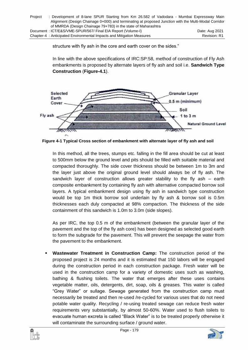
Project : Development of 8-lane SPUR Starting from Km 26.582 of Vadodara - Mumbai Expressway Main
Alignment (Design Chainage 0+000) and terminating at proposed Junction with the Multi-Modal Corridor
of MMRDA (Design Chainage 79+783) in the state of Maharashtra
Document : ICT/E&S/VME-SPUR/567/ Final EIA Report (Volume-I) Date: Aug 2021
Chapter-4 : Anticipated Environmental Impacts and Mitigation Measures Revision: R1
Page - 179
Figure 4-1 Typical Cross section of embankment with alternate layer of fly ash and soil
structure with fly ash in the core and earth cover on the sides.”
In line with the above specifications of IRC:SP:58, method of construction of Fly Ash
embankments is proposed by alternate layers of fly ash and soil i.e. Sandwich Type
Construction (Figure-4.1).
In this method, all the trees, stumps etc. falling in the fill area should be cut at least
to 500mm below the ground level and pits should be filled with suitable material and
compacted thoroughly. The side cover thickness should be between 1m to 3m and
the layer just above the original ground level should always be of fly ash. The
sandwich layer of construction allows greater stability to the fly ash – earth
composite embankment by containing fly ash with alternative compacted borrow soil
layers. A typical embankment design using fly ash in sandwich type construction
would be top 1m thick borrow soil underlain by fly ash & borrow soil is 0.5m
thicknesses each duly compacted at 98% compaction. The thickness of the side
containment of this sandwich is 1.0m to 3.0m (side slopes).
As per IRC, the top 0.5 m of the embankment (between the granular layer of the
pavement and the top of the fly ash core) has been designed as selected good earth
to form the subgrade for the pavement. This will prevent the seepage the water from
the pavement to the embankment.
Wastewater Treatment in Construction Camp: The construction period of the
proposed project is 24 months and it is estimated that 150 labors will be engaged
during the construction period in each construction package. Fresh water will be
used in the construction camp for a variety of domestic uses such as washing,
bathing & flushing toilets. The water that emerges after these uses contains
vegetable matter, oils, detergents, dirt, soap, oils & greases. This water is called
“Grey Water” or sullage. Sewage generated from the construction camp must
necessarily be treated and then re-used /re-cycled for various uses that do not need
potable water quality. Recycling / re-using treated sewage can reduce fresh water
requirements very substantially, by almost 50-60%. Water used to flush toilets to
evacuate human excreta is called “Black Water” is to be treated properly otherwise it
will contaminate the surrounding surface / ground water.

Project : Development of 8-lane SPUR Starting from Km 26.582 of Vadodara - Mumbai Expressway Main
Alignment (Design Chainage 0+000) and terminating at proposed Junction with the Multi-Modal Corridor
of MMRDA (Design Chainage 79+783) in the state of Maharashtra
Document : ICT/E&S/VME-SPUR/567/ Final EIA Report (Volume-I) Date: Aug 2021
Chapter-4 : Anticipated Environmental Impacts and Mitigation Measures Revision: R1
Page - 180
As per the calculation; daily water requirement for drinking & domestic purposes in
the 4 construction camps are 42,000 liters (10,500 liters in each construction camp)
and generation of wastewater is 33,600 liters (8,400 liters in each construction
camp). Therefore, Packaged Wastewater Treatment Plant has been
recommended for the construction camp. Guideline for wastewater treatment in
construction camp is given in Annex-9.7. However, any other type of packaged
wastewater treatment plant may be installed.
Water Quality Monitoring: Apart from provision of the mitigation measures, water
quality shall be monitored to understand the effectiveness and further improvement
in designs in reducing the concentration of pollutants. The monitoring plan shall be
functional in construction as well as in operation stages. The frequency, duration
and responsibility will be as per the Environmental Monitoring Program (Table 6-2 of
Chapter-6). All deviated results shall be reported to Sr. Environmental Specialist of
the Authority / Independent Engineer for remedial measures. It should be ensured
that no construction camps or stockyards are set up near rivers and water bodies to
prevent oil spills.
Silt Fencing: Silt fencing will be provided to prevent sediments from the
construction site entering into the nearby watercourses. The silt fencing consists of
geo textile with extremely small size supported by a wire mesh mounted on a panel
made up of angle / wooden frame and post. The frame will be installed at the edge
of the water body along which construction is in progress. It is proposed to install silt
fence at the edge of all water bodies abutting the project road including major and
minor bridge locations.
Silt fence will be mounted on pole fixed at a distance of 2 to 3 m apart and last 2 m
of fence shall be framed up slope. The location of silt traps will depend on
contractor‟s proposal for site facilities and work sites and should be provided in the
contractor‟s proposals. This will be checked by Sr. Environmental Specialist of the
Authority / Independent Engineer and monitored by PIU. Drawing of typical silt trap
is given in Annex-4.1.
Oil Interceptor: Oil and grease from road run-off is another major concern during
construction as well as operation. During construction, discharge of oil and grease is
most likely from workshops, oil and waste oil storage locations, vehicle parking
areas of the contractor camp. Therefore, location of Oil Interceptors has been
considered such that each construction camp having refueling stations, oil and
lubricants storage places will have one oil interceptor to stop & separate the floating
oils. The arrested products shall be disposed as per MoEF&CC and CPCB
guidelines. Actual number will be decided by the Contractor with the consent of Sr.
Environmental Specialist of the Authority / Independent Engineer. Drawing of typical
Oil Interceptor is given in Annex-4.2.
Project : Development of 8-lane SPUR Starting from Km 26.582 of Vadodara - Mumbai Expressway Main
Alignment (Design Chainage 0+000) and terminating at proposed Junction with the Multi-Modal Corridor
of MMRDA (Design Chainage 79+783) in the state of Maharashtra
Document : ICT/E&S/VME-SPUR/567/ Final EIA Report (Volume-I) Date: Aug 2021
Chapter-4 : Anticipated Environmental Impacts and Mitigation Measures Revision: R1
Page - 181
Rainwater Harvesting Structures
The normal annual rainfall in the study area ranges from 1900 mm to 2600 mm and
mean annual rainfall during the year 1981 to 2010 is 1874.6 mm. Pre monsoon
depth to water level (May-2011) ranging between 2 to 5 mbgl and 5 to 10 mbgl while
post-monsoon depth to water level (Nov- 2011) ranging between 2 to 5 mbgl in
major part of the study area. Mean water level range of 2 to 5 mbgl is observed in
the Palghar, Dahanu and Talasari area. As per the CGWA classification, all the
Talukas (Vasai, Wada, Bhiwandi, Kalyan, Ambarnath and Panvel) through which
the proposed expressway is passing fall under safe category. However, as per
MoRTH requirement rainwater harvesting structure has been proposed at toll plaza,
wayside amenities and at suitable location along the expressway. Total number of
Rainwater Harvesting structures proposed is 75 and cost of the same has been
included in the EMP budget. Typical drawing of rainwater harvesting structure is
shown in Figure 4-2.
4.3.3.2 Operation Phase
Impacts:
Increase of surface run-off due to more paved surface
Filthy environment due to improper maintenance of drainage
Chances of contamination of water bodies from surface run off containing oil spills
due to traffic movement & accidents
Mitigation Measures:
Shoulder drain & toe drain of sufficient capacity have been provided on both sides of
the expressway to accommodate increased run-off. The out fall for these drains will
be the nearby culverts / bridges or natural drainage channel. Silt fencing will be
provided to sediment entering into the water courses.
Contingent actions will be taken for speedy cleaning up of oil spills, fuel and toxic
chemicals in the event of accidents.
Regular maintenance of rainwater harvesting structures shall be done during the
operation stage to prevent choking of these structures.
Regular monitoring of water quality at specified representative locations will be
conducted at fixed interval.
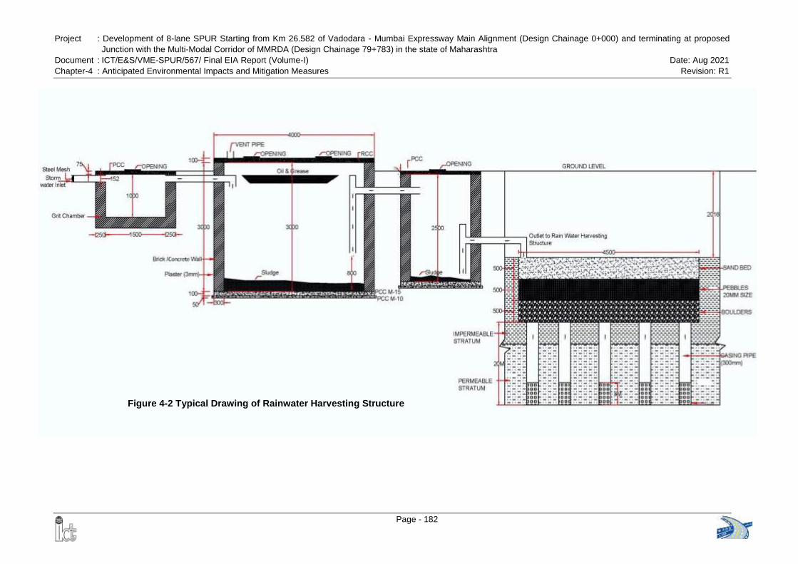
Project : Development of 8-lane SPUR Starting from Km 26.582 of Vadodara - Mumbai Expressway Main Alignment (Design Chainage 0+000) and terminating at proposed
Junction with the Multi-Modal Corridor of MMRDA (Design Chainage 79+783) in the state of Maharashtra
Document : ICT/E&S/VME-SPUR/567/ Final EIA Report (Volume-I) Date: Aug 2021
Chapter-4 : Anticipated Environmental Impacts and Mitigation Measures Revision: R1
Page - 182
Figure 4-2 Typical Drawing of Rainwater Harvesting Structure
Project : Development of 8-lane SPUR Starting from Km 26.582 of Vadodara - Mumbai Expressway Main
Alignment (Design Chainage 0+000) and terminating at proposed Junction with the Multi-Modal Corridor
of MMRDA (Design Chainage 79+783) in the state of Maharashtra
Document : ICT/E&S/VME-SPUR/567/ Final EIA Report (Volume-I) Date: Aug 2021
Chapter-4 : Anticipated Environmental Impacts and Mitigation Measures Revision: R1
Page - 183
4.4 AIR ENVIRONMENT
4.4.1 Construction Phase
Particulate matter would be the predominant pollutant affecting the air quality during the
construction phase as it is likely to generate considerable quantities of dust, especially
during dry condition. Dust will be generated mainly during excavation, backfilling,
hauling & transportation activities through unpaved haul roads, loading/ unloading &
transportation of construction materials, spilling of material during transportation, and
open storage of fine construction materials.
Undesirable gaseous pollutants will be generated mostly by the automobile traffic and
construction machineries. Pollutants of primary concern include PM2.5 and PM10.
However, suspended dust particles may be coarse and will be settled within a short
distance of construction area. Therefore, impact will be temporary and restricted within
the closed vicinity along the road only. Further, this would not lead to any tangible effect,
as the expected traffic volume is low. Operation of hot mix plants and Asphalt plants will
cause emission of fumes and gases.
4.4.1.1 Hot Mix Plant
Asphalt is used for paving roads; which is a mixture containing thousands of different
chemicals. The chemicals in asphalt vary depending on the source of the crude oil, the
type of asphalt being made and the process used. In general, the fumes emitted from
hot mix plant are a mixture of several different types of chemicals including carbon
monoxide, nitrogen oxides, sulfur, volatile organic compounds, polycyclic aromatic
hydrocarbons etc.
Fumes created from heating asphalt can be inhaled into the lungs or can condense onto
exposed areas of the skin. People who work in asphalt plants have the greatest
exposure to asphalt fumes. Residents living near an asphalt plant also would be more
likely to breathe low levels of asphalt fumes for a long period of time.
Control System: To avoid problems of air pollution following Guidelines1 is to be
considered by the Contractor for setting up hot mix plant:
Hot mix plant shall be at-least 500 m away from nearest settlement / educational
institute / religious places / water bodies and 200 m away from the centerline of
National Highway / State Highway
In case of existing Hot Mix plants, operating with CTE of the State Pollution Control
Board, which are located at lesser distance then 200 meter from existing highways,
the unit shall provide minimum 6 meter high compound wall of GI sheets along plot
periphery towards highway side.
Adequate dust control system shall be provided
1 Guideline for Hot Mix Plant, Gujarat Pollution Control Board
Project : Development of 8-lane SPUR Starting from Km 26.582 of Vadodara - Mumbai Expressway Main
Alignment (Design Chainage 0+000) and terminating at proposed Junction with the Multi-Modal Corridor
of MMRDA (Design Chainage 79+783) in the state of Maharashtra
Document : ICT/E&S/VME-SPUR/567/ Final EIA Report (Volume-I) Date: Aug 2021
Chapter-4 : Anticipated Environmental Impacts and Mitigation Measures Revision: R1
Page - 184
Hot Mix Plant with Pollution Control Measures having Fabric Filter with reverse air
cleaner based on the principle of Reverse Air Cleaning or Dry dust collector (Multicy-
clone) with multiple wet scrubber shall be installed and elevators at loading section
shall be fully covered
The plant shall have centralized control panel / cabin capable of pre-setting
controlling / synchronization all operations, starting from feeding of aggregates to the
discharge of hot mix to ensure proper mixing. It shall have adequate water scrubbing
mechanism to control the dust coming out of the dryer.
Hot Mix plant must have at-least 6 m stack height for the discharge of its scrubbed
flue gases
Conveyor belts shall be fully covered from top and sides.
Considering predominant wind direction, wind breaking wall shall be constructed.
Regular sprinkling of water shall be ensured on all roads and surrounding area of
the plant to minimize dust pollution
Regular cleaning and wetting of ground within premises shall be carried out
Only approved fuel such as diesel, light diesel oil (LDO) shall be used. In no case
unauthorized fuel such as solvents, industrial waste shall be used.
Safety measures: Adequate measures of safety for workers working in Hot Mix
plant shall be taken. Personal Protective Devices such as Goggles, mask, Helmet
and safety shoes shall be provided to workers
4.4.1.2 Stone Crushers
Stone processing operations including crushing, screening, material handling and
transfer operations are potential sources of particulate emissions.
a. Emission during Crushing Operation: During crushing operation, generation of
particulate emissions is inherent and the emissions are most apparent at crusher
feed and discharge points. The greater the reduction in size during subsequent
crushing stages from primary, secondary to tertiary crushing, the higher the
emissions.
b. Emissions during Screening: In the screening section, the mixture of stones is
classified and separated according to size. Screening efficiency is generally
considered to be in the range of 60 to 75%. Commonly used screening equipment
are grizzlies, shaking screens, vibrating screens and revolving screens. Screening
may be performed wet but dry screening is the most common. Dust is emitted from
screening operations as a result of the agitation of dry stone. The screening of fine
sizes produces higher emissions than the screening of coarse sizes.
c. Emissions during Material Handling: Various handling devices like feeders, belt
conveyors, bucket elevators and screw conveyors are used to transport crushed
materials from one point to another. Particulates may be emitted from any of the
material handling operations. Most of the emissions occur at transfer points. The
Project : Development of 8-lane SPUR Starting from Km 26.582 of Vadodara - Mumbai Expressway Main
Alignment (Design Chainage 0+000) and terminating at proposed Junction with the Multi-Modal Corridor
of MMRDA (Design Chainage 79+783) in the state of Maharashtra
Document : ICT/E&S/VME-SPUR/567/ Final EIA Report (Volume-I) Date: Aug 2021
Chapter-4 : Anticipated Environmental Impacts and Mitigation Measures Revision: R1
Page - 185
amount of uncontrolled emissions depends on the size distribution of the material
handled, the belt speed and the free fall distance.
d. Nature and Spread of Emissions: The major source of dust generation is during
size reduction in the primary, secondary & tertiary crushers. The dust is also
generated during handling of stones, especially at the point where the stones fall
through a height from places like one belt to another or from belt to hopper or stock
piles etc. During vibratory screen large quantity of fine dust is emitted and gets air
borne.
e. Impacts due to Emission: Some percentage of the fugitive dust emissions may get
settled down within the unit premises but a substantial percentage of airborne
emissions are carried away to the surroundings by wind currents. Dust that settles
within the plant gets air borne again due to vehicular movement or by wind and acts
as a secondary emission source.
Dust emissions affect the human health, vegetation, climate and damage the
material. When the amount of particulates increases in the atmosphere, it absorbs
incoming solar radiation, causing an increase in the atmospheric and land surface
temperature. The physical properties of atmospheric particulates affect human
health either by allowing penetration of the lung and causing irritation to the internal
membrane, or by transporting absorbed toxic gases and vapors deeper into the lung
than they would normally travel. The work place environment at stone crusher sites
contain millions of suspended mineral particles of respirable size that get deposited
in lungs during inhalation.
f. Emission Control System – Combination of Dry and Wet Type
A combination of dry and wet type control system is suggested to minimize the
impact on air quality. In the combination system the dust is suppressed at some
point with water sprays and from some points the dust is extracted with the help of
an induced draft fan and can be captured in dry type or wet spray chamber type
control equipment. Such combination control systems are commonly used in stone
crusher in developed countries. In the combination control system the water is to be
sprayed at the primary crushing stage and in the secondary / tertiary stages the dust
is to be extracted out and separately controlled. This will have benefit in terms of
avoiding a coating of dust on the stone products and at the same time lesser
expensive than dry type control system.
The Wet Type Dust Suppression System comprises of introducing moisture into
the material flow by spraying water at key dust generating locations so as to restrain
fine particulate matter from becoming air borne. The objective of wet dust
suppression is to prevent emission by keeping the material moist at all process
stages. Small quantities of specially formulated wetting agents or surfactants are
often blended with water to reduce its surface tension and improve its wetting
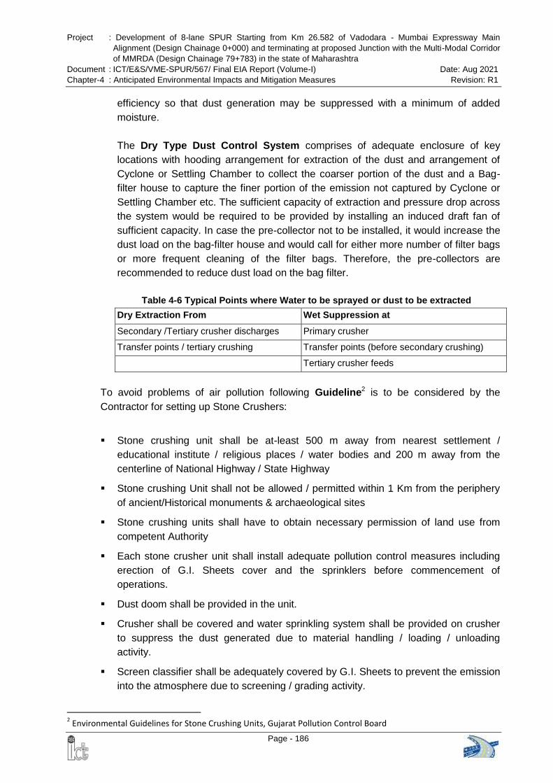
Project : Development of 8-lane SPUR Starting from Km 26.582 of Vadodara - Mumbai Expressway Main
Alignment (Design Chainage 0+000) and terminating at proposed Junction with the Multi-Modal Corridor
of MMRDA (Design Chainage 79+783) in the state of Maharashtra
Document : ICT/E&S/VME-SPUR/567/ Final EIA Report (Volume-I) Date: Aug 2021
Chapter-4 : Anticipated Environmental Impacts and Mitigation Measures Revision: R1
Page - 186
efficiency so that dust generation may be suppressed with a minimum of added
moisture.
The Dry Type Dust Control System comprises of adequate enclosure of key
locations with hooding arrangement for extraction of the dust and arrangement of
Cyclone or Settling Chamber to collect the coarser portion of the dust and a Bag-
filter house to capture the finer portion of the emission not captured by Cyclone or
Settling Chamber etc. The sufficient capacity of extraction and pressure drop across
the system would be required to be provided by installing an induced draft fan of
sufficient capacity. In case the pre-collector not to be installed, it would increase the
dust load on the bag-filter house and would call for either more number of filter bags
or more frequent cleaning of the filter bags. Therefore, the pre-collectors are
recommended to reduce dust load on the bag filter.
Table 4-6 Typical Points where Water to be sprayed or dust to be extracted
Dry Extraction From Wet Suppression at
Secondary /Tertiary crusher discharges Primary crusher
Transfer points / tertiary crushing Transfer points (before secondary crushing)
Tertiary crusher feeds
To avoid problems of air pollution following Guideline2 is to be considered by the
Contractor for setting up Stone Crushers:
Stone crushing unit shall be at-least 500 m away from nearest settlement /
educational institute / religious places / water bodies and 200 m away from the
centerline of National Highway / State Highway
Stone crushing Unit shall not be allowed / permitted within 1 Km from the periphery
of ancient/Historical monuments & archaeological sites
Stone crushing units shall have to obtain necessary permission of land use from
competent Authority
Each stone crusher unit shall install adequate pollution control measures including
erection of G.I. Sheets cover and the sprinklers before commencement of
operations.
Dust doom shall be provided in the unit.
Crusher shall be covered and water sprinkling system shall be provided on crusher
to suppress the dust generated due to material handling / loading / unloading
activity.
Screen classifier shall be adequately covered by G.I. Sheets to prevent the emission
into the atmosphere due to screening / grading activity.
2 Environmental Guidelines for Stone Crushing Units, Gujarat Pollution Control Board
Project : Development of 8-lane SPUR Starting from Km 26.582 of Vadodara - Mumbai Expressway Main
Alignment (Design Chainage 0+000) and terminating at proposed Junction with the Multi-Modal Corridor
of MMRDA (Design Chainage 79+783) in the state of Maharashtra
Document : ICT/E&S/VME-SPUR/567/ Final EIA Report (Volume-I) Date: Aug 2021
Chapter-4 : Anticipated Environmental Impacts and Mitigation Measures Revision: R1
Page - 187
All conveyor belts shall be adequately covered by G.I. Sheet / M.S. sheet only.
Regular wetting of roads shall be carried out to suppress the ground level dust within
the premises to control the air borne dust emission due to wind velocity.
All approach roads and ramps shall be paved.
Curtain or wall shall be provided surrounding the stone crusher unit.
Display board shall be provided at the entrance of stone crusher indicating survey
no, name and address of owner and the unit.
Fine dust generated due to screening / crushing / grading shall be disposed-off into
abandoned mines.
4.4.1.3 Other Impacts
Deterioration of air quality due to fugitive dusts emission from construction activities
like excavation, backfilling & concreting, and hauling & dumping of earth materials &
construction spoils, and vehicular movement along unpaved roads.
Deterioration of air quality due to gaseous emissions from vehicular traffic
4.4.1.4 Mitigation Measures
Proper and prior planning and appropriate sequencing and scheduling of all major
construction activities shall be done, and timely availability of infrastructural supports
needed for construction shall be ensured to shorten the construction period vis a vis
reduce pollution.
Construction materials shall be stored in covered godowns or enclosed spaces to
prevent the windblown fugitive emissions.
Truck carrying soil, sand and stone shall be duly covered to avoid spilling.
Adequate dust suppression measures such as regular water sprinkling on unpaved
haul roads & vulnerable areas of the construction sites from trucks or other suitable
means shall be undertaken to control fugitive dust during material handling & hauling
activities particularly near habitation especially in the dry seasons.
During construction period, all activities are to adhere to the contractual obligations
and all clearances and approvals such as „Consent to Establish‟ and „Consent to
Operate‟ shall be obtained from the Maharashtra Pollution Control Board under Air
Act. All vehicles operating for the Contractor, Supervision Consultants and PIU shall
obtain Pollution under Control (PUC) certificate.
All required clearances are to be obtained from the Maharashtra Pollution Control
Board and the Mining Department for establishing quarries, borrow areas and
crushers. Contractor should submit copy of such clearances to PIU & AE before
start of activities.
It will be ensured that all the construction equipment & vehicles are in good working
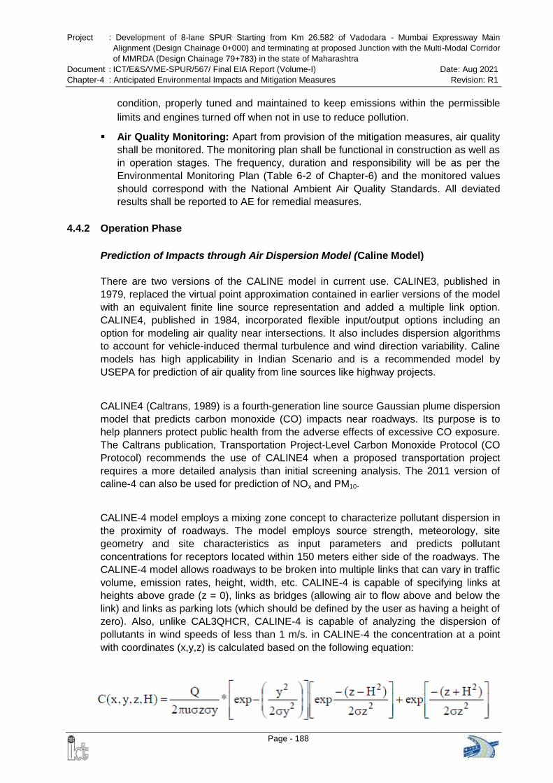
Project : Development of 8-lane SPUR Starting from Km 26.582 of Vadodara - Mumbai Expressway Main
Alignment (Design Chainage 0+000) and terminating at proposed Junction with the Multi-Modal Corridor
of MMRDA (Design Chainage 79+783) in the state of Maharashtra
Document : ICT/E&S/VME-SPUR/567/ Final EIA Report (Volume-I) Date: Aug 2021
Chapter-4 : Anticipated Environmental Impacts and Mitigation Measures Revision: R1
Page - 188
condition, properly tuned and maintained to keep emissions within the permissible
limits and engines turned off when not in use to reduce pollution.
Air Quality Monitoring: Apart from provision of the mitigation measures, air quality
shall be monitored. The monitoring plan shall be functional in construction as well as
in operation stages. The frequency, duration and responsibility will be as per the
Environmental Monitoring Plan (Table 6-2 of Chapter-6) and the monitored values
should correspond with the National Ambient Air Quality Standards. All deviated
results shall be reported to AE for remedial measures.
4.4.2 Operation Phase
Prediction of Impacts through Air Dispersion Model (Caline Model)
There are two versions of the CALINE model in current use. CALINE3, published in
1979, replaced the virtual point approximation contained in earlier versions of the model
with an equivalent finite line source representation and added a multiple link option.
CALINE4, published in 1984, incorporated flexible input/output options including an
option for modeling air quality near intersections. It also includes dispersion algorithms
to account for vehicle-induced thermal turbulence and wind direction variability. Caline
models has high applicability in Indian Scenario and is a recommended model by
USEPA for prediction of air quality from line sources like highway projects.
CALINE4 (Caltrans, 1989) is a fourth-generation line source Gaussian plume dispersion
model that predicts carbon monoxide (CO) impacts near roadways. Its purpose is to
help planners protect public health from the adverse effects of excessive CO exposure.
The Caltrans publication, Transportation Project-Level Carbon Monoxide Protocol (CO
Protocol) recommends the use of CALINE4 when a proposed transportation project
requires a more detailed analysis than initial screening analysis. The 2011 version of
caline-4 can also be used for prediction of NOx and PM10.
CALINE-4 model employs a mixing zone concept to characterize pollutant dispersion in
the proximity of roadways. The model employs source strength, meteorology, site
geometry and site characteristics as input parameters and predicts pollutant
concentrations for receptors located within 150 meters either side of the roadways. The
CALINE-4 model allows roadways to be broken into multiple links that can vary in traffic
volume, emission rates, height, width, etc. CALINE-4 is capable of specifying links at
heights above grade (z = 0), links as bridges (allowing air to flow above and below the
link) and links as parking lots (which should be defined by the user as having a height of
zero). Also, unlike CAL3QHCR, CALINE-4 is capable of analyzing the dispersion of
pollutants in wind speeds of less than 1 m/s. in CALINE-4 the concentration at a point
with coordinates (x,y,z) is calculated based on the following equation:
Project : Development of 8-lane SPUR Starting from Km 26.582 of Vadodara - Mumbai Expressway Main
Alignment (Design Chainage 0+000) and terminating at proposed Junction with the Multi-Modal Corridor
of MMRDA (Design Chainage 79+783) in the state of Maharashtra
Document : ICT/E&S/VME-SPUR/567/ Final EIA Report (Volume-I) Date: Aug 2021
Chapter-4 : Anticipated Environmental Impacts and Mitigation Measures Revision: R1
Page - 189
Where:
C = Concentration of the pollutant in air [m/L3]
Q = Rate of chemical emission [m/T]
U = Wind speed in X direction [L/T]
óy = Standard deviation in y direction [L]
óz = Standard deviation in z direction [L]
y = Distance along a Horizontal axis perpendicular to the wind [L]
z = Distance along a vertical axis.[L]
H = effective stack height [L]
CALINEpro™ Model is a further improved air quality model based on CALINE‟s
algorithm (USEPA Preferred/ Recommended Models) for prediction of pollutant
concentration near highways.
It divides individual highway links into a series of elements from which incremental
concentrations are computed and then summed to form a total concentration estimate
for a particular receptor location. Downwind concentrations from the element are
modeled using the crosswind FLS (Finite Line Source) Gaussian formulation, but σy and
σz are modified to consider the mechanical turbulence created by moving vehicles and
the thermal turbulence created by hot vehicle exhaust in the region directly over the
highway, region considered as a zone of uniform emissions and turbulence. Given
source strength, meteorology and site geometry, the model can predict pollutant
concentrations for receptors located within 500 meters of the roadway. It also has
special options for modeling air quality near intersections, bridge and parking facilities.
Quantitative assessment for predicted level of pollutants concentration has been done using CALINEpro™ Model Ver. 2016.
Emission Rate: Composite Emission factors were calculated to assess the contribution
of the vehicles in air emission based on the emission factors developed for Indian road
conditions by "The Automotive Research Association of India (ARAI)", Pune in its study
for "Emission Factor Development for Indian Vehicles" as a part of Ambient Air Quality
Monitoring and Emission Source Apportionment Studies under Air Quality Monitoring
Project - Indian Clean Air Program (ICAP). Composite Emission Factor (CEF) represent
the various vehicular emission pollutant for different types of vehicles (viz. two wheelers,
three wheelers, Cars, Commercial vehicle, Buses etc.) used in India as requirement of
the model.
Meteorological Data: The primary factors affecting transport and dispersion of
pollutants are wind and stability. The winds are caused by differences in pressure
between areas of the atmosphere. Differences in pressure cause air to move from high-
pressure areas to low-pressure areas. Wind speed can affect the pollutant concentration
in a selected area. In general, the higher the wind speeds, the lower the pollutant
concentration. The winds dilute pollutants and rapidly disperse them throughout the
near areas. In the present case, meteorological data of post-monsoon season
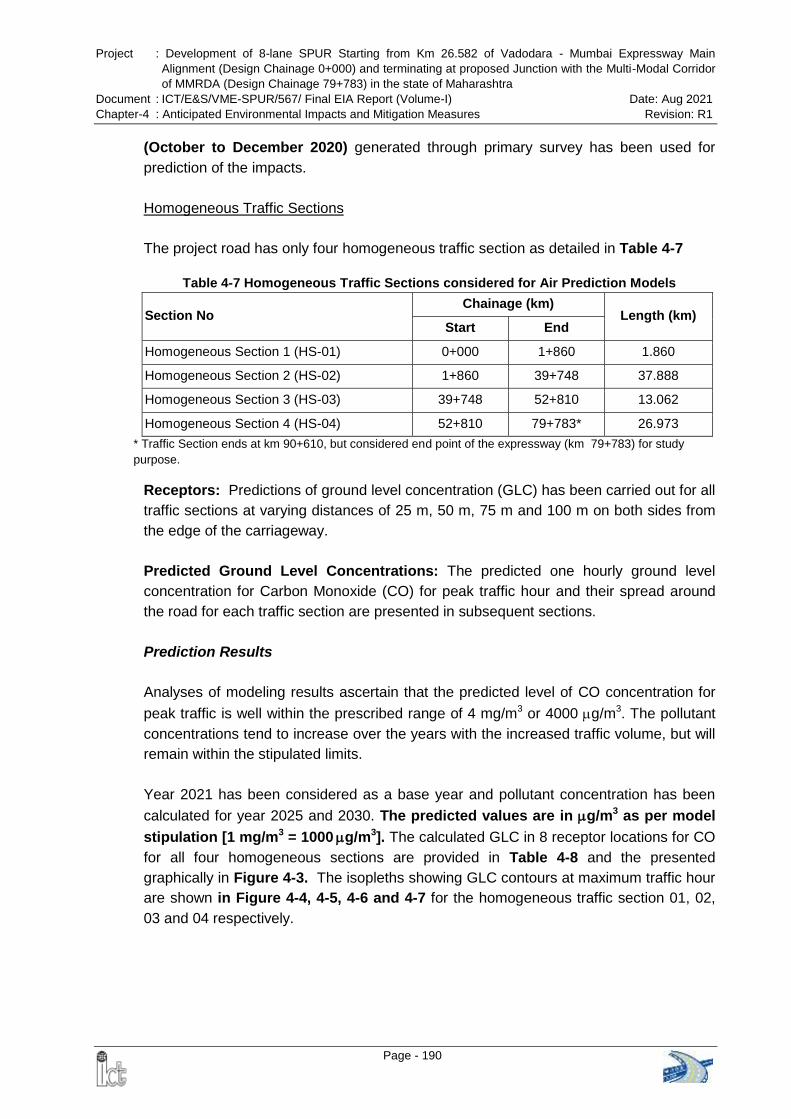
Project : Development of 8-lane SPUR Starting from Km 26.582 of Vadodara - Mumbai Expressway Main
Alignment (Design Chainage 0+000) and terminating at proposed Junction with the Multi-Modal Corridor
of MMRDA (Design Chainage 79+783) in the state of Maharashtra
Document : ICT/E&S/VME-SPUR/567/ Final EIA Report (Volume-I) Date: Aug 2021
Chapter-4 : Anticipated Environmental Impacts and Mitigation Measures Revision: R1
Page - 190
(October to December 2020) generated through primary survey has been used for
prediction of the impacts.
Homogeneous Traffic Sections
The project road has only four homogeneous traffic section as detailed in Table 4-7
Table 4-7 Homogeneous Traffic Sections considered for Air Prediction Models
Section No Chainage (km)
Length (km) Start End
Homogeneous Section 1 (HS-01) 0+000 1+860 1.860
Homogeneous Section 2 (HS-02) 1+860 39+748 37.888
Homogeneous Section 3 (HS-03) 39+748 52+810 13.062
Homogeneous Section 4 (HS-04) 52+810 79+783* 26.973
* Traffic Section ends at km 90+610, but considered end point of the expressway (km 79+783) for study
purpose.
Receptors: Predictions of ground level concentration (GLC) has been carried out for all
traffic sections at varying distances of 25 m, 50 m, 75 m and 100 m on both sides from
the edge of the carriageway.
Predicted Ground Level Concentrations: The predicted one hourly ground level
concentration for Carbon Monoxide (CO) for peak traffic hour and their spread around
the road for each traffic section are presented in subsequent sections.
Prediction Results
Analyses of modeling results ascertain that the predicted level of CO concentration for
peak traffic is well within the prescribed range of 4 mg/m3 or 4000 g/m3. The pollutant
concentrations tend to increase over the years with the increased traffic volume, but will
remain within the stipulated limits.
Year 2021 has been considered as a base year and pollutant concentration has been
calculated for year 2025 and 2030. The predicted values are in g/m3 as per model
stipulation [1 mg/m3 = 1000 g/m3]. The calculated GLC in 8 receptor locations for CO
for all four homogeneous sections are provided in Table 4-8 and the presented
graphically in Figure 4-3. The isopleths showing GLC contours at maximum traffic hour
are shown in Figure 4-4, 4-5, 4-6 and 4-7 for the homogeneous traffic section 01, 02,
03 and 04 respectively.
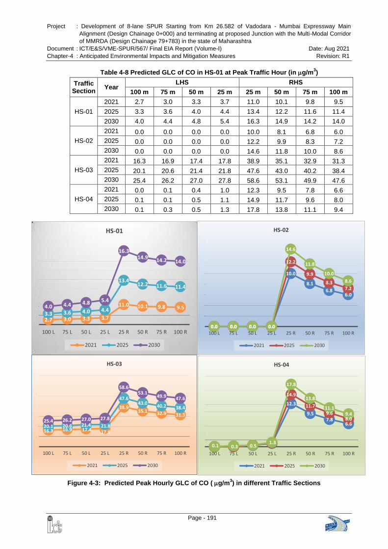
Project : Development of 8-lane SPUR Starting from Km 26.582 of Vadodara - Mumbai Expressway Main
Alignment (Design Chainage 0+000) and terminating at proposed Junction with the Multi-Modal Corridor
of MMRDA (Design Chainage 79+783) in the state of Maharashtra
Document : ICT/E&S/VME-SPUR/567/ Final EIA Report (Volume-I) Date: Aug 2021
Chapter-4 : Anticipated Environmental Impacts and Mitigation Measures Revision: R1
Page - 191
Table 4-8 Predicted GLC of CO in HS-01 at Peak Traffic Hour (in g/m3)
Traffic Section
Year LHS RHS
100 m 75 m 50 m 25 m 25 m 50 m 75 m 100 m
HS-01
2021 2.7 3.0 3.3 3.7 11.0 10.1 9.8 9.5
2025 3.3 3.6 4.0 4.4 13.4 12.2 11.6 11.4
2030 4.0 4.4 4.8 5.4 16.3 14.9 14.2 14.0
HS-02
2021 0.0 0.0 0.0 0.0 10.0 8.1 6.8 6.0
2025 0.0 0.0 0.0 0.0 12.2 9.9 8.3 7.2
2030 0.0 0.0 0.0 0.0 14.6 11.8 10.0 8.6
HS-03
2021 16.3 16.9 17.4 17.8 38.9 35.1 32.9 31.3
2025 20.1 20.6 21.4 21.8 47.6 43.0 40.2 38.4
2030 25.4 26.2 27.0 27.8 58.6 53.1 49.9 47.6
HS-04
2021 0.0 0.1 0.4 1.0 12.3 9.5 7.8 6.6
2025 0.1 0.1 0.5 1.1 14.9 11.7 9.6 8.0
2030 0.1 0.3 0.5 1.3 17.8 13.8 11.1 9.4
2.7 3.0 3.3 3.7
11.0 10.1 9.8 9.5 3.3 3.6 4.0 4.4
13.4 12.2 11.6 11.4
4.0 4.4 4.8 5.4
16.3 14.9 14.2 14.0
100 L 75 L 50 L 25 L 25 R 50 R 75 R 100 R
HS-01
2021 2025 2030
0.0 0.0 0.0 0.0
10.0
8.1
6.8 6.0
0.0 0.0 0.0 0.0
12.2
9.9
8.3 7.2
0.0 0.0 0.0 0.0
14.6
11.8
10.0
8.6
100 L 75 L 50 L 25 L 25 R 50 R 75 R 100 R
HS-02
2021 2025 2030
16.3 16.9 17.4 17.8
38.9 35.1 32.9 31.3
20.1 20.6 21.4 21.8
47.6 43.0
40.2 38.4
25.4 26.2 27.0 27.8
58.6 53.1
49.9 47.6
100 L 75 L 50 L 25 L 25 R 50 R 75 R 100 R
HS-03
2021 2025 2030
12.3
9.5 7.8
6.6
14.9
11.7
9.6 8.0
0.1 0.3 0.5 1.3
17.8
13.8
11.1 9.4
100 L 75 L 50 L 25 L 25 R 50 R 75 R 100 R
HS-04
2021 2025 2030
Figure 4-3: Predicted Peak Hourly GLC of CO (g/m3) in different Traffic Sections
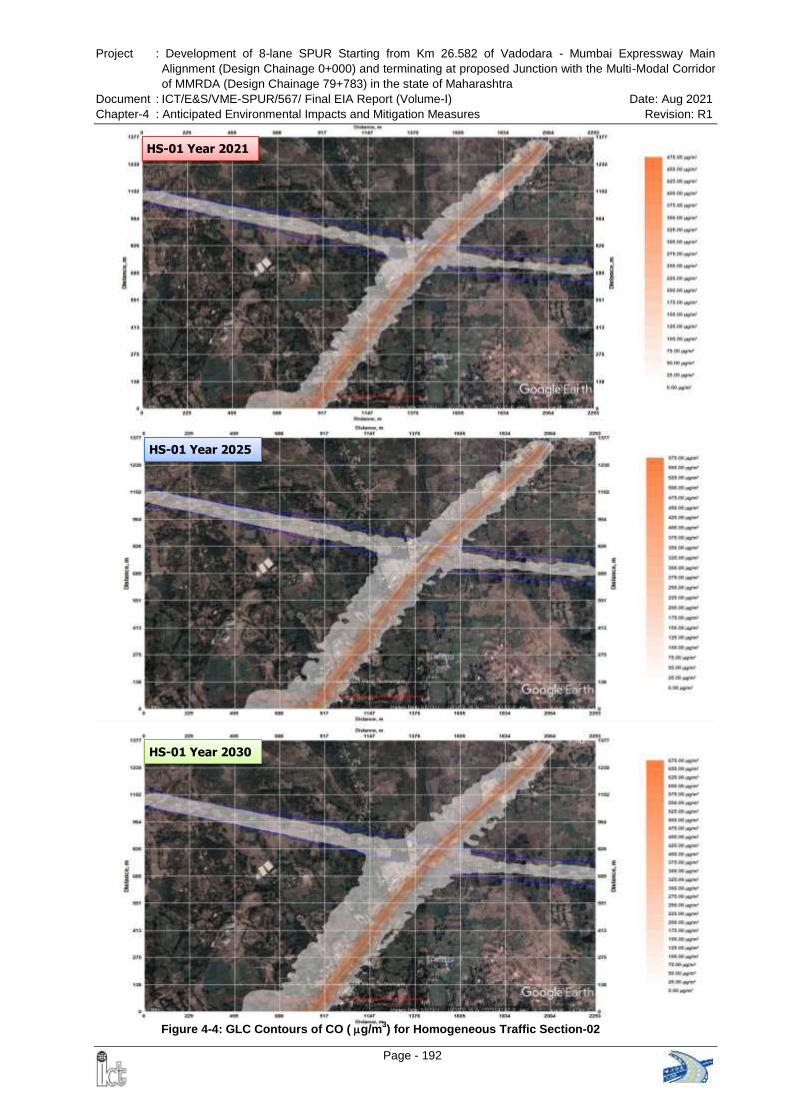
Project : Development of 8-lane SPUR Starting from Km 26.582 of Vadodara - Mumbai Expressway Main
Alignment (Design Chainage 0+000) and terminating at proposed Junction with the Multi-Modal Corridor
of MMRDA (Design Chainage 79+783) in the state of Maharashtra
Document : ICT/E&S/VME-SPUR/567/ Final EIA Report (Volume-I) Date: Aug 2021
Chapter-4 : Anticipated Environmental Impacts and Mitigation Measures Revision: R1
Page - 192
HS-01 Year 2025
HS-01 Year 2021
HS-01 Year 2030
Figure 4-4: GLC Contours of CO (g/m3) for Homogeneous Traffic Section-02
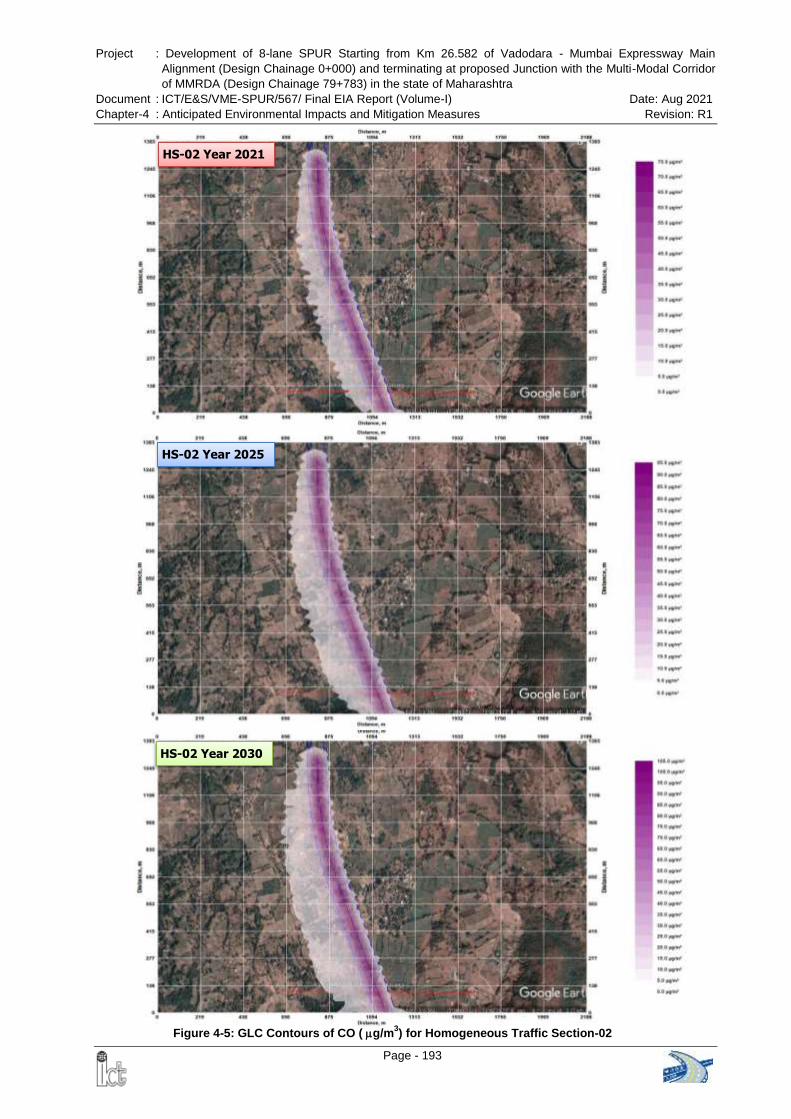
Project : Development of 8-lane SPUR Starting from Km 26.582 of Vadodara - Mumbai Expressway Main
Alignment (Design Chainage 0+000) and terminating at proposed Junction with the Multi-Modal Corridor
of MMRDA (Design Chainage 79+783) in the state of Maharashtra
Document : ICT/E&S/VME-SPUR/567/ Final EIA Report (Volume-I) Date: Aug 2021
Chapter-4 : Anticipated Environmental Impacts and Mitigation Measures Revision: R1
Page - 193
HS-02 Year 2021
HS-02 Year 2025
HS-02 Year 2030
Figure 4-5: GLC Contours of CO (g/m3) for Homogeneous Traffic Section-02
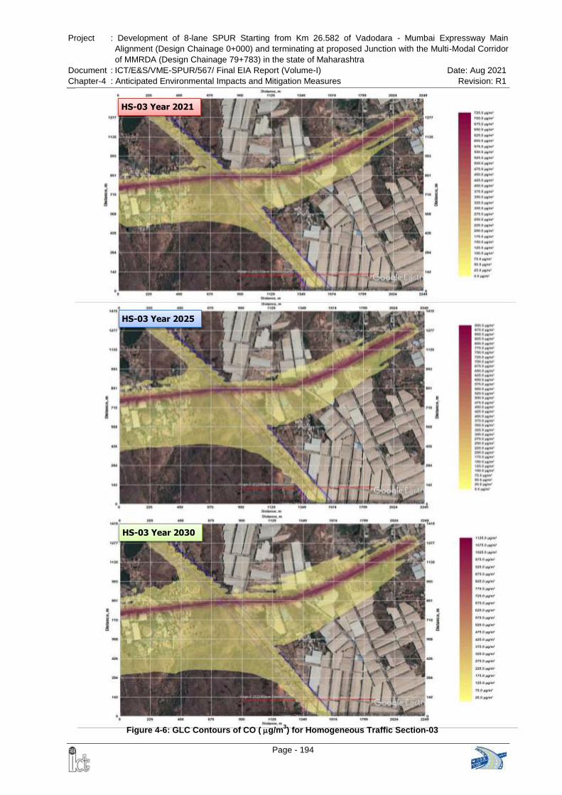
Project : Development of 8-lane SPUR Starting from Km 26.582 of Vadodara - Mumbai Expressway Main
Alignment (Design Chainage 0+000) and terminating at proposed Junction with the Multi-Modal Corridor
of MMRDA (Design Chainage 79+783) in the state of Maharashtra
Document : ICT/E&S/VME-SPUR/567/ Final EIA Report (Volume-I) Date: Aug 2021
Chapter-4 : Anticipated Environmental Impacts and Mitigation Measures Revision: R1
Page - 194
HS-03 Year 2021
HS-03 Year 2025
HS-03 Year 2030
Figure 4-6: GLC Contours of CO (g/m3) for Homogeneous Traffic Section-03
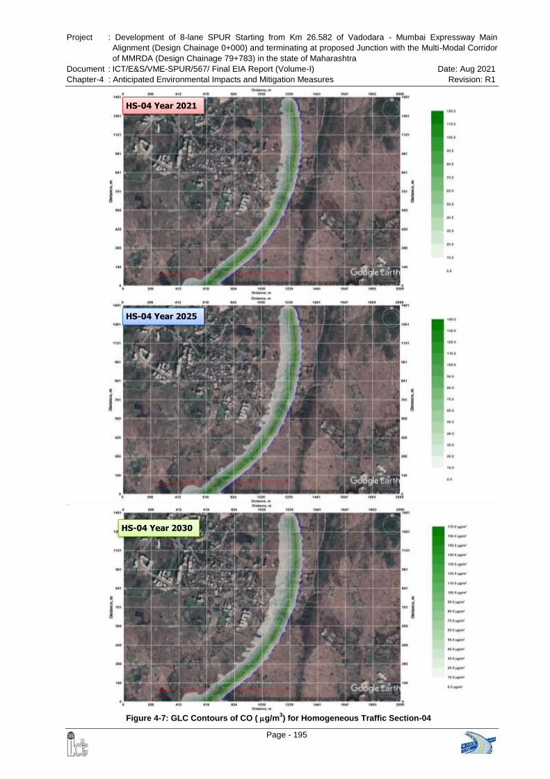
Project : Development of 8-lane SPUR Starting from Km 26.582 of Vadodara - Mumbai Expressway Main
Alignment (Design Chainage 0+000) and terminating at proposed Junction with the Multi-Modal Corridor
of MMRDA (Design Chainage 79+783) in the state of Maharashtra
Document : ICT/E&S/VME-SPUR/567/ Final EIA Report (Volume-I) Date: Aug 2021
Chapter-4 : Anticipated Environmental Impacts and Mitigation Measures Revision: R1
Page - 195
Figure 4-4: GLC Contours of CO (g/m3) for Homogeneous Traffic Section 01
HS-04 Year 2021
HS-04 Year 2025
HS-04 Year 2030
Figure 4-7: GLC Contours of CO (g/m3) for Homogeneous Traffic Section-04
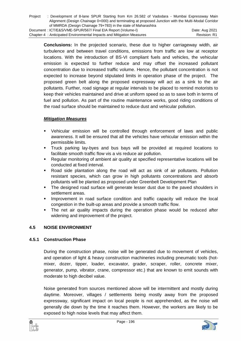
Project : Development of 8-lane SPUR Starting from Km 26.582 of Vadodara - Mumbai Expressway Main
Alignment (Design Chainage 0+000) and terminating at proposed Junction with the Multi-Modal Corridor
of MMRDA (Design Chainage 79+783) in the state of Maharashtra
Document : ICT/E&S/VME-SPUR/567/ Final EIA Report (Volume-I) Date: Aug 2021
Chapter-4 : Anticipated Environmental Impacts and Mitigation Measures Revision: R1
Page - 196
Conclusions: In the projected scenario, these due to higher carriageway width, air
turbulence and between travel conditions, emissions from traffic are low at receptor
locations. With the introduction of BS-VI compliant fuels and vehicles, the vehicular
emission is expected to further reduce and may offset the increased pollutant
concentration due to increased traffic volume. Hence, the pollutant concentration is not
expected to increase beyond stipulated limits in operation phase of the project. The
proposed green belt along the proposed expressway will act as a sink to the air
pollutants. Further, road signage at regular intervals to be placed to remind motorists to
keep their vehicles maintained and drive at uniform speed so as to save both in terms of
fuel and pollution. As part of the routine maintenance works, good riding conditions of
the road surface should be maintained to reduce dust and vehicular pollution.
Mitigation Measures
Vehicular emission will be controlled through enforcement of laws and public
awareness. It will be ensured that all the vehicles have vehicular emission within the
permissible limits.
Truck parking lay-byes and bus bays will be provided at required locations to
facilitate smooth traffic flow vis a vis reduce air pollution.
Regular monitoring of ambient air quality at specified representative locations will be
conducted at fixed interval.
Road side plantation along the road will act as sink of air pollutants. Pollution
resistant species, which can grow in high pollutants concentrations and absorb
pollutants will be planted as proposed under Greenbelt Development Plan
The designed road surface will generate lesser dust due to the paved shoulders in
settlement areas.
Improvement in road surface condition and traffic capacity will reduce the local
congestion in the built-up areas and provide a smooth traffic flow.
The net air quality impacts during the operation phase would be reduced after
widening and improvement of the project.
4.5 NOISE ENVIRONMENT
4.5.1 Construction Phase
During the construction phase, noise will be generated due to movement of vehicles,
and operation of light & heavy construction machineries including pneumatic tools (hot-
mixer, dozer, tipper, loader, excavator, grader, scraper, roller, concrete mixer,
generator, pump, vibrator, crane, compressor etc.) that are known to emit sounds with
moderate to high decibel value.
Noise generated from sources mentioned above will be intermittent and mostly during
daytime. Moreover, villages / settlements being mostly away from the proposed
expressway, significant impact on local people is not apprehended, as the noise will
generally die down by the time it reaches them. However, the workers are likely to be
exposed to high noise levels that may affect them.
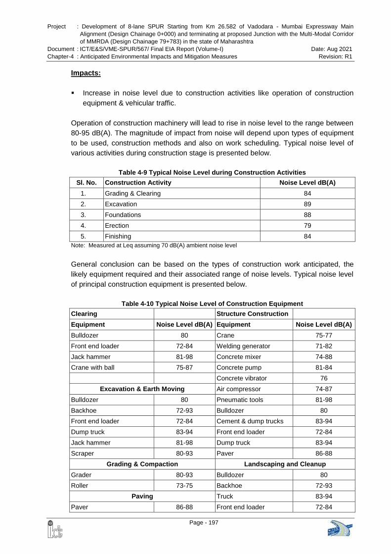
Project : Development of 8-lane SPUR Starting from Km 26.582 of Vadodara - Mumbai Expressway Main
Alignment (Design Chainage 0+000) and terminating at proposed Junction with the Multi-Modal Corridor
of MMRDA (Design Chainage 79+783) in the state of Maharashtra
Document : ICT/E&S/VME-SPUR/567/ Final EIA Report (Volume-I) Date: Aug 2021
Chapter-4 : Anticipated Environmental Impacts and Mitigation Measures Revision: R1
Page - 197
Impacts:
Increase in noise level due to construction activities like operation of construction
equipment & vehicular traffic.
Operation of construction machinery will lead to rise in noise level to the range between
80-95 dB(A). The magnitude of impact from noise will depend upon types of equipment
to be used, construction methods and also on work scheduling. Typical noise level of
various activities during construction stage is presented below.
Table 4-9 Typical Noise Level during Construction Activities
Sl. No. Construction Activity Noise Level dB(A)
1. Grading & Clearing 84
2. Excavation 89
3. Foundations 88
4. Erection 79
5. Finishing 84
Note: Measured at Leq assuming 70 dB(A) ambient noise level
General conclusion can be based on the types of construction work anticipated, the
likely equipment required and their associated range of noise levels. Typical noise level
of principal construction equipment is presented below.
Table 4-10 Typical Noise Level of Construction Equipment
Clearing Structure Construction
Equipment Noise Level dB(A) Equipment Noise Level dB(A)
Bulldozer 80 Crane 75-77
Front end loader 72-84 Welding generator 71-82
Jack hammer 81-98 Concrete mixer 74-88
Crane with ball 75-87 Concrete pump 81-84
Concrete vibrator 76
Excavation & Earth Moving Air compressor 74-87
Bulldozer 80 Pneumatic tools 81-98
Backhoe 72-93 Bulldozer 80
Front end loader 72-84 Cement & dump trucks 83-94
Dump truck 83-94 Front end loader 72-84
Jack hammer 81-98 Dump truck 83-94
Scraper 80-93 Paver 86-88
Grading & Compaction Landscaping and Cleanup
Grader 80-93 Bulldozer 80
Roller 73-75 Backhoe 72-93
Paving Truck 83-94
Paver 86-88 Front end loader 72-84
Project : Development of 8-lane SPUR Starting from Km 26.582 of Vadodara - Mumbai Expressway Main
Alignment (Design Chainage 0+000) and terminating at proposed Junction with the Multi-Modal Corridor
of MMRDA (Design Chainage 79+783) in the state of Maharashtra
Document : ICT/E&S/VME-SPUR/567/ Final EIA Report (Volume-I) Date: Aug 2021
Chapter-4 : Anticipated Environmental Impacts and Mitigation Measures Revision: R1
Page - 198
Clearing Structure Construction
Truck 83-94 Dump truck 83-94
Tamper 74-77 Paver 86-88
Source: U.S. Environmental Protection Agency, Noise from Construction Equipment and Operations.
Building Equipment and Home Appliance. NJID.300.1. December 31, 1971
The construction noise is generally intermittent and depends on the type of operations,
location and function of the equipment and the equipment usage cycle, it attenuates
quickly with increases in distance. The noise level generated from a source will
decrease with distance as per the following empirical formula (inverse square law).
SPL2 = SPL1 - 20Log10(r2/r1)
where, SPL1 and SPL2 are the sound pressure levels at distance r1 and r2 respectively.
Considering the stationary construction equipment as a point source generating 90
dB(A) at a reference distance of 2 m, computed minimum distance required from the
stationery source to meet the permissible noise limits during day time for different land
use categories are given in Table 4-11.
Table 4-11 Minimum Distance Required from Stationary Noise Source
Category Permissible Limits in Day Time (CPCB) Distance Required (m)
Silence zone 50 dB(A) 200
Residential 55 dB(A) 113
Commercial 65 dB(A) 36
Industrial 75 dB(A) 11
From the above table it may be noted that residence within 113m from the expressway
will be exposed to a noise higher than the permissible limit. The impacts will be
significant on construction workers, working close to the machinery.
Mitigation Measures:
Construction camp and temporary labour sheds will be located away from the
immediate vicinity of the construction sites and major road traffic.
Protective gears such as ear plugs or ear muffs will be provided to construction
personnel exposed to high noise levels as preventive measure (Annex-9.11).
Low noise construction equipment will be used.
It will be ensured that all the construction equipment & vehicles used are in good
working condition, properly lubricated & maintained to keep noise within the
permissible limits and engines turned off when not in use to reduce noise.
Stationary construction equipment will be placed 113 m away from inhabited areas.
Stationary construction equipment will be placed 200 m away from the school.
However, those schools are located within 200m of the proposed expressway; no
construction activity shall be carried out in those stretches during school hours.
Project : Development of 8-lane SPUR Starting from Km 26.582 of Vadodara - Mumbai Expressway Main
Alignment (Design Chainage 0+000) and terminating at proposed Junction with the Multi-Modal Corridor
of MMRDA (Design Chainage 79+783) in the state of Maharashtra
Document : ICT/E&S/VME-SPUR/567/ Final EIA Report (Volume-I) Date: Aug 2021
Chapter-4 : Anticipated Environmental Impacts and Mitigation Measures Revision: R1
Page - 199
Further, noise barrier has also been proposed in those schools.
Construction activities carried out near residential area will be scheduled to the
daytime only so that minimum disturbances are caused to people.
“Silence zones will be demarcated and road signs prohibiting the use of horns (No
Honk Zone) will be displayed at residential areas, sensitive locations and silence
zones
Noise barrier will be constructed in silence zone, interchanges (300m on each side
on outer edge), fly-overs (200m on each side on outer edge), truck parking (500m
on one side on outer edge), way side amenity - type A (500m on one side on outer
edge) and way side amenity - type B (150m on one side on outer edge)
Noise Monitoring: The effectiveness of mitigation measures and further
improvement in designs to reduce the noise level due to construction and operation
activity shall be monitored. The frequency, duration and monitoring plan shall be
functional in construction as well as in operation stages as per the Environmental
Monitoring Plan (Table 6-2 of Chapter-6) and the monitored values should
correspond with the standard. All deviated results shall be reported to AE, for
remedial measures.
4.5.2 Operation Phase
The significance of operational noise impacts commensurate with the number of
sensitive structures and sensitive areas that exist along the project roads. As stated in
Chapter-3, land use pattern within RoW of the proposed expressway is mainly
agricultural and allied uses (63.93%) of the total area, followed by barren / waste land
(16.06%), forest (11.91%), industrial area (4.31%), built-up area (2.46%) and water
bodies (1.33%).
The sensitive receptors comprising of educational institutions, medical amenities etc.
are located on either side of the proposed expressway will be exposed to traffic induced
noise during the operation phase.
4.5.2.1 Source of Noise
Source of Noise: During the operational phase, movement of traffic, traffic congestion,
pedestrian interferences and increase in use of horns will be the prime source of noise.
The noise levels at nearby schools, religious place may cause nuisance and irritation.
Vehicle Noise and Road Surface Influence on Tire/Road Noise3
There are many sources of noise when a vehicle travels down a roadway. Vehicle
manufactures have made efforts to reduce tire/road noise and drive train noise. If a
vehicle is in a good operating condition and has a reasonably good exhaust system,
then the effect that power and drive train noise has on the overall noise level will be
negligible at moderate to high speeds. There is a “cross-over speed” where tire / road
3 U.S. Department of Transportation, Federal Highway Administration
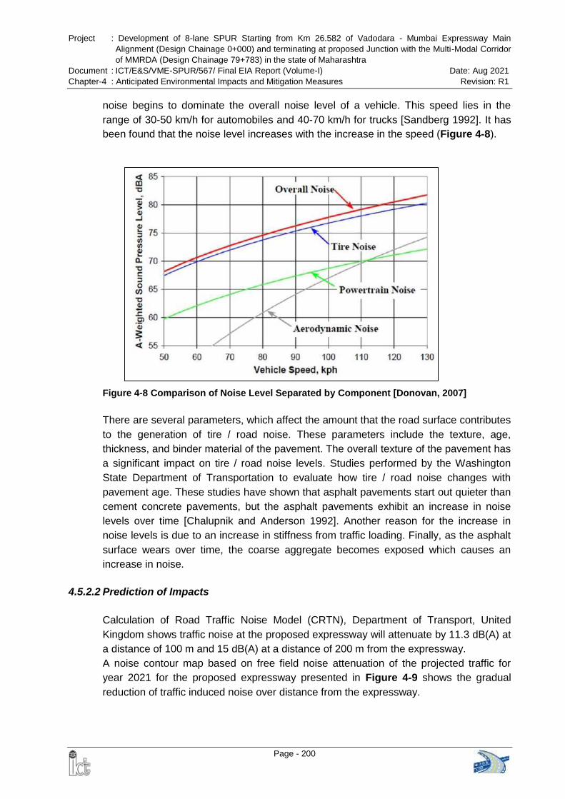
Project : Development of 8-lane SPUR Starting from Km 26.582 of Vadodara - Mumbai Expressway Main
Alignment (Design Chainage 0+000) and terminating at proposed Junction with the Multi-Modal Corridor
of MMRDA (Design Chainage 79+783) in the state of Maharashtra
Document : ICT/E&S/VME-SPUR/567/ Final EIA Report (Volume-I) Date: Aug 2021
Chapter-4 : Anticipated Environmental Impacts and Mitigation Measures Revision: R1
Page - 200
noise begins to dominate the overall noise level of a vehicle. This speed lies in the
range of 30-50 km/h for automobiles and 40-70 km/h for trucks [Sandberg 1992]. It has
been found that the noise level increases with the increase in the speed (Figure 4-8).
Figure 4-8 Comparison of Noise Level Separated by Component [Donovan, 2007]
There are several parameters, which affect the amount that the road surface contributes
to the generation of tire / road noise. These parameters include the texture, age,
thickness, and binder material of the pavement. The overall texture of the pavement has
a significant impact on tire / road noise levels. Studies performed by the Washington
State Department of Transportation to evaluate how tire / road noise changes with
pavement age. These studies have shown that asphalt pavements start out quieter than
cement concrete pavements, but the asphalt pavements exhibit an increase in noise
levels over time [Chalupnik and Anderson 1992]. Another reason for the increase in
noise levels is due to an increase in stiffness from traffic loading. Finally, as the asphalt
surface wears over time, the coarse aggregate becomes exposed which causes an
increase in noise.
4.5.2.2 Prediction of Impacts
Calculation of Road Traffic Noise Model (CRTN), Department of Transport, United
Kingdom shows traffic noise at the proposed expressway will attenuate by 11.3 dB(A) at
a distance of 100 m and 15 dB(A) at a distance of 200 m from the expressway.
A noise contour map based on free field noise attenuation of the projected traffic for
year 2021 for the proposed expressway presented in Figure 4-9 shows the gradual
reduction of traffic induced noise over distance from the expressway.
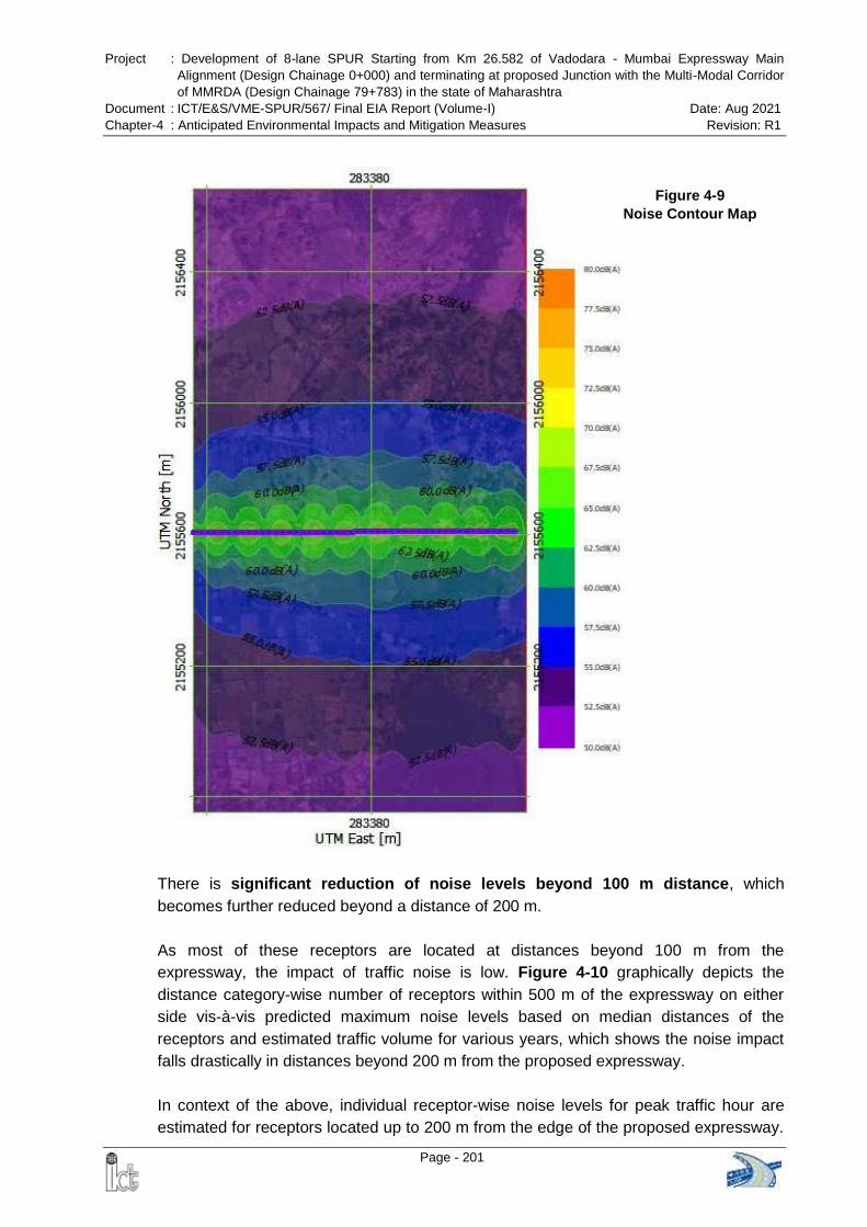
Project : Development of 8-lane SPUR Starting from Km 26.582 of Vadodara - Mumbai Expressway Main
Alignment (Design Chainage 0+000) and terminating at proposed Junction with the Multi-Modal Corridor
of MMRDA (Design Chainage 79+783) in the state of Maharashtra
Document : ICT/E&S/VME-SPUR/567/ Final EIA Report (Volume-I) Date: Aug 2021
Chapter-4 : Anticipated Environmental Impacts and Mitigation Measures Revision: R1
Page - 201
Figure 4-9
Noise Contour Map
There is significant reduction of noise levels beyond 100 m distance, which
becomes further reduced beyond a distance of 200 m.
As most of these receptors are located at distances beyond 100 m from the
expressway, the impact of traffic noise is low. Figure 4-10 graphically depicts the
distance category-wise number of receptors within 500 m of the expressway on either
side vis-à-vis predicted maximum noise levels based on median distances of the
receptors and estimated traffic volume for various years, which shows the noise impact
falls drastically in distances beyond 200 m from the proposed expressway.
In context of the above, individual receptor-wise noise levels for peak traffic hour are
estimated for receptors located up to 200 m from the edge of the proposed expressway.
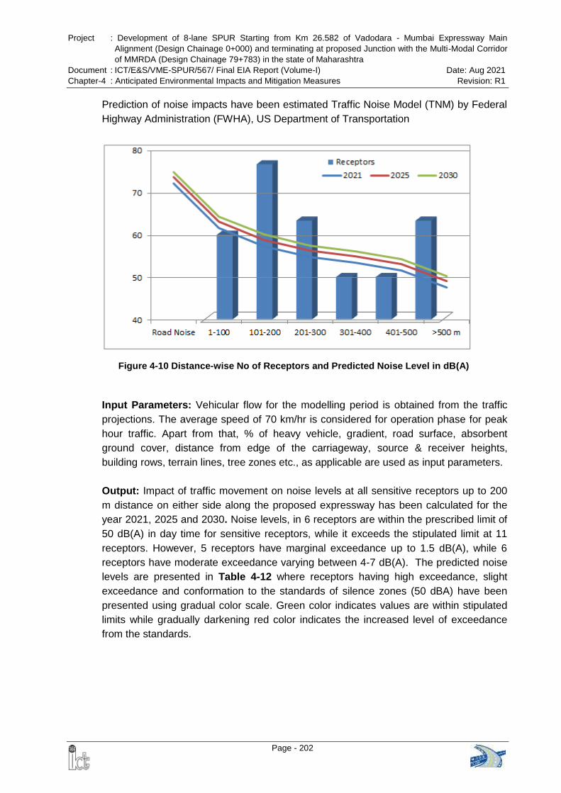
Project : Development of 8-lane SPUR Starting from Km 26.582 of Vadodara - Mumbai Expressway Main
Alignment (Design Chainage 0+000) and terminating at proposed Junction with the Multi-Modal Corridor
of MMRDA (Design Chainage 79+783) in the state of Maharashtra
Document : ICT/E&S/VME-SPUR/567/ Final EIA Report (Volume-I) Date: Aug 2021
Chapter-4 : Anticipated Environmental Impacts and Mitigation Measures Revision: R1
Page - 202
Prediction of noise impacts have been estimated Traffic Noise Model (TNM) by Federal
Highway Administration (FWHA), US Department of Transportation
Input Parameters: Vehicular flow for the modelling period is obtained from the traffic
projections. The average speed of 70 km/hr is considered for operation phase for peak
hour traffic. Apart from that, % of heavy vehicle, gradient, road surface, absorbent
ground cover, distance from edge of the carriageway, source & receiver heights,
building rows, terrain lines, tree zones etc., as applicable are used as input parameters.
Output: Impact of traffic movement on noise levels at all sensitive receptors up to 200
m distance on either side along the proposed expressway has been calculated for the
year 2021, 2025 and 2030. Noise levels, in 6 receptors are within the prescribed limit of
50 dB(A) in day time for sensitive receptors, while it exceeds the stipulated limit at 11
receptors. However, 5 receptors have marginal exceedance up to 1.5 dB(A), while 6
receptors have moderate exceedance varying between 4-7 dB(A). The predicted noise
levels are presented in Table 4-12 where receptors having high exceedance, slight
exceedance and conformation to the standards of silence zones (50 dBA) have been
presented using gradual color scale. Green color indicates values are within stipulated
limits while gradually darkening red color indicates the increased level of exceedance
from the standards.
Figure 4-10 Distance-wise No of Receptors and Predicted Noise Level in dB(A)
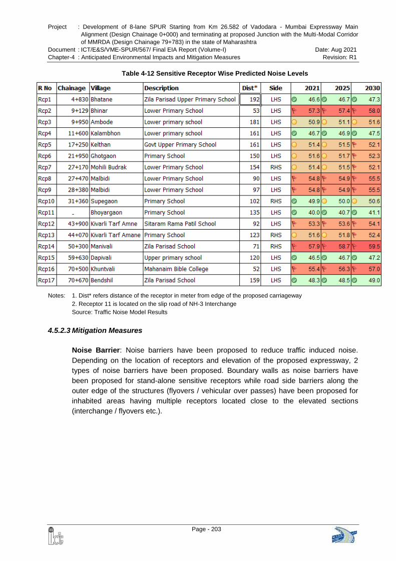
Project : Development of 8-lane SPUR Starting from Km 26.582 of Vadodara - Mumbai Expressway Main
Alignment (Design Chainage 0+000) and terminating at proposed Junction with the Multi-Modal Corridor
of MMRDA (Design Chainage 79+783) in the state of Maharashtra
Document : ICT/E&S/VME-SPUR/567/ Final EIA Report (Volume-I) Date: Aug 2021
Chapter-4 : Anticipated Environmental Impacts and Mitigation Measures Revision: R1
Page - 203
Table 4-12 Sensitive Receptor Wise Predicted Noise Levels
Notes: 1. Dist* refers distance of the receptor in meter from edge of the proposed carriageway 2. Receptor 11 is located on the slip road of NH-3 Interchange
Source: Traffic Noise Model Results
4.5.2.3 Mitigation Measures
Noise Barrier: Noise barriers have been proposed to reduce traffic induced noise.
Depending on the location of receptors and elevation of the proposed expressway, 2
types of noise barriers have been proposed. Boundary walls as noise barriers have
been proposed for stand-alone sensitive receptors while road side barriers along the
outer edge of the structures (flyovers / vehicular over passes) have been proposed for
inhabited areas having multiple receptors located close to the elevated sections
(interchange / flyovers etc.).
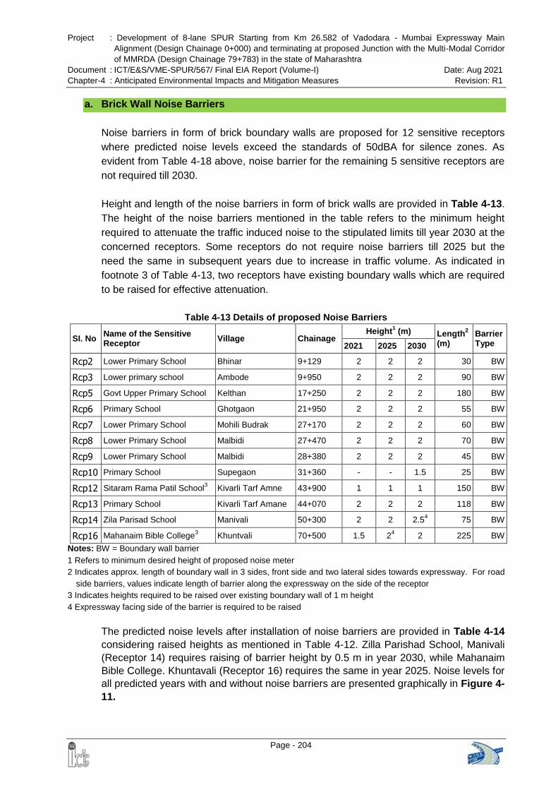
Project : Development of 8-lane SPUR Starting from Km 26.582 of Vadodara - Mumbai Expressway Main
Alignment (Design Chainage 0+000) and terminating at proposed Junction with the Multi-Modal Corridor
of MMRDA (Design Chainage 79+783) in the state of Maharashtra
Document : ICT/E&S/VME-SPUR/567/ Final EIA Report (Volume-I) Date: Aug 2021
Chapter-4 : Anticipated Environmental Impacts and Mitigation Measures Revision: R1
Page - 204
a. Brick Wall Noise Barriers
Noise barriers in form of brick boundary walls are proposed for 12 sensitive receptors
where predicted noise levels exceed the standards of 50dBA for silence zones. As
evident from Table 4-18 above, noise barrier for the remaining 5 sensitive receptors are
not required till 2030.
Height and length of the noise barriers in form of brick walls are provided in Table 4-13.
The height of the noise barriers mentioned in the table refers to the minimum height
required to attenuate the traffic induced noise to the stipulated limits till year 2030 at the
concerned receptors. Some receptors do not require noise barriers till 2025 but the
need the same in subsequent years due to increase in traffic volume. As indicated in
footnote 3 of Table 4-13, two receptors have existing boundary walls which are required
to be raised for effective attenuation.
Table 4-13 Details of proposed Noise Barriers
SI. No Name of the Sensitive Receptor
Village Chainage Height
1 (m) Length
2
(m) Barrier Type 2021 2025 2030
Rcp2 Lower Primary School Bhinar 9+129 2 2 2 30 BW
Rcp3 Lower primary school Ambode 9+950 2 2 2 90 BW
Rcp5 Govt Upper Primary School Kelthan 17+250 2 2 2 180 BW
Rcp6 Primary School Ghotgaon 21+950 2 2 2 55 BW
Rcp7 Lower Primary School Mohili Budrak 27+170 2 2 2 60 BW
Rcp8 Lower Primary School Malbidi 27+470 2 2 2 70 BW
Rcp9 Lower Primary School Malbidi 28+380 2 2 2 45 BW
Rcp10 Primary School Supegaon 31+360 - - 1.5 25 BW
Rcp12 Sitaram Rama Patil School3 Kivarli Tarf Amne 43+900 1 1 1 150 BW
Rcp13 Primary School Kivarli Tarf Amane 44+070 2 2 2 118 BW
Rcp14 Zila Parisad School Manivali 50+300 2 2 2.54 75 BW
Rcp16 Mahanaim Bible College3 Khuntvali 70+500 1.5 2
4 2 225 BW
Notes: BW = Boundary wall barrier
1 Refers to minimum desired height of proposed noise meter
2 Indicates approx. length of boundary wall in 3 sides, front side and two lateral sides towards expressway. For road
side barriers, values indicate length of barrier along the expressway on the side of the receptor
3 Indicates heights required to be raised over existing boundary wall of 1 m height
4 Expressway facing side of the barrier is required to be raised
The predicted noise levels after installation of noise barriers are provided in Table 4-14
considering raised heights as mentioned in Table 4-12. Zilla Parishad School, Manivali
(Receptor 14) requires raising of barrier height by 0.5 m in year 2030, while Mahanaim
Bible College. Khuntavali (Receptor 16) requires the same in year 2025. Noise levels for
all predicted years with and without noise barriers are presented graphically in Figure 4-
11.
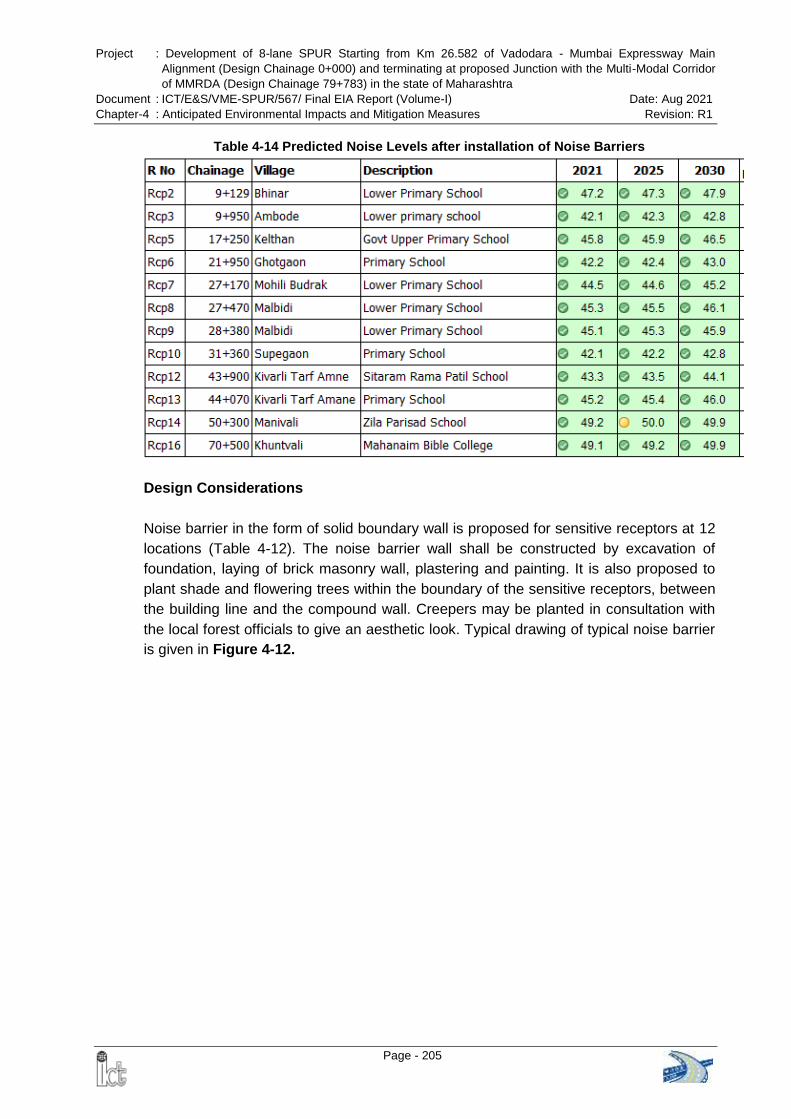
Project : Development of 8-lane SPUR Starting from Km 26.582 of Vadodara - Mumbai Expressway Main
Alignment (Design Chainage 0+000) and terminating at proposed Junction with the Multi-Modal Corridor
of MMRDA (Design Chainage 79+783) in the state of Maharashtra
Document : ICT/E&S/VME-SPUR/567/ Final EIA Report (Volume-I) Date: Aug 2021
Chapter-4 : Anticipated Environmental Impacts and Mitigation Measures Revision: R1
Page - 205
Table 4-14 Predicted Noise Levels after installation of Noise Barriers
Design Considerations
Noise barrier in the form of solid boundary wall is proposed for sensitive receptors at 12
locations (Table 4-12). The noise barrier wall shall be constructed by excavation of
foundation, laying of brick masonry wall, plastering and painting. It is also proposed to
plant shade and flowering trees within the boundary of the sensitive receptors, between
the building line and the compound wall. Creepers may be planted in consultation with
the local forest officials to give an aesthetic look. Typical drawing of typical noise barrier
is given in Figure 4-12.
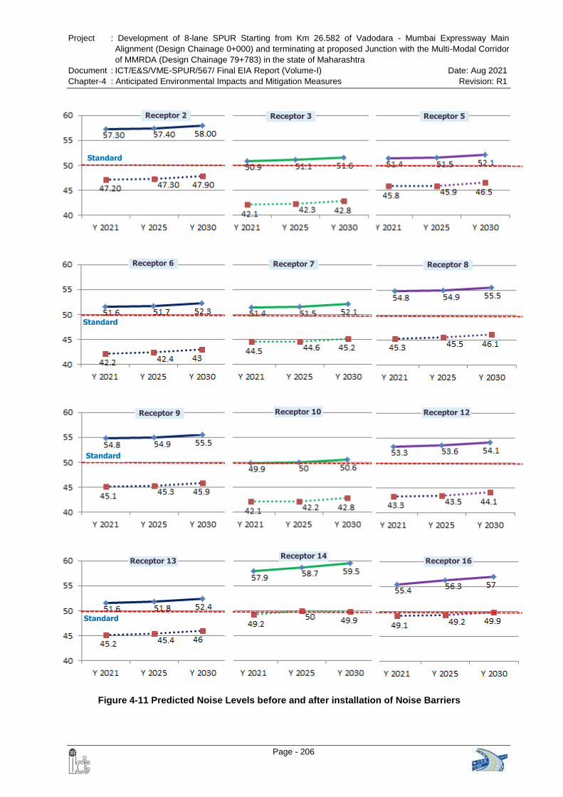
Project : Development of 8-lane SPUR Starting from Km 26.582 of Vadodara - Mumbai Expressway Main
Alignment (Design Chainage 0+000) and terminating at proposed Junction with the Multi-Modal Corridor
of MMRDA (Design Chainage 79+783) in the state of Maharashtra
Document : ICT/E&S/VME-SPUR/567/ Final EIA Report (Volume-I) Date: Aug 2021
Chapter-4 : Anticipated Environmental Impacts and Mitigation Measures Revision: R1
Page - 206
Standard
Receptor 2 Receptor 3 Receptor 5
Receptor 6 Receptor 7 Receptor 8
Standard
Standard
Receptor 9 Receptor 10 Receptor 12
Standard
Receptor 13 Receptor 14
Receptor 16
Figure 4-11 Predicted Noise Levels before and after installation of Noise Barriers
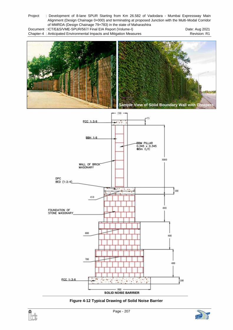
Project : Development of 8-lane SPUR Starting from Km 26.582 of Vadodara - Mumbai Expressway Main
Alignment (Design Chainage 0+000) and terminating at proposed Junction with the Multi-Modal Corridor
of MMRDA (Design Chainage 79+783) in the state of Maharashtra
Document : ICT/E&S/VME-SPUR/567/ Final EIA Report (Volume-I) Date: Aug 2021
Chapter-4 : Anticipated Environmental Impacts and Mitigation Measures Revision: R1
Page - 207
Figure 4-12 Typical Drawing of Solid Noise Barrier
Sample View of Solid Boundary Wall with Creepers
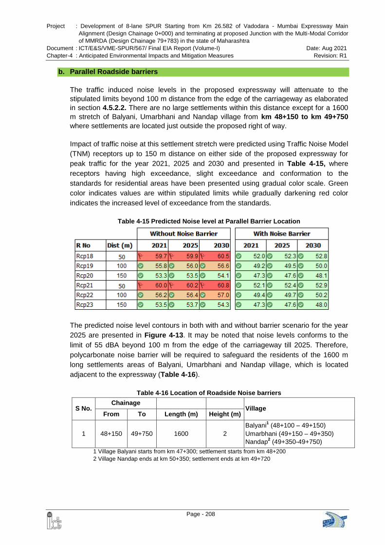
Project : Development of 8-lane SPUR Starting from Km 26.582 of Vadodara - Mumbai Expressway Main
Alignment (Design Chainage 0+000) and terminating at proposed Junction with the Multi-Modal Corridor
of MMRDA (Design Chainage 79+783) in the state of Maharashtra
Document : ICT/E&S/VME-SPUR/567/ Final EIA Report (Volume-I) Date: Aug 2021
Chapter-4 : Anticipated Environmental Impacts and Mitigation Measures Revision: R1
Page - 208
b. Parallel Roadside barriers
The traffic induced noise levels in the proposed expressway will attenuate to the
stipulated limits beyond 100 m distance from the edge of the carriageway as elaborated
in section 4.5.2.2. There are no large settlements within this distance except for a 1600
m stretch of Balyani, Umarbhani and Nandap village from km 48+150 to km 49+750
where settlements are located just outside the proposed right of way.
Impact of traffic noise at this settlement stretch were predicted using Traffic Noise Model
(TNM) receptors up to 150 m distance on either side of the proposed expressway for
peak traffic for the year 2021, 2025 and 2030 and presented in Table 4-15, where
receptors having high exceedance, slight exceedance and conformation to the
standards for residential areas have been presented using gradual color scale. Green
color indicates values are within stipulated limits while gradually darkening red color
indicates the increased level of exceedance from the standards.
Table 4-15 Predicted Noise level at Parallel Barrier Location
The predicted noise level contours in both with and without barrier scenario for the year
2025 are presented in Figure 4-13. It may be noted that noise levels conforms to the
limit of 55 dBA beyond 100 m from the edge of the carriageway till 2025. Therefore,
polycarbonate noise barrier will be required to safeguard the residents of the 1600 m
long settlements areas of Balyani, Umarbhani and Nandap village, which is located
adjacent to the expressway (Table 4-16).
Table 4-16 Location of Roadside Noise barriers
S No. Chainage
Village From To Length (m) Height (m)
1 48+150 49+750 1600 2
Balyani1 (48+100 – 49+150)
Umarbhani (49+150 – 49+350)
Nandap2 (49+350-49+750)
1 Village Balyani starts from km 47+300; settlement starts from km 48+200
2 Village Nandap ends at km 50+350; settlement ends at km 49+720
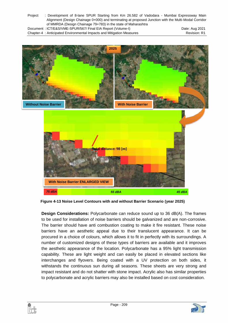
Project : Development of 8-lane SPUR Starting from Km 26.582 of Vadodara - Mumbai Expressway Main
Alignment (Design Chainage 0+000) and terminating at proposed Junction with the Multi-Modal Corridor
of MMRDA (Design Chainage 79+783) in the state of Maharashtra
Document : ICT/E&S/VME-SPUR/567/ Final EIA Report (Volume-I) Date: Aug 2021
Chapter-4 : Anticipated Environmental Impacts and Mitigation Measures Revision: R1
Page - 209
Without Noise Barrier With Noise Barrier
2025
With Noise Barrier ENLARGED VIEW
75 dBA 45 dBA 55 dBA
Figure 4-13 Noise Level Contours with and without Barrier Scenario (year 2025)
Design Considerations: Polycarbonate can reduce sound up to 36 dB(A). The frames
to be used for installation of noise barriers should be galvanized and are non-corrosive.
The barrier should have anti combustion coating to make it fire resistant. These noise
barriers have an aesthetic appeal due to their translucent appearance. It can be
procured in a choice of colours, which allows it to fit in perfectly with its surroundings. A
number of customized designs of these types of barriers are available and it improves
the aesthetic appearance of the location. Polycarbonate has a 95% light transmission
capability. These are light weight and can easily be placed in elevated sections like
interchanges and flyovers. Being coated with a UV protection on both sides, it
withstands the continuous sun during all seasons. These sheets are very strong and
impact resistant and do not shatter with stone impact. Acrylic also has similar properties
to polycarbonate and acrylic barriers may also be installed based on cost consideration.
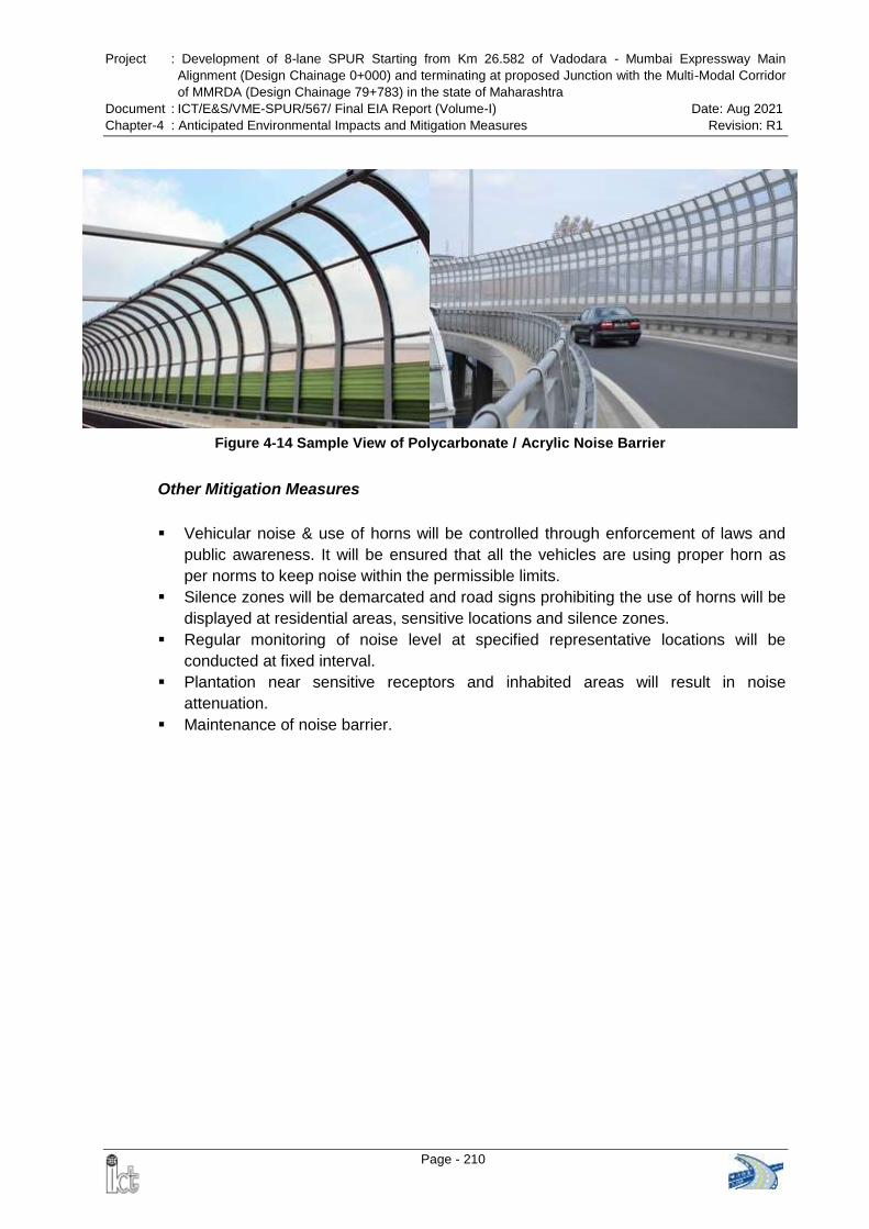
Project : Development of 8-lane SPUR Starting from Km 26.582 of Vadodara - Mumbai Expressway Main
Alignment (Design Chainage 0+000) and terminating at proposed Junction with the Multi-Modal Corridor
of MMRDA (Design Chainage 79+783) in the state of Maharashtra
Document : ICT/E&S/VME-SPUR/567/ Final EIA Report (Volume-I) Date: Aug 2021
Chapter-4 : Anticipated Environmental Impacts and Mitigation Measures Revision: R1
Page - 210
Figure 4-14 Sample View of Polycarbonate / Acrylic Noise Barrier
Other Mitigation Measures
Vehicular noise & use of horns will be controlled through enforcement of laws and
public awareness. It will be ensured that all the vehicles are using proper horn as
per norms to keep noise within the permissible limits.
Silence zones will be demarcated and road signs prohibiting the use of horns will be
displayed at residential areas, sensitive locations and silence zones.
Regular monitoring of noise level at specified representative locations will be
conducted at fixed interval.
Plantation near sensitive receptors and inhabited areas will result in noise
attenuation.
Maintenance of noise barrier.
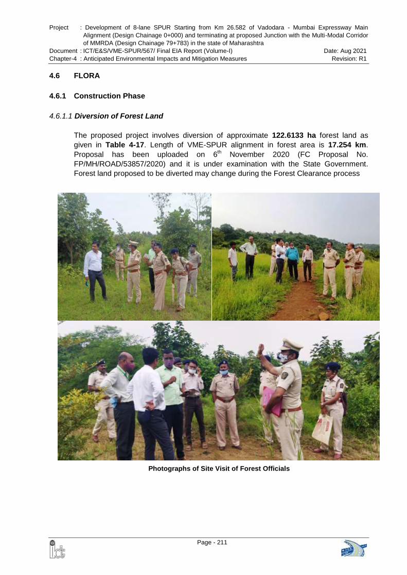
Project : Development of 8-lane SPUR Starting from Km 26.582 of Vadodara - Mumbai Expressway Main
Alignment (Design Chainage 0+000) and terminating at proposed Junction with the Multi-Modal Corridor
of MMRDA (Design Chainage 79+783) in the state of Maharashtra
Document : ICT/E&S/VME-SPUR/567/ Final EIA Report (Volume-I) Date: Aug 2021
Chapter-4 : Anticipated Environmental Impacts and Mitigation Measures Revision: R1
Page - 211
Photographs of Site Visit of Forest Officials
4.6 FLORA
4.6.1 Construction Phase
4.6.1.1 Diversion of Forest Land
The proposed project involves diversion of approximate 122.6133 ha forest land as
given in Table 4-17. Length of VME-SPUR alignment in forest area is 17.254 km.
Proposal has been uploaded on 6th November 2020 (FC Proposal No.
FP/MH/ROAD/53857/2020) and it is under examination with the State Government.
Forest land proposed to be diverted may change during the Forest Clearance process
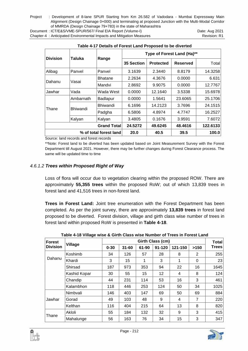
Project : Development of 8-lane SPUR Starting from Km 26.582 of Vadodara - Mumbai Expressway Main
Alignment (Design Chainage 0+000) and terminating at proposed Junction with the Multi-Modal Corridor
of MMRDA (Design Chainage 79+783) in the state of Maharashtra
Document : ICT/E&S/VME-SPUR/567/ Final EIA Report (Volume-I) Date: Aug 2021
Chapter-4 : Anticipated Environmental Impacts and Mitigation Measures Revision: R1
Page - 212
Table 4-17 Details of Forest Land Proposed to be diverted
Division Taluka Range Type of Forest Land (Ha)**
35 Section Protected Reserved Total
Alibag Panvel Panvel 3.1639 2.3440 8.8179 14.3258
Dahanu Vasai Bhatane 2.2634 4.3676 0.0000 6.631
Mandvi 2.8692 9.9075 0.0000 12.7767
Jawhar Vada Wada West 0.0000 12.1640 3.5338 15.6978
Thane
Ambarnath Badlapur 0.0000 1.5641 23.6065 25.1706
Bhiwandi Bhiwandi 6.1696 14.2123 3.7696 24.1515
Padgha 6.5806 4.8974 4.7747 16.2527
Kalyan Kalyan 3.4805 0.1676 3.9591 7.6072
Grand Total 24.5272 49.6245 48.4616 122.6133
% of total forest land 20.0 40.5 39.5 100.0
Source: land records and forest records
**Note: Forest land to be diverted has been updated based on Joint Measurement Survey with the Forest
Department till August 2021. However, there may be further changes during Forest Clearance process. The
same will be updated time to time
4.6.1.2 Trees within Proposed Right of Way
Loss of flora will occur due to vegetation clearing within the proposed ROW. There are
approximately 55,355 trees within the proposed RoW; out of which 13,839 trees in
forest land and 41,516 trees in non-forest land.
Trees in Forest Land: Joint tree enumeration with the Forest Department has been
completed. As per the joint survey, there are approximately 13,839 trees in forest land
proposed to be diverted. Forest division, village and girth class wise number of trees in
forest land within proposed RoW is presented in Table 4-18.
Table 4-18 Village wise & Girth Class wise Number of Trees in Forest Land
Forest Division
Village Girth Class (cm) Total
Trees 0-30 31-60 61-90 91-120 121-150 >150
Dahanu
Koshimb 34 126 57 28 8 2 255
Khardi 3 15 1 3 1 0 23
Shirsad 187 973 353 94 22 16 1645
Kashid Kopar 30 55 15 12 4 8 124
Chandip 44 231 114 53 16 3 461
Kalambhon 118 446 253 124 50 34 1025
Jawhar
Nimbvali 146 403 147 69 50 69 884
Gorad 49 103 48 9 4 7 220
Kelthan 116 404 215 64 13 8 820
Thane Akloli 55 184 132 32 9 3 415
Mahalunge 56 163 76 34 15 3 347
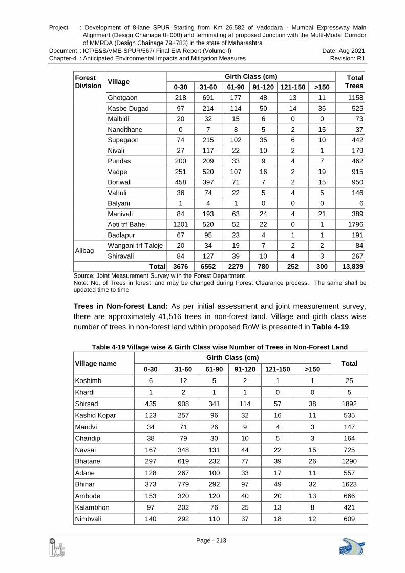
Project : Development of 8-lane SPUR Starting from Km 26.582 of Vadodara - Mumbai Expressway Main
Alignment (Design Chainage 0+000) and terminating at proposed Junction with the Multi-Modal Corridor
of MMRDA (Design Chainage 79+783) in the state of Maharashtra
Document : ICT/E&S/VME-SPUR/567/ Final EIA Report (Volume-I) Date: Aug 2021
Chapter-4 : Anticipated Environmental Impacts and Mitigation Measures Revision: R1
Page - 213
Forest Division
Village Girth Class (cm) Total
Trees 0-30 31-60 61-90 91-120 121-150 >150
Ghotgaon 218 691 177 48 13 11 1158
Kasbe Dugad 97 214 114 50 14 36 525
Malbidi 20 32 15 6 0 0 73
Nandithane 0 7 8 5 2 15 37
Supegaon 74 215 102 35 6 10 442
Nivali 27 117 22 10 2 1 179
Pundas 200 209 33 9 4 7 462
Vadpe 251 520 107 16 2 19 915
Boriwali 458 397 71 7 2 15 950
Vahuli 36 74 22 5 4 5 146
Balyani 1 4 1 0 0 0 6
Manivali 84 193 63 24 4 21 389
Apti trf Bahe 1201 520 52 22 0 1 1796
Badlapur 67 95 23 4 1 1 191
Alibag Wangani trf Taloje 20 34 19 7 2 2 84
Shiravali 84 127 39 10 4 3 267
Total 3676 6552 2279 780 252 300 13,839
Source: Joint Measurement Survey with the Forest Department Note: No. of Trees in forest land may be changed during Forest Clearance process. The same shall be updated time to time Trees in Non-forest Land: As per initial assessment and joint measurement survey,
there are approximately 41,516 trees in non-forest land. Village and girth class wise
number of trees in non-forest land within proposed RoW is presented in Table 4-19.
Table 4-19 Village wise & Girth Class wise Number of Trees in Non-Forest Land
Village name Girth Class (cm)
Total 0-30 31-60 61-90 91-120 121-150 >150
Koshimb 6 12 5 2 1 1 25
Khardi 1 2 1 1 0 0 5
Shirsad 435 908 341 114 57 38 1892
Kashid Kopar 123 257 96 32 16 11 535
Mandvi 34 71 26 9 4 3 147
Chandip 38 79 30 10 5 3 164
Navsai 167 348 131 44 22 15 725
Bhatane 297 619 232 77 39 26 1290
Adane 128 267 100 33 17 11 557
Bhinar 373 779 292 97 49 32 1623
Ambode 153 320 120 40 20 13 666
Kalambhon 97 202 76 25 13 8 421
Nimbvali 140 292 110 37 18 12 609
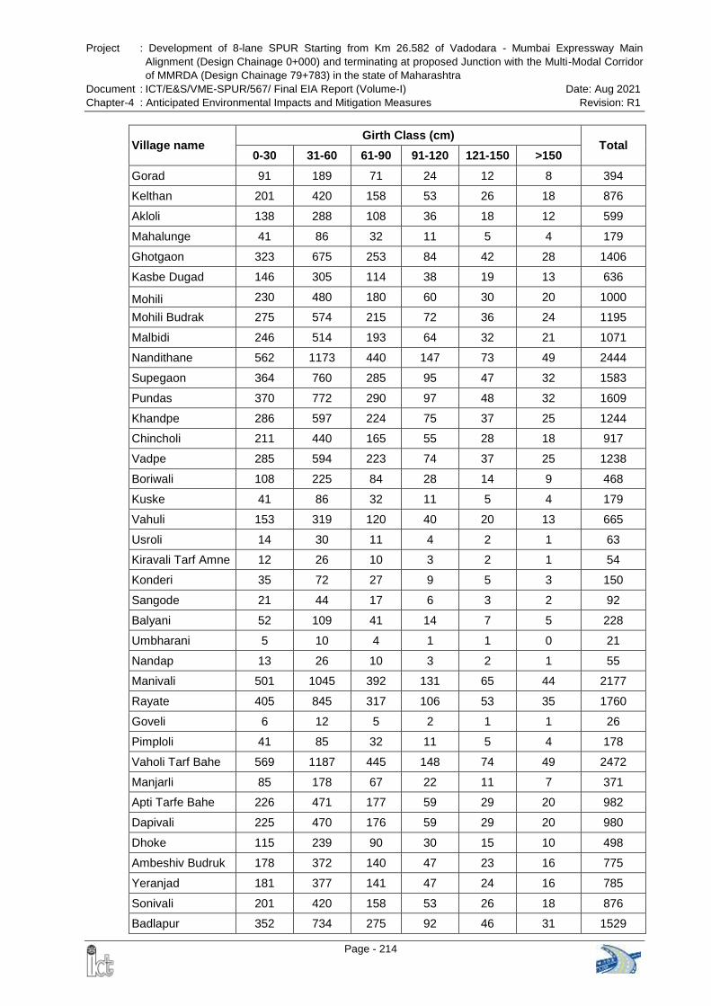
Project : Development of 8-lane SPUR Starting from Km 26.582 of Vadodara - Mumbai Expressway Main
Alignment (Design Chainage 0+000) and terminating at proposed Junction with the Multi-Modal Corridor
of MMRDA (Design Chainage 79+783) in the state of Maharashtra
Document : ICT/E&S/VME-SPUR/567/ Final EIA Report (Volume-I) Date: Aug 2021
Chapter-4 : Anticipated Environmental Impacts and Mitigation Measures Revision: R1
Page - 214
Village name Girth Class (cm)
Total 0-30 31-60 61-90 91-120 121-150 >150
Gorad 91 189 71 24 12 8 394
Kelthan 201 420 158 53 26 18 876
Akloli 138 288 108 36 18 12 599
Mahalunge 41 86 32 11 5 4 179
Ghotgaon 323 675 253 84 42 28 1406
Kasbe Dugad 146 305 114 38 19 13 636
Mohili 230 480 180 60 30 20 1000
Mohili Budrak 275 574 215 72 36 24 1195
Malbidi 246 514 193 64 32 21 1071
Nandithane 562 1173 440 147 73 49 2444
Supegaon 364 760 285 95 47 32 1583
Pundas 370 772 290 97 48 32 1609
Khandpe 286 597 224 75 37 25 1244
Chincholi 211 440 165 55 28 18 917
Vadpe 285 594 223 74 37 25 1238
Boriwali 108 225 84 28 14 9 468
Kuske 41 86 32 11 5 4 179
Vahuli 153 319 120 40 20 13 665
Usroli 14 30 11 4 2 1 63
Kiravali Tarf Amne 12 26 10 3 2 1 54
Konderi 35 72 27 9 5 3 150
Sangode 21 44 17 6 3 2 92
Balyani 52 109 41 14 7 5 228
Umbharani 5 10 4 1 1 0 21
Nandap 13 26 10 3 2 1 55
Manivali 501 1045 392 131 65 44 2177
Rayate 405 845 317 106 53 35 1760
Goveli 6 12 5 2 1 1 26
Pimploli 41 85 32 11 5 4 178
Vaholi Tarf Bahe 569 1187 445 148 74 49 2472
Manjarli 85 178 67 22 11 7 371
Apti Tarfe Bahe 226 471 177 59 29 20 982
Dapivali 225 470 176 59 29 20 980
Dhoke 115 239 90 30 15 10 498
Ambeshiv Budruk 178 372 140 47 23 16 775
Yeranjad 181 377 141 47 24 16 785
Sonivali 201 420 158 53 26 18 876
Badlapur 352 734 275 92 46 31 1529
Project : Development of 8-lane SPUR Starting from Km 26.582 of Vadodara - Mumbai Expressway Main
Alignment (Design Chainage 0+000) and terminating at proposed Junction with the Multi-Modal Corridor
of MMRDA (Design Chainage 79+783) in the state of Maharashtra
Document : ICT/E&S/VME-SPUR/567/ Final EIA Report (Volume-I) Date: Aug 2021
Chapter-4 : Anticipated Environmental Impacts and Mitigation Measures Revision: R1
Page - 215
Village name Girth Class (cm)
Total 0-30 31-60 61-90 91-120 121-150 >150
Bhoj 76 159 60 20 10 7 331
Khuntvali 29 60 22 7 4 2 124
Bendshil 144 301 113 38 19 13 627
Grand Total 9,549 19,925 7,477 2,497 1,246 834 41,516
Source: land records and joint measurement survey
Note: No. of Trees in non-forest land can be determined after finalization of JMR by the CALA. The same
shall be updated time to time
The impact on agricultural land will be with regard to felling of fruit trees. The fruit
trees majorly impacted are Khajur, Toddy Palm, Coconut, Mango, Chikkoo, Kaju,
Guava, Chinch, Banana, Custard Apple / Sithaphal, Jamun, Lemon, Kokam, Awla,
Bor etc.
Cutting of fruit trees will directly impact the fruit production and intake of fruits by the
inhabitants. Due to clearing of agricultural land local crop production will be affected.
People depended on agricultural land will be directly impacted. Domestic animals
feeding on crops remnants will face shortage of fodder. The avifauna, insects and
wild animals consuming the fruits and dwelling in the area will be impacted and will
be forced to move out to other locations. Shortage of fruits, agricultural produce and
fodder will be caused due acquisition of agricultural land.
Clear felling of the tree and subsequent clearing of under growth will expose the soil
to the impact of rainfall accelerating the runoff and trigger soil erosion. Productive
soil will be washed away.
Trees play an important role to maintain surface temperature and humidity. Due to
loss of the vegetation cover change in microclimate is envisaged.
Deposition of fugitive dust on leaves of nearby vegetation will lead to temporary
reduction of photosynthesis along the construction corridor. Such impacts will,
however, be confined mostly to the initial periods of the construction phase and in
the immediate vicinity of the construction area.
Labour population during construction phase will cut trees in the area for fuel and
making temporary huts.
Overall impact on the ecology will be severe due to the development of the project.
Mitigation measures are suggested to minimize and compensate the adverse
impacts.
4.6.1.3 Mitigation Measures
Forest clearance shall be obtained from the Competent Authority for diversion of
forest land for the development of the expressway. No construction activity will be
initiated before obtaining the requisite Forest Clearance.
Vegetation clearing shall be done within PROW; it will be ensured that trees falling
outside PROW will not be felled. Efforts will be made to save trees outside
construction zone standing on edge of the PROW.
Project : Development of 8-lane SPUR Starting from Km 26.582 of Vadodara - Mumbai Expressway Main
Alignment (Design Chainage 0+000) and terminating at proposed Junction with the Multi-Modal Corridor
of MMRDA (Design Chainage 79+783) in the state of Maharashtra
Document : ICT/E&S/VME-SPUR/567/ Final EIA Report (Volume-I) Date: Aug 2021
Chapter-4 : Anticipated Environmental Impacts and Mitigation Measures Revision: R1
Page - 216
Top soil upto 20 cm depth shall be stockpiled and preserved and reused for
plantation. The Contactor shall earmark the area of soil stockpiling and to be
approved by Engineer in-Charge.
Compensatory afforestation for trees and mangroves shall be carried out as per the
recommendations of Competent Authority.
69,680 no. of trees and 40,098 no. of hedges have been proposed to be planted
under greenbelt development plan. Preference to native species including fruit
species shall be given. These species are valuable from the socio-economic point of
view. Plantation will be maintained upto 5 years and protected from cattle, wildlife
and illegal felling. Dead saplings will be replaced to maintain the survival percentage
of 90%.
As per Compensatory afforestation notification 7th November, 2017, the
requirement is 1,000 plants per ha of Forestland diverted. Therefore the plantation
required under CA for diversion of 122.6133 ha forestland shall be 2,45,226 plants.
However, this shall be finalized by the Forest Department.
Saplings of horticultural trees such as Mangifera indica, Manilkara zapota, Borassus
flabellifer, Cocus nucifera, , Psidium gujava, Tamarindus indica, Annona squamosa,
Syzygium cumini, Citrus limon, Garcinia indica, Emblica officinalis, etc. may be
distributed to farmers in affected villages and nearby schools freely to compensate
the loss of horticultural trees in the area. Sapling may be procured from Horticulture
Department / nursery of Forest Department.
4.6.2 Operation Phase
4.6.2.1 Impacts
Invasion by alien species, such lantana , parthenium etc. along the expressway
Illegal felling of trees
Deposition of waste along expressway and impact of vehicular emission on plant
growth
Vehicular emission will have impacts on vegetation along the expressway. Plant
along expressway will be exposed to various pollutants from vehicles. Vehicular
emission affects mainly photosynthetic pigments, respiratory activities, enzymatic
activities, uptake of water etc. Pollutants affect the growth of photosynthetic
pigments in the plants. Various gases such as nitrous oxide, volatile organic
compound and suspended particulate matter deposit on the surface of leaves and
affect the output of plants. The pollutants released from vehicles affect the stomatal
performance hence disrupt the gaseous exchange process. Most frequent effects
reported are necrosis and chlorosis. (Wagh, N. D., Shukla, P. V.,Tambe, S. B. and
Ingle, S. T. 2006) , (Joshi, P. C. and Abhishek, S. 2007)
4.6.2.2 Mitigation Measures
Monitoring of avenue plantation along the expressway to be done for 5 years as per
Project : Development of 8-lane SPUR Starting from Km 26.582 of Vadodara - Mumbai Expressway Main
Alignment (Design Chainage 0+000) and terminating at proposed Junction with the Multi-Modal Corridor
of MMRDA (Design Chainage 79+783) in the state of Maharashtra
Document : ICT/E&S/VME-SPUR/567/ Final EIA Report (Volume-I) Date: Aug 2021
Chapter-4 : Anticipated Environmental Impacts and Mitigation Measures Revision: R1
Page - 217
Green Highway policy. Dead sapling shall be replaced and survival rate of 90%
shall be maintained. Saplings shall be provided with tree guards to protect from
cattle grazing.
Regular watering of plants to be done in dry season.
Weeding to be done biannually to remove exotic species.
Dumping of waste along the expressway shall be strictly prohibited. Contingency
plans to be followed to deal with spills or leaks on the expressway.
Regarding vehicular emission, there is a need of a proper monitoring system and
strengthening of the laws on environmental protection to ensure the reduction of
roadside pollution that affect the animals, plants but also the human population.
Vehicular emissions are of particular concern since these are ground level sources
and therefore, have the maximum impact on the population of the surroundings. Use
of clean fuel (public transport and private vehicles) and encourage electric vehicle
are some of the measure to deter vehicular pollution.
Compensatory Afforestation (CA) plan prepared by Forest Department in lieu of
Forest land diversion is for 10 years. As per Compensatory afforestation notification
7th November, 2017, the requirement is 1000 plants per ha of Forestland diverted.
Therefore the plantation required under CA for diversion of 122.6133 ha forestland
shall be 2,45,226 plants. However, this shall be finalized by the Forest Department.
Maintenance of avenue plantation and compensatory afforestation facilitate in
restoring the ecology of the area and also provide aesthetic value for the travellers
Project : Development of 8-lane SPUR Starting from Km 26.582 of Vadodara - Mumbai Expressway Main
Alignment (Design Chainage 0+000) and terminating at proposed Junction with the Multi-Modal Corridor
of MMRDA (Design Chainage 79+783) in the state of Maharashtra
Document : ICT/E&S/VME-SPUR/567/ Final EIA Report (Volume-I) Date: Aug 2021
Chapter-4 : Anticipated Environmental Impacts and Mitigation Measures Revision: R1
Page - 218
4.7 FAUNA
4.7.1 Construction Phase
4.7.1.1 Impacts
The alignment of the expressway traverses through the forest area. Forests are
important for sustaining the population of wildlife. The forests are surrounded by
agricultural land and settlements and shrinking from border due to deforestation,
encroachments and illicit cutting. There are schedule species as per Wildlife Protection
Act and threatened species as per IUCN in the forest area. Schedule-I and threatened
species such as are dewelling in the region as discussed in Chapter-3. The
development of the project will have impact on the fauna of the project area.
Diversion of forest land shall directly cause loss of habitat for wildlife. The wildlife
dwelling in the forest will be forced to move to other locations and compete for space
and food.
Panthera paradus (Panther) is one of the important and protected species dwelling
in the area. Panther move outside forest area in dry summer season in search of
food and water in nearby villages. There are incidences of wildlife conflict in the
study area. The diversion of forestland and construction activity will further increase
the conflicts with shrinking area for wildlife.
Clearing of land and felling of trees will directly cause loss of habitat, shortage of
fruits and seeds to avifauna and animals.
Disturbance from road construction activity will affect wildlife behavior. Behavioral
responses of wildlife consist of avoidance of the area associated with regular or
constant disturbance. The construction activities and noise will cause stress and
disturbance to wildlife. It may cause change in their movement, feeding, breeding
and resting. Noisy activity will be intermittent and short term reversible impact. Some
animals may migrate to other locations.
The labour population in the project area may enter nearby forest areas for
collecting fire wood .The work force may poach wildlife. The labours may hurt wildlife
observed at site during construction period.
Domestic fauna in the area will also face problem in movement due to construction
activity as the people
Increase in incidences of mam- animal conflicts.
4.7.1.2 Mitigation Measures
Conservation and awareness measures need to be followed to avoid / minimize /
compensate potential adverse impacts.
Construction activity shall be planned in such a manner to minimize impact on
fauna. Trees outside ROW will not be felled.
Wildlife awareness & environmental protection training shall be provided to the work
force by the Contractor / PIU. The workers shall be made aware of the location,
Project : Development of 8-lane SPUR Starting from Km 26.582 of Vadodara - Mumbai Expressway Main
Alignment (Design Chainage 0+000) and terminating at proposed Junction with the Multi-Modal Corridor
of MMRDA (Design Chainage 79+783) in the state of Maharashtra
Document : ICT/E&S/VME-SPUR/567/ Final EIA Report (Volume-I) Date: Aug 2021
Chapter-4 : Anticipated Environmental Impacts and Mitigation Measures Revision: R1
Page - 219
value and sensitivity of the natural resources in the area. The program shall be
conducted before starting of construction activity. All staff of PIU, engineers, support
staff and construction labour will attend the awareness program. Budget of
Rs.32,00,000/- (Thirty Two Lakh) has been proposed for training in the EMP
budget. The awareness and training shall be provided construction package wise
before initiation of construction activity.
Noise level will be kept under control as per the guidelines of CPCB and noisy
activities shall be prohibited near forest areas during night time. No honking board
shall be placed near the forest areas.
Construction camps shall be located at least 1 km away from forest areas.
Prohibitory sign boards shall be placed to prevent trespassing in the forest area.
Movement of labour force shall be monitored by the Contractor and watch tower /
check post may be established near forest area in consultation with concerned
Forest Department, if required.
Poaching shall be strictly banned and any incidence of wildlife poaching by
workforce shall be reported to the Forest Department by the Contractor / PIU.
Construction debris shall not be disposed in forest areas.
Implementing sediment and erosion controls during construction will minimize
adverse Impacts of water bodies and aquatic life. Construction activity will be
avoided near rivers during rainy season.
Drainage structures are designed to ensure continuous flow thus preventing ponding
and flooding
Plantation of fruit bearing species near forests will support the future demand of the
fauna dwelling in the area. Plantation will provide habitat to avifauna dwelling in the
area.
The expressway will reduce the area of natural habitat. Loss of habitat shall be
permanent within the ROW. Overall the impact on fauna can be mitigated /
minimized by strict implementation of above provided measures and monitoring
during construction stage.
4.7.2 Operation Phase
4.7.2.1 Road Killing of Wild animals within study area
Road Killing of Wild Animals within Study Area: Two different incidents of wildlife
road kills involving a Leopard Cat (Prionailurus bengalensis) and a Hyena (Hyaena
hyaena) were reported on the Vajreshwari Road (SH-40) near Saiwan village, in
last 2 years. This location is approx. 900m southwards from km 10+000 to 11+000
of proposed VME-SPUR alignment across the River Tansa. This indicates lesser
wildlife movement between Tungareshwar Wildlife Sanctuary, Tansa Wildlife
Sanctuary and other nearby forest patches across the proposed 8-Lane VME-SPUR
alignment.
NH-48 is an existing National Highway, wildlife kills are reported along the Highway
by the Forest department. The incidence of wildlife killed in accident along old NH-8)
is given in the Table 4-20 and shown in Figure 4-15.
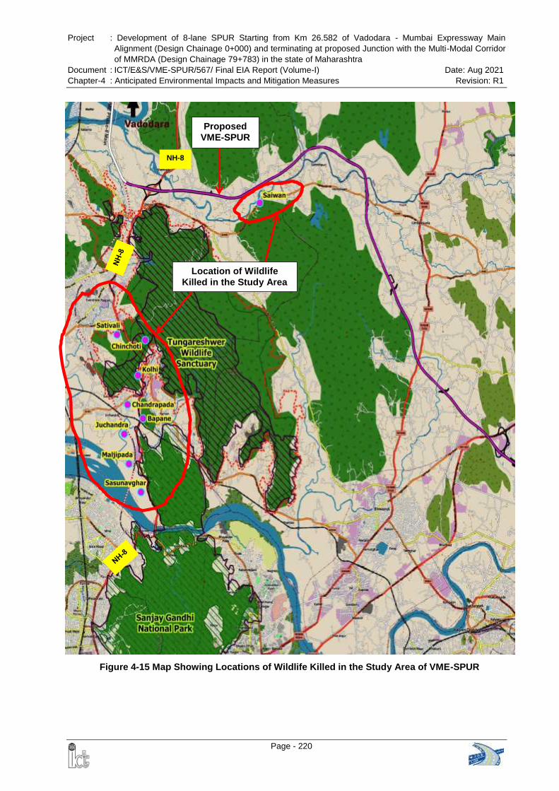
Project : Development of 8-lane SPUR Starting from Km 26.582 of Vadodara - Mumbai Expressway Main
Alignment (Design Chainage 0+000) and terminating at proposed Junction with the Multi-Modal Corridor
of MMRDA (Design Chainage 79+783) in the state of Maharashtra
Document : ICT/E&S/VME-SPUR/567/ Final EIA Report (Volume-I) Date: Aug 2021
Chapter-4 : Anticipated Environmental Impacts and Mitigation Measures Revision: R1
Page - 220
Location of Wildlife
Killed in the Study Area
Proposed
VME-SPUR
NH-8
Figure 4-15 Map Showing Locations of Wildlife Killed in the Study Area of VME-SPUR
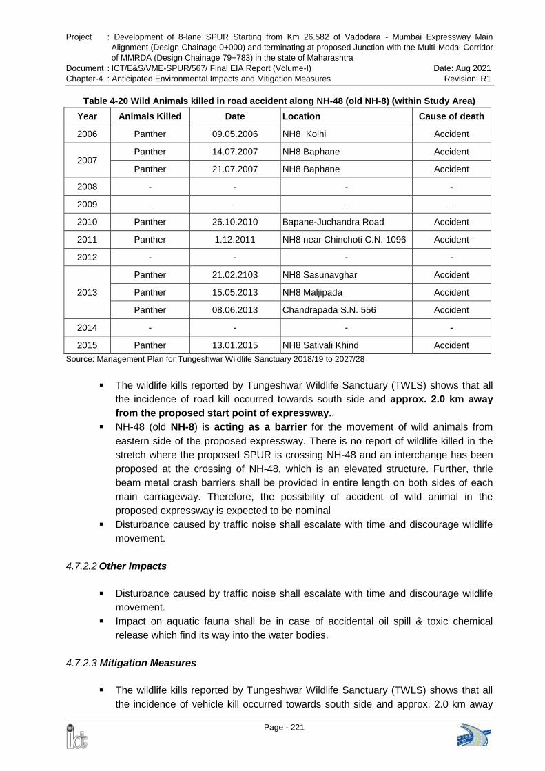
Project : Development of 8-lane SPUR Starting from Km 26.582 of Vadodara - Mumbai Expressway Main
Alignment (Design Chainage 0+000) and terminating at proposed Junction with the Multi-Modal Corridor
of MMRDA (Design Chainage 79+783) in the state of Maharashtra
Document : ICT/E&S/VME-SPUR/567/ Final EIA Report (Volume-I) Date: Aug 2021
Chapter-4 : Anticipated Environmental Impacts and Mitigation Measures Revision: R1
Page - 221
Table 4-20 Wild Animals killed in road accident along NH-48 (old NH-8) (within Study Area)
Year Animals Killed Date Location Cause of death
2006 Panther 09.05.2006 NH8 Kolhi Accident
2007 Panther 14.07.2007 NH8 Baphane Accident
Panther 21.07.2007 NH8 Baphane Accident
2008 - - - -
2009 - - - -
2010 Panther 26.10.2010 Bapane-Juchandra Road Accident
2011 Panther 1.12.2011 NH8 near Chinchoti C.N. 1096 Accident
2012 - - - -
2013
Panther 21.02.2103 NH8 Sasunavghar Accident
Panther 15.05.2013 NH8 Maljipada Accident
Panther 08.06.2013 Chandrapada S.N. 556 Accident
2014 - - - -
2015 Panther 13.01.2015 NH8 Sativali Khind Accident
Source: Management Plan for Tungeshwar Wildlife Sanctuary 2018/19 to 2027/28
The wildlife kills reported by Tungeshwar Wildlife Sanctuary (TWLS) shows that all
the incidence of road kill occurred towards south side and approx. 2.0 km away
from the proposed start point of expressway..
NH-48 (old NH-8) is acting as a barrier for the movement of wild animals from
eastern side of the proposed expressway. There is no report of wildlife killed in the
stretch where the proposed SPUR is crossing NH-48 and an interchange has been
proposed at the crossing of NH-48, which is an elevated structure. Further, thrie
beam metal crash barriers shall be provided in entire length on both sides of each
main carriageway. Therefore, the possibility of accident of wild animal in the
proposed expressway is expected to be nominal
Disturbance caused by traffic noise shall escalate with time and discourage wildlife
movement.
4.7.2.2 Other Impacts
Disturbance caused by traffic noise shall escalate with time and discourage wildlife
movement.
Impact on aquatic fauna shall be in case of accidental oil spill & toxic chemical
release which find its way into the water bodies.
4.7.2.3 Mitigation Measures
The wildlife kills reported by Tungeshwar Wildlife Sanctuary (TWLS) shows that all
the incidence of vehicle kill occurred towards south side and approx. 2.0 km away
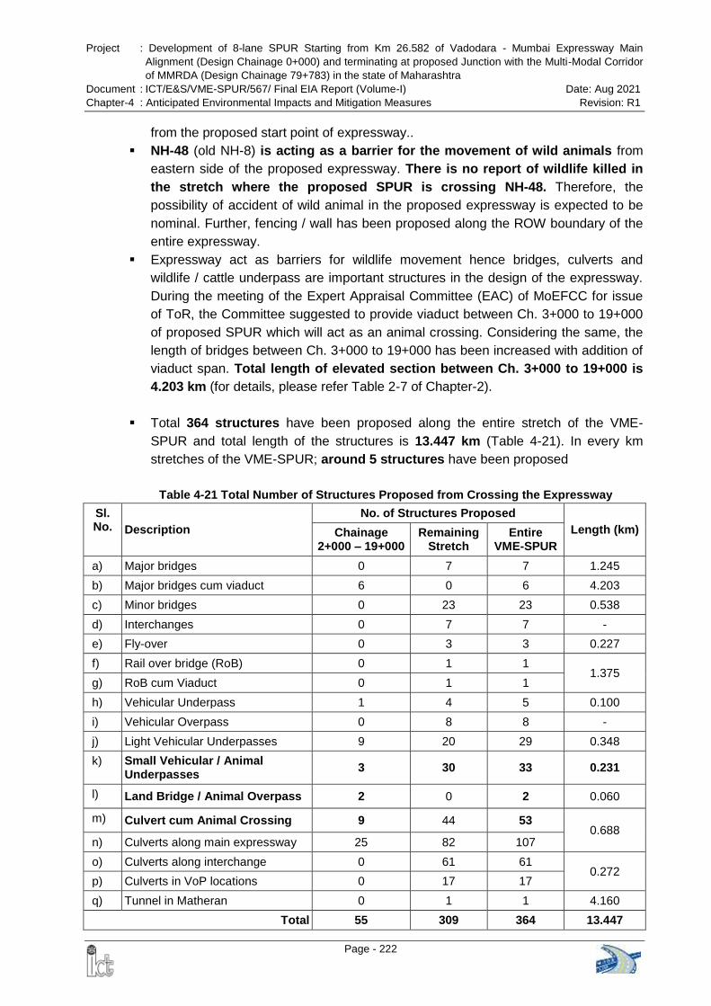
Project : Development of 8-lane SPUR Starting from Km 26.582 of Vadodara - Mumbai Expressway Main
Alignment (Design Chainage 0+000) and terminating at proposed Junction with the Multi-Modal Corridor
of MMRDA (Design Chainage 79+783) in the state of Maharashtra
Document : ICT/E&S/VME-SPUR/567/ Final EIA Report (Volume-I) Date: Aug 2021
Chapter-4 : Anticipated Environmental Impacts and Mitigation Measures Revision: R1
Page - 222
from the proposed start point of expressway..
NH-48 (old NH-8) is acting as a barrier for the movement of wild animals from
eastern side of the proposed expressway. There is no report of wildlife killed in
the stretch where the proposed SPUR is crossing NH-48. Therefore, the
possibility of accident of wild animal in the proposed expressway is expected to be
nominal. Further, fencing / wall has been proposed along the ROW boundary of the
entire expressway.
Expressway act as barriers for wildlife movement hence bridges, culverts and
wildlife / cattle underpass are important structures in the design of the expressway.
During the meeting of the Expert Appraisal Committee (EAC) of MoEFCC for issue
of ToR, the Committee suggested to provide viaduct between Ch. 3+000 to 19+000
of proposed SPUR which will act as an animal crossing. Considering the same, the
length of bridges between Ch. 3+000 to 19+000 has been increased with addition of
viaduct span. Total length of elevated section between Ch. 3+000 to 19+000 is
4.203 km (for details, please refer Table 2-7 of Chapter-2).
Total 364 structures have been proposed along the entire stretch of the VME-
SPUR and total length of the structures is 13.447 km (Table 4-21). In every km
stretches of the VME-SPUR; around 5 structures have been proposed
Table 4-21 Total Number of Structures Proposed from Crossing the Expressway
Sl. No. Description
No. of Structures Proposed
Length (km) Chainage 2+000 – 19+000
Remaining Stretch
Entire VME-SPUR
a) Major bridges 0 7 7 1.245
b) Major bridges cum viaduct 6 0 6 4.203
c) Minor bridges 0 23 23 0.538
d) Interchanges 0 7 7 -
e) Fly-over 0 3 3 0.227
f) Rail over bridge (RoB) 0 1 1 1.375
g) RoB cum Viaduct 0 1 1
h) Vehicular Underpass 1 4 5 0.100
i) Vehicular Overpass 0 8 8 -
j) Light Vehicular Underpasses 9 20 29 0.348
k) Small Vehicular / Animal Underpasses
3 30 33 0.231
l) Land Bridge / Animal Overpass 2 0 2 0.060
m) Culvert cum Animal Crossing 9 44 53 0.688
n) Culverts along main expressway 25 82 107
o) Culverts along interchange 0 61 61 0.272
p) Culverts in VoP locations 0 17 17
q) Tunnel in Matheran 0 1 1 4.160
Total 55 309 364 13.447
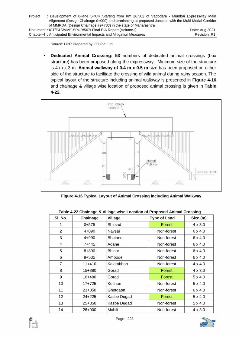
Project : Development of 8-lane SPUR Starting from Km 26.582 of Vadodara - Mumbai Expressway Main
Alignment (Design Chainage 0+000) and terminating at proposed Junction with the Multi-Modal Corridor
of MMRDA (Design Chainage 79+783) in the state of Maharashtra
Document : ICT/E&S/VME-SPUR/567/ Final EIA Report (Volume-I) Date: Aug 2021
Chapter-4 : Anticipated Environmental Impacts and Mitigation Measures Revision: R1
Page - 223
Figure 4-16 Typical Layout of Animal Crossing including Animal Walkway
Source: DPR Prepared by ICT Pvt. Ltd.
Dedicated Animal Crossing: 53 numbers of dedicated animal crossings (box
structure) has been proposed along the expressway. Minimum size of the structure
is 4 m x 3 m. Animal walkway of 0.4 m x 0.5 m size has been proposed on either
side of the structure to facilitate the crossing of wild animal during rainy season. The
typical layout of the structure including animal walkway is presented in Figure 4-16
and chainage & village wise location of proposed animal crossing is given in Table
4-22.
Table 4-22 Chainage & Village wise Location of Proposed Animal Crossing
Sl. No. Chainage Village Type of Land Size (m)
1 0+575 Shirsad Forest 4 x 3.0
2 4+090 Navsai Non-forest 6 x 4.0
3 4+990 Bhatane Non-forest 6 x 4.0
4 7+445 Adane Non-forest 6 x 4.0
5 8+890 Bhinar Non-forest 6 x 4.0
6 9+535 Ambode Non-forest 6 x 4.0
7 11+410 Kalambhon Non-forest 4 x 4.0
8 15+880 Gorad Forest 4 x 3.0
9 16+400 Gorad Forest 5 x 4.0
10 17+725 Kelthan Non-forest 5 x 4.0
11 23+050 Ghotgaon Non-forest 6 x 4.0
12 24+225 Kasbe Dugad Forest 5 x 4.0
13 25+350 Kasbe Dugad Non-forest 5 x 4.0
14 26+000 Mohili Non-forest 4 x 3.0
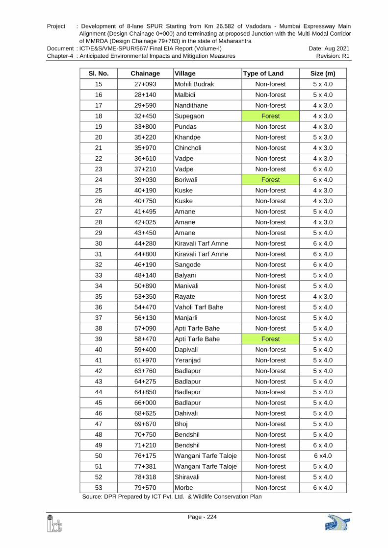
Project : Development of 8-lane SPUR Starting from Km 26.582 of Vadodara - Mumbai Expressway Main
Alignment (Design Chainage 0+000) and terminating at proposed Junction with the Multi-Modal Corridor
of MMRDA (Design Chainage 79+783) in the state of Maharashtra
Document : ICT/E&S/VME-SPUR/567/ Final EIA Report (Volume-I) Date: Aug 2021
Chapter-4 : Anticipated Environmental Impacts and Mitigation Measures Revision: R1
Page - 224
Sl. No. Chainage Village Type of Land Size (m)
15 27+093 Mohili Budrak Non-forest 5 x 4.0
16 28+140 Malbidi Non-forest 5 x 4.0
17 29+590 Nandithane Non-forest 4 x 3.0
18 32+450 Supegaon Forest 4 x 3.0
19 33+800 Pundas Non-forest 4 x 3.0
20 35+220 Khandpe Non-forest 5 x 3.0
21 35+970 Chincholi Non-forest 4 x 3.0
22 36+610 Vadpe Non-forest 4 x 3.0
23 37+210 Vadpe Non-forest 6 x 4.0
24 39+030 Boriwali Forest 6 x 4.0
25 40+190 Kuske Non-forest 4 x 3.0
26 40+750 Kuske Non-forest 4 x 3.0
27 41+495 Amane Non-forest 5 x 4.0
28 42+025 Amane Non-forest 4 x 3.0
29 43+450 Amane Non-forest 5 x 4.0
30 44+280 Kiravali Tarf Amne Non-forest 6 x 4.0
31 44+800 Kiravali Tarf Amne Non-forest 6 x 4.0
32 46+190 Sangode Non-forest 6 x 4.0
33 48+140 Balyani Non-forest 5 x 4.0
34 50+890 Manivali Non-forest 5 x 4.0
35 53+350 Rayate Non-forest 4 x 3.0
36 54+470 Vaholi Tarf Bahe Non-forest 5 x 4.0
37 56+130 Manjarli Non-forest 5 x 4.0
38 57+090 Apti Tarfe Bahe Non-forest 5 x 4.0
39 58+470 Apti Tarfe Bahe Forest 5 x 4.0
40 59+400 Dapivali Non-forest 5 x 4.0
41 61+970 Yeranjad Non-forest 5 x 4.0
42 63+760 Badlapur Non-forest 5 x 4.0
43 64+275 Badlapur Non-forest 5 x 4.0
44 64+850 Badlapur Non-forest 5 x 4.0
45 66+000 Badlapur Non-forest 5 x 4.0
46 68+625 Dahivali Non-forest 5 x 4.0
47 69+670 Bhoj Non-forest 5 x 4.0
48 70+750 Bendshil Non-forest 5 x 4.0
49 71+210 Bendshil Non-forest 6 x 4.0
50 76+175 Wangani Tarfe Taloje Non-forest 6 x4.0
51 77+381 Wangani Tarfe Taloje Non-forest 5 x 4.0
52 78+318 Shiravali Non-forest 5 x 4.0
53 79+570 Morbe Non-forest 6 x 4.0
Source: DPR Prepared by ICT Pvt. Ltd. & Wildlife Conservation Plan
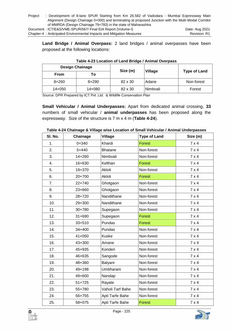
Project : Development of 8-lane SPUR Starting from Km 26.582 of Vadodara - Mumbai Expressway Main
Alignment (Design Chainage 0+000) and terminating at proposed Junction with the Multi-Modal Corridor
of MMRDA (Design Chainage 79+783) in the state of Maharashtra
Document : ICT/E&S/VME-SPUR/567/ Final EIA Report (Volume-I) Date: Aug 2021
Chapter-4 : Anticipated Environmental Impacts and Mitigation Measures Revision: R1
Page - 225
Land Bridge / Animal Overpass: 2 land bridges / animal overpasses have been
proposed at the following locations:
Table 4-23 Location of Land Bridge / Animal Overpass
Design Chainage Size (m) Village Type of Land
From To
8+260 8+290 82 x 30 Adane Non-forest
14+050 14+080 82 x 30 Nimbvali Forest
Source: DPR Prepared by ICT Pvt. Ltd. & Wildlife Conservation Plan
Small Vehicular / Animal Underpasses: Apart from dedicated animal crossing, 33
numbers of small vehicular / animal underpasses has been proposed along the
expressway. Size of the structure is 7 m x 4 m (Table 4-24).
Table 4-24 Chainage & Village wise Location of Small Vehicular / Animal Underpasses
Sl. No. Chainage Village Type of Land Size (m)
1. 0+340 Khardi Forest 7 x 4
2. 5+440 Bhatane Non-forest 7 x 4
3. 14+260 Nimbvali Non-forest 7 x 4
4. 16+630 Kelthan Forest 7 x 4
5. 19+370 Akloli Non-forest 7 x 4
6. 20+700 Akloli Forest 7 x 4
7. 22+740 Ghotgaon Non-forest 7 x 4
8. 23+660 Ghotgaon Non-forest 7 x 4
9. 28+720 Nandithane Non-forest 7 x 4
10. 29+300 Nandithane Non-forest 7 x 4
11. 30+780 Supegaon Non-forest 7 x 4
12. 31+690 Supegaon Forest 7 x 4
13. 33+510 Pundas Forest 7 x 4
14. 34+400 Pundas Non-forest 7 x 4
15. 41+050 Kuske Non-forest 7 x 4
16. 43+300 Amane Non-forest 7 x 4
17. 45+935 Konderi Non-forest 7 x 4
18. 46+635 Sangode Non-forest 7 x 4
19. 48+360 Balyani Non-forest 7 x 4
20. 49+198 Umbharani Non-forest 7 x 4
21. 49+600 Nandap Non-forest 7 x 4
22. 51+725 Rayate Non-forest 7 x 4
23. 55+780 Vaholi Tarf Bahe Non-forest 7 x 4
24. 56+755 Apti Tarfe Bahe Non-forest 7 x 4
25. 58+075 Apti Tarfe Bahe Forest 7 x 4
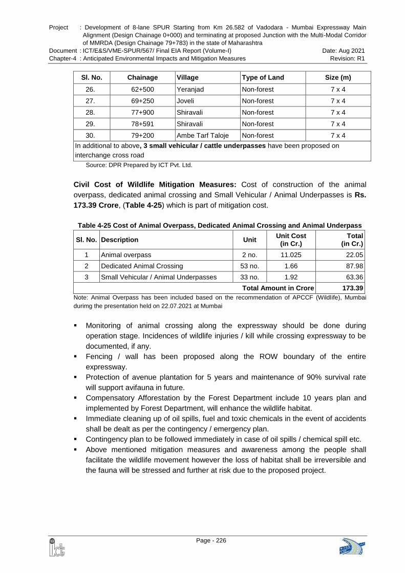
Project : Development of 8-lane SPUR Starting from Km 26.582 of Vadodara - Mumbai Expressway Main
Alignment (Design Chainage 0+000) and terminating at proposed Junction with the Multi-Modal Corridor
of MMRDA (Design Chainage 79+783) in the state of Maharashtra
Document : ICT/E&S/VME-SPUR/567/ Final EIA Report (Volume-I) Date: Aug 2021
Chapter-4 : Anticipated Environmental Impacts and Mitigation Measures Revision: R1
Page - 226
Sl. No. Chainage Village Type of Land Size (m)
26. 62+500 Yeranjad Non-forest 7 x 4
27. 69+250 Joveli Non-forest 7 x 4
28. 77+900 Shiravali Non-forest 7 x 4
29. 78+591 Shiravali Non-forest 7 x 4
30. 79+200 Ambe Tarf Taloje Non-forest 7 x 4
In additional to above, 3 small vehicular / cattle underpasses have been proposed on
interchange cross road
Source: DPR Prepared by ICT Pvt. Ltd.
Civil Cost of Wildlife Mitigation Measures: Cost of construction of the animal
overpass, dedicated animal crossing and Small Vehicular / Animal Underpasses is Rs.
173.39 Crore, (Table 4-25) which is part of mitigation cost.
Table 4-25 Cost of Animal Overpass, Dedicated Animal Crossing and Animal Underpass
Sl. No. Description Unit Unit Cost
(in Cr.) Total
(in Cr.)
1 Animal overpass 2 no. 11.025 22.05
2 Dedicated Animal Crossing 53 no. 1.66 87.98
3 Small Vehicular / Animal Underpasses 33 no. 1.92 63.36
Total Amount in Crore 173.39
Note: Animal Overpass has been included based on the recommendation of APCCF (Wildlife), Mumbai
durimg the presentation held on 22.07.2021 at Mumbai
Monitoring of animal crossing along the expressway should be done during
operation stage. Incidences of wildlife injuries / kill while crossing expressway to be
documented, if any.
Fencing / wall has been proposed along the ROW boundary of the entire
expressway.
Protection of avenue plantation for 5 years and maintenance of 90% survival rate
will support avifauna in future.
Compensatory Afforestation by the Forest Department include 10 years plan and
implemented by Forest Department, will enhance the wildlife habitat.
Immediate cleaning up of oil spills, fuel and toxic chemicals in the event of accidents
shall be dealt as per the contingency / emergency plan.
Contingency plan to be followed immediately in case of oil spills / chemical spill etc.
Above mentioned mitigation measures and awareness among the people shall
facilitate the wildlife movement however the loss of habitat shall be irreversible and
the fauna will be stressed and further at risk due to the proposed project.
Project : Development of 8-lane SPUR Starting from Km 26.582 of Vadodara - Mumbai Expressway Main
Alignment (Design Chainage 0+000) and terminating at proposed Junction with the Multi-Modal Corridor
of MMRDA (Design Chainage 79+783) in the state of Maharashtra
Document : ICT/E&S/VME-SPUR/567/ Final EIA Report (Volume-I) Date: Aug 2021
Chapter-4 : Anticipated Environmental Impacts and Mitigation Measures Revision: R1
Page - 227
4.8 PROTECTED AREA
4.8.1 Construction Phase
The proposed VME-SPUR does not pass through any National Park, Wildlife
Sanctuary, Conservation Reserve and Community Reserve. The proposed
alignment of VME-SPUR is neither fragmenting nor diverting land of the
Tungareshwar Wildlife Sanctuary. The nearest distance of Tungareshwar Wildlife
Sanctuary from proposed VME-SPUR is 0.619 km. near the start point and nearest
distance of the notified ESZ boundary of the Sanctuary is 0.275 km. Hence, there
will be no direct impact on Tungareshwar Wildlife Sanctuary.
The proposed SPUR alignment is intervening Matheran Eco Sensitive Zone at two
locations i.e. from Km 71.532 to 75.426 (buffer & ESZ) and from km 77.115 to km
77.691 (online buffer zone). To preserve ecology of the Matheran, 4.160 km long
tunnel is proposed in this section which will go under the Matheran Eco-Sensitive
Zone. The start point of the tunnel is at km 71.520 (before buffer zone) and end
point of the tunnel is at km 75.680 (after buffer zone).
The construction work will involve influx of labours in the area. Movement of man
and construction machinery will produce noise and frighten away birds and wildlife
dwelling in the vicinity. Incidences of human and wildlife conflicts will be more and
may cause loss of life / injury to wildlife or persons at construction site.
Use of community water resources by labour force.
Dumping of waste will degrade the surrounding area.
Discharge of waste generated from construction camps into nearby water bodies
Mitigation Measures:
Monitoring of wild animals should be done during construction phase and any
incidence of sighting should be immediately reported to Forest Department. Watch
tower may be installed in consultation with the Forest Department, if required during
construction phase.
Felling of trees on the Forest or Government or revenue or private lands shall be
done after obtaining permission from competent authority.
Mining of minor minerals, stone quarrying and crushing units shall be prohibited
within the 1 km boundary of the protected areas.
Open fire will not be permitted at construction site. Dos and Don‟ts at the work place
shall be displayed such as no smoking, waste disposal, personal protective
equipment, etc.
The construction and demolition waste management shall be carried out as per the
provisions of the Construction and Demolition Waste Management Rules, 2016
published by the Government of India in the Ministry of Environment, Forest and
Climate Change vide notification number G.S.R. 317(E), dated the 29th March, 2016,
as amended from time to time
Mitigation measures recommended by the Chief Wildlife Warden, Govt. of
Project : Development of 8-lane SPUR Starting from Km 26.582 of Vadodara - Mumbai Expressway Main
Alignment (Design Chainage 0+000) and terminating at proposed Junction with the Multi-Modal Corridor
of MMRDA (Design Chainage 79+783) in the state of Maharashtra
Document : ICT/E&S/VME-SPUR/567/ Final EIA Report (Volume-I) Date: Aug 2021
Chapter-4 : Anticipated Environmental Impacts and Mitigation Measures Revision: R1
Page - 228
Maharashtra as well as during Environment & CRZ Clearance and Forest Clearance
shall be complied with by the Project Proponent. Monitoring and progress report of
implementation of EMP and recommendations by various authorities shall be
submitted concerned authorities as per the schedule.
4.8.2 Operation Phase
Though, roads are the vital features of human development, they pose severe threat to
forest and wildlife. The major impacts on animal population include road-kills, limiting
population, road avoidance causing modification of movement pattern etc. During
operation phase the impact will be due to traffic movement.
Collision of wild animals with traffic causing injuries and mortality
Emission from vehicles will impact the Air Quality.
Honking and Traffic noise will cause disturbance behavioral change in wild animals.
Leakages and spills from vehicle will pollute the land and water bodies
Solid waste disposal by travellers
Mitigation Measures:
Monitoring of Wildlife movement and identify accident prone areas or hot spots for
wildlife kill. Fencing has been proposed along the ROW boundary of the entire
expressway.
Boards depicting wildlife awareness instructions and cautions should be placed near
forest areas and at start and end point of the expressway.
Animal feeding along the expressway will not be permitted and clearly conveyed
through sign boards.
Recommendations provided during EC shall be strictly adhered to and monitored by
the concerned authorities.
Measure for pollution control and waste management provided in the concerned
sections. Speedy cleaning up of oil spills, fuel and toxic chemicals in the event of
accidents shall be dealt as per the contingency / emergency plan.
Structures (bridges, culverts, underpasses) to be maintained to facilitate movement
of wildlife.
Maintenance of plantation, implementation of CA activities and EC & FC compliance
will facilitate in amelioration of environmental parameters.
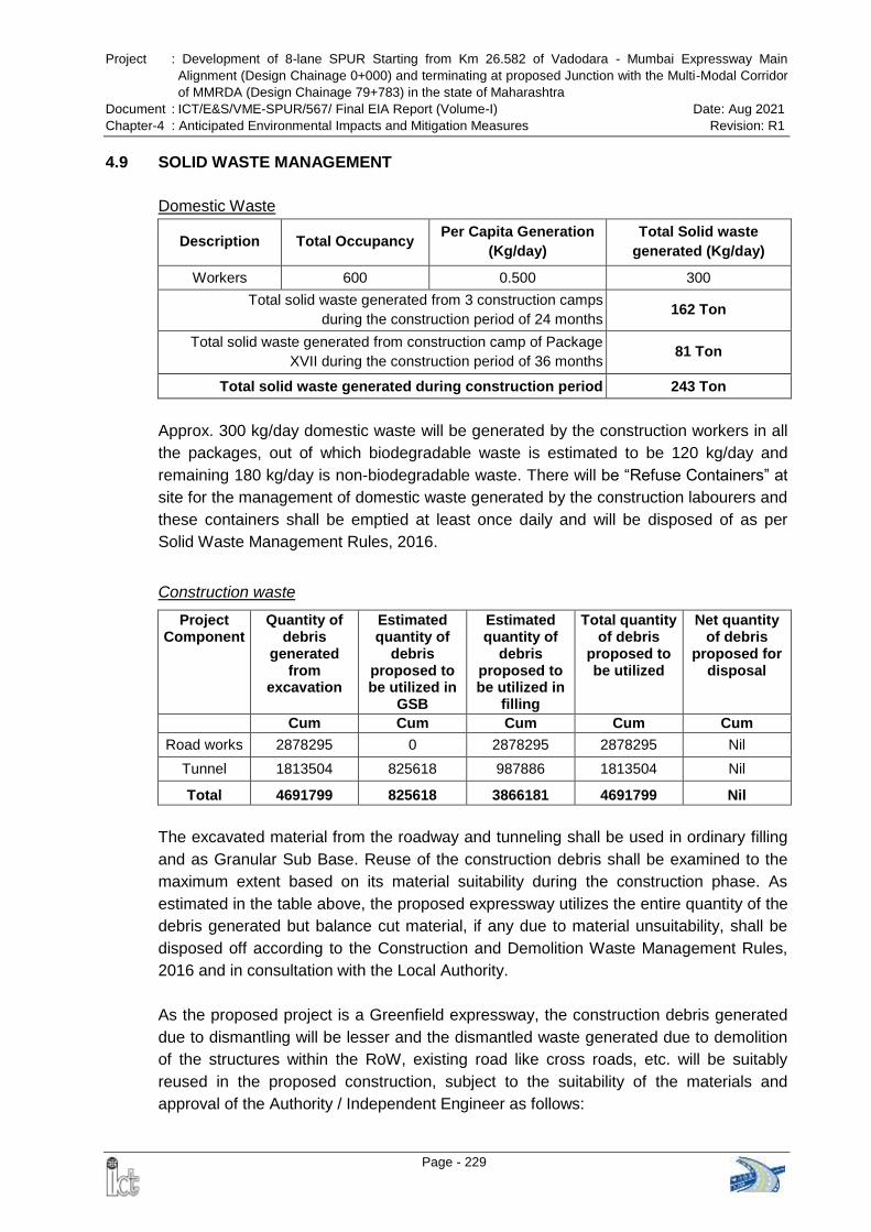
Project : Development of 8-lane SPUR Starting from Km 26.582 of Vadodara - Mumbai Expressway Main
Alignment (Design Chainage 0+000) and terminating at proposed Junction with the Multi-Modal Corridor
of MMRDA (Design Chainage 79+783) in the state of Maharashtra
Document : ICT/E&S/VME-SPUR/567/ Final EIA Report (Volume-I) Date: Aug 2021
Chapter-4 : Anticipated Environmental Impacts and Mitigation Measures Revision: R1
Page - 229
4.9 SOLID WASTE MANAGEMENT
Domestic Waste
Description Total Occupancy Per Capita Generation
(Kg/day)
Total Solid waste
generated (Kg/day)
Workers 600 0.500 300
Total solid waste generated from 3 construction camps
during the construction period of 24 months 162 Ton
Total solid waste generated from construction camp of Package
XVII during the construction period of 36 months 81 Ton
Total solid waste generated during construction period 243 Ton
Approx. 300 kg/day domestic waste will be generated by the construction workers in all
the packages, out of which biodegradable waste is estimated to be 120 kg/day and
remaining 180 kg/day is non-biodegradable waste. There will be “Refuse Containers” at
site for the management of domestic waste generated by the construction labourers and
these containers shall be emptied at least once daily and will be disposed of as per
Solid Waste Management Rules, 2016.
Construction waste
Project Component
Quantity of debris
generated from
excavation
Estimated quantity of
debris proposed to be utilized in
GSB
Estimated quantity of
debris proposed to be utilized in
filling
Total quantity of debris
proposed to be utilized
Net quantity of debris
proposed for disposal
Cum Cum Cum Cum Cum
Road works 2878295 0 2878295 2878295 Nil
Tunnel 1813504 825618 987886 1813504 Nil
Total 4691799 825618 3866181 4691799 Nil
The excavated material from the roadway and tunneling shall be used in ordinary filling
and as Granular Sub Base. Reuse of the construction debris shall be examined to the
maximum extent based on its material suitability during the construction phase. As
estimated in the table above, the proposed expressway utilizes the entire quantity of the
debris generated but balance cut material, if any due to material unsuitability, shall be
disposed off according to the Construction and Demolition Waste Management Rules,
2016 and in consultation with the Local Authority.
As the proposed project is a Greenfield expressway, the construction debris generated
due to dismantling will be lesser and the dismantled waste generated due to demolition
of the structures within the RoW, existing road like cross roads, etc. will be suitably
reused in the proposed construction, subject to the suitability of the materials and
approval of the Authority / Independent Engineer as follows:
Project : Development of 8-lane SPUR Starting from Km 26.582 of Vadodara - Mumbai Expressway Main
Alignment (Design Chainage 0+000) and terminating at proposed Junction with the Multi-Modal Corridor
of MMRDA (Design Chainage 79+783) in the state of Maharashtra
Document : ICT/E&S/VME-SPUR/567/ Final EIA Report (Volume-I) Date: Aug 2021
Chapter-4 : Anticipated Environmental Impacts and Mitigation Measures Revision: R1
Page - 230
The sub grade of the existing pavement shall be used as embankment fill material.
The existing base and sub-base material shall be recycled as sub-base of the haul
road or access roads, if any
The existing bitumen surface may be utilized for the paving of cross roads, access
roads and paving works in construction sites and campus, temporary traffic
diversions, haulage routes etc.
Impact:
Waste generated during construction may impact soil, agriculture and water quality
Waste generated from workers‟ camps may impact surface and ground water quality
and agriculture
Problems could arise from dumping of construction spoils (Concrete, bricks), waste
materials (from contractor camps) etc. causing surface and ground water pollution. The
other construction material such as steel, bricks, etc. will be housed in a fenced yard.
The balance material from these yards will be removed for use/disposal. Mitigation
measures include careful planning, cleaning redressing, landscaping and re-vegetation.
Inorganic solid waste generated during the construction phase like waste concrete, and
mortar, left over aggregate and debris etc. shall be recycled for use in the base layers of
paved area i.e. parking pavement. Municipal waste from labor camps can lead to land
pollution. Therefore adequate mitigation measures shall be developed to negate the
overall impact of waste disposal during construction phase.
Mitigation Measures:
Contamination of Soil
Reuse of construction waste: Construction waste will be reused in the construction
to the extent possible.
Unutilized debris/ spoils or other material unsuitable for reuse shall be disposed off
through filling up of borrow areas located in wasteland or at approved disposal
locations protected by berms
Storage of construction material in accordance with the IRC norms.
Avoiding work during periods of heavy rainfall.
Conservation of topsoil for reuse in planting pits and rehabilitation of borrow areas,
sodding /grass turfing and implementation of soil erosion control plan.
Disposal of domestic waste from Labour camps as per SWM Rules, 2016
Degradation of Water quality
Use of sediment traps, silt fencing, sodding / grass turfing etc. for minimization of
soil movement;
The campsites will be provided with proper drainage and connected to local disposal
system.
No solid waste will be dumped near the water bodies or rivers.
Garbage bins will be provided in the camps and ensured that these are regularly
emptied and disposed off in a hygienic manner as per SWM Rules, 2016
Vehicle maintenance will be carried out in a confined area, away from water
Project : Development of 8-lane SPUR Starting from Km 26.582 of Vadodara - Mumbai Expressway Main
Alignment (Design Chainage 0+000) and terminating at proposed Junction with the Multi-Modal Corridor
of MMRDA (Design Chainage 79+783) in the state of Maharashtra
Document : ICT/E&S/VME-SPUR/567/ Final EIA Report (Volume-I) Date: Aug 2021
Chapter-4 : Anticipated Environmental Impacts and Mitigation Measures Revision: R1
Page - 231
sources, and it will be ensured that used oil or lubricants are not disposed to
watercourses.
Construction laborers` camps shall be located away from the habitation and from
major water bodies.
Health Problem to workers
Construction camp will be organized in a planned manner. Workers shall be
provided proper sanitation facilities including toilets.
There will be “Refuse Containers” at site for the management of domestic waste
generated by the construction labourers and these containers shall be emptied at
least once daily and will be disposed of as per SWM Rules, 2016.
Wastes shall be collected, stored and taken to approve disposal sites in consultation
with local authorities.
4.10 EMPLOYMENT & TRADING OPPORTUNITIES
It is estimated that a substantial construction personnel including skilled, semi-skilled
and unskilled labourers employed by various contractors will work at site during the
peak period of construction phase. Since most of sizeable labour force will be drawn
from neighbourhood, no change in demographic profile is anticipated. Only for a few
skilled personnel, brought to site from outside the locality, proper housing/
accommodation would be provided in the construction camps. Due to employment
opportunities, some competition for workers during construction phase is therefore
anticipated.
The construction materials like stone chips and sand will be procured locally from
identified quarry sites. The other important materials like cement, steel will be procured
through various local sources. Thus there is a possibility of generation of local trading
opportunities, though temporary.
Mitigation Measures:
Most of the unskilled construction labourers will be recruited from the local areas to
create some employment opportunities and sense of wellbeing among local people.
This will also reduce social tension of migration.
Some of the construction materials like stone chips & sand will be procured locally.
Thus there is a possibility of generation of local trading opportunities, though
temporary.
4.11 CONSTRUCTION CAMP
Impacts:
Influx of construction work-force & supplier who are likely to construct temporary
tents in the vicinity
Project : Development of 8-lane SPUR Starting from Km 26.582 of Vadodara - Mumbai Expressway Main
Alignment (Design Chainage 0+000) and terminating at proposed Junction with the Multi-Modal Corridor
of MMRDA (Design Chainage 79+783) in the state of Maharashtra
Document : ICT/E&S/VME-SPUR/567/ Final EIA Report (Volume-I) Date: Aug 2021
Chapter-4 : Anticipated Environmental Impacts and Mitigation Measures Revision: R1
Page - 232
Likely sanitation & health hazards & other impacts on the surrounding environment
due to inflow of construction labourers
Generation of solid and liquid waste from construction camp
Mitigation Measures:
Temporary construction camps at designated & demarcated sites with adequate
sanitation, drinking water supply & primary health facilities.
Proper accommodation will be provided in the locality for the migrant construction
engineers & officers.
It will be ensured that the contractor's workers are provided with adequate
amenities, health & sanitation facilities in the camp by the contractor. Guidelines for
Siting and Layout of Construction Camp is given in Annex-9.2
It is recommended to install Packaged Wastewater Treatment Plant in the
construction camp. Guideline for the same is given in Annex-9.7
A comprehensive waste management plan shall be prepared by the contractor prior
to initiation of any works. Guideline for preparation of Comprehensive Waste
Management Plan is given in Annex-9.9.
4.12 OCCUPATIONAL HEALTH & SAFETY
Impacts:
Health & safety related problems to construction workers due to inadequate health &
safety measures
Mitigation Measures:
Adequate safety measures complying with the occupational safety manuals will be
adopted by the contractor to prevent accidents/hazards to the construction workers
A road safety, traffic management and accident management plan is to be prepared
by the Contractor prior to the start of the construction activity
Periodic health check-up of construction workers will be done by the contractor
Personal protective equipment will be provided to the construction workers (Annex-
9.11)
4.13 ROAD SAFETY
4.13.1 Construction Phase
Impacts:
Increase on incidence of accidents due to disruptions caused in existing traffic
movements
Project : Development of 8-lane SPUR Starting from Km 26.582 of Vadodara - Mumbai Expressway Main
Alignment (Design Chainage 0+000) and terminating at proposed Junction with the Multi-Modal Corridor
of MMRDA (Design Chainage 79+783) in the state of Maharashtra
Document : ICT/E&S/VME-SPUR/567/ Final EIA Report (Volume-I) Date: Aug 2021
Chapter-4 : Anticipated Environmental Impacts and Mitigation Measures Revision: R1
Page - 233
Mitigation Measures:
The proposed project is a greenfield alignment and there is no normal operating
traffic as in the case of existing highways. Therefore, there is no specific standard
requirement for traffic management plan during construction phase. It is normally the
construction vehicles, which will be plying on temporary roads for the constriction
works. Wherever the proposed expressway is crossing any existing road, during
construction phase, the Contractor shall provide and maintain a passage for traffic
either along a part of the proposed RoW or along a temporary diversion constructed
close to the crossing. The Contractor shall take prior approval of the Authority
Engineer (AE) regarding traffic arrangements during construction. Guideline for
Preparing of Traffic Management Plan is given in Annex-9.10.
Reduction of speed through construction zones
4.13.2 Operation Phase
Impacts:
Impacts on human health due to accidents
Damage of expressway due to wear & tear
Mitigation Measures:
To improve the safety of such high speed corridor, Thrie beam metal crash barriers
shall be provided in entire length on both sides of each main carriageway (i.e. on
median and on earthen shoulder of both carriageway), Loops and Ramps excluding
stretches covered by bridges and RE wall structures, where concrete barriers to be
provided.
In addition to safety barrier, safety features like road marking, traffic sign, boundary
stones, kilometer stones and hectometer stones, pavement marking and lighting has
been proposed. Advanced Traffic Management System (ATMS) for entire
expressway have been proposed to facilitate the road users, which will include
mobile communication system, meteorological data system, automatic traffic counter
and vehicle classification, video surveillance system, video incident detection
system. To improve antiglare, hedge plantation on median have been proposed.
The engineering design of the expressway has also considered IRC codal provisions
related to road safety such as:
IRC: SP: 32-1988 Road Safety for Children
IRC: SP: 44-1994 Highway Safety Code
IRC: SP: 55-2001 Guidelines for Safety in Construction Zones
IRC:119:2015 Guidelines for Traffic Safety Barriers\
Project : Development of 8-lane SPUR Starting from Km 26.582 of Vadodara - Mumbai Expressway Main
Alignment (Design Chainage 0+000) and terminating at proposed Junction with the Multi-Modal Corridor
of MMRDA (Design Chainage 79+783) in the state of Maharashtra
Document : ICT/E&S/VME-SPUR/567/ Final EIA Report (Volume-I) Date: Aug 2021
Chapter-4 : Anticipated Environmental Impacts and Mitigation Measures Revision: R1
Page - 234
4.14 MIGRATION
From the view point of employment of migrant skilled workers the project is small.
Therefore no social tension is expected due to very small number migrant skilled
workers. As the construction phase has a very short time span in comparison to the
operation phase, it would not have any long term effect. Moreover the different groups
of people engaged in different construction activities will leave the place after specified
time span.
4.15 POSITIVE & BENEFICIAL IMPACTS
4.15.1 Construction Phase
Employment opportunities due to recruitment of local labourers
Trading opportunities due to procurement of some construction materials locally
Clean up operations, landscaping and plantations
4.15.2 Operation Phase
Increase in traffic & transportation activities due to faster accessibility
Time saving due to faster movement of traffic
Fuel saving due to faster movement of traffic
Reduction of number of accidents
Reduction of vehicle operating cost
Better facilities to road users
Project : Development of 8-lane SPUR Starting from Km 26.582 of Vadodara - Mumbai Expressway Main
Alignment (Design Chainage 0+000) and terminating at proposed Junction with the Multi-Modal Corridor
of MMRDA (Design Chainage 79+783) in the state of Maharashtra
Document : ICT/E&S/VME-SPUR/567/ Final EIA Report (Volume-I) Date: Aug 2021
Chapter-5 : Analysis of Alternatives Revision: R1
Page - 235
CHAPTER-5: ANALYSIS OF ALTERNATIVES
5.1 INTRODUCTION
A Comprehensive Transportation Study for the Mumbai Metropolitan Region (MMR) has
been done in 2008-2009 by the Mumbai Metropolitan Region Development Authority
(MMRDA). In this study the future road network for the MMR has been suggested as
shown in Figure 5.1. This network envisages construction of a link from NH4 to NH8 to
freeway standards. The main objective of the proposed SPUR of VME is to take the
through traffic of VME to JNPT and further southward so that it does not enter Mumbai.
A Comprehensive Transportation Study for the Mumbai Metropolitan Region has been
done in 2008-2009 by the MMRDA. The alignment options studied for VME & SPUR
follow the links identified in the MMRDA study and has been modified to suit site
conditions.
5.2 ALTERNATIVE ALIGNMENTS
The Consultants have studied six alternative alignments for the connection to JNPT
and Mumbai Pune Expressway. The alignments are depicted in the Figure 5.2. Since
the section between Mumbai Pune expressway and NH4B (node 10-14) is common to
all alternatives, this section has not been considered for comparison purposes. The
features, merits and demerits of these alternative alignments are described below:
Alternative -1 (Node No. 1-2-3-6-8-9-10)
The alignment takes off from km 27.00 (Zero at Mumbai end) on the proposed
Vadodara Mumbai Expressway (VME) and connects to Mumbai Pune expressway
(about 5km from the NH4 junction) and is 73 km long. It has 6 major bridges and 33
minor bridges. There will be 15 pedestrian and 12 vehicular underpasses, 3 ROBs, 3
flyovers and 4 interchanges. The civil cost is approx. Rs. 2,252.60 Crores.
Merits:
a) The alignment connects straight to Mumbai Pune (MP) Expressway and thus gives
direct expressway to expressway connectivity.
b) Though the alignment is about 5kms longer than ALT2 in terms of travel distance
between node 1 and 10 (73.00 km) but it is advantageous in that it connects directly
to MP Expressway while in ALT2 the section of NH4 between node 7 and 13 is
congested and passes through thickly populated urban area and will need to be
upgraded to expressway standards. Since the Mumbai-Pune Expressway is already
in operation, there is no development cost of 5km, upto node 10.
c) It traverses close to Mumbai Metropolitan region and therefore will pick-up more
traffic as the interchange on NH3 will be closer to the area.
d) Near Node 1 the traffic from NH8 bound for JNPT and vice versa will get on/off the
expressway before/after the congested Vasai- Virar region.
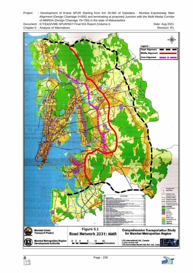
Project : Development of 8-lane SPUR Starting from Km 26.582 of Vadodara - Mumbai Expressway Main
Alignment (Design Chainage 0+000) and terminating at proposed Junction with the Multi-Modal Corridor
of MMRDA (Design Chainage 79+783) in the state of Maharashtra
Document : ICT/E&S/VME-SPUR/567/ Final EIA Report (Volume-I) Date: Aug 2021
Chapter-5 : Analysis of Alternatives Revision: R1
Page - 236
Figure 5.1
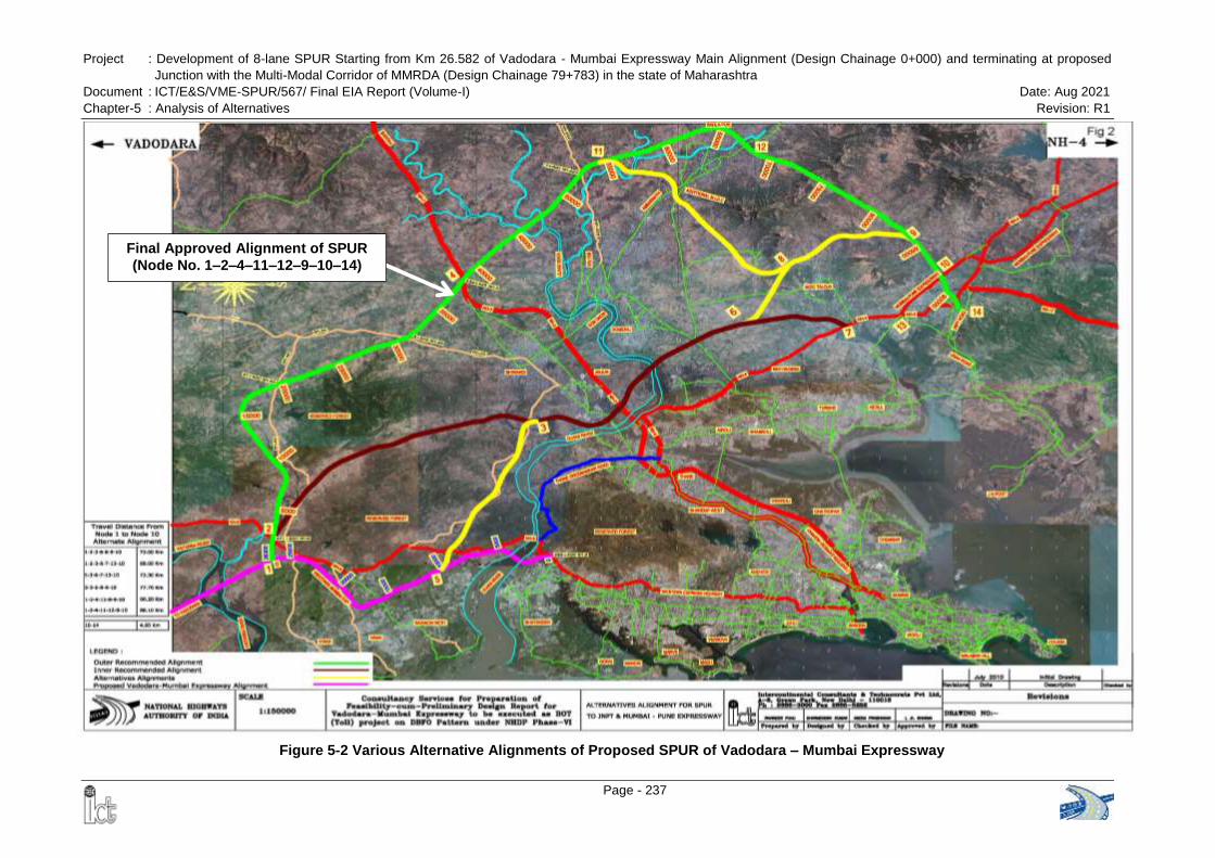
Project : Development of 8-lane SPUR Starting from Km 26.582 of Vadodara - Mumbai Expressway Main Alignment (Design Chainage 0+000) and terminating at proposed
Junction with the Multi-Modal Corridor of MMRDA (Design Chainage 79+783) in the state of Maharashtra
Document : ICT/E&S/VME-SPUR/567/ Final EIA Report (Volume-I) Date: Aug 2021
Chapter-5 : Analysis of Alternatives Revision: R1
Page - 237
Final Approved Alignment of SPUR
(Node No. 1–2–4–11–12–9–10–14)
Figure 5-2 Various Alternative Alignments of Proposed SPUR of Vadodara – Mumbai Expressway
Project : Development of 8-lane SPUR Starting from Km 26.582 of Vadodara - Mumbai Expressway Main
Alignment (Design Chainage 0+000) and terminating at proposed Junction with the Multi-Modal Corridor
of MMRDA (Design Chainage 79+783) in the state of Maharashtra
Document : ICT/E&S/VME-SPUR/567/ Final EIA Report (Volume-I) Date: Aug 2021
Chapter-5 : Analysis of Alternatives Revision: R1
Page - 238
Demerits:
a) The alignment traverses through reserved forest for a length of about 5 km.
b) The alignment passes through marshy land with mangroves in about 6 km length
and shall have severe impacts on mangrove.
c) As the alignment is closer to suburbs of Mumbai, there are major resettlement and
rehabilitation issues along the alignment and the land cost is very high.
Alternative -2 (Node No. 1-2-3-6-7-13-10)
The alignment takes off from km 27.00 on the proposed VME and connects to NH4 at
km 110.00 which is 5 km short of start of Mumbai Pune Expressway and is 68 km long.
It has 6 major bridges and 27 minor bridges. There will be 14 pedestrian and 10
vehicular underpasses, 3 ROBs, 2 flyovers and 4 interchanges. Besides on NH-4 there
will 3 flyovers and 3 level interchange at Mumbai-Pune Expressway. The civil cost is
approx. Rs. 2,173.74 Crores.
Merits:
a) The alignment is the shortest in terms of the travel distance from node 1 to node 10
(68.00 km). Therefore it will have the least vehicle operating costs for travel between
node 1 and node 10.
b) It traverses close to Mumbai Metropolitan region and therefore will pick-up more
traffic as the interchange on NH-3 will be closer to the area.
c) Near Node 1 the traffic from NH-8 bound for JNPT and vice versa will get on/off the
expressway before/after the congested Vasai-Virar region.
Demerits:
a) The alignment traverses through reserved forest for a length of about 6 km.
b) The alignment passes through about 6 km of marshy land with mangroves and
shall have severe impacts on mangrove.
c) The alignment ends at NH4 at km 110.00 and is about 4.75 km from the exiting
junction of Mumbai Pune (MP) and NH4 junction. This section of NH4 will need to be
upgraded to expressway standards and will involve 3 flyovers and a three level
interchange with MP expressway.
d) As the alignment is closer to suburbs of Mumbai, there are major resettlement and
rehabilitation issues along the alignment and the land cost is very high.
Alternative -3 (Node No. 5-3-6-7-13-10)
The alignment takes off from km 10.00 near Juchandra (zero at Mumbai end) on the
proposed VME and connects to NH-4 at km 110.00 and having a total length of 73.3 km.
It has 5 major bridges and 28 minor bridges. There will be 12 pedestrian and 15
vehicular underpasses, 3 ROBs, 3 flyovers and 4 interchanges. The civil cost is approx.
Rs. 1,986.20 Crores.
Project : Development of 8-lane SPUR Starting from Km 26.582 of Vadodara - Mumbai Expressway Main
Alignment (Design Chainage 0+000) and terminating at proposed Junction with the Multi-Modal Corridor
of MMRDA (Design Chainage 79+783) in the state of Maharashtra
Document : ICT/E&S/VME-SPUR/567/ Final EIA Report (Volume-I) Date: Aug 2021
Chapter-5 : Analysis of Alternatives Revision: R1
Page - 239
Merits:
a) The alignment is shortest in terms of construction length and has the least cost.
b) It traverses close to Mumbai Metropolitan region and therefore will pick-up more
traffic as the interchange on NH3 will be closer to the area.
c) Since the start point is closer to Vasai-Virar and Ghodbandar area so it can pick the
traffic from these locations.
Demerits:
a) The alignment traverses through Tungareshwar Wildlife Sanctuary for a length of
about 2.56 km
b) The alignment traverses through reserved forest for a length of about 5 km.
c) The alignment passes through marshy land with mangroves in about 6 km length
and shall have severe impacts on mangrove
d) The alignment ends at NH4 at km 110.00 and is about 4.75 km from the exiting
junction of Mumbai Pune (MP) and NH4. This section of NH4 will need to be
upgraded to expressway standards and will involve 3 flyovers and a three level
interchange with MP expressway.
e) As the alignment is closer to suburbs of Mumbai, there are major resettlement and
rehabilitation issues along the alignment and the land cost is very high.
f) Since the start point of the alignment is far from node1 the NH8 traffic bound for
JNPT or MP expressway will have to travel 17km on NH8 before accessing the
expressway. Travel distance from node 1 to 10 will be 73.30 km.
Alternative -4 (Node No. 5-3-6-8-9-10)
The alignment takes off from km 10.00 on the proposed VME and connects to Mumbai
Pune expressway (about 5km from the NH4 junction) is 60.00 km long. Total length of
the alignment is 77.7 km. It has 5 major bridges and 34 minor bridges. There will be 13
pedestrian and 14 vehicular underpasses, 3 ROBs, 3 flyovers and 4 interchanges. The
civil cost is approx. Rs. 2,017.80 Crores.
Merits:
a) The alignment connects straight to MP expressway and thus gives direct
expressway to expressway connectivity.
b) It traverses close to Mumbai Metropolitan region and therefore will pick-up more
traffic as the interchange on NH3 will be closer to the area.
c) The start point is closer to Vasai-Virar and Ghodbandar area so it can pick the traffic
from these locations.
Demerits:
a) The alignment traverses through Tungareshwar Wildlife Sanctuary for a length of
about 2.56 km
b) The alignment traverses through reserved forest for a length of about 6 km.

Project : Development of 8-lane SPUR Starting from Km 26.582 of Vadodara - Mumbai Expressway Main
Alignment (Design Chainage 0+000) and terminating at proposed Junction with the Multi-Modal Corridor
of MMRDA (Design Chainage 79+783) in the state of Maharashtra
Document : ICT/E&S/VME-SPUR/567/ Final EIA Report (Volume-I) Date: Aug 2021
Chapter-5 : Analysis of Alternatives Revision: R1
Page - 240
c) The alignment passes through marshy land with mangroves in about 6 km
length and shall have severe impacts on mangrove.
d) As the alignment is closer to suburbs of Mumbai, the land cost will be more
e) Since the start point of the alignment is far from node1 the NH8 traffic bound for
JNPT or MP expressway will have to travel 17km on NH8 before accessing the
expressway. The travel distance will be 77.7 km.
Alternative -5 (Node No. 1-2-4-11-8-9-10)
The alignment takes off from km 27.00 on the proposed VME and connects to Mumbai
Pune expressway (about 5km from the NH4 junction) and is 90.2 km long. It has 11
major bridges and 20 minor bridges. There will be 27 pedestrian and 13 vehicular
underpasses, 2 ROBs, 3 flyovers and 4 interchanges. The civil cost is approx. Rs.
2,362.00 Crores.
Merits:
f) The alignment largely avoids dense reserved forest and traverses at the fringe of
reserved forest for a length of about 2.27 km.
a) The alignment completely avoids marshy areas with mangroves and shall have
no impacts on mangrove.
b) The alignment traverses through mostly rural area and so the land cost will be less.
c) The expressway is largely passing through less developed area and will lead to the
growth of the influence area.
Demerits:
a) Alignment is longest of all the alternatives and so will have the highest vehicle
operating cost.
b) The cost of construction is higher than the above 4 alternatives.
c) The major disadvantage of this alternative is that, between node 11 and 8 the
alignment passes through Ambernath MIDC area for a length of about 6 km
where the acquisition of land will be opposed by stake holders and the cost
will be very high.
Alternative -6 (Node No. 1-2-4-11-12-9-10)
The alignment takes off from km 27.00 on the proposed VME and connects to Mumbai
Pune Expressway (about 5km from the NH4 junction) and is 88.10 km long. It has 11
major bridges and 20 minor bridges. There will be 27 pedestrian and 13 vehicular
underpasses, 2 ROBs, 3 flyovers and 4 interchanges. Between node 12 and 9 the
alignment passes through hilly terrain and will require construction of about 4.0km long
tunnel. The civil cost is approx. Rs. 2,746.29 Crores.
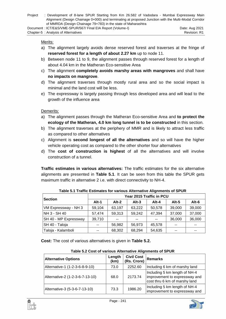
Project : Development of 8-lane SPUR Starting from Km 26.582 of Vadodara - Mumbai Expressway Main
Alignment (Design Chainage 0+000) and terminating at proposed Junction with the Multi-Modal Corridor
of MMRDA (Design Chainage 79+783) in the state of Maharashtra
Document : ICT/E&S/VME-SPUR/567/ Final EIA Report (Volume-I) Date: Aug 2021
Chapter-5 : Analysis of Alternatives Revision: R1
Page - 241
Merits:
a) The alignment largely avoids dense reserved forest and traverses at the fringe of
reserved forest for a length of about 2.27 km up to node 11.
b) Between node 11 to 9, the alignment passes through reserved forest for a length of
about 4.04 km in the Matheran Eco-sensitive Area
c) The alignment completely avoids marshy areas with mangroves and shall have
no impacts on mangrove.
d) The alignment traverses through mostly rural area and so the social impact is
minimal and the land cost will be less.
e) The expressway is largely passing through less developed area and will lead to the
growth of the influence area
Demerits:
a) The alignment passes through the Matheran Eco-sensitive Area and to protect the
ecology of the Matheran, 4.0 km long tunnel is to be constructed in this section.
b) The alignment traverses at the periphery of MMR and is likely to attract less traffic
as compared to other alternatives
c) Alignment is second longest of all the alternatives and so will have the higher
vehicle operating cost as compared to the other shorter four alternatives
d) The cost of construction is highest of all the alternatives and will involve
construction of a tunnel.
Traffic estimates in various alternatives: The traffic estimates for the six alternative
alignments are presented in Table 5.1. It can be seen from this table the SPUR gets
maximum traffic in alternative 2 i.e. with direct connectivity to NH-4.
Table 5.1 Traffic Estimates for various Alternative Alignments of SPUR
Section Year 2015 Traffic in PCU
Alt-1 Alt-2 Alt-3 Alt-4 Alt-5 Alt-6
VM Expressway - NH 3 59,104 63,197 63,222 50,578 39,000 39,000
NH 3 - SH 40 57,474 59,313 59,242 47,394 37,000 37,000
SH 40 - MP Expressway 39,710 -- -- -- 36,000 36,000
SH 40 - Taloja -- 56,982 56,973 45,578 -- --
Taloja - Kalamboli -- 68,302 68,294 54,635 -- --
Cost: The cost of various alternatives is given in Table 5.2.
Table 5.2 Cost of various Alternative Alignments of SPUR
Alternative Options Length
(km) Civil Cost
(Rs. Crore) Remarks
Alternative-1 (1-2-3-6-8-9-10) 73.0 2252.60 Including 6 km of marshy land
Alternative-2 (1-2-3-6-7-13-10) 68.0 2173.74 Including 5 km length of NH-4 improvement to expressway and cost thru 6 km of marshy land
Alternative-3 (5-3-6-7-13-10) 73.3 1986.20 Including 5 km length of NH-4 improvement to expressway and
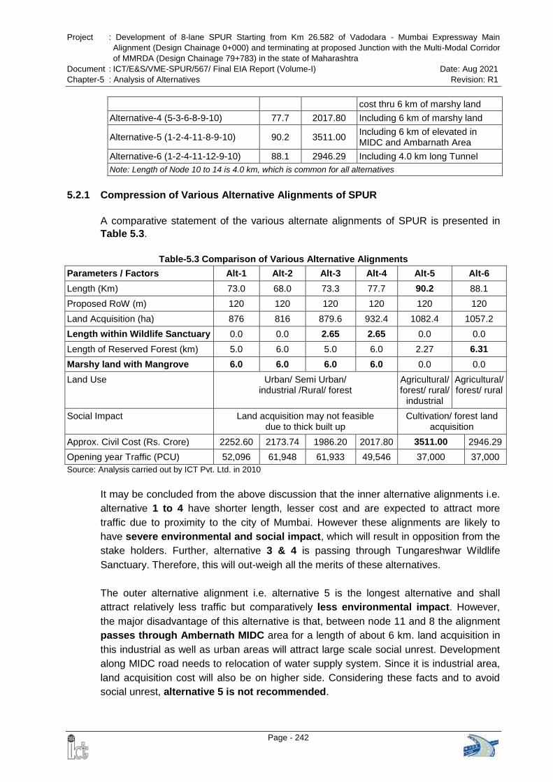
Project : Development of 8-lane SPUR Starting from Km 26.582 of Vadodara - Mumbai Expressway Main
Alignment (Design Chainage 0+000) and terminating at proposed Junction with the Multi-Modal Corridor
of MMRDA (Design Chainage 79+783) in the state of Maharashtra
Document : ICT/E&S/VME-SPUR/567/ Final EIA Report (Volume-I) Date: Aug 2021
Chapter-5 : Analysis of Alternatives Revision: R1
Page - 242
cost thru 6 km of marshy land
Alternative-4 (5-3-6-8-9-10) 77.7 2017.80 Including 6 km of marshy land
Alternative-5 (1-2-4-11-8-9-10) 90.2 3511.00 Including 6 km of elevated in MIDC and Ambarnath Area
Alternative-6 (1-2-4-11-12-9-10) 88.1 2946.29 Including 4.0 km long Tunnel
Note: Length of Node 10 to 14 is 4.0 km, which is common for all alternatives
5.2.1 Compression of Various Alternative Alignments of SPUR
A comparative statement of the various alternate alignments of SPUR is presented in
Table 5.3.
Table-5.3 Comparison of Various Alternative Alignments
Parameters / Factors Alt-1 Alt-2 Alt-3 Alt-4 Alt-5 Alt-6
Length (Km) 73.0 68.0 73.3 77.7 90.2 88.1
Proposed RoW (m) 120 120 120 120 120 120
Land Acquisition (ha) 876 816 879.6 932.4 1082.4 1057.2
Length within Wildlife Sanctuary 0.0 0.0 2.65 2.65 0.0 0.0
Length of Reserved Forest (km) 5.0 6.0 5.0 6.0 2.27 6.31
Marshy land with Mangrove 6.0 6.0 6.0 6.0 0.0 0.0
Land Use Urban/ Semi Urban/ industrial /Rural/ forest
Agricultural/ forest/ rural/
industrial
Agricultural/ forest/ rural
Social Impact Land acquisition may not feasible due to thick built up
Cultivation/ forest land acquisition
Approx. Civil Cost (Rs. Crore) 2252.60 2173.74 1986.20 2017.80 3511.00 2946.29
Opening year Traffic (PCU) 52,096 61,948 61,933 49,546 37,000 37,000
Source: Analysis carried out by ICT Pvt. Ltd. in 2010
It may be concluded from the above discussion that the inner alternative alignments i.e.
alternative 1 to 4 have shorter length, lesser cost and are expected to attract more
traffic due to proximity to the city of Mumbai. However these alignments are likely to
have severe environmental and social impact, which will result in opposition from the
stake holders. Further, alternative 3 & 4 is passing through Tungareshwar Wildlife
Sanctuary. Therefore, this will out-weigh all the merits of these alternatives.
The outer alternative alignment i.e. alternative 5 is the longest alternative and shall
attract relatively less traffic but comparatively less environmental impact. However,
the major disadvantage of this alternative is that, between node 11 and 8 the alignment
passes through Ambernath MIDC area for a length of about 6 km. land acquisition in
this industrial as well as urban areas will attract large scale social unrest. Development
along MIDC road needs to relocation of water supply system. Since it is industrial area,
land acquisition cost will also be on higher side. Considering these facts and to avoid
social unrest, alternative 5 is not recommended.
Project : Development of 8-lane SPUR Starting from Km 26.582 of Vadodara - Mumbai Expressway Main
Alignment (Design Chainage 0+000) and terminating at proposed Junction with the Multi-Modal Corridor
of MMRDA (Design Chainage 79+783) in the state of Maharashtra
Document : ICT/E&S/VME-SPUR/567/ Final EIA Report (Volume-I) Date: Aug 2021
Chapter-5 : Analysis of Alternatives Revision: R1
Page - 243
The outer alternative alignment i.e. alternative 6 is the second longest of all the
alternatives and shall attract relatively less traffic but comparatively less environmental
and social impacts. Though alternative 6 is passing through Matheran Eco Sensitive
Zone, there is provision of tunnel of about 4.160 km in this section which will preserve
the ecological environment as well as save reserved forest of about 4 Km stretch.
Further, there is no major hurdle for land acquisition. Therefore these alignments are
the routes of least resistance from stake holders.
5.2.2 Selection of the Final Alignment
The various alternate alignments were presented to NHAI Officials and it was desired
that the SPUR alignment should be synergized with the other developments being
envisaged in the Mumbai Metropolitan Region (MMR) by the Government of
Maharashtra.
Subsequently on 9th April 2010 a presentation of the alignment of the expressway and
the SPUR was made to the Chief Secretary, Government of Maharashtra in which
senior officials of the NHAI, MoRTH, State PWD, State Revenue and Forest
Department, City and Industrial Development Corporation (CIDCO) and the Mumbai
Metropolitan Region Development Authority (MMRDA) were present. In the
presentation, the SPUR to JNPT was approved in principle. The Chief Secretary
appointed a committee under the Chairmanship of Divisional Commissioner Konkan
Region to look into the selection of the alignment. The other members of the committee
included CGM NHAI; Chief Engineer (NH) PWD; Chief Conservator of Forest, Thane;
Chief Engineer MMRDA; Collector Thane; Additional Chief Transportation Engineer,
CIDCO and Additional Collector (Tribal), Jawhar, Thane. The committee held 5
meetings between April 2010 to August 2010 after joint site visit and the final report of
the committee was submitted to Chief Secretary on November 2010.
Considering technical aspects brought out from the visit made by the NHAI, Forest
Department. PWD and CIDCO and taking into account the merits of the outer
alignments, as explained in the above Paras, the Committee recommends the outer
alignment (Node No. 1-2-4-11-12-9-10-14) of SPUR of the main Vadodara Mumbai
Expressway in Maharashtra.
The Government of Maharashtra accepted the recommendations of the committee. A
formal approval of the alignment was communicated by the Government of Maharashtra
vide their letter NHP2010/CR81/ NH1 dated 3 Feb 2011 addressed to Chairman NHAI
(Annex 5.1).
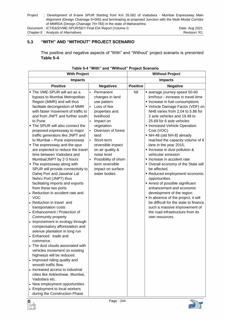
Project : Development of 8-lane SPUR Starting from Km 26.582 of Vadodara - Mumbai Expressway Main
Alignment (Design Chainage 0+000) and terminating at proposed Junction with the Multi-Modal Corridor
of MMRDA (Design Chainage 79+783) in the state of Maharashtra
Document : ICT/E&S/VME-SPUR/567/ Final EIA Report (Volume-I) Date: Aug 2021
Chapter-5 : Analysis of Alternatives Revision: R1
Page - 244
5.3 “WITH” AND “WITHOUT” PROJECT SCENARIO
The positive and negative aspects of “With” and “Without” project scenario is presented
Table 5-4.
Table 5-4 “With” and “Without” Project Scenario
With Project Without Project
Impacts Impacts
Positive Negatives Positive Negative
The VME-SPUR will act as a
bypass to Mumbai Metropolitan
Region (MMR) and will thus
facilitate decongestion of MMR
with faster movement of traffic to
and from JNPT and further south
to Pune
The SPUR will also connect the
proposed expressway to major
traffic generators like JNPT and
to Mumbai – Pune expressway
The expressway and the spur
are expected to reduce the travel
time between Vadodara and
Mumbai/JNPT by 2-3 hours
The expressway along with
SPUR will provide connectivity to
Dahej Port and Jawahar Lal
Nehru Port (JNPT) thus
facilitating imports and exports
from these two ports
Reduction in accident rate and
VOC
Reduction in travel and
transportation costs
Enhancement / Protection of
Community property
Improvement in ecology through
compensatory afforestation and
avenue plantation in long run
Enhanced trade and
commerce.
The dust clouds associated with
vehicles movement on existing
highways will be reduced
Improved riding quality and
smooth traffic flow.
Increased access to industrial
cities like Ankleshwar, Mumbai,
Vadodara etc.
New employment opportunities
Employment to local workers
during the Construction Phase
Permanent
changes in land
use pattern
Loss of few
properties and
livelihood
Impact on
vegetation
Diversion of forest
land
Short-term
reversible impact
on air quality &
noise level
Possibility of short-
term reversible
impact on surface
water bodies
Nil
average journey speed 50-60
km/hour - increase in travel time
Increase in fuel consumptions
Vehicle Damage Factor (VDF) on
NH8 varies from 2.04 to 5.86 for
2 axle vehicles and 19.48 to
25.69 for 6 axle vehicles
Increased Vehicle Operation
Cost (VOC)
NH-48 (old NH-8) already
reached the capacity volume of 6
lane in the year 2015,
Increase in dust pollution &
vehicular emission
Increase in accident rate
Overall economy of the State will
be affected.
Reduced employment/ economic
opportunities
Arrest of possible significant
enhancement and economic
development of the region
In absence of the project, it will
be difficult for the state to finance
such a massive improvement of
the road infrastructure from its
own resources.
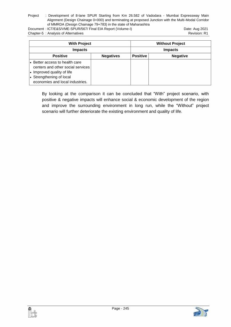
Project : Development of 8-lane SPUR Starting from Km 26.582 of Vadodara - Mumbai Expressway Main
Alignment (Design Chainage 0+000) and terminating at proposed Junction with the Multi-Modal Corridor
of MMRDA (Design Chainage 79+783) in the state of Maharashtra
Document : ICT/E&S/VME-SPUR/567/ Final EIA Report (Volume-I) Date: Aug 2021
Chapter-5 : Analysis of Alternatives Revision: R1
Page - 245
With Project Without Project
Impacts Impacts
Positive Negatives Positive Negative
Better access to health care
centers and other social services
Improved quality of life
Strengthening of local
economies and local industries.
By looking at the comparison it can be concluded that “With” project scenario, with
positive & negative impacts will enhance social & economic development of the region
and improve the surrounding environment in long run, while the “Without” project
scenario will further deteriorate the existing environment and quality of life.
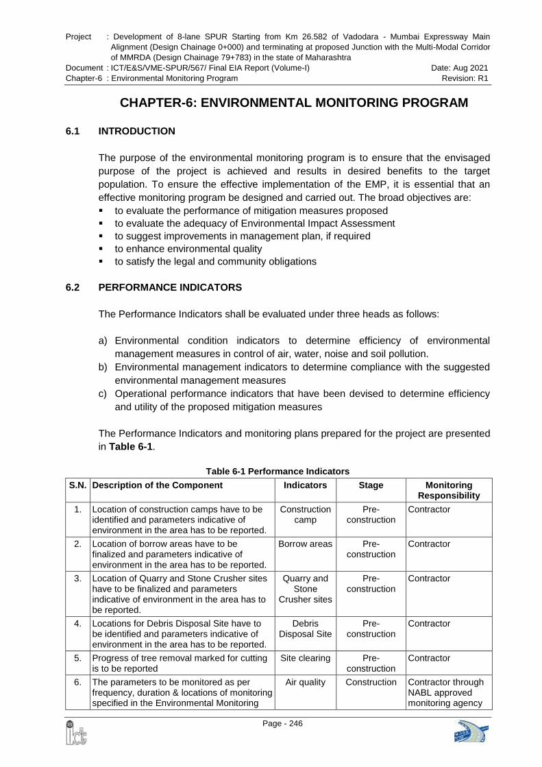
Project : Development of 8-lane SPUR Starting from Km 26.582 of Vadodara - Mumbai Expressway Main
Alignment (Design Chainage 0+000) and terminating at proposed Junction with the Multi-Modal Corridor
of MMRDA (Design Chainage 79+783) in the state of Maharashtra
Document : ICT/E&S/VME-SPUR/567/ Final EIA Report (Volume-I) Date: Aug 2021
Chapter-6 : Environmental Monitoring Program Revision: R1
Page - 246
CHAPTER-6: ENVIRONMENTAL MONITORING PROGRAM
6.1 INTRODUCTION
The purpose of the environmental monitoring program is to ensure that the envisaged
purpose of the project is achieved and results in desired benefits to the target
population. To ensure the effective implementation of the EMP, it is essential that an
effective monitoring program be designed and carried out. The broad objectives are:
to evaluate the performance of mitigation measures proposed
to evaluate the adequacy of Environmental Impact Assessment
to suggest improvements in management plan, if required
to enhance environmental quality
to satisfy the legal and community obligations
6.2 PERFORMANCE INDICATORS
The Performance Indicators shall be evaluated under three heads as follows:
a) Environmental condition indicators to determine efficiency of environmental
management measures in control of air, water, noise and soil pollution.
b) Environmental management indicators to determine compliance with the suggested
environmental management measures
c) Operational performance indicators that have been devised to determine efficiency
and utility of the proposed mitigation measures
The Performance Indicators and monitoring plans prepared for the project are presented
in Table 6-1.
Table 6-1 Performance Indicators
S.N. Description of the Component Indicators Stage Monitoring Responsibility
1. Location of construction camps have to be identified and parameters indicative of environment in the area has to be reported.
Construction camp
Pre-construction
Contractor
2. Location of borrow areas have to be finalized and parameters indicative of environment in the area has to be reported.
Borrow areas Pre-construction
Contractor
3. Location of Quarry and Stone Crusher sites have to be finalized and parameters indicative of environment in the area has to be reported.
Quarry and Stone
Crusher sites
Pre-construction
Contractor
4. Locations for Debris Disposal Site have to be identified and parameters indicative of environment in the area has to be reported.
Debris Disposal Site
Pre-construction
Contractor
5. Progress of tree removal marked for cutting is to be reported
Site clearing
Pre-construction
Contractor
6. The parameters to be monitored as per frequency, duration & locations of monitoring specified in the Environmental Monitoring
Air quality Construction Contractor through NABL approved monitoring agency
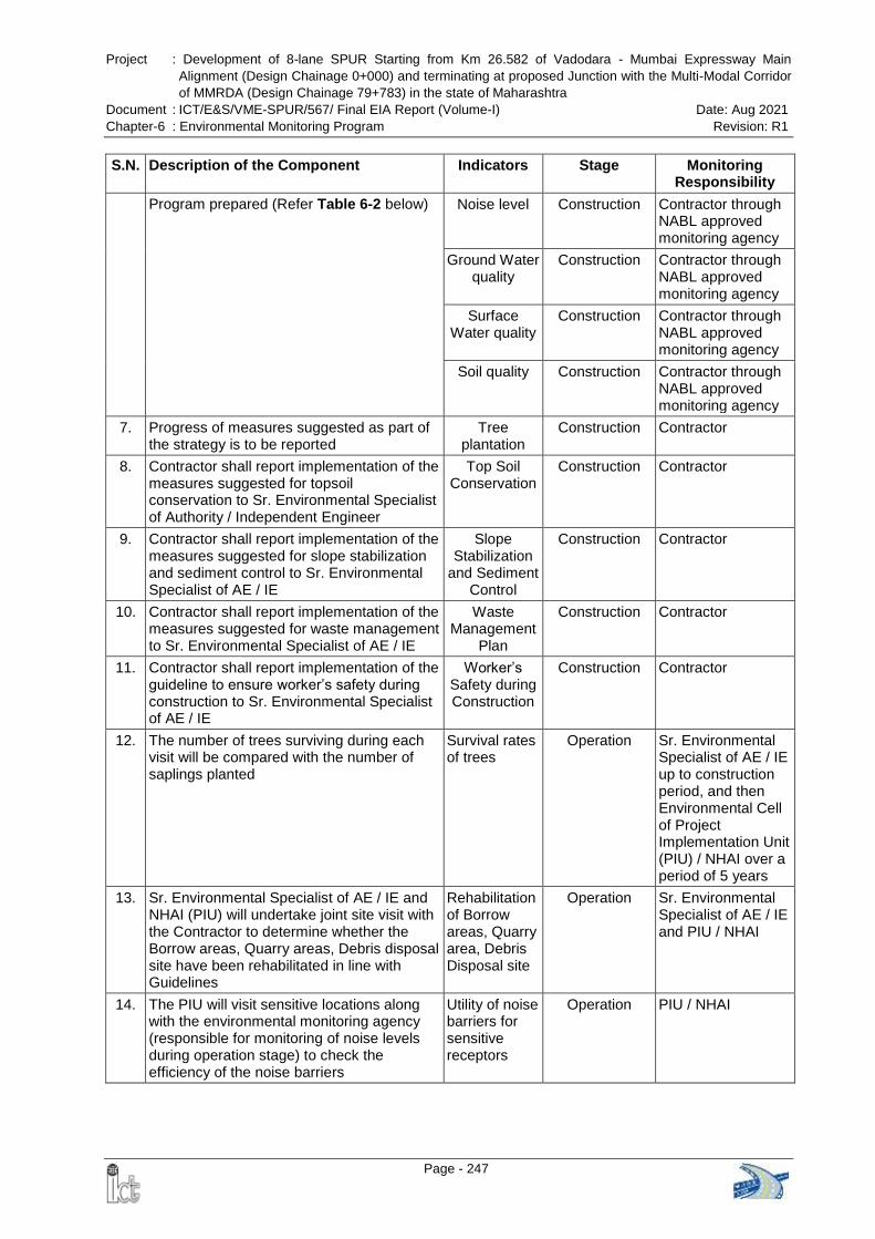
Project : Development of 8-lane SPUR Starting from Km 26.582 of Vadodara - Mumbai Expressway Main
Alignment (Design Chainage 0+000) and terminating at proposed Junction with the Multi-Modal Corridor
of MMRDA (Design Chainage 79+783) in the state of Maharashtra
Document : ICT/E&S/VME-SPUR/567/ Final EIA Report (Volume-I) Date: Aug 2021
Chapter-6 : Environmental Monitoring Program Revision: R1
Page - 247
S.N. Description of the Component Indicators Stage Monitoring Responsibility
Program prepared (Refer Table 6-2 below) Noise level Construction Contractor through NABL approved monitoring agency
Ground Water quality
Construction Contractor through NABL approved monitoring agency
Surface Water quality
Construction Contractor through NABL approved monitoring agency
Soil quality Construction Contractor through NABL approved monitoring agency
7. Progress of measures suggested as part of the strategy is to be reported
Tree plantation
Construction Contractor
8. Contractor shall report implementation of the measures suggested for topsoil conservation to Sr. Environmental Specialist of Authority / Independent Engineer
Top Soil Conservation
Construction Contractor
9. Contractor shall report implementation of the measures suggested for slope stabilization and sediment control to Sr. Environmental Specialist of AE / IE
Slope Stabilization
and Sediment Control
Construction Contractor
10. Contractor shall report implementation of the measures suggested for waste management to Sr. Environmental Specialist of AE / IE
Waste Management
Plan
Construction Contractor
11. Contractor shall report implementation of the guideline to ensure worker’s safety during construction to Sr. Environmental Specialist of AE / IE
Worker’s Safety during Construction
Construction Contractor
12. The number of trees surviving during each visit will be compared with the number of saplings planted
Survival rates of trees
Operation Sr. Environmental Specialist of AE / IE up to construction period, and then Environmental Cell of Project Implementation Unit (PIU) / NHAI over a period of 5 years
13. Sr. Environmental Specialist of AE / IE and NHAI (PIU) will undertake joint site visit with the Contractor to determine whether the Borrow areas, Quarry areas, Debris disposal site have been rehabilitated in line with Guidelines
Rehabilitation of Borrow areas, Quarry area, Debris Disposal site
Operation Sr. Environmental Specialist of AE / IE and PIU / NHAI
14. The PIU will visit sensitive locations along with the environmental monitoring agency (responsible for monitoring of noise levels during operation stage) to check the efficiency of the noise barriers
Utility of noise barriers for sensitive receptors
Operation PIU / NHAI
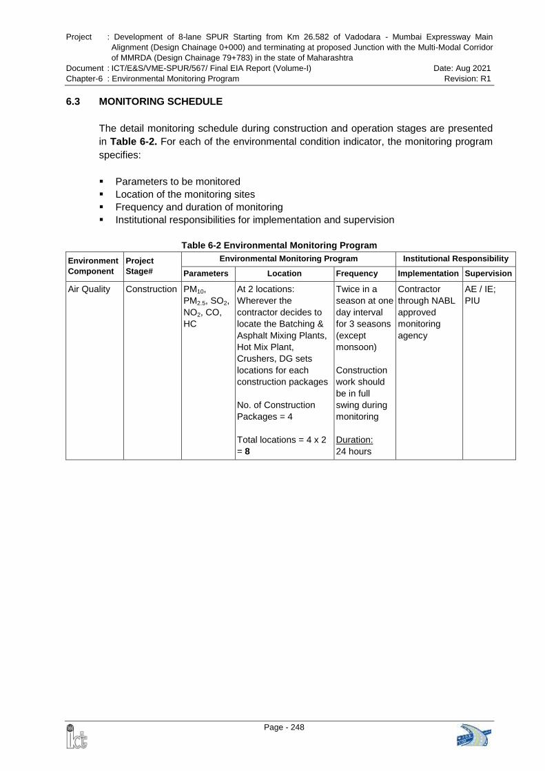
Project : Development of 8-lane SPUR Starting from Km 26.582 of Vadodara - Mumbai Expressway Main
Alignment (Design Chainage 0+000) and terminating at proposed Junction with the Multi-Modal Corridor
of MMRDA (Design Chainage 79+783) in the state of Maharashtra
Document : ICT/E&S/VME-SPUR/567/ Final EIA Report (Volume-I) Date: Aug 2021
Chapter-6 : Environmental Monitoring Program Revision: R1
Page - 248
6.3 MONITORING SCHEDULE
The detail monitoring schedule during construction and operation stages are presented
in Table 6-2. For each of the environmental condition indicator, the monitoring program
specifies:
Parameters to be monitored
Location of the monitoring sites
Frequency and duration of monitoring
Institutional responsibilities for implementation and supervision
Table 6-2 Environmental Monitoring Program
Environment
Component
Project
Stage#
Environmental Monitoring Program Institutional Responsibility
Parameters Location Frequency Implementation Supervision
Air Quality Construction PM10,
PM2.5, SO2,
NO2, CO,
HC
At 2 locations:
Wherever the
contractor decides to
locate the Batching &
Asphalt Mixing Plants,
Hot Mix Plant,
Crushers, DG sets
locations for each
construction packages
No. of Construction
Packages = 4
Total locations = 4 x 2
= 8
Twice in a
season at one
day interval
for 3 seasons
(except
monsoon)
Construction
work should
be in full
swing during
monitoring
Duration:
24 hours
Contractor
through NABL
approved
monitoring
agency
AE / IE;
PIU
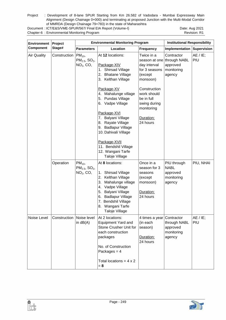
Project : Development of 8-lane SPUR Starting from Km 26.582 of Vadodara - Mumbai Expressway Main
Alignment (Design Chainage 0+000) and terminating at proposed Junction with the Multi-Modal Corridor
of MMRDA (Design Chainage 79+783) in the state of Maharashtra
Document : ICT/E&S/VME-SPUR/567/ Final EIA Report (Volume-I) Date: Aug 2021
Chapter-6 : Environmental Monitoring Program Revision: R1
Page - 249
Environment
Component
Project
Stage#
Environmental Monitoring Program Institutional Responsibility
Parameters Location Frequency Implementation Supervision
Air Quality Construction PM10,
PM2.5, SO2,
NO2, CO,
At 12 locations:
Package-XIV
1. Shirsad Village
2. Bhatane Village
3. Kelthan Village
Package-XV
4. Mahalunge village
5. Pundas Village
6. Vadpe Village
Package-XVI
7. Balyani Village
8. Rayate Village
9. Badlapur Village
10. Dahivali Village
Package-XVII
11. Bendshil Village
12. Wangani Tarfe
Taloje Village
Twice in a
season at one
day interval
for 3 seasons
(except
monsoon)
Construction
work should
be in full
swing during
monitoring
Duration:
24 hours
Contractor
through NABL
approved
monitoring
agency
AE / IE;
PIU
Operation PM10,
PM2.5, SO2,
NO2, CO,
At 8 locations:
1. Shirsad Village
2. Kelthan Village
3. Mahalunge village
4. Vadpe Village
5. Balyani Village
6. Badlapur Village
7. Bendshil Village
8. Wangani Tarfe
Taloje Village
Once in a
season for 3
seasons
(except
monsoon)
Duration:
24 hours
PIU through
NABL
approved
monitoring
agency
PIU, NHAI
Noise Level Construction Noise level
in dB(A)
At 2 locations:
Equipment Yard and
Stone Crusher Unit for
each construction
packages
No. of Construction
Packages = 4
Total locations = 4 x 2
= 8
4 times a year
(in each
season)
Duration:
24 hours
Contractor
through NABL
approved
monitoring
agency
AE / IE;
PIU
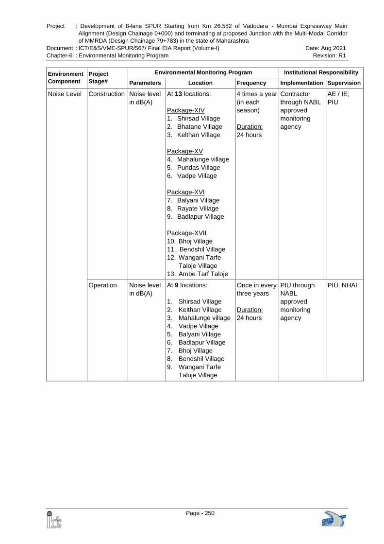
Project : Development of 8-lane SPUR Starting from Km 26.582 of Vadodara - Mumbai Expressway Main
Alignment (Design Chainage 0+000) and terminating at proposed Junction with the Multi-Modal Corridor
of MMRDA (Design Chainage 79+783) in the state of Maharashtra
Document : ICT/E&S/VME-SPUR/567/ Final EIA Report (Volume-I) Date: Aug 2021
Chapter-6 : Environmental Monitoring Program Revision: R1
Page - 250
Environment
Component
Project
Stage#
Environmental Monitoring Program Institutional Responsibility
Parameters Location Frequency Implementation Supervision
Noise Level Construction Noise level
in dB(A)
At 13 locations:
Package-XIV
1. Shirsad Village
2. Bhatane Village
3. Kelthan Village
Package-XV
4. Mahalunge village
5. Pundas Village
6. Vadpe Village
Package-XVI
7. Balyani Village
8. Rayate Village
9. Badlapur Village
Package-XVII
10. Bhoj Village
11. Bendshil Village
12. Wangani Tarfe
Taloje Village
13. Ambe Tarf Taloje
4 times a year
(in each
season)
Duration:
24 hours
Contractor
through NABL
approved
monitoring
agency
AE / IE;
PIU
Operation Noise level
in dB(A)
At 9 locations:
1. Shirsad Village
2. Kelthan Village
3. Mahalunge village
4. Vadpe Village
5. Balyani Village
6. Badlapur Village
7. Bhoj Village
8. Bendshil Village
9. Wangani Tarfe
Taloje Village
Once in every
three years
Duration:
24 hours
PIU through
NABL
approved
monitoring
agency
PIU, NHAI
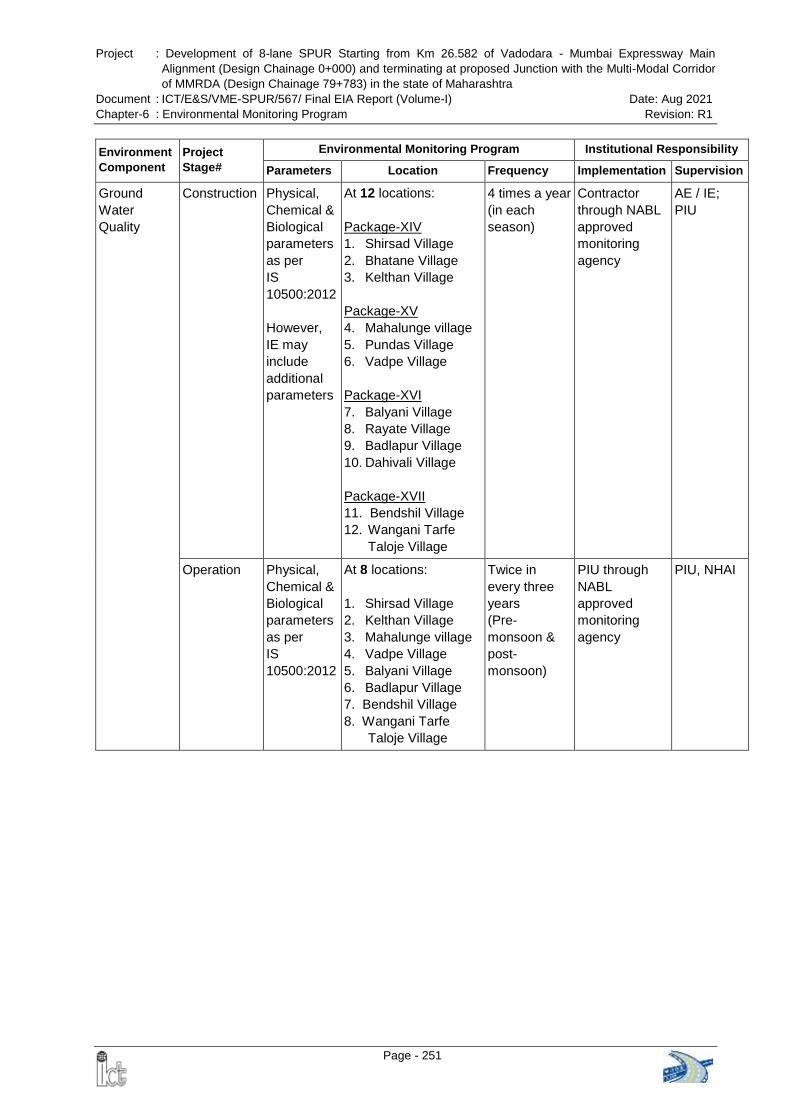
Project : Development of 8-lane SPUR Starting from Km 26.582 of Vadodara - Mumbai Expressway Main
Alignment (Design Chainage 0+000) and terminating at proposed Junction with the Multi-Modal Corridor
of MMRDA (Design Chainage 79+783) in the state of Maharashtra
Document : ICT/E&S/VME-SPUR/567/ Final EIA Report (Volume-I) Date: Aug 2021
Chapter-6 : Environmental Monitoring Program Revision: R1
Page - 251
Environment
Component
Project
Stage#
Environmental Monitoring Program Institutional Responsibility
Parameters Location Frequency Implementation Supervision
Ground
Water
Quality
Construction Physical,
Chemical &
Biological
parameters
as per
IS
10500:2012
However,
IE may
include
additional
parameters
At 12 locations:
Package-XIV
1. Shirsad Village
2. Bhatane Village
3. Kelthan Village
Package-XV
4. Mahalunge village
5. Pundas Village
6. Vadpe Village
Package-XVI
7. Balyani Village
8. Rayate Village
9. Badlapur Village
10. Dahivali Village
Package-XVII
11. Bendshil Village
12. Wangani Tarfe
Taloje Village
4 times a year
(in each
season)
Contractor
through NABL
approved
monitoring
agency
AE / IE;
PIU
Operation Physical,
Chemical &
Biological
parameters
as per
IS
10500:2012
At 8 locations:
1. Shirsad Village
2. Kelthan Village
3. Mahalunge village
4. Vadpe Village
5. Balyani Village
6. Badlapur Village
7. Bendshil Village
8. Wangani Tarfe
Taloje Village
Twice in
every three
years
(Pre-
monsoon &
post-
monsoon)
PIU through
NABL
approved
monitoring
agency
PIU, NHAI
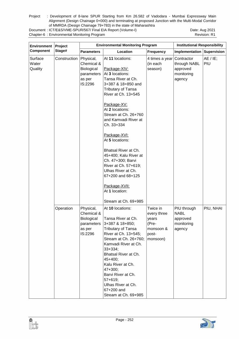
Project : Development of 8-lane SPUR Starting from Km 26.582 of Vadodara - Mumbai Expressway Main
Alignment (Design Chainage 0+000) and terminating at proposed Junction with the Multi-Modal Corridor
of MMRDA (Design Chainage 79+783) in the state of Maharashtra
Document : ICT/E&S/VME-SPUR/567/ Final EIA Report (Volume-I) Date: Aug 2021
Chapter-6 : Environmental Monitoring Program Revision: R1
Page - 252
Environment
Component
Project
Stage#
Environmental Monitoring Program Institutional Responsibility
Parameters Location Frequency Implementation Supervision
Surface
Water
Quality
Construction Physical,
Chemical &
Biological
parameters
as per
IS:2296
At 11 locations:
Package-XIV:
At 3 locations:
Tansa River at Ch.
3+387 & 18+850 and
Tributary of Tansa
River at Ch. 13+545
Package-XV:
At 2 locations:
Stream at Ch. 26+760
and Kamvadi River at
Ch. 33+334
Package-XVI:
At 5 locations:
Bhatsal River at Ch.
45+400; Kalu River at
Ch. 47+300; Barvi
River at Ch. 57+619;
Ulhas River at Ch.
67+200 and 68+125
Package-XVII:
At 1 location:
Stream at Ch. 69+985
4 times a year
(in each
season)
Contractor
through NABL
approved
monitoring
agency
AE / IE;
PIU
Operation Physical,
Chemical &
Biological
parameters
as per
IS:2296
At 10 locations:
Tansa River at Ch.
3+387 & 18+850;
Tributary of Tansa
River at Ch. 13+545;
Stream at Ch. 26+760;
Kamvadi River at Ch.
33+334;
Bhatsal River at Ch.
45+400;
Kalu River at Ch.
47+300;
Barvi River at Ch.
57+619;
Ulhas River at Ch.
67+200 and
Stream at Ch. 69+985
Twice in
every three
years
(Pre-
monsoon &
post-
monsoon)
PIU through
NABL
approved
monitoring
agency
PIU, NHAI
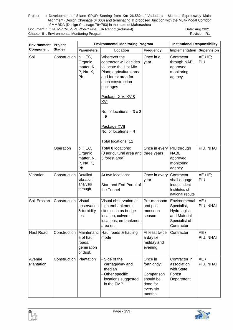
Project : Development of 8-lane SPUR Starting from Km 26.582 of Vadodara - Mumbai Expressway Main
Alignment (Design Chainage 0+000) and terminating at proposed Junction with the Multi-Modal Corridor
of MMRDA (Design Chainage 79+783) in the state of Maharashtra
Document : ICT/E&S/VME-SPUR/567/ Final EIA Report (Volume-I) Date: Aug 2021
Chapter-6 : Environmental Monitoring Program Revision: R1
Page - 253
Environment
Component
Project
Stage#
Environmental Monitoring Program Institutional Responsibility
Parameters Location Frequency Implementation Supervision
Soil Construction pH, EC,
Organic
matter, N,
P, Na, K,
Pb
Wherever the
contractor will decides
to locate the Hot Mix
Plant; agricultural area
and forest area for
each construction
packages
Package-XIV, XV &
XVI
No. of locations = 3 x 3
= 9
Package XVII
No. of locations = 4
Total locations: 11
Once in a
year
Contractor
through NABL
approved
monitoring
agency
AE / IE;
PIU
Operation pH, EC,
Organic
matter, N,
P, Na, K,
Pb
Total 8 locations:
(3 agricultural area and
5 forest area)
Once in every
three years
PIU through
NABL
approved
monitoring
agency
PIU, NHAI
Vibration Construction Detailed
vibration
analysis
through
At two locations:
Start and End Portal of
the Tunnel
Once in every
year
Contractor
shall engage
Independent
Institutes of
national repute
AE / IE;
PIU
Soil Erosion Construction Visual
observation
& turbidity
test
Visual observation at
high embankments
sites such as bridge
location, culvert
locations, embankment
area etc.
Pre-monsoon
and post-
monsoon
season
Environmental
Specialist,
Hydrologist,
and Material
Specialist of
Contractor
AE /
PIU, NHAI
Haul Road Construction Maintenanc
e of haul
roads,
generation
of dust.
Haul roads & hauling
mode
At least twice
a day i.e.
midday and
evening
Contractor
AE /
PIU, NHAI
Avenue
Plantation
Construction Plantation - Side of the
carriageway and
median
- Other specific
locations suggested
in the EMP
Once in
fortnightly;
Comparison
should be
done for
every six
months
Contractor in
association
with State
Forest
Department
AE /
PIU, NHAI
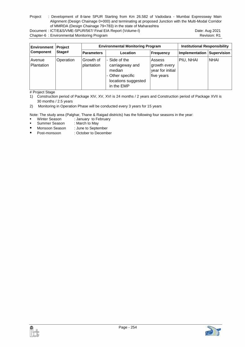
Project : Development of 8-lane SPUR Starting from Km 26.582 of Vadodara - Mumbai Expressway Main
Alignment (Design Chainage 0+000) and terminating at proposed Junction with the Multi-Modal Corridor
of MMRDA (Design Chainage 79+783) in the state of Maharashtra
Document : ICT/E&S/VME-SPUR/567/ Final EIA Report (Volume-I) Date: Aug 2021
Chapter-6 : Environmental Monitoring Program Revision: R1
Page - 254
Environment
Component
Project
Stage#
Environmental Monitoring Program Institutional Responsibility
Parameters Location Frequency Implementation Supervision
Avenue
Plantation
Operation Growth of
plantation
- Side of the
carriageway and
median
- Other specific
locations suggested
in the EMP
Assess
growth every
year for initial
five years
PIU, NHAI NHAI
# Project Stage 1) Construction period of Package XIV, XV, XVI is 24 months / 2 years and Construction period of Package XVII is
30 months / 2.5 years
2) Monitoring in Operation Phase will be conducted every 3 years for 15 years
Note: The study area (Palghar, Thane & Raigad districts) has the following four seasons in the year: Winter Season : January to February Summer Season : March to May
Monsoon Season : June to September Post-monsoon : October to December
Project : Development of 8-lane SPUR Starting from Km 26.582 of Vadodara - Mumbai Expressway Main
Alignment (Design Chainage 0+000) and terminating at proposed Junction with the Multi-Modal Corridor
of MMRDA (Design Chainage 79+783) in the state of Maharashtra
Document : ICT/E&S/VME-SPUR/567/ Final EIA Report (Volume-I) Date: Aug 2021
Chapter-7 : Additional Studies Revision: R1
Page - 255
CHAPTER-7: ADDITIONAL STUDIES
7.0 INTRODUCTION
In order to ensure the comprehensive and effective EIA, it is necessary to conduct
various project specific studies as suggested by the MoEFCC in the approved ToR,
which will help in identifying the anticipated impacts of the proposed project and to
propose appropriate measures during design phase to successfully mitigate the
envisaged impacts.
The project specific conditions of the approved ToR issued by the MoEFCC vide
letter dated 16th March 2020 says that:
(ix) The proponent, with the help of an independent institute / expert of national
repute, shall carry out the topographic and geophysical surveys also include in the
study area with special mention of the tunnel area. The study should 3D modelling of
the proposed alignment with interpretation on hydrology, rock type, lineaments,
fractures, vegetation cover etc. using latest high resolution Remote Sensing data and
Survey of India toposheets at 1:50,000 scale.
(x) The proponent shall take up detailed aquifer study at various depths and its impact
of ambient ground water regime due to construction of tunnel and spur especially in the
eco-sensitive zone. A specialized hydrogeological and hydrological study is essential to
address this issue. It is preferred to take up resistivity profiling/ VES or advanced
geophysical studies on the either side of the tunnel to decipher the fracture pattern and
weathered portion. The foot hills of both sides of the proposed tunnel have high
possibility of weathered rocks having good repository of ground water that need to be
taken care for tunnel alignment.
(xi) The proponent shall ensure that the proposed tunnel does not obstruct any major
source of ground water which deprives availability of desired ground water in the down
gradient side. All precautions to be taken to avoid any interference to sub-surface
ground water flow.
(xv) Since, the proposal involves acquisition of fertile agriculture land and R&R issues,
the proponent, with the help of an independent institution/expert of national repute,
shall carry out a comprehensive socio-economic assessment with emphasis on impact
of ongoing land acquisition on the local people living around the proposed alignment.
The Social Impact Assessment shall take into consideration of key parameters like
people's dependency in the study area, socio-economic spectrum, impact of the project
at local and regional levels.
(xvi) The proponent, with the help of an independent institute / expert of national repute,
shall carry out a detailed traffic study to assess inflow of traffic from adjoining areas
like airport / urban cities. The detailed traffic planning studies shall include complete
Project : Development of 8-lane SPUR Starting from Km 26.582 of Vadodara - Mumbai Expressway Main
Alignment (Design Chainage 0+000) and terminating at proposed Junction with the Multi-Modal Corridor
of MMRDA (Design Chainage 79+783) in the state of Maharashtra
Document : ICT/E&S/VME-SPUR/567/ Final EIA Report (Volume-I) Date: Aug 2021
Chapter-7 : Additional Studies Revision: R1
Page - 256
design, drawings and traffic circulation plans (taking into consideration integration with
proposed alignment and other state roads etc.). Wherever required adequate
connectivity in terms of VUP (vehicle underpass) / PUP (Pedestrian underpass) needs
to be included
(xvii) The proponent, with the help of an independent institute/expert of national
repute, shall carry out a detailed vibration analysis associated with the construction
and operation phases of the proposed tunnel and its impact on the wildlife along with
mitigation measures.
Following Independent Agencies were engaged for conducting the project specific
studies:
1. PMT Infra Science in association with Indian Institute of Technology (Indian School
of Mines), Dhanbad was engaged for conducting the Geophysical Surveys,
Hydrogeological & Aquifer Study and 3-D Modelling
2. Infer Development Consulting Pvt. Ltd., New Delhi was engaged for conducting
comprehensive Social Impact Assessment for the project
3. i Adept Marketing, New Delhi was engaged for conducting detailed vibration analysis
These agencies conducted the project specific study and prepared standalone report.
The findings of the project specific studies have been summarized and
incorporated in this chapter.
Apart from the above project specific studies, MoEF&CC also suggested
(xiii) Since, the area is important from wildlife point of view and Schedule-I species
exists in the study area (10 km radius of the proposed project), the proponent shall
prepare a detailed Wildlife Conservation Plan along with adequate mitigation
measures. The Wildlife Conservation Plan shall be approved by the Chief Wildlife
Warden concerned.
(xiv) The proponent shall also study wildlife corridor along the proposed alignment
covering atleast two seasons, winter and summer in consultation with Chief Wildlife
Warden, Government of Maharashtra. The suggested mitigation measures should
include options of long elevated stretches of the road to maintain and ensure contiguity
of animal movement between Tungareshwar and Tansa forest areas.
The mitigation measures suggested in the Wildlife Conservation Plan has been included
in Section 4.7 of Chapter-4 “Anticipated Environmental Impacts and Mitigation
Measures” and approved financial allocation for Wildlife Conservation measures
has been included in Chapter-9 “Environment Management Plan”.
Project : Development of 8-lane SPUR Starting from Km 26.582 of Vadodara - Mumbai Expressway Main
Alignment (Design Chainage 0+000) and terminating at proposed Junction with the Multi-Modal Corridor
of MMRDA (Design Chainage 79+783) in the state of Maharashtra
Document : ICT/E&S/VME-SPUR/567/ Final EIA Report (Volume-I) Date: Aug 2021
Chapter-7 : Additional Studies Revision: R1
Page - 257
Therefore, this Chapter describes the followings:
Risk Assessment and Disaster Management Plan
Geophysical Surveys
Hydrogeological & Aquifer Study and 3-D Modelling
Vibration Impact Assessment of Proposed Tunnel
Social Impact Assessment
Traffic Study
Public Hearing
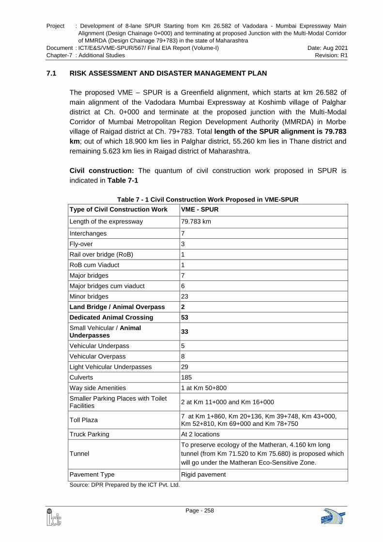
Project : Development of 8-lane SPUR Starting from Km 26.582 of Vadodara - Mumbai Expressway Main
Alignment (Design Chainage 0+000) and terminating at proposed Junction with the Multi-Modal Corridor
of MMRDA (Design Chainage 79+783) in the state of Maharashtra
Document : ICT/E&S/VME-SPUR/567/ Final EIA Report (Volume-I) Date: Aug 2021
Chapter-7 : Additional Studies Revision: R1
Page - 258
7.1 RISK ASSESSMENT AND DISASTER MANAGEMENT PLAN
The proposed VME – SPUR is a Greenfield alignment, which starts at km 26.582 of
main alignment of the Vadodara Mumbai Expressway at Koshimb village of Palghar
district at Ch. 0+000 and terminate at the proposed junction with the Multi-Modal
Corridor of Mumbai Metropolitan Region Development Authority (MMRDA) in Morbe
village of Raigad district at Ch. 79+783. Total length of the SPUR alignment is 79.783
km; out of which 18.900 km lies in Palghar district, 55.260 km lies in Thane district and
remaining 5.623 km lies in Raigad district of Maharashtra.
Civil construction: The quantum of civil construction work proposed in SPUR is
indicated in Table 7-1
Table 7 - 1 Civil Construction Work Proposed in VME-SPUR
Type of Civil Construction Work VME - SPUR
Length of the expressway 79.783 km
Interchanges 7
Fly-over 3
Rail over bridge (RoB) 1
RoB cum Viaduct 1
Major bridges 7
Major bridges cum viaduct 6
Minor bridges 23
Land Bridge / Animal Overpass 2
Dedicated Animal Crossing 53
Small Vehicular / Animal Underpasses
33
Vehicular Underpass 5
Vehicular Overpass 8
Light Vehicular Underpasses 29
Culverts 185
Way side Amenities 1 at Km 50+800
Smaller Parking Places with Toilet Facilities
2 at Km 11+000 and Km 16+000
Toll Plaza 7 at Km 1+860, Km 20+136, Km 39+748, Km 43+000, Km 52+810, Km 69+000 and Km 78+750
Truck Parking At 2 locations
Tunnel
To preserve ecology of the Matheran, 4.160 km long
tunnel (from Km 71.520 to Km 75.680) is proposed which
will go under the Matheran Eco-Sensitive Zone.
Pavement Type Rigid pavement
Source: DPR Prepared by the ICT Pvt. Ltd.
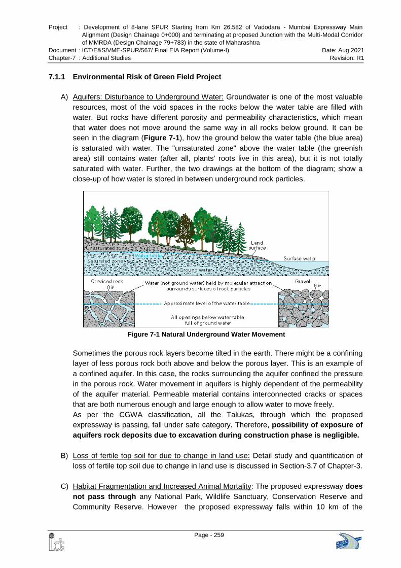
Project : Development of 8-lane SPUR Starting from Km 26.582 of Vadodara - Mumbai Expressway Main
Alignment (Design Chainage 0+000) and terminating at proposed Junction with the Multi-Modal Corridor
of MMRDA (Design Chainage 79+783) in the state of Maharashtra
Document : ICT/E&S/VME-SPUR/567/ Final EIA Report (Volume-I) Date: Aug 2021
Chapter-7 : Additional Studies Revision: R1
Page - 259
7.1.1 Environmental Risk of Green Field Project
A) Aquifers: Disturbance to Underground Water: Groundwater is one of the most valuable
resources, most of the void spaces in the rocks below the water table are filled with
water. But rocks have different porosity and permeability characteristics, which mean
that water does not move around the same way in all rocks below ground. It can be
seen in the diagram (Figure 7-1), how the ground below the water table (the blue area)
is saturated with water. The "unsaturated zone" above the water table (the greenish
area) still contains water (after all, plants' roots live in this area), but it is not totally
saturated with water. Further, the two drawings at the bottom of the diagram; show a
close-up of how water is stored in between underground rock particles.
Sometimes the porous rock layers become tilted in the earth. There might be a confining
layer of less porous rock both above and below the porous layer. This is an example of
a confined aquifer. In this case, the rocks surrounding the aquifer confined the pressure
in the porous rock. Water movement in aquifers is highly dependent of the permeability
of the aquifer material. Permeable material contains interconnected cracks or spaces
that are both numerous enough and large enough to allow water to move freely.
As per the CGWA classification, all the Talukas, through which the proposed
expressway is passing, fall under safe category. Therefore, possibility of exposure of
aquifers rock deposits due to excavation during construction phase is negligible.
B) Loss of fertile top soil for due to change in land use: Detail study and quantification of
loss of fertile top soil due to change in land use is discussed in Section-3.7 of Chapter-3.
C) Habitat Fragmentation and Increased Animal Mortality: The proposed expressway does
not pass through any National Park, Wildlife Sanctuary, Conservation Reserve and
Community Reserve. However the proposed expressway falls within 10 km of the
Figure 7-1 Natural Underground Water Movement
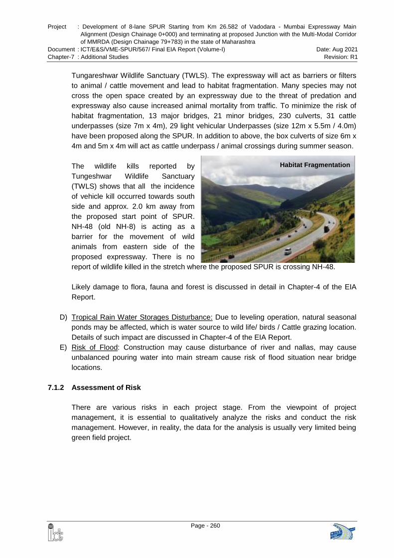
Project : Development of 8-lane SPUR Starting from Km 26.582 of Vadodara - Mumbai Expressway Main
Alignment (Design Chainage 0+000) and terminating at proposed Junction with the Multi-Modal Corridor
of MMRDA (Design Chainage 79+783) in the state of Maharashtra
Document : ICT/E&S/VME-SPUR/567/ Final EIA Report (Volume-I) Date: Aug 2021
Chapter-7 : Additional Studies Revision: R1
Page - 260
Habitat Fragmentation
Tungareshwar Wildlife Sanctuary (TWLS). The expressway will act as barriers or filters
to animal / cattle movement and lead to habitat fragmentation. Many species may not
cross the open space created by an expressway due to the threat of predation and
expressway also cause increased animal mortality from traffic. To minimize the risk of
habitat fragmentation, 13 major bridges, 21 minor bridges, 230 culverts, 31 cattle
underpasses (size 7m x 4m), 29 light vehicular Underpasses (size 12m x 5.5m / 4.0m)
have been proposed along the SPUR. In addition to above, the box culverts of size 6m x
4m and 5m x 4m will act as cattle underpass / animal crossings during summer season.
The wildlife kills reported by
Tungeshwar Wildlife Sanctuary
(TWLS) shows that all the incidence
of vehicle kill occurred towards south
side and approx. 2.0 km away from
the proposed start point of SPUR.
NH-48 (old NH-8) is acting as a
barrier for the movement of wild
animals from eastern side of the
proposed expressway. There is no
report of wildlife killed in the stretch where the proposed SPUR is crossing NH-48.
Likely damage to flora, fauna and forest is discussed in detail in Chapter-4 of the EIA
Report.
D) Tropical Rain Water Storages Disturbance: Due to leveling operation, natural seasonal
ponds may be affected, which is water source to wild life/ birds / Cattle grazing location.
Details of such impact are discussed in Chapter-4 of the EIA Report.
E) Risk of Flood: Construction may cause disturbance of river and nallas, may cause
unbalanced pouring water into main stream cause risk of flood situation near bridge
locations.
7.1.2 Assessment of Risk
There are various risks in each project stage. From the viewpoint of project
management, it is essential to qualitatively analyze the risks and conduct the risk
management. However, in reality, the data for the analysis is usually very limited being
green field project.
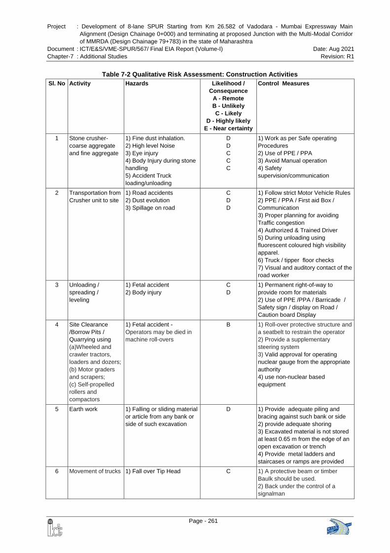
Project : Development of 8-lane SPUR Starting from Km 26.582 of Vadodara - Mumbai Expressway Main
Alignment (Design Chainage 0+000) and terminating at proposed Junction with the Multi-Modal Corridor
of MMRDA (Design Chainage 79+783) in the state of Maharashtra
Document : ICT/E&S/VME-SPUR/567/ Final EIA Report (Volume-I) Date: Aug 2021
Chapter-7 : Additional Studies Revision: R1
Page - 261
Table 7-2 Qualitative Risk Assessment: Construction Activities
Sl. No Activity Hazards Likelihood /
Consequence
A - Remote
B - Unlikely
C - Likely
D - Highly likely
E - Near certainty
Control Measures
1 Stone crusher-
coarse aggregate
and fine aggregate
1) Fine dust inhalation.
2) High level Noise
3) Eye injury
4) Body Injury during stone
handling
5) Accident Truck
loading/unloading
D
D
C
C
C
1) Work as per Safe operating
Procedures
2) Use of PPE / PPA
3) Avoid Manual operation
4) Safety
supervision/communication
2 Transportation from
Crusher unit to site
1) Road accidents
2) Dust evolution
3) Spillage on road
C
D
D
1) Follow strict Motor Vehicle Rules
2) PPE / PPA / First aid Box /
Communication
3) Proper planning for avoiding
Traffic congestion
4) Authorized & Trained Driver
5) During unloading using
fluorescent coloured high visibility
apparel.
6) Truck / tipper floor checks
7) Visual and auditory contact of the
road worker
3 Unloading /
spreading /
leveling
1) Fetal accident
2) Body injury
C
D
1) Permanent right-of-way to
provide room for materials
2) Use of PPE /PPA / Barricade /
Safety sign / display on Road /
Caution board Display
4 Site Clearance
/Borrow Pits /
Quarrying using
(a)Wheeled and
crawler tractors,
loaders and dozers;
(b) Motor graders
and scrapers;
(c) Self-propelled
rollers and
compactors
1) Fetal accident -
Operators may be died in
machine roll-overs
B 1) Roll-over protective structure and
a seatbelt to restrain the operator
2) Provide a supplementary
steering system
3) Valid approval for operating
nuclear gauge from the appropriate
authority
4) use non-nuclear based
equipment
5 Earth work 1) Falling or sliding material
or article from any bank or
side of such excavation
D 1) Provide adequate piling and
bracing against such bank or side
2) provide adequate shoring
3) Excavated material is not stored
at least 0.65 m from the edge of an
open excavation or trench
4) Provide metal ladders and
staircases or ramps are provided
6 Movement of trucks
1) Fall over Tip Head C 1) A protective beam or timber
Baulk should be used.
2) Back under the control of a
signalman
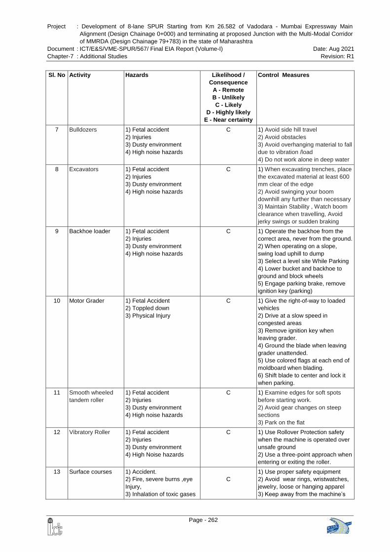
Project : Development of 8-lane SPUR Starting from Km 26.582 of Vadodara - Mumbai Expressway Main
Alignment (Design Chainage 0+000) and terminating at proposed Junction with the Multi-Modal Corridor
of MMRDA (Design Chainage 79+783) in the state of Maharashtra
Document : ICT/E&S/VME-SPUR/567/ Final EIA Report (Volume-I) Date: Aug 2021
Chapter-7 : Additional Studies Revision: R1
Page - 262
Sl. No Activity Hazards Likelihood /
Consequence
A - Remote
B - Unlikely
C - Likely
D - Highly likely
E - Near certainty
Control Measures
7 Bulldozers 1) Fetal accident
2) Injuries
3) Dusty environment
4) High noise hazards
C 1) Avoid side hill travel
2) Avoid obstacles
3) Avoid overhanging material to fall
due to vibration /load
4) Do not work alone in deep water
8 Excavators 1) Fetal accident
2) Injuries
3) Dusty environment
4) High noise hazards
C 1) When excavating trenches, place
the excavated material at least 600
mm clear of the edge
2) Avoid swinging your boom
downhill any further than necessary
3) Maintain Stability , Watch boom
clearance when travelling, Avoid
jerky swings or sudden braking
9 Backhoe loader 1) Fetal accident
2) Injuries
3) Dusty environment
4) High noise hazards
C 1) Operate the backhoe from the
correct area, never from the ground.
2) When operating on a slope,
swing load uphill to dump
3) Select a level site While Parking
4) Lower bucket and backhoe to
ground and block wheels
5) Engage parking brake, remove
ignition key (parking)
10 Motor Grader 1) Fetal Accident
2) Toppled down
3) Physical Injury
C 1) Give the right-of-way to loaded
vehicles
2) Drive at a slow speed in
congested areas
3) Remove ignition key when
leaving grader.
4) Ground the blade when leaving
grader unattended.
5) Use colored flags at each end of
moldboard when blading.
6) Shift blade to center and lock it
when parking.
11 Smooth wheeled
tandem roller
1) Fetal accident
2) Injuries
3) Dusty environment
4) High noise hazards
C 1) Examine edges for soft spots
before starting work.
2) Avoid gear changes on steep
sections
3) Park on the flat
12 Vibratory Roller 1) Fetal accident
2) Injuries
3) Dusty environment
4) High Noise hazards
C 1) Use Rollover Protection safety
when the machine is operated over
unsafe ground
2) Use a three-point approach when
entering or exiting the roller.
13 Surface courses 1) Accident.
2) Fire, severe burns ,eye
Injury,
3) Inhalation of toxic gases
C
1) Use proper safety equipment
2) Avoid wear rings, wristwatches,
jewelry, loose or hanging apparel
3) Keep away from the machine’s
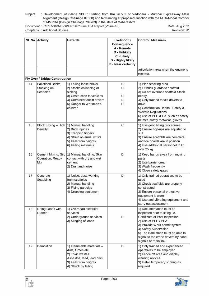
Project : Development of 8-lane SPUR Starting from Km 26.582 of Vadodara - Mumbai Expressway Main
Alignment (Design Chainage 0+000) and terminating at proposed Junction with the Multi-Modal Corridor
of MMRDA (Design Chainage 79+783) in the state of Maharashtra
Document : ICT/E&S/VME-SPUR/567/ Final EIA Report (Volume-I) Date: Aug 2021
Chapter-7 : Additional Studies Revision: R1
Page - 263
Sl. No Activity Hazards Likelihood /
Consequence
A - Remote
B - Unlikely
C - Likely
D - Highly likely
E - Near certainty
Control Measures
articulation area when the engine is
running.
Fly Over / Bridge Construction
14 Palletised Bricks,
Stacking on
Scaffolds
1) Falling loose bricks
2) Stacks collapsing or
sinking
3) Obstruction to vehicles
4) Untrained forklift drivers
5) Danger to Workman’s
children
C
D
C
B
C
1) Plan stacking area
2) Fit brick guards to scaffold
3) Do not overload scaffold Stack
neatly
4) Only trained forklift drivers to
drive
5) Construction Health , Safety &
Welfare Regulations
6) Use of PPE /PPA, such as safety
helmet, safety footwear, gloves
15 Block Laying – High
Density
1) Manual handling
2) Back injuries
3) Trapping fingers
4) Strain on arms, wrists
5) Falls from heights
6) Falling materials
C 1) Use good lifting procedures
2) Ensure hop-ups are adjusted to
suit
3) Ensure scaffolds are complete
and toe boards are in position
4) Use additional personnel to lift
over 25 kg
16 Cement Mixing, Silo
Operation, Ready
Mix
1) Manual handling, Skin
contact with dry and wet
cement
2) Dust and noise
D 1) Keep hands away from moving
parts
2) Use barrier cream
3) Wash frequently
4) Close safety gates
17 Concrete –
Scabbling
1) Noise, dust, working
from scaffolds
2) Manual handling
3) Flying particles
4) Dropping equipment
D
1) Only trained operatives to be
used
2) Check scaffolds are properly
constructed
3) Ensure personal protective
equipment is worn
4) Use anti-vibrating equipment and
carry out assessment
18 Lifting Loads with
Cranes
1) Overhead electrical
services
2) Underground services
3) Slinging of loads
D
1) Documentation must be
inspected prior to lifting i.e.
Certificate of Past Inspection
2) Use of PPE / PPA
3) Provide Work permit system
4) Safety Supervision
5) The Banksman must be able to
signal to the crane drivers by hand
signals or radio link
19 Demolition 1) Flammable materials –
dust, fumes etc.
2) Toxic wastes
Asbestos, lead, lead paint
3) Falls from heights
4) Struck by falling
D 1) Only trained and experienced
operatives to be employed
2) Fence off area and display
warning notices
3) Install temporary shoring as
required
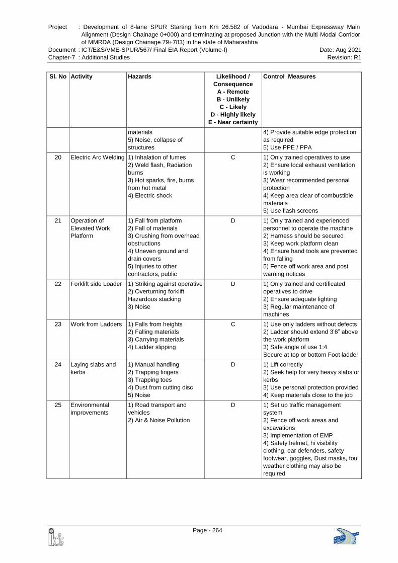
Project : Development of 8-lane SPUR Starting from Km 26.582 of Vadodara - Mumbai Expressway Main
Alignment (Design Chainage 0+000) and terminating at proposed Junction with the Multi-Modal Corridor
of MMRDA (Design Chainage 79+783) in the state of Maharashtra
Document : ICT/E&S/VME-SPUR/567/ Final EIA Report (Volume-I) Date: Aug 2021
Chapter-7 : Additional Studies Revision: R1
Page - 264
Sl. No Activity Hazards Likelihood /
Consequence
A - Remote
B - Unlikely
C - Likely
D - Highly likely
E - Near certainty
Control Measures
materials
5) Noise, collapse of
structures
4) Provide suitable edge protection
as required
5) Use PPE / PPA
20 Electric Arc Welding 1) Inhalation of fumes
2) Weld flash, Radiation
burns
3) Hot sparks, fire, burns
from hot metal
4) Electric shock
C 1) Only trained operatives to use
2) Ensure local exhaust ventilation
is working
3) Wear recommended personal
protection
4) Keep area clear of combustible
materials
5) Use flash screens
21 Operation of
Elevated Work
Platform
1) Fall from platform
2) Fall of materials
3) Crushing from overhead
obstructions
4) Uneven ground and
drain covers
5) Injuries to other
contractors, public
D 1) Only trained and experienced
personnel to operate the machine
2) Harness should be secured
3) Keep work platform clean
4) Ensure hand tools are prevented
from falling
5) Fence off work area and post
warning notices
22 Forklift side Loader 1) Striking against operative
2) Overturning forklift
Hazardous stacking
3) Noise
D 1) Only trained and certificated
operatives to drive
2) Ensure adequate lighting
3) Regular maintenance of
machines
23 Work from Ladders
1) Falls from heights
2) Falling materials
3) Carrying materials
4) Ladder slipping
C 1) Use only ladders without defects
2) Ladder should extend 3’6” above
the work platform
3) Safe angle of use 1:4
Secure at top or bottom Foot ladder
24 Laying slabs and
kerbs
1) Manual handling
2) Trapping fingers
3) Trapping toes
4) Dust from cutting disc
5) Noise
D 1) Lift correctly
2) Seek help for very heavy slabs or
kerbs
3) Use personal protection provided
4) Keep materials close to the job
25 Environmental
improvements
1) Road transport and
vehicles
2) Air & Noise Pollution
D 1) Set up traffic management
system
2) Fence off work areas and
excavations
3) Implementation of EMP
4) Safety helmet, hi visibility
clothing, ear defenders, safety
footwear, goggles, Dust masks, foul
weather clothing may also be
required
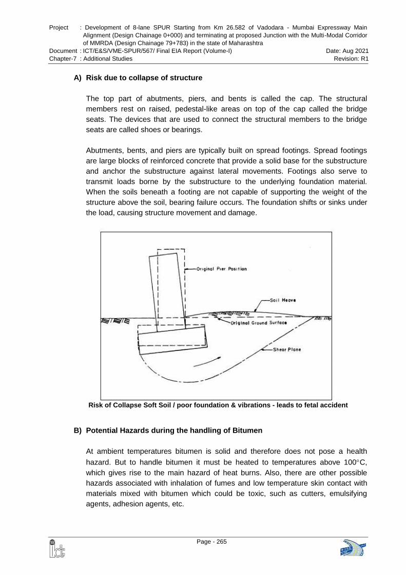
Project : Development of 8-lane SPUR Starting from Km 26.582 of Vadodara - Mumbai Expressway Main
Alignment (Design Chainage 0+000) and terminating at proposed Junction with the Multi-Modal Corridor
of MMRDA (Design Chainage 79+783) in the state of Maharashtra
Document : ICT/E&S/VME-SPUR/567/ Final EIA Report (Volume-I) Date: Aug 2021
Chapter-7 : Additional Studies Revision: R1
Page - 265
A) Risk due to collapse of structure
The top part of abutments, piers, and bents is called the cap. The structural
members rest on raised, pedestal-like areas on top of the cap called the bridge
seats. The devices that are used to connect the structural members to the bridge
seats are called shoes or bearings.
Abutments, bents, and piers are typically built on spread footings. Spread footings
are large blocks of reinforced concrete that provide a solid base for the substructure
and anchor the substructure against lateral movements. Footings also serve to
transmit loads borne by the substructure to the underlying foundation material.
When the soils beneath a footing are not capable of supporting the weight of the
structure above the soil, bearing failure occurs. The foundation shifts or sinks under
the load, causing structure movement and damage.
B) Potential Hazards during the handling of Bitumen
At ambient temperatures bitumen is solid and therefore does not pose a health
hazard. But to handle bitumen it must be heated to temperatures above 100C,
which gives rise to the main hazard of heat burns. Also, there are other possible
hazards associated with inhalation of fumes and low temperature skin contact with
materials mixed with bitumen which could be toxic, such as cutters, emulsifying
agents, adhesion agents, etc.
Risk of Collapse Soft Soil / poor foundation & vibrations - leads to fetal accident
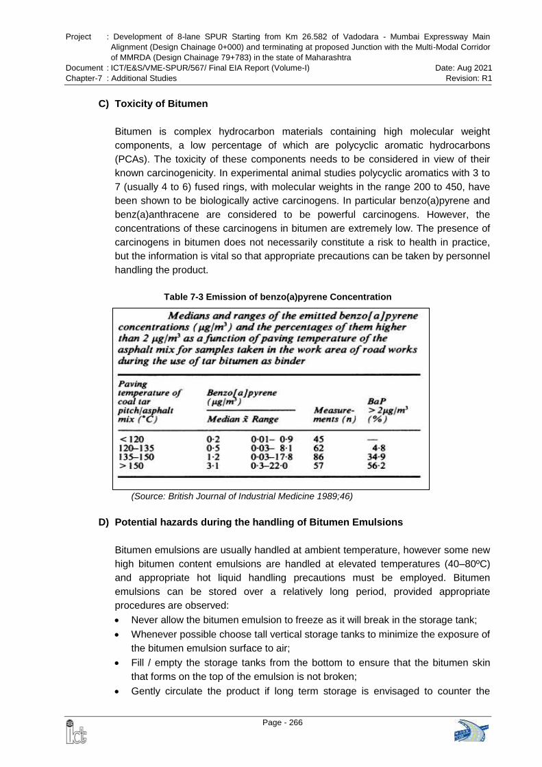
Project : Development of 8-lane SPUR Starting from Km 26.582 of Vadodara - Mumbai Expressway Main
Alignment (Design Chainage 0+000) and terminating at proposed Junction with the Multi-Modal Corridor
of MMRDA (Design Chainage 79+783) in the state of Maharashtra
Document : ICT/E&S/VME-SPUR/567/ Final EIA Report (Volume-I) Date: Aug 2021
Chapter-7 : Additional Studies Revision: R1
Page - 266
C) Toxicity of Bitumen
Bitumen is complex hydrocarbon materials containing high molecular weight
components, a low percentage of which are polycyclic aromatic hydrocarbons
(PCAs). The toxicity of these components needs to be considered in view of their
known carcinogenicity. In experimental animal studies polycyclic aromatics with 3 to
7 (usually 4 to 6) fused rings, with molecular weights in the range 200 to 450, have
been shown to be biologically active carcinogens. In particular benzo(a)pyrene and
benz(a)anthracene are considered to be powerful carcinogens. However, the
concentrations of these carcinogens in bitumen are extremely low. The presence of
carcinogens in bitumen does not necessarily constitute a risk to health in practice,
but the information is vital so that appropriate precautions can be taken by personnel
handling the product.
Table 7-3 Emission of benzo(a)pyrene Concentration
(Source: British Journal of Industrial Medicine 1989;46)
D) Potential hazards during the handling of Bitumen Emulsions
Bitumen emulsions are usually handled at ambient temperature, however some new
high bitumen content emulsions are handled at elevated temperatures (40–80ºC)
and appropriate hot liquid handling precautions must be employed. Bitumen
emulsions can be stored over a relatively long period, provided appropriate
procedures are observed:
Never allow the bitumen emulsion to freeze as it will break in the storage tank;
Whenever possible choose tall vertical storage tanks to minimize the exposure of
the bitumen emulsion surface to air;
Fill / empty the storage tanks from the bottom to ensure that the bitumen skin
that forms on the top of the emulsion is not broken;
Gently circulate the product if long term storage is envisaged to counter the
Project : Development of 8-lane SPUR Starting from Km 26.582 of Vadodara - Mumbai Expressway Main
Alignment (Design Chainage 0+000) and terminating at proposed Junction with the Multi-Modal Corridor
of MMRDA (Design Chainage 79+783) in the state of Maharashtra
Document : ICT/E&S/VME-SPUR/567/ Final EIA Report (Volume-I) Date: Aug 2021
Chapter-7 : Additional Studies Revision: R1
Page - 267
natural settling tendency of the emulsion. Once again do not break the skin that
forms on top of the emulsion.
Bitumen emulsions can be handled and transported safely by following a few simple
rules, which include:
Never load bitumen emulsion on top of the remainder of a hot bitumen load;
Never mix emulsion types i.e. anionic and cationic, in the same tank or pipeline
as the emulsion will break into its two components;
Ensure that the approved product tanker switch loading procedure is carried out
whenever changing emulsion types or changing between loads of hot bitumen
and emulsion. Follow the suppliers Material Safety Data Sheet advice at all
times.
The main considerations therefore involved in handling bitumen are:
The high handling temperature and the need to minimize the temperature
wherever practical,
The need for purpose-designed vessels which are insulated to retain heat and
prevent contact of personnel with hot surfaces,
The need to safeguard the health of personnel by provision of suitable protective
clothing, serious burns can be caused by bitumen coming in contact with the
skin.
The training of personnel,
The prevention of contact of water with hot bitumen,
Flammability
Protection against skin burns
Eye and face protection (face shield)
Heat resistant material overalls, close-fitting at the cuffs and overlapping the
boots
Heat resistant gloves with close-fitting cuffs
Safety boots
First aid for skin burns
Accidental contact with hot bitumen to the skin or eye should be immediately dealt
with by immersing the affected area in clean cool running water for at least 10
minutes or until thoroughly cooled.
For this reason, water showers and eye bath facilities should be available at
fixed installations such as depots etc., at strategic locations.
For other work locations, consideration must be given to where and how this
safeguard would be accommodated.
Once the bitumen has cooled, no immediate attempt should be made to remove
it until admission to hospital and only at the direction of a burns specialist.
Project : Development of 8-lane SPUR Starting from Km 26.582 of Vadodara - Mumbai Expressway Main
Alignment (Design Chainage 0+000) and terminating at proposed Junction with the Multi-Modal Corridor
of MMRDA (Design Chainage 79+783) in the state of Maharashtra
Document : ICT/E&S/VME-SPUR/567/ Final EIA Report (Volume-I) Date: Aug 2021
Chapter-7 : Additional Studies Revision: R1
Page - 268
All bitumen burns should receive proper medical attention without delay and
burns to the eye should be referred urgently to hospital.
Bitumen encircling a limb or finger can produce a tourniquet effect as it cools.
This should be relieved under medical supervision.
“Bituminous Materials SOP” and good practice would have all personnel aware
of the available at all work locations including in the cabin of bituminous product
vehicles.
E) Fly Ash
When coal ash is used in concrete for building roads and bridges, its
constituentssuch as heavy metals are bound (encapsulated) in the matrix of the
concrete and are very stable. Leaching of these constituents for all practical
purposes does not occur. Occupational issues associated with coal ash use in
concrete include the handling of dry coal ash prior to or during its inclusion in a
concrete mix or exposures during demolition of concrete structures. In these cases
work inhalation and skin contact precautions should be observed.
Inhalation and Skin Contact: Water and air are the two media most likely to be
affected by coal ash or coal ash constituents. Ingestion, inhalation, and skin contact
are the ways that humans and other living things could be exposed to coal ash.
Other issues that may need to be addressed are leaching of elements such as
mercury and metals into ground water contamination of vegetation and the impact
of other elements on the food chain, and airborne dust. In most cases, however, the
way that coal ash is used, the engineering requirements for that use, and the
handling and management methods applied minimizes exposure to the ash.
F) Risk of Fire
Construction sites tend to have a potential abundance of various types of fire:
Class A fires involve solid materials of an organic nature such as wood, paper,
cloth, rubber and plastics that do not melt.
Class B fires involve liquids. They include petrol, diesel, thinners, oils, paints,
wax, cooking fat and plastics that melt.
Class C fires involve electricity.
Table 7-4 Casus of Fire during Construction Period
Sl. No. Causes of Fire
1 Fire-fighting equipment and facilities malfunctions
2 Lack of fire safety awareness among staff / workers
3 Unsafe behavior and negligence of staff / workers
4 Poor electrical equipment and wiring
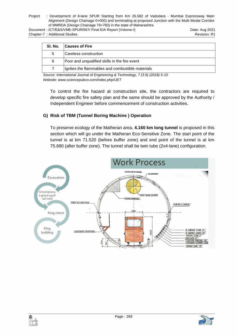
Project : Development of 8-lane SPUR Starting from Km 26.582 of Vadodara - Mumbai Expressway Main
Alignment (Design Chainage 0+000) and terminating at proposed Junction with the Multi-Modal Corridor
of MMRDA (Design Chainage 79+783) in the state of Maharashtra
Document : ICT/E&S/VME-SPUR/567/ Final EIA Report (Volume-I) Date: Aug 2021
Chapter-7 : Additional Studies Revision: R1
Page - 269
Sl. No. Causes of Fire
5 Careless construction
6 Poor and unqualified skills in the fire event
7 Ignites the flammables and combustible materials
Source: International Journal of Engineering & Technology, 7 (3.9) (2018) 5-10
Website: www.sciencepubco.com/index.php/IJET
To control the fire hazard at construction site, the contractors are required to
develop specific fire safety plan and the same should be approved by the Authority /
Independent Engineer before commencement of construction activities.
G) Risk of TBM (Tunnel Boring Machine ) Operation
To preserve ecology of the Matheran area, 4.160 km long tunnel is proposed in this
section which will go under the Matheran Eco-Sensitive Zone. The start point of the
tunnel is at km 71.520 (before buffer zone) and end point of the tunnel is at km
75.680 (after buffer zone). The tunnel shall be twin tube (2x4-lane) configuration.
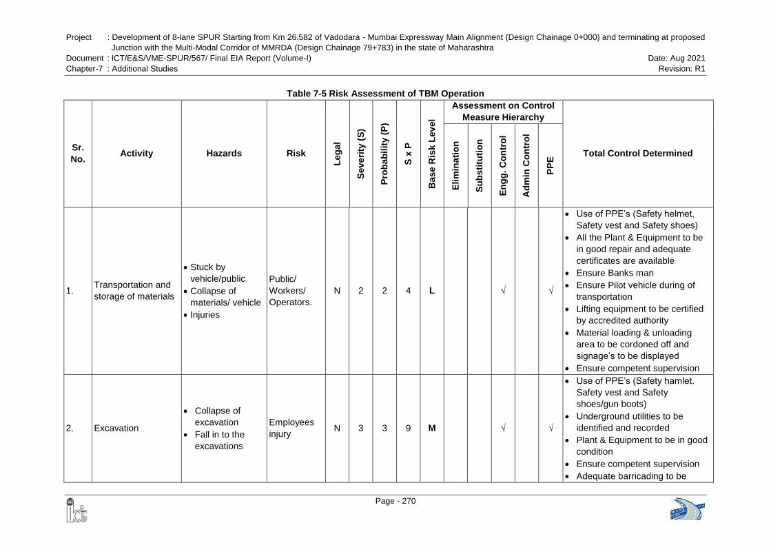
Project : Development of 8-lane SPUR Starting from Km 26.582 of Vadodara - Mumbai Expressway Main Alignment (Design Chainage 0+000) and terminating at proposed
Junction with the Multi-Modal Corridor of MMRDA (Design Chainage 79+783) in the state of Maharashtra
Document : ICT/E&S/VME-SPUR/567/ Final EIA Report (Volume-I) Date: Aug 2021
Chapter-7 : Additional Studies Revision: R1
Page - 270
Table 7-5 Risk Assessment of TBM Operation
Sr.
No. Activity Hazards Risk
Leg
al
Sev
eri
ty (
S)
Pro
bab
ilit
y (
P)
S x
P
Base R
isk
Lev
el
Assessment on Control
Measure Hierarchy
Total Control Determined
Elim
inati
on
Su
bsti
tuti
on
En
gg
. C
on
tro
l
Ad
min
Co
ntr
ol
PP
E
1. Transportation and
storage of materials
Stuck by
vehicle/public
Collapse of
materials/ vehicle
Injuries
Public/
Workers/
Operators.
N 2 2 4 L √ √
Use of PPE’s (Safety helmet,
Safety vest and Safety shoes)
All the Plant & Equipment to be
in good repair and adequate
certificates are available
Ensure Banks man
Ensure Pilot vehicle during of
transportation
Lifting equipment to be certified
by accredited authority
Material loading & unloading
area to be cordoned off and
signage’s to be displayed
Ensure competent supervision
2. Excavation
Collapse of
excavation
Fall in to the
excavations
Employees
injury N 3 3 9 M √ √
Use of PPE’s (Safety hamlet.
Safety vest and Safety
shoes/gun boots)
Underground utilities to be
identified and recorded
Plant & Equipment to be in good
condition
Ensure competent supervision
Adequate barricading to be
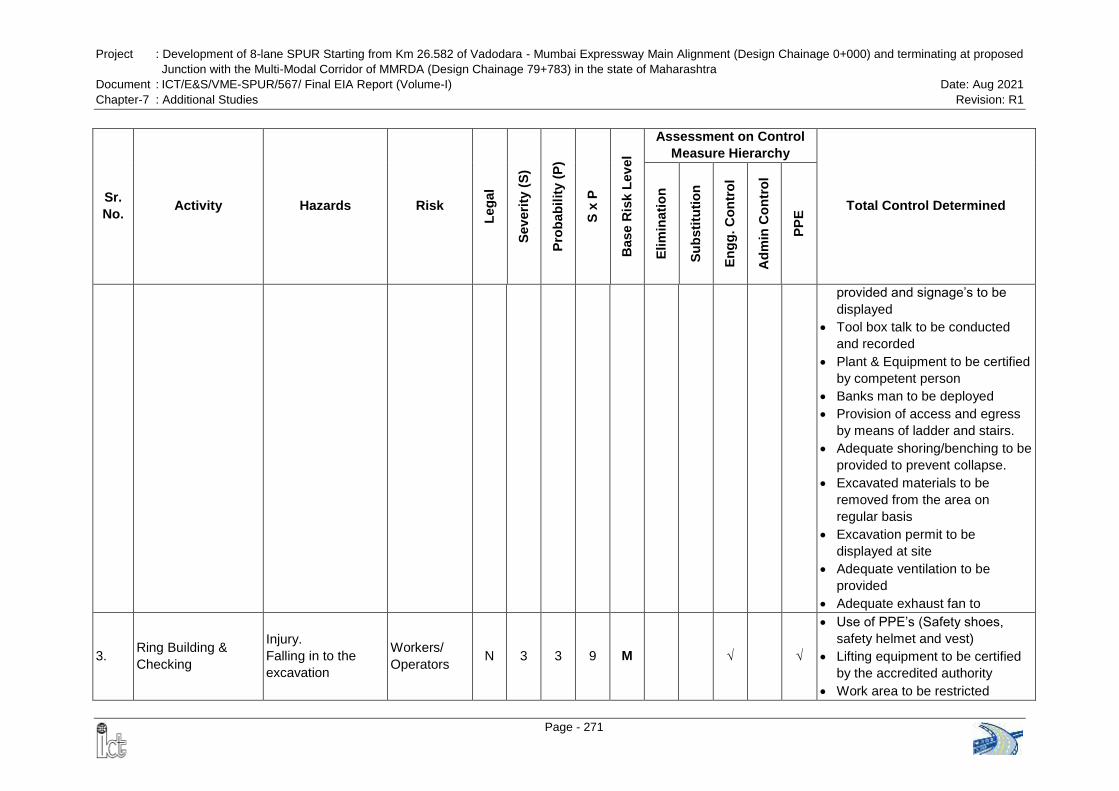
Project : Development of 8-lane SPUR Starting from Km 26.582 of Vadodara - Mumbai Expressway Main Alignment (Design Chainage 0+000) and terminating at proposed
Junction with the Multi-Modal Corridor of MMRDA (Design Chainage 79+783) in the state of Maharashtra
Document : ICT/E&S/VME-SPUR/567/ Final EIA Report (Volume-I) Date: Aug 2021
Chapter-7 : Additional Studies Revision: R1
Page - 271
Sr.
No. Activity Hazards Risk
Leg
al
Sev
eri
ty (
S)
Pro
bab
ilit
y (
P)
S x
P
Base R
isk
Lev
el
Assessment on Control
Measure Hierarchy
Total Control Determined
Elim
inati
on
Su
bsti
tuti
on
En
gg
. C
on
tro
l
Ad
min
Co
ntr
ol
PP
E
provided and signage’s to be
displayed
Tool box talk to be conducted
and recorded
Plant & Equipment to be certified
by competent person
Banks man to be deployed
Provision of access and egress
by means of ladder and stairs.
Adequate shoring/benching to be
provided to prevent collapse.
Excavated materials to be
removed from the area on
regular basis
Excavation permit to be
displayed at site
Adequate ventilation to be
provided
Adequate exhaust fan to
3. Ring Building &
Checking
Injury.
Falling in to the
excavation
Workers/
Operators N 3 3 9 M √ √
Use of PPE’s (Safety shoes,
safety helmet and vest)
Lifting equipment to be certified
by the accredited authority
Work area to be restricted

Project : Development of 8-lane SPUR Starting from Km 26.582 of Vadodara - Mumbai Expressway Main Alignment (Design Chainage 0+000) and terminating at proposed
Junction with the Multi-Modal Corridor of MMRDA (Design Chainage 79+783) in the state of Maharashtra
Document : ICT/E&S/VME-SPUR/567/ Final EIA Report (Volume-I) Date: Aug 2021
Chapter-7 : Additional Studies Revision: R1
Page - 272
Sr.
No. Activity Hazards Risk
Leg
al
Sev
eri
ty (
S)
Pro
bab
ilit
y (
P)
S x
P
Base R
isk
Lev
el
Assessment on Control
Measure Hierarchy
Total Control Determined
Elim
inati
on
Su
bsti
tuti
on
En
gg
. C
on
tro
l
Ad
min
Co
ntr
ol
PP
E
/barricaded to prevent
collapse/Fall
Ensure competent supervision
Lifting permit to be displayed and
requirements to be adhered
Ensure Safe working platform
4. Grouting Injury by Falling in
to the excavation
Injury to
workmen N 3 2 6 L √ √
Use of PPE
Provide safe working platform
Ensure competent supervision
5. Hot works Injury Fire Injury to
workmen N 2 2 4 L √ √
Use of PPE’s
Hot work permit to be displayed
Fire extinguisher to readily
available
Area to be barricaded and
signage’s to be displayed
Combustible/Flammable
materials to be removed from the
level of welders
Adequate ventilation&
illumination to be provided
6. Lifting activity of
Ring and Muck slips
Collapse of
materials/ Plants
Fall in to the
excavation
Workmen N 2 2 4 L √ √
Use of PPE’s (Safety helmet,
Safety vest and safety shoes)
Ensure competent supervision
and Lifting supervisor
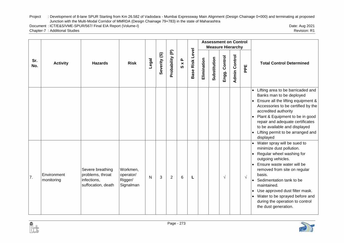
Project : Development of 8-lane SPUR Starting from Km 26.582 of Vadodara - Mumbai Expressway Main Alignment (Design Chainage 0+000) and terminating at proposed
Junction with the Multi-Modal Corridor of MMRDA (Design Chainage 79+783) in the state of Maharashtra
Document : ICT/E&S/VME-SPUR/567/ Final EIA Report (Volume-I) Date: Aug 2021
Chapter-7 : Additional Studies Revision: R1
Page - 273
Sr.
No. Activity Hazards Risk
Leg
al
Sev
eri
ty (
S)
Pro
bab
ilit
y (
P)
S x
P
Base R
isk
Lev
el
Assessment on Control
Measure Hierarchy
Total Control Determined
Elim
inati
on
Su
bsti
tuti
on
En
gg
. C
on
tro
l
Ad
min
Co
ntr
ol
PP
E
Lifting area to be barricaded and
Banks man to be deployed
Ensure all the lifting equipment &
Accessories to be certified by the
accredited authority
Plant & Equipment to be in good
repair and adequate certificates
to be available and displayed
Lifting permit to be arranged and
displayed
7. Environment
monitoring
Severe breathing
problems, throat
infections,
suffocation, death
Workmen,
operator/
Rigger/
Signalman
N 3 2 6 L √ √
Water spray will be sued to
minimize dust pollution.
Regular wheel washing for
outgoing vehicles.
Ensure waste water will be
removed from site on regular
basis.
Sedimentation tank to be
maintained.
Use approved dust filter mask.
Water to be sprayed before and
during the operation to control
the dust generation.
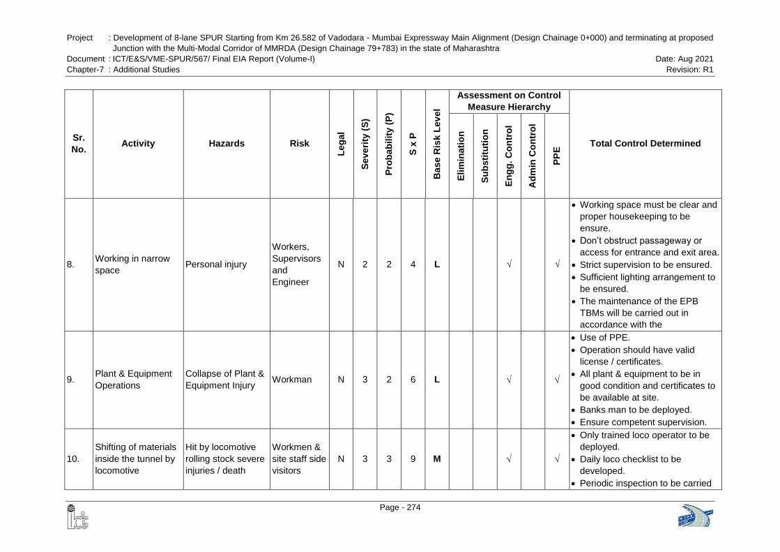
Project : Development of 8-lane SPUR Starting from Km 26.582 of Vadodara - Mumbai Expressway Main Alignment (Design Chainage 0+000) and terminating at proposed
Junction with the Multi-Modal Corridor of MMRDA (Design Chainage 79+783) in the state of Maharashtra
Document : ICT/E&S/VME-SPUR/567/ Final EIA Report (Volume-I) Date: Aug 2021
Chapter-7 : Additional Studies Revision: R1
Page - 274
Sr.
No. Activity Hazards Risk
Leg
al
Sev
eri
ty (
S)
Pro
bab
ilit
y (
P)
S x
P
Base R
isk
Lev
el
Assessment on Control
Measure Hierarchy
Total Control Determined
Elim
inati
on
Su
bsti
tuti
on
En
gg
. C
on
tro
l
Ad
min
Co
ntr
ol
PP
E
8. Working in narrow
space Personal injury
Workers,
Supervisors
and
Engineer
N 2 2 4 L √ √
Working space must be clear and
proper housekeeping to be
ensure.
Don’t obstruct passageway or
access for entrance and exit area.
Strict supervision to be ensured.
Sufficient lighting arrangement to
be ensured.
The maintenance of the EPB
TBMs will be carried out in
accordance with the
9. Plant & Equipment
Operations
Collapse of Plant &
Equipment Injury Workman N 3 2 6 L
Use of PPE.
Operation should have valid
license / certificates.
All plant & equipment to be in
good condition and certificates to
be available at site.
Banks man to be deployed.
Ensure competent supervision.
10.
Shifting of materials
inside the tunnel by
locomotive
Hit by locomotive
rolling stock severe
injuries / death
Workmen &
site staff side
visitors
N 3 3 9 M
Only trained loco operator to be
deployed.
Daily loco checklist to be
developed.
Periodic inspection to be carried
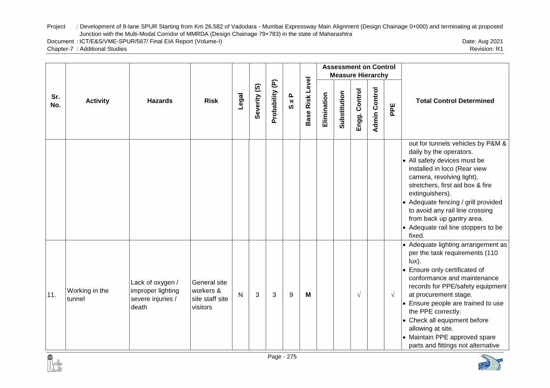
Project : Development of 8-lane SPUR Starting from Km 26.582 of Vadodara - Mumbai Expressway Main Alignment (Design Chainage 0+000) and terminating at proposed
Junction with the Multi-Modal Corridor of MMRDA (Design Chainage 79+783) in the state of Maharashtra
Document : ICT/E&S/VME-SPUR/567/ Final EIA Report (Volume-I) Date: Aug 2021
Chapter-7 : Additional Studies Revision: R1
Page - 275
Sr.
No. Activity Hazards Risk
Leg
al
Sev
eri
ty (
S)
Pro
bab
ilit
y (
P)
S x
P
Base R
isk
Lev
el
Assessment on Control
Measure Hierarchy
Total Control Determined
Elim
inati
on
Su
bsti
tuti
on
En
gg
. C
on
tro
l
Ad
min
Co
ntr
ol
PP
E
out for tunnels vehicles by P&M &
daily by the operators.
All safety devices must be
installed in loco (Rear view
camera, revolving light),
stretchers, first aid box & fire
extinguishers).
Adequate fencing / grill provided
to avoid any rail line crossing
from back up gantry area.
Adequate rail line stoppers to be
fixed.
11. Working in the
tunnel
Lack of oxygen /
improper lighting
severe injuries /
death
General site
workers &
site staff site
visitors
N 3 3 9 M
Adequate lighting arrangement as
per the task requirements (110
lux).
Ensure only certificated of
conformance and maintenance
records for PPE/safety equipment
at procurement stage.
Ensure people are trained to use
the PPE correctly.
Check all equipment before
allowing at site.
Maintain PPE approved spare
parts and fittings not alternative
Project : Development of 8-lane SPUR Starting from Km 26.582 of Vadodara - Mumbai Expressway Main Alignment (Design Chainage 0+000) and terminating at proposed
Junction with the Multi-Modal Corridor of MMRDA (Design Chainage 79+783) in the state of Maharashtra
Document : ICT/E&S/VME-SPUR/567/ Final EIA Report (Volume-I) Date: Aug 2021
Chapter-7 : Additional Studies Revision: R1
Page - 276
Sr.
No. Activity Hazards Risk
Leg
al
Sev
eri
ty (
S)
Pro
bab
ilit
y (
P)
S x
P
Base R
isk
Lev
el
Assessment on Control
Measure Hierarchy
Total Control Determined
Elim
inati
on
Su
bsti
tuti
on
En
gg
. C
on
tro
l
Ad
min
Co
ntr
ol
PP
E
non- approved spare parts and
fittings.
Storage and maintenance of the
PPE shall meet standard.
24 hours gas monitoring to be
done.
Gas monitor to be present at all
tines.
Acceptable entry conditions are:
Oxygen (O2) – greater than 19.5%
and less than 21%
Lower Flammable Limit LFL – less
than 10%
Carbon Monoxide (CO) – less than
35ppm
Hydrogen Sulphide (H2S) – less
than 10ppm
12. Working in the
tunnel
Inadequate
ventilation severe
injuries / death
Workmen
and staff N 3 3 9 M
Static plant items at surface
located away from jet fan to
ensure forced air is nit
contaminated by exhaust fumes.
Ensure proper ventilation all the
time inside the shaft
Ventilation system must be
provided.
Project : Development of 8-lane SPUR Starting from Km 26.582 of Vadodara - Mumbai Expressway Main Alignment (Design Chainage 0+000) and terminating at proposed
Junction with the Multi-Modal Corridor of MMRDA (Design Chainage 79+783) in the state of Maharashtra
Document : ICT/E&S/VME-SPUR/567/ Final EIA Report (Volume-I) Date: Aug 2021
Chapter-7 : Additional Studies Revision: R1
Page - 277
Sr.
No. Activity Hazards Risk
Leg
al
Sev
eri
ty (
S)
Pro
bab
ilit
y (
P)
S x
P
Base R
isk
Lev
el
Assessment on Control
Measure Hierarchy
Total Control Determined
Elim
inati
on
Su
bsti
tuti
on
En
gg
. C
on
tro
l
Ad
min
Co
ntr
ol
PP
E
13. Working in the
tunnel
Fire severe injuries
/ multiple deaths
Workmen &
site staff site
visitors
N 3 2 6 L
Highly flammable material should
not be stored in tunneling area,
no smoking inside tunnels.
Adequate firefighting system shall
be maintained in tunnel.
Emergency communications
systems will those in the confined
space to be established.
Emergency routes must be
displayed, clear and identified. All
the workers must know the
location from the assembly
points.
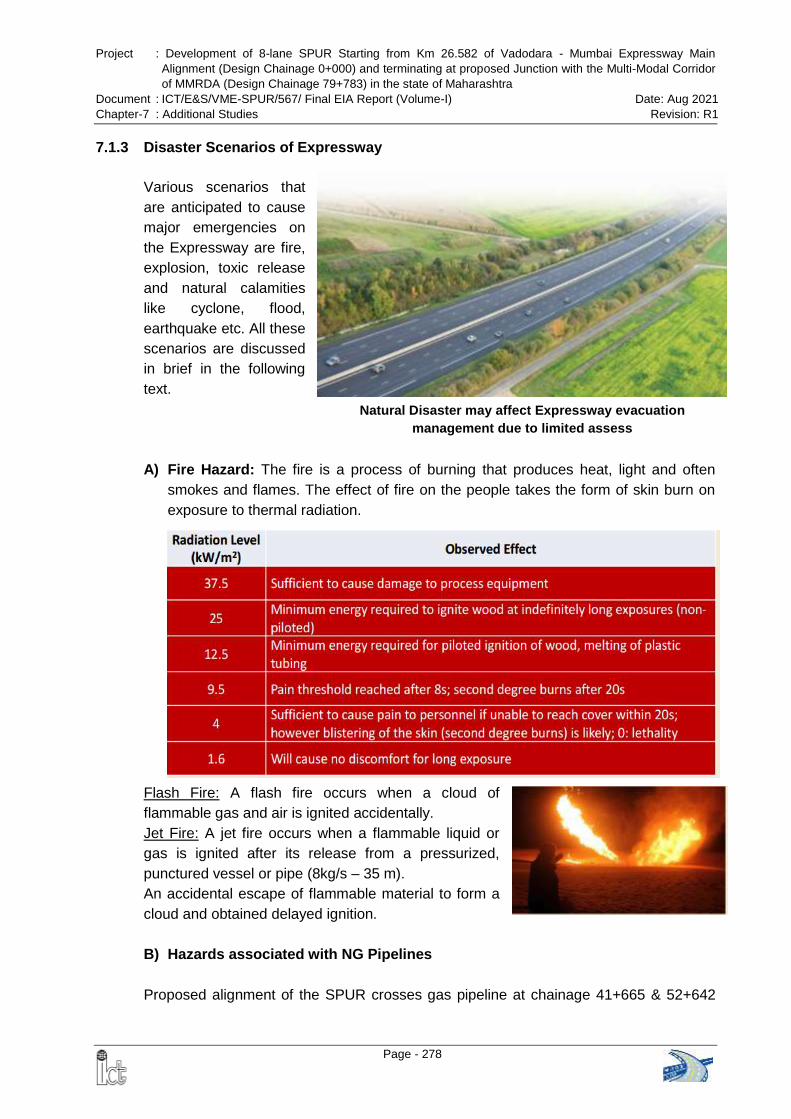
Project : Development of 8-lane SPUR Starting from Km 26.582 of Vadodara - Mumbai Expressway Main
Alignment (Design Chainage 0+000) and terminating at proposed Junction with the Multi-Modal Corridor
of MMRDA (Design Chainage 79+783) in the state of Maharashtra
Document : ICT/E&S/VME-SPUR/567/ Final EIA Report (Volume-I) Date: Aug 2021
Chapter-7 : Additional Studies Revision: R1
Page - 278
Natural Disaster may affect Expressway evacuation
management due to limited assess
7.1.3 Disaster Scenarios of Expressway
Various scenarios that
are anticipated to cause
major emergencies on
the Expressway are fire,
explosion, toxic release
and natural calamities
like cyclone, flood,
earthquake etc. All these
scenarios are discussed
in brief in the following
text.
A) Fire Hazard: The fire is a process of burning that produces heat, light and often
smokes and flames. The effect of fire on the people takes the form of skin burn on
exposure to thermal radiation.
Flash Fire: A flash fire occurs when a cloud of
flammable gas and air is ignited accidentally.
Jet Fire: A jet fire occurs when a flammable liquid or
gas is ignited after its release from a pressurized,
punctured vessel or pipe (8kg/s – 35 m).
An accidental escape of flammable material to form a
cloud and obtained delayed ignition.
B) Hazards associated with NG Pipelines
Proposed alignment of the SPUR crosses gas pipeline at chainage 41+665 & 52+642
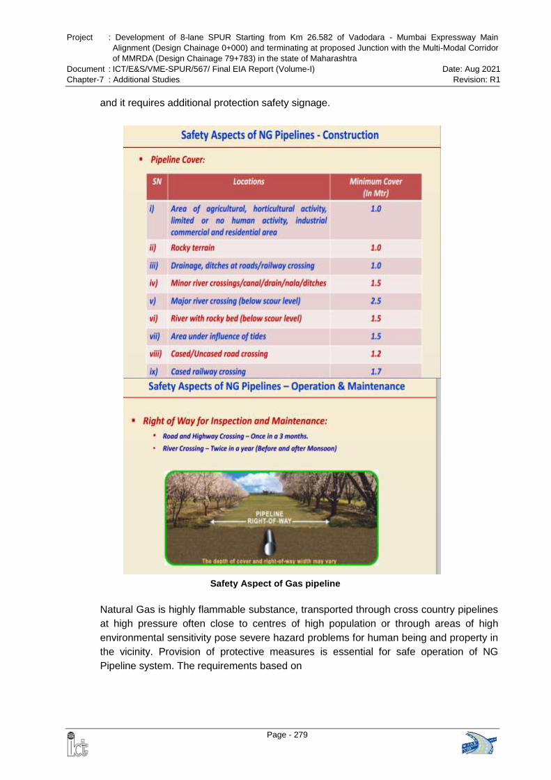
Project : Development of 8-lane SPUR Starting from Km 26.582 of Vadodara - Mumbai Expressway Main
Alignment (Design Chainage 0+000) and terminating at proposed Junction with the Multi-Modal Corridor
of MMRDA (Design Chainage 79+783) in the state of Maharashtra
Document : ICT/E&S/VME-SPUR/567/ Final EIA Report (Volume-I) Date: Aug 2021
Chapter-7 : Additional Studies Revision: R1
Page - 279
and it requires additional protection safety signage.
Natural Gas is highly flammable substance, transported through cross country pipelines
at high pressure often close to centres of high population or through areas of high
environmental sensitivity pose severe hazard problems for human being and property in
the vicinity. Provision of protective measures is essential for safe operation of NG
Pipeline system. The requirements based on
Safety Aspect of Gas pipeline
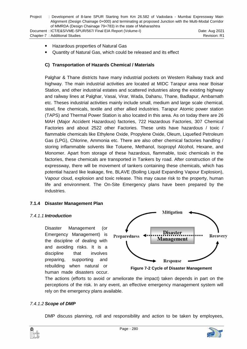
Project : Development of 8-lane SPUR Starting from Km 26.582 of Vadodara - Mumbai Expressway Main
Alignment (Design Chainage 0+000) and terminating at proposed Junction with the Multi-Modal Corridor
of MMRDA (Design Chainage 79+783) in the state of Maharashtra
Document : ICT/E&S/VME-SPUR/567/ Final EIA Report (Volume-I) Date: Aug 2021
Chapter-7 : Additional Studies Revision: R1
Page - 280
Figure 7-2 Cycle of Disaster Management
Hazardous properties of Natural Gas
Quantity of Natural Gas, which could be released and its effect
C) Transportation of Hazards Chemical / Materials
Palghar & Thane districts have many industrial pockets on Western Railway track and
highway. The main industrial activities are located at MIDC Tarapur area near Boisar
Station, and other industrial estates and scattered industries along the existing highway
and railway lines at Palghar, Vasai, Virar, Wada, Dahanu, Thane, Badlapur, Ambarnath
etc. Theses industrial activities mainly include small, medium and large scale chemical,
steel, fine chemicals, textile and other allied industries. Tarapur Atomic power station
(TAPS) and Thermal Power Station is also located in this area. As on today there are 26
MAH (Major Accident Hazardous) factories, 722 Hazardous Factories, 307 Chemical
Factories and about 2522 other Factories. These units have hazardous / toxic /
flammable chemicals like Ethylene Oxide, Propylene Oxide, Oleum, Liquefied Petroleum
Gas (LPG), Chlorine, Ammonia etc. There are also other chemical factories handling /
storing inflammable solvents like Toluene, Methanol, Isopropyl Alcohol, Hexane, and
Monomer. Apart from storage of these hazardous, flammable, toxic chemicals in the
factories, these chemicals are transported in Tankers by road. After construction of the
expressway, there will be movement of tankers containing these chemicals, which has
potential hazard like leakage, fire, BLAVE (Boiling Liquid Expanding Vapour Explosion),
Vapour cloud, explosion and toxic release. This may cause risk to the property, human
life and environment. The On-Site Emergency plans have been prepared by the
industries.
7.1.4 Disaster Management Plan
7.4.1.1 Introduction
Disaster Management (or
Emergency Management) is
the discipline of dealing with
and avoiding risks. It is a
discipline that involves
preparing, supporting and
rebuilding when natural or
human made disasters occur.
The actions (efforts to avoid or ameliorate the impact) taken depends in part on the
perceptions of the risk. In any event, an effective emergency management system will
rely on the emergency plans available.
7.4.1.2 Scope of DMP
DMP discuss planning, roll and responsibility and action to be taken by employees,
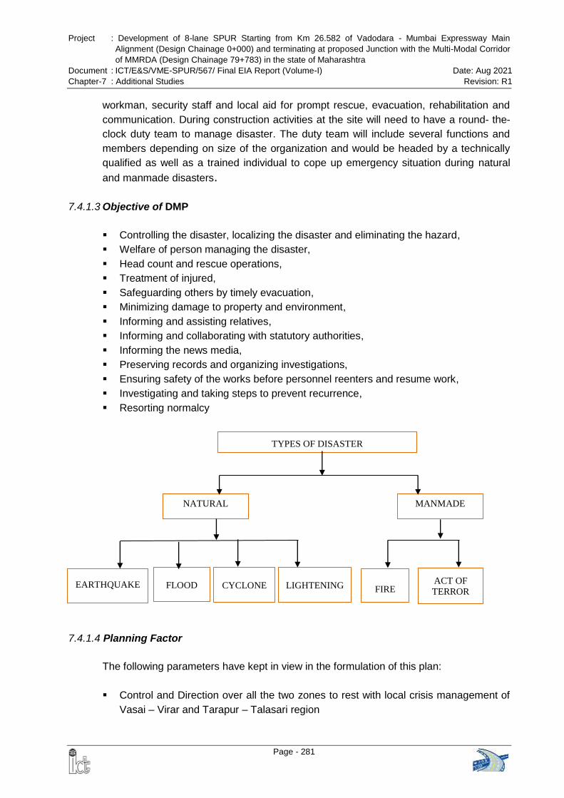
Project : Development of 8-lane SPUR Starting from Km 26.582 of Vadodara - Mumbai Expressway Main
Alignment (Design Chainage 0+000) and terminating at proposed Junction with the Multi-Modal Corridor
of MMRDA (Design Chainage 79+783) in the state of Maharashtra
Document : ICT/E&S/VME-SPUR/567/ Final EIA Report (Volume-I) Date: Aug 2021
Chapter-7 : Additional Studies Revision: R1
Page - 281
workman, security staff and local aid for prompt rescue, evacuation, rehabilitation and
communication. During construction activities at the site will need to have a round- the-
clock duty team to manage disaster. The duty team will include several functions and
members depending on size of the organization and would be headed by a technically
qualified as well as a trained individual to cope up emergency situation during natural
and manmade disasters.
7.4.1.3 Objective of DMP
Controlling the disaster, localizing the disaster and eliminating the hazard,
Welfare of person managing the disaster,
Head count and rescue operations,
Treatment of injured,
Safeguarding others by timely evacuation,
Minimizing damage to property and environment,
Informing and assisting relatives,
Informing and collaborating with statutory authorities,
Informing the news media,
Preserving records and organizing investigations,
Ensuring safety of the works before personnel reenters and resume work,
Investigating and taking steps to prevent recurrence,
Resorting normalcy
7.4.1.4 Planning Factor
The following parameters have kept in view in the formulation of this plan:
Control and Direction over all the two zones to rest with local crisis management of
Vasai – Virar and Tarapur – Talasari region
EARTHQUAKE
CYCLONE
TYPES OF DISASTER
FIRE ACT OF
TERROR
NATURAL
FLOOD
MANMADE
LIGHTENING
Project : Development of 8-lane SPUR Starting from Km 26.582 of Vadodara - Mumbai Expressway Main
Alignment (Design Chainage 0+000) and terminating at proposed Junction with the Multi-Modal Corridor
of MMRDA (Design Chainage 79+783) in the state of Maharashtra
Document : ICT/E&S/VME-SPUR/567/ Final EIA Report (Volume-I) Date: Aug 2021
Chapter-7 : Additional Studies Revision: R1
Page - 282
Decentralization of operational control to each zone to be exercised by the
respective crisis management group
Each to be self-sufficient in first response capability within a specified time in
emergency service
All concern should have very close linkage to ensure integrated approach to
emergency
All MAH industries in a zone should have formulated mutual aid agreement covering
firefighting and medical services
Instant alarm system to alert the people in danger zone
Quick response by radio communication network, Mobile Phones and other
available resources of communication
Identification of alternative routes for transport of Hazardous Chemicals during
emergency situation
7.4.1.5 Onsite Disaster Management Plan
a) Site Disaster Manager to take charge and give guidance over public address system
Project Manager will take charge and give guidance over public address system
Assembly point shall be identified and marked. Mega phone shall be used to
address the emergency to employees.
b) Call for outside assistance of Fire Brigade, Hospital, Ambulance
Accounts & Administration In-charge will call for outside assistance of Fire
Brigade, Hospital, Ambulance
In absence of Accounts & Administration In-charge, manager will call outside for
assistance
c) Network with State, District and Ward level control rooms
Ward level details are provided below in operation phase
d) Ensure adequate warning before switching off power
All announcements will be done with good quality equipment
EHS In-charge of the Contractor will ensure with Safety Supervisor that all
worker are stopped working and shut downed the machines & equipment before
switching off emergency control switch
The emergency electrical switch during construction phase will be placed near
the site office.
e) Assure workers of continuous communication and take all measures to keep up their
morale
Project manager will do continuous announcements by various methods to keep
up workers morale
Project : Development of 8-lane SPUR Starting from Km 26.582 of Vadodara - Mumbai Expressway Main
Alignment (Design Chainage 0+000) and terminating at proposed Junction with the Multi-Modal Corridor
of MMRDA (Design Chainage 79+783) in the state of Maharashtra
Document : ICT/E&S/VME-SPUR/567/ Final EIA Report (Volume-I) Date: Aug 2021
Chapter-7 : Additional Studies Revision: R1
Page - 283
f) Guide workers on the steps being taken for evacuation in a systematic manner
This requirement will be handled by dedicated trained staff/volunteers.
g) Take steps to reduce/ eliminate panic
Periodical training to internal Volunteers & Officers
Periodical mock drills to all Workers, Officers, volunteers and staff in every three
months
h) Liaise with Law & order Machinery
Project manager will liaise
i) Preventive Maintenance
Preventive maintenance of construction equipment, lifting tackles, cranes, hot
mix Plants, batching plants, stone quarry, fire protection system of POL storage
area is advisable.
j) Regular maintenance of Equipment & Systems
Periodical maintenance will be carried by certified, competent and skilled person
employed by the Contractor at regular intervals.
k) Warning System
Security will do the announcement by fan horn or reflex horn speaker in the
guidance of Safety In-Charge
Provision of fire alarm switch at security room
l) Organize extensive training for disaster managers and assistants
Quarterly training will be arranged by the Contractor for disaster managers and
assistants during construction stage
m) Prepare Inventory of Resources - rescue equipment, medical equipment for
emergencies, ambulances, hospitals, NGOs and disaster management related
material and personnel. Only OHSAS 18000 Certified Contractor will undertake work
having
DMP policy
Standard Operation Procedures (SOP)
Emergency rescue equipment and resources
Provision of stretcher at appropriate location
Implementation of Work Permit system
All emergency contact details is to be maintained in register
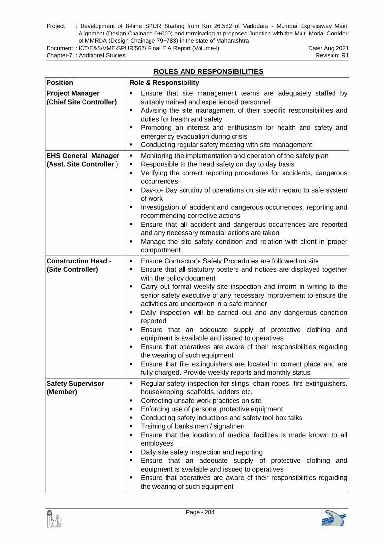
Project : Development of 8-lane SPUR Starting from Km 26.582 of Vadodara - Mumbai Expressway Main
Alignment (Design Chainage 0+000) and terminating at proposed Junction with the Multi-Modal Corridor
of MMRDA (Design Chainage 79+783) in the state of Maharashtra
Document : ICT/E&S/VME-SPUR/567/ Final EIA Report (Volume-I) Date: Aug 2021
Chapter-7 : Additional Studies Revision: R1
Page - 284
ROLES AND RESPONSIBILITIES
Position Role & Responsibility
Project Manager
(Chief Site Controller)
Ensure that site management teams are adequately staffed by
suitably trained and experienced personnel
Advising the site management of their specific responsibilities and
duties for health and safety
Promoting an interest and enthusiasm for health and safety and
emergency evacuation during crisis
Conducting regular safety meeting with site management
EHS General Manager
(Asst. Site Controller )
Monitoring the implementation and operation of the safety plan
Responsible to the head safety on day to day basis
Verifying the correct reporting procedures for accidents, dangerous
occurrences
Day-to- Day scrutiny of operations on site with regard to safe system
of work
Investigation of accident and dangerous occurrences, reporting and
recommending corrective actions
Ensure that all accident and dangerous occurrences are reported
and any necessary remedial actions are taken
Manage the site safety condition and relation with client in proper
comportment
Construction Head -
(Site Controller)
Ensure Contractor’s Safety Procedures are followed on site
Ensure that all statutory posters and notices are displayed together
with the policy document
Carry out formal weekly site inspection and inform in writing to the
senior safety executive of any necessary improvement to ensure the
activities are undertaken in a safe manner
Daily inspection will be carried out and any dangerous condition
reported
Ensure that an adequate supply of protective clothing and
equipment is available and issued to operatives
Ensure that operatives are aware of their responsibilities regarding
the wearing of such equipment
Ensure that fire extinguishers are located in correct place and are
fully charged. Provide weekly reports and monthly status
Safety Supervisor
(Member)
Regular safety inspection for slings, chain ropes, fire extinguishers,
housekeeping, scaffolds, ladders etc.
Correcting unsafe work practices on site
Enforcing use of personal protective equipment
Conducting safety inductions and safety tool box talks
Training of banks men / signalmen
Ensure that the location of medical facilities is made known to all
employees
Daily site safety inspection and reporting
Ensure that an adequate supply of protective clothing and
equipment is available and issued to operatives
Ensure that operatives are aware of their responsibilities regarding
the wearing of such equipment
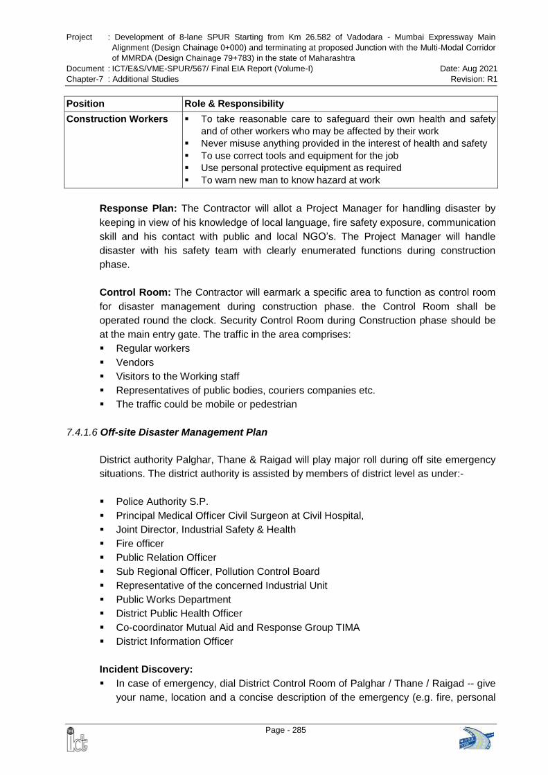
Project : Development of 8-lane SPUR Starting from Km 26.582 of Vadodara - Mumbai Expressway Main
Alignment (Design Chainage 0+000) and terminating at proposed Junction with the Multi-Modal Corridor
of MMRDA (Design Chainage 79+783) in the state of Maharashtra
Document : ICT/E&S/VME-SPUR/567/ Final EIA Report (Volume-I) Date: Aug 2021
Chapter-7 : Additional Studies Revision: R1
Page - 285
Position Role & Responsibility
Construction Workers To take reasonable care to safeguard their own health and safety
and of other workers who may be affected by their work
Never misuse anything provided in the interest of health and safety
To use correct tools and equipment for the job
Use personal protective equipment as required
To warn new man to know hazard at work
Response Plan: The Contractor will allot a Project Manager for handling disaster by
keeping in view of his knowledge of local language, fire safety exposure, communication
skill and his contact with public and local NGO’s. The Project Manager will handle
disaster with his safety team with clearly enumerated functions during construction
phase.
Control Room: The Contractor will earmark a specific area to function as control room
for disaster management during construction phase. the Control Room shall be
operated round the clock. Security Control Room during Construction phase should be
at the main entry gate. The traffic in the area comprises:
Regular workers
Vendors
Visitors to the Working staff
Representatives of public bodies, couriers companies etc.
The traffic could be mobile or pedestrian
7.4.1.6 Off-site Disaster Management Plan
District authority Palghar, Thane & Raigad will play major roll during off site emergency
situations. The district authority is assisted by members of district level as under:-
Police Authority S.P.
Principal Medical Officer Civil Surgeon at Civil Hospital,
Joint Director, Industrial Safety & Health
Fire officer
Public Relation Officer
Sub Regional Officer, Pollution Control Board
Representative of the concerned Industrial Unit
Public Works Department
District Public Health Officer
Co-coordinator Mutual Aid and Response Group TIMA
District Information Officer
Incident Discovery:
In case of emergency, dial District Control Room of Palghar / Thane / Raigad -- give
your name, location and a concise description of the emergency (e.g. fire, personal
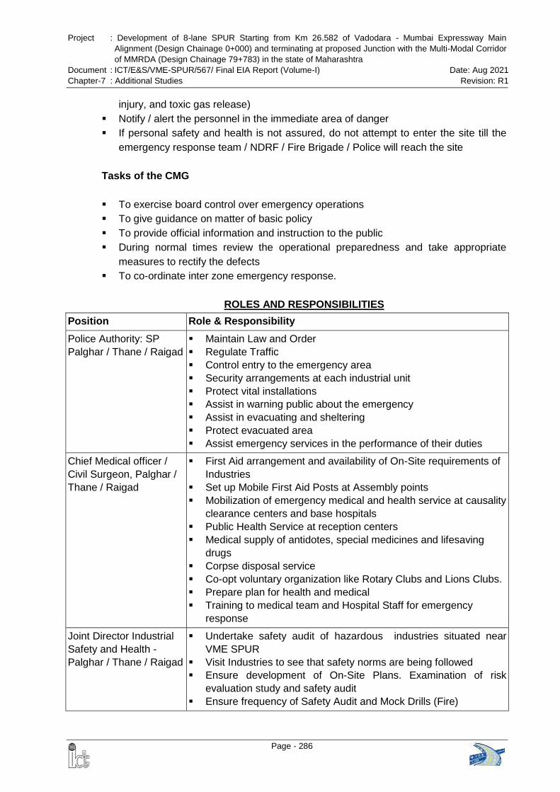
Project : Development of 8-lane SPUR Starting from Km 26.582 of Vadodara - Mumbai Expressway Main
Alignment (Design Chainage 0+000) and terminating at proposed Junction with the Multi-Modal Corridor
of MMRDA (Design Chainage 79+783) in the state of Maharashtra
Document : ICT/E&S/VME-SPUR/567/ Final EIA Report (Volume-I) Date: Aug 2021
Chapter-7 : Additional Studies Revision: R1
Page - 286
injury, and toxic gas release)
Notify / alert the personnel in the immediate area of danger
If personal safety and health is not assured, do not attempt to enter the site till the
emergency response team / NDRF / Fire Brigade / Police will reach the site
Tasks of the CMG
To exercise board control over emergency operations
To give guidance on matter of basic policy
To provide official information and instruction to the public
During normal times review the operational preparedness and take appropriate
measures to rectify the defects
To co-ordinate inter zone emergency response.
ROLES AND RESPONSIBILITIES
Position Role & Responsibility
Police Authority: SP
Palghar / Thane / Raigad
Maintain Law and Order
Regulate Traffic
Control entry to the emergency area
Security arrangements at each industrial unit
Protect vital installations
Assist in warning public about the emergency
Assist in evacuating and sheltering
Protect evacuated area
Assist emergency services in the performance of their duties
Chief Medical officer /
Civil Surgeon, Palghar /
Thane / Raigad
First Aid arrangement and availability of On-Site requirements of
Industries
Set up Mobile First Aid Posts at Assembly points
Mobilization of emergency medical and health service at causality
clearance centers and base hospitals
Public Health Service at reception centers
Medical supply of antidotes, special medicines and lifesaving
drugs
Corpse disposal service
Co-opt voluntary organization like Rotary Clubs and Lions Clubs.
Prepare plan for health and medical
Training to medical team and Hospital Staff for emergency
response
Joint Director Industrial
Safety and Health -
Palghar / Thane / Raigad
Undertake safety audit of hazardous industries situated near
VME SPUR
Visit Industries to see that safety norms are being followed
Ensure development of On-Site Plans. Examination of risk
evaluation study and safety audit
Ensure frequency of Safety Audit and Mock Drills (Fire)
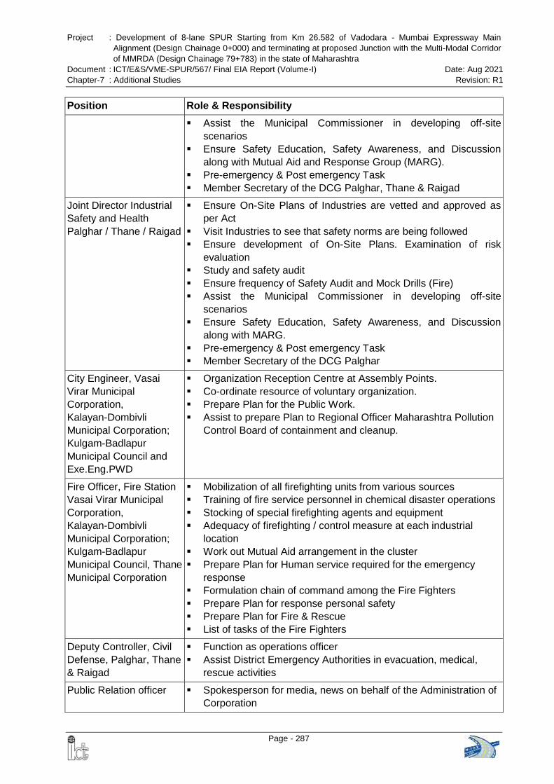
Project : Development of 8-lane SPUR Starting from Km 26.582 of Vadodara - Mumbai Expressway Main
Alignment (Design Chainage 0+000) and terminating at proposed Junction with the Multi-Modal Corridor
of MMRDA (Design Chainage 79+783) in the state of Maharashtra
Document : ICT/E&S/VME-SPUR/567/ Final EIA Report (Volume-I) Date: Aug 2021
Chapter-7 : Additional Studies Revision: R1
Page - 287
Position Role & Responsibility
Assist the Municipal Commissioner in developing off-site
scenarios
Ensure Safety Education, Safety Awareness, and Discussion
along with Mutual Aid and Response Group (MARG).
Pre-emergency & Post emergency Task
Member Secretary of the DCG Palghar, Thane & Raigad
Joint Director Industrial
Safety and Health
Palghar / Thane / Raigad
Ensure On-Site Plans of Industries are vetted and approved as
per Act
Visit Industries to see that safety norms are being followed
Ensure development of On-Site Plans. Examination of risk
evaluation
Study and safety audit
Ensure frequency of Safety Audit and Mock Drills (Fire)
Assist the Municipal Commissioner in developing off-site
scenarios
Ensure Safety Education, Safety Awareness, and Discussion
along with MARG.
Pre-emergency & Post emergency Task
Member Secretary of the DCG Palghar
City Engineer, Vasai
Virar Municipal
Corporation,
Kalayan-Dombivli
Municipal Corporation;
Kulgam-Badlapur
Municipal Council and
Exe.Eng.PWD
Organization Reception Centre at Assembly Points.
Co-ordinate resource of voluntary organization.
Prepare Plan for the Public Work.
Assist to prepare Plan to Regional Officer Maharashtra Pollution
Control Board of containment and cleanup.
Fire Officer, Fire Station
Vasai Virar Municipal
Corporation,
Kalayan-Dombivli
Municipal Corporation;
Kulgam-Badlapur
Municipal Council, Thane
Municipal Corporation
Mobilization of all firefighting units from various sources
Training of fire service personnel in chemical disaster operations
Stocking of special firefighting agents and equipment
Adequacy of firefighting / control measure at each industrial
location
Work out Mutual Aid arrangement in the cluster
Prepare Plan for Human service required for the emergency
response
Formulation chain of command among the Fire Fighters
Prepare Plan for response personal safety
Prepare Plan for Fire & Rescue
List of tasks of the Fire Fighters
Deputy Controller, Civil
Defense, Palghar, Thane
& Raigad
Function as operations officer
Assist District Emergency Authorities in evacuation, medical,
rescue activities
Public Relation officer Spokesperson for media, news on behalf of the Administration of
Corporation
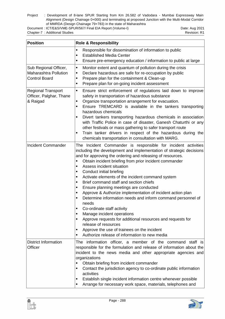
Project : Development of 8-lane SPUR Starting from Km 26.582 of Vadodara - Mumbai Expressway Main
Alignment (Design Chainage 0+000) and terminating at proposed Junction with the Multi-Modal Corridor
of MMRDA (Design Chainage 79+783) in the state of Maharashtra
Document : ICT/E&S/VME-SPUR/567/ Final EIA Report (Volume-I) Date: Aug 2021
Chapter-7 : Additional Studies Revision: R1
Page - 288
Position Role & Responsibility
Responsible for dissemination of information to public
Established Media Center
Ensure pre-emergency education / information to public at large
Sub Regional Officer,
Maharashtra Pollution
Control Board
Monitor extent and quantum of pollution during the crisis
Declare hazardous are safe for re-occupation by public
Prepare plan for the containment & Clean-up
Prepare plan for on-going incident assessment
Regional Transport
Officer, Palghar, Thane
& Raigad
Ensure strict enforcement of regulations laid down to improve
safety in transportation of hazardous substance
Organize transportation arrangement for evacuation.
Ensure TREMCARD is available in the tankers transporting
hazardous chemicals
Divert tankers transporting hazardous chemicals in association
with Traffic Police in case of disaster, Ganesh Chaturthi or any
other festivals or mass gathering to safer transport route
Train tanker drivers in respect of the hazardous during the
chemicals transportation in consultation with MARG.
Incident Commander The Incident Commander is responsible for incident activities
including the development and implementation of strategic decisions
and for approving the ordering and releasing of resources.
Obtain incident briefing from prior incident commander
Assess incident situation
Conduct initial briefing
Activate elements of the incident command system
Brief command staff and section chiefs
Ensure planning meetings are conducted
Approve & Authorize implementation of incident action plan
Determine information needs and inform command personnel of
needs
Co-ordinate staff activity
Manage incident operations
Approve requests for additional resources and requests for
release of resources
Approve the use of trainees on the incident
Authorize release of information to new media
District Information
Officer
The information officer, a member of the command staff is
responsible for the formulation and release of information about the
incident to the news media and other appropriate agencies and
organizations
Obtain briefing from incident commander
Contact the jurisdiction agency to co-ordinate public information
activities
Establish single incident information centre whenever possible
Arrange for necessary work space, materials, telephones and

Project : Development of 8-lane SPUR Starting from Km 26.582 of Vadodara - Mumbai Expressway Main
Alignment (Design Chainage 0+000) and terminating at proposed Junction with the Multi-Modal Corridor
of MMRDA (Design Chainage 79+783) in the state of Maharashtra
Document : ICT/E&S/VME-SPUR/567/ Final EIA Report (Volume-I) Date: Aug 2021
Chapter-7 : Additional Studies Revision: R1
Page - 289
Position Role & Responsibility
staffing
Prepare initial information summary as soon as possible after
arrival
Observe constrains on the release of information imposed by
incident commander
Obtain approval for release from incident commander
Release news to news media and post information in command
post and other appropriate locations
Attend meetings to update information release
Arrange for meetings between media and incident personnel
Provide escort service to the media and VIP’s
Provide fire retardant clothing for media and VIPs
Respond to special requests for information
Maintain and Submit all records and logs.
Assistant to SDM
(Administration)
Act as an Alternate Leader, Liaison Officer, and Agency Chief in
disaster
Check in at the incident command post. Ensure that all agency
resources have completed check-in
Obtain briefing from liaison officer or incident commander
Establish working location. Advise agency personnel on the
incident that the agency representative position has been filled
Attend planning meetings as required
Provide input on use of agency resources if no resources use
advisors are assigned
Co-operative fully with incident commander and general staff on
agency’s involvement at the incident
Observe the wellbeing and safety of agency personnel assigned
to incident
Advise liaison officer if any special agency needs or requirements
Determine, if any special reports or documents are required.
Report to agency dispatch or headquarters on prearranged
schedule.
Ensure that all agency personnel and/or equipment is properly
accounted for and released prior to your departure
Ensure that all required agency forms, reports and documents
are completed prior to your departure from the incident
Have debriefing session with liaison officer incident commander
prior to departure
Station Master
Western Railway, Vasai
Road / Virar / Saphale /
Palghar/ Boisar / Dahanu
Ensure availability of local trains in case of evacuations
Depot Manager MSRTC
Palghar / Boisar / Vasai
Ensure availability of Buses in case of evacuations

Project : Development of 8-lane SPUR Starting from Km 26.582 of Vadodara - Mumbai Expressway Main
Alignment (Design Chainage 0+000) and terminating at proposed Junction with the Multi-Modal Corridor
of MMRDA (Design Chainage 79+783) in the state of Maharashtra
Document : ICT/E&S/VME-SPUR/567/ Final EIA Report (Volume-I) Date: Aug 2021
Chapter-7 : Additional Studies Revision: R1
Page - 290
Position Role & Responsibility
Execute Engineer
MSEDCL, Vasai,
Dy. Execute Engineer
Ensure electricity supply to expressway, streets; Police Stations,
Fire Brigades, Emergency Control Centre and other Offices of
emergency Response Personnel
District Supply Officer,
Palghar, Thane & Raigad
He is responsible for determining feeding requirements at all
incident facilities, menu planning, determining cooking facilities
required and general maintenance of the food service areas
District Collector,
Palghar, Thane & Raigad
Co-ordination of all Local Crisis Groups of the District
Act as Chief Controlling Authority of District Emergency Plan.
Mobilize / Requisition / pulling together resources to tackle
emergencies
Establish relationship between District Emergency Plan (Crisis
Group) and State Crisis Group
To requisite the resource available from the public works
departments
Warning System: A good warning system is one of the important pre-requisite of the
emergency management system to save lives, Prevent injuries and mitigate losses. As
soon as incident commander determines that it is necessary to warn people of a threat
to public safety, a strategy appropriate to the situation will be developed and
immediately implemented to ensure coverage of the affected area.
In order to ensure speedy and effective response, the execution of off-site disaster
related activities will be undertaken under the direction of the Disaster Management
Committee as per the Off-site Emergency Plan of Palghar, Thane and Raigad district.
Project : Development of 8-lane SPUR Starting from Km 26.582 of Vadodara - Mumbai Expressway Main
Alignment (Design Chainage 0+000) and terminating at proposed Junction with the Multi-Modal Corridor
of MMRDA (Design Chainage 79+783) in the state of Maharashtra
Document : ICT/E&S/VME-SPUR/567/ Final EIA Report (Volume-I) Date: Aug 2021
Chapter-7 : Additional Studies Revision: R1
Page - 291
7.2 GEOPHYSICAL SURVEYS
Aquifer in hard-rock terrain is a serious issue, which occurs in limited areal extent within
secondary porosity generated by weathering, fracturing, jointing and faulting .In hard-
rock terrain, the fractured rocks are only the channel for water charging and
transporting .These structural variations are scattered in the hard rock areas. Unplanned
drilling without suitable information regarding subsurface formation may lead to
unsuccessful results.
Present scope of work includes subsurface characterization using Electrical Resistivity
Tomography (ERT) and Seismic Refraction Tomography (SRT) for detail aquifer study
at various depths to decipher the fracture pattern and weathered portion.
The team comprising Prof. Sanjit Kumar Pal, and Prof. S. Datta Gupta, from
department of geophysics, IIT (ISM), Dhanbad were visited the site during
28.12.2020 to 31.12.2020 for Electrical Resistivity Tomography (ERT) and Seismic
Refraction Tomography (SRT) data acquisition with guidance of Mr. Aejaz Ahmad,
Geologist Intercontinental Consultants & Technocrats Pvt. Ltd., New Delhi. The
summary of the study is discussed below and separate report has been prepared
covering the detailed study.
7.2.1 Seismic Refraction Tomography (SRT)
Geode digital seismograph has been used for the Seismic Refraction Tomography
(SRT) data acquisition with shot’s offsets at +5 m; +20 m; +50 m; +100 m; +150 m; +200
m along with inline shots at 0 m, 30m, 60 m, 90m, and 120m; which cover a total survey
length of about 2040m.
Rayfract 3.32 software (Intelligent Resources Inc., 2006) has been used for SRT
(Sheehan et al 2005) study. The initial velocity model was obtained using the smooth
inversion Delta-t-V turning ray method (Gebrande and Miller, 1985) with the one-
dimensional (1D) gradient option. The standard Delta-t-V method produces a pseudo-
2D model with lateral velocity changes along the profile. The smooth 1D gradient option
is an average of all traces of the pseudo-2D model and is the recommended starting
model to minimize velocity artefacts in the final model (Intelligent Resources Inc., 2007).
Subsequent model refinement was performed using the 2D Wavepath Eikonal
Traveltime (WET) tomographic inversion method (Schuster and Quintus-Bosz, 1993).
The SRT represents subsurface using cells or grids of various sizes with fixed or
variable dimension. Presently, finite difference method has been used for prediction of
refracted ray path in subsurface forward modelling to estimate the travel times between
source and geophone location. Velocities assigned to grids or cells are refined or
modified iteratively so that misfit between predicted and calculated travel times is
acceptable.
Project : Development of 8-lane SPUR Starting from Km 26.582 of Vadodara - Mumbai Expressway Main
Alignment (Design Chainage 0+000) and terminating at proposed Junction with the Multi-Modal Corridor
of MMRDA (Design Chainage 79+783) in the state of Maharashtra
Document : ICT/E&S/VME-SPUR/567/ Final EIA Report (Volume-I) Date: Aug 2021
Chapter-7 : Additional Studies Revision: R1
Page - 292
7.2.2 Electrical Resistivity Tomography (ERT)
Electrical resistivity tomography data have been collected along 4-profiles each of about
500m covering total of 2000m line length using Syscal R1 Plus Electrical resistivity
tomography instrument. Electrical resistivity tomography involves a series of resistivity
measurements with different electrode spacing using a 2D multi electrode imaging
system to control the measurements. Increasing electrode separation provides
information of increasing depths. The measured apparent resistivities are processed
and interpreted to provide an image of true resistivity against depth. For each
successive measurement, for getting deeper subsurface information, the current
electrodes are moved farther away from the potential electrode pair by a distance that is
a multiple of the separation between potential electrode pair. In resistivity tomography
survey, a large number of electrodes are arranged in a linear array. An automatic
switching mechanism is used to select the relevant four electrode array for each
measurement.
Electrical Resistivity Tomography technique is best suited for the investigation of sites
with complex geology that cannot be approximated to horizontal layer stratigraphy. The
final depth-section of ERT technique is an image of true resistivity with depth from which
the subsurface geological information including that of isolated low/high resistive
anomalies representing cavities, seepage zones etc can be discerned. Resistivity
Tomography data collection technique is also called sounding-profiling technique as it
involves both sounding and profiling measurements. Aquifer / weathered/ water
saturated fracture zones exhibit low resistivity anomaly whereas, hard-rocks/ bed-rocks
/ compact rocks exhibit high resistivity anomaly in the resistivity tomography section.
The ERT survey is carried out using (Syscal R1 Plus) a multi-electrode electrical
resistivity tomography (ERT) system. Survey involves multicore cables with many
electrodes takeouts which are connected together to form a multi-electrode set-up. This
enables the selection of any four (two for current injection and two for potential
measurement) out of these electrodes. Spacing between consecutive electrodes are
always the same. Selection of spacing between electrodes is based on the geometry of
expected anomaly i.e., vertical depth of investigation, horizontal resolution and space
availability. For high resolution subsurface imaging, smaller spacing is used. The
multicore cables are connected to a resistivity meter which is connected to a laptop.
Information regarding the sequence of measurements, type of array used and other
survey parameters such as the intensity of current/ voltage etc are assigned through a
computer program. A microcomputer together with an electrode-switching unit is used to
automatically select the relevant four electrodes for each measurement .Apparent
resistivity measurements are recorded sequentially and sweeping any quadripole
(current and potential electrodes )within the multi-electrode array .As a result, high-
definition pseudo sections with dense sampling of apparent resistivity variation at
shallow depth are obtained in a short period of time, which are then used for generation
of 2D inverted true resistivity section .It allows for detailed interpretation of 2D resistivity
distribution in the subsurface formation.
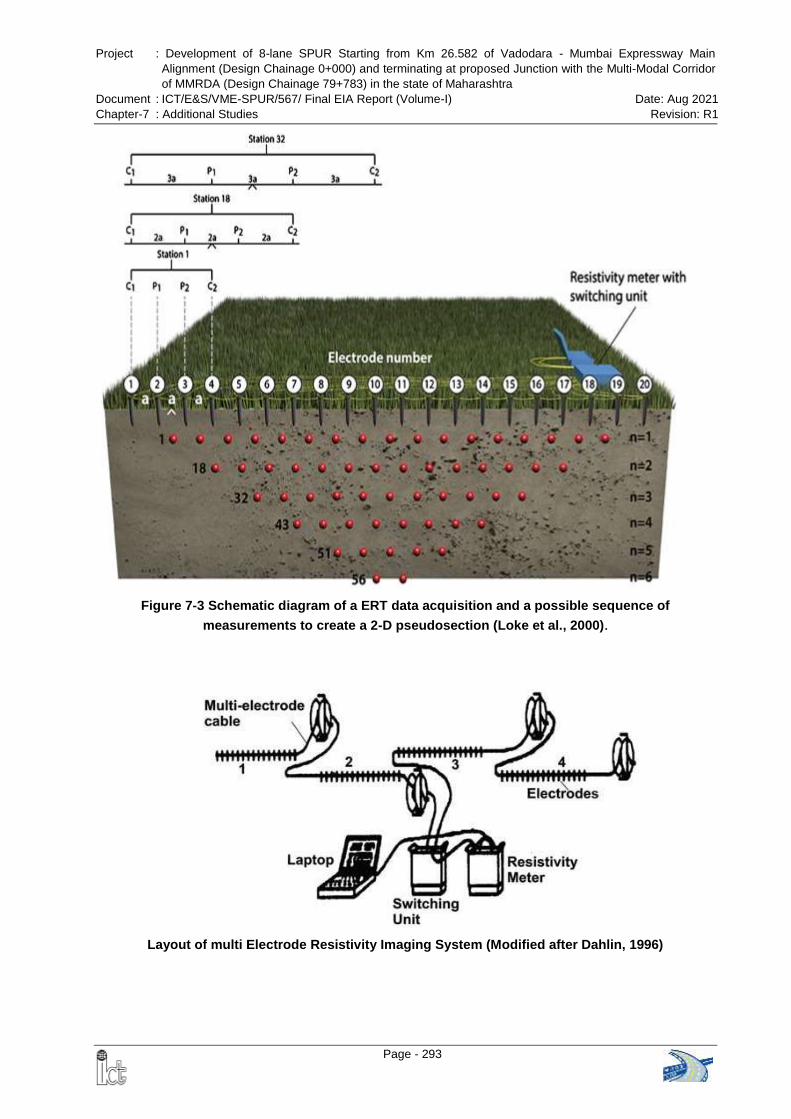
Project : Development of 8-lane SPUR Starting from Km 26.582 of Vadodara - Mumbai Expressway Main
Alignment (Design Chainage 0+000) and terminating at proposed Junction with the Multi-Modal Corridor
of MMRDA (Design Chainage 79+783) in the state of Maharashtra
Document : ICT/E&S/VME-SPUR/567/ Final EIA Report (Volume-I) Date: Aug 2021
Chapter-7 : Additional Studies Revision: R1
Page - 293
Figure 7-3 Schematic diagram of a ERT data acquisition and a possible sequence of
measurements to create a 2-D pseudosection (Loke et al., 2000).
Layout of multi Electrode Resistivity Imaging System (Modified after Dahlin, 1996)
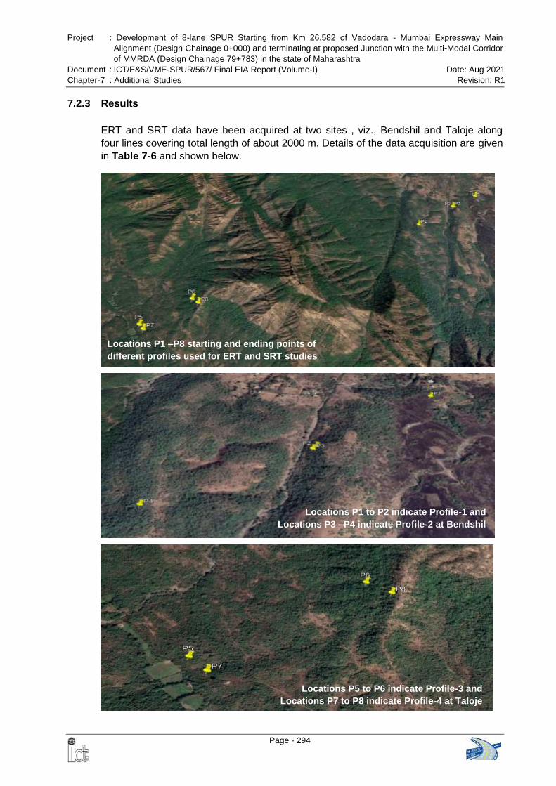
Project : Development of 8-lane SPUR Starting from Km 26.582 of Vadodara - Mumbai Expressway Main
Alignment (Design Chainage 0+000) and terminating at proposed Junction with the Multi-Modal Corridor
of MMRDA (Design Chainage 79+783) in the state of Maharashtra
Document : ICT/E&S/VME-SPUR/567/ Final EIA Report (Volume-I) Date: Aug 2021
Chapter-7 : Additional Studies Revision: R1
Page - 294
Fig.3
Locations P1 –P8 starting and ending points of
different profiles used for ERT and SRT studies
Locations P1 to P2 indicate Profile-1 and
Locations P3 –P4 indicate Profile-2 at Bendshil
Locations P5 to P6 indicate Profile-3 and
Locations P7 to P8 indicate Profile-4 at Taloje
7.2.3 Results
ERT and SRT data have been acquired at two sites , viz., Bendshil and Taloje along
four lines covering total length of about 2000 m. Details of the data acquisition are given
in Table 7-6 and shown below.
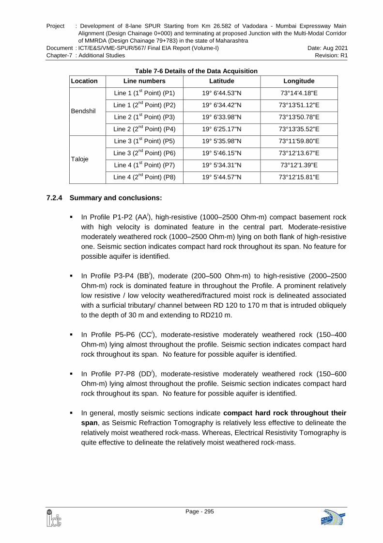
Project : Development of 8-lane SPUR Starting from Km 26.582 of Vadodara - Mumbai Expressway Main
Alignment (Design Chainage 0+000) and terminating at proposed Junction with the Multi-Modal Corridor
of MMRDA (Design Chainage 79+783) in the state of Maharashtra
Document : ICT/E&S/VME-SPUR/567/ Final EIA Report (Volume-I) Date: Aug 2021
Chapter-7 : Additional Studies Revision: R1
Page - 295
Table 7-6 Details of the Data Acquisition
Location Line numbers Latitude Longitude
Bendshil
Line 1 (1st Point) (P1) 19° 6'44.53"N 73°14'4.18"E
Line 1 (2nd
Point) (P2) 19° 6'34.42"N 73°13'51.12"E
Line 2 (1st Point) (P3) 19° 6'33.98"N 73°13'50.78"E
Line 2 (2nd
Point) (P4) 19° 6'25.17"N 73°13'35.52"E
Taloje
Line 3 (1st Point) (P5) 19° 5'35.98"N 73°11'59.80"E
Line 3 (2nd
Point) (P6) 19° 5'46.15"N 73°12'13.67"E
Line 4 (1st Point) (P7) 19° 5'34.31"N 73°12'1.39"E
Line 4 (2nd
Point) (P8) 19° 5'44.57"N 73°12'15.81"E
7.2.4 Summary and conclusions:
In Profile P1-P2 (AA/), high-resistive (1000–2500 Ohm-m) compact basement rock
with high velocity is dominated feature in the central part. Moderate-resistive
moderately weathered rock (1000–2500 Ohm-m) lying on both flank of high-resistive
one. Seismic section indicates compact hard rock throughout its span. No feature for
possible aquifer is identified.
In Profile P3-P4 (BB/), moderate (200–500 Ohm-m) to high-resistive (2000–2500
Ohm-m) rock is dominated feature in throughout the Profile. A prominent relatively
low resistive / low velocity weathered/fractured moist rock is delineated associated
with a surficial tributary/ channel between RD 120 to 170 m that is intruded obliquely
to the depth of 30 m and extending to RD210 m.
In Profile P5-P6 (CC/), moderate-resistive moderately weathered rock (150–400
Ohm-m) lying almost throughout the profile. Seismic section indicates compact hard
rock throughout its span. No feature for possible aquifer is identified.
In Profile P7-P8 (DD/), moderate-resistive moderately weathered rock (150–600
Ohm-m) lying almost throughout the profile. Seismic section indicates compact hard
rock throughout its span. No feature for possible aquifer is identified.
In general, mostly seismic sections indicate compact hard rock throughout their
span, as Seismic Refraction Tomography is relatively less effective to delineate the
relatively moist weathered rock-mass. Whereas, Electrical Resistivity Tomography is
quite effective to delineate the relatively moist weathered rock-mass.
Project : Development of 8-lane SPUR Starting from Km 26.582 of Vadodara - Mumbai Expressway Main
Alignment (Design Chainage 0+000) and terminating at proposed Junction with the Multi-Modal Corridor
of MMRDA (Design Chainage 79+783) in the state of Maharashtra
Document : ICT/E&S/VME-SPUR/567/ Final EIA Report (Volume-I) Date: Aug 2021
Chapter-7 : Additional Studies Revision: R1
Page - 296
7.3 HYDROGEOLOGICAL & AQUIFER STUDY AND 3-D MODELLING
The proposed SPUR alignment is intervening Matheran Eco Sensitive Zone at two
locations as detailed below:
Section I (Km 71.532 to 75.426): The proposed SPUR alignment enters the Buffer
Zone at km 71.532 and after traversing 249 m it enters the Eco-sensitive Zone of
Matheran at km 71.781. The alignment exits from the Eco-sensitive Zone at km 75.128
and from Buffer Zone at km 75.426.
To preserve ecology of the Matheran, 4.160 km long tunnel is proposed in this
section which will go under the Matheran Eco-Sensitive Zone. The start point of the
tunnel is at km 71.520 (before buffer zone) and end point of the tunnel is at km 75.680
(after buffer zone).
Section II (km 77.115 to km 77.691): Based on the suggestions of the Monitoring
Committee of the Matheran ESZ in the year 2012, the proposed alignment was modified
and shifted on the right side to minimize the impact. The width of the Right of Way
(RoW) at this location has also been reduced. Hence, in this section, the alignment is
only passing through the Buffer Zone from km 77.115 to km 77.691 for a length of 576
m.
NHAI engaged independent agency to conduct 3D modeling, detail aquifer study and
hydrogeological study in the proposed tunnel area at Matheran as suggested by the
MoEFCC in the TOR. The agency conducted the study and prepared standalone report.
The summary of the study is presented in the following sections.
7.3.1 Study Area
The study area extends in the districts of Thane and Raigad of Maharastra State and it
covers an area of more about 100 sq. km under a toposheet no. 47 E/4 of Survey of
India on the scale of 1:50,000. The study area is very well connected and is
approachable from either by roadway or railway from Mumbai. Nearest towns are
Ambernath and Badlapur lying on the northern part of the study area and Panvel on the
southwestern part.
The study area is characterized by the slightly undulating plain in the western, eastern
and northern part whereas the hill range is present in the central and southern part. The
average ground elevation is around 50-100 m above mean sea level; however, the hills
rise sharply from 450 m to about 700 m. The entire plain is dissected by numerous
streams, though the Ulhas River and the Taloje River is the two main stream of the
region. Lithology of the area comprises Deccan Trap Basalt
Project : Development of 8-lane SPUR Starting from Km 26.582 of Vadodara - Mumbai Expressway Main
Alignment (Design Chainage 0+000) and terminating at proposed Junction with the Multi-Modal Corridor
of MMRDA (Design Chainage 79+783) in the state of Maharashtra
Document : ICT/E&S/VME-SPUR/567/ Final EIA Report (Volume-I) Date: Aug 2021
Chapter-7 : Additional Studies Revision: R1
Page - 297
7.3.2 Materials and Methods
Field work for geological investigation at the study area has been carried out from 3rd to
7th January 2021. The investigation contains: (a) geological mapping around the hilly
tract, the special emphasis has been given on the SPUR tunnel alignment; (b) geo-
structural surveys through scanline sampling method done along the stream cut
sections (c) tracking around traced lineaments (from satellite imageries) to find the
cause of lineaments, (d) field photography from where the geological data have been
retrieved, with their location details.
Tracing of lineaments and drainages have been done from the satellite imageries
available from bhuvan.nrsc.gov.in website, SOI topo-sheet and also have taken help of
Google Earth. The overview of the geological set-up of the region has been obtained
from (1) Geological Quadrangle Map No. 47E (scale 1:250,000) published by Geological
Survey of India; (2) District Resource maps (DRMs) of Thane and Raigad districts,
Maharastra, Geological Survey of India, Kolkata.
Overview of the area has been gathered from Zonal Master Plan for Matheran Eco-
Sensitive Zone (MESZ) 2016-36 (2019). The hydrological and groundwater data have
been obtained from Ground Water Monitoring Wells (GWMS) of CGWB, Nagpur. And
similarly, the rainfall data obtained from IMD website. Soil data has been gathered from
Maharastra Remote Sensing and Application Centre (MRSAC).
Detail geological mapping on the scale of 1:50,000 have been done, which involves
lithology identification, delineation of lithological boundaries, structural geological data
collection by geological compass and other relevant software and plotting the same on
the geological map and geo-mechanical rock mass classification.
Methodologies adopted to gather the data (degree of jointing, type of discontinuities,
orientation, spacing, persistence, roughness, apertures, fillings, etc.) from the field for
geological mapping and scanline sampling is from “International Society for Rock
Mechanics commission on standardization of laboratory and field tests- suggested
methods for the quantitative description of discontinuities in rock masses” published on
1977 in Int. J. Rock Mech. Min. Sci & Geomech. Abstr. Vol. 15.
The data obtained from geophysical studies like ERT and SRT have been utilized for
determination of fracture intensity in rock and groundwater condition. The boreholes
drilled in the area (2 nos.) by IGS, New Delhi have also been used for information like
geotechnical parameters of the rock and finally used in determination of rock mass
classes.
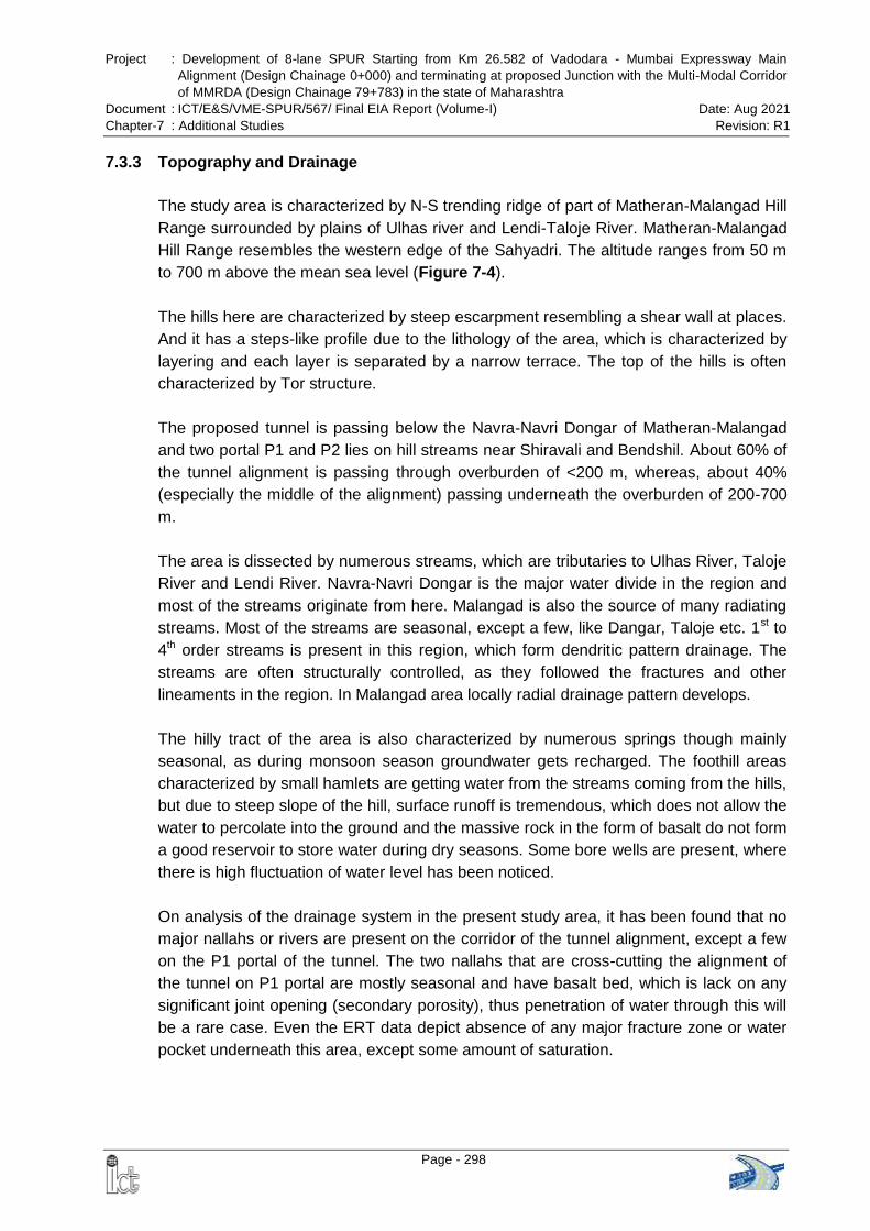
Project : Development of 8-lane SPUR Starting from Km 26.582 of Vadodara - Mumbai Expressway Main
Alignment (Design Chainage 0+000) and terminating at proposed Junction with the Multi-Modal Corridor
of MMRDA (Design Chainage 79+783) in the state of Maharashtra
Document : ICT/E&S/VME-SPUR/567/ Final EIA Report (Volume-I) Date: Aug 2021
Chapter-7 : Additional Studies Revision: R1
Page - 298
7.3.3 Topography and Drainage
The study area is characterized by N-S trending ridge of part of Matheran-Malangad Hill
Range surrounded by plains of Ulhas river and Lendi-Taloje River. Matheran-Malangad
Hill Range resembles the western edge of the Sahyadri. The altitude ranges from 50 m
to 700 m above the mean sea level (Figure 7-4).
The hills here are characterized by steep escarpment resembling a shear wall at places.
And it has a steps-like profile due to the lithology of the area, which is characterized by
layering and each layer is separated by a narrow terrace. The top of the hills is often
characterized by Tor structure.
The proposed tunnel is passing below the Navra-Navri Dongar of Matheran-Malangad
and two portal P1 and P2 lies on hill streams near Shiravali and Bendshil. About 60% of
the tunnel alignment is passing through overburden of <200 m, whereas, about 40%
(especially the middle of the alignment) passing underneath the overburden of 200-700
m.
The area is dissected by numerous streams, which are tributaries to Ulhas River, Taloje
River and Lendi River. Navra-Navri Dongar is the major water divide in the region and
most of the streams originate from here. Malangad is also the source of many radiating
streams. Most of the streams are seasonal, except a few, like Dangar, Taloje etc. 1st to
4th order streams is present in this region, which form dendritic pattern drainage. The
streams are often structurally controlled, as they followed the fractures and other
lineaments in the region. In Malangad area locally radial drainage pattern develops.
The hilly tract of the area is also characterized by numerous springs though mainly
seasonal, as during monsoon season groundwater gets recharged. The foothill areas
characterized by small hamlets are getting water from the streams coming from the hills,
but due to steep slope of the hill, surface runoff is tremendous, which does not allow the
water to percolate into the ground and the massive rock in the form of basalt do not form
a good reservoir to store water during dry seasons. Some bore wells are present, where
there is high fluctuation of water level has been noticed.
On analysis of the drainage system in the present study area, it has been found that no
major nallahs or rivers are present on the corridor of the tunnel alignment, except a few
on the P1 portal of the tunnel. The two nallahs that are cross-cutting the alignment of
the tunnel on P1 portal are mostly seasonal and have basalt bed, which is lack on any
significant joint opening (secondary porosity), thus penetration of water through this will
be a rare case. Even the ERT data depict absence of any major fracture zone or water
pocket underneath this area, except some amount of saturation.
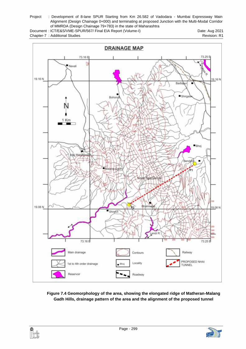
Project : Development of 8-lane SPUR Starting from Km 26.582 of Vadodara - Mumbai Expressway Main
Alignment (Design Chainage 0+000) and terminating at proposed Junction with the Multi-Modal Corridor
of MMRDA (Design Chainage 79+783) in the state of Maharashtra
Document : ICT/E&S/VME-SPUR/567/ Final EIA Report (Volume-I) Date: Aug 2021
Chapter-7 : Additional Studies Revision: R1
Page - 299
Figure 7.4 Geomorphology of the area, showing the elongated ridge of Matheran-Malang
Gadh Hills, drainage pattern of the area and the alignment of the proposed tunnel
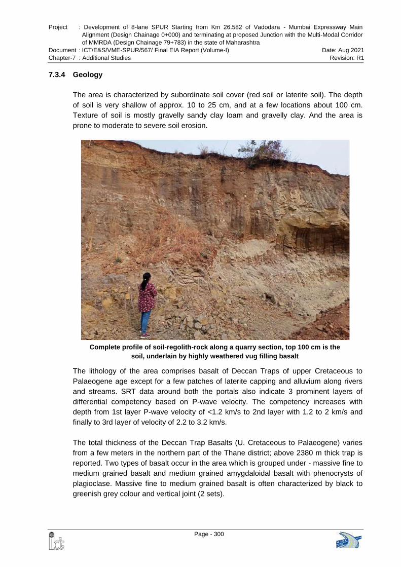
Project : Development of 8-lane SPUR Starting from Km 26.582 of Vadodara - Mumbai Expressway Main
Alignment (Design Chainage 0+000) and terminating at proposed Junction with the Multi-Modal Corridor
of MMRDA (Design Chainage 79+783) in the state of Maharashtra
Document : ICT/E&S/VME-SPUR/567/ Final EIA Report (Volume-I) Date: Aug 2021
Chapter-7 : Additional Studies Revision: R1
Page - 300
Complete profile of soil-regolith-rock along a quarry section, top 100 cm is the
soil, underlain by highly weathered vug filling basalt
7.3.4 Geology
The area is characterized by subordinate soil cover (red soil or laterite soil). The depth
of soil is very shallow of approx. 10 to 25 cm, and at a few locations about 100 cm.
Texture of soil is mostly gravelly sandy clay loam and gravelly clay. And the area is
prone to moderate to severe soil erosion.
The lithology of the area comprises basalt of Deccan Traps of upper Cretaceous to
Palaeogene age except for a few patches of laterite capping and alluvium along rivers
and streams. SRT data around both the portals also indicate 3 prominent layers of
differential competency based on P-wave velocity. The competency increases with
depth from 1st layer P-wave velocity of <1.2 km/s to 2nd layer with 1.2 to 2 km/s and
finally to 3rd layer of velocity of 2.2 to 3.2 km/s.
The total thickness of the Deccan Trap Basalts (U. Cretaceous to Palaeogene) varies
from a few meters in the northern part of the Thane district; above 2380 m thick trap is
reported. Two types of basalt occur in the area which is grouped under - massive fine to
medium grained basalt and medium grained amygdaloidal basalt with phenocrysts of
plagioclase. Massive fine to medium grained basalt is often characterized by black to
greenish grey colour and vertical joint (2 sets).
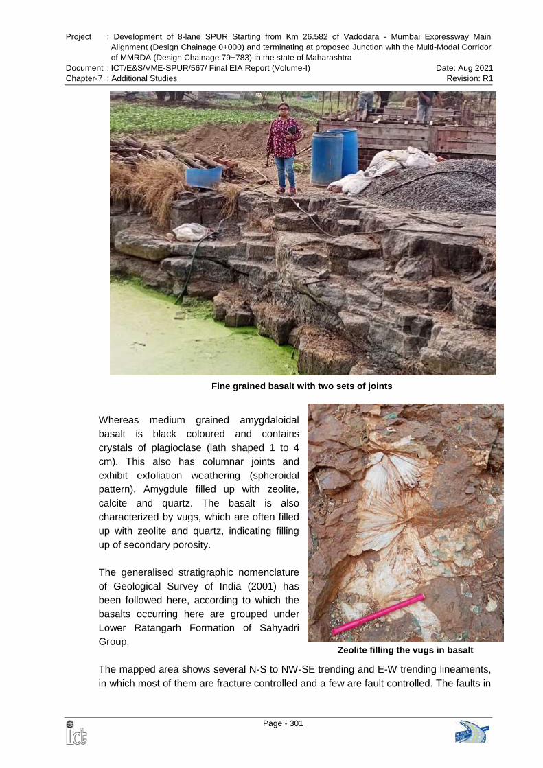
Project : Development of 8-lane SPUR Starting from Km 26.582 of Vadodara - Mumbai Expressway Main
Alignment (Design Chainage 0+000) and terminating at proposed Junction with the Multi-Modal Corridor
of MMRDA (Design Chainage 79+783) in the state of Maharashtra
Document : ICT/E&S/VME-SPUR/567/ Final EIA Report (Volume-I) Date: Aug 2021
Chapter-7 : Additional Studies Revision: R1
Page - 301
Fine grained basalt with two sets of joints
Zeolite filling the vugs in basalt
Whereas medium grained amygdaloidal
basalt is black coloured and contains
crystals of plagioclase (lath shaped 1 to 4
cm). This also has columnar joints and
exhibit exfoliation weathering (spheroidal
pattern). Amygdule filled up with zeolite,
calcite and quartz. The basalt is also
characterized by vugs, which are often filled
up with zeolite and quartz, indicating filling
up of secondary porosity.
The generalised stratigraphic nomenclature
of Geological Survey of India (2001) has
been followed here, according to which the
basalts occurring here are grouped under
Lower Ratangarh Formation of Sahyadri
Group.
The mapped area shows several N-S to NW-SE trending and E-W trending lineaments,
in which most of them are fracture controlled and a few are fault controlled. The faults in
Project : Development of 8-lane SPUR Starting from Km 26.582 of Vadodara - Mumbai Expressway Main
Alignment (Design Chainage 0+000) and terminating at proposed Junction with the Multi-Modal Corridor
of MMRDA (Design Chainage 79+783) in the state of Maharashtra
Document : ICT/E&S/VME-SPUR/567/ Final EIA Report (Volume-I) Date: Aug 2021
Chapter-7 : Additional Studies Revision: R1
Page - 302
the region are mostly strike-slip faults trending N-S around Bendshil and Bhainiwadi
area and also suspected fault trending E-W in the Malang Gad area. The faults around
Bendshil and Bhainiwadi are on the portal P1 and portal P2 respectively of the tunnel
alignment (Km 72+000, Km 72+900 and Km 75+550). The faults are identified by
increase fracture density (around Km 72+300 to 72+600) and laterization along a line,
otherwise no significant evidences of movement like slickensides or variation in joint
orientation has been noticed. The basalts have some inherent vertical joints trending N-
S and E-W, which are also controlling the lineament orientations. Local radial joints are
often developed due to the flowing of magma during fissure eruption in this Deccan
area. Often the escarpments of the hill are also very linear giving impression of
lineament.
7.3.5 Hydrogeology
The drainage density of the region is high, especially at the hilly tract of Matheran-
Malang Gadh Range. 1st order drainage is dominating, whereas the highest order
drainage or the main drainage in the area is very less. The streams are seasonal and
become totally dry during the dry seasons. This indicates the steep slopes of the hilly
area and less porous massive basalt causing high amount of surface runoff during
monsoon.
Interpreted Geo-hydrological map for Vadodra-Mumbai Expressway SPUR indicate
absence of any significant groundwater bodies or aquifers in and around the
tunnel alignment. The ERT survey carried out in the portal areas of the tunnel also
indicate the same except some amount of saturation at a few locations, especially
around portal P1, somewhere around (1) Km 71+520 to Km 71+800, and (2) at some
isolated locations in between Km 72+000 to Km 72+900. The 2nd area has deep seated
(50-100 m) saturated zone and this area lies in between two strike slip faults and the
lithology here is also characterized by basalt with vugs and higher fracture density.
During pre-monsoon from 2010-2019, the mean groundwater level was around 4.01 to
6.44 mbgl, and even further below the mean during May 2019 to 4.8-7.1 mbgl. This
trend of dropping down of water level is alarming as the mean water level in pre-
monsoon of 1996 to 2011 was around 2 to 5 mbgl. The similar dropping of water level in
post monsoon season has also been noticed.
The main reasons for this dropping of water level are as follows:
Porosity is lacking in massive basalt (some amount of secondary porosity
developed due to fracturing and vugs, but they are not sufficient to hold the water
for long)
Steep hill slopes in the area and also deforestation around encourage higher
amount of surface runoff, thus rain water does not able to percolate into the ground
Project : Development of 8-lane SPUR Starting from Km 26.582 of Vadodara - Mumbai Expressway Main
Alignment (Design Chainage 0+000) and terminating at proposed Junction with the Multi-Modal Corridor
of MMRDA (Design Chainage 79+783) in the state of Maharashtra
Document : ICT/E&S/VME-SPUR/567/ Final EIA Report (Volume-I) Date: Aug 2021
Chapter-7 : Additional Studies Revision: R1
Page - 303
(recharge problem),
Silting of existing recharge structures, which again increase surface runoff, and
Increase in fluctuation due to draft attributed to increase in population and urban
sprawl, especially in the northwestern part, around Ambernath and also to some
extent around Badlapur.
7.3.6 Geotechnical Investigation Results
The geotechnical investigation by drilling 2 nos. boreholes around portal P1 has been
carried out in 2011 to know the geotechnical parameters (Table: Geotechnical details).
The results indicate presence of overburden of only about 40-50 cm and followed by
black fine grained basalt, occasionally amygdaloidal, weathering grade mostly fresh with
slight to moderate weathering at a few locations. Water table encountered around 9 m
and there was partial water indicating joints are either tight or filled-up. Occasional
vesicular openings have been observed. The RQD ranges from 28-90%.
Laboratory test results from the same borehole samples indicate lack or very less
porosity and also water absorption percentage. The overall strength of the rock is good,
where UCS ranges from 30 Mpa to 97 Mpa.
7.3.7 Rock mass Classification & Geological Matrix along Tunnel Alignment
The tunnel alignment traverses through the tectonically stable Deccan Traps basalt. The
basalt is characterized by thick bedded flows, which are almost horizontal or slightly
dipping towards west and is lacking in tectonic joints. Therefore, stable ground during
tunnelling is expected and frequent changes of strata will not be there, though a few
minor geological surprises may be encountered.
A rockmass classification along the proposed tunnel alignment has been presented here
by taking into consideration of (i) geological data, (ii) geotechnical data, (iii) geo-
mechanical data, (iv) hydrogeological data, and (v) geometrical data of tunnel. The
height of the tunnel is around 10 m and the width is of about 18 m.
The rock along the tunnel alignment comprises two types of basalts, which are
categorized under Rock Type (RT): RT-1 (30%) and RT-2 (70%). Mostly the rock mass
along the proposed tunnel alignment is devoid of any significant tectonic activity, except
presence of two strike slip faults around P1 (Km 72+200 and Km 72+900) portal and
one suspected fault around P2 portal (Km 75+550).
Rock mass is rarely continuous, homogeneous and isotropic, and is usually dissected
by several discontinuity planes (fractures, cleavage, joints, etc.) and other structures.
Mapping of such elements is an essential component for the design of underground
excavation. Different engineering geological parameters, such as, weathering/alteration,
structure, colour, grain size, rock type, groundwater influence, details of discontinuities
Project : Development of 8-lane SPUR Starting from Km 26.582 of Vadodara - Mumbai Expressway Main
Alignment (Design Chainage 0+000) and terminating at proposed Junction with the Multi-Modal Corridor
of MMRDA (Design Chainage 79+783) in the state of Maharashtra
Document : ICT/E&S/VME-SPUR/567/ Final EIA Report (Volume-I) Date: Aug 2021
Chapter-7 : Additional Studies Revision: R1
Page - 304
(number of joint sets, orientation, persistence, spacing, aperture/thickness, infilling,
waviness and unevenness), etc. have been collected.
The geological and geotechnical data collected have been utilized for rock mass
classification by the methods like Q-value, Rock Mass Rating (RMR) and Geological
Strength Index (GSI). RMR uses compressive strength directly and its calculation also
incorporates the joint and tunnel orientations relationship while Q only considers
strength as it relates to in-situ stress in competent rock. GSI has also been used here to
properly demarcate the geo-mechanical properties of the rock mass, taking into
consideration the discontinuity network and the relative geotechnical characteristics.
The obtained Rock Mass rating (RMR) value from geotechnical investigation ranges
mostly from 40 to 80, with subordinate 15 to 40. Though RMR is mainly based on the
criteria of joint orientations and UCS of the rockmass. Whereas at present study area,
the joints are not so important factor in controlling the rockmass behaviour. The
competency of the rock and the overburden pressure on the tunnel plays an important
role in controlling rockmass behaviour and consequently in categorization of different
rock support classes along the tunnel. Therefore, Barton’s Q-Index has been used
here for geo-mechanical classification of rockmass along the tunnel. Six parameters
are used to calculate Q-Index, viz. Rockmass Quality Designation (RQD), Joint set
number (Jn), Joint roughness number (Jr), Joint alteration number (Ja), Joint water
factor (Jw) and Stress Reduction Factor (SRF). First quotient (RQD/Jn) represents
structure of rockmass, and it is a crude measure of the block or particle size.
Second quotient (Jr/Ja) represents the roughness and frictional characteristics of the
joint walls or filling materials. And third quotient (Jw/SRF) consists of two stress
parameters. The Q-Index ranges from 3 to 60, whereas the RMR estimated from Q-
Index (RMR=9lnQ+44) ranges from 53 to 81. Similarly, Geological Strength Index
(GSI) has been determined from Q-Index (GSI=15log[(RQD/Jn)(Jr/Ja)]+50) and it
has been found that the GSI ranges from 65 to 72. The Q-Index, RMR and GSI
along the proposed tunnel alignment has been given below:
Q-Index RMR GSI
3 53 65
4 56 65
5 58 65
6 60 65
15 68 72
30 74 72
45 78 72
60 80 72
Project : Development of 8-lane SPUR Starting from Km 26.582 of Vadodara - Mumbai Expressway Main
Alignment (Design Chainage 0+000) and terminating at proposed Junction with the Multi-Modal Corridor
of MMRDA (Design Chainage 79+783) in the state of Maharashtra
Document : ICT/E&S/VME-SPUR/567/ Final EIA Report (Volume-I) Date: Aug 2021
Chapter-7 : Additional Studies Revision: R1
Page - 305
The overburden along the tunnel has been classified into (i) 0-100 m, (ii) 100-200 m, (iii)
200-400 m, and (iv) >400 m. Dry to minor inflow of water during the tunnelling activity is
expected and in rare cases medium inflow may encounter, especially around the portal
P1.
By taking into consideration of the GSI value and strength of the intact rock, rockmass
strength has been obtained. Then the competency of the rockmass has been computed
by using rockmass strength and overburden. Then the obtained RMR and competency
of the rockmass were used to determine the Rockmass Behaviour Type.
Rockmass Behaviour Type (RBT) represents the determined behaviour of the rockmass
due to the excavation of the tunnel without any support measures. Three classes of RBT
along the present tunnel are RBT-1 (~35%), i.e., stable ground with potential of small
local gravity induced falling or sliding of blocks, RBT-2 (~60%), i.e., potential of
discontinuity-controlled block fall, and RBT-3 (~5%), i.e., rockburst, caused by highly
stressed brittle rocks and the rapid release of accumulated strain. Both RBT-1 and 2 are
characterized by instability phenomena associated with wedge failure and seldom occur
in RBT-1, where the rockmass is considered as a continuum, but if joints are abundant
as in RBT-2, rockmass is considered as discontinuum.
The longitudinal profile of the proposed tunnel alignment has been prepared based on
the available information, discussed above (Figure 7-5). Four classes of Q-Index are
namely, A (very good rockmass), B (good rockmass), C (fair rockmass) and D (poor
rockmass). There is probability of encountering fair to good rockmass, i.e., B and C to
be around 62%, A to be around 16% and D to be around 22%.
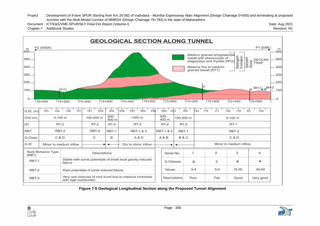
Project : Development of 8-lane SPUR Starting from Km 26.582 of Vadodara - Mumbai Expressway Main Alignment (Design Chainage 0+000) and terminating at proposed
Junction with the Multi-Modal Corridor of MMRDA (Design Chainage 79+783) in the state of Maharashtra
Document : ICT/E&S/VME-SPUR/567/ Final EIA Report (Volume-I) Date: Aug 2021
Chapter-7 : Additional Studies Revision: R1
Page - 306
Figure 7-5 Geological Longitudinal Section along the Proposed Tunnel Alignment
Project : Development of 8-lane SPUR Starting from Km 26.582 of Vadodara - Mumbai Expressway Main
Alignment (Design Chainage 0+000) and terminating at proposed Junction with the Multi-Modal Corridor
of MMRDA (Design Chainage 79+783) in the state of Maharashtra
Document : ICT/E&S/VME-SPUR/567/ Final EIA Report (Volume-I) Date: Aug 2021
Chapter-7 : Additional Studies Revision: R1
Page - 307
7.3.8 3D Model of the Area
The geophysical surveys including ERT and SRT at both the portal areas of the
proposed tunnel have been conducted by IIT (ISM), Dhanbad to assess the physical
condition of the ground and also to analyse the saturation condition of the ground on
occasion of detail aquifer study by geophysical method.
Other geological and geomorphological data were collected from field survey as
mentioned earlier in the report.
The vibration impact assessment for proposed tunnel has also been done by iAdept
Marketing to carry out a predictive calculation of ground borne vibration (Peak Particle
Velocity or PPV) to be induced during construction of the tunnel and the vibration to be
induced by road traffic in tunnel during operational phase. The results show that the
PPV is very low ranging from 0.045 to 0.077 mm/s that will not be problematic for
the wildlife in the surrounding forest areas.
The 3D map of the present study has also been prepared to show the relationships
between the (i) physical geography, (ii) geology and (iii) engineering aspects. The
software like ArcGIS, CorelDRAW and GlobalMapper have been used here to prepare
the map. The GlobalMapper software have been used for georeferencing of the maps,
like 1:50000 scale SOI toposheet, alignment plan of the proposed tunnel, and other
relevant maps. The georeferenced maps were then superimposed over one another, to
obtain the relationships of different components, like geology, geomorphology,
lineaments, groundwater map, etc. on ArcGIS. This has been done to assess the
influence of each factors on each other. And finally, the 3D map has been constructed
or traced by using the CorelDRAW software.
The base map comprising the topography (Digital Elevation Model or DEM) has been
prepared on ArcGIS by incorporating the altitude data retrieved from Google Earth.
The SOI toposheet and other prepared maps has been geo-referenced and imported in
CorelDRAW software. Major contour lines at interval of 100 m have been traced from
which, the outline of geomorphology has been done and then the streams have been
traced, which were then classified into 1st, 2nd and 3rd.
Table 7-7 Characterization of the proposed tunnelling area based on impact indicators
Category Indicators From proposed tunnel
Physical
geography
Average annual rainfall (mm) According to rainfall records from meteorology
department, the average annual precipitation is
3068.4 mm in the tunnel area
Coefficient of
evapotranspiration
It ranges from 250 to 350 mm in the Western Ghats
region (0.08-0.11)
Project : Development of 8-lane SPUR Starting from Km 26.582 of Vadodara - Mumbai Expressway Main
Alignment (Design Chainage 0+000) and terminating at proposed Junction with the Multi-Modal Corridor
of MMRDA (Design Chainage 79+783) in the state of Maharashtra
Document : ICT/E&S/VME-SPUR/567/ Final EIA Report (Volume-I) Date: Aug 2021
Chapter-7 : Additional Studies Revision: R1
Page - 308
Category Indicators From proposed tunnel
Coefficient of rainfall infiltration
(mm)
Rainfall infiltration ranges from 950 to 1600 mm in
the Western Ghats region (0.30-0.52)
Spatial relationship between
tunnel and geomorphology
Length consisting of the section between Km
73+400 and Km 74+800 is of high mountain, while
rest have narrow nallahs
Capacities of reservoirs and
lakes on the ground (m3)
There are no reservoirs and lakes within 1.5 to 2 km
range from the tunnel axis
Flow of surface rivers (m3/s) Mostly 1
st and 2
nd streams are present around both
the portal areas of the proposed tunnel with average
discharge of 12.9 to 13.2 m3/s
Water yield property of
aquifers
Based on hydrogeological map and ERT/SRT
studies aquifers have not been identified around the
proposed tunnelling area
Geology
Development of folds Not identified
Development of fracture zones Based on geological mapping and ERT/SRT studies
a few localized moderately fractured zones are
identified around portal areas
Formation lithology The entire area comprises massive fine grained
basalt and medium grained amygdaloidal basalt,
with a few patches of laterite
Location of tunnel in horizontal
and vertical hydrodynamic
zoning of groundwater
The area is located in high runoff zone in horizontal
and stressful zone in vertical with seasonal
fluctuations in groundwater level
Engineering
Aspects
Length of tunnel (Km) About 4.1 Km
Construction method NATM
Burial depth of tunnel (m) Below 200 m overburden 60% and 200 to 700 m
overburden 40%
Measures for prevention of
groundwater flowing into the
tunnel
Composite lining with waterproofing membrane in
between, if required
After tracing the contour lines and drainage systems, the geological map and
groundwater level maps prepared earlier were superimposed on it. The groundwater
level delineation has been done from the groundwater level data (Figure 7-6).
Ground surface elevation ranges from 50 to 700 m in the proposed tunnelling area.
According to the geological mapping, a very few faults and minor fracture zones are the
major geological structures developing in the region and the lithology comprises
alternate flow bands of fine grained basalt and medium grained amygdaloidal basalt,
which are devoid of any primary porosity. The geological profile along the proposed
tunnel is shown in Figure-7-7. Proposed tunnel will be located in MESZ, but as per
topographic survey and geological mapping and also from available information
regarding water bearing medium and recharge and discharge condition of groundwater,
the study area does not have any developed aquifer system, except some pockets
with developed secondary porosity in the form of fractures and vugs, etc.
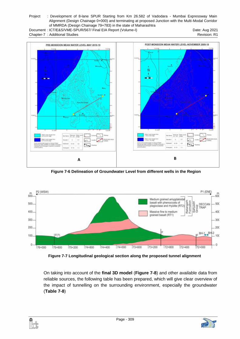
Project : Development of 8-lane SPUR Starting from Km 26.582 of Vadodara - Mumbai Expressway Main
Alignment (Design Chainage 0+000) and terminating at proposed Junction with the Multi-Modal Corridor
of MMRDA (Design Chainage 79+783) in the state of Maharashtra
Document : ICT/E&S/VME-SPUR/567/ Final EIA Report (Volume-I) Date: Aug 2021
Chapter-7 : Additional Studies Revision: R1
Page - 309
Figure 7-7 Longitudinal geological section along the proposed tunnel alignment
A
B
Figure 7-6 Delineation of Groundwater Level from different wells in the Region
On taking into account of the final 3D model (Figure 7-8) and other available data from
reliable sources, the following table has been prepared, which will give clear overview of
the impact of tunnelling on the surrounding environment, especially the groundwater
(Table 7-8)
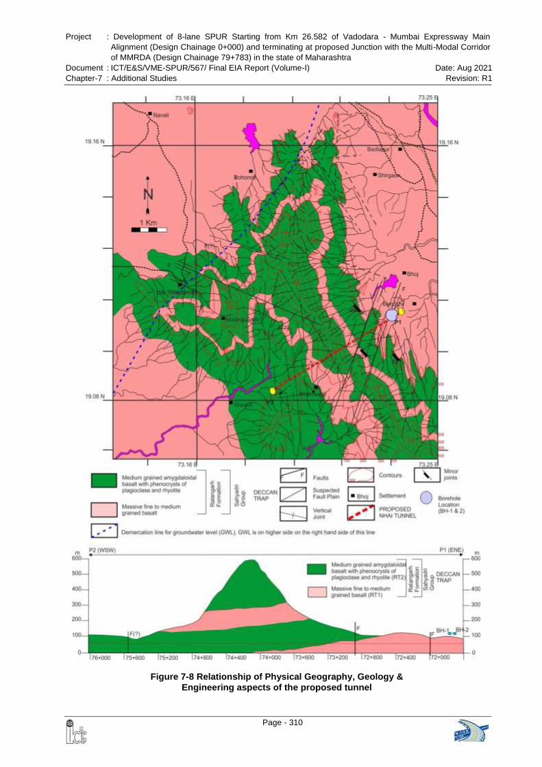
Project : Development of 8-lane SPUR Starting from Km 26.582 of Vadodara - Mumbai Expressway Main
Alignment (Design Chainage 0+000) and terminating at proposed Junction with the Multi-Modal Corridor
of MMRDA (Design Chainage 79+783) in the state of Maharashtra
Document : ICT/E&S/VME-SPUR/567/ Final EIA Report (Volume-I) Date: Aug 2021
Chapter-7 : Additional Studies Revision: R1
Page - 310
Figure 7-8 Relationship of Physical Geography, Geology &
Engineering aspects of the proposed tunnel
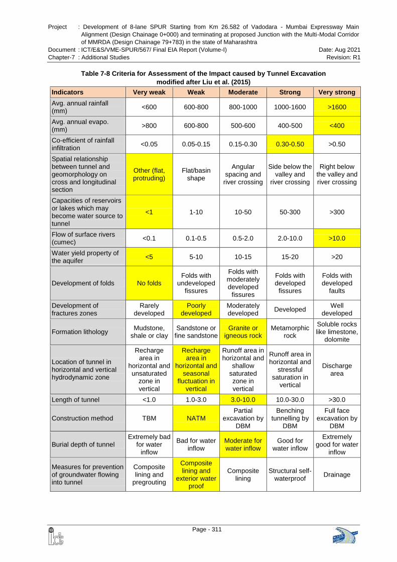
Project : Development of 8-lane SPUR Starting from Km 26.582 of Vadodara - Mumbai Expressway Main
Alignment (Design Chainage 0+000) and terminating at proposed Junction with the Multi-Modal Corridor
of MMRDA (Design Chainage 79+783) in the state of Maharashtra
Document : ICT/E&S/VME-SPUR/567/ Final EIA Report (Volume-I) Date: Aug 2021
Chapter-7 : Additional Studies Revision: R1
Page - 311
Table 7-8 Criteria for Assessment of the Impact caused by Tunnel Excavation
modified after Liu et al. (2015)
Indicators Very weak Weak Moderate Strong Very strong
Avg. annual rainfall (mm)
<600 600-800 800-1000 1000-1600 >1600
Avg. annual evapo. (mm)
>800 600-800 500-600 400-500 <400
Co-efficient of rainfall infiltration
<0.05 0.05-0.15 0.15-0.30 0.30-0.50 >0.50
Spatial relationship between tunnel and geomorphology on cross and longitudinal section
Other (flat, protruding)
Flat/basin shape
Angular spacing and river crossing
Side below the valley and
river crossing
Right below the valley and river crossing
Capacities of reservoirs or lakes which may become water source to tunnel
<1 1-10 10-50 50-300 >300
Flow of surface rivers (cumec)
<0.1 0.1-0.5 0.5-2.0 2.0-10.0 >10.0
Water yield property of the aquifer
<5 5-10 10-15 15-20 >20
Development of folds No folds Folds with
undeveloped fissures
Folds with moderately developed
fissures
Folds with developed
fissures
Folds with developed
faults
Development of fractures zones
Rarely developed
Poorly developed
Moderately developed
Developed Well
developed
Formation lithology Mudstone,
shale or clay Sandstone or fine sandstone
Granite or igneous rock
Metamorphic rock
Soluble rocks like limestone,
dolomite
Location of tunnel in horizontal and vertical hydrodynamic zone
Recharge area in
horizontal and unsaturated
zone in vertical
Recharge area in
horizontal and seasonal
fluctuation in vertical
Runoff area in horizontal and
shallow saturated zone in vertical
Runoff area in horizontal and
stressful saturation in
vertical
Discharge area
Length of tunnel <1.0 1.0-3.0 3.0-10.0 10.0-30.0 >30.0
Construction method TBM NATM Partial
excavation by DBM
Benching tunnelling by
DBM
Full face excavation by
DBM
Burial depth of tunnel Extremely bad
for water inflow
Bad for water inflow
Moderate for water inflow
Good for water inflow
Extremely good for water
inflow
Measures for prevention of groundwater flowing into tunnel
Composite lining and
pregrouting
Composite lining and
exterior water proof
Composite lining
Structural self-waterproof
Drainage
Project : Development of 8-lane SPUR Starting from Km 26.582 of Vadodara - Mumbai Expressway Main
Alignment (Design Chainage 0+000) and terminating at proposed Junction with the Multi-Modal Corridor
of MMRDA (Design Chainage 79+783) in the state of Maharashtra
Document : ICT/E&S/VME-SPUR/567/ Final EIA Report (Volume-I) Date: Aug 2021
Chapter-7 : Additional Studies Revision: R1
Page - 312
The indicators mentioned above in Table 7-8 will mostly control the behaviour of the
surrounding environment during the construction of the tunnel. Most of the indicators in
the present study are hereby predicted to have weak to very weak negative impact on
the environment, especially the groundwater, during the construction phase of the
tunnel. A few indicators, such as (i) average annual rainfall, (ii) average annual
evaporation, (iii) coefficient of rainfall infiltration and (iv) flow of surface rivers, do have
strong negative impact, but that too may be during the monsoon season only.
Any significant storage of water, which may become source to water inflow in tunnel is
lacking in and around the proposed tunnel alignment, such as lakes or reservoirs or any
aquifer, etc. This has been also corroborated by geophysical data obtained from the
same locality. The reservoirs, which are present at the villages near portals P1 and P2
of proposed tunnel, are both too far away from the exact portal locations and even they
are located much below the level of the tunnel alignment. So, any chance of negative
impact on such water bodies is negligible.
Apart from the points discussed above, the positive impact on socioeconomics and on
flora and fauna of the region will be high due to tunnelling, these are as follows:
The construction will generate huge employment opportunities to the locale, the
increase of connectivity due to the tunnel will allow the people to move easily,
quickly and safely from east to west and west to east. It will also generate
employment indirectly even after the completion of the project.
Dependency of locale on seasonal agricultural work will also be lessen
Ground vibration to be generated during the construction stage will be very meagre,
so there will be no negative impact on the wildlife.
Tunnelling is an underground work, only the portal areas of the tunnel will be on
ground surface, so only small portions of land on either side of proposed tunnel will
be prepared, which may include falling of trees, etc. Therefore, there will be less to
negligible negative impact on ecological environment.
7.3.9 Conclusions
The proposed tunnel is passing below the Navra-Navri Dongar of Matheran-Malangadh
and two portal P1 and P2 lies on hill streams near Shiravali and Bendshil. About 60% of
the tunnel alignment is passing through overburden of <200 m, whereas, about 40%
(especially the middle of the alignment) passing underneath the overburden of 200-700
m. Two types of basalt occur in the area which is grouped under – 1) massive fine to
medium grained basalt and 2) medium grained amygdaloidal basalt with phenocrysts of
plagioclase. The basalt is massive with a few inherent joints. The rock mass is
competent enough to overcome the overburden stress and tunnelling can be done
safely through this region.
Project : Development of 8-lane SPUR Starting from Km 26.582 of Vadodara - Mumbai Expressway Main
Alignment (Design Chainage 0+000) and terminating at proposed Junction with the Multi-Modal Corridor
of MMRDA (Design Chainage 79+783) in the state of Maharashtra
Document : ICT/E&S/VME-SPUR/567/ Final EIA Report (Volume-I) Date: Aug 2021
Chapter-7 : Additional Studies Revision: R1
Page - 313
Several N-S to NW-SE trending and E-W trending lineaments, in which most of them
are fracture controlled and a few are fault controlled. However, only two strike slip faults
have been identified, which are narrow and significant evidences of movement like
slickensides or variation in joint orientation has not been noticed. And the faults are
across the tunnel alignment, which is a favourable orientation relationship between
tunnelling direction and discontinuity orientation. Shear zones or any weak zones are
absent in the region, hence there will be no chance of losing self-sustainability of the
rockmass and no chance of disturbance due to competency difference.
No major nallahs or rivers are present on the corridor of the tunnel alignment, except a
few on the P1 portal of the tunnel. The two nallahs that are cross-cutting the alignment
of the tunnel on P1 portal are mostly seasonal and have basalt bed, which is lack on
any significant joint opening (secondary porosity), thus penetration of water through this
will be a rare case. Hence these seasonal nallahs do not face any problem of lack of
water during the monsoonal period. Even the ERT data depict absence of any major
fracture zone or water pocket underneath this area, except some amount of saturation.
The groundwater gets recharged due to percolation of rainwater, and recharging is
dependent upon the rainfall in the area.
Mostly 1st order nallahs are crossing across the tunnel alignment, and these nallahs are
very much seasonal, neither will they be affected by tunnelling activity nor they will affect
the tunnelling activity. A few 2nd order streams crossing the alignment, which do have
perpendicular relationship with the alignment. Proper construction of drainage over the
tunnel alignment will further control erosion and water penetration into the tunnel, if any.
As the alignment of 8-Lane SPUR is passing through the MESZ, the construction of
tunnel is more viable as this has less negative impact on the environment. Only portal
areas of the tunnel need treatment of the natural ground by slope cutting (cutting of
vegetation included) and protection, otherwise the entire 4.16 km length of the
alignment will be underground. Both flora and fauna in the region will not have any
negative impact due to the tunnelling activity. Deforestation and soil erosion may be
controlled due to tunnelling, otherwise in case of open constructional work, these two
would have been enhanced.
The area surrounding the proposed tunnel alignment is devoid on any large settlements,
except a few hamlets, and most of the people depends upon seasonal crops for their
livelihood. As there will be no negative impact of tunnelling on groundwater as
discussed earlier, the local people will not be get affected. In addition to that the locals
will get employment during the construction of tunnel and road works.
The portal areas are lying in such areas, where the soil thickness is very less, and is
underlain by good bedrock comprising basalt. Thus, any slope instability chances will be
meagre during the portal development stage of the tunnel. Even the approach road
construction for the tunnel portals do not pass through any steep slope and/or poor
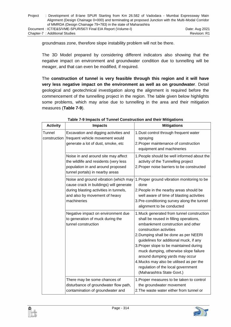
Project : Development of 8-lane SPUR Starting from Km 26.582 of Vadodara - Mumbai Expressway Main
Alignment (Design Chainage 0+000) and terminating at proposed Junction with the Multi-Modal Corridor
of MMRDA (Design Chainage 79+783) in the state of Maharashtra
Document : ICT/E&S/VME-SPUR/567/ Final EIA Report (Volume-I) Date: Aug 2021
Chapter-7 : Additional Studies Revision: R1
Page - 314
groundmass zone, therefore slope instability problem will not be there.
The 3D Model prepared by considering different indicators also showing that the
negative impact on environment and groundwater condition due to tunnelling will be
meager, and that can even be modified, if required.
The construction of tunnel is very feasible through this region and it will have
very less negative impact on the environment as well as on groundwater. Detail
geological and geotechnical investigation along the alignment is required before the
commencement of the tunnelling project in the region. The table given below highlights
some problems, which may arise due to tunnelling in the area and their mitigation
measures (Table 7-9).
Table 7-9 Impacts of Tunnel Construction and their Mitigations
Activity Impacts Mitigations
Tunnel
construction
Excavation and digging activities and
frequent vehicle movement would
generate a lot of dust, smoke, etc
1. Dust control through frequent water
spraying
2. Proper maintenance of construction
equipment and machineries
Noise in and around site may affect
the wildlife and residents (very less
population in and around proposed
tunnel portals) in nearby areas
1. People should be well informed about the
activity of the Tunnelling project
2. Proper noise barriers to be constructed
Noise and ground vibration (which may
cause crack in buildings) will generate
during blasting activities in tunnels,
and also by movement of heavy
machineries
1. Proper ground vibration monitoring to be
done
2. People in the nearby areas should be
well aware of time of blasting activities
3. Pre-conditioning survey along the tunnel
alignment to be conducted
Negative impact on environment due
to generation of muck during the
tunnel construction
1. Muck generated from tunnel construction
shall be reused in filling operations,
embankment construction and other
construction activities
2. Dumping shall be done as per NEERI
guidelines for additional muck, if any
3. Proper slope to be maintained during
muck dumping, otherwise slope failure
around dumping yards may occur
4. Mucks may also be utilised as per the
regulation of the local government
(Maharashtra State Govt.)
There may be some chances of
disturbance of groundwater flow path,
contamination of groundwater and
1. Proper measures to be taken to control
the groundwater movement
2. The waste water either from tunnel or
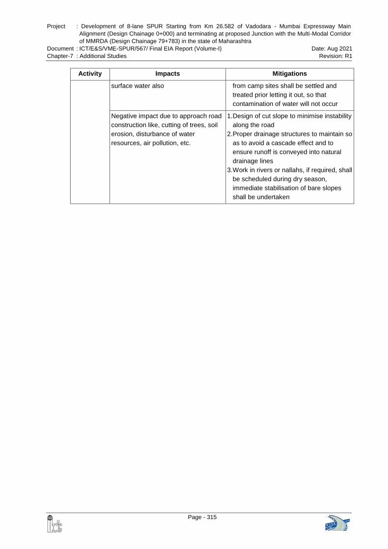
Project : Development of 8-lane SPUR Starting from Km 26.582 of Vadodara - Mumbai Expressway Main
Alignment (Design Chainage 0+000) and terminating at proposed Junction with the Multi-Modal Corridor
of MMRDA (Design Chainage 79+783) in the state of Maharashtra
Document : ICT/E&S/VME-SPUR/567/ Final EIA Report (Volume-I) Date: Aug 2021
Chapter-7 : Additional Studies Revision: R1
Page - 315
Activity Impacts Mitigations
surface water also from camp sites shall be settled and
treated prior letting it out, so that
contamination of water will not occur
Negative impact due to approach road
construction like, cutting of trees, soil
erosion, disturbance of water
resources, air pollution, etc.
1. Design of cut slope to minimise instability
along the road
2. Proper drainage structures to maintain so
as to avoid a cascade effect and to
ensure runoff is conveyed into natural
drainage lines
3. Work in rivers or nallahs, if required, shall
be scheduled during dry season,
immediate stabilisation of bare slopes
shall be undertaken
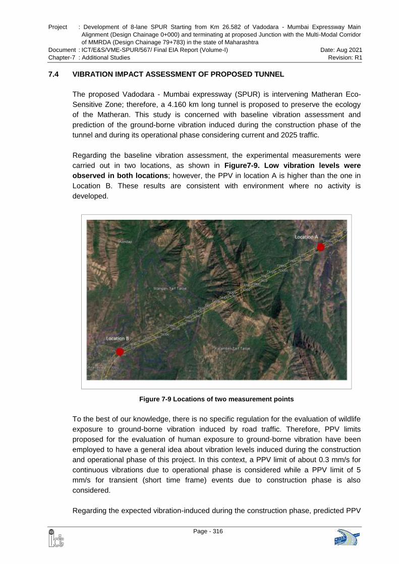
Project : Development of 8-lane SPUR Starting from Km 26.582 of Vadodara - Mumbai Expressway Main
Alignment (Design Chainage 0+000) and terminating at proposed Junction with the Multi-Modal Corridor
of MMRDA (Design Chainage 79+783) in the state of Maharashtra
Document : ICT/E&S/VME-SPUR/567/ Final EIA Report (Volume-I) Date: Aug 2021
Chapter-7 : Additional Studies Revision: R1
Page - 316
7.4 VIBRATION IMPACT ASSESSMENT OF PROPOSED TUNNEL
The proposed Vadodara - Mumbai expressway (SPUR) is intervening Matheran Eco-
Sensitive Zone; therefore, a 4.160 km long tunnel is proposed to preserve the ecology
of the Matheran. This study is concerned with baseline vibration assessment and
prediction of the ground-borne vibration induced during the construction phase of the
tunnel and during its operational phase considering current and 2025 traffic.
Regarding the baseline vibration assessment, the experimental measurements were
carried out in two locations, as shown in Figure7-9. Low vibration levels were
observed in both locations; however, the PPV in location A is higher than the one in
Location B. These results are consistent with environment where no activity is
developed.
Figure 7-9 Locations of two measurement points
To the best of our knowledge, there is no specific regulation for the evaluation of wildlife
exposure to ground-borne vibration induced by road traffic. Therefore, PPV limits
proposed for the evaluation of human exposure to ground-borne vibration have been
employed to have a general idea about vibration levels induced during the construction
and operational phase of this project. In this context, a PPV limit of about 0.3 mm/s for
continuous vibrations due to operational phase is considered while a PPV limit of 5
mm/s for transient (short time frame) events due to construction phase is also
considered.
Regarding the expected vibration-induced during the construction phase, predicted PPV
Project : Development of 8-lane SPUR Starting from Km 26.582 of Vadodara - Mumbai Expressway Main
Alignment (Design Chainage 0+000) and terminating at proposed Junction with the Multi-Modal Corridor
of MMRDA (Design Chainage 79+783) in the state of Maharashtra
Document : ICT/E&S/VME-SPUR/567/ Final EIA Report (Volume-I) Date: Aug 2021
Chapter-7 : Additional Studies Revision: R1
Page - 317
has been obtained for different types of operating machines or equipment as a function
of distance from the source. Moreover, the predicted vibration level during the
operational phase has been obtained.
In respect of vibration induced in the construction phase, considering the
aforementioned limits, it can be seen that vibration induced only by pile driving (impact)
and pile driving (sonic) works are expected to induced vibration levels on the ground
surface higher than 5 mm/s PPV. Other works are expected to induce lower vibration
levels on the ground surface.
Regarding the ground-borne vibration induced during the operational phase, there will
be an increment in vibration level on the ground surface comparing with the existing
vibration levels. However, these vibration levels expected on the ground surface during
operational phase will be lower than 0.3 mm/s set as limit, therefore vibration levels will
be low.
Moreover, an increment of vibration levels on the ground surface is expected by year
2025 when the traffic for the tunnel is increased. However, these increments are not
considerable.
Project : Development of 8-lane SPUR Starting from Km 26.582 of Vadodara - Mumbai Expressway Main
Alignment (Design Chainage 0+000) and terminating at proposed Junction with the Multi-Modal Corridor
of MMRDA (Design Chainage 79+783) in the state of Maharashtra
Document : ICT/E&S/VME-SPUR/567/ Final EIA Report (Volume-I) Date: Aug 2021
Chapter-7 : Additional Studies Revision: R1
Page - 318
7.5 SOCIAL IMPACT ASSESSMENT
The Government of India through NHAI has proposed development of 79.783 km SPUR
of Vadodara - Mumbai Expressway (VME) under National Highway Development
Program (NHDP). The proposed VME – SPUR is a Greenfield alignment, which starts at
km 26.582 of main alignment of the Vadodara Mumbai Expressway at Koshimb village
of Palghar district at Chainage 0+000 and terminate at the proposed junction with the
Multi-Modal Corridor of Mumbai Metropolitan Region Development Authority (MMRDA)
in Morbe village of Raigad district at Chainage 79+783.
The SPUR connects the main expressway to Jawaharlal Nehru Port Trust (JNPT), Maha
Samrudhi Marg (Mumbai-Nagpur Expressway) and Mumbai Pune Expressway.
Therefore, the traffic bound for JNPT, Nagpur and Pune will plies with SPUR and will not
enter the Mumbai city. This will reduce both traffic congestion and pollution in the city.
The proposed SPUR of VME will be linking Vadodara – Mumbai Expressway,
Ahmedabad - Vadodara Expressway, Mumbai – Nagpur Expressway and Mumbai -
Pune Expressway and thus will provide expressway connectivity from Delhi –
Ahmedabad – Mumbai – Nagpur - Pune.
The Social Impact Assessment (SIA) study carried out for this Project is part of EIA
prepared as per the requirement of MoEFCC with objective to evaluate the potential
impacts of proposed road on the valued ecosystem components within the project study
area. All the parameters pertaining to assessment of Social Impact should be as per
requirement of applicable laws of Government of India to accomplish socio-economic
study of project influence area considering important socio-economic and cultural
parameters. The methodology involves collection of land acquisition records from
project affected tehsils, administration of pretested questionnaire and survey of around
20% sampled affected households and conducting stakeholder consultations on various
locations and entire length of the project.
The proposed alignment for SIA study is channel through 68 villages in Six Talukas
namely; Vasai, Wada, Bhiwandi, Kalyan, Ambarnath and Panvel in the State of
Maharashtra. The project area is mainly rural including 57 villages and 11 towns. The
total population of the affected area as per census 2011 is 61,524, which include 38%
schedule tribe.
Total land requirement for construction of VME-SPUR as per the design requirement is
1,038.75 ha which include 847.6 ha of private land. The land acquisition will entail
resettlement impacts like loss of land, structure (residential and commercial) and public
properties.
The survey of 2205 sampled households revealed that a total 10,894 persons will be
affected due to land acquisition. The average size of household is found 5 and the sex
Project : Development of 8-lane SPUR Starting from Km 26.582 of Vadodara - Mumbai Expressway Main
Alignment (Design Chainage 0+000) and terminating at proposed Junction with the Multi-Modal Corridor
of MMRDA (Design Chainage 79+783) in the state of Maharashtra
Document : ICT/E&S/VME-SPUR/567/ Final EIA Report (Volume-I) Date: Aug 2021
Chapter-7 : Additional Studies Revision: R1
Page - 319
ratio is 909 female per thousand male. Most (around 22%) of the affected person are
found matric qualified and engaged in farm activities. Out of which, total sample
household 9.25% are schedule tribe (ST). Around 67% households have average
income Rs. 1-3 Lakh per annum. The health care facilities are found mostly at Tehsil
level. Around 55 people were reported dead due to Covid-19 in project influence area.
The households fully dependent on farming for their income are barely fulfil their
household expenditure. The private land being acquired for VME – SPUR is mainly
(90%) in agriculture use and around 52.06% of total affected households are
experiencing loss less than 10% of their total landholdings. A total 222 structures were
reported to be affected among sampled households, which include 66% residential
structures and 13.5% commercial structures.
A total 19 Focus Group Discussion (FGD) were organized with 203 participants. Apart
from FGD, consultations were also carried out with project officials and other
stakeholders including hoteliers, travel agents, drivers, transporters, builder and
developers. People consulted were found positive towards proposed development of
SPUR and road connectivity. However, the displeasure over loss of agriculture land and
insufficient compensation being paid were the major concerns of affected households.
The people in nearby villages have concerns regarding increase in people influx and
road accidents due to construction of SPUR.
While the land is being acquired under the project through NH Act 1956, the
compensation and assistance are being paid to the affected households as per the
provisions laid down in Right to Fair Compensation and Transparency in Land
Acquisition, Resettlement and Rehabilitation Act 2013. The SIA revealed that most of
the affected households opted for self-relocation and cash compensation for loss of their
land and structures.
The NHAI is the executing agency, an autonomous agency under Ministry of Road,
Transport and Highways and has established a PIU in Thane to implement the project.
The Competent Authority for Land Acquisition (CALA) is the main body involved in land
acquisition at tehsil level. The grievances if any are received in PIU are resolved at PD
office.
Transport sector has direct contribution to the many Sustainable Development Goals
(Goals 1, 2,3,7,9 11, 13 and 17) set globally by UN and hence development of roads
and highways are important. However, while dealing with land acquisition under a
Greenfield alignment more efforts can be taken to mitigate the negative impacts as
much as possible on people losing their land, structures and livelihood. A holistic,
integrated and informative approach can be adopted with improvements of water ponds,
water facilities, sanitation facilities, traveller shed and other social development facilities
and hence, the project road is to be designed considering engineering aspects in
general and social engineering aspects in particular.
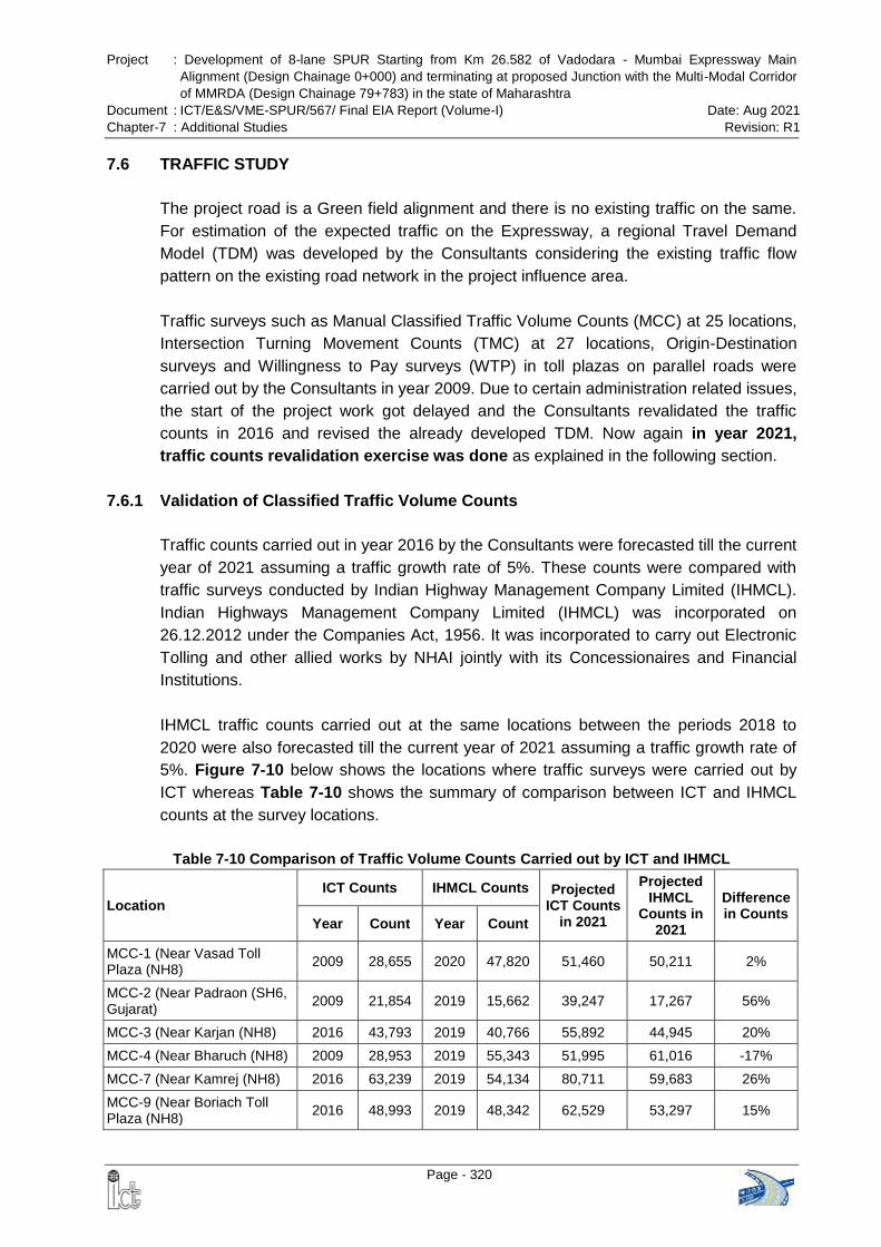
Project : Development of 8-lane SPUR Starting from Km 26.582 of Vadodara - Mumbai Expressway Main
Alignment (Design Chainage 0+000) and terminating at proposed Junction with the Multi-Modal Corridor
of MMRDA (Design Chainage 79+783) in the state of Maharashtra
Document : ICT/E&S/VME-SPUR/567/ Final EIA Report (Volume-I) Date: Aug 2021
Chapter-7 : Additional Studies Revision: R1
Page - 320
7.6 TRAFFIC STUDY
The project road is a Green field alignment and there is no existing traffic on the same.
For estimation of the expected traffic on the Expressway, a regional Travel Demand
Model (TDM) was developed by the Consultants considering the existing traffic flow
pattern on the existing road network in the project influence area.
Traffic surveys such as Manual Classified Traffic Volume Counts (MCC) at 25 locations,
Intersection Turning Movement Counts (TMC) at 27 locations, Origin-Destination
surveys and Willingness to Pay surveys (WTP) in toll plazas on parallel roads were
carried out by the Consultants in year 2009. Due to certain administration related issues,
the start of the project work got delayed and the Consultants revalidated the traffic
counts in 2016 and revised the already developed TDM. Now again in year 2021,
traffic counts revalidation exercise was done as explained in the following section.
7.6.1 Validation of Classified Traffic Volume Counts
Traffic counts carried out in year 2016 by the Consultants were forecasted till the current
year of 2021 assuming a traffic growth rate of 5%. These counts were compared with
traffic surveys conducted by Indian Highway Management Company Limited (IHMCL).
Indian Highways Management Company Limited (IHMCL) was incorporated on
26.12.2012 under the Companies Act, 1956. It was incorporated to carry out Electronic
Tolling and other allied works by NHAI jointly with its Concessionaires and Financial
Institutions.
IHMCL traffic counts carried out at the same locations between the periods 2018 to
2020 were also forecasted till the current year of 2021 assuming a traffic growth rate of
5%. Figure 7-10 below shows the locations where traffic surveys were carried out by
ICT whereas Table 7-10 shows the summary of comparison between ICT and IHMCL
counts at the survey locations.
Table 7-10 Comparison of Traffic Volume Counts Carried out by ICT and IHMCL
Location
ICT Counts IHMCL Counts Projected ICT Counts
in 2021
Projected IHMCL
Counts in 2021
Difference in Counts
Year Count Year Count
MCC-1 (Near Vasad Toll Plaza (NH8)
2009 28,655 2020 47,820 51,460 50,211 2%
MCC-2 (Near Padraon (SH6, Gujarat)
2009 21,854 2019 15,662 39,247 17,267 56%
MCC-3 (Near Karjan (NH8) 2016 43,793 2019 40,766 55,892 44,945 20%
MCC-4 (Near Bharuch (NH8) 2009 28,953 2019 55,343 51,995 61,016 -17%
MCC-7 (Near Kamrej (NH8) 2016 63,239 2019 54,134 80,711 59,683 26%
MCC-9 (Near Boriach Toll Plaza (NH8)
2016 48,993 2019 48,342 62,529 53,297 15%
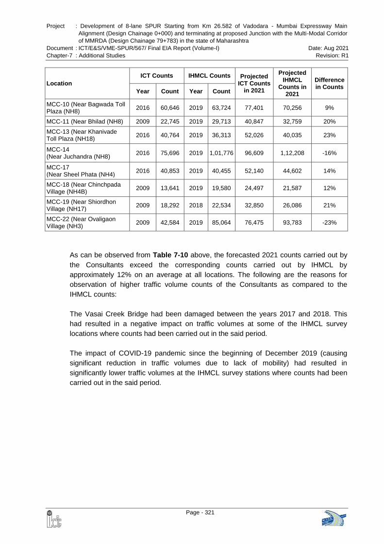
Project : Development of 8-lane SPUR Starting from Km 26.582 of Vadodara - Mumbai Expressway Main
Alignment (Design Chainage 0+000) and terminating at proposed Junction with the Multi-Modal Corridor
of MMRDA (Design Chainage 79+783) in the state of Maharashtra
Document : ICT/E&S/VME-SPUR/567/ Final EIA Report (Volume-I) Date: Aug 2021
Chapter-7 : Additional Studies Revision: R1
Page - 321
Location
ICT Counts IHMCL Counts Projected ICT Counts
in 2021
Projected IHMCL
Counts in 2021
Difference in Counts
Year Count Year Count
MCC-10 (Near Bagwada Toll Plaza (NH8)
2016 60,646 2019 63,724 77,401 70,256 9%
MCC-11 (Near Bhilad (NH8) 2009 22,745 2019 29,713 40,847 32,759 20%
MCC-13 (Near Khanivade Toll Plaza (NH18)
2016 40,764 2019 36,313 52,026 40,035 23%
MCC-14 (Near Juchandra (NH8)
2016 75,696 2019 1,01,776 96,609 1,12,208 -16%
MCC-17 (Near Sheel Phata (NH4)
2016 40,853 2019 40,455 52,140 44,602 14%
MCC-18 (Near Chinchpada Village (NH4B)
2009 13,641 2019 19,580 24,497 21,587 12%
MCC-19 (Near Shiordhon Village (NH17)
2009 18,292 2018 22,534 32,850 26,086 21%
MCC-22 (Near Ovaligaon Village (NH3)
2009 42,584 2019 85,064 76,475 93,783 -23%
As can be observed from Table 7-10 above, the forecasted 2021 counts carried out by
the Consultants exceed the corresponding counts carried out by IHMCL by
approximately 12% on an average at all locations. The following are the reasons for
observation of higher traffic volume counts of the Consultants as compared to the
IHMCL counts:
The Vasai Creek Bridge had been damaged between the years 2017 and 2018. This
had resulted in a negative impact on traffic volumes at some of the IHMCL survey
locations where counts had been carried out in the said period.
The impact of COVID-19 pandemic since the beginning of December 2019 (causing
significant reduction in traffic volumes due to lack of mobility) had resulted in
significantly lower traffic volumes at the IHMCL survey stations where counts had been
carried out in the said period.
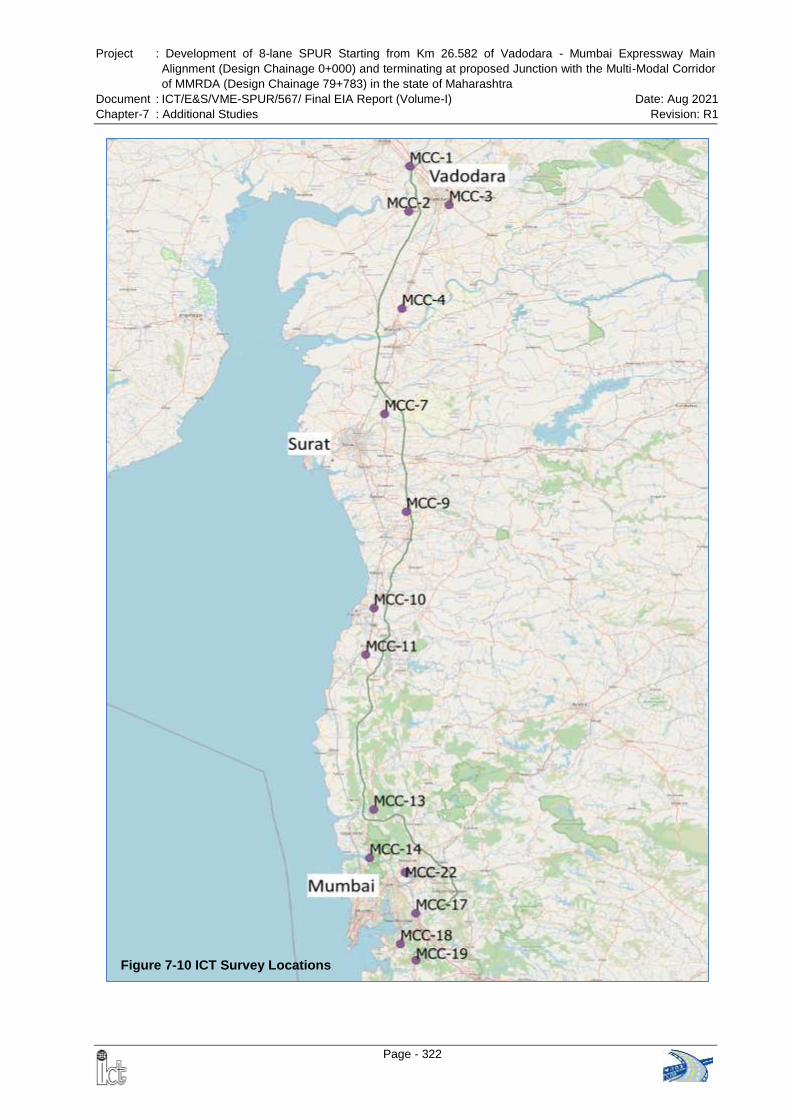
Project : Development of 8-lane SPUR Starting from Km 26.582 of Vadodara - Mumbai Expressway Main
Alignment (Design Chainage 0+000) and terminating at proposed Junction with the Multi-Modal Corridor
of MMRDA (Design Chainage 79+783) in the state of Maharashtra
Document : ICT/E&S/VME-SPUR/567/ Final EIA Report (Volume-I) Date: Aug 2021
Chapter-7 : Additional Studies Revision: R1
Page - 322
Figure 7-10 ICT Survey Locations
Project : Development of 8-lane SPUR Starting from Km 26.582 of Vadodara - Mumbai Expressway Main
Alignment (Design Chainage 0+000) and terminating at proposed Junction with the Multi-Modal Corridor
of MMRDA (Design Chainage 79+783) in the state of Maharashtra
Document : ICT/E&S/VME-SPUR/567/ Final EIA Report (Volume-I) Date: Aug 2021
Chapter-7 : Additional Studies Revision: R1
Page - 323
7.6.2 Regional Connectivity
While planning of the route options for Mumbai-Vadodara Expressway in year 2009-10,
existing transport corridor (including road, railway, Air and Ports) and proposed corridors
in project influence areas were studied thoroughly and travel demand modelling
exercise was done. To provide smooth connection with other regional transport corridors
consultant has provided 20 Interchanges, 25 Flyovers, 9 Railway Over Bridges, 66
Vehicular Underpasses, 21 Vehicular Overpasses, 4 Animal Overpasses, 153
LVUPs/PUPs and 267 Small Vehicular / Animal Underpasses.
Enclosures: A detailed traffic study report and IHMCL data collected for validation of
traffic count is submitted as standalone Report.
Project : Development of 8-lane SPUR Starting from Km 26.582 of Vadodara - Mumbai Expressway Main
Alignment (Design Chainage 0+000) and terminating at proposed Junction with the Multi-Modal Corridor
of MMRDA (Design Chainage 79+783) in the state of Maharashtra
Document : ICT/E&S/VME-SPUR/567/ Final EIA Report (Volume-I) Date: Aug 2021
Chapter-7 : Additional Studies Revision: R1
Page - 324
7.7 PUBLIC HEARING
7.7.1 Process of Public Hearing
Public hearing is an integral part of project requiring prior Environment Clearance. The
proposed VME-SPUR alignment is passing through 3 districts namely Palghar, Thane
and Raigad districts in the State of Maharashtra. As per requirement of the EIA
Notification 2006 and it’s subsequent amendment thereafter, Public Hearing has been
conducted in all three districts.
Application for conducting Public Hearing was submitted to the Member Secretary,
Maharashtra Pollution Control Board on 19.01.2021 along with a copy to the concerned
Sub Regional Officer (S.R.O) of MPCB. The Member Secretary, MPCB vide letter dated
29.01.2021 directed all concerned S.R.Os to conduct the Public Hearing for the project.
The date of Public Hearing has been finalized in consultation with the respective District
Collector of Raigad district, Thane district and Palghar district and accordingly, the
MPCB published a public notice in the newspaper.
Copy of Draft EIA report and Executive Summery in English and Marathi were made
available at various government offices i.e. Environment Department, Govt. of
Maharashtra; District Collector Office of Palghar, Thane and Raigad districts; all
concerned Sub Divisional Offices and Sub Regional Office of MPCB; Head Office of
MPCB at Sion, Mumbai; Zilla Parishad and Gram Panchayat offices in the vicinity of the
project area.
7.7.2 Public Hearing in Raigad District
Date of Newspaper Advertisement 13th February 2021
Date & Time of Public Hearing 15th March 2021 at 12.00 noon
Venue of Public Hearing Gram Panchayat Office
Village: Morbe, Taluka: Panvel, District: Raigad
Panel Members for conducting public hearing
1. Dr. Padamsgri Bainade, Addl. District Magistrate, Raigad- Chairperson
2. Shri D. B. Patil, Regional Officer, Raigad, MPCB - Member
3. Shri Sachin Adkar, Sub Regional Officer, Raigad-I, MPCB – Convener
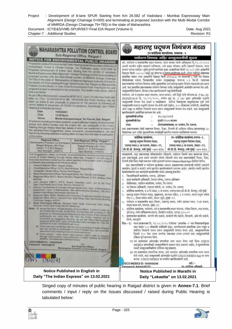
Project : Development of 8-lane SPUR Starting from Km 26.582 of Vadodara - Mumbai Expressway Main
Alignment (Design Chainage 0+000) and terminating at proposed Junction with the Multi-Modal Corridor
of MMRDA (Design Chainage 79+783) in the state of Maharashtra
Document : ICT/E&S/VME-SPUR/567/ Final EIA Report (Volume-I) Date: Aug 2021
Chapter-7 : Additional Studies Revision: R1
Page - 325
Notice Published in English in
Daily “The Indian Express” on 13.02.2021
Notice Published in Marathi in
Daily “Lokastta” on 13.02.2021
Singed copy of minutes of public hearing in Raigad district is given in Annex-7.1. Brief
comments / input / reply on the Issues discussed / raised during Public Hearing is
tabulated below:
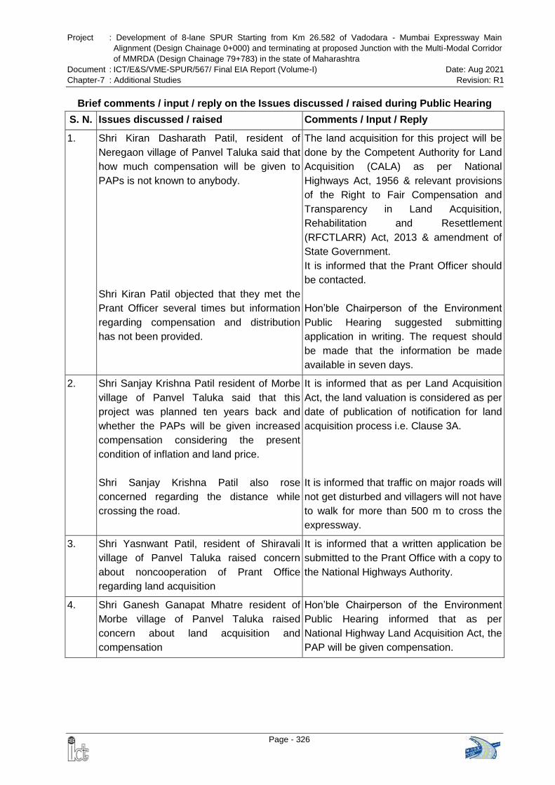
Project : Development of 8-lane SPUR Starting from Km 26.582 of Vadodara - Mumbai Expressway Main
Alignment (Design Chainage 0+000) and terminating at proposed Junction with the Multi-Modal Corridor
of MMRDA (Design Chainage 79+783) in the state of Maharashtra
Document : ICT/E&S/VME-SPUR/567/ Final EIA Report (Volume-I) Date: Aug 2021
Chapter-7 : Additional Studies Revision: R1
Page - 326
Brief comments / input / reply on the Issues discussed / raised during Public Hearing
S. N. Issues discussed / raised Comments / Input / Reply
1. Shri Kiran Dasharath Patil, resident of
Neregaon village of Panvel Taluka said that
how much compensation will be given to
PAPs is not known to anybody.
Shri Kiran Patil objected that they met the
Prant Officer several times but information
regarding compensation and distribution
has not been provided.
The land acquisition for this project will be
done by the Competent Authority for Land
Acquisition (CALA) as per National
Highways Act, 1956 & relevant provisions
of the Right to Fair Compensation and
Transparency in Land Acquisition,
Rehabilitation and Resettlement
(RFCTLARR) Act, 2013 & amendment of
State Government.
It is informed that the Prant Officer should
be contacted.
Hon’ble Chairperson of the Environment
Public Hearing suggested submitting
application in writing. The request should
be made that the information be made
available in seven days.
2. Shri Sanjay Krishna Patil resident of Morbe
village of Panvel Taluka said that this
project was planned ten years back and
whether the PAPs will be given increased
compensation considering the present
condition of inflation and land price.
Shri Sanjay Krishna Patil also rose
concerned regarding the distance while
crossing the road.
It is informed that as per Land Acquisition
Act, the land valuation is considered as per
date of publication of notification for land
acquisition process i.e. Clause 3A.
It is informed that traffic on major roads will
not get disturbed and villagers will not have
to walk for more than 500 m to cross the
expressway.
3. Shri Yasnwant Patil, resident of Shiravali
village of Panvel Taluka raised concern
about noncooperation of Prant Office
regarding land acquisition
It is informed that a written application be
submitted to the Prant Office with a copy to
the National Highways Authority.
4. Shri Ganesh Ganapat Mhatre resident of
Morbe village of Panvel Taluka raised
concern about land acquisition and
compensation
Hon’ble Chairperson of the Environment
Public Hearing informed that as per
National Highway Land Acquisition Act, the
PAP will be given compensation.
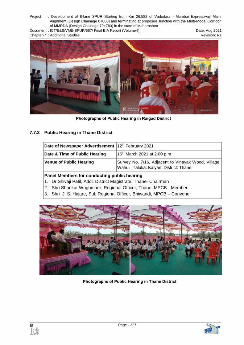
Project : Development of 8-lane SPUR Starting from Km 26.582 of Vadodara - Mumbai Expressway Main
Alignment (Design Chainage 0+000) and terminating at proposed Junction with the Multi-Modal Corridor
of MMRDA (Design Chainage 79+783) in the state of Maharashtra
Document : ICT/E&S/VME-SPUR/567/ Final EIA Report (Volume-I) Date: Aug 2021
Chapter-7 : Additional Studies Revision: R1
Page - 327
Photographs of Public Hearing in Thane District
7.7.3 Public Hearing in Thane District
Date of Newspaper Advertisement 12th February 2021
Date & Time of Public Hearing 16th March 2021 at 2.00 p.m.
Venue of Public Hearing Survey No. 7/16, Adjacent to Vinayak Wood, Village:
Wahuli, Taluka: Kalyan, District: Thane
Panel Members for conducting public hearing
1. Dr.Shivaji Patil, Addl. District Magistrate, Thane- Chairman
2. Shri Shankar Waghmare, Regional Officer, Thane, MPCB - Member
3. Shri J. S. Hajare, Sub Regional Officer, Bhiwandi, MPCB – Convener
Photographs of Public Hearing in Raigad District
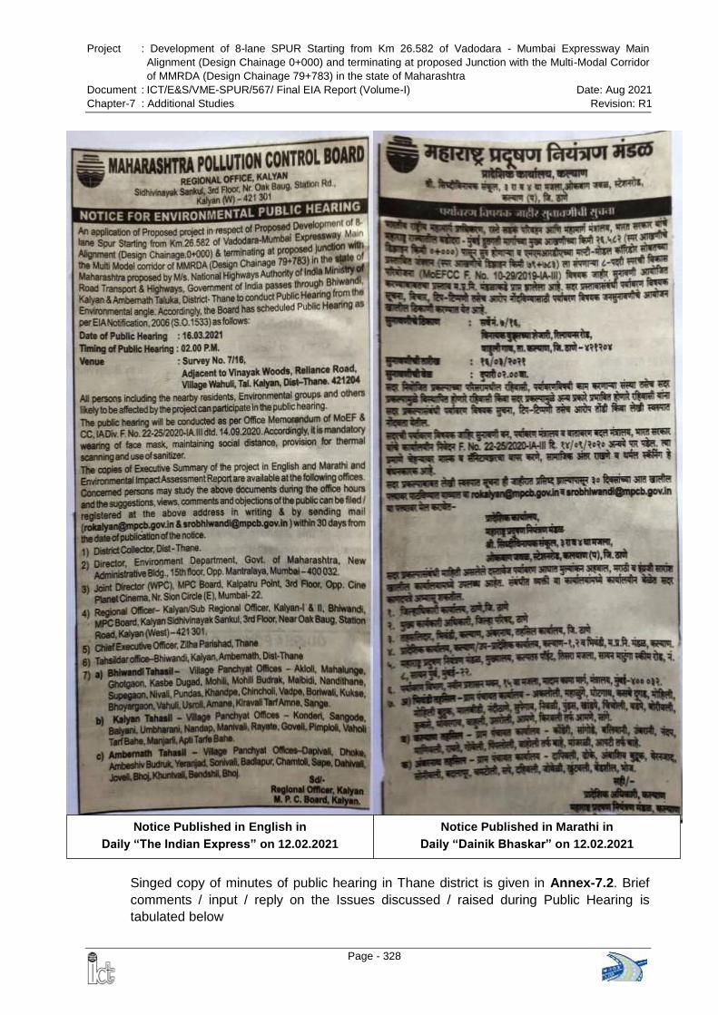
Project : Development of 8-lane SPUR Starting from Km 26.582 of Vadodara - Mumbai Expressway Main
Alignment (Design Chainage 0+000) and terminating at proposed Junction with the Multi-Modal Corridor
of MMRDA (Design Chainage 79+783) in the state of Maharashtra
Document : ICT/E&S/VME-SPUR/567/ Final EIA Report (Volume-I) Date: Aug 2021
Chapter-7 : Additional Studies Revision: R1
Page - 328
Notice Published in English in
Daily “The Indian Express” on 12.02.2021
Notice Published in Marathi in
Daily “Dainik Bhaskar” on 12.02.2021
Singed copy of minutes of public hearing in Thane district is given in Annex-7.2. Brief
comments / input / reply on the Issues discussed / raised during Public Hearing is
tabulated below
Project : Development of 8-lane SPUR Starting from Km 26.582 of Vadodara - Mumbai Expressway Main
Alignment (Design Chainage 0+000) and terminating at proposed Junction with the Multi-Modal Corridor
of MMRDA (Design Chainage 79+783) in the state of Maharashtra
Document : ICT/E&S/VME-SPUR/567/ Final EIA Report (Volume-I) Date: Aug 2021
Chapter-7 : Additional Studies Revision: R1
Page - 329
Brief comments / input / reply on the Issues discussed / raised during Public Hearing
S. N. Issues discussed / raised Comments / Input / Reply
1. Shri Naresh Sureshi resident of Rayte
village expressed concern about land
acquisition and flooding in their village after
construction of the expressway
The project proponent explained that
acquisition of nearby land and its
compensation is not yet proposed and
construction of the expressway will not
have any significant impact on the
hydrology of the area.
To minimize the impact drainage &
hydrological flow, 13 major bridges, 21
minor bridges, 230 culverts are proposed
to be constructed along the expressway
It has been ensured that all the 1st and
2nd order streams crossing the
proposed expressway alignment
provided with necessary culverts, mirror
bridges and major bridges with capacity
of 20% excess discharge
All bridges have been designed for a
return period of 100 years and culverts
have been designed for a return period
of 50 years
2. Shri Avish Juwari- Advocate & Sarpanch of
Wahuli appreciated for arranging Public
Hearing for this project and raised concern
about land acquisition
Hon’ble Chairman of the Environment
Public Hearing convinced that, this public
hearing is regarding environmental issues
only and not regarding compensation of
land acquisition.
3. Shri Avish Juwari said that to whom we
shall give our complaint regarding
environment related issues
Hon’ble Chairman of the Environment
Public Hearing explained that he can give
his suggestion on environmental issues to
the MPCB officials who are present in the
meeting
4. Shri. Naresh Sureshe, resident of Rayta
village asked about noise level survey of the
area during day & night hours
It is explained that noise level monitoring
was conducted at six location. Maximum
noise level during day time observed 54.3
dB(A) and during night 43.9 dB(A) is within
permissible limit. He further explained that,
during construction and operation stage,
noise monitoring will be carried out and
noise barriers will provided to maintain
noise level.
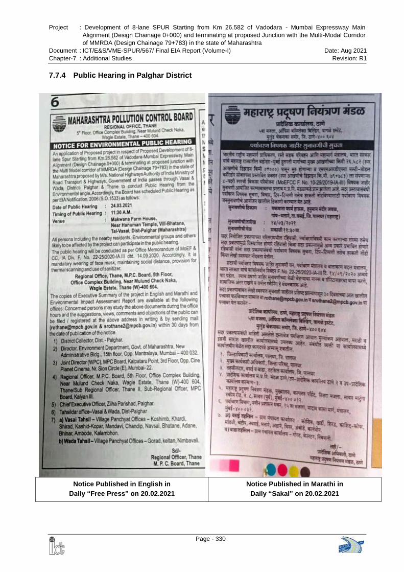
Project : Development of 8-lane SPUR Starting from Km 26.582 of Vadodara - Mumbai Expressway Main
Alignment (Design Chainage 0+000) and terminating at proposed Junction with the Multi-Modal Corridor
of MMRDA (Design Chainage 79+783) in the state of Maharashtra
Document : ICT/E&S/VME-SPUR/567/ Final EIA Report (Volume-I) Date: Aug 2021
Chapter-7 : Additional Studies Revision: R1
Page - 330
Notice Published in English in
Daily “Free Press” on 20.02.2021
Notice Published in Marathi in
Daily “Sakal” on 20.02.2021
7.7.4 Public Hearing in Palghar District
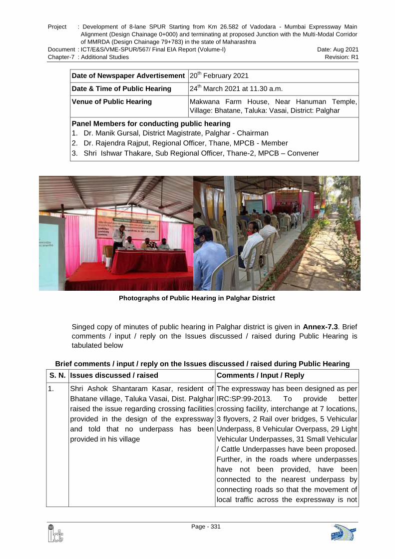
Project : Development of 8-lane SPUR Starting from Km 26.582 of Vadodara - Mumbai Expressway Main
Alignment (Design Chainage 0+000) and terminating at proposed Junction with the Multi-Modal Corridor
of MMRDA (Design Chainage 79+783) in the state of Maharashtra
Document : ICT/E&S/VME-SPUR/567/ Final EIA Report (Volume-I) Date: Aug 2021
Chapter-7 : Additional Studies Revision: R1
Page - 331
Date of Newspaper Advertisement 20th February 2021
Date & Time of Public Hearing 24th March 2021 at 11.30 a.m.
Venue of Public Hearing Makwana Farm House, Near Hanuman Temple,
Village: Bhatane, Taluka: Vasai, District: Palghar
Panel Members for conducting public hearing
1. Dr. Manik Gursal, District Magistrate, Palghar - Chairman
2. Dr. Rajendra Rajput, Regional Officer, Thane, MPCB - Member
3. Shri Ishwar Thakare, Sub Regional Officer, Thane-2, MPCB – Convener
Singed copy of minutes of public hearing in Palghar district is given in Annex-7.3. Brief
comments / input / reply on the Issues discussed / raised during Public Hearing is
tabulated below
Brief comments / input / reply on the Issues discussed / raised during Public Hearing
S. N. Issues discussed / raised Comments / Input / Reply
1. Shri Ashok Shantaram Kasar, resident of
Bhatane village, Taluka Vasai, Dist. Palghar
raised the issue regarding crossing facilities
provided in the design of the expressway
and told that no underpass has been
provided in his village
The expressway has been designed as per
IRC:SP:99-2013. To provide better
crossing facility, interchange at 7 locations,
3 flyovers, 2 Rail over bridges, 5 Vehicular
Underpass, 8 Vehicular Overpass, 29 Light
Vehicular Underpasses, 31 Small Vehicular
/ Cattle Underpasses have been proposed.
Further, in the roads where underpasses
have not been provided, have been
connected to the nearest underpass by
connecting roads so that the movement of
local traffic across the expressway is not
Photographs of Public Hearing in Palghar District
Project : Development of 8-lane SPUR Starting from Km 26.582 of Vadodara - Mumbai Expressway Main
Alignment (Design Chainage 0+000) and terminating at proposed Junction with the Multi-Modal Corridor
of MMRDA (Design Chainage 79+783) in the state of Maharashtra
Document : ICT/E&S/VME-SPUR/567/ Final EIA Report (Volume-I) Date: Aug 2021
Chapter-7 : Additional Studies Revision: R1
Page - 332
S. N. Issues discussed / raised Comments / Input / Reply
hindered. Length of left connecting road is
2.389 km and length of right connecting
road is 5.170 km
2. Shri Krishna Bhoir, resident of Wada village,
Taluka Wada, Dist. Palghar said that the
height of the road is 3-5 meters and
proposed road is close to the hill. Due to
which, agriculture fields will be submerged
and barren. The human settlements will
sink.
The second question was much of the
proposed road will pass through the forest
area. This will destroy a lot of forest
resources.
The third question was that there are “Hot-
Water Ponds.” If the construction of project
is carried there and if earth quake occurs
due to it, the Government Administration
needs to make alternative arrangements
and study, so that local farmers do not have
to suffer.
To minimize the impact flood &
hydrological flow, 13 major bridges, 21
minor bridges, 230 culverts are proposed
to be constructed along the expressway. It
has been ensured that all streams crossing
the proposed expressway alignment
provided with necessary culverts, mirror
bridges and major bridges with excess
discharge capacity.
This issue totally falls under jurisdiction of
Forest Department and separate
permission will be obtained from the Forest
Department. Whatever the Forest
Department claims, the compensation will
be paid by the project proponent, so as to
minimize damage to forest lands and the
environment. Tree shall be planted under
greenbelt development plan.
There are no Hot-Water Ponds within the
proposed right of way of the expressway
and it’s close vicinity. Hence there will be
no impact on Hot-Water Ponds.
3. Shri Shantaram Jadhav resident of Bhatane
village, Taluka -Vasai, Dist. Palghar raised
concern about crossing facilities
The expressway has been designed as per
IRC:SP:99-2013 and the villagers will not
have to go more than 500 meters for
crossing the expressway.
4. Mrs. Sugandha Sachin Jadhav, Ex
Sabhapati, Vasai Panchayat Samiti, Dist.
Palghar said that the farmers living in the
area from Navsai to Adane mostly have
their agriculture fields to the south side.
Hence, footpaths and underpass require for
the farmers
Chairman of the Environment Public
Hearing Committee here informed that
above points have been already discussed
previously and it is noted also.
Project : Development of 8-lane SPUR Starting from Km 26.582 of Vadodara - Mumbai Expressway Main
Alignment (Design Chainage 0+000) and terminating at proposed Junction with the Multi-Modal Corridor
of MMRDA (Design Chainage 79+783) in the state of Maharashtra
Document : ICT/E&S/VME-SPUR/567/ Final EIA Report (Volume-I) Date: Aug 2021
Chapter-7 : Additional Studies Revision: R1
Page - 333
S. N. Issues discussed / raised Comments / Input / Reply
5. Shri Sujay More, resident of Palghar said
that a) lot of wild animals stay here. They
migrate seasonally. Many wild animals
migrate from Tanasa to Kalsubai
seasonally. What effect will this project
have on them and b) There are many small
and big forts from Hajimalang to Matheran.
Will the archeological monuments affect due
to this project
To minimize the impact on wildlife and their
movement, Wildlife Conservation Plan has
been prepared for the project and has been
approved by the Chief Wildlife Warden,
Government of Maharashtra.
There are no archaeological sites within
300m of the proposed expressway
alignment
6. Shri Krishna Bhoir, resident of Wada village,
Taluka Wada, Dist. Palghar said that there
are 49 households which will be affected
due to this project at Nimboli village of
Wada Taluka. We are sending our
representations since 2018 and several
times correspondence is made. But there is
no response
Chairman of the Environment Public
Hearing Committee promised to look into
the matter and to inform concerned
officials.
Project : Development of 8-lane SPUR Starting from Km 26.582 of Vadodara - Mumbai Expressway Main
Alignment (Design Chainage 0+000) and terminating at proposed Junction with the Multi-Modal Corridor
of MMRDA (Design Chainage 79+783) in the state of Maharashtra
Document : ICT/E&S/VME-SPUR/567/ Final EIA Report (Volume-I) Date: Aug 2021
Chapter-8 : Project Benefit Revision: R1
Page - 334
CHAPTER-8: PROJECT BENEFIT
8.1 GENERAL
During the draft Feasibility Study of the Mumbai – Vadodara Expressway, it was felt that
the starting point of proposed MV Expressway on NH-8 at Mumbai end would pose a
serious problem for safe and quick dispersal of traffic from the Expressway and also
would not serve the purpose of connecting to major traffic generators like JNPT Port and
to Mumbai-Pune expressway. Currently, the traffic bound for Gujarat and further north
from JNPT, NH-4 and Mumbai – Pune Expressway follows Thane-Ghodbandar Road
which is already congested. This traffic has to pass through congested road network of
Mumbai Metropolis from southward destination and the goods earmarked for export and
import also find difficulty in commuting to and from JNPT, Navi Mumbai. Therefore it
would be prudent to connect the proposed MV Expressway to major traffic generators
like JNPT and Mumbai – Pune Expressway. The spur will not only connect to these
major traffic generators but will also result in better dispersal of traffic in the Mumbai
Metropolitan Region. Therefore, the Consultants proposed that the VM Expressway
should be connected to JNPT and Mumbai-Pune expressway via NH-3, NH-222, NH4B
and NH-17 for proper traffic dispersal.
The project highway will provide smooth, safe and uninterrupted traffic movement
between Vadodara to Mumbai in respect to the alternative road NH 48. The NH 48 (Old
NH8) is currently carrying more than 100000 PCUs with much substandard geometry
and is heavily congested. It will reduce the travel time about 3 to4 hours between
Vadodara to Mumbai. The proposed expressway falls in the Delhi-Mumbai Industrial
Corridor. It will connect to the largest container port, JNPT near Mumbai with northern
part and Dahej port, other ports in Gujarat. Surat is at the heart of the world's diamond-
polishing industry contributing billions of dollars to the Indian GDP. Vapi, Daman and
Silvassa are the major industrial hub will be connected. Development of this section will
reduce the existing distance between Vadodara-Mumbai by about 22 km and ultimately
there will be reduction in distance between Delhi-Mumbai.
The spur connects the main expressway to JNPT, Maha Samrudhi Marg (Mumbai-
Nagpur Expressway) and Mumbai Pune Expressway. Therefore the traffic bound for
JNPT, Nagpur and Pune will ply on SPUR and will not enter the Mumbai city. This will
reduce both traffic congestion and pollution in the city. The Vadodara Mumbai
Expressway with Spur is linking already existing Ahmedabad- Vadodara Expressway,
Delhi-Vadodara Expressway, Mumbai –Nagpur Expressway and Mumbai Pune
expressway and thus will provide expressway connectivity between Delhi-Mumbai-
Nagpur-Pune.
This will further improve connectivity in terms of achieving smooth and safe traffic flow
and improve level of service. In addition to above, substantial economic gain, this would
eventually lead to reduction in the travel time and savings in terms of time, fuel and
Project : Development of 8-lane SPUR Starting from Km 26.582 of Vadodara - Mumbai Expressway Main
Alignment (Design Chainage 0+000) and terminating at proposed Junction with the Multi-Modal Corridor
of MMRDA (Design Chainage 79+783) in the state of Maharashtra
Document : ICT/E&S/VME-SPUR/567/ Final EIA Report (Volume-I) Date: Aug 2021
Chapter-8 : Project Benefit Revision: R1
Page - 335
maintenance cost of vehicles. Further this stretch will be a part of Delhi- Mumbai
expressway corridor.
8.2 DIRECT BENEFITS
The proposed VME-SPUR will have following direct benefits.
8.2.1 Fast Connectivity
The spur connects the main expressway to JNPT, Maha Samrudhi Marg (Mumbai-
Nagpur Expressway) and Mumbai Pune Expressway. Therefore the traffic bound for
JNPT, Nagpur and Pune will ply on SPUR and will not enter the Mumbai city. This
will reduce both traffic congestion and pollution in the city. The Vadodara Mumbai
Expressway with Spur is linking already existing Ahmedabad- Vadodara
Expressway, Delhi-Vadodara Expressway, Mumbai –Nagpur Expressway and
Mumbai Pune expressway and thus will provide expressway connectivity between
Delhi-Mumbai-Nagpur-Pune.
The expressway along with SPUR will provide connectivity to Dahej Port and
Jawahar Lal Nehru Port (JNPT) thus facilitating imports and exports from these two
ports.
The expressway alignment is passing through the proposed Delhi – Mumbai
Industrial Corridor (DMIC) and hence will facilitate the Investments in the Mega
Project.
The Expressway will be linking big industrial cities like Vadodara, Surat, Bharuch,
Ankleshwar, Mumbai thus will immensely benefit the economy of these cities.
The expressway has been designed to best of International Standards and will thus
facilitate safe travel at high speeds with State of the art Automated Traffic
Management system, Access Control, World class way- side amenities such as
truck parking / servicing areas, fuel stations etc.
8.2.2 Reductions in Vehicle Operating Cost & Travel Time
The proposed expressway and the existing NH8 shall be competing facilities. With the
expressway facility of eight lane configuration, it is expected that there will not be high
savings in the operating costs. However since the expressway will offer higher speeds
there will be considerable time related savings. Therefore as is expected under the
project scenario the proposed expressway is economically viable with time savings only.
8.2.3 Benefit to Local Trade and Economy
Palghar is a vibrant industrial destination and has 5757 small registered Industries, 1883
temporary small registered industries and 427 large / medium industries. It houses the
largest MIDC (Maharashtra Industrial Development Corporation) in the state. The MIDC
at Tarapur is home to over 1300 operating industrial units, including renowned global
Project : Development of 8-lane SPUR Starting from Km 26.582 of Vadodara - Mumbai Expressway Main
Alignment (Design Chainage 0+000) and terminating at proposed Junction with the Multi-Modal Corridor
of MMRDA (Design Chainage 79+783) in the state of Maharashtra
Document : ICT/E&S/VME-SPUR/567/ Final EIA Report (Volume-I) Date: Aug 2021
Chapter-8 : Project Benefit Revision: R1
Page - 336
corporations like TATA Steel, JSW Steel and Raymond. Palghar is a self-sustaining
employment hub, with a working population exceeding 1.5 lakh persons. Palghar has
India's first atomic power plant located at Tarapur. Additionally, a new shipping terminal
is planned in Dahanu. Maharashtra's biggest fishing center, Satpati, is located around 8
km from Palghar railway station
This region sources their raw materials as well as transports their finished goods to
various parts of the country. The expressway will provide efficient access to various
markets by ensuring smooth flow of goods and services. The expressway will support
the local businesses and economy along the project corridor. It will also facilitate small-
scale industries by streamlining transport of raw and finished material.
8.2 INDIRECT BENEFITS
8.2.1 Employment Opportunity
The proposed expressway is expected to generate employment during construction
phase. It is estimated that ~500 direct employees will be required per day during
construction phase. Further due to ecosystem which will be created during construction
phase, the expressway will also create considerable indirect employment opportunities
in form of transportation of construction materials, greenbelt development, ancillary
facilities like canteens, dhabas etc.
During operations phase, the expressway will largely have indirect employment benefits
in form of highway amenities and through economic & social hubs developed around the
expressway. Efficient reach and connectivity to distant markets will further enhance
economy of the district and create employment opportunities.
8.2.2 Development of Agriculture
The construction of the expressway will help the farmers in getting good prices of their
produce by way of quick and fast transportation of perishable goods to the market
places. The expressway connectivity will also help in import of new techniques of
agriculture to the backward areas.
Project : Development of 8-lane SPUR Starting from Km 26.582 of Vadodara - Mumbai Expressway Main Alignment (Design Chainage 0+000) and terminating at proposed
Junction with the Multi-Modal Corridor of MMRDA (Design Chainage 79+783) in the state of Maharashtra
Document : ICT/E&S/VME-SPUR/567/ Final EIA Report (Volume-I) Date: Aug 2021
Chapter-9 : Environmental Management Plan Revision: R1
Page - 337
CHAPTER-9: ENVIRONMENTAL MANAGEMENT PLAN
9.1 INTRODUCTION
Environmental Management Plan (EMP) is the key to ensure a safe and clean environment. The desired results from the environmental
mitigation measures proposed in the project may not be obtained without a management plan to assure its proper implementation & function.
The EMP envisages the plans for the proper implementation of management measures to reduce the adverse impacts arising out of the
project activities.
9.2 STAGE WISE ENVIRONMENTAL MANAGEMENT MEASURES
The EMP includes a list of all project-related activities at different stages of project (design & pre-construction stage, construction stage and
operation & maintenance stage), remedial measures, reference to laws/ guidelines, monitoring indicators & performance target and a clear
reporting schedule. The EMP sets a time frame to all proposed mitigation and monitoring actions with specific responsibility assigned to the
proponents, the contractors and the regulatory agencies to implement the project and follow-up actions defined. The contractor should follow
this broad guidelines outlined in the environmental management measures while developing their EMP and should include approach to
mitigation measures specific to impact identified on ground based on final design or change in design or scope. Any variation approved by
AE / IE or PIU, NHAI should take cognizant of environmental management measures for change in design or scope. Stage wise
management measures are tabulated below:
Table 9-1 Stage Wise Environmental Management Plan
Environmental Issues/ Component
Remedial Measures Reference to laws/ guidelines
Location Monitoring Indicators (MI) / Performance Target (PT)
Monitoring Methods
Institutional Responsibility
Implementation Supervision
A. DESIGN AND PRE-CONSTRUCTION STAGE
1. Alignment
1.1 Pavement damage and drainage provisions
Rigid pavement has been proposed
Design CBR value of sub grade is
recommended to be 8 %.
Overloading to be checked
Raised embankment and provision
of shoulder drain to prevent
Design requirement IRC:37 IRC: 58
Entire stretch of proposed expressway;
Roadside drains shall be provided on
MI: Design and number of bridges, culverts and length of drain,
PT: Design and
Review of detail design documents & drawings and comparison with site conditions
Design Consultant
NHAI
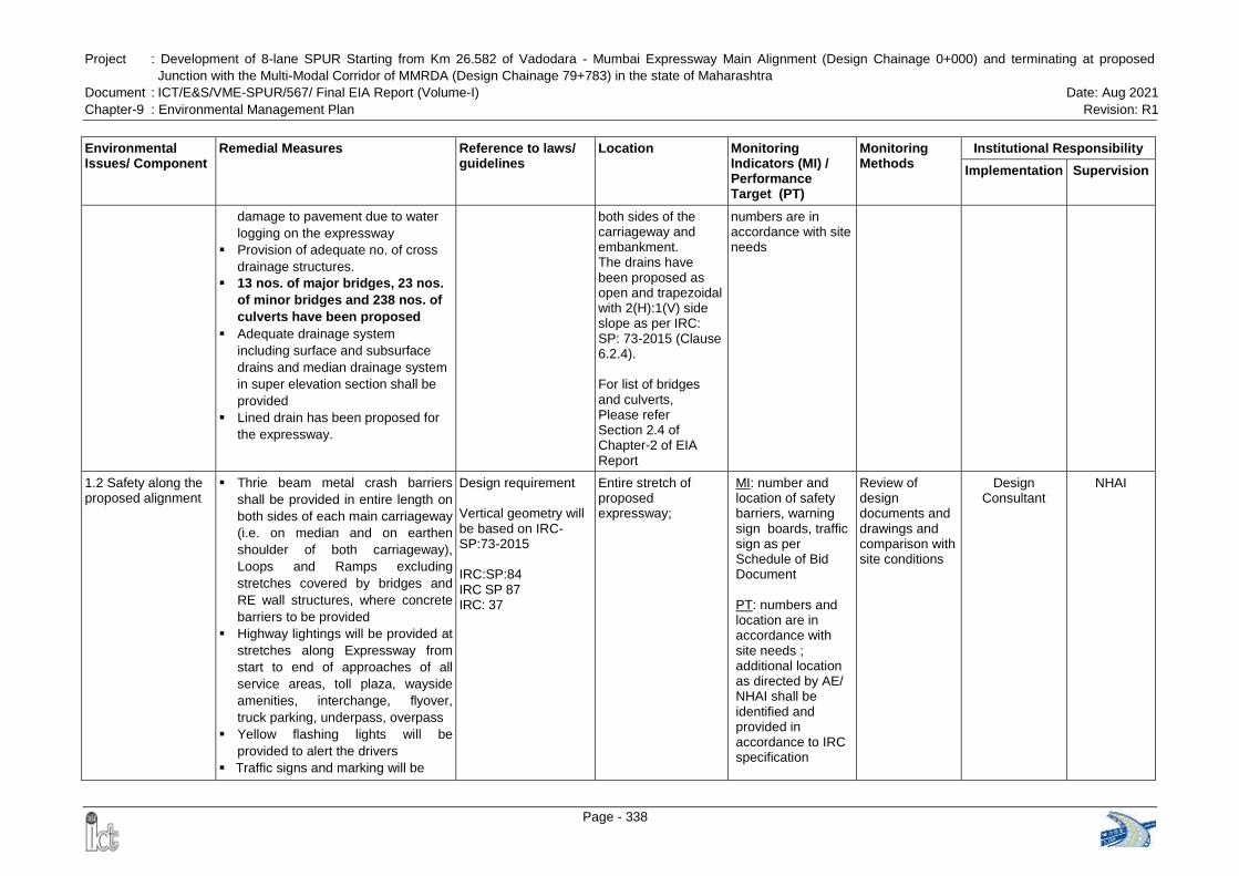
Project : Development of 8-lane SPUR Starting from Km 26.582 of Vadodara - Mumbai Expressway Main Alignment (Design Chainage 0+000) and terminating at proposed
Junction with the Multi-Modal Corridor of MMRDA (Design Chainage 79+783) in the state of Maharashtra
Document : ICT/E&S/VME-SPUR/567/ Final EIA Report (Volume-I) Date: Aug 2021
Chapter-9 : Environmental Management Plan Revision: R1
Page - 338
Environmental Issues/ Component
Remedial Measures Reference to laws/ guidelines
Location Monitoring Indicators (MI) / Performance Target (PT)
Monitoring Methods
Institutional Responsibility
Implementation Supervision
damage to pavement due to water
logging on the expressway
Provision of adequate no. of cross
drainage structures.
13 nos. of major bridges, 23 nos.
of minor bridges and 238 nos. of
culverts have been proposed
Adequate drainage system
including surface and subsurface
drains and median drainage system
in super elevation section shall be
provided
Lined drain has been proposed for
the expressway.
both sides of the carriageway and embankment. The drains have been proposed as open and trapezoidal with 2(H):1(V) side slope as per IRC: SP: 73-2015 (Clause 6.2.4). For list of bridges and culverts, Please refer Section 2.4 of Chapter-2 of EIA Report
numbers are in accordance with site needs
1.2 Safety along the proposed alignment
Thrie beam metal crash barriers
shall be provided in entire length on
both sides of each main carriageway
(i.e. on median and on earthen
shoulder of both carriageway),
Loops and Ramps excluding
stretches covered by bridges and
RE wall structures, where concrete
barriers to be provided
Highway lightings will be provided at
stretches along Expressway from
start to end of approaches of all
service areas, toll plaza, wayside
amenities, interchange, flyover,
truck parking, underpass, overpass
Yellow flashing lights will be
provided to alert the drivers
Traffic signs and marking will be
Design requirement
Vertical geometry will be based on IRC-SP:73-2015
IRC:SP:84 IRC SP 87 IRC: 37
Entire stretch of proposed expressway;
MI: number and location of safety barriers, warning sign boards, traffic sign as per Schedule of Bid Document PT: numbers and location are in accordance with site needs ; additional location as directed by AE/ NHAI shall be identified and provided in accordance to IRC specification
Review of design documents and drawings and comparison with site conditions
Design Consultant
NHAI
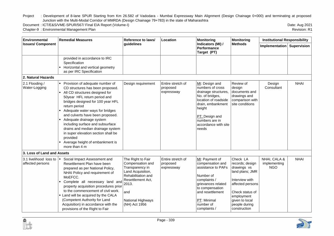
Project : Development of 8-lane SPUR Starting from Km 26.582 of Vadodara - Mumbai Expressway Main Alignment (Design Chainage 0+000) and terminating at proposed
Junction with the Multi-Modal Corridor of MMRDA (Design Chainage 79+783) in the state of Maharashtra
Document : ICT/E&S/VME-SPUR/567/ Final EIA Report (Volume-I) Date: Aug 2021
Chapter-9 : Environmental Management Plan Revision: R1
Page - 339
Environmental Issues/ Component
Remedial Measures Reference to laws/ guidelines
Location Monitoring Indicators (MI) / Performance Target (PT)
Monitoring Methods
Institutional Responsibility
Implementation Supervision
provided in accordance to IRC
Specification
Horizontal and vertical geometry as per IRC Specification
2. Natural Hazards
2.1 Flooding / Water-Logging
Provision of adequate number of
CD structures has been proposed.
All CD structures designed for
50year HFL return period and
bridges designed for 100 year HFL
return period
Adequate water ways for bridges
and culverts have been proposed.
Adequate drainage system
including surface and subsurface
drains and median drainage system
in super elevation section shall be
provided
Average height of embankment is
more than 4 m
Design requirement
Entire stretch of proposed expressway
MI: Design and numbers of cross drainage structures, No. of bridges, location of roadside drain, embankment height
PT: Design and numbers are in accordance with site needs
Review of design documents and drawings and comparison with site conditions
Design Consultant
NHAI
3. Loss of Land and Assets
3.1 livelihood loss to affected persons
Social Impact Assessment and
Resettlement Plan have been
prepared as per National Policy,
NHAI Policy and requirement of
MoEFCC.
Complete all necessary land and
property acquisition procedures prior
to the commencement of civil work.
Land will be acquired by the CALA
(Competent Authority for Land
Acquisition) in accordance with the
provisions of the Right to Fair
The Right to Fair Compensation and Transparency in Land Acquisition, Rehabilitation and Resettlement Act, 2013. and National Highways (NH) Act 1956
Entire stretch of proposed expressway
MI: Payment of compensation and assistance to PAFs
Number of complaints / grievances related to compensation and resettlement PT: Minimal number of complaints /
Check LA records; design drawings vs land plans; JMR Interview with affected persons
Check status of employment given to local people during construction
NHAI, CALA & implementing
NGO
NHAI
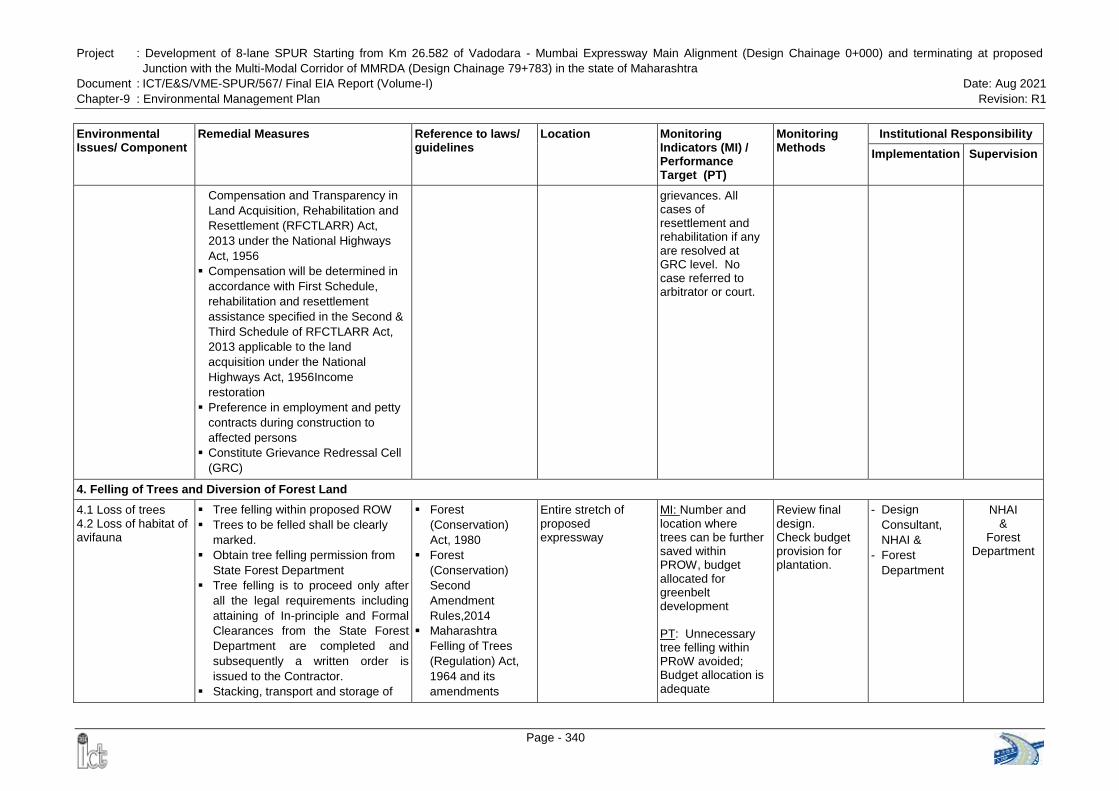
Project : Development of 8-lane SPUR Starting from Km 26.582 of Vadodara - Mumbai Expressway Main Alignment (Design Chainage 0+000) and terminating at proposed
Junction with the Multi-Modal Corridor of MMRDA (Design Chainage 79+783) in the state of Maharashtra
Document : ICT/E&S/VME-SPUR/567/ Final EIA Report (Volume-I) Date: Aug 2021
Chapter-9 : Environmental Management Plan Revision: R1
Page - 340
Environmental Issues/ Component
Remedial Measures Reference to laws/ guidelines
Location Monitoring Indicators (MI) / Performance Target (PT)
Monitoring Methods
Institutional Responsibility
Implementation Supervision
Compensation and Transparency in
Land Acquisition, Rehabilitation and
Resettlement (RFCTLARR) Act,
2013 under the National Highways
Act, 1956
Compensation will be determined in
accordance with First Schedule,
rehabilitation and resettlement
assistance specified in the Second &
Third Schedule of RFCTLARR Act,
2013 applicable to the land
acquisition under the National
Highways Act, 1956Income
restoration
Preference in employment and petty
contracts during construction to
affected persons
Constitute Grievance Redressal Cell
(GRC)
grievances. All cases of resettlement and rehabilitation if any are resolved at GRC level. No case referred to arbitrator or court.
4. Felling of Trees and Diversion of Forest Land
4.1 Loss of trees 4.2 Loss of habitat of avifauna
Tree felling within proposed ROW
Trees to be felled shall be clearly
marked.
Obtain tree felling permission from
State Forest Department
Tree felling is to proceed only after
all the legal requirements including
attaining of In-principle and Formal
Clearances from the State Forest
Department are completed and
subsequently a written order is
issued to the Contractor.
Stacking, transport and storage of
Forest
(Conservation)
Act, 1980
Forest
(Conservation)
Second
Amendment
Rules,2014
Maharashtra
Felling of Trees
(Regulation) Act,
1964 and its
amendments
Entire stretch of proposed expressway
MI: Number and location where trees can be further saved within PROW, budget allocated for greenbelt development
PT: Unnecessary tree felling within PRoW avoided; Budget allocation is adequate
Review final design. Check budget provision for plantation.
- Design
Consultant,
NHAI &
- Forest
Department
NHAI &
Forest Department
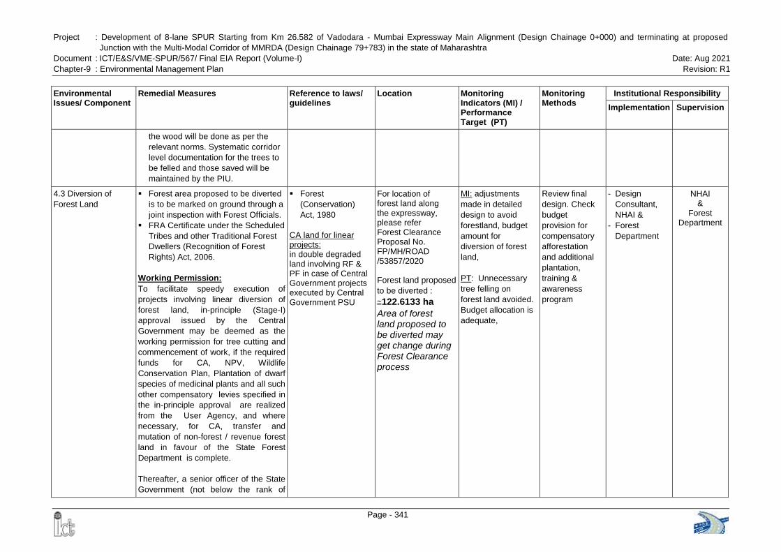
Project : Development of 8-lane SPUR Starting from Km 26.582 of Vadodara - Mumbai Expressway Main Alignment (Design Chainage 0+000) and terminating at proposed
Junction with the Multi-Modal Corridor of MMRDA (Design Chainage 79+783) in the state of Maharashtra
Document : ICT/E&S/VME-SPUR/567/ Final EIA Report (Volume-I) Date: Aug 2021
Chapter-9 : Environmental Management Plan Revision: R1
Page - 341
Environmental Issues/ Component
Remedial Measures Reference to laws/ guidelines
Location Monitoring Indicators (MI) / Performance Target (PT)
Monitoring Methods
Institutional Responsibility
Implementation Supervision
the wood will be done as per the
relevant norms. Systematic corridor
level documentation for the trees to
be felled and those saved will be
maintained by the PIU.
4.3 Diversion of
Forest Land
Forest area proposed to be diverted
is to be marked on ground through a
joint inspection with Forest Officials.
FRA Certificate under the Scheduled
Tribes and other Traditional Forest
Dwellers (Recognition of Forest
Rights) Act, 2006.
Working Permission:
To facilitate speedy execution of
projects involving linear diversion of
forest land, in-principle (Stage-I)
approval issued by the Central
Government may be deemed as the
working permission for tree cutting and
commencement of work, if the required
funds for CA, NPV, Wildlife
Conservation Plan, Plantation of dwarf
species of medicinal plants and all such
other compensatory levies specified in
the in-principle approval are realized
from the User Agency, and where
necessary, for CA, transfer and
mutation of non-forest / revenue forest
land in favour of the State Forest
Department is complete.
Thereafter, a senior officer of the State
Government (not below the rank of
Forest
(Conservation)
Act, 1980
CA land for linear projects: in double degraded land involving RF & PF in case of Central Government projects executed by Central Government PSU
For location of forest land along the expressway, please refer Forest Clearance Proposal No. FP/MH/ROAD /53857/2020 Forest land proposed
to be diverted :
122.6133 ha
Area of forest land proposed to be diverted may get change during Forest Clearance process
MI: adjustments
made in detailed
design to avoid
forestland, budget
amount for
diversion of forest
land,
PT: Unnecessary
tree felling on
forest land avoided.
Budget allocation is
adequate,
Review final
design. Check
budget
provision for
compensatory
afforestation
and additional
plantation,
training &
awareness
program
- Design
Consultant,
NHAI &
- Forest
Department
NHAI &
Forest Department
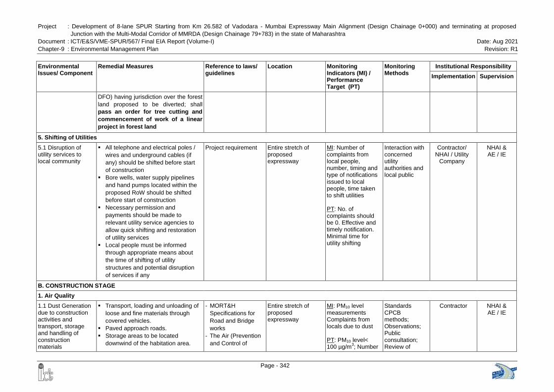
Project : Development of 8-lane SPUR Starting from Km 26.582 of Vadodara - Mumbai Expressway Main Alignment (Design Chainage 0+000) and terminating at proposed
Junction with the Multi-Modal Corridor of MMRDA (Design Chainage 79+783) in the state of Maharashtra
Document : ICT/E&S/VME-SPUR/567/ Final EIA Report (Volume-I) Date: Aug 2021
Chapter-9 : Environmental Management Plan Revision: R1
Page - 342
Environmental Issues/ Component
Remedial Measures Reference to laws/ guidelines
Location Monitoring Indicators (MI) / Performance Target (PT)
Monitoring Methods
Institutional Responsibility
Implementation Supervision
DFO) having jurisdiction over the forest
land proposed to be diverted; shall
pass an order for tree cutting and
commencement of work of a linear
project in forest land
5. Shifting of Utilities
5.1 Disruption of utility services to local community
All telephone and electrical poles /
wires and underground cables (if
any) should be shifted before start
of construction
Bore wells, water supply pipelines
and hand pumps located within the
proposed RoW should be shifted
before start of construction
Necessary permission and
payments should be made to
relevant utility service agencies to
allow quick shifting and restoration
of utility services
Local people must be informed
through appropriate means about
the time of shifting of utility
structures and potential disruption
of services if any
Project requirement
Entire stretch of proposed expressway
MI: Number of complaints from local people, number, timing and type of notifications issued to local people, time taken to shift utilities PT: No. of complaints should be 0. Effective and timely notification. Minimal time for utility shifting
Interaction with concerned utility authorities and local public
Contractor/ NHAI / Utility
Company
NHAI & AE / IE
B. CONSTRUCTION STAGE
1. Air Quality
1.1 Dust Generation due to construction activities and transport, storage and handling of construction materials
Transport, loading and unloading of
loose and fine materials through
covered vehicles.
Paved approach roads.
Storage areas to be located
downwind of the habitation area.
- MORT&H
Specifications for
Road and Bridge
works
- The Air (Prevention
and Control of
Entire stretch of proposed expressway
MI: PM10 level measurements Complaints from locals due to dust PT: PM10 level< 100 µg/m
3; Number
Standards CPCB methods; Observations; Public consultation; Review of
Contractor NHAI & AE / IE
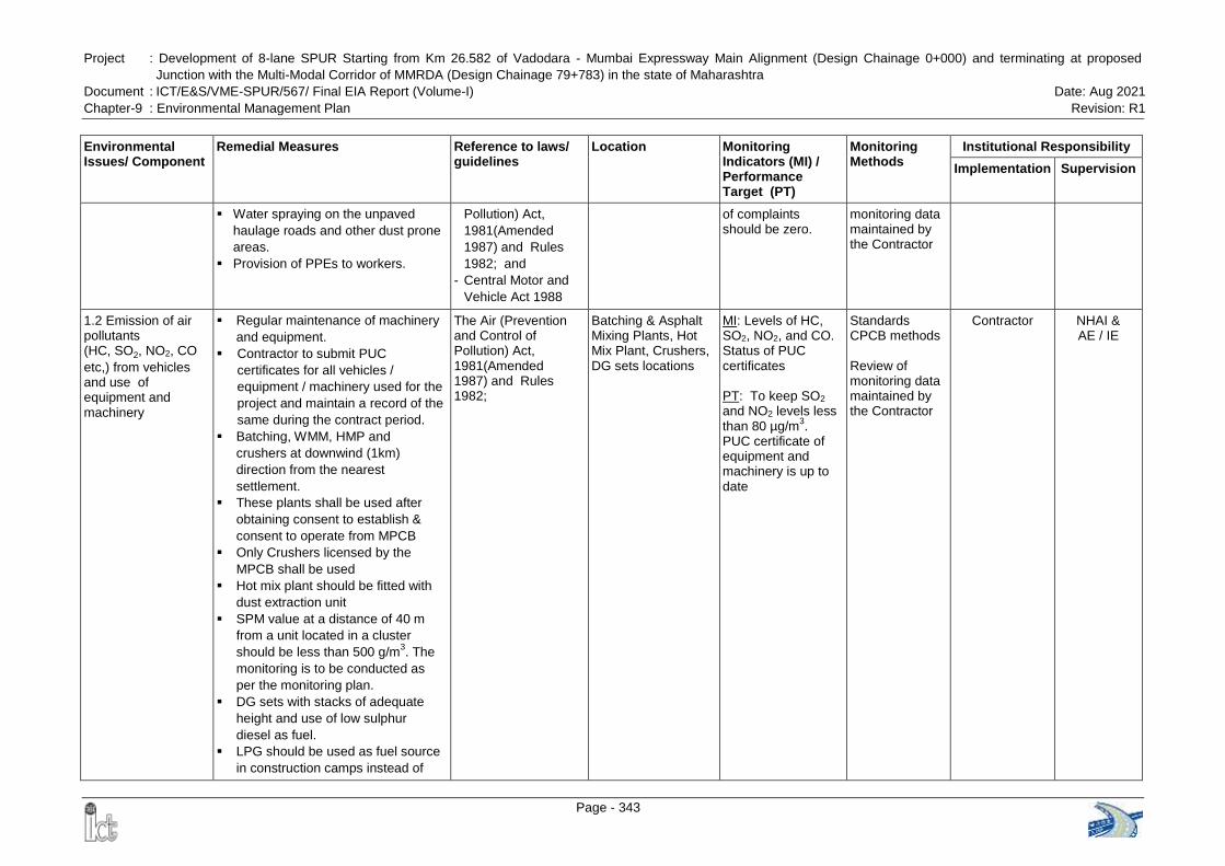
Project : Development of 8-lane SPUR Starting from Km 26.582 of Vadodara - Mumbai Expressway Main Alignment (Design Chainage 0+000) and terminating at proposed
Junction with the Multi-Modal Corridor of MMRDA (Design Chainage 79+783) in the state of Maharashtra
Document : ICT/E&S/VME-SPUR/567/ Final EIA Report (Volume-I) Date: Aug 2021
Chapter-9 : Environmental Management Plan Revision: R1
Page - 343
Environmental Issues/ Component
Remedial Measures Reference to laws/ guidelines
Location Monitoring Indicators (MI) / Performance Target (PT)
Monitoring Methods
Institutional Responsibility
Implementation Supervision
Water spraying on the unpaved
haulage roads and other dust prone
areas.
Provision of PPEs to workers.
Pollution) Act,
1981(Amended
1987) and Rules
1982; and
- Central Motor and
Vehicle Act 1988
of complaints should be zero.
monitoring data maintained by the Contractor
1.2 Emission of air pollutants (HC, SO2, NO2, CO
etc,) from vehicles and use of equipment and machinery
Regular maintenance of machinery
and equipment.
Contractor to submit PUC
certificates for all vehicles /
equipment / machinery used for the
project and maintain a record of the
same during the contract period.
Batching, WMM, HMP and
crushers at downwind (1km)
direction from the nearest
settlement.
These plants shall be used after
obtaining consent to establish &
consent to operate from MPCB
Only Crushers licensed by the
MPCB shall be used
Hot mix plant should be fitted with
dust extraction unit
SPM value at a distance of 40 m
from a unit located in a cluster
should be less than 500 g/m3. The
monitoring is to be conducted as
per the monitoring plan.
DG sets with stacks of adequate
height and use of low sulphur
diesel as fuel.
LPG should be used as fuel source
in construction camps instead of
The Air (Prevention and Control of Pollution) Act, 1981(Amended 1987) and Rules 1982;
Batching & Asphalt Mixing Plants, Hot Mix Plant, Crushers, DG sets locations
MI: Levels of HC, SO2, NO2, and CO. Status of PUC certificates
PT: To keep SO2 and NO2 levels less than 80 µg/m
3.
PUC certificate of equipment and machinery is up to date
Standards CPCB methods
Review of monitoring data maintained by the Contractor
Contractor NHAI & AE / IE
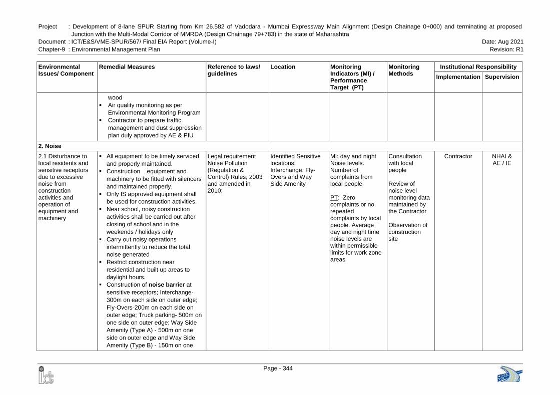
Project : Development of 8-lane SPUR Starting from Km 26.582 of Vadodara - Mumbai Expressway Main Alignment (Design Chainage 0+000) and terminating at proposed
Junction with the Multi-Modal Corridor of MMRDA (Design Chainage 79+783) in the state of Maharashtra
Document : ICT/E&S/VME-SPUR/567/ Final EIA Report (Volume-I) Date: Aug 2021
Chapter-9 : Environmental Management Plan Revision: R1
Page - 344
Environmental Issues/ Component
Remedial Measures Reference to laws/ guidelines
Location Monitoring Indicators (MI) / Performance Target (PT)
Monitoring Methods
Institutional Responsibility
Implementation Supervision
wood
Air quality monitoring as per
Environmental Monitoring Program
Contractor to prepare traffic
management and dust suppression
plan duly approved by AE & PIU
2. Noise
2.1 Disturbance to local residents and sensitive receptors due to excessive noise from construction activities and operation of equipment and machinery
All equipment to be timely serviced
and properly maintained.
Construction equipment and
machinery to be fitted with silencers
and maintained properly.
Only IS approved equipment shall
be used for construction activities.
Near school, noisy construction
activities shall be carried out after
closing of school and in the
weekends / holidays only
Carry out noisy operations
intermittently to reduce the total
noise generated
Restrict construction near
residential and built up areas to
daylight hours.
Construction of noise barrier at
sensitive receptors; Interchange-
300m on each side on outer edge;
Fly-Overs-200m on each side on
outer edge; Truck parking- 500m on
one side on outer edge; Way Side
Amenity (Type A) - 500m on one
side on outer edge and Way Side
Amenity (Type B) - 150m on one
Legal requirement Noise Pollution (Regulation & Control) Rules, 2003 and amended in 2010;
Identified Sensitive locations; Interchange; Fly-Overs and Way Side Amenity
MI: day and night Noise levels. Number of complaints from local people
PT: Zero complaints or no repeated complaints by local people. Average day and night time noise levels are within permissible limits for work zone areas
Consultation with local people
Review of noise level monitoring data maintained by the Contractor Observation of construction site
Contractor NHAI & AE / IE
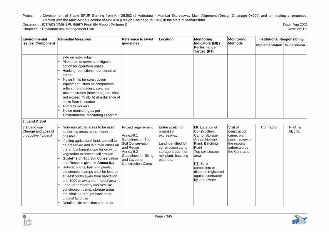
Project : Development of 8-lane SPUR Starting from Km 26.582 of Vadodara - Mumbai Expressway Main Alignment (Design Chainage 0+000) and terminating at proposed
Junction with the Multi-Modal Corridor of MMRDA (Design Chainage 79+783) in the state of Maharashtra
Document : ICT/E&S/VME-SPUR/567/ Final EIA Report (Volume-I) Date: Aug 2021
Chapter-9 : Environmental Management Plan Revision: R1
Page - 345
Environmental Issues/ Component
Remedial Measures Reference to laws/ guidelines
Location Monitoring Indicators (MI) / Performance Target (PT)
Monitoring Methods
Institutional Responsibility
Implementation Supervision
side on outer edge
Plantation to serve as mitigation
option for operation phase
Honking restrictions near sensitive
areas
Noise limits for construction
equipment such as compactors,
rollers, front loaders, concrete
mixers, cranes (moveable) etc. shall
not exceed 75 dB(A) at a distance of
11 m from its source
PPEs to workers
Noise monitoring as per
Environmental Monitoring Program
3. Land & Soil
3.1 Land use Change and Loss of productive / topsoil
Non-agricultural areas to be used
as borrow areas to the extent
possible.
If using agricultural land, top soil to
be preserved and laid over either on
the embankment slope for growing
vegetation to protect soil erosion.
Guideline on Top Soil Conservation
and Reuse is given in Annex-9.1
Hot-mix plants, batching plants,
construction camps shall be located
at least 500m away from habitation
and 1000 m away from forest area
Land for temporary facilities like
construction camp, storage areas
etc. shall be brought back to its
original land use
Detailed site selection criteria for
Project requirement Annex-9.1 Guidelines on Top Soil Conservation and Reuse Annex-9.2 Guidelines for Siting and Layout of Construction Camp
Entire stretch of proposed expressway; Land identified for construction camp, storage areas, hot-mix plant, batching plant etc.
MI: Location of Construction Camp, Storage Areas, Hot-mix Plant, Batching Plant Top soil storage area
PT: Zero complaints or disputes registered against contractor by land owner
Visit of construction camp, plant sites; review of the reports submitted by the Contractor
Contractor NHAI & AE / IE
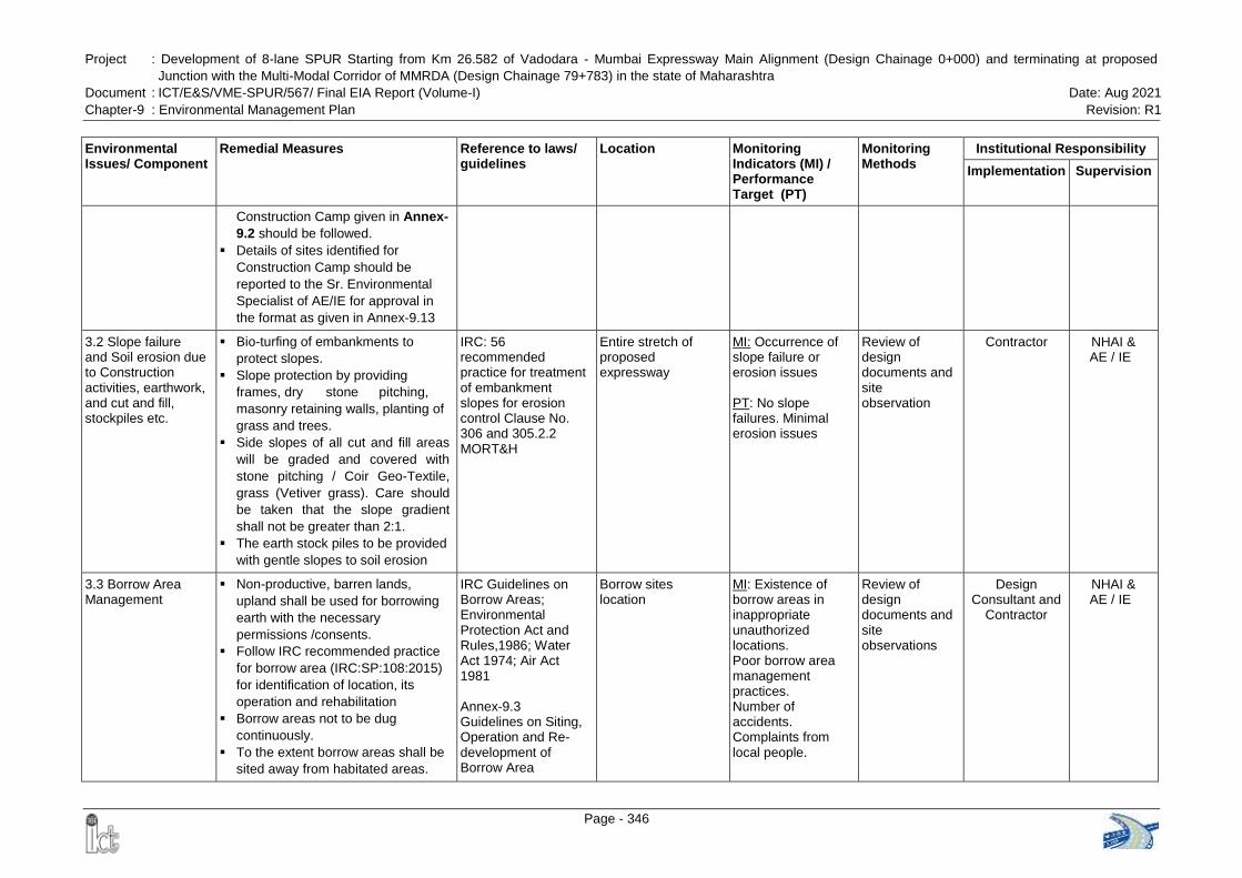
Project : Development of 8-lane SPUR Starting from Km 26.582 of Vadodara - Mumbai Expressway Main Alignment (Design Chainage 0+000) and terminating at proposed
Junction with the Multi-Modal Corridor of MMRDA (Design Chainage 79+783) in the state of Maharashtra
Document : ICT/E&S/VME-SPUR/567/ Final EIA Report (Volume-I) Date: Aug 2021
Chapter-9 : Environmental Management Plan Revision: R1
Page - 346
Environmental Issues/ Component
Remedial Measures Reference to laws/ guidelines
Location Monitoring Indicators (MI) / Performance Target (PT)
Monitoring Methods
Institutional Responsibility
Implementation Supervision
Construction Camp given in Annex-
9.2 should be followed.
Details of sites identified for
Construction Camp should be
reported to the Sr. Environmental
Specialist of AE/IE for approval in
the format as given in Annex-9.13
3.2 Slope failure and Soil erosion due to Construction activities, earthwork, and cut and fill, stockpiles etc.
Bio-turfing of embankments to
protect slopes.
Slope protection by providing
frames, dry stone pitching,
masonry retaining walls, planting of
grass and trees.
Side slopes of all cut and fill areas
will be graded and covered with
stone pitching / Coir Geo-Textile,
grass (Vetiver grass). Care should
be taken that the slope gradient
shall not be greater than 2:1.
The earth stock piles to be provided
with gentle slopes to soil erosion
IRC: 56 recommended practice for treatment of embankment slopes for erosion control Clause No. 306 and 305.2.2 MORT&H
Entire stretch of proposed expressway
MI: Occurrence of slope failure or erosion issues
PT: No slope failures. Minimal erosion issues
Review of design documents and site observation
Contractor NHAI & AE / IE
3.3 Borrow Area Management
Non-productive, barren lands,
upland shall be used for borrowing
earth with the necessary
permissions /consents.
Follow IRC recommended practice
for borrow area (IRC:SP:108:2015)
for identification of location, its
operation and rehabilitation
Borrow areas not to be dug
continuously.
To the extent borrow areas shall be
sited away from habitated areas.
IRC Guidelines on Borrow Areas; Environmental Protection Act and Rules,1986; Water Act 1974; Air Act 1981 Annex-9.3 Guidelines on Siting, Operation and Re-development of Borrow Area
Borrow sites location
MI: Existence of borrow areas in inappropriate unauthorized locations. Poor borrow area management practices. Number of accidents. Complaints from local people.
Review of design documents and site observations
Design Consultant and
Contractor
NHAI & AE / IE
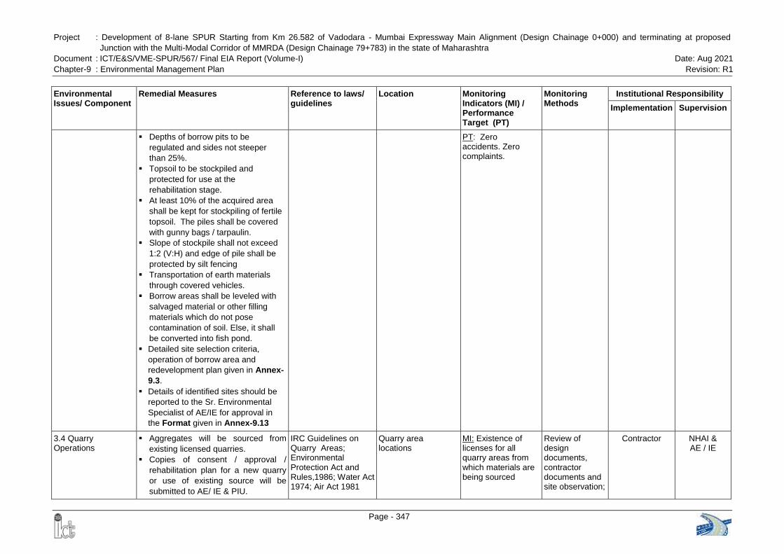
Project : Development of 8-lane SPUR Starting from Km 26.582 of Vadodara - Mumbai Expressway Main Alignment (Design Chainage 0+000) and terminating at proposed
Junction with the Multi-Modal Corridor of MMRDA (Design Chainage 79+783) in the state of Maharashtra
Document : ICT/E&S/VME-SPUR/567/ Final EIA Report (Volume-I) Date: Aug 2021
Chapter-9 : Environmental Management Plan Revision: R1
Page - 347
Environmental Issues/ Component
Remedial Measures Reference to laws/ guidelines
Location Monitoring Indicators (MI) / Performance Target (PT)
Monitoring Methods
Institutional Responsibility
Implementation Supervision
Depths of borrow pits to be
regulated and sides not steeper
than 25%.
Topsoil to be stockpiled and
protected for use at the
rehabilitation stage.
At least 10% of the acquired area
shall be kept for stockpiling of fertile
topsoil. The piles shall be covered
with gunny bags / tarpaulin.
Slope of stockpile shall not exceed
1:2 (V:H) and edge of pile shall be
protected by silt fencing
Transportation of earth materials
through covered vehicles.
Borrow areas shall be leveled with
salvaged material or other filling
materials which do not pose
contamination of soil. Else, it shall
be converted into fish pond.
Detailed site selection criteria,
operation of borrow area and
redevelopment plan given in Annex-
9.3.
Details of identified sites should be
reported to the Sr. Environmental
Specialist of AE/IE for approval in
the Format given in Annex-9.13
PT: Zero accidents. Zero complaints.
3.4 Quarry Operations
Aggregates will be sourced from
existing licensed quarries.
Copies of consent / approval /
rehabilitation plan for a new quarry
or use of existing source will be
submitted to AE/ IE & PIU.
IRC Guidelines on Quarry Areas; Environmental Protection Act and Rules,1986; Water Act 1974; Air Act 1981
Quarry area locations
MI: Existence of licenses for all quarry areas from which materials are being sourced
Review of design documents, contractor documents and site observation;
Contractor NHAI & AE / IE
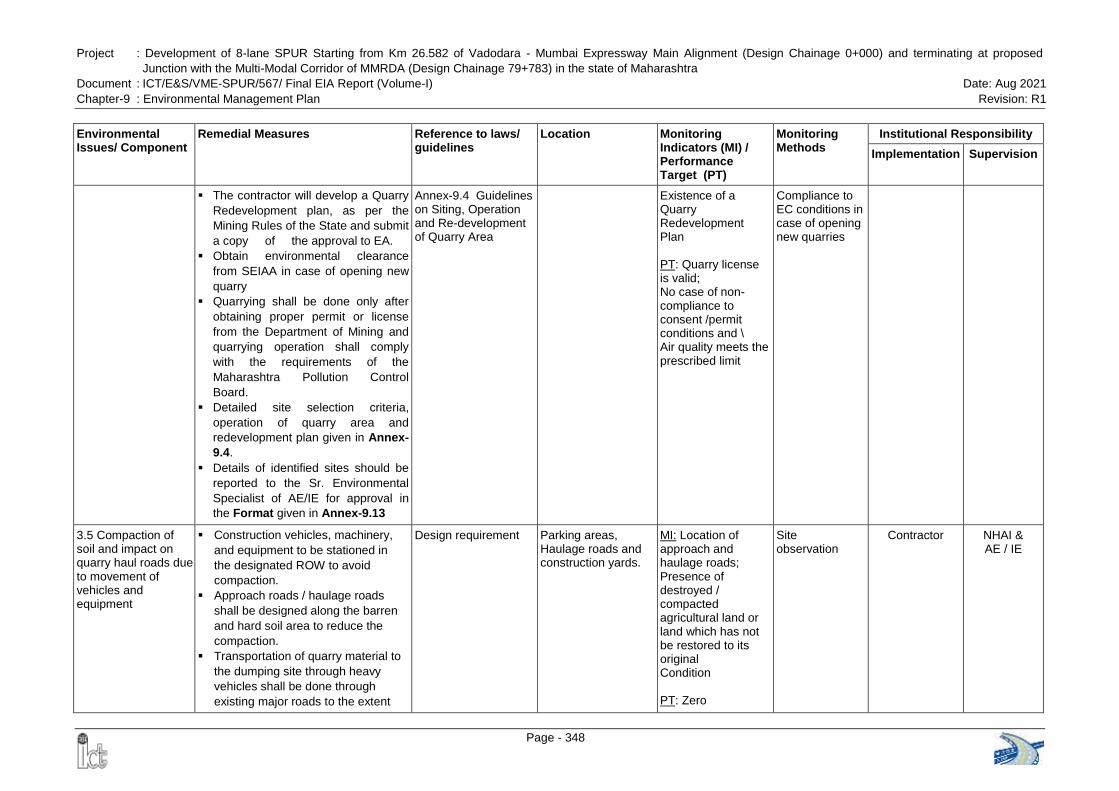
Project : Development of 8-lane SPUR Starting from Km 26.582 of Vadodara - Mumbai Expressway Main Alignment (Design Chainage 0+000) and terminating at proposed
Junction with the Multi-Modal Corridor of MMRDA (Design Chainage 79+783) in the state of Maharashtra
Document : ICT/E&S/VME-SPUR/567/ Final EIA Report (Volume-I) Date: Aug 2021
Chapter-9 : Environmental Management Plan Revision: R1
Page - 348
Environmental Issues/ Component
Remedial Measures Reference to laws/ guidelines
Location Monitoring Indicators (MI) / Performance Target (PT)
Monitoring Methods
Institutional Responsibility
Implementation Supervision
The contractor will develop a Quarry
Redevelopment plan, as per the
Mining Rules of the State and submit
a copy of the approval to EA.
Obtain environmental clearance
from SEIAA in case of opening new
quarry
Quarrying shall be done only after
obtaining proper permit or license
from the Department of Mining and
quarrying operation shall comply
with the requirements of the
Maharashtra Pollution Control
Board.
Detailed site selection criteria,
operation of quarry area and
redevelopment plan given in Annex-
9.4.
Details of identified sites should be
reported to the Sr. Environmental
Specialist of AE/IE for approval in
the Format given in Annex-9.13
Annex-9.4 Guidelines on Siting, Operation and Re-development of Quarry Area
Existence of a Quarry Redevelopment Plan PT: Quarry license is valid; No case of non-compliance to consent /permit conditions and \ Air quality meets the prescribed limit
Compliance to EC conditions in case of opening new quarries
3.5 Compaction of soil and impact on quarry haul roads due to movement of vehicles and equipment
Construction vehicles, machinery,
and equipment to be stationed in
the designated ROW to avoid
compaction.
Approach roads / haulage roads
shall be designed along the barren
and hard soil area to reduce the
compaction.
Transportation of quarry material to
the dumping site through heavy
vehicles shall be done through
existing major roads to the extent
Design requirement
Parking areas, Haulage roads and construction yards.
MI: Location of approach and haulage roads; Presence of destroyed / compacted agricultural land or land which has not be restored to its original Condition PT: Zero
Site observation
Contractor NHAI & AE / IE
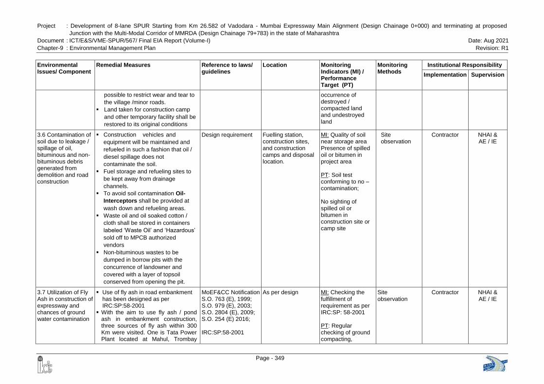
Project : Development of 8-lane SPUR Starting from Km 26.582 of Vadodara - Mumbai Expressway Main Alignment (Design Chainage 0+000) and terminating at proposed
Junction with the Multi-Modal Corridor of MMRDA (Design Chainage 79+783) in the state of Maharashtra
Document : ICT/E&S/VME-SPUR/567/ Final EIA Report (Volume-I) Date: Aug 2021
Chapter-9 : Environmental Management Plan Revision: R1
Page - 349
Environmental Issues/ Component
Remedial Measures Reference to laws/ guidelines
Location Monitoring Indicators (MI) / Performance Target (PT)
Monitoring Methods
Institutional Responsibility
Implementation Supervision
possible to restrict wear and tear to
the village /minor roads.
Land taken for construction camp
and other temporary facility shall be
restored to its original conditions
occurrence of destroyed / compacted land and undestroyed land
3.6 Contamination of soil due to leakage / spillage of oil, bituminous and non-bituminous debris generated from demolition and road construction
Construction vehicles and
equipment will be maintained and
refueled in such a fashion that oil /
diesel spillage does not
contaminate the soil.
Fuel storage and refueling sites to
be kept away from drainage
channels.
To avoid soil contamination Oil-
Interceptors shall be provided at
wash down and refueling areas.
Waste oil and oil soaked cotton /
cloth shall be stored in containers
labeled „Waste Oil‟ and „Hazardous‟
sold off to MPCB authorized
vendors
Non-bituminous wastes to be
dumped in borrow pits with the
concurrence of landowner and
covered with a layer of topsoil
conserved from opening the pit.
Design requirement
Fuelling station, construction sites, and construction camps and disposal location.
MI: Quality of soil near storage area Presence of spilled oil or bitumen in project area
PT: Soil test conforming to no –contamination; No sighting of spilled oil or bitumen in construction site or camp site
Site observation
Contractor NHAI & AE / IE
3.7 Utilization of Fly Ash in construction of expressway and chances of ground water contamination
Use of fly ash in road embankment has been designed as per IRC:SP:58-2001
With the aim to use fly ash / pond ash in embankment construction, three sources of fly ash within 300 Km were visited. One is Tata Power Plant located at Mahul, Trombay
MoEF&CC Notification S.O. 763 (E), 1999; S.O. 979 (E), 2003; S.O. 2804 (E), 2009; S.O. 254 (E) 2016; IRC:SP:58-2001
As per design MI: Checking the fulfillment of requirement as per IRC:SP: 58-2001 PT: Regular checking of ground compacting,
Site observation
Contractor NHAI & AE / IE
Project : Development of 8-lane SPUR Starting from Km 26.582 of Vadodara - Mumbai Expressway Main Alignment (Design Chainage 0+000) and terminating at proposed
Junction with the Multi-Modal Corridor of MMRDA (Design Chainage 79+783) in the state of Maharashtra
Document : ICT/E&S/VME-SPUR/567/ Final EIA Report (Volume-I) Date: Aug 2021
Chapter-9 : Environmental Management Plan Revision: R1
Page - 350
Environmental Issues/ Component
Remedial Measures Reference to laws/ guidelines
Location Monitoring Indicators (MI) / Performance Target (PT)
Monitoring Methods
Institutional Responsibility
Implementation Supervision
(Bombay) which is about 80 km from Km. 38.300 of the SPUR. On enquiry, we understand that the quality of fly-ash is very good and the fly Ash generation of the plant in 2018-19 is 50312 MT per annum. The other source is Reliance Thermal Power Plant (250 MW) located at Dahanu, Maharastra which is about 150 Km and its production of fly-ash in 2018-19 is around 5,64,376 MT per annum. The third source is Nashik Thermal Power plant, Ekalahre which is around 170 Km from project road and its fly ash production in 2018-19 is around 7,02,227 MT per annum. The fly Ash for the embankment construction can be used from these sources as per guidelines of MoEFCC and IRC:SP:58.
Fly ash shall be transported to the site in covered dumper
The leaching problem can be minimised by controlling the amount of water, which infiltrates into fly ash embankment
Sides and top of the embankment will be protected using less permeable good earth. This will prevent the seepage the water from the pavement to the embankment.
Surface of the stockpile will be covered with tarpaulins
Monitoring Format for utilization of Fly Ash during construction of the expressway is given in Annex-9.5. it
handling & transportation of fly ash, spreading & compaction process
Project : Development of 8-lane SPUR Starting from Km 26.582 of Vadodara - Mumbai Expressway Main Alignment (Design Chainage 0+000) and terminating at proposed
Junction with the Multi-Modal Corridor of MMRDA (Design Chainage 79+783) in the state of Maharashtra
Document : ICT/E&S/VME-SPUR/567/ Final EIA Report (Volume-I) Date: Aug 2021
Chapter-9 : Environmental Management Plan Revision: R1
Page - 351
Environmental Issues/ Component
Remedial Measures Reference to laws/ guidelines
Location Monitoring Indicators (MI) / Performance Target (PT)
Monitoring Methods
Institutional Responsibility
Implementation Supervision
should be submitted to AE / IE on monthly basis
4. Water Resources
4.1 Sourcing of water during construction
Requisite permission shall be
obtained for abstraction of
groundwater from Central Ground
Water Authority and State Ground
Water Board
Where surface water sources are to
be tapped, arrangements shall be
made by contractor that the water
availability and supply to nearby
communities remain unaffected.
The possible sources could be
abandoned quarry filled with
rainwater, river, tanks or wells,
specially created tanks nearby
perennial rivers subject to approval
of village & local administration.
Water intensive activities not to be
undertaken during summer season.
CGWA Guidelines
Entire stretch of proposed expressway
MI: Approval from competent authority; Complaints from local people on water availability
PT: Valid approval from Competent Authority. Zero complaints from local people.
Checking of documentation; Talk to local people
Contractor NHAI & AE / IE
4.2 Disposal of water during construction
Provisions shall be made to
connect drains with existing nearby
natural drains.
Design requirement
Entire stretch of proposed expressway
MI: Condition of drainage system in construction site; Presence / absence of water logging in project area.
PT: Existence of proper drainage system. No water logging in project area
Standards methods; Site observation and review of documents
Contractor NHAI & AE / IE
4.3 Alteration in Provision of adequate no. of cross Design requirement, Near all drainage MI: Proper flow of Review of Contractor NHAI &
Project : Development of 8-lane SPUR Starting from Km 26.582 of Vadodara - Mumbai Expressway Main Alignment (Design Chainage 0+000) and terminating at proposed
Junction with the Multi-Modal Corridor of MMRDA (Design Chainage 79+783) in the state of Maharashtra
Document : ICT/E&S/VME-SPUR/567/ Final EIA Report (Volume-I) Date: Aug 2021
Chapter-9 : Environmental Management Plan Revision: R1
Page - 352
Environmental Issues/ Component
Remedial Measures Reference to laws/ guidelines
Location Monitoring Indicators (MI) / Performance Target (PT)
Monitoring Methods
Institutional Responsibility
Implementation Supervision
Surface Water Hydrology
drainage structures.
13 nos. of major bridges, 23 nos.
of minor bridges and 238 nos. of
culverts have been proposed
All CD structures designed for
50year HFL return period and
bridges designed for 100 year HFL
return period
It has been ensured that all the 1st
and 2nd
order streams crossing the
proposed expressway alignment
provided with necessary culverts,
mirror bridges and major bridges
with capacity of 20% excess
discharge
Construction of cross drainage
structures shall be undertaken
during lean flow period.
channels, River / Nallah crossings etc.
water in Rivers, Streams and Nallah
PT: No complain of water shortage by downstream communities. No record of overtopping / water logging
design documents
Site observation
AE / IE
4.4 Siltation in Water Bodies due to construction activities / earthwork
Embankment slopes to be
modified suitably to restrict the soil,
debris entering water bodies.
Silt fencing shall be provided along
water bodies within the direct
impact zone intercepting
expressway to prevent siltation in
water bodies.
Sediment / silt should be collected
and stockpiled for possible reuse as
surfacing of slopes where they have
to be re-vegetated.
Earthworks and stone works to be
prevented from impeding natural
flow of rivers, streams and water
canals or existing drainage system.
Design requirement; Worldwide Best Practices; Annex-9.6 Guideline for Sediment Control
Near all water bodies/ waterway
MI: Presence/absence of siltation in rivers, streams, nallah, ponds and other water bodies in project area; water quality monitoring
PT: No records of siltation due to project activities. Surface water quality tests confirm to turbidity and TSS limit
Field observation
Contractor NHAI & AE / IE
Project : Development of 8-lane SPUR Starting from Km 26.582 of Vadodara - Mumbai Expressway Main Alignment (Design Chainage 0+000) and terminating at proposed
Junction with the Multi-Modal Corridor of MMRDA (Design Chainage 79+783) in the state of Maharashtra
Document : ICT/E&S/VME-SPUR/567/ Final EIA Report (Volume-I) Date: Aug 2021
Chapter-9 : Environmental Management Plan Revision: R1
Page - 353
Environmental Issues/ Component
Remedial Measures Reference to laws/ guidelines
Location Monitoring Indicators (MI) / Performance Target (PT)
Monitoring Methods
Institutional Responsibility
Implementation Supervision
Guideline for Sediment Control is
given in Annex-9.6
4.5 Deterioration in Surface water quality due to leakage from vehicles and equipment and waste from construction camps.
No vehicles or equipment should be
parked or refueled near water-
bodies, so as to avoid
contamination from fuel and
lubricants.
Oil and grease traps and fuelling
platforms to be provided at re-
fuelling locations.
All chemicals and oil shall be stored
away from water and concreted
platform with catchment pit for spills
collection.
All equipment operators, drivers,
and warehouse personnel will be
trained in immediate response for
spill containment and eventual
clean-up. Readily available, simple
to understand and preferably
written in the local language
emergency response procedure,
including reporting, will be provided
by the contractors
Construction camp to be sited away
from water bodies.
Solid wastes must be collected,
stored and taken to identified
disposal site only.
Packaged Wastewater Treatment
Plant is to be installed in the
Construction Camp. Guideline for
Wastewater Treatment in
Construction Camp is given in
The Water (Prevention and Control of Pollution) Act, 1974 and amendments thereof; Annex-9.7 Guideline for Wastewater Treatment in Construction Camp
Water bodies;
refueling stations; construction camps.
MI: Water quality of river, stream, ponds and other water bodies in project area; Presence of oil floating in water bodies in project area PT: Surface water quality meets water quality standards (IS:2296)
Water quality tests as per the Environmental Monitoring Plan Field observation
Contractor NHAI & AE / IE
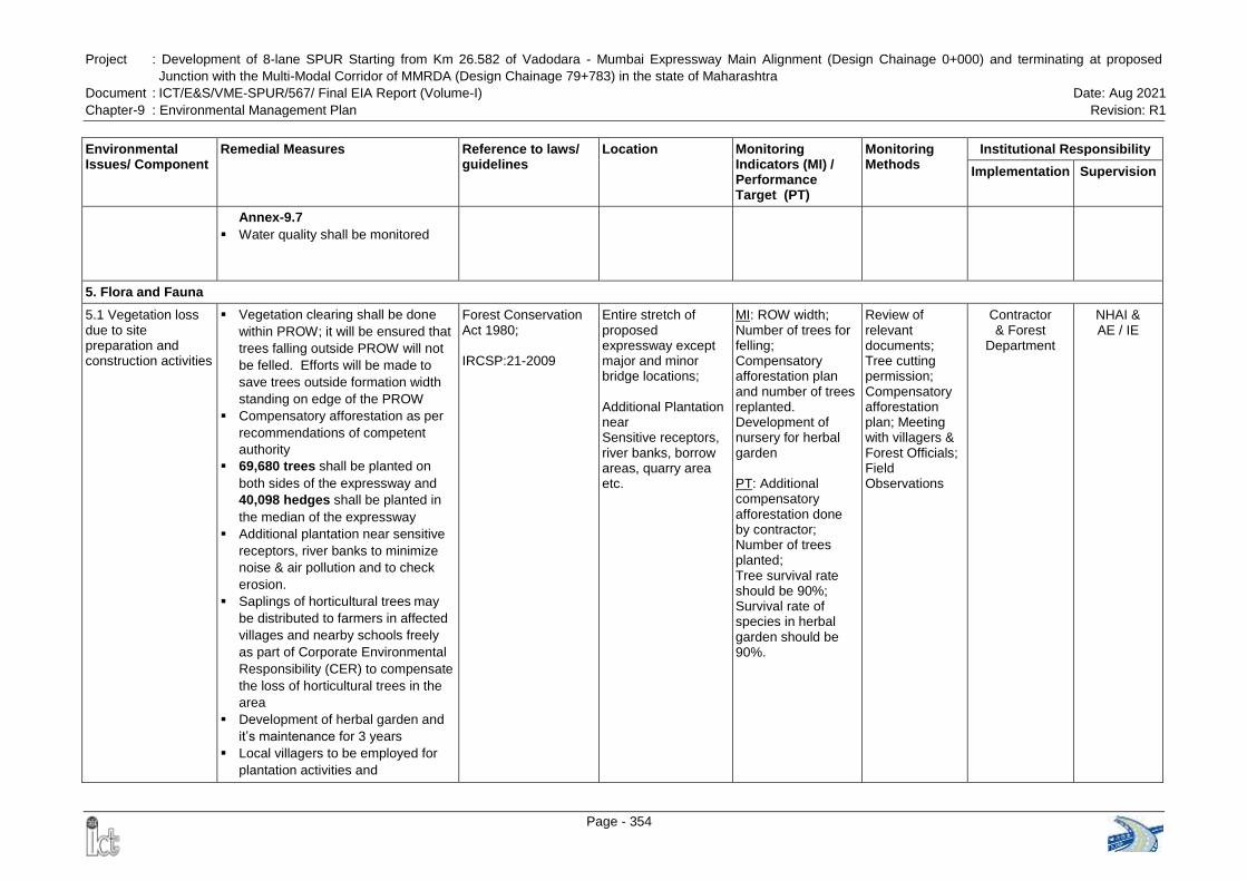
Project : Development of 8-lane SPUR Starting from Km 26.582 of Vadodara - Mumbai Expressway Main Alignment (Design Chainage 0+000) and terminating at proposed
Junction with the Multi-Modal Corridor of MMRDA (Design Chainage 79+783) in the state of Maharashtra
Document : ICT/E&S/VME-SPUR/567/ Final EIA Report (Volume-I) Date: Aug 2021
Chapter-9 : Environmental Management Plan Revision: R1
Page - 354
Environmental Issues/ Component
Remedial Measures Reference to laws/ guidelines
Location Monitoring Indicators (MI) / Performance Target (PT)
Monitoring Methods
Institutional Responsibility
Implementation Supervision
Annex-9.7
Water quality shall be monitored
5. Flora and Fauna
5.1 Vegetation loss due to site preparation and construction activities
Vegetation clearing shall be done
within PROW; it will be ensured that
trees falling outside PROW will not
be felled. Efforts will be made to
save trees outside formation width
standing on edge of the PROW
Compensatory afforestation as per
recommendations of competent
authority
69,680 trees shall be planted on
both sides of the expressway and
40,098 hedges shall be planted in
the median of the expressway
Additional plantation near sensitive
receptors, river banks to minimize
noise & air pollution and to check
erosion.
Saplings of horticultural trees may
be distributed to farmers in affected
villages and nearby schools freely
as part of Corporate Environmental
Responsibility (CER) to compensate
the loss of horticultural trees in the
area
Development of herbal garden and
it‟s maintenance for 3 years
Local villagers to be employed for
plantation activities and
Forest Conservation Act 1980; IRCSP:21-2009
Entire stretch of proposed expressway except major and minor bridge locations; Additional Plantation near Sensitive receptors, river banks, borrow areas, quarry area etc.
MI: ROW width; Number of trees for felling; Compensatory afforestation plan and number of trees replanted. Development of nursery for herbal garden PT: Additional compensatory afforestation done by contractor; Number of trees planted; Tree survival rate should be 90%; Survival rate of species in herbal garden should be 90%.
Review of relevant documents; Tree cutting permission; Compensatory afforestation plan; Meeting with villagers & Forest Officials; Field Observations
Contractor & Forest
Department
NHAI & AE / IE
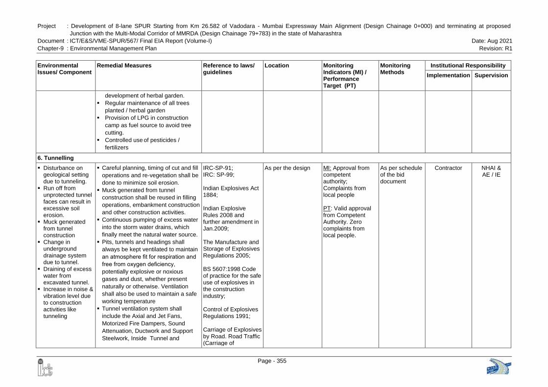
Project : Development of 8-lane SPUR Starting from Km 26.582 of Vadodara - Mumbai Expressway Main Alignment (Design Chainage 0+000) and terminating at proposed
Junction with the Multi-Modal Corridor of MMRDA (Design Chainage 79+783) in the state of Maharashtra
Document : ICT/E&S/VME-SPUR/567/ Final EIA Report (Volume-I) Date: Aug 2021
Chapter-9 : Environmental Management Plan Revision: R1
Page - 355
Environmental Issues/ Component
Remedial Measures Reference to laws/ guidelines
Location Monitoring Indicators (MI) / Performance Target (PT)
Monitoring Methods
Institutional Responsibility
Implementation Supervision
development of herbal garden.
Regular maintenance of all trees
planted / herbal garden
Provision of LPG in construction
camp as fuel source to avoid tree
cutting.
Controlled use of pesticides /
fertilizers
6. Tunnelling
Disturbance on geological setting due to tunneling.
Run off from unprotected tunnel faces can result in excessive soil erosion.
Muck generated from tunnel construction
Change in underground drainage system due to tunnel.
Draining of excess water from excavated tunnel.
Increase in noise & vibration level due to construction activities like tunneling
Careful planning, timing of cut and fill
operations and re-vegetation shall be
done to minimize soil erosion.
Muck generated from tunnel
construction shall be reused in filling
operations, embankment construction
and other construction activities.
Continuous pumping of excess water
into the storm water drains, which
finally meet the natural water source.
Pits, tunnels and headings shall
always be kept ventilated to maintain
an atmosphere fit for respiration and
free from oxygen deficiency,
potentially explosive or noxious
gases and dust, whether present
naturally or otherwise. Ventilation
shall also be used to maintain a safe
working temperature
Tunnel ventilation system shall
include the Axial and Jet Fans,
Motorized Fire Dampers, Sound
Attenuation, Ductwork and Support
Steelwork, Inside Tunnel and
IRC-SP-91; IRC: SP-99; Indian Explosives Act 1884; Indian Explosive Rules 2008 and further amendment in Jan.2009; The Manufacture and Storage of Explosives Regulations 2005; BS 5607:1998 Code of practice for the safe use of explosives in the construction industry; Control of Explosives Regulations 1991; Carriage of Explosives by Road. Road Traffic (Carriage of
As per the design MI: Approval from competent authority; Complaints from local people
PT: Valid approval from Competent Authority. Zero complaints from local people.
As per schedule of the bid document
Contractor NHAI & AE / IE
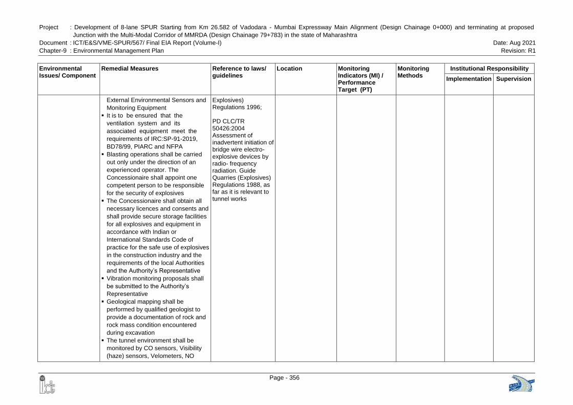
Project : Development of 8-lane SPUR Starting from Km 26.582 of Vadodara - Mumbai Expressway Main Alignment (Design Chainage 0+000) and terminating at proposed
Junction with the Multi-Modal Corridor of MMRDA (Design Chainage 79+783) in the state of Maharashtra
Document : ICT/E&S/VME-SPUR/567/ Final EIA Report (Volume-I) Date: Aug 2021
Chapter-9 : Environmental Management Plan Revision: R1
Page - 356
Environmental Issues/ Component
Remedial Measures Reference to laws/ guidelines
Location Monitoring Indicators (MI) / Performance Target (PT)
Monitoring Methods
Institutional Responsibility
Implementation Supervision
External Environmental Sensors and
Monitoring Equipment
It is to be ensured that the
ventilation system and its
associated equipment meet the
requirements of IRC:SP-91-2019,
BD78/99, PIARC and NFPA
Blasting operations shall be carried
out only under the direction of an
experienced operator. The
Concessionaire shall appoint one
competent person to be responsible
for the security of explosives
The Concessionaire shall obtain all
necessary licences and consents and
shall provide secure storage facilities
for all explosives and equipment in
accordance with Indian or
International Standards Code of
practice for the safe use of explosives
in the construction industry and the
requirements of the local Authorities
and the Authority‟s Representative
Vibration monitoring proposals shall
be submitted to the Authority‟s
Representative
Geological mapping shall be
performed by qualified geologist to
provide a documentation of rock and
rock mass condition encountered
during excavation
The tunnel environment shall be
monitored by CO sensors, Visibility
(haze) sensors, Velometers, NO
Explosives) Regulations 1996; PD CLC/TR 50426:2004 Assessment of inadvertent initiation of bridge wire electro-explosive devices by radio- frequency radiation. Guide Quarries (Explosives) Regulations 1988, as far as it is relevant to tunnel works
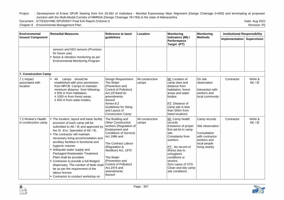
Project : Development of 8-lane SPUR Starting from Km 26.582 of Vadodara - Mumbai Expressway Main Alignment (Design Chainage 0+000) and terminating at proposed
Junction with the Multi-Modal Corridor of MMRDA (Design Chainage 79+783) in the state of Maharashtra
Document : ICT/E&S/VME-SPUR/567/ Final EIA Report (Volume-I) Date: Aug 2021
Chapter-9 : Environmental Management Plan Revision: R1
Page - 357
Environmental Issues/ Component
Remedial Measures Reference to laws/ guidelines
Location Monitoring Indicators (MI) / Performance Target (PT)
Monitoring Methods
Institutional Responsibility
Implementation Supervision
sensors and N02 sensors (Provision
for future use)
Noise & vibration monitoring as per
Environmental Monitoring Program
7. Construction Camp
7.1 Impact associated with location
All camps should be established with prior permission from MPCB. Camps to maintain minimum distance from following: # 500 m from habitation, # 1000 m from forest areas, # 500 m from water bodies,
Design Requirement The Water (Prevention and Control of Pollution) Act,1974and its amendments thereof Annex-9.2 Guidelines for Siting and Layout of Construction Camp
All construction camps
MI: Location of camp sites and distance from habitation, forest areas and water bodies PT: Distance of camp site is less than 500m from listed locations
On site observation Interaction with workers and local community
Contractor NHAI & AE / IE
7.2 Worker‟s Health in construction camp
The location, layout and basic facility
provision of each camp will be
submitted to AE / IE and approved by
the Sr. Env. Specialist of AE / IE.
The contractor will maintain
necessary living accommodation and
ancillary facilities in functional and
hygienic manner.
Adequate water supply and
Packaged Wastewater Treatment
Plant shall be provided.
Contractor to provide a full-fledged
dispensary. The number of beds shall
be as per the requirement of the
labour license
Contractor to conduct workshop on
The Building and Other Construction workers (Regulation of Employment and Conditions of Service) Act 1996 and The Contract Labour (Regulation & Abolition) Act, 1970 The Water (Prevention and Control of Pollution) Act,1974 and amendments thereof
All construction camps
MI: Camp health records. Existence of proper first aid kit in camp site. Complaints from workers. PT: No record of illness due to unhygienic conditions or vectors. Zero cases of STD. Clean and tidy camp site conditions.
Camp records Site observation Consultation with contractor workers and local people living nearby
Contractor NHAI & AE / IE
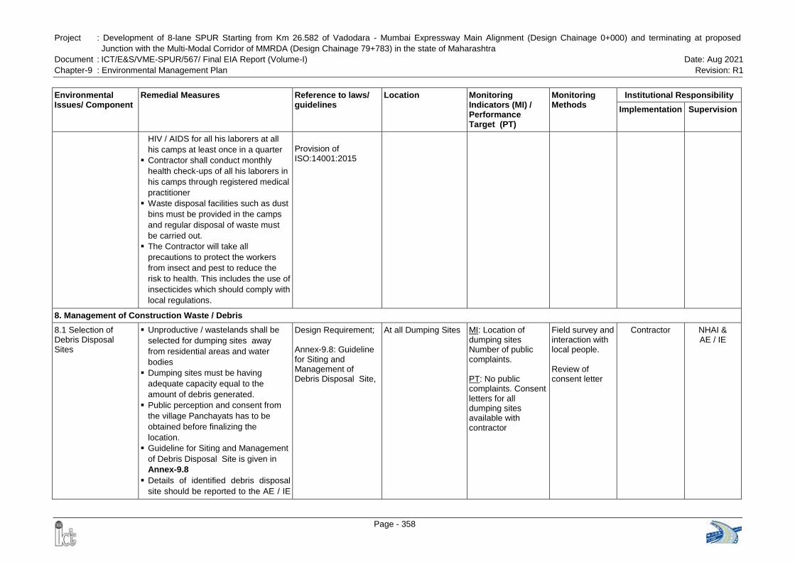
Project : Development of 8-lane SPUR Starting from Km 26.582 of Vadodara - Mumbai Expressway Main Alignment (Design Chainage 0+000) and terminating at proposed
Junction with the Multi-Modal Corridor of MMRDA (Design Chainage 79+783) in the state of Maharashtra
Document : ICT/E&S/VME-SPUR/567/ Final EIA Report (Volume-I) Date: Aug 2021
Chapter-9 : Environmental Management Plan Revision: R1
Page - 358
Environmental Issues/ Component
Remedial Measures Reference to laws/ guidelines
Location Monitoring Indicators (MI) / Performance Target (PT)
Monitoring Methods
Institutional Responsibility
Implementation Supervision
HIV / AIDS for all his laborers at all
his camps at least once in a quarter
Contractor shall conduct monthly
health check-ups of all his laborers in
his camps through registered medical
practitioner
Waste disposal facilities such as dust
bins must be provided in the camps
and regular disposal of waste must
be carried out.
The Contractor will take all
precautions to protect the workers
from insect and pest to reduce the
risk to health. This includes the use of
insecticides which should comply with
local regulations.
Provision of ISO:14001:2015
8. Management of Construction Waste / Debris
8.1 Selection of Debris Disposal Sites
Unproductive / wastelands shall be
selected for dumping sites away
from residential areas and water
bodies
Dumping sites must be having
adequate capacity equal to the
amount of debris generated.
Public perception and consent from
the village Panchayats has to be
obtained before finalizing the
location.
Guideline for Siting and Management
of Debris Disposal Site is given in
Annex-9.8
Details of identified debris disposal
site should be reported to the AE / IE
Design Requirement; Annex-9.8: Guideline for Siting and Management of Debris Disposal Site,
At all Dumping Sites MI: Location of dumping sites Number of public complaints. PT: No public complaints. Consent letters for all dumping sites available with contractor
Field survey and interaction with local people. Review of consent letter
Contractor NHAI & AE / IE
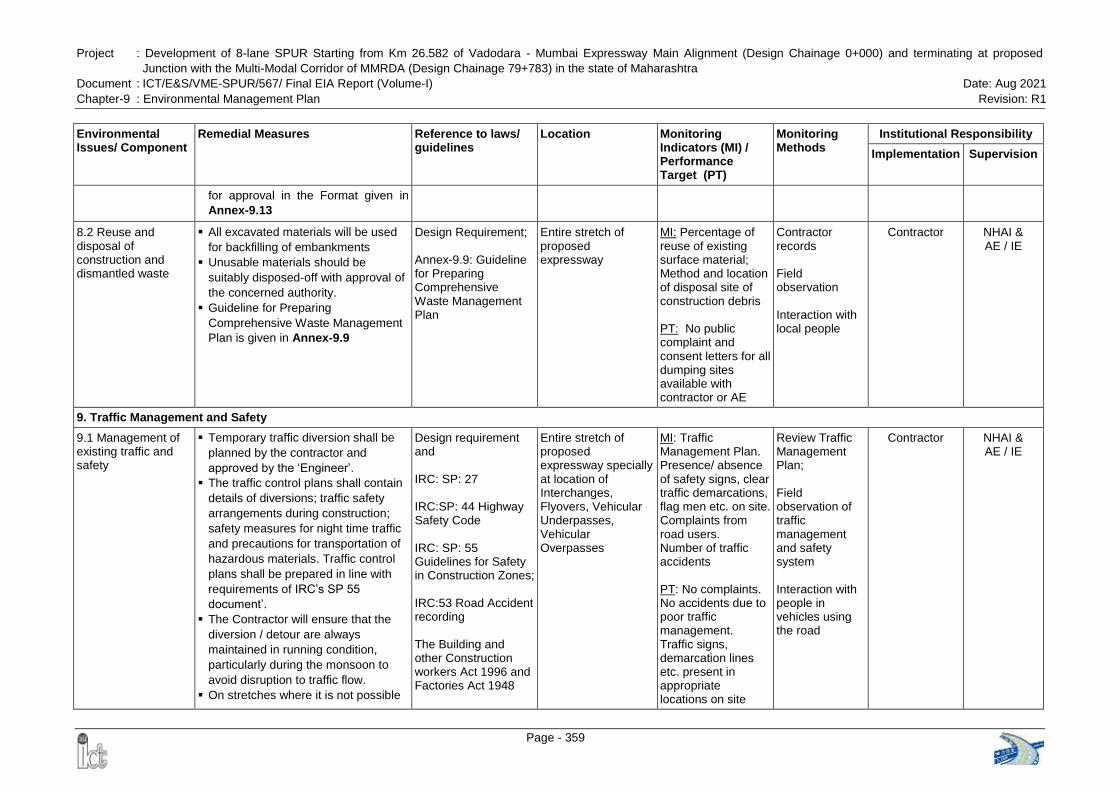
Project : Development of 8-lane SPUR Starting from Km 26.582 of Vadodara - Mumbai Expressway Main Alignment (Design Chainage 0+000) and terminating at proposed
Junction with the Multi-Modal Corridor of MMRDA (Design Chainage 79+783) in the state of Maharashtra
Document : ICT/E&S/VME-SPUR/567/ Final EIA Report (Volume-I) Date: Aug 2021
Chapter-9 : Environmental Management Plan Revision: R1
Page - 359
Environmental Issues/ Component
Remedial Measures Reference to laws/ guidelines
Location Monitoring Indicators (MI) / Performance Target (PT)
Monitoring Methods
Institutional Responsibility
Implementation Supervision
for approval in the Format given in
Annex-9.13
8.2 Reuse and disposal of construction and dismantled waste
All excavated materials will be used
for backfilling of embankments
Unusable materials should be
suitably disposed-off with approval of
the concerned authority.
Guideline for Preparing
Comprehensive Waste Management
Plan is given in Annex-9.9
Design Requirement; Annex-9.9: Guideline for Preparing Comprehensive Waste Management Plan
Entire stretch of proposed expressway
MI: Percentage of reuse of existing surface material; Method and location of disposal site of construction debris PT: No public complaint and consent letters for all dumping sites available with contractor or AE
Contractor records Field observation Interaction with local people
Contractor NHAI & AE / IE
9. Traffic Management and Safety
9.1 Management of existing traffic and safety
Temporary traffic diversion shall be
planned by the contractor and
approved by the „Engineer‟.
The traffic control plans shall contain
details of diversions; traffic safety
arrangements during construction;
safety measures for night time traffic
and precautions for transportation of
hazardous materials. Traffic control
plans shall be prepared in line with
requirements of IRC‟s SP 55
document‟.
The Contractor will ensure that the
diversion / detour are always
maintained in running condition,
particularly during the monsoon to
avoid disruption to traffic flow.
On stretches where it is not possible
Design requirement and IRC: SP: 27 IRC:SP: 44 Highway Safety Code IRC: SP: 55 Guidelines for Safety in Construction Zones; IRC:53 Road Accident recording The Building and other Construction workers Act 1996 and Factories Act 1948
Entire stretch of proposed expressway specially at location of Interchanges, Flyovers, Vehicular Underpasses, Vehicular Overpasses
MI: Traffic Management Plan. Presence/ absence of safety signs, clear traffic demarcations, flag men etc. on site. Complaints from road users. Number of traffic accidents PT: No complaints. No accidents due to poor traffic management. Traffic signs, demarcation lines etc. present in appropriate locations on site
Review Traffic Management Plan; Field observation of traffic management and safety system Interaction with people in vehicles using the road
Contractor NHAI & AE / IE
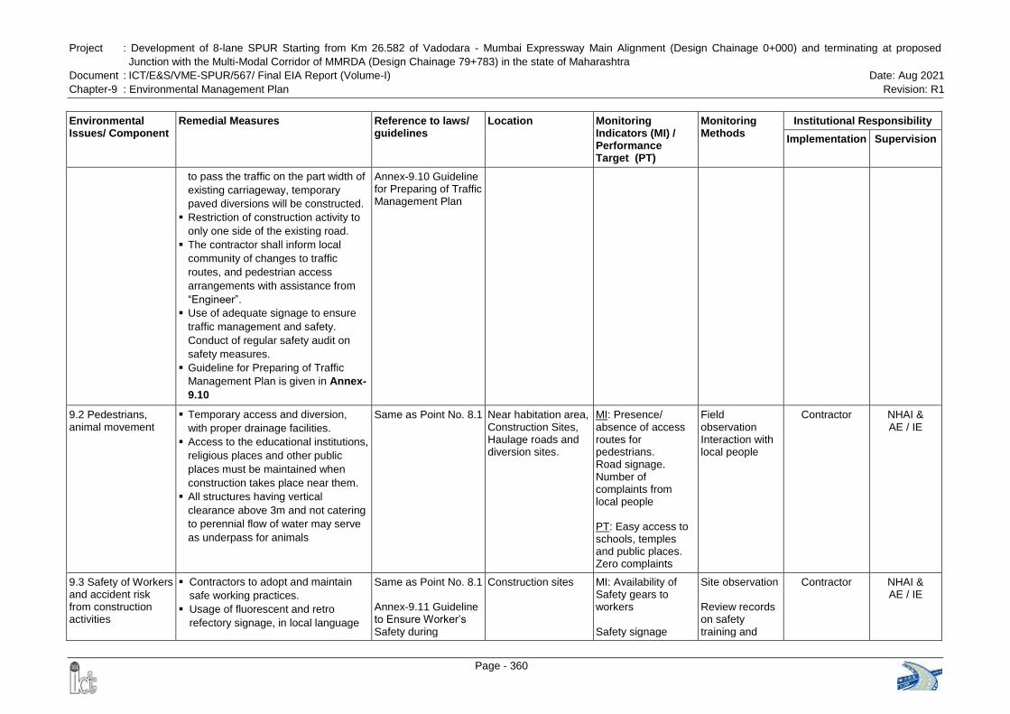
Project : Development of 8-lane SPUR Starting from Km 26.582 of Vadodara - Mumbai Expressway Main Alignment (Design Chainage 0+000) and terminating at proposed
Junction with the Multi-Modal Corridor of MMRDA (Design Chainage 79+783) in the state of Maharashtra
Document : ICT/E&S/VME-SPUR/567/ Final EIA Report (Volume-I) Date: Aug 2021
Chapter-9 : Environmental Management Plan Revision: R1
Page - 360
Environmental Issues/ Component
Remedial Measures Reference to laws/ guidelines
Location Monitoring Indicators (MI) / Performance Target (PT)
Monitoring Methods
Institutional Responsibility
Implementation Supervision
to pass the traffic on the part width of
existing carriageway, temporary
paved diversions will be constructed.
Restriction of construction activity to
only one side of the existing road.
The contractor shall inform local
community of changes to traffic
routes, and pedestrian access
arrangements with assistance from
“Engineer”.
Use of adequate signage to ensure
traffic management and safety.
Conduct of regular safety audit on
safety measures.
Guideline for Preparing of Traffic
Management Plan is given in Annex-
9.10
Annex-9.10 Guideline for Preparing of Traffic Management Plan
9.2 Pedestrians, animal movement
Temporary access and diversion,
with proper drainage facilities.
Access to the educational institutions,
religious places and other public
places must be maintained when
construction takes place near them.
All structures having vertical
clearance above 3m and not catering
to perennial flow of water may serve
as underpass for animals
Same as Point No. 8.1 Near habitation area, Construction Sites, Haulage roads and diversion sites.
MI: Presence/ absence of access routes for pedestrians. Road signage. Number of complaints from local people PT: Easy access to schools, temples and public places. Zero complaints
Field observation Interaction with local people
Contractor NHAI & AE / IE
9.3 Safety of Workers and accident risk from construction activities
Contractors to adopt and maintain
safe working practices.
Usage of fluorescent and retro
refectory signage, in local language
Same as Point No. 8.1 Annex-9.11 Guideline to Ensure Worker‟s Safety during
Construction sites MI: Availability of Safety gears to workers Safety signage
Site observation Review records on safety training and
Contractor NHAI & AE / IE
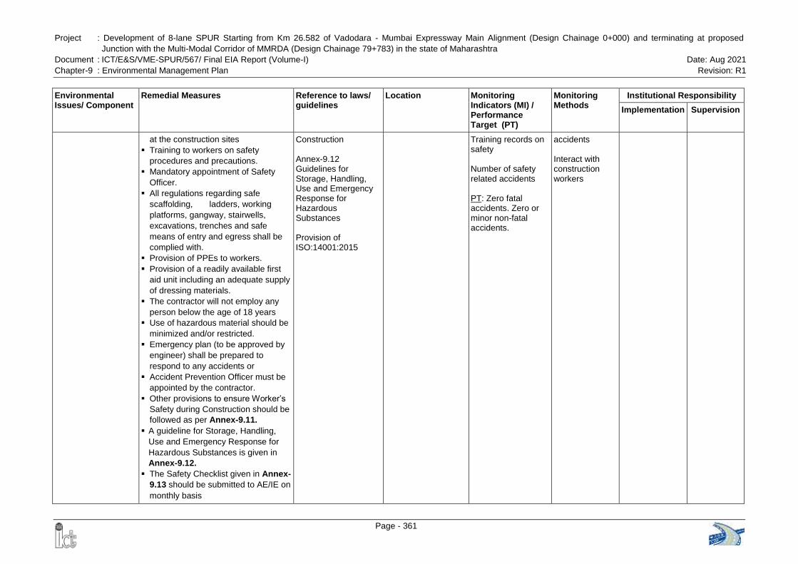
Project : Development of 8-lane SPUR Starting from Km 26.582 of Vadodara - Mumbai Expressway Main Alignment (Design Chainage 0+000) and terminating at proposed
Junction with the Multi-Modal Corridor of MMRDA (Design Chainage 79+783) in the state of Maharashtra
Document : ICT/E&S/VME-SPUR/567/ Final EIA Report (Volume-I) Date: Aug 2021
Chapter-9 : Environmental Management Plan Revision: R1
Page - 361
Environmental Issues/ Component
Remedial Measures Reference to laws/ guidelines
Location Monitoring Indicators (MI) / Performance Target (PT)
Monitoring Methods
Institutional Responsibility
Implementation Supervision
at the construction sites
Training to workers on safety
procedures and precautions.
Mandatory appointment of Safety
Officer.
All regulations regarding safe
scaffolding, ladders, working
platforms, gangway, stairwells,
excavations, trenches and safe
means of entry and egress shall be
complied with.
Provision of PPEs to workers.
Provision of a readily available first
aid unit including an adequate supply
of dressing materials.
The contractor will not employ any
person below the age of 18 years
Use of hazardous material should be
minimized and/or restricted.
Emergency plan (to be approved by
engineer) shall be prepared to
respond to any accidents or
Accident Prevention Officer must be
appointed by the contractor.
Other provisions to ensure Worker‟s
Safety during Construction should be
followed as per Annex-9.11.
A guideline for Storage, Handling,
Use and Emergency Response for
Hazardous Substances is given in
Annex-9.12.
The Safety Checklist given in Annex-
9.13 should be submitted to AE/IE on
monthly basis
Construction Annex-9.12 Guidelines for Storage, Handling, Use and Emergency Response for Hazardous Substances Provision of ISO:14001:2015
Training records on safety Number of safety related accidents PT: Zero fatal accidents. Zero or minor non-fatal accidents.
accidents Interact with construction workers
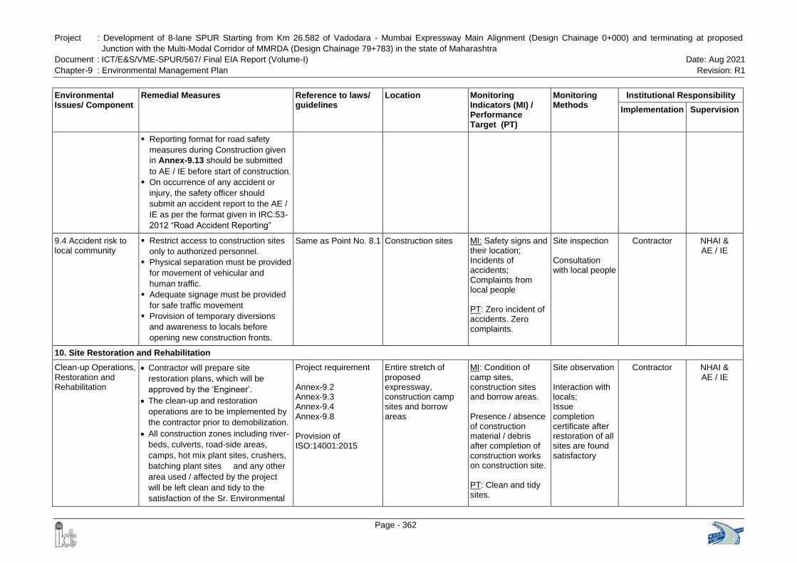
Project : Development of 8-lane SPUR Starting from Km 26.582 of Vadodara - Mumbai Expressway Main Alignment (Design Chainage 0+000) and terminating at proposed
Junction with the Multi-Modal Corridor of MMRDA (Design Chainage 79+783) in the state of Maharashtra
Document : ICT/E&S/VME-SPUR/567/ Final EIA Report (Volume-I) Date: Aug 2021
Chapter-9 : Environmental Management Plan Revision: R1
Page - 362
Environmental Issues/ Component
Remedial Measures Reference to laws/ guidelines
Location Monitoring Indicators (MI) / Performance Target (PT)
Monitoring Methods
Institutional Responsibility
Implementation Supervision
Reporting format for road safety
measures during Construction given
in Annex-9.13 should be submitted
to AE / IE before start of construction.
On occurrence of any accident or
injury, the safety officer should
submit an accident report to the AE /
IE as per the format given in IRC:53-
2012 “Road Accident Reporting”
9.4 Accident risk to local community
Restrict access to construction sites
only to authorized personnel.
Physical separation must be provided
for movement of vehicular and
human traffic.
Adequate signage must be provided
for safe traffic movement
Provision of temporary diversions
and awareness to locals before
opening new construction fronts.
Same as Point No. 8.1
Construction sites MI: Safety signs and their location; Incidents of accidents; Complaints from local people PT: Zero incident of accidents. Zero complaints.
Site inspection Consultation with local people
Contractor NHAI & AE / IE
10. Site Restoration and Rehabilitation
Clean-up Operations, Restoration and Rehabilitation
Contractor will prepare site
restoration plans, which will be
approved by the „Engineer‟.
The clean-up and restoration
operations are to be implemented by
the contractor prior to demobilization.
All construction zones including river-
beds, culverts, road-side areas,
camps, hot mix plant sites, crushers,
batching plant sites and any other
area used / affected by the project
will be left clean and tidy to the
satisfaction of the Sr. Environmental
Project requirement Annex-9.2 Annex-9.3 Annex-9.4 Annex-9.8 Provision of ISO:14001:2015
Entire stretch of proposed expressway, construction camp sites and borrow areas
MI: Condition of camp sites, construction sites and borrow areas. Presence / absence of construction material / debris after completion of construction works on construction site. PT: Clean and tidy sites.
Site observation Interaction with locals; Issue completion certificate after restoration of all sites are found satisfactory
Contractor NHAI & AE / IE
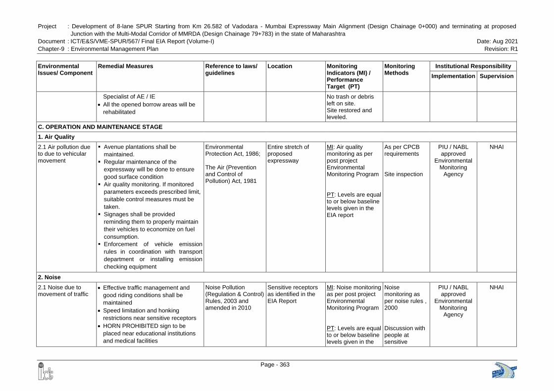
Project : Development of 8-lane SPUR Starting from Km 26.582 of Vadodara - Mumbai Expressway Main Alignment (Design Chainage 0+000) and terminating at proposed
Junction with the Multi-Modal Corridor of MMRDA (Design Chainage 79+783) in the state of Maharashtra
Document : ICT/E&S/VME-SPUR/567/ Final EIA Report (Volume-I) Date: Aug 2021
Chapter-9 : Environmental Management Plan Revision: R1
Page - 363
Environmental Issues/ Component
Remedial Measures Reference to laws/ guidelines
Location Monitoring Indicators (MI) / Performance Target (PT)
Monitoring Methods
Institutional Responsibility
Implementation Supervision
Specialist of AE / IE
All the opened borrow areas will be
rehabilitated
No trash or debris left on site. Site restored and leveled.
C. OPERATION AND MAINTENANCE STAGE
1. Air Quality
2.1 Air pollution due to due to vehicular movement
Avenue plantations shall be
maintained.
Regular maintenance of the
expressway will be done to ensure
good surface condition
Air quality monitoring. If monitored
parameters exceeds prescribed limit,
suitable control measures must be
taken.
Signages shall be provided
reminding them to properly maintain
their vehicles to economize on fuel
consumption.
Enforcement of vehicle emission
rules in coordination with transport
department or installing emission
checking equipment
Environmental Protection Act, 1986; The Air (Prevention and Control of Pollution) Act, 1981
Entire stretch of proposed expressway
MI: Air quality monitoring as per post project Environmental Monitoring Program PT: Levels are equal to or below baseline levels given in the EIA report
As per CPCB requirements Site inspection
PIU / NABL approved
Environmental Monitoring
Agency
NHAI
2. Noise
2.1 Noise due to movement of traffic
Effective traffic management and
good riding conditions shall be
maintained
Speed limitation and honking
restrictions near sensitive receptors
HORN PROHIBITED sign to be
placed near educational institutions
and medical facilities
Noise Pollution (Regulation & Control) Rules, 2003 and amended in 2010
Sensitive receptors as identified in the EIA Report
MI: Noise monitoring as per post project Environmental Monitoring Program PT: Levels are equal to or below baseline levels given in the
Noise monitoring as per noise rules , 2000 Discussion with people at sensitive
PIU / NABL approved
Environmental Monitoring
Agency
NHAI
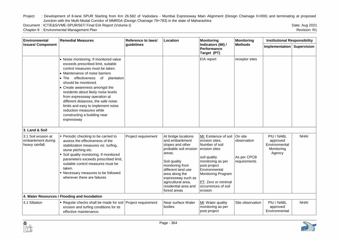
Project : Development of 8-lane SPUR Starting from Km 26.582 of Vadodara - Mumbai Expressway Main Alignment (Design Chainage 0+000) and terminating at proposed
Junction with the Multi-Modal Corridor of MMRDA (Design Chainage 79+783) in the state of Maharashtra
Document : ICT/E&S/VME-SPUR/567/ Final EIA Report (Volume-I) Date: Aug 2021
Chapter-9 : Environmental Management Plan Revision: R1
Page - 364
Environmental Issues/ Component
Remedial Measures Reference to laws/ guidelines
Location Monitoring Indicators (MI) / Performance Target (PT)
Monitoring Methods
Institutional Responsibility
Implementation Supervision
Noise monitoring. If monitored value
exceeds prescribed limit, suitable
control measures must be taken.
Maintenance of noise barriers
The effectiveness of plantation
should be monitored.
Create awareness amongst the
residents about likely noise levels
from expressway operation at
different distances, the safe noise
limits and easy to implement noise
reduction measures while
constructing a building near
expressway
EIA report receptor sites
3. Land & Soil
3.1 Soil erosion at embankment during heavy rainfall.
Periodic checking to be carried to
assess the effectiveness of the
stabilization measures viz. turfing,
stone pitching etc.
Soil quality monitoring. If monitored
parameters exceeds prescribed limit,
suitable control measures must be
taken.
Necessary measures to be followed
wherever there are failures
Project requirement
At bridge locations and embankment slopes and other probable soil erosion areas. Soil quality monitoring from different land use area along the expressway such as agricultural area, residential area and forest areas
MI: Existence of soil erosion sites; Number of soil erosion sites soil quality monitoring as per post project Environmental Monitoring Program PT: Zero or minimal occurrences of soil erosion
On site observation As per CPCB requirements
PIU / NABL approved
Environmental Monitoring
Agency
NHAI
4. Water Resources / Flooding and Inundation
4.1 Siltation
Regular checks shall be made for soil
erosion and turfing conditions for its
effective maintenance.
Project requirement
Near surface Water bodies
MI: Water quality monitoring as per post project
Site observation PIU / NABL approved
Environmental
NHAI
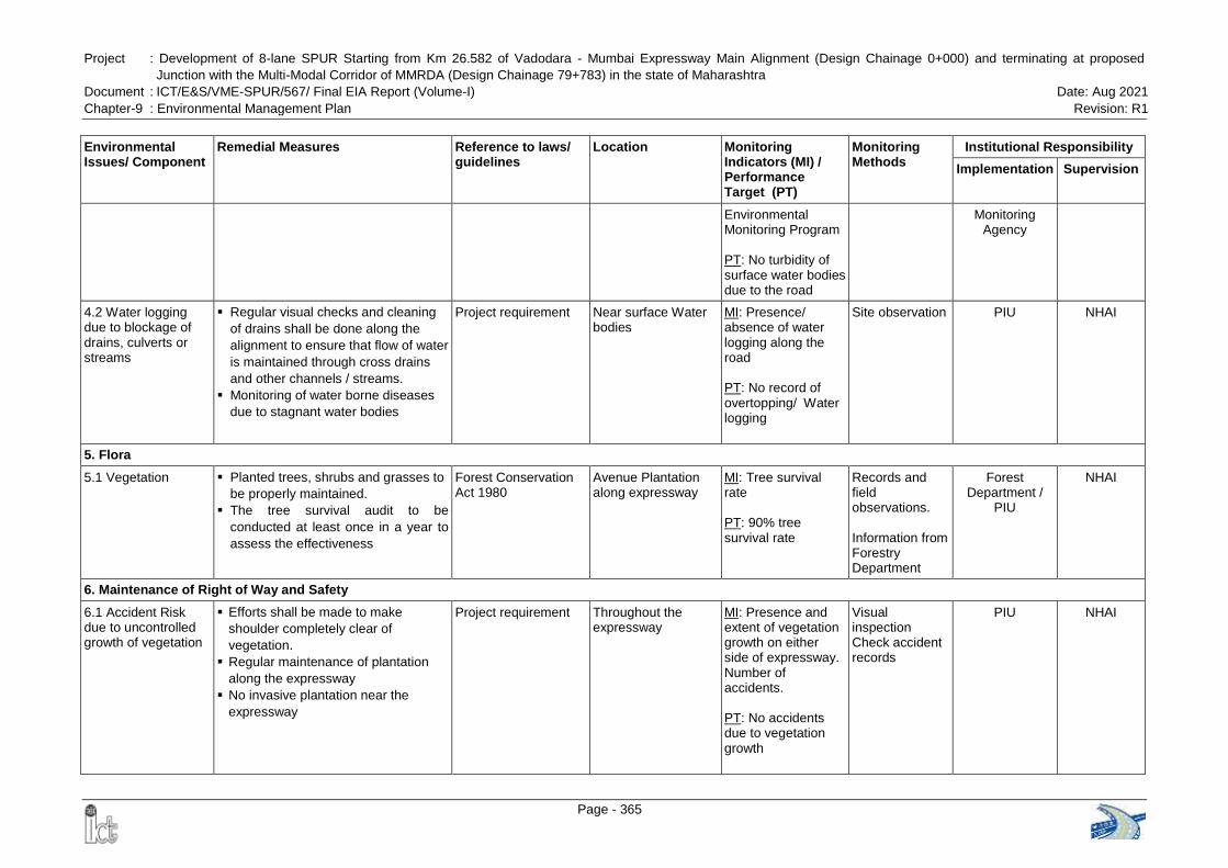
Project : Development of 8-lane SPUR Starting from Km 26.582 of Vadodara - Mumbai Expressway Main Alignment (Design Chainage 0+000) and terminating at proposed
Junction with the Multi-Modal Corridor of MMRDA (Design Chainage 79+783) in the state of Maharashtra
Document : ICT/E&S/VME-SPUR/567/ Final EIA Report (Volume-I) Date: Aug 2021
Chapter-9 : Environmental Management Plan Revision: R1
Page - 365
Environmental Issues/ Component
Remedial Measures Reference to laws/ guidelines
Location Monitoring Indicators (MI) / Performance Target (PT)
Monitoring Methods
Institutional Responsibility
Implementation Supervision
Environmental Monitoring Program PT: No turbidity of surface water bodies due to the road
Monitoring Agency
4.2 Water logging due to blockage of drains, culverts or streams
Regular visual checks and cleaning
of drains shall be done along the
alignment to ensure that flow of water
is maintained through cross drains
and other channels / streams.
Monitoring of water borne diseases
due to stagnant water bodies
Project requirement
Near surface Water bodies
MI: Presence/ absence of water logging along the road PT: No record of overtopping/ Water logging
Site observation PIU NHAI
5. Flora
5.1 Vegetation
Planted trees, shrubs and grasses to
be properly maintained.
The tree survival audit to be
conducted at least once in a year to
assess the effectiveness
Forest Conservation Act 1980
Avenue Plantation along expressway
MI: Tree survival rate PT: 90% tree survival rate
Records and field observations. Information from Forestry Department
Forest Department /
PIU
NHAI
6. Maintenance of Right of Way and Safety
6.1 Accident Risk due to uncontrolled growth of vegetation
Efforts shall be made to make
shoulder completely clear of
vegetation.
Regular maintenance of plantation
along the expressway
No invasive plantation near the
expressway
Project requirement
Throughout the expressway
MI: Presence and extent of vegetation growth on either side of expressway. Number of accidents. PT: No accidents due to vegetation growth
Visual inspection Check accident records
PIU NHAI
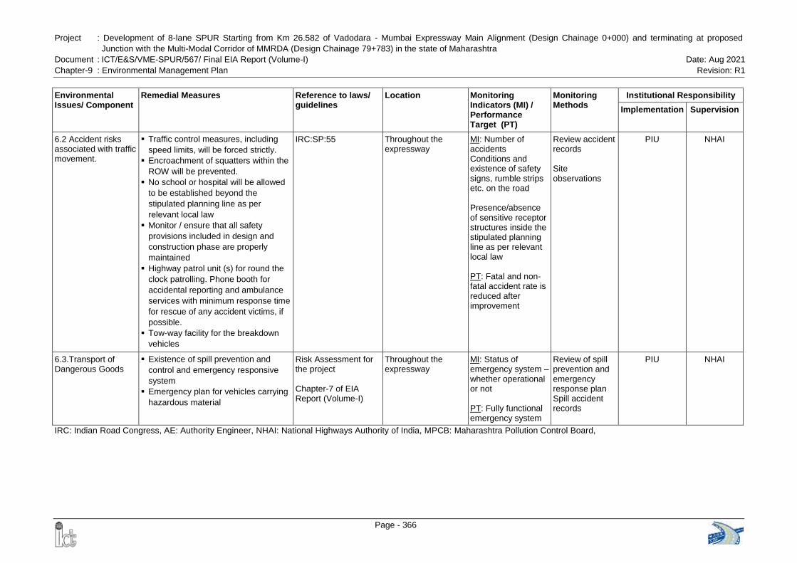
Project : Development of 8-lane SPUR Starting from Km 26.582 of Vadodara - Mumbai Expressway Main Alignment (Design Chainage 0+000) and terminating at proposed
Junction with the Multi-Modal Corridor of MMRDA (Design Chainage 79+783) in the state of Maharashtra
Document : ICT/E&S/VME-SPUR/567/ Final EIA Report (Volume-I) Date: Aug 2021
Chapter-9 : Environmental Management Plan Revision: R1
Page - 366
Environmental Issues/ Component
Remedial Measures Reference to laws/ guidelines
Location Monitoring Indicators (MI) / Performance Target (PT)
Monitoring Methods
Institutional Responsibility
Implementation Supervision
6.2 Accident risks associated with traffic movement.
Traffic control measures, including
speed limits, will be forced strictly.
Encroachment of squatters within the
ROW will be prevented.
No school or hospital will be allowed
to be established beyond the
stipulated planning line as per
relevant local law
Monitor / ensure that all safety
provisions included in design and
construction phase are properly
maintained
Highway patrol unit (s) for round the
clock patrolling. Phone booth for
accidental reporting and ambulance
services with minimum response time
for rescue of any accident victims, if
possible.
Tow-way facility for the breakdown
vehicles
IRC:SP:55
Throughout the expressway
MI: Number of accidents Conditions and existence of safety signs, rumble strips etc. on the road Presence/absence of sensitive receptor structures inside the stipulated planning line as per relevant local law PT: Fatal and non-fatal accident rate is reduced after improvement
Review accident records Site observations
PIU NHAI
6.3.Transport of Dangerous Goods
Existence of spill prevention and
control and emergency responsive
system
Emergency plan for vehicles carrying
hazardous material
Risk Assessment for the project Chapter-7 of EIA Report (Volume-I)
Throughout the expressway
MI: Status of emergency system – whether operational or not PT: Fully functional emergency system
Review of spill prevention and emergency response plan Spill accident records
PIU NHAI
IRC: Indian Road Congress, AE: Authority Engineer, NHAI: National Highways Authority of India, MPCB: Maharashtra Pollution Control Board,
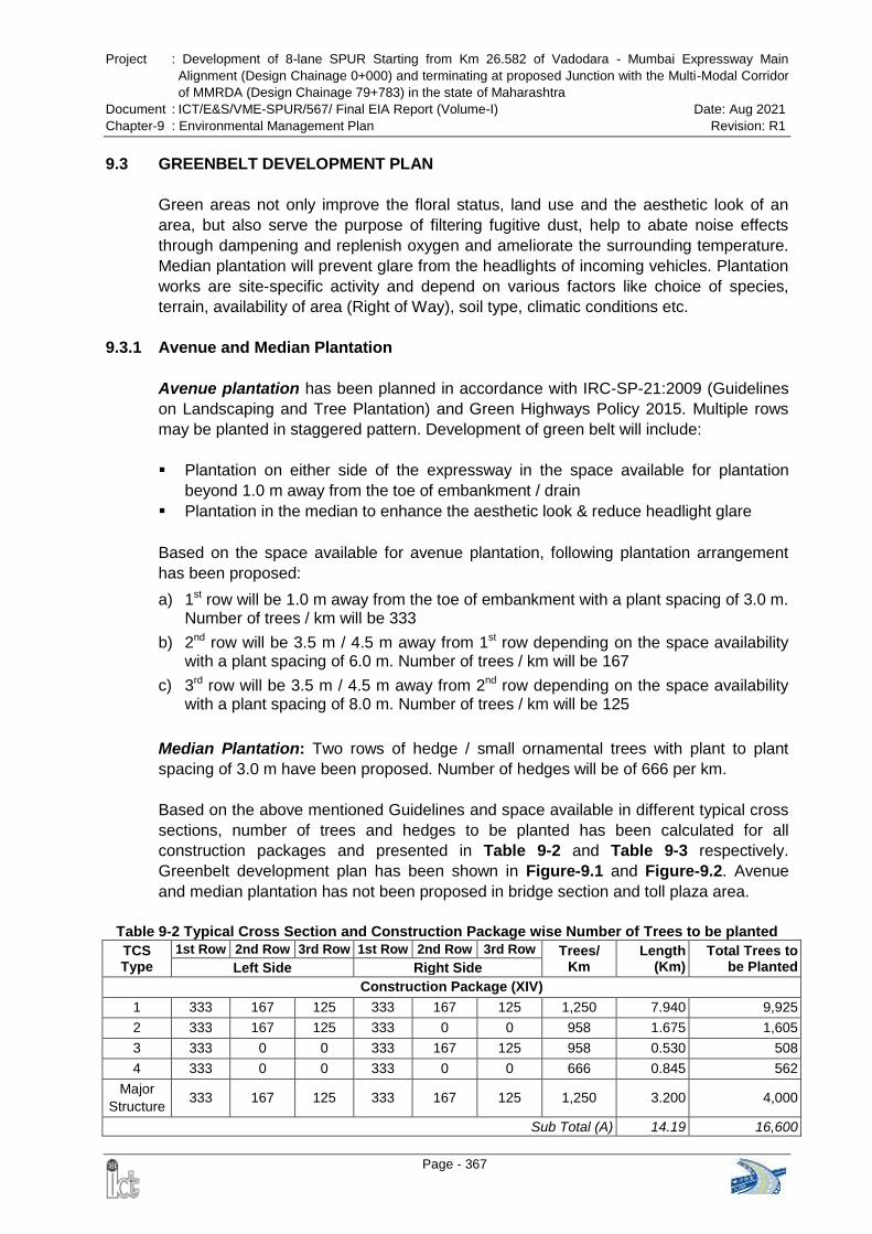
Project : Development of 8-lane SPUR Starting from Km 26.582 of Vadodara - Mumbai Expressway Main
Alignment (Design Chainage 0+000) and terminating at proposed Junction with the Multi-Modal Corridor
of MMRDA (Design Chainage 79+783) in the state of Maharashtra
Document : ICT/E&S/VME-SPUR/567/ Final EIA Report (Volume-I) Date: Aug 2021
Chapter-9 : Environmental Management Plan Revision: R1
Page - 367
9.3 GREENBELT DEVELOPMENT PLAN
Green areas not only improve the floral status, land use and the aesthetic look of an
area, but also serve the purpose of filtering fugitive dust, help to abate noise effects
through dampening and replenish oxygen and ameliorate the surrounding temperature.
Median plantation will prevent glare from the headlights of incoming vehicles. Plantation
works are site-specific activity and depend on various factors like choice of species,
terrain, availability of area (Right of Way), soil type, climatic conditions etc.
9.3.1 Avenue and Median Plantation
Avenue plantation has been planned in accordance with IRC-SP-21:2009 (Guidelines
on Landscaping and Tree Plantation) and Green Highways Policy 2015. Multiple rows
may be planted in staggered pattern. Development of green belt will include:
Plantation on either side of the expressway in the space available for plantation
beyond 1.0 m away from the toe of embankment / drain
Plantation in the median to enhance the aesthetic look & reduce headlight glare
Based on the space available for avenue plantation, following plantation arrangement
has been proposed:
a) 1st row will be 1.0 m away from the toe of embankment with a plant spacing of 3.0 m. Number of trees / km will be 333
b) 2nd row will be 3.5 m / 4.5 m away from 1st row depending on the space availability with a plant spacing of 6.0 m. Number of trees / km will be 167
c) 3rd row will be 3.5 m / 4.5 m away from 2nd row depending on the space availability with a plant spacing of 8.0 m. Number of trees / km will be 125
Median Plantation: Two rows of hedge / small ornamental trees with plant to plant
spacing of 3.0 m have been proposed. Number of hedges will be of 666 per km.
Based on the above mentioned Guidelines and space available in different typical cross
sections, number of trees and hedges to be planted has been calculated for all
construction packages and presented in Table 9-2 and Table 9-3 respectively.
Greenbelt development plan has been shown in Figure-9.1 and Figure-9.2. Avenue
and median plantation has not been proposed in bridge section and toll plaza area.
Table 9-2 Typical Cross Section and Construction Package wise Number of Trees to be planted
TCS Type
1st Row 2nd Row 3rd Row 1st Row 2nd Row 3rd Row Trees/ Km
Length (Km)
Total Trees to be Planted Left Side Right Side
Construction Package (XIV)
1 333 167 125 333 167 125 1,250 7.940 9,925
2 333 167 125 333 0 0 958 1.675 1,605
3 333 0 0 333 167 125 958 0.530 508
4 333 0 0 333 0 0 666 0.845 562
Major
Structure 333 167 125 333 167 125 1,250 3.200 4,000
Sub Total (A) 14.19 16,600
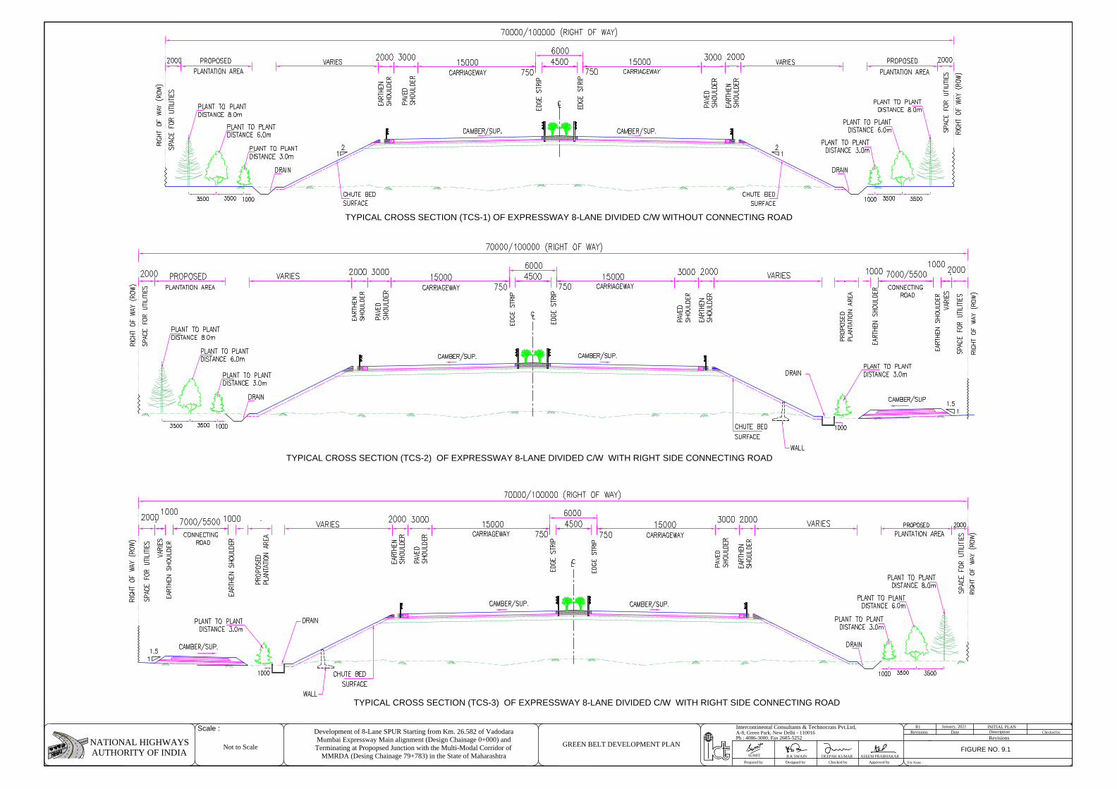
TYPICAL CROSS SECTION (TCS-1) OF EXPRESSWAY 8-LANE DIVIDED C/W WITHOUT CONNECTING ROAD
TYPICAL CROSS SECTION (TCS-2) OF EXPRESSWAY 8-LANE DIVIDED C/W WITH RIGHT SIDE CONNECTING ROAD
TYPICAL CROSS SECTION (TCS-3) OF EXPRESSWAY 8-LANE DIVIDED C/W WITH RIGHT SIDE CONNECTING ROAD
RevisionsPh : 4086-3000, Fax 2685-5252
Prepared by Designed by Checked by Approved by File Name :
A-8, Green Park, New Delhi - 110016Intercontinental Consultants & Technocrats Pvt.Ltd,
NATIONAL HIGHWAYSAUTHORITY OF INDIA DEEPAK KUMARB.K SWAIN ASEEM PRABHAKAR
R1DateRevisions
INITIAL PLANDescription Checked by
Scale : Development of 8-Lane SPUR Starting from Km. 26.582 of VadodaraMumbai Expressway Main alignment (Design Chainage 0+000) andTerminating at Propopsed Junction with the Multi-Modal Corridor of
MMRDA (Desing Chainage 79+783) in the State of Maharashtra
January, 2021
SUMIT
Not to Scale GREEN BELT DEVELOPMENT PLANFIGURE NO. 9.1
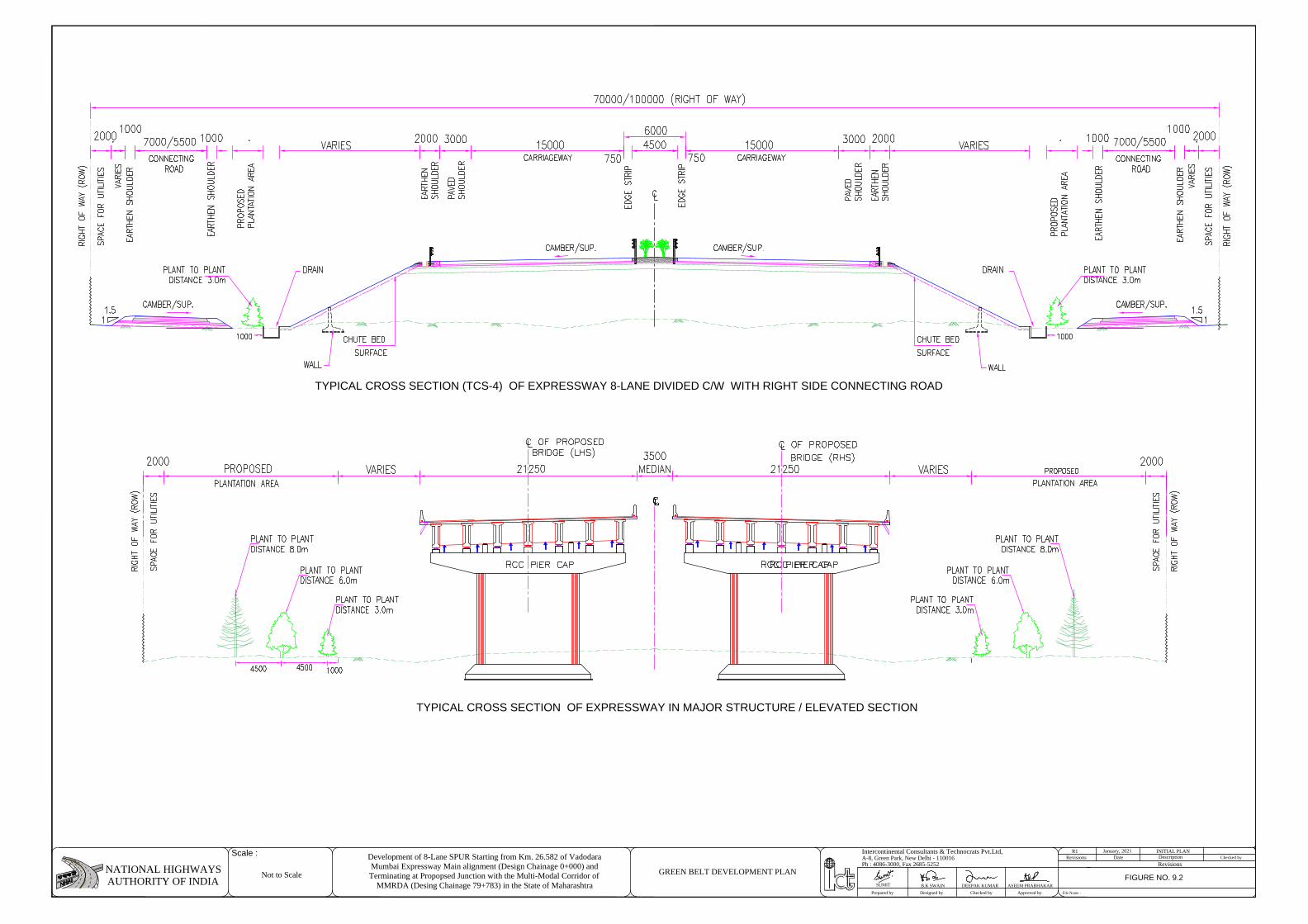
TYPICAL CROSS SECTION (TCS-4) OF EXPRESSWAY 8-LANE DIVIDED C/W WITH RIGHT SIDE CONNECTING ROAD
TYPICAL CROSS SECTION OF EXPRESSWAY IN MAJOR STRUCTURE / ELEVATED SECTION
RevisionsPh : 4086-3000, Fax 2685-5252
Prepared by Designed by Checked by Approved by File Name :
A-8, Green Park, New Delhi - 110016Intercontinental Consultants & Technocrats Pvt.Ltd,
NATIONAL HIGHWAYSAUTHORITY OF INDIA DEEPAK KUMARB.K SWAIN ASEEM PRABHAKAR
R1DateRevisions
INITIAL PLANDescription Checked by
Scale : Development of 8-Lane SPUR Starting from Km. 26.582 of VadodaraMumbai Expressway Main alignment (Design Chainage 0+000) andTerminating at Propopsed Junction with the Multi-Modal Corridor of
MMRDA (Desing Chainage 79+783) in the State of Maharashtra
January, 2021
SUMIT
Not to Scale GREEN BELT DEVELOPMENT PLANFIGURE NO. 9.2
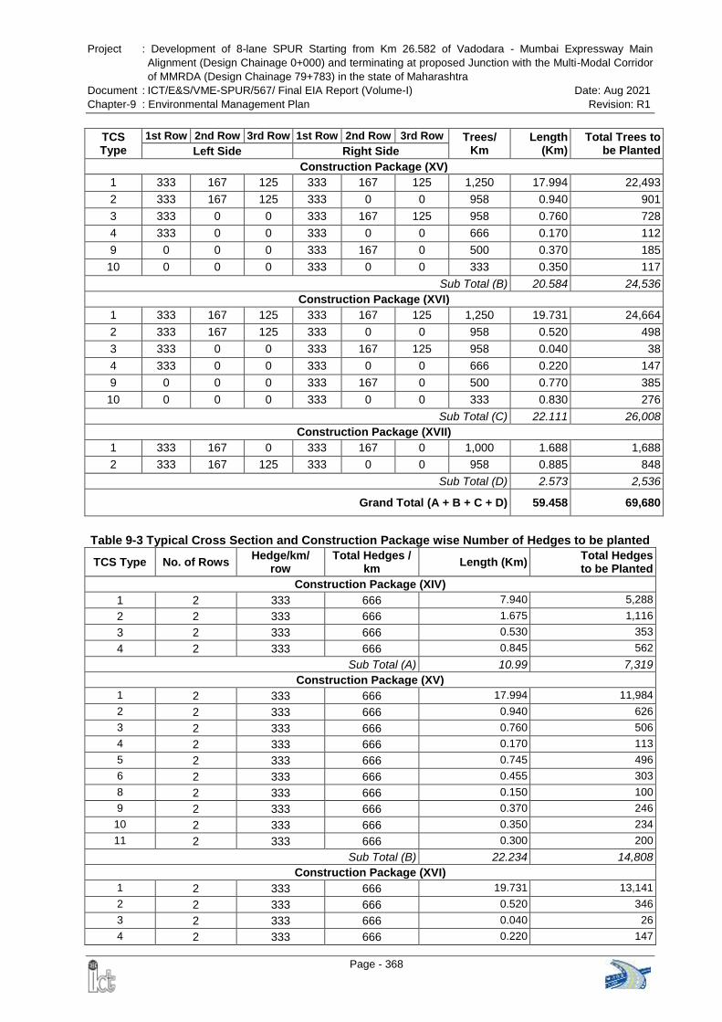
Project : Development of 8-lane SPUR Starting from Km 26.582 of Vadodara - Mumbai Expressway Main
Alignment (Design Chainage 0+000) and terminating at proposed Junction with the Multi-Modal Corridor
of MMRDA (Design Chainage 79+783) in the state of Maharashtra
Document : ICT/E&S/VME-SPUR/567/ Final EIA Report (Volume-I) Date: Aug 2021
Chapter-9 : Environmental Management Plan Revision: R1
Page - 368
TCS Type
1st Row 2nd Row 3rd Row 1st Row 2nd Row 3rd Row Trees/ Km
Length (Km)
Total Trees to be Planted Left Side Right Side
Construction Package (XV)
1 333 167 125 333 167 125 1,250 17.994 22,493
2 333 167 125 333 0 0 958 0.940 901
3 333 0 0 333 167 125 958 0.760 728
4 333 0 0 333 0 0 666 0.170 112
9 0 0 0 333 167 0 500 0.370 185
10 0 0 0 333 0 0 333 0.350 117
Sub Total (B) 20.584 24,536
Construction Package (XVI)
1 333 167 125 333 167 125 1,250 19.731 24,664
2 333 167 125 333 0 0 958 0.520 498
3 333 0 0 333 167 125 958 0.040 38
4 333 0 0 333 0 0 666 0.220 147
9 0 0 0 333 167 0 500 0.770 385
10 0 0 0 333 0 0 333 0.830 276
Sub Total (C) 22.111 26,008
Construction Package (XVII)
1 333 167 0 333 167 0 1,000 1.688 1,688
2 333 167 125 333 0 0 958 0.885 848
Sub Total (D) 2.573 2,536
Grand Total (A + B + C + D) 59.458 69,680
Table 9-3 Typical Cross Section and Construction Package wise Number of Hedges to be planted
TCS Type No. of Rows Hedge/km/
row Total Hedges /
km Length (Km)
Total Hedges to be Planted
Construction Package (XIV)
1 2 333 666 7.940 5,288
2 2 333 666 1.675 1,116
3 2 333 666 0.530 353
4 2 333 666 0.845 562
Sub Total (A) 10.99 7,319
Construction Package (XV)
1 2 333 666 17.994 11,984
2 2 333 666 0.940 626
3 2 333 666 0.760 506
4 2 333 666 0.170 113
5 2 333 666 0.745 496
6 2 333 666 0.455 303
8 2 333 666 0.150 100
9 2 333 666 0.370 246
10 2 333 666 0.350 234
11 2 333 666 0.300 200
Sub Total (B) 22.234 14,808
Construction Package (XVI)
1 2 333 666 19.731 13,141
2 2 333 666 0.520 346
3 2 333 666 0.040 26
4 2 333 666 0.220 147
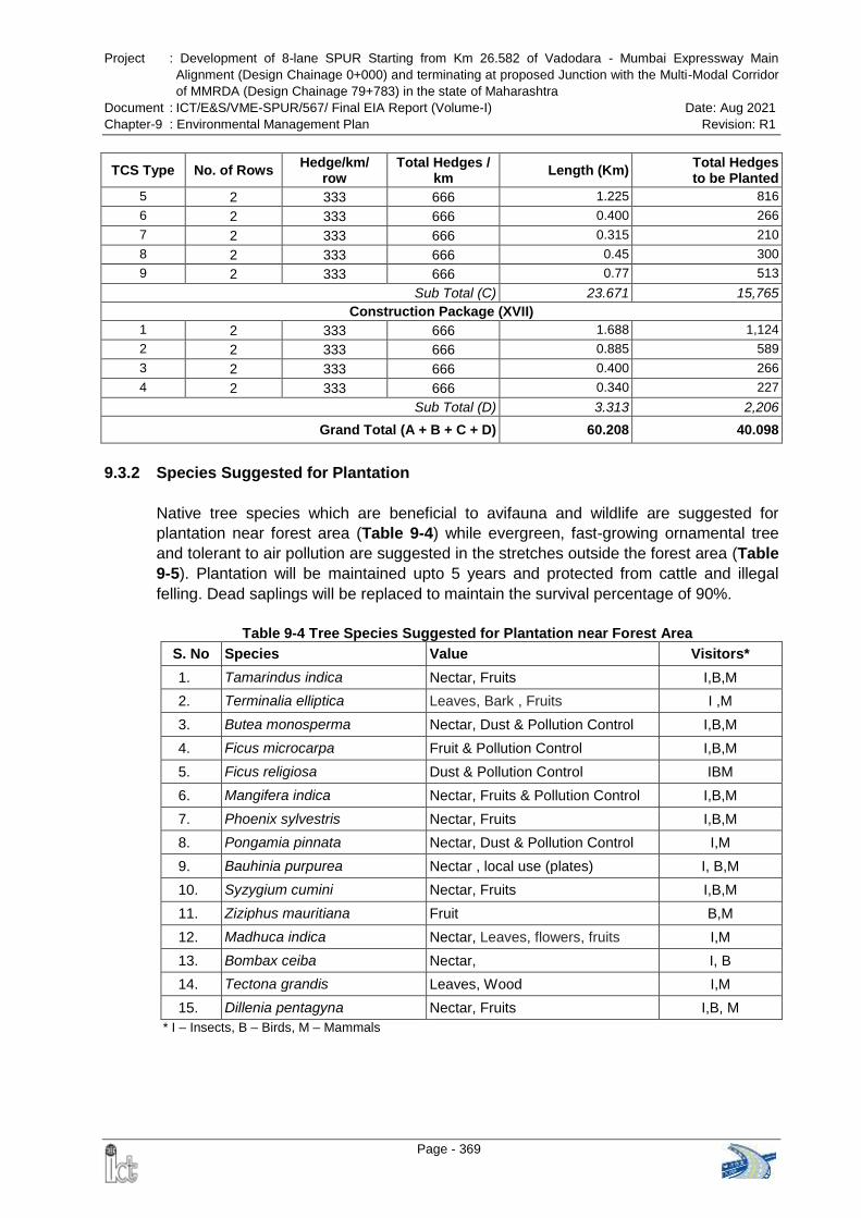
Project : Development of 8-lane SPUR Starting from Km 26.582 of Vadodara - Mumbai Expressway Main
Alignment (Design Chainage 0+000) and terminating at proposed Junction with the Multi-Modal Corridor
of MMRDA (Design Chainage 79+783) in the state of Maharashtra
Document : ICT/E&S/VME-SPUR/567/ Final EIA Report (Volume-I) Date: Aug 2021
Chapter-9 : Environmental Management Plan Revision: R1
Page - 369
TCS Type No. of Rows Hedge/km/
row Total Hedges /
km Length (Km)
Total Hedges to be Planted
5 2 333 666 1.225 816
6 2 333 666 0.400 266
7 2 333 666 0.315 210
8 2 333 666 0.45 300
9 2 333 666 0.77 513
Sub Total (C) 23.671 15,765
Construction Package (XVII)
1 2 333 666 1.688 1,124
2 2 333 666 0.885 589
3 2 333 666 0.400 266
4 2 333 666 0.340 227
Sub Total (D) 3.313 2,206
Grand Total (A + B + C + D) 60.208 40.098
9.3.2 Species Suggested for Plantation
Native tree species which are beneficial to avifauna and wildlife are suggested for
plantation near forest area (Table 9-4) while evergreen, fast-growing ornamental tree
and tolerant to air pollution are suggested in the stretches outside the forest area (Table
9-5). Plantation will be maintained upto 5 years and protected from cattle and illegal
felling. Dead saplings will be replaced to maintain the survival percentage of 90%.
Table 9-4 Tree Species Suggested for Plantation near Forest Area
S. No Species Value Visitors*
1. Tamarindus indica Nectar, Fruits I,B,M
2. Terminalia elliptica Leaves, Bark , Fruits I ,M
3. Butea monosperma Nectar, Dust & Pollution Control I,B,M
4. Ficus microcarpa Fruit & Pollution Control I,B,M
5. Ficus religiosa Dust & Pollution Control IBM
6. Mangifera indica Nectar, Fruits & Pollution Control I,B,M
7. Phoenix sylvestris Nectar, Fruits I,B,M
8. Pongamia pinnata Nectar, Dust & Pollution Control I,M
9. Bauhinia purpurea Nectar , local use (plates) I, B,M
10. Syzygium cumini Nectar, Fruits I,B,M
11. Ziziphus mauritiana Fruit B,M
12. Madhuca indica Nectar, Leaves, flowers, fruits I,M
13. Bombax ceiba Nectar, I, B
14. Tectona grandis Leaves, Wood I,M
15. Dillenia pentagyna Nectar, Fruits I,B, M
* I – Insects, B – Birds, M – Mammals
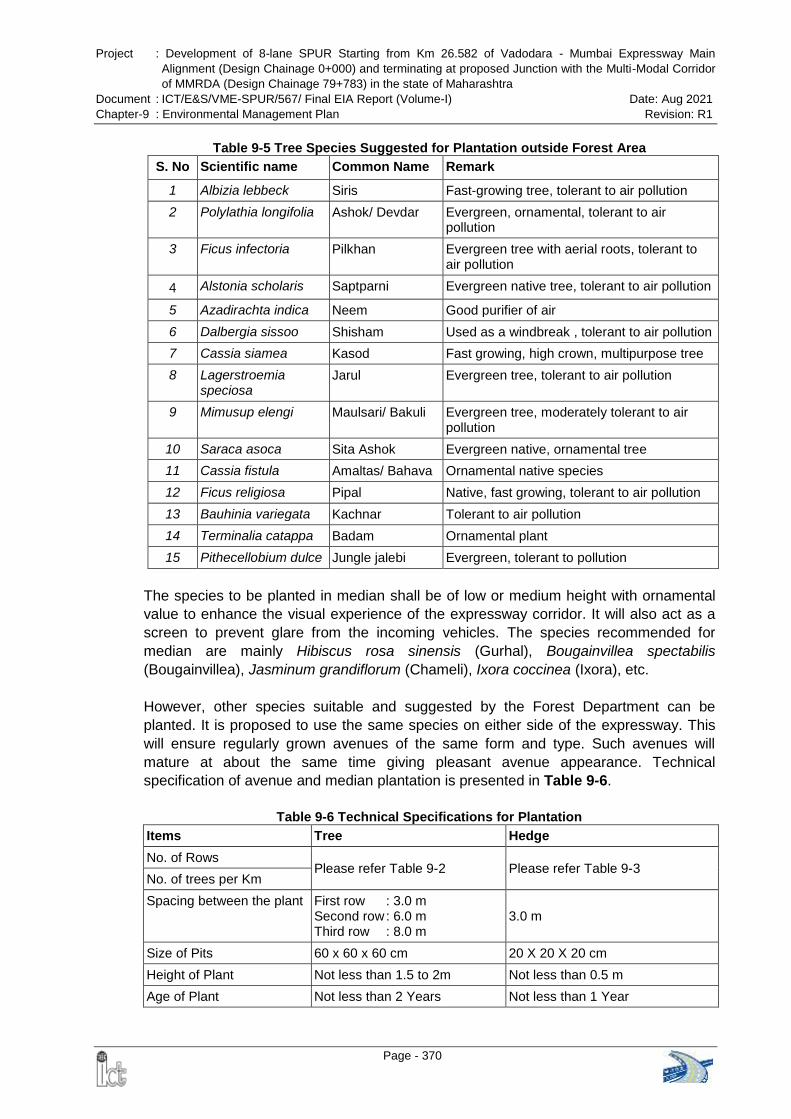
Project : Development of 8-lane SPUR Starting from Km 26.582 of Vadodara - Mumbai Expressway Main
Alignment (Design Chainage 0+000) and terminating at proposed Junction with the Multi-Modal Corridor
of MMRDA (Design Chainage 79+783) in the state of Maharashtra
Document : ICT/E&S/VME-SPUR/567/ Final EIA Report (Volume-I) Date: Aug 2021
Chapter-9 : Environmental Management Plan Revision: R1
Page - 370
Table 9-5 Tree Species Suggested for Plantation outside Forest Area
S. No Scientific name Common Name Remark
1 Albizia lebbeck Siris Fast-growing tree, tolerant to air pollution
2 Polylathia longifolia Ashok/ Devdar Evergreen, ornamental, tolerant to air pollution
3 Ficus infectoria Pilkhan Evergreen tree with aerial roots, tolerant to air pollution
4 Alstonia scholaris Saptparni Evergreen native tree, tolerant to air pollution
5 Azadirachta indica Neem Good purifier of air
6 Dalbergia sissoo Shisham Used as a windbreak , tolerant to air pollution
7 Cassia siamea Kasod Fast growing, high crown, multipurpose tree
8 Lagerstroemia speciosa
Jarul Evergreen tree, tolerant to air pollution
9 Mimusup elengi Maulsari/ Bakuli Evergreen tree, moderately tolerant to air pollution
10 Saraca asoca Sita Ashok Evergreen native, ornamental tree
11 Cassia fistula Amaltas/ Bahava Ornamental native species
12 Ficus religiosa Pipal Native, fast growing, tolerant to air pollution
13 Bauhinia variegata Kachnar Tolerant to air pollution
14 Terminalia catappa Badam Ornamental plant
15 Pithecellobium dulce Jungle jalebi Evergreen, tolerant to pollution
The species to be planted in median shall be of low or medium height with ornamental
value to enhance the visual experience of the expressway corridor. It will also act as a
screen to prevent glare from the incoming vehicles. The species recommended for
median are mainly Hibiscus rosa sinensis (Gurhal), Bougainvillea spectabilis
(Bougainvillea), Jasminum grandiflorum (Chameli), Ixora coccinea (Ixora), etc.
However, other species suitable and suggested by the Forest Department can be
planted. It is proposed to use the same species on either side of the expressway. This
will ensure regularly grown avenues of the same form and type. Such avenues will
mature at about the same time giving pleasant avenue appearance. Technical
specification of avenue and median plantation is presented in Table 9-6.
Table 9-6 Technical Specifications for Plantation
Items Tree Hedge
No. of Rows Please refer Table 9-2 Please refer Table 9-3
No. of trees per Km
Spacing between the plant First row : 3.0 m Second row : 6.0 m Third row : 8.0 m
3.0 m
Size of Pits 60 x 60 x 60 cm 20 X 20 X 20 cm
Height of Plant Not less than 1.5 to 2m Not less than 0.5 m
Age of Plant Not less than 2 Years Not less than 1 Year
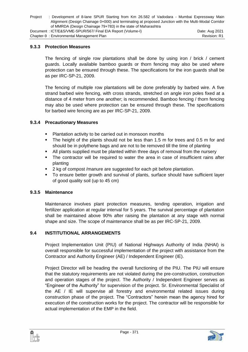
Project : Development of 8-lane SPUR Starting from Km 26.582 of Vadodara - Mumbai Expressway Main
Alignment (Design Chainage 0+000) and terminating at proposed Junction with the Multi-Modal Corridor
of MMRDA (Design Chainage 79+783) in the state of Maharashtra
Document : ICT/E&S/VME-SPUR/567/ Final EIA Report (Volume-I) Date: Aug 2021
Chapter-9 : Environmental Management Plan Revision: R1
Page - 371
9.3.3 Protection Measures
The fencing of single row plantations shall be done by using iron / brick / cement
guards. Locally available bamboo guards or thorn fencing may also be used where
protection can be ensured through these. The specifications for the iron guards shall be
as per IRC-SP-21, 2009.
The fencing of multiple row plantations will be done preferably by barbed wire. A five
strand barbed wire fencing, with cross strands, stretched on angle iron poles fixed at a
distance of 4 meter from one another; is recommended. Bamboo fencing / thorn fencing
may also be used where protection can be ensured through these. The specifications
for barbed wire fencing are as per IRC-SP-21, 2009.
9.3.4 Precautionary Measures
Plantation activity to be carried out in monsoon months
The height of the plants should not be less than 1.5 m for trees and 0.5 m for and
should be in polythene bags and are not to be removed till the time of planting
All plants supplied must be planted within three days of removal from the nursery
The contractor will be required to water the area in case of insufficient rains after
planting
2 kg of compost /manure are suggested for each pit before plantation.
To ensure better growth and survival of plants, surface should have sufficient layer
of good quality soil (up to 45 cm)
9.3.5 Maintenance
Maintenance involves plant protection measures, tending operation, irrigation and
fertilizer application at regular interval for 5 years. The survival percentage of plantation
shall be maintained above 90% after raising the plantation at any stage with normal
shape and size. The scope of maintenance shall be as per IRC-SP-21, 2009.
9.4 INSTITUTIONAL ARRANGEMENTS
Project Implementation Unit (PIU) of National Highways Authority of India (NHAI) is
overall responsible for successful implementation of the project with assistance from the
Contractor and Authority Engineer (AE) / Independent Engineer (IE).
Project Director will be heading the overall functioning of the PIU. The PIU will ensure
that the statutory requirements are not violated during the pre-construction, construction
and operation stages of the project. The Authority / Independent Engineer serves as
“Engineer of the Authority” for supervision of the project. Sr. Environmental Specialist of
the AE / IE will supervise all forestry and environmental related issues during
construction phase of the project. The “Contractors” herein mean the agency hired for
execution of the construction works for the project. The contractor will be responsible for
actual implementation of the EMP in the field.
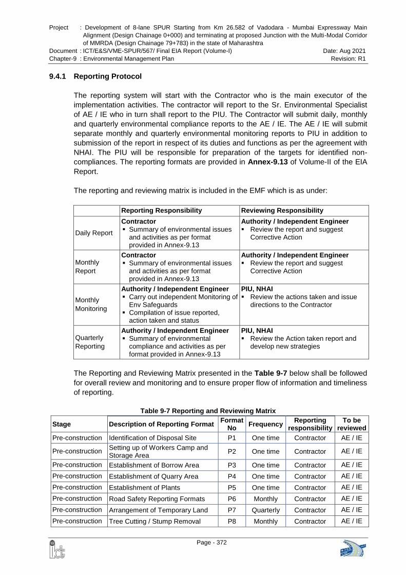
Project : Development of 8-lane SPUR Starting from Km 26.582 of Vadodara - Mumbai Expressway Main
Alignment (Design Chainage 0+000) and terminating at proposed Junction with the Multi-Modal Corridor
of MMRDA (Design Chainage 79+783) in the state of Maharashtra
Document : ICT/E&S/VME-SPUR/567/ Final EIA Report (Volume-I) Date: Aug 2021
Chapter-9 : Environmental Management Plan Revision: R1
Page - 372
9.4.1 Reporting Protocol
The reporting system will start with the Contractor who is the main executor of the
implementation activities. The contractor will report to the Sr. Environmental Specialist
of AE / IE who in turn shall report to the PIU. The Contractor will submit daily, monthly
and quarterly environmental compliance reports to the AE / IE. The AE / IE will submit
separate monthly and quarterly environmental monitoring reports to PIU in addition to
submission of the report in respect of its duties and functions as per the agreement with
NHAI. The PIU will be responsible for preparation of the targets for identified non-
compliances. The reporting formats are provided in Annex-9.13 of Volume-II of the EIA
Report.
The reporting and reviewing matrix is included in the EMF which is as under:
Reporting Responsibility Reviewing Responsibility
Daily Report
Contractor Summary of environmental issues
and activities as per format provided in Annex-9.13
Authority / Independent Engineer Review the report and suggest
Corrective Action
Monthly
Report
Contractor Summary of environmental issues
and activities as per format provided in Annex-9.13
Authority / Independent Engineer Review the report and suggest
Corrective Action
Monthly
Monitoring
Authority / Independent Engineer Carry out independent Monitoring of
Env Safeguards Compilation of issue reported,
action taken and status
PIU, NHAI Review the actions taken and issue
directions to the Contractor
Quarterly
Reporting
Authority / Independent Engineer Summary of environmental
compliance and activities as per format provided in Annex-9.13
PIU, NHAI Review the Action taken report and
develop new strategies
The Reporting and Reviewing Matrix presented in the Table 9-7 below shall be followed
for overall review and monitoring and to ensure proper flow of information and timeliness
of reporting.
Table 9-7 Reporting and Reviewing Matrix
Stage Description of Reporting Format Format
No Frequency
Reporting responsibility
To be reviewed
Pre-construction Identification of Disposal Site P1 One time Contractor AE / IE
Pre-construction Setting up of Workers Camp and Storage Area
P2 One time Contractor AE / IE
Pre-construction Establishment of Borrow Area P3 One time Contractor AE / IE
Pre-construction Establishment of Quarry Area P4 One time Contractor AE / IE
Pre-construction Establishment of Plants P5 One time Contractor AE / IE
Pre-construction Road Safety Reporting Formats P6 Monthly Contractor AE / IE
Pre-construction Arrangement of Temporary Land P7 Quarterly Contractor AE / IE
Pre-construction Tree Cutting / Stump Removal P8 Monthly Contractor AE / IE
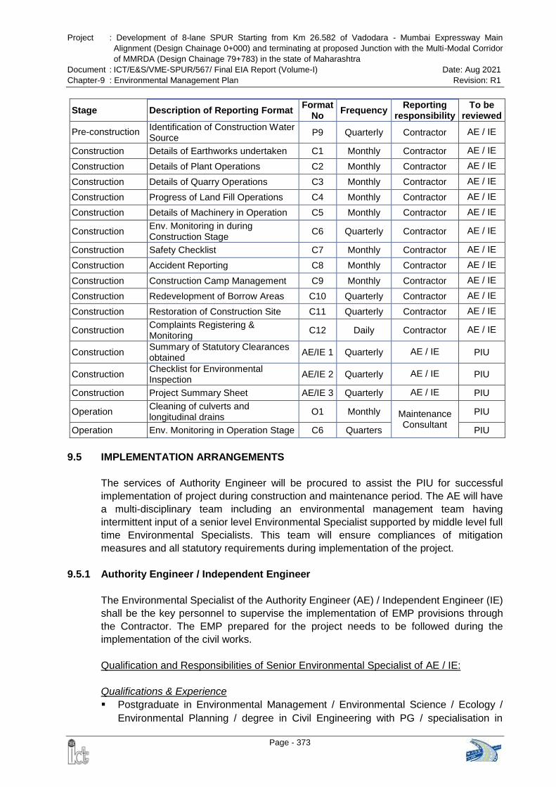
Project : Development of 8-lane SPUR Starting from Km 26.582 of Vadodara - Mumbai Expressway Main
Alignment (Design Chainage 0+000) and terminating at proposed Junction with the Multi-Modal Corridor
of MMRDA (Design Chainage 79+783) in the state of Maharashtra
Document : ICT/E&S/VME-SPUR/567/ Final EIA Report (Volume-I) Date: Aug 2021
Chapter-9 : Environmental Management Plan Revision: R1
Page - 373
Stage Description of Reporting Format Format
No Frequency
Reporting responsibility
To be reviewed
Pre-construction Identification of Construction Water Source
P9 Quarterly Contractor AE / IE
Construction Details of Earthworks undertaken C1 Monthly Contractor AE / IE
Construction Details of Plant Operations C2 Monthly Contractor AE / IE
Construction Details of Quarry Operations C3 Monthly Contractor AE / IE
Construction Progress of Land Fill Operations C4 Monthly Contractor AE / IE
Construction Details of Machinery in Operation C5 Monthly Contractor AE / IE
Construction Env. Monitoring in during Construction Stage
C6 Quarterly Contractor AE / IE
Construction Safety Checklist C7 Monthly Contractor AE / IE
Construction Accident Reporting C8 Monthly Contractor AE / IE
Construction Construction Camp Management C9 Monthly Contractor AE / IE
Construction Redevelopment of Borrow Areas C10 Quarterly Contractor AE / IE
Construction Restoration of Construction Site C11 Quarterly Contractor AE / IE
Construction Complaints Registering & Monitoring
C12 Daily Contractor AE / IE
Construction Summary of Statutory Clearances obtained
AE/IE 1 Quarterly AE / IE PIU
Construction Checklist for Environmental Inspection
AE/IE 2 Quarterly AE / IE PIU
Construction Project Summary Sheet AE/IE 3 Quarterly AE / IE PIU
Operation Cleaning of culverts and longitudinal drains
O1 Monthly Maintenance Consultant
PIU
Operation Env. Monitoring in Operation Stage C6 Quarters PIU
9.5 IMPLEMENTATION ARRANGEMENTS
The services of Authority Engineer will be procured to assist the PIU for successful
implementation of project during construction and maintenance period. The AE will have
a multi-disciplinary team including an environmental management team having
intermittent input of a senior level Environmental Specialist supported by middle level full
time Environmental Specialists. This team will ensure compliances of mitigation
measures and all statutory requirements during implementation of the project.
9.5.1 Authority Engineer / Independent Engineer
The Environmental Specialist of the Authority Engineer (AE) / Independent Engineer (IE)
shall be the key personnel to supervise the implementation of EMP provisions through
the Contractor. The EMP prepared for the project needs to be followed during the
implementation of the civil works.
Qualification and Responsibilities of Senior Environmental Specialist of AE / IE:
Qualifications & Experience
Postgraduate in Environmental Management / Environmental Science / Ecology /
Environmental Planning / degree in Civil Engineering with PG / specialisation in
Project : Development of 8-lane SPUR Starting from Km 26.582 of Vadodara - Mumbai Expressway Main
Alignment (Design Chainage 0+000) and terminating at proposed Junction with the Multi-Modal Corridor
of MMRDA (Design Chainage 79+783) in the state of Maharashtra
Document : ICT/E&S/VME-SPUR/567/ Final EIA Report (Volume-I) Date: Aug 2021
Chapter-9 : Environmental Management Plan Revision: R1
Page - 374
environment.
15 years of total experience with a minimum of 10 years in the preparation and
implementation of EMP of highway projects and an understanding of environmental,
health and safety issues.
Prior practical experience in Highways projects funded by Multilateral Agencies
Roles & Responsibilities
Supervise and monitor the implementation of EMP by the Contractor
Update the PIU on the progress of environmental protection and / or enhancement
works as envisaged in the EMP
Review and approve site-specific environmental mitigation / enhancement designs
worked out by the Contractor based on the EMP prepared during project preparation
Review and recommend the Contractors‟ Implementation Plans for approval (with
any changes that may be necessary) to ensure compliance with the environmental
provisions of the Contract
Supervise the progress of tree plantation and environmental monitoring programs
Hold meetings with Contractor time to time and provide update to PIU regarding the
progress of environmental works
Finalized and submit Monthly, Quarterly, Semi-annual and Annual Environmental
report to PIU
Develop and organise environmental training programmes to upgrade the skills
within the staff of the environmental cell and the Contractor
Documentation of good practices during project implementation for wider
dissemination
Prepare and submit Half-yearly Compliance Reports in respect of the
environmental clearance terms and conditions in soft copies to the regulatory
authority concerned, on 1st June and 1st December of each calendar year.
The project will require continuous environmental supervision. Since the Sr.
Environmental Specialist of AE / IE is to be deployed on intermittent basis, it is
required to have fulltime Jr. Environmental Specialist to assist the key specialist.
Field Engineers supervising the construction works also needs to be trained on
environmental aspects, who then shall apprise the Team Leader and the Sr.
Environmental Specialist of any significant development on environment.
Qualification and Responsibilities of Junior Environmental Specialist of AE / IE (Sub
Professional):
Qualifications & Experience
Postgraduate in Environmental Management / Environmental Science / Ecology /
Environmental Planning / Environmental Engineering
7 years of experience with a minimum of 3 years in the preparation and or
implementation of EMP of highway projects and an understanding of environmental,
health and safety issues
Prior practical experience in multilateral funded projects in highways sector would be
an advantage
Project : Development of 8-lane SPUR Starting from Km 26.582 of Vadodara - Mumbai Expressway Main
Alignment (Design Chainage 0+000) and terminating at proposed Junction with the Multi-Modal Corridor
of MMRDA (Design Chainage 79+783) in the state of Maharashtra
Document : ICT/E&S/VME-SPUR/567/ Final EIA Report (Volume-I) Date: Aug 2021
Chapter-9 : Environmental Management Plan Revision: R1
Page - 375
Roles & Responsibilities
Update the Sr. Environmental Specialist & the Team Leader of AE on the progress
of environmental protection and / or enhancement works as envisaged in the EMP
Regularly supervise and monitor the implementation of EMP by the Contractor
Verify the extent of environmental compliance of the Contractor regularly
Monitor tree plantation programs and the periodic Environmental Monitoring
Programs to ensure compliance with the statutory requirements and the EMP
Interact & hold regular meetings with Contractor Environmental Officers in
implementation of the EMP
Prepare Monthly, Quarterly, Semi-annual and Annual Environmental reports and
submit to the key specialist for finalization
Assist the key specialist in documenting good practices during project
implementation for wider dissemination
Regularly monitor the approved site-specific environmental mitigation /
enhancement designs based on the EMP prepared
9.5.2 Contractor
Execution of works will be the responsibility of the Contractor. The Contractors shall
employ a full time Environmental Officer whose qualification and responsibilities shall
be as stated below:
Qualification and Responsibilities of Environmental Officer (EO) of Contractor:
Qualifications & Experience
Postgraduate in Environmental Management / Environmental Science / Zoology /
Botany / Ecology / Environmental Planning / Environmental Engineering
5 years of experience with a minimum of 2 years in the implementation of EMP of
highway projects and an understanding of environmental, health and safety issues
Prior practical experience in multilateral funded projects in highways sector would be
an advantage
Roles & Responsibilities
The Environmental Officer shall report directly to the Resident Construction Manager
/ Project Manager of the Contractor so that the pertinent environmental issues that
he / she raise are promptly dealt with.
He / she shall also have a direct interaction with the Environmental Specialist of the
AE / IE.
Implement measures laid out in the EMP and or as directed by the AE / IE for the
work executed both by petty contractors and the contractor.
Implement tree plantation programs and conduct periodic Environmental Monitoring
Programs to ensure compliance with the statutory requirements and the EMP
Provide key inputs in the development of the Contractors‟ implementation plan for all
construction activities, including haulage of material to site, adhering to the
requirements of the EMP and getting approval of the AE / IE on the same before
start of works.
Ensure that the regulatory permissions required for the construction equipment,
Project : Development of 8-lane SPUR Starting from Km 26.582 of Vadodara - Mumbai Expressway Main
Alignment (Design Chainage 0+000) and terminating at proposed Junction with the Multi-Modal Corridor
of MMRDA (Design Chainage 79+783) in the state of Maharashtra
Document : ICT/E&S/VME-SPUR/567/ Final EIA Report (Volume-I) Date: Aug 2021
Chapter-9 : Environmental Management Plan Revision: R1
Page - 376
vehicles and machinery (given in the EIA Report) have been obtained and are valid
at all times during the execution of the project.
Prepare / fill up the environmental and safety related compliances as per daily,
weekly, fortnightly, monthly, quarterly, semi-annual checklists in the EMP
Prepare Safety Plans, Debris & Waste disposal Plan, Emergency Response Plans
and Quarry Management and other safety, health and environment related Plans for
approval of the AE / IE.
Identify locations for siting construction camps and other plants, machinery, vehicles
and equipment, as well as locations for storage and disposal of wastes, both from
the construction camps and from the site and obtain approval for the same from the
AE / IE.
Detail out site-specific environmental mitigation and enhancement measures and
obtain approval of the AE / IE for the same
Carry out the measurements of environmental mitigation and / or enhancement
works and prepares bills for the same for approval and payment through the AE / IE.
Ensure that the safety of the workers and other site users is not compromised during
construction
Ensure that adequate monitoring facilities are available for collecting samples of all
discharges from the Contractor‟s plants, equipment and camps
Verify the extent of environmental compliance at sites from where the Contractor is
procuring the material – Borrow Area, Quarries, Crushers or even sand and suggest
appropriate mitigation measures, if required
Penalty Clause:
For not employing a full time Environmental Officer (EO), the contractor shall be
levied a fine of Rs. 2,000/ every day from his invoice
The EO shall be approved by the NHAI
In case of non-notified absence of the EO (absence to be notified to the authority in
writing) for more than 15 days from site, a fine of Rs. 2,000 per day to be levied on
the contractor. Eligibility of leave due to the EO shall be as per standard guidelines
of the organization.
The environmental officer shall have an environmental, health and safety team to help
him in implementing the EMP. These team members may / may not report to him / her
directly but shall apprise him of all the incidents and mark a formal report of any incident
having an impact on the Health, Environment and Safety issues.
Safety Officer (SO): The safety officer shall on day to day basis interact and assist
the EO in implementation of the safety features mentioned in the EMP. He shall also
assist the EO in the preparation & submission of safety plans.
First Aider / Medical Officer (MO): The first aider / medical officer shall interact and
assist the EO in implementation of the health features mentioned in the EMP
Duty Officers (DO) /Supervisors: The Duty Officers shall on day to day basis, take
the necessary mitigation measures as per the directions of the EO, SO & MO and
Project : Development of 8-lane SPUR Starting from Km 26.582 of Vadodara - Mumbai Expressway Main
Alignment (Design Chainage 0+000) and terminating at proposed Junction with the Multi-Modal Corridor
of MMRDA (Design Chainage 79+783) in the state of Maharashtra
Document : ICT/E&S/VME-SPUR/567/ Final EIA Report (Volume-I) Date: Aug 2021
Chapter-9 : Environmental Management Plan Revision: R1
Page - 377
monitor the project facilities and report to the EO on activities that adversely affect
the environment in the vicinity.
Plant Engineer: The Plant Engineer has the responsibility of managing and
controlling the hot mix plant, crusher unit and fleet of vehicles. He shall ensure that
the environment is not degraded at his plant site. Even though the EO shall routinely
monitor to detect any negative issues due to operations and bring it to the
knowledge of Plant Engineer for taking rectification works. In case of emergency the
Plant Engineer shall immediately notify the EO for necessary actions.
9.6 INSTITUTIONAL CAPACITY BUILDING
It is important to orient contractor‟s supervisory staff as well as key field staff towards
environmental issues of highway project, implementation of mitigation measures, green
construction technology etc. for successful implementation of the EMP. Project
Implementation Unit and Authority / Independent Engineer are also responsible for the
implementation of the EMP, need to be trained. To ensure the success of the proposed
implementation set up, there is need for training and skill up-gradation. Hence,
considering the requirement, the following training program is suggested.
9.6.1 Training Components
The environmental training should encompass the following:
Understanding of the relevant environmental regulations and their application to the
project;
Environmental & Social Issues in Highway Projects
Road Safety and Road Safety Audit for Highways
Mainstreaming Biodiversity in Road Transportation Projects for Promoting Smart
Green Infrastructure
Eco friendly measures to mitigate impacts of linear infrastructure on wildlife
Mitigation measures of noise generated from construction equipment
Environmental Monitoring during Construction stage and Operation stage
Green Highways & Green Infrastructure
ISO 14001:2015 Environmental Management System
9.6.2 Training Program
A training program needs to be worked out incorporating the project needs as well as
the intermediate-term capacity building needs of the PIU, AE and Contractor. The
program should consist of a number of training modules specific to target groups. The
training would cover the basic principles and postulates of environmental assessment,
mitigation plans and program implementation techniques, monitoring and management
methods and tools. Given below is a list of Training Institutes (Table 9-8) which can be
contacted for providing training in various issues related to environmental management.
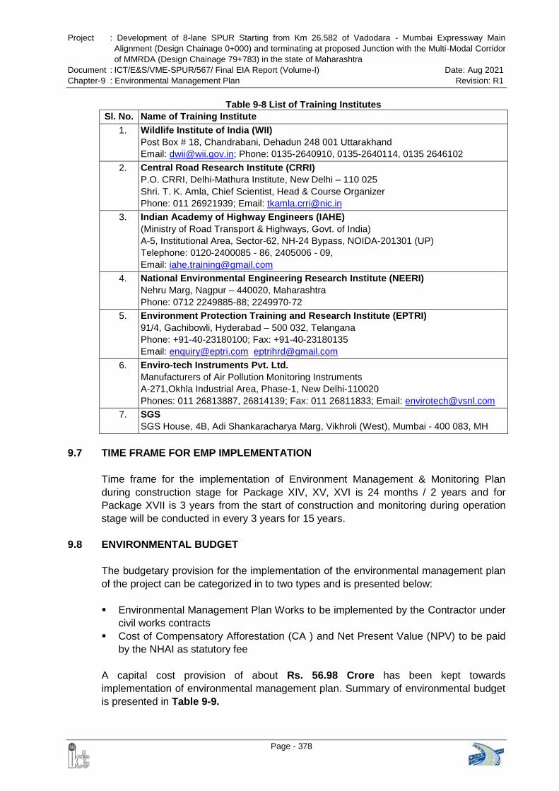
Project : Development of 8-lane SPUR Starting from Km 26.582 of Vadodara - Mumbai Expressway Main
Alignment (Design Chainage 0+000) and terminating at proposed Junction with the Multi-Modal Corridor
of MMRDA (Design Chainage 79+783) in the state of Maharashtra
Document : ICT/E&S/VME-SPUR/567/ Final EIA Report (Volume-I) Date: Aug 2021
Chapter-9 : Environmental Management Plan Revision: R1
Page - 378
Table 9-8 List of Training Institutes
Sl. No. Name of Training Institute
1. Wildlife Institute of India (WII)
Post Box # 18, Chandrabani, Dehadun 248 001 Uttarakhand
Email: [email protected]; Phone: 0135-2640910, 0135-2640114, 0135 2646102
2. Central Road Research Institute (CRRI)
P.O. CRRI, Delhi-Mathura Institute, New Delhi – 110 025
Shri. T. K. Amla, Chief Scientist, Head & Course Organizer
Phone: 011 26921939; Email: [email protected]
3. Indian Academy of Highway Engineers (IAHE)
(Ministry of Road Transport & Highways, Govt. of India)
A-5, Institutional Area, Sector-62, NH-24 Bypass, NOIDA-201301 (UP)
Telephone: 0120-2400085 - 86, 2405006 - 09,
Email: [email protected]
4. National Environmental Engineering Research Institute (NEERI)
Nehru Marg, Nagpur – 440020, Maharashtra
Phone: 0712 2249885-88; 2249970-72
5. Environment Protection Training and Research Institute (EPTRI)
91/4, Gachibowli, Hyderabad – 500 032, Telangana
Phone: +91-40-23180100; Fax: +91-40-23180135
Email: [email protected] [email protected]
6. Enviro-tech Instruments Pvt. Ltd.
Manufacturers of Air Pollution Monitoring Instruments
A-271,Okhla Industrial Area, Phase-1, New Delhi-110020
Phones: 011 26813887, 26814139; Fax: 011 26811833; Email: [email protected]
7. SGS
SGS House, 4B, Adi Shankaracharya Marg, Vikhroli (West), Mumbai - 400 083, MH
9.7 TIME FRAME FOR EMP IMPLEMENTATION
Time frame for the implementation of Environment Management & Monitoring Plan
during construction stage for Package XIV, XV, XVI is 24 months / 2 years and for
Package XVII is 3 years from the start of construction and monitoring during operation
stage will be conducted in every 3 years for 15 years.
9.8 ENVIRONMENTAL BUDGET
The budgetary provision for the implementation of the environmental management plan
of the project can be categorized in to two types and is presented below:
Environmental Management Plan Works to be implemented by the Contractor under
civil works contracts
Cost of Compensatory Afforestation (CA ) and Net Present Value (NPV) to be paid
by the NHAI as statutory fee
A capital cost provision of about Rs. 56.98 Crore has been kept towards
implementation of environmental management plan. Summary of environmental budget
is presented in Table 9-9.
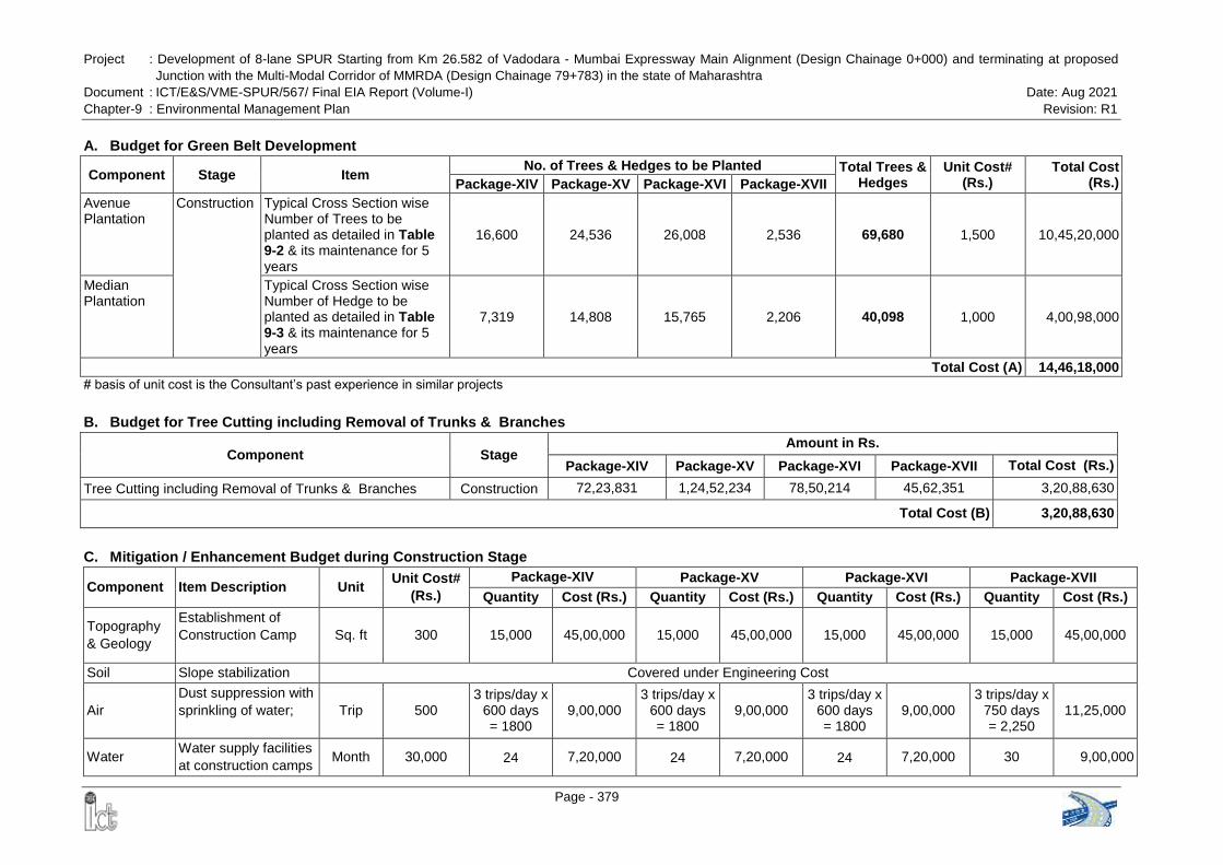
Project : Development of 8-lane SPUR Starting from Km 26.582 of Vadodara - Mumbai Expressway Main Alignment (Design Chainage 0+000) and terminating at proposed
Junction with the Multi-Modal Corridor of MMRDA (Design Chainage 79+783) in the state of Maharashtra
Document : ICT/E&S/VME-SPUR/567/ Final EIA Report (Volume-I) Date: Aug 2021
Chapter-9 : Environmental Management Plan Revision: R1
Page - 379
A. Budget for Green Belt Development
Component Stage Item No. of Trees & Hedges to be Planted Total Trees &
Hedges Unit Cost#
(Rs.) Total Cost
(Rs.) Package-XIV Package-XV Package-XVI Package-XVII
Avenue Plantation
Construction Typical Cross Section wise Number of Trees to be planted as detailed in Table 9-2 & its maintenance for 5 years
16,600 24,536 26,008 2,536 69,680 1,500 10,45,20,000
Median Plantation
Typical Cross Section wise Number of Hedge to be planted as detailed in Table 9-3 & its maintenance for 5 years
7,319 14,808 15,765 2,206 40,098 1,000 4,00,98,000
Total Cost (A) 14,46,18,000
# basis of unit cost is the Consultant‟s past experience in similar projects
B. Budget for Tree Cutting including Removal of Trunks & Branches
Component Stage Amount in Rs.
Package-XIV Package-XV Package-XVI Package-XVII Total Cost (Rs.)
Tree Cutting including Removal of Trunks & Branches Construction 72,23,831 1,24,52,234 78,50,214 45,62,351 3,20,88,630
Total Cost (B) 3,20,88,630
C. Mitigation / Enhancement Budget during Construction Stage
Component Item Description Unit Unit Cost#
(Rs.)
Package-XIV Package-XV Package-XVI Package-XVII
Quantity Cost (Rs.) Quantity Cost (Rs.) Quantity Cost (Rs.) Quantity Cost (Rs.)
Topography
& Geology
Establishment of
Construction Camp
Sq. ft 300 15,000 45,00,000 15,000 45,00,000 15,000 45,00,000 15,000 45,00,000
Soil Slope stabilization Covered under Engineering Cost
Air
Dust suppression with
sprinkling of water;
Trip 500 3 trips/day x
600 days = 1800
9,00,000 3 trips/day x
600 days = 1800
9,00,000 3 trips/day x
600 days = 1800
9,00,000 3 trips/day x
750 days = 2,250
11,25,000
Water Water supply facilities
at construction camps Month 30,000 24 7,20,000 24 7,20,000 24 7,20,000 30 9,00,000

Project : Development of 8-lane SPUR Starting from Km 26.582 of Vadodara - Mumbai Expressway Main Alignment (Design Chainage 0+000) and terminating at proposed
Junction with the Multi-Modal Corridor of MMRDA (Design Chainage 79+783) in the state of Maharashtra
Document : ICT/E&S/VME-SPUR/567/ Final EIA Report (Volume-I) Date: Aug 2021
Chapter-9 : Environmental Management Plan Revision: R1
Page - 380
Component Item Description Unit Unit Cost#
(Rs.)
Package-XIV Package-XV Package-XVI Package-XVII
Quantity Cost (Rs.) Quantity Cost (Rs.) Quantity Cost (Rs.) Quantity Cost (Rs.)
Water
Sewage and
sanitation facilities at
construction camps
including
maintenance
Month 15,000 24 3,60,000 24 3,60,000 24 3,60,000 30 4,50,000
Water
Wastewater
Treatment Plant at
Construction Camp
Lump
sum 22,50,000 1 no. 22,50,000 1 no. 22,50,000 1 no. 22,50,000 1 22,50,000
Water
Provision for Oil
Interception
Chambers in
construction yard near
to 1) vehicle parking,
fueling and washing
area and 2) Hot Mix
Plant
No. 15,000 2 nos. 30,000 2 nos. 30,000 2 nos. 30,000 2 nos. 30,000
Water
Construction of
Sedimentation Tanks
in construction yard
near to 1) Concrete
mix plant and 2) Hot
mix plant
No. 50,000 2 nos. 1,00,000 2 nos. 1,00,000 2 nos. 1,00,000 2 nos. 1,00,000
Water Silt fencing near
surface water bodies Meter 850 900 7,65,000 500 4,25,000 2400 20,40,000 500 4,25,000
Water
Rain water harvesting
structures to be
constructed at every
km of the Expressway
with special
precaution of oil filters
and de-silting
chambers##
No. 1,00,000 17 17,00,000 22 22,00,000 26 26,00,000 10 10,00,000
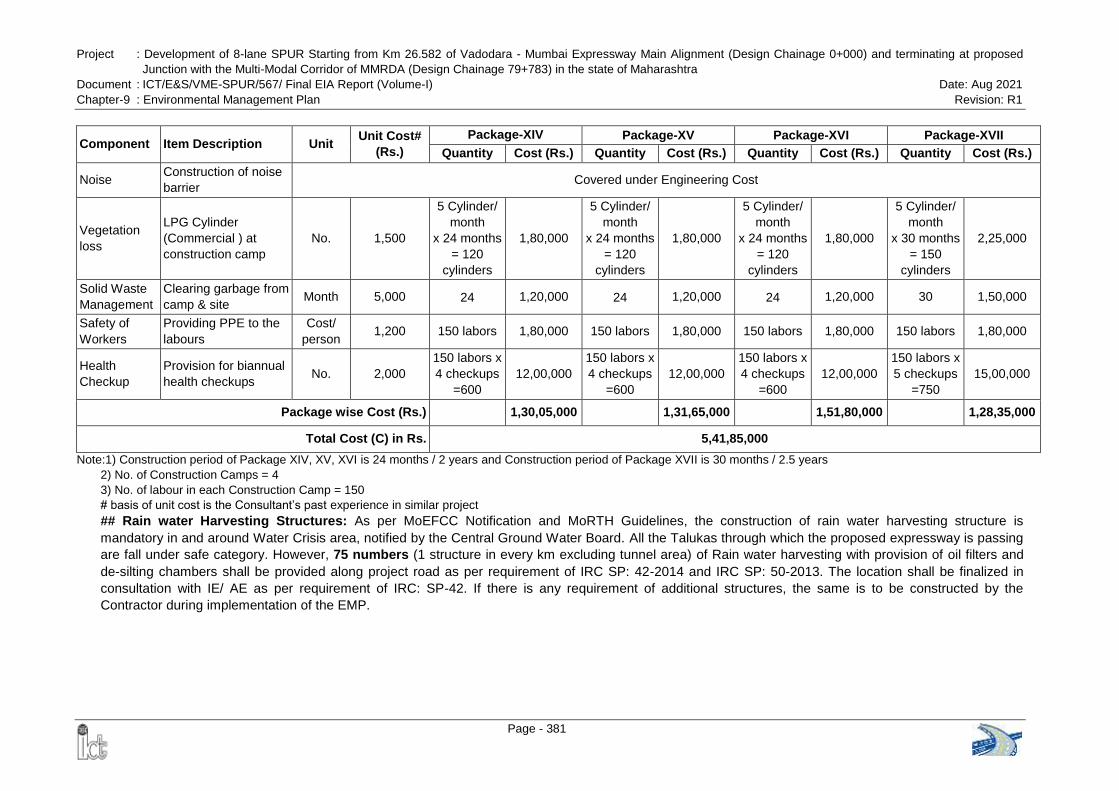
Project : Development of 8-lane SPUR Starting from Km 26.582 of Vadodara - Mumbai Expressway Main Alignment (Design Chainage 0+000) and terminating at proposed
Junction with the Multi-Modal Corridor of MMRDA (Design Chainage 79+783) in the state of Maharashtra
Document : ICT/E&S/VME-SPUR/567/ Final EIA Report (Volume-I) Date: Aug 2021
Chapter-9 : Environmental Management Plan Revision: R1
Page - 381
Component Item Description Unit Unit Cost#
(Rs.)
Package-XIV Package-XV Package-XVI Package-XVII
Quantity Cost (Rs.) Quantity Cost (Rs.) Quantity Cost (Rs.) Quantity Cost (Rs.)
Noise Construction of noise
barrier Covered under Engineering Cost
Vegetation
loss
LPG Cylinder
(Commercial ) at
construction camp
No. 1,500
5 Cylinder/
month
x 24 months
= 120
cylinders
1,80,000
5 Cylinder/
month
x 24 months
= 120
cylinders
1,80,000
5 Cylinder/
month
x 24 months
= 120
cylinders
1,80,000
5 Cylinder/
month
x 30 months
= 150
cylinders
2,25,000
Solid Waste
Management
Clearing garbage from
camp & site Month 5,000 24 1,20,000 24 1,20,000 24 1,20,000 30 1,50,000
Safety of
Workers
Providing PPE to the
labours
Cost/
person 1,200 150 labors 1,80,000 150 labors 1,80,000 150 labors 1,80,000 150 labors 1,80,000
Health
Checkup
Provision for biannual
health checkups No. 2,000
150 labors x
4 checkups
=600
12,00,000
150 labors x
4 checkups
=600
12,00,000
150 labors x
4 checkups
=600
12,00,000
150 labors x
5 checkups
=750
15,00,000
Package wise Cost (Rs.) 1,30,05,000 1,31,65,000 1,51,80,000 1,28,35,000
Total Cost (C) in Rs. 5,41,85,000
Note:1) Construction period of Package XIV, XV, XVI is 24 months / 2 years and Construction period of Package XVII is 30 months / 2.5 years
2) No. of Construction Camps = 4
3) No. of labour in each Construction Camp = 150
# basis of unit cost is the Consultant‟s past experience in similar project
## Rain water Harvesting Structures: As per MoEFCC Notification and MoRTH Guidelines, the construction of rain water harvesting structure is
mandatory in and around Water Crisis area, notified by the Central Ground Water Board. All the Talukas through which the proposed expressway is passing
are fall under safe category. However, 75 numbers (1 structure in every km excluding tunnel area) of Rain water harvesting with provision of oil filters and
de-silting chambers shall be provided along project road as per requirement of IRC SP: 42-2014 and IRC SP: 50-2013. The location shall be finalized in
consultation with IE/ AE as per requirement of IRC: SP-42. If there is any requirement of additional structures, the same is to be constructed by the
Contractor during implementation of the EMP.
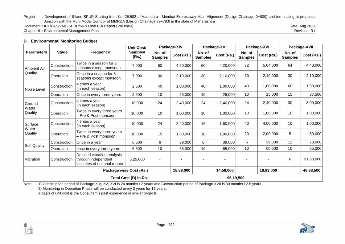
Project : Development of 8-lane SPUR Starting from Km 26.582 of Vadodara - Mumbai Expressway Main Alignment (Design Chainage 0+000) and terminating at proposed
Junction with the Multi-Modal Corridor of MMRDA (Design Chainage 79+783) in the state of Maharashtra
Document : ICT/E&S/VME-SPUR/567/ Final EIA Report (Volume-I) Date: Aug 2021
Chapter-9 : Environmental Management Plan Revision: R1
Page - 382
D. Environmental Monitoring Budget
Parameters Stage Frequency Unit Cost/ Sample#
(Rs.)
Package-XIV Package-XV Package-XVI Package-XVII
No. of Samples
Cost (Rs.) No. of
Samples Cost (Rs.)
No. of Samples
Cost (Rs.) No. of
Samples Cost (Rs.)
Ambient Air Quality
Construction Twice in a season for 3 seasons except monsoon
7,000 60 4,20,000 60 4,20,000 72 5,04,000 64 4,48,000
Operation Once in a season for 3 seasons except monsoon
7,000 30 2,10,000 30 2,10,000 30 2,10,000 30 2,10,000
Noise Level Construction
4 times a year (in each season)
2,500 40 1,00,000 40 1,00,000 40 1,00,000 60 1,50,000
Operation Once in every three years 2,500 10 25,000 10 25,000 10 25,000 15 37,500
Ground Water Quality
Construction 4 times a year (in each season)
10,000 24 2,40,000 24 2,40,000 24 2,40,000 30 3,00,000
Operation Twice in every three years – Pre & Post monsoon
10,000 10 1,00,000 10 1,00,000 10 1,00,000 10 1,00,000
Surface Water Quality
Construction 4 times a year (in each season)
10,000 24 2,40,000 16 1,60,000 40 4,00,000 10 1,00,000
Operation Twice in every three years – Pre & Post monsoon
10,000 15 1,50,000 10 1,00,000 20 2,00,000 5 50,000
Soil Quality Construction Once in a year 6,500 6 39,000 6 39,000 6 39,000 12 78,000
Operation once in every three years 6,500 10 65,000 10 65,000 10 65,000 10 65,000
Vibration Construction Detailed vibration analysis through independent institutes of national repute
5,25,000 - - - - - - 6 31,50,000
Package wise Cost (Rs.) 15,89,000 14,59,000 18,83,000 46,88,500
Total Cost (D) in Rs. 96,19,500
Note: 1) Construction period of Package XIV, XV, XVI is 24 months / 2 years and Construction period of Package XVII is 30 months / 2.5 years
2) Monitoring in Operation Phase will be conducted every 3 years for 15 years.
# basis of unit cost is the Consultant‟s past experience in similar projects
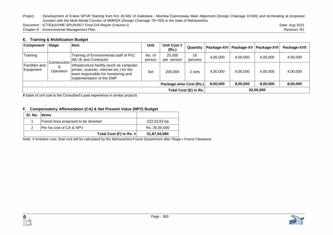
Project : Development of 8-lane SPUR Starting from Km 26.582 of Vadodara - Mumbai Expressway Main Alignment (Design Chainage 0+000) and terminating at proposed
Junction with the Multi-Modal Corridor of MMRDA (Design Chainage 79+783) in the state of Maharashtra
Document : ICT/E&S/VME-SPUR/567/ Final EIA Report (Volume-I) Date: Aug 2021
Chapter-9 : Environmental Management Plan Revision: R1
Page - 383
E. Training & Mobilization Budget
Component Stage Item Unit Unit Cost # (Rs.)
Quantity Package-XIV Package-XV Package-XVI Package-XVII
Training
Construction &
Operation
Training of Environmental staff of PIU; AE/ IE and Contractor
No. of person
25,000 per person
16 persons
4,00,000 4,00,000 4,00,000 4,00,000
Facilities and Equipment
Infrastructure facility (such as computer, printer, scanner, internet etc.) for the team responsible for monitoring and implementation of the EMP
Set 200,000 2 sets 4,00,000 4,00,000 4,00,000 4,00,000
Package wise Cost (Rs.) 8,00,000 8,00,000 8,00,000 8,00,000
Total Cost (E) in Rs. 32,00,000
# basis of unit cost is the Consultant‟s past experience in similar projects
F. Compensatory Afforestation (CA) & Net Present Value (NPV) Budget
Sl. No. Items
1 Forest Area proposed to be diverted 122.6133 ha
2 Per ha cost of CA & NPV Rs. 26,00,000
Total Cost (F) in Rs. # 31,87,94,580
Note: # tentative cost; final cost will be calculated by the Maharashtra Forest Department after Stage-I Forest Clearance
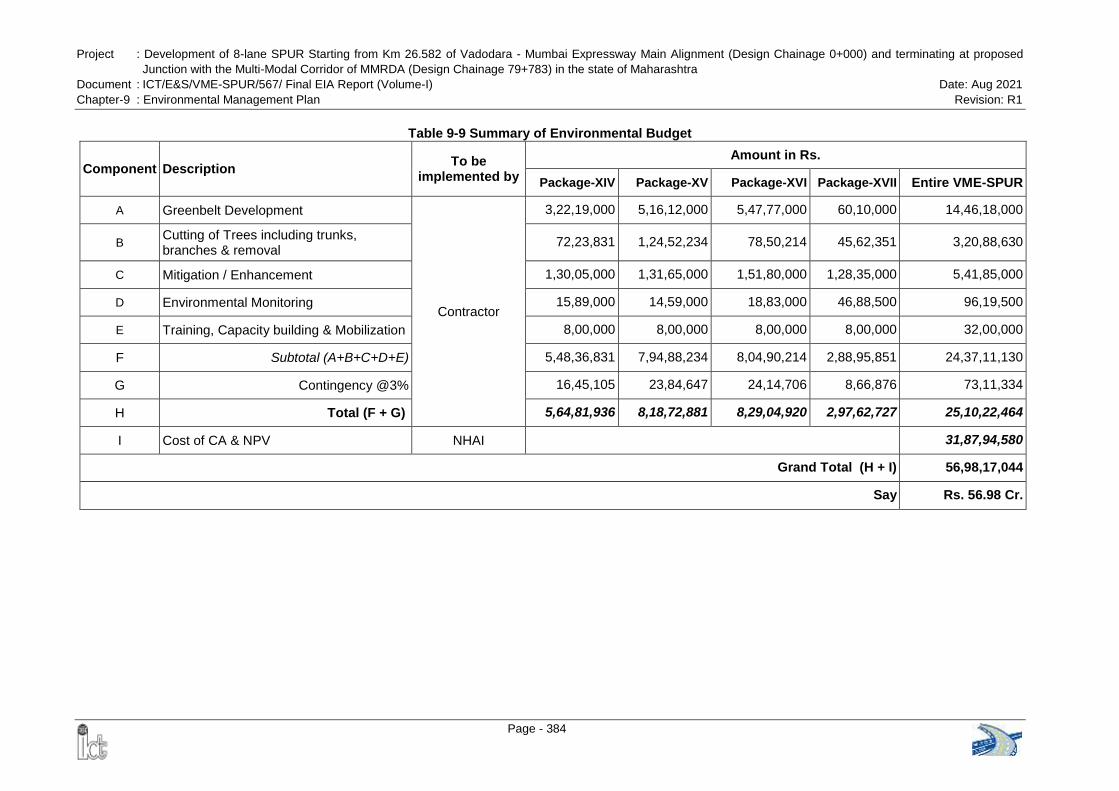
Project : Development of 8-lane SPUR Starting from Km 26.582 of Vadodara - Mumbai Expressway Main Alignment (Design Chainage 0+000) and terminating at proposed
Junction with the Multi-Modal Corridor of MMRDA (Design Chainage 79+783) in the state of Maharashtra
Document : ICT/E&S/VME-SPUR/567/ Final EIA Report (Volume-I) Date: Aug 2021
Chapter-9 : Environmental Management Plan Revision: R1
Page - 384
Table 9-9 Summary of Environmental Budget
Component Description To be
implemented by
Amount in Rs.
Package-XIV Package-XV Package-XVI Package-XVII Entire VME-SPUR
A Greenbelt Development
Contractor
3,22,19,000 5,16,12,000 5,47,77,000 60,10,000 14,46,18,000
B Cutting of Trees including trunks, branches & removal
72,23,831 1,24,52,234 78,50,214 45,62,351 3,20,88,630
C Mitigation / Enhancement 1,30,05,000 1,31,65,000 1,51,80,000 1,28,35,000 5,41,85,000
D Environmental Monitoring 15,89,000 14,59,000 18,83,000 46,88,500 96,19,500
E Training, Capacity building & Mobilization 8,00,000 8,00,000 8,00,000 8,00,000 32,00,000
F Subtotal (A+B+C+D+E) 5,48,36,831 7,94,88,234 8,04,90,214 2,88,95,851 24,37,11,130
G Contingency @3% 16,45,105 23,84,647 24,14,706 8,66,876 73,11,334
H Total (F + G) 5,64,81,936 8,18,72,881 8,29,04,920 2,97,62,727 25,10,22,464
I Cost of CA & NPV NHAI 31,87,94,580
Grand Total (H + I) 56,98,17,044
Say Rs. 56.98 Cr.
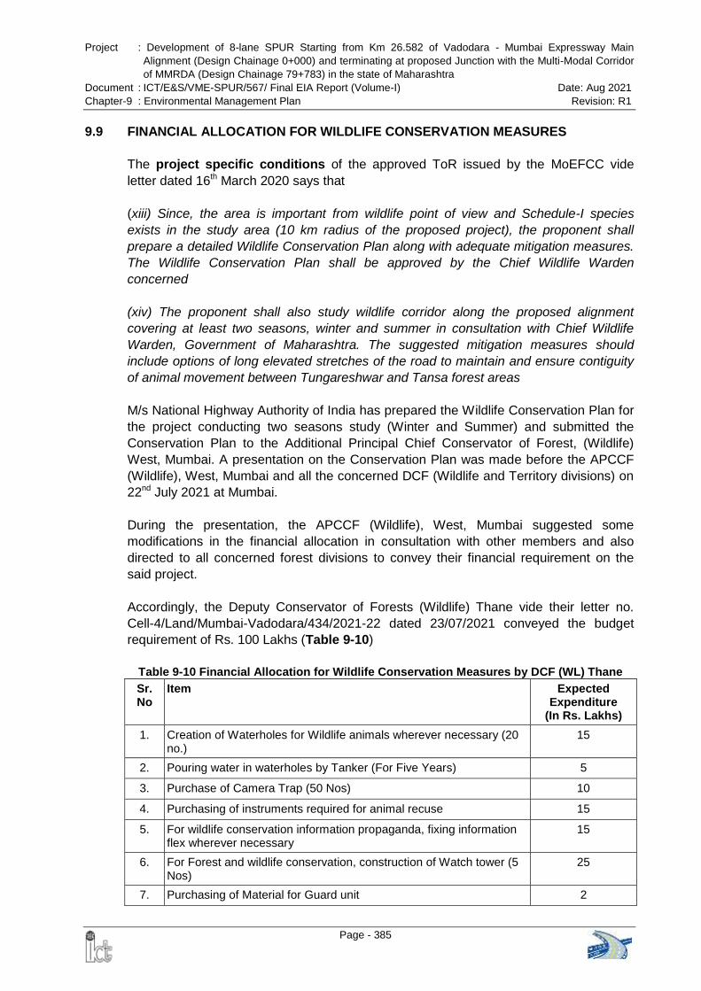
Project : Development of 8-lane SPUR Starting from Km 26.582 of Vadodara - Mumbai Expressway Main
Alignment (Design Chainage 0+000) and terminating at proposed Junction with the Multi-Modal Corridor
of MMRDA (Design Chainage 79+783) in the state of Maharashtra
Document : ICT/E&S/VME-SPUR/567/ Final EIA Report (Volume-I) Date: Aug 2021
Chapter-9 : Environmental Management Plan Revision: R1
Page - 385
9.9 FINANCIAL ALLOCATION FOR WILDLIFE CONSERVATION MEASURES
The project specific conditions of the approved ToR issued by the MoEFCC vide
letter dated 16th March 2020 says that
(xiii) Since, the area is important from wildlife point of view and Schedule-I species
exists in the study area (10 km radius of the proposed project), the proponent shall
prepare a detailed Wildlife Conservation Plan along with adequate mitigation measures.
The Wildlife Conservation Plan shall be approved by the Chief Wildlife Warden
concerned
(xiv) The proponent shall also study wildlife corridor along the proposed alignment
covering at least two seasons, winter and summer in consultation with Chief Wildlife
Warden, Government of Maharashtra. The suggested mitigation measures should
include options of long elevated stretches of the road to maintain and ensure contiguity
of animal movement between Tungareshwar and Tansa forest areas
M/s National Highway Authority of India has prepared the Wildlife Conservation Plan for
the project conducting two seasons study (Winter and Summer) and submitted the
Conservation Plan to the Additional Principal Chief Conservator of Forest, (Wildlife)
West, Mumbai. A presentation on the Conservation Plan was made before the APCCF
(Wildlife), West, Mumbai and all the concerned DCF (Wildlife and Territory divisions) on
22nd July 2021 at Mumbai.
During the presentation, the APCCF (Wildlife), West, Mumbai suggested some
modifications in the financial allocation in consultation with other members and also
directed to all concerned forest divisions to convey their financial requirement on the
said project.
Accordingly, the Deputy Conservator of Forests (Wildlife) Thane vide their letter no.
Cell-4/Land/Mumbai-Vadodara/434/2021-22 dated 23/07/2021 conveyed the budget
requirement of Rs. 100 Lakhs (Table 9-10)
Table 9-10 Financial Allocation for Wildlife Conservation Measures by DCF (WL) Thane
Sr. No
Item Expected Expenditure
(In Rs. Lakhs)
1. Creation of Waterholes for Wildlife animals wherever necessary (20 no.)
15
2. Pouring water in waterholes by Tanker (For Five Years) 5
3. Purchase of Camera Trap (50 Nos) 10
4. Purchasing of instruments required for animal recuse 15
5. For wildlife conservation information propaganda, fixing information flex wherever necessary
15
6. For Forest and wildlife conservation, construction of Watch tower (5 Nos)
25
7. Purchasing of Material for Guard unit 2
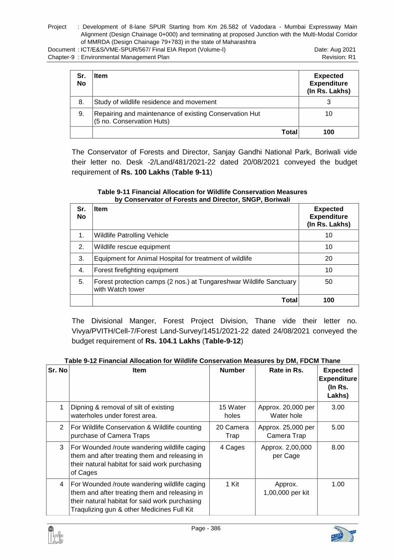
Project : Development of 8-lane SPUR Starting from Km 26.582 of Vadodara - Mumbai Expressway Main
Alignment (Design Chainage 0+000) and terminating at proposed Junction with the Multi-Modal Corridor
of MMRDA (Design Chainage 79+783) in the state of Maharashtra
Document : ICT/E&S/VME-SPUR/567/ Final EIA Report (Volume-I) Date: Aug 2021
Chapter-9 : Environmental Management Plan Revision: R1
Page - 386
Sr. No
Item Expected Expenditure
(In Rs. Lakhs)
8. Study of wildlife residence and movement 3
9. Repairing and maintenance of existing Conservation Hut (5 no. Conservation Huts)
10
Total 100
The Conservator of Forests and Director, Sanjay Gandhi National Park, Boriwali vide
their letter no. Desk -2/Land/481/2021-22 dated 20/08/2021 conveyed the budget
requirement of Rs. 100 Lakhs (Table 9-11)
Table 9-11 Financial Allocation for Wildlife Conservation Measures by Conservator of Forests and Director, SNGP, Boriwali
Sr. No
Item Expected Expenditure
(In Rs. Lakhs)
1. Wildlife Patrolling Vehicle 10
2. Wildlife rescue equipment 10
3. Equipment for Animal Hospital for treatment of wildlife 20
4. Forest firefighting equipment 10
5. Forest protection camps (2 nos.) at Tungareshwar Wildlife Sanctuary with Watch tower
50
Total 100
The Divisional Manger, Forest Project Division, Thane vide their letter no.
Vivya/PVITH/Cell-7/Forest Land-Survey/1451/2021-22 dated 24/08/2021 conveyed the
budget requirement of Rs. 104.1 Lakhs (Table-9-12)
Table 9-12 Financial Allocation for Wildlife Conservation Measures by DM, FDCM Thane
Sr. No Item Number Rate in Rs. Expected
Expenditure
(In Rs.
Lakhs)
1 Dipning & removal of silt of existing
waterholes under forest area.
15 Water
holes
Approx. 20,000 per
Water hole
3.00
2 For Wildlife Conservation & Wildlife counting
purchase of Camera Traps
20 Camera
Trap
Approx. 25,000 per
Camera Trap
5.00
3 For Wounded /route wandering wildlife caging
them and after treating them and releasing in
their natural habitat for said work purchasing
of Cages
4 Cages Approx. 2,00,000
per Cage
8.00
4 For Wounded /route wandering wildlife caging
them and after treating them and releasing in
their natural habitat for said work purchasing
Traqulizing gun & other Medicines Full Kit
1 Kit Approx.
1,00,000 per kit
1.00
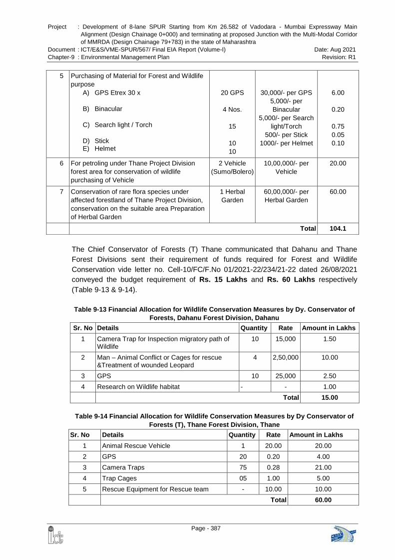
Project : Development of 8-lane SPUR Starting from Km 26.582 of Vadodara - Mumbai Expressway Main
Alignment (Design Chainage 0+000) and terminating at proposed Junction with the Multi-Modal Corridor
of MMRDA (Design Chainage 79+783) in the state of Maharashtra
Document : ICT/E&S/VME-SPUR/567/ Final EIA Report (Volume-I) Date: Aug 2021
Chapter-9 : Environmental Management Plan Revision: R1
Page - 387
The Chief Conservator of Forests (T) Thane communicated that Dahanu and Thane
Forest Divisions sent their requirement of funds required for Forest and Wildlife
Conservation vide letter no. Cell-10/FC/F.No 01/2021-22/234/21-22 dated 26/08/2021
conveyed the budget requirement of Rs. 15 Lakhs and Rs. 60 Lakhs respectively
(Table 9-13 & 9-14).
Table 9-13 Financial Allocation for Wildlife Conservation Measures by Dy. Conservator of
Forests, Dahanu Forest Division, Dahanu
Sr. No Details Quantity Rate Amount in Lakhs
1 Camera Trap for Inspection migratory path of Wildlife
10 15,000 1.50
2 Man – Animal Conflict or Cages for rescue &Treatment of wounded Leopard
4 2,50,000 10.00
3 GPS 10 25,000 2.50
4 Research on Wildlife habitat - - 1.00
Total 15.00
Table 9-14 Financial Allocation for Wildlife Conservation Measures by Dy Conservator of
Forests (T), Thane Forest Division, Thane
Sr. No Details Quantity Rate Amount in Lakhs
1 Animal Rescue Vehicle 1 20.00 20.00
2 GPS 20 0.20 4.00
3 Camera Traps 75 0.28 21.00
4 Trap Cages 05 1.00 5.00
5 Rescue Equipment for Rescue team - 10.00 10.00
Total 60.00
5 Purchasing of Material for Forest and Wildlife
purpose
A) GPS Etrex 30 x
B) Binacular
C) Search light / Torch
D) Stick E) Helmet
20 GPS
4 Nos.
15
10
10
30,000/- per GPS
5,000/- per
Binacular
5,000/- per Search
light/Torch
500/- per Stick
1000/- per Helmet
6.00
0.20
0.75
0.05
0.10
6 For petroling under Thane Project Division
forest area for conservation of wildlife
purchasing of Vehicle
2 Vehicle
(Sumo/Bolero)
10,00,000/- per
Vehicle
20.00
7 Conservation of rare flora species under
affected forestland of Thane Project Division,
conservation on the suitable area Preparation
of Herbal Garden
1 Herbal
Garden
60,00,000/- per
Herbal Garden
60.00
Total 104.1

Project : Development of 8-lane SPUR Starting from Km 26.582 of Vadodara - Mumbai Expressway Main
Alignment (Design Chainage 0+000) and terminating at proposed Junction with the Multi-Modal Corridor
of MMRDA (Design Chainage 79+783) in the state of Maharashtra
Document : ICT/E&S/VME-SPUR/567/ Final EIA Report (Volume-I) Date: Aug 2021
Chapter-9 : Environmental Management Plan Revision: R1
Page - 388
Therefore, total financial allocation proposed by the Forest Department (Wildlife Division
and Territorial Forest Division) is Rs. 3.79 Cr. as given in Table 9-15.
Table 9-15 Total Financial Allocation proposed by the Forest Department
Sr. No Details of Department/ Agency Table No Amount in Lakhs
1 Deputy Conservator of Forests (Wildlife) Thane
9-9 100.00
2 Conservator of Forests and Director, SNGP, Boriwali
9-10 100.00
3 Divisional Manager, Forest Project Division, (FDCM) Thane
9-11 104.00
4 Dy Conservator of Forests, Dahanu Forest Division, Dahanu
9-12 15.00
5 Dy Conservator of Forests (T), Thane Forest Division, Thane
9-13 60.00
Total 379.00
Rs. 3.79 Cr.
As per Table No 9-14 all respective five divisions have conveyed their cost for
implementation of the conservation measures in project area of their respective
divisions.
Apart from the above, M/s National Highway Authority of India has proposed Rs. 173.39
Crore under civil construction for construction of animal overpass, dedicated animal
crossing and small vehicular / animal underpasses (Table 9-16) which is also part of the
mitigation cost.
Table 9-16 Cost of Animal Overpass, Dedicated Animal Crossing and Animal Underpass
Sl. No. Description Unit Unit Cost
(in Cr.) Total (in Cr.)
1 Animal overpass 2 no. 11.025 22.05
2 Dedicated Animal Crossing 53 no. 1.66 87.98
3 Small Vehicular / Animal Underpasses
33 no. 1.92 63.36
Total Amount in Crore 173.39
The total financial allocation proposed for implementation of the Wildlife Conservation
Plan including its implementation responsibility, as approved by the Principle Chief
Conservator of Forests and Chief Wildlife Warden, Maharashtra State is given in
Table 9-17. The Project Director, M/s National Highway Authority of India, PIU-Thane
has agreed to defray the cost of Wildlife Conservation measure to the forest department.
Copy of the letter no. Desk-22(6)/Plan/C.R.117/1569/ 2021-22 dated 01/09/2021
issued from the office of the Principle Chief Conservator of Forests and Chief Wildlife
Warden, Maharashtra State approving the Wildlife Conservation Plan for VME-SPUR is
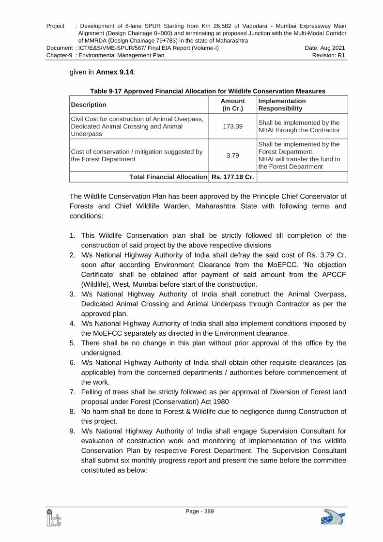
Project : Development of 8-lane SPUR Starting from Km 26.582 of Vadodara - Mumbai Expressway Main
Alignment (Design Chainage 0+000) and terminating at proposed Junction with the Multi-Modal Corridor
of MMRDA (Design Chainage 79+783) in the state of Maharashtra
Document : ICT/E&S/VME-SPUR/567/ Final EIA Report (Volume-I) Date: Aug 2021
Chapter-9 : Environmental Management Plan Revision: R1
Page - 389
given in Annex 9.14.
Table 9-17 Approved Financial Allocation for Wildlife Conservation Measures
Description Amount (in Cr.)
Implementation Responsibility
Civil Cost for construction of Animal Overpass, Dedicated Animal Crossing and Animal Underpass
173.39 Shall be implemented by the NHAI through the Contractor
Cost of conservation / mitigation suggested by the Forest Department
3.79
Shall be implemented by the Forest Department. NHAI will transfer the fund to the Forest Department
Total Financial Allocation Rs. 177.18 Cr.
The Wildlife Conservation Plan has been approved by the Principle Chief Conservator of
Forests and Chief Wildlife Warden, Maharashtra State with following terms and
conditions:
1. This Wildlife Conservation plan shall be strictly followed till completion of the
construction of said project by the above respective divisions
2. M/s National Highway Authority of India shall defray the said cost of Rs. 3.79 Cr.
soon after according Environment Clearance from the MoEFCC. „No objection
Certificate‟ shall be obtained after payment of said amount from the APCCF
(Wildlife), West, Mumbai before start of the construction.
3. M/s National Highway Authority of India shall construct the Animal Overpass,
Dedicated Animal Crossing and Animal Underpass through Contractor as per the
approved plan.
4. M/s National Highway Authority of India shall also implement conditions imposed by
the MoEFCC separately as directed in the Environment clearance.
5. There shall be no change in this plan without prior approval of this office by the
undersigned.
6. M/s National Highway Authority of India shall obtain other requisite clearances (as
applicable) from the concerned departments / authorities before commencement of
the work.
7. Felling of trees shall be strictly followed as per approval of Diversion of Forest land
proposal under Forest (Conservation) Act 1980
8. No harm shall be done to Forest & Wildlife due to negligence during Construction of
this project.
9. M/s National Highway Authority of India shall engage Supervision Consultant for
evaluation of construction work and monitoring of implementation of this wildlife
Conservation Plan by respective Forest Department. The Supervision Consultant
shall submit six monthly progress report and present the same before the committee
constituted as below:
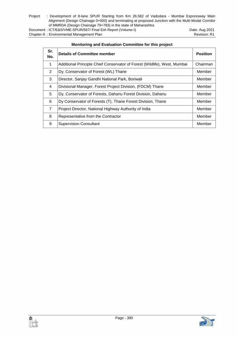
Project : Development of 8-lane SPUR Starting from Km 26.582 of Vadodara - Mumbai Expressway Main
Alignment (Design Chainage 0+000) and terminating at proposed Junction with the Multi-Modal Corridor
of MMRDA (Design Chainage 79+783) in the state of Maharashtra
Document : ICT/E&S/VME-SPUR/567/ Final EIA Report (Volume-I) Date: Aug 2021
Chapter-9 : Environmental Management Plan Revision: R1
Page - 390
Monitoring and Evaluation Committee for this project
Sr.
No. Details of Committee member Position
1 Additional Principle Chief Conservator of Forest (Wildlife), West, Mumbai Chairman
2 Dy. Conservator of Forest (WL) Thane Member
3 Director, Sanjay Gandhi National Park, Boriwali Member
4 Divisional Manager, Forest Project Division, (FDCM) Thane Member
5 Dy. Conservator of Forests, Dahanu Forest Division, Dahanu Member
6 Dy Conservator of Forests (T), Thane Forest Division, Thane Member
7 Project Director, National Highway Authority of India Member
8 Representative from the Contractor Member
9 Supervision Consultant Member
Project : Development of 8-lane SPUR Starting from Km 26.582 of Vadodara - Mumbai Expressway Main
Alignment (Design Chainage 0+000) and terminating at proposed Junction with the Multi-Modal Corridor
of MMRDA (Design Chainage 79+783) in the state of Maharashtra
Document : ICT/E&S/VME-SPUR/567/ Final EIA Report (Volume-I) Date: Aug 2021
Chapter-9 : Environmental Management Plan Revision: R1
Page - 391
9.10 CORPORATE ENVIRONMENT RESPONSIBILITY
The MoEFCC vide Office Memorandum dated 1st May 2018 had firmed up guidelines
that will require every corporate seeking green clearance to set aside up to 0.25 % to
2.0% of its capital investment for Corporate Environment Responsibility (CER) and it is
to be in addition to the cost for implementation of EMP (EMP budget).
However, the MoEFCC vide Office Memorandum (OM) dated 30th September 2020
suspended the above OM i.e. guidelines in respect of CRE. It has been decided by the
MoEFCC that henceforth the Expert Appraisal Committee (EAC) or State Level Expert
Appraisal Committee (SEAC) shall deliberate on the commitments made by the
project proponent to address the concerns raised during public consultation and
prescribed specific condition(s) in physical terms while recommending the proposal for
grant of prior environment clearance instead of allocation of funds under Corporate
Environment Responsibility.
Further, it is directed that all the activities proposed by the project proponent or EAC or
SEAC, as the case may be, shall be part of the Environment Management Plan.
9.10.1 Commitments by the Project Proponent
A. Skill Development
It is now a well-known that fact the life in the post-COVID era will not be the same as it
was earlier. The pandemic and global lockdown pose an unprecedented challenge for
the skills development systems. Stalled economic activities have an immediate impact
on the global market that varies dramatically across sectors and regions. Honorable
Prime Minister of our country gave a clarion call to make India self-reliant. He
announced the Atmanirbhar Bharat Abhiyan to propel the country on the path of self-
sustenance. But, the structural reforms in society can only be witnessed when skill
development becomes the backbone of this ambitious program. Skilling, up-skilling and
re-skilling of India‟s youth, who is the workforce of the future, will play a crucial role.
With the objective of skilling, up-skilling and re-skilling the youth of the villages in the
study area, it is proposed to allocate fund under the CER for skill development. Various
sectors have been identified for skill development. Significance of these sectors and
tentative training module is tabulated below:
Table 9-18 Sectors Identified for Skill Development
Sector Significance of the Sector Tentative Training Module
Digital
Transformation
Technology
The biggest post-pandemic change in the
business world is the permanent shift to a
distributed workforce which operates
remotely. Work from Home (WFH) is the new
normal in almost all sectors of the economy
Digital marketing; Data Sciences; Web
Technologies; Database systems; Cloud
computing; Information Management
Services (IMS); Security; Enterprise
Applications; Telecom and Embedded
Project : Development of 8-lane SPUR Starting from Km 26.582 of Vadodara - Mumbai Expressway Main
Alignment (Design Chainage 0+000) and terminating at proposed Junction with the Multi-Modal Corridor
of MMRDA (Design Chainage 79+783) in the state of Maharashtra
Document : ICT/E&S/VME-SPUR/567/ Final EIA Report (Volume-I) Date: Aug 2021
Chapter-9 : Environmental Management Plan Revision: R1
Page - 392
Sector Significance of the Sector Tentative Training Module
with India. Working virtually will demand
significantly different workforce capabilities.
Employees will need to be abreast with the
skills to work from remote locations
Systems; Project Management; Internet
of Things (IoT); Visual Design; Games
Development etc.
Building,
construction
The building and construction sectors in India
currently employ around 33 million people.
The bulk of that workforce, around 82.5%,
constitutes of unskilled workers. Based on
the growth expected in this sector, it is
expected that about 83 million would be
employed by 2022. The sector will further
continue to employ a large portion of this
human resource with low education profiles.
Plumbing; Painting; Welding; Wireman;
Masonry; Carpentry, Bar bending;
Electrical, Mechanical training for
repairing heavy construction machinery;
Operation of grader/ excavator/ crane/
roller/ crusher/ paver; Surveyors;
Supervisors etc.
Non-timber
Forest Produce
Non-timber forest produce is the next major
alternative source of income after agriculture.
But it is observed that local people are less
aware about the market value of many
produce and not able to generate income
from NTFP‟s. Villagers of the study area are
dependent on NTFP for their daily need and
income after agriculture. Commercialization
of NTFPs through selling raw or processed
resources can fulfill both conservation and
development objectives and lead to livelihood
diversification.
Design and implementation of NTFPs
based livelihood promotion interventions
such as sustainable harvesting and
collection, in-situ and ex-situ
conservation, production, value addition,
product development, branding,
packaging, certification, legal aspects of
NTFPs etc.
Marketing linkages and planning for
marketing of NTFPs;
Business plan for NTFPs enterprises for
planning and management their
business activities.
Chemicals &
pharmaceuticals
Manufacturing of chemical and chemical
products is one of the important industry
Raigad & Palghar districts.
Chemical synthesis and fermentation;
Instrumentation; Maintenance
Mechanical Chemical Plant (MMCP);
Operator Chemical Plant (AOCP);
Chemical plant operator, CNC milling;
Petrochemical related courses;
Pharmaceutical preparations and
manufacture of Ayurvedic and
Homoeopathic Medicinal preparations
etc.
Textile Sector Manufacture of textiles is one of the largest
industries in Palghar district.
Colour schemes; Techniques like
appliqué, akoba, etc.; Designing of the
garment; Innovative cuts and
structuring; Embroidery etc.
Skill development program in the villages is proposed to be implemented in a phased
manner in collaboration with Gram Panchayat (GP) and local administration. NHAI may
implement the program by engaging an independent agency or in collaboration with
National Skill Training Institutes under Ministry of Skill Development and
Entrepreneurship and be a party committed to Hon‟ble Prime Minister‟s vision of “Make
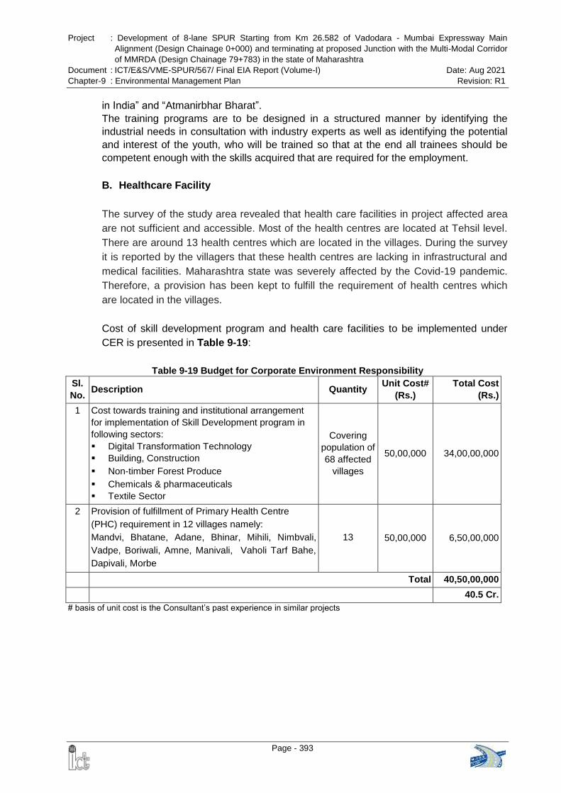
Project : Development of 8-lane SPUR Starting from Km 26.582 of Vadodara - Mumbai Expressway Main
Alignment (Design Chainage 0+000) and terminating at proposed Junction with the Multi-Modal Corridor
of MMRDA (Design Chainage 79+783) in the state of Maharashtra
Document : ICT/E&S/VME-SPUR/567/ Final EIA Report (Volume-I) Date: Aug 2021
Chapter-9 : Environmental Management Plan Revision: R1
Page - 393
in India” and “Atmanirbhar Bharat”.
The training programs are to be designed in a structured manner by identifying the
industrial needs in consultation with industry experts as well as identifying the potential
and interest of the youth, who will be trained so that at the end all trainees should be
competent enough with the skills acquired that are required for the employment.
B. Healthcare Facility
The survey of the study area revealed that health care facilities in project affected area
are not sufficient and accessible. Most of the health centres are located at Tehsil level.
There are around 13 health centres which are located in the villages. During the survey
it is reported by the villagers that these health centres are lacking in infrastructural and
medical facilities. Maharashtra state was severely affected by the Covid-19 pandemic.
Therefore, a provision has been kept to fulfill the requirement of health centres which
are located in the villages.
Cost of skill development program and health care facilities to be implemented under
CER is presented in Table 9-19:
Table 9-19 Budget for Corporate Environment Responsibility
Sl.
No. Description Quantity
Unit Cost#
(Rs.)
Total Cost
(Rs.)
1 Cost towards training and institutional arrangement
for implementation of Skill Development program in
following sectors:
Digital Transformation Technology
Building, Construction
Non-timber Forest Produce
Chemicals & pharmaceuticals
Textile Sector
Covering
population of
68 affected
villages
50,00,000 34,00,00,000
2 Provision of fulfillment of Primary Health Centre
(PHC) requirement in 12 villages namely:
Mandvi, Bhatane, Adane, Bhinar, Mihili, Nimbvali,
Vadpe, Boriwali, Amne, Manivali, Vaholi Tarf Bahe,
Dapivali, Morbe
13 50,00,000 6,50,00,000
Total 40,50,00,000
40.5 Cr.
# basis of unit cost is the Consultant‟s past experience in similar projects
Project : Development of 8-lane SPUR Starting from Km 26.582 of Vadodara - Mumbai Expressway Main
Alignment (Design Chainage 0+000) and terminating at proposed Junction with the Multi-Modal Corridor
of MMRDA (Design Chainage 79+783) in the state of Maharashtra
Document : ICT/E&S/VME-SPUR/567/ Final EIA Report (Volume-I) Date: Aug 2021
Chapter-10: Summary and Conclusion Revision: R1
Page - 394
CHAPTER-10: SUMMARY AND CONCLUSION
Need of the Project: During the draft Feasibility Study of the Mumbai – Vadodara Expressway,
it was felt that the starting point of proposed Vadodara Mumbai Expressway on NH-8 near
Dahisar at Mumbai end would pose a serious problem for safe and quick dispersal of traffic
from the Expressway and also would not serve the purpose of connecting to major traffic
generators like JNPT Port and to Mumbai-Pune expressway. Currently, the traffic bound for
Gujarat and further north from JNPT, NH-4 and Mumbai – Pune Expressway follows Thane-
Ghodbandar Road which is already congested and passes through / close to Sanjay Gandhi
National Park. Widening of this stretch as per IRC standard is not feasible. This traffic has to
pass through congested road network of Mumbai Metropolis from southward destination and
the goods earmarked for export and import also find difficulty in commuting to and from JNPT,
Navi Mumbai. Therefore it would be prudent to connect the proposed Vadodara Mumbai
Expressway to major traffic generators like JNPT and Mumbai – Pune Expressway.
Keeping view of the above, provision of SPUR to VME was explored. The spur will not only
connect to these major traffic generators but will also result in better dispersal of traffic in the
Mumbai Metropolitan Region. Therefore, the Consultants proposed that the VM Expressway
should be connected to JNPT and Mumbai-Pune expressway via NH-3, NH-8 NH-222 and
NH4B for proper traffic dispersal.
The project highway will provide smooth, safe and uninterrupted traffic movement between
Vadodara to Mumbai in respect to the alternative road NH 48. The NH 48 (Old NH8) is currently
carrying more than 100,000 PCUs with much substandard geometry and is heavily congested.
It will reduce the travel time about 3 to4 hours between Vadodara to Mumbai. The proposed
expressway falls in the Delhi-Mumbai Industrial Corridor. It will connect to the largest container
port, JNPT near Mumbai with northern part and Dahej port, other ports in Gujarat. Surat is at
the heart of the world's diamond-polishing industry contributing billions of dollars to the Indian
GDP. Vapi, Daman and Silvassa are the major industrial hub will be connected. Development
of this section will reduce the existing distance between Vadodara-Mumbai by about 22 km and
ultimately there will be reduction in distance between Delhi-Mumbai.
The SPUR connects the main expressway to JNPT, Maha Samrudhi Marg (Mumbai-Nagpur
Expressway) and Mumbai Pune Expressway. Therefore the traffic bound for JNPT, Nagpur and
Pune will ply on SPUR and will not enter the Mumbai city. This will reduce both traffic
congestion and pollution in the city. The proposed SPUR of VME will be linking Vadodara –
Mumbai Expressway, Ahmedabad- Vadodara Expressway, Mumbai –Nagpur Expressway and
Mumbai - Pune Expressway and thus will provide expressway connectivity from Delhi –
Ahmedabad – Mumbai – Nagpur - Pune.
This will further improve connectivity in terms of achieving smooth and safe traffic flow and
improve level of service. In addition to above, substantial economic gain, this would eventually
lead to reduction in the travel time and savings in terms of time, fuel and maintenance cost of
vehicles. Further this stretch will be a part of Delhi- Mumbai expressway corridor..
Project : Development of 8-lane SPUR Starting from Km 26.582 of Vadodara - Mumbai Expressway Main
Alignment (Design Chainage 0+000) and terminating at proposed Junction with the Multi-Modal Corridor
of MMRDA (Design Chainage 79+783) in the state of Maharashtra
Document : ICT/E&S/VME-SPUR/567/ Final EIA Report (Volume-I) Date: Aug 2021
Chapter-10: Summary and Conclusion Revision: R1
Page - 395
Environmental Impacts: The proposed greenfield expressway will have impacts on the
environment during construction and operation phase as summarized below:
Blockage of natural surface water runoff due to construction embankment
Permanent change of existing land use pattern due to acquisition of approx. 1031.91 ha
private & government land
Impact on ecology & biodiversity due to diversion of approx. 122.6133 ha forest land and
felling of approx. 55,355 no. of trees (Trees in forest-land - 13,839 and Trees in non-forest
land - 41,516)
Impact due to construction of 4.160 km tunnel in the Matheran ESZ
Mitigation Measures: Conservation and ecosystem management has vital role to minimize the
impact of expressway construction. Maintaining natural flows of rivers, streams, drainage
network etc. without changing the gorge of flow at expressway site also contribute to
conservation of ecosystem. Mitigation measures suggested to minimize the impacts is
summarized below:
To minimize the impact drainage & hydrological flow, 13 major bridges, 23 minor bridges,
238 culverts are proposed to be constructed along the expressway
It has been ensured that all the 1st and 2nd order streams crossing the proposed expressway
alignment provided with necessary culverts, mirror bridges and major bridges with capacity
of 20% excess discharge.
In addition to culverts & underpasses, for easy movement of animals, major bridge cum
viaduct of 4.2 km length has been proposed
All bridges have been designed for a return period of 100 years and culverts have been
designed for a return period of 50 years
The detailed analysis of Geophysical study shows that there is no water body encountered
along the SPUR alignment and the rock is hard and compact which will not affect on the
alignment and it is safe for tunneling.
The structural geology study shows that the area is good for tunneling.
The lineament study and Aquifer mapping shows that the area is safe for tunneling and will
not affect any ground water body present in the area.
Stabilization measures for tunnel and slope shall be as per final recommendation of
Geotechnical Investigation report.
Coir Geotextile & Vetiver grasses have been proposed for slope stabilization, which is the
only environment friendly and sustainable technology to control soil erosion and slope
stabilization.
Packaged Wastewater Treatment Plant has been recommended for the construction camp
Silt fencing shall be provided to prevent sediments from the construction site entering into
the nearby watercourses
Total 364 structures (which includes 2 animal overpass, 53 numbers of dedicated animal
crossings and 33 numbers of small vehicular / animal underpasses) have been proposed
along the entire stretch of the VME-SPUR and total length of the structures is 13.447 km. It
can be concluded that in every km stretches of the VME-SPUR; around 5 structures
Project : Development of 8-lane SPUR Starting from Km 26.582 of Vadodara - Mumbai Expressway Main
Alignment (Design Chainage 0+000) and terminating at proposed Junction with the Multi-Modal Corridor
of MMRDA (Design Chainage 79+783) in the state of Maharashtra
Document : ICT/E&S/VME-SPUR/567/ Final EIA Report (Volume-I) Date: Aug 2021
Chapter-10: Summary and Conclusion Revision: R1
Page - 396
have been proposed.
As suggested by the MoEFCC, RoW has been reduced from 100 m to 70 m in the forest
area. In 8.756 km stretch, RoW has been reduced and 24.276 ha forest land has been
saved
Average width of construction zone in the non-forest area is 70 m out of 100 m RoW (Right
of Way). Tree counting has been conducted in 100 m area and there are 41,516 trees in
non-forest land. Approx. 30% i.e. 12,454 trees standing outside the construction zone on
edge of the RoW may be saved in the non-forest area
69,680 no. of trees and 40,098 no. of hedges proposed to be planted under greenbelt
development plan
As per Compensatory afforestation notification 7th November, 2017, the requirement is
1000 plants per ha of Forestland diverted. Therefore the plantation required under CA for
diversion of 122.6133 ha forestland shall be 2,45,226 plants. However, this shall be
finalized by the Forest Department.
Wildlife awareness & environmental protection training shall be provided to the work force
by the Contractor / PIU. Budget of Rs.32.0 Lakh has been proposed for training in the EMP
budget. The awareness and training shall be provided construction package wise before
initiation of construction activity.
The proposed expressway does not pass through any National Park, Wildlife Sanctuary,
Conservation Reserve and Community Reserve, hence no direct impact is envisaged
To improve the safety of such high speed corridor, Thrie beam metal crash barriers shall be
provided in entire length on both sides of each main carriageway (i.e. on median and on
earthen shoulder of both carriageway), Loops and Ramps excluding stretches covered by
bridges and RE wall structures, where concrete barriers to be provided.
In addition to safety barrier, safety features like road marking, traffic sign, boundary stones,
kilometer stones and hectometer stones, pavement marking and lighting has been
proposed. Advanced Traffic Management System (ATMS) for entire expressway have
been proposed
The construction and demolition waste management shall be carried out as per the
provisions of the Construction and Demolition Waste Management Rules, 2016.
Disposal of domestic waste from Labour camps as per SWM Rules, 2016
Mitigation measures recommended during Environment & CRZ Clearance and Forest
Clearance shall be complied with by the Project Proponent. Monitoring and progress report
of implementation of EMP and recommendations by various authorities shall be submitted
as per the schedule.
Environmental Management Plan
A capital cost provision of about Rs. 56.98 Crore has been kept towards implementation of
environmental management plan.
Budget for Implementation of Wildlife Conservation Plan
Cost of construction of the animal overpass, dedicated animal crossing & animal underpass
Project : Development of 8-lane SPUR Starting from Km 26.582 of Vadodara - Mumbai Expressway Main
Alignment (Design Chainage 0+000) and terminating at proposed Junction with the Multi-Modal Corridor
of MMRDA (Design Chainage 79+783) in the state of Maharashtra
Document : ICT/E&S/VME-SPUR/567/ Final EIA Report (Volume-I) Date: Aug 2021
Chapter-10: Summary and Conclusion Revision: R1
Page - 397
is Rs. 173.39 Crore which is part of mitigation cost
Total financial outlay for implementation of wildlife conservation plan and mitigation
measures, Rs. 3.57 Crore has been proposed.
The total financial allocation proposed for implementation of the Wildlife Conservation Plan
including its implementation responsibility, as approved by the Principle Chief
Conservator of Forests and Chief Wildlife Warden, Maharashtra State is Rs. 177.18
Cr.
Budget for Corporate Environment Responsibility
A capital cost provision of about Rs. 40.5 Crore has been kept for training and institutional
arrangement for implementation of skill development program and provision of fulfillment of
Primary Health Centre (PHC) requirement in 12 villages under Corporate Environment
Responsibility.
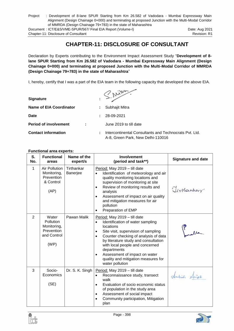
Project : Development of 8-lane SPUR Starting from Km 26.582 of Vadodara - Mumbai Expressway Main
Alignment (Design Chainage 0+000) and terminating at proposed Junction with the Multi-Modal Corridor
of MMRDA (Design Chainage 79+783) in the state of Maharashtra
Document : ICT/E&S/VME-SPUR/567/ Final EIA Report (Volume-I) Date: Aug 2021
Chapter-11: Disclosure of Consultant Revision: R1
Page - 398
CHAPTER-11: DISCLOSURE OF CONSULTANT
Declaration by Experts contributing to the Environment Impact Assessment Study “Development of 8-
lane SPUR Starting from Km 26.582 of Vadodara - Mumbai Expressway Main Alignment (Design
Chainage 0+000) and terminating at proposed Junction with the Multi-Modal Corridor of MMRDA
(Design Chainage 79+783) in the state of Maharashtra”
I, hereby, certify that I was a part of the EIA team in the following capacity that developed the above EIA.
Signature :
Name of EIA Coordinator : Subhajit Mitra
Date : 28-09-2021
Period of involvement : June 2019 to till date
Contact information : Intercontinental Consultants and Technocrats Pvt. Ltd.
A-8, Green Park, New Delhi-110016
Functional area experts:
S. No.
Functional areas
Name of the expert/s
Involvement (period and task**)
Signature and date
1 Air Pollution Monitoring, Prevention & Control
(AP)
Tirthankar Banerjee
Period: May 2019 – till date
Identification of meteorology and air quality monitoring locations and supervision of monitoring at site
Review of monitoring results and analysis
Assessment of impact on air quality and mitigation measures for air pollution
Preparation of EMP
2 Water Pollution
Monitoring, Prevention and Control
(WP)
Pawan Malik Period: May 2019 – till date
Identification of water sampling locations
Site visit, supervision of sampling
Counter checking of analysis of data by literature study and consultation with local people and concerned departments
Assessment of impact on water quality and mitigation measures for water pollution
3 Socio-Economics
(SE)
Dr. S. K. Singh
Period: May 2019 – till date
Reconnaissance study, transect walk
Evaluation of socio economic status of population in the study area
Assessment of social impact
Community participation, Mitigation plan
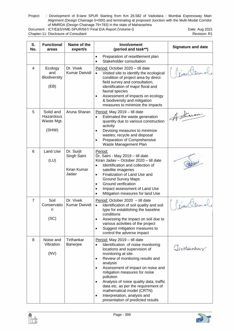
Project : Development of 8-lane SPUR Starting from Km 26.582 of Vadodara - Mumbai Expressway Main
Alignment (Design Chainage 0+000) and terminating at proposed Junction with the Multi-Modal Corridor
of MMRDA (Design Chainage 79+783) in the state of Maharashtra
Document : ICT/E&S/VME-SPUR/567/ Final EIA Report (Volume-I) Date: Aug 2021
Chapter-11: Disclosure of Consultant Revision: R1
Page - 399
S. No.
Functional areas
Name of the expert/s
Involvement (period and task**)
Signature and date
Preparation of resettlement plan
Stakeholder consultation
4 Ecology and
Biodiversity
(EB)
Dr. Vivek Kumar Dwividi
Period: October 2020 – till date
Visited site to identify the ecological condition of project area by direct field survey and consultation, identification of major floral and faunal species
Assessment of impacts on ecology & biodiversity and mitigation measures to minimize the impacts
5 Solid and Hazardous Waste Mgt.
(SHW)
Aruna Sharan Period: May 2019 – till date
Estimated the waste generation quantity due to various construction activity
Devising measures to minimize wastes; recycle and disposal
Preparation of Comprehensive Waste Management Plan
6 Land Use
(LU)
Dr. Surjit Singh Saini Kiran Kumar Jadav
Period: Dr. Saini - May 2019 – till date Kiran Jadav – October 2020 – till date
Identification and collection of satellite imageries
Finalization of Land Use and Ground Survey Maps
Ground verification
Impact assessment of Land Use
Mitigation measures for land Use
7 Soil Conservatio
n
(SC)
Dr. Vivek Kumar Dwividi
Period: October 2020 – till date
Identification of soil quality and soil type for establishing the baseline conditions
Assessing the impact on soil due to various activities of the project
Suggest mitigation measures to control the adverse impact
8 Noise and Vibration
(NV)
Tirthankar Banerjee
Period: May 2019 – till date
Identification of noise monitoring locations and supervision of monitoring at site
Review of monitoring results and analysis
Assessment of impact on noise and mitigation measures for noise pollution
Analysis of noise quality data, traffic data etc. as per the requirement of mathematical model (CRTN)
Interpretation, analysis and presentation of predicted results
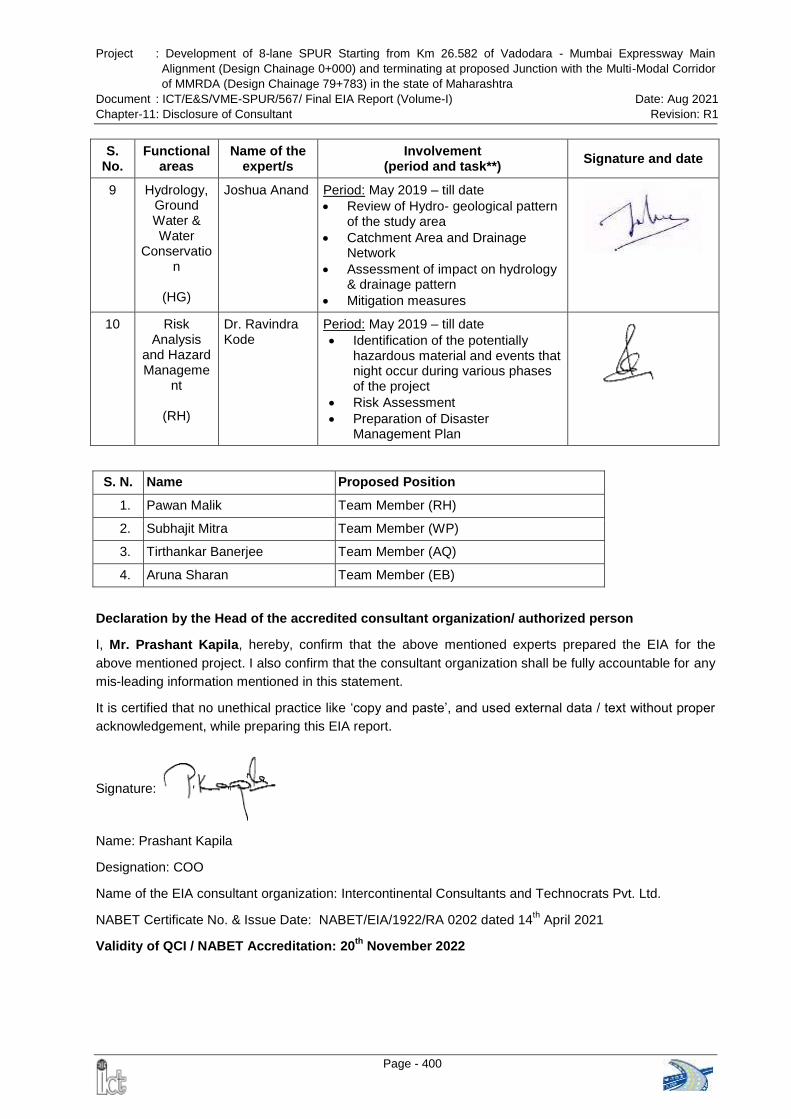
Project : Development of 8-lane SPUR Starting from Km 26.582 of Vadodara - Mumbai Expressway Main
Alignment (Design Chainage 0+000) and terminating at proposed Junction with the Multi-Modal Corridor
of MMRDA (Design Chainage 79+783) in the state of Maharashtra
Document : ICT/E&S/VME-SPUR/567/ Final EIA Report (Volume-I) Date: Aug 2021
Chapter-11: Disclosure of Consultant Revision: R1
Page - 400
S. No.
Functional areas
Name of the expert/s
Involvement (period and task**)
Signature and date
9 Hydrology, Ground Water & Water
Conservation
(HG)
Joshua Anand Period: May 2019 – till date
Review of Hydro- geological pattern of the study area
Catchment Area and Drainage Network
Assessment of impact on hydrology & drainage pattern
Mitigation measures
10 Risk Analysis
and Hazard Manageme
nt
(RH)
Dr. Ravindra Kode
Period: May 2019 – till date
Identification of the potentially hazardous material and events that night occur during various phases of the project
Risk Assessment
Preparation of Disaster Management Plan
S. N. Name Proposed Position
1. Pawan Malik Team Member (RH)
2. Subhajit Mitra Team Member (WP)
3. Tirthankar Banerjee Team Member (AQ)
4. Aruna Sharan Team Member (EB)
Declaration by the Head of the accredited consultant organization/ authorized person
I, Mr. Prashant Kapila, hereby, confirm that the above mentioned experts prepared the EIA for the
above mentioned project. I also confirm that the consultant organization shall be fully accountable for any
mis-leading information mentioned in this statement.
It is certified that no unethical practice like „copy and paste‟, and used external data / text without proper
acknowledgement, while preparing this EIA report.
Signature:
Name: Prashant Kapila
Designation: COO
Name of the EIA consultant organization: Intercontinental Consultants and Technocrats Pvt. Ltd.
NABET Certificate No. & Issue Date: NABET/EIA/1922/RA 0202 dated 14th April 2021
Validity of QCI / NABET Accreditation: 20th
November 2022