denmark, southern sweden and the netherlands
TRANSCRIPT
DENMARK, SOUTHERN SWEDEN AND THE NETHERLANDS

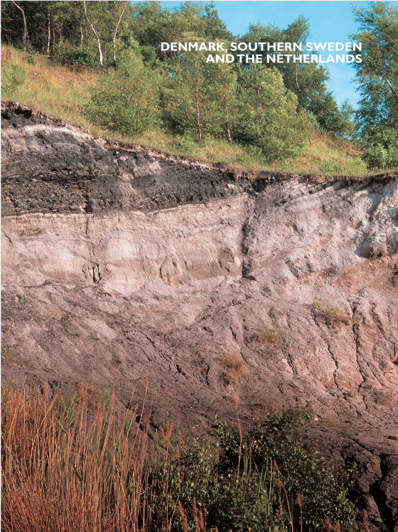
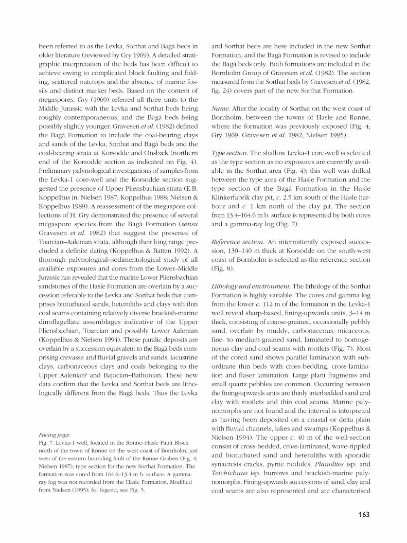
Previous page: Jurassic sediments exposed in a clay-pit at Bagå on Bornholm, Denmark – see Michelsen et al. (2003, this volume).Photo: Peter K. Warna-Moors.
147
Jurassic lithostratigraphy and stratigraphic developmentonshore and offshore Denmark
Olaf Michelsen, Lars H. Nielsen, Peter N. Johannessen, Jan Andsbjerg and Finn Surlyk
A complete updated and revised lithostratigraphic scheme for the Jurassic succession of theonshore and offshore Danish areas is presented together with an overview of the geological evo-lution. The lithostratigraphies of Bornholm, the Danish Basin and the Danish Central Graben aredescribed in ascending order, and a number of new units are defined. On Bornholm, theLower–Middle Jurassic coal-bearing clays and sands that overlie the Lower Pliensbachian HasleFormation are referred to the new Sorthat Formation (Lower Jurassic) and the revised BagåFormation (Middle Jurassic). In the southern Danish Central Graben, the Middle Jurassic successionformerly referred to the Lower Graben Sand Formation is now included in the revised BryneFormation. The Lulu Formation is erected to include the uppermost part of the Middle Jurassicsuccession, previously referred to the Bryne Formation in the northern Danish Central Graben.The Upper Jurassic Heno Formation is subdivided into two new members, the Gert Member (lower)and the Ravn Member (upper). The organic-rich part of the upper Farsund Formation, the for-mer informal ‘hot unit’, is established formally as the Bo Member.
Dominantly shallow marine and paralic deposition in the Late Triassic was succeeded by wide-spread deposition of offshore marine clays in the Early Jurassic. On Bornholm, coastal and par-alic sedimentation prevailed. During maximum transgression in the Early Toarcian, sedimentationof organic-rich offshore clays took place in the Danish area. This depositional phase was termi-nated by a regional erosional event in early Middle Jurassic time, caused by uplift of the centralNorth Sea area, including the Ringkøbing–Fyn High. In the Sorgenfrei–Tornquist Zone to the east,where slow subsidence continued, marine sandy sediments were deposited in response to theuplift. Uplift of the central North Sea area was followed by fault-controlled subsidence accom-panied by fluvial and floodplain deposition during Middle Jurassic time. On Bornholm, deposi-tion of lacustrine muds, fluvial sands and peats dominated. The late Middle Jurassic saw a gradualshift to shallow marine deposition in the Danish Central Graben, the Danish Basin and Skåne,southern Sweden. During the Late Jurassic, open marine shelf conditions prevailed with depo-sition of clay-dominated sediments while shallow marine sands were deposited on platformareas. The Central Graben received sand by means of sediment gravity flows. The clay sedimentsin the Central Graben became increasingly rich in organic matter at the Jurassic–Cretaceoustransition, whilst shallow marine coarse-grained deposits prograded basinwards in the Sorgenfrei–Tornquist Zone.
Keywords: Denmark, Danish Central Graben, Danish Basin, Sorgenfrei–Tornquist Zone, Bornholm, Jurassic,
lithostratigraphy, basin development
O.M., Geological Institute, University of Aarhus, C.F. Møllers Allé, DK-8000 Århus C, Denmark.
L.H.N., P.N.J. & J.A., Geological Survey of Denmark and Greenland, Geocenter Copenhagen, Øster Voldgade 10,
DK-1350 Copenhagen K, Denmark. E-mail: [email protected]
F.S., Geological Institute, University of Copenhagen, Geocenter Copenhagen, Øster Voldgade 10, DK-1350 Copen-
hagen K, Denmark.
Geological Survey of Denmark and Greenland Bulletin 1, 147–216 (2003) © GEUS, 2003
148
Jurassic deposits extend throughout most of theDanish area, from the island of Bornholm in theBaltic Sea in the east to the central part of the NorthSea in the west (Fig. 1). They can be studied at out-crop on Bornholm and Skåne (southern Sweden),whereas they are only known from subsurface dataover the remainder of the area.
The Jurassic of Bornholm has been studied since the19th century; the early literature includes Forchhammer(1837), Jespersen (1866, 1869), Bartholin (1892, 1894),Grönwall (1899), Hjort (1899), Møller (1902, 1903), Malling& Grönwall (1909), Malling (1911, 1914, 1920) and Höhne(1933). The stratigraphy and structural evolution was stud-ied by Gry (1969), and the sedimentary evolution of theJurassic successions was discussed by Sellwood (1972),Rolle et al. (1979) and Gravesen et al. (1982); the lastauthors also erected the first formal lithostratigraphic
scheme. Palynological studies have been undertaken byHoelstad (1985), Koppelhus (1991), Koppelhus & Batten(1992), Batten et al. (1994) and Koppelhus & Nielsen(1994). Surlyk & Noe-Nygaard (1986) interpreted thedepositional environments of the Pliensbachian HasleFormation, and the rich ammonite fauna is described byDonovan & Surlyk (2003, this volume). Surlyk et al. (1995)provided a detailed sequence stratigraphic interpretationof the Hettangian– Sinemurian Sose Bugt Member (RønneFormation). Koppelhus & Nielsen (1994) and Petersen &Nielsen (1995) interpreted the depositional environmentsof the Upper Pliensbachian – Bathonian Sorthat and BagåFormations. The coal beds, burial depths and amount ofuplift based on coal maturation were studied by Petersen(1993) and Petersen et al. (2003a, b, this volume).
Jurassic sediments in the subsurface are known froma large number of deep wells drilled for hydrocarbon
Contents
Regional setting 149Lithostratigraphy 154Bornholm 155
Rønne Formation 155Hasle Formation 161Sorthat Formation 161Bagå Formation 166
Danish Basin 168Gassum Formation 168Fjerritslev Formation 170Haldager Sand Formation 173Flyvbjerg Formation 174Børglum Formation 174Frederikshavn Formation 175
Danish Central Graben 176Fjerritslev Formation 176Bryne Formation 177Lulu Formation 180Middle Graben Formation 183Lola Formation 185Heno Formation 185
Gert Member 189Ravn Member 190
Farsund Formation 191Bo Member 195
Poul Formation 197Stratigraphic evolution 197
Early Jurassic marine deposition 197Middle Jurassic uplift 204Middle Jurassic fluvial and paralic deposition 204Late Jurassic marine deepening 208Late Jurassic graben development and sedimentation 209
Acknowledgements 211References 212
and geothermal exploration with supplementary infor-mation from seismic surveys. The presence of Jurassicrocks from the subsurface of onshore Denmark wasdescribed for the first time by Nørvang (1946) from aborehole situated in northern Jylland near the villageof Vejrum. The Vinding-1 well, drilled in 1947, was thefirst deep onshore well to penetrate the Jurassic.Gregersen & Sorgenfrei (1951) presented a stratigraphicreview of two well sections, Gassum-1 and Vinding-1.A lithological and stratigraphical summary of the Jurassicin a large number of wells was given by Sorgenfrei &Buch (1964). A lithostratigraphic subdivision of theentire Jurassic succession was undertaken by Larsen(1966), and later refined and partly revised by Bertelsen(1978) and Michelsen (1978a, 1989a). Larsen et al. (1968)described Jurassic strata encountered in wells drilled inthe strait between Denmark and Sweden (Øresund);Petersen (1994) studied the genesis of the coals fromthese wells. Several biostratigraphic studies have beenpublished including those of Nørvang (1957) who exam-ined the Early Jurassic foraminiferal faunas, Michelsen(1975) who established a zonation of the Lower Jurassicbased on the ostracod faunas, Dybkjær (1988, 1991) andPoulsen (1992, 1994, 1996) who established a palyno-logical zonation of the Jurassic in the Danish Basin.The depositional environments and bivalve assemblagesof the Lower Jurassic Fjerritslev Formation were inter-preted by Pedersen (1985, 1986). Koch (1983) discussedthe depositional environments of the Middle–UpperJurassic sandstone reservoirs, Thomsen et al. (1987)described the hydrocarbon plays, and Nielsen (1995,2003, this volume) has described the Upper Triassic –Jurassic depositional sequences and the developmentof the Danish Basin and Fennoscandian Border Zone.
In the Danish North Sea sector, the Jurassic was firstpenetrated by the A-2 well, drilled in 1967, and Sorgenfrei(1969) indicated the presence of Jurassic marine offshoredeposits in the North Sea. The first lithological andstratigraphic summaries of drilled Jurassic successionswere presented by Rasmussen (1974, 1978). A regionaldescription and a preliminary lithostratigraphic subdi-vision of the Jurassic succession in the Central Grabenwere presented by Koch et al. (1982). The lithostrati-graphic subdivision defined in the Danish onshore wellsections also applies to the easternmost North Sea wellslocated in the Norwegian–Danish Basin (Michelsen1978a). A lithostratigraphic scheme for the deposits inthe Central Graben was established by Jensen et al.(1986), and Jurassic basin development was discussedby Michelsen et al. (1987). The depositional environ-ments of the Middle Jurassic Bryne and Lulu Formations
and the Upper Jurassic Heno Formation were inter-preted by Johannessen (1995, 1997, 2003, this volume),Johannessen et al. (1996), Petersen & Andsbjerg (1996)Andsbjerg (1997, 2003, this volume) and Andsbjerg &Dybkjær (2003, this volume). Biostratigraphic data fromthe offshore well sections were presented by Rasmussen(1974, 1978). The Early Jurassic ostracod faunas of theO-1 well were described by Michelsen (1978b), Hoelstad(1986a) studied the palynology of the Middle Jurassicin the U-1 well, and Poulsen (1986, 1991) presented adinoflagellate cyst biostratigraphy of the Middle andUpper Jurassic in two wells from the Central Graben.Dybkjær (1998) and Andsbjerg & Dybkjær (2003, thisvolume) presented palynological data from the Middleand Upper Jurassic. The hydrocarbon plays weredescribed by Damtoft et al. (1992); further details onsource rocks were provided by Petersen et al. (1996,1998, 2000), Petersen & Rosenberg (1998) and Inesonet al. (2003, this volume).
The primary aim of the present paper is to presenta complete and updated version of the lithostratigraphicscheme of the entire Danish onshore and offshore area(Fig. 2). In addition, an account is given of the strati-graphic development during the Jurassic Period in theDanish part of the North Sea Basin including the DanishBasin. Biostratigraphic and sequence stratigraphic aspectsare dealt with in other papers in this volume and willbe referred to where relevant. A summary of the dis-tribution and thickness of the lithostratigraphic unitspenetrated in well sections can be found in Nielsen &Japsen (1991).
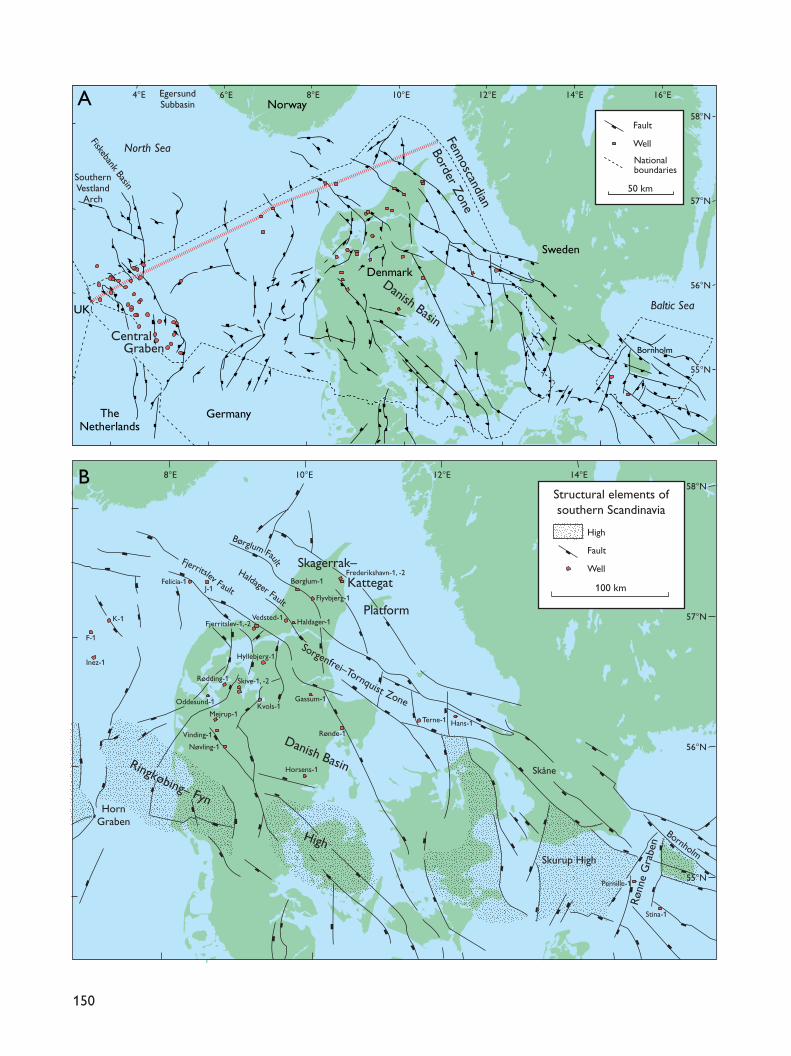
Regional settingThe Danish area belongs to the eastern part of theNorth Sea Basin, which comprises a number of fault-bounded basins separated by structural highs (Figs 1,3). The Danish Jurassic deposits represent a wide rangeof environments, from dominantly paralic and coastalin the east to deep marine in the west. Differentialmovements of individual structural features have con-trolled the distribution of Jurassic deposits. The mostimportant structural features are therefore describedbriefly below.
The North Sea Basin is separated from the Fenno-scandian Shield to the east by the strongly block-faultedFennoscandian Border Zone (Sorgenfrei & Buch 1964;Baartman & Christensen 1975). The zone runs fromnorthernmost Jylland, south-eastwards through Skåneto the island of Bornholm in the Baltic Sea. It comprises
149
150
EgersundSubbasin
SouthernVestland
Arch
Fiskebank Basin
North Sea
Baltic Sea
Fennoscandian
Border Zone
10°E8°E 12°E 14°E
10°E8°E 12°E 14°E
16°E
58°N
57°N
56°N
55°N
58°N
57°N
56°N
55°N
6°E4°EA
Sweden
TheNetherlands
Germany
Norway
Denmark
UK
Skåne
Bornholm
HornGraben
Horsens-1
Rønde-1
Terne-1
Gassum-1
Mejrup-1
Rødding-1
Hyllebjerg-1
Vedsted-1
Flyvbjerg-1
Vinding-1
Nøvling-1
Oddesund-1
Skive-1, -2
Kvols-1
Børglum-1
Haldager-1
Frederikshavn-1, -2
Hans-1
Pernille-1
Stina-1
Fjerritslev-1,-2
F-1
Inez-1
K-1
Felicia-1J-1
Well
Fault
High
Well
Fault
100 km
Structural elements ofsouthern Scandinavia
B
Nationalboundaries
Sorgenfrei–Tornquist Zone
Børglum Fault
Haldager Fault
Fjerritslev Fault
Danish Basin
Skurup High
Ringkøbing– Fyn
High
Skagerrak–
Kattegat
Platform
Rønn
e G
rabe
n
Bornholm
50 km
Danish BasinCentral
Graben
mainly marine and paralic Jurassic deposits, and wasrepeatedly overstepped during the Jurassic. In theKattegat area and northernmost Jylland, the zoneincludes two different structural elements, the Sorgen-frei–Tornquist Zone and the Skagerrak–Kattegat Platform(Figs 1B, 3; EUGENO-S Working Group 1988).
The Sorgenfrei–Tornquist Zone was established dur-ing Late Carboniferous – Early Permian times as a riftzone in conjunction with the Oslo Graben (Liboriussen
et al. 1987; EUGENO-S Working Group 1988; Ro et al.1990; Michelsen & Nielsen 1991, 1993; Mogensen &Korstgård 1993, 2003, this volume; Mogensen 1994,1996; Vejbæk 1997). The zone was periodically activeduring the Mesozoic. Block faulting and increased sub-sidence rates prevailed in the Late Triassic – Early Jurassicand during latest Jurassic – earliest Cretaceous times,while inversion tectonism characterised Late Cretaceous– Early Cenozoic times. Slow subsidence occurred in
151
■
■
■
■
GertrudPlateau/GrabenGert
Ridge
Late JurassicStructural elements
Normal fault
Reverse fault
Salt structures
Well
▲
■
25 km
■
■
■
■
■
■
■
■
■
■
■
■
■
■
■
■
▲
■
■
■
■
■
■
■
■
■
■
■
■
■
■
■■
■
■
■
■
■
■
■
■
■
■
■
■
■■
■
■
■
■
■
▲
▲
■
■
■
■
■
▲▲
▲
■
■
■
■
■
■
■
Ugle-1
Cleo-1
Amalie-1
Elin-1
West Lulu-1West Lulu-3
Gert-1
Gert-4Gert-2
Kim-1
Tordenskjold-1
P-1
2/8-3
Jeppe-1
Gwen-2
T-1
Ravn-1
Edna-1
Ravn-2
W-1
Elly-2Elly-3
Ringkøbing–Fyn HighEast North Sea High
Deep Gorm-1G-1
M-8
A-2
O-1
E-1
L-1
U-1
Lulu-1
Nora-1
Poul Plateau
V-1
Bo-1
MidNorth Sea
High
Feda Graben
Inge High
Søgne Basin
Mads H
igh
Tail End Graben
Rosa Basin
Coffee Soil Fault
Heno Plateau
Baron-2
4°E
56°N
Salt DomeProvince
Mandal High
C
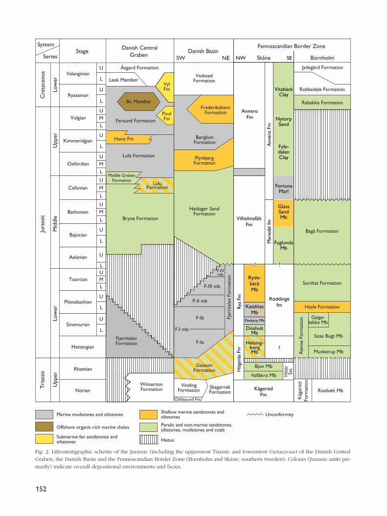
Fig. 1. A: Outline structure map showing the three main Mesozoic tectonic elements: the Central Graben, the Danish Basin and theFennoscandian Border Zone. The red line parallel to the Denmark–Norway border indicates the location of the geosection in Fig. 3.B: Simplified structural map of the Danish Basin with well locations. Modified from Nielsen (2003, this volume). C: Map of the DanishCentral Graben showing the Late Jurassic structural elements and the location of wells mentioned in the text. Modified from Japsenet al. (2003, this volume).
152
Oddesund Fm Kåg
eröd
Form
atio
n
System
SeriesStage
Jura
ssic
Tri
assi
c
Åsgard Formation
Leek Member
Bo Member
Heno Fm
Lola Formation
Bryne Formation
Danish BasinSW NE
VedstedFormation
BørglumFormation
FlyvbjergFormation
Haldager SandFormation
Fjer
rits
lev
Form
atio
n
GassumFormation
VindingFormation
SkagerrakFormation
Jydegård Formation
Robbedale Formation
Rabekke Formation
Bagå Formation
Sorthat Formation
Hasle Formation
Galge-løkke Mb
Sose Bugt Mb
Røn
ne F
orm
atio
n
F-IVmb
F-III mb
F-II mb
F-Ib
F-I mb
F-Ia
Fennoscandian Border Zone
Risebæk Mb
Munkerup Mb
FrederikshavnFormation
Danish CentralGraben
Ryazanian
Volgian
Kimmeridgian
Oxfordian
Callovian
Bathonian
Bajocian
Aalenian
Toarcian
Pliensbachian
Sinemurian
Hettangian
Rhaetian
NorianWintertonFormation
Cre
tace
ous Valanginian
FjerritslevFormation
VylFm
PoulFmFarsund Formation
Low
erU
pper
Mid
dle
Low
erU
pper
U
L
U
L
L
U
U
M
L
L
M
U
M
L
U
L
U
U
L
L
UM
L
U
U
L
UM
L
AnneroFm
Ann
ero
FmM
arie
dal f
m
VilhelmsfältFm
Röddingefm
?
? ?
Paralic and non-marine sandstones,siltstones, mudstones and coals
Marine mudstones and siltstones Unconformity
Offshore organic-rich marine shales
Submarine fan sandstones andsiltstones
Shallow marine sandstones andsiltstones
Hiatus
Fyle-dalenClay
NytorpSand
FortunaMarl
GlassSandMb
FuglundaMb
VitabäckClay
Helsing-borgMb
DöshultMb
Pankarp Mb
KatslösaMb
Ryde-bäckMb
Rya
Fm
Hög
anäs
Fm
Bjuv Mb
Vallåkra Mb Höö
rSs
t.
KågerödFm
Skåne BornholmNW SE
??
Middle GrabenFormation
LuluFormation
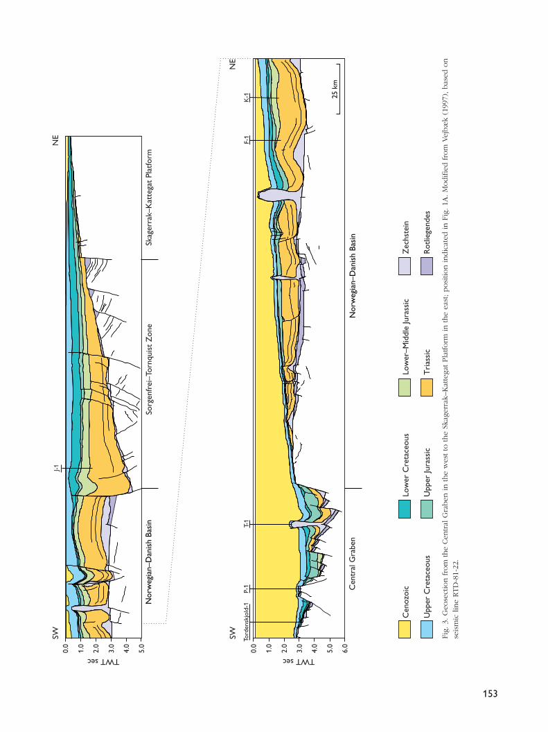
Fig. 2. Lithostratigraphic scheme of the Jurassic (including the uppermost Triassic and lowermost Cretaceous) of the Danish CentralGraben, the Danish Basin and the Fennoscandian Border Zone (Bornholm and Skåne, southern Sweden). Colours (Jurassic units pri-marily) indicate overall depositional environments and facies.
153
0.0
1.0
2.0
3.0
4.0
5.0
6.0
0.0
1.0
2.0
3.0
4.0
5.0
J-1
K-1
F-1
P-1
T-1
Cen
tral
Gra
ben
SW SW
NE
Skag
erra
k–K
atte
gat
Plat
form
NE
25 k
m
Tord
ensk
jold
-1Nor
weg
ian–
Dan
ish
Basi
nSo
rgen
frei
–Tor
nqui
st Z
one
Nor
weg
ian–
Dan
ish
Basi
n
TWT sec TWT sec
Cen
ozoi
c
Upp
er C
reta
ceou
s
Low
er C
reta
ceou
s
Upp
er Ju
rass
ic
Low
er–M
iddl
e Ju
rass
ic
Tri
assi
c
Zec
hste
in
Rot
liege
ndes
Fig.
3. G
eose
ctio
n fro
m the
Cen
tral
Gra
ben
in the
wes
t to
the
Skag
erra
k–K
atte
gat Pla
tform
in the
east
; posi
tion indic
ated
in F
ig. 1A
. M
odifie
d fro
m V
ejbæ
k (1
997)
, bas
ed o
nse
ism
ic lin
e RTD
-81-
22.
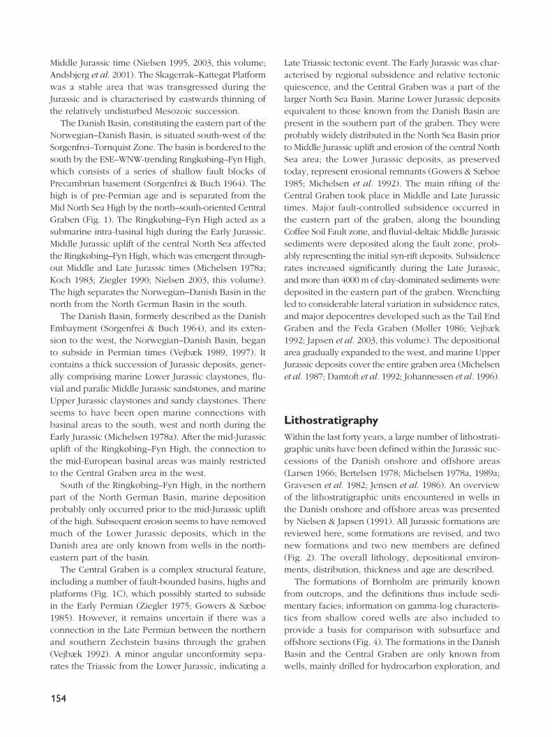
Middle Jurassic time (Nielsen 1995, 2003, this volume;Andsbjerg et al. 2001). The Skagerrak–Kattegat Platformwas a stable area that was transgressed during theJurassic and is characterised by eastwards thinning ofthe relatively undisturbed Mesozoic succession.
The Danish Basin, constituting the eastern part of theNorwegian–Danish Basin, is situated south-west of theSorgenfrei–Tornquist Zone. The basin is bordered to thesouth by the ESE–WNW-trending Ringkøbing–Fyn High,which consists of a series of shallow fault blocks ofPrecambrian basement (Sorgenfrei & Buch 1964). Thehigh is of pre-Permian age and is separated from theMid North Sea High by the north–south-oriented CentralGraben (Fig. 1). The Ringkøbing–Fyn High acted as asubmarine intra-basinal high during the Early Jurassic.Middle Jurassic uplift of the central North Sea affectedthe Ringkøbing–Fyn High, which was emergent through-out Middle and Late Jurassic times (Michelsen 1978a;Koch 1983; Ziegler 1990; Nielsen 2003, this volume).The high separates the Norwegian–Danish Basin in thenorth from the North German Basin in the south.
The Danish Basin, formerly described as the DanishEmbayment (Sorgenfrei & Buch 1964), and its exten-sion to the west, the Norwegian–Danish Basin, beganto subside in Permian times (Vejbæk 1989, 1997). Itcontains a thick succession of Jurassic deposits, gener-ally comprising marine Lower Jurassic claystones, flu-vial and paralic Middle Jurassic sandstones, and marineUpper Jurassic claystones and sandy claystones. Thereseems to have been open marine connections withbasinal areas to the south, west and north during theEarly Jurassic (Michelsen 1978a). After the mid-Jurassicuplift of the Ringkøbing–Fyn High, the connection tothe mid-European basinal areas was mainly restrictedto the Central Graben area in the west.
South of the Ringkøbing–Fyn High, in the northernpart of the North German Basin, marine depositionprobably only occurred prior to the mid-Jurassic upliftof the high. Subsequent erosion seems to have removedmuch of the Lower Jurassic deposits, which in theDanish area are only known from wells in the north-eastern part of the basin.
The Central Graben is a complex structural feature,including a number of fault-bounded basins, highs andplatforms (Fig. 1C), which possibly started to subsidein the Early Permian (Ziegler 1975; Gowers & Sæbøe1985). However, it remains uncertain if there was aconnection in the Late Permian between the northernand southern Zechstein basins through the graben(Vejbæk 1992). A minor angular unconformity sepa-rates the Triassic from the Lower Jurassic, indicating a
Late Triassic tectonic event. The Early Jurassic was char-acterised by regional subsidence and relative tectonicquiescence, and the Central Graben was a part of thelarger North Sea Basin. Marine Lower Jurassic depositsequivalent to those known from the Danish Basin arepresent in the southern part of the graben. They wereprobably widely distributed in the North Sea Basin priorto Middle Jurassic uplift and erosion of the central NorthSea area; the Lower Jurassic deposits, as preservedtoday, represent erosional remnants (Gowers & Sæbøe1985; Michelsen et al. 1992). The main rifting of theCentral Graben took place in Middle and Late Jurassictimes. Major fault-controlled subsidence occurred inthe eastern part of the graben, along the boundingCoffee Soil Fault zone, and fluvial-deltaic Middle Jurassicsediments were deposited along the fault zone, prob-ably representing the initial syn-rift deposits. Subsidencerates increased significantly during the Late Jurassic,and more than 4000 m of clay-dominated sediments weredeposited in the eastern part of the graben. Wrenchingled to considerable lateral variation in subsidence rates,and major depocentres developed such as the Tail EndGraben and the Feda Graben (Møller 1986; Vejbæk1992; Japsen et al. 2003, this volume). The depositionalarea gradually expanded to the west, and marine UpperJurassic deposits cover the entire graben area (Michelsenet al. 1987; Damtoft et al. 1992; Johannessen et al. 1996).
LithostratigraphyWithin the last forty years, a large number of lithostrati-graphic units have been defined within the Jurassic suc-cessions of the Danish onshore and offshore areas(Larsen 1966; Bertelsen 1978; Michelsen 1978a, 1989a;Gravesen et al. 1982; Jensen et al. 1986). An overviewof the lithostratigraphic units encountered in wells inthe Danish onshore and offshore areas was presentedby Nielsen & Japsen (1991). All Jurassic formations arereviewed here, some formations are revised, and twonew formations and two new members are defined(Fig. 2). The overall lithology, depositional environ-ments, distribution, thickness and age are described.
The formations of Bornholm are primarily knownfrom outcrops, and the definitions thus include sedi-mentary facies; information on gamma-log characteris-tics from shallow cored wells are also included toprovide a basis for comparison with subsurface andoffshore sections (Fig. 4). The formations in the DanishBasin and the Central Graben are only known fromwells, mainly drilled for hydrocarbon exploration, and
154
from reflection seismic data. The successions pene-trated by wells are mainly represented by cuttings sam-ples, and petrophysical logs are therefore used in theidentification, delimitation and description of the sub-surface formations. The descriptions including the lithol-ogy and log features (predominantly gamma-ray andsonic logs) are shown on figures with subsurface typesections or reference sections. Formal and informalmembers of certain formations are discussed brieflyunder the ‘remarks’ given to the respective formations.The formations from Bornholm are described first, fol-lowed by formations from the Danish Basin, and thelithostratigraphic section is concluded with the forma-tions from the Danish Central Graben. Within each area,the formations are described in ascending stratigraphicorder; with the exception of the uppermost formationin each area, only the lower boundary is described foreach formation, the upper boundary being describedunder the succeeding formation. In borehole/well sec-tions, the depths are given in relation to the land sur-face (Bornholm), the well reference level (typicallyKelly Bushing (KB)) and mean sea level (MSL). Metric(SI) units are preferred, but wells drilled in feet arelisted as such, relative to the well reference level, toensure the accuracy of primary borehole data.
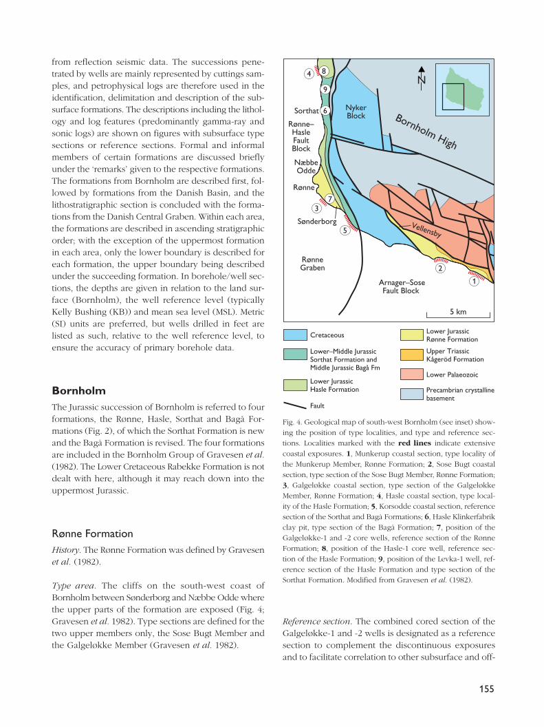
BornholmThe Jurassic succession of Bornholm is referred to fourformations, the Rønne, Hasle, Sorthat and Bagå For-mations (Fig. 2), of which the Sorthat Formation is newand the Bagå Formation is revised. The four formationsare included in the Bornholm Group of Gravesen et al.(1982). The Lower Cretaceous Rabekke Formation is notdealt with here, although it may reach down into theuppermost Jurassic.
Rønne FormationHistory. The Rønne Formation was defined by Gravesenet al. (1982).
Type area. The cliffs on the south-west coast ofBornholm between Sønderborg and Næbbe Odde wherethe upper parts of the formation are exposed (Fig. 4;Gravesen et al. 1982). Type sections are defined for thetwo upper members only, the Sose Bugt Member andthe Galgeløkke Member (Gravesen et al. 1982).
Reference section. The combined cored section of theGalgeløkke-1 and -2 wells is designated as a referencesection to complement the discontinuous exposuresand to facilitate correlation to other subsurface and off-
155
Rønne–HasleFaultBlock
NykerBlock
RønneGraben
Arnager–SoseFault Block
Bornholm High
37
4
5
2
1
5 km
Cretaceous
Lower–Middle JurassicSorthat Formation andMiddle Jurassic Bagå Fm
Lower JurassicHasle Formation
Fault
Lower JurassicRønne Formation
Upper Triassic Kågeröd Formation
Lower Palaeozoic
Precambrian crystallinebasement
N9
6Sorthat
NæbbeOdde
Rønne
Sønderborg
8
Vellensby
Fig. 4. Geological map of south-west Bornholm (see inset) show-ing the position of type localities, and type and reference sec-tions. Localities marked with the red lines indicate extensivecoastal exposures. 1, Munkerup coastal section, type locality ofthe Munkerup Member, Rønne Formation; 2, Sose Bugt coastalsection, type section of the Sose Bugt Member, Rønne Formation;3, Galgeløkke coastal section, type section of the GalgeløkkeMember, Rønne Formation; 4, Hasle coastal section, type local-ity of the Hasle Formation; 5, Korsodde coastal section, referencesection of the Sorthat and Bagå Formations; 6, Hasle Klinkerfabrikclay pit, type section of the Bagå Formation; 7, position of theGalgeløkke-1 and -2 core wells, reference section of the RønneFormation; 8, position of the Hasle-1 core well, reference sec-tion of the Hasle Formation; 9, position of the Levka-1 well, ref-erence section of the Hasle Formation and type section of theSorthat Formation. Modified from Gravesen et al. (1982).
156
390
400
350
360
370
380
330
340
230
240
250
260
270
280
290
300
310
320
Depthin m
Depthin m
✩
✩
✩✩
✩✩
✩
✩✩
✩✩
✩
✩
✩✩
✩
✩
✩
✩
✩
✩
✩
✩
✩
✩✩✩✩
✩
✩
✩
2Clay Si Sand 4 8 mm 2Clay Si Sand 4 8 mm
Galgeløkke-1, -2 composite core log Reference section: Rønne Formation
0 225
GRAPI
0 225
GRAPI
157
120
130
140
160
170
180
190
200
210
220
✲✲✲
✩
✲✲✲✩
10
20
30
40
50
60
70
80
90
100
110
✩
✩
✩
✩
✩
✩
✩
✩
?
Depthin m
Depthin m
150
2Clay Si Sand 4 8 mm 2Clay Si Sand 4 8 mm
0 225
GRAPI
0 225
GRAPI
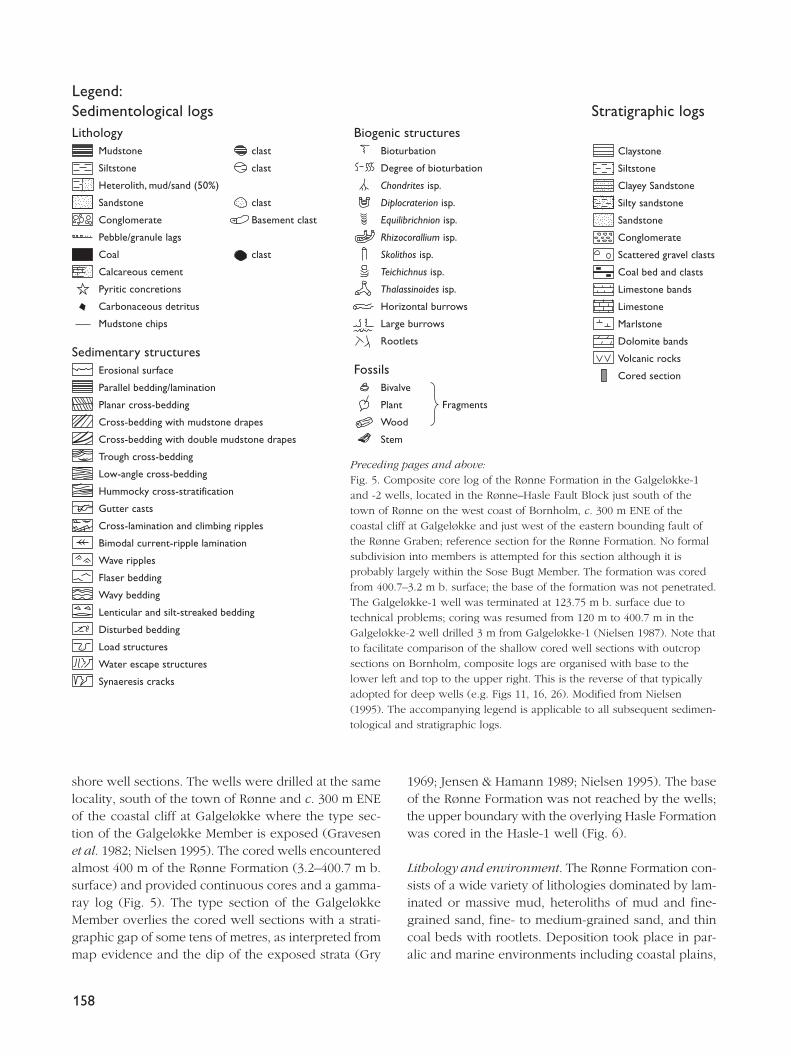
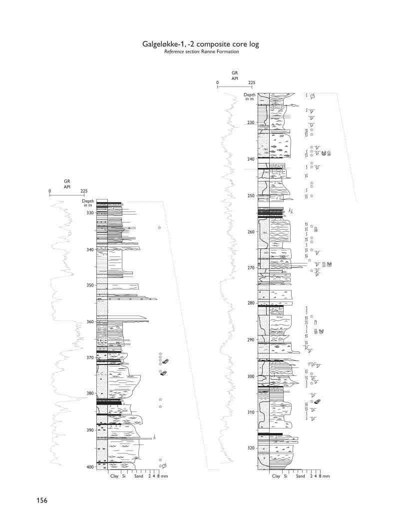
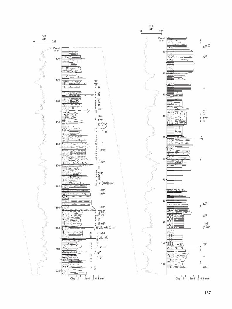
shore well sections. The wells were drilled at the samelocality, south of the town of Rønne and c. 300 m ENEof the coastal cliff at Galgeløkke where the type sec-tion of the Galgeløkke Member is exposed (Gravesenet al. 1982; Nielsen 1995). The cored wells encounteredalmost 400 m of the Rønne Formation (3.2–400.7 m b.surface) and provided continuous cores and a gamma-ray log (Fig. 5). The type section of the GalgeløkkeMember overlies the cored well sections with a strati-graphic gap of some tens of metres, as interpreted frommap evidence and the dip of the exposed strata (Gry
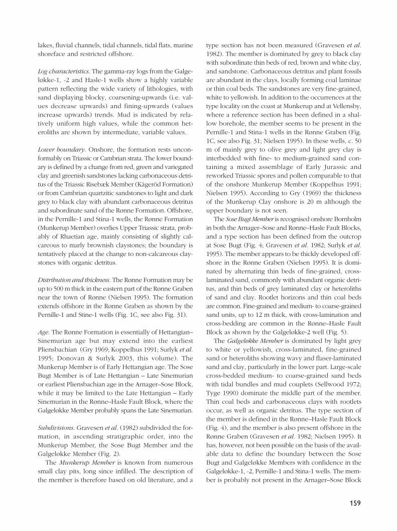
1969; Jensen & Hamann 1989; Nielsen 1995). The baseof the Rønne Formation was not reached by the wells;the upper boundary with the overlying Hasle Formationwas cored in the Hasle-1 well (Fig. 6).
Lithology and environment. The Rønne Formation con-sists of a wide variety of lithologies dominated by lam-inated or massive mud, heteroliths of mud and fine-grained sand, fine- to medium-grained sand, and thincoal beds with rootlets. Deposition took place in par-alic and marine environments including coastal plains,
158
LithologyMudstone
Siltstone
Heterolith, mud/sand (50%)
Sandstone
Conglomerate
Pebble/granule lags
Coal
Calcareous cement
Pyritic concretions
Carbonaceous detritus
Mudstone chips
Sedimentary structuresErosional surface
Parallel bedding/lamination
Planar cross-bedding
Cross-bedding with mudstone drapes
Cross-bedding with double mudstone drapes
Trough cross-bedding
Low-angle cross-bedding
Hummocky cross-stratification
Gutter casts
Cross-lamination and climbing ripples
Bimodal current-ripple lamination
Wave ripples
Flaser bedding
Wavy bedding
Lenticular and silt-streaked bedding
Disturbed bedding
Load structures
Water escape structures
Synaeresis cracks
clast
clast
clast
Basement clast
clast
Fragments
Biogenic structuresBioturbation
Degree of bioturbation
Chondrites isp.
Diplocraterion isp.
Equilibrichnion isp.
Rhizocorallium isp.
Skolithos isp.
Teichichnus isp.
Thalassinoides isp.
Horizontal burrows
Large burrows
Rootlets
FossilsBivalve
Plant
Wood
Stem
Claystone
Siltstone
Clayey Sandstone
Silty sandstone
Sandstone
Conglomerate
Scattered gravel clasts
Coal bed and clasts
Limestone bands
Limestone
Marlstone
Dolomite bands
Volcanic rocks
Cored section
Legend:Sedimentological logs Stratigraphic logs
Preceding pages and above:Fig. 5. Composite core log of the Rønne Formation in the Galgeløkke-1and -2 wells, located in the Rønne–Hasle Fault Block just south of thetown of Rønne on the west coast of Bornholm, c. 300 m ENE of thecoastal cliff at Galgeløkke and just west of the eastern bounding fault ofthe Rønne Graben; reference section for the Rønne Formation. No formalsubdivision into members is attempted for this section although it isprobably largely within the Sose Bugt Member. The formation was coredfrom 400.7–3.2 m b. surface; the base of the formation was not penetrated.The Galgeløkke-1 well was terminated at 123.75 m b. surface due totechnical problems; coring was resumed from 120 m to 400.7 m in theGalgeløkke-2 well drilled 3 m from Galgeløkke-1 (Nielsen 1987). Note thatto facilitate comparison of the shallow cored well sections with outcropsections on Bornholm, composite logs are organised with base to thelower left and top to the upper right. This is the reverse of that typicallyadopted for deep wells (e.g. Figs 11, 16, 26). Modified from Nielsen(1995). The accompanying legend is applicable to all subsequent sedimen-tological and stratigraphic logs.
lakes, fluvial channels, tidal channels, tidal flats, marineshoreface and restricted offshore.
Log characteristics. The gamma-ray logs from the Galge-løkke-1, -2 and Hasle-1 wells show a highly variablepattern reflecting the wide variety of lithologies, withsand displaying blocky, coarsening-upwards (i.e. val-ues decrease upwards) and fining-upwards (valuesincrease upwards) trends. Mud is indicated by rela-tively uniform high values, while the common het-eroliths are shown by intermediate, variable values.
Lower boundary. Onshore, the formation rests uncon-formably on Triassic or Cambrian strata. The lower bound-ary is defined by a change from red, green and variegatedclay and greenish sandstones lacking carbonaceous detri-tus of the Triassic Risebæk Member (Kågeröd Formation)or from Cambrian quartzitic sandstones to light and darkgrey to black clay with abundant carbonaceous detritusand subordinate sand of the Rønne Formation. Offshore,in the Pernille-1 and Stina-1 wells, the Rønne Formation(Munkerup Member) overlies Upper Triassic strata, prob-ably of Rhaetian age, mainly consisting of slightly cal-careous to marly brownish claystones; the boundary istentatively placed at the change to non-calcareous clay-stones with organic detritus.
Distribution and thickness. The Rønne Formation may beup to 500 m thick in the eastern part of the Rønne Grabennear the town of Rønne (Nielsen 1995). The formationextends offshore in the Rønne Graben as shown by thePernille-1 and Stine-1 wells (Fig. 1C, see also Fig. 31).
Age. The Rønne Formation is essentially of Hettangian–Sinemurian age but may extend into the earliestPliensbachian (Gry 1969; Koppelhus 1991; Surlyk et al.1995; Donovan & Surlyk 2003, this volume). TheMunkerup Member is of Early Hettangian age. The SoseBugt Member is of Late Hettangian – Late Sinemurianor earliest Pliensbachian age in the Arnager–Sose Block,while it may be limited to the Late Hettangian – EarlySinemurian in the Rønne–Hasle Fault Block, where theGalgeløkke Member probably spans the Late Sinemurian.
Subdivisions. Gravesen et al. (1982) subdivided the for-mation, in ascending stratigraphic order, into theMunkerup Member, the Sose Bugt Member and theGalgeløkke Member (Fig. 2).
The Munkerup Member is known from numeroussmall clay pits, long since infilled. The description ofthe member is therefore based on old literature, and a
type section has not been measured (Gravesen et al.1982). The member is dominated by grey to black claywith subordinate thin beds of red, brown and white clay,and sandstone. Carbonaceous detritus and plant fossilsare abundant in the clays, locally forming coal laminaeor thin coal beds. The sandstones are very fine-grained,white to yellowish. In addition to the occurrences at thetype locality on the coast at Munkerup and at Vellensby,where a reference section has been defined in a shal-low borehole, the member seems to be present in thePernille-1 and Stina-1 wells in the Rønne Graben (Fig.1C, see also Fig. 31; Nielsen 1995). In these wells, c. 50m of mainly grey to olive grey and light grey clay isinterbedded with fine- to medium-grained sand con-taining a mixed assemblage of Early Jurassic andreworked Triassic spores and pollen comparable to thatof the onshore Munkerup Member (Koppelhus 1991;Nielsen 1995). According to Gry (1969) the thicknessof the Munkerup Clay onshore is 20 m although theupper boundary is not seen.
The Sose Bugt Member is recognised onshore Bornholmin both the Arnager–Sose and Rønne–Hasle Fault Blocks,and a type section has been defined from the outcropat Sose Bugt (Fig. 4; Gravesen et al. 1982; Surlyk et al.1995). The member appears to be thickly developed off-shore in the Rønne Graben (Nielsen 1995). It is domi-nated by alternating thin beds of fine-grained, cross-laminated sand, commonly with abundant organic detri-tus, and thin beds of grey laminated clay or heterolithsof sand and clay. Rootlet horizons and thin coal bedsare common. Fine-grained and medium- to coarse-grainedsand units, up to 12 m thick, with cross-lamination andcross-bedding are common in the Rønne–Hasle FaultBlock as shown by the Galgeløkke-2 well (Fig. 5).
The Galgeløkke Member is dominated by light greyto white or yellowish, cross-laminated, fine-grainedsand or heteroliths showing wavy and flaser-laminatedsand and clay, particularly in the lower part. Large-scalecross-bedded medium- to coarse-grained sand bedswith tidal bundles and mud couplets (Sellwood 1972;Tyge 1990) dominate the middle part of the member.Thin coal beds and carbonaceous clays with rootletsoccur, as well as organic detritus. The type section ofthe member is defined in the Rønne–Hasle Fault Block(Fig. 4), and the member is also present offshore in theRønne Graben (Gravesen et al. 1982; Nielsen 1995). Ithas, however, not been possible on the basis of the avail-able data to define the boundary between the SoseBugt and Galgeløkke Members with confidence in theGalgeløkke-1, -2, Pernille-1 and Stina-1 wells. The mem-ber is probably not present in the Arnager–Sose Block
159
160
Clay Si Sand 2 4 8 mm
Depthin m
70
80
90
100
110
120
118.3
130
140
150
Røn
ne F
orm
atio
nH
asle
For
mat
ion
0 700
GRAPI
0 700
GRAPI
Depthin m
10
20
30
40
50
60
Has
le F
orm
atio
n
Clay Si Sand 2 4 8 mm
Hasle-1, core logReference section: Hasle Formation
GR
GR
(Nielsen 1995; Surlyk et al. 1995), as originally sup-posed (Gravesen et al. 1982).
Hasle FormationHistory. The Hasle Formation was defined by Gravesenet al. (1982).
Type area. The coastal cliff, south of Hasle town,Bornholm (Fig. 4). A type section has not been mea-sured, but representative sections of the formation maybe found in Surlyk & Noe-Nygaard (1986).
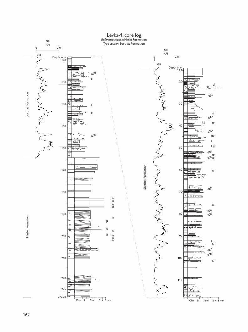
Reference section. The cored Hasle-1 well (2.6–155.0 mb. surface), drilled c. 1.1 km south of the Hasle harbour(Fig. 4), provides continuous cores and a gamma-raylog from the lower–middle part of the Hasle Formationand illustrates the lower boundary with the RønneFormation (Fig. 6). The cored Levka-1 well drilledbetween the type area of the Hasle Formation and thetype section of the Bagå Formation in the HasleKlinkerfabrik clay pit, c. 2.5 km south of the Hasle har-bour and c. 1 km north of the clay pit, provides coresfrom the middle–upper part of the Hasle Formation(Fig. 7). The two wells are designated as reference sec-tions to facilitate correlation to other subsurface and off-shore well-sections; together they illustrate the entireformation with some overlap.
Lithology and environment. At outcrop, the Hasle For-mation consists of rusty yellow to brownish (dark green-ish when unweathered), coarse-grained siltstones andvery fine-grained sandstones with swaley to hummockycross-stratification and marked erosion surfaces drapedwith small pebble lags. Thin poorly sorted gravels,greenish grey and brown clays and clay-ironstones
occur locally (Gravesen et al. 1982; Surlyk & Noe-Nygaard 1986). The sandstones are intercalated with fos-siliferous clays in the area of the town of Rønne andthe south coast at Stampe Å (northern end of theKorsodde section, see Fig. 4), and a diverse marinefauna including numerous ammonites has beendescribed from the clays (Malling & Grönwall 1909;Malling 1911, 1914, 1920; Höhne 1933; Donovan &Surlyk 2003, this volume). Clay beds seem to be absentin the type area to the north as clays were not encoun-tered in the Hasle-1 and Levka-1 wells which in combi-nation illustrate the entire Hasle Formation (Figs 6, 7).Deposition took place in a storm-dominated shorefaceto offshore environment (Surlyk & Noe-Nygaard 1986).
Log characteristics. The gamma-ray log from the Has-le-1 well (Fig. 6) shows intervals with relatively uniformlow readings interrupted by log spikes that locally showextremely high values; such high values in the sandstonesare caused by concentrations of uranium and thorium(Nielsen 1995).
Lower boundary. The formation conformably overliesthe Rønne Formation and is marked by a change fromlargely unconsolidated heterolithic sand and clay withcarbonaceous detritus to indurated limonitic brownish(weathered) or dark greenish (unweathered) sandstonesor thick clay beds containing marine macrofossils. Inthe Hasle-1 reference section, the base of the HasleFormation is defined at a marked pebble-strewn sur-face interpreted as a ravinement surface capping cross-bedded and flaser-laminated sandstones with coalparticles of the underlying Rønne Formation (Fig. 6,118.3 m; Nielsen 1995).
Distribution and thickness. The formation is probablyup to 140 m thick in the type area and seems to be pre-sent offshore in the Stina-1 well in the southern part ofthe Rønne Graben in a slightly more fine-grained, clayeyfacies (see Fig. 31; Nielsen 1995).
Age. The formation is of Early Pliensbachian age(Donovan & Surlyk 2003, this volume).
Sorthat Formation
new formation
History. The coal-bearing clays and sands that overlie theHasle Formation in the Rønne–Hasle Fault Block have
161
Facing page:Fig. 6. Hasle-1 well, located in the Rønne–Hasle Fault Block,north of the town of Rønne on the west coast of Bornholm,just west of the eastern bounding fault of the Rønne Graben(Nielsen 1987); reference section for the Hasle Formation. Thelower c. 37 m of the cored section is referred to the RønneFormation; the Hasle Formation was cored from 118.3–2.6 m b.surface. The upper part of the Hasle Formation is not repre-sented in Hasle-1, but is cored in Levka-1 (see Fig. 7). Notethat the scale on the gamma-ray log differs from the Galge-løkke-1, -2 and Levka-1 wells. Modified from Nielsen (1995);for legend, see Fig. 5.
162
Sort
hat
Form
atio
n
Clay SandSi 2 4 8 mm
Depth in m
Levka-1, core logReference section: Hasle Formation
Type section: Sorthat Formation
0
GR
225
GRAPI
Depth in m
Clay SandSi 2 4 8 mm
0 225
GRAPI
GR
Has
le F
orm
atio
nSo
rtha
t Fo
rmat
ion
229.20
120
130
140
150
160
170
180
190
200
210
220
225
13.4
20
30
40
50
60
70
80
90
100
110
been referred to as the Levka, Sorthat and Bagå beds inolder literature (reviewed by Gry 1969). A detailed strati-graphic interpretation of the beds has been difficult toachieve owing to complicated block faulting and fold-ing, scattered outcrops and the absence of marine fos-sils and distinct marker beds. Based on the content ofmegaspores, Gry (1969) referred all three units to theMiddle Jurassic with the Levka and Sorthat beds beingroughly contemporaneous, and the Bagå beds beingpossibly slightly younger. Gravesen et al. (1982) definedthe Bagå Formation to include the coal-bearing claysand sands of the Levka, Sorthat and Bagå beds and thecoal-bearing strata at Korsodde and Onsbæk (northernend of the Korsodde section as indicated on Fig. 4).Preliminary palynological investigations of samples fromthe Levka-1 core-well and the Korsodde section sug-gested the presence of Upper Pliensbachian strata (E.B.Koppelhus in: Nielsen 1987; Koppelhus 1988; Nielsen &Koppelhus 1989). A reassessment of the megaspore col-lections of H. Gry demonstrated the presence of severalmegaspore species from the Bagå Formation (sensuGravesen et al. 1982) that suggest the presence ofToarcian–Aalenian strata, although their long range pre-cluded a definite dating (Koppelhus & Batten 1992). Athorough palynological–sedimentological study of allavailable exposures and cores from the Lower–MiddleJurassic has revealed that the marine Lower Pliensbachiansandstones of the Hasle Formation are overlain by a suc-cession referable to the Levka and Sorthat beds that com-prises bioturbated sands, heteroliths and clays with thincoal seams containing relatively diverse brackish-marinedinoflagellate assemblages indicative of the UpperPliensbachian, Toarcian and possibly Lower Aalenian(Koppelhus & Nielsen 1994). These paralic deposits areoverlain by a succession equivalent to the Bagå beds com-prising crevasse and fluvial gravels and sands, lacustrineclays, carbonaceous clays and coals belonging to theUpper Aalenian? and Bajocian–Bathonian. These newdata confirm that the Levka and Sorthat beds are litho-logically different from the Bagå beds. Thus the Levka
and Sorthat beds are here included in the new SorthatFormation, and the Bagå Formation is revised to includethe Bagå beds only. Both formations are included in theBornholm Group of Gravesen et al. (1982). The sectionmeasured from the Sorthat beds by Gravesen et al. (1982,fig. 24) covers part of the new Sorthat Formation.
Name. After the locality of Sorthat on the west coast ofBornholm, between the towns of Hasle and Rønne,where the formation was previously exposed (Fig. 4;Gry 1969; Gravesen et al. 1982; Nielsen 1995).
Type section. The shallow Levka-1 core-well is selectedas the type section as no exposures are currently avail-able in the Sorthat area (Fig. 4); this well was drilledbetween the type area of the Hasle Formation and thetype section of the Bagå Formation in the HasleKlinkerfabrik clay pit, c. 2.5 km south of the Hasle har-bour and c. 1 km north of the clay pit. The sectionfrom 13.4–164.6 m b. surface is represented by both coresand a gamma-ray log (Fig. 7).
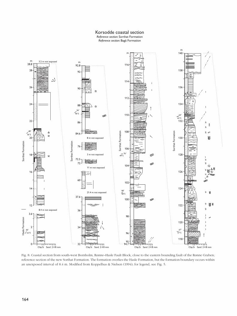
Reference section. An intermittently exposed succes-sion, 130–140 m thick at Korsodde on the south-westcoast of Bornholm is selected as the reference section(Fig. 8).
Lithology and environment. The lithology of the SorthatFormation is highly variable. The cores and gamma logfrom the lower c. 112 m of the formation in the Levka-1well reveal sharp-based, fining-upwards units, 3–14 mthick, consisting of coarse-grained, occasionally pebblysand, overlain by muddy, carbonaceous, micaceous,fine- to medium-grained sand, laminated to homoge-neous clay and coal seams with rootlets (Fig. 7). Mostof the cored sand shows parallel lamination with sub-ordinate thin beds with cross-bedding, cross-lamina-tion and flaser lamination. Large plant fragments andsmall quartz pebbles are common. Occurring betweenthe fining-upwards units are thinly interbedded sand andclay with rootlets and thin coal seams. Marine paly-nomorphs are not found and the interval is interpretedas having been deposited on a coastal or delta plainwith fluvial channels, lakes and swamps (Koppelhus &Nielsen 1994). The upper c. 40 m of the well-sectionconsist of cross-bedded, cross-laminated, wave-rippledand bioturbated sand and heteroliths with sporadicsynaeresis cracks, pyrite nodules, Planolites isp. andTeichichnus isp. burrows and brackish-marine paly-nomorphs. Fining-upwards successions of sand, clay andcoal seams are also represented and are characterised
163
Facing page:Fig. 7. Levka-1 well, located in the Rønne–Hasle Fault Blocknorth of the town of Rønne on the west coast of Bornholm, justwest of the eastern bounding fault of the Rønne Graben (Fig. 4;Nielsen 1987); type section for the new Sorthat Formation. Theformation was cored from 164.6–13.4 m b. surface. A gamma-ray log was not recorded from the Hasle Formation. Modifiedfrom Nielsen (1995); for legend, see Fig. 5.
164
Clay Si Sand 2 4 8 mm
Sort
hat
Form
atio
n
Sort
hat
Form
atio
n
Sort
hat
Form
atio
n
Sort
hat
Form
atio
n
Has
le F
orm
atio
n
3.2 m not exposed m92.8
m
32
34
36
37.6
60
72
72.5
76
84.6
86
88
40°S
56°
90
92
8 m not exposed
3 m not exposed
11 m not exposed
21.4 m not exposed
8.4 m not exposed
116
114
112
100
102
104
106
108
110
96
98
9594.7
m140
138
136
134
130
132
128
126
122
124
120
118
36°S
48°
22°E
30°
49°S76°
58°S
68°
57°S
67°
62°S
64°
22
24
26
28
20
16
18
12
14
3.6
0
2
m28.8
Clay Si Sand 2 4 8 mm Clay Si Sand 2 4 8 mm Clay Si Sand 2 4 8 mm
Korsodde coastal sectionReference section: Sorthat Formation
Reference section: Bagå Formation
Fig. 8. Coastal section from south-west Bornholm, Rønne–Hasle Fault Block, close to the eastern bounding fault of the Rønne Graben;reference section of the new Sorthat Formation. The formation overlies the Hasle Formation, but the formation boundary occurs withinan unexposed interval of 8.4 m. Modified from Koppelhus & Nielsen (1994); for legend, see Fig. 5.
165
Bagå
For
mat
ion
Bagå
For
mat
ion
Bagå
For
mat
ion
Sort
hat
Form
atio
n
m200
198
196
194
192
190
188
18646°S
66°
40°S70°
68°E44°
56°S74°
60°S38°
5.2 m not exposed
Clay Si Sand 2 4 8 mm Clay Si Sand 2 4 8 mm Clay Si Sand 2 4 8 mm
m186
184
182.4
177.2
176
166
168
170
172
174
162
164
m
160
158
156
154
152
150
148
144
146
140
142
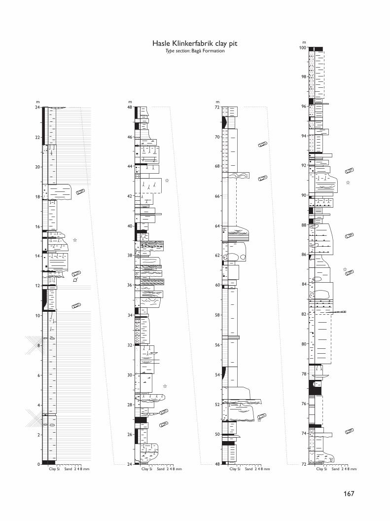
by non-marine palynomorphs. This upper c. 40 m inter-val is interpreted as having been deposited in lagoons,coastal lakes and fluvial channels with the clean sandat the top probably representing a marine shoreface.
The reference section at Korsodde is also lithologi-cally highly variable (Fig. 8). The lower c. 93 m thickunit consists of medium- to coarse-grained, pebbly,cross-bedded and parallel-laminated sand units, up to6 m thick. Thin, fine-grained and cross-laminated sandbeds occur. The sand is locally almost black due toabundant organic debris. Interbedded with the sandare laminated to almost homogeneous clay beds andfining-upwards heteroliths overlain by laminated darkclay and coaly beds with rootlets. Brackish paly-nomorphs are present. This part of the section is inter-preted to have been deposited in fluvial channels,coastal lakes and lagoons. Above a pronounced ero-sion surface (Fig. 8, 105.5 m) is a fining-upwards unit,c. 19 m thick, of cross-bedded, coarse- to fine-grainedsand overlain by heteroliths and clays capped by a coalseam. Some cross-beds show tidal structures such asreactivation surfaces, bundles and mud-drapes that yieldbrackish-marine dinoflagellates. Small burrows are alsocommon. Larger burrows, including Diplocraterion isp.,occur in the wavy to flaser bedded heteroliths. The unitis interpreted as the fill of an estuarine channel. It isoverlain by bioturbated heteroliths with dinoflagellatesand burrows of Diplocraterion isp., Teichichnus isp.,Skolithos isp. and Planolites isp. Well-sorted, fine-grainedsand beds with wave-ripples and swaley cross-stratifi-cation also occur. These inferred lagoonal deposits arefollowed by fluvial sands and lacustrine clays. Theuppermost part of the formation in the Korsodde sec-tion consists of very fine- to fine-grained, swaley cross-stratified and parallel-laminated yellowish–brown sandsand sandstones with thin bioturbated and wave-rip-pled heterolithic beds deposited in the shoreface tooffshore transition zone (Koppelhus & Nielsen 1994).The coals of the Levka-1 and Korsodde sections wereprimarily formed in anoxic, water-saturated inter-channelenvironments on a coastal plain (Petersen et al. 2003,this volume).
Log characteristics. The gamma-ray log shows a veryvariable pattern reflecting the interbedded sands, het-eroliths, muds and coals (Fig. 7). Both fining-upwardsand coarsening-upwards trends are represented, as tes-tified by gamma log values that increase and decreaseupwards, respectively.
Lower boundary. The lower boundary is defined at thechange from dark green (unweathered), yellow toindurated brownish (weathered) limonitic marine sand-stones of the Hasle Formation to unconsolidated light grey-ish fluvial sands, lacustrine grey to dark grey clays, andcoals (Figs 7, 8). In the type section, the boundary ismarked by a change from laminated and cross-bedded,medium- to coarse-grained beach sand of the upper-most Hasle Formation to coal-bearing sand and clay withroots. In the Korsodde reference section, the boundarywith the Hasle Formation occurs within a non-exposedinterval of c. 8.4 m, covered by a concrete construction.
Distribution and thickness. The formation occurs in theRønne–Hasle Fault block, where it is up to 200 m thick.The formation is also present offshore in the RønneGraben, as indicated by seismic data and the Stina-1 well(see Fig. 31; Hamann 1994; Nielsen 1995).
Age. Gry (1969) proposed a Middle Jurassic age for theSorthat, Levka and Bagå beds based on the megasporecontent. However, a reassessment of the megasporesrevealed the possible presence of Toarcian–Aalenianstrata (Koppelhus & Batten 1992). Based on the recog-nition of several dinoflagellate assemblages supportedby spores and pollen, Koppelhus & Nielsen (1994) pro-posed that the age of the Sorthat Formation is LatePliensbachian – Toarcian, possibly extending up intothe Early Aalenian.
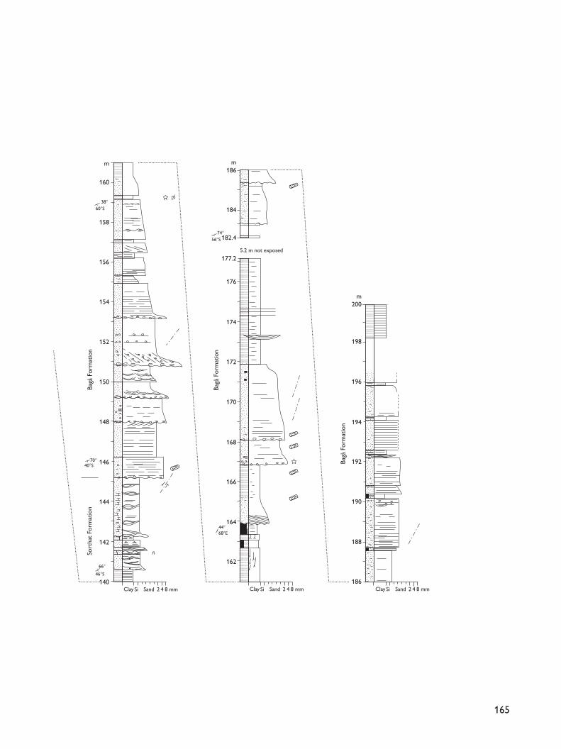
Bagå Formation
revised formation
History. The Bagå Formation was defined by Gravesenet al. (1982) to include the coal-bearing clays and sandsin the Rønne–Hasle Fault Block traditionally named theLevka, Sorthat and Bagå beds (reviewed by Gry 1969).The coal-bearing strata at Korsodde and Onsbæk werealso included in the Bagå Formation. As discussed above(Sorthat Formation), the Bagå Formation as revised here
166
Facing page:Fig. 9. Hasle Klinkerfabrik clay pit, type section of the BagåFormation; re-measured by Koppelhus & Nielsen (1994) tocover the full exposure. Modified from Koppelhus & Nielsen(1994); for legend, see Fig. 5.
167
Clay SandSi 2 4 8 mm Clay SandSi 2 4 8 mm Clay SandSi 2 4 8 mm Clay SandSi 2 4 8 mm
m24
20
22
16
18
12
10
14
8
6
4
2
0
m72
70
68
64
66
60
58
62
56
54
52
50
48
m100
88
90
92
94
96
98
84
82
86
80
78
76
74
72
m48
46
44
40
42
36
34
38
32
30
28
26
24
✩
✩
✩
✩
✩
✩
Hasle Klinkerfabrik clay pitType section: Bagå Formation
is adopted in a restricted sense to only include theMiddle Jurassic Bagå beds of Gry (1969).
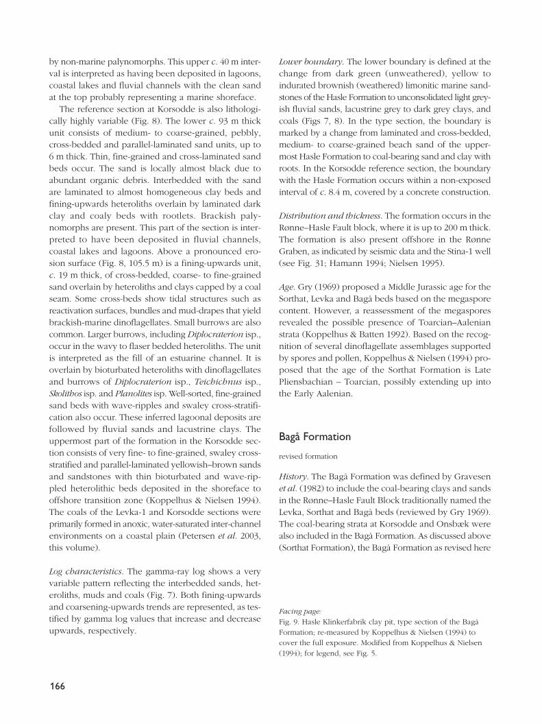
Type section. The succession exposed in the HasleKlinkerfabrik clay pit, immediately south of the Bagåstream, is selected as the type section in accordance withGravesen et al. (1982), who presented 23 m of section.The exposed section has been re-measured to presentthe full section of the pit (Fig. 9).
Reference section. The upper c. 65 m of the sectionexposed at Korsodde is proposed as a new referencesection (Fig. 8), as the former reference section usedby Gravesen et al. (1982, fig. 24) is now referred to theSorthat Formation.
Lithology and environment. The Bagå Formation in-cludes thick laminated to homogeneous, grey clay units,up to 10 m thick, dark to black coaly clays with rootletsand coal beds, up to 2.5 m thick, and medium- to fine-grained, cross-bedded or poorly laminated sand bedsforming units up to 5.5 m thick. Poorly sorted, muddyand pebbly sand beds, locally with boulders of weath-ered granite, occur in the upper part (Fig. 9). The lowerpart of the reference section at Korsodde comprisespoorly parallel-stratified, coarse- to very coarse-grainedpebbly sand with boulders of Cambrian quartzites andLower Palaeozoic kaolinised mudstones (Fig. 8). The mid-dle part comprises laminated grey clay and dark highlycarbonaceous clay. The upper part consists of poorlysorted fine- to medium-grained, poorly laminated sandbeds, 1.5–3.0 m thick, interbedded with muddy andcarbonaceous sand. Deposition took place in lakes andswamps, small crevasse channels and lacustrine deltas,and fluvial channels (Gravesen et al. 1982; Koppelhus& Nielsen 1994; Nielsen 1995). The coaly clays and coalbeds were primarily deposited in open freshwater miressubjected to some siliciclastic deposition. Coal beds inthe upper part of the formation were deposited on analluvial fan with a fluctuating watertable.
Boundaries. The lower boundary is not exposed in theSorthat area and was not encountered in the coredwells. In the Korsodde reference section, the lowerboundary is defined at a significant pebble-strewn ero-sion surface separating swaley to hummocky cross-stratified, weakly cemented, yellowish brown, fine-grained shoreface sandstones of the upper SorthatFormation from overlying coarse-grained, pebbly, lightgrey to white, largely unconsolidated fluvial sands withpebbles and boulders (Fig. 8, 145.2 m).
Onshore, the upper boundary is an erosion surfacedefining the present-day land surface or the base of theQuaternary. The Korsodde section is faulted againstthe Upper Cretaceous Bavnodde Greensand.
Distribution and thickness. The Bagå Formation is pre-sent in the Rønne–Hasle Fault Block, where it is esti-mated to be more than 190 m thick (Gry 1969), and isalso present offshore in the Rønne Graben with a sim-ilar thickness as indicated by seismic data (Jensen &Hamann 1989; Hamann 1994).
Age. The Bagå beds were referred to the Middle Jurassicby Gry (1969) based on megaspores. Hoelstad (1985)referred the Bagå beds as exposed in the HasleKlinkerfabrik clay pit to the uppermost Toarcian –Aalenian and Bajocian–Bathonian. However, the paly-noflora used by Hoelstad (1985) for the identificationof the uppermost Toarcian – Aalenian in the Bagå bedsappear to have a longer range than originally supposed(T. Hoelstad, personal communication 1994). Based onthe content of spores and pollen in the Bagå beds inthe Hasle Klinkerfabrik clay pit and the reference sec-tion from Korsodde, the age of the re-defined BagåFormation is Middle Jurassic, probably including theLate Aalenian, Bajocian and Bathonian (Koppelhus &Nielsen 1994).
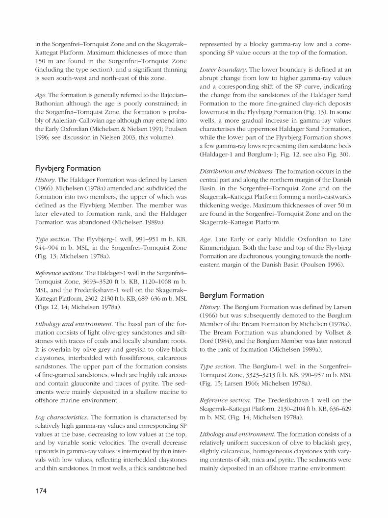
Danish BasinThe Upper Triassic – lowermost Cretaceous successionof the Danish Basin is referred to six formations, theGassum, Fjerritslev, Haldager Sand, Flyvbjerg, Børglumand Frederikshavn Formations (Fig. 2). New referencesections are proposed here for the Gassum and FjerritslevFormations.
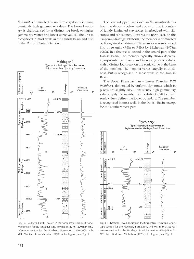
Gassum FormationHistory. The Gassum Formation was defined by Larsen(1966), and redefined by Bertelsen (1978).
Type section. The Gassum-1 well, 5406–4980 ft b. KB,1590–1460 m b. MSL, in the Danish Basin (Larsen 1966;Bertelsen 1978).
Reference section. The Hyllebjerg-1 well, 2751–2582 mb. KB, 2723–2554 m b. MSL, drilled centrally in theDanish Basin is here selected as a reference section in
168
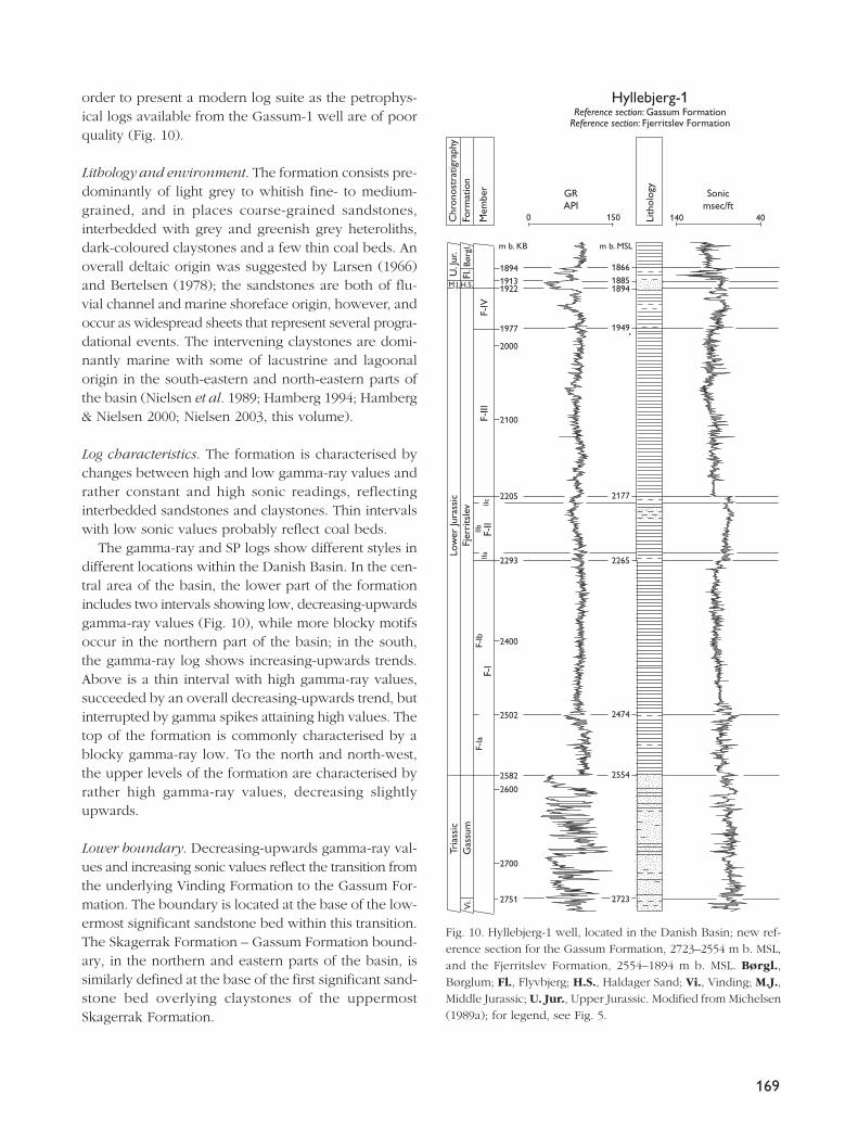
order to present a modern log suite as the petrophys-ical logs available from the Gassum-1 well are of poorquality (Fig. 10).
Lithology and environment. The formation consists pre-dominantly of light grey to whitish fine- to medium-grained, and in places coarse-grained sandstones,interbedded with grey and greenish grey heteroliths,dark-coloured claystones and a few thin coal beds. Anoverall deltaic origin was suggested by Larsen (1966)and Bertelsen (1978); the sandstones are both of flu-vial channel and marine shoreface origin, however, andoccur as widespread sheets that represent several progra-dational events. The intervening claystones are domi-nantly marine with some of lacustrine and lagoonalorigin in the south-eastern and north-eastern parts ofthe basin (Nielsen et al. 1989; Hamberg 1994; Hamberg& Nielsen 2000; Nielsen 2003, this volume).
Log characteristics. The formation is characterised bychanges between high and low gamma-ray values andrather constant and high sonic readings, reflectinginterbedded sandstones and claystones. Thin intervalswith low sonic values probably reflect coal beds.
The gamma-ray and SP logs show different styles indifferent locations within the Danish Basin. In the cen-tral area of the basin, the lower part of the formationincludes two intervals showing low, decreasing-upwardsgamma-ray values (Fig. 10), while more blocky motifsoccur in the northern part of the basin; in the south,the gamma-ray log shows increasing-upwards trends.Above is a thin interval with high gamma-ray values,succeeded by an overall decreasing-upwards trend, butinterrupted by gamma spikes attaining high values. Thetop of the formation is commonly characterised by ablocky gamma-ray low. To the north and north-west,the upper levels of the formation are characterised byrather high gamma-ray values, decreasing slightlyupwards.
Lower boundary. Decreasing-upwards gamma-ray val-ues and increasing sonic values reflect the transition fromthe underlying Vinding Formation to the Gassum For-mation. The boundary is located at the base of the low-ermost significant sandstone bed within this transition.The Skagerrak Formation – Gassum Formation bound-ary, in the northern and eastern parts of the basin, issimilarly defined at the base of the first significant sand-stone bed overlying claystones of the uppermostSkagerrak Formation.
169
Hyllebjerg-1Reference section: Gassum Formation
Reference section: Fjerritslev Formation
Chr
onos
trat
igra
phy
Form
atio
n
Mem
ber
H.S.
m b. MSL
Børg
l.Fl
.
M.J.
U. J
ur.
F-IV
F-III
F-II
F-I
F-Ib
F-Ia
IIaIIb
IIc
Fjer
rits
lev
Gas
sum
Tria
ssic
Low
er Ju
rass
icV
i.
Lith
olog
y
0 150 140 40
m b. KB
GRAPI
189419131922
1977
2100
2000
2400
2600
2700
2205
2293
2502
2751
2582 2554
2723
1866
1894
1949
2177
2265
2474
1885
Sonicmsec/ft
Fig. 10. Hyllebjerg-1 well, located in the Danish Basin; new ref-erence section for the Gassum Formation, 2723–2554 m b. MSL,and the Fjerritslev Formation, 2554–1894 m b. MSL. Børgl.,Børglum; Fl., Flyvbjerg; H.S., Haldager Sand; Vi., Vinding; M.J.,Middle Jurassic; U. Jur., Upper Jurassic. Modified from Michelsen(1989a); for legend, see Fig. 5.
Distribution and thickness. The formation is present inthe Danish Basin and locally in the North German Basin.Maximum thicknesses of more than 300 m occur in theSorgenfrei–Tornquist Zone.
Age. Late Norian – Rhaetian over most of the basin,younging towards the north-eastern margin, where theformation is of Hettangian – Early Sinemurian age(Michelsen 1975; Bertelsen 1978, 1980; L.H. Nielsen, L.Hamberg and E.B. Koppelhus in: Nielsen 1995).
Remarks. The formation was subdivided informally intothree members by Bertelsen (1978), but new well sec-tions suggest that they are not consistently identifiable.
Fjerritslev FormationHistory. The Fjerritslev Formation was defined by Larsen(1966), and amended by Michelsen (1978a).
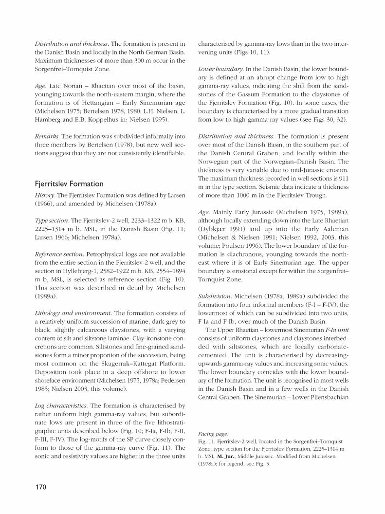
Type section. The Fjerritslev-2 well, 2233–1322 m b. KB,2225–1314 m b. MSL, in the Danish Basin (Fig. 11;Larsen 1966; Michelsen 1978a).
Reference section. Petrophysical logs are not availablefrom the entire section in the Fjerritslev-2 well, and thesection in Hyllebjerg-1, 2582–1922 m b. KB, 2554–1894m b. MSL, is selected as reference section (Fig. 10).This section was described in detail by Michelsen(1989a).
Lithology and environment. The formation consists ofa relatively uniform succession of marine, dark grey toblack, slightly calcareous claystones, with a varyingcontent of silt and siltstone laminae. Clay-ironstone con-cretions are common. Siltstones and fine-grained sand-stones form a minor proportion of the succession, beingmost common on the Skagerrak–Kattegat Platform.Deposition took place in a deep offshore to lowershoreface environment (Michelsen 1975, 1978a; Pedersen1985; Nielsen 2003, this volume).
Log characteristics. The formation is characterised byrather uniform high gamma-ray values, but subordi-nate lows are present in three of the five lithostrati-graphic units described below (Fig. 10; F-Ia, F-Ib, F-II,F-III, F-IV). The log-motifs of the SP curve closely con-form to those of the gamma-ray curve (Fig. 11). Thesonic and resistivity values are higher in the three units
characterised by gamma-ray lows than in the two inter-vening units (Figs 10, 11).
Lower boundary. In the Danish Basin, the lower bound-ary is defined at an abrupt change from low to highgamma-ray values, indicating the shift from the sand-stones of the Gassum Formation to the claystones ofthe Fjerritslev Formation (Fig. 10). In some cases, theboundary is characterised by a more gradual transitionfrom low to high gamma-ray values (see Figs 30, 32).
Distribution and thickness. The formation is presentover most of the Danish Basin, in the southern part ofthe Danish Central Graben, and locally within theNorwegian part of the Norwegian–Danish Basin. Thethickness is very variable due to mid-Jurassic erosion.The maximum thickness recorded in well sections is 911m in the type section. Seismic data indicate a thicknessof more than 1000 m in the Fjerritslev Trough.
Age. Mainly Early Jurassic (Michelsen 1975, 1989a),although locally extending down into the Late Rhaetian(Dybkjær 1991) and up into the Early Aalenian(Michelsen & Nielsen 1991; Nielsen 1992, 2003, thisvolume; Poulsen 1996). The lower boundary of the for-mation is diachronous, younging towards the north-east where it is of Early Sinemurian age. The upperboundary is erosional except for within the Sorgenfrei–Tornquist Zone.
Subdivision. Michelsen (1978a, 1989a) subdivided theformation into four informal members (F-I – F-IV), thelowermost of which can be subdivided into two units,F-Ia and F-Ib, over much of the Danish Basin.
The Upper Rhaetian – lowermost Sinemurian F-Ia unitconsists of uniform claystones and claystones interbed-ded with siltstones, which are locally carbonate-cemented. The unit is characterised by decreasing-upwards gamma-ray values and increasing sonic values.The lower boundary coincides with the lower bound-ary of the formation. The unit is recognised in most wellsin the Danish Basin and in a few wells in the DanishCentral Graben. The Sinemurian – Lower Pliensbachian
170
Facing page:Fig. 11. Fjerritslev-2 well, located in the Sorgenfrei–TornquistZone; type section for the Fjerritslev Formation, 2225–1314 mb. MSL. M. Jur., Middle Jurassic. Modified from Michelsen(1978a); for legend, see Fig. 5.
171
HaldagerSand Fm
Gas
sum
Tria
ssic
M.Ju
r.
Lith
olog
y
0 150
ResistivityOhm m2/m
100
Fjerritslev-2Type section: Fjerritslev Formation
F-III
F-IV
F-II
Chr
onos
trat
igra
phy
Form
atio
n
Mem
ber
Lith
olog
y
Chr
onos
trat
igra
phy
Form
atio
n
Mem
ber
50 100
SPMillivolt
SPMillivolt
Fjer
rits
lev
Low
er Ju
rass
ic
F-Ia
F
-I F
-II F
-IIb
F-
Ib
F-I
Ia
F-IIb
F-IIc
Fjer
rits
lev
Low
er Ju
rass
ic
m b. KB m b. KB m b. MSLm b. MSL
1399
1322
1678
1400
1500
1600
1700
1314
1391
1670
1800
1857
1900
2000
2100
2200
2233
1849
2225
155
ResistivityOhm m2/m
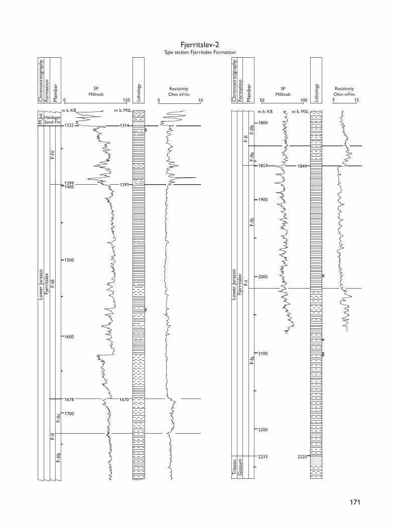
F-Ib unit is dominated by uniform claystones showingconstantly high gamma-ray values. The lower bound-ary is characterised by a distinct log-break to highergamma-ray values and lower sonic values. The unit isrecognised in most wells in the Danish Basin and alsoin the Danish Central Graben.
The Lower–Upper Pliensbachian F-II member differsfrom the deposits below and above in that it consistsof faintly laminated claystones interbedded with silt-stones and sandstones. Towards the north-east, on theSkagerrak–Kattegat Platform, the member is dominatedby fine-grained sandstones. The member was subdividedinto three units (F-IIa to F-IIc) by Michelsen (1978a,1989a) in a few wells located in the central part of theDanish Basin. The member typically shows decreas-ing-upwards gamma-ray and increasing sonic values,with a distinct log-break on the sonic curve at the baseof the member. The member varies laterally in thick-ness, but is recognised in most wells in the DanishBasin.
The Upper Pliensbachian – Lower Toarcian F-IIImember is dominated by uniform claystones, which inplaces are slightly silty. Consistently high gamma-rayvalues typify the member, and a distinct shift to lowersonic values defines the lower boundary. The memberis recognised in most wells in the Danish Basin, exceptfor the southernmost part.
172
Chr
onos
trat
igra
phy
Form
atio
n
Lith
olog
y
-65 90
Haldager-1Type section: Haldager Sand FormationReference section: Flyvbjerg Formation
m b. MSL
1120
1068
1275
Hal
dage
r Sa
ndM
iddl
e Ju
rass
icFl
yvbj
erg
Upp
er Ju
rass
ic Børg
lum
Fjer
rits
lev
Low
er Ju
rass
ic
ft b.KB
4300
4198.5
4100
4000
3900
3800
3693
3600
35203500
SPMillivolt
-10
ResistivityOhm m2/m
15
Fig. 12. Haldager-1 well, located in the Sorgenfrei–Tornquist Zone;type section for the Haldager Sand Formation, 1275–1120 m b. MSL;reference section for the Flyvbjerg Formation, 1120–1068 m b.MSL. Modified from Michelsen (1978a); for legend, see Fig. 5.
Flyvbjerg-1Type section: Flyvbjerg Formation
Reference section: Haldager Sand Formation
Fjer
rits
lev
Hal
dage
r Sa
ndM
iddl
e Ju
rass
icL.
Jura
ssic
Upp
er Ju
rass
icFl
yvbj
erg
Børg
lum
Lith
olog
y
10 150 -5 10
904
944
998
m b. MSL
951
991
10451050
1000
m b. KB
Chr
onos
trat
igra
phy
Form
atio
n
ResistivityOhm m2/m
SPMillivolt
Fig. 13. Flyvbjerg-1 well, located in the Sorgenfrei–Tornquist Zone;type section for the Flyvbjerg Formation, 944–904 m b. MSL; ref-erence section for the Haldager Sand Formation, 998–944 m b.MSL. Modified from Michelsen (1978a); for legend, see Fig. 5.
The Upper Toarcian – Lower Aalenian F-IV memberconsists of uniform claystones with varying silt con-tent, interbedded with sandstones that are locally car-bonate-cemented. The proportion of sandstone, locallywith organic debris and coal fragments, increases inthe Fjerritslev Trough and on the Skagerrak–KattegatPlatform. The member is characterised by a distinctshift to higher sonic values at the base. The presenceof sandstone intercalations is identified by gamma-raylows, and carbonate-cemented levels are reflected byhigh sonic peaks. The top of the member coincideswith the top of the formation. The member is recog-nised in the north-eastern part of the Danish Basin, theSorgenfrei–Tornquist Zone and the Skagerrak–KattegatPlatform.
Haldager Sand FormationHistory. The Haldager Formation was defined by Larsen(1966), and amended by Michelsen (1978a) who sub-divided the formation into two members, the lower ofwhich was defined as the Haldager Sand Member. Themember was later given the rank of formation, and theHaldager Formation was abandoned (Michelsen 1989a).
Type section. The Haldager-1 well, 4198.5–3693 ft b.KB, 1275–1120 m b. MSL in the Sorgenfrei–TornquistZone is defined as the type section (Fig. 12; Larsen1966; Michelsen 1978a).
Reference section. The Flyvbjerg-1 well, 1045–991 m b.KB, 998–944 m b. MSL in the Sorgenfrei–Tornquist Zone(Fig. 13; Michelsen 1978a).
Lithology and environment. The formation consists ofthick beds of light olive-grey, fine- to coarse-grainedoccasionally pebbly sandstones and siltstones interbed-ded with claystones and thin coal beds. The south-western part of the basin and the Skagerrak–KattegatPlatform is dominated by sandstones deposited inbraided rivers and lacustrine mudstones (Koch 1983).Shallow marine sandstones, estuarine sandstones andmudstones, and marine mudstones occur in the Sorgen-frei–Tornquist Zone (Nielsen 2003, this volume).
Log characteristics. The dominance of thick sandstones(low gamma-ray values) interbedded with thin clay-stones (high gamma-ray spikes) yields a characteristicblocky pattern which is replicated on the SP and resis-tivity curves (Figs 12, 13).
Lower boundary. The lower boundary is defined at anabrupt change from high to low gamma-ray values andthe corresponding shift of the SP log, indicating theabrupt change from the claystones of the FjerritslevFormation to the sandstones of the Haldager SandFormation (Figs 12, 13). A regional unconformity sep-arates the two formations.
Distribution and thickness. The formation is distributedin the central and northern part of the Danish Basin,
173
Chr
onos
trat
igra
phy
Form
atio
n
Lith
olog
y
10 12 -5 22
ft b. KB
1665
1800
1900
1700
2000
21042130
2200
2302
Frederikshavn-1Type section: Frederikshavn FormationReference section: Flyvbjerg Formation Børglum Formation
Flyv
bjer
gVe
ds.
L.C
r.Fr
eder
iksh
avn
Upp
er Ju
rass
ic –
Low
er C
reta
ceou
sB.
495
636
689
629
m b. MSL
M.J.
H.S
.ResistivityOhm m2/m
SPMillivolt
Fig. 14. Frederikshavn-1 well, located on the Skagerrak–KattegatPlatform; type section for the Frederikshavn Formation, 629–495m b. MSL; reference section of the Flyvbjerg Formation, 689–636m b. MSL and Børglum Formation, 636–629 m b. MSL. B., Børglum;Veds., Vedsted; H.S., Haldager Sand; M.J., Middle Jurassic; L.Cr.,Lower Cretaceous. Modified from Michelsen (1978a); for legend,see Fig. 5.
in the Sorgenfrei–Tornquist Zone and on the Skagerrak–Kattegat Platform. Maximum thicknesses of more than150 m are found in the Sorgenfrei–Tornquist Zone(including the type section), and a significant thinningis seen south-west and north-east of this zone.
Age. The formation is generally referred to the Bajocian–Bathonian although the age is poorly constrained; inthe Sorgenfrei–Tornquist Zone, the formation is proba-bly of Aalenian–Callovian age although may extend intothe Early Oxfordian (Michelsen & Nielsen 1991; Poulsen1996; see discussion in Nielsen 2003, this volume).
Flyvbjerg FormationHistory. The Haldager Formation was defined by Larsen(1966). Michelsen (1978a) amended and subdivided theformation into two members, the upper of which wasdefined as the Flyvbjerg Member. The member waslater elevated to formation rank, and the HaldagerFormation was abandoned (Michelsen 1989a).
Type section. The Flyvbjerg-1 well, 991–951 m b. KB,944–904 m b. MSL, in the Sorgenfrei–Tornquist Zone(Fig. 13; Michelsen 1978a).
Reference sections. The Haldager-1 well in the Sorgenfrei–Tornquist Zone, 3693–3520 ft b. KB, 1120–1068 m b.MSL, and the Frederikshavn-1 well on the Skagerrak–Kattegat Platform, 2302–2130 ft b. KB, 689–636 m b. MSL(Figs 12, 14; Michelsen 1978a).
Lithology and environment. The basal part of the for-mation consists of light olive-grey sandstones and silt-stones with traces of coals and locally abundant roots.It is overlain by olive-grey and greyish to olive-blackclaystones, interbedded with fossiliferous, calcareoussandstones. The upper part of the formation consistsof fine-grained sandstones, which are highly calcareousand contain glauconite and traces of pyrite. The sed-iments were mainly deposited in a shallow marine tooffshore marine environment.
Log characteristics. The formation is characterised byrelatively high gamma-ray values and corresponding SPvalues at the base, decreasing to low values at the top,and by variable sonic velocities. The overall decreaseupwards in gamma-ray values is interrupted by thin inter-vals with low values, reflecting interbedded claystonesand thin sandstones. In most wells, a thick sandstone bed
represented by a blocky gamma-ray low and a corre-sponding SP value occurs at the top of the formation.
Lower boundary. The lower boundary is defined at anabrupt change from low to higher gamma-ray valuesand a corresponding shift of the SP curve, indicatingthe change from the sandstones of the Haldager SandFormation to the more fine-grained clay-rich depositslowermost in the Flyvbjerg Formation (Fig. 13). In somewells, a more gradual increase in gamma-ray valuescharacterises the uppermost Haldager Sand Formation,while the lower part of the Flyvbjerg Formation showsa few gamma-ray lows representing thin sandstone beds(Haldager-1 and Børglum-1; Fig. 12, see also Fig. 30).
Distribution and thickness. The formation occurs in thecentral part and along the northern margin of the DanishBasin, in the Sorgenfrei–Tornquist Zone and on theSkagerrak–Kattegat Platform forming a north-eastwardsthickening wedge. Maximum thicknesses of over 50 mare found in the Sorgenfrei–Tornquist Zone and on theSkagerrak–Kattegat Platform.
Age. Late Early or early Middle Oxfordian to LateKimmeridgian. Both the base and top of the FlyvbjergFormation are diachronous, younging towards the north-eastern margin of the Danish Basin (Poulsen 1996).
Børglum FormationHistory. The Børglum Formation was defined by Larsen(1966) but was subsequently demoted to the BørglumMember of the Bream Formation by Michelsen (1978a).The Bream Formation was abandoned by Vollset &Doré (1984), and the Børglum Member was later restoredto the rank of formation (Michelsen 1989a).
Type section. The Børglum-1 well in the Sorgenfrei–Tornquist Zone, 3323–3213 ft b. KB, 990–957 m b. MSL(Fig. 15; Larsen 1966; Michelsen 1978a).
Reference section. The Frederikshavn-1 well on theSkagerrak–Kattegat Platform, 2130–2104 ft b. KB, 636–629m b. MSL (Fig. 14; Michelsen 1978a).
Lithology and environment. The formation consists of arelatively uniform succession of olive to blackish grey,slightly calcareous, homogeneous claystones with vary-ing contents of silt, mica and pyrite. The sediments weremainly deposited in an offshore marine environment.
174
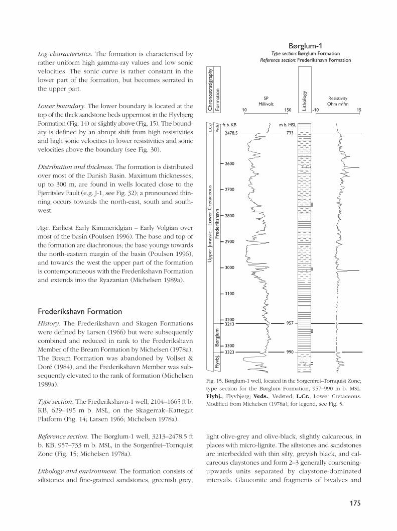
Log characteristics. The formation is characterised byrather uniform high gamma-ray values and low sonicvelocities. The sonic curve is rather constant in thelower part of the formation, but becomes serrated inthe upper part.
Lower boundary. The lower boundary is located at thetop of the thick sandstone beds uppermost in the FlyvbjergFormation (Fig. 14) or slightly above (Fig. 15). The bound-ary is defined by an abrupt shift from high resistivitiesand high sonic velocities to lower resistivities and sonicvelocities above the boundary (see Fig. 30).
Distribution and thickness. The formation is distributedover most of the Danish Basin. Maximum thicknesses,up to 300 m, are found in wells located close to theFjerritslev Fault (e.g. J-1, see Fig. 32); a pronounced thin-ning occurs towards the north-east, south and south-west.
Age. Earliest Early Kimmeridgian – Early Volgian overmost of the basin (Poulsen 1996). The base and top ofthe formation are diachronous; the base youngs towardsthe north-eastern margin of the basin (Poulsen 1996),and towards the west the upper part of the formationis contemporaneous with the Frederikshavn Formationand extends into the Ryazanian (Michelsen 1989a).
Frederikshavn FormationHistory. The Frederikshavn and Skagen Formationswere defined by Larsen (1966) but were subsequentlycombined and reduced in rank to the FrederikshavnMember of the Bream Formation by Michelsen (1978a).The Bream Formation was abandoned by Vollset &Doré (1984), and the Frederikshavn Member was sub-sequently elevated to the rank of formation (Michelsen1989a).
Type section. The Frederikshavn-1 well, 2104–1665 ft b.KB, 629–495 m b. MSL, on the Skagerrak–KattegatPlatform (Fig. 14; Larsen 1966; Michelsen 1978a).
Reference section. The Børglum-1 well, 3213–2478.5 ftb. KB, 957–733 m b. MSL, in the Sorgenfrei–TornquistZone (Fig. 15; Michelsen 1978a).
Lithology and environment. The formation consists ofsiltstones and fine-grained sandstones, greenish grey,
light olive-grey and olive-black, slightly calcareous, inplaces with micro-lignite. The siltstones and sandstonesare interbedded with thin silty, greyish black, and cal-careous claystones and form 2–3 generally coarsening-upwards units separated by claystone-dominatedintervals. Glauconite and fragments of bivalves and
175
Lith
olog
y
Børglum-1Type section: Børglum Formation
Reference section: Frederikshavn Formation
-10 15
Fred
erik
shav
n U
pper
Jura
ssic
– L
ower
Cre
tace
ous
10
SPMillivolt
990
957
733
Chr
onos
trat
igra
phy
Form
atio
n
m b. MSLft b. KB
150
Børg
lum
Flyv
bj.
Veds
.
L.C
r.
2600
2478.5
2700
2800
2900
3000
3100
32003213
33003323
ResistivityOhm m2/m
Fig. 15. Børglum-1 well, located in the Sorgenfrei–Tornquist Zone;type section for the Børglum Formation, 957–990 m b. MSL.Flybj., Flyvbjerg; Veds., Vedsted; L.Cr., Lower Cretaceous.Modified from Michelsen (1978a); for legend, see Fig. 5.
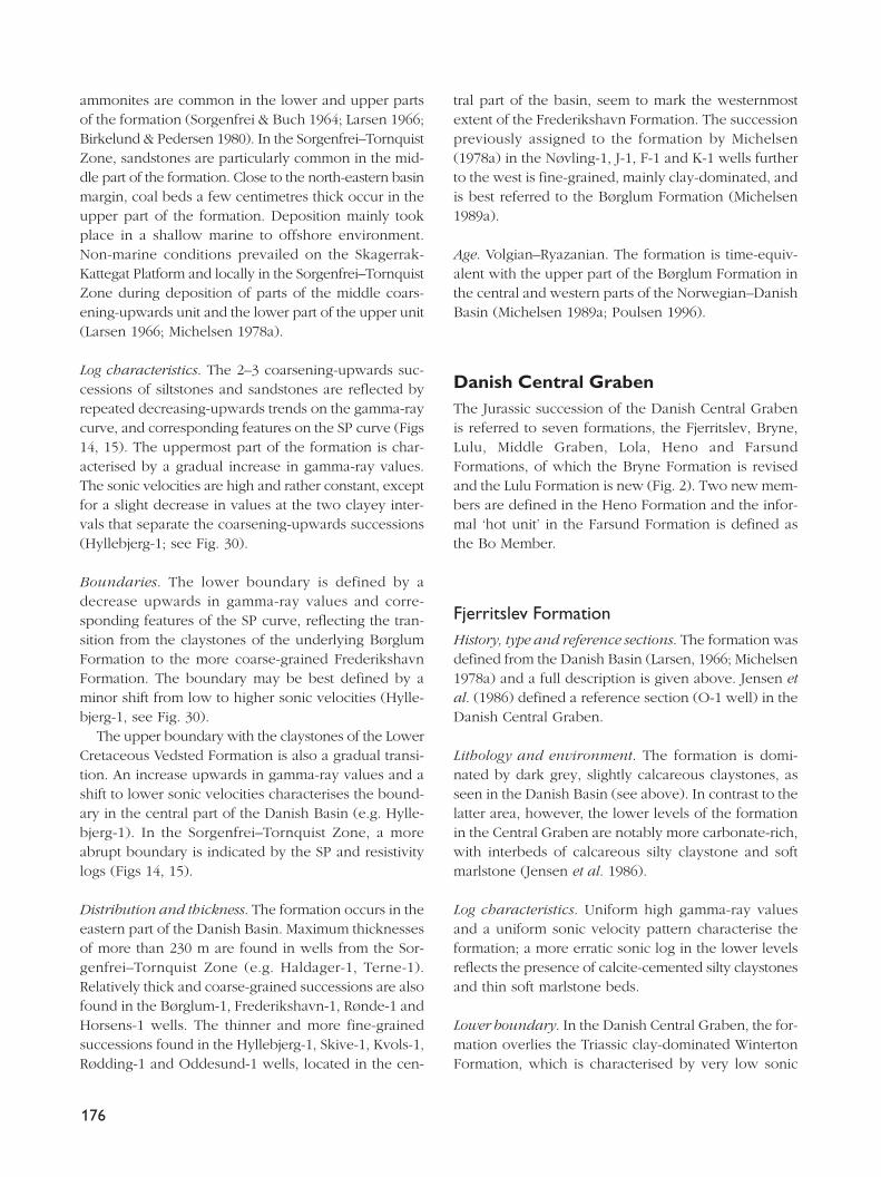
ammonites are common in the lower and upper partsof the formation (Sorgenfrei & Buch 1964; Larsen 1966;Birkelund & Pedersen 1980). In the Sorgenfrei–TornquistZone, sandstones are particularly common in the mid-dle part of the formation. Close to the north-eastern basinmargin, coal beds a few centimetres thick occur in theupper part of the formation. Deposition mainly tookplace in a shallow marine to offshore environment.Non-marine conditions prevailed on the Skagerrak-Kattegat Platform and locally in the Sorgenfrei–TornquistZone during deposition of parts of the middle coars-ening-upwards unit and the lower part of the upper unit(Larsen 1966; Michelsen 1978a).
Log characteristics. The 2–3 coarsening-upwards suc-cessions of siltstones and sandstones are reflected byrepeated decreasing-upwards trends on the gamma-raycurve, and corresponding features on the SP curve (Figs14, 15). The uppermost part of the formation is char-acterised by a gradual increase in gamma-ray values.The sonic velocities are high and rather constant, exceptfor a slight decrease in values at the two clayey inter-vals that separate the coarsening-upwards successions(Hyllebjerg-1; see Fig. 30).
Boundaries. The lower boundary is defined by adecrease upwards in gamma-ray values and corre-sponding features of the SP curve, reflecting the tran-sition from the claystones of the underlying BørglumFormation to the more coarse-grained FrederikshavnFormation. The boundary may be best defined by aminor shift from low to higher sonic velocities (Hylle-bjerg-1, see Fig. 30).
The upper boundary with the claystones of the LowerCretaceous Vedsted Formation is also a gradual transi-tion. An increase upwards in gamma-ray values and ashift to lower sonic velocities characterises the bound-ary in the central part of the Danish Basin (e.g. Hylle-bjerg-1). In the Sorgenfrei–Tornquist Zone, a moreabrupt boundary is indicated by the SP and resistivitylogs (Figs 14, 15).
Distribution and thickness. The formation occurs in theeastern part of the Danish Basin. Maximum thicknessesof more than 230 m are found in wells from the Sor-genfrei–Tornquist Zone (e.g. Haldager-1, Terne-1).Relatively thick and coarse-grained successions are alsofound in the Børglum-1, Frederikshavn-1, Rønde-1 andHorsens-1 wells. The thinner and more fine-grainedsuccessions found in the Hyllebjerg-1, Skive-1, Kvols-1,Rødding-1 and Oddesund-1 wells, located in the cen-
tral part of the basin, seem to mark the westernmostextent of the Frederikshavn Formation. The successionpreviously assigned to the formation by Michelsen(1978a) in the Nøvling-1, J-1, F-1 and K-1 wells furtherto the west is fine-grained, mainly clay-dominated, andis best referred to the Børglum Formation (Michelsen1989a).
Age. Volgian–Ryazanian. The formation is time-equiv-alent with the upper part of the Børglum Formation inthe central and western parts of the Norwegian–DanishBasin (Michelsen 1989a; Poulsen 1996).
Danish Central GrabenThe Jurassic succession of the Danish Central Grabenis referred to seven formations, the Fjerritslev, Bryne,Lulu, Middle Graben, Lola, Heno and FarsundFormations, of which the Bryne Formation is revisedand the Lulu Formation is new (Fig. 2). Two new mem-bers are defined in the Heno Formation and the infor-mal ‘hot unit’ in the Farsund Formation is defined asthe Bo Member.
Fjerritslev FormationHistory, type and reference sections. The formation wasdefined from the Danish Basin (Larsen, 1966; Michelsen1978a) and a full description is given above. Jensen etal. (1986) defined a reference section (O-1 well) in theDanish Central Graben.
Lithology and environment. The formation is domi-nated by dark grey, slightly calcareous claystones, asseen in the Danish Basin (see above). In contrast to thelatter area, however, the lower levels of the formationin the Central Graben are notably more carbonate-rich,with interbeds of calcareous silty claystone and softmarlstone (Jensen et al. 1986).
Log characteristics. Uniform high gamma-ray valuesand a uniform sonic velocity pattern characterise theformation; a more erratic sonic log in the lower levelsreflects the presence of calcite-cemented silty claystonesand thin soft marlstone beds.
Lower boundary. In the Danish Central Graben, the for-mation overlies the Triassic clay-dominated WintertonFormation, which is characterised by very low sonic
176
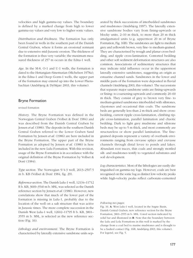
velocities and high gamma-ray values. The boundaryis defined by a marked change from high to lowergamma-ray values and very low to higher sonic values.
Distribution and thickness. The formation has onlybeen found in wells in the southern part of the DanishCentral Graben, where it forms an erosional remnantdue to extensive mid-Jurassic erosion. The thickness ofthe formation is thus very variable; the maximum mea-sured thickness of 257 m occurs in the Edna-1 well.
Age. In the M-8, O-1 and U-1 wells, the formation isdated to the Hettangian–Sinemurian (Michelsen 1978a);in the Edna-1 and Deep Gorm-1 wells, the upper partof the formation may extend up into the Lower Pliens-bachian (Andsbjerg & Dybkjær 2003, this volume).
Bryne Formation
revised formation
History. The Bryne Formation was defined in theNorwegian Central Graben (Vollset & Doré 1984) andwas described from the Danish Central Graben byJensen et al. (1986). The deposits in the southern DanishCentral Graben referred to the Lower Graben SandFormation by Jensen et al. (1986) are here included inthe Bryne Formation. The upper part of the BryneFormation as adopted by Jensen et al. (1986) is hereincluded in the new Lulu Formation. With this revision,usage of the Bryne Formation is in accordance with theoriginal definition of the Bryne Formation by Vollset &Doré (1984).
Type section. The Norwegian 9/4-3 well, 2613–2507.5m b. KB (Vollset & Doré 1984, fig. 29).
Reference section. The Danish Lulu-1 well, 12134–11712ft b. KB, 3669–3540 m b. MSL, was selected as the Danishreference section by Jensen et al. (1986). However, newcorrelations show that much of the lower part of theformation is missing in Lulu-1, probably due to thelocation of the well on a salt structure that was activein Jurassic times. The more complete succession in theDanish West Lulu-1 well, 12602–11795 ft b. KB, 3801–3555 m b. MSL, is selected as the new reference sec-tion (Fig. 16).
Lithology and environment. The Bryne Formation ischaracterised by laterally extensive sandstone units sep-
arated by thick successions of interbedded sandstonesand mudstones (Andsbjerg 1997). The laterally exten-sive sandstone bodies vary from fining-upwards orblocky units, 2–10 m thick, to more than 20 m thickamalgamated units (e.g. uppermost 20 m of BryneFormation, Fig. 16B). The sandstones are light to mediumgrey and yellowish brown, very fine- to medium-grained.They are characterised by trough and planar cross-bed-ding, and ripple cross-lamination. Contorted beddingand other soft sediment deformation structures are alsocommon. Associations of sedimentary structures thatmay indicate tidal influence occur in the uppermostlaterally extensive sandstones, suggesting an origin asestuarine channel sands. Sandstones in the lower andmiddle parts of the formation were deposited in fluvialchannels (Andsbjerg 2003, this volume). The successionsthat separate major sandstone units are fining-upwardsor fining- to coarsening-upwards and commonly 20–60m thick. They consist of grey to brown very fine- tomedium-grained sandstones interbedded with siltstones,claystones and occasional thin coals. The sandstonebeds are generally less than 2 m thick and show cross-bedding, current ripple cross-lamination, climbing rip-ple cross-lamination, parallel lamination and chaoticbedding. Dark to light grey mudstone and siltstonebeds may be up to 5 m thick, and most commonly arestructureless or show parallel lamination. The fine-grained deposits represent a variety of overbank envi-ronments ranging from crevasse splays and crevassechannels through distal levee to ponds and lakes.Abundant root traces, thin coals and strongly mottledsilt- and mudstones testify to vegetated substrates andsoil development.
Log characteristics. Most of the lithologies are easily dis-tinguished on gamma-ray logs. However, coals are bestrecognised on the sonic log as distinct low-velocity peakswhile high-velocity peaks reflect carbonate-cemented
177
Following two pages:Fig. 16. A: West Lulu-1 well, located in the Søgne Basin,Danish Central Graben; new reference section for the BryneFormation, 3801–3555 m b. MSL. Cored section indicated bysolid bar and illustrated in B. Note that the boundary betweenthe Lulu and Lola Formations in this well is marked by thechange from a coal bed to marine mudstones and is thought tobe a faulted contact (Fig. 16B; Andsbjerg 2003, this volume).For legend, see Fig. 5.
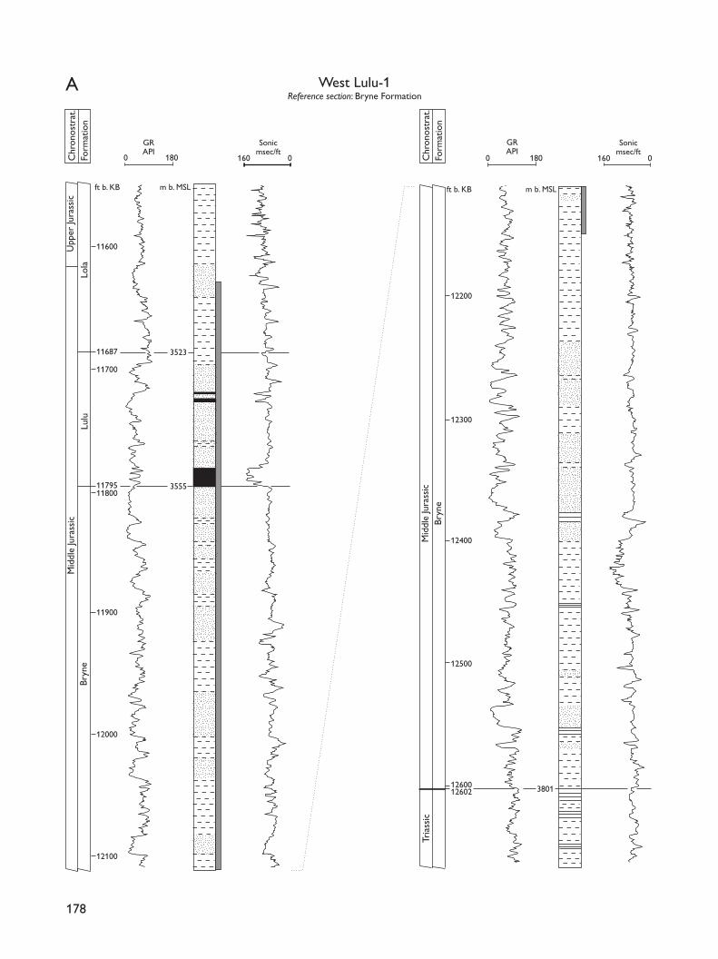
178
Mid
dle
Jura
ssic
Upp
er Ju
rass
ic
Bryn
e
Lulu
Lola
Bryn
eM
iddl
e Ju
rass
ic
Tria
ssic
West Lulu-1Reference section: Bryne Formation
0 180 0 180 160 0160 0
11600
11687
11700
3523
1179511800
11900
12000
12100
3555
Chr
onos
trat
.Fo
rmat
ion
3801
ft b. KB m b. MSL ft b. KB m b. MSL
Chr
onos
trat
.Fo
rmat
ion
12200
12300
12400
12500
1260212600
GRAPI
Sonicmsec/ft
GRAPI
Sonicmsec/ft
A
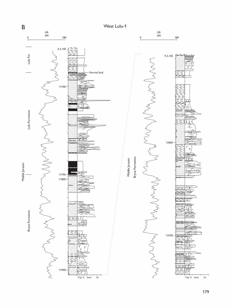
179
Bryn
e Fo
rmat
ion
Mid
dle
Jura
ssic
Bryn
e Fo
rmat
ion
Lola
Fm
Lulu
For
mat
ion
0 180
West Lulu-1
0 180
Normal fault
SiClay Sand Gr SiClay Sand Gr
GRAPI
GRAPI
Mid
dle
Jura
ssic
11800
11900
11795
11700
ft b. KB
12000
12100
ft b. KB
B
deposits. The gamma-ray logs typically show low val-ues for the sandstones. Channel sandstones may showgamma-ray values that increase upwards, indicative offining-upwards units (e.g. Fig. 16B, 12035–12016 ft b.KB), or box-like, uniformly low values (e.g. Fig. 16B,11840–11797 ft b. KB). The intermediate to high gamma-ray values of floodplain deposits commonly showincreasing-upwards (e.g. Fig. 16A, 12512–12437 ft b.KB) or increasing-upwards to decreasing-upwards (e.g.Fig. 16A, 12200–12165 ft b. KB) gamma-ray patterns.
Lower boundary. The Bryne Formation unconformablyoverlies claystones of the Lower Jurassic FjerritslevFormation in the southern part and Triassic and Permianrocks in the northern part of the Danish Central Graben.The boundary is marked by a distinct increase in gamma-ray values where the Bryne Formation overlies Permiansalt, whereas the boundary elsewhere may vary fromhighly distinct to indistinct depending upon the under-lying lithology.
Distribution and thickness. The formation is found inthe Søgne Basin, in the Tail End Graben, in the Salt DomeProvince and along the south-eastern fringe of the HenoPlateau. The thickness of the Bryne Formation is veryvariable, varying from a few tens of metres in marginalparts of the basin to commonly more than 200 m. Thethickest section, 289 m, was recorded in the Amalie-1well in the southernmost Søgne Basin (base not pene-trated).
Age. The relatively sparse palynological data suggest thatthe lower part of the Bryne Formation is Aalenian orearliest Bajocian in age. Based on the occurrence of thedinoflagellate cyst Impletosphaeridium varispinosumin the uppermost estuarine sandstones of the BryneFormation in the West Lulu-1 and West Lulu-3 wells, thetop of the Bryne Formation is dated to the latest Bath-onian – earliest Callovian (Andsbjerg & Dybkjær 2003,this volume).
Remarks. The Middle Jurassic deposits of the SøgneBasin in the northern part of the Danish Central Grabenwere previously referred to the Bryne Formation (Jensenet al. 1986). The uppermost part of the succession con-sists of interfingering shallow marine and paralic sand-stones and mudstones; this uppermost unit differs fromthe remainder of the Middle Jurassic succession bothin terms of lithology and depositional environment. Inaccordance with the original definition of the BryneFormation (Vollset & Doré 1984), these deposits are no
longer assigned to the Bryne Formation but are referredto the new Lulu Formation (defined below), equivalentto the Sandnes Formation in the Norwegian sector.
The Middle Jurassic succession in the southern partof the Danish Central Graben was referred to the CentralGraben Group (the Central Graben Subgroup of vanAdrichem Boogaert & Kouwe 1994) by Jensen et al.(1986) as well control was missing in the central partof the graben. However, with more well data availableit has become clear that the lower part of the MiddleJurassic succession in the southern Danish CentralGraben shows greater affinity to the Bryne Formationthan to the Lower Graben Formation as originally definedby NAM & RGD (1980) and modified by van AdrichemBoogaert & Kouwe (1994). In core sections, it is evi-dent that with respect to both lithology and deposi-tional environment this part of the succession cannotbe distinguished from that of the Bryne Formation ofthe northern Danish Central Graben. It is thus proposedto include the Middle Jurassic deposits from the south-ern Central Graben in the Bryne Formation.
Lulu Formation
new formation
History. The succession that makes up the new LuluFormation was included in the upper part of the BryneFormation by Jensen et al. (1986). Vollset & Doré (1984)defined the equivalent succession in the Norwegiansector, penetrated in the Fiskebank Basin and theEgersund Subbasin, as a separate formation, the SandnesFormation. This unit is missing from most of the morethan 100 km wide area that separates the southern partof the Søgne Basin from the central Fiskebank Basin.It is thus preferred not to adopt the term SandnesFormation for the unit in the southern Søgne Basin andnorthern Tail End Graben.
Name. From the Lulu structure in the Søgne Basinwhich was the target for the Lulu-1 well (Fig. 1C).
Type section. The Danish Lulu-1 well, 11813–11715 ft b.KB, 3571–3541 m b. MSL (Fig. 17).
Reference section. The Danish West Lulu-3 well, 12035–11865 ft b. KB, 3633–3581 m b. MSL (Fig. 18).
Lithology and environment. The Lulu Formation is char-acterised by coarsening-upwards wedges of shallow
180
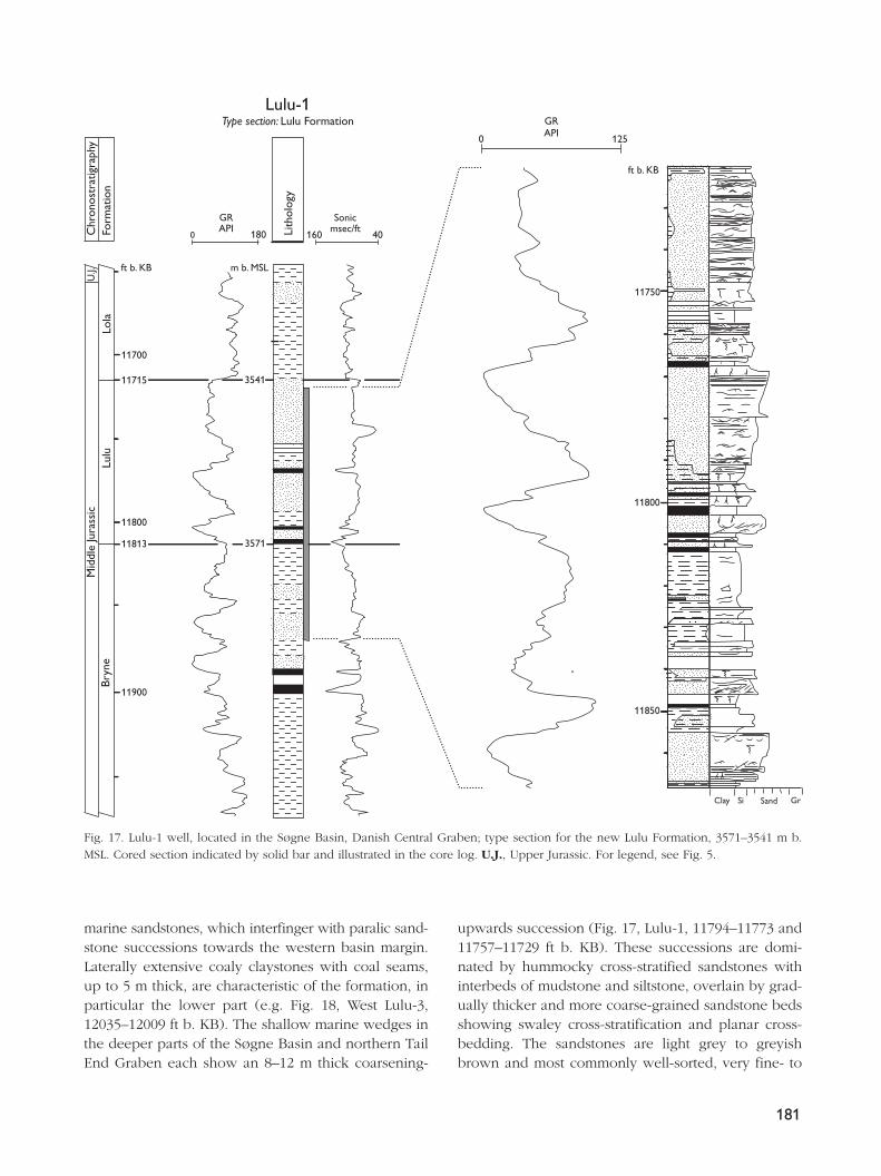
marine sandstones, which interfinger with paralic sand-stone successions towards the western basin margin.Laterally extensive coaly claystones with coal seams,up to 5 m thick, are characteristic of the formation, inparticular the lower part (e.g. Fig. 18, West Lulu-3,12035–12009 ft b. KB). The shallow marine wedges inthe deeper parts of the Søgne Basin and northern TailEnd Graben each show an 8–12 m thick coarsening-
upwards succession (Fig. 17, Lulu-1, 11794–11773 and11757–11729 ft b. KB). These successions are domi-nated by hummocky cross-stratified sandstones withinterbeds of mudstone and siltstone, overlain by grad-ually thicker and more coarse-grained sandstone bedsshowing swaley cross-stratification and planar cross-bedding. The sandstones are light grey to greyishbrown and most commonly well-sorted, very fine- to
181
ft b. KB
ft b. KB
m b. MSL
Chr
onos
trat
igra
phy
Form
atio
n
Lith
olog
y
Lulu-1Type section: Lulu Formation
Clay Si Sand Gr
160
Sonicmsec/ft
40
U.J.
Lulu
Lola
Bryn
eM
iddl
e Ju
rass
ic
0
GRAPI
125
0
GRAPI
180
11700
11715
11800
11813
11900
11750
11800
11850
3541
3571
Fig. 17. Lulu-1 well, located in the Søgne Basin, Danish Central Graben; type section for the new Lulu Formation, 3571–3541 m b.MSL. Cored section indicated by solid bar and illustrated in the core log. U.J., Upper Jurassic. For legend, see Fig. 5.
182
ft b. KB m b. MSL
ft b. KB
Mid
dle
Jura
ssic
Bryn
eLu
luLo
la
Clay Si Sand Gr
Chr
onos
trat
igra
phy
Form
atio
n
GRAPI
GRAPI
Sonicmsec/ft
Lith
olog
y
West Lulu-3Reference section: Lulu Formation
0 150 160 40
0 75
3633
358111865
11900
11800
12000
12035
12100
11900
12000
Fig. 18. West Lulu-3, located in the Søgne Basin, Danish Central Graben; reference section for the new Lulu Formation, 3633–3581 mb. MSL. Cored section indicated by solid bar and illustrated in the core log. For legend, see Fig. 5.
fine-grained. The coarsening-upwards successions areinterpreted as prograding shoreface deposits.
Along the western margin of the Søgne Basin andTail End Graben, the succession is dominated by back-barrier deposits, consisting mainly of sandstones withevidence for strong tidal influence. The sandstones arecommonly moderately to well-sorted, dark and brown-ish grey to light brown, and show cross-bedding,current and climbing ripple-lamination and abundantdouble mud-drapes and bundled foresets. Bioturbatedintervals occur commonly (Fig. 18, 11980 ft b. KB inWest Lulu-3). Only thin units of shallow marine sand-stone and mudstone are present in the paralic wedges(Fig. 18, 11904 ft b. KB. in West Lulu-3; Andsbjerg2003, this volume). The coal seams, 0.1 – > 1 m thickwith a cumulative thickness of up to 5 m, were de-posited on a coastal plain during relative sea-level rise(Petersen & Andsbjerg 1996).
Log characteristics. The heterogeneous lithologies arereflected by variable log patterns. Two 8–12 m thick unitsshowing gamma-ray values that decrease upwards inthe deeper parts of the Søgne Basin and Tail End Grabenrepresent coarsening-upwards successions of shorefaceand beach sandstones. In the western parts of the SøgneBasin and Tail End Graben, 0.5–5 m thick units showgamma-ray values that are consistently low or increaseslightly upwards; these units represent channel fills.Units with high or decreasing-upwards gamma-ray val-ues between the channel-fills represent lagoonal, tidalflat and bay-head delta environments (Andsbjerg 2003,this volume). Sonic log intervals 0.5–5 m thick thatshow very low sonic velocities (usually correspondingto low gamma-ray readings) represent coal deposits.
Lower boundary. The formation conformably overliesthe Bryne Formation over most of the Danish CentralGraben. The lower boundary is placed at the base ofthe lowermost laterally persistent major coal bed, or atthe base of a correlative unit of interbedded sandstonesand organic-rich mudstones with thin coals, as seen inAmalie-1 and Lulu-1.
Distribution and thickness. The Lulu Formation is widelydistributed in the Søgne Basin and the northern Tail EndGraben. In the southern part of the Tail End Grabenand in the northern part of the Salt Dome Province, theLulu Formation is replaced by the partly time-equiva-lent, mudstone-dominated Middle Graben Formation(NAM & RGD 1980; Jensen et al. 1986; van Adrichem
Boogaert & Kouwe 1994). The thickness of the LuluFormation varies from 30–60 m.
Age. The formation is of Early–Late Callovian age. Thisis indicated by the occurrence of the latest Bathonian– earliest Callovian dinoflagellate cyst Impletosphaeri-dium varispinosum in the uppermost estuarine sand-stones of the Bryne Formation in the West Lulu-3 welland the appearance of the Late Callovian – MiddleOxfordian dinoflagellate cyst Liesbergia scarburghen-sis in the basal part of the Lola Formation in several wells(Andsbjerg & Dybkjær 2003, this volume).
Middle Graben FormationHistory. The Middle Graben Shale Formation was definedin the Dutch North Sea sector by NAM & RGD (1980),and extended to the Danish Central Graben by Jensenet al. (1986). The name was modified to the MiddleGraben Formation by van Adrichem Boogaert & Kouwe(1994).
183
Chr
onos
trat
igra
phy
Form
atio
n
GRAPI
Sonicmsec/ft
Lith
olog
y
m b. MSLft b. KB
U-1Reference section: Middle Graben Formation
0 180 180 40
10853
10668
10700
10800Cal
lovi
an M
iddl
e G
rabe
nBr
yne
Lola
Cal
lov.
(?)
3223
3279
Fig. 19. U-1 well, located in the southern part of the DanishCentral Graben; reference section for the Middle Graben Formation,3279–3223 m b. MSL. Callov., Callovian. Modified from Jensenet al. (1986); for legend, see Fig. 5.
Type section. The Dutch F03-03 well, 3090–2670 m b.KB (NAM & RGD 1980).
Reference section. The U-1 well, 10853–10668 ft b. KB,3279–3223 m b. MSL, is used as a reference section inthe Danish sector (Fig. 19; Jensen et al. 1986).
Lithology and environment. The formation consists ofdark brownish grey claystones interbedded with silt-stones and rare sandstone beds. Coal beds, locally sev-eral metres thick, may occur in the lower part of theformation. Deposition took place in swampy environ-ments, probably interdistributary bays or coastal lagoons.
Log characteristics. The gamma-ray log commonly showsa response slightly lower than the overlying LolaFormation but considerably higher than that of theunderlying Bryne Formation. However, some coal bedsmay be characterised by a very low gamma-ray responseand a low sonic velocity.
Lower boundary. The Middle Graben Formation in theDanish Central Graben overlies the Bryne Formation.The boundary is placed at the base of a prominent coalbed, usually the lowermost of a series of coal beds andcommonly characterised by a low gamma-ray and alow sonic velocity log response.
Distribution and thickness. The formation extends fromthe southern North Sea into the Salt Dome Province ofthe Danish Central Graben. It is not recognised northof the Salt Dome Province, where the Bryne Formationis overlain by the Lulu Formation in the Danish sector.The thickness of the Middle Graben Formation rangesfrom 15–56 m in the Danish sector.
Age. Based on datings of the underlying deposits belong-ing to the Bryne Formation by Hoelstad (1986a), theformation is not older than Late Callovian. There is nogood data to constrain the youngest age of the forma-tion, although it probably ranges into the Early or MiddleOxfordian, based on the occurrence of the dinoflagel-late cyst Liesbergia scarburghensis. The formation maybe slightly diachronous, younging southwards to the
184
Lol
a C
hron
ostr
at.
Form
atio
n
Lith
olog
y
0 180 180 40
U-1Type section: Lola Formation
ft b. KB
2884
Oxf
ordi
anC
allo
vian
M
. Gra
ben 3223
m b. MSL
10600
10500
10400
10300
10200
10100
10000
9900
9800
9700
9600
9500
9555
9400
10668
10700
Kim
mer
idgi
anFa
rsun
d
GRAPI
Sonicmsec/ft
Fig. 20. U-1 well, located in the southern part of the DanishCentral Graben; type section for the Lola Formation, 3223–2884m b. MSL. M. Graben, Middle Graben. Modified from Jensen etal. (1986); for legend, see Fig. 5.
Dutch North Sea area, where it has an Early–MiddleOxfordian age.
Lola FormationHistory. The Lola Formation was defined by Jensen etal. (1986).
Type section. The U-1 well, 10668–9555 ft b. KB,3223–2884 m b. MSL, in the Danish Central Graben(Fig. 20; Jensen et al. 1986).
Lithology and environment. The formation consists ofdark olive-grey to grey claystones, with organic mate-rial, mainly of terrestrial origin. Deposition took placein a low energy, offshore open marine environment.
Log characteristics. The formation is characterised byfairly constant, high gamma-ray readings and relativelylow sonic velocities. A few high velocity peaks corre-sponding to dolomite or limestone beds may occur(Fig. 20).
Lower boundary. The formation overlies the Lulu For-mation in the northern part of the Danish Central Grabenand the Middle Graben Formation in the southern partof the Danish Central Graben. On structurally high areasalong the western margin of the Danish Central Grabenand on local highs, the formation rests unconformablyon Triassic or older strata. The lower boundary with theLulu Formation is placed at an abrupt, fairly largeincrease in gamma-ray values and a minor decrease insonic velocity (Figs 17, 18). The boundary with theMiddle Graben Formation shows a sudden and fairlylarge drop in sonic velocity (Figs 19, 20).
Distribution and thickness. The formation is present inthe eastern and southern parts of the Danish CentralGraben. It thins west of the Tail End Graben and prob-ably continues southwards and grades into the lowerpart of the Kimmeridge Clay Formation in the DutchNorth Sea area (Michelsen & Wong 1991). Maximumthicknesses of c. 1000 m occur in the Tail End Graben.
Age. Late Callovian/Early Oxfordian – Late Kimmerid-gian. The base of the formation is considered diachro-nous, younging southwards. The uppermost part is notyounger than Early Kimmeridgian in the Elly-2 well inthe Tail End Graben (Andsbjerg & Dybkjær 2003, thisvolume).
Heno Formation
revised formation
History. The Heno Formation was defined by Jensenet al. (1986) to include Upper Jurassic shallow marinesandstones in the Danish Central Graben. Wells drilledin recent years have demonstrated that sandstones ofthe Heno Formation interfinger with claystones of theLola Formation. In the southern part of the Feda Graben,two sandstone units are separated by claystones andsouth and east of the Feda Graben, on the Heno andGertrud Plateaus, clayey sandstones separate two dis-crete sandstone units. The type section of the HenoFormation, as defined by Jensen et al. (1986), com-prises only the upper sandstone unit (the new RavnMember). The informal terms ‘basal sandstone unit’ and‘Heno Equivalent’ have been used for the lower sand-stone unit by Bergan et al. (1989), Michelsen & Wong(1991), Nielsen & Japsen (1991), Söderström et al. (1991),
185
Chr
onos
trat
igra
phy
Form
atio
nM
embe
r
GRAPI
Sonicmsec/ftLi
thol
ogy
Fars
und
m b. MSLft b. KB
1352013500
13400
13820
13800
13700
13600
13839 4184
4178
4087
W-1Type section: Heno Formation
Kim
mer
idgi
an
Permian
Hen
oR
avn
Lola
0 150 140 40
Fig. 21. W-1 well, located on the Heno Plateau, Danish CentralGraben; type section for the Heno Formation, 4178–4087 m b.MSL. Modified from Jensen et al. (1986); for legend, see Fig. 5.
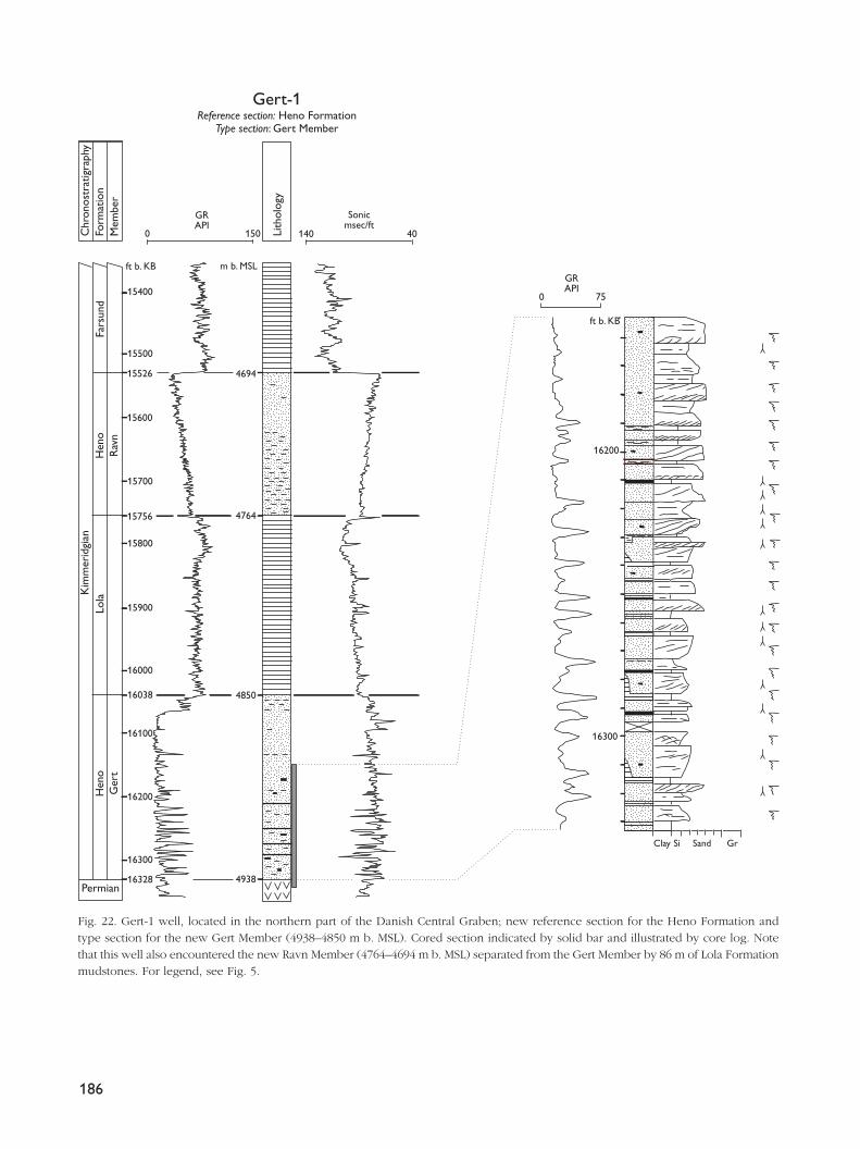
186
Chr
onos
trat
igra
phy
Form
atio
nM
embe
r
GRAPI
GRAPI
Sonicmsec/ft
Lith
olog
y
Fars
und
15500
15400
m b. MSLft b. KB
ft b. KB
15526 4694
15600
15756
16038
15700
15800
15900
16000
16100
16200
16300
16200
16300
16328
4764
4850
4938
Gert-1Reference section: Heno Formation
Type section: Gert Member
Kim
mer
idgi
an
Permian
Lola
Hen
oG
ert
Hen
oR
avn
0 150 140 40
Clay Si Sand Gr
0 75
Fig. 22. Gert-1 well, located in the northern part of the Danish Central Graben; new reference section for the Heno Formation andtype section for the new Gert Member (4938–4850 m b. MSL). Cored section indicated by solid bar and illustrated by core log. Notethat this well also encountered the new Ravn Member (4764–4694 m b. MSL) separated from the Gert Member by 86 m of Lola Formationmudstones. For legend, see Fig. 5.
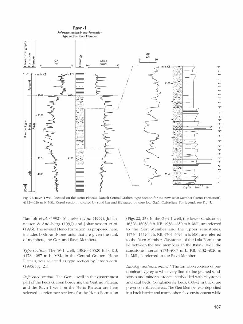
Damtoft et al. (1992), Michelsen et al. (1992), Johan-nessen & Andsbjerg (1993) and Johannessen et al.(1996). The revised Heno Formation, as proposed here,includes both sandstone units that are given the rankof members, the Gert and Ravn Members.
Type section. The W-1 well, 13820–13520 ft b. KB,4178–4087 m b. MSL, in the Central Graben, HenoPlateau, was selected as type section by Jensen et al.(1986; Fig. 21).
Reference section. The Gert-1 well in the easternmostpart of the Feda Graben bordering the Gertrud Plateau,and the Ravn-1 well on the Heno Plateau are hereselected as reference sections for the Heno Formation
(Figs 22, 23). In the Gert-1 well, the lower sandstones,16328–16038 ft b. KB, 4938–4850 m b. MSL, are referredto the Gert Member and the upper sandstones,15756–15526 ft b. KB, 4764–4694 m b. MSL, are referredto the Ravn Member. Claystones of the Lola Formationlie between the two members. In the Ravn-1 well, thesandstone interval 4173–4067 m b. KB, 4132–4026 mb. MSL, is referred to the Ravn Member.
Lithology and environment. The formation consists of pre-dominantly grey to white very fine- to fine-grained sand-stones and minor siltstones interbedded with claystonesand coal beds. Conglomerate beds, 0.08–2 m thick, arepresent on plateau areas. The Gert Member was depositedin a back-barrier and marine shoreface environment while
187
Chr
onos
trat
igra
phy
Form
atio
nM
embe
r
Lith
olog
y
m b. MSLm b. KB
m b. KB
4067 4026
4173
4200
4100
4100
4150
4132
GRAPI
GRAPI
Sonicmsec/ft
Ravn-1Reference section: Heno Formation
Type section: Ravn Member
Kim
mer
idgi
anO
xf?
Rav
nFa
rsun
dLo
laH
eno
0 150 140 40
500
Clay Si Sand Gr
Fig. 23. Ravn-1 well, located on the Heno Plateau, Danish Central Graben; type section for the new Ravn Member (Heno Formation),4132–4026 m b. MSL. Cored section indicated by solid bar and illustrated by core log. Oxf., Oxfordian. For legend, see Fig. 5.
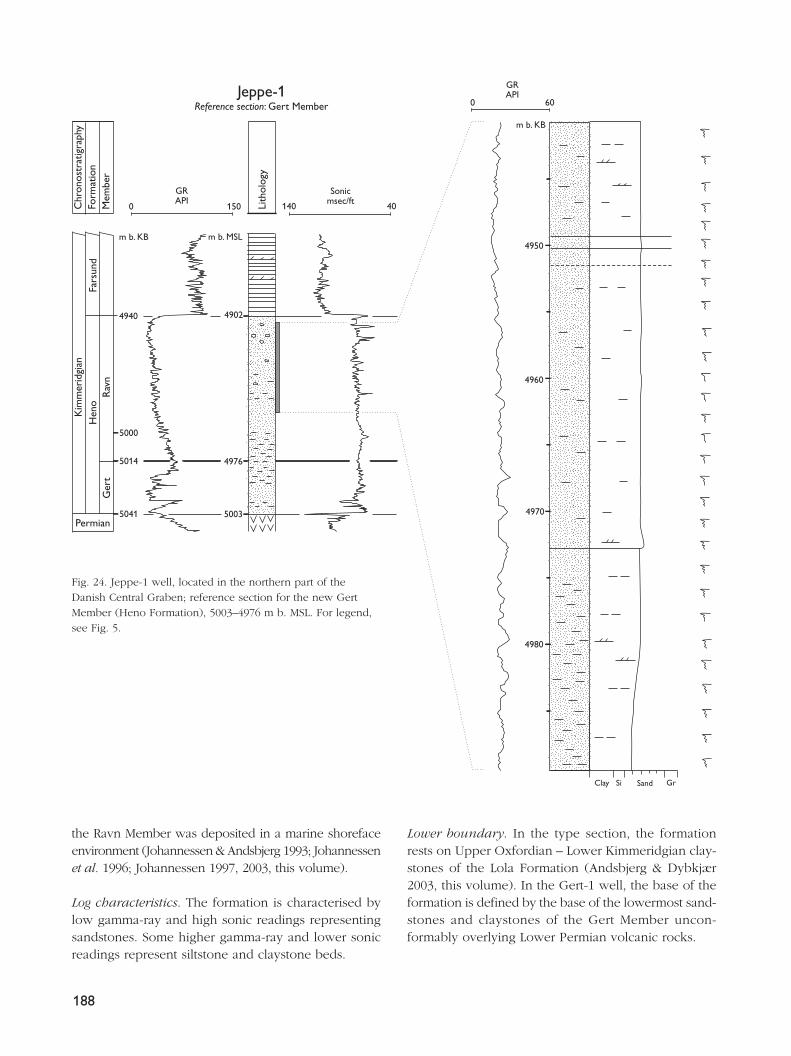
the Ravn Member was deposited in a marine shorefaceenvironment (Johannessen & Andsbjerg 1993; Johannessenet al. 1996; Johannessen 1997, 2003, this volume).
Log characteristics. The formation is characterised bylow gamma-ray and high sonic readings representingsandstones. Some higher gamma-ray and lower sonicreadings represent siltstone and claystone beds.
Lower boundary. In the type section, the formationrests on Upper Oxfordian – Lower Kimmeridgian clay-stones of the Lola Formation (Andsbjerg & Dybkjær2003, this volume). In the Gert-1 well, the base of theformation is defined by the base of the lowermost sand-stones and claystones of the Gert Member uncon-formably overlying Lower Permian volcanic rocks.
188
Chr
onos
trat
igra
phy
Form
atio
nM
embe
r
GRAPI
Sonicmsec/ftLi
thol
ogy
m b. MSLm b. KB
m b. KB
4940
5000
5014
4902
5041 5003
4976
4970
4980
4950
4960
0 60
GRAPIJeppe-1
Reference section: Gert Member
Kim
mer
idgi
an
Permian
Rav
nG
ert
Fars
und
Hen
o
0 150 140 40
Clay Si Sand Gr
Fig. 24. Jeppe-1 well, located in the northern part of theDanish Central Graben; reference section for the new GertMember (Heno Formation), 5003–4976 m b. MSL. For legend,see Fig. 5.
Distribution and thickness. The formation is present inthe Feda Graben and on the Gertrud and Heno Plateausin the northern part of the Danish Central Graben. Themaximum thickness of the formation on the HenoPlateau is 106 m in the Ravn-1 well. In the Feda Graben,the total thickness of the Heno Formation is 158 m inthe Gert-1 well (Gert Member 88 m, and Ravn Member70 m), where the formation interfingers with 86 m ofclaystones of the Lola Formation.
Age. The formation was assigned a Middle–Late Oxfordianto Kimmeridgian age (Jensen et al. 1986), but new bio-stratigraphic data indicate a latest Early – Late Kimmerid-gian age (Andsbjerg & Dybkjær 2003, this volume).
Subdivision. In the eastern part of the Feda Graben, theGertrud Plateau and the western part of the HenoPlateau, the lower part of the formation is characterisedby a serrated gamma-ray and sonic log pattern includ-ing very high gamma-ray peaks corresponding to verylow sonic values, recording the presence of thin coaland clay beds within the sand-dominated section. Thispart of the formation is defined as the new Gert Member,described below. In the same area, the upper part ofthe formation is characterised by moderate to lowgamma-ray and moderate to high sonic readings rep-resenting sandstone facies seen in the type section ofthe W-1 well. This part of the formation is defined asthe new Ravn Member, described below. The type sec-tion of the Heno Formation in the W-1 well comprisesonly the Ravn Member (Fig. 21).
Remarks. Other shallow marine sandstones somewhatyounger than the Heno Formation may be present inthe western part of the Danish area (Damtoft et al.1992). A sandy siltstone succession in the Kim-1 wellat the eastern margin of the Grensen Nose Basin isthought to be a distal equivalent of the Early–MiddleVolgian shallow marine ‘Fife sandstones’ in the UK sec-tor (Mackertich 1996; Andsbjerg & Dybkjær 2003, thisvolume). Similar sandstones are expected to be presentin the intervening area of the Ål and Grensen NoseBasins.
Gert Member
new member
Name. The Gert Member is named after the Gert Ridgesituated at the eastern margin of the Feda Graben.
Type section. The Gert-1 well, 16328–16038 ft b. KB,4938–4850 m b. MSL, is proposed as the type section(Fig. 22).
Reference section. The Jeppe-1 well, 5041–5014 m b. KB,5003–4976 m b. MSL, on the Gertrud Plateau, is selectedas the reference section (Fig. 24).
Lithology and environment. The member consists pre-dominantly of grey to white very fine- to fine-grainedsandstones and minor siltstones interbedded with clay-stones and coal beds (Fig. 22). The sediments were de-posited in back-barrier and shoreface environments.
Log characteristics. The lower part of the member inthe type section is characterised by serrated gamma-rayand sonic log motifs. Log readings from the upper partare more uniform and smooth. The very high gamma-ray values and very low sonic values in the serrated sec-tion represent thin claystone and coal beds interbeddedwith sandstones. The upper part with low gamma-rayand high sonic values consists of clean sandstones with-out coal and clay beds. The uppermost part of the mem-ber is characterised by a step-wise increase in gamma-rayvalues and decrease in sonic values, representing a fin-ing-upwards succession from sandstones to the clay-stones of the overlying Lola Formation (Fig. 22).
Boundaries. In the type and reference sections, the mem-ber rests unconformably on Lower Permian volcanicrocks. In the Gert-1 well, the upper boundary is definedat the change to the clay-dominated Lola Formationmarked by a significant log shift to higher gamma-rayvalues and lower sonic velocities. In the Jeppe-1 well ref-erence section (Fig. 24) and the Gert-2 well, the GertMember is directly overlain by the Ravn Member, as off-shore claystones of the Lola Formation are absent. In thesewells, the top of the Gert Member is defined at the high-est gamma-ray and lowest sonic readings, defining thebase of the coarsening-upwards Ravn Member.
Distribution and thickness. The member is present inthe northern part of the Danish Central Graben with amaximum thickness of 88 m in the Gert-1 well at theeastern margin of the Feda Graben. On the adjacent Ger-trud Plateau, the thickness of the member is reduced to27 m in the Jeppe-1 well and to 23 m in the Gert-2 well.
Age. The member is of latest Early – Late Kimmeridgianage (Johannessen et al. 1996; Andsbjerg & Dybkjær2003, this volume).
189
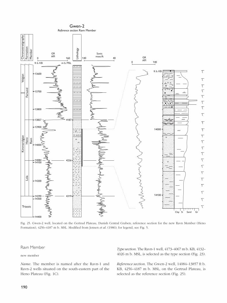
Ravn Member
new member
Name. The member is named after the Ravn-1 andRavn-2 wells situated on the south-eastern part of theHeno Plateau (Fig. 1C).
Type section. The Ravn-1 well, 4173–4067 m b. KB, 4132–4026 m b. MSL, is selected as the type section (Fig. 23).
Reference section. The Gwen-2 well, 14084–13857 ft b.KB, 4256–4187 m b. MSL, on the Gertrud Plateau, isselected as the reference section (Fig. 25).
190
Gwen-2Reference section: Ravn Member
Kim
mer
idgi
an
Triassic
Lola
Hen
oR
avn
0 140
Chr
onos
trat
igra
phy
Form
atio
nM
embe
r
Lith
olog
y
ft b. KB
ft b. KB
13857
1429014300
14200
1408414100
14000
13900
13800
13700
13600
14400
m b. MSL
4187
4256
4319
Fars
und
Volg
ian
14100
14000
Clay Si Sand Gr
0 160 140 40
GRAPI GR
API
Sonicmsec/ft
Fig. 25. Gwen-2 well, located on the Gertrud Plateau, Danish Central Graben; reference section for the new Ravn Member (HenoFormation), 4256–4187 m b. MSL. Modified from Jensen et al. (1986); for legend, see Fig. 5.
Lithology and environment. The Ravn Member consistspredominantly of grey to white, very fine- to fine-grainedsandstones, muddy sandstones and minor siltstones thatare bioturbated to such a degree that almost no primarysedimentary structures are preserved (Fig. 23). Conglome-rate beds, 0.08–2 m thick, locally associated with medium-grained sandstones, are present on plateau areas. In thegraben areas, the member is dominated by clayey, veryfine-grained sandstones and siltstones. Calcareous bedsand/or concretions occur. Deposition took place in amarine shoreface environment. The conglomerates rep-resent river or beach deposits that were later winnowedduring transgressive erosion (Johannessen et al. 1996;Johannessen 2003, this volume).
Log characteristics. In the Ravn-1 and Gwen-2 wells(Figs 23, 25), the lower and upper parts of the mem-ber include clayey sandstones characterised by rela-tively high gamma-ray and low sonic readings. Themiddle part of the member consists of sandstones andconglomerates characterised by low gamma-ray andhigh sonic readings. The overall pattern is thus char-acterised by decreasing-upwards gamma-ray values andincreasing-upwards sonic values followed by increas-ing gamma-ray values and decreasing sonic values. Inthe Gert-1 and Jeppe-1 wells, the member does notinclude clayey sandstones in the upper part (Figs 22,24). The gamma-ray and sonic logs are strongly serratedin the Ravn-1 well, less serrated in Gwen-2, and rela-tively smooth in Gert-1 and Jeppe-1 (Figs 22–25). Thismay be due to variation in the development of cal-careous beds and/or concretions.
Lower boundary. The member overlies offshore clay-stones of the Lola Formation in the Ravn-1 well typesection. The base of the member is defined by a shiftto lower gamma-ray and higher sonic readings mark-ing the base of an overall coarsening-upwards succes-sion beginning with clayey sandstones (Figs 23, 25). Inthe Gwen-2 reference section and the Gert-1 well, themember overlies sandy offshore claystones of the LolaFormation (Figs 22, 25), whereas in the Jeppe-1 well,the Ravn Member directly overlies the Gert Member(Fig. 24).
Distribution and thickness. The member is present inthe Feda Graben and on the Gertrud and Heno Plateausin the northern part of the Danish Central Graben. Amaximum thickness of 106 m is found in the Ravn-1well on the southern part of the Heno Plateau.
Age. The member is of Late Kimmeridgian age (Ands-bjerg & Dybkjær 2003, this volume).
Farsund FormationHistory. The Farsund Formation was defined by Vollset& Doré (1984) in the Norwegian North Sea area andextended to the Danish Central Graben by Jensen et al.(1986). New correlations have shown that Jensen et al.(1986) placed the lower boundary of the formation ata lower stratigraphic level than that defined by Vollset& Doré (1984). In addition, Forsberg et al. (1993) pointedout a discrepancy between the base of the FarsundFormation as picked by Vollset & Doré (1984) in theirtype well (2/7-3) and that picked in their reference well(2/8-3); neither of these picks correspond with that sug-gested by Jensen et al. (1986).
The practice of Jensen et al. (1986) is followed hereas they defined the boundary at a distinct and easilyrecognisable log change that marks a significant changein depositional style, which is probably related tochanges in subsidence patterns (Andsbjerg & Dybkjær2003, this volume). However, the upper part of the for-mation is missing from the U-1 well that was chosenas the Danish reference well for the Farsund Formationby Jensen et al. (1986). A new reference well, the G-1well, is thus introduced here.
Type and reference sections. The Norwegian 2/7-3 well,3626–3414 m b. KB, is the type section; the G-1 wellin the Danish Central Graben, 12036–7863 ft b. KB,3631–2359 m b. MSL, is designated as a reference sec-tion in the Danish sector (Fig. 26). A correlation lineshowing the stratigraphic relationship between theNorwegian reference well 2/8-3 and three Danish wellsincluding the reference well G-1 and the old referencewell U-1 is depicted in Figure 27.
Lithology and environment. The Farsund Formationconsists of medium to dark grey claystones; they arecarbonaceous and variably calcareous, and are inter-calated with numerous thin beds of brownish dolomite.The organic matter is mainly liptinitic, and depositiontook place in a relatively deep marine environment.Thin units of turbidite sandstones occur locally in thedeeper parts of the basins. Towards the eastern part ofthe Danish Central Graben, close to the Coffee SoilFault, the proportion of sandstones increases and thereappears to be a transition locally to the sandy PoulFormation.
191
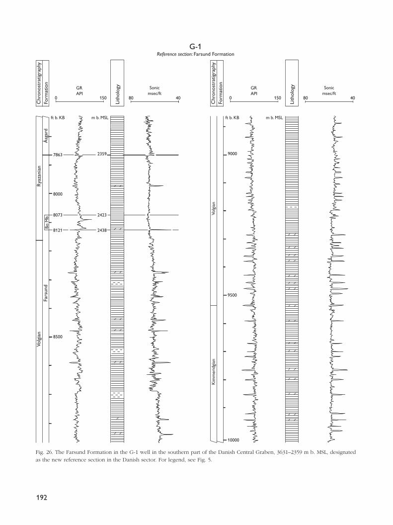
192
Fars
und
Volg
ian
Rya
zani
an
Bo M
b
7863
8000
8073
8121
2423
2438
8500
9000 2359
9500
10000
Kim
mer
idgi
anVo
lgia
n
Åsg
ard
Chr
onos
trat
igra
phy
Form
atio
n
m b. MSLft b. KB
G-1Reference section: Farsund Formation
Lith
olog
y
0 150 80 40
Chr
onos
trat
igra
phy
Form
atio
n
Lith
olog
y
GRAPI
Sonicmsec/ft
m b. MSLft b. KB
0 150 80 40
GRAPI
Sonicmsec/ft
Fig. 26. The Farsund Formation in the G-1 well in the southern part of the Danish Central Graben, 3631–2359 m b. MSL, designatedas the new reference section in the Danish sector. For legend, see Fig. 5.
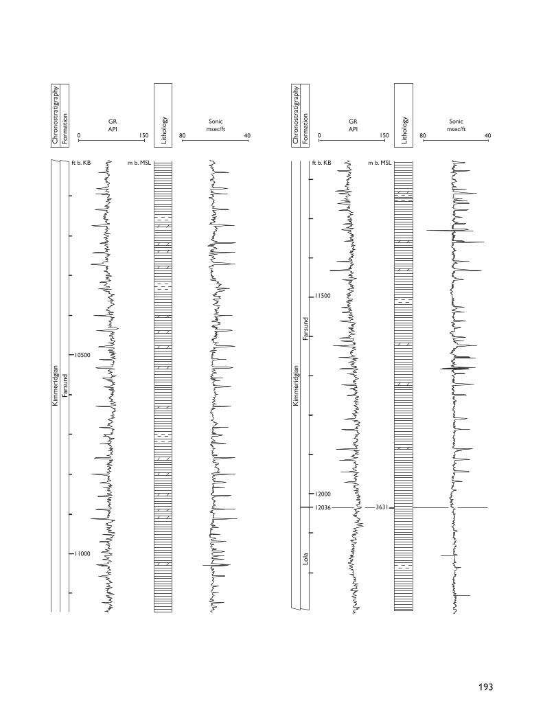
193
Fars
und
Lola
Kim
mer
idgi
an
Fars
und
Kim
mer
idgi
an
10500
11000
11500
12000
12036 3631
Chr
onos
trat
igra
phy
Form
atio
n
m b. MSLft b. KBLi
thol
ogy
0 150 80 40
GRAPI
Sonicmsec/ft
Chr
onos
trat
igra
phy
Form
atio
n
m b. MSLft b. KB
Lith
olog
y
0 150 80 40
GRAPI
Sonicmsec/ft
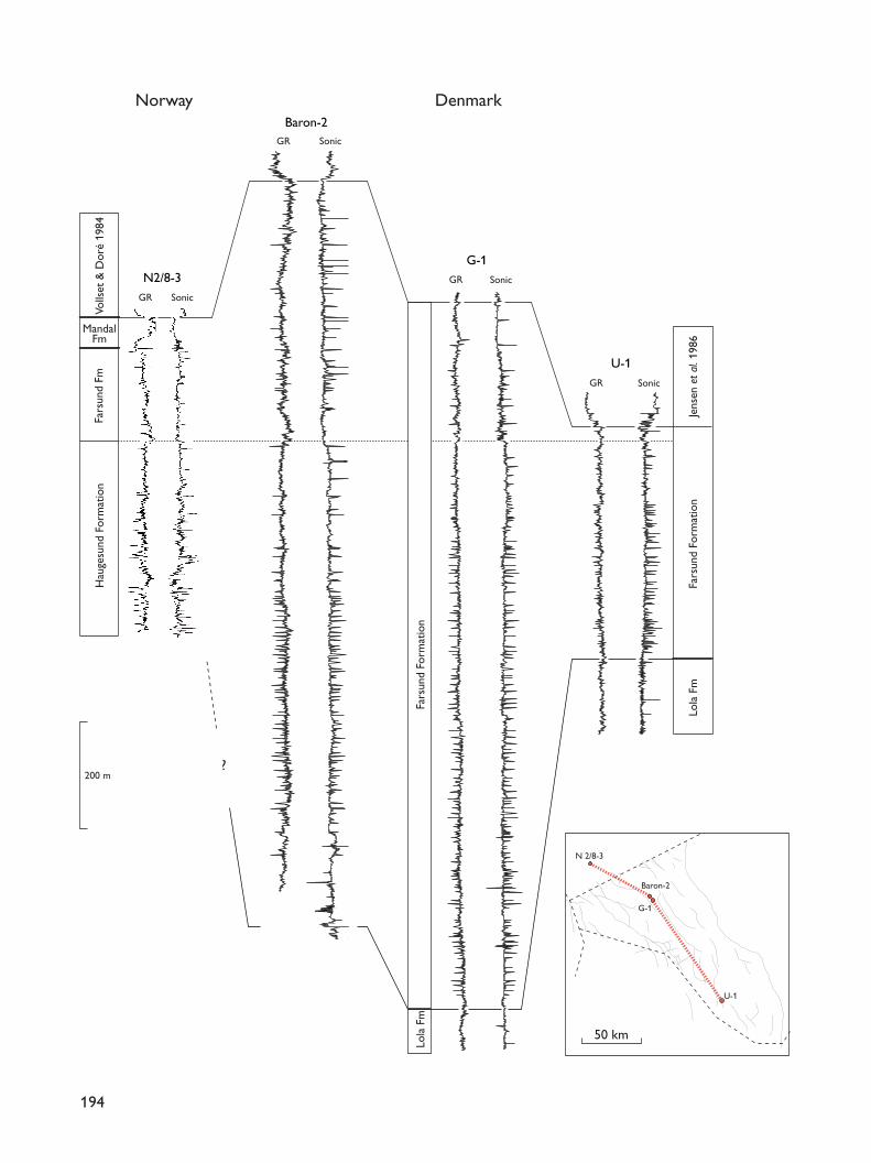
194
N2/8-3
Baron-2
G-1
U-1
DenmarkNorway
?
Jens
en e
t al.
1986
Fars
und
Form
atio
nLo
la F
m
Fars
und
Fm
MandalFm
Volls
et&
Dor
é 19
84H
auge
sund
For
mat
ion
Fars
und
Form
atio
nLo
la F
m
GR Sonic
GR Sonic
GR Sonic
GR Sonic
200 m
50 km
N 2/8-3
Baron-2
G-1
U-1
Log characteristics. The formation is characterised byrelatively high gamma-ray values and relatively lowsonic velocities. High velocity peaks and correspond-ing low gamma-ray readings reflecting dolomite or lime-stone beds or carbonate-cemented sandstone and silt-stone beds are a common feature of the formation.
Boundaries. The Farsund Formation overlies the LolaFormation in most of the Danish Central Graben (Figs26, 27). On plateau areas in the western and north-western part of the Danish Central Graben, the FarsundFormation overlies the Heno Formation (Figs 21–25).The boundary with the Lola Formation is defined abovea velocity minimum and a corresponding gamma-raymaximum. Above the boundary, there is commonly ageneral increase in velocity, a decrease in gamma-rayvalues and a much higher frequency of sonic velocitypeaks. The boundary with the Heno Formation is char-acterised by an abrupt or gradual increase in gamma-ray readings and a corresponding decrease in velocity.
The upper boundary with the Åsgard Formation(Cromer Knoll Group) is placed at the first significantchange from high gamma-ray and low sonic velocityreadings of the Farsund Formation to the low gamma-ray values and higher sonic velocities of the ÅsgardFormation (Figs 26–28).
Distribution and thickness. The formation extends fromthe Norwegian North Sea area, through the DanishCentral Graben. Southwards it correlates with the upperpart of the Kimmeridge Clay Formation in the DutchNorth Sea area. Eastwards, the formation correlates withthe Børglum Formation of the Norwegian–Danish Basin,although the transition zone has not yet been located.Maximum thicknesses of more than 3000 m occur inthe Tail End Graben.
Age. The Farsund Formation is of Late Kimmeridgian –Ryazanian age (Poulsen 1986; Heilmann-Clausen 1987;Andsbjerg & Dybkjær 2003, this volume).
Subdivision. Organic-rich mudstones in the upper lev-els of the Farsund Formation, previously referred to infor-mally as the ‘hot unit’, are herein defined as the BoMember of the Farsund Formation. The remainder ofthe formation is not subdivided at the level of members.
Bo Member
new member
History. Jensen et al. (1986) described the ‘hot unit’ asan informal member of the Farsund Formation charac-terised by mudstones that display unusually high gam-ma-ray values. Correlatives at least in part are knownfrom the Norwegian sector where they are referred tothe Mandal Formation (Vollset & Doré 1984), and fromthe Dutch sector where they form the Clay Deep Memberof the Kimmeridge Clay Formation (van AdrichemBoogaert & Kouwe 1994). However, both the MandalFormation and the Clay Deep Member span a greaterstratigraphic interval and include mudstones showingintermediate gamma-ray values beneath and above the‘hot unit’ as described by Jensen et al. (1986). Use ofthe Mandal Formation in the Danish sector is consid-ered impractical due to difficulties in recognising thelower boundary in many of the Danish wells. The ‘hotunit’ of Jensen et al. (1986) is thus retained and givenformal status as the Bo Member of the Farsund For-mation.
Name. The Bo Member is named after the Bo-1 well,located in the southern Tail End Graben where themember is well-developed.
Type section. The Danish Bo-1 well, 8561–8434 ft b.KB, 2576–2537 m b. MSL (Fig. 28).
Reference section. The Danish E-1 well, 9853–9771 ft b.KB, 2966–2940 m b. MSL (Ineson et al. 2003, this vol-ume, fig. 6).
Lithology and environment. The member is dominatedby black to dark grey-brown, laminated claystones,which are carbonaceous and slightly calcareous to non-calcareous. The total organic carbon content rangesfrom 3–8%, locally attaining values of more than 15%(Ineson et al. 2003, this volume). The organic matter ismainly liptinitic. Thin beds of dolomite may occur. Inthe Jeppe-1 core, the unit also includes thin sand-stone–mudstone couplets up to 5 cm thick; log data
195
Facing page:Fig. 27. Well-log panel from the Norwegian 2/8-3 well (Nor-wegian reference well of the Farsund Formation) through theBaron-2 well, the G-1 well (new Danish reference well of theFarsund Formation) and the U-1 well (previous Danishreference well of the Farsund Formation). Note the position ofthe basal boundary of the Farsund Formation as picked in theNorwegian reference well and in the Danish wells.

suggest that thicker sandstone-rich intervals are alsopresent in the member (Ineson et al. 2003, this volume).Deposition occurred in a low-energy, oxygen-deficientdeep marine environment. The sandstone–mudstonecouplets were deposited from dilute turbidity currents(Ineson et al. 2003, this volume).
Log characteristics. The member is primarily identifiedby its high gamma-ray values, which are significantlyhigher than those of the underlying and overlying clay-stones of the Farsund Formation. The sonic velocity islow. The gamma-ray values may show significant vari-
ation within the member with decreasing-upwardstrends, 3–5 m thick, separated by intervals with moreconsistently high values (e.g. Bo-1).
Boundaries. The lower and upper boundaries are placedat shifts to the significantly lower gamma-ray values ofthe Farsund Formation.
Distribution and thickness. The member is recognisedwidely in the Danish Central Graben, where this por-tion of the Farsund Formation is preserved. On struc-tural highs, the upper part of the Farsund Formation iscommonly truncated and the member may be absentor reduced in thickness. The thickness varies greatly fromless than 10 m in the southern Salt Dome Province tomore than 100 m in the western part of the DanishCentral Graben, probably controlled by local factorssuch as structural position and sediment supply (Inesonet al. 2003, this volume).
Age. Late Volgian – Late Ryazanian, mainly occurringwithin the Lower Ryazanian H. kochi Chronozone with
196
8700
8800
8900
ft b. KB
8561
8434
8348
8400
8500
8600
Lith
olog
y
Chr
onos
trat
igra
phy
Form
atio
nM
embe
r
0 180
??
Rya
zani
an–V
alan
gini
an
140 60
Volg
ian
Fars
und
2576
m b. MSL
2537
2511
Ås.
BoBo-1
Type section: Bo Member
GRAPI
Sonicmsec/ft
Fig. 28. Bo-1 well, located in the Danish Central Graben; typesection of the new Bo Member (Farsund Formation), 2576–2537m b. MSL. Ås., Åsgard. Modified from Jensen et al. (1986); forlegend, see Fig. 5.
Fars
und
Fa
rsun
dPo
ul
28189356
9400
9300
9463
9500
9600
2851
m b. MSLft b. KB
Volg
ian
Chr
onos
trat
igra
phy
Form
atio
n
GRAPI
Sonicmsec/ftLi
thol
ogy
0 140 140 40
V-1Type section: Poul Formation
Fig. 29. V-1 well, located in the eastern part of the Danish CentralGraben; type section for the Poul Formation, 2851–2818 m b. MSL.Modified from Jensen et al. (1986); for legend, see Fig. 5.
a maximum age range from the C. preplicomphalus tothe C. stenomphalus Chronozones (Birkelund et al.1983; Poulsen 1992; Dybkjær 1998; Ineson et al. 2003,this volume).
Poul FormationHistory. The Poul Formation was defined by Jensenet al. (1986).
Type section. The V-1 well, 9463–9356 ft b. KB, 2851–2818m b. MSL, in the eastern part of the Danish CentralGraben was selected by Jensen et al. (1986; Fig. 29).
Lithology and environment. The Poul Formation typi-cally consists of dark grey siltstones and light grey, veryfine-grained sandstones. The siltstones are partly argilla-ceous and grade into claystones. In the Ugle-1 well,located at the eastern margin of the Danish CentralGraben close to the Coffee Soil Fault zone, the forma-tion includes pebble conglomerates, coarse-grainedsandstones and fine- to very fine-grained, silty sand-stones. Shelly debris and lithic clasts are common, andthe conglomerates may be polymictic. The clasts rep-resent a wide range of lithologies suggesting a meta-morphic source terrain with phyllites and other meta-sediments. Deposition was probably from turbiditycurrents on fault-bounded plateaus along the Coffee SoilFault. The exceptionally thick and immature succes-sion in the Ugle-1 well was probably deposited as a fault-attached, localised slope apron.
Log characteristics. The Poul Formation is characterisedby low gamma-ray values and intermediate sonic val-ues representing silt- and sandstones, with a few peaksshowing higher sonic velocities representing carbonate-cemented beds.
Boundaries. The formation interfingers with the FarsundFormation, and the lower and upper boundaries areclearly defined at abrupt changes to lower gamma-rayvalues and higher sonic velocities than those that char-acterise the Farsund Formation.
Distribution and thickness. The formation is present inthe Danish Central Graben close to the eastern faultedmargin of the Central Graben. The thickest sandstoneunits occur on down-faulted plateaus along the CoffeeSoil Fault zone. The maximum thickness of 175 m isobserved in the Ugle-1 well (2591–2416 m b. MSL).
Age. The Poul Formation is of Volgian age (Hoelstad1986b; Poulsen 1986).
Stratigraphic evolution The Jurassic succession of Denmark, from Bornholmin the east to the Central Graben in the west, providesa detailed record of major basin evolutionary events thatwere experienced along the length of the Jurassic riftsystem. A summary of the Jurassic stratigraphic evolu-tion of Denmark is given below; detailed accounts arepresented elsewhere in this volume (Andsbjerg 2003,this volume; Andsbjerg & Dybkjær 2003, this volume;Johannessen 2003, this volume; Nielsen 2003, thisvolume).
Early Jurassic marine depositionThe Early Jurassic transgression of the Danish Basinwas initiated in the Norian (Late Triassic) and recordedby deposition of restricted marine claystones of theVinding Formation and paralic – shallow marine sand-stones and mudstones of the overlying and partlyinterfingering Gassum Formation. Mudstones of theLower Jurassic Fjerritslev Formation conformably over-lie the Gassum Formation over most of the DanishBasin and Sorgenfrei–Tornquist Zone, indicating a fur-ther deepening of the basin (Figs 30–32). The FjerritslevFormation is subdivided into four members, all of whichare present in the Danish Basin. The two sub-units ofthe lower member (F-Ia, F-Ib) are also recognised inthe Danish Central Graben (Michelsen 1978b). The for-mation is patchily preserved in the southern part of theNorwegian North Sea sector and has been drilled in theEgersund Subbasin and in the area around the SouthernVestland Arch (Vollset & Doré 1984). To the east, com-parable mudstones have been exposed at Gantofta,Skåne, where they are referred to the Pankarp Memberof the Rya Formation (Fig. 2; Frandsen & Surlyk 2003,this volume). The Fjerritslev Formation was probablydeposited over most of the south-eastern North Sea. Theisolated occurrences of the formation are erosional out-liers of a previously widely distributed Lower Jurassiccover, which existed prior to early Middle Jurassic upliftand erosion of the mid North Sea dome and theRingkøbing–Fyn High (Michelsen 1978a, b; Gowers &Sæbøe 1985; Ziegler 1990; Underhill & Partington 1993;Andsbjerg & Dybkjær 2003, this volume; Nielsen 2003,this volume).
197
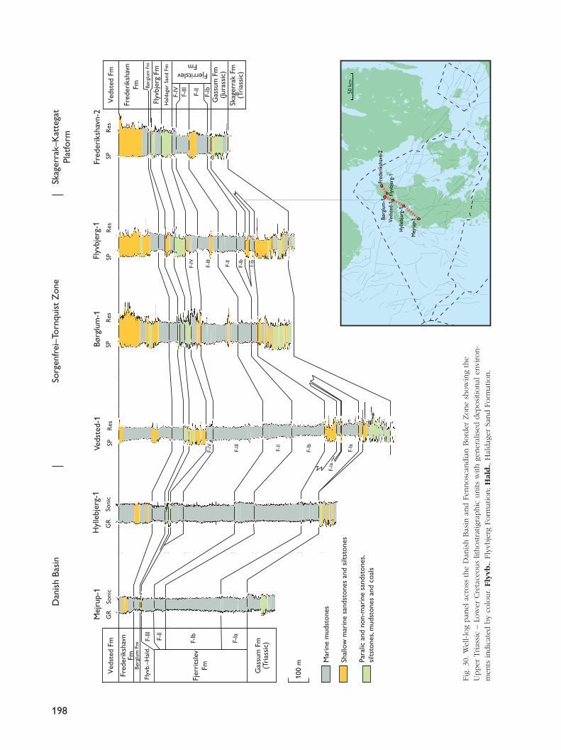
198
100
m
Mej
rup-
1H
ylle
bjer
g-1
Veds
ted-
1Bø
rglu
m-1
Flyv
bjer
g-1
Fred
erik
shav
n-2
GR
GR
Soni
cSo
nic
SPR
esSP
Res
SPR
esSP
Res
F-lV
F-lV
F-lll
F-ll
F-lb
F-lb
F-lll
F-ll
F-lb
F-la
F-la
Flyv
b.–H
ald.
Fjer
rits
lev
Fm
Børg
lum
Fm
FjerritslevFm
Mar
ine
mud
ston
es
Shal
low
mar
ine
sand
ston
es a
nd s
iltst
ones
Para
lic a
nd n
on-m
arin
e sa
ndst
ones
, si
ltsto
nes,
mud
ston
es a
nd c
oals
Dan
ish
Basi
nSo
rgen
frei
–Tor
nqui
st Z
one
Skag
erra
k–K
atte
gat
Plat
form
Skag
erra
k Fm
(Tri
assi
c)
Fred
erik
shav
nFm
Børg
lum
Fm
Ved
sted
Fm
Gas
sum
Fm
(Tri
assi
c)
F-lll
F-ll
F-lb
F-la
Gas
sum
Fm
(Jura
ssic
)
Fred
erik
shav
nFm
Flyv
bjer
g Fm
Hal
dage
r Sa
nd F
m
Ved
sted
Fm
F-lV
F-lll
F-ll
F-lb
Fred
erik
shav
n-2
Børg
lum
-1Fl
yvbj
erg-
1Ve
dste
d-1
Hyl
lebj
erg-
1
Mej
rup-
1
50 k
m
Fig.
30.
Wel
l-lo
g pan
el a
cross
the
Dan
ish B
asin
and F
ennosc
andia
n B
ord
er Z
one
show
ing
the
Upper
Trias
sic
– Lo
wer
Cre
tace
ous
lithost
ratig
raphic
units
with
gen
eral
ised
dep
osi
tional
envi
ron-
men
ts indic
ated
by
colo
ur. F
lyvb
., Fl
yvbje
rg F
orm
atio
n;
Hal
d.,
Hal
dag
er S
and F
orm
atio
n.
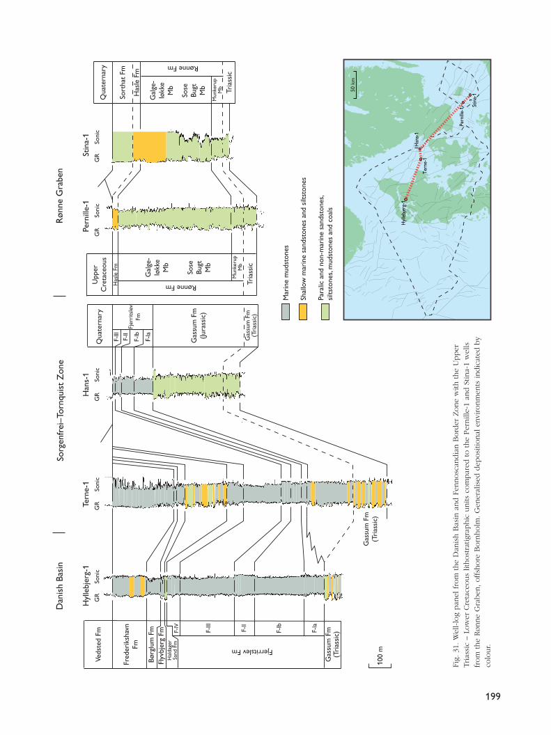
199
100
m
Dan
ish
Basi
nSo
rgen
frei
–Tor
nqui
st Z
one
Røn
ne G
rabe
n
Børg
lum
Fm F-
lV
F-lll
F-ll
F-lb
F-la
Gas
sum
Fm
(Tri
assi
c)
Fjerritslev Fm
F-lll
F-ll
F-lb
F-la
Fjer
rits
lev
Fm
Hyl
lebj
erg-
1Te
rne-
1H
ans-
1Pe
rnill
e-1
Stin
a-1
Gas
sum
Fm
(Tri
assi
c)
Fred
erik
shav
nFm
Qua
tern
ary
Gas
sum
Fm
(Jura
ssic
)
Gas
sum
Fm
(Tri
assi
c)
Upp
erC
reta
ceou
s
Has
le F
m
Rønne Fm
Rønne Fm
Mun
keru
pM
b
Mun
keru
pM
b
Qua
tern
ary
Sort
hat
Fm
Has
le F
m
Tria
ssic
Tria
ssic
Flyv
bjer
g Fm
Hal
dage
rSa
nd F
m
Sose
Bugt
Mb
Gal
ge-
løkk
eM
b
Gal
ge-
løkk
eM
b
Sose
Bugt
Mb
Veds
ted
Fm
Mar
ine
mud
ston
es
Shal
low
mar
ine
sand
ston
es a
nd s
iltst
ones
Para
lic a
nd n
on-m
arin
e sa
ndst
ones
, si
ltsto
nes,
mud
ston
es a
nd c
oals
Hyl
lebj
erg-
1
Tern
e-1
Han
s-1
Pern
ille-
1 Stin
a-1
GR
Soni
cG
RSo
nic
Soni
cG
RG
RSo
nic
GR
Soni
c
50 k
m
Fig.
31.
Wel
l-lo
g pan
el fro
m the
Dan
ish B
asin
and F
ennosc
andia
n B
ord
er Z
one
with
the
Upper
Trias
sic
– Lo
wer
Cre
tace
ous
lithost
ratig
raphic
units
com
par
ed to the
Per
nill
e-1
and S
tina-
1 w
ells
from
the
Rønne
Gra
ben
, offsh
ore
Born
holm
. G
ener
alis
ed d
eposi
tional
envi
ronm
ents
indic
ated
by
colo
ur.
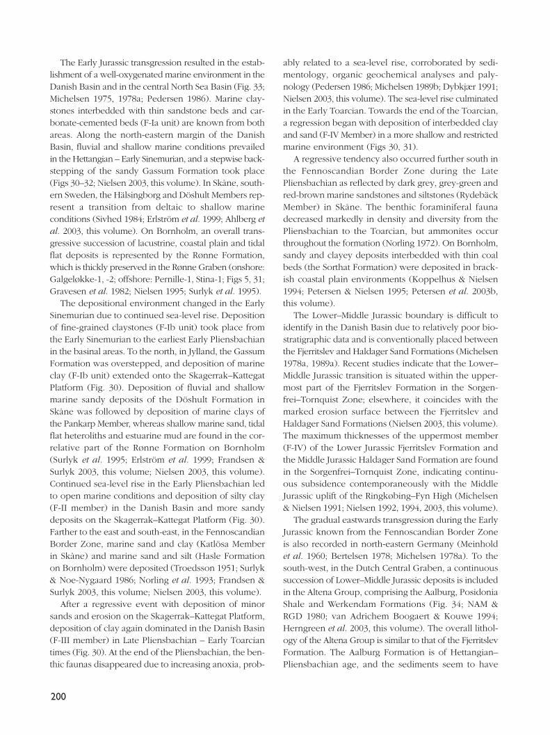
The Early Jurassic transgression resulted in the estab-lishment of a well-oxygenated marine environment in theDanish Basin and in the central North Sea Basin (Fig. 33;Michelsen 1975, 1978a; Pedersen 1986). Marine clay-stones interbedded with thin sandstone beds and car-bonate-cemented beds (F-Ia unit) are known from bothareas. Along the north-eastern margin of the DanishBasin, fluvial and shallow marine conditions prevailedin the Hettangian – Early Sinemurian, and a stepwise back-stepping of the sandy Gassum Formation took place(Figs 30–32; Nielsen 2003, this volume). In Skåne, south-ern Sweden, the Hälsingborg and Döshult Members rep-resent a transition from deltaic to shallow marineconditions (Sivhed 1984; Erlström et al. 1999; Ahlberg etal. 2003, this volume). On Bornholm, an overall trans-gressive succession of lacustrine, coastal plain and tidalflat deposits is represented by the Rønne Formation,which is thickly preserved in the Rønne Graben (onshore:Galgeløkke-1, -2; offshore: Pernille-1, Stina-1; Figs 5, 31;Gravesen et al. 1982; Nielsen 1995; Surlyk et al. 1995).
The depositional environment changed in the EarlySinemurian due to continued sea-level rise. Depositionof fine-grained claystones (F-Ib unit) took place fromthe Early Sinemurian to the earliest Early Pliensbachianin the basinal areas. To the north, in Jylland, the GassumFormation was overstepped, and deposition of marineclay (F-Ib unit) extended onto the Skagerrak–KattegatPlatform (Fig. 30). Deposition of fluvial and shallowmarine sandy deposits of the Döshult Formation inSkåne was followed by deposition of marine clays ofthe Pankarp Member, whereas shallow marine sand, tidalflat heteroliths and estuarine mud are found in the cor-relative part of the Rønne Formation on Bornholm(Surlyk et al. 1995; Erlström et al. 1999; Frandsen &Surlyk 2003, this volume; Nielsen 2003, this volume).Continued sea-level rise in the Early Pliensbachian ledto open marine conditions and deposition of silty clay(F-II member) in the Danish Basin and more sandydeposits on the Skagerrak–Kattegat Platform (Fig. 30).Farther to the east and south-east, in the FennoscandianBorder Zone, marine sand and clay (Katlösa Memberin Skåne) and marine sand and silt (Hasle Formationon Bornholm) were deposited (Troedsson 1951; Surlyk& Noe-Nygaard 1986; Norling et al. 1993; Frandsen &Surlyk 2003, this volume; Nielsen 2003, this volume).
After a regressive event with deposition of minorsands and erosion on the Skagerrak–Kattegat Platform,deposition of clay again dominated in the Danish Basin(F-III member) in Late Pliensbachian – Early Toarciantimes (Fig. 30). At the end of the Pliensbachian, the ben-thic faunas disappeared due to increasing anoxia, prob-
ably related to a sea-level rise, corroborated by sedi-mentology, organic geochemical analyses and paly-nology (Pedersen 1986; Michelsen 1989b; Dybkjær 1991;Nielsen 2003, this volume). The sea-level rise culminatedin the Early Toarcian. Towards the end of the Toarcian,a regression began with deposition of interbedded clayand sand (F-IV Member) in a more shallow and restrictedmarine environment (Figs 30, 31).
A regressive tendency also occurred further south inthe Fennoscandian Border Zone during the LatePliensbachian as reflected by dark grey, grey-green andred-brown marine sandstones and siltstones (RydebäckMember) in Skåne. The benthic foraminiferal faunadecreased markedly in density and diversity from thePliensbachian to the Toarcian, but ammonites occurthroughout the formation (Norling 1972). On Bornholm,sandy and clayey deposits interbedded with thin coalbeds (the Sorthat Formation) were deposited in brack-ish coastal plain environments (Koppelhus & Nielsen1994; Petersen & Nielsen 1995; Petersen et al. 2003b,this volume).
The Lower–Middle Jurassic boundary is difficult toidentify in the Danish Basin due to relatively poor bio-stratigraphic data and is conventionally placed betweenthe Fjerritslev and Haldager Sand Formations (Michelsen1978a, 1989a). Recent studies indicate that the Lower–Middle Jurassic transition is situated within the upper-most part of the Fjerritslev Formation in the Sorgen-frei–Tornquist Zone; elsewhere, it coincides with themarked erosion surface between the Fjerritslev andHaldager Sand Formations (Nielsen 2003, this volume).The maximum thicknesses of the uppermost member(F-IV) of the Lower Jurassic Fjerritslev Formation andthe Middle Jurassic Haldager Sand Formation are foundin the Sorgenfrei–Tornquist Zone, indicating continu-ous subsidence contemporaneously with the MiddleJurassic uplift of the Ringkøbing–Fyn High (Michelsen& Nielsen 1991; Nielsen 1992, 1994, 2003, this volume).
The gradual eastwards transgression during the EarlyJurassic known from the Fennoscandian Border Zoneis also recorded in north-eastern Germany (Meinholdet al. 1960; Bertelsen 1978; Michelsen 1978a). To thesouth-west, in the Dutch Central Graben, a continuoussuccession of Lower–Middle Jurassic deposits is includedin the Altena Group, comprising the Aalburg, PosidoniaShale and Werkendam Formations (Fig. 34; NAM &RGD 1980; van Adrichem Boogaert & Kouwe 1994;Herngreen et al. 2003, this volume). The overall lithol-ogy of the Altena Group is similar to that of the FjerritslevFormation. The Aalburg Formation is of Hettangian–Pliensbachian age, and the sediments seem to have
200
201
Cle
o-1
L-1
Inez
-1F-
1K
-1Bø
rglu
m-1
Gr
U. J
ur.
Tria
ssic
Gas
sum
Fm
Hal
dage
r Sa
ndFm
Børg
lum
Fm
Gas
sum
Fm
Tri
assi
c
F lV
Ved
sted
Fm
Fred
erik
shav
nFm
Børg
lum
Fm
Flyv
bjer
g Fm
Hal
dage
r Sa
nd F
m
F-lV
F-lll
F-ll
F-lb
F-lb
F-la
Gassum Fm(Jurassic)Fjerritslev Fm
Felic
ia-1
J-1
100
m
Cen
tral
Gra
ben
Rin
gkøb
ing–
Fyn
Hig
hN
orw
egia
n–D
anis
h Ba
sin
Sorg
enfr
ei–T
ornq
uist
Zon
e
Soni
cSo
nic
GR
GR
So
nic
Soni
cG
R
SPR
esG
RSo
nic
Soni
cG
RG
RSo
nic
Mar
ine
mud
ston
es
Turb
idite
san
dsto
nes
and
silts
tone
s
Para
lic a
nd n
on-m
arin
e sa
ndst
ones
, si
ltsto
nes,
mud
ston
es a
nd c
oals
Shal
low
mar
ine
sand
ston
es a
nd s
iltst
ones
Børg
lum
-1Fe
licia
-1J-1
K-1
F-1 In
ez-1
Cle
o-1
L-1
Fred
erik
shav
n Fm
Low
er C
ret.
Flyv
bjer
gFm
Cha
lkG
r
Bryn
eFm
Lulu
Fm
Tri
assi
c
Lola
Fm
Fars
und
Fm
50 k
m
Fig.
32.
Wel
l-lo
g pan
el r
unnin
g from
the
Sorg
enfrei
–To
rnquis
t Zone
to the
north-e
aste
rn D
anis
h C
entral
Gra
ben
show
ing
the
Upper
Trias
sic
– Lo
wer
Cre
tace
ous
lithost
ratig
raphic
units
with
gen
eral
ised
dep
osi
tional
envi
ronm
ents
indic
ated
by
colo
ur.
202
4°E
8°E
12°E
16°E
58°N
56°
N
Late
Aal
enia
n –
Bath
onia
n
4°E
8°E
12°E
16°E
58°N
56°N
Het
tang
ian
4°E
8°E
12°E
16°E
58°N
56°N
Sine
mur
ian
–Ea
rly
Plie
nsba
chia
n
4°E
8°E
12°E
16°E
58°N
56°N
Toar
cian
–
Earl
y A
alen
ian
Swed
en
Nor
way
Ger
man
yT
heN
ethe
rlan
ds
Swed
en
Nor
way
Ger
man
yT
heN
ethe
rlan
ds
Swed
en
Nor
way
Ger
man
yT
heN
ethe
rlan
ds
Swed
en
Nor
way
Ger
man
y
Den
mar
k
Den
mar
k
The
Net
herl
ands
100
km10
0 km
100
km10
0 km
Den
mar
k
Den
mar
k
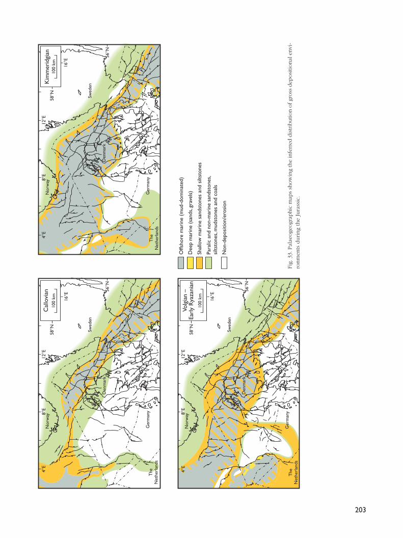
203
Den
mar
k
Offs
hore
mar
ine
(mud
-dom
inat
ed)
Dee
p m
arin
e (s
ands
, gra
vels
)
Non
-dep
ositi
on/e
rosi
on
Para
lic a
nd n
on-m
arin
e sa
ndst
ones
, si
ltsto
nes,
mud
ston
es a
nd c
oals
Shal
low
mar
ine
sand
ston
es a
nd s
iltst
ones
4°E
8°E
12°E
16°E
58°N
56°N
Cal
lovi
an4°
E8°
E12°E
16°E
58°N
56°N
Kim
mer
idgi
an
4°E
8°E
12°E
16°E
58°N
56°N
Volg
ian
–Ea
rly
Rya
zani
an
100
km
Swed
en
Nor
way
Ger
man
yT
heN
ethe
rlan
ds
Swed
en
Nor
way
Ger
man
yT
heN
ethe
rlan
ds
Swed
en
Nor
way
Ger
man
yT
heN
ethe
rlan
ds
100
km
100
km
Den
mar
k
Den
mar
k
Fig.
33.
Pal
aeoge
ogr
aphic
map
s sh
ow
ing
the
infe
rred
dis
trib
utio
n o
f gr
oss
dep
osi
tional
envi
-ro
nm
ents
during
the
Jura
ssic
.
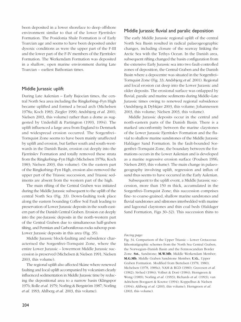
been deposited in a lower shoreface to deep offshoreenvironment similar to that of the lower FjerritslevFormation. The Posidonia Shale Formation is of EarlyToarcian age and seems to have been deposited underdysoxic conditions as were the upper part of the F-IIIand the lower part of the F-IV members of the FjerritslevFormation. The Werkendam Formation was depositedin a shallow, open marine environment during LateToarcian – earliest Bathonian times.
Middle Jurassic upliftDuring Late Aalenian – Early Bajocian times, the cen-tral North Sea area including the Ringkøbing–Fyn Highbecame uplifted and formed a broad arch (Michelsen1978a; Koch 1983; Ziegler 1990; Andsbjerg et al. 2001;Nielsen 2003, this volume) rather than a dome as sug-gested by Underhill & Partington (1993, 1994). Theuplift influenced a large area from England to Denmarkand widespread erosion occurred. The Sorgenfrei–Tornquist Zone seems to have been mainly unaffectedby uplift and erosion, but farther south and south-west-wards in the Danish Basin, erosion cut deeply into theFjerritslev Formation and totally removed these stratafrom the Ringkøbing–Fyn High (Michelsen 1978a; Koch1983; Nielsen 2003, this volume). On the eastern partof the Ringkøbing–Fyn High, erosion also removed theupper part of the Triassic succession, and Triassic sed-iments are absent from the western part of the high.
The main rifting of the Central Graben was initiatedduring the Middle Jurassic subsequent to the uplift of thecentral North Sea (Fig. 33). Down-faulting took placealong the eastern bounding Coffee Soil Fault leading topreservation of Lower Jurassic deposits in the south-east-ern part of the Danish Central Graben. Erosion cut deeplyinto the pre-Jurassic deposits in the north-western partof the Central Graben due to simultaneous half-grabentilting, and Permian and Carboniferous rocks subcrop post-Lower Jurassic deposits in this area (Fig. 35).
Middle Jurassic block-faulting and subsidence char-acterised the Sorgenfrei–Tornquist Zone, where theentire Lower Jurassic – lowermost Middle Jurassic suc-cession is preserved (Michelsen & Nielsen 1991; Nielsen2003, this volume).
The regional uplift also affected Skåne where renewedfaulting and local uplift accompanied by volcanism clearlyinfluenced sedimentation in Middle Jurassic time by reduc-ing the depositional area to a narrow basin (Klingspor1976; Rolle et al. 1979; Norling & Bergström 1987; Norlinget al. 1993; Ahlberg et al. 2003, this volume).
Middle Jurassic fluvial and paralic depositionThe early Middle Jurassic regional uplift of the centralNorth Sea Basin resulted in radical palaeogeographicchanges, including closure of the seaway linking theArctic Sea with the Tethys Ocean. In the Danish area,subsequent rifting changed the basin configuration fromthe extensive Early Jurassic sea into two fault-controlledzones of deposition, the Central Graben and the DanishBasin where a depocentre was situated in the Sorgenfrei–Tornquist Zone (Fig. 33; Andsbjerg et al. 2001). Regionaland local erosion cut deep into the Lower Jurassic andolder deposits. The erosional surface was onlapped byfluvial, paralic and marine sediments during Middle–LateJurassic times owing to renewed regional subsidence(Andsbjerg & Dybkjær 2003, this volume; Johannessen2003, this volume; Nielsen 2003, this volume).
Middle Jurassic deposits occur in the central andnorth-eastern parts of the Danish Basin. There is amarked unconformity between the marine claystonesof the Lower Jurassic Fjerritslev Formation and the flu-vial to shallow marine sandstones of the Middle JurassicHaldager Sand Formation. In the fault-bounded Sor-genfrei–Tornquist Zone, the boundary between the for-mations occurs in the Lower Aalenian and is developedas a marine regressive erosion surface (Poulsen 1996;Nielsen 2003, this volume). The main change in palaeo-geography involving uplift, regression and influx ofsand thus seems to have occurred in the Early Aalenian.
Subsequent to the uplift event, a Middle Jurassic suc-cession, more than 150 m thick, accumulated in theSorgenfrei–Tornquist Zone; this succession comprisesfine- to coarse-grained, shallow marine sandstones andfluvial sandstones and siltstones interbedded with marineand lagoonal claystones and thin coal beds (HaldagerSand Formation, Figs 30–32). This succession thins to
204
Facing page:Fig. 34. Comparison of the Upper Triassic – Lower Cretaceouslithostratigraphic schemes from the North Sea Central Graben,the Norwegian–Danish Basin and the Fennoscandian BorderZone. Sst., Sandstone; M.W.Mb, Middle Werkendam Member;M.G.Mb, Middle Graben Sandstone Member; U.G., UpperGraben Formation. Modified from Bertelsen (1978, 1980);Michelsen (1978, 1989a); NAM & RGD (1980); Gravesen et al.(1982); Sivhed (1984); Vollset & Doré (1984); Herngreen &Wong (1989); Norling et al. (1993); Richards et al. (1993); vanAdrichem Boogaert & Kouwe (1994); Koppelhus & Nielsen(1994); Ahlberg et al. (2003, this volume); Herngreen et al.(2003, this volume).
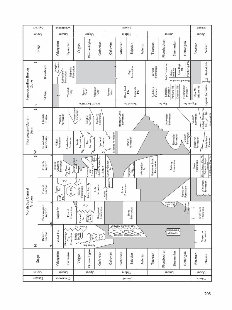
205
TriassicJurassicCretaceous
Upper UpperLower LowerMiddleSeries
System
Stag
eUpper UpperLower LowerMiddleSeries
System TriassicJurassicCretaceous N
orth
Sea
Cen
tral
Gra
ben
NS
W
Briti
shse
ctor
Nor
weg
ian
sect
orD
anis
hse
ctor
Dut
chse
ctor
Fisk
eban
ksu
bbas
inD
anis
hBa
sin
Skån
eBo
rnho
lm
Nor
weg
ian–
Dan
ish
Basi
nFe
nnos
cand
ian
Bord
erZ
one
NE
S
NN
NS
SS
Stag
e
Val
angi
nian
Val
angi
nian
Rya
zani
anR
yaza
nian
Vol
gian
Vol
gian
Kim
mer
idgi
anK
imm
erid
gian
Oxf
ordi
anO
xfor
dian
Cal
lovi
anC
allo
vian
Bath
onia
nBa
thon
ian
Bajo
cian
Bajo
cian
Aal
enia
nA
alen
ian
Toa
rcia
nT
oarc
ian
Plie
nsba
chia
nPl
iens
bach
ian
Sine
mur
ian
Sine
mur
ian
Het
tang
ian
Het
tang
ian
Rha
etia
nR
haet
ian
Nor
ian
Nor
ian
Vlie
land
Cla
ysto
neFo
rmat
ion
Cla
y D
eep
Mem
ber
Kåg
eröd
For
mat
ion
Ryd
ebäc
kM
embe
r
Kat
slös
aM
embe
r
Pank
arp
Mb
Dös
hult
Mb
Hel
sing
borg
Mem
ber
Bjuv
Mb
Vallå
kra
Mb
Höganäs FmRya Fm
Gla
ss S
and
Mb
Fugl
unda
Mb
Fort
una
Mar
l
Fyle
dale
nC
lay
Annero Formation
Vita
bäck
Cla
y
Nyt
orp
Sand
Jyde
gård
Form
atio
n
Rob
beda
leFo
rmat
ion
Rab
ekke
Form
atio
n
Bagå
Form
atio
n
Sort
hat
Form
atio
n
Has
le F
orm
atio
n
Rønne Formation
Gal
ge-
løkk
e M
b
Sose
Bug
tM
b
Mun
keru
p M
b
Ris
ebæ
k M
b
KågerödFm
Fjer
rits
lev
Form
atio
n
Win
tert
onFo
rmat
ion
Valh
all
Form
atio
nVe
dste
dFo
rmat
ion
Fred
erik
shav
nFo
rmat
ion
Børg
lum
Form
atio
n
Flyv
bjer
gFo
rmat
ion
Hal
dage
r Sa
ndFo
rmat
ion
Fjer
rits
lev
Form
atio
n
Gas
sum
Form
atio
n
Vin
ding
FmSk
ager
rak
Fm
Odd
esun
d Fm
Valh
all F
mÅ
sgar
d Fm
Fars
und
FmU
laFm
Man
dal
Form
atio
n
Kim
mer
idge
Cla
yFo
rmat
ion
Rib
ble
Sst.M
b
Hea
ther
Fm
Fres
hney
Sst.M
b
Fulmar Fm
Fulmar Fm
? ?
Rattray Volcanic Member
Ron Volcanic Member
Pentland FmFjerritslevFormation
FjerritslevFormation
???
?
??
??
??
?
Skag
erra
kFo
rmat
ion
Smith
Ban
kFo
rmat
ion
Gas
sum
Form
atio
n
Bryn
eFo
rmat
ion
Hau
gesu
ndFo
rmat
ion
Eldf
isk
Fm
Åsg
ard
FmLe
ekM
bV
ylFm
Bo M
b
Fars
und
Form
atio
n
Poul
Fm
Lulu
Fm
Mid
dle
Gra
ben
Fm
Hen
o Fm Lo
laFo
rmat
ion
Bryn
eFo
rmat
ion
Scru
ff G
reen
-sa
nd F
m
Kim
mer
idge
Cla
yFo
rmat
ion
Puzz
leH
ole
FmU
.G
Mid
dle
Gra
ben
FmM
.G. M
b
Low
er G
rabe
nFm
Wer
kend
amFm
Wer
kend
amFmM. W
. Mb
Posi
doni
a Sh
ale
Form
atio
n
Aal
burg
Form
atio
n
Slee
nFo
rmat
ion
Upp
er K
eupe
r C
lay
Mb
Dol
omiti
c K
eupe
rM
embe
rR
ed K
eupe
r C
lay
Mb
Smith
Ban
kM
embe
r
Skag
erra
kFo
rmat
ion
Gas
sum
Form
atio
n
Fjer
rits
lev
Form
atio
n
Bryn
eFo
rmat
ion
Sand
nes
Form
atio
n
Eger
sund
Form
atio
n
Tau
Form
atio
n
Saud
aFo
rmat
ion
Flek
kenf
jord
Form
atio
n
??
Mariedal fm
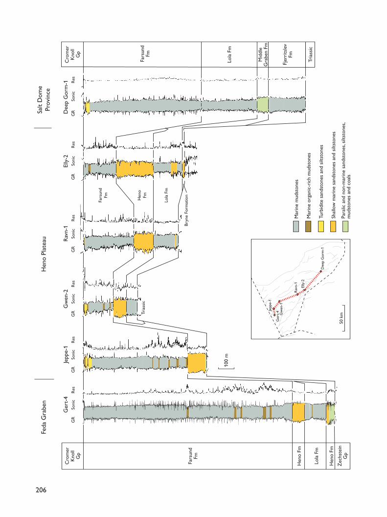
206
100
m
Dee
p G
orm
-1El
ly-2
Rav
n-1
Gw
en-2
Jepp
e-1
Ger
t-4
1
Cro
mer
Kno
llG
p
Fars
und
Fm
Fars
und
Fm
Hen
o Fm
Hen
o Fm
Lola
Fm
Tria
ssic
Lola
Fm
Fars
und
Fm
Bryn
e Fo
rmat
ion
Hen
oFm
Lola
Fm
Fjer
rits
lev
Fm
Mid
dle
Gra
ben
Fm
Tria
ssic
Cro
mer
Kno
llG
p
Zec
hste
inG
p
Mar
ine
mud
ston
es
Mar
ine
orga
nic-
rich
mud
ston
es
Turb
idite
san
dsto
nes
and
silts
tone
s
Shal
low
mar
ine
sand
ston
es a
nd s
iltst
ones
Para
lic a
nd n
on-m
arin
e sa
ndst
ones
, silt
ston
es,
mud
ston
es a
nd c
oals
50 k
m
Dee
p G
orm
-1
Elly
-2
Rav
n-1
Gw
en-1
Jepp
e-1
Ger
t-4
Feda
Gra
ben
Hen
o Pl
atea
uSa
lt D
ome
Prov
ince
GR
Soni
cR
esG
RSo
nic
Res
GR
Soni
cR
esG
RSo
nic
Res
GR
Soni
cR
esG
RSo
nic
Res
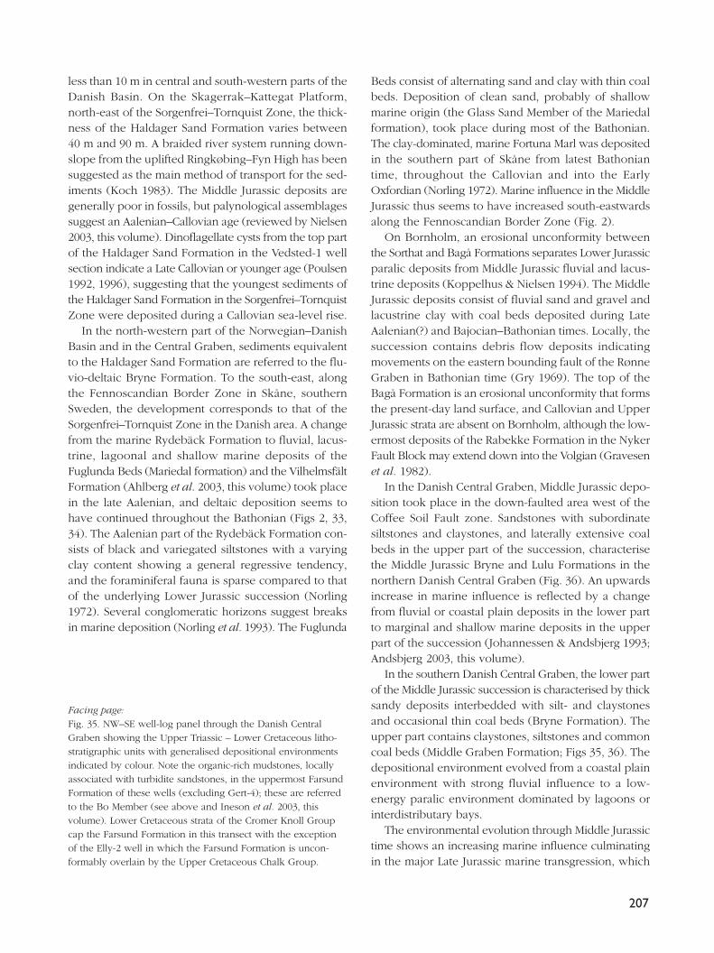
less than 10 m in central and south-western parts of theDanish Basin. On the Skagerrak–Kattegat Platform,north-east of the Sorgenfrei–Tornquist Zone, the thick-ness of the Haldager Sand Formation varies between40 m and 90 m. A braided river system running down-slope from the uplifted Ringkøbing–Fyn High has beensuggested as the main method of transport for the sed-iments (Koch 1983). The Middle Jurassic deposits aregenerally poor in fossils, but palynological assemblagessuggest an Aalenian–Callovian age (reviewed by Nielsen2003, this volume). Dinoflagellate cysts from the top partof the Haldager Sand Formation in the Vedsted-1 wellsection indicate a Late Callovian or younger age (Poulsen1992, 1996), suggesting that the youngest sediments ofthe Haldager Sand Formation in the Sorgenfrei–TornquistZone were deposited during a Callovian sea-level rise.
In the north-western part of the Norwegian–DanishBasin and in the Central Graben, sediments equivalentto the Haldager Sand Formation are referred to the flu-vio-deltaic Bryne Formation. To the south-east, alongthe Fennoscandian Border Zone in Skåne, southernSweden, the development corresponds to that of theSorgenfrei–Tornquist Zone in the Danish area. A changefrom the marine Rydebäck Formation to fluvial, lacus-trine, lagoonal and shallow marine deposits of theFuglunda Beds (Mariedal formation) and the VilhelmsfältFormation (Ahlberg et al. 2003, this volume) took placein the late Aalenian, and deltaic deposition seems tohave continued throughout the Bathonian (Figs 2, 33,34). The Aalenian part of the Rydebäck Formation con-sists of black and variegated siltstones with a varyingclay content showing a general regressive tendency,and the foraminiferal fauna is sparse compared to thatof the underlying Lower Jurassic succession (Norling1972). Several conglomeratic horizons suggest breaksin marine deposition (Norling et al. 1993). The Fuglunda
Beds consist of alternating sand and clay with thin coalbeds. Deposition of clean sand, probably of shallowmarine origin (the Glass Sand Member of the Mariedalformation), took place during most of the Bathonian.The clay-dominated, marine Fortuna Marl was depositedin the southern part of Skåne from latest Bathoniantime, throughout the Callovian and into the EarlyOxfordian (Norling 1972). Marine influence in the MiddleJurassic thus seems to have increased south-eastwardsalong the Fennoscandian Border Zone (Fig. 2).
On Bornholm, an erosional unconformity betweenthe Sorthat and Bagå Formations separates Lower Jurassicparalic deposits from Middle Jurassic fluvial and lacus-trine deposits (Koppelhus & Nielsen 1994). The MiddleJurassic deposits consist of fluvial sand and gravel andlacustrine clay with coal beds deposited during LateAalenian(?) and Bajocian–Bathonian times. Locally, thesuccession contains debris flow deposits indicatingmovements on the eastern bounding fault of the RønneGraben in Bathonian time (Gry 1969). The top of theBagå Formation is an erosional unconformity that formsthe present-day land surface, and Callovian and UpperJurassic strata are absent on Bornholm, although the low-ermost deposits of the Rabekke Formation in the NykerFault Block may extend down into the Volgian (Gravesenet al. 1982).
In the Danish Central Graben, Middle Jurassic depo-sition took place in the down-faulted area west of theCoffee Soil Fault zone. Sandstones with subordinatesiltstones and claystones, and laterally extensive coalbeds in the upper part of the succession, characterisethe Middle Jurassic Bryne and Lulu Formations in thenorthern Danish Central Graben (Fig. 36). An upwardsincrease in marine influence is reflected by a changefrom fluvial or coastal plain deposits in the lower partto marginal and shallow marine deposits in the upperpart of the succession (Johannessen & Andsbjerg 1993;Andsbjerg 2003, this volume).
In the southern Danish Central Graben, the lower partof the Middle Jurassic succession is characterised by thicksandy deposits interbedded with silt- and claystonesand occasional thin coal beds (Bryne Formation). Theupper part contains claystones, siltstones and commoncoal beds (Middle Graben Formation; Figs 35, 36). Thedepositional environment evolved from a coastal plainenvironment with strong fluvial influence to a low-energy paralic environment dominated by lagoons orinterdistributary bays.
The environmental evolution through Middle Jurassictime shows an increasing marine influence culminatingin the major Late Jurassic marine transgression, which
207
Facing page:Fig. 35. NW–SE well-log panel through the Danish CentralGraben showing the Upper Triassic – Lower Cretaceous litho-stratigraphic units with generalised depositional environmentsindicated by colour. Note the organic-rich mudstones, locallyassociated with turbidite sandstones, in the uppermost FarsundFormation of these wells (excluding Gert-4); these are referredto the Bo Member (see above and Ineson et al. 2003, thisvolume). Lower Cretaceous strata of the Cromer Knoll Groupcap the Farsund Formation in this transect with the exceptionof the Elly-2 well in which the Farsund Formation is uncon-formably overlain by the Upper Cretaceous Chalk Group.
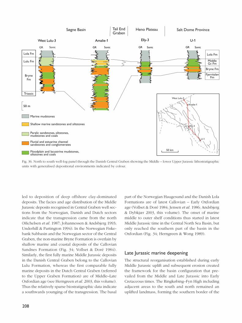
led to deposition of deep offshore clay-dominateddeposits. The facies and age distribution of the MiddleJurassic deposits recognised in Central Graben well sec-tions from the Norwegian, Danish and Dutch sectorsindicate that the transgression came from the north(Michelsen et al. 1987; Johannessen & Andsbjerg 1993;Underhill & Partington 1994). In the Norwegian Fiske-bank Subbasin and the Norwegian sector of the CentralGraben, the non-marine Bryne Formation is overlain byshallow marine and coastal deposits of the CallovianSandnes Formation (Fig. 34; Vollset & Doré 1984).Similarly, the first fully marine Middle Jurassic depositsin the Danish Central Graben belong to the CallovianLulu Formation, whereas the first comparable fullymarine deposits in the Dutch Central Graben (referredto the Upper Graben Formation) are of Middle–LateOxfordian age (see Herngreen et al. 2003, this volume).Thus the relatively sparse biostratigraphic data indicatea southwards younging of the transgression. The basal
part of the Norwegian Haugesund and the Danish LolaFormations are of latest Callovian – Early Oxfordianage (Vollset & Doré 1984; Jensen et al. 1986; Andsbjerg& Dybkjær 2003, this volume). The onset of marinemiddle to outer shelf conditions thus started in latestMiddle Jurassic time in the Central North Sea Basin, butonly reached the southern part of the basin in theOxfordian (Fig. 34; Herngreen & Wong 1989).
Late Jurassic marine deepeningThe structural reorganisation established during earlyMiddle Jurassic uplift and subsequent erosion createdthe framework for the basin configuration that pre-vailed from the Middle and Late Jurassic into EarlyCretaceous times. The Ringkøbing–Fyn High includingadjacent areas to the south and north remained anuplifted landmass, forming the southern border of the
208
50 m
West Lulu-3
MiddleGr. Fm
FjerritslevFm
Bryne Fm
Lola Fm
SonicGR
Amalie-1 Elly-3 U-1
Sonic SonicGR GR SonicGR
Lola Fm
Lulu Fm
BryneFm
Triassic
Søgne Basin Tail EndGraben
Heno Plateau Salt Dome Province
Marine mudstones
Shallow marine sandstones and siltstones
Paralic sandstones, siltstones,mudstones and coals
Fluvial and estuarine channelsandstones and conglomerates
Floodplain and lacustrine mudstones,siltstones and coals
50 km
U-1
Elly-3
Amalie-1
West Lulu-3
Fig. 36. North to south well-log panel through the Danish Central Graben showing the Middle – lower Upper Jurassic lithostratigraphicunits with generalised depositional environments indicated by colour.
Danish Basin. The landmass was submerged late in theEarly Cretaceous. The Fennoscandian Border Zone andthe easternmost part of the basin acted as a broad tran-sition zone characterised by shallow marine to paralicor non-marine deposition during repeated transgres-sive–regressive cycles. These environmental conditionslasted into the earliest Early Cretaceous, when theywere succeeded by deeper marine conditions.
The initial shallow marine conditions represented bythe uppermost, probably Callovian part of the HaldagerSand Formation were succeeded by transgressive, par-alic to marine deposition (Flyvbjerg Formation) in theOxfordian. Dinoflagellate cysts from the lowermost partof the Flyvbjerg Formation in wells located in theSorgenfrei–Tornquist Zone and in a well in the centralpart of the Danish Basin suggest an Early–MiddleOxfordian age and a marine origin for the basal part ofthe formation (Poulsen 1992, 1996). The transition fromthe shallow marine, regressive deposits of the upper-most part of the Flyvbjerg Formation to the transgres-sive, deeper marine deposits of the Børglum Formationseems to be of earliest Kimmeridgian age in the DanishBasin and of Late Kimmeridgian age in the Fenno-scandian Border Zone, thus demonstrating a north-east-wards younging (Poulsen 1992, 1996) and recording thegradual transgression of the basin margin. The deep-ening represented by the Børglum Formation lastedfrom the earliest Kimmeridgian to the Middle Volgianin the Danish Basin. A regressive development followedwith deposition of coarser sediments in most of thebasin. In the Fennoscandian Border Zone, two–threecoarsening-upwards successions with shallow marinesilt and sand beds alternating with transgressive clayswere deposited during the Volgian–Ryazanian (Frederiks-havn Formation; Figs 30–32). Farther to the north-west,in the Norwegian– Danish Basin, a nearly time-equiv-alent succession of sedimentary rocks is referred, instratigraphic order, to the Egersund, Tau and SaudaFormations (Vollset & Doré 1984).
To the south-east, in Skåne, the lacustrine and la-goonal variegated claystones and siltstones of the Fyle-dal Clay were deposited during the Oxfordian and earlyKimmeridgian, succeeded by prograding coastal plaindeposits of the Nytorp Sand (Norling et al. 1993; Ahlberget al. 2003, this volume). The Jurassic–Cretaceous tran-sitional beds of the Vitabäck Clays are again dominatedby brackish to freshwater deposits showing some marineinfluence.
The connection between the Central European basinsand the Danish Basin along the Fennoscandian BorderZone was characterised by increased marine influence
(Fortuna Marl) during the Callovian (Fig. 34). DuringLate Jurassic time, marine communication between theDanish Basin and the North German Basin was mainlythrough the Central Graben, but a connection was peri-odically established through the Sorgenfrei–TornquistZone (Christensen & Kilenyi 1970). The environmentchanged to mainly brackish water, while open marineconditions dominated in the Danish Basin. However,repeated regressive–transgressive events are recordedin Skåne and in northernmost Jylland. Precise strati-graphic correlation between these two areas is not yetpossible due to scarce biostratigraphic data. Callovian–Kimmeridgian deposits are absent on Bornholm and inthe Rønne Graben. The ?Volgian– Valanginian Rabekke,Robbedale and Jydegård Formations (Fig. 2), preservedeast of the Rønne Graben, show a broadly transgres-sive development, probably reflecting the overall EarlyCretaceous transgression in Northwest Europe.
Late Jurassic graben development and sedimentationOnset of the main rifting following the Middle Jurassicuplift of the central North Sea Basin led to rapid sub-sidence of the Central Graben. Fault activity along theCoffee Soil Fault continued from Middle Jurassic throughLate Jurassic times. The Central Graben was developedas a major half-graben, which became compartmen-talised into a number of minor grabens and highs dur-ing the Late Jurassic (Møller 1986; Japsen et al. 2003,this volume; Møller & Rasmussen 2003, this volume).Up to 4000 m of clay-dominated sediments were depo-sited in the Tail End Graben to the east during the LateJurassic (Møller 1986; Michelsen et al. 1992).
The marine middle–outer shelf conditions whichwere established in latest Callovian time in the DanishCentral Graben continued during the Late Jurassic over-all sea-level rise. The Central Graben region was prob-ably connected with the Danish Basin during most ofthe Late Jurassic through the north-western part of theNorwegian–Danish Basin, north of the Ringkøbing–FynHigh. The sedimentary facies of the Central Graben dif-fer markedly from those of the Norwegian–Danish Basin,and none of the formations known from the DanishBasin can be traced to the Central Graben. These dif-ferences probably resulted from varying distances to thesource areas and from differences in structural evolu-tion.
Deposition of offshore muds of the Lola Formationin the eastern part of the Central Graben continued
209
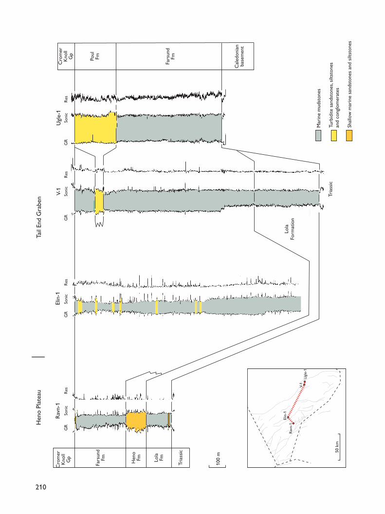
210
Fars
und
Fm Lola
FmHen
oFm
Tria
ssic
100
m
Fars
und
FmPoul
Fm
Cal
edon
ian
base
men
t
Cro
mer
Kno
llG
p
Cro
mer
Kno
llG
p
Tria
ssic
Lola
Form
atio
n
Hen
o Pl
atea
uTa
il En
d G
rabe
n
Elin
-1V-
1R
avn-
1U
gle-
1G
RSo
nic
Res
GR
Soni
cR
esG
RSo
nic
Res
GR
Soni
cR
es
Mar
ine
mud
ston
es
Turb
idite
san
dsto
nes,
silts
tone
san
d co
nglo
mer
ates
Shal
low
mar
ine
sand
ston
es a
nd s
iltst
ones
50 k
m
Elin
-1
V-1
Ugl
e-1
Rav
n-1
from the latest Callovian, and onlapped westwards ontothe Heno Plateau during the Oxfordian–Kimmeridgian(Fig. 35; Michelsen et al. 1992; Johannessen & Andsbjerg1993; Andsbjerg & Dybkjær 2003, this volume). Thin shal-low marine sands were deposited at the western mar-gin of the basin during deposition of the Lola Formation.This indicates that the sea transgressed westwards andup-dip from the eastern part of the Danish CentralGraben. Deposition of offshore muds of the LolaFormation on the Heno Plateau was succeeded byshoreface sands of the Heno Formation during the lat-est Early – Late Kimmeridgian (Figs 35, 37; Andsbjerg& Dybkjær 2003, this volume; Johannessen 2003, thisvolume). Shallow marine and back-barrier sediments ofthe Heno Formation were also deposited on the GertrudPlateau and in the southern Feda Graben. Rapid sub-sidence of the individual basins of the Central Grabentook place during latest Kimmeridgian time with anincreased rate in the Early Volgian. Deposition of off-shore muds dominated the entire graben area duringlatest Kimmeridgian – Volgian times, periodically witha significant increase in the content of organic matteras seen in the lower part of the Farsund Formation inthe Feda Graben and Heno Plateau (Fig. 35; Damtoftet al. 1992). Locally, coarse-grained sediments depositedfrom sediment gravity flows (Poul Formation) interfin-ger with the claystones of the Farsund Formation adja-cent to active fault zones (Fig. 37). The subsidence ratesseem to have decreased in the latter part of the Volgian,and during the Late Volgian – Early Ryazanian, the high-ly radioactive Bo Member developed as a part of theFarsund Formation. Deposition of the organic-rich mudswas governed by stratification of the water column,poor circulation, sea-level changes and reduced sedimentinflux (Ineson et al. 2003, this volume).
The Norwegian sector of the Central Graben devel-oped in a similar way to that described for the Danishpart. The Callovian – Early Volgian clay deposits are in-
cluded in the Haugesund Formation (Fig. 34), whichdiffers from the partly time-equivalent Lola Formationin containing a number of thin sandstone beds and byforming an overall coarsening-upwards cycle (Vollset& Doré 1984; see discussion in Forsberg et al. 1993).The overlying Farsund Formation is widely distributednorth of the Danish sector. In the western part of thegraben, a sand-dominated turbidite succession ofKimmeridgian age (Eldfisk Formation) forms a wedgebetween the Haugesund and Farsund Formations. Inthe Norwegian sector, the Farsund Formation is alsocapped by an organic-rich mudstone, named the MandalFormation (Fig. 34).
To the south, in the Dutch sector, the Callovian –Upper Oxfordian Lower, Middle and Upper GrabenFormations (terrestrial–paralic) of the Dutch North Seaarea are succeeded, with some overlap, by the UpperOxfordian – Kimmeridgian Puzzle Hole Formation(lower delta plain deposits), indicating a northwards shiftof the coastline during the Middle Oxfordian (Fig. 34;NAM & RGD 1980; Herngreen & Wong 1989; vanAdrichem Boogaert & Kouwe 1994; Herngreen et al.2003, this volume). Transgression was again initiated inthe Late Oxfordian, as indicated by the southwardsonlap by the deeper marine Kimmeridge Clay Formation(equivalent to the Lola and Farsund Formations) ontothe shallow marine deposits. To the south, a barriersand complex (the Volgian–Ryazanian Scruff GreensandFormation) seems to have been partly reworked intotransgressive sheet sands overstepping the graben mar-gins (Herngreen & Wong 1989). At the Jurassic–Cretaceous transition, anoxic conditions (Clay DeepMember) prevailed in the northern part of the DutchNorth Sea area.
AcknowledgementsThe referees G.F. Waldemar Herngreen and Gunver K.Pedersen and the editor Jon R. Ineson are thanked formany valuable suggestions. F.S. acknowledges the sup-port of the Danish Natural Science Research Foundation;L.H.N. and F.S. acknowledge the use of Gravgærde, thefield station of the University of Copenhagen on theisland of Bornholm.
211
Facing page:Fig. 37. West–east well-log panel from the Danish CentralGraben showing Middle/Upper Jurassic – Lower Cretaceouslithostratigraphic units with generalised depositional environ-ments indicated by colour. Note the thin development oforganic-rich mudstones (Bo Member) in the uppermost FarsundFormation of the Ravn-1 well; this member is not recognised inthe V-1 and Ugle-1 wells close to the eastern flank of theCentral Graben and is thick but only weakly developed in theElin-1 well (see Ineson et al. 2003, this volume).
212
ReferencesAhlberg, A., Sivhed, U. & Erlström, M. 2003: The Jurassic of Skåne,
southern Sweden. In: Ineson, J.R. & Surlyk, F. (eds): TheJurassic of Denmark and Greenland. Geological Survey ofDenmark and Greenland Bulletin 1, 527–541 (this volume).
Andsbjerg, J. 1997: Sedimentology and sequence stratigraphy ofMiddle Jurassic deposits. Danish and Norwegian CentralGraben, 172 pp. Unpublished Ph.D. thesis, University ofCopenhagen, Denmark.
Andsbjerg, J. 2003: Sedimentology and sequence stratigraphy ofthe Bryne and Lulu Formations, Middle Jurassic, northernDanish Central Graben. In: Ineson, J.R. & Surlyk, F. (eds): TheJurassic of Denmark and Greenland. Geological Survey ofDenmark and Greenland Bulletin 1, 301–347 (this volume).
Andsbjerg, J. & Dybkjær, K. 2003: Sequence stratigraphy of theJurassic of the Danish Central Graben. In: Ineson, J.R. & Surlyk,F. (eds): The Jurassic of Denmark and Greenland. GeologicalSurvey of Denmark and Greenland Bulletin 1, 265–300 (thisvolume).
Andsbjerg, J., Nielsen, L.H., Johannessen, P.N. & Dybkjær, K.2001: Divergent development of two neighbouring basins fol-lowing the Jurassic North Sea doming event: the Danish CentralGraben and the Norwegian–Danish Basin. In: Martinsen, O.J.& Dreyer, T. (eds): Sedimentary environments offshore Norway– Palaeozoic to Recent. Norwegian Petroleum Society (NPF)Special Publication 10, 175–197.
Baartman, J.C. & Christensen, O.B. 1975: Contributions to the inter-pretation of the Fennoscandian Border Zone. DanmarksGeologiske Undersøgelse II. Række 102, 47 pp.
Bartholin, C.T. 1892: Nogle i den bornholmske Jura formationforekommende planteforsteninger. Botanisk Tidsskrift 18,12–28.
Bartholin, C.T. 1894: Nogle i den bornholmske Jura formationforekommende planteforsteninger. Botanisk Tidsskrift 19,87–115.
Batten, D.J., Koppelhus, E.B. & Nielsen, L.H. 1994: UppermostTriassic to Middle Jurassic palynofacies and palynomiscel-lanea in the Danish Basin and Fennoscandian Border Zone.Cahiers de Micropaléontologie 9, 21–45.
Bergan, M., Tørudbakken, B. & Wandås, B. 1989: Lithostratigraphiccorrelation of Upper Jurassic sandstones within the NorwegianCentral Graben: sedimentological and tectonic implications.In: Collinson, J.D. (ed.): Correlation in hydrocarbon exploration,243–251. London: Graham & Trotman for the NorwegianPetroleum Society (NPF).
Bertelsen, F. 1978: The Upper Triassic – Lower Jurassic Vindingand Gassum Formations of the Norwegian–Danish Basin. Dan-marks Geologiske Undersøgelse Serie B 3, 26 pp.
Bertelsen, F. 1980: Lithostratigraphy and depositional history ofthe Danish Triassic. Danmarks Geologiske Undersøgelse SerieB 4, 59 pp.
Birkelund, T. & Pedersen, G.K. 1980: Middle Volgian ammonitesand trace fossils from the Frederikshavn Member of the BreamFormation, northern Jutland. Danmarks Geologiske Under-søgelse Årbog 1979, 95–104.
Birkelund, T., Clausen, C.K., Hansen, H.N. & Holm, L. 1983: The
Hectoroceras kochi zone (Ryazanian) in the North Sea CentralGraben and remarks on the Late Cimmerian Unconformity.Danmarks Geologiske Undersøgelse Årbog 1982, 53–73.
Christensen, O.B. & Kilenyi, T.I. 1970: Ostracod biostratigraphyof the Kimmeridgian in northern and western Europe.Danmarks Geologiske Undersøgelse II. Række 95, 65 pp.
Damtoft, K., Nielsen, L.H., Johannessen, P.N., Thomsen, E. &Andersen, P.R. 1992: Hydrocarbon plays of the Danish CentralTrough. In: Spencer, A.M. (ed.): Generation, accumulationand production of Europe’s hydrocarbons II. EuropeanAssociation of Petroleum Geoscientists Special Publication 2,35–58.
Donovan, D.T. & Surlyk, F. 2003: Lower Jurassic (Pliensbachian)ammonites from Bornholm, Baltic Sea, Denmark. In: Ineson,J.R. & Surlyk, F. (eds): The Jurassic of Denmark and Greenland.Geological Survey of Denmark and Greenland Bulletin 1,555–583 (this volume).
Dybkjær, K. 1988: Palynological zonation and stratigraphy of theJurassic section in the Gassum No. 1-borehole, Denmark.Danmarks Geologiske Undersøgelse Serie A 21, 72 pp.
Dybkjær, K. 1991: Palynological zonation and palynofacies inves-tigation of the Fjerritslev Formation (Lower Jurassic – basalMiddle Jurassic) in the Danish Subbasin. Danmarks GeologiskeUndersøgelse Serie A 30, 150 pp.
Dybkjær, K. 1998: Palynological dating of the Mandal Formation(uppermost Jurassic – lowermost Cretaceous, NorwegianCentral Graben) and correlation to organic-rich shales in theDanish sector. Marine and Petroleum Geology 15, 495–503.
Erlström, M., Sivhed, U. & Surlyk, F. 1999: A backstepping fluvi-atile–paralic–marine succession, Sinemurian, Lower Jurassic,Skåne, southern Sweden. Bulletin of the Geological Societyof Denmark 46, 1–12.
EUGENO-S Working Group 1988: Crustal structure and tectonicevolution of the transition between the Baltic Shield and theNorth German Caledonides (the EUGENO-S Project). Tectono-physics 150, 253–348.
Forchhammer, J.G. 1837: Om de bornholmske Kulformationer.Det Kongelige Danske Videnskabernes Selskabs Skrifter. Natur-videnskabelig og Matematisk Afdeling 7, 64 pp.
Forsberg, A., Gowers, M.B. & Holtar, E. 1993: Multi-disciplinarystratigraphic analysis of the Upper Jurassic strata of theNorwegian Central Trough. In: Spencer, A.M. (ed.): Generation,accumulation and production of Europe’s hydrocarbons III.European Association of Petroleum Geoscientists SpecialPublication 3, 45–58.
Frandsen, N. & Surlyk, F. 2003: An offshore transgressive–regres-sive mudstone-dominated succession from the Sinemurian ofSkåne, Sweden. In: Ineson, J.R. & Surlyk, F. (eds): The Jurassicof Denmark and Greenland. Geological Survey of Denmarkand Greenland Bulletin 1, 543–554 (this volume).
Gowers, M.B. & Sæbøe, A. 1985: On the structural evolution ofthe Central Trough in the Norwegian and Danish sectors ofthe North Sea. Marine and Petroleum Geology 2, 298–318.
Gravesen, P., Rolle, F. & Surlyk, F. 1982: Lithostratigraphy andsedimentary evolution of the Triassic, Jurassic and LowerCretaceous of Bornholm, Denmark. Danmarks GeologiskeUndersøgelse Serie B 7, 51 pp.
213
Gregersen, A. & Sorgenfrei, T. 1951: Efterforskningsarbejdet iDanmarks dybere undergrund. Meddelelser fra DanskGeologisk Forening 12(1), 141–151.
Grönwall, K.A. 1899: Bemærkninger om Bornholms sedimen-tære Dannelser og deres tektoniske Forhold. DanmarksGeologiske Undersøgelse II. Række 10, 1–48.
Gry, H. 1969: Megaspores from the Jurassic of the island ofBornholm, Denmark. Meddelelser fra Dansk GeologiskForening 19, 69–89.
Hamann, N.-E. 1994: Den tektoniske udvikling af Rønne Graven– et seismisk studie, 136 pp. Unpublished Ph.D. thesis,University of Copenhagen, Denmark.
Hamberg, L. 1994: Anatomy of clastic coastal sequences in theRhaetian Gassum Formation, Stenlille, Denmark, 90 pp.Unpublished Ph.D. thesis, University of Copenhagen, Denmark.
Hamberg, L. & Nielsen, L.H. 2000: Shingled, sharp-based shorefacesandstones and the importance of stepwise forced regressionin a shallow basin, Upper Triassic Gassum Formation, Denmark.In: Hunt, D. & Gawthorpe, R.L. (eds): Sedimentary responsesto forced regressions. Geological Society Special Publication(London) 172, 69–89.
Heilmann-Clausen, C. 1987: Lower Cretaceous dinoflagellate bio-stratigraphy in the Danish Central Trough. Danmarks Geo-logiske Undersøgelse Serie A 17, 89 pp.
Herngreen, G.F.W. & Wong, T.E. 1989: Revision of the ‘LateJurassic’ stratigraphy of the Dutch Central North Sea Graben.Geologie en Mijnbouw 68, 73–105.
Herngreen, G.F.W., Kouwe, W.F.P. & Wong, T.E. 2003: The Jurassicof the Netherlands. In: Ineson, J.R. & Surlyk, F. (eds): TheJurassic of Denmark and Greenland. Geological Survey ofDenmark and Greenland Bulletin 1, 217–229 (this volume).
Hjort, A. 1899: Om Vellensbyleret og dets Flora. DanmarksGeologiske Undersøgelse II. Række 10, 61–86.
Hoelstad, T. 1985: Palynology of the uppermost Lower to MiddleJurassic strata on Bornholm, Denmark. Bulletin of theGeological Society of Denmark 34, 111–132.
Hoelstad, T. 1986a: Palynology of the Middle Jurassic LowerGraben Sand Formation of the U-1 well, Danish Central Trough.Danmarks Geologiske Undersøgelse Serie A 14, 25 pp.
Hoelstad, T. 1986b: Palynology and palynofacies analysis of theMiddle Jurassic to Lower Cretaceous in the Danish CentralTrough. DGU internal report 43, 25 pp. Copenhagen:Geological Survey of Denmark.
Höhne, R. 1933: Beiträge zur Stratigraphie, Tektonik undPaläogeographie des südbaltischen Rhät-Lias, insbesondereauf Bornholm. Abhandlungen aus dem geologisch-palaeon-tologischen Institut Greifswald Heft 12, 31–70.
Ineson, J.R., Bojesen-Koefoed, J.A., Dybkjær, K. & Nielsen, L.H.2003: Volgian–Ryazanian ‘hot shales’ of the Bo Member(Farsund Formation) in the Danish Central Graben, North Sea:stratigraphy, facies and geochemistry. In: Ineson, J.R. & Surlyk,F. (eds): The Jurassic of Denmark and Greenland. GeologicalSurvey of Denmark and Greenland Bulletin 1, 403–436 (thisvolume).
Japsen, P., Britze, P. & Andersen, C. 2003: Upper Jurassic – LowerCretaceous of the Danish Central Graben: structural frameworkand nomenclature. In: Ineson, J.R. & Surlyk, F. (eds): The
Jurassic of Denmark and Greenland. Geological Survey ofDenmark and Greenland Bulletin 1, 233–246 (this volume).
Jensen, J.B. & Hamann, N.E. 1989: Geological mapping of Mesozoicdeposits along the eastern margin of the Rønne Graben, off-shore Bornholm, Denmark. Bulletin of the Geological Societyof Denmark 37, 237–260.
Jensen, T.F., Holm, L., Frandsen, N. & Michelsen, O. 1986: Jurassic– Lower Cretaceous lithostratigraphic nomenclature for theDanish Central Trough. Danmarks Geologiske UndersøgelseSerie A 12, 65 pp.
Jespersen, M. 1866: En skitse af Sorthats Kulværk på Bornholm.Indbydelsesskrift til de offentlige Examina i Rønne HøjereRealskole, 5–38.
Jespersen, M. 1869: Bidrag til Bornholms geoteknik. II. De geo-tekniske forhold i Knudskerplateauets omegn. NaturhistoriskTidsskrift 3. Række 6, 1–48.
Johannessen, P.N. 1995: Genetic stratigraphy of shallow marineand paralic deposits: Upper Jurassic, Danish Central Graben;Upper Cretaceous, San Juan Basin, New Mexico; and LowerJurassic, Bornholm, Baltic Sea 1–4, 107 pp. (parts paginatedseparately). Unpublished Ph.D. thesis, University of Copen-hagen, Denmark.
Johannessen, P.N. 1997: Upper Jurassic, back-barrier and shorefacereservoir sandstones and thin turbidite sandstones in theDanish Central Trough, North Sea. In: Oakman, C.D., Martin,J.H. & Corbett, P.W.M. (eds): Cores from the NorthwestEuropean hydrocarbon province: an illustration of geologicalapplications from exploration to development, 11–22. London:Geological Society.
Johannessen, P.N. 2003: Sedimentology and sequence stratigra-phy of paralic and shallow marine Upper Jurassic sandstonesin the northern Danish Central Graben. In: Ineson, J.R. &Surlyk, F. (eds): The Jurassic of Denmark and Greenland.Geological Survey of Denmark and Greenland Bulletin 1,367–402 (this volume).
Johannessen, P.N. & Andsbjerg, J. 1993: Middle to Late Jurassicbasin evolution and sandstone reservoir distribution in theDanish Central Trough. In: Parker, J.R. (ed.): Petroleum geol-ogy of Northwest Europe: proceedings of the 4th conference,271–283. London: Geological Society.
Johannessen, P.N., Dybkjær, K. & Rasmussen, E.S. 1996: Sequencestratigraphy of Upper Jurassic reservoir sandstones in thenorthern part of the Danish Central Trough, North Sea. Marineand Petroleum Geology 13, 755–770.
Klingspor, I. 1976: Radiometric age-determinations of basalts,dolerites and related syenite in Skåne, southern Sweden.Geologiska Föreningens i Stockholm Förhandlingar 98,195–216.
Koch, J.-O. 1983: Sedimentology of Middle and Upper Jurassicsandstone reservoirs of Denmark. Geologie en Mijnbouw 62,115–129.
Koch, J.-O., Holm, L. & Michelsen, O. 1982: Jurassic. In: Michelsen,O. (ed.): Geology of the Danish Central Graben. DanmarksGeologiske Undersøgelse Serie B 8, 37–45.
Koppelhus, E.B. 1988: Catalogue of spores and pollen from theLower–Middle Jurassic Bagå Formation on Bornholm, Denmark.DGU confidential report 21, 42 pp. Copenhagen: Geological
214
Survey of Denmark.Koppelhus, E.B. 1991: Palynology of the Lower Jurassic Rønne
Formation on Bornholm, eastern Denmark. Bulletin of theGeological Society of Denmark 39, 91–109.
Koppelhus, E.B. & Batten, D.J. 1992: Megaspore assemblagesfrom the Jurassic and lowermost Cretaceous of Bornholm,Denmark. Danmarks Geologiske Undersøgelse Serie A 32,81 pp.
Koppelhus, E.B. & Nielsen, L.H. 1994: Palynostratigraphy andpalaeoenvironments of the Lower to Middle Jurassic BagåFormation of Bornholm, Denmark. Palynology 18, 139–194.
Larsen, G. 1966: Rhaetic – Jurassic – Lower Cretaceous sedimentsin the Danish Embayment (a heavy-mineral study). DanmarksGeologiske Undersøgelse II. Række 91, 127 pp.
Larsen, G., Christensen, O.B., Bang, I. & Buch, A. 1968: Øresund.Helsingør–Hälsingborg Linien. Geologisk rapport. DanmarksGeologiske Undersøgelse Rapport 1, 90 pp. + table volume(summary in English).
Liboriussen, J., Ashton, P. & Tygesen, T. 1987: The tectonic evo-lution of the Fennoscandian Border Zone in Denmark. In:Ziegler, P.A. (ed.): Compressional intra-plate deformations inthe Alpine Foreland. Tectonophysics 137, 21–29.
Mackertich, D. 1996: The Fife Field, UK Central North Sea.Petroleum Geoscience 2, 373–380.
Malling, C. 1911: Hasle-Sandstenens alder. Meddelelser fra DanskGeologisk Forening 3, 629–631.
Malling, C. 1914: De Jespersenske Buelag i Lias paa Bornholm.Meddelelser fra Dansk Geologisk Forening 4, 265–270.
Malling, C. 1920: Den marine Lias og Wealden-Aflejringer paaBornholm. Meddelelser fra Dansk Geologisk Forening 5,55–57.
Malling, C. & Grönwall, K.A. 1909: En Fauna i Bornholms Lias.Meddelelser fra Dansk Geologisk Forening 3, 271–316.
Meinhold, R., Unger, E. & Wienholz, R. 1960: Neue Erkenntnisseüber den prätertiären Untergrund des Flachlandgebietes derDeutschen Demokratischen Republik. International GeologicalCongress, 21st session, Norden 11, 87–100.
Michelsen, O. 1975: Lower Jurassic biostratigraphy and ostracodsof the Danish Embayment. Danmarks Geologiske UndersøgelseII. Række 104, 287 pp.
Michelsen, O. 1978a: Stratigraphy and distribution of Jurassicdeposits of the Norwegian–Danish Basin. Danmarks GeologiskeUndersøgelse Serie B 2, 28 pp.
Michelsen, O. 1978b: The Lower Jurassic of the Dansk NordsøO-1 boring, Central Trough. Danmarks Geologiske Under-søgelse Årbog 1977, 77–89.
Michelsen, O. 1989a: Revision of the Jurassic lithostratigraphy ofthe Danish Subbasin. Danmarks Geologiske UndersøgelseSerie A 24, 21 pp.
Michelsen, O. 1989b: Log-sequence analysis and environmentalaspects of the Lower Jurassic Fjerritslev Formation in theDanish Subbasin. Danmarks Geologiske Undersøgelse SerieA 25, 23 pp.
Michelsen, O. & Nielsen, L.H. 1991: Well records on the Phan-erozoic stratigraphy in the Fennoscandian Border Zone,Denmark. Hans-1, Sæby-1, and Terne-1 wells. DanmarksGeologiske Undersøgelse Serie A 29, 37 pp.
Michelsen, O. & Nielsen, L.H. 1993: Structural development ofthe Fennoscandian Border Zone, offshore Denmark. Marineand Petroleum Geology 10, 124–134.
Michelsen, O. & Wong, T.E. 1991: Discussion of Jurassic litho-stratigraphy in the Danish, Dutch and Norwegian CentralGraben areas. In: Michelsen, O. & Frandsen, N. (eds): TheJurassic in the southern Central Trough. Danmarks GeologiskeUndersøgelse Serie B 16, 20–28.
Michelsen, O., Frandsen, N., Holm, L., Jensen, T.F., Møller, J.J.& Vejbæk, O.V. 1987: Jurassic – Lower Cretaceous of theDanish Central Trough – depositional environments, tectonism,and reservoirs. Danmarks Geologiske Undersøgelse Serie A16, 45 pp.
Michelsen, O., Mogensen, T.E. & Korstgård, J.A. 1992: Pre-Cretaceous structural development of the Danish CentralTrough and its implications for the distribution of Jurassicsands. In: Larsen, R.M. et al. (eds): Structural and tectonicmodelling and its application to petroleum geology. NorwegianPetroleum Society (NPF) Special Publication 1, 495–506.
Mogensen, T.E. 1994: Palaeozoic structural development alongthe Tornquist Zone, Kattegat area, Denmark. In: Cloetingh, S.et al. (eds): Dynamics of extensional basin formation andinversion. Tectonophysics 240, 191–214.
Mogensen, T.E. 1996: Triassic and Jurassic structural develop-ment along the Tornquist Zone, Kattegat, Denmark. Tectono-physics 252, 197–220.
Mogensen, T.E. & Korstgård, J.A. 1993: Structural developmentand trap formation along the Børglum Fault, Tornquist Zone,Denmark, compared with the Painted Canyon Fault, SanAndreas Zone, USA. In: Spencer, A.M. (ed.): Generation, accu-mulation and production of Europe’s hydrocarbons III.European Association of Petroleum Geoscientists SpecialPublication 3, 89–97.
Mogensen, T.E. & Korstgård, J.A. 2003: Triassic and Jurassictranstension along part of the Sorgenfrei–Tornquist Zone inthe Danish Kattegat. In: Ineson, J.R. & Surlyk, F. (eds): TheJurassic of Denmark and Greenland. Geological Survey ofDenmark and Greenland Bulletin 1, 439–458 (this volume).
Møller, H. 1902: Bidrag till Bornholms Fossila Flora. Pteridofyter.Lunds Universitets Årsskrift 38 Afd. 2(5), 63 pp.
Møller, H. 1903: Bidrag till Bornholms Fossila Flora (Rhät och Lias).Gymnospermer. Kongeliga Svenska Vetenskabs-AkademiensHandlingar 36(6), 56 pp.
Møller, J.J. 1986: Seismic structural mapping of the Middle andUpper Jurassic in the Danish Central Trough. DanmarksGeologiske Undersøgelse Serie A 13, 37 pp.
Møller, J.J. & Rasmussen, E.S. 2003: Middle Jurassic – EarlyCretaceous rifting of the Danish Central Graben. In: Ineson,J.R. & Surlyk, F. (eds): The Jurassic of Denmark and Greenland.Geological Survey of Denmark and Greenland Bulletin 1,247–264 (this volume).
NAM & RGD 1980: Stratigraphic nomenclature of the Netherlands.Verhandelingen van het Koninklijk Nederlands Geologisch enMijnbouwkundig Genootschap 32, 77 pp. (NederlandseAardolie Maatschappij & Rijks Geologische Dienst).
Nielsen, L.H. 1987: Progress report 1.1.1988. Biostratigraphy andorganic geochemistry of the Mesozoic on Bornholm. DGU
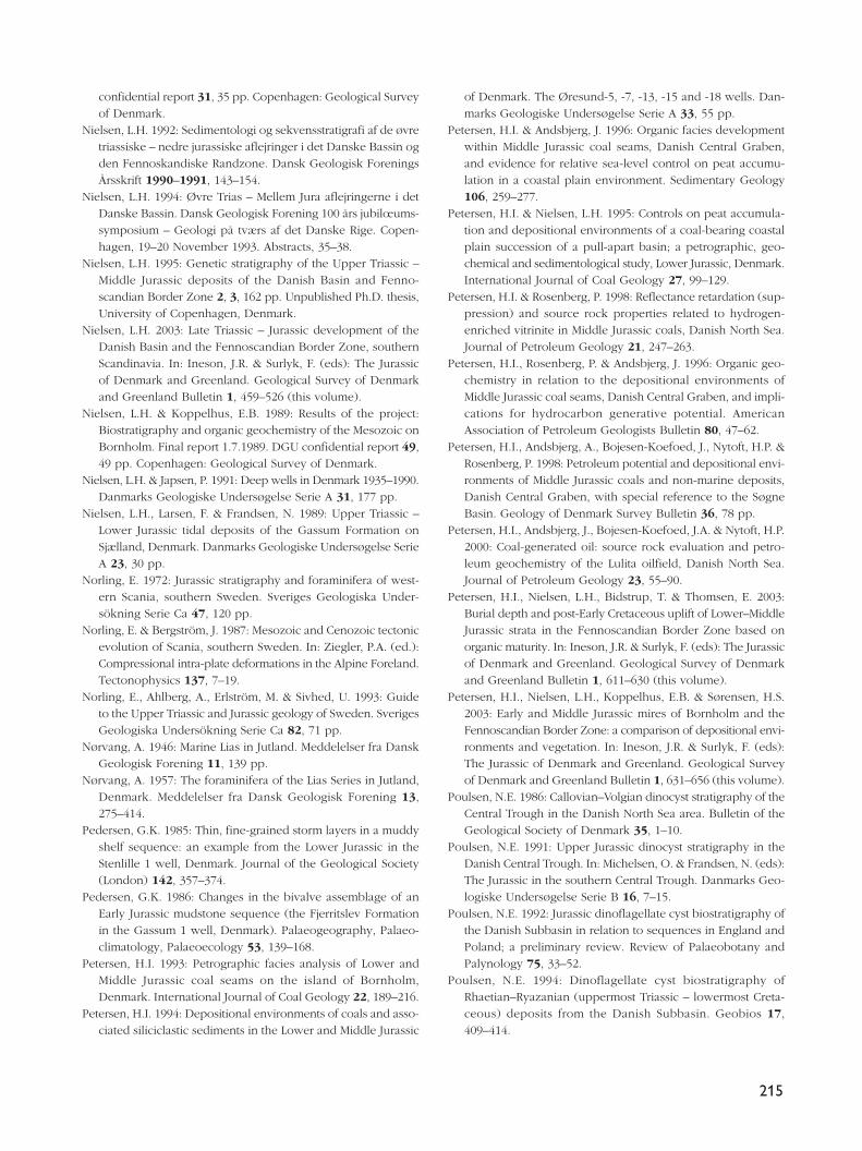
215
confidential report 31, 35 pp. Copenhagen: Geological Surveyof Denmark.
Nielsen, L.H. 1992: Sedimentologi og sekvensstratigrafi af de øvretriassiske – nedre jurassiske aflejringer i det Danske Bassin ogden Fennoskandiske Randzone. Dansk Geologisk ForeningsÅrsskrift 1990–1991, 143–154.
Nielsen, L.H. 1994: Øvre Trias – Mellem Jura aflejringerne i detDanske Bassin. Dansk Geologisk Forening 100 års jubilœums-symposium – Geologi på tværs af det Danske Rige. Copen-hagen, 19–20 November 1993. Abstracts, 35–38.
Nielsen, L.H. 1995: Genetic stratigraphy of the Upper Triassic –Middle Jurassic deposits of the Danish Basin and Fenno-scandian Border Zone 2, 3, 162 pp. Unpublished Ph.D. thesis,University of Copenhagen, Denmark.
Nielsen, L.H. 2003: Late Triassic – Jurassic development of theDanish Basin and the Fennoscandian Border Zone, southernScandinavia. In: Ineson, J.R. & Surlyk, F. (eds): The Jurassicof Denmark and Greenland. Geological Survey of Denmarkand Greenland Bulletin 1, 459–526 (this volume).
Nielsen, L.H. & Koppelhus, E.B. 1989: Results of the project:Biostratigraphy and organic geochemistry of the Mesozoic onBornholm. Final report 1.7.1989. DGU confidential report 49,49 pp. Copenhagen: Geological Survey of Denmark.
Nielsen, L.H. & Japsen, P. 1991: Deep wells in Denmark 1935–1990.Danmarks Geologiske Undersøgelse Serie A 31, 177 pp.
Nielsen, L.H., Larsen, F. & Frandsen, N. 1989: Upper Triassic –Lower Jurassic tidal deposits of the Gassum Formation onSjælland, Denmark. Danmarks Geologiske Undersøgelse SerieA 23, 30 pp.
Norling, E. 1972: Jurassic stratigraphy and foraminifera of west-ern Scania, southern Sweden. Sveriges Geologiska Under-sökning Serie Ca 47, 120 pp.
Norling, E. & Bergström, J. 1987: Mesozoic and Cenozoic tectonicevolution of Scania, southern Sweden. In: Ziegler, P.A. (ed.):Compressional intra-plate deformations in the Alpine Foreland.Tectonophysics 137, 7–19.
Norling, E., Ahlberg, A., Erlström, M. & Sivhed, U. 1993: Guideto the Upper Triassic and Jurassic geology of Sweden. SverigesGeologiska Undersökning Serie Ca 82, 71 pp.
Nørvang, A. 1946: Marine Lias in Jutland. Meddelelser fra DanskGeologisk Forening 11, 139 pp.
Nørvang, A. 1957: The foraminifera of the Lias Series in Jutland,Denmark. Meddelelser fra Dansk Geologisk Forening 13,275–414.
Pedersen, G.K. 1985: Thin, fine-grained storm layers in a muddyshelf sequence: an example from the Lower Jurassic in theStenlille 1 well, Denmark. Journal of the Geological Society(London) 142, 357–374.
Pedersen, G.K. 1986: Changes in the bivalve assemblage of anEarly Jurassic mudstone sequence (the Fjerritslev Formationin the Gassum 1 well, Denmark). Palaeogeography, Palaeo-climatology, Palaeoecology 53, 139–168.
Petersen, H.I. 1993: Petrographic facies analysis of Lower andMiddle Jurassic coal seams on the island of Bornholm,Denmark. International Journal of Coal Geology 22, 189–216.
Petersen, H.I. 1994: Depositional environments of coals and asso-ciated siliciclastic sediments in the Lower and Middle Jurassic
of Denmark. The Øresund-5, -7, -13, -15 and -18 wells. Dan-marks Geologiske Undersøgelse Serie A 33, 55 pp.
Petersen, H.I. & Andsbjerg, J. 1996: Organic facies developmentwithin Middle Jurassic coal seams, Danish Central Graben,and evidence for relative sea-level control on peat accumu-lation in a coastal plain environment. Sedimentary Geology106, 259–277.
Petersen, H.I. & Nielsen, L.H. 1995: Controls on peat accumula-tion and depositional environments of a coal-bearing coastalplain succession of a pull-apart basin; a petrographic, geo-chemical and sedimentological study, Lower Jurassic, Denmark.International Journal of Coal Geology 27, 99–129.
Petersen, H.I. & Rosenberg, P. 1998: Reflectance retardation (sup-pression) and source rock properties related to hydrogen-enriched vitrinite in Middle Jurassic coals, Danish North Sea.Journal of Petroleum Geology 21, 247–263.
Petersen, H.I., Rosenberg, P. & Andsbjerg, J. 1996: Organic geo-chemistry in relation to the depositional environments ofMiddle Jurassic coal seams, Danish Central Graben, and impli-cations for hydrocarbon generative potential. AmericanAssociation of Petroleum Geologists Bulletin 80, 47–62.
Petersen, H.I., Andsbjerg, A., Bojesen-Koefoed, J., Nytoft, H.P. &Rosenberg, P. 1998: Petroleum potential and depositional envi-ronments of Middle Jurassic coals and non-marine deposits,Danish Central Graben, with special reference to the SøgneBasin. Geology of Denmark Survey Bulletin 36, 78 pp.
Petersen, H.I., Andsbjerg, J., Bojesen-Koefoed, J.A. & Nytoft, H.P.2000: Coal-generated oil: source rock evaluation and petro-leum geochemistry of the Lulita oilfield, Danish North Sea.Journal of Petroleum Geology 23, 55–90.
Petersen, H.I., Nielsen, L.H., Bidstrup, T. & Thomsen, E. 2003:Burial depth and post-Early Cretaceous uplift of Lower–MiddleJurassic strata in the Fennoscandian Border Zone based onorganic maturity. In: Ineson, J.R. & Surlyk, F. (eds): The Jurassicof Denmark and Greenland. Geological Survey of Denmarkand Greenland Bulletin 1, 611–630 (this volume).
Petersen, H.I., Nielsen, L.H., Koppelhus, E.B. & Sørensen, H.S.2003: Early and Middle Jurassic mires of Bornholm and theFennoscandian Border Zone: a comparison of depositional envi-ronments and vegetation. In: Ineson, J.R. & Surlyk, F. (eds):The Jurassic of Denmark and Greenland. Geological Surveyof Denmark and Greenland Bulletin 1, 631–656 (this volume).
Poulsen, N.E. 1986: Callovian–Volgian dinocyst stratigraphy of theCentral Trough in the Danish North Sea area. Bulletin of theGeological Society of Denmark 35, 1–10.
Poulsen, N.E. 1991: Upper Jurassic dinocyst stratigraphy in theDanish Central Trough. In: Michelsen, O. & Frandsen, N. (eds):The Jurassic in the southern Central Trough. Danmarks Geo-logiske Undersøgelse Serie B 16, 7–15.
Poulsen, N.E. 1992: Jurassic dinoflagellate cyst biostratigraphy ofthe Danish Subbasin in relation to sequences in England andPoland; a preliminary review. Review of Palaeobotany andPalynology 75, 33–52.
Poulsen, N.E. 1994: Dinoflagellate cyst biostratigraphy ofRhaetian–Ryazanian (uppermost Triassic – lowermost Creta-ceous) deposits from the Danish Subbasin. Geobios 17,409–414.
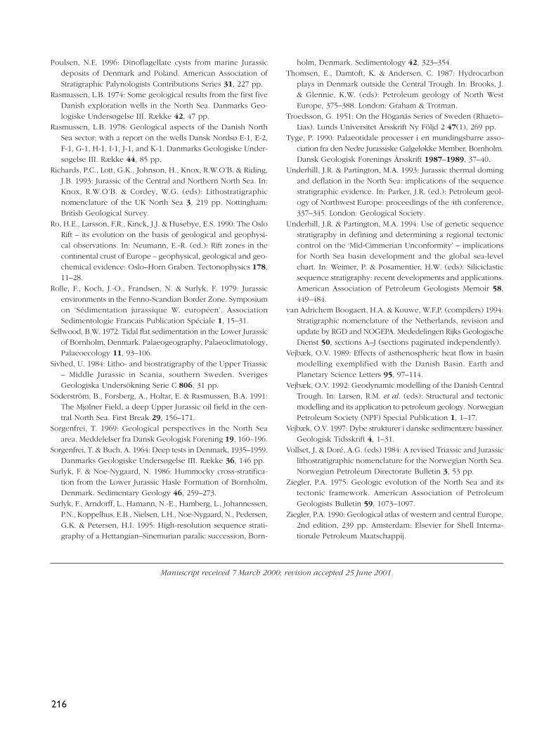
216
Poulsen, N.E. 1996: Dinoflagellate cysts from marine Jurassicdeposits of Denmark and Poland. American Association ofStratigraphic Palynologists Contributions Series 31, 227 pp.
Rasmussen, L.B. 1974: Some geological results from the first fiveDanish exploration wells in the North Sea. Danmarks Geo-logiske Undersøgelse III. Række 42, 47 pp.
Rasmussen, L.B. 1978: Geological aspects of the Danish NorthSea sector; with a report on the wells Dansk Nordsø E-1, E-2,F-1, G-1, H-1, I-1, J-1, and K-1. Danmarks Geologiske Under-søgelse III. Række 44, 85 pp.
Richards, P.C., Lott, G.K., Johnson, H., Knox, R.W.O’B. & Riding,J.B. 1993: Jurassic of the Central and Northern North Sea. In:Knox, R.W.O’B. & Cordey, W.G. (eds): Lithostratigraphicnomenclature of the UK North Sea 3, 219 pp. Nottingham:British Geological Survey.
Ro, H.E., Larsson, F.R., Kinck, J.J. & Husebye, E.S. 1990: The OsloRift – its evolution on the basis of geological and geophysi-cal observations. In: Neumann, E.-R. (ed.): Rift zones in thecontinental crust of Europe – geophysical, geological and geo-chemical evidence: Oslo–Horn Graben. Tectonophysics 178,11–28.
Rolle, F., Koch, J.-O., Frandsen, N. & Surlyk, F. 1979: Jurassicenvironments in the Fenno-Scandian Border Zone. Symposiumon ‘Sédimentation jurassique W. européen’. AssociationSedimentologie Francais Publication Spéciale 1, 15–31.
Sellwood, B.W. 1972: Tidal flat sedimentation in the Lower Jurassicof Bornholm, Denmark. Palaeogeography, Palaeoclimatology,Palaeoecology 11, 93–106.
Sivhed, U. 1984: Litho- and biostratigraphy of the Upper Triassic– Middle Jurassic in Scania, southern Sweden. SverigesGeologiska Undersökning Serie C 806, 31 pp.
Söderström, B., Forsberg, A., Holtar, E. & Rasmussen, B.A. 1991:The Mjølner Field, a deep Upper Jurassic oil field in the cen-tral North Sea. First Break 29, 156–171.
Sorgenfrei, T. 1969: Geological perspectives in the North Seaarea. Meddelelser fra Dansk Geologisk Forening 19, 160–196.
Sorgenfrei, T. & Buch, A. 1964: Deep tests in Denmark, 1935–1959.Danmarks Geologiske Undersøgelse III. Række 36, 146 pp.
Surlyk, F. & Noe-Nygaard, N. 1986: Hummocky cross-stratifica-tion from the Lower Jurassic Hasle Formation of Bornholm,Denmark. Sedimentary Geology 46, 259–273.
Surlyk, F., Arndorff, L., Hamann, N.-E., Hamberg, L., Johannessen,P.N., Koppelhus, E.B., Nielsen, L.H., Noe-Nygaard, N., Pedersen,G.K. & Petersen, H.I. 1995: High-resolution sequence strati-graphy of a Hettangian–Sinemurian paralic succession, Born-
holm, Denmark. Sedimentology 42, 323–354.Thomsen, E., Damtoft, K. & Andersen, C. 1987: Hydrocarbon
plays in Denmark outside the Central Trough. In: Brooks, J.& Glennie, K.W. (eds): Petroleum geology of North WestEurope, 375–388. London: Graham & Trotman.
Troedsson, G. 1951: On the Höganäs Series of Sweden (Rhaeto–Lias). Lunds Universitet Årsskrift Ny Följd 2 47(1), 269 pp.
Tyge, P. 1990: Palaeotidale processer i en mundingsbarre asso-ciation fra den Nedre Jurassiske Galgeløkke Member, Bornholm.Dansk Geologisk Forenings Årsskrift 1987–1989, 37–40.
Underhill, J.R. & Partington, M.A. 1993: Jurassic thermal domingand deflation in the North Sea: implications of the sequencestratigraphic evidence. In: Parker, J.R. (ed.): Petroleum geol-ogy of Northwest Europe: proceedings of the 4th conference,337–345. London: Geological Society.
Underhill, J.R. & Partington, M.A. 1994: Use of genetic sequencestratigraphy in defining and determining a regional tectoniccontrol on the ‘Mid-Cimmerian Unconformity’ – implicationsfor North Sea basin development and the global sea-levelchart. In: Weimer, P. & Posamentier, H.W. (eds): Siliciclasticsequence stratigraphy: recent developments and applications.American Association of Petroleum Geologists Memoir 58,449–484.
van Adrichem Boogaert, H.A. & Kouwe, W.F.P. (compilers) 1994:Stratigraphic nomenclature of the Netherlands, revision andupdate by RGD and NOGEPA. Mededelingen Rijks GeologischeDienst 50, sections A–J (sections paginated independently).
Vejbæk, O.V. 1989: Effects of asthenospheric heat flow in basinmodelling exemplified with the Danish Basin. Earth andPlanetary Science Letters 95, 97–114.
Vejbæk, O.V. 1992: Geodynamic modelling of the Danish CentralTrough. In: Larsen, R.M. et al. (eds): Structural and tectonicmodelling and its application to petroleum geology. NorwegianPetroleum Society (NPF) Special Publication 1, 1–17.
Vejbæk, O.V. 1997: Dybe strukturer i danske sedimentære bassiner.Geologisk Tidsskrift 4, 1–31.
Vollset, J. & Doré, A.G. (eds) 1984: A revised Triassic and Jurassiclithostratigraphic nomenclature for the Norwegian North Sea.Norwegian Petroleum Directorate Bulletin 3, 53 pp.
Ziegler, P.A. 1975: Geologic evolution of the North Sea and itstectonic framework. American Association of PetroleumGeologists Bulletin 59, 1073–1097.
Ziegler, P.A. 1990: Geological atlas of western and central Europe,2nd edition, 239 pp. Amsterdam: Elsevier for Shell Interna-tionale Petroleum Maatschappij.
Manuscript received 7 March 2000; revision accepted 25 June 2001.