convention on migratory species - convention on
TRANSCRIPT

For reasons of economy, documents are printed in a limited number, and will not be distributed at the meeting.
Delegates are kindly requested to bring their copy to the meeting and not to request additional copies.
18th MEETING OF THE SCIENTIFIC COUNCIL
Bonn, Germany, 1-3 July 2014
Agenda Item 10.3.1
ECOLOGICAL NETWORKS:
CASE STUDIES, CHALLENGES AND LESSONS LEARNED
CMS
CONVENTION ON MIGRATORY SPECIES
Distribution: General UNEP/CMS/ScC18/Inf.10.3.1 30 May 2014 Original: English
Summary:
At COP10 Parties had requested the Secretariat to compile case
studies on ecological networks benefitting migratory species in
order to better guide decision-making on this subject matter at
COP11 (Resolution 10.3, paragraph 10). The document presented
here has been produced in-house by the Secretariat and covers
migratory species representative of different taxonomic groups and
groups related to major ecosystem types as requested by
Resolution 10.3. A draft Resolution which takes note of this
compilation of case studies can be found in document
UNEP/CMS/ScC18/Doc.10.3.
UNEP/CMS/ScC18/Inf.10.3.1
UNITED NATIONS ENVIRONMENT PROGRAMME - CONVENTION ON MIGRATORY SPECIES
Ecological Networks Case studies, challenges and lessons learned

UNEP/CMS/ScC18/Inf.10.3.1
1
Contents
Executive summary ................................................................................................................................. 3
Introduction ............................................................................................................................................ 6
How this report was compiled ................................................................................................................ 6
The evolution of the of ecological network concept .......................................................................... 7
Network design: tailoring strategies to different patterns of habitat use.................................... 12
Challenges and limitations ............................................................................................................ 14
Case studies - running, swimming, flying .............................................................................................. 17
1. The Selous - Niassa Wildlife Corridor: African Elephants and Wild Dogs .................................... 18
Game reserves, corridors and community involvement.................................................................... 18
2. Central Albertine Rift Protected Areas: Mountain Gorillas ......................................................... 27
Landscape-scale cooperation at the intersection of three countries ................................................ 27
3. The “Tridom” Landscape network: Forest Elephants and Western Lowland Gorillas ................. 35
Addressing multiple threats through an ecosystem-based approach .............................................. 35
4. The Kanchenjunga Conservation Area: Snow Leopards .............................................................. 45
Networking for a low-density, widely-dispersed species .................................................................. 45
5. The Mesoamerican Biological Corridor: Jaguars .......................................................................... 51
Using a charismatic “flagship” species to promote sustainable resource use .................................. 51
6. An International Protected Area for the Daurian steppe: Mongolian Gazelles ........................... 57
Catering for regular and irregular migratory movements over a wide area .................................... 57
7. A management plan for the Danube River Basin: Sturgeons ....................................................... 62
Tackling obstacles to migration throughout an entire river system ................................................. 62
8. The North Atlantic “Sister Sanctuary” partnership: Humpback Whales ...................................... 66
Linking protection of critical feeding and breeding areas ................................................................ 66
9. The Great Barrier Reef Marine Park: Dugongs ............................................................................. 75
A network of sub-zones within one large protected area ................................................................. 75
10. Marine Protected Areas in the Lesser Sunda Ecoregion: Large Marine Fauna .......................... 84
Coastal and marine areas integrated in a single network ................................................................ 84
11. Asian wetland networks: Siberian Crane ................................................................................... 98
How a network was developed from a GEF project .......................................................................... 98
12. European steppe farmland: Great Bustards ............................................................................ 109
Agri-environment measures and connectivity ................................................................................ 109
13. The Western Hemisphere Shorebird Reserve Network: Red Knots ........................................ 119

UNEP/CMS/ScC18/Inf.10.3.1
2
Critical sites and their role in a flyway ............................................................................................ 119
14. A “Nectar Corridor” for migrating pollinators: birds, bats and butterflies .............................. 127
Designing for both spatial and temporal factors ............................................................................ 127
15. The Danube River Protected Areas Network: White-tailed Eagles .......................................... 133
A network built by scaling-up existing schemes.............................................................................. 133
Contributors ........................................................................................................................................ 143
References .......................................................................................................................................... 145
Annex: Questionnaire interviews.................................................................................................... 164
UNEP/CMS/ScC18/Inf.10.3.1
3
Executive summary
Ecological networks are crucial for the unhindered movement and survival of migratory species.
Since the migration patterns of these species transcend political boundaries, such networks often
need to be transboundary in nature; and their functioning depends on shared conservation
strategies and cooperation between countries. These strategies may need to take as many forms as
the myriad types of behaviour we have come to group under the heading of “animal migration”; and
they may fundamentally differ according to whether the animals concerned travel over land, in
water or through the air.
In response to a request from the Contracting Parties to the Convention on Migratory Species (CMS
COP Resolution 10.3, 2011), this report presents illuminating case studies of fifteen ecological
networks, representing a range of taxonomic groups, ecosystem types and regions of the world.
Each one contributes something different to the conservation of migratory species. Lessons learnt
from these “real life” experiences have also been distilled, to give practical assistance in further
applying network concepts in future. A short overview of the evolution of the concepts is also given.
Not only are animal populations a shared responsibility between countries, but many of the threats
to their survival are also increasingly manifested at international scales. Ever more globalised
economic drivers demand ever-smarter multilateral coordination of policy responses, among which,
strategic ecological networks make a key contribution. Long-range pollution, fishing on the high seas,
organized poaching, large-scale logging and barriers in international rivers all feature in the case
examples examined here; as well as threats to individual “critical sites” on which a chain of other
places depend. Over them all, of course, changes in the world’s climate are posing new questions for
the resilience of area-based conservation systems in general
This report is for international agencies, national governments, protected area managers and “on
the ground” implementers, any of whom (at these different levels) may have a role to play in
delivering effective ecological networks for migratory species - including raising awareness about
them among wider audiences. The real-life experiences documented here can be tested, copied,
adapted, challenged, improved, publicized and further analysed as appropriate, by all who see the
value of this issue. The good practice principles identified in the “lessons learned” sections are
offered as an agenda for action. All concerned are encouraged to use this resource in considerably
expanding the future application of ecological networks as a conservation tool, as urged by CMS
Resolution 10.3.
UNEP/CMS/ScC18/Inf.10.3.1
4
Useful practices that have been shown to be effective in the examples covered in this report
include:
Having a shared vision among cooperating parties, and a clearly expressed purpose
Having strong, sufficiently broad and influential institutional structures, backed by an
explicit formal agreement
Incorporating (and making the network relevant to) socioeconomic factors
Having a well-researched scientific basis; but also making good use of local wisdom
Genuinely involving stakeholders (not just consulting them)
Designing the network according to the functional ecological needs at stake, including
both spatial and temporal dimensions (see case study examples)
Planning according to a recognition that the system overall may only be as strong as the
(ecologically) “weakest link in the chain”
Designing (where appropriate) in a way that will spread risks, to underpin resilience
Where necessary, building a network by joining relevant existing measures together
Making appropriate use of “flagship species” to promote wider conservation agendas
Adopting an “adaptive management” approach (adjusting in the light of experience)
Note: This document has been compiled with limited resources by the CMS Secretariat, based on a combination
of existing published material and input from external experts. It has not been subject to independent scientific
review.
UNEP/CMS/ScC18/Inf.10.3.1
5
The purpose of this report
This report presents illuminating stories about fifteen ecological networks, each of which contributes
in a different way to the conservation of migratory species. They have been chosen to cover a range
of taxonomic groups, ecosystem types and regions of the world. Lessons learnt from these “real life”
experiences are distilled, and some general principles are discussed.
This provides part of a response to a request from the Contracting Parties to the Convention on
Migratory Species (CMS), in Resolution 10.3 of the Conference of Parties (COP) in 2011, which asked
the CMS Secretariat “to compile existing case studies that are relevant to migratory species
representative of the different taxonomic groups and/or groups related to major ecosystem types
and report the results, including recommendations, to the Conference of the Parties at its eleventh
meeting to illustrate the practical application of the approaches described in the present Resolution
and to support the sharing of experience among Parties”. Recommendations based on the case
experiences reported here have been taken forward into a separate document which provides a
broader strategic review of ecological network issues, for presentation to CMS COP11 in 2014
(UNEP/CMS/ScC18/Doc.10.3.1).
Most of the word’s existing ecological networks have not been designed to address animal migration
(for a review see Bennett and Mulongoy 2006). More often, they are concerned with the
conservation of territorial species that have limited home ranges, or with purposes such as human
recreation and use of natural resources (Bennett and Wit, 2001). The case studies presented here
are therefore intended to fill a knowledge gap, to contribute to enhanced sharing and testing of
wisdom in this field, and to complement efforts by others on related aspects of the issue (such as
work by IUCN on legal frameworks for connectivity - see Lausche, 2012).
UNEP/CMS/ScC18/Inf.10.3.1
6
Introduction
Migratory species depend on a vast array of sites for refueling, reproduction and rest during their
annual and seasonal journeys. They move between discrete areas, alternately occupying them and
leaving them (Berger, 2004). The removal of a single such site can threaten the survival of an entire
population. As a result, conservation efforts for migratory species must be coordinated as part of a
well-designed network approach that mitigates the decline and fragmentation of their populations
along their migration routes.
Parties to the Convention on the Conservation of Migratory Species of Wild Animals (CMS),
recognizing this need, made ecological networks the central theme of the 10th Meeting of their
Conference of the Parties (COP10, Norway 2011). Resolution 10.3 of the COP, on the Role of
Ecological Networks, recognizes the lack of transboundary ecological networks covering parts or the
entire extent of migratory pathways, and calls for further research and the development of
recommendations to assist Parties. As mentioned above, the Resolution also asked the Convention’s
Secretariat to compile the present volume of case studies.
How this report was compiled
A general literature review was conducted to obtain a broad overview of existing ecological
networks (how many are there? and where?), to trace their origins and development, and to assess
their current status. The selected case studies focused on CMS-listed species and other migratory
species that would reveal useful approaches and generate valuable lessons to guide future activity.
The example networks were chosen to cover a range of parameters, including:
Types of migration (e.g running, swimming, flying)
Animal taxa (e.g aquatic mammals, birds, fish, terrestrial mammals, marine turtles)
Ecological roles (e.g. predators, browsers, pollinators)
Landscape and seascape types
Biogeographic regions
Socioeconomic factors and human uses

UNEP/CMS/ScC18/Inf.10.3.1
7
Figure 1: Distribution of species selected for the case studies (Adapted from Lee, 2012).
To supplement the literature review, experts on each topic were identified and telephone interviews
were carried out (see questionnaire at Annex 1).
The evolution of the of ecological network concept
The concept of ecological networks was initially designed mainly for terrestrial ecosystems, based on
the “patch-matrix-corridor” model developed in Europe by Forman (1995) (Boitani et al., 2007,
Jongman et al., 2004), and on the theory of “island biogeography” developed initially from a North
American perspective by MacArthur and Wilson (1967). Estonia was the first country to apply the
concept in a formal sense, in the Estonian Network of Ecologically Compensating Areas created in
the 1970s and now known as the Estonian Green Network (Bennett and Wit 2001, CBD 2010). Since
then, many other networks at national level or involving trans-boundary protected areas (TBPAs)
have been formed, and from the 1990s onwards, cooperation in implementing the ecological
network idea has grown significantly in Europe (Bennett and Wit 2001, EEA 2012, Boitani et al.,
2007, Jongman, 1995). This has been driven substantially by European Union legislation in the form
of the EU Nature Directives (on Birds and Habitats), which establish the Natura 2000 network (EEA,
2012) and have provided a major impetus for conservation in the region. Political weight was also
added by the launch of the Pan-European Ecological Network (PEEN) in 1995 (Boitani et al., 2007,
EAF, 2012). By 2001, as many as 150 ecological network programmes were known to have been
established or to be in development (Bennet and Wit, 2001). This number has since grown to over
250 programmes, many of which combine conservation with sustainable development goals (CBD,

UNEP/CMS/ScC18/Inf.10.3.1
8
2010). These vary considerably in extent (from local to continental scale) and in their objectives.
Following the application and refinement of the ecological network model in a variety of contexts, a
roughly generic representation of its typical spatial elements can be represented as shown in Fig. 2.
Figure 2: Typical spatial configuration of a terrestrial ecological network, with “stepping stones” and linear
landscape corridors linking core areas (Source: Chester and Hilty, 2010, p.25; from Bennett, 2004).
Currently, most definitions of network principles and strategies relate to terrestrial networks or
flyways. The physically more homogenous nature of the oceans makes such terrestrial landscape
models generally less suited to marine environments (Bennett and Mulongoy, 2006). Nonetheless,
aspects of land use planning systems have been successfully adapted for application in maritime
areas, taking into account the role of ecosystems, for example in Finland (Tihlman et al., 2012). A key
feature of such an ecosystem-based approach is the maintenance of ecosystem structure and
functioning.
In the early stages of the development of ecological networks, much emphasis was put on the simple
assemblage of individual protected areas according to an a priori defined scheme of values
considered to be worth protecting. Ecological networks were broadly defined as a suite of areas that
are connected to enhance biodiversity conservation (Boitani et al., 2007). These areas are then

UNEP/CMS/ScC18/Inf.10.3.1
9
described in terms of their role in a broader network, for example Natura 2000, the Emerald
Network or the PEEN. This however generates a list of protected sites which may not necessarily add
up to a coherently functioning whole, in ecological terms (Pritchard, 2006, Boitani et al., 2007, and
see below).
The more holistic definition proposed by Bennett (2004) aims to augment the earlier concepts which
focused on isolated islands of protected areas in an increasingly degraded landscape. To the original
ideas of core areas and corridors he adds a more multi-functional perspective, giving fuller attention
to ecological, political, social and cultural aspects (Boitani et al., 2007), all of which are important to
the conservation purpose.
The establishment of ecological networks is receiving progressively greater attention, including
through multilateral environmental agreements (MEAs) (Lausche and Burhenne, 2011). The concept
is interpreted in a variety of ways according to the spatial scale concerned or the implementing
agency involved, and the terminology has become similarly diverse, with initiatives being launched
for “reserve networks”, “bio-regional planning”, “eco-region-based conservation”,
“biological/conservation corridors”, “greenways” and “connectivity conservation areas” (Bennett
and Wit, 2001, Bennett, 2004, Jongman et al., 2004, Bennett and Mulongoy, 2006). It is important
therefore to consider which models and definitions are most applicable to purposes concerning
migratory species, and hence to the CMS.
Although there is a wide variety of models, all should be relatable to the generic definition of
“ecological network” used by the International Union for Conservation of Nature (IUCN), the
Convention on Biological Diversity (CBD) and the World Summit on Sustainable Development (WSSD)
(Boitani et al., 2007), viz: “a coherent system of natural or semi-natural landscape elements that is
configured and managed with the objective of maintaining or restoring ecological functions as a
means to conserve biodiversity, while also providing appropriate opportunities for the sustainable
use of natural resources” (Bennett and Wit, 2001).
In the CBD context, the aim of combining conservation and sustainable use is described further in
terms of “creating an infrastructure that facilitates ecological functioning but also accommodates a
degree of human exploitation of the landscape where this is compatible with, or contributes to, the
conservation of biodiversity” (Bennett and Mulongoy, 2006).
Reflecting the concept’s origins in terrestrial landscape-scale habitat conservation, most ecological
networks exhibit the four main elements shown in Fig 2: core areas, corridors, buffer zones and
restoration areas (Biro et al., 2006). Corridors may be linear features, or they may be composed of

UNEP/CMS/ScC18/Inf.10.3.1
10
“stepping stones”, landscape patchworks or other forms of spatial connectivity. This connectivity is
vital for the maintenance of migration systems which are otherwise increasingly threatened by
habitat fragmentation.
Connectivity: not just a map of sites; but a functioning system
Ecological connectivity relates to the functioning of ecological systems in terms of both space and
time. It is determined not simply by areas being adjacent to one another, but also by a range of
trophic, seasonal, behavioural and other factors (Lausche and Burhenne, 2011). These ecological
links need to be matched by equal levels of coherence in the conservation strategies that address
them.
In recent times the term ’ecological coherence’ has been frequently used in the context of protected
area networks (OSPAR, 2012), but no exact definition of the term has been internationally agreed. In
a migratory species context it has been argued that it should reflect factors such as sufficient
representation (in protected area networks) of the geographical migratory range of the species to
ensure its survival. This approach involves both functionality and a notion of the whole being more
than simply the sum of its constituent parts (Pritchard, 2006).
In practice, it is difficult to assess whether a network is coherent. Different attempts have been
made to characterize ecologically coherent networks theoretically, and to develop practical
guidelines on how to apply the concept. The Convention for the Protection of the Marine
Environment of the North-East Atlantic (OSPAR) and the Helsinki Commission (HELCOM) are among
those who have addressed the issue. Although developed for marine protected areas, the key
elements identified in these contexts also have relevance for networks for the terrestrial
environment, and have been described in terms of design advice as follows (modified after OSPAR,
2006 & 2008):
1) Feature (= Value) Define the specific aspect of interest (species, habitat, ecological
process) which the network should include and protect.
2) Representativeness Include areas which best represent the range of the defined
features which the network aims to conserve. Include a sufficient
number of sites to demonstrate the range of functions, values
and attributes at stake.

UNEP/CMS/ScC18/Inf.10.3.1
11
3) Connectivity Ensure spatial connections between protected sites to allow
migration and dispersal.
4) Resilience (defined as “the ability of an ecosystem to recover from
disturbances within a reasonable timeframe” - IUCN 2003).
a. Minimize vulnerability (e.g. to climate change) by
geographically spreading the selection across the largest
possible number of sites.
b. Delineate large protected areas to reduce “edge effect”
deterioration.
5) Replication Include sufficient numerical representation of features to ensure
genetic variability and to spread the risk of loss.
6) Adequacy/Viability Ensure species or populations within the network can be self-
sustaining.
A further discussion of coherence in site networks is given by Pritchard (2006), framed in terms of
the choice of strategic purposes for a given network, and ways of measuring success. In addition to
“area inclusion criteria”, including those flagged by OSPAR, Pritchard explores the definition of
desired target end-states for the network, in terms of “completion objectives”. This interpretation of
coherence involves questions of when the network contains sufficient sites (and other “ecological
infrastructure”) to maintain its functional integrity (including requisite buffers against risk and
variability). Pritchard also discusses tradeoffs that may need to be made between different
strategies, for example risk-spreading (suggesting a network of numerous small sites) versus cost-
effectiveness (suggesting a network of fewer but larger sites).
In the context of migration as defined by CMS (see under “Network design” below), it is multi-
national and transboundary ecological networks that are of most relevance. Transboundary
Protected Area (TBPA) concepts were elaborated at the Vth IUCN World Parks Congress in 2003, in
order to help in harmonizing approaches and sharing lessons learned.
Transboundary networks of course need not only involve sites with protected area status, and the
need for such status may vary between the countries concerned, depending on the circumstances
(Lausche and Burhenne, 2011; Dudley, 2008). Other measures such as incentives, agri-environment
schemes and voluntary conservation agreements may all have a part to play alongside, or instead of,

UNEP/CMS/ScC18/Inf.10.3.1
12
legally-enforced habitat protection and nature reserve management (CMS, 2011; Lausche, 2012;
Tihlman et al., 2012).
For more than a decade now, ecological networks have included systems that aim to address the
patterns and ranges of animal migrations; whether for individual species/populations or for
assemblages of species with related needs. This has occurred both within the framework of the CMS
and beyond. Particular progress has been made in the context of CMS regional agreements and
Memoranda of Understanding (MoUs).
Conservation efforts for flying animals have benefited from a flyway-based network approach, often
aiming to encompass all the key sites in the species’ life cycle. A Flyway is “the entire range of a
migratory bird species (or groups of related species or distinct populations of a single species)
through which it moves on an annual basis from the breeding grounds to non-breeding areas,
including intermediate resting and feeding places as well as the area within which the birds migrate”
(Boere and Stroud, 2006). CMS Resolution 10.10 on global flyway conservation stresses the
protection of critical sites, including stop-over sites and habitat corridors, for the conservation of
endangered migratory birds; and considers the whole flyway to comprise an ecological network,
irrespective of whether its constituent parts are spatially contiguous (which usually of course they
are not) (UNEP/CMS 2011).
Network design: tailoring strategies to different patterns of habitat use
Migration, as understood in the CMS context (cyclical and predictable movements across national
boundaries) includes a wide variety of animal behaviours. The movements may be short-distance or
transcontinental, seasonal or irruptive, lateral or altitudinal, east-west or north-south, dispersed or
congregatory, on a broad front or narrowly funnelled, age-segregated, sex-segregated or
unsegregated, site-faithful or not site-faithful, and many variants of these. The “predictability” may
be spatial, or temporal, or both. A versatile range of conservation strategies is therefore required in
response.
Ecological network strategies need to take account of the pattern of habitat usage by the species
concerned, including the degree of site fidelity they exhibit from one year to the next. Not all
migratory species display strong site fidelity; and protection via protected areas is easier for those
which do.
Moreover, some faithfully-used sites play a disproportionately critical role for a whole migratory
system, as in many bird flyways, where bird movements link sites and ecosystem into a single

UNEP/CMS/ScC18/Inf.10.3.1
13
functional unit, the loss of any part of which may jeopardize the long-term viability of the species
(Boere and Stroud, 2006).
Migratory waterbirds often return to very specific breeding, wintering and stop-over sites over long
periods of years. Hence much emphasis has been placed on the design of ecological networks for
these species, for example through the Wings over Wetlands project under the African-Eurasian
Migratory Waterbird Agreement (AEWA), which among other things developed a “Critical Site
Network Tool”. Other international agreements and collaborations also owe their genesis to the
relatively well-known predictability of waterbird migrations, among them notably the Convention on
Wetlands (Ramsar Convention).
Some migratory marine animals also show strong site fidelity. Great White Sharks (Carcharodon
carcharias) in the Pacific, for example, have been described as having a highly structured seasonal
migration cycle with fixed destinations, schedules and routes (Jorgensen et al., 2009). Returning to
their natal sites for breeding (philopatric behaviour) is also a feature of other sharks, marine turtles
and some baleen whales. Species whose young have a close parental relationship during their early
years may have a particularly strong learned and/or inherited tendency to show such site fidelity
(Harrison et al., 2010). In some species this relates only to some part of the annual cycle. Almost the
whole population of the North Atlantic Humpback Whale (Megaptera novaeangliae) returns to
regular breeding areas in the Caribbean, but afterwards disperses with the new calves throughout
the North Atlantic, as far north as Greenland (Reilly et al., 2008). Although the seasonal cycles
(spatial and temporal) of animals such as these may be highly predictable, conserving them through
ecological networks has only recently received attention.
The Monarch Butterfly (Danaus plexippus) similarly shows very strong site fidelity to its
overwintering grounds in Mexico, but then disperses on migrations northwards across the North
American continent as far as Canada, following the growth of its food source, the milkweed (Hamlin,
2010).
Many migratory species do not follow a regular or well-defined migration route, and their
movement patterns may be more nomadic. Networks based on “critical sites” may not be such a
relevant conservation strategy for such species. Nonetheless, networks based on corridors and other
landscape-scale measures may still have an important role to play in such cases, in catering
holistically across a migratory system for variability of various kinds, and spreading risks across
multiple locations as a way of supporting resilience to negative change.
UNEP/CMS/ScC18/Inf.10.3.1
14
Saiga Antelopes (Saiga tatarica) and many other migratory ungulates (e.g. Mongolian Gazelle
Procapra gutturosa, zebra and wildebeest) track optimal vegetation and their migration patterns are
therefore more closely linked to weather patterns, following seasonal rain, than to fixed sites (Singh
et al., 2010, Morrison and Bolger, 2012). There is however a degree of site fidelity on a more
intermittent basis, with populations regularly returning to particular sites over several years, but not
every year. The Ustiurt Saiga Antelope population, for example, which is transboundary between
Kazakhstan, Uzbekistan and Turkmenistan, returns to the same breeding site approximately two or
three times in every ten-year period (A. Kühl, personal communication, 2012).
Highly mobile marine species, such as some sharks, may follow the movement patterns of their food
sources (e.g. krill). For such species, measures other than site protection (such as minimizing
bycatch) assume greater importance.
Strategies therefore need to vary according to the circumstances, and different forms of networks
are needed to suit different types of migratory behaviour.
Challenges and limitations
A new challenge in the design of ecological networks arises with the issue of changing climatic
conditions. Climate change may affect migratory species in a variety of ways: it can potentially alter
connectivity and movement patterns by changing habitat conditions, and thus the food-web
structure, life cycle, distribution and population structure of species (Brock, 2012, UNEP/CMS, 2008).
This may increase the distances between suitable staging areas, altering in turn the optimum timing
for migratory movements. Many factors influenced by climatic conditions are crucial for the
successful functioning of the migration cycle: change in one factor can have consequences for
others, and may ultimately pose a severe threat to the survival of populations (Robinson et al.,
2009). Populations in wetlands and coastal habitats are at particular risk. Species with habitually
strong site fidelity might be more vulnerable to changing conditions than others, as they have less of
a repertoire of spatial adaptation responses (Morrison and Bolger, 2012). This needs to be
considered in the design of ecological networks, with “reserve capacity” built in to the coverage of
suitable habitat, where possible.

UNEP/CMS/ScC18/Inf.10.3.1
15
Figure 3: Implications of climate change for a variety of migratory species around the globe (Source: Robinson
et al. 2009).
The CMS responded to the significance of this issue by adopting Resolution 10.19 on “Migratory
Species Conservation in the Light of Climate Change” at COP10 in 2011, taking the first steps towards
the development of a new action plan for the next triennium (UNEP/CMS/Resolution 10.19).
In addition to the positive contributions made to biodiversity conservation by ecological networks as
demonstrated throughout this report, there are risks and potential negative aspects to bear in mind
too. Habitat connectivity can assist the movement of non-target species as well as target species,
and in certain circumstances could exacerbate the spread of disease organisms, problematic
predators, ecological competitors or invasive species. Some kinds of increased connectivity may also
exacerbate human pressures, for example by opening up new avenues of access for disturbance or
poaching.
To take the example of disease: Saiga Antelopes are known to have been a vector for the spread of
gastrointestinal nematodes in domestic sheep populations after grazing on their pastures (Altizer,
Bartel and Han, 2011); while increased movement of domestic dogs raises the risk of passing canine
distemper virus (CDV) to the endangered African Wild Dog (Alexander and Appel, 1994). The
potential spread of CDV from one protected area to another was a key issue when connecting the
Kruger National Park, where CDV was present, with other conservation areas where it was not, with
potentially severe impacts on susceptible wildlife species such as wild dogs, hyenas, lions and
leopards (Cronwright-Snoeren, 2010). Problems of this kind may threaten people too: for example
flying foxes (Pteropus sp.) are known to have facilitated two lethal outbreaks of paramyxovirus
UNEP/CMS/ScC18/Inf.10.3.1
16
among humans in Malaysia and Australia, when deforestation forced the animals into (sub)-urban
environments. Wild migratory waterbirds have been a focus of concern in connection with
outbreaks of Highly Pathogenic Avian Influenza (HPAI); although evidence suggests that
domesticated poultry have a far greater role in spreading this disease (Altizer, Bartel and Han, 2011).
Weaknesses in demonstrating the practical efficacy of ecological network concepts remain, and
there is as yet little proven evidence of the theory that achieving structural connectedness will
ensure functional connectivity (Boitani et al., 2007).
OSPAR has noted that tests to assess the ecological coherence of its network of marine protected
areas are more likely to be based on discerning examples of malfunction rather than examples of
success (OSPAR Commission, 2012).
It would be good practice in any event, but particularly in light of the issues above, to carry out a risk
analysis before the establishment of new ecological networks. Each case is unique and needs to be
examined in its particular context: both in terms of the likelihood of the intended conservation
benefit (general assumptions on this may not hold good in every case; for example there is evidence
that some birds in Europe avoid corridors - Cox and Simberloff, 1987, Boitani et al., 2007, Hindmarch
and Kirby, 2002), and in terms of potential disadvantages of artificially created connectedness.
Some networks have been designed around “flagship” species, implying that success for this species
will be a way to benefit other target species at the same time. Each species may however have quite
different needs, and may respond in quite different ways to the creation of a particular network; as
shown for example in relation to a case of habitat corridors designed for wolves (Boitani et al.,
2007).
The examples of challenges and limitations identified above are not a reason to avoid creating
ecological networks. Rather, they suggest a need for considered planning, good research, careful
assessment of risks, precise agreement as to purposes, and design strategies tailored to specific
patterns of migratory behaviour and habitat use. If these principles of good practice are followed,
then the gains for migratory species conservation from ecological networks could be truly enormous.
UNEP/CMS/ScC18/Inf.10.3.1
17
Case studies - running, swimming, flying
Running
1. African Elephant (Loxodonta africana) and African Wild Dog (Lycaon pictus)
2. Mountain Gorilla (Gorilla gorilla)
3. African Forest Elephant (Loxodonta cyclotis) and Western Lowland Gorilla (Gorilla gorilla
gorilla)
4. Snow Leopard (Uncia uncia)
5. Jaguar (Panthera onca)
6. Mongolian Gazelle (Procapra gutturosa)
Swimming
7. Sturgeon (Huso huso)
8. Humpback Whale (Megaptera novaeangliae)
9. Dugong (Dugong dugon)
10. Large marine migrants
Flying
11. Siberian Crane (Grus leucogeranus)
12. Great Bustard (Otis tarda)
13. Red Knot (Calidris canutus rufa)
14. Nectar-feeding birds, bats and butterflies
15. White-tailed Eagle (Haliaeetus albicilla)

UNEP/CMS/ScC18/Inf.10.3.1
18
1. The Selous - Niassa Wildlife Corridor: African Elephants and Wild Dogs
Game reserves, corridors and community involvement
Lessons learnt from this example
Detailed, on-the-ground prior studies of migratory animals’ spatial usage of the wildlife
corridor at the heart of this network have provided a robust scientific basis for its
delineation.
A strategic network-scale approach has resulted from the application of a well-
coordinated mix of different management and protection tools (game reserves, Wildlife
Management Areas, buffer zones etc).
Close involvement of stakeholders and village communities in establishing and operating
the network has built awareness and support, and integration of a sustainable livelihoods
dimension has ensured the network’s relevance to local people.
Introduction
This case study shows the successful establishment of a wildlife corridor between two large
protected areas, the Selous Game Reserve in the United Republic of Tanzania and the Niassa Game
Reserve in Mozambique (Fig. 1.1). This area covers important traditional migration routes and
habitats for both the two largest African Elephant Loxodonta africana populations and the
endangered African Wild Dog Lycaon pictus (Tab. 1.1), which are on Appendix II of the Convention
on Migratory Species (CMS). Even some migratory birds use the Ruvuma River at the border of the
United Republic of Tanzania and Mozambique for nesting and resting on their flyway from Europe to
South Africa (Baldus et al., 2009).
UNEP/CMS/ScC18/Inf.10.3.1
19
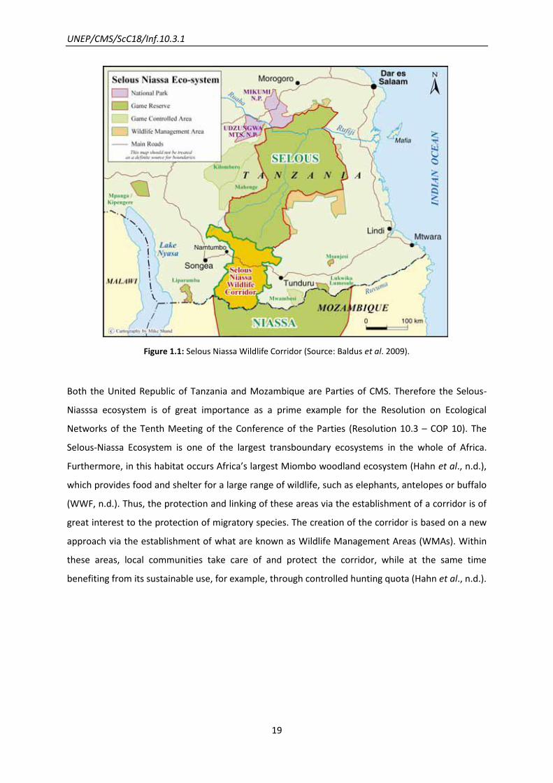
Figure 1.1: Selous Niassa Wildlife Corridor (Source: Baldus et al. 2009).
Both the United Republic of Tanzania and Mozambique are Parties of CMS. Therefore the Selous-
Niasssa ecosystem is of great importance as a prime example for the Resolution on Ecological
Networks of the Tenth Meeting of the Conference of the Parties (Resolution 10.3 – COP 10). The
Selous-Niassa Ecosystem is one of the largest transboundary ecosystems in the whole of Africa.
Furthermore, in this habitat occurs Africa’s largest Miombo woodland ecosystem (Hahn et al., n.d.),
which provides food and shelter for a large range of wildlife, such as elephants, antelopes or buffalo
(WWF, n.d.). Thus, the protection and linking of these areas via the establishment of a corridor is of
great interest to the protection of migratory species. The creation of the corridor is based on a new
approach via the establishment of what are known as Wildlife Management Areas (WMAs). Within
these areas, local communities take care of and protect the corridor, while at the same time
benefiting from its sustainable use, for example, through controlled hunting quota (Hahn et al., n.d.).

UNEP/CMS/ScC18/Inf.10.3.1
20
Figure 1.2: Landscape of the Selous-Niassa Wildlife Corridor (Source: Hahn, n.d.)

UNEP/CMS/ScC18/Inf.10.3.1
21
Table 1.1: General information Selous-Niassa.
NAME OF THE NETWORK Selous-Niassa
CMS SPECIES
(LISTED ON APP. II)
African elephant (Loxodonta africana)
African wild dog (Lycaon pictus)
COUNTRY The United Republic of Tanzania/Mozambique
NETWORK COMPONENTS
(SIZE)
Selous Game Reserve1 (48,000 km
2)
Wildlife Management Areas as buffer zone of Selous Game
Reserve1 (7,500 km
2)
Mikumi National Park1 (3,000 km
2)
Kilombero Game Controlled Area1 (6,500 km
2)
Muhuwesi Game Controlled Area1 (1,500 km
2)
Mwambesi Game Conrolled Area1 (1,000 km
2)
Lukwika - Lumesule/Msanjesi Game Reserve1 (400 km
2)
Sasawara Forest Reserve1 (385 km
2)
Niassa Game Reserve2 (42,400 km
2)
SIZE NETWORK CA. 154,000 KM2
SIZE CORRIDOR 8,000 KM2
TOTAL DISTANCE OF APP. 120 KM
(Source: Hahn, n.d.)
Network Aims
The first subject of investigation was a research project on Roosevelt Sable Antelopes Hippotragus
niger roosevelti in the proposed Selous-Niassa Wildlife Corridor. The population of Roosevelt Sable
Antelopes in this area was relatively stable, whereas other wildlife such as elephants was severely
affected by poaching. After the funding of this project ended, the new project on elephant
conservation started. Therefore the next purpose of the network was to protect migratory species,
such as the African Elephant and the African Wild Dog by securing and protecting the traditional
migration routes (R. Baldus, personal communication, 2012).
1 United Republic of Tanzania
2 Mozambique
UNEP/CMS/ScC18/Inf.10.3.1
22
Network Design
Network Components
The size of the corridor was determined in accordance to both natural boundaries, such as rivers or
mountains, and man-made boundaries, such as villages or roads. It was important to conserve the
area of the corridor rapidly, because the habitat was under threat of fragmentation caused by gold
mining, agriculture, logging and new settlements. A further important aspect to determine the size
of the corridor was the protection of traditional routes of migratory species. As a first step a survey
conducted on foot through the whole area of the proposed corridor was carried out in order to
compile information on wildlife populations, the poaching status of different animals, human
activities and settlements, the occurrence of wildfire in different areas (which could severely
damage wildlife habitats) and the infrastructure of this area. With the collected GIS coordinates a
basic sketch map could be drawn. The results of the survey conducted on foot showed, that there
was still sufficient intact habitat and low densities of human settlements in this area to create a
corridor (R. Baldus, personal communication, 2012). To define the natural migration routes, scientific
research and monitoring on elephant migration were conducted, confirming the knowledge of local
people (Mpandudji et al., 2002). Elephants were radio-collared to record their movement patterns.
The inhabitants of twelve villages inside the proposed corridor met to create a village profile and to
offer information on infrastructure and farming activities inside the corridor.
On the whole the research that was done consisted of four different elements:
The first step was to do field research in the area of the proposed corridor with biodiversity and
wildlife specialists (Fig. 1.3). The second one was interviewing stakeholders at departmental,
regional, district, ward and village level as well as protected area officials and resource users (Hahn
et al. 2004). A further important measure was the research in existing databases and publication on
legislation, regulations, guidelines and other documents. The next action was to perform analytic
map studies, processing spatial data and producing thematic maps in cooperation with the GIS
specialists (Hahn et al., 2004).

UNEP/CMS/ScC18/Inf.10.3.1
23
Figure 1.3: Cross border planning meeting of Tanzanian Figure 1.4: Participatory land use and Mozambican
professionals (Source: Hahn, n.d.). planning meeting in the Corridor (Source: Hahn, n.d.).
Nowadays the ecological network consists of two game reserves as core areas, several buffer zones,
game controlled areas and corridors. The corridor was designed via the establishment of Wildlife
Management Areas (WMAs). The villages belonging to the WMAs worked out a common land-use
plan (Fig. 1.4) which divided the area in different zones, such as bee-keeping, fishery, forestry and
hunting zones. Mining, wildlife cropping, wildlife farming and ranching are restricted types of
resource utilization in a WMA.
The aim was to create a network of WMAs along the corridor to receive its full protection and to link
the southern area with the northern one. A WMA corresponded accordingly to category IV of IUCN’s
protected areas.
Network Evolution
The evolution of the network started with a shared concern of the governments of the United
Republic of Tanzania and Mozambique to reduce poaching within their game reserves. This resulted
in the design and establishment of a corridor between the two Selous and Niassa Game Reserves.
In 1991 the buffer-zone was enlarged including 11 villages to create the first pilot WMAs. Within the
WMAs, village game scouts were controlling and safeguarding the region. Village committees were
responsible for the management of game.
The buffer-zone was additionally extended some years later to include 17 participating villages
which are responsible for the management of two WMAs. These WMAs served as a buffer-zone and
secured the northern area at the Selous border. At this time the idea was raised to create WMAs in

UNEP/CMS/ScC18/Inf.10.3.1
24
the whole area in between the Selous and Niassa Game Reserves to protect the entire corridor
(Baldus et al., 2009).
The United Republic of Tanzania and Mozambique formally recognized the corridor and
consequently the need of cross-border cooperation (R. Baldus, personal communication, 2012). The
northern part of the corridor is secured through the “North East Undendeule Forest Reserve” and
the Wildlife Management Areas of several villages whereas the southern part at the Ruvuma River
was still unprotected until 2003 (Baldus et al., 2009). Therefore, the local authorities of the south
together with the German agency for development and cooperation (GIZ) established two WMAs in
the southern part of the corridor in collaboration with 17 villages. These two WMAs received their
official status in 2009 and 2010. Three other WMAs in the south were established in 2008. The aim is
to establish as many WMAs as needed to protect the whole corridor fully and to include all 29
corridor villages within these WMAs.
In 2007, the regional administrations and local governments of Mtwara and Ruvuma of the United
Republic of Tanzania and the provincial governments of Cabo Delgado and Niassa of Mozambique
signed an MoU on cross-border conservation (focusing on research and anti-poaching methods).
Nevertheless, there was still space for extending the network as for example WWF established a
second corridor further east of the Selous Game Reserve with the same WMA approach.
Game and forest reserves and a marine protected area at the border of the United Republic of
Tanzania provide the potential for further spatial expansion. Thus, the area of sustainable use
benefiting local, urban settlements as well as the environment can be expanded considerably.
Nowadays there are still some problems affecting the corridor, its wildlife and people, for instance:
The growing human population with its need to produce and expand cultivation areas into
prime forest ecosystems thus competing with the wildlife population for suitable habitats.
Illegal exploitation of wildlife resources in the Southern area, illegal fishing along the river,
transboundary poaching for meat and ivory, snare lines and fishing hinder animals from
reaching water sources. Another problem is that increasing elephant and predator
populations inside the corridor are leading to increasing wildlife-human conflicts, for
example damage on crops or attacks on livestock and people.

UNEP/CMS/ScC18/Inf.10.3.1
25
Scientific and Conservation Activities
Research and Monitoring in the Network
In 2000 there was still a lack of data about the status and migration routes of the populations of
large mammal species in the Selous-Niassa Wildlife Corridor. Good research and scientific knowledge
are essential to establish a network which meets all the needs of the migratory species present.
Another problem was that there were no data on the value and risks of corridors in terms of
population persistence and genetic diversity and the occurrence and spreading of pathogens (Hahn
et al., n.d.).
To figure out the area which was used by elephants as a migration route, satellite tags were fitted to
elephants and at the same time the health status and fertility of the elephants were assessed. In
total ten elephants were equipped with satellite transmitters in 2000 and 2001 and monitored for
one year in order to find out their home ranges (Hahn et al., n.d.). Aerial surveys on the distribution
of large mammals using SRF (Systematic Reconnaissance Flights) were carried out. Village game
scouts collected data on the movement, sex, age, cow-calf relationship, preferred plants and crop
damage of elephants.
Figure 1.5: Migration routes of elephants in the corridor (Source: Mpandudji et al., 2002).
The results showed that three major migration routes were identified from the Ruvuma River to the
centre of the corridor. From the centre of the corridor to the North four separate migration routes
UNEP/CMS/ScC18/Inf.10.3.1
26
were identified. The peak of occurrence of elephants was between March and April during the rainy
season when they move from South to North, whereas between June and December they move
from North to South. The fruiting period of Marula (one favourite fruit of elephants) corresponded
to the peak of elephant occurrences in March as well (Hahn et al., n.d.).
Just a few elephants were found on the South-Central part of the corridor; one reason for this could
be the high level of human activity in this region (Hahn et al., n.d.).
Moreover, the results of the monitoring showed that elephants and other endangered wildlife
species such as the African Wild Dog used the corridor for their migration. In this corridor there were
several well-established migratory routes for animals and many regions that were crucial as habitats
for elephants and other wildlife species. The different habitats of elephant populations overlapped
within the corridor, so genetic exchange between the two Game Reserves took place but over
generations rather than in terms of single individuals (R. Baldus, personal communication, 2012).
Other Activities
To promote the concept of WMAs in the villages of the corridor, awareness campaigns were
organized. These included education in primary and secondary schools, presentation of movies,
international workshops or music campaigns (Baldus et al., 2009).
Future of the Network
The future of the network lies especially in the further development of the transboundary
cooperation between the United Republic of Tanzania and Mozambique, including the development
of alternative income opportunities for the villages in combination with biodiversity conservation.
Transboundary tourist cooperation could strengthen private or public relationships and investments
(Baldus et al., 2009).

UNEP/CMS/ScC18/Inf.10.3.1
27
2. Central Albertine Rift Protected Areas: Mountain Gorillas
Landscape-scale cooperation at the intersection of three countries
Lessons learnt from this example
Collective recognition by three adjoining countries that the ecological system for gorillas
centred on the intersection of their respective jurisdictions, was an essential starting-
point.
High-level institutional frameworks, such as the Central Albertine Rift Transboundary
Protected Area Network between the protected area authorities of the three countries
which contributes to the CMS Gorilla Agreement, have provided the necessary political
infrastructure to enable a truly joint approach.
A revenue-sharing agreement has been an important ingredient in the basis for
cooperation
Good partnership working between NGO and government players has been key to
effective delivery.
Introduction
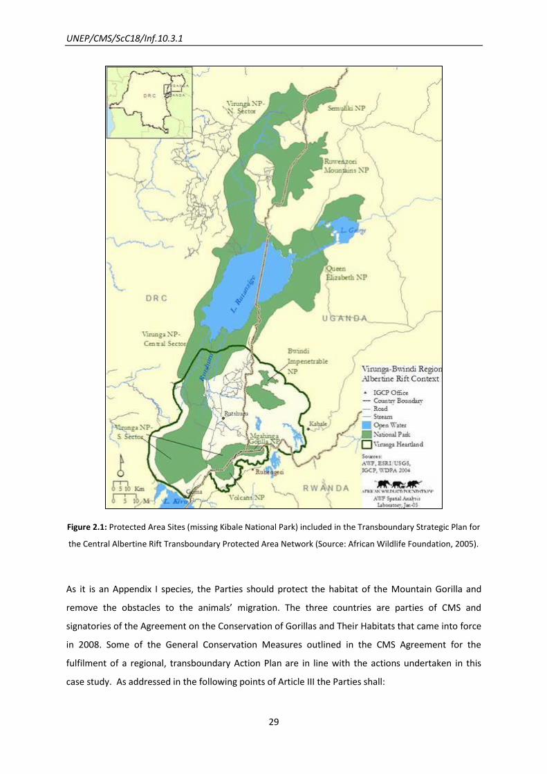
The transboundary ecosystem of the Central Albertine Rift Transboundary Protected Area Network
(CAR-TPAN) encompassing eight national parks (Tab. 2.1) aim for the sustainable collaborative
conservation of Mountain Gorillas Gorilla beringei beringei and their habitats. This ecological
network connects protected areas in the Democratic Republic of Congo (DRC), Uganda and Rwanda
(Fig. 2.1) and is a reservoir of unique and very high conservation value (Linde, 2009).
The landscape covers the afro-montane habitats (altitude of 2,500 to 4,000 metres) of Mountain
Gorilla populations which roam across the borders of the three countries while foraging for food.
Their home range varies between 5 and 30 km2 (UNEP-WCMC & WWF, 2001) and the area of habitat
occupied is circa 450 km2 for Virungas gorillas and 215 km2 for Bwindi-Impenetrable National Park
gorillas (Butynski, 2001). This home range varies as a function of food availability and male mating
competition (Vedder, 1984).

UNEP/CMS/ScC18/Inf.10.3.1
28
Habitat conversion, poaching for bush meat, harvest of non-forest timber products, timber logging
and civil unrest, among other threats (USAID, 2006), put at risk the maintenance of the populations
size in the network and thus regional cooperation for its conservation is needed.
Table 2.1: General Information Central Albertine Rift Transboundary Protected Area Network.
NAME OF THE NETWORK Mountain Gorillas in Central Albertine Region
CMS SPECIES
(LISTED ON APP. I)
Mountain Gorilla (Gorilla beringei beringei)
COUNTRIES Democratic Republic of Congo (DRC)
Uganda
Rwanda
PROTECTED AREAS (NAME, SIZE, YEAR OF
ESTABLISHMENT, COUNTRY)
Bwindi Impenetrable National Park (321 km2, 1991, Uganda)
Queen Elizabeth National Park (978 km², 1952, Uganda)
Rwenzori Mountains National Park (996 km2, 1991, Uganda)
Mgahinga Gorilla National Park (33.7 km2, 1991, Uganda)
Semuliki National Park (20 km², 1993, Uganda)
Kibale National Park (795 km2, 1993, Uganda)
Parc national des Volcans (160 km², 1925, Rwanda)
Parc national des Virunga (790,000 km2, 1925, DRC)
UNEP/CMS/ScC18/Inf.10.3.1
29
Figure 2.1: Protected Area Sites (missing Kibale National Park) included in the Transboundary Strategic Plan for
the Central Albertine Rift Transboundary Protected Area Network (Source: African Wildlife Foundation, 2005).
As it is an Appendix I species, the Parties should protect the habitat of the Mountain Gorilla and
remove the obstacles to the animals’ migration. The three countries are parties of CMS and
signatories of the Agreement on the Conservation of Gorillas and Their Habitats that came into force
in 2008. Some of the General Conservation Measures outlined in the CMS Agreement for the
fulfilment of a regional, transboundary Action Plan are in line with the actions undertaken in this
case study. As addressed in the following points of Article III the Parties shall:

UNEP/CMS/ScC18/Inf.10.3.1
30
b) identify sites and habitats for gorillas occurring within their territory and ensure the protection,
management, rehabilitation and restoration of these sites (…);
c) coordinate their efforts to ensure that a network of suitable habitats in maintained or re-
established throughout the entire range of all species and sub-species, in particular where habitats
extend over the area of more than one Party to this Agreement.
Range States and international partners are also asked to guarantee connectivity among sites,
through the establishment of corridors in order to conserve biological diversity.
(UNEP/CMS, 2008, 2011)
Network Aims
The initial aim of the International Gorilla Conservation Program (IGCP) was the protection of
mountain gorillas and their habitats. Further on, with the launch of a Strategic Plan, the horizon is
enlarged to encompass the conservation of the unique ecosystem within the Central Albertine Rift
Transboundary Protected Area Network (CAR-TBPAN; IGCP, 2006).
Network Design
This network evolved under heavy constraints, in the context of inter-state conflict. IGCP partners
did not conceive of a particular model of Transboundary Natural Resources Management (TBNRM),
having developed an NGO-State model. It has two distinctive characteristics, it is led by an NGO and
state agencies are the most important planning and implementation partners (Martin et al., 2009).
It includes all the eight contiguous national parks straddling borders between the three countries.
Mountain Gorillas occur in two known populations, almost just within national parks, one in the
Virunga Massif region, within Virunga National Park, Volcanoes National Park and Mgahinga Gorilla
National Park and the second mainly at the Bwindi Impenetrable National Park (UNEP/CMS, 2008).
Network Components
Due to the prolonged instability in the region IGCP was required as a facilitator, working intimately
with PAA, helping strengthen their capacity and achieving equitable partnerships.
The TBNRM supporting the CAR-TBPAN aims to create new scales of governance and to manage links
between scales. It is operated through three levels of cooperation, from local to regional and more
formal levels, ranging from technical to political interventions (Fig. 2).

UNEP/CMS/ScC18/Inf.10.3.1
31
Figure 2.2: Three tracks of collaboration in the Central Albertine Rift Transboundary Protected Area Network
(Source: Martin et al., 2009).
Tracks 1 and 2 have been in force, but track 3 remains to be implemented through the progression
from a formal agreement at a ministerial level to the creation of an integrated Transboundary
Protected Area with unitary management authority.
Track 1 corresponds to the bottom level – technical and advisory level, represented by the Regional
Research Committee, Tourism Committee, Community Conservation & Enterprise Committee and
the Security and Law Enforcement Committee, together with the Transboundary Executive
Secretariat. Immediately above are the Transboundary Core Secretariat and the Protected Areas
Authorities corresponding to track 2 and respectively to the implementation and executive levels.
The most formal phase, the policy level at track 3 is implemented by the National Ministries, with
the formal classification of the Transboundary Protected Area.
Network Evolution
A process for the Transboundary Natural Resources Management started in 1991. It developed from
informal field level cooperation to ministerial level and formal agreements more recently.
IGCP led and mediated the transboundary management of the protected areas, being a facilitator
and catalyst for dialogue and collaboration between the three Protected Area Authorities and their
supporting ministries. IGCP has applied since 1991 a regional approach to its conservation work with
the three PAA in DRC, Rwanda and Uganda, first in the region comprising the Virunga-Bwindi region,
and then extending to the eight national parks encompassing the current network (Lanjouw et al.,
2001; Rutagarama, 2005). These PAA are: Institut Congolais pour la Conservation de la Nature
UNEP/CMS/ScC18/Inf.10.3.1
32
(ICCN)/DRC, Office Rwandais du Tourisme et des Parcs Nationaux (ORTPN/RWA) and Uganda Wildlife
Authority (UWA/UGA).
A Memorandum of Understanding (MoU) for the Central Albertine Rift Protected Area Network was
signed in 2004 between the three PAA, to conserve the unique ecosystem within the network.
International Gorilla Conservation Program was assigned as the facilitator.
The MoU final aim was the delivery of a transboundary strategic plan (TSP). In 2005, this MoU was
further strengthened by the ministers in charge in the three countries with a “Tripartite Declaration
on the Transboundary Natural Resources Management of the Trans-frontier Protected Area Network
of the Central Albertine Rift”. Also called The Goma Declaration, it recognizes the need for
collaborative efforts, supports the TSP development and commits to funding its implementation.
In 2006, the three PAA launched a Ten-Year Transboundary Strategic Plan for the Central Albertine
Rift. The plan is intended to work towards the objective of “Sustainable conservation of the CAR
biodiversity for long-term socio-economic development through strategic transboundary
collaborative management”. At the same year, it was signed a Trilateral MoU on the Collaborative
Monitoring of and Sharing Revenues from Transfrontier Tourism Gorilla Groups by the PAA.
The Strategic Plan established an institutional structure for the implementation of TBNRM, with the
creation of a Transboundary Inter-Ministerial Council, Four Regional Technical Committees, The
Transboundary Core Secretariat and The Transboundary Executive Secretariat. The last two
coordinate the implementation of the Strategic Plan.
In 2009, the Inter-Ministerial Council institutionalized the Greater Virunga Transboundary
Collaboration (GVTC) as a formal entity to follow the mandate of the Strategic Plan. It is a
mechanism to coordinate conservation efforts, engaging government and NGOs from the ground to
the national and regional level.
In 2010, it was launched a refined five-year strategic plan (2010-2014) to help on the
implementation of the ten-year Transboundary Strategic Plan.
Scientific and Conservation Activities
A vital part of the activities promoted by IGCP is to develop more sophisticated monitoring
techniques jointly applied. In addition, the following activities are facilitated:
National Programmes in each country;

UNEP/CMS/ScC18/Inf.10.3.1
33
Communication and information sharing – information on gorilla’s movements, poaching
and monitoring data (relevant for the transboundary management of potential conflict situations
such as where groups of gorillas cross borders);
Regional meetings between the three countries since 1995 (just from this year on due to
previous conflicts);
Ranger-based monitoring (RBM) from 1998/1999 onwards; IGCP is working on the
establishment and functionality of a regional server to host all RBM data;
Regional training programmes for the development of the Protected Areas Authorities
Capacity Building, as a basis for national and regional management;
o Workshop in 2012 bringing together park staff, researchers and conservationists
from the three countries, to look at trends in the data collected over the 15 year
period since RBM data started to be collected
Joint Activities, including joint and co-ordinated patrols, gorilla censuses, and anti-poaching
activities;
Helping with equipment;
Sharing experiences of adopting community conservation interventions.
(Martin et al., 2009; IGCP, n.d.)
One of the most important achievements is the collaborated long-lasting research and monitoring of
gorillas populations that has been carried on, with various stakeholders involved, resulting in gorilla
census, health monitoring and RBM data (Mwandha, n.d.).
Most of the mountain gorilla groups, in both the Virunga Massif and Bwindi, have seen their home
ranges significantly expanding over time, standing at a total of 880 gorillas (IGCP, n.d.; Mutagamba,
2012). Indeed, the Bwindi population has increased over the years from 1997 and 2012 from 300 to
400 individuals. Following the same trend, the Virunga population has increased since the
collaboration started, from 1991 onwards and the expectation is for further growth (Mwandha, n.d.)
and according to the 2010 census there are 480 gorillas in the Virunga Massif (IGCP, n.d.).
Future of the Network
In 2013, the Transboundary Executive Secretariat is expected to be legalized, together with the
GVTB, through a treaty to be signed by the Heads of the State of the three countries (GVTB, n.d.).

UNEP/CMS/ScC18/Inf.10.3.1
34
The complete institutionalization of the collaboration through a legal mandate, after the recognition
of the three countries, will enable the partners to take binding decisions (Martin et al., 2009).

UNEP/CMS/ScC18/Inf.10.3.1
35
3. The “Tridom” Landscape network: Forest Elephants and Western
Lowland Gorillas
Addressing multiple threats through an ecosystem-based approach
Lessons learnt from this example
The willingness of the governments of Cameroon, Congo and Gabon to take a purpose-
driven trilateral view of their protected area systems allowed a single strategic plan for
corridor areas to be devised.
A formal trilateral agreement and governance structure have been helpful; as have the
institutional structures created under the wider Yaoundé Declaration on sustainable
forest management (7 countries).
Coordination has also been assisted by park wardens from the three countries
undertaking activities on a joint basis, and by engagement at a strategic level of private
sector mining and logging interests (which, along with hunting and poaching, still
represent considerable challenges for conservation of the area).
UNEP/CMS/ScC18/Inf.10.3.1
36
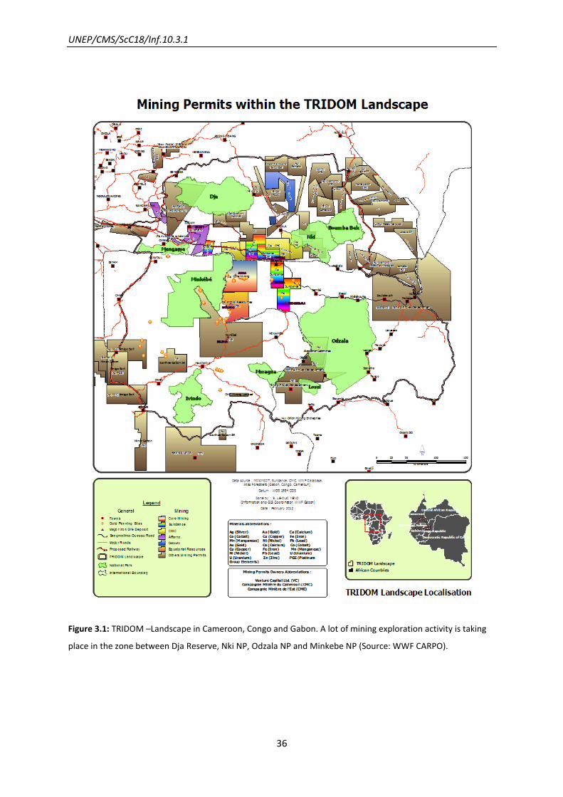
Figure 3.1: TRIDOM –Landscape in Cameroon, Congo and Gabon. A lot of mining exploration activity is taking
place in the zone between Dja Reserve, Nki NP, Odzala NP and Minkebe NP (Source: WWF CARPO).

UNEP/CMS/ScC18/Inf.10.3.1
37
Introduction
The region of the Congo Basin belongs to one of the most important biodiversity areas of the world
and contains the second largest expanse of rainforest. The tropical forests contain numerous species
of plants and animals. Within the Congo Basin lies the Dja-Odzala-Minkebe Tri-National (Tridom)
Landscape (186,000 km²) which encompasses an important ecological network, shared by Gabon,
the Republic of Congo and Cameroon, for endangered flagship species, such as the African Forest
Elephant Loxodonta africana cyclotis and the Western Lowland Gorilla Gorilla gorilla gorilla. Both
species are listed under CMS. In addition, all three countries are signatories of the Agreement on the
Conservation of Gorillas and Their Habitats (UNEP/CMS, 2012). This unique area is threatened by
commercial logging, mining and poaching (ivory and bushmeat). Another threat which is affecting
especially the Western lowland gorillas in this region is the exchange of zoonotic diseases, such as
Ebola between humans and gorillas. In the years 1994-1996 90 per cent of the whole gorilla
population in the Minkebe region was killed due to Ebola (Huijbregts et al., 2003). The increasing
loss of habitat promotes the human-wildlife contact, therefore facilitating the transmission of
zoonotic diseases (thegef.org, n.d). The main threat to African Forest Elephants is severe poaching
pressure (ivory) not only in the interzone but also in the protected areas (P. De Wachter, personal
communication, 2013).
Table 3.1: General information on TRIDOM.
NAME OF THE NETWORK Tri-National Dja-Odzala-Minkébé (TRIDOM) Landscape
TARGETED SPECIES
African Forest Elephant
(Loxodonta africana cyclotis) App. II
Western Lowland Gorilla
(Gorilla gorilla gorilla) App.I
COUNTRIES
Republic of Congo
Cameroon
Gabon
COMPONENTS
(SIZE, COUNTRY)
Odzala-Koukoua National Park (1,350,000 ha, Republic of Congo)
Lossi Gorilla Sanctuary (35,000 ha, Republic of Congo)
Minkébé National Park (756,700 ha, Gabon)
Ivindo National Park (300,274 ha, Gabon)
Mwagna National Park (116,500 ha, Gabon)
Boumba-Bek National Park (309,300 ha, Cameroon)
Nki National Park (238,300 ha, Cameroon)
Dja Fauna Reserve (526,000 ha, Cameroon)
Mengame Gorilla Sanctuary (121,800 ha, Cameroon)
UNEP/CMS/ScC18/Inf.10.3.1
38
Network Aims
The main aims of the network were to maintain the ecological features and the connectivity inside
the TRIDOM landscape. The integrity of this ecosystem should be preserved via sustainable
management in the zone between the protected areas including zoning for various land uses
compatible with habitat conservation. Flagship species include the African Forest Elephant and the
Western Lowland Gorilla.
Network Design
The network consists of nine protected areas in the Republic of Congo, Gabon and Cameroon (see
Tab. 3.1) of which the ecological connectivity should be maintained through the maintenance of
robust blocks of (very thinly inhabited) habitat between and surrounding the protected areas. Four
transboundary corridors are planned to enhance the connectivity and robustness of this ecological
network:
A corridor between the protected areas of the Dja Fauna Reserve, Nki National Park and
Minkébé National Park;
A corridor connecting the Minkébé National Park with the Mengame Gorilla Sanctuary;
A corridor linking the Odzala-Koukoua National Park and the Minkebe National Park;
A corridor linking Nki NP with Odzala NP.
These corridors together with the peripheries of the protected areas, mostly inside logging
concessions, lead to a complex covering as much as 186,000 km² that, if indeed well maintained as
habitat, should improve the robustness of the network against climate change or other threats. The
TRIDOM agreement for cooperation was signed by the three countries in 2005 with the
establishment of a tri-national governance structure and an expression of willingness for sustainable
management of the interzone (G., Ngono, 2010; P. De Wachter, personal communication, 2013).
Critical sites for conservation have been identified including the Ngoïla Mintom Forest (9,321 km²) in
Cameroon, the Djoua Ivindo Forest (9,432 km²), Messok Dja (1,400 km²), Ntokou Pikounda (5,391
km²) in Congo, and the Mwagna NP extension (416 km²), Sing Nouna ridge (1,658 km²) and Djoua
Zadie (2000 km²) in Gabon. In 2012 49 per cent of the Ngoïla Mintom Forest was assigned to logging
companies, while 51 per cent is reserved for conservation concessions (mining companies are
interested as are carbon investors). In the Republic of Congo, Ntokou Pikounda was gazetted as a
National Park in 2012, while Messok Dja was recognized as a “proposed PA” in the TRIDOM Congo

UNEP/CMS/ScC18/Inf.10.3.1
39
Land Use Plan (produced by an interministerial commission). The same Land Use Plan designates de
Djoua Ivindo forest for mining, conservation and rural development, opening the way for zoning of
this thinly inhabited forest in mining concessions, conservation areas, and rural development areas
(P. De Wachter, personal communication, 2013).
Key criteria for the design of a connected ecological network in TRIDOM were related to the
conservation of robust critical sites for large mammals, for example the Minkébé Djoua Ivindo
Odzala IFO Complex, the Boumba Bek Nki-Messok Dja Complex, the Dja – Ngoïla Mintom- Messok
Dja complex, the Mwagna Lossi complex, the Minkébé Kom Mengame complex and the Ivindo NP
and its periphery. Generating awareness of continuous forest elephant habitat and migration routes
is also an important point to be considered in the network designation. Forest elephants in the
TRIDOM landscape migrate over great distances crossing large rivers such as the Dja River between
Messok Dja Forest in the Republic of Congo and Nki NP and neighbouring forests in Cameroon) or
the upper Ivindo River where 150 different elephant crossings were monitored (between Minkébé
National Park in Gabon and Djoua Ivindo Forest in Congo (Mabaza & Zebene, 2012)). Another
important criterion is the existence of unpopulated or very thinly populated habitat in the
surroundings of protected areas, which function as buffer zones and could be managed via logging
concessions. Anti-poaching measures are crucial to protect gorillas and elephants in these areas.
For the design of a coherent network of protected areas, it is also important to consider the TRIDOM
landscape and the Sangha River Tri-National Protected Area (Central African Republic, Cameroon,
Republic of Congo) as a whole, as they are adjacent to each other and could create a continuous
habitat for both great apes and forest elephants (Fig. 3.2) (P. De Wachter, personal communication,
2013).
UNEP/CMS/ScC18/Inf.10.3.1
40
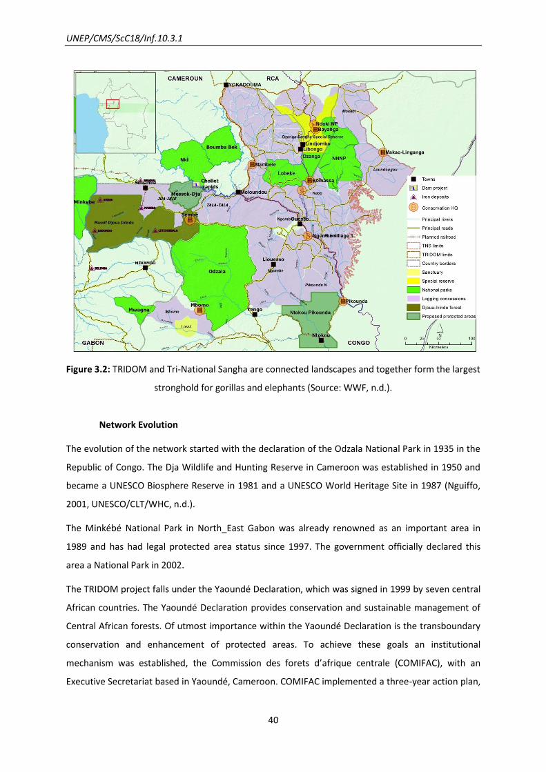
Figure 3.2: TRIDOM and Tri-National Sangha are connected landscapes and together form the largest
stronghold for gorillas and elephants (Source: WWF, n.d.).
Network Evolution
The evolution of the network started with the declaration of the Odzala National Park in 1935 in the
Republic of Congo. The Dja Wildlife and Hunting Reserve in Cameroon was established in 1950 and
became a UNESCO Biosphere Reserve in 1981 and a UNESCO World Heritage Site in 1987 (Nguiffo,
2001, UNESCO/CLT/WHC, n.d.).
The Minkébé National Park in North_East Gabon was already renowned as an important area in
1989 and has had legal protected area status since 1997. The government officially declared this
area a National Park in 2002.
The TRIDOM project falls under the Yaoundé Declaration, which was signed in 1999 by seven central
African countries. The Yaoundé Declaration provides conservation and sustainable management of
Central African forests. Of utmost importance within the Yaoundé Declaration is the transboundary
conservation and enhancement of protected areas. To achieve these goals an institutional
mechanism was established, the Commission des forets d’afrique centrale (COMIFAC), with an
Executive Secretariat based in Yaoundé, Cameroon. COMIFAC implemented a three-year action plan,

UNEP/CMS/ScC18/Inf.10.3.1
41
with focus on transboundary protected areas, amongst them the Tri-National Dja-Odzala-Minkebe
(TRIDOM) landscape (UNDP/GEF, 2004).
The spatial extension of protected areas within TRIDOM started in May 2001 with the increase of the
Odzala-Koukoua National Parks in the Republic of Congo by four times its former size. One year later
13 National Parks were established in Gabon with a total size of 30,000 km2. Three of these National
Parks are also located in the TRIDOM landscape, namely the Minkébé, Mwange and Ivindo National
Parks. In Cameroon two new National Parks were announced (Nki and Boumba-Bek National Park).
Currently the Dja Reserve, Nki and Boumba Bek, and Odzala NP have management plans, while the
management plans for Minkebe, Mwagna, and Ivindo are being prepared. (De Wachter et al., n.d.)
TRIDOM contains several “world class” iron ore deposits and at least eight mining exploration
companies are currently active in the interzone. Therefore, WWF has recently been working on a
land use plan combining industrial topics such as mining or logging with conservation issues in the
region of northern Congo (Djoua Ivindo Forest in between Minkébé National Park and Odzala
National Park). Also a new protected area (Messok Dja, northern Congo) is being developed and
implemented, which is especially important for the conservation of Western Lowland Gorilla and
African Forest Elephant habitats. Another land use plan in the region of the Ngoïla Mintom Forest is
in the process of being developed in the context of demand for logging, mining, oil palm and
conservation concessions (P. De Wachter, pers. comm., 2013).
Scientific and Conservation Activities
Research and Monitoring
The monitoring in TRIDOM landscape has its main focus on large mammals, their distribution and
diversity in this area. Other important research topics concern human-wildlife conflicts, wildlife
management and village hunting, and socio-economic analysis. In the Minkébé, Ivindo, Mwagne,
Boumba Bek, Nki and Dja protected areas complete studies on large mammals were conducted (Tab.
3.2). Satellite tagging on Forest Elephants has been carried out in the Odzala, Ivindo, Minkebe and
Nki protected areas. Another special focus in wildlife monitoring has been placed on wildlife health
and zoonotic diseases, such as Ebola in the Republic of Congo and Gabon. The socio-economic
surveys were focused on traditional terrains, the use of natural resources or conflicts raised by park
boundary issues (CARPE, 2005).

UNEP/CMS/ScC18/Inf.10.3.1
42
Figure 3.3: Elephants (Messok Dja), near the Cameroon/Congo border; these elephants frequently
cross between Cameroon and Congo (Source: Victor Mbolo/WWF©).

UNEP/CMS/ScC18/Inf.10.3.1
43
Figure 3.4: Gorilla Messok Dja (Congo), near the Cameroon/Congo border (Source: Victor Mbolo/WWF©).
Recent large mammal monitoring activity
Presently a new survey on large mammals is being conducted in the Minkébé National Park and will
be finished in 2013. A second survey will start in the Djoua Ivindo Forest (corridor between Minkébé
and Odzala), an important area for African Forest Elephants and great apes (Fig. 3.3 and 3.4), which
is threatened by iron ore mining. Recent large mammal monitoring data are currently being analyzed
for the Ngoïla Mintom Forest, Messok Dja proposed PA and the Boumba Bek, Nki, and Odzala
protected areas (P. De Wachter, personal communication, 2013).
Table 3.2: Large mammal monitoring in TRIDOM baseline (Source: CARPE/USAID).
Zone Year Value Size (ha)
Boumba Bek NP 1998 wildlife surveys (encounter rate
in 2004) :
Gorilla 953 individuals (0.43
nesting group/km) ;
Chimpanzee 1,085 [737-1,649];
Elephant 476 (2 dung piles/km)
238,260
Nki NP 2006 Gorilla 14,354 [11,136-18,530];
Chimpanzee 897 [618-1,237];
Elephant 2,320 [2,041-2,629]
309,360
Dja Wildlife
Reserve
1999 Wildlife surveys:
Gorilla 1,630;
Chimpanzee 2,945;
Elephant 1,893
526,000
Odzala NP 2006 Estimated gorilla density of
3.7/km2 (CI 2.13 – 6.42) and
elephant density of 1.0/km2 (CI
0.78-1.27) across 13,545km2.
1,350,000
Ivindo NP 2004-2007 1,000 elephants;
3,150 great apes
300,000
Minkebe NP &
northern periphery
2003-2004 Mike/Cites surveys 2003-2004:
Elephant 30,000
1,000,000

UNEP/CMS/ScC18/Inf.10.3.1
44
Other Activities
Other activities concerning trans-boundary cooperation performed within the TRIDOM landscape
are for instance coordination meetings between the park wardens of different countries, and bi-
national patrols (Cameroon- Congo, Gabon-Congo). A tri-national brigade is planned and will be
based at the intersection of the three countries.
A TRIDOM wide concertation process, initiated by WWF, has been started with TRIDOM’s mining
companies, aiming for the coordinated planning for mining and conservation together with all
mining companies active in the TRIDOM interzone.
Several multi-stakeholder agreements concerning hunting and logging concessions were also
developed such as the Okano Valley agreement that covers 9,000 km² of concessions west of
Minkebe NP. Stakeholders agreed that no one should enter logging concessions with vehicles for
hunting, and that all entrances in logging concessions should be protected by barriers guarded round
the clock. Other co-management agreements include the Oua River agreement that zones the river
in collaboration with local communities and prohibits its use as an access river for bushmeat hunters
(Ko, USAID/CARPE, 2011).
Future of the Network
The continued existence of TRIDOM as a robust interconnected landscape will depend on the
cumulative impact of the announced mining and infrastructure development (trans-TRIDOM
highway Sangmelima Ouesso, Chollet hydro-dam). Therefore governments, mining companies and
development/conservation partners should engage in a process that ensures that these
developments do not sign the end of TRIDOM. Regrettably real government willingness to address
these issues is low (P. De Wachter, pers. Comm. 2013).
If TRIDOM is to survive as an landscape inhabited by many elephants, it is of the utmost urgency that
the ivory trade networks are dismantled, the level of patrols in in key sites is increased so that
poachers can be dissuaded, punishments for wildlife crime are appliedfirmly and increased and
corruption is combated (the major weakness related to law enforcement). (De Wachter, personal
communication 2013).
Of great importance is therefore the work on logging concessions in the interzone and in the
peripheral zones of the protected areas, as they function as both a critical habitat for threatened
species (such as gorillas and elephants) and an outstanding buffer zone for the protected areas
(TRIDOM UNDP/GEF, 2004).
UNEP/CMS/ScC18/Inf.10.3.1
45
4. The Kanchenjunga Conservation Area: Snow Leopards
Networking for a low-density, widely-dispersed species
Lessons learnt from this example
Special considerations apply when planning ecological networks for species with low
population densities and large home ranges. When the overall numbers of the species
are also very low, such networks can be important not only for supporting migratory
patterns but also in facilitating genetic flow between populations.
In identifying critical sites for the Kanchenjunga network, local knowledge from farmers
played an important role alongside research by conservation experts.
A shift from a species-focused approach to one based more on community-based
landscape management has provided more enlightened solutions.
Introduction
The Snow Leopard (Uncia uncia) is a charismatic and rare species, which occurs in the mountain
regions of Central Asia from the Russian Federation and Mongolia to Nepal and Bhutan (UNEP/CMS,
2011). The Snow Leopard is considered as globally endangered by IUCN and listed in Appendix I
under CMS. Recently UNEP/CMS is funding a small grants project in Tajikistan, with a snow leopard
population of about 180-220 individuals, promoting trans-boundary snow leopard conservation
together with Kyrgyzstan (150–500 snow leopards) and Afghanistan (100–200 Snow Leopards)
(Diment FFI, 2012).
Since Snow Leopards are very dependent on large habitats with huge home ranges up to 100 km2
and live in very low densities, trans-boundary cooperation in Snow Leopard conservation is very
important (WWF, 2006). To provide unhindered movement for this migratory species and to allow
gene flow between different populations, it is essential for the protected areas to be connected for
the survival and health of entire snow leopard populations. Different organizations and countries are
already working together to secure the species’ continued existence.
The Kanchenjunga Conservation Area in Bhutan, Nepal and India, led by ICIMOD, is presented as a
case study in this document as an example for trans-boundary cooperation to conserve the Snow
Leopard.

UNEP/CMS/ScC18/Inf.10.3.1
46
Figure 4.1: Snow leopard’s range (Source: Snow Leopard Conservancy, n.d.).
The Kangchenjunga Landscape belongs to one of the richest biodiversity hotspots on Earth. It is part
of the Himalayan mountain ecosystems and borders China, India, Nepal and Bhutan. Many impacts
are threatening to isolate the different protected areas of these countries into “conservation
islands” and therefore leading to the ecosystems becoming unviable. Among the main threats are
forest encroachment, overgrazing by livestock, illegal fuel wood collection, timber extraction and
unregulated tourism (Shakya et al., 2008). In this area, many species of bird and mammal depend on
seasonal migrations. Thus, a continuous habitat is necessary for unobstructed movement (Chettri et
al., 2001). As a consequence, this landscape is of great importance for migratory species. One
flagship species in the Kangchenjunga Landscape is the Snow Leopard which occurs in several
protected areas in this region (ICIMOD, n.d.). Within the project, six corridors should be established
to connect nine Protected Areas in India, Nepal and Bhutan. The linked ecological network provides
not only the conservation of nature and different flagship species, such as the Snow Leopard, but
also alternative forms of land-use management to support local communities in this area.

UNEP/CMS/ScC18/Inf.10.3.1
47
Figure 4.2: Area of proposed Corridors in Kanchenjunga Landscape (Source: Chettri et al., 2008).
Table 4.1: Ecological Network in Kanchenjunga Landscape (Source: ICIMOD, n.d.).
NAME OF THE NETWORK Kangchenjunga Landscape
CMS SPECIES
(APP. I)
Snow Leopard (Uncia uncia)
COUNTRY China/India/Nepal/Bhutan
NETWORK COMPONENTS
Kangchenjunga Conservation
Area (KCA)
Barsay Rhododendron Sanctuary (BRS)
Fambong Lho Wildlife Sanctuary
Jorepokhari Salamander Sanctuary
Khangchendzonga Biosphere Reserve (KBR)
Kyongnosla Alpine Wildlife Sanctuary
Mahananda Wildlife Sanctuary
Mainam Wildlife Sanctuary
Neora Valley National Park
Pangolakha Wildlife Sanctuary
Senchal Wildlife Sanctuary

UNEP/CMS/ScC18/Inf.10.3.1
48
Shingba Rhododendron Sanctuary
Singhalila National Park
Toorsa Strict Nature Reserve
natural corridor to Jigme Dorji
National Park Niassa Game Reserve (42,400 km2)
PROPOSED CORRIDORS Nepal side of KBR and BRS adjoining KCA
Singhalila-Senchal
Senchal-Mahananda
Mahananda-Neora Valley
Neora Valley-Toorsa
Toorsa-JigmeDorji
Network Aims
The conservation of biodiversity in this hotspot was the top priority for the broader development of
regional communities and cooperation amongst them. This landscape is populated by 1.5 million
people who are very dependent on the ecosystem services (Sharma, 2008). The most prominent
flagship species in the region are the endangered Snow Leopard, the Asiatic Black Bear (Ursus
thibetanus), the Red Panda (Ailurus fulgens), the Himalayan Musk Deer (Moschus leucogaster), the
Tiger (Panthera tigris) and the Takin (Budorcas taxicolor).
Network Design
The network consists of 14 protected areas (Tab. 4.1), of which six are transboundary. The protected
areas are likely to become isolated conservation islands since the natural corridors, which were once
intact, are threatened by degradation. Consequently, the protection and connection of these natural
corridors is of utmost importance for all migrating species, especially for the endangered snow
leopard. It is planned to establish six corridors in the southern part of the Kangchenjunga landscape
to ensure the integrity of the network (ICIMOD, 2008).
Network Evolution
In the 1940s the conservation initiative started with the declaration of the Senchel Wildlife
Sanctuary, a game reserve in India. Afterwards, more protected areas in India, Nepal and Bhutan
were established. India adopted the National Park Act and later both the Wildlife (Protection) and
the Forest Conservation Acts and is Party to the Convention on Migratory Species, too. Nepal passed
UNEP/CMS/ScC18/Inf.10.3.1
49
the National Parks and Wildlife Conservation Act and Bhutan the Bhutan Forest Act. All three
countries are signatories to the Convention on Biological Diversity (CBD) as well.
The early conservation measurements were very strict and species-focused. Over the last 20 years
the actions changed from a species-focused conservation approach to a community-based landscape
one, such as joint forest management, community forestry and buffer zone management (Chettri et
al., 2008). So, today the network consists of various forms of conservation: from strictly protected
government-managed areas to community-managed systems.
One first step in designing the corridors to connect the different protected areas was the regional
consultation on conservation of Kangchenjunga Mountain Ecosystem in 1997. Within this
consultation, several crucial subjects were discussed such as the importance of biodiversity and the
framework for conservation. A gap analysis to identify critical sites outside the protected areas was
carried out. In 2003, the governments of Nepal, India and Bhutan met to find a consensus on
transboundary landscapes protection and to identify potential conservation corridors. One year
later, a technical expert workshop on “Developing a Transboundary Conservation Landscape in the
Kanchenjunga Complex” took place to share the outcome of national consultations and to define a
strategy for the planning process (ICIMOD, 2008).
Steering committees, task forces and alliances came together to discuss the corridor development
plans and strategic documents. In that phase research on the different plant and animal species was
carried out in the area of the six proposed corridors, as well as their distribution and movement
patterns and the different forms of land-use in the region. To confirm the defined areas of the
corridors GIS and RS methods were applied as well. In 2006, another workshop took place to share
the results of the completed monitoring and research and to develop both a cooperation framework
and implementation recommendations (ICIMOD, 2008).
Scientific and Conservation Activities
To identify critical sites, local knowledge from farmers was used as well as the knowledge from
experts and the reports and data from organizations. A land cover analysis was conducted. The
corridors identified based on habitat requirements, the distribution of species, derived from already
existing reports, and data of different organizations. 14 species of mammals (including the snow
leopard) and 8 species of rhododendrons were used as indicator species to assess the rarity and
value of some areas and thus, to identify potential corridors. Both, the maps of distribution for each
of these 14 species and the distribution maps for the rhododendron were overlaid to select the
critical sites. In the end a final map was created to show the potential corridors (Rana et al., 2008).
UNEP/CMS/ScC18/Inf.10.3.1
50
In the corridor stretching from the Toorsa Strict Nature Reserve (TSNR) to the Jigme Dorji National
Park (JDNP) an analysis of vegetation and ecosystem types was conducted.
A study to estimate the diversity of bird and mammal species in this proposed corridor was carried
out. The results showed that about 143 different bird species occurred in the proposed corridor, 18
different mammal species were recorded, among them the snow leopard (Rai et al., 2008).

UNEP/CMS/ScC18/Inf.10.3.1
51
5. The Mesoamerican Biological Corridor: Jaguars
Using a charismatic “flagship” species to promote sustainable resource use
Lessons learnt from this example
Formal endorsement of the Mesoamerican Biological Corridor at Heads of State level has
given it good political status, but strong coordination at institutional level has been
lacking.
The evocative “branding” of the network (“Path of the Panther”) succinctly conveys the
concept and may have helped to raise its profile; although its specific purposes could
have been more clearly promoted.
Significant investment in the design mapping stage allowed relevant land and resource
use/socioeconomic factors to be taken into account.
A lack of legally protected status for most of the areas has required more emphasis to be
put on other measures, such as economic incentives. This has some advantages, but is
also a precarious situation, with pressures on habitats being high, and fragmentation of
habitat corridors remaining a problem in many places.
A small project grants regime proved divisive and lost its focus on migration-related
network connectivity aims: its purposes could have been more clearly agreed and then
followed more closely.
An independent evaluation of the network was useful in highlighting practical
implementation strengths and weaknesses.
Introduction
The Mesoamerican Biological Corridor (MBC), also known as Path of the Panther - Paseo Pantera, is
an international land-use planning system, considered to be one of 25 biodiversity hotspots in the
world, due to the high concentration of biological diversity within its relatively small area
(Conservation International, 2012). It was formally endorsed by the Central American heads of state
in 1997 to support the free transboundary movement of the Jaguar Panthera onca (not yet CMS
listed). It has since become a large ecological network which promotes the conservation and
sustainable use of the region’s natural resources (Marynowski, 1992).

UNEP/CMS/ScC18/Inf.10.3.1
52
Figure 5.1: Illustration of areas encompassed in the MBC – identified in Table 1 (Source: MBC, 2010).
Table 5.1: General Information of the Mesoamerican Biological Corridor.
Network Aims
The aim of the network is to prevent the fragmentation of ecosystems by establishing a set of
interconnected areas which enable genetic and biological interchange between fragmented
populations. As the name suggests, the Path of the Panther makes the Jaguar a flagship species of
the network. However, the network’s aim and design is to support many other species in their
migration.
Other goals are the prevention of deterioration and loss of biodiversity through conservation of
representative samples of the region's environments and integration with a regional planning
process that is oriented towards sustainable development.
The MBC seeks to maintain biodiversity by maintaining biological connectivity through conservation
measures on private land.
NAME OF THE NETWORK Mesoamerican Biological Corridor
SPECIES Jaguar (Panthera onca)
COUNTRY Mexico, Belize, Guatemala, El Salvador, Honduras, Nicaragua
AREA PROTECTED 142,103 km2

UNEP/CMS/ScC18/Inf.10.3.1
53
Network Design
Network Evolution
The network design has been modified in response to the development of ideas on suitable
conservation and resource use:
The original Paseo Pantera Conceptual Map, first conceived by Wildlife Conservation Society and the
Caribbean Conservation Corporation, was developed by the University of Florida and the Central
American Commission on Environment and Development (CCAD) in the early 1990s.This involved the
use of GIS software to design the seamless corridors to promote biological connectivity. Geo-spatial
analysis involved the use of remotely sensed data and other GIS layers to link the major parks and
reserves throughout the region.
With improved geographic information system technology and data sets, a second map was
developed for the Regional Environment Program for Central America (PROARCA) in 1996. This
addressed problems from the first map including a high dispersal among schemes which had not
resulted in strong connectivity. This also enabled political realities such as resource use areas or
regional opposition to plans across the corridor to be addressed (Post and Warden, 2004).
In 1999 regional strategies for sustainable development were included in the network.
Legal framework
Apart from there being a property tax incentive in some Costa Rican components of the corridor,
there are few legal frameworks in place to help the network. The management of the network was
conducted at a national level. This gave participating countries the freedom to pursue their ideal
strategies (Costa Rica and Mexico being the more advanced members).
Ecosystems included in the network
Implementation has occurred through a system of natural protected areas of core, buffer, multiple
use and corridor zones (Fig. 5.1). These connect over 380 parks and protected areas across the
region enabling the Jaguar as well as other migratory species to move across their range (Toly,
2004). The majority of the network which existed outside the protected areas was comprised of
forests which offer shelter and refuge to large vertebrates. These mainly include moist lowland rain
forests of the Atlantic slope, Pacific slope dry forests and Highland pine-oak forests.
The selection of the connective zones was based on locating corridors between protected areas that
were able to be incorporated into the network. Payments for Environmental Service schemes were
developed in Costa Rica and Panama to encourage land owners to contribute towards these
UNEP/CMS/ScC18/Inf.10.3.1
54
connective zones. However, these have since been reduced along much of the coastline in response
to the rising cost of land, caused by the growing tourism industry. A lack of training, of technical
assistance and of capacity-building activities has also made it difficult for many poor rural people to
participate in the schemes. In response, Costa Rica’s “Payments for Environmental Services”
programme is developing collective contracts that group many small plots of land together and
process them in one operation.
Other land uses across the network
Timber, agriculture, coastal fishing and ecotourism are all important industries in and around the
network. In 2001, the Puebla-Panama Plan (a large industrial network) was initiated across
Mesoamerica with the aim to improve industry and infrastructure in the region, and the design of
this plan overlapped with parts of the Mesoamerican Biological Corridor. Following concerns that
this would disrupt the corridor, the design was changed but many concerns about increasing
fragmentation remain.
Fragmentation in the network
The World Bank has had a degree of success in promoting sustainable development and
collaborating with NASA to use GIS as a tool for management. However, this has not been sufficient
for many rural landowners in connective zones. As a result, the corridor has become fragmented.
This fragmentation has severely reduced the robustness of the network (Independent Evaluation
Group, 2011).
The adoption of the regional approach (PROACRA) to an extent helped add further robustness to the
network. However, the Independent Evaluation Group (2011) suggests that the project’s activities
were too thematically and geographically dispersed, due in part to the lack of coordination between
the regional programmes team, national offices, and subcontracting partners. For example, human
activities have resulted in a de-prioritization of the north-central region while core areas have
become located in the transboundary regions with Nicaragua and Panama (CCAD,2002).
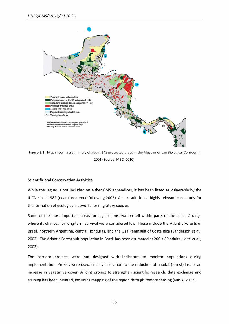
UNEP/CMS/ScC18/Inf.10.3.1
55
Figure 5.2: Map showing a summary of about 145 protected areas in the Mesoamerican Biological Corridor in
2001 (Source: MBC, 2010).
Scientific and Conservation Activities
While the Jaguar is not included on either CMS appendices, it has been listed as vulnerable by the
IUCN since 1982 (near threatened following 2002). As a result, it is a highly relevant case study for
the formation of ecological networks for migratory species.
Some of the most important areas for Jaguar conservation fell within parts of the species’ range
where its chances for long-term survival were considered low. These include the Atlantic Forests of
Brazil, northern Argentina, central Honduras, and the Osa Peninsula of Costa Rica (Sanderson et al.,
2002). The Atlantic Forest sub-population in Brazil has been estimated at 200 ± 80 adults (Leite et al.,
2002).
The corridor projects were not designed with indicators to monitor populations during
implementation. Proxies were used, usually in relation to the reduction of habitat (forest) loss or an
increase in vegetative cover. A joint project to strengthen scientific research, data exchange and
training has been initiated, including mapping of the region through remote sensing (NASA, 2012).

UNEP/CMS/ScC18/Inf.10.3.1
56
Support for scientific research that helps improve understanding of what Jaguars need and to work
with the people who live with Jaguars to minimize conflicts, began in 1999. In addition, livestock
owners of both large and small herds of domestic animals have been trained to reduce losses to cats
(WCS, 2012).
UNEP/CMS/ScC18/Inf.10.3.1
57
6. An International Protected Area for the Daurian steppe: Mongolian
Gazelles
Catering for regular and irregular migratory movements over a wide area
Lessons learnt from this example
The network approach in this instance provided a mechanism for one CMS Party
(Mongolia) to cooperate with two non-Parties (China and Russian Federation) in joint
action for migratory species.
A clear choice and definition of purposes at the outset can fundamentally affect what is
ultimately delivered. This network was conceived mainly as a protected area for a
transboundary ecological region, rather than specifically to address the migration system
of the gazelles (although it may have delivered better for migratory requirements of
cranes). Subsequent area extensions have included more parts of the gazelles’ migratory
system; but the overall network design remains shaped by the original concept.
Foresight in accounting protocols also pays dividends: in the three national jurisdictions
here, insufficient provision under specific budget-lines for the kind of cooperation
required made funding this network difficult.
Communication is the basic currency of cooperation: insufficient resources for language
translation in this case also caused difficulties.
Introduction
In the Russian-Mongolian-Chinese Dauria International Protected Area (DIPA) an ecosystem and
biodiversity conservation project commenced in 1994, especially for the protection of migrant
species of birds and mammals. The network consists of connected wetlands and steppe habitats in
the Amur-Heilong River Basin, with different eco-regions, crucial for the conservation of the
Mongolian Gazelle Procapra Gutturosa, the last mass migrating mammal of the Central Asian Steppe
(Tab. 6.1). It includes part of the migration route crossed by the Gazelles. The populations have
suffered dramatic declines in both numbers and distribution range (WFN, 2010). Over 2 million

UNEP/CMS/ScC18/Inf.10.3.1
58
individuals inhabit the Daurian steppe of eastern Mongolia - the optimal habitat and only 40 per cent
of the former habitat (including areas in China, Mongolia and Kazakhstan) remains (Fig. 6.1).
Large scale annual migrations (scale of hundreds of km) are undertaken across the steppe, with
herds ranging from 35,000 to 80,000 individuals (Smithsonian Institution, n.d.). They neither migrate
nor move with predictable, well-defined routes as the movement occurs in response to food
availability. A part of the population migrates while others make only extensive local movements
(UNEP/CMS, 2002). After the calving period in June-July, thousands of Gazelles migrate and breed in
the Mongolian-Manchurian grasslands (Mongolia and China), for autumn and winter (LHNET, n.d).
The main reasons behind the population decline are barriers (e.g. railway lines, barbed-wire fences),
poaching and habitat degradation (WFN, n.d.; UNEP/CMS, 2011). Climate Change may additionally
pose some threats. The related temperature increase of between 0.60 and 1.70°C in Amur-Heilong
has promoted variations of ecosystem conditions, particularly in the western part of the basin.
Ecosystem fluctuations (including provision of forage) and distribution of animal populations are
strongly correlated with cyclical climate fluctuations, thus changes in these phenomena influence
ultimately the population dynamics, distribution and “nomadic” migration routes (Amur Heilong,
n.d.).
Regarding the Convention on Migratory Species, only Mongolia is a CMS Party having joined in 1999
(UNEP/CMS Mongolia, CMS Report, 2011). In 2008, consultations with range states and other
relevant stakeholders promoted by Mongolia led to the launch, in 2011, of an Action Plan – Central
Eurasian Aridland Mammals Action Plan - to be finalized and adopted some time in the future. It
pinpoints key conservation concerns and aims to pave the way for further negotiations and the
development of a common strategic framework for action to conserve terrestrial migratory large
mammals and their habitats, also encompassing the particular Dauria region addressed in the
present case study (UNEP/CMS, Central Eurasian Aridland Mammals Action Plan, 2011).
Table 6.1: General Information of Dauria International Protected Area.
NAME OF THE NETWORK
(SIZE)
Dauria International Protected Area (1,725,220 million ha)
CMS SPECIES
(LISTED ON APP. I)
Mongolian Gazelle (Procapra gutturosa)
COUNTRIES
(POPULATION SIZE)
Russian Federation (over 3,0003)
Mongolia (2,000,0004)
3 WFN, n.d.
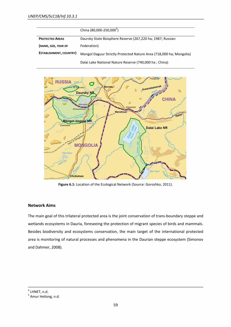
UNEP/CMS/ScC18/Inf.10.3.1
59
China (80,000-250,0005)
PROTECTED AREAS
(NAME, SIZE, YEAR OF
ESTABLISHMENT, COUNTRY)
Daursky State Biosphere Reserve (267,220 ha; 1987; Russian
Federation)
Mongol Daguur Strictly Protected Nature Area (718,000 ha; Mongolia)
Dalai Lake National Nature Reserve (740,000 ha ; China)
Figure 6.1: Location of the Ecological Network (Source: Goroshko, 2011).
Network Aims
The main goal of this trilateral protected area is the joint conservation of trans-boundary steppe and
wetlands ecosystems in Dauria, foreseeing the protection of migrant species of birds and mammals.
Besides biodiversity and ecosystems conservation, the main target of the international protected
area is monitoring of natural processes and phenomena in the Daurian steppe ecosystem (Simonov
and Dahmer, 2008).
4 LHNET, n.d.
5 Amur Heilong, n.d.
UNEP/CMS/ScC18/Inf.10.3.1
60
Network Design
The migration paths of Mongolian gazelles were not much considered in the design of the network
as it was rather designed with the aim of gathering the Protected Areas located in the junction of the
three borders of Russia, Mongolia and China, to protect the Dauria steppe transboundary eco-
region, under the established network.
Network Components
The protected areas cover around 10 per cent of the Daurian region and consist of wetland and
steppe habitats, not connected by ecological corridors, thus providing protection to just some of the
most important parts of the ecosystems. Due to this fragmentation and small size of the three PA, it
is not possible to conserve the ecosystem integrity and ecological functionality.
The major targeted endangered species include the migratory White-Naped Cranes Grus vipio, Red-
Crowned Cranes Grus japonensis, Hooded Cranes Grus monacha, Swan Goose Anser cygnoides as
well as the Mongolian Gazelle – three last species are CMS-listed (NEASPEC, 2010).
Regarding the protection status of the network it is very diverse and has strengthened over time. All
three nature reserves were included in the international net of biosphere reserves (MAB), were
nominated as Ramsar Sites (Wetlands of International Importance), as Internationally Important Bird
Areas (IBAs) and as Key Sites for Cranes in the North East Asia. In addition, the Daursky and Dalai
reserves are part of the network of UNESCO biosphere reserves, and there is currently a proposal to
include the international protected area on UNESCO List of World Nature Heritage (Goroshko, 2008).
Network Evolution
The DIPA was established in 1994 under a trilateral agreement between the Ministry of Environment
and Natural Resources of the Russian Federation, the Ministry of Nature and Environment of
Mongolia and the State Environment Protection Agency of China (NEASPEC, 2010).
Eighteen years after of the establishment of the DIPA, its size was increased step by step to include
other strictly protected areas and buffer zones, to accommodate important wetlands with habitats
of cranes, geese and other threatened species of birds, steppes with flocks of Mongolian Gazelles
and rocks with wild cats. The main purpose of the enlargement was to safeguard more areas crossed
by migration routes (Simonov and Dahmer, 2008).

UNEP/CMS/ScC18/Inf.10.3.1
61
Scientific and Conservation Activities
Before the establishment of the international reserve, research in Daurian eco-region was very
rarely undertaken. International research was particularly developed from 1994 onwards, and until
2007 it was meant to have had as main aims: the study of ecosystem’s status, main threats,
recommendations for the conservation of biodiversity and monitoring of ecosystems (Goroshko,
2008).
The basic guidelines for cooperation were adopted at the first meeting of the Joint Commission in
1995 (Dauria Reserve, n.d.). The Joint Commission of DIPA launched a two-year project (2010-2011),
in partnership with the Temperate Grasslands Conservation initiative, for the protection of gazelle
habitat. This project, based on the conservation vision presented in 2007 to the governments of
China, the Russian Federation and Mongolia, has the following main components: monitoring,
conservation action planning, volunteering and anti-poaching programmes, expansion of Protected
Areas and improved management, support of transboundary migration and international
cooperation (IUCN, 2010).
After 2000, DIPA staff expanded the focus of investigation and joint activities from the reserve’s core
areas to the vast territory of the greater Daurian eco-region – about 30,000,000 ha, an area a
hundred times larger than the size of the network (Goroshko, 2010). Monitoring activities include
counting populations and evaluating habitats conditions to allow dangerous changes to be noticed in
good time. Also some research is carried out into population structure and distribution.
The above-mentioned activities have enabled a set of recommendations to be made for gazelle
conservation in Mongolia and for the population to recover in the Russian Federation, while in China
the trend in population growth is unclear and most of the Chinese gazelle population is border
crossing with Mongolia (Large Herbivore Network, n.d.; Simonov and Dahmer, 2008).
Corridors in border fencing are being planned and executed to allow the free movement in the
migratory routes (WFN, 2010).

UNEP/CMS/ScC18/Inf.10.3.1
62
7. A management plan for the Danube River Basin: Sturgeons
Tackling obstacles to migration throughout an entire river system
Lessons learnt from this example
Defining the aim of this network in terms of securing habitat continuity has made it
very clearly focused on the specific added value of a network approach, for the
migratory species concerned. A similarly focused emphasis on targeting obstacles to
migration (while also addressing habitat quality and other issues) has also
contributed to its success.
For migratory fish in rivers, a truly strategic approach can only be organized at the
river basin scale. In the case of the Danube, the 14-country International Commission
for the Protection of the Danube River provides an appropriate institutional
cooperation platform for this.
EU legislation (the Water Framework Directive) has provided a strong policy driver for
the operation of this network.
Introduction
The International Commission for the Protection of the Danube River (ICPDR) consists of 14
countries along the Danube River (Tab. 7.1). Signed in 2000, the ICPDR aims to work as a platform for
the implementation of all transboundary aspects of the EU Water Framework Directive (WFD). As
part of this platform, a Sturgeon Action Plan has been implemented. This includes a step-by-step
approach to ensure river and habitat continuity for sturgeon and other migratory species at the
basin-wide scale. The Signatory Parties of the Sturgeon Action Plan are Austria, Bosnia-Herzegovina,
Bulgaria, Croatia, the Czech Republic, Germany, Hungary, Moldova, Montenegro, Romania, Serbia,
Slovakia, Slovenia and the Ukraine.
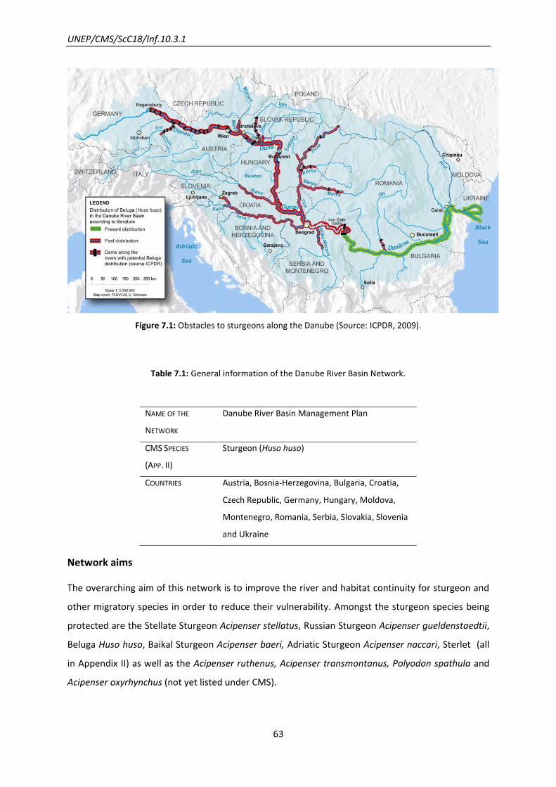
UNEP/CMS/ScC18/Inf.10.3.1
63
Figure 7.1: Obstacles to sturgeons along the Danube (Source: ICPDR, 2009).
Table 7.1: General information of the Danube River Basin Network.
Network aims
The overarching aim of this network is to improve the river and habitat continuity for sturgeon and
other migratory species in order to reduce their vulnerability. Amongst the sturgeon species being
protected are the Stellate Sturgeon Acipenser stellatus, Russian Sturgeon Acipenser gueldenstaedtii,
Beluga Huso huso, Baikal Sturgeon Acipenser baeri, Adriatic Sturgeon Acipenser naccari, Sterlet (all
in Appendix II) as well as the Acipenser ruthenus, Acipenser transmontanus, Polyodon spathula and
Acipenser oxyrhynchus (not yet listed under CMS).
NAME OF THE
NETWORK
Danube River Basin Management Plan
CMS SPECIES
(APP. II)
Sturgeon (Huso huso)
COUNTRIES Austria, Bosnia-Herzegovina, Bulgaria, Croatia,
Czech Republic, Germany, Hungary, Moldova,
Montenegro, Romania, Serbia, Slovakia, Slovenia
and Ukraine
UNEP/CMS/ScC18/Inf.10.3.1
64
Network design
The management plan includes a five-step process, incorporating research and monitoring with the
coordination and implementation of management strategies with different stakeholders.
Step 1: Performance of a feasibility study on enabling free passage of sturgeon species at
Iron Gates I and II as well as habitat restoration in the lower Danube (Fig. 7.1). This will take
downstream migration into account. The feasibility study requires fieldwork and so will last
approximately three years (until 2012)
Step 2: Plan, design and implement passage facilities for Iron Gates I and II
Step 3: Undertake habitat restoration for sturgeons and other migratory species in the
middle Danube, upstream of Iron Gates to, and beyond the Gabcikovo Dam.
Step 4: Plan, design and implement passage facilities at the Gabcikovo Dam
Step 5: Feasibility study on sturgeon passage at potentially affected hydropower plants.
Consider downstream migration and involve the hydropower stakeholders.
River Danube Green Corridor
The Danube Green Corridor Agreement was signed by Bulgaria, Romania, Ukraine and Moldova in
2000.
The aim was to extend the protected areas of the river by 160,000 ha, resulting in a total of 900,000
ha along the river’s final 1,000 km. This measure was taken to protect a wide range of endangered
species including Beluga Sturgeon Huso huso (CMS App. II) and has become incorporated into the
management plan.
Corridor design: the International Commission for the Protection of the Danube River has
coordinated in each of the signatory states different strategies which are most beneficial to
improving connectivity. These measures include habitat restoration in Bulgaria and Romania and
improved management in the Ukraine.
Scientific and Conservation Activities
Research before the establishment of the network
A consolidated database, as well as a few additional data sources provide 1,268 sites in the Danube
River Basin where management work is recorded (Fig. 7.2; ICPDR, 2009).These have suggested a
need to improve habitat continuity along the river.

UNEP/CMS/ScC18/Inf.10.3.1
65
Figure 7.2: Interruption of river continuity in the DRBD as estimated for 2015 (Source: ICPDR, 2009).
Research assisting the implementation of the network
As different parts of the river are threatened to varying extents, monitoring and research have been
implemented in order to designate an appropriate level of priority to each section. These are
displayed in Fig. 7.3 suggesting a highly organized map to assist in implementing action plans.
Figure 7.3: Danube River Basin – Restoration measures prioritized (Source ICPDR, 2009).

UNEP/CMS/ScC18/Inf.10.3.1
66
8. The North Atlantic “Sister Sanctuary” partnership: Humpback Whales
Linking protection of critical feeding and breeding areas
Lessons learnt from this example
A good basis in scientific research has given a robust justification for addressing
humpback whale conservation with a sufficient extent of protected areas in different
parts of its migratory range.
The nature of the conservation controls and protections applied varies considerably
between the different jurisdictions and protected area types in this network. Where
strengthened protection has been achieved, this appears to be unrelated to the existence
of the network; the added value of the latter lying instead more with collaboration on
research and outreach.
Introduction
Although Humpback Whales have been recently down-listed to “Least Concern” on the IUCN Red
List, their numbers have still by no means recovered from the depletion through commercial
whaling, especially in the breeding areas, in the 19th century and early 20th century (Reilly et al.,
2012). In the North Atlantic region, Humpback Whales have been legally protected from commercial
whaling by the International Whaling Commission (IWC) since 1955, with a consequent complete
whaling ban in 1966, except for indigenous, subsistence and scientific outtake (Kurvits et al., 2011).
The ‘gentle giant’ is a cosmopolitan species with an estimated world population of 60,000 animals.
Almost all sub-populations annually migrate between their mating and calving areas in tropical
coastal waters during winter to their summer feeding grounds in productive temperate and polar
waters (except for the resident Arabian Sea sub-population). The Western North Atlantic humpback
whale population is estimated to be between 10,000-14,000 individuals (estimate from 1993; Stevick
et al., 2003). New data will be provided by IWC in 2013 (IWC, n.d.; Kurvits et al., 2011).
Nowadays the main threats to humpback whales, after the complete ban of whaling, are the often
fatal entanglement in fishing gear as well as serious injuries from collisions with ships.
Documentation about ship strikes and entanglements is best for US waters. During the period 1999
to 2003, 26 reports of ship strikes or entanglements leading to death or serious injury were reported

UNEP/CMS/ScC18/Inf.10.3.1
67
from the Atlantic (Reilly et al., 2012). Recently pollution and oceanic noise have become new
challenging threats.
The North Atlantic Humpback Whale has its main winter breeding ground in the tropical waters of
the West Indies and migrates and disperses northwards during summer to the colder nutrient-rich
feeding areas along the East Canadian coast up to Davis Strait, Greenland and the Greenland Sea,
Iceland and the most northern site in the Barents Sea (Fig. 8.1). Six distinct feeding grounds are
known, representing relatively discrete subpopulations. A small number of the North Atlantic
feeding groups migrate to the mating and calving grounds around the Cape Verde Islands.
Intermixing between the two breeding areas occurs, leading to a male-mediated nuclear gene flow.
It is of interest that site fidelity is determined matrilineally. The biggest present breeding and calving
aggregation extends from Cuba to Venezuela with estimated 10,000-11,000 animals (as in 1992/93;
Stevick et al., 2003). Largest breeding groups are especially on Silver Bank and Navidad Bank (near
Dominican Republic – D.R.). Smaller aggregations exist in Samana Bay (D.R.), off the north-west coast
of Puerto Rico and around Virgin Island and eastern Antilles.
The main food sources are sand lance, herring and mackerel (Hain et al., 1982). Especially the U.S.
Stellwagen Bank Marine National Sanctuary is prime habitat of the sand lance (sand eels) enticing
the Humpback Whales in spring and summer to these rich feed grounds (Gulf of Maine Research
Institute, 2012; NOAA, 2012).
The Humpback Whale is listed on CMS Appendix I. Although not all its collaborating States are
Parties of CMS, the Sister Sanctuary partnership is the first cross-border network of sanctuaries that
tries to protect the critical sites of the migration route of one Humpback Whale population (Tab.
8.1).

UNEP/CMS/ScC18/Inf.10.3.1
68
Figure 8.1: Migration route of the North Atlantic Humpback Whale population
(Source: Stellwagen Bank National Marine Sanctuary Web Group, 2012).
Table 8.1: General information of the Sister Sanctuary Agreement.
NAME OF THE
NETWORK
Sister Sanctuary
CMS SPECIES
(LISTED ON APP. I)
Humpback Whale (Megaptera novaeangliae)
COUNTRY United States
Dominican Republic
United Kingdom, Bermuda
France, French Antilles
PROTECTED AREAS
(SIZE, YEAR OF
ESTABLISHMENT)
1) Gerry E. Studds Stellwagen Bank National Marine Sanctuary (2,180 km2,1992)
2) Bermuda Marine Mammal Sanctuary (450,370 km2,2000)
3) Sanctuary for the Marine Mammals of the Dominican Republic (19,438km2,1986)
4) Agoa Marine Mammal Sanctuary French Antilles: 143,618 km2,2000)

UNEP/CMS/ScC18/Inf.10.3.1
69
Network Aims
The Sister Sanctuary Agreement between the U.S. and the other states was developed to protect
both ends of the migration corridor of the Humpback Whales from the West Indies to one of their six
feeding grounds, the U.S. Stellwagen Bank National Marine Sanctuary (SBNMS), a mere 3,000 miles
apart, as well as to protect the stop-over sites. The reason behind the partnership is the protection
of the existing Humpback Whale population to ensure its survival in the U.S. waters off the coast of
Massachusetts (currently counting around 900 individuals).
Network Design
The network consists of agreements between marine sanctuaries of the United States, Dominican
Republic, French Antilles (seven territories under French sovereignty) and the Bermuda Islands
(British overseas territory). Partnerships between the organizations running the network were
concluded through a Memorandum of Agreement (MoA) to enhance coordination in management
efforts between the sanctuaries and help improve Humpback Whale recovery in the North Atlantic
(NOAA, 2012). Marine sanctuaries can be full marine protected areas (MPAs) or ‘national
sanctuaries’ that usually extend to the limits of a nation’s or national territory’s Exclusive Economic
Zone (EEZ), which is 200 nautical miles from the state’s coastal baseline. These ‘national sanctuaries’
are essentially ‘no cetacean hunting‘ areas which have generally no management body or plan (Hoyt
2005, 2011), thus Sanctuaries only offer protection in the sense of reducing shipping traffic,
controlled fishery of certain species, restriction of environmental impacts, controlled whale
watching, etc.
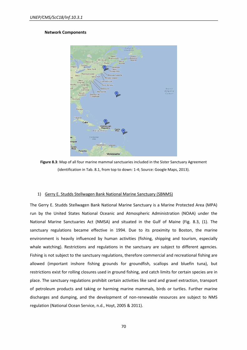
UNEP/CMS/ScC18/Inf.10.3.1
70
Network Components
Figure 8.3: Map of all four marine mammal sanctuaries included in the Sister Sanctuary Agreement
(identification in Tab. 8.1, from top to down: 1-4; Source: Google Maps, 2013).
1) Gerry E. Studds Stellwagen Bank National Marine Sanctuary (SBNMS)
The Gerry E. Studds Stellwagen Bank National Marine Sanctuary is a Marine Protected Area (MPA)
run by the United States National Oceanic and Atmospheric Administration (NOAA) under the
National Marine Sanctuaries Act (NMSA) and situated in the Gulf of Maine (Fig. 8.3, (1). The
sanctuary regulations became effective in 1994. Due to its proximity to Boston, the marine
environment is heavily influenced by human activities (fishing, shipping and tourism, especially
whale watching). Restrictions and regulations in the sanctuary are subject to different agencies.
Fishing is not subject to the sanctuary regulations, therefore commercial and recreational fishing are
allowed (important inshore fishing grounds for groundfish, scallops and bluefin tuna), but
restrictions exist for rolling closures used in ground fishing, and catch limits for certain species are in
place. The sanctuary regulations prohibit certain activities like sand and gravel extraction, transport
of petroleum products and taking or harming marine mammals, birds or turtles. Further marine
discharges and dumping, and the development of non-renewable resources are subject to NMS
regulation (National Ocean Service, n.d., Hoyt, 2005 & 2011).
UNEP/CMS/ScC18/Inf.10.3.1
71
The Sanctuary is an important feeding and nursery ground for more than a dozen cetacean species
and other protected species, including the North Atlantic Right Whale Eubalaena glacialis, Fin Whale
Balaenoptera physalus and Minke Whale Balaenoptera bonaerensis, Atlantic White-sided Dolphin
Lagenorhynchus acutus, Harbour Porpoise Phocoena phocoena, Grey Seal Halichoerus grypus and
Harbour Seal Phoca vitulina, Basking Shark Cetorhinus maximus - all species mentioned so far are
CMS listed; moonfish and four turtle species are users of these sites as well.
2) Bermuda Marine Mammal Sanctuary
Bermuda’s territorial waters are protected under a marine mammal ‘national sanctuary’ noted for its
relevance as a stop-over ground. The designation process was primarily led by the Sargasso Sea
Alliance. Humpback Whales are protected through the Fisheries Act of 1978 which applies to all
marine mammals, whereas the Protected Species Act of 2003 specifically protects threatened whale
species. Additional protected species are fin whale, Blue Whale Balaenoptera musculus, Sperm
Whale Physeter macrocephalus, Striped Dolphin Stenella coeruleoalba, Rough-toothed Dolphin Steno
bredanensis and Pygmy Sperm Whale Kogia breviceps (only the last two not CMS-listed).
3) Sanctuary for the Marine Mammals of the Dominican Republic (SMMRD)
The sanctuary has been declared as a MPA and was the first marine mammal sanctuary in the
Caribbean Region. It is also known as the Marine Mammal Sanctuary of Silver and Navidad Banks or
Santuario de Mamíferos Marinos de la República Dominicana.
It was first established as the Silver Bank Humpback Whale Sanctuary (Santuario de las Ballenas
Jorobadas del Banco de la Plata) and in 1996 and 2004 expanded to further include the Navidad
Bank and part of Samaná Bay (Fig. 8.3, (3)). It is administered by a multi-institutional umbrella
organization. Silver Bank has the densest aggregation of humpbacks, with almost 3,000 individuals
and about 85 per cent of the entire North Atlantic population are believed to use the whole
sanctuary as their breeding grounds (Hoyt, 2011). The 2000 Law of the Environment and Natural
Resources of the Dominican Republic strengthens overall environmental standards, as well as
protection and conservation of marine mammals. The management regime includes the whale
watching industry, commercial and artisanal fishing, and potential hydrocarbon exploration and
production in the area.
The sanctuary protects not only Humpback breeding areas, but also habitat used by dolphins, turtles
and manatees and the shallow platform coral reefs. Further cetaceans are the Bryde’s Whale

UNEP/CMS/ScC18/Inf.10.3.1
72
Balaenoptera brydei, Shortfinned Pilot Whale Globicephala macrorhynchus, pantropical Spotted
Dolphin Stenella attenuata and the two CMS-listed species Sperm Whale Physeter macrocephalus
and Bottlenose Dolphin Tursiops aduncus.
4) Agoa Marine Mammal Sanctuary, French Antilles
The ‘National Sanctuary’ stretches over the territorial waters and the Exclusive Economic Zone (EEZ)
of Guadeloupe, Martinique, Saint-Martin, Saint-Barthélémy (Fig. 8.3, (2)) to ensure the conservation
of marine mammals in waters under French sovereignty and jurisdiction. Twenty-four cetacean
species have been identified in the French Antilles.
Network Evolution
In December 2006 the world’s first Sister Sanctuary agreement was signed between the United
States National Oceanic and Atmospheric Administration (NOAA), Stellwagen Bank National Marine
Sanctuary (SBNMS) and the Dominican Republic’s Ministry of Environment and Natural Resources
Santuario de Mamiferos Marinos de la Republica Dominicana (SMMRD). Extension of the Network
was achieved in 2011 with France’s Marine Protected Areas Agency and Agoa Marine Mammal
Sanctuary in the French Antilles. In 2011 the Bermuda Department of Environmental Protection
signed a Letter of Intent to establish a “Sister Sanctuary” partnership and in 2012 the Memorandum
of Agreement (MoA) became effective.
Various programmes and conventions have been set up globally and regionally to protect the marine
environment and wildlife. The UNEP’s Cartagena Convention (Convention for the Protection and
Development of the Marine Environment of the Wider Caribbean Region), the key environmental
treaty in this region was adopted in 1983 and ratified in 1986. It requires all Parties to establish
specially protected areas and foster exchange of information and cooperation in scientific research
and monitoring. In this context the Protocol concerning Specially Protected Areas and Wildlife in the
Wider Caribbean Region, the SPAW Protocol, under the UNEP-CEP (Caribbean Environment
Program), was established and became international law in 2000. The SPAW Protocol recommends
the establishment of protected areas to create a regional network of MPAs for ecosystem-level
protection. In 2008 the UNEP-CEP within the framework of the SPAW Protocol developed the Action
Plan for the Conservation of Marine Mammals (MMAP) in the Wider Caribbean Region, which states
clearly the establishment of MPAs or other management measures to maintain ecological
connection (e.g. Sister Sanctuaries, MMAP 2.4). The long-term objectives of the MMAP state the

UNEP/CMS/ScC18/Inf.10.3.1
73
conservation of all marine mammal species and their habitats to ensure their recovery, as well as to
establish regional cooperation programs to increase scientific, technical, and educational exchange
on national, regional and international organisations (Stellwagen Bank National Marine Sanctuary
Web Group, n.d.).
Scientific and Conservation Activities
Photo identification (photo-ID) in the early 80s proved the migration path between the U.S.
Stellwagen Bank and the Dominican Republic’s Silver Bank. The unique black and white patterns of
the underside of the tail work like a fingerprint which enables individual identification via
photographic shots of the fluke. The comprehensive North Atlantic Humpback Whale Catalogue
contains photographs of approximately 7,000 Humpbacks taken by scientists, enthusiastic citizens
and tourists (College of the Atlantic, n.d.). The ‘Years of the North Atlantic Humpbacks’ (YoNAH)
project in 1992 and 1993 using photo-ID and biopsy (genetic) sampling gave insights into the
abundance, population structure and migratory movements and feeding aggregations of the
Humpbacks. The follow up study ‘More North Atlantic Humpbacks’ (MoNAH) in 2004 and 2005
focused in particular on the population of Stellwagen Bank and Silver Bank. Since 1999 the ‘Digital
acoustic recording tag’ (short DTAG) was used to study the behavior of whales. The instrument is
used to obtain information about the movements (speed and depth) of whales as well as the sounds
the whales make and hear (Johnson, 2005). Recently the so-called ‘Crittercams’ of National
Geographic provide videos showing group coordination during feeding events (Slivka, 2012).
Network Activities
Each sanctuary has signed its own Memorandum of Agreement with the U.S. Stellwagen Bank.
Collaboration is normally on research, monitoring, educational and outreach programmes, as well as
collaborative work on exchange of practical experience, and development and coordination of
management (Stellwagen Bank National Marine Sanctuary Web Group).
Regarding specific achievements of the network in terms of population numbers, a trend has not
been identified, in part as a result of high variability in Humpback whale numbers using the SBNMS,
and also other sites of the Gulf of Maine (D. Wiley, personal communication, 2013). Nevertheless,
unrelated to the network, achievements in some sanctuaries have been made due to intense
research. The U.S. National Marine Fisheries Services (NMFS) has modified shipping lanes northward
and put on seasonal speed restrictions to reduce negative impact on the Humpback Whale

UNEP/CMS/ScC18/Inf.10.3.1
74
populations. Scientists have estimated that these adaptations could reduce whale strikes with
vessels by about 81 per cent (Tweed, 2011).
Future of the Network
NOAA’s goal is to extend the Sister Sanctuary Partnership network throughout the Caribbean.
Negotiations of new agreements are currently being undertaken with former Dutch territories in the
eastern Caribbean. The neighbouring nations of the Agoa Sanctuary, Dominica and St Lucia, have
also been asked to join (Hoyt, 2011).
UNEP/CMS/ScC18/Inf.10.3.1
75
9. The Great Barrier Reef Marine Park: Dugongs
A network of sub-zones within one large protected area
Lessons learnt from this example
The network in this instance consists of zones with particular restrictions (eg no-take
zones) all within the Great Barrier Reef Marine Park; hence this shows an application of
the “network” concept within a single protected area, rather than (for example) a chain
of such areas. The migratory movements primarily addressed by this take place within
one country (albeit at continental scale, since the country is Australia) rather than as
migration in the CMS sense; but the concept would in principle be applicable to
transfrontier protected areas too.
The scale of the network design has had to be sufficient to encompass natural variability
in the distribution of the dugong’s favoured habitat (seagrass beds), resulting from
cyclones and other episodic extreme weather events.
Introduction
Australia contains the world’s largest population of dugongs (UNEP 2002). Within Australia, an
estimated 10,000 to 14,000 dugongs occur in the Great Barrier Reef Marine Park (GBRMP), one of
the world’s largest marine protected area at 344,400 km2. It extends southwards from the tip of
Cape York in Queensland almost as far as Bundaberg (Fig. 9.1, Marsh et al., 2005).
Dugongs are protected in Australia under national legislation (Environment Protection and
Biodiversity Conservation Act 1999), as well as under Queensland (state) legislation (Nature
Conservation Act 1992) and within the Marine Park under the Great Barrier Reef Marine Park Act
1975 (Commonwealth).
The GBRMP is managed by the Great Barrier Reef Marine Park Authority (GBRMPA), an independent
statutory authority established by the Federal Government under the Great Barrier Reef Marine Park
Act 1975. Management of the Great Barrier Reef relies upon a number of Commonwealth and
Queensland agencies to regulate access and to control or mitigate impacts associated with activities.
These agencies employ various management approaches including education, planning,
environmental impact assessment, monitoring, stewardship and enforcement. GBRMPA has worked
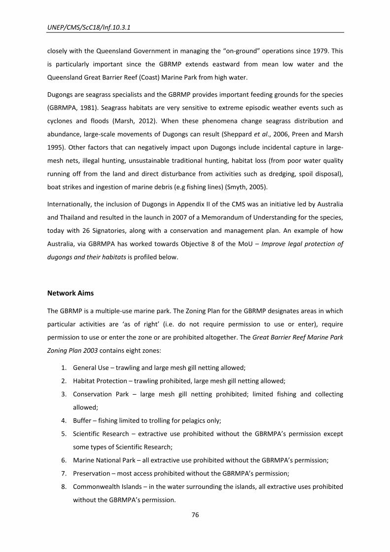
UNEP/CMS/ScC18/Inf.10.3.1
76
closely with the Queensland Government in managing the “on-ground” operations since 1979. This
is particularly important since the GBRMP extends eastward from mean low water and the
Queensland Great Barrier Reef (Coast) Marine Park from high water.
Dugongs are seagrass specialists and the GBRMP provides important feeding grounds for the species
(GBRMPA, 1981). Seagrass habitats are very sensitive to extreme episodic weather events such as
cyclones and floods (Marsh, 2012). When these phenomena change seagrass distribution and
abundance, large-scale movements of Dugongs can result (Sheppard et al., 2006, Preen and Marsh
1995). Other factors that can negatively impact upon Dugongs include incidental capture in large-
mesh nets, illegal hunting, unsustainable traditional hunting, habitat loss (from poor water quality
running off from the land and direct disturbance from activities such as dredging, spoil disposal),
boat strikes and ingestion of marine debris (e.g fishing lines) (Smyth, 2005).
Internationally, the inclusion of Dugongs in Appendix II of the CMS was an initiative led by Australia
and Thailand and resulted in the launch in 2007 of a Memorandum of Understanding for the species,
today with 26 Signatories, along with a conservation and management plan. An example of how
Australia, via GBRMPA has worked towards Objective 8 of the MoU – Improve legal protection of
dugongs and their habitats is profiled below.
Network Aims
The GBRMP is a multiple-use marine park. The Zoning Plan for the GBRMP designates areas in which
particular activities are ‘as of right’ (i.e. do not require permission to use or enter), require
permission to use or enter the zone or are prohibited altogether. The Great Barrier Reef Marine Park
Zoning Plan 2003 contains eight zones:
1. General Use – trawling and large mesh gill netting allowed;
2. Habitat Protection – trawling prohibited, large mesh gill netting allowed;
3. Conservation Park – large mesh gill netting prohibited; limited fishing and collecting
allowed;
4. Buffer – fishing limited to trolling for pelagics only;
5. Scientific Research – extractive use prohibited without the GBRMPA’s permission except
some types of Scientific Research;
6. Marine National Park – all extractive use prohibited without the GBRMPA’s permission;
7. Preservation – most access prohibited without the GBRMPA’s permission;
8. Commonwealth Islands – in the water surrounding the islands, all extractive uses prohibited
without the GBRMPA’s permission.
UNEP/CMS/ScC18/Inf.10.3.1
77
Network Design
The development approach used for the 2003 zoning plan involved the application of biophysical
data for the selection of no-take sites (Kerrigan et al. 2008, Fernandes et al., 2005). Dugongs were
explicitly considered in the Biophysical Operating Principles (Fernandes et al., 2005, Dobbs et al.
2008). The aim was to protect the areas which consistently supported high densities of Dugongs,
with the identification of 31 important areas for Dugongs (Fig. 9.1, Tab. 9.1). The sites were
identified based on available information on Dugong distribution data and known information about
the location of seagrass meadows (Dobbs et al., 2008). Knowledge of connectivity among sites and
how Dugongs moved among seagrass areas was limited at the time the plan was developed (2002-
2003) and was not a major factor in the design of this new network (Dobbs et al., 2008).
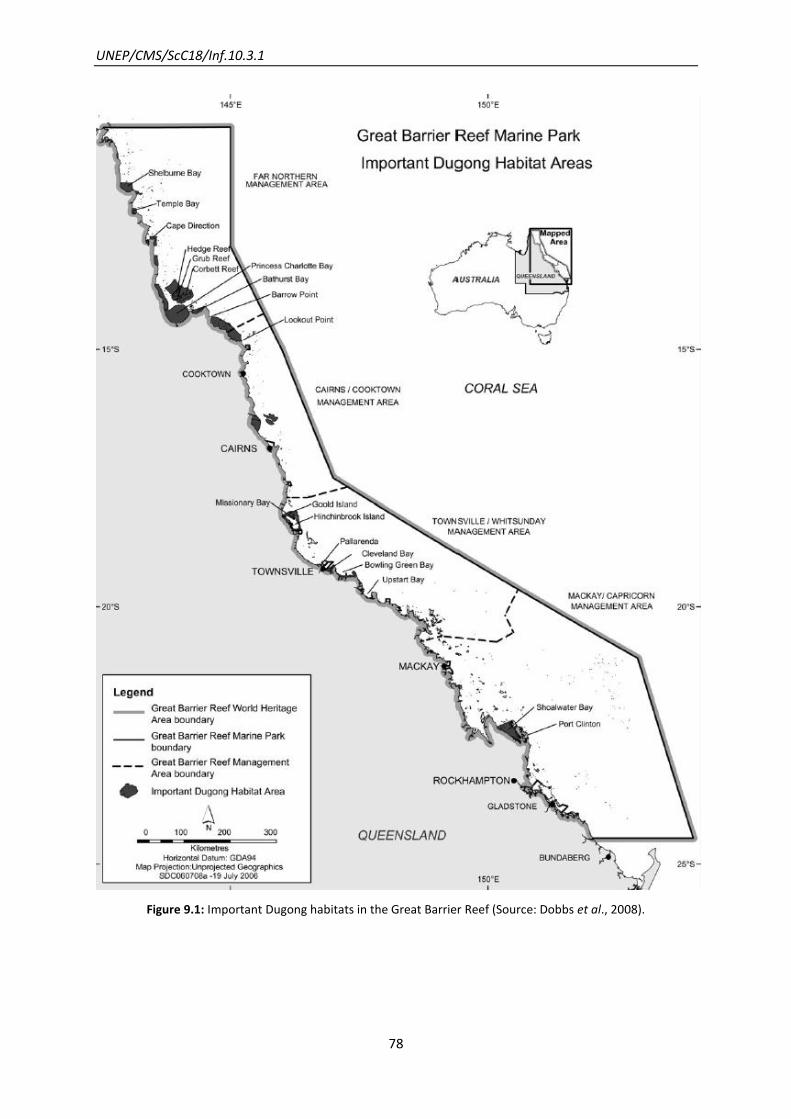
UNEP/CMS/ScC18/Inf.10.3.1
78
Figure 9.1: Important Dugong habitats in the Great Barrier Reef (Source: Dobbs et al., 2008).

UNEP/CMS/ScC18/Inf.10.3.1
79
Table 9.1: Dugong habitats identified as important for consideration in developing the Great Barrier Reef
Marine Park Zoning Plan 2003.
NAME OF THE NETWORK Dugong in the Great Barrier Reef Marine Park Zoning Plan 2003
CMS SPECIES
(LISTED ON APP. II)
Dugong (Dugong dugon)
COUNTRY Australia
PROTECTED AREAS
(SIZE)
13-093, Magpie and Lytton Reefs (493 km2)
Area behind Turtle Island (0.2 km2)
Bathurst Bay (202 km2)
Batt and Tongue Reefs (33 km2)
Bowling Green Bay (190 km
2)
Cape Direction Green Zone (160 km2)
Clairview Bluff Carmilla Creek DPA (1
8 km2)
Cleveland Bay (101 km
2)
Edgecumbe Bay (8 km
2)
French Point to Bobardt Point (147 km2)
Hedge, Grubb and Corbett Reefs (1,127 km2)
Hinchinbrook Area (425 km
2)
Ince Bay DPA (14 km
2)
Lookout Point to Barrow Point (1,266 km2)
Lucinda to Allingham-Halifax Bay DPA (0,7 km
2)
Magnetic Island (8 km2)
Margaret Bay (34 km2)
Orford Ness (32 km2)
Pallarenda (13 km2)
Port Clinton including Island Head Creek (1 km
2)
Port Douglas – Low Isles, North (115 km2)
Port Douglas – Low Isles, South (337 km2)
Port of Gladstone-Rodds Bay DPA1
(2 km2)
Port Stewart (488 km2)
Princess Charlotte Bay (1,441 km2)
Repulse Bay (4 km
2)
Shelburne Bay (419 km2)
Shoalwater Bay (764 km
2)
Steward peninsula, Newry Islands, Ball Bay (13 km2)
Temple Bay (96 km2)
Upstart Bay (25 km2)
SIZE OF THE NETWORK 8,278 km2
Network Components
Eleven biophysical operational principles, recommended by an Independent Scientific Steering
Committee, were applied in identification phase of the Representative Areas Program to provide

UNEP/CMS/ScC18/Inf.10.3.1
80
minimum protection through declaration of no-take areas (Australian Gov, 2002). Principles to apply
in the planning of the network ranged from the inclusion of minimum network size and number of
no-take areas, to the protection of the integrity and diversity of reef and non-reef bioregion, use of
best information available for the creation of viable networks, consideration of sea and land uses for
the determination of no-take areas, and a minimum amount of each community type and physical
environment type (Fernandes et al., 2005). Overall, protected no-take zones across the Marine Park
were increased from 4.5 per cent to almost 33.5 per cent (Fernandes et al., 2005). The Queensland
Government complemented the zoning arrangements in the GBRMP (Queensland Government
2004).
Based on expert advice, the recommendation for dugong habitats was that at a minimum, protected
no-take areas (Marine National Park and Preservation Areas) should represent identified dugong
habitat summed to about 50 per cent of all high priority dugong habitats (sites listed in Table 9.1;
Dobbs et al., 2008). The result of the zoning was that more than 40 per cent of the identified
habitats were incorporated into no-take areas under the new network (Dobbs et al., 2008).
Network Evolution
Dugong and seagrass conservation have been a focus of effort for the Great Barrier Reef for many
decades. In the early 1990s, concerns were raised over the population status of Dugongs along the
urban coast of the GBRMP (south from Cooktown). In 1994 the GBRMPA prepared a Turtle and
Dugong Conservation Strategy aiming to maintain turtle and Dugong populations at current or
higher levels throughout their range in the Great Barrier Reef Region. The Strategy recommended a
range of initiative be implemented with consideration of the biological constraints of the species and
through negotiation with scientists, Aboriginals and Torres Strait Islanders, conservation groups, the
commercial fishing industry, management agencies and the general public (GBRMPA, 1994).
In 1997, the Queensland Government, through its fisheries legislation, introduced 15 Dugong
Protected Areas (DPAs), which banned or restricted gill netting practices in important Dugong areas.
Also in 1997, GBRMPA enacted special measures to protect Dugong and Dugong habitat in
Shoalwater Bay, home to the largest Dugong population in the southern Great Barrier Reef, through
the Shoalwater Bay (Dugong) Plan of Management 1997 (GBRMPA, 1997). A range of other actions
also occurred from 1997-2000 (Dobbs et al., 2012).
In 1999 the Queensland Government launched a Nature Conservation (Dugong) Conservation Plan
1999 to control threats to Dugongs by incorporating measures in broader management plans and

UNEP/CMS/ScC18/Inf.10.3.1
81
strategies, changing fishing practices and promoting low-impact boating practices (GBRMPA, 1994;
EPA, 1999).
In 2003, GBRMPA, as part of the Australian Federal Government’s National Representative System
for Marine Protected Areas programme, finalized the Great Barrier Reef Marine Park Zoning Plan
2003, which aimed for the conservation of the Great Barrier Reef’s biodiversity by protecting
‘representative’ examples of all the different habitats and communities in the GBRMP, including
Dugongs (Fernandes et al., 2005).
Conservation and Scientific Activities
GBRMPA recognized that its zoning plan would not adequately address all of the pressures on
Dugongs and seagrass habitats within the GBRMP. It needed research and to be able to work with its
partner agencies to address other impacts.
Research and Monitoring
Since the 1970s significant research effort has been made to quantify the distribution and
abundance of Dugongs to facilitate management of the species in Queensland. For example,
standardized aerial surveys began in the mid-1980s to address population estimates. Today, these
estimates indicate stability in Dugong populations in areas north of Cooktown – one of the most
important areas for Dugong habitat (UNEP, 2002) although there are concerns about overharvest in
the region (Heinsohn et al., 2004), and declines further south along the urban coast of Queensland
(Sobtzick et al., 2012). Indeed, the Northern Great Barrier Reef Region between Hunter Point and
Cape Bedford near Cooktown (Fig. 9.1), is the region with the largest area of seagrass in the GBR and
where most seagrass beds are subject to little human influence (Morissette, 1992 cited in UNEP,
2002).
Satellite Platform Transmitter Terminal (PTT) and Global Positioning System (GPS) tracking of a total
of 70 Dugongs have been carried out since 1987, trying initially to fill the gaps in information on the
nature of the large-scale movements of Dugongs. The results show that more than half of this group
conducts large-scale movements (Sheppard et al., 2007). These studies also have concluded that at
least some Dugongs in east Australia undertake seasonal macro-scale movements in response to low
water temperatures in winter (Sheppard et al., 2006), alone or with their calves in search of food
(Lawler et al., 2002), or as a reaction to extreme climatic degradation of seagrass food resources or
driven by spatial memory of foraging patch distribution (Sheppard, 2008). In addition, some of the

UNEP/CMS/ScC18/Inf.10.3.1
82
studied movements were return movements suggesting ranging movements rather than dispersal
movements, with high fidelity to coastal sites (Sheppard, 2008). Some Dugongs are also know to
undertake large-scale movements at regional scales, but the causes of these movements remain
poorly known (Sheppard, 2008). Nevertheless, the nature of these movements has only recently
started to be discovered.
In 1999 the Great Barrier Reef Ministerial Council (a joint forum between the Australian and
Queensland Government Ministers to facilitate and oversee implementation and achievement of the
objectives of an intergovernmental agreement between the two governments) agreed to a Dugong
research strategy as a guide to setting priorities, allocating funds and assessing performance of
Dugong recovery and conservation actions in the Great Barrier Reef and Hervey Bay-Great Sandy
regions (UNEP, 2002). An updated strategy was released (period 2006-2011), continuing the goals of
the first strategy, but extending the geographical scope to include South-East Queensland and the
Torres Strait, as a result of the knowledge that Dugongs move among these areas. One of the
proposed projects recommended that large-scale aerial surveys of Dugongs “across the entire
dugong range of north-eastern Australia to account for large-scale Dugong movements” occur
(Hodgson, 2007).
Additional Network Activities
Some of the main protection measures that came into effect with the Great Barrier Reef Marine Park
Zoning Plan 2003 and since include:
establishment of a Remote Natural Area in the Far Northern Management Area of the
Marine Park, designating areas in which works as dumping spoil, reclamation, beach
protection works, harbour works, and constructing or operating a structure (with exception
of a vessel, mooring or a navigational aid) are not allowed;
Establishing specific large-mesh netting restrictions in Princess Charlotte Bay;
complementing Queensland rules in Dugong Protection Areas; further amending large-mesh
netting rules within the Bowling Green Bay;
Traditional use of marine resources agreements with Great Barrier Reef Aboriginal
Traditional Owners to ensure sustainable hunting of dugongs and other species within the
GBRMP.
(Dobbs et al., 2008, GBRMPA, 2011)

UNEP/CMS/ScC18/Inf.10.3.1
83
Other measures not taken under the new zoning plan but affecting the same sites are for instance:
Improving water quality through the Reef Water Quality Protection Plan to increase the
protection of inshore habitats (Australian Government and Queensland Government, 2009);
Promoting ecologically sustainable fisheries practices through Queensland Government
(state) fisheries management plans including reducing the risk of entanglement and death of
dugongs in large mesh gill nets (Dobb et al., 2008)
In relation to the zoning network’s achievements since coming into effect in 2004, approximately 96
per cent of habitat of high conservation value for dugongs and 93 per cent with medium
conservation value is at low risk from a range of human activities (e.g. commercial gill netting and
trawling, water quality, harvesting by indigenous people and boat strike) (McCook et al., 2010).

UNEP/CMS/ScC18/Inf.10.3.1
84
10. Marine Protected Areas in the Lesser Sunda Ecoregion: Large Marine
Fauna
Coastal and marine areas integrated in a single network
Lessons learnt from this example
Given the threats of system-level change to fragile underwater habitats in this area,
linked to a range of pressures (including climate change) it has proved valuable to design
this network according to concepts of resilience (for example in determining adequate
representation of habitat and species distributions).
In order to cater for elements such as marine species that nest on beaches, migratory
routes that span shallow and deep waters, land-based threats to the marine
environment, and human use of marine resources, this network has had to be designed
in such a way as to take an integrated approach to both the coastal and offshore
components of the ecoregion.
Figure 10.1: The Lesser Sunda Ecoregion comprising Indonesia and Timor-Leste (A. Darmawan in: J. Wilson et
al., 2011).
UNEP/CMS/ScC18/Inf.10.3.1
85
Introduction
The Lesser Sunda Ecoregion stretches from the Indonesian island of Bali to Timor-Leste, and
encompasses more than 325,000 km2. It is one of 11 ecoregions identified in the Coral Triangle – the
area of the world’s highest coral reef biodiversity (Veron, et al. 2009). In addition to high diversity
and endemism in coastal species, the Lesser Sunda Ecoregion is one of the most important areas in
the Coral Triangle for cetaceans and other large marine species including Blue and Sperm Whales. It
acts as both a migratory pathway and provides critical feeding areas for migratory marine animals.
This is because of the great diversity of underwater habitats which include seamounts, canyons and
steep underwater landscapes where depths of over 2,000 meters occur within a few kilometres of
the coast. Although the Lesser Sunda Ecoregion is remote and has a relatively low population it faces
many threats including overfishing, destructive fishing, coastal development, deep sea dumping of
mine waste, seismic testing, shipping and pollution. In addition, the impact of climate change has
already been seen in this and other parts of the Coral Triangle. As well as impacts on coral reefs,
marine migratory species may be affected by the disturbance of ocean circulation or the change in
food availability (UNEP-CMS, 2009).
Therefore, the creation of a network of marine protected areas (MPA), which incorporates principles
of resilience, would contribute towards the conservation of marine fauna and provide sustainable
sources of food and income for local people. The final MPA network design included areas for both
coastal habitats and fisheries and for large and migratory marine animals because of their
importance in the Lesser Sunda Ecoregion. The MPA network design incorporates principles of
resilience (McLeod, et al. 2009) for coastal habitats and identifies critical deep sea and offshore
areas for large and migratory marine animals. Where possible, coastal and deep sea MPAs were
linked.
The Savu Sea Marine National Park (MNP) encompasses 3.5 million hectares of water and islands
between West Timor, Sumba and Flores. It was designated in 2009 and is the first MPA in Indonesia
to be declared primarily for the conservation of cetaceans. The waters of Savu Sea MNP alone
harbour 22 species of marine mammals including different species of whales, dolphins and dugongs.
Additionally, it is home to six out of seven worldwide known species of marine turtles (Tab. 10.1)
(Savu Sea Marine National Park, n.d.).
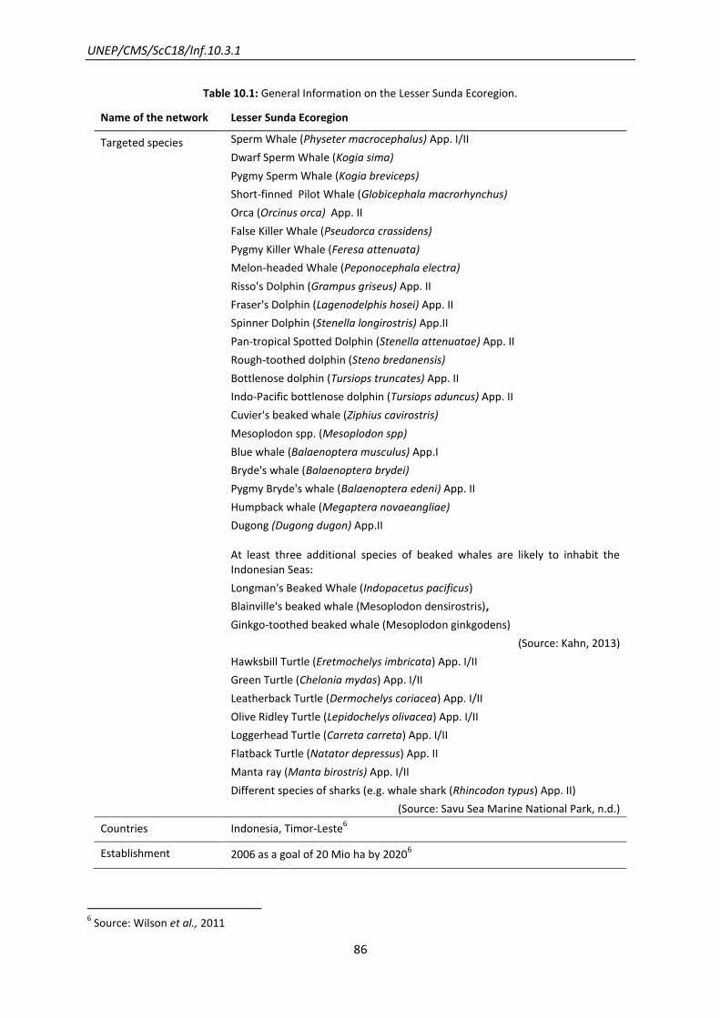
UNEP/CMS/ScC18/Inf.10.3.1
86
Table 10.1: General Information on the Lesser Sunda Ecoregion.
Name of the network Lesser Sunda Ecoregion
Targeted species
Sperm Whale (Physeter macrocephalus) App. I/II
Dwarf Sperm Whale (Kogia sima)
Pygmy Sperm Whale (Kogia breviceps)
Short-finned Pilot Whale (Globicephala macrorhynchus)
Orca (Orcinus orca) App. II
False Killer Whale (Pseudorca crassidens)
Pygmy Killer Whale (Feresa attenuata)
Melon-headed Whale (Peponocephala electra)
Risso's Dolphin (Grampus griseus) App. II
Fraser's Dolphin (Lagenodelphis hosei) App. II
Spinner Dolphin (Stenella longirostris) App.II
Pan-tropical Spotted Dolphin (Stenella attenuatae) App. II
Rough-toothed dolphin (Steno bredanensis)
Bottlenose dolphin (Tursiops truncates) App. II
Indo-Pacific bottlenose dolphin (Tursiops aduncus) App. II
Cuvier's beaked whale (Ziphius cavirostris)
Mesoplodon spp. (Mesoplodon spp)
Blue whale (Balaenoptera musculus) App.I
Bryde's whale (Balaenoptera brydei)
Pygmy Bryde's whale (Balaenoptera edeni) App. II
Humpback whale (Megaptera novaeangliae)
Dugong (Dugong dugon) App.II
At least three additional species of beaked whales are likely to inhabit the Indonesian Seas:
Longman's Beaked Whale (Indopacetus pacificus)
Blainville's beaked whale (Mesoplodon densirostris),
Ginkgo-toothed beaked whale (Mesoplodon ginkgodens)
(Source: Kahn, 2013)
Hawksbill Turtle (Eretmochelys imbricata) App. I/II
Green Turtle (Chelonia mydas) App. I/II
Leatherback Turtle (Dermochelys coriacea) App. I/II
Olive Ridley Turtle (Lepidochelys olivacea) App. I/II
Loggerhead Turtle (Carreta carreta) App. I/II
Flatback Turtle (Natator depressus) App. II
Manta ray (Manta birostris) App. I/II
Different species of sharks (e.g. whale shark (Rhincodon typus) App. II)
(Source: Savu Sea Marine National Park, n.d.)
Countries Indonesia, Timor-Leste6
Establishment 2006 as a goal of 20 Mio ha by 20206
6 Source: Wilson et al., 2011
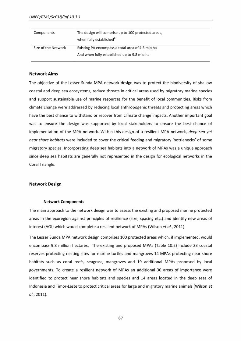
UNEP/CMS/ScC18/Inf.10.3.1
87
Components The design will comprise up to 100 protected areas,
when fully established6
Size of the Network Existing PA encompass a total area of 4.5 mio ha
And when fully established up to 9.8 mio ha
Network Aims
The objective of the Lesser Sunda MPA network design was to protect the biodiversity of shallow
coastal and deep sea ecosystems, reduce threats in critical areas used by migratory marine species
and support sustainable use of marine resources for the benefit of local communities. Risks from
climate change were addressed by reducing local anthropogenic threats and protecting areas which
have the best chance to withstand or recover from climate change impacts. Another important goal
was to ensure the design was supported by local stakeholders to ensure the best chance of
implementation of the MPA network. Within this design of a resilient MPA network, deep sea yet
near shore habitats were included to cover the critical feeding and migratory ‘bottlenecks’ of some
migratory species. Incorporating deep sea habitats into a network of MPAs was a unique approach
since deep sea habitats are generally not represented in the design for ecological networks in the
Coral Triangle.
Network Design
Network Components
The main approach to the network design was to assess the existing and proposed marine protected
areas in the ecoregion against principles of resilience (size, spacing etc.) and identify new areas of
interest (AOI) which would complete a resilient network of MPAs (Wilson et al., 2011).
The Lesser Sunda MPA network design comprises 100 protected areas which, if implemented, would
encompass 9.8 million hectares. The existing and proposed MPAs (Table 10.2) include 23 coastal
reserves protecting nesting sites for marine turtles and mangroves 14 MPAs protecting near shore
habitats such as coral reefs, seagrass, mangroves and 19 additional MPAs proposed by local
governments. To create a resilient network of MPAs an additional 30 areas of importance were
identified to protect near shore habitats and species and 14 areas located in the deep seas of
Indonesia and Timor-Leste to protect critical areas for large and migratory marine animals (Wilson et
al., 2011).

UNEP/CMS/ScC18/Inf.10.3.1
88
Table 10.2: Existing coastal reserves and marine protected areas in the Lesser Sunda Ecoregion.
1) Bali Barat National Park
2) Ngurah Rai Grand Forest Park
3) Gili Matra Marine Nature Recreation Park
4) Bangko-Bangko Nature Recreation Park
5) Pelangan Nature Recreation Park
6) Cape Tampa Forest Reserve
7) Gunung Tunag Nature Recreation Park
8) Gili Sulat Marine Conservation Area
9) Pedauh Nature Reserve
10) Panjang Island Nature Conservation Area
11) Moyo Marine Nature Recreational Park
12) Satonda Island Nature Recreational Park
13) Toffo Kota Lambu Nature Reserve
14) Gali Banda Marine Conservation Area
15) Komodo National Park
16) Savu Sea (1) Marine National Park
17) Manupeu Tanadaru National Park
18) Riung Marine Nature Recreational Park
19) Wolo Tadho Nature Reserve
20) Maumere Bay Marine Nature Recreational Park
21) Bessar Island Nature Recreational Park
22) Savu Sea (2) Marine National Park
23) Ndana Is Game Reserve
24) Harlu Wildlife Reserve
25) Perhatu Wildlife Reserve
26) Kupang Bay Marine Nature Recreational Park
27) Danau Tuadale Wildlife Reserve
28) Menipo Island Nature Recreational Park
29) Dataran Bena Game Reserve
30) Maubesi Nature Reserve
31) Selat Pantar Marine Conservation Area
32) Rusa Island Game Reserve

UNEP/CMS/ScC18/Inf.10.3.1
89
33) Lapang Island Nature Recreational Park
34) Batang Island Nature Recreational Park
35) Tuti Adagae Nature Recreational Park
36) Nino Konis Santana National Park
37) Pantar Strait Marine Protected Area
(Source: Wilson et al., 2011)
Network Evolution
In 2006, the designing of a resilient network of MPAs in the Lesser Sunda Ecoregion was initiated
between The Nature Conservancy (TNC) and the Ministry of Marine Affairs and Fisheries (MMAF) of
Indonesia. MMAF confirmed that it would accept the design as a ‘road map’ for the establishment
of MPAs in the Lesser Sunda Ecoregion.
The MPA network design was developed using both a detailed scientific analysis and extensive
stakeholder consultation to ensure their interests and needs were taken into account and the design
would be locally relevant.
Key Steps
From 2006 to 2009 four key steps were undertaken to design the MPA network:
1. Setting objectives, boundaries and MPA network design principles
2. Identifying and compiling high priority information
3. Assembling a GIS database
4. Designing a resilient network of MPAs using a decision-support tool with stakeholder inputs
(Derived from Wilson et al., 2011)
The scale of the network was defined to incorporate the whole area of the Lesser Sunda Ecoregion
(Wilson et al., 2011).
Once species and habitats of concern (conservation targets) were identified, specific design
principles for biophysical and socio-economic aspects for shallow coastal areas were developed.
These were based on resilience principles (McLeod et al 2009) and principles used for developing
MPAs in Indonesia (Wiryawan et al 2006). For deep sea areas, principles were designed specifically
for this study.
UNEP/CMS/ScC18/Inf.10.3.1
90
A list of biophysical and socio-economic data layers needed to design the MPA network was
identified based on the design principles. A database encompassing 61 themes was developed and
analyzed using the decision support software Marxan. Goals for representation of area of habitats or
species distribution were set and usually included 30 per cent representation for coastal habitats but
up to 80 per cent for some endangered species such as dugong. Input was sought from key
stakeholders on three occasions during the development of the MPA network design either through
workshops or consultation with individual government agencies.
The deep sea MPAs were primarily identified through a process of expert mapping and analysis of
key habitats known to be important for large and migratory marine species. These included
a) Migratory ‘bottlenecks’ – in the Lesser Sunda there are just a few narrow straits between
islands deep enough for cetaceans to migrate through. Ombai Strait between Indonesia and
Timor-Leste is one of the most important ‘bottlenecks’.
b) Underwater habitats – areas of steep slopes which reach depths over 2,000 metres,
seamounts and pinnacles, underwater canyons and sills which are all known as important
habitats for large and migratory marine animals
c) High productivity from upwelling – there are a number of areas in the Lesser Sunda which
have significant seasonal and predictable upwelling events which provide an important food
source for resident and migratory marine animals.
In the second draft of the network design deep sea habitats were included. Deep sea habitats are
especially important for the migration of cetaceans. During the development of the design 14
additional deep sea areas of interest were identified. Due to the inclusion of deep sea habitats, the
representation of cetaceans in the network of MPA would increase from formerly 16 per cent up to
78 per cent.
(Wilson et al., 2011)
Network Achievements
In the early stages of the development of the network design in 2006, the existing marine protected
areas covered 600,000 hectares of the Lesser Sunda Ecoregion. In the course of time, new marine
protected areas were declared and incorporated into the MPA network design. In 2009, the Savu Sea
MNP (3.5 million ha) and the Pantar Strait MPA (0.4 million ha) were declared in the East Nusa
Tengarra region. This region is well-known for its importance as a migratory corridor for resident and
migratory marine mammals with 21 species recorded to date. This lists both the highly endangered

UNEP/CMS/ScC18/Inf.10.3.1
91
Blue Whale and the Sperm Whale which use this region as a corridor to move between the Indian
and the Pacific Ocean. The region also includes nesting beaches for three endangered sea turtle
species and contains extensive seagrass beds which are critical feeding grounds for dugongs.
The Savu Sea NMP consists of two protected areas: Suma Strait Marine Area and TIROSA-BATEK
Marine Area (Savu Sea National Marine Park Conservation Plan, 2010). To date, the Savu Sea is
already protecting 50 per cent of known Dugong distribution. The main focus lies in the appropriate
management of these areas to reduce threats to Dugongs, such as habitat loss, ship strikes or
entanglement in nets.
In 2010 the Nusa Penida MPA was gazetted in the Province of Bali. It added 20,057 ha of coastal
habitats to the network (CTC, 2012).
In 2010, the Province of East Nusa Tengarra incorporated the entire MPA network design in its 25-
year spatial plan as a road map for MPA planning. Spatial plans are a powerful tool in Indonesia upon
which all development applications are assessed and their documentation of the MPA network
design is a strong signal they are committed to its development and implementation.
Within the Lesser Sunda Ecoregion, existing protected areas included 40 per cent of known turtle
nesting beaches. After the network is fully established 80 per cent of important areas for turtles,
which includes nesting and feeding areas, would be preserved. In addition, the known distribution of
cetaceans in MPAs would increase from 16 to 78 per cent.
Scientific and Conservation Activities
At the beginning of the design of a resilient network of MPAs there was not much data and
information available on the distribution of key species and habitats in the Lesser Sunda Ecoregion.
The identification of important sites for cetaceans (Fig. 10.6 and Fig. 10.7) in deep sea habitats was
based on a combination of known distribution or sightings of cetaceans and on bathymetric or
oceanographic features that are important for cetaceans, such as seamounts, canyons, straits or
upwelling areas with high chlorophyll a concentrations. Where possible, deep sea MPAs were linked
with recommended areas for coastal reserves/MPAs and where opportunities existed for cetacean
based tourism activities (J. Wilson, personal communication, 2013).
Data was also taken from previous cetacean surveys in the Lesser Sunda Ecoregion. In the area of
the Komodo National Park cetacean surveys using acoustic and visual methods took place from 1999
to 2001 seasonally (Kahn et al., 2003).
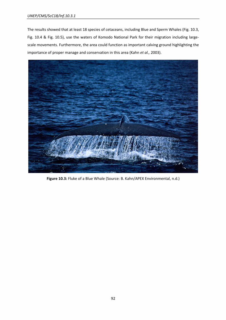
UNEP/CMS/ScC18/Inf.10.3.1
92
The results showed that at least 18 species of cetaceans, including Blue and Sperm Whales (Fig. 10.3,
Fig. 10.4 & Fig. 10.5), use the waters of Komodo National Park for their migration including large-
scale movements. Furthermore, the area could function as important calving ground highlighting the
importance of proper manage and conservation in this area (Kahn et al., 2003).
Figure 10.3: Fluke of a Blue Whale (Source: B. Kahn/APEX Environmental, n.d.)

UNEP/CMS/ScC18/Inf.10.3.1
93
Figure 10.4: Fluke of a Sperm Whale bull (Source: B. Kahn/APEX Environmental, n.d.)
Figure 10.5: Underwater dive in Sulawesi Sea (Source: B. Kahn/APEX Environmental, n.d.)
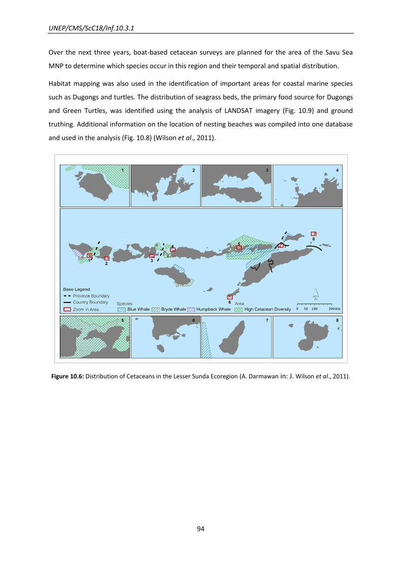
UNEP/CMS/ScC18/Inf.10.3.1
94
Over the next three years, boat-based cetacean surveys are planned for the area of the Savu Sea
MNP to determine which species occur in this region and their temporal and spatial distribution.
Habitat mapping was also used in the identification of important areas for coastal marine species
such as Dugongs and turtles. The distribution of seagrass beds, the primary food source for Dugongs
and Green Turtles, was identified using the analysis of LANDSAT imagery (Fig. 10.9) and ground
truthing. Additional information on the location of nesting beaches was compiled into one database
and used in the analysis (Fig. 10.8) (Wilson et al., 2011).
Figure 10.6: Distribution of Cetaceans in the Lesser Sunda Ecoregion (A. Darmawan in: J. Wilson et al., 2011).

UNEP/CMS/ScC18/Inf.10.3.1
95
Figure 10.7: Straits that represent important migratory passages and bottlenecks for cetaceans (A. Darmawan
in: J. Wilson et al., 2011).

UNEP/CMS/ScC18/Inf.10.3.1
96
Figure 10.8: Distribution of marine turtles in the Lesser Sunda Ecoregion (A. Darmawan in: J. Wilson et al.,
2011).
Figure 10.9: Dugong habitats in the Lesser Sunda Ecoregion (A. Darmawan in: J. Wilson et al., 2011).
While areas for the protection of large and migratory marine animals were included in the Lesser
Sunda MPA network design, this was primarily based on proxies for cetacean distribution i.e. habitat,
bathymetry and oceanography. It is now very important that data on the composition of large and
migratory marine animals, their behaviour and temporal and spatial distribution are collected
through field surveys. This will be relatively expensive and will require sufficient funding for aerial
and boat based surveys. In addition, a programme of capacity building is needed to increase local
expertise in cetacean surveys, analysis of data and development of policies and regulations for their
protection (J. Wilson, personal communication, 2013).
(Marine) Protected areas could also function as a bridging mechanism between states; an ecological
network can be used as a bigger international platform to strengthen cooperation also in the benefit
of migratory species. Since the feedback for an Ombai-Wetar Strait Transboundary MPA has been
cautiously positive from both governments (i.e., senior staff from fisheries ministries and
departments with MPA mandates within DKP and MAP); it is important to move forward with the
project in this direction (B. Kahn, personal communication, 2013).

UNEP/CMS/ScC18/Inf.10.3.1
97
Future of the Network
The Ministry of Marine Affairs and Fisheries of Indonesia (MMAF) agreed to use this design as a
reference for the creation of new MPAs in the Lesser Sunda Ecoregion (Wilson et al., 2011).
Indonesia has committed to establish 20 million hectares of MPAs by 2020 and the Lesser Sunda
Ecoregion is a focus area for a government programme to accelerate and expand economic
development on the basis of tourism and food production (i.e. from fishery and animal
husbandry). Given that MPAs can become a focus for tourism and support sustainable resource
management, it is expected that there will be a lot of attention given for this ecoregion including a
focus on MPA implementation.
If the design of a resilient network of MPAs is fully implemented in the Lesser Sunda Ecoregion,
there would be a good chance to conserve this unique area and the endangered species living in it.
UNEP/CMS/ScC18/Inf.10.3.1
98
11. Asian wetland networks: Siberian Crane
How a network was developed from a GEF project
Lessons learnt from this example
The development of this network gained significant impetus from a dedicated multi-
country GEF project backed by a CMS MoU on Siberian Cranes, and from being designed
specifically to match the entire flyway (and life-cycle) of a single species (while also
simultaneously benefiting other species that have related habitat needs).
The key to the flyway approach required in this case was felt to lie with linking
conservation efforts at local and national level with the international context.
Where pre-existing initiatives could be drawn upon and integrated (notably the North
East Asian Crane Site Network), this helped to accelerate progress in those areas.
Indigenous people generally supported the project, since they perceived it as helping to
safeguard their heritage. Incorporation of a socioeconomic dimension in the creation of
the network helped to secure people’s cooperation and commitment to it.
An evaluation of the project during its first phase allowed adaptive improvements to be
made in the second phase.
Introduction
This project is commonly known as the UNEP/GEF Siberian Crane Wetland Project (SCWP) and
applies the flyway conservation network approach to a single species, the Siberian Crane Grus
leucogeranus. It links activities at 16 key wetland sites (Fig. 11.1) which cover the whole life cycle of
the Siberian Crane (including crucial wintering, breeding and staging/stopover sites).
The Siberian Crane acts as an flagship species for many other migratory waterbirds dependent upon
these wetland areas along the main Asian flyways. At least 31 endangered migratory bird species
occur in these wetlands, of which 19 are CMS listed: Dalmatian Pelican Pelecanus crispus, Pygmy
Cormorant Phalacrocorax pygmeus, Black-faced Spoonbill Platalea alba, Swan Goose Anser
cygnoides, Lesser White-fronted Goose Anser erythropus, Red-breasted Goose Branta ruficollis,
Baikal Teal Anas formosa, Marbled Teal Marmaronetta angustirostris, Baer’s Pochard Aythya baeri,

UNEP/CMS/ScC18/Inf.10.3.1
99
Ferruginous Duck Aythya nyroca, Steller’s Eider Polysticta stelleri, White-headed Duck Oxyura
leucocephala, Hooded Crane Grus monacha, White-naped Crane Grus vipio, Corncrake Crex crex,
Black-winged Pratincole Glareola nordmanni, Slender-billed Curlew Numenius tenuirostris, Far-
eastern Curlew Numenius madagascariensis and the Great Snipe Gallinago media.
The Siberian Crane, the third most endangered crane species, faces serious threats along its three
migration routes (Eastern, Central and Western Flyway) across Asia. Hunting along its migration
route and habitat deterioration in its wintering grounds are the most serious. With the species
dependent on huge open areas of shallow wetlands all along its range, the immense loss of wetland
through human activities (development and resource exploitation), as well as a result of climate
change, is a driving factor behind the decreasing population numbers and a great challenge to
overcome. The Siberian Crane can be distinguished in two populations (Eastern and
Western/Central) with a total population estimated at 3,500-4,000 individuals, of which 99 per cent
belong to the Eastern flock. The Western/Central population has been almost eradicated through
illegal hunting, with only 10-20 pairs left on the Western flyway and some unconfirmed sightings
along the Central Flyway.
Table 11.1: General Information of the Siberian Crane Wetland Project.
NAME OF THE NETWORK Siberian Crane Wetland Project
CMS SPECIES
(LISTED ON APP. I/II)
Siberian Crane (Grus leucogeranus)
COUNTRY China
Iran
Kazakhstan
Russian Federation
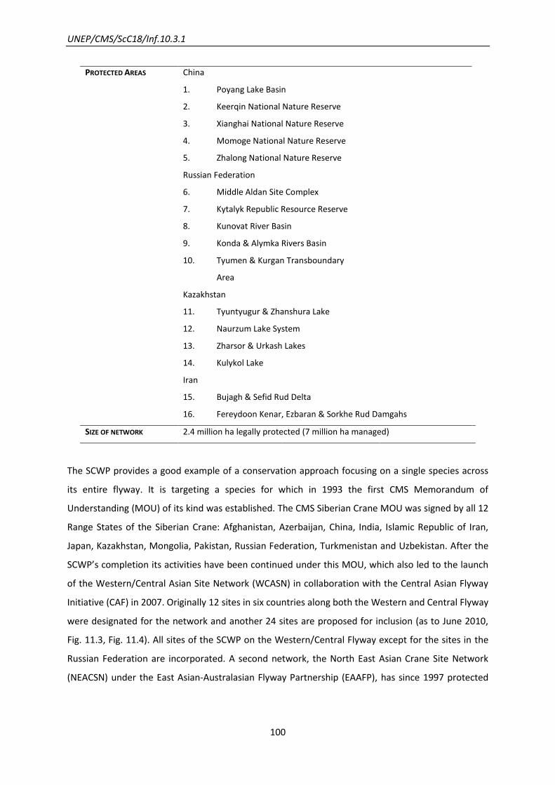
UNEP/CMS/ScC18/Inf.10.3.1
100
PROTECTED AREAS
China
1. Poyang Lake Basin
2. Keerqin National Nature Reserve
3. Xianghai National Nature Reserve
4. Momoge National Nature Reserve
5. Zhalong National Nature Reserve
Russian Federation
6. Middle Aldan Site Complex
7. Kytalyk Republic Resource Reserve
8. Kunovat River Basin
9. Konda & Alymka Rivers Basin
10. Tyumen & Kurgan Transboundary
Area
Kazakhstan
11. Tyuntyugur & Zhanshura Lake
12. Naurzum Lake System
13. Zharsor & Urkash Lakes
14. Kulykol Lake
Iran
15. Bujagh & Sefid Rud Delta
16. Fereydoon Kenar, Ezbaran & Sorkhe Rud Damgahs
SIZE OF NETWORK 2.4 million ha legally protected (7 million ha managed)
The SCWP provides a good example of a conservation approach focusing on a single species across
its entire flyway. It is targeting a species for which in 1993 the first CMS Memorandum of
Understanding (MOU) of its kind was established. The CMS Siberian Crane MOU was signed by all 12
Range States of the Siberian Crane: Afghanistan, Azerbaijan, China, India, Islamic Republic of Iran,
Japan, Kazakhstan, Mongolia, Pakistan, Russian Federation, Turkmenistan and Uzbekistan. After the
SCWP’s completion its activities have been continued under this MOU, which also led to the launch
of the Western/Central Asian Site Network (WCASN) in collaboration with the Central Asian Flyway
Initiative (CAF) in 2007. Originally 12 sites in six countries along both the Western and Central Flyway
were designated for the network and another 24 sites are proposed for inclusion (as to June 2010,
Fig. 11.3, Fig. 11.4). All sites of the SCWP on the Western/Central Flyway except for the sites in the
Russian Federation are incorporated. A second network, the North East Asian Crane Site Network
(NEACSN) under the East Asian-Australasian Flyway Partnership (EAAFP), has since 1997 protected

UNEP/CMS/ScC18/Inf.10.3.1
101
wetlands important for migratory waterbirds and thus, covers the parts of the Siberian Crane key
wetland sites on its Eastern flyway.
Network Aims
The project’s aim is to conserve a network of protected key wetlands along the Eastern and
Western/Central flyways of the Siberian Crane and other Eurasian migratory waterbirds using the
Siberian Crane as a flagship species to promote conservation. The SCWP sets an example in building
capacity to coordinate flyway-scale conservation and aims to maintain the ecological integrity of a
network of globally important wetlands.
Figure 11.1: Locations of the 16 SCWP sites. Red: phase 1, Blue: phase 2 (Source: International Crane
Foundation: Zoë Richenbach, n.d.).
Network Design
The design was an approach to conserve the whole flyway-network of a species. It was especially
designed taking into account the migration route of the Siberian Crane, protecting all so far known
crucial breeding, wintering and staging/stopover sites along the two main flyways. It operates at
three levels: on the site (local), national and international (regional) level, with each scale focusing
UNEP/CMS/ScC18/Inf.10.3.1
102
on different specific tasks and challenges. Most funding (80 per cent) and effort was put towards site
level and national level activities. The project was implemented in two stages (Phase 1 and Phase 2)
plus a nine month extension. Phase 1 (2003 -2006) focused on those sites which are critical for the
migration of the Siberian Crane or were most threatened by destruction. During Phase 1, further
research on existing gaps of knowledge on the migration routes and identification of new sites were
conducted.
In Phase 2 (2006-2009), sites under less threat and sites that still needed support to achieve
conservation objectives from Phase 1 were addressed. The project was preceded by a three-year
planning and designing period (2000-2003). Evaluation of efforts during Phase 1 helped to improve
the design and adapt activities in Phase 2.
Network Components
The network consists of 16 key wetlands along both the Eastern and Western Flyway. Five of these
wetlands are located in China, two in Iran, four in Kazakhstan and five in the Russian Federation. 12
of these sites are designated as Ramsar sites (Wetlands of International Importance, Fig. 11.1). Some
sites are composed of various different protected areas with different protection status (National
park, national nature reserve, non-shooting area, UNESCO biosphere reserve, wildlife refuge,
resource reservation), with most sites listed IUCN Category IV (Habitat/Species Management Area).
The wetlands were mainly selected on their importance as key breeding, wintering and staging sites
for the Siberian Crane and should have adequate potential in helping conserve the species
populations. Additional criteria that were considered were their global importance for other
migratory waterbirds (Important Bird Areas, IBA) as well as their biodiversity as a whole. Further, the
established network should be resilient to climate change. Important wetlands already covered by
other projects were not included. No conservation zones were addressed along the Central Flyway
as research during the planning phase had not shown any species activity. The last pair in India was
recorded in 2002.

UNEP/CMS/ScC18/Inf.10.3.1
103
Figure 11.2: Sites and their migratory usage. All Breeding Areas are in Russian territory (Western Siberia and
Eastern Yakutia), whereas Iran and China (Poyang Lake Basin) contain the main Wintering Areas. The
Western Flyway also passes through Azerbaijan but as it was not a member of the Convention on Biodiversity
(CBD) when the project was established, it was not eligible for funding by GEF (Source: Siberian Crane
Wetland Project, n.d.).
Network Evolution
The project was launched and coordinated by the International Crane Foundation (ICF) in
cooperation with the Convention on the Conservation of Migratory Species (CMS) and the four
governments of the People’s Republic of China, Republic of Kazakhstan, Islamic Republic of Iran and
Russian Federation.
The network was conceived in 1998 at the 3rd Meeting of the Siberian Crane Range States under the
CMS Siberian Crane MOU. Originally, a third site was planned in Iran but only two were finally
implemented, due to conservation constraints regarding the relative lack of importance of this site
and effectiveness of resource concentration. The site was cancelled after the Midterm Review in
2005 (Fourth Standing Committee Meeting). Additionally, the Russian site complex “Middle Aldan”
was included in the SCWP network.

UNEP/CMS/ScC18/Inf.10.3.1
104
The seven-year project (finished on December 2009) was implemented by the United Nations
Environment Programme (UNEP) functioning as the implementing Agency of the Global Environment
Facility (GEF).
Scientific and Conservation Activities
Research on basic information about Siberian Crane started in the early 1970s with the discovery of
its main breeding grounds. Precise migration routes were detected via satellite transmitters in the
early 1990s. Hitherto, the ecology of the species was widely unknown. Researchers from the
different range states were involved from the beginning. Although this early research provided a
good understanding of the life cycle of the species, additional research was needed and especially
addressed during the project. These included:
- The establishment of coordinated annually waterbird monitoring programmes at all sites to
assess the status of the population across the countries. Especially China put a lot of effort
into the monitoring project: 18 partner organizations and 158 sites were monitored.
- Threat analysis and environmental impact assessments, and their effects on the migration
habits (changing migration route and site selection), e.g. pest monitoring, water resource
and vegetation monitoring.
- Additional ecological research
- Information on Siberian Crane sightings and new migration routes were obtained through
interviews with local communities. There is still lack of knowledge e.g. on the location of the
summer areas of sub-adults during the first years.
The obtained information should help to increase the conservation efforts and was shared between
the different countries and initiatives.
It is believed that the eastern population remains stable but due to changing climate conditions
(long dry periods) and human development pressure, new challenges are arising. Without illegal
hunting being controlled along the Central/Western Flyway the Western population is not likely to
recover and the sense of expensive reintroduction methods (i.e. “Flight of Hope”) remains
questionable.
UNEP/CMS/ScC18/Inf.10.3.1
105
Network Activities
Activities were implemented at three levels: at site (local) level, national level and international
(regional) level, to overcome the various specific obstacles and challenges. For example, where the
type and level of threat are site-specific, they have to be tackled differently: whereas illegal hunting
is the main factor influencing populations in Iran, Kazakhstan and Afghanistan, disturbance and
habitat deterioration through oil and gas production and infrastructure are main threats to the
nesting areas in the Russian Federation. Water diversion and drainage are main obstacles in China.
Site level:
Activities included strengthening legal protection and enforcement, building capacity to
develop and implement management plans for all sites, and train conservation and
management staff properly. Stakeholders and local communities were involved from the
early stage on and encouraged in active participation. Further environmental education was
facilitated, and public awareness raising programmes and sustainable livelihood projects
established. Priority was given to water management measures securing water supply to the
designated project sites.
National level:
Activities focused on strengthening national legislative, implementing policy and planning
frameworks on wetland protection, improving and enhancing coordination among different
other national and international acting wetland conservation initiatives and foster their
cooperation, support monitoring, training, education and public awareness programmes
across sites.
International level:
Focus on flyway-level conservation. Activities included: cooperation among the participatory
countries and interaction among sites and management of communities, which were
achieved through exchange of staff, sharing of information (databases) and workshops.
Further conservation actions were coordinated with other initiatives for migratory
waterbirds (i.e. North East Asian Crane Site Network, NEACSN) and aligned to the
Conservation and Action Plans created through the CMS Memorandum of Understanding
(MOU) concerning Conservation Measures for the Siberian Crane.

UNEP/CMS/ScC18/Inf.10.3.1
106
The Network Achievements were:
- Improvement of protection level of all sites: either new protection areas established or
established ones expanded (i.e. buffer zones) or the protection level increased:
o 5 new Ramsar sites
o 1 World Heritage Site
o 4 new protected reserves
o 3 protected areas expanded
o 3 sites upgraded in their legal protection status
- Management plans set in place for all sites
- Local communities, related organizations and important stakeholders actively involved in
decision making (Site Management and Stakeholder Committees)
- Dialogue and cooperation between different interest groups (i.e. hunters and scientists in
China on non-shooting areas; governments and academic institutions)
- Extensive environmental education programs for the communities as well as public
awareness raising (i.e. through “Crane Celebration” ceremonies, held annually since 2007 in
over 120 places across range states)
Future of the Network
Site conservation will be continued through the established management plans and with support
from local and national governments as well as through cooperation with regional and national
organizations. Current funding mechanisms have been developed before the project ended and a
strong community dedicated to continue conservation effort was built up. A set up coordination
centre in Moscow provides linkage of actions and knowledge between various flyway conservation
initiatives.
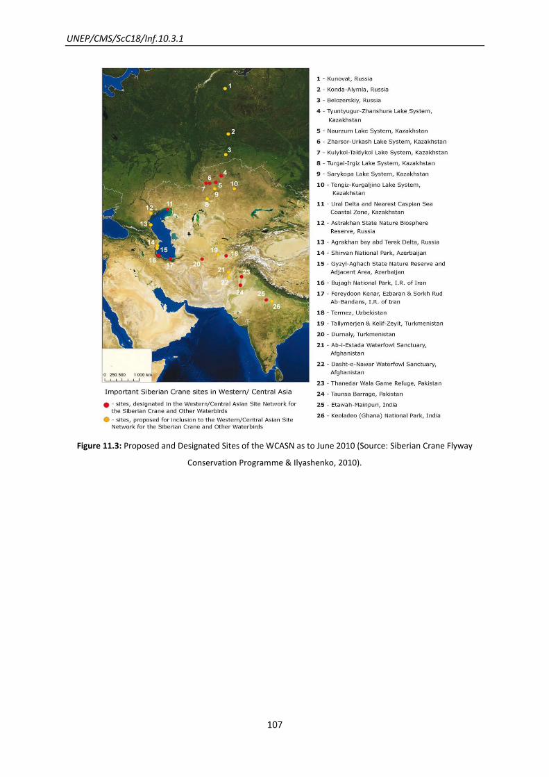
UNEP/CMS/ScC18/Inf.10.3.1
107
Figure 11.3: Proposed and Designated Sites of the WCASN as to June 2010 (Source: Siberian Crane Flyway
Conservation Programme & Ilyashenko, 2010).
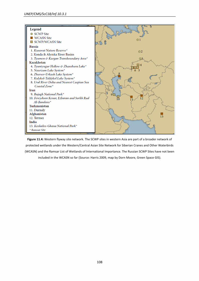
UNEP/CMS/ScC18/Inf.10.3.1
108
Figure 11.4: Western flyway site network. The SCWP sites in western Asia are part of a broader network of
protected wetlands under the Western/Central Asian Site Network for Siberian Cranes and Other Waterbirds
(WCASN) and the Ramsar List of Wetlands of International Importance. The Russian SCWP Sites have not been
included in the WCASN so far (Source: Harris 2009, map by Dorn Moore, Green Space GIS).
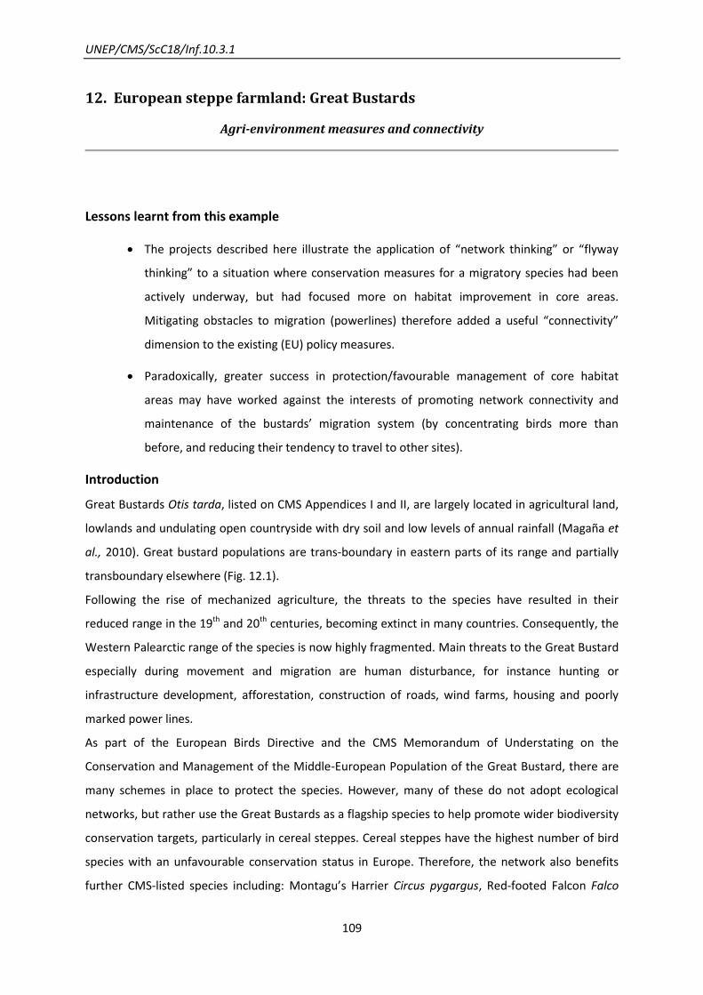
UNEP/CMS/ScC18/Inf.10.3.1
109
12. European steppe farmland: Great Bustards
Agri-environment measures and connectivity
Lessons learnt from this example
The projects described here illustrate the application of “network thinking” or “flyway
thinking” to a situation where conservation measures for a migratory species had been
actively underway, but had focused more on habitat improvement in core areas.
Mitigating obstacles to migration (powerlines) therefore added a useful “connectivity”
dimension to the existing (EU) policy measures.
Paradoxically, greater success in protection/favourable management of core habitat
areas may have worked against the interests of promoting network connectivity and
maintenance of the bustards’ migration system (by concentrating birds more than
before, and reducing their tendency to travel to other sites).
Introduction
Great Bustards Otis tarda, listed on CMS Appendices I and II, are largely located in agricultural land,
lowlands and undulating open countryside with dry soil and low levels of annual rainfall (Magaña et
al., 2010). Great bustard populations are trans-boundary in eastern parts of its range and partially
transboundary elsewhere (Fig. 12.1).
Following the rise of mechanized agriculture, the threats to the species have resulted in their
reduced range in the 19th and 20th centuries, becoming extinct in many countries. Consequently, the
Western Palearctic range of the species is now highly fragmented. Main threats to the Great Bustard
especially during movement and migration are human disturbance, for instance hunting or
infrastructure development, afforestation, construction of roads, wind farms, housing and poorly
marked power lines.
As part of the European Birds Directive and the CMS Memorandum of Understating on the
Conservation and Management of the Middle-European Population of the Great Bustard, there are
many schemes in place to protect the species. However, many of these do not adopt ecological
networks, but rather use the Great Bustards as a flagship species to help promote wider biodiversity
conservation targets, particularly in cereal steppes. Cereal steppes have the highest number of bird
species with an unfavourable conservation status in Europe. Therefore, the network also benefits
further CMS-listed species including: Montagu’s Harrier Circus pygargus, Red-footed Falcon Falco
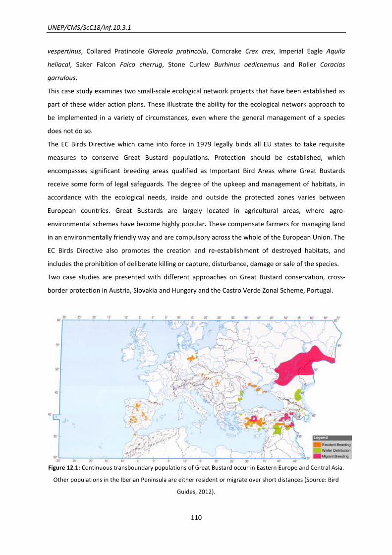
UNEP/CMS/ScC18/Inf.10.3.1
110
vespertinus, Collared Pratincole Glareola pratincola, Corncrake Crex crex, Imperial Eagle Aquila
heliacal, Saker Falcon Falco cherrug, Stone Curlew Burhinus oedicnemus and Roller Coracias
garrulous.
This case study examines two small-scale ecological network projects that have been established as
part of these wider action plans. These illustrate the ability for the ecological network approach to
be implemented in a variety of circumstances, even where the general management of a species
does not do so.
The EC Birds Directive which came into force in 1979 legally binds all EU states to take requisite
measures to conserve Great Bustard populations. Protection should be established, which
encompasses significant breeding areas qualified as Important Bird Areas where Great Bustards
receive some form of legal safeguards. The degree of the upkeep and management of habitats, in
accordance with the ecological needs, inside and outside the protected zones varies between
European countries. Great Bustards are largely located in agricultural areas, where agro-
environmental schemes have become highly popular. These compensate farmers for managing land
in an environmentally friendly way and are compulsory across the whole of the European Union. The
EC Birds Directive also promotes the creation and re-establishment of destroyed habitats, and
includes the prohibition of deliberate killing or capture, disturbance, damage or sale of the species.
Two case studies are presented with different approaches on Great Bustard conservation, cross-
border protection in Austria, Slovakia and Hungary and the Castro Verde Zonal Scheme, Portugal.
Figure 12.1: Continuous transboundary populations of Great Bustard occur in Eastern Europe and Central Asia.
Other populations in the Iberian Peninsula are either resident or migrate over short distances (Source: Bird
Guides, 2012).

UNEP/CMS/ScC18/Inf.10.3.1
111
Table 12.1: Status of Great Bustard population in Europe.
Country Breeding Migration Wintering7 1994 Population
8 2003-2004
Population9
Trend/Status
Albania ✓
Armenia ✓
Austria ✓ ✓ 50-60 107-140 Breeding population
increasing
Azerbaijan ✓ ✓
Bulgaria ✓ 10-15 0-10 Became extinct
recently
Croatia ✓
Czech
Republic
✓ ✓ 10-20 1-6 Became extinct
recently
Georgia ✓
Germany ✓ ✓ 130 85 Breeding population
increasing
Greece ✓
Kazakhstan ✓
Hungary ✓ ✓ 1,100-1,300 1,300 Stable
Italy ✓
Macedonia,
FYR
✓
Moldova ✓
Morocco ✓ ✓
Portugal ✓ ✓ 1,000
1,435 Stable
Romania ✓ ✓ 10-15 Unknown Became extinct
recently
Russia ✓ ✓ ✓
Serbia ✓ ✓ ✓
Slovakia ✓ ✓ 25-30 10 Breeding population
declining
7http://www.birdguides.com/species/species.asp?sp=047011 8Heredia et al., 1996
9BirdLife International, 2004

UNEP/CMS/ScC18/Inf.10.3.1
112
Slovenia ✓
Spain ✓ ✓ 13,500-14,000 23,300 Stable
Turkey ✓ ✓
Ukraine ✓ ✓
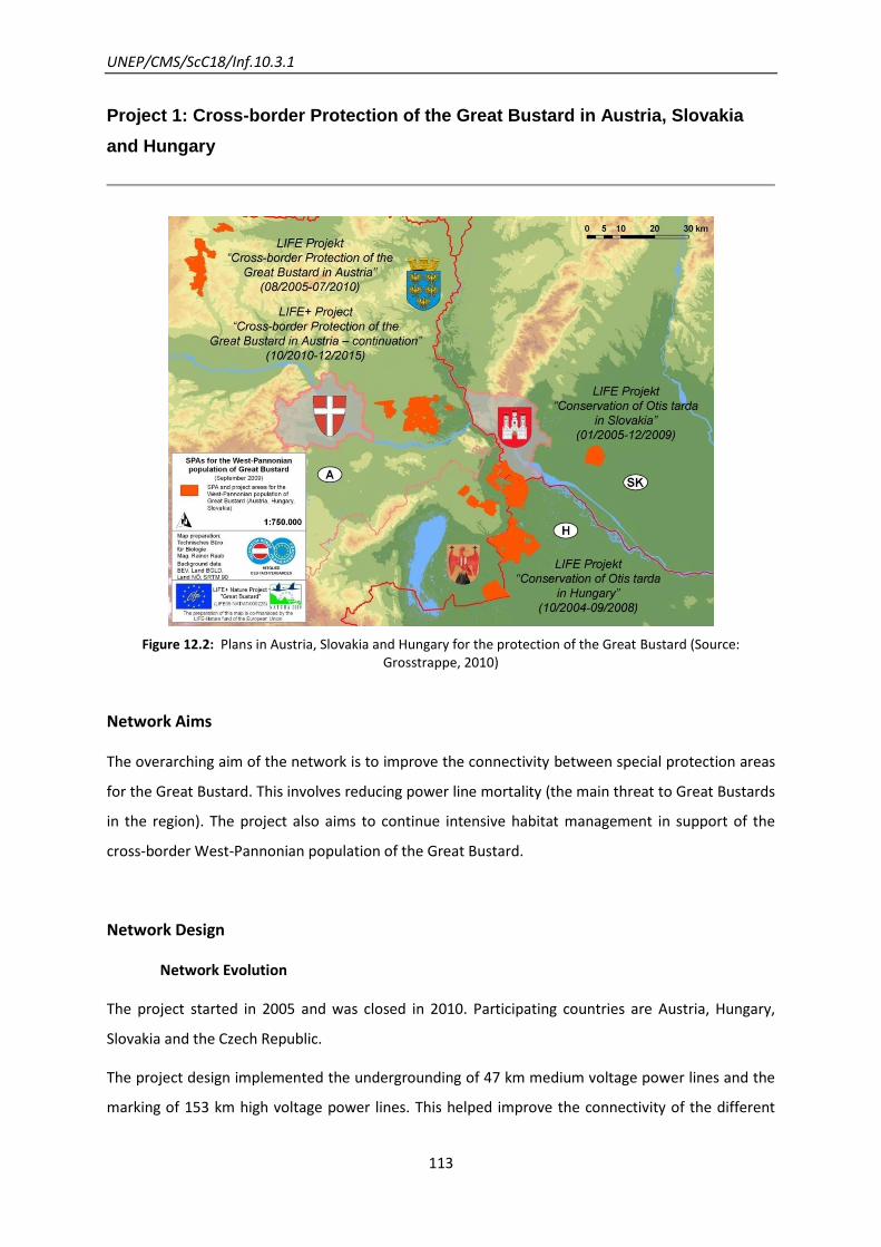
UNEP/CMS/ScC18/Inf.10.3.1
113
Project 1: Cross-border Protection of the Great Bustard in Austria, Slovakia
and Hungary
Figure 12.2: Plans in Austria, Slovakia and Hungary for the protection of the Great Bustard (Source: Grosstrappe, 2010)
Network Aims
The overarching aim of the network is to improve the connectivity between special protection areas
for the Great Bustard. This involves reducing power line mortality (the main threat to Great Bustards
in the region). The project also aims to continue intensive habitat management in support of the
cross-border West-Pannonian population of the Great Bustard.
Network Design
Network Evolution
The project started in 2005 and was closed in 2010. Participating countries are Austria, Hungary,
Slovakia and the Czech Republic.
The project design implemented the undergrounding of 47 km medium voltage power lines and the
marking of 153 km high voltage power lines. This helped improve the connectivity of the different
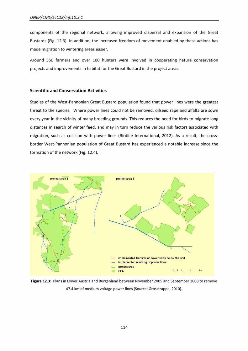
UNEP/CMS/ScC18/Inf.10.3.1
114
components of the regional network, allowing improved dispersal and expansion of the Great
Bustards (Fig. 12.3). In addition, the increased freedom of movement enabled by these actions has
made migration to wintering areas easier.
Around 550 farmers and over 100 hunters were involved in cooperating nature conservation
projects and improvements in habitat for the Great Bustard in the project areas.
Scientific and Conservation Activities
Studies of the West-Pannonian Great Bustard population found that power lines were the greatest
threat to the species. Where power lines could not be removed, oilseed rape and alfalfa are sown
every year in the vicinity of many breeding grounds. This reduces the need for birds to migrate long
distances in search of winter feed, and may in turn reduce the various risk factors associated with
migration, such as collision with power lines (Birdlife International, 2012). As a result, the cross-
border West-Pannonian population of Great Bustard has experienced a notable increase since the
formation of the network (Fig. 12.4).
Figure 12.3: Plans in Lower Austria and Burgenland between November 2005 and September 2008 to remove
47.4 km of medium voltage power lines (Source: Grosstrappe, 2010).
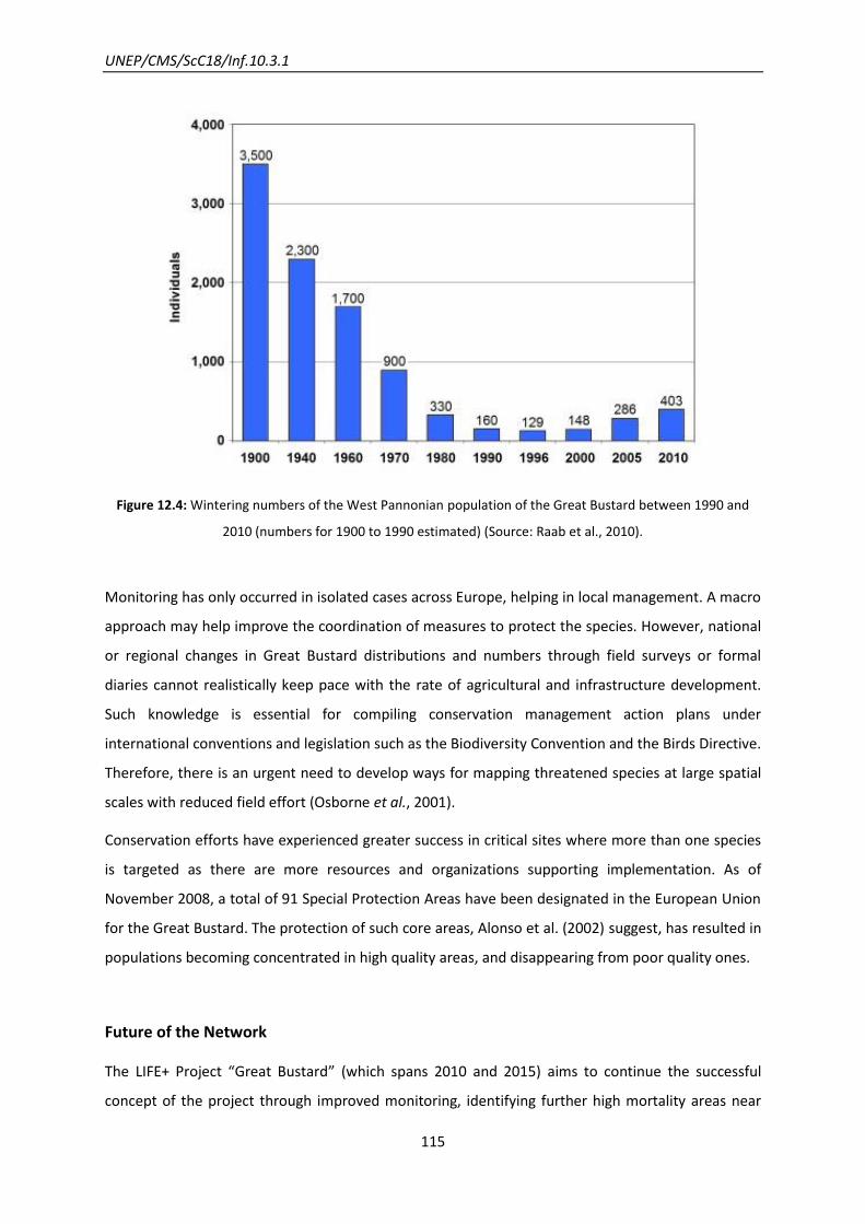
UNEP/CMS/ScC18/Inf.10.3.1
115
Figure 12.4: Wintering numbers of the West Pannonian population of the Great Bustard between 1990 and
2010 (numbers for 1900 to 1990 estimated) (Source: Raab et al., 2010).
Monitoring has only occurred in isolated cases across Europe, helping in local management. A macro
approach may help improve the coordination of measures to protect the species. However, national
or regional changes in Great Bustard distributions and numbers through field surveys or formal
diaries cannot realistically keep pace with the rate of agricultural and infrastructure development.
Such knowledge is essential for compiling conservation management action plans under
international conventions and legislation such as the Biodiversity Convention and the Birds Directive.
Therefore, there is an urgent need to develop ways for mapping threatened species at large spatial
scales with reduced field effort (Osborne et al., 2001).
Conservation efforts have experienced greater success in critical sites where more than one species
is targeted as there are more resources and organizations supporting implementation. As of
November 2008, a total of 91 Special Protection Areas have been designated in the European Union
for the Great Bustard. The protection of such core areas, Alonso et al. (2002) suggest, has resulted in
populations becoming concentrated in high quality areas, and disappearing from poor quality ones.
Future of the Network
The LIFE+ Project “Great Bustard” (which spans 2010 and 2015) aims to continue the successful
concept of the project through improved monitoring, identifying further high mortality areas near

UNEP/CMS/ScC18/Inf.10.3.1
116
power lines in Sandboden and Praterterrasse. The LIFE+ project will involve the marking or burying
of these power lines. Other aims are to integrate nature conservation in the framework of Natura
2000 and LIFE this will be continued to be communicated to the public in order to improve
stakeholder involvement. Further international cooperation should take place to improve the
movement between the Great Bustard locations (Fig. 12.4), these have involved the marking or
burying of further power lines.

UNEP/CMS/ScC18/Inf.10.3.1
117
Project 2: The Castro Verde Zonal Scheme, Portugal
Introduction
The Castro Verde Special Protection Area (SPA) is included in Natura 2000, a Network of natural
protected spaces of the European Union. This classification is given due to the diversity, abundance
and conservation status of steppe birds that inhabit this area.
Network Aims
The network aims, specifically to promote low intensity agriculture that is compatible with the
conservation of cereal steppe birds in the Castro Verde Special Protection Area (SPA), enabling their
dispersal and expansion.
Network Design
Network Components
An agro-environmental scheme pays farmers to maintain traditional crop rotations and low grazing
intensities, reduce pesticide input and keep stubble or crop coverage over the winter. This has
produced highly favorable conditions for the Great Bustard enabling their expansion across Castro
Verde and a population increase from 400 to 650 between 1995 and 2002. Part of this population
rise has been attributed to the increased migration of Great Bustard to the Castro Verde area in
search of improved habitats. These birds have then become resident due to the favourable
conditions (Pinto et al., 2005).
Scientific and Conservation Activities
Research and Monitoring
Monitoring suggests that all dry grassland birds in the SPA have benefited, with some conservation
priority species, such as the lesser kestrel, the little bustard successfully increasing in numbers as
result of this scheme (Borralho et al., 1999). Populations of Great Bustards outside of this Natura
2000 site show a reduction and further fragmentation of their populations. This suggests that the
Castro Verde has become a safe haven for Great Bustards, enabling a core area to be established
while connective zones diminish.
UNEP/CMS/ScC18/Inf.10.3.1
118
The population data displayed in Tab. 12.1 produced a justification for the listing of the Great
Bustard in Annex 1. Many further papers and data on habitat and behaviour have helped in the
design of the network. Efforts are made within LIFE+ to encourage farmers and tractor drivers to
report Bustards. As knowledge of the species has improved, the network has been able to evolve
accordingly as critical sites were identified.
Recent dispersal studies using individual marking and radio-tracking techniques have shown that
although the species is capable of performing considerable seasonal migration, individuals display a
marked site fidelity to their breeding areas (Alonso et al., 2000, Morales et al. 2000). In response,
mapping schemes have been developed in some countries, enabling planning of where agri-
environmental measures should be implemented (Gaston and Blackburn, 1995, Williams et al.,
1997).
López-Jamar et al. (2010) suggest that local patterns of habitat selection changed in relation to
agricultural abandonment and particularly infrastructure development. In response, future schemes
should include landscape-scale restrictions on the development and use of infrastructure (roads,
tracks and buildings).
UNEP/CMS/ScC18/Inf.10.3.1
119
13. The Western Hemisphere Shorebird Reserve Network: Red Knots
Critical sites and their role in a flyway
Lessons learnt from this example
This case shows an example of a network approach based on research knowledge about
the relative importance of sites in a flyway, and about why particular sites are critical to
the whole system (such as Delaware Bay and its Horseshoe Crab harvest). Harmonized
monitoring methods have been important to this.
This case also provides an example of regional network initiative which, supported by its
research activities, acted as the stimulus for global prioritisation of the conservation
needs of the species (through CMS Appendix I listing), rather than Convention listing
being the stimulus to set up the network. Both of these scenarios are therefore possible.
Introduction
More than 85 sites designated within the Western Hemisphere Shorebird Reserve Network (WHSRN)
are home to a large number and diversity of migratory shorebird species. Created in 1985, WHSRN is
a hemispheric strategy with the mission of identifying key sites across the Americas in order to
promote the conservation of shorebirds and their habitats.
Among the species at higher risk are Red Knots (Calidris canutus – C. c.), one of the longest-distance
migrants recorded so far. The subspecies C. c. rufa migrates to the breeding sites at the
northernmost point of North America (Arctic Canada) from wintering sites as far away as the
southernmost point of South America - Tierra del Fuego (coverage of the main C.c. rufa Red Knot
population). Other Red Knot populations of smaller size have their wintering sites in Florida and
North-East Brazil and Colombia, but these are not considered as threatened as the aforementioned
population wintering in Tierra del Fuego.
Sites of importance to Red Knots included in the WHSRN cover the whole range of migration sites,
including stopover sites during Spring and Fall migrations, breeding and wintering grounds. The
ecosystems encompassed by these sites range from sandy beaches, to tidal mudflats, peat banks,
restingas, intertidal rocky flats, salt marshes, mangroves, brackish lagoons/impoundments, and
rocky barrens.
UNEP/CMS/ScC18/Inf.10.3.1
120
Example: The Valdes Peninsula, Argentina
The Valdes Peninsula is now the 6th WHSRN site in Argentina. It is within the Peninsula Valdes
Natural Protected Area, which was named a Natural Heritage Site by UNESCO in 1999.
The Valdes Peninsula is located in the Province of Chubut on the central coast of Argentina and
consists of numerous shallow bays with extensive intertidal mudflats, shallow lagoons, sandy
beaches, and coastal dunes, plus sea cliffs and small islands. The site supports more than 1% of the
population of rufa Red Knots (Calidris canutus rufa) as well as significant populations of Two-banded
Plover (Charadrius falklandicus), Baird’s Sandpiper (Calidris bairdii), and the durnfordi race of
American Oystercatchers (Haempatopus palliatus durnfordi). For this, the area was designated a
WHSRN Site of Regional Importance--the result of a coordinated partnership by the Laboratory of
Wetland-dependent Shorebirds based at the National Patagonian Center (CENPAT by its Spanish
acronym) and the Undersecretary of Tourism and Protected Areas for the Province of Chubut.
The majority of this WHSRN site is home to privately owned rural establishments. However, being
within the natural protected area, management and administration is carried out by the Province of
Chubut's Department of Protected Areas Conservation, overseen by the Undersecretary of Tourism
and Protected Areas. The landowner letter of support required by WHSRN was therefore signed by
the Undersecretary, the partner having the maximum provincial authority for the site.
The subsistence or small-scale fishermen that make up the community in and around the site
have been informed about the shorebirds in the wetlands. They work together
with different research teams at CENPAT-CONICET, and some are also part of an association called
the Subsistence Fishermen Community Network for Sustainable Development (RECOPADE by its
Spanish acronym).
Red knots have declined by approximately 80 per cent in the past 30 years. In particular, the C.c. rufa
Red Knot populations suffered a severe drop since the mid-1980s, from the estimated 100,000-
150,000 to only 18,000-35,000 in 2011. This is a consequence of food resources decreasing at
stopover sites, particularly the eggs of Horseshoe Crabs (Limulus polyphemus). A shortage in eggs
arose from an unsustainable harvest of crabs in Delaware Bay, U.S.A, (for commercial fishing bait)
mostly during 1996-1999. Nowadays, a Horseshoe Crab management plan has taken steps to
improve availability of the crabs’ eggs.
During the northward (Spring) migration, the stopover site in Delaware Bay is a crucial feeding
ground to gain adequate fat reserves (Fig. 13.1), before the Red Knot starts its non-stop flight to the
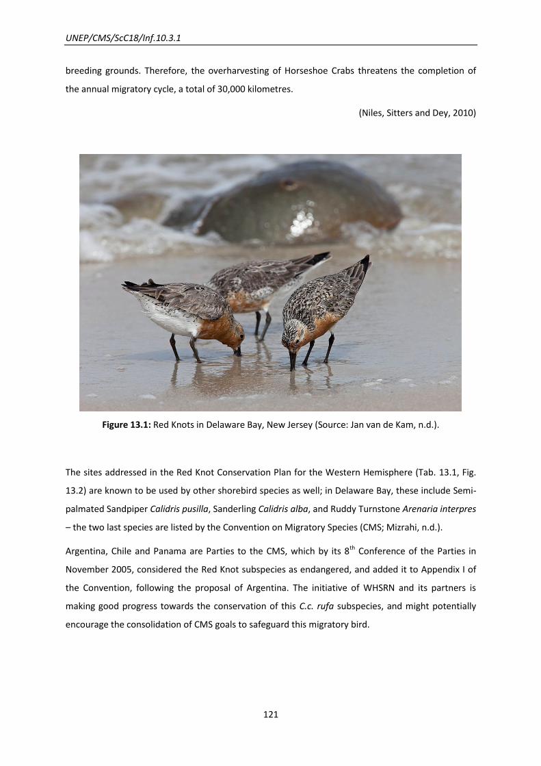
UNEP/CMS/ScC18/Inf.10.3.1
121
breeding grounds. Therefore, the overharvesting of Horseshoe Crabs threatens the completion of
the annual migratory cycle, a total of 30,000 kilometres.
(Niles, Sitters and Dey, 2010)
Figure 13.1: Red Knots in Delaware Bay, New Jersey (Source: Jan van de Kam, n.d.).
The sites addressed in the Red Knot Conservation Plan for the Western Hemisphere (Tab. 13.1, Fig.
13.2) are known to be used by other shorebird species as well; in Delaware Bay, these include Semi-
palmated Sandpiper Calidris pusilla, Sanderling Calidris alba, and Ruddy Turnstone Arenaria interpres
– the two last species are listed by the Convention on Migratory Species (CMS; Mizrahi, n.d.).
Argentina, Chile and Panama are Parties to the CMS, which by its 8th Conference of the Parties in
November 2005, considered the Red Knot subspecies as endangered, and added it to Appendix I of
the Convention, following the proposal of Argentina. The initiative of WHSRN and its partners is
making good progress towards the conservation of this C.c. rufa subspecies, and might potentially
encourage the consolidation of CMS goals to safeguard this migratory bird.
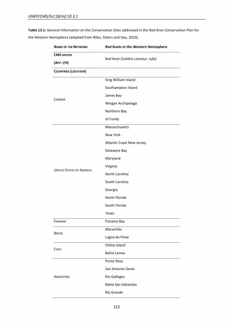
UNEP/CMS/ScC18/Inf.10.3.1
122
Table 13.1: General Information on the Conservation Sites addressed in the Red Knot Conservation Plan for
the Western Hemisphere (adapted from Niles, Sitters and Dey, 2010).
NAME OF THE NETWORK Red Knots in the Western Hemisphere
CMS SPECIES
(APP. I/II) Red Knot (Calidris canutus rufa)
COUNTRIES (LOCATION)
CANADA
King William Island
Southampton Island
James Bay
Mingan Archipelago
Northern Bay
of Fundy
UNITED STATES OF AMERICA
Massachusetts
New York
Atlantic Coast New Jersey
Delaware Bay
Maryland
Virginia
North Carolina
South Carolina
Georgia
North Florida
South Florida
Texas
PANAMA Panama Bay
BRAZIL Maranhão
Lagoa do Peixe
CHILE Chiloe Island
Bahía Lomas
ARGENTINA
Punta Rasa
San Antonio Oeste
Río Gallegos
Bahía San Sebastián
Río Grande
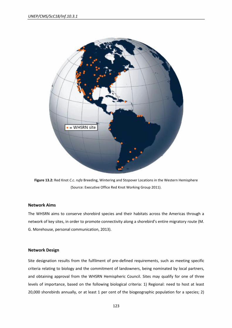
UNEP/CMS/ScC18/Inf.10.3.1
123
Figure 13.2: Red Knot C.c. rufa Breeding, Wintering and Stopover Locations in the Western Hemisphere
(Source: Executive Office Red Knot Working Group 2011).
Network Aims
The WHSRN aims to conserve shorebird species and their habitats across the Americas through a
network of key sites, in order to promote connectivity along a shorebird’s entire migratory route (M.
G. Morehouse, personal communication, 2013).
Network Design
Site designation results from the fulfilment of pre-defined requirements, such as meeting specific
criteria relating to biology and the commitment of landowners, being nominated by local partners,
and obtaining approval from the WHSRN Hemispheric Council. Sites may qualify for one of three
levels of importance, based on the following biological criteria: 1) Regional: need to host at least
20,000 shorebirds annually, or at least 1 per cent of the biogeographic population for a species; 2)

UNEP/CMS/ScC18/Inf.10.3.1
124
International: at least 100,000 shorebirds or at least 10 per cent of a species; and 3) Hemispheric: at
least 500,000 shorebirds or at least 30 per cent of a species population. In all cases, landowners
need to commit in writing that they will make shorebird conservation a priority, manage the site in a
way that benefits shorebirds, and keep the WHSRN Executive Office informed of any changes (M. G.
Morehouse, personal communication, 2013).
Network Components
The governance and management of the Network occurs at a variety of scales but is ultimately led
by the Hemispheric Council. The major geographic regions are well represented in the Council.
Regional and/or National Councils design and implement activities contributing to the overall
accomplishment of the WHSRN mission and, where applicable, the Red Knot Conservation Action
Plan. Participation in WHSRN is voluntary.
With regard to C.c. rufa Red Knot, the sites have a strong element of connectivity through their
importance to this subspecies at some stage of its lifecycle, since its entire migration route is
covered. The scale of the WHSRN initiative at its action plan is hemispheric in order to encompass
the whole movement range of the Red Knot. Breeding habitats are located near the Arctic coast in
Canada. Migration and wintering habitats in Canada and U.S., and Brazil, Argentina and Chile
respectively are both in coastal areas with a large extent of intertidal sediments.
(Castillo et al., 2011)
Network Evolution
WHSRN is a concept developed by experts in shorebird biology from the United States and Canada.
In 1986 Delaware Bay (USA) became the first Western Hemisphere Shorebird Reserve. The network
approach was developed in response to the need to understand shorebirds’ movements between
the known breeding grounds, stopovers and wintering areas.
The network evolves through the acceptance of site nominations initiated by the local partners.
The Red Knot Working Group, an independent, international group of scientists, performs research
and monitoring of the endangered C.c. rufa subspecies, covering its whole range in the Western
Hemisphere. The group also recommends and helps to implement conservation actions (M. G.
Morehouse, personal communication, 2012).

UNEP/CMS/ScC18/Inf.10.3.1
125
The Red knot was one of the most researched species of shorebirds at the time of the working
group’s creation. During banding and monitoring studies done in the 1990s, scientists recognized the
extreme drop in the C.c. rufa population, particularly in Tierra del Fuego (Castillo et al., 2011).
A conservation plan for Red knotsin the Western Hemisphere was developed in 2010, laying out a
conservation framework for research, monitoring, surveys, and actions necessary to support the
recovery of this species.
The plan presents an action timeline which stresses the urgency of the proposed measures, which
have proven difficult to accomplish by the target year given (M. G. Morehouse, personal
communication, 2012). Like WHSRN itself, this and other species conservation plans are voluntary
and not legally binding or enforceable. Most measures have not yet progressed as far as needed.
Nevertheless, in response to the proposal of protection measures and management plans within the
main wintering areas, in Maranhão, Brazil, several surveys were conducted, providing input for the
management plan; in Tierra del Fuego, Argentina, progress was made towards protecting habitats,
and partners have completed a management plan. In Florida only few actions were undertaken as a
result of the species not being federally listed as endangered. The control of disturbance at all
stopovers and wintering areas has been attempted, however in U.S. disturbance is higher – a
scenario that could be reversed with the change of the C.c. rufa Red Knot’s status (Niles, Sitters and
Dey, 2010).
Scientific and Conservation Activities
The following actions have been undertaken:
To improve feeding conditions – beach closures to prevent disturbance and beach exclosures
to decrease competition from gulls;
To conserve Horseshoe Crabs – reduced harvest quotas; more efficient use of crabs as bait;
closure of the harvest in certain seasons and places, and the designation of a sanctuary off
the mouth of Delaware Bay.
The Red Knot is one of the most extensively studied of the world’s 221 species of shorebirds.
Intensive studies throughout the Western Atlantic Flyway found:
The impact of Horseshoe Crabs harvest at the availability of the Crabs’ eggs for migrating
shorebirds was recognized as a worrisome threat in the mid-1990s.
UNEP/CMS/ScC18/Inf.10.3.1
126
Negative trends in the population numbers - 100,000-150,000 in the 70s-80s; 60,000 in
1999; 50,000 in 2000 and 30,000 in 2002/2004;
Decrease in survival rates of Tierra del Fuego population – 85 per cent in 1994-1998 and 56
per cent in 1998-2001;
The majority of the three populations wintering in Tierra del Fuego, Maranhão and Florida
pass through Delaware Bay during northward migration but only the first population has
been found to have declined over the last decades;
The location of Red Knot habitats by attaching radio transmitters to the birds in 1999 in
order to track their movements.
Worldwide studies show that declining populations are connected to food shortages at the spring
stopover site in Delaware Bay. It is worrisome as this is the final stopover area en route north to
breeding grounds. The birds should accumulate both fuel for the journey and additional body stores
here for their survival and proper breeding conditions after arriving in the Arctic.
(Niles, Sitters and Dey, 2010)

UNEP/CMS/ScC18/Inf.10.3.1
127
14. A “Nectar Corridor” for migrating pollinators: birds, bats and
butterflies
Designing for both spatial and temporal factors
Lessons learnt from this example
Effective networks for pollinators depend not only on suitable spatial design but also on
catering for critical temporal factors related to flowering of the pollen-bearing plants.
This case also shows that measures can be successfully taken to improve the
conservation status of invertebrate migrants.
Introduction
To restore their energy reserves winged pollinators need stopover sites within migration corridors,
that are designed like a mosaic of stepping stones rather than linear corridors (Narbhan, 2004).
Within the migration routes of such species, flowering plants play a crucial role, as in the flowering
seasons they are visited by migratory pollinators looking to feed on nectar. Nectar trails are a
sequence of flowering plants along a migration route. Therefore, migratory pollinators are also
important for the gene flow of these flowering plants along the migration route. The major threats
to migratory pollinators are the conversion of landscape into agricultural land and the degradation
and fragmentation of their migration routes, especially in arid lands, as in this case study the
Sonoran Desert in North America and North-West Mexico (Arizona-Sonora Desert Museum, n.d.).
Other threats are the spread of competitive invasive species, climate change and the destruction of
roost sites. One of the most important issues for migratory pollinators is to acquire enough food
during their migration to have a good energetic reservoir, especially during long-distance migration
(Narbhan, 2004). Migratory pollinators are severely affected by the declining quality of stop-over
habitats. This is for example due to less diversity of flowers, the planting of buffelgrass in the deserts
or the harvesting of Agave prior to their flowering (Narbhan, 2004). During their migration routes,
they have to overcome barriers such as deserts and therefore need good stop-over sites to replenish
their nectar reserves.
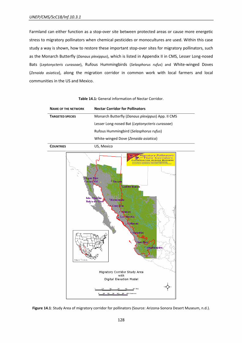
UNEP/CMS/ScC18/Inf.10.3.1
128
Farmland can either function as a stop-over site between protected areas or cause more energetic
stress to migratory pollinators when chemical pesticides or monocultures are used. Within this case
study a way is shown, how to restore these important stop-over sites for migratory pollinators, such
as the Monarch Butterfly (Danaus plexippus), which is listed in Appendix II in CMS, Lesser Long-nosed
Bats (Leptonycteris curasoae), Rufous Hummingbirds (Selasphorus rufus) and White-winged Doves
(Zenaida asiatica), along the migration corridor in common work with local farmers and local
communities in the US and Mexico.
Table 14.1: General information of Nectar Corridor.
NAME OF THE NETWORK Nectar Corridor for Pollinators
TARGETED SPECIES
Monarch Butterfly (Danaus plexippus) App. II CMS
Lesser Long-nosed Bat (Leptonycteris curasoae)
Rufous Hummingbird (Selasphorus rufus)
White-winged Dove (Zenaida asiatica)
COUNTRIES US, Mexico
Figure 14.1: Study Area of migratory corridor for pollinators (Source: Arizona-Sonora Desert Museum, n.d.).
UNEP/CMS/ScC18/Inf.10.3.1
129
Network Aims
The major aims are to set aside the migration corridor for migratory pollinators in regional reserve
networks and to work conjointly with private land-owners to restore stop-over sites for migratory
wildlife, since nowadays, private land is considered to be the weakest link in the migratory chain
(Nabhan, 2004). Additional aims are to conduct monitoring and research on four important
migratory pollinator species (Monarch Butterfly, Lesser Long-nosed Bats, Rufous Hummingbird and
White-winged Dove) to receive a better understanding of their migration routes and plants needed
to enhance conservation strategies and managements (Arizona-Sonora Desert Museum, n.d.).
Network Design
Network Activities
In 1995 the Arizona Desert Museum started the Forgotten Pollinators Campaign (FPC), which raised
public awareness on the status of migratory pollinators now.
In 1998 a multi-institutional, bi-national Pollinator Conservation Consortium (PCC) was formed to
strengthen collaboration and research between Mexico and the U.S.
Education programmes were carried out in U.S and Mexican society to raise public awareness of
conservation of migratory pollinators and to involve them actively in conservation practices and
collection of scientific data. Activities with the public included the planting of nectar-rich plants and
other preferred plants of the pollinators. A workshop on the Monarch Butterfly for schools, the
general public, eco-tourists and industry was carried out to inform the participants about the
importance of pollinators and what they can do to protect them (Arizona-Sonora Desert Museum,
n.d.).
Network Evolution
In May 1989 the former leading scientist of Mexico’s Instituto Nacional de Ecologia emphasized at
the International Conference on the Conservation of Migratory Pollinators and their Corridors “the
increasing political difficulties of establishing additional large, federally protected areas in Mexico
and the United States” (Narbhan, 2004). Therefore the conversion of private land into habitat
suitable for migratory pollinators was important for their conservation. The use of treated sewage
effluent in the bi-national area of riverbeds in Arizona-Sonora to restore riparian corridors showed
very good achievements (Nabhan, 2001). The Rio Santa Cruz was part of a 400 km corridor with
important vegetation for migratory pollinators, crossing one of the driest areas in North America. In
1980 an international waste treatment plant was established which cleared the water and refilled
UNEP/CMS/ScC18/Inf.10.3.1
130
the Rio Santa Cruz with fresh water. In 1992 cottonwoods, willows and mesquites were planted
along the upper Rio Santa Cruz (Nabhan and Donovan, 2000). Today additional restoration efforts
are planned to protect the Sonoran Desert along the Rio Santa Cruz by using treated sewage effluent
(Nabhan, 2004). The active restoration of habitat for migratory pollinators started with an initial case
on farmland in the upper Rio Santa Cruz corridor, where a farmer used sewage effluent to establish
riparian tree species and reduced grazing in seasonally important areas for migratory pollinators. In
1997 the active restoration of this area continued, this included the planting of wild flowers, the
placement of artificial nests and techniques aimed at enhancing pollinators (Buchmann and Nabhan,
1996 and 2000). Riparian restoration was the major conservation measure to increase the number of
migratory pollinators in this area.
Not only vertebrate migratory species showed clear signs of recovery but also invertebrate
pollinators (Nabhan, 2004). This story of success encouraged the Sonoran Institute and Centre for
Sustainable Environment to start more projects with private-landowners to restore habitat inside
the migration corridor of important pollinator species along the San Pedro and San Simon rivers
(Nabhan, 2004). Within this approach of restoring private land both nectar trails for migratory
pollinators could be established between protected areas and their connectivity could be ensured.
As a next step the Wild Farm Alliance suggested linking these positive results to “enhance the
ecological functionality of an entire corridor” (Nabhan, 2004).
Scientific and Conservation Activities
Research within this migration corridor was carried out on four different migratory pollinator
species, amongst them the Monarch Butterfly, as an invertebrate species, two migratory birds the
Rufous Hummingbird and the White-winged Dove and a migratory mammal species the Lesser Long-
nosed Bat.
Lesser long-nosed bats
The behaviour and movement of Lesser Long-nosed Batswas studied to predict their migration
routes and determine the migration corridors. The routes were defined by direct observation of the
bats, by means of locating the caves and mine sites for resting and monitoring their movements and
feeding at night. To research the food requirements both a carbon stable isotope analysis and a
migration energetics analysis were carried out (Arizona-Sonora Desert Museum, n.d.). It is important
to know on which nectar resources from which plants the bats rely on to define their migration
corridor. The results showed that the Lesser Long-nosed Bats migrate in two different nectar
corridors into and out of the Sonroan Desert (Arizona-Sonora Desert Museum, n.d). In the spring

UNEP/CMS/ScC18/Inf.10.3.1
131
they use a corridor covered with cactus along the coast and in the autumn they use a migratory
route covered with agave (Fig. 14.2).
Figure 14.2: Two different seasonal migration routes of Lesser Long-nosed Bats (Source: Arizona-Sonora Desert
Museum, n.d).
Rufous Hummingbirds
The different migratory routes of the Rufous Hummingbirds in North-West Mexico were investigated
based on monitoring of the movements and behaviour of the birds and the distribution pattern of
their preferred feeding plants. Three different migration corridors were identified during spring
migration: the Foothills Corridor, Plains of Sonora Corridor and Gulf Coast Corridor, whereas the
Southward migration routes are not well understood yet (Arizona-Sonora Desert Museum, n.d.).
White-winged Dove
The White-winged Dove selects its migration routes according to the flowering season of Saguaro
Cactus. This reliance of the White-winged Dove and the Saguaro Cactus was studied using isotope
analysis to identify and understand the habitat requirements of this migratory pollinator. The results
showed that the White-winged Dove uses the migration route from its hibernation sites to the
Sonoran Desert to arrive there in April when the Saguaros start to bloom. Therefore the distribution
UNEP/CMS/ScC18/Inf.10.3.1
132
of White-winged Doves is congruent with the distribution of Saguaros (Arizona-Sonora Desert
Museum, n.d).
Monarch Butterfly
The research on the Monarch Butterfly contained awareness-raising, education and data collection
on the movement and migratory behaviour of the Monarch Butterfly.
The results showed that the Monarch Butterflies fly within a migration route between Arizona and
Sonora. In winter Monarchs from the western population migrate southwards to Mexico. But more
monitoring and research on Monarch Butterfly migration is needed, since the particular routes are
not well understood, yet. The great dependency of Monarch Butterflies on suitable forage plants
was shown, since Monarch Butterflies were found without enough lipid reservoirs and therefore
died during their travel to their overwintering grounds in Mexico (Arizona-Sonora Desert Museum,
n.d.).
Future of the Network
To conserve migratory pollinators it is important to protect and preserve their migration routes. The
different stop-over sites should be coherent within the corridor to obtain a continuous nectar trail
and allow unhindered migration. There should be more research and monitoring on the Monarch
Butterfly carried out to understand fully its migration routes and therefore to conserve them better.
UNEP/CMS/ScC18/Inf.10.3.1
133
15. The Danube River Protected Areas Network: White-tailed Eagles
A network built by scaling-up existing schemes
Lessons learnt from this example
Use of a charismatic “flagship species” can help to promote a network with a broad range
of benefits for other species sharing similar needs.
It proved possible in this case to construct a network covering the whole river corridor by
building on pre-existing bilateral and other cooperation arrangements for smaller
components of the system.
Introduction
The Danube River Network of Protected Areas (DANUBEPARKS), formalized in 2007 is of great
importance to White-tailed Eagles - Haliaeetus albicilla (Fig. 15.1) as it encompasses relevant
breeding, stopover and wintering sites (Probst and Gaborik, 2011). The wet habitats and floodplain
forest in the network are the main habitats where this species is found, occurring along the whole
Danube.
The DANUBEPARKS was established as a platform for the optimization of cooperation among
Protected Areas in the vicinity of the Danube River (Fig. 15.2, Tab. 15.1), the most international river
in the world, for the application of transnational conservation concepts and strategies, exchange of
experience and know-how, consolidation of protected areas international policy and
implementation of pilot projects (Danube Parks, n.d.). The White-tailed Eagle is one of the flagship
species focused in this network. The application of the flagship species concept promotes the
conservation of other migratory species with less complex demands on their habitats (DanubeParks,
n.d.), such as Black Stork Ciconia nigra, Purple Heron Ardea purpurea purpurea, Pygmy Cormorant
Phalacrocorax pygmeus, Dalmatian Pelican Pelecanus crispus and Glossy Ibis Plegadis falcinellus, all
CMS-listed (Probst and Gaborik, 2011).
The White-tailed Eagle population consists of two divided northern and south-eastern groups
(DanubeParks, n.d.). The second group is located in the Danube River Basin countries - former
habitat distributed in Austria, Slovakia, Hungary, Croatia, Serbia, Bulgaria and Romania. Individuals
from north-eastern Europe undertake long migrations, of about 2,000 kilometres to central-
UNEP/CMS/ScC18/Inf.10.3.1
134
southern Europe, including the Danube River sites (Probst and Gaborik, 2011). Except for some
northern populations, territorial pairs are mainly sedentary while younger birds are migrants or
vagrants (Helander and Stjernberg 2002). This species is known to show high site-fidelity to its range
territory (DanubeParks, n.d.).
More than one third of the second group is dependent upon the Danube floodplains – about 550
breeding pairs (DanubeParks, n.d.), particularly concentrated at the Hungarian-Croatian-Serbian
border, as a result of the distribution here of vast undisturbed wetlands (Probst and Gaborik, 2011).
The population decline during the 70s was much related to DDT use and habitat destruction.
Nowadays, not only habitat disturbance and destruction (forestry, reduction of former floodplain
wetlands along the Danube in 80 pr cent with river regulation projects) but also hunting, accidental
killing and poisoning threaten the maintenance of white-tailed eagle populations (Helander and
Stjernberg, 2002; T. Mikuska, personal communication, 2013). Food availability, mainly fish and
waterfowl, has not been considered as a main threat. However, variations influence the breeding
success of the populations in Danube. Despite these threats the population has recovered from a
dramatic decline in 1950-1970 (Probst and Gaborik, 2011).
The main challenges faced derive from the large habitat range needed by the species populations,
stretching over state borders, therefore complex habitat protection is needed (DanubeParks, n.d.).
The White-tailed Eagle is included on the Appendix I and II of the Convention on Migratory Species
and its endangered status is reinforced through the listing in the Red Data Books, with the exception
of Germany and Serbia (Probst and Gaborik, 2011). All range countries are covered by the Regional
MOU on the Conservation of African-Eurasian Birds of Prey, which entered into force in 2008, but
only Germany, Hungary, Romania and Slovakia have signed it so far. Its action plan, in effect for
seven years from 2008 onwards, aims to promote internationally coordinated efforts “to achieve
and maintain the Favourable Conservation Status of migratory birds of prey throughout their range
and to reverse their decline”, by means of identifying priority actions and setting an implementation
framework (UNEP/CMS, 2008).

UNEP/CMS/ScC18/Inf.10.3.1
135
Figure 15.1: White-tailed Eagle in DANUBEPARKS (Provided by DANUBEPARKS/Nationalpark Donau-Auen,
Hoyer).
Table 15.1: General Information of DANUBEPARKS (excluding last protected areas added to the network).
NAME OF THE NETWORK Danube River Network of Protected Areas (DANUBEPARKS, 8278 km2)
CMS SPECIES
(LISTED ON BOTH APP. I/II)
White-tailed Sea Eagle (Haliaeetus albicilla)
COUNTRY Austria
Bulgaria
Croatia
Germany
Hungary
Romania
Serbia
Slovakia
PROTECTED AREAS
(SIZE, YEAR OF ESTABLISHMENT)
1. Danube Delta Biosphere Reserve (580,000 ha, 1990, Romania)10
2. Kalimok Brushlen Protected Site (6,000 ha, 2001 Bulgaria)
3. Rusenski Lom Nature Park (3,800 ha, 1980, Bulgaria)10
4. Persina Nature Park (21,762 ha, 2000, Bulgaria) 10
10
protected areas representing the partners that signed the letter of commitment concerning the action plan for the White-tailed Eagle
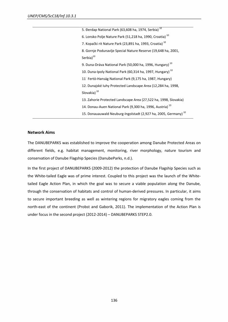
UNEP/CMS/ScC18/Inf.10.3.1
136
5. Ðerdap National Park (63,608 ha, 1974, Serbia) 10
6. Lonsko Polje Nature Park (51,218 ha, 1990, Croatia) 10
7. Kopački rit Nature Park (23,891 ha, 1993, Croatia) 10
8. Gornje Podunavlje Special Nature Reserve (19,648 ha, 2001,
Serbia)10
9. Duna-Dráva National Park (50,000 ha, 1996, Hungary) 10
10. Duna-Ipoly National Park (60,314 ha, 1997, Hungary) 10
11. Fertö-Hanság National Park (9,175 ha, 1987, Hungary)
12. Dunajské Iuhy Protected Landscape Area (12,284 ha, 1998,
Slovakia) 10
13. Zahorie Protected Landscape Area (27,522 ha, 1998, Slovakia)
14. Donau-Auen National Park (9,300 ha, 1996, Austria) 10
15. Donauauwald Neuburg-Ingolstadt (2,927 ha, 2005, Germany) 10
Network Aims
The DANUBEPARKS was established to improve the cooperation among Danube Protected Areas on
different fields, e.g. habitat management, monitoring, river morphology, nature tourism and
conservation of Danube Flagship Species (DanubeParks, n.d.).
In the first project of DANUBEPARKS (2009-2012) the protection of Danube Flagship Species such as
the White-tailed Eagle was of prime interest. Coupled to this project was the launch of the White-
tailed Eagle Action Plan, in which the goal was to secure a viable population along the Danube,
through the conservation of habitats and control of human-derived pressures. In particular, it aims
to secure important breeding as well as wintering regions for migratory eagles coming from the
north-east of the continent (Probst and Gaborik, 2011). The implementation of the Action Plan is
under focus in the second project (2012-2014) – DANUBEPARKS STEP2.0.
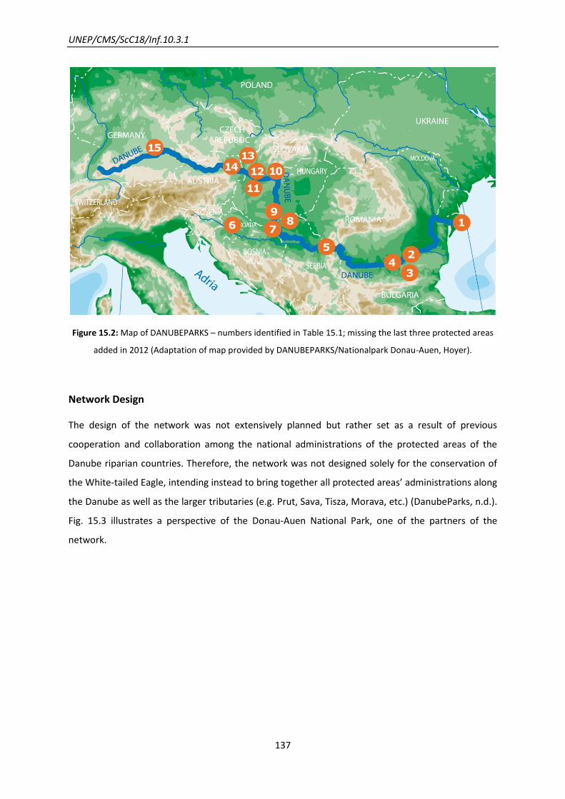
UNEP/CMS/ScC18/Inf.10.3.1
137
Figure 15.2: Map of DANUBEPARKS – numbers identified in Table 15.1; missing the last three protected areas
added in 2012 (Adaptation of map provided by DANUBEPARKS/Nationalpark Donau-Auen, Hoyer).
Network Design
The design of the network was not extensively planned but rather set as a result of previous
cooperation and collaboration among the national administrations of the protected areas of the
Danube riparian countries. Therefore, the network was not designed solely for the conservation of
the White-tailed Eagle, intending instead to bring together all protected areas’ administrations along
the Danube as well as the larger tributaries (e.g. Prut, Sava, Tisza, Morava, etc.) (DanubeParks, n.d.).
Fig. 15.3 illustrates a perspective of the Donau-Auen National Park, one of the partners of the
network.

UNEP/CMS/ScC18/Inf.10.3.1
138
Figure 15.3: The Donau-Auen National Park connecting the "Twin Cities" Vienna and Bratislava (provided by
DANUBEOPARKS/Donau-Auen National Park, Kovacs).
Network Components
At present, the network encompasses a total of 18 protected areas in nine of ten Danube countries.
For nearly all of them conservation action for White-tailed Eagles is on their agenda and, therefore,
they actively contribute to the implementation of the White-tailed Eagle Action Plan.
The River Danube plays a crucial role as biological corridor and its dynamics have been maintained,
e.g. all protected areas work intensively on river restoration (G. Frank, personal communication,
2013). Functional connectivity was proved through an international colour ringing programme, by
which movement upstream and downstream of the rivers was shown, with adult birds establishing
new breeding territories (T. Mikuska, personal communication, 2013).
An efficient protected network of protected areas along the Danube and its tributaries is considered
therefore of crucial importance to establish a network of stepping stones for the White-tailed Eagle’s
breeding population, guaranteeing connectivity in the network (G. Frank, personal communication,
2013; Sádovský n.d.; T. Mikuska, personal communication, 2013).
UNEP/CMS/ScC18/Inf.10.3.1
139
Network Evolution
Bilateral cooperation existed already in the 1990s before the establishment of the Danube-wide
perspectives, followed by cross-border projects in the 2000s (DanubeParks, n.d.). In some cases this
former cooperation even resulted in official agreements and cross-border projects (LIFE, INTERREG).
The next step was taken with the Tulcea Declaration, signed in April 2007, which laid the foundation
stone for the establishment of the network along the Danube River. It remarked the need for
cooperation, coordination, consultation and strengthening of links between the national
administrations of the protected areas, through joint programmes and exchange and enhancement
of expertise in the management of natural sites. As a result the DANUBEPARKS was established in
2007, starting with eight protected areas.
At the 1st International White-tailed Eagle Conference in November 2007 some concerns were raised
in particular in regard to the lack of specific conservation efforts in South-East Europe, the need to
raise know-how transfer (international database, regular conferences) and last but not least the
need for transnational cooperation (and for protected areas to have a leading role in it) (Probst,
2011).
In 2009, at the beginning of the first joint project (April 2009 - February 2012) the partnership
included twelve protected areas from eight Danube countries. Activities were planned and executed,
by which the establishment of Project Management, Steering Committee and Standing Technical
Task Forces were crucial means to accomplish the goals associated with these activities. In
particular, a Task Force Birds was created, including experts from the protected areas, all of them
active for the conservation of the white-tailed eagle.
In the same year, DANUBEPARKS started to elaborate the action plan, a result of the joint work of
the protected areas together with the Advisory Board of experts of Danube countries – outlining the
key conservation measures to be undertaken.
During the 2nd Steering Committee in September 2011 a Letter of Commitment was signed by 13
partners responsible for 12 protected areas, which stresses “the willingness of these Protected Areas
to take over a leading role in the implementation of this Action Plan” (DanubeParks, n.d.).
A month later, the 2nd International White-tailed Eagle Conference in October 2011 expressed the
need of transnational cooperation and served as a catalyst through the launch of an action plan,
which “on the one hand, the Action Plan is one step in a long-term approach of each Protected
Areas, on the other hand, it marks a starting point for a Danube-wide conservation initiative” (G.
Frank, personal communication, 2013). This document was officially supported by the Council of
UNEP/CMS/ScC18/Inf.10.3.1
140
Europe and the Bern Convention, thus gaining recognition at the policy level, expected to help pave
the way for its implementation, as from this date this was one of the legal requirements for
signatory countries.
Breeding sites and wintering sites are addressed but as the White-tailed Eagle cannot be protected
solely by protected areas, inasmuch its spatial range surpass these areas, the developed action plan
is particularly meant to support conservation beyond these boundaries. So far, it is awaiting
implementation and fully related coordinated actions during the second joint project of the network
- DANUBEPARKS STEP 2.0 (October 2012 - September 2014), including identification of priority
measures and transnational activities to be executed in this two-year period (T. Mikuska, personal
communication, 2013).
Scientific and Conservation Activities
In the framework of DANUBEPARKS, a transnational conservation strategy was launched, including:
scientific and conservation activities (monitoring, ringing, database, telemetry, protection of nesting
sites) and knowledge exchange (Danube Parks, n.d.). Nevertheless, this strategy is yet to be fully
implemented during the second project of Danube Parks.
In all countries there are long-lasting programmes of monitoring and conservation for this species,
run by different organizations (working groups, BirdLife, WWF, etc) and partly of transboundary
character (e.g. Croatia and Hungary). The monitoring is done through wintering and breeding
populations counting and use of colour ringing. Synchronized winter counts are already multi-lateral
in part (e.g. Austria, Czech Republic, Slovakia and Hungary) and are planned to be carried out in all
partner countries by 2014 following common methodology, to provide coherent data for the whole
Danube (Parrag, 2012).
Know-how transfer is occurring in the form of regular task force meetings, workshops and
conferences, frequent study visits, steering committees, annual meetings, an online database and
questionnaires (information concerning the execution of national projects, monitoring, etc) (Probst
and Gaborik, 2011).
The Birds Task Force is planning a Protection Plan to be presented to the next meeting in 2013
(Parrag, 2012). Several workshops were conducted, where eagle experts from almost all Danube
countries gathered to share experiences – on threats, research, conservation (G. Frank, personal
communication, 2013). An online database on the White-tailed Eagle has been put at the disposal of
UNEP/CMS/ScC18/Inf.10.3.1
141
the network’s partners aiming to produce a useful tool by sharing national survey’ results and
providing an easy to use map to help the protection of the species.
The results presented in this database consist of breeding data (breeding success and the ringing
data), observational data (follow-up of ringed birds, important to determine the number of Eagles
on wintering areas). The maps obtained from satellite telemetry tools are essential to gain
knowledge on habitat use, consequently affecting conservation actions set (Nagy and Kecskes,
2011).
The conservation status of the species varies among the countries in the study, and so do the
measures applied, with different sizes and level of enforcement for the nest protection zones,
penalties for killing, destroying nests and monitoring activities (Probst and Gaborik, 2011).
By 2010, from the outputs of the questionnaire sent to the project partners, the main results point
to the uptake of national projects in around half of the protected areas, with breeding monitoring as
a standard procedure as opposed to winter census, and some ringing initiatives in only four of the
eleven protected areas that answered the questionnaire (Probst, 2010).
Other measures include the construction of artificial nests, nesting site conservation, prevention of
disturbance, research and sharing of guidelines on lead-poisoning, feeding during winter, restoration
of water regimes and of native tree species composition (Parrag, 2011).
From monitoring activities in the last years, population numbers are very diverse and derive from
non-synchronized counts (Probst, 2010). Nevertheless, during the last decades countries along the
Danube have assisted the recovery of the White-tailed Eagle as a breeding species, as a result of the
contribution of many protection initiatives (Probst and Gaborik, 2011). The trends concerning
wintering populations remain poorly known but stability trends have been confirmed in Slovakia and
Austria, as a result of winter census performed in recent years (Probst, 2011; Ruda, 2011).
The main recommendations point to the elimination or control of threats, as the impact of these
might hamper the success of the network’s goals, namely: need to adhere to nest protection zones
during breeding; to promote fundamental changes in the methods of exploiting alluvial forest
(instead of clear cuts and intensive forestry implement more forest sensitive and ecologically
friendly measures); replacement of river regulation projects for non-structural measures and river
restoration projects; banning lead ammunition and use of other poisons.

UNEP/CMS/ScC18/Inf.10.3.1
142
Future of the Network
Evolution through the enlargement of the number of protected areas in the network is a goal which
has been renewed over time, testified by the recurrent adding, since 2007, of new protected areas
to the network, and expected to continue in the future, as reflection of the on-going discussion in
the last workshops concerning the concept of habitat corridors, stepping stones, etc.
(Danube Parks, n.d.)
UNEP/CMS/ScC18/Inf.10.3.1
143
Contributors
Editorial Team
Avinoam Baruch, UNEP/CMS intern
Katharina Denkinger, UNEP/CMS intern
Borja Heredia, UNEP/CMS Secretariat
Aline Kühl-Stenzel, UNEP/CMS Secretariat
Tanja Lumetsberger, UNEP/CMS intern
Stephanie Maier, UNEP/CMS intern
Joana Martins, UNEP/CMS intern
Johannes Stahl, UNEP/CMS Secretariat
Advisors
Dave Pritchard, Independent Consultant
Tanja Rosen, Transboundary Conservation Specialist Group IUCN World Commission on Protected
Areas
Maja Vasilijevic, Transboundary Conservation Specialist Group IUCN World Commission on
Protected Areas
Dorothy Zbicz, Independent Consultant
Contributors on specific case studies:
African Elephants in the Selous - Niassa Wildlife Corridor
Rolf Baldus, President of the CIC Tropical Game Commission
Rudolf Hahn, Department of Environment - Suva, Fiji Islands
Mountain Gorillas in Central Albertine Rift Region
Sam Mwandha, Virunga Transboundary Collaboration
Tri-National Dja-Odzala-Minkébé (Tridom) Landscape - ForestE and Western Lowland
Gorillas
Richard W. Carroll, WWF Vice President - Africa/Madagascar Program Pauwel De Wachter, TRIDOM Coordinator - WWF Central Africa Regional Program Office (CARPO)
Snow Leopard in Central Asia - Kanchenjunga Conservation Area
Bandana Shakya, ICIMOD - Biodiversity Analyst Koustubh Sharma, Snow leopard Trust - Senior Regional Ecologist
Mongolian Gazelle in Dauria International Protected Area
Oleg Goroshko, Daursky State Nature Biosphere Reserve
UNEP/CMS/ScC18/Inf.10.3.1
144
Tibor Mikuska, Kopacki rit Nature Park
Humpback Whale in the North Atlantic
Nathalie Ward, NOAA - Stellwagen Bank National Marine Sanctuary
David Wiley, NOAA - Stellwagen Bank National Marine Sanctuary
Dugong habitats in the Great Barrier Reef Marine Park
Kirstin Dobbs, Great Barrier Reef Marine Park Authority
Resilient network of MPAs in the Lesser Sunda Ecoregion - Large Marine Fauna
Alison Green, TNC - Senior Marine Scientist Benjamin Kahn, APEX Environmental - Executive Director Mirza Pedju, Area Based Conservation Manager TNC – Indonesia Marine Program Joanne Wilson, Principal 'Sea Solutions'
Siberian Crane Wetland Project
Claire Mirande, Crane Conservation International Crane Foundation
Red Knots in the Western Hemisphere
Meredith Gutowski, Western Hemisphere Shorebird Reserve network - Executive Office Manomet
Center for Conservation Sciences
White-tailed Eagle in the Danube River Network
George Frank, DANUBEPARKS
Tibor Mikuska , Kopacki Rit Nature Park
Arno Mohl, WWF Mura-Drava-Danube
Tibor Parrag, Danube-Drava National Park
Ulrich Schwarz, Consultant Engineer for Geography
UNEP/CMS/ScC18/Inf.10.3.1
145
References
Introduction
Alexander, K. A. & Appel, M. J. G. 1994. African Wild Dogs (Lycaon pictus) endangered by a canine
distemper epizootic among domestic dogs near the Masai Mara national reserve, Kenya. Journal of
Wildlife Diseases, 30(4): 481-485.
Alitzer, S., Bartel, R. & Han, B. A. 2011. Animal Migration and Infectious Disease Risk. Science 331:
296-302.
Australian Government. 2012. Department of Sustainability, Environment, Water, Population and
Communities. National Wildlife Corridor Plan: A framework for landscape-scale conservation.
http://www.environment.gov.au/biodiversity/wildlifecorridors/publications/pubs/national-wildlife-
corridors-plan.pdf (Accessed 06 February 2013)
Bennett, G. 2004. Integrating biodiversity conservation and sustainable use, lessons learnt from
ecological networks. IUCN. Gland.
Bennett, G. & Mulongoy, K. J. 2006. Review of Experience with Ecological Networks, Corridors and
Buffer Zones. Secretariat of the Convention on Biological Diversity, Montreal, Technical Series No.
23, 100 pp.
Bennett, G. & Wit, P. 2001. The Development and Application of Ecological Networks: a Review of
Proposals, Plans and Programmes. Amsterdam: AIDEnvironment/IUCN.
Berger, J. 2004. The last mile: How to sustain long-distance migration in mammals. Conservation
Biology 18(2): 320-331.
Biró, E., Bouwma, I. & Grobelnik, V. (eds) 2006. Indicative Map of the Pan-European Ecological
Network in South-Eastern Europe. ECNC Technical Report Series. ECNC European Centre for Nature
Conservation: Tilburg.
Boere, G. C. & Stroud, D. A. 2006. The flyway concept: what it is and what it isn’t. Waterbirds around
the World. Boere, G. C., Galbraith, C. A. & Stroud, D. A. (eds). The Stationery Office, Edinburgh, UK.
Boitani, L., Falcucci, A., Maiorano, L. & Rondinini, C. 2007. Ecological Networks as Conceptual
Frameworks or Operational Tools in Conservation. Conservation Biology 21(6): 1414-1422.

UNEP/CMS/ScC18/Inf.10.3.1
146
Brock, R. J., Kenchington, E. & Martínez-Arroyo, A. (eds). 2012. Scientific Guidelines for Designing
Resilient Marine Protected Area Networks in a Changing Climate. Commission for Environmental
Cooperation. Montreal, Canada. 95 pp.
CBD, 2010. Case Studies Illustrating the Socio-Economic Benefits of Ecological Networks. Secretariat
of the Convention on Biological Diversity, Montreal, 33 pp.
Chester, C. C. & Hilty, J.A. 2010. Connectivity Science. In: Worboys, G.L., Francis, W.L. & Lockwood,
M. (eds). 2010. Connectivity Conservation Management: A global Guide. 26-33. London: Earthscan.
CMS, 2011. CMS Report Format for National Report of Parties on the Implementation of the
Convention on the Conservation of Migratory Species of Wild Animals. Hungary.
Cronwright-Snoeren, A. 2010. The prevalence of canine distemper virus antibodies in wild carnivores
in the Kruger National Park and Marakele Park, MSc dissertation, University of Pretoria.
University of Pretoria. n.d. http://upetd.up.ac.za/thesis/available/etd-08062010-171656/ (Accessed
15 November 2012).
Dudley, N. (ed) 2008. Guidelines for Applying Protected Area Management Categories. Gland,
Switzerland: IUCN. x + 86 pp.
EECONET Action Fund (EAF) 2012. http://www.eeconet.org/ (Accessed 19 November 2012).
European Environment Agency (EEA) 2012. Protected areas in Europe – an overview. EEA Report No
5/2012, Copenhagen. Luxembourg: Publications Office of the European Union. 130 pp.
Forman, R. T. 1995. Land mosaics: the ecology of landscapes and regions. Cambridge University
Press, New York.
Hamlin, D. 2010. Great Migrations: Born to Move. National Geographic. Movie
Harrison, X. A., Tregenza, T., Inger, R., Colhoun, K., Dawson, D. A., Gudmundsson, G. A., Hodgson, D.
J, Horsburgh, G. J., McElwaine, G. & Bearhop, S. 2010. Cultural inheritance drives site fidelity and
migratory connectivity in a long-distant migrant. Molecular Ecology 19: 5484-5496.
Hindmarch, C. & Kirby, J. 2002. Corridors for birds within a Pan-European Ecological Network. Nature
and environment no. 123. Council of Europe Publishing, Strasbourg, France.
IUCN 2003. Recommendation 5.22, 5th IUCN World Parks Congress, Durban, South Africa (8-17th
September, 2003).
Jongman, R. H. G. 1995. Nature conservation planning in Europe: developing ecological networks.
Landscape and Urban Planning 32: 170-183.

UNEP/CMS/ScC18/Inf.10.3.1
147
Jongman, R. H. G., Külvik, M. & Kristiansen, I. 2004. European ecological networks and greenways.
Landscape and Urban Planning 68: 305–319.
Jorgensen, S .J., Reeb, C.A., Chapple, T. K., Anderson, S., Perle, C., Van Sommeran, S. R., Fritz-Cope,
C., Brown, A. C., Klimley, A. P. & Block, B. A. 2009. Philopatry and migration of Pacific white sharks.
Proceedings of the Royal Society B 277(1682): 679-88.
Kurvits, T., Nellemann, C., Alfthan, B., Kühl, A., Prokosch, P. Virtue, M. & Skaalvik, J.F. (eds.) 2011.
Living Planet: Connected Planet – Preventing the End of the World’s Wildlife Migrations through
Ecological Networks. A Rapid Response Assessment. United Nations Environment Programme, GRID-
Arendal.
Lausche, B. & Burhenne, F. 2011. Guidelines for Protected Areas Legislation. IUCN Environmental
Policy and Law Paper No. 81.
Lausche, B. 2012. The Legal Aspects of Connectivity Conservation. Volume 1 – A Concept Paper,
DRAFT 12.11.2012, IUCN, Gland, Switzerland. 189 pp.
MacArthur, R. H. & Wilson, E. O. 1967. The Theory of Island Biogeography. Princeton, N.J. Princeton
University Press.
Morrison, T. A. & Bolger, D. T. 2012. Wet season range fidelity in a tropical migratory ungulate.
Journal of Animal Ecology 81: 543-552.
OSPAR Commission. 2006. Guidance on developing an ecologically coherent network of OSPAR
Marine Protected Areas. Reference number 2006-3.
OSPAR Commission. 2008. A matrix approach to assessing the ecological coherence of the OSPAR
MPA Network (MASH 08/5/6-E)
OSPAR Commission. 2012. 2011 Status Report on the OSPAR Network of Marine Protected Areas.
Biodiversity Series 2012.
Pritchard, D. E. 2006. Towards coherence in site networks. Waterbirds around the world. In: Boere,
G.C., Galbraith, C.A. & Stroud, D.A. (eds.). The Stationery Office, Edinburgh, UK. pp. 673-674.
Reilly, S. B., Bannister, J. L., Best, P. B., Brown, M., Brownell JR., R. L., Butterworth, D. S., Clapham, P.
J., Cooke, J., Donovan, G. P., Urbán, J. & Zerbini, A. N. 2008. Megaptera novaeangliae. In: IUCN 2012.
IUCN Red List of Threatened Species. Version 2012.2. www.iucnredlist.org. (Accessed 19 October
2012).
Robinson, R. A., Crick, H. Q. P., Learmonth, J. A., Maclean, I. M. D., Thomas, C. D., Bairlein, F.,
Forchhammer, M. C., Francis, C. M., Gill, J. A., Godley, B. J., Harwood, J., Hays, G. C., Huntley, B.,

UNEP/CMS/ScC18/Inf.10.3.1
148
Hutson, A. M., Pierce, G. J., Rehfisch, M. M., Sims, D. W., Santos, M. B., Sparks, T. H., Stroud, D. A. &
Visser, M. E. 2009. Travelling through a warming world: climate change and migratory species.
Endangered Species Research 7: 87-99.
Simberloff, D. & Cox, J. 1987. Consequences and costs of conservation corridors. Conservation
Biology 1(1): 63-71.
Singh, N. J., Grachev, I. A., Bekenov, A. B. & Milner-Gulland, E. J. 2010. Tracking greenery across a
latitudinal gradient in central Asia – the migration of the Saiga Antelope. Diversity and Distributions,
16(4): 663-675.
Tihlman, T., Stenström, M., Blankett, P. & Kostamo, K. 2012. Ecosystem Approach in Preparing a Plan
for Maritime Areas. Helsinki Commission – Vision and Strategy around the Baltic Sea 2010 (HELCOM-
VASAB) Maritime Spatial Planning Working Group. 5th Meeting. Helsinki Commission.
UNEP/CMS and DEFRA, 2008. Migratory Species and Climate Change: Impacts of a Changing
Environment on Wild Animals. UNEP/CMS Secretariat, Bonn, Germany, 64 pp.
UNEP/CMS, 2011. Resolution 10.03: The role of ecological networks in the conservation of migratory
species. Adopted by the Conference of the Parties at its Tenth Meeting (Bergen, 20-25 November
2011)
http://www.cms.int/bodies/COP/cop10/resolutions_adopted/10_03_eco_networks_e.pdf (Accessed
22 February 2013)
UNEP/CMS, 2011. Resolution 10.10: Guidance on global flyway conservation and options for policy
arrangements. Adopted by the Conference of the Parties at its Tenth Meeting (Bergen, 20-25
November2011).
http://www.cms.int/bodies/COP/cop10/resolutions_adopted/10_10_flyways_e.pdf (Accessed 22
February 2013)
Zbicz, D. 2003. Imposing Transboundary Conservation. Journal of Sustainable Forestry 17: 1-2, 21-37.
African Elephants in the Selous - Niassa Wildlife Corridor
Baldus, R. D., & Siege, L. (eds.) 2003. The Selous-Niassa Wildlife Corridor. In: Baldus, R. D., Hahn, R.,
Mpanduji, D. G., & Siege, L. et al. Tanzania Wildlife Discussion Paper No. 34. Wildlife Division,
Deutsche Gesellschaft für Technische Zusammenarbeit GTZ. Wildlife Programme in Tanzania. Dar Es
Salaam.

UNEP/CMS/ScC18/Inf.10.3.1
149
Baldus, R. D., & Hahn, R. 2009. The Selous – Niassa Wildlife Corridor in Tanzania: Biodiversity
Conservation from the Grassroots. Practical Experiences and Lessons from Integrating Local
Communities into Trans-boundary Natural Resources Management. Joint publication of FAO and CIC.
Budapest. 48 pp
Baldus, R. D. 2012. Annotated History of the Selous Niassa Wildlife Corridor. http://www.wildlife-
baldus.com/download/SNWC_History.pdf (Accessed 13 September 2012).
Hahn, R. 2004. Environmental baseline study for the Ruvuma interface. Pre-feasibility study into
sustainable development and conservation the legal and institutional environment.
Regierungsberatung Kommunale Wildbewirtschaftung/ Community Wildlife Management – GTZ.
Dar Es Salaam
Jones T., Rovero F. & Msirikale J. 2007. Vanishing Corridors: A Last Chance to Preserve Ecological
Connectivity between the Udzungwa and Selous-Mikumi Ecosystems of Southern Tanzania. Final
Report to Conservation International.
Mpanduji, D. G. 2004. Population structure, movement and health status of elephants and other
wildlife in the Selous-Niassa Wildlife Corridor, southern Tanzania. Inaugural-Dissertation zur
Erlangung des Grades eines Doktors der Veterinärmedizin an der Freien Universität Berlin.
Tanzania Wildlife Corridors. n.d. http://www.tzwildlifecorridors.org/corridors/selous-niassa/
(Accessed 10 September 2012).
Mountain Gorillas in Central Albertine Rift Region
Butynski, T. M. 2001. Africa’s Great Apes. In: Great Apes and Humans: The ethics of Coexistence.
Beck, B., Stoinski, T. S., Hutchins, M., Maple, T. L., Norton, B., Rowan, A., Stevens, E. F. & Arluke, A.
(eds). Smithsonian Institution Press, Washington D.C. Pp.3-56.
GVTC. n.d. Greater Virunga Transboundary Collaboration. http://greatervirunga.org/ (Accessed 15
November 2012)
International Gorilla Conservation Programme (IGCP). 2006. Ten Year Transboundary Strategic Plan
Central Albertine Rift Transboundary Protected Area Network
IGCP. n.d. International Gorilla Conservation Programme. http://www.igcp.org/ (Accessed 9
November 2012)

UNEP/CMS/ScC18/Inf.10.3.1
150
Lanjouw, A., Kayitare, A., Kayitare, H., Rutagarama, E., Sivha, M., Asuma, S. & Kalpers, J. 2001.
Beyond Boundaries: Transboundary National Resource Management for Mountain Gorillas in the
Virunga-Bwindi Region. Washington DC, USA. Biodiversity Support Program.
Martin, A., Rutagarama, E., Gray, M., Kayitare, A. & Chhotray, V. 2009. Transboundary Natural
Resource Management in the Greater Virunga. Lessons Learned from Regional Approaches to
Conservation Facilitated by the International Gorilla Conservation Programme.
Mutagamba, M. 2012. Gorillas Increase to 400 in Bwindi, Uganda. Uganda Wildlife Authority.
http://www.ugandawildlife.org/component/k2/item/191-gorilla-population-increases-in-bwindi
(Accessed 28 November 2012)
Mwandha, S. n.d. The Greater Virunga Transboundary Collaboration. Greater Virunga Transboundary
Collaboration Secretariat.
Rutagarama, Eugène. 2005. The Virunga-Bwindi Transboundary Strategic Plan A Pathway to
Mountain Gorilla Conservation Progress. International Gorilla Conservation Program.
UNEP-WCMC. 2001. Gorilla – Species sheet.
http://www.wcmc.org.uk/species/data/species_sheets/gorilla.htm (Accessed 11 November 2012)
UNEP/CMS. 2008. Gorilla. Report on the conservation status of Gorillas. R.C. Beudels-Jamar, R-M.
Lafontaine, P. Devillers, I. Redmond, C. Devos et M-O. Beudels. CMS Gorilla Concerted Action. CMS
Technical Series Publiction No17. http://www.cms.int/publications/TechSeries/ts17_Gorilla_E.pdf
(Accessed 12 November 2012).
UNEP/CMS. 2011. Agreement on the Conservation of Gorillas and their Habitats (Gorilla Agreement).
United States Agency for International Development (USAID). 2006. Central African Regional
Program for the Environment (CARPE) Virunga Landscape. Final Performance Report October 2003 –
September 2006
Van der Linde, H. 2010. Central Albertine Rift Transboundary Protected Area Network. Refined Five-
Year Strategic Plan (2010-2014). Rwanda
Vedder, A. L. 1984. Movement patterns of a group of free-ranging mountain gorillas (Gorilla gorilla
beringei) and their relation to food availability. American Journal of Primatology, 7: 73-88.

UNEP/CMS/ScC18/Inf.10.3.1
151
Tri-National Dja-Odzala-Minkébé (Tridom) Landscape: Forest Elephants and Western
Lowland Gorillas
CARPE. 2005. Dja-Minkébé-Odzala Tri-National (TRIDOM) Landscape
http://carpe.umd.edu/Documents/2005/CL4_Dja_SOF.pdf (Accessed 13 February 2013)
Delpero, C. 2012. Music of the forest: a way forward for Gabon’s cooperation with China. WWF
http://wwf.panda.org/?205572/Music-of-the-forest-a-way-forward-for-Gabons-cooperation-with-
China (Accessed 12 February 2013)
De Wachter, P., Malonga, R., Moussavou Makanga, B. L., Nishihara, T., Nzooh, Z. & Usong, L. (n.d.)
Chapter 18 Dja-Odzala-Minkébé (Tridom) Landscape Land Use Planning
Huijbregts, B.W., De Wachter, P., Ndong Obiang, L.S.,Ella Akou, M.A. (2003), Ebola and the decline of
gorilla (Gorilla gorilla) and chimpanzee (Pan troglodytes) in the Minkebe forest, north-eastern
Gabon. Oryx 37: 437-443.
Ko, J. 2011. USAID/CARPE. 2010 Annual Report USAID/CARPE Activities in the COMIFAC/PFBC
Landscapes in Support of the COMIFAC Convergence Plan. US Forest Service International Programs
http://carpe-infotool.umd.edu/IMT/Landscape.php?Landscape=4 (accessed 11 February 2013)
Mabaza, G. & Zebene, J. (2012), Etude socio-économique du Haut Ivindo, Rapport WWF Gabon &
WWF Espace TRIDOM Interzone Congo.
Ngono, G. et al. 2010. Three nations, one conservation complex In: ITTO Tropical Forest Update
20/2. ISSN 1022–5439 www.itto.int/direct/topics/topics_pdf_download/topics_id=2490&no=0
(Accessed 12 February 2013)
Nguiffo, S. 2001. Cameroon – Dja Wildlife Reserve One forest and two dreams: the constraints
imposed on the Baka in Miatta by the Dja Wildlife Reserve
UNDP/GEF. 2004. DRAFT PROJECT BRIEF TRIDOM UNDP/GEF
http://www.thegef.org/gef/sites/thegef.org/files/gef_prj_docs/GEFProjectDocuments/Biodiversity/
Regional%20-%20Conservation%20of%20Transboundary%20Biodiversity-
%20%20Minkebe%20zone/4-9-04%20Project%20Brief%20TRIDOM%20v60404.pdf (Accessed 12
February 2013)
UNESCO/CLT/WHC, n.d. http://whc.unesco.org/en/list/407 (Accessed 12 February 2013)
GEF. n.d. http://issuu.com/thegef/docs/west-africa-bio (Accessed 12 February 2013)
UNEP/CMS/ScC18/Inf.10.3.1
152
Snow Leopards’ conservation in Central Asia
Chettri, N., Bajracharya, B. & Thapa, R. 2008. Feasibility Assessment for Developing Conservation
Corridors in the Kangchenjunga Landscape. In: Chettri, N., Shakya, B. & Sharma, E. 2008. Biodiversity
Conservation in the Kangchenjunga Landscape, International Centre for Integrated Mountain
Development; Kathmandu, Nepal
Diment, A. (FFI), 2012. CMS/UNEP Small Grants Programme. Project title: Supporting Tajikistan to
lead on Transboundary Cooperation on Snow Leopards
Jackson, R. 2005. Surveying Snow Leopard Populations with emphasis on camera trapping: a
Handbook. The Snow Leopard Conservancy, Sonoma, Califorina (73 pages)
Rana L. N. 2008. Biodiversity Status in the Potential Conservation Corridors of the Kangchenjunga
Landscape: a Distribution Model of Flagship and Indicator Species. In: Chettri, N., Shakya, B. &
Sharma, E. 2008. Biodiversity Conservation in the Kangchenjunga Landscape, International Centre for
Integrated Mountain Development; Kathmandu, Nepal
Shakya, B. & Joshi, R. M. 2008. Protected Areas and Biodiversity Conservation in the Hindu Kush-
Himalayan Region with Special Reference to the Kangchenjunga Landscape. In: Chettri, N., Shakya,
B. & Sharma, E. 2008. Biodiversity Conservation in the Kangchenjunga Landscape. International
Centre for Integrated Mountain Development. Kathmandu, Nepal
Sharma, E. 2008. Developing a Transboundary Biodiversity Conservation Landscape and
Conservation Corridors in the Kangchenjunga Complex. In: Chettri, N., Shakya, B. & Sharma, E. 2008.
Biodiversity Conservation in the Kangchenjunga Landscape. International Centre for Integrated
Mountain Development. Kathmandu, Nepal
Singh Rai, D. Tshering, K., Gyeltshen, K., Norbu, N., Raling Ngawang, S., & Sharap Wangchuk, S. 2008.
Biodiversity of Toorsa Strict Nature Reserve - Jigme Dorji National Park Proposed Conservation
Corridor, Western Bhutan. Nature Conservation Division, Department of Forests, Ministry of
Agriculture, Bhutan. In: Chettri, N., Shakya, B. & Sharma, E. 2008. Biodiversity Conservation in the
Kangchenjunga Landscape. International Centre for Integrated Mountain Development. Kathmandu,
Nepal
Wikramanayake, E., Moktan, V., Aziz, T., Khaling, S., Khan, A. A. & Tshering, D. 2006. The WWF
snow leopard action strategy for the Himalayan Region. WWF.
Snow Leopard Conservancy. n.d. http://snowleopardconservancy.org/ (Accessed 23 October 2012)
ICIMOD. n.d. http://www.icimod.org/hkhconservationportal/PA.aspx?ID=1 (Accessed 23 October
2012)

UNEP/CMS/ScC18/Inf.10.3.1
153
Jaguars in the Mesoamerican Biological Corridor
Conservation International, n.d. Mesoamerica
http://www.conservation.org/where/priority_areas/hotspots/north_central_america/Mesoamerica
/Pages/default.aspx (Accessed 7 September 2012)
Independent Evaluation Group. 2011. The Mesoamerican Biological Corridor.‖ Regional Program
Review. Vol. 5, Issue 2.
http://siteresources.worldbank.org/EXTGLOREGPARPROG/Resources/MBC_rpr.pdf (Accessed 7
September 2012)
Marynowski, S. 1992. Paseo Pantera. The Great American Biotic Interchange. Wild Earth. Special
Issue. P. 71-74 MBC, 2010.
The Mesoamerican Biological Corridor. 2010.
http://www.mtholyoke.edu/~melto20j/classweb/mbc/index.html (Accessed 7 September 2012)
National Aeronautics and Space Administration (NASA). Monitoring The Meso American Biological
Corridor http://www-radar.jpl.nasa.gov/centralamericamap/ca/listing.htm (Accessed 7 September
2012)
Post, J. & Warden, R. 2004. Program Assessment of the Regional Environmental Program (PROARCA-
II) http://pdf.usaid.gov/pdf_docs/PDACD698.pdf (Accessed 7 September 2012)
Wildlife Conservation Society (WCS). 2012. Jaguar. http://www.wcs.org/saving-wildlife/big-
cats/jaguar.aspx (Accessed 7 September 2012)
Mongolian gazelles in Dauria International Protected Area
Dauria Reserve. n.d. Dauria International Protected Area (Russian – China – Mongolia).
http://www.dauriareserve.narod.ru./index_eng.htm (Accessed 5 November 2012)
Goroshko, O. 2008. Dauria International (Chinese-Mongolian-Russian) Protected Area (1994 – 2007).
IUCN. 2010. Breaking down the barriers Transboundary conservation of the Mongolian gazelle.
Large Herbivore Network. n.d. Mongolian Gazelle - Procapra gutturosa.
http://www.lhnet.org/mongolian-gazelle/ (Accessed 2 November 2012)
NEASPEC - North-East Asian Subregional Programme for Environmental Cooperation. 2010.
Development of the Cooperation Mechanisms for Nature Conservation in Transboundary Areas in
North East Asia. Note by the secretariat. Fifteenth Senior Officials Meting (SOM) of NEASPEC

UNEP/CMS/ScC18/Inf.10.3.1
154
Simonov, E. A. & Dahmer, T. D., editors. 2008. Amur-Heilong River Basin Reader. WWF. Ecosystems
Ltd., Hong Kong.
Smithsonian Institution. n.d. Conservation GIS Projects Spatial Patterns in Relative Primary
Productivity and Gazelle (Procapra gutturosa) migration in the eastern steppes of Mongolia.
http://nationalzoo.si.edu/SCBI/ConservationGIS/projects/mongolian_gazelle/default.cfm (Accessed
2 November 2012)
UNEP/CMS. 2002. Proposal for inclusion of species on the appendices of the convention on the
conservation of migratory species of wild animals. Proposal: Inclusion of the Mongolian gazelle
Procapra gutturosa to the CMS Convention’s Appendix II.
UNEP/CMS. 2011. Barriers to Migration. Case Study in Mongolia. Analysing the Effects of
Infrastructure on Migratory Terrestrial Mammals in Mongolia. UNEP/CMS/ScC17/Inf.23.
UNEP/CMS. 2011. Mongolia, CMS Report. Format for National Report of Parties on the
Implementation of the Convention on the Conservation of Migratory Species of Wild Animals.
UNEP/CMS/Inf.10.12.51.
UNEP/CMS. 2011. Central Eurasian Aridland Mammals Action Plan. 17th Meeting of the Scientific
Council. UNEP/CMS/ScC17/Doc.13.
Whitley Fund for Nature (WFN). 2010. Cross-border research and conservation of Mongolian
Gazelles, Vadim Kirilyuk. http://whitleyaward.org/winners/mongolian-gazelles-russia/ (Accessed 30
October 2012)
Sturgeon Migration in Danube River Basin Management Plan
International Commission for the Protection of the Danube River. 2009. Danube River Basin District
Management Plan. http://www.icpdr.org/main/publications/danube-river-basin-management-plan
(Accessed 20 September 2012)
Patriche, N., Lorga V., Talpe, S, M., Trofimov, A. & Tenciu, M. n.d. State of the sturgeon stocks From
the Lower Danube River
http://www.danubeparks.org/files/102_SturgeonStocksLowerDanube_NeculaiPatriche.pdf
(Accessed 20 September 2012)
World Wide Fund for Nature (WWF). 2012. River Danube Delta.
http://wwf.panda.org/about_our_earth/ecoregions/danube_river_delta.cfm (Accessed 20
September 2012)

UNEP/CMS/ScC18/Inf.10.3.1
155
Humpback Whales in the North Atlantic
Agence des Aires Marines Protégées (AAMP). 2012. Le sanctuaire Agoa vient d'être reconnu aire
marine protégée française et internationale. http://www.aires-marines.fr/Actualites/Sanctuaire-
Agoa-reconnu-aire-marine-protegee-internationale (Accessed 27 November 2012)
College of the Atlantic. http://www.coa.edu/nahwc.htm (Accessed 25 January 2013)
Gulf of Maine Research Institute. 2012. http://www.gmri.org/ (Accessed 23 January 2013)
Hoyt, E. 2005. Marine Protected Areas for Whales, Dolphins and Porpoises: A worldwide handbook
for cetacean habitat conservation. Earthscan, London. http://www.cetaceanhabitat.org/ (Accessed
10 December 2013)
Hoyt, E. 2011. Marine Protected Areas for Whales, Dolphins and Porpoises: A world handbook for
cetacean habitat conservation and planning. Earthscan, Oxon. http://www.cetaceanhabitat.org/
(Accessed 10 December 2013)
Hain, J. H. W., Carter, G. D., Kraus, S. D., Mayo, C. A. & Winn, H. E. 1982. Feeding behavior of the
humpback whale, Megaptera novaeangliae, in the western North Atlantic. Fishery Bulletin 80: 259-
268.
International Whaling Commission (IWC). n.d. Whale Population Estimates.
www.iwcoffice.org/estimate (Accessed 7 November 2012).
Kurvits, T., Nellemann, C., Alfthan, B., Kühl, A., Prokosch, P. Virtue, M. & Skaalvik, J.F. (eds). 2011.
Living Planet: Connected Planet – Preventing the End of the World’s Wildlife Migrations through
Ecological Networks. A Rapid Response Assessment. United Nations Environment Programme, GRID-
Arendal.
NOAA. 2012. Marine Protected Areas (MPAs): Conservation of Endangered Humpback Whales. The
National Oceanic and Atmospheric Administration (NOAA) Office of the General Counsel, U.S.
Department of Commerce. http://www.gc.noaa.gov/gcil_mpa-whales.html (Accessed 30 January
2013)
Tweed, K. 2011. Bermuda Triangle to Become Humpback Whale Haven OurAmazingPlanet.
http://www.ouramazingplanet.com/1768-bermuda-triandle-humpback-whale-sanctuary.html
(Accessed 30 January 2013)
Reilly, S. B., Bannister, J. L., Best, P. B., Brown, M., Brownell Jr., R. L., Butterworth, D. S., Clapham, P.
J., Cooke, J., Donovan, G. P., Urbán, J. & Zerbini, A. N. 2008. Megaptera novaeangliae. In: IUCN 2012.

UNEP/CMS/ScC18/Inf.10.3.1
156
IUCN Red List of Threatened Species. Version 2012.2. www.iucnredlist.org. (Accessed 19 October
2012)
National Ocean Service. n.d. Stellwagen Bank National Marine Sanctuary Web Group
http://stellwagen.noaa.gov/sister/welcome.html (Accessed 15 November 2012).
Slivka, K. 2012. Close to Shore, Humpbacks are far from safe. New York Times
http://www.nytimes.com/2012/08/21/science/earth/close-to-cape-cod-shore-humpback-whales-
are-far-from-safe.html?pagewanted=all (Accessed 15 November 2012).
Johnson, M. 2005. Playing Tag with Whales. Woods Hole Oceanographic Institution.
http://www.whoi.edu/oceanus/viewArticle.do?id=3820 (Accessed 30 January 2013)
Dugongs and their habitats in the Great Barrier Reef Marine Park
Australian Government and Queensland Government, 2009. Reef Water Quality Protection Plan.
<http://www.environment.gov.au/coasts/pollution/reef/index.html>.
Dobbs, K., Fernandes, L., Slegers, S., Jago, B., Thompson, L., Hall, J., Day, J., Cameron, D., Tanzer, J.,
Macdonald, F., Marsh, H. & Coles, R. 2008. Incorporating dugong habitats into the marine protected
area design for the Great Barrier Reef Marine Park, Queensland, Australia. Ocean & Coastal
Management 51: 368-375.
Dobbs, K. A., Lawler, I. & Kwan, D. 2012. Chapter 11. Dugongs in Australia and the Pacific, p.99-105
In: Sirenian Conservation: Issues and Strategies in Developing Countries; Eds: Hines, E., Reynolds,
J.E., Aragones, L. V., Mignucci-Giannoni, A. A., & Marmontel, M. Unviersity of Florida Press, USA,
326p.
Fernandes, L., Day, J., Lewis, A., Slegers, S., Kerrigan, B., Breen, D., Cameron, D., Jago, B., Hall, J.,
Lowe, D., Innes, J., Tanzer, J., Chadwick, V., Thompson, L., Gorman, K., Simmons, M., Barnett, B.,
Sampson, K., De’ath, G., Mapstone, B., Marsh, H., Possingham, H., Ball, I., Ward, T., Dobbs, K.,
Aumend, J., Slater, D., & Stapleton, K. 2005. Implementing representative no-take areas over 1/3 of
the Great Barrier Reef: large-scale implementation of Marine Protected Area theory with lessons for
global application. Conservation Biology, 19(6): 1733-1744.
GBRMPA (Great Barrier Reef Marine Park Authority). 1981. Nomination of the Great Barrier Reef by
the Commonwealth for Inclusion in the World Heritage List. Great Barrier Reef Marine Park
Authority, Townsville, Australia.
GBRMPA. 1994. Turtle and dugong conservations strategy for the Great Barrier Reef Marine Park.

UNEP/CMS/ScC18/Inf.10.3.1
157
GBRMPA. 1997. Shoalwater Bay (Dugong) plan of management. No. SB01/97.
GBRMPA. 2011. Information Sheet For commercial net fishermen about netting changes in Bowling
Green bay Species Conservation (Dugong Protection) Special Management Area.
http://www.gbrmpa.gov.au/ (Accessed February 2013)
Heinsohn, R., Lacy, R. C., Lindenmayer, D. B., Marsh, H., Kwan, D. & Lawler, I. R. 2004, Unsustainable
harvest of dugongs in Torres Strait and Cape York (Australia) waters: two case studies using
population viability analysis. Animal Conservation, 7, 417-425.
Hodgson, A. 2007. A Dugong Research Strategy for the Torres Strait, Great Barrier Reef World
Heritage Areas and south-east Queensland 2006-2011. Australian Government Great Barrier Reef
Marine Park Authority, Townsville, Australia. Research Publication No.86.
Kerrigan, B., Breen, D., De’ath, G., Tobin, R., Day, J., Fernandes, L. & Dobbs, K. 2010. Classifying the
Biodiversity of the Great Barrier Reef, Research Publication No. 104, Great Barrier Reef Marine Park
Authority, Townsville, 50p.
Lawler, I., Marsh, H., McDonald, B. & Stokes, T. 2002. Dugongs in the Great Barrier Reef.
Queensland, Australia: CRC Reef Research Centre.
Marsh, H., Penrose, H. 2001. Seasonal distribution of the dugong in the southern Great Barrier Reef
Marine Park. Final Report to the Great Barrier Reef Marine Park Authority, Townsville, Australia.
Marsh, H.; De’ath G, Gribble, N. & Lane, B. 2005. Historical marine population estimates: triggers or
targets for conservation? Ecological Applications, vol. 15, pp. 481-492.
Marsh. 2012. Lady of the Sea under threat. James Cook University Australia. http://www-
public.jcu.edu.au/news/current/JCU_110255. (Accessed 4 December 2012)
McCook, L., Ayling, T., Cappo, M., Choat, J., Evans, R., Freitas, D., Heupel, M., Hughes, T., Jones, G.,
Mapstone, B., Marsh, H., Mills, M., Molloy, F., Pitcher, C., Pressey, R., Russ, G., Sutton, S., Sweatman,
H., Tobin, R., Wachenfeld, D. & Williamson, D. 2010. Adaptive management of the Great Barrier
Reef: A globally significant demonstration of the benefits of networks of marine reserves.
Preen, A. & Marsh, H. 1995. Responses of dugongs to large-scale loss of seagrass from Hervey Bay,
Queensland, Australia. Wildlife Research, 22, 507-519.
Smyth, D. 2005. Dugong and Marine Turtle Knowledge Handbook. North Australian Indigenous Land
& Sea Management Alliance.
Queensland Government. 1999. Conservation and management of the dugong in Queensland 1999-
2004. Environmental Protection Agency, Brisbane, Qld.
UNEP/CMS/ScC18/Inf.10.3.1
158
Queensland Government. 2004. Marine Parks (Great Barrier Reef Coast) Zoning Plan 2004.
Regulatory Impact Statement for SL 2004 No. 240 made under the Marine Parks Act 1982.
Sheppard, J. K.; Preen, A. R.; Marsh, H.; Lawler, I. R.; Whiting, S. D. &Jones, R. E. 2006. “Movement
heterogeneity of dugongs, Dugong dugon (Müller), over large spatial scales” Journal of Experimental
Marine Biology and Ecology 334: 64-83.
Sheppard, J. K. 2008. The Spatial Ecology of Dugongs: Applications to Conservation Management.
Diss. James Cook University, Townsville, Australia.
Sobtzick, S., Hagihara, R., Grech, A. & Marsh, H. 2012. Aerial survey of the urban coast of Queensland
to evaluate the response of the dugong population to the widespread effects of the extreme
weather events of the summer of 2010-11. Final report to the Australian Marine Mammal Centre
and the National Environmental Research Program, James Cook University, Townsville, Queensland,
UNEP. 2002. Dugong Status Report and Action Plans for Countries and Territories.
UNEP/DEWA/RS.02-1 ISBN 92-807-2130-5.
Resilient Network of MPAs in the Lesser Sunda Ecoregion: Large Marine Fauna
Carter, E., Soemodinoto, A. & White, A. 2010. Guide for Improving Marine Protected Area
Management Effectiveness in Indonesia. Bali, Indonesia: The Nature Conservancy Indonesia Marine
Program, xi + 49p
CTC (2012) Nusa Penida: Establishing an MPA Learning Site; available at
http://www.coraltrianglecenter.org/wp-content/infosheet/pdf/infosheet-np-bps-march26.pdf
(latest access 04th of February 2013)
Djuharsa, E. n.d. Gili Matra Marine Natural Recreation Park West Nusa Tenggara Province –
Indonesia. Natural Resources Conservation Office. West Nusa Tenggara, Indonesia.
UNEP/EAS/ICRAN/WS. 2/5 Annex 8 Page 2
http://www.globalcoral.org/Gili%20Matra%20Marine%20Natural%20Recreation%20Park.pdf
Green, A., White, A., &Tanzer, J. 2012. Integrating fisheries, biodiversity, and climate change
objectives into marine protected area network design in the Coral Triangle. Report prepared by The
Nature Conservancy for the Coral Triangle Support Partnership, 105 pp.
Kahn, B. 2013. Marine mammal species positively identified in the Lesser Sunda Ecoregion. Apex
Environmental. Australia
UNEP/CMS/ScC18/Inf.10.3.1
159
Kahn, B. & Pet, J. 2003. Long-term visual and acoustic cetacean surveys in Komodo National Park,
Indonesia 1999-2001: Management implications for large migratory marine life. In: Proceedings and
publications of the world congress on Aquatic protected areas 2002. Australian Society for Fish
Biology. 28pp.
McLeod, E., Salm, R., Green A. & Almany, J. 2009. Designing Marine Protected Area Networks to
Address the Impacts Of Climate Change. Frontiers in Ecology and the Environment; 7 doi:
10.1890/070211.
Savu Sea Marine National Park: http://tnplautsawu.net (latest access 24th of January 2013)
Veron, J. E. N., L. M. De Vantier, E. Turak, A. L. Green, S. Kininmonth, M. Stafford-Smith, & Petersen,
N. 2009. Delineating the Coral Triangle. Galexea, Journal of Coral Reef Studies 11:91-100.
Wilson, J., Darmawan, A., Subijanto. J., Green, A., & S. Sheppard. 2011 Scientific designof a resilient
network of marine protected areas. Lesser SundaEcoregion, Coral Triangle.Asia Pacific Marine
Program. Report 2/11. 96 pp.
Siberian Crane Wetland Project
BirdLife International. 2012. Leucogeranus leucogeranus. In: IUCN 2012. IUCN Red List of Threatened
Species. Version 2012.1. www.iucnredlist.org (Accessed 11 September 2012)
UNEP/CMS. 2011. Conservation Measures for the Siberian Crane, Fifth Edition. UNEP/CMS
Secretariat, Bonn, Germany. 202 pages. Technical Report Series No 25.
Harris, J. 2009. Safe Flyways for the Siberian Crane: A flyway approach conserves some of Asia’s
most beautiful wetlands and waterbirds. International Crane Foundation. Baraboo, USA. 99 pp.
Ilyashenko, E. I., ed. 2010. Atlas of Key Sites for the Siberian Crane and Other Waterbirds in
Western/Central Asia. International Crane Foundation, Baraboo, Wisconsin, USA. 116 p.
International Crane Foundation. www.savingcranes.org (Accessed 14 September 2012)
Mirande, C. M. & Prentice, C. 2011. Conservation of flyway wetlands in Asia using the Siberian Crane
as a flagship species: an overview of the outcomes of the UNEP/GEF Siberian Crane Wetland Project.
In: Prentice C. (Editor). Conservation of Flyway Wetlands in East and West/Central Asia. Proceedings
of the Project Completion Workshop of the UNEP/GEF Siberian Crane Wetland Project, 14-15
October 2009, Harbin, China. Baraboo (Wisconsin), USA: International Crane Foundation.

UNEP/CMS/ScC18/Inf.10.3.1
160
Partnership of the East Asian-Australasian Flyway. www.eaaflyway.net (Accessed 14 September
2012)
Prentice, C., Mirande, C.M., Ilyashenko, E. & Harris, J. 2006. Flyway site network development in
Asia: wetland conservation using the Siberian Crane Grus leucogeranus as a flagship species.
Waterbirds around the World. Eds. G.C. Boere, C.A. Galbraith & D.A. Stroud. The Stationery Office,
Edinburgh, UK. pp. 690-696.
Siberian Crane Flyway Conservation Program. www.sibeflyways.org (Accessed 14 September 2012)
Siberian Crane Wetland Project. www.scwp.info (Accessed 14 September 2012)
Zandri, E. & Prentice, C. 2009. The Experience of UNEP GEF and Partners in Flyway Conservation.
UNEP GEF Portfolio Outlook and Evolution. Biodiversity Issue Paper BD/001. UNEP, Nairobi, Kenya.
Great bustards in the European Birds Directive
Alonso, J. C., Martín, C. A., Alonso, J. A., Palacín, C., Magaña, M. & Lane, S. J. 2004. Distribution
dynamics of a great bustard metapopulation throughout a decade: influence of conspecific
attraction and recruitment. Biodiversity and Conservation 13: 1659-1674.
Alonso, J. C., Morales, M. B., Alonso, J. A. 2000. Partial migration, and lek and nesting area fidelity in
female great bustards Otis tarda. Condor, 102, 127–136.
Bird Guides. 2012. Great Bustard (Otis tarda)
http://www.birdguides.com/species/species.asp?sp=047011 (Accessed 16 July 2012).
Birdlife International. 2012. Otis Tarda Online http://tuzok.mme.hu/index.php?m_id=2&sm_id=7
(Accessed 16 July 2012).
BirdLife International. 2012. Species factsheet: Otis tarda. Downloaded from http://www.birdlife.org
Accessed 21 October 2012)
Borralho, R., Rio Carvalho, C., Stoate, C., Araújo, M. & Reino, L.M. 1999. Avaliação intermédia do
impacte do Plano Zonal de Castro Verde na avifauna. In: Beja, P., Catry, P., Moreira, F. (Eds.), Actas
do II Congresso de Ornitologia da Sociedade Portuguesa para o Estudo das Aves. SPEA, Faro,
Portugal.
Evans, A.D., Armstrong-Brown, S. & Grice, P. V. 2002. The role of research and development in the
evolution of a "smart" agri-environment scheme. Aspects of Applied Biology 67, 253-262.

UNEP/CMS/ScC18/Inf.10.3.1
161
Gaston, K. J. & Blackburn, T. M. 1995. Mapping biodiversity using surrogates for species richness –
macro-scales and New World birds. Proceedings of the Royal Society of London, Series B, Biological
Sciences, 262, 335–341.
Grosstrappe. 2010. LIFE Project "Cross-border Protection of the Great Bustard in Austria”
http://www.grosstrappe.at/indexe.htm (Accessed 16 July 2012)
Kleijn, D. & Sutherland, W. J. 2003. How effective are European agri-environment schemes in
conserving and promoting biodiversity? Journal of Applied Ecology 40, 947-969.
LIFE. 2011. http://greatbustard.org/management/wp-content/uploads/2011/02/TWG-No-1.pdf
Marta-Pedroso, C., Domingos, T., Freitas, H. & de Groot, S. 2007 Cost–benefit analysis of the Zonal
Program of Castro Verde (Portugal): Highlighting the trade-off between biodiversity and soil
conservation. Soil and Tilage Research. Vol. 97, P.79-90
Morales, M. B., Alonso, J. C., Alonso, J. A. & Martin, E. 2000. Migration patterns in male great
bustards.Auk, 117, 493–498.
Osborne, P. E., Alonso, J.C. & Bryant, R. G. 2001. Modelling landscape-scale habitat use using GIS and
remote sensing: a case study with great bustards.Journal of Applied Ecology. Vol. 38, P. 458–471
http://onlinelibrary.wiley.com/doi/10.1046/j.1365-2664.2001.00604.x/full
Pinto, M., Rocha, P. % Moreira, F. 2005 Long-term trends in great bustard (Otis tarda) populations in
Portugal suggest concentration in single high quality area. Biological Conservation124, 415-423.
Prager, K., Reed, M. & Scott, A. 2012. Encouraging collaboration for the provision of ecosystem
services at a landscape scale - Rethinking agri-environmental payments.Land Use Policy. 29: 244-
249.
Raab, R., Kovacs, F. J., Julius, E., Raab, S., Schütz, C., Spakovszky, P. & Timar, J. 2010: Die Großtrappe
in Mitteleuropa. Erfolgreicher Schutz der westpannonischen Population. APG, Wien, 304 S.
Williams, P., Humphries, C., Vanewright, D. & Gaston, K. 1997. Descriptive and predictive approaches
to biodiversity measurement. Trends in Ecology and Evolution, 12, 444–445.
Red Knots in the Western Hemisphere
Castillo, F., Davidson, I., Duncan, C., Hahn, D., Quevedo, D. L., Mundkur, T., Vidal, R. M. 2011. Five-
Year Strategic Plan, 2011-2015, for the Western Hemisphere Shorebird Reserve Network. Version
1.0. Manomet Center for Conservation Sciences, Manomet, Massachusetts, U.S.A.
http://www.whsrn.org/ (Accessed on 2nd November 2012).
UNEP/CMS/ScC18/Inf.10.3.1
162
Niles, L., Sitters, H., Dey, A. and Red Knot Status Assessment Group. 2010. Red Knot Conservation
Plan for the Western Hemisphere (Calidris canutus), Version 1.1. Manomet Center for Conservation
Sciences, Manomet, Massachusetts, USA. http://www.whsrn.org/ (Accessed on 2nd November 2012).
Mizrahi, D. n.d. The Science behind Conserving Shorebirds and Horseshoe Crabs in Delaware Bay.
New Jersey Audubon Society. http://www.njaudubon.org/SectionConservation/BurdenofProof.aspx
(Accessed on 22nd January 2013).
Nectar Corridor for Migratory Pollinators – U.S. - Mexican Cooperation
Arizona-Sonora Desert Museum, n.d. http://www.desertmuseum.org (Accessed 22 November, 2012)
Buchmann, S. L. & Nabhan, G. P. 1996. The Forgotten Pollinators, Island Press. Washington, D.C.
Conservation Biology 4(4): 365-374
Nabhan, G. P. & Donovan J. 2000. Nectar trails for pollinators: designing corridors for conservation.
Arizona-Sonora Desert Museum. Technical Series, No. 4
Nabhan, G. P. 2001. Nectar Trails of Migratory Pollinators - Restoring Corridors on Private Lands,
Conservation Biology in Practice. 2(1): 21-27
Nabhan, G. P. 2004. Conserving Migratory Pollinators and Nectar Corridors in Western North
America (Arizona-Sonora Desert Museum Studies in Natural History). Univ of Arizona Pr (Juni 2004).
190p
White-tailed Eagles in the Danube River Network
DanubeParks. n.d. DanubeParks network of protected areas. http://www.danubeparks.org/
(Accessed January 2013).
Helander, B. & Stjernberg, T. 2002. Action Plan for the conservation of White-tailed Sea Eagle
(Haliaeetus albicilla). BirdLife International. 43 pp.
Probst, R. 2010. Questionnaire Results for White-tailed Eagle Action Plan. Task Force Meeting Birds,
Hungary. http://www.danubeparks.org/ (Accessed January 2013).
Probst, R. 2011. The White-tailed Eagle in Austria Part 1: Monitoring. “Protection of White-Tailed-
Eagle in the Danube Valley” conference, Szekszárd - Hungary, 2011. http://www.danubeparks.org/
(Accessed January 2013).

UNEP/CMS/ScC18/Inf.10.3.1
163
Probst, R. & Gaborik, Akos. 2011. Action Plan for the conservation of the White-tailed Sea Eagle
(Haliaeetus albicilla) along the Danube. Convention on the Conservation of European Wildlife and
Natural Habitats (Bern Convention), Council of Europe. Nature and Environment, No.163.
http://www.danubeparks.org/ (Accessed January 2013).
Nagy, Z.; Nagy, Z. & Kecskés, Z. 2012. Introduction of the White-tailed eagle on-line database.
“Protection of White-Tailed-Eagle in the Danube-valley” conference, Szekszárd - Hungary, 2011.
http://www.danubeparks.org/ (Accessed January 2013).
Parrag, T. 2011. White-tailed Eagle protection measures of the DANUBEPARKS project. “Protection
of White-Tailed-Eagle in the Danube Valley” conference, Szekszárd - Hungary, 2011.
http://www.danubeparks.org/ (Accessed January 2013).
Parrag, T. 2012. Flagship Species 2.0 WHITE-TAILED EAGLE (White-tailed Eagle). DANUBEPARKS Step
2.0 Kick Off Event, Germany. http://www.danubeparks.org/ (Accessed January 2013).
Ruda, M. 2011. Conservation of White-tailed Eagle in Slovakia. “Protection of White-Tailed-Eagle in
the Danube-valley” conference, Szekszárd - Hungary, 2011. http://www.danubeparks.org/ (Accessed
January 2013).
Sádovský, M. n.d. Perspectives for Danube Floodplain Forests. DANUBEPARKS.
http://www.danubeparks.org/ (Accessed January 2013).
UNEP/CMS/ScC18/Inf.10.3.1
164
Annex: Questionnaire interviews
Ecological networks: case studies, challenges and lessons learned
What were the main aims of the network? How/When was the network established?/how was it agreed upon?/ Which countries are involved?
Protection status (Agreement/ MOU/ Directive)?
Which countries lead the implementation?
What are the components of the network?
How many species? Breeding/nesting/feeding sites – how were selected? Evolution of the network (e.g. new countries where added)?
Do these support other migratory species?
Do these have a strong element of connectivity (corridors) or critical sites (core areas and buffer zones)?
How much of the species range is covered?
A map could be helpful
How strong is the understanding of the target species within the network?
How well was the species monitored/researched before establishing the network?
Was there a need for additional monitoring or research?
How has the species responded to the network (in terms of population and distribution)? o Was there a timeframe for monitoring this response? If so are there any changes
you would have suggested for the timeframe?
To what extent did species migration play a role in the design of the network?
Did species migration fit into the network’s priorities?
On what basis were sites selected?
Conservation importance/threats/costs?
Were critical sites criteria such as KBA/IBA/SPA used?
What influenced the scale of the network?
Has the original design been changed or modified?
Why was the design changed?
What were the implications of design changes to the robustness of the network?
How is the network expected to progress in the future?
What lessons can be learnt for further migratory species networks?
How well did different stakeholders cooperate in the realisation of the network?
Other recommendations?