climatic confort in gardens
TRANSCRIPT
PLEA2012 - 28th Conference, Opportunities, Limits & Needs Towards an environmentally responsible architecture Lima, Perú 7-9 November 2012
Climatic Comfort in Gardens and Public Squares of the City of
Colima
REYNA VALLADARES-ANGUIANO1, ADALBERTO TEJEDA MARTÍNEZ
2, PETER CHUNG
ALONSO3, NAHEMA CATALÁN VEGA
4
1, 3, 4
Facultad de Arquitectura y Diseño, Universidad de Colima, Colima, México
2Programa de Estudios de Cambio Climático , Universidad Veracruzana, Xalapa, México
ABSTRACT: This paper analyzes the physical and microclimatic characteristics of eight urban parks in order to know
how the green areas, vegetation and surface cover material configuration can reduce the air temperature, through the
correlation of different variables like superficial temperature, relative humidity, vapour pressure, illumination and
shaded areas. The same variables are measured in a 100- meter influence area around three parks, in order to know
how the urban context conditions modify the inside air temperature.
Based on the review of the mechanism of the formation of the urban heat island and local conditions, it is concluded with
a set of urban heat island mitigation strategies.
Keywords: urban heat island, climate, comfort
INTRODUCTION
The results of measuring thermic conditions in public
areas opened in a subhumid tropical city are presented
here; these should be useful in an attempt to make future
parks and gardens more agreeable to those using them
and to contribute to a better quality of life. We start from
an analysis of parks and gardens, since various authors
(Jáuregui and Heres [8], Higueras [5], RUROS [10],
Brown [1]) consider them beneficial to urban
environmental conditions.
This research addresses two initial questions: How do
urban indices influence the microclimate of public areas?
And: What configuration and characteristics should the
surfaces of urban open spaces present in order to reduce
the air temperature and to exert a greater influence on
their immediate context?
The hypothesis is that the ambient temperature in a public
area of an urban unit increases due to a greater density of
buildings and paved surfaces in comparison with open
spaces, which have more vegetation, shaded areas and
permeable surfaces.
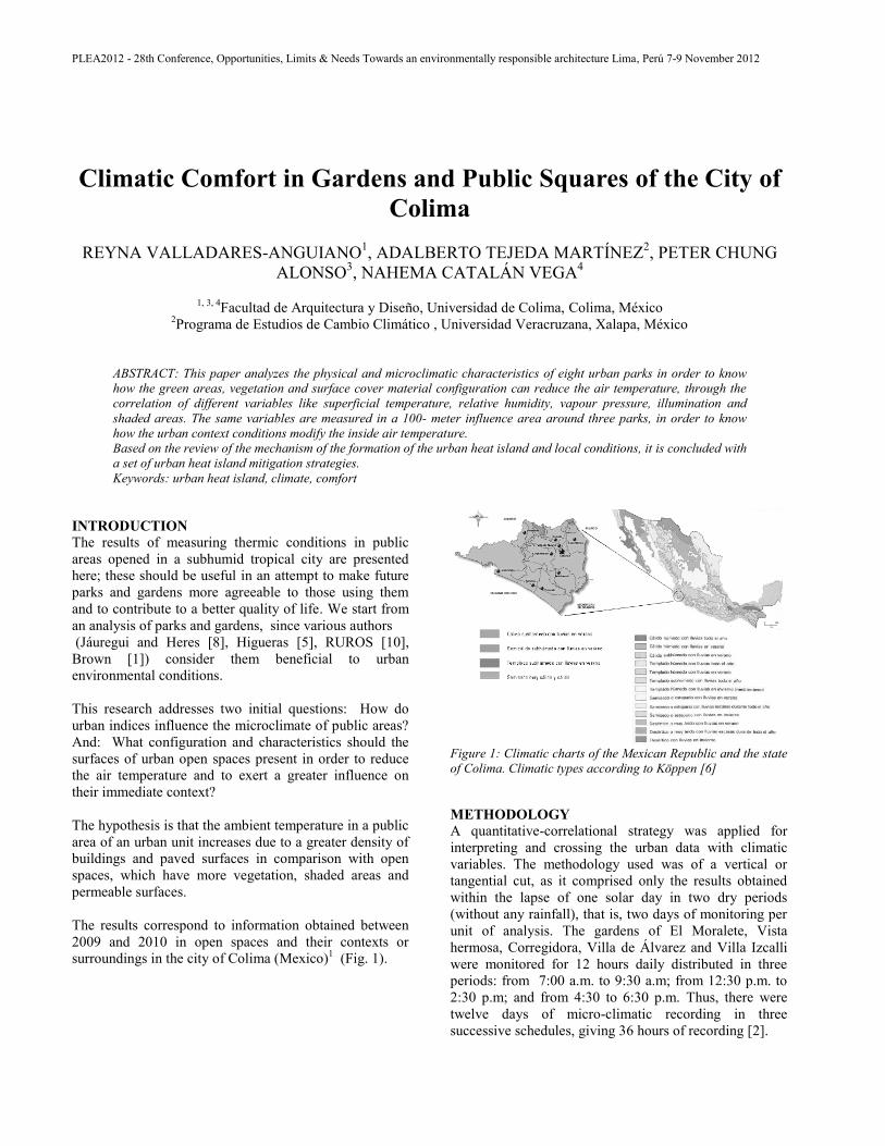
The results correspond to information obtained between
2009 and 2010 in open spaces and their contexts or
surroundings in the city of Colima (Mexico)1 (Fig. 1).
Figure 1: Climatic charts of the Mexican Republic and the state
of Colima. Climatic types according to Köppen [6]
METHODOLOGY
A quantitative-correlational strategy was applied for
interpreting and crossing the urban data with climatic
variables. The methodology used was of a vertical or
tangential cut, as it comprised only the results obtained
within the lapse of one solar day in two dry periods
(without any rainfall), that is, two days of monitoring per
unit of analysis. The gardens of El Moralete, Vista
hermosa, Corregidora, Villa de Álvarez and Villa Izcalli
were monitored for 12 hours daily distributed in three
periods: from 7:00 a.m. to 9:30 a.m; from 12:30 p.m. to
2:30 p.m; and from 4:30 to 6:30 p.m. Thus, there were
twelve days of micro-climatic recording in three
successive schedules, giving 36 hours of recording [2].

PLEA2012 - 28th Conference, Opportunities, Limits & Needs Towards an environmentally responsible architecture Lima, Perú 7-9 November 2012
In the Regional, Hidalgo and Nuñez parks, measurements
were taken between 9 and 11 a.m and from 3 to 5 p.m.
There were also night time measurements in order to
compare the thermic behavior of the study cases and their
context, with and without solar radiation [3]. Both kinds
of recordings were done during the seasons of autumn-
winter and spring (see Fig 2).
Figure 2: Location of gardens and parks analyzed.
In all cases, the location, form, spatial limits and vegetal
components of the system were analyzed, and the urban
subsystem constituting each open public area with its
context or surrounding edifications was studied (Table 1).
Table 1: Caracteristics parks and gardens
Garden Space area Context characteristics
Moralete
6,193 M2
Storey 1 or 2 floor plan,
roadway with asphalt and
popular houses.
Vista
Hermosa 52,056.82
M2
Storey 1 or 3 floor plan,
roadway with stone
pavement and residential
houses.
Corregidora 15,842.15
M2
Storey 1 or 2 floor plan,
roadway with concrete and
residential houses.
Jardín
Núñez 17,492.28
M2
Storey 1 or 2 floor plan
roadway with concrete and
mixture uses.
Villa de
Álvarez 10,240.23
M2
Storey 1 or 2 floor plan
roadway with stone
pavement and asphalt,
traditional houses.
Villa Izcalli
13,706.88
M2
Storey 1 or 2 floor plan
roadway with stone
pavement and popular
houses.
Parque
Regional 174,238.20
M2
Storey 1 or 2 floor plan
roadway with asphalt, near
have only open space.
Parque
Hidalgo 52,058.98
M2
Storey 1 or 2 floor plan
roadway with stone
pavement and popular
houses.
Each of the gardens was monitored by circulating around
it on foot in a counter-clockwise direction. At the start,
we walked around the perimeter of the green área, then
continuing to the northeast corner adjoining the garden;
thereafter, we followed the sidewalk until reaching the
other extreme of the block, where we crossed the street
and returned again toward the garden to turn at the
corner, and this was repeated until we ended at the
starting point. In this way, all the edges of the blocks
facing the streets leading to the garden were covered.
Regarding the parks, the routes were also covered on foot
with two types of monitoring: one for the interior of the
park, which covered the different types of superficial
material, both natural and man-made, distributed among
20 and 27 measuring points, according to the extent of
each unit of analysis; the other for the context, covering
one or two blocks around each space.
For both the gardens and the parks, the measurements
were performed by three persons who recorded the data
from the instriments on tables to be analyzed later in
office. In the eight cases studied, movements were from
the interior of the garden toward the periphery (see Fig.
3).
Figure 3: Example of field survey on parks.
Various measuring instruments were used: 1)
Data Logger with 2-channel LCD screen, model H14-
001, trademark Onset; 2) Infrared pocket thermometer,
model 7201 Pocket IR Thermometer, Brand TIF; 3)
PLEA2012 - 28th Conference, Opportunities, Limits & Needs Towards an environmentally responsible architecture Lima, Perú 7-9 November 2012
digital photometer, model FX-200, trademark Watt-
Stopper; 4) unidirectional pocket anemometer, model
wind speed meter, trademark Skywatch Fun.
Once the field survey and the monitoring of units had been
finished, we proceeded with the digitalization for the
crossing of information and obtaining results. For the
analysis and interpretation of the data, we calculated the
rate of heating in ΔTa/h (°C/hour) and the decrease in
relative humidity per hour, –ΔHR/h (%/hour), where:
ΔTa/h = (Ta2 – Ta1)/(h2 – h1),
with Ta2 being the ambient temperature recorded at
midday; Ta1 the ambient temperature recorded in the
morning; h2 the local hour of the midday recording, and h1
the local hour of the morning recording; and
-ΔHR/h = (HR1 – HR2)/(h2 – h1),
with HR2 being the relative humidity recorded at midday;
HR1 the relative humidity recorded in the morning; h2
the hour of the midday recording, and h1 the hour of the
morning recording.
RESULTS
Of the eight spaces analyzed, the Hidalgo and Regional
parks have the highest índices of green áreas and
permeable surface; whereas the Nuñez Garden has the
least natural or permeable surface (Table 2). Table 2: Concentration of urban indices
Garden Green
area
Permeable
area
Edified
area
Paved
area
Moralete 3 38 33 26
Vista
Hermosa 15 28 31 26
Corregidora 9 45 33 13
Jardín
Núñez 13 23 45 18
Villa de
Álvarez 7 46 41 6
Villa Izcalli 15 41 21 22
Parque
Regional 74 0 0 26
Parque
Hidalgo 54 0 0 46
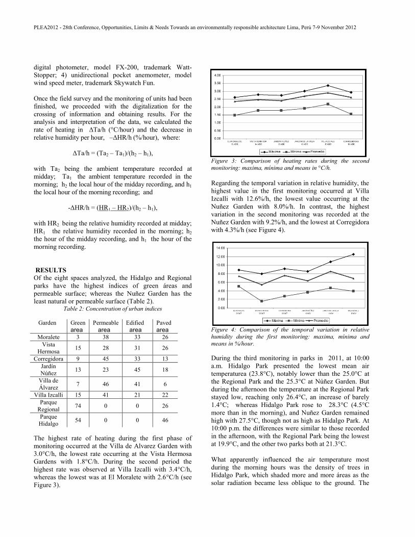
The highest rate of heating during the first phase of
monitoring occurred at the Villa de Alvarez Garden with
3.0°C/h, the lowest rate occurring at the Vista Hermosa
Gardens with 1.8°C/h. During the second period the
highest rate was observed at Villa Izcalli with 3.4°C/h,
whereas the lowest was at El Moralete with 2.6°C/h (see
Figure 3).
Figure 3: Comparison of heating rates during the second
monitoring: maxima, mínima and means in °C/h.
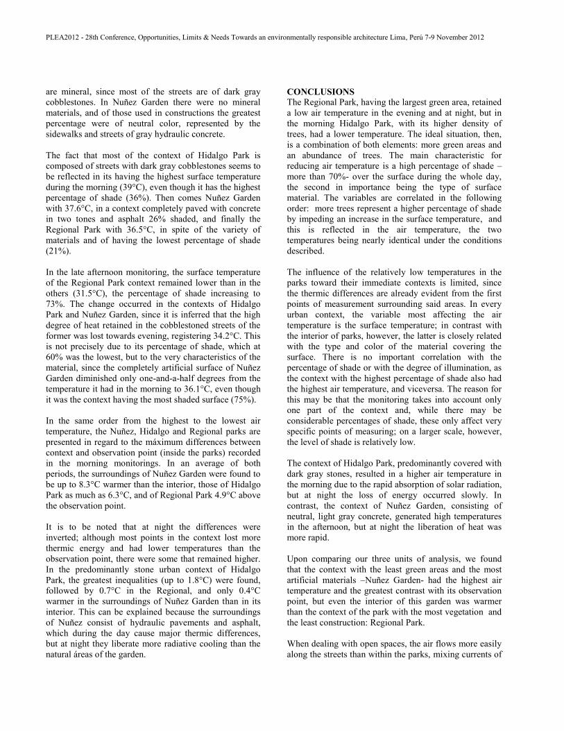
Regarding the temporal variation in relative humidity, the
highest value in the first monitoring occurred at Villa
Izcalli with 12.6%/h, the lowest value occurring at the
Nuñez Garden with 8.0%/h. In contrast, the highest
variation in the second monitoring was recorded at the
Nuñez Garden with 9.2%/h, and the lowest at Corregidora
with 4.3%/h (see Figure 4).
Figure 4: Comparison of the temporal variation in relative
humidity during the first monitoring: maxima, mínima and
means in %/hour.
During the third monitoring in parks in 2011, at 10:00
a.m. Hidalgo Park presented the lowest mean air
temperaturea (23.8°C), notably lower than the 25.0°C at
the Regional Park and the 25.3°C at Núñez Garden. But
during the afternoon the temperature at the Regional Park
stayed low, reaching only 26.4°C, an increase of barely
1.4°C; whereas Hidalgo Park rose to 28.3°C (4.5°C
more than in the morning), and Nuñez Garden remained
high with 27.5°C, though not as high as Hidalgo Park. At
10:00 p.m. the differences were similar to those recorded
in the afternoon, with the Regional Park being the lowest
at 19.9°C, and the other two parks both at 21.3°C.
What apparently influenced the air temperature most
during the morning hours was the density of trees in
Hidalgo Park, which shaded more and more áreas as the
solar radiation became less oblique to the ground. The

PLEA2012 - 28th Conference, Opportunities, Limits & Needs Towards an environmentally responsible architecture Lima, Perú 7-9 November 2012
foregoing is made evident by comparing the percentage
of shade in each park, Hidalgo being the one with the
most shade (70%) during the morning.
After midday, the air temperature is influenced by the
percentage of green áreas. The Regional Park has the
largest vegetal surface, and although it does not have the
greatest density of trees, its surfaces do not accumulate as
much heat as artificial ones after receiving a maximum of
solar radiation, the latter type of surfaces radiating
abundant energy into nearby air layers. Therefore, the
Regional Park was the one having the lowest surface and
air temperatures at 5:00 p.m.
On the other hand, the material covering the ground
seems to be unimportant, since half of the points with low
temperatures were over grass and the rest over floors of
gray brick, ceramics, stone, earth or pink concrete. The
common characteristic of all was the high percentage of
shade during the whole day, which oscillated between 70
and 90%. Consequently, with a high percentage of shade
over the surfaces, the type of material loses relevance for
determining the air temperature.
The correlation between illumination and surface
temperature is among the highest, between 0.91 and 0.96,
thus accentuating the importance of the vegetation as a
strategy for shading. From this we might say that the
degree of illumination determines the surface
temperature, which determines the air temperature.
Since the air temperature is not directly correlated with
neither the illumination nor the percentage of shaded
areas, it can be inferred that the ventilation produces a
horizontal mixture that erases the thermic differences
which, in principle, should have been generated by the
different types of surface and fractions of shade.
Concerning relative humidity, the average values from
each park differ but little from one another, remaining
around 50% during morning and afternoon, but rising
during the nocturnal measurement to as much as 86% in
Hidalgo Park, followed by Nuñez Garden with 81% and
finally Hidalgo Park with 76%. The posible influence of
the swimming pools in the Regional Park may be
explained by the vapor content of the air, which is higher
than in the rest but only in the morning, with 16.17 mb of
vapor pressure. At 5:00 p.m. the vapor pressure in the
three parks is very similar at 17.7 mb; but at night they
again differ, Nuñez Garden being the highest with 20.55
mb, not far above the Regional with 20.0 mb, and lastly
Hidalgo Park with 19.3 mb, these differences being non –
significant if we consider the uncertainty proper to
measuring instruments.
The morning air temperature in the urban contexts
averaged 27.5°C, similar in three of the study cases. It is
at 5:00 p.m. when the differences shoot up, with Nuñez
Garden becoming the hottest at 33.0°C, two degrees
higher than the average temperature of Hidalgo Park, the
latter being three degrees above the 27.5°C recorded at
the Regional Park, which in general did not show any
considerable variation in temperature.
At night the temperatures tended to equalize, but not
completely, as the Regional Park context remained below
the rest at 22.1°C, followed by Nuñez Garden which
reduced its temperature by almost ten degrees to 23.4°C.
The warmest was Hidalgo Park with 24.2°C at 10:00
p.m., possibly the index of the urban heat island.
Then we ask ourselves what causes such temperature
differences after midday. Upon reviewing the average
surface temperatures we noted that the surface
temperatures in the Regional Park context were lower in
the afternoon than in the others, 36°C in the morning and
32°C in the afternoon, in the sun as well as in the shade.
Nuñez Garden had the highest value with 36.3°C, and
Hidalgo Park was in between, with an average of 34.9°C.
However, the percentages of shade seem to have little
relationship with the air temperature, since in the
afternoon the Nuñez Garden context had the highest
percentage of shady places with 75%, followed by the
Regional Park with 73%, and lastly Hidalgo Park with
60%. When the percentages of shade from both
measuring periods were added, the Regional Park turned
out to be the least affected by the shade but, as already
mentioned, it had the lowest air temperature; in contrast,
Nuñez Garden had the highest percentage of shade but
also the highest air temperature.
Something similar occurred with the amount of luxes
inciding over each point, since during the morning the
average of luxes unaffected by the shade was between
62,000 and 76,000 in the three contexts; in reality these
are almost homogeneous values, whereas towards
evening an average of 10,000 luxes was not exceeded in
any of the parks.
The surface temperature being the variable with the most
impact on the air temperature, we proceeded to analyze
the types of material (typified in four categories) and
color that make up the urban contexts. In the Regional
Park, the four variants were found in more or less the
same proportion –mineral materials like stone and earth,
elaborated in light, médium (neutral) and dark colors-, the
most abundant being dark, which corresponds to asphaltic
concrete. In Hidalgo Park, three-fourths of the materials
PLEA2012 - 28th Conference, Opportunities, Limits & Needs Towards an environmentally responsible architecture Lima, Perú 7-9 November 2012
are mineral, since most of the streets are of dark gray
cobblestones. In Nuñez Garden there were no mineral
materials, and of those used in constructions the greatest
percentage were of neutral color, represented by the
sidewalks and streets of gray hydraulic concrete.
The fact that most of the context of Hidalgo Park is
composed of streets with dark gray cobblestones seems to
be reflected in its having the highest surface temperature
during the morning (39°C), even though it has the highest
percentage of shade (36%). Then comes Nuñez Garden
with 37.6°C, in a context completely paved with concrete
in two tones and asphalt 26% shaded, and finally the
Regional Park with 36.5°C, in spite of the variety of
materials and of having the lowest percentage of shade
(21%).
In the late afternoon monitoring, the surface temperature
of the Regional Park context remained lower than in the
others (31.5°C), the percentage of shade increasing to
73%. The change occurred in the contexts of Hidalgo
Park and Nuñez Garden, since it is inferred that the high
degree of heat retained in the cobblestoned streets of the
former was lost towards evening, registering 34.2°C. This
is not precisely due to its percentage of shade, which at
60% was the lowest, but to the very characteristics of the
material, since the completely artificial surface of Nuñez
Garden diminished only one-and-a-half degrees from the
temperature it had in the morning to 36.1°C, even though
it was the context having the most shaded surface (75%).
In the same order from the highest to the lowest air
temperature, the Nuñez, Hidalgo and Regional parks are
presented in regard to the máximum differences between
context and observation point (inside the parks) recorded
in the morning monitorings. In an average of both
periods, the surroundings of Nuñez Garden were found to
be up to 8.3°C warmer than the interior, those of Hidalgo
Park as much as 6.3°C, and of Regional Park 4.9°C above
the observation point.
It is to be noted that at night the differences were
inverted; although most points in the context lost more
thermic energy and had lower temperatures than the
observation point, there were some that remained higher.
In the predominantly stone urban context of Hidalgo
Park, the greatest inequalities (up to 1.8°C) were found,
followed by 0.7°C in the Regional, and only 0.4°C
warmer in the surroundings of Nuñez Garden than in its
interior. This can be explained because the surroundings
of Nuñez consist of hydraulic pavements and asphalt,
which during the day cause major thermic differences,
but at night they liberate more radiative cooling than the
natural áreas of the garden.
CONCLUSIONS
The Regional Park, having the largest green area, retained
a low air temperature in the evening and at night, but in
the morning Hidalgo Park, with its higher density of
trees, had a lower temperature. The ideal situation, then,
is a combination of both elements: more green areas and
an abundance of trees. The main characteristic for
reducing air temperature is a high percentage of shade –
more than 70%- over the surface during the whole day,
the second in importance being the type of surface
material. The variables are correlated in the following
order: more trees represent a higher percentage of shade
by impeding an increase in the surface temperature, and
this is reflected in the air temperature, the two
temperatures being nearly identical under the conditions
described.
The influence of the relatively low temperatures in the
parks toward their immediate contexts is limited, since
the thermic differences are already evident from the first
points of measurement surrounding said areas. In every
urban context, the variable most affecting the air
temperature is the surface temperature; in contrast with
the interior of parks, however, the latter is closely related
with the type and color of the material covering the
surface. There is no important correlation with the
percentage of shade or with the degree of illumination, as
the context with the highest percentage of shade also had
the highest air temperature, and viceversa. The reason for
this may be that the monitoring takes into account only
one part of the context and, while there may be
considerable percentages of shade, these only affect very
specific points of measuring; on a larger scale, however,
the level of shade is relatively low.
The context of Hidalgo Park, predominantly covered with
dark gray stones, resulted in a higher air temperature in
the morning due to the rapid absorption of solar radiation,
but at night the loss of energy occurred slowly. In
contrast, the context of Nuñez Garden, consisting of
neutral, light gray concrete, generated high temperatures
in the afternoon, but at night the liberation of heat was
more rapid.
Upon comparing our three units of analysis, we found
that the context with the least green areas and the most
artificial materials –Nuñez Garden- had the highest air
temperature and the greatest contrast with its observation
point, but even the interior of this garden was warmer
than the context of the park with the most vegetation and
the least construction: Regional Park.
When dealing with open spaces, the air flows more easily
along the streets than within the parks, mixing currents of
PLEA2012 - 28th Conference, Opportunities, Limits & Needs Towards an environmentally responsible architecture Lima, Perú 7-9 November 2012
fresh air with warm ones due to the heat energy radiating
from surface materials and edified masses, and at the
same time making a precise explanation of the
temperatures more difficult. The parks and gardens
actually function as cool islands, or more precisely, “cool
archipelagos” which, according to the present research,
may register as much as 8.6°C lower than their urban
context, but their temperature is exactly proportional to
that of the surroundings. Consequently, the strategy for
mitigating the urban heat island lies both in the
characteristics of the park itself, which should constitute a
solid support of greenery, and the urban structure in
which the latter is immersed.
The mechanism involves a balance of energy among
providers (emitters of solar radiation), consumers
(receptors, where long and short wave radiation
converges, is absorbed and reflected), thermic
conductivity and storage, evaporation and the heat
emitted from diverse surfaces to be dissipated in the air
through convection [9]; however, the air temperature will
always be lower than the surface temperatures, since air is
a poor conductor of energy.
Otherwise, it is possible to influence radiation flows by
introducing shade-projecting objects. Another way to
modify said flow is through the adequate selection of
materials with high albedos to reflect the greatest
percentage of solar radiation, such as white-colored walls.
The radiative interchange taking place in the urban area
of our study cases is associated with the absorption of
heat by exterior surfaces, the refreshing influence of the
green areas, the presence of winds, which together
determine the ambient temperature and the relative
humidity in the open spaces.
The increase in temperature from solar radiation falling
on exposed urban surfaces will be at least 5 to 10°C
compared with the surfaces receiving few hours of
sunlight, e.g., facades, sidewalks, and vehicular lanes
close to facades with exposure toward the south,
southwest or southeast. Nevertheless, concentrated heat
tends to move into cooler areas by means of conduction
in order to equalize or maintain the energy balance; thus,
the shaded areas will increase their temperature through
the effect of thermic conduction.
It is worth mentioning that in Colima there exists a
diversity of urban morphological configurations, for
example, those of the popular neighborhoods, of
residential zones, of housing developments with typified
dwellings, etc. However, the configuration of the
historical center is peculiar, as one can see a clear
densification and social dynamics tending to concentrate
the vegetation in islets. In contrast, in other areas of the
city the trees form an integrating element of the urban
landscape, in gardens, traffic islands and backyards;
therefore, the existence of this natural element somewhat
mitigates the solar absorption occurring in the
construction material.
In many cases the inhabitants themselves adopt these
measures of planting and caring for the vegetation, due to
their close relationship with the outdoors, as they are
usually in front of their homes in the evening or in their
free time. Thus, the quality of the urban environment
improves through the presence of wooded areas, an
indispensable factor in the habitability of outdoor spaces.
ACKNOWLEDGEMENTS
The authors are grateful for the translation to Mr. Warren
Haid from the Research Department.
REFERENCES 1. Brown, G. S., (2001). Sun, wind & light. Architectural
design strategies. Third ed. Washington: Johnson Wiley
& sons.
2. Catalán Vega, N., (2009). Comportamiento de los índices
urbanos al microclima de seis espacios públicos abiertos
de la ciudad conurbada Colima-Villa de Álvarez de clima
cálido subhúmedo. Coquimatlán, Colima: Universidad de
Colima- Tesis de Maestría.
3. Chung Alonso, P., (2001). Configuración óptima de los
espacios abiertos urbanos para la reducción de la
temperatura del aire en un clima cálido subhúmedo.
Coquimatlán, Colima: Universidad de Colima, Tesis de la
Maestría en Arquitectura.
4. Garduño, R., (2003). El veleidoso clima. Tercera ed.
México: FCE-SEP-CONACyT.
5. Higueras, E., (2006). Urbanismo Bioclimático. Barcelona:
Gustavo Gili.
6. Instituto Nacional de Estadística y Geografía, (2000).
Carta climáticas de la República Mexicana y del Estado
de Colima. Tipos de climas según Köppen. [Online]
Available at: http://www.inegi.org.mx
[Accessed 20 julio 2009].
7. Instituto Nacional de Estadística y Geografía, (2012).
Anuario estadístico de Colima. Aspectos geográficos.
[Online]
Available at: http://www.inegi.org.mx
[Accessed 10 marzo 2012].
8. Jáuregui, E. & Heres, M., (2008). El clima/bioclima de un
parque periurbano de la ciudad de México.
Investigaciones geográficas.. Boletín del Instituto de
Geografía, Issue 67, pp. 101-112.
9. Ochoa, J., (1999). La vegetación como instrumento para
el control microclimático. First ed. Barcelona: Universitat
Politecnica de Barcelona.

PLEA2012 - 28th Conference, Opportunities, Limits & Needs Towards an environmentally responsible architecture Lima, Perú 7-9 November 2012
10. RUROS, (2004). Designing open spaces in the urban
environment: a bioclimatic approach. Firsth ed. Grecia:
Centre for Renewable Energy Sources.
11. Valladares Anguiano, R. & Chávez González, M. E.,
(2009). Mitigación de islas de calor en la ciudad
conurbada Colima-Villa de Álvarez, Colima, Colima:
Universidad de Colima-FRABA.