chapter 12: proposals map 565
TRANSCRIPT

Chapter 12: Proposals Map
City of Westminster Unitary Development Plan approved by Full Council 13 December 2004565
Page
Introduction 566
Proposals Sites 566
Major new public transport routes 567
Policy Areas 568

Chapter 12: Proposals Map
City of Westminster Unitary Development Plan approved by Full Council 13 December 2004566
INTRODUCTION
12.1 The Proposals Map forms an integral part of the City Council’s statutoryplan. PPG 12 states that “The proposals map should illustrate each of thedetailed policies and proposals in the written statement, defining sites forparticular developments or land uses and the areas to which specifieddevelopment control policies will be applied.” (Paragraph 26). TheProposals Map is at a scale of 1:6000 on an ordnance survey base. TheProposals Map shows all policy boundary areas and those Proposalssites that are listed and described in Schedules 1 and 2.
PROPOSALS SITES
12.2 The Proposals Sites are organised into two schedules and are located onthe Proposals Map. The schedules describe each proposal, the site andpreferred uses.
12.3 Schedule 1 lists large and important sites in Westminster, theredevelopment of which would involve major physical change orsignificant change in the functioning of the surrounding area. They havebeen determined by reference to the following criteria:
a) either outline of full planning permission has been grantedb) the site covers a large area e.g. a street blockc) the site includes a large element of development, redevelopment or a
major change of used) the site development involves a substantial alteration to the
townscapee) the site development would involve changes to the street pattern,
pedestrian routes or to public transportf) the site will have a significant effect on the current pattern of land uses
or on the provision of services in the area e.g. will change shoppingpatterns or requirements for primary school education, and
g) the site development will involve compulsory purchase
12.4 The proposals sites in Schedule 1 have been grouped as follows:
‘R’ Residential: this includes housing development of vacant sites,redevelopment of existing property, rehabilitation and conversion. Itincludes mixed use developments where residential is the preferred anddominant use where 50 or more units are being built.
‘O’ Office-led developments: this includes development schemeswhere offices form part of the redevelopment to provide over 20,000sqmof new office floor space.
Chapter 12: Proposals Map
City of Westminster Unitary Development Plan approved by Full Council 13 December 2004567
‘H’ Hotel and hotel-led schemes: this includes developmentproposals where 100 or more hotel bedrooms are being provided.
12.5 Schedule 2 lists major opportunity sites that have been subject todevelopment interest or are sites that the City Council would like to seeredeveloped either individually or, where linked, comprehensively. Manyof these sites are covered by planning briefs. For all sites, the Schedulecontains a summary of preferred uses. The policy for vacant andunderused land is ENV 3 in Chapter 9: Environment.
12.6 The inclusion of a site on the Proposals Map and in Schedule 1 orSchedule 2 will not prejudice the City Council’s normal consideration ofany planning application for the site.
12.7 Schedules 1 and 2 and the Proposals Map do not indicate small-scaledevelopment sites which are not considered to have a significant impacton the surrounding area.
MAJOR NEW PUBLIC TRANSPORT ROUTES
12.8 The Proposals Map indicates the land that is subject to consultation inrespect of the proposed CrossRail and Chelsea-Hackney Lines (referredto by the Mayor as the Hackney Southwest Line), taken from the formerDepartment of Transport safeguarding directions for these routes dated10th October 1991 and 7th February 1991, respectively. For furtherdetails and advice, developers should contact the City Council.
POLICY AREAS
12.9 In addition to the Proposals Sites listed in Schedules 1 and 2, theProposals Map also shows the boundaries of a range of policy areas:
a) Central Activities Zone and Frontagesb) Air Quality Management Zonec) Residential Density Boundariesd) Road Hierarchye) World Heritage Sitef) Edgware Road Safeguarding Directionsg) Bishop’s Bridge Road between Eastbourne Terrace and Harrow Road
safeguarding lineh) Primary Shopping Frontages, District and Local Shopping Centres
Chapter 12: Proposals Map
City of Westminster Unitary Development Plan approved by Full Council 13 December 2004568
Special Policy Areas
1. Harley Street
2. Portland Place
3. East Marylebone
4. Temporary Offices
5. Creative Industries
6. Sex-related Uses
7. Stress Areas
8. Arts, Culture and Education
9. Paddington
10. North-West Westminster
11. Thames

Chapter 12: Proposals Map
City of Westminster Unitary Development Plan approved by Full Council 13 December 2004 569
Conservation Areas
1. St. John’s Wood2. Regent’s Park 3. Maida Vale4. Dorset Square5. Westbourne6. Bayswater7. Molyneux Street8. Portman Estate9. Harley Street10. Stratford Place11. Mayfair12. Regent Street13. Charlotte Street, West14. Soho15. Covent Garden16. Strand17. St James’s18. Trafalgar Square19. Whitehall20. Westminster Abbey &
Parliament Square21. Smith Square22. Knightsbridge23. Belgravia24. Grosvenor Gardens25. Birdcage Walk26. Westminster
Cathedral Area27. Pimlico28. Millbank29. Queen’s Park Estate30. Vincent Square31. Adelphi32. Savoy33. East Marylebone34. Broadway and
Christchurch Gardens35. Paddington Green36. Albert Gate37. Knightsbridge Green38. Aldridge Road Villas /
Leamington RoadVillas
39. Hanway Street40. Medway Street41. Royal Parks42. Leicester Square43. Churchill Gardens44. Cleveland Street45. Dolphin Square46. Fisherton Street
Estate47. Hallfield Estate48. Haymarket49. Lillington Gardens50. Lisson Grove51. Regency Street52. Peabody Avenue53. Queensway

Chapter 12: Proposals Map
City of Westminster Unitary Development Plan approved by Full Council 13 December 2004570
Regulation 7 Direction Areas(controlling estate agents’ boards)(see map 10.1)
Areas of protected family housing:
1. Belgravia2. Pimlico3. Knightsbridge4. Bayswater5. Queen’s Park6. St. John’s Wood
Priority Areas for additional play space / greenopen space for play
1. Fernhead Road Area2. Area between Abbey Road and Finchley Road3. Area bounded by Hamilton Terrace, Scott Ellis Gardens and
Grove Road End4. Little Venice Area5. Area around Seymour Place6. Great Titchfield Street, Holcroft Court, and Clipstone Street7. Sussex Gardens8. Soho9. Area around Francis Street, Vauxhall Bridge Road and Emery Hill
Street10. Lupus Street, Vauxhall Bridge Road area, Pimlico11. Ebury Street Area12. South Westminster Area
Areas of archaeological priority
1. Lundenwic and Thorney Island
2. Marylebone Village
3. Paddington and Lilestone Villages
4. Ebury Village
5. Tyburn Settlement

Chapter 12: Proposals Map
City of Westminster Unitary Development Plan approved by Full Council 13 December 2004 571
Strategic view corridors
1. Primrose Hill to St. Paul’s Cathedral2. Primrose Hill to the Palace of Westminster3. Parliament Hill to St. Paul’s Cathedral4. King Henry VIII’s Mound, Richmond Park to St. Paul’s Cathedral5. Westminster Pier to St. Paul’s Cathedral
Sites of importance for nature conservation
1. Metropolitan2. Borough (Grade I and Grade II)3. Local
Areas of wildlife deficiency
1. Maida Vale2. Soho/East Marylebone3. Aldwych4. South Pimlico
Chapter 12: Proposals Map
City of Westminster Unitary Development Plan approved by Full Council 13 December 2004572
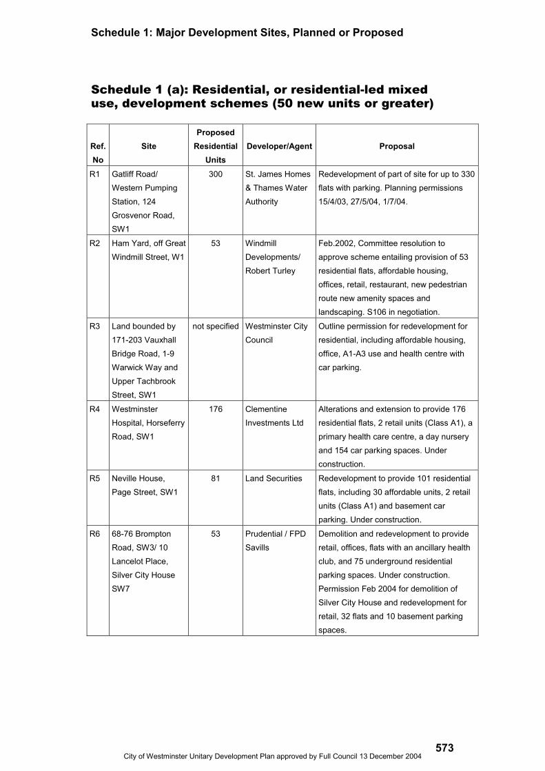
Schedule 1: Major Development Sites, Planned or Proposed
City of Westminster Unitary Development Plan approved by Full Council 13 December 2004573
Schedule 1 (a): Residential, or residential-led mixeduse, development schemes (50 new units or greater)
Ref.No
SiteProposed
ResidentialUnits
Developer/Agent Proposal
R1 Gatliff Road/Western PumpingStation, 124Grosvenor Road,SW1
300 St. James Homes& Thames WaterAuthority
Redevelopment of part of site for up to 330flats with parking. Planning permissions15/4/03, 27/5/04, 1/7/04.
R2 Ham Yard, off GreatWindmill Street, W1
53 WindmillDevelopments/Robert Turley
Feb.2002, Committee resolution toapprove scheme entailing provision of 53residential flats, affordable housing,offices, retail, restaurant, new pedestrianroute new amenity spaces andlandscaping. S106 in negotiation.
R3 Land bounded by171-203 VauxhallBridge Road, 1-9Warwick Way andUpper TachbrookStreet, SW1
not specified Westminster CityCouncil
Outline permission for redevelopment forresidential, including affordable housing,office, A1-A3 use and health centre withcar parking.
R4 WestminsterHospital, HorseferryRoad, SW1
176 ClementineInvestments Ltd
Alterations and extension to provide 176residential flats, 2 retail units (Class A1), aprimary health care centre, a day nurseryand 154 car parking spaces. Underconstruction.
R5 Neville House,Page Street, SW1
81 Land Securities Redevelopment to provide 101 residentialflats, including 30 affordable units, 2 retailunits (Class A1) and basement carparking. Under construction.
R6 68-76 BromptonRoad, SW3/ 10Lancelot Place,Silver City HouseSW7
53 Prudential / FPDSavills
Demolition and redevelopment to provideretail, offices, flats with an ancillary healthclub, and 75 underground residentialparking spaces. Under construction.Permission Feb 2004 for demolition ofSilver City House and redevelopment forretail, 32 flats and 10 basement parkingspaces.

Schedule 1: Major Development Sites, Planned or Proposed
City of Westminster Unitary Development Plan approved by Full Council 13 December 2004574
R7 Maida ValePsychiatricHospital, 4 MaidaVale, W9
57 Cala Homes(South) Ltd /AssaelArchitecture
Redevelopment to provide 57 (including 14affordable units) and a community healthunit. Approved subject to completion of aSection 106 agreement. Underconstruction.
R8 Land bounded by129-147 ChurchStreet, 283-317Edgware Road, 11-13 PaddingtonGreen andNewcastle Place,W2
228 West End GreenProperties
The City Council agreed to grant planningpermission (12 March 1998) for a mixed-use scheme comprising supermarket, 228residential units, and 162 holiday lettingunits and associated parking. Approval issubject to a legal agreement relating toaffordable housing (56 units) and fundingof a road widening scheme by thedeveloper. This legal agreement was notsigned and no further action has beentaken on the application. Appeals havebeen lodged in respect of the two schemesfor the redevelopment of 285 -329Edgware Road, Option A and Option Bwhich were heard at a Public Inquiry inJuly 2004. New applications werereceived in March 2004 for theredevelopment of 285-329 Edgware Roadfor buildings between 5 and 22 storeysincluding a retail supermarket, 307residential units, 156 holiday lets,associated car parking and landscaping.
R9 Hermitage Streetsite, W2
222 Chelsfield / City ofWestminster
Development for residential / retail /restaurant / café / medical and communityuses. Associated landscaping and highwayworks including vehicle and pedestrianaccesses. Under construction.
R10 Paddington BasinPhase II
213 Chelsfield / PBDL Outline planning permission for 5 blockswas granted 23/4/01. Reserved matters onthe residential part of the site, for ascheme including 213 residential unitswere approved 27.5.04.
R11 Romney House, 47-61 Marsham Street,SW1
169 FrogmoreInvestments Ltd
Planning permission granted August 2000for conversion of building to housing,providing 169 units. Unimplemented.
R12 63-69 RochesterRow and 66 – 68Vincent Square
70 Receiver forMetropolitanPolice/ Fred Olsen
Conversion and redevelopment for 70residential flats including 21 affordablehousing with a new garden facing thesquare and underground car park. Underconstruction.
Schedule 1: Major Development Sites, Planned or Proposed
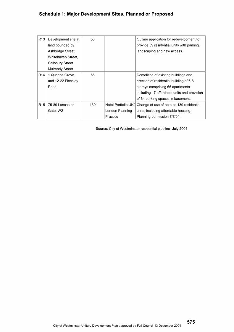
City of Westminster Unitary Development Plan approved by Full Council 13 December 2004575
R13 Development site atland bounded byAshbridge Street,Whitehaven Street,Salisbury StreetMulready Street
56 Outline application for redevelopment toprovide 59 residential units with parking,landscaping and new access.
R14 1 Queens Groveand 12-22 FinchleyRoad
66 Demolition of existing buildings anderection of residential building of 6-8storeys comprising 66 apartmentsincluding 17 affordable units and provisionof 64 parking spaces in basement.
R15 75-89 LancasterGate, W2
139 Hotel Portfolio UK/London PlanningPractice
Change of use of hotel to 139 residentialunits, including affordable housing.Planning permission 7/7/04.
Source: City of Westminster residential pipeline- July 2004
Schedule 1: Major Development Sites, Planned or Proposed
City of Westminster Unitary Development Plan approved by Full Council 13 December 2004576
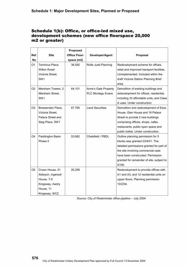
Schedule 1(b): Office, or office-led mixed use,development schemes (new office floorspace 20,000m2 or greater)
Ref.No
SiteProposed
Office Floor-space (m2)
Developer/Agent Proposal
O1 Terminus Place,Wilton Road/Victoria Street,SW1
36,592 Rolfe Judd Planning Redevelopment scheme for offices,retail and improved transport facilities.Unimplemented. Included within thedraft Victoria Station Planning Briefarea.
O2 Marsham Towers, 2Marsham Street,SW1
64,101 Anne’s Gate PropertyPLC Montagu Evans
Demolition of existing buildings andredevelopment for offices, residential,including 33 affordable units, and ClassA uses. Under construction.
O3 Bressenden Place,Victoria Street,Palace Street andStag Place, SW1
67,760 Land Securities Demolition and redevelopment of EssoHouse, Glen House and 16 PalaceStreet to provide 2 new buildingscomprising offices, shops, cafes,restaurants, public open space andpublic toilets. Under construction.
O4 Paddington BasinPhase II
53,662 Chelsfield / PBDL Outline planning permission for 5blocks was granted 23/4/01. Thedetailed permissions granted for part ofthe site involving commercial useshave been constructed. Permissiongranted for remainder of site, subject toS106.
O5 Crown House, 51Aldwych, IngersollHouse, 7-9Kingsway, AwdryHouse, 11Kingsway, WC2
20,256 Redevelopment to provide offices withA1 and A3, and 12 residential units onupper floors. Planning permission10/2/04.
Source: City of Westminster office pipeline – July 2004
Schedule 1: Major Development Sites, Planned or Proposed
City of Westminster Unitary Development Plan approved by Full Council 13 December 2004577
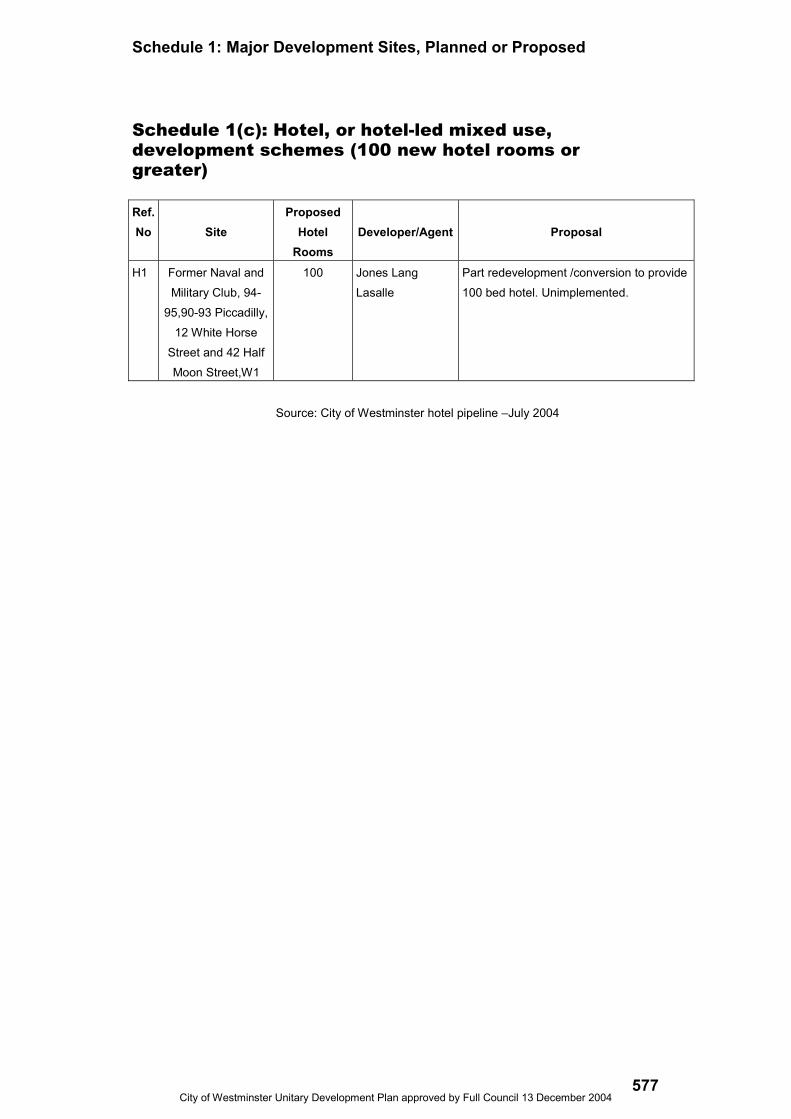
Schedule 1(c): Hotel, or hotel-led mixed use,development schemes (100 new hotel rooms orgreater)
Ref.No Site
ProposedHotel
RoomsDeveloper/Agent Proposal
H1 Former Naval andMilitary Club, 94-
95,90-93 Piccadilly,12 White Horse
Street and 42 HalfMoon Street,W1
100 Jones LangLasalle
Part redevelopment /conversion to provide100 bed hotel. Unimplemented.
Source: City of Westminster hotel pipeline –July 2004

Schedule 1: Major Development Sites, Planned or Proposed
City of Westminster Unitary Development Plan approved by Full Council 13 December 2004578

Schedule 2: Opportunity Sites
City of Westminster Unitary Development Plan approved by Full Council 13 December 2004579
Ref.No.
Site PreferredUses
Area(hectares)
Ownership Notes
OP1 RoyalNationalOrthopaedicHospital,BolsoverStreet, W1
Medical,residential,open spaceand retailuses.
0.13 RoyalNationalOrthopaedicHospital NHSTrust
CAZ Frontage. Not in a conservationarea. No current applications. Identifiedin the Council’s 1999 ‘HousingCapacity Study’. Draft planning brief(September 1997). It is understood thatthis site is now on the market. The briefstill needs to be updated to takeaccount of the listing of certainbuildings, and its implications. Principalexisting uses: Hospital use.
OP2 Car Park,MoxonStreet, W1
Residentialandcommunityuses.
0.33 City ofWestminster
Outside CAZ, Portman Estateconservation area. Identified in theCouncil’s 1999 ‘Housing CapacityStudy’. Draft planning brief (September1999). Consultation on revised briefcarried out between November 1999and January 2000. Principal existinguses: Open parking.
OP3 177-185MaryleboneRoad/165-177,SeymourPlace, W1
Residentialuse with anelement ofcommercial/mixed uses andopen space/play space.
0.09 GreaterLondonMagistrates’CourtsAuthority
CAZ Frontage, Portman Estateconservation area, rear of siteidentified in the Council’s 1999‘Housing Capacity Study’. WithinPriority Area for Additional Playspaceand in Priority Area for AdditionalPublic Open Space. No currentapplications. Principal existing uses:Open parking.
OP4 PaddingtonNew Yard,off GreatWesternRoad, W9
Commercialand/or publicservice use.
11.20 Railtrack Outside CAZ. Not in a conservationarea. Draft planning brief (July 1995).Within ‘North West WestminsterSpecial Policy Area’ and protected as aworks site for the proposed CrossRaildevelopment. From the decision to goahead with CrossRail the site is likelyto remain unavailable for ten years.Principal existing uses: Transportrelated and heavy plan based uses andartists studio in former goods depot.

Schedule 2: Opportunity Sites
City of Westminster Unitary Development Plan Adopted November 2004580
OP5 Landbounded by591-595HarrowRoad, 364-374LadbrokeGrove and2-6 and 26-28 St.John’sTerrace,W10
Residentialand retailuses.
0.10 Unknown Outside CAZ. Not in a conservationarea. Identified in the Council’s 1999‘Housing Capacity Study’. Planningbrief (October 1992). Any proposalsmust have regard to the Council’s‘Policy Guidelines for CanalsideDevelopment (January 1992). Principalexisting uses: Residential use.
OP6 EdgwareRoadStation,ChapelStreet, NW1
Newundergroundstation, office,retail andresidentialuses.
0.86 LondonUndergroundLtd
CAZ Frontage. Not in a conservationarea. Scheme agreed in principle(1991) for redevelopment to providenew station and additional office,residential and retail units. Applicationwithdrawn 1998. Identified in theCouncil’s 1999 ‘Housing CapacityStudy’. Principal existing uses: LondonUnderground station.
OP7 119-128WiltonRoad, 18-36GillinghamStreet andGillinghamMews, SW1
Office,residentialand Class Auses, andopen space.
0.30 Unknown Inside CAZ. Not in a conservation area.Extant permission for demolition andredevelopment of site for office, retail,residential and restaurant uses dated12 June 1995. Principal existing uses:Office, residential and retail uses.Included within the draft VictoriaStation Planning Brief area (2001).
OP8 ChelseaBarracks,ChelseaBridgeRoad, SW1
Residential,communityuse and greenopen spacefor play.
3.50 Ministry ofDefence
Outside CAZ. Not in a conservationarea. Identified in the Council’s 1999‘Housing Capacity Study’.Redevelopment of some or all of sitefor residential use. Principal existinguses: Barracks. Planning brief (1999).
OP9 QueenAlexandraMilitaryHospital,John IslipStreet, SW1
Residential,cultural andoffice uses,and greenopen spacefor play.
1.0 Trustees ofthe TateGallery
Inside CAZ, Thames Policy Area andMillbank conservation area. Within thePriority Area for Additional Green OpenSpace for Play. Proposals forresidential, cultural and office use.Principal existing uses: administrativeand storage purposes for Tate Britain.

Schedule 2: Opportunity Sites
City of Westminster Unitary Development Plan approved by Full Council 13 December 2004581
OP10 VictoriaRailwayStation,SW1
Transport andcommercialuses.
4.53 Railtrack Inside CAZ, not in a conservation area.Draft planning brief published forconsultation July 2001 sets out the keyissues that development at and aroundthe station should address. The areacovered by the brief includes a numberof other sites in this schedule (andSchedule 1) as indicated.
OP11 VictoriaCoachStation – 2sites oneither sideof ElizabethStreet, SW1
Transport andother uses.
0.45 and0.91
GrosvenorEstate
Inside CAZ, part of site in Belgraviaconservation area. The Victoria CoachStation lies on these two sites.Currently there are no formal plans forthe redevelopment of the CoachStation but the sites are in closeproximity to Victoria Railway stationand are included within the draftVictoria Station Planning Brief area.
OP12 MiddlesexHospital, W1
Residential,commercial,retail, leisureand publicopen space.
1.2 NHS Inside CAZ, Creative Industries SpecialPolicy Area, East MaryleboneConservation Area, 2 listed buildings.Principal existing use: hospital.Redevelopment part of overall strategyto consolidate NHS services to a singlesite in Camden. Planning brief (1997).
OP13 34-38AybrookStreet, W1
Residentialuse.
0.34 LondonElectricity
Outside CAZ, Portman Estateconservation area. Principal existinguse: storage, depot and office. Currentapplication for a residential schemecomprising 131 units.
OP14 37-67 BakerStreet, W1
Residential,office, retailuse.
1.16 Marks andSpencer
Proposal for demolition of existingbuilding and redevelopment of existingsite to provide 57,292 sq. m of officeaccommodation, 32 residential units,including affordable housing and retail,leisure and cafes with basementparking. Scheme approved subject to asection 106 agreement (not yetfinalised).
OP15 WestbourneGreen,HarrowRoad, W2
Communityuses, depotandresidential.
2.84 City ofWestminster /GLA
Within North West Westminster SpecialPolicy Area, not in a conservation area.Principal existing use: sports facilities,depot, housing including affordablehousing. Draft planning brief.
Schedule 2: Opportunity Sites
City of Westminster Unitary Development Plan Adopted November 2004582
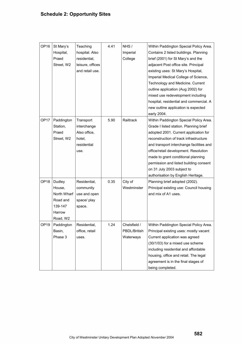
OP16 St Mary’sHospital,PraedStreet, W2
Teachinghospital. Alsoresidential,leisure, officesand retail use.
4.41 NHS /ImperialCollege
Within Paddington Special Policy Area.Contains 2 listed buildings. Planningbrief (2001) for St Mary’s and theadjacent Post office site. Principalexisting uses: St Mary’s Hospital,Imperial Medical College of Science,Technology and Medicine. Currentoutline application (Aug 2002) formixed use redevelopment includinghospital, residential and commercial. Anew outline application is expectedearly 2004.
OP17 PaddingtonStation,PraedStreet, W2
TransportinterchangeAlso office,hotel,residentialuse.
5.90 Railtrack Within Paddington Special Policy Area.Grade I listed station. Planning briefadopted 2001. Current application forreconstruction of track infrastructureand transport interchange facilities andoffice/retail development. Resolutionmade to grant conditional planningpermission and listed building consenton 31 July 2003 subject toauthorisation by English Heritage.
OP18 DudleyHouse,North WharfRoad and139-147HarrowRoad, W2
Residential,communityuse and openspace/ playspace.
0.35 City ofWestminster
Planning brief adopted (2002).Principal existing use: Council housingand mix of A1 uses.
OP19 PaddingtonBasin,Phase 3
Residential,office, retailuses.
1.24 Chelsfield /PBDL/BritishWaterways
Within Paddington Special Policy Area.Principal existing uses: mostly vacantCurrent application was agreed(30/1/03) for a mixed use schemeincluding residential and affordablehousing, office and retail. The legalagreement is in the final stages ofbeing completed.

Schedule 2: Opportunity Sites
City of Westminster Unitary Development Plan approved by Full Council 13 December 2004583
OP20 PaddingtonGoods YardPhase 2
Office,commercial,light industrial,retail andresidentialuses.
1.29 DevelopmentSecurities
Within Paddington Special Policy Area.Planning brief (1997). Principal existinguses: vacant. Application for a podiumdeck to be constructed in preparationfor Crossrail was approved 31 October2002. Permission for phase 2Aapproved 5 June 2003 for 45,249 sq. moffice and small amount of lightindustrial/retail on north of site.Conditional permission for phase 2Bwas granted on 25 September 2003 for32,700 sq. m office on south of site.
OP21 PaddingtonGoods YardPhase 3
Office,commercial,light industrial,retail andresidentialuses.
0.75 DevelopmentSecurities
Within Paddington Special Policy Areaand protected as a works site for theproposed CrossRail development.Planning brief (1997). Application for apodium deck to be constructed inpreparation for Crossrail was approved31 October 2002.Outline permissionfor 145,842 sqm office, 210 residentialunits and 8,956 sqm retail granted 23May 2000 for the whole of the GoodsYard site. Principal existing uses:vacant.
OP22 NCP CarPark,BrewerStreet, W1
Residential,retail, office,creativeindustry uses,car park.
0.24 National CarParks
Inside CAZ, Soho conservation area,West End Stress Area. Principalexisting use: car park.
OP23 MasterparkCar Park,SouthAudleyStreet, W1
Residential,retail, officeand creativeindustry uses.
0.14 City ofWestminster
Inside CAZ, Mayfair conservation area.Principal existing use: car park.Permission for redevelopment for hoteland carpark approved 2003. Not yetimplemented.

Schedule 2: Opportunity Sites
City of Westminster Unitary Development Plan Adopted November 2004584
OP24 Dean StreetStation site,bounded by91-101Oxford St,97-102Dean St, 6 &7 FarehamSt and 1-8GreatChapel St,W1. Also 2-4 FarehamSt and 8-12GreatChapel St,W1.
Transportuse, retail,residential,offices,creativeindustries.
0.24 Unknown Inside CAZ, West End Stress area,part in Soho conservation area,CrossRail safeguarding direction.Planning brief (1992). Principal existinguses: retail, offices.
OP25 TottenhamCourt RoadStation site,bounded by1-23 OxfordSt, 157-165CharingCross Rd,Sutton RowandFalconbergMews, WC2
Transportuse, offices,retail, theatre,residential.
0.32 Unknown Inside CAZ, West End Stress area, inSoho conservation area, CrossRailsafeguarding direction. Planning brief(1990). Principal existing uses: retail,offices, theatre.
OP26 135-155CharingCross Rd,WC2
Transportuse, offices,retail,residential.
0.17 Unknown Inside CAZ, West End Stress area, notin a conservation area, CrossRailsafeguarding direction. Planning brief(1993). Principal existing uses: retail,offices.
OP27 18-19HanoverSquare, W1
Transportuse, office,residential,retail.
0.21 Unknown Inside CAZ, in Mayfair conservationarea, CrossRail safeguarding direction.Adjacent to Grade II* listed building.Scheme for redevelopment for offices,approved subject to a section 106agreement (not yet finalised).
OP28 65 DaviesStreet, W1
Transportuse, office,residential.
0.17 GrosvenorEstate
Inside CAZ, not in a conservation area,CrossRail safeguarding direction.Principal existing use: offices.

Schedule 2: Opportunity Sites
City of Westminster Unitary Development Plan approved by Full Council 13 December 2004585
OP29 55-67 NorthWharf Road
DerwentValley
Within Paddington Special Policy Area.Principal existing use: offices.Application received for mixed useoffice and residential units. A revisedscheme is expected followingCommittee comments on 18/12/03.

Schedule 2: Opportunity Sites
City of Westminster Unitary Development Plan Adopted November 2004586