carboniferous clay deposits from jenolan caves, new south wales: implications for timing of...
TRANSCRIPT

Seediscussions,stats,andauthorprofilesforthispublicationat:https://www.researchgate.net/publication/248955441
CarboniferousclaydepositsfromJenolanCaves,NewSouthWales:implicationsfortimingofspeleogenesisandregionalgeology
ARTICLEinAUSTRALIANJOURNALOFEARTHSCIENCES·JUNE2006
ImpactFactor:1.58·DOI:10.1080/08120090500507362
CITATIONS
25
READS
43
4AUTHORS:
ArmstrongOsborne
UniversityofSydney
67PUBLICATIONS281CITATIONS
SEEPROFILE
HorstZwingmann
KyotoUniversity
89PUBLICATIONS701CITATIONS
SEEPROFILE
RossEdwardPogson
AustralianMuseum
39PUBLICATIONS209CITATIONS
SEEPROFILE
D.M.Colchester
UniversityofMelbourne
14PUBLICATIONS56CITATIONS
SEEPROFILE
Availablefrom:ArmstrongOsborne
Retrievedon:04February2016
Carboniferous clay deposits from Jenolan Caves,New South Wales: implications for timingof speleogenesis and regional geology
R. A. L. OSBORNE1*, H. ZWINGMANN2, R. E. POGSON3 AND D. M. COLCHESTER3
1Faculty of Education & Social Work A35, University of Sydney, NSW 2006, Australia.2CSIRO Petroleum and Centre of Excellence in Mass Spectrometry, School of Applied Geology, Curtin Universityof Technology, GPO Box U1987, Perth, WA 6845, Australia.
3Australian Museum, 6 College Street, Sydney, NSW 2010, Australia.
K –Ar dating of illite-bearing clays from eight locations in Jenolan Caves yielded ages from 394 Ma(Early Devonian) to 258 Ma (Late Permian) (18 dates of individual size fractions). There were two distinctclusters among the dates. Seven dates ranged from 342 to 335 Ma (Carboniferous, Visean). Three datesranged from 394 to 389 Ma (Early Devonian). Fission track dating of 11 zircons from one sample yieldedpooled ages of 345.9 Ma (nine grains) and 207.2 Ma (two grains). XRD peak width measurements andSEM studies indicated that the clays are well crystallised and showed no signs of transport. This suggeststhat the clays formed and matured in place in the caves. Sedimentary strata of Visean to Namurianage are not found in the surroundings of the caves. XRD peak width measurements, SEM studies, andadditional K –Ar illite dating rule out illite-bearing materials in the immediate catchment of the caves asa source for the Carboniferous clays. The most likely origin for the Carboniferous clays is fromvolcaniclastics, associated with the emplacement of Carboniferous granites, entering the caves. Thevolcaniclastics reacted with thermal waters, which had excavated the caves, altering feldspars andglasses to kaolinite and illite. The Early Devonian clays are interpreted as volcaniclastic palaeokarstdeposits related to an unconformity at the base of the overlying Lower Devonian volcanics. Whatevertheir origin, the Carboniferous clays are hundreds of millions of years older than absolute dates of cavedeposits reported in recent reviews and appear to set a record for the absolute age of deposits foundin currently open caves.
KEY WORDS: Carboniferous, caves, clay, Devonian, fission track dating, Jenolan, potassium–argondating, speleogenesis.
INTRODUCTION
It is now well accepted that landforms in Australia have
considerable antiquity, with many features surviving
since the Mesozoic (Gale 1992). This idea arose from
unexpectedly old K – Ar dates for basalt reported by
Wellman and McDougall (1974) and their application to
landscape evolution by Young (1977, 1982).
We report here extraordinarily old K – Ar dates for
illite from unlithified clays in Jenolan Caves. We
provide evidence that the clays formed in situ in the
caves and argue that sections of the cave regularly
visited by tourists formed in the Carboniferous some 340
million years ago, making them the oldest caves so far
dated by absolute techniques.
Reported dates, for example 12 Ma for alunite (Polyak
et al. 1998) and 92 Ma for calcite spar (Lundberg et al.
2001) from caves in the Guadalupe Mountains, New
Mexico, indicate that modern caves have origins
extending back into the Cenozoic and Late Mesozoic.
While accounts of open cavities surviving since the
Palaeozoic are found in the palaeokarst literature, and
modern caves intersect Palaeozoic palaeokarst deposits
(Osborne 2000), absolute dates for deposits older than
the Late Cretaceous have not previously been reported
in caves that are accessible today.
JENOLAN CAVES AND THEIR SETTING
Jenolan Caves, Australia’s most visited show caves, are
located 100 km west of Sydney (Figure 1). The caves have
developed in Silurian limestone and intersect Palaeo-
zoic palaeokarst deposits (Osborne 1991, 1993a, 1999a).
Geologic and geomorphic setting
Jenolan Caves are developed in the Upper Silurian
Jenolan Caves Limestone (Chalker 1971), which crops
out continuously over a strike length of 5 km in the
*Corresponding author: [email protected]
Australian Journal of Earth Sciences (2006) 53, (377 – 405)
ISSN 0812-0099 print/ISSN 1440-0952 online � Geological Society of Australia
DOI: 10.1080/08120090500507362

Jenolan Caves area and then continues north as a series
of discontinuous outcrops for a further 4 km. The lime-
stone is 265 m thick near Caves House (Stanley 1923). It
has a steep and variable dip, ranging from almost
vertical to steeply westwards near the Grand Archway,
to steeply eastwards just north of the Devils Coach
House. In the south, along Camp Creek and in the north,
along the Jenolan River, the limestone dips westwards.
Allan (1986) attributed these changes in dip to folding
along subhorizontal axes.
To the west, the limestone is faulted against Ordovi-
cian andesite and laminated siliceous mudstone, while
Figure 1 Location and geological
setting of Jenolan Caves (geology
modified after Brunker & Rose
1969).
378 R. A. L. Osborne et al.

to the east it is overlain by silicic volcaniclastics (the
‘Jenolan beds’ of Allan 1986). The Siluro-Devonian
sequence is unconformably overlain to the east by
shallow-marine and terrestrial sediments of the Upper
Devonian Lambie Group. Carboniferous granitic plu-
tons intrude the sequence to the north, east, and south of
Jenolan Caves (Figure 1).
The caves intersect and expose a system of palaeo-
karst caves filled with subhorizontally bedded, lithified
limestone containing crinoid fossils. This limestone is
similar to palaeokarst deposits called caymanite by
Jones (1992) and also described from Ida Bay, Tasmania,
by Osborne and Cooper (2001). The size, shape and
distribution of the underground caymanite exposures
indicate that it completely fills a formerly extensive
system of north – south-oriented cave passages with
circular cross-sections, in places 2.5 m or more in
diameter. Osborne (1995, 1999b) interpreted these cay-
manite remnants as indicating a period of ancient cave
development, followed by marine transgression and
deposition, post-dating the Kanimblan Orogeny.
Outcrops of diamictite and conglomerate, interpreted
as outliers of the Permo-Triassic Sydney Basin (Snapper
Point Formation: Gostin & Herbert 1973), with basal
elevations of approximately 1180 m asl, unconformably
overlie the older sequence on the Kanangra Walls Road,
2 km south of Jenolan Caves. Doughty (1994) found a
remnant deposit of these conglomerates with a base
elevation of 1040 m in the valley of Camp Creek, 1.9 km
south of Jenolan Caves.
Apart from remnants of Cenozoic basalt flows on the
plateau 8 km south-southwest of Jenolan Caves, surficial
alluvial and colluvial deposits in the Jenolan River
valley and some relict, probably Pleistocene, bone-
bearing sediments, no post-Permian sedimentation is
evident on the surface near Jenolan Caves.
Morphology of Jenolan Caves
Caves are developed at Jenolan throughout the entire 9
km length of the narrow (250 m wide) limestone body.
The Jenolan Show Caves are an interconnected
system extending 1 km south and 2 km north of the
Grand Archway (Figure 2). However, the caves each
side of the archway are distinctly different (Osborne
1999b).
Caves south of the Grand Archway consist of
two groups of large cupolas (dome-shaped solution
Figure 2 Jenolan Show Cave
System (simplified map after un-
published compilation map by
K. Oliver). Inset: map of Orient,
Baal & River Cave showing
the sample localities (base map
modified after Trickett 1925).
Carboniferous clays and caves, Jenolan Caves 379

chambers: Osborne 2004) interconnected by a series of
north – south-trending passages that have been exten-
sively modified by paragenesis (solution by water
resting on an accumulating sediment body acting
upwards into the cave ceiling). There is also a large
breakdown chamber, the Exhibition Chamber.
The northern show caves are principally composed of
north – south-trending passages developed at a variety of
levels and lack large cupolas and breakdown chambers.
There is more coarse alluvial sediment in the northern
caves, suggesting regular incursions of sediment-laden
water from the Jenolan River. Despite this, there is little
evidence for high-velocity water flow in these caves.
Both the northern and southern sections of the cave
intersect palaeokarst deposits. There is also evidence
indicating that some parts of the caves were once filled
with clay and ferroan dolomite, now largely removed
(Osborne 1993a).
It is unusual for caves to intersect older, filled
palaeokarst structures (Osborne 2000). Intersection of
palaeokarst and the development of cupolas are char-
acteristic of caves formed by rising artesian or thermal
water (Ford 1995; Dublyansky 2000), rather than the
better known process of solution by descending meteo-
ric water.
SAMPLES, LOCATIONS AND SAMPLEDESCRIPTIONS
Samples are referred to in the text by their field
numbers. All described samples have been lodged with
the Australian Museum, Sydney. Museum registration
numbers and their corresponding field numbers are
given in Table 1.
Primary cave samples
A number of anomalous remnant clay deposits were
identified in the tourist sections of the caves during
our ongoing mineralogical and speleogenetic studies.
These deposits stood out due to their unusual colours,
textures and field relationships. Eight localities were
selected for detailed study to represent the range of field
occurrences of the anomalous clay. With the exception
of sample W5, primary samples were selected from
deposits that appeared to represent the oldest clay-
bearing material in the caves. These deposits lay within
the walls of the present caves and were not lithified
palaeokarst.
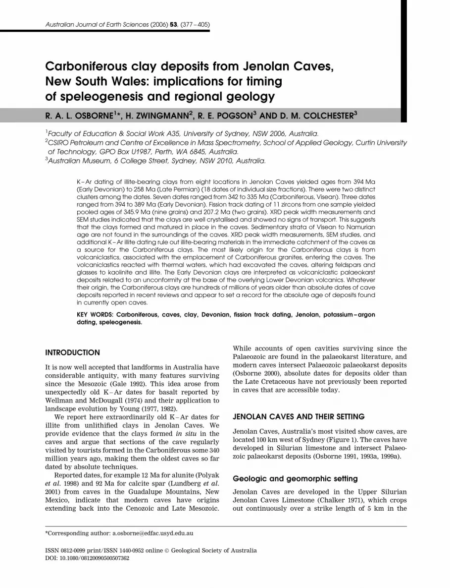
LOCATION O1, ORIENT CAVE
Orient Cave (Figure 2) is a sequence of interconnected
cupolas. Sample O1 was collected from The Jungle, a
region where the ceiling in Orient Cave lowers at the
intersection of two cupolas (Figures 2, 3). The Jungle is
richly endowed with speleothems including delicate
helictites and monocrystalline stalagmites.
Sample O1 came from clayey sand, part of a sediment
remnant, included in a complex mass of younger
flowstone and muds. It has a distinctive yellow colour
and complex field relationships that distinguish it from
more recent cave sediments (Figure 4a).
Table 1 Sample registration numbers.
Field no. Australian Museum no. Location Description
O1 DR17729 Orient Cave, Jungle Yellow clay
BR6 DR17730 Temple of Baal, East White clay
JRV7 DR17731 River Lethe White clay
JRV9 DR17732 River Cave, Junction Yellow clay
JIC1 DR17733 Imperial Cave, Selina Cave Brown clay
DCH4 DR17734 Devils Coach House, W wall Pink clay breccia
W5 DR17735 Chifley Cave, Wilkinson Branch Blue clay
JI74 DR17736 River Cave, Mud Tunnels Yellow gossan
J203 DR17737 Devils Coach House, river bed Sand
J204 DR17738 Temple of Baal, East Pink sediment
J205 DR17739 Baal-River Tunnel, S wall Clay from vugh
J206 DR17740 River Cave, Mud Tunnels Muddy gravel
J207 DR17741 Orient Cave, Persian Chamber Pit, Clay
J208 DR17742 Temple of Baal, West Clay matrix from cobbly gravel
J209 DR17743 Imperial Cave, Selina Cave, E wall Sediment bank
J210 DR17744 Jubilee Cave, Water Cavern, far N Clay
J211 DR17745 Jubilee Cave, Water Cavern, S Clay surrounding stalactites
J212 DR17746 Imperial Cave, River, Overbank deposit
J213 DR17747 Kanangra Walls Road near Mt Whiteley Diamictite
J214 DR17748 2 mile hill Weathered Slate
J215 DR17749 2 mile hill Chert
J216 DR17750 2 mile hill Terra rossa
J217 DR17751 2 mile hill, Silt Trap Sediment
J218 DR17752 Old School Matrix of gravel
J219 DR17753 Playing Fields Fire Trail Weathered slate
J220 DR17754 McKeowns Valley Track Weathered Jenolan volcanics
J221 DR17755 Rear of Caves House Weathered andesite
380 R. A. L. Osborne et al.
Panning of the clay extracted a light (up to 0.5 mm)
and heavy (52 mm) fraction. The components from the
light fraction (up to 0.5 mm) include quartz, calcite,
quartzite and metasediments. Some of the quartz grains
are colourless, transparent, well rounded to spherical
with a high surface polish. The components of the heavy
fraction (52 mm) are mainly zircon with magnetite,
ilmenite, romanechite and clinopyroxene (Table 2). The
zircon, ilmenite, magnetite and clinopyroxene could be
of volcaniclastic origin, while the calcite fragments
were not precipitated in the clay, but are detrital,
derived from the disintegration of speleothem elsewhere
in the cave.
Clays occur throughout Orient Cave indicating
periods of sediment filling and removal. Yellow clay
deposits, similar to sample O1, are uncommon and
appear to be remnants from an early cave-filling event.
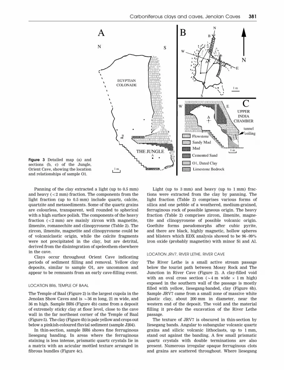
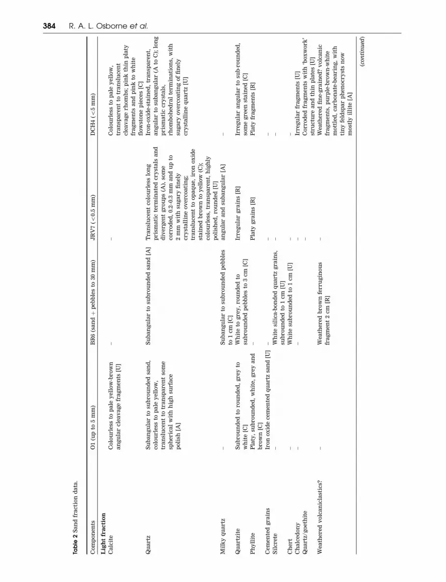
LOCATION BR6, TEMPLE OF BAAL
The Temple of Baal (Figure 2) is the largest cupola in the
Jenolan Show Caves and is *36 m long, 21 m wide, and
36 m high. Sample BR6 (Figure 4b) came from a deposit
of extremely sticky clay at floor level, close to the cave
wall in the far northeast corner of the Temple of Baal
(Figure 5). The clay (Figure 4b) is pale yellow and crops out
below a pinkish-coloured fluvial sediment (sample J204).
In thin-section, sample BR6 shows fine ferruginous
liesegang banding. In areas where the ferruginous
staining is less intense, prismatic quartz crystals lie in
a matrix with an acicular mottled texture arranged in
fibrous bundles (Figure 4c).
Light (up to 3 mm) and heavy (up to 1 mm) frac-
tions were extracted from the clay by panning. The
light fraction (Table 2) comprises various forms of
silica and one pebble of a weathered, medium-grained,
ferruginous rock of possible igneous origin. The heavy
fraction (Table 2) comprises zircon, ilmenite, magne-
tite and clinopyroxene of possible volcanic origin.
Goethite forms pseudomorphs after cubic pyrite,
and there are black, highly magnetic, hollow spheres
and blisters which EDX analysis showed to be 96 –99%
iron oxide (probably magnetite) with minor Si and Al.
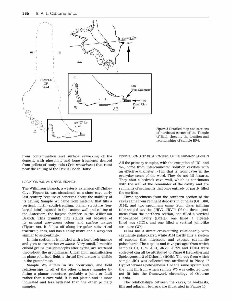
LOCATION JRV7, RIVER LETHE, RIVER CAVE
The River Lethe is a small active stream passage
below the tourist path between Mossy Rock and The
Junction in River Cave (Figure 2). A clay-filled void
with an oval cross section (*4 m wide 6 1 m high)
exposed in the southern wall of the passage is mostly
filled with yellow, liesegang-banded, clay (Figure 6b).
Sample JRV7 came from a small zone of massive white
plastic clay, about 200 mm in diameter, near the
western end of the deposit. The void and the material
filling it pre-date the excavation of the River Lethe
passage.
The texture of JRV7 is obscured in thin-section by
liesegang bands. Angular to subangular volcanic quartz
grains and silicic volcanic lithoclasts, up to 1 mm,
stand out against the banding. A few small prismatic
quartz crystals with double terminations are also
present. Numerous irregular opaque ferruginous clots
and grains are scattered throughout. Where liesegang
Figure 3 Detailed map (a) and
sections (b, c) of the Jungle,
Orient Cave, showing the location
and relationships of sample O1.
Carboniferous clays and caves, Jenolan Caves 381
banding and ferruginous clots are less marked, the
specimen has a texture similar to a fine-grained
pyroclastic.
The clastic components of sample JRV7 were sepa-
rated by panning 0.5 kg of the clay into a coarse light
fraction (up to 4 mm), a light medium-grained fraction
(up to 1.5 mm), a light fine fraction (50.5 mm), and a
heavy fraction (mostly 50.5 mm).
In the light fraction (50.5 mm), quartz grains display
a large variety of forms, indicating multiple sources.
Figure 4 (a) Sample O1, looking
east from the tourist platform in
The Jungle, Orient Cave. Sample
collected from the area near the
scale bar. Note the continuation
of deposit on the right-hand side
of the frame. Black squares on
scale¼ 1 cm. (b) Sample BR6.
Looking towards the northern
wall of the Temple of Baal. Sample
BR6 is the lighter zone in centre of
frame above the scale bar. Darker
surrounding material is the over-
lying fluvial sediment, J204. The
upper edge of the photo is the cave
wall, which is dark due to a
pinkish coating on the limestone.
Black squares on scale¼ 1 cm.
(c) Thin-section of sample BR6,
crossed nicols. Note the prismatic
quartz crystal *30 mm long in the
centre of the field and the fine
radiating dark crystal masses in
the groundmass.
382 R. A. L. Osborne et al.
These include perfect prismatic quartz crystals with
double terminations, quartz veinlets with delicate
features, and, by contrast, highly polished and rounded
quartz grains (Table 2).
The heavy (50.5 mm) fraction contains euhedral
zircon, magnetite, clinopyroxene and ilmenite (Table 2).
Analysis of four clinopyroxene grains by EDX gives an
augite – diopside composition, (Wo44 – 49 En43 – 49 Fs6 – 12).
The ilmenite composition is low in Mg and Cr.
LOCATION JRV9, THE JUNCTION, RIVER CAVE
The Junction is a prominent T-intersection between two
cave passages and tourist paths in River Cave (Figure 2).
At the short axis of the T, the cave path has been
tunnelled through the bedrock directly below a natural
passage, which has a semicircular profile (2 m high62.4 m wide).
Sample JRV9 comes from a mass of crumbly
mustard-brown clay 1.5 m high and 400 mm wide that
projects up to 200 mm from the cave wall on the
northeastern side of this passage (Figure 6a). It fills a
solution cavity back into the wall and contains a few
ferruginous sheets. An oven-dried sample of 100 g was
wet-sieved to remove the gravel and sand fractions. The
fraction 42 mm weighed 8.1 g, consisting principally of
ferruginous flakes up to 2.4 mm thick and *30 mm
long 6 12 mm wide. The sand fraction weighed 1.6 g and
consisted mainly of cemented composite grains with a
chip-like form. A few quartz grains with a range of
forms were present.
LOCATION J174, MUD TUNNELS, RIVER CAVE
The Mud Tunnels is a complex of large cupolas in the
River Cave located below and connected to the system of
cupolas in the Orient Cave (Figure 2). The cupolas in the
Mud Tunnels intersect and expose in their walls
extensive deposits of horizontally bedded caymanite
palaeokarst. Osborne (1999a) interpreted these cupolas
as the products of solution by rising, possibly thermal,
water.
Sample J174 comes from a mass of gossan-like
material located high on the western wall of the Mud
Tunnels (Figure 7). The deposit (Figure 6c) is plastered
onto the cave wall but does not penetrate it, indicating
that it is a remnant of a deposit that formerly filled this
part of the cave.
Most of sample J174 is light reddish tan with a dark
mottle. A zone of white carbonate occurs along one edge
of the specimen. In thin-section, ferruginous ovoid tan
pellets with a long axis of *40 mm dominate the speci-
men and obscure the underlying texture. Where visible,
the original texture is a mud matrix containing very
fine needles of quartz. The white carbonate zone consists
of radiating acicular crystal masses with an aragonite-
like form (0.04 mm in diameter) growing in voids.
LOCATION JIC1, IMPERIAL CAVE, SELINA CAVE
The passage connecting Imperial Cave with Jubilee
Cave (Figure 8) is called Selina Cave (Figure 8a). It
intersects a number of crystal-lined vugs, 1 – 1.5 m in
diameter, which are clearly older than the present
passage. The centre of some of these vugs is filled, or
partly filled, with brown clay that overlies a crystal
lining of euhedral calcite.
Sample JIC1 (Figure 8a) is clay from a vug that has
been intersected by the ceiling of the present cave
passage (Figure 9a). In thin-section, at over 2006magnification, speckles in the clay are resolved as fine
needles and irregular globular grains of quartz, which
lack any preferred orientation.
LOCATION DCH4, DEVILS COACH HOUSE
The Devils Coach House is the largest of the three
natural bridges that penetrate the limestone bluff
at Jenolan Caves. Near its western wall (Figure 8), out
of view from the tourist path, there is a vertical
funnel in the limestone with an elliptical cross-section
of *3 m 6 2 m. The walls of this funnel are composed
of bedrock and, on the northwestern side, horizon-
tally bedded caymanite palaeokarst. The southeastern
side of the funnel is coated with coarse blocky calcite
crystals. Bedrock in the funnel walls is altered to a
depth of up to 10 mm, having a light-brown colour,
which contrasts with the light-grey unaltered bedrock.
Alteration also penetrates along fractures in the lime-
stone. Remnants of a deposit that once filled the
funnel form a bridge oriented east – west across it
(Figure 9b).
Sample DCH4 was collected from pink partially
consolidated material that makes up the centre and
bulk of the deposit. It contains a few rectangular white
clasts with sides up to 100 mm long. A narrow zone
(300 – 600 mm wide) of yellow material of similar con-
sistency separates the pink material from the funnel
walls. This site may be the locality for material that
Mingaye (1899) analysed, a specimen of pink clay,
labelled ‘phosphatic deposits’, in the Australian Mu-
seum collection (Specimen D12099) donated by the then
caretaker of the caves, Voss Wiburd, in 1898.
In thin-section under low magnification, DCH4 shows
a mottled, low birefringent groundmass with patchy
extinction scattered with occasional to more abundant
subangular quartz grains and composite quartz grains
up to 0.5 mm. Under high magnification, tiny acicular
crystals with low birefringence are just visible in the
groundmass.
Clastic components were separated by panning 0.6 kg
of the clay into a coarse light fraction (up to 5 mm),
a light fine fraction (50.5 mm), and a minor heavy
fraction (mostly 50.5 mm). In the light fraction (coarse,
up to 5 mm, and fine 50.5 mm), many rock and mineral
components are represented. Pseudomorphs of illite
after feldspar are present as tiny perfect tabular
crystals. There are also many small fragments of wea-
thered, mottled white and purple-brown fine-grained
volcaniclastics, some with white, tabular phenocrysts of
feldspar pseudomorphed by illite. These fragments have
extensive carbonate alteration. The heavy fraction
(50.5 mm) contains clinopyroxene (Table 2).
Bone fragments occur in the sample, along with the
phosphate identified by Mingaye. These probably come
Carboniferous clays and caves, Jenolan Caves 383
Table
2S
an
dfr
ac
tio
nd
ata
.
Co
mp
on
en
tsO
1(u
pto
5m
m)
BR
6(s
an
dþ
pe
bb
les
to30
mm
)J
RV
7(5
0.5
mm
)D
CH
4(5
5m
m)
Lig
ht
fra
cti
on
Ca
lcit
eC
olo
urle
ssto
pa
ley
ell
ow
-bro
wn
an
gu
lar
cle
av
ag
efr
ag
me
nts
[U]
––
Co
lou
rle
ssto
pa
ley
ell
ow
,
tra
nsp
are
nt
totr
an
slu
ce
nt
cle
av
ag
erh
om
bs;
pin
kth
inp
laty
fra
gm
en
tsa
nd
pin
kto
wh
ite
flo
wst
on
ep
iec
es
[C]
Qu
artz
Su
ba
ng
ula
rto
sub
ro
un
de
dsa
nd
,
co
lou
rle
ssto
pa
ley
ell
ow
,
tra
nsl
uc
en
tto
tra
nsp
are
nt
som
e
sph
eric
al
wit
hh
igh
surfa
ce
po
lish
[A]
Su
ba
ng
ula
rto
sub
ro
un
de
dsa
nd
[A]
Tra
nsl
uc
en
tc
olo
urle
sslo
ng
pris
ma
tic
term
ina
ted
cry
sta
lsa
nd
div
erg
en
tg
ro
up
s(A
),so
me
co
rro
de
d,
0.2
–0.3
mm
an
du
pto
2m
mw
ith
sug
ary
fin
ely
cry
sta
llin
eo
ve
rc
oa
tin
g;
tra
nsl
uc
en
tto
op
aq
ue
,ir
on
ox
ide
sta
ine
db
ro
wn
toy
ell
ow
(C);
co
lou
rle
ss,
tra
nsp
are
nt,
hig
hly
po
lish
ed
,ro
un
de
d[U
]
Iro
n-o
xid
e-s
tain
ed
,tr
an
spa
re
nt,
an
gu
lar
tosu
ba
ng
ula
r(A
toC
);lo
ng
pris
ma
tic
cry
sta
ls,
rh
om
bo
he
dra
lte
rm
ina
tio
ns,
wit
h
sug
ary
ov
erc
oa
tin
go
ffi
ne
ly
cry
sta
llin
eq
ua
rtz
[U]
Mil
ky
qu
artz
–S
ub
an
gu
lar
tosu
bro
un
de
dp
eb
ble
s
to1
cm
[C]
an
gu
lar
an
dsu
ba
ng
ula
r[A
]–
Qu
artz
ite
Su
bro
un
de
dto
ro
un
de
d,
gre
yto
wh
ite
[C]
Wh
ite
tog
re
y,
ro
un
de
dto
sub
ro
un
de
dp
eb
ble
sto
3c
m[C
]
Irre
gu
lar
gra
ins
[R]
Irre
gu
lar
an
gu
lar
tosu
b-r
ou
nd
ed
,
som
eg
re
en
sta
ine
d[C
]
Ph
yll
ite
Pla
ty,
sub
ro
un
de
d,
wh
ite
,g
re
ya
nd
bro
wn
[C]
–P
laty
gra
ins
[R]
Pla
tyfr
ag
me
nts
[R]
Ce
me
nte
dg
ra
ins
Iro
no
xid
ec
em
en
ted
qu
artz
san
d[U
]–
––
Sil
cre
te–
Wh
ite
sili
ca
-bo
nd
ed
qu
artz
gra
ins,
sub
ro
un
de
dto
1c
m[U
]
––
Ch
ert
–W
hit
esu
bro
un
de
dto
1c
m[U
]–
–
Ch
alc
ed
on
y–
––
Irre
gu
lar
fra
gm
en
ts[U
]
Qu
artz
/g
oe
thit
e–
Co
rro
de
dfr
ag
me
nts
wit
h‘b
ox
wo
rk
’
stru
ctu
re
an
dth
inp
late
s[U
]
We
ath
ere
dv
olc
an
icla
stic
s?–
We
ath
ere
db
ro
wn
ferru
gin
ou
s
fra
gm
en
t2
cm
[R]
–W
ea
the
re
dfi
ne
-gra
ine
d?
vo
lca
nic
fra
gm
en
ts,
pu
rp
le-b
ro
wn
-wh
ite
mo
ttle
d,
ca
rb
on
ate
-be
arin
g,
wit
h
tin
yfe
ldsp
ar
ph
en
oc
ry
sts
no
w
mo
stly
illi
te[A
]
(co
nti
nu
ed)
384 R. A. L. Osborne et al.

Table
2(C
on
tin
ued
).
Co
mp
on
en
tsO
1(u
pto
5m
m)
BR
6(s
an
dþ
pe
bb
les
to30
mm
)J
RV
7(5
0.5
mm
)D
CH
4(5
5m
m)
Hea
vy
fra
cti
on
Zir
co
nE
uh
ed
ra
l,tr
an
spa
re
nt,
co
lou
rle
ss,
sin
gly
an
dd
ou
bly
term
ina
ted
,
up
to0.2
mm
;lo
wa
bra
sio
n;
ma
ny
are
ro
un
de
dg
ra
ins
of
ap
pro
x.
0.1
mm
[C]
Eu
he
dra
lsi
ng
lya
nd
do
ub
ly
term
ina
ted
,c
olo
urle
ssto
pa
le
ye
llo
w-o
ra
ng
e,
low
ab
ra
sio
n,
up
to
0.3
mm
;o
cc
asi
on
al
sph
eric
al
gra
ins
to0.1
mm
[C]
Lo
ng
pris
ma
tic
,e
uh
ed
ra
lc
ry
sta
ls,
ma
ny
do
ub
ly-t
erm
ina
ted
,u
pto
0.4
mm
,u
na
bra
de
d,
lust
ro
us,
co
lou
rle
ssto
pa
ley
ell
ow
(A),
So
me
sph
eric
al,
co
lou
rle
ssa
nd
tra
nsp
are
nt
totr
an
slu
ce
nt,
po
lish
ed
tosl
igh
tly
fro
ste
d,
to0.2
mm
[C]
Lo
ng
pris
ma
tic
cry
sta
ls,
do
ub
ly
term
ina
ted
,lu
stro
us,
un
ab
ra
de
d,
co
lou
rle
ssto
pa
ley
ell
ow
,u
pto
0.3
mm
,b
ut
ma
inly
0.2
–0.3
mm
;
som
esm
all
er
sph
eric
al
gra
ins
[U]
Cli
no
py
ro
xe
ne
An
he
dra
ly
ell
ow
-gre
en
,g
lass
y
gra
ins
up
to0.3
mm
[R]
Gla
ssy
ye
llo
w-g
re
en
,a
nh
ed
ra
l
gra
ins
to0.3
mm
[R]
Gla
ssy
,a
nh
ed
ra
l,tr
an
slu
ce
nt,
pa
le
gre
en
,0.2
–0.3
mm
[U]
Gla
ssy
,p
ale
gre
en
,a
nh
ed
ra
l
gra
ins
[R]
Ma
gn
eti
teA
nh
ed
ra
lb
lac
km
ag
ne
tic
gra
ins
an
dra
re
oc
tah
ed
ra
[U]
An
he
dra
lg
ra
ins,
an
da
sb
lac
k,
ma
gn
eti
csp
he
re
s,b
list
ers
an
dte
ar-
dro
ps
(pa
rti
all
yh
oll
ow
)
to1
mm
[C]
Ma
inly
an
he
dra
lg
ra
ins,
som
e
dis
torte
do
cta
he
dro
ns
[C]
Bla
ck
,a
nh
ed
ra
lg
ra
ins
[C]
Go
eth
ite
Pla
tyb
ro
wn
ferru
gin
ou
sfr
ag
me
nts
of
go
eth
ite
/si
ltst
on
eto
2m
m[C
]
An
he
dra
lg
ra
ins
up
to0.5
mm
,a
nd
pse
ud
om
orp
hs
aft
er
py
rit
e
to0.5
mm
[U]
An
gu
lar
toro
un
de
dg
ra
ins,
spa
rse
pse
ud
om
orp
hs
aft
er
py
rit
e
cu
be
s[C
]
Irre
gu
lar
bro
wn
tob
lac
kg
ra
ins
[C]
Ro
ma
ne
ch
ite
Da
rk
gre
yto
bla
ck
no
du
lar
an
dp
laty
fra
gm
en
tsto
1.5
mm
[U]
–Ir
re
gu
lar
bla
ck
cru
sts
wit
hro
ug
h
co
ra
l-li
ke
bra
nc
hin
g[C
]
–
Ma
gh
em
ite
An
he
dra
lg
re
y-b
ro
wn
ma
gn
eti
c
gra
ins
up
to0.5
mm
[C]
An
he
dra
lb
ro
wn
ma
gn
eti
cg
ra
ins
up
to1
mm
[C]
An
he
dra
lm
ag
ne
tic
gra
ins
[C]
Bro
wn
-gre
ym
ag
ne
tic
gra
ins
[C]
Ilm
en
ite
An
he
dra
lg
ra
ins
up
to1
mm
[R]
Ro
un
de
dg
ra
ins
0.1
–0.2
mm
[C]
–
Ru
tile
––
Re
d-b
ro
wn
,e
lon
ga
tero
un
de
d
gra
ins
[R]
–
Mic
a–
–P
seu
do
-he
xa
go
na
lc
ry
sta
l,
we
ath
ere
db
ro
nze
,0.2
mm
[R]
–
Go
ld–
–F
latt
en
ed
fla
ke
wit
hro
un
de
de
dg
es,
0.2
mm
[R]
–
Bo
ne
fra
gm
en
ts–
––
Lo
ng
,th
infr
ag
me
nts
up
to
1.2
5c
m[U
]
Re
lati
ve
ab
un
da
nc
es
wit
hin
lig
ht
an
dh
ea
vy
fra
cti
on
s:A
,a
bu
nd
an
t;C
,c
om
mo
n;
U,
un
co
mm
on
;R
,ra
re
.
Th
eh
ea
vy
fra
cti
on
sa
re
av
ery
min
or
co
mp
on
en
to
fth
ea
pp
ro
xim
ate
ly0.5
kg
of
sam
ple
pro
ce
sse
d,
be
ing
0.4
gfo
rJ
RV
7,
0.2
gfo
rD
CH
4a
nd
BR
6,
an
d0.1
gfo
rO
1.
Carboniferous clays and caves, Jenolan Caves 385
from contamination and surface reworking of the
deposit, with phosphate and bone fragments derived
from pellets of sooty owls (Tyto tenebricosa) that roost
near the ceiling of the Devils Coach House.
LOCATION W5, WILKINSON BRANCH
The Wilkinson Branch, a westerly extension off Chifley
Cave (Figure 8), was abandoned as a show cave early
last century because of concerns about the stability of
its ceiling. Sample W5 came from material that fills a
vertical, north – south-trending, planar structure (?en-
larged joint) exposed in the eastern wall and ceiling of
the Anteroom, the largest chamber in the Wilkinson
Branch. This crumbly clay stands out because of
its unusual grey-green colour and surface texture
(Figure 9c). It flakes off along irregular subvertical
fracture planes, and has a shiny lustre and a waxy feel
similar to serpentinite.
In thin-section, it is mottled with a low birefringence
and goes to extinction en masse. Very small, limonitic
cuboid grains, pseudomorphs after pyrite, are scattered
throughout the groundmass. Under high magnification
in plane-polarised light, a thread-like texture is visible
in the groundmass.
Sample W5 differs in its occurrence and field
relationships to all of the other primary samples by
filling a planar structure, probably a joint or fault
rather than a cave void. It is not plastic and is more
indurated and less hydrated than the other primary
samples.
DISTRIBUTION AND RELATIONSHIPS OF THE PRIMARY SAMPLES
All the primary samples, with the exception of JIC1 and
W5, come from interconnected solution cavities with
an effective diameter 41 m, that is, from caves in the
everyday sense of the word. They do not fill fissures.
They abut a bedrock cave wall, which is continuous
with the wall of the remainder of the cavity and are
remnants of sediments that once entirely or partly filled
the cavities.
Three specimens from the southern section of the
caves came from remnant deposits in cupolas (O1, BR6,
J174), and two specimens came from clays infilling
tube-shaped cavities (JRV7, JRV9). Of the three speci-
mens from the northern section, one filled a vertical
tube-shaped cavity (DCH4), one filled a crystal-
lined vug (JIC1), and one filled a vertical joint-like
structure (W5).
DCH4 has a direct cross-cutting relationship with
caymanite palaeokarst, while J174 partly fills a system
of cupolas that intersects and exposes caymanite
palaeokarst. The cupolas and cave passages from which
samples O1, BR6, J174, JRV7, JRV9 and DCH4 were
collected can all be attributed to Phase 6 Hydrothermal
Speleogenesis 2 of Osborne (1999b). The vug from which
sample JIC1 was collected was attributed to Phase 3?
Hydrothermal Speleogenesis 1 of the same system and
the joint fill from which sample W5 was collected does
not fit into the framework chronology of Osborne
(1999b).
The relationships between the caves, palaeokarsts,
fills and adjacent bedrock are illustrated in Figure 10.
Figure 5 Detailed map and sections
of northeast corner of the Temple
of Baal, showing the location and
relationships of sample BR6.
386 R. A. L. Osborne et al.
Additional cave samples
Ten samples were collected from the caves in order to
elucidate the relationships between the primary clay
samples and other sediments in the caves.
Four samples, J203, J210, J211 and J212, were
selected as representative of active or obviously re-
cently active deposition in the caves. Sample J203 is
sediment from the flood bedload of the Jenolan River in
the Devils Coach House. Sample J210 is clay from the
normally flooded Water Cavern at the northern end of
Jubilee Cave. Sample J211 is from a laminated clay
deposit that surrounds small stalactites in the northern
end of Jubilee Cave, and Sample J212 is recently
deposited overbank deposit from the Jenolan Under-
ground River in Imperial Cave (Figure 8).
Two samples, J205 clay from the centre of a spar-lined
vug intersected by the Baal-River Tunnel, and J207 from
remnant clay fill in the bottom of the Persian Chamber
in Orient Cave, were selected because their physical
Figure 6 (a) Sample JRV9, looking east from the River Cave tourist path to above Junction path. The light area to the left of the
frame is the limestone cave wall. The darker vertical feature with the scale bar in the centre of the frame is a sediment
remnant, the source of sample JRV9, protruding into the cave. Note the sutured boundary on the left-hand side between the
limestone cave wall and the sediment remnant. Black squares on scale¼ 1 cm. (b) Sample JRV7. Looking towards
the southern wall of River Lethe Passage. The ladder seen to the left of frame leads down from the River Cave tourist path.
The sample is from the white patch to the left of the scale bar. An irregular ceiling of filled passage is visible in the upper field
of view. Black squares on scale¼ 1 cm. (c) Sample J174. Looking up to the western wall of the Mud Tunnels, River Cave. The
gossan-like zone is a mustard yellow zone with hollows extending up at an angle of 458 from the scale. Light shaded zones
above and to the left are massive limestone cave walls. Black squares on scale¼ 1 cm.
Carboniferous clays and caves, Jenolan Caves 387

properties and relationships were similar to those of the
primary samples.
Four samples, J204, J206, J208 and J209, were selected
to test relationships between the primary samples and
adjacent sediments. J204 is from fluvial sediment that
directly overlies sample BR6 (Figure 5). J206 is mud
matrix from the uncemented muddy gravel that appears
to have once largely filled the Mud Tunnels (Figure 7a).
J208 is mud matrix from the gravel with cobbles that
appears to have once largely filled the Temple of Baal
(Figure 2), and J209 is sediment from the mud bank on
the eastern side of Selina Cave (Figure 8a).
Figure 8 Map of Chifley Cave,
Imperial Cave and Devil’s Coach
House, showing the location of
samples DCH4, J210, J211, J212
and W5 (base map modified after
Trickett 1925). Inset (A): detailed
map and section of Selina Cave,
Imperial Cave showing location,
and relationships of samples JIC1
and J209.
Figure 7 (a) Detailed map and (b)
section of the Mud Tunnels, River
Cave showing the location and
relationships of samples J174 and
J206.
388 R. A. L. Osborne et al.
Surface samples
In order to identify possible illite sources in the
immediate catchment of the caves, nine samples of clay
and weathered rock were collected, representing the
range of materials in the catchment (Figure 11).
Sample J213 is the matrix from an outcrop of
horizontally bedded diamictite, exposed in a cutting
on the Kanangra Walls Road. This outcrop was inter-
preted in geological maps (Bryan 1965) and by later
workers (Herbert 1980a, b) as an outlier of the Sydney
Basin, correlated with the Permian Snapper Point
Formation.
Sample J214 is weathered slate from the road cutting
near the top of the ‘two mile hill’. Sample J215 is chert
from the road cutting halfway down ‘two mile hill’.
Sample J216 is red terra rossa-type soil occurring on the
limestone on the hillside between the Jenolan Village
(900 – 930 m) terrace and the Carlotta Arch (830 m)
terrace. Like most terras rossa and red earths, it is
probably aeolian in origin, rather than weathering
residuum from the limestone. Sample J217 is recent
Figure 9 (a) Sample JIC1, showing the exposed section through the vug. Sample JIC1 is from the light-coloured material
around the scale. The material in the top of frame with an irregular surface is void-filling spar with mammillary surfaces
lining the ceiling of the vug. Black squares on scale¼ 1 cm. (b) Sample DCH4, looking south across the funnel in the bedrock
showing a bridge of pink material in the mid-ground. Sample DCH4 was collected near the bag towards the left-hand side
of the bridge. The bag in the far left mid-field is 25 cm wide 6 20 cm high. (c) Sample W5: detail of clay deposit showing
fractured surface. Looking up towards eastern wall of the Anteroom, Wilkinson Branch, Chifley Cave. The pen is 13 cm long.
Carboniferous clays and caves, Jenolan Caves 389

sediment from the silt trap on the road gutter on ‘two
mile hill’. Samples J218 and J218A are the matrix
from a gravely cobble deposit exposed in the excavated
bank behind the old school. This deposit sits on the
830 m terrace. Sample J219 is weathered slate from
the cutting towards the bottom of the Playing Fields
fire trail. Sample J220 is soil derived from weathered
Jenolan volcanics from the western side of the
McKeowns Valley walking track, *240 m upstream of
the Devils Coach House. Sample J221 is weathered
andesite from a road cutting uphill and to the west of
Caves House.
METHODS
X-ray diffraction
X-ray diffraction (XRD) studies were undertaken at
the Australian Museum using a Philips PW1730, 3 kW
generator coupled with a PW1050 goniometer fitted with
a graphite monochromator adjusted to receive Cu
Ka radiation. The instrument was operated at 40 kV and
30 mA with a 18 divergence slit and a 1/48 receiver
slit. Scans were made from 2 to 708 2y at a scan speed of
18 per minute using Diffraction Technology software.
Two consecutive scans were co-added to reduce random
background noise and improve the signal-to-noise
ratio. The region from 2 to 108 2y was rescanned at 0.58per minute using a 1/48 divergence slit to check for basal
d-spacings of smectite group clays.
Bulk samples were reduced in an agate mortar and
pestle, sieved to – 45 mm and packed into a standard
shallow-cavity aluminium sample holder. For oriented
mounts, the various separated size fractions in water
suspension were evaporated onto glass slides at room
temperature over several days. These slides were then
exposed to ethylene glycol vapour at room tempera-
ture for 5 days, then resubmitted for XRD analysis (as
above) to check for peak shifts from smectite group
clays.
SIROQUANT ANALYSIS
An estimate of mineral phase content (40.5 wt%) was
obtained with SIROQUANT for Windows Version 2.5
software (Taylor 1991; Taylor & Clapp 1992), using both
calculated and observed hkl mineral library files. The
refinement parameters were adjusted to give the
smallest possible w2 goodness-of-fit parameter for the
resulting Rietveld pattern match.
FWHM
To quantify the extent to which the illite component of
the clays has evolved from ordered mixed-layer illite/
smectite (I/S) to well-crystallised illite (WCI), the ‘full
width at half maximum’ (FWHM) of the 10 A (001) XRD
peak was measured using the routine embedded in the
Diffraction Technology software. Following Lanson
(1997) and as detailed in Meunier and Velde (2004),
a FWHM 50.38 2y for Cu Ka radiation signifies well-
crystallised illite.
SEM
Scanning electron microscope images were taken of all
primary cave samples, two additional cave samples
(J204, J208) and three surface samples (J213, J214, J218),
with a Leo 435VP SEM at the Australian Museum.
Sedimented aggregate specimens were prepared from
air-dried clay particles settled in water suspension on
standard SEM stubs. Raw clay specimens were also
prepared from freshly broken fragments of the bulk
sample mounted on a standard SEM stub with the
freshly broken surface upwards. Gold-coated stubs were
imaged in secondary electron mode at magnifications
ranging between *6000 and 20 000 at 20 kV and 16 –
36 mm working distance.
K –Ar dating
SAMPLE PREPARATION
For each sample, *500 g of fresh material was crushed
into chips with a maximum dimension of 510 mm using
a hammer. The chips were gently disaggregated by
repetitive freezing and thawing. This was to avoid
artificial reduction of rock components and contamina-
tion of finer size fractions with K-bearing minerals such
as K-feldspar (Liewig et al. 1987). Grainsize fractions 52
and 2 – 6 mm were separated in distilled water according
to Stokes’ law, and the efficiency of this separation was
controlled by a laser granulometer on selected fractions.
Additional size fractions 50.4 mm were obtained using a
large-capacity high-speed centrifuge.
ANALYTICAL PROCEDURES
Conventional K – Ar dating techniques are detailed by
Dalrymple and Lanphere (1969) and Faure (1986). The K
content was determined by atomic absorption using Cs
for ionisation suppression. Sample aliquots of 100 –
200 mg were dissolved with HF and HNO3 (Heinrichs &
Herrmann 1990). Once in solution, the samples were
diluted to 0.3 – 1.5 ppm K for the atomic-absorption
analysis. The pooled error of duplicate K determination
on several samples and standards is better than 2.0%.
Ar isotopic determinations used a procedure simi-
lar to that of Bonhomme et al. (1975). Samples were
pre-heated under vacuum at 808C for several hours to
reduce the amount of atmospheric Ar adsorbed onto the
mineral surfaces during sample handling. Ar was
extracted from the separated mineral fractions by fusing
samples within a vacuum line serviced by an online 38Ar
spike pipette. The isotopic composition of the spiked Ar
was measured with an online mass spectrometer
VG3600. The 38Ar spike was calibrated against standard
biotite GA1550 (McDougall & Roksandic 1974). After
fusion of the sample in a low-blank Heine resistance
furnace, the released gases were subjected to a two-stage
purification procedure with a CuO getter for the first
step and two Ti getters for the second step. Blanks for
the extraction line and mass spectrometer were system-
atically determined, and the mass discrimination factor
was determined periodically by airshots. Normally, 25 mg
of sample material was required for argon analyses.
390 R. A. L. Osborne et al.
During the study, five international standards
(GA1550, 2GL-O, HD-B1, LP6) were measured. The error
for Ar analyses is below 1.00%, and the 40Ar/36Ar value
for airshots averaged 293.46+ 0.12 (n¼ 14). The K – Ar
ages were calculated using 40K abundance and decay
constants recommended by Steiger and Jager (1977). The
age uncertainties take into account the errors during
sample weighing, 38Ar/36Ar and 40Ar/38Ar measure-
ments, and K analysis.
SAMPLE SELECTION FOR K–Ar DATING
Sixteen samples were selected for conventional K – Ar
dating; the eight primary cave samples, two of
the additional cave samples, and six surface samples.
The two additional cave samples, J204 and J208A, were
selected to see if K – Ar dates on the clays in the cave
made sense stratigraphically. It was predicted that J204
should be just younger than BR6 and that J208A should
be significantly younger than both of them.
The six surface samples (J213, J214, J216, J218, J220,
J221) contained 410% illite and were selected to evaluate
their potential as sources for the primary cave samples.
RESULTS
X-ray mineralogy
The results (Table 3) include no adjustment for
amorphous content but do include a correction for
microabsorption. Apart from variable amounts of illite,
kaolinite, quartz and goethite/hematite, there were
trace amounts (50.5 wt%) of montmorillonite in sam-
ples J208 and J211 and minor to trace quantities of
calcite in many samples (50.5 – 1 wt%).
The lack of calcite in most of the cave samples
(Table 3) is surprising, given that they were deposited
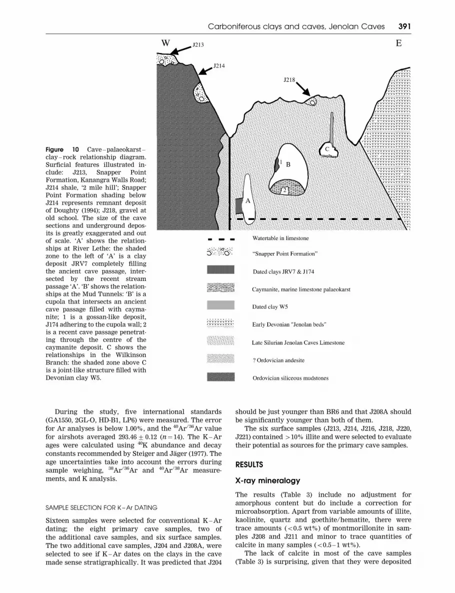
Figure 10 Cave – palaeokarst –
clay – rock relationship diagram.
Surficial features illustrated in-
clude: J213, Snapper Point
Formation, Kanangra Walls Road;
J214 shale, ‘2 mile hill’; Snapper
Point Formation shading below
J214 represents remnant deposit
of Doughty (1994); J218, gravel at
old school. The size of the cave
sections and underground depos-
its is greatly exaggerated and out
of scale. ‘A’ shows the relation-
ships at River Lethe: the shaded
zone to the left of ‘A’ is a clay
deposit JRV7 completely filling
the ancient cave passage, inter-
sected by the recent stream
passage ‘A’. ‘B’ shows the relation-
ships at the Mud Tunnels: ‘B’ is a
cupola that intersects an ancient
cave passage filled with cayma-
nite; 1 is a gossan-like deposit,
J174 adhering to the cupola wall; 2
is a recent cave passage penetrat-
ing through the centre of the
caymanite deposit. C shows the
relationships in the Wilkinson
Branch: the shaded zone above C
is a joint-like structure filled with
Devonian clay W5.
Carboniferous clays and caves, Jenolan Caves 391

and have resided for a significant time in a carbonate-
rich environment. Calcite cement was not detected in
thin-section either; rather, calcite occurred as detrital
crystal clasts (speleothem fragments) and limestone
fragments. The lack of calcite cement most likely
reflects the low permeability of the clays and low pH
conditions at the time of their initial deposition. No
K-rich contamination phases, such as K-feldspar, were
identified in the separated clay fractions.
PRIMARY CAVE SAMPLES
Variable amounts of illite and kaolinite were present
in all the primary cave samples, together with major
amounts of quartz and minor amounts of goethite and
haematite. Calcite was present in minor to trace
amounts, and montmorillonite was present as a trace
in JIC1 and O1. For kaolinite, the closest XRD pattern
match was with the 1Md polytype (ICDD card 06-221),
and for illite, the closest match was with the 2M1
polytype (ICDD card 09-0334).
ADDITIONAL CAVE SAMPLES
While Hill and Forti (1997) reported illite as a common
detrital cave mineral, our additional cave samples show
that illite is absent or present as a minor component.
The Selina Cave mudbank (J209), the recent cave
deposits (J203, J210, J211, J212) and the Mud Tunnels
gravel (J206) all contain 56% illite, and most contain
51% illite (Table 3). J205 and J207 have high illite and
kaolinite, similar to many of the primary cave samples.
Both J204 and J208 contain sufficient illite to make
dating possible. J204 (Table 3) contains significantly less
illite and kaolinite than sample BR6.
The low illite content in the recent cave deposits and
in J206 and J209 suggests that illite is not an abundant
component of sediments currently or recently deposited
in Jenolan Caves. It indicates instead that the primary
cave samples from the Mud Tunnels (J174) and Selina
Cave (JIC1) are not small remnants of the most
abundant deposits at these localities.
SURFACE SAMPLES
Six of the nine surface samples (J213, J214, J216, J218,
J220, J221) contained 410% illite, making them possible
sources for the illite in the primary cave samples.
Clay minerals in the cave samples
The two clay minerals identified in significant quanti-
ties in the cave clays were illite and kaolinite, which
together make up between 12 and 80% of the total
mineral content of the primary cave samples. The illite/
kaolinite ratio is also quite variable, but except for one
of the primary samples (JRV7), illite is always the
dominant clay mineral (Table 3).
Illite exhibits a characteristic 10 A XRD peak,
which is often asymmetrical in shape. Lanson (1997)
showed that this asymmetry arose because the peak is
composed of two components; a narrower and taller
10 A peak and a smaller and broader 10.2 – 10.4 A peak.
The amount these two components contribute to the
composite peak can be measured by calculating the
full width at half maximum (FWHM) of the composite
peak. Meunier and Velde (2004) considered the narrow
Figure 11 Map showing the surface sample collecting
localities in the Jenolan Caves catchment (based on Jenolan
8931-III-N: 1 km grid lines ADG 66, Zone 56H). The brick-
work pattern marks the Jenolan Caves Limestone, and the
pattern at Mt Whiteley marks the Snapper Point Formation.
392 R. A. L. Osborne et al.

Table
3S
IRO
QU
AN
Te
stim
ate
s(t
ota
lsto
100%
).
Sa
mp
leL
oc
ati
on
/d
esc
rip
tio
nQ
ua
rtz
Ka
oli
nit
eIl
lite
Go
eth
ite
He
ma
tite
Pla
gC
alc
ite
Mo
nt-
15A
Au
git
ew2
I/K
ra
tio
%c
lay
s
Prim
ary
ca
ve
sa
mp
les
O1
Orie
nt,
Ju
ng
le68
10
10
11
10
00
02.3
61
20
BR
6T
em
ple
of
Ba
al
29
23
47
01
00
00
4.1
12
80
JR
V7
Riv
er
Le
the
66
18
13
02
00.4
00
2.4
00.7
31
JR
V9
Riv
er,
Ju
nc
tio
n27
24
36
11
20
00
03.1
21.5
60
J174
Riv
er,
Mu
dT
un
ne
ls64
329
31
00
00
2.5
69.7
31
J1C
1Im
pe
ria
l,S
eli
na
40
12
47
01
00
00
2.2
33.9
59
DC
H4
De
vil
sC
oa
ch
Ho
use
73
57
015
00
00
1.8
81.4
12
W5
Wil
kin
son
Bra
nc
h39
853
00
00
00
3.5
66.6
61
Ad
dit
ion
al
ca
ve
sa
mp
les
J203
De
vil
sC
oa
ch
Ho
use
,sa
nd
84
0.2
111
04
00
02.9
95.0
1.2
J204
Ba
al
ov
erly
ing
BR
6p
ink
sed
ime
nt
67
16
14
Tra
ce
03
00.1
02.6
30.9
30.1
J205
Ba
al-
Riv
er
Tu
nn
el,
cla
yin
vu
gh
60
18
19
20
00
0.1
03.0
00.9
37.1
J206
Mu
dT
un
ne
ls,
mu
dd
yg
ra
ve
l71
70.7
11
05
60
02.9
30.1
7.7
J207
Pit
,O
rie
nt
Ca
ve
,c
lay
37
915
60
033
00
3.0
71.7
24
J208
Ba
al,
we
st,
cla
ym
atr
ixfr
om
co
bb
ly
gra
ve
l
64
923
20
2T
ra
ce
0.1
02.2
22.6
32.1
J209
Se
lin
a,
Ew
all
sed
ime
nt
84
0.3
0.3
12
04
00
03.3
1.0
0.6
J210
Wa
ter
Ca
ve
rn
,fa
re
nd
,c
lay
64
17
0.4
80
38
00
2.9
60.0
17.4
J211
Ju
bil
ee
,c
lay
surro
un
din
gst
ala
cti
tes
91
0.5
0.5
50
30
Tra
ce
02.8
51.0
1
J212
Imp
eria
lR
ive
ro
ve
rb
an
kd
ep
osi
t78
0.3
511
04
30
02.9
116.7
5.3
Su
rfa
ce
sa
mp
les
J213
Ka
na
ng
ra
Ro
ad
dia
mic
tite
67
15
15
40
00
00
3.1
1.0
30
J214
2m
ile
hil
lw
ea
the
re
dsl
ate
32
721
13
015
211
02.7
3.0
39
J215
2m
ile
hil
lc
he
rt
60
37
30
28
0.2
00
1.8
92.3
10
J216
2m
ile
hil
lte
rra
ro
ssa
33
17
28
23
0T
ra
ce
Tra
ce
00
2.5
41.6
45
J217
2m
ile
hil
lsi
lttr
ap
sed
ime
nt
63
35
20
27
0.7
00
2.0
61.7
8
J218
Old
Sc
ho
ol
gra
ve
lm
atr
ix48
24
19
90
Tra
ce
Tra
ce
00
3.1
20.8
43
J219
Pla
yin
gF
ield
Fir
eT
ra
ilw
ea
the
re
d
sla
te
79
0.4
0.4
10
19
Tra
ce
00
2.7
11.0
0.8
J220
Mc
Ke
ow
ns
Va
lle
yw
ea
the
re
dJ
en
ola
n
vo
lca
nic
s
64
122
13
00
00
03.5
722.0
23
J221
Ca
ve
sH
ou
sew
ea
the
re
da
nd
esi
te28
717
Tra
ce
033
14
00
2.9
62.4
24
Pla
g,
pla
gio
cla
se;
Mo
nt,
mo
ntm
oril
lon
ite
.
Carboniferous clays and caves, Jenolan Caves 393

10 A peak to be due to well-crystallised illite (WCI)
while the wider 10.2 – 10.4 A peak is from poorly
crystallised illite (PCI). If the FWHM of the composite
peak is 50.4 2y, the illite sample is considered to be
predominantly WCI, whereas an FWHM 40.4 2y is
predominantly PCI.
Illite exhibits two distinct forms—laths and plates.
Lath-shaped or fibrous illite has curving strap-like
crystals typically 1 – 2 mm. Illite laths transform over
time by a process of ripening and dissolution into
pseudohexagonal plates of WCI. However, there is also
evidence that illite can recrystallise and coarsen by
Ostwald ripening (Eberl & Rodo 1988; Eberl et al. 1990) in
some hydrothermal systems under conditions appro-
priate to those considered here.
The nature of the illite present in the samples as
shown by the FWHM of the 10 A peak is shown in
Table 4. All of the primary samples with the exception of
DCH4 and J174 have a FWHM 50.4, making them WCI.
The slightly lower crystallinity of DCH4 is unsurprising,
given its brecciated nature. J208, the matrix of the
cobbly gravel from the Temple of Baal had the highest
FWHM measured. It was not possible to determine the
FWHM for sample J204 due to the small size of the 10 A
illite peak. Illite from all the surface samples measured
had a FWHM 40.4 with the matrix from the old school
gravel J218A having the highest.
SEM images of clays
Six of the eight primary cave samples (O1, BR6, JRV7,
JRV9, J174, JIC1) were characterised by random aggre-
gations of clay platelets. Key features of these specimens
are the survival of books of euhedral pseudohexagonal
clay (Figure 12a, b, d), the presence of straight-sided
platelets (Figure 12c, e), and the growth of secondary
fibrous illite (Figure 12f). These characteristics suggest
that the clays formed in situ, in the caves. In addition to
random aggregations and books of plates, sample DCH4
also contains a few euhedral crystals resembling
feldspar. These are probably small examples of the illite
pseudomorphs after feldspar identified in the fine sand
fraction.
W5 differed from all the other primary cave samples
in consisting mostly of large aligned, often crenulated,
platelets along with some smaller, randomly oriented
platelets with acicular overgrowths.
SEM images of additional cave samples, J204 and
J208A, show fragmented clay plates, with rounded or
broken edges (Figure 13), suggesting transport, and SEM
images of surface samples J213, J214 and J218 show
accumulations of plates with broken edges (Figure 13).
They lack the euhedral plates and articulated stacks of
plates found in the primary cave samples.
K –Ar results
For the 32 K – Ar dates, radiogenic 40Ar ranged from
60.25% for J221 to 99.32% for JRV7 52 mm. The 16 dates
for the primary cave samples contain high levels of
radiogenic 40Ar, which ranged from 96.57 to 99.32%. This
indicates negligible atmospheric Ar contamination and
reliable analytical conditions for these samples.
K contents range from 0.48% for samples J214 and
J221 to 7.28% for sample DCH4 50.4mm. The K – Ar
dates range from 167.12+ 3.60 Ma (Middle Jurassic,
Bathonian) to 394.87+ 7.85 Ma (Early Devonian, Em-
sian). These results are summarised in Table 5 and
Figure 14, and are correlated with the time-scale of
Veevers (2000).
Fission track dating
Zircon grains in the heavy-mineral concentrate from
sample JRV7 were submitted for fission track dating to
provide an independent check on the illite K – Ar ages.
Approximately 200 zircon crystals 0.1 – 0.4 mm in size
were inspected by Geotrack International, Melbourne.
Eleven grains were dated using standard methods
(Gleadow et al. 1976; Green 1981, 1985; Hurford &
Green 1982, 1983) and statistical techniques (Galbraith
1988, 1990). The data are presented in Table 6.
Green (2003) noted a significant spread in the single
grain ages around the central age of 308.9+ 25.6 Ma and
concluded that there were two age groups with pooled
ages of 345.9+ 19.1 Ma (nine grains) and 207.2+ 18.5 Ma
Table 4 10 A Illite XRD peak widths.
Sample Location FWHM
Primary cave samples
O1 Orient Cave 0.2140
BR6 Temple of Baal 0.306
JRV7 River Lethe 0.3620
JRV9 River Cave, Junction 0.3140
JI74 River Cave, Mud Tunnels 0.446
JIC1 Imperial Cave, Selina Cave 0.1500
DCH4 Devils Coach House 0.542
W5 Wilkinson Branch 0.3880
Additional cave samples
J208 Baal, west, clay matrix from cobbly gravel 1.1940
Surface samples
J213 Kanangra Walls Road, diamictite 0.4260
J214 2 mile hill, weathered slate 0.5160
J218A Old School, gravel matrix 1.1200
394 R. A. L. Osborne et al.
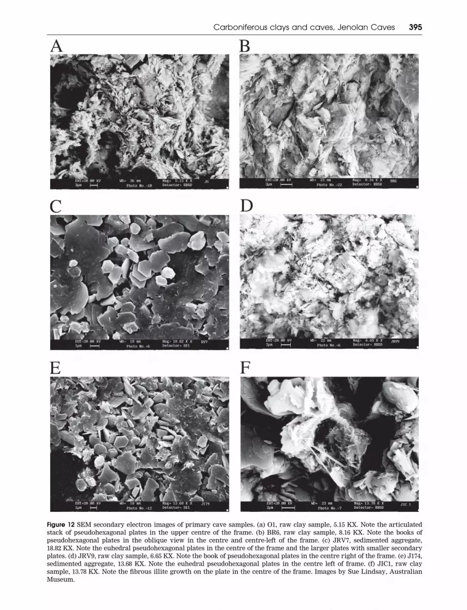
Figure 12 SEM secondary electron images of primary cave samples. (a) O1, raw clay sample, 5.15 KX. Note the articulated
stack of pseudohexagonal plates in the upper centre of the frame. (b) BR6, raw clay sample, 8.16 KX. Note the books of
pseudohexagonal plates in the oblique view in the centre and centre-left of the frame. (c) JRV7, sedimented aggregate,
18.82 KX. Note the euhedral pseudohexagonal plates in the centre of the frame and the larger plates with smaller secondary
plates. (d) JRV9, raw clay sample, 6.65 KX. Note the book of pseudohexagonal plates in the centre right of the frame. (e) J174,
sedimented aggregate, 13.68 KX. Note the euhedral pseudohexagonal plates in the centre left of frame. (f) JIC1, raw clay
sample, 13.78 KX. Note the fibrous illite growth on the plate in the centre of the frame. Images by Sue Lindsay, Australian
Museum.
Carboniferous clays and caves, Jenolan Caves 395
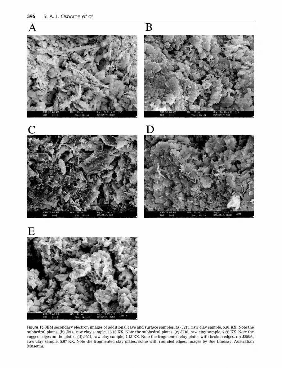
Figure 13 SEM secondary electron images of additional cave and surface samples. (a) J213, raw clay sample, 5.91 KX. Note the
subhedral plates. (b) J214, raw clay sample, 16.16 KX. Note the subhedral plates. (c) J218, raw clay sample, 7.56 KX. Note the
ragged edges on the plates. (d) J204, raw clay sample, 7.43 KX. Note the fragmented clay plates with broken edges. (e) J208A,
raw clay sample, 5.67 KX. Note the fragmented clay plates, some with rounded edges. Images by Sue Lindsay, Australian
Museum.
396 R. A. L. Osborne et al.
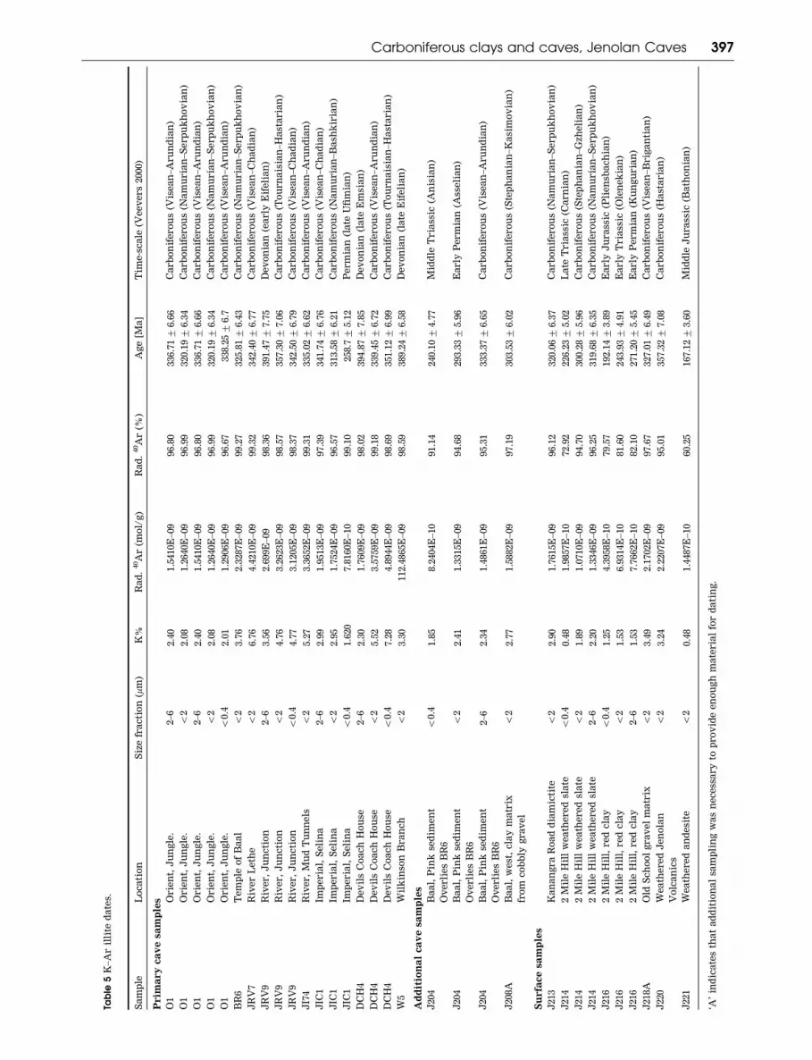
Table
5K
–A
ril
lite
da
tes.
Sa
mp
leL
oc
ati
on
Siz
efr
ac
tio
n(m
m)
K%
Ra
d.
40A
r(m
ol/
g)
Ra
d.
40A
r(%
)A
ge
[Ma
]T
ime
-sc
ale
(Ve
ev
ers
2000)
Prim
ary
ca
ve
sa
mp
les
O1
Orie
nt,
Ju
ng
le.
2–6
2.4
01.5
410E
–09
96.8
0336.7
1+
6.6
6C
arb
on
ife
ro
us
(Vis
ea
n–A
ru
nd
ian
)
O1
Orie
nt,
Ju
ng
le.
52
2.0
81.2
640E
–09
96.9
9320.1
9+
6.3
4C
arb
on
ife
ro
us
(Na
mu
ria
n–S
erp
uk
ho
via
n)
O1
Orie
nt,
Ju
ng
le.
2–6
2.4
01.5
410E
–09
96.8
0336.7
1+
6.6
6C
arb
on
ife
ro
us
(Vis
ea
n–A
ru
nd
ian
)
O1
Orie
nt,
Ju
ng
le.
52
2.0
81.2
640E
–09
96.9
9320.1
9+
6.3
4C
arb
on
ife
ro
us
(Na
mu
ria
n–S
erp
uk
ho
via
n)
O1
Orie
nt,
Ju
ng
le.
50.4
2.0
11.2
906E
–09
96.6
7338.2
5+
6.7
Ca
rb
on
ife
ro
us
(Vis
ea
n–A
ru
nd
ian
)
BR
6T
em
ple
of
Ba
al
52
3.7
62.3
287E
–09
99.2
7325.8
1+
6.4
3C
arb
on
ife
ro
us
(Na
mu
ria
n–S
erp
uk
ho
via
n)
JR
V7
Riv
er
Le
the
52
6.7
64.4
210E
–09
99.3
2342.4
0+
6.7
7C
arb
on
ife
ro
us
(Vis
ea
n–C
ha
dia
n)
JR
V9
Riv
er,
Ju
nc
tio
n2–6
3.5
62.6
99E
–09
98.3
6391.4
7+
7.7
5D
ev
on
ian
(ea
rly
Eif
eli
an
)
JR
V9
Riv
er,
Ju
nc
tio
n5
24.7
63.2
623E
–09
98.5
7357.3
0+
7.0
6C
arb
on
ife
ro
us
(To
urn
ais
ian
–H
ast
aria
n)
JR
V9
Riv
er,
Ju
nc
tio
n5
0.4
4.7
73.1
205E
–09
98.3
7342.5
0+
6.7
9C
arb
on
ife
ro
us
(Vis
ea
n–C
ha
dia
n)
JI7
4R
ive
r,
Mu
dT
un
ne
ls5
25.2
73.3
652E
–09
99.3
1335.0
2+
6.6
2C
arb
on
ife
ro
us
(Vis
ea
n–A
ru
nd
ian
)
JIC
1Im
pe
ria
l,S
eli
na
2–6
2.9
91.9
513E
–09
97.3
9341.7
4+
6.7
6C
arb
on
ife
ro
us
(Vis
ea
n–C
ha
dia
n)
JIC
1Im
pe
ria
l,S
eli
na
52
2.9
51.7
524E
–09
96.5
7313.5
8+
6.2
1C
arb
on
ife
ro
us
(Na
mu
ria
n–B
ash
kir
ian
)
JIC
1Im
pe
ria
l,S
eli
na
50.4
1.6
20
7.8
160E
–10
99.1
0258.7+
5.1
2P
erm
ian
(la
teU
fim
ian
)
DC
H4
De
vil
sC
oa
ch
Ho
use
2–6
2.3
01.7
609E
–09
98.0
2394.8
7+
7.8
5D
ev
on
ian
(la
teE
msi
an
)
DC
H4
De
vil
sC
oa
ch
Ho
use
52
5.5
23.5
759E
–09
99.1
8339.4
5+
6.7
2C
arb
on
ife
ro
us
(Vis
ea
n–A
ru
nd
ian
)
DC
H4
De
vil
sC
oa
ch
Ho
use
50.4
7.2
84.8
944E
–09
98.6
9351.1
2+
6.9
9C
arb
on
ife
ro
us
(To
urn
ais
ian
–H
ast
aria
n)
W5
Wil
kin
son
Bra
nc
h5
23.3
0112.4
865E
–09
98.5
9389.2
4+
6.5
8D
ev
on
ian
(la
teE
ife
lia
n)
Ad
dit
ion
al
ca
ve
sa
mp
les
J204
Ba
al,
Pin
kse
dim
en
t
Ov
erli
es
BR
6
50.4
1.8
58.2
404E
–10
91.1
4240.1
0+
4.7
7M
idd
leT
ria
ssic
(An
isia
n)
J204
Ba
al,
Pin
kse
dim
en
t
Ov
erli
es
BR
6
52
2.4
11.3
315E
–09
94.6
8293.3
3+
5.9
6E
arly
Pe
rm
ian
(Ass
eli
an
)
J204
Ba
al,
Pin
kse
dim
en
t
Ov
erli
es
BR
6
2–6
2.3
41.4
861E
–09
95.3
1333.3
7+
6.6
5C
arb
on
ife
ro
us
(Vis
ea
n–A
ru
nd
ian
)
J208A
Ba
al,
we
st,
cla
ym
atr
ix
fro
mc
ob
bly
gra
ve
l
52
2.7
71.5
882E
–09
97.1
9303.5
3+
6.0
2C
arb
on
ife
ro
us
(Ste
ph
an
ian
–K
asi
mo
via
n)
Su
rfa
ce
sa
mp
les
J213
Ka
na
ng
ra
Ro
ad
dia
mic
tite
52
2.9
01.7
615E
–09
96.1
2320.0
6+
6.3
7C
arb
on
ife
ro
us
(Na
mu
ria
n–S
erp
uk
ho
via
n)
J214
2M
ile
Hil
lw
ea
the
re
dsl
ate
50.4
0.4
81.9
857E
–10
72.9
2226.2
3+
5.0
2L
ate
Tria
ssic
(Ca
rn
ian
)
J214
2M
ile
Hil
lw
ea
the
re
dsl
ate
52
1.8
91.0
710E
–09
94.7
0300.2
8+
5.9
6C
arb
on
ife
ro
us
(Ste
ph
an
ian
–G
zhe
lia
n)
J214
2M
ile
Hil
lw
ea
the
re
dsl
ate
2–6
2.2
01.3
346E
–09
96.2
5319.6
8+
6.3
5C
arb
on
ife
ro
us
(Na
mu
ria
n–S
erp
uk
ho
via
n)
J216
2M
ile
Hil
l,re
dc
lay
50.4
1.2
54.3
958E
–10
79.5
7192.1
4+
3.8
9E
arly
Ju
ra
ssic
(Pli
en
sba
ch
ian
)
J216
2M
ile
Hil
l,re
dc
lay
52
1.5
36.9
314E
–10
81.6
0243.9
3+
4.9
1E
arly
Tria
ssic
(Ole
ne
kia
n)
J216
2M
ile
Hil
l,re
dc
lay
2–6
1.5
37.7
662E
–10
82.1
0271.2
0+
5.4
5E
arly
Pe
rm
ian
(Ku
ng
uria
n)
J218A
Old
Sc
ho
ol
gra
ve
lm
atr
ix5
23.4
92.1
702E
–09
97.6
7327.0
1+
6.4
9C
arb
on
ife
ro
us
(Vis
ea
n–B
rig
an
tia
n)
J220
We
ath
ere
dJ
en
ola
n
Vo
lca
nic
s
52
3.2
42.2
207E
–09
95.0
1357.3
2+
7.0
8C
arb
on
ife
ro
us
(Ha
sta
ria
n)
J221
We
ath
ere
da
nd
esi
te5
20.4
81.4
487E
–10
60.2
5167.1
2+
3.6
0M
idd
leJ
ura
ssic
(Ba
tho
nia
n)
‘A’
ind
ica
tes
tha
ta
dd
itio
na
lsa
mp
lin
gw
as
ne
ce
ssa
ry
top
ro
vid
ee
no
ug
hm
ate
ria
lfo
rd
ati
ng
.
Carboniferous clays and caves, Jenolan Caves 397

(two grains). All dated grains are euhedral, and the results
suggest that there were two distinct sources for zircon
grains in the clay, one of Carboniferous (or possibly of Late
Devonian) and one of Late Triassic to Early Jurassic age.
The two pooled ages, with their error bars, are shown on
Figure 14 along with the K – Ar clay dates.
DISCUSSION
Analysis of dating results
The correlation of K – Ar dates on illite separates with
geologically meaningful events requires evaluation of
the assumptions underlying the method. Meunier and
Velde (2004) and Clauer and Chaudhuri (1995) discussed
in detail the validity and importance of the assump-
tions involved in K – Ar dating of authigenic illite in
clays (e.g. contamination, closed system behaviour,
excess Ar).
First, there should be no loss or gain of either 40K or40Ar after the illite formation, which implies closed
system behaviour. Argon is the most likely component
to be lost, especially as the result of thermal diffusion,
but also perhaps by exchange with hydrothermal fluids.
Second, only one illite generation should be present,
ruling out contamination with any other potassium-
bearing phase. Contamination can be a major problem
for the acquisition of meaningful K – Ar ages, particu-
larly in samples containing either small amounts of
K-bearing detritus or a mixture of illites formed at
different times. For neocrystallised illite, the finest
separated particle size is derived from the ends of
filamentous grains and therefore represents the most
recently grown illite. Conversely, coarser size fractions
were formed earlier during the illite neocrystallisation
process and should yield older ages.
In reality, grainsize fractions of new-grown illite are
mixtures of illite particles formed at different times
during growth, and this growth history is usually
investigated by dating a range of different grainsize
fractions, as in the current study. The resultant dates
are therefore maximum ages.
The dates reported here show a general trend for the
coarser fractions (2 – 6 mm) to give the oldest dates. We
interpret this as resulting from the incorporation of
older illite grains into the samples, essentially as rip-up
clasts from older illite deposits. The smaller grainsize
fractions (50.4 mm) are mostly younger than the larger
fractions. SEM evidence (above) supports the interpre-
tation of the young dates as resulting from post-
depositional growth of fine platy and fibrous illite. In
these cases, the date for the 50.4 mm fraction gives the
youngest minimum age for deposition.
A graph (Figure 14) of the K – Ar dates from Table 5
shows one outlying young date (258.7 Ma) for JIC1
50.4mm, and three outlying old dates for W5 (389.24 Ma),
DCH4 2 – 6 mm (394.87 Ma), and JRV9 2 – 6 mm (391.47 Ma)
among the primary cave samples. All the other primary
cave samples were Carboniferous, with seven dates
forming a group around a mean of 339 Ma (Visean).
An outlying date for W5 is not unexpected, as this
material has distinctly different field relationships to Figure
14
Gra
ph
of
K–
Ar
an
dzi
rc
on
fiss
ion
tra
ck
da
tes.
Ba
thu
rst
Gra
nit
ein
dic
ate
sth
eC
arb
on
ife
ro
us
intr
usi
ve
ma
xim
um
of
Sh
aw
an
dF
loo
d(1
993);
Ka
nim
bla
nO
ro
ge
ny
ind
ica
tes
the
tim
era
ng
eo
fS
ch
eib
ne
ra
nd
Ve
ev
ers
(2000).
398 R. A. L. Osborne et al.
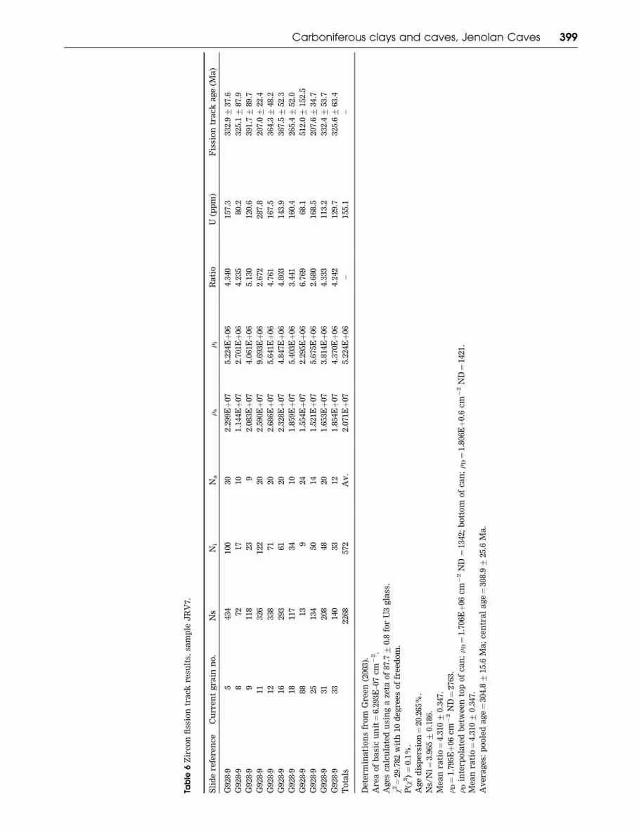
Table
6Z
irc
on
fiss
ion
tra
ck
re
sult
s,sa
mp
leJ
RV
7.
Sli
de
re
fere
nc
eC
urre
nt
gra
inn
o.
Ns
Ni
Na
�s
�i
Ra
tio
U(p
pm
)F
issi
on
tra
ck
ag
e(M
a)
G928-9
5434
100
30
2.2
99Eþ
07
5.2
24Eþ
06
4.3
40
157.3
332.9+
37.6
G928-9
872
17
10
1.1
44Eþ
07
2.7
01Eþ
06
4.2
35
80.2
325.1+
87.9
G928-9
9118
23
92.0
83Eþ
07
4.0
61Eþ
06
5.1
30
120.6
391.7+
89.7
G928-9
11
326
122
20
2.5
90Eþ
07
9.6
93Eþ
06
2.6
72
287.8
207.0+
22.4
G928-9
12
338
71
20
2.6
86Eþ
07
5.6
41Eþ
06
4.7
61
167.5
364.3+
48.2
G928-9
16
293
61
20
2.3
28Eþ
07
4.8
47Eþ
06
4.8
03
143.9
367.5+
52.3
G928-9
18
117
34
10
1.8
59Eþ
07
5.4
03Eþ
06
3.4
41
160.4
265.4+
52.0
G928-9
88
13
924
1.5
54Eþ
07
2.2
95Eþ
06
6.7
69
68.1
512.0+
152.5
G928-9
25
134
50
14
1.5
21Eþ
07
5.6
75Eþ
06
2.6
80
168.5
207.6+
34.7
G928-9
31
208
48
20
1.6
53Eþ
07
3.8
14Eþ
06
4.3
33
113.2
332.4+
53.7
G928-9
33
140
33
12
1.8
54Eþ
07
4.3
70Eþ
06
4.2
42
129.7
325.6+
63.4
To
tals
2268
572
Av
.2.0
71Eþ
07
5.2
24Eþ
06
–155.1
–
De
term
ina
tio
ns
fro
mG
re
en
(2003).
Are
ao
fb
asi
cu
nit¼
6.2
93E
–07
cm
72.
Ag
es
ca
lcu
late
du
sin
ga
zeta
of
87.7+
0.8
for
U3
gla
ss.
w2¼
29.7
82
wit
h10
de
gre
es
of
fre
ed
om
.
P(w
2)¼
0.1
%.
Ag
ed
isp
ersi
on¼
20.2
65%
.
Ns/
Ni¼
3.9
65+
0.1
86.
Me
an
ra
tio¼
4.3
10+
0.3
47.
�D¼
1.7
95Eþ
06
cm
72
ND¼
2763.
�D
inte
rp
ola
ted
be
twe
en
top
of
ca
n;�
D¼
1.7
06Eþ
06
cm
72
ND¼
1342;
bo
tto
mo
fc
an
;�
D¼
1.8
06Eþ
0.6
cm
72
ND¼
1421.
Me
an
ra
tio¼
4.3
10+
0.3
47.
Av
era
ge
s:p
oo
led
ag
e¼
304.8+
15.6
Ma
;c
en
tra
la
ge¼
308.9+
25.6
Ma
.
Carboniferous clays and caves, Jenolan Caves 399
the other specimens. The date for W5 and the two
other older dates approximate the expected age of
the volcanics of the ‘Jenolan beds’ that overlie the
Jenolan Caves Limestone. W5 could thus be a deformed
palaeokarst deposit, formed from volcaniclastics filling
a solution-enlarged joint in the limestone, and the old
fractions in samples DCH4 and JRV9 are likely to be
redeposited clasts from similar Early Devonian palaeo-
karst deposits.
While palaeokarst deposits of this age were pre-
viously unknown at Jenolan Caves, Osborne (1993b)
described volcaniclastic palaeokarst deposits at Wom-
beyan Caves (50 km south of Jenolan) in karst features
filled by ash falls of the Lower Devonian Bindook
Volcanic Complex. The volcanics of the ‘Jenolan beds’
overlying the Jenolan Caves Limestone are likely to be
of a similar age to the Bindook Volcanic Complex.
The young age (Late Permian) for JIC1 50.4 mm is for
more recently grown illite, forming fibrous growths on
older grains. The older pooled fission track age, 345.9 Ma
for nine of the 11 zircon grains tested just exceeds the
mean for the K – Ar clay dates (Figure 14). This suggests
that the clays are similar in age to their likely rock
source and are not derived from weathering of either
Early Devonian volcanics or younger Carboniferous
granites.
The two younger zircon grains (207.2 Ma) may be
either contaminants or material redeposited since the
Triassic. Their origin is not known. They may be
derived from Mesozoic dykes intersected by the caves
or possibly from unrecognised Mesozoic intrusives in
the catchment of the caves.
Do the dates make stratigraphic sense?
One check on the validity of the dates is to see if they
make stratigraphic sense. This is difficult due to the
absence of datable quantities of illite in most of the
apparently younger cave sediments.
Primary sample BR6 is overlain by an illite-bearing
stratum (J204), and there is a datable quantity of illite in
the matrix of a cobbly gravel in the west of the Temple
of Baal that appears to be younger than both BR6
and J204. This stratigraphy is generally supported by
the K – Ar dating. Both the finer fractions of J204 are
younger than BR6 by more than the errors, while the
coarse fraction of J204, which is likely to be older due to
included grains, is within errors, the same age as
BR6. The 52 mm fraction of J208A, is just older than
the 52 mm fraction of J204 but, given the errors, could
be the same age.
XRD peak width data (Table 4) showed that the illite
in J208A is significantly less ordered than that in BR6,
suggesting that the clay in J208A was redeposited. SEM
imaging of J204 and J208A (Figure 13) showed fragmen-
ted clay plates. Taken together with the XRD peak
widths and SEM images, this suggests that K – Ar
illite dates for cave clays at Jenolan make sense
stratigraphically and are not simply a product of
changes in sediment provenance. It also shows that the
combination of XRD peak width and SEM studies allows
redeposited illite to be distinguished from autochtho-
nous illite.
Implications of a mid-Carboniferousage for the primary cave samples
Osborne (1999b) postulated a 10-stage chronology for the
development of Jenolan Caves based on cross-cutting
relationships between palaeokarsts and caves, and
relationships between cave forms with different
morphologies. Cave development was thought to have
begun in the Late Carboniferous.
Field relationships suggest that primary samples,
except for W5 and JIC1, filled cavities that formed
during Phase 6, Hydrothermal Speleogenesis 2 in this
chronology. This phase was thought to have occurred
sometime between the mid-Permian and the Early
Cenozoic and probably in the Late Cretaceous, related
to a thermal event associated with the opening of the
Tasman Sea. The unexpectedly older dates raised a
number of questions: (i) what could be the source of clay
minerals and zircons of this age; (ii) were the particular
caves containing the clays really that much (almost four
times) older than had been anticipated; (iii) are there
other illite-bearing clays among the sediments in the
cave: if so are they all the same age, and if not, do their
ages make stratigraphic sense; (iv) how can the dates be
reconciled with the geological history of the Jenolan
Caves region; and (v) if the clays were dating a
hydrothermal or thermal cave-forming event, what was
the heat source?
The mid-Carboniferous ages for the illite and zircons
have significant implications for the age of the caves
themselves and for the timing of local and regional
geological events. Any explanation for the origin and
deposition of these clays must: (i) account for their high
crystallinity and the intact nature of the fibrous illite and
platelets, i.e. their lack of significant transport; (ii)
account for the presence of prismatic quartz crystals
with two rhombohedral terminations and unabraded
zircon crystals; (iii) account for the presence of clinopyr-
oxene, ilmenite, volcanic lithic fragments, and polished
quartz; (iv) include a source for the illite; and
(v) reconcile the ages of the clays and zircon grains with
a geological and geomorphological history of the region.
Given these constraints, four potential origins for the
primary cave samples and their dated Carboniferous
illite and zircon components need considering: (i) they
were produced by the weathering of local rocks, or
released by weathering from local rocks at the surface,
and later deposited in the caves; (ii) they consist of
aeolian sediment (loess) from a distant source, which
collected in the caves; (iii) they were directly precipi-
tated from fluids within the cave space; and (iv) the
clays and their sand fraction were derived from
volcaniclastics entering the caves from the surface with
the illite resulting from the alteration of feldspars and
volcanic glass in the cave environment.
Possible origins of the mid-Carboniferousclays
LOCAL SURFACE ORIGIN
There are no mid-Carboniferous (Visean – Namurian)
strata near the caves, so for the primary samples to have
400 R. A. L. Osborne et al.
a local surface source, they could: (i) have been
produced by weathering of the rocks themselves; (ii)
have formed by diagenesis in older surrounding rocks;
(iii) have been stored as detrital grains in younger rocks
and released as the host rocks weathered; or (iv) be the
remnant of a lost sequence.
The lost sequence scenario is possible, given that
Shaw and Flood (1993) considered that some 5 km of rock
was removed from the Lachlan Fold Belt during the Late
Carboniferous.
Illitic clays of mid-Carboniferous age could have
formed by diagenesis in the nearby Upper Devonian
Lambie Group sediments, although any released during
weathering would be significantly affected by transport
to the caves.
If any local surface materials were a source for the
Carboniferous clays from the caves, then they should
contain illite in the range 357 – 313 Ma with a mean near
339 Ma.
The illite in the red clay (J216) and the weathered
andesite (J221) are both too young to be a source for the
primary cave samples. The illite from the weathered
Jenolan volcanics (J220) lies at the older end of the
range and so could be a minor contributor to the cave
clays. The coarse fraction from the weathered slate
(J214) also falls within the range. Material derived from
these two sources in the caves should show signs of
transport.
With ages of 320 Ma and 327 Ma, respectively, the
most likely illite sources from the dating are the
Snapper Point Formation diamictite matrix (J213) and
the gravel matrix (J218A).
The outcrop of Snapper Point Formation is a
remnant of a larger deposit that not only blanketed the
plateau surface along the Kanangra Walls Road in the
past but also partly filled valleys in the present land-
scape. Doughty (1994) found a remnant deposit of
conglomerate in the valley of Camp Creek, 1.9 km south
of the Grand Archway. This conglomerate is similar to
the Snapper Point Formation at Kanangra Walls Road
and sits unconformably on the Jenolan Caves Lime-
stone. With a base elevation of 1040 m, the conglomerate
sits 150 m below the plateau surface, well within the
present valley of Camp Creek.
Given its similarity in composition and age, it is
possible that the J218 deposit is also a Snapper Point
Formation remnant or an exhumed cave-fill of similar
age, sitting deeply within the landscape.
SEM images of J213, J214, and J218 (Figure 13) show
scattered accumulations of plates with broken edges.
They lack the euhedral plates and articulated stacks of
plates found in the initial cave clay specimens. XRD
peak width analysis (Table 4) shows that illite in all the
potential surface sources is less ordered than all but
DCH4 and J174 of the primary cave samples. Thus,
their crystallinity alone rules out the three most likely
candidates as sources for the Carboniferous clays in the
caves.
AEOLIAN ORIGIN
Thick deposits of Pleistocene aeolian silt (‘red earth’)
occur in eastern Australian caves (Osborne 1992). The
major mineral components in these silts are kaolinite
and quartz, but some illite is present (Kiefert &
McTanish 1995). It is very likely that similar aeolian
silts were deposited in the caves during earlier periods
of glaciation, for example during the Permo-Carbonifer-
ous. One possible source for the illitic clays is loess
entering the cave entrances, being redistributed and
redeposited deep within the caves. However, the pre-
sence of highly regular unabraded clay platelets of
fibrous illite, of unabraded quartz crystals and zircons,
the SEM evidence, and XRD peak width measurements
all rule out an aeolian origin.
SUBSURFACE PRECIPITATION
Osborne (1999b), using morphological evidence, pro-
posed that the cavities in which the Carboniferous clays
occur were formed by rising thermal, hydrothermal or
artesian waters, rather than by descending meteoric
water. In this case, the clays could have been precipi-
tated in the caves by the waters that excavated them, or
by other waters rising through the cavities soon after
their excavation.
Clays formed this way would show well-ordered
crystal structures and little sign of abrasion, even under
short transport within the caves. They are likely to be
associated with other deposits of possible thermal
origin, as with the gossan-like sample from River Cave
(J174). They could well involve fluids with a low pH,
resulting in the minimal concentration of precipitated
carbonate minerals in the specimens.
The range of the dates for the primary samples
(except for the three oldest and one youngest date)
provides circumstantial support for this hypothesis
(Figure 14), as they are just older, or contemporaneous
with, the emplacement of the Bathurst Batholith
and related intrusions (Shaw & Flood 1993). Intruding
igneous rocks frequently generate both hydrothermal
fluids and thermal waters through the heating of
groundwater. This would provide a mechanism for
the excavation of the Carboniferous caves and the depo-
sition (precipitation) of the dated clays, the prismatic
quartz crystals with two rhombohedral terminations,
and the deposits of (now weathered) ferroan dolomite in
the caves. However, it does not account for the presence
of the volcaniclastic lithic fragments, pyroxene, ilme-
nite, polished quartz or zircon.
VOLCANICLASTIC ORIGIN
The similarity of the pooled age for the majority of dated
zircons to the main illite K – Ar dates for the primary
samples suggests that the zircons and the clays have
related origins. The presence of pyroclastic rock
fragments, pyroxenes and illite pseudomorphs after
feldspar in the sand fraction of many specimens
suggests a pyroclastic source. The presence of colour-
less, transparent, well-rounded to spherical quartz
grains with a high surface polish in samples O1 and
JRV7 is indicative of ablation during an explosive
volcanic event.
The likely source for the illite/kaolinite cave
deposits is volcanic ash derived from local volcanic
Carboniferous clays and caves, Jenolan Caves 401

eruptions. This would blanket the countryside and get
washed into and inundate the cave system where it
would form wet, compacted, impervious deposits. In
the cave environment, the volcanic glass, forming a
large fraction of the ash fall, would break down under
mildly acidic conditions to form a mixed-layer illite/
smectite clay mineral. Breakdown of feldspar in the
ash would form kaolinite and release potassium,
which would be incorporated into the illite structure.
Over time, maturation of the illite/smectite clay would
produce fibrous illite and eventually well-crystallised
platy illite.
The lack of any apparent sedimentary layering in the
primary samples, as well as their very small silt and fine
sand fractions, suggests that the cave system was
inundated by very fine-grained material and not by the
redeposition of detrital material.
The stacks of pseudohexagonal platy clay minerals as
well as their pristine euhedral shapes (Figure 12)
indicate that the clays were not transported by any
aerial or aquatic process but were formed in place.
Thus, the cave system must pre-date the illite. By
contrast, clay minerals of similar ages taken from
outcrops in the Jenolan neighbourhood have a very
ragged appearance (Figure 13).
Since there is no sign of transport, alteration is
favoured to have occurred where the clays now lie. The
cluster of illite dates around a mean of 339 Ma could
thus represent the in situ alteration of volcaniclastic
material to illite plus kaolinite and maturation of the
clay crystals. Alteration of volcanic glass could easily
have occurred in a cave through which thermal waters
were circulating. The volcaniclastic sediments or sedi-
ments derived from volcaniclastics would have to enter
the caves from the surface.
Since the zircon ages rule out derivation from
sediments released by weathering of the ‘Jenolan beds,’
another origin is needed. It is likely that the surface
expression of the Bathurst Batholith and related
intrusions included eruptives with significant quanti-
ties of siliceous tephra. Shaw and Flood (1993 p. 114)
noted that ‘no volcanic equivalents (of the Carbonifer-
ous intrusives) have as yet been found in the Lachlan
Fold Belt’. The Carboniferous clays in Jenolan Caves,
and possibly other similar, undated cave deposits, in
the Lachlan Fold Belt may represent traces of these
volcanics.
Such eruptives would be an ideal source of parent
material for the clays, the volcaniclastic fragments,
pyroxenes and zircons. Ash falls would blanket the
countryside, fill cave entrances and thermal lakes, and
gradually filter down through the water-filled caves.
Convecting thermal water in the caves would alter
the feldspars and glass to clay, precipitate the
quartz crystals, and inhibit the formation of graded
bedding, normally associated with deep phreatic cave
sediments.
A source of illite from the alteration of feldspars
and glass also accounts for the variation in age with
grain size among the K – Ar dates. Larger grains, as in
the case with JRV9 and DCH4 2 – 6 mm, can be of
detrital origin. Alteration and subsequent maturation
would occur over a time range, rather than at a single
time. Thus, dates for smaller grains have a range of
ages, with earlier ages indicating the minimum ages
for illite growth by alteration and later ages indicating
the minimum ages for illite growth by diagenesis and
maturation.
CONCLUSIONS—GREAT AGE OF JENOLANCAVES
Implications for the age of the caves
If the clays formed and matured in situ, then the sections
of the caves containing the Carboniferous clays are at
least 339 Ma (Visean) and may be older than 345 Ma
(Tournaisian). The distribution of these clays suggests
that much of the cave system currently visited by tourists
(including all of the cupolas and many of the passages
extending from them) originated by thermal solution in
the Carboniferous. They were not excavated in the Late
Cretaceous, as suggested by Osborne (1999b), nor in the
Pleistocene, as suggested by Sussmilch and Stone (1915).
The group of three older dates (JRV9 2 – 6 mm, DCH4
2 – 6 mm, W5) indicate the presence of a previously
unrecognised Early Devonian (pre-tectonic) palaeokarst
at Jenolan. This older palaeokarst correlates with the
Devonian volcaniclastic palaeokarst recognised at Wom-
beyan Caves by Osborne (1993b). Its presence suggests
that the unconformity, with its period of exposure and
karstification, recognised at Wombeyan before the erup-
tion of the Bindook Volcanic Complex, also occurred at
Jenolan before the eruption of the ‘Jenolan beds.’
The world’s oldest caves?
While lists of the world’s longest and deepest caves
(Gillieson 1996 p.6;Gulden 2003a, b) are regularly published
and updated, there is no comparable listing of the
world’s oldest caves. The idea of accessible caves having
geologically significant ages is relatively recent, and
there are significant problems in defining what is meant
by the age of a cave (Osborne 2000, 2002b; Bosak 2002).
While filled palaeokarst caves date back to the
Palaeoproterozoic (Martini 1981), there are few reports
of open karst caves large enough for human access older
than the Cenozoic (Table 7).
The Middle Carboniferous caves in the Black Hills of
South Dakota are described by Palmer and Palmer (2000
p. 279) as: ‘. . . mainly isolated domed chambers, rather
than continuous systems. They are rarely more than
10 m in height or more than 100 m in lateral extent’. The
Silurian caves in West Ohio described by Kahle (1988)
are small features 1.5 – 50 m across exposed in quarry
faces. Many are filled with sediment, and some are open,
although it is not completely clear if the open caves are
truly ancient in origin or are more recent features
intersecting older palaeokarst deposits.
The caves at Jenolan containing the Carboniferous
clay remnants are larger and more complex than any
other accessible Palaeozoic caves yet described, and
appear at present to be the world’s oldest caves
developed as show caves and the world’s oldest recog-
nised complex cave system accessible to humans.
402 R. A. L. Osborne et al.
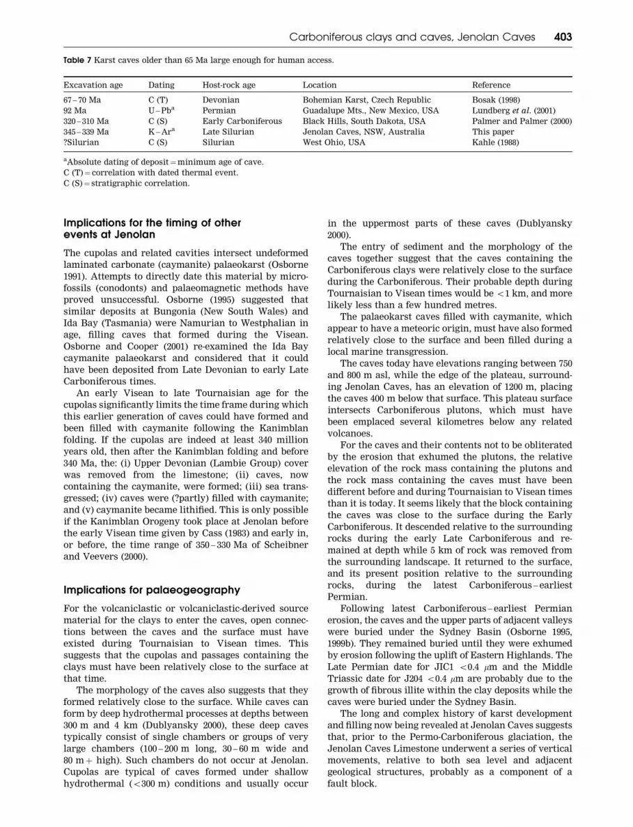
Implications for the timing of otherevents at Jenolan
The cupolas and related cavities intersect undeformed
laminated carbonate (caymanite) palaeokarst (Osborne
1991). Attempts to directly date this material by micro-
fossils (conodonts) and palaeomagnetic methods have
proved unsuccessful. Osborne (1995) suggested that
similar deposits at Bungonia (New South Wales) and
Ida Bay (Tasmania) were Namurian to Westphalian in
age, filling caves that formed during the Visean.
Osborne and Cooper (2001) re-examined the Ida Bay
caymanite palaeokarst and considered that it could
have been deposited from Late Devonian to early Late
Carboniferous times.
An early Visean to late Tournaisian age for the
cupolas significantly limits the time frame during which
this earlier generation of caves could have formed and
been filled with caymanite following the Kanimblan
folding. If the cupolas are indeed at least 340 million
years old, then after the Kanimblan folding and before
340 Ma, the: (i) Upper Devonian (Lambie Group) cover
was removed from the limestone; (ii) caves, now
containing the caymanite, were formed; (iii) sea trans-
gressed; (iv) caves were (?partly) filled with caymanite;
and (v) caymanite became lithified. This is only possible
if the Kanimblan Orogeny took place at Jenolan before
the early Visean time given by Cass (1983) and early in,
or before, the time range of 350 – 330 Ma of Scheibner
and Veevers (2000).
Implications for palaeogeography
For the volcaniclastic or volcaniclastic-derived source
material for the clays to enter the caves, open connec-
tions between the caves and the surface must have
existed during Tournaisian to Visean times. This
suggests that the cupolas and passages containing the
clays must have been relatively close to the surface at
that time.
The morphology of the caves also suggests that they
formed relatively close to the surface. While caves can
form by deep hydrothermal processes at depths between
300 m and 4 km (Dublyansky 2000), these deep caves
typically consist of single chambers or groups of very
large chambers (100 – 200 m long, 30 – 60 m wide and
80 mþ high). Such chambers do not occur at Jenolan.
Cupolas are typical of caves formed under shallow
hydrothermal (5300 m) conditions and usually occur
in the uppermost parts of these caves (Dublyansky
2000).
The entry of sediment and the morphology of the
caves together suggest that the caves containing the
Carboniferous clays were relatively close to the surface
during the Carboniferous. Their probable depth during
Tournaisian to Visean times would be 51 km, and more
likely less than a few hundred metres.
The palaeokarst caves filled with caymanite, which
appear to have a meteoric origin, must have also formed
relatively close to the surface and been filled during a
local marine transgression.
The caves today have elevations ranging between 750
and 800 m asl, while the edge of the plateau, surround-
ing Jenolan Caves, has an elevation of 1200 m, placing
the caves 400 m below that surface. This plateau surface
intersects Carboniferous plutons, which must have
been emplaced several kilometres below any related
volcanoes.
For the caves and their contents not to be obliterated
by the erosion that exhumed the plutons, the relative
elevation of the rock mass containing the plutons and
the rock mass containing the caves must have been
different before and during Tournaisian to Visean times
than it is today. It seems likely that the block containing
the caves was close to the surface during the Early
Carboniferous. It descended relative to the surrounding
rocks during the early Late Carboniferous and re-
mained at depth while 5 km of rock was removed from
the surrounding landscape. It returned to the surface,
and its present position relative to the surrounding
rocks, during the latest Carboniferous – earliest
Permian.
Following latest Carboniferous – earliest Permian
erosion, the caves and the upper parts of adjacent valleys
were buried under the Sydney Basin (Osborne 1995,
1999b). They remained buried until they were exhumed
by erosion following the uplift of Eastern Highlands. The
Late Permian date for JIC1 50.4 mm and the Middle
Triassic date for J204 50.4 mm are probably due to the
growth of fibrous illite within the clay deposits while the
caves were buried under the Sydney Basin.
The long and complex history of karst development
and filling now being revealed at Jenolan Caves suggests
that, prior to the Permo-Carboniferous glaciation, the
Jenolan Caves Limestone underwent a series of vertical
movements, relative to both sea level and adjacent
geological structures, probably as a component of a
fault block.
Table 7 Karst caves older than 65 Ma large enough for human access.
Excavation age Dating Host-rock age Location Reference
67 – 70 Ma C (T) Devonian Bohemian Karst, Czech Republic Bosak (1998)
92 Ma U – Pba Permian Guadalupe Mts., New Mexico, USA Lundberg et al. (2001)
320 – 310 Ma C (S) Early Carboniferous Black Hills, South Dakota, USA Palmer and Palmer (2000)
345 – 339 Ma K – Ara Late Silurian Jenolan Caves, NSW, Australia This paper
?Silurian C (S) Silurian West Ohio, USA Kahle (1988)
aAbsolute dating of deposit¼minimum age of cave.
C (T)¼ correlation with dated thermal event.
C (S)¼ stratigraphic correlation.
Carboniferous clays and caves, Jenolan Caves 403

Implications for other karst areas
K – Ar clay dating and zircon fission track dating has
provided new insights into cave development at Jenolan
and local and regional geological history. It has
shown that caves are a much longer-term repository
of geological information than had previously been
anticipated.
Clays, cupolas, and suspect thermal mineral deposits
occur in several cave systems in eastern Australia, some
with similar geological settings to Jenolan, as well as
in some cave systems with quite different settings
(Osborne 2002a). Further application of K – Ar and40Ar – 39Ar dating of fine-grained clay material using
micro-encapsulation techniques, fission track, and other
dating (e.g. U – Pb dating of calcite) have the potential
to reveal new geological information from the largely
unexplored bank of data within eastern Australian
caves.
ACKNOWLEDGEMENTS
A Geodiversity Research Centre Grant from the Aus-
tralian Museum Trust supported much of the research
for this paper. Sue Lindsay, Australian Museum Elec-
tron Microscopy Unit, is thanked for the SEM imaging.
Andrew Todd, CSIRO Petroleum is thanked for techni-
cal assistance during the course of the study. A
University of Sydney Faculty of Education Teaching
Relief Grant (publications) to RALO aided in compila-
tion of the paper. A grant from the Jenolan Caves
Reserve Trust funded the dating of additional surface
and cave clay samples in 2004. P. J. Osborne assisted
with field mapping and by proofreading many drafts and
revisions. The text was improved through the detailed
attention of F. L. Sutherland and from suggestions made
by anonymous referees. We would like to thank the
Jenolan Caves Reserve Trust for permitting access and
sampling from the caves and for providing accommoda-
tion and assistance during fieldwork. REP publishes
with the permission of the Australian Museum Trust.
REFERENCES
ALLAN T. L. 1986. Geology of Jenolan Caves Reserve. BSc (Hons)
thesis, University of Sydney, Sydney (unpubl.).
BONHOMME M. G., THUIZAT R., PINAULT Y., CLAUER N., WENDLING R.
& WINKLER R. 1975. Methode de Datation Potassium – Argon:
Appareillage et Technique. Universite Louis Pasteur, Strasbourg,
Notes Technique de l’Institut de Geologie 3.
BOSAK P. 1998. The evolution of karst and caves in the Koneprusy
region (Bohemian Karst, Czech Republic), Part II: hydrothermal
paleokarst. Acta Carsologica 27, 41 – 61.
BOSAK P. 2002. Karst processes from the beginning to the end:
how can they be dated. In: Gabrovsek F. ed. Evolution of
Karst: from Prekarst to Cessation, pp. 191 – 223. Zalozba ZRC,
Ljubljana.
BRUNKER R. L. & ROSE G. 1969. Sydney Basin 1:500 000 Geology Map.
New South Wales Department of Mines, Sydney.
BRYAN J. H. 1965. Sydney 1:250 000 Geological Sheet. New South Wales
Department of Mines, Sydney.
CASS R. A. F. 1983. Palaeogeographic and tectonic development of the
Lachlan Fold Belt southeastern Australia. Geological Society of
Australia Special Publication 10.
CHALKER L. E. 1971. Limestone in the Jenolan Caves area. Geological
Survey of New South Wales Records 13, 53 – 60.
CLAUER N. & CHAUDHURI S. 1995. Clays and Crustal Cycles. Springer,
Heidelberg.
DALRYMPLE G. B. & LANPHERE M. A. 1969. Potassium – Argon Dating.
W.H. Freeman. San Francisco.
DOUGHTY D. G. 1994. The stratigraphy and structure of the southern
limestone area Jenolan Caves, N.S.W. BAppSc thesis, University
of Technology, Sydney (unpubl.).
DUBLYANSKY Y. V. 2000. Hydrothermal speleogenesis—its setting and
peculiar features. In: Klimchouk A. B., Ford D. C., Palmer A. N.
& Dreybrodt W. eds. Speleogenesis, Evolution of Karst Aquifers,
pp. 292 – 297. National Speleological Society, Huntsville.
EBERL D. D. & RODO J. 1988. Ostwald ripening and interparticle-
diffraction effects for illite crystals. American Mineralogist 73,
1335 – 1345.
EBERL D. D., RODO J., KRALIK M., TAYLOR B. E. & PETERMAN Z. E.
1990. Ostwald ripening of clays and metamorphic minerals.
Science 248, 474 – 477.
FAURE G. 1986. Principles of Isotope Geology. Wiley, New York.
FORD D. C. 1995. Paleokarst as a target for modern karstification.
Carbonates and Evaporites 10, 138 – 147.
GALBRAITH R. F. 1988. Graphical display of estimates having
differing standard errors. Technometrics 20, 271 – 281.
GALBRAITH R. F. 1990. The radial plot: graphical assessment of
spread in ages. Nuclear Tracks 17, 207 – 214.
GALE S. J. 1992. Long-term landscape evolution in Australia. Earth
Surface Processes and Landforms 17, 323 – 343.
GILLIESON D. S. 1996. Caves: Process, Development, Management.
Blackwell, Oxford.
GLEADOW A. J. W., HURFORD A. J. & QUAIFE R. D. 1976. Fission track
dating of zircon: improved etching techniques. Earth and
Planetary Science Letters 33, 273 – 276.
GOSTIN V. A. & HERBERT C. 1973. Stratigraphy of the Upper
Carboniferous and Lower Permian sequence, southern Sydney
Basin. Journal of the Geological Society of Australia 20, 49 – 70.
GREEN P. F. 1981. A new look at statistics in fission track dating.
Nuclear Tracks 5, 77 – 86.
GREEN P. F. 1985. A comparison of zeta calibration baselines in
zircon sphene and apatite. Chemical Geology (Isotope Geoscience
Section) 58, 1 – 22.
GREEN P. F. 2003. Fission track dating of a zircon concentrate from
Jenolan Caves (report submitted to the Australian Museum,
March 2003) Geotrack International Ltd, Brunswick West, Geo-
track Report 872 (unpubl).
GULDEN B. 2003a. World Long Cave List. Online
5www.pipeline.com/%Ecaverbob/wlong.htm4GULDEN B. 2003b. World Deep Cave List. Online
5www.pipeline.com/%Ecaverbob/wdeep.htm4HEINRICHS H. & HERRMANN A. G. 1990. Praktikum der Analytischen
Geochemie, Springer, Berlin.
HERBERT C. 1980a. Southwestern Sydney Basin. Geological Survey of
New South Wales Bulletin 26, 82 – 99.
HERBERT C. 1980b. Evidence for glaciation in the Sydney Basin and
the Tamworth Synclinorial Zone. Geological Survey of New South
Wales Bulletin 26, 274 – 293.
HILL C. & FORTI W. 1997. Cave Minerals of the World (2nd edition).
National Speleological Society, Huntsville.
HURFORD A. J. & GREEN P. F. 1982. A user’s guide to fission track
dating calibration. Earth and Planetary Science Letters 59, 343 – 354.
HURFORD A. J. & GREEN P. F. 1983. The zeta age calibration of fission
track dating. Isotope Geoscience 1, 285 – 317.
JONES B. 1992. Caymanite, a cavity-filling deposit in the Oligocene –
Miocene Bluff Formation of the Cayman Islands. Canadian
Journal of Earth Sciences 29, 720 – 736.
KAHLE C. F. 1988. Surface and subsurface paleokarst, Silurian
Lockport, and Peebles Dolomites, Western Ohio. In: James N. P.
& Choquette P. W. eds. Paleokarst, pp. 229 – 255. Springer, New
York.
KIEFERT L. & MCTANISH G. 1995. Clay minerals in east Australian
Dust. In: Churchman G. J., Fitzpatrick R. N. & Eggleton E. A. eds.
Clays Controlling the Environment, Proceedings of the 10th
International Clays Conference, pp. 339 – 345. CSIRO Publishing,
Melbourne.
LANSON B. 1997. Decomposition of experimental X-ray diffraction
patterns (profile fitting) a convenient way to study clay minerals.
Clays and Clay Minerals 45, 132 – 146.
404 R. A. L. Osborne et al.

LIEWIG N., CLAUER N. & SOMMER F. 1987. Rb – Sr and K – Ar dating of
clay diagenesis in Jurassic sandstone oil reservoirs, North Sea.
American Association of Petroleum Geologists Bulletin 71,
1467 – 1474.
LUNDBERG J., FORD D. C. & HILL C. A. 2001. A preliminary U – Pb date
on cave spar, Big A Canyon, Guadalupe Mountains, New Mexico,
USA. Journal of Cave and Karst Studies 62, 144 – 148.
MCDOUGALL I. & ROKSANDIC Z. 1974. Total fusion 40Ar/39Ar ages
using HIFAR reactor. Journal of the Geological Society of
Australia 21, 81 – 89.
MARTINI E. J. 1981. Early Proterozoic paleokarst of the Transvaal,
South Africa. Proceedings of the 8th International Congress of
Speleology 1, 4 – 5.
MEUNIER A. & VELDE B. 2004. Illite: Origins, Evolution and
Metamorphism. Springer, Berlin.
MINGAYE C. H. 1899. On the occurrence of phosphate deposits in the
Jenolan Caves, New South Wales. Geological Survey of New
South Wales Records 6, 111 – 116.
OSBORNE R. A. L. 1991. Palaeokarst deposits at Jenolan Caves, N.S.W.
Journal and Proceedings of the Royal Society of New South Wales
123, 59 – 73.
OSBORNE R. A. L. 1992. Australian red earth and bones. Journal
and Proceedings of the Royal Society of New South Wales 125,
111.
OSBORNE R. A. L. 1993a. Geological Note: Cave formation by exhuma-
tion of Palaeozoic palaeokarst deposits at Jenolan Caves, New
South Wales. Australian Journal of Earth Sciences 40, 591 – 593.
OSBORNE R. A. L. 1993b. The history of karstification at Wombeyan
Caves, New South Wales, Australia, as revealed by palaeokarst
deposits. Cave Science 20, 1 – 8.
OSBORNE R. A. L. 1995. Evidence for two phases of Late Palaeozoic
karstification, cave development and sediment filling in south-
eastern Australia. Cave and Karst Science 22, 39 – 44.
OSBORNE R. A. L. 1999a. The inception horizon hypothesis in vertical
to steeply-dipping limestone: applications in New South Wales,
Australia. Cave and Karst Science 26, 5 – 12.
OSBORNE R. A. L. 1999b. The origin of Jenolan Caves: elements of a
new synthesis and framework chronology. Proceedings of the
Linnean Society of New South Wales 121, 1 – 27.
OSBORNE R. A. L. 2000. Paleokarst and its significance for spele-
ogenesis. In: Klimchouk A. B., Ford D. C., Palmer A. N. &
Dreybrodt W. eds. Speleogenesis, Evolution of Karst Aquifers,
pp. 113 – 123. National Speleological Society, Huntsville.
OSBORNE R. A. L. 2002a. The new science of Australian caves:
implications for management and interpretation. Proceedings of
the 14th Australasian Conference on Cave & Karst Management,
2 – 7.
OSBORNE R. A. L. 2002b. Paleokarst: cessation and rebirth? In:
Gabrovsek F. ed. Evolution of Karst: from Prekarst to Cessation,
pp. 97 – 114. Zalozba ZRC, Ljubljana.
OSBORNE R. A. L. 2004. The troubles with cupolas. Acta Carsologica
33, 9 – 36.
OSBORNE R. A. L. & COOPER I. B. 2001. Sulfide-bearing palaeokarst
deposits at Lune River Quarry, Ida Bay, Tasmania. Australian
Journal of Earth Sciences 48, 401 – 416.
PALMER A. N. & PALMER M. V. 2000. Speleogenesis of the Black Hills
Maze Caves, South Dakota, USA. In: Klimchouk A. B., Ford D. C.,
Palmer A. N. & Dreybrodt W. eds. Speleogenesis, Evolution of
Karst Aquifers, pp. 274 – 281. National Speleological Society,
Huntsville.
POLYAK V. J., MCINTOSH W. C., GUVEN N. & PROVENCIO P. 1998. Age
and origin of Carlsbad Cavern and related caves from 40Ar/30Ar
of alunite. Science 279, 1919 – 1922.
SCHEIBNER E. & VEEVERS J. J. 2000. Tasman Fold Belt System. In:
Veevers J. J. ed. Billion year Earth History of Australia and
Neighbours in Gondwanaland, pp. 154 – 234. GEMOC Press,
Sydney.
SHAW S. E. & FLOOD R. H. 1993. Carboniferous magmatic activity in
the Lachlan and New England Fold belts. In: Flood P. G. &
Aitchison J. C. eds. New England Orogen Eastern Australia,
pp. 113 – 121. Department of Geology and Geophysics, University
of New England, Armidale.
STANLEY G. A. V. 1923. Note on the thickness of the Jenolan Caves
Limestone. Sydney University Science Journal, 34 – 35.
STEIGER R. H. & JAGER E. 1977. Subcommission on Geochronology:
convention on the use of decay constants in geo- and
cosmochronology. Earth and Planetary Science Letters 36,
359 – 362.
SUSSMILCH C. A. & STONE W. G. 1915. Geology of the Jenolan Caves
district. Journal and Proceedings of the Royal Society of New
South Wales 49, 144 – 148.
TAYLOR J. C. 1991. Computer programs for standardless quantitative
analysis of minerals using the full powder diffraction profile.
Powder Diffraction 6, 2 – 9.
TAYLOR J. C. & CLAPP R. A. 1992. New features and advanced
applications of SIROQUANT: a personal computer XRD
full profile quantitative analysis software package. Advances in
X-ray Analysis 35, 49.
TRICKETT O. 1925. The Jenolan Caves, New South Wales (map),
Government Tourist Bureau, Sydney.
VEEVERS J. J. 2000. Time Scale. In: Veevers J. J. ed. Billion-year
Earth History of Australia and Neighbours in Gondwanaland,
pp. 3 – 5. GEMOC Press, Sydney.
WELLMAN P. & MCDOUGALL I. 1974. Potassium – argon ages on the
Cainozoic volcanic rocks of New South Wales. Journal of the
Geological Society of Australia 21, 247 – 272.
YOUNG R. W. 1977. Landscape development in the Shoalhaven River
catchment of southeastern New South Wales. Zeitschrift fur
Geomorphologie NF 21, 262 – 283.
YOUNG R. W. 1982. The tempo of geomorphological change: evidence
from southeastern Australia. Journal of Geology 91, 211 – 230.
Received 13 April 2005; accepted 17 October 2005
Carboniferous clays and caves, Jenolan Caves 405
