bard college - town of red hook
TRANSCRIPT

BARD COLLEGECAMPUS MASTER PLANSEPTEMBER 2017
ACKNOWLEDGEMENTS
Bard College
Leon Botstein President James Brudvig Chief Financial Officer Coleen Murphy Alexander Vice President for Administration Chuck Simmons Project Manager
Master Planning Team
Perkins+Will Architects / Master Planners SCAPE Landscape Architects Morris Engineers Civil Engineers Hudson & Pacific Designs Historic / Cultural Landscape Consultants
2 BARD COLLEGE MASTER PLAN
INTRODUCTION 4
PURPOSE 12
ORGANIZATION 14
CAMPUS MASTER PLAN 16
CAMPUS-WIDE PLANNING CONSIDERATIONS 20
PROJECT IDENTIFICATION 68NEAR-TERM PROJECTS 70
MID-TERM PROJECTS 92
LONG-TERM IDEAS 116
BARD COLLEGE CAMPUS MASTER PLAN SEPTEMBER 2017
// 3
4 BARD COLLEGE MASTER PLAN
INTRODUCTION
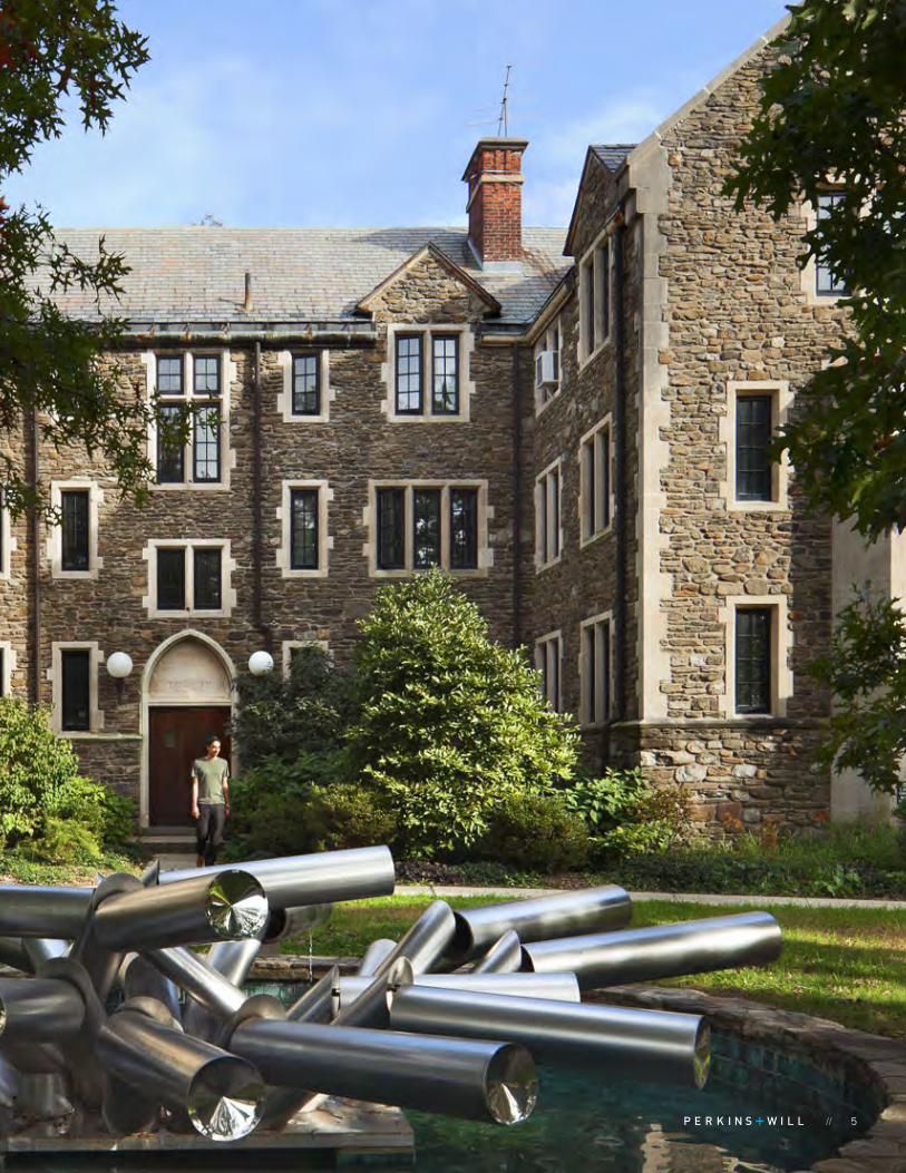
Bard College, located in Red Hook, NY and founded in 1860, is one of the most innovative and highly-ranked liberal arts colleges in the nation. To maintain its academic excellence, support the student experience and remain a vital part of its local community, Bard is preparing to upgrade and expand its campus facilities. The College also aims to integrate Montgomery Place into its campus while preserving this nationally significant, 380-acre historic site, it acquired in January 2016.
To provide assistance in funding some of these measures, Bard is submitting an application to the United States Department of Agriculture (USDA) Rural Community Development Program for financing. This application requires a Master Plan, approved by the Town of Red Hook.
This Campus Master Plan summarizes projects completed since the last Master Plan Update and describes currently planned and future projects within a 10-year planning horizon. The Master Plan also assesses a number of campus-wide considerations and summarizes the College’s approach to each for long-term planning purposes, including a planning framework to integrate the Montgomery Place property into the overall campus.
Bard College Campus Master Plan follows a 2012 Amendment to the Bard College Master Plan, prepared by Morris Associates, which documented a planned baseball field. The Amendment referenced the November 2004 Campus Master Plan Update, Bard College, prepared by Buckhurst, Fish & Jacquemart, Inc. This focused on projects completed since 1997 and included a number of Near-Term and Mid-Term Project Descriptions and Long-Term Project Ideas, some of which have been implemented.
The 2004 Campus Master Plan Update builds on and references a comprehensive, original Master Plan in 1989 by Hudson & Pacific Designs, Inc. and its subsequent update in 1997. A DEIS was completed in 1998, covering both the Generic EIS for the Master Plan and the site-specific EIS on plans for the Performing Arts Center.
Since these plan updates have been incremental, and because Bard has evolved considerably in enrollment, land and facilities since the last comprehensive Master Plan, it is timely for the College to conduct a more broad-based Campus Master Plan at this time.
COLLEGE MISSIONCAMPUS MASTER PLAN OVERVIEW
Bard College seeks to inspire curiosity, a love of learning, idealism, and a commitment to the link between higher education and civic participation. The undergraduate curriculum is designed to address central questions facing new generations, and reshapes traditional disciplines into multidisciplinary fields and programs. Students pursue a rigorous course of study reflecting varied traditions of scholarship, research, speculation, and artistic expression. They engage philosophies of human existence, theories of human behavior and society, the making of art, and the study of science, nature, and history.
Bard’s approach to learning focuses on the individual and is structured around small group seminars to encourage thoughtful discourse. Faculty are active in their fields and stress the connection between life inside and outside of the classroom. They strive to foster critical inquiry, intellectual ambition, and creativity.
Bard acts at the intersection of education and civil society. Through its undergraduate college, its distinctive graduate programs, its commitment to the fine and performing arts, and its network of international dual-degree partnerships, early colleges, prison education initiatives, and public engagement programs, Bard offers unique opportunities for students and faculty to study, experience, and realize the principle that higher-education institutions can and should operate in the public interest.
COLLEGE ECONOMIC IMPACT
The 2015 Economic Impact Study for Bard, prepared by the Independent Commission on Private Colleges and Universities in New York, estimates that the College had $165,200,000 total in direct spending and a grand total economic impact (direct and spillover) of $393,600,000.
// 5
6 BARD COLLEGE MASTER PLAN
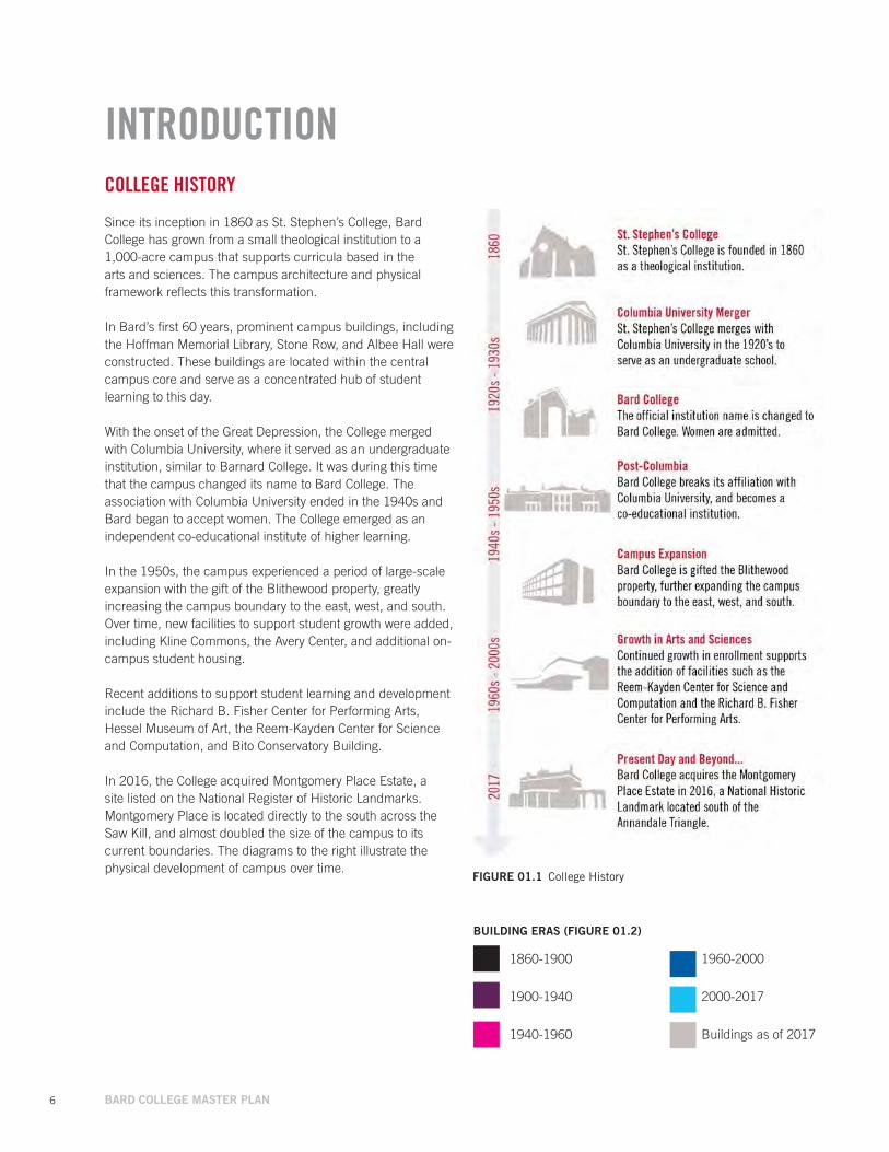
FIGuRE 01.1 College History
COLLEGE HISTORY
Since its inception in 1860 as St. Stephen’s College, Bard College has grown from a small theological institution to a 1,000-acre campus that supports curricula based in the arts and sciences. The campus architecture and physical framework reflects this transformation.
In Bard’s first 60 years, prominent campus buildings, including the Hoffman Memorial Library, Stone Row, and Albee Hall were constructed. These buildings are located within the central campus core and serve as a concentrated hub of student learning to this day.
With the onset of the Great Depression, the College merged with Columbia University, where it served as an undergraduate institution, similar to Barnard College. It was during this time that the campus changed its name to Bard College. The association with Columbia University ended in the 1940s and Bard began to accept women. The College emerged as an independent co-educational institute of higher learning.
In the 1950s, the campus experienced a period of large-scale expansion with the gift of the Blithewood property, greatly increasing the campus boundary to the east, west, and south. Over time, new facilities to support student growth were added, including Kline Commons, the Avery Center, and additional on-campus student housing.
Recent additions to support student learning and development include the Richard B. Fisher Center for Performing Arts, Hessel Museum of Art, the Reem-Kayden Center for Science and Computation, and Bito Conservatory Building.
In 2016, the College acquired Montgomery Place Estate, a site listed on the National Register of Historic Landmarks. Montgomery Place is located directly to the south across the Saw Kill, and almost doubled the size of the campus to its current boundaries. The diagrams to the right illustrate the physical development of campus over time.
1960-2000
2000-2017
Buildings as of 2017
BuILDING ERAS (FIGuRE 01.2)
INTRODUCTION
1860-1900
1900-1940
1940-1960

// 7
Anna
ndal
e Rd
High
way 9
G
Kelly Road
FIGuRE 01.2 Historic Campus Evolution
1860-1900
1940-1960
1960-2000
2000 - 20171900-1940
Rive
r Rd
Anna
ndal
e Rd
High
way 9
G
Anna
ndal
e Rd
High
way 9
G
STONE ROW
LIBRARY
BLITHEWOOD
CHAPEL
HOPSON COTTAGE
WARD MANOR
ROBBINS HOuSE
PRESIDENT’S HOuSE
HENDERSON
OLD GYM
TEWKSBuRY
LuDLOW
CRuGER VILLAGE
AVERY ARTS CENTER
STEVENSON GYM
CAMPuS CENTERALuMNI HOuSES
LIBRARY
KLINE
OLIN
FISHER CENTER
CENTER FOR SCIENCE AND COMPuTATION
RESNICK COMMONS
FISHER STuDIO ARTS BuILDING
BITO CONSERVATORY
BuILDING
HESSEL MuSEuM OF ART
8 BARD COLLEGE MASTER PLAN
Tivoli Bays
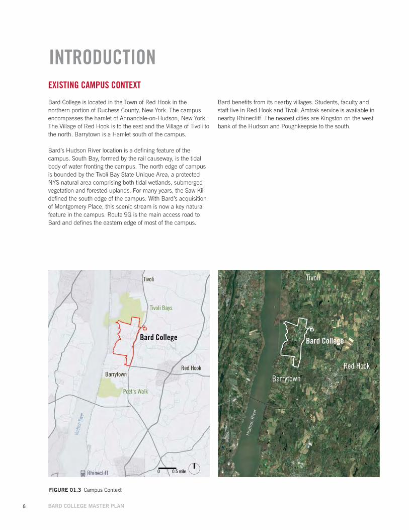
EXISTING CAMPUS CONTEXT
Bard College is located in the Town of Red Hook in the northern portion of Duchess County, New York. The campus encompasses the hamlet of Annandale-on-Hudson, New York. The Village of Red Hook is to the east and the Village of Tivoli to the north. Barrytown is a Hamlet south of the campus.
Bard’s Hudson River location is a defining feature of the campus. South Bay, formed by the rail causeway, is the tidal body of water fronting the campus. The north edge of campus is bounded by the Tivoli Bay State Unique Area, a protected NYS natural area comprising both tidal wetlands, submerged vegetation and forested uplands. For many years, the Saw Kill defined the south edge of the campus. With Bard’s acquisition of Montgomery Place, this scenic stream is now a key natural feature in the campus. Route 9G is the main access road to Bard and defines the eastern edge of most of the campus.
FIGuRE 01.3 Campus Context
INTRODUCTION
Hud
son
Riv
er
Bard College
Tivoli
Red Hook
Barrytown
Bard benefits from its nearby villages. Students, faculty and staff live in Red Hook and Tivoli. Amtrak service is available in nearby Rhinecliff. The nearest cities are Kingston on the west bank of the Hudson and Poughkeepsie to the south.

// 9
Huds
on R
iver
Tivoli Bays
Montgomery Place
South BayKe
lly Rd
Rive
r Rd
High
way 9
G
High
way 9
G
Barrytown Rd
Annandale Rd
Annandale Rd
Main Campus
Cam
pus
Rd
Whalesback Rd
Saw Kill
Red Hook
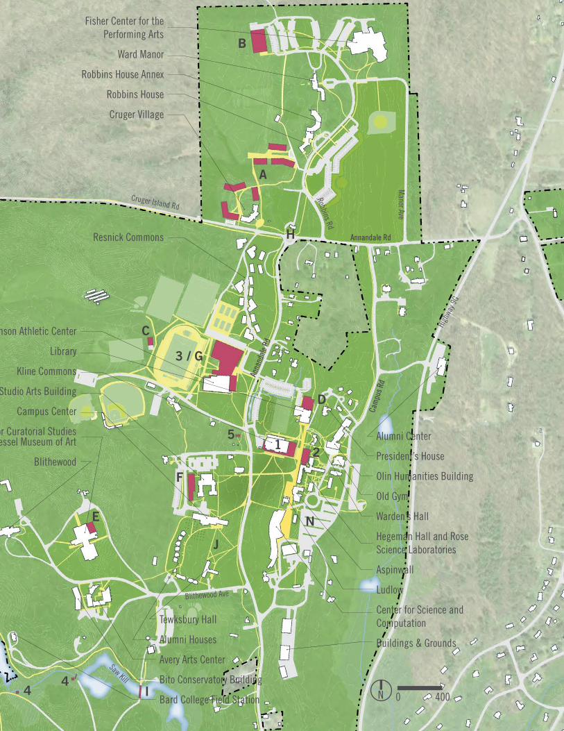
Refer to Figure 01.5 The Main Campus Today
FIGuRE 01.4 The Campus Today
10 BARD COLLEGE MASTER PLAN
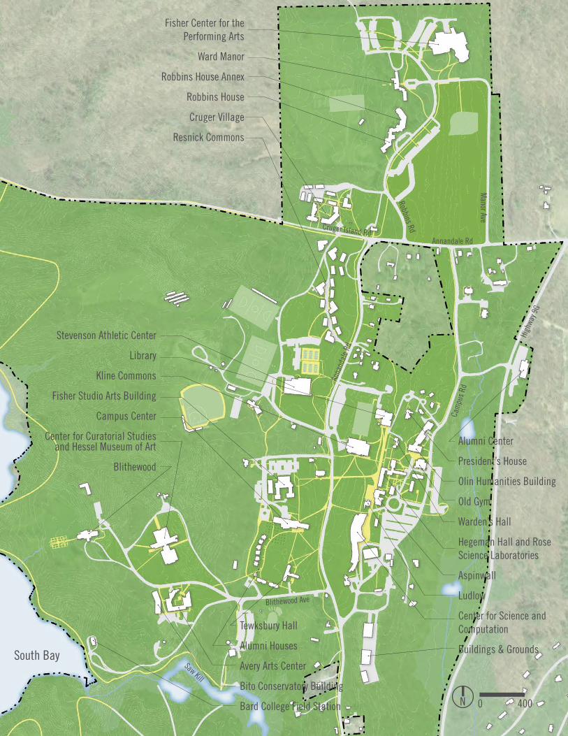
FIGuRE 01.5 The Main Campus Today
South Bay
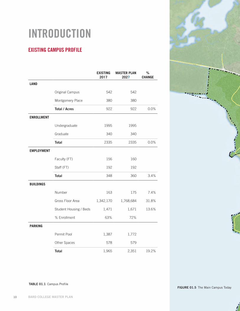
INTRODUCTIONEXISTING CAMPUS PROFILE
EXISTING 2017
MASTER PLAN 2027
% CHANGE
LAND
Original Campus 542 542
Montgomery Place 380 380
Total / Acres 922 922 0.0%
ENROLLMENT
Undergraduate 1995 1995
Graduate 340 340
Total 2335 2335 0.0%
EMPLOYMENT
Faculty (FT) 156 160
Staff (FT) 192 192
Total 348 360 3.4%
BUILDINGS
Number 163 175 7.4%
Gross Floor Area 1,342,170 1,768,684 31.8%
Student Housing / Beds 1,471 1,671 13.6%
% Enrollment 63% 72%
PARKING
Permit Pool 1,387 1,772
Other Spaces 578 579
Total 1,965 2,351 19.2%
TABLE 01.1 Campus Profile
// 11
FIGuRE 01.5 The Main Campus Today
Annandale Rd
Stevenson Athletic Center
Library
Kline Commons
Fisher Studio Arts Building
Campus Center
Center for Curatorial Studies and Hessel Museum of Art
BlithewoodCa
mpu
s Rd
South BaySaw Kill
Anna
ndal
e Rd
High
way 9
G
Alumni Center
President’s House
Olin Humanities Building
Old Gym
Warden’s Hall
Hegeman Hall and Rose Science Laboratories
Aspinwall
Ludlow
Center for Science and Computation
Buildings & Grounds
Fisher Center for the Performing Arts
Ward Manor
Robbins House Annex
Robbins House
Cruger Village
Resnick Commons
Blithewood Ave
Manor Ave
Robbins RdCruger Island Rd
0 400N
Tewksbury Hall
Alumni Houses
Avery Arts Center
Bito Conservatory Building
Bard College Field Station
12 BARD COLLEGE MASTER PLAN
PURPOSE OF THE MASTER PLAN
The Campus Master Plan will serve multiple purposes that benefit the College, its students, faculty and staff, as well as the Town of Red Hook and the regional community.
• Provide the Town of Red Hook Planning Board with information on the College’s near-term and mid-term plans sufficient for review, comment, SEQR, and approval of the Campus Master Plan under the Special Permit for educational campuses. The special permit is contingent on the College obtaining any necessary variances.
• Provide Bard with an updated and forward-thinking campus “Owner’s Manual” for development and stewardship to support its mission.
• Support Bard’s USDA Rural Community Development Program application.
• Update the existing campus map, including projects completed since the 2004 Master Plan update.
• Locate and describe the general characteristics of projects currently in planning phases for the USDA application.
• Summarize other Mid-Projects and Long-Term Ideas that would be implemented when funded.
• Identify Bard facilities that are shared with the Red Hook community.
• Summarize a Planning Framework for the stewardship and use of Montgomery Place.
• Identify other historic resources for continued preservation and stewardship.
• Assess access, circulation and parking and identify strategies for improvements.
• Identify facility planning factors, including enrollment and campus housing.
// 13

14 BARD COLLEGE MASTER PLAN
ORGANIZATION OF THE MASTER PLAN
The balance of the Campus Master Plan is organized in three parts, as follows.
Campus Master Plan Map
A Site Plan shows location of intended projects and any building, circulation, and open space improvements related to Near-Term Projects.
Campus-Wide Planning Considerations
Campus-wide planning considerations are examined through a series and maps and narrative descriptions. In this section, existing conditions systems are mapped and any interventions planned as part of the Near-Term Projects are highlighted.
ο Enrollment ο Future Program Expansion ο Projects Completed Since 2004 ο Montgomery Place ο Zoning Districts ο Campus Preservation & Historic Designations ο Area and Bulk Analysis ο Campus Landscaping ο Building Uses ο Facilities with Public Access ο Student Housing ο Campus Entrances ο Parking ο Circulation ο Campus Infrastructure Analysis ο Sustainability ο Campus Lighting
Project Identification
Near-Term Projects The five Near-Term Projects, listed below, are currently in conceptual design. The Campus Master Plan includes a summary description of each project’s goals, location, orientation, use, and scale. Concept-level plans, site plans and preliminary views are also included.
ο Kline Commons Renovation and Expansion ο Digital Science Commons ο Campus and Community Recreational Facilities, Phase 1
ο Micro Hydropower on the Saw Kill ο Bard Media Lab ο Campus Infrastructure Analysis
Mid-Term Projects Mid-Term Projects have yet to begin the design process. Project intent and scale are described in narrative form. General projects location, or candidate locations on campus are also identified. It is expected the Mid-Term Projects would be completed within 5-10 years of this Master Plan. Included are:
ο Student Housing ο North Campus Live Arts Building ο Relocated Student Performance Space ο Library Expansion ο Center for Curatorial Studies Collection Expansion ο MFA Studio Building ο Campus and Community Recreational Facilities, Phase 2
ο Intersection Improvements at Cruger Island Road and Annandale Road
ο Pedestrian Bridge to Montgomery Place ο Campus Infrastructure Analysis
Long-Term Ideas Long-Term Project ideas are similarly conceptual and are described in same format as Mid-Term Projects. Long-Term Ideas are expected to be completed in 10 or more years of the Master Plan. Included are:
ο Additional Student Housing ο Stephen Shore Photography Archive ο College Inn ο Main Lot Expansion ο Center for Environmental Studies ο Montgomery Place Collection Facility ο Campus Infrastructure Analysis
// 15
16 BARD COLLEGE MASTER PLAN
CAMPUS MASTER PLAN
FIGuRE 01.6 Campus Master Plan
Near-Term ProjectsDesign in Progress1. Kline Commons Renovation and Expansion
2. Digital Science Commons
3. Campus and Community Recreational Facilities, Phase 1
4. Micro Hydropower on the Saw Kill
5. Bard Media Lab
Mid-Term Projects Within 5 Years
A Student Housing
B North Campus Live Arts Building
C Relocated Student Performance Space
D Library Expansion
E Center for Curatorial Studies Collection Expansion
F MFA Studio Building
G Campus and Community Recreational Facilities, Phase 2
H Intersection Improvements at Cruger Island Road and Annandale Road
I Pedestrian Bridge to Montgomery Place
The 2017 Campus Master Plan locates the five Near-Term Projects currently in conceptual design and select Mid- and Long-Term Ideas where the location is known.
Tivoli Bays
Long-Term IdeasWithin 10 or More Years
J Additional Student Housing
K Montgomery Place Collection Facility
L Stephen Shore Photography Archive (Not Shown on Plan)
M College Inn
N Main Lot Expansion
O Center for Environmental Studies (Not Shown on Plan)

// 17
1
3 / G
2
K
B
D
F
A
Huds
on R
iver
Montgomery Place
South Bay
Kelly Rd
Rive
r Rd
Barrytown Rd
Annandale Rd
Annandale Rd
Cam
pus
Rd
Whalesback Rd
High
way 9
G
High
way 9
G
Saw Kill
I
Tivoli Bays
H
E
M
Refer to Figure 01.7 Main Campus Master Plan
5
4 4
4
C
J
J
N

18 BARD COLLEGE MASTER PLAN FIGuRE 01.7 Main Campus Master Plan
South Bay
CAMPUS MASTER PLAN
Near-Term ProjectsDesign in Progress1. Kline Commons Renovation and Expansion
2. Digital Science Commons
3. Campus and Community Recreational Facilities, Phase 1
4. Micro Hydropower on the Saw Kill
5. Bard Media Lab
Mid-Term Projects Within 5-10 Years
A Student Housing
B North Campus Live Arts Building
C Relocated Student Performance Space
D Library Expansion
E Center for Curatorial Studies Collection Expansion
F MFA Studio Building
G Campus and Community Recreational Facilities, Phase 2
H Intersection Improvements at Cruger Island Road and Annandale Road
I Pedestrian Bridge to Montgomery Place
Long-Term IdeasIn 10 or More Years
J Additional Student Housing
K Montgomery Place Collection Facility (not pictured)
L Stephen Shore Photography Archive (not pictured)
M College Inn (not pictured)
N Main Lot Expansion
O Center for Environmental Studies (not pictured)
The 2017 Campus Master Plan locates the three Near-Term Projects currently in conceptual design and select Mid- and Long-Term Ideas where the location is known.
South Bay
Stevenson Athletic Center
Library
Kline Commons
Fisher Studio Arts Building
Campus Center
Center for Curatorial Studies and Hessel Museum of Art
Blithewood
5
// 19FIGuRE 01.7 Main Campus Master Plan
Annandale Rd
Cam
pus R
d
South Bay
Saw Kill
Anna
ndal
e Rd
Annandale Rd
Cam
pus R
d
South Bay
Anna
ndal
e Rd
High
way 9
G
Blithewood Ave
Manor Ave
Robbins Rd
Cruger Island Rd
1
3 / G
2
B
C
D
A
I
F
H
0 400N
Stevenson Athletic Center
Library
Kline Commons
Fisher Studio Arts Building
Campus Center
Center for Curatorial Studies and Hessel Museum of Art
Blithewood
Fisher Center for the Performing Arts
Ward Manor
Robbins House Annex
Robbins House
Cruger Village
Tewksbury Hall
Alumni Houses
Avery Arts Center
Bito Conservatory Building
Bard College Field Station
Alumni Center
President’s House
Olin Humanities Building
Old Gym
Warden’s Hall
Hegeman Hall and Rose Science Laboratories
Aspinwall
Ludlow
Center for Science and Computation
Buildings & Grounds
5
4
E
J
Resnick Commons
N
4

20 BARD COLLEGE MASTER PLAN
CAMPUS-WIDEPLANNINGCONSIDERATIONS

// 21
Enrollment
Future Program Expansion
Projects Completed Since 2004
Montgomery Place
Zoning Districts
Campus Preservation & Historic Designations
Area and Bulk Analysis
Campus Landscaping
Building uses
Facilities with Public Access
Student Housing
Campus Entrances
Parking
Circulation
Campus Infrastructure Analysis
Sustainability
Campus Lighting
CAMPUS-WIDEPLANNINGCONSIDERATIONS
22 BARD COLLEGE MASTER PLAN
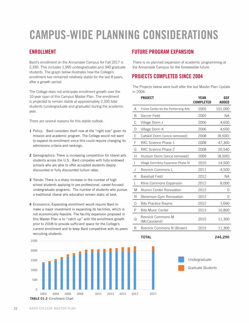
CAMPUS-WIDE PLANNING CONSIDERATIONSENROLLMENT
Bard’s enrollment on the Annandale Campus for Fall 2017 is 2,335. This includes 1,995 undergraduates and 340 graduate students. The graph below illustrates how the College’s enrollment has remained relatively stable for the last 8 years, after a growth period.
The College does not anticipate enrollment growth over the 10-year span of this Campus Master Plan. The enrollment is projected to remain stable at approximately 2,335 total students (undergraduate and graduate) during the academic year.
There are several reasons for this stable outlook.
1 Policy: Bard considers itself now at the “right size” given its mission and academic program. The College would not want to expand its enrollment since this could require changing its admissions criteria and rankings.
2 Demographics: There is increasing competition for liberal arts students across the U.S. Bard competes with fully endowed schools who are able to offer accepted students deeply discounted or fully discounted tuition rates.
3 Trends: There is a sharp increase in the number of high school students applying to pre-professional, career-focused undergraduate programs. The number of students who pursue a traditional liberal arts education remain static at best.
4 Economics: Expanding enrollment would require Bard to make a major investment in expanding its facilities, which is not economically feasible. The facility expansion proposed in this Master Plan is to “catch up” with the enrollment growth prior to 2008 to provide sufficient space for the College’s current enrollment and to keep Bard competitive with its peers recruiting students.
PROJECTS COMPLETED SINCE 2004
The Projects below were built after the last Master Plan Update in 2004.
FUTURE PROGRAM EXPANSION
There is no planned expansion of academic programming at the Annandale Campus for the foreseeable future.
BARD COLLEGE / CAMPUS MASTER PLAN 6/17/17
CAMPUS-WIDE PLANNING CONSIDERATIONS DRAFT – for review and comment
Enrollment
Bard’s enrollment on the Annandale Campus for Fall 2017 is 2,335. This includes 1,995 undergraduates and 340 graduate students. The graph below illustrates how the College’s enrollment has remained relatively stable for the last 8 years, after a growth period.
The College does not anticipate enrollment growth over the 10-year span of this Campus Master Plan. The enrollment is projected to remain stable at approximately 2,335 total students (undergraduate and graduate) during the academic year.
There are several reasons for this stable outlook.
Policy: Bard considers itself now at the right size given its mission and academic program.
Demographics: There are fewer prospective students in the nation and in Bard’s region in the coming 10 years. There will be more competition for these students. The College would not want to expand its enrollment since this could require changing its admissions criteria and rankings.
Trends: Fewer students have been applying to Liberal Arts Colleges relative to increased applications at institutions with more career-focused programs.
Economics: Expanding enrollment would require Bard to make a major investment in expanding its facilities, which is not economically feasible. The facility expansion proposed in this Master Plan is to “catch up” with the enrollment growth prior to 2008 to provide sufficient space for the College’s current enrollment and to keep Bard competitive with its peers recruiting students.
0
500
1000
1500
2000
2500
2002 2004 2006 2008 2011 2013 2015 2017 2027
Enrollment
Undergraduate Graduate StudentsTABLE 01.2 Enrollment Chart
Undergraduate
Graduate Students
PROJECT YEAR COMPLETED
GSFADDED
A Fisher Center for the Performing Arts 2005 101,000
B Soccer Field 2005 NA
C Village Dorm J 2006 4,650
D Village Dorm K 2006 4,650
E Catskill Dorm [since removed] 2008 [8,500]
F RKC Science Phase 1 2008 47,360
G RKC Science Phase 2 2008 20,540
H Hudson Dorm [since removed] 2009 [8,500]
I Village Dormitory Expansion Phase IV 2010 14,500
J Resnick Commons L 2011 4,500
K Baseball Field 2012 NA
L Kline Commons Expansion 2012 8,000
M Alumni Center Renovation 2012 0
N Stevenson Gym Renovation 2012 0
O Bito Practice Rooms 2012 1,690
P Bito Music Center 2013 16,800
QResnick Commons M (McCausland)
2015 11,300
R Resnick Commons N (Brown) 2015 11,300
TOTAL 246,290

// 23FIGuRE 01.8 Projects Completed Since 2004
A
L
M
N, O
C, D, I, J, Q, R
O
E, H
0 400N
P
NK
B
24 BARD COLLEGE MASTER PLAN
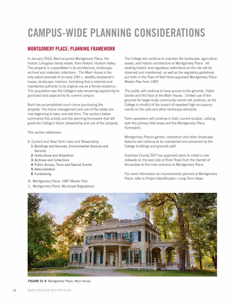
CAMPUS-WIDE PLANNING CONSIDERATIONSMONTGOMERY PLACE: PLANNING FRAMEWORK
In January 2016, Bard acquired Montgomery Place, the historic Livingston family estate, from Historic Hudson Valley. The property is unparalleled in its architecture, landscape, archival and materials collections. The Main House is the only extant example of an early 19th c. wealthy landowner’s house, landscape, interiors, furnishing that is retained and maintained authentic to its original use as a family residence. This acquisition was the College’s sole remaining opportunity to purchase land adjacent to its current campus.
Bard has accomplished much since purchasing the property. The future management and use of the estate are now beginning to take concrete form. The sections below summarize this activity and the planning framework that will guide the College’s future stewardship and use of the property.
This section addresses:
A. Current and Near-Term Uses and Stewardship1 Buildings and Grounds, Environmental Services and
Security2 Horticulture and Arboretum3 Archives and Collections4 Public Access, Tours and Special Events5 Administration6 Fundraising
B. Montgomery Place: 1987 Master PlanC. Montgomery Place: Municipal Regulations
The College will continue to maintain the landscape, agriculture assets, and historic architecture at Montgomery Place. All existing historic and regulatory restrictions on the site will be observed and maintained, as well as the regulatory guidelines put forth in the Town of Red Hook-approved Montgomery Place Master Plan from 1987.
The public will continue to have access to the grounds, Visitor Center and first floor of the Main House. Limited use of the grounds for larger-scale community events will continue, as the College is mindful of the impact of repeated high-occupancy events on the soils and other landscape elements.
Farm operations will continue in their current location, utilizing both the primary field areas and the Montgomery Place Farmstand.
Montgomery Place’s garden, arboretum and other landscape features will continue to be maintained and preserved by the College buildings and grounds staff.
Dutchess County DOT has approved plans to install a new sidewalk on the east side of River Road from the Hamlet of Annandale to the main entrance to Montgomery Place.
For more information on improvements planned at Montgomery Place, refer to Project Identification / Long-Term Ideas.
FIGuRE 01.9 Montgomery Place, Main House
// 25
MONTGOMERY PLACE
Buildings and Grounds, Environmental Services and Security Significant capital improvements and maintenance projects completed by Bard since the acquisition include:
• Installation of a new phone control center at the Coach house and new / improved internet service to the Coach House, Greenhouse, Squash Court, Thompson House and Butler Building.
• Squash Court: Complete renovation• Major renovations:
ο Main House: Completed extensive Existing Conditions report, installed crack monitors to track building movement, replaced gutters, installed chimney caps and restored select window shutters in accordance with historic guidelines. Compliance with Fire code regulations are in process.
ο Butler Building South completed extensive cleaning, painting and upgrading space to accommodate housing the Archives and selected collection materials. Included installation of extensive shelving systems, replaced boiler, installed new propane tanks, new gutters and de-humidification unit.
ο Visitor Center weatherized to house BPI book stock and upgrade bathrooms to be used year round.
ο Coach House basement completed electrical upgrades and installed generator system to support the phone switch and other nearby buildings.
• Additional renovations: ο Property-wide improvements made to all roads including managing storm water, improved signage, re-paved asphalt curtain at front gate.
ο Gardeners Cottage installed a new septic and leach field system, replaced bluestone walkway, painted and refinished floors throughout.
ο Thompson House upgraded appliances, repaired roof, porch and gutters, and insulated basement and attic.
ο Annandale Road Cottages installed lighting and signage for First Responders.
ο Modular House installed new boiler and well pump, resurfaced gravel driveway.
Horticulture and Arboretum Bard’s horticulture grounds crew has maintained the property to the same peak standards as the main Bard campus. The College’s intent is to continue this level of stewardship. Work completed since January 2016 includes:
• Removed dead and dying trees from the grounds and Farm stand, and invasive trees and vines from Visitor Parking lot, cleared and cleaned woods at main gate, and began replanting of the historic rose garden.
• Completed an Existing Conditions Report on the greenhouse and received a $100,000 grant for the restoration of the building; restoration is currently underway and completion date is April 2017.
• Measured and verified with DEC there are 5 trees that are distinguished as “New York State Big Trees”
• Director of Horticulture supervised 12 legacy garden volunteers, 2 legacy Abilities First students and 24 new work study students to assist on grounds and garden upkeep.
• Director of Horticulture researched MP archives for horticulture related information, digitized several maps and interviewed 2 former Montgomery Place gardeners.
• Director of Horticulture led monthly and special event garden and arboretum tours to both Bard and local community members; helped organize a MLK day of community service that included trail maintenance and tree measuring.

26 BARD COLLEGE MASTER PLAN
MONTGOMERY PLACE
CAMPUS-WIDE PLANNING CONSIDERATIONS
Archives and Collections The College has gathered information on the scope of the collections and archives and is developing policies, procedures and strategies on how they might be utilized by the College. The first year focus has been on matching the physical inventory with the existing records, reviewing storage locations, proper insurance coverage and the acquisition of a working data base. Activities have included:
• On-going project to manually inventory the 8,000+ accessioned and un-accessioned collection items that are stored inside the mansion house. To date, the first floor four main rooms and most of the second floor collections have been completed. Third floor inventory and other objects stored in other buildings still to do, photography for all objects is still to be completed.
• Completed the renovation of the old carpenter shop into a secure space to house all paper archives and selected collection items. Work included installing extensive shelving units and creating an identification system where material is housed.
• Drafted Mission Statement and Policies regarding Collections Management, Outgoing Loans, Research and Reproduction Requests, Special Events and Professional Photography and Filming Requests. Policies are pending final management approval.
• Completed appraisals of silver and jewelry collections.• Scheduled Conservation assessment of the painting
collections.• Revised insurance coverage for all MP archive and
collection materials.• Extracted the MP database of information from Historic
Hudson Valley’s master list.• Trained seven student workers, two staff and four volunteers
to assist in various aspects of collection inventory, storage management, photography, and researching and drafting policies and procedures manual.
Public Access, Tours and Special Events In the first year of operations, the College has expanded visiting hours to the property, maintained a summer tour schedule, hosted various one off events and scheduled various private tours when possible. The College’s intent is to maintain this general level of public access in the future. A summary of activity in the past year includes:
• Extended open property hours from a 10 AM – 4 PM schedule to a sunrise to sunset schedule 365 days/year.
• Completed first summer season of public tours scheduled on Saturdays from Memorial Day through Labor Day, four times a day; Plans to extend tour season through October 2017 are in process.
• Honored HHV commitments to host 2 private weddings summer of 2016; current private Special Event policy is under review.
• Trained several students as tour guides.• Hosted Bard’s Fisher Center’s SummerScape Gala, Big
Ideas gathering on curriculum changes and a day-long outdoor history program, “Celebrating the Saw Kill”.
• Arranged private tour for patrons of the Metropolitan Museum of Art, hosted day long tours in conjunction with Hudson River Heritage County Seats regional event and led guided tours for several VIPs.
• Scheduled open house tours to coincide with several Bard student and family events.
• Organized Volunteer Fall field trip and Winter Appreciation Luncheon for all garden and house volunteers.
• Participated in MP Orchards annual Apple Pie Contest.

// 27
Administration Since acquiring Montgomery Place, the College has undertaken to integrate the property into the College, transforming its operations from a stand-alone tourist destination to a larger part of Bard’s campus with its own unique character and conditions. Administrative activities have included:
• Created two campus Committees regarding (1) Collections and Archives and (2) Academic and Co-curricular Activities.
• Reviewed MP Orchard lease and reassigned or clarified control of various spaces in the MP Orchard complex.
• Prepared press and public relations initiatives including a new website, brochure, map and campus-wide walking tour guide. Bard has also held meetings with local historians and preservation groups to build community relations.
• Started discussions with Bard Athletics and Red Hook Central School District to create a cross country course for team practices and invitations.
FIGuRE 01.10 Montgomery Place Greenhouse and Gardens
Fundraising In the first year of operations, Bard has raised $230,000 to support Montgomery Place from individual donors and a Foundation. Several other grants are currently pending. The College intends to continue applying for grant funding in the foreseeable future to supplement its financial support for the property.
28 BARD COLLEGE MASTER PLAN
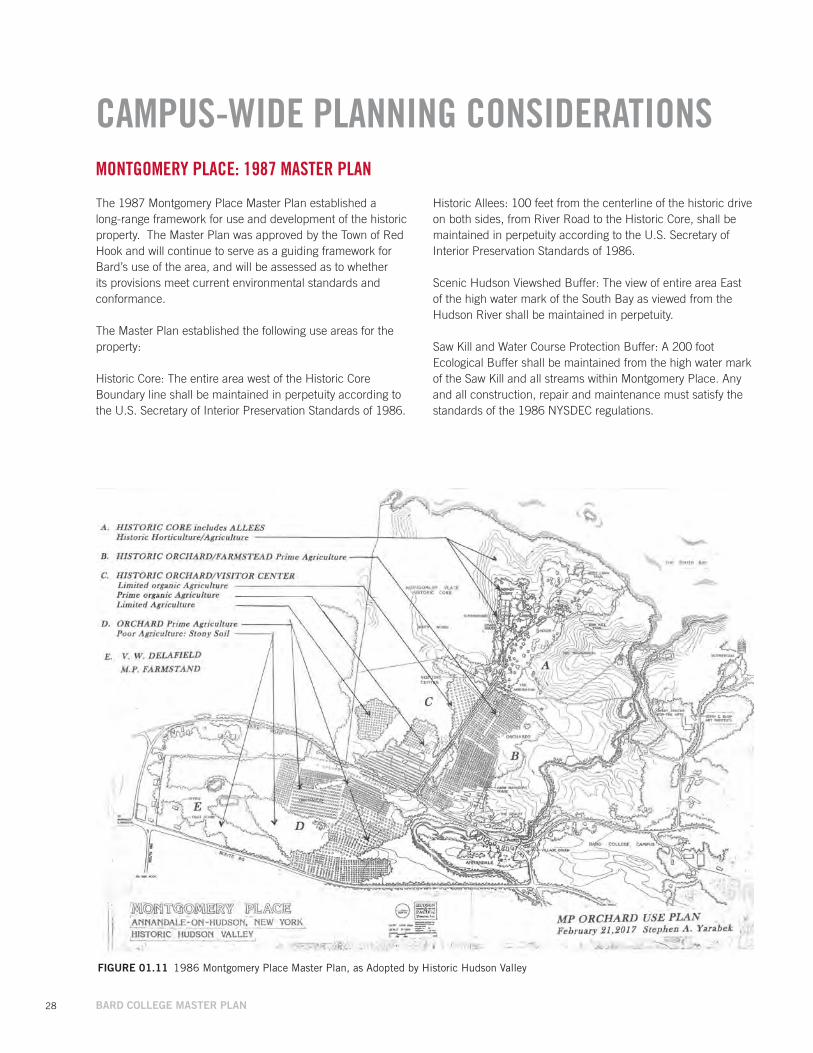
FIGuRE 01.11 1986 Montgomery Place Master Plan, as Adopted by Historic Hudson Valley
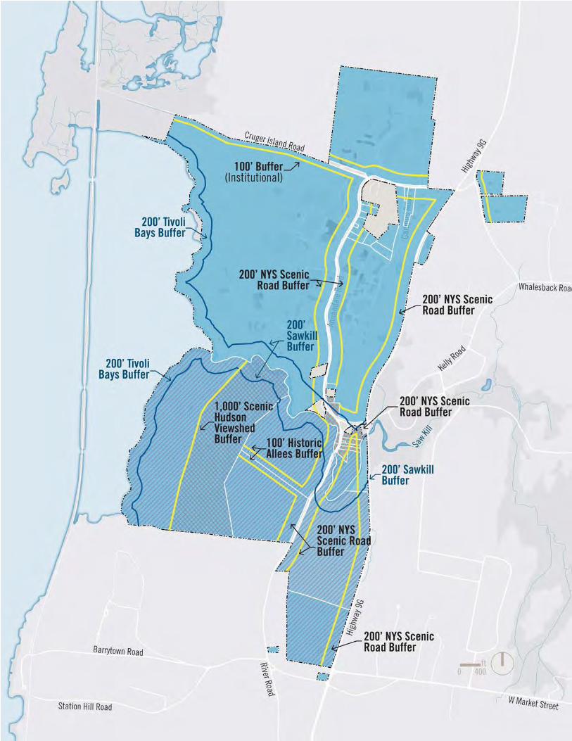
MONTGOMERY PLACE: 1987 MASTER PLAN
The 1987 Montgomery Place Master Plan established a long-range framework for use and development of the historic property. The Master Plan was approved by the Town of Red Hook and will continue to serve as a guiding framework for Bard’s use of the area, and will be assessed as to whether its provisions meet current environmental standards and conformance.
The Master Plan established the following use areas for the property:
Historic Core: The entire area west of the Historic Core Boundary line shall be maintained in perpetuity according to the U.S. Secretary of Interior Preservation Standards of 1986.
Historic Allees: 100 feet from the centerline of the historic drive on both sides, from River Road to the Historic Core, shall be maintained in perpetuity according to the U.S. Secretary of Interior Preservation Standards of 1986.
Scenic Hudson Viewshed Buffer: The view of entire area East of the high water mark of the South Bay as viewed from the Hudson River shall be maintained in perpetuity.
Saw Kill and Water Course Protection Buffer: A 200 foot Ecological Buffer shall be maintained from the high water mark of the Saw Kill and all streams within Montgomery Place. Any and all construction, repair and maintenance must satisfy the standards of the 1986 NYSDEC regulations.
CAMPUS-WIDE PLANNING CONSIDERATIONS

// 29
FIGuRE 01.12 1986 Montgomery Place Master Plan and Land Use Buffers
MONTGOMERY PLACE MUNICIPAL REGULATIONS
Bard will adhere to all existing Municipal Regulations that apply to Montgomery Place. In addition to Master Plan land use buffers shown on the drawing below, the following municipal regulations apply to the use and development of Montgomery Place:
NYS SASS - NYS Scenic Area of Statewide Significance: Any and all land improvements must have a minimum mitigatable impact on the property as viewed from the Hudson River and Ulster County.
Town SC-O Scenic Corridor Overlay District: Amplifies the NYS SASS- NYS Scenic Area of Statewide Significance regulations, including but not limited to the provision that the required front yard setback be doubled for all structures and parking areas located within the SC-O District.
Any construction and maintenance must also be accordance with the U.S. Secretary of Interior Preservation Standards which protects the Scenic Quality of the Road within One Hundred Feet from the centerline of the road and all that can be viewed from the road.
Additional regulations that apply to this area include:
Zoning Districts in which the properties comprising Montgomery Place are located (WC, I, and AB); additional overlay districts, including the Historic Landmark Overlay (HL-O) District (which is governed by § 143-46),the Flood Fringe Overlay (FF-O) District (§ 143-111), and the Environmental Protection Overlay (EP-O) District (§ 143-47); and additional provisions throughout the Zoning Law, in particular the requirements for historic structures and districts found in § 143-45 of the Zoning Law.
Additional special planning districts that should be mentioned include: the Town of Red Hook Local Waterfront Revitalization Program; New York State’s Mid-Hudson Historic Shorelands Scenic District; Estates District Scenic Area of Statewide Significance; American Heritage River; Hudson River Valley National Heritage Area; Hudson River National Historic Landmark District; and New York State Hudson River Valley Greenway.
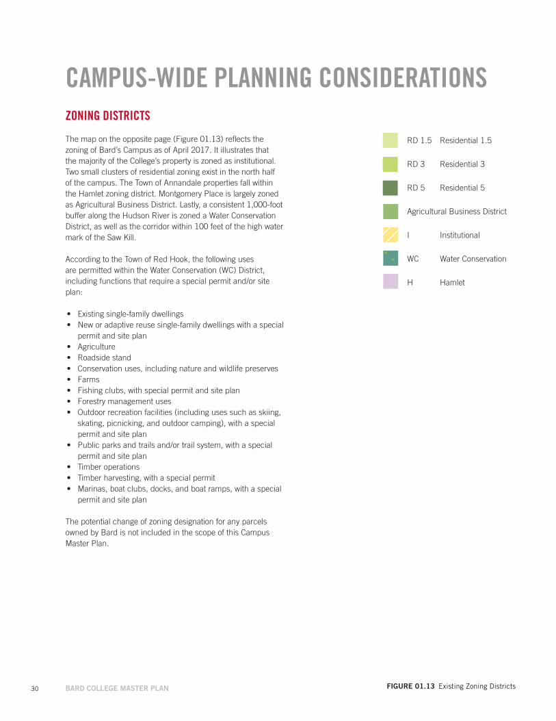
30 BARD COLLEGE MASTER PLAN FIGuRE 01.13 Existing Zoning Districts
RD 1.5 Residential 1.5
RD 3 Residential 3
RD 5 Residential 5
Agricultural Business District
I Institutional
WC Water Conservation
H Hamlet
ZONING DISTRICTS
The map on the opposite page (Figure 01.13) reflects the zoning of Bard’s Campus as of April 2017. It illustrates that the majority of the College’s property is zoned as institutional. Two small clusters of residential zoning exist in the north half of the campus. The Town of Annandale properties fall within the Hamlet zoning district. Montgomery Place is largely zoned as Agricultural Business District. Lastly, a consistent 1,000-foot buffer along the Hudson River is zoned a Water Conservation District, as well as the corridor within 100 feet of the high water mark of the Saw Kill.
According to the Town of Red Hook, the following uses are permitted within the Water Conservation (WC) District, including functions that require a special permit and/or site plan:
• Existing single-family dwellings• New or adaptive reuse single-family dwellings with a special
permit and site plan• Agriculture• Roadside stand• Conservation uses, including nature and wildlife preserves• Farms• Fishing clubs, with special permit and site plan• Forestry management uses• Outdoor recreation facilities (including uses such as skiing,
skating, picnicking, and outdoor camping), with a special permit and site plan
• Public parks and trails and/or trail system, with a special permit and site plan
• Timber operations• Timber harvesting, with a special permit• Marinas, boat clubs, docks, and boat ramps, with a special
permit and site plan
The potential change of zoning designation for any parcels owned by Bard is not included in the scope of this Campus Master Plan.
CAMPUS-WIDE PLANNING CONSIDERATIONS
// 31
Institutional
Agricultural Business District
Hamlet
Water Conservation
Residential 1.5
Residential 3
Residential 5
Residential 5
32 BARD COLLEGE MASTER PLAN
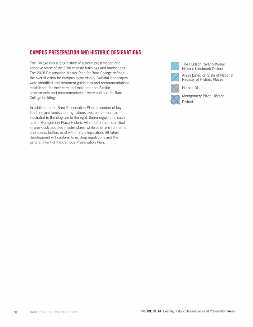
CAMPUS PRESERVATION AND HISTORIC DESIGNATIONS
The College has a long history of historic preservation and adaptive reuse of the 19th century buildings and landscapes. The 2008 Preservation Master Plan for Bard College defined the overall vision for campus stewardship. Cultural landscapes were identified and treatment guidelines and recommendations established for their care and maintenance. Similar assessments and recommendations were outlined for Bard College buildings.
In addition to the Bard Preservation Plan, a number of key land use and landscape regulations exist on campus, as illustrated in the diagram to the right. Some regulations such as the Montgomery Place Historic Allee buffers are identified in previously adopted master plans, while other environmental and scenic buffers exist within State legislation. All future development will conform to existing regulations and the general intent of the Campus Preservation Plan.
FIGuRE 01.14 Existing Historic Designations and Preservation Areas
The Hudson River National Historic Landmark District
Areas Listed on State of National Register of Historic Places
Hamlet District
Montgomery Place Historic
District
// 33
34 BARD COLLEGE MASTER PLAN
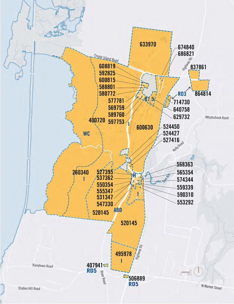
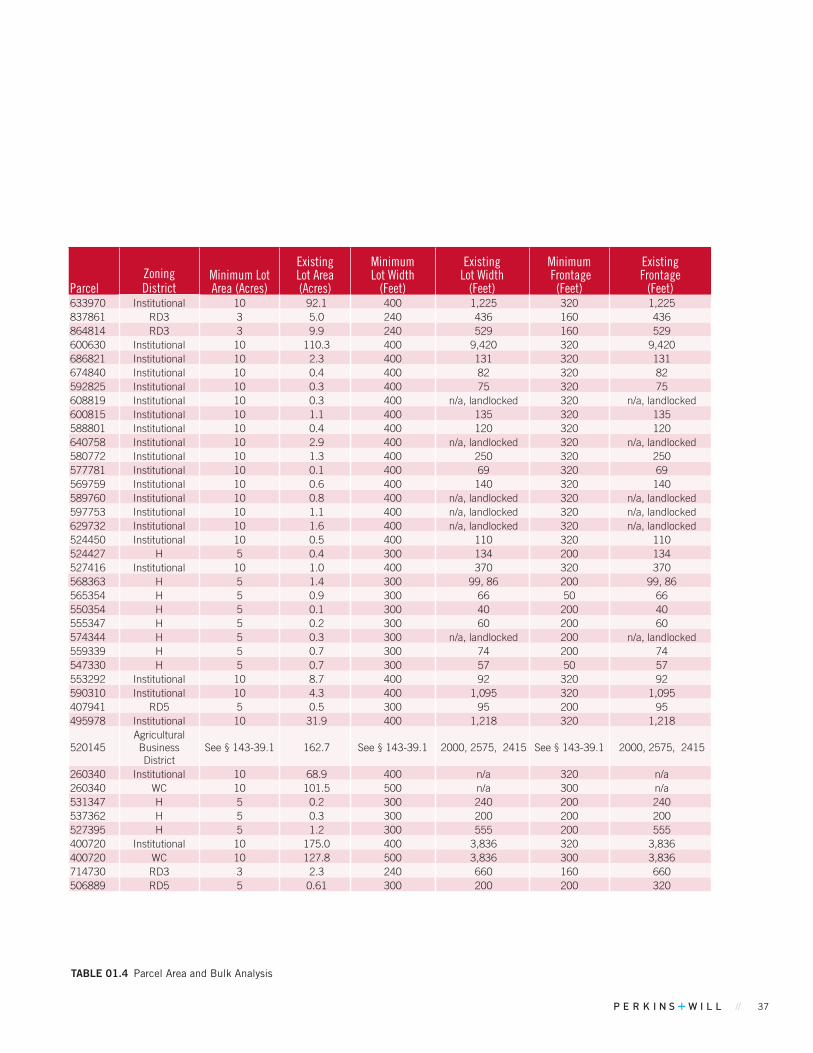
CAMPUS-WIDE PLANNING CONSIDERATIONSAREA AND BULK ANALYSIS
The tables on the following pages document the existing coverage for Bard’s multiple parcels of land.
Proposed area and bulk reporting for planned projects applies only to parcels 600630, 400720, 260340, 553292 and 633970 where the five Near-Term Projects and nine Mid-Term Projects are located. Long-Term Ideas are not sufficiently defined at this time to allow for calculation of area and bulk metrics.
Over time, Bard will continue to work with the Town of Red Hook Planning Board to consolidate existing small parcels that were historically under separate owners into the larger College parcels, where appropriate. This should remedy some non-compliant conditions where historic structures that predate current zoning exceed allowable coverage today. This consolidation of parcels is a separate process from the Master Plan.
FIGuRE 01.15 Bard Parcel Map
// 35
36 BARD COLLEGE MASTER PLAN
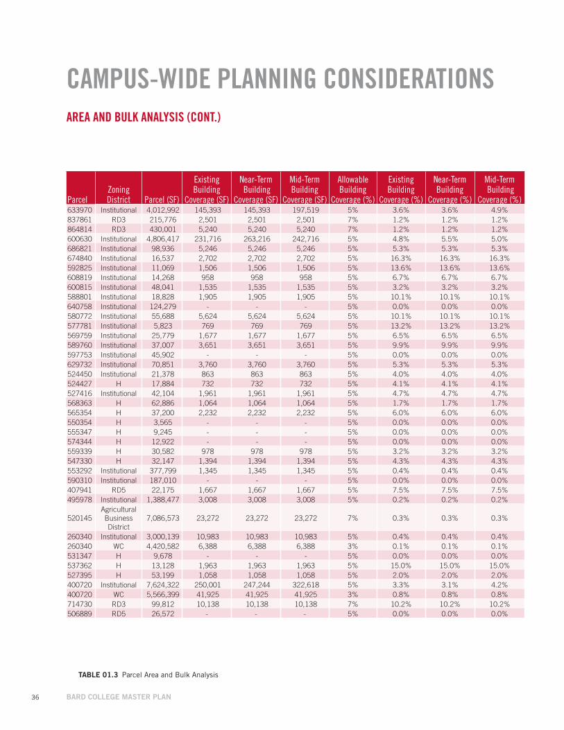
CAMPUS-WIDE PLANNING CONSIDERATIONSAREA AND BULK ANALYSIS (CONT.)
TABLE 01.3 Parcel Area and Bulk Analysis
ParcelZoningDistrict Parcel (SF)
Existing Building
Coverage (SF)
Near-Term Building
Coverage (SF)
Mid-TermBuilding
Coverage (SF)
Allowable Building
Coverage (%)
ExistingBuilding
Coverage (%)
Near-Term Building
Coverage (%)
Mid-Term Building
Coverage (%)633970 Institutional 4,012,992 145,393 145,393 197,519 5% 3.6% 3.6% 4.9%837861 RD3 215,776 2,501 2,501 2,501 7% 1.2% 1.2% 1.2%864814 RD3 430,001 5,240 5,240 5,240 7% 1.2% 1.2% 1.2%600630 Institutional 4,806,417 231,716 263,216 242,716 5% 4.8% 5.5% 5.0%686821 Institutional 98,936 5,246 5,246 5,246 5% 5.3% 5.3% 5.3%674840 Institutional 16,537 2,702 2,702 2,702 5% 16.3% 16.3% 16.3%592825 Institutional 11,069 1,506 1,506 1,506 5% 13.6% 13.6% 13.6%608819 Institutional 14,268 958 958 958 5% 6.7% 6.7% 6.7%600815 Institutional 48,041 1,535 1,535 1,535 5% 3.2% 3.2% 3.2%588801 Institutional 18,828 1,905 1,905 1,905 5% 10.1% 10.1% 10.1%640758 Institutional 124,279 - - - 5% 0.0% 0.0% 0.0%580772 Institutional 55,688 5,624 5,624 5,624 5% 10.1% 10.1% 10.1%577781 Institutional 5,823 769 769 769 5% 13.2% 13.2% 13.2%569759 Institutional 25,779 1,677 1,677 1,677 5% 6.5% 6.5% 6.5%589760 Institutional 37,007 3,651 3,651 3,651 5% 9.9% 9.9% 9.9%597753 Institutional 45,902 - - - 5% 0.0% 0.0% 0.0%629732 Institutional 70,851 3,760 3,760 3,760 5% 5.3% 5.3% 5.3%524450 Institutional 21,378 863 863 863 5% 4.0% 4.0% 4.0%524427 H 17,884 732 732 732 5% 4.1% 4.1% 4.1%527416 Institutional 42,104 1,961 1,961 1,961 5% 4.7% 4.7% 4.7%568363 H 62,886 1,064 1,064 1,064 5% 1.7% 1.7% 1.7%565354 H 37,200 2,232 2,232 2,232 5% 6.0% 6.0% 6.0%550354 H 3,565 - - - 5% 0.0% 0.0% 0.0%555347 H 9,245 - - - 5% 0.0% 0.0% 0.0%574344 H 12,922 - - - 5% 0.0% 0.0% 0.0%559339 H 30,582 978 978 978 5% 3.2% 3.2% 3.2%547330 H 32,147 1,394 1,394 1,394 5% 4.3% 4.3% 4.3%553292 Institutional 377,799 1,345 1,345 1,345 5% 0.4% 0.4% 0.4%590310 Institutional 187,010 - - - 5% 0.0% 0.0% 0.0%407941 RD5 22,175 1,667 1,667 1,667 5% 7.5% 7.5% 7.5%495978 Institutional 1,388,477 3,008 3,008 3,008 5% 0.2% 0.2% 0.2%
520145Agricultural Business District
7,086,573 23,272 23,272 23,272 7% 0.3% 0.3% 0.3%
260340 Institutional 3,000,139 10,983 10,983 10,983 5% 0.4% 0.4% 0.4%260340 WC 4,420,582 6,388 6,388 6,388 3% 0.1% 0.1% 0.1%531347 H 9,678 - - - 5% 0.0% 0.0% 0.0%537362 H 13,128 1,963 1,963 1,963 5% 15.0% 15.0% 15.0%527395 H 53,199 1,058 1,058 1,058 5% 2.0% 2.0% 2.0%400720 Institutional 7,624,322 250,001 247,244 322,618 5% 3.3% 3.1% 4.2%400720 WC 5,566,399 41,925 41,925 41,925 3% 0.8% 0.8% 0.8%714730 RD3 99,812 10,138 10,138 10,138 7% 10.2% 10.2% 10.2%506889 RD5 26,572 - - - 5% 0.0% 0.0% 0.0%
// 37
TABLE 01.4 Parcel Area and Bulk Analysis
ParcelZoningDistrict
Minimum Lot Area (Acres)
Existing Lot Area (Acres)
Minimum Lot Width
(Feet)
Existing Lot Width
(Feet)
Minimum Frontage
(Feet)
Existing Frontage
(Feet)633970 Institutional 10 92.1 400 1,225 320 1,225 837861 RD3 3 5.0 240 436 160 436 864814 RD3 3 9.9 240 529 160 529 600630 Institutional 10 110.3 400 9,420 320 9,420 686821 Institutional 10 2.3 400 131 320 131 674840 Institutional 10 0.4 400 82 320 82 592825 Institutional 10 0.3 400 75 320 75 608819 Institutional 10 0.3 400 n/a, landlocked 320 n/a, landlocked 600815 Institutional 10 1.1 400 135 320 135 588801 Institutional 10 0.4 400 120 320 120 640758 Institutional 10 2.9 400 n/a, landlocked 320 n/a, landlocked 580772 Institutional 10 1.3 400 250 320 250 577781 Institutional 10 0.1 400 69 320 69 569759 Institutional 10 0.6 400 140 320 140 589760 Institutional 10 0.8 400 n/a, landlocked 320 n/a, landlocked 597753 Institutional 10 1.1 400 n/a, landlocked 320 n/a, landlocked 629732 Institutional 10 1.6 400 n/a, landlocked 320 n/a, landlocked 524450 Institutional 10 0.5 400 110 320 110 524427 H 5 0.4 300 134 200 134 527416 Institutional 10 1.0 400 370 320 370 568363 H 5 1.4 300 99, 86 200 99, 86 565354 H 5 0.9 300 66 50 66 550354 H 5 0.1 300 40 200 40 555347 H 5 0.2 300 60 200 60 574344 H 5 0.3 300 n/a, landlocked 200 n/a, landlocked 559339 H 5 0.7 300 74 200 74 547330 H 5 0.7 300 57 50 57 553292 Institutional 10 8.7 400 92 320 92 590310 Institutional 10 4.3 400 1,095 320 1,095 407941 RD5 5 0.5 300 95 200 95 495978 Institutional 10 31.9 400 1,218 320 1,218
520145Agricultural Business District
See § 143-39.1 162.7 See § 143-39.1 2000, 2575, 2415 See § 143-39.1 2000, 2575, 2415
260340 Institutional 10 68.9 400 n/a 320 n/a 260340 WC 10 101.5 500 n/a 300 n/a 531347 H 5 0.2 300 240 200 240 537362 H 5 0.3 300 200 200 200 527395 H 5 1.2 300 555 200 555 400720 Institutional 10 175.0 400 3,836 320 3,836 400720 WC 10 127.8 500 3,836 300 3,836 714730 RD3 3 2.3 240 660 160 660 506889 RD5 5 0.61 300 200 200 320
38 BARD COLLEGE MASTER PLAN
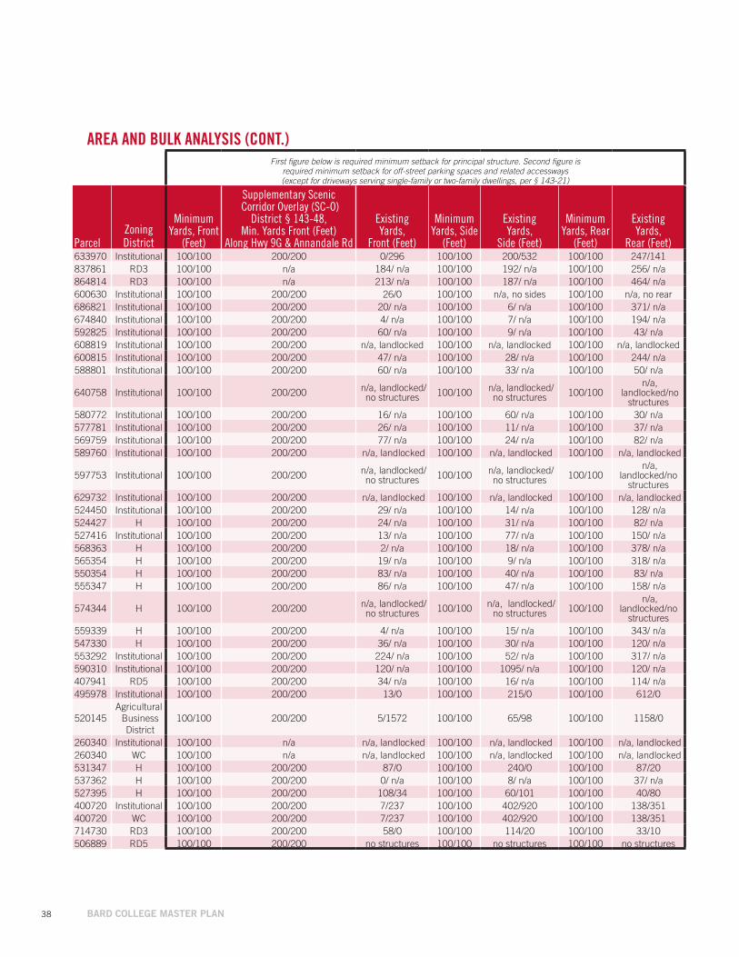
First figure below is required minimum setback for principal structure. Second figure is required minimum setback for off-street parking spaces and related accessways (except for driveways serving single-family or two-family dwellings, per § 143-21)
ParcelZoningDistrict
Minimum Yards, Front
(Feet)
Supplementary Scenic Corridor Overlay (SC-O)
District § 143-48, Min. Yards Front (Feet)
Along Hwy 9G & Annandale Rd
Existing Yards,
Front (Feet)
Minimum Yards, Side
(Feet)
Existing Yards,
Side (Feet)
Minimum Yards, Rear
(Feet)
Existing Yards,
Rear (Feet)633970 Institutional 100/100 200/200 0/296 100/100 200/532 100/100 247/141837861 RD3 100/100 n/a 184/ n/a 100/100 192/ n/a 100/100 256/ n/a864814 RD3 100/100 n/a 213/ n/a 100/100 187/ n/a 100/100 464/ n/a600630 Institutional 100/100 200/200 26/0 100/100 n/a, no sides 100/100 n/a, no rear686821 Institutional 100/100 200/200 20/ n/a 100/100 6/ n/a 100/100 371/ n/a674840 Institutional 100/100 200/200 4/ n/a 100/100 7/ n/a 100/100 194/ n/a592825 Institutional 100/100 200/200 60/ n/a 100/100 9/ n/a 100/100 43/ n/a608819 Institutional 100/100 200/200 n/a, landlocked 100/100 n/a, landlocked 100/100 n/a, landlocked600815 Institutional 100/100 200/200 47/ n/a 100/100 28/ n/a 100/100 244/ n/a588801 Institutional 100/100 200/200 60/ n/a 100/100 33/ n/a 100/100 50/ n/a
640758 Institutional 100/100 200/200 n/a, landlocked/no structures 100/100 n/a, landlocked/
no structures 100/100 n/a,
landlocked/no structures
580772 Institutional 100/100 200/200 16/ n/a 100/100 60/ n/a 100/100 30/ n/a577781 Institutional 100/100 200/200 26/ n/a 100/100 11/ n/a 100/100 37/ n/a569759 Institutional 100/100 200/200 77/ n/a 100/100 24/ n/a 100/100 82/ n/a589760 Institutional 100/100 200/200 n/a, landlocked 100/100 n/a, landlocked 100/100 n/a, landlocked
597753 Institutional 100/100 200/200 n/a, landlocked/no structures 100/100 n/a, landlocked/
no structures 100/100 n/a,
landlocked/no structures
629732 Institutional 100/100 200/200 n/a, landlocked 100/100 n/a, landlocked 100/100 n/a, landlocked 524450 Institutional 100/100 200/200 29/ n/a 100/100 14/ n/a 100/100 128/ n/a524427 H 100/100 200/200 24/ n/a 100/100 31/ n/a 100/100 82/ n/a527416 Institutional 100/100 200/200 13/ n/a 100/100 77/ n/a 100/100 150/ n/a568363 H 100/100 200/200 2/ n/a 100/100 18/ n/a 100/100 378/ n/a565354 H 100/100 200/200 19/ n/a 100/100 9/ n/a 100/100 318/ n/a550354 H 100/100 200/200 83/ n/a 100/100 40/ n/a 100/100 83/ n/a555347 H 100/100 200/200 86/ n/a 100/100 47/ n/a 100/100 158/ n/a
574344 H 100/100 200/200 n/a, landlocked/no structures 100/100 n/a, landlocked/
no structures 100/100 n/a,
landlocked/no structures
559339 H 100/100 200/200 4/ n/a 100/100 15/ n/a 100/100 343/ n/a547330 H 100/100 200/200 36/ n/a 100/100 30/ n/a 100/100 120/ n/a553292 Institutional 100/100 200/200 224/ n/a 100/100 52/ n/a 100/100 317/ n/a590310 Institutional 100/100 200/200 120/ n/a 100/100 1095/ n/a 100/100 120/ n/a407941 RD5 100/100 200/200 34/ n/a 100/100 16/ n/a 100/100 114/ n/a495978 Institutional 100/100 200/200 13/0 100/100 215/0 100/100 612/0
520145Agricultural Business District
100/100 200/200 5/1572 100/100 65/98 100/100 1158/0
260340 Institutional 100/100 n/a n/a, landlocked 100/100 n/a, landlocked 100/100 n/a, landlocked 260340 WC 100/100 n/a n/a, landlocked 100/100 n/a, landlocked 100/100 n/a, landlocked 531347 H 100/100 200/200 87/0 100/100 240/0 100/100 87/20537362 H 100/100 200/200 0/ n/a 100/100 8/ n/a 100/100 37/ n/a527395 H 100/100 200/200 108/34 100/100 60/101 100/100 40/80400720 Institutional 100/100 200/200 7/237 100/100 402/920 100/100 138/351400720 WC 100/100 200/200 7/237 100/100 402/920 100/100 138/351714730 RD3 100/100 200/200 58/0 100/100 114/20 100/100 33/10506889 RD5 100/100 200/200 no structures 100/100 no structures 100/100 no structures
AREA AND BULK ANALYSIS (CONT.)
// 39
Parcel Zoning District
Minimum Open Space
(Percent)
Existing Open Space (Percent)
Near-TermOpen Space
(Percent)
Mid-TermOpen Space
(Percent)633970 Institutional 75% 86% 86% 83%837861 RD3 80% 98% 98% 98%864814 RD3 80% 97% 97% 97%600630 Institutional 75% 86% 85% 85%686821 Institutional 75% 88% 88% 88%674840 Institutional 75% 79% 79% 79%592825 Institutional 75% 76% 76% 76%608819 Institutional 75% 78% 78% 78%600815 Institutional 75% 87% 87% 87%588801 Institutional 75% 86% 86% 86%
640758 Institutional 75% 100% 100% 100%
580772 Institutional 75% 81% 81% 81%577781 Institutional 75% 52% 52% 52%569759 Institutional 75% 92% 92% 92%589760 Institutional 75% 86% 86% 86%
597753 Institutional 75% 93% 93% 93%
629732 Institutional 75% 83% 83% 83%524450 Institutional 75% 88% 88% 88%524427 H 80% 95% 95% 95%527416 Institutional 75% 92% 92% 92%568363 H 80% 97% 97% 97%565354 H 80% 91% 91% 91%550354 H 80% 100% 100% 100%555347 H 80% 100% 100% 100%
574344 H 80% 100% 100% 100%
559339 H 80% 95% 95% 95%547330 H 80% 96% 96% 96%553292 Institutional 75% 100% 100% 100%590310 Institutional 75% 100% 100% 100%407941 RD5 80% 84% 84% 84%495978 Institutional 75% 99% 99% 99%
520145Agricultural Business
District80% 98% 98% 98%
260340 Institutional 75% 98% 98% 98%260340 WC 90% 100% 100% 100%531347 H 80% 48% 48% 48%537362 H 80% 78% 78% 78%527395 H 80% 86% 86% 86%400720 Institutional 75% 92% 91% 86%400720 WC 90% 97% 97% 97%714730 RD3 80% 63% 63% 63%506889 RD5 80% 100% 100% 100%
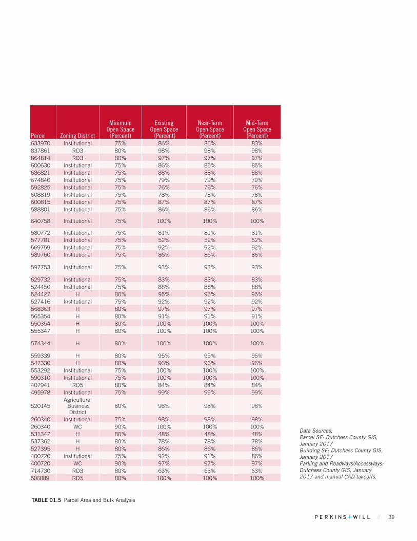
TABLE 01.5 Parcel Area and Bulk Analysis
Data Sources: Parcel SF: Dutchess County GIS, January 2017 Building SF: Dutchess County GIS, January 2017 Parking and Roadways/Accessways: Dutchess County GIS, January 2017 and manual CAD takeoffs.

40 BARD COLLEGE MASTER PLAN
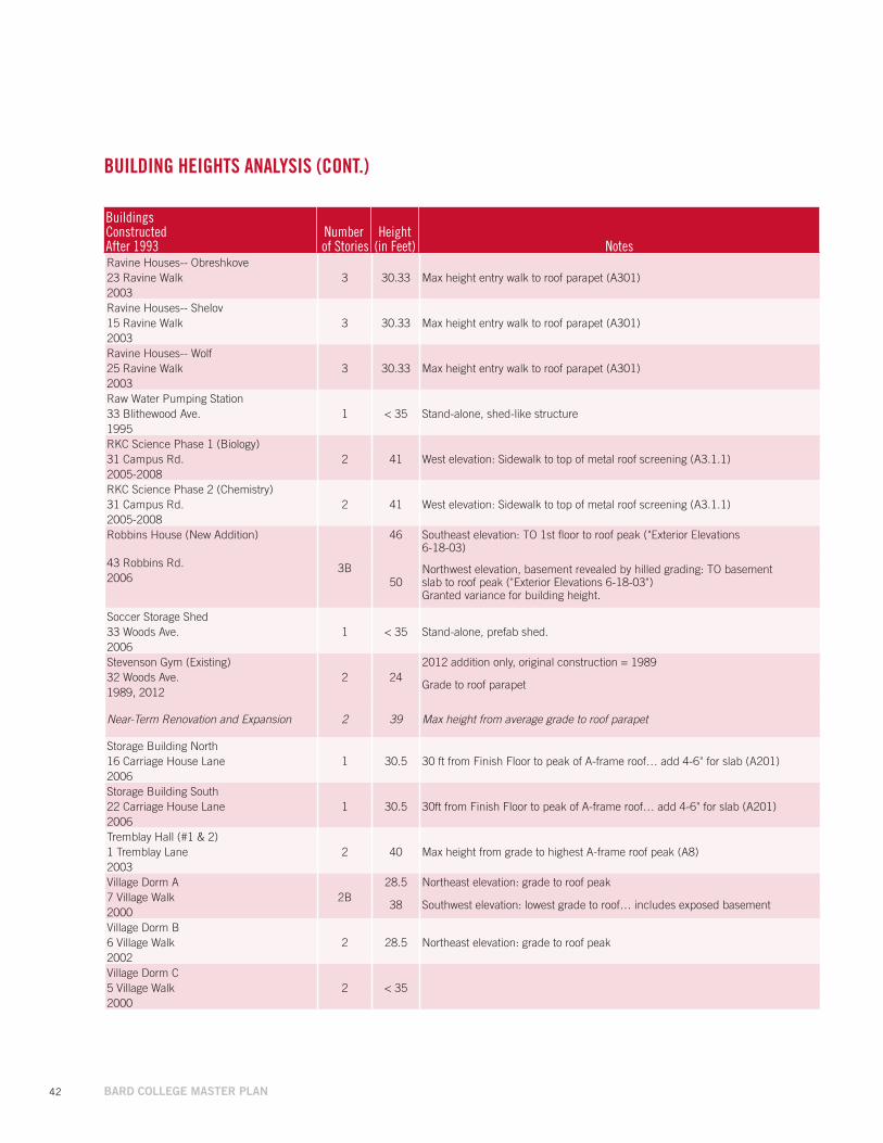
Buildings ConstructedAfter 1993
Number of Stories
Height(in Feet) Notes
Alumni Center/ Two-Boots Pizzeria2 24.84 To peak of higher roofline, calculated from elevation drawings4604 Rt. 9G
1930/ 2012Avery Film Center
321.51 From lowest grade to highest roofline on Avery north elevation (A200)
55 Blithewood Ave.38.5 From lowest grade to highest roofline on Avery south elevation (A201)
1971-2004Bito Music Center
333.67 From average grade to highest roofline, east elevation (A-300.00)
59 Blithewood Ave.35.00 Max building height (A-301.00)
2012-2013Bito Practice Rooms
1 < 351-story with A-frame roof, less than 35 ft
5 S. Ravine Road See “Roof truss package”2012Blum Music Center
225.81 From lowest grade to highest roofline on Blum north elevation (A200)
59 Blithewood Ave.36.66 From lowest grade to highest roofline on Blum south elevation (A201)
1980-2004Botstein House
2 < 35 2-story residential house with A-frame roof, less than 35 ft1307 Annandale Rd.1995Brandeis House
2 < 35 2-story residential house with A-frame roof, less than 35 ft1329 Annandale Rd.1970-2007Campus Center
2 32 Max building height = 32 ft, grade to parapet (A3.1 and A3.2)Ravine Rd.1995-2006Campus Center Recycling Building
1 < 35 Standing brick wall, less than 12 ftRavine Rd.1995Catskill Dorm
1 N/A Modular building no longer exists31 Robbins Rd.2008Center for Curatorial Studies (CCS)
127.5 CCS: Max height of "barrel roof", from grade to peak (A3.1)
33 Garden Rd.21.8 Hessel: Max height to parapet, excludes "sawtooth windows" (A3.0)
1992-2006Cruger Village-- Cruger
2
36.25 Max height of "outer wings", grade to A-frame roof peak (A3.1)14 Cruger Island Rd. 38.75 Max height of "middle wings", grade to A-frame roof peak (A3.1)1999 43.75 Max height of "central gateway", grade to A-frame roof peak,
excluding cupola (A3.1)Cruger Village-- Maple
1 < 35 1-story modular (double-wide) with A-frame, less than 35 ft28 Robbins Rd. Ext.2003Cruger Village-- Mulberry
1 < 35 1-story modular (double-wide) with A-frame, less than 35 ft29 Robbins Rd. Ext.2003Cruger Village-- Spruce
1 < 35 1-story modular (double-wide) with A-frame, less than 35 ft27 Robbins Rd. Ext.2003Cruger Village-- Sycamore
1 < 35 1-story modular (double-wide) with A-frame, less than 35 ft26 Robbins Rd. Ext.2003
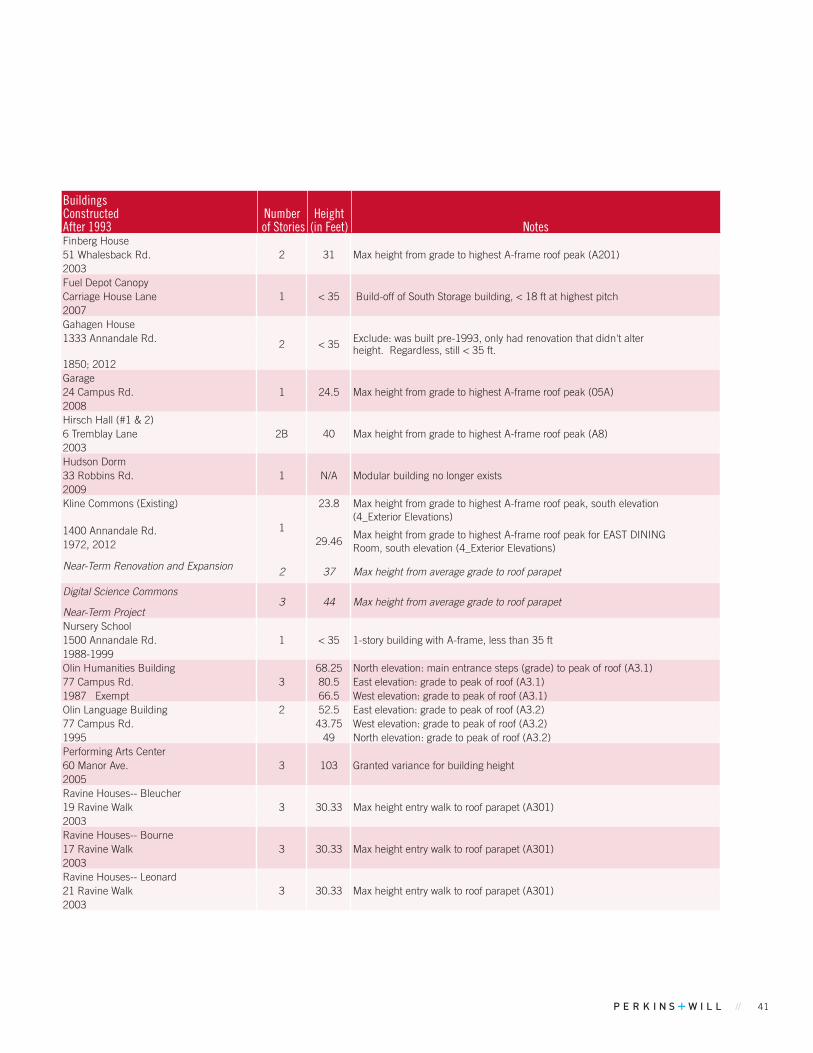
TABLE 01.6 Building Heights Analysis
BUILDING HEIGHTS ANALYSISLISTED IN ALPHABETICAL ORDER
// 41
Finberg House2 31 Max height from grade to highest A-frame roof peak (A201)51 Whalesback Rd.
2003Fuel Depot Canopy
1 < 35Carriage House Lane Build-off of South Storage building, < 18 ft at highest pitch2007Gahagen House
2 < 351333 Annandale Rd. Exclude: was built pre-1993, only had renovation that didn't alter height. Regardless, still < 35 ft.
1850; 2012Garage
1 24.524 Campus Rd. Max height from grade to highest A-frame roof peak (05A)2008Hirsch Hall (#1 & 2)
2B 406 Tremblay Lane Max height from grade to highest A-frame roof peak (A8)2003Hudson Dorm
1 N/A Modular building no longer exists33 Robbins Rd.2009Kline Commons (Existing)
1
23.8 Max height from grade to highest A-frame roof peak, south elevation (4_Exterior Elevations)
1400 Annandale Rd.29.46
Max height from grade to highest A-frame roof peak for EAST DININGRoom, south elevation (4_Exterior Elevations)1972, 2012
Near-Term Renovation and Expansion 2 37 Max height from average grade to roof parapet
Digital Science Commons
Near-Term Project3 44 Max height from average grade to roof parapet
Nursery School1 < 351500 Annandale Rd. 1-story building with A-frame, less than 35 ft
1988-1999Olin Humanities Building
368.25 North elevation: main entrance steps (grade) to peak of roof (A3.1)
77 Campus Rd. 80.5 East elevation: grade to peak of roof (A3.1)1987 Exempt 66.5 West elevation: grade to peak of roof (A3.1)Olin Language Building 2 52.5 East elevation: grade to peak of roof (A3.2)77 Campus Rd. 43.75 West elevation: grade to peak of roof (A3.2)1995 49 North elevation: grade to peak of roof (A3.2)Performing Arts Center
3 103 Granted variance for building height60 Manor Ave.2005Ravine Houses-- Bleucher
3 30.33 Max height entry walk to roof parapet (A301)19 Ravine Walk2003Ravine Houses-- Bourne
3 30.33 Max height entry walk to roof parapet (A301)17 Ravine Walk2003Ravine Houses-- Leonard
3 30.33 Max height entry walk to roof parapet (A301)21 Ravine Walk2003
Buildings ConstructedAfter 1993
Number of Stories
Height(in Feet) Notes
Alumni Center/ Two-Boots Pizzeria2 24.84 To peak of higher roofline, calculated from elevation drawings4604 Rt. 9G
1930/ 2012Avery Film Center
321.51 From lowest grade to highest roofline on Avery north elevation (A200)
55 Blithewood Ave.38.5 From lowest grade to highest roofline on Avery south elevation (A201)
1971-2004Bito Music Center
333.67 From average grade to highest roofline, east elevation (A-300.00)
59 Blithewood Ave.35.00 Max building height (A-301.00)
2012-2013Bito Practice Rooms
1 < 351-story with A-frame roof, less than 35 ft
5 S. Ravine Road See “Roof truss package”2012Blum Music Center
225.81 From lowest grade to highest roofline on Blum north elevation (A200)
59 Blithewood Ave.36.66 From lowest grade to highest roofline on Blum south elevation (A201)
1980-2004Botstein House
2 < 35 2-story residential house with A-frame roof, less than 35 ft1307 Annandale Rd.1995Brandeis House
2 < 35 2-story residential house with A-frame roof, less than 35 ft1329 Annandale Rd.1970-2007Campus Center
2 32 Max building height = 32 ft, grade to parapet (A3.1 and A3.2)Ravine Rd.1995-2006Campus Center Recycling Building
1 < 35 Standing brick wall, less than 12 ftRavine Rd.1995Catskill Dorm
1 N/A Modular building no longer exists31 Robbins Rd.2008Center for Curatorial Studies (CCS)
127.5 CCS: Max height of "barrel roof", from grade to peak (A3.1)
33 Garden Rd.21.8 Hessel: Max height to parapet, excludes "sawtooth windows" (A3.0)
1992-2006Cruger Village-- Cruger
2
36.25 Max height of "outer wings", grade to A-frame roof peak (A3.1)14 Cruger Island Rd. 38.75 Max height of "middle wings", grade to A-frame roof peak (A3.1)1999 43.75 Max height of "central gateway", grade to A-frame roof peak,
excluding cupola (A3.1)Cruger Village-- Maple
1 < 35 1-story modular (double-wide) with A-frame, less than 35 ft28 Robbins Rd. Ext.2003Cruger Village-- Mulberry
1 < 35 1-story modular (double-wide) with A-frame, less than 35 ft29 Robbins Rd. Ext.2003Cruger Village-- Spruce
1 < 35 1-story modular (double-wide) with A-frame, less than 35 ft27 Robbins Rd. Ext.2003Cruger Village-- Sycamore
1 < 35 1-story modular (double-wide) with A-frame, less than 35 ft26 Robbins Rd. Ext.2003
Buildings ConstructedAfter 1993
Number of Stories
Height(in Feet) Notes
42 BARD COLLEGE MASTER PLAN
Ravine Houses-- Obreshkove3 30.33 Max height entry walk to roof parapet (A301)23 Ravine Walk
2003Ravine Houses-- Shelov
3 30.33 Max height entry walk to roof parapet (A301)15 Ravine Walk2003Ravine Houses-- Wolf
3 30.33 Max height entry walk to roof parapet (A301)25 Ravine Walk2003Raw Water Pumping Station
1 < 35 Stand-alone, shed-like structure33 Blithewood Ave.1995RKC Science Phase 1 (Biology)
2 41 West elevation: Sidewalk to top of metal roof screening (A3.1.1)31 Campus Rd.2005-2008RKC Science Phase 2 (Chemistry)
2 41 West elevation: Sidewalk to top of metal roof screening (A3.1.1)31 Campus Rd.2005-2008Robbins House (New Addition)
3B
46 Southeast elevation: TO 1st floor to roof peak ("Exterior Elevations 6-18-03)
43 Robbins Rd.
50Northwest elevation, basement revealed by hilled grading: TO basementslab to roof peak ("Exterior Elevations 6-18-03")Granted variance for building height.
2006
Soccer Storage Shed1 < 35 Stand-alone, prefab shed.33 Woods Ave.
2006Stevenson Gym (Existing)
2 242012 addition only, original construction = 1989
Grade to roof parapet32 Woods Ave.1989, 2012
Near-Term Renovation and Expansion 2 39 Max height from average grade to roof parapet
Storage Building North1 30.5 30 ft from Finish Floor to peak of A-frame roof… add 4-6" for slab (A201)16 Carriage House Lane
2006Storage Building South
1 30.5 30ft from Finish Floor to peak of A-frame roof… add 4-6" for slab (A201)22 Carriage House Lane2006Tremblay Hall (#1 & 2)
2 40 Max height from grade to highest A-frame roof peak (A8)1 Tremblay Lane2003Village Dorm A
2B28.5 Northeast elevation: grade to roof peak
7 Village Walk38 Southwest elevation: lowest grade to roof… includes exposed basement
2000Village Dorm B
2 28.5 Northeast elevation: grade to roof peak6 Village Walk2002Village Dorm C
2 < 355 Village Walk2000
Buildings ConstructedAfter 1993
Number of Stories
Height(in Feet) Notes
BUILDING HEIGHTS ANALYSIS (CONT.)
// 43
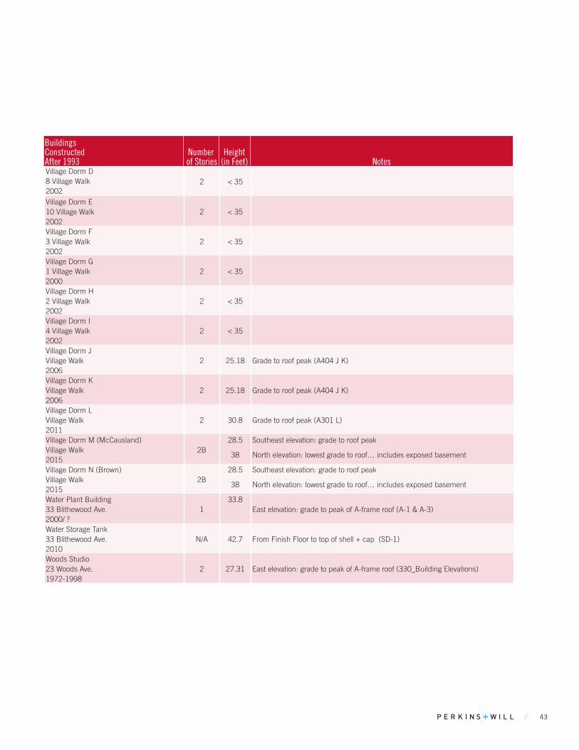
Village Dorm D2 < 358 Village Walk
2002Village Dorm E
2 < 3510 Village Walk2002Village Dorm F
2 < 353 Village Walk2002Village Dorm G
2 < 351 Village Walk2000Village Dorm H
2 < 352 Village Walk2002Village Dorm I
2 < 354 Village Walk2002Village Dorm J
2 25.18 Grade to roof peak (A404 J K)Village Walk2006Village Dorm K
2 25.18 Grade to roof peak (A404 J K)Village Walk2006Village Dorm L
2 30.8 Grade to roof peak (A301 L)Village Walk2011Village Dorm M (McCausland)
2B28.5 Southeast elevation: grade to roof peak
Village Walk38 North elevation: lowest grade to roof… includes exposed basement
2015Village Dorm N (Brown)
2B28.5 Southeast elevation: grade to roof peak
Village Walk38 North elevation: lowest grade to roof… includes exposed basement
2015Water Plant Building
133.8
East elevation: grade to peak of A-frame roof (A-1 & A-3)33 Blithewood Ave.2000/ ?Water Storage Tank
N/A 42.7 From Finish Floor to top of shell + cap (SD-1)33 Blithewood Ave.2010Woods Studio
2 27.31 East elevation: grade to peak of A-frame roof (330_Building Elevations)23 Woods Ave.1972-1998
Buildings ConstructedAfter 1993
Number of Stories
Height(in Feet) Notes
44 BARD COLLEGE MASTER PLAN
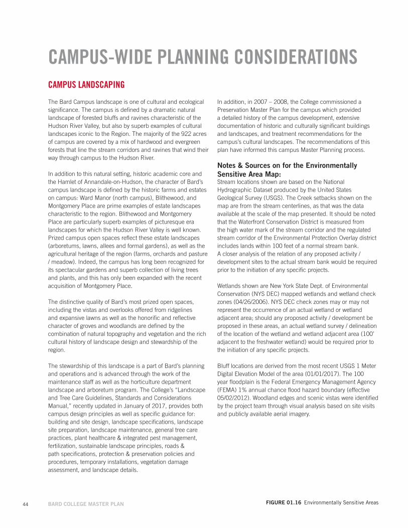
CAMPUS LANDSCAPING
The Bard Campus landscape is one of cultural and ecological significance. The campus is defined by a dramatic natural landscape of forested bluffs and ravines characteristic of the Hudson River Valley, but also by superb examples of cultural landscapes iconic to the Region. The majority of the 922 acres of campus are covered by a mix of hardwood and evergreen forests that line the stream corridors and ravines that wind their way through campus to the Hudson River.
In addition to this natural setting, historic academic core and the Hamlet of Annandale-on-Hudson, the character of Bard’s campus landscape is defined by the historic farms and estates on campus: Ward Manor (north campus), Blithewood, and Montgomery Place are prime examples of estate landscapes characteristic to the region. Blithewood and Montgomery Place are particularly superb examples of picturesque era landscapes for which the Hudson River Valley is well known. Prized campus open spaces reflect these estate landscapes (arboretums, lawns, allees and formal gardens), as well as the agricultural heritage of the region (farms, orchards and pasture / meadow). Indeed, the campus has long been recognized for its spectacular gardens and superb collection of living trees and plants, and this has only been expanded with the recent acquisition of Montgomery Place.
The distinctive quality of Bard’s most prized open spaces, including the vistas and overlooks offered from ridgelines and expansive lawns as well as the honorific and reflective character of groves and woodlands are defined by the combination of natural topography and vegetation and the rich cultural history of landscape design and stewardship of the region.
The stewardship of this landscape is a part of Bard’s planning and operations and is advanced through the work of the maintenance staff as well as the horticulture department landscape and arboretum program. The College’s “Landscape and Tree Care Guidelines, Standards and Considerations Manual,” recently updated in January of 2017, provides both campus design principles as well as specific guidance for: building and site design, landscape specifications, landscape site preparation, landscape maintenance, general tree care practices, plant healthcare & integrated pest management, fertilization, sustainable landscape principles, roads & path specifications, protection & preservation policies and procedures, temporary installations, vegetation damage assessment, and landscape details.
CAMPUS-WIDE PLANNING CONSIDERATIONS
In addition, in 2007 – 2008, the College commissioned a Preservation Master Plan for the campus which provided a detailed history of the campus development, extensive documentation of historic and culturally significant buildings and landscapes, and treatment recommendations for the campus’s cultural landscapes. The recommendations of this plan have informed this campus Master Planning process.
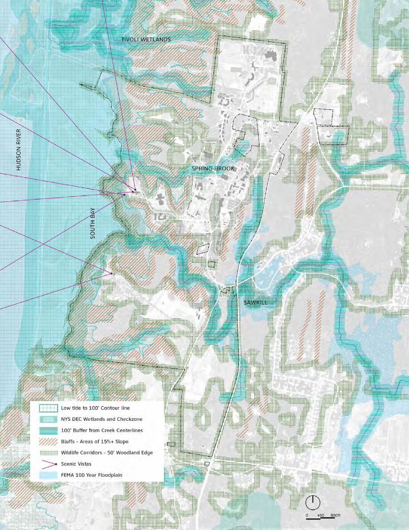
Notes & Sources on for the Environmentally Sensitive Area Map:Stream locations shown are based on the National Hydrographic Dataset produced by the United States Geological Survey (USGS). The Creek setbacks shown on the map are from the stream centerlines, as that was the data available at the scale of the map presented. It should be noted that the Waterfront Conservation District is measured from the high water mark of the stream corridor and the regulated stream corridor of the Environmental Protection Overlay district includes lands within 100 feet of a normal stream bank. A closer analysis of the relation of any proposed activity / development sites to the actual stream bank would be required prior to the initiation of any specific projects.
Wetlands shown are New York State Dept. of Environmental Conservation (NYS DEC) mapped wetlands and wetland check zones (04/26/2006). NYS DEC check zones may or may not represent the occurrence of an actual wetland or wetland adjacent area; should any proposed activity / development be proposed in these areas, an actual wetland survey / delineation of the location of the wetland and wetland adjacent area (100’ adjacent to the freshwater wetland) would be required prior to the initiation of any specific projects.
Bluff locations are derived from the most recent USGS 1 Meter Digital Elevation Model of the area (01/01/2017). The 100 year floodplain is the Federal Emergency Management Agency (FEMA) 1% annual chance flood hazard boundary (effective 05/02/2012). Woodland edges and scenic vistas were identified by the project team through visual analysis based on site visits and publicly available aerial imagery.
FIGuRE 01.16 Environmentally Sensitive Areas
// 45

Residential
Student Support
Academic
Administration
Athletics / Recreation
Campus Support
Misc
Montgomery Place
46 BARD COLLEGE MASTER PLAN
CAMPUS-WIDE PLANNING CONSIDERATIONS
FIGuRE 01.17 Building Uses
BUILDING USES
The plan below identifies the primary use of all the major existing buildings on campus by category of space use. Academic uses are generally concentrated in the campus core, while residential and student support are more dispersed. Campus support and facility management uses are concentrated together to the south of the Campus Center.
There will continue to be public access to Montgomery Place and its historical and cultural assets. Montgomery Place Farms will continue their current agricultural operation and market presence at the Montgomery Place Farm Stand.
Near- and Mid-Term Projects will not alter the general building use distribution on campus.

// 47
48 BARD COLLEGE MASTER PLAN
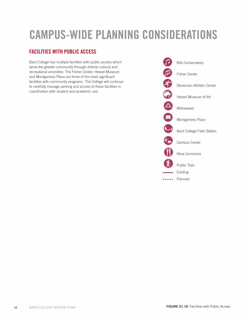
FACILITIES WITH PUBLIC ACCESS
Bard College has multiple facilities with public access which serve the greater community through diverse cultural and recreational amenities. The Fisher Center, Hessel Museum and Montgomery Place are three of the most significant facilities with community programs. The College will continue to carefully manage parking and access to these facilities in coordination with student and academic use.
Bito Conservatory
Fisher Center
Stevenson Athletic Center
Hessel Museum of Art
Blithewood
Montgomery Place
Bard College Field Station
Campus Center
Kline Commons
Public Trail:
Existing
Planned
FIGuRE 01.18 Facilities with Public Access
CAMPUS-WIDE PLANNING CONSIDERATIONS

// 49

Existing Housing
Mid-Term Site for New Housing
50 BARD COLLEGE MASTER PLAN
CAMPUS-WIDE PLANNING CONSIDERATIONSSTUDENT HOUSING
Bard College offers broad range of housing options and room configurations with facilities located throughout campus. Housing facilities range from multi-story dormitory buildings to clusters of single-family style buildings. Approximately 40 percent of the existing housing facilities are located in the North Campus above Cruger Island Road and 60% in the campus core.
The College plans to add 200 new beds in the next 5-10 years. Bard also plans to remove outdated housing and replace them with approximately 200 additional new beds. These are a Mid-Term Project, described in the following section.
• Existing Student Housing: 1,471 beds• On-campus residents: 72% of undergraduate students• Additional beds: 200 • Replacement beds: 200 approx.
Eventually, Bard would like to house 85% of its students on campus. (Refer to Long-Term Ideas section for additional information).
FIGuRE 01.19 Student Housing
// 51
52 BARD COLLEGE MASTER PLAN
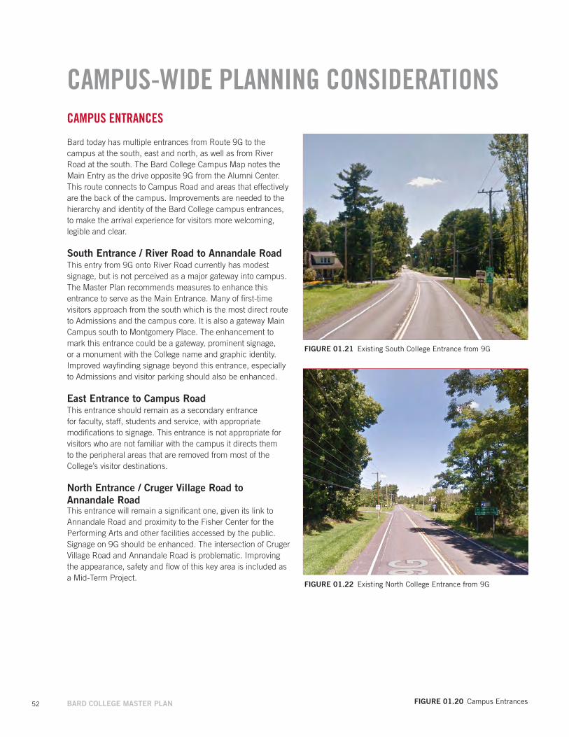
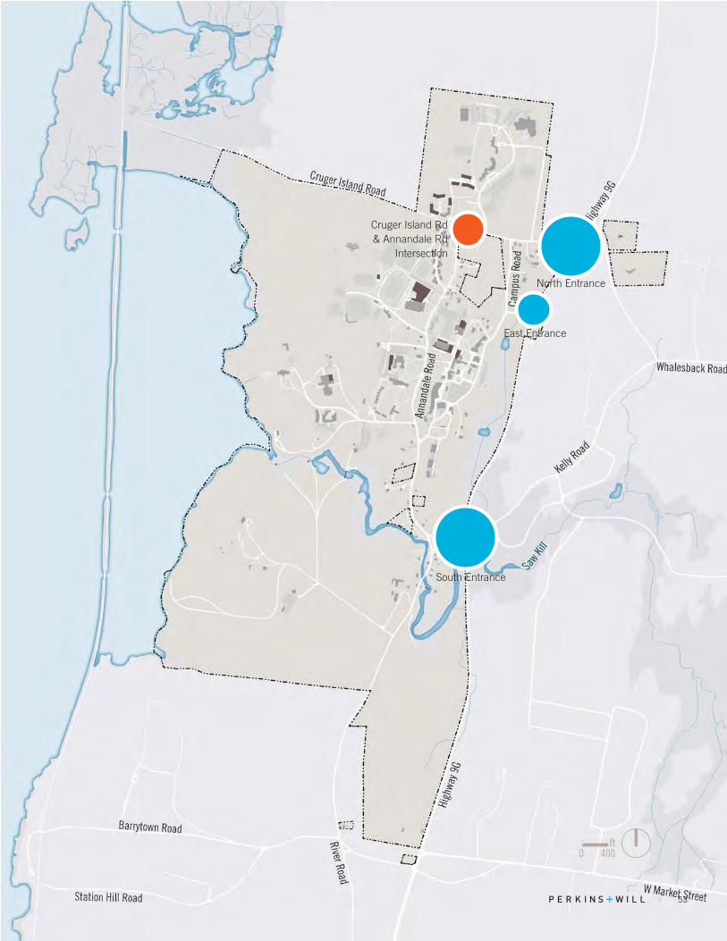
CAMPUS ENTRANCES
Bard today has multiple entrances from Route 9G to the campus at the south, east and north, as well as from River Road at the south. The Bard College Campus Map notes the Main Entry as the drive opposite 9G from the Alumni Center. This route connects to Campus Road and areas that effectively are the back of the campus. Improvements are needed to the hierarchy and identity of the Bard College campus entrances, to make the arrival experience for visitors more welcoming, legible and clear.
South Entrance / River Road to Annandale RoadThis entry from 9G onto River Road currently has modest signage, but is not perceived as a major gateway into campus. The Master Plan recommends measures to enhance this entrance to serve as the Main Entrance. Many of first-time visitors approach from the south which is the most direct route to Admissions and the campus core. It is also a gateway Main Campus south to Montgomery Place. The enhancement to mark this entrance could be a gateway, prominent signage, or a monument with the College name and graphic identity. Improved wayfinding signage beyond this entrance, especially to Admissions and visitor parking should also be enhanced.
East Entrance to Campus RoadThis entrance should remain as a secondary entrance for faculty, staff, students and service, with appropriate modifications to signage. This entrance is not appropriate for visitors who are not familiar with the campus it directs them to the peripheral areas that are removed from most of the College’s visitor destinations.
North Entrance / Cruger Village Road to Annandale RoadThis entrance will remain a significant one, given its link to Annandale Road and proximity to the Fisher Center for the Performing Arts and other facilities accessed by the public. Signage on 9G should be enhanced. The intersection of Cruger Village Road and Annandale Road is problematic. Improving the appearance, safety and flow of this key area is included as a Mid-Term Project.
FIGuRE 01.20 Campus Entrances
FIGuRE 01.21 Existing South College Entrance from 9G
FIGuRE 01.22 Existing North College Entrance from 9G
CAMPUS-WIDE PLANNING CONSIDERATIONS
// 53
Cruger Island Rd & Annandale Rd
Intersection
North Entrance
South Entrance
East Entrance

54 BARD COLLEGE MASTER PLAN
PARKING
Existing LotsBard has approximately 1,968 total existing parking spaces in paved and some unpaved lots across the campus, as detailed in the table below and map opposite. 1,387 of these spaces in the parking inventory are managed by Bard’s Office of Safety and Security. The balance are for use by Facilities and Maintenance and located at smaller residential properties and at Montgomery Place, During periods of peak parking demand for select events, grass areas are used as occasional overflow parking in some areas.
Parking Policy and OperationsBard issues parking permits to faculty and staff. There are 1,004 faculty/staff permits currently issued. This includes part time employees and some duplicate permits for those with more than one vehicle.
Parking permits are available to students for a fee. There are 683 student permits currently issued, or approximately 29% of the total enrollment. Approximately 700 students live off campus of Bard’s total enrollment of 2,224. Many off campus students utilize the Bard shuttle, while some drive.
All students are able to apply for a parking permit. Between 10 – 15% of first year students have cars at Bard. In comparison, some colleges do not allow first year students to have cars on campus. Others limit the number of student permits. Bard is not currently considering a change in policy, but may consider policy changes as a way to manage parking if typical demand begins to outpace the supply of parking, given the cost of additional spaces.
Most parking lots in the campus core are signed for designated users, including faculty / staff, commuter students and visitors. Currently, Bard rarely enforces parking with tickets or towing.
TABLE 01.7 Existing Parking Spaces
LOT NAMEPARKING
INVENTORY
OTHER PARKINGSPACES TOTAL
NorthFisher PAC 255 255Fisher PAC overflow* 0Manor House 12 12Robbins Annex 76 76Robbins 111 111Cruger 18 18Tremblay / Hirsch 20 20Arendt Center 5 5Annandale Houses 6 6Subtotal 480 23 503
Core NEKline 102 102Library 52 52Faculty Circle 5 5Subtotal 154 5 159
Core NWStevenson Gym 36 36Resnick Dorm Lot 87 87Honey Field 37 37Subtotal 160 0 160
Core SWFisher Arts 73 73Media Lab 0Campus Center 26 25 51Subtotal 99 124 223
Core SEOlin 84 9 93Main 198 198Sands House 14 14Facilities, Operations 168 168Subtotal 282 191 473
EastAlumni Center 50 50Finberg House 5 5John Cage Trust 3 3Subtotal 58 58
West / SouthBlithewood / Levy 38 38Hessel Museum of Art 64 64Bito/Blum 56 56Tewksbury Hall 5 5Ottaway Gatehouse 3 3Water Plant 118 118Annandale Hotel 12 12Annandale Triangle 6 6Subtotal 212 90 302
Montgomery PlaceFarm Complex 3 3Orchards Farmstand 15 15Visitor Center Lot 69 69Subtotal 0 87 87
Total 1387 577 1,965
CAMPUS-WIDE PLANNING CONSIDERATIONS
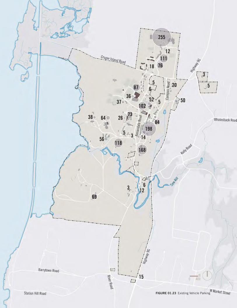
// 55FIGuRE 01.23 Existing Vehicle ParkingTABLE 01.7 Existing Parking Spaces
56 BARD COLLEGE MASTER PLAN
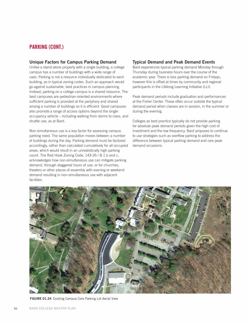
unique Factors for Campus Parking Demand Unlike a stand-alone property with a single building, a college campus has a number of buildings with a wide range of uses. Parking is not a resource individually dedicated to each building, as in typical zoning codes. Such an approach would go against sustainable, best practices in campus planning. Instead, parking on a college campus is a shared resource. The best campuses are pedestrian-oriented environments where sufficient parking is provided at the periphery and shared among a number of buildings so it is efficient. Good campuses also promote a range of access options beyond the single occupancy vehicle – including walking from dorms to class, and shuttle use, as at Bard.
Non-simultaneous use is a key factor for assessing campus parking need. The same population moves between a number of buildings during the day. Parking demand must be factored accordingly, rather than calculated cumulatively for all occupied areas, which would result in an unrealistically high parking count. The Red Hook Zoning Code, 143-26 / B.1.b and c, acknowledges how non-simultaneous use can mitigate parking demand, through staggered hours of use, or for churches, theaters or other places of assembly with evening or weekend demand resulting in non-simultaneous use with adjacent facilities.
Typical Demand and Peak Demand EventsBard experiences typical parking demand Monday through Thursday during business hours over the course of the academic year. There is less parking demand on Fridays, however this is offset at times by community and regional participants in the Lifelong Learning Initiative (LLI).
Peak demand periods include graduation and performances at the Fisher Center. These often occur outside the typical demand period when classes are in session, in the summer or during the evening.
Colleges as best practice typically do not provide parking for absolute peak demand periods given the high cost of investment and the low frequency. Bard proposes to continue to use strategies such as overflow parking to address the difference between typical parking demand and rare peak demand occasions.
FIGuRE 01.24 Existing Campus Core Parking Lot Aerial View
PARKING (CONT.)
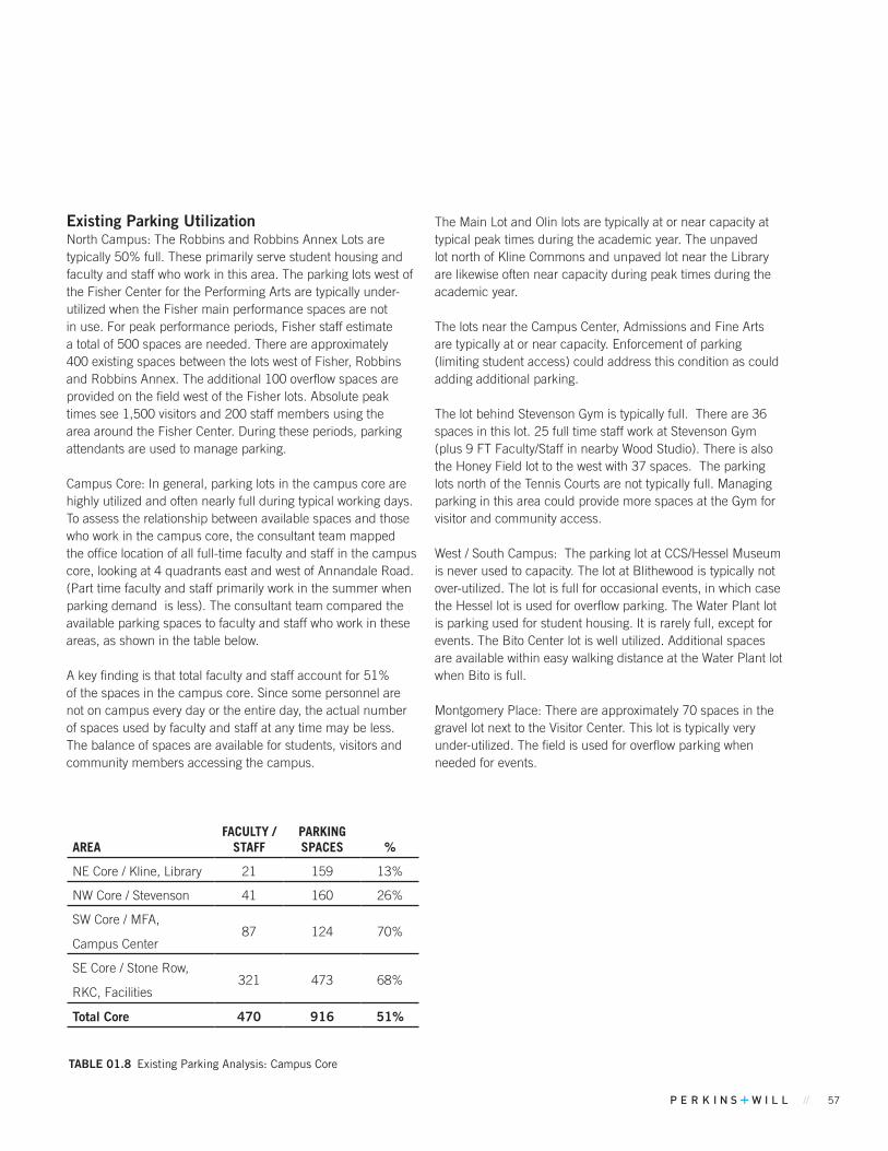
// 57
Existing Parking utilizationNorth Campus: The Robbins and Robbins Annex Lots are typically 50% full. These primarily serve student housing and faculty and staff who work in this area. The parking lots west of the Fisher Center for the Performing Arts are typically under-utilized when the Fisher main performance spaces are not in use. For peak performance periods, Fisher staff estimate a total of 500 spaces are needed. There are approximately 400 existing spaces between the lots west of Fisher, Robbins and Robbins Annex. The additional 100 overflow spaces are provided on the field west of the Fisher lots. Absolute peak times see 1,500 visitors and 200 staff members using the area around the Fisher Center. During these periods, parking attendants are used to manage parking.
Campus Core: In general, parking lots in the campus core are highly utilized and often nearly full during typical working days. To assess the relationship between available spaces and those who work in the campus core, the consultant team mapped the office location of all full-time faculty and staff in the campus core, looking at 4 quadrants east and west of Annandale Road. (Part time faculty and staff primarily work in the summer when parking demand is less). The consultant team compared the available parking spaces to faculty and staff who work in these areas, as shown in the table below.
A key finding is that total faculty and staff account for 51% of the spaces in the campus core. Since some personnel are not on campus every day or the entire day, the actual number of spaces used by faculty and staff at any time may be less. The balance of spaces are available for students, visitors and community members accessing the campus.
AREAFACULTY /
STAFFPARKING SPACES %
NE Core / Kline, Library 21 159 13%
NW Core / Stevenson 41 160 26%
SW Core / MFA,
Campus Center87 124 70%
SE Core / Stone Row,
RKC, Facilities321 473 68%
Total Core 470 916 51%
TABLE 01.8 Existing Parking Analysis: Campus Core
The Main Lot and Olin lots are typically at or near capacity at typical peak times during the academic year. The unpaved lot north of Kline Commons and unpaved lot near the Library are likewise often near capacity during peak times during the academic year.
The lots near the Campus Center, Admissions and Fine Arts are typically at or near capacity. Enforcement of parking (limiting student access) could address this condition as could adding additional parking.
The lot behind Stevenson Gym is typically full. There are 36 spaces in this lot. 25 full time staff work at Stevenson Gym (plus 9 FT Faculty/Staff in nearby Wood Studio). There is also the Honey Field lot to the west with 37 spaces. The parking lots north of the Tennis Courts are not typically full. Managing parking in this area could provide more spaces at the Gym for visitor and community access.
West / South Campus: The parking lot at CCS/Hessel Museum is never used to capacity. The lot at Blithewood is typically not over-utilized. The lot is full for occasional events, in which case the Hessel lot is used for overflow parking. The Water Plant lot is parking used for student housing. It is rarely full, except for events. The Bito Center lot is well utilized. Additional spaces are available within easy walking distance at the Water Plant lot when Bito is full.
Montgomery Place: There are approximately 70 spaces in the gravel lot next to the Visitor Center. This lot is typically very under-utilized. The field is used for overflow parking when needed for events.

58 BARD COLLEGE MASTER PLAN
Addressing Current Parking NeedsParking congestion in the Core can be addressed by a range of potential transportation demand management (TDM) measures. These include managing faculty, staff and student use to encourage more walking, biking, and shuttle use by posting alternative parking locations at main lots; incentivizing drivers to park in less-utilized lots; offering community bike-share; offering a more pedestrian-friendly main campus, offering incentives for not driving; utilizing rideshare boards; staggering class scheduling; and continuing to build infrastructure for cyclists on campus.
Parking for Near-Term and Mid-term ProjectsThe following Chapter, Project Identification, outlines 5 Near-Term Projects (within the next 5 years, if funding is available) and 9 Mid-Term Projects (within the next 10 years, if funding is available). Some of these projects do not generate additional parking demand. Examples are infrastructure projects like a new pedestrian bridge, or open space projects. Each project is summarized at a master plan level in the following chapter, including an assessment of additional parking demand (if any) generated by the project and how additional parking is being provided.
Table 01.9 summarizes the total additional parking to be provided to meet all Near and Mid-Term Projects when and if these are implemented. If all potential spaces were realized, the total is 353 spaces. This represents a 25% increase in the existing pool of parking spaces available to visitors and permit holders.
PARKING (CONT.)
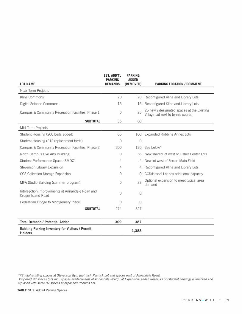
// 59
LOT NAME
EST. ADD’TL PARKING DEMANDS
PARKING ADDED
(REMOVED) PARKING LOCATION / COMMENT
Near-Term Projects
Kline Commons 20 20 Reconfigured Kline and Library Lots
Digital Science Commons 15 15 Reconfigured Kline and Library Lots
Campus & Community Recreation Facilities, Phase 1 0 2525 newly designated spaces at the Existing Village Lot next to tennis courts
SUBTOTAL 35 60
Mid-Term Projects
Student Housing (200 beds added) 66 100 Expanded Robbins Annex Lots
Student Housing (212 replacement beds) 0 0
Campus & Community Recreation Facilities, Phase 2 200 130 See below*
North Campus Live Arts Building 0 56 New shared lot west of Fisher Center Lots
Student Performance Space (SMOG) 4 4 New lot west of Ferrari Main Field
Stevenson Library Expansion 4 4 Reconfigured Kline and Library Lots
CCS Collection Storage Expansion 0 0 CCS/Hessel Lot has additional capacity
MFA Studio Building (summer program) 0 33Optional expansion to meet typical area demand
Intersection Improvements at Annandale Road and Cruger Island Road
0 0
Pedestrian Bridge to Montgomery Place 0 0
SUBTOTAL 274 327
Total Demand / Potential Added 309 387
Existing Parking Inventory for Visitors / Permit Holders 1,388
TABLE 01.9 Added Parking Spaces
*73 total existing spaces at Stevenson Gym (not incl. Resnick Lot and spaces east of Annandale Road) Proposed 98 spaces (not incl. spaces available east of Annandale Road) Lot Expansion; added Resnick Lot (student parking) is removed and replaced with same 87 spaces at expanded Robbins Lot.

60 BARD COLLEGE MASTER PLAN
CAMPUS-WIDE PLANNING CONSIDERATIONS
Highway 9G Corridor
Vehicular Road
Road To Be Removed
Improved Roadway
New Roadway
Shuttle Route
FIGuRE 01.25 Vehicle Circulation
VEHICLE CIRCULATION
The campus road network is largely defined by the north-south corridors formed by Highway 9G and Annandale Road/River Road. A finer grain of both paved and unpaved roads form ribs off these two primary spine roads. Some minor road closures and realignments are anticipated as part of the Near-Term Projects in the campus core.
The College will also be actively engaging with the Poughkeepsie-Dutchess County Transportation Council’s Upper Route 9G Corridor Management Plan for sections of 9G adjacent to the College as well as along Annandale Road and River road within the campus. A potential Mid-Term Project to work with DOT to increase pedestrian safety around the intersection of Cruger Island Road and Annandale Road is also being considered. Primary objectives would be to decrease the ‘blind corner’ condition, and increase pedestrian safety for students traveling between north campus and main campus.
The College is also planning to implement improved vehicular wayfinding on main campus. This may include directing visitors toward the more robust northern and southern 9G entrances to campus, and discouraging visitor use of the east entrance that leads to Campus Road and a smaller series of one-way roads and service drives.
CIRCuLATION KEY

// 61

62 BARD COLLEGE MASTER PLAN
PEDESTRIAN AND BIKE CIRCULATION
Montgomery Place Public Trails
Pedestrian Route
Recommended Multi-purpose Pathway Widening
Planned Pedestrian Route
New Sidewalk
Mid-Term Project: Pedestrian Bridge Location
Pedestrian CirculationThe existing network of pedestrian routes around campus include paved sidewalks, unpaved pathways and trails. As part of the Near-Term Projects, a number of sidewalks would be reconfigured / installed to connect new building entries and better serve revitalized open spaces. Included in these changes, would be improvements within public roads, such as crosswalks on Annandale Road in the campus core or intersection improvements at Cruger Island Road and Annandale to reduce traffic speed and increase visibility.
The College also supports increased future trail access to through its more natural areas. The proposed Red Hook Trail Plan and Tivoli South Bay Shoreline Trail are currently in development and would provide significant new public access to the Saw Kill and Montgomery Place. The College plans to connect the main campus to Montgomery Place via one or two pedestrian bridges, one in the historic Upper Falls area and a possible second bridge to the west. The location of the bridges would take into consideration FEMA, New York State, and local floodplain regulations. A preferred southern alignment for the Red Hook Trail that avoids sensitive wooded areas is shown in Figure 01.26.
CIRCuLATION KEY
In January 2017, Governor Cuomo proposed an initiative to create the Empire State Trail, the largest state multi-use trail in the nation. This would include completing the Hudson River Valley Greenway by 2020. The Empire State Trail would connect the Tivoli Bays Natural Area Trail which enters the north end of Bard’s campus, to the south end of campus. At the time of this Campus Master Plan, discussions on possible routes through the campus were commencing.
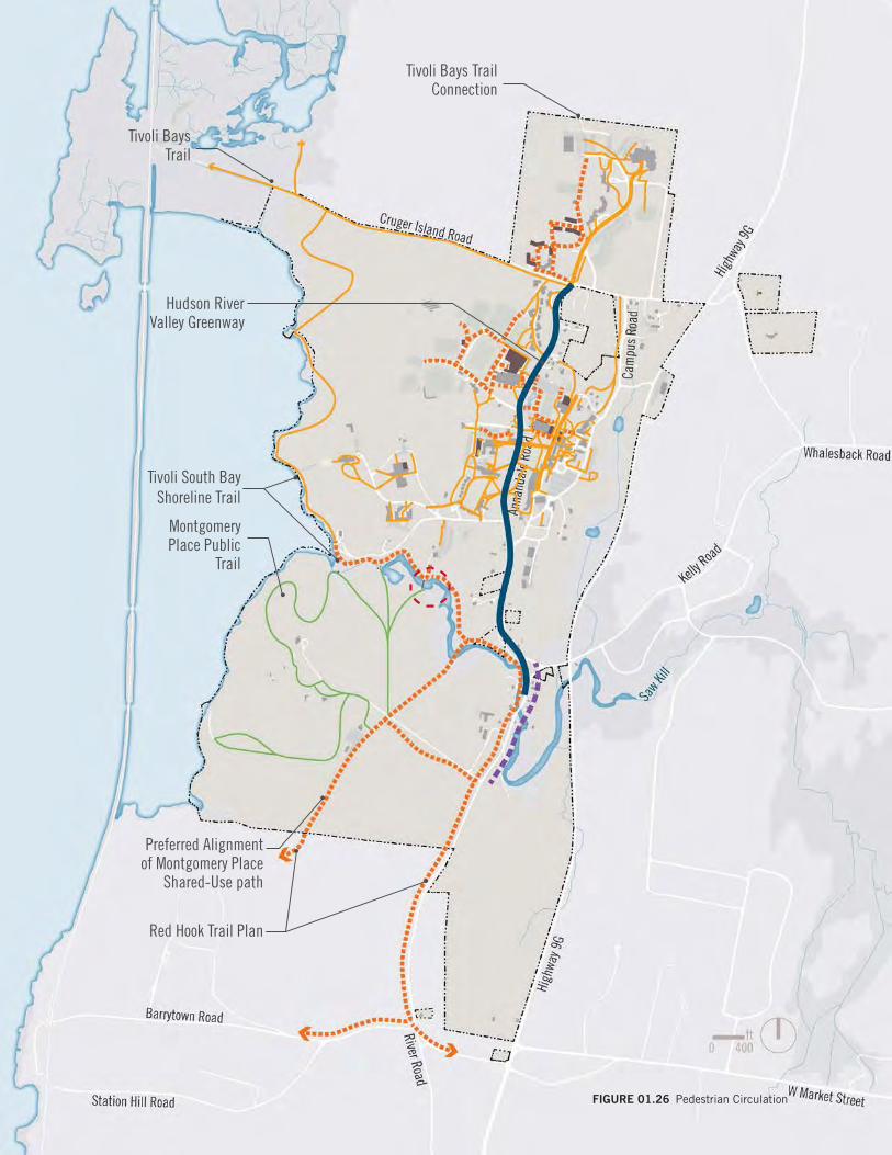
// 63
Tivoli South Bay Shoreline Trail
Red Hook Trail Plan
Tivoli Bays Trail
Preferred Alignment of Montgomery Place
Shared-Use path
Montgomery Place Public
Trail
Hudson RiverValley Greenway
FIGuRE 01.26 Pedestrian Circulation
Tivoli Bays TrailConnection
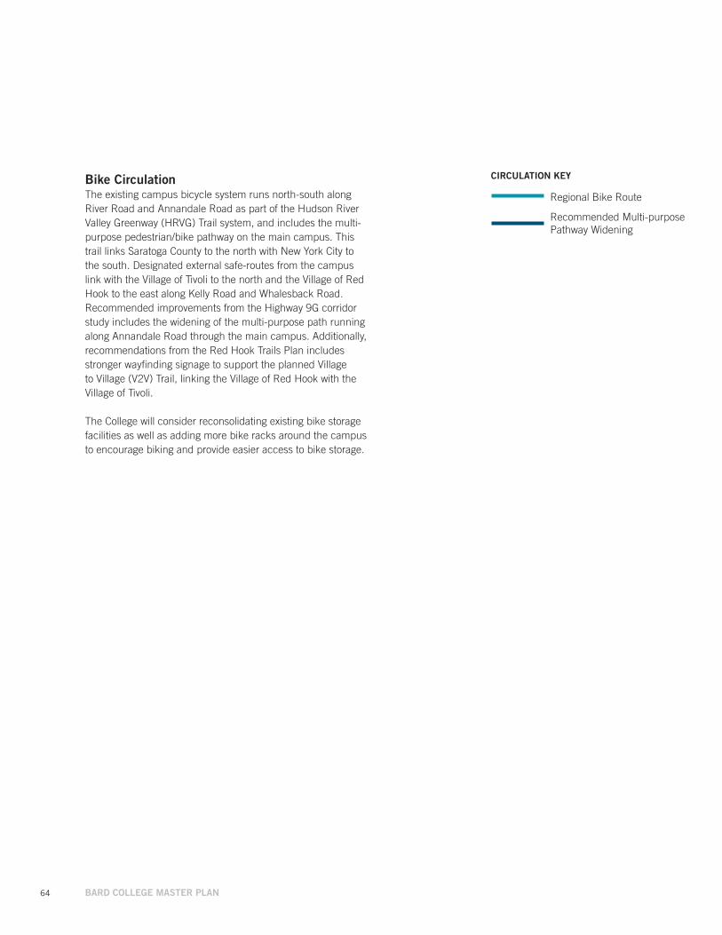
64 BARD COLLEGE MASTER PLAN
Regional Bike Route
Recommended Multi-purpose Pathway Widening
CIRCuLATION KEYBike CirculationThe existing campus bicycle system runs north-south along River Road and Annandale Road as part of the Hudson River Valley Greenway (HRVG) Trail system, and includes the multi-purpose pedestrian/bike pathway on the main campus. This trail links Saratoga County to the north with New York City to the south. Designated external safe-routes from the campus link with the Village of Tivoli to the north and the Village of Red Hook to the east along Kelly Road and Whalesback Road. Recommended improvements from the Highway 9G corridor study includes the widening of the multi-purpose path running along Annandale Road through the main campus. Additionally, recommendations from the Red Hook Trails Plan includes stronger wayfinding signage to support the planned Village to Village (V2V) Trail, linking the Village of Red Hook with the Village of Tivoli.
The College will consider reconsolidating existing bike storage facilities as well as adding more bike racks around the campus to encourage biking and provide easier access to bike storage.
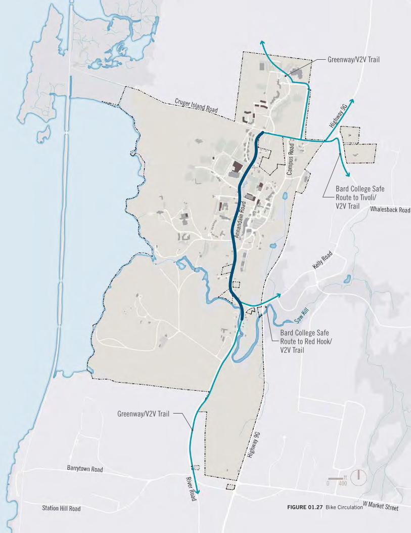
// 65FIGuRE 01.27 Bike Circulation
Bard College Safe Route to Tivoli/V2V Trail
Greenway/V2V Trail
Bard College Safe Route to Red Hook/V2V Trail
Greenway/V2V Trail
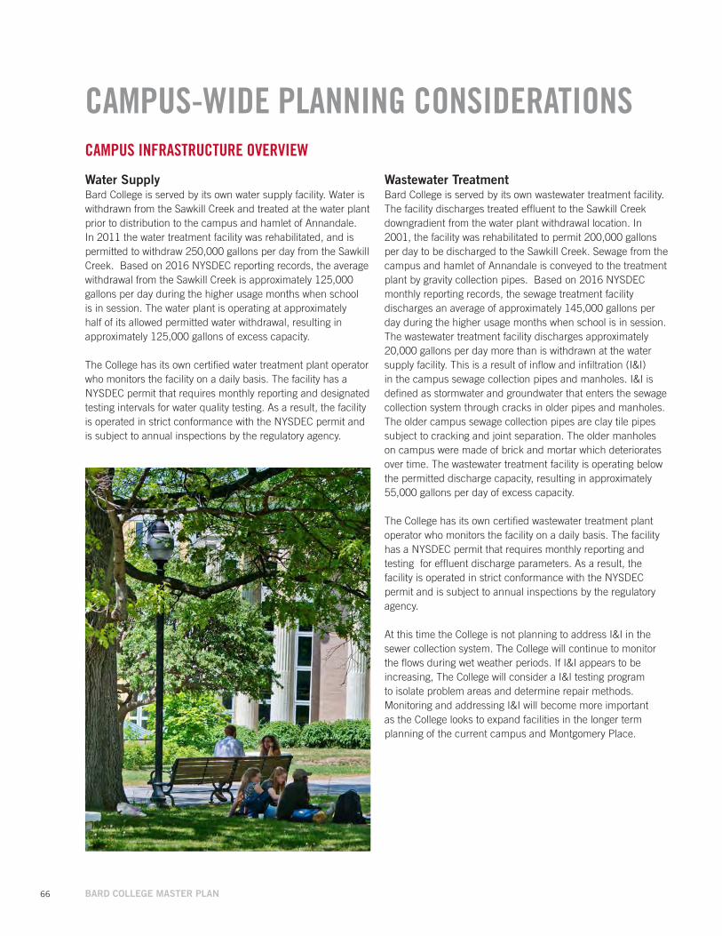
66 BARD COLLEGE MASTER PLAN
CAMPUS-WIDE PLANNING CONSIDERATIONSCAMPUS INFRASTRUCTURE OVERVIEW
Water SupplyBard College is served by its own water supply facility. Water is withdrawn from the Sawkill Creek and treated at the water plant prior to distribution to the campus and hamlet of Annandale. In 2011 the water treatment facility was rehabilitated, and is permitted to withdraw 250,000 gallons per day from the Sawkill Creek. Based on 2016 NYSDEC reporting records, the average withdrawal from the Sawkill Creek is approximately 125,000 gallons per day during the higher usage months when school is in session. The water plant is operating at approximately half of its allowed permitted water withdrawal, resulting in approximately 125,000 gallons of excess capacity.
The College has its own certified water treatment plant operator who monitors the facility on a daily basis. The facility has a NYSDEC permit that requires monthly reporting and designated testing intervals for water quality testing. As a result, the facility is operated in strict conformance with the NYSDEC permit and is subject to annual inspections by the regulatory agency.
Wastewater Treatment Bard College is served by its own wastewater treatment facility. The facility discharges treated effluent to the Sawkill Creek downgradient from the water plant withdrawal location. In 2001, the facility was rehabilitated to permit 200,000 gallons per day to be discharged to the Sawkill Creek. Sewage from the campus and hamlet of Annandale is conveyed to the treatment plant by gravity collection pipes. Based on 2016 NYSDEC monthly reporting records, the sewage treatment facility discharges an average of approximately 145,000 gallons per day during the higher usage months when school is in session. The wastewater treatment facility discharges approximately 20,000 gallons per day more than is withdrawn at the water supply facility. This is a result of inflow and infiltration (I&I) in the campus sewage collection pipes and manholes. I&I is defined as stormwater and groundwater that enters the sewage collection system through cracks in older pipes and manholes. The older campus sewage collection pipes are clay tile pipes subject to cracking and joint separation. The older manholes on campus were made of brick and mortar which deteriorates over time. The wastewater treatment facility is operating below the permitted discharge capacity, resulting in approximately 55,000 gallons per day of excess capacity.
The College has its own certified wastewater treatment plant operator who monitors the facility on a daily basis. The facility has a NYSDEC permit that requires monthly reporting and testing for effluent discharge parameters. As a result, the facility is operated in strict conformance with the NYSDEC permit and is subject to annual inspections by the regulatory agency.
At this time the College is not planning to address I&I in the sewer collection system. The College will continue to monitor the flows during wet weather periods. If I&I appears to be increasing, The College will consider a I&I testing program to isolate problem areas and determine repair methods. Monitoring and addressing I&I will become more important as the College looks to expand facilities in the longer term planning of the current campus and Montgomery Place.

// 67
StormwaterStormwater runoff is collected by a series of collection pipes and most of the campus drains to the Hudson River via discharges to the Sawkill Creek or other onsite tributaries. Since 2003 when the NYSDEC enacted stormwater regulations adopted by the Environmental Protection Agency, any new construction projects disturbing over one acre are required to conform to these regulations including preparation of Stormwater Pollution Prevention Plans (SWPPP’s) . Since 2003, these stormwater regulations have been updated several times, the most recent being in 2015. The NYSDEC stormwater regulations require that runoff be treated to improve water quality prior to discharge, and must also ensure that the rate of runoff after development does not exceed the rate of runoff prior to development.
The regulations also require each construction project to prepare an Erosion and Sediment Control Plan that ensures sediment laden runoff from construction sites is properly captured and treated prior to discharge from the project.
The College is responsible for annual inspections of the post construction stormwater practices to ensure they are functioning in accordance with the SWPPP inspection and maintenance schedules.
Electric The College is serviced by Central Hudson Gas and Electric (CHGE). CHGE has transmission poles along Annandale Road, and the College owns and maintains all the secondary underground, and limited overhead lines serving buildings throughout the campus.
* Campus infrastructure overview based on NYSDEC flow reporting records from the past 12 months and past electric usage.
** Please refer to the Project Identification sections on Near-Term Projects, Mid-Term Projects, and Long-Term Ideas for more detailed analysis of the campus infrastructure as it pertains to individual projects.
SUSTAINABILITY
Bard will continue actively planning ways to promote sustainability within the College and in the greater community. The Bard Office of Sustainability (BOS) operates under the mission to enhance the sustainability of the College in its operations, academics, and outreach, while making Bard carbon neutral by 2035.
By signing the Carbon Commitment (formerly ACUPCC) in 2009, President Botstein agreed to launch an ambitious and important process to achieve carbon neutrality and “actions to make climate neutrality and sustainability a part of the curriculum and other educational experience for all students.”
The Carbon Commitment begins the process of deliberate and systematic steps towards carbon neutrality, and lays out a prescribed timeline. To aid in this process, Bard has prepared annual greenhouse gas inventories, a detailed Climate Action Plan and maintains regular progress reports.
Bard has also recently updated the College New Construction and Major Renovation Policy, which strives to create high performance buildings using a “whole building as a system” approach.
Bard also operates a Sustainability Council, which conducts sustainability planning, advises the College on sustainability issues, and collaborates on sustainability events. In addition, the Sustainability Council helped move the College along the STARS spectrum from a silver rating to a gold rating for the 2011-2014 reporting period.
Academically, Bard strives to fully integrate environmental responsibility and sustainability into its academic programs and research endeavors. This incorporates everything from safe disposal practices in the lab, to an emphasis on academic programs that train the next generation of environmental leaders.
CAMPUS LIGHTING
The College will continue to reference the Campus and Town of Red Hook lighting standards for new building and exterior lighting projects. The campus has recently converted all of its exterior lighting to LED and will continue to strive towards energy efficient and environmentally sensitive lighting in all areas of campus. Particular attention will be made towards selecting historically and architecturally compatible lighting at Montgomery Place.

68 BARD COLLEGE MASTER PLAN
PROJECT IDENTIFICATION
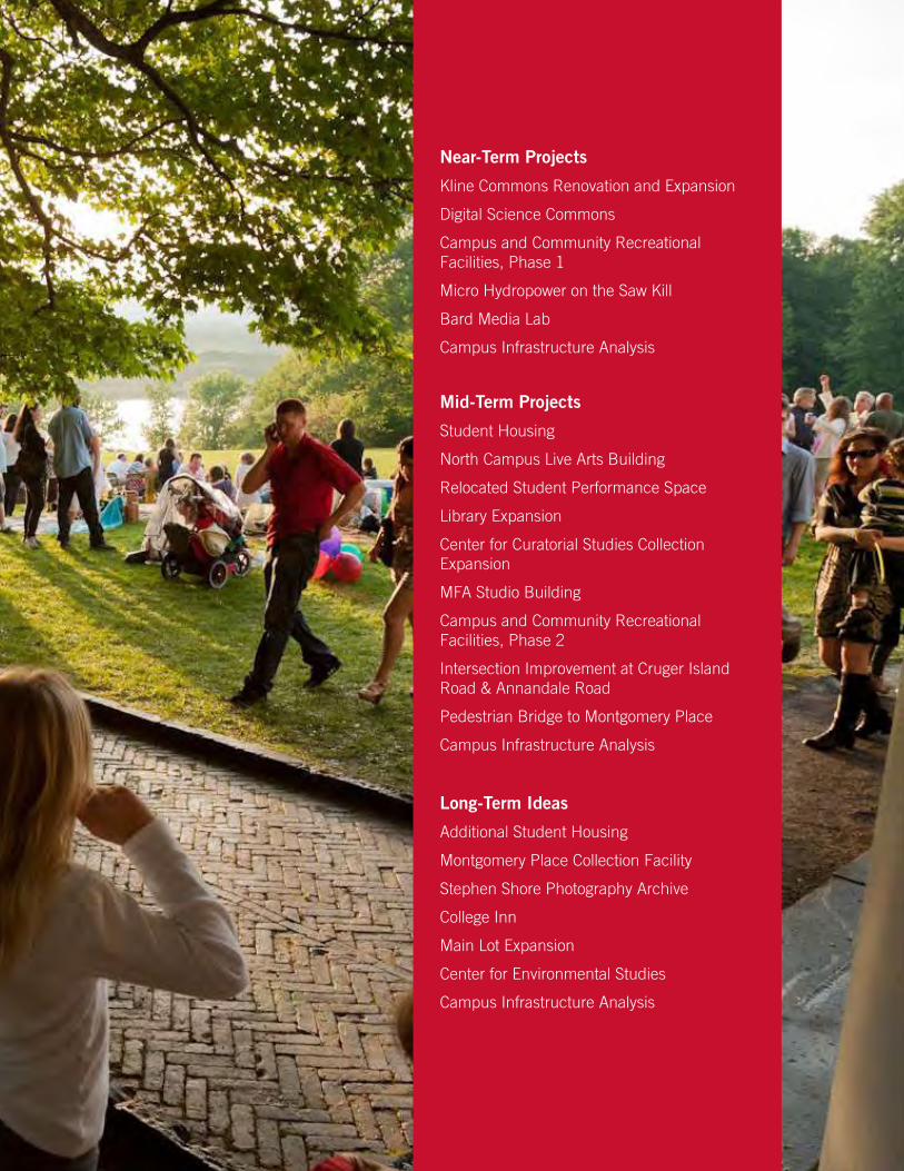
// 69
PROJECT IDENTIFICATION
Near-Term Projects
Kline Commons Renovation and Expansion
Digital Science Commons
Campus and Community Recreational Facilities, Phase 1
Micro Hydropower on the Saw Kill
Bard Media Lab
Campus Infrastructure Analysis
Mid-Term Projects
Student Housing
North Campus Live Arts Building
Relocated Student Performance Space
Library Expansion
Center for Curatorial Studies Collection Expansion
MFA Studio Building
Campus and Community Recreational Facilities, Phase 2
Intersection Improvement at Cruger Island Road & Annandale Road
Pedestrian Bridge to Montgomery Place
Campus Infrastructure Analysis
Long-Term Ideas
Additional Student Housing
Montgomery Place Collection Facility
Stephen Shore Photography Archive
College Inn
Main Lot Expansion
Center for Environmental Studies
Campus Infrastructure Analysis
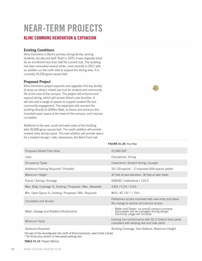
70 BARD COLLEGE MASTER PLAN
Proposed Added Floor Area 22,660 GSF
Uses Educational, Dining
Occupancy Types Classrooms, Student dining, Lounges
Additional Parking Required / Provided 20 / 20 spaces* , 2 improved ADA spaces added
Maximum Height 32 feet at east elevation, 36 feet at stair tower
Parcel / Zoning / Acreage 600630 / Institutional / 110.3
Max. Bldg. Coverage %: Existing / Proposed / Max. Allowable 4.8% / 5.2% / 5.0%
Min. Open Space %: Existing / Proposed / Min. Required 86% / 87.1%** / 75%
Circulation and AccessPedestrian access improved with new entry and plazaNo change to vehicle and service access
Water, Sewage and Related Infrastructure - Water and Sewer: no overall campus increase - Stormwater will be managed during design - Electricity usage will increase
Minimum YardsExisting non-conformance with SC-O District front yards, compliant with existing rear and side yards
Variances Required Building Coverage, Yard Setback, Maximum Height
NEAR-TERM PROJECTS
Existing ConditionsKline Commons is Bard’s primary dining facility, serving students, faculty and staff. Built in 1970, it was originally sized for an enrollment less than half the current size. The building has been renovated several times, most recently in 2011 with an addition on the north side to expand the dining area. It is currently 24,256 gross square feet.
Proposed Project Kline Commons project expands and upgrades this key facility to serve as vibrant, mixed-use hub for student and community life at the core of the campus. The project will enhance and expand dining, which will remain Kline’s core function. It will also add a range of spaces to support student life and community engagement. The expansion will connect the building directly to Griffiths Walk, to frame and enhance this important open space at the heart of the campus, and improve circulation.
Additions to the east, south and west sides of the building total 20,000 gross square feet. The south addition will provide needed extra dining space. The east addition will provide space for a student lounge / café, classrooms, the Bard Food Lab
TABLE 01.10 Project Metrics
FIGuRE 01.28 Key Map
*As part of the reconfigured lots north of Kline Commons, west of the Library**for Kline plus portion of new paved parking lots.
KLINE COMMONS RENOVATION & EXPANSION
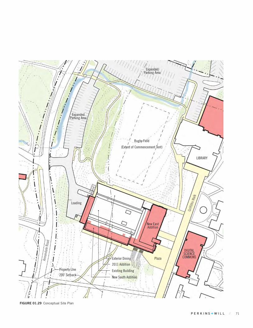
// 71
FIGuRE 01.29 Conceptual Site Plan
DIGITAL SCIENCE
COMMONSPlaza
Griff
iths W
alk
Existing Building
Anna
ndal
e Ro
ad
Loading
2011 Addition
New South Addition
Exterior Dining
New East Addition
Rugby Field
(Extent of Commencement Tent)
LIBRARY
Expanded Parking Area
Expanded Parking Area
Property LIne
200’ Setback

72 BARD COLLEGE MASTER PLAN
80’N
PROPOSEDGROUND LEVEL 01
8' 16' 32' 64' 100'8' 16' 32' 64' 100'
DINING
DINING
WC
WC WC
STOR.
WC DISHWASHING
KITCHENFOOD
SERVICE
OFFICE
STOR.
LOBBY
LOWERLOUNGE
KITCHENLAB
CLASSROOM 1
STOR.
STOR.
STOR.
ELEC.
WC
WC
GREENONION
UNEXCAVATEDMECH
LOADING
ADA PARKING
MEETING ROOM
MEETING ROOM
DINING CAPACITY 543 SEATS
Ground Level
NEAR-TERM PROJECTS
FIGuRE 01.30 Conceptual Floor Plans
and a multipurpose space. The west addition will provide an improved service access and include screening measures.
The Kline Commons dining service will continue and expand on the current use of locally sourced food, with a Farm to Table concept. A variety of dining options will be provided in the building to address a diverse range of food preferences. The project will support a new initiative, the Bard Food Lab. Separate from the commercial dining operation, the Lab will provide space for teaching, research and community engagement related to food science. A kitchen lab will provide a dedicated space for instruction and research in food preparation, supported by an adjacent multipurpose classroom and storage space. A second flexible classroom, also for 30 people will also be provided. Both will be available for campus-wide use and for events and meetings when not in use for instruction. The project will also include a generously-sized student lounge / café and multipurpose space. Individual and group study areas are included on the upper floor. There is a significant need for these types of space on campus.
The project will also address site accessibility given the surrounding sloping site, and code upgrades. Improving the service area is a priority so it is more attractive and functional.
A wall or continuous landscaping will be installed to screen views from Annandale Road to the service yard. Sustainability measures will be incorporated as the project is further developed.
Calculating parking demand is problematic using standard types of uses since this facility is used primarily by students who live on campus. Students are not meant to drive between buildings on campus, but rather walk, bike and/or take the shuttle whenever possible. The project adds approximately 64 seats for dining. Applying the restaurant use to this is not applicable for reasons noted above. The project adds 76 classroom seats. The project also adds a lounge and a multipurpose space. The College proposes to add 20 parking spaces north of Kline for access to the building by visitors to support the expansion. The plan also provides 2 additional ADA-compliant parking spaces adjacent to the building at the west to replace the existing accessible space up a steep incline. The additional parking will be within the Scenic Corridor Overlay District and will require an area variance.
The proposed loading dock extension is 78’ from the centerline of Annandale Road; the nearest corner of the west addition is 102’ from the centerline of Annandale Road. The proposed addition and existing building are inside the setbacks from Annandale Road, as established by the Scenic Corridor Overlay and base zoning districts.
KLINE COMMONS RENOVATION & EXPANSION
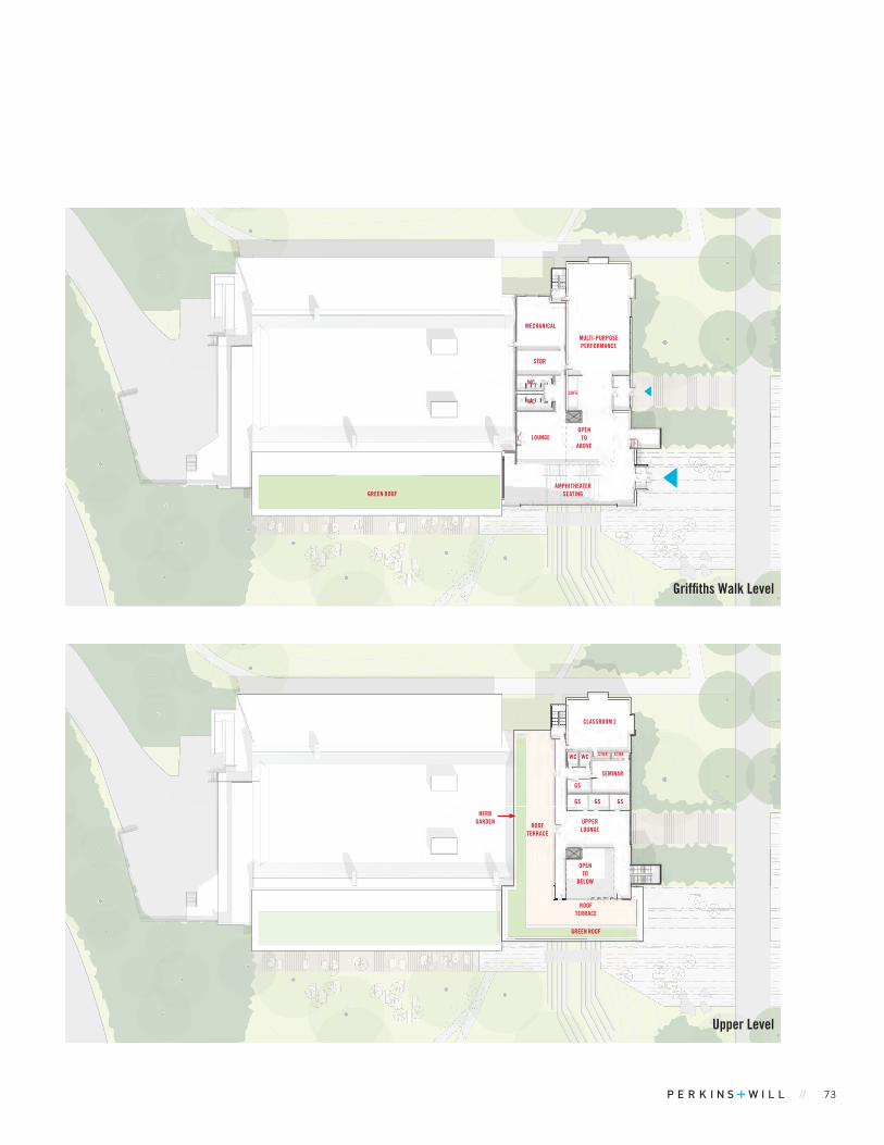
// 73
80’N
8' 16' 32' 64' 100'8' 16' 32' 64' 100'
MECHANICAL
LOUNGE
WC
STOR
WC
MULTI-PURPOSEPERFORMANCE
CAFE
AMPHITHEATER SEATINGGREEN ROOF
OPEN TO
ABOVE
Griffiths Walk Level
80’N
8' 16' 32' 64' 100'8' 16' 32' 64' 100'
UPPERLOUNGE
GSGS
GS
GS
STORSTOR
GREEN ROOF
HERBGARDEN
WC WC
OPEN TO
BELOW
ROOFTERRACE
ROOFTERRACE
CLASSROOM 2
SEMINAR
Upper Level
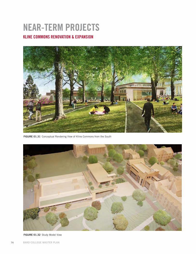
74 BARD COLLEGE MASTER PLAN
FIGuRE 01.31 Conceptual Rendering View of Kline Commons from the South
NEAR-TERM PROJECTSKLINE COMMONS RENOVATION & EXPANSION
FIGuRE 01.32 Study Model View

// 75
NEAR-TERM PROJECTSDIGITAL SCIENCE COMMONS
Existing ConditionsThe site for this new building is open space between the Rose Laboratory Building and Griffiths Walk.
Proposed Project The Digital Science Commons is a new, 3-story building that will serve as the departmental hub for Bard’s Physics program, currently housed in Hegeman and Rose Halls. The Physics program includes research and teaching labs as well as faculty offices, lounge and seminar spaces. The building will have a five-meter observatory dome and telescope deck for teaching and night sky public viewing.
Since the building will occupy a central location on the Bard campus, it is seen as an opportunity to organize spaces and activities that will welcome the larger Bard campus population. The followings are proposed: general use classrooms (30 seats); physical labs, a shared maker space for use both by Bard as well as for the larger Red Hook community including K-12 students; and a digital media commons for Bard student group work with dedicated support staff.
TABLE 01.11 Project Metrics
Proposed Added Floor Area 33,810 GSF
Uses Educational
Occupancy Types Classrooms, Office
Additional Parking Required / Provided 15 / 15 spaces*
Minimum Yards Compliant with SC-O and I District yards
Maximum Height 44 Feet
Parcel / Zoning / Acreage 600630 / Institutional / 110.3
Max. Bldg. Coverage %: Existing / Proposed / Max. Allowable 4.8% / 5.0%** / 5.0%
Min. Open Space %: Existing / Proposed / Min. Required 86% / 86.3%** / 75%
Circulation and AccessPedestrian access improved with new entry and plaza
No change to vehicle and service access
Water, Sewage and Related Infrastructure - Water and Sewer: no overall campus increase - Stormwater will be managed during design - Electricity usage will increase
Variances Required Maximum Height, Building Coverage**
*As part of the reconfigured lots north of Kline Commons, west of the Library**for this project only. 5.5% building coverage including all proposed Near-term projects.
The building will align with existing Stone Row along Griffiths Walk at a scale that will blend with this historic edge while at the same time punctuating the center of campus with a contemporary structure with a transparent facade to display learning activity within.
The building will have 134 classroom seats (including seminar and maker space) resulting in a need for 12 parking spaces. Offices total 800 SF, resulting in a need for 3 spaces. (Note that two laboratories will be taken off-line in the Rose Building and converted to office space. The reduction in parking demand is not included in this figure.)
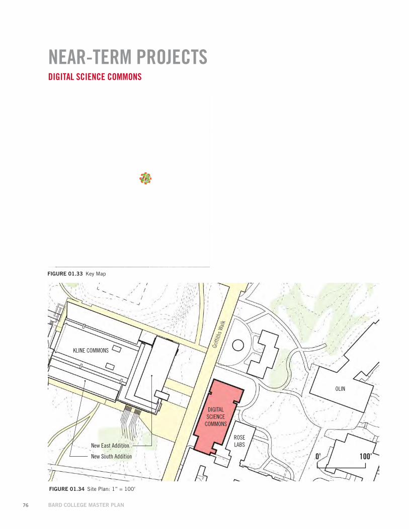
76 BARD COLLEGE MASTER PLAN
NEAR-TERM PROJECTS
KLINE COMMONS
OLIN
DIGITAL SCIENCE
COMMONS
0’ 100’
DIGITAL SCIENCE COMMONS
Griff
iths W
alk
New South Addition
New East Addition
FIGuRE 01.33 Key Map
FIGuRE 01.34 Site Plan: 1” = 100’
ROSE LABS
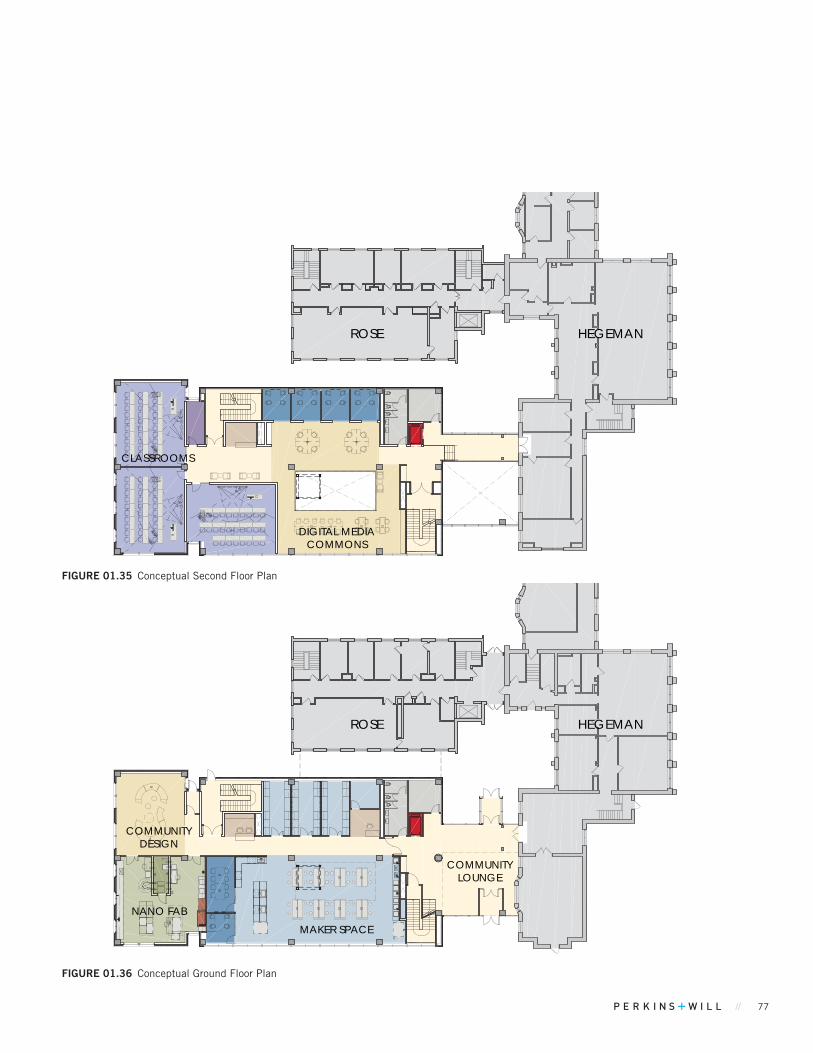
// 77
ROSE
MAKER SPACE
NANO FAB
COMMUNITYDESIGN
COMMUNITYLOUNGE
HEGEMAN
ROSE
DIGITAL MEDIACOMMONS
CLASSROOMS
HEGEMAN
FIGuRE 01.35 Conceptual Second Floor Plan
FIGuRE 01.36 Conceptual Ground Floor Plan
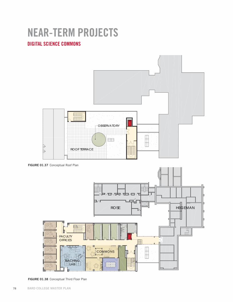
78 BARD COLLEGE MASTER PLAN
NEAR-TERM PROJECTSDIGITAL SCIENCE COMMONS
ROSE
COMMONS
TEACHINGLAB
FACULTYOFFICES
HEGEMAN
OBSERVATORY
ROOF TERRACE
FIGuRE 01.37 Conceptual Roof Plan
FIGuRE 01.38 Conceptual Third Floor Plan
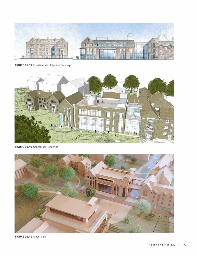
// 79
FIGuRE 01.39 Elevation with Adjacent Buildings
FIGuRE 01.40 Conceptual Rendering
FIGuRE 01.41 Model View

80 BARD COLLEGE MASTER PLAN
NEAR-TERM PROJECTSCAMPUS AND COMMUNITY RECREATIONAL FACILITIES, PHASE 1
Proposed Added Floor Area 0 GSF
Uses Educational: Athletics and recreation / exterior space
Occupancy Types NA
Additional Parking Required / Provided 0 / 25 spaces
Minimum YardsExisting non-compliance with SC-O District front yards,
compliant with rear and side yards
Maximum Height NA
Parcel / Zoning / Acreage 400720 / Institutional / 175
Max. Bldg. Coverage %: Existing / Proposed / Max. Allowable 3.3% / 3.3% / 5.0%
Min. Open Space %: Existing / Proposed / Min. Required 92% / 90% / 75%
Circulation and AccessPedestrian access improved with new entry and plazaNo change to vehicle and service access
Water, Sewage and Related Infrastructure - Water, Sewer and Electricity: no overall campus increase - Stormwater for fields will be managed during design
Variances Required None
TABLE 01.12 Project Metrics
Existing ConditionsThe area is currently occupied by Stevenson Gymnasium, tennis courts, access drives and parking, athletic fields, a grounds keeping staging area.
Proposed Project The scope for Phase 1 of the project includes creating a new artificial turf field for soccer and lacrosse at Ferrari Main Field, leveling and planting a new grass practice field on the grounds keeping staging area (which will be relocated), and renovating the existing locker rooms in Stevenson Gymnasium. Other more comprehensive improvements are planned in a second phase when funding is available for implementation.
The existing 125 bleacher seats at Ferrari Main Field will remain when this is converted to artificial turf. The grass practice field will not have seating and will support the current student population.
To address the congestion in the Stevenson Gym parking lot and improve community access, Bard will designate partial use of the under-utilized Village parking lot (est. 25 spaces) next to the tennis courts for faculty, staff and the community using the athletic and recreational facilities. Bard will designate 5 spaces with signage for exclusive use by the surrounding community. On evenings and weekends, the parking lots east of Annandale Road will have parking capacity suitable for athletics and recreation participants, spectators, staff and visitors.

// 81
FIGuRE 01.42 Key Map
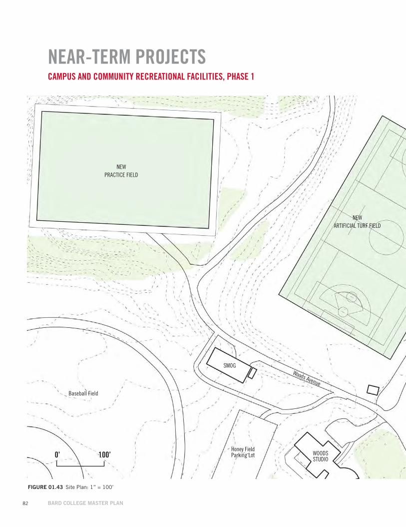
82 BARD COLLEGE MASTER PLAN
NEAR-TERM PROJECTSCAMPUS AND COMMUNITY RECREATIONAL FACILITIES, PHASE 1
FIGuRE 01.43 Site Plan: 1” = 100’
0’ 100’
NEWPRACTICE FIELD
NEWARTIFICIAL TURF FIELD
SMOG
WOODS STUDIO
Honey Field Parking Lot
Woods Avenue
Baseball Field
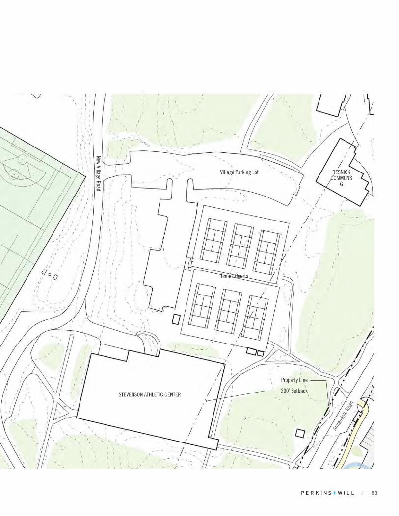
// 83
FIGuRE 01.44 Key Map
200’ Setback
Property Line
STEVENSON ATHLETIC CENTER
New Village Road
Village Parking Lot
Tennis Courts
RESNICK COMMONS
G
Anna
ndale
Roa
d
84 BARD COLLEGE MASTER PLAN
NEAR-TERM PROJECTSMICRO HYDROPOWER ON THE SAW KILL
Existing ConditionsThe site is the Saw Kill. An existing hydropower plant exists near the outlet to the Hudson River.
Proposed Project Three micro hydropower projects are under review associated with two dams owned by Bard on the Saw Kill as part of a NYSERDA grant. None of the projects currently are approved by Bard, the Town of Red Hook, or regulating authorities including the DEC, FERC, ACOE. The intent for the timeline is to make a decision of which project or projects (none, any or all) can go forward by the end of this summer. There is no short-term goal to do the third project near the lower dam. Regardless of whether micro hydropower proceeds, planning for the future of both Bard dams, whether to remove or continue to Operation & Maintain them, will need to be made by the College.
Proposed Added Floor Area NA
Uses Educational: Turbines and power plant for hydro power project
Occupancy Types NA
Parking Requirement 0 spaces
Minimum YardsThe 3 proposed projects are within 100’ of the property line in the Saw Kill
Maximum Height TBD
Parcel / Zoning / Acreage 260340 / WC / 101.5 ; / 553292 / I / 5.05
Max. Bldg. Coverage %: Existing / Proposed / Max. Allowable NA
Min. Open Space %: Existing / Proposed / Min. Required NA
Circulation and Access Utilizing existing unpaved roads and trails.
Water, Sewage and Related Infrastructure NA
Variances Required Project approval is under Federal jurisdiction
TABLE 01.13 Project Metrics
FIGuRE 01.45 Key Map
Figure 1.45
Figure 1.46
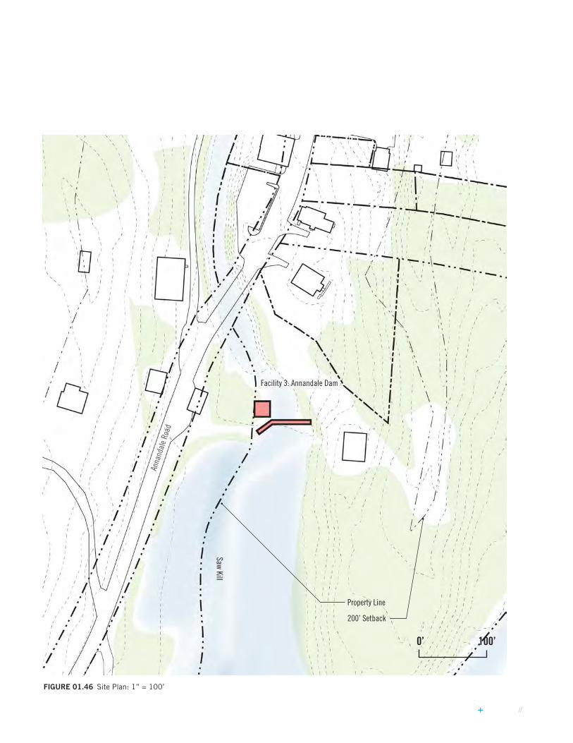
// 85
FIGuRE 01.46 Site Plan: 1” = 100’
0’ 100’
Anna
ndal
e Roa
d
Property Line
200’ Setback
Saw Kill
Facility 3: Annandale Dam

86 BARD COLLEGE MASTER PLAN
NEAR-TERM PROJECTSMICRO HYDROPOWER ON THE SAW KILL
FIGuRE 01.47 Site Plan: 1” = 100’
Property Line
200’ Setback
Facility 1: Lower Saw Kill Dam
Facility 2: Lower Saw Kill Dam
Bard College Field House
Saw Kill
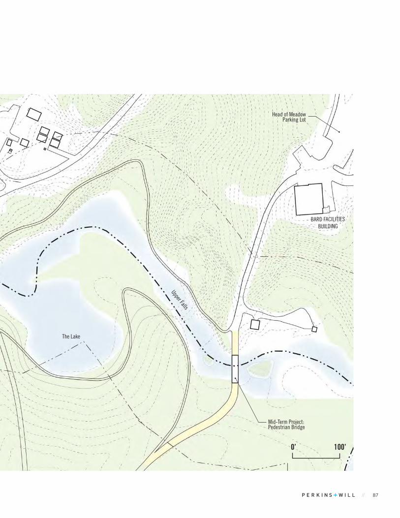
// 87
0’ 100’
Upper Falls
Facility 2: Lower Saw Kill Dam
The Lake
Head of Meadow Parking Lot
Mid-Term Project: Pedestrian Bridge
BARD FACILITIES BUILDING
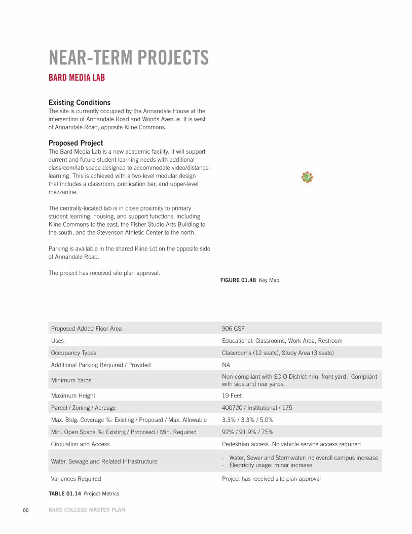
88 BARD COLLEGE MASTER PLAN
NEAR-TERM PROJECTSBARD MEDIA LAB
Existing ConditionsThe site is currently occupied by the Annandale House at the intersection of Annandale Road and Woods Avenue. It is west of Annandale Road, opposite Kline Commons.
Proposed Project The Bard Media Lab is a new academic facility. It will support current and future student learning needs with additional classroom/lab space designed to accommodate video/distance-learning. This is achieved with a two-level modular design that includes a classroom, publication bar, and upper-level mezzanine.
The centrally-located lab is in close proximity to primary student learning, housing, and support functions, including Kline Commons to the east, the Fisher Studio Arts Building to the south, and the Stevenson Athletic Center to the north.
Parking is available in the shared Kline Lot on the opposite side of Annandale Road.
The project has received site plan approval.
Proposed Added Floor Area 906 GSF
Uses Educational: Classrooms, Work Area, Restroom
Occupancy Types Classrooms (12 seats), Study Area (3 seats)
Additional Parking Required / Provided NA
Minimum YardsNon-compliant with SC-O District min. front yard. Compliant with side and rear yards.
Maximum Height 19 Feet
Parcel / Zoning / Acreage 400720 / Institutional / 175
Max. Bldg. Coverage %: Existing / Proposed / Max. Allowable 3.3% / 3.3% / 5.0%
Min. Open Space %: Existing / Proposed / Min. Required 92% / 91.9% / 75%
Circulation and Access Pedestrian access. No vehicle service access required
Water, Sewage and Related Infrastructure - Water, Sewer and Stormwater: no overall campus increase - Electricity usage: minor increase
Variances Required Project has received site plan approval
TABLE 01.14 Project Metrics
FIGuRE 01.48 Key Map
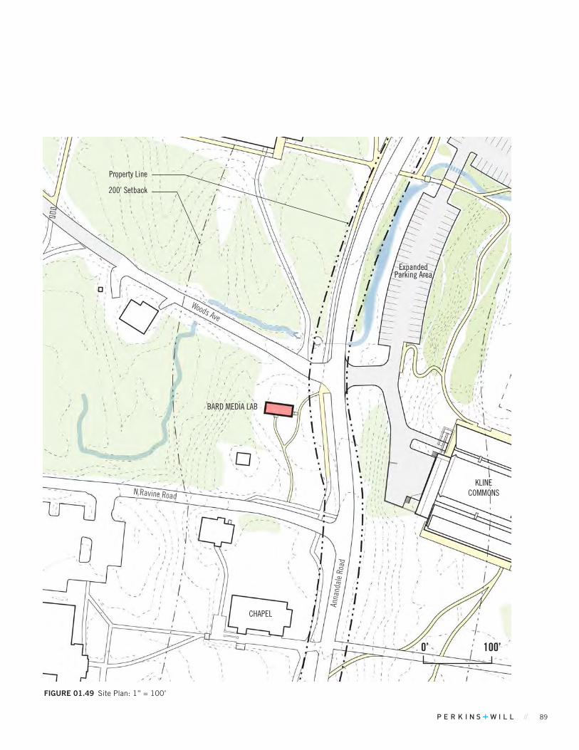
// 89
KLINE COMMONS
BARD MEDIA LAB
FIGuRE 01.49 Site Plan: 1” = 100’
CHAPEL
Property Line
200’ Setback
Anna
ndal
e Ro
ad
Expanded Parking Area
N Ravine Road
Woods Ave
0’ 100’
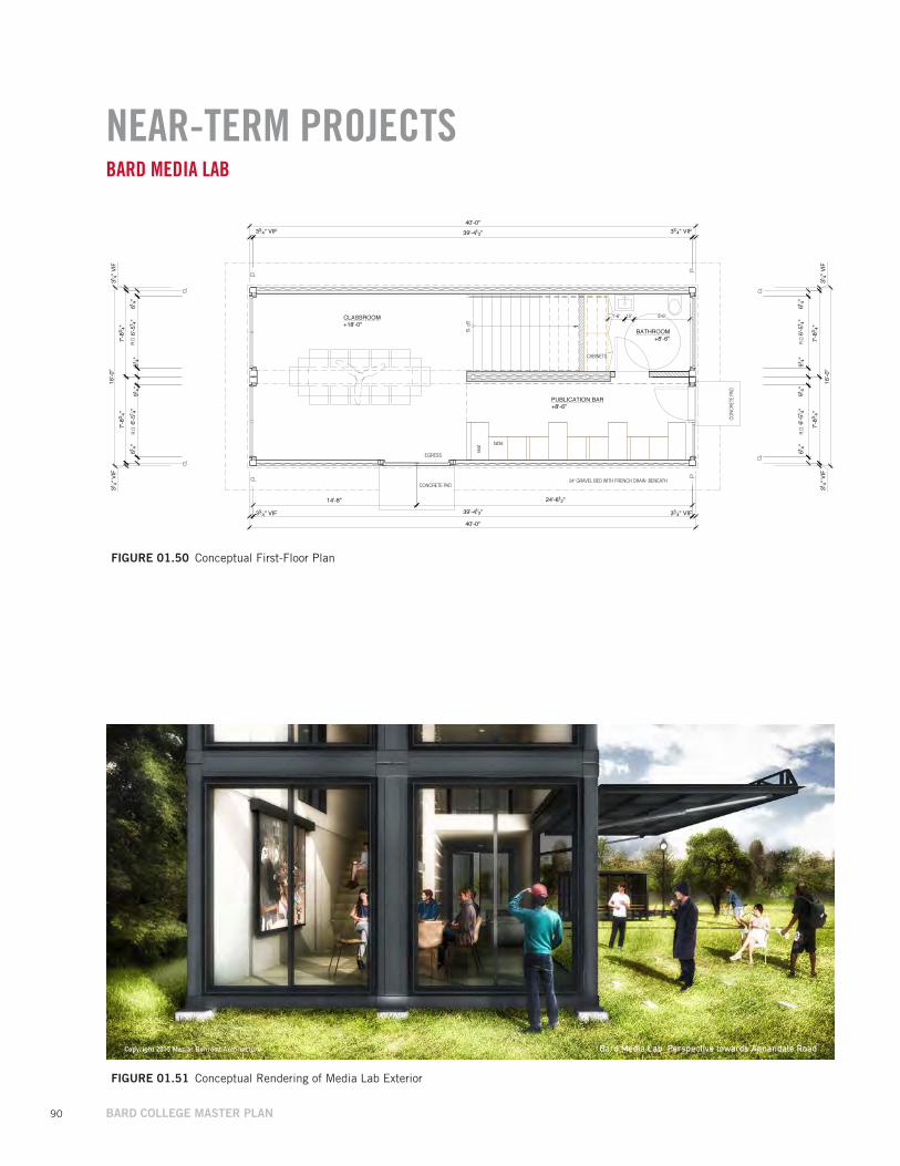
90 BARD COLLEGE MASTER PLAN
NEAR-TERM PROJECTSBARD MEDIA LAB
FIGuRE 01.50 Conceptual First-Floor Plan
FIGuRE 01.51 Conceptual Rendering of Media Lab Exterior

// 91
The Near-Term Projects in the Master Plan will not require any improvements to the wastewater and water supply treatment facilities. In addition to both facilities having excess capacity, the projects will not increase the student enrollment. The existing building expansion projects are meant to provide more space for existing students and programs. However, there will be approximately 1,200 SF of space in the Digital Science Commons building that could be utilized by the Red Hook Community and or public school system for programs. These community and school programs are not expected to occur very often, but may result in a very minor increase in daily water and sewage usage for the facility. Based on NYSDEC criteria of 0.1 GPD per SF, this results in an increase of approximately 120 gallons per day. Given the significant excess capacity of the water and sewer plant facilities, this increase is negligible. Each project will require installation of water supply distribution and sewage collection pipes connected to the existing campus water and sewer piping. In most cases, these projects will require Dutchess County Board of Health approval for extension of water and sewer piping.
If any project on the Near-Term list would disturb over one acre, the project will need to conform to the latest NYSDEC Stormwater Regulations and will prepare a Stormwater Pollution Prevention Plan to be reviewed and approved by the Town of Red Hook’s engineering consultant during the Site Plan Approval process. Projects that disturb less than one acre will still be required to prepare an Erosion and Sediment Control Plan. Each project will also install a stormwater collection system to convey runoff to the project’s stormwater practices, and ultimately connect to an existing campus collection system or discharge directly to an existing Hudson River tributary.
Near-Term Projects will have no effect on electric service capacity at the College. Electric service will be routed to each project on the Near-Term list and be coordinated with the College’s facilities staff.
* Campus infrastructure analysis based on NYSDEC flow reporting records from the past 12 months and past electric usage.
NEAR-TERM PROJECTS INFRASTRUCTURE ANALYSIS
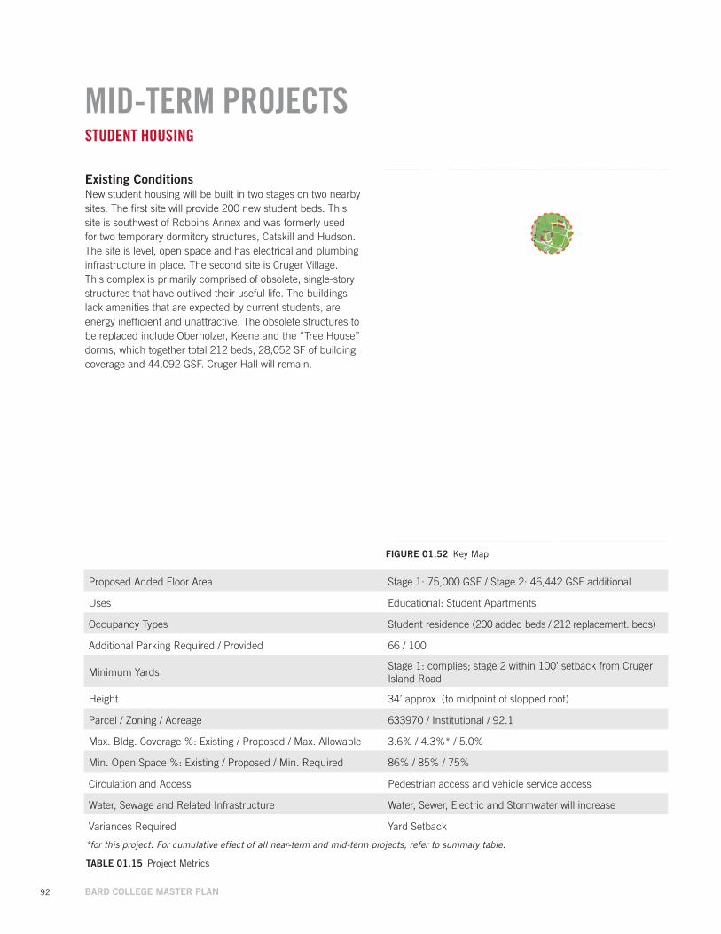
92 BARD COLLEGE MASTER PLAN
MID-TERM PROJECTSSTUDENT HOUSING
Existing ConditionsNew student housing will be built in two stages on two nearby sites. The first site will provide 200 new student beds. This site is southwest of Robbins Annex and was formerly used for two temporary dormitory structures, Catskill and Hudson. The site is level, open space and has electrical and plumbing infrastructure in place. The second site is Cruger Village. This complex is primarily comprised of obsolete, single-story structures that have outlived their useful life. The buildings lack amenities that are expected by current students, are energy inefficient and unattractive. The obsolete structures to be replaced include Oberholzer, Keene and the “Tree House” dorms, which together total 212 beds, 28,052 SF of building coverage and 44,092 GSF. Cruger Hall will remain.
FIGuRE 01.52 Key Map
TABLE 01.15 Project Metrics
Proposed Added Floor Area Stage 1: 75,000 GSF / Stage 2: 46,442 GSF additional
Uses Educational: Student Apartments
Occupancy Types Student residence (200 added beds / 212 replacement. beds)
Additional Parking Required / Provided 66 / 100
Minimum YardsStage 1: complies; stage 2 within 100’ setback from Cruger Island Road
Height 34’ approx. (to midpoint of slopped roof)
Parcel / Zoning / Acreage 633970 / Institutional / 92.1
Max. Bldg. Coverage %: Existing / Proposed / Max. Allowable 3.6% / 4.3%* / 5.0%
Min. Open Space %: Existing / Proposed / Min. Required 86% / 85% / 75%
Circulation and Access Pedestrian access and vehicle service access
Water, Sewage and Related Infrastructure Water, Sewer, Electric and Stormwater will increase
Variances Required Yard Setback
*for this project. For cumulative effect of all near-term and mid-term projects, refer to summary table.
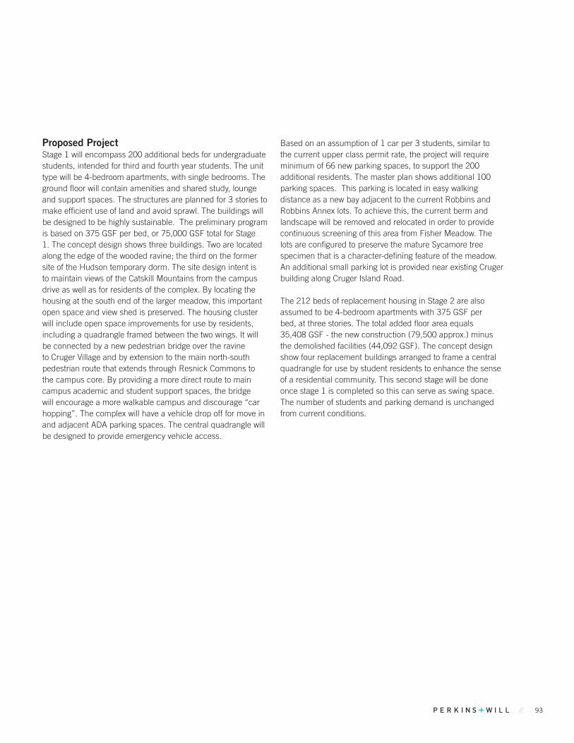
// 93
Proposed Project Stage 1 will encompass 200 additional beds for undergraduate students, intended for third and fourth year students. The unit type will be 4-bedroom apartments, with single bedrooms. The ground floor will contain amenities and shared study, lounge and support spaces. The structures are planned for 3 stories to make efficient use of land and avoid sprawl. The buildings will be designed to be highly sustainable. The preliminary program is based on 375 GSF per bed, or 75,000 GSF total for Stage 1. The concept design shows three buildings. Two are located along the edge of the wooded ravine; the third on the former site of the Hudson temporary dorm. The site design intent is to maintain views of the Catskill Mountains from the campus drive as well as for residents of the complex. By locating the housing at the south end of the larger meadow, this important open space and view shed is preserved. The housing cluster will include open space improvements for use by residents, including a quadrangle framed between the two wings. It will be connected by a new pedestrian bridge over the ravine to Cruger Village and by extension to the main north-south pedestrian route that extends through Resnick Commons to the campus core. By providing a more direct route to main campus academic and student support spaces, the bridge will encourage a more walkable campus and discourage “car hopping”. The complex will have a vehicle drop off for move in and adjacent ADA parking spaces. The central quadrangle will be designed to provide emergency vehicle access.
Based on an assumption of 1 car per 3 students, similar to the current upper class permit rate, the project will require minimum of 66 new parking spaces, to support the 200 additional residents. The master plan shows additional 100 parking spaces. This parking is located in easy walking distance as a new bay adjacent to the current Robbins and Robbins Annex lots. To achieve this, the current berm and landscape will be removed and relocated in order to provide continuous screening of this area from Fisher Meadow. The lots are configured to preserve the mature Sycamore tree specimen that is a character-defining feature of the meadow. An additional small parking lot is provided near existing Cruger building along Cruger Island Road.
The 212 beds of replacement housing in Stage 2 are also assumed to be 4-bedroom apartments with 375 GSF per bed, at three stories. The total added floor area equals 35,408 GSF - the new construction (79,500 approx.) minus the demolished facilities (44,092 GSF). The concept design show four replacement buildings arranged to frame a central quadrangle for use by student residents to enhance the sense of a residential community. This second stage will be done once stage 1 is completed so this can serve as swing space. The number of students and parking demand is unchanged from current conditions.
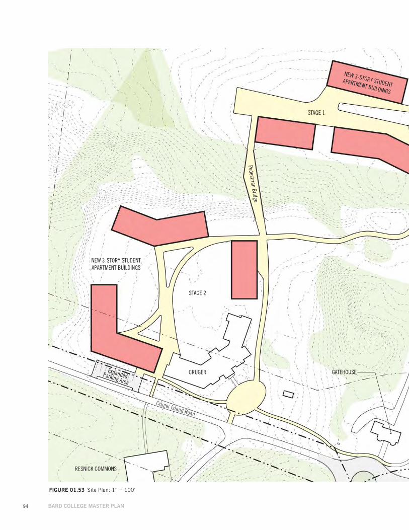
94 BARD COLLEGE MASTER PLAN
FIGuRE 01.53 Site Plan: 1” = 100’
Cruger Island Road
GATEHOUSEExpanded Parking Area
CRUGER
RESNICK COMMONS
STAGE 1
STAGE 2
Pedestrian Bridge
NEW 3-STORY STUDENT APARTMENT BUILDINGS
NEW 3-STORY STUDENT APARTMENT BUILDINGS
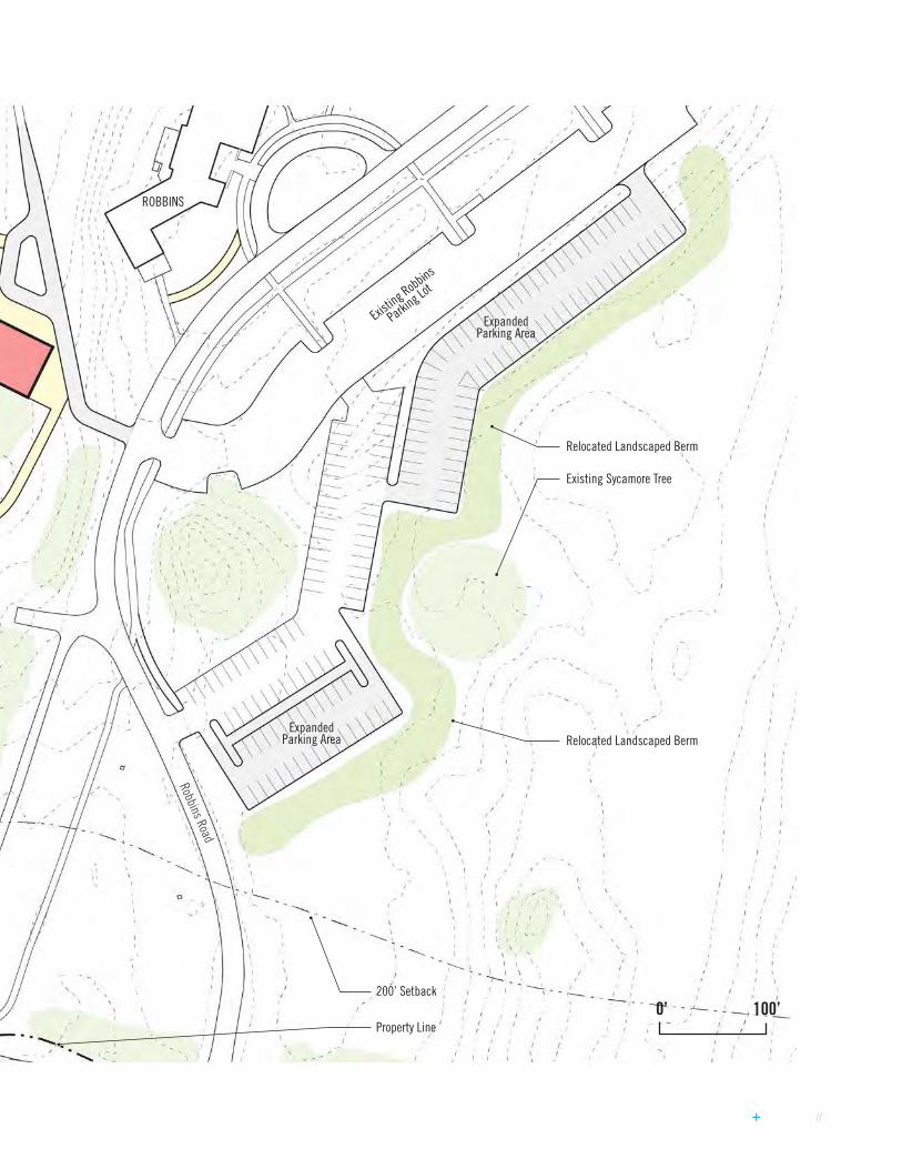
// 95
0’ 100’
Robbins Road
Property Line
200’ Setback
Expanded Parking Area
Expanded Parking Area
ROBBINS
Existing Robbins
Parking Lo
t
Relocated Landscaped Berm
Existing Sycamore Tree
Relocated Landscaped Berm
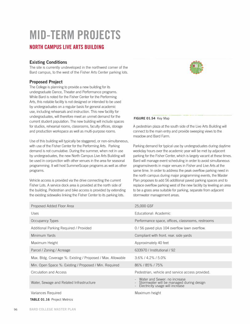
96 BARD COLLEGE MASTER PLAN
MID-TERM PROJECTSNORTH CAMPUS LIVE ARTS BUILDING
Existing ConditionsThe site is currently undeveloped in the northwest corner of the Bard campus, to the west of the Fisher Arts Center parking lots.
Proposed Project The College is planning to provide a new building for its undergraduate Dance, Theater and Performance programs. While Bard is noted for the Fisher Center for the Performing Arts, this notable facility is not designed or intended to be used by undergraduates on a regular basis for general academic use, including rehearsals and instruction. This new facility for undergraduates, will therefore meet an unmet demand for the current student population. The new building will include spaces for studios, rehearsal rooms, classrooms, faculty offices, storage and production workspace as well as multi-purpose rooms.
Use of this building will typically be staggered, or non-simultaneous, with use of the Fisher Center for the Performing Arts. Parking demand is not cumulative. During the summer, when not in use by undergraduates, the new North Campus Live Arts Building will be used in conjunction with other venues in the area for seasonal programming. It will host SummerScape programs as well as other programs.
Vehicle access is provided via the drive connecting the current Fisher Lots. A service dock area is provided at the north side of the building. Pedestrian and bike access is provided by extending the existing sidewalks linking the Fisher Center to its parking lots.
FIGuRE 01.54 Key Map
TABLE 01.16 Project Metrics
Proposed Added Floor Area 25,000 GSF
Uses Educational: Academic
Occupancy Types Performance space, offices, classrooms, restrooms
Additional Parking Required / Provided 0 / 56 paved plus 104 overflow lawn overflow.
Minimum Yards Compliant with front. rear. side yards
Maximum Height Approximately 40 feet
Parcel / Zoning / Acreage 633970 / Institutional / 92
Max. Bldg. Coverage %: Existing / Proposed / Max. Allowable 3.6% / 4.2% / 5.0%
Min. Open Space %: Existing / Proposed / Min. Required 86% / 85% / 75%
Circulation and Access Pedestrian, vehicle and service access provided.
Water, Sewage and Related Infrastructure - Water and Sewer: no increase - Stormwater will be managed during design - Electricity usage will increase
Variances Required Maximum height
A pedestrian plaza at the south side of the Live Arts Building will connect to the main entry and provide sweeping views to the meadow and Bard Farm.
Parking demand for typical use by undergraduates during daytime weekday hours over the academic year will be met by adjacent parking for the Fisher Center, which is largely vacant at these times. Bard will manage event scheduling in order to avoid simultaneous programs/events in major venues in Fisher and Live Arts at the same time. In order to address the peak overflow parking need in the north campus during major programming events, the Master Plan proposes to add 56 additional paved parking spaces and to replace overflow parking west of the new facility by leveling an area to be a grass area suitable for parking, separate from adjacent stormwater management areas.
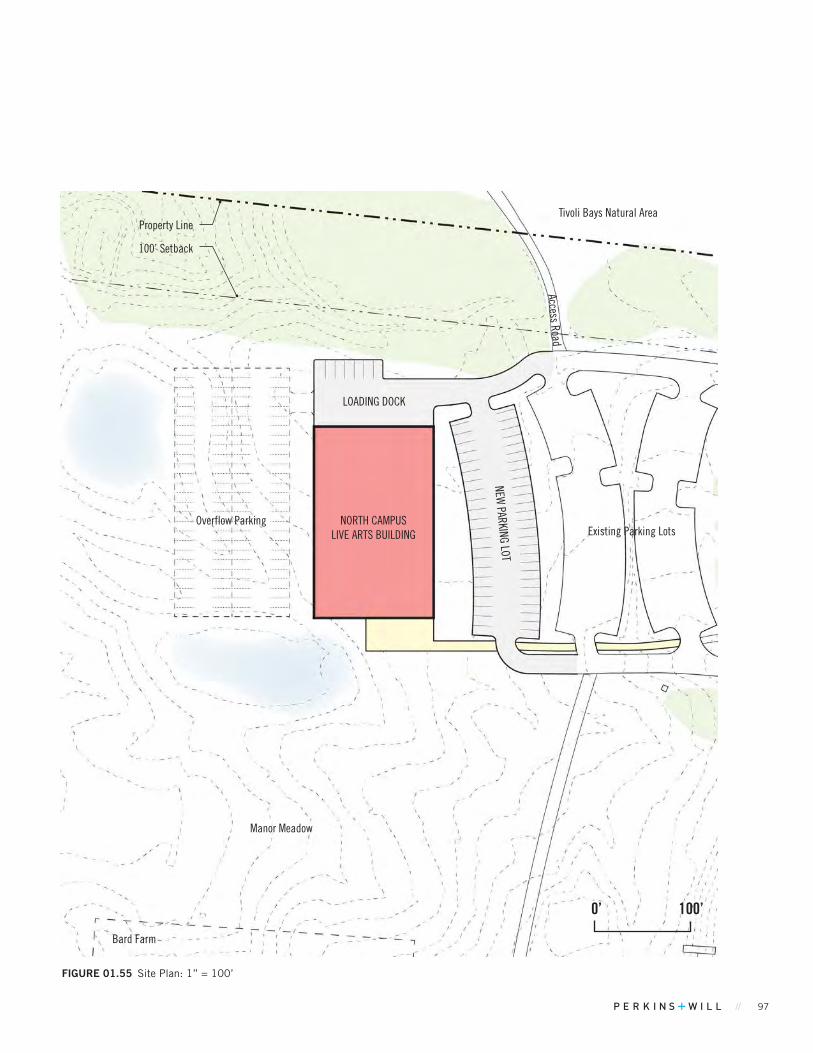
// 97
FIGuRE 01.55 Site Plan: 1” = 100’
0’ 100’
NORTH CAMPUS LIVE ARTS BUILDING
Property Line
100’ Setback
Existing Parking Lots
NEW PARKING LOT
Bard Farm
Manor Meadow
LOADING DOCK
Access Road
Overflow Parking
Tivoli Bays Natural Area
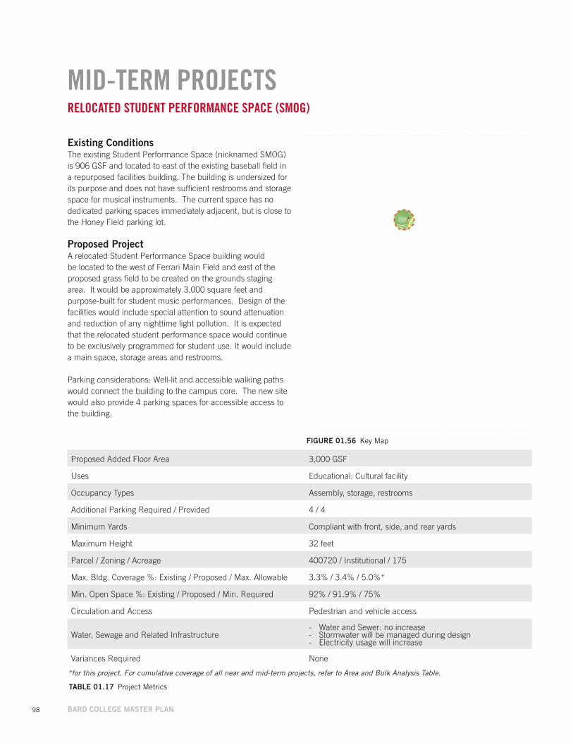
98 BARD COLLEGE MASTER PLAN
MID-TERM PROJECTSRELOCATED STUDENT PERFORMANCE SPACE (SMOG)
Existing ConditionsThe existing Student Performance Space (nicknamed SMOG) is 906 GSF and located to east of the existing baseball field in a repurposed facilities building. The building is undersized for its purpose and does not have sufficient restrooms and storage space for musical instruments. The current space has no dedicated parking spaces immediately adjacent, but is close to the Honey Field parking lot.
Proposed Project A relocated Student Performance Space building would be located to the west of Ferrari Main Field and east of the proposed grass field to be created on the grounds staging area. It would be approximately 3,000 square feet and purpose-built for student music performances. Design of the facilities would include special attention to sound attenuation and reduction of any nighttime light pollution. It is expected that the relocated student performance space would continue to be exclusively programmed for student use. It would include a main space, storage areas and restrooms.
Parking considerations: Well-lit and accessible walking paths would connect the building to the campus core. The new site would also provide 4 parking spaces for accessible access to the building.
TABLE 01.17 Project Metrics
Proposed Added Floor Area 3,000 GSF
Uses Educational: Cultural facility
Occupancy Types Assembly, storage, restrooms
Additional Parking Required / Provided 4 / 4
Minimum Yards Compliant with front, side, and rear yards
Maximum Height 32 feet
Parcel / Zoning / Acreage 400720 / Institutional / 175
Max. Bldg. Coverage %: Existing / Proposed / Max. Allowable 3.3% / 3.4% / 5.0%*
Min. Open Space %: Existing / Proposed / Min. Required 92% / 91.9% / 75%
Circulation and Access Pedestrian and vehicle access
Water, Sewage and Related Infrastructure - Water and Sewer: no increase - Stormwater will be managed during design - Electricity usage will increase
Variances Required None
FIGuRE 01.56 Key Map
*for this project. For cumulative coverage of all near and mid-term projects, refer to Area and Bulk Analysis Table.
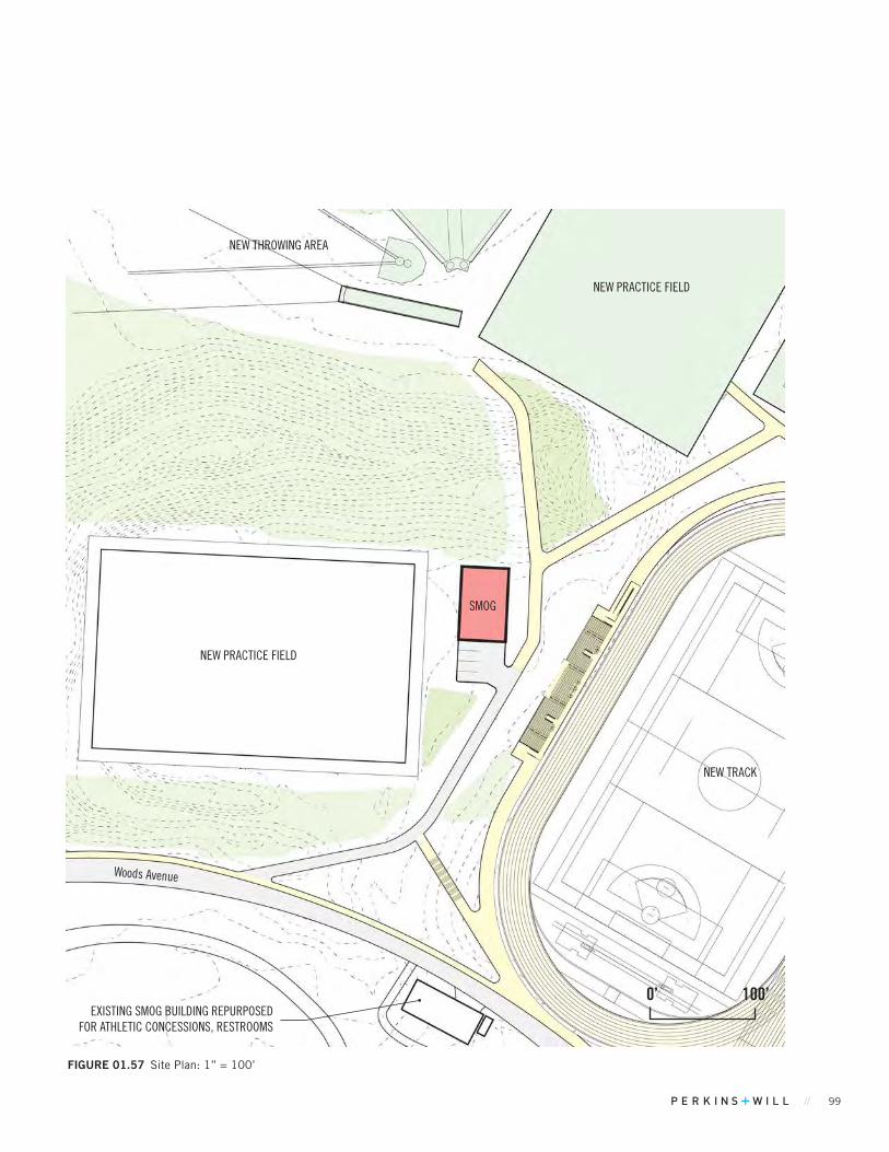
// 99
FIGuRE 01.57 Site Plan: 1” = 100’
SMOG
EXISTING SMOG BUILDING REPURPOSED FOR ATHLETIC CONCESSIONS, RESTROOMS
NEW TRACK
NEW THROWING AREA
NEW PRACTICE FIELD
0’ 100’
NEW PRACTICE FIELD
Woods Avenue
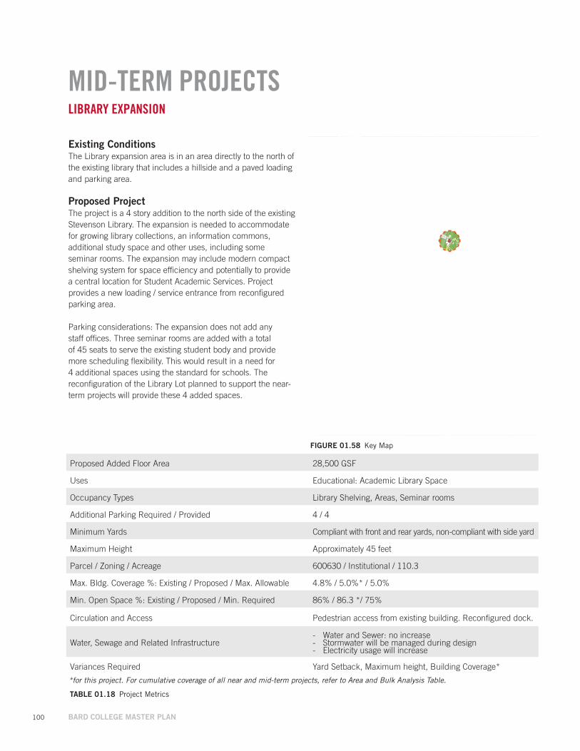
100 BARD COLLEGE MASTER PLAN
MID-TERM PROJECTSLIBRARY EXPANSION
Existing ConditionsThe Library expansion area is in an area directly to the north of the existing library that includes a hillside and a paved loading and parking area.
Proposed Project The project is a 4 story addition to the north side of the existing Stevenson Library. The expansion is needed to accommodate for growing library collections, an information commons, additional study space and other uses, including some seminar rooms. The expansion may include modern compact shelving system for space efficiency and potentially to provide a central location for Student Academic Services. Project provides a new loading / service entrance from reconfigured parking area.
Parking considerations: The expansion does not add any staff offices. Three seminar rooms are added with a total of 45 seats to serve the existing student body and provide more scheduling flexibility. This would result in a need for 4 additional spaces using the standard for schools. The reconfiguration of the Library Lot planned to support the near-term projects will provide these 4 added spaces.
FIGuRE 01.58 Key Map
TABLE 01.18 Project Metrics
Proposed Added Floor Area 28,500 GSF
Uses Educational: Academic Library Space
Occupancy Types Library Shelving, Areas, Seminar rooms
Additional Parking Required / Provided 4 / 4
Minimum Yards Compliant with front and rear yards, non-compliant with side yard
Maximum Height Approximately 45 feet
Parcel / Zoning / Acreage 600630 / Institutional / 110.3
Max. Bldg. Coverage %: Existing / Proposed / Max. Allowable 4.8% / 5.0%* / 5.0%
Min. Open Space %: Existing / Proposed / Min. Required 86% / 86.3 */ 75%
Circulation and Access Pedestrian access from existing building. Reconfigured dock.
Water, Sewage and Related Infrastructure - Water and Sewer: no increase - Stormwater will be managed during design - Electricity usage will increase
Variances Required Yard Setback, Maximum height, Building Coverage*
*for this project. For cumulative coverage of all near and mid-term projects, refer to Area and Bulk Analysis Table.

// 101
FIGuRE 01.59 Site Plan: 1” = 100’
KLINE COMMONS
LIBRARY EXPANSION
STEVENSON LIBRARY
OLIN
Griff
iths W
alk
0’ 100’
Reconfigured and Expanded Parking
Property Line
100’ Setback
Bard-Owned Parcel
Bard-Owned ParcelBard-Owned Parcel
Bard-Owned Parcel
Bard-Owned Parcel
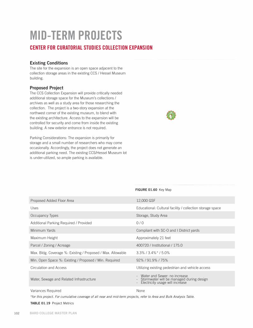
102 BARD COLLEGE MASTER PLAN
MID-TERM PROJECTSCENTER FOR CURATORIAL STUDIES COLLECTION EXPANSION
Existing ConditionsThe site for the expansion is an open space adjacent to the collection storage areas in the existing CCS / Hessel Museum building.
Proposed Project The CCS Collection Expansion will provide critically needed additional storage space for the Museum’s collections / archives as well as a study area for those researching the collection. The project is a two-story expansion at the northwest corner of the existing museum, to blend with the existing architecture. Access to the expansion will be controlled for security and come from inside the existing building. A new exterior entrance is not required.
Parking Considerations: The expansion is primarily for storage and a small number of researchers who may come occasionally. Accordingly, the project does not generate an additional parking need. The existing CCS/Hessel Museum lot is under-utilized, so ample parking is available.
FIGuRE 01.60 Key Map
TABLE 01.19 Project Metrics
Proposed Added Floor Area 12,000 GSF
Uses Educational: Cultural facility / collection storage space
Occupancy Types Storage, Study Area
Additional Parking Required / Provided 0 / 0
Minimum Yards Compliant with SC-O and I District yards
Maximum Height Approximately 21 feet
Parcel / Zoning / Acreage 400720 / Institutional / 175.0
Max. Bldg. Coverage %: Existing / Proposed / Max. Allowable 3.3% / 3.4%* / 5.0%
Min. Open Space %: Existing / Proposed / Min. Required 92% / 91.9% / 75%
Circulation and Access Utilizing existing pedestrian and vehicle access
Water, Sewage and Related Infrastructure - Water and Sewer: no increase - Stormwater will be managed during design - Electricity usage will increase
Variances Required None
*for this project. For cumulative coverage of all near and mid-term projects, refer to Area and Bulk Analysis Table.
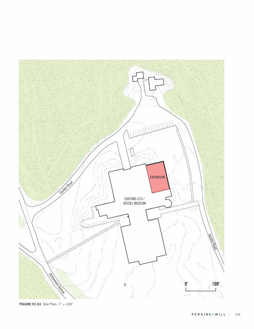
// 103
FIGuRE 01.61 Site Plan: 1” = 100’
EXPANSION
EXISTING CCS / HESSEL MUSEUM
0’ 100’
Garden Road
Blithewood AvenueGard
en Road
104 BARD COLLEGE MASTER PLAN
MID-TERM PROJECTSMFA STUDIO BUILDING
FIGuRE 01.62 Key Map
Existing ConditionsThe site for the proposed project is the Fisher Annex Building. This single-story, obsolete metal temporary building housing offices will be demolished. The College currently rents space in the Town of Red Hook for its summer MFA program. The project intent is to relocate this function onto the campus so it is better integrated with other programs and college facilities.
Proposed Project The project is a new, 3-story building west of the Fisher Studio Building and east of an existing drive and parking lot beyond. The building will include 80 MFA studio spaces, and replacement offices for those eliminated when the Fisher Annex is demolished.
The parking lot will be expanded to address current congestion in this area which also serves Admissions, the Fine Arts programs and the Campus Center.
Parking considerations: The MFA Program is unique in that it occurs over the summer exclusively when parking demand is low. Since parking need is staggered by season in this case (rather than by time of day, or day of the week), the existing 99 spaces north and west of the project site should be sufficient. (If Bard desires and has funding, the lot to the west could be expanded to provide more spaces to meet demand during the academic year).
TABLE 01.20 Project Metrics
Proposed Added Floor Area 38,000 GSF
Uses Educational: Academic
Occupancy Types Art studios, offices, restrooms
Additional Parking Required / Provided 0 / 33 (Optional Expansion)
Minimum Yards Compliant with SC-O District yards
Maximum Height 42 feet
Parcel / Zoning / Acreage 400720 / Institutional / 175
Max. Bldg. Coverage %: Existing / Proposed / Max. Allowable 3.3% / 3.4%* / 5.0%
Min. Open Space %: Existing / Proposed / Min. Required 92% / 91.8% / 75%
Circulation and Access Utilizes existing pedestrian and vehicle access
Water, Sewage and Related Infrastructure - Water and Sewer: no overall campus increase - Stormwater will be managed during design - Electricity usage: No increase as summer program
Variances Required Maximum Height
*for this project. For cumulative coverage of all near and mid-term projects, refer to Area and Bulk Analysis Table.

// 105
FIGuRE 01.63 Site Plan: 1” = 100’
CAMPUS CENTER
FISHER
ADMISSIONS
CHAPEL
Expa
nded
Par
king
Lot
0’ 100’
N. Ravine Road
NEW M
FA STUDIO BUILDING
Property Line
200’ Setback
106 BARD COLLEGE MASTER PLAN
MID-TERM PROJECTSCAMPUS AND COMMUNITY RECREATIONAL FACILITIES, PHASE 2
Existing ConditionsThe area is currently occupied by Stevenson Gymnasium, tennis courts, access drives and parking, athletic fields, a grounds keeping staging area.
Proposed Project The Phase 2 of the Campus and Community Recreation Facilities project around the Stevenson Athletic Center will add significant new indoor and outdoor space to enhance student life and community engagement at Bard. The addition will be used for recreation by the campus and by community members, including a space for basketball, tennis and volleyball surrounded by an elevated track. This large space will be suitable for occasional assemblies by the College and community. The addition will also include spaces for fitness and group exercise, as well as meeting areas that vary in size and privacy. The expansion will not be used as a competition venue for athletic teams. The existing gym will have 428 retractable seats.
The new volume will form an exterior courtyard of lawns and outdoor play surfaces to complement a cascade of new terraces and roof gardens focused toward Ferrari Main field and views to the Hudson River and Catskill Mountains beyond.
This project includes several new outdoor field amenities: a new 400-meter track around Ferrari Main with spectator viewing integrated into the new Stevenson Courtyard. (Converting Ferrari Main from grass to artificial turf is a near-term project). This project will also re-orient Ferrari North for a more efficient field alignment. It will relocate six tennis courts onto the space now occupied by the parking lot with 87 spaces, used primarily by students in the Village Dorms complex. This parking will be replaced to the north in the expanded Robbins / Robbins Annex lots. This project is separate from parking needed for the Recreation Facility project (see below).
The project also includes two additional grass practice fields, a throwing area, and a softball field. The re-designed site circulation promotes safety and legibility by transforming the north-south road west of Stevenson into an access road open only to emergency and service vehicles. Public traffic routes are strengthened by the augmentation of access to existing and expanded parking, and by the addition of a drop-off loop.
To address the congestion in the Stevenson Gym parking lot and improve community access, the plan will utilize 3 new
TABLE 01.21 Project Metrics
Proposed Added Floor Area 97,000 GSF
Uses Educational: Athletics and recreation / interior space
Occupancy TypesFitness and group exercise, meeting areas, locker rooms, storage, restrooms
Additional Parking Required / Provided 200 / 130 add. space (plus 195 space east of Annandale*)
Minimum YardsExisting building and accessway non-compliant with SC-O District front yards. Proposed addition and accessways also non-compliant.
Maximum Height 39 feet
Parcel / Zoning / Acreage 400720 / Institutional / 175
Max. Bldg. Coverage %: Existing / Proposed / Max. Allowable 3.3% / 4.6%/ 5.0%
Min. Open Space %: Existing / Proposed / Min. Required 90% / 86%** / 75% (existing = proposed near term)
Circulation and Access Improvements to pedestrian, vehicle, service access.
Water, Sewage and Related Infrastructure - Water, Sewer and Electricity will increase - Stormwater will be managed during design - Electricity usage will increase
Variances Required Maximum Heights, Minimum Yards (front)
*max. available for staggered use when this peak demand exists on evenings and weekends when Kline and Library Lots are not utilized**for this project only. For cumulative assessment, see summary table.
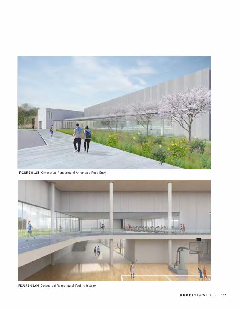
// 107
FIGuRE 01.64 Conceptual Rendering of Facility Interior
FIGuRE 01.65 Conceptual Rendering of Annandale Road Entry
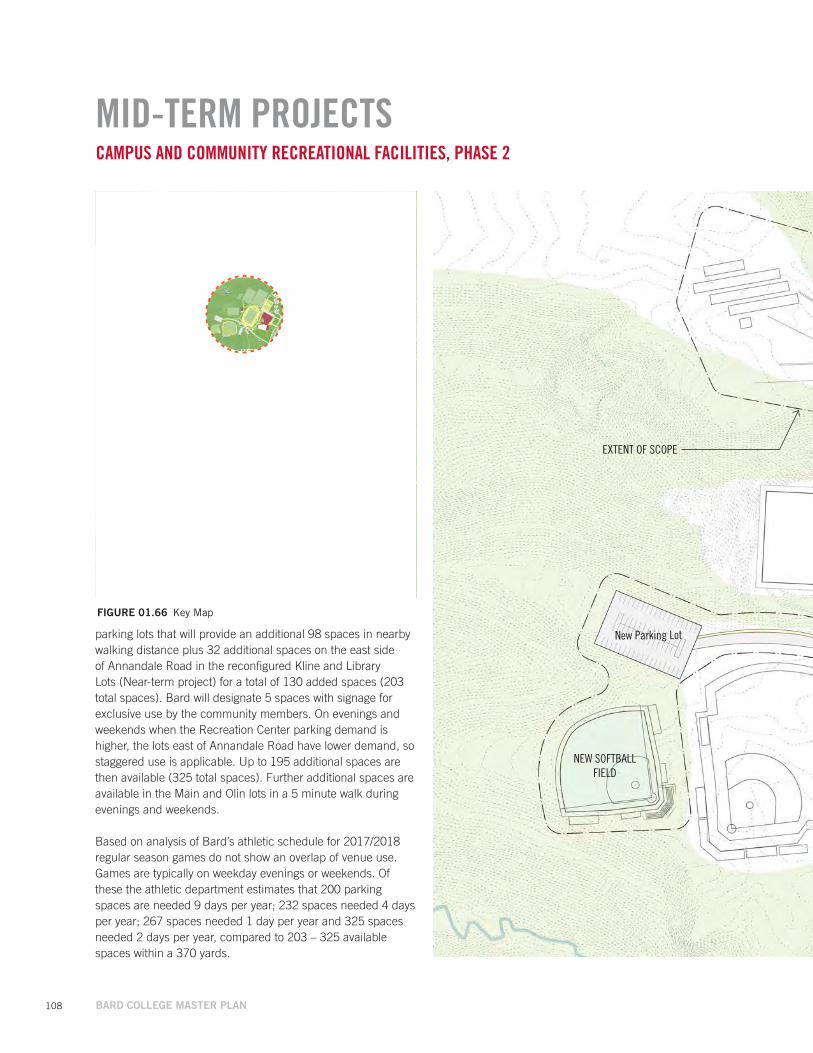
108 BARD COLLEGE MASTER PLAN
EXTENT OF SCOPE
NEW SOFTBALL FIELD
FIGuRE 01.66 Key Map
CAMPUS AND COMMUNITY RECREATIONAL FACILITIES, PHASE 2
parking lots that will provide an additional 98 spaces in nearby walking distance plus 32 additional spaces on the east side of Annandale Road in the reconfigured Kline and Library Lots (Near-term project) for a total of 130 added spaces (203 total spaces). Bard will designate 5 spaces with signage for exclusive use by the community members. On evenings and weekends when the Recreation Center parking demand is higher, the lots east of Annandale Road have lower demand, so staggered use is applicable. Up to 195 additional spaces are then available (325 total spaces). Further additional spaces are available in the Main and Olin lots in a 5 minute walk during evenings and weekends.
Based on analysis of Bard’s athletic schedule for 2017/2018 regular season games do not show an overlap of venue use. Games are typically on weekday evenings or weekends. Of these the athletic department estimates that 200 parking spaces are needed 9 days per year; 232 spaces needed 4 days per year; 267 spaces needed 1 day per year and 325 spaces needed 2 days per year, compared to 203 – 325 available spaces within a 370 yards.
MID-TERM PROJECTS
New Parking Lot
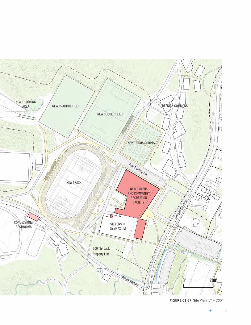
// 109
FIGuRE 01.67 Site Plan: 1” = 200’
NEW PRACTICE FIELD
NEW SOCCER FIELD
NEW TENNIS COURTS
NEW TRACK
NEW CAMPUS AND COMMUNITY
RECREATION FACILITY
0’ 200’
NEW THROWING AREA
Anna
ndale
Roa
d
Woods Avenue
RESNICK COMMONS
New Parking Lot
STEVENSON GYMNASIUM
Property Line
200’ Setback
CONCESSIONS, RESTROOMS
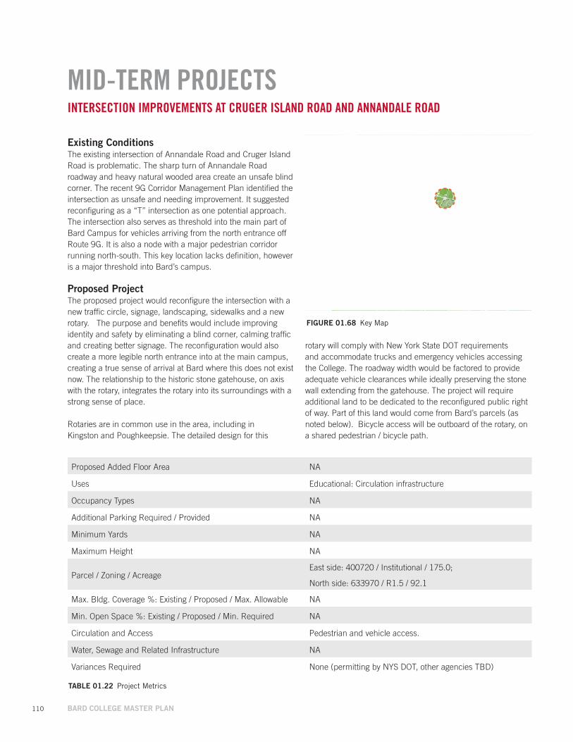
110 BARD COLLEGE MASTER PLAN
MID-TERM PROJECTSINTERSECTION IMPROVEMENTS AT CRUGER ISLAND ROAD AND ANNANDALE ROAD
Existing ConditionsThe existing intersection of Annandale Road and Cruger Island Road is problematic. The sharp turn of Annandale Road roadway and heavy natural wooded area create an unsafe blind corner. The recent 9G Corridor Management Plan identified the intersection as unsafe and needing improvement. It suggested reconfiguring as a “T” intersection as one potential approach. The intersection also serves as threshold into the main part of Bard Campus for vehicles arriving from the north entrance off Route 9G. It is also a node with a major pedestrian corridor running north-south. This key location lacks definition, however is a major threshold into Bard’s campus.
Proposed Project The proposed project would reconfigure the intersection with a new traffic circle, signage, landscaping, sidewalks and a new rotary. The purpose and benefits would include improving identity and safety by eliminating a blind corner, calming traffic and creating better signage. The reconfiguration would also create a more legible north entrance into at the main campus, creating a true sense of arrival at Bard where this does not exist now. The relationship to the historic stone gatehouse, on axis with the rotary, integrates the rotary into its surroundings with a strong sense of place.
Rotaries are in common use in the area, including in Kingston and Poughkeepsie. The detailed design for this
FIGuRE 01.68 Key Map
rotary will comply with New York State DOT requirements and accommodate trucks and emergency vehicles accessing the College. The roadway width would be factored to provide adequate vehicle clearances while ideally preserving the stone wall extending from the gatehouse. The project will require additional land to be dedicated to the reconfigured public right of way. Part of this land would come from Bard’s parcels (as noted below). Bicycle access will be outboard of the rotary, on a shared pedestrian / bicycle path.
TABLE 01.22 Project Metrics
Proposed Added Floor Area NA
Uses Educational: Circulation infrastructure
Occupancy Types NA
Additional Parking Required / Provided NA
Minimum Yards NA
Maximum Height NA
Parcel / Zoning / AcreageEast side: 400720 / Institutional / 175.0;
North side: 633970 / R1.5 / 92.1
Max. Bldg. Coverage %: Existing / Proposed / Max. Allowable NA
Min. Open Space %: Existing / Proposed / Min. Required NA
Circulation and Access Pedestrian and vehicle access.
Water, Sewage and Related Infrastructure NA
Variances Required None (permitting by NYS DOT, other agencies TBD)
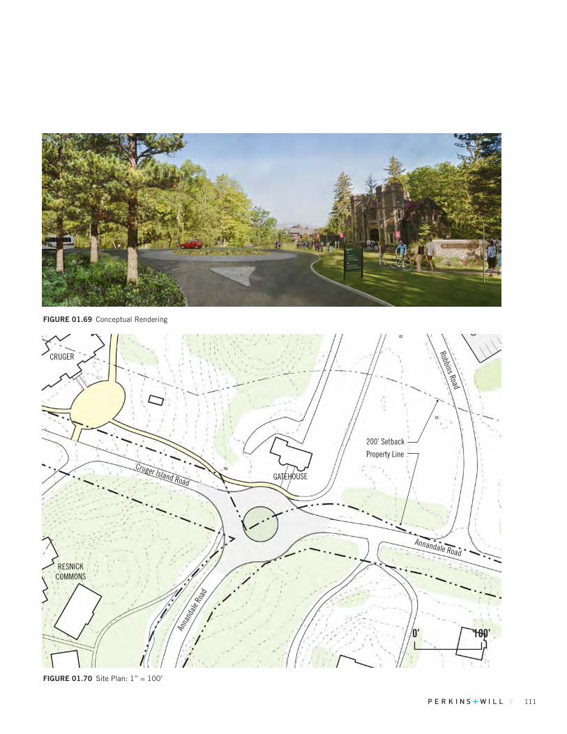
// 111
FIGuRE 01.69 Conceptual Rendering
FIGuRE 01.70 Site Plan: 1” = 100’
Annandale Road
0’ 100’
Cruger Island RoadGATEHOUSE
Anna
ndale
Roa
d
Robbins Road
CRUGER
RESNICK COMMONS
Property Line
200’ Setback
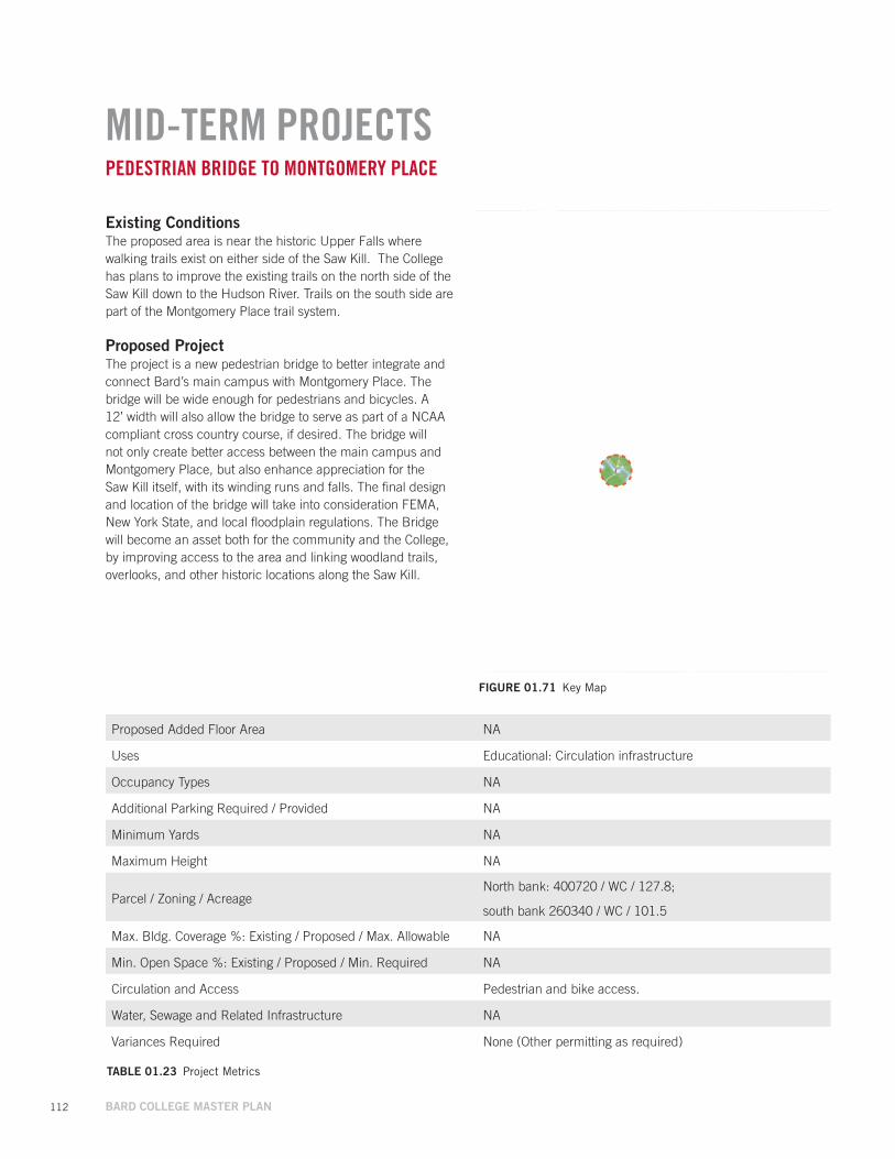
112 BARD COLLEGE MASTER PLAN
MID-TERM PROJECTSPEDESTRIAN BRIDGE TO MONTGOMERY PLACE
FIGuRE 01.71 Key Map
Existing ConditionsThe proposed area is near the historic Upper Falls where walking trails exist on either side of the Saw Kill. The College has plans to improve the existing trails on the north side of the Saw Kill down to the Hudson River. Trails on the south side are part of the Montgomery Place trail system.
Proposed Project The project is a new pedestrian bridge to better integrate and connect Bard’s main campus with Montgomery Place. The bridge will be wide enough for pedestrians and bicycles. A 12’ width will also allow the bridge to serve as part of a NCAA compliant cross country course, if desired. The bridge will not only create better access between the main campus and Montgomery Place, but also enhance appreciation for the Saw Kill itself, with its winding runs and falls. The final design and location of the bridge will take into consideration FEMA, New York State, and local floodplain regulations. The Bridge will become an asset both for the community and the College, by improving access to the area and linking woodland trails, overlooks, and other historic locations along the Saw Kill.
TABLE 01.23 Project Metrics
Proposed Added Floor Area NA
Uses Educational: Circulation infrastructure
Occupancy Types NA
Additional Parking Required / Provided NA
Minimum Yards NA
Maximum Height NA
Parcel / Zoning / AcreageNorth bank: 400720 / WC / 127.8;
south bank 260340 / WC / 101.5
Max. Bldg. Coverage %: Existing / Proposed / Max. Allowable NA
Min. Open Space %: Existing / Proposed / Min. Required NA
Circulation and Access Pedestrian and bike access.
Water, Sewage and Related Infrastructure NA
Variances Required None (Other permitting as required)
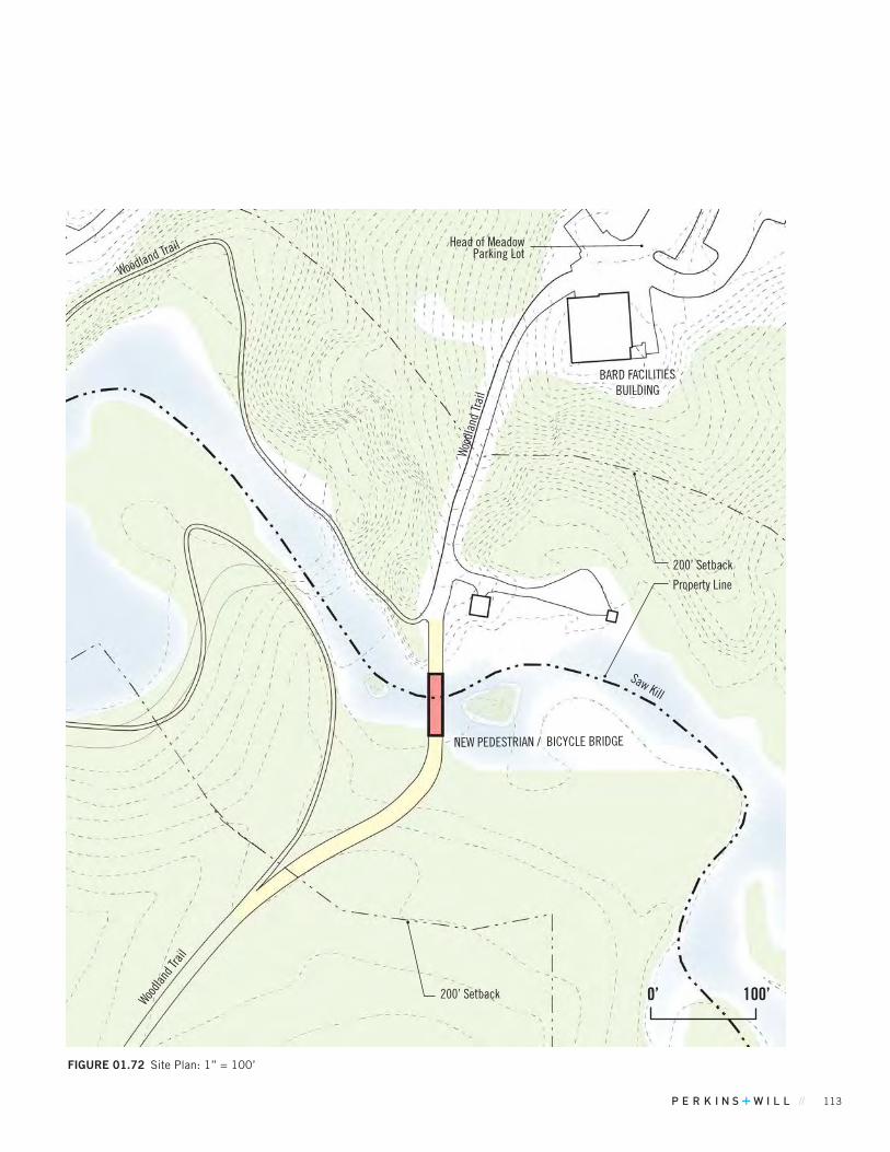
// 113
FIGuRE 01.72 Site Plan: 1” = 100’
Saw Kill
0’ 100’Woodla
nd Tr
ail
Woodland Trail
Wood
land
Trai
l
BARD FACILITIES BUILDING
Head of Meadow Parking Lot
NEW PEDESTRIAN / BICYCLE BRIDGE
Property Line
200’ Setback
200’ Setback
114 BARD COLLEGE MASTER PLAN
Tivoli Bays
The Mid-Term Projects in the Master Plan are not anticipated to require any improvements to the wastewater and water supply treatment facilities, as there is excess capacity in both facilities to accommodate the increase in water and sewer requirements for several of the Mid-Term projects. There is approximately 125,000 gallons per day excess capacity at the water treatment plant, and approximately 55,000 gallons per day excess capacity at the sewage treatment facility during peak school periods. The following projects on the Mid-Term list will increase water and sewerage usage:
Student HousingThe student housing project is expected to add approximately 200 beds to current on-campus housing. Using NYSEDC criteria of 75 GPD per bed equates to 15,000 GPD of additional water and sewage use.
Campus and Community Recreational Facilities Phase 2 The Phase 2 expansion will include additional amenities that will likely result in increased community use of the facility. The additional community use of the facility will result in some additional increase in water and sewage use. As the Phase 2 facility expansion will not be used for additional competition venues for athletic events, the increase in water and sewage use is limited to additional community use of the facility. Although the increase in community use is difficult to quantify, the water and sewage usage associated with the community usage is limited to bathrooms and shower facilities. To be conservative, we estimate an average of approximately 2000 gallons per day for community use of the new facility.
Given the significant excess capacity of the college’s water and sewage treatment facilities, the Student Housing and Campus and Community Recreational Facility projects will not require any expansion of the treatment facilities.
The other projects on the Mid-Term list are either expansions of existing buildings to provide additional learning space, or new buildings to provide enhanced learning space for students. The Mid-Term projects will not result in an increase in student enrollment. It should be noted that the MFA Studio Building project will relocate this program from rented off campus space to on campus. This program is only held during the summer months when water and sewage use is low, therefore the project will not impact the overall water a sewage treatment facilities
Each project on the Mid-Term list however, will require installation of water supply distribution and sewage collection pipes connected to the existing campus water and sewer piping. In most cases, these projects will require Dutchess County Board of Health approval for extension of water and sewer piping.
Any planned improvements to the Montgomery Place site in the Mid-Term will likely be reconstruction of existing buildings which will not increase sewage or water demands. Currently, Montgomery Place is served by an individual water supply wells, and subsurface sewage disposal systems. If any existing building reconstruction project does result in an increase in water supply or sewage disposal demand, it will likely be minor enough that the existing water and sewage disposal systems on the site will be upgraded with approval from the Dutchess County Department of Health.
If any project on the Mid-Term list is disturbing over one acre, the project will need to conform to the latest NYSDEC Stormwater Regulations, and will prepare a Stormwater Pollution Prevention Plan to be reviewed and approved by the Town of Red Hook’s engineering consultant during the Site Plan Approval process. Projects that disturb less than one acre will still be required to prepare an Erosion and Sediment Control Plan. Each project will also install a stormwater collection system to convey runoff to the projects storm water practices and ultimately connect to an existing campus collection system or discharge directly to an existing Hudson River tributary.
Mid-Term Projects will have no effect on electric service capacity at the College. Electric service will be routed to each project on the Mid-Term list and coordinated with the College’s facilities staff.
* Campus infrastructure analysis based on NYSDEC flow reporting records from the past 12 months and past electric usage.
MID-TERM PROJECT INFRASTRUCTURE ANALYSIS
FIGuRE 01.74 Near and Mid-Term Project Locations
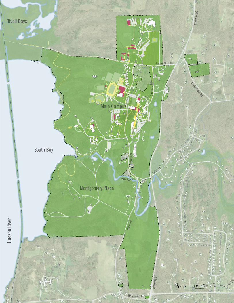
// 115
Huds
on R
iver
Tivoli Bays
Montgomery Place
South Bay
Kelly Rd
Rive
r Rd
High
way 9
G
High
way 9
G
Barrytown Rd
Annandale Rd
Annandale RdMain Campus
Cam
pus
Rd
Whalesback Rd
Saw Kill
116 BARD COLLEGE MASTER PLAN
LONG-TERM IDEAS
A. ADDITIONAL STUDENT HOUSINGThe College would like to eventually house 85% of students on campus (undergraduate and graduate). This correlates to 314 additional beds, following the Mid-term Housing Project, which adds 200 beds (plus demolishing obsolete facilities with 212 beds and replacing these with 212 beds in new construction). The realization of this project will depend both on market conditions, student preferences and available funding.
The College has multiple available sites suitable for student housing. Some additional beds are feasible in the vicinity of the Mid-term Housing Project. A new student residence hall could be accommodated between Tewksbury Hall and the Campus Center, to complete framing this quadrangle. With a three-story building, this site could fit approximately 80 beds. The site south of Blithewood Avenue and east of the water tower parking lot could accommodate housing around the perimeter, maintaining a green central open space. Housing in this central location would be in close walking distance of dining, student services, the library and most academic buildings on campus.
FIGuRE 01.75 Long-Term Ideas Locations
Tivoli Bays
B. MONTGOMERY PLACE COLLECTION FACILITYBard intends to construct a new facility to provide long-term stewardship of the historic collection materials associated with Montgomery Place. The building would primarily be a archival storage building, with study area for visitors, support space and staff offices. The building would also have an area open to the public at regular times for interpreting the site, structures and historic significance of Montgomery Place. The building together may be 25,000 GSF.
The location of this new facility will be in the area now occupied by the Visitor Center, its parking lot and environs. The existing Visitor Center, now used primarily for storage, with some space open for visitors at times, is obsolete functionally, deteriorated physically and makes poor use of an important site that is proximate but removed from historically and environmentally sensitive area.
The parking for the building would reflect it function as primarily a storage / curatorial facility with some visitor use. Overflow parking on suitable lawn areas (away from historic areas and buffers) would be used for visitor and staff parking for special events.
C. STEPHEN SHORE PHOTOGRAPHY ARCHIVEThe College intends to build Photography Archive Building to be an active study, research and collection facility. A significant part of the facility will house works by Stephen Shore, the Director of the Photography Program at Bard and a notable professional photographer. The project could be built in collaboration with the Center for Curatorial Studies and may be located near the CCS/Hessel Museum for efficiencies and to promote collaboration. The building or addition will include climate-controlled spaces for long-term preservation of photographs, an archival study room, offices, support areas and possibly a small gallery.
Students
PROJECTED ENROLLMENT (UNDERGRADUATE + GRADUATE)
2,335
LONG-TERM ON CAMPUS HOUSING GOAL / 85% 1,985
Beds
EXISTING BEDS 1,471
PROPOSED ADDITIONAL BEDS (MID-TERM) 200
PROPOSED ADDITIONAL BEDS (LONG-TERM) 314
TOTAL BEDS 1,985
TABLE 01.24 Enrollment & Beds Metrics
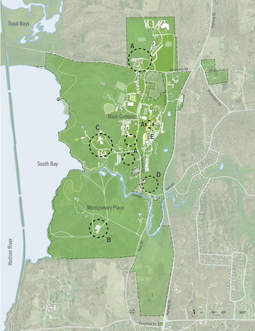
// 117
Huds
on R
iver
Tivoli Bays
Montgomery Place
South Bay
Kelly Rd
Rive
r Rd
High
way 9
G
High
way 9
G
Barrytown Rd
Annandale Rd
Annandale RdMain Campus
Cam
pus
Rd
Whalesback Rd
Saw Kill
C
D
A
A
B
A
E
118 BARD COLLEGE MASTER PLAN
D. COLLEGE INNBard would like to build a small College Inn to accommodate visitors, scholars, parents of students and members of the community. One site being considered is the south end of the campus core. The inn would be accessed from Annandale Road and provide requisite on-site parking and drop off. This site would both be near the south entrance to the campus and also in walking distance of main venues in the center of the campus. Any new building(s) would maintain the scenic character of Annandale Road. (The project is separate and distinct from the Annandale Hotel property that was purchased by Bard in 1998 and renovated to house the Public Relations and Publications Departments.)
E. MAIN LOT EXPANSIONProposed Near and Mid-term projects provide additional campus parking to meet this demand and address current areas that are near capacity. In the long-term, Bard will explore other ways to manage and accommodate parking in order to support access, promote sustainability and foster a pedestrian-friendly campus environment.
One opportunity to expand parking in an area of high demand is to reconfigure the main parking lot and expand this to the north. A new layout could re-orient the direction of the parking bays to separate the campus loop road from parking aisle, improving visibility and safety. A reconfiguration and expansion of the Main Lot could yield up to 110 additional parking spaces. Bard has sufficient space east of the Olin Lot expand this visitor and commuter lot. Areas east of the lot appear to be wetlands, making expansion challenging.
F. CENTER FOR ENVIRONMENTAL STUDIESBard envisions a new facility to house an interdepartmental Environmental Studies program. The program, size and location of the building will be determined after further study. The project in part will replace outdated facilities at the Field Station, with state-of-the-art labs more suitable to current standards. A location close to other science departments may permit greater interdisciplinary collaboration.
LONG-TERM IDEAS
LONG-TERM IDEAS INFRASTRUCTURE ANALYSIS As the Long-Term Ideas are potentially anticipated within a 10-year period, more in-depth analysis will be required on campus infrastructure. The College Inn, and additional student housing would significantly increase the water and sewage demands if connected to the existing college systems. In any scenario however, given the significant excess capacity of 125,000 gallons per day at the water supply facility, it is unlikely that any of the Long-Term Ideas will require any improvements to the water supply facility if they are connected. The capacity of the wastewater treatment facility will have to be analyzed as part of long term planning, and in particular these two projects. As part of the wastewater treatment facility capacity analysis, inflow and infiltration (I&I) in the sewer collection system will also be evaluated as a means to provide additional treatment capacity. Given its location away from the existing campus infrastructure, the Clustered Residential Development will require significant extensions of water and sewer pipes to serve the proposed project. These water and sewer pipe extensions will require approval of the Dutchess County Department of Health.
If any project on the long-term list is disturbing over one acre, the project will need to conform to the latest NYSDEC Stormwater Regulations, and will prepare a Stormwater Pollution Prevention Plan to be reviewed and approved by the Town of Red Hook’s engineering consultant during the Site Plan Approval process. Projects that disturb less than one acre will still be required to prepare an Erosion and Sediment Control Plan. Each project will also install a stormwater collection system to convey runoff to the projects stormwater practices and ultimately connect to an existing campus collection system or discharge directly to an existing Hudson River tributary.
Long-Term Ideas will have no effect on electric service capacity at the College. Electric service will be routed to each project on the Long-Term list and coordinated with both CHGE and the College’s facilities staff. As several Long-Term Ideas will occur in previously undeveloped areas, CHGE will need to review extensions of primary transmission lines.
* Campus infrastructure analysis based on NYSDEC flow reporting records from the past 12 months and past electric usage.
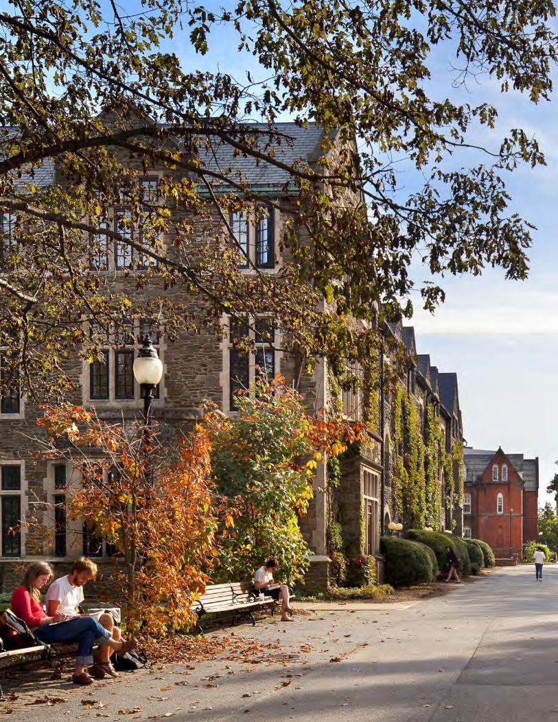
// 119

120 BARD COLLEGE MASTER PLAN