archaeological survey in the blue nile area, central sudan prospección arqueológica en el área...
TRANSCRIPT

Archaeological surveyin the Blue Nile area, Central Sudan
Prospección arqueológicaen el área del Nilo Azul, Sudán Central
Víctor M. FERNÁNDEZ1, Alfredo JIMENO1, Mario MENÉNDEZ2, Javier LARIO3
Recibido: 20-07-2003Aceptado: 10-10-2003
PALABRASCLAVE
Procesos deformación,Seriación,
Patrones deasentamiento,
Mesolítico yNeolítico de
Jartum,Holoceno,
Sudán Central
KEYWORDS
Formationprocesses,Seriation,
Settlementpatterns,
KhartoumMesolithic-
Neolithic,Holocene,
Central Sudan
RES
UMEN
ABS
TRACT
The results are presented of an intensive survey of the Wadi Soba-el-Hasib area east of Khartoum on
the east bank of the Blue Nile and the exploration of the Blue Nile Basin upstream to Singa. The sur-
vey focused mainly on the Prehistoric sites, with the Mesolithic period (Early Khartoum) as the mostly
represented with more than 80% of the discovered sites, the Neolithic sites (Shaheinab-Jebel Moya)
making up most of the remainder 20%. Very few Palaeolithic sites were recorded. Late Neolithic sites
of large size have been found for the first time in the Central Sudan, all of them located away from
the Blue Nile in the Butana and Gezira plains. Site structure and formation processes, ceramic seria-
tion and settlement patterns have been analysed applying statistical multivariate methods to the sur-
vey quantitative data. Some historical trends have been noticed. The first is the change from a Nile-
wadi aquatic exploitation by small mobile groups towards demographic concentration of near-seden-
tary savanna hunting-herding populations. During the Late Neolithic period the groups adopted a
mobile economy and their only archaeological record thereafter are the burial tumuli fields up to the
Christian and Islamic periods.
Se presentan los resultados de una prospección intensiva del área de Wadi Soba-el-Hasib al este de
Jartum en la orilla oriental del Nilo Azul y una exploración del Nilo Azul aguas arriba hasta Singa. El
objetivo principal fueron los restos prehistóricos, con un 80% de yacimientos mesolíticos (Early
Khartoum), siendo el resto neolítico (Shaheinab-Jebel Moya) junto a escasos restos paleolíticos. Por
primera vez se han registrado yacimientos importantes del Neolítico Final en el Sudán Central, siem-
pre en áreas lejanas al Nilo de la Butana y la Gezira. Se han aplicado métodos estadísticos multiva-
riantes a los procesos de formación, seriación cerámica y modelos de asentamiento. Se advierte el
paso primero de una explotación acuática por grupos móviles a una concentración demográfica de
cazadores-pastores de sabana, que luego adoptan una economía móvil con túmulos funerarios como
único resto arqueológico hasta la época moderna.
SUMARIO 1. Introductión. 2. Gazetteer. 3. Archaeological material from the 1940’s excavations.
4. Radiocarbon chronology. 5. Palaeolithic sites. 6. Mesolithic sites. 7. Neolithic sites. 8. Historical sites.
1 Departamento de Prehistoria. Universidad Complutense de Madrid. 28040 Madrid. Spain. [email protected]; [email protected] Departamento de Prehistoria e Historia Antigua. Universidad Nacional de Educación a Distancia. 28040Madrid. Spain. [email protected] Departamento de Ingenieria Geologica y Minera. Universidad de Castilla-La Mancha. 45071 Toledo. Spain. [email protected]
Complutum, 2003, Vol. 14 201-272 ISSN: 1131-6993201

Five seasons of archaeological survey werecarried out during the winters of 1990, 1992,1993, 1994 and 2000. The autumn campaign of1994 and those of 1996, 1997 and 1998 werededicated to the excavation of several prehis-toric sites (see general introduction for calendardetails and Fernández, Jimeno, Menéndez 2003for the results of the excavation work). We con-centrated first on the Wadi Soba area that isimmediately upstream from the area investigat-ed in the 1989 season when a rescue excavationwas made at the Early Neolithic site of HagYusuf (Fernández et al. 1989). After the agree-ment with the Sudan National Corporation forAntiquities and Museums (NCAM), our conces-sion area was located between Khartoum Northand the village of Eseilat on the Blue Nile east-ern bank. The limits were, at west the meridianat Hag Yusuf (32º 7’), at north 15º 45’, at east32º 54’, at south the Blue Nile and 15º 21’ (Fig.2). This area was investigated in the field cam-paigns of 1990 to 1998. For the 2000 field sea-son we asked permission to examine a widerarea in order to choose a new concession areafor the next campaigns. The zone immediatelyeast of the previous concession (the Wadi Ra-bob, Wadi el Hag and Wadi el Hasib areas) wasextensively surveyed during two weeks (Fig. 2).Also a general exploration upstream the BlueNile basin until the locality of Singa was madeduring one week in the same campaign (Fig. 19).
According to the 1: 100.000 map (sheet 360,Wad Hesona), the area of Wadi Rabob and Wadiel Hag is crossed by many small wadis, but wechose to name it only by these two (Rabob andel Hag) because most of the sites are situated inor near them. Moreover, they appear to be themore important wadis in the 1:250.000 map(sheet ND-36-C, El Kamlin). The landscape inall the survey areas is mostly flat, with manyacacia trees and shrubs in the lower or morewatered areas, being more abundant in the wadibottoms (Figure 3). In a few zones there werestill thick herbaceous patches left during the dryseason (end of January, Figure 4). The entireregion is spotted with artificial water reservoir(hafir), many of them probably of an ancient age(Sadr 1991: 111), while others are much bigger
and have been made recently by machinerymeans (Figure 5). Besides the traditional Butananomads that periodically come near the river,recent immigrants that work in Khartoum, andlive in small mud brick buildings or, more fre-quently, temporary shanty houses (Figure 6)now occupy the whole region.
Our aim was to record all the archaeologicalevidence in the area from surface observations.Limited subsurface sondages were excavatedonly in very special cases. Thus, we tried to fol-low recent theoretical and methodologicaltrends in archaeology that primarily emphasisethe need for a large amount of data before anygeneral inference about behavioural patterns inthe past (socio-economic organisation, regionalnetworks, demography, subsistence activities,etc.) can be made. At the same time, we hopedto improve our present knowledge of the richarchaeological heritage in Central Sudan, inorder to make its preservation feasible in thenear future.
Several research issues were addressedbefore the beginning of the fieldwork. Amongthese were the choice of an efficient surveymethodology, the chronological control and theculture orientation of the survey. Initially, twosimple survey strategies were observed: anintensive, all-embracing pedestrian inspection inelongated quadrats over the alluvial area, andseveral extensively inspected, narrow transectsperpendicular to the river following by car thedry wadi beds and banks. The greater accuracyand efficiency of the random quadrats samplingtechnique, especially where the sites follow arandom or regular distribution, has been estab-lished both in practical and theoretical terms(Plog 1976; see computer simulation in Fernán-dez 1985a). However, it still needs confirmationin this area, where sites are very unevenly locat-ed and surveys have usually been conductedwithout sampling methods (Caneva and Marks1992; Garcea and Sebastiani 1998). Shortlyafter starting the survey we realised that theintensive inspection of the alluvial plain was notyielding any results, since agricultural activityand house construction have largely transformedthe area. Further from the Nile, the method ofconcentrating our efforts on the elevations, how-ever small, of this very flat area, proved to befruitful. The sites were mostly situated on thesehigher spots, being in some cases the remains of
1. Introduction
Survey area and methodology (Figs. 1-6)
Complutum, 2003, Vol. 14 201-272 202
Víctor M. Fernández, Alfredo Jimeno, Mario Menéndez and Javier Lario Archaeological survey in the Blue Nile area, Central Sudan

Figure 1.- Map of the Central and Northern Sudan with the general areas of research. Area A corresponds to figures 2and 7 and area B to figure 19 in this paper. Archaeological sites (dots) and ethnic groups (italics) cited in the dossier areindicated.
Complutum, 2003, Vol. 14 201-272203
Archaeological survey in the Blue Nile area, Central Sudan Víctor M. Fernández, Alfredo Jimeno, Mario Menéndez and Javier Lario

Figure 2.- The research area in the eastern bank of the Blue Nile southeast of Khartoum. The discovered sites in the inten-sive archaeological survey of the Wadi Soba area and in the archaeological exploration of the Wadi Rabob-el Hasib areasare shown. The square at left indicates the first concession area of the project. Site numbers correspond to table 1 andcatalogue list in section 2.
Complutum, 2003, Vol. 14 201-272 204
Víctor M. Fernández, Alfredo Jimeno, Mario Menéndez and Javier Lario Archaeological survey in the Blue Nile area, Central Sudan

ancient river terraces at the wadi banks and inothers accumulations of cultural debris or both.Most, if not all the prehistoric sites were situat-ed in the shores of the wadis or palaeochannels,and following those lines proved to be a produc-tive method to find them. In this wider area, acar-survey was carried out, all sites being visiblefrom at least 200-300 m away from the transectband limits (see Sadr 1991: 37 or Welsby 2001:3 for a similar approach).
In order to establish a reasonable secure chro-nological control over the cultural sequence, cross-cultural information was used and statistical seri-ation techniques were applied (Doran and Hod-son 1975: 267-84; Fernández 1985b) (see ceramicseriation in sections 6 and 7). This task was facil-itated by the fact that multi-phase or stratifiedsites are rare in the area, and they are usuallyeasy to identify since they conform to knownpatterns (e.g. Late Neolithic or Meroitic burialsover earlier settlements; cf. Caneva 1988, 1993).
In the bigger sites there was the possibility ofdetecting a “horizontal” stratigraphy or generalintrasite variability (e.g. it had been noticed dur-ing the digging of the Neolithic site of HagYusuf; Fernández et al. 1989: 266). After a firstunsystematic collecting (grab sample) of surfacefinds in all the sites when discovered, in themain sites another technique was applied, bychoosing differentiated, systematically sampledunits (Redman and Watson 1970). All the arte-facts were collected inside 1-meter diameter cir-cles, these units being chosen according to a“systematic, stratified unaligned” samplingmethod that combines the advantages of bothrandom and systematic sampling (Judge et al.1975). Each unit was randomly selected insideevery 30x30-m or 20x20-m square, dependingon the entire site size, these squares covering thewhole site surface extension (see Figures 10-13). The results of this intensive collection were
Figure 3.- Acacia trees in Wadi Rabob area (January 2000).
Figure 4.- Herbaceous landscape in Wadi Rabob area (January2000).
Figure 5.- Artificial water reservoir (hafir) near Wad Hassu-na (January 2000).
Figure 6.- Temporary camp in Wadi el Hasib area (January2000).
Complutum, 2003, Vol. 14 201-272205
Archaeological survey in the Blue Nile area, Central Sudan Víctor M. Fernández, Alfredo Jimeno, Mario Menéndez and Javier Lario

different in some important aspects to the grabsample contents: many more plain sherds, lithicdebris, and culturally insignificant finds wererepresented now. But, interestingly enough, thepercentages of decorated pottery types wereroughly similar in both collection methods, thegeneral coincidence being observed in severalsites. This conclusion seems to confirm previousstatements advocating classical unsystematiccollection methods (Sadr 1991: 38). Multivariatestatistical analysis was carried out with thequantitative data from the systematic sampling.The results of this investigation, however,showed that in most cases the differences andthe model could be ascribed to post-deposition-al deflation surface processes rather than to anykind of behavioural pattern (see surface micro-spatial analysis in section 6).
Our primary interest in the area focusedmainly on the prehistoric remains - the Palaeoli-thic sequence; the transition between Mesolithicand Neolithic; the later Neolithic evidence. Allthe sites discovered in the survey including thehistoric remains were documented, and therecords delivered in due course to the SudanNational Corporation for Antiquities and Mu-seums for archiving and further study.
As in most archaeological surveys, site typesin the area proved to be rather varied, anddepending on the importance of the location,more or less data were gathered on the spot dur-ing the fieldwork (Ruiz and Fernández 1993).There is no general agreement on what are theminimal characteristics of a “site”, and defini-tions include more than two (Anderson 1984),five (Warren 1982) or “several” artefacts spatial-ly related to each other over the surface (Plog etal. 1978; Ammerman 1985). Very often it is hardto demarcate the difference between a site andthe usual “background noise”, i.e. the distribu-tion of isolated artefacts all along the landscape(Gallant 1986). Quite a number of “non-sites” or“restricted activity sites” (Schofield 1991), prob-ably the result of short-time human occupationof the area, have been recorded in the survey.For them only the co-ordinates and a shortdescription of the finds are offered in the site cat-alogue. Proper or bigger sites with significantremains were measured along to approximatelyperpendicular axes and a short description of thesurrounding area is presented in the catalogue
together with the classification and counts of thearchaeological materials observed. Finally, insome of the more important sites test-pit excava-tions were carried out and in three of the sites(nos. 13, 26 and 36) wider excavation workswere undertaken and are described in a separatepaper of this volume.
The name of each site in the gazetteer corre-sponds to the nearest geographical feature,recorded in the map. Two map types were used,the old 1:250.000 and the more recent 1:100.000sheets. Very often we ascribed the same name toa group of sites, for instance the closest village,or had to assign the general name of the area(e.g. Wadi Soba) when there was not any singlevillage or location nearby. In those cases and inorder to avoid confusion, consecutive numbershave been added to the general name (e.g.Sheikh Mustafa-1, 2, 3, etc.). After ProfessorHinkel’s suggestion, we have followed thenames and spelling of names of sites in accor-dance with the 1:250.000 maps and the SudanGovernment Index Gazetteer of 1932 (IndexGazetteer 1932). Prof. Hinkel also most kindlycorrected some of our 3’ grid square assign-ments in the Archaeological Map of the Sudan(Hinkel 1977).
For the sake of simplicity and earlier andmore common usage, we have employed theterm “Mesolithic” for the cultural period alsoknown as “Early Khartoum” (c. 9000-6000 bpin the Central Sudan; see section 6), and “EarlyNeolithic” for the period also known as “Sha-heinab” (c. 6000-5000/4500 bp). Anthony J.Arkell first used all these terms in their seminalworks of 1949 and 1953. We understand andappreciate, however, the reluctance to the use ofthese old and strongly European-related terms(e.g. Nur Eldaim Mohammed 1992; Magid inthis volume). For the period called here “LateNeolithic” the alternative terms of “Kadada” or“Jebel Moya” have been occasionally applied.Usual acronyms for incised Wavy Line (WL),Dotted Wavy Line (DWL), Rocker impression(RK) and Alternately Pivoting Stamp (APS)decorated pottery are used throughout the vol-ume. For the classification of pottery decorationtypes during the Mesolithic and Neolithic peri-ods, we have followed Caneva 1983: 164-183;Caneva 1988: 83-110; Caneva and Marks 1990.
Complutum, 2003, Vol. 14 201-272 206
Víctor M. Fernández, Alfredo Jimeno, Mario Menéndez and Javier Lario Archaeological survey in the Blue Nile area, Central Sudan

The formations underlying the study area onthe east bank of the Blue Nile between Khar-toum and Wadi el Hasib in the northwestern cor-ner of the Butana plain (Figures 2, 7) are thesuperficial deposits, the Nubian SandstoneFormation and the Basement Complex. TheUmm Ruwaba or Gezira formation (Vail 1982:59-60) is present only in a narrow band parallelto the Blue Nile that widens appreciably, up to20 km, in the Wadi el Hasib zone. Further fromthe river the surface is mostly covered by quater-narian-stabilised dunes, dune fields (Qoz) andrecent alluvium formed mainly by silt, silty sandand sand in the wadi beds (GRAS 1988). Awayfrom the Blue Nile a gradation is noticeablefrom sand into loose sandy gravels with patchesof clays. These gravels, usually composed ofquartz fragments, mark the contact between theButana clays and the Nubian sandstones (Vail1982: 60). Abundant iron pisolites indicate aderivation from Nubian sandstone, cementedwith iron in this area (El Boushi 1974: 22;
Williams and Adamson 1980: 290). Ferruginuoshorizons from that formation are more clearlyexposed south and north of Wadi el Hasib. In thelower areas the clays are mixed with lateriticgravelly soil that shows mud cracks at the top;crystals of sodium chloride are seen close to thesurface. The playa deposits formed by repeatedevaporation, which extend from Sheikh AbuQoron to Sheikh el Amin and northward untillKhartoum North, have been mined by local peo-ple since the beginning of the 20th century (ElBoushi 1974).
In some areas near the Wadi Soba course andsurrounding the beds of Wadi Rabob and Wadiel Hag and especially around Wadi el Hasib,undifferentiated Proterozoic metamorphic rocksfrom the Basement Complex are noticeable onsurface (GRAS 1988). Singular rocky outcropsfrom the same period are visible both at north(Jebel Sileitat) and east (Jebel Qeili) of the studyarea. Also the Nubian Sandstone formation rockscan be seen on the surface at many places, (e.g.below the excavation levels in the lower areas ofthe Neolithic site no. 36, or in the Mesolithic site
Geology and palaeoclimates (Figures 7-9)
Figure 7.- Geological map of the research area (after GRAS 1988). Legend: Qal, recent alluvium. CzUr, Umm Ruwabadeposits (Cenozoic gravels, sands, silts and clays). Qoz, old, often stabilised dunes. Kst, undifferentiated fluviatile sand-stones, siltstones and minor conglomerates of presumed Cretaceous age. Kf, ferruginous horizons in the Kst sequence.Pep, undifferentiated Proterozoic metamorphic rocks. Pzv, undifferentiated Paleozoic/Mesozoic volcanic rocks.
Complutum, 2003, Vol. 14 201-272207
Archaeological survey in the Blue Nile area, Central Sudan Víctor M. Fernández, Alfredo Jimeno, Mario Menéndez and Javier Lario

no. 25), with some small outcrops such as JebelDirer near Sheikh el Amin. A larger area ofexposed sandstone is located immediately southof Wadi el Hasib. Quartz pebbles from this for-mation were intensively used for makingmicrolithic implements in all the Mesolithic andNeolithic sites, and mudstone and sandstonerocks were flaked in the earlier, Palaeolithicperiods to make bigger tools (sites nos. 7-9, 37,38) (Vail 1982: 57-8).
A sedimentological and geochemical analy-sis was carried out on the soil samples from thetest-square excavated in the Mesolithic site of ElMahalab during the 1993 field season (Figure8). Contrary to the usual disturbed conditions inother sectors of this site and in most areas of theother sites excavated in the area, a clear stratig-raphy was distinguished during the excavation.Six levels were recognised (see Figure 8), fromtop to bottom: level f of aeolian sands (presentsand sheet); Level e of ochre sands similar tolevel c; level d of aeolian sands, archaeological-ly sterile; level c with ochre sands; level b withgrey silty sands; natural level a of grey silts andmarly-silts, corresponding to a flooding event ofthe Nile, archaeologically sterile (Umm Ruwabaformation). The levels e, c and b were radiocar-bon dated as is shown in figure 8. Chronologi-
cally and stratigraphically, the three dates arecorrectly ordered.
The geochemical analysis (Figure 8; see La-rio et al. 1997) indicate that the contents of cal-cite, kaolinite and microcline decrease from bot-tom to top. They also yielded high values ofsmectite-montmorillonite at the natural level a.A general trend towards aridity is consistentwith these changes (Friedmand and Sanders1978). During the early Holocene and up to8000 bp, the entire area experienced humid con-ditions with frequent floods of the Nile river(level a of El Mahalab), and development ofpalustrine areas close to the present Blue Nileriver bed (Wickens 1982: Fig. 6). A period ofNile aggradation with very high river floods hasbeen recorded as well in Egypt between 10.000and 7700 bp (Hassan 1998). Palaeochanels didalso develop in the Gezira, west of the currentBlue Nile bed (Adamson et al. 1982: Fig. 4).This feature has been described by differentauthors in the context of palaeoclimatic studieson the Eastern Sahara, Nile floods and/or lakelevel variations (Williams and Adamsom 1980;Hassan 1987; Haynes and Mead 1987; Hayneset al. 1989; Pachur and Hoelzmann 1991; Bre-wer 1992). All these studies recognise a stage ofgreater humidity at roughly the same period. A
Figure 8.- Stratigraphic, sedimentological and geochemical profiles of the El Mahalab Mesolithic site.
Complutum, 2003, Vol. 14 201-272 208
Víctor M. Fernández, Alfredo Jimeno, Mario Menéndez and Javier Lario Archaeological survey in the Blue Nile area, Central Sudan

similar fact has been observed in other Africanareas with similar climatic conditions (Lezineand Casanova 1989; Wengler and Vermet 1992;Gasse and Vancampo 1994). Between c. 7800and 7000 bp, a drop in the flooding levels of theNile indicates a reduction in humidity, which isin accordance with an episode of reduced seasurface temperature in the Eastern Mediterraneansea (Hassan 2002: 322). Nevertheless, theweather was still humid, as it has been recordedin the Western Egyptian desert (El Nabta-AlJerar Maximum Humid Interphase between8050 and 7300 bp, cf. Wendorf et al. 2001: 650).In the Central Sudan there were still some bigseasonal floods, as suggested by the presence ofPila sp. in El Mahalab (see Chaix 2003: table 7),which has been described as being characteristicof areas with frequent floods (Tothill 1946;Adamson et al. 1982). Also the higher frequen-cy of fish remains in the lower levels of SheikhMustafa, dated to around 7900 bp (see Chaix2003: table 2) suggests the same scenario. Thisclimatic phase is represented in level b of Al-Mahalab by high values of albite and smectite-montmorillonite at the bottom of the level and aprogressive increase in microcline. At the sametime a decrease of smectite-kaolinite is observedin the upper part and in level c (Figure 8). Thesetrends and changes are characteristic of a reduc-tion in humidity (Friedman and Sanders1978).
This humidity decrease has been observed inthe Northwest of Sudan by a still-stand in thelake levels at ca. 8000 bp, which followed a lakelevel rise between 8400 and 8000 bp (Haynes etal. 1989). Sites in eastern Africa, western Sahara,the Sahel and subequatorial Africa have alsoregistered a relatively drier stage between 8000and 7000 bp during a general period of humidconditions in the early to mid-Holocene (Gasseand Vancampo 1994). At c. 7500 bp the humid-ity appears to have been lower, with the reduc-tion of fish remains in the upper levels of SheikhMustafa and the presence of Limicolaria sp. inthe upper levels of El Mahalab (see Chaix2003). Limicolaria is a land snail intolerant tofloods and characteristic of Acacia-Tall Grassplains with more humid conditions than thepresent day (Tothill 1946; Williams and Adam-son 1980; Adamson et al. 1992). In fact, Haynesand Mead (1987) found that most of the knownspecies of Limicolaria live in forest or forest-
savanna habitats and need almost 300 mm ofannual rainfall. This presence confirms that Li-micolaria was frequent in what is known assemi-desert scrub between ca. 8000 and 4500 bpas suggested by many authors (Tothill 1946; Ar-kell 1949a, 1953; Williams and Adamson 1980;Adamson et al. 1982). During the general trendtowards aridity, some periods of a slight increasein humidity are detected with annual rainfallclearly higher than present day (Brewer 1992).In El Mahalab this is attested by the increase incalcite and kaolinite together with the decreaseof smectite in level c (Figure 8), which indicatesa leaching of the Ca coming from the weather-ing of feldspars due to an increase in humidity(Friedman and Sanders 1978). The availabilityof water is important in chemical weathering(Friedman et al. 1992). Under humid climaticconditions, albite, microcline and smectiteweather into kaolinite and Na, K and Ca arerespectively removed in solution; Na and K aremobilised readily during weathering, but Ca canprecipitate as calcite (Garrels 1967; Garrels andMcKenzie, 1967; Drever 1988).
The climatic changes proposed in the forego-ing are consistent with the archaeological datapresented in this volume. After a period ofapparent depopulation of the area, indicated bythe absence of Upper Palaeolithic sites, theabundance of Mesolithic sites on the Nile river-side and in the wadis suggest that the climaticconditions were optimum for these settlements.
Figure 9.- Suggested environmental, climatic and culturalchanges in the Blue Nile-Wadi Soba areas during the Early-Middle Holocene (after Lario et al. 1997).
Complutum, 2003, Vol. 14 201-272209
Archaeological survey in the Blue Nile area, Central Sudan Víctor M. Fernández, Alfredo Jimeno, Mario Menéndez and Javier Lario

The palustrine areas were replaced by Acaciaforest, as is evidenced by the appearance ofLimicoria. Mesolithic settlements are wide-spread along the wadi areas and the Blue Nileriverside, after approximately 8000 bp. The ear-liest radiocarbon date in our sites is 7930 + 50 bp(Sheikh Mustafa-1, see later). This spreading ofsettlements develops under the optimum climat-ic conditions that we propose to call the “Meso-lithic Optimum” (Figure 9). Only the lowerareas, for instance the playa deposits south ofSheikh el Amin, are devoid of sites, probablydue to repeated floodings. In the South-westernEgyptian desert a relative humid phase is alsodetected at approximately the same time, the ElNabta/Al Jerar Humid Interphase, c. 8050-7300bp (Schild and Wendorf 2001). A probable max-imum in human occupation of the area is sug-gested by the concentration of radiocarbon datesaround 8000 bp (Nicoll 2001: Fig. 2).
Between 7400 and 6900 bp, the presence ofan aeolian sandy deposit in level d of El Maha-lab seems to indicate a short arid period. Hayneset al. (1989) registered an arid phase in Selimaat 7000 bp marked by a fall in the lake levels andincreased salinity. This arid stage has also beenidentified in studies from eastern Sahara and inrecords of lake levels and floods of the Nile(Hassan 1987; Brewer 1992). It probably corre-sponds to the Post Al Jerar Arid Phase (7300-7100 bp or 7250-7200 bp, maximum or mini-mum duration), a major period of aridity regis-tered in the Nabta/Kiseiba area of the EgyptianSahara (Schild and Wendorf 2001: 22; Wendorfet al. 2001: 650). The apparently short durationof this stage in our area, inferred from the thinsand deposit of level d at El Mahalab, seems toagree with the Egyptian data (cf. Wendorf andSchild 2003) rather than with the evidence fromother zones (Central Sahara, Mediterranean seasurface temperatures) advocating a longer aridphase, from 7800 to 7000 bp (Hassan 2002: 322).
After this short arid phase, the area regainedthe humid conditions as it is marked in ElMahalab by an increase in kaolinite and calcitein level e (Figure 8). This phase could corre-spond to the “Middle Neolithic” humid inter-phase recorded from 7100 to 6600 bp in theSouth-western Egyptian desert, the time whencattle and sheep/goat spread to the Central
Sahara (Wendorf et al. 2001: 662-4; Schild andWendorf 2001). Even though we have no addi-tional information from our sites, other authorssuggest that this wet phase, with short arid inter-vals (c. 6600-6550 bp, 5800-5500 bp in NabtaPlaya, cf. Schild and Wendorf 2002: 24-6), last-ed until ca. 4500-4000 bp in western Nubia(Sudan). Faunal data from the site of Sheikh elAmin (warthog more abundant than before, seeChaix 2003: table 12), dated to 5500-4600 bp,suggest that the Butana plain had at least season-al humid conditions. The presence at Sheikh elAmin of a seed-impression on pottery of theperennial herb Carex sp. (see Magid 2003), aplant typical of moist regions (e.g. Equatoria inSouthern Sudan), together with Celtis and Sor-ghum, also hints at humid conditions during theEarly Neolithic period. The present arid andhyperarid conditions started at about 4500 bptime in Western Nubia and some centuries earli-er in the north (Haynes and Mead 1987; Pachurand Hoelzmann 1991; Hassan 2002: 323).
To sum up, prior to 8000 bp the area experi-enced humid conditions that promoted theoccurrence of floods in the Nile, with develop-ment of marshy areas close to the present BlueNile riverbed. This probably made the area inap-propriate for human establishment. After c. 8000bp a reduction in humidity is recorded from adrop in the flooding levels of the Nile. Thedevelopment of Acacia-Tall Grass forest both inthe wadis and in areas over 390 m high (i.e.those areas not affected by Nile floods) duringthis time, created optimum conditions for thespread of a Mesolithic population (MesolithicOptimum) (Figure 9).
A dry phase between 7400 and 6900 bp hasbeen recognised, not only in this area but also inNorthern Sudan and South-western Egypt, fromsedimentological, flooding and lake level data.The prevalence of conditions more humid thanthe present day, without reaching the formerflooding levels, at c. 7000 bp, allowed the devel-opment of Acacia forest and highly vegetatedareas close to the Nile, probably favouring thespreading and arrival of Neolithic pastoral pop-ulations to the Middle Nile. These conditionsappear to continue until ca.4500-4000 bp, whenthe present arid to hyperarid conditions com-menced.
Complutum, 2003, Vol. 14 201-272 210
Víctor M. Fernández, Alfredo Jimeno, Mario Menéndez and Javier Lario Archaeological survey in the Blue Nile area, Central Sudan

2. Gazetteer of sites (Table 1)
Nº Name Arch. Map Sudan Geographical Coordinates Periods1 Hag Yusuf ND-36-B/11-R 15º 35’ 7’’ N / 32º 37’ 30’’ E Early Neolithic2 Umm Dom-1 ND-36-B/11-S 15º 34’ 5’’ N / 32º 40’ 55’’ E Mesolithic/Historic3 Umm Dom-2 ND-36-B/11-W 15º 31’ 40’’ N / 32º 38’ 10’’ E Historic4 Umm Dom-3 ND-36-B/11-X 15º 31’ 15’’ N / 32º 38’ 45’’ E Historic5 Soba-1 ND-36-B/11-X 15º 30’ 41’’ N / 32º 41’ 33’’ E Mesolithic/Late Neolithic6 Soba-2 ND-36-B/11-Y-1 15º 30’ 24’’ N / 32º 42’ 3’’ E Mesolithic/Late Neolithic7 Umm ‘Ushush ND-36-B/11-Y-2 15º 32’ 15’’ N / 32º 42’ 39’’ E Middle Palaeolithic8 Sambra-1 ND-36-B/11-Y-3 15º 30’ 14’’ N / 32º 43’ 44’’ E Middle Palaeolithic/Historic9 Sambra-2 ND-36-B/11-Y-4 15º 30’ 44’’ N / 32º 43’ 46’’ E Middle Palaeolithic10 Sambra-3 ND-36-B/11-Y-5 15º 30’ 44’’ N / 32º 43’ 46’’ E Historic11 Sambra-4 ND-36-B/17-E-1 15º 29’ 44’’ N / 32º 43’ 39’’ E Mesolithic/Historic12 Sambra-5 ND-36-B/17-E-2 15º 29’ 38’’ N / 32º 44’ 32’’ E Mesolithic13 Sheikh Mustafa-1 ND-36-B/18-A-1 15º 29’’ 27’’ N / 32º 45’ 55’‘ E Mesolithic14 Sheikh Mustafa-2 ND-36-B/18-A-2 15º 29’ 1’’ N / 32º 45’ 26’’ E Mesolithic15 Sheikh Mustafa-3 ND-36-B/18-A-3 15º 28’ 42’’ N / 32º 45’ 30’’ E Mesolithic?16 Sheikh Mustafa-4 ND-36-B/18-A-4 15º 28’ 8’’ N / 32º 45’ 5’’ E Mesolithic/Meroitic17 Sheikh Mustafa-5 ND-36-B/18-A-5 15º 29’ 0’’ N / 32º 46’ 41’’ E Mesolithic18 Sheikh Mustafa-6 ND-36-B/18-A-6 15º 27’ 33’’ N / 32º 45’ 17’’ E Mesolithic19 Karnus-1 ND-36-B/18-A-7 15º 27’ 43’’ N / 32º 47’ 22’’ E Mesolithic20 Karnus-2 ND-36-B/18-A-8 15º 27’ 23’’ N / 32º 46’ 44’’ E Mesolithic21 Karnus-3 ND-36-B/18-A-9 15º 27’ 17’’ N / 32º 47’ 51’’ E Mesolithic22 Bakrab ND-36-B/18-B-1 15º 27’ 43’’ N / 32º 48’ 37’’ E Historic23 Hudeiba, El –1 ND-36-B/18-F-1 15º 25’ 11’’ N / 32º 46’ 33’’ E Historic24 Hudeiba, El –2 ND-36-B/18-F-2 15º 25’ 5’’ N / 32º 46’ 45’’ E Historic25 Arrehana ND-36-B/12-P-1 15º 35’ 28’’ N / 32º 45’ 56’’ E Mesolithic/Historic26 Mahalab, El ND-36-B/12-L-1 15º 36’ 12’’ N / 32º 48’ 24’’ E Mesolithic27 Umm Maishera ND-36-B/12-L-2 15º 36’ 28’’ N / 32º 49’ 29’’ E Mesolithic28 Wadi Soba area –1 ND-36-B/12-L-3 15º 36’ 56’’ N / 32º 50’ 2’’ E Mesolithic29 Wadi Soba area –2 ND-36-B/12-L-4 15º 36’ 49’’ N / 32º 50’ 10’’ E Mesolithic30 Wadi Soba area –3 ND-36-B/12-N-1 15º 36’ 25’’ N / 32º 55’ 14’’ E Mesolithic31 Wadi Soba area –4 ND-36-B/12-R-1 15º 35’ 50’’ N / 32º 53’ 25’’ E Mesolithic32 Wadi Soba area –5 ND-36-B/12-R-2 15º 34’ 10’’ N / 32º 53’ 18’’ E Mesolithic33 Wadi Soba area –6 ND-36-B/12-R-3 15º 34’ 35’’ N / 32º 53’ 18’’ E Historic34 Wadi Soba area –7 ND-36-B/12-R-4 15º 34’ 59’’ N / 32º 51’ 59’’ E Historic35 Wadi Soba area –8 ND-36-B/12-Q-1 15º 35’ 3’’ N / 32º 50’ 5’’ E Mesolithic36 Sheikh el Amin ND-36-B/12-Q-2 15º 34’ 46’’ N / 32º 49’ 39’’ E Early Neolithic/Mesolithic37 Galla el Haddadia –1 ND-36-B/12-K-1 15º 38’ 49’’ N / 32º 45’ 43’’ E Palaeolithic38 Galla el Haddadia –2 ND-36-B/12-F-1 15º 39’ 28’’ N / 32º 47’ 2’’ E Palaeolithic39 Galla el Haddadia –3 ND-36-B/12-F-2 15º 40’ 37’’ N / 32º 45’ 52’’ E Historic40 Galla el Haddadia- 4 ND-36-B/12-C-1 15º 42’ 3’’ N / 32º 51’ 12’’ E Historic41 Ibrahim al Kabbashi, J. ND-36-B/12-C-2 15º 44’ 53’’ N / 32º 51’ 40’’ E Historic42 Magarbah ND-36-B/12-M-1 15º 37’ 42’’ N / 32º 51’ 13’’ E Mesolithic43 Akod ND-36-B/18-I-1 15º 25’ 3’’ N / 32º 54’ 49’’ E Mesolithic44 Wadi Soba area –9 ND-36-B/12-M-1 15º 38’ 41’’ N / 32º 51’ 11’’ E Mesolithic45 Wadi Soba area –10 ND-36-B/12-G-1 15º 39’ 55’’ N / 32º 50’ 5’’ E Mesolithic46 Wadi Abu Dibiera area –1 ND-36-B/12-O-1 15º 38’ 54’’ N / 32º 57’ 6’’ E Historic47 Wadi Abu Dibiera area –2 ND-36-B/12-J-1 15º 40’ 1’’ N / 32º 58’ 57’’ E Prehistoric48 Wadi Rabob area –1 ND-36-C/07-I-1 15º 40’ 17’’ N / 33º 9’ 15’’ E Historic49 Wadi Rabob area –2 ND-36-C/07-I-2 15º 41’ 29’’ N / 33º 9’ 27’’ E Mesolithic50 Rabob ND-36-C/07-D-1 15º 43’ 9’’ N / 33º 10’ 43’’ E Late Neolithic
.../...
Complutum, 2003, Vol. 14 201-272211
Archaeological survey in the Blue Nile area, Central Sudan Víctor M. Fernández, Alfredo Jimeno, Mario Menéndez and Javier Lario

A GPS receiver (Global Positioning System;Trimble Transpack II model) was used to locatethe sites, with an error of + 100 m. Co-ordinatesare given in two formats: geographical (degrees,minutes and seconds) and UTM system (Uni-
versal Transverse Mercator projection, zone 36).The latter is intended to use with the modern1:100.000 maps. The Archaeological Map of theSudan references (ASN; Hinkel 1977: 21-31)are also indicated. Dimensions of sites areapproximate and rounded to the next 10-m unit.The 1975 edition of the sheet no. 359 of the
51 Wadi Rabob area – 3 ND-36-C/01-X-1 15º 46’ 3’’ N / 33º 11’ 18’’ E Historic52 Dururba, J. ND-36-C/02-P-1 15º 50’ 32’’ N / 33º 15’ 33’’ E Historic53 Wad Hassuna area ND-36-C/02-W-1 15º 46’ 7’’ N / 33º 22’ 52’’ E Historic54 Salamat Wad Nail-1 ND-36-C/08-K-1 15º 38’ 12’’ N / 33º 15’ 46’’ E Mesolithic?55 Salamat Wad Nail-2 ND-36-C/08-K-2 15º 38’ 17’’ N / 33º 16’ 50’’ E Historic56 Wadi El Hag area –1 ND-36-C/08-L-1 15º 38’ 22’’ N / 33º 18’ 10’’ E Historic57 Wadi El Hag area –2 ND-36-C/08-L-2 15º 38’ 40’’ N / 33º 18’ 35’’ E Historic58 Wadi El Hag area –3 ND-36-C/08-J-1 15º 39’ 1’’ N / 33º 27’ 20’’ E Historic59 Wadi El Hag area –4 ND-36-C/08-K-2 15º 37’’ 36’’ N / 33º 17’ 43’’ E Historic60 Hafir Umm Dam ND-36-C/08-R-1 15º 35’ 12’’ N / 33º 22’ 24’’ E Historic61 Hafir Umm Mohhar ND-36-C/08-R-2 15º 33’ 2’’ N / 33º 22’ 20’’ E Historic62 Bir el Lahamda ND-36-C/08-P-1 15º 33’ 43’’ N / 33º 16’ 56’’ E Early Neolithic63 Hafir Umm Gana ND-36-C/07-S-1 15º 34’ 21’’ N / 33º 11’ 10’’ E Mesolithic64 Hafir Quseima ND-36-C/14-C-1 15º 29’ 59’’ N / 33º 21’ 40’’ E Historic65 Hafir Umm Sinait ND-36-C/13-B-1 15º 28’ 2’’ N / 33º 5’ 12’’ E Historic66 Alwan ND-36-C/13-N-1 15º 23’ 44’’ N / 33º 9’ 43’’ E Mesolithic67 Wad el Amin ND-36-C/14-K-1 15º 21’ 52’’ N / 33º 15’ 27’’ E Late Neolithic68 Khalifa Ahmed, el –1 ND-36-C/13-R-1 15º 20’ 0’’ N / 33º 7’ 20’’ E Mesolithic?69 Khalifa Ahmed, el –2 ND-36-C/13-R-2 15º 20’ 21’’ N / 33º 7’ 45’’ E Mesolithic?70 Lahamda, El ND-36-C/13-P-1 15º 19’ 43’’ N / 33º 1’ 55’’ E Mesolithic71 Farig Er Rizgab ND-36-C/19-E-1 15º 14’ 13’’ N / 33º 13’ 52’’ E Mesolithic72 Hafir Umm Hijlija ND-36-C/20-I-1 15º 11’ 14’’ N / 33º 24’ 43’’ E Mesolithic?73 Hantub ND-36-G/15-F-1 14º 26’ 22’’ N / 33º 32’ 59’ E Historic74 Kordogeili-1 ND-36-G/15-Q-1 14º 20’ 47’’ N / 33º 34’ 56’’ E Historic75 Kordogeili-2 ND-36-G/15-L-1 14º 21’ 56’’ N / 33º 33’ 48’’ E Historic76 Sherif Ya’qub-1 ND-36-G/15-Y-1 14º 15’ 53’’ N / 33º 42’ 39’’ E Historic77 Sherif Ya’qub-2 ND-36-G/15-Y-2 14º 15’ 13’’ N / 33º 42’ 58’’ E Historic78 Sheikh Ahmed-1 ND-36-G/23-N-1 14º 06’ 42’’ N/ 34º 11’ 38’’ E Historic?79 Sheikh Ahmed-2 ND-36-G/23-N-2 14º 06’ 56’’ N / 34º 11’ 39’’ E Historic80 Ugheilif, J. el ND-36-L/01-G-1 13º 56’ 53’’ N / 34º 33’ 10’’ E Prehistoric/Historic?81 Denabo, J. –1 ND-36-H/19-U-1 14º 00’ 11’’ N / 34º 32’ 47’’ E Rock Art82 Denabo, J. –2 ND-36-H/19-U-2 14º 00’ 11’’ N / 34º 32’ 47’’ E Historic83 Umm Sunt ND-36-G/15-Q-1 14º 19’ 14’’ N / 33º 35’ 11’’ E Historic84 Karaba, El ND-36-K/15-S-1 13º 18’ 29’’ N / 33º 40’ 18’’ E Prehistoric (Palaeolithic?)85 Eneikliba-1 ND-36-K/15-Y-1 13º 16’ 26’’ N / 33º 43’ 10’’ E Mesolithic86 Eneikliba-2 ND-36-K/22-B-1 13º 13’ 30’’ N / 33º 48’ 07’’ E Mesolithic87 Kabaro, El Qoz –1 ND-36-G/07-J-1 14º 41’ 55’’ N / 33º 12’ 37’’ E Mesolithic88 Kabaro, El Qoz –2 ND-36-G/07-J-2 14º 41’ 36’’ N / 33º 12’ 26’’ E Late Neolithic89 Bakhit, El Qoz ND-36-G/07-J-3 14º 41’ 53’’ N / 33º 13’ 05’’ E Late Neolithic90 Wad Sheneina ND-36-G/01-Q-1 14º 50’ 50’’ N / 33º 04’ 03’’ E Mesolithic/Late Neolithic91 Humeira ND-36-G/19-H-1 14º 09’ 36’’ N / 33º 08’ 12’’ E Historic92 Umm Daqal ND-36-F/24-O-1 14º 06’ 50’’ N / 32º 58’ 41’’ E Mesolithic93 Bashaqra Gharb ND-36-C/19-B-1 15º 12’ 29’’ N / 33º 04’ 23’’ E Early Neolithic94 Qeili, J. ND-36-C/10-U-25/26 15º 30’ 9’’ N / 33º 46’ 15’’ E Late Neolithic/Historic95 Moya, J. ND-36-K/14-B-1 13º 29’ 19’’ N / 33º 19’ 05’’ E Late Neolithic/Historic
Table 1.- The list of discovered (1-86, 91-3) or revisited (87-90, 94-5) sites in the survey.
Survey in the Wadi Soba area (1990-1994) (Figure 2)
Complutum, 2003, Vol. 14 201-272 212
Víctor M. Fernández, Alfredo Jimeno, Mario Menéndez and Javier Lario Archaeological survey in the Blue Nile area, Central Sudan

1:100.000 Map of Sudan (Khartoum sheet),where all the sites listed in this section are situ-ated, apparently has an error: all the longitudinalUTM co-ordinates (horizontally in the map) aredisplaced 5000 units (5 km) to the West.
1.- Hag Yusuf. 15º 35’ 7’’ N / 32º 37’ 30’’ E(E 0459807 / N 1723118). Early Neolithic(Shaheinab). The artefacts are distributed overan area of 300 x 150 m. The site was discoveredby A.J. Arkell in 1942 (Arkell 1953: 108, Fig.57), and excavated by the Spanish team inJanuary 1989 (Fernández et al. 1989).
2.- Umm Dom-1. 15º 34’ 5’’ N / 32º 40’ 55’’E (E 0465897 / N 1721230). Mesolithic / Histo-ric. Several small mound formations (kôms 1.5-2 m over the plain) near the road from Khartoumto Soba; partially destroyed by big holes of amodern quarry. The sherds are of two kinds:prehistoric (2 WL or DWL, eroded; 9 with rock-er impression decoration) and historic, probablyChristian (rough or black burnished withoutdecoration).
3.- Umm Dom-2. 15º 31’40’’N / 32º 38’10’’E (E 0460975 / N 1716783). Historic. Twokôms, 120 x 90 m; 30 x 20 m; about 1.5 m high.Abundant red bricks; some wall alignments withwhite plaster on the bricks were recorded,together with very few sherds of wheel-madered fabric.
4.- Umm Dom-3. 15º 31’15’’N / 32º 38’45’’E (E 0462016 / N 1715985). Historic. A kôm ofapproximately circular shape, 35 m in diameter,2 m high. Abundant red bricks and wheel-madesherds. An irrigation canal crossed through thesite in 1992.
5.- Soba-1. 15º 30’ 41’’ N / 32º 41’ 33’’ E (E0467020 / N 1714933). Mesolithic / Late Neoli-thic. Scattered sherds in an area of about 20 x 30m, made of two fabrics, with and without min-eral temper. The first type is decorated withrocker impressions (Figure 43: 9) and WL (Fi-gure 42: 17); the second is decorated withincised triangles and comb impressed lines (LateNeolithic) (Menéndez et al. 1994: Fig. 3: 16-27). Some fragmented grinders, one taperingcylindrical rubber and two flakes in sandstonewere also collected.
6.- Soba-2. 15º 30’ 24’’ N / 32º 42’ 3’’ E (E0467916 / N 1714416) (ND-36-B/11-Y-1).Mesolithic / Late Neolithic. Scattered sherds inabout 20 x 20 m, as in the previous site. Mesoli-thic sherds include DWL and rocker (highly
eroded); late Neolithic sherds have incised trian-gles and impressed-incised combined decoration.
7.- Umm ‘Ushush. 15º 32’ 15’’ N / 32º 42’39’’ E (E 0469005 / N 1717819) (ND-36-B/11-Y-2). Middle Palaeolithic? / Historic. Fivetumuli, c. 15-20 m in diameter. Two of them hada plundering hole in its central part, but no arte-facts were conspicuous. In the nearby someretouched mudstone flakes were collected (seesection 5 and Figures 39-40).
8.- Sambra-1. 15º 30’ 14’’ N / 32º 43’ 44’’ E(E 0470299 / N 1715943) (ND-36-B/11-Y-3).Middle Palaeolithic? / Historic. Several smalltumuli of about 4-6 m in diameter, made ofheaps of black sandstone blocks. Scattered in thenearby, some mudstone retouched flakes wererecorded near natural mudstone outcrops (seesection 5 and Figures 39-40).
9.- Sambra-2. 15º 30’ 44’’ N / 32º 43’ 46’’ E(E 0470983 / N 1715020) (ND-36-B/11-Y-4).Middle Palaeolithic? Scattered retouched flakesover an area of rocky outcrops (black Nubiansandstone and fine yellow mudstone) (see sec-tion 5 and Figures 39-40).
10.- Sambra-3. 15º 30’ 44’’ N / 32º 43’ 46’’E (E 0471019 / N 1713453) (ND-36-B/11-Y-5).Historic. A field of 12 tumuli near the modernIslamic cemetery of Sambra, immediately at thesouth of the village. Several fragments of grind-ing stones were also collected.
11.- Sambra-4. 15º 29’ 44’’ N / 32º 43’ 39’’E (E 0470772 / N 1713177) (ND-36-B/17-E-1).Mesolithic / Historic. At about 200 m south ofthe village, scattered artefacts over a flat area(130 x 120 m) with several small kôms, proba-ble tumuli. Sherds of the WL (2), DWL (1)(Figure 43: 18), rocker (13) and alternately piv-oting stamp impression (5) types, lunates inwhite quartz, sandstone flakes, sandstone stonerings and grinding stones were found.
12.- Sambra-5. 15º 29’ 38’’ N / 32º 44’ 32’’E (E 0472356 / N 1713003) (ND-36-B/17-E-2).Mesolithic. A few scattered sherds in a smallarea (50 x 50 m) inside a modern hafir. WL (2)(Figure 42: 13), rocker (2) and alternately pivot-ing stamp impressed (4) sherd types; also a LateNeolithic incised sherd was recorded.
13.- Sheikh Mustafa-1. 15º 29’’ 27’’ N / 32º45’ 55” E (E 0474823 / N 1712650) (ND-36-B/18-A-1). Mesolithic. At about 200 m south ofthe village, a high concentration of artefacts in awide area (80 x 100 m) (Figure 10): WL and
Complutum, 2003, Vol. 14 201-272213
Archaeological survey in the Blue Nile area, Central Sudan Víctor M. Fernández, Alfredo Jimeno, Mario Menéndez and Javier Lario

rocker sherds, a wide variety of microlithictypes in white quartz (lunates, backed bladesand bladelets, perforators, etc.), big flakes insandstone, stone rings. The sherds were classi-fied in WL (11) (Figure 42: 12), rocker, mostlyspaced zigzags (15), and alternately pivotingstamp (7) types (grab sample), and in WL (9),rocker (14) and alternately pivoting stamp (1)types (systematic sampling) (see sections 1 and6). A squared meter test-pit was excavated inJanuary 1993. Down to 35 cm deep, two archae-ological levels were apparent in this part of thesite. The upper had a loose, sandier earth of clearcolour and the lower was characterised by dark-er, compacted and less sandy sediment. Somekind of chronological pattern could be distin-guished, since the upper part yielded mostlyrocker sherds (43) with only one WL sherd,while the lower produced 23 sherds of the WLtype. (See a more detailed account of the exca-vations at the site in 1993-1996 in Fernández,Jimeno and Menéndez, this volume).
14.- Sheikh Mustafa-2. 15º 29’ 1’’ N / 32º45’ 26’’ E (E 0473958 / N 1711852) (ND-36-
B/18-A-2). Mesolithic. A high concentration ofartefacts were found in a wide area (150 x 140m): WL (1 sherd), DWL (9), rocker (24) sherds,plenty of small flakes with some lunates in whitequartz, a few big flakes of sandstone, grindingstones, stone rings. The systematic samplingonly yielded 10 rocker impressed sherds. Asquared meter test excavation was made inJanuary 1993. The archaeological level wasonly 10 cm deep and the sediment was mixedwith sand and apparently disturbed; a few sherdswith rocker (11) and DWL (1) decoration wererecovered from the test-pit.
15.- Sheikh Mustafa-3. 15º 28’ 42’’ N / 32º45’ 30’’ E (E 0474085 / N 1711271) (ND-36-B/18-A-3). Mesolithic? A few sherds (6), allvery eroded with rocker impressed decorationwere collected around a modern quarry hole.
16.- Sheikh Mustafa-4. 15º 28’ 8’’ N / 32º45’ 5’’ E (E 0473330 / N 1710240) (ND-36-B/18-A-4). Mesolithic / Meroitic. A high con-centration of artefacts in a wide flat area (120 x100 m), besides a modern irrigation canal. WL(10 sherds in the grab sample, 3 in the systemat-
Figure 10.- Topographical map of the Sheikh Mustafa-1 Mesolithic site (no. 13). Dots indicate the surface systematicsampling units (see section 6) and squares the initial test-pit. Darker area marks the surface artefact distribution; contourlines every 10 cm.
Complutum, 2003, Vol. 14 201-272 214
Víctor M. Fernández, Alfredo Jimeno, Mario Menéndez and Javier Lario Archaeological survey in the Blue Nile area, Central Sudan

ic collection, see sections 1 and 6) (Figure 42:10), DWL (17 and 1) (Figure 43: 8, 10, 11, 13,16, 19), rocker (18 and 17) (Figure 43: 4) andalternately pivoting stamp (10 and 0) potterysherds were collected. Microliths of whitequartz (lunates, perforator, small flakes) and big-ger flakes of sandstone; grinding stones andstone rings (Figure 41: 5); a bone bead and abiconical lip plug in fine red sandstone (Figure41: 9) were collected. The canal destroyed oneor several Meroitic graves in the vicinity; humanbones and pottery (hand-made, burnished,comb-impressed) were observed in the slopes ofthe canal earthwork. A test-excavation of onesquare meter was carried out in January 1993.Only one superficial level, less than 10 cm thick,was recorded with mixed Meroitic and Mesoli-thic materials (9 WL and 7 Rocker sherds werecollected in the dig).
17.- Sheikh Mustafa-5. 15º 29’0’’N / 32º 46’41’’ E (E 0476199 / N 1711825) (ND-36-B / 8-A-5). Mesolithic. Afew scattered artefacts over asmall elevation: DWL (2) and rocker impressed(7) sherds, a lunate and some grinding stones.
18.- Sheikh Mustafa-6 (Khalifa Ali Farm).15º 27’ 33’’ N / 32º 45’ 17’’ E (E 0479196 / N
4474610) (ND-36-B/18-A-6). Mesolithic. Scat-tered artefacts over a wide area (110 x 90 m):WL (4), DWL (2) (Figure 43: 12) and rocker(35) sherds; grinding stones and stone ring;flakes and lunate in white quartz; flakes in sand-stone. A stratigraphic section of the site could bestudied cleaning the wall of a big hole made byrecent quarrying work in the site. The archaeo-logical sediment was 40-50 cm thick, formed ofloose sandy soil with many yellow sand pocketsand only a few cultural remains (some animalbones, plain sherd and stone grinder).
19.- Karnus-1. 15º 27’43’’N / 32º 47’22’’E( E 0477415 / N 1709461) (ND-36-B/18-A-7).Mesolithic. In the 1:100.000 map (sheet 388, AlMased) the place is wrongly marked as Hillat alHufra, which is situated 4 km towards the river.There are two big Mesolithic sites in a flat aca-cia-spotted area (150 x 100 m; 170 x 100 m),separated by a small area without artefacts ofabout 200 m long. Both sites have a very highconcentration of artefacts, with similar types:WL and rocker pottery sherds, lunates, backedblades and flakes in white quartz, some flakes insandstone, grinding stones and stone rings, apolished palette, and a bead in ivory (Figure 41:
Figure 11.- Topographical map of the Karnus-1A Mesolithic site (no. 19A). Dots indicate the surface systematic sam-pling units (see section 6) and square the initial test-pit. Darker area marks the surface artefact distribution; contour linesevery 10 cm.
Complutum, 2003, Vol. 14 201-272215
Archaeological survey in the Blue Nile area, Central Sudan Víctor M. Fernández, Alfredo Jimeno, Mario Menéndez and Javier Lario

10). In the first of the sites (Karnus-1A, Figure11), the pottery collected on surface was classi-fied as WL (20 sherds) (Figure 42: 4, 5, 11),rocker impression (10) (Figure 43: 3), and alter-nately pivoting stamp impression types (1) afterthe first unsystematic (grab) sampling. WL (51),rocker (18) and alternately pivoting stamp (2)were found using a systematic stratified sam-pling in equidistant units (see sections 1 and 6).In Karnus-1B the sherds belonged to WL (41)(Figure 42: 1-3, 8, 9, 14) and rocker (8) (Figure43: 2, 6) types in the first sampling, and to WL(15) and rocker (3) types in the systematic col-lection. The differences of type percentages pro-duced by the two different sampling methodswere not statistically significant (t-test) (see sec-tion 6, table 3). One square meter test-pit wasexcavated in the central part of Karnus-1A inJanuary 1993. The archaeological remains wereconcentrated in the first 5-10 cm bellow the sur-face and directly over the natural muddy sedi-ment. The excavation yielded 13 potsherds withWL decoration, 11 rocker and 45 plain, togetherwith undifferentiated lithics made in quartz andsome animal bones. Another test-pit was dug inKarnus-1B in January 1993. Here the archaeo-logical remains were found in a sediment 35-cmdeep, yielding 15 WL, 1 rocker and 8 plainsherds, 9 fragments of stone grinder and somelithics, including 4 Nubian sandstone flakes. Thesediment was composed of gravel earth withyellow sand pockets inside. Two organic sam-ples (of wood and peat) were collected for radio-carbon analysis from the lower part of the sedi-ment. The wood was dated to 230 + 90 bp (T-10951, Trondheim laboratory) and the peat to555 + 85 bp (T-10952), thus clearly pointing atrecent perturbations having affected the site.
20.- Karnus-2. 15º 27’23’’N / 32º 46’44’’E(E 0476285 / N 1708844) (ND-36-B/18-A-8).Mesolithic. A few artefacts scattered over asmall elevation: WL (2) and alternately pivotingstamp (2) sherds, grinding stone, stone ring,quartz lunate and flake.
21.- Karnus-3. 15º 27’17’’N / 32º 47’51’’E(E 0478285 / N 1708652) (ND-36-B/18-A-9).Mesolithic. Near a small obelisk commemorat-ing a battle in 1884, a few artefacts scatteredover a small elevation (100 x 40 m): WL (1) androcker (5) sherds, lunates and flakes in whitequartz and a stone ring.
22.- Bakrab. 15º 27’ 43’’ N / 32º 48’ 37’’ E
(E 0479650 / N 1709456) (ND-36-B/18-B-1).Historic. Two wide tumuli in the outskirts of thevillage.
23.- El Hudeiba-1. 15º 25’ 11’’ N / 32º 46’33’’ E (E 0475953 / N 1704783) (ND-36-B/18-F-1). Historic. The remains of an abandoned vil-lage. High concentration of sherds from bigroughly burnished vessels with impressed andincised decoration.
24.- El Hudeiba-2. 15º 25’5’’N / 32º 46’45’’E (E 0476304 / N 1704604) (ND-36-B/18-F-2).Historic. The same features as in the previous site.
25.- Arrehana. 15º 35’ 28’’ N / 32º 45’ 56’’E (E 0474871 / N 1723748) (ND-36-B/12-P-1).Mesolithic / Historic. The Mesolithic remains,very scanty, are scattered over a small, elongat-ed elevation (100 x 60 m) (Figure 12). At thewestern end of the elevation there are ten round-ed tumuli (c. 7-15 m in diameter). The Mesoli-thic artefacts were classified as lunates, perfo-rators, blades and bladelets, backed blades andsmall flakes, all of them of white quartz, somebig flakes of sandstone, sandstone grindingstones (2) and stone rings (2). During severalvisits to the site, only seven pottery sherds werefound on the surface (six without or unidentifieddecoration and one of the alternately pivotingstamp type). As pottery finds are rare, we classi-fied this site as “epipalaeolithic” in a previouspublication, just after the discovery and first sur-vey of the site in 1990 (Menéndez et al. 1994:15). Even though part of the lithic assemblagemay be comparable to the later Pleistocene sitesof the Upper Atbara region (Elamin 1987;Marks et al. 1987), we currently favour the ideaof this being just another Mesolithic site, maybea reflection of a shorter occupation than in therest of the settlements. This interpretation is sup-ported by the fact that no other sites withmicrolithic technology and without or little pot-tery were found in the survey, and also by theresults of a test excavation carried out in January1993. The archaeological deposit was concen-trated in the first 5 cm, immediately over a localoutcrop of Nubian sandstone. The archaeologi-cal material recovered consisted of 2 WL and 1rocker sherds, 6 grinder fragments, and 90 lith-ic items including one lunate, all in whitequartz.
26.- El Mahalab. 15º 36’12’’N / 32º 48’24’’E (E 0479280 / N 1725095) (ND-36-B/12-L-1).Mesolithic. Over a small elevation (c. 120 x 110
Complutum, 2003, Vol. 14 201-272 216
Víctor M. Fernández, Alfredo Jimeno, Mario Menéndez and Javier Lario Archaeological survey in the Blue Nile area, Central Sudan

Figure 12.- Topographical map of the Arrehana Mesolithic site (no. 25). Circles indicate historic tumuli. Dots indicatethe surface systematic sampling units (see section 6) and square the initial test-pit. Darker area marks the surface arte-fact distribution; contour lines every 10 cm.
Figure 13.- Topographical map of the El Mahalab Mesolithic site (no. 26). Dots indicate the surface systematic sam-pling units (see section 6) and square the initial test-pit. Darker area marks the surface artefact distribution; contour linesevery 10 cm.
Complutum, 2003, Vol. 14 201-272217
Archaeological survey in the Blue Nile area, Central Sudan Víctor M. Fernández, Alfredo Jimeno, Mario Menéndez and Javier Lario

m in size, 1.50 m over the plain; Figure 13) thereis a relatively large concentration of artefacts:WL (17 in the grab sample, 4 in the systematicsample) (Figure 42: 7, 18), rocker (9, 1) andalternately pivoting stamp (10, 0) (Figure 42: 19,19) sherds, lunates, perforators, backed blades,debitage in white quartz, some flakes and oneblade of sandstone, two stone rings and a frag-mented polished bone. Faunal remains werealso abundant on the surface. Sherds seem to bemore concentrated while lithic tools appear scat-tered over a wider area. A test-excavation wasmade in February 1993 at the central area of thesite that produced WL (40), Rocker (28), DWL(9) and Alternately Pivoting Stamp sherds (15).(See section 1 and report on the 1993-1996excavations at the site in Fernández, Jimeno andMenéndez, this volume).
27.- Umm Maishera. 15º 36’28’’N / 32º 49’29’’ E (E 0481219 / N 1725585) (ND-36-B/12-L-2). Mesolithic. Over a small elevation, 150 x120 m in size with three smaller kôms inside,there is a relatively dense concentration of arte-facts: WL (10) (Figure 42: 6), rocker (15) andalternately pivoting stamp (3) (Figure 42: 16)sherds, lunates, perforators, backed blades andflakes in white quartz, and two stone rings. Asquared meter test-pit was dug in January 1993.The archaeological level as limited to the first 25cm of sediment over a fossil sand dune. Theexcavation produced 5 WL and 9 rockerimpressed sherds.
28.- Wadi Soba area-1. 15º 36’ 56’’ N / 32º50’ 2’’ E (E 0482199 / N 1726445) (ND-36-B/12-L-3). Mesolithic. A few lunates in whitequartz, some very eroded sherds and one stonering were scattered over a small area.
29.- Wadi Soba area-2. 15º 36’ 49’’ N / 32º50’ 10’’ E (E 0482443 / N 1726229) (ND-36-B/12-L-4). Mesolithic. Over a wide area (200 x150 m), sloping towards the bottom of the wadi,there are lithic tools (lunates, blades and backedblades, flakes in white quartz, bigger flakes insandstone) and pottery sherds (8 DWL, 5 rock-er -Fig. 43: 1- and 1 alternately pivoting stampsherds were collected). The lithic items appearconcentrated in three smaller areas with plentyof debitage (workshops?). A closer examinationof the site in February 1993 showed that the cul-tural remains are only on the surface, with nosub-soil deposit. Two WL sherds were collectedon the occasion.
30.- Wadi Soba area-3. 15º 36’ 25’’ N / 32º55’ 14’’ E (E 0491492 / N 1725484) (ND-36-B/12-N-1). Mesolithic. Over a rounded eleva-tion (1 m high) there is an area (80 x 70 m), verydisturbed by animal burrowing, with erodedsherds (5 WL, 7 rocker -Fig. 43: 5- and 3 alter-nately pivoting stamp sherds were selected), anda higher density of lithic tools: lunates, flakesand truncated blade of white quartz, some flakesof sandstone. A test-pit in February 1993revealed that all the remains are on the surfaceand that there is no archaeological deposit; twoDWL sherds were collected.
31.- Wadi Soba area-4. 15º 35’ 50’’ N / 32º53’ 25’’ E (E 0488246 / N 1724407) (ND-36-B/12-R-1). Mesolithic. Several concentrationsof artefacts scattered over a wide flat area (130 x100; 100 x 100 m): WL (8), rocker (16) andalternately pivoting stamp (6) (Figure 42: 20)sherds, lunates, backed blades, retouched bladesand flakes, grinding stones and stone rings.
32.- Wadi Soba area-5. 15º 34’ 10’’ N / 32º53’ 18’’ E (E 0488033 / N 1721337) (ND-36-B/12-R-2). Mesolithic. A few artefacts scatteredin a small area: DWL sherds and a lunate inquartz.
33.- Wadi Soba area-6. 15º 34’ 35’’ N / 32º53’ 18’’ E (E 0488034 / N 1722109) (ND-36-B/12-R-3). Historic. An area of modern quarry-ing with big heaps of earth and plenty of sherds.
34.- Wadi Soba area-7. 15º 34’ 59’’ N / 32º51’ 59’’ E (E 0485678 / N 1722844) (ND-36-B/12-R-4). Historic. An area of small kôms withmodern pottery; probably an abandoned vil-lage.
35.- Wadi Soba area-8. 15º 35’ 3’’ N / 32º50’ 5’’ E (E 0482283 / N 1722844) (ND-36-B/12-Q-1). Mesolithic. Over a slightly elevatedarea (200 x 80 m), WL (4), DWL (2), rocker(10) (Figure 43: 7) and alternately pivotingstamp (4) (Figure 42: 15) sherds, lunates, blades,bladelets and flakes of white quartz, grindingstones and one stone ring (Figure 41: 6) weresampled. One Neolithic sherd was also collect-ed. A test-pit in February 1993 yielded not anyarchaeological deposit under the surface remains.
36.- Sheikh el Amin. 15º 34’ 46’’ N / 32º 49’39’’ E (E 0481511 / N 1722448) (ND-36-B/12-Q-2). Early Neolithic / Mesolithic. First of twoEarly Neolithic sites recorded by our team in thewadi areas far from the Nile (the other is no. 62,Bir El Lahamda). Eleven kôms in a very wide
Complutum, 2003, Vol. 14 201-272 218
Víctor M. Fernández, Alfredo Jimeno, Mario Menéndez and Javier Lario Archaeological survey in the Blue Nile area, Central Sudan

area (250 x 240 m), covered with sherds (rockerimpressed, incised, black topped, incised andimpressed rims, etc.) with very few lithics (onlysome unretouched flakes were recorded on thesurface) and grinding stones. For more detail seethe report on the 1993 and 1997-98 excavationsat the site in Fernández, Jimeno and Menéndez2003. In the northwestern corner of the site(location E 0481310 / N 1722568), we collectedsome DWL sherds, microlithic tools and debris,some grinder stones and stone circles from a pre-vious Mesolithic occupation of the same area.
37.- Galla el Haddadia-1. 15º 38’ 49’’ N /32º 45’ 43’’ E (E 0474491 / N 1729921) (ND-36-B/12-K-1). Palaeolithic. In a small area (50 x20 m) at the western slope of an elongated ele-vation, we gathered some flakes in ferrous darksandstone. The flakes are of a special and ratheruniform type: short and wide, the distal end big-ger than the platform and perpendicular to thestriking direction, usually not retouched (Figure39: 1-3, 5). The site probably corresponds to atemporary workshop of Middle (?) Palaeolithicchronology. Several other find spots wererecorded in the nearby, usually with a few flakesof the same or similar type.
38.- Galla el Haddadia-2. 15º 39’ 28’’ N /32º 47’ 2’’ E (E 0476841 / N 1731117) (ND-36-B/12-F-1). Palaeolithic. A few big flakes inwhite sandstone (Figure 39: 8). Aprobable work-shop, seemingly predating site no. 37.
39.- Galla el Haddadia-3. 15º 40’ 37’’ N /32º 45’ 52’’ E (E 0474759 / N 1733242) (ND-36-B/12-F-2). Historic. A tumulus arranged indark sandstone blocks, on the top of an elevation.
40.- Galla el Haddadia-4. 15º 42’3’’N / 32º51’ 12’’ E (E 0484290 / N 1735873) (ND-36-B/12-C-1). Historic. Two small tumuli wereobserved over an elevation.
41.- Jebel Ibrahim al Kabbashi. 15º 44’53’’ N / 32º 51’ 40’’ E (E 0485127 / N 1741099)(ND-36-B/12-C-2). Historic. Three tumuli,made with dark sandstone blocks, are on the topof the Jebel; there are several other tumuli at theeastern side of the elevation.
42.- Magarbah. 15º 37’ 42’’ N / 32º 51’ 13’’E (E 048442 / N 1727761) (ND-36-B/12-M-1).Mesolithic. A few WL, DWL and rocker potterysherds and a dense concentration of lithicremains were observed on a flat area. A group ofIslamic graves marked by small earth heaps inthe same area prevented us from testing the site
in February 1993. An intensive surface collec-tion over one square meter produced 231 flakes(84 primary, 62 secondary, 84 tertiary), 6 amor-phous cores, 2 bladelets, 5 lunates and 1 burin.
43.- Akod. 15º 25’ 3’’ N / 32º 54’ 49’’ E (E0490886 / N 1704440) (ND-36-B/18-I-1). Me-solithic. A small scatter of artefacts, with a feweroded sherds, mostly of the WL type, microlith-ic waste in white quartz.
44.- Wadi Soba area-9. 15º 38’ 41’’ N / 32º51’ 11’’ E (E 0484405 / N 1729577) (ND-36-B/12-M-1). Mesolithic. A few sherds of DWLand specially rocker type, microlithic artefacts inwhite quartz and some flakes in Nubian sand-stone were collected.
45.- Wadi Soba area-10. 15º 39’55’’N / 32º50’ 5’’ E (E 0482442 / N 1731852) (ND-36-B/12-G-1). Mesolithic. A relatively dense con-centration of microliths, WL and rocker sherdsand stone grinders. Sherds and grinders had beenwashed down by erosion to the lower, smallgully areas inside the site.
Two weeks were spent in January-February2000 carrying out an initial extensive survey ofthe areas east and southeast of our previous sur-vey area in Wadi Soba. The region is crossed byan intricate network of wadis extending fromWest to East between Wadi Soba and the villageof Wad Hassuna (modern spelling Hesona) inthe western corner of the Butana steppe. A carsurvey was made in this predominantly flat area(Figure 14) along the wadi banks where most ofthe prehistoric sites are found, in a pattern simi-lar to that previously observed at Wadi Soba.The location of the sites was obtained by meansof a GPS receiver (Global Positioning System;Garmin GPS 12), with an error of + 30 m.
46.- Wadi Abu Dibiera area-1. 15º 38’ 54’’N / 32º 57’6’’E (E 0494680 / N 1729974) (ND-36-B/12-O-1). Historic. 10-12 tumuli are besidesa jebel and a few more on the top of it. They areenclosed by a stone circle and are very probablyIslamic (many have a clearly oval shape orient-ed in the NW-SE direction). Some small elon-gated graves also enclosed with stones and withthe same orientation were seen in the nearby ofthe tumuli. The grave of a Sheikh, marked bytwo flags and with metal and plastic containers
Survey in the Wadi Rabob, Wadi el Hag and Wadiel Hasib areas (2000) (Figure 2)
Complutum, 2003, Vol. 14 201-272219
Archaeological survey in the Blue Nile area, Central Sudan Víctor M. Fernández, Alfredo Jimeno, Mario Menéndez and Javier Lario

on it, was located on the highest point of thejebel. In the south-east lower extension of thejebel some flakes, one retouched blade in whitequartz and a grinder fragment were found on thesurface.
47.- Wadi Abu Dibiera area-2. 15º 40’1’’N/ 32º 58’ 57’’ E (E 0498130 / N 1732122) (ND-36-B/12-J-1). Prehistoric. Several concentra-tions of lithic tools on the top of a low hill, pos-sibly the remains of temporary hunting watch-ing points of Mesolithic or Neolithic age. Smallflakes, debitage and several end scrapers andone lunate, all in white quartz, were found. Oneof the spots was just some meters above a smallwater pond, clearly conspicuous in the dry sea-son by way of a circular patch of grass.
48.- Wadi Rabob area-1. 15º 40’17’’N / 33º9’15’’E (E 0516522 / N 1732619) (ND-36-C/7-I-1). Historic. Several tumuli, with black stoneson them, probably Islamic.
49.- Wadi Rabob area-2. 15º 41’29’’N / 33º9’27’’E (E 0516877 / N 1734829) (ND-36-C/7-I-2). Mesolithic. Recorded artefacts includesherds decorated with WL (20), DWL (4), rock-er impression of packed zigzag (14), rockerimpression of spaced zigzag (2), two stone rings(one squared), four sandstone grinders, flakes,blades, bladelets, cores and five lunates, one endscraper and some Pila shells.
50.- Rabob. 15º 43’ 9’’ N / 33º 10’ 43’’ E (E0519143 / N 1737906) (ND-36-C/7-D-1). LateNeolithic. Near the village of Rabob. It is thebiggest site found during the survey. The surfaceremains extend over an area of about 600 x 500m, with 8 small elevations divided by shallowerosion gullies. The sediments are part of an old
terrace of Lower Proterozoic age with metamor-phic material, around 1 meter high over the sur-rounding flat acacia and shrub areas (Figure 15),these being small lateral branches of WadiRabob. On the surface there were plenty offlakes, blades and broken white quartz pebbles,but the percentage of retouched tools was lowerthan it is usual in Mesolithic and even Neolithicsites. An outstanding fact is the great abundanceof perforated sandstone disks, not paralleled inother sites of the area, and the variety of theirshapes: round, square, oval, etc. (Figure 41: 1, 2,8); also a polished porphyry mace-head wasfound (Figure 51: 4). Had it not been for the pot-tery decoration types, which clearly assign thesite to a Late Neolithic, post-Shaheinab, phase,we had ascribed the site to the previous, EarlyKhartoum Mesolithic phase where stones ringsdo belong. The finding of a polished disk mace-head and the small size of some of these stonerings suggest a functional use to make stone-headed clubs comparable to those used recentlyin the Nuba mountains (Arkell 1949a: 63-4).Also polished axes and adzes in green stone,together with sandstone cylindrical and conicalrubbers were very abundant (Figures 16, 50).Two beads, in ostrich shell and green stone,were found on the surface.
Two square meter test-pits were excavated indifferent parts of the site, to examine its archae-ological potential and sediment thickness. Mostof archaeological material was found within thetop sediment (10-20 cm), the deeper being withvery scanty remains. In the test-pit A we found ahole and burrowing tunnel of a big den that had
Figure 14.- A general view of Wadi Rabob area from the topof Jebel Dururba (site no. 52).
Figure 15.- The site of Rabob (no. 50). The terrace elevationcan be seen with a darker colour in the background (photo byAlfredo González-Ruibal).
Complutum, 2003, Vol. 14 201-272 220
Víctor M. Fernández, Alfredo Jimeno, Mario Menéndez and Javier Lario Archaeological survey in the Blue Nile area, Central Sudan

disturbed completely the layers in that area. Ithas been observed that there is a completeabsence of animal bones, but a few Nile oystershells were found in the pits. A shell samplefrom the test-pit B was radiocarbon analyzed(using the AMS technique) and produced a dateof 4670 + 50 bp (Ua-19741, Uppsala laborato-ry). The archaeological material consists mainlyof pottery. A total of 490 sherds were recoveredand classified, as shown in the table below:
The high frequency of rocker impressedsherds and the black topped decoration are typi-cal features of the pottery from the Shaheinabphase. But the high percentage of plain sherds,simple zoned impressed and scraped surfacesherds (very scarce in Shaheinab sites), and thepresence of slightly thickened rims with incisedand impressed decoration, strongly suggest that
the site belongs to the final stages of the Sha-heinab Neolithic or the beginning of the follow-ing phase, which for this area can be called JebelMoya phase (see section 7 and Figures 51: 5, 8;52: 1, 6, 9; 53: 6, 11, 13, 18, 24; 54: 23-24). Alarge number of flakes and blades of whitequartz were also recovered from the surface andin the excavation of the site, with only a fewretouched tools present (three lunates, two endscrapers and one truncated blade).
51.- Wadi Rabob area-3. 15º 46’ 3’’ N / 33º11’ 18’’ E (E 0520177 / N 1743251) (ND-36-C/1-X-1). Historic. A wide elevation with potterysherds, most probably Christian (Balfour-Paul1952: 212, Figs. 12-3; Welsby and Daniels1991: 213-5), of partly burnished surface, someof them black and other red slipped, with incisedand occasionally impressed decoration in a hor-izontal band near the rim (Figure 17).
52.- Jebel Dururba. 15º 50’ 32’’ N / 33º 15’33’’E (E 0527757 / N 1751524) (ND-36-C/2-P-1). Historic. A group of accumulations of bigstones, with rounded shape (burial mounds oranimal traps? cf. Binford 1983: Fig. 73) were
Figure 16.- Agroup of stone grinders and rubbers on the sandysurface of the Rabob site (no. 50).
Pottery Decoration Type N %Rocker impression packed zigzag 37 7.5Rocker impression spaced zigzag 99 20.3Rocker impression plain edge 3 0.6Alternately pivoting stamp 29 5.9Simple zoned impression 28 5.7Incision, fine 2 0.04Incision, rough (scraped) 17 3.5Ripple ware 10 2Black topped 1 0.02Impressed thick rims 9 1.8Incised thick rims 22 4.5Plain sherds 233 47.8Total 490 100
Figure 17.- Christian incised and impressed pottery sherdsfrom site no. 51.
Complutum, 2003, Vol. 14 201-272221
Archaeological survey in the Blue Nile area, Central Sudan Víctor M. Fernández, Alfredo Jimeno, Mario Menéndez and Javier Lario

recorded in the flat areas on the top of the Jebel(see view from the top in Figure 14).
53.- Wad Hassuna area. 15º 46’ 7’’ N / 33º22’ 52’’ E (E 0540830 / N 1743404) (ND-36-C/2-W-1). Historic. At least 11 or 12 small tumuli,probably Islamic since some of them show anelongated shape roughly following the North-South direction (Figure 18). About 4-5 m in dia-meter and less than 1 m in elevation, surround-ed and topped by volcanic stones. Over an eleva-tion immediately at north-east some flakes and arough scraper in white quartz were collected.
54.- Salamat Wad Nail-1. 15º 38’ 12’’ N /33º 15’ 46’’ E (E 0528167 / N 1728787) (ND-36-C/8-K-1). Mesolithic? A small group offlakes and blades in white quartz, a lunate and abroken mortar were seen on surface.
55.- Salamat Wad Nail-2. 15º 38’ 17’’ N /33º 16’ 50’’ E (E 0530078 / N 1728940) (ND-36-C/8-K-2). Historic. A deserted village, withsherds of burnished and rough surface typeswithout decoration, around the remains of mudhouse floors; one complete polished stone axe(Fig. 51: 9).
56.- Wadi el Hag area-1. 15º 38’22’’N / 33º18’ 10’’ E (E 0532457 / N 1729100) (ND-36-C/8-L-1). Historic. Two isolated tumuli, of ovalshape (c. 8 x 5 m in size) surrounded by stones,and NE-SW orientation.
57.- Wadi el Hag area-2. 15º 38’40’’N / 33º18’ 35’’ E (E 0533457 / N 1729655) (ND-36-C/8-L-2). Historic. A group of 9 tumuli, thebiggest one 13 m in diameter. Unlike in the pre-vious site, these mounds have not stones in theperiphery, and some of them could have beenplundered.
58.- Wadi el Hag area-3. 15º 39’ 1’’ N / 33º27’ 20’’ E (E 0548833 / N 1730325) (ND-36-C/8-J-1). Historic. A field of tumuli similar tono. 57, 60 and 61, with about 60 rounded burialmounds in total.
59.- Wadi el Hag area-4. 15º 37’’36’’N / 33º17’ 43’’ E (E 0531655 / N 1727686) (ND-36-C/8-K-1). Historic. A group of 10-12 tumuli ofrounded and oval shape peripherally marked bycircles of black stones. Some small Muslimgraves between the mounds and in the vicinitystrongly suggest that all the remains are of thatchronology.
60.- Hafir Umm Dam. 15º 35’ 12’’ N / 33º22’ 24’’ E (E 0540038 / N 1723275) (ND-36-C/8-R-1). Historic. About eleven tumuli of thesame type than at the bigger site no. 61.
61.- Hafir Umm Mohhar. 15º 33’2’’N / 33º22’ 20’’ E (E 0539920 / N 1719277) (ND-36-C/8-R-2). Historic. More than 90 big circulartumuli ranging in dimension between 5 and 10m in diameter, around 1 m in elevation. All ofthem are covered with small white and roseyquartz pebbles from the ancient terrace (but thesame condition applies to all the surface aroundthem and in the whole site). The small and sandyparticles were probably washed out by the rainfrom the top of the mounds leaving only thepebbles on them. None of the mounds show anysigns of disturbance, and not archaeologicalmaterial was found on and around them, withthe exception of some lunates, scraper, flakesand lithic cores that were collected around butmost probably do not come from the tumuli. Theabsence of archaeological remains and of distur-bance poses some difficulties to determine thetype of site and its chronology. However, anIslamic grave also covered by a round tumulusof small pebbles was recorded at Saggai 1 northof Khartoum (Caneva 1983: 14-5).
62.- Bir el Lahamda. 15º 33’43’’N / 33º 16’56’’E (E 0530270 / N 1720525) (ND-36-C/8-P-1). Early Neolithic. A very big site (500 x 300m) of the Shaheinab phase. Unfortunately, thisimportant site (an Early Neolithic settlement 40km from the main river) could not be moreintensively investigated since it was discoveredthe last day of the survey. Besides the potterysherds sample, also two fragments of stone rings(Figure 41: 7), three rubbers, one fragmentedpolished axe, two lunates, flakes, blades andsome cores were observed. The pottery sherds
Figure 18.- Burial mound in the Wad Hassuna area (site no.53).
Complutum, 2003, Vol. 14 201-272 222
Víctor M. Fernández, Alfredo Jimeno, Mario Menéndez and Javier Lario Archaeological survey in the Blue Nile area, Central Sudan

were classified as in the following table (seeFigures 52: 6; 53: 3):
63.- Hafir Umm Gana. 15º 34’ 21’’ N / 33º11’ 10’’ E (E 0519969 / N 1721678) (ND-36-C/7-S-1). Mesolithic. Situated over the elevationof an ancient terrace covered with white quartzpebbles, it is a small site with sherds decoratedwith wavy line (4), rocker impression withpacked zigzag (3), rocker spaced zigzag (1), dot-ted wavy line? (1), and plain without decoration(1). Several stone rings (two round, one squared,Figure 41: 3-4), 12 lunates of white quartz,flakes, blades, one backed bladelet and quartzand agate lithic cores were also recorded.
64.- Hafir Quseima. 15º 29’ 59’’ N / 33º 21’40’’ E (E 0538744 / N 1713655) (ND-36-C/14-C-1). Historic. Recently abandoned Islamic vil-lage, situated near an Islamic cemetery withmany flags over the graves.
65.- Hafir Umm Sinait. 15º 28’2’’N / 33º 5’12’’ E (E 0509306 / N 1710026) (ND-36-C/13-B-1). Historic. The remains of a recently aban-doned Islamic village.
66.- Alwan. 15º 23’ 44’’ N / 33º 9’ 43’’ E (E0517382 / N 1702107) (ND-36-C/13-N-1).Mesolithic. Situated over a small elevation on anancient terrace of Wadi el Hasib. A surface col-lection was recorded, consisting of sherds withwavy line decoration (8), dotted wavy line (1),rocker impression packed (3), rocker impressionspaced (2), two lunates, one scraper, flakes,blades and cores (in quartz and agate), two bro-ken stone mortars and several Pila shells.
67.- Wad el Amin. 15º 21’ 52’’ N / 33º 15’27’’ E (E 0527643 / N 1698673) (ND-36-C/14-K-1). Late Neolithic. Located over an ancientterrace and near a hafir and a modern Muslim
cemetery (with small individual graves and big-ger tumuli), there is a dense concentration ofsurface remains extending over an area of about70 x 110 m. The sherds were classified accord-ing to decoration as follows (see Figures 52: 1,2, 7; 53: 5; 54: 1, 2, 10, 12, 15, 17; 55: 13, 14):
The abundance of simple impression anddecorated thick rims and the scarcity of rockerimpression, suggest a younger chronology forthis site than for Rabob (no. 50; see seriation insection 7 and Figure 56). Several sandstone rub-bers, cylindrical (4) and conical (4), one squareperforated sandstone disk, a curved adze ofgreen stone and two fragmented axes were alsocollected (Figure 51: 8).
68.- Al Khalifa Ahmed-1. 15º 20’0’’N / 33º7’ 20’’ E (E 0513129 / N 1695255) (ND-36-C/13-R-1). Mesolithic? Over the flat erodedremains of an ancient terrace of the wadi, wefound two small lithic assemblages with cores,flakes and blades of white quartz, includingthree retouched lunates, and a small sphericalmortar.
69.- Al Khalifa Ahmed-2. 15º 20’ 21’’ N /33º 7’ 45’’ E (E 0513868 / N 1695867) (ND-36-C/13-R-2). Mesolithic? Very near the previoussite, a small sample of flakes and blades of whitequartz was recorded.
70.- El Lahamda. 15º 19’43’’N / 33º 1’55’’E (E 0503438 / N 1694693) (ND-36-C/13-P-1).Mesolithic. Situated over a kôm in the alluvialplain at 6 km from the Nile. Some Muslimgraves, already partially eroded, had been dug inthe same place. A sample of artefacts wasanalysed: sherds with wavy line decoration (27),dotted wavy line (3), rocker impression withpacked zigzag (20) and spaced zigzag (2), inci-sion (1), several flakes and blades in agate,quartz cores, three fragmented mortars.
71.- Farig Er Rizgab (after local informants)or Farig Al Galahig (after the 1:100.000 map).15º 14’ 13’’ N / 33º 13’ 52’’ E (E 0524823 / N
Pottery Decoration Type N %Rocker impression packed zigzag 26 26Rocker impression spaced zigzag 52 52Alternately pivoting stamp 3 3Dotted wavy line 1 1Simple zoned impression 2 2Impressed thick rims 3 3Incised thick rims 1 1Scraped surface 3 3Plain sherds 9 9Total 100 100
Pottery Decoration Type N %Rocker impression packed zigzag 10 11Rocker impression spaced zigzag 9 10Simple zoned impression 60 66Incised thick rims 2 2Impressed thick rims 10 11Total 91 100
Complutum, 2003, Vol. 14 201-272223
Archaeological survey in the Blue Nile area, Central Sudan Víctor M. Fernández, Alfredo Jimeno, Mario Menéndez and Javier Lario

1684569) (ND-36-C/19-E-1). Mesolithic. Aslightly elevated mound over the flat alluvialplain that goes parallel to the Nile south-west ofthe Wadi el Hasib mouth. Largely destroyed site,where a group of 14 pottery sherds decoratedwith rocker impression (packed or zigzag onecannot say, since they are very much eroded, butthe fabric is unmistakably of the Early Khar-
toum type), together with a white quartz lunate,several blades, core and spheroid mortar wereobserved.
72.- Hafir Umm Hijlija. 15º 11’ 14’’ N / 33º24’ 43’’ E (E 0544259 / N 1679098) (ND-36-C/20-I-1). Mesolithic? Over a small elevation inthe wide flat plain there were several brokenmortars and two lunates of white quartz.
Figure 19.- The area explored in the winter of 2000, with the discovered or revisited sites. Site numbers correspond totable 1 and the catalogue list in section 2.
Complutum, 2003, Vol. 14 201-272 224
Víctor M. Fernández, Alfredo Jimeno, Mario Menéndez and Javier Lario Archaeological survey in the Blue Nile area, Central Sudan

The whole area is very flat, which in princi-ple would make the discovering of archaeologi-cal sites on the landscape an easy task. Yet, asAndré Vila already observed in his survey of apart of it in 1974 (Vila 1979: 121-134), intensivecultivation activities have heavily disturbed andmost probably destroyed many ancient sites.Starting from our base in Wad Medani (Figure20), we made a very general exploration of thearea during one week in February 2000. Wetried to locate some of the Gezira sites previous-ly discovered in the 1940’s by Paul Balfour-Paul(1952), and in other areas we simply asked topeople in the villages. Our aim was to get a gen-eral idea of the archaeological “thing” in thearea, what type of sites and how they are pre-served, and if any trace had been left of theMesolithic and Neolithic occupation in theregion. The objective was also to identify thenature of the archaeological features present andto make use of these when looking for relatedsites across the border into Ethiopia during thefollowing seasons.
73.- Hantub. 14º 26’22’’N / 33º 32’59’E (E0559257 / N 1596417) (ND-36-G/15-F-1). His-toric. Situated near the village of Hantub on thesouthern side of the road to Gedaref after cross-ing the Blue Nile Medani bridge. Over the inun-dated terraces near the river, are the remains ofold mud houses in squared shape, together withsome sherds of the Islamic period (Figure 21).Most of them come from flat-based bowls dec-orated with geometric incision arranged in hori-zontal bands near the border, such as it was typ-
ical in the Funj period (Arkell 1934: 104; Craw-ford and Addison 1951: pl. 31).
74.- Kordogeili-1. 14º 20’ 47’’ N / 33º 34’56’’ E (E 0562786 / N 1586131) (ND-36-G/15-Q-1). Historic. Very close to the course of theBlue Nile, there is a kôm of red bricks belongingto the Christian period, the probable remains ofa church. One of the bricks had a graffito withtwo Greek letters (lambda and other unidentifi-able); also some sherds with rough relief deco-ration were recorded.
75.- Kordogeili-2. 14º 21’ 56’’ N / 33º 33’48’’ E (E 0560744 / N 1588249) (ND-36-G/15-L-1). Historic. Very near the previous spot, asmall cemetery of Christian (?) chronology. Atleast one of the graves was disturbed by erosion,and human bones and a group of flat, cylindricalostrich egg beads were scattered in the nearby.Some brown burnished, undecorated sherdswere observed in the area.
76.- Sherif Ya’qub-1. 14º 15’53’’N / 33º 42’39’’ E (E 0576683 / N 1577139) (ND-36-G/15-Y-1). Historic. Abig Islamic site, situated near theRahad river in front of the modern village of She-rif Ya’qub. The site consists of small elevationsbeing the remains of ancient houses, with manyrough, incised pottery sherds and stone mortars.
77.- Sherif Ya’qub-2. 14º 15’13’’N / 33º 42’58’’ E (E 0577256 / N 1575912) (ND-36-G/15-Y-2). Historic. Near the previous spot besidesthe Rahad river. Besides a modern Islamiccemetery, with the grave of a Sheikh surroundedby stones and a circle of small tree trunks, thereare the remains of an ancient Islamic cemetery,with abundant remains of fossilised humanbones but no visible archaeological remains.
Exploration between Wad Medani, Gedaref andSinga (2000) (Figure 19)
Figure 20.- The Blue Nile at Wad Medani.
Figure 21.- Pottery sherds from the Funj period (site no. 73).
Complutum, 2003, Vol. 14 201-272225
Archaeological survey in the Blue Nile area, Central Sudan Víctor M. Fernández, Alfredo Jimeno, Mario Menéndez and Javier Lario

78.- Sheikh Ahmed-1. 14º 06’ 42’’ N/ 34º11’ 38’’ E (E 0628883 / N 1560422) (ND-36-G/23-N-1). Historic? In one of the interior wadisof the Qalat Arang Hill range in the Fau area,near the village of Sheikh Ahmed, we observedvisually that a circle made of big stones waserected in the middle of the slope of the rockyJebel Husaan. However, none of our informantscould tell us anything about it.
79.- Sheikh Ahmed-2. 14º 06’ 56’’ N / 34º11’ 39’’ E (E 0628914 / N 1560852) (ND-36-
G/23-N-2). Historic. Near the previous spot andthe mouth of the wadi shortly before the con-necting point to the road to Gedaref. A desertedvillage of recent, Islamic chronology with roughsherds of incised decoration and stone mortars.The remains of an ancient floor were visible, ma-de of big stones with an overall squared shape.
80.- Jebel El Ugheilif. 13º 56’ 53’’ N / 34º33’ 10’’ E (E 0667754 / N 1542551) (ND-36-L/1-G-1). Prehistoric/ Historic? Leaving the Geda-ref asphalted road in the service area of JebelMigreh and following a track to the South, thereare several jebels (rocky inselbergs) with naturalwells and springs, used today by Shukriyanomads (Figure 22). The first spot we visitedwas Jebel El Ugheilif, where there are some bigrocks that were hollowed in several places(Figure 23) to make mortars (?) of the same typethat are found in Jebel Qeili and many other sitesof the Butana steppe (Napflöcher, cf. Hintze1959). Only some undecorated sherds (with aMesolithic-like fabric) and some flakes near theholes were observed. Very probably nomadgroups come since long ago to the site for thesake of its water.
81.- Jebel Denabo-1. 14º 00’11’’N / 34º 32’47’’ E (E 0667025 / N 1548628) (ND-36-H/19-U-1). Rock art. On the eastern flank of JebelDenabo there is an ancient well still in use byShukriya groups (three girls were bringing upwater at that moment, Figure 24). Besides thewell it is a big rock with a flat eastern faceengraved with representations of animals thatappear walking to the right in several rows. Hor-ses, camels, cows, donkeys and probably goatsand dog are easily identified in the panel (Figu-
Figure 22.- Shukriya nomad at the Jebel el Ugheilif well (siteno. 80).
Figure 23.- “Pan-holes” (Napflöcher) in the rocks at Jebel elUgheilif (site no. 80).
Figure 24.- Shukriya girls at the Jebel Denabo well (site no.81).
Complutum, 2003, Vol. 14 201-272 226
Víctor M. Fernández, Alfredo Jimeno, Mario Menéndez and Javier Lario Archaeological survey in the Blue Nile area, Central Sudan

res 25-27). Three horsemen, with a flock ofgoats at their right, head the group. Then followtwo or three cows and three camels with a horse-man guarding the right side. Finally three morecows and two or three donkeys (and a dog?)close the herd. The length of the engraved panelis of 155 cm. The animals represented, the tech-nique (pecking) and the very schematic stylesuggest a recent chronology for these represen-tations (see very similar engravings from Soma-lia in Bachechi 1998: Fig. 3).
82.- Jebel Denabo-2. 14º 00’11’’N / 34º 32’47’’ E (E 0667028 / N 1548631) (ND-36-H/19-U-2). Historic. Near the previous spot, at thenorthern side of the Jebel, there are the remainsof a deserted Islamic village with a small ceme-tery in the nearby, many scattered sherds of theFunj type (like in site no. 73), mortars, an ironaxe, etc.
83.- Umm Sunt. 14º 19’ 14’’ N / 33º 35’ 11’’E (E 0563248 / N 1583277) (ND-36-G/15-Q-1).
Historic. In the outskirts of the village of UmmSunt, very close to the riverbank, there are therests of a big deserted Islamic village, with manypottery sherds of Funj type, glass beads and bro-ken glass bottles, fragments of China ware, andhuman bones from a near cemetery. We askedthe local villagers about the post-Meroitic ceme-tery investigated by Balfour Paul (1952: 207-9;see an assessment of the materials from a morerecent excavation in Edwards 1991:49-52), andwere informed that river floods and recent build-ings have destroyed the site
84.- El Karaba. 13º 18’ 29’’ N / 33º 40’ 18’’E (E 0572759 / N 1471318) (ND-36-K/15-S-1).Prehistoric (Palaeolithic?). Near the village of ElKaraba, on the bank of a dry riverbed that flowsfrom the Gezira into the Blue Nile, at the eastside of the asphalted road from Sennar to Singa.Several lithic tools were observed scattered onthe surface between the riverbed and the moderncultivation fields: flakes in quartz, agate and
Figure 25.- The engraved panel at Jebel Denabo-1 (site no. 81).
Figure 26.- Detail of the central part of the engravings fromJebel Denabo-1 (site no. 81).
Figure 27.- Detail of the engraved horsemen from JebelDenabo-1 (site no. 81).
Complutum, 2003, Vol. 14 201-272227
Archaeological survey in the Blue Nile area, Central Sudan Víctor M. Fernández, Alfredo Jimeno, Mario Menéndez and Javier Lario

rhyolite, and one big side scraper in whitequartz.
85.- Eneikliba-1. 13º 16’26’’N / 33º 43’10’’E (E 0577939 / N 1467557) (ND-36-K/15-Y-1).Mesolithic. Near Eneikliba village at the westside of the road to Singa, there are several deepand wide quarry holes on a Qoz area. On one ofthe first mounds (earthworks) coming from theroad, some Mesolithic artefacts were recorded:69 pottery sherds, plain or with weathered deco-ration, 8 with rocker impression (packedzigzag), 6 plain rim sherds (all of them with therough surface and mineral temper typical of theEarly Khartoum horizon), two lunates (of whitequartz and agate), flakes, blades and bladelets,cores and mortars.
86.- Eneikliba-2. 13º 13’30’’N / 33º 48’07’’E (E 0586900 / N 1462180) (ND-36-K/22-B-1).Mesolithic. Near Eneikliba Station at the westside of the road to Singa. A few, much erodedpottery sherds with typical Mesolithic fabric,flakes, cores and mortars were recorded on thesurface of an area of quarry canals besides theroad.
During a two days survey we tried to locatethe sites discovered by H.G. Balfour Paul in the1940’s, belonging to what he called the “GozCulture”. Travelling along the Gezira canals andintensive cultivation fields, with the help oflocal guides, we found some of the previouslyknown sites (no. 87-90) and discovered a fewnew ones (no. 91-93). Later on we applied at theNational Museum in Khartoum to examine thematerial collected in the old survey (see section3).
87.- Qoz Kabaro-1. 14º 41’ 55’’ N / 33º 12’37’’ E (E 0522648 / N 1625021) (ND-36-G/7-J-1). Mesolithic. Situated besides several rubbishheaps of the village of Qoz Kabaro, after the vil-lager’s information. The position of this villageand that of Qoz Bakhit (no. 89) seem to bereversed in the 1:250.000 map and Balfour Paularticle (1952: map 1). A local informant hadrecently reported the site to the NationalCorporation for Antiquities and Museums inKhartoum, but it turned out to be the same spotexcavated and published by H.G. Balfour Paul(1952: 203-6). There were scattered materials
from different periods, and the basement of ahouse made of mud brick was visible in a trenchrecently dug at one elevation of the site. Thegreat majority of the observed pottery sherds,however, belong to the Mesolithic period. Thus,Balfour Paul was not right in defining the “GozCulture” (or Qoz) in this and other close sites ofthe Qoz area as a mixture of the Early Khartoumand Jebel Moya groups. Only one of the sherdsrecorded by our team in the site was ascribed tothe Late Neolithic period (a rim with simpleimpression and incision). The rest were classi-fied as Wavy Line (10 sherds), Dotted WavyLine (1) (Figure 43: 14), Rocker impressionpacked (7), Rocker Impression spaced (2), and acombination of Rocker Impression and WavyLine (1). (See section 3 and Figs. 33-36 for thecemetery excavated near this site by BalfourPaul).
88.- Qoz Kabaro-2. 14º 41’ 36’’ N / 33º 12’26’’ E (E 0522317 / N 1624440) (ND-36-G/7-J-2). Late Neolithic. Very close to the previousspot, at both sides of the asphalted road thatcrosses the Gezira from East to West in this area.Modern quarrying has disturbed the site. Thereare also mixed materials from different periods,and around ten pottery sherds recorded are prob-ably of Christian chronology (similar to the siteno. 51), but the majority belong to the LateNeolithic phase. They were classified in simplezoned impression of parallel lines (2 sherds),parallel bands (3) (Figure 54: 5) and triangulardesigns (4), rocker impression of packed zigzag(7) and scraped surfaces (2). Three lunates inwhite quartz were also observed.
89.- Qoz Bakhit. 14º 41’53’’N / 33º 13’05’’E (E 0523482 / N 1624963) (ND-36-G/7-J-3).Late Neolithic. About one km east from the pre-vious site, near a small village and small tentcamp of northern immigrants called Qoz Bakhit.This place name was told to us by the villagersat the spot; the name is in the Balfour Paul arti-cle and the 1:250.000 map but not in the recent1:100.000 map. In the latter map the nearestplace is Abu Juweli, which reminds the placename Abu Gueili, located at the same zone inBalfour Paul’s publication (1952: map 1). Whenwe asked for this site, however, we wereinformed that there was not any archaeologicalsite there. The Qoz Bakhit site is c. 200 x 200 min extension of surface artefacts dispersion.Several stone rings were seen but not retouched
Exploration of the Qoz areas in the NorthernGezira (2000) (Figure 19)
Complutum, 2003, Vol. 14 201-272 228
Víctor M. Fernández, Alfredo Jimeno, Mario Menéndez and Javier Lario Archaeological survey in the Blue Nile area, Central Sudan

lithic tools were found. The pottery sherds wereclassified as in the following table:
The sherds with simple impression were clas-sified according to the decorative designs, in tri-angular designs (25 sherds), chess pattern (9),parallel bands (9), circular (1) (Figures 52: 4; 53:10; 54: 9, 14, 19, 20, 21, 22; 55: 5, 9, 10) and onepossible animal representation (Fig. 53: 7).
90.- Wad Sheneina. 14º 50’ 50’’ N / 33º 04’03’’ E (E 0507268 / N 1641449) (ND-36-G/1-Q-1). Mesolithic / Late Neolithic / Historic.Near the village of Qoz Wad Sheneina. Over anelongated kôm that clearly rises around 2 metersover the flat Gezira plain (an ancient fossilisedsand dune, see Figure 28), about 200 m long (ina NNE-SSW direction) and 50/60 m wide, thereis a prehistoric site in the central and northernparts, with some Islamic remains at the southernend. Almost all the surface was covered withPila and Limicolaria shells. This elevated areawas occupied for a long period of time coveringdifferent cultural periods, since the potterysherds belong to the Mesolithic, Late Neolithic,Meroitic (?), Christian and Islamic times. Also alot of human bones were conspicuous on thesurface. The documented artefacts include onepartially perforated stone disk, flakes, blades, acore of agate, two lunates and one end scraper ofwhite quartz. The pottery of the historic periodsconsists of several incised and impressed sherdsand an almost complete bowl with holes in itsbottom (salt strainer? see Figure 33: 1). Most ofthe pottery sherds are of the Mesolithic (EarlyKhartoum) type (see two DWL examples inFigure 43: 15, 17), and may be classified accord-ing to the following types:
The pottery sherds of Late Neolithic chronol-ogy were mostly decorated with simple zonedimpressions, these being of triangular designs (3sherds), parallel bands (2) or parallel bandsforming triangles (1), and with incision (1) andscraping (2) (Figures 53: 11; 54: 7, 16, 25, 26).The cord impressed sherd of Figure 55: 22, withvegetal tempered fabric, is the only one of thiskind found in the survey, an seems to belong tothe “Naima ware” of the close site of Shabona(Clark 1989: 405), also known in the KhartoumChest Hospital site (Arkell 1949: 88, Fig. 77: 3).The incised sherd of Figure 55: 2, with vegetaltemper fabric, is also different to any other foundin the survey.
91.- Humeira. 14º 09’ 36’’ N / 33º 08’ 12’’ E(E 0514755 / N 1565447) (ND-36-G/19-H-1).Historic. Near Managil town in the big Qoz areaat the middle of the Gezira area, there are theremains of a small deserted Islamic village.
92.- Umm Daqal. 14º 06’ 50’’ N / 32º 58’41’’ E (E 0497641 / N 1560347) (ND-36-F/24-0-1). Mesolithic. East of the big Qoz area in themiddle of the Gezira, there are a few remains ofa Mesolithic site, heavily disturbed. Only four
Pottery Decoration Type N %Rocker impression packed zigzag 5 5.6Rocker impression spaced zigzag 6 6.7Alternately pivoting stamp, fine dots 1 1.1Simple zoned impression 45 50.6Incision 10 11.2Incised thick rims 5 5.6Impressed thick rims 4 4.5Scraped inner surface 11 12.3Relief decoration with white plaster 1 1.1Pottery disk support 1 1.1Total 89 99.8
Pottery Decoration Type N %Wavy Line 11 11.6Wavy Line + Rocker impression packed 2 2.1Dotted Wavy Line 26 27.4Rocker impression packed zigzag 38 40Rocker impression spaced zigzag 5 5.3Rocker impression plain zigzag 1 1Alternately pivoting stamp, dashes 12 12.6Total 95 100
Figure 28.- The site of Wad Sheneina in the Gezira plain (siteno. 90).
Complutum, 2003, Vol. 14 201-272229
Archaeological survey in the Blue Nile area, Central Sudan Víctor M. Fernández, Alfredo Jimeno, Mario Menéndez and Javier Lario

pottery sherds undecorated but with typical EarlyKhartoum fabric, together with three lunates inwhite quartz, a retouched natural flat stone,flakes, blades, and blade and flake cores wereseen on surface.
93.- Bashaqra Gharb. 15º 12’ 29’’ N / 33º04’ 23’’ E (E 0507855 / N 1681362) (ND-36-C/19-B-1). Early Neolithic. Near the village ofBashaqra Gharb, on the road from Medani toKhartoum. We visited this site to check a recentreport of local informants to the NCAM. Thesite extends only over a small kôm of around 20x 20 m but we were unable to check its total sizesince it is located among the houses of the vil-lage. It seems of Early Neolithic chronology(Shaheinab phase) but with some features of theLate Neolithic period (simple impression andfine incised decoration). The pottery sherds wereclassified as follows (Figures 52: 3, 9; 53: 2, 4,8; 54: 3):
94.- Jebel Qeili. 15º 30’ 9’’ N / 33º 46’ 15’’ E(E 0582704 /N 1713919) (ND-36-C/10-U-25-26). Late Neolithic/Historic. During our survey
in January 2000 we visited the well known siteof Jebel Qeili in the Butana (Crowfoot 1920;Hintze 1959) (Figure 29). A total of 20 potterysherds were examined in the flat areas aroundthe small rock with the Meroitic engraving andon the top of the rocky mountain. According totheir decoration, they were classified as follows:incision (6) (Figure 55: 1), simple zone impressedwith triangular designs (3) or short parallel lines(3) (Figure 54: 23), ripple (1) and without deco-ration (7). Even if the site was probably visitedby pastoral nomad groups during a long time,this kind of pottery strongly resembles the typesof the Late Neolithic phase to which many of thesites described in this report belong. Some pic-tures were taken of the Prehistoric engravings atthe site (Figures 30-31).
95.- Jebel Moya. 13º 29’19’’N / 33º 19’05’’E (ND-36-K/14-B-1). In February 2000 we paida short visit to this well known site of the south-
Pottery Decoration Type N %Rocker impression packed zigzag 6 15.4Rocker impression spaced zigzag 17 43.5Alternately pivoting stamp, fine dots 2 5.1Simple zoned impression 9 23.1Ripple ware 1 2.6Rough incision 3 7.7Fine incision 1 2.6Total 39 100
Other sites
Figure 29.- Jebel Qeili from the West (site no. 94).
Figure 30.- Engravings of giraffes and other animals on thewestern side of Jebel Qeili (site no. 94).
Figure 31.- Engravings of bovids on the top area of Jebel Qeili(site no. 94).
Complutum, 2003, Vol. 14 201-272 230
Víctor M. Fernández, Alfredo Jimeno, Mario Menéndez and Javier Lario Archaeological survey in the Blue Nile area, Central Sudan
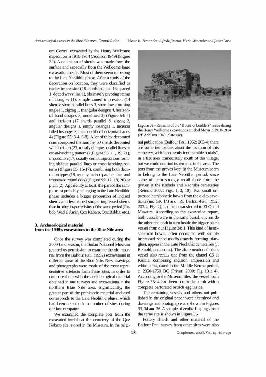
ern Gezira, excavated by the Henry Wellcomeexpedition in 1910-1914 (Addison 1949) (Figure32). A collection of sherds was made from thesurface and especially from the Wellcome largeexcavation heaps. Most of them seem to belongto the Late Neolithic phase. After a study of thedecoration on location, they were classified asrocker impression (18 sherds: packed 16, spaced1, dotted wavy line 1), alternately pivoting stampof triangles (1), simple zoned impression (14sherds: short parallel lines 3, short lines formingangles 1, zigzag 1, triangular designs 4, horizon-tal band designs 3, undefined 2) (Figure 54: 4)and incision (17 sherds parallel 6, zigzag 2,angular designs 1, empty losanges 1, incisionfilled losanges 3, incision filled horizontal bands4) (Figure 55: 3-4, 6-8). A lot of thick decoratedrims composed the sample, 60 sherds decoratedwith incision (23, mostly oblique parallel lines orcross-hatching patterns) (Figure 55: 11, 19, 21),impression (17, usually comb impressions form-ing oblique parallel lines or cross-hatching pat-terns) (Figure 55: 15-17), combining both deco-ration types (18, usually incised parallel lines andimpressed round dots) (Figure 55: 12, 18, 20) orplain (2). Apparently at least, the part of the sam-ple most probably belonging to the Late Neolithicphase includes a bigger proportion of incisedsherds and less zoned simple impressed sherdsthan in other inspected sites of the same period (Ra-bob, Wad el Amin, Qoz Kabaro, Qoz Bakhit, etc.).
Once the survey was completed during the2000 field season, the Sudan National Museumgranted us permission to examine the old mate-rial from the Balfour Paul (1952) excavations indifferent areas of the Blue Nile. New drawingsand photographs were made of the most repre-sentative artefacts form these sites, in order tocompare them with the archaeological materialobtained in our surveys and excavations in thenorthern Blue Nile area. Significantly, thegreater part of the prehistoric material analysedcorresponds to the Late Neolithic phase, whichhad been detected in a number of sites duringour last campaign.
We examined the complete pots from theexcavated burials at the cemetery of the QozKabaro site, stored in the Museum. In the origi-
nal publication (Balfour Paul 1952: 203-4) thereare some indications about the location of thiscemetery, with “apparently innumerable burials”,in a flat area immediately south of the village,but we could not find its remains in the area. Thepots from the graves kept in the Museum seemto belong to the Late Neolithic period, sincesome of them strongly recall those from thegraves at the Kadada and Kadruka cemeteries(Reinold 2002: Figs. 1, 3, 10). Two small im-pressed hemispheric bowls from the old excava-tions (no. GK 1/8 and 1/9, Balfour-Paul 1952:203-4, Fig. 2), had been transferred to El ObeidMuseum. According to the excavation report,both vessels were in the same burial, one insidethe other and both in turn inside the bigger blackvessel from our Figure 34: 1. This kind of hemi-spherical bowls, often decorated with simpleimpressed zoned motifs (mostly forming trian-gles), appear in the Late Neolithic cemeteries (J.Reinold, pers. com.). The aforementioned blackvessel also recalls one from the chapel C5 atKerma, combining incision, impression andwhite paint, dated in the Middle Kerma period,c. 2050-1750 BC (Privati 2000: Fig 131: 4).According to the Museum files, the vessel fromFigure 33: 4 had been put in the tomb with acomplete perforated ostrich egg inside.
The remaining vessels and others not pub-lished in the original paper were examined anddrawings and photographs are shown in Figures33, 34 and 36. Asample of zeolite lip plugs fromthe same site is shown in Figure 35.
Pottery sherds and other material of theBalfour Paul survey from other sites were also
Figure 32.- Remains of the “House of boulders” made duringthe Henry Wellcome excavations at Jebel Moya in 1910-1914(cf. Addison 1949: plate xiv).
3. Archaeological materialfrom the 1940’s excavations in the Blue Nile area
Complutum, 2003, Vol. 14 201-272231
Archaeological survey in the Blue Nile area, Central Sudan Víctor M. Fernández, Alfredo Jimeno, Mario Menéndez and Javier Lario

Figure 33.- Pottery vessels from our survey of the site at Wad Sheneina, site no. 90 (1) and from the Qoz Kabaro ceme-tery (sites no. 87-8) excavated by H.G. Balfour Paul (1952) and stored in the Sudan National Museum. No. 2, 3, 4, 6 and7 have external scraped surfaces, and no. 5 internal and external scraped surfaces. Museum labels: 2 (9441), 3 (9439), 4(9443 GK 1/11), 5 (9445 GK 1/5), 6 (9490), 7 (9477 55-G).
Complutum, 2003, Vol. 14 201-272 232
Víctor M. Fernández, Alfredo Jimeno, Mario Menéndez and Javier Lario Archaeological survey in the Blue Nile area, Central Sudan

analysed. The site of Abu Miriam in the WestButana (Figures 37-38) is characterized by theabundance of pottery with simple impressiondecoration and scraped inner surfaces, and alsowith thick impressed rims that ascribe this site toa Late Neolithic chronology, with strong rela-tions with the Jebel Moya site (Addison 1949).
The site of Abu Zumein in the West Butana(where far less material was collected) has cul-tural features similar to those of Abu Miriam.The Qoz Wad Nureim site (not referred inBalfour Paul 1952) is also culturally similar toJebel Moya, though some Mesolithic materialwas collected here. Two other sites in the Gezira,Goz Abu Khadra y Qoz Shikeira (the latter notmentioned in Balfour Paul 1952), were classi-fied as Mesolithic on the basis of the few potterytypes collected in them (WL and rocker decora-tion).
Figure 34.- Pottery vessels from the Qoz Kabaro cemetery (sites no. 87-8) excavated by H.G. Balfour Paul (1952) andstored in the Sudan National Museum. Decoration by simple impression (1), ripple surface (2) and scraped outer andinner surface (4). Nos. 1 and 2 seem to correspond to no. GK 1/10 and 1/12 in Balfour Paul 1952, Fig. 2. Museum labels:1 (9446 GK 1/10), 2 (no label), 3 (9435 GK 1/1), 4(9438 55-G).
Figure 35.- Zeolite lip plugs from Qoz Kabaro stored in theSudan National Museum (see Balfour Paul 1952, Fig 8); scaledivisions of 5 mm.
Complutum, 2003, Vol. 14 201-272233
Archaeological survey in the Blue Nile area, Central Sudan Víctor M. Fernández, Alfredo Jimeno, Mario Menéndez and Javier Lario

Atotal of 14 radiocarbon dates were processedfrom five of the sites investigated in the project.They are presented in table 2. Most of themcome from Mesolithic and Neolithic sites. Thesamples from Sheikh Mustafa-1 were all ofcharcoal since not a single shell was found in thesite. Because of their small size most of themwere analysed by the Accelerator Mass Spectro-meter (AMS) method. The samples from Kar-nus-2 were of wood and pet, both of them pro-
ducing recent dates probably because of the sitedisturbance. One further charcoal sample fromthe same site had not enough radiocarbon to beanalysed by the conventional method and wasrejected. Two other samples of bone from sitesno. 13 and 18 had no collagen left in them andcould not be dated. The rest of the samples wereof landsnail (Limicolaria sp.) or fresh watermolluscs shells (Pila, Lanistes and Nile oysters).
Even if the number of dates is small, theresults for the Mesolithic (no. 13, 26) and Neoli-thic (no. 36, 50) sites are generally consistent
Figure 36.- Photographs of the pottery vessels from the Late Neolithic site of Goz Kabaro, excavated by H.G. BalfourPaul (1952) and stored in the Sudan National Museum. Museum labels: 1 (9490), 2 (9439), 3 (9443 GK 1/11), 4 (9441),5 (9438 55-G), 6 (9442, GK 1/3), 7 (9446 GK 1/10), 8 (9477 55-G), 9 (9435 GK 1/1), 10 (no label).
4. Radiocarbon chronology
Complutum, 2003, Vol. 14 201-272 234
Víctor M. Fernández, Alfredo Jimeno, Mario Menéndez and Javier Lario Archaeological survey in the Blue Nile area, Central Sudan

with the previous chronological information onboth periods (Hassan 1986). In Sheikh Mustafa-1 there are, however, two dates that are youngerthan 6000 bp and thus fall outside what is con-sidered the Mesolithic time span (c. 9000-6000bp). This deviation could be attributed to recentcontamination, and very probably this is the casealso with the dating of 6295 bp, too young whencompared with the rest of the site results. Theother dates (7930-7600 bp) are in agreement
with the early position of this site in the ceramicseriation (see section 6). The three dates from ElMahalab (spanning from 7705 to 6940 bp) areconsistent both internally, since they appearstratigraphically ordered, and externally whencompared to the Sheikh Mustafa site, whichseems to be slightly earlier on the basis of its cul-tural contents.
The dates for the Neolithic sites are few butconsistent with cross-cultural chronologicalinformation. The earliest dating from Sheikh elAmin is located at the middle of the time spanfor the Shaheinab Early Neolithic phase (c.6000-5000 bp). The same happens with the datefrom Rabob (4670 bp), in the middle of the fifth
Figure 37.- Zoned simple impressed pottery from Abu Miriam(West Butana).
Figure 38.- Zoned simple impressed and incised pottery fromAbu Miriam (West Butana).
Site (no) Square Deep Sample Method Lab ref. Date bp Cal. B.C.Sheikh Mustafa-1 (13) G-10 50 cm charcoal Conventional T-11920 6295 + 215 5480-4990Sheikh Mustafa-1 (13) G-3 50 cm charcoal AMS (alkali extract) GrA-9836 5790 + 50 4720-4550Sheikh Mustafa-1 (13) G-3 50 cm charcoal AMS GrA-10527 5520 + 70 4460-4250Sheikh Mustafa-1 (13) G-9 48 cm charcoal AMS (alkali extract) GrA-10530 7600 + 80 6590-6260Sheikh Mustafa-1 (13) E-15 54 cm charcoal AMS GrA-9834 7930 + 50 7030-6690Sheikh Mustafa-1 (13) H-11 39 cm charcoal AMS GrA-10529 7720 + 110 6660-6430El Mahalab (26) test 17 cm shell Conventional T-10949 6940 + 85 5900-5720El Mahalab (26) test 53 cm shell Conventional T-10948 7470 + 60 6400-6250El Mahalab (26) test 128 cm shell Conventional T-10946 7705 + 145 6750-6390Karnus-1B (19-1B) test 35 cm wood Conventional T-10951 230 + 90 1510-1950 adKarnus-1B (19-1B) test 30 cm peat Conventional T-10952 555 + 85 1300-1440 adS. el Amin (36) test 60 cm shell Conventional T-10950 5555 + 60 4460-4340S. el Amin (36) J/B5 55 cm shell AMS Ua-20415 4590 + 45 3500-3120Rabob (50) test 40 cm shell AMS Ua-19741 4670 + 50 3520-3360
Table 2.- Radiocarbon dates from the excavated sites. Laboratories are Trondheim (T), Groningen (Gr) and Uppsala (U).Calibration has been made using the program OxCal 3.8, Bronk Ramsey 2002 (date ranges are given with 68.2% of prob-ability).
Complutum, 2003, Vol. 14 201-272235
Archaeological survey in the Blue Nile area, Central Sudan Víctor M. Fernández, Alfredo Jimeno, Mario Menéndez and Javier Lario
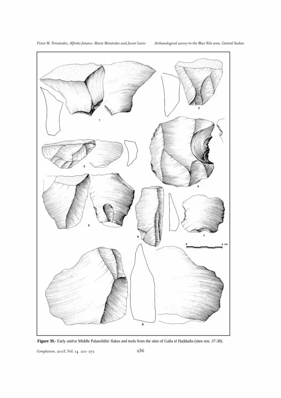
Figure 39.- Early and/or Middle Palaeolithic flakes and tools from the sites of Galla el Haddadia (sites nos. 37-38).
Complutum, 2003, Vol. 14 201-272 236
Víctor M. Fernández, Alfredo Jimeno, Mario Menéndez and Javier Lario Archaeological survey in the Blue Nile area, Central Sudan

millennium bp and thus being consistent with itscultural features that are parallel to the LateNeolithic phase in Eastern Sudan (Kassala pha-se) and the Gezira (Jebel Moya). Only the sec-ond date from Sheikh el Amin (4590 bp) seemsto contradict the model, being apparently toorecent. Nevertheless, it comes from a sampleexcavated in what seems to be the youngest areaof the site, and moreover this difference does notappear too serious when having a so small groupof dates.
A total of five Palaeolithic sites were record-ed in the survey. Three of them are near the allu-vial plain, close to the villages of Umm ‘Ushush(site no. 7) and Sambra (8 and 9), and the othertwo were located far from the Nile, in a semi-desert area known as Galla el Haddadia (site no.37-38). Even though they have a Palaeolithiclook, the scanty findings from site no. 84 (El Ka-raba) do not allow us to include it safely in thesample of earlier sites. The sites are frequentlylocated on the western slopes of small eleva-tions, usually the remains of ancient river ter-races. The concentrations are fairly small, themaximum dimension being usually less thanone hundred meters and the artefact densities on
surface generally low. No structural feature, fau-nal remains or stratigraphical preserved condi-tions could be discerned on the surface of thesites.
At Galla el Haddadia, at about 12 km fromthe Nile, two sites were recorded that probablybelong to the Early or Middle Palaeolithic. Atboth places the most abundant find is a specialtype of flake, short and wide, the distal end (oftenwith cortex) being characteristically wider thanthe platform and perpendicular to the strikingdirection (Figure 39: 1-3, 5). The only indicationof tool making is the presence of unevendenticulate or notch retouching on about a thirdof the flakes, but this could have been caused bynatural action (Figure 39: 4-5, 7). The raw mate-rial is dark Nubian sandstone in site no. 37 andin one group of flakes of site no. 38. A secondgroup of flakes (bigger, with no retouch andmore intensively eroded, thus suggesting an ear-lier dating; Figure 39: 8) is made up of lightercoloured sandstone. Some flakes have a Leval-lois aspect but not prepared cores were found(most of them are natural sandstone tablets). Afew facetted striking-platforms were recognised,though most of them are flat with obtuse angle.Neither bifaces nor cleavers have been found (asin the nearby Acheulian site of Khor Abu Anga,cf. Arkell 1949b, or in the area of Jebel Baroka
5. The Palaeolithic sites
Figure 40.- Middle Palaeolithic denticulates (1, 3, 6) and notches (2, 4, 5) from Umm ‘Ushush and Sambra (sites nos.7-9).
Complutum, 2003, Vol. 14 201-272237
Archaeological survey in the Blue Nile area, Central Sudan Víctor M. Fernández, Alfredo Jimeno, Mario Menéndez and Javier Lario

southwest of Omdurman, cf. Usai and Salvatori2002). The general uncharacteristic aspect of theindustry (probably because of both sites beinglithic workshops?) makes its cultural andchronological attribution unfeasible.
The three sites near Umm ‘Ushush and Sam-bra exhibit Middle Palaeolithic features. Theindustry is made of yellow mudstone from localoutcrops, and consists of denticulates (48 %),notches (22 %) and a few side scrapers (7 %)(Figure 40); some flakes are of thermal originbut many others are human-made and comefrom atypical Levallois cores. The assemblagesinclude some “Upper Palaeolithic” tools: simpleand nosed end-scrapers, raclette and “sur frac-ture” burin. Even though the sites and collectedsurface samples are very small, both the overallcharacter of the technology and the toolpercentages strongly remind us of the Denticu-late Mousterian of Lower Nubia (Marks 1968:205-15), as yet unrecorded in the Central Sudan.
This is the most frequent type-site in the area- 36 sites discovered in the survey of Wadi Soba,Rabob, el Hag and el Hasib areas. This abun-dance is typical of the Khartoum area and seemsto justify the frequent use of the label “EarlyKhartoum” to name this period in the CentralSudan (Arkell 1949a), that roughly covers thetime span between c. 9300 and 6000 years bp.Other three Mesolithic sites were re-corded inour exploration of the Gedaref-Singa areas (nos.80, 85, 86) and three more in the central Geziraarea (nos. 87, 90, 92). This “archaeological cul-ture” forms a part of the great “technocomplex”(Clarke 1978) of Early Holocene Saharan cul-tures that was called “Aqualithic” by J.E.G.Sutton (1974, 1977), “Neolithique Saharo-Soudanais” by the French school in NorthernAfrica (Camps 1974), Epipalaeolithic with pot-tery (Barich 1987), Pre-pastoral period (Garcea1993) or, more frequently and simply, Mesolithic(Arkell 1949a; Caneva 1983). Recently, the de-nomination of “Khartoum Horizon-Style” (Hays1971: 134) has been proposed and used again(Jesse 2000: 69; Mohammed-Ali, Khabir 2003:82). The features of the cultural complex seemto be in agreement with the early and later usage
of the French term “Mésolithique” since the workof M. Reboux in 1873 or J. de Morgan in 1909.It was designed to include all the (European)industries that are different to and chronological-ly fall between the last Palaeolithic and the firstNeolithic cultures (Orliac 1988). The “aqualith-ic” Saharan-Sahelian cultures existed after orshortly before the end of the Palaeolithic in Nor-thern Africa (Iberomaurusian-Capsian indus-tries) and the Nile valley (Qarunian-Elkabian-Shamarkian-Arkinian), even if they occupied alarger geographical area that was inhabited untilthat moment. They were also clearly previous tothe Neolithic phase, which begun during the 7th
millennium bp with the spread of domestic cat-tle in the Sahara and Nile
The most conspicuous artefacts that definethis period are the pottery, stone grinders, stonerings and microlithic tools. Examples of Meso-lithic pottery sherds and Mesolithic and Neoli-thic stone rings and other types recovered fromthe sites discovered during the survey can beseen in Figures 41 to 43.
An analysis of the pottery sherds recoveredfrom the Mesolithic sites with magnifying glassshows that the fabric is very homogeneous.Only mineral temper is seen, composed ofquartz grains (white and brown colour), usuallyless than 1 mm in size, yet there are some sherdsthat have grains of bigger size, up to 5 mm insome cases. Other temper material include blackgrains (basalt?), mica and in one case from ElMahalab possibly crushed shell (mollusc shellsare very abundant at the site). In some of thesherds crushed pottery seems to have been alsoadded. The wall thickness of the sherds variesbetween 5 and 10 mm for the WL, Rocker andDWL sherds, and between 5 and 7 mm for thealternately pivoting stamp sherds (APS). TheAPS sherds have small size temper and a bettersurface treatment, sometimes approaching theburnishing quality.
The DWL sherds from site 16, supposedlyone of the youngest Mesolithic sites in the sur-vey (see later, Seriation), show some special fea-tures. Contrary to the usual external aspect ofmost Mesolithic sherds, the surface appear inmost cases very well smoothed (Figure 43: 8, 10,11, 16). Temper grains are smaller than usual.One sherd from this site has the rare combinationof WL and DWL techniques near the rim (Fig.43: 10). The DWL sherds from the sites in the
6. The Mesolithic sites
Introduction
Complutum, 2003, Vol. 14 201-272 238
Víctor M. Fernández, Alfredo Jimeno, Mario Menéndez and Javier Lario Archaeological survey in the Blue Nile area, Central Sudan

Gezira area (sites no. 87 and 90) also exhibitunusual characteristics (Figure 43: 14, 15, 17).Besides the normal mineral temper, two of thesherds (14, 15) have also vegetal temper, a veryrare feature in the Prehistoric pottery from oursurvey area. Also the decoration technique looksdifferent, roughly made and less deeply impre-ssed than in the other sherds. This pottery prob-
ably belongs to the later phases of the Mesolithicperiod, when Wavy Line decoration was absentor scarce, as it is the case in these sites.
Atotal of 27 Mesolithic sites were discoveredin the survey of the Wadi Soba area and 9 in theWadi Rabob-el Hag-el Hasib areas, which arefarther from the Nile. In two of the Mesolithicsites (nos. 13 and 26) our team undertook archae-
Figure 41.- Mesolithic and Neolithic sandstone rings and other finds from the survey. Nos. 1, 2 and 8 from Rabob (siteno. 50, Late Neolithic), nos. 3-4 from Hafir Umm Gana (63, Mesolithic), no. 5 from Sheikh Mustafa-4 (no. 16, Mesoli-thic), no. 6 from Wadi Soba area-8 (no. 35, Mesolithic), no. 7 from Bir Al el Lahamda (no. 62, Early Neolithic). No. 9is a lip plug in fine red sandstone from Sheikh Mustafa-4 (no. 16, Mesolithic), no. 10 is an ivory bead from Karnus-1A(no. 19-A, Mesolithic).
Complutum, 2003, Vol. 14 201-272239
Archaeological survey in the Blue Nile area, Central Sudan Víctor M. Fernández, Alfredo Jimeno, Mario Menéndez and Javier Lario

Figure 42.- Wavy Line (1-14, 17) and Alternately Pivoting Stamp (15-16, 18-20) pottery sherds from the survey. Nos.17 (site no. 5), 13 (no. 12), 12 (no. 13), 10 (no. 16), 4, 5, 11 (19-A), 1, 2, 3, 8, 9, 14 (no. 19-B), 7, 18, 19 (no. 26), 6, 16(no. 27), 20 (no. 31), 15 (no. 35). Scale in cm.
Complutum, 2003, Vol. 14 201-272 240
Víctor M. Fernández, Alfredo Jimeno, Mario Menéndez and Javier Lario Archaeological survey in the Blue Nile area, Central Sudan

Figure 43.- Rocker (1-7) and Dotted Wavy Line (8-19) pottery sherds from the survey. Nos. 9 (site no. 5), 18 (no. 11),4, 8, 10, 11 13, 16, 19 (no. 16), 12 (no. 18), 3 (no. 19-A), 2, 6 (no. 19-B), 1 (no. 29), 5 (no. 30), 7 (no. 35), 14 (no. 87),15, 17 (no. 90). Scale in cm.
Complutum, 2003, Vol. 14 201-272241
Archaeological survey in the Blue Nile area, Central Sudan Víctor M. Fernández, Alfredo Jimeno, Mario Menéndez and Javier Lario

ological work during several field seasons (seeFernández, Jimeno and Menéndez 2003).
In the larger Mesolithic sites, the surfaceanalysis has provided certain micro-spatial infor-mation concerning different functional activitiesand/or post-depositional perturbation processes.Preliminary test-excavations made it possible toselect sites with sufficient depth of deposit forlarge-scale excavation. In the same way, thequantitative surface collections and test-pit datawere analysed statistically, obtaining a tentativechronological seriation for the most importantsites that could cover the whole Mesolithic peri-od in the area (see next section).
In the 1992 campaign, a significant sample ofmaterials was collected from each site when itwas discovered, using a non-systematic way(grab sampling): six people walking over theentire site for about 15-30 minutes and pickingup the most interesting finds. In the 1993 cam-
paign a systematic strategy for collecting surfacematerials was adopted in the biggest sites, sam-pling one-metre diameter circles at almost regu-lar 20-metre intervals (see section 1 for generalmethodology and Figures 10-13 for actual sitesamplings). All the surface artefacts collectedfrom these circles were classified according totheir types and counted on the spot.
Out of the 36 Mesolithic sites discovered, 20had a quite low density of surface artefacts, sothey were not analysed after they had been dis-covered. The site of Magarbah (no. 42), appar-ently important, could not be analysed due to thepresence of several Islamic tombs at one end ofthe kôm formed by the site. Twelve sites in theSoba and Wadi Soba areas were investigated ingreater depth during the 1993 field season, ofwhich ten were test-excavated using 1x1 m test-pits (nos. 13, 14, 16, 19A, 19B, 25, 16, 27, 30,35). In two other sites (nos. 18 and 28) this wasnot necessary because industrial quarrying workbeing carried out in the places allowed us toexamine the sediments without excavation. Data
Surface micro-spatial analysis
Site no. Sampling system WL RK DWL APS r Sig.13 Grab sample 11 15 0 7 0.920 0.08013 Systematic sample 9 14 0 1 0.996 0.00413 Test-pit 24 43 0 0 0.891 0.10914 Grab sample 1 24 9 0 0.932 0.06814 Systematic sample 0 10 0 0 0.996 0.00414 Test-pit 0 11 1 0 0.960 0.04016 Grab sample 10 18 17 10 0.621 0.37916 Systematic sample 3 17 1 0 0.555 0.45516 Test-pit 9 7 0 0 -0.065 0.93519-1 Grab sample 20 10 0 1 0.988 0.01219-1 Systematic sample 51 18 0 2 0.881 0.11919-1 Test-pit 13 11 0 0 0.943 0.05719-2 Grab sample 41 8 0 0 1.000 0.00019-2 Systematic sample 15 3 0 0 0.991 0.00919-2 Test-pit 15 1 0 0 0.992 0.00826 Grab sample 17 9 0 10 0.827 0.17326 Systematic sample 4 1 0 0 0.929 0.07126 Test-pit 40 28 9 15 0.883 0.11727 Grab sample 10 15 0 3 0.981 0.01927 Test-pit 5 9 0 0
Table 3.- Frequencies of sherds with different decoration types recovered from the Mesolithic sites, using unsystematic(grab) and systematic surface sampling, and test-pit excavation methods. Pearson’s correlation coefficients r (betweenfirst and second systems, second and third, and third and first when applicable), and their statistical significance are alsogiven.
Complutum, 2003, Vol. 14 201-272 242
Víctor M. Fernández, Alfredo Jimeno, Mario Menéndez and Javier Lario Archaeological survey in the Blue Nile area, Central Sudan

from the test-pits, however, reduced the numberto only two sites deserving wider excavationwork, Sheikh Mustafa-1 (no. 13) and El Maha-lab (26). The rest display a similar pattern of ero-sion: the original archaeological mound has beenpartially or totally dismantled, scattering the ma-terials horizontally over an area considerablylarger than the original site (see Fernández, Ji-meno and Menéndez 2003: Fig. 11).
A comparison was made of the frequenciesof the general pottery decoration types comingfrom non-systematic and systematic surfacesampling and the test-pit excavations in sevensites (Table 3). Surprisingly enough, the threemethods produced a very similar general picturefor six of the sites, with very high correlationcoefficients between them (e.g in Sheikh Musta-fa-1, no. 13, r = .92, .996, .891). However, dif-ferences exist for the less frequent types (i.e.DWL and APS), whose percentages obviouslyoscillate to a greater extent because they are lesslikely to be included in the sample and are thusmore dependent on the random character of thesampling techniques. The APS type presents theadditional problem of being hard to distinguishfrom other types of Rocker decoration, especial-ly in the small and/or eroded sherds.
The most striking case occurred in El Maha-lab (no. 26), where no DWL fragments werecollected from the surface, but test-digging pro-duced about 10%. This fact was probably areflection of different degrees of erosion: this isone of the less deflated sites, with a deposit depthof nearly one metre, and thus the surface is lessan accurate image of the buried deposit than inthe other sites. But even in this site the correla-tion of systematic surface sampling, non-sys-tematic surface sampling and test-pit data is fair-ly high (r = .827, .929, .883) as in the other sites,always near or above .9 with the exception ofno. 16. Here the correlation is much lower andstatistically not significant, a case perhaps to beexplained by the disturbance of the original dis-position of the remains in the site due to subse-quent tumuli construction in the historical peri-od and a modern irrigation canal.
More important than that, the main objectiveof the systematic surface sampling was to checkthe existence of some kind of spatial model ofthe remains in relation with possible areas offunctional activity in the Mesolithic settlements.The quantitative data from the units sampled in
Samplingunit no. CO F1 F2 F3 TT BL GR PO
1 8 32 45 50 8 4 2 202 9 52 82 153 15 0 1 93 0 33 31 33 13 1 1 114 6 34 29 23 1 1 6 155 4 46 33 40 3 2 4 216 21 76 58 104 7 1 6 487 7 30 14 29 4 2 5 158 10 62 37 104 7 0 5 469 7 35 19 72 2 0 2 410 11 34 21 37 0 1 3 2911 10 17 14 10 0 1 6 1212 12 17 25 31 0 2 4 14
Table 4.- Artefact type frequencies in the systematic surfacesampling units at the Mesolithic site of Sheikh Mustafa-1 (no.13; see their position on the site in Figure 10). Legend: CO,cores, F1-F2-F2, primary, secondary and tertiary flakes, TT,formal lithic tools, BL, bladelets, GR, stone grinders, PO, pot-tery.
Figure 44.- Principal Component Analysis of the surface dis-tribution data in systematic sampling units at the Mesolithicsite of Sheikh Mustafa-1 (table 4). Plotted variables in the firstdiagram follow the legend of table 4. Plotted in the seconddiagram are the 12 surface sampling units (SPSS program).
Complutum, 2003, Vol. 14 201-272243
Archaeological survey in the Blue Nile area, Central Sudan Víctor M. Fernández, Alfredo Jimeno, Mario Menéndez and Javier Lario

each site were processed using statistical multi-variate methods (Principal Component Analysis),with interesting results. If the surface materialshad been mixed in a random fashion, either as aresult of deflation or because this was their orig-inal arrangement as a result of successivechanges and overlaying of different activities atthe settlement (‘palimpsest effect’), it would benatural to expect an equally random result with-in each site or different models from one site toanother. But, in six of the seven analysed sites-all except, significantly, no. 16- the result wasvery similar: the lithic flakes and tools appearspatially opposed to grinders (and sometimes alsoto pottery); i.e. the areas with more tools havefewer grinders, and vice versa. As one example,see table 4 and Figures 10 and 44 for the dataand results at the Sheikh Mustafa-1 site, no. 13.
This statistical result suggests the possibilitythat functional areas originally existed in the set-tlements and, more important, that the traces ofthis differentiation have been preserved untiltoday, at least in part, despite the heavy deflationand post-depositional disturbance of the areathat has led to consistently pessimistic opinionsin this respect (e.g. Arkell 1949a: 4-5; Caneva1983: 18; Reinold 1986: 121; Haaland 1992a:22; Welsby 2001: 569). Such functional areas,which would obviously have to be confirmed bylarge-scale excavation, could correspond tofemale (gathering) and male (hunting-fishing)activities, as the contemporary ethnographic datasuggest and has been proposed for the varioustypes (riverside/savannah) of Neolithic settle-ments (Haaland 1987a: 211-3).
Another possible cause for the observed spa-tial dichotomy could be just post-depositional.In most of the analysed sites the diagram plotsshow how mortars and sometimes pottery tendto appear in bigger quantities over the peripher-al or lower part of the sites, while the lithic itemsare more frequent in the central, which is usual-ly the upper area. Thus, the “size-effect” (Baker1978) could have been influencing the distribu-tion, making wider objects to sink by the effectof wind and rain action, and letting the thinnerartefacts in the upper and flatter areas. This facthas been detected in many sites, and interpretedas another “cautionary tale” against archaeolog-ical inferences based on surface findings (Fer-nández and Lorrio 1986: 189). It was practical-ly observed during the survey in some of the
Mesolithic sites, especially in site no. 45 duringthe 1994 field season.
Multivariate analysis has also shown a recur-rent spatial association of retouched tools(lunates, backed bladelets, scrapers, etc.) and themuch more abundant unretouched flakes (espe-cially secondary and tertiary flakes). This factsuggests that flakes should sometimes be con-sidered true tools even when they were notretouched (Caneva and Zarattini 1983: 211).
On the basis of quantitative surface data (per-centages of pottery decoration types), retrievedfrom surface sampling we tried another type ofstatistical analysis: chronological seriation of thesites using a model of gradual variation of pot-tery types and applying the statistical multivari-ate analysis model known as MultidimensionalScaling (Kendall 1971; Doran, Hodson 1975:267-84; Fernández 1985b; see a recent applica-tion to African archaeology in Usman 2003).The input data from the most representative sitesis shown in table 5.
Ceramic seriation
SITE No. WL DWL RK APS Total11 (Sambra-4) 9.5 4.5 59.1 23.8 2113 (S. Mustafa-1) 67.8 0.4 31.2 0.6 4595*14 (S. Mustafa-2) 2.9 26.5 70.6 0 3416 (S. Mustafa-4) 18.2 30.9 32.7 18.2 5518 (S. Mustafa-6) 9.7 4.9 85.4 0 4119-A (Karnus-1A) 64.5 0 32.2 3.2 3119-B (Karnus-1B) 83.7 0 16.3 0 4926 (El Mahalab) 37.2 2.0 56.5 4.3 3276*27 (Umm Maishera) 35.7 0 53.6 10.7 2829 (Wadi Soba-2) 0 57.1 35.7 7.1 1430 (Wadi Soba-3) 33.3 0 46.7 20 1531 (Wadi Soba-4) 26.7 0 53.3 20 3035 (Wadi Soba-8) 20 10 50 20 2049 (Wadi Rabob-2) 50 10 40 0 4066 (Ulwan) 60 6.7 33.3 0 1570 (El Lahamda) 51.9 5.8 42.3 0 52
Table 5.- Pottery decoration percentages in the surface sam-ples from the Mesolithic sites. Legend: WL: Wavy line; DWL:Dotted wavy line; RK: Rocker; APS: Alternately pivotingstamp. (*) In the sites nos. 13 and 26 survey data have beenreplaced by the frequencies obtained in the excavation (seeFernández, Jimeno and Menéndez 2003).
Complutum, 2003, Vol. 14 201-272 244
Víctor M. Fernández, Alfredo Jimeno, Mario Menéndez and Javier Lario Archaeological survey in the Blue Nile area, Central Sudan

After analysing the data with a Multidimen-sional Scaling program (MDSCAL, with ATDprogram, Analyse d’un tableau de distances, cf.Foucart 1982), the following ordering of sites isretrieved from the diagram in Figure 45. The“horse-shoe” shape indicated by the curved lineis expected for chronological studies of archae-ological material (Cowgill 1972). Projecting thesites on that line an order is obtained with themost gradual variation of decoration percent-ages: 19-B, 13, 19-A, 66, 70, 49, 26, 27, 30, 31,11, 18, 35, 14, 16, 29. The diagram with the vari-ation of the percentages in the ordered sites isshown in Figure 46.
As it is shown in Figure 46, there is a fairlygradual variation for the WL type, whichdecreases at an almost constant rate (the clearestmodel). The RK type increases at the same timeyet more irregularly, APS pottery follows a morerandom model (but this type presents some iden-
tification problems, see above), while the DWLtype tends to appear and increase at the end ofthe ordering. The only exceptions to the DWLmodel are the three sites discovered in the Ra-bob and Hasib areas (nos. 49, 66 and 70), whichdespite having a large amount of WL pottery,present a small but significant quantity of DWL.This difference is probably due to their differentlocation, and possibly hints at the known factthat the variation patterns are not universal butdepend upon the specific areas where peoplelived in the past.
This chronological ordering is obviously ten-tative and has to be confirmed by means of anyother relative dating method or by radiocarbondating of some of the sites. Only two Mesolithicsites have been radiocarbon dated, Sheikh Mus-tafa-1 and El Mahalab (nos. 13 & 26). Both aresituated in a relative position that is roughly inaccordance with their radiological dating:Sheikh Mustafa-1 between 7900 and 7600 bp,and El Mahalab between 7700 an 6900 bp (seetable 2). (See Fernández, Jimeno and Menén-dez 2003 for a detailed analysis of the potteryvariation between both sites.) Unfortunately, wecould not get a bigger sample of radiocarbondates spanning the whole period covered by theseriated sites, which would contribute to a betterchecking of the proposed ordering.
However, further support for our hypothesismay be obtained from more traditional archaeo-logical methods to get relative chronologies.Thus, there is a coincidence of our model andwhat is known from the excavation of the Meso-lithic site of Saggai 1, where there is also a clearmodel of WL decreasing and RK increasingthrough time (Caneva 1983: 187-8). The samepattern was deduced in the only multi-stratified
Figure 45.- Diagram plot on the first two axis of the multidi-mensional scaling of the 16 sites with 4 variables of table 5.
Figure 46.- Percentage variation of pottery decoration types in the Mesolithic sites from the Wadi Soba, Rabob and elHasib survey, according to data in table 5 and diagram of Figure 45. The order is supposedly chronological, the earliersites being at the lower and the younger at the upper part.
Complutum, 2003, Vol. 14 201-272245
Archaeological survey in the Blue Nile area, Central Sudan Víctor M. Fernández, Alfredo Jimeno, Mario Menéndez and Javier Lario

site excavated in central Sudan for this period,the Shaqadud cave (Caneva and Marks 1990).The division of the deep deposit at Shaqadudinto artificial levels displays a pattern of gradualvariation of the pottery decorations from bottomto top, which allowed its arbitrary division intofour phases: the first with predominant WL andRK pottery, the second with predominant APSand RK, the third with predominant RK andDWL, and the fourth with different decorativetypes that date to the following, Neolithic period(Ibid.: 21, Fig. 2). The models only differ in boththe greater preponderance of WL type -a specif-ically Nilotic decoration (Ibid.: 22)- and the ear-lier appearance of DWL in our sites.
Also the pattern detected at our sites looksvery much like the model deduced from ananalysis of the Mesolithic sites surveyed in theeast bank of the Main Nile north of Khartoum(Saggai-Geili area) by the Italian project fromRome University (Caneva 1983, 1988; Garcea1991). In order to compare the two areas using asimilar method, we attempted a statistical seri-ation of the northern sites. The data on percent-ages of different decoration types in the siteswere taken from Caneva (1983: 168) and Gar-cea (1991: 62-6), and are presented in table 6.After applying an MDSCAL program to thesedata we obtained a better-ordered list of SL-KH-SU-US-EA-AI-QA-KL-KU-ET, whose decora-tion types variation is seen in Figure 47.
Although the frequencies of WL in the north-ern sites are lower than in the Soba sites, it iseasily observed that the same model of decreas-ing WL, increasing RK and, to a lesser extent,DWL is present here. Radiocarbon dates for thesites also confirm the chronological ordering:
SL (7410 + 100), KH (7470 + 90 bp), US (7240+ 90), SU (7230 + 100), AI (7750 + 90), QA(6620 + 90), KU (6150 + 80) (Caneva 1988:399-400). There is only one reversion of thesequence at Awlad el Iman (AI), easily explica-ble by the contamination and random problemsof the method (Long and Rippeteau 1974; Fer-nández 1984a; see later for another possibleexplanation).
As to the variation in the WLamounts, amongthe northern sites only the lower levels of Saggaiand Kabbashi Haitab have similar percentagesto the Blue Nile sites, over 50% (Caneva 1983:187; Garcea 1991: 66). Significantly, they alsoshow very close radiocarbon dates (7450 ± 90bp in Kabbashi Haitab and 7410 ± 100 for SaggaiLower) (Caneva 1988: 28). In principle, it couldbe assumed that our Karnus and Sheikh Mus-tafa-1 sites (13, 19-A, 19-B), with WL frequen-cies over 60%, are earlier than Saggai 1 andKabbashi Haitab, and perhaps contemporary with
SITE WL DWL RK APS TotalUmm Singid (US) 28.9 0.6 57.6 12.9 349Qala’a (QA) 9.7 2.4 87.8 0 41El Ahamda (EA) 27.8 0 72.2 0 18El Temeyim (ET) 1.9 0 98.1 0 411Awlad el Iman (AI) 11.9 7.4 80.0 0 67Kabashi-upper (KU) 0 8.1 91.9 0 111Kabashi-lower (KL) 4 4.7 91.3 0 150Kabashi Haitah (KH) 49.9 6.6 40.8 2.7 561Saggai-upper (SU) 25.9 1.3 70.6 2.2 228 (1c)Saggai-lower (SL) 77.0 0.9 20.3 1.8 217(5b)
Table 6.- Pottery decoration percentages in the Mesolithic sitesinvestigated by the Italian team north of Khartoum (after Ca-neva 1983 and Garcea 1991).
Figure 47.- Percentage variation of pottery decoration types in the Mesolithic sites from the Saggai-Geili region northof Khartoum, according to data in table 6. The order is presumably chronological, the earlier sites being at the lower andthe younger at the upper part.
Complutum, 2003, Vol. 14 201-272 246
Víctor M. Fernández, Alfredo Jimeno, Mario Menéndez and Javier Lario Archaeological survey in the Blue Nile area, Central Sudan

the Khartoum Hospital site, where the WL typeis about 70% (Mohammed-Ali 1982: 76, 1985:437).
The phase 2 at Shaqadud, with its high per-centages of APS, appears to be underrepresent-ed in the sites on the Main Nile. This presenceoccurs only in Umm Singid, with 13 % of APS(Garcea 1991: 62), and Sarurab 1, with 17%(Mohammed-Ali 1985: 438), both sites beingyounger than Kabbashi Haitab but widely sepa-rated in time (Umm Singid: 7240 ± 90, Caneva1988: 28; Sarurab 1: 6407 ± 80, Mohammed-Ali1982: 173). A different situation is seen on thesites at the Blue Nile reported here, where rela-tively high percentages of APS occur in a con-siderable number of sites, approaching 20 % andeven 30 % in some sites (table 5). The positionof these sites in the seriation ordering, approxi-mately in the middle of the sequence after thegroup defined by WL and before the sites withmore DWL (Figure 46), also corresponds withthe recorded pattern at Shaqadud.
As regards Shaqadud phase 3, which is char-acterised by the extinction of WL and theappearance of DWL, the situation is less clear.In our seriation this type appears in the seeming-ly younger sites, in contrast with the WL pottery(Figure 46). The same is true for the sites on theMain Nile (Caneva 1988; Garcea 1991): Kab-bashi’s upper level, dated at a quite later date(6150 ± 80), has no WL, and its lower level hasvery little WL. El Qala’a also has a small fre-quency of WL and is also dated at a later period(6620 ± 90) (Figure 47).
DWL types, however, also appear in someancient sites, as in the case of El Mahalab (no.26), Kabbashi Haitab (near 7 %) as it has beenalready mentioned, and in Awlad el Iman, where,despite the existence of very little WL, a radio-carbon dating yielded a very early date (7750 ±90) (although this site could have been dis-turbed, cf. Garcea 1991: 54). Also the KhartoumChest Hospital must be mentioned in this group,with 7 % of DWL (Mohammed-Ali 1982: 76-7,1985: 437) and very probably of an early date,as we saw previously. Perhaps also Sarurab 2belongs to this group, with two surprisinglyearly dates (9370-9339 ± 110) and where thepresence of DWL is mentioned, although in thedated levels only the WL type is referred (Kha-bir 1987: 378). The only site in our survey thatcorrectly fits in the “DWL phase” (i.e. without
WL) is no. 29, possibly a lithic workshop nearthe wadi riverbed.
The Mesolithic sites near Atbara, also in Cen-tral Sudan but further north from the Blue Nilearea (Haaland 1987b, 1992a; Magid 1989; Haa-land and Magid 1995), show a model thatresembles and at the same time differs from theKhartoum area model. The sequence in the threeexcavated sites, Abu Darbein, el Damer andAneibis, also shows a chronological model ofdecreasing WL (from 12 % to almost nil),increasing RK (from 48 % to 84 %), and increas-ing but not so clearly, in the case of DWL (15 -5 - 34 - 14 %) (Haaland 1995: 113). As this areais far from the core of Central Sudan, the Khar-toum area where WL pottery possibly originat-ed and where its earliest dates are known, theabundance of this type is much lower. This greatconcentration of WL pottery type in Central Su-dan contrasts with its almost total absence in theSaharan areas far from the Nile, its previousidentification in those regions having been recent-ly corrected in most cases as being actually DWL(Caneva and Marks 1990: 22; Garcea 1998).
At the same time, the presence of DWL in theAtbara sites at an early date (Abu Darbeinbetween 7700 and 8640 bp; Aneibis area 4,where a 34 % of DWL was recorded, between7470 and 8090 bp; cf. Haaland and Magid 1995:49-50), is in accordance with the very early pres-ence of the type in the Saharan areas. As it iswell known, DWL, together with RK, is the ear-liest decoration type found at the “Mesolithic”sites in most of the Saharan region far from theNile, with dates earlier than 9000 bp in somecases (e.g. Roset 1987 for Niger, cf. Garcea 1993for a comprehensive review).
The presence of some early DWL pottery onthe Nile makes the river data more similar to theSaharan model. This presence has been taken asevidence of contacts with Saharan hunter-gath-erers that were pushed towards the Nile by theexpanding first pastoralists, which eventuallybrought the pastoral economy to the river popu-lations (Caneva 1988: 368-9, 2002: 232). But inthis theory the contacts took place at a later datein the Mesolithic sequence, the DWL being“only rarely and atypically attested in the NileValley before about 6500 years ago” (Caneva1991: 265). It seems that the irregular presenceof DWL in the Blue Nile sites, but specially itsabundance in the Atbara region, suggest the real
Complutum, 2003, Vol. 14 201-272247
Archaeological survey in the Blue Nile area, Central Sudan Víctor M. Fernández, Alfredo Jimeno, Mario Menéndez and Javier Lario

possibility that those contacts already existedfrom an earlier phase of the Mesolithic period.
An analysis of the distribution of Mesolithicsettlements first reveals their abundance andgreat variation in site extension. The phenome-non of alternating large and small sites is alsofound on the Main Nile (Caneva 1988: 337-43)and can be possibly explained by longer orshorter periods of occupation. As these sites aresituated in similar areas, it is unlikely that theywere subjected to different degrees of erosion.
In contrast to the pattern on the northern MainNile, where sites seem to follow lines paralleland near the river, in the Blue Nile area an entiresystem of settlements exists at both banks of theWadi Soba course for at least 25 kilometresinland (sites 42-45), and almost 50 km in WadiRabob and Wadi el Hag areas (sites 49, 54). Thedepths of archaeological deposits at the sitesvary, and in many there is virtually no deposit atall, the material being concentrated over the sur-
face sand sheet due to deflation processes.Nevertheless, archaeological sediments in thesubsoil have been conserved partially intact insome sites: 60 cm in depth (no. 14), 30 cm (13),25 cm (16), 25 cm (27), 15 cm (19-1) and 35 cm(19-2) (values from test-excavations). The spa-tial distribution itself is different, with the Wadisites being farther apart (2.9 km on average)than those on the main river (1.6 km).
The seriation seen in the previous section sug-gests the existence of contemporary sites on theWadi and on the river, and the analysis of thecultural remains provides some indications offunctional differences between the settlementsin the two areas. In the first place, a multivariateanalysis (Principal Component and Correspon-dence Analysis) of the total frequencies of thevarious artefact types found on the surface sys-tematic sampling and in the test-pits excavatedat seven sites (nos. 13, 14, 16, 19-A, 19-B, 25,26, see table 7) suggests a separation betweenthe Wadi and river sites (Figure 49).
The two sites in the Wadi, Arrehana and ElMahalab (no. 25 and 26), appear clearly separat-
Settlement patterns (Figure 48)
Figure 48.- Distribution of Mesolithic sites in the Wadi Soba-Rabob-el Hag-el Hasib area; bigger and smaller dots indi-cate larger and smaller sites.
Complutum, 2003, Vol. 14 201-272 248
Víctor M. Fernández, Alfredo Jimeno, Mario Menéndez and Javier Lario Archaeological survey in the Blue Nile area, Central Sudan

ed at the upper left corner in the sites plot on thetwo first principal components. They have fewergrinders and pottery than the river sites, forexample in Arrehana only four decorated sherdswere found. In the case of lithic tools there is agreater variety at the Wadi sites, with a largerproportion of retouched flakes, end scrapers,notches, denticulates, burins and truncations.Furthermore, the Nile sites have more potteryand grinders, and a proportionately greater num-ber of points, lunates, cores and unretouchedflakes. Even the river sites can be divided in twogroups according to the analysis output. In theyounger sites, especially nos. 14 and 16, thereare more grinders, pottery and lunates than in theearlier ones (13 and 19-1B), that appear in theplot closer to earlier types as backed points. Asregards the lithic tools, the whole model couldalso be interpreted as specifically chronological,the sites in the Wadi appearing in general moreancient than the river ones. This difference couldbe attributed to the climatic deterioration thattook place towards the end of the Mesolithic
period, with arid intervals at c. 7300-7100, 6600-6550 bp (see section 1). In the chronologicalordering of Figures 45-46, though the Wadi andriver sites are intermingled along the sequence,four of the last six sites (11-18-16-14) are situat-ed near the Blue Nile river.
In the settlements near the river, grinderswere probably associated with vegetal process-ing (Magid 1989: 144-53; Haaland 1987a: 78-83), and pottery was related to the preparation ofvegetables and fish (Caneva 1983: 263; Haaland1992b: 48). The analysis of vegetal impressionson the pottery sherds from Sheikh Mustafa-1and El Mahalab (see Magid 2003: table 1) sug-gests that food-plants exploitation was animportant economic activity at both settlements.The activity included gathering of immediatelyeaten edible fruits and harvesting of plants thatrequired processing and preparation beforebeing served as food (e.g. seeds/grains of wildcereals and grasses). In the extensive excava-tions at Sheikh Mustafa-1 site near the Nile (seeFernández, Jimeno and Menéndez 2003) we
Site (No.) F1 F2 F3 BL CO LU ES DE TU NO BP TR BU RF NQ GR POKarnus-1 (19-A) 402 314 473 12 84 20 00 00 00 01 00 00 00 00 02 39 129Karnus-1 (19-B) 477 435 378 26 136 28 00 03 01 01 11 01 00 03 15 79 320El Mahalab (26) 214 217 339 17 44 08 04 02 08 05 04 00 00 07 11 15 41S.Mustafa-1 (13) 468 408 686 20 105 28 00 01 01 02 14 00 02 02 15 45 244S.Mustafa-4 (16) 200 132 106 07 34 08 00 00 01 00 04 02 00 01 04 22 70S.Mustafa-2 (14) 291 277 320 03 91 15 01 00 03 01 01 02 00 02 01 46 138Arrehana (25) 68 68 62 06 20 04 01 04 02 02 02 00 03 12 03 03 04
Table 7.- Cultural type frequencies in the systematic surface survey and test-pits at seven Mesolithic sites of the WadiSoba area. Legend: F1, F2, F3: primary, secondary and tertiary flakes. BL: bladelets. CO: cores. LU: lunates. ES: endscrapers. DE: denticulates. TU: truncations. NO: notches. BP: backed points. TR: triangles. BU: burins. RF: retouchedflakes. NQ: non-quartz flakes. GR: stone grinders and rings. PO: pottery sherds.
Figure 49.- Principal Component Analysis of surface type frequencies for the seven Mesolithic sites of table 7 (SPSSprogram).
Complutum, 2003, Vol. 14 201-272249
Archaeological survey in the Blue Nile area, Central Sudan Víctor M. Fernández, Alfredo Jimeno, Mario Menéndez and Javier Lario

recorded quite a big number of curved backedpoints in quartz that have been interpreted inPalaeolithic and Mesolithic sites elsewhere asfish hooks, and a few possible “net-sinkers”made out of pottery sherds (cf. Haaland 1992b:Fig 3) that could have been used to fish in theNile waters. This could have been made usingboats in deep waters (Peters 1991), so that fish-ing would have been possible throughout theyear and not just during the wet season. Evidenceof fishing is attested by the faunal analysis of thebone remains in the Sheikh Mustafa-1 and ElMahalab sites, yet in the former site the activitytook place only in the low waters during the dryseason (see Chaix 2003: tables 2 & 6).
Points and lunates (Haaland 1987a: 73-6;Magid 1989: 135-42) provide some indicationof hunting. All this suggests a broad-spectrumsubsistence economy, which is also suggestedby the faunal data and has been attested for othersites close to the Nile, such as Saggai 1 (Caneva1983: 265). In contrast, the Wadi sites offer adifferent image of functional especialization,perhaps exclusively hunting (some of the lithictools most abundant there -end scrapers, dentic-ulates- are associated with skin treatment; Haa-land 1987a: 69-73), carried out during the rainyseason (Clark 1984: 116). The abundance ofmammal bones and scarcity of fish bones in ElMahalab (see Chaix 2003: table 2), is in accor-dance with the foregoing interpretation.
Both in the wadi and the main river there aresites of big and small size (Figure 48). The siteswith significant surface remains were measuredalong to approximately perpendicular axes (seegazetteer and table 8), and the site size was com-puted by multiplying the two measures. In Figu-re 50 a fairly even distribution is observed forthe number of sites with different sizes. Themost abundant size category is between 12.500and 17.500 m2, with 7 sites. The bigger settle-ment is no. 29 in the Wadi Soba area, with 3hectares of surface artefact distribution. Thisvariation could be due to differences in the post-depositional disturbances affecting the sites, butthese could not be very dissimilar in the differ-ent zones of the same area. Furthermore, the sizediversities may be considered roughly propor-tional to the human group size (Hassan 1981) orto the duration of the settlement occupation.Both variables have worked simultaneously,because of their shared relationship to the cli-
matic conditions of the area. Possibly in muchthe same way that the Nuer populations used tomove over the country when they were studiedby Evans-Pritchard (1940), in a geographicaland climatic setting in Southern Sudan like theone that we can infer for the Central Sudanbetween 8000 and 7000 year ago, so the Meso-lithic populations could have split their groupsduring the dry season and move from one toanother area to optimise the exploitation ofdiminishing water resources. Applying this
Site no. Area (m2)11 1560012 250013 1560014 2100016 1200018 990019-A 1500019-B 1700021 400025 560026 1320027 1800029 3000030 560031 1300035 1600090 10000
Table 8.- Areas of surface artefact distribution at the main Me-solithic sites.
Figure 50.- Histogram for the sizes of 17 Mesolithic sites inthe Blue Nile region.
Complutum, 2003, Vol. 14 201-272 250
Víctor M. Fernández, Alfredo Jimeno, Mario Menéndez and Javier Lario Archaeological survey in the Blue Nile area, Central Sudan

model, the remains of the smaller sites wouldhave been deposited during the dry season(camps), while the bigger ones would have beenformed at the end of that same period when thewater resorts were concentrated on a few places.The larger settlements could similarly corre-spond to the rainy season (villages), when peo-ple had to concentrate on the elevated places toavoid floods inundating most of the plains. Eventhough the economic system during the Mesoli-thic period was very different to the Nuer systembased on animal herding, both societies had astrong fishing component and the Mesolithichunters would have looked for green prairies tofound their prey, just like the Nuer were insearch of good pasture for their herds.
One fact supporting the previous model isthat the smaller sites, including those not repre-sented in Figure 50 since their surface distribu-tion area was not measured during the survey,are more abundant near the Blue Nile than in thewadi area (Figure 48). Those small sites are nos.2, 12, 15, 17, 20, 21, 43, 70, 68, 69, 71, 72 in theriver area, while in the wadi area we found onlythree sites of the same kind, nos. 28, 32, 54. Thesmaller settlements near the river could corre-spond to the camps of the beginning of the dryseason, the bigger ones in the same area to thebigger camps at the end of the same season, andthe bigger ones in the wadis could have been thevillages used during the flooding season whenthe alluvial plain near the Blue Nile was whollyinundated.
The occupation model is radically differentduring the following, Neolithic period. In agree-ment with the results of the survey along themain Nile (Caneva 1988), the number of sites inthe Blue Nile also decreases abruptly, more sothan one would expect due to the shorter dura-tion of the Neolithic period. Interestingly, thepercentages of sites belonging to the differentperiods during the Holocene -Mesolithic, Earlyand Late Neolithic- that we found in our surveyare very similar to those of the Main Nile inves-tigation (Caneva 1988: 334) (Table 9). Apartfrom the probable demographic contraction thatthat decrease suggests, the distribution of sites is
also different. The population moved away fromthe main river, and the bigger sites of this period(Sheikh el Amin for the Early Neolithic and Ra-bob for the Late Neolithic period) are situatedmany kilometres far inland in Wadi Soba andWadi Rabob. Along the Nile watercourse wherethe majority of settlements had been previouslyconcentrated, only two small and much erodedsites were found in our survey (Hag Yusuf andSoba). Their position at the mouth of Wadi So-ba, an area where there are very few Mesolithicsites known, suggests that the wadi probablywas almost dry during the Neolithic or flowed ata lower level than in earlier times.
This decrease in the number of sites is notparalleled in other areas along the Nile. In theDongola Reach, the survey made by the FrenchUnit (Reinold 2001: 5) recorded 7 Mesolithicsites (17.5 %) and 33 Neolithic sites (82.5 %):the percentages show a model, which is just theopposite of the Khartoum pattern. Asimilar ima-ge was obtained in the survey made by the Su-dan Archaeological Research Society immedi-ately south of the French concession, to the pointthat no Mesolithic wavy line neither dotted wavyline pottery was found (Welsby 2001: 569).
A total of seven Neolithic sites were discov-ered in the Wadi Soba, Rabob, el Hag and elHasib areas. Three are related to the Early Neoli-thic period (Shaheinab phase): nos. 1, 36, 62.The other four belong to the Late Neolithic hori-zon: nos. 5, 6, 50, 67. Another Early Neolithicor, better, transitional site (no. 93) and two LateNeolithic sites (nos. 88, 89) were also recordedin the Gezira area west of the Blue Nile. Largescale excavations were undertaken in the biggestEarly Neolithic discovered, Sheikh el Amin (no.36, see Fernández, Jimeno and Menéndez 2003),and test-pits were also excavated in Rabob (no.50, see description of results in section 2), whichis the biggest Late Neolithic site recorded in thesurvey. As no spatial analysis of surface findswas undertaken at any of these sites, only theresults on the ceramic seriation and settlementpatterns will be presented here.
7. The Neolithic sites
Introduction
SURVEY Mesolithic EarlyNeolithic
LateNeolithic
Main Nile 81.5 % 11.1 % 7.4 %Blue Nile 82.5 % 7.5 % 10.0 %
Table 9.- Percentages of sites discovered for each cultural pe-riod in the Main Nile north of Khartoum and in the Blue Nilesouth-east of Khartoum.
Complutum, 2003, Vol. 14 201-272251
Archaeological survey in the Blue Nile area, Central Sudan Víctor M. Fernández, Alfredo Jimeno, Mario Menéndez and Javier Lario

As to the finds, a selection of polished lithicimplements from the surveyed Neolithic sites canbe seen in Figure 51. Some of the stone ringsrepresented in Figure 41 also come from Earlyand Late Neolithic sites. One of the biggest ringsfound in the survey (Fig. 41: 7) was found on thesite no. 62, Bir El Lahamda, dated to the EarlyNeolithic phase. These kind of big stone ringsprobably were used as weights for digging sticksin plant gathering activities (see Magid 2003).The function of the three small perforated stonesfrom the Late Neolithic site of Rabob (Fig. 41:1, 2, 8) is harder to ascertain, but some of theirnon-functional shapes (squared, oval) point to
their possible use as stone-headed clubs asrecently used in the Nuba mountains (Arkell1949a: 63). They are also probably connected tothe Predynastic and Shaheinab Neolithic diskmace-heads (Ibid.: 64), such as the broken onefound on the surface of the same site (Figure 51:4). The presence of stone rings in Early Neoli-thic and especially in Late Neolithic sites is avery singular fact, since these pieces have beenconsidered characteristic of the earlier, Mesoli-thic period. But the record has not been madehere for the first time, since they were also foundin one of the few Late Neolithic sites known sofar, El Kenger (Caneva and Gautier 1994: 76).
Figure 51.- Neolithic polished axes, celts and rubbers in green stone and mace-head in porphyry (4) from the survey. Allfrom site no. 50 (Rabob) except no. 8 (site no. 67, Wad el Amin) and no. 9 (site no. 55, Salamat Wad Nail). Scale in cm.
Complutum, 2003, Vol. 14 201-272 252
Víctor M. Fernández, Alfredo Jimeno, Mario Menéndez and Javier Lario Archaeological survey in the Blue Nile area, Central Sudan

Figure 52.- Simple zoned impressed and incised (9) sherds from Early and Late Neolithic sites in the survey: Rabob,site no. 50 (5,8), Bir El Lahamda, no. 62 (6), Wad el Amin, no. 67 (1, 2, 7), Qoz Bakhit, no. 89 (4), Bashaqra Gharb, no.93 (3, 9). Scale in cm.
Complutum, 2003, Vol. 14 201-272253
Archaeological survey in the Blue Nile area, Central Sudan Víctor M. Fernández, Alfredo Jimeno, Mario Menéndez and Javier Lario

Figure 53.- Simple zoned impressed, incised (1) and plain (6) sherds from Early and Late Neolithic sites in the survey:Rabob, site no. 50 (1, 6, 9), Bir El Lahamda, no. 62 (3), Wad el Amin, no. 67 (5), Qoz Bakhit, no. 89 (7, 10), WadSheneina, no. 90 (11), Bashaqra Gharb, no. 93 (2, 4, 8). Scale in cm.
Complutum, 2003, Vol. 14 201-272 254
Víctor M. Fernández, Alfredo Jimeno, Mario Menéndez and Javier Lario Archaeological survey in the Blue Nile area, Central Sudan

The pottery recorded from the Neolithic sitesbelongs to two groups. One is the well-knownShaheinab pottery from Early Neolithic sites,which include polished surface vessels with dif-ferent decoration types. These are the rockerimpression or alternately pivoting stamp combimpression covering most or all the outer sur-face; concentric incised lines also in all the ves-sel exterior; black topped with dark triangles onthe rims; ripple undulated surfaces, etc. (Arkell1953: 68-77; Chlodnicki 1984; 1987; Reinold2002). Sherds with those decoration types werefound during the survey at all the mentionedNeolithic sites, and their respective abundance isindicated in the sites gazetteer. As a much largernumber of sherds from that period, however,came to light in the excavation of the Sheikh elAmin site (see Fernández, Jimeno and Menén-dez 2003), we will not treat them in detail here.
The second group of pottery sherds, thoughpresent in small numbers in the Early Neolithicsites, is considered typical of the Late Neolithicones. The decoration techniques that were pre-dominant in this period are zoned simple impres-sion and incision. Simple impression appearsnow for the first time in the Sudanese culturalhistory and because of its originality and abun-dance it deserves some comments here. In Figu-res 52 (1-8) and 53 (2-5, 7-11) the drawings ofthe most representative rim sherds with this dec-oration found in the survey are presented. Figure54 (nos. 1-24) shows examples of the differentdecoration patterns made with this technique.The sherds come from sites both in the WesternButana and in the Gezira, yet they seem to bemore abundant in the former area. The greatmajority of the vessel forms are simple globularrestricted forms (Figures 52-53), with a fewexamples of open unrestricted bowls (Fig. 53: 7-10). The outer surfaces are very well smoothedalmost approaching the burnishing in somecases, while the inner are smoothed or some-times scraped. The fabric is of a good quality,harder than in the Mesolithic and even the EarlyNeolithic times. Temper is mostly of mineralnature, including the same elements (quartz andsome mica), yet not so abundant and of smallersize, than in the Mesolithic pottery in this report,with some vegetal temper added.
The decoration types are varied, as few motifsare repeated in the recovered sherds. In Figure54 examples are shown of triangular designs
(Fig. 54: 1-4), curvilinear (5-7), rectangular withoblique lines inside parallel ones (8-10), cross-ing lines (11), parallel or angular double or triplelines (12-18; no. 16 is the same as in Figure 53:11), short parallel lines (19-20), oblique linesinside parallel incised ones (21-22), irregularimpressions of a short (23) or longer comb (24).The same motifs can be seen in the drawn sherd-rims of Figures 52 and 53 with some cases ofcomplex designs as Fig. 52: 5 or 53: 7.
Since little material has been published so far,comparing this pottery type with other waresknown from Central Sudan is not easy task.Some cases of linear, triangular and rectangulardesigns have been presented from El KengerEast (Caneva and Gautier 1994: pl. V; Caneva1988: 336) and Geili (Ibid.: 103). Parallels alsoexist with the pottery of the Gash Group of theSouthern Atbai area in the Eastern Butana, withfrequent scraped surfaces and simple impressionpatterns near the rims (Sadr 1990: Fig. 5; Sadr1991: Figs. 3.11). Yet the survey did not yieldsignificant amounts of cross-hatching incisedpottery such as that of the Atbai Mokram Group(Ibid.: Fig. 3: 14), which has been recently re-corded in some tumuli of the northern Khartoumprovince (dated to 3220 bp) and could be theresult of an influence or migration from the Pan-Grave people of Northern and/or Eastern Sudan(Caneva 2002).
The closest similarities of our pottery is to befound south of the research area, especially inthe well known site of Jebel Moya (Addison1949), whose earlier levels have been dated to4200 + 80 bp (Clark and Stemler 1975: 589).This site is characterised by the abundance ofsimple impressed pottery, many of whose sherdsbear decoration patterns similar to ours (Addi-son 1949: pls. 95-97). The Late Neolithic sitesof Rabak and Jebel Tomat in the Gezira area alsoyielded some pottery of the same kind (Haaland1987a: 45-7, 56). Another type of pottery embel-lishment that seems to be distinctive of this peri-od in our area and more southern zones is theimpression and/or incision of thick rims frombig vessels, such as they have been recovered atJebel Moya (Addison 1949: pl. 89: A.4, A.10, pl.90: H.10, H.11, pl. 91: J.5, K.4, K.5, L.13, M.1,M.2). A few sherds of this kind were recorded inour survey, for instance in Wad el Amin (no. 67;Fig. 55: 13, 14) in the Blue Nile area, or QozBakhit in the Gezira (nos. 89; Fig. 55: 10). They
Complutum, 2003, Vol. 14 201-272255
Archaeological survey in the Blue Nile area, Central Sudan Víctor M. Fernández, Alfredo Jimeno, Mario Menéndez and Javier Lario

Figure 54.- Simple impressed (1-24) and scraped (25-26) pottery sherds from the survey. Nos. 6, 11, 13, 18, 24 (site no.50), 1, 2, 10, 12, 15, 17 (no. 67), 8 (no. 71), 5 (no. 88), 9, 14, 19, 20, 21, 22 (no. 89), 7, 16, 25, 26 (no. 90), 3 (no. 93),23 (no. 94, Jebel Qeili), 4 (no. 95, Jebel Moya). Scale in cm.
Complutum, 2003, Vol. 14 201-272 256
Víctor M. Fernández, Alfredo Jimeno, Mario Menéndez and Javier Lario Archaeological survey in the Blue Nile area, Central Sudan
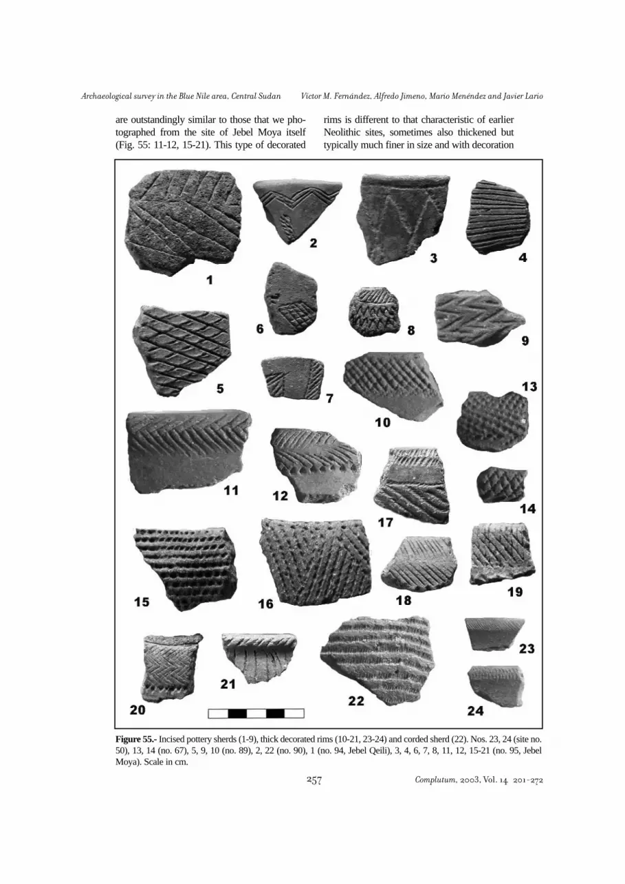
are outstandingly similar to those that we pho-tographed from the site of Jebel Moya itself(Fig. 55: 11-12, 15-21). This type of decorated
rims is different to that characteristic of earlierNeolithic sites, sometimes also thickened buttypically much finer in size and with decoration
Figure 55.- Incised pottery sherds (1-9), thick decorated rims (10-21, 23-24) and corded sherd (22). Nos. 23, 24 (site no.50), 13, 14 (no. 67), 5, 9, 10 (no. 89), 2, 22 (no. 90), 1 (no. 94, Jebel Qeili), 3, 4, 6, 7, 8, 11, 12, 15-21 (no. 95, JebelMoya). Scale in cm.
Complutum, 2003, Vol. 14 201-272257
Archaeological survey in the Blue Nile area, Central Sudan Víctor M. Fernández, Alfredo Jimeno, Mario Menéndez and Javier Lario

of plain rocker or minute incised lines (Fig. 53:1; Fig. 55: 23-4).
As the field work progressed, it became clearto us that the pottery sherds recovered from thesurface at the different Neolithic sites did notpresent a two-phase model (Early-Late) with aclear-cut separation, but instead a gradual varia-tion of decoration categories. These ranged fromthe typical Early Neolithic types (especially rock-er impression) to those which are characteristicof the final phases, especially simple impressionand incision (Figures 52-55). This turn from oneto another so a different decoration technique isreally striking. The first technique is based onimpressions on the fresh clay of the vessels usinga system of continuous pivoting of the (usuallydenticulated) comb between one and the follow-ing impression. This means alternative turningof the comb a bit around its two ends, the finalresult being zigzag lines, more or less packedagainst each other (the “packed” or “spaced”zigzag types of Caneva 1988: 83), that usuallycover all the outer space of the vessel. The sec-ond technique is radically different: the combhas to be completely lifted from the surfacebetween one impression and the next one. Thisresults in a pattern of more detached lines, thiseffect being usually reinforced by letting a sur-face area free from decoration (a choice not soeasy to apply, and actually very seldom chosen,with the first technique) (Figures 52-54).
As shown on table 10, a ceramic seriationwas made with the percentages of sherds with
different decoration types found in eight sur-veyed and/or excavated sites: Hag Yusuf (no. 1),Sheikh el Amin (36), Rabob (50), Bir el Laham-da (62), Wad el Amin (67), Qoz Kabaro (88),Qoz Bakhit (89) and Bashaqra Garb (93). Thefirst five sites are located at the east bank of theBlue Nile river, in the areas of Khartoum, WadiSoba, Wadi Rabob and Wadi Hasib. The lastthree are found on the west bank in the Geziraregion. The scarcity of data obliges us to over-rule one of the principles of archaeological seri-ation, which prescribes that sites must come fromthe same cultural region (Rouse 1967: 178-9).
Following the same method than in theMesolithic sites (see section 6), a multivariateanalysis using a MDSCAL program for PCcomputer (ATD, Foucart 1982) yields a “better”ordering of sites according to a model of gradualvariation of decoration percentages between thesites. The order is Bir el Lahamda, Hag Yusuf,Sheikh el Amin, Rabob, Bashaqra Garb, QozKabaro, Qoz Bakhit, Wad el Amin. The smallnumber of sites to be ordered and the presenceof only two quantitatively important types (RKand SIMP) would permit to carry out the analy-sis manually, simply ordering by decreasing RKand increasing SIMP, or vice versa. The modelof gradual variation is shown in Figure 56.
A constant decrease in the rocker impressiontechnique is recorded in the model, what is pre-sumably chronological. Contrary to that patternis the also continuous increase in the other tech-nique of making impressed patterns namely thesimple impression. Alternatively pivoting stamp,a technique very similar and with the same prin-ciple of the rocker impression, also decreases
Ceramic seriation
SITE RK SIMP APS INC BT RIP DWL TOTAL1 (Hag Yusuf) 79.6 0.3 12.8 6.9 0.4 0 0 1833*36 (S. el Amin) 74.8 0 1.7 22.4 0.2 0 0.8 28830*50 (Rabob) 61.5 12.4 12.8 8.4 0.4 4.4 0 22662 (Bir el Lahamda) 89.6 2.3 3.4 3.4 0 0 1.1 9067 (Wad el Amin) 24 75.9 0 0 0 0 0 7988 (Qoz Kabaro) 38.9 50 0 11.1 0 0 0 1889 (Qoz Bakhit) 16.4 67.1 1.5 14.9 0 0 0 6793 (Bashaqra Garb) 59 23.1 5.1 10.3 0 2.6 0 39
Table 10.- Percentages of pottery decoration types in the surface or excavated samples from Neolithic sites. Legend: RK:Rocker impression (including packed and spaced zigzag, even and unevenly serrated edge, and plainedge types; varia-tion of these subtypes seems erratic in the seriation); SIMP: Simple impression; APS: Alternatively Pivoting Stamp; INC:Incision; BT: Black Topped; RIP: Ripple ware; DWL: Dotted Wavy Line. (*) Data from excavation has been taken forsites nos. 1 and 36.
Complutum, 2003, Vol. 14 201-272 258
Víctor M. Fernández, Alfredo Jimeno, Mario Menéndez and Javier Lario Archaeological survey in the Blue Nile area, Central Sudan

with the passing of time. Incision, a culturalmark for Late Neolithic times, increases yet witha not so clear pattern. The less frequent decora-tion types, such as black topped and ripple undu-lated surface, do not show a distinct model,probably due to their small numbers. Dottedwavy line sherds only occur at the beginning ofthe sequence, which is in accordance with theircultural provenance from Mesolithic times. Theresults of the seriation analysis indicate that theborder between both phases is indistinguishableor either does not exist. Considerations of a dif-ferent kind, such as the settlement analysis thatcomes in the next section below, could make iteasier to understand the behavioural and socialchanges that took place in the Sudanese Sahelduring the Middle Holocene.
Arelated model of increase in simple impres-sion decoration was also detected in the twoNeolithic sites excavated by the Italian team inEl Kenger, North of Khartoum. El KengerMiddle had 12.5 % of sherds with this kind ofdecoration and was radiocarbon dated to 5620 +80 bp (level 3 of sounding 1, another date froma surface shell gave a younger, if questionable,date: 5080 + 70 bp). El Kenger East had 65.6 %of simple impressed sherds and was dated to5290 + 80 bp (Caneva and Gautier 1994: 68, 70).Other evidence for pottery variation in the Wadiel Kenger sites does not match our model, how-ever. For instance the incised sherds decreaseinstead of increasing over time as in the case ofthe Blue Nile sites. Only the APS technique,much more abundant, shows a decreasing patternas in our sites. The radiocarbon dates are alsounexpectedly early when interpreted in terms ofthe high frequency of simple impression pat-terns, as the excavators clearly admit in the pub-lication (Ibidem: 72).
Only three samples were successfully radio-carbon-dated from the Neolithic sites of our sur-vey (another two from Hag Yusuf were not use-ful for they came from a more recent Christiancontext, cf. Fernández et al. 1989: 264). Oneshell sample from sector B of Sheikh el Aminyielded a date of 5555 + 60 bp (T-10950, Trond-heim laboratory), and a Nile oyster shell fromthe site of Rabob produced a date of 4670 + 50bp (Ua-19741 at Uppsala laboratory using AMStechnique). Hence the order of the two sites inthe seriation seems to be correct, if only toomuch separated in time (885 years) for being soclose in the seriation (see Figure 56). Anotheroyster shell sample from Sheikh el Amin waslater analysed using the AMS method at Uppsa-la laboratory. It came from the open area exca-vation in sector J, probably the only part of thesite that could be considered of a younger datethan the rest, all of it very homogeneous. Thedate (4590 + 45 bp; Ua-20415) is, however, sur-prisingly young when compared with that fromsector B of the same site. Its proximity to the Ra-bob date, however, is in accordance with the sim-ilarity of pottery type frequencies at both sites.
During the fieldwork we made a culturalclassification of the sites on the basis of the pot-tery types observed on the surface. With one sin-gle exception, this preliminary labelling was notchanged and so it appears in the gazetteer of sec-tion 2 of this paper. Curiously enough, we clas-sified as “Early Neolithic (Shaheinab)” the firstthree sites of the seriated list (Lahamda, Hag Yu-suf, S. Amin) and the fifth one (Bashagra), andwe put the “Late Neolithic” label to the fourth(Rabob) and the last three sites (Kabaro, Bakhit,W. Amin). Aprobable explanation for the “error”in the two wrongly classified sites is a purelysubjective one. Rabob was the first important
Figure 56.- Seriation of pottery decoration types percentages in the Neolithic sites surveyed in the Blue Nile area, accord-ing to data in table 10. The order is presumably chronological, the earlier sites being at the lower and the younger at theupper part.
Complutum, 2003, Vol. 14 201-272259
Archaeological survey in the Blue Nile area, Central Sudan Víctor M. Fernández, Alfredo Jimeno, Mario Menéndez and Javier Lario

site with significant amounts of simple impres-sion pottery that we found (and it is a veryunique kind of site in the Central Sudan indeed),so we tended to ascribe to it rapidly the newlabel of “Late Neolithic”. Bashagra was just thelast site, Neolithic or of any other kind, that wediscovered during the survey.
A similar shift from rocker to simple impres-sion zoned decoration in pottery seems to haveoccurred in the Eastern Sudan area, marking thetransition between the Saroba and Kassala cul-tural phases (Fattovich et al. 1984: Figs. 3, 5;Fattovich 1990: 13-4). Another feature in thepottery of the Blue Nile Late Neolithic sites isalso related to the Eastern Sudan, namely thedecoration of surfaces by rough wide scrapingor combing. Scraped decoration is the mostcharacteristic technique of the Atbai ceramic tra-dition in the Gash-Atbara area during the lastfive millennia bc (Fattovich et al. 1984: 177-8;Fattovich 1990: 10-1; Sadr 1990: 69-70), and ispresent in some of the Blue Nile sites: Bir La-hamda (3 %), Rabob (3.5 %), Kabaro (11.1 %)and Bakhit (12.3 %). Simple impression appear-ed in Eastern Sudan around the middle of the VImillennium bp (Fattovich et al. 1984: 179). Inthe Central Sudan it may be dated, as it is infer-able from the aforementioned data, between themiddle of the VI and the middle of the V millen-nium bp. Thus the first region could be suggest-ed as a probable origin for this gradual techno-logical change, irrespective of its possible lin-guistic or ethnic implications (the coming of Cu-chitic specialised pastoralists to the Khartoumarea; Haaland 1987a: 229-30, 1991, 1992b). Themuch longer chronological duration of the rock-er impression technique in the Southern Sudan(Mack and Robertshaw 1982) and in the “pre-nilotic” areas of Western Ethiopia, as it has beenevidenced in our own survey at Benishangulfrom 2001 to 2003, could also indicate somekind of long term relationship of this decorationwith Nilo-Saharan populations. This associationperhaps begun in the Mesolithic or “Aqualithic”period as J.E.G. Sutton (1974, 1977) first pro-posed it.
The sites discovered or re-examined in oursurvey come to fill the supposed population gapin this area during the last millennia bc. Also thematerials from two sites surveyed in the WestButana area by Balfour-Paul (1952) and re-analysed in the Khartoum National Museum,
Abu Miriam and Abu Zumein, show close sim-ilarities with Eastern Sudan and with the JebelMoya Late Neolithic cultural assemblage (seesection 3). All these sites are situated in-betweenand thus serve to connect culturally the settle-ments of the Eastern Butana with others knownin the Southern Gezira such as Jebel Moya, Je-bel Tomat or Rabak. As we have seen, thick rimswith impressed and, more frequently, inciseddecoration are abundant in Jebel Moya (Addi-son 1949: pl. 91-3; Balfour-Paul 1952: Fig. 5).They have often been interpreted as a “fossilguide” for the Late Neolithic in the Gezira area,such as in the sites of Rabak and Jebel Tomat(Haaland 1987a: 45-7, Fig. 14, 1987b: 57, Fig.8).
The relations between Eastern Sudan and theGezira in Late Neolithic times had been suggest-ed by several authors (Clark 1973; Clark andStemmler 1975; Haaland 1987a), but the cultur-al aspects defining this phase were unknown inthe Central Nile valley proper (Caneva 1991:264, 2002). The radiocarbon date from Rabob(4670 + 50 bp) falls within the Late Neolithicchronology previously assumed for the site andalso parallels known dates from Eastern Sudanand the Gezira. It is one of the first radiocarbondates in the fifth millennium bp for occupationsites in Central Sudan, the other dates corre-sponding to cemetery sites such as El Kadada(Hassan 1986: table 1). A very close date, 4490+ 100 bp, was obtained for the upper, Late Neo-lithic part of the occupation midden of Rabak(Haaland 1987b: 57; Magid 1989: 49-51).
So far plenty of sites of the previous phases(Mesolithic and Early Neolithic) had been found,but very few were of the period that forms thetransition between the Neolithic agro-pastoralphase (Shaheinab, c. 6000-5000 bp) and thebeginning of the Meroitic period shortly after3000 bp. The only sites known are the earlierphases of Jebel Moya (Addison 1949; Gerharz1994) -with the exception of a few sherds thatcould even be earlier (Caneva 1991)-, JebelTomat (Clark and Stemmler 1975) and Rabak(Haaland 1987a, b; Magid 1989). All these sitesare located in the middle of the Gezira or at theWhite Nile bank but none of them in the BlueNile valley. As to the Khartoum region, only thefew findings of the El Kenger in the main Nilevalley (Caneva 1988: 335-6; Caneva and Gautier1994) could be ascribed to this phase.
Complutum, 2003, Vol. 14 201-272 260
Víctor M. Fernández, Alfredo Jimeno, Mario Menéndez and Javier Lario Archaeological survey in the Blue Nile area, Central Sudan

The remains found on the surface of the siteof Sheikh el Amin cover an area of c. 60.000square metres. The results of extensive excava-tions carried out during the 1997 and 1998 cam-paigns (see Fernández, Jimeno and Menéndez2003) have confirmed that the real extension ofthe site is approximately that large. The site isthus one of the biggest known prehistoric settle-ments in Central Sudan. The other two big Neo-lithic sites in our survey have even larger surfaceremains: no. 50, Rabob (c. 300.000 m2) and no.62, Bir El Lahamda (c. 150.000 m2). It is possi-ble, however, that the archaeological sub-soildeposits do not correspond to that wide distribu-tion. The test-pits in the Rabob site did notreveal significant stratigraphic levels, and in La-hamda the observation was made that the pot-tery distribution was smaller in size than thewhole surface covered by the lithic remains. Forthe Mesolithic sites, data from the excavationsin no. 19-1, Karnus and no. 13, Sheikh Mustafa(see Fernández, Jimeno and Menéndez 2003)
show that the surface artefact distribution do notcorrespond to the underground remains.However, other sites, for instance El Mahalab(Ibid.), seem to have been less affected by defla-tion and post-depositional disturbance. Anyway,we can safely assume that a general relationshipexists between the artefact distribution on thesurface of each site (Table 11) and the relativeimportance of the settlement in the past. Site sizecan be correlated with the number of its inhabi-tants (population nucleation or dispersal), andartefact density with the duration of occupationat each site (Sadr 1988: 392-3). An overall com-
Settlement patterns (Figure 57)
Figure 57.- Distribution of Early (squares) and Late (triangles) Neolithic sites in the Wadi Soba-el Hasib area, includingthe site of Bashaqra Garb in the Gezira West of the Blue Nile (no. 93) and the previously known sites in the Main Nileeast bank.
Site no. Size (m2) 1 4500036 6000050 30000062 15000067 770089 4000090 10000
Table 11.- Areas of surface artefact distribution at the mainNeolithic sites.
Complutum, 2003, Vol. 14 201-272261
Archaeological survey in the Blue Nile area, Central Sudan Víctor M. Fernández, Alfredo Jimeno, Mario Menéndez and Javier Lario

parison of the surface areas for the best-pre-served sites in the two periods shows a signifi-cant and large increase in site size for the Neoli-thic settlements. The mean area size for the Me-solithic sites is 13.176 m2 (N= 17), while for theNeolithic sites it is 87.529 m2 (N= 7).
Another feature of the Neolithic sites in theEastern bank of the Blue Nile is their generallocation in areas that are farther apart from thecurrent course of the Blue Nile than the Meso-lithic sites. With the exception of Hag Yusuf andthe two small sites of Soba, all the Neolithic sitesdiscovered in the Soba-Rabob-Hasib areas are atmore than 18 km from the Nile: Sheikh el Amin(18 km), Wad el Amin (25 km), Bir el Lahamda(40 km), Wadi Rabob (58 km).
This model of Neolithic occupation inferredfrom the survey, with fewer but larger sites andfarther inland sites than in the earlier Mesolithicperiod, can be compared to that proposed previ-ously by L. Krzyzaniak (1978) and expanded byR. Haaland (1987a, b). According to their loca-tion with respect to the Nile, the settlements hada different socio-economic orientation: dry sea-son camps in the alluvial plain, exploiting theaquatic resources (male and female activities),base sites occupied all-year round in the alluvialplain and orientated to cultivation (female activ-ity), and herding camps (male activity) in theButana savanna during the rainy season (Haa-land 1987b: 216).
The four previously mentioned sites mighthave been large permanent settlements (basesites) near the wadi beds in the Butana plain -thesame could be said of Qoz Kabaro and QozBakhit in the Gezira plain-, probably occupiedthroughout the year and mainly used for culti-vating crops or gathering wild plants. The sitesnearer the main watercourse, like Hag Yusuf andSoba on the east bank, or Bashagra on the WestBank, much smaller in size, could have beentemporary dry season settlements, used for fish-ing and herding in the dry season. From the siteseriation (Fig. 56) the inference is possible thatthe later type was more abundant at the begin-ning of the period (Early Neolithic) and that theformer is typical of the Late Neolithic times.This hypothesis is in accordance with the pres-ence of only Early Neolithic sites in the proxim-ity of the Main Nile course, such as the well-known settlements of Kadero, Umm Direiwa,Zakiab, Geili, etc.
Also a comparison of the spatial distributionof the Neolithic sites of our survey (Fig. 57) andthose previously known north of Khartoum atboth sides of the Main Nile, on which the modelreferred to is based (e.g. Haaland 1987a: 37;Caneva 1988: 21; Magid 1989: 12) shows impor-tant differences. In the Main Nile all the sites arelocated in a narrow band parallel to the Nile: themaximum distances that set them apart is lessthan 10 km from the present Nile course, as inthe case of Umm Direiwa I and II. It could besaid that our big sites in the Butana, both of earlyand late chronology, are too far apart from themain river to be complementary seasonal settle-ments in the hinterland for the same humangroups in the river. Equally important, they donot fulfil the criteria set for seasonal herdingcamps (Haaland 1987a: 30, 207-13). These sitesare much bigger than could be expected for amobile camp, and the faunal remains do notindicate husbandry especialization. In the onlyextensively excavated site, Sheikh el Amin,domestic animals amount to only 13.1 % of thefaunal remains analyzed (see Chaix 2003: table12). With the exception of Esh Shaheinab, thispercentage is outstandingly low if comparedwith other sites in the region, (e.g. Geili 24 %;Nofalab 62.1 %, Kadada 64.5 %, Kadero 88.3%, Za-kiab 87 %) (Gautier 1986, 1988; Tigani elMahi 1988; Peters 1992). The two small test-pitsdug in the Late Neolithic Rabob (no. 50), did notyield any mammalian faunal remains.
If the general chronology and cultural aspectare taken into consideration, there is reason tosuggest that Sheikh el Amin and Bir el Lahamdaare similar to the large Early Neolithic sites nearthe main Nile such as Geili and Kadero. Butthey are located in a different ecological setting,namely the Butana savanna. Most of our sites,both Early and Late Neolithic, are located on thebanks of the wadis, which were probably notcompletely dried out during the rainy season.Further inside the Butana there are seeminglynot many settlements from this period. The Ger-man survey in the fifties discovered only two“Neolithic” sites, most probably Early and LateMesolithic, in all the Butana area investigated(Hintze 1959: 177-8, 192). But being near thewater did not mean that the fishing activitieswere important as the scanty fish remains foundin Sheikh el Amin show (one single fragment ofNile perch; cf. Chaix 2003: table 12). Compared
Complutum, 2003, Vol. 14 201-272 262
Víctor M. Fernández, Alfredo Jimeno, Mario Menéndez and Javier Lario Archaeological survey in the Blue Nile area, Central Sudan

with the fish remains in the nearby Mesolithicsite of El Mahalab, where they amount to 13.7 %(Ibidem), a substantial reduction in the aquaticeconomic orientation seems to have taken placeduring the Neolithic period in this area.
These sites in the Western Butana were occu-pied by mostly hunting and gathering groupswith domestic livestock as a subsidiary foodsource: around 87 % of the bones found in Sheikhel Amin correspond to wild savanna species(Chaix 2003: table 14). Aparallel situation is knownto have occurred with other inland groups, as ithas been recorded in the Northern area (Shaqadudcave) and in the Eastern Butana and SouthernAtbai region (Khashm Al Girba-Kassala areas).The population of Shaqadud had a hunting-gath-ering economy during the first occupation in theeight millennium bp and it is only in the fourthmillennium bp when a small percentage ofdomestic animal remains (2.7 %) is recorded(Peters 1991b: 229). In the Southern Atbai region,evidence of food-production does not appearuntil the later half of the Butana Group (c. 6000-4500 bp), being fully established only in the fol-lowing Gash Group (c. 4500-3500) (Fattovich1990: 14; Sadr 1991: 40-1; Geraads 1986). Itseems that the introduction of the herding econ-omy was a gradual diffusion process from theNile towards the Eastern Sahel.
The big area of the Neolithic sites discoveredin our survey still awaits explanation. The dra-matic size increase of the settlements, true “vil-lages” of the savanna, imply a great demograph-ic concentration that was previously unknown inthe area, and will not be seen again until moderntimes. Several authors have insisted on thehumid conditions of the Central Sudan area dur-ing the second half of the Holocene, with a slowdiminution of precipitation until present dayconditions were reached about 3000 bp (Wi-ckens 1982). The good conditions would havefavoured the exploitation of the resources of thethorn savanna, during the rainy season if not ona permanent basis as in the Gash area, wherevery big settlements have also been recorded atabout the same time (Fattovich 1990: 14). Theabundance of edible wild plant impressions inthe Sheikh el Amin pottery is another indicationof an intense exploitation of food resources inthe area (see Magid 2003: table 1). Possiblybecause of the contracting water resources, andcontrary to the Mesolithic period when wadi
flooding was more intense, now the groupstended to concentrate in bigger settlements. Thisnucleation process could also be explained bysocial reasons, since as it is clearly shown in theKadero settlement and cemetery, the groupsexhibit now for the first time evidence of emerg-ing social division and complexity, probablyrelated to the livestock ownership (see Fernán-dez 2003b).
The finding of Late Neolithic sites in areaswhere they were previously unknown (Khartoumregion, Blue Nile basin) widens considerablyour knowledge of this period. Moreover, thelarger sites (Wadi Rabob, Wad el Amin, QozBakhit) suggest a more intense occupation of thearea than was previously thought. Some inter-esting hypothesis advanced on the question(Haaland 1987a, b, 1992b) insinuate that theeconomic way of life changed to a fully pastoralsystem in the transition from Early to Late Neo-lithic phases. A new population, a nomad peoplethat only occasionally visited the river areas (asin El Kenger, Soba or Bashagra), initiated thenew economy. This change could be related tothe introduction of the Afro-asiatic languages inthe area replacing the previous Nilo-Saharanones that correspond to the previous “aquatic”populations (Sutton 1974, 1977).
Contrary to this, our data suggest that the pas-toral element is not yet decisive in the later Neo-lithic times. Moreover, there was not any signifi-cant cultural interruption during the whole Neo-lithic period. As we have previously seen, potterydecoration patterns show a continuous variation,gradually replacing one technique of impressionwith another. Nonetheless, the significance of thisslow change was surely important, for the rockertechnique had been used in the Nile and all alongthe Saharan area during many millennia. In thefollowing archaeologically “visible” cultural pe-riod, when the Meroitic culture was being for-med in the first millennium bc, the hand-madeblack pottery tradition that connects with the LateNeolithic times was decorated using mostly inci-sion and simple impression techniques. Rockertechnique, though still present, was very rare(see for example the vessels from Jebel Moya,Addison 1949: plates 89-93, from Geili, Caneva1988: 202-6, Meroe and Kadada, Lenoble 1995,or the large collection from the Early Meroiticcemetery of Amir Abdallah in Northern Sudan,Fernández 1984b: 75-7, 1985c: 372-425).
Complutum, 2003, Vol. 14 201-272263
Archaeological survey in the Blue Nile area, Central Sudan Víctor M. Fernández, Alfredo Jimeno, Mario Menéndez and Javier Lario

The transition to the Meroitic kingdom in thearea poses a different problem, since not one sin-gle site is known from the time extendingbetween approximately 4000 and 2500 bp. Afterour data, the Neolithic sites become very largeand then suddenly disappear. The better exam-ple of this process is the Late Neolithic site atRabob (no. 50). Unlike many Mesolithic sites,which are small in size and probably correspondto short time occupations, the Rabob site is quitebig and presumably a larger human group pro-duced its remains. Another possibility is that asmall or medium size group camped on thesame place periodically. This model would cor-respond to a nomadic group that approached thevicinity of the Blue Nile or the wadi, choosingthe same favourable place in every seasonalvisit. Since the midden shifted every year, it pro-duced an even and thin spread of artefacts on alarge surface (“sheet midden”). On the contrary,the Early Neolithic site of Sheikh el Amin (no.36), which is also fairly large, has much deepersediments concentrated in separate kôms withareas in between almost devoid of archaeologi-cal deposit (see report on the excavation in thisvolume). This would correspond to a moresedentary group living on the same spot yearafter year. As the midden location never changedthis would result in higher concentration of arte-facts in the waste areas and lower densities in thehabitation cleared areas (see Sadr 1991: 20-3,for this model of archaeological record forma-tion). This transition from a sedentary to a morenomadic way of life, inferable from the changesbetween both archaeological sites, is in accor-dance with previous theories about the econom-ic trends in the Central Sudanese Neolithic(Krzyzaniak 1978; Haaland 1987a, 1987b; Ca-neva 1988). The chronology of the sites (5550-4670 bp) is also consistent with the period whenthat change is supposed to have occurred.
The shift to a progressively mobile economywas probably due to environmental (more aridclimate) or social (problems of group organisa-tion and division) reasons, or both. The humangroups at this period became archaeologicallyinvisible and at the end of the time gap most ofthem were already fully nomadic, just about thesame time that the fully pastoral Hagiz Groupoccurred in the Atbai region at the eastern side ofthe Butana (Sadr 1991: 111). Only some funer-ary mounds, very difficult to distinguish from
those made in the historical period (see next sec-tion), seem to correspond to this “post-Neoli-thic” period. Recent excavations have shed somelight on the “ghosts” of the Khartoum province,represented by tumuli -some of them true ceno-taphs, i.e. empty tombs probably erected as amemorial for people dead and buried elsewhere.Some of the burials produced incised potteryreminiscent of the pan-grave and Mokran groupsof Northern and Eastern Sudan (Caneva 2002).
All along the field survey we found tumulifields that can be ascribed to the historical peri-od, from the Meroitic times onwards. Eventhough we were working near the north-easterncorner of the Butana plain, which was called inthe antiquity the “island of Meroe”, only a fewremains could be asigned that chronology (a partof site no. 16), together with the well knownengravings of Jebel Qeili, located in an area thatfell outside of our main survey area (Crowfoot1920; Hintze 1959: 189-192). This absence wasalso detected in the 1957-1958 Berlin HumboldtUniversity survey, whose inspection only detect-ed Meroitic sites in the Western part very nearthe Nile river and particularly along the fertilewadis where important settlements such as Mu-sawwarat es Sufra and Naqa were erected. Inthis sense, the “Meroitic culture, like the Egyp-tian, was a culture of the Nile Valley” (Hintze1959: 196). Other outposts in the hinterland, notvery far from the river, were interpreted as forti-fications (Ibid.), since they exerted some degreeof control over the desert pastoralist nomadswhen they annually came near the river to theedge of the more densely settled area (Adams1977: 330). Throughout the Meroitic period thosenomads wandered and exploited the grasslandsof the Butana, and the temple/hafir complexes atMusawwarat and Naga were their contact pointswith the sedentary agricultural population estab-lished near the river (Bradley 1986; Sadr 1991:115). Those association of the artificial waterponds (hafir) with nomadic groups probablybegun earlier, since at Shaqadud the cave over-looks a partly man-made water pool that couldhave been used by people in the site before c.3500 bp (Sadr 1991: 111).
Tumuli ascribed to a nomadic populationwhich yielded pottery of Late Neolithic affilia-
8. The Historical sites
Complutum, 2003, Vol. 14 201-272 264
Víctor M. Fernández, Alfredo Jimeno, Mario Menéndez and Javier Lario Archaeological survey in the Blue Nile area, Central Sudan

tion (rocker and simple impression, incision),tentatively dated around 4000 bp, were excavat-ed near Meroe at Jebel Makbor, some kilome-tres away from the Nile course (Lenoble 1987).Together with the aforementioned Khartoumregion tumuli, this site is the earliest known of along series of funerary mounds that lasted formillennia in this area, and were the only type ofarchaeological feature until the Christian era.This did not only happen in the hinterland andmore remote East Butana zones, but also nearthe Nile. The survey around Geili and Saggaidid not found any Meroitic settlement remains,only graves that were interpreted, on the basis ofpaleodietary analysis of their bones, as belong-ing to a nomad population that came near theriver to bury their dead (Caneva 1988: 335). Thesurface inspection of some of the burial groundsreveals that many tumuli fields could have beenerected during several periods, and their culturalattribution is unfeasible unless some excavationwork is done (Lenoble 1987: 238).
Some of the groups of burial mounds foundin our survey are probably of Islamic chronolo-gy (site nos. 46, 48, 53, 56, 59). Their moundsare small, made of earth and oval in shape, sur-rounded by a stone circle. They follow a N-S orNW-SE orientation and sometimes have smallerstone-circled tombs with the same layout andorientation, or sheikhs graves marked with flags,in between or nearby the mounds. The stoneaccumulations over some granitic outcrops orsmaller elevations (site nos. 39, 40, 41, 52)could belong to the same period. Normal ceme-teries without visible mounds were recorded insite no. 75 (besides the remains of a Christianchurch) and no. 77 (Islamic).
Another type of burial mound ground is rep-resented by sites nos. 10, 11, 22, 25, 57, 58, 60and 61. The first four sites are in the Wadi Sobaarea and in some cases the tumuli cover part ofa Mesolithic site. Even if there were no signs ofplundering neither culturally idiosyncratic itemson surface allowing attribution, the similar casesrecorded in the Geili area (Caneva 1988) sug-
gest a Meroitic chronology for those cases. Theother four mound grounds, recorded in the areain between Wadi Rabob and Wadi el Hasib, areof a different type. The tumuli are more numer-ous, e.g. up to 90 mounds in site no. 61, all ofthem are of an almost perfect circular shape andare covered by white quartz pebbles. Using asimple exclusion argument, these graves couldbelong to the Christian era.
As regards the settlement sites, we found theremains of three brick buildings that probablycorrespond to Christian churches (nos. 3, 4 and74). The first two are very near the medievaltown of Soba and the third had one of the bricksincised with letters of the Greek alphabet. Threeother settlement sites were abandoned duringthe Christian period (nos. 23, 24, 51) since thepottery found on the surface was of the typedefined as “incised” in the recent Soba excava-tions (Welsby and Daniels 1991: Figs. 122-33).
The settlement sites that can be attributed tothe Islamic period are of two types. In some ofthem (nos. 73, 76, 79, 82, 83, 91?) we foundincised decoration with geometric designs that isknown to belong to the Funj period (Crawfordand Addison 1951: 59-60, pl. 32-3; Chataway1930: Fig. 6; Arkell 1934). All these sites are sit-uated south of Wad Medani in the Rahad andBlue Nile valleys, that is very near the core ofthe Funj Kingdom of Sennar (Crawford 1951;Kleppe 1997), and thus were probably aban-doned before the end of the kingdom at thebeginning of the XIX century. The second typeseems to be more recent, because the sitesappear to have been abandoned not long ago(nos. 34, 64, 65). The common pottery found onthem has a very hard fabric, usually with a blackand red section because of uneven firing, theouter surface being very rough and without anykind of decoration. Isolated sherds of this kindwere frequently found on the surface duringthe survey, including in the prehistoric sites dis-covered and investigated during this researchproject.
Complutum, 2003, Vol. 14 201-272265
Archaeological survey in the Blue Nile area, Central Sudan Víctor M. Fernández, Alfredo Jimeno, Mario Menéndez and Javier Lario

ADAMS, W.Y. (1977): Nubia, Corridor to Africa. Allen Lane, London.ADAMSON, D.A.; WILLIAMS, M.A.J.; GILLESPIE, R. (1982): Palaeogeography of the Gezira and of the
lower Blue and White Nile valleys. In Williams and Adamson 1982: 165-219.ADDISON, F. (1949): Jebel Moya. Oxford University Press, Oxford.AMMERMAN, A.J. (1981): Surveys and archaeological research. Annual Review of Anthropology, 10:
63-88.ANDERSON, J. (1984): Between Plateau and Plain. Flexible responses to varied environments in
Southern Australia. Camberra University Occasional Papers in Prehistory 4, Camberra.ARKELL, A.J. (1934): Three burials in Sennar district. Sudan Notes and Records, 17(1): 103-110.ARKELL, A.J. (1949a): Early Khartoum. An account of the excavation of an early occupation site
carried out by the Sudan Government Antiquities Service in 1944-5. Oxford University Press,Oxford.
ARKELL, A.J. (1949b): The Old Stone Age of the Anglo-Egyptian Sudan. Sudan Antiquities ServiceOccasional Paper no. 1, Khartoum.
ARKELL, A.J. (1953): Shaheinab. An account of the excavation of a Neolithic occupation site carriedout for the Sudan Antiquities Service in 1949-50. Oxford University Press, Oxford.
BACHECHI, L. (1998): Contributo alla conoscenza dell’arte rupestre somala. Rivista di Scienze Preisto-riche, 49: 225-246.
BAKER, C.M. (1978): The size-effect and explanation of variability in surface artefact assemblagecontent. American Antiquity, 43: 288-293.
BALFOUR PAUL, H.G. (1952): Early Cultures on the Northern Blue Nile. Sudan Notes and Records,33(2): 202-215 (Figures in Supplement to vol. 33).
BARICH, B. (ed.) (1987): Archaeology and Environment in the Lybian Sahara. The Excavations in theTadrart Acacus, 1978-1983. BAR International Series 368, Oxford.
BINFORD, L.R. (1983): In Pursuit of the Past. Decoding the Archaeological Record. Thames andHudson, London.
BRADLEY, R.J. (1986): AModel for Pastoralism in the Meroitic Butana. Nubische Studien (M. Krause,ed.), Ph. von Zabern, Mainz an Rhein: 25-31.
BREWER, J. (1992): Incremental growth structures in Nile fish and molluscs from archaeological sitesas indicators of Holocene environmental change in Egypt. The Holocene, 2: 30-36.
CAMPS, G. (1974): Les civilisations préhistoriques du Nord de l’Afrique et du Sahara. Doin, Paris.CANEVA, I. (ed.) (1983): Pottery-using hunters and gatherers at Saggai (Sudan): Preconditions for
Food Production. Origini 12, Roma.CANEVA, I. (ed.) (1988): El Geili: the history of a Middle Nile environment 7000 B.C. - A.D.
1500. Cambridge Monographs in African Archaeology 29, BAR International Series 424,Oxford.
CANEVA, I. (1991): Jebel Moya revisited: a settlement of the 5th millennium BC in the middle NileBasin. Antiquity, 65: 262-268.
CANEVA, I. (1994): Le tumulus funéraire dans les cultures anciennes du Soudan Central Nilotique.Hommages à Jean Leclant, vol. II (C. Berger, M. Clerc, N. Grimal, eds.), Institut Français d'Ar-chéologie Orientale, Bibliotheque d'Étude 106(2): 81-95.
CANEVA, I. (2002): Second Millennium BC Pastoral Cultures in the Nile Valley: The Ghosts of theKhartoum Province. Tides of the Desert. Gezeiten der Wüste. Beiträge zu Archäologie und Um-weltgeschichte Afrikas zu Ehren von Rudolf Kuper, Africa Praehistorica 14, Heinrich Barth Insti-tut, Köln: 231-237.
CANEVA, I.; GAUTIER, A. (1994): The desert and the Nile: Sixth millennium pastoral adaptations atWadi el Kenger (Khartoum). Archéologie du Nil Moyen, 6: 65-92.
CANEVA, I.; MARKS, A.E. (1990): More on the Shaqadud pottery: evidence for Saharo-nilotic connec-tions during the 6th-4th millenium B.C. Archéologie du Nil Moyen, 4: 11-35.
CANEVA, I.; MARKS, A.E. (1992): Prehistoric Survey in the Upper Nile Valley: From Site to Region.
Bibliography
Complutum, 2003, Vol. 14 201-272 266
Víctor M. Fernández, Alfredo Jimeno, Mario Menéndez and Javier Lario Archaeological survey in the Blue Nile area, Central Sudan

Études Nubiennes. Conférence de Genève. Actes du VIIe Congrès International d’études nubi-ennes (3-8 septembre 1990) vol. I: 61-78.
CANEVA, I.; ZARATTINI, I. (1983): Microlithism and functionality in the Saggai 1 industry. In Caneva1983: 209-233.
CHAIX, L. (2003): La faune des sites mésolithiques et néolithique de la zone du Nil Bleu (SoudanCentral). The Blue Nile Project. Holocene Archaeology in Central Sudan (V.M. Fernández, ed.),Complutum 14, Madrid: 373-396.
CHATAWAY, J.D.P. (1930): Archaeology in the Southern Sudan. Some Ancient Sites near Roseires.Sudan Notes and Records, 13: 259-267.
CHLODNICKI, M. (1984): Pottery from the Neolithic settlement at Kadero (Central Sudan). Origin andEarly Development of Food-Producing Cultures in North-Eastern Africa (L. Krzyzaniak and M.Kobusiewicz, eds.), Poznan Archaeological Museum, Poznan: 337-342.
CHLODNICKI, M. (1987): Ceramics from the Neolithic cemetery at Kadero, Central Sudan. Archéolo-gie du Nil Moyen, 2: 141-147.
CLARK, J.D. (1973): The University of California, Berkeley, expedition to the Central Sudan. NyameAkuma, 3: 56-64.
CLARK, J.D. (1980): Human populations and cultural adaptations in the Sahara and Nile during pre-historic times. The Sahara and the Nile (Quaternary environments and prehistoric occupation innorthern Africa) (M.A.J. Williams and H. Faure, eds.), Balkema, Rotterdam: 527-82.
CLARK, J.D. (1984): Prehistoric Cultural Continuity and Economic Change in the Central Sudan inthe Early Holocene. From Hunters to Farmers. The Causes and Consequences of Food Productionin Africa (J.D. Clark and S.A. Brandt, eds.), University of California Press, Berkeley: 113-126.
CLARK, J.D.; STEMMLER, A. (1975): Early domesticated sorghum from Central Sudan. Nature, 254:588-591.
CLARKE, D.L (1978): Analytical Archaeology (2nd edition). Methuen, London.COWGILL, G. (1972): Models, methods and techniques for archaeological seriation. Models in Ar-
chaeology (D.L. Clarke, ed.), London: 381-424.CRAWFORD, O.G.S. (1951): The Fung Kingdom of Sennar, with an Account of the Middle Nile Region.
John Bellows, Gloucester.CRAWFORD, O.G.S.; ADDISON, F. (1951): Abu Geili and Saqadi & Dar el Mek. The Wellcome Excava-
tions in the Sudan, vol. III, Oxford University Press, Oxford.CROWFOOT, J.W. (1920): Old sites in the Butana. Sudan Notes and Records, 3: 83-92.DORAN, J.E.; HODSON, F.R. (1975): Mathematics and Computers in Archaeology. Edinburgh Univer-
sity Press, Edinburgh.DREVER, J.L. (1982): The Geochemistry of Natural Waters. Prentice-Hall, Englewood Cliffs, New Jersey.EDWARDS, D.N. (1991): Three cemetery sites on the Blue Nile. Archéologie du Nil Moyen, 5: 41-64.ELAMIN, Y.M. (1987): The Later Palaeolithic in Sudan in the light of new data from the Atbara.
Nubian Culture Past and Present (Main Papers presented at the Sixth International Conferencefor Nubian Studies in Uppsala (11-16 August 1986) (T. Hagg, ed.), Uppsala: 33-46.
EL BOUSHI, I.M. (1974): Hydrogeology of the area east of the Blue Nile between Khartoum and ElTekalat. Bulletin of the Geological Research Authority of the Sudan: 22-24.
EVANS-PRITCHARD, E.E. (1940): The Nuer. A Description of the Modes of Livelihood and PoliticalInstitutions of a Nilotic People. Clarendon Press, Oxford.
FATTOVICH, R. (1990): The Peopling of the Northern Ethiopian-Sudanese Borderland between 7000and 1000 BP: A Preliminary Model. Nubica, I/II: 3-45.
FATTOVICH, R.; MARKS, A.E.; MOHAMMED-ALI, A. (1984): The archaeology of the Eastern Sahel, Su-dan: preliminary results. The African Archaeological Review, 2: 173-188.
FERNÁNDEZ, V.M. (1984a): La combinación estadística de las fechas de carbono-14. Trabajos de Pre-historia, 41: 349-359.
FERNÁNDEZ, V.M. (1984b): Early Meroitic in Northern Sudan: the assessment of a Nubian archaeo-logical culture. Aula Orientalis, 2(1): 43-84.
Complutum, 2003, Vol. 14 201-272267
Archaeological survey in the Blue Nile area, Central Sudan Víctor M. Fernández, Alfredo Jimeno, Mario Menéndez and Javier Lario

FERNÁNDEZ, V.M. (1985a): Las técnicas de muestreo en prospección arqueológica. Revista de Investi-gación (C.U. Soria), 9(3): 7-47.
FERNÁNDEZ, V.M. (1985b): La seriación automática en arqueología: introducción histórica y aplica-ciones. Trabajos de Prehistoria, 42: 9-49.
FERNÁNDEZ, V.M. (1985c): La cultura Alto-meroítica del Norte de Nubia: Evolución de la cultura ma-terial y el ritual funerario en el Norte de Nubia del siglo III al I a.C.: la necrópolis de Amir Abda-llah. Colección Tesis Doctorales, 132/85, Universidad Complutense de Madrid. 2 vols., 1390 pp.
FERNÁNDEZ, V.M. (2003a): An Archaeological exploration of the Blue Nile in January-February 2000.Sudan and Nubia, 7: 85-90.
FERNÁNDEZ, V.M. (2003b): Four thousand years in the Blue Nile: paths to inequality and ways ofresistance. The Blue Nile Project. Holocene Archaeology in Central Sudan (V.M. Fernández, ed.),Complutum 14, Madrid: 409-425.
FERNÁNDEZ, V.M.; LORRIO, A. (1986): Relaciones entre datos de superficie y del subsuelo en yaci-mientos arqueológicos: un caso práctico. Arqueología Espacial, 7: 183-198.
FERNANDEZ, V.M.; JIMENO, A.; MENÉNDEZ, M.; TRANCHO, G. (1989): The Neolithic site of Haj Yusif(Central Sudan). Trabajos de Prehistoria, 46: 261-9.
FERNÁNDEZ, V.M.; JIMENO, A.; MENÉNDEZ, M.; LARIO, J. (1997a): The Mesolithic sites of SheikhMustafa and Al Mahalab (Central Sudan): A preliminary report. Cahier de Recherches de l’Institutde Papyrologie et d’Égyptologie de Lille, 17(2): 21-27.
FERNÁNDEZ, V.M.; JIMENO, A.; MENÉNDEZ, M. (1997b): The Spanish archaeological work at the BlueNile (Khartoum Province), 1989-1996. Kush, 17: 355-378.
FERNÁNDEZ, V.M.; JIMENO, A.; MENÉNDEZ, M. (2003): Archaeological excavations in Prehistoric sitesof the Blue Nile area, Central Sudan. The Blue Nile Project. Holocene Archaeology in CentralSudan (V.M. Fernández, ed.), Complutum 14, Madrid: 273-344.
FOUCART, T. (1982): Analyse Factorielle. Programmation sur micro-ordinateurs. Doin, Paris.FRIEDMAN, G.M.; SANDERS, J.E. (1978): Principles of Sedimentology. John Wiley and Sons, New
York.FRIEDMAN, G.M.; SANDERS, J.E.; KOPASKA-MERKEL, D.C. (1992): Principles of sedimentary deposits.
McMillan Publishing Company, New York.GALLANT, T.W. (1986): “Background noise” and site definition: a contribution to survey methodolo-
gy. Journal of Field Archaeology, 13(4): 403-418.GARCEA, E.A.A. (1991): La cultura materiale delle popolazioni sahariane all’origine dell’economia
produttiva. Esempi dalla valle del Nilo e dal Sahara centrale e atlantico. Dottorato di Ricerca inArcheologia (Prehistorica) - III Ciclo. Università degli Studi di Roma “La Sapienza”, Roma.
GARCEA, E.A.A. (1993): Cultural Dynamics in the Saharan-Sudanese Prehistory. Gruppo EditorialeInternazionale, Roma.
GARCEA, E.A.A. (1998): From Early Khartoum to Saharan Neolithic: Ceramics in Comparison. Ca-hier de Recherches de l’Institut de Papyrologie et d’Égyptologie de Lille, 17(3): 91-104.
GARCEA, E.A.A.; SEBASTIANI, R. (1998): Advantages and limitations of surveys: the case of the Napa-tan region. Archéologie du Nil Moyen, 8: 55-83.
GARRELS, R.M. (1967): Genesis of some ground waters from igneous rocks. Research in Geochemis-try (P.H. Abelson, ed.), 2: 405-420.
GARRELS, R.M.; MCKENZIE, F.T. (1967): Origin of the chemical composition of some springs andlakes: Equilibrium concepts in natural Water Systems. Ac. Chemical Society Advances in Chemis-try Series, 67: 222-249.
GASSE, F.; VANCAMPO, E. (1994): Abrupt postglacial climate events in West Asia and North-Africamonsoon domains. Earth and Planetary Science Letters, 126(4): 435-456.
GAUTIER, A. (1986): La faune de l’occupation néolithique d’El Kadada (secteurs 12-22-32). Archéolo-gie du Nil Moyen, 1: 59-111.
GERAADS, D. (1983): Faunal remains from the Gash Delta. Nyame Akuma, 23: 22-23.GERHARZ, R. (1994): Jebel Moya. Meroitica, 14.GRAS (1988): Geological Research Authority of the Sudan. Geological Map, Khartoum sheet.
Complutum, 2003, Vol. 14 201-272 268
Víctor M. Fernández, Alfredo Jimeno, Mario Menéndez and Javier Lario Archaeological survey in the Blue Nile area, Central Sudan

HAALAND, R. (1987a): Socio-economic differentiation in the Neolithic Sudan. Cambridge Mono-graphs in African Archaeology 20, BAR International Series 350, Oxford.
HAALAND, R. (1987b): Problems in the Mesolithic and Neolithic Culture-history in the Central NileValley, Sudan. Nubian Culture Past and Present (Main papers presented at the Sixth Internatio-nal Conference for Nubian Studies in Uppsala (11-16 August 1986) (T. Hagg, ed.), Uppsala: 47-74.
HAALAND, R. (1991): Specialized pastoralism and the use of secondary products in Prehistoric CentralSudan. Archéologie du Nil Moyen, 5: 149-155.
HAALAND, R. (1992a): Radiocarbon Dates from Mesolithic Sites in the Atbara Region, Sudan. NyameAkuma, 37: 17-27.
HAALAND, R. (1992b): Fish, pots and grain: Early and Mid-Holocene adaptations in the CentralSudan. The African Archaeological Review, 10: 43-64.
HAALAND, R. (1995a): Pottery materials: a discussion of the emergence and consequences of potteryproduction. In Haaland and Magid 1995: 84-122.
HAALAND, R. (1995b): Graves and burial customs. In Haaland and Magid 1995: 137-146.HAALAND, R.; MAGID, A.A. (eds.) (1995): Aqualithic Sites along the Rivers Nile and Atbara, Sudan.
Alma Mager, Bergen.HASSAN, F.A. (1981): Demographic Archaeology. Academic Press, New York.HASSAN, F.A. (1986): Chronology of the Khartoum ‘Mesolithic’ and ‘Neolithic’ and related sites in
the Sudan: statistical analysis and comparisons with Egypt. The African Archaeological Review, 4:83-102.
HASSAN, F.A. (1987): Desert Environment and Origins of Agriculture in Egypt. Nubian Culture Pastand Present (Main papers presented at the Sixth International Conference for Nubian Studies inUppsala (11-16 August 1986) (T. Hagg, ed.), Uppsala: 17-32.
HASSAN, F.A. (1998): Holocene climatic change and riverine dynamics in the Nile Valley. Before FoodProduction in North Africa (S. di Lernia and G. Manzi, eds.), A.B.A.C.O. Edizioni, Forlì: 43-51.
HASSAN, F.A. (2002): Conclusions: Ecological changes and food security in the Later Prehistory ofNorth Africa: Looking forward. Droughts, Food and Culture: Ecological Change and Food Secu-rity in Africa’s Later Prehistory (F.A. Hassan, ed.), Kluwer Academic/Plenum Publishers, NewYork: 321-333.
HAYNES, C.V.; EYLES, C.H.; PAVLISH, L.A.; RITCHIE, J.C.; RYBAK, M. (1989): Holocene palaeocologyof the eastern Sahara; Selima oasis. Quaternary Science Reviews, 8(2): 109-136.
HAYNES, C.V.; MEAD, A.R. (1987): Radiocarbon dating and paleoclimatic significance of subfossil Li-micolaria in Nortwestern Sudan. Quaternary Research, 28: 86-99.
HAYS, T.R. (1971): The Sudanese Neolithic: A Critical Analysis. Southern Methodist University Ph.D., University Microfilms, Ann Arbor, Michigan.
HINKEL, F. (1977): The Archaeological Map of the Sudan. A guide to its use, and explanation of itsprinciples. Akademie Verlag, Berlin.
HINTZE, F. (1959): Preliminary Report of the Butana Expedition 1958, made by the Institute forEgyptology of the Humboldt University, Berlin. Kush, 7: 171-196.
INDEX GAZETTEER (1932): Index Gazetteer of the Anglo-Egyptian Sudan Showing Place Names. H.M.Stationery Office, London.
JESSE, F. (2000): La céramique à Wavy Line au Sahara: le cas de Wadi Howar (Nord du Soudan). Pré-histoire Anthropologie Méditerranéennes, 9: 57-71.
JUDGE, W.J.; EBERT, J.I.; HICHTCOCK, R.K. (1975): Sampling in Regional Archaeological Survey.Sampling in Archaeology (J.W. Mueller, ed.), The University of Arizona Press, Tucson: 82-123.
KENDALL, D.G. (1971): Seriation from abundance matrices. Mathematics and Computers in the Ar-chaeological and Historical Sciences (F.R. Hodson, D.G. Kendall and P. Tautu, eds.), EdinburghUniversity Press, Edinburgh: 215-252.
KHABIR, A.M. (1987): New Radiocarbon Dates for Sarurab 2 and the Age of the Early Khartoum Tra-dition. Current Anthropology, 28(3): 377-380.
KLEPPE, E.J. (1997): The Funj Problem in Archaeological Perspective. Sudan Notes and Records,New Series, 1: 1-24.
Complutum, 2003, Vol. 14 201-272269
Archaeological survey in the Blue Nile area, Central Sudan Víctor M. Fernández, Alfredo Jimeno, Mario Menéndez and Javier Lario

KRZYZANIAK, L. (1978): New Light on Early Food Production in the Central Sudan. Journal of Afri-can History, 19 (2): 159-172.
LARIO, J.; SÁNCHEZ-MORAL, S.; FERNÁNDEZ, V.M.; JIMENO, A.; MENÉNDEZ, M. (1997): Palaeoenviron-mental evolution of the Blue Nile (Central Sudan) during the Early and Mid-Holocene (Mesoli-thic-Neolithic transition). Quaternary Science Reviews, 16: 583-588.
LENOBLE, P. (1987): Quatre tumulus sur mille du Djebel Makbor AMS NE-36-O/3-X-1. Archéologiedu Nil Moyen, 2: 207-250.
LENOBLE, P. (1995): La petite bouteille noire, un récipient méroéen de la libation funéraire. Archéolo-gie du Nil Moyen, 7: 143-162.
LEZINE, A.M.; CASANOVA, J. (1989): Pollen and hydrological evidences for the interpretation of pastclimates in tropical West Africa during the Holocene. Quaternary Science Reviews, 8: 45-55.
LONG, A.; RIPPETEAU, B. (1974): Testing contemporaneity and averaging radiocarbon dates. AmericanAntiquity, 39(2): 205-215.
MACK, J.; ROBERTSHAW, P. (eds.) (1982): Culture History in the Southern Sudan. Archaeology,Linguistics and Ethnohistory. British Institute in Eastern Africa, Nairobi.
MAGID, A. (1989): Plant Domestication in the Middle Nile Basin. An Archaeobotanical Case Study.British Archaeological Reports, International Series 523, Oxford.
MAGID, A. (2003): Exploitation of food-plants in the Early and Middle Holocene Blue Nile area, Su-dan and neighbouring areas. The Blue Nile Project. Holocene Archaeology in Central Sudan (V.M.Fernández, ed.), Complutum 14, Madrid: 345-372.
MARKS, A.E. (1968): The Mousterian industries of Nubia. The Prehistory of Nubia (F. Wendorf, ed.),Fort Burgwin Research Center and Southern Methodist University, Dallas: 194-314.
MARKS, A.E.; PETERS, J.; VAN NEER, W. (1987): Late Pleistocene and Early Holocene occupations inthe Upper Atbara river valley, Sudan. Prehistory of Arid North Africa (Essays in Honor of FredWendorf) (A.E. Close, ed.), Southern Methodist Press, Dallas: 137-61.
MENÉNDEZ, M.; JIMENO, A.; FERNÁNDEZ, V.M. (1994): The archaeological survey of the Blue Nile:aims and first results. Études Nubiennes. Conference de Genève. Actes du VIIe Congrès Internatio-nal d’études nubiennes (3-8 septembre 1990), volume II: communications (Ch. Bonnet, ed.), Ge-neva: 13-18.
MOHAMMED-ALI, A.S. (1982): The Neolithic Period in the Sudan, c. 6000-2500 B.C. British Archaeo-logical Reports, International Series 139, Cambridge Monographs in African Archaeology 6,Oxford.
MOHAMMED-ALI, A.S. (1985): The Neolithic of Khartoum Province, Sudan. Studi di Paletnologia inonore di Salvatore M. Puglisi (M. Liverani, A. Palmieri and R. Peroni, eds.), Roma: 433-441.
MOHAMMED-ALI, A.S.; KHABIR, A.M. (2003): The Wavy Line and the Dotted Wavy Line Pottery inthe Prehistory of the Central Nile and the Sahara-Sahel Belt. African Archaeological Review, 20(1): 25-58.
NICOLL, K. (2001): Radiocarbon Chronologies for Prehistoric Human Occupation and Hydroclima-tic Change in Egypt and Northern Sudan. Geoarchaeology: An International Journal, 16(1): 47-64.
NUR ELDAIM MOHAMMED, A. (1992): The Neolithic of Central Sudan. Problems of Terminology andCultural Interpretation. Unpublished B.A. Dissertation, University of Khartoum.
ORLIAC, M. (1988): Mésolithique. Dictionnaire de la Préhistoire (A. Leroi-Gourham, ed.), PressesUniversitaires de France, Paris: 686.
PACHUR, H.J.; HOELZMANN, P. (1991): Paleoclimatic implications of Late Quaternary lacustrine sedi-ments in western Nubia, Sudan. Quaternary Research, 36: 257-276.
PETERS, J. (1991): Mesolithic Fishing along the Central Sudanese Nile and the Lower Atbara. Sahara,4: 33-40.
PETERS, J. (1992): Late Quaternary mammalian remains from Central and Eastern Sudan and their pa-laeoenvironmental significance. Palaeoecology of Africa and the Surrounding Islands, 23: 91-115.
PLOG, S. (1976): Relative efficiencies of sampling techniques for archaeological survey. The earlyMesoamerican village (K.V. Flannery, ed.), Academic Press, New York: 136-58.
Complutum, 2003, Vol. 14 201-272 270
Víctor M. Fernández, Alfredo Jimeno, Mario Menéndez and Javier Lario Archaeological survey in the Blue Nile area, Central Sudan

PLOG, S.; PLOG, F.; WAIT, W. (1978): Decision making in modern surveys. Advances in ArchaeologicalMethod and Theory (M.B. Schiffer, ed.), Academic Press, New York: 384-421.
PRIVATI, B. (2000): Le matériel céramique associé aux edifices funéraires. Edifices et rites funérairesà Kerma (Ch. Bonnet, ed.), Éditions Errance, Paris: 176-193.
REDMAN, C.L.; WATSON, P.J. (1970): Systematic, intensive surface collection. American Antiquity, 35:279-91.
REINOLD, J. (1986): La notion d’habitat au Soudan Central durant le Néolithique. Archéologie Africai-ne et Sciences de la Nature appliquées a l’archéologie (1. Symposium International. Bordeaux1983), ACCT-CNRS-CRIAA Bordeaux III, Bordeaux: 107-124.
REINOLD, J. (2001): Kadruka and the Neolithic in the Northern Dongola Reach. Sudan and Nubia, 5:2-10.
REINOLD, J. (2002): Néolithique du Soudan Central et de Haute Nubie - données sur le matériel céra-mique. Tides of the Desert. Gezeiten der Wüste. Beiträge zu Archäologie und UmweltgeschichteAfrikas zu Ehren von Rudolf Kuper, Africa Praehistorica 14, Heinrich Barth Institut, Köln: 203-18.
ROSET, J.-P. (1987): Paleoclimatic and Cultural Conditions of Neolithic Development in the EarlyHolocene of Northern Niger (Aïr and Ténéré). Prehistory of Arid North Africa. Essays in Honorof Fred Wendorf (A.E. Close, ed.), Southern Methodist University Press, Dallas: 211-234.
ROUSE, I. (1967): Seriation in Archaeology. American Historical Archaeology. Essays in Honor ofLeslie Spier (C.L. Riley and W.W. Taylor, eds.), Southern Illinois University Press: 153-195.
RUIZ ZAPATERO, G.; FERNÁNDEZ, V.M. (1993): Prospección de superficie, técnicas de muestreo y re-cogida de información. Inventarios y Cartas Arqueológicas. Homenaje a Blas Taracena (A.Jimeno, J.M. del Val and J.J. Fernández, eds.), Junta de Castilla y León, Valladolid: 87-98.
SADR, K. (1988): Settlement Patterns and Land Use in the Late Prehistoric Southern Atbai, East Cen-tral Sudan. Journal of Field Archaeology, 15: 381-401.
SADR, K. (1990): The Medjay in Southern Atbai. Archéologie du Nil Moyen, 4: 63-86.SADR, K. (1991): The Development of Nomadism in Ancient Northeastern Africa. University of Penn-
sylvania Press, Philadelphia.SCHILD, R.; WENDORF, F. (2001): Geoarchaeology of the Holocene Climatic Optimum at Nabta Playa,
South-western Desert, Egypt. Geoarchaeology: An International Journal, 16(1): 7-28.SCHILD, R.; WENDORF, F. (2002): Palaeo-ecologic and Palaeo-climatic Background to Socio-econom-
ic Changes in the South Western Desert of Egypt. Egypt and Nubia. Gifts of the Desert (R. Fried-man, ed.), The British Museum, London: 21-27.
SCHOFIELD, A.J. (ed.) (1991): Interpreting Artefact Scatters. Contribution to Ploughzone Archaeology.Oxbow, Oxford.
SUTTON, J.E.G. (1974): The aquatic civilization of middle Africa. Journal of African History¸15: 527-46.SUTTON, J.E.G. (1977): The African Aqualithic. Antiquity, 51: 25-34.TIGANI EL MAHI, A. (1988): Zooarchaeology in the Middle Nile Valley. A Study of Four Neolithic Sites
near Khartoum. British Archaeological Reports, International Series 418, Oxford.TOTHILL, J.D. (1946): The origin of the Sudan Gezira clay plain. Sudan Notes and Records, 27: 153-83.USAI, D.; SALVATORI, S. (2002): The Is.I.A.O. el-Salha Archaeological Project. Sudan and Nubia, 6:
67-72.USMAN, A.A. (20003): Ceramic Seriation, Sites Chronology, and Old Oyo Factor in Northcentral
Yorubaland. The African Archaeological Review, 20(3): 149-169.VAIL, J.R. (1982): Geology of the central Sudan. In Williams and Adamson 1982: 51-63.VILA, A. (1979): La prospection archéologique au sud de la cataracte de Dal. Vol. 11. C.N.R.S.,
Paris.WARREN, R.E. (1982): Prehistoric settlement patterns. The Cannon Reservoir Human Ecology Pro-
ject: An archaeological study of cultural adaptations in the Southern Prairie Peninsular (M.J.O’Brien, R.E. Warren and D.E. Lewarch, eds.), Academic Press, New York: 337-368.
WELSBY, D.A. (ed.) (2001): Life on the Desert Edge. Seven Thousand Years of Settlement in the Nor-thern Dongola Reach, Sudan. Sudan Archaeological Research Society Publication 7, British Ar-chaeological Reports, International Series S980, Oxford.
Complutum, 2003, Vol. 14 201-272271
Archaeological survey in the Blue Nile area, Central Sudan Víctor M. Fernández, Alfredo Jimeno, Mario Menéndez and Javier Lario

WELSBY, D.A.; DANIELS, C.M. (1991): Soba: Archaeological Research at a Medieval Capital on theBlue Nile. British Institute in Eastern Africa, Monograph Series 12.
WENDORF, F.; SCHILD, R. & ASSOCIATES (2001): Holocene Settlement of the Egyptian Sahara. Volume1. The Archaeology of Nabta Playa. Kluwer Academic/Plenum Press, New York.
WENDORF, F.; SCHILD, R. (2003): Book review of Hassan, ed. 2002. African Archaeological Review,20(2): 121-133.
WENGLER, L.; VERNET, J.L. (1992): Vegetation, sedimentary deposits and climates during the LatePleistocene and Holocene in eastern Morocco. Palaeogeography, Palaeoclimatology, Palaeoeco-logy, 94(1-4): 141-167.
WICKENS, G.E. (1982): Palaeobotanical speculations and Quaternary environments in the Sudan. InWilliams and Adamson 1982: 23-50.
WILLIAMS, M.A.J.; ADAMSON, D.A. (1980): Late Quaternary depositional history of the Blue Nile andWhite Nile rivers in central Sudan. The Sahara and The Nile. Quaternary environments and pre-historic occupation in northern Africa (M.A.J. Williams and H. Faure, eds.), A.A. Balkema, Ro-tterdam: 281-304.
WILLIAMS, M.A.J.; ADAMSON, D.A. (eds.) (1982): A Land between Two Niles. Quaternary Geologyand Biology of the Central Sudan. A.A. Balkema, Rotterdam.
Complutum, 2003, Vol. 14 201-272 272
Víctor M. Fernández, Alfredo Jimeno, Mario Menéndez and Javier Lario Archaeological survey in the Blue Nile area, Central Sudan