annandale way
TRANSCRIPT

We took a walk on the Annandale Way
We took a walk in Annandale
and at the end we asked,
‘Can we walk the whole way?’
Ce
l eb
r at i
n g a
n d en h a n c i n g t h e S c o t t i s h S o l w a y C o a s t a n d r i v e r v a
l l ey s
w w w . s u l w a t h c o n n e c t i o n s . o r g
On the horizon the hills climbed so that
the sun could nest between them.
The Annan ran softly and smooth its golden
cool waters rustling like leaves.
Annandale WayWe took a walk on the
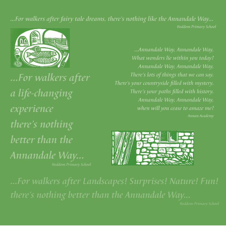
...For walkers after fairy tale dreams, there’s nothing like the Annandale Way... Hoddom Primary School
...For walkers after Landscapes! Surprises! Nature! Fun!
there’s nothing better than the Annandale Way...Hoddom Primary School
...For walkers after
a life-changing
experience
there’s nothing
better than the
Annandale Way... Hoddom Primary School
...Annandale Way, Annandale Way,
What wonders lie within you today?
Annandale Way, Annandale Way,
There’s lots of things that we can say.
There’s your countryside filled with mystery.
There’s your paths filled with history.
Annandale Way, Annandale Way,
when will you cease to amaze me?Annan Academy
...The cows were
cowering from rain.
The wind howled
through the trees.
The buttercups are
like little lights in
the grass... Annan Academy
...Every call, whistle and hoot
runs like a river through my head...Lockerbie Academy
...Come and grow with me and I’ll never stop surprising you...Moffat Academy
...I’ve heard the screaming prisoner
dying in pain, in the dungeon of
Spedlin Tower! I have heard the fast
footsteps trip trapping of the Jardine-
Pattersons running over my weary
bridge. I couldn’t hear the ghost, but I
could feel the tickle of it!
I’ve heard the footsteps, thudding over
my bridge, day after day, night after
night, those were the thuddings of
the Corncockle Quarry workers. They
dirtied my water, washing each day,
washing the sandstone dust away...
Lochmaben Primary School

Welcome to the
Embark on a 55 mile journey
through Annandale with an
opportunity to delve into some of
the cultural and industrial history
of this ancient border region
whilst immersing yourself in the
tranquillity and beauty of a little
explored corner of Scotland.
The guide is designed to allow
you to follow the Annandale
Way from Source to Sea (north
to south) or Sea to Source (south
to north), which ever way you
chose to go you will have the
opportunity to experience the
hospitality of the market towns of
Annan and Moffat. You will also
Annandale Wayhave a choice, do you take the
Eastern arm through the fabulous
Scottish Wildlife Trust’s Eskrigg
Nature Reserve, spending a night
in Lockerbie before continuing on
through the wonderful Gallabery
plantation or do you go for the
more challenging route up over
Joe Graham’s monument which
lends spectacular views across
Annandale and past Castle Loch,
with its sculpture trail, for a night
in Lochmaben?
Which ever way you chose you’re
sure to encounter the warm
hospitality of the locals and have
experiences you’re unlikely to
forget.
The guide has been broken into
easy sections which enable the
Annandale Way to be covered
comfortably in five days. You may
however wish to extend some of
your days and to run one section
into another choosing alternative
points to break your walk. Either
way we have provided details of
local accommodation providers and
transport connections but we would
advise checking these in advance
as new accommodation may be
available or bus times change.
Before embarking on the Annandale
Way you should ensure you are
suitably equipped for inclement
weather and carrying the
appropriate OS Maps 322 Annandale
and 330 Moffat & St Mary’s.
Some sections of the route do take
in high hills and rough ground
particularly the Devil’s Beef Tub and
Joe Graham’s monument.
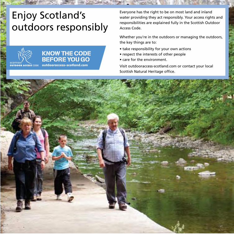
Annandale WayEnjoy Scotland’soutdoors responsibly
Everyone has the right to be on most land and inland water providing they act responsibly. Your access rights and responsibilities are explained fully in the Scottish Outdoor Access Code.
Whether you’re in the outdoors or managing the outdoors, the key things are to:
• take responsibility for your own actions• respect the interests of other people• care for the environment.
Visit outdooraccess-scotland.com or contact your local Scottish Natural Heritage office.


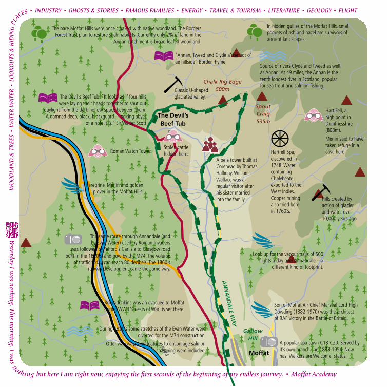
Route, described clockwise: Starting in the Station Park
car park (OS Map 330 GR084,049), follow the youthful
River Annan upstream from Moffat, and along the
valley road turning off for Meikleholmside where you
climb the old Edinburgh coach road.
Crossing the A701 takes you past a Roman watch tower
and over Ericstane Hill, before you re-cross the road
to begin your circumnavigation of the Devils Beef
Tub corrie. Climb onto Annanhead Hill and a range
that rims the upper limits of the Annan catchment. A
spectacular view opens into the Beef Tub corries and
down and down the green corridor of Annandale
towards the Solway coast.
On the coll between Chalk Rig Edge and Spout
Craig, you’ll squelch across the watershed between
the sources of the tributaries that feed the Annan
and Tweed. This is the official start or finish of the
Annandale Way. After you have celebrated, turn south
into the valley here, following the rapidly growing
waters in a gully that will spit you out below Corehead
Farm. Here you meet a minor road that leads you back
to Moffat, where a welcome for walkers awaits.
Moffat – Devil’s Beef Tub - Moffat Distance: 22km [13½ miles]Upland Environment
Chalk Rig Edge500mThe Devil’s
Beef Tub
Viewpoint
Moffat
Beattock
Spout Craig 535m
Blue Cairn 584m
Greygill Head 474m
A701
AN
NA
ND
ALE W
AY
B719
M74
Gallow Hill
River A
nnan
Birnock
Wat
er
Garpol Water
The Crooked Road
Come and grow with me and I’ll never stop surprising you. • Moffat Academy
The Devil’s Beef Tub section
of this walk involves steep
climbs and rough ground –
be prepared!
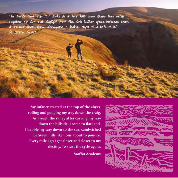
My infancy started at the top of the abyss,
rolling and gouging my way down the craig.
As I reach the valley after carving my way
down the hillside, I come to flat land.
I babble my way down to the sea, sandwiched
between hills like lions about to pounce.
Every mile I go I get closer and closer to my
destiny. To start the cycle again.
Moffat Academy
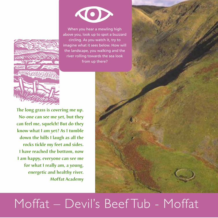
The Devil’s Beef Tub: “It looks as if four hills were laying their heads together to shut out daylight from the dark hollow space between them. A damned deep, black, blackguard – looking abyss of a hole it is.” Sir Walter Scott
Black Knowe 549m
WO
OD
LAN
D &
TR
EES
• W
ATER
WAT
ER •
LO
OKO
UTS
& H
IDIN
G P
LACES • INDUSTRY • GHOSTS & STORIES • FAMOUS FAMILIES • ENERGY • TRAVEL & TOURISM • LITERATURE • GEOLOGY • FLIGHT
Yesterday I was nothing. This m
orning, I was nothing but here I am right now, enjoying the f rst seconds of the beginning of my endless journey. • Moffat Academy
A pele tower built at Corehead by Thomas Halliday. William Wallace was a regular visitor after his sister married into the family.
“Annan, Tweed and Clyde a‘rise oot o’ ae hillside” Border rhyme
Stolen cattle hidden here.
Moffat
Chalk Rig Edge500m
The Devil’s Beef Tub
Spout Craig 535m
AN
NA
ND
ALE W
AY
M74
Gallow Hill
The bare Moffat Hills were once cloaked with native woodland. The Borders Forest Trust plan to restore such habitats. Currently only 2% of land in the
Annan catchment is broad leafed woodland.
Hills created by action of glacier and water over 10,000 years ago.
Classic U-shaped glaciated valley.
Look up for the vapour trails of 500 flights a day over Annandale – a
different kind of footprint.
Hartfell Spa, discovered in 1748. Water containing Chalybeate exported to the West Indies. Copper mining also tried here in 1760’s.
The Devil’s Beef Tub: “It looks as if four hills were laying their heads together to shut out
daylight from the dark hollow space between them. A damned deep, black, blackguard – looking abyss
of a hole it is.” Sir Walter Scott
In hidden gullies of the Moffat Hills, small pockets of ash and hazel are survivors of ancient landscapes.
Roman Watch Tower.
Hart Fell, a high point in Dumfriesshire (808m).
Merlin said to have taken refuge in a cave here
The same route through Annandale (and by Evan Water) used by Roman Invaders
was followed by Telford’s Carlisle to Glasgow road built in the 1820’s, and now by the M74. The volume
of traffic today can reach 80 decibels. The 1860’s railway development came the same way.
During 1990’s some stretches of the Evan Water were diverted for the M74 construction.
Otter walkways and features to encourage salmon spawning were included.
Source of rivers Clyde and Tweed as well as Annan. At 49 miles, the Annan is the tenth longest river in Scotland, popular for sea trout and salmon fishing.
Peregrine, Merlin and golden plover in the Moffat Hills.
Robin Jenkins was an evacuee to Moffat during WWII ‘Guests of War’ is set there.
A popular spa town C18-C20. Served by it’s own branch line 1883-1954. Now has ‘Walkers are Welcome’ status.
Son of Moffat Air Chief Marshal Lord High Dowding (1882-1970) was the architect of RAF victory in the Battle of Britain.
WO
OD
LAN
D &
TR
EES
• W
ATER
WAT
ER •
LO
OKO
UTS
& H
IDIN
G P
LA
CES • INDUSTRY • GHOSTS & STORIES • FAMOUS FAMILIES • ENERGY • TRAVEL & TOURISM • LITERATURE • GEOLOGY • FLIGHT
Yesterday I was nothing. This m
orning, I was nothing but here I am right now, enjoying the f rst seconds of the beginning of my endless journey. • Moffat Academy
When you hear a mewling high
above you, look up to spot a buzzard
circling. As you watch it, try to
imagine what it sees below. How will
the landscape, you walking and the
river rolling towards the sea look
from up there?
The long grass is covering me up.
No-one can see me yet, but they
can feel me, squelch! But do they
know what I am yet? As I tumble
down the hills I laugh as all the
rocks tickle my feet and sides.
I have reached the bottom, now
I am happy, everyone can see me
for what I really am, a young,
energetic and healthy river.
Moffat Academy
Moffat – Devil’s Beef Tub - Moffat
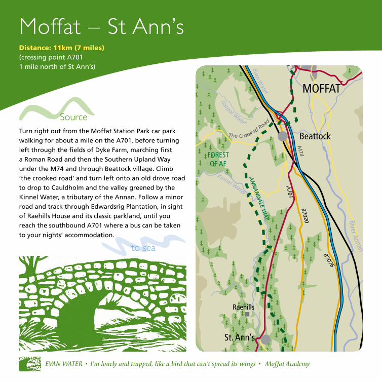
Moffat – St Ann’s
Turn right out from the Moffat Station Park car park
walking for about a mile on the A701, before turning
left through the fields of Dyke Farm, marching first
a Roman Road and then the Southern Upland Way
under the M74 and through Beattock village. Climb
‘the crooked road’ and turn left onto an old drove road
to drop to Cauldholm and the valley greened by the
Kinnel Water, a tributary of the Annan. Follow a minor
road and track through Edwardsrig Plantation, in sight
of Raehills House and its classic parkland, until you
reach the southbound A701 where a bus can be taken
to your nights’ accommodation.
Distance: 11km (7 miles)(crossing point A701 1 mile north of St Ann’s)
EVAN WATER • I’m lonely and trapped, like a bird that can’t spread its wings • Moffat Academy
Beattock
Raehills
A701
B7020
B7076
FOREST OF AE
River Annan
Garpol W
ater
Kinnel Water
MOFFAT
St. Ann’s
The Crooked RoadSource
to sea
Evan Water
M74
AN
NA
ND
ALE W
AY

THE FORGOTTEN RIVER • Now I see, under the motorway, the sad river….. and, if a river could cry, this one would. Where I am
writing this, a crisp packet falls…
• M
offat Academy
The river is like the R o m an soldiers who once walked this way – They marched and marched all night and day. • Moffat Academy
Start your day a mile north of St Ann’s on
the A701 (OS Map 322 GR072, 953), leave the
classic parkland of Raehills House, following
the Kinnel Water through Edwardsrig
Plantation and a minor road to Cauldholm.
An old drove road then crosses hills towards
Beattock fort. Turn right to join The Southern
Upland Way, dropping to Beattock on ‘the
crooked road’, and under the M74. Follow
waymarkers across Dyke Farm fields once
marched by Romans to your left, rejoining
the A701 into Moffat.
Walking north, the Annandale
Wayfarer starts to climb out of the
green and pastoral lands which
glitter with Friesian cows. The hills
ahead rise and spread, roughening
and browning in great muscular
animal backs, promising a new kind
of journey soon. Looking from the
Crooked Road into the valley to the
south of Moffat, the Annan is seen
gathering strength in its rendezvous
with the Evan Water from the
north west and Moffat Water from
the north east. Threewater Foot, a
powerful symmetry.
Sea
to source
River Annan

WO
OD
LAN
D &
TR
EES
• W
ATER
WAT
ER •
LO
OKO
UTS
& H
IDIN
G P
LACES • INDUSTRY • GHOSTS & STORIES • FAMOUS FAMILIES • ENERGY • TRAVEL & TOURISM • LITERATURE • GEOLOGY • FLIGHT
Annandale carries major electricity and gas lines.
Harestanes wind farm.
Raehills House. Seat of Johnstone clan, who kept watch on the western border
with England for 600 years.
Lochwood Tower (Mid C15), first home of Johnstones.
Beattock gravels quarried for road construction since the Romans.
Lochwood oakwoods – the pollarded trees are thought to be over 400 years old.
Conifer plantations make up 27% of land use in the Annan catchment.
Sitka spruce is used for cheap furniture and many types of paper.
...As I join with more and more of my brothers, my memory merges with that of them...• Moffat Academy
The veteran oaks of
Lochwood.
‘… contorted and gnarled
into faces and withered
limbs, offering any shape
you’d care to see. They are
bluebell-lit from below;
moss-coated; fern-bearded.’
Route diversion
Moffat
Beattock
St Ann’s
River Annan
Kinnel Water
The woollen mill building was originally a slaughterhouse until the late 1950’s, it then
became a retail outlet with hand looms for visitors.
Forgotten places under the motorway make interesting habitats and hiding places.
Salmon deposit their eggs in depressions in the bed. After
fertilisation the female covers them with gravel.
Stones to the memory of James McGeorge and John Goodfellow, Guard and Driver of a Royal Mail coach, who lost their lives in a snowstorm north of the Devil’s Beef Tub in 1831.
The Moffat ram dedicated to James Hogg, the “Ettrick Shepherd”, poet & song writer (1770-1835).
The fountain was gifted to Moffat in recognition of the importance of sheep farming and the wool trade John Loudon McAdam (Tarmac)
buried in Moffat in 1836.
WO
OD
LAN
D &
TR
EES
• W
ATER
WAT
ER •
LO
OKO
UTS
& H
IDIN
G P
LA
CES • INDUSTRY • GHOSTS & STORIES • FAMOUS FAMILIES • ENERGY • TRAVEL & TOURISM • LITERATURE • GEOLOGY • FLIGHT
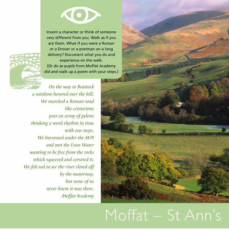
Invent a character or think of someone
very different from you. Walk as if you
are them. What if you were a Roman
or a Drover or a postman on a long
delivery? Document what you do and
experience on the walk.
(Or do as pupils from Moffat Academy
did and walk up a poem with your steps.)
Moffat – St Ann’s
On the way to Beattock
a rainbow hovered over the hill.
We marched a Roman road
like centurions
past an army of pylons
thinking a word rhythm in time
with our steps.
We burrowed under the M74
and met the Evan Water
wanting to be free from the rocks
which squeezed and corseted it.
We felt sad to see the river closed off
by the motorway,
but some of us
never knew it was there.
Moffat Academy
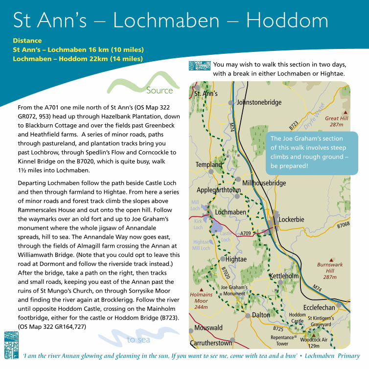
St Ann’s – Lochmaben – HoddomDistanceSt Ann’s – Lochmaben 16 km (10 miles)Lochmaben – Hoddom 22km (14 miles)
You may wish to walk this section in two days,
with a break in either Lochmaben or Hightae.
‘I am the river Annan glowing and gleaming in the sun, If you want to see me, come with tea and a bun’ • Lochmaben Primary
From the A701 one mile north of St Ann’s (OS Map 322
GR072, 953) head up through Hazelbank Plantation, down
to Blackburn Cottage and over the fields past Greenbeck
and Heathfield farms. A series of minor roads, paths
through pastureland, and plantation tracks bring you
past Lochbrow, through Spedlin’s Flow and Corncockle to
Kinnel Bridge on the B7020, which is quite busy, walk
1½ miles into Lochmaben.
Departing Lochmaben follow the path beside Castle Loch
and then through farmland to Hightae. From here a series
of minor roads and forest track climb the slopes above
Rammerscales House and out onto the open hill. Follow
the waymarks over an old fort and up to Joe Graham’s
monument where the whole jigsaw of Annandale
spreads, hill to sea. The Annandale Way now goes east,
through the fields of Almagill farm crossing the Annan at
Williamwath Bridge. (Note that you could opt to leave this
road at Dormont and follow the riverside track instead.)
After the bridge, take a path on the right, then tracks
and small roads, keeping you east of the Annan past the
ruins of St Mungo’s Church, on through Sorrysike Moor
and finding the river again at Brocklerigg. Follow the river
until opposite Hoddom Castle, crossing on the Mainholm
footbridge, either for the castle or Hoddom Bridge (B723).
(OS Map 322 GR164,727)
Source
to sea
JohnstonebridgeSt. Ann’s
Templand
MillhousebridgeApplegarthtown
Lochmaben
Hightae
Kettleholm
Dalton
Mouswald
Carrutherstown
Ecclefechan
Holmains Moor244m
Woodcock Air 129m
Burnswark Hill
287m
Great Hill287m
M74
M74
Mein Wate
r
Dryfe
Wat
er
Mill Loch
Kirk Loch
Castle LochHightae
Mill Loch
B7020
B725
A709B7068
B723
Lockerbie
Joe Graham’s Monument
Hoddom Castle
Repentance Tower
St Kintigern’s Graveyard
The Joe Graham’s section
of this walk involves steep
climbs and rough ground –
be prepared!
From Hoddom Bridge on the B723, (OS Map 322
GR164,727) follow a path along the south bank of
the Annan, crossing at Mainholm footbridge. Then
head along the river to Brocklerigg, leaving it to go
on through Sorrysike Moor and along minor roads
past the ruins of St Mungo’s church until you reach
Williamwath Bridge. After crossing the Annan, the
official route follows the road left. Alternatively,
turn right to follow the river, emerging back on
route at Dormont. Follow minor roads before
heading across the fields of Almagill farm and up
the steep climb to Joe Graham’s Monument where
you are rewarded by the whole jigsaw of Annandale
spreading below you, hill to sea. You then drop
over an old fort and through the woodlands of
Rammerscales along minor roads into Hightae and
then over the fields and along the shores of Castle
Loch into Lochmaben.
Follow the B7020 out of Lochmaben for 1½ miles
(note it is quite busy) and turn right at Kinnel
Bridge. Out of these lowlands formed by the
junction of the Annan and Kinnel Water, a series
of minor roads, paths through pastureland, and
plantation tracks gently lead you towards the
uplands, firstly through Corncockle Plantation and
Spedlin’s Flow, then past Lochbrow and over the
fields of Heathfield, before heading up through
Hazelbank plantation and finally emerging on
the A701 one mile north of St Ann’s. (OS Map
GR322072, 953)
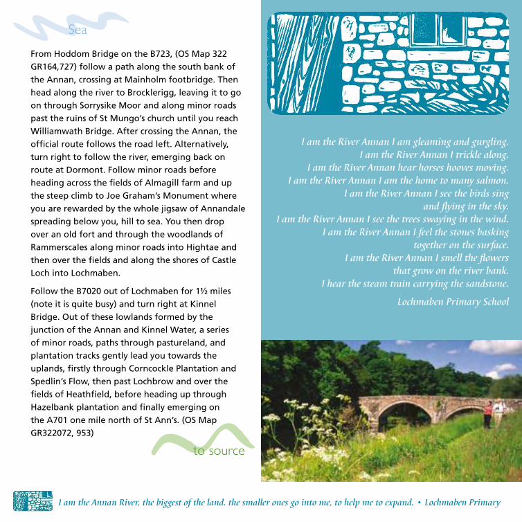
I am the Annan River, the biggest of the land. the smaller ones go into me, to help me to expand. • Lochmaben Primary
I am the River Annan I am gleaming and gurgling.I am the River Annan I trickle along.
I am the River Annan hear horses hooves moving.I am the River Annan I am the home to many salmon.
I am the River Annan I see the birds sing and flying in the sky.
I am the River Annan I see the trees swaying in the wind.I am the River Annan I feel the stones basking
together on the surface.I am the River Annan I smell the flowers
that grow on the river bank.I hear the steam train carrying the sandstone.
Lochmaben Primary School
Sea
to source

For walkers after Landscapes! Surprises! Nature! Fun! there’s nothing better than the Annandale Way. • Hoddom Primary
Lockerbie
St Ann’s
Millhousebridge
Johnstonebridge
Parkgate
Ecclefechan
Templand
Applegarth
Hightae
Dalton
Torthorwald
Collin
Lochmaben
WO
OD
LAN
D &
TR
EES
• W
ATER
WAT
ER •
LO
OKO
UTS
& H
IDIN
G P
LACES • INDUSTRY • GHOSTS & STORIES • FAMOUS FAMILIES • ENERGY • TRAVEL & TOURISM • LITERATURE • GEOLOGY • FLIGHT
Willows are grown for bio-mass power production and can be harvested after three years.
A C12 motte and bailey stood in what is now the golf course. The Bruce Family became the first Lords of Annandale in
1124 and established Lochmaben, said to be the birthplace of Robert the Bruce.
Jardines of Applegarth moved to Spedlin’s tower C15.
Spedlin’s Tower (c1500) built by Jardines. Said to be haunted by ‘Dunty’ Porteous who was forgotten in a dungeon and gnawed off his hands.
Corncockle sandstone quarry.
Corncockle sandstone quarry heavily worked late C19. Helped build Glasgow.
Dinosaur footprints found here.
Fertile soil in floodplains due to sediments left by the river Annan.
Crannog remains at Spedlin’s flow.
Hilltop monument to Joe Graham, a master of fox-hounds who died in 1893. Two nearby hills – Range Castle and Moss Castle were iron age hill forts.
Mill Loch was last Scottish home of vendace fish, Britain’s rarest freshwater species.
Where might future Annandale way-farers get wet feet if river levels rise with climate change?
Growing, breeding and migration patterns are already changing in Scotland.
Hazelbank plantation. Conifers make up 27% of the river Annan catchment land cover.
Name suggests it belonged to Knights Templar.
Lochmaben Castle built 1385. At a strategic junction for travellers over centuries.
Castle Loch is internationally important for wintering pink–footed geese and goosander

Notice all the ways in which water crosses
your path on its way to the river. Give each
crossing its own name. This might depend
on the colour of the water, the sounds it
makes, or your manner of crossing, e.g.
‘Linda’s Leap’ or ‘Guinness Gargle’.
St Ann’s – Lochmaben – Hoddom
River Milk I brush the edges of the bank as I flow uniquely and my
cold waters bond together into a shimmering mixture as
it cascades freely and glows a sun kissed bronze colour
as I calmly weave my way down with River Annan.
As we part I never lose hope because somewhere,
someday we will meet again as the water never dies
and keeps on going to new and exciting places to seek.
I gradually get bigger and stronger as I age and soon
meet more rivers. As I set off to another place, my
family takes over the river until I finally make my way
back. It is spectacular how many places I have visited &
will someday visit the whole world.
Hoddom Primary
WO
OD
LAN
D &
TR
EES
• W
ATER
WAT
ER •
LO
OKO
UTS
& H
IDIN
G P
LA
CES • INDUSTRY • GHOSTS & STORIES • FAMOUS FAMILIES • ENERGY • TRAVEL & TOURISM • LITERATURE • GEOLOGY • FLIGHT

...High
Up
; joyful as gian
ts, Far off the Solway Firth shone like a crescent moon... Lockerbie Academy
St Ann’s – Millhousebridge – HoddomDistanceSt Ann’s – Lockerbie 20km (12½ miles)Lockerbie – Hoddom 14km (9 miles)
You may wish to walk this section in
two days, with a break in Lockerbie
Source
to sea
From the A701 one mile north of St Ann’s (OS Map 322
GR072, 953) head up through Hazelbank Plantation,
down to Blackburn Cottage and over fields past
Greenbeck and Heathfield farms. A series of minor roads,
paths through pastureland, and plantation bring you
past Lochbrow, through Spedlin’s Flow and Corncockle
to the road between Templand and Millhousebridge.
Turn left here, following the ‘Lockerbie’ sign, to
Millhousebridge down the banks of the Annan. If,
stopping in Lockerbie turn left after Applegarthtown
leaving the Annandale Way, walking along quiet roads
into the town. If you’re carrying on turn right along the
road through Gallaberry Plantation across Dryfe Water,
along quiet roads to Lockerbie Memorial Garden. Here is
a second opportunity to enter Lockerbie along the A709.
Continuing south, cross the main road through the
plantation that makes up Eskrigg Nature Reserve. Follow
on through Pilmur, Southfield along a minor road, drop
towards Kettleholm where you turn right walking with the
Water of Milk to your left and through the plantation past
Milkbank Kennels. Carry on to Broom where a sharp right
will see you rejoin the westward loop of the Annandale
Way. Go through Brocklerigg Farm, just before the Milk
joins the Annan and follow the river until opposite
Hoddom Castle, crossing on the Mainholm footbridge,
either for the castle or Hoddom Bridge on the B723. (OS
Map 322 GR164,727).
JohnstonebridgeSt. Ann’s
Templand
MillhousebridgeApplegarthtown
Lochmaben
Hightae
Kettleholm
Dalton
Mouswald
Carrutherstown
Ecclefechan
Holmains Moor244m
Woodcock Air 129m
Burnswark Hill
287m
Great Hill287m
M74
M74
Mein Wate
r
Dryfe
Wat
er
Mill Loch
Kirk Loch
Castle LochHightae
Mill Loch
B7020
B725
A709B7068
B723
Lockerbie
Joe Graham’s Monument
AN
NA
ND
ALE W
AY
Hoddom Castle
Repentance Tower
St Kintigern’s Graveyard
Tracing the river along its path like a palm reader follow
ing the lifelines on an open, eager hand • Lockerbie Academy
From Hoddom Bridge on the B723 (OS Map 322
GR164,727), follow a path along the south bank
of the Annan, crossing at Mainholm footbridge
and onto Brocklerigg Farm. About 1km north of
the farm take the easterly loop of the Ananndale
Way, signposted ‘Lockerbie’. Soon you will have
the Water of Milk to your right as you make your
way north past Milkbank Kennels, Southfield,
Firpark and on into the Eskrigg Nature Reserve.
There are three opportunities to divert into
Lockerbie, the first of these is in the Nature
Reserve, a second along the A7009 and the final
one after Gallaberry plantation.
If you ignore the Lockerbie diversions, you will
cross the main road at the Memorial Gardens and
follow minor roads over Dryfe Water, through
Gallaberry and onto along the banks of the
Annan into Millhousebridge. About 1km later,
you rejoin the western loop of the Annandale
Way. Out of these lowlands formed by the
junction of the Annan and Kinnel Water, a series
of minor roads, paths through pastureland, and
plantation tracks gently lead you towards the
uplands, firstly through Corncockle Plantation
and Spedlin’s Flow, then past Lochbrow and
over the fields of Heathfield, before heading
up through Hazelbank Plantation and finally
emerging on the A701 one mile north of
St Ann’s. (OS Map GR322 072, 953)
A lingering taste of bad bread?
The lanes around Templand were once filled, dyke-to-dyke, with the heads of men walking to and from work at Corncockle Quarry. They
transported the sandstone by rail, crossing the Annan on a now-rickety bridge just north of the
infamous Spedlin’s Tower. Perhaps the Quarry was named for the purple flower once abundant in cornfields but unwelcome because they made
bread bitter-tasting or even poisonous.
The Templand area still murmurs with the terrible haunting of Spedlin’s Tower and the
Jardine Family by miller, James Porteus (c 1650). He was confined in the dungeon of the Tower by a forgetful Sir Alexander, where he accidentally starved to death. But not before he had chewed off his own hands. His crime? Some say he was
imprisoned for baking bad bread
Lockerbie Academy.
Sea
to source
St Ann’s – Millhousebridge – Hoddom

Steven’s Croft biomass plant, largest in Scotland. Can power 70,000 homes.
Site of Jardine Hall (1814) was demolished in 1964. Jardine, Matheson & Co was formed in 1832, traded with China in tea and opium and later involved in banking.
St Mungo’s graveyard (‘Mungo’ a familiar name for Kentigern).
Applegarth a village on a C8-11 monastic site with a church and the
Jardine burial enclosure.
Ladyward Roman Fort and Torwood marching camp. In the invasion of 79AD, they walked 15-25 miles a day and built temporary fortified camp at the end of each day’s march. Tougher footwear was developed for Scottish conditions.
Route A welcome to Lockerbie
We would love to invite you to
Lockerbie. There’s a lot to do, from
places to get refreshments to places to
get your energy back. Why not go for
a delicious ice cream? Or if it’s raining,
visit our local library. We have two
Church of Scotland and one Catholic
Church, with friendly ministers. We
also have a memorial for all the people
that died tragically in the Lockerbie air
disaster on the 21st December 1988.
We hope you enjoy your time on the walk.
Lockerbie Academy
Lockerbie
St Ann’s
Millhousebridge
Templand
Applegarth
Hightae
Dalton
Johnstonebridge
Parkgate
Every call, whistle and hoot. Runs like a river through my head. • Lockerbie Academy
diversion
Ecclefechan
WO
OD
LAN
D &
TR
EES
• W
ATER
WAT
ER •
LO
OKO
UTS
& H
IDIN
G P
LACES • INDUSTRY • GHOSTS & STORIES • FAMOUS FAMILIES • ENERGY • TRAVEL & TOURISM • LITERATURE • GEOLOGY • FLIGHT
Minsca wind farm.
Millhousebridge was built in 1814 as an estate village for Jardine Hall.
Dryfe Sands – the last great battle between Border families Maxwell and Johnstone, 1593.
Jardines of Applegarth moved to Spedlin’s tower C15.
Lockerbie Dairy or ‘the cheesie’.
Birthplace of Victorian essayist & historian Thomas Carlyle.
Burnswark Hill - an iron age fort and Roman camp where there may have been a siege in the conquest of Scotland.
Applegarthtown church and graveyard.
Confluence of Annan and Kinnel Water.
The Jardines were early pioneers in Queensland Australia. In 1865 John Jardine named an ‘Annan’ River there. It is also a fishing destination, but unlike the Scottish Annan, has crocodiles.
One of many placenames in Annandale which include ‘holm’ – (‘Meadow beside a river’)70% of land use in the Annan catchment is agricultural, much of it used for cattle grazing.
Eskrigg nature reserve managed by Lockerbie Wildlife Trust, is on the site of an old curling pond.
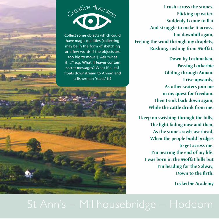
Creative diversion
St Ann’s – Millhousebridge – Hoddom
Collect some objects which could
have magic qualities (collecting
may be in the form of sketching
or a few words if the objects are
too big to move!). Ask ‘what
if…?’ e.g. What if leaves contain
secret messages? What if a leaf
floats downstream to Annan and
a fisherman ‘reads’ it?
I rush across the stones,
Flicking up water.
Suddenly I come to flat
And struggle to make it across.
I’m downhill again,
Feeling the wind through my droplets,
Rushing, rushing from Moffat.
Down by Lochmaben,
Passing Lockerbie
Gliding through Annan.
I rise upwards,
As other waters join me
in my quest for freedom.
Then I sink back down again,
While the cattle drink from me.
I keep on swishing through the hills,
The light fading now and then,
As the stone crawls overhead,
When the people build bridges
to get across me.
I’m nearing the end of my life.
I was born in the Moffat hills but
I’m heading for the Solway,
Down to the firth.
Lockerbie Academy
WO
OD
LAN
D &
TR
EES
• W
ATER
WAT
ER •
LO
OKO
UTS
& H
IDIN
G P
LA
CES • INDUSTRY • GHOSTS & STORIES • FAMOUS FAMILIES • ENERGY • TRAVEL & TOURISM • LITERATURE • GEOLOGY • FLIGHT

Source
Hoddom – Barnkirk Point - AnnanDistance: 17 (10½ miles)
to sea
The Annandale way is like rain drops trickling through a tree of rivers. • Annan Academy
From Hoddom Bridge on the B723 (OS Map 322
GR164,727) follow the path on the eastern bank, past
Meinfoot farm and on into Brydekirk where the route
crosses, to the Bridge and then follows the western bank
along the wooded riverside path, until re-crossing again
at the Cuthbertson Memorial Bridge for Annan town.
In Annan head up onto the main street cross the road
and turn right towards the bridge, where some steps will
drop you back down to the riverbank path. Keep heading
south to the edge of town, cross the Annan for the final
time on the Sustrans Bridge and head for Newbie. From
there, a track leads to Barnkirk Point and your finish at
Newbiebarns. (OS Map 322 GR179,645)
Cummertrees
Powfoot
Newbie
ANNAN
Brydekirk
Woodcock Air 129m
Mein Wate
r
B7020
B725B723
Hoddom Castle
Repentance Tower
St Kintigern’s Graveyard
Motte and Bailey
AN
NA
ND
ALE W
AY
to source
SeaFor this section you can either get a lift to the
start at Newbiebarns (OS Map 322 GR179, 645), or
walk out from Annan.
In Annan head along the main street towards
the bridge, where some steps will drop you down
to the riverbank path. Head south to the edge
of town, crossing the Annan on the Sustrans
Bridge and head for Newbie. From there, a track
leads to Barnkirk Point and the official start at
Newbiebarns, retrace your steps to Annan.
From Newbiebarns head out to Barnkirk point and
follow the path north through to Newbie and
then alongside the river towards Annan. Just after
the railway bridge cross the river on the Sustrans
bridge and follow the riverside path into Annan,
In Annan follow Bruce Street down to the car
park on the Eastern bank of the river, where you
can pick up the riverside path heading north.
At the Cuthbertson memorial bridge cross to the
western bank and follow the woodland path on
to Brydekirk.
Cross the river again to the eastern bank where
the footpath takes you past Meinfoot farm and
on to Hoddom Bridge on the B723 (OS Map 322
GR164,727).
A walking thought-line The quiet site of St Kentigern’s miracle, walled in pink stone. Graves carved with
skulls and crossed-bones, winged souls, palm fronds, Bells and Irvings. Over the years what has been whispered over the wall from these sleepers to the river and then carried to the sea? The trees climbing Woodcock Air opposite sing sweet with morning birds.
The Annan here wide, slower than my walking pace, glossing over seal-backed rocks, frothing against pink gravel bays where paw-prints suggest otters.
An inlet for Mein Water, its banks defended with rubble, one fence already snatched away. A bird. A long bill. A turquoise wing flashing away in sunlight. Recognition. Joy lightening my step.
Brydekirk Bridge and the straight street guarded by a church on the hill. A model village for weavers. Then a woody path, cross-hatched with bluebells. A dog upending its paws to rub its back in the dewy grass. Mount Annan Estate peering down from the opposite bank, across an island.
The approach of suburbia and the river puts on its concrete girdle. A sudden smell of perfume in the park and people saying, ‘where are ye?’ into mobile phones. Men on benches.
Out onto merse, the river calls in its carved veins; sludgy brown creeks eeking through the grass. Low tide reveals a mud-coloured bicycle wedged in one. Beyond, an audacious line of yellow gorse, the pale blue outline of Cumbrian heights.
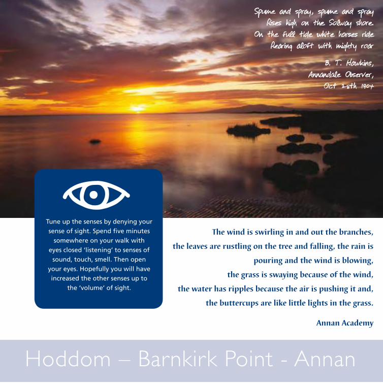
Solway salt air, wide water, pinky-brown and braided with the devil’s currents. Lumpish Criffel a silhouette, leading the eye west, the waters opening towards Galloway and the Irish Sea.
Rubbing shoulders with grey-pink pebbles, bricks lie abandoned on the beach, edges rounded by the tumbling sea, but still named ‘Whitehaven’ and ‘Sanquhar’. A flock of shellduck lift and circle into a furrowed, frowning sky. A sky that dwarfs and flattens the Earth here at Barnkirk Point.
Mein Wate
r

In the severe winter of 1880, huge blocks of ice destroyed the Solway Viaduct.
Large masts seen across the Solway were part of the ‘early warning system’ against nuclear missile attack. Now the cold war has ended they are used to communicate with the nuclear submarine fleet.
Site of Annan lighthouse, built of timber in early 1800’s and destroyed by fire in 1960’s
Motto of Annan: ‘Ut flumen sic oppidum’ – ‘As the river, so the town’.
WO
OD
LAN
D &
TR
EES
• W
ATER
WAT
ER •
LO
OKO
UTS
& H
IDIN
G P
LACES • INDUSTRY • GHOSTS & STORIES • FAMOUS FAMILIES • ENERGY • TRAVEL & TOURISM • LITERATURE • GEOLOGY • FLIGHT
Confluence of river Annan and Water of Milk.
Mesolithic remains found around Brocklerigg. People at that time followed rivers.
The native woodlands around Hoddom Castle were planted in C19. This area would have
been Marshland.
Hoddom Castle built 1552-65 by John Maxwell, 4th Lord Herries.
Cummertrees
Powfoot
Newbie
Annan
Brydekirk
Dornock
‘Repentance Tower’ built c1650. Steeped in tales of treachery and Border warfare, it
commands spectacular views south over the Solway and north through Annandale.
The Solway Firth has the third largest tidal range in the UK, rising to 1 metre and travelling at 6-7 knots. A barrage to capture this energy is being explored.
Chapelcross nuclear power plant built 1957 and closed 1994. The four cooling towers were demolished in 2007.
Annan made a Burgh of Barony by the Bruces in the C13.
The inner Solway is internationally recognised as a site for wetland birds. Ringed plover break their journeys here in May on route to Iceland, Greenland and Arctic Canada.
Look out for Kingfishers around here.
During its heyday as a port 1780 – 1848, emigrants sailed from here to North America.
In 1200 the Bruce (Brus) Castle was washed away perhaps because of a curse by St
Malachy who gained mercy for a robber but later saw him hung. As a result the Brus family
built a new castle at Lochmaben.
St Kentigern’s graveyard and site of a miracle when he returned to Scotland from exile in Wales in 573. The high ground behind the graveyard is thought to have been a monastery.
The graveyard at Repentance Tower has many ornate gravestones dating from the C17
Model village built for
weavers 1800.
Stone from Corsehill Quarry was used for the three grand staircases in the Capitol
building in the New York State of Albany.
1000-ton tea clippers built here.
Cochrans boilers from 1898.
“The deil cam fiddlin thro’ the town And danc’d awa wi’ th’ exciseman….’Robert Burns worked in Annan as an excise officer.
“This wild place of the world” Robert Burns
Annan Bridge on site of ancient fording point, built in 1826 by Robert Stevenson
better known for lighthouses.
Hoddom Mill – One of the many once water-powered mills along the Annan.
WO
OD
LAN
D &
TR
EES
• W
ATER
WAT
ER •
LO
OKO
UTS
& H
IDIN
G P
LA
CES • INDUSTRY • GHOSTS & STORIES • FAMOUS FAMILIES • ENERGY • TRAVEL & TOURISM • LITERATURE • GEOLOGY • FLIGHT
Tune up the senses by denying your
sense of sight. Spend five minutes
somewhere on your walk with
eyes closed ‘listening’ to senses of
sound, touch, smell. Then open
your eyes. Hopefully you will have
increased the other senses up to
the ‘volume’ of sight.
Hoddom – Barnkirk Point - Annan
Spume and spray, spume and sprayRises high on the Solway shore.
On the full tide white horses rideRearing aloft with mighty roar
B. T. Hawkins, Annandale Observer,
Oct 28th 1904
The wind is swirling in and out the branches,
the leaves are rustling on the tree and falling, the rain is
pouring and the wind is blowing,
the grass is swaying because of the wind,
the water has ripples because the air is pushing it and,
the buttercups are like little lights in the grass.
Annan Academy

Tall grand trees loomed over us,others were down-hearted,lifeless stumps.We trudged towards the rickety bridgethat had holes like little eyesspying on us from the river below.It creaked as we crept, afraidwe might fall deep, deep, deep.The whistling wind wove through the treeslike the spirit of the baker chained in Spedlin’s Towerfor baking bad bread, andleft roaming there.
Birds whistled to each other a soft lullaby.The river was trickling, then rushing, crashing, whooshing,roaring like a tiger.The sweet smell of bright white hawthorntickled sneezes from us and fresh, lush air hung above the tree canopy.We said to ourselves,‘We’ll never make bad bread’.
P7 Lochmaben Primary
to the Devil’s Bath Tub
From the Devil’s Beef Tub
We to
ok a
wal
k on the Annandale W
ay
At Corehead, under the Devil’s Beef Tubglaciers cut into the hills thousands of years ago so theynow roll like camel humps and many valleys thread into one. We smelt wet moss and felt attached to the shimmery small riveras it flowed gently past – glistening rocks and spongy grass.We were nearing the end of our walk but for the river it was just beginning.
On the way to Beattock a rainbow hovered over the hill.We marched a Roman road like centurionspast an army of pylonsthinking a word rhythm in time with our steps.We burrowed under the M74 and met the Evan Water wanting to be free from the rock which squeezed and corseted it.We felt sad to see the river closed off by the motorway,but some of us never knew it was there.
S1 Moffat Academy
Tall grand trees
a rainbow hovered
Written in partnership with Linda Cracknell

On the horizon the hills climbed so that the sun could nest between them.The Annan ran softly and smoothits golden cool waters rustling like leaves. We came to the glittering place where it met the Water of Milk.Families of water joinedand went on their way as one. A huge heron flapped its wings.
We took a walk on the Annandale Wayand the towers of the old pinkHoddom Castlepeered from above the forest and lured us in. Trees were around us like a cave,leaves dripping with bright blue raindrops,a rainforest canopy, the smell of nature.Wild garlic smiled at us.Bluebells, giant hogweed and wild rhubarb grew.Birds scattered through the leaves,one calling like a creaky door. The river roared.After Hoddom Bridge buttercups spread over lush green grassto lead us to the deserted graveyardof Saint Kentigern.
We took a walk in Annandaleand at the end we asked,‘Can we walk the whole way?’
P6/7 Hoddom Primary
At Welldale, by the old piers,it was just us, the wind, the water and the curlewswhere once had been shouting workers, passengers hauling luggage for the ‘Victoria’,shrimp boats chuggingand sandstone blocks banged aboardto sail abroad.Over the small stone bridgelines of Cochran’s men once cycled,and we took a walk on the Annandale Way.
At Barnkirk Point, the tide was coming in,pushing the river back upstreaminstead of flowing to meet other watersfor the party of the Solway.Warring waves drew a spiral pattern on the surface, rough rippling as if fingers had been dragged through sand.‘Let me out!’ the river called to the sea,and we named this deep and dangerous meeting place the ‘Devil’s Bath Tub’.
When the tide turned,allowing the Annan to flood the Solway mud, the river lost itselfun-named, unnoticed, forgotten. But we knew its waters would, in time,be sucked skywards to return as cloudsto the hills of the Devil’s Beef Tubfifty miles inland.
‘You again!’ the hills will say,as they tear at the clouds, emptying themso the waters begin their descent and once again we call them ‘Annan’.
S1 Annan Academy
The gorse was like a blanket of mustard on a bed of nails.It smelt of coconut-butter, taking us back to exotic holidays.We saw many things. Cows were one, sheep were two, and birds were three.Joe Graham’s monument rose, a sharp needle from its hilllike a candle on a birthday cake.From there we could see the huge belching monster that is the cheese factory andthe Solway Firth shining like a crescent moon.The Annan below was like a wavy ribbon weaving continuously.We could trace the river like a palm reader following the lifelines on an open, eager hand, telling us stories.Mud, like marshmallows, squelched under our toestried to steal our shoes and set as cement.
Children were yelping, whooping, breaking the silence with their joy.Laughter tumbled down the hilland the trees talked to one another in the wind.The gazing eyes of a deserted houseinhabited by crows and bats made us shiver as we passed.Fighter–jet sounds rumbled overhead like a giant’s belly.On the crest of a hill sat the misty outline of wind turbines near the steep volcano of Burnswark, green and smooth on top.We found a bird’s leg full of decay, the smell of young trees budding.Our legs, tied down with kilogram weights, grew tired from walking.Some of us thought it a lonely place because nobody else was there.
S1 Lockerbie Academy
belching monster
You again!garlic smiled
From the Devil’s Beef Tub
Embark on a 55 mile journey through
Annandale with an opportunity to delve into
some of the cultural and industrial history of this
ancient border region whilst immersing yourself
in the tranquillity and beauty of a little explored
corner of Scotland.
Published by CREATE CfE, Schools Services, Dumfries & Galloway Council
© Sulwath Connections, Dumfries and Galloway Council
ISBN Title Information
978-0-9563666-0-3
Annandale Way