africa climate resource and information services (acris
TRANSCRIPT
Feasibility Report
For
Africa Climate Resource and Information Services (ACRIS) Platform
Version 1.0
Draft Report for - Africa Climate Resource and Information Services (ACRIS) Platform
Page | ii
Table of Contents
TABLE OF CONTENTS .............................................................................................................................................. II
COMMON TERMS ................................................................................................................................................. IV
ACRONYMS ............................................................................................................................................................ V
LIST OF FIGURES .................................................................................................................................................... VI
LIST OF TABLES .................................................................................................................................................... VII
EXECUTIVE SUMMARY ........................................................................................................................................ VIII
1. INTRODUCTION ............................................................................................................................................ 1
1.1. CLIMATE INFORMATION SERVICES ....................................................................................................................... 1 1.2. ABOUT THE AFRICAN CLIMATE POLICY CENTRE (ACPC). ......................................................................................... 2 1.3. CLIMATE FOR DEVELOPMENT IN AFRICA (CLIMDEV-AFRICA) .................................................................................... 4 1.4. TERMS OF REFERENCE OF ASSIGNMENT ............................................................................................................... 5
2. AIM, OBJECTIVES AND DELIVERABLES OF THE ASSIGNMENT ........................................................................ 5
2.1. AIM .............................................................................................................................................................. 5 2.2. OBJECTIVES .................................................................................................................................................... 5 2.3. EXPECTED DELIVERABLES ................................................................................................................................... 6
3. APPROACH AND METHODOLOGY ................................................................................................................. 6
3.1. APPROACH ..................................................................................................................................................... 6 3.2. METHODOLOGY .............................................................................................................................................. 6
3.2.1 Undertaking the Situational Analysis ..................................................................................................... 6 3.2.2 Survey Design ......................................................................................................................................... 7 3.2.3 Identification of target institutions ........................................................................................................ 8 3.2.4 Undertaking Institutional Surveys .......................................................................................................... 9 3.2.5 Benchmarking with International Good Practices ................................................................................. 9 3.2.6 Analysing the Findings ........................................................................................................................... 9
3.3. DESIGNING THE SYSTEM .................................................................................................................................... 9 3.4. PREPARING THE FINAL REPORT ........................................................................................................................... 9
4. SITUATIONAL ANALYSIS .............................................................................................................................. 10
4.1. LEGAL AND INSTITUTIONAL FRAMEWORKS .......................................................................................................... 11 4.2. TECHNOLOGY TRENDS .................................................................................................................................... 11
4.2.1 Core IT Infrastructure ........................................................................................................................... 12 4.3. DATA .......................................................................................................................................................... 13 4.4. EXISTING CAPACITIES AND CAPABILITIES ............................................................................................................. 14
4.4.1 WMO Climate Services Toolkit ............................................................................................................. 15 4.4.2 IGAD Climate Prediction and Applications Centre ............................................................................... 15 4.4.3 Climatelinks .......................................................................................................................................... 16
5. INSTITUTIONAL SURVEYS ............................................................................................................................ 17
5.1. AFRICAN CENTRE OF METEOROLOGICAL APPLICATION FOR DEVELOPMENT (ACMAD) ................................................ 18 5.2. IGAD CLIMATE PREDICTION AND APPLICATIONS CENTRE (ICPAC) .......................................................................... 19
Draft Report for - Africa Climate Resource and Information Services (ACRIS) Platform
Page | iii
5.3. SADC – CLIMATE SERVICES CENTRE (SADC-CSC) .............................................................................................. 20 5.4. WORLD BANK ............................................................................................................................................... 20 5.5. AGRHYMET REGIONAL CENTRE ..................................................................................................................... 21 5.6. REGIONAL CENTRE FOR MAPPING OF RESOURCES FOR DEVELOPMENT (RCMRD) ...................................................... 23 5.7. COUNCIL FOR SCIENTIFIC AND INDUSTRIAL RESEARCH (CSIR) ................................................................................. 24
6. INTERNATIONAL GOOD PRACTICES............................................................................................................. 26
7. FINDINGS .................................................................................................................................................... 26
7.1. INSTITUTIONAL FINDINGS ................................................................................................................................ 26 7.1.1 ICT Review ............................................................................................................................................ 26 7.1.2 Data Review ......................................................................................................................................... 27 7.1.3 Legal ..................................................................................................................................................... 28
7.2. INSTITUTIONAL NEEDS AND GAPS ..................................................................................................................... 30
8. SYSTEM DESIGN .......................................................................................................................................... 32
8.1. SYSTEM ARCHITECTURE .................................................................................................................................. 32 8.2. DATAFLOW MODEL ....................................................................................................................................... 33 8.3. PHYSICAL DESIGN .......................................................................................................................................... 33
9. SYSTEM RECOMMENDATIONS .................................................................................................................... 34
9.1. HARDWARE .................................................................................................................................................. 34 9.2. SOFTWARE ................................................................................................................................................... 35 9.3. DATA .......................................................................................................................................................... 35 9.4. HUMAN RESOURCES ...................................................................................................................................... 35 9.5. SUPPLIERS .................................................................................................................................................... 35
10. COST ESTIMATES ........................................................................................................................................ 37
11. CONCLUSION AND WAY FORWARD ............................................................................................................ 37
11.1. CONCLUSION ................................................................................................................................................ 37 11.2. WAY FORWARD ............................................................................................................................................ 38
12. REFERENCES ............................................................................................................................................... 40
13. ANNEXES .................................................................................................................................................... 41
13.1. TERMS OF REFERENCE .................................................................................................................................... 41 13.2. ICPAC STAFF ORGANISATION STRUCTURE.......................................................................................................... 42 13.3. RCMRD STAFF ORGANISATION STRUCTURE ....................................................................................................... 43 13.4. KEY INSTITUTIONS QUESTIONNAIRE ................................................................................................................... 44 13.5. RCMRD SERVER ROOM PICTURES ................................................................................................................... 46 13.6. ICPAC SERVER ROOM PICTURES ...................................................................................................................... 47
Draft Report for - Africa Climate Resource and Information Services (ACRIS) Platform
Page | iv
Common Terms
Climate: Climate is typically defined as the average weather over a period of time. The quantities measured are most often surface variables such as temperature, precipitation and wind. Climate in a wider sense, on the other hand, is the state of the climate system, including its statistical description. For the purposes of this report we have used the term climate to cover time periods of months or longer. Climate change: Climate change refers to any change in climate over time, whether due to natural variability or as a result of human activity. Can also mean an identifiable and statistical change in the state of the climate that persists for an extended period of time. This change may result from internal processes within the climate system or from external processes. These external processes (or forcing) could be natural, for example volcanoes, or caused by the activities of people, for example emissions of greenhouse gases or changes in land use. Climate product: The end result of a process of synthesising climate science and data. Climate service: Climate information prepared and delivered to meet a user’s needs. Extreme weather and climate events: Extreme events refer to phenomena, such as floods, droughts and storms, that are at the extremes of (or even outside) the historical distribution. Weather: The state of the atmosphere at a given time and place, with respect to variables such as temperature, moisture, wind velocity and barometric pressure.
Draft Report for - Africa Climate Resource and Information Services (ACRIS) Platform
Page | v
Acronyms
ACRIS Africa Climate Resource and Information Services ACPC African Climate Policy Centre ATPS African Technology Policy Studies Network AU: African Union AUC: African Union Commission CMS Content Management System DMZ Demilitarized zone ECA Economic Commission for Africa ESA Eastern and Southern Africa EU European Union GFCS Global Framework for Climate Services ICT Information Communication Technology IGAD Intergovernmental Authority for Development OFESA RCC Regional Climate Centre SADC: Southern African Development Community SEO Search Engine Optimization SWOT Strengths weaknesses Opportunities Threats UN United Nations URL Uniform Resource Locator VPN Virtual Private Network WISER Weather and Climate Information Services for Africa
Draft Report for - Africa Climate Resource and Information Services (ACRIS) Platform
Page | vi
List of Figures Figure 1 Global Framework for Climate Services, Source WMO (2011 .......................... 2 Figure 2 - Core IT infrastructure of Climate Data Management (Climate Services Information System) Source: WMO Climate Data Management System Specifications, http://library.wmo.int/pmb_ged/wmo_1131_en.pdf ........................................................ 12 Figure 3 - WMO Climate Services Toolkit website, Mar 2018 ....................................... 15 Figure 4 - WMO RCC website at ICPAC ....................................................................... 16 Figure 5 - ICPAC Web Map Viewer ............................................................................... 16
Figure 6 - Climatelinks - A Global Knowledge Portal for Climate Change & Development Practitioners by USAID .................................................................................................. 17 Figure 7 Regional Early Warning and Action Communication tool implemented at ICPAC ........................................................................................................................... 28 Figure 8 Adaptive System for Image Communication over global Networks implementation at ICPAC .............................................................................................. 29
Figure 9 Early warning explorer by RCMRD for FEWSNET .......................................... 29 Figure 10 - ACRIS System Architecture ........................................................................ 32 Figure 11 - Data Flow Model ......................................................................................... 33
Figure 12 - ACRIS portal Architecture ........................................................................... 33 Figure 13 - ICPAC Staff Organisation Structure ............................................................ 42
Figure 14 - RCMRD Staff Organisation Structure ......................................................... 43
Draft Report for - Africa Climate Resource and Information Services (ACRIS) Platform
Page | vii
List of Tables ICT Review .................................................................................................................... 27 Institutional Data Review ............................................................................................... 27
Institutional Legal Review .............................................................................................. 28 Policy Documents Presence ......................................................................................... 30 Minimum Hardware Specifications ................................................................................ 34 SWOT analysis of RCMRD ........................................................................................... 36 SWOT Analysis of ICPAC ............................................................................................. 36
Average Financial Costs of running the ACRIS platform for one year ........................... 37
Draft Report for - Africa Climate Resource and Information Services (ACRIS) Platform
Page | viii
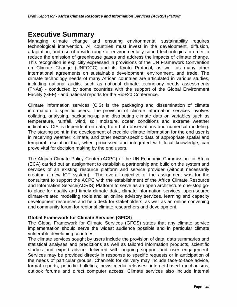
Executive Summary Managing climate change and ensuring environmental sustainability requires technological intervention. All countries must invest in the development, diffusion, adaptation, and use of a wide range of environmentally sound technologies in order to reduce the emission of greenhouse gases and address the impacts of climate change. This recognition is explicitly expressed in provisions of the UN Framework Convention on Climate Change (UNFCCC) and its Kyoto Protocol, as well as many other international agreements on sustainable development, environment, and trade. The climate technology needs of many African countries are articulated in various studies, including national audits, such as national climate technology needs assessments (TNAs) - conducted by some countries with the support of the Global Environment Facility (GEF) - and national reports for the Rio+20 Conference. Climate information services (CIS) is the packaging and dissemination of climate information to specific users. The provision of climate information services involves collating, analysing, packaging-up and distributing climate data on variables such as temperature, rainfall, wind, soil moisture, ocean conditions and extreme weather indicators. CIS is dependent on data, from both observations and numerical modeling. The starting point in the development of credible climate information for the end user is in receiving weather, climate, and other sector-specific data of appropriate spatial and temporal resolution that, when processed and integrated with local knowledge, can prove vital for decision making by the end users. The African Climate Policy Center (ACPC) of the UN Economic Commission for Africa (ECA) carried out an assignment to establish a partnership and build on the system and services of an existing resource platform and service provider (without necessarily creating a new ICT system). The overall objective of the assignment was for the consultant to support the ACPC with the establishment of the Africa Climate Resource and Information Service(ACRIS) Platform to serve as an open architecture one-stop go-to place for quality and timely climate data, climate information services, open-source climate-related modelling tools and an online advisory services, learning and capacity development resources and help desk for stakeholders, as well as an online convening and community forum for regional climate researchers and development. Global Framework for Climate Services (GFCS) The Global Framework for Climate Services (GFCS) states that any climate service implementation should serve the widest audience possible and in particular climate vulnerable developing countries. The climate services sought by users include the provision of data, data summaries and statistical analyses and predictions as well as tailored information products, scientific studies and expert advice delivered with ongoing support and user engagement. Services may be provided directly in response to specific requests or in anticipation of the needs of particular groups. Channels for delivery may include face-to-face advice, formal reports, periodic bulletins, news media releases, internet-based mechanisms, outlook forums and direct computer access. Climate services also include internal
Draft Report for - Africa Climate Resource and Information Services (ACRIS) Platform
Page | ix
activities such as archive development, quality management and statistical analyses that benefit both current users and future generations. Several drawbacks in climate data delivery and integration have been identified and these findings have served as foundations of GFCS. It has been recognized that:
(1) Climate services do not efficiently exploit scientific climate knowledge, information and data;
(2) Climate services do not meet present and future user needs and in particular in developing or least developed countries that are the most vulnerable;
(3) Providers of climate services do not interact sufficiently with users; (4) Existing capacities for climate observations provide a good basis for
strengthening climate services but commitment to sustain high-quality observations across the entire climate system is inadequate;
(5) Enhancements in observations networks in developing countries are required; (6) Restrictions about the sharing and access to data and information are a major
barrier to progress and wide use of climate knowledge; (7) Use of climate knowledge that can inform decision-making is inadequate and is
not following the rapid advancement of the understanding of climate system; and (8) Capacities of users is often insufficient to adequately use climate data and
information. The objectives of ACRIS in line with those of the GFCS are:
1. to improve climate services for all countries, 2. build capacities of providers and users, 3. enable governments to have a central role as primary sources of climate
services, 4. promote a free and open exchange of climate data and information while
respecting existing data policies, 5. facilitate the timely access to relevant scientific information to help society to
cope with current climate variability and limit economic and social damages caused by climate-related disasters.
Methodology The mapping exercise was carried out as follows:
1. Desk review of existing reports, and literature on existing platforms/services, especially with regards to institutional and systemic frameworks (governance, human resources, legal and policy frameworks, protocols of data exchange).
2. survey with focus on institutions offering weather & climate services, geospatial services, and the institutions offering training and technological interventions
3. Institutional visits to collect data and assess institutional capacities in terms of: data, infrastructure, software, legal and institutional framework.
4. Report preparation with recommendations of the solutions provider, system and software specifications, cost estimates of the potential providers and procurement recommendations and guidelines for implementation of the platform.
Draft Report for - Africa Climate Resource and Information Services (ACRIS) Platform
Page | x
Surveys and Findings The institutions identified from the study as key players in the climate information services domain are: 1. African Centre of Meteorological Application for Development (ACMAD) 2. AGRHYMET Regional Centre 3. Council for Scientific and Industrial Research (CSIR) 4. IGAD Climate Prediction and Applications Centre (ICPAC) 5. Regional Centre for Mapping of Resources for Development (RCMRD) 6. SADC – Climate Services Centre (SADC-CSC) For the study, managed to obtain feedback from the two institutions below: Regional Centre for Mapping of Resources for Development Established in 1975 under the auspices of the United Nations Economic Commission for Africa (UNECA) and the then Organization of African Unity (OAU), RCMRD has 20 African countries as members. IGAD Climate Prediction and Applications Centre IGAD Regional Climate Centre hosted at ICPAC provides regional climate forecasts and other products that support regional and national climate activities, and thereby strengthen the capacity of WMO Members in the Greater Horn of Africa region to deliver better climate services to users. ICPAC is a Regional Climate Centre for WMO operating in 11 countries. To achieve the objectives, the study gathered information through websites reviews, and face to face visits interviews. in a bid as follows:
1. Information gathering through desk analysis 2. Meeting on 19th April 2018 with RCMRD Director of Remote Sensing to clarify
the objectives of the assessment and expectations and ensure team assignment to the process;
3. Meeting on 23rd April 2018 with IT Representative for a one on one Interview and confirmation of specifications;
4. Meeting on 24rd April 2018 with RCMRD Marketing representative for a one on one Interview on Governance and data aspects;
5. Continuous exchange of emails between the consultant and climate information service players.
The survey carried out on the institutional capacity and readiness for climate information services noted the following: Data The study noted that there are huge amounts of data available at the institutional level. Furthermore, more data is received on a daily basis. Some of the data domains
Draft Report for - Africa Climate Resource and Information Services (ACRIS) Platform
Page | xi
available that are critical for climate services are rainfall, temperature, satellite derived, hydrological to name a few. With such huge availability of data, the main challenge is data dispensing to end users and storage facilities. There is presence of data in archive disks that has not been accessed for a couple of years. For climate information services to be effective, this data has to be made available to interested stakeholders. ICT Infrastructure The study found that there has been a huge investment in ICT for the institutions in the previous strategic term periods. However, the institutions have not been able to keep up to date with the latest ICT trends. There is need to reduce input to physical equipment but invest to future proof technologies. RCMRD has 10% of its services running on cloud while ICPAC is yet to adopt the technology. Human Capacity Human capacity being the core of any climate Information Service provider. The technical expertise determines the level of usage of the ICT infrastructure in place. The study note obtained Information indicating presence of ICT staff that undertake all the available duties. Its paramount to segregate the duties from development to infrastructural support. Having a developer support ICT infrastructure reduces the quality of the output application. Proposed Solution To help mitigate the drawbacks in climate data delivery and integration, ACRIS has been developed on the framework below: Legal and institution: to be implemented at a continental level by support of ACPC through policy development, knowledge and data exchange, infrastructure development, research, training and the provision of services to meet agreed requirements; ensuring access to data and knowledge products, tailoring information to user requirements, ensuring effective routine use of information in planning and management along with developing sustainable capacities. Users to access information from a range of available global, regional and national sources.
1. Technological Infrastructure: The overall IT infrastructure is adapted from the WMO Climate Services Information System (CSIS). The ACRIS System Architecture is as below:
2. Data: Data is to be pulled from different participating Regional Climate Centers.
This will ensure data gaps are easily identified and assist in managing user expectations. As well as ensuring ACRIS is the highest level of user interaction to the continents climate services.
3. Human Capacity: For ACRIS to succeed, the in charge ICT staff have to be trained on climate information services management as well as have a high level expertise to manage the coordination of ACRIS between the RCCs.
Draft Report for - Africa Climate Resource and Information Services (ACRIS) Platform
Page | xii
Recommendation ACRIS will take advantage of existing infrastructure and resources to work as a go between the user and any access to climate Resource Information in Africa. The data will be accessed from the existing WMO Regional Climate Centres. This is to create a central landing database for all the regions. The implementation to take place in phases: Phase 1: being the ground breaking phase, all legal and policy issues to be handled. The portal development that involves centralization of the resources through links and landing pages. Phase 2: Tools development and adaptation. Most of the tools already developed by partner institutions to be presented at a central access point on the ACRIS platform with support on the same. Phase 3: Suite development of ACRIS. This will involve packaging all the items created in phase 1 and 2 to enable ACRIS be a solutions provider for climate services.
1. Introduction
Managing climate change and ensuring environmental sustainability requires technological intervention. All countries must invest in the development, diffusion, adaptation, and use of a wide range of environmentally sound technologies in order to reduce the emission of greenhouse gases and address the impacts of climate change. This recognition is explicitly expressed in provisions of the UN Framework Convention on Climate Change (UNFCCC) and its Kyoto Protocol, as well as many other international agreements on sustainable development, environment, and trade. The climate technology needs of many African countries are articulated in various studies, including national audits, such as national climate technology needs assessments (TNAs) - conducted by some countries with the support of the Global Environment Facility (GEF) - and national reports for the Rio+20 Conference. Source, ICTSD, 2012 The African Climate Policy Center (ACPC) of the UN Economic Commission for Africa (ECA) is carrying out an assignment to establish a partnership and build on the system and services of an existing resource platform and service provider (without necessarily creating a new ICT system). The overall objective of this assignment is for the consultant to support the ACPC with the establishment of the Africa Climate Resource and Information Service Platform to serve as an open architecture one-stop go-to place for quality and timely climate data, climate information services, open-source climate-related modelling tools and an online advisory services, learning and capacity development resources and help desk for stakeholders, as well as an online convening and community forum for regional climate researchers and development. CIS is dependent on data, from both observations and numerical modeling. The starting point in the development of credible climate information for the end user is in receiving weather, climate, and other sector-specific data of appropriate spatial and temporal resolution that, when processed and integrated with local knowledge, can prove vital for decision making by the end users.
1.1. Climate Information Services
Climate information services is the packaging and dissemination of climate information to specific users. The provision of climate information services involves collating, analysing, packaging-up and distributing climate data on variables such as temperature, rainfall, wind, soil moisture, ocean conditions and extreme weather indicators. CIS is dependent on data, from both observations and numerical modeling. The starting point in the development of credible climate information for the end user is in receiving weather, climate, and other sector-specific data of appropriate spatial and temporal resolution that, when processed and integrated with local knowledge, can prove vital for decision making by the end users.
Draft Report for - Africa Climate Resource and Information Services (ACRIS) Platform
Page | 2
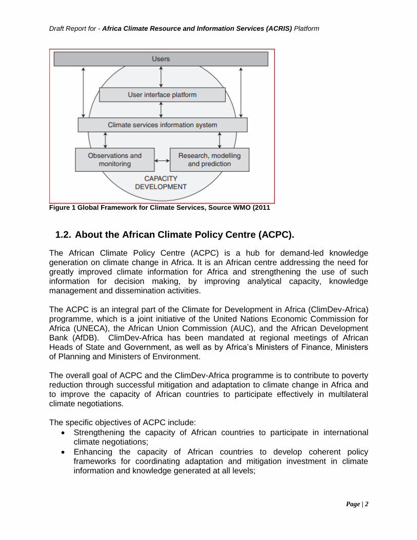
Figure 1 Global Framework for Climate Services, Source WMO (2011
1.2. About the African Climate Policy Centre (ACPC).
The African Climate Policy Centre (ACPC) is a hub for demand-led knowledge generation on climate change in Africa. It is an African centre addressing the need for greatly improved climate information for Africa and strengthening the use of such information for decision making, by improving analytical capacity, knowledge management and dissemination activities. The ACPC is an integral part of the Climate for Development in Africa (ClimDev-Africa) programme, which is a joint initiative of the United Nations Economic Commission for Africa (UNECA), the African Union Commission (AUC), and the African Development Bank (AfDB). ClimDev-Africa has been mandated at regional meetings of African Heads of State and Government, as well as by Africa’s Ministers of Finance, Ministers of Planning and Ministers of Environment. The overall goal of ACPC and the ClimDev-Africa programme is to contribute to poverty reduction through successful mitigation and adaptation to climate change in Africa and to improve the capacity of African countries to participate effectively in multilateral climate negotiations. The specific objectives of ACPC include:
• Strengthening the capacity of African countries to participate in international climate negotiations;
• Enhancing the capacity of African countries to develop coherent policy frameworks for coordinating adaptation and mitigation investment in climate information and knowledge generated at all levels;
Draft Report for - Africa Climate Resource and Information Services (ACRIS) Platform
Page | 3
• Improving the capacity of African countries to mainstream climate concerns into development frameworks;
• Ensuring a solid foundation of applied climate science and assessment of climate vulnerability, risks and impacts;
• Identifying sectoral priorities and responses for managing climate risks and guiding related investments.
The ACPC serves Regional Economic Communities, governments and communities across Africa. The center is actively working with stakeholders and partners to address Africa’s climate challenges. ACPC is currently refocusing its programme to align with the emerging issues in climate governance, and other global and regional development frameworks, with a view to incorporating such frameworks into national development policies and programmes. Vision To make Africa’s development sustainable, inclusive and climate-resilient. Mission To influence, strengthen and enable the transition to climate-resilient development in Africa through responsive policies, plans and programmes towards transformed economies, healthy ecosystems and human wellbeing. Goals To achieve its vision and mission, ACPC will:
• Conduct research and analysis in support of climate-informed social and economic development in Africa;
• Provide advisory services and technical assistance for the implementation of the Paris Agreement;
• Strengthen and develop human and institutional capacities in member States for climate-resilient development planning, policies and practices;
• Design and convene dialogue spaces for building and fostering strategic alliances and partnerships towards effective climate response and development, and catalyse Africa common positions;
• Generate, manage and customize knowledge products to effectively communicate climate solutions to key constituencies;
• Ensure value for money in programme management, implementation, monitoring, evaluation and learning.
Key Milestones / Achievements ACPC intends to enhance its analytical capacity in pursuit of its objective to be a leading climate policy and resource centre on the continent. This role will build on strengthening networks and partnerships for the generation, analysis and packaging of climate information encapsulated in ClimDev-Africa, Weather and Climate Information Services for Africa (WISER), the Africa Climate Resilient Investment Facility (Afri-Res) and other projects.
Draft Report for - Africa Climate Resource and Information Services (ACRIS) Platform
Page | 4
1.3. Climate for Development in Africa (ClimDev-Africa)
ClimDev‐Africa is a joint initiative of the African Union Commission (AUC), the United National Economic Commission for Africa (UNECA) and the African Development Bank (AfDB). The Programme has been mandated at regional meetings of African Heads of Government, as well as by Africa’s Minsters of Finance, Ministers of Planning and Ministers of Environment. The ClimDev‐Africa Programme (ClimDev) supports Africa’s response to climate
variability and change by building regional, sub‐regional and national policy capacity. It will improve the quality and availability of information and analysis to decision‐makers. The Programme is comprised of three elements;
• the African Climate Policy Centre (ACPC);
• the ClimDev Special Fund (CDSF); and,
• the Climate Change and Desertification Unit (CCDU). ClimDev is implemented by the ACPC, the CCDU based at the AUC, and through the the ClimDev Special Fund managed by the AfDB. Political leadership of ClimDev is provided by the AUC. Funding is through a blend of programmatic and special fund modalities. ACPC has two key functions to enable ClimDev‐Africa’s objectives to be achieved:
• Enabling the development of Africa’s climate policy capacity; and,
• Being the secretariat for the ClimDev‐Africa Programme including undertaking administrative functions for the Programme.
Source: Revised ClimDev‐Africa Framework Programme Document,2012
Information and communication technologies (ICT) have transformed global economies - but this progress is yet to be seen in Africa. Recent advances in weather and climate services have come about not necessarily from the discovery of new science but from advances in affordable information and communication technologies that allow tests to complex scientific theories at a higher and deeper level than before; these technologies enable the production of robust climate information and services at affordable cost. One of the major barriers to advancing climate information services in Africa is a digital divide which boils down to the simple problem of ICT. This divide, is due to a lack of three key elements: IT infrastructure which is critical for generating robust climate information, efficient communication platforms which are essential for dissemination and finally, knowledge of how to package up the information ready for use. Of these three elements, IT infrastructure is arguably the most critical. The delivery of climate information and services depends heavily on e-infrastructure consisting of High Performance Computing, data, data analytic tools, observing networks and networks of institutions. This infrastructure is now extremely cost-effective and much more widely available; these systems are low-hanging fruit ready for Africa to take advantage of. Source, ACPC Website, 2018.
Draft Report for - Africa Climate Resource and Information Services (ACRIS) Platform
Page | 5
1.4. Terms of Reference of Assignment
The full terms of reference are in Annex 1.
2. Aim, Objectives and Deliverables of the assignment
2.1. Aim
The overall objective of the assignment is to support the African Climate Policy Center (ACPC) of the UN Economic Commission for Africa (ECA) with the establishment of the Africa Climate Resource and Information Service Platform to serve as an open architecture one-stop go-to place for quality and timely climate data, climate information services, open-source climate-related modelling tools and an online advisory services, learning and capacity development resources and help desk for stakeholders, as well as an online convening and community forum for regional climate researchers and development.
2.2. Objectives
i. Demand mapping survey to establish user needs and preferences for the proposed platform
ii. supply mapping to establish the supply landscape, needs and gaps iii. survey to establish potential and interested partners for the platform iv. Specification document for ICT and services for the proposed platform
partnership and service provision v. Evaluation report for the ICT infrastructure, quality, standards and services of
existing climate and resource ICT based institutions related to the UN Economic Commission for Africa - such as the African Centre of Meteorological Application for Development (ACMAD) and the Regional Centre for Mapping of Resources for Development (RCMRD) ? to establish needs and gaps
vi. System and software specifications needed to meet identified needs and gaps vii. Cost estimates report for each potential service provider and based on the
specifications identified, cost estimates for full implementation of the platform, partnership and information service based on the identified demand and supply canvas as well as the identified systems needs and gaps
viii. Shortlist report of three qualifying potential service providers ix. Report on Procurement recommendations and guidelines for full implementation
of the proposed platform and information service
Draft Report for - Africa Climate Resource and Information Services (ACRIS) Platform
Page | 6
2.3. Expected Deliverables
The main deliverable of this assignment is the Project Report that shall be informed by the following annexes that are intermediary outputs of the assignment:
i. Report on mapping of user needs and preferences of the proposed platform ii. Report on supply landscape of the system, including needs and gaps iii. Report on potential and interested partners of the platform iv. Report on specification of ICT and climate services of the proposed platform,
including partnership and service provision v. Evaluation report of the ICT infrastructure, quality, standards and services of
existing climate and resource ICT based institutions related to the UN Economic Commission for Africa, including needs and gaps
vi. Report on system and software specifications needed to meet identified needs and gaps
vii. Report on cost estimates of each potential service provider based on the specifications identified, full implementation of the platform, partnership and information service.
viii. Report on qualified potential service providers ix. Procurement recommendations and guidelines for full implementation of the
proposed platform and information service
3. Approach and Methodology
This section covers the approach, methods and tools used to gather information related to this assignment.
3.1. Approach
Execution of this assignment will broadly entail situational analysis, holistic institutional surveys, benchmarking against internationally recognized good practices, analysis of findings and preparation of the final report including annexes emanating from key sub-tasks of the assignment.
3.2. Methodology
3.2.1 Undertaking the Situational Analysis
The situational analysis will entail a two-pronged approach; a) Desk review of existing reports, and literature on existing platforms/services,
especially with regards to institutional and systemic frameworks (governance, human resources, legal and policy frameworks, protocols of data exchange).
b) Institutional visits to collect data and assess institutional capacities
Draft Report for - Africa Climate Resource and Information Services (ACRIS) Platform
Page | 7
3.2.2 Survey Design
The survey will primarily be conducted through institutional visits with the option of remote interviews as a complement method, where and when applicable. The survey will be designed to cover the following four critical institutional components with focus on institutions offering weather & climate services, geospatial services, and the institutions offering training and technological interventions in these areas:
• Data
• Infrastructure (Hardware and Software)
• Human Resource
• Legal and institutional frameworks; For each of the aforementioned components, the survey will solicit answers to the following set of questions which are by no means exhaustive at this point in time:
3.2.2.1 Data
i. What are the key climate data sets? ii. What is the source of climate data? iii. What is the format of the data? iv. How is the data accessed? v. How is the data stored? vi. Where does data processing take place? Locally or on cloud? vii. Are there any climate data modelling tools? If so which ones? viii. What is the current storage capacity of the digital data? ix. What is the anticipated annual growth rate in data storage requirements? x. What backup processes are in place? xi. Where are the backup copies stored? xii. In case of a disaster, what data recovery (or business continuance) measures
and processes are in place to protect the data? xiii. Does the institution maintain metadata records? xiv. What quality assurance mechanisms are in place to ensure data integrity? xv. What mechanisms are in place to ensure data currency/continuity? xvi. Does the institution share its data/products and to whom? xvii. What are the key challenges faced in regards to data management?
3.2.2.2 Infrastructure
1. What ICT infrastructure is in place? Are there plans to acquire additional/new ICT
infrastructure in the next 1-5years? 2. What are key specifications of the ICT infrastructure listed above? 3. What security measures are in place to safeguard the ICT infrastructure? 4. What is the capacity of the internet bandwidth? 5. What are the failover measures in place?
Draft Report for - Africa Climate Resource and Information Services (ACRIS) Platform
Page | 8
6. What modes of application delivery are currently available (cloud services, stand alone, distributed systems)?
7. What safety measures are in place to guard the ICT infrastructure (e.g against fire, flood etc.)
3.2.2.3 Software
i. What software are currently used to process data? Operating system? Security?
etc ii. What tools/platforms are available for data access, processing (including
modelling), visualization and disseminations? iii. Is the software open source, freeware, proprietary, etc? iv. Are there end user software systems developed by the organization? If yes list. v. Is there a software maintenance and upgrade plan? vi. How frequently are products processed (daily, weekly, biweekly, monthly,
decadal, etc)?
3.2.2.4 Legal and institutional frameworks
1. What products and services are offered by the institution related to weather
&climate and/or geospatial services? 2. What legal instruments are available on data and/or ICT? (e.g policy) 3. What institutional arrangements are in place on data and ICT? (e.g. MOUs) 4. Is there a data sharing policy and mechanism? 5. Does an ICT and data Policy exist? 6. Are SOPS (standard operating procedures)/manuals available? Are the
SOPs/manuals operational 7. Who are the key Stakeholders? (partners, end users, etc) 8. How is the organization structured for efficient delivery of products and services?
Specify key related staff, specify staff strengths and needs. 9. What is the source of funding for the weather & climate services and/or
geospatial services? (own funding, donor funding, etc) 10. What are the key strategic plans of the institution in regard to weather & climate
and or geospatial services? (short, medium, long term). Source: Climate Data Management System Specifications, WMO-No. 1131, WMO, 2014.
3.2.3 Identification of target institutions
The climate information products and services providers are organization established as regional, sub regional intergovernmental organizations by States governments or at national level by government for the purpose of carrying out meteorological and related functions which governments consider as a responsibility of the States in support of the safety, security and general welfare of their citizens and in fulfilment of their international obligations under the Convention of the World Meteorological Organization
Draft Report for - Africa Climate Resource and Information Services (ACRIS) Platform
Page | 9
(WMO) (Zillman 1999). Source: The State of Climate Information Services for Agriculture and Food Security in East African Countries, Kadi et al, Target institutions to be surveyed shall be identified in consultation with ACPC informed by the report on Mapping of Institutions, Experts and Initiatives Engaged in Climate Research and Related Activities in Africa (2017) prepared by ACPC. A draft list of institutions offering products and services in weather & climate, geospatial solutions, relevant technologies and training will be prepared and submitted for approval prior to commencing the survey.
3.2.4 Undertaking Institutional Surveys
This will involve preparation of requisite documentation (Questionnaires, Travel Schedule, Letters of introduction), institutional visits including collection of relevant material where available and identification of key persons/department/sections.
3.2.5 Benchmarking with International Good Practices
Desk review of renowned institutions around the world offering weather and climate services (EUMETSAT, NOAA, WMO)
3.2.6 Analysing the Findings
Analyzing of items of 3.23, 3.2.4 and 3.25
3.3. Designing the System
The system design will incorporate a two tier approach:
• Overall Climate application design
• Modular approach in implementation
3.4. Preparing the Final Report
This will involve preparation of the draft reports that will eventually morph into the final report.
Draft Report for - Africa Climate Resource and Information Services (ACRIS) Platform
Page | 10
4. Situational Analysis
Developing countries share many common challenges in addressing current and future climate risks. A key barrier to managing these risks is the limited availability of accessible, reliable and relevant weather and climate information. Despite continued investments in Earth System Modelling, and the growing provision of climate services across Africa and India, there often remains a mismatch between available information and what is needed to support on-the-ground decision-making. Weather and climate information encompasses a diverse range of data sets, methods and tools. To unpack the issues in the utility of weather and climate information for decision-making, it is necessary to understand what type of information is relevant and the underpinning technical and scientific challenges associated with the production of such information. This section summarizes the range of globally and regionally available weather and climate information, but first provides pertinent background on key concepts of weather and climate. Source: The utility of weather and climate information for adaptation decision-making: current uses and future prospects in Africa and India, May 2017, Chandni Singh, et.al According to a research undertaken by the World Meteorological Organisation (WMO) captured in the report Climate Knowledge for Action:a global framework for climate services–empowering the most vulnerable,the report of the high-level taskforce for the global framework for climate services, WMO-no. 1065, the components of a global Framework for climate information services are as follows: (i) The User Interface Platform to provide a means for users, user representatives,
climate researchers and climate service providers to interact, thereby maximising the usefulness of climate services and helping develop new and improved applications of climate information.
(ii) The Climate Services Information System is the system needed to protect and distribute climate data and information according to the needs of users and according to the procedures agreed by governments and other data providers.
(iii) The Observations and Monitoring component will ensure that the climate observations necessary to meet the needs of climate services are generated.
(iv) The Research, Modelling and Prediction component to assess and promote the needs of climate services within research agendas.
(v) The Capacity Building component will support systematic development of the necessary institutions, infrastructure and human resources to provide effective climate services.
The climate services sought by users include the provision of data, data summaries and statistical analyses and predictions as well as tailored information products, scientific studies and expert advice delivered with ongoing support and user engagement. A requirement may be as simple as providing the temperature for a particular place and date or as complicated as an assessment of environmental factors in constructing a

Draft Report for - Africa Climate Resource and Information Services (ACRIS) Platform
Page | 11
billion-dollar infrastructure project. A service package may encompass past historical data, recent and current conditions and future predictions and projections. Services may be provided directly in response to specific requests or in anticipation of the needs of particular groups. Services may be supplied free or at a price. Channels for delivery may include face-to-face advice, formal reports, periodic bulletins, news media releases, internet-based mechanisms, outlook forums and direct computer access. Climate services also include internal activities such as archive development, quality management and statistical analyses that benefit both current users and future generations. The demand for climate-related information services is rising owing to a combination of factors such as greater awareness of climate issues and impacts and the need for an integrated approach to addressing environmental and other issues, pressures of competition, efficiency and accountability for businesses and public entities, greater capacity throughout society for computer-based accessing
4.1. Legal and Institutional Frameworks
The Taskforce charged with development of the framework for WMO believes that providing operational climate services should be the focus of the Framework. It should operate at global, regional and national levels, in support of and in collaboration with global, regional and national stakeholders and efforts.
• At the global level, it will focus on producing global climate prediction products, coordinating and supporting data exchange, major capacity building initiatives, and establishing and maintaining standards and protocols;
• At the regional level, it will support multilateral efforts to address regional needs, for example through regional policy development, knowledge and data exchange, infrastructure development, research, training and the provision of services regionally to meet agreed regional requirements;
• At the national level, it will focus on ensuring access to data and knowledge products, tailoring information to user requirements, ensuring effective routine use of information in planning and management along with developing sustainable capacities in these respects. Depending on their needs and capacities, users may obtain information from a range of available global, regional and national sources.
4.2. Technology Trends
ICTs can provide many strategies for adapting to or mitigating the adverse impact of climate change, as well as for the transfer and exchange of knowledge more generally. The most important roles for ICTs in climate change are likely to be in monitoring and adaptation, rather than mitigation. Source: Using information and communication technologies to disseminate and exchange agriculture-related climate information in the Indo Gangetic Plains, V. Balaji et al
Draft Report for - Africa Climate Resource and Information Services (ACRIS) Platform
Page | 12
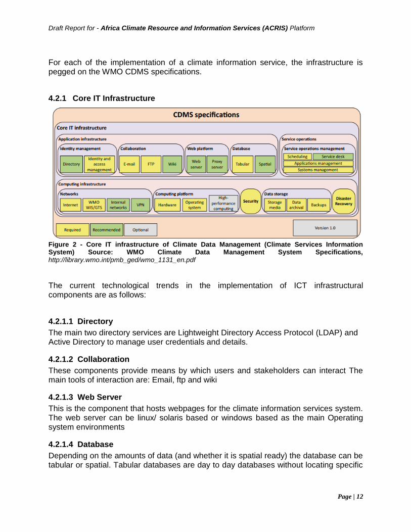
For each of the implementation of a climate information service, the infrastructure is pegged on the WMO CDMS specifications.
4.2.1 Core IT Infrastructure
Figure 2 - Core IT infrastructure of Climate Data Management (Climate Services Information System) Source: WMO Climate Data Management System Specifications, http://library.wmo.int/pmb_ged/wmo_1131_en.pdf
The current technological trends in the implementation of ICT infrastructural components are as follows:
4.2.1.1 Directory
The main two directory services are Lightweight Directory Access Protocol (LDAP) and Active Directory to manage user credentials and details.
4.2.1.2 Collaboration
These components provide means by which users and stakeholders can interact The main tools of interaction are: Email, ftp and wiki
4.2.1.3 Web Server
This is the component that hosts webpages for the climate information services system. The web server can be linux/ solaris based or windows based as the main Operating system environments
4.2.1.4 Database
Depending on the amounts of data (and whether it is spatial ready) the database can be tabular or spatial. Tabular databases are day to day databases without locating specific
Draft Report for - Africa Climate Resource and Information Services (ACRIS) Platform
Page | 13
features while a spatial database has geo location features. Both databases can be obtained as open source or proprietary.
4.2.1.5 Scheduling
With presence of automated task schedulers or cron jobs, this enables system functions to be invoked to run as specific times.
4.2.1.6 Service Desk
A service desk is critical in ensuring stakeholders can request for additional support or request as well as providing feedback on the status of the systems. Service desks ensure proper mapping of uptime of services provided by a software solution.
4.2.1.7 VPN
VPNs can ensure the different providers of climate data can access the data not readily available to them. This enables creation of a huge data catalog at no extra cost as storage space is distributed.
4.3. Data
In most countries the networks established for weather forecasting purposes do double-service by contributing weather data to the national climate archive, particularly on temperature, rainfall, humidity, wind speed and pressure. Data collected for weather forecasting thus provides the major source of climate data, although the priorities for climate stations and weather stations sometimes differ. Climate information depends on long-term, stable records of data, but such criteria are not as critical to inform weather forecasting needs. Dedicated national climate networks are becoming more common and usually cover additional parameters of climatic importance such as maximum and minimum temperature, soil temperature, sunshine, evaporation, solar radiation, daily wind run and frost occurrence. Other significant contributors of climate data include networks operated by sectoral agencies, particularly those for water resources, energy production, agriculture, forestry, fire management and marine affairs. Climate data is also collected by some research institutes and city and local governments. Data sets originating outside the country may also be available, either through routine data exchange arrangements between countries, particularly under the Global Climate Observing System, or as global analysis products from global processing centres and research institutes. Source: Climate Knowledge for Action:a global framework for climate services–empowering the most vulnerable,the report of the high-level taskforce for the global framework for climate services, wmo-no. 1065
Draft Report for - Africa Climate Resource and Information Services (ACRIS) Platform
Page | 14
4.4. Existing Capacities and Capabilities
Several drawbacks in climate data delivery and integration have been identified and these findings have served as foundations for the GFCS (World Meteorological Organization, 2011). It has been recognized that:
(9) Climate services do not efficiently exploit scientific climate knowledge, information and data;
(10) Climate services do not meet present and future user needs and in particular in developing or least developed countries that are the most vulnerable;
(11) Providers of climate services do not interact sufficiently with users; (12) Existing capacities for climate observations provide a good basis for
strengthening climate services but commitment to sustain high-quality observations across the entire climate system is inadequate;
(13) Enhancements in observations networks in developing countries are required;
(14) Restrictions about the sharing and access to data and information are a major barrier to progress and wide use of climate knowledge;
(15) Use of climate knowledge that can inform decision-making is inadequate and is not following the rapid advancement of the understanding of climate system; and
(16) Capacities of users is often insufficient to adequately use climate data and information.
Borrowing from the Global Framework for Climate Services (GFCS) is that any climate service implementation should serve the widest audience possible and in particular climate vulnerable developing countries. The objectives of ACRIS in line with those of the GFCS are:
(1) to improve climate services for all countries, (2) build capacities of providers and users, (3) enable governments to have a central role as primary sources of climate
services, (4) promote a free and open exchange of climate data and information while respecting existing data policies,
(4) facilitate the timely access to relevant scientific information to help society to cope with current climate variability and limit economic and social damages caused by climate-related disasters.
Source: Spatially enabling the Global Framework for Climate Services: Reviewing geospatial solutions to efficiently share and integrate climate data & information, Gregory Giuliani, et al

Draft Report for - Africa Climate Resource and Information Services (ACRIS) Platform
Page | 15
4.4.1 WMO Climate Services Toolkit
WMO has developed a comprehensive climate information services that is packaged as a toolkit. Climate Services Toolkit (CST) intends to serve as a principal mechanism for sharing data, software tools, guidance, and training resources for climate services development. It is currently under prototyping stage. The toolkit is segmented into four parts namely:
• Training Resources
• Climate Data
• User Engagement Forum
• Help Desk
Figure 3 - WMO Climate Services Toolkit website, Mar 2018
4.4.2 IGAD Climate Prediction and Applications Centre
The IGAD Regional Climate Centre hosted at ICPAC provides regional climate forecasts and other products that support regional and national climate activities, and thereby strengthen the capacity of WMO Members in the Greater Horn of Africa region to deliver better climate services to users.
Draft Report for - Africa Climate Resource and Information Services (ACRIS) Platform
Page | 16
Figure 4 - WMO RCC website at ICPAC
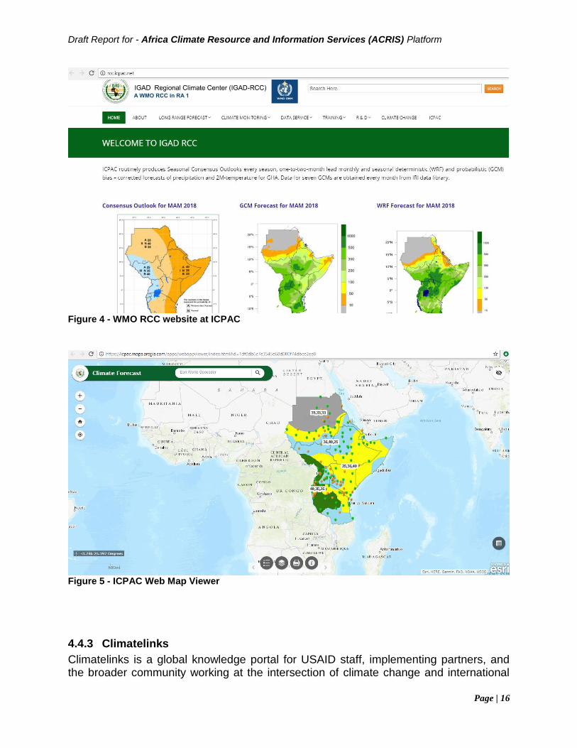
Figure 5 - ICPAC Web Map Viewer
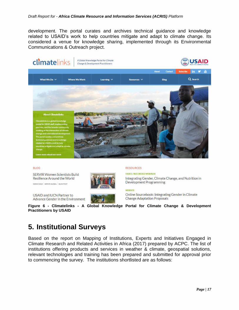
4.4.3 Climatelinks
Climatelinks is a global knowledge portal for USAID staff, implementing partners, and the broader community working at the intersection of climate change and international
Draft Report for - Africa Climate Resource and Information Services (ACRIS) Platform
Page | 17
development. The portal curates and archives technical guidance and knowledge related to USAID’s work to help countries mitigate and adapt to climate change. Its considered a venue for knowledge sharing, implemented through its Environmental Communications & Outreach project.
Figure 6 - Climatelinks - A Global Knowledge Portal for Climate Change & Development Practitioners by USAID
5. Institutional Surveys
Based on the report on Mapping of Institutions, Experts and Initiatives Engaged in Climate Research and Related Activities in Africa (2017) prepared by ACPC. The list of institutions offering products and services in weather & climate, geospatial solutions, relevant technologies and training has been prepared and submitted for approval prior to commencing the survey. The institutions shortlisted are as follows:
Draft Report for - Africa Climate Resource and Information Services (ACRIS) Platform
Page | 18
5.1. African Centre of Meteorological Application for Development (ACMAD)
ACMAD is the Weather and Climate Centre with African continental competence. It was created in 1987 by the Conference of Ministers of the United Nations Economic Commission for Africa (UNECA) and the World Meteorological Organisation (WMO). ACMAD has been operational in Niamey since 1992 and is composed of 53 Member States, the 53 countries of "Africa" continent. ACMAD functions primarily with meteorologists detached by its Members States. Source: http://www.acmad.net/new/?q=en/pages/about-us ACMAD activities focus mainly on climate information and prediction, weather watch and forecasting, and applications in support to sustainable development of Africa (notably within the context of national strategies for poverty eradication), in the fields of agriculture, water resources, health, public safety and renewable energy. Hence, ACMAD’s work is implemented by two core scientific programmes;
(i) climate and environment and (ii) Weather Watch and Prediction, in addition to one major technical support
department, namely the telecommunication and computing department. The climate and environment programme also host the WMO RCC for the provision and delivery of climate products and services including long-range forecast (LRF), climate monitoring products, data services, and training activities to the NMHSs and the sub-regional centres of the continent’s economic communities, including ECOWAS RCC, ICPAC, Drought Monitoring Centre, North African RCCNetwork and Central African RCC. Regional Projects MESA project ACMAD is the continental implementation centre on Monitoring of Environment for Security in Africa (MESA) project Continental Climate Services for Disaster Risks Reduction (DRR). MESA seeks to increase the capacity in information management, decision-making and planning of African continental, regional and national institutions mandated for environment, climate, and food security. It is initiated to provide increasingly powerful tools supporting better communication and policy decisions with ISACIP Project The Institutional Support to African Climate Institutions Project (ISACIP) is an African Development Bank (AfDB) funded project designed to strengthen the capacities of African regional climate centres to develop and disseminate climate information in support of economic development in the continent. Although coordinated by ACMAD, the primary beneficiaries are ACMAD, AGRHYMET, ICPAC and DMC. Source: Report on Capacity Needs Assessment of ACMAD Supported, WISER
Draft Report for - Africa Climate Resource and Information Services (ACRIS) Platform
Page | 19
5.2. IGAD Climate Prediction and Applications Centre (ICPAC)
In 1996 Intergovernmental Authority on Development (IGAD) was formed to supersede IGADD. In October 2003, the Heads of State and Governments of the Intergovernmental Authority on Development (IGAD) held their 10th Summit in Kampala, Uganda, where Drought Monitoring Center-Nairobi (DCMN) was adopted as a specialized IGAD institution. The name of the institution was at the same time changed to IGAD Climate Prediction and Applications Centre (ICPAC) in order to better reflect all its mandates, mission and objectives within the IGAD system. A Protocol integrating the institution fully into IGAD was signed on 13 April 2007. The Centre is responsible for eight member countries namely: Djibouti, Eritrea, Ethiopia, Kenya, Somalia, South Sudan, Sudan and Uganda as well as Burundi, Rwanda and Tanzania. Source ICPAC Profile, http://icpac.net/downloads/PROFILE.pdf ICPAC activities focus mainly on climate information, prediction, early warning and applications in support of environmental management, disaster risk reduction for sustainable development in the IGAD region as well as in Burundi, Rwanda and Tanzania. Source: Human Capacity Needs Assessment of icpac for effective climate services in greater horn of africa (gha), september,2015 Regional Projects IGAD-UNOSAT UNITAR and the Inter-Governmental Authority on Development (IGAD) partnered in the implementation of a project to build capacities in the use of GIT to address Disaster Risk Reduction (DRR) in the region. The main project being Building Capacities for Disaster Risk Reduction using Geospatial Technologies in the East Africa Region (in partnership with UNITAR-UNOSAT). CCAFS ICPAC, in partnership with International Research Institute for Climate and Society (IRI), and the University of Reading, contributed to the CCAFS-led project, Climate Change, Agriculture and Food Security, Climate Services for Africa. The overall goal of this initiative is to strengthen the capacity of IGAD Climate Prediction and Applications Centre (ICPAC) and ICPAC member countries (covering IGAD and rest of East African Community member states) to develop effective climate services for agriculture and food security; in a manner that benefits smallholder farmers.
Draft Report for - Africa Climate Resource and Information Services (ACRIS) Platform
Page | 20
SCIPEA Strengthening Climate Information Partnerships - East Africa is a UKaid-funded project of the WISER programme (Weather and climate Information and SERvices for Africa). The purpose of the SCIPEA project is to strengthen climate partnerships by:
• Enhancing links and data exchanges between global, regional and national climate organisations, with the aim of strengthening resources and tools for seasonal forecasts.
• l facilitate the co-development of tailored services with climate information providers and users
• Working with national meteorological and hydrological services (NMHSs), universities and training centres in the region to strengthen training resources and the capacity for climate service development.
The project partners include International Research Institute for Climate and Society (IRI), IGAD (Intergovernmental Authority on Development) Climate Prediction Applications Centre (ICPAC), the meteorological services of Ethiopia, Kenya, Tanzania and Uganda, educational institutions and end users of seasonal forecasting information in the region and from the four countries. Who are the Red Cross, ministries of agriculture and water resource and disaster risk reduction organisations as well as the energy, food security and nutrition, and media sectors. Source: http://icpac.net/index.php/projects/scipea.html
5.3. SADC – Climate Services Centre (SADC-CSC)
SADC Climate Services Centre provides operational, regional services for monitoring and predicting extremes in climate condition. The Centre develops and disseminates meteorological, environmental and hydro-meteorological products. The Centre’s products contribute to improved disaster risk management in the region, and help to ensure Member States are better prepared for weather and climate disasters, conservation and protection of natural resources. The Climate Services Centre was established in 1990 as the Drought Monitoring Centre. Being a SADC programme, the Centre falls within the Infrastructure and Services (I&S) Directorate and is co- located with Botswana Meteorological Services. The Centre provides training in climate prediction for personnel in the National Meteorological/Hydrological Services (NMHSs). Training covers the end- users in the various weather –sensitive economic sectors such as agriculture, health, energy, water resources management and transport in the region in application of the climate products and services.
5.4. World Bank
Founded in 1944, the International Bank for Reconstruction and Development—soon called the World Bank—has expanded to a closely associated group of five
Draft Report for - Africa Climate Resource and Information Services (ACRIS) Platform
Page | 21
development institutions. Originally, its loans helped rebuild countries devastated by World War II. In time, the focus shifted from reconstruction to development, with a heavy emphasis on infrastructure such as dams, electrical grids, irrigation systems, and roads. With the founding of the International Finance Corporation in 1956, the institution became able to lend to private companies and financial institutions in developing countries. And the founding of the International Development Association in 1960 put greater emphasis on the poorest countries, part of a steady shift toward the eradication of poverty becoming the Bank Group’s primary goal. The subsequent launch of the International Centre for Settlement of Investment Disputes and the Multilateral Investment Guarantee Agency further rounded out the Bank Group’s ability to connect global financial resources to the needs of developing countries. Today the Bank Group’s work touches nearly every sector that is important to fighting poverty, supporting economic growth, and ensuring sustainable gains in the quality of people’s lives in developing countries The World Bank is made up of 189 member countries. These member countries, or shareholders, are represented by a Board of Governors, who are the ultimate policymakers at the World Bank. Generally, the governors are member countries' ministers of finance or ministers of development. They meet once a year at the Annual Meetings of the Boards of Governors of the World Bank Group and the International Monetary Fund. The governors delegate specific duties to 25 Executive Directors, who work on-site at the Bank. The five largest shareholders appoint an executive director, while other member countries are represented by elected executive directors. In an effort to serve as a 'one stop shop' for climate-related information, data, and tools, the World Bank created the Climate Change Knowledge Portal (CCKP), supported by the Global Facility for Disaster Reduction and Recovery and others. The Portal provides an online tool for access to comprehensive global, regional, and country data related to climate change and development. The World Bank has a Climate change section that deals with climate related data, tools and knowledge sharing platform.
5.5. AGRHYMET Regional Centre
Created in 1974, AGRHYMET is a specialized agency of the Permanent Inter-State Committee against Drought in the Sahel (CILSS) of thirteen countries are: Benin, Burkina Faso, Cape Verde, Chad, Ivory Coast, Gambia, Guinea, Guinea Bissau, Mali, Mauritania , Niger, Senegal and Togo. This is a public interstate with legal personality and financial autonomy. It has an international status with headquarters in Niamey, Niger.
Draft Report for - Africa Climate Resource and Information Services (ACRIS) Platform
Page | 22
AGRHYMET main objectives are:
• contribute to food security and increased agricultural production in member countries of CILSS and ECOWASO
• help improve the management of natural resources of the Sahel and West Africa Providing information and training of development agents and their partners in the fields of agro-ecology in the broadest sense (agro-climatology, hydrology, plant protection). It is a tool oriented regional, specialized in science and technology applicable to the sectors of agricultural development, development of rural and natural resource management. AGRHMET’s core activities are:
• Collection, processing and dissemination of information on food security, market access, natural resource management, water and desertification control and climate change in the Sahel and West Africa;
• The development of decision support tools to meet the requirement for Sahelian and West African populations development;
• Strengthening of technical capacities through training and transfer of tools, methods and know-how adapted to Sahelian and West African countries in the fields of climatology, agro-meteorology, hydrology, crop protection, geomoatics and remote sensing.
Climate Services related projects implemented by AGRHMET are: The ECOWAS Agriculture Regional Information System (ECOAGRIS) Sponsored by the European Union at 18 million Euros, the objective of ECOAGRIS is to strengthen and integrate the information systems at different local, national and regional scales. With a duration of 54 months, this project aims at addressing the information needs to monitor food and nutrition situations, analyze vulnerability, support decision-making in order to anticipate food and nutrition crises and better target the intervention areas. Monitoring for Environment and Security in Africa (MESA) Sponsored by the EU, the overall objective of the MESA project is to improve the Environmental monitoring capacities of regional and national institutions of the CILSS-ECOWAS region. specifically for a better use of earth observation data for an enhanced water control, and a more efficient agriculture and livestock management. Institutional Support to African Climate Institutions project (ISACIP/AfriClimServ) The project aims at strengthening the forecasting capacities of the African climate Centre: the African Centre for Meteorological Applications to Development (ACMAD), AGRHYMET Regional Centre, the forecasting and climatologic Application Centre IGAD (ICPAC) and the Drought Monitoring Centre (DMC). Support Project to Climate change adaptation by the improvement of climate information (ACCIC /DANIDA)
Draft Report for - Africa Climate Resource and Information Services (ACRIS) Platform
Page | 23
Its strategic objective is to “support climate adaptation strategies in West Africa by making available scientific quality data”. Global Climate Change Alliance (AMCC or GCCA) GCCA is an initiative shared between the European Union and the ACP countries which are the most exposed to climate change effects.The objective is to support the CILSS/ECOWAS member countries to address climate change in implementing priority adaptation and mitigation actions in order to reduce sustainably poverty of the most vulnerable populations. Climate change adaptation program in the water and agricultural sector (FFEM/AOC). Objective of this project is to strengthen the capacities of the West African countries in order to address climate change. It includes the development of a web knowledge exchange platform, production of knowledge, implementation of innovative pilot projects, support to climate change training and support to the integration of climate dimension in the sectorial policies Source: AGRHYMET Regional Centre General Presentation, July 2016, http://www.agrhymet.ne/eng/PDF/presentation%20CRA%202016_eng.pdf
5.6. Regional Centre for Mapping of Resources for Development (RCMRD)
The Regional Centre for Mapping of Resources for Development (RCMRD), previously known as Regional Centre for Services in Surveying, Mapping and Remote Sensing (RCSSMRS) was established in Nairobi, Kenya in 1975 under the auspices of the United Nations Economic Commission for Africa (UNECA) and the then Organization of African Unity (OAU). As part of its mandate, RCMRD, through its programme on early warning, offers capacity building, research, development and innovation services utilizing space technology for disaster risk reduction, disaster management and emergency response. RCMRD an intergovernmental organisation managed at the highest level by the Ministers in charge of land in the Member states; a not-for-profit, with its operations funded in part by contributions from contracting Member States and revenue generated from sales of its products and services. The Centre enjoys diplomatic status. RCMRD Objectives are:
• To provide quality geo-information and allied information and communication technology (ICT) products and services in environmental and resource management for sustainable development in the member countries and beyond;
• To promote the development and use of geo-information and information and communication technology in the sustainable development of member States by assisting in human resource and institutional capacity building;
Draft Report for - Africa Climate Resource and Information Services (ACRIS) Platform
Page | 24
• To provide problem solving applications in natural resource and environmental management;
• To provide formal and on the job training for nationals of the Contracting Parties in geo-information and information communication technology;
• To offer customer tailored geo-information and information technology courses on demand to contracting Parties and other customers;
• To provide advisory services upon request on problems relating to geo-information and ICT to the Contracting Parties;
• To provide services in the repair, maintenance and calibration of surveying and mapping equipment;
• To conduct research and development activities in all fields of its expertise in collaboration with its partners;
• To make available to the Contracting Parties data and results of the studies, research and tests carried out by the Centre; and
• To provide competitive services on demand-driven basis and in a business-like manner.
RCMRD’s Core mandate is found is as follows:
• Project Implementation – Environment, Natural Resources Management, Disaster Management, Infrastructure and Service Provision, Urban Mapping and Planning & Good Governance.
• Advisory Services – Development of National Policies and Strategies, Geo-information Standards etc.
• Capacity Development – Training in basic and applied programs.
• Research and Development – AFREF, Rapid LCM, Tsetse spread prediction, Crop yield estimation, Water resources management, Land Degradation and Habitat conservation & Disaster management etc.
• Servicing and Calibration of Mapping Equipment.
• Data and Information Dissemination – Acquisition, usage, sharing and discovery.
5.7. Council for Scientific and Industrial Research (CSIR)
The Council for Scientific and Industrial Research, commonly known as the CSIR, is a world-class African research and development organisation established through an Act of the South African Parliament in 1945. The CSIR undertakes directed, multidisciplinary research and technological innovation that contributes to the improved quality of life of South Africans. The organisation plays a key role in supporting government’s programmes through directed research that is aligned with the country’s
Draft Report for - Africa Climate Resource and Information Services (ACRIS) Platform
Page | 25
priorities, the organisation’s mandate and its science, engineering and technology competences. CSIR Strategic objectives are: Conduct high-quality and relevant research and technological innovation to foster industrial and scientific development – This strategic objective is achieved through the selection and implementation of a range of R&D programmes. Build and transform human capital - The CSIR’s scientific and technical contributions are only possible through the skills and capabilities of our scientific staff, which we refer to as our science, engineering and technology (SET) base. The ongoing development, renewal and transformation of the SET base are of critical importance for the organisation. In addition, the CSIR is an important part of the national system of innovation and through the development and training of our scientific base, contributes to the national imperative to develop human capital and to the ongoing transformation of our society. Maintain a sustainable and well-governed organisation - Without a financially sustainable and well-governed organisation, our ability to, over the long-term, contribute to national development through our scientific and technological work, would be severely compromised. Therefore, the CSIR is committed to maintaining its record of good governance and to continue to operate in a sustainable manner. Supporting national imperatives through high quality and relevant research- by: Creating a vibrant economy and employment opportunities; building a capable state that is able to consistently deliver high-quality services for all South Africans; contributing to the development of economic and social infrastructure like transport, energy, water resources and ICT networks. The organisation has identified six research impact areas that are: environment, defence and security, energy, health, industry and the natural environment. To make an impact in these areas, the organisation draws on a rich, multidisciplinary science base and proficiency in enabling technologies such as nanotechnology, materials science, synthetic biology, photonics and information and communications technology. World-class infrastructure and highly skilled staff - The CSIR’s state-of-the-art research infrastructure includes laboratories, testing facilities, scientific instruments, equipment, machinery, clean rooms and pilot plants that enable the translation of CSIR research into solid scientific output such as technology demonstrators and intellectual property. Two-thirds of the CSIR’s staff consists of scientists, engineers and technologists, who share a passion for shaping a better future through science and technology innovation. The organisation also invests in a myriad of training interventions to foster young talent and further develop expertise by providing bursaries, studentships, internships, exchange and sabbatical programmes. Source: https://www.csir.co.za/about-us-0
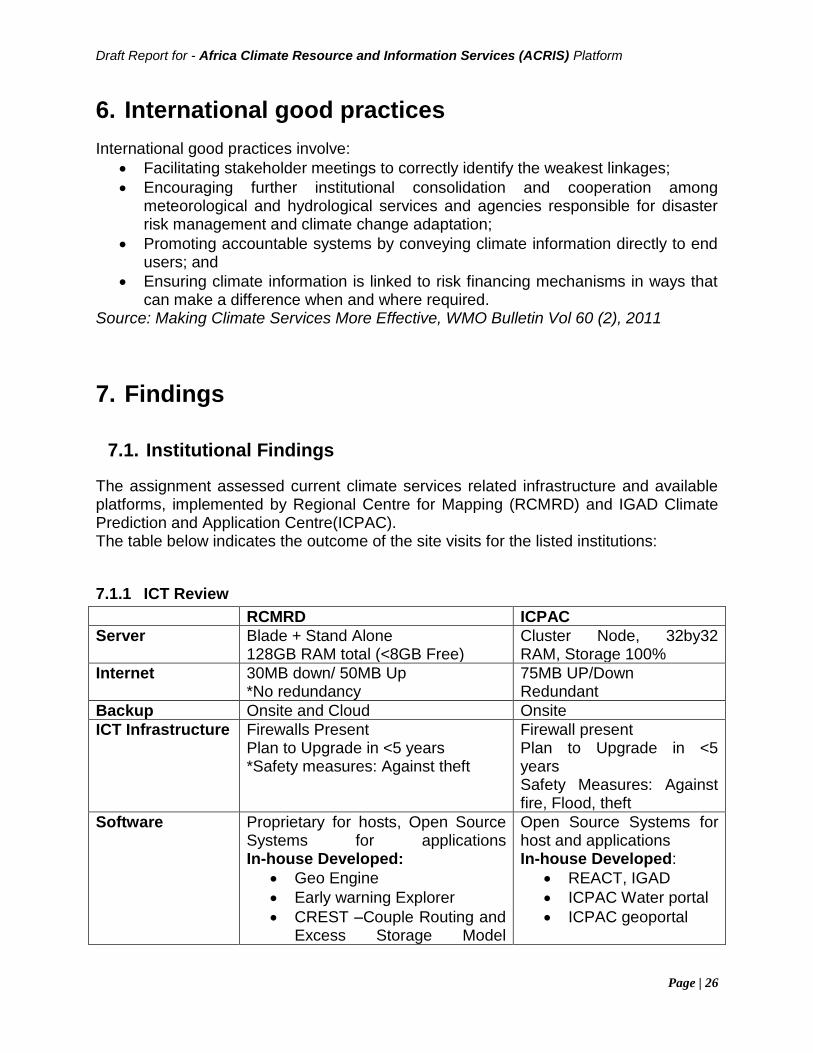
Draft Report for - Africa Climate Resource and Information Services (ACRIS) Platform
Page | 26
6. International good practices
International good practices involve:
• Facilitating stakeholder meetings to correctly identify the weakest linkages;
• Encouraging further institutional consolidation and cooperation among meteorological and hydrological services and agencies responsible for disaster risk management and climate change adaptation;
• Promoting accountable systems by conveying climate information directly to end users; and
• Ensuring climate information is linked to risk financing mechanisms in ways that can make a difference when and where required.
Source: Making Climate Services More Effective, WMO Bulletin Vol 60 (2), 2011
7. Findings
7.1. Institutional Findings
The assignment assessed current climate services related infrastructure and available platforms, implemented by Regional Centre for Mapping (RCMRD) and IGAD Climate Prediction and Application Centre(ICPAC). The table below indicates the outcome of the site visits for the listed institutions:
7.1.1 ICT Review
RCMRD ICPAC
Server Blade + Stand Alone 128GB RAM total (<8GB Free)
Cluster Node, 32by32 RAM, Storage 100%
Internet 30MB down/ 50MB Up *No redundancy
75MB UP/Down Redundant
Backup Onsite and Cloud Onsite
ICT Infrastructure Firewalls Present Plan to Upgrade in <5 years *Safety measures: Against theft
Firewall present Plan to Upgrade in <5 years Safety Measures: Against fire, Flood, theft
Software Proprietary for hosts, Open Source Systems for applications In-house Developed:
• Geo Engine
• Early warning Explorer
• CREST –Couple Routing and Excess Storage Model
Open Source Systems for host and applications In-house Developed:
• REACT, IGAD
• ICPAC Water portal
• ICPAC geoportal portal
Draft Report for - Africa Climate Resource and Information Services (ACRIS) Platform
Page | 27
(Hydrological Model)
• FROST viewer
Table 1 - ICT Review
Though ICPAC and RCMRD have onsite backups, both institutions have limited backup capacities as they accumulate huge amounts of data at any given time. The RCMRD raid system is 98% full while ICPAC uses external hard disks that are 99% full. The internet is shared across all institution’s users for both institutions without the presence of a DMZ. ICPAC has a redundancy internet connection that ensures no downtimes. ICPAC is investing in a state of the art server room at the new headquarters in Ngong, Kajiado County, Kenya. The server room implementation has taken into consideration emerging installation trends. With funding from WISER, the plan is to have facilities that can absorb the huge data requisitions and processing.
7.1.2 Data Review
RCMRD ICPAC
Key Datasets • Chirps
• Rainfall (From Met)
• NDVI
• Crop Zones
•Rainfall, Max/Min Temperature (from 1960/1980, )
Data Source • Local Satellite dish (E.g Modis)
• KMD
• Internet downloads
Met Stations, Chirps
Data Formats CDMS Ready CDMS Ready
Presentation Web Services, FTP Downloads, Applications
Web Portals
Collaborating institutions
FEWSNET, KFS, NEMA, NDMA, ICPAC (Modis Data ), OFESA , SADC (MESA data), MARINE Biodiversity (IGAD), NASA
IRI, CARE International (co production), Makerere University, Tanzania Forest Service, SERVIR, RCMRD, ACMAD, ATPS, UKMET •IRI •CCAFS –CGAIR
Table 2 - Institutional Data Review
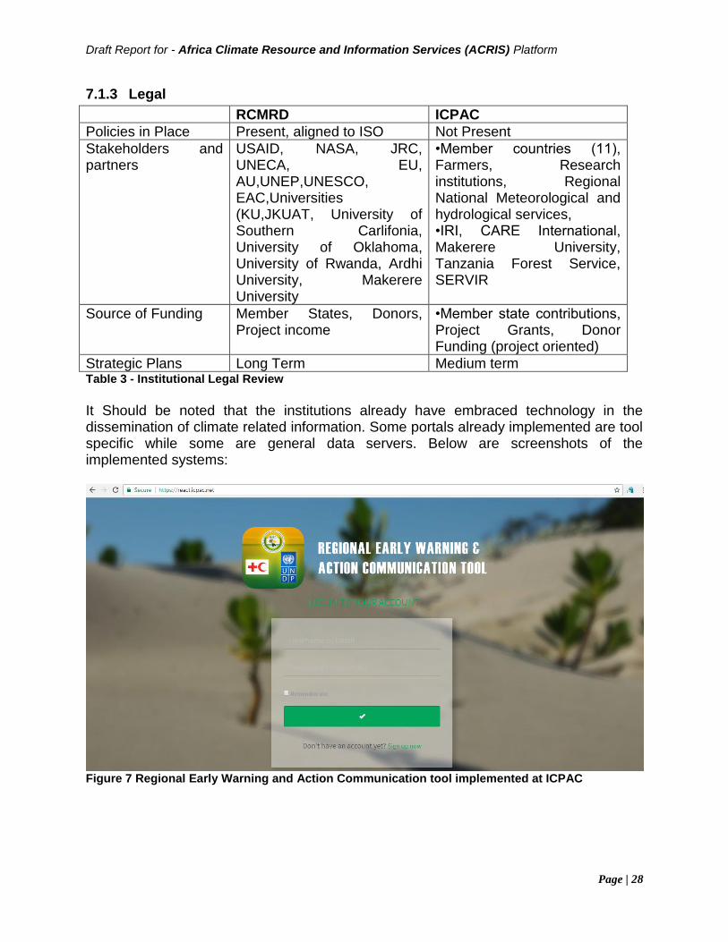
Draft Report for - Africa Climate Resource and Information Services (ACRIS) Platform
Page | 28
7.1.3 Legal
RCMRD ICPAC
Policies in Place Present, aligned to ISO Not Present
Stakeholders and partners
USAID, NASA, JRC, UNECA, EU, AU,UNEP,UNESCO, EAC,Universities (KU,JKUAT, University of Southern Carlifonia, University of Oklahoma, University of Rwanda, Ardhi University, Makerere University
•Member countries (11), Farmers, Research institutions, Regional National Meteorological and hydrological services, •IRI, CARE International, Makerere University, Tanzania Forest Service, SERVIR
Source of Funding Member States, Donors, Project income
•Member state contributions, Project Grants, Donor Funding (project oriented)
Strategic Plans Long Term Medium term Table 3 - Institutional Legal Review
It Should be noted that the institutions already have embraced technology in the dissemination of climate related information. Some portals already implemented are tool specific while some are general data servers. Below are screenshots of the implemented systems:
Figure 7 Regional Early Warning and Action Communication tool implemented at ICPAC
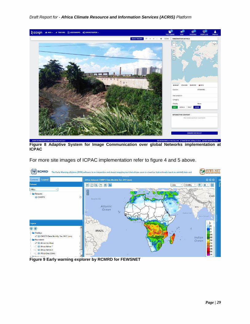
Draft Report for - Africa Climate Resource and Information Services (ACRIS) Platform
Page | 29
Figure 8 Adaptive System for Image Communication over global Networks implementation at ICPAC
For more site images of ICPAC implementation refer to figure 4 and 5 above.
Figure 9 Early warning explorer by RCMRD for FEWSNET
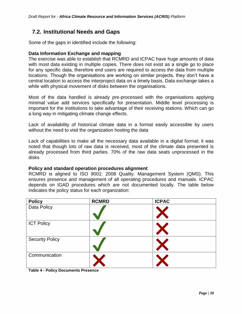
Draft Report for - Africa Climate Resource and Information Services (ACRIS) Platform
Page | 30
7.2. Institutional Needs and Gaps
Some of the gaps in identified include the following: Data Information Exchange and mapping The exercise was able to establish that RCMRD and ICPAC have huge amounts of data with most data existing in multiple copies. There does not exist as a single go to place for any specific data, therefore end users are required to access the data from multiple locations. Though the organisations are working on similar projects, they don’t have a central location to access the interproject data on a timely basis. Data exchange takes a while with physical movement of disks between the organisations. Most of the data handled is already pre-processed with the organisations applying minimal value add services specifically for presentation. Middle level processing is important for the institutions to take advantage of their receiving stations. Which can go a long way in mitigating climate change effects. Lack of availability of historical climate data in a format easily accessible by users without the need to visit the organization hosting the data Lack of capabilities to make all the necessary data available in a digital format; it was noted that though lots of raw data is received, most of the climate data presented is already processed from third parties. 70% of the raw data seats unprocessed in the disks Policy and standard operation procedures alignment RCMRD is aligned to ISO 9001: 2008 Quality. Management System (QMS). This ensures presence and management of all operating procedures and manuals. ICPAC depends on IGAD procedures which are not documented locally. The table below indicates the policy status for each organization:
Policy RCMRD ICPAC
Data Policy
ICT Policy
Security Policy
Communication
Table 4 - Policy Documents Presence
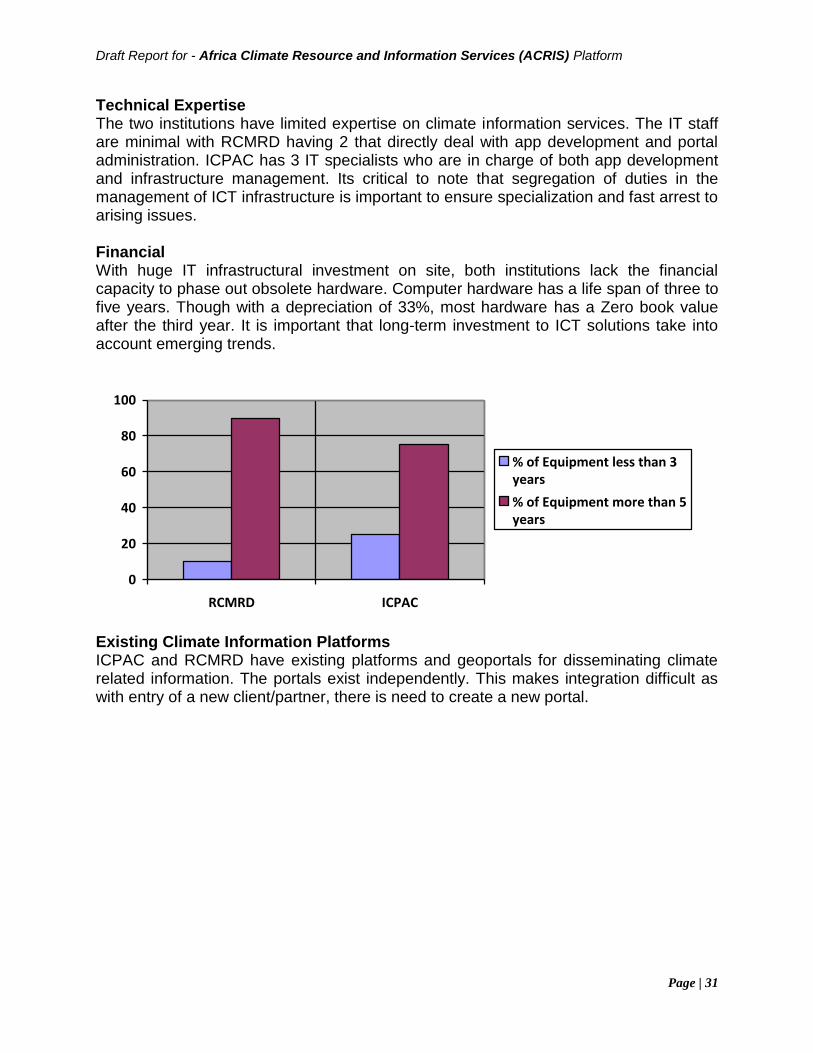
Draft Report for - Africa Climate Resource and Information Services (ACRIS) Platform
Page | 31
Technical Expertise The two institutions have limited expertise on climate information services. The IT staff are minimal with RCMRD having 2 that directly deal with app development and portal administration. ICPAC has 3 IT specialists who are in charge of both app development and infrastructure management. Its critical to note that segregation of duties in the management of ICT infrastructure is important to ensure specialization and fast arrest to arising issues. Financial With huge IT infrastructural investment on site, both institutions lack the financial capacity to phase out obsolete hardware. Computer hardware has a life span of three to five years. Though with a depreciation of 33%, most hardware has a Zero book value after the third year. It is important that long-term investment to ICT solutions take into account emerging trends.
0
20
40
60
80
100
RCMRD ICPAC
% of Equipment less than 3years
% of Equipment more than 5years
Existing Climate Information Platforms ICPAC and RCMRD have existing platforms and geoportals for disseminating climate related information. The portals exist independently. This makes integration difficult as with entry of a new client/partner, there is need to create a new portal.
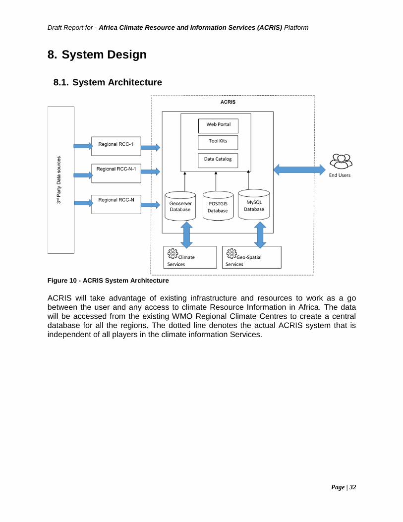
Draft Report for - Africa Climate Resource and Information Services (ACRIS) Platform
Page | 32
8. System Design
8.1. System Architecture
Figure 10 - ACRIS System Architecture
ACRIS will take advantage of existing infrastructure and resources to work as a go between the user and any access to climate Resource Information in Africa. The data will be accessed from the existing WMO Regional Climate Centres to create a central database for all the regions. The dotted line denotes the actual ACRIS system that is independent of all players in the climate information Services.
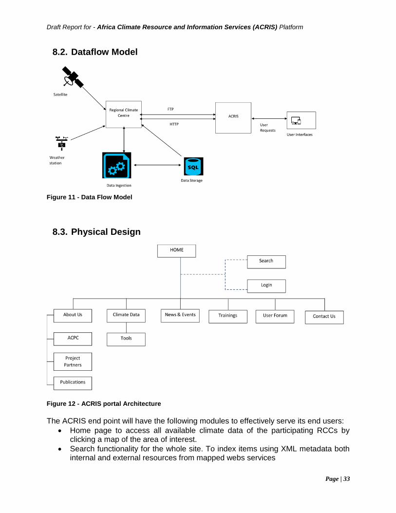
Draft Report for - Africa Climate Resource and Information Services (ACRIS) Platform
Page | 33
8.2. Dataflow Model
Figure 11 - Data Flow Model
8.3. Physical Design
Figure 12 - ACRIS portal Architecture
The ACRIS end point will have the following modules to effectively serve its end users:
• Home page to access all available climate data of the participating RCCs by clicking a map of the area of interest.
• Search functionality for the whole site. To index items using XML metadata both internal and external resources from mapped webs services
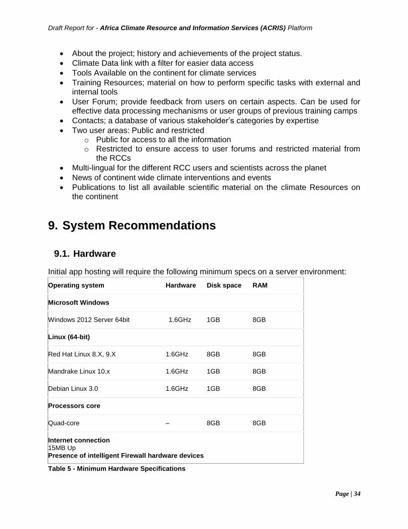
Draft Report for - Africa Climate Resource and Information Services (ACRIS) Platform
Page | 34
• About the project; history and achievements of the project status.
• Climate Data link with a filter for easier data access
• Tools Available on the continent for climate services
• Training Resources; material on how to perform specific tasks with external and internal tools
• User Forum; provide feedback from users on certain aspects. Can be used for effective data processing mechanisms or user groups of previous training camps
• Contacts; a database of various stakeholder’s categories by expertise
• Two user areas: Public and restricted o Public for access to all the information o Restricted to ensure access to user forums and restricted material from
the RCCs
• Multi-lingual for the different RCC users and scientists across the planet
• News of continent wide climate interventions and events
• Publications to list all available scientific material on the climate Resources on the continent
9. System Recommendations
9.1. Hardware
Initial app hosting will require the following minimum specs on a server environment:
Operating system Hardware Disk space RAM
Microsoft Windows
Windows 2012 Server 64bit 1.6GHz 1GB 8GB
Linux (64-bit)
Red Hat Linux 8.X, 9.X 1.6GHz 8GB 8GB
Mandrake Linux 10.x 1.6GHz 1GB 8GB
Debian Linux 3.0 1.6GHz 1GB 8GB
Processors core
Quad-core – 8GB 8GB
Internet connection 15MB Up Presence of intelligent Firewall hardware devices
Table 5 - Minimum Hardware Specifications
Draft Report for - Africa Climate Resource and Information Services (ACRIS) Platform
Page | 35
9.2. Software
ACRIS will take advantage of open source software and systems for full implementations:
• Operating System on Linux
• portal on WordPress
• PostGIS Database: PostGIS is a spatial database extender for PostgreSQL object-relational database. It adds support for geographic objects allowing location queries to be run in SQL.
• MySQL: the most popular Open Source SQL database management system, is developed, distributed, and supported by Oracle Corporation. Will be used to power the online services of ACRIS due to its light weight nature and ability to handle millions of user transactions easily without extra requirement of resources.
• Geoserver: for spatial data publishing. GeoServer is free software. This significantly lowers the financial resources required. It is also open source. Bug fixes and feature improvements are greatly accelerated when compared to traditional software solutions.
• Third party tools already developed by WMO and other organisations
9.3. Data
Virtual portal with access to data from various providers. The data will be accessed via HTTP, FTP and RSS feeds or APIs if present. To facilitate huge data sharing between the institutions, a VPN (peer to peer end point) should be implemented between the institutions to have easier sharing of data.
9.4. Human Resources
Training for existing ICT staff of the RCCs to ensure the virtual links between ACRIS and their portals are always up and running. The ICT staff will be the first users on the forum to have a collaborative space with monitoring services to determine which RCCs service is not accessible from ACRIS.
9.5. Suppliers
The primary objective of this supplier landscape assessment was to help the client gain actionable insights into the current ICT setup and architecture available for different types of climate information services providers. This involved an assessment of the average cost setting up the ACRIS portal as well as its maintenance. The visited supplier is categorized as per the table below:
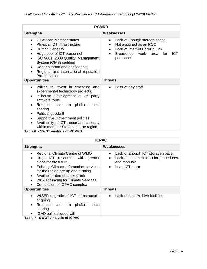
Draft Report for - Africa Climate Resource and Information Services (ACRIS) Platform
Page | 36
RCMRD
Strengths Weaknesses
• 20 African Member states
• Physical ICT infrastructure
• Human Capacity
• Huge pool of ICT personnel
• ISO 9001: 2008 Quality. Management System (QMS) certified
• Donor support and confidence:
• Regional and international reputation Partnerships
• Lack of Enough storage space.
• Not assigned as an RCC
• Lack of Internet Backup Link
• Broadened work area for ICT personnel
Opportunities Threats
• Willing to invest in emerging and experimental technology projects.
• In-house Development of 3rd party software tools
• Reduced cost on platform cost sharing
• Political goodwill
• Supportive Government policies:
• Availability of ICT labour and capacity within member States and the region
• Loss of Key staff
Table 6 - SWOT analysis of RCMRD
ICPAC
Strengths Weaknesses
• Regional Climate Centre of WMO
• Huge ICT resources with greater plans for the future
• Existing Climate information services for the region are up and running
• Available Internet backup link
• WISER funding for Climate Services
• Completion of ICPAC complex
• Lack of Enough ICT storage space.
• Lack of documentation for procedures and manuals
• Lean ICT team
Opportunities Threats
• WISER upgrade of ICT infrastructure ongoing
• Reduced cost on platform cost sharing
• IGAD political good will
• Lack of data Archive facilities
Table 7 - SWOT Analysis of ICPAC
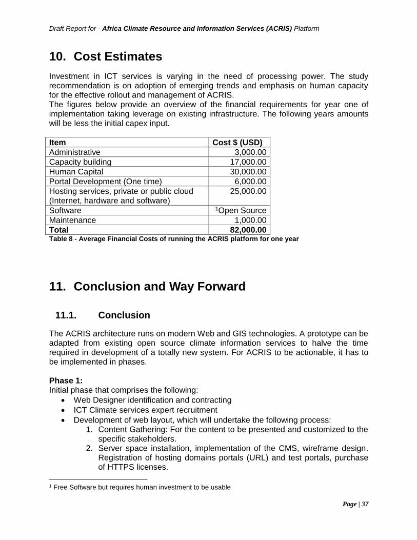
Draft Report for - Africa Climate Resource and Information Services (ACRIS) Platform
Page | 37
10. Cost Estimates
Investment in ICT services is varying in the need of processing power. The study recommendation is on adoption of emerging trends and emphasis on human capacity for the effective rollout and management of ACRIS. The figures below provide an overview of the financial requirements for year one of implementation taking leverage on existing infrastructure. The following years amounts will be less the initial capex input.
Item Cost $ (USD)
Administrative 3,000.00
Capacity building 17,000.00
Human Capital 30,000.00
Portal Development (One time) 6,000.00
Hosting services, private or public cloud (Internet, hardware and software)
25,000.00
Software 1Open Source
Maintenance 1,000.00
Total 82,000.00 Table 8 - Average Financial Costs of running the ACRIS platform for one year
11. Conclusion and Way Forward
11.1. Conclusion
The ACRIS architecture runs on modern Web and GIS technologies. A prototype can be adapted from existing open source climate information services to halve the time required in development of a totally new system. For ACRIS to be actionable, it has to be implemented in phases. Phase 1: Initial phase that comprises the following:
• Web Designer identification and contracting
• ICT Climate services expert recruitment
• Development of web layout, which will undertake the following process: 1. Content Gathering: For the content to be presented and customized to the
specific stakeholders. 2. Server space installation, implementation of the CMS, wireframe design.
Registration of hosting domains portals (URL) and test portals, purchase of HTTPS licenses.
1 Free Software but requires human investment to be usable
Draft Report for - Africa Climate Resource and Information Services (ACRIS) Platform
Page | 38
3. Design of the actual portal User Interface. The look and feel has to be reviewed with input from the System owners and contractors.
4. Content assignment to the specific portal sections. 5. Backend Coding and development of the portal. The portal will be
deployed in stages to ensure all stakeholders give input on the translation of the design to actual implementation. All special features will be implemented at this stage (search, map, SEO ready)
6. Testing and launch of final portal. This will also involve migration from test portal to live portal.
7. Maintenance and regular content update Phase 2: This phase will involve moving ACRIS to a notch higher, to be able to have user requests collected in the forum implemented. The requests can range from;
• specific permutations on data which can be through development of ACRIS data Ingestion engine
• Climate software tools customization or development (of already existing tools) and adaptation to specific Areas of Interest
• End user training Phase 3: Being the final phase, this phase will involve morphing of ACRIS into a complete suite of applications that can be run on the go. This will enable data interoperability between participating RCCs. The application can be used to ingest direct satellite data as well as weather station data to create prediction models. This will us look into the future with a historical background on the impacts of climate change.
11.2. Way Forward
The general findings from the assessment reflect that though there are some systems in place, they are not future proof. There is need to invest in data, hardware, software, and human resources within the climate Information Centres, to enable Africa as a continent to enjoy the benefits of climate interventions. With internet penetration at 35% (www.internetworldstats.com, 2017) internet penetration in Africa, up from 15.3% in 2011 it is critical that Climate Information Services take advantage of the growing numbers of internet users and use it as an effective dissemination tool for providing stakeholders with required information.
Draft Report for - Africa Climate Resource and Information Services (ACRIS) Platform
Page | 39
Investment in ICT infrastructure to be continuous The general finding is that ICT is not considered an ongoing investment. Once equipment has been purchased, it will be used for ages without budget allocation for upgrade and continuous maintenance. It is prudent to keep in touch with the current technological trends. For instance, with the advance of Internet of Things (IOT) and Cloud Services, its empirical that the systems are migrated to cloud secure locations to ensure minimal downtime. This also enables the local ICT staff to concentrate on application improvement and minimize support time. Effective continuous collaboration on data A major observation was the fact that there exists MOUs between different institutions but lack the necessary technological tools to ensure interoperability of data. The MOUs should be effected not only on expertise exchange but also on technological solutions. This can enable operationalization of a single point of Climate Information for particular regions and ensure academic and research institutions share breakthroughs achieved. Capacity building is critical in the advance of Climate information systems Climate related mitigations take a long time to be felt on the ground. During this period there are new technological inventions that should be adapted to hasten the mitigations. Its therefore critical to keep the personnel team in touch with such inventions through training. Training should be applicable to both experienced and novice users and should be ongoing. In conclusion, this report provides a simplified roll out for implementing a Climate Resources Information Service taking advantage of existing infrastructure and technologies.
Draft Report for - Africa Climate Resource and Information Services (ACRIS) Platform
Page | 40
12. References
ACPC:https://www.uneca.org/acpc/pages/climate-information-services-supporting-africa%E2%80%99s-development, March 2018 African Climate Policy Centre, Programme Strategy, Knowledge generation and delivery for climate resilient development policies in Africa, 2017-2021 Afri-Res: https://www.uneca.org/afri-res/pages/background, March 2018 Clim-Dev: Revised ClimDev‐Africa Framework Programme Document,2012
Climate Data Management System Specifications, WMO-No. 1131, WMO, 2014. Climate knowledge for action: a global framework for climate services–empowering the most vulnerable, wmo-no. 1065un, 2011 ICTSD: Realizing the Potential of the UNFCCC Technology Mechanism, ICTSD, May 2012 http://www.wmo.int/cst/, March 2018 Kadi M, Njau LN, Mwikya J, Kamga A. 2011. The State of Climate Information Services for Agriculture and Food Security in East African Countries. CCAFS Working Paper No. 5. Copenhagen, Denmark. Available online at: www.ccafs.cgiar.org Mapping of Institutions, Experts and Initiatives Engaged in Climate Research and Related Activities in Africa 2017 The utility of weather and climate information for adaptation decision-making: current uses and future prospects in Africa and India, May 2017, Chandni Singh, et.al Spatially enabling the Global Framework for Climate Services: Reviewing geospatial solutions to efficiently share and integrate climate data & information, Gregory Giuliani, et al Climate Data Management System Specifications, WMO-No. 1131, World Meteorological Organization, 2014
Draft Report for - Africa Climate Resource and Information Services (ACRIS) Platform
Page | 41
13. Annexes
13.1. Terms of Reference
Duties and Responsibilities The approach is not to create a new ICT system but to establish a partnership and build on the system and services of an existing resource platform and service provider. Specifically, the senior consultant will"
(i) conduct a demand mapping survey to establish user needs and
preferences for the proposed platform
(ii) conduct a supply mapping to establish the supply landscape, needs and
gaps
(iii) conduct to survey to establish potential and interested partners for the
platform
(iv) provide the ICT and service specifications for the proposed platform
partnership and service provision
(v) evaluate the ICT infrastructure, quality, standards and services of existing
climate and resource ICT based institutions related to the UN Economic
Commission for Africa - such as the African Centre of Meteorological
Application for Development (ACMAD) and the Regional Centre for
Mapping of Resources for Development (RCMRD)? to establish needs
and gaps
(vi) for each potential provider, elaborate system and software specifications
needed to meet identified needs and gaps
(vii) provide for each potential service provider and based on the specifications
identified, cost estimates for full implementation of the platform,
partnership and information service based on the identified demand and
supply canvas as well as the identified systems needs and gaps
(viii) rank and recommend at least three qualifying potential service providers
(ix) provide procurement recommendations and guidelines for full
implementation of the proposed platform and information service
Ultimate result of service
The overall objective of this consultancy is to support the African Climate Policy Center (ACPC) of the UN Economic Commission for Africa (ECA) with the establishment of the Africa Climate Resource and Information Service Platform to serve as an open architecture one-stop go-to place for quality and timely climate data, climate information services, open-source climate-related modelling tools and an online advisory services, learning and capacity development resources and help desk for stakeholders, as well as an online convening and community forum for regional climate researchers and development planning user groups.
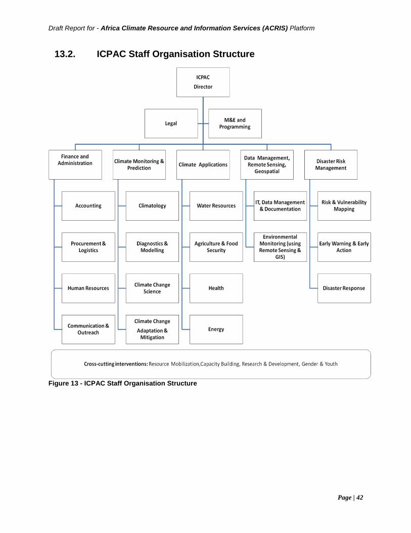
Draft Report for - Africa Climate Resource and Information Services (ACRIS) Platform
Page | 42
13.2. ICPAC Staff Organisation Structure
Figure 13 - ICPAC Staff Organisation Structure
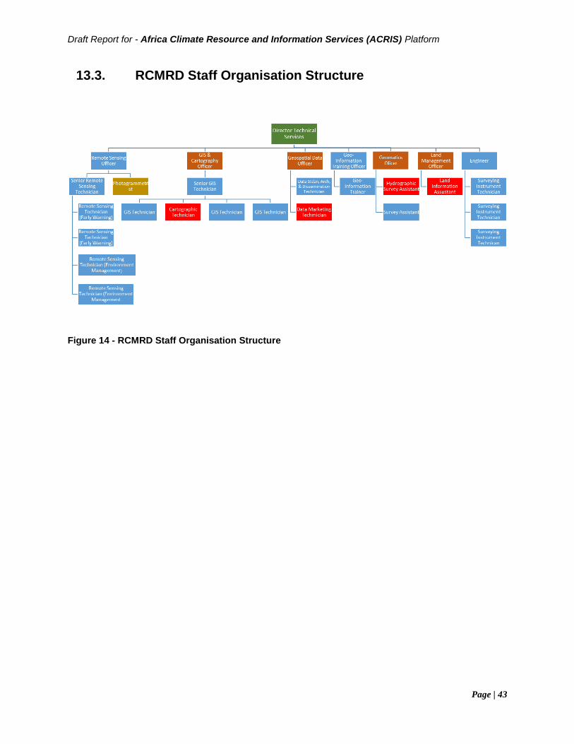
Draft Report for - Africa Climate Resource and Information Services (ACRIS) Platform
Page | 43
13.3. RCMRD Staff Organisation Structure
Figure 14 - RCMRD Staff Organisation Structure
Draft Report for - Africa Climate Resource and Information Services (ACRIS) Platform
Page | 44
13.4. Key Institutions Questionnaire
DATA
1. What are the key climate data sets? 2. What is the source of climate data? 3. What is the format of the data? 4. How is the data accessed? 5. How is the data stored? 6. Where does data processing take place? Locally or on cloud? 7. Are there any climate data modelling tools? If so which ones? 8. What is the current storage capacity of the digital data? 9. What is the anticipated annual growth rate in data storage requirements? 10. What backup processes are in place? 11. Where are the backup copies stored? 12. In case of a disaster, what data recovery (or business continuance) measures
and processes are in place to protect the data? 13. Does the institution maintain metadata records? 14. What quality assurance mechanisms are in place to ensure data integrity? 15. What mechanisms are in place to ensure data currency/continuity? 16. Does the institution share its data/products and to whom? 17. What are the key challenges faced in regards to data management?
Infrastructure
1. What ICT infrastructure is in place? Are there plans to be acquire additional/new ICT infrastructure in the next 1-5years?
2. What are key specifications of the ICT infrastructure listed above? 3. What security measures are in place to safeguard the ICT infrastructure? 4. What is the capacity of the internet bandwidth? 5. What are the failover measures in place? 6. What modes of application deliver are currently available (cloud services, stand
alone, distributed systems)? 7. What safety measures are in place to guard the ict infrastructure (e.g against fire,
flood etc.) Software
1. What software are currently used to process data? Operating system? Security? etc
2. What tools/platforms are available for data access, processing (including modelling), visualization and disseminations?
3. Is the software open source, freeware, proprietary, etc? 4. Are there end user software systems developed by the organization? If yes list. 5. Is there a software maintenance and upgrade plan?
Draft Report for - Africa Climate Resource and Information Services (ACRIS) Platform
Page | 45
6. How frequently are products processed (daily, weekly, biweekly, monthly, decadal, etc)?
Legal 1. What products and services are offered by the institution related to weather
&climate and/or geospatial services? 2. What legal instruments are available on data and/or ICT? (e.g policy) 3. What institutional arrangements are in place on data and ICT? (e.g. MOUs) 4. Is there a data sharing policy and mechanism? 5. Does an ICT and data Policy exist? 6. Are SOPS (standard operating procedures)/manuals available? Are the
SOPs/manuals operational 7. Who are the key Stakeholders? (partners, end users, etc) 8. How is the organization structured for efficient delivery of products and services?
Specify key related staff, specify staff strengths and needs. 9. What is the source of funding for the weather & climate services and/or
geospatial services? (own funding, donor funding, etc) 10. What are the key strategic plans of the institution in regard to weather & climate
and or geospatial services? (short, medium, long term).
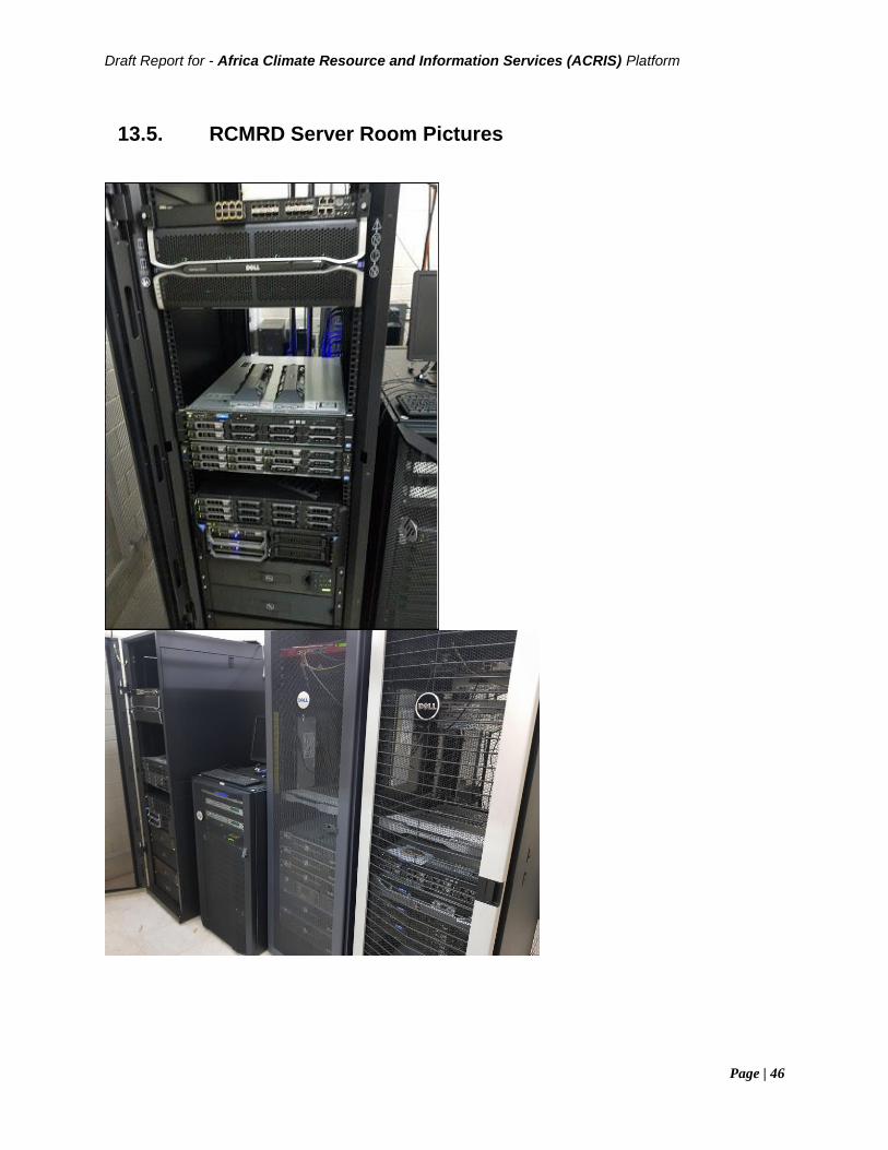
Draft Report for - Africa Climate Resource and Information Services (ACRIS) Platform
Page | 46
13.5. RCMRD Server Room Pictures
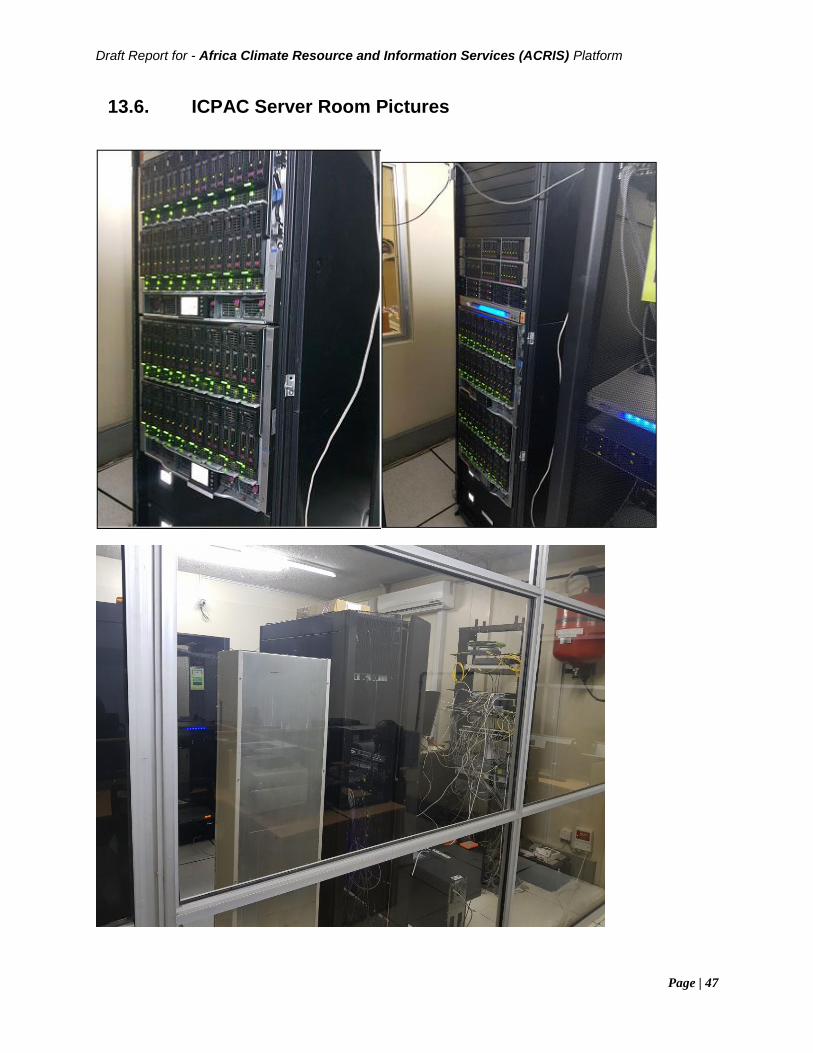
Draft Report for - Africa Climate Resource and Information Services (ACRIS) Platform
Page | 47
13.6. ICPAC Server Room Pictures
Supported By: