aeolian sequence and the archaeological record in the fuegian steppe, argentina
TRANSCRIPT
lable at ScienceDirect
Quaternary International 245 (2011) 122e135
Contents lists avai
Quaternary International
journal homepage: www.elsevier .com/locate/quaint
Aeolian sequence and the archaeological record in the fuegian steppe, Argentina
Andrea Coronato a,b,*, Patricia Fanning c, Mónica Salemme a,b, Jimena Oría a, John Pickard c,Juan Federico Ponce a
aCONICET-CADIC, B. Houssay 200, 9410 Ushuaia, Tierra del Fuego, ArgentinabUniversidad Nacional de la Patagonia San Juan Bosco, Sede Ushuaia, Darwin y Canga, 9410 Ushuaia, ArgentinacDepartment of Environment and Geography, Macquarie University, New South Wales 2109, Australia
a r t i c l e i n f o
Article history:Available online 23 March 2011
* Corresponding author. CONICET-CADIC, B. Houssdel Fuego, Argentina. Fax: þ54 2901 430644.
E-mail addresses: [email protected] (Amq.edu.au (P. Fanning), [email protected] (J. Oría), [email protected] (J. Pigob.ar (J.F. Ponce).
1040-6182/$ e see front matter � 2011 Elsevier Ltd adoi:10.1016/j.quaint.2011.02.042
a b s t r a c t
A 20 m thick sequence of aeolian deposits and palaeosols, deposited above Neogene marine sedimentsadjacent to the shallow saline ephemeral Lake Arturo in interior Tierra del Fuego, is described. A depositof archaeological stone artifacts and bones, the Lake Arturo 1 archaeological site, is located in a deflationhollow near the top of the aeolian sequence. The sequence of nine aeolian deposits, including eightpalaeosols and capped by the contemporary soil, provides evidence of environmental changeswhich have occurred during the Holocene in the cold Fuegian steppe, beginning as early as the LateGlacialeEarly Holocene transition. A chronostratigraphy is provided by guanaco (Lama guanicoe) andCanidae bones embedded within palaeosols and organic matter content, radiocarbon dated from9951� 59 BP (11,304 cal. BP) at the base of the sequence to 434� 43 BP (471 cal. BP) near the top.A tephra layer between Palaeosols 4 and 5 is interpreted from its geochemical fingerprint as the productof one of the mid-Holocene eruptions of Mt. Burney, located in the Southern Patagonian Andes. It issuggested that the accumulation of the aeolian sediments occurred throughout most of the Holocene, asa result of both local acquisition of fine particles derived from the weathering and erosion of the basalNeogene marine sediments, and deflation from the intermittently dry lake bed, as well as deposition ofmaterial transported by wind from more distant sources. The orientation of the aeolian deposits suggestsa more northwesterly wind direction instead of the present westerlies. Weakly developed A horizonscapping each of the sediment units suggest that the landscape was sensitive to environmental change,from more arid conditions when the aeolian deposits accumulated to brief periods of landscape stabilitywhen topsoil development occurred. Evidence of human occupation in Lake Arturo 1 is confined to theupper part of the sequence (ca. 500 years BP) and is interpreted as a place for primary butchering andraw material acquisition.
� 2011 Elsevier Ltd and INQUA. All rights reserved.
1. Introduction
Patagonia, including Tierra del Fuego, was the last sector of theSouth American continent to be explored and colonized by peoplefollowing the Last Glacial Maximum (Borrero, 2004; Miotti, 2006),with many social and environmental changes taking place sincethen. The Fuegian Archipelago was the southernmost tip of SouthAmerica until the Pleistocene glacial valley occupied by the“Magellan Glacier” (McCulloch et al., 2005) was flooded by marinewater, forming the Magellan Strait around 8 ka 14C BP.
ay 200, 9410 Ushuaia, Tierra
. Coronato), patricia.fanning@ar (M. Salemme), jimenaoria@ckard), jfponce@cadic-conicet.
nd INQUA. All rights reserved.
This geographic isolation is not a minor issue because it affectednot only the human populations but also the regional ecosystems(Borrero, 1989e1990; Salemme and Miotti, 2008). The earliest-known archaeological site in northern Tierra del Fuego, dating fromthe time of the PleistoceneeHolocene transition, is Tres Arroyos 1(ca. 10.6e10.0 ka 14C BP); an earliest radiocarbon date of 11.88 ka14C BP previously published (Massone et al., 1998) is now consid-ered doubtful (Massone, 2004). Although not the focus of thispaper, the subsequent marine transgression that formed thepresent Strait of Magellan would have had a large impact upon theIndian populations of Southern South America (McCulloch andMorello, 2009), influencing the distribution and movements ofpeople (Borrero, 1994e1995).
Surface artifact visibility in interior Tierra del Fuego is low due toalmost continuous grass and shrub cover. However, aeolian defla-tion hollows in various locations provide a window to the past by
A. Coronato et al. / Quaternary International 245 (2011) 122e135 123
exposing archaeological materials that can be investigated usingtechniques developed in semiarid environments elsewhere (e.g.Fanning and Holdaway, 2008). In addition, multiple buried palae-osols within dune sequences adjacent to the numerous lake basinsattest to past periods of climatic amelioration which may haveencouraged people to settle in the interior. These deposits con-taining faunal and lithic remains of human origin provide a uniqueopportunity to test the prevailing hypothesis of a predominantcoastal occupation pattern during the Holocene (Borrero, 1985;Muñoz, 2002).
The aims of this paper are threefold:
(a) to provide a preliminary description and palaeoenvironmentalinterpretation of aeolian deposits and buried soils in a coldsemiarid environment in interior Tierra del Fuego;
(b) to describe an example of the archaeological record exposed bydeflation, and
(c) to explore the potential for this environment as a suitablelocation for intermittent hunteregatherer occupation in thepast.
2. Setting
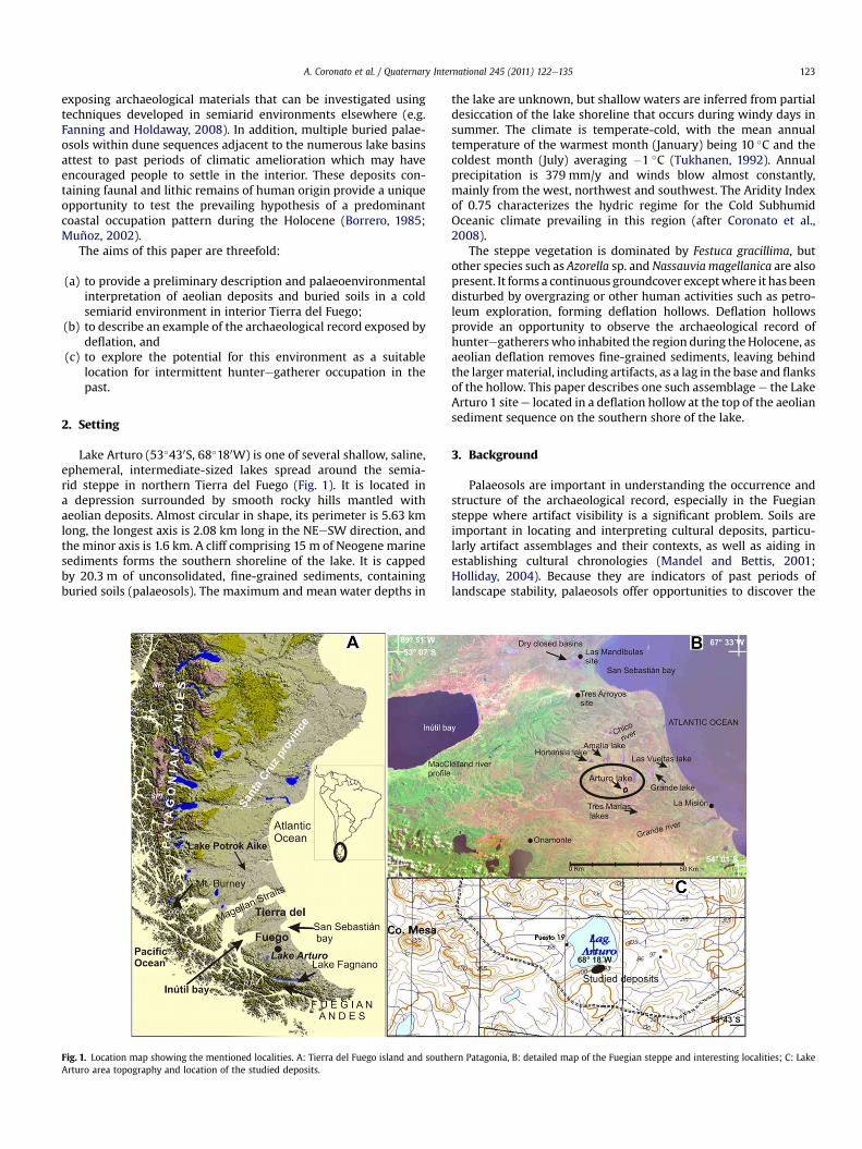
Lake Arturo (53�430S, 68�180W) is one of several shallow, saline,ephemeral, intermediate-sized lakes spread around the semia-rid steppe in northern Tierra del Fuego (Fig. 1). It is located ina depression surrounded by smooth rocky hills mantled withaeolian deposits. Almost circular in shape, its perimeter is 5.63 kmlong, the longest axis is 2.08 km long in the NEeSW direction, andthe minor axis is 1.6 km. A cliff comprising 15 m of Neogene marinesediments forms the southern shoreline of the lake. It is cappedby 20.3 m of unconsolidated, fine-grained sediments, containingburied soils (palaeosols). The maximum and mean water depths in
Fig. 1. Location map showing the mentioned localities. A: Tierra del Fuego island and southArturo area topography and location of the studied deposits.
the lake are unknown, but shallow waters are inferred from partialdesiccation of the lake shoreline that occurs during windy days insummer. The climate is temperate-cold, with the mean annualtemperature of the warmest month (January) being 10 �C and thecoldest month (July) averaging �1 �C (Tukhanen, 1992). Annualprecipitation is 379 mm/y and winds blow almost constantly,mainly from the west, northwest and southwest. The Aridity Indexof 0.75 characterizes the hydric regime for the Cold SubhumidOceanic climate prevailing in this region (after Coronato et al.,2008).
The steppe vegetation is dominated by Festuca gracillima, butother species such as Azorella sp. and Nassauvia magellanica are alsopresent. It forms a continuous groundcover exceptwhere it has beendisturbed by overgrazing or other human activities such as petro-leum exploration, forming deflation hollows. Deflation hollowsprovide an opportunity to observe the archaeological record ofhunteregathererswho inhabited the region during theHolocene, asaeolian deflation removes fine-grained sediments, leaving behindthe largermaterial, including artifacts, as a lag in the base and flanksof the hollow. This paper describes one such assemblage e the LakeArturo 1 sitee located in a deflation hollow at the top of the aeoliansediment sequence on the southern shore of the lake.
3. Background
Palaeosols are important in understanding the occurrence andstructure of the archaeological record, especially in the Fuegiansteppe where artifact visibility is a significant problem. Soils areimportant in locating and interpreting cultural deposits, particu-larly artifact assemblages and their contexts, as well as aiding inestablishing cultural chronologies (Mandel and Bettis, 2001;Holliday, 2004). Because they are indicators of past periods oflandscape stability, palaeosols offer opportunities to discover the
ern Patagonia, B: detailed map of the Fuegian steppe and interesting localities; C: Lake
A. Coronato et al. / Quaternary International 245 (2011) 122e135124
record of past human activities preserved within them. Therefore,the eight buried soil horizons of the Lake Arturo sediment sequenceprovide the possibility of finding buried cultural remains. In addi-tion, soil horizons contain palaeoenvironmental information that isessential for better understanding the conditions that prevailed inthe past. They may also provide insights into past environmentalchanges and the concomitant change in the availability of resourcesthat could have influenced human subsistence and settlementstrategies (Mandel and Bettis, 2001).
While this paper is the first to describe this particular aeoliansequence (see also Coronato et al., 2009a,b), other aeolian land-scapes have been recorded elsewhere in Tierra del Fuego. Raedeke(1978) mentioned five palaeosols exposed within aeolian depositsin the MacClelland River close to Inutil Bay on the west coast(Fig. 1). However, the aeolian sequence is only 3 m thick, andbecomes thinner inland. The source of the sediments in thissequence is likely therefore to be located close to the marine coast.Arce and Vilas (1986e1987) described the effect of deflation overdry shallow lakes eroded in Holocene marsh plains located in thenortheast of Tierra del Fuego, near San Sebastián Bay on the AtlanticOcean (Fig. 1). A palaeosol buried by surficial aeolian deposits wasdated at ca. 1000 BP (Favier Dubois, 2001), while a guanaco bonerecovered from an underlying unit was dated at 610� 45 14C BP(Cordero Otero et al., 1999), indicating a stratigraphic inconsistency(Barberena, 2008).
Endorheic basins, some containing ephemeral lakes but othersdry, have been described from elsewhere in Patagonia. Auer (1958),for example, interpreted the origin of most of the extra-AndeanPatagonian closed basins as ancient glacial basins, later eroded bymeltwater streams, although he noted that small lakes have alsobeen formed through fluvial and aeolian erosion of fine materialsfrom dry channel beds. Clapperton (1993) noted the palae-oenvironmental importance of closed basins, relating their genesisto dry and cold climates during glacial times. Deflation is describedas one of the most important causes of the dry or ephemeral lakegenesis in southern Patagonia and Tierra del Fuego (Feruglio, 1949;Fidalgo, 1972; Raedeke, 1978; Arce and Vilas, 1986e1987; Bujaleskyet al., 2001; Mazzoni, 2001). Partial or total desiccation depends onthe amount of winter precipitation and is controlled by evapo-transpiration during persistent winds in summer (Iturraspe andUrciuolo, 2002).
Palaeoenvironmental studies based on pollen, ostracodes anddiatoms have been conducted by Auer (1958) and Markgraf (1983)at “LaMision”mire, located 30 km northeast of Lake Arturo, close tothe Atlantic Ocean (Fig. 1). They postulate the existence of a treelesssteppe following the most recent deglaciation, replaced by openNothofagus sp. woodland at about 8 ka BP and continuing up to thelast millenium, when it was abruptly replaced by the presentsteppe. In contrast, later pollen studies at the Onamonte site,located at the current forest-steppe transition zone (Fig. 1), showthat the open forest declined in favour of the gramineous steppebetween the Late Glacial and the Middle Holocene, ca. 11,620e513014C BP, with later expansion of the forest during the last millenniumand episodically during the last two hundred radiocarbon years(Heusser, 1993). This pattern of past vegetation change could beinterpreted as a response to the prevalence of dry climatic condi-tions during the Early Holocene which became milder around 5 kaBP and turned to more humid conditions after 1.16 ka BP (Heusser,1993). Wetedry climatic cycles have also been suggested from thelate Glacial to the early Holocene from limnological and palae-oenvironmental studies of coreesediments from the permanentLake Potrok Aike in the southern Patagonian steppe (Fig. 1;Haberzettl et al., 2005, 2006, 2007).
Based on studies of palaeosol development in northern Tierradel Fuego and Santa Cruz province (Fig. 1), Favier Dubois (2003)
interpreted the widespread development of Mollisols as a conse-quence of a regional increase in humidity during the so-calledMedieval Warm Period, followed by drier conditions during whichthese soils were buried as a result of aeolian erosion and deposition.An alternative explanation is that the introduction of sheep grazingat the beginning of the nineteenth century resulted in vegetationdisturbance, leading to aeolian deflation and downwind deposition(Fanning et al., 2008).
Numerous cases of human occupation along the shorelines ofephemeral lakes in northern Tierra del Fuego are known from theliterature. Massone et al. (1993) refer to this type of location in theirsurvey of the lake system of Dos Marías and Florentina Ranches, inthe Inútil e San Sebastián glacial valley, near the ChileeArgentinaborder (Fig. 1). Longitudinal and transverse dunes were recognizedin the area, as well as dry lake basins and the terrace-like surfacesbetween them. Twenty-seven occupation sites were identified,with five of them being classified as housing camps of long occu-pation duration, twentyeone as occasional camps for hunting andbutchering, and one site characterized as a quarry-workshop camp.
Favier Dubois (2001) analyzed the Las Mandibulas site, in thenorthwestern part of San Sebastian bay (Fig. 1). It is located inaeolianelacustrine plains, where abundant lithic materials andbones (mainly guanaco) of cultural and taphonomic origin wererecorded along the lagoon margins. Three radiocarbon dates wereobtained from bones coming from in situ exposures in clay dunesassociated with the lakes, ranging between ca. 1380 and 760 14C BP.Cutmarks thought to indicate human activity were found on one ofthe bones (Favier Dubois, 2001). Taphonomic assemblages in thedunes are frequent, and the record of archaeological and bio-anthropological remains provides good resolution and integritybecause of the high sedimentation rates. However, rills and gulliesformed on the dune slopes aid the transport of archaeological andnon-archaeological remains towards the lake, with mixing andredeposition of assemblages (Favier Dubois, 2001).
South of San Sebastian Bay, an archaeological record related tolakes and lagoons has been reported by Santiago (2009), includingdeposits recorded at Lake Amalia, Lake Grande, Las Vueltas and anunnamed lake (Fig. 1). These environments in the Fuegian steppeare considered to have good visibility because in all of them at leasta sector of their shorelines is free of vegetation, or there are areasdeflated by wind that work as “open windows” for the archaeo-logical record (Santiago and Oría, 2007; Santiago, 2009). Morerecently, Oría (2009) and Oría et al. (in press) have recordedarchaeological deposits at the Tres Marias group of lakes, to thesoutheast of Lake Arturo (Fig. 1).
4. Materials and methods
A reconnaissance survey of the landforms and sedimentsequence at Lake Arturo was conducted in December 2007.Following examination of the entire length of the cliff-top expo-sure, a location was chosen for detailed stratigraphic descriptionand sediment sampling. Later, in March 2010, sedimentary unitdepths and thicknesses were determined by Total Station survey,and aerial photographs at 1:20,000 scale (1970) and Shuttle RadarTerrain Model (SRTM) data were used for topography and reliefstudies around the lake.
The texture of each unit was described in the field using theNorthcote key (Northcote, 1979), with samples later undergoingparticle size analysis at the Centro de Investigaciones Geológicas,Universidad Nacional de La Plata (Argentina). Other field-baseddescriptions included moist and dry colour (with reference toMunsell (1973) colour charts), structure, inclusions, and visibleorganic matter. The organic content of the identified soil layers wasdetermined in the laboratory using the WalkleyeBlack method.
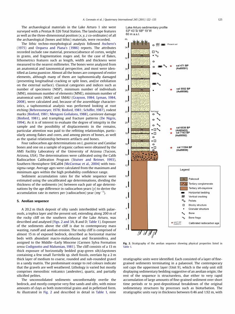
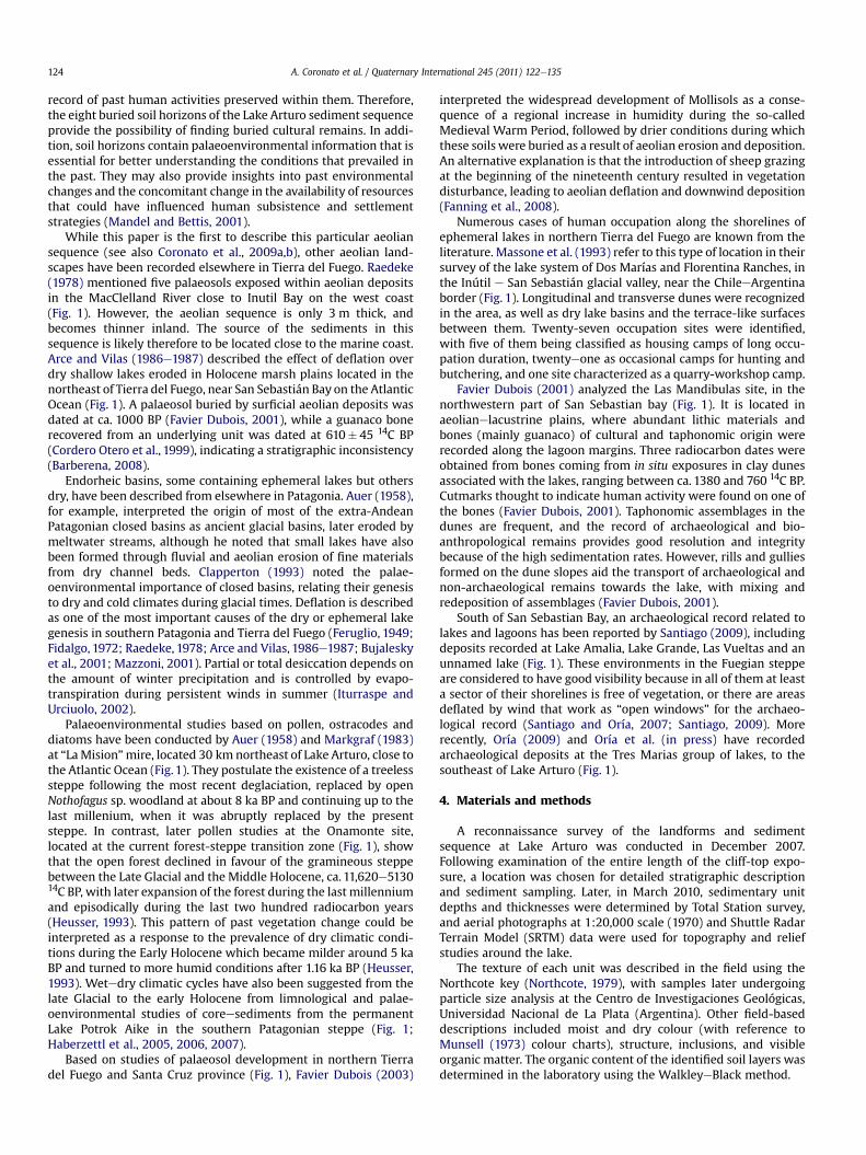
Fig. 2. Stratigraphy of the aeolian sequence showing physical properties listed inTable 1.
A. Coronato et al. / Quaternary International 245 (2011) 122e135 125
The archaeological materials in the Lake Arturo 1 site weresurveyed with a Pentax R-326 Total Station. The landscape featuresas well as the three-dimensional position (x, y, z co-ordinates) of allthe archaeological (bones and lithic) materials, were recorded.
The lithic techno-morphological analysis followed Aschero’s(1975) and Orquera and Piana’s (1986) reports. The attributesrecorded include raw material, presence/absence of cortex, weightin grams, and fragmentation stages and, for the case of flakes,lithometrics features such as length, width and thickness weremeasured to the nearest millimeter. The bones were analyzed froman anatomical and taxonomical perspective, and most were iden-tified as Lama guanicoe. Almost all the bones are composed of entireelements, although many of them are taphonomically damaged(presenting longitudinal cracking or split lines, and/or exfoliationon the external surface). Classical categories and indices such asnumber of specimens (NISP), minimum number of individuals(MNI), minimum number of elements (MNE), minimum number ofanatomical units (MAU) and %MAU (Grayson, 1984; Lyman, 1984,2008), were calculated and, because of the assemblage character-istics, a taphonomical analysis was performed looking at rootetching (Behrensmeyer, 1978; Binford, 1981; Schiffer, 1987), rodentmarks (Binford, 1981; Mengoni Goñalons, 1988), carnivore damage(Binford, 1981), and trampling and fracture patterns (De Nigris,1994). As it is of interest to evaluate the degree of integrity in thesample and the possibility of displacements in the remains,particular attention was paid to the refitting relationships, partic-ularly among flakes and cores, and among pieces of bones, as wellas the spatial relationship between artifacts and bones.
Four radiocarbon age determinations on L. guanicoe and Canidaebones and one on a sample of organic carbon were obtained by theAMS Facility Laboratory of the University of Arizona (Tucson,Arizona, USA). The determinations were calibrated using the CalibRadiocarbon Calibration Program (Stuiver and Reimer, 1993),Southern Hemisphere SHCal04 (McCormac et al., 2004) with two-sigma range. Average ages were calculated from the maximum andminimum ages within the high probability confidence range.
Sediment accumulation rates for the whole sequence wereestimated using the uncalibrated age determinations, dividing thethickness of the sediments (m) between each pair of age determi-nations by the age difference in radiocarbon years (y) to derive theaccumulation rate in meters per (radiocarbon) year (my�1).
5. Aeolian sequence
A 20.2 m thick deposit of silty sands interbedded with palae-osols, a tephra layer and the present soil, extending along 200 m ofthe rocky cliff on the southern shore of the Lake Arturo, wasdescribed and analysed (Figs. 2 and 3A, B and D; Table 1). Exposureof the sediments above the cliff is due to contemporary masswasting, runoff and aeolian erosion. The rocky cliff is comprised ofalmost 15 m of exposed bedrock, described as horizontal marinebeds with abundant macro-malacofauna and foraminifera, andassigned to the MiddleeEarly Miocene (Carmen Sylva Formationsensu Codignotto and Malumian, 1981). The cliff consists of a 13 mthick exposure of horizontally bedded gray-green silt/claystonescontaining a few small Turritella sp. shell fossils, overlain by a 2 mthick layer of medium to coarse, rounded and sub-rounded gravelin a sandy matrix. The predominant orange to red colours indicatethat the gravels are well weathered. Lithology is varied but mostlycomprises mesosilisic volcanics (andesites), quartz, and partiallysilicified pelites.
The unconsolidated sediments unconformably overlie thebedrock, and mostly comprise very fine sands and silts, with minoramounts of clays as both insterstitial grains and in pelletised form.As illustrated in Fig. 2 and described in detail in Table 1, nine
stratigraphic units were identified. Each consisted of a layer of fine-grained sediments terminating in a palaeosol. The contemporarysoil caps the uppermost layer (Unit 9), which is the only unit stilldisplaying sedimentary bedding suggestive of an aeolian origin; therest of the sequence is structureless, due either to very rapidaccumulation of large amounts of fine-grained sediment over shorttime periods or to post-depositional breakdown of the originalsedimentary structures by processes such as bioturbation. Thestratigraphic units vary in thickness between 0.46 and 1.92 m, with
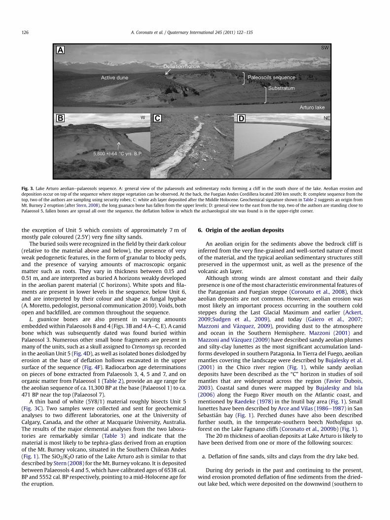
Fig. 3. Lake Arturo aeolianepalaeosols sequence. A: general view of the palaeosols and sedimentary rocks forming a cliff in the south shore of the lake. Aeolian erosion anddeposition occur on top of the sequence where steppe vegetation can be observed. At the back, the Fuegian Andes Cordillera located 200 km south; B: complete sequence from thetop, two of the authors are sampling using security robes; C: white ash layer deposited after the Middle Holocene. Geochemical signature shown in Table 2 suggests an origin fromMt. Burney 2 eruption (after Stern, 2008), the long guanaco bone has fallen from the upper levels; D: general view to the east from the top, two of the authors are standing close toPalaeosol 5, fallen bones are spread all over the sequence, the deflation hollow in which the archaeological site was found is in the upper-right corner.
A. Coronato et al. / Quaternary International 245 (2011) 122e135126
the exception of Unit 5 which consists of approximately 7 m ofmostly pale coloured (2.5Y) very fine silty sands.
The buried soils were recognized in the field by their dark colour(relative to the material above and below), the presence of veryweak pedogenetic features, in the form of granular to blocky peds,and the presence of varying amounts of macroscopic organicmatter such as roots. They vary in thickness between 0.15 and0.51 m, and are interpreted as buried A horizons weakly developedin the aeolian parent material (C horizons). White spots and fila-ments are present in lower levels in the sequence, below Unit 6,and are interpreted by their colour and shape as fungal hyphae(A. Moretto, pedologist, personal communication 2010). Voids, bothopen and backfilled, are common throughout the sequence.
L. guanicoe bones are also present in varying amountsembeddedwithin Palaeosols 8 and 4 (Figs. 3B and 4 AeC, E). A canidbone which was subsequently dated was found buried withinPalaeosol 3. Numerous other small bone fragments are present inmany of the units, such as a skull assigned to Ctenomys sp. recordedin the aeolian Unit 5 (Fig. 4D), as well as isolated bones dislodged byerosion at the base of deflation hollows excavated in the uppersurface of the sequence (Fig. 4F). Radiocarbon age determinationson pieces of bone extracted from Palaeosols 3, 4, 5 and 7, and onorganic matter from Palaeosol 1 (Table 2), provide an age range forthe aeolian sequence of ca. 11,300 BP at the base (Palaeosol 1) to ca.471 BP near the top (Palaeosol 7).
A thin band of white (5Y8/1) material roughly bisects Unit 5(Fig. 3C). Two samples were collected and sent for geochemicalanalyses to two different laboratories, one at the University ofCalgary, Canada, and the other at Macquarie University, Australia.The results of the major elemental analyses from the two labora-tories are remarkably similar (Table 3) and indicate that thematerial is most likely to be tephra-glass derived from an eruptionof the Mt. Burney volcano, situated in the Southern Chilean Andes(Fig. 1). The SiO2/K2O ratio of the Lake Arturo ash is similar to thatdescribed by Stern (2008) for theMt. Burney volcano. It is depositedbetween Palaeosols 4 and 5, which have calibrated ages of 6538 cal.BP and 5552 cal. BP respectively, pointing to amid-Holocene age forthe eruption.
6. Origin of the aeolian deposits
An aeolian origin for the sediments above the bedrock cliff isinferred from the very fine-grained and well-sorted nature of mostof the material, and the typical aeolian sedimentary structures stillpreserved in the uppermost unit, as well as the presence of thevolcanic ash layer.
Although strong winds are almost constant and their dailypresence is one of themost characteristic environmental features ofthe Patagonian and Fuegian steppe (Coronato et al., 2008), thickaeolian deposits are not common. However, aeolian erosion wasmost likely an important process occurring in the southern coldsteppes during the Last Glacial Maximum and earlier (Ackert,2009;Sudgen et al., 2009), and today (Gaiero et al., 2007;Mazzoni and Vázquez, 2009), providing dust to the atmosphereand ocean in the Southern Hemisphere. Mazzoni (2001) andMazzoni and Vázquez (2009) have described sandy aeolian plumesand silty-clay lunettes as the most significant accumulation land-forms developed in southern Patagonia. In Tierra del Fuego, aeolianmantles covering the landscape were described by Bujalesky et al.(2001) in the Chico river region (Fig. 1), while sandy aeoliandeposits have been described as the “C” horizon in studies of soilmantles that are widespread across the region (Favier Dubois,2003). Coastal sand dunes were mapped by Bujalesky and Isla(2006) along the Fuego River mouth on the Atlantic coast, andmentioned by Raedeke (1978) in the Inutil bay area (Fig. 1). Smalllunettes have been described by Arce and Vilas (1986e1987) in SanSebastián bay (Fig. 1). Perched dunes have also been describedfurther south, in the temperate-southern beech Nothofagus sp.forest on the Lake Fagnano cliffs (Coronato et al., 2009b) (Fig. 1).
The 20 m thickness of aeolian deposits at Lake Arturo is likely tohave been derived from one or more of the following sources:
a. Deflation of fine sands, silts and clays from the dry lake bed.
During dry periods in the past and continuing to the present,wind erosion promoted deflation of fine sediments from the dried-out lake bed, which were deposited on the downwind (southern to
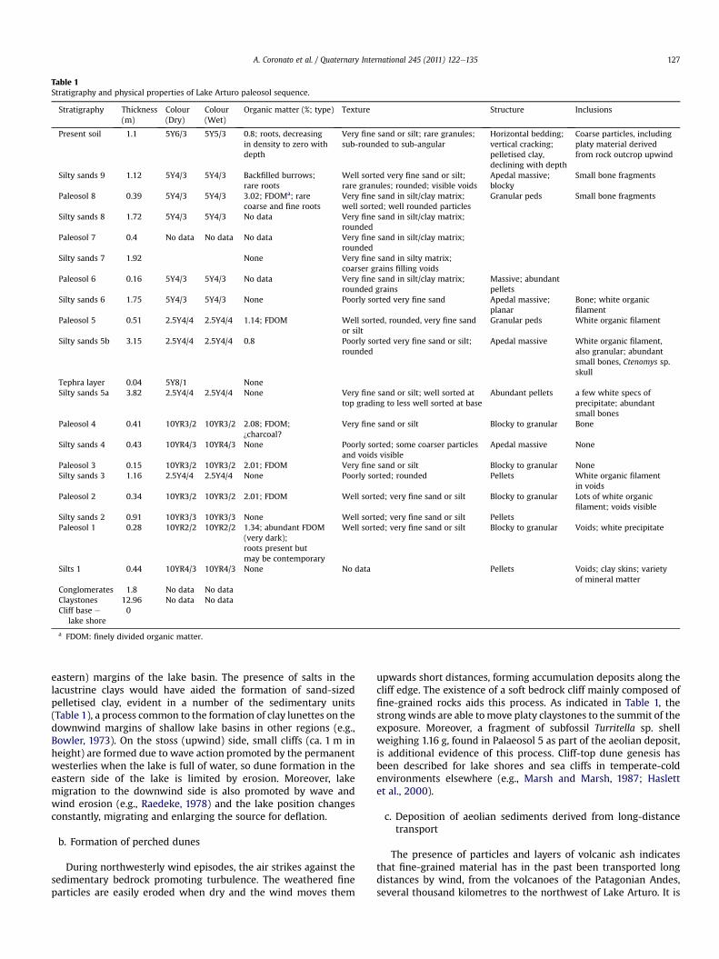
Table 1Stratigraphy and physical properties of Lake Arturo paleosol sequence.
Stratigraphy Thickness(m)
Colour(Dry)
Colour(Wet)
Organic matter (%; type) Texture Structure Inclusions
Present soil 1.1 5Y6/3 5Y5/3 0.8; roots, decreasingin density to zero withdepth
Very fine sand or silt; rare granules;sub-rounded to sub-angular
Horizontal bedding;vertical cracking;pelletised clay,declining with depth
Coarse particles, includingplaty material derivedfrom rock outcrop upwind
Silty sands 9 1.12 5Y4/3 5Y4/3 Backfilled burrows;rare roots
Well sorted very fine sand or silt;rare granules; rounded; visible voids
Apedal massive;blocky
Small bone fragments
Paleosol 8 0.39 5Y4/3 5Y4/3 3.02; FDOMa; rarecoarse and fine roots
Very fine sand in silt/clay matrix;well sorted; well rounded particles
Granular peds Small bone fragments
Silty sands 8 1.72 5Y4/3 5Y4/3 No data Very fine sand in silt/clay matrix;rounded
Paleosol 7 0.4 No data No data No data Very fine sand in silt/clay matrix;rounded
Silty sands 7 1.92 None Very fine sand in silty matrix;coarser grains filling voids
Paleosol 6 0.16 5Y4/3 5Y4/3 No data Very fine sand in silt/clay matrix;rounded grains
Massive; abundantpellets
Silty sands 6 1.75 5Y4/3 5Y4/3 None Poorly sorted very fine sand Apedal massive;planar
Bone; white organicfilament
Paleosol 5 0.51 2.5Y4/4 2.5Y4/4 1.14; FDOM Well sorted, rounded, very fine sandor silt
Granular peds White organic filament
Silty sands 5b 3.15 2.5Y4/4 2.5Y4/4 0.8 Poorly sorted very fine sand or silt;rounded
Apedal massive White organic filament,also granular; abundantsmall bones, Ctenomys sp.skull
Tephra layer 0.04 5Y8/1 NoneSilty sands 5a 3.82 2.5Y4/4 2.5Y4/4 None Very fine sand or silt; well sorted at
top grading to less well sorted at baseAbundant pellets a few white specs of
precipitate; abundantsmall bones
Paleosol 4 0.41 10YR3/2 10YR3/2 2.08; FDOM;¿charcoal?
Very fine sand or silt Blocky to granular Bone
Silty sands 4 0.43 10YR4/3 10YR4/3 None Poorly sorted; some coarser particlesand voids visible
Apedal massive None
Paleosol 3 0.15 10YR3/2 10YR3/2 2.01; FDOM Very fine sand or silt Blocky to granular NoneSilty sands 3 1.16 2.5Y4/4 2.5Y4/4 None Poorly sorted; rounded Pellets White organic filament
in voidsPaleosol 2 0.34 10YR3/2 10YR3/2 2.01; FDOM Well sorted; very fine sand or silt Blocky to granular Lots of white organic
filament; voids visibleSilty sands 2 0.91 10YR3/3 10YR3/3 None Well sorted; very fine sand or silt PelletsPaleosol 1 0.28 10YR2/2 10YR2/2 1.34; abundant FDOM
(very dark);roots present butmay be contemporary
Well sorted; very fine sand or silt Blocky to granular Voids; white precipitate
Silts 1 0.44 10YR4/3 10YR4/3 None No data Pellets Voids; clay skins; varietyof mineral matter
Conglomerates 1.8 No data No dataClaystones 12.96 No data No dataCliff base e
lake shore0
a FDOM: finely divided organic matter.
A. Coronato et al. / Quaternary International 245 (2011) 122e135 127
eastern) margins of the lake basin. The presence of salts in thelacustrine clays would have aided the formation of sand-sizedpelletised clay, evident in a number of the sedimentary units(Table 1), a process common to the formation of clay lunettes on thedownwind margins of shallow lake basins in other regions (e.g.,Bowler, 1973). On the stoss (upwind) side, small cliffs (ca. 1 m inheight) are formed due to wave action promoted by the permanentwesterlies when the lake is full of water, so dune formation in theeastern side of the lake is limited by erosion. Moreover, lakemigration to the downwind side is also promoted by wave andwind erosion (e.g., Raedeke, 1978) and the lake position changesconstantly, migrating and enlarging the source for deflation.
b. Formation of perched dunes
During northwesterly wind episodes, the air strikes against thesedimentary bedrock promoting turbulence. The weathered fineparticles are easily eroded when dry and the wind moves them
upwards short distances, forming accumulation deposits along thecliff edge. The existence of a soft bedrock cliff mainly composed offine-grained rocks aids this process. As indicated in Table 1, thestrong winds are able tomove platy claystones to the summit of theexposure. Moreover, a fragment of subfossil Turritella sp. shellweighing 1.16 g, found in Palaeosol 5 as part of the aeolian deposit,is additional evidence of this process. Cliff-top dune genesis hasbeen described for lake shores and sea cliffs in temperate-coldenvironments elsewhere (e.g., Marsh and Marsh, 1987; Haslettet al., 2000).
c. Deposition of aeolian sediments derived from long-distancetransport
The presence of particles and layers of volcanic ash indicatesthat fine-grained material has in the past been transported longdistances by wind, from the volcanoes of the Patagonian Andes,several thousand kilometres to the northwest of Lake Arturo. It is
Fig. 4. Lama guanicoe and Ctenomys sp. bones are dispersed in the aeolian depositepalaeosol sequence but only those in the upper level have archaeological meaning. A: from thebase to the top, Palaeosols 2e4 with fallen bones from unidentified strata, but guanaco bones appear from Palaeosol 4; B: femur and scapula detail; C: radiocarbon-dated guanacobone in Palaeosol 4; D: Ctenomys sp. skull buried in Aeolian silty sands 5b; E: a long guanaco bone is appearing from Palaeosol 8 due to erosion; F: Lake Arturo 1 archaeological sitegeneral view.
A. Coronato et al. / Quaternary International 245 (2011) 122e135128
therefore likely that at least some of the materials in the lakemargin deposits here and elsewhere in Tierra del Fuego have beensourced from distant aeolian deflation and transported during theLate Glacial period and continuing at least until the mid-Holocene,as indicated by the ash layer deposited within Unit 5 (Table 1).
At present, it is not possible to confirm any one of these as thepredominant source of the aeolian sequence at Lake Arturo. Thepresence of pelletized clays indicates the availability of salineminerals, but the provenience is not yet clear as they could bederived from either the desiccated lake bed, or by the marineclaystones forming the substratum.
Table 2Radiocarbon ages obtained from organic matter and bones deposited into palaeosol levesedimentary units capped by each palaeosol are calculated using the uncalibrated radiocconjunctionwith Calib program (Stuiver and Reimer, 1993). Average ages were calculatedages have a confidence probability range close to 1. Palaeosol 7 sample confidence proba
Sedimentaryunits
Laboratorycode
Material 14C ages(yrs BP)
SurfacePalaeosol 7 AA89591 Lama guanicoe bone 434� 43Palaeosol 5 AA89590 Lama guanicoe bone 4871� 59Palaeosol 4 AA85452 Lama guanicoe bone 5800� 64Palaeosol 3 AA89592 Canidae bone 6333� 67Palaeosol 1 AA89589 Organic carbon 9e41� 59
7. Archaeological evidence
The Lake Arturo 1 archaeological site is located in a deflationhollow in the eastern sector of the cliff (Fig. 5A and B). The surfacedeposit covers approximately 630 m2 and contains lithic artifacts(flakes, debris, and cores), faunal remains and a human bone(Fig. 5C). The formation of the deflation hollow has resulted in somedisturbance of the artifacts from their original positions within thestratigraphic sequence, thus their provenience is hard to determine.Materials are also constantly being exposed by ongoing aeolianerosion. For example, three articulated vertebrae and apiece of rib of
ls at Lake Arturo, Tierra del Fuego, Argentina. Sediment accumulation rates for thearbon ages. Calibration was performed with SHCal04.14c (McCormac et al., 2004) infromminimum andmaximum BP, 2 sigma calibrated ages. The most of the calibratedbility range is 0. 63 while Palaeosol 1 sample is 0.87.
Average calibratedBP ages (SHCal04)
Sediment accumulation(m)
Accumulation rate(my�1)
2.622 0.00604471 4.245 9.57E-04
5552 6.494 0.006996538 0.844 0.0015837163 2.582 7.15E-04
11304 0.722 e
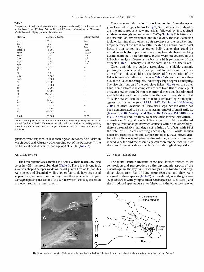
Table 3Comparison of major and trace element composition (in wt%) of bulk samples oftephra layer (Level 10), Lake Arturo, Tierra del Fuego, conducted by the Macquarie(Australia) and Calgary (Canada) laboratories.
Material Macquarie (wt %) Calgary (wt %)
SiO2 74.9 77.2TiO2 0.3 0.2Al2O3 14.1 13.0Total Fe 1.661 1.45MnO 0.049 0.037MgO 0.5 0.3CaO 2.4 1.7Na2O 4.38 3.09K2O 1.6 1.6P2O5 <0.01 e
S 0 e
Cl 0.1 e
V2O5 0.002 e
Cr2O3 0.004 e
Ni <0.001 e
Cu 0.003 e
Zn 0.001 e
Br <0.001 e
Rb 9E�04 e
Sr 0.013 e
Y <0.01 e
Zr 0.008 e
Ba 0.012 e
W <0.001 e
Pb 8E�04 e
Total 100.000 98.55
Method: Pellet pressed at 13 t for 90 s with Boric Acid backing. Analysed on a Pan-alytical Epsilon 5 EDXRF. Various analytical conditions with 6 secondary targets,200 s live time per condition for major elements and 100 s live time for traceelements.
A. Coronato et al. / Quaternary International 245 (2011) 122e135 129
guanaco were exposed in less than a year, between field visits inMarch 2009 and February 2010, eroding out of the Palaeosol 7; therib has a calibrated radiocarbon age of 471 cal. BP (Table 2).
7.1. Lithic context
The lithic assemblage contains 148 items,withflakes (n¼ 97) andcores (n¼ 25) the most abundant (Table 4). There is only one tool,a convex shaped scraper made on basalt gravel. Five of 15 noduleswere tested and discarded, while another four could have been usedas percussor/hammerstones as they show the characteristic impactdamage of pitting in a sector of the surfacewhich is usually observedin pieces used as hammerstones.
Fig. 5. A: southern margin of lake Arturo; B: detail of the hollow deflati
The raw materials are local in origin, coming from the uppergravel layer of Neogene bedrock (Fig. 2). Several varieties of rhyoliteare the most frequent raw materials, followed by fine-grainedsandstones strongly cementedwith CaCO3 (Table 4). This latter rockis a material of low resistance and bad quality for manufacturingtools or forming sharp edges, so its presence as the result of ant-hropic activity at the site is doubtful. It exhibits a natural conchoidalfracture that sometimes generates bulb shapes that could bemistaken for bulbs of percussion resulting from deliberate strikingduring knapping. Therefore, those pieces were not counted in thefollowing analysis. Cortex is visible in a high percentage of theartifacts (Table 5), namely 94% of the cores and 85% of the flakes.
Given that this is a surface assemblage in a highly dynamicgeomorphic environment, it is important to understand the inte-grity of the lithic assemblage. The degree of fragmentation of theflakes is one such indicator. However, Table 6 shows that more than80% of the flakes are complete, indicating a high degree of integrity.The size distribution of the complete flakes (Fig. 6), on the otherhand, demonstrates the complete absence from this assemblage ofartifacts smaller than 20 mm maximum dimension. Experimentaland field studies from elsewhere in the world have shown thatartifacts smaller than 20 mm are readily removed by geomorphicagents such as water (e.g., Schick, 1987; Fanning and Holdaway,2004). At other locations in Tierra del Fuego, aeolian action hasbeen demonstrated to be instrumental in removal of small artifacts(Borrazzo, 2004; Santiago and Oría, 2007; Oría and Pal, 2010; Oríaet al., in press), and it is likely to be the same for the Lake Arturo 1assemblage. Finally, although different agents could have affectedthe spatial relationships between artifacts within the assemblage,there is a remarkably high degree of refitting of artifacts, with 44 ofthe total of 115 pieces refitting adequately. Thus while aeoliandeflation, mass wasting and surface runoff may have moved arti-facts from their original place of discard, they appear not to havemoved very far, and the assemblage can therefore be used to inferthe natural agents activity that leads to their original deposition.
7.2. Faunal assemblage
The faunal sample presents some peculiarities related to itscomposition and preservation, so the taphonomic aspects of theassemblage are the key issue in its analysis. One hundred and fifty-three pieces (n¼ 153) of bone were recorded and they wereassigned to three species (Table 7), although only one, the guanaco(L. guanicoe), is widely represented. Ctenomys sp. (“tuco-tuco”) andthe introduced species Ovis aries (sheep) are the other two species
on; C: a scheme showing the material distribution in Lake Arturo 1.
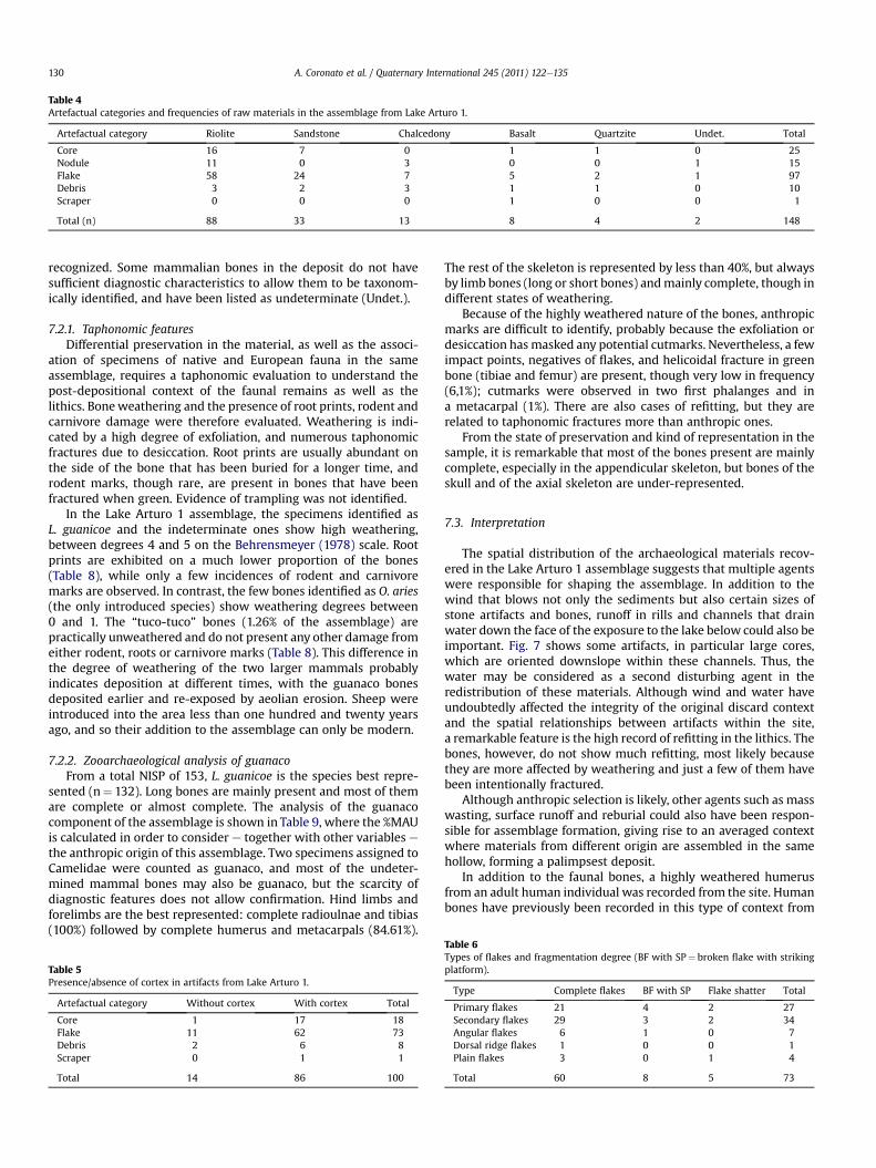
Table 4Artefactual categories and frequencies of raw materials in the assemblage from Lake Arturo 1.
Artefactual category Riolite Sandstone Chalcedony Basalt Quartzite Undet. Total
Core 16 7 0 1 1 0 25Nodule 11 0 3 0 0 1 15Flake 58 24 7 5 2 1 97Debris 3 2 3 1 1 0 10Scraper 0 0 0 1 0 0 1
Total (n) 88 33 13 8 4 2 148
A. Coronato et al. / Quaternary International 245 (2011) 122e135130
recognized. Some mammalian bones in the deposit do not havesufficient diagnostic characteristics to allow them to be taxonom-ically identified, and have been listed as undeterminate (Undet.).
7.2.1. Taphonomic featuresDifferential preservation in the material, as well as the associ-
ation of specimens of native and European fauna in the sameassemblage, requires a taphonomic evaluation to understand thepost-depositional context of the faunal remains as well as thelithics. Boneweathering and the presence of root prints, rodent andcarnivore damage were therefore evaluated. Weathering is indi-cated by a high degree of exfoliation, and numerous taphonomicfractures due to desiccation. Root prints are usually abundant onthe side of the bone that has been buried for a longer time, androdent marks, though rare, are present in bones that have beenfractured when green. Evidence of trampling was not identified.
In the Lake Arturo 1 assemblage, the specimens identified asL. guanicoe and the indeterminate ones show high weathering,between degrees 4 and 5 on the Behrensmeyer (1978) scale. Rootprints are exhibited on a much lower proportion of the bones(Table 8), while only a few incidences of rodent and carnivoremarks are observed. In contrast, the few bones identified as O. aries(the only introduced species) show weathering degrees between0 and 1. The “tuco-tuco” bones (1.26% of the assemblage) arepractically unweathered and do not present any other damage fromeither rodent, roots or carnivore marks (Table 8). This difference inthe degree of weathering of the two larger mammals probablyindicates deposition at different times, with the guanaco bonesdeposited earlier and re-exposed by aeolian erosion. Sheep wereintroduced into the area less than one hundred and twenty yearsago, and so their addition to the assemblage can only be modern.
7.2.2. Zooarchaeological analysis of guanacoFrom a total NISP of 153, L. guanicoe is the species best repre-
sented (n¼ 132). Long bones are mainly present and most of themare complete or almost complete. The analysis of the guanacocomponent of the assemblage is shown in Table 9, where the %MAUis calculated in order to consider e together with other variables ethe anthropic origin of this assemblage. Two specimens assigned toCamelidae were counted as guanaco, and most of the undeter-mined mammal bones may also be guanaco, but the scarcity ofdiagnostic features does not allow confirmation. Hind limbs andforelimbs are the best represented: complete radioulnae and tibias(100%) followed by complete humerus and metacarpals (84.61%).
Table 5Presence/absence of cortex in artifacts from Lake Arturo 1.
Artefactual category Without cortex With cortex Total
Core 1 17 18Flake 11 62 73Debris 2 6 8Scraper 0 1 1
Total 14 86 100
The rest of the skeleton is represented by less than 40%, but alwaysby limb bones (long or short bones) andmainly complete, though indifferent states of weathering.
Because of the highly weathered nature of the bones, anthropicmarks are difficult to identify, probably because the exfoliation ordesiccation hasmasked any potential cutmarks. Nevertheless, a fewimpact points, negatives of flakes, and helicoidal fracture in greenbone (tibiae and femur) are present, though very low in frequency(6,1%); cutmarks were observed in two first phalanges and ina metacarpal (1%). There are also cases of refitting, but they arerelated to taphonomic fractures more than anthropic ones.
From the state of preservation and kind of representation in thesample, it is remarkable that most of the bones present are mainlycomplete, especially in the appendicular skeleton, but bones of theskull and of the axial skeleton are under-represented.
7.3. Interpretation
The spatial distribution of the archaeological materials recov-ered in the Lake Arturo 1 assemblage suggests that multiple agentswere responsible for shaping the assemblage. In addition to thewind that blows not only the sediments but also certain sizes ofstone artifacts and bones, runoff in rills and channels that drainwater down the face of the exposure to the lake below could also beimportant. Fig. 7 shows some artifacts, in particular large cores,which are oriented downslope within these channels. Thus, thewater may be considered as a second disturbing agent in theredistribution of these materials. Although wind and water haveundoubtedly affected the integrity of the original discard contextand the spatial relationships between artifacts within the site,a remarkable feature is the high record of refitting in the lithics. Thebones, however, do not show much refitting, most likely becausethey are more affected by weathering and just a few of them havebeen intentionally fractured.
Although anthropic selection is likely, other agents such as masswasting, surface runoff and reburial could also have been respon-sible for assemblage formation, giving rise to an averaged contextwhere materials from different origin are assembled in the samehollow, forming a palimpsest deposit.
In addition to the faunal bones, a highly weathered humerusfrom an adult human individual was recorded from the site. Humanbones have previously been recorded in this type of context from
Table 6Types of flakes and fragmentation degree (BF with SP¼ broken flake with strikingplatform).
Type Complete flakes BF with SP Flake shatter Total
Primary flakes 21 4 2 27Secondary flakes 29 3 2 34Angular flakes 6 1 0 7Dorsal ridge flakes 1 0 0 1Plain flakes 3 0 1 4
Total 60 8 5 73
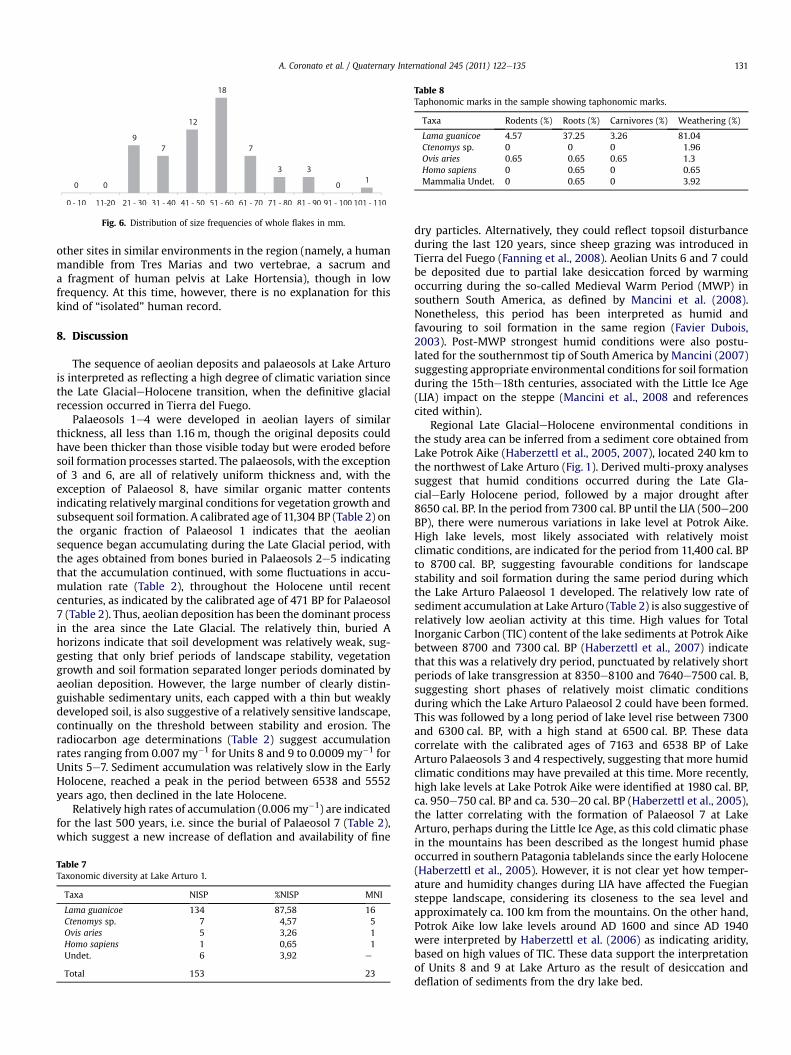
Fig. 6. Distribution of size frequencies of whole flakes in mm.
Table 8Taphonomic marks in the sample showing taphonomic marks.
Taxa Rodents (%) Roots (%) Carnivores (%) Weathering (%)
Lama guanicoe 4.57 37.25 3.26 81.04Ctenomys sp. 0 0 0 1.96Ovis aries 0.65 0.65 0.65 1.3Homo sapiens 0 0.65 0 0.65Mammalia Undet. 0 0.65 0 3.92
A. Coronato et al. / Quaternary International 245 (2011) 122e135 131
other sites in similar environments in the region (namely, a humanmandible from Tres Marias and two vertebrae, a sacrum anda fragment of human pelvis at Lake Hortensia), though in lowfrequency. At this time, however, there is no explanation for thiskind of “isolated” human record.
8. Discussion
The sequence of aeolian deposits and palaeosols at Lake Arturois interpreted as reflecting a high degree of climatic variation sincethe Late GlacialeHolocene transition, when the definitive glacialrecession occurred in Tierra del Fuego.
Palaeosols 1e4 were developed in aeolian layers of similarthickness, all less than 1.16 m, though the original deposits couldhave been thicker than those visible today but were eroded beforesoil formation processes started. The palaeosols, with the exceptionof 3 and 6, are all of relatively uniform thickness and, with theexception of Palaeosol 8, have similar organic matter contentsindicating relatively marginal conditions for vegetation growth andsubsequent soil formation. A calibrated age of 11,304 BP (Table 2) onthe organic fraction of Palaeosol 1 indicates that the aeoliansequence began accumulating during the Late Glacial period, withthe ages obtained from bones buried in Palaeosols 2e5 indicatingthat the accumulation continued, with some fluctuations in accu-mulation rate (Table 2), throughout the Holocene until recentcenturies, as indicated by the calibrated age of 471 BP for Palaeosol7 (Table 2). Thus, aeolian deposition has been the dominant processin the area since the Late Glacial. The relatively thin, buried Ahorizons indicate that soil development was relatively weak, sug-gesting that only brief periods of landscape stability, vegetationgrowth and soil formation separated longer periods dominated byaeolian deposition. However, the large number of clearly distin-guishable sedimentary units, each capped with a thin but weaklydeveloped soil, is also suggestive of a relatively sensitive landscape,continually on the threshold between stability and erosion. Theradiocarbon age determinations (Table 2) suggest accumulationrates ranging from 0.007 my�1 for Units 8 and 9 to 0.0009 my�1 forUnits 5e7. Sediment accumulation was relatively slow in the EarlyHolocene, reached a peak in the period between 6538 and 5552years ago, then declined in the late Holocene.
Relatively high rates of accumulation (0.006 my�1) are indicatedfor the last 500 years, i.e. since the burial of Palaeosol 7 (Table 2),which suggest a new increase of deflation and availability of fine
Table 7Taxonomic diversity at Lake Arturo 1.
Taxa NISP %NISP MNI
Lama guanicoe 134 87,58 16Ctenomys sp. 7 4,57 5Ovis aries 5 3,26 1Homo sapiens 1 0,65 1Undet. 6 3,92 e
Total 153 23
dry particles. Alternatively, they could reflect topsoil disturbanceduring the last 120 years, since sheep grazing was introduced inTierra del Fuego (Fanning et al., 2008). Aeolian Units 6 and 7 couldbe deposited due to partial lake desiccation forced by warmingoccurring during the so-called Medieval Warm Period (MWP) insouthern South America, as defined by Mancini et al. (2008).Nonetheless, this period has been interpreted as humid andfavouring to soil formation in the same region (Favier Dubois,2003). Post-MWP strongest humid conditions were also postu-lated for the southernmost tip of South America by Mancini (2007)suggesting appropriate environmental conditions for soil formationduring the 15the18th centuries, associated with the Little Ice Age(LIA) impact on the steppe (Mancini et al., 2008 and referencescited within).
Regional Late GlacialeHolocene environmental conditions inthe study area can be inferred from a sediment core obtained fromLake Potrok Aike (Haberzettl et al., 2005, 2007), located 240 km tothe northwest of Lake Arturo (Fig. 1). Derived multi-proxy analysessuggest that humid conditions occurred during the Late Gla-cialeEarly Holocene period, followed by a major drought after8650 cal. BP. In the period from 7300 cal. BP until the LIA (500e200BP), there were numerous variations in lake level at Potrok Aike.High lake levels, most likely associated with relatively moistclimatic conditions, are indicated for the period from 11,400 cal. BPto 8700 cal. BP, suggesting favourable conditions for landscapestability and soil formation during the same period during whichthe Lake Arturo Palaeosol 1 developed. The relatively low rate ofsediment accumulation at Lake Arturo (Table 2) is also suggestive ofrelatively low aeolian activity at this time. High values for TotalInorganic Carbon (TIC) content of the lake sediments at Potrok Aikebetween 8700 and 7300 cal. BP (Haberzettl et al., 2007) indicatethat this was a relatively dry period, punctuated by relatively shortperiods of lake transgression at 8350e8100 and 7640e7500 cal. B,suggesting short phases of relatively moist climatic conditionsduring which the Lake Arturo Palaeosol 2 could have been formed.This was followed by a long period of lake level rise between 7300and 6300 cal. BP, with a high stand at 6500 cal. BP. These datacorrelate with the calibrated ages of 7163 and 6538 BP of LakeArturo Palaeosols 3 and 4 respectively, suggesting that more humidclimatic conditions may have prevailed at this time. More recently,high lake levels at Lake Potrok Aike were identified at 1980 cal. BP,ca. 950e750 cal. BP and ca. 530e20 cal. BP (Haberzettl et al., 2005),the latter correlating with the formation of Palaeosol 7 at LakeArturo, perhaps during the Little Ice Age, as this cold climatic phasein the mountains has been described as the longest humid phaseoccurred in southern Patagonia tablelands since the early Holocene(Haberzettl et al., 2005). However, it is not clear yet how temper-ature and humidity changes during LIA have affected the Fuegiansteppe landscape, considering its closeness to the sea level andapproximately ca. 100 km from the mountains. On the other hand,Potrok Aike low lake levels around AD 1600 and since AD 1940were interpreted by Haberzettl et al. (2006) as indicating aridity,based on high values of TIC. These data support the interpretationof Units 8 and 9 at Lake Arturo as the result of desiccation anddeflation of sediments from the dry lake bed.
Table 9Assemblage analysis of skeletal pieces of Lama guanicoe in the Lake Arturo 1 assemblage. L: left, R: right; Ind./I.: undetermined. Ds. Distal; Px: proximal; Vert: Vertebrae.
Anatomical Unit Inmature Mature Undetermined Total NISP MNI MNE MAU %MAU
L R I L R I L R I
Axial skeleton Skull e e e e e e e e e e e e e e
Incisor e e e e e e e e e e e e e e
Molar e e e e 1 e e e e 1 1 1 0.08 1.23Maxilar e 1 e e e e e e e 1 1 1 0.5 7.69Hemimandible e e e 1 e e e e e 1 1 1 0.5 7.69Atlas e e e e e e e e e e e e e e
Axis e e e e e e e e e e e e e e
Cervical Vert. e e e e e 1 e e e 1 1 1 0.14 2.15Toraxic Vert. e e 3 e e e e e e 3 1 3 0.25 3.84Lumbar Vert. e e 2 e e e e e e 2 1 1 0.14 2.15Sacro Vert. e e e e e e e e e e e e e e
Caudal Vert. e e e e e e e e e e e e e e
Und. Vert e e e e e e e e e e e e 0.03 0.46Sternebrae e e 1 e e e e e e 1 1 1 0.33 5.07Ribs 1 1 e 3 3 e e e 1 9 4 8 0.33 5.07
ApendicularSkeleton
Scapula e e e 1 1 e 1 1 e 4 2 4 2 30.76Px. Humerus e e e e e e e e e e e e e e
Ds. Humerus e e e e 2 e e e e 2 2 2 1 15.38Shaft Humerus e e e e e e e e e e e e e e
Entire Humerus 2 5 e 1 3 e e e e 11 8 11 5.5 84.61Px Radius ulna e e e e e e e e e e e e e e
Ds Radius ulna 1 1 e e 1 e e e e 3 2 3 1.5 23.07Shaft Radius ulna e e e e e e e e 1 1 1 1 0.5 7.69Entire Radius ulna 2 5 e 2 4 e e e e 13 9 13 6.5 100Pisiform e e e e 1 e 3 e e 4 3 4 2 30.76Scaphoid e e e e e e e e e e e e e e
Cuneiform e e e e e e e e e e e e e e
Lunar e e e e e e e e e e e e e e
Magnum e e e e e e e 1 e 1 1 1 0.5 7.69Trapezoid e e e e 2 e e e e 2 2 2 1 15.38Unciform e e e e 1 e e e e 1 1 1 0.5 7.69Px Metacarpal e e e e e e e e e e e e e e
Ds Metacarpal e e e e e e e e e e e e e e
Shaft Metacarpal e 2 e e e e e e e 2 1 1 0.5 7.69Entire Metacarpal 2 3 e 3 3 e e e e 11 6 11 5.5 84.61Pelvis e e e e e e e e e e e e
Px Femur 1 e e e e e e e e 1 1 1 0.5 7.69Ds Femur e 1 e 1 e e e e e 2 1 2 1 15.38Shaft Femur e e e e e e e e e e e e e e
Entire Femur 2 1 e e e e e e e 3 2 3 1.5 23.07Patella e e e 1 e e e e e 1 1 1 0.5 7.69Px Tibia 2 e e e 1 e e e e 3 3 3 1.5 23.07Ds Tibia 1 e e e e e e e e 1 1 1 0.5 7.69Shaft Tibia 5 e 1 e 1 e e e 1 8 6 5 2.5 38.46Entire Tibia 8 5 e 3 4 e e e e 20 8 13 6.5 100Astragalus e e e e e e 1 1 e 2 1 2 1 15.38Calcaneous e e e 1 2 e e e e 3 2 3 1.5 23.07Endocuneiform e e e e e e e e e e e e e e
Navicular e e e e e e e e e e e e e e
Ectocuneiform e e e e e e e e 2 2 2 2 1 15.38Cuboid e e e e e e e 1 e 1 1 1 0.5 7.69Px Metatarsal e e e e e e e e e e e e e e
Ds Metatarsal e e e e e e e e e e e e e e
Entire Metatarsal 1 1 e 1 1 e e e e 4 2 4 2 30.76Ds Metapodial e e e 2 e e 1 e e 3 3 3 1.5 23.07Phalanx 1a. e e e e e 1 e e 2 3 3 3 0.37 5.69Phalanx 2a. e e e e e 1 e e e 1 1 1 0.12 1.84Phalanx 3a. e e e e e e e e e e e e e e
Total 28 26 7 20 31 3 6 4 7 132
A. Coronato et al. / Quaternary International 245 (2011) 122e135132
The Mt. Burney tephra level interbedded in the mid-HoloceneUnit 5 is considered as a good chronological marker for the impactof the Andean volcanism in the region. The age of Holocene erup-tions from this volcanowas averaged by Stern (2008) at 8425� 50014C BP and 3830� 390 14C BP and named as MB1 and MB2 erup-tions, respectively (Stern, 2008). The uncalibrated radiocarbon agesof the overlying and underlying Palaeosols 5 and 4, bracketedbetween 5.8 and 4.8 ka 14C BP (Table 2), offer a relative age for themid-Holocene eruption. Although this does not match with the
average ages proposed by Stern (2008), it fits better with the mid-Holocene MB eruption, considering the three samples, cited byStern (2008) which range between<5430� 250 and>4280� 50 inother localities.
Archaeological remains have so far only been identified from theuppermost units (Palaeosols 7 and 8) at Lake Arturo, radiocarbondated ca. 500 years BP. Equivalent soil units have also been identifiedin a similar landform on the southern shoreline of Lake Amalia tothe south of Lake Arturo (Fig. 1), where a quarry-workshop was
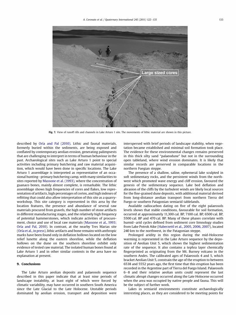
Fig. 7. View of runoff rills and channels in Lake Arturo 1 site. The movements of lithic material are shown in this picture.
A. Coronato et al. / Quaternary International 245 (2011) 122e135 133
described by Oría and Pal (2010). Lithic and faunal materials,formerly buried within the sediments, are being exposed andconflated by contemporary aeolian erosion, generating palimpseststhat are challenging to interpret in terms of human behaviour in thepast. Archaeological sites such as Lake Arturo 1 point to specialactivities including primary butchering and raw material acquisi-tion, which would have been done in specific locations. The LakeArturo 1 assemblage is interpreted as representative of an occa-sional huntingeprimary butchering camp,withmany similarities tosites reported by Massone et al. (1993), where the concentration ofguanaco bones, mainly almost complete, is remarkable. The lithicassemblage shows high frequencies of cores and flakes, low repre-sentation of artifacts, high percentages of cortex, andhigh indexes ofrefitting that could also allow interpretation of this site as a quarry-workshop. This site category is represented in this area by thelocation features, the presence and abundance of several rawmaterials procured from gravels, the high number of stone artifactsin different manufacturing stages, and the relatively high frequencyof potential hammerstones, which indicate activities of procure-ment, choice and use of local raw materials (Massone et al., 1993;Oría and Pal, 2010). In contrast, at the nearby Tres Marias site(Oría et al., inpress), lithic artifacts and bone remainswith anthropicmarks have been found only in deflation hollows located on the lowrelief lunette along the eastern shoreline, while the deflationhollows on the dune on the southern shoreline exhibit onlyevidence of tested rawmaterial. The isolated human bones found atLake Arturo 1 and in other similar contexts in the area have noexplanation at present.
9. Conclusions
The Lake Arturo aeolian deposits and palaeosols sequencedescribed in this paper indicate that at least nine periods oflandscape instability, at least eight of which were forced byclimatic variability, may have occurred in southern South Americasince the Late Glacial to the Late Holocene. Unstable periodsdominated by aeolian erosion, transport and deposition were
interspersed with brief periods of landscape stability, when vege-tation became established and minimal soil formation took place.The evidence for these environmental changes remains preservedin this thick silty sand “palaeodune” but not in the surroundingopen tableland, where wind erosion dominates. It is likely thatsimilar records are preserved in comparable locations in thenorthern Fuegian steppe.
The presence of a shallow, saline, ephemeral lake sculpted insoft sedimentary rocks, and the persistent winds from the north-west which promoted wave energy and cliff erosion, favoured thegenesis of the sedimentary sequence. Lake bed deflation andabrasion of the cliffs by the turbulent winds are likely local sourcesfor the fine-grained dune deposits, with additional material derivedfrom long-distance aeolian transport from northern Tierra delFuego or southern Patagonian semiarid tablelands.
Available radiocarbon dating on five of the eight palaeosolslevels shows that stable conditions, favourable for soil formation,occurred at approximately 11,300 cal. BP, 7100 cal. BP, 6500 cal. BP,5500 cal. BP and 470 cal. BP. Many of these phases correlate withhumidearid cycles defined from sediment core limnology studiesfrom Lake Potrok Aike (Haberzettl et al., 2005, 2006, 2007), located240 km to the northwest, in the Patagonian steppe.
Prolonged aridity in this region during the mid-Holocenewarming is represented in the Lake Arturo sequence by the depo-sition of Aeolian Unit 5, which shows the highest sedimentationrate of the sequence. It also contains a tephra layer chemicallyfingerprinted as originating from the Mt. Burney volcano in thesouthern Andes. The calibrated ages of Palaeosols 4 and 5, whichbracket Aeolian Unit 5, constrain the age of the eruption to between6538 and 5552 years ago, the first time that this eruption has beenrecorded in the Argentine part of Tierra del Fuego Island. Palaeosols6e8 and their relative aeolian units could represent the lastclimatic abrupt changes occurred along the Late Holocene occurredwhen the area was occupied by native people and fauna. This willbe the subject of further work.
Lakes in semiarid environments constitute archaeologicallyinteresting places, as they are considered to be meeting points for
A. Coronato et al. / Quaternary International 245 (2011) 122e135134
native people and wildlife. Long aeolian sequences such as LakeArturo might be sensitive markers for the evidence of humanoccupations since the lake shores were recurrently visited, espe-cially for the acquisition of faunal resources and the gravel exposedin the cliffs, useful as raw material. As changes in rainfall andtemperature would have affected the local resource availability,Lake Arturo offers the possibility of understanding the complex anddynamic humaneenvironment interactions in the past. Althoughthe archaeological evidence dating to the Early and mid-Holocenein the Fuegian steppe is sparse, a more continuous occupation isrecognizable for the Late Holocene, when most of the landscapes,such as hills, rockshelters, lacustrine areas and marine coasts, wereoccupied (Salemme and Miotti, 2008). With its relatively longsequence spanning the whole of the Holocene, the Lake Arturolocality is particularly important for evaluating not only the geo-archaeological processes that resulted in the formation of palimp-sest deposits of artifacts and bone, but also the Holoceneenvironmental changes that influenced human populations in thisremote and challenging location. Ongoing chronostratigraphic,paleoenvironmental and archaeological researchwill providemuchneeded tools for regional interpretations of human settlementpatterns.
Acknowledgements
This research was funded by grant ANPCyT-PICT 05-38096 toM. Salemme and a Macquarie University Research Developmentgrant to P. Fanning. We thank Dr. Sergio Matheos from the Labo-ratorio de Sedimentología y Petrografía del Centro de Inves-tigaciones Geológicas (CIG) for the granulometry analysis, AssociateProfessor Damian Gore from Macquarie University and Dr. JerryOsborn from the University of Calgary for the geochemical analysesof the ash samples. Matias Bitch from San Julio Ranch gave logisticalsupport and Belen Colasurdo (CONICET- Universidad Nacional deRosario) helped with archaeological field work. Dr Alicia Moretto(CADIC) made some interesting suggestions about soil properties.We thank M. Bonomo, chairman at the Multidisciplinary Studies inArchaeology Symposium of the IV Argentine Quaternary andGeomorphology Congress held in La Plata, Argentina, on September2009 for his kind invitation to publish our results in this volume.We are grateful to V. Holliday and two anonymous reviewers fortheir valuable comments to improve this paper.
References
Ackert, R., 2009. Patagonian dust machine. Nature Geoscience 2, 244e245.Aschero, C., 1975. Ensayo para una clasificación morfológica de artefactos líticos
aplicada a estudios tipológicos comparativos. CONICET report. CONICET, BuenosAires, Argentina, 1e116 p.
Arce, A., Vilas, F., 1986e1987. Depósitos eólicos de grano fino en la Bahía de SanSebastián, Tierra del Fuego, Argentina. Acta Geológica Hispánica 21e22,261e266.
Auer, V., 1958. The Pleistocene of Fuego-Patagonia. Part II: The History of Flora andVegetation.AnnalesAcademiaeScie. Fennicae. SeriesA III.GeologicaeGeographica,vol. 50, Helsinki, Finland, 1e239 p.
Barberena, R., 2008. Arqueología y Biogeografía Humana en Patagonia Meridional.Colección Tesis Doctorales. Sociedad Argentina de Antropología. Buenos Aires,1e395 p.
Behrensmeyer, A.K., 1978. Taphonomic and ecologic information from boneweathering. Paleobiology 4, 150e162.
Binford, L., 1981. Bones: Ancient Bones and Moderns Myths. Academic Press, NewYork. 320 p.
Borrazzo, K., 2004. Hacia una tafonomía lítica: el análisis tafonómico y tecnológico de losconjuntos artefactuales líticos de superficie provenientes de los loci San Genaro 3 y 4(Bahía San Sebastián e Tierra del Fuego, Argentina). Degree Thesis in Antrophology.University of Buenos Aires, Buenos Aires, Argentina, unpublished.
Borrero, L., 1985. La Economía Prehistórica de los Habitantes del Norte de la IslaGrande de Tierra del Fuego. Unpublished Dissertation. Fac de Filos y Letras,Universidad de Buenos Aires, UBA. 390 pagesþ appendix.
Borrero, L., 1989e1990. Evolución cultural divergente en la Patagonia Austral.Anales del Instituto de la Patagonia (Serie Ciencias Sociales) 19, 133e139. PuntaArenas, Chile.
Borrero, L., 1994e1995. Arqueología de la Patagonia, Palimpsesto. Revista deArqueología 4, 9e69. Buenos Aires.
Borrero, L., 2004. The archaeozoology of the Andean “Dead Ends” in Patagonia:living near the continental Ice Cap. In: Mondini, M., Muñoz, S., Wickler, S. (Eds.),Colonization, Migration, and Marginal Areas, A Zooarchaeological Approach.Oxbow Books, pp. 55e61.
Bowler, J.M., 1973. Clay dunes: their occurrence, formation and environmentalsignificance. Earth Science Reviews 9 (4), 315e338.
Bujalesky, G., Coronato, A., Isla, F., 2001. Ambientes glacifluviales y litorales Cua-ternarios de la región del Río Chico, Tierra del Fuego, Argentina. Revista de laAsociación Geológica Argentina 56 (1), 73e90.
Bujalesky, G., Isla, F., 2006. Depósitos cuaternarios de la costa atlántica fueguina,entre los cabos Peñas y Ewan. Revista de la Asociación Geológica Argentina 61(1), 81e92.
Clapperton, Ch, 1993. Quaternary Geology and Geomorphology of South America.Elsevier, Amsterdam, pp. 779.
Codignotto, J., Malumian, N., 1981. Geología de la Región al N del paralelo 54� L.S. dela Isla Grande de Tierra del Fuego. Revista de la Asociación Geológica Argentina36 (1), 44e88.
Cordero Otero, R., Favier Dubois, C., dos Santos Afonso, M., 1999. Consideracionesacerca de la confiabilidad de las muestras óseas en las dataciones por carbonocatorce. El caso de los sitios San Genaro en la bahía San Sebastián (Norte deTierra del Fuego). XII Congreso Nacional de Arqueología Argentina. Actas III,pp. 335e348.
Coronato, A., Coronato, F., Mazzoni, E., Vázquez, M., 2008. Physical geography ofPatagonia and Tierra del Fuego. In: Rabassa, J. (Ed.), Late Cenozoic of Patagoniaand Tierra del Fuego. Development in Quaternary Sciences, vol. 11. Elsevier,pp. 13e56 (Chapter 3).
Coronato, A., Fanning, P., Salemme, M., Oría, J., Pickard, J., 2009a. Aeolian sequenceand the archaeological record at lake Arturo, northern Tierra del Fuego,Argentina. IV Congreso Argentino de Cuaternario y Geomorfología. La Plata.Abstracts, 234.
Coronato, A., Seppälä, M., Ponce, F., Rabassa, J., 2009b. Sand dunes on Lake Fagnanocliffs, Tierra del Fuego, Argentina. IV Congreso Argentino de Cuaternario yGeomorfología. Abstracts, 342.
De Nigris, M., 1994. Patrones de Fragmentación de Huesos Largos en el Sito Cerro delos Indios 1, Lago Posadas. Provincia de Santa Cruz e Argentina. Degree Thesison Anthropology. University of Buenos Aires, Argentina, unpublished.
Fanning, P.C., Holdaway, S.J., 2004. Artifact visibility at open sites in western NewSouth Wales, Australia. Journal of Field Archaeology 29, 255e271.
Fanning, P.C., Holdaway, S.J., 2008. Developing a landscape history as part ofa survey strategy: a critique of current settlement systems approaches based oncase studies from western New South Wales, Australia. Journal of Archaeolog-ical Method and Theory 15, 167e189.
Fanning, P.C., Salemme, M.C., Pickard, J., Santiago, F., Oria, J., 2008. People and sheep,wind and water: geomorphic processes and human impacts in Tierra del Fuego,Argentina, and consequences for the archaeological record. Australian and NewZealand Geomorphology Group Conference, Queenstown, Tasmania, February2008. Abstracts.
Favier Dubois, C.M., 2001. Análisis geoarqueológico de los procesos de formacióndel registro, cronología y paleoambientes, en sitios arqueológicos de Fuego-Patagonia. Ph.D. Dissertation in Anthropology. University of Buenos Aires,unpublished.
Favier Dubois, C., 2003. Late Holocene climatic fluctuations and soil genesis insouthern Patagonia: effects on the archaeological record. Journal of Archaeo-logical Science 30, 1657e1664.
Feruglio, E., 1949. Descripción Geológica de la Patagonia. Ministerio de Industria yComercio de la Nación, Dirección General de Yacimientos Petrolíferos Fiscales,vol. 1. Buenos Aires, 334 p.
Fidalgo, F. 1972. Consideraciones sobre los bajos situados al norte de la Provincia deSanta Cruz. V Congreso Geológico Argentino, Actas V, pp. 123e137.
Gaiero, D., Brunet, F., Probst, J.L., Depetris, P., 2007. An uniform isotopic andchemical signature of dust exported from Patagonia: rock sources and occur-rence in southern environments. Chemical Geology 238, 107e120.
Grayson, D., 1984. Quantitative Zooarchaeology. Academic Press. 225 p.Haberzettl, T., Fey, M., Lücke, A., Maidana, N., Mayr, Ch., Ohlendorf, Ch., Schäbitz, F.,
Schleser, G., Wille, M., Zolitschka, B., 2005. Climatically induced lake levelchanges during the last two millennia as reflected in sediments of LagunaPotrok Aike, southern Patagonia (Santa Cruz, Argentina). Journal of Paleo-limnology 33, 283e302.
Haberzettl, T., Wille, M., Fey, M., Janssen, S., Lücke, A., Mayr, Ch., Ohlendorf, Ch.,Schäbitz, F., Schleser, G., Zolitschka, B., 2006. Environmental change and firehistory of southern Patagonia (Argentina) during the last five centuries.Quaternary International 158, 72e82.
Haberzettl, T., Corbella, H., Fey, M., Janssen, S., Lücke, A., Mayr, Ch., Ohlendorf, Ch.,Schäbitz, F., Schleser, G., Wille, M., Wulf, S., Zolitschka, B., 2007. Lateglacial andHolocene wetedry cycles in southern Patagonia: chronology, sedimentologyand geochemistry of a lacustrine record from Laguna Potrok Aike, Argentina.The Holocene 17 (3), 297e310.
Haslett, S., Davis, P., Curr, R., 2000. Geomorphologic and palaeoenvironmentaldevelopment of Holocene perched coastal dune systems in Brittany, France.Geographiska Annaler 82A (1), 79e88.
A. Coronato et al. / Quaternary International 245 (2011) 122e135 135
Heusser, C., 1993. Late Quaternary forest-steppe contact zone, Isla Grande de Tierradel Fuego, Subantarctic South America. Quaternary Science Reviews 12 (3),169e177.
Holliday, V., 2004. Soil in Archaeological Research. Oxford University Press, Oxford.448 p.
Iturraspe, R., Urciuolo, A., 2002. Ciclos deficitarios en el régimen de sistemaslagunares de la estepa fueguina. XIX Congreso Nacional del Agua. Proceedings I:1e4. Santa Fe, Argentina.
Lyman, R.L., 1984. Vertebrate Taphonomy. Cambridge University Press, Cambridge.326 p.
Lyman, R.L., 2008. Quantitative Paleozoology. Cambridge University Press, NewYork. 348 p.
Mancini, M.V., 2007. Variabilidad climática en los últimos 1000 años en el área deCabo Vírgenes, Argentina. Ameghiniana 44 (1), 173e182.
Mancini, M.V., Prieto, A., Paez, M., Schäbitz, F., 2008. Late Quaternary vegetationand climate of Patagonia. In: Rabassa, J. (Ed.), The Late Cenozoic of Patagoniaand Tierra del Fuego. Developments in Quaternary Science, vol. 11. Elsevier,pp. 351e367.
McCormac, F., Hogg, A., Blackwell, P., Buck, C., Highman, T., Reimer, P., 2004.SHCal04 southern hemisphere calibration 0e11.0 cal kyr BP. Radiocarbon 46,1087e1092.
Mandel, R.D., Bettis III, E.A., 2001. Use and analysis of soils by archaeologists andgeoscientists. In: Goldberg, P., Holliday, V.T., Ferring, C.R. (Eds.), Earth Sciencesand Archaeology. Kluwer Academic/Plenum Publishers, New York, pp. 173e204.
Markgraf, V., 1983. Late and postgalcial vegetational and paleoclimatic changes insubantarctic, temperate and arid environments in Argentina. Palynology 7,43e63.
Marsh, W., Marsh, B., 1987. Wind erosion and sand dune formation on high LakeSuperior bluffs. Geographiska Annaler 69A (3e4), 379e391.
Massone, M., 2004. Los cazadores después del hielo. Centro de InvestigacionesDiego Barros Arana, colección. Antropología. Chile, 173 p.
Massone, M., Jackson, D., Prieto, A., 1993. Perspectivas arqueológicas de los Selk�nam.Centro de Investigaciones Diego Barros Arana, Dirección de Bibliotecas, Archi-vos y Museos, Santiago, Chile.
Massone, M., Prieto, A., Jackson, D., Cárdenas, G., Arroyo, M., Cárdenas, P., 1998. Loscazadores tempranos y sus fogatas: una nueva historia para la cueva TresArroyos 1, Tierra. Boletín de la Sociedad Chilena de Arqueología 26, 11e18.Santiago.
Mazzoni, E., 2001. Space distribution and geomorphological characterization ofsmall closed basins of the Extra-Andean Patagonia. Anales del Instituto de laPatagonia, Ciencias Naturales 29, 5e24. Punta Arenas, Chile.
Mazzoni, E., Vázquez, M., 2009. Desertification in Patagonia. In: Latrubesse, E. (Ed.),Natural Hazards and Human-Exacerbated Disasters in Latin-America. Devel-opments in Earth Surface Processes, vol. 13. Elsevier, Amsterdam, pp. 351e377.
McCulloch, R.D., Bentley, M.J., Tipping, R.M., Clapperton, C.M., 2005. Evidence forLate-Glacial ice dammed lakes in the Central Strait of Magellan and Bahía Inútil,southernmost South America. Geografiska Annaler 87A (2), 335e362.
McCulloch, R., Morello, F., 2009. Evidencia glacial y paleoecológica de ambientestardiglaciales y del Holoceno temprano. Implicaciones para el poblamientotemprano de Tierra del Fuego. In: Salemme, M., Santiago, F., Alvarez, M.,Piana, E., Vazquez, M., Mansur, E. (Eds.), Arqueología de Patagonia: una miradadesde el último confín. Utopías, Ushuaia, pp. 119e134.
Miotti, L., 2006. La fachada atlántica como puerta de ingreso alternativa de lacolonización humana de América del Sur durante la transición Pleistoceno/
Holoceno. 2do. Simposio Internacional El Hombre Temprano en América.CONACULTA e INAH, México, pp. 155e188.
Mengoni Goñalons, G., 1988. El estudio de huellas en arqueofaunas, una vía parareconstruir situaciones interactivas en contextos arqueológicos: aspectos teór-ico-metodológicos y técnicas de análisis. In: Ratto, N., Haber, A. (Eds.), DeProcesos, Contextos y Otros Huesos. Instituto de Ciencias Antropológicas.University of Buenos Aires, Argentina, pp. 17e28.
Munsell,1973.Munsell Soil ColorCharts.Macbeth-KollmorgenCorporation, Baltimore.Muñoz, A.S., 2002. La explotación de Mamíferos por cazadores-recolectores ter-
restres de Tierra del Fuego. Ph.D. Dissertation. Facultad de Filosofía y Letras.Universidad de Buenos Aires, unpublished.
Northcote, K.H., 1979. A Factual Key for the Recognition of Australian Soils, fourthed. Rellim, Adelaide. 123 p.
Oría, J., 2009. Prospecciones en el interior de la estepa fueguina. In: Salemme, M.,Santiago, F., Alvarez, M., Piana, E., Vazquez, M., Mansur, M.E. (Eds.), Arqueologíade Patagonia. Una mirada desde el último confín, vol. 2. Utopías, Ushuaia,Argentina, pp. 1109e1126.
Oría, J., Pal, N., 2010. Yar Hayen. Un sitio cantera taller en el norte de Tierra delFuego. XVII Congreso Nacional de Arqueología Argentina. Actas I, Mendoza,pp. 25e30.
Oría, J., Salemme, M., Santiago, F., Montes, A., in press. Localidad Tres Marías: uncaso para evaluar la pérdida de información arqueológica por erosión eólica enla estepa fueguina. Cazadores e Recolectores Del Cono Sur. Revista DeArqueología, vol. 4. Buenos Aires.
Orquera, L., Piana, E., 1986. Normas para la descripción de objetos arqueológicosde piedra tallada. CADIC, Contribución Científica, vol. 1. Ushuaia, Argentina,pp. 1e198, unpublished.
Raedeke, L., 1978. Formas y depósitos cuaternarios de Tierra del Fuego. RevistaGeológica de Chile 5, 3e31.
Salemme, M., Miotti, L., 2008. Archeological hunteregatherer landscapes since thelatest Pleistocene in Fuego Patagonia. In: Rabassa, J. (Ed.), The Late Cenozoic ofPatagonia and Tierra del Fuego. Elsevier, pp. 437e483.
Santiago, F., 2009. La ocupación humana del norte de Tierra del Fuego durante elHoloceno medio y tardío. Su vinculación con el paisaje. Ph.D. Dissertation onArchaeology. Universidad Nacional del Centro, Olavarría, Argentina, unpublished.
Santiago, F., Oría, J., 2007. Lo que el viento no se llevó. Análisis de sitios de superficieen la estepa fueguina. Magallania 35 (2), 121e132. Punta Arenas.
Schiffer, M., 1987. Formation Processes of the Archaeological Record. University ofNew Mexico Press, Albuquerque, New Mexico. 428 p.
Schick, K., 1987. Experimentally derived criteria for assessing hydrological distur-bance of archaeological sites. In: Nash, D., Petraglia, M. (Eds.), Natural Forma-tion Processes and the Archaeological Record. British Archaeological ResearchInternational Series, vol. 352. Oxford, pp. 86e107.
Stern, Ch, 2008. Holocene tephrochronology record of large explosive eruptions inthe southernmost Patagonian Andes. Bulletin of Volcanology 70 (4), 435e454.Springer.
Stuiver, M., Reimer, P., 1993. Calib, radiocarbon calibration program. Radiocarbon 35,215e230.
Sudgen, D., McCulloch, R., Bory, A., Hein, A., 2009. Influence of Patagonian glacierson Antarctic dust deposition during the last glacial period. Nature Geoscience 2,281e285.
Tukhanen, S., 1992. The climate of Tierra del Fuego from a vegetation geographicalpoint of view and its ecoclimatic counterparts elsewhere. Acta Botánica Fennica145, 1e64.