a prototype mobility and navigation tele-assistance system for visually disabled
TRANSCRIPT
Seediscussions,stats,andauthorprofilesforthispublicationat:https://www.researchgate.net/publication/225704788
APrototypeMobilityandNavigationTele-AssistanceSystemforVisuallyDisabled
CHAPTER·OCTOBER2009
DOI:10.1007/978-3-642-03202-8_8
READS
18
5AUTHORS,INCLUDING:
M.Bujacz
LodzUniversityofTechnology
17PUBLICATIONS67CITATIONS
SEEPROFILE
MarcinMorańskiLodzUniversityofTechnology
6PUBLICATIONS20CITATIONS
SEEPROFILE
PawelStrumillo
LodzUniversityofTechnology
77PUBLICATIONS358CITATIONS
SEEPROFILE
AndrzejMaterka
LodzUniversityofTechnology
120PUBLICATIONS1,107CITATIONS
SEEPROFILE
Availablefrom:PrzemyslawBaranski
Retrievedon:07February2016
Z.S. Hippe and J.L. Kulikowski (Eds.): Human-Computer Sys. Intera., AISC 60, pp. 97–108. springerlink.com © Springer-Verlag Berlin Heidelberg 2009
A Prototype Mobility and Navigation Tele-Assistance System for Visually Disabled
M. Bujacz, P. Barański, M. Morański, P. Strumiłło, and A. Materka
Institute of Electronics, Łódź University of Technology, Łódź, Poland {bujaczm,baranski,moranski,pawel.strumillo}@p.lodz.pl, [email protected]
Abstract. The paper presents initial research on the system for remote guidance of the blind. The concept is based on the idea that a blind pedestrian can be aided by spoken instructions from an operator who receives a video stream from a camera and GPS readouts from a sensor carried by a visually impaired user. An early pro-totype utilizing two laptop PCs and a wireless internet connection is used in indoor orientation and mobility trials, which aim to measure the potential usefulness of the system and discover possible problems with user-operator communication or de-vice design. A second prototype is also constructed using a smaller subnotebook Flybook computer, a GPS sensor and GSM modem with HSDPA technology, and tested in outdoor environments. Test results show a quantitative performance in-crease when travelling with a remote guide: 15-50% speed increase and halved times of navigational tasks in indoor trials, as well as a significant decrease in the number of missteps and accidental obstacle collisions in outdoor trials. A large part of the success is the supportive feedback from the blind testers, who point out the engendered feeling of safety when assisted.
1 Introduction
Vision loss is a serious impairment that deprives a human of approximately 80-90% perceptual abilities and has a detrimental effect on professional, social and personal quality of life. The European Union surveys report that 4 out of every 1000 Europeans are blind or suffer from a serious visual disability. This number increases yearly due to the aging demographic.
In earlier studies [1], the authors have conducted questionnaires among the blind asking to indicate the main barriers in their everyday activities. The three following ones were pointed out (ranked according to their importance):
1. Lack of the means for safe and independent mobility (e.g., obstacle detection and early warning),
2. Limited capability to navigate in the surrounding environment (route planning and following, identification of whereabouts),
98 M. Bujacz et al.
3. Difficulties in access to visual or text information (e.g. road signs, bus num-bers) and handling of devices (e.g. cellular phones, vending machines). Overcoming the first two barriers can only partially be achieved by means of
the so called primary aids, i.e. the white cane or a guide dog. Much research effort has also been devoted to development of electronic travel aids (ETA) that imple-ment different versions of sensory substitution concepts to compensate for the lost vision [2]. Unfortunately, these devices have not found any widespread acceptance among the blind. The causes include high costs, poor reliability and lack of com-fort in using such devices. On the other hand, it is clear that no single device can match the comprehensive help offered by a sighted guide. Obviously, for different reasons, this solution is not always possible or accepted by a blind person and of-ten deepens the feeling of being a social burden.
A compromise concept would be a system that is capable of delivering the as-sistance of a sighted guide remotely, for example by using existing GSM tech-nologies by building a so called tele-assistance link. The current and upcoming ICTs (Information and Telecommunications Technologies) offer platforms for im-plementing such systems.
1.1 Existing Tele-Assitance Systems
To the authors’ best knowledge, the first reported system for remote guidance of the blind was the system developed at the Brunel University, UK [3]. Three ICT technologies were combined to offer the tele-assistance functionality; namely, GPS (Global Positioning System), GIS (Geographic Information System) and vid-eo/voice transmission over the 3G mobile network. The system [3] comprises of two units: the mobile unit that is carried by the blind user, and a stationary PC-based unit. The mobile unit is equipped with a portable camera and an audio headset. The stationary unit, operated by the sighted guide, runs an application displaying what the camera carried on the blind person’s chest sees [4]. Video, voice and other data is transmitted over the 3G communication network. The authors have noted successful remote navigated walks of the blind individuals within the campus precinct [3]. However, no commercial deployment of the sys-tem was reported.
Although few recent scientific publications in this narrow field can be found, a number of companies are working on very similar commercial projects. One has been announced by a French company Ives Interactivity Video Systemes [5]. The device called Visio.assistant is now in the phase of preindustrial tests using WiFi. In that solution the webcamera and the wireless transmitter are mounted in a case resembling a hand hair dryer.
Another system worthy of mentioning is Micro Look, awarded two medals on the 2007 Brussels Innova Fair. This system is under development by a Polish company Design-Innovation-Integration [6]. Micro Look differs from the earlier designs by integrating a webcamera with a headset and a mobile telephone plat-form. The project is at the stage of a prototype under tests.
A Prototype Mobility and Navigation Tele-Assistance System 99
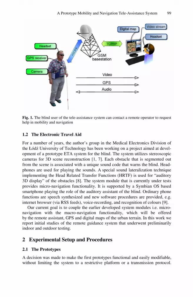
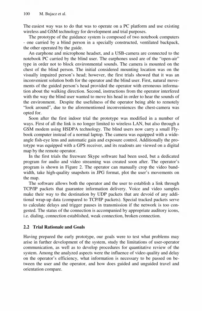
Fig. 1. The blind user of the tele-assistance system can contact a remote operator to request help in mobility and navigation
1.2 The Electronic Travel Aid
For a number of years, the author’s group in the Medical Electronics Division of the Łódź University of Technology has been working on a project aimed at devel-opment of a prototype ETA system for the blind. The system utilizes stereoscopic cameras for 3D scene reconstruction [1, 7]. Each obstacle that is segmented out from the scene is associated with a unique sound code that warns the blind. Head-phones are used for playing the sounds. A special sound lateralization technique implementing the Head Related Transfer Functions (HRTF) is used for “auditory 3D display” of the obstacles [8]. The system module that is currently under tests provides micro-navigation functionality. It is supported by a Symbian OS based smartphone playing the role of the auditory assistant of the blind. Ordinary phone functions are speech synthesized and new software procedures are provided, e.g. internet browser (via RSS feeds), voice-recording, and recognition of colours [9].
Our current goal is to couple the earlier developed system modules i.e. micro-navigation with the macro-navigation functionality, which will be offered by the remote assistant, GPS and digital maps of the urban terrain. In this work we report initial studies of the remote guidance system that underwent preliminarily indoor and outdoor testing.
2 Experimental Setup and Procedures
2.1 The Prototypes
A decision was made to make the first prototypes functional and easily modifiable, without limiting the system to a restrictive platform or a transmission protocol.
100 M. Bujacz et al.
The easiest way was to do that was to operate on a PC platform and use existing wireless and GSM technology for development and trial purposes.
The prototype of the guidance system is composed of two notebook computers - one carried by a blind person in a specially constructed, ventilated backpack, the other operated by the guide.
An earphone and microphone headset, and a USB-camera are connected to the notebook PC carried by the blind user. The earphones used are of the “open-air” type in order not to block environmental sounds. The camera is mounted on the chest of the blind person. The initial considered mounting location was on the visually impaired person’s head; however, the first trials showed that it was an inconvenient solution both for the operator and the blind user. First, natural move-ments of the guided person’s head provided the operator with erroneous informa-tion about the walking direction. Second, instructions from the operator interfered with the way the blind user wanted to move his head in order to hear the sounds of the environment. Despite the usefulness of the operator being able to remotely “look around”, due to the aforementioned inconveniences the chest-camera was opted for.
Soon after the first indoor trial the prototype was modified in a number of ways. First of all the link is no longer limited to wireless LAN, but also through a GSM modem using HSDPA technology. The blind users now carry a small Fly-book computer instead of a normal laptop. The camera was equipped with a wide-angle fish-eye lens and automatic gain and exposure control. Additionally the pro-totype was equipped with a GPS receiver, and its readouts are viewed on a digital map by the remote operator.
In the first trials the freeware Skype software had been used, but a dedicated program for audio and video streaming was created soon after. The operator’s program is shown in Figure 2. The operator can manually crop the video band-width, take high-quality snapshots in JPG format, plot the user’s movements on the map.
The software allows both the operator and the user to establish a link through TCP/IP packets that guarantee information delivery. Voice and video samples make their way to the destination by UDP packets that are devoid of any addi-tional wrap-up data (compared to TCP/IP packets). Special tracked packets serve to calculate delays and trigger pauses in transmission if the network is too con-gested. The status of the connection is accompanied by appropriate auditory icons, i.e. dialing, connection established, weak connection, broken connection.
2.2 Trial Rationale and Goals
Having prepared the early prototype, our goals were to test what problems may arise in further development of the system, study the limitations of user-operator communication, as well as to develop procedures for quantitative review of the system. Among the analyzed aspects were the influence of video quality and delay on the operator’s efficiency, what information is necessary to be passed on be-tween the user and the operator, and how does guided and unguided travel and orientation compare.

A Prototype Mobility and Navigation Tele-Assistance System 101
Fig. 2. Screenshot of the operator’s application: A) The video stream, B) Digital map with GPS readouts, with small markers every 5 seconds, C) Connection controls and parameters
2.3 Indoor Trial Description
Three blind volunteers took part in the indoor trials – all male, ages 25-45, two blind since birth, and one for the last 17 years. Two had temporarily successful ret-ina transplantations, which unfortunately regressed leaving them with partial light sensitivity (they were thus blindfolded for the tests). Each of the participants was asked to travel three multi-segment paths and locate a doorway in the corridor.
The multi-segment paths were designated in a 7 by 12 meter hallway. Four cardboard obstacles were deployed at random along the paths and were moved around between each travel attempt, to prevent the participants from memorizing obstacle locations and using them for orientation. One of the experimenters ac-companied the blind volunteers at all times, should a surprising or dangerous situation arise. Every blind volunteer used his long cane during the tests.
Each path was completed in four different “modes”:
a) unguided walk – the participants were told path information only, for example: 10 steps ahead, then turn right and make 6 steps, then make 5 steps and so on. Prior to the tests the number of steps was adjusted to each participant’s stride length. In case a participant forgot the route the experimenter reminded him, but nothing else. This run served as a reference, simulating a path known from memory, but with possible unexpected obstacles along the way.
102 M. Bujacz et al.
b) remote guidance without path information – the blind participant wore the headset, the chest-camera and the backpack with the laptop. The operator pro-vided remote guidance on the base of a real-time video transmission. However, the operator did not provide precise information about the path (number of steps) and only estimated the participant’s position from the video feed.
c) remote guidance with path information – as in the previous mode, the blind volunteers were guided by the remote operator. This time however, the operator provided them with precise information concerning the path (i.e. the exact number of steps to take).
d) walk with a human guide – in this reference run a visually disabled person held a guide’s hand who led their way along the precisely defined path. The speed of walking was dictated by the blind participant. At the end of each trial run the blind participant was asked to point to where he
thought the start of the path was located. This was to test whether focusing on the remote guidance influenced the person’s orientation skills.
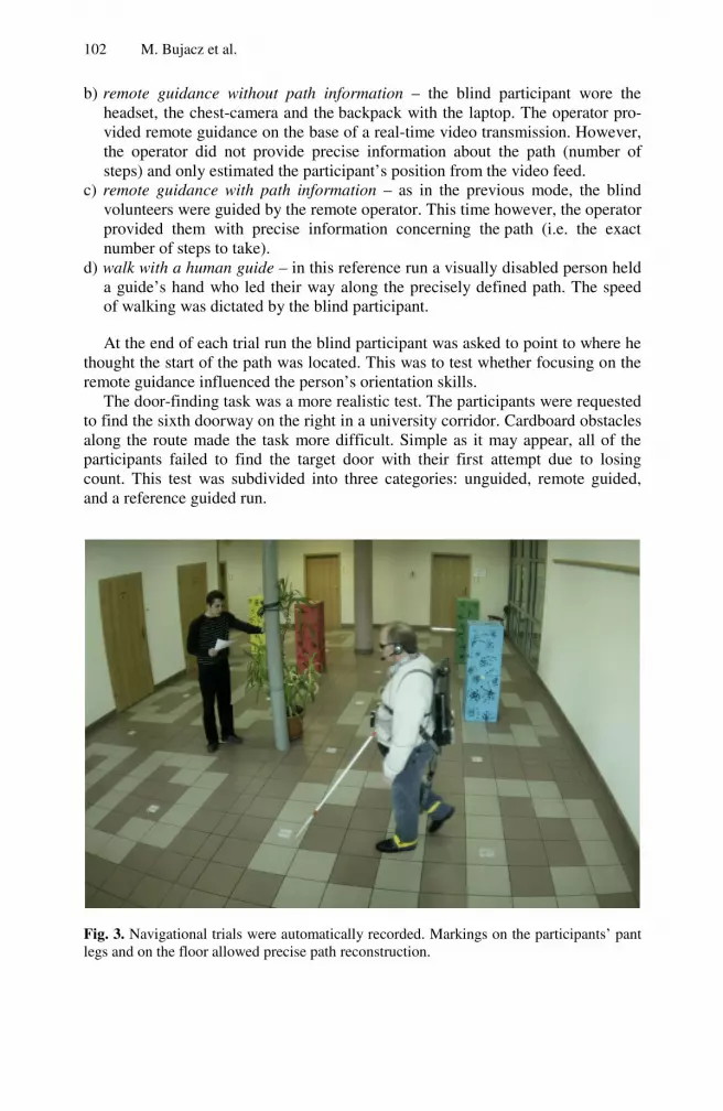
The door-finding task was a more realistic test. The participants were requested to find the sixth doorway on the right in a university corridor. Cardboard obstacles along the route made the task more difficult. Simple as it may appear, all of the participants failed to find the target door with their first attempt due to losing count. This test was subdivided into three categories: unguided, remote guided, and a reference guided run.
Fig. 3. Navigational trials were automatically recorded. Markings on the participants’ pant legs and on the floor allowed precise path reconstruction.
A Prototype Mobility and Navigation Tele-Assistance System 103
2.4 Data Collection
A wide angle camera automatically took pictures of the trials every 2 seconds. A sample photo is presented in Figure 3. Bright markers on the participants’ pant legs allowed quick, half-automated position plotting. The results were interpolated in order to graph the subject’s positions with a resolution of one second. Using this technique it was possible to accurately record, time-stamp and measure all the traversed trial paths. The perceived starting point direction was also marked for each trial.
At the end of the experiment, each participant completed a short survey provid-ing feedback about the proposed system, his communication with the operator, and expectations from the developed device.
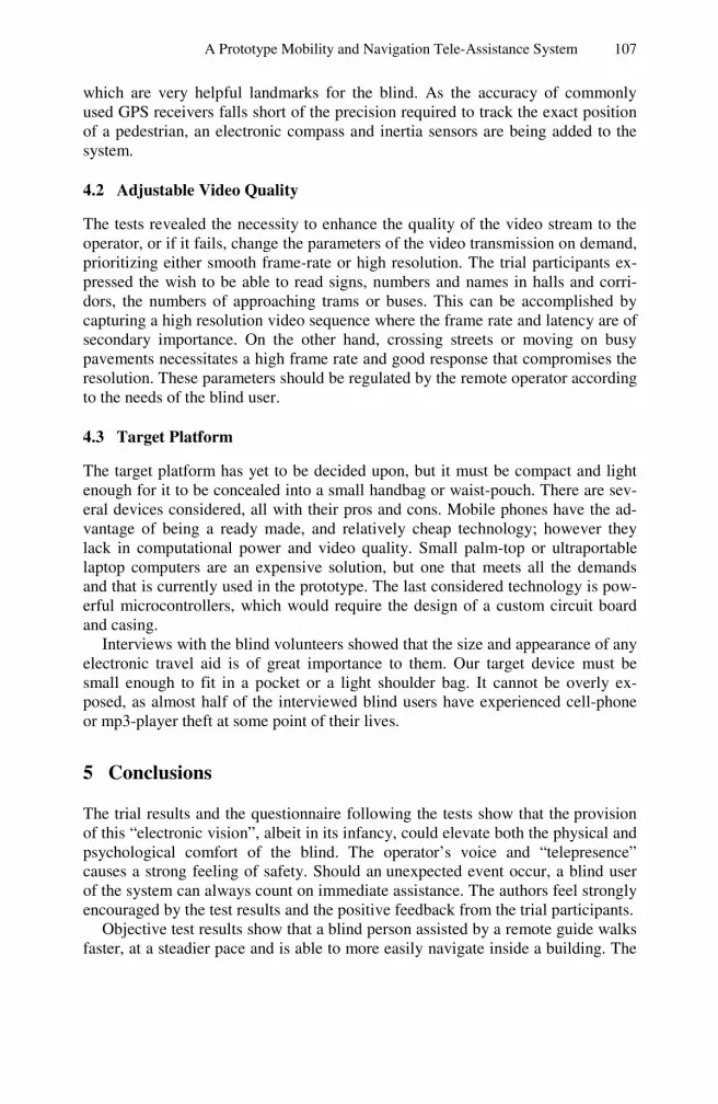
Table 1. Results from one of the trial paths and the door locating task
Path wavering* [m] Path/Task comple-tion time [s]
Error in locating the starting point
Participant MM RP JM MM RP JM MM RP JM
Path 1 (reference, help of a human guide)
- - - 55 38 30 45° 90° Un-
able to
guess
Path 1 (unguided, path information only)
4,0 9,4 3,9 92 82 82 100° 135° 45°
Path 1 (remote guid-ance, no path informa-tion)
10,0 8,1 8,6 69 55 60 55° 45° 55°
Path 1 (remote guid-ance with path infor-mation)
5,1 9,8 7,5 63 60 58 45° 45° 45°
Door locating task (reference)
- - - 30 36 30 - - -
Door locating task (unguided)
- - - 60 66 94 - - -
Door locating task
(remote guidance) - - - 34 36 38 - - -
*sum of distances from 5 key path points
2.5 Outdoor Trial Description
The second trial, performed with the more portable prototype with an UMTS-/HSDPA modem, consisted of navigating outdoor paths on the university campus. The same three visually impaired volunteers participated in the tests. Trial paths were chosen to provide multiple obstacles, such as stairs, trash cans, park benches, lamp posts and fire hydrants. Every blind volunteer used his long cane during the tests. The paths had only limited turns to be easily remembered. One of the expe-rimenters accompanied the blind volunteers at all times for safety purposes, but provided assistance only in dangerous situations.

104 M. Bujacz et al.
In order to prevent path familiarization to influence the results, the three trial participants completed the paths in three different “modes” in the order: a), a), b), c), b), c), b), c), b), c), where:
a) walk with a human guide – walking hand-in-hand with a guide, who explained
the turns in the path and any dangers along it. All three participants claimed that one run was sufficient to memorize the simple paths, but the process was repeated twice.
b) remote guidance – the blind participant wore the earpiece, chest-camera and the portable mini-laptop. The operator provided remote guidance on the base of the real-time video transmission and observed the volunteer’s positions thanks to GPS readouts displayed on his digital map.
c) independent walk – the participants relied only on themselves to navigate the paths, they were warned when in danger or when they lost their way. Thanks to such distribution of modes, the familiarization with the path in-
creased steadily and evenly influenced both the remote assisted and independent attempts.
Table 2. Outdoor trial times
Path I times Path II times
JM MM RP JM MM RP
Assisted 1 03:27 03:58 04:06 03:21 06:00 04:00
Independent 2 03:31 04:00 03:50 04:02 06:41 04:40
Assisted 3 02:57 03:44 03:18 03:06 05:09 03:50
Independent 4 03:06 03:20 03:53 03:50 05:15 04:09
Assisted 5 02:58 03:06 02:55 03:58 03:58 03:37
Independent 6 03:05 03:30 03:10 03:17 04:41 03:51
Assisted 7 02:55 03:08 02:55 03:40 03:20 03:26
Independent 8 03:00 03:08 03:03 03:20 04:32 03:29
During each path attempt the participants were timed, and the number of mis-steps, minor collisions, potentially dangerous collisions and path confusions were counted. Missteps were either slight stumbles, or stepping on the grass. Minor col-lisions were counted when unexpected obstacles were hit strongly with a cane, or a volunteer brushed against an obstacle. Dangerous collisions were always pre-vented by the assisting experimenter, but included such dangers as tripping on stairs, or walking into an obstacle missed with the cane.
The GPS position readouts were recorded once every second. The experiments were recorded and later replayed so that the participants’ positions at 5 second in-tervals could be plotted. The collected data is presented in Table 2 and the total re-sults, summed for the three participants are shown in Figure 4.

A Prototype Mobility and Navigation Tele-Assistance System 105
0
5
10
15
20
Path I Assited Total
Path IIAssisted
Total
Path I Indep. Total
Path II Indep. Total
Missteps
Minor Collisions
Dangerous Collisions
Lost Way
Fig. 4. Comparison of the total number of unfortunate event occurrences for assisted vs. in-dependent trials totalled for all participants and all attempts on two outdoor paths.
3 Trial Results and Analysis
3.1 Performance Review
Comparing the performance between the three participants is difficult as the cause of their blindness and mobility skills are disparate. The results provided in Table 1 are the most representative of the group. Due to space constrains the table shows data for only one of the three test paths.
The detailed trial data shows that the help of a remote guide is a significant im-provement over travelling unguided. It is still far from assistance of a human guide present onsite, but the average travel speeds were 20-50% better then when trav-ersing the paths unguided. In outdoor trials the time differences were less signifi-cant – 15-20%. This is primarily due to the real-world environment in which the trial participants were experienced in navigating. The trials were constructed in such a way as to quickly familiarize the blind volunteers with the paths, leading them to reach quickly reach a similar safe top speed.
The large path wavering when under remote guidance in indoor trials showed that the operator was not always able to precisely estimate the position of the as-sisted person. This is improved once he could provide a-priori instructions about the distances in the paths.
Contrary to their expectations, the blind participants retained better orientation when using the remote guide, than when walking unguided or with a human guide, as evidence by better estimation of the starting point at the end of each path.
The task of locating the correct door was failed by all three participants on the first attempt. The successful unguided attempt was on average two times slower than when assisted by a remote guide.
In the outdoor trials, the main improvement was the certainty of navigation and the decrease in missteps, such as walking onto grass or tripping on curbs, and ac-cidental collisions.

106 M. Bujacz et al.
3.2 Operator Conclusions
One of the main conclusions about the user-operator communication was that that it is far more effective to inform the guided person about a nearby obstacle and let him pass the obstacle alone than trying to manoeuvre him precisely, e.g. with “step left/right” commands. The operator simply instructs: “obstacle on the left, a doorway on half right”. It requires less effort from both the operator and the blind pedestrian, is more concise and yields better results. After all, the ultimate goal of the system is to complement and not replace the way the blind travel.
The operator’s adjustment to each blind user’s needs seemed to be a key pa-rameter in providing effective navigation. When encountering obstacles, short and simple commands e.g. “park bench on your left, a doorway on half right” were far more welcome to most users than precise manoeuvring instructions. To ensure the blind persons maintain a proper walking direction it was advisable to find a travel boundary, e.g. ,,a walk along the left curb’’. From the psychological point of view operator-user communication should be settled individually with every blind user. Some participants only wanted short navigating instructions and obstacle warn-ings; others felt more comfortable and safe after a more detailed description of the environment.
3.3 Survey Results
Both trials were followed by short questionnaires, which revealed some important points for improving the system. All the respondents expressed great excitement about the project. They professed that if the device comes into being, they would use it on daily basis to travel with more confidence and explore new areas. They conceded that the presence of the operator’s voice engendered a feeling of safety, which the ETA [1] all of them had contact with previously could not compare to.
The surveyed participants expressed a general reluctance to hold any extra items such as an electronic compass or a camera, and under no circumstance would they relinquish their canes.
Their three primary predicaments that need to be addressed are as follows:
a) finding a set of traffic lights to safely cross a pedestrian-crossing, b) finding the button to activate a green light on a pedestrian-crossing, and c) searching for a quiet street and being guided across it. Traversing a pedestrian-
crossing with no traffic lights is the most risky task. They can be solved by the developed system.
4 Present and Future Work
4.1 Enhancing GPS Navigation
The inclusion of a GPS receiver greatly enhanced the system’s functionality. Availability of precise digital maps enables the visualization of sidewalks, lawns, the outlines of buildings, stairs, traffic lights, zebra crossings, bus and tram stops
A Prototype Mobility and Navigation Tele-Assistance System 107
which are very helpful landmarks for the blind. As the accuracy of commonly used GPS receivers falls short of the precision required to track the exact position of a pedestrian, an electronic compass and inertia sensors are being added to the system.
4.2 Adjustable Video Quality
The tests revealed the necessity to enhance the quality of the video stream to the operator, or if it fails, change the parameters of the video transmission on demand, prioritizing either smooth frame-rate or high resolution. The trial participants ex-pressed the wish to be able to read signs, numbers and names in halls and corri-dors, the numbers of approaching trams or buses. This can be accomplished by capturing a high resolution video sequence where the frame rate and latency are of secondary importance. On the other hand, crossing streets or moving on busy pavements necessitates a high frame rate and good response that compromises the resolution. These parameters should be regulated by the remote operator according to the needs of the blind user.
4.3 Target Platform
The target platform has yet to be decided upon, but it must be compact and light enough for it to be concealed into a small handbag or waist-pouch. There are sev-eral devices considered, all with their pros and cons. Mobile phones have the ad-vantage of being a ready made, and relatively cheap technology; however they lack in computational power and video quality. Small palm-top or ultraportable laptop computers are an expensive solution, but one that meets all the demands and that is currently used in the prototype. The last considered technology is pow-erful microcontrollers, which would require the design of a custom circuit board and casing.
Interviews with the blind volunteers showed that the size and appearance of any electronic travel aid is of great importance to them. Our target device must be small enough to fit in a pocket or a light shoulder bag. It cannot be overly ex-posed, as almost half of the interviewed blind users have experienced cell-phone or mp3-player theft at some point of their lives.
5 Conclusions
The trial results and the questionnaire following the tests show that the provision of this “electronic vision”, albeit in its infancy, could elevate both the physical and psychological comfort of the blind. The operator’s voice and “telepresence” causes a strong feeling of safety. Should an unexpected event occur, a blind user of the system can always count on immediate assistance. The authors feel strongly encouraged by the test results and the positive feedback from the trial participants.
Objective test results show that a blind person assisted by a remote guide walks faster, at a steadier pace and is able to more easily navigate inside a building. The
108 M. Bujacz et al.
trials provided valuable experience to the designers concerning future require-ments from the target platform and the communication channel.
Another concept worth considering is that the operators themselves could be disabled individuals. Confined to a wheelchair, they could find employment in aiding the blind.
Acknowledgments
The authors would like to express their deep gratitude to the volunteers from the Łódź Center of the Polish Society of the Blind, for their steadfast cooperation, un-abated patience and invaluable feedback in areas for improving the system.
This work has been supported by the Polish Ministry of Science and Higher Education grant no. R02 01303 in years 2007–2010.
References
1. Strumiłło, P., Pełczyński, P., Bujacz, M., Pec, M.: Space perception by means of acous-tic images: an electronic travel aid for the blind. In: Acoustics High Tatras 33rd Intern. Acoustical Conference - EAA Symposium, Strbske Pleso, Slovakia, pp. 296–299 (2006)
2. Bourbakis, N.: Sensing surrounding 3-D space for navigation of the blind. In: IEEE En-gineering in Medicine and Biology Magazine, pp. 49–55 (Janaury-Feburary 2008)
3. Garaj, V., Jirawimut, R., Ptasiński, P., Cecelja, P., Balachandran, W.: A system for re-mote sighted guidance of visually impaired pedestrians. British J. Visual Impairment 21, 55–63 (2003)
4. Hunaiti, Z., Garaj, V., Balachandran, W., Cecelja, F.: Use of remote vision in navigation of visually impaired pedestrians. International Congress Series 1282, 1026–1030 (2005)
5. Web page, http://www.ives.fr/ (accessed April 3, 2009) 6. Web page, http://www.warsawvoice.pl/view/17989 (accessed April 3,
2009) 7. Web page, http://www.naviton.pl (accessed April 3, 2009) 8. Pec, M., Bujacz, M., Strumiłło, P.: Personalized head related transfer function meas-
urement and verification through sound localization resolution. In: Proc. 15th European Signal Processing Conference (EUSIPCO 2007), Poznań, Poland, pp. 2326–2330 (2007)
9. Strumiłło, P., Skulimowski, P., Polańczyk, M.: Programming Symbian smartphones for the blind and visually impaired. In: Łódź (ed.) Intern. Conference on Computers in Medical Activity. LNCS. Springer, Heidelberg (2007) (to be published)