a heritage interpretation-based itinerary to enhance tourist
TRANSCRIPT
sustainability
Article
A Heritage Interpretation-Based Itinerary to EnhanceTourist Use of Traditional Rural Buildings
Paola M. Leanza 1,†, Simona M. C. Porto 1,*, Vincenzo Sapienza 2,† and Santi M. Cascone 2,†
Received: 4 November 2015; Accepted: 29 December 2015; Published: 6 January 2016Academic Editor: Victor T. King
1 Department of Agriculture, Food and Environment, University of Catania, S. Sofia n˝100, Catania 95123,Italy; [email protected]
2 Department of Civil Engineering and Architecture, University of Catania, S. Sofia n˝64, Catania 95123, Italy;[email protected] (V.S.); [email protected] (S.M.C.)
* Correspondence: [email protected]; Tel.: +39-095-714-7582; Fax: +39-392-303-1968† These authors contributed equally to this work.
Abstract: The study describes the planning strategy for a tourist itinerary in rural areas located inSouth-Eastern Sicily which aimed at promoting cultural rural heritage and diversifying the touristoffer. The planning of the tourist itinerary occurred within an appropriate heritage interpretationstrategy as a working method which could facilitate the understanding and social use of the heritagesites located along the itinerary. The tourist itinerary combined significant territory potentialsuch as traditional rural buildings and enogastronomy. It included a starting point; which isa heritage site and an already well known “tourist attraction”, and several other tourist resourcesselected on the basis of the information derived from the analysis of the profile of the averagevisitor to the area. An interpretation center, which was located at the heritage site, and severalinterpretation media placed at each stopping point included in the itinerary supported the touristsduring their trip. By promoting traditional rural buildings and enogastronomy, the tourist itineraryrepresents a significant opportunity for rural diversification and, therefore, can contribute to achievingsustainable socio-economic development of rural areas.
Keywords: rural tourism; tourist itinerary; rural heritage; territorial marketing; building materials
1. Introduction
The tourism sector promises to generate employment, improve infrastructure for the community,help to restore vitality to weak rural economies, increase the profitability of the most underdevelopedregions, improve the standard of living of the local population and encourage citizens to protect andenhance natural and cultural assets [1,2].
In particular, the development of rural tourism offers multiple solutions to problems facing ruralareas by creating new jobs and multi-activities that can result in an increase in income. With regardto a socio-cultural point of view, rural tourism can promote the repopulation of rural areas andthe preservation of crafts, customs and cultural identities. Furthermore, from the point of view ofenvironmental protection, rural tourism can contribute to improving the quality of the natural habitat,built environment and infrastructure. The relationship between rural tourism and sustainabilityaccording to planning strategies and actions and the analysis of potentiality and limits for its impacton sustainable rural development are often argued [3,4].
According to Meyer [1], tourist itineraries are seen as good opportunities for the development oftourism in marginal areas that possess natural or cultural resources and can be defined and associatedto each other by the presence of local products whose quality and reputation are essentially due tonatural factors and human traditions of the geographical environment of origin [5]. Some studies on
Sustainability 2016, 8, 47; doi:10.3390/su8010047 www.mdpi.com/journal/sustainability
Sustainability 2016, 8, 47 2 of 19
planning itineraries in different environmental fields are carried out with particular attention to theoverall strategies of economic planning and to the involvement of stakeholders [6].
The overall objective of the present study is to propose a heritage interpretation-based itinerary(HII) able to influence tourists who visit a famous rural heritage site, to extend their stay in therelated neighbouring rural area and, as a consequence, consume tourist products. In this paper, theHII is defined as a tourist itinerary that is supported by suitable interpretation media and connectsseveral heritage attractions located in a given rural area with a heritage site selected as a tourist catalyst.The term “interpretation” refers to the set of actions aimed at strengthening public awareness regardinga particular heritage site and improving its understanding [7].
Tilden [8] stated that the aim of interpretation is not instruction, but provocation, i.e., a processthat stimulates the mind of a visitor through meditation and leads to the emergence or strengthening ofa feeling. This process on one hand allows visitors to enjoy the new knowledge and develop a positiveattitude towards the protection and conservation of cultural heritage sites and on the other hand favorsthe promotion and marketing of heritage sites in respect to authenticity and integrity [9–12].
In this context, the place where tourists are accommodated can arouse emotions and feelingsthrough which they are encouraged to return to visit a specific geographic area. In rural areas, thetraditional rural buildings (TRBs) can represent a cultural heritage capable of arousing such emotionsand feelings and are often converted for purposes of making accommodation, food services andagricultural activities available to tourists [13–15] and for the economic, social, cultural and landscapebenefits to the rural community [16,17].
The choice of the TRBs as a theme of the itinerary is the novelty of the present study because, inthe literature of the tourism sector, several studies have focused on tourist itineraries based on historiccity-buildings whereas only a few have regarded traditional buildings located in rural areas.
The implementation of a HII by following the method proposed in this study should promote thedispersal of tourists and, in turn, the dispersal of economic benefits to marginal areas that, in spite ofhaving considerable environmental and cultural significance, do not have tourist services (e.g., ruralviability, transportation, and accommodation) for suitable tourism development [1].
2. Materials and Methods
2.1. Developing a Heritage Interpretation-Based Itinerary
Tourist itineraries are characterized by the mix of natural, cultural and social resources that conveya distinctive character to the rural areas where the itinerary is located [5]. Heritage is a significantpart of a tourist itinerary and the concept of a heritage route is mainly used in the framework of thepromotion of rural tourism [18,19].
A HII seeks to articulate a set of meanings that endows it with a distinctive identity. Such meaningsare provided by heritage interpretation plans and their connection with tourists are defined withinsuitable heritage interpretation strategies [20].
To develop a HII the phases reported below must be carried out:
(1) Selection of the starting point of the HII. A specific heritage site which is already considered asa “tourist attraction” must be selected as the starting point of the HII. This stage is crucial because,as stated by Prideaux [21], “large well-known attractions create visitor interest in an area andmay constitute the primary drive for a visit”.
(2) Analysis of the visitor profile. To develop a HII, the profile of the visitors must be established.Nationality, education, income level, experience and daily budget are the major factors influencingthe duration of stay. These factors have an impact on the duration of the stay as it emerges fromstudies on the length of stay of travelers [22]. Examples of visitors' profiles can be found in severalstudies on wine tourism where the general characteristics of potential tourists, which includeddemographic data and behavioral attitudes on the purchase of products, were investigated [23].
Sustainability 2016, 8, 47 3 of 19
(3) Choice of the interpretive elements on the basis of the analysis of the visitor’s profile. The heritagesite selected as starting point of the HII must provide visitors with a number of interpretiveelements (e.g., history, socio-economic context, environmental features, and building techniques)that link it to other TRBs.
(4) Implementation of an interpretation center which will be located at the heritage site selected asa tourist attraction. The interpretation center will ensure the mediation between visitors andthe rural area. At the interpretation center, visitors can gather general information on the areawith regard to natural and cultural resources, customs and ways of life of the local community.This phase of the method involves the production of interpretation media to be placed at theinterpretation center. The type of interpretation media must be previously selected from amongthose possible [11] during the planning phase of the heritage interpretation plan [20]. The contentsof the interpretation media must be consistent with the interpretive elements provided by theheritage site selected as a tourist attraction. Other interpretation media should be placed in eachTRB included in the itinerary as stopping points on the tour, which provide both informationabout the site and the “interpretive elements”.
(5) Implementation of a geographical information system (GIS) to store geographical data and otherattributes which characterize the heritage site selected as a tourist catalyst and the TRBs [20].This kind of system is a useful tool to carry out several relevant analyses: TRBs’ distance from theheritage site selected as a tourist catalyst, TRBs’ mutual distance, characteristics of the viability(e.g., slope and type of road surface), information on the services offered to tourists along theitinerary such as places to taste food products, eat, stay, and where to find picnic areas and otherservices. In this context, over the years, food and beverages have become the most importantcomponents of the tourist experience [24]. By promoting local products, food and tourismrepresent a significant opportunity for rural diversification [23–25] and, therefore, can contributeto achieving one of the objectives of multifunctional agriculture: the socio-economic developmentof rural areas [26].
(6) TRBs connections through the HII. The number of kilometers which visitors are able to travel ina day (about 180/200 km) [5] should be taken into account in the selection of TRBs’ connections.The perception of geographical distance may be affected by the morphology of the territory (e.g.,shape of the paths, winding roads, presence of slopes, shrubs, road signs, and natural landmarks)and any cultural differences between the visitors’ places of origin and the tourist destination [5].The distance perceived by the tourist is a mental representation of the actual distance formedon the basis of the social, cultural and life experiences of an individual that has the power toincrease or decrease the cognition of the cost of transport and has an important role in the choiceof a holiday destination [21,27]. If the destination of the trip is particularly attractive to the visitor,the presence of routes in the itinerary where the distance perceived by tourists is greater than thegeographical one does not have a dramatic impediment on the carrying out of the tour [28].
The method proposed in this paper was applied to develop a HII in South-Eastern Sicily (Italy) inthe area of the Hyblean Plateau.
The final objective of the study was to implement the actions of learning of the heritageinterpretation strategy [20] developed within a pilot project of the Archimed programme of theCommunity Initiative Interreg III B, entitled “Tourism Uses of the Historic Environment. Know-HowTransfer and Quality Management Practices at Community Level”, commonly referred to as Herodot.
2.2. The Area of Study
The itinerary is located in the Province of Ragusa in Sicily (Italy) and is close to the coastal areawhich attracts a large influx of tourists in the summer season due to seaside tourism.
Sustainability 2016, 8, 47 4 of 19
2.2.1. Tourist Flows in the Province of Ragusa and Tourist Accommodations
In the Province of Ragusa between the years 2011 and 2012, tourist arrivals and stays totaled208,319 and 816,438, respectively (data released by the Department of Tourism, Sport and Entertainmentof the Region of Sicily). The analysis of the data shows a clear predominance of internal tourism (visitorsresident and non-resident within the Italian country) because only about 29% of the tourist arrivalsand 36% of tourist stays were foreign tourists. Among Italians, as seen by stays and arrivals, Siciliansare the major visitors to the province, followed by visitors from Lombardy, Latium and Campania.Among the foreign tourists, French tourists were the greatest number of visitors, followed by thosecoming from Germany, Switzerland, United Kingdom, Belgium, Israel, Netherlands, United States ofAmerica, and Russia.
An increased influx of tourists is generally recorded in July, August and September in comparisonto the other months of the year. Therefore, from this analysis, the importance of a seasonal adjustmentin tourism emerges because it is mostly centered on accommodation in resorts located along the coast.
During the considered time interval, tourist accommodation facilities amounted to 480, andwere divided into hotels (95), which are located mainly in the coastal area and in urban centers, andother types of accommodations (385) such as camping, holiday parks, rentals, farmhouses, bed &breakfasts and other accommodation. The number of beds available in the considered accommodationamounted to 10,566 for the hotels and to 5790 for the other type of accommodation. With regard totourist accommodation in rural areas, a total of 524 beds were present in 26 farmhouses as well asa conspicuous number of bed & breakfasts.
As it emerges from stays and arrivals, tourists had a preference for hotels.
2.2.2. Main Tourism Attractions in the Area under Study
The Baroque Architecture
The baroque designs of the cities of Modica, Noto, Palazzolo Acreide, Ragusa Ibla, Scicli, Catania,Caltagirone and Militello Val di Catania, located in South-Eastern Sicily, has been included by UNESCOin the World Heritage List because they represent a considerable collective achievement, successfullycarried out to a high standard from an architectural point of view. Built according to the late baroquestyle, they also show particular innovation in urban design and in the actual building of the city.
The Ruins of Kamarina
The area of study is close to the ruins of Kamarina, a city which was founded by the Syracusansat the beginning of the sixth century B.C. (598–597 B.C.) on the fertile promontory between the Ippariand Oanis rivers (nowadays called Rifriscolaro) with the intent to create a passage to the African routeand to control the southward expansion of the town of Gela.
The Regional Archaeological Museum of Kamarina is among the most interesting in Sicily, forboth its wealth of collections and location. The museum is situated in the archaeological area of theancient city of Kamarina 35 km from Ragusa.
The museum is a rural building from the nineteenth century, and a significant example ofan agricultural residential typology which is very common on the Hyblean coast. The constructionis made up of different buildings organised around a central space which is open on two sides andfaces towards the countryside. It is located on the acropolis where the temple of Athena once stoodand the ruins can still be found inside one of the rooms of the museum. The museum illustrates thepolitical, civil and economic history of the city of Kamarina, its urban development, the most importantmonuments, and the material and artistic production.
Natural Attractions
In general, protected natural areas are important resources because, by being an importantdestination for leisure, they may become tourist catalysts for the territory where they are located.
Sustainability 2016, 8, 47 5 of 19
In the Province of Ragusa, two natural regional reserves currently exist: the Riserva NaturaleOrientata “Pino d’Aleppo” near the city of Vittoria and the Riserva Naturale Speciale Biologica“Macchia Foresta del Fiume Irminio” near the city of Marina di Ragusa.
Wine and Food
Wine and food tourism represents a form of cultural tourism. In fact, through the preservationand enhancement of agriculture and wine growing territories, wine and food tourism offers a newway to experience a holiday. Another important aspect of wine and food tourism concerns the fact thatit favors the equal distribution of the tourist flow because it is available all year round.
The various climatic conditions in Sicily are favorable to wine and food tourism. In fact, a widevariety of cultivation and breeding supply the basic products for the wide array of typical Siciliandishes which are strongly bonded to the territory. Local agricultural products can be divided into thefollowing categories: products of protected nomination (DOP), products of protected geographicalindication (IGP), and traditional products.
Organized visits to wineries allow tourists to taste wine, typical products and local dishes.Furthermore, tourists have the opportunity to experience the place by participating in localproduct processing.
3. Results and Discussion
3.1. The Starting Point of the HII
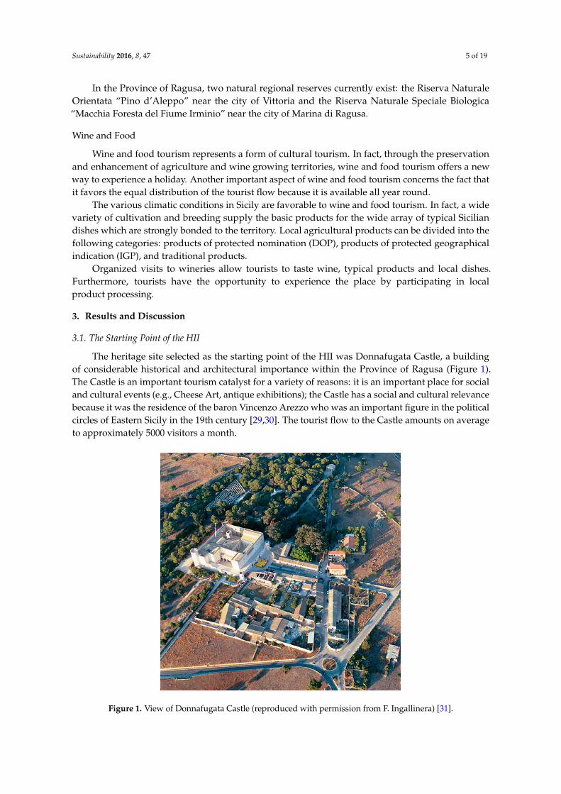
The heritage site selected as the starting point of the HII was Donnafugata Castle, a buildingof considerable historical and architectural importance within the Province of Ragusa (Figure 1).The Castle is an important tourism catalyst for a variety of reasons: it is an important place for socialand cultural events (e.g., Cheese Art, antique exhibitions); the Castle has a social and cultural relevancebecause it was the residence of the baron Vincenzo Arezzo who was an important figure in the politicalcircles of Eastern Sicily in the 19th century [29,30]. The tourist flow to the Castle amounts on averageto approximately 5000 visitors a month.
Figure 1. View of Donnafugata Castle (reproduced with permission from F. Ingallinera) [31].
Sustainability 2016, 8, 47 6 of 19
The Castle is located about 20 km from Ragusa city and a little farther from Ibla, the old citywhich was built on the ancient urban centers of Ragusa and attracts millions of visitors from aroundthe world as a sublime example of Sicilian Baroque; less than 15 km from the coast of Ragusa; about10 km from Kamarina Museum; about 10 km from a farm associated with the wine road “Cerasuolo diVittoria dal Barocco al Liberty”; about 15 km from a farm in the Irminio valley, associated with theconsortium “Monti Iblei” which was established for the protection of extra virgin olive oil.
Concerning the architectural features, the Castle was originally a fortified farmhouse in the 18thcentury, built on the ancient buildings from the 10–11th century. The entrance to the Castle is precededby a wide path, on both sides of which, in addition to the storehouse and the cowshed, are the homesof the peasants who worked for the baron. The Castle has been subject to various transformationsthroughout the decades. The oldest part of the building is the massive square tower situated in thecenter. The Castle is fronted by a long terrace above the main entrance. At both ends, two circulartowers arise, which are accessible by narrow stairs. The terrace leads to the great tower on one sideand on the other to the wide and sumptuous staircase that leads to the park. Beyond the terrace, thereis a Gothic-Venetian style loggia which was built at the beginning of the XX century. Underneath,there are large pointed balconies in the same style as the loggia. These are decorated with beautifulsculptures and motifs that recall the Roman bestiary alternated with beautiful female figures. On theother sides of the Castle, there are many double lancet windows and two towers. The first tower, builtbetween 1950 and 1960, has a square base and stairs made of hard limestone. The second tower, tallerthan the first, has a circular base and wooden stairs. Between the two towers, in addition to manywindows, there is a moat like those found in ancient castles.
Inside the Castle, passing the main gate, there are storehouses on the left and a chapel on the right.The interior of the chapel, though simple, with its barrel vault and suffused light, creates a sense ofmystical serenity.
In the large yard, there are four entrance arches, many doors, balconies and windows. In the mainroom, a flight of stairs made of pitch stones and adorned with benches, vases and statues leads tothe floor where the noble family lived. The statues include a discobolus on the ground floor and twoneoclassical style female figures on the intermediate flights.
3.2. Analysis of the Visitors’ Profile
The profile of the “average” visitor was defined by analyzing the answers given by touristsvisiting Donnafugata Castle in a double-language questionnaire. The questionnaire was distributed tothe visitors before they began their visit [20].
The data from the questionnaire showed that visitors to the Castle are mostly Italians, areaged between 41 and 61 years, have a good cultural background, stay in the area for 1–3 days,are self-organized tourists, and use personal cars as their main means of transport. From this data,it emerges that Donnafugata tourists may decide to extend their visit to the Hyblean area whenorganizing their holiday which is mostly carried out without the aid of tour operators and, therefore,not subject to time constraints.
From the analysis in the questionnaire, the majority of visitors (74.6%) preferred coastal areas asplaces of accommodation and only 11.3% of tourists chose farmhouses as places to stay. The aspectsof the area that most strongly provoked tourists’ curiosities were its gastronomy (41.3%) andrural architecture (33.0%). Moreover, visitors would have a higher knowledge of the architecturalcharacteristics of TRB [20], which in this study became the elements to be interpreted in the HII.The itinerary was addressed to tourists aged at least 14 years old and especially coming from Sicily, inorder to raise awareness of the protection and enhancement of the TRBs of the island. Furthermore, theitinerary was also addressed to heritage tourists, i.e., those visitors of the middle class, well-educatedand middle-aged. Generally, these kinds of tourists plan their holidays away from their place ofresidence by collecting information on the site they will be visiting on their journey and are morewilling to spend money on travel [21].
Sustainability 2016, 8, 47 7 of 19
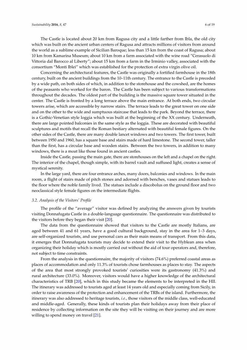
3.3. Choice of the Castle's Elements to be Interpreted
Among the many interpretive elements that the Castle could provide, only the building materialsand techniques used in its construction have been considered in this study. If knowledge of theseinterpretive elements is properly widespread among visitors, it might inspire tourists to learn moreabout a particular cultural trait of the local community that, in this case, is the manner of buildingwhich was influenced by local environmental resources such as limestone, asphaltic stone and wood.
In this study, knowledge of the materials and building techniques applied in the construction ofthe Donnafugata Castle was deepened through the acquisition of drawings (e.g., maps, floor plans,tables, sections, and degradation maps) made available by the technical bureau of the Municipality ofRagusa. Information was also gathered by means of inspections and metric and photographic surveys.
Though the building typology of the Castle looks quite different from that of its neighboringTRBs, several architectural elements (e.g., floor, vault, roof) were made with the same materials andbuilding techniques as those used in the construction of TRBs (Figure 2).
Figure 2. Materials and building techniques common to Donnafugata Castle and TRBs in itssurrounding area.
Sustainability 2016, 8, 47 8 of 19
3.4. Implementation of the Interpretation Center Located in the Donnafugata Castle
Tourists of the Donnafugata Castle can visit the interior of the building which itself will serve asthe interpretation center for the surrounding area. Here, tourists can obtain information on buildingmaterials and techniques used in the construction of the Castle and can have a look at the map of theHII with indications of the streets and stopping points.
The interpretation media placed at the Donnafugata Castle and at the stopping points of the HIIwere chosen on the basis of the results obtained from studies conducted in previous research [20] thathad shown the degree of appreciation by tourists about the means of interpretation already in useat the Donnafugata Castle and those which may be integrated. Therefore, the interpretation mediaproduced in the research described in this paper were: a didactic graphic panel to be placed at theDonnafugata Castle, the panels to be placed at the stopping points, and a mini-guide that tourists cantake with them during the tour.
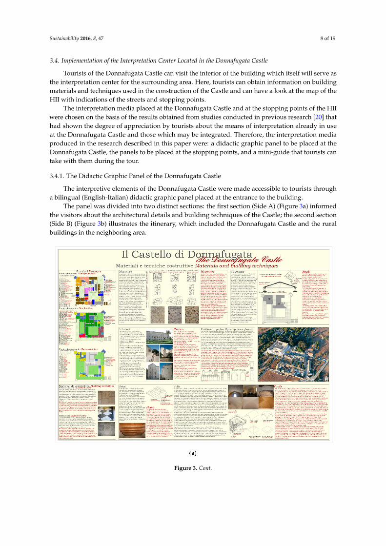
3.4.1. The Didactic Graphic Panel of the Donnafugata Castle
The interpretive elements of the Donnafugata Castle were made accessible to tourists througha bilingual (English-Italian) didactic graphic panel placed at the entrance to the building.
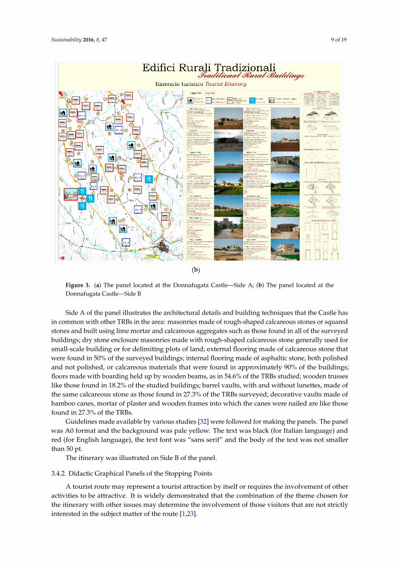
The panel was divided into two distinct sections: the first section (Side A) (Figure 3a) informedthe visitors about the architectural details and building techniques of the Castle; the second section(Side B) (Figure 3b) illustrates the itinerary, which included the Donnafugata Castle and the ruralbuildings in the neighboring area.
Figure 3. Cont.
Sustainability 2016, 8, 47 9 of 19
Figure 3. (a) The panel located at the Donnafugata Castle—Side A; (b) The panel located at theDonnafugata Castle—Side B
Side A of the panel illustrates the architectural details and building techniques that the Castle hasin common with other TRBs in the area: masonries made of rough-shaped calcareous stones or squaredstones and built using lime mortar and calcareous aggregates such as those found in all of the surveyedbuildings; dry stone enclosure masonries made with rough-shaped calcareous stone generally used forsmall-scale building or for delimiting plots of land; external flooring made of calcareous stone thatwere found in 50% of the surveyed buildings; internal flooring made of asphaltic stone, both polishedand not polished, or calcareous materials that were found in approximately 90% of the buildings;floors made with boarding held up by wooden beams, as in 54.6% of the TRBs studied; wooden trusseslike those found in 18.2% of the studied buildings; barrel vaults, with and without lunettes, made ofthe same calcareous stone as those found in 27.3% of the TRBs surveyed; decorative vaults made ofbamboo canes, mortar of plaster and wooden frames into which the canes were nailed are like thosefound in 27.3% of the TRBs.
Guidelines made available by various studies [32] were followed for making the panels. The panelwas A0 format and the background was pale yellow. The text was black (for Italian language) andred (for English language), the text font was “sans serif” and the body of the text was not smallerthan 50 pt.
The itinerary was illustrated on Side B of the panel.
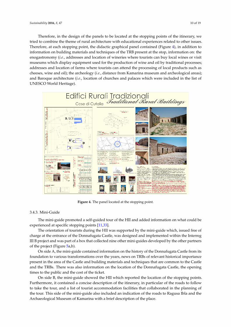
3.4.2. Didactic Graphical Panels of the Stopping Points
A tourist route may represent a tourist attraction by itself or requires the involvement of otheractivities to be attractive. It is widely demonstrated that the combination of the theme chosen forthe itinerary with other issues may determine the involvement of those visitors that are not strictlyinterested in the subject matter of the route [1,23].
Sustainability 2016, 8, 47 10 of 19
Therefore, in the design of the panels to be located at the stopping points of the itinerary, wetried to combine the theme of rural architecture with educational experiences related to other issues.Therefore, at each stopping point, the didactic graphical panel contained (Figure 4), in addition toinformation on building materials and techniques of the TRB present at the stop, information on: theenogastronomy (i.e., addresses and location of wineries where tourists can buy local wines or visitmuseums which display equipment used for the production of wine and oil by traditional processes;addresses and location of farms where tourists can attend the processing of local products such ascheeses, wine and oil); the archeology (i.e., distance from Kamarina museum and archeological areas);and Baroque architecture (i.e., location of churches and palaces which were included in the list ofUNESCO World Heritage).
Figure 4. The panel located at the stopping point.
3.4.3. Mini-Guide
The mini-guide promoted a self-guided tour of the HII and added information on what could beexperienced at specific stopping points [11,33].
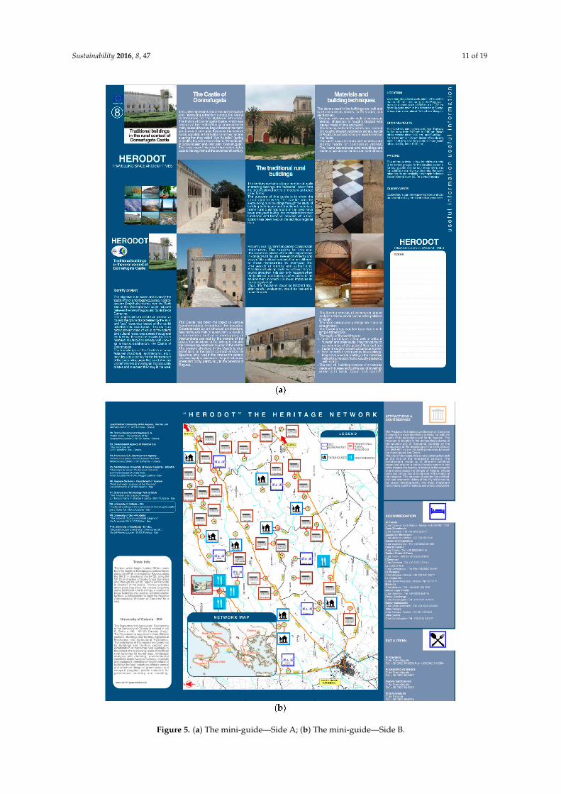
The orientation of tourists during the HII was supported by the mini-guide which, issued free ofcharge at the entrance of the Donnafugata Castle, was designed and implemented within the InterregIII B project and was part of a box that collected nine other mini-guides developed by the other partnersof the project (Figure 5a,b).
On side A, the mini-guide contained information on the history of the Donnafugata Castle from itsfoundation to various transformations over the years, news on TRBs of relevant historical importancepresent in the area of the Castle and building materials and techniques that are common to the Castleand the TRBs. There was also information on the location of the Donnafugata Castle, the openingtimes to the public and the cost of the ticket.
On side B, the mini-guide showed the HII which reported the location of the stopping points.Furthermore, it contained a concise description of the itinerary, in particular of the roads to followto take the tour, and a list of tourist accommodation facilities that collaborated in the planning ofthe tour. This side of the mini-guide also included an indication of the roads to Ragusa Ibla and theArchaeological Museum of Kamarina with a brief description of the place.
Sustainability 2016, 8, 47 11 of 19
Figure 5. (a) The mini-guide—Side A; (b) The mini-guide—Side B.
Sustainability 2016, 8, 47 12 of 19
3.5. Implementation of the Geographical Information System (GIS)
The use of a GIS software made it possible to acquire, store, and display information about TRBsuse, localisation, and building materials and techniques [17]; main and secondary road characteristics;and tourist accommodation located in the area near the Castle. Table 1 lists the attributes which wererecorded in the thematic layer “building features” for each TRB of the sample.
Table 1. The building features of TRBs.
Information on Buildings’ External and Internal Architectural Features
Buildings’ current useBuildings’ visibility from the main roads
Buildings’ conservation stateBuildings’ accessibility
Buildings’ location in relation to soil morphologyBuildings’ bodily configuration
Buildings’ number of floorsBuildings’ number of free façades
External furnishingsExternal floorings
MasonriesFair-faced stonework of the façades
Surface finished of the façadesExternal plasters
Elements of façades demarcationPartition wall
Internal plastersGeometrical characteristics of the openings
FlooringsVaults
Roof’s shape and gutter’s positionRoof’s covering
With the aim of studying the viability of the HII, the GIS used is Quantum GIS, a commercialpackage open source, which stores the following information on the main and secondary roads:geometric characteristics (width, slope, number and type of intersections, winding, paving); trafficflow parameters (flow and speed); traffic composition (light and heavy vehicles, pedestrians); type ofusers (regular or not); and the lighting conditions (day and night).
The data were collected by inspections in locus, by analysis of the Technical Regional Cartography,and the data from the Automobile club d’Italia.
With regard to tourist accommodation, the following data was included in the GIS: type offacilities (i.e., farmhouse, bed & breakfast, hotel); availability of restaurants or facilities for food tasting;typical products offered to tourists; number of beds; cost per person for accommodation and lunch;location of picnic areas and swimming pools; services offered to children, elderly and disabled persons;availability of a kitchen to use; access to tour guides; possibilities for playing sport. In addition, theGIS included information on the use of the wireless system and if pets are allowed or not.
The tourist accommodation included in the itinerary were identified by data released by theDepartment of Tourism, Sport and Entertainment of the Region of Sicily, by Provincial tourism boards,by the official websites of the Ragusa city, and TripAdvisor. The tourist services’ offered data werecollected by the above mentioned sources and by websites for each accommodation.
The analysis of the Technical Regional Cartography of the Sicilian Region confirmed a significantpresence of TRBs located in the neighbouring area of the Donnafugata Castle which amountedto 120 TRBs located in an area of approximately 112 km2 that extends from Ragusa to SantaCroce Camerina.
A sample of 46 TRBs was selected on the basis of historical, cultural and architectural relevance.
Sustainability 2016, 8, 47 13 of 19
A lot of the examined TRBs were made up of one-floor units of modest dimension (45.5%).The majority of the TRBs examined (81.8%) had masonries made of rough-shaped calcareous stone
and lime mortar; only a small number of the surveyed buildings (18.2%) made use of square blockscalcareous stone and lime mortar. The original structure had been left untouched for the majority ofthe restored buildings. A significant number of the buildings (63.3%) had at least one curtain wallplastered with lime mortar and calcareous pebbles, the surface of which had been textured usinga sponge float.
With regard to roof shape, pavilions were used exclusively for buildings of significant importance(18.2%), for instance, owners’ houses, whereas traditional mono-pitched and double-pitched roofs,found in 72.8% of the buildings examined, were used to cover farm buildings and peasants’ houses.With regard to roof structure, in 54.5% of the buildings, purlins, boarding, and battens were used tosupport traditional Sicilian tiles, also called “coppi e canali”, which covered the roofs of the majority ofthe surveyed TRBs (81.8%). In a few cases, builders had improperly substituted traditional Siciliantiles with other non-traditional covering materials (18.2%).
Nearly all of the buildings (90.9%) had external floorings made of local calcareous stone, or, inrare cases (9.1%), “terracotta” bricks.
The floorings of the rooms were frequently (36.4%) made of more than one material. In thebuildings surveyed, stone, “terracotta” and ceramic floorings were found. Several buildings examined(63%) had partition walls made of stone.
Finally, rooms on the first floor included vaults and wooden floors, respectively, in 27.3% and36.3% of the surveyed buildings.
Firstly, the itinerary included all the TRBs which were protected by the Superintendence ofCultural and Environmental Heritage of Ragusa and, secondly, the TRBs that were built with the samebuilding materials and techniques as the Donnafugata Castle and had not been tampered with overthe years.
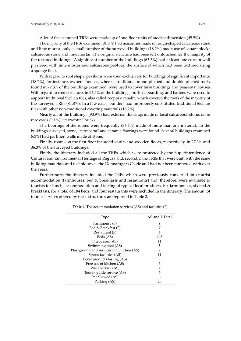
Furthermore, the itinerary included the TRBs which were previously converted into touristaccommodation (farmhouses, bed & breakfasts and restaurants) and, therefore, were available totourists for lunch, accommodation and tasting of typical local products. Six farmhouses, six bed &breakfasts, for a total of 184 beds, and four restaurants were included in the itinerary. The amount oftourist services offered by these structures are reported in Table 2.
Table 2. The accommodation services (AS) and facilities (F).
Type AS and F Total
Farmhouse (F) 9Bed & Breakfast (F) 7
Restaurant (F) 4Beds (AS) 243
Picnic area (AS) 11Swimming pool (AS) 5
Play ground and services for children (AS) 2Sports facilities (AS) 11
Local products tasting (AS) 9Free use of kitchen (AS) 5
Wi-Fi service (AS) 4Tourist guide service (AS) 5
Pet allowed (AS) 6Parking (AS) 20
Sustainability 2016, 8, 47 14 of 19
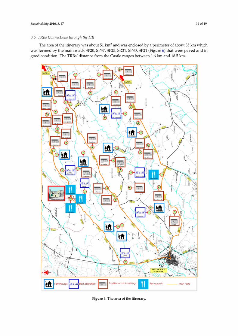
3.6. TRBs Connections through the HII
The area of the itinerary was about 51 km2 and was enclosed by a perimeter of about 35 km whichwas formed by the main roads SP20, SP37, SP25, SR31, SP80, SP21 (Figure 6) that were paved and ingood condition. The TRBs’ distance from the Castle ranges between 1.6 km and 18.5 km.
Figure 6. The area of the itinerary.

Sustainability 2016, 8, 47 15 of 19
On the basis of data collected in the questionnaire [20], the car is still the most widely used meansof transport. This is supported, as observed by other authors [34] by the fact that it is easily availableto the visitors. It is advantageous because it creates independence and flexibility in time management.The use of cars is mostly due to a greater extent to the lack of public transport or inadequacy of thetransport system. Presently, in the area of the itinerary there are no public transportation lines thatconnect the Donnafugata Castle to the town of Ragusa and seaside villages. A private transportationcompany connects Ragusa city and the seaside resorts with the Castle in about 20 min, twice daily.
In addition to the means of transport used by tourists, for the implementation of the connectionsof the HII the eligible kilometers that visitors are able to travel on a day trip were considered as wellas the time required to cover their distances. The kilometers were counted using Google Maps anddata collected by ACI and it considered the distance traveled by tourists on the main roads startingfrom their accommodation, travelling to the Donnafugata Castle, following the tourist itinerary, andreturning to their accommodation.
Ultimately, the visitor can follow the itinerary by car on the roads that circumscribe the area orcan go into and visit the stopping points on the road SP60 (11.0 km) or on the road SP110 (4.4 km)or on the road SP76 (6.00 km) or on a dirt road with a maximum length of 6.2 km. Currently, roadconditions do not allow the HII to be followed by bicycle. In fact, although the road network presenteda traffic composition which predominantly consisted of light vehicles, maximum speed of distance lessthan 80 km/h and transit of habitual users along almost all the connections in the itinerary, it is notequipped with lighting.
Electric minibuses may be employed for the transport of groups of visitors accompanied by touristguides. However, this solution should be coordinated with the local authority that currently managesthe Donnafugata Castle and should provide for a greater involvement of qualified tourist guides whocurrently, as detected by the questionnaire [20], are rarely used by tourists.
The stopping points are generally accessible on foot from farm dirt roads which are a few hundredmeters long.
The perceived distance is not greater than the geometric one which amounts to about 56 km.This is because of the relatively low slope of the roads on the itinerary, the few road crossings, thehigh visibility of the landscape along the roads determined by the sparse and low vegetation, the highvisibility of the buildings chosen as stopping points of the road network, and the view of the sea.
By considering the length of the connections, the HII can be classified as a “single destination” fortourists whose accommodation is placed within the Province of Ragusa or the municipality of Noto(Province of Siracusa) and Caltagirone (Province of Catania). In fact, in a whole day these touriststravel a maximum 180–200 km. This implies a reduction of costs for visitors and a modest touristservice demand in comparison to those itineraries which are to be followed in several days. The HIIcan also be classified as “multiple destination” [35] for tourists coming from geographical areas in whichdistances from the Castle are more than 90 km. In this case, these tourists are accommodated by thetourist facilities located along the itinerary and they can visit other tourist attractions such as thearchaeological site of Kamarina, Ibla which is the old town center of Ragusa, and the wine museum“Valle dell’Acate”.
The cost of the HII mainly depends on the distance to be travelled, the means of transportused [21], the cost of the ticket to the Castle, and the type of services used by tourists. Tourists candecide to have a lunch break and taste many typical dishes of Ragusa as well as local products such asfruits (e.g., oranges Navel, Tarocco and Sanguinello, tangerines and lemons), cheeses (e.g., provolaRagusana, caciocavallo Ragusano, ricotta), wines (Cerasuolo di Vittoria, Nero d'Avola, Ambrato diModica, Albanello), and olive oil.
Possible further improvements of the method to enhance the HII:
(1) During the planning of a HII, the quality of the roads is crucial along with panoramic views, thepresence of traffic signals [28] and services at tourist stops [1]. However, in the examined rural
Sustainability 2016, 8, 47 16 of 19
area, the illumination of the roads should be improved in order to improve visibility and roadsafety and, in turn, broaden the type of means of transport that can be used by tourists.
(2) The number of HII connections could be enlarged by taking into account judgments of preferenceexpressed by tourists and residents on main and secondary roads currently present in the areaunder consideration. This may be implemented through the use of questionnaires, by conductinginterviews and showing photographs for the assessment of the quality of natural and culturalresources found along the main and secondary roads [36,37]. The number of connections of the HIIcould be further expanded through the building of new paths. To this end, it is necessary to analyzethe ground morphology and calculate suitable indicators [38] which permit the choice of the mostappropriate means of transport by quantifying the degree of difficulty of the covered distance.
(3) The availability of tour guides at the selected heritage site is crucial because they act asintermediaries between tourists and an unfamiliar environment, thus playing an importantrole in the success or failure of a tour experience and influencing tourists’ perceptions of thehost destination [39]. For this reason, there are many studies on how to improve the work oftourist guides [39–42], on the different roles and functions that a tour guide can take on [42],such as the role of cultural mediator [41] and as “cultural heritage interpreters” [40]. The qualityof the service offered by the tour guide can be measured by importance performance analysis(IPA) models [42] and improved by studies on emotional intelligence [41], which is universallyrecognized as a means to achieve success in personal and professional fields [39].
(4) In this study, the tourist profile was investigated before the trip (for planning the tourist itinerary),and it would be advisable to review it when tourists make their first evaluations (i.e., during theitinerary) as well as at the end of the tour when they make the final assessments and are betterable to gauge their future preferences [43]. The final assessment of the HII may be carried outby means of questionnaires or interviews and investigate the socio-economic characteristics ofthe tourists, the value of the tourism service (benefits gained and costs), the quality of the touristservices (analysis of the characteristics of a service capable of meeting visitors’ needs), the degreeof tourist satisfaction (perceived performance compared to expectations) [43–48], the relationshipbetween reasons for the visit and the degree of satisfaction [49], and the relationship betweenservice quality and satisfaction [50].
(5) The promotion of the HII must be done through the cooperation between public and privatepartners and the direct involvement of the local community [1]. Better advertising in magazines,newspapers, internet and in hotels and tourist development agencies may attract more visitorsduring the year and adjust the seasonal flow of tourists. The sponsorship of the tour will occurduring the events that take place at the Donnafugata Castle (Cheese art event called “NightCastle”, concerts, theater performances and painting and sculpture exhibitions).
4. Conclusions
The heritage interpretation-based itinerary (HII) proposed in this study was implemented byfollowing a method that would allow tourists to explore rural areas by visiting traditional ruralbuildings (TRBs) at stopping points located along the itinerary.
The Donnafugata Castle was chosen as the starting point of the HII because it was close to touristsites and is visited annually by a large number of tourists.
The analysis of the visitors’ profile of the Donnafugata Castle was decisive in the choice of theelements of interpretation which formed the basis for the HII. Visitors to the Castle were mostly Sicilianand preferred tourist accommodation in the coastal area. In addition, they demonstrated curiosityabout rural architecture and enogastronomy. Therefore, among the many interpretive elements thatthe Castle could provide, this study considered the building materials and techniques used in itsconstruction. Certainly, the interpretive elements selected in this study represent only one possible linkbetween the Castle and TRBs; socio-cultural, environmental, economic and geographical characteristicscould be other subjects of interpretation. In the proposed HII, food and wine were joined to the main
Sustainability 2016, 8, 47 17 of 19
theme because the combination of various subjects of interest within a tourist itinerary led to theinvolvement of people with different inclinations and aptitudes.
An interpretation center was located within the Donnafugata Castle. A didactic graphical panelwas chosen as the main interpretation media to be placed in a room of the Castle because it waspreferred by the visitors to the Castle. Other types of interpretation media were a number of didacticgraphical panels placed at each stopping point on the itinerary and a mini-guide, which was distributedto the visitors at the interpretation center and enabled tourists to carry out self-guided tours.
The use of GIS made it possible to locate TRBs, classify materials and construction techniques, andassess the road conditions in order to select the stopping points of the HII and the means of transport.The GIS also allowed the available main tourist services (e.g., restaurants and accommodations) thatwere included as stopping points to be located.
The GIS analysis showed that the area of the HII is equipped with a large amount of touristaccommodation which was economically advantageous and of good quality (farmhouses and bed &breakfasts).
The study of the TRBs’ connections has shown that the perceived distance along the itinerary isnot much higher than the geometric one. In addition, considering the length of the connections, thetourist itinerary is a “single destination” for tourists staying in Ragusa Province or in the territory of themunicipality of Noto (Province of Siracusa) and Caltagirone (Province of Catania) because the distancethey are able to travel in a day is equal to 180–200 km. However, for tourists who live more than 90 kmaway from the Donnafugata Castle, the HII may be a “multiple destination” because they need to usethe tourist facilities included in the itinerary.
Acknowledgments: The study has been carried out within one of the pilot projects of the PIC–Interreg III, standB, programme Archimed, 2007–2013, entitled, “Tourism Uses of the Historic Environment. Know-How Transferand Quality Management Practices at Community Level”. This project, also known as Herodot, was funded bythe European Union.
Author Contributions: The authors contributed equally to this work.
Conflicts of Interest: The authors declare no conflict of interest.
References
1. Meyer, D. Tourism Route and Gateways: Key Issues for the Development of the Tourism Route and Gateway andTheir Potential for Pro-Poor Tourism; Overseas Development Institute: London, UK, 2004.
2. Sharpley, R. Rural tourism and the challenge of tourism diversification: The case of Cyprus. Tour. Manag.2002, 23, 233–244. [CrossRef]
3. Garau, C. Perspectives on Cultural and Sustainable Rural Tourism in a Smart Region: The Case Study ofMarmilla in Sardinia (Italy). Sustainability 2015, 7, 6412–6434. [CrossRef]
4. Trukhachev, A. Methodology for Evaluating the Rural Tourism Potentials: A Tool to Ensure SustainableDevelopment of Rural Settlements. Sustainability 2015, 7, 3052–3070. [CrossRef]
5. Bruwer, J. South African wine routes: Some perspectives on the wine tourism industry’s structuraldimensions and wine tourism product. Tour. Manag. 2003, 24, 423–435. [CrossRef]
6. Antonson, H.; Steen Jacobsen, J.K. Tourism development strategy or just brown signage? Comparing roadadministration policies and designation procedures for official tourism routes in two Scandinavian countries.Land Use Policy 2014, 36, 342–350. [CrossRef]
7. ICOMOS. Charter for the interpretation and presentation of cultural heritage site. In Proceedings of the 16thGeneral Assembly of ICOMOS, Québec, QC, Canada, 4 October 2008.
8. Tilden, F. Interpreting Our Heritage; University of North Carolina Press: Chapel Hill, NC, USA, 1977.9. Papathanassiou-Zuhrt, D.; Karipis, K.; Doumi, M.; Sakellaridis, O. Applying the interpretive planning process
to promote local heritage in peripheral areas: Serving the visitor in the Highlands of Nafpaktia, Greece.In Proceedings of the International Conference on Advances in Tourism Economics, Vila Nova de Sto André,Portugal, 13–14 April 2007.
10. Copeland, T.; Delmaire, Y. Heritage Intepretation in the Framework of the European Heritage Days; Report of theTraining Course 2003 for European Heritage Days Coordinators; Council of Europe: Strasbourg, France, 2004.
Sustainability 2016, 8, 47 18 of 19
11. Carter, J. A Sense of Place. An Interpretive Planning Handbook, 1st ed.; Tourism and Environment Initiative:Inverness, UK, 1997.
12. Veverka, J. Interpretive Master Planning; Falcon Press: La Habra, CA, USA, 1998.13. De Montis, A.; Ledda, A.; Ganciu, A.; Serra, V.; de Montis, S. Recovery of rural centres and “albergo diffuso”:
A case study inSardinia, Italy. Land Use Policy 2015, 47, 12–28. [CrossRef]14. Porto, S.M.C.; Cascone, G. Indicatori per la valutazione della potenzialità turistico-ricettiva di edifici rurali
tradizionali. J. Agric. Eng. 2008, 4, 43–56. (In Italian)15. Gutierrez Rodriguez, L.; Ruiz Perez, M.; Yang, X.; Geriletu. From Farm to Rural Hostel: New Opportunities
and Challenges Associated with Tourism Expansion in Daxi, a Village in Anji County, Zhejiang, China.Sustainability 2011, 3, 306–321. [CrossRef]
16. Fuentes, J.M.; Gallego, E.; García, A.I.; Ayuga, F. New uses for old traditional farm buildings: The case of theunderground wine cellars in Spain. Land Use Policy 2010, 27, 738–748. [CrossRef]
17. Porto, S.M.C.; Cascone, G. A building characterization-based method for the advancement of knowledge onexternal architectural features of traditional rural buildings. Inf. Constr. 2013, 65, 481–496.
18. Briedenhann, J.; Wickens, E. Tourism routes as a tool for the economic development of rural areas-vibranthope or impossible dream? Tour. Manag. 2004, 25, 71–79. [CrossRef]
19. Meyer-Cech, K. Regional Cooperation in Rural Tourism Trails. In Rural Tourism and Sustainable Business;Hall, D., Kirkpatrick, I., Mitchell, M., Eds.; Channel View Publications: Clevedon, UK, 2005; pp. 137–148.
20. Porto, S.M.C.; Leanza, P.M.; Cascone, G. Developing Interpretation Plans to Promote Traditional RuralBuildings as Built Heritage Attractions. Int. J. Tour. Res. 2012, 14, 421–436. [CrossRef]
21. Prideaux, B. Creating rural heritage visitor attractions—The Queensland heritage trails project. Int. J.Tour. Res. 2002, 4, 313–323. [CrossRef]
22. Gokovali, U.; Bahar, O.; Kozak, M. Determinants of length of stay: A practical use of survival analysis.Tour. Manag. 2007, 28, 736–746. [CrossRef]
23. Jaffe, E.; Pasternak, H. Developing Wine Trails as a Tourist Attraction in Israel. Int. J. Tour. Res. 2004, 6,237–249. [CrossRef]
24. Josiam, B.M.; Mattson, M.; Sullivan, P. The Historaunt: Heritage tourism at Mickey’s Dining Car. Tour. Manag.2004, 25, 453–461. [CrossRef]
25. Plummer, R.; Telfer, D.; Hashimoto, A.; Summers, R. Beer tourism in Canada along the Waterloo–WellingtonAle Trail. Tour. Manag. 2005, 26, 447–458. [CrossRef]
26. Yang, Z.; Cai, J.; Sliuzas, R. Agro-tourism enterprises as a form of multi-functional urban agriculture forperi-urban development in China. Habitat Int. 2010, 34, 374–385. [CrossRef]
27. Ankomah, P.K.; Crompton, J.L.; Baker, D. Influenze of cognitive distance in vacation choice. Ann. Tour. Res.1996, 23, 138–150. [CrossRef]
28. Getz, D.; Brown, G. Critical success factors for wine tourism regions: A demand analysis. Tour. Manag.2006, 27, 146–158. [CrossRef]
29. Leone, G. Donnafugata Il Castello; Filippo Angelica Editore: Siracusa, Italy, 2006.30. Anselmi, G.F.; Arezzo di Trifiletti, G.; Vella, C.; Turco, T. Il Castello di Donnafugata a Ragusa; Edizioni Kalós:
Palermo, Italy, 2002.31. Ingallinera, F. Castello Donnafugata dall'alto, Available online: http://www.panoramio.com/photo/4129944
(accessed on 17 December 2015).32. Curtis, E. Interpretive Project Guide Book; U.S.D.A. Forest Service: Portland, Italy, 1994.33. Izquierdo-Tugas, P.; Tresserras, J.J.; Matamala-Mellini, J.C. Heritage Interpretation Centres. The HICIRA
Handbook; Institut d’Edicions de la Diputació de Barcelona: Diputació de Barcelona, Spain, 2005.34. Lew, A.; McKercher, B. Trip destinations, gateways and itineraries: The example of Hong Kong. Tour. Manag.
2002, 23, 609–621. [CrossRef]35. Lew, A.; McKercher, B. Modeling tourist movements: A Local Destination Analysis. Ann. Tour. Res. 2006, 33,
403–423. [CrossRef]36. Kent, R.L.; Elliott, C.L. Scenic ruotes linking and protecting natural and cultural landscape features:
A greenway skeleton. Landsc. Urban Plan. 1995, 33, 341–355. [CrossRef]37. Ramírez, Á.; Ayuga-Téllez, E.; Gallego, E.; Fuentes, J.M.; García, A.I. A simplified model to assess landscape
quality from rural roads in Spain. Agric. Ecosyst. Environ. 2011, 142, 205–212. [CrossRef]

Sustainability 2016, 8, 47 19 of 19
38. Clius, M.; Teleuca, A.; David, O.; Morosanu, A. Trail accessibility as a tool for sustainable managementof protected areas: Case study Ceahlau National Park, Romania. Procedia Environ. Sci. 2012, 14, 267–278.[CrossRef]
39. Min, J.C.H. A short-form measure for assessment of emotional intelligence for tour guides: Developmentand evaluation. Tour. Manag. 2012, 33, 155–167. [CrossRef]
40. Rabotic, B. Tourist Guides as Cultural Heritage Interpreters: Belgrade Experience withMunicipality-sponsored Guided Walks for Local Residents. In Proceedings of the Cultural andEvent Tourism: Issues & Debates, Alanya, Turkey, 5–9 November 2008; pp. 213–233.
41. Yu, X.; Weiler, B.; Ham, S. Cultural Mediation in Guided Tour Experiences: A Case Study of Australian Guides ofChinese Tour Groups; Monash University: Melbourne, Australia, 2004; Volume 44, p. 12.
42. Zhang, H.Q.; Chow, I. Application of importance-performance model in tour guides’ performance: Evidencefrom mainland Chinese outbound visitors in Hong Kong. Tour. Manag. 2004, 25, 81–91. [CrossRef]
43. Chen, C.-F.; Tsai, D. How destination image and evaluative factors affect behavioral intentions? Tour. Manag.2007, 28, 1115–1122. [CrossRef]
44. Chen, C.-F.; Chen, F.-S. Experience quality, perceived value, satisfaction and behavioral intentions for heritagetourists. Tour. Manag. 2010, 31, 29–35. [CrossRef]
45. De Rojas, C.; Camarero, C. Visitors’ experience, mood and satisfaction in a heritage context: Evidence froman interpretation center. Tour. Manag. 2008, 29, 525–537. [CrossRef]
46. Denstadli, J.M.; Jacobsen, J.K.S. The long and winding roads: Perceived quality of scenic tourism routes.Tour. Manag. 2011, 32, 780–788. [CrossRef]
47. Murphy, P.; Pritchard, M.P.; Smith, B. The destination product and its impact on traveller perceptions.Tour. Manag. 2000, 21, 43–52. [CrossRef]
48. Nowacki, M.M. Quality of Visitor Attractions, Satisfaction, Benefits and Behavioural Intentions of Visitors:Verification of a Model. Int. J. Tour. Res. 2009, 11, 297–309. [CrossRef]
49. Devesa, M.; Laguna, M.; Palacios, A. The role of motivation in visitor satisfaction: Empirical evidence inrural tourism. Tour. Manag. 2010, 31, 547–552. [CrossRef]
50. Hernández Maestro, R.M.; Muñoz Gallego, P.A.; Requejo, L.S. The moderating role of familiarity in ruraltourism in Spain. Tour. Manag. 2007, 28, 951–964. [CrossRef]
© 2016 by the authors; licensee MDPI, Basel, Switzerland. This article is an open accessarticle distributed under the terms and conditions of the Creative Commons by Attribution(CC-BY) license (http://creativecommons.org/licenses/by/4.0/).