a guidebook planning for operations in pennsylvania
TRANSCRIPT
A Guidebook Planning for Operations in Pennsylvania
December 4, 2018
i
Regional Operations Plan (ROP) Central RTMC Region
Contents Executive Summary ....................................................................................................................... v
Acronyms and Abbreviations ...................................................................................................... ix
Chapter 1. Overview of the Region .......................................................................................... 1
Synopsis of the Region ...................................................................................................................................................................................... 1
Key Regional Stakeholders ............................................................................................................................................................................... 5
Region’s ITS and Operations Vision and Planning Process .................................................................................................................. 7 Altoona MPO ................................................................................................................................................................................................................................. 7 Centre County MPO .................................................................................................................................................................................................................... 8 Johnstown MPO ........................................................................................................................................................................................................................... 9 North Central RPO ..................................................................................................................................................................................................................... 10 Northern Tier RPO ..................................................................................................................................................................................................................... 10 SEDA-COG MPO ......................................................................................................................................................................................................................... 11 Southern Alleghenies RPO ..................................................................................................................................................................................................... 11 WATS MPO ................................................................................................................................................................................................................................... 12 Summary of Planning Horizon Times ................................................................................................................................................................................. 13
Chapter 2. Existing Regional Demographics and Transportation Elements ...................... 14
Existing Key Transportation Elements ....................................................................................................................................................... 14 Roadway Network ...................................................................................................................................................................................................................... 14 Transit Service ............................................................................................................................................................................................................................. 14 Airports .......................................................................................................................................................................................................................................... 15 Tourist and Travel Destinations ............................................................................................................................................................................................ 16 Major Employers ........................................................................................................................................................................................................................ 18 Demographics ............................................................................................................................................................................................................................. 19
TSMO Roadway Tiering System .................................................................................................................................................................. 20
Corridors and Areas of Transportation Significance ............................................................................................................................ 21
Regional TSMO Elements .............................................................................................................................................................................. 25
Chapter 3. Existing and Future Operations ........................................................................... 28
TSMO Mapping ................................................................................................................................................................................................. 28
Existing Corridor Performance ..................................................................................................................................................................... 28 Mobility .......................................................................................................................................................................................................................................... 28 Traveler Information and Situational Awareness ........................................................................................................................................................... 33 Safety .............................................................................................................................................................................................................................................. 34 Organization Issues ................................................................................................................................................................................................................... 38
Recently Completed Projects ....................................................................................................................................................................... 38
ii
Regional Operations Plan (ROP) Central RTMC Region
Planned Infrastructure Changes .................................................................................................................................................................. 40 Potters Mill Gap Transportation Project ............................................................................................................................................................................ 40 Route 26 Betterment and I-80/I-99 High Speed and Local Access Interchanges ............................................................................................. 40 Central Susquehanna Valley Transportation Project .................................................................................................................................................... 40 US 219 – Somerset to Meyersdale ...................................................................................................................................................................................... 41 US 30 Traffic Signals – Breezewood .................................................................................................................................................................................... 41 Other Projects Under Consideration .................................................................................................................................................................................. 42
Future Land Use Changes .............................................................................................................................................................................. 42 Natural Gas Drilling ................................................................................................................................................................................................................... 42 Warehouses and Freight ......................................................................................................................................................................................................... 42 Anticipated Development ....................................................................................................................................................................................................... 43 Infrastructure-Related Development .................................................................................................................................................................................. 43
Chapter 4. Transportation Needs and Operational Issues ................................................... 44
Traveler Information ........................................................................................................................................................................................ 44 ITS Device Gaps .......................................................................................................................................................................................................................... 45 Upgrade/Replace Existing Devices ...................................................................................................................................................................................... 46
Incident and Emergency Management .................................................................................................................................................... 47 Integrated Corridor Management ....................................................................................................................................................................................... 47 TIM Teams .................................................................................................................................................................................................................................... 49 Weather Forecasting Integration ......................................................................................................................................................................................... 49 Special Event Use of Portable DMS .................................................................................................................................................................................... 49
Transportation System Safety ...................................................................................................................................................................... 50 Variable Speed Displays .......................................................................................................................................................................................................... 50 Queue Detection ........................................................................................................................................................................................................................ 50 Dynamic Curve Warning ......................................................................................................................................................................................................... 51 Bridge De-Icing ........................................................................................................................................................................................................................... 51 Slow Vehicle Warning............................................................................................................................................................................................................... 52 Automated Truck Enforcement ............................................................................................................................................................................................ 52
Traffic Signal Enhancements ........................................................................................................................................................................ 52
Communications Network ............................................................................................................................................................................ 54 Fiber Backbone ........................................................................................................................................................................................................................... 54 P3 Fiber Potential ....................................................................................................................................................................................................................... 55
Enhanced Asset Management ..................................................................................................................................................................... 56
Automated Systems Management ............................................................................................................................................................. 56
Chapter 5. Strategies and Projects ......................................................................................... 57
Project Prioritization ........................................................................................................................................................................................ 57 Comparative Need .................................................................................................................................................................................................................... 57
iii
Regional Operations Plan (ROP) Central RTMC Region
Regional Impact .......................................................................................................................................................................................................................... 58 Expected Benefit ......................................................................................................................................................................................................................... 59 Overall Project Weighting ....................................................................................................................................................................................................... 60
Project Sequencing .......................................................................................................................................................................................... 60
Project Descriptions ......................................................................................................................................................................................... 62
Estimated Project Costs .................................................................................................................................................................................. 63
Chapter 6. ROP Coordination and Maintenance ................................................................... 64
Appendix A. ROP Project Rankings
Appendix B. Planning Partner Project Maps
Appendix C. Short-Term Projects
Appendix D. Long-Term Projects
Figures Figure 1: TSMO Regions within Pennsylvania ........................................................................................................................................... 2 Figure 2: Central RTMC Region Planning Partners .................................................................................................................................. 1 Figure 3: Central RTMC Region Corridors of Significance .................................................................................................................... 5 Figure 4: Central RTMC Region ITS Devices ............................................................................................................................................ 25 Figure 5: State College Congestion Map ................................................................................................................................................. 29 Figure 6: Danville Congestion Map ............................................................................................................................................................ 30 Figure 7: Lewisburg Congestion Map ....................................................................................................................................................... 30 Figure 8: Central Susquehanna Valley Congestion Map .................................................................................................................... 31 Figure 9: Williamsport Congestion Map .................................................................................................................................................. 31 Figure 10: Altoona Congestion Map ......................................................................................................................................................... 32 Figure 11: Johnstown Congestion Map .................................................................................................................................................... 33 Figure 12: State College Crash Clusters .................................................................................................................................................... 35 Figure 13: Altoona Crash Clusters .............................................................................................................................................................. 36 Figure 14: Williamsport Crash Clusters ..................................................................................................................................................... 37 Figure 15: Bloomsburg Crash Clusters ...................................................................................................................................................... 38 Figure 16: Seven Mountains ITS Project Location Map ...................................................................................................................... 39 Figure 17: I-80/US 11 Phase B ITS Project Location Map .................................................................................................................. 40 Figure 18: CSVT Project Overview .............................................................................................................................................................. 41 Figure 19: Comparative Need Weighting Distribution ....................................................................................................................... 58 Figure 20: Overall Project Weighting Distribution ................................................................................................................................ 60
iv
Regional Operations Plan (ROP) Central RTMC Region
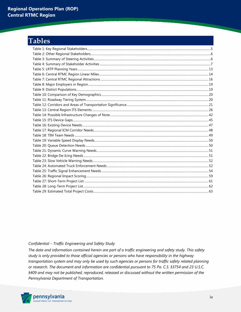
Tables Table 1: Key Regional Stakeholders .............................................................................................................................................................. 5 Table 2: Other Regional Stakeholders.......................................................................................................................................................... 6 Table 3: Summary of Steering Activities ...................................................................................................................................................... 6 Table 4: Summary of Stakeholder Activities .............................................................................................................................................. 7 Table 5: LRTP Planning Years ....................................................................................................................................................................... 13 Table 6: Central RTMC Region Linear Miles ............................................................................................................................................ 14 Table 7: Central RTMC Regional Attractions .......................................................................................................................................... 16 Table 8: Major Employers in Region .......................................................................................................................................................... 19 Table 9: District Populations ......................................................................................................................................................................... 19 Table 10: Comparison of Key Demographics ......................................................................................................................................... 20 Table 11: Roadway Tiering System ............................................................................................................................................................. 20 Table 12: Corridors and Areas of Transportation Significance......................................................................................................... 21 Table 13: Central Region ITS Elements ..................................................................................................................................................... 26 Table 14: Possible Infrastructure Changes of Note .............................................................................................................................. 42 Table 15: ITS Device Gaps .............................................................................................................................................................................. 45 Table 16: Existing Device Needs.................................................................................................................................................................. 47 Table 17: Regional ICM Corridor Needs ................................................................................................................................................... 48 Table 18: TIM Team Needs ........................................................................................................................................................................... 49 Table 19: Variable Speed Display Needs .................................................................................................................................................. 50 Table 20: Queue Detection Needs ............................................................................................................................................................. 50 Table 21: Dynamic Curve Warning Needs ............................................................................................................................................... 51 Table 22: Bridge De-Icing Needs ................................................................................................................................................................ 51 Table 23: Slow Vehicle Warning Needs .................................................................................................................................................... 52 Table 24: Automated Truck Enforcement Needs .................................................................................................................................. 52 Table 25: Traffic Signal Enhancement Needs ......................................................................................................................................... 54 Table 26: Regional Impact Scoring............................................................................................................................................................. 59 Table 27: Short-Term Project List ............................................................................................................................................................... 61 Table 28: Long-Term Project List ................................................................................................................................................................ 62 Table 29: Estimated Total Project Costs ................................................................................................................................................... 63
Confidential – Traffic Engineering and Safety Study
The data and information contained herein are part of a traffic engineering and safety study. This safety study is only provided to those official agencies or persons who have responsibility in the highway transportation system and may only be used by such agencies or persons for traffic safety related planning or research. The document and information are confidential pursuant to 75 Pa. C.S. §3754 and 23 U.S.C. §409 and may not be published, reproduced, released or discussed without the written permission of the Pennsylvania Department of Transportation.
v
Regional Operations Plan (ROP) Central RTMC Region
Executive Summary This Regional Operations Plan (ROP) has been developed to cover the Pennsylvania Department of Transportation (PennDOT) Central Region. This region is comprised of PennDOT Engineering Districts 2, 3, and 9. This region is centered around the Regional Traffic Management Center (RTMC) located in Clearfield, PA at the PennDOT District 2-0 office.
The previous ROP process for this region was divided into separate documents for each of the three Districts. These documents were completed between 2007 and 2008.
This ROP has been compiled based on guidance from the TSMO Guidebook, Part I: Planning, a PennDOT document developed in 2018 which describes how to implement the statewide approach to Transportation Systems Management and Operations (TSMO). TSMO is a set of integrated strategies used to increase the reliability and mobility of existing roadway infrastructure without adding capacity. The ROP will complement the TSMO Program Plan by identifying the regional approach to traffic operations and sets the stage for regional implementation of TSMO strategies.
This document will help to enable the Central Region of Pennsylvania to:
Meet federal requirements related to Intelligent Transportation System (ITS) planning (23 CFR 940) Incorporate statewide TSMO goals for operations planning at the regional level Utilize objectives-driven, performance-based planning processes for operations and congestion
management planning Integrate/mainstream ITS and operations planning into the overall transportation planning process,
per Federal Highway Administration (FHWA) guidance Identify and prioritize TSMO capital projects as part of the Transportation Improvement Program
(TIP) Manage funds for the TSMO operations and maintenance (O&M) in future years
It is anticipated that this ROP will be updated every four or five years. Similar to the Long Range Transportation Plan (LRTP), the ROP should, at a minimum, identify which projects could be undertaken within the first four years, aligning these projects for potential inclusion in the Transportation Improvement Program (TIP).
The planning process was led by a Steering Committee which included PennDOT Bureau of Maintenance and Operations (BOMO), PennDOT District 2-0, 3-0, and 9-0, and the Federal Highway Administration (FHWA) Pennsylvania Division. This Steering Committee met four times through the process and helped review and refine the message and material to be presented to stakeholders. The Stakeholder Groups included each of the region’s Metropolitan Planning Organizations (MPO) and Rural Planning Organizations (RPO), as well as PennDOT District Safety Engineers, PennDOT County Maintenance Departments, the Pennsylvania Turnpike Commission (PTC), and local emergency responders. Stakeholder Groups met three times in each District for a total of nine meetings. Stakeholder meetings were used to present information on the ROP process and to receive valuable input from the assembled stakeholders on each phase of the plan’s development.
A summary of the LRTP for each of the planning partners is provided in this document, as well as a discussion of the regional demographics and key transportation elements. Significant transportation corridors are
vi
Regional Operations Plan (ROP) Central RTMC Region
identified, including the region’s interstates, as well as most US Routes, and a few of the most important Pennsylvania state routes.
A summary of existing conditions is provided within this document, including the current ITS elements, existing congestion and safety issues, and notable recently completed projects. Looking towards the future, a discussion of planned infrastructure and land use changes is included, as well as a list of major roadway projects under consideration.
The PennDOT One Map website (www.dot7.state.pa.us/OneMap) was heavily utilized in the development of this plan. The availability of extensive data on the region’s operations was tremendously helpful in pinpointing existing congestion and safety issues, as well as identifying gaps in current ITS device coverage. These various hotspots were presented to the Steering Committee and Stakeholder Groups throughout the ROP process and refined based on input received at meetings.
Through data analysis and stakeholder input, a list of the region’s transportation needs and operation issues was developed. These needs and issues include the following:
Traveler Information Incident and Emergency Management Transportation System Safety Traffic Signal Improvements Communications Network Enhanced Asset Management Automated Systems Management
Projects were then developed for identified hotspots based on these issues and needs. Of particular focus in this ROP are Integrated Corridor Management (ICM) projects which seek to improve incident management and maximize use of available capacity on important parallel corridors. There are also a number of safety-related TSMO projects, including Dynamic Curve Warning systems, Queue Warning systems, and Variable Speed Displays.
Projects were prioritized and ranked based on three categories: Comparative Need, Regional Impact, and Expected Benefit. Need was based on congestion and crash cluster data available on the PennDOT One Map website. Regional Impact utilized the TSMO Roadway Tiering System to quantify regional importance and impact of each project roadway. Finally, the benefit was developed as a qualitative measurement, based on a review of available TSMO benefit guidance, such as the Crash Modification Factor (CMF) Clearinghouse.
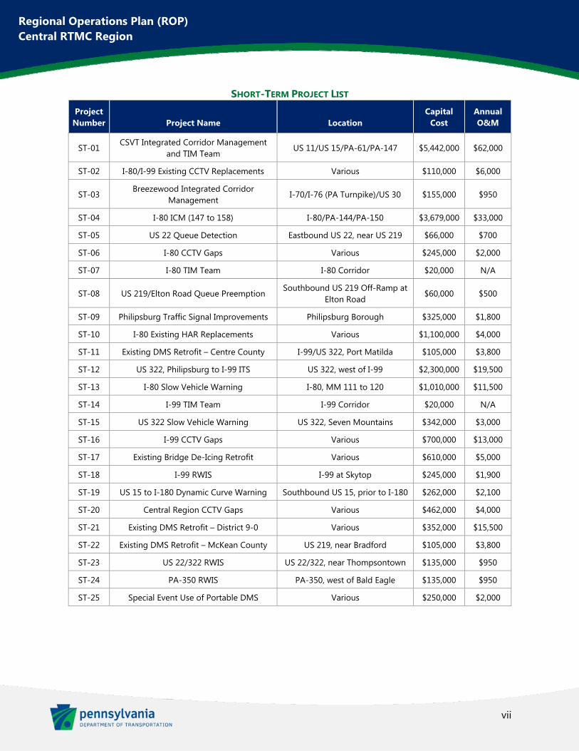
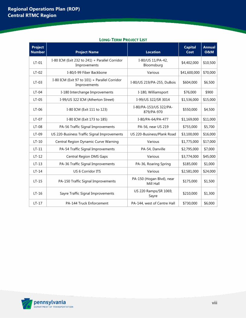
The ROP Projects were then divided into short-term and long-term categories. Short-term projects were identified as those which could be implemented in less than four years. Long-term projects are those that would take four or more years. The following tables show the complete list of recommended projects for the Central RTMC Region.
vii
Regional Operations Plan (ROP) Central RTMC Region
SHORT-TERM PROJECT LIST Project Number Project Name Location
Capital Cost
Annual O&M
ST-01 CSVT Integrated Corridor Management
and TIM Team US 11/US 15/PA-61/PA-147 $5,442,000 $62,000
ST-02 I-80/I-99 Existing CCTV Replacements Various $110,000 $6,000
ST-03 Breezewood Integrated Corridor
Management I-70/I-76 (PA Turnpike)/US 30 $155,000 $950
ST-04 I-80 ICM (147 to 158) I-80/PA-144/PA-150 $3,679,000 $33,000
ST-05 US 22 Queue Detection Eastbound US 22, near US 219 $66,000 $700
ST-06 I-80 CCTV Gaps Various $245,000 $2,000
ST-07 I-80 TIM Team I-80 Corridor $20,000 N/A
ST-08 US 219/Elton Road Queue Preemption Southbound US 219 Off-Ramp at
Elton Road $60,000 $500
ST-09 Philipsburg Traffic Signal Improvements Philipsburg Borough $325,000 $1,800
ST-10 I-80 Existing HAR Replacements Various $1,100,000 $4,000
ST-11 Existing DMS Retrofit – Centre County I-99/US 322, Port Matilda $105,000 $3,800
ST-12 US 322, Philipsburg to I-99 ITS US 322, west of I-99 $2,300,000 $19,500
ST-13 I-80 Slow Vehicle Warning I-80, MM 111 to 120 $1,010,000 $11,500
ST-14 I-99 TIM Team I-99 Corridor $20,000 N/A
ST-15 US 322 Slow Vehicle Warning US 322, Seven Mountains $342,000 $3,000
ST-16 I-99 CCTV Gaps Various $700,000 $13,000
ST-17 Existing Bridge De-Icing Retrofit Various $610,000 $5,000
ST-18 I-99 RWIS I-99 at Skytop $245,000 $1,900
ST-19 US 15 to I-180 Dynamic Curve Warning Southbound US 15, prior to I-180 $262,000 $2,100
ST-20 Central Region CCTV Gaps Various $462,000 $4,000
ST-21 Existing DMS Retrofit – District 9-0 Various $352,000 $15,500
ST-22 Existing DMS Retrofit – McKean County US 219, near Bradford $105,000 $3,800
ST-23 US 22/322 RWIS US 22/322, near Thompsontown $135,000 $950
ST-24 PA-350 RWIS PA-350, west of Bald Eagle $135,000 $950
ST-25 Special Event Use of Portable DMS Various $250,000 $2,000
viii
Regional Operations Plan (ROP) Central RTMC Region
LONG-TERM PROJECT LIST Project Number Project Name Location
Capital Cost
Annual O&M
LT-01 I-80 ICM (Exit 232 to 241) + Parallel Corridor
Improvements I-80/US 11/PA-42,
Bloomsburg $4,402,000 $10,500
LT-02 I-80/I-99 Fiber Backbone Various $41,600,000 $70,000
LT-03 I-80 ICM (Exit 97 to 101) + Parallel Corridor
Improvements I-80/US 219/PA-255, DuBois $604,000 $6,500
LT-04 I-180 Interchange Improvements I-180, Williamsport $76,000 $900
LT-05 I-99/US 322 ICM (Atherton Street) I-99/US 322/SR 3014 $1,536,000 $15,000
LT-06 I-80 ICM (Exit 111 to 123) I-80/PA-153/US 322/PA-
879/PA-970 $550,000 $4,500
LT-07 I-80 ICM (Exit 173 to 185) I-80/PA-64/PA-477 $1,169,000 $11,000
LT-08 PA-56 Traffic Signal Improvements PA-56, near US 219 $755,000 $5,700
LT-09 US 220-Business Traffic Signal Improvements US 220-Business/Plank Road $3,100,000 $16,000
LT-10 Central Region Dynamic Curve Warning Various $1,775,000 $17,000
LT-11 PA-54 Traffic Signal Improvements PA-54, Danville $2,795,000 $7,000
LT-12 Central Region DMS Gaps Various $3,774,000 $45,000
LT-13 PA-36 Traffic Signal Improvements PA-36, Roaring Spring $185,000 $1,000
LT-14 US 6 Corridor ITS Various $2,581,000 $24,000
LT-15 PA-150 Traffic Signal Improvements PA-150 (Hogan Blvd), near
Mill Hall $175,000 $1,500
LT-16 Sayre Traffic Signal Improvements US 220 Ramps/SR 1069,
Sayre $210,000 $1,300
LT-17 PA-144 Truck Enforcement PA-144, west of Centre Hall $730,000 $6,000
ix
Regional Operations Plan (ROP) Central RTMC Region
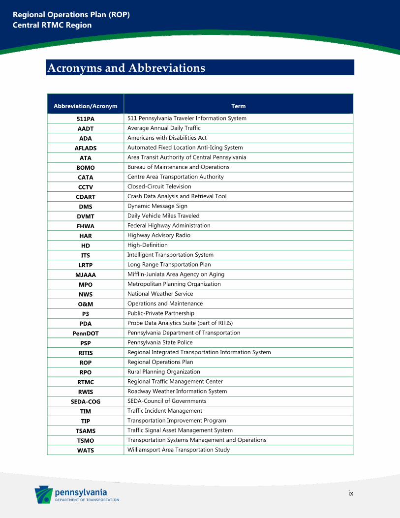
Acronyms and Abbreviations
Abbreviation/Acronym Term
511PA 511 Pennsylvania Traveler Information System
AADT Average Annual Daily Traffic
ADA Americans with Disabilities Act
AFLADS Automated Fixed Location Anti-Icing System
ATA Area Transit Authority of Central Pennsylvania
BOMO Bureau of Maintenance and Operations
CATA Centre Area Transportation Authority
CCTV Closed-Circuit Television
CDART Crash Data Analysis and Retrieval Tool
DMS Dynamic Message Sign
DVMT Daily Vehicle Miles Traveled
FHWA Federal Highway Administration
HAR Highway Advisory Radio
HD High-Definition
ITS Intelligent Transportation System
LRTP Long Range Transportation Plan
MJAAA Mifflin-Juniata Area Agency on Aging
MPO Metropolitan Planning Organization
NWS National Weather Service
O&M Operations and Maintenance
P3 Public-Private Partnership
PDA Probe Data Analytics Suite (part of RITIS)
PennDOT Pennsylvania Department of Transportation
PSP Pennsylvania State Police
RITIS Regional Integrated Transportation Information System
ROP Regional Operations Plan
RPO Rural Planning Organization
RTMC Regional Traffic Management Center
RWIS Roadway Weather Information System
SEDA-COG SEDA-Council of Governments
TIM Traffic Incident Management
TIP Transportation Improvement Program
TSAMS Traffic Signal Asset Management System
TSMO Transportation Systems Management and Operations
WATS Williamsport Area Transportation Study
1
Regional Operations Plan (ROP) Central RTMC Region
Chapter 1. Overview of the Region This ROP has been compiled based on guidance from the TSMO Guidebook, Part I: Planning, a PennDOT document developed in 2018 which describes how to implement the statewide approach to Transportation Systems Management and Operations (TSMO). TSMO is a set of integrated strategies used to increase the reliability and mobility of existing roadway infrastructure without adding capacity. The ROP will complement the TSMO Program Plan by identifying the regional approach to traffic operations and sets the stage for regional implementation of TSMO strategies.
This document will help to enable the Central Region of Pennsylvania to:
Meet federal requirements related to Intelligent Transportation System (ITS) planning (23 CFR 940)
Incorporate statewide TSMO goals for operations planning at the regional level
Utilize objectives-driven, performance-based planning processes for operations and congestion management planning
Integrate/mainstream ITS and operations planning into the overall transportation planning process, per Federal Highway Administration (FHWA) guidance
Identify and prioritize TSMO capital projects as part of the Transportation Improvement Program (TIP)
Manage funds for the TSMO operations and maintenance (O&M) in future years
It is anticipated that this ROP will be updated every four or five years. Similar to the Long Range Transportation Plan (LRTP), the ROP should, at a minimum, identify which projects could be undertaken within the first four years, aligning these projects for potential inclusion in the TIP.
Synopsis of the Region
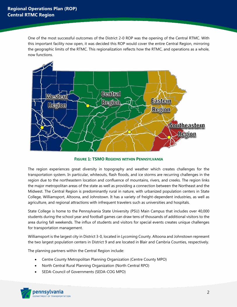
For Transportation Systems Management and Operations (TSMO) planning, Pennsylvania is broken into four regions whose borders coincide with Pennsylvania Department of Transportation’s (PennDOT) Regional Traffic Management Center (RTMC) operational areas. These regions can be seen in Figure 1 below. The Central Region comprises PennDOT Engineering Districts 2, 3, and 9, including 24 counties. The Region spans from the Maryland state line in the south to the New York state line in the north and from Somerset, PA in the west to Berwick, PA in the east. The RTMC for the Central Region is located in the District 2-0 Office in Clearfield, PA.
The previous ROP process for this region was divided into separate documents for each of the three Districts. These documents were completed as follows:
District 2-0 – November 2007
District 3-0 – July 2007
District 9-0 – January 2008
2
Regional Operations Plan (ROP) Central RTMC Region
One of the most successful outcomes of the District 2-0 ROP was the opening of the Central RTMC. With this important facility now open, it was decided this ROP would cover the entire Central Region, mirroring the geographic limits of the RTMC. This regionalization reflects how the RTMC, and operations as a whole, now functions.
FIGURE 1: TSMO REGIONS WITHIN PENNSYLVANIA
The region experiences great diversity in topography and weather which creates challenges for the transportation system. In particular, whiteouts, flash floods, and ice storms are recurring challenges in the region due to the northeastern location and confluence of mountains, rivers, and creeks. The region links the major metropolitan areas of the state as well as providing a connection between the Northeast and the Midwest. The Central Region is predominantly rural in nature, with urbanized population centers in State College, Williamsport, Altoona, and Johnstown. It has a variety of freight-dependent industries, as well as agriculture, and regional attractions with infrequent travelers such as universities and hospitals.
State College is home to the Pennsylvania State University (PSU) Main Campus that includes over 40,000 students during the school year and football games can draw tens of thousands of additional visitors to the area during fall weekends. The influx of students and visitors for special events creates unique challenges for transportation management.
Williamsport is the largest city in District 3-0, located in Lycoming County. Altoona and Johnstown represent the two largest population centers in District 9 and are located in Blair and Cambria Counties, respectively.
The planning partners within the Central Region include:
Centre County Metropolitan Planning Organization (Centre County MPO) North Central Rural Planning Organization (North Central RPO) SEDA-Council of Governments (SEDA-COG MPO)
3
Regional Operations Plan (ROP) Central RTMC Region
Northern Tier Regional Planning and Development Corporation (Northern Tier RPO) Williamsport Area Transportation Study (WATS MPO) Southern Alleghenies Planning & Development Commission RPO (Southern Alleghenies RPO) Cambria County Metropolitan Planning Organization (Johnstown MPO) Metropolitan Planning Organization for Blair County (Altoona MPO)
Figure 2 shows a map of the various planning partner areas within the region.
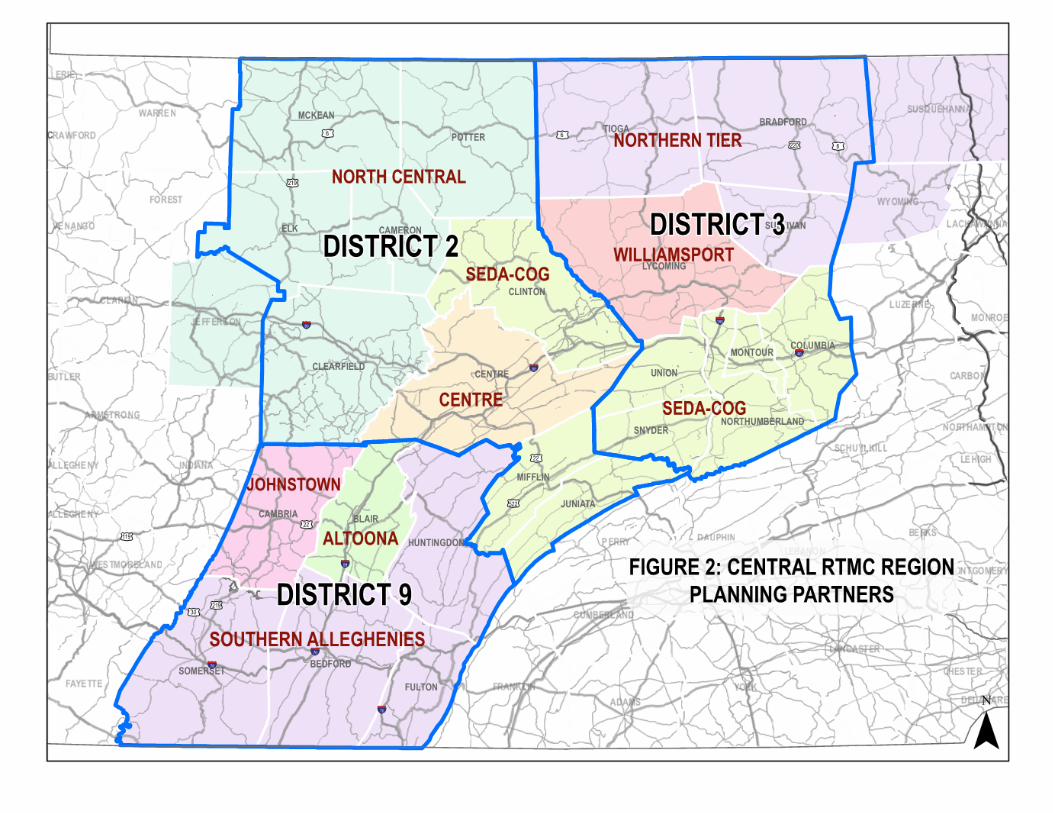
FIGURE 2: CENTRAL RTMC REGION PLANNING PARTNERS
5
Regional Operations Plan (ROP) Central RTMC Region
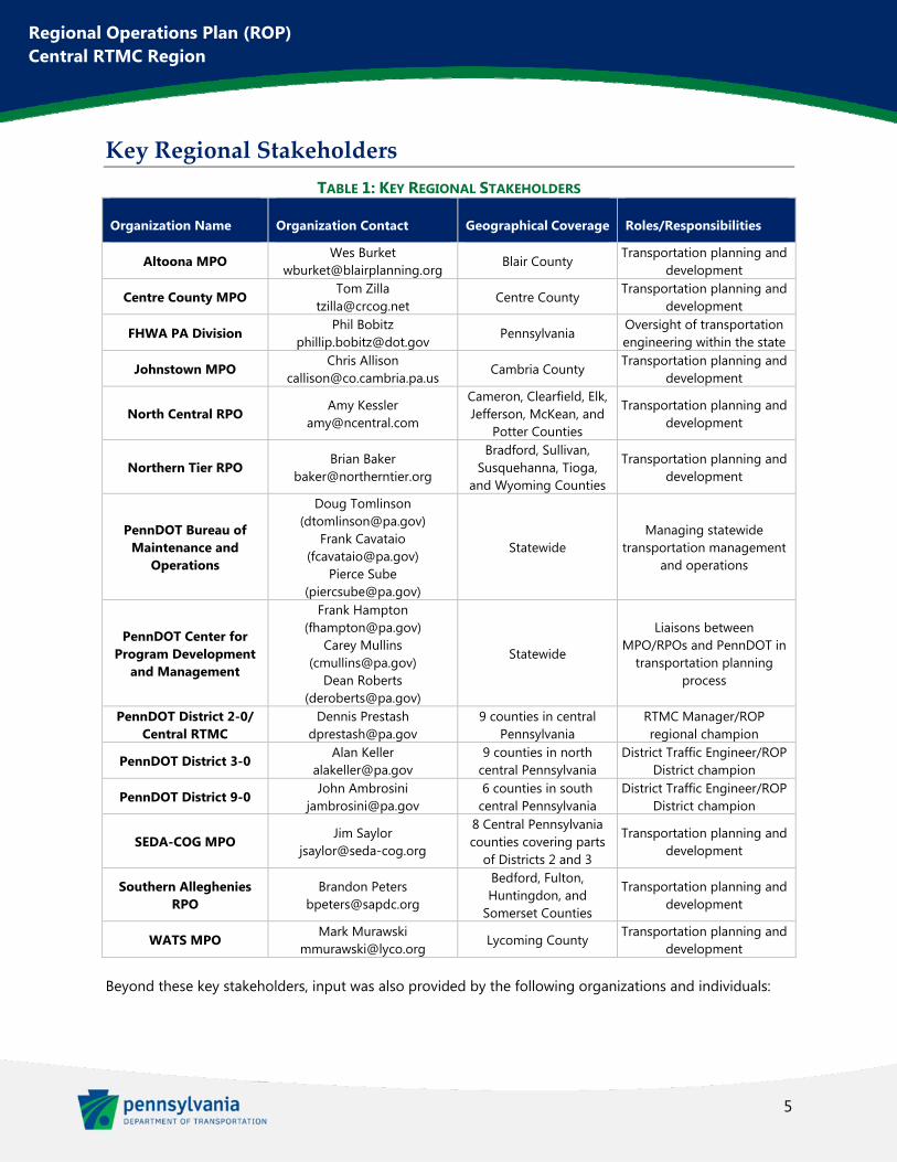
Key Regional Stakeholders
TABLE 1: KEY REGIONAL STAKEHOLDERS
Organization Name Organization Contact Geographical Coverage Roles/Responsibilities
Altoona MPO Wes Burket
[email protected] Blair County
Transportation planning and development
Centre County MPO Tom Zilla
[email protected] Centre County
Transportation planning and development
FHWA PA Division Phil Bobitz
[email protected] Pennsylvania
Oversight of transportation engineering within the state
Johnstown MPO Chris Allison
[email protected] Cambria County
Transportation planning and development
North Central RPO Amy Kessler
Cameron, Clearfield, Elk, Jefferson, McKean, and
Potter Counties
Transportation planning and development
Northern Tier RPO Brian Baker
Bradford, Sullivan, Susquehanna, Tioga,
and Wyoming Counties
Transportation planning and development
PennDOT Bureau of Maintenance and
Operations
Doug Tomlinson ([email protected])
Frank Cavataio ([email protected])
Pierce Sube ([email protected])
Statewide Managing statewide
transportation management and operations
PennDOT Center for Program Development
and Management
Frank Hampton ([email protected])
Carey Mullins ([email protected])
Dean Roberts ([email protected])
Statewide
Liaisons between MPO/RPOs and PennDOT in
transportation planning process
PennDOT District 2-0/ Central RTMC
Dennis Prestash [email protected]
9 counties in central Pennsylvania
RTMC Manager/ROP regional champion
PennDOT District 3-0 Alan Keller
[email protected] 9 counties in north
central Pennsylvania District Traffic Engineer/ROP
District champion
PennDOT District 9-0 John Ambrosini
[email protected] 6 counties in south
central Pennsylvania District Traffic Engineer/ROP
District champion
SEDA-COG MPO Jim Saylor
8 Central Pennsylvania counties covering parts
of Districts 2 and 3
Transportation planning and development
Southern Alleghenies RPO
Brandon Peters [email protected]
Bedford, Fulton, Huntingdon, and
Somerset Counties
Transportation planning and development
WATS MPO Mark Murawski
[email protected] Lycoming County
Transportation planning and development
Beyond these key stakeholders, input was also provided by the following organizations and individuals:
6
Regional Operations Plan (ROP) Central RTMC Region
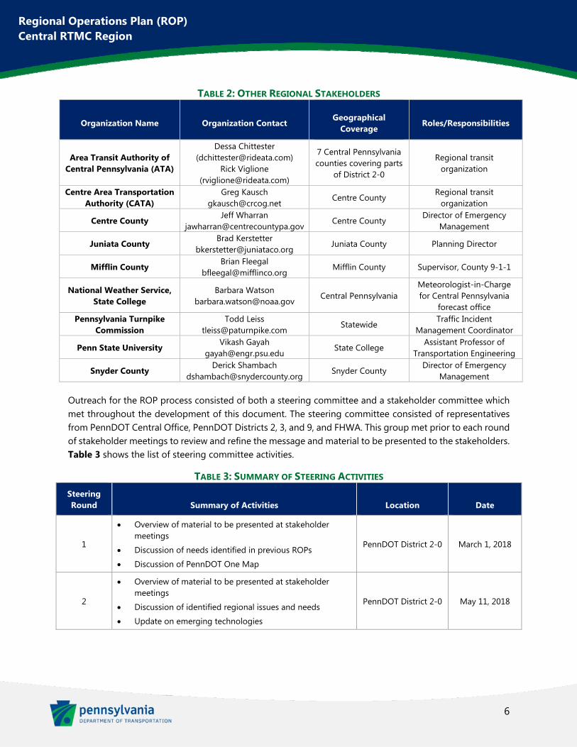
TABLE 2: OTHER REGIONAL STAKEHOLDERS
Organization Name Organization Contact Geographical
Coverage Roles/Responsibilities
Area Transit Authority of Central Pennsylvania (ATA)
Dessa Chittester ([email protected])
Rick Viglione ([email protected])
7 Central Pennsylvania counties covering parts
of District 2-0
Regional transit organization
Centre Area Transportation Authority (CATA)
Greg Kausch [email protected]
Centre County Regional transit
organization
Centre County Jeff Wharran
[email protected] Centre County
Director of Emergency Management
Juniata County Brad Kerstetter
[email protected] Juniata County Planning Director
Mifflin County Brian Fleegal
[email protected] Mifflin County Supervisor, County 9-1-1
National Weather Service, State College
Barbara Watson [email protected]
Central Pennsylvania Meteorologist-in-Charge for Central Pennsylvania
forecast office Pennsylvania Turnpike
Commission Todd Leiss
[email protected] Statewide
Traffic Incident Management Coordinator
Penn State University Vikash Gayah
[email protected] State College
Assistant Professor of Transportation Engineering
Snyder County Derick Shambach
[email protected] Snyder County
Director of Emergency Management
Outreach for the ROP process consisted of both a steering committee and a stakeholder committee which met throughout the development of this document. The steering committee consisted of representatives from PennDOT Central Office, PennDOT Districts 2, 3, and 9, and FHWA. This group met prior to each round of stakeholder meetings to review and refine the message and material to be presented to the stakeholders. Table 3 shows the list of steering committee activities.
TABLE 3: SUMMARY OF STEERING ACTIVITIES Steering Round Summary of Activities Location Date
1
Overview of material to be presented at stakeholder meetings
Discussion of needs identified in previous ROPs
Discussion of PennDOT One Map
PennDOT District 2-0 March 1, 2018
2
Overview of material to be presented at stakeholder meetings
Discussion of identified regional issues and needs
Update on emerging technologies
PennDOT District 2-0 May 11, 2018
7
Regional Operations Plan (ROP) Central RTMC Region
Steering Round Summary of Activities Location Date
3
Overview of material to be presented at stakeholder meetings
Discussed initial list of projects and the prioritization criteria for project ranking
PennDOT District 2-0 August 2, 2018
4
Refined final list of projects
Discussed future ROP coordination and maintenance of document
Discussed lessons learned
PennDOT District 2-0 October 9, 2018
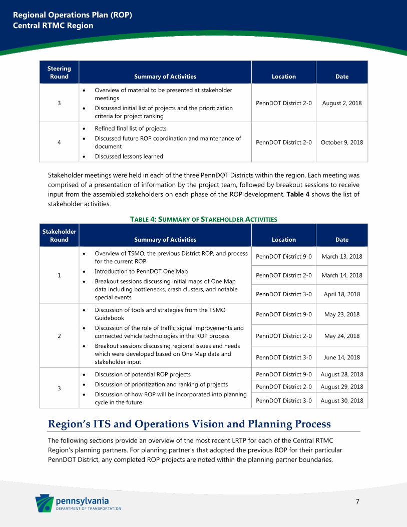
Stakeholder meetings were held in each of the three PennDOT Districts within the region. Each meeting was comprised of a presentation of information by the project team, followed by breakout sessions to receive input from the assembled stakeholders on each phase of the ROP development. Table 4 shows the list of stakeholder activities.
TABLE 4: SUMMARY OF STAKEHOLDER ACTIVITIES Stakeholder
Round Summary of Activities Location Date
1
Overview of TSMO, the previous District ROP, and process for the current ROP
Introduction to PennDOT One Map
Breakout sessions discussing initial maps of One Map data including bottlenecks, crash clusters, and notable special events
PennDOT District 9-0 March 13, 2018
PennDOT District 2-0 March 14, 2018
PennDOT District 3-0 April 18, 2018
2
Discussion of tools and strategies from the TSMO Guidebook
Discussion of the role of traffic signal improvements and connected vehicle technologies in the ROP process
Breakout sessions discussing regional issues and needs which were developed based on One Map data and stakeholder input
PennDOT District 9-0 May 23, 2018
PennDOT District 2-0 May 24, 2018
PennDOT District 3-0 June 14, 2018
3
Discussion of potential ROP projects
Discussion of prioritization and ranking of projects
Discussion of how ROP will be incorporated into planning cycle in the future
PennDOT District 9-0 August 28, 2018
PennDOT District 2-0 August 29, 2018
PennDOT District 3-0 August 30, 2018
Region’s ITS and Operations Vision and Planning Process
The following sections provide an overview of the most recent LRTP for each of the Central RTMC Region’s planning partners. For planning partner’s that adopted the previous ROP for their particular PennDOT District, any completed ROP projects are noted within the planning partner boundaries.
8
Regional Operations Plan (ROP) Central RTMC Region
Altoona MPO The Blair County MPO adopted their latest LRTP in 2016. The plan was developed with the following transportation goals in mind:
Improve the coordination of land use, infrastructure, and transportation planning throughout the County.
Participate in local planning to improve the design and visual impact of high profile gateways and corridors.
Pursue state and local funding for implementing the Blair County Greenways Plan, which integrates key destinations into a countywide greenway and trail network.
Safety recommendations in the Southern Alleghenies (PennDOT District 9) Regional Intelligent Transportation Systems (ITS) Architecture Plan have resulted in installation of dynamic message signs (DMS) along I-99, US 22, PA-764, and US 220.
To improve roadway system management and operations, the MPO adopted the Southern Alleghenies Regional Operations Plan (ROP) which covered PennDOT District 9 and was published in January 2008. This included installation of closed circuit television cameras (CCTV) to provide coverage of the following sections of highway:
I-99 – from US 22 to 17th Street Plank Road – from the Meadows Intersection north 17th Street – bridge over 10th Avenue to I-99 Chestnut Avenue – Juniata Gap Road to 8th Street Bridge 7th Street Bridge – City of Altoona
The current LRTP included ITS improvements at the signalized intersection of Route 764 and Carson Valley Road which have since been installed.
Centre County MPO The Centre County LRTP 2044 was adopted in 2015. The primary goals and objectives of the Centre County LRTP 2044 included:
Economic Vitality—improves access and/or enhances freight movement to regional and national economic centers, encourages tourism, and encourages infill development.
Safety and Security—reduces crash rates, reduces conflicts between motorized and non-motorized transportation modes, improves safety of intersections and roadway alignments, and improves the security of traveling public
Preservation of the Existing Transportation System—prolongs useful life of the existing transportation system and infrastructure through reconstruction, rehabilitation, and preventative maintenance, rehabilitates and modernizes public transportation facility/fleet, and improves ride quality
9
Regional Operations Plan (ROP) Central RTMC Region
Integration and Connectivity of Transportation System—eliminates/overcomes barriers in key corridors, establishes/maintains intermodal connections, introduces new connections between existing travel patterns, and aligns residents with their destinations
Efficient System Management and Operation—reduces congestions, improves Levels of Service, reduces travel times, increases public transportation service and capacity, and improves system functionality
Consistency with Planned Growth and Development Areas—consistent with County, Regional and Municipal Comprehensive plans and associated documents, improves/supports the existing transportation infrastructure in existing and planned growth areas, promotes Smart Growth Principles, avoids negative impacts on communities
To improve roadway system management and operations, the MPO adopted the District 2-0 Regional Operations Plan (ROP) as published in January 2008. This included installation of closed circuit television cameras (CCTV) to provide coverage of the following sections of highway:
I-80 @ Exit 158 – Milesburg
I-80 @ Exit 161 – Bellefonte
Highway Advisory Radios (HAR) were deployed to disseminate Traveler Information at key locations and junctions to close ITS equipment gaps at the following locations:
PA-26 & Zion Road
US 220
Johnstown MPO The Cambria County LRTP was adopted in 2016. The primary needs addressed in the Cambria County LRTP 2015-2040:
Need for better transit connections between major community hubs Need for better sidewalks, crosswalks, and pedestrian signals. Interest in more bicycle and pedestrian trails and interconnection of existing trials as a regional
system. Declining air passenger services at John Murtha Johnstown-Cambria County Airport. Lack of commuter (one-day roundtrip) passenger rail service to Pittsburgh. Poor highway access north to I-80 – US 219 from Carrolltown north to DuBois and Interstate 80 is
a 60-mile, two-lane rural highway. Desired interstate status for US 219. Poor east-west highway access for the Johnstown area
To further improve the roadway system management and operations, Cambria County implemented the recommendations of the Southern Alleghenies ROP plan for traffic management of PennDOT District 9-0:
Install DMS, closed-loop traffic signal systems, and CCTV along Scalp Avenue
10
Regional Operations Plan (ROP) Central RTMC Region
Install DMS, CCTV, and closed-loop traffic signals along US 22 Install DMS and CCTV along PA-56 and PA-403 at Conemaugh Gap Install DMS, HAR, and CCTV along US 22 Install DMS, HAR, CCTV along PA-56 in Johnstown
Since publication of the LRTP, the Scalp Avenue and US 22 ITS improvements have been completed and the US 22 signal improvements are in construction.
North Central RPO The North Central PA Commission adopted its current LRTP in July 2017 with a planning horizon year of 2045. Under the goal of “promoting efficient system management and operation” the North Central LRTP set the objective to leverage innovations in technology and procurement for improved traffic management, congestion reduction, and safety enhancements. To do this, the North Central LRTP proposes:
Update the region’s roadway functional classification network and National Highway System routes.
Evaluate potential for alternative intersection improvements during design phases.
Promote public-private partnerships to distribute traveler information.
Remain abreast of developments regarding connected and autonomous vehicles and other developing technologies affecting transportation.
Improve signal timing by adding protective left-turn phases, improving clearance intervals, and coordinating signals.
Develop a clearly-defined process for the bonding of local roads.
Access management standards for major collector and arterial streets should be implemented to preserve the capability of a roadway to enhance traffic flows, minimize vehicle conflicts, and improve pedestrian safety.
Encourage multi-municipal collaboration and resource sharing.
Support the development and execution of Maintenance and Operations agreements between municipalities and PennDOT for traffic signals.
Upgrade existing traffic signals with audible pedestrian signals and countdown pedestrian signals and Americans with Disabilities Act (ADA) features where feasible.
Develop a signal retiming and optimization program to improve arterial corridor operations.
Northern Tier RPO The Northern Tier Regional Planning & Development Commission (NTRPDC) LRTP was adopted in 2015. The plan was developed focusing on the following goals:
Improve driver navigation.
Reduce crashes and crash severity.
11
Regional Operations Plan (ROP) Central RTMC Region
Reduce road and bridge infrastructure impacts on waterways, floodplains, and wildlife.
Reduce maintenance costs.
Improve infrastructure to serve businesses.
Improve safety.
Improve design to current standards for modern vehicles, modern speeds.
Improve asset management.
Reduce congestion at known bottlenecks.
Evaluate transportation improvements periodically after completion to ensure that they are achieving the intended results.
Improve mobility for all modes.
Enhance communities.
Increase the number of highways that receive priority maintenance, especially with regard to winter travel reliability.
Increase Interstate system access, particularly in support of economic development.
Improve highway access and access management.
Expand mobility choices.
Increase access to fuel choices and efficiency.
SEDA‐COG MPO The SEDA-COG Metropolitan Planning Organization’s LRTP was adopted in 2016, focusing on the eight-county SEDA-COG region. In many significant ways, the SEDA-COG MPO region finds itself in a transitional period, starting with the designation of the MPO in 2013 and continuing reactivation of the Central Susquehanna Valley Transportation (CSVT) project, new transportation funding through Act 89, and more prescriptive project programming philosophies, among other emerging economic and demographic trends.
The SEDA-COG LRTP proposes corridor modernization—focusing on corridors that cross jurisdictional centers and modernizing them to better serve communities, region, and economic development centers. This corridor modernization specifically focuses on the implementation of traffic signals and ITS devices. Specific strategies proposed include:
Investigation of a TIP line item for traffic signals, funded by state and federal sources.
An inventory of both traffic signal operation needs and ITS-related needs.
Southern Alleghenies RPO The Southern Alleghenies Rural Planning Organization LRTP was adopted in 2017.
12
Regional Operations Plan (ROP) Central RTMC Region
The Southern Alleghenies RPO LRTP references the Southern Alleghenies ROP—outlining transportation operations projects, programs, and policies to be implemented in the six-county Southern Alleghenies region over a twelve-year time frame. The following CCTVs were deployed throughout Southern Alleghenies.
Three (3) CCTV cameras on US 30 in Bedford
One (1) CCTV camera on US 30 in Fulton
One (1) CCTV camera on US 22 in Huntingdon
One (1) CCTV camera on PA-453 in Huntingdon
DMS were placed on US 30, I-70, PA-56, I-99, SR 8007, US 22, and PA-453 in Bedford, Fulton, and Huntingdon Counties.
The 2008 Southern Alleghenies ROP recommended that the Southern Alleghenies region:
Establish dedicated funding for ITS
Maximize the benefits of the TMCs
Better maintain and manage existing equipment
Expedite the communication line request process
Permit the use of wireless communication systems
Improve guidance on incident management protocols
Integrate reporting systems.
The Southern Alleghenies region is currently funding the traffic signal system through two programs providing funds to local government agencies for traffic signal improvements; Automated Red Light Enforcement (ARLE) and Green Light-Go.
WATS MPO The WATS Long Range Transportation Plan issued a draft update in 2018 which is anticipated to be adopted in December 2018. It encompasses the entire geographic area of Lycoming County. The primary vision and goals of the WATS LRTP 2018-2038 are to:
Ensure adequate maintenance and preservation of existing transportation system
Promote efficient transportation system management and operations
Enhance integration and connectivity of the transportation system
Ensure transportation investments protect and enhance the environment, promote energy conservation, promote consistency with the state and local planned growth and improve quality of life.
Increase accessibility and mobility options for people and freight
13
Regional Operations Plan (ROP) Central RTMC Region
Increase transportation system safety and security for all users
Ensure transportation investments support overall economic development that enables global competitiveness, productivity and efficiency.
Through the goal of “promote efficient transportation system management and operations” the WATS LRTP set out to implement the enhancements laid out in the 2007 Regional Operations Plan, through the deployment of ITS equipment and related projects to improve incident management, response and provide up to date information for motorists. This includes:
Properly maintaining and improving traffic signal systems
Maximizing the use of public transportation, shared ride, park-and-ride, carpool/vanpool and rail freight modal alternatives to reduce traffic congestion and travel times, improving levels of service
Implement corridor access management recommendations along US 220 between Jersey Shore and Williamsport and along PA-405, SR 2014 (John Brady Drive) and US 220 in the Muncy-Hughesville growth area to reduce/consolidate private drive access resulting from new significant development patterns to preserve the operational integrity of these high growth corridors
Assessing the impact of the Marcellus gas exploration activity through traffic count monitoring, data collection, and analysis
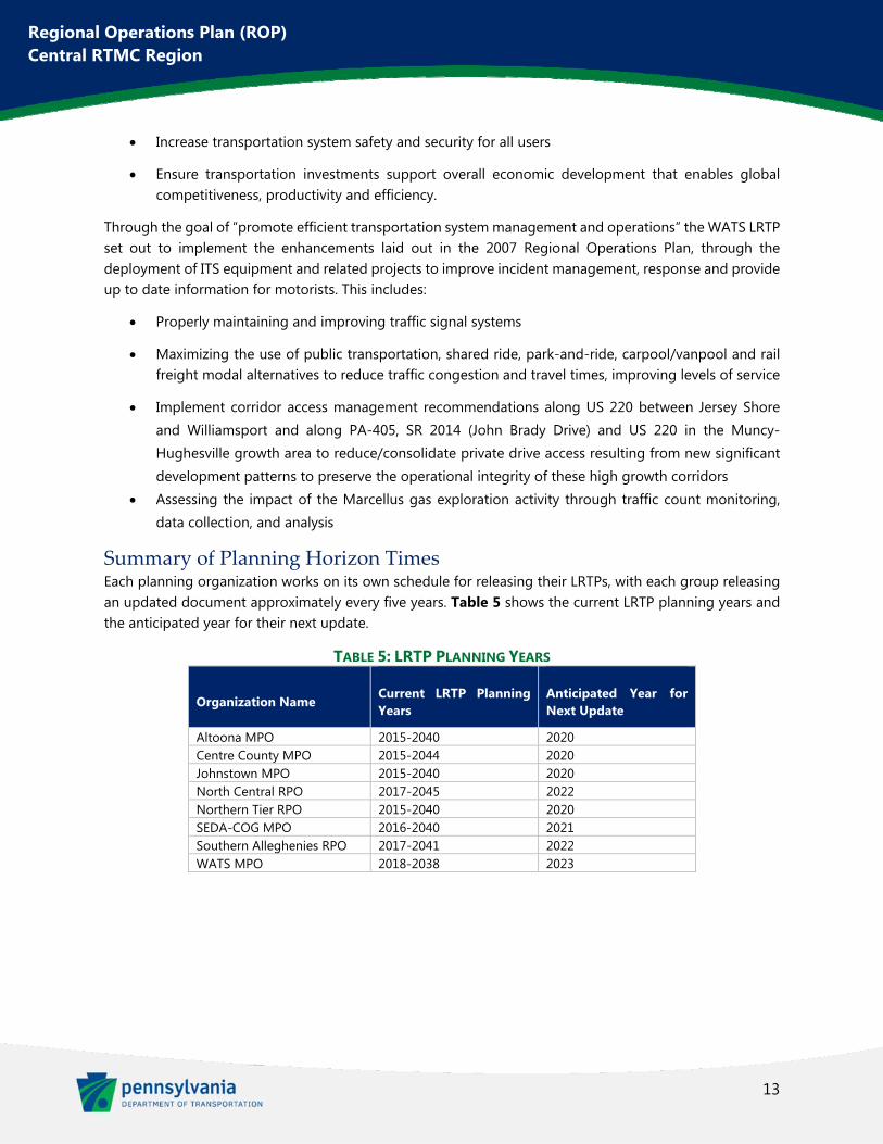
Summary of Planning Horizon Times Each planning organization works on its own schedule for releasing their LRTPs, with each group releasing an updated document approximately every five years. Table 5 shows the current LRTP planning years and the anticipated year for their next update.
TABLE 5: LRTP PLANNING YEARS
Organization Name Current LRTP Planning Years
Anticipated Year for Next Update
Altoona MPO 2015-2040 2020 Centre County MPO 2015-2044 2020 Johnstown MPO 2015-2040 2020 North Central RPO 2017-2045 2022 Northern Tier RPO 2015-2040 2020 SEDA-COG MPO 2016-2040 2021 Southern Alleghenies RPO 2017-2041 2022 WATS MPO 2018-2038 2023
14
Regional Operations Plan (ROP) Central RTMC Region
Chapter 2. Existing Regional Demographics and
Transportation Elements
Existing Key Transportation Elements
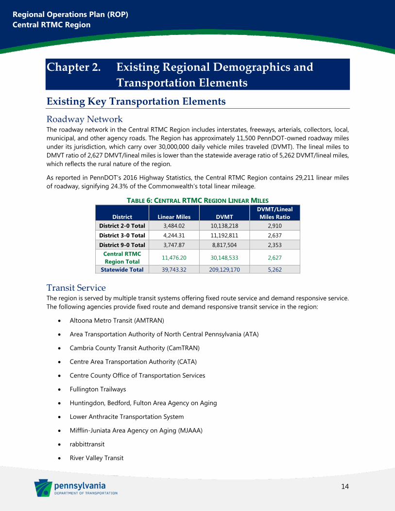
Roadway Network The roadway network in the Central RTMC Region includes interstates, freeways, arterials, collectors, local, municipal, and other agency roads. The Region has approximately 11,500 PennDOT-owned roadway miles under its jurisdiction, which carry over 30,000,000 daily vehicle miles traveled (DVMT). The lineal miles to DMVT ratio of 2,627 DMVT/lineal miles is lower than the statewide average ratio of 5,262 DVMT/lineal miles, which reflects the rural nature of the region.
As reported in PennDOT’s 2016 Highway Statistics, the Central RTMC Region contains 29,211 linear miles of roadway, signifying 24.3% of the Commonwealth’s total linear mileage.
TABLE 6: CENTRAL RTMC REGION LINEAR MILES
Transit Service The region is served by multiple transit systems offering fixed route service and demand responsive service. The following agencies provide fixed route and demand responsive transit service in the region:
Altoona Metro Transit (AMTRAN)
Area Transportation Authority of North Central Pennsylvania (ATA)
Cambria County Transit Authority (CamTRAN)
Centre Area Transportation Authority (CATA)
Centre County Office of Transportation Services
Fullington Trailways
Huntingdon, Bedford, Fulton Area Agency on Aging
Lower Anthracite Transportation System
Mifflin-Juniata Area Agency on Aging (MJAAA)
rabbittransit
River Valley Transit
District Linear Miles DVMT DVMT/Lineal Miles Ratio
District 2-0 Total 3,484.02 10,138,218 2,910
District 3-0 Total 4,244.31 11,192,811 2,637
District 9-0 Total 3,747.87 8,817,504 2,353 Central RTMC Region Total
11,476.20 30,148,533 2,627
Statewide Total 39,743.32 209,129,170 5,262
15
Regional Operations Plan (ROP) Central RTMC Region
Somerset County Transportation System
STEP, Inc.
Airports There are 27 public airports operating in the region:
Albert Airport in Clearfield County
Altoona Blair County Airport (limited passenger service)
Bedford County Airport
Bellefonte Airport in Centre County
Bloomsburg Municipal Airport
Bradford Regional Airport in McKean County (limited passenger service)
Cambria County Airport (limited passenger service)
Centre Airpark in Centre County
Clearfield Lawrence Airport in Clearfield County
Danville Airport
DuBois Regional Airport in Jefferson County (limited passenger service)
Ebensburg Airport in Cambria County
Mid-State Airport in Centre County
Mifflin County Airport in Mifflin County
Mifflintown Airport in Juniata County
Northumberland County Airport
Penn’s Cave Airport in Centre County
Penn Valley Airport
Ridge Soaring Gliderport in Centre County
Somerset County Airport
St. Mary’s Municipal Airport in Elk County
Stottle Memorial in Juniata County
Sunbury Airport
Sunbury Seaplane Airport
University Park Airport in Centre County (regular passenger service)
William T. Piper Memorial Airport in Clinton County
16
Regional Operations Plan (ROP) Central RTMC Region
Williamsport Regional Airport (regular passenger service)
Tourist and Travel Destinations The Central RTMC region is also home to tourist and travel destinations including:
TABLE 7: CENTRAL RTMC REGIONAL ATTRACTIONS Destination
Type Name
Amusement Parks
Clyde Peeling’s Reptiland DelGrosso’s Amusement Park Knoebels Amusement Resort Lakemont Park Treasure Castle Playland
Caves and Mines
Coudersport Ice Mine Lincoln Caverns & Whisper Rocks Penn’s Cave & Wildlife Park Woodward Cave
Sporting Events/Facilities
1st Summit Arena BB&T Ballpark Beard Field – Nittany Lion Softball Park Beaver Stadium Bryce Jordan Center Galactic Ice Rink Heindl Memorial Field Little League World Series Medlar Field at Lubrano Park North Central Recreation Center Ice Skating Rink Pegula Ice Arena Penn State Recreation Hall Peoples Natural Gas Field Point Stadium Port Royal Speedway Selinsgrove Speedway Showers Field Veterans Memorial Field
Universities and Colleges
Bloomsburg University Bucknell University Juniata College Lock Haven University Lycoming College Mansfield University Mt Aloysius College Pennsylvania College of Technology PSU-University Park (main campus) PSU-Altoona St Francis University Susquehanna University University of Pittsburgh-Bradford University of Pittsburgh-Johnstown
17
Regional Operations Plan (ROP) Central RTMC Region
Destination Type Name
Entertainment and Special
Events
Altoona Mirror Keystone Country Festival Bedford County Fair Bedford Fall Foliage Festival Benezette Elk Viewing Bloomsburg Fair Cambria County Fair Centre County Grange and Encampment Fair Central Pennsylvania Festival of the Arts Downtown DuBois Farmers Market Downtown State College Farmers Market Discovery Space Elk Expo Elysburg Haunted House People’s Choice Festival of Pennsylvania Punxsutawney Phil Ridgway Chainsaw Carving Rendezvous Thunder in the Valley Zippo/Case Museum
Parks and Recreation
Austin Dam Bald Eagle State Park Black Moshannon State Park Blue Knob All Seasons Resort Bodine Park Canoe Creek State Park Centralia Cherry Springs State Park Clearfield County Fair & Park Columbia Creek Farms Cowans Gap State Park Curwensville Lake Elk Country Visitors Center Evansville Motocross Park Fisherman’s Paradise Flight 93 Memorial Greater Renovo Area Heritage Park Greenwood Furnace State Park Hiawatha Paddlewheeler Hidden Valley Resort Hyner Run State Park Kettle Creek State Park Kiess Memorial Park Kinzua Dam Kinzua State Park and Skywalk Little Buffalo State Park Little Pine State Park Lyman Run State Park Millbrook Marsh Nature Center Montour Preserve Morrison Cove Memorial Park
18
Regional Operations Plan (ROP) Central RTMC Region
Destination Type Name
Parks and Recreation
Ole Bull State Park Prince Gallitzin Park Raymond B. Winter State Park Raystown Lake Ricketts Glen State Park Seven Springs Mountain Resort Shaver’s Creek Environmental Center Shawnee State Park Shikellamy State Park Susquehanna State Park Treasure Lake Trough Creek State Park Sinnemahoning State Park Whipple Dam State Park Worlds End State Park
Others
Allegheny Portage Railroad National Historic Site Altoona Railroaders Memorial Museum Birdsong Winery & Vineyards Blair County Convention Center Eisenhower Auditorium Endless Mountains War Memorial Museum Frank J. Pasquerilla Conference Center Freas Farm Winery Horseshoe Curve National Historical Landmark Jaffa Shrine Center Johnstown Convention and Visitors Bureau Johnstown War Memorial Logan Town Center Logan Valley Mall Lycoming County Historical Society & Taber Museum Mishler Theatre Mount Nittany Vineyard & Winery Penn State Palmer Museum of Art The Pioneer Tunnel Pennsylvania Lumber Museum World of Little League Museum
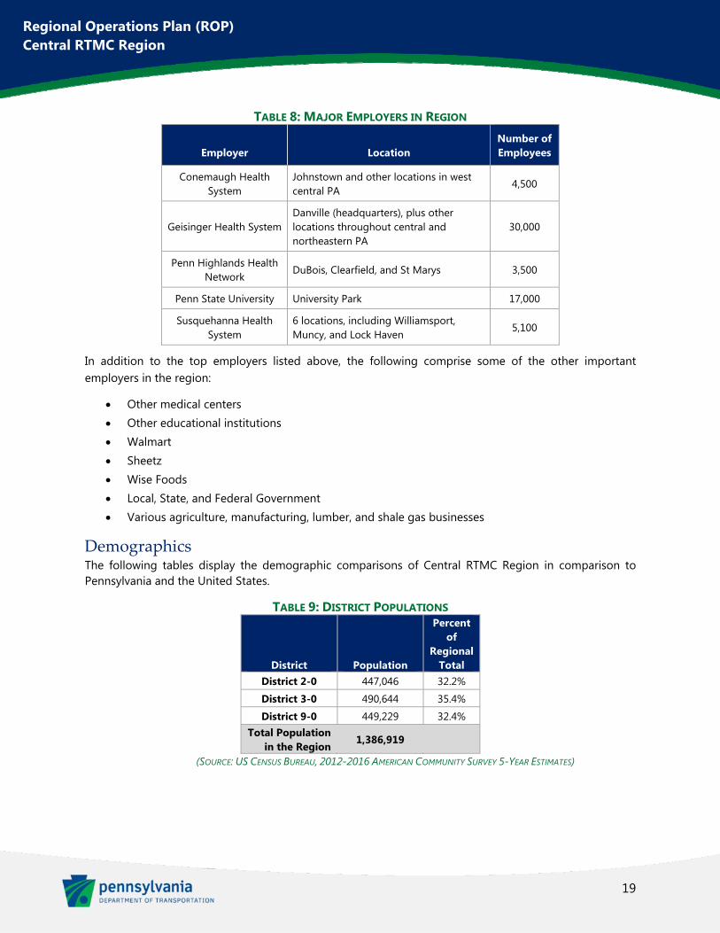
Major Employers Penn State University is the overwhelmingly largest employer in Centre County and one of the largest in the whole region. The other top employers are medical centers with multiple locations throughout the region. These top employers can be found in Table 8.
19
Regional Operations Plan (ROP) Central RTMC Region
TABLE 8: MAJOR EMPLOYERS IN REGION
Employer Location Number of Employees
Conemaugh Health System
Johnstown and other locations in west central PA
4,500
Geisinger Health System Danville (headquarters), plus other locations throughout central and northeastern PA
30,000
Penn Highlands Health Network
DuBois, Clearfield, and St Marys 3,500
Penn State University University Park 17,000
Susquehanna Health System
6 locations, including Williamsport, Muncy, and Lock Haven
5,100
In addition to the top employers listed above, the following comprise some of the other important employers in the region:
Other medical centers Other educational institutions Walmart Sheetz Wise Foods Local, State, and Federal Government Various agriculture, manufacturing, lumber, and shale gas businesses
Demographics The following tables display the demographic comparisons of Central RTMC Region in comparison to Pennsylvania and the United States.
TABLE 9: DISTRICT POPULATIONS
District Population
Percent of
Regional Total
District 2-0 447,046 32.2%
District 3-0 490,644 35.4%
District 9-0 449,229 32.4% Total Population
in the Region 1,386,919
(SOURCE: US CENSUS BUREAU, 2012-2016 AMERICAN COMMUNITY SURVEY 5-YEAR ESTIMATES)
20
Regional Operations Plan (ROP) Central RTMC Region
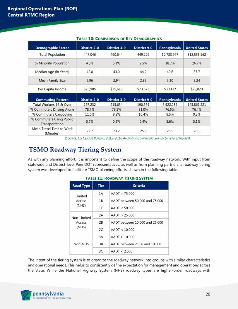
TABLE 10: COMPARISON OF KEY DEMOGRAPHICS
Demographic Factor District 2-0 District 3-0 District 9-0 Pennsylvania United States
Total Population 447,046 490,644 449,229 12,783,977 318,558,162
% Minority Population 4.5% 5.1% 2.5% 18.7% 26.7%
Median Age (In Years) 42.8 43.0 44.2 40.6 37.7
Mean Family Size 2.96 2.94 2.92 3.10 3.24
Per Capita Income $23,905 $25,619 $23,673 $30,137 $29,829
Commuting Pattern District 2-0 District 3-0 District 9-0 Pennsylvania United States Total Workers 16 & Over 197,232 215,634 190,579 5,922,289 145,861,221
% Commuters Driving Alone 78.7% 79.5% 81.0% 76.5% 76.4% % Commuters Carpooling 11.0% 9.2% 10.4% 8.5% 9.3%
% Commuters Using Public Transportation
0.7% 0.5% 0.4% 5.6% 5.1%
Mean Travel Time to Work (Minutes)
22.7 23.2 25.9 26.5 26.1
(SOURCE: US CENSUS BUREAU, 2012-2016 AMERICAN COMMUNITY SURVEY 5-YEAR ESTIMATES)
TSMO Roadway Tiering System
As with any planning effort, it is important to define the scope of the roadway network. With input from statewide and District-level PennDOT representatives, as well as from planning partners, a roadway tiering system was developed to facilitate TSMO planning efforts, shown in the following table.
TABLE 11: ROADWAY TIERING SYSTEM Road Type Tier Criteria
Limited Access (NHS)
1A AADT > 75,000
1B AADT between 50,000 and 75,000
1C AADT < 50,000
Non-Limited Access (NHS)
2A AADT > 25,000
2B AADT between 10,000 and 25,000
2C AADT < 10,000
Non-NHS
3A AADT > 10,000
3B AADT between 2,000 and 10,000
3C AADT < 2,000
The intent of the tiering system is to organize the roadway network into groups with similar characteristics and operational needs. This helps to consistently define expectation for management and operations across the state. While the National Highway System (NHS) roadway types are higher-order roadways with
21
Regional Operations Plan (ROP) Central RTMC Region
generally higher traffic volumes, the tiering classifications are not intended to dictate specific solutions or levels of funding.
Corridors and Areas of Transportation Significance
As noted earlier, the region has a predominately rural character. Major highway corridors serve to connect urbanized areas and industries within the region to population centers and markets in much wider areas. The following corridors were identified as serving these purposes for the Central RTMC Region.
TABLE 12: CORRIDORS AND AREAS OF TRANSPORTATION SIGNIFICANCE
Class Route County
Average Daily
Traffic TSMO Tier 511
Network Notes and Considerations
Interstates
Bedford Fulton
Huntingdon Somerset
33-37K 23-25K 24-25K 33-36K
1C Yes East-west toll facility connecting
Philadelphia and Ohio Significant commerce activity
Bedford Fulton
7-8K 7-9K
1C Yes
Generally east-west interstate which runs from Baltimore to Utah
Overlaps with I-76 (Pennsylvania Turnpike) from Breezewood to New Stanton
Significant commerce activity
Centre Clearfield Clinton
Columbia Montour
Northumberland Union
10-13K 10-15K 10-13K 16-24K 15-25K 14-16K 10-15K
1C 1C 1C
1B,1C 1B,1C
1C 1C
Yes
East-west interstate connecting Northeast (NYC) and Midwest
High percentage of interstate and inter-regional travelers
Significant commerce activity
Bedford Blair
Centre
6-9K 6-21K 8-20K
1C 1C
1C,2A Yes
North-south interstate which currently runs from Bedford to I-80
Provides access from I-76 (Pennsylvania Turnpike) to Altoona and State College
Lycoming Northumberland
8-24K 7-9K
1B,1C 1C
Yes
Connects I-80 with Lycoming County and Williamsport
Provides connection from I-80 to US 15 and US 220
U.S. Routes
Columbia Juniata
Montour Northumberland
Snyder Union
10-17K 13K
11-19K 11-18K
13K-40K 18K
1C,2B 2B 2B 2B
1C,2A,2B 2B
Partial
North-south highway which runs from Louisiana to Quebec, Canada
Connects many population centers through central Pennsylvania
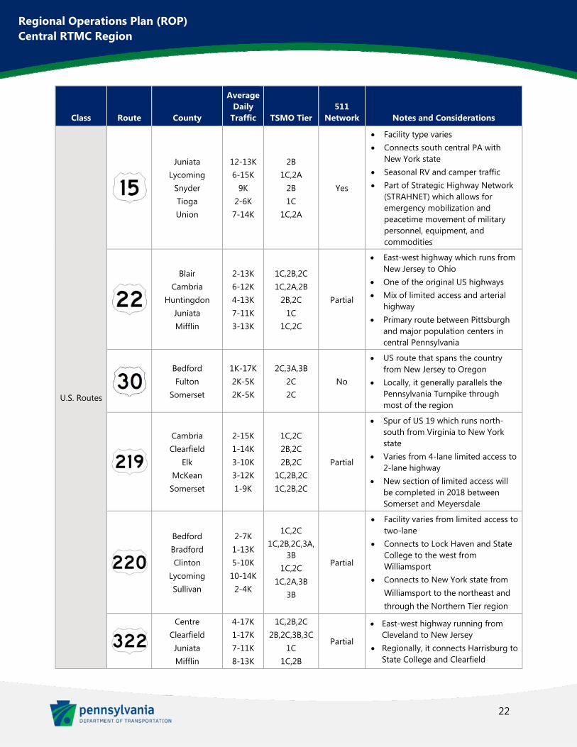
22
Regional Operations Plan (ROP) Central RTMC Region
Class Route County
Average Daily
Traffic TSMO Tier 511
Network Notes and Considerations
U.S. Routes
Juniata Lycoming
Snyder Tioga Union
12-13K 6-15K
9K 2-6K 7-14K
2B 1C,2A
2B 1C
1C,2A
Yes
Facility type varies Connects south central PA with
New York state Seasonal RV and camper traffic Part of Strategic Highway Network
(STRAHNET) which allows for emergency mobilization and peacetime movement of military personnel, equipment, and commodities
Blair Cambria
Huntingdon Juniata Mifflin
2-13K 6-12K 4-13K 7-11K 3-13K
1C,2B,2C 1C,2A,2B
2B,2C 1C
1C,2C
Partial
East-west highway which runs from New Jersey to Ohio
One of the original US highways Mix of limited access and arterial
highway Primary route between Pittsburgh
and major population centers in central Pennsylvania
Bedford Fulton
Somerset
1K-17K 2K-5K 2K-5K
2C,3A,3B 2C 2C
No
US route that spans the country from New Jersey to Oregon
Locally, it generally parallels the Pennsylvania Turnpike through most of the region
Cambria Clearfield
Elk McKean
Somerset
2-15K 1-14K 3-10K 3-12K 1-9K
1C,2C 2B,2C 2B,2C
1C,2B,2C 1C,2B,2C
Partial
Spur of US 19 which runs north-south from Virginia to New York state
Varies from 4-lane limited access to 2-lane highway
New section of limited access will be completed in 2018 between Somerset and Meyersdale
Bedford Bradford Clinton
Lycoming Sullivan
2-7K 1-13K 5-10K 10-14K 2-4K
1C,2C 1C,2B,2C,3A,
3B 1C,2C
1C,2A,3B 3B
Partial
Facility varies from limited access to two-lane
Connects to Lock Haven and State College to the west from Williamsport
Connects to New York state from Williamsport to the northeast and through the Northern Tier region
Centre Clearfield Juniata Mifflin
4-17K 1-17K 7-11K 8-13K
1C,2B,2C 2B,2C,3B,3C
1C 1C,2B
Partial
East-west highway running from Cleveland to New Jersey
Regionally, it connects Harrisburg to State College and Clearfield
23
Regional Operations Plan (ROP) Central RTMC Region
Class Route County
Average Daily
Traffic TSMO Tier 511
Network Notes and Considerations
U.S. Routes
Centre 5-21K 2A.2B,2C No
Business loop of US 322 which connects to I-99
Major route through State College Known as Atherton Street and Boal
Avenue
PA State Routes
Centre 10-23K 2A,2B No
Portion of this state highway which runs through the State College area
Provides connections between US 322, Atherton St, and PA-150
Bedford Cambria Somerset
2-7K 4-11K 3-7K
1C,2C,3A,3B 1C,2A,2B,2C
2B,2C No
Generally east-west highway between New Kensington and Bedford
Main connection to Johnstown
Northumberland 1-17K
1C,2B,2C,3B,3C
Yes
Connects US 11 near Northumberland to I-80 and I-180
Used as a connection from I-80 west to I-81/ I-78
Clearfield Elk
4-14K 4-8K
3A,3B 3A,3B,3C
No Major route through DuBois Connects DuBois to St Marys and
points north
I-80 extends through the Region approximately 150 miles in the east-west direction. I-80 carries the most traffic of any roadway in the Central RTMC Region with an Average Daily Traffic (ADT) of approximately 25,000 vehicles. Connecting the Pennsylvania Turnpike (Interstate 70-76) in Bedford with I-80 (northeast of Bellefonte), I-99 is another growing Interstate corridor. Also known as the Appalachian Thruway and the Bud Shuster Highway, it is the first Interstate highway to have its designation written into law. A high-speed interchange is planned to complete the connections between I-99 and I-80. I-99 is also planned to be a Technology Corridor for testing of Connected and Autonomous Vehicle (CAV) and ITS technologies.
US 22 and US 322 provide the main east/west non-interstate highways through the region. The routes overlap between Harrisburg and Lewistown. To the west, US 322 runs through State College and Clearfield while US 22 runs by Altoona on the way towards Pittsburgh. US routes 11, 15, 219, and 220 all travel generally north/south from Maryland north to New York state. US 30 runs east-west through the region, generally paralleling the Pennsylvania Turnpike.
Some of the major state routes in the region include PA-26, PA-56, PA-147, and PA-255. PA-26 runs through State College, connecting it to US 322 and other state routes. PA-56 provides a connection between I-99 and Johnstown. PA-147 runs along the Susquehanna River connecting Harrisburg and I-80. PA-255 is the major route through DuBois, running north to St Marys.
A map of the Corridors of Significance is included as Figure 3.
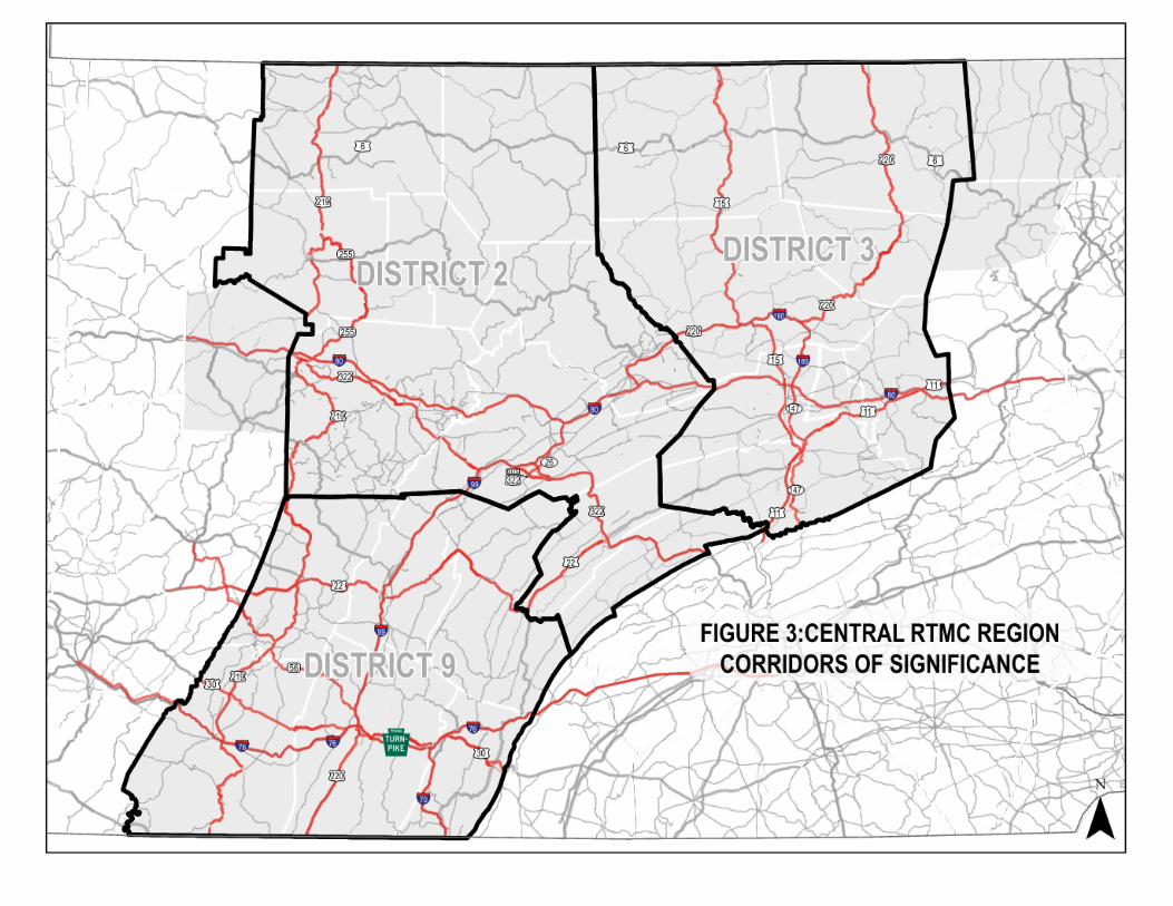
FIGURE 3: CENTRAL RTMC REGION CORRIDORS OF SIGNIFICANCE
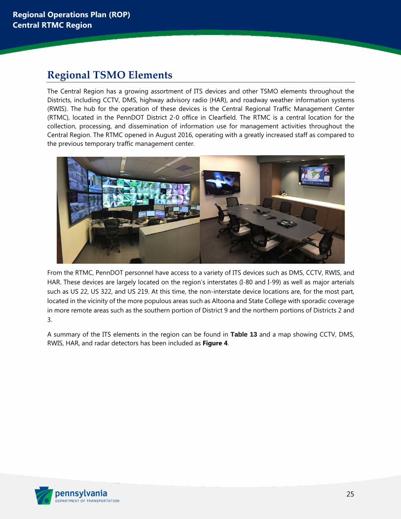
25
Regional Operations Plan (ROP) Central RTMC Region
Regional TSMO Elements
The Central Region has a growing assortment of ITS devices and other TSMO elements throughout the Districts, including CCTV, DMS, highway advisory radio (HAR), and roadway weather information systems (RWIS). The hub for the operation of these devices is the Central Regional Traffic Management Center (RTMC), located in the PennDOT District 2-0 office in Clearfield. The RTMC is a central location for the collection, processing, and dissemination of information use for management activities throughout the Central Region. The RTMC opened in August 2016, operating with a greatly increased staff as compared to the previous temporary traffic management center.
From the RTMC, PennDOT personnel have access to a variety of ITS devices such as DMS, CCTV, RWIS, and HAR. These devices are largely located on the region’s interstates (I-80 and I-99) as well as major arterials such as US 22, US 322, and US 219. At this time, the non-interstate device locations are, for the most part, located in the vicinity of the more populous areas such as Altoona and State College with sporadic coverage in more remote areas such as the southern portion of District 9 and the northern portions of Districts 2 and 3.
A summary of the ITS elements in the region can be found in Table 13 and a map showing CCTV, DMS, RWIS, HAR, and radar detectors has been included as Figure 4.
26
Regional Operations Plan (ROP) Central RTMC Region
TABLE 13: CENTRAL REGION ITS ELEMENTS
ITS Device Number of
Devices
CCTV 105
DMS 108
RWIS 18
HAR Transmitters 29
HAR Beacons 85
Radar Detectors 40
Traffic Signals 1,042
Traffic Signal Systems 126
Bridge De-Icing 2
Flashing Warning Devices
39
Communications Hubs 7
High Cross Winds Warning
1
Queue Detection 2
Truck Warning 1
Low Visibility Warning 1
Speed Detection and Feedback
1
Portable CCTV 4
(SOURCE: PENNDOT ITS MASTER DEVICE LIST, AND PENNDOT TSAMS WEBSITE)
FIGURE 4: CENTRAL RTMC REGION ITS DEVICE
28
Regional Operations Plan (ROP) Central RTMC Region
Chapter 3. Existing and Future Operations
TSMO Mapping
This section provides information documenting and summarizing the region’s existing and future operations performance. Much of this data has been culled from PennDOT One Map, a web-based interactive GIS mapping application. Through this new website, PennDOT has aggregated traffic operations metrics, crash clusters, and many other data from a variety of sources. This powerful tool provides PennDOT and their planning partners with the ability to identify and investigate problem areas in a continuing process, planning for new and changing needs as they develop.
Existing Corridor Performance
Mobility The Central Region is largely rural so does not see widespread recurring congestion. However, there are corridors that incur noticeable vehicular delay in urbanized areas such as State College, as well as areas where regional corridors transition between limited access and signalized arterial roadways. Some of the most significant recurring congestion occurs on the following roadways:
Atherton Street (SR 3014) in State College
I-80 Exit 161 at PA-26
PA-255 in DuBois
Plank Road (SR 1001) in Altoona, Logan Township, and Allegheny Township
US 11 corridor near Shamokin Dam
US 15 in Lewisburg
US 322 in Philipsburg and Potters Mill
The Central Susquehanna Valley Transportation Project is currently in construction in the vicinity of Shamokin Dam, south of Lewisburg. This long-term construction work is impacting traffic through the region and, upon its completion, should greatly relieve the current congestion with the additional roadways being built.
Measures of traffic congestion are calculated from third party probe data, which aggregates speed and travel time data from a sampling of vehicles throughout the roadway network. Two distinct measures of congestion are Bottleneck Rankings and TomTom Travel Time Ratios, which have been aggregated in One Map. Bottleneck Rankings are derived from the RITIS PDA Suite based on INRIX probe speed data, with a bottleneck occurring whenever the speed is less than 60% of the estimated free flow speed. These bottlenecks are ranked by delay, which is weighted by volume, queue length, magnitude of speed drop, and duration. This is a valuable piece of data but the following limitations should be kept in mind when analyzing Bottleneck data:
29
Regional Operations Plan (ROP) Central RTMC Region
Free flow speeds are determined by INRIX, which in some cases might be based on limited data sets
Low volume periods may use historical average speeds when there aren’t enough probe vehicles
Non-NHS roadways do not have volume data in RITIS, so delay cannot be calculated
To augment the bottleneck data, travel time ratio data was also considered, derived from anonymized data pulled from TomTom’s navigation devices, in-dash systems, and apps. The travel time ratio compares actual travel times to free-flow travel times. This data is presented as four different tiers of severity within One Map.
The maps provided below show both the Top 50 Central Region Bottlenecks and the TomTom Travel Time Ratio displayed in some of the region’s most congested areas. Not that the maps do not represent the actual length of bottlenecks, only the length of the segment of road where the bottleneck occurred.
State College (see Figure 5)
Danville (see Figure 6)
Lewisburg (see Figure 7)
Central Susquehanna Valley (see Figure 8)
Williamsport (see Figure 9)
Altoona (see Figure 10)
Johnstown (see Figure 11)
FIGURE 5: STATE COLLEGE CONGESTION MAP
30
Regional Operations Plan (ROP) Central RTMC Region
FIGURE 6: DANVILLE CONGESTION MAP
FIGURE 7: LEWISBURG CONGESTION MAP
31
Regional Operations Plan (ROP) Central RTMC Region
FIGURE 8: CENTRAL SUSQUEHANNA VALLEY CONGESTION MAP
FIGURE 9: WILLIAMSPORT CONGESTION MAP
32
Regional Operations Plan (ROP) Central RTMC Region
FIGURE 10: ALTOONA CONGESTION MAP
33
Regional Operations Plan (ROP) Central RTMC Region
FIGURE 11: JOHNSTOWN CONGESTION MAP
Traveler Information and Situational Awareness Much of the congestion in the Central Region occurs due to weather, incidents, and special events. In these cases, getting information to the operators in the RTMC and to the travelers on the roadways is vital to minimize impacts. The region has made great advancements in deploying ITS devices to assist in acquiring and disseminating important information during these events.
Closures on the region’s interstates, particularly on I-80, due to weather and incidents have a profound effect on the parallel corridors. These nearby routes struggle to handle the high volumes rerouted from the interstates, often causing severe congestion until operations on the interstate are restored.
Special events problems are most noticeable around State College due to the urbanized area surrounding the PSU campus and the many special events that occur there. Penn State football games at Beaver Stadium provide the most intense traffic impacts on the region but the campus plays host to a frequent assortment of sporting events, concerts, and other events. Student move-in and move-out days (occurring in the fall and spring, respectively) also create significant traffic impacts.
Other notable special events in the Central Region from a traffic perspective include:
34
Regional Operations Plan (ROP) Central RTMC Region
Little League World Series, Williamsport
County fairs, particularly in Clearfield and Bloomsburg
DelGrosso’s Park, amusement park outside of Altoona
Safety Crashes are one of the primary concerns in the region and one of the most frequent causes of congestion. Weather-related crashes are a concern throughout the region but are noticed particularly along I-80 due to the high volumes and particularly the high volumes of truck traffic. A series of winter-related crash clusters is found in the section of I-80 between State College and Clearfield. Clusters of curved road crashes are widely spread throughout the region with the many windy, rural roads. Rear-end crashes and intersection crashes are noticeable in urbanized areas along their signalized corridors. A few corridors with the highest clusters of these crashes are:
Atherton Street (SR 3014) in State College (see Figure 12)
DuBois Avenue (PA-255) in DuBois
PA-150 from Mill Hall to Lock Haven
US 11 from Selinsgrove to Northumberland and in Bloomsburg (see Figure 15)
Fourth Street (SR 2014) in Williamsport (see Figure 14)
17th Street (SR 4010) and Plank Road/Pleasant Valley Blvd. (SR 1001) in Altoona (see Figure 13)
Overall, some of the highest crash rates in the region occur on the following routes:
Beaver Avenue (PA-26) in downtown State College (see Figure 12)
Atherton Street (SR 3014) at University Drive (SR 3018) and Branch Road (SR 3011) in State College (see Figure 12)
Washington Boulevard (SR 2016) near Northway Road in Williamsport (see Figure 14)
Market Street (SR 2023) in downtown Williamsport (see Figure 14)
Valley View Boulevard/Pleasant Valley Boulevard (SR 1001) at 17th Street (SR 4010) in Altoona (see Figure 13)
Woodbury Pike (PA-164) near PA-36, south of Altoona (see Figure 13)
PennDOT One Map provides crash data based on source information from CDART, the Crash Data Analysis and Retrieval Tool. This is a web-based query tool for PennDOT personnel which pulls together detailed information on reportable crashes. Reportable crashes are classified as incidents which result in an injury or where at least one of the involved vehicles must be towed from the scene. The latest CDART data is available in One Map; currently 2016 crash report data which is taken from the previous 5-year period. Examples of One Map crash clusters are shown below.
35
Regional Operations Plan (ROP) Central RTMC Region
FIGURE 12: STATE COLLEGE CRASH CLUSTERS
This figure has been redacted pursuant to 75 Pa. C.S. §3754 and 23 U.S.C. §409
36
Regional Operations Plan (ROP) Central RTMC Region
FIGURE 13: ALTOONA CRASH CLUSTERS
This figure has been redacted pursuant to 75 Pa. C.S. §3754 and 23 U.S.C. §409
37
Regional Operations Plan (ROP) Central RTMC Region
FIGURE 14: WILLIAMSPORT CRASH CLUSTERS
This figure has been redacted pursuant to 75 Pa. C.S. §3754 and 23 U.S.C. §409
38
Regional Operations Plan (ROP) Central RTMC Region
FIGURE 15: BLOOMSBURG CRASH CLUSTERS
Organization Issues Maintenance of existing ITS elements is vital to the success of the RTMC and the ITS system throughout the region. This includes performing routine inspections, fixing problems in a timely manner when they do arise, and also insuring that devices are replaced as they approach the end of their lifecycles. An inventory management system is important to track maintenance and device lifecycle. Training in the operation of ITS equipment is also important. RTMC personnel receive training to operate and gather data from the various ITS devices at their disposal and maintenance personnel should also be familiar with the devices so that they can monitor and diagnose problems in the field.
Recently Completed Projects
Within the Central Region, two ITS projects have recently been completed, Seven Mountains ITS and I-80/US 11 Phase B ITS. The following maps provide project locations.
This figure has been redacted pursuant to 75 Pa. C.S. §3754 and 23 U.S.C. §409

39
Regional Operations Plan (ROP) Central RTMC Region
FIGURE 16: SEVEN MOUNTAINS ITS PROJECT LOCATION MAP
The Seven Mountains project provided ITS improvements to Armagh and Brown Townships in Mifflin County. DMS, CCTV, RWIS were installed along the US 322 corridor. This project was completed in January 2018 and will provide ITS infrastructure to monitor and provide traveler information along this winding, mountainous stretch of US 322 between Lewistown and State College which is heavily traveled, particularly during special events at PSU.
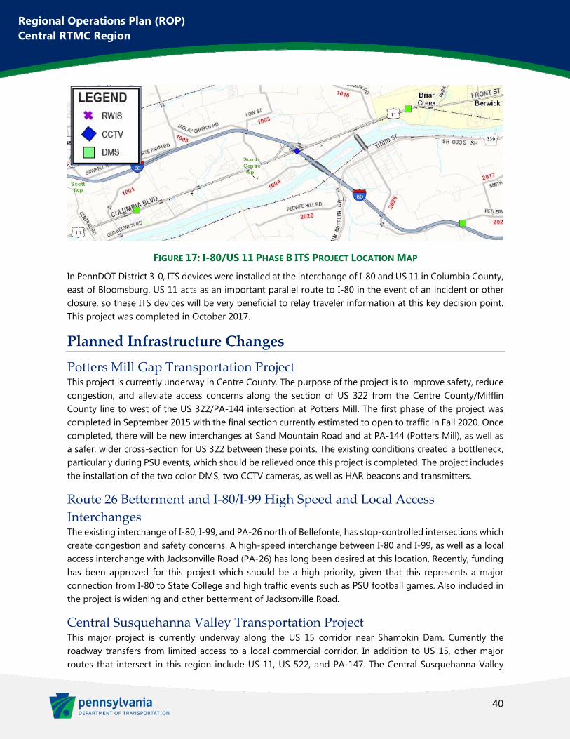
40
Regional Operations Plan (ROP) Central RTMC Region
FIGURE 17: I-80/US 11 PHASE B ITS PROJECT LOCATION MAP
In PennDOT District 3-0, ITS devices were installed at the interchange of I-80 and US 11 in Columbia County, east of Bloomsburg. US 11 acts as an important parallel route to I-80 in the event of an incident or other closure, so these ITS devices will be very beneficial to relay traveler information at this key decision point. This project was completed in October 2017.
Planned Infrastructure Changes
Potters Mill Gap Transportation Project This project is currently underway in Centre County. The purpose of the project is to improve safety, reduce congestion, and alleviate access concerns along the section of US 322 from the Centre County/Mifflin County line to west of the US 322/PA-144 intersection at Potters Mill. The first phase of the project was completed in September 2015 with the final section currently estimated to open to traffic in Fall 2020. Once completed, there will be new interchanges at Sand Mountain Road and at PA-144 (Potters Mill), as well as a safer, wider cross-section for US 322 between these points. The existing conditions created a bottleneck, particularly during PSU events, which should be relieved once this project is completed. The project includes the installation of the two color DMS, two CCTV cameras, as well as HAR beacons and transmitters.
Route 26 Betterment and I‐80/I‐99 High Speed and Local Access
Interchanges The existing interchange of I-80, I-99, and PA-26 north of Bellefonte, has stop-controlled intersections which create congestion and safety concerns. A high-speed interchange between I-80 and I-99, as well as a local access interchange with Jacksonville Road (PA-26) has long been desired at this location. Recently, funding has been approved for this project which should be a high priority, given that this represents a major connection from I-80 to State College and high traffic events such as PSU football games. Also included in the project is widening and other betterment of Jacksonville Road.
Central Susquehanna Valley Transportation Project This major project is currently underway along the US 15 corridor near Shamokin Dam. Currently the roadway transfers from limited access to a local commercial corridor. In addition to US 15, other major routes that intersect in this region include US 11, US 522, and PA-147. The Central Susquehanna Valley
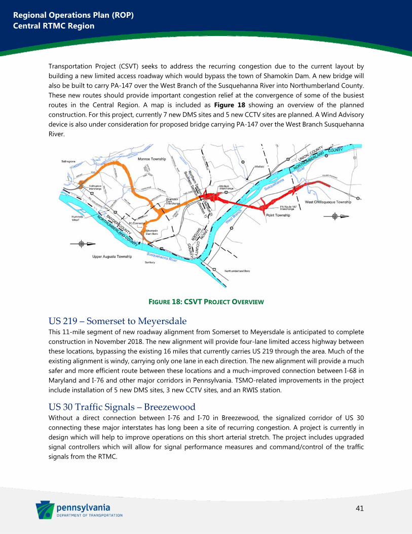
41
Regional Operations Plan (ROP) Central RTMC Region
Transportation Project (CSVT) seeks to address the recurring congestion due to the current layout by building a new limited access roadway which would bypass the town of Shamokin Dam. A new bridge will also be built to carry PA-147 over the West Branch of the Susquehanna River into Northumberland County. These new routes should provide important congestion relief at the convergence of some of the busiest routes in the Central Region. A map is included as Figure 18 showing an overview of the planned construction. For this project, currently 7 new DMS sites and 5 new CCTV sites are planned. A Wind Advisory device is also under consideration for proposed bridge carrying PA-147 over the West Branch Susquehanna River.
FIGURE 18: CSVT PROJECT OVERVIEW
US 219 – Somerset to Meyersdale This 11-mile segment of new roadway alignment from Somerset to Meyersdale is anticipated to complete construction in November 2018. The new alignment will provide four-lane limited access highway between these locations, bypassing the existing 16 miles that currently carries US 219 through the area. Much of the existing alignment is windy, carrying only one lane in each direction. The new alignment will provide a much safer and more efficient route between these locations and a much-improved connection between I-68 in Maryland and I-76 and other major corridors in Pennsylvania. TSMO-related improvements in the project include installation of 5 new DMS sites, 3 new CCTV sites, and an RWIS station.
US 30 Traffic Signals – Breezewood Without a direct connection between I-76 and I-70 in Breezewood, the signalized corridor of US 30 connecting these major interstates has long been a site of recurring congestion. A project is currently in design which will help to improve operations on this short arterial stretch. The project includes upgraded signal controllers which will allow for signal performance measures and command/control of the traffic signals from the RTMC.
42
Regional Operations Plan (ROP) Central RTMC Region
Other Projects Under Consideration The following table collects other projects currently under consideration that would greatly impact regional transportation and development.
TABLE 14: POSSIBLE INFRASTRUCTURE CHANGES OF NOTE
Project Name Project Description Planning
Organization
SR 322/144/45 Corridors (Potters Mills to I-80/I-99 area)
Construct a new 4 lane limited access highway on new alignment from Potters Mills to I-80/I-99 area.
Centre County MPO
US 220 Widening, I-80 to Salona I-99 missing link in Clinton County. Widening of US 220 to 4-lane cross-section from I-80 Interchange to existing 4-lane, limited access section near Salona
SEDA-COG
US 219 Meyersdale to I-68 New limited access alignment of US 219 between I-68 in Maryland and Meyersdale
Southern Alleghenies RPO
Future Land Use Changes
Overall, there is a trend in economic development from traditional, large scale manufacturing industries to smaller, technology-driven manufacturing and service industries. To best take advantage of this trend, transportation infrastructure and services should be improved in the region’s downtown and urban cores, connecting workers to available jobs and lowering shipping costs for freight haulers.
Natural Gas Drilling Since the development of the last ROP, a sustained oversupply of natural gas has led to a significant decrease in commodity prices for gas and oil, and drilling efforts in the Marcellus region have therefore dropped off. This has reduced some of the highway traffic, particularly heavy vehicle traffic, that had previously been a concern. Moving forward, natural gas well drilling activity should be monitored. Depending on market prices for gas and oil, another boom could happen which would again impact the transportation network in the region. Current predictions anticipate a modest increase in drilling but not to the degree of activity that was seen in the previous boom.
Despite these predictions, a few factors point towards increasing in drilling. A large-scale ethane cracker is currently under construction in Beaver County which would convert ethane produced from the Marcellus Shale into ethylene for Royal Dutch Shell. This could lead to an uptick in drilling in the Central Region. Also, National Fuel Gas is attempting to build a pipeline from the Marcellus Shale are north through New York to Canada but has been denied. They continue to push for its construction and, if it is built, would lead to the construction of many wells in the North Central RPO region.
Warehouses and Freight Pennsylvania is located in an important strategic position in the nation with several interstate roadways traversing the state that serve national and international trade routes. A large proportion of the nation’s population can be reached within a single day by trucking freight operators. Therefore, many warehouse and manufacturing operations have been developing throughout the state, but particularly near major
43
Regional Operations Plan (ROP) Central RTMC Region
interchanges. It should be anticipated that this trend will continue and impact the Central Region given its position within the state and the way that I-80 and other important corridors bisect the area.
Anticipated Development Growth areas in the SEDA-COG planning region include the US 11 corridor in the Bloomsburg/Scott Township area and the PA-54 corridor in Montour County where 200 acres have been rezoned for medical research with other nearby and primed for residential development. In Lycoming County, Geisinger has proposed a medical center facility in Muncy Township near I-180 which would likely bring other development in the area. Also, a $20 million revitalization project is being developed through a public/private partnership between Lycoming College and the City of Williamsport.
Centre County has a variety of development occurring. There has been a boom in mixed use construction in downtown State College replacing surface lots and other parcels with mid-rise residential/retail buildings. Elsewhere in the county, industrial park development is occurring near the I-99/PA-150 interchange.
Infrastructure‐Related Development Some major land use changes are contingent on proposed roadway developments, such as the northward expansion of I-99. The various proposed I-99 projects would result in growth areas for business and industry, as well as residential land uses. The CSVT project mentioned above and currently underway is anticipated to spur residential development in eastern Snyder County and in Northumberland County along the PA-147 corridor.

44
Regional Operations Plan (ROP) Central RTMC Region
Chapter 4. Transportation Needs and Operational
Issues In the previous ROPs, completed in 2007 and 2008, two needs areas were identified by each of the three Districts. Through the stakeholder outreach for this current regional plan, these needs were found to still be applicable. They are:
Traveler Information
Incident and Emergency Management
In addition to the needs which remain from the previous ROP process, a number of other issues and needs were identified during the current stakeholder process. These issues and needs fall under the following additional categories:
Transportation System Safety
Traffic Signal Improvements
Communications Network
Enhanced Asset Management
Automated Systems Management
The tables in the following sections outline the specific transportation needs and operational issues identified throughout the Region.
Traveler Information
Traveler information is vital to improving the efficiency of the transportation system. When drivers are notified of real-time operating conditions, they can make informed decisions which better distribute traffic across the roadway system, maximizing efficiency. Timely information can also keep queues from continuing to build when closures occur due to crashes or weather conditions, increasing safety for all road users.
Likely the most important traveler information need for the region was completed with the opening of the RTMC. This is now the focal point of traffic operations and traveler information dissemination to the public. Through the RTMC, travelers can be informed of roadway conditions, incidents and crashes, construction and maintenance activities, and weather conditions. RTMC operators utilize DMS and HAR to disseminate this traveler information. In addition, the information is also distributed via the 511 Pennsylvania Traveler Information System (511PA) website and app.
In the years since the last ROPs were developed, the distribution of traveler information from third party developers has greatly increased. Now many drivers use apps such as Waze as part of their daily commuting habits. Despite this change, ITS devices still provide an easy and widely used source of traveler information.
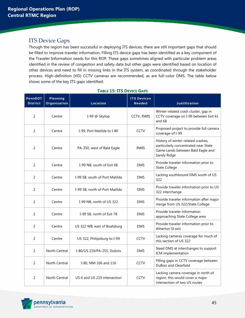
45
Regional Operations Plan (ROP) Central RTMC Region
ITS Device Gaps Though the region has been successful in deploying ITS devices, there are still important gaps that should be filled to improve traveler information. Filling ITS device gaps has been identified as a key component of the Traveler Information needs for this ROP. These gaps sometimes aligned with particular problem areas identified in the review of congestion and safety data but other gaps were identified based on location of other devices and need to fill in missing links in the ITS system, as coordinated through the stakeholder process. High-definition (HD) CCTV cameras are recommended, as are full-color DMS. The table below shows some of the key ITS gaps identified:
TABLE 15: ITS DEVICE GAPS PennDOT District
Planning Organization Location
ITS Devices Needed Justification
2 Centre I-99 @ Skytop CCTV, RWIS Winter-related crash cluster, gap in CCTV coverage on I-99 between Exit 61 and 68
2 Centre I-99, Port Matilda to I-80 CCTV Proposed project to provide full camera coverage of I-99
2 Centre PA-350, west of Bald Eagle RWIS
History of winter-related crashes, particularly concentrated near State Game Lands between Bald Eagle and Sandy Ridge
2 Centre I-99 NB, south of Exit 68 DMS Provide traveler information prior to State College
2 Centre I-99 SB, south of Port Matilda DMS Lacking southbound DMS south of US 322
2 Centre I-99 SB, north of Port Matilda DMS Provide traveler information prior to US 322 interchange
2 Centre I-99 NB, north of US 322 DMS Provide traveler information after major merge from US 322/State College
2 Centre I-99 SB, north of Exit 78 DMS Provide traveler information approaching State College area
2 Centre US 322 WB, east of Boalsburg DMS Provide traveler information prior to Atherton St exit
2 Centre US 322, Philipsburg to I-99 CCTV Lacking cameras coverage for much of this section of US 322
2 North Central I-80/US 219/PA-255, Dubois DMS Need DMS at interchanges to support ICM implementation
2 North Central I-80, MM 106 and 116 CCTV Filling gaps in CCTV coverage between DuBois and Clearfield
2 North Central US 6 and US 219 intersection CCTV Lacking camera coverage in north of region, this would cover a major intersection of two US routes
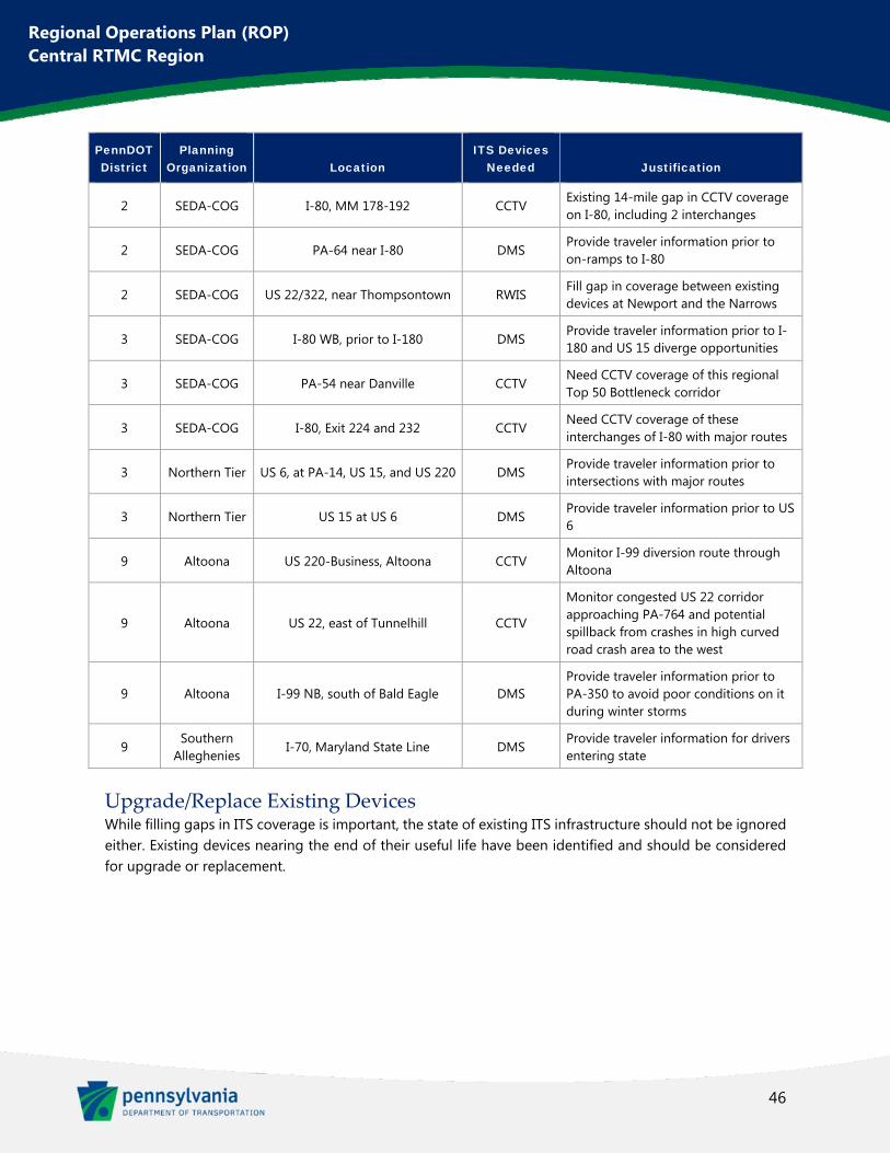
46
Regional Operations Plan (ROP) Central RTMC Region
PennDOT District
Planning Organization Location
ITS Devices Needed Justification
2 SEDA-COG I-80, MM 178-192 CCTV Existing 14-mile gap in CCTV coverage on I-80, including 2 interchanges
2 SEDA-COG PA-64 near I-80 DMS Provide traveler information prior to on-ramps to I-80
2 SEDA-COG US 22/322, near Thompsontown RWIS Fill gap in coverage between existing devices at Newport and the Narrows
3 SEDA-COG I-80 WB, prior to I-180 DMS Provide traveler information prior to I-180 and US 15 diverge opportunities
3 SEDA-COG PA-54 near Danville CCTV Need CCTV coverage of this regional Top 50 Bottleneck corridor
3 SEDA-COG I-80, Exit 224 and 232 CCTV Need CCTV coverage of these interchanges of I-80 with major routes
3 Northern Tier US 6, at PA-14, US 15, and US 220 DMS Provide traveler information prior to intersections with major routes
3 Northern Tier US 15 at US 6 DMS Provide traveler information prior to US 6
9 Altoona US 220-Business, Altoona CCTV Monitor I-99 diversion route through Altoona
9 Altoona US 22, east of Tunnelhill CCTV
Monitor congested US 22 corridor approaching PA-764 and potential spillback from crashes in high curved road crash area to the west
9 Altoona I-99 NB, south of Bald Eagle DMS Provide traveler information prior to PA-350 to avoid poor conditions on it during winter storms
9 Southern
Alleghenies I-70, Maryland State Line DMS
Provide traveler information for drivers entering state
Upgrade/Replace Existing Devices While filling gaps in ITS coverage is important, the state of existing ITS infrastructure should not be ignored either. Existing devices nearing the end of their useful life have been identified and should be considered for upgrade or replacement.
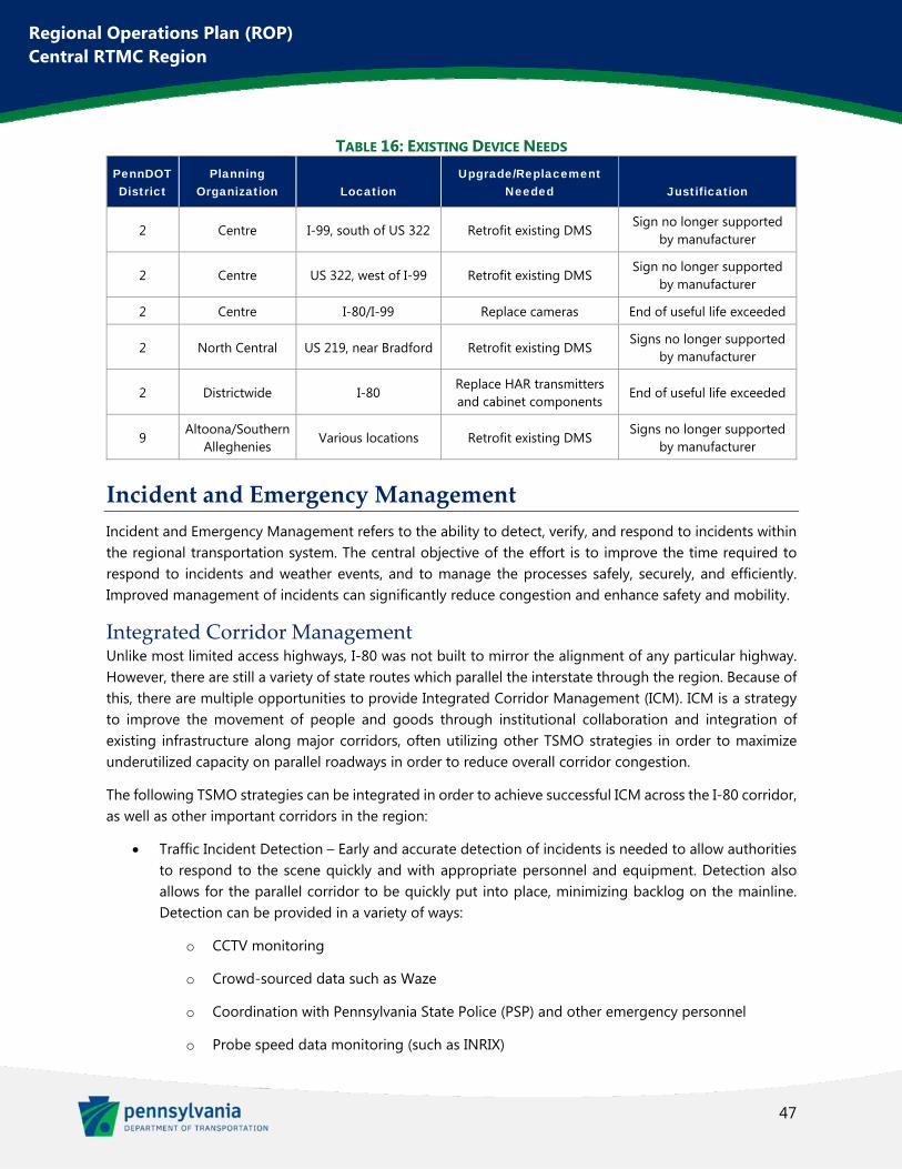
47
Regional Operations Plan (ROP) Central RTMC Region
TABLE 16: EXISTING DEVICE NEEDS PennDOT District
Planning Organization Location
Upgrade/Replacement Needed Justification
2 Centre I-99, south of US 322 Retrofit existing DMS Sign no longer supported
by manufacturer
2 Centre US 322, west of I-99 Retrofit existing DMS Sign no longer supported
by manufacturer
2 Centre I-80/I-99 Replace cameras End of useful life exceeded
2 North Central US 219, near Bradford Retrofit existing DMS Signs no longer supported
by manufacturer
2 Districtwide I-80 Replace HAR transmitters and cabinet components
End of useful life exceeded
9 Altoona/Southern
Alleghenies Various locations Retrofit existing DMS
Signs no longer supported by manufacturer
Incident and Emergency Management
Incident and Emergency Management refers to the ability to detect, verify, and respond to incidents within the regional transportation system. The central objective of the effort is to improve the time required to respond to incidents and weather events, and to manage the processes safely, securely, and efficiently. Improved management of incidents can significantly reduce congestion and enhance safety and mobility.
Integrated Corridor Management Unlike most limited access highways, I-80 was not built to mirror the alignment of any particular highway. However, there are still a variety of state routes which parallel the interstate through the region. Because of this, there are multiple opportunities to provide Integrated Corridor Management (ICM). ICM is a strategy to improve the movement of people and goods through institutional collaboration and integration of existing infrastructure along major corridors, often utilizing other TSMO strategies in order to maximize underutilized capacity on parallel roadways in order to reduce overall corridor congestion.
The following TSMO strategies can be integrated in order to achieve successful ICM across the I-80 corridor, as well as other important corridors in the region:
Traffic Incident Detection – Early and accurate detection of incidents is needed to allow authorities to respond to the scene quickly and with appropriate personnel and equipment. Detection also allows for the parallel corridor to be quickly put into place, minimizing backlog on the mainline. Detection can be provided in a variety of ways:
o CCTV monitoring
o Crowd-sourced data such as Waze
o Coordination with Pennsylvania State Police (PSP) and other emergency personnel
o Probe speed data monitoring (such as INRIX)
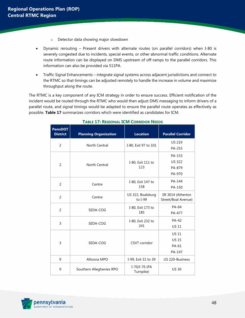
48
Regional Operations Plan (ROP) Central RTMC Region
o Detector data showing major slowdown
Dynamic rerouting – Present drivers with alternate routes (on parallel corridors) when I-80 is severely congested due to incidents, special events, or other abnormal traffic conditions. Alternate route information can be displayed on DMS upstream of off-ramps to the parallel corridors. This information can also be provided via 511PA.
Traffic Signal Enhancements – integrate signal systems across adjacent jurisdictions and connect to the RTMC so that timings can be adjusted remotely to handle the increase in volume and maximize throughput along the route.
The RTMC is a key component of any ICM strategy in order to ensure success. Efficient notification of the incident would be routed through the RTMC who would then adjust DMS messaging to inform drivers of a parallel route, and signal timings would be adapted to ensure the parallel route operates as effectively as possible. Table 17 summarizes corridors which were identified as candidates for ICM.
TABLE 17: REGIONAL ICM CORRIDOR NEEDS PennDOT District Planning Organization Location Parallel Corridor
2 North Central I-80, Exit 97 to 101 US 219
PA-255
2 North Central I-80, Exit 111 to
123
PA-153
US 322
PA-879
PA-970
2 Centre I-80, Exit 147 to
158 PA-144
PA-150
2 Centre US 322, Boalsburg
to I-99 SR 3014 (Atherton
Street/Boal Avenue)
2 SEDA-COG I-80, Exit 173 to
185 PA-64
PA-477
3 SEDA-COG I-80, Exit 232 to
241 PA-42
US 11
3 SEDA-COG CSVT corridor
US 11
US 15
PA-61
PA-147
9 Altoona MPO I-99, Exit 31 to 39 US 220-Business
9 Southern Alleghenies RPO I-70/I-76 (PA
Turnpike) US 30
49
Regional Operations Plan (ROP) Central RTMC Region
TIM Teams Traffic Incident Management (TIM) is a multi-agency, coordinated effort to minimize the impact of traffic incidents. TIM requires planning and coordination between multiple entities, including local transportation departments, law enforcement, fire departments, emergency medical services, towing and recovery companies, and hazardous materials clean-up contractors. Each agency has its own diverse priorities and cultures which need to be addressed through a unified set of TIM strategies including better interagency coordination and training. A successful TIM team can lead to reduced incident response cost, decreased travel delay, and improved safety through faster, better organized incident clearance.
TABLE 18: TIM TEAM NEEDS PennDOT District
Planning Organization Corridor
3 SEDA-COG CSVT Corridor
2 and 3 Various I-80 Corridor
2 and 9 Various I-99 Corridor
Weather Forecasting Integration Weather, particularly winter weather, is an important transportation issue within the region. There is an existing relationship between the Central RTMC and the State College office of the National Weather Service (NWS). There is room for this relationship to grow with further collaboration and sharing of data. This can lead to improved traveler information and safer operations decisions on PennDOT’s roadways. The following are recommendations to assist in more extensive integration of weather forecasting information at the RTMC:
Increase collaboration to ensure consistent messaging between PennDOT and NWS. NWS is seeking to increase public knowledge of snow squall warnings. Snow squalls are particularly
hazardous weather events to drivers as they severely decrease visibility and often move quickly through regions. Through collaboration between PennDOT and NWS, these snow squall warnings could be broadcast out to drivers via existing DMS signs and PA511, providing advance warning to the public to stay off the road or otherwise avoid these potentially dangerous conditions.
PennDOT Maintenance personnel can assist NWS with gathering snowfall measurements at regional PennDOT stockpile locations. This will be particularly beneficial to NWS at rural facilities that have 24/7 staff that can provide snowfall information during the overnight hours.
Special Event Use of Portable DMS Portable DMS, normally transported via a trailer hitch, are a very handy tool for ITS operations due to the inherit flexibility which they provide. They are often used to improve safety in work zones but can also be utilized during special events which draw large crowds and create congestion. The Central Region has the capability to program these devices from the RTMC. The stakeholder process identified the following events which could benefit from planned use of portable DMS:
Peoples Natural Gas Field (Altoona Curve baseball stadium)
50
Regional Operations Plan (ROP) Central RTMC Region
Multiple Centre County/PSU events
Bloomsburg Fairgrounds Events
Benezette Elk Viewing and Elk Expo, PA-555
Transportation System Safety
With an estimated 50% of rural congestion occurring due to traffic incidents, safety is of course an important issue. While the previous section discussed ways to minimize impacts due to incidents, this regional need relates to minimizing the occurrence of incidents before they happen.
Innovative ITS devices continue to be introduced and improved upon which seek to assist drivers in warning of potential dangers and in reducing dangerous conditions in the first place. This section discusses a few of these TSMO strategies which are recommended to improve safety at particularly dangerous sections of the region’s highways.
Variable Speed Displays Variable speed displays, also known as variable speed limits, are posted by variable speed limit signs. These speed limits can be changed remotely by the RTMC or can automatically change in response to congestion, incidents, work zones, or road weather conditions.
TABLE 19: VARIABLE SPEED DISPLAY NEEDS PennDOT District
Planning Organization Corridor
2 Centre US 322 west of I-99
2 Centre I-80, Exit 147 to 158
Queue Detection Queue warning systems alert drivers to downstream slow-moving traffic, especially in cases where the congestion would be unexpected. Queue warnings are typically delivered to motorists through DMS, though some advanced ITS applications involve in-vehicle queue warnings. Queue warning systems can be used in conjunction with portable DMS ahead of work zones with lane closures in effect or other temporary conditions which will cause atypical congestion. Queue warning systems can also be effectively paired with variable speed limits to improve their effectiveness.
TABLE 20: QUEUE DETECTION NEEDS PennDOT District
Planning Organization Corridor
3 Williamsport I-180 WB, approaching SB US 15 off-ramp
9 Johnstown US 22 Eastbound, near US 219
51
Regional Operations Plan (ROP) Central RTMC Region
Dynamic Curve Warning Dynamic curve warning systems provide feedback to vehicles entering a horizontal curve when they approach at an unsafe speed. Vehicle speeds are detected upstream of the curve by radar or other ITS devices and trigger a controller which activates electronic sign elements and/or DMS signs to warn the speeding driver to slow down prior to the curve.
In most cases, Dynamic Curve Warning should be installed only after other more low-cost improvements have been installed and not achieved the desired outcome. Low-cost improvements would include signage, delineation treatments, high friction surface treatments, and other similar solutions.
Dynamic Curve Warning Needs were identified by evaluating curved road crash clusters within PennDOT One Map. These clusters were tiered and the highest ranking curved road crash locations were evaluated to determine if an ITS solution was warranted or if low-cost improvements should be attempted first.
TABLE 21: DYNAMIC CURVE WARNING NEEDS PennDOT District
Planning Organization Corridor
2 Centre I-99 near Exit 81
2 SEDA-COG I-80 near MM 180
2 SEDA-COG US 322 near Laurel Creek Reservoir
3 Williamsport US 15, Southbound prior to I-180
9 Altoona US 22 near Williamsburg
9 Johnstown US 219 near Summerhill
9 Southern Alleghenies US 30 near McConnellsburg
Bridge De‐Icing Heating technologies can be used to prevent snow and ice accumulation on bridge decks during winter storms. The latest technology includes burying electric resistance cables or pipes with heated liquid within the pavement to warm up the road surface and help to minimize accumulation of winter precipitation. Currently, PennDOT utilizes the Automated Fixed Location Anti-Icing System (AFLADS) at locations along I-80. This system consists of a series of spray disks that deliver a freeze point depressant agent, in a pre-prescribed amount, determined by the roadway surface condition. RWIS is utilized to determine the current roadway surface temperature and condition. RTMC personnel are notified when the system is activated. It is recommended to include bridge de-icing technology within the pavement for future installations.
Table 22 shows existing systems that need retrofits of equipment in order to stay operational.
TABLE 22: BRIDGE DE-ICING NEEDS PennDOT District
Planning Organization Corridor Need
2 Centre I-80 over Eagle Valley Road Retrofit existing system
2 North Central I-80 over Anderson Creek Retrofit existing system
52
Regional Operations Plan (ROP) Central RTMC Region
Slow Vehicle Warning Slow vehicle warning systems have begun to be used, often for large construction vehicles entering the roadway from a work zone access point. Sensors can be used to detect the slow moving vehicle, triggering a message to be displayed upstream warning drivers. This could be used in the region at permanent locations as well where speed discrepancies (often due to vertical curves) create rear end crashes.
TABLE 23: SLOW VEHICLE WARNING NEEDS PennDOT District
Planning Organization Corridor
2 North Central I-80 WB, MM 120 to 111
2 SEDA-COG US 322, Seven Mountains
Automated Truck Enforcement Automated truck enforcement systems can be used to detect certain types of unauthorized vehicles and assess violations, saving manpower that would normally be used for enforcement. Within the region, this could be used to reduce heavy vehicle usage of routes which they are banned from. The vehicle would be identified to be above a specified height, length, or weight and a camera system would record images to be used in an automated violation which would be sent to the driver. It should be noted that the state legislation would be required in order to allow for this type of automated enforcement.
TABLE 24: AUTOMATED TRUCK ENFORCEMENT NEEDS PennDOT District
Planning Organization Corridor
2 Centre PA-144, west of Centre Hall
Traffic Signal Enhancements
Traffic signals can improve the safety and efficiency of roadway networks for motorists, as well as for cyclists and pedestrians. However, poor signal timing and/or poor coordination between signalized intersections can negatively impact traffic flow and the effectiveness of the signals. There are a variety of traffic signal enhancements that can allow agencies to get the most effective operations from their existing traffic signals without roadway widening or other costly improvements.
Optimization and coordination of signal timing
Integrating signal systems across adjacent jurisdictions to improve arterial progression
Adaptive traffic signal control to smoothly adjust timings to account for actual traffic volumes where volumes are less predictable
Traffic responsive operations for corridors where traffic volumes fall into typical patterns, but the volumes vary daily
53
Regional Operations Plan (ROP) Central RTMC Region
Emergency vehicle preemption to halt general traffic movements so that emergency vehicles may pass through
Removal of unwarranted traffic signals
Monitoring traffic signals using automated traffic signal performance measures developed from high resolution data logs
The benefits of these enhancements include:
Decreased congestion and delay, improving travel time and travel time reliability
Smoother traffic flow and reduced congestion between traffic signal systems in adjacent jurisdictions
Improved safety without major modifications
Some of the Central Region’s corridors which would benefit from these enhancements are shown in Table 25.
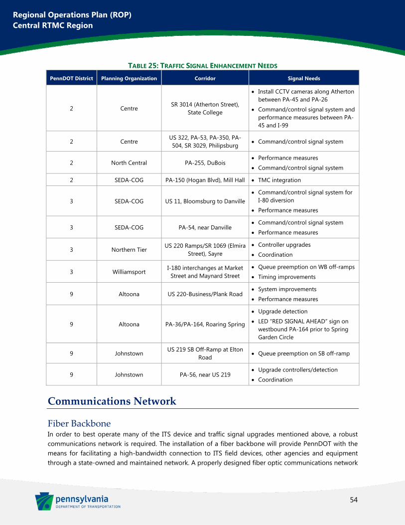
54
Regional Operations Plan (ROP) Central RTMC Region
TABLE 25: TRAFFIC SIGNAL ENHANCEMENT NEEDS
PennDOT District Planning Organization Corridor Signal Needs
2 Centre SR 3014 (Atherton Street),
State College
Install CCTV cameras along Atherton between PA-45 and PA-26
Command/control signal system and performance measures between PA-45 and I-99
2 Centre US 322, PA-53, PA-350, PA-504, SR 3029, Philipsburg
Command/control signal system
2 North Central PA-255, DuBois Performance measures
Command/control signal system
2 SEDA-COG PA-150 (Hogan Blvd), Mill Hall TMC integration
3 SEDA-COG US 11, Bloomsburg to Danville Command/control signal system for
I-80 diversion
Performance measures
3 SEDA-COG PA-54, near Danville Command/control signal system
Performance measures
3 Northern Tier US 220 Ramps/SR 1069 (Elmira
Street), Sayre Controller upgrades
Coordination
3 Williamsport I-180 interchanges at Market
Street and Maynard Street Queue preemption on WB off-ramps
Timing improvements
9 Altoona US 220-Business/Plank Road System improvements
Performance measures
9 Altoona PA-36/PA-164, Roaring Spring
Upgrade detection
LED “RED SIGNAL AHEAD” sign on westbound PA-164 prior to Spring Garden Circle
9 Johnstown US 219 SB Off-Ramp at Elton
Road Queue preemption on SB off-ramp
9 Johnstown PA-56, near US 219 Upgrade controllers/detection
Coordination
Communications Network
Fiber Backbone In order to best operate many of the ITS device and traffic signal upgrades mentioned above, a robust communications network is required. The installation of a fiber backbone will provide PennDOT with the means for facilitating a high-bandwidth connection to ITS field devices, other agencies and equipment through a state-owned and maintained network. A properly designed fiber optic communications network
55
Regional Operations Plan (ROP) Central RTMC Region
is highly reliable and will supply the bandwidth necessary to transmit current and future data and video to/from the RTMC.
By utilizing the region’s interstates as a pathway to establish the backbone installation, all conduit, cabling, and communications equipment will be installed within the limited access right-of-way which will help mitigate any possible damage to cable or equipment infrastructure due to uncoordinated digging activities near PennDOT underground infrastructure (exacerbated by the fact that PennDOT is not a listed utility as part of Pennsylvania’s One-Call system). In addition, the installation of primary backbone facilities along the interstate roadway network provides logical connections for expansion to major arterial facilities via interchanges.
Once deployed, the fiber optic backbone network does not require any additional leasing cost to maintain. The high bandwidth that is provided by a properly designed fiber optic backbone network also makes this alternative more scalable as additional data and video needs are realized in upcoming years. It should be noted that the up-front installation cost for a fiber backbone network is substantial when compared to leasing costs on a device-by-device basis, but the installation of fiber will begin to realize cost savings once fully deployed.
To connect the existing fiber network back to the RTMC, the following gaps were identified:
I-99, Exit 71 to I-80
I-80, Existing Fiber (MM 159.1) to Exit 161
I-80, Existing Fiber (MM 153.9) to District 2-0 Office
To complete the fiber backbone on I-80 in the region, the additional gaps were identified:
I-80, Exit 97 to District 2-0 Office
I-80, Exit 161 to Exit 212 (I-180)
I-180, from I-80 to Montoursville (I-180 Exit 21)
To complete the fiber backbone on I-99, an additional gap from Exit 52 to the Pennsylvania Turnpike (I-76) was also identified.
In total, approximately 49 miles of fiber are needed to connect the existing backbone to the RTMC and an additional 97 miles of fiber are needed to provide a complete backbone on I-80/I-180. An additional 52 miles of fiber are needed to complete the I-99 backbone.
P3 Fiber Potential Elsewhere in the Commonwealth and throughout the country, Public-Private Partnerships (P3) are being undertaken to facilitate expansion of fiber networks. P3 projects involve cooperative arrangements between public and private sectors, adding important upfront funding of public projects while normally providing potential for long-term benefits to the private entity.
In the case of fiber networks, a P3 agreement could allow a private company to install a large fiber network within PennDOT’s right-of-way. The network would accommodate PennDOT’s existing and future data
56
Regional Operations Plan (ROP) Central RTMC Region
communications needs while also allowing the private firm to generate revenue from third party broadband customers. This could aid the Department in building their fiber network while likely resulting in an overall cost savings as well.
Enhanced Asset Management
With a growing network of ITS devices throughout the Central RTMC Region, it becomes increasingly difficult to manage and maintain them. It is recommended that an Enhanced Asset Management program be deployed so that PennDOT and the planning partners are able to monitor the age and status of the various ITS devices in the region. Therefore, the devices can be best maintained and remain in operation. Also, PennDOT and the planning partners can be aware of which devices are reaching the end of their life cycles and in need of replacement. This allows for planners to determine approximate timing of future expenditures related to replacement of existing ITS devices.
A funding source for replacement of antiquated ITS devices should also be determined. This would ensure that existing devices remain operable and ITS capabilities are not lost at important locations along the region’s roadways.
Automated Systems Management
Another aspect to consider with a growing network of ITS devices is the capabilities of RTMC staff to manage and utilize them. Potential solutions exist which can automate some of the operation of devices. These systems, sometimes referred to as advanced roadside information management systems, can pull data from cameras and sensors and run algorithms to determine any issues occurring in real-time. These systems can then automate the operation of variable speed displays and other devices, as well as sending appropriate messaging out to DMS signs. In the future, messaging could also be delivered to in-vehicle units via Dedicated short-range communications (DSRC).
This sort of technology is relatively new and would specifically be new to the Central RTMC Region. Therefore, no large-scale deployment is recommended at this time. However, a pilot should be considered to test the potential and capabilities of such a system.
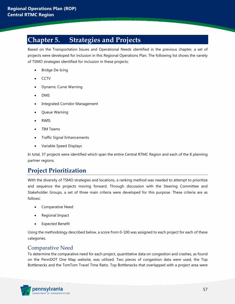
57
Regional Operations Plan (ROP) Central RTMC Region
Chapter 5. Strategies and Projects Based on the Transportation Issues and Operational Needs identified in the previous chapter, a set of projects were developed for inclusion in this Regional Operations Plan. The following list shows the variety of TSMO strategies identified for inclusion in these projects:
Bridge De-Icing
CCTV
Dynamic Curve Warning
DMS
Integrated Corridor Management
Queue Warning
RWIS
TIM Teams
Traffic Signal Enhancements
Variable Speed Displays
In total, 37 projects were identified which span the entire Central RTMC Region and each of the 8 planning partner regions.
Project Prioritization
With the diversity of TSMO strategies and locations, a ranking method was needed to attempt to prioritize and sequence the projects moving forward. Through discussion with the Steering Committee and Stakeholder Groups, a set of three main criteria were developed for this purpose. These criteria are as follows:
Comparative Need
Regional Impact
Expected Benefit
Using the methodology described below, a score from 0-100 was assigned to each project for each of these categories.
Comparative Need To determine the comparative need for each project, quantitative data on congestion and crashes, as found on the PennDOT One Map website, was utilized. Two pieces of congestion data were used, the Top Bottlenecks and the TomTom Travel Time Ratio. Top Bottlenecks that overlapped with a project area were
58
Regional Operations Plan (ROP) Central RTMC Region
identified and their Bottleneck Delay Surrogate value was used to proportionally rank the project’s bottleneck severity.
Bottleneck Delay Surrogate is a value based on the speed differential as compared to free flow speed, weighted by queue lengths, and estimated traffic volume. This is the value used to rank the Top Bottlenecks within One Map.
Travel Time Ratio is a similar value of actual travel time divided by free-flow travel time, as provided by the navigation company TomTom. Within One Map, this data is divided into four categories of severity from green (the lowest level) to red (the highest level). For the purposes of the ROP project ranking, a value was assigned to each of these categories and the value was applied to each project which overlapped with an identified TomTom area. Where multiple TomTom categories were called out in a single project area, the highest (worst) category was utilized.
The other data used in determining each project’s need was crash cluster information. Rear-End, Intersection, Winter-Related, and Curved Road crash clusters were summed within each project area and this value was compared proportionally amongst the projects.
Based on discussion within the Steering Committee, the importance of congestion and crashes were relatively equal when determining comparative need, so the two congestion values and the one crash value were weighted evenly in the prioritization rankings.
FIGURE 19: COMPARATIVE NEED WEIGHTING DISTRIBUTION
Regional Impact The next criteria which was utilized in ranking projects was the regional impact. Previous ROPs were completed on a PennDOT District basis. With the move to a regional, RTMC-focused ROP, the focus area of this plan has greatly expanded to now cover three of the largest Districts within the Commonwealth. Because of this, the impact of each project should expand beyond its immediate surroundings and provide positives to the greater region.
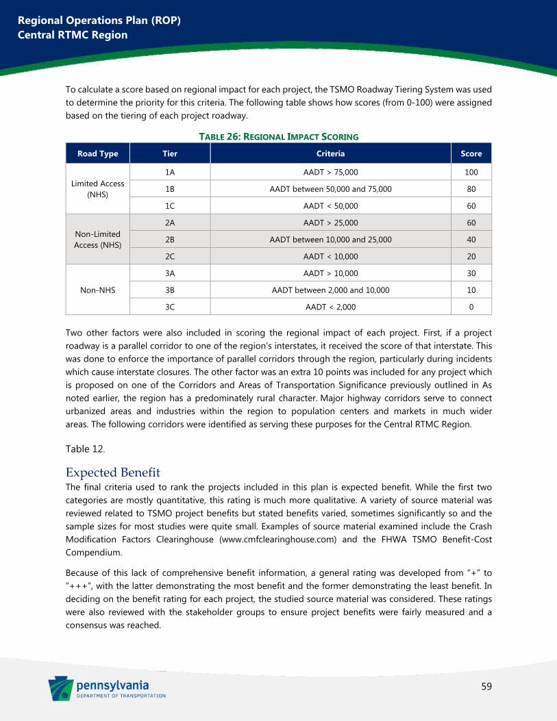
59
Regional Operations Plan (ROP) Central RTMC Region
To calculate a score based on regional impact for each project, the TSMO Roadway Tiering System was used to determine the priority for this criteria. The following table shows how scores (from 0-100) were assigned based on the tiering of each project roadway.
TABLE 26: REGIONAL IMPACT SCORING Road Type Tier Criteria Score
Limited Access (NHS)
1A AADT > 75,000 100
1B AADT between 50,000 and 75,000 80
1C AADT < 50,000 60
Non-Limited Access (NHS)
2A AADT > 25,000 60
2B AADT between 10,000 and 25,000 40
2C AADT < 10,000 20
Non-NHS
3A AADT > 10,000 30
3B AADT between 2,000 and 10,000 10
3C AADT < 2,000 0
Two other factors were also included in scoring the regional impact of each project. First, if a project roadway is a parallel corridor to one of the region’s interstates, it received the score of that interstate. This was done to enforce the importance of parallel corridors through the region, particularly during incidents which cause interstate closures. The other factor was an extra 10 points was included for any project which is proposed on one of the Corridors and Areas of Transportation Significance previously outlined in As noted earlier, the region has a predominately rural character. Major highway corridors serve to connect urbanized areas and industries within the region to population centers and markets in much wider areas. The following corridors were identified as serving these purposes for the Central RTMC Region.
Table 12.
Expected Benefit The final criteria used to rank the projects included in this plan is expected benefit. While the first two categories are mostly quantitative, this rating is much more qualitative. A variety of source material was reviewed related to TSMO project benefits but stated benefits varied, sometimes significantly so and the sample sizes for most studies were quite small. Examples of source material examined include the Crash Modification Factors Clearinghouse (www.cmfclearinghouse.com) and the FHWA TSMO Benefit-Cost Compendium.
Because of this lack of comprehensive benefit information, a general rating was developed from “+” to “+++”, with the latter demonstrating the most benefit and the former demonstrating the least benefit. In deciding on the benefit rating for each project, the studied source material was considered. These ratings were also reviewed with the stakeholder groups to ensure project benefits were fairly measured and a consensus was reached.
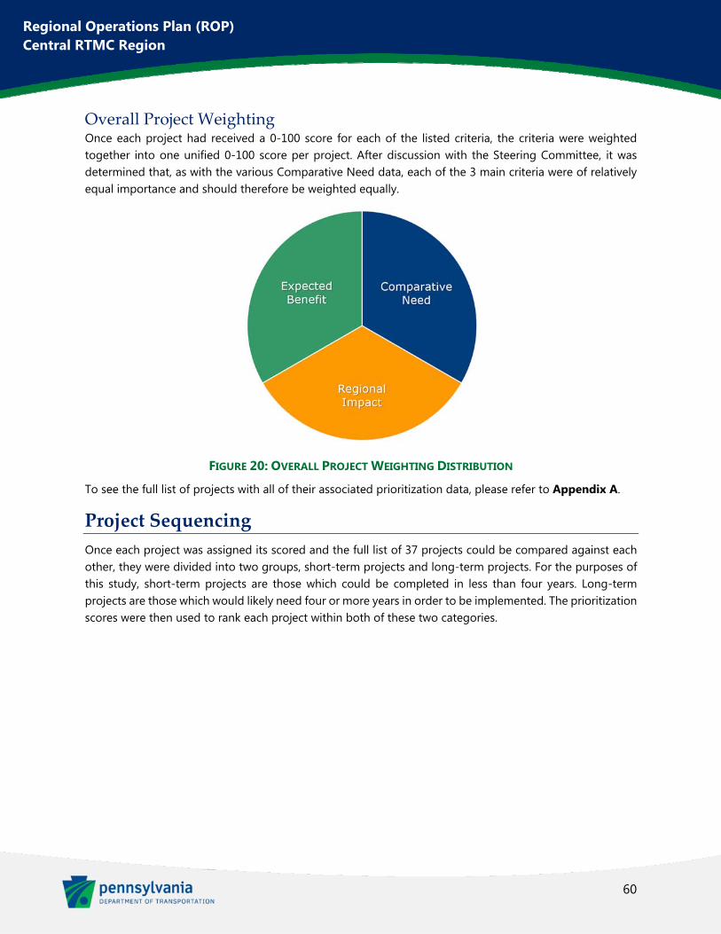
60
Regional Operations Plan (ROP) Central RTMC Region
Overall Project Weighting Once each project had received a 0-100 score for each of the listed criteria, the criteria were weighted together into one unified 0-100 score per project. After discussion with the Steering Committee, it was determined that, as with the various Comparative Need data, each of the 3 main criteria were of relatively equal importance and should therefore be weighted equally.
FIGURE 20: OVERALL PROJECT WEIGHTING DISTRIBUTION
To see the full list of projects with all of their associated prioritization data, please refer to Appendix A.
Project Sequencing
Once each project was assigned its scored and the full list of 37 projects could be compared against each other, they were divided into two groups, short-term projects and long-term projects. For the purposes of this study, short-term projects are those which could be completed in less than four years. Long-term projects are those which would likely need four or more years in order to be implemented. The prioritization scores were then used to rank each project within both of these two categories.
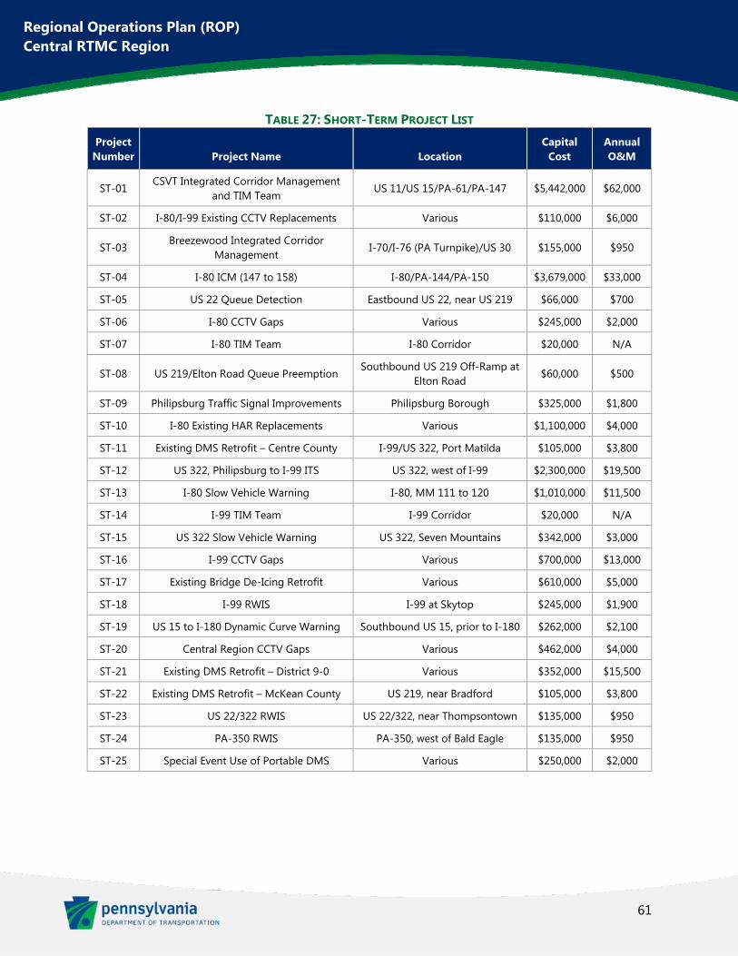
61
Regional Operations Plan (ROP) Central RTMC Region
TABLE 27: SHORT-TERM PROJECT LIST Project Number Project Name Location
Capital Cost
Annual O&M
ST-01 CSVT Integrated Corridor Management
and TIM Team US 11/US 15/PA-61/PA-147 $5,442,000 $62,000
ST-02 I-80/I-99 Existing CCTV Replacements Various $110,000 $6,000
ST-03 Breezewood Integrated Corridor
Management I-70/I-76 (PA Turnpike)/US 30 $155,000 $950
ST-04 I-80 ICM (147 to 158) I-80/PA-144/PA-150 $3,679,000 $33,000
ST-05 US 22 Queue Detection Eastbound US 22, near US 219 $66,000 $700
ST-06 I-80 CCTV Gaps Various $245,000 $2,000
ST-07 I-80 TIM Team I-80 Corridor $20,000 N/A
ST-08 US 219/Elton Road Queue Preemption Southbound US 219 Off-Ramp at
Elton Road $60,000 $500
ST-09 Philipsburg Traffic Signal Improvements Philipsburg Borough $325,000 $1,800
ST-10 I-80 Existing HAR Replacements Various $1,100,000 $4,000
ST-11 Existing DMS Retrofit – Centre County I-99/US 322, Port Matilda $105,000 $3,800
ST-12 US 322, Philipsburg to I-99 ITS US 322, west of I-99 $2,300,000 $19,500
ST-13 I-80 Slow Vehicle Warning I-80, MM 111 to 120 $1,010,000 $11,500
ST-14 I-99 TIM Team I-99 Corridor $20,000 N/A
ST-15 US 322 Slow Vehicle Warning US 322, Seven Mountains $342,000 $3,000
ST-16 I-99 CCTV Gaps Various $700,000 $13,000
ST-17 Existing Bridge De-Icing Retrofit Various $610,000 $5,000
ST-18 I-99 RWIS I-99 at Skytop $245,000 $1,900
ST-19 US 15 to I-180 Dynamic Curve Warning Southbound US 15, prior to I-180 $262,000 $2,100
ST-20 Central Region CCTV Gaps Various $462,000 $4,000
ST-21 Existing DMS Retrofit – District 9-0 Various $352,000 $15,500
ST-22 Existing DMS Retrofit – McKean County US 219, near Bradford $105,000 $3,800
ST-23 US 22/322 RWIS US 22/322, near Thompsontown $135,000 $950
ST-24 PA-350 RWIS PA-350, west of Bald Eagle $135,000 $950
ST-25 Special Event Use of Portable DMS Various $250,000 $2,000
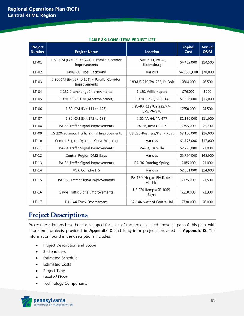
62
Regional Operations Plan (ROP) Central RTMC Region
TABLE 28: LONG-TERM PROJECT LIST Project Number Project Name Location
Capital Cost
Annual O&M
LT-01 I-80 ICM (Exit 232 to 241) + Parallel Corridor
Improvements I-80/US 11/PA-42,
Bloomsburg $4,402,000 $10,500
LT-02 I-80/I-99 Fiber Backbone Various $41,600,000 $70,000
LT-03 I-80 ICM (Exit 97 to 101) + Parallel Corridor
Improvements I-80/US 219/PA-255, DuBois $604,000 $6,500
LT-04 I-180 Interchange Improvements I-180, Williamsport $76,000 $900
LT-05 I-99/US 322 ICM (Atherton Street) I-99/US 322/SR 3014 $1,536,000 $15,000
LT-06 I-80 ICM (Exit 111 to 123) I-80/PA-153/US 322/PA-
879/PA-970 $550,000 $4,500
LT-07 I-80 ICM (Exit 173 to 185) I-80/PA-64/PA-477 $1,169,000 $11,000
LT-08 PA-56 Traffic Signal Improvements PA-56, near US 219 $755,000 $5,700
LT-09 US 220-Business Traffic Signal Improvements US 220-Business/Plank Road $3,100,000 $16,000
LT-10 Central Region Dynamic Curve Warning Various $1,775,000 $17,000
LT-11 PA-54 Traffic Signal Improvements PA-54, Danville $2,795,000 $7,000
LT-12 Central Region DMS Gaps Various $3,774,000 $45,000
LT-13 PA-36 Traffic Signal Improvements PA-36, Roaring Spring $185,000 $1,000
LT-14 US 6 Corridor ITS Various $2,581,000 $24,000
LT-15 PA-150 Traffic Signal Improvements PA-150 (Hogan Blvd), near
Mill Hall $175,000 $1,500
LT-16 Sayre Traffic Signal Improvements US 220 Ramps/SR 1069,
Sayre $210,000 $1,300
LT-17 PA-144 Truck Enforcement PA-144, west of Centre Hall $730,000 $6,000
Project Descriptions
Project descriptions have been developed for each of the projects listed above as part of this plan, with short-term projects provided in Appendix C and long-term projects provided in Appendix D. The information found in the descriptions includes:
Project Description and Scope Stakeholders Estimated Schedule Estimated Costs Project Type Level of Effort Technology Components
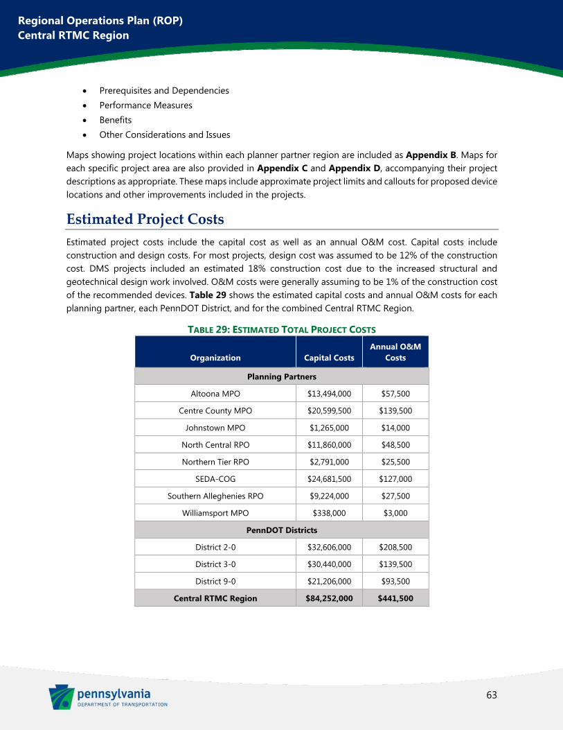
63
Regional Operations Plan (ROP) Central RTMC Region
Prerequisites and Dependencies Performance Measures Benefits Other Considerations and Issues
Maps showing project locations within each planner partner region are included as Appendix B. Maps for each specific project area are also provided in Appendix C and Appendix D, accompanying their project descriptions as appropriate. These maps include approximate project limits and callouts for proposed device locations and other improvements included in the projects.
Estimated Project Costs
Estimated project costs include the capital cost as well as an annual O&M cost. Capital costs include construction and design costs. For most projects, design cost was assumed to be 12% of the construction cost. DMS projects included an estimated 18% construction cost due to the increased structural and geotechnical design work involved. O&M costs were generally assuming to be 1% of the construction cost of the recommended devices. Table 29 shows the estimated capital costs and annual O&M costs for each planning partner, each PennDOT District, and for the combined Central RTMC Region.
TABLE 29: ESTIMATED TOTAL PROJECT COSTS
Organization Capital Costs Annual O&M
Costs
Planning Partners
Altoona MPO $13,494,000 $57,500
Centre County MPO $20,599,500 $139,500
Johnstown MPO $1,265,000 $14,000
North Central RPO $11,860,000 $48,500
Northern Tier RPO $2,791,000 $25,500
SEDA-COG $24,681,500 $127,000
Southern Alleghenies RPO $9,224,000 $27,500
Williamsport MPO $338,000 $3,000
PennDOT Districts
District 2-0 $32,606,000 $208,500
District 3-0 $30,440,000 $139,500
District 9-0 $21,206,000 $93,500
Central RTMC Region $84,252,000 $441,500
64
Regional Operations Plan (ROP) Central RTMC Region
Chapter 6. ROP Coordination and Maintenance The previous round of ROPs in the Central Region produced great results for TSMO and ITS advancement, in particular leading to the opening of the Central Region RTMC in Clearfield. Ten years passed since those last plans were completed though and some of the momentum was lost. With the publishing of this new regionwide ROP, it is intended for it to be updated and maintained on a more consistent basis going forward.
The Steering Committee and Stakeholder Groups discussed this matter and decided that the complete ROP process should be undertaken once every four years, with an interim update two years after each full ROP is completed. Therefore, the ROP would be refreshed every other year, aligning with the TIP update schedule. The ROP schedule should however align so that it is published in the years prior to TIP updates, so that the ROP can be incorporated into the development of the TIP.
Aligning the ROP with the region’s LRTPs was also discussed. Unfortunately, with eight different planning partners involved, there is no way to align the ROP with them, since their LRTP update schedules differ (as seen in Table 5).
Also, in order to maximize the success of the ROP, further funding sources for TSMO projects should be pursued. Ideally, a dedicated line item for TSMO funding would be added to the LRTP and TIP processes.
TSMO should also be included within the project scoping checklist. This way, ROP projects can be incorporated into larger construction projects occurring in the areas recommended within this plan. To help ensure continuity of the recommendations included in this report, it is hoped that each of the region’s planning partners will formally adopt this ROP and the recommendations included herein. Finally, the ITS projects recommended in this document should be considered for PennDOT’s statewide Device Deployment Plan as it is compiled each year.
Connected and autonomous vehicles were generally not accounted for within this report. Despite its ongoing presence in the news and the very real advancements occurring, too much remains unknown with the future of these technologies. As this plan is revisited for future updates, the issue of regional planning for connected and autonomous vehicles should be examined again. Any guidance provided by PennDOT Central Office and other stakeholders should also be incorporated into the document.

Regional Operations Plan (ROP) Central RTMC Region
Appendix A. ROP Project Rankings
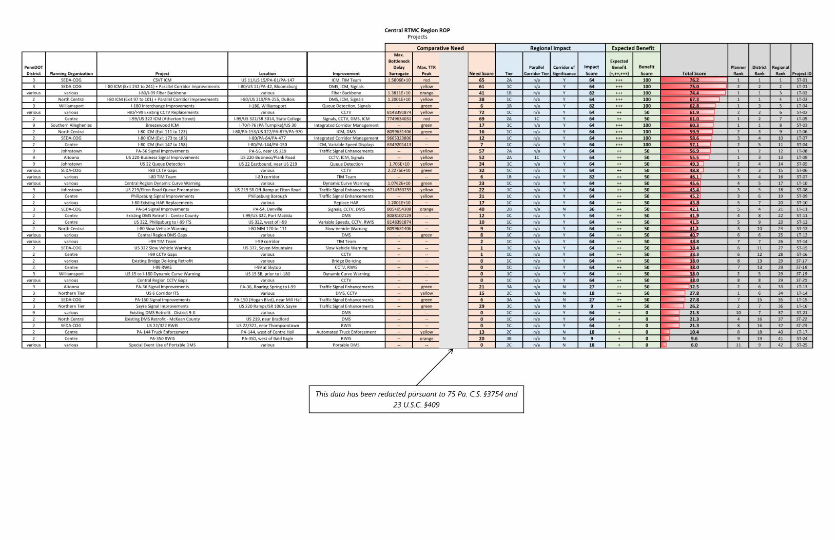
This data has been redacted pursuant to 75 Pa. C.S. §3754 and 23 U.S.C. §409

Regional Operations Plan (ROP) Central RTMC Region
Appendix B. Planning Partner Project Maps
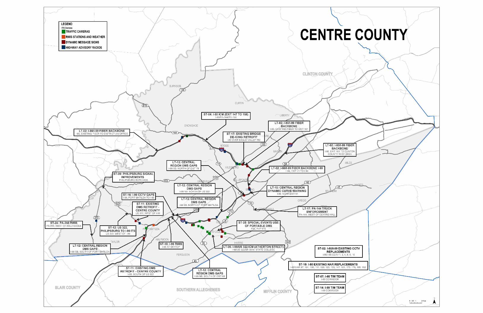
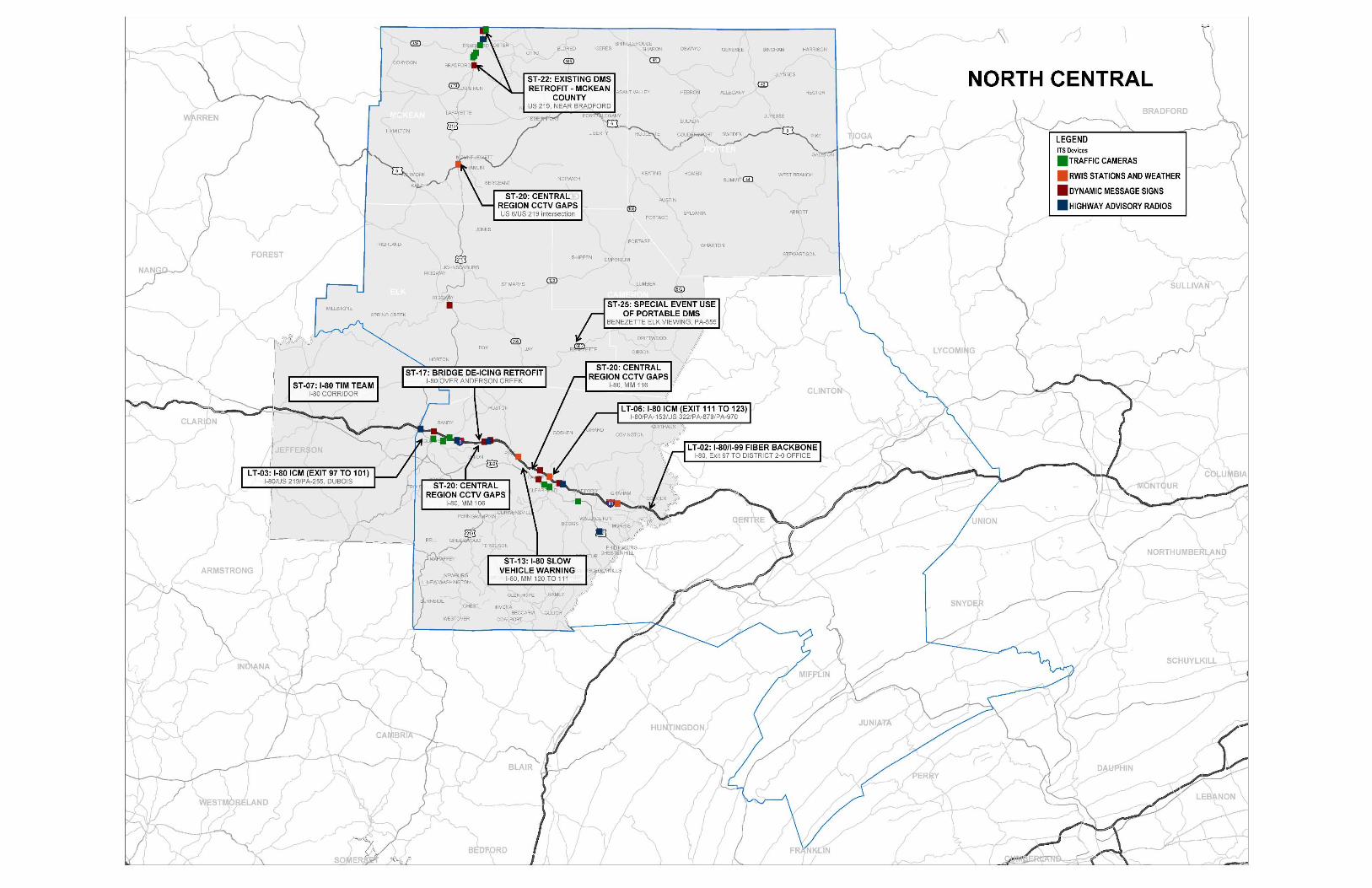
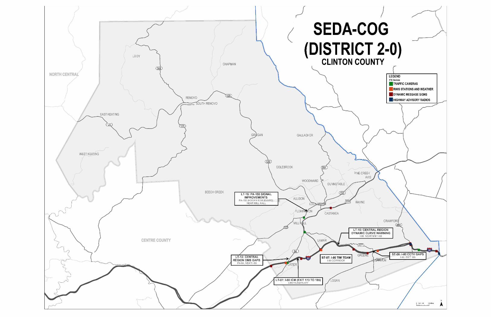
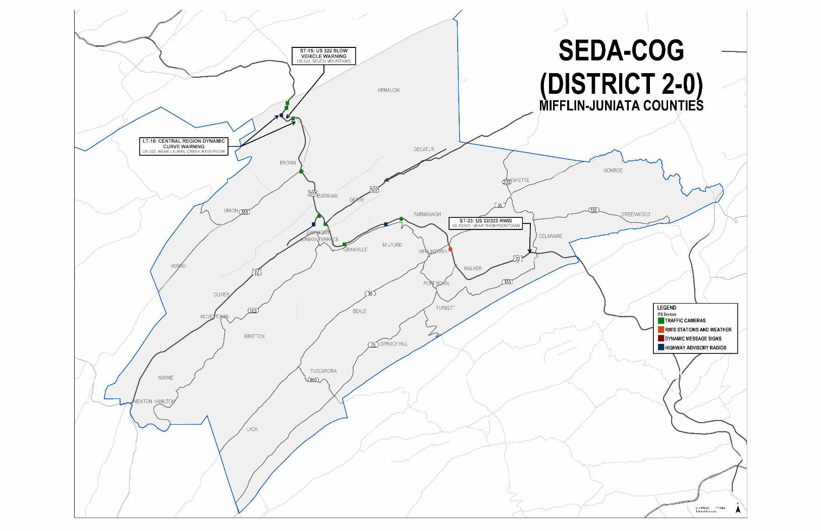
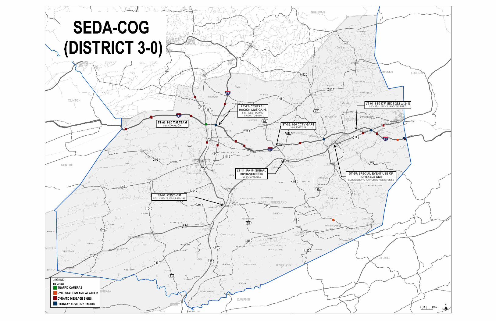
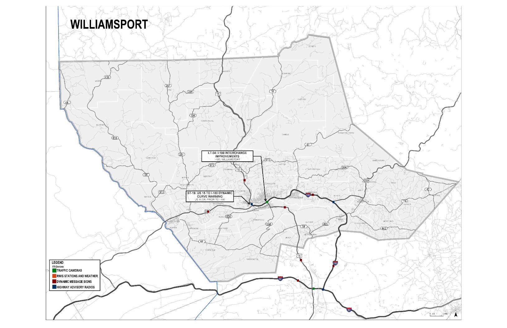
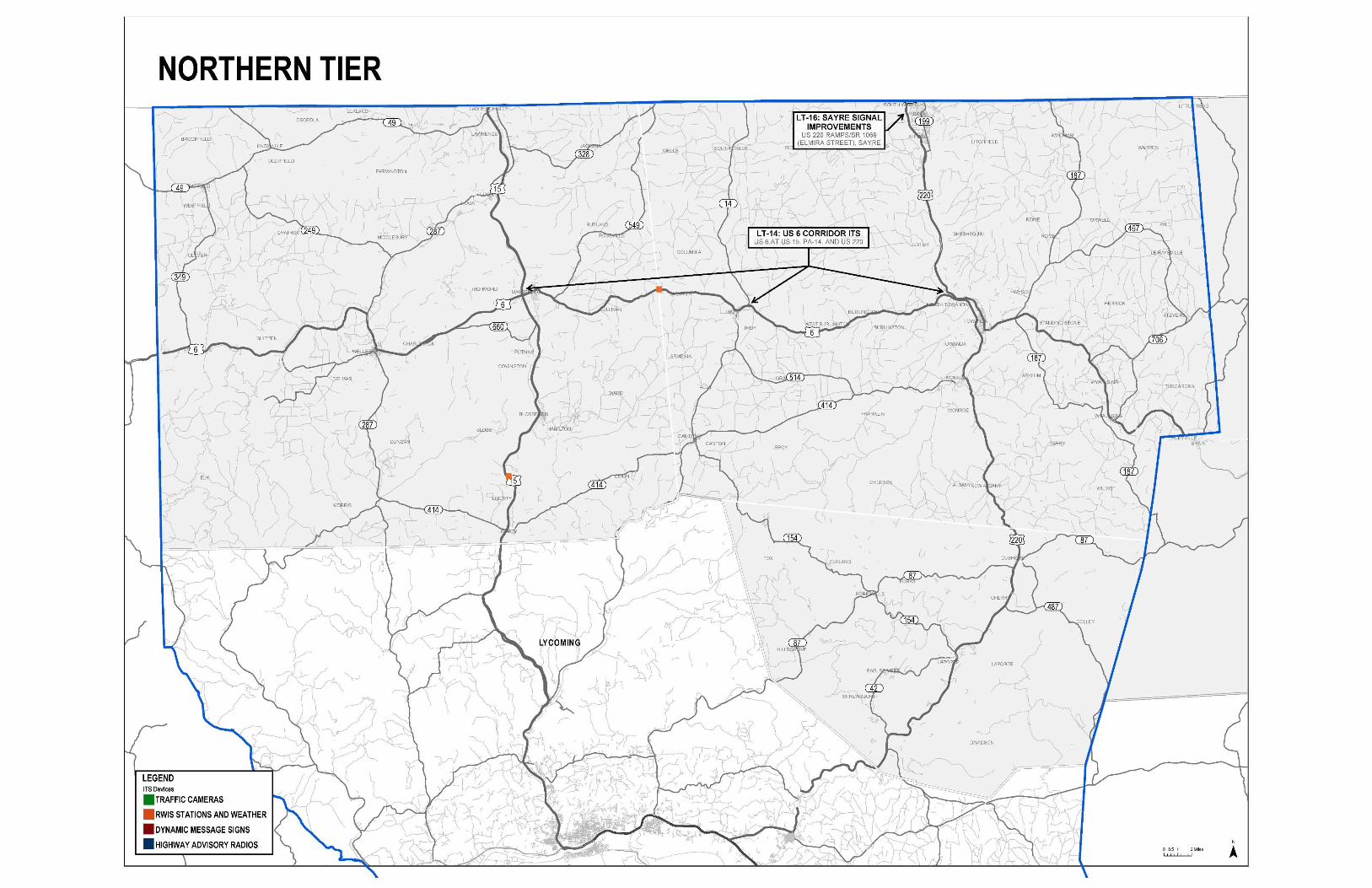
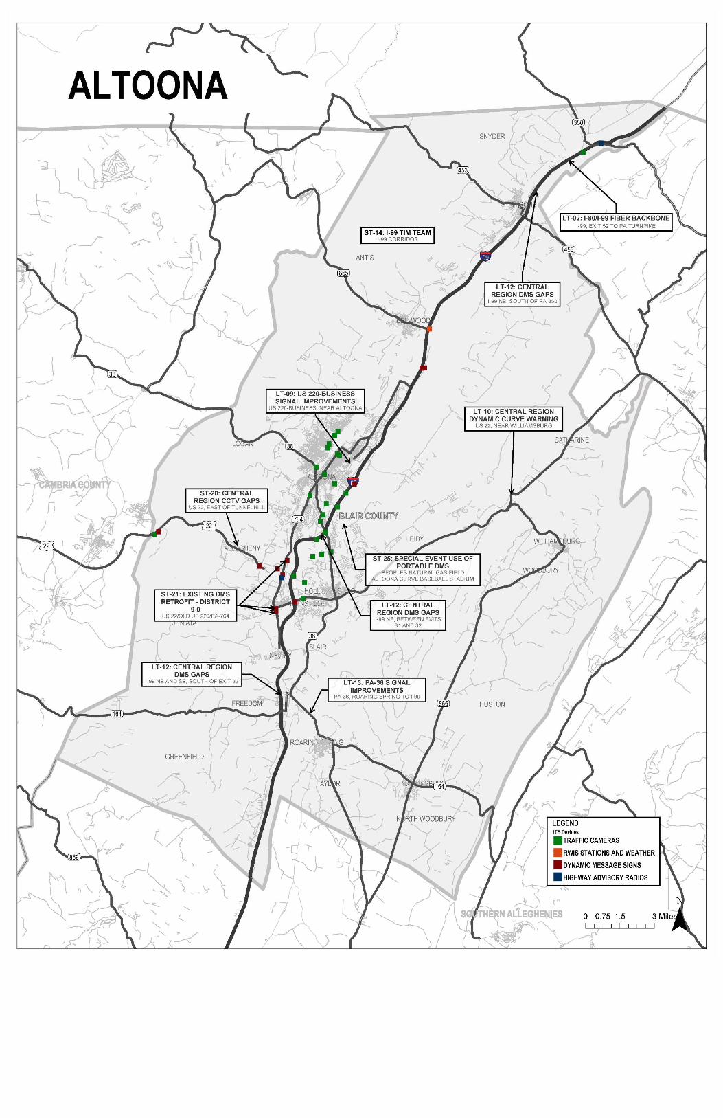
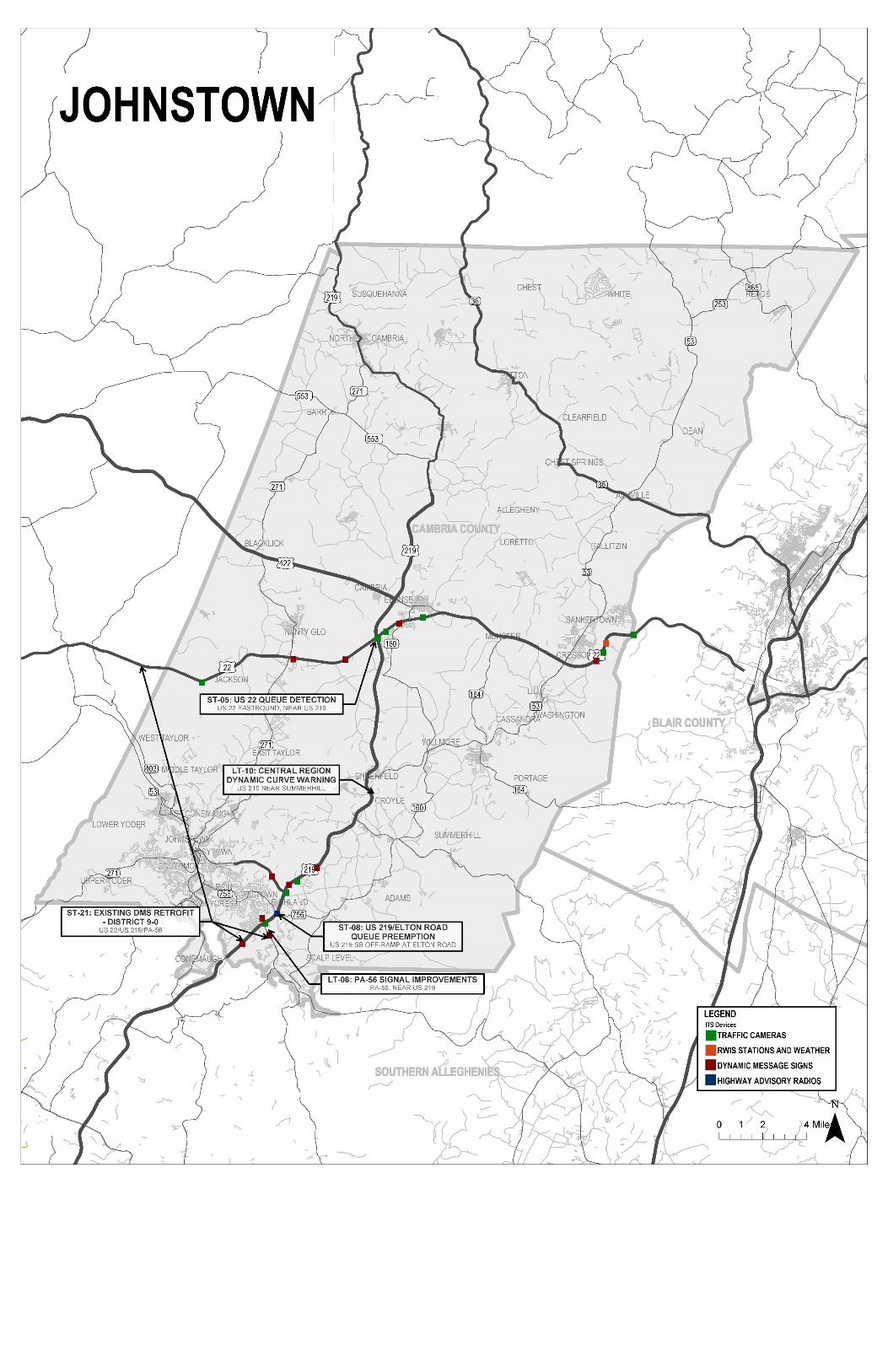
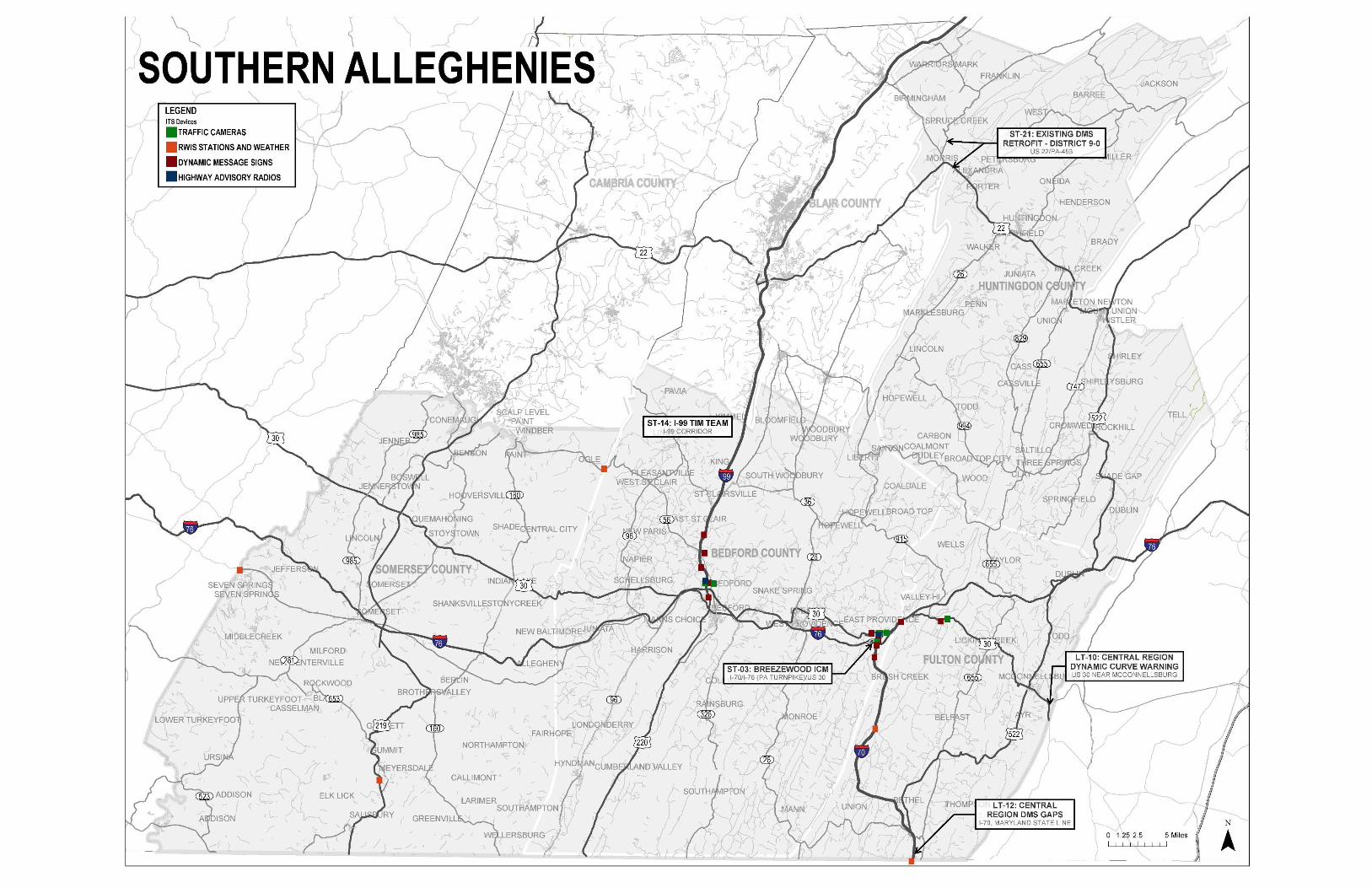

Regional Operations Plan (ROP) Central RTMC Region
Appendix C. Short‐Term Projects
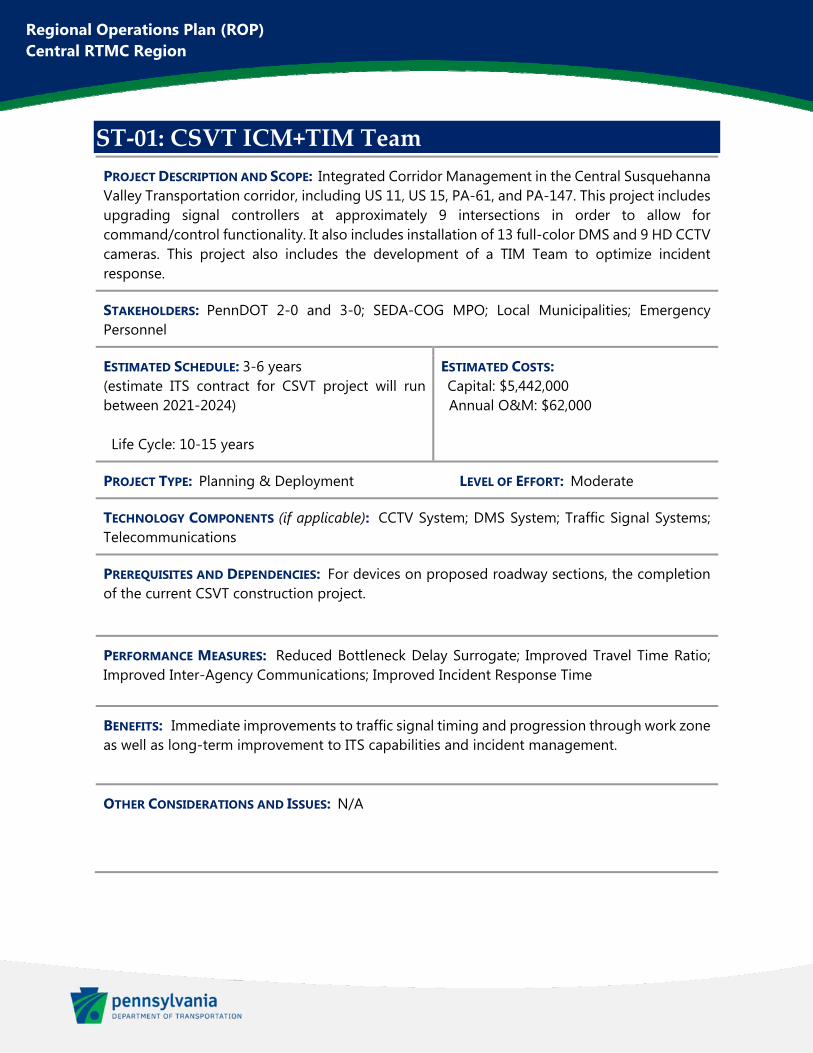
Regional Operations Plan (ROP) Central RTMC Region
ST‐01: CSVT ICM+TIM Team
PROJECT DESCRIPTION AND SCOPE: Integrated Corridor Management in the Central Susquehanna Valley Transportation corridor, including US 11, US 15, PA-61, and PA-147. This project includes upgrading signal controllers at approximately 9 intersections in order to allow for command/control functionality. It also includes installation of 13 full-color DMS and 9 HD CCTV cameras. This project also includes the development of a TIM Team to optimize incident response.
STAKEHOLDERS: PennDOT 2-0 and 3-0; SEDA-COG MPO; Local Municipalities; Emergency Personnel
ESTIMATED SCHEDULE: 3-6 years (estimate ITS contract for CSVT project will run between 2021-2024) Life Cycle: 10-15 years
ESTIMATED COSTS: Capital: $5,442,000 Annual O&M: $62,000
PROJECT TYPE: Planning & Deployment LEVEL OF EFFORT: Moderate
TECHNOLOGY COMPONENTS (if applicable): CCTV System; DMS System; Traffic Signal Systems; Telecommunications
PREREQUISITES AND DEPENDENCIES: For devices on proposed roadway sections, the completion of the current CSVT construction project.
PERFORMANCE MEASURES: Reduced Bottleneck Delay Surrogate; Improved Travel Time Ratio; Improved Inter-Agency Communications; Improved Incident Response Time
BENEFITS: Immediate improvements to traffic signal timing and progression through work zone as well as long-term improvement to ITS capabilities and incident management.
OTHER CONSIDERATIONS AND ISSUES: N/A
This figure has been redacted pursuant to 75 Pa. C.S. §3754 and 23 U.S.C. §409
Regional Operations Plan (ROP) Central RTMC Region
ST‐02: I‐80/I‐99 Existing CCTV Replacements
PROJECT DESCRIPTION AND SCOPE: Replacement of six (6) existing CCTV cameras along I-80 and I-99 with HD cameras. The locations are as follows (listed by District ID): 1, 3, 4, 6, 9, and 10.
STAKEHOLDERS: PennDOT 2-0 and 9-0; Centre County MPO; Altoona MPO
ESTIMATED SCHEDULE: 1-3 years Life Cycle: 10-15 years
ESTIMATED COSTS: Capital: $110,000 Annual O&M: $6,000
PROJECT TYPE: Deployment LEVEL OF EFFORT: Simple
TECHNOLOGY COMPONENTS (if applicable): CCTV System
PREREQUISITES AND DEPENDENCIES: N/A
PERFORMANCE MEASURES: Reduce Required Maintenance Hours
BENEFITS: Vital to ensure that existing devices remain operable at these key locations for acquiring traffic surveillance at the RTMC.
OTHER CONSIDERATIONS AND ISSUES: N/A
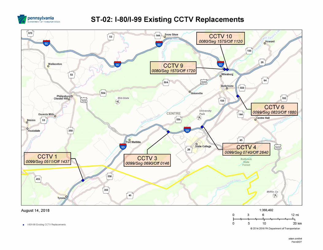
Regional Operations Plan (ROP) Central RTMC Region
ST‐03: Breezewood ICM
PROJECT DESCRIPTION AND SCOPE: Improve interagency communication between PennDOT and the Pennsylvania Turnpike Commission (PTC) to improve operations at the junction of I-70, I-76, and US 30. Coordinate with PTC to gain access to existing PTC Pre-Entry DMS on I-70 westbound prior to I-70 Exit 149 (Everett) interchange. Install 1 HD CCTV camera at I-70 Everett interchange.
STAKEHOLDERS: PennDOT 2-0 and 9-0; Southern Alleghenies RPO
ESTIMATED SCHEDULE: 1-3 years Life Cycle: 10-15 years
ESTIMATED COSTS: Capital: $155,000 Annual O&M: $950
PROJECT TYPE: Planning & Deployment LEVEL OF EFFORT: Moderate
TECHNOLOGY COMPONENTS (if applicable): CCTV System; Telecommunications
PREREQUISITES AND DEPENDENCIES: N/A
PERFORMANCE MEASURES: Improved Incident Response Time; Improved Travel Time Ratio
BENEFITS: Improving incident management and operations in the vicinity of this important connection between two major interstates.
OTHER CONSIDERATIONS AND ISSUES: N/A
This figure has been redacted pursuant to 75 Pa. C.S. §3754 and 23 U.S.C. §409
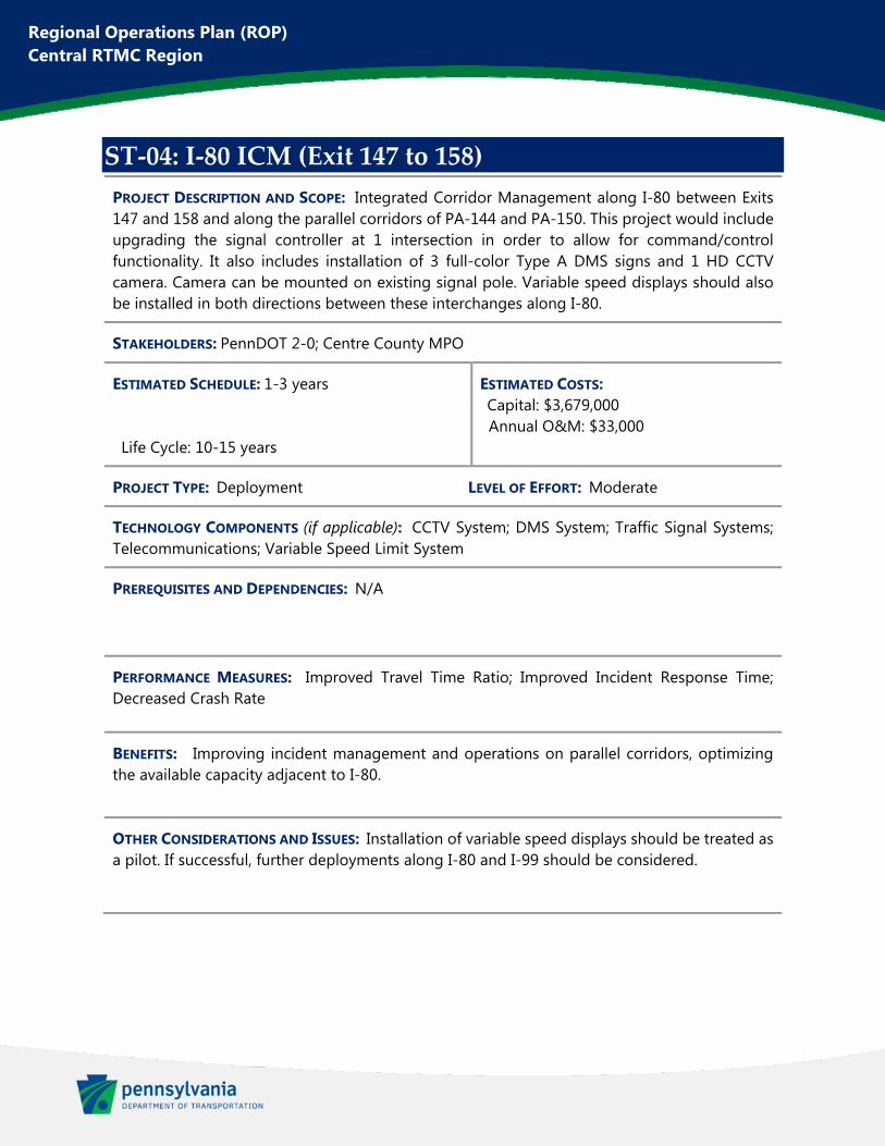
Regional Operations Plan (ROP) Central RTMC Region
ST‐04: I‐80 ICM (Exit 147 to 158)
PROJECT DESCRIPTION AND SCOPE: Integrated Corridor Management along I-80 between Exits 147 and 158 and along the parallel corridors of PA-144 and PA-150. This project would include upgrading the signal controller at 1 intersection in order to allow for command/control functionality. It also includes installation of 3 full-color Type A DMS signs and 1 HD CCTV camera. Camera can be mounted on existing signal pole. Variable speed displays should also be installed in both directions between these interchanges along I-80.
STAKEHOLDERS: PennDOT 2-0; Centre County MPO
ESTIMATED SCHEDULE: 1-3 years Life Cycle: 10-15 years
ESTIMATED COSTS: Capital: $3,679,000 Annual O&M: $33,000
PROJECT TYPE: Deployment LEVEL OF EFFORT: Moderate
TECHNOLOGY COMPONENTS (if applicable): CCTV System; DMS System; Traffic Signal Systems; Telecommunications; Variable Speed Limit System
PREREQUISITES AND DEPENDENCIES: N/A
PERFORMANCE MEASURES: Improved Travel Time Ratio; Improved Incident Response Time; Decreased Crash Rate
BENEFITS: Improving incident management and operations on parallel corridors, optimizing the available capacity adjacent to I-80.
OTHER CONSIDERATIONS AND ISSUES: Installation of variable speed displays should be treated as a pilot. If successful, further deployments along I-80 and I-99 should be considered.
This figure has been redacted pursuant to 75 Pa. C.S. §3754 and 23 U.S.C. §409
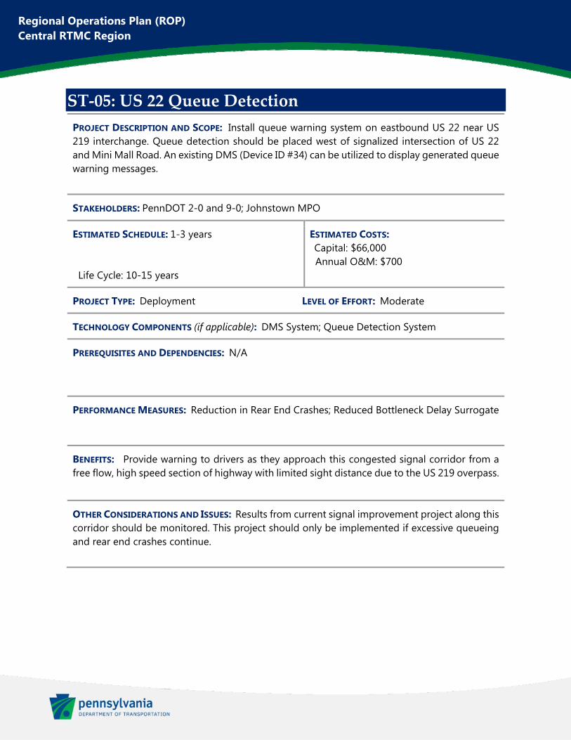
Regional Operations Plan (ROP) Central RTMC Region
ST‐05: US 22 Queue Detection
PROJECT DESCRIPTION AND SCOPE: Install queue warning system on eastbound US 22 near US 219 interchange. Queue detection should be placed west of signalized intersection of US 22 and Mini Mall Road. An existing DMS (Device ID #34) can be utilized to display generated queue warning messages.
STAKEHOLDERS: PennDOT 2-0 and 9-0; Johnstown MPO
ESTIMATED SCHEDULE: 1-3 years Life Cycle: 10-15 years
ESTIMATED COSTS: Capital: $66,000 Annual O&M: $700
PROJECT TYPE: Deployment LEVEL OF EFFORT: Moderate
TECHNOLOGY COMPONENTS (if applicable): DMS System; Queue Detection System
PREREQUISITES AND DEPENDENCIES: N/A
PERFORMANCE MEASURES: Reduction in Rear End Crashes; Reduced Bottleneck Delay Surrogate
BENEFITS: Provide warning to drivers as they approach this congested signal corridor from a free flow, high speed section of highway with limited sight distance due to the US 219 overpass.
OTHER CONSIDERATIONS AND ISSUES: Results from current signal improvement project along this corridor should be monitored. This project should only be implemented if excessive queueing and rear end crashes continue.
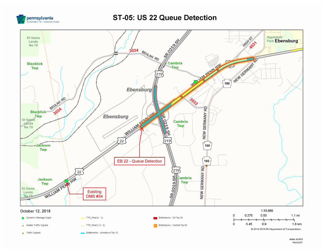
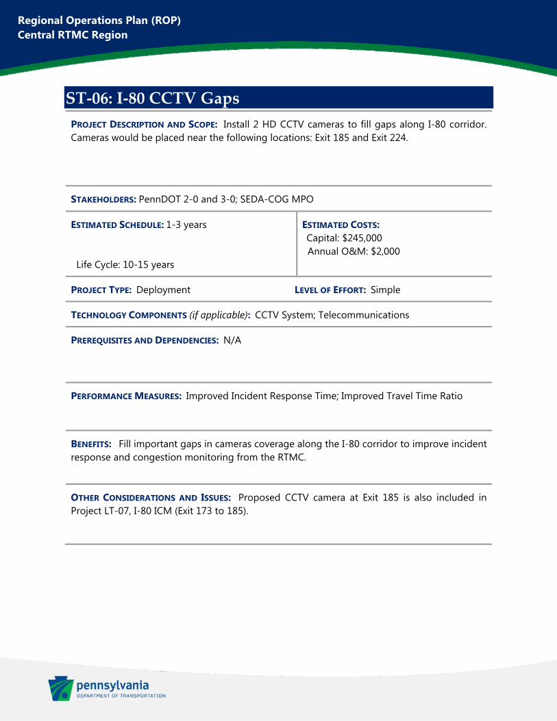
Regional Operations Plan (ROP) Central RTMC Region
ST‐06: I‐80 CCTV Gaps
PROJECT DESCRIPTION AND SCOPE: Install 2 HD CCTV cameras to fill gaps along I-80 corridor. Cameras would be placed near the following locations: Exit 185 and Exit 224.
STAKEHOLDERS: PennDOT 2-0 and 3-0; SEDA-COG MPO
ESTIMATED SCHEDULE: 1-3 years Life Cycle: 10-15 years
ESTIMATED COSTS: Capital: $245,000 Annual O&M: $2,000
PROJECT TYPE: Deployment LEVEL OF EFFORT: Simple
TECHNOLOGY COMPONENTS (if applicable): CCTV System; Telecommunications
PREREQUISITES AND DEPENDENCIES: N/A
PERFORMANCE MEASURES: Improved Incident Response Time; Improved Travel Time Ratio
BENEFITS: Fill important gaps in cameras coverage along the I-80 corridor to improve incident response and congestion monitoring from the RTMC.
OTHER CONSIDERATIONS AND ISSUES: Proposed CCTV camera at Exit 185 is also included in Project LT-07, I-80 ICM (Exit 173 to 185).
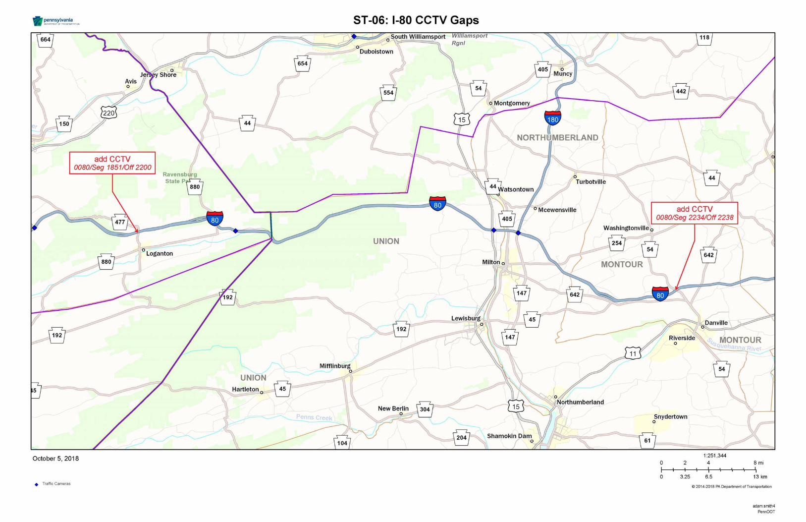

Regional Operations Plan (ROP) Central RTMC Region
ST‐07: I‐80 TIM Team
PROJECT DESCRIPTION AND SCOPE: Establish TIM Team for I-80 corridor.
STAKEHOLDERS: PennDOT 2-0 and 3-0; Centre County MPO; North Central RPO; SEDA-COG MPO; Local Municipalities; Emergency Personnel
ESTIMATED SCHEDULE: 1 year Life Cycle: N/A
ESTIMATED COSTS: Capital: $20,000 Annual O&M: N/A
PROJECT TYPE: Planning LEVEL OF EFFORT: Simple
TECHNOLOGY COMPONENTS (if applicable): N/A
PREREQUISITES AND DEPENDENCIES: N/A
PERFORMANCE MEASURES: Improved Inter-Agency Communications; Improved Incident Response Time; Improved Incident Clearance Time; Reduction in Secondary Crashes
BENEFITS: Improved incident management and coordination increasing safety for motorists and emergency responders.
OTHER CONSIDERATIONS AND ISSUES: N/A
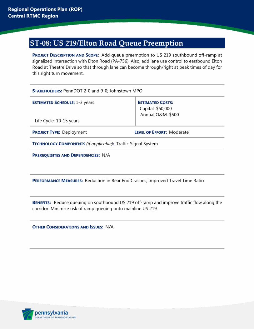
Regional Operations Plan (ROP) Central RTMC Region
ST‐08: US 219/Elton Road Queue Preemption
PROJECT DESCRIPTION AND SCOPE: Add queue preemption to US 219 southbound off-ramp at signalized intersection with Elton Road (PA-756). Also, add lane use control to eastbound Elton Road at Theatre Drive so that through lane can become through/right at peak times of day for this right turn movement.
STAKEHOLDERS: PennDOT 2-0 and 9-0; Johnstown MPO
ESTIMATED SCHEDULE: 1-3 years Life Cycle: 10-15 years
ESTIMATED COSTS: Capital: $60,000 Annual O&M: $500
PROJECT TYPE: Deployment LEVEL OF EFFORT: Moderate
TECHNOLOGY COMPONENTS (if applicable): Traffic Signal System
PREREQUISITES AND DEPENDENCIES: N/A
PERFORMANCE MEASURES: Reduction in Rear End Crashes; Improved Travel Time Ratio
BENEFITS: Reduce queuing on southbound US 219 off-ramp and improve traffic flow along the corridor. Minimize risk of ramp queuing onto mainline US 219.
OTHER CONSIDERATIONS AND ISSUES: N/A
This figure has been redacted pursuant to 75 Pa. C.S. §3754 and 23 U.S.C. §409
Regional Operations Plan (ROP) Central RTMC Region
ST‐09: Philipsburg Traffic Signal Improvements
PROJECT DESCRIPTION AND SCOPE: Upgrade signal controllers at 5 signalized intersections in order to allow for command/control functionality and performance measures. Upgrade all signal equipment at 2 of the intersections (Philipsburg-Railroad system). Improve coordination along the Rush-Railroad and Philipsburg-Railroad systems.
STAKEHOLDERS: PennDOT 2-0; Centre County MPO
ESTIMATED SCHEDULE: 1-3 years Life Cycle: 10-15 years
ESTIMATED COSTS: Capital: $325,000 Annual O&M: $1,800
PROJECT TYPE: Deployment LEVEL OF EFFORT: Moderate
TECHNOLOGY COMPONENTS (if applicable): Traffic Signal Systems
PREREQUISITES AND DEPENDENCIES: N/A
PERFORMANCE MEASURES: Improved Travel Time Ratio
BENEFITS: Improved traffic flow and reduced congestion along an important signalized corridor within the region.
OTHER CONSIDERATIONS AND ISSUES: N/A
This figure has been redacted pursuant to 75 Pa. C.S. §3754 and 23 U.S.C. §409
Regional Operations Plan (ROP) Central RTMC Region
ST‐10: I‐80 Existing HAR Replacements
PROJECT DESCRIPTION AND SCOPE: Replacement of 11 existing Highway Advisory Radio (HAR) transmitters along I-80. The HAR transmitters are as follows (listed by District ID): 101, 106, 111, 120, 133, 147, 161, 173, 178, 185, and 192.
STAKEHOLDERS: PennDOT 2-0; Centre County MPO; North Central RPO; SEDA-COG MPO
ESTIMATED SCHEDULE: 1-3 years Life Cycle: 10-15 years
ESTIMATED COSTS: Capital: $1,100,000 Annual O&M: $4,000
PROJECT TYPE: Deployment LEVEL OF EFFORT: Moderate
TECHNOLOGY COMPONENTS (if applicable): HAR System
PREREQUISITES AND DEPENDENCIES: N/A
PERFORMANCE MEASURES: Reduce Required Maintenance Hours
BENEFITS: Vital to ensure that existing devices remain operable to continue providing traveler information at important locations
OTHER CONSIDERATIONS AND ISSUES: N/A
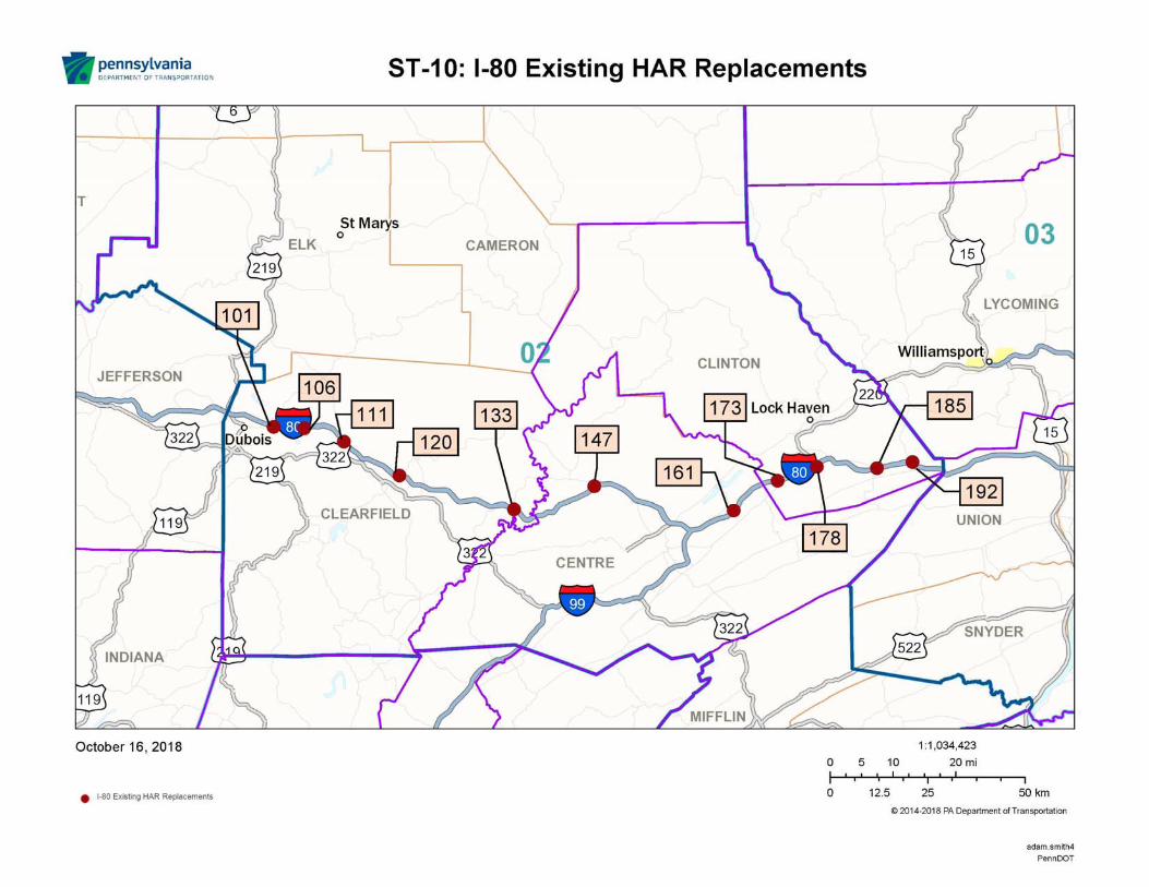
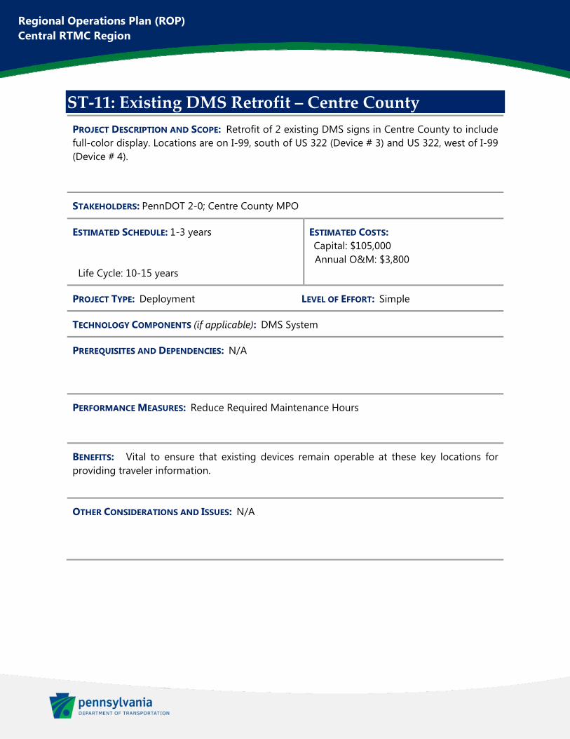
Regional Operations Plan (ROP) Central RTMC Region
ST‐11: Existing DMS Retrofit – Centre County
PROJECT DESCRIPTION AND SCOPE: Retrofit of 2 existing DMS signs in Centre County to include full-color display. Locations are on I-99, south of US 322 (Device # 3) and US 322, west of I-99 (Device # 4).
STAKEHOLDERS: PennDOT 2-0; Centre County MPO
ESTIMATED SCHEDULE: 1-3 years Life Cycle: 10-15 years
ESTIMATED COSTS: Capital: $105,000 Annual O&M: $3,800
PROJECT TYPE: Deployment LEVEL OF EFFORT: Simple
TECHNOLOGY COMPONENTS (if applicable): DMS System
PREREQUISITES AND DEPENDENCIES: N/A
PERFORMANCE MEASURES: Reduce Required Maintenance Hours
BENEFITS: Vital to ensure that existing devices remain operable at these key locations for providing traveler information.
OTHER CONSIDERATIONS AND ISSUES: N/A
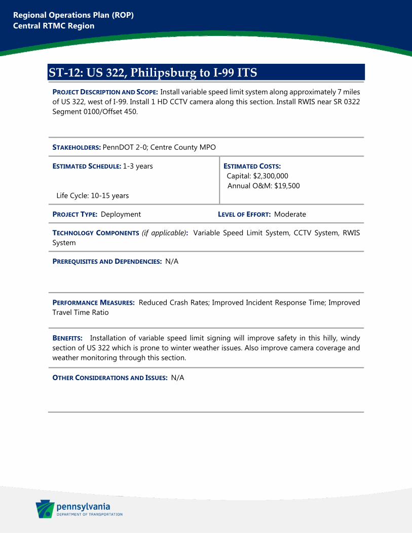
Regional Operations Plan (ROP) Central RTMC Region
ST‐12: US 322, Philipsburg to I‐99 ITS
PROJECT DESCRIPTION AND SCOPE: Install variable speed limit system along approximately 7 miles of US 322, west of I-99. Install 1 HD CCTV camera along this section. Install RWIS near SR 0322 Segment 0100/Offset 450.
STAKEHOLDERS: PennDOT 2-0; Centre County MPO
ESTIMATED SCHEDULE: 1-3 years Life Cycle: 10-15 years
ESTIMATED COSTS: Capital: $2,300,000 Annual O&M: $19,500
PROJECT TYPE: Deployment LEVEL OF EFFORT: Moderate
TECHNOLOGY COMPONENTS (if applicable): Variable Speed Limit System, CCTV System, RWIS System
PREREQUISITES AND DEPENDENCIES: N/A
PERFORMANCE MEASURES: Reduced Crash Rates; Improved Incident Response Time; Improved Travel Time Ratio
BENEFITS: Installation of variable speed limit signing will improve safety in this hilly, windy section of US 322 which is prone to winter weather issues. Also improve camera coverage and weather monitoring through this section.
OTHER CONSIDERATIONS AND ISSUES: N/A
This figure has been redacted pursuant to 75 Pa. C.S. §3754 and 23 U.S.C. §409
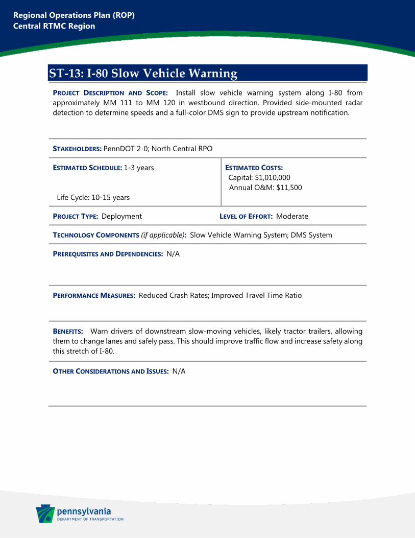
Regional Operations Plan (ROP) Central RTMC Region
ST‐13: I‐80 Slow Vehicle Warning
PROJECT DESCRIPTION AND SCOPE: Install slow vehicle warning system along I-80 from approximately MM 111 to MM 120 in westbound direction. Provided side-mounted radar detection to determine speeds and a full-color DMS sign to provide upstream notification.
STAKEHOLDERS: PennDOT 2-0; North Central RPO
ESTIMATED SCHEDULE: 1-3 years Life Cycle: 10-15 years
ESTIMATED COSTS: Capital: $1,010,000 Annual O&M: $11,500
PROJECT TYPE: Deployment LEVEL OF EFFORT: Moderate
TECHNOLOGY COMPONENTS (if applicable): Slow Vehicle Warning System; DMS System
PREREQUISITES AND DEPENDENCIES: N/A
PERFORMANCE MEASURES: Reduced Crash Rates; Improved Travel Time Ratio
BENEFITS: Warn drivers of downstream slow-moving vehicles, likely tractor trailers, allowing them to change lanes and safely pass. This should improve traffic flow and increase safety along this stretch of I-80.
OTHER CONSIDERATIONS AND ISSUES: N/A

This figure has been redacted pursuant to 75 Pa. C.S. §3754 and 23 U.S.C. §409
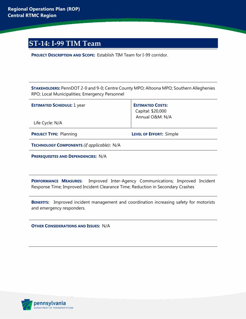
Regional Operations Plan (ROP) Central RTMC Region
ST‐14: I‐99 TIM Team
PROJECT DESCRIPTION AND SCOPE: Establish TIM Team for I-99 corridor.
STAKEHOLDERS: PennDOT 2-0 and 9-0; Centre County MPO; Altoona MPO; Southern Alleghenies RPO; Local Municipalities; Emergency Personnel
ESTIMATED SCHEDULE: 1 year Life Cycle: N/A
ESTIMATED COSTS: Capital: $20,000 Annual O&M: N/A
PROJECT TYPE: Planning LEVEL OF EFFORT: Simple
TECHNOLOGY COMPONENTS (if applicable): N/A
PREREQUISITES AND DEPENDENCIES: N/A
PERFORMANCE MEASURES: Improved Inter-Agency Communications; Improved Incident Response Time; Improved Incident Clearance Time; Reduction in Secondary Crashes
BENEFITS: Improved incident management and coordination increasing safety for motorists and emergency responders.
OTHER CONSIDERATIONS AND ISSUES: N/A

Regional Operations Plan (ROP) Central RTMC Region
ST‐15: US 322 Slow Vehicle Warning
PROJECT DESCRIPTION AND SCOPE: Install slow vehicle warning system along an approximately 6-mile section of US 322 which runs through the Seven Mountains area. System should be installed in westbound direction. Provided side-mounted radar detection to determine speeds and a full-color Type A DMS sign to provide upstream notification.
STAKEHOLDERS: PennDOT 2-0; SEDA-COG MPO
ESTIMATED SCHEDULE: 1-3 years Life Cycle: 10-15 years
ESTIMATED COSTS: Capital: $342,000 Annual O&M: $3,000
PROJECT TYPE: Deployment LEVEL OF EFFORT: Moderate
TECHNOLOGY COMPONENTS (if applicable): Slow Vehicle Warning System; DMS System
PREREQUISITES AND DEPENDENCIES: N/A
PERFORMANCE MEASURES: Reduced Crash Rates; Improved Traveler Time Ratio
BENEFITS: Warn drivers of downstream slow-moving vehicles, likely tractor trailers, allowing them to change lanes and safely pass. This should improve traffic flow and increase safety along this stretch of US 322.
OTHER CONSIDERATIONS AND ISSUES: LT-11: Central Region Dynamic Curve Warning includes deployments at 2 curves within this project area. Those Curve Warning systems could also be integrated into this project.
This figure has been redacted pursuant to 75 Pa. C.S. §3754 and 23 U.S.C. §409
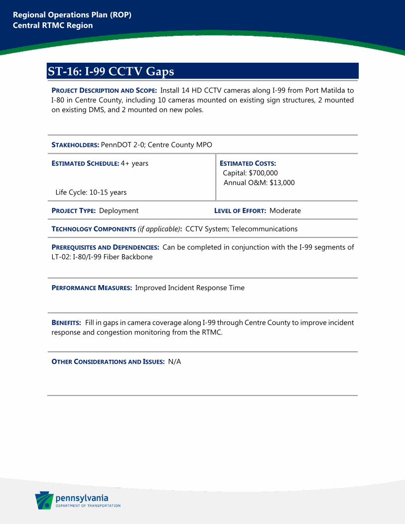
Regional Operations Plan (ROP) Central RTMC Region
ST‐16: I‐99 CCTV Gaps
PROJECT DESCRIPTION AND SCOPE: Install 14 HD CCTV cameras along I-99 from Port Matilda to I-80 in Centre County, including 10 cameras mounted on existing sign structures, 2 mounted on existing DMS, and 2 mounted on new poles.
STAKEHOLDERS: PennDOT 2-0; Centre County MPO
ESTIMATED SCHEDULE: 4+ years Life Cycle: 10-15 years
ESTIMATED COSTS: Capital: $700,000 Annual O&M: $13,000
PROJECT TYPE: Deployment LEVEL OF EFFORT: Moderate
TECHNOLOGY COMPONENTS (if applicable): CCTV System; Telecommunications
PREREQUISITES AND DEPENDENCIES: Can be completed in conjunction with the I-99 segments of LT-02: I-80/I-99 Fiber Backbone
PERFORMANCE MEASURES: Improved Incident Response Time
BENEFITS: Fill in gaps in camera coverage along I-99 through Centre County to improve incident response and congestion monitoring from the RTMC.
OTHER CONSIDERATIONS AND ISSUES: N/A
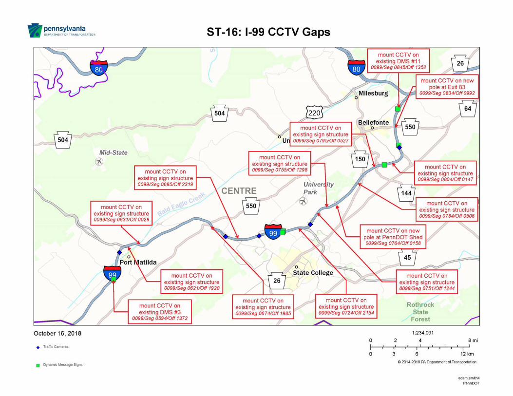

Regional Operations Plan (ROP) Central RTMC Region
ST‐17: Existing Bridge De‐Icing Retrofit
PROJECT DESCRIPTION AND SCOPE: Retrofit of 2 existing Bridge De-icing systems on I-80. Locations include the I-80 bridge over Eagle Valley Road in Centre County and the I-80 bridge over Anderson Creek in Clearfield County.
STAKEHOLDERS: PennDOT 2-0; Centre County MPO; North Central RPO
ESTIMATED SCHEDULE: 1-3 years Life Cycle: 10-15 years
ESTIMATED COSTS: Capital: $610,000 Annual O&M: $5,000
PROJECT TYPE: Deployment LEVEL OF EFFORT: Simple
TECHNOLOGY COMPONENTS (if applicable): Bridge De-Icing System
PREREQUISITES AND DEPENDENCIES: N/A
PERFORMANCE MEASURES: Reduced Winter Weather Crashes; Reduce Required Maintenance Hours
BENEFITS: Vital to ensure that existing devices remain operable at these key locations along I-80.
OTHER CONSIDERATIONS AND ISSUES: N/A
Regional Operations Plan (ROP) Central RTMC Region
ST‐18: I‐99 RWIS
PROJECT DESCRIPTION AND SCOPE: Install 1 Road Weather Information System (RWIS) and 1 CCTV camera on I-99 near Skytop.
STAKEHOLDERS: PennDOT 2-0; Centre County MPO
ESTIMATED SCHEDULE: 1-3 years Life Cycle: 10-15 years
ESTIMATED COSTS: Capital: $245,000 Annual O&M: $1,900
PROJECT TYPE: Deployment LEVEL OF EFFORT: Simple
TECHNOLOGY COMPONENTS (if applicable): CCTV System; RWIS System
PREREQUISITES AND DEPENDENCIES: N/A
PERFORMANCE MEASURES: Reduced Winter Weather Crashes; Improved Incident Response Time; Improved Travel Time Ratio
BENEFITS: Improve monitoring of weather and roadway conditions, particularly during winter weather. Improve plowing and winter maintenance response.
OTHER CONSIDERATIONS AND ISSUES: N/A
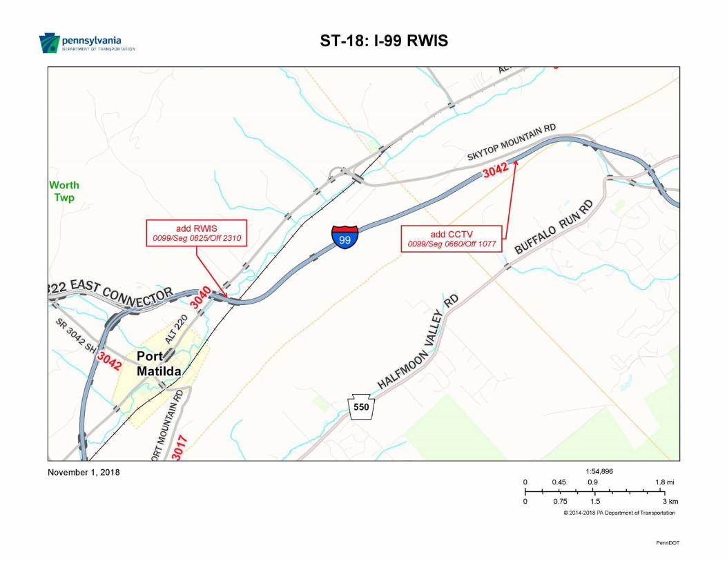
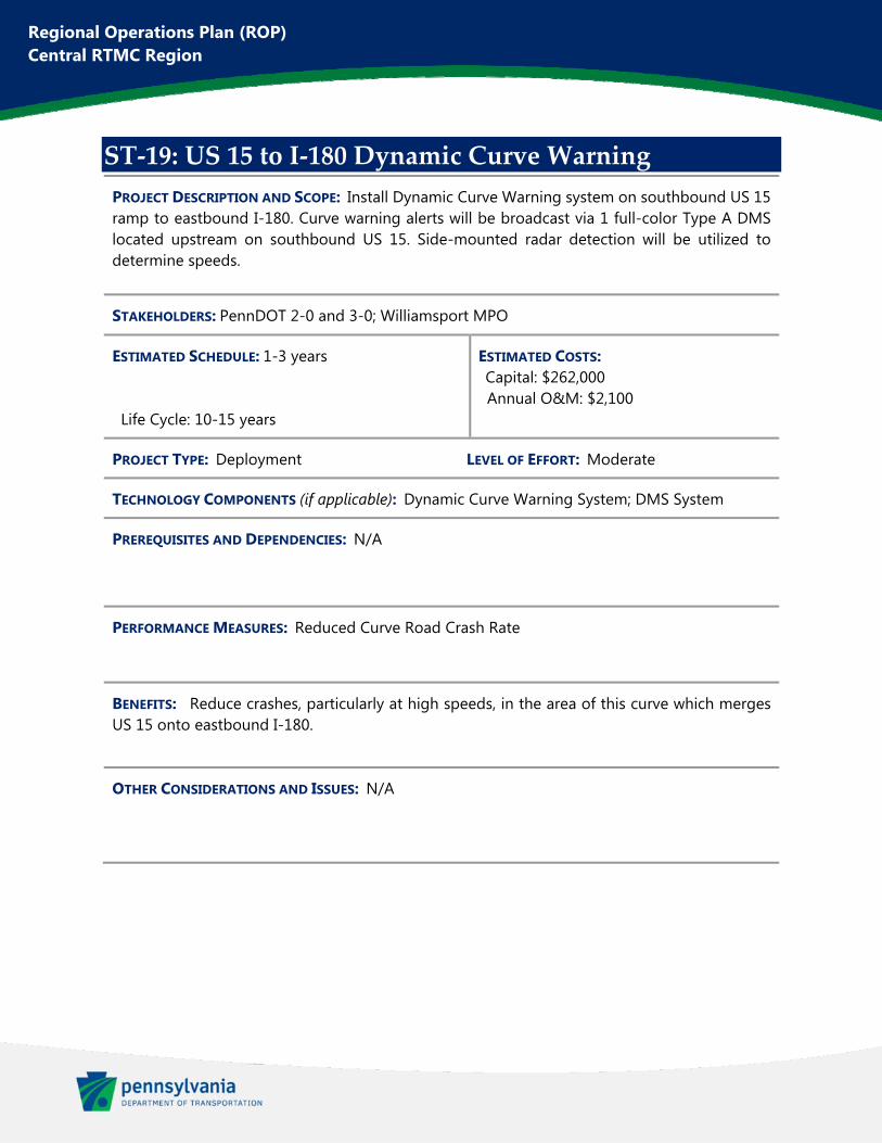
Regional Operations Plan (ROP) Central RTMC Region
ST‐19: US 15 to I‐180 Dynamic Curve Warning
PROJECT DESCRIPTION AND SCOPE: Install Dynamic Curve Warning system on southbound US 15 ramp to eastbound I-180. Curve warning alerts will be broadcast via 1 full-color Type A DMS located upstream on southbound US 15. Side-mounted radar detection will be utilized to determine speeds.
STAKEHOLDERS: PennDOT 2-0 and 3-0; Williamsport MPO
ESTIMATED SCHEDULE: 1-3 years Life Cycle: 10-15 years
ESTIMATED COSTS: Capital: $262,000 Annual O&M: $2,100
PROJECT TYPE: Deployment LEVEL OF EFFORT: Moderate
TECHNOLOGY COMPONENTS (if applicable): Dynamic Curve Warning System; DMS System
PREREQUISITES AND DEPENDENCIES: N/A
PERFORMANCE MEASURES: Reduced Curve Road Crash Rate
BENEFITS: Reduce crashes, particularly at high speeds, in the area of this curve which merges US 15 onto eastbound I-180.
OTHER CONSIDERATIONS AND ISSUES: N/A
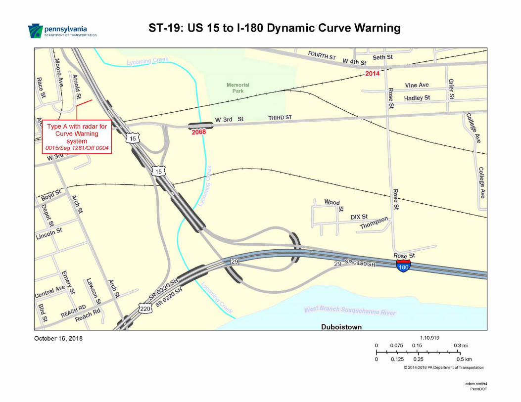
Regional Operations Plan (ROP) Central RTMC Region
ST‐20: Central Region CCTV Gaps
PROJECT DESCRIPTION AND SCOPE: Install 4 HD CCTV cameras in Central Region. Locations include:
US 22, east of Tunnelhill US 219 and US 6 intersection I-80 near MM 106 I-80 near MM 116
STAKEHOLDERS: PennDOT 2-0 and 9-0; North Central RPO; Altoona MPO
ESTIMATED SCHEDULE: 1-3 years Life Cycle: 10-15 years
ESTIMATED COSTS: Capital: $462,000 Annual O&M: $4,000
PROJECT TYPE: Deployment LEVEL OF EFFORT: Moderate
TECHNOLOGY COMPONENTS (if applicable): CCTV System; Telecommunications
PREREQUISITES AND DEPENDENCIES: N/A
PERFORMANCE MEASURES: Improved Incident Response Time; Improved Travel Time Ratio
BENEFITS: Fill in gaps in camera coverage throughout the region in order to improve incident response and congestion monitoring from the RTMC.
OTHER CONSIDERATIONS AND ISSUES: N/A
Regional Operations Plan (ROP) Central RTMC Region
ST‐21: Existing DMS Retrofit – District 9‐0
PROJECT DESCRIPTION AND SCOPE: Retrofit of 8 existing DMS signs in PennDOT District 9-0. Locations are as follows:
SR 3013 NB (DMS 09-001) US 22 WB (DMS 09-002) PA-764 SB (DMS 09-003) US 22 WB (DMS 09-012) US 22 EB (DMS 09-017) PA-453 SB (DMS 09-018) US 219 NB (DMS 09-026) PA-56 WB (DMS 09-028)
STAKEHOLDERS: PennDOT 2-0 and 9-0; Altoona MPO; Southern Alleghenies RPO
ESTIMATED SCHEDULE: 1-3 years Life Cycle: 10-15 years
ESTIMATED COSTS: Capital: $352,000 Annual O&M: $15,500
PROJECT TYPE: Deployment LEVEL OF EFFORT: Simple
TECHNOLOGY COMPONENTS (if applicable): DMS System
PREREQUISITES AND DEPENDENCIES: N/A
PERFORMANCE MEASURES: Reduce Required Maintenance Hours
BENEFITS: Vital to ensure that existing devices remain operable at these key locations for providing traveler information.
OTHER CONSIDERATIONS AND ISSUES: N/A
Regional Operations Plan (ROP) Central RTMC Region
ST‐22: Existing DMS Retrofit – McKean County
PROJECT DESCRIPTION AND SCOPE: Retrofit of 2 existing DMS signs in McKean County to include full-color display. Locations are on US 219 near Bradford (Device # 22 and 23).
STAKEHOLDERS: PennDOT 2-0; North Central RPO
ESTIMATED SCHEDULE: 1-3 years Life Cycle: 10-15 years
ESTIMATED COSTS: Capital: $105,000 Annual O&M: $3,800
PROJECT TYPE: Deployment LEVEL OF EFFORT: Simple
TECHNOLOGY COMPONENTS (if applicable): DMS System
PREREQUISITES AND DEPENDENCIES: N/A
PERFORMANCE MEASURES: Reduce Required Maintenance Hours
BENEFITS: Vital to ensure that existing devices remain operable at these key locations for providing traveler information.
OTHER CONSIDERATIONS AND ISSUES: N/A
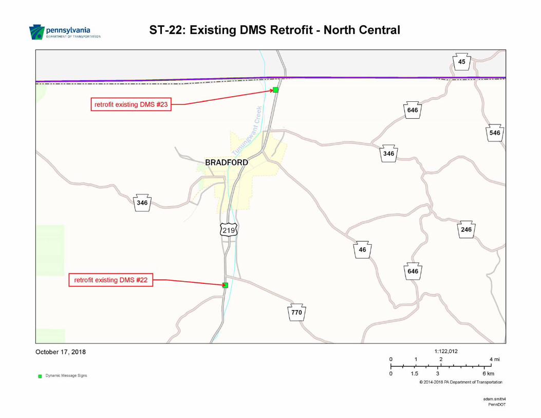
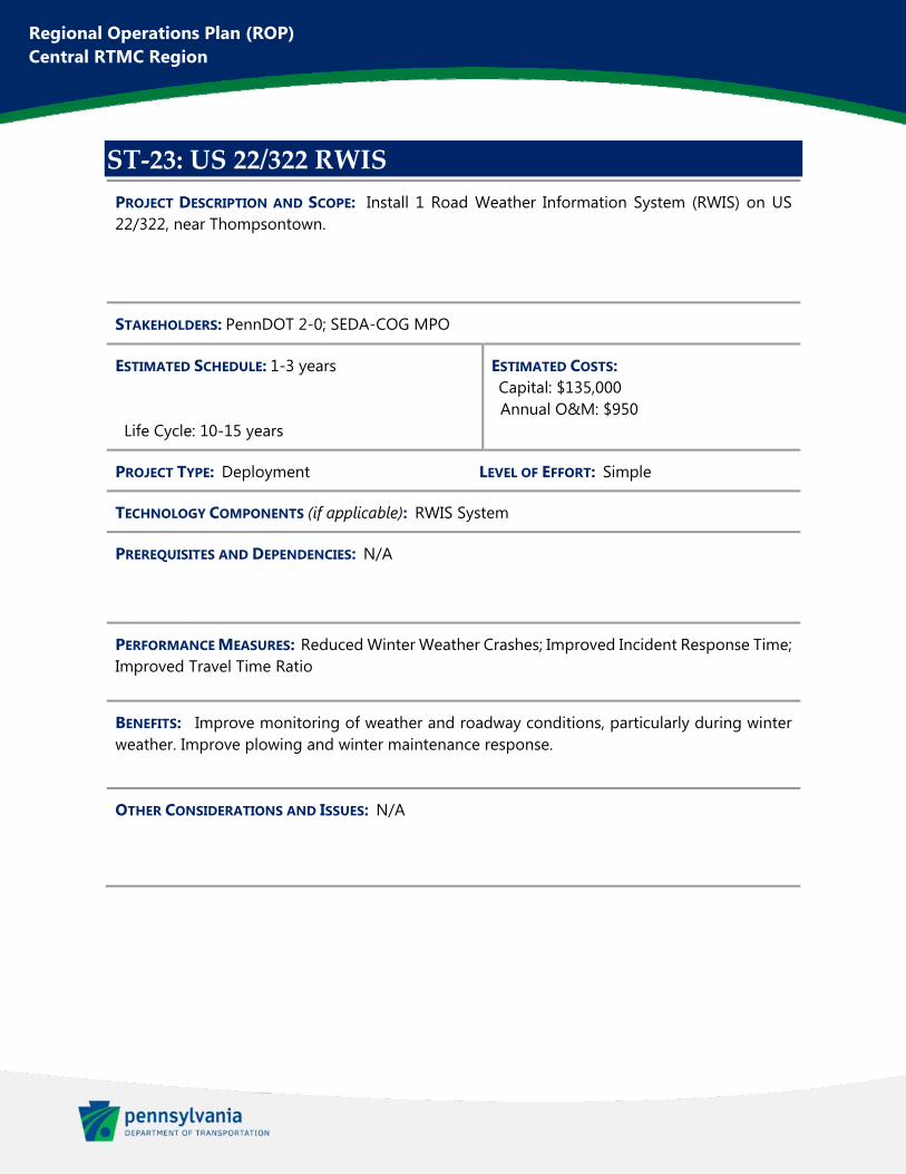
Regional Operations Plan (ROP) Central RTMC Region
ST‐23: US 22/322 RWIS
PROJECT DESCRIPTION AND SCOPE: Install 1 Road Weather Information System (RWIS) on US 22/322, near Thompsontown.
STAKEHOLDERS: PennDOT 2-0; SEDA-COG MPO
ESTIMATED SCHEDULE: 1-3 years Life Cycle: 10-15 years
ESTIMATED COSTS: Capital: $135,000 Annual O&M: $950
PROJECT TYPE: Deployment LEVEL OF EFFORT: Simple
TECHNOLOGY COMPONENTS (if applicable): RWIS System
PREREQUISITES AND DEPENDENCIES: N/A
PERFORMANCE MEASURES: Reduced Winter Weather Crashes; Improved Incident Response Time; Improved Travel Time Ratio
BENEFITS: Improve monitoring of weather and roadway conditions, particularly during winter weather. Improve plowing and winter maintenance response.
OTHER CONSIDERATIONS AND ISSUES: N/A
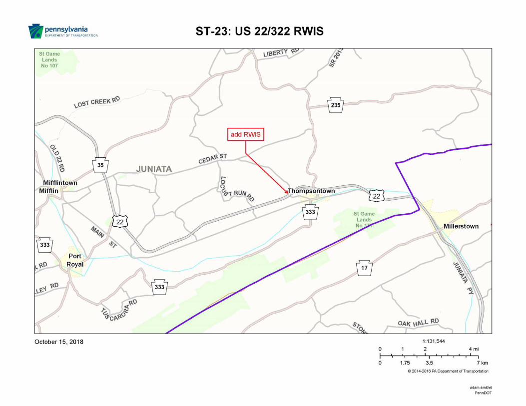
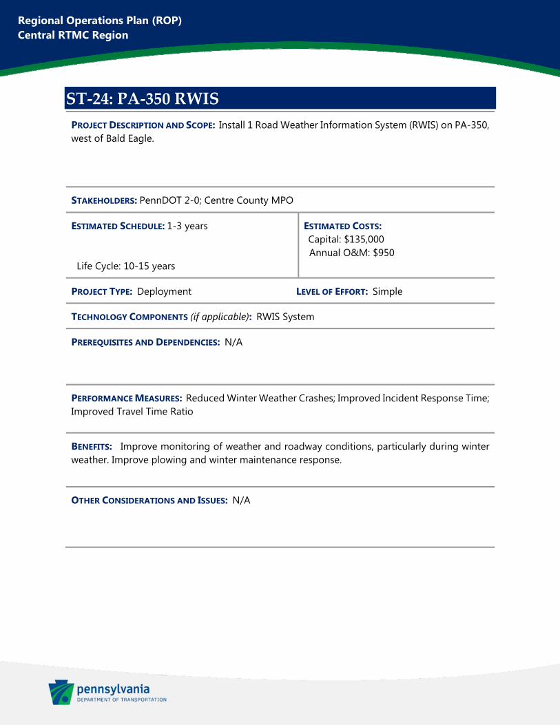
Regional Operations Plan (ROP) Central RTMC Region
ST‐24: PA‐350 RWIS
PROJECT DESCRIPTION AND SCOPE: Install 1 Road Weather Information System (RWIS) on PA-350, west of Bald Eagle.
STAKEHOLDERS: PennDOT 2-0; Centre County MPO
ESTIMATED SCHEDULE: 1-3 years Life Cycle: 10-15 years
ESTIMATED COSTS: Capital: $135,000 Annual O&M: $950
PROJECT TYPE: Deployment LEVEL OF EFFORT: Simple
TECHNOLOGY COMPONENTS (if applicable): RWIS System
PREREQUISITES AND DEPENDENCIES: N/A
PERFORMANCE MEASURES: Reduced Winter Weather Crashes; Improved Incident Response Time; Improved Travel Time Ratio
BENEFITS: Improve monitoring of weather and roadway conditions, particularly during winter weather. Improve plowing and winter maintenance response.
OTHER CONSIDERATIONS AND ISSUES: N/A
This figure has been redacted pursuant to 75 Pa. C.S. §3754 and 23 U.S.C. §409
Regional Operations Plan (ROP) Central RTMC Region
ST‐25: Special Event Use of Portable DMS
PROJECT DESCRIPTION AND SCOPE: Utilize portable DMS signs for special events throughout the Central RTMC Region. Portable DMS should include cell modems and have capability to be operated remotely by RTMC. Locations include: Penn State University events, Benezette Elk Viewing on PA-555, Bloomsburg Fairgrounds Events, and Altoona Curve games (and other events) at Peoples Natural Gas Field.
STAKEHOLDERS: PennDOT 2-0, 3-0, and 9-0; Centre County MPO; North Central RPO; SEDA-COG MPO; Altoona MPO
ESTIMATED SCHEDULE: 1-3 years Life Cycle: 10-15 years
ESTIMATED COSTS: Capital: $250,000 Annual O&M: $2,000
PROJECT TYPE: Planning & Deployment LEVEL OF EFFORT: Simple
TECHNOLOGY COMPONENTS (if applicable): DMS System
PREREQUISITES AND DEPENDENCIES: Obtain through construction projects with FHWA concurrence.
PERFORMANCE MEASURES: Improved Travel Time Ratio
BENEFITS: Increased flexibility in providing traveler information based on recurring or non-recurring planned special events.
OTHER CONSIDERATIONS AND ISSUES: N/A

Regional Operations Plan (ROP) Central RTMC Region
Appendix D. Long‐Term Projects
Regional Operations Plan (ROP) Central RTMC Region
LT‐01: I‐80 ICM (Exit 232 to 241)
PROJECT DESCRIPTION AND SCOPE: Integrated Corridor Management along I-80 between Exits 232 and 241 and along the parallel corridor of US 11 through Bloomsburg. This project would include full replacements of signal equipment at approximately 12 intersections, including upgraded signal controllers to allow for command/control functionality. It also includes installation of 1 full-color standard DMS, 1 full-color Type A DMS, and 2 HD CCTV.
STAKEHOLDERS: PennDOT 2-0 and 3-0; SEDA-COG MPO
ESTIMATED SCHEDULE: 4+ years Life Cycle: 10-15 years
ESTIMATED COSTS: Capital: $4,402,000 Annual O&M: $10,500
PROJECT TYPE: Deployment LEVEL OF EFFORT: Moderate
TECHNOLOGY COMPONENTS (if applicable): CCTV System; DMS System; Traffic Signal Systems; Telecommunications
PREREQUISITES AND DEPENDENCIES: N/A
PERFORMANCE MEASURES: Improved Travel Time Ratio; Improved Incident Response Time
BENEFITS: Improving incident management and operations on parallel corridors, optimizing the available capacity adjacent to I-80.
OTHER CONSIDERATIONS AND ISSUES: N/A
This figure has been redacted pursuant to 75 Pa. C.S. §3754 and 23 U.S.C. §409
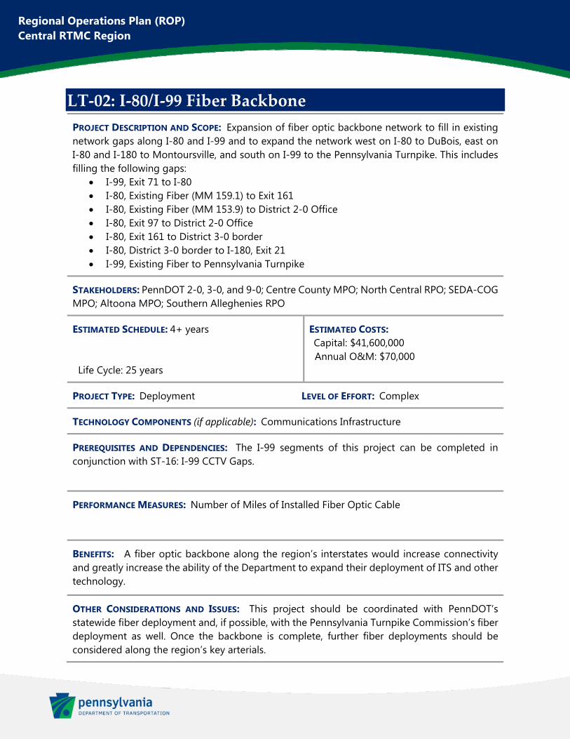
Regional Operations Plan (ROP) Central RTMC Region
LT‐02: I‐80/I‐99 Fiber Backbone
PROJECT DESCRIPTION AND SCOPE: Expansion of fiber optic backbone network to fill in existing network gaps along I-80 and I-99 and to expand the network west on I-80 to DuBois, east on I-80 and I-180 to Montoursville, and south on I-99 to the Pennsylvania Turnpike. This includes filling the following gaps:
I-99, Exit 71 to I-80 I-80, Existing Fiber (MM 159.1) to Exit 161 I-80, Existing Fiber (MM 153.9) to District 2-0 Office I-80, Exit 97 to District 2-0 Office I-80, Exit 161 to District 3-0 border I-80, District 3-0 border to I-180, Exit 21 I-99, Existing Fiber to Pennsylvania Turnpike
STAKEHOLDERS: PennDOT 2-0, 3-0, and 9-0; Centre County MPO; North Central RPO; SEDA-COG MPO; Altoona MPO; Southern Alleghenies RPO
ESTIMATED SCHEDULE: 4+ years Life Cycle: 25 years
ESTIMATED COSTS: Capital: $41,600,000 Annual O&M: $70,000
PROJECT TYPE: Deployment LEVEL OF EFFORT: Complex
TECHNOLOGY COMPONENTS (if applicable): Communications Infrastructure
PREREQUISITES AND DEPENDENCIES: The I-99 segments of this project can be completed in conjunction with ST-16: I-99 CCTV Gaps.
PERFORMANCE MEASURES: Number of Miles of Installed Fiber Optic Cable
BENEFITS: A fiber optic backbone along the region’s interstates would increase connectivity and greatly increase the ability of the Department to expand their deployment of ITS and other technology.
OTHER CONSIDERATIONS AND ISSUES: This project should be coordinated with PennDOT’s statewide fiber deployment and, if possible, with the Pennsylvania Turnpike Commission’s fiber deployment as well. Once the backbone is complete, further fiber deployments should be considered along the region’s key arterials.
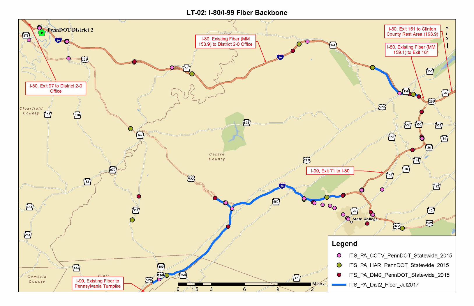

Regional Operations Plan (ROP) Central RTMC Region
LT‐03: I‐80 ICM (Exit 97 to 101)
PROJECT DESCRIPTION AND SCOPE: Integrated Corridor Management along I-80 between Exits 97 and 101 and along the parallel corridors of US 219 and PA-255 through DuBois. This project would include upgrading signal controllers at approximately 11 intersections in order to allow for command/control functionality. It also includes installation of 1 full-color Type A DMS sign and 2 HD CCTV cameras.
STAKEHOLDERS: PennDOT 2-0; North Central RPO
ESTIMATED SCHEDULE: 4+ years Life Cycle: 10-15 years
ESTIMATED COSTS: Capital: $604,000 Annual O&M: $6,500
PROJECT TYPE: Deployment LEVEL OF EFFORT: Moderate
TECHNOLOGY COMPONENTS (if applicable): DMS System; CCTV System; Traffic Signal Systems; Telecommunications
PREREQUISITES AND DEPENDENCIES: N/A
PERFORMANCE MEASURES: Improved Travel Time Ratio; Improved Incident Response Time
BENEFITS: Improving incident management and operations on parallel corridors, optimizing the available capacity adjacent to I-80.
OTHER CONSIDERATIONS AND ISSUES: N/A
This figure has been redacted pursuant to 75 Pa. C.S. §3754 and 23 U.S.C. §409
Regional Operations Plan (ROP) Central RTMC Region
LT‐04: I‐180 Interchange Improvements
PROJECT DESCRIPTION AND SCOPE: Install queue warning system on westbound I-180 approaching the Market Street off-ramp. Existing upstream DMS (ID: D3-180W-US15) can be used for queue notification. Add queue preemption to I-180 westbound off-ramp leg of the single-point urban interchange traffic signal and to the westbound off-ramp to Maynard Street. Timing improvements should also be included to improve excessive queue for northbound left turn from Market Street to I-180 westbound on-ramp.
STAKEHOLDERS: PennDOT 3-0; Williamsport MPO
ESTIMATED SCHEDULE: 4+ years Life Cycle: 10-15 years
ESTIMATED COSTS: Capital: $76,000 Annual O&M: $900
PROJECT TYPE: Deployment LEVEL OF EFFORT: Moderate
TECHNOLOGY COMPONENTS (if applicable): DMS System; Traffic Signal Systems; Telecommunications; Queue Warning System
PREREQUISITES AND DEPENDENCIES: N/A
PERFORMANCE MEASURES: Improved Travel Time Ratio; Reduced Rear End Crashes
BENEFITS: Improve safety on I-180 and westbound off-ramps to Market Street and Maynard Street, as well as reducing congestion at the I-180 Ramps/Market Street traffic signal.
OTHER CONSIDERATIONS AND ISSUES: N/A
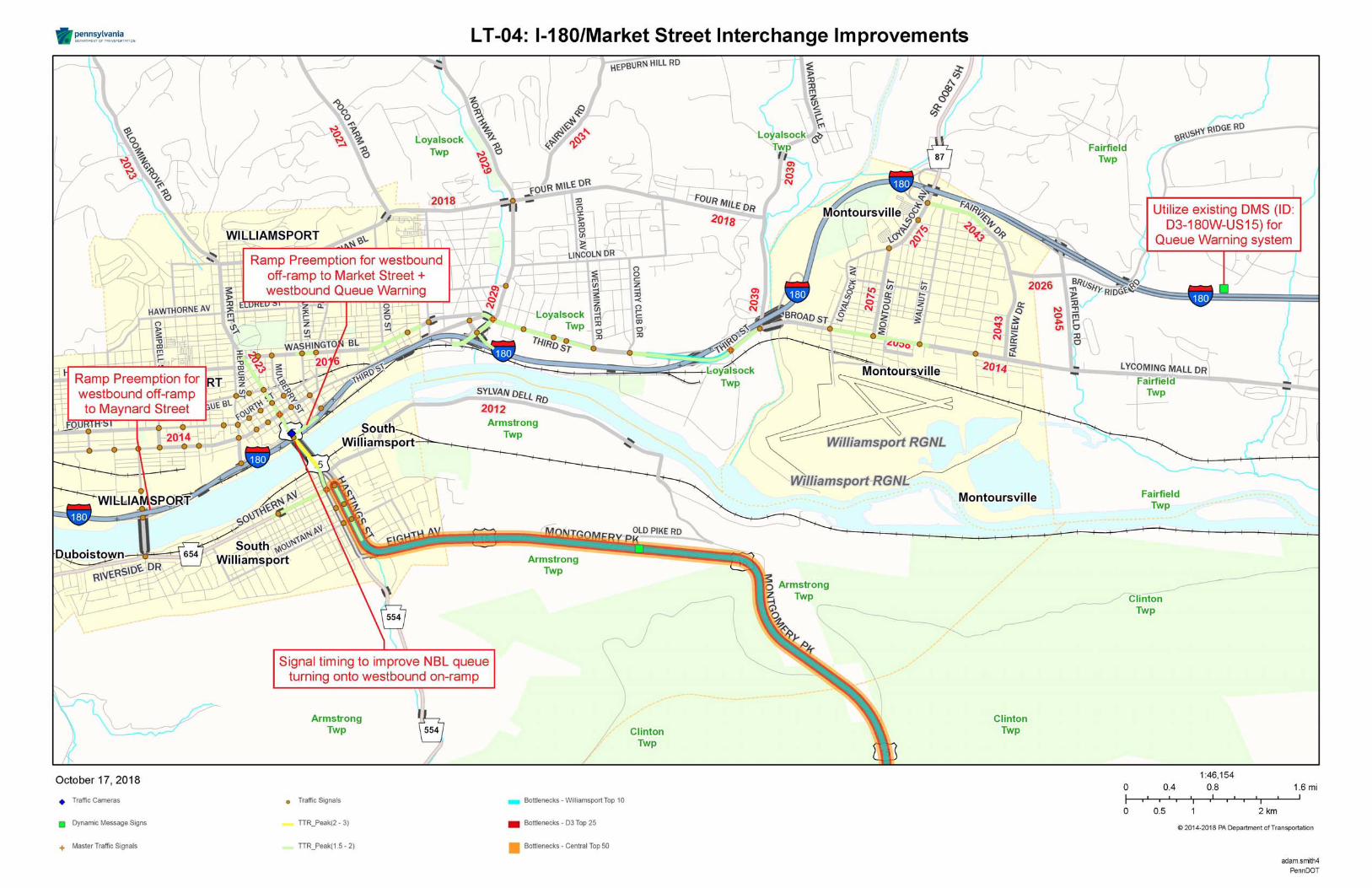
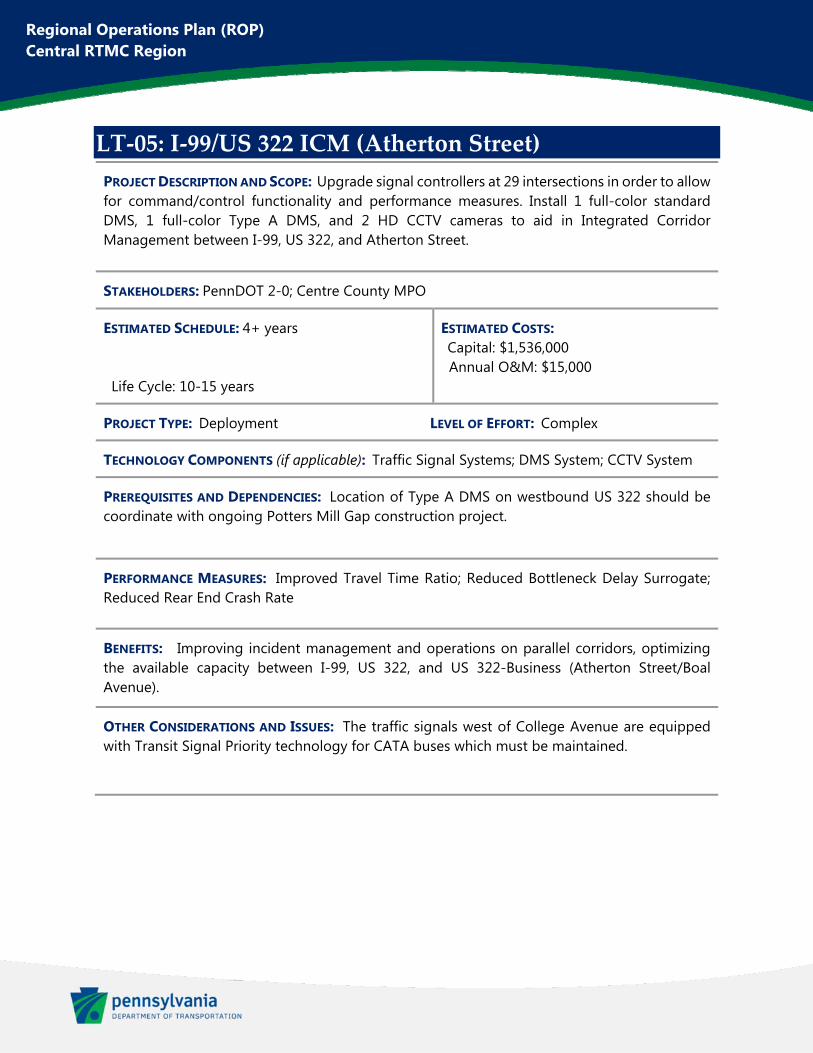
Regional Operations Plan (ROP) Central RTMC Region
LT‐05: I‐99/US 322 ICM (Atherton Street)
PROJECT DESCRIPTION AND SCOPE: Upgrade signal controllers at 29 intersections in order to allow for command/control functionality and performance measures. Install 1 full-color standard DMS, 1 full-color Type A DMS, and 2 HD CCTV cameras to aid in Integrated Corridor Management between I-99, US 322, and Atherton Street.
STAKEHOLDERS: PennDOT 2-0; Centre County MPO
ESTIMATED SCHEDULE: 4+ years Life Cycle: 10-15 years
ESTIMATED COSTS: Capital: $1,536,000 Annual O&M: $15,000
PROJECT TYPE: Deployment LEVEL OF EFFORT: Complex
TECHNOLOGY COMPONENTS (if applicable): Traffic Signal Systems; DMS System; CCTV System
PREREQUISITES AND DEPENDENCIES: Location of Type A DMS on westbound US 322 should be coordinate with ongoing Potters Mill Gap construction project.
PERFORMANCE MEASURES: Improved Travel Time Ratio; Reduced Bottleneck Delay Surrogate; Reduced Rear End Crash Rate
BENEFITS: Improving incident management and operations on parallel corridors, optimizing the available capacity between I-99, US 322, and US 322-Business (Atherton Street/Boal Avenue).
OTHER CONSIDERATIONS AND ISSUES: The traffic signals west of College Avenue are equipped with Transit Signal Priority technology for CATA buses which must be maintained.
This figure has been redacted pursuant to 75 Pa. C.S. §3754 and 23 U.S.C. §409

Regional Operations Plan (ROP) Central RTMC Region
LT‐06: I‐80 ICM (Exit 111 to 123)
PROJECT DESCRIPTION AND SCOPE: Integrated Corridor Management along I-80 between Exits 111 and 123 and along the parallel corridor of US 322 as well as connecting routes PA-153, PA 879, and PA-970 near Clearfield. This project would include upgrading signal controllers at approximately 6 intersections in order to allow for command/control functionality. It also includes installation of 2 full-color Type A DMS signs.
STAKEHOLDERS: PennDOT 2-0; North Central RPO
ESTIMATED SCHEDULE: 4+ years Life Cycle: 10-15 years
ESTIMATED COSTS: Capital: $550,000 Annual O&M: $4,500
PROJECT TYPE: Deployment LEVEL OF EFFORT: Moderate
TECHNOLOGY COMPONENTS (if applicable): DMS System; Traffic Signal Systems; Telecommunications
PREREQUISITES AND DEPENDENCIES: N/A
PERFORMANCE MEASURES: Improved Travel Time Ratio; Improved Incident Response Time
BENEFITS: Improving incident management and operations on parallel corridors, optimizing the available capacity adjacent to I-80.
OTHER CONSIDERATIONS AND ISSUES: N/A
This figure has been redacted pursuant to 75 Pa. C.S. §3754 and 23 U.S.C. §409
Regional Operations Plan (ROP) Central RTMC Region
LT‐07: I‐80 ICM (Exit 173 to 185)
PROJECT DESCRIPTION AND SCOPE: Integrated Corridor Management along I-80 between Exits 173 and 185 and along the parallel corridors of PA-64 and PA-477. This project would include upgrading signal controllers at approximately 5 intersections in order to allow for command/control functionality. It also includes installation of 1 full-color standard DMS sign, 3 full-color Type A DMS signs, and 1 HD CCTV camera.
STAKEHOLDERS: PennDOT 2-0; SEDA-COG MPO
ESTIMATED SCHEDULE: 4+ years Life Cycle: 10-15 years
ESTIMATED COSTS: Capital: $1,169,000 Annual O&M: $11,000
PROJECT TYPE: Deployment LEVEL OF EFFORT: Moderate
TECHNOLOGY COMPONENTS (if applicable): CCTV System; DMS System; Traffic Signal Systems; Telecommunications
PREREQUISITES AND DEPENDENCIES: N/A
PERFORMANCE MEASURES: Improved Travel Time Ratio; Improved Incident Response Time
BENEFITS: Improving incident management and operations on parallel corridors, optimizing the available capacity adjacent to I-80.
OTHER CONSIDERATIONS AND ISSUES: Proposed CCTV camera at Exit 185 is also included in Project ST-05, I-80 CCTV Gaps

This figure has been redacted pursuant to 75 Pa. C.S. §3754 and 23 U.S.C. §409
Regional Operations Plan (ROP) Central RTMC Region
LT‐08: PA‐56 Traffic Signal Improvements
PROJECT DESCRIPTION AND SCOPE: Upgrade signal controllers at 11 intersections in order to allow for command/control functionality and performance measures. Upgrade detection and improve coordination along the PA-56 (Scalp Avenue) corridor between Scalp Level and Geistown.
STAKEHOLDERS: PennDOT 2-0 and 9-0; Johnstown MPO
ESTIMATED SCHEDULE: 4+ years Life Cycle: 10-15 years
ESTIMATED COSTS: Capital: $755,000 Annual O&M: $5,700
PROJECT TYPE: Deployment LEVEL OF EFFORT: Moderate
TECHNOLOGY COMPONENTS (if applicable): Traffic Signal Systems
PREREQUISITES AND DEPENDENCIES: N/A
PERFORMANCE MEASURES: Improved Travel Time Ratio
BENEFITS: Improved traffic flow and reduced congestion along an important signalized corridor within the region.
OTHER CONSIDERATIONS AND ISSUES: N/A
This figure has been redacted pursuant to 75 Pa. C.S. §3754 and 23 U.S.C. §409
Regional Operations Plan (ROP) Central RTMC Region
LT‐09: US 220‐Business Traffic Signal Improvements
PROJECT DESCRIPTION AND SCOPE: Upgrade signal controllers on US 220-Business/Plank Road from Pinecroft (I-99, Exit 39) to US 22 near Hollidaysburg. This includes approximately 38 intersections and will allow for command/control functionality and performance measures. Detection should also be upgraded to radar at these intersections. Install 1 full-color DMS and 2 HD CCTV cameras to aid in Integrated Corridor Management between I-99 and US 220-Business.
STAKEHOLDERS: PennDOT 2-0 and 9-0; Altoona MPO
ESTIMATED SCHEDULE: 4+ years Life Cycle: 10-15 years
ESTIMATED COSTS: Capital: $3,100,000 Annual O&M: $16,000
PROJECT TYPE: Deployment LEVEL OF EFFORT: Moderate
TECHNOLOGY COMPONENTS (if applicable): Traffic Signal Systems; DMS System; CCTV System
PREREQUISITES AND DEPENDENCIES: N/A
PERFORMANCE MEASURES: Improved Travel Time Ratio; Improved Incident Response Time
BENEFITS: Improving incident management and operations on parallel corridors, optimizing the available capacity between I-99 and US 220-Business through the City of Altoona.
OTHER CONSIDERATIONS AND ISSUES: N/A
This figure has been redacted pursuant to 75 Pa. C.S. §3754 and 23 U.S.C. §409
Regional Operations Plan (ROP) Central RTMC Region
LT‐10: Central Region Dynamic Curve Warning
PROJECT DESCRIPTION AND SCOPE: Install Dynamic Curve Warning systems at the following noted curved road problem areas:
I-80, near MM 180 US 322, near Laurel Creek Reservoir I-99, near Exit 81 US 22, near Williamsburg US 219, near Summerhill US 30, near McConnellsburg
System will consist of side-mounted radar speed detection and a full-color DMS (or full-color Type A DMS) for notification.
STAKEHOLDERS: PennDOT 2-0, 3-0, and 9-0; Centre County; SEDA-COG MPO; Altoona MPO; Johnstown MPO; Southern Alleghenies RPO
ESTIMATED SCHEDULE: 4+ years Life Cycle: 10-15 years
ESTIMATED COSTS: Capital: $1,775,000 Annual O&M: $17,000
PROJECT TYPE: Deployment LEVEL OF EFFORT: Moderate
TECHNOLOGY COMPONENTS (if applicable): DMS System; Telecommunications
PREREQUISITES AND DEPENDENCIES: N/A
PERFORMANCE MEASURES: Reduced Curved Road Crashes
BENEFITS: Regional deployment of curve warning systems to reduce crashes at some of the most dangerous curves on the region’s highways.
OTHER CONSIDERATIONS AND ISSUES: ST-12: US 322 Slow Vehicle Warning includes improvements within the same project area as the “US 322, near Laurel Creek Reservoir” site listed here. This Curve Warning deployment could be also be integrated into that project and removed from this regional project.

This figure has been redacted pursuant to 75 Pa. C.S. §3754 and 23 U.S.C. §409
Regional Operations Plan (ROP) Central RTMC Region
LT‐11: PA‐54 Traffic Signal Improvements
PROJECT DESCRIPTION AND SCOPE: This signal improvement project includes 8 signalized intersections along US 11 and PA-54 in Danville. This will include full replacements of signal equipment at each intersection, including upgraded signal controllers to allow for command/control functionality. This project also includes 2 HD CCTV cameras, 1 full-color standard DMS, and 1 full-color Type A DMS.
STAKEHOLDERS: PennDOT 2-0 and 3-0; SEDA-COG MPO
ESTIMATED SCHEDULE: 4+ years Life Cycle: 10-15 years
ESTIMATED COSTS: Capital: $2,795,000 Annual O&M: $7,000
PROJECT TYPE: Deployment LEVEL OF EFFORT: Moderate
TECHNOLOGY COMPONENTS (if applicable): Traffic Signal Systems; DMS System; CCTV System
PREREQUISITES AND DEPENDENCIES: N/A
PERFORMANCE MEASURES: Improved Travel Time Ratio; Reduced Bottleneck Delay Surrogate; Improved Incident Response Time
BENEFITS: Improved traffic flow and reduced congestion along an important arterial running through Danville.
OTHER CONSIDERATIONS AND ISSUES: N/A
This figure has been redacted pursuant to 75 Pa. C.S. §3754 and 23 U.S.C. §409
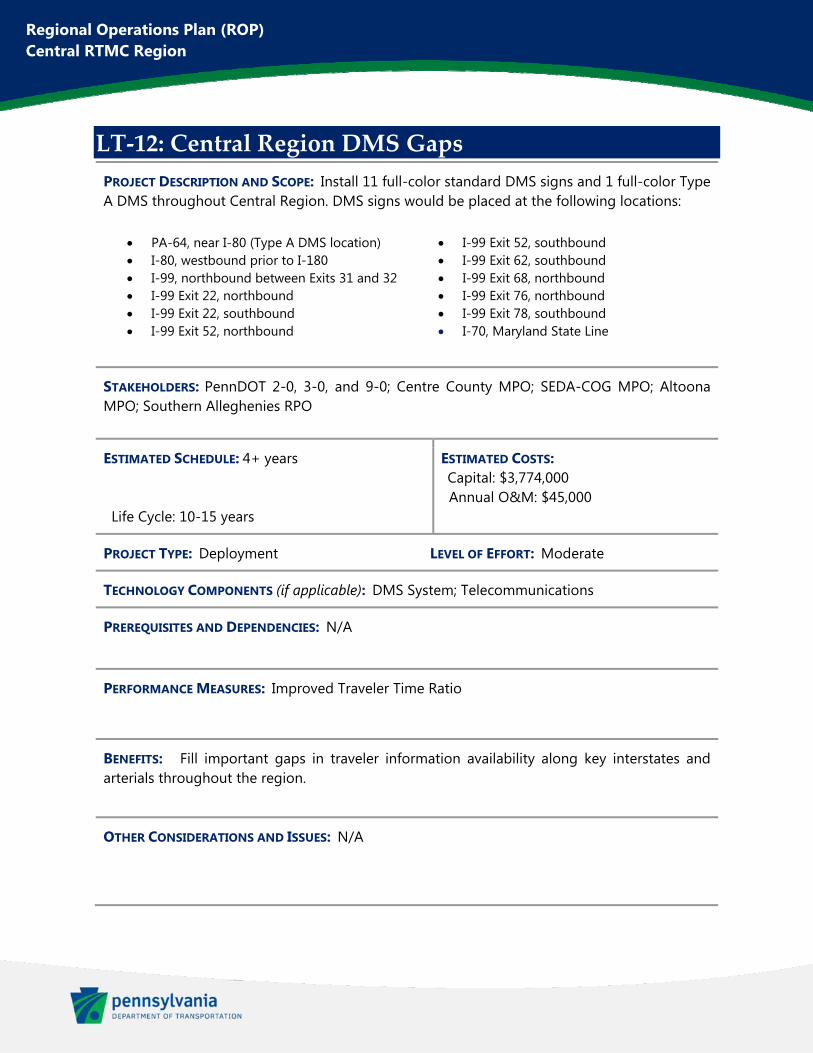
Regional Operations Plan (ROP) Central RTMC Region
LT‐12: Central Region DMS Gaps
PROJECT DESCRIPTION AND SCOPE: Install 11 full-color standard DMS signs and 1 full-color Type A DMS throughout Central Region. DMS signs would be placed at the following locations:
PA-64, near I-80 (Type A DMS location) I-80, westbound prior to I-180 I-99, northbound between Exits 31 and 32 I-99 Exit 22, northbound I-99 Exit 22, southbound I-99 Exit 52, northbound
I-99 Exit 52, southbound I-99 Exit 62, southbound I-99 Exit 68, northbound I-99 Exit 76, northbound I-99 Exit 78, southbound I-70, Maryland State Line
STAKEHOLDERS: PennDOT 2-0, 3-0, and 9-0; Centre County MPO; SEDA-COG MPO; Altoona MPO; Southern Alleghenies RPO
ESTIMATED SCHEDULE: 4+ years Life Cycle: 10-15 years
ESTIMATED COSTS: Capital: $3,774,000 Annual O&M: $45,000
PROJECT TYPE: Deployment LEVEL OF EFFORT: Moderate
TECHNOLOGY COMPONENTS (if applicable): DMS System; Telecommunications
PREREQUISITES AND DEPENDENCIES: N/A
PERFORMANCE MEASURES: Improved Traveler Time Ratio
BENEFITS: Fill important gaps in traveler information availability along key interstates and arterials throughout the region.
OTHER CONSIDERATIONS AND ISSUES: N/A
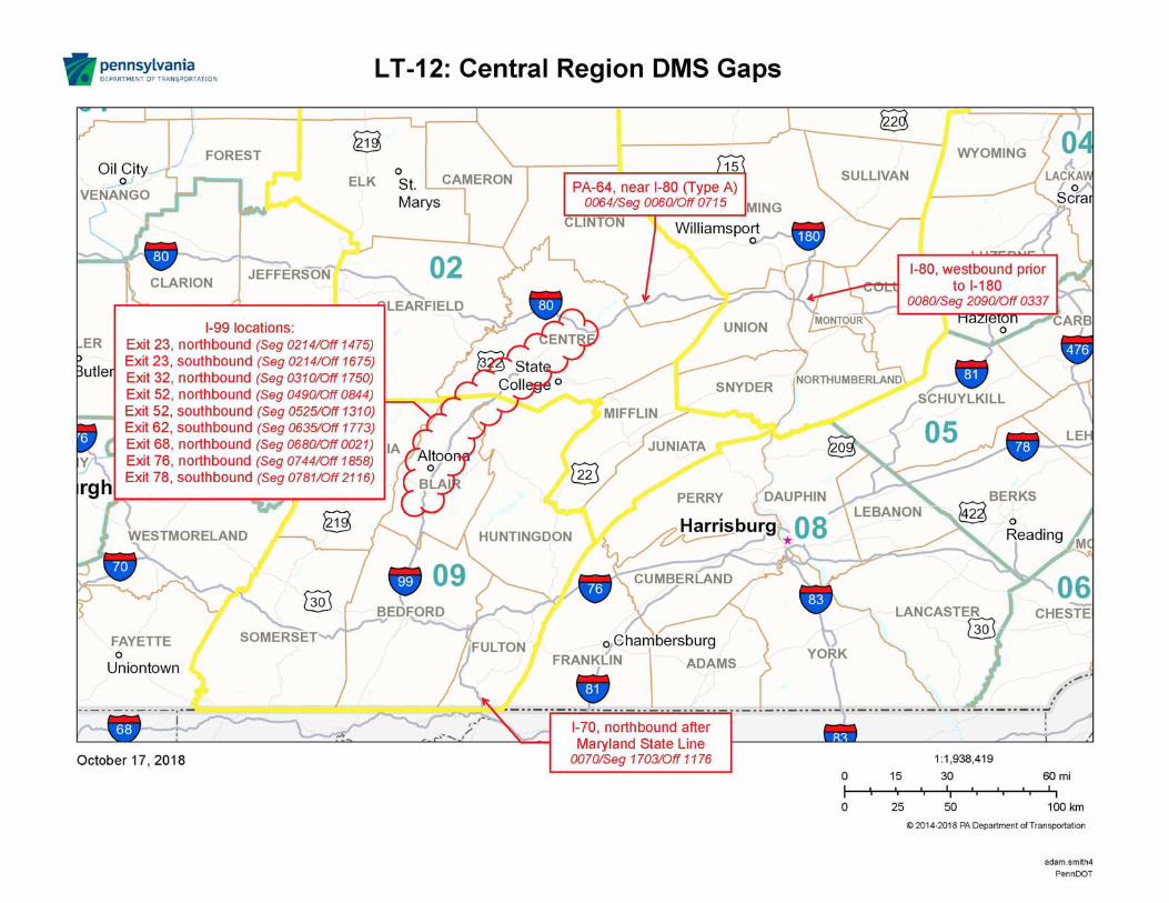

Regional Operations Plan (ROP) Central RTMC Region
LT‐13: PA‐36 Traffic Signal Improvements
PROJECT DESCRIPTION AND SCOPE: Upgrade signalized intersections along the PA-164 and PA-36 corridor in Roaring Spring. Improvements include upgrading to radar detection at 4 intersections. The project will also include LED “Red Signal Ahead” signs for northbound PA-36 and westbound PA-164 prior to Roaring Spring.
STAKEHOLDERS: PennDOT 2-0 and 9-0; Altoona MPO
ESTIMATED SCHEDULE: 4+ years Life Cycle: 10-15 years
ESTIMATED COSTS: Capital: $185,000 Annual O&M: $1,100
PROJECT TYPE: Deployment LEVEL OF EFFORT: Moderate
TECHNOLOGY COMPONENTS (if applicable): Traffic Signal Systems
PREREQUISITES AND DEPENDENCIES: N/A
PERFORMANCE MEASURES: Improved Travel Time Ratio; Reduced Rear End Crashes
BENEFITS: Improved traffic flow and reduced congestion along an important signalized corridor within the region. Improved safety on approaches to this signalized corridor.
OTHER CONSIDERATIONS AND ISSUES: N/A
This figure has been redacted pursuant to 75 Pa. C.S. §3754 and 23 U.S.C. §409
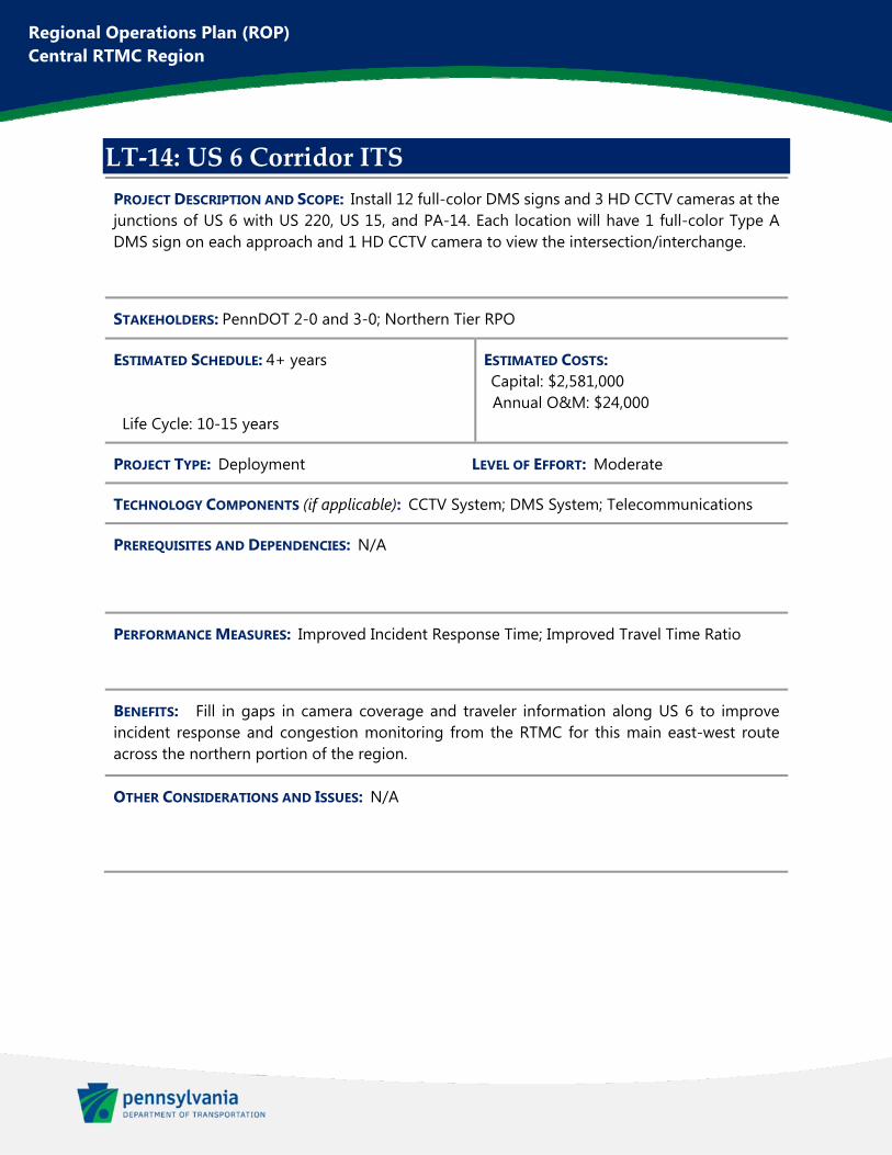
Regional Operations Plan (ROP) Central RTMC Region
LT‐14: US 6 Corridor ITS
PROJECT DESCRIPTION AND SCOPE: Install 12 full-color DMS signs and 3 HD CCTV cameras at the junctions of US 6 with US 220, US 15, and PA-14. Each location will have 1 full-color Type A DMS sign on each approach and 1 HD CCTV camera to view the intersection/interchange.
STAKEHOLDERS: PennDOT 2-0 and 3-0; Northern Tier RPO
ESTIMATED SCHEDULE: 4+ years Life Cycle: 10-15 years
ESTIMATED COSTS: Capital: $2,581,000 Annual O&M: $24,000
PROJECT TYPE: Deployment LEVEL OF EFFORT: Moderate
TECHNOLOGY COMPONENTS (if applicable): CCTV System; DMS System; Telecommunications
PREREQUISITES AND DEPENDENCIES: N/A
PERFORMANCE MEASURES: Improved Incident Response Time; Improved Travel Time Ratio
BENEFITS: Fill in gaps in camera coverage and traveler information along US 6 to improve incident response and congestion monitoring from the RTMC for this main east-west route across the northern portion of the region.
OTHER CONSIDERATIONS AND ISSUES: N/A
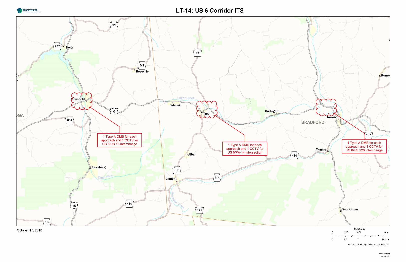
Regional Operations Plan (ROP) Central RTMC Region
LT‐15: PA‐150 Traffic Signal Improvements
PROJECT DESCRIPTION AND SCOPE: Upgrade signal controllers at 5 signalized intersections along PA-150 near Mill Hall in order to allow for command/control functionality and performance measures. These signals are part of the Bald Eagle-Hogan system.
STAKEHOLDERS: PennDOT 2-0; SEDA-COG MPO
ESTIMATED SCHEDULE: 4+ years Life Cycle: 10-15 years
ESTIMATED COSTS: Capital: $175,000 Annual O&M: $1,500
PROJECT TYPE: Deployment LEVEL OF EFFORT: Moderate
TECHNOLOGY COMPONENTS (if applicable): Traffic Signal Systems
PREREQUISITES AND DEPENDENCIES: N/A
PERFORMANCE MEASURES: Improved Travel Time Ratio
BENEFITS: Improved traffic flow and reduced congestion along an important signalized corridor within the region.
OTHER CONSIDERATIONS AND ISSUES: N/A
This figure has been redacted pursuant to 75 Pa. C.S. §3754 and 23 U.S.C. §409
Regional Operations Plan (ROP) Central RTMC Region
LT‐16: Sayre Traffic Signal Improvements
PROJECT DESCRIPTION AND SCOPE: Upgrade controllers at 5 signalized intersections along US 220 and Elmira Street near Sayre. Retime and improve coordination along the corridor.
STAKEHOLDERS: PennDOT 2-0 and 3-0; Northern Tier RPO
ESTIMATED SCHEDULE: 4+ years Life Cycle: 10-15 years
ESTIMATED COSTS: Capital: $210,000 Annual O&M: $1,300
PROJECT TYPE: Deployment LEVEL OF EFFORT: Moderate
TECHNOLOGY COMPONENTS (if applicable): Traffic Signal Systems
PREREQUISITES AND DEPENDENCIES: N/A
PERFORMANCE MEASURES: Improved Travel Time Ratio
BENEFITS: Improved traffic flow and reduced congestion along an important signalized corridor within the region.
OTHER CONSIDERATIONS AND ISSUES: N/A
This figure has been redacted pursuant to 75 Pa. C.S. §3754 and 23 U.S.C. §409
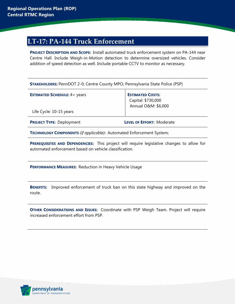
Regional Operations Plan (ROP) Central RTMC Region
LT‐17: PA‐144 Truck Enforcement
PROJECT DESCRIPTION AND SCOPE: Install automated truck enforcement system on PA-144 near Centre Hall. Include Weigh-in-Motion detection to determine oversized vehicles. Consider addition of speed detection as well. Include portable CCTV to monitor as necessary.
STAKEHOLDERS: PennDOT 2-0; Centre County MPO; Pennsylvania State Police (PSP)
ESTIMATED SCHEDULE: 4+ years Life Cycle: 10-15 years
ESTIMATED COSTS: Capital: $730,000 Annual O&M: $6,000
PROJECT TYPE: Deployment LEVEL OF EFFORT: Moderate
TECHNOLOGY COMPONENTS (if applicable): Automated Enforcement System;
PREREQUISITES AND DEPENDENCIES: This project will require legislative changes to allow for automated enforcement based on vehicle classification.
PERFORMANCE MEASURES: Reduction in Heavy Vehicle Usage
BENEFITS: Improved enforcement of truck ban on this state highway and improved on the route.
OTHER CONSIDERATIONS AND ISSUES: Coordinate with PSP Weigh Team. Project will require increased enforcement effort from PSP.
This figure has been redacted pursuant to 75 Pa. C.S. §3754 and 23 U.S.C. §409
Regional Operations Plan (ROP)
Central RTMC Region
Appendix E. 2021 Interim Update
Introduction
Background The Regional Operations Plan (ROP) completed for the Central Regional Traffic Management Center
(RTMC) Region in 2018 was the first in a statewide initiative to increase implementation of Transportation
Systems Management and Operations (TSMO) projects. This ROP, and subsequent plans developed for
the Western and Eastern RTMC Regions, were compiled based on guidance from PennDOT Publication
851 (TSMO Guidebook, Part I: Planning).
This addendum provides an interim update to the 2018 Central RTMC ROP, including the status of
existing projects, a discussion of emerging trends related to traffic operations, and identification of new
ROP projects which have been proposed during the update process.
Update Process This interim update was completed through an expedited schedule of approximately two months. A
kickoff meeting was held on May 14, 2021, followed by individual stakeholder outreach meetings with
each of the region’s eight MPO/RPO planning partners. A separate meeting was also held with the District
2-0 County Maintenance Managers to gather additional feedback. The stakeholder outreach meetings
were used to confirm existing project status and gain insight into new traffic operations needs in each
respective area. This information was evaluated with the project steering committee – including PennDOT
Bureau of Maintenance and Operations (BOMO) and PennDOT Districts 2-0, 3-0, and 9-0 – and a list of
new ROP projects was confirmed. A final meeting of stakeholders was held on June 22, 2021.
This process does not supplant the extensive stakeholder outreach and data analysis completing during
the 2018 ROP development. New projects identified within this update process should be considered
alongside, and not in place of, previously confirmed projects when funding opportunities arise.
Status of Existing ROP Projects
In the initial 2018 Central RTMC ROP, 42 projects were identified, ranging from intelligent transportation
systems (ITS) and traffic signal improvements to incident management and preventive safety
technologies. Integrated Corridor Management (ICM) was also a key component of the ROP. These
projects take a holistic approach, maximizing existing capacity of parallel routes and emphasizing
multimodal approaches to congestion management. A table is attached which shows the status of each of
these previously documented projects. Status updates fall into the following categories shown in Table 1.
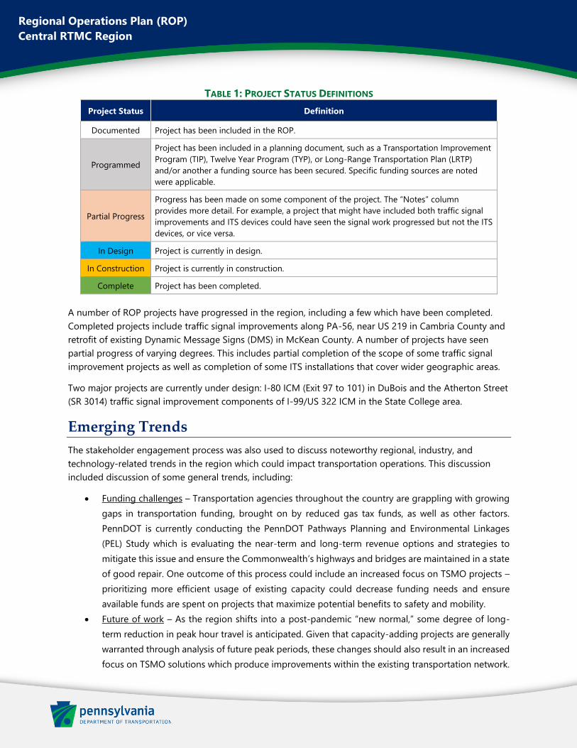
Regional Operations Plan (ROP)
Central RTMC Region
TABLE 1: PROJECT STATUS DEFINITIONS
Project Status Definition
Documented Project has been included in the ROP.
Programmed
Project has been included in a planning document, such as a Transportation Improvement
Program (TIP), Twelve Year Program (TYP), or Long-Range Transportation Plan (LRTP)
and/or another a funding source has been secured. Specific funding sources are noted
were applicable.
Partial Progress
Progress has been made on some component of the project. The “Notes” column
provides more detail. For example, a project that might have included both traffic signal
improvements and ITS devices could have seen the signal work progressed but not the ITS
devices, or vice versa.
In Design Project is currently in design.
In Construction Project is currently in construction.
Complete Project has been completed.
A number of ROP projects have progressed in the region, including a few which have been completed.
Completed projects include traffic signal improvements along PA-56, near US 219 in Cambria County and
retrofit of existing Dynamic Message Signs (DMS) in McKean County. A number of projects have seen
partial progress of varying degrees. This includes partial completion of the scope of some traffic signal
improvement projects as well as completion of some ITS installations that cover wider geographic areas.
Two major projects are currently under design: I-80 ICM (Exit 97 to 101) in DuBois and the Atherton Street
(SR 3014) traffic signal improvement components of I-99/US 322 ICM in the State College area.
Emerging Trends
The stakeholder engagement process was also used to discuss noteworthy regional, industry, and
technology-related trends in the region which could impact transportation operations. This discussion
included discussion of some general trends, including:
• Funding challenges – Transportation agencies throughout the country are grappling with growing
gaps in transportation funding, brought on by reduced gas tax funds, as well as other factors.
PennDOT is currently conducting the PennDOT Pathways Planning and Environmental Linkages
(PEL) Study which is evaluating the near-term and long-term revenue options and strategies to
mitigate this issue and ensure the Commonwealth’s highways and bridges are maintained in a state
of good repair. One outcome of this process could include an increased focus on TSMO projects –
prioritizing more efficient usage of existing capacity could decrease funding needs and ensure
available funds are spent on projects that maximize potential benefits to safety and mobility.
• Future of work – As the region shifts into a post-pandemic “new normal,” some degree of long-
term reduction in peak hour travel is anticipated. Given that capacity-adding projects are generally
warranted through analysis of future peak periods, these changes should also result in an increased
focus on TSMO solutions which produce improvements within the existing transportation network.
Regional Operations Plan (ROP)
Central RTMC Region
The discussions also included specific planned developments and other location-specific trends, as
discussed below.
Centre County MPO In the State College area, a large amount of development has occurred over the last few years and is
anticipated to continue. Substantial mixed-use development has occurred along College Avenue and
Beaver Avenue in downtown State College near Penn State’s University Park campus, including sizable
student housing combined with ground floor retail. Student housing is also anticipated to spread east
along College Avenue towards the US 322 interchange. Further east on this corridor, development is also
occurring around the Nittany Mall site, with the possibility of a future casino.
This increasing density places an increased importance on prioritizing projects to improve mode share –
reducing personal vehicle usage and increasing mobility opportunities for transit users, cyclists, and
pedestrians. Centre Area Transportation Authority (CATA) is about to begin a System Reimagine Study
and Transportation Development Plan. This will include a ground up evaluation of bus stop spacing and
amenities, bus routes, access to transit, and connections to micromobility, microtransit, intercity buses and
other services and modes. The study will also consider possibilities for Bus Rapid Transit, particularly along
SR 3014 (Atherton St) and SR 0026 (College Ave/Beaver Ave) in State College and adjacent municipalities.
Initiatives and projects stemming from this process should be strongly considered for future ROP updates.
Also in the State College area, the Borough of State College is partnering with Penn State University to
pursue a significant bike share deployment with a major micromobility provider. The system is anticipated
to have approximately 300 e-assist bicycles. The system would be dockless but will have established
parking and deployment hubs arranged throughout the service area.
This system would fill the void of the previous system operated by Zagster, a company which ceased
operations in 2020. Bike share, coupled with continued investments in both trails and on-street bike
infrastructure, could greatly increase biking as a viable means of transportation for more residents and
visitors and lead to positive impacts on congestion issues. Investments in bike share development and
expansion, as well as introduction of e-assist bicycles to bike share fleets, have been included in other
ROPs throughout the state. Future ROP updates should evaluate this anticipated bike share system and
consider any additional needs which should be documented as ROP projects.
Elsewhere in Centre County, considerable development activity has occurred in Benner and Spring
Townships along the PA-150 corridor between I-99 and Bellefonte. Multiple traffic impact studies have
been completed for commercial and residential developments in the corridor.
North Central RPO In Sandy Township (Clearfield County), development is progressing in the area between I-80, PA-255 and
Industrial Drive. Long-term plans would likely extend Industrial Drive east to connect with PA-255 near I-
80 Exit 101. Land uses in the development are primarily warehousing/logistics centers and would result in
impactful traffic, particularly freight traffic, which should be considered in subsequent ROPs if the project
moves forward.
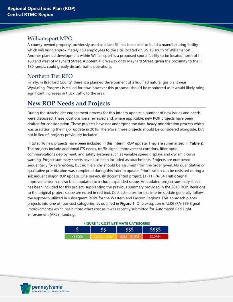
Regional Operations Plan (ROP) Central RTMC Region
Williamsport MPO A county-owned property, previously used as a landfill, has been sold to build a manufacturing facility which will bring approximately 150 employees to the site, located on US 15 south of Williamsport. Another planned development within Williamsport is a proposed sports facility to be located north of I-180 and west of Maynard Street. A potential driveway onto Maynard Street, given the proximity to the I-180 ramps, could greatly disturb traffic operations.
Northern Tier RPO Finally, in Bradford County, there is a planned development of a liquified natural gas plant near Wyalusing. Progress is stalled for now, however this proposal should be monitored as it would likely bring significant increases in truck traffic to the area.
New ROP Needs and Projects During the stakeholder engagement process for this interim update, a number of new issues and needs were discussed. These locations were reviewed and, where applicable, new ROP projects have been drafted for consideration. These projects have not undergone the data-heavy prioritization process which was used during the major update in 2018. Therefore, these projects should be considered alongside, but not in lieu of, projects previously included.
In total, 16 new projects have been included in this interim ROP update. They are summarized in Table 2. The projects include additional ITS needs, traffic signal improvement corridors, fiber optic communications deployment, and safety systems such as variable speed displays and dynamic curve warning. Project summary sheets have also been included as attachments. Projects are numbered sequentially for referencing, but no hierarchy should be assumed from the order given. No quantitative or qualitative prioritization was completed during this interim update. Prioritization can be revisited during a subsequent major ROP update. One previously documented project, LT-11 (PA-54 Traffic Signal Improvements), has also been updated to include expanded scope. An updated project summary sheet has been included for this project, supplanting the previous summary provided in the 2018 ROP. Revisions to the original project scope are noted in red text. Cost estimates for this interim update generally follow the approach utilized in subsequent ROPs for the Western and Eastern Regions. This approach places projects into one of four cost categories, as outlined in Figure 1. One exception is IU.06 (PA-879 Signal Improvements) which has a more exact cost as it was recently submitted for Automated Red Light Enforcement (ARLE) funding.
FIGURE 1: COST ESTIMATE CATEGORIES
$ <$500k $500k - $2M $2M - $10M $10M+
$$ $$$ $$$$
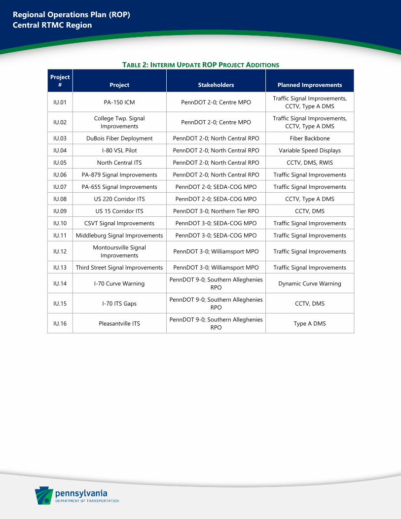
Regional Operations Plan (ROP)
Central RTMC Region
TABLE 2: INTERIM UPDATE ROP PROJECT ADDITIONS
Project
# Project Stakeholders Planned Improvements
IU.01 PA-150 ICM PennDOT 2-0; Centre MPO Traffic Signal Improvements,
CCTV, Type A DMS
IU.02 College Twp. Signal
Improvements PennDOT 2-0; Centre MPO
Traffic Signal Improvements,
CCTV, Type A DMS
IU.03 DuBois Fiber Deployment PennDOT 2-0; North Central RPO Fiber Backbone
IU.04 I-80 VSL Pilot PennDOT 2-0; North Central RPO Variable Speed Displays
IU.05 North Central ITS PennDOT 2-0; North Central RPO CCTV, DMS, RWIS
IU.06 PA-879 Signal Improvements PennDOT 2-0; North Central RPO Traffic Signal Improvements
IU.07 PA-655 Signal Improvements PennDOT 2-0; SEDA-COG MPO Traffic Signal Improvements
IU.08 US 220 Corridor ITS PennDOT 2-0; SEDA-COG MPO CCTV, Type A DMS
IU.09 US 15 Corridor ITS PennDOT 3-0; Northern Tier RPO CCTV, DMS
IU.10 CSVT Signal Improvements PennDOT 3-0; SEDA-COG MPO Traffic Signal Improvements
IU.11 Middleburg Signal Improvements PennDOT 3-0; SEDA-COG MPO Traffic Signal Improvements
IU.12 Montoursville Signal
Improvements PennDOT 3-0; Williamsport MPO Traffic Signal Improvements
IU.13 Third Street Signal Improvements PennDOT 3-0; Williamsport MPO Traffic Signal Improvements
IU.14 I-70 Curve Warning PennDOT 9-0; Southern Alleghenies
RPO Dynamic Curve Warning
IU.15 I-70 ITS Gaps PennDOT 9-0; Southern Alleghenies
RPO CCTV, DMS
IU.16 Pleasantville ITS PennDOT 9-0; Southern Alleghenies
RPO Type A DMS

Regional Operations Plan (ROP)
Central RTMC Region
Previous Project Status
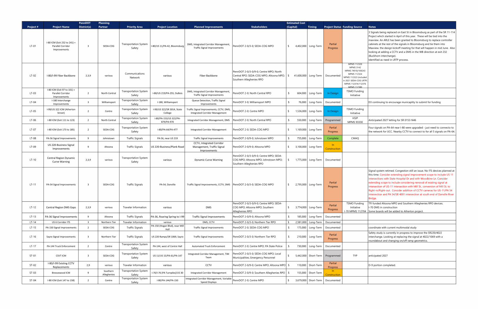
Project # Project NamePennDOT District(s)
Planning Partner Priority Area Project Location Planned Improvements Stakeholders
Estimated Cost (Capital) Timing Project Status Funding Source Notes
LT-01I-80 ICM (Exit 232 to 241) +
Parallel Corridor Improvements
3 SEDA-COGTransportation System
SafetyI-80/US 11/PA-42, Bloomsburg
DMS, Integrated Corridor Management, Traffic Signal Improvements
PennDOT 2-0/3-0; SEDA-COG MPO $ 4,402,000 Long-TermPartial
Progress
3 Signals being replaced on East St in Bloomsburg as part of the SR 11-114 Project which started in April of this year. These will be tied into the maxview. An ARLE has been granted to Bloomsburg to replace controller cabinets at the rest of the signals in Bloomsburg and tie them into Maxview. the design kickoff meeting for that will happen in mid June. Also looking at adding a CCTV and a DMS in the WB direction at exit 232 (Buckhorn interchange).Identified as need in LRTP process.
LT-02 I-80/I-99 Fiber Backbone 2,3,9 variousCommunications
Networkvarious Fiber Backbone
PennDOT 2-0/3-0/9-0; Centre MPO; North Central RPO; SEDA-COG MPO; Altoona MPO; Southern Alleghenies RPO
$ 41,600,000 Long-Term Documented
MPMS 112320MPMS 3142
MPMS 74910/109243MPMS 112324
MPMS 112323 (included in 2021 SEDA-COG LRTP)MPMS 112374/112376
MPMS 112380
LT-03I-80 ICM (Exit 97 to 101) +
Parallel Corridor Improvements
2 North CentralTransportation System
SafetyI-80/US 219/PA-255, DuBois
DMS, Integrated Corridor Management, Traffic Signal Improvements
PennDOT 2-0; North Central RPO $ 604,000 Long-Term In DesignTSMO Funding
Initiative
LT-04I-180 Interchange
Improvements3 Williamsport
Transportation System Safety
I-180, WilliamsportQueue Detection, Traffic Signal
ImprovementsPennDOT 3-0; Williamsport MPO $ 76,000 Long-Term Documented D3 continuing to encourage municaplity to submit for funding
LT-05I-99/US 322 ICM (Atherton
Street)2 Centre
Transportation System Safety
I-99/US 322/SR 3014, State College
Traffic Signal Improvements, CCTV, DMS, Integrated Corridor Management
PennDOT 2-0; Centre MPO $ 1,536,000 Long-Term In DesignTSMO Funding
Initiative
LT-06 I-80 ICM (Exit 111 to 123) 2 North CentralTransportation System
SafetyI-80/PA-153/US 322/PA-
879/PA-970Integrated Corridor Management, DMS PennDOT 2-0; North Central RPO $ 550,000 Long-Term Programmed
HSIPMPMS 93330
Anticipated 2027 letting for SR 0153-N46
LT-07 I-80 ICM (Exit 173 to 185) 2 SEDA-COGTransportation System
SafetyI-80/PA-64/PA-477 Integrated Corridor Management PennDOT 2-0; SEDA-COG MPO $ 1,169,000 Long-Term
Partial Progress
Four signals on PA-64 near I-80 were upgraded - just need to connecto to the network for UCC. Nearby CCTV to connect to for all 5 signals on PA-64.
LT-08 PA-56 Signal Improvements 9 Johnstown Traffic Signals PA-56, near US 219 Traffic Signal Improvements PennDOT 2-0/9-0; Johnstown MPO $ 755,000 Long-Term Complete CMAQ
LT-09US 220-Business Signal
Improvements9 Altoona Traffic Signals US 220-Business/Plank Road
CCTV, Integrated Corridor Management, Traffic Signal
ImprovementsPennDOT 2-0/9-0; Altoona MPO $ 3,100,000 Long-Term
In Construction
LT-10Central Region Dynamic
Curve Warning2,3,9 various
Transportation System Safety
various Dynamic Curve WarningPennDOT 2-0/3-0/9-0; Centre MPO; SEDA-COG MPO; Altoona MPO; Johnstown MPO; Southern Alleghenies RPO
$ 1,775,000 Long-Term Documented
LT-11 PA-54 Signal Improvements 3 SEDA-COG Traffic Signals PA-54, Danville Traffic Signal Improvements, CCTV, DMS PennDOT 2-0/3-0; SEDA-COG MPO $ 2,795,000 Long-TermPartial
Progress
Signal system retimed. Congestion still an issue. No ITS devices planned at this time. Consider extending signal improvement scope to include US 11 intersections with State Hospital Dr and with Woodbine Ln. Consider extending scope to include considering removal of existing signal at intersection of US-11 intersection with Mill St., conversion of Mill St. to Right-in/Right-out. Consider addition of CCTV cameras for US-11/PA 54 intersection and PA 54/SR 4001 intersection at south end of Danville River Bridge.
LT-12 Central Region DMS Gaps 2,3,9 various Traveler Information various DMSPennDOT 2-0/3-0/9-0; Centre MPO; SEDA-COG MPO; Altoona MPO; Southern Alleghenies RPO
$ 3,774,000 Long-TermPartial
Progress
TSMO Funding Initiative
I-70 MPMS 112704
TFI funded Altoona MPO and Southern Alleghenies RPO devices.I-70 DMS in constructionSome boards will be added to Atherton project.
LT-13 PA-36 Signal Improvements 9 Altoona Traffic Signals PA-36, Roaring Spring to I-99 Traffic Signal Improvements PennDOT 2-0/9-0; Altoona MPO $ 185,000 Long-Term Documented
LT-14 US 6 Corridor ITS 3 Northern Tier Traveler Information various DMS, CCTV PennDOT 2-0/3-0; Northern Tier RPO $ 2,581,000 Long-Term Documented
LT-15 PA-150 Signal Improvements 2 SEDA-COG Traffic SignalsPA-150 (Hogan Blvd), near Mill
HallTraffic Signal Improvements PennDOT 2-0; SEDA-COG MPO $ 175,000 Long-Term Documented coordinate with current multimodal study
LT-16 Sayre Signal Improvements 3 Northern Tier Traffic Signals US 220 Ramps/SR 1069, Sayre Traffic Signal Improvements PennDOT 2-0/3-0; Northern Tier RPO $ 210,000 Long-TermPartial
Progress
Safety study is currently in progress to improve the SR220/4022 interchange. Looking at replacing the signal at 4022/1069 with a roundabout and changing on/off ramp geometrics.
LT-17 PA-144 Truck Enforcement 2 CentreTransportation System
SafetyPA-144, west of Centre Hall Automated Truck Enforcement PennDOT 2-0; Centre MPO; PA State Police $ 730,000 Long-Term Documented
ST-01 CSVT ICM 3 SEDA-COGTransportation System
SafetyUS 11/US 15/PA-61/PA-147
Integrated Corridor Management, TIM Team
PennDOT 2-0/3-0; SEDA-COG MPO; Local Municipalities; Emergency Personnel
$ 5,442,000 Short-Term Programmed TYP anticipated 2027
ST-02I-80/I-99 Existing CCTV
Replacements2,9 various Traveler Information various CCTV PennDOT 2-0/9-0; Centre MPO; Altoona MPO $ 110,000 Short-Term
Partial Progress
D-9 portion completed.
ST-03 Breezewood ICM 9Southern
AllegheniesTransportation System
SafetyI-70/I-76 (PA Turnpike)/US 30 Integrated Corridor Management PennDOT 2-0/9-0; Southern Alleghenies RPO $ 155,000 Short-Term
In Construction
ST-04 I-80 ICM (Exit 147 to 158) 2 CentreTransportation System
SafetyI-80/PA-144/PA-150
Integrated Corridor Management, Variable Speed Displays
PennDOT 2-0; Centre MPO $ 3,679,000 Short-Term Documented
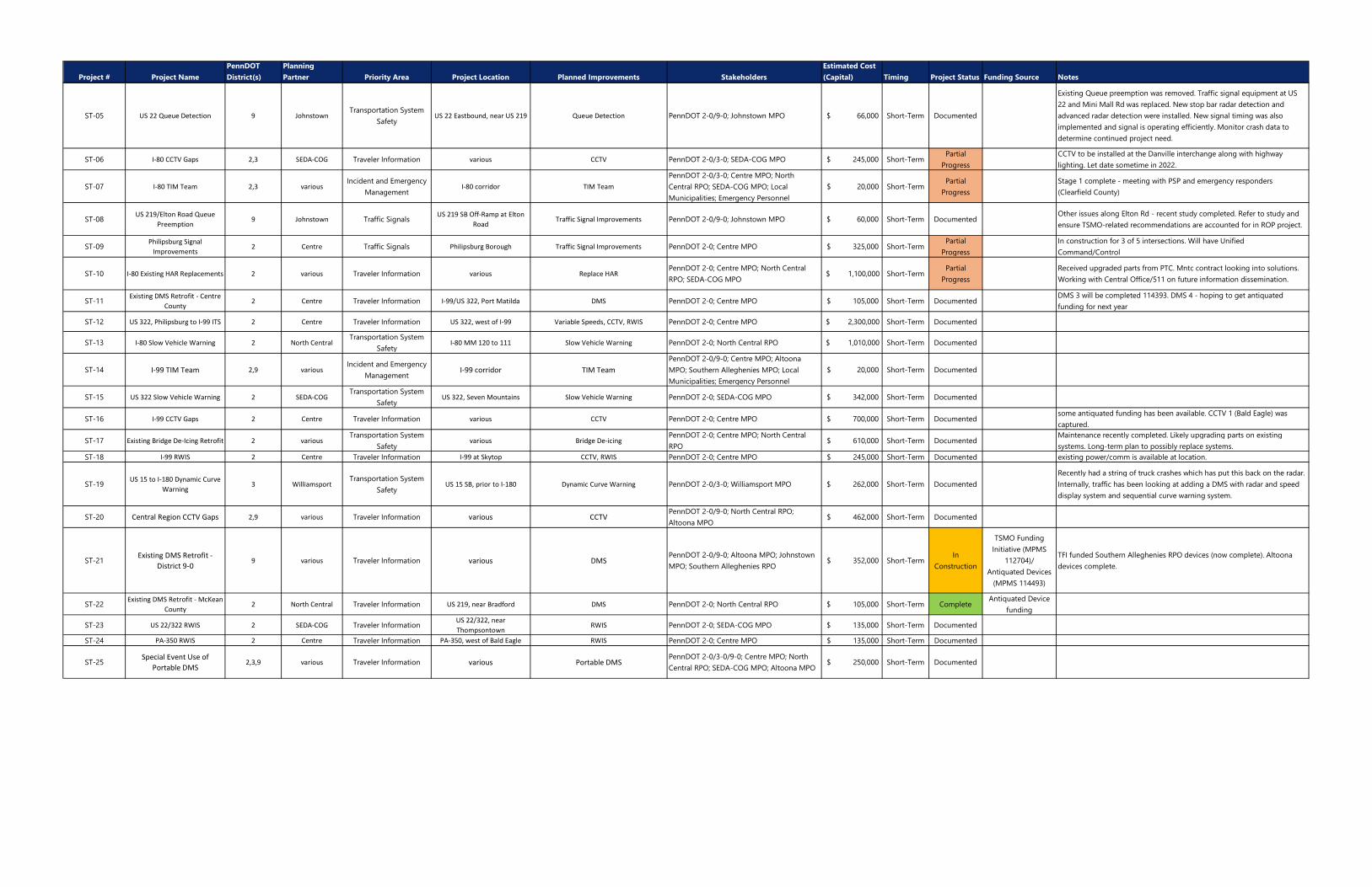
Project # Project NamePennDOT District(s)
Planning Partner Priority Area Project Location Planned Improvements Stakeholders
Estimated Cost (Capital) Timing Project Status Funding Source Notes
ST-05 US 22 Queue Detection 9 JohnstownTransportation System
SafetyUS 22 Eastbound, near US 219 Queue Detection PennDOT 2-0/9-0; Johnstown MPO $ 66,000 Short-Term Documented
Existing Queue preemption was removed. Traffic signal equipment at US 22 and Mini Mall Rd was replaced. New stop bar radar detection and advanced radar detection were installed. New signal timing was also implemented and signal is operating efficiently. Monitor crash data to determine continued project need.
ST-06 I-80 CCTV Gaps 2,3 SEDA-COG Traveler Information various CCTV PennDOT 2-0/3-0; SEDA-COG MPO $ 245,000 Short-TermPartial
ProgressCCTV to be installed at the Danville interchange along with highway lighting. Let date sometime in 2022.
ST-07 I-80 TIM Team 2,3 variousIncident and Emergency
ManagementI-80 corridor TIM Team
PennDOT 2-0/3-0; Centre MPO; North Central RPO; SEDA-COG MPO; Local Municipalities; Emergency Personnel
$ 20,000 Short-TermPartial
ProgressStage 1 complete - meeting with PSP and emergency responders (Clearfield County)
ST-08US 219/Elton Road Queue
Preemption9 Johnstown Traffic Signals
US 219 SB Off-Ramp at Elton Road
Traffic Signal Improvements PennDOT 2-0/9-0; Johnstown MPO $ 60,000 Short-Term DocumentedOther issues along Elton Rd - recent study completed. Refer to study and ensure TSMO-related recommendations are accounted for in ROP project.
ST-09Philipsburg Signal
Improvements2 Centre Traffic Signals Philipsburg Borough Traffic Signal Improvements PennDOT 2-0; Centre MPO $ 325,000 Short-Term
Partial Progress
In construction for 3 of 5 intersections. Will have Unified Command/Control
ST-10 I-80 Existing HAR Replacements 2 various Traveler Information various Replace HARPennDOT 2-0; Centre MPO; North Central RPO; SEDA-COG MPO
$ 1,100,000 Short-TermPartial
ProgressReceived upgraded parts from PTC. Mntc contract looking into solutions. Working with Central Office/511 on future information dissemination.
ST-11Existing DMS Retrofit - Centre
County2 Centre Traveler Information I-99/US 322, Port Matilda DMS PennDOT 2-0; Centre MPO $ 105,000 Short-Term Documented
DMS 3 will be completed 114393. DMS 4 - hoping to get antiquated funding for next year
ST-12 US 322, Philipsburg to I-99 ITS 2 Centre Traveler Information US 322, west of I-99 Variable Speeds, CCTV, RWIS PennDOT 2-0; Centre MPO $ 2,300,000 Short-Term Documented
ST-13 I-80 Slow Vehicle Warning 2 North CentralTransportation System
SafetyI-80 MM 120 to 111 Slow Vehicle Warning PennDOT 2-0; North Central RPO $ 1,010,000 Short-Term Documented
ST-14 I-99 TIM Team 2,9 variousIncident and Emergency
ManagementI-99 corridor TIM Team
PennDOT 2-0/9-0; Centre MPO; Altoona MPO; Southern Alleghenies MPO; Local Municipalities; Emergency Personnel
$ 20,000 Short-Term Documented
ST-15 US 322 Slow Vehicle Warning 2 SEDA-COGTransportation System
SafetyUS 322, Seven Mountains Slow Vehicle Warning PennDOT 2-0; SEDA-COG MPO $ 342,000 Short-Term Documented
ST-16 I-99 CCTV Gaps 2 Centre Traveler Information various CCTV PennDOT 2-0; Centre MPO $ 700,000 Short-Term Documentedsome antiquated funding has been available. CCTV 1 (Bald Eagle) was captured.
ST-17 Existing Bridge De-Icing Retrofit 2 variousTransportation System
Safetyvarious Bridge De-icing
PennDOT 2-0; Centre MPO; North Central RPO
$ 610,000 Short-Term DocumentedMaintenance recently completed. Likely upgrading parts on existing systems. Long-term plan to possibly replace systems.
ST-18 I-99 RWIS 2 Centre Traveler Information I-99 at Skytop CCTV, RWIS PennDOT 2-0; Centre MPO $ 245,000 Short-Term Documented existing power/comm is available at location.
ST-19US 15 to I-180 Dynamic Curve
Warning3 Williamsport
Transportation System Safety
US 15 SB, prior to I-180 Dynamic Curve Warning PennDOT 2-0/3-0; Williamsport MPO $ 262,000 Short-Term DocumentedRecently had a string of truck crashes which has put this back on the radar. Internally, traffic has been looking at adding a DMS with radar and speed display system and sequential curve warning system.
ST-20 Central Region CCTV Gaps 2,9 various Traveler Information various CCTVPennDOT 2-0/9-0; North Central RPO; Altoona MPO
$ 462,000 Short-Term Documented
ST-21Existing DMS Retrofit -
District 9-09 various Traveler Information various DMS
PennDOT 2-0/9-0; Altoona MPO; Johnstown MPO; Southern Alleghenies RPO
$ 352,000 Short-TermIn
Construction
TSMO Funding Initiative (MPMS
112704)/Antiquated Devices
(MPMS 114493)
TFI funded Southern Alleghenies RPO devices (now complete). Altoona devices complete.
ST-22Existing DMS Retrofit - McKean
County2 North Central Traveler Information US 219, near Bradford DMS PennDOT 2-0; North Central RPO $ 105,000 Short-Term Complete
Antiquated Device funding
ST-23 US 22/322 RWIS 2 SEDA-COG Traveler InformationUS 22/322, near Thompsontown
RWIS PennDOT 2-0; SEDA-COG MPO $ 135,000 Short-Term Documented
ST-24 PA-350 RWIS 2 Centre Traveler Information PA-350, west of Bald Eagle RWIS PennDOT 2-0; Centre MPO $ 135,000 Short-Term Documented
ST-25Special Event Use of
Portable DMS2,3,9 various Traveler Information various Portable DMS
PennDOT 2-0/3-0/9-0; Centre MPO; North Central RPO; SEDA-COG MPO; Altoona MPO
$ 250,000 Short-Term Documented

Regional Operations Plan (ROP)
Central RTMC Region
Updated ROP Projects
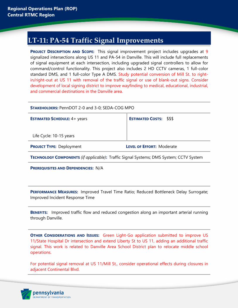
Regional Operations Plan (ROP)
Central RTMC Region
LT-11: PA-54 Traffic Signal Improvements
PROJECT DESCRIPTION AND SCOPE: This signal improvement project includes upgrades at 9
signalized intersections along US 11 and PA-54 in Danville. This will include full replacements
of signal equipment at each intersection, including upgraded signal controllers to allow for
command/control functionality. This project also includes 2 HD CCTV cameras, 1 full-color
standard DMS, and 1 full-color Type A DMS. Study potential conversion of Mill St. to right-
in/right-out at US 11 with removal of the traffic signal or use of blank-out signs. Consider
development of local signing district to improve wayfinding to medical, educational, industrial,
and commercial destinations in the Danville area.
STAKEHOLDERS: PennDOT 2-0 and 3-0; SEDA-COG MPO
ESTIMATED SCHEDULE: 4+ years
Life Cycle: 10-15 years
ESTIMATED COSTS: $$$
PROJECT TYPE: Deployment LEVEL OF EFFORT: Moderate
TECHNOLOGY COMPONENTS (if applicable): Traffic Signal Systems; DMS System; CCTV System
PREREQUISITES AND DEPENDENCIES: N/A
PERFORMANCE MEASURES: Improved Travel Time Ratio; Reduced Bottleneck Delay Surrogate;
Improved Incident Response Time
BENEFITS: Improved traffic flow and reduced congestion along an important arterial running
through Danville.
OTHER CONSIDERATIONS AND ISSUES: Green Light-Go application submitted to improve US
11/State Hospital Dr intersection and extend Liberty St to US 11, adding an additional traffic
signal. This work is related to Danville Area School District plan to relocate middle school
operations.
For potential signal removal at US 11/Mill St., consider operational effects during closures in
adjacent Continental Blvd.
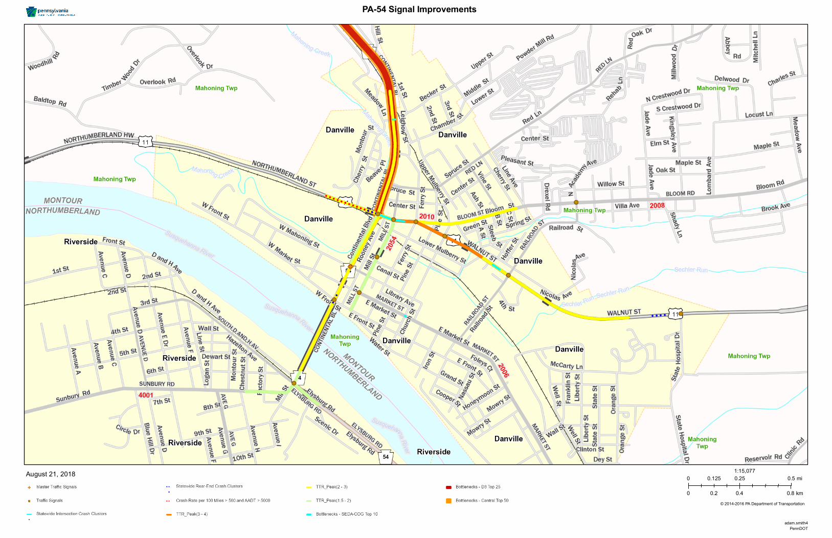
© 2014-2016 PA Department of Transportation
LegendAugust 21, 2018
PennDOTadam.smith4
0 0.25 0.50.125 mi
0 0.4 0.80.2 km
1:15,077
PA-54 Signal Improvements

Regional Operations Plan (ROP)
Central RTMC Region
New ROP Projects
Regional Operations Plan (ROP)
Central RTMC Region
IU-01: PA-150 ICM
PROJECT DESCRIPTION AND SCOPE: Upgrade traffic signal controllers as necessary in order to
allow for command/control functionality and performance measures at five intersections along
the PA-150 corridor in Benner and Spring Townships between I-99 and Bellefonte. Also consider
installation of CCTV cameras and Type A DMS, as needed.
STAKEHOLDERS: PennDOT 2-0; Centre County MPO
ESTIMATED SCHEDULE: 1-3 years
Life Cycle: 10-15 years
ESTIMATED COSTS: $$
PROJECT TYPE: Deployment LEVEL OF EFFORT: Moderate
TECHNOLOGY COMPONENTS (if applicable): CCTV System; DMS System; Traffic Signal Systems
PREREQUISITES AND DEPENDENCIES: N/A
PERFORMANCE MEASURES: Improved Travel Time Ratio; Reduced Bottleneck Delay Surrogate;
Reduced Rear End Crash Rate
BENEFITS: Improved traffic flow and reduced congestion along an important signalized corridor
within the region.
OTHER CONSIDERATIONS AND ISSUES: Considerable development activity, including retail and
housing, has occurred along the PA-150 corridor. Multiple traffic impact studies have been
completed for commercial and residential developments in the corridor. Traffic volume and
congestion levels are expected to increase and impact traffic signal operations.
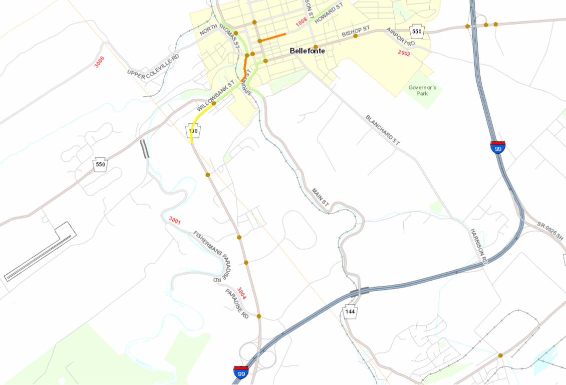
Regional Operations Plan (ROP)
Central RTMC Region
IU-02: College Twp. Signal Improvements
PROJECT DESCRIPTION AND SCOPE: Upgrade traffic signal controllers as necessary in order to
allow for command/control functionality and performance measures along the PA-26 and PA-
150 corridors in College Township (11 intersections). Consider installation of ramp preemption
at the PA-26 interchange with US 322. Also consider installation of CCTV cameras and Type A
DMS, as needed.
STAKEHOLDERS: PennDOT 2-0; Centre County MPO
ESTIMATED SCHEDULE: 1-3 years
Life Cycle: 10-15 years
ESTIMATED COSTS: $$
PROJECT TYPE: Deployment LEVEL OF EFFORT: Moderate
TECHNOLOGY COMPONENTS (if applicable): CCTV System; DMS System; Traffic Signal Systems
PREREQUISITES AND DEPENDENCIES: N/A
PERFORMANCE MEASURES: Improved Travel Time Ratio; Reduced Bottleneck Delay Surrogate;
Reduced Rear End Crash Rate
BENEFITS: Improved traffic flow and reduced congestion along an important signalized corridor
within the region.
OTHER CONSIDERATIONS AND ISSUES: Considerable development activity has occurred along the
PA-26 corridor. Traffic volume and congestion levels are expected to increase and impact traffic
signal operations. Large casino development planned for former mall site in 2022.
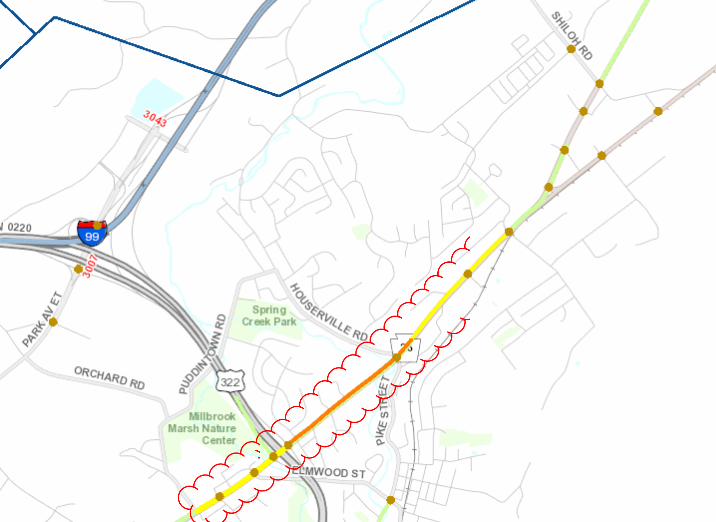
Regional Operations Plan (ROP)
Central RTMC Region
IU-03: DuBois Fiber Deployment
PROJECT DESCRIPTION AND SCOPE: Installation of fiber optic backbone along the US 219/PA-255
corridors through the DuBois area.
STAKEHOLDERS: PennDOT 2-0; North Central RPO
ESTIMATED SCHEDULE: 4+ years
Life Cycle: 10-15 years
ESTIMATED COSTS: $$$
PROJECT TYPE: Deployment LEVEL OF EFFORT: Complex
TECHNOLOGY COMPONENTS (if applicable): Communications Infrastructure
PREREQUISITES AND DEPENDENCIES: Project LT-03 is currently under design and will install ITS
and signal improvements along these corridors. Project should also be coordinated with LT-02
(I-80/I-99 Fiber Backbone) as this project would install fiber west along I-80 to DuBois.
PERFORMANCE MEASURES: Number of Miles of Installed Fiber Optic Cable
BENEFITS: A fiber optic backbone along this key corridor would increase connectivity and
greatly increase the ability of the Department to expand their deployment of ITS, connected
vehicles, and other emerging transportation technology.
OTHER CONSIDERATIONS AND ISSUES: N/A
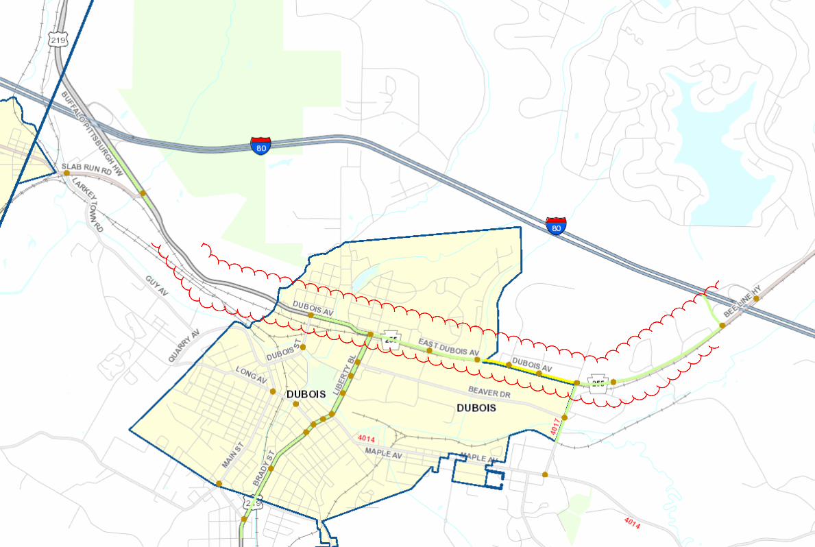

Regional Operations Plan (ROP)
Central RTMC Region
IU-04: I-80 VSL Pilot
PROJECT DESCRIPTION AND SCOPE: Install Variable Speed Displays along I-80 between Mile
Markers 111-120. This would serve as a pilot for further Variable Speed deployment along the
I-80 corridor.
STAKEHOLDERS: PennDOT 2-0; North Central RPO
ESTIMATED SCHEDULE: 4+ years
Life Cycle: 10-15 years
ESTIMATED COSTS: $$$
PROJECT TYPE: Deployment LEVEL OF EFFORT: Moderate
TECHNOLOGY COMPONENTS (if applicable): Variable Speed Limit System
PREREQUISITES AND DEPENDENCIES: N/A
PERFORMANCE MEASURES: Improved Travel Time Ratio; Reduced Rear End Crash Rate
BENEFITS: Improved traffic flow and reduced congestion along an important interstate corridor
within the region.
OTHER CONSIDERATIONS AND ISSUES: N/A
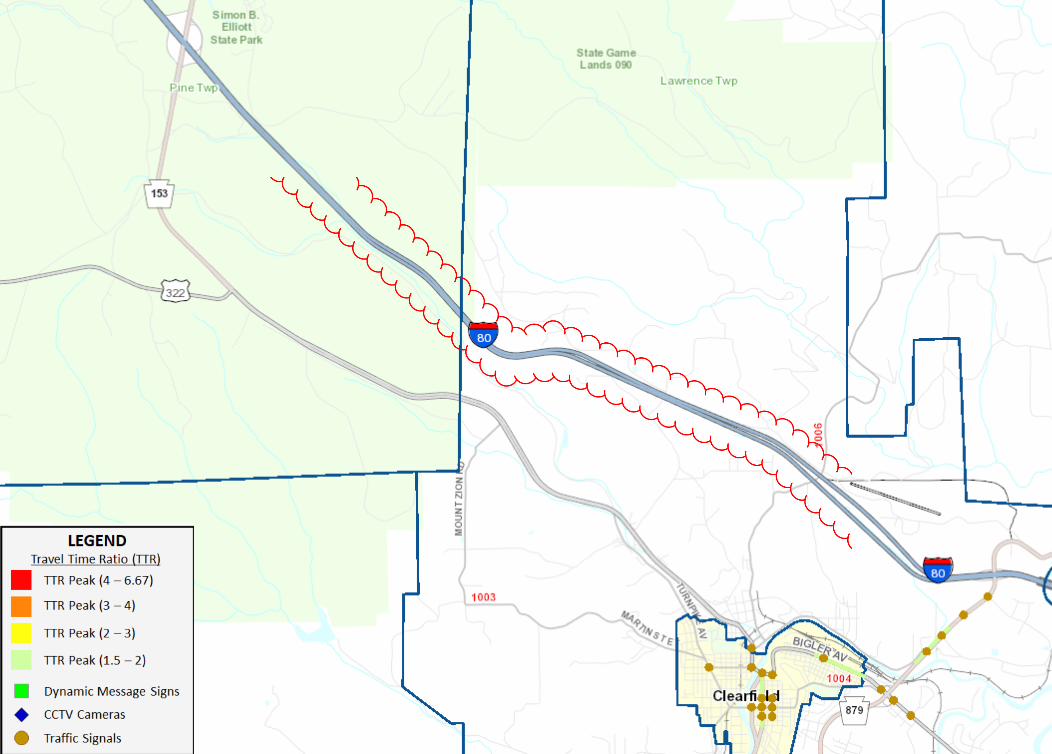

Regional Operations Plan (ROP)
Central RTMC Region
IU-05: North Central ITS
PROJECT DESCRIPTION AND SCOPE: Install/upgrade the following ITS devices in the North Central
RPO region:
• Install CCTV camera on PA-153 at Boone Mountain
• Install CCTV camera at Lantz Corners (US 219/US 6 intersection)
• Install CCTV cameras and possible DMS at PA-255/PA-153 intersection
• Install DMS on US 322 westbound approaching US 219 (prior to Shaffer Rd)
• Upgrade existing RWIS at I-80 MM 111 to include grit factor measurement capability
STAKEHOLDERS: PennDOT 2-0; North Central RPO
ESTIMATED SCHEDULE: 1-3 years
Life Cycle: 10-15 years
ESTIMATED COSTS: $$
PROJECT TYPE: Deployment LEVEL OF EFFORT: Moderate
TECHNOLOGY COMPONENTS (if applicable): CCTV System; DMS System; RWIS System
PREREQUISITES AND DEPENDENCIES: N/A
PERFORMANCE MEASURES: Improved Incident Response Time; Improved Travel Time Ratio
BENEFITS: Fill in gaps in camera coverage and traveler information to improve incident response
and congestion monitoring from the RTMC at key locations in the North Central region.
OTHER CONSIDERATIONS AND ISSUES: N/A
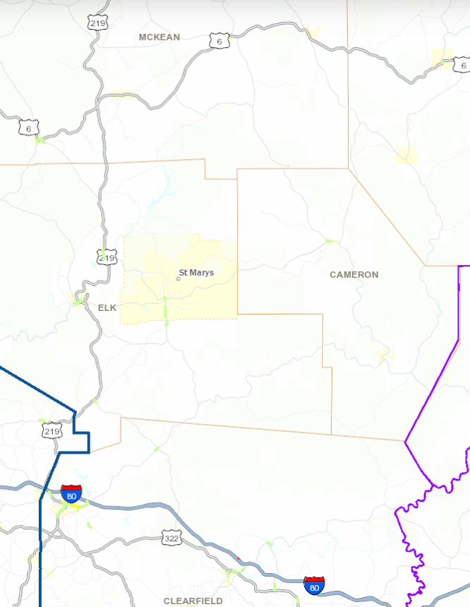
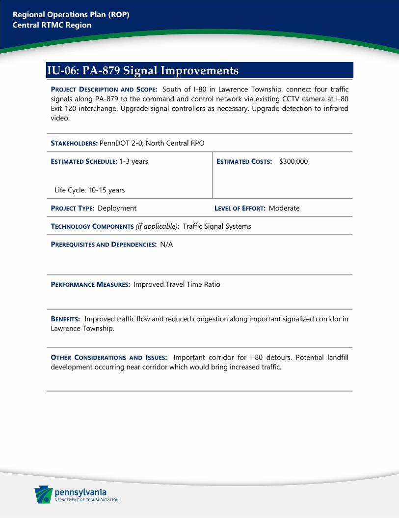
Regional Operations Plan (ROP) Central RTMC Region
IU-06: PA-879 Signal Improvements PROJECT DESCRIPTION AND SCOPE: South of I-80 in Lawrence Township, connect four traffic signals along PA-879 to the command and control network via existing CCTV camera at I-80 Exit 120 interchange. Upgrade signal controllers as necessary. Upgrade detection to infrared video.
STAKEHOLDERS: PennDOT 2-0; North Central RPO
ESTIMATED SCHEDULE: 1-3 years Life Cycle: 10-15 years
ESTIMATED COSTS: $300,000
PROJECT TYPE: Deployment LEVEL OF EFFORT: Moderate
TECHNOLOGY COMPONENTS (if applicable): Traffic Signal Systems
PREREQUISITES AND DEPENDENCIES: N/A
PERFORMANCE MEASURES: Improved Travel Time Ratio
BENEFITS: Improved traffic flow and reduced congestion along important signalized corridor in Lawrence Township.
OTHER CONSIDERATIONS AND ISSUES: Important corridor for I-80 detours. Potential landfill development occurring near corridor which would bring increased traffic.
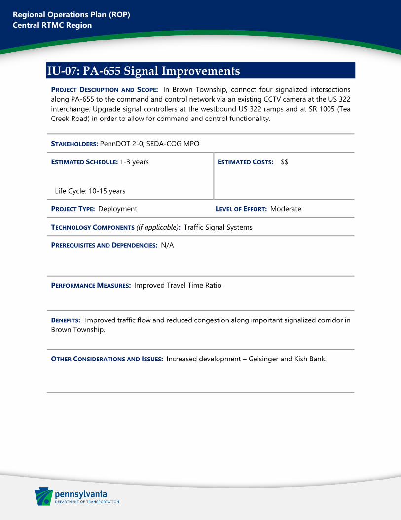
Regional Operations Plan (ROP)
Central RTMC Region
IU-07: PA-655 Signal Improvements
PROJECT DESCRIPTION AND SCOPE: In Brown Township, connect four signalized intersections
along PA-655 to the command and control network via an existing CCTV camera at the US 322
interchange. Upgrade signal controllers at the westbound US 322 ramps and at SR 1005 (Tea
Creek Road) in order to allow for command and control functionality.
STAKEHOLDERS: PennDOT 2-0; SEDA-COG MPO
ESTIMATED SCHEDULE: 1-3 years
Life Cycle: 10-15 years
ESTIMATED COSTS: $$
PROJECT TYPE: Deployment LEVEL OF EFFORT: Moderate
TECHNOLOGY COMPONENTS (if applicable): Traffic Signal Systems
PREREQUISITES AND DEPENDENCIES: N/A
PERFORMANCE MEASURES: Improved Travel Time Ratio
BENEFITS: Improved traffic flow and reduced congestion along important signalized corridor in
Brown Township.
OTHER CONSIDERATIONS AND ISSUES: Increased development – Geisinger and Kish Bank.
Regional Operations Plan (ROP)
Central RTMC Region
IU-08: US 220 Corridor ITS
PROJECT DESCRIPTION AND SCOPE: Install CCTV cameras and Type A DMS along US 220 corridor,
north and south of Mill Hall. CCTV cameras should be mounted onto the DMS.
STAKEHOLDERS: PennDOT 2-0; SEDA-COG MPO
ESTIMATED SCHEDULE: 1-3 years
Life Cycle: 10-15 years
ESTIMATED COSTS: $$
PROJECT TYPE: Deployment LEVEL OF EFFORT: Moderate
TECHNOLOGY COMPONENTS (if applicable): CCTV System; DMS System
PREREQUISITES AND DEPENDENCIES: N/A
PERFORMANCE MEASURES: Improved Incident Response Time; Improved Travel Time Ratio
BENEFITS: Fill in gaps in camera coverage and traveler information to improve incident response
and congestion monitoring from the RTMC at key locations on the US 220 corridor.
OTHER CONSIDERATIONS AND ISSUES: N/A
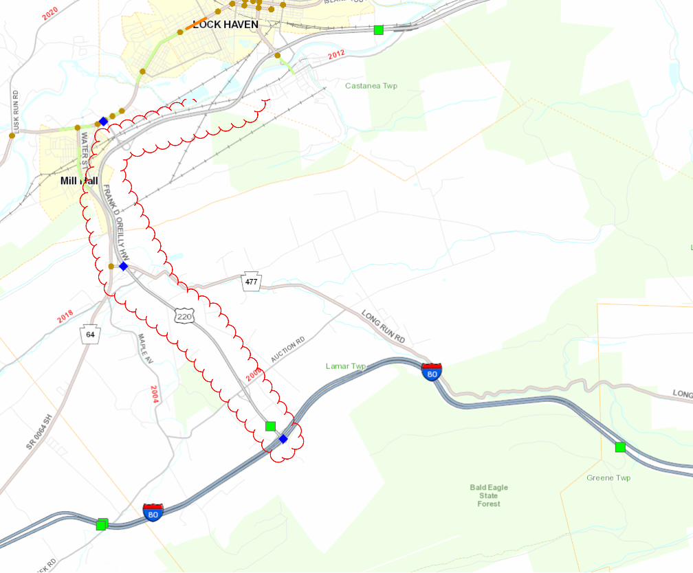

Regional Operations Plan (ROP)
Central RTMC Region
IU-09: US 15 Corridor ITS
PROJECT DESCRIPTION AND SCOPE: Install CCTV cameras and Dynamic Message Signs at key
locations along the US 15 corridor, between US 6 and Williamsport.
STAKEHOLDERS: PennDOT 3-0; Northern Tier RPO
ESTIMATED SCHEDULE: 1-3 years
Life Cycle: 10-15 years
ESTIMATED COSTS: $$
PROJECT TYPE: Deployment LEVEL OF EFFORT: Moderate
TECHNOLOGY COMPONENTS (if applicable): CCTV System; DMS System
PREREQUISITES AND DEPENDENCIES: N/A
PERFORMANCE MEASURES: Improved Incident Response Time; Improved Travel Time Ratio
BENEFITS: Fill in gaps in camera coverage and traveler information to improve incident response
and congestion monitoring from the RTMC at key locations on the US 15 corridor.
OTHER CONSIDERATIONS AND ISSUES: N/A
Regional Operations Plan (ROP)
Central RTMC Region
IU-10: CSVT Signal Improvements
PROJECT DESCRIPTION AND SCOPE: Evaluate traffic signal operations along two corridors and
complete retiming if necessary:
• US 15 – Smoketown Road/Moore Avenue to Ziegler Road (Lewisburg)
• US 11 – Duke Street to King Street (Northumberland)
STAKEHOLDERS: PennDOT 3-0; SEDA-COG MPO
ESTIMATED SCHEDULE: 1-3 years
Life Cycle: 10-15 years
ESTIMATED COSTS: $
PROJECT TYPE: Deployment LEVEL OF EFFORT: Moderate
TECHNOLOGY COMPONENTS (if applicable): Traffic Signal Systems
PREREQUISITES AND DEPENDENCIES: N/A
PERFORMANCE MEASURES: Improved Travel Time Ratio
BENEFITS: Improved traffic flow and reduced congestion along important signalized corridors
in the region. Mitigate potential effects of ongoing CSVT construction project.
OTHER CONSIDERATIONS AND ISSUES: N/A
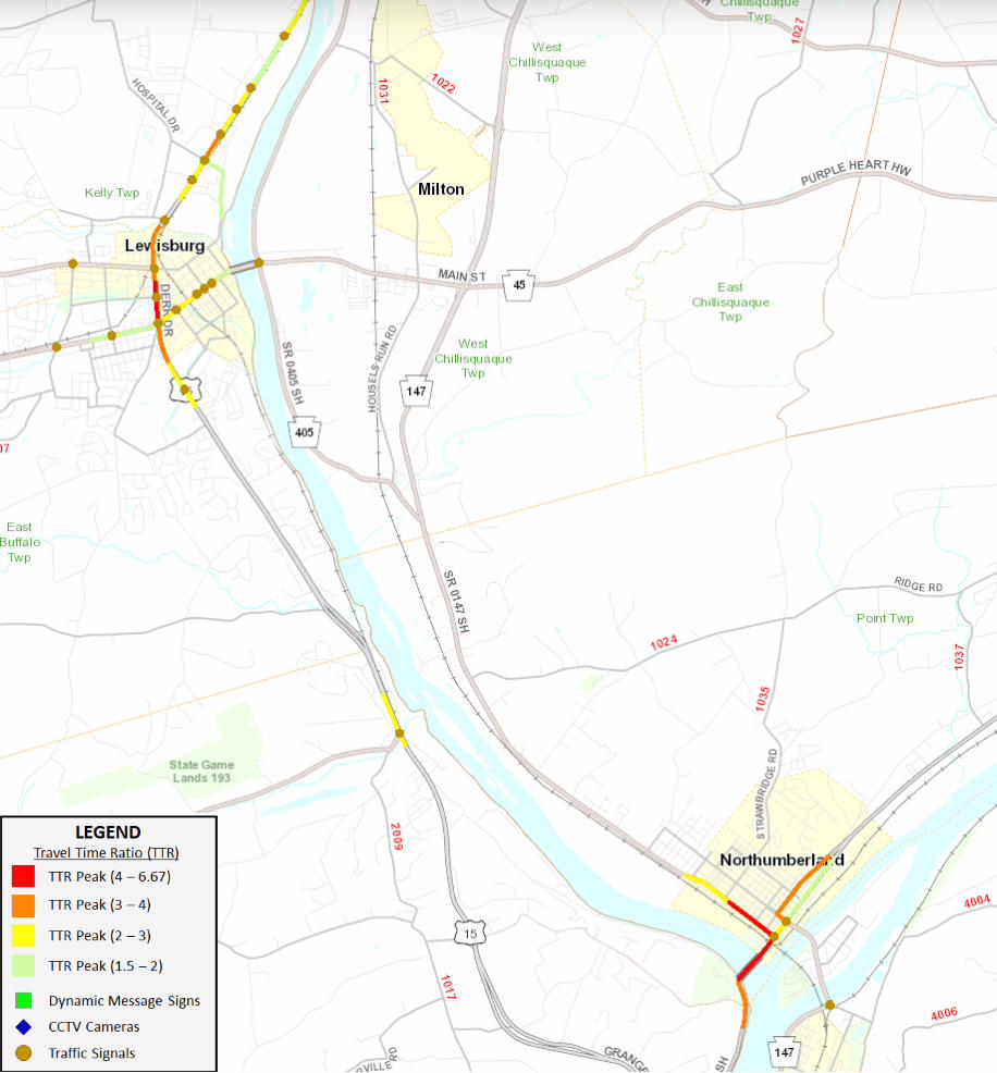
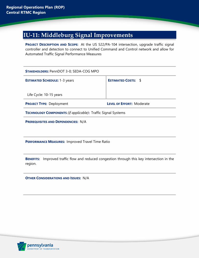
Regional Operations Plan (ROP)
Central RTMC Region
IU-11: Middleburg Signal Improvements
PROJECT DESCRIPTION AND SCOPE: At the US 522/PA-104 intersection, upgrade traffic signal
controller and detection to connect to Unified Command and Control network and allow for
Automated Traffic Signal Performance Measures
STAKEHOLDERS: PennDOT 3-0; SEDA-COG MPO
ESTIMATED SCHEDULE: 1-3 years
Life Cycle: 10-15 years
ESTIMATED COSTS: $
PROJECT TYPE: Deployment LEVEL OF EFFORT: Moderate
TECHNOLOGY COMPONENTS (if applicable): Traffic Signal Systems
PREREQUISITES AND DEPENDENCIES: N/A
PERFORMANCE MEASURES: Improved Travel Time Ratio
BENEFITS: Improved traffic flow and reduced congestion through this key intersection in the
region.
OTHER CONSIDERATIONS AND ISSUES: N/A
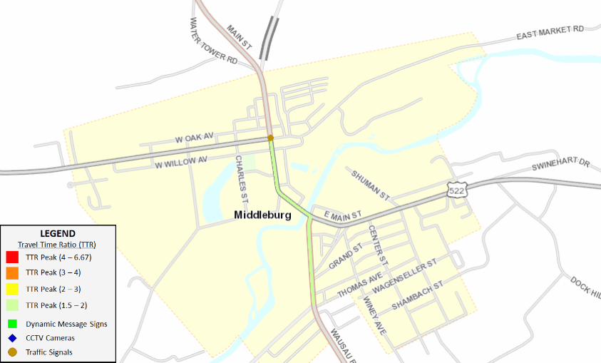
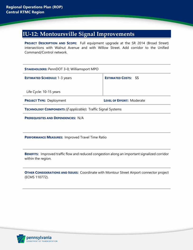
Regional Operations Plan (ROP)
Central RTMC Region
IU-12: Montoursville Signal Improvements
PROJECT DESCRIPTION AND SCOPE: Full equipment upgrade at the SR 2014 (Broad Street)
intersections with Walnut Avenue and with Willow Street. Add corridor to the Unified
Command/Control network.
STAKEHOLDERS: PennDOT 3-0; Williamsport MPO
ESTIMATED SCHEDULE: 1-3 years
Life Cycle: 10-15 years
ESTIMATED COSTS: $$
PROJECT TYPE: Deployment LEVEL OF EFFORT: Moderate
TECHNOLOGY COMPONENTS (if applicable): Traffic Signal Systems
PREREQUISITES AND DEPENDENCIES: N/A
PERFORMANCE MEASURES: Improved Travel Time Ratio
BENEFITS: Improved traffic flow and reduced congestion along an important signalized corridor
within the region.
OTHER CONSIDERATIONS AND ISSUES: Coordinate with Montour Street Airport connector project
(ECMS 110772).
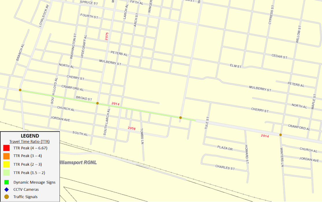
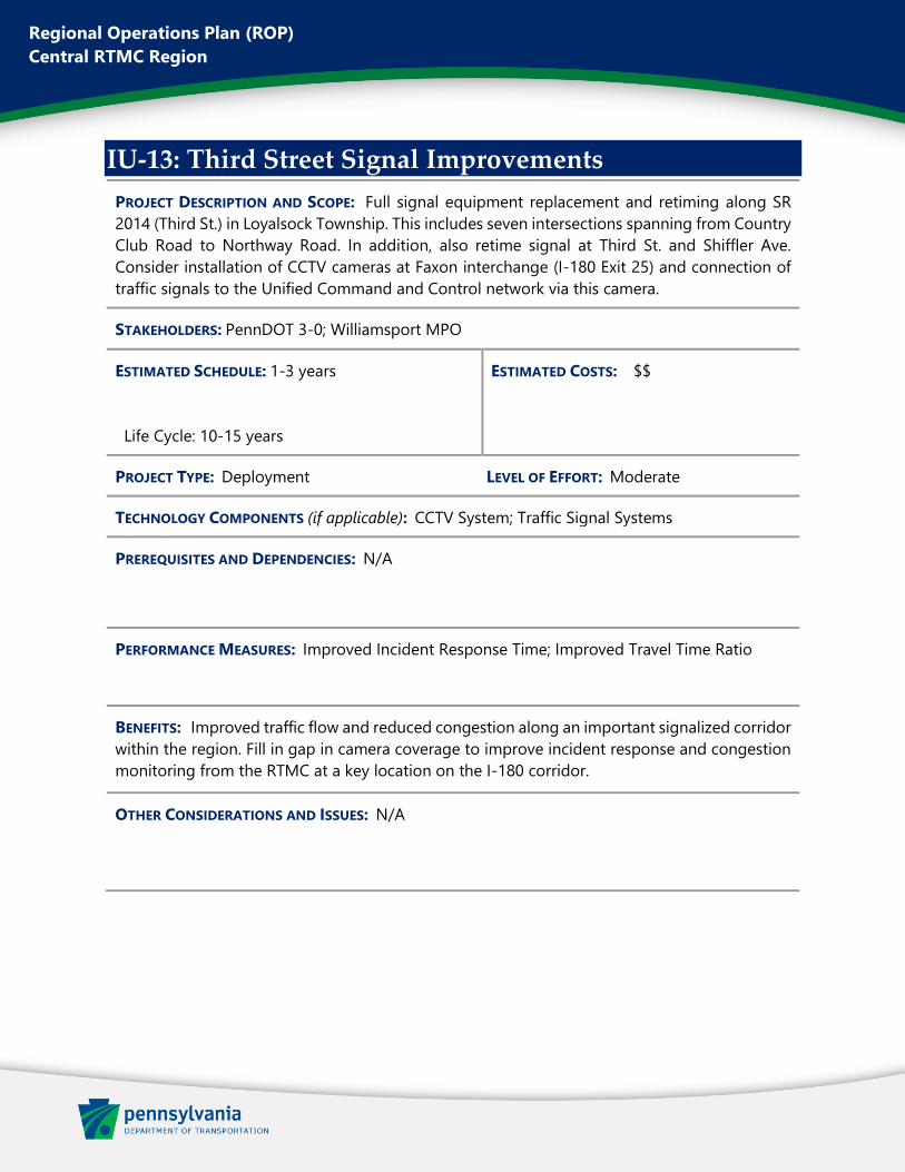
Regional Operations Plan (ROP)
Central RTMC Region
IU-13: Third Street Signal Improvements
PROJECT DESCRIPTION AND SCOPE: Full signal equipment replacement and retiming along SR
2014 (Third St.) in Loyalsock Township. This includes seven intersections spanning from Country
Club Road to Northway Road. In addition, also retime signal at Third St. and Shiffler Ave.
Consider installation of CCTV cameras at Faxon interchange (I-180 Exit 25) and connection of
traffic signals to the Unified Command and Control network via this camera.
STAKEHOLDERS: PennDOT 3-0; Williamsport MPO
ESTIMATED SCHEDULE: 1-3 years
Life Cycle: 10-15 years
ESTIMATED COSTS: $$
PROJECT TYPE: Deployment LEVEL OF EFFORT: Moderate
TECHNOLOGY COMPONENTS (if applicable): CCTV System; Traffic Signal Systems
PREREQUISITES AND DEPENDENCIES: N/A
PERFORMANCE MEASURES: Improved Incident Response Time; Improved Travel Time Ratio
BENEFITS: Improved traffic flow and reduced congestion along an important signalized corridor
within the region. Fill in gap in camera coverage to improve incident response and congestion
monitoring from the RTMC at a key location on the I-180 corridor.
OTHER CONSIDERATIONS AND ISSUES: N/A
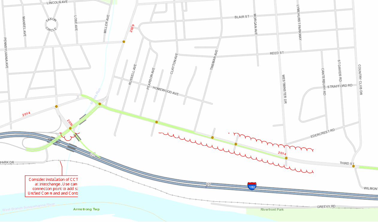
Regional Operations Plan (ROP)
Central RTMC Region
IU-14: I-70 Curve Warning
PROJECT DESCRIPTION AND SCOPE: Install Dynamic Curve Warning systems at the following noted
curved road problem areas along I-70:
• Westbound at PA-643 overpass (Exit 156)
• Eastbound before and after PA-915 interchange (Exit 151)
Curve warning alerts will be broadcast via Dynamic Message Signs installed upstream of the
curve locations.
STAKEHOLDERS: PennDOT 9-0; Southern Alleghenies RPO
ESTIMATED SCHEDULE: 1-3 years
Life Cycle: 10-15 years
ESTIMATED COSTS: $
PROJECT TYPE: Deployment LEVEL OF EFFORT: Moderate
TECHNOLOGY COMPONENTS (if applicable): Dynamic Curve Warning System; DMS System
PREREQUISITES AND DEPENDENCIES: N/A
PERFORMANCE MEASURES: Reduced Curved Road Crashes
BENEFITS: Reduce crashes, particularly at high speeds, in the area of some of the most
dangerous curves on the I-70 corridor.
OTHER CONSIDERATIONS AND ISSUES: N/A
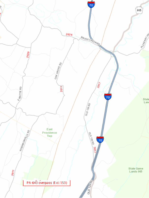
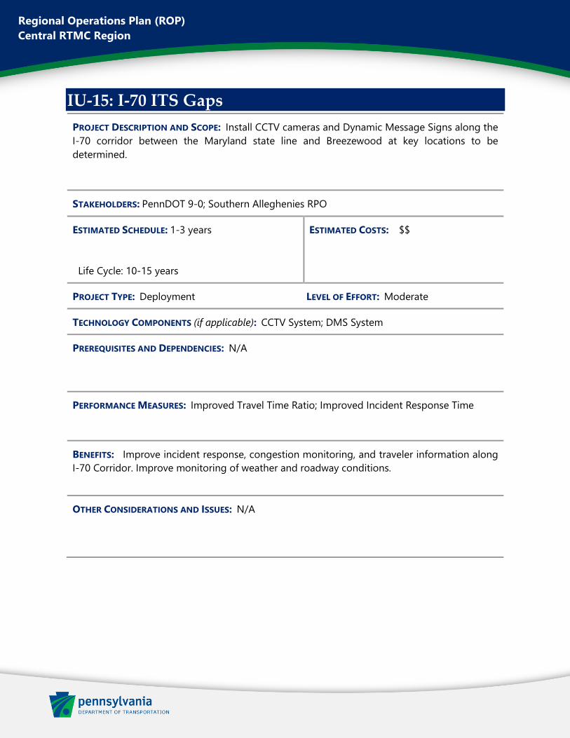
Regional Operations Plan (ROP)
Central RTMC Region
IU-15: I-70 ITS Gaps
PROJECT DESCRIPTION AND SCOPE: Install CCTV cameras and Dynamic Message Signs along the
I-70 corridor between the Maryland state line and Breezewood at key locations to be
determined.
STAKEHOLDERS: PennDOT 9-0; Southern Alleghenies RPO
ESTIMATED SCHEDULE: 1-3 years
Life Cycle: 10-15 years
ESTIMATED COSTS: $$
PROJECT TYPE: Deployment LEVEL OF EFFORT: Moderate
TECHNOLOGY COMPONENTS (if applicable): CCTV System; DMS System
PREREQUISITES AND DEPENDENCIES: N/A
PERFORMANCE MEASURES: Improved Travel Time Ratio; Improved Incident Response Time
BENEFITS: Improve incident response, congestion monitoring, and traveler information along
I-70 Corridor. Improve monitoring of weather and roadway conditions.
OTHER CONSIDERATIONS AND ISSUES: N/A
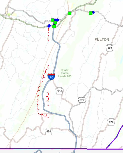
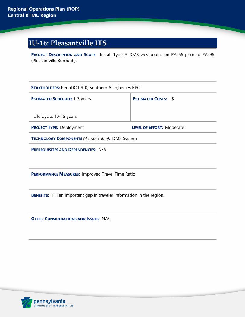
Regional Operations Plan (ROP)
Central RTMC Region
IU-16: Pleasantville ITS
PROJECT DESCRIPTION AND SCOPE: Install Type A DMS westbound on PA-56 prior to PA-96
(Pleasantville Borough).
STAKEHOLDERS: PennDOT 9-0; Southern Alleghenies RPO
ESTIMATED SCHEDULE: 1-3 years
Life Cycle: 10-15 years
ESTIMATED COSTS: $
PROJECT TYPE: Deployment LEVEL OF EFFORT: Moderate
TECHNOLOGY COMPONENTS (if applicable): DMS System
PREREQUISITES AND DEPENDENCIES: N/A
PERFORMANCE MEASURES: Improved Travel Time Ratio
BENEFITS: Fill an important gap in traveler information in the region.
OTHER CONSIDERATIONS AND ISSUES: N/A