50 years bgr an activity report
TRANSCRIPT
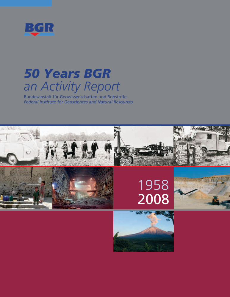
50 Years BGRan Activity Report
50
Years
BG
R
Bundesanstalt für Geowissenschaften und RohstoffeFederal Institute for Geosciences and Natural Resources
bgr.bund.de
19582008
Bund
esan
stal
tfü
rG
eow
isse
nsch
afte
nun
dRo
hsto
ffe
ISSN 0343-8147
FI (J6>7IJ$A$?) <7J.7IJ$AV#A#+ 80=#G$76A' +)5,7<&3F.6>EI#9 !J$+O E69V#A#+ H2/?.+; H11 I#9 (JV7+97+VV+C7AA>),2>9>"=>BD>E5<1&
<7J.7IJ$AN 6A. E69$JV7+97+VV+ K:;JT JA. I69 97?> !J$+
!
<7J.7IJ$AV#A#+ K :;JT V#A+ 80
D+VV+
"J99+V
E+;V#A
@+#A+
1$
<67+V97;J&+
%T(+#.XJT
>+B6V+AXJT>
5+#.+7?;NX;+#9+V
F" (JAALNE6G$$?VP
F< (JAALN!J$+
F< FV73J;TNI0G$+A
F<E6;'.)L
F"(JAA?4+;NS97
+-:/+?*$(@%;#'
<7#VV+3+'
<LN(+.#AN<7;J&+
*=S<<NE8D((S!R
W%<E8=*
F!:5F=WE-D(BU
!F(B
CM$;+A
-76>
H2/
,V6'$J)+A(JAA?4+;N!JA'+A$J'+A
1+
1*$
0*
(JTI6;'C?;7T6A.
(JAAL W#77+6A. (I)L
<7;J&+
@?.I#+
V9X#N
97;J&+
(JAA?4+;
0%'
*;?&NE6G$$?VP+
; <7;J&+"
V#A'+;97;L
<G$#+;$
?VPN
97;J&+
=?.+;I;6G$97;J&+
E6;'.?;)
F"(JAALN"#;G$$?;97
F< (JAALNFA.+;7+A
W((
FUCB=:BU
U(J
AAL
E6G$$?VP+; <7;L
(M4+;9G$+
<7;L
7!,,&64
653)4
85356
!
4
/-).2"3&66(&#
7&..&4 .2"3
&664
(&#
@J97+
6 ; N
JV V++
*;?&NE
6G$$L "#;G$3+'
C7AA>),2>9>"C7AA>),2>9>"C7AA>),2>9>"=>BD>E5<1&=>BD>E5<1&=>BD>E5<1&
80
80
FV);+.NFV);+.NFV);+.NE+A7PN(J69E+A7PN(J69E+A7PN(J69
H11
H11
F< (JAALNF< (JAALNF< (JAALNW#9I6;'W#9I6;'W#9I6;'
$#!
%$%
"%
H2/
H2/ H11
,;?T TJ#A ;J#V3JQ 97J7#?AO 7JX+ 7;JT A?L 80.#;+G7#?A +)5,7<&3F.6>E7? !J$+O JA. 7$+A I69 H2/ ?; H11OI69 97?>C7AA>),2>9>"=>BD>E5<1&
E69$JV7+97+VV+ K E69 97?>@J>>+V3#+9+K*+?P+A7;6T
4
E69V#A#+ K E69 V#A+
… you canfind us here
50 years
an Activity Report by the
Bundesanstalt für Geowissenschaften und RohstoffeFederal Institute for Geosciences and Natural Resources
Hanover,March 2009
1958 -
1999so001d_001_020.indd 11999so001d_001_020.indd 1 16.06.2009 09:10:1116.06.2009 09:10:11
This Activity Report is free and can be obtained from:
Bundesanstalt für Geowissenschaften und RohstoffeReferat Z.8 Öffentlichkeitsarbeit, Schriftenpublikationen
Stilleweg 2, 30655 Hannover
Phone (0511) 643 – 22 49Fax (0511) 643 – 23 04E-Mail [email protected]
Internet http: // www.bgr.bund.de
Info
1999so001d_001_020.indd 21999so001d_001_020.indd 2 16.06.2009 09:10:1416.06.2009 09:10:14
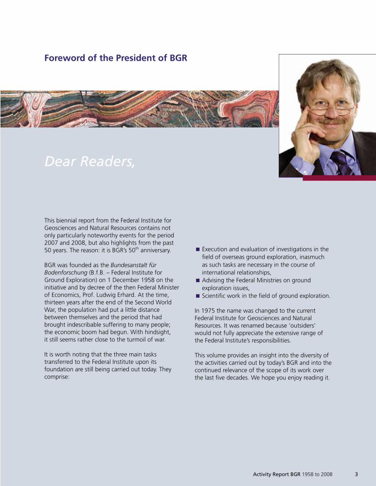
This biennial report from the Federal Institute forGeosciences and Natural Resources contains notonly particularly noteworthy events for the period2007 and 2008, but also highlights from the past50 years. The reason: it is BGR’s 50th anniversary.
BGR was founded as the Bundesanstalt fürBodenforschung (B.f.B. – Federal Institute forGround Exploration) on 1 December 1958 on theinitiative and by decree of the then Federal Ministerof Economics, Prof. Ludwig Erhard. At the time,thirteen years after the end of the Second WorldWar, the population had put a little distancebetween themselves and the period that hadbrought indescribable suffering to many people;the economic boom had begun. With hindsight,it still seems rather close to the turmoil of war.
It is worth noting that the three main taskstransferred to the Federal Institute upon itsfoundation are still being carried out today. Theycomprise:
Dear Readers,
Foreword of the President of BGR
Execution and evaluation of investigations in theÈ
field of overseas ground exploration, inasmuchas such tasks are necessary in the course ofinternational relationships,Advising the Federal Ministries on groundÈ
exploration issues,Scientific work in the field of ground exploration.È
In 1975 the name was changed to the currentFederal Institute for Geosciences and NaturalResources. It was renamed because ‘outsiders’would not fully appreciate the extensive range ofthe Federal Institute’s responsibilities.
This volume provides an insight into the diversity ofthe activities carried out by today’s BGR and into thecontinued relevance of the scope of its work overthe last five decades. We hope you enjoy reading it.
Activity Report BGR 1958 to 2008 3
1999so001d_001_020.indd 31999so001d_001_020.indd 3 16.06.2009 09:10:1416.06.2009 09:10:14
My thanks go to the Federal Minister of Economicsand Technology Michael Glos, President LotharLohff, Director Prof. Ugur Yaramanci and thechairman of the BGR board of trustees Prof. Kurt M.Reinicke, for their opening words, and in additionto everybody involved in making this volumepossible. I would also like to thank all former andcurrent BGR staff, whose excellent work over thepast 50 years has made the BGR what it is today:the federal government’s geoscientific centre ofexcellence for energy resources, mineral resources,groundwater, soil and the underground space forstorage and economic use.
It is a happy coincidence that BGR can celebrate itsjubilee in the core year of the International Year ofPlanet Earth (IYPE), as proclaimed by UNESCO. Youwill therefore find the IYPE logo at a prominentplace in this volume.
If you have any questions about what we do –perhaps as a result of reading this report – or aboutthe projects detailed here, please call me or send mean email.
Yours
Prof. Dr. Hans-Joachim KümpelBGR President
4 Activity Report BGR 1958 to 2008
1999so001d_001_020.indd 41999so001d_001_020.indd 4 16.06.2009 09:10:1616.06.2009 09:10:16
Introductions
9 .......... The Federal Minister of Economics and Technology
11 .......... The President of the LBEG
12 .......... The Director of the GGA Institute
13 .......... The Chairman of the BGR Board of Trustees
15 .......... The BGR – looking ahead
19 .......... Board of Trustees
Natural Resources
Energy Resources
22 .......... 50 Years of Energy Resources
26 .......... Research for the estimation of the Hydrocarbon Potentialof Siberia’s Marginal Arctic Seas
29 .......... Mine Gas Methane – Hazard or Energy Source?
Contents
Activity Report BGR 1958 to 2008 5
1999so001d_001_020.indd 51999so001d_001_020.indd 5 16.06.2009 09:10:1616.06.2009 09:10:16
Mineral Resources
33 .......... 50 Years of Mineral Resources
38 .......... Certification of Mineral Resources
42 .......... Mine Waste Heaps – Potentials and Risks
Georesource Water
49 .......... 50 Years Groundwater Sector in BGR
54 .......... Guaraní Aquifer Systems (SAG) – Sustainable Use of theTransboundary Groundwater Resource
57 .......... Drinking Water for Zambia’s Southern Province
Georesource Soil
64 .......... 50 Years Soil Sector in BGR
69 .......... Organic Matter Content in Top Soils in Germany
72 .......... Groundwater Protection Begins with Soil Protection:Background Concentrations of Trace Elements in Percolation Water
Contents
6 Activity Report BGR 1958 to 2008
1999so001d_001_020.indd 61999so001d_001_020.indd 6 16.06.2009 09:10:1816.06.2009 09:10:18
Geosafety
Geotechnical Stability/Final Disposal
76 .......... The Discovery of Slowness: Why Does Salt Creep?Salt Mechanics – Birth and Development of a NewField of Research
82 .......... Three-dimensional Geological and Geomechanical Modellingof the Morsleben Final Repository (ERAM)
85 .......... The BGR ‘Clay Report’ – a Media-Highlight
Geological Hazards
90 .......... Geological Hazards: Overview
98 .......... Cliff recession affecting the Island Rügen:A Contribution to the behaviour of coastal landslide systems and geohazard assessment
104 ........ ’Mitigation of Geo Risks in Central America’ Project
Seismological Research/Comprehensive Nuclear-Test-Ban Treaty
110 ........ Seismic Monitoring and Earthquake Research at BGR
114 ........ The Vogtland/NW Bohemia Earthquake Swarm Region
116 ........ Verification of a Nuclear Test in North Korea
Climate Change
120 ........ Can Geoscientists Contribute to Understanding Climate Change?
Activity Report BGR 1958 to 2008 7
1999so001d_001_020.indd 71999so001d_001_020.indd 7 16.06.2009 09:10:2416.06.2009 09:10:24
Interdisciplinary Tasks
Geological Fundamentals
126 ........ What do Maps, Thematic Geoscientific Information Systemsand Expeditions Have in Common?
132 ........ Environmental Geodata – the New EU INSPIRE Directive
134 ........ ‘CASE 10’ Arctic Expedition to Spitsbergen
Geoscientific Cooperation
140 ........ 50 Years of BGR Means 50 Years of Technical Cooperation
145 ........ Conference on Transparency in the Resources Sector, World Water Weekin Stockholm, United Nations Convention on the Law of the Sea
Technical Infrastructure
148 ........ 50 years Technical Infrastructure
155 ........ Geosciences for Society
159 ........ Use of New Satellite Methods for Monitoring Land Subsidenceon Java, Indonesia
Appendix
166 ......... The Presidents
168 ......... References
Contents
8 Activity Report BGR 1958 to 2008
1999so001d_001_020.indd 81999so001d_001_020.indd 8 16.06.2009 09:10:3116.06.2009 09:10:31
The BGR will soon be celebrating a milestonebirthday. This is of course a fitting reason forcongratulations, but also provides an opportunityto look back at the past and forwards to the future.It was fifty years ago, on 26 November 1958, thatLudwig Erhard, the first Federal Minister ofEconomics, established the BGR by decree as thefederal government’s central geoscientific advisorybody. In terms of a human lifetime, 50 years is afairly long period of time, but one that we cancomprehend. However, to geoscientists, it mustappear relatively short, as on a geological time scaleof several billion years, 50 years is not much morethan a brief flash.
Today, just as 50 years ago, the BGR makes a vitalcontribution to providing Germany with securenatural resources. During the last few years pricesfor energy and metallic resources, in particular, haverisen drastically. Germany is largely dependent onimports for these important resources, which oureconomy requires to maintain prosperity and jobs.We therefore continue to rely on the work of theBGR in prospecting for and exploring previouslyundiscovered resource deposits, which can help usto secure supplies for industry.
The BGR can build on many years of experience inthe field of hydrocarbons exploration. One exampleis the research work being carried out in the RussianArctic. Based on information gained from researchin the Laptev Sea in the 1980s and ‘90s, the BGR is
currently carrying out research into oil/gas systemsin close scientific cooperation with the All RussianResearch Geological Institute (VSEGEI) in St. Peters-burg. The results of such investigations are helpingto relieve the tensions on the resource markets inthe medium term. I would greatly welcome earlysupport for this research from German industrialpartners.
In addition, the BGR is an important and expertcontact for the federal government in theinternational seismological monitoring of theComprehensive Test Ban Treaty (CTBT). Ourcommon objective is to work towards a permanentworldwide cessation of nuclear tests. The BGRsupports us in achieving this objective by operatingfour of a total of 321 monitoring stations plannedworldwide and running a national seismologicaldata centre. This is a vital contribution to securingworld peace.
The importance of the BGR is reflected not only inresource, foreign and defence policy issues, but alsoin questions of economic and technology policy inthe broader sense. For example, let me emphasisethe role of the BGR in the INSPIRE1 process (INSPIRE –Infrastructure for Spatial Information in Europe).
Introduction
Dear Readers!
The Federal Minister of Economics
Activity Report BGR 1958 to 2008 9
1999so001d_001_020.indd 91999so001d_001_020.indd 9 16.06.2009 09:10:3416.06.2009 09:10:34
Through its active participation in formulating theEU Directive on establishing an EU-wide geodatainfrastructure, which came into force on 15 May2007, the BGR also helped to develop the technicalaspects of this directive.
The BGR’s expertise is also indispensable in thedevelopment of power stations that burn fossilfuels, but produce only little CO2. This workrepresents active climate protection. In this contextthe research and development work carried out bythe BGR on the safe and environmentally friendlysequestration of CO2 in the geological undergroundis absolutely crucial to the German power industryand to energy policy as a whole.
I was particularly pleased with the result of theScience Council’s evaluation of the BGR, in which itfound the institute to be an excellently staffed andmanaged scientific-technical federal institute underthe auspices of the Federal Ministry of Economics.
This is consistent with the excellent impression Igained of the georesearchers during my visit to theBGR on 5 July 2007. We have taken on board therecommendations of the Science Council, and thenew leadership and our board of trustees will worktogether to improve the BGR even further and toachieve the optimum possible strategic positioning.
I would like to see the BGR succeed in maintainingand improving its excellent position in the Germanand international geoscientific community. We willactively support the BGR in this undertaking.
Good luck!Yours
Michael GlosFederal Minister of Economics and Technology
10 Activity Report BGR 1958 to 2008
1999so001d_001_020.indd 101999so001d_001_020.indd 10 16.06.2009 09:10:3616.06.2009 09:10:36
The Club of Rome certainly drew the world’sattention to resources as a limiting factor to thegrowth of our civilisation in its 1972 report ‘TheLimits of Growth’. And later on the Club of Romecertainly also intended to draw our attention to thisvital basis for the development of human civilisationwith new information on the state of our resources.And human civilisation today certainly does nothave the knowledge or the experience to knowwhen it must end the Resource Age.
But there is one thing we do know:
By ceaselessly searching, and with extraordinaryenergy, geologists and engineers worldwide haveagain and again extended the resource basewhenever resource prices have made it possible.Other great inventive minds have developedtechnologies that bring about continuous devel-opment away from, for example, energy resourcestowards new energy production or more economictechnologies in the face of rising resources prices.
Working closely with politics, science and industry,the finest intellects will prepare the way to makethe end of the Resource Age and our richness ofresources as smooth a transition as possible.
The work of the Federal Institute for Geosciencesand Natural Resources contributes greatly to findingthis way forward, especially with regard to the
scientific aspect. It successfully supports the federalgovernment and industry in finding the correctframework for decisions that will shape the future.
It does not focus solely on the Earth’s resource base,but also on the ‘new technologies’. It does thistoday in the same internationally recognised wayas it has over the last 50 years, when it facedchallenges of a completely different nature.
I hope that we and our colleagues at the BGR mayshare in solving the problems that our future poses,using the modern technology available.
Glückauf!
Lothar LohffPresident of the Landesamt
für Bergbau, Energie und Geologie
The President of the LBEG
Activity Report BGR 1958 to 2008 11
Dear Readers!
1999so001d_001_020.indd 111999so001d_001_020.indd 11 16.06.2009 09:10:3616.06.2009 09:10:36
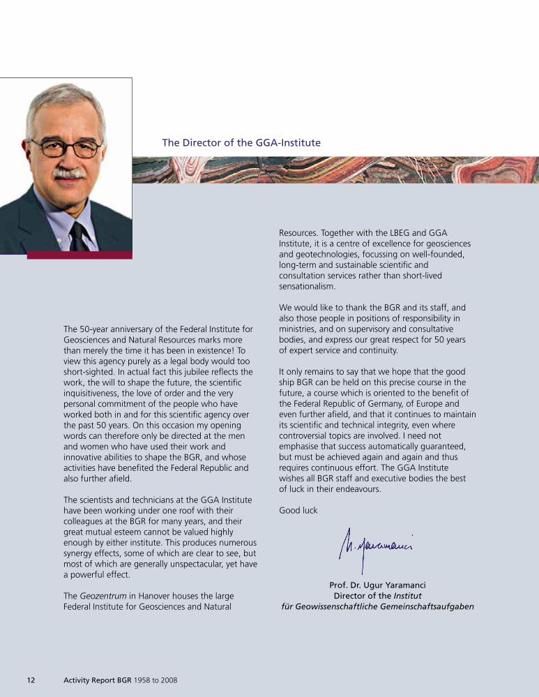
The Director of the GGA-Institute
The 50-year anniversary of the Federal Institute forGeosciences and Natural Resources marks morethan merely the time it has been in existence! Toview this agency purely as a legal body would tooshort-sighted. In actual fact this jubilee reflects thework, the will to shape the future, the scientificinquisitiveness, the love of order and the verypersonal commitment of the people who haveworked both in and for this scientific agency overthe past 50 years. On this occasion my openingwords can therefore only be directed at the menand women who have used their work andinnovative abilities to shape the BGR, and whoseactivities have benefited the Federal Republic andalso further afield.
The scientists and technicians at the GGA Institutehave been working under one roof with theircolleagues at the BGR for many years, and theirgreat mutual esteem cannot be valued highlyenough by either institute. This produces numeroussynergy effects, some of which are clear to see, butmost of which are generally unspectacular, yet havea powerful effect.
The Geozentrum in Hanover houses the largeFederal Institute for Geosciences and Natural
Resources. Together with the LBEG and GGAInstitute, it is a centre of excellence for geosciencesand geotechnologies, focussing on well-founded,long-term and sustainable scientific andconsultation services rather than short-livedsensationalism.
We would like to thank the BGR and its staff, andalso those people in positions of responsibility inministries, and on supervisory and consultativebodies, and express our great respect for 50 yearsof expert service and continuity.
It only remains to say that we hope that the goodship BGR can be held on this precise course in thefuture, a course which is oriented to the benefit ofthe Federal Republic of Germany, of Europe andeven further afield, and that it continues to maintainits scientific and technical integrity, even wherecontroversial topics are involved. I need notemphasise that success automatically guaranteed,but must be achieved again and again and thusrequires continuous effort. The GGA Institutewishes all BGR staff and executive bodies the bestof luck in their endeavours.
Good luck
Prof. Dr. Ugur YaramanciDirector of the Institut
für Geowissenschaftliche Gemeinschaftsaufgaben
12 Activity Report BGR 1958 to 2008
1999so001d_001_020.indd 121999so001d_001_020.indd 12 16.06.2009 09:10:3716.06.2009 09:10:37
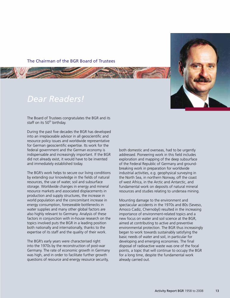
Dear Readers!
The Board of Trustees congratulates the BGR and itsstaff on its 50th birthday.
During the past five decades the BGR has developedinto an irreplaceable advisor in all geoscientific andresource policy issues and worldwide representativefor German geoscientific expertise. Its work for thefederal government and the German economy isindispensable and increasingly important. If the BGRdid not already exist, it would have to be inventedand immediately established today.
The BGR’s work helps to secure our living conditionsby extending our knowledge in the fields of naturalresources, the use of water, soil and subsurfacestorage. Worldwide changes in energy and mineralresource markets and associated displacements inproduction and supply structures, the increase inworld population and the concomitant increase inenergy consumption, foreseeable bottlenecks inwater supplies and many other global factors arealso highly relevant to Germany. Analysis of thesefactors in conjunction with in-house research on thetopics involved puts the BGR in a leading positionboth nationally and internationally, thanks to theexpertise of its staff and the quality of their work.
The BGR’s early years were characterised rightinto the 1970s by the reconstruction of post-warGermany. The rate of economic growth in Germanywas high, and in order to facilitate further growthquestions of resource and energy resource security,
both domestic and overseas, had to be urgentlyaddressed. Pioneering work in this field includesexploration and mapping of the deep subsurfaceof the Federal Republic of Germany and ground-breaking work in preparation for worldwideindustrial activities, e.g. geophysical surveying inthe North Sea, in northern Norway, off the coastof west Africa, in the Arctic and Antarctic, andfundamental work on deposits of natural mineralresources and studies relating to undersea mining.
Mounting damage to the environment andspectacular accidents in the 1970s and 80s (Seveso,Amoco Cadiz, Chernobyl) resulted in the increasingimportance of environment-related topics and anew focus on water and soil science at the BGR,aimed at contributing to active and preventiveenvironmental protection. The BGR thus increasinglybegan to work towards sustainably satisfying thebasic needs of water and soil, in particular fordeveloping and emerging economies. The finaldisposal of radioactive waste was one of the focalpoints, a topic that will continue to occupy the BGRfor a long time, despite the fundamental workalready carried out.
The Chairman of the BGR Board of Trustees
Activity Report BGR 1958 to 2008 13
1999so001d_001_020.indd 131999so001d_001_020.indd 13 16.06.2009 09:10:3916.06.2009 09:10:39
The surplus of resources during the late 1980sand 90s as a consequence of energy and resourcesavings and successes in resource exploration,resulted in price collapses and considerable cut-backs in exploration and development activity.This had consequences for the geoscientific fieldin particular. The industry redundancies wereaccompanied by unremitting efforts to achievegreater effectiveness and efficiency by improvingmanagement. Many of the management practicesdeveloped in industry in this context were adoptedby the BGR thanks to the support of the Board ofTrustees. Examples include the introduction of afixed planning cycle with a research plan andprogramme budget, cost and performanceaccounting, regular reviews for monitoring ourown performance, etc.
Quite correctly, from the very beginning the BGRhas aimed at close cooperation with both theprivate sector and the scientific community atnational and international level and has thusattained a wide knowledge base on a broad front.
As has happened in the past, the altered environ-mental conditions of recent times, characterisedamong other things by high resource prices, thedevelopment of renewables, the climate discussionand the CO2 problem, Europeisation and
globalisation, plus the world’s increasing population,is reflected in the orientation of the BGR’s work.By continuously adapting to new situations the BGRhas managed to integrate such changes and thusto maintain and advance its leading position. Thiscourse will be continued. The important factorhere is continued focus on the core tasks and coreexpertise, and constant readjustment of the balancebetween short-, medium- and long-term projects.
The Board of Trustees is also happy to continueoffering advice to the BGR management and theFederal Minister of Economics and Technology bothon these questions and on the future evolution ofthe organisation, further increasing efficiency andlinks to industry.
The Trustees, the BGR management and allemployees are very pleased with the performanceof the past five decades. We wish you continuedsuccess and recognition in the future.
Good luck on behalf of the Board of Trustees
Prof. Dr. Kurt M. Reinicke
14 Activity Report BGR 1958 to 2008
1999so001d_001_020.indd 141999so001d_001_020.indd 14 16.06.2009 09:10:4016.06.2009 09:10:40
The BGR – looking ahead
A review of highlights from the past 50 years suchas those presented in this volume also encouragesus to look to the future. Quo vadis BGR? Whichdevelopments will shape its work? Where do thegreatest challenges lie?
Although the tasks transferred to BGR in itsfounding decree have lost none of their relevance,the social and science policy environment inGermany has changed dramatically since then –as it has in the rest of the world. Three casesemphasise this:
A number of important non-university research1.institutions in Germany have either beenestablished or fundamentally reformed,particularly since the 1980s, and have beencarrying out excellent research in geoscientificfields: the Alfred Wegener Institute for Polar andMarine Research, the German Research Centrefor Geosciences Potsdam in the HelmholtzAssociation (GFZ), the Helmholtz Centre forEnvironmental Research (UFZ) in Leipzig, theLeibniz Institute of Marine Sciences (IfM-GEOMAR) in Kiel, the Leibniz Institute forApplied Geosciences (GGA) in Hanover andthe geoscience-oriented Institutes at the JülichResearch Centre are just some examples.
Today, BGR undertakes joint projects with all ofthese institutions or coordinates new projectswith them during the planning stage. Many oftheir management personnel are reciprocallymembers of scientific advisory boards or theboards of trustees for the respective institutions.
The geosciences themselves have made giant2.strides over the last 50 years. The revolutionarytheory of plate tectonics – in conjunction withthe paradigm change that the appearance ofthe Earth is characterised less by vertical than byhorizontal displacements of large areas of theEarth’s surface – was not firmly established untilthe end of the 1960s. For many of the disciplinesin which research was once carried out separatelyat universities, such as geology/palaeontology,geophysics, mineralogy/crystallography, pedology,geodesy, geochemistry and more, it has finallybeen recognised that the great geoscientificproblems need to be addressed together.
These developments have led to strong growthin, or the creation of new, generally topic-related fields of research, which take a holisticview of the Earth system. Examples includegeo-risk research, climate research, ecosystemresearch and sustainability research. Cleardemarcation of these fields of research – and thisis characteristic of modern geoscience disciplines– is not possible. Recognition of the fragility ofour existence and its total dependency on thecondition of our planet and the course of thenumerous dynamic processes taking place upon itdemand considerably more comprehensive,broader-based research efforts than our scientificteachers imagined 50 years ago.
Activity Report BGR 1958 to 2008 15
1999so001d_001_020.indd 151999so001d_001_020.indd 15 23.06.2009 07:28:4623.06.2009 07:28:46
16 Activity Report BGR 1958 to 2008
And finally, the degree of globalisation is far3.greater today than it was in the 1950s. Forexample, where overseas visits by high-rankingcivil servants were previously relatively rareevents, today they are part of day-to-daybusiness. The extent of trans-boundary goodstraffic on land, on water and in the air hasincreased by orders of magnitude – and formsthe backbone of our economy and prosperity.Natural resources play a decisive role in this.
As a result, the extent of consultation forministries and industry carried out by BGR staffhas increased considerably over the past fewdecades. Numerous internationally activescientific organisations and institutions havebeen established and BGR performs importantcoordinating functions in a number of them, forexample the International Union of GeologicalSciences (IUGS), the International Union ofGeodesy and Geophysics (IUGG), the IntegratedOcean Drilling Programme (IODP) and itsprecursor the Ocean Drilling Programme (ODP)and in EuroGeoSurveys, the Association of theGeological Surveys of Europe.
Against this background, looking at BGR’s futurewas also the subject of a recent evaluation by theScience Council of the federal government. In itsfinal report, dated 9 November 2007, the councilrecognises that BGR’s research and developmentwork and its knowledge-based services are of greatpublic importance; these services secure sustainablesupplies of both energy and mineral resources forthe economy and the public. In this context theservices of the Federal Institute are acknowledgedas attaining a high scientific standard and BGR isidentified as an internationally leading stategeological survey.
Among the Science Council’s statements on BGR’sfields of activity is the request to maintain theexisting research component at 40% – as the basisfor qualified advice to politics and industry. BGRitself views this as advance and applied research,and it is anticipated that the results will beimplemented in the foreseeable future, i.e. fromseveral years to a few decades. BGR thus alsosupports the initiatives of several different groups
aiming to see geoscientific research serving themost important requirements of society morestrongly than has previously been the case. This aimis also expressed in the 2007–2017 programme ofthe United States Geological Survey (USGS). TheUSGS sees the most important primary objective asmaintaining or reinstating ecosystems which canpromote human well-being and lead to a healthyexistence. Taking the provision of society with thenecessary natural resources into consideration, thisview incorporates the sustainability aspect and thusthe preservation of ecosystems, which comprisethe zones of the geological subsurface, thegroundwater regime, soil, the Earth’s surface, thehydrosphere and the air envelope, including thebiodiversity existing therein.
The fields of expertise of BGR within thegeosciences lie clearly in the georesources discipline.This includes natural mineral resources and energyresources, groundwater and soil, and alsounderground space, which provides possibilitiesfor geological CO2 storage or for final repositoriesfor radioactive substances. BGR also has a highdegree of expertise in the field of geo-safety.Last but not least, geodata and information systemsalso represent a ‘resource’; they have played animportant role in the work of BGR since itsestablishment and will continue to do so.
The importance of georesources for our existenceis obvious in view of the recent drastic pricedevelopments in terms of natural mineral andenergy resources, and the often dramatic scarcityof clean water and fertile agricultural land. This isin conjunction with an increasing world populationand the advancing industrialisation of heavilypopulated countries in Asia, Africa and SouthAmerica. Georesources will therefore increasinglybe the frame for the activities of BGR. In thedistribution of responsibilities with the geologicalsurveys of the federal states, whose tasks lie withinGermany, the fields of groundwater, soil andnatural resources, are primarily European andoverseas tasks for BGR, predominantly as part ofprojects involving technical cooperation. In thisrespect, sharpening the profile of BGR activitiesfollows one of the principle recommendations ofthe Science Council, whose members I would liketo thank again at this point for their valuable work.
1999so001d_001_020.indd 161999so001d_001_020.indd 16 16.06.2009 09:10:4016.06.2009 09:10:40
At the end of 2007 BGR established a number ofproject groups, whose work is coordinated by aproject team, to implement the recommendationsof the Science Council. The aim of the proposedmeasures is to further increase the effectiveness ofBGR and to cement its recognised position in socialand scientific policy. This applies equally to theresearch sector, which is the focus of the ScienceCouncil’s report, and the service-oriented sector.One of the actions taken will be greater monitoringof the numerous services for affiliates of BGR. Inaddition, special attention will be paid to newgeoscientific topics for improving living conditionsand the provision of public utilities and services,internal task reviews and flexibility. Externally,BGR will continue to seek further networkingopportunities with other institutions so as tocontinue to offer a broad spectrum of geoscientificconsultations as an independent agency in thefuture.
Cooperation with universities will be expanded forthe mutual benefit of the universities, the BGR andyoung scientists. And finally, BGR will makeadditional efforts to make their work known in thescientific community and to the broader public.This includes raising public awareness of the topicsdealt with by BGR to the population.
With these objectives in mind, BGR can look withconfidence to the future as the federal govern-ment’s centre of geoscientific excellence.
Prof. Dr. Hans-Joachim Kümpel
Activity Report BGR 1958 to 2008 17
1999so001d_001_020.indd 171999so001d_001_020.indd 17 16.06.2009 09:10:4016.06.2009 09:10:40
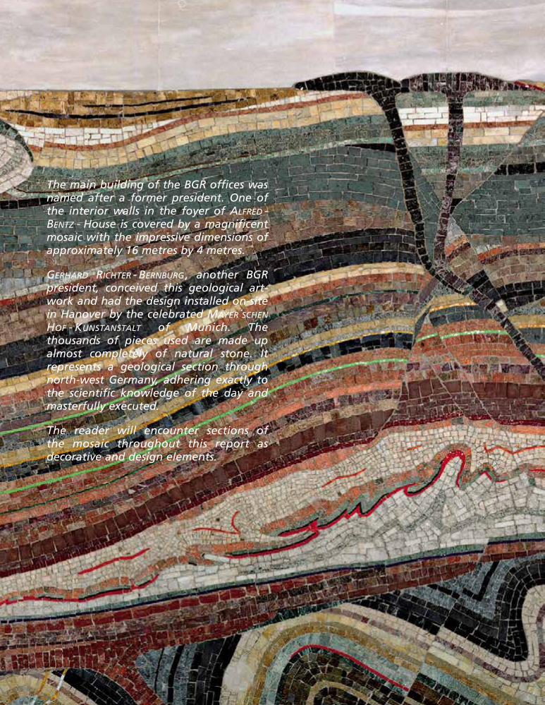
The main building of the BGR offices wasnamed after a former president. One ofthe interior walls in the foyer of ALFRED -BENTZ - House is covered by a magnificentmosaic with the impressive dimensions ofapproximately 16 metres by 4 metres.
GERHARD RICHTER - BERNBURG , another BGRpresident, conceived this geological art-work and had the design installed on-sitein Hanover by the celebrated MAYER´SCHEN
HOF - KUNSTANSTALT of Munich. Thethousands of pieces used are made upalmost completely of natural stone. Itrepresents a geological section throughnorth-west Germany, adhering exactly tothe scientific knowledge of the day andmasterfully executed.
The reader will encounter sections ofthe mosaic throughout this report asdecorative and design elements.
1999so001d_001_020.indd 181999so001d_001_020.indd 18 16.06.2009 09:10:4116.06.2009 09:10:41
Activity Report BGR 1958 to 2008 19
The German Minister for Economics and Techno-logy, established a Board of Trustees to providethe Minister and the BGR President with advice onall of the important aspects affecting the work ofthe BGR.
The Board of Trustees is made up of geoscientificrepresentatives from industry and commerce,universities and non-university researchorganisations.
Chairman of the Board of Trustees
Prof. Dr. K. M. REINICKETU ClausthalAbteilung Erdöl/Erdgasgewinnungund ErdgasversorgungClausthal-Zellerfeld
Members
Dr. K. ÅKERDirector, Espoo UnitGeological Survey of FinlandEspoo, Finnland
Dr.-Ing. D. BÖCKERBrühl
Prof. Dr. Dr. h. c. R. EMMERMANNManagement Board ChairmanGeoForschungsZentrum Potsdam (GFZ)Potsdam
G. GRIMMIGMember of the Management BoardK+S AktiengesellschaftKassel
Prof. Dr. P. M. HERZIGDirectorLeibniz-Institut fürMeereswissenschaften Kiel (IFM-GEOMAR)Kiel
Board of Trustees
1999so001d_001_020.indd 191999so001d_001_020.indd 19 16.06.2009 09:10:4516.06.2009 09:10:45
20 Activity Report BGR 1958 to 2008
Dr. G. KALKOFFENTechnical Managing DirectorExxonMobil Production Deutschland GmbHHannover
Dr. N. KLOPPENBURGMember of the Management BoardKreditanstalt für WiederaufbauFrankfurt/Main
Prof. Dr. I. KÖGEL-KNABNERTU MünchenLehrstuhl für BodenkundeFreising-Weihenstephan
Prof. Dr.-Ing. K.-U. KÖHLERManagement Board ChaimanThyssen Krupp Steel AGDuisburg
Prof. Dr. V. MOSBRUGGERDirectorSenckenberg Forschungsinstitutund NaturmuseumFrankfurt/Main
Professor Dr. G. TEUTSCHScientific Managing DirectorUmweltforschungszentrum (UFZ)Leipzig-Halle GmbHLeipzig
Prof. Dr. J. THIEDEDirectorStiftung Alfred-Wegener-Institut fürPolar- und MeeresforschungBremerhaven
Dr. B. THOMAUSKESchwülper
Dipl.-Ing. B. TÖNJESManagement Board ChairmanDeutsche Steinkohle AGHerne
P. VOSSpeaker of the Management BoardBasalt-Actien-GesellschaftLinz/Rhein
R. ZWITSERLOOTMember of the Management BoardWintershall AGKassel
1999so001d_001_020.indd 201999so001d_001_020.indd 20 23.06.2009 07:29:3823.06.2009 07:29:38
Natural Resources
Resources
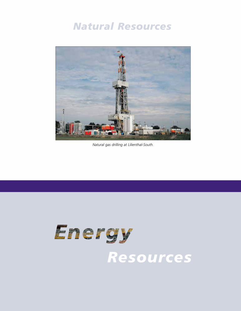
Natural gas drilling at Lilienthal-South.
1999so001d_021_030.indd 211999so001d_021_030.indd 21 16.06.2009 09:12:0216.06.2009 09:12:02
22 Activity Report BGR 1958 to 2008
Energy Resources
The energy resources sector has seen great changesover the past 50 years. While crude oil cost only $2per barrel in 1958, at the beginning of March 2008it was over $100. Between these two dates the priceof oil has fluctuated, influenced by numerous majorevents; the most important of these include:
Autumn 1973: First oil crisisÈ
1978/79: Second oil crisisÈ
Oil price collapse after expansion ofÈ
Saudi Arabian crude oil production1998/99: Further oil price collapse toÈ
less than $10/barrel as a result of theAsian crisisAs of 2003: Large oil price increases.È
50 Years ofEnergy Resources
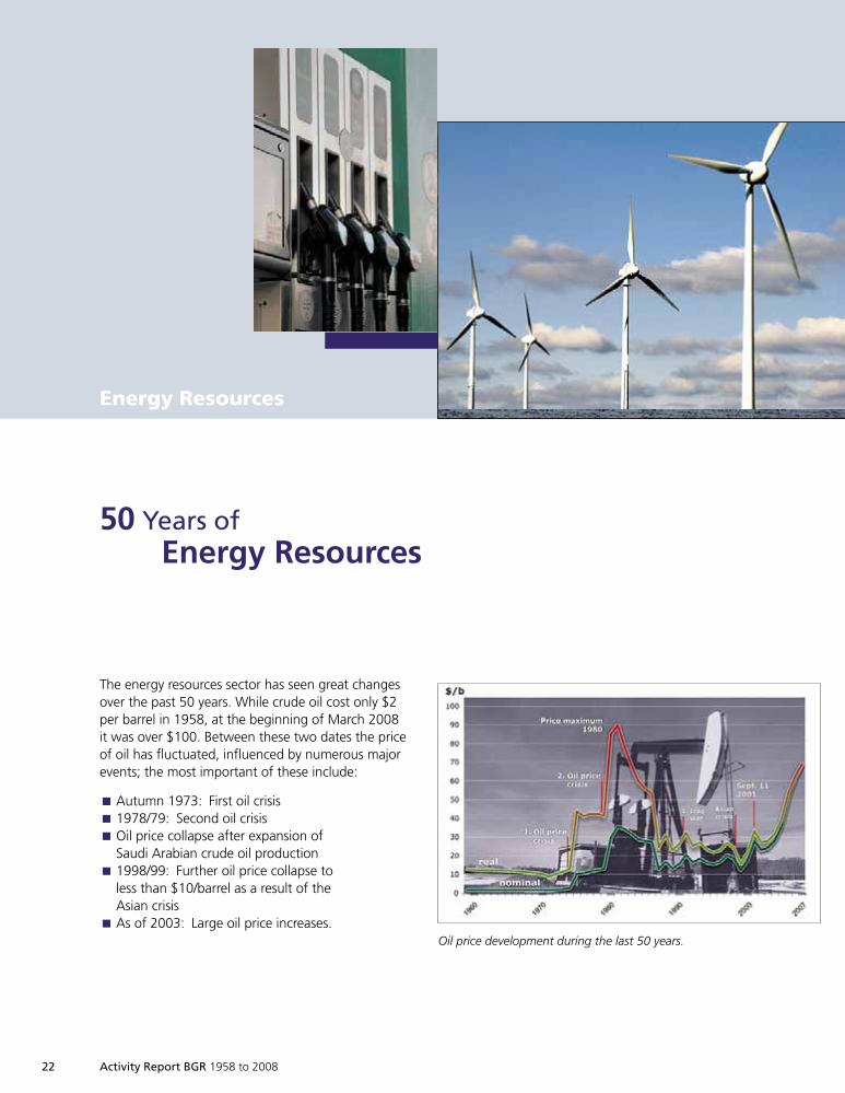
Oil price development during the last 50 years.
1999so001d_021_030.indd 221999so001d_021_030.indd 22 16.06.2009 09:12:0416.06.2009 09:12:04
These developments had consequences for boththe activities of international oil companies and forother energy resources, as their prices are indirectlycoupled to the price of crude oil. The high oilprices of the mid-1970s to the mid-1980s initiatedincreased activity in exploration for, and research
into, energy resources, which led to the discoveryof rich natural gas and oil fields in the North Sea,among other things. At the same time, the high oilprices also initiated increased research activities intothe use of non-conventional energy resources, i.e.resources only extractable at high cost, such as oilsands and shales, and in the field of alternativeenergy sources. In contrast to this, the oil pricecollapse of the mid-1980s and at the end of the1990s led to a considerable decrease in theseactivities.
The orientation of BGR’s work in these fields wasalso influenced by these developments. It wasnevertheless possible for us to maintain continuityin our work, despite some heavy redundancies, andthus to remain an expert consultation partner forpolitics and industry.
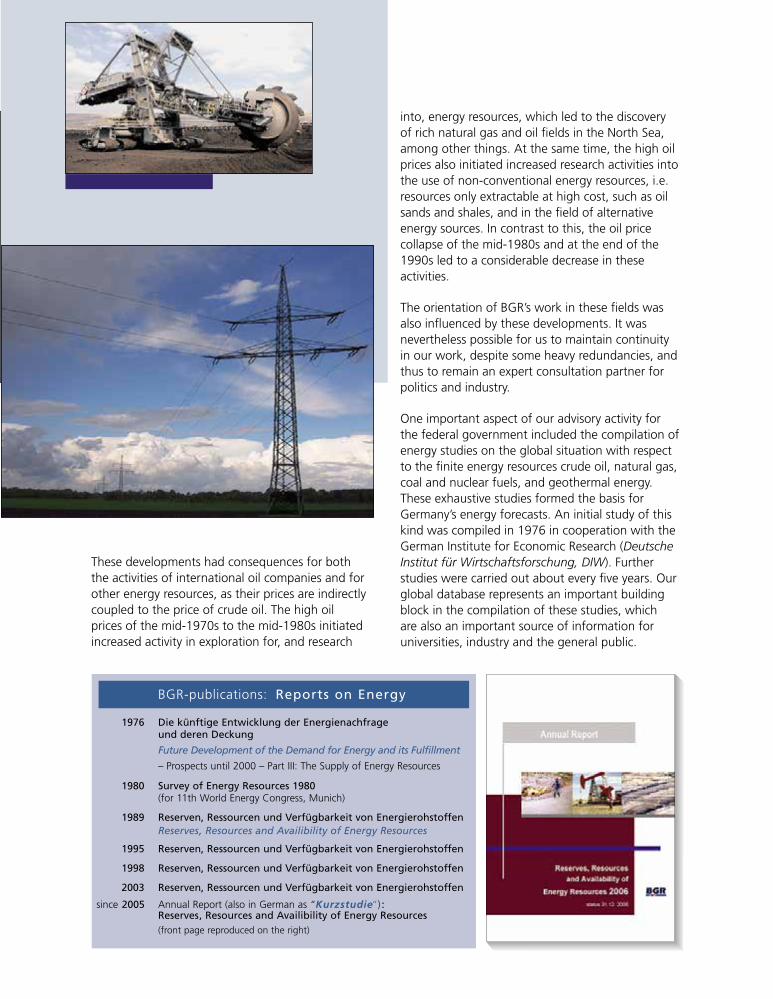
One important aspect of our advisory activity forthe federal government included the compilation ofenergy studies on the global situation with respectto the finite energy resources crude oil, natural gas,coal and nuclear fuels, and geothermal energy.These exhaustive studies formed the basis forGermany’s energy forecasts. An initial study of thiskind was compiled in 1976 in cooperation with theGerman Institute for Economic Research (DeutscheInstitut für Wirtschaftsforschung, DIW). Furtherstudies were carried out about every five years. Ourglobal database represents an important buildingblock in the compilation of these studies, whichare also an important source of information foruniversities, industry and the general public.
1976 Die künftige Entwicklung der Energienachfrageund deren Deckung
Future Development of the Demand for Energy and its Fulfillment
– Prospects until 2000 – Part III: The Supply of Energy Resources
1980 Survey of Energy Resources 1980(for 11th World Energy Congress, Munich)
1989 Reserven, Ressourcen und Verfügbarkeit von EnergierohstoffenReserves, Resources and Availibility of Energy Resources
1995 Reserven, Ressourcen und Verfügbarkeit von Energierohstoffen
1998 Reserven, Ressourcen und Verfügbarkeit von Energierohstoffen
2003 Reserven, Ressourcen und Verfügbarkeit von Energierohstoffen
since 2005 Annual Report (also in German as “Kurzstudie“) :Reserves, Resources and Availibility of Energy Resources(front page reproduced on the right)
BGR-publications: Reports on Energy
1999so001d_021_030.indd 231999so001d_021_030.indd 23 16.06.2009 09:12:1916.06.2009 09:12:19
24 Activity Report BGR 1958 to 2008
In 1969 the federal government initiated a federalfunding programme to improve Germany’s crudeoil supply. In particular, it supported the overseasactivities of German companies involved in theexploration and production of crude oil and naturalgas. The programme led to the establishment of theDeminex Oil Company (Deutsche Erdölversorgungs-gesellschaft mbH DEMINEX). Funds of almost2.4 billion German Marks were paid out as loansand grants by 1989, of which approx. 760 millionGerman Marks were repaid by the end of 1997when DEMINEX was either dissolved or split up.BGR accompanied this programme as expert witnessfor the federal government. In the period ofDEMINEX’s activities more than 200 million tonnesof oil equivalent were discovered, and more than100 million tonnes of crude oil and 16 billion m³ ofnatural gas produced. First oil production resultingfrom this programme commenced in 1978 in theThistle field in the British North Sea. Work wascarried out on almost every continent, with themain focus in the North Sea, the Middle East, NorthAfrica and Indonesia.
Technical cooperation with developing countriesalso played a prominent role and there have beenmajor changes in this field in recent years. In theearly years, the emphasis was on direct cooperationwith partners in prospection and exploration,including exploration activities funded in part byus within the scope of financial cooperation. Thisled, among other things, to the discovery of naturalgas deposits in Bangladesh. In recent years theemphasis has moved to training personnel and toconsultation and building geological institutions.The importance of the resource sector declinedconsiderably in line with the reorientation ofdevelopment aid. It is only recently that consulta-tions in this sector have regained some significanceand BGR has become more active.
In almost 50 years of cooperation with developingcountries BGR specialists have made importantcontributions to developing the resource base inmany countries and on almost every continent. Forexample, in countries such as Bangladesh, Pakistanand Myanmar, the foundation was laid for thediscovery of important natural gas deposits, in the
Philippines, Turkey and Malaysia coal fields werediscovered and uranium prospection has beensupported in numerous countries. Even unconven-tional energy resources have been the subject ofinvestigation. In the 1980s, for instance, BGRcarried out extensive work in investigating oil shaledeposits in Jordan; the results today form the basisfor widespread industrial activity. Geothermalenergy has been a significant field in recent years.East African countries and Chile were provided withsupport in the development and utilisation ofgeothermal energy in the course of the GEOTHERMprogramme. This field will continue to be importantin the future.
BGR carried out wide-ranging research activities tosupport this work, comprising geophysical surveys,primarily offshore in seas, laboratory tests, andtheir joint evaluation and interpretation. This workprofited from the many disciplines represented inBGR and their interdependencies, as well as intensecooperation with universities, research facilities andindustry. The research work was related to bothGerman domestic topics such as uranium andthorium prospection (1960s), deep natural gasexposure projects (1970s) and deep gas (1990s),in close cooperation with industry and universities,and to numerous international activities. Theseincluded the evaluation of buried grabens in Africain terms of their hydrocarbon potential (1980s)and extensive offshore seismic work for industryinvestigating the great oceans’ continental shelvesas future crude oil and natural gas explorationzones. The great interest taken by industry in theresults of this work underlines the relevance of theinvestigations – as with the present case of theLaptev Sea. BGR is closely integrated in the networkof international cooperation. It sits on internationalpanels and was crucially involved in the compilationof the NW European Gas Atlas. It is currentlyinvolved in the Southern Permian Basin Atlas (SPBA).
Besides investigating traditional energy resources,BGR is also involved in the use of geothermalenergy. For example, it is participating in a researchproject in Sultz in the Alsace region, which isinvestigating the options for using geothermalenergy for generating electricity. The options
1999so001d_021_030.indd 241999so001d_021_030.indd 24 16.06.2009 09:12:2516.06.2009 09:12:25
Activity Report BGR 1958 to 2008 25
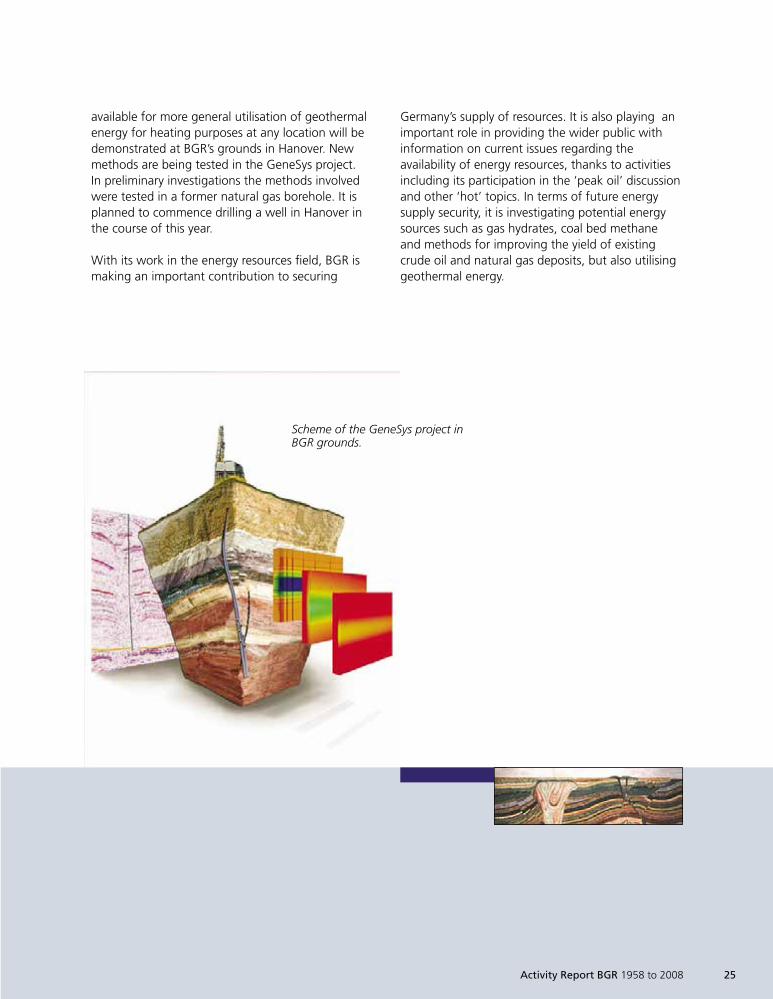
available for more general utilisation of geothermalenergy for heating purposes at any location will bedemonstrated at BGR’s grounds in Hanover. Newmethods are being tested in the GeneSys project.In preliminary investigations the methods involvedwere tested in a former natural gas borehole. It isplanned to commence drilling a well in Hanover inthe course of this year.
With its work in the energy resources field, BGR ismaking an important contribution to securing
Germany’s supply of resources. It is also playing animportant role in providing the wider public withinformation on current issues regarding theavailability of energy resources, thanks to activitiesincluding its participation in the ‘peak oil’ discussionand other ‘hot’ topics. In terms of future energysupply security, it is investigating potential energysources such as gas hydrates, coal bed methaneand methods for improving the yield of existingcrude oil and natural gas deposits, but also utilisinggeothermal energy.
Scheme of the GeneSys project inBGR grounds.
1999so001d_021_030.indd 251999so001d_021_030.indd 25 16.06.2009 09:12:2516.06.2009 09:12:25
26 Activity Report BGR 1958 to 2008
The arctic polar regions are regarded as prosperous‘frontier regions’ for natural resources. However, thisprobably considerable resource potential remainsrelatively untouched yet.
In the arctic shelf regions in particular, the crudeoil and natural gas potential is thought to be verylarge due to the extensive sedimentary basins withsignificant sediment infill. However, reconnaissanceand economic exploitation under arctic conditionsrepresent considerable technical challenges andrequire enormous investments, influenced by thedevelopment of energy prices on the world markets.
Climate change and the projected retreat of arcticice may, however, prove advantageous to the futuredevelopment and utilisation of arctic resources,because the conditions for oil and gas productionin the previously largely ice-covered Arctic Oceanmay be altered and the arctic sea routes (forexample the north-east passage) may evolve intouseable transport routes for Siberian resourcesdue to a decrease in ice cover.
Research for the estimation of theHydrocarbon Potential of
Siberia´s Marginal Arctic Seas
The arctic is defined as the region north of theArctic Circle (latitude 66° 33’’ north) and coversan area of around 21 million km². The shelf area(water depths < 500 m) covers an area of around7 million km², approximately the same area as theland areas. The USGS (United States GeologicalSurvey) estimates that a quarter of all hypotheticalcrude oil and natural gas resources is situated withinthe Arctic. The potential crude oil and natural gasresources in the shelf regions are almost completelywithin the 200 nautical miles zones (exclusiveeconomic zone) of the respective adjacent states.
A study by Fugro Robertson (Future of the arctic,November 2006) postulates that natural gas is farmore likely to be discovered (85%) than crude oil(15%). Of the estimated gas reserves, 69% arelocated within Russia. More than 550 oil and gasfields (15% of the known global crude oil andnatural gas resources) have already been discoveredin the arctic, mainly in Russia. According to Russianinformation of April 2007 resources of more than62.5 trillion m3 of gas and 9 billion tonnes of crudeoil are anticipated on the Russian shelf.
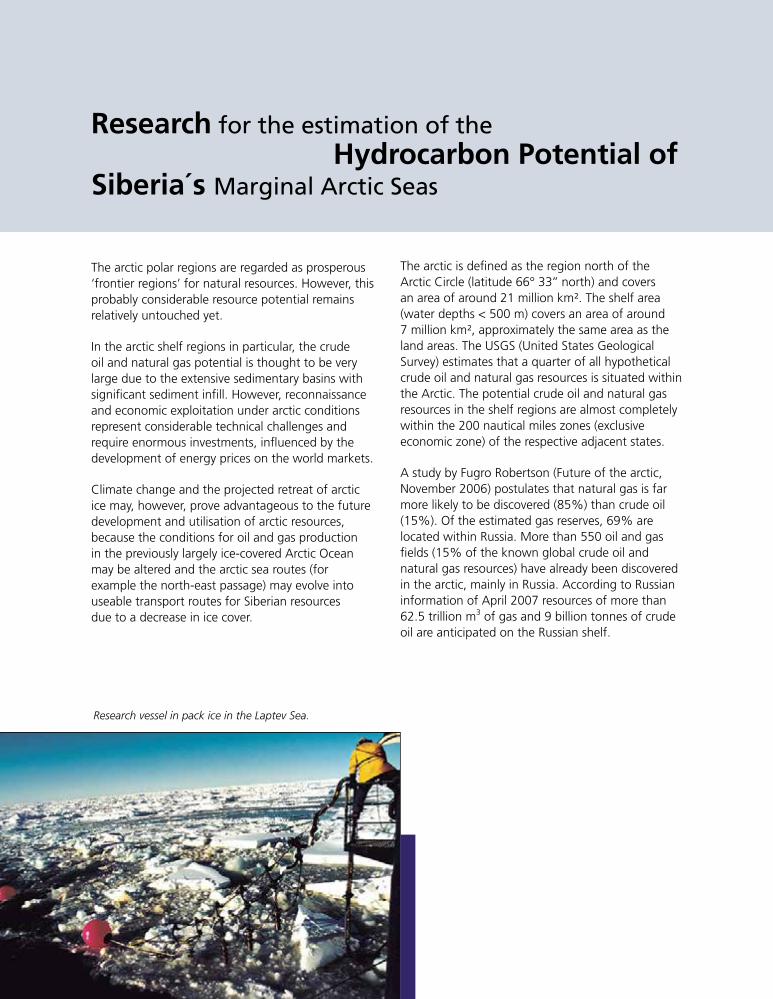
Research vessel in pack ice in the Laptev Sea.
1999so001d_021_030.indd 261999so001d_021_030.indd 26 16.06.2009 09:12:3216.06.2009 09:12:32
0°
180°
90°E90°WNO
RWAY
SWED
EN
FINLAND
RU
SS
IA
A LAS K A
(U S A)
CA
NA
DA
ICELAND
G R E E N L AN
D
North Pole
Arctic Circle
Gas Field
Oil Field
Basins covered by study
Position ofBGR profile 97-01(below)
AAEEaasstt
SSiibbiirriiaannSSeeaa
NNoorrtthhKKaarraa SSeeaa
WWeessttBBaarreennttss
SSeeaa
EEaasstt BBaarreennttss SSeeaa
SSoouutthh KKaarraaYYaammaall
KKrroonnpprriinnssCChhrriissttiiaann
EEaasstt CCeennttrraallGGrreeeennllaanndd
BBaaffffiinnBBaayy
FFrraannkklliinniiaann--SSvveerrddrruupp
SSoouutthhwweesstt--GGrreeeennllaanndd
LLaabbrr
aaddoorr
SShheellff
SSoouutthheerrnnAArrccttiicc
IIssllaannddss
BBeeaauuffoorrtt --
MMaacckkeennzziiee
NNoorrtthh SSllooppee
HHooppee
NNoorrtthhCChhuukkcchhii
NNoorrtthhGGrreeeennllaanndd
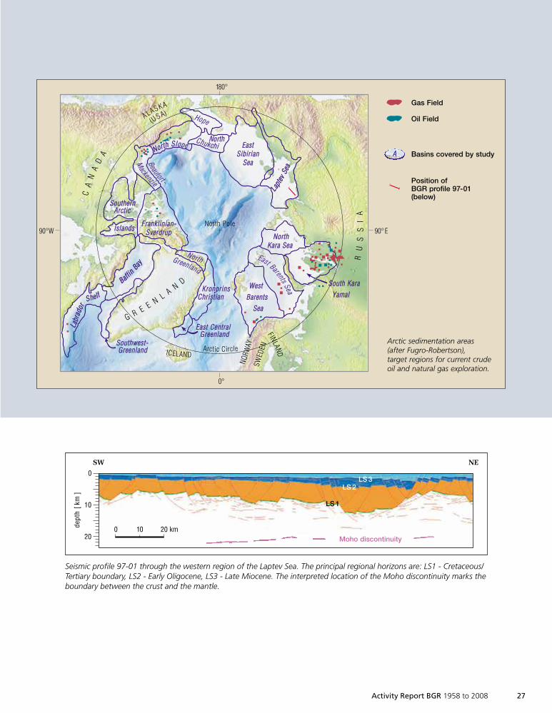
Arctic sedimentation areas(after Fugro-Robertson),target regions for current crudeoil and natural gas exploration.
LLaapptt
eevvSSee
aa
LS 3LS 2
LS 1
SW NE
0
10
20
dept
h[k
m]
0 10 20 kmMoho discontinuity
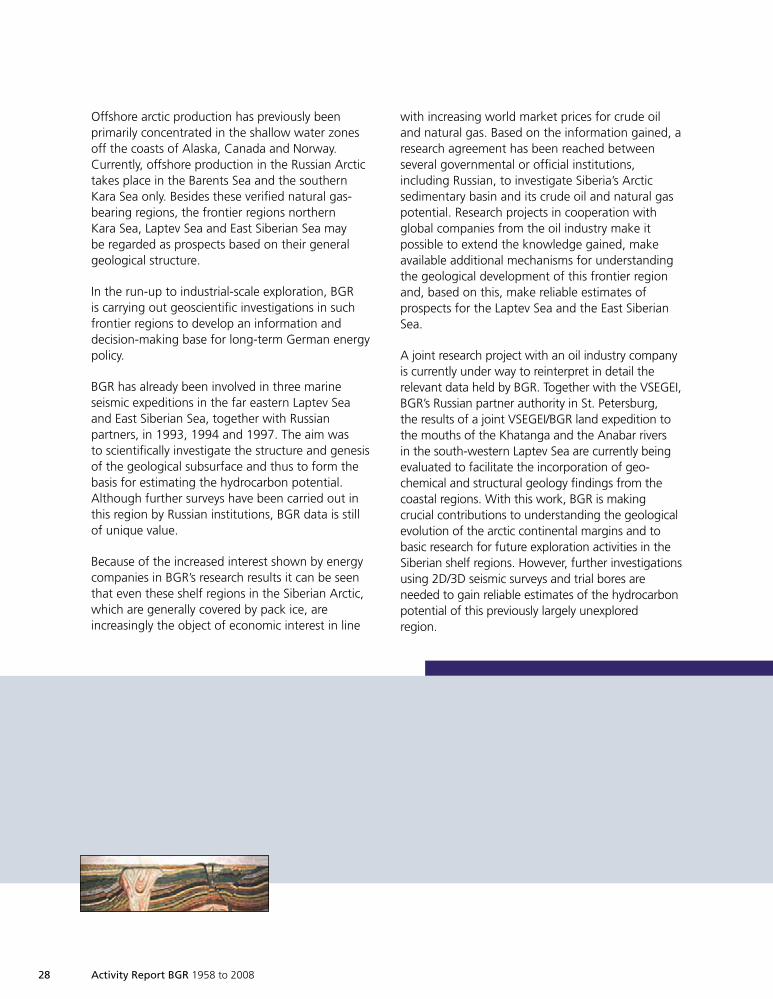
Seismic profile 97-01 through the western region of the Laptev Sea. The principal regional horizons are: LS1 - Cretaceous/Tertiary boundary, LS2 - Early Oligocene, LS3 - Late Miocene. The interpreted location of the Moho discontinuity marks theboundary between the crust and the mantle.
Activity Report BGR 1958 to 2008 27
1999so001d_021_030.indd 271999so001d_021_030.indd 27 23.06.2009 07:30:4323.06.2009 07:30:43
28 Activity Report BGR 1958 to 2008
Offshore arctic production has previously beenprimarily concentrated in the shallow water zonesoff the coasts of Alaska, Canada and Norway.Currently, offshore production in the Russian Arctictakes place in the Barents Sea and the southernKara Sea only. Besides these verified natural gas-bearing regions, the frontier regions northernKara Sea, Laptev Sea and East Siberian Sea maybe regarded as prospects based on their generalgeological structure.
In the run-up to industrial-scale exploration, BGRis carrying out geoscientific investigations in suchfrontier regions to develop an information anddecision-making base for long-term German energypolicy.
BGR has already been involved in three marineseismic expeditions in the far eastern Laptev Seaand East Siberian Sea, together with Russianpartners, in 1993, 1994 and 1997. The aim wasto scientifically investigate the structure and genesisof the geological subsurface and thus to form thebasis for estimating the hydrocarbon potential.Although further surveys have been carried out inthis region by Russian institutions, BGR data is stillof unique value.
Because of the increased interest shown by energycompanies in BGR’s research results it can be seenthat even these shelf regions in the Siberian Arctic,which are generally covered by pack ice, areincreasingly the object of economic interest in line
with increasing world market prices for crude oiland natural gas. Based on the information gained, aresearch agreement has been reached betweenseveral governmental or official institutions,including Russian, to investigate Siberia’s Arcticsedimentary basin and its crude oil and natural gaspotential. Research projects in cooperation withglobal companies from the oil industry make itpossible to extend the knowledge gained, makeavailable additional mechanisms for understandingthe geological development of this frontier regionand, based on this, make reliable estimates ofprospects for the Laptev Sea and the East SiberianSea.
A joint research project with an oil industry companyis currently under way to reinterpret in detail therelevant data held by BGR. Together with the VSEGEI,BGR’s Russian partner authority in St. Petersburg,the results of a joint VSEGEI/BGR land expedition tothe mouths of the Khatanga and the Anabar riversin the south-western Laptev Sea are currently beingevaluated to facilitate the incorporation of geo-chemical and structural geology findings from thecoastal regions. With this work, BGR is makingcrucial contributions to understanding the geologicalevolution of the arctic continental margins and tobasic research for future exploration activities in theSiberian shelf regions. However, further investigationsusing 2D/3D seismic surveys and trial bores areneeded to gain reliable estimates of the hydrocarbonpotential of this previously largely unexploredregion.
1999so001d_021_030.indd 281999so001d_021_030.indd 28 16.06.2009 09:12:3416.06.2009 09:12:34
Activity Report BGR 1958 to 2008 29
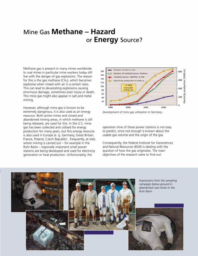
Methane gas is present in many mines worldwide.In coal mines in particular mine workers today stilllive with the danger of gas explosions. The reasonfor this is the gas methane (CH4), which becomesexplosive when mixed with air in a certain ratio.This can lead to devastating explosions causingenormous damage, sometimes even injury or death.This mine gas might also appear in salt and metalmining.
However, although mine gas is known to beextremely dangerous, it is also used as an energyresource. Both active mines and closed andabandoned mining areas, in which methane is stillbeing released, are used for this. In the U.S. minegas has been collected and utilised for energyproduction for many years, but this energy resourceis also used in Europe (e. g. Germany, Great Britain,France, Poland, Czech Republic) . Frequently, at siteswhere mining is carried out – for example in theRuhr Basin – regionally important small powerstations are being developed and used for electricitygeneration or heat production. Unfortunately, the
Mine Gas Methane – Hazardor Energy Source?
operation time of these power stations is not easyto predict, since not enough is known about theusable gas volume and the origin of the gas.
Consequently, the Federal Institute for Geosciencesand Natural Resources (BGR) is dealing with thequestion of how the gas originates. The mainobjectives of the research were to find out:
Anzahl der betriebenen Standorte
Anzahl der installierten BHKWs
Installierte Leistung in MW
Stromerzeugung in GWh/a
180
160
140
120
100
80
60
40
20
800
600
400
200
01998 2000 2002 2004
Elec
tric
ity
pro
du
ctio
n[G
Wh
/a]
1.4.2000:renewableenergy law
capacity
Development of mine gas utilisation in Germany.
Impressions from the samplingcampaign below ground inabandoned coal mines in theRuhr Basin.
1999so001d_021_030.indd 291999so001d_021_030.indd 29 16.06.2009 09:12:3716.06.2009 09:12:37
30 Activity Report BGR 1958 to 2008
Is the methane exclusively formed by the coalÈ
being heated in the upper earth crust?What role do microorganisms play in theÈ
development of the gas?How long can methane from mining be usedÈ
as an energy resource?What is the extent of the ongoing formation?È
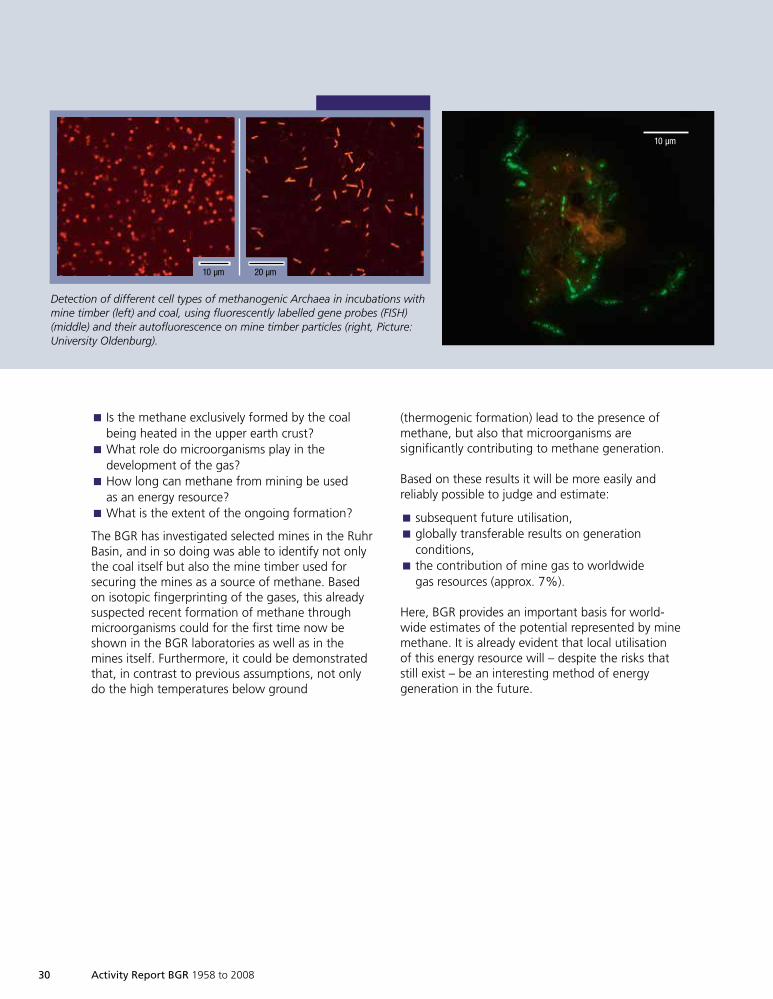
The BGR has investigated selected mines in the RuhrBasin, and in so doing was able to identify not onlythe coal itself but also the mine timber used forsecuring the mines as a source of methane. Basedon isotopic fingerprinting of the gases, this alreadysuspected recent formation of methane throughmicroorganisms could for the first time now beshown in the BGR laboratories as well as in themines itself. Furthermore, it could be demonstratedthat, in contrast to previous assumptions, not onlydo the high temperatures below ground
10 µm 20 µm
10 µm
(thermogenic formation) lead to the presence ofmethane, but also that microorganisms aresignificantly contributing to methane generation.
Based on these results it will be more easily andreliably possible to judge and estimate:
subsequent future utilisation,È
globally transferable results on generationÈ
conditions,the contribution of mine gas to worldwideÈ
gas resources (approx. 7%).
Here, BGR provides an important basis for world-wide estimates of the potential represented by minemethane. It is already evident that local utilisationof this energy resource will – despite the risks thatstill exist – be an interesting method of energygeneration in the future.
Detection of different cell types of methanogenic Archaea in incubations withmine timber (left) and coal, using fluorescently labelled gene probes (FISH)(middle) and their autofluorescence on mine timber particles (right, Picture:University Oldenburg).
1999so001d_021_030.indd 301999so001d_021_030.indd 30 16.06.2009 09:12:4416.06.2009 09:12:44
Activity Report BGR 1958 to 2008 31
Resources
Limestone quarrying at Elbingerode, GermanyLimestone production in the Elbingerode open cast mine, Germany.
1999so001d_031_045.indd 311999so001d_031_045.indd 31 16.06.2009 09:13:2716.06.2009 09:13:27
32 Activity Report BGR 1958 to 2008
Mineral Resources
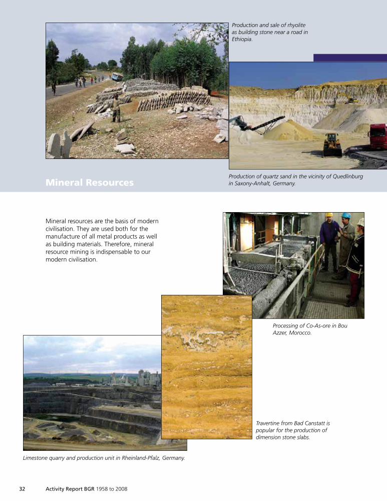
Mineral resources are the basis of moderncivilisation. They are used both for themanufacture of all metal products as wellas building materials. Therefore, mineralresource mining is indispensable to ourmodern civilisation.
Production and sale of rhyoliteas building stone near a road inEthiopia.
Limestone quarry and production unit in Rheinland-Pfalz, Germany.
Processing of Co-As-ore in BouAzzer, Morocco.
Production of quartz sand in the vicinity of Quedlinburgin Saxony-Anhalt, Germany.
Travertine from Bad Canstatt ispopular for the production ofdimension stone slabs.
1999so001d_031_045.indd 321999so001d_031_045.indd 32 16.06.2009 09:13:2816.06.2009 09:13:28
Activity Report BGR 1958 to 2008 33
The term ´mineral resources´ covers a wide range ofusable rocks occurring in nature. Mineral resourcesare gravel, sand, chalk, and clay, all of which are usedmainly as building materials for roads and houses.The term also covers the sometimes unimpressiverocks containing gold, silver, and copper and alsographite, fluorspar and barite. Such rocks are calledores. Resources used for energy generation (e.g. coal)are not considered mineral resources, but are termedenergy resources.
The development of our modern technical civili-sation is causing a steadily increasing demand formineral resources, and it is often reported that aspecific resource will no longer be available in thenear future. Such predictions are not true! It is morecorrect to state that it is increasingly difficult to findnew profitable mineral deposits. One of the mostimportant goals of BGR (and of the other geologicalsurveys worldwide) is to support the mining industryin this increasingly difficult task.
Additional tasks for BGR are to manage and carryout technical cooperation projects in developingcountries and to give advice on national politics andthe economy. 50 years of BGR history have proventhat all these tasks can be reasonably combinedwithin the scope of the search for mineral resources.
One of the common goals of technical cooperationprojects dealing with mineral resources is thesearch for possible new deposits in regions not yetexplored. When a potentially interesting area isdiscovered, a set of samples is collected and broughtto BGR where they are analysed in specializedlaboratories by experienced scientists, who in turnmay use the new data for the development of newscientific models and/or conclusions. Such researchsignificantly contributes towards the understandingof the formation of ore deposits, which in turn helpsto optimise prospection and exploration strategies.As soon as the formation of a particular ore depositis understood, the systematic search for similar
50 Years of MineralResources
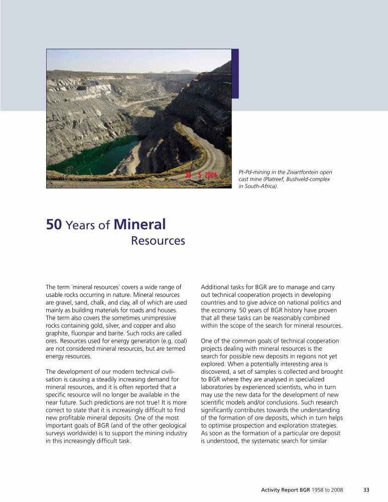
Pt-Pd-mining in the Zwartfontein opencast mine (Platreef, Bushveld-complexin South-Africa).
1999so001d_031_045.indd 331999so001d_031_045.indd 33 16.06.2009 09:13:3516.06.2009 09:13:35
34 Activity Report BGR 1958 to 2008
geological situations worldwide can begin. As anexample, during the research project ‘metallogenesisof gold and platinum deposits’ (end of the 1980suntil beginning of the 1990s), the conditionsrequired for the formation of economic depositswere identified. This was the basis for the develop-ment of a new and optimized strategy for searchingfor new deposits.
During the last 50 years BGR has gained significantknowledge about the formation of chromium,copper, and gold ores, which led to the discovery ofseveral new deposits. The most significant are thecopper deposit ‘La Granja’ in Peru (see below), thegold deposit ‘Yamfo’ in Ghana, and ‘Song Toh’,which is now the most important lead mine inThailand.
However, BGR does not only operate in the fieldof metal ores but also in the field of non-metallicmineral resources. Extraordinary deposits werediscovered in Jordan (phosphate) and Guatemala(gypsum) as well as in many other parts of the world(marble, clay, limestone). In some instances theprojects were run until the establishment of thefinal production unit (e.g. brick-making plant inthe case of clay deposits).
When a new deposit is discovered the nationalindustry is contacted, which can help to define theactual value of the deposit and of course can alsobenefit from the economic potential. This has ledto several long-term engagements of Germancompanies, such as Knauf Gips KG and Süd-ChemieAG in Argentina, and Schaeferkalk GmbH inMalaysia. Since 1991 there has been increasedactivity by German companies in the field of non-metallic resource mining abroad. In contrast the fewimportant German companies which used to beinvolved in metal ore mining have pulled out ofactive foreign mining. According to the recent study‘German mining abroad’, most of these companiesare now focusing exclusively on importing ores.
Only a few companies (commonly family enterprises)are still benefiting from the potential of metal oredeposits abroad, sometimes with remarkablesuccess. Due to this, and because of rising resourceprices, it is conceivable that at least some of the bigGerman companies will start to revise their opinionand restart their activities abroad. BGR, of course,
supports such projects particularly with adviceregarding the specific situation of the differentcountries and the resulting challenges. To be able togive optimum advice to the companies, it is essentialto be able to assess the current worldwide resourcesituation, offering opportunities as well as risks.
Because of the wide variety of mineral resourcesand the huge amount of data available, it makessense to collect different types of information indata bases. In this respect BGR has beencooperating with other well established geologicalsurveys for decades, e.g. the USGS (US GeologicalSurvey ) since 1975. As the only German institutionmanaging different types of comprehensive mineralresource data bases, BGR is able to interpret thedata correctly. The most important data bases are,for example, the resource data base providinginformation about the production, reserves andconsumption of mineral resources, and secondlya data base containing the prices of differentresources. These data bases are essential for givingpoliticians optimum advice. In addition, based onthe interpreted summaries gained from these databases, BGR publishes the ‘Resource Reports’(‘Rohstoffberichte’) and the ‘Country ResourceReports’ (‘Rohstoffwirtschafltiche Länderstudien’),which provide information on the resource situationof specific countries. An additional report concernsthe resource situation in Germany and is publishedannually (‘Bundesrepublik Deutschland –Rohstoffsituation’). Finally, since 1979 the pricesof 38 different mineral resources have beenpublished (nowadays on the Internet) and updatedmonthly.
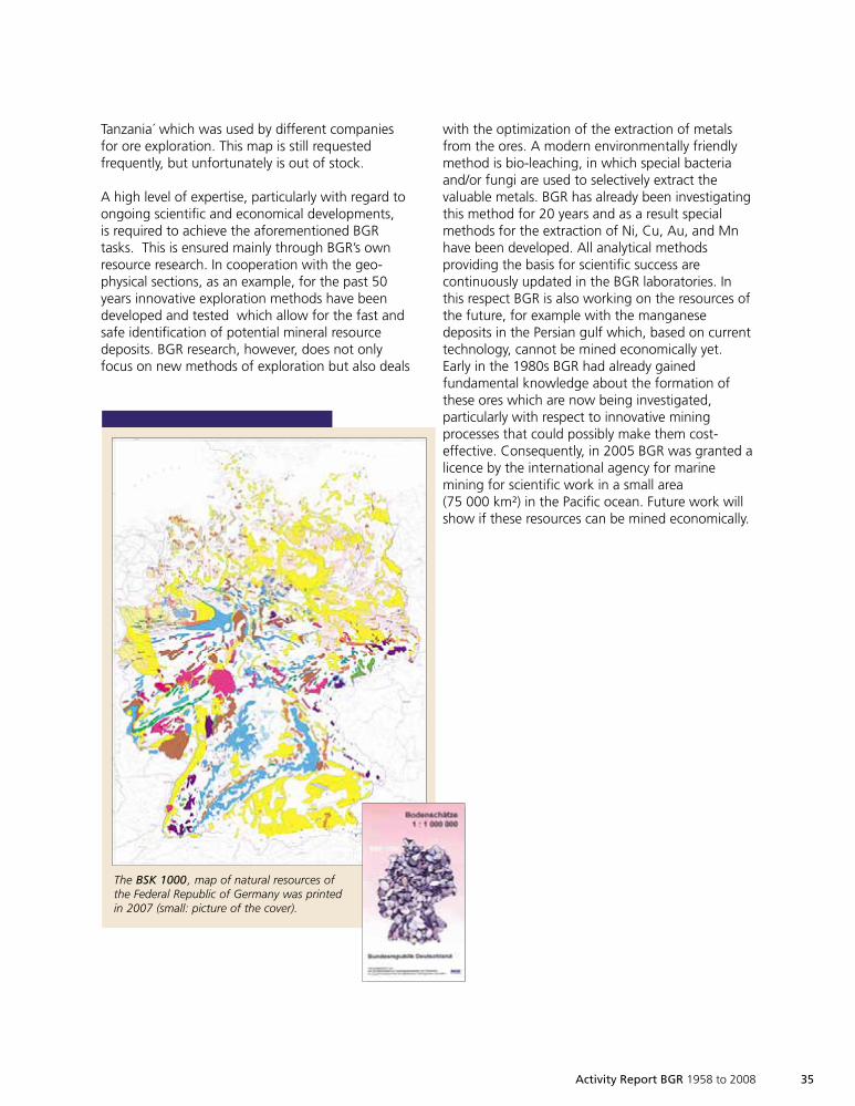
Geodata, on the other hand, can be used for theproduction of resource maps. An iron ore map ofGermany was established as early as 1964. Severalimportant maps followed, e.g. the ‘Map of Near-surface Mineral Resources of the Federal Republicof Germany 1: 200 000’ (Karte der oberflächen-nahen Rohstoffe der Bundesrepublik Deutschland1 : 200 000, ‘KOR200’) and very recently the map‘Resources of the Federal Republic of Germany1 : 1 000 000, (Bodenschätze der BundesrepublikDeutschland 1 : 1 000 000, ‘BSK1000’). Resourcemaps are also produced in and for foreign countries,often in the course of technical cooperationprojects. At the end of the 1980s, for example, BGRestablished the map ´The Lake Victoria goldfields,
1999so001d_031_045.indd 341999so001d_031_045.indd 34 16.06.2009 09:13:3716.06.2009 09:13:37
Activity Report BGR 1958 to 2008 35
The BSK 1000 , map of natural resources ofthe Federal Republic of Germany was printedin 2007 (small: picture of the cover).
Tanzania´ which was used by different companiesfor ore exploration. This map is still requestedfrequently, but unfortunately is out of stock.
A high level of expertise, particularly with regard toongoing scientific and economical developments,is required to achieve the aforementioned BGRtasks. This is ensured mainly through BGR’s ownresource research. In cooperation with the geo-physical sections, as an example, for the past 50years innovative exploration methods have beendeveloped and tested which allow for the fast andsafe identification of potential mineral resourcedeposits. BGR research, however, does not onlyfocus on new methods of exploration but also deals
with the optimization of the extraction of metalsfrom the ores. A modern environmentally friendlymethod is bio-leaching, in which special bacteriaand/or fungi are used to selectively extract thevaluable metals. BGR has already been investigatingthis method for 20 years and as a result specialmethods for the extraction of Ni, Cu, Au, and Mnhave been developed. All analytical methodsproviding the basis for scientific success arecontinuously updated in the BGR laboratories. Inthis respect BGR is also working on the resources ofthe future, for example with the manganesedeposits in the Persian gulf which, based on currenttechnology, cannot be mined economically yet.Early in the 1980s BGR had already gainedfundamental knowledge about the formation ofthese ores which are now being investigated,particularly with respect to innovative miningprocesses that could possibly make them cost-effective. Consequently, in 2005 BGR was granted alicence by the international agency for marinemining for scientific work in a small area(75 000 km²) in the Pacific ocean. Future work willshow if these resources can be mined economically.
1999so001d_031_045.indd 351999so001d_031_045.indd 35 17.06.2009 12:50:4717.06.2009 12:50:47
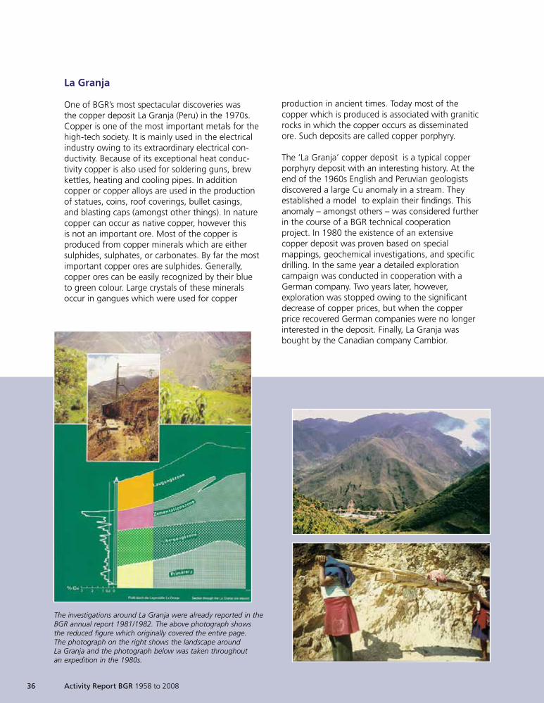
The investigations around La Granja were already reported in theBGR annual report 1981/1982. The above photograph showsthe reduced figure which originally covered the entire page.The photograph on the right shows the landscape aroundLa Granja and the photograph below was taken throughoutan expedition in the 1980s.
36 Activity Report BGR 1958 to 2008
La Granja
One of BGR’s most spectacular discoveries wasthe copper deposit La Granja (Peru) in the 1970s.Copper is one of the most important metals for thehigh-tech society. It is mainly used in the electricalindustry owing to its extraordinary electrical con-ductivity. Because of its exceptional heat conduc-tivity copper is also used for soldering guns, brewkettles, heating and cooling pipes. In additioncopper or copper alloys are used in the productionof statues, coins, roof coverings, bullet casings,and blasting caps (amongst other things). In naturecopper can occur as native copper, however thisis not an important ore. Most of the copper isproduced from copper minerals which are eithersulphides, sulphates, or carbonates. By far the mostimportant copper ores are sulphides. Generally,copper ores can be easily recognized by their blueto green colour. Large crystals of these mineralsoccur in gangues which were used for copper
production in ancient times. Today most of thecopper which is produced is associated with graniticrocks in which the copper occurs as disseminatedore. Such deposits are called copper porphyry.
The ‘La Granja’ copper deposit is a typical copperporphyry deposit with an interesting history. At theend of the 1960s English and Peruvian geologistsdiscovered a large Cu anomaly in a stream. Theyestablished a model to explain their findings. Thisanomaly – amongst others – was considered furtherin the course of a BGR technical cooperationproject. In 1980 the existence of an extensivecopper deposit was proven based on specialmappings, geochemical investigations, and specificdrilling. In the same year a detailed explorationcampaign was conducted in cooperation with aGerman company. Two years later, however,exploration was stopped owing to the significantdecrease of copper prices, but when the copperprice recovered German companies were no longerinterested in the deposit. Finally, La Granja wasbought by the Canadian company Cambior.
1999so001d_031_045.indd 361999so001d_031_045.indd 36 16.06.2009 09:13:3916.06.2009 09:13:39
Activity Report BGR 1958 to 2008 37
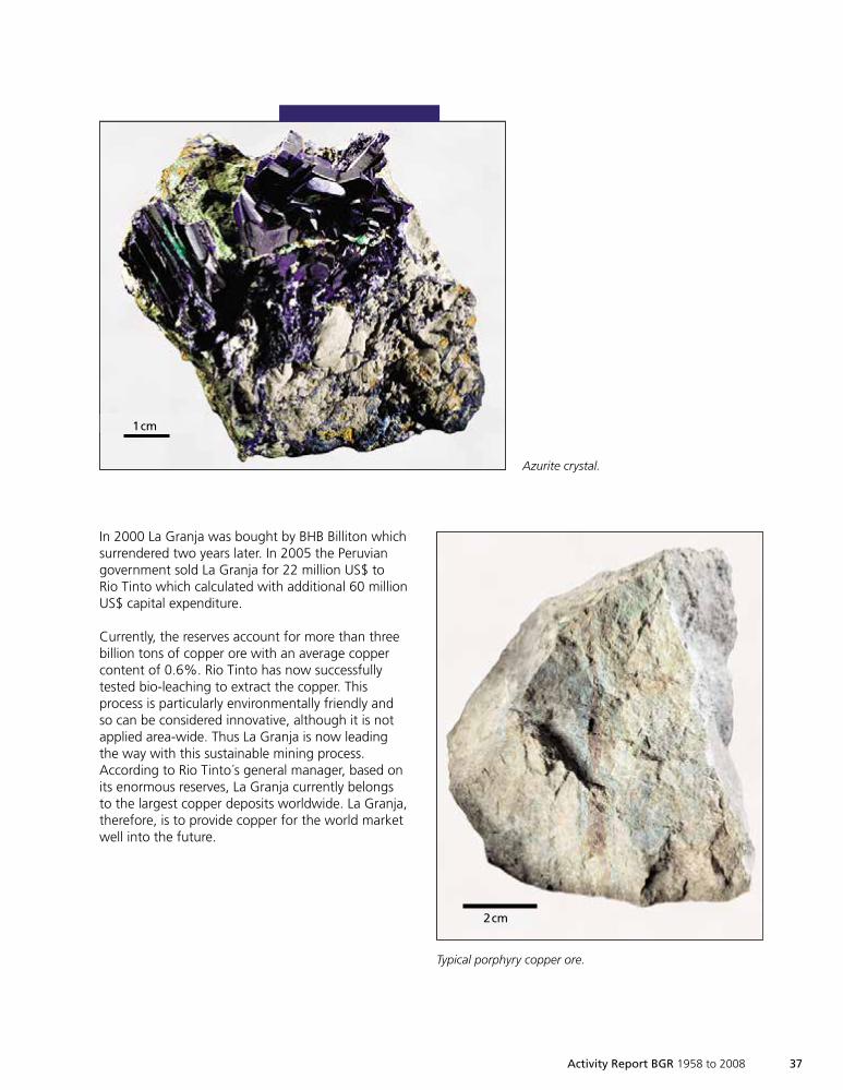
In 2000 La Granja was bought by BHB Billiton whichsurrendered two years later. In 2005 the Peruviangovernment sold La Granja for 22 million US$ toRio Tinto which calculated with additional 60 millionUS$ capital expenditure.
Currently, the reserves account for more than threebillion tons of copper ore with an average coppercontent of 0.6%. Rio Tinto has now successfullytested bio-leaching to extract the copper. Thisprocess is particularly environmentally friendly andso can be considered innovative, although it is notapplied area-wide. Thus La Granja is now leadingthe way with this sustainable mining process.According to Rio Tinto´s general manager, based onits enormous reserves, La Granja currently belongsto the largest copper deposits worldwide. La Granja,therefore, is to provide copper for the world marketwell into the future.
1 cm
Azurite crystal.
Typical porphyry copper ore.
2 cm
1cm
2cm
1999so001d_031_045.indd 371999so001d_031_045.indd 37 16.06.2009 09:13:3916.06.2009 09:13:39
38 Activity Report BGR 1958 to 2008
Mining of mineral resources significantly influencesboth the economic and social development of aregion and its natural environment. The impact ofmining activities is generally much greater than thesize of the actual mining operations. Althoughmining accounts for just ~1.5% of production valueworldwide, its products form an indispensableprerequisite for industrial production. Based on this,mining may initiate or actively support sustainabledevelopment but, on the other hand, may also beresponsible for environmental destruction or thecontinuation of armed conflicts.
So far there has been no generally acceptedmechanism, based on compliance with criteriasuch as sustainability or development standards,and allowing differentiation between products, forthe mining sector. However, such criteria alreadyexist for the forestry and fishing industries in theform of seals of approval. The certification oftrading chains in the mining sector represents anewly established tool for political activity in thefield of mineral resources, and aims to fill this gap.
The Federal Institute for Geosciences and NaturalResources (BGR) was commissioned by the GermanMinistry for Economics and Technology to proposea concept for mining activities in developingcountries, focusing on minimum social andecological standards. This paper was available forthe G8 Summit in Heiligendamm (June 2007) andwas prominently incorporated into the SummitDeclaration of the G8 countries (Article 86).
The regional focus of the pilot project is Africa, assuggested by BGR. Here, mineral resources have anextraordinary potential for the development ofsociety. Furthermore, regulation and administrativecontrol are not well developed in the mining sectorleading to a lack in transparency and sustainabilityin many cases. The central focus of the pilotproject is directed at small-scale mining, which issteadily gaining importance in terms of regionaldevelopment and poverty reduction. About 10to 30 percent of world production of somecommodities originates from small-scale miningoperations. Promising commodities for a pilotstudy are tantalum (Coltan), tin or tungsten ores.Commissioned by the German Ministry forEconomic Cooperation and Development, BGR ispresently developing a methodological approachcapable of distinguishing the origin of tantalumores (fingerprinting). This analytical procedure willbe used to verify trading chains in cases of doubt.
Certificationof Mineral Resources
86. … In order to better support the developmentof sustainable livelihoods and positivedevelopmental impacts associated with artisanaland small-scale mineral production, we…
support a pilot study, in co-operation with theÈWorld Bank and its initiatives, concerning thefeasibility of a designed certification system forselected raw materials. …The pilot study shallstrive on the basis of the existing principles andguidelines to comply with internationallyrecognised minimum standards by verifying theprocess of mineral resource extraction andtrading.
(Extract from the summit declaration of the G8-Summit inHeiligendamm June 7, 2007)
1999so001d_031_045.indd 381999so001d_031_045.indd 38 16.06.2009 09:13:5116.06.2009 09:13:51
Activity Report BGR 1958 to 2008 39
Analytical Proof of Origin of Tantalum(Coltan-Fingerprinting)
Tantalum is a rare metal which has a wide range ofapplications in the industry due to its high thermaland chemical resistance. Tantalum is of specialimportance in the field of microelectronics; it is anindispensable raw material for the production oftiny capacitors with high electrical capacitance. Suchcapacitors are vital in the production of modernmobile phones, laptops and flat screens.
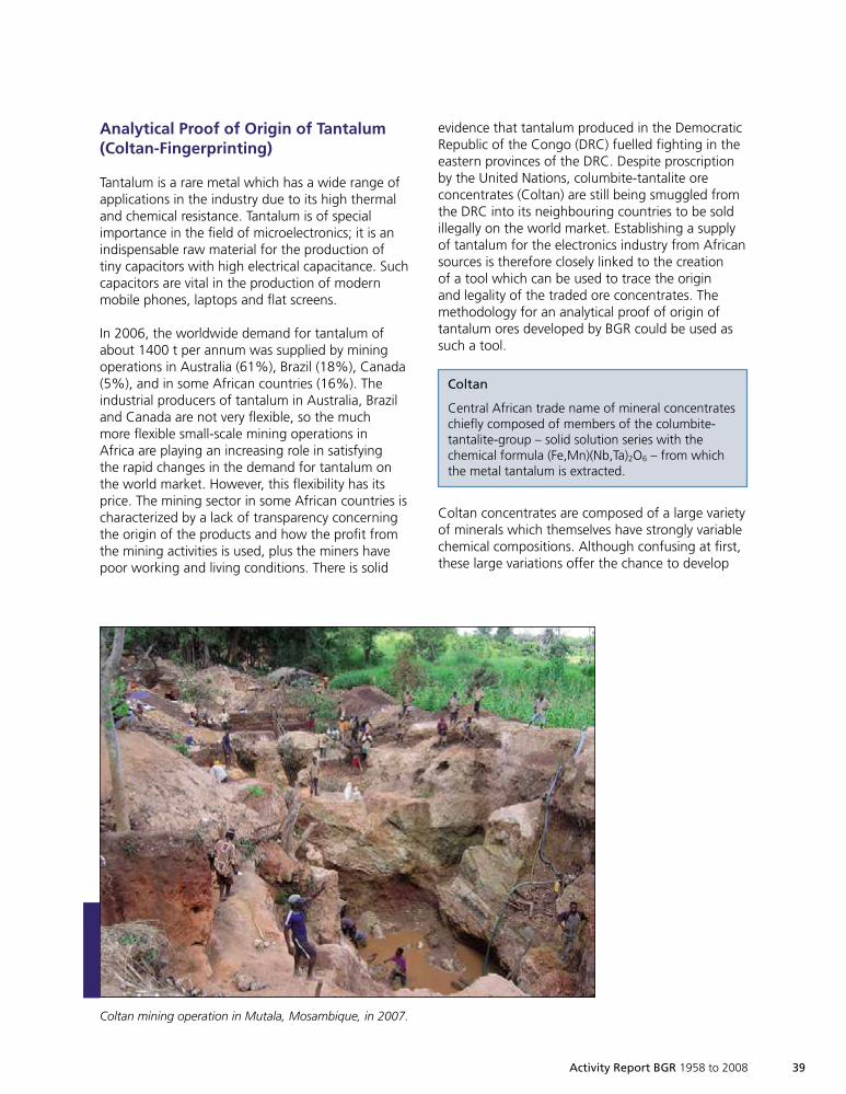
In 2006, the worldwide demand for tantalum ofabout 1400 t per annum was supplied by miningoperations in Australia (61%), Brazil (18%), Canada(5%), and in some African countries (16%). Theindustrial producers of tantalum in Australia, Braziland Canada are not very flexible, so the muchmore flexible small-scale mining operations inAfrica are playing an increasing role in satisfyingthe rapid changes in the demand for tantalum onthe world market. However, this flexibility has itsprice. The mining sector in some African countries ischaracterized by a lack of transparency concerningthe origin of the products and how the profit fromthe mining activities is used, plus the miners havepoor working and living conditions. There is solid
evidence that tantalum produced in the DemocraticRepublic of the Congo (DRC) fuelled fighting in theeastern provinces of the DRC. Despite proscriptionby the United Nations, columbite-tantalite oreconcentrates (Coltan) are still being smuggled fromthe DRC into its neighbouring countries to be soldillegally on the world market. Establishing a supplyof tantalum for the electronics industry from Africansources is therefore closely linked to the creationof a tool which can be used to trace the originand legality of the traded ore concentrates. Themethodology for an analytical proof of origin oftantalum ores developed by BGR could be used assuch a tool.
Coltan concentrates are composed of a large varietyof minerals which themselves have strongly variablechemical compositions. Although confusing at first,these large variations offer the chance to develop
Coltan mining operation in Mutala, Mosambique, in 2007.
Coltan
Central African trade name of mineral concentrateschiefly composed of members of the columbite-tantalite-group – solid solution series with thechemical formula (Fe,Mn)(Nb,Ta)2O6 – from whichthe metal tantalum is extracted.
1999so001d_031_045.indd 391999so001d_031_045.indd 39 16.06.2009 09:13:5116.06.2009 09:13:51
40 Activity Report BGR 1958 to 2008
a scheme for proof of origin. Mineralogical andchemical variations within individual coltan oreconcentrates will provide proof of their origin,which is generally a pegmatite body. The appliedprocedure represents what is known as fingerprintor footprint methodology.
The fingerprint of a coltan deposit is based ondetermination of the most promising mineralogicaland chemical parameters using state-of-the-arttechniques; these parameters are selected to enablediscrimination between different sources with theutmost precision. Discrimination starts from an oreprovince scale (supra-regional) and proceeds to alocal scale of individual pegmatite bodies. In thefuture, the combination of selected data (factors)will achieve a degree of discrimination which willmake it possible to assign samples of unknownorigin to ore provinces, ore districts or even toindividual deposits.
Columbite-tantalite can accommodate relativelylarge amounts of uranium and excludes commonlead almost completely. It is thus potentially suitedfor uranium-lead dating. The measured ratios
between uranium and radiogenic lead concentrationsas produced by the decaying of uranium areindicative of the age of the analysed mineral grain.Four age populations are evident for African Coltanconcentrates so far: >2500, ~2000, ~1000 und<600 million years. Material from the deposits inthe conflict region of the eastern provinces of theDRC (Kivu Province) always has an age of 1000to 900 million years. Based on this knowledge,measurement of ages of individual grains in aconcentrate will make it possible to detect an oreprovince, and will also provide evidence in caseswhere material from different provinces has beenmixed.
However, the trace element concentrations inthe coltan minerals also play a substantial role inthe methodology for discrimination of tantalumprovinces in Africa. Even if tantalum occurrenceswith similar ages of formation are examined (e.g.occurrences in the Great Lakes Region, KivuProvince of the DRC, Rwanda, Burundi andUganda), a discrimination of ore districts appearspossible based on trace element concentrations orelemental ratios.
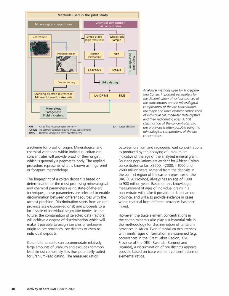
Methods used in the pilot study
Mineralogical compositions
Ore microscopy U-Pb dating
Majo
ran
dtrace
elemen
ts
MineralogyParagenesis
Fluid inclusions
Scanning electron microscopeMineral Liberation Analysis
LA-ICP-MS
Electronmicroprobe
Single grains(high resolution)
Whole rocksample
XRF
ICP-MS
LA-ICP-MS TIMS
Chemical compositionof concentrates
Concentrate
Polished section
XRF X-ray fluorescence spectrometry LA Laser ablationICP-MS Inductively coupled plasma mass spectrometryTIMS Thermal ionization mass spectrometry
Analytical methods used for fingerprin-ting Coltan. Important parameters forthe discrimination of various sources ofthe concentrates are the mineralogicalcompositions of the ore concentrates,the major and trace element compositionof individual columbite-tantalite crystalsand their radiometric ages. A firstclassification of the concentrates intoore provinces is often possible using themineralogical compositions of the oreconcentrates.
1999so001d_031_045.indd 401999so001d_031_045.indd 40 16.06.2009 09:13:5316.06.2009 09:13:53
Certified Trading Chains (CTC)in Mineral Production
BGR’s concept of certification aims at achievingminimum standards in the production and trade ofcertain mineral resources by ensuring a traceableand controllable trading chain. Widespread imple-mentation of CTC can gradually bring about anetwork of responsible use of mineral resources inthe processing industry that is effective worldwide.The approach of promoting sustainable develop-ment in a subset of projects seems to be morepragmatic for the short term than the challenge ofregulating the international resource economy.
The core of CTC lies in the certification of processand production methods rather than in the miningproduct itself – thus increasing the scope of appli-cation of the scheme and at the same time reducingcosts for laborious and time-consuming researchand analyses in mineral production. On the ground,the process verification builds on company auditsand the tracking of volumes of production, tradeand stockpile, while the industrial partner assumesresponsibility for the transparent and ethicalproduction of mineral resources.
Pilot Project Implementation
The pilot project focuses on certifying theproduction of the commodities tantalum (Coltan),tungsten and tin in Rwanda. In the past few yearsRwanda, and specifically the country’s military elite,has been accused of illegally exploiting and tradingmineral resources from the eastern parts of DRCongo. But Rwanda actually has deposits of naturalresources of its own. Enhancing national mineralproduction offers the country the possibility ofdeveloping its domestic and local economy. At themoment the 50 to 100 thousand artisanal andsmall-scale miners comprise the entire workforce inRwanda’s mining sector. This adds up to approxi-
mately half a million people, meaning that about15% of the total population is indirectly dependenton mining as a livelihood. Thus the pilot project iscontributing to enhancing the transparency andstabilisation of the resource economy in the regionof the Great Lakes.
The project partners on the side of the producersare locally based companies that took over con-cessions from the state company Régie des Minesdu Rwanda (Redemi) when the mining sector wasrestructured in 2006.
The business concept lies in further employingthe current staff by continuously improving theoperational facilities and production equipment,their current operations will gradually result inregular mining activities gaining adequately inefficiency. Metal-producing companies in industrialcountries with the strategic objective of securingthe acquisition of natural resources from CentralAfrica are the partners on the side of the buyer inthe trading chain. Supplying concentrates of therespective ores of tin, tungsten und tantalum(Coltan) from ethically responsible productionfrom Rwanda to Europe is part of the partnershipagreement between the primary producers andprocessors of mineral resources.
The OECD Guidelines for Multinational Enterprisesand the OECD Risk Awareness Tool for MultinationalEnterprises in Weak Governance Zones wereadapted to the reality of artisanal and small-scalemining and serve as basic principles for auditing thetrading chain. The initial conditions of the plannedsupply relationship were scrutinized by independentauditors. On this basis, BGR is establishing a setof provisions that guarantee minimum ethicalstandards. The analytical proof of origin will makeit possible to ensure that the minerals stem from aknown and registered mine site. If the method isused as forensic proof, it can also identify dubiouslots from possible areas of conflict.
Activity Report BGR 1958 to 2008 41
1999so001d_031_045.indd 411999so001d_031_045.indd 41 16.06.2009 09:13:5416.06.2009 09:13:54
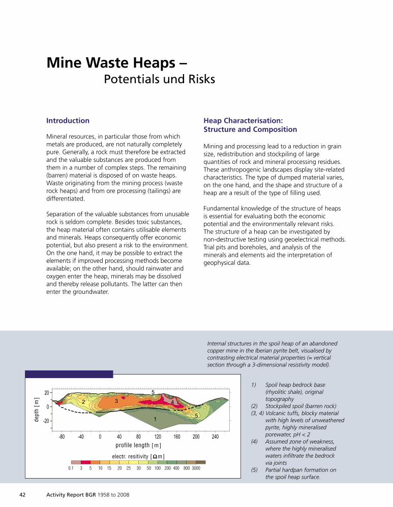
42 Activity Report BGR 1958 to 2008
Heap Characterisation:Structure and Composition
Mining and processing lead to a reduction in grainsize, redistribution and stockpiling of largequantities of rock and mineral processing residues.These anthropogenic landscapes display site-relatedcharacteristics. The type of dumped material varies,on the one hand, and the shape and structure of aheap are a result of the type of filling used.
Fundamental knowledge of the structure of heapsis essential for evaluating both the economicpotential and the environmentally relevant risks.The structure of a heap can be investigated bynon-destructive testing using geoelectrical methods.Trial pits and boreholes, and analysis of theminerals and elements aid the interpretation ofgeophysical data.
Mine Waste Heaps –Potentials und Risks
Internal structures in the spoil heap of an abandonedcopper mine in the Iberian pyrite belt, visualised bycontrasting electrical material properties (= verticalsection through a 3-dimensional resistivity model).
1) Spoil heap bedrock base(rhyolitic shale), originaltopography
(2) Stockpiled spoil (barren rock)(3, 4) Volcanic tuffs, blocky material
with high levels of unweatheredpyrite, highly mineralisedporewater, pH < 2
(4) Assumed zone of weakness,where the highly mineralisedwaters infiltrate the bedrockvia joints
(5) Partial hardpan formation onthe spoil heap surface.
Introduction
Mineral resources, in particular those from whichmetals are produced, are not naturally completelypure. Generally, a rock must therefore be extractedand the valuable substances are produced fromthem in a number of complex steps. The remaining(barren) material is disposed of on waste heaps.Waste originating from the mining process (wasterock heaps) and from ore processing (tailings) aredifferentiated.
Separation of the valuable substances from unusablerock is seldom complete. Besides toxic substances,the heap material often contains utilisable elementsand minerals. Heaps consequently offer economicpotential, but also present a risk to the environment.On the one hand, it may be possible to extract theelements if improved processing methods becomeavailable; on the other hand, should rainwater andoxygen enter the heap, minerals may be dissolvedand thereby release pollutants. The latter can thenenter the groundwater.
-80 -40 0 40 80 120 160 200 240
1
2 3 4
5
5
-20
0
20
profile length [ m ]
electr. resitivity [ ΩΩ m]
dept
h[m
]
0.1 3 5 10 15 20 25 30 50 100 200 400 800 3000
1999so001d_031_045.indd 421999so001d_031_045.indd 42 16.06.2009 09:13:5916.06.2009 09:13:59
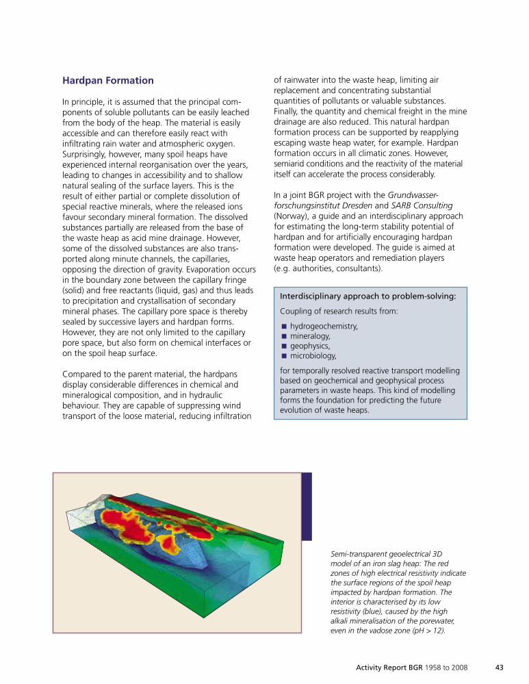
Activity Report BGR 1958 to 2008 43
Hardpan Formation
In principle, it is assumed that the principal com-ponents of soluble pollutants can be easily leachedfrom the body of the heap. The material is easilyaccessible and can therefore easily react withinfiltrating rain water and atmospheric oxygen.Surprisingly, however, many spoil heaps haveexperienced internal reorganisation over the years,leading to changes in accessibility and to shallownatural sealing of the surface layers. This is theresult of either partial or complete dissolution ofspecial reactive minerals, where the released ionsfavour secondary mineral formation. The dissolvedsubstances partially are released from the base ofthe waste heap as acid mine drainage. However,some of the dissolved substances are also trans-ported along minute channels, the capillaries,opposing the direction of gravity. Evaporation occursin the boundary zone between the capillary fringe(solid) and free reactants (liquid, gas) and thus leadsto precipitation and crystallisation of secondarymineral phases. The capillary pore space is therebysealed by successive layers and hardpan forms.However, they are not only limited to the capillarypore space, but also form on chemical interfaces oron the spoil heap surface.
Compared to the parent material, the hardpansdisplay considerable differences in chemical andmineralogical composition, and in hydraulicbehaviour. They are capable of suppressing windtransport of the loose material, reducing infiltration
of rainwater into the waste heap, limiting airreplacement and concentrating substantialquantities of pollutants or valuable substances.Finally, the quantity and chemical freight in the minedrainage are also reduced. This natural hardpanformation process can be supported by reapplyingescaping waste heap water, for example. Hardpanformation occurs in all climatic zones. However,semiarid conditions and the reactivity of the materialitself can accelerate the process considerably.
In a joint BGR project with the Grundwasser-forschungsinstitut Dresden and SARB Consulting(Norway), a guide and an interdisciplinary approachfor estimating the long-term stability potential ofhardpan and for artificially encouraging hardpanformation were developed. The guide is aimed atwaste heap operators and remediation players(e.g. authorities, consultants).
Semi-transparent geoelectrical 3Dmodel of an iron slag heap: The redzones of high electrical resistivity indicatethe surface regions of the spoil heapimpacted by hardpan formation. Theinterior is characterised by its lowresistivity (blue), caused by the highalkali mineralisation of the porewater,even in the vadose zone (pH > 12).
Interdisciplinary approach to problem-solving:
Coupling of research results from:
hydrogeochemistry,Èmineralogy,Ègeophysics,Èmicrobiology,È
for temporally resolved reactive transport modellingbased on geochemical and geophysical processparameters in waste heaps. This kind of modellingforms the foundation for predicting the futureevolution of waste heaps.
1999so001d_031_045.indd 431999so001d_031_045.indd 43 16.06.2009 09:13:5916.06.2009 09:13:59
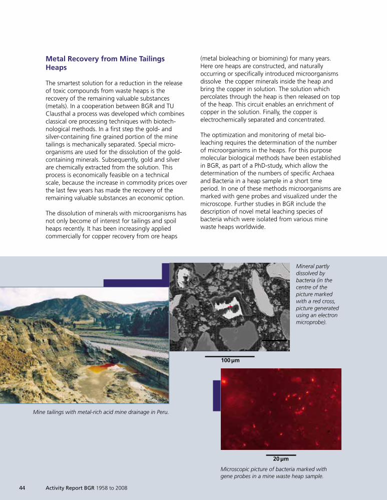
Metal Recovery from Mine TailingsHeaps
The smartest solution for a reduction in the releaseof toxic compounds from waste heaps is therecovery of the remaining valuable substances(metals). In a cooperation between BGR and TUClausthal a process was developed which combinesclassical ore processing techniques with biotech-nological methods. In a first step the gold- andsilver-containing fine grained portion of the minetailings is mechanically separated. Special micro-organisms are used for the dissolution of the gold-containing minerals. Subsequently, gold and silverare chemically extracted from the solution. Thisprocess is economically feasible on a technicalscale, because the increase in commodity prices overthe last few years has made the recovery of theremaining valuable substances an economic option.
The dissolution of minerals with microorganisms hasnot only become of interest for tailings and spoilheaps recently. It has been increasingly appliedcommercially for copper recovery from ore heaps
(metal bioleaching or biomining) for many years.Here ore heaps are constructed, and naturallyoccurring or specifically introduced microorganismsdissolve the copper minerals inside the heap andbring the copper in solution. The solution whichpercolates through the heap is then released on topof the heap. This circuit enables an enrichment ofcopper in the solution. Finally, the copper iselectrochemically separated and concentrated.
The optimization and monitoring of metal bio-leaching requires the determination of the numberof microorganisms in the heaps. For this purposemolecular biological methods have been establishedin BGR, as part of a PhD-study, which allow thedetermination of the numbers of specific Archaeaand Bacteria in a heap sample in a short timeperiod. In one of these methods microorganisms aremarked with gene probes and visualized under themicroscope. Further studies in BGR include thedescription of novel metal leaching species ofbacteria which were isolated from various minewaste heaps worldwide.
Mine tailings with metal-rich acid mine drainage in Peru.
Microscopic picture of bacteria marked withgene probes in a mine waste heap sample.
Mineral partlydissolved bybacteria (in thecentre of thepicture markedwith a red cross,picture generatedusing an electronmicroprobe).
44 Activity Report BGR 1958 to 2008
100 µm
20 µm
1999so001d_031_045.indd 441999so001d_031_045.indd 44 16.06.2009 09:14:0116.06.2009 09:14:01

Activity Report BGR 1958 to 2008 45
Conclusion
The BGR and its cooperation partners have a broadknowledge in the field of ‘Rohstoffsicherung‘. Thestrong interdisciplinary scientific focus on valuable
and toxic compounds in a heap and the consider-ation of economic aspects provide a basis for asustainable use of this georesource.
1999so001d_031_045.indd 451999so001d_031_045.indd 45 16.06.2009 09:14:0216.06.2009 09:14:02

1999so001d_046_061.indd 461999so001d_046_061.indd 46 16.06.2009 09:14:4216.06.2009 09:14:42
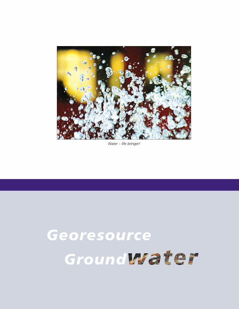
Activity Report BGR 1958 to 2008 47
Georesource
Ground
Water – life bringer!
1999so001d_046_061.indd 471999so001d_046_061.indd 47 16.06.2009 09:14:4716.06.2009 09:14:47
48 Activity Report BGR 1958 to 2008
Groundwater
Globally, groundwater is the most widely distributedand largest resource. With an estimated amount of10.5 million cubic kilometres it is also the mostimportant available reserve of fresh water. In aridzones, in particular, groundwater is immenselyvaluable, because it is the only reliable waterresource. Today, more than 1.5 billion people rely
on groundwater. Because of population growthand climate change, the global importance ofgroundwater as a high-quality basis of watersupplies will increase considerably in the future.If used sensibly and sustainably, groundwater canmake an important contribution to solving regionalwater crises.
1999so001d_046_061.indd Abs1:481999so001d_046_061.indd Abs1:48 16.06.2009 09:14:4816.06.2009 09:14:48
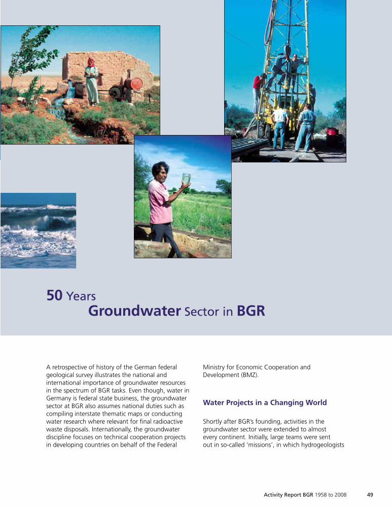
Activity Report BGR 1958 to 2008 49
A retrospective of history of the German federalgeological survey illustrates the national andinternational importance of groundwater resourcesin the spectrum of BGR tasks. Even though, water inGermany is federal state business, the groundwatersector at BGR also assumes national duties such ascompiling interstate thematic maps or conductingwater research where relevant for final radioactivewaste disposals. Internationally, the groundwaterdiscipline focuses on technical cooperation projectsin developing countries on behalf of the Federal
50 YearsGroundwater Sector in BGR
Ministry for Economic Cooperation andDevelopment (BMZ).
Water Projects in a Changing World
Shortly after BGR’s founding, activities in thegroundwater sector were extended to almostevery continent. Initially, large teams were sentout in so-called ‘missions’, in which hydrogeologists
1999so001d_046_061.indd Abs1:491999so001d_046_061.indd Abs1:49 16.06.2009 09:14:5416.06.2009 09:14:54
50 Activity Report BGR 1958 to 2008
worked on groundwater exploration, togetherwith other geoscientists and technicians involved intasks such as exploration for energy and mineralresources. This was based on the approach thateconomically underdeveloped countries are betteraided by comprehensive concepts than bystandalone projects.
The advances in related natural sciences such asanalytical chemistry and geophysics initiated achange in hydrogeological research and methodsduring the 1960s: the establishment of new waterlaboratories improved not only analytics of watercomposition, new techniques in isotope hydrologyalso allowed groundwater dating and estimatesof recharge and flow patterns. The developmentand application of new geophysical methods ingroundwater exploration enables the localisationof aquifers or the boundary between fresh andsaline water, without expensive drilling. Thesehydrochemical and geophysical methods, initiatedin the 1960s, are still in use and being developedfurther continuously. Therefore, the interdisciplinarycooperation in the groundwater sector has a longtradition at BGR.
Although raw material supply was at the forefrontin 1970s for economical reasons, long-termsecurity of water supply continued to be afundamental human need, especially in the Earth’sarid regions. In countries with low precipitation,both within and outside of Europe, there was adesire to cooperate with BGR hydrogeologists, sothat the number of technical cooperation projectsrose steadily. National research projects, incooperation with the soil sector, demonstrated theimportance of the unsaturated zone for ground-water protection and water balance. The hydrogeo-logical thematic maps at a scale of 1 : 1 milliondeveloped in cooperation with the State Geolo-gical Surveys provided an initial basis for land-use regulations and water protection measures.The early use of IT systems, which allowed thedevelopment of the first numeric flow simulations,established to an important planning instrument inthe following years, was a piece of pioneering work.
Hydrogeological activities of BGR were extended byan important national task at the beginning of the1980s: the problem of final radioactive wastestorage increasingly moved to the centre of publicinterest. The extensive hydrogeological investigationand evaluation of possible sites, in particular atGorleben and Schacht Konrad, represented a corenational duty of the groundwater sector into the1990s. In addition, special hydrogeological problemssuch as the behaviour of fresh-saline water systemswere worked on in the course of radioactive wastemanagement and research. Overall, groundwateractivities expanded during this period, not leastdue to the increasing importance of environmentalprotection. Similarly, environmental problems wereincreasingly the object of technical cooperationprojects.
At Germany’s reunification in the 1990s, existinghydrogeological data needed to be secured. Inaddition, the problem of soil and groundwaterpollution from abandoned hazardous sites gainedimportance not only in the new federal states. BGRassisted the State Geological Surveys as an expertadvisor with regard to these environmental issues.In technical cooperation projects, helicopters wereused for the first time for groundwater explorationapplying geophysical methods, for example inPakistan and Namibia. This method has been usedboth at home and abroad for extensive ground-water exploration. In technical cooperation projects,hydrogeologic consulting service again increased inimportance: The establishment of institutions andtechnical expertise in the partner countries wasincreasingly promoted. Besides exploration, thesustainable management and protection ofgroundwater resources took centre stage in foreignwater projects.
A computer printout from the late 1970s showsthe result of numeric simulation for a Sudanese
research project.
1999so001d_046_061.indd Abs1:501999so001d_046_061.indd Abs1:50 16.06.2009 09:14:5916.06.2009 09:14:59
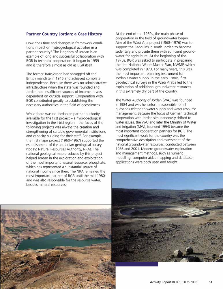
Activity Report BGR 1958 to 2008 51
Partner Country Jordan: a Case History
How does time and changes in framework condi-tions impact on hydrogeological activities in apartner country? The kingdom of Jordan is anexample of long and successful collaboration withBGR in technical cooperation. It began in 1959and is therefore almost as old as BGR itself.
The former Transjordan had shrugged off theBritish mandate in 1946 and achieved completeindependence. Because there was no administrativeinfrastructure when the state was founded andJordan had insufficient sources of income, it wasdependent on outside support. Cooperation withBGR contributed greatly to establishing thenecessary authorities in the field of geosciences.
While there was no Jordanian partner authorityavailable for the first project – a hydrogeologicalinvestigation in the Irbid region – the focus of thefollowing projects was always the creation andstrengthening of suitable governmental institutionsand capacity building for their staff. For example,the first major project (1960–1967) supported theestablishment of the Jordanian geological survey(today: Natural Resources Authority, NRA). Thenational geological map produced by this projecthelped Jordan in the exploration and exploitationof the most important natural resource, phosphate,which has represented a substantial source ofnational income since then. The NRA remained themost important partner of BGR until the mid-1980sand was also responsible for the resource water,besides mineral resources.
At the end of the 1960s, the main phase ofcooperation in the field of groundwater began.Aim of the Wadi Arja project (1968–1976) was tosupport the Bedouins in south Jordan to becomesedentary and provide them with sufficient ground-water for agriculture. At the beginning of the1970s, BGR was asked to participate in preparingthe first National Water Master Plan, NWMP, whichwas completed in 1973. For many years, this wasthe most important planning instrument forJordan‘s water supply. In the early 1980s, firstgeoelectrical surveys in the Wadi Araba led to theexploitation of additional groundwater resourcesin this extremely dry part of the country.
The Water Authority of Jordan (WAJ) was foundedin 1984 and was henceforth responsible for allquestions related to water supply and water resourcemanagement. Because the focus of German technicalcooperation with Jordan simultaneously shifted towater issues, the WAJ and later the Ministry of Waterand Irrigation (MWI, founded 1994) became themost important cooperation partners for BGR. Themost significant work for the country was thecomprehensive description and assessment of thenational groundwater resources, conducted between1986 and 2001. Modern groundwater explorationand management methods, such as numericmodelling, computer-aided mapping and databaseapplications were both used and taught.
1999so001d_046_061.indd 511999so001d_046_061.indd 51 16.06.2009 09:15:0316.06.2009 09:15:03
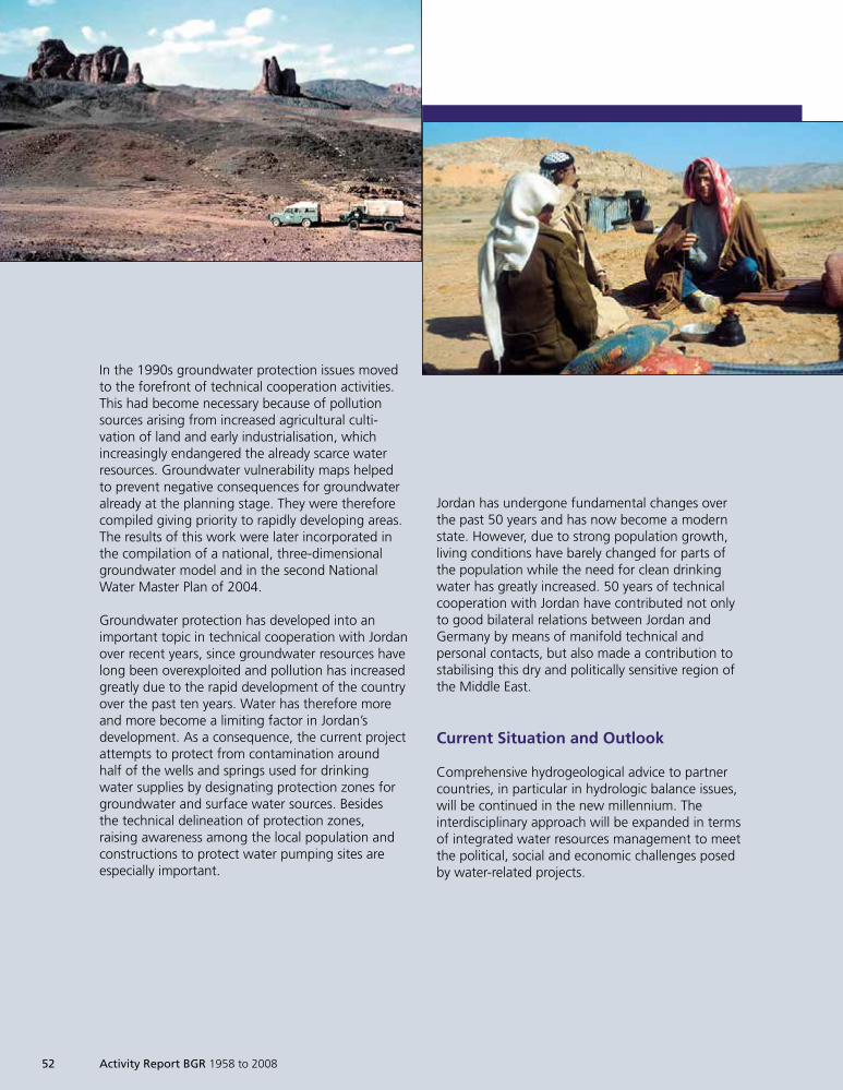
52 Activity Report BGR 1958 to 2008
In the 1990s groundwater protection issues movedto the forefront of technical cooperation activities.This had become necessary because of pollutionsources arising from increased agricultural culti-vation of land and early industrialisation, whichincreasingly endangered the already scarce waterresources. Groundwater vulnerability maps helpedto prevent negative consequences for groundwateralready at the planning stage. They were thereforecompiled giving priority to rapidly developing areas.The results of this work were later incorporated inthe compilation of a national, three-dimensionalgroundwater model and in the second NationalWater Master Plan of 2004.
Groundwater protection has developed into animportant topic in technical cooperation with Jordanover recent years, since groundwater resources havelong been overexploited and pollution has increasedgreatly due to the rapid development of the countryover the past ten years. Water has therefore moreand more become a limiting factor in Jordan’sdevelopment. As a consequence, the current projectattempts to protect from contamination aroundhalf of the wells and springs used for drinkingwater supplies by designating protection zones forgroundwater and surface water sources. Besidesthe technical delineation of protection zones,raising awareness among the local population andconstructions to protect water pumping sites areespecially important.
Jordan has undergone fundamental changes overthe past 50 years and has now become a modernstate. However, due to strong population growth,living conditions have barely changed for parts ofthe population while the need for clean drinkingwater has greatly increased. 50 years of technicalcooperation with Jordan have contributed not onlyto good bilateral relations between Jordan andGermany by means of manifold technical andpersonal contacts, but also made a contribution tostabilising this dry and politically sensitive region ofthe Middle East.
Current Situation and Outlook
Comprehensive hydrogeological advice to partnercountries, in particular in hydrologic balance issues,will be continued in the new millennium. Theinterdisciplinary approach will be expanded in termsof integrated water resources management to meetthe political, social and economic challenges posedby water-related projects.
1999so001d_046_061.indd 521999so001d_046_061.indd 52 16.06.2009 09:15:0716.06.2009 09:15:07
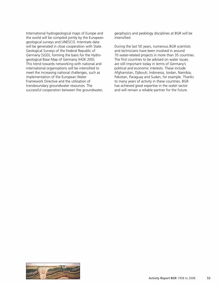
Activity Report BGR 1958 to 2008 53
International hydrogeological maps of Europe andthe world will be compiled jointly by the Europeangeological surveys and UNESCO. Interstate datawill be generated in close cooperation with StateGeological Surveys of the Federal Republic ofGermany (SGD), forming the basis for the Hydro-geological Base Map of Germany (HÜK 200).This trend towards networking with national andinternational organisations will be intensified tomeet the increasing national challenges, such asimplementation of the European WaterFramework Directive and the utilisation oftransboundary groundwater resources. Thesuccessful cooperation between the groundwater,
geophysics and pedology disciplines at BGR will beintensified.
During the last 50 years, numerous BGR scientistsand technicians have been involved in around70 water-related projects in more than 35 countries.The first countries to be advised on water issuesare still important today in terms of Germany’spolitical and economic interests. These includeAfghanistan, Djibouti, Indonesia, Jordan, Namibia,Pakistan, Paraguay and Sudan, for example. Thanksto many years of activity in these countries, BGRhas achieved great expertise in the water sectorand will remain a reliable partner for the future.
1999so001d_046_061.indd 531999so001d_046_061.indd 53 16.06.2009 09:15:1116.06.2009 09:15:11
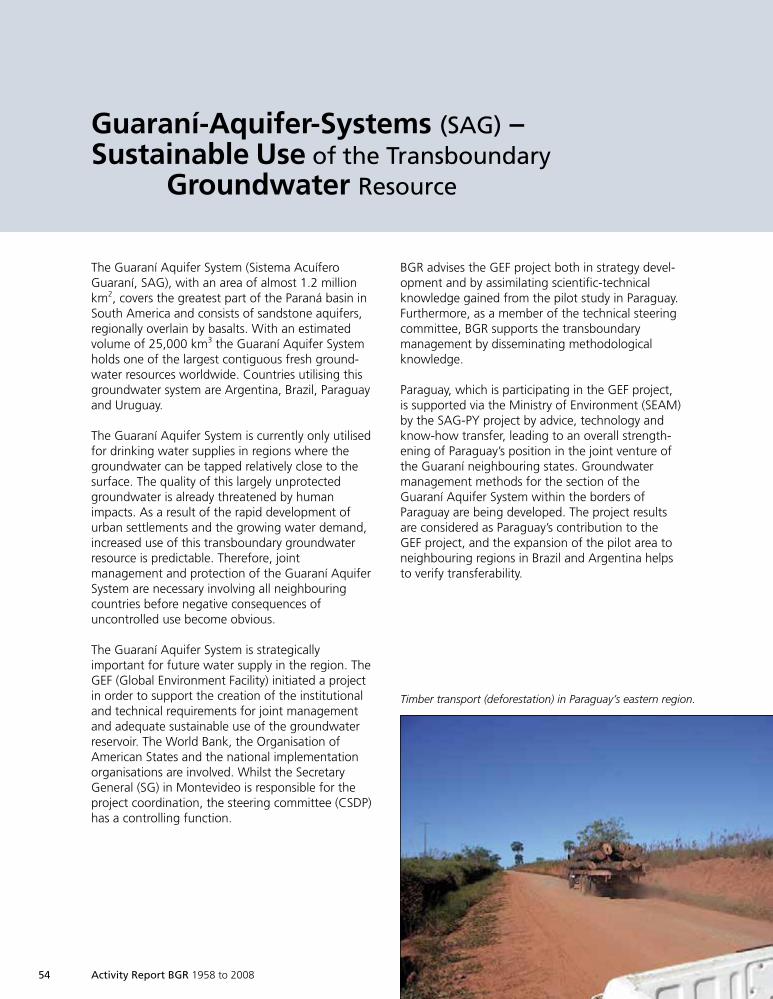
54 Activity Report BGR 1958 to 2008
The Guaraní Aquifer System (Sistema AcuíferoGuaraní, SAG), with an area of almost 1.2 millionkm2, covers the greatest part of the Paraná basin inSouth America and consists of sandstone aquifers,regionally overlain by basalts. With an estimatedvolume of 25,000 km3 the Guaraní Aquifer Systemholds one of the largest contiguous fresh ground-water resources worldwide. Countries utilising thisgroundwater system are Argentina, Brazil, Paraguayand Uruguay.
The Guaraní Aquifer System is currently only utilisedfor drinking water supplies in regions where thegroundwater can be tapped relatively close to thesurface. The quality of this largely unprotectedgroundwater is already threatened by humanimpacts. As a result of the rapid development ofurban settlements and the growing water demand,increased use of this transboundary groundwaterresource is predictable. Therefore, jointmanagement and protection of the Guaraní AquiferSystem are necessary involving all neighbouringcountries before negative consequences ofuncontrolled use become obvious.
The Guaraní Aquifer System is strategicallyimportant for future water supply in the region. TheGEF (Global Environment Facility) initiated a projectin order to support the creation of the institutionaland technical requirements for joint managementand adequate sustainable use of the groundwaterreservoir. The World Bank, the Organisation ofAmerican States and the national implementationorganisations are involved. Whilst the SecretaryGeneral (SG) in Montevideo is responsible for theproject coordination, the steering committee (CSDP)has a controlling function.
Guaraní-Aquifer-Systems (SAG) –Sustainable Use of the Transboundary
Groundwater Resource
BGR advises the GEF project both in strategy devel-opment and by assimilating scientific-technicalknowledge gained from the pilot study in Paraguay.Furthermore, as a member of the technical steeringcommittee, BGR supports the transboundarymanagement by disseminating methodologicalknowledge.
Paraguay, which is participating in the GEF project,is supported via the Ministry of Environment (SEAM)by the SAG-PY project by advice, technology andknow-how transfer, leading to an overall strength-ening of Paraguay’s position in the joint venture ofthe Guaraní neighbouring states. Groundwatermanagement methods for the section of theGuaraní Aquifer System within the borders ofParaguay are being developed. The project resultsare considered as Paraguay’s contribution to theGEF project, and the expansion of the pilot area toneighbouring regions in Brazil and Argentina helpsto verify transferability.
Timber transport (deforestation) in Paraguay’s eastern region.
1999so001d_046_061.indd 541999so001d_046_061.indd 54 16.06.2009 09:15:1616.06.2009 09:15:16
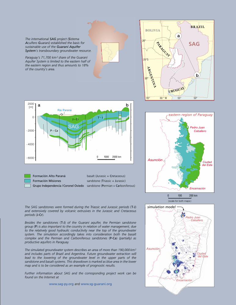
Río Paraná
K
J-K
T-J
C-P
SAG
0 1000 2000 km
a b
CrT – J
J – Cr
P – Ca
2000[m]
0
- 2000
- 4000
- 6000Asunción
Encarnación
Ciudad
del Este
Pedro Juan
Caballero
The SAG sandstones were formed during the Triassic and Jurassic periods (T-J)and extensively covered by volcanic extrusives in the Jurassic and Cretaceousperiods (J-Cr).
Besides the sandstones (T-J) of the Guaraní aquifer, the Permian sandstonegroup (P) is also important to the country in relation of water management, dueto the relatively good hydraulic conductivity near the top of the groundwatersystem. The simulation accordingly takes into consideration both the basaltcomplex and the Permian and Carboniferous sandstones (P-Ca) (partially) asproductive aquifers in Paraguay.
The simulated groundwater system describes an area of more than 190,000 km2
and includes parts of Brazil and Argentina. Future groundwater extraction willlead to the lowering of the groundwater level in the upper parts of thesandstone and basalt systems. This drawdown is marked as blue area in the lowermap and is to be considered as an example of prognostic results.
Further information about SAG and the corresponding project work can befound on the Internet at
www.sag-py.org and www.sg-guarani.org
Formación Alto Paraná basalt (Jurassic + Cretaceous)
Formación Misiones sandstone (Triassic + Jurassic)
Grupo Independencia / Coronel Oviedo sandstone (Permian + Carboniferous)
100 km500
eastern region of Paraguay
simulation model
SAG
BRAZILBOLIVIA
PAR
AG
UAY
AR
GE
NT
INA
URUGUAY
a
b
60 ° W 55° 50°65°
30°
25°S
20°
Asunción
Encarnación
Pedro JuanCaballero
Ciudaddel Este
0 100 200 km
( scale for both maps )
The international SAG project (SistemaAcuífero Guaraní) established the basis forsustainable use of the Guaraní AquiferSystem's transboundary groundwater resource.
Paraguay's 71,700 km2 share of the GuaraníAquifer System is limited to the eastern half ofthe eastern region and thus amounts to 18%of the country's area.
1999so001d_046_061.indd 551999so001d_046_061.indd 55 16.06.2009 09:15:1816.06.2009 09:15:18
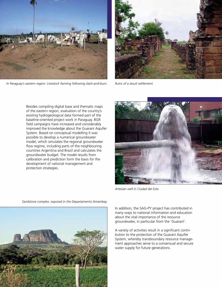
56 Activity Report BGR 1958 to 2008
Besides compiling digital base and thematic mapsof the eastern region, evaluation of the country’sexisting hydrogeological data formed part of thebaseline-oriented project work in Paraguay. BGRfield campaigns have increased and considerablyimproved the knowledge about the Guaraní AquiferSystem. Based on conceptual modelling it waspossible to develop a numerical groundwatermodel, which simulates the regional groundwaterflow regime, including parts of the neighbouringcountries Argentina and Brazil and calculates thegroundwater budget. The model results fromcalibration and prediction form the basis for thedevelopment of national management andprotection strategies.
In addition, the SAG-PY project has contributed inmany ways to national information and educationabout the vital importance of the resourcegroundwater, in particular from the ‘Guaraní’.
A variety of activities result in a significant contri-bution to the protection of the Guaraní AquiferSystem, whereby transboundary resource manage-ment approaches serve to a consensual and securewater supply for future generations.
In Paraguay’s eastern region: Livestock farming following slash-and-burn. Ruins of a Jesuit settlement.
Artesian well in Ciudad del Este.
Sandstone complex, exposed in the Departamento Amambay.
1999so001d_046_061.indd 561999so001d_046_061.indd 56 16.06.2009 09:15:2016.06.2009 09:15:20
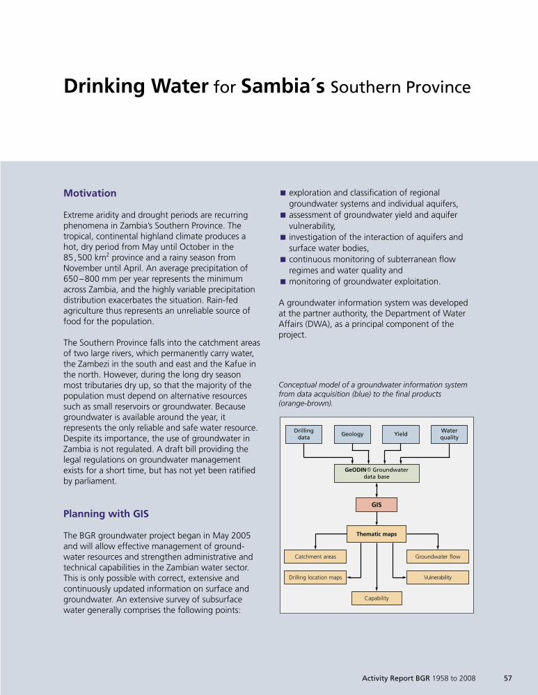
Motivation
Extreme aridity and drought periods are recurringphenomena in Zambia’s Southern Province. Thetropical, continental highland climate produces ahot, dry period from May until October in the85,500 km2 province and a rainy season fromNovember until April. An average precipitation of650 –800 mm per year represents the minimumacross Zambia, and the highly variable precipitationdistribution exacerbates the situation. Rain-fedagriculture thus represents an unreliable source offood for the population.
The Southern Province falls into the catchment areasof two large rivers, which permanently carry water,the Zambezi in the south and east and the Kafue inthe north. However, during the long dry seasonmost tributaries dry up, so that the majority of thepopulation must depend on alternative resourcessuch as small reservoirs or groundwater. Becausegroundwater is available around the year, itrepresents the only reliable and safe water resource.Despite its importance, the use of groundwater inZambia is not regulated. A draft bill providing thelegal regulations on groundwater managementexists for a short time, but has not yet been ratifiedby parliament.
Planning with GIS
The BGR groundwater project began in May 2005and will allow effective management of ground-water resources and strengthen administrative andtechnical capabilities in the Zambian water sector.This is only possible with correct, extensive andcontinuously updated information on surface andgroundwater. An extensive survey of subsurfacewater generally comprises the following points:
Drinking Water for Sambia´s Southern Province
exploration and classification of regionalÈ
groundwater systems and individual aquifers,assessment of groundwater yield and aquiferÈ
vulnerability,investigation of the interaction of aquifers andÈ
surface water bodies,continuous monitoring of subterranean flowÈ
regimes and water quality andmonitoring of groundwater exploitation.È
A groundwater information system was developedat the partner authority, the Department of WaterAffairs (DWA), as a principal component of theproject.
Drillingdata
Geology
GeODIN R Groundwaterdata base
GIS
YieldWaterquality
Thematic maps
Groundwater flow
Vulnerability
Catchment areas
Drilling location maps
Capability
Conceptual model of a groundwater information systemfrom data acquisition (blue) to the final products(orange-brown).
Activity Report BGR 1958 to 2008 57
1999so001d_046_061.indd 571999so001d_046_061.indd 57 16.06.2009 09:15:2816.06.2009 09:15:28
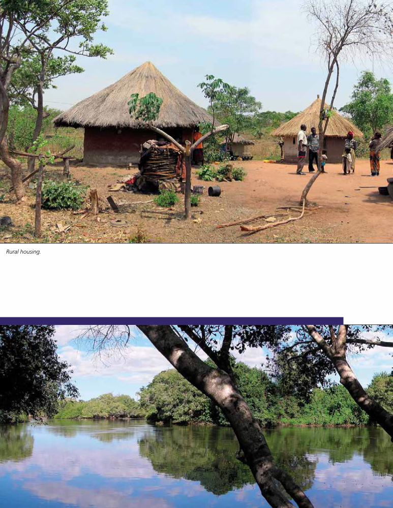
58 Activity Report BGR 1958 to 2008
Rural housing.
1999so001d_046_061.indd 581999so001d_046_061.indd 58 16.06.2009 09:15:2816.06.2009 09:15:28
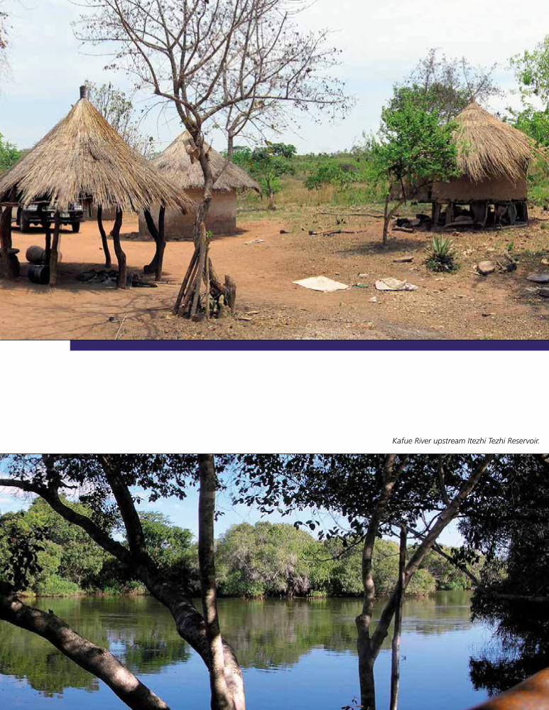
Activity Report BGR 1958 to 2008 59
Kafue River upstream Itezhi Tezhi Reservoir.
1999so001d_046_061.indd 591999so001d_046_061.indd 59 16.06.2009 09:15:3616.06.2009 09:15:36
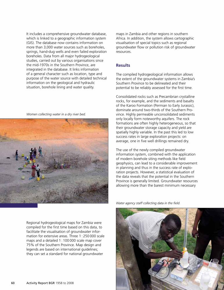
60 Activity Report BGR 1958 to 2008
It includes a comprehensive groundwater database,which is linked to a geographic information system(GIS). The database now contains information onmore than 3,000 water sources such as boreholes,springs, hand-dug wells and even failed explorationboreholes. Data from all major hydrogeologicalstudies, carried out by various organisations sincethe mid-1970s in the Southern Province, areintegrated in the database. It links informationof a general character such as location, type andpurpose of the water source with detailed technicalinformation on the geological and hydraulicsituation, borehole lining and water quality.
maps in Zambia and other regions in southernAfrica. In addition, the system allows cartographicvisualisation of special topics such as regionalgroundwater flow or pollution risk of groundwaterresources.
Results
The compiled hydrogeological information allowsthe extent of the groundwater systems in Zambia’sSouthern Province to be delineated and theirpotential to be reliably assessed for the first time.
Consolidated rocks such as Precambrian crystallinerocks, for example, and the sediments and basaltsof the Karoo Formation (Permian to Early Jurassic),dominate around two-thirds of the Southern Pro-vince. Highly permeable unconsolidated sedimentsonly locally form noteworthy aquifers. The rockformations are often highly heterogeneous, so thattheir groundwater storage capacity and yield arespatially highly variable. In the past this led to lowsuccess rates in large exploration projects: onaverage, one in five well drillings remained dry.
The use of the newly compiled groundwaterinformation system, combined with the applicationof modern borehole siting methods like fieldgeophysics, can lead to a considerable improvementin planning and thus in the success rate of explo-ration projects. However, a statistical evaluation ofthe data reveals that the potential in the SouthernProvince is generally limited. Groundwater resourcesallowing more than the barest minimum necessary
Regional hydrogeological maps for Zambia werecompiled for the first time based on this data, tofacilitate the visualisation of groundwater infor-mation for extensive areas. Three 1 : 250 000 scalemaps and a detailed 1 : 100 000 scale map cover75% of the Southern Province. Map design andlegends are based on international guidelines;they can set a standard for national groundwater
Women collecting water in a dry river bed.
Water agency staff collecting data in the field.
1999so001d_046_061.indd 601999so001d_046_061.indd 60 16.06.2009 09:15:3816.06.2009 09:15:38
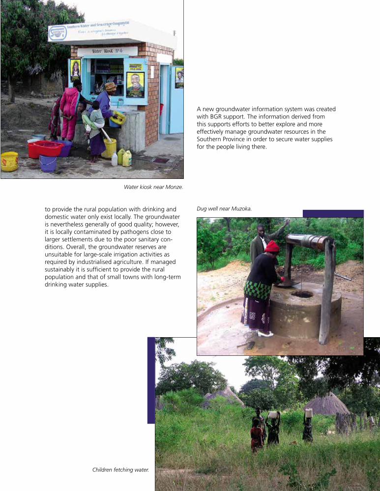
Activity Report BGR 1958 to 2008 61
to provide the rural population with drinking anddomestic water only exist locally. The groundwateris nevertheless generally of good quality; however,it is locally contaminated by pathogens close tolarger settlements due to the poor sanitary con-ditions. Overall, the groundwater reserves areunsuitable for large-scale irrigation activities asrequired by industrialised agriculture. If managedsustainably it is sufficient to provide the ruralpopulation and that of small towns with long-termdrinking water supplies.
A new groundwater information system was createdwith BGR support. The information derived fromthis supports efforts to better explore and moreeffectively manage groundwater resources in theSouthern Province in order to secure water suppliesfor the people living there.
Water kiosk near Monze.
Dug well near Muzoka.
Children fetching water.
1999so001d_046_061.indd 611999so001d_046_061.indd 61 16.06.2009 09:15:4116.06.2009 09:15:41

1999so001d_062_074.indd 621999so001d_062_074.indd 62 16.06.2009 09:16:2816.06.2009 09:16:28
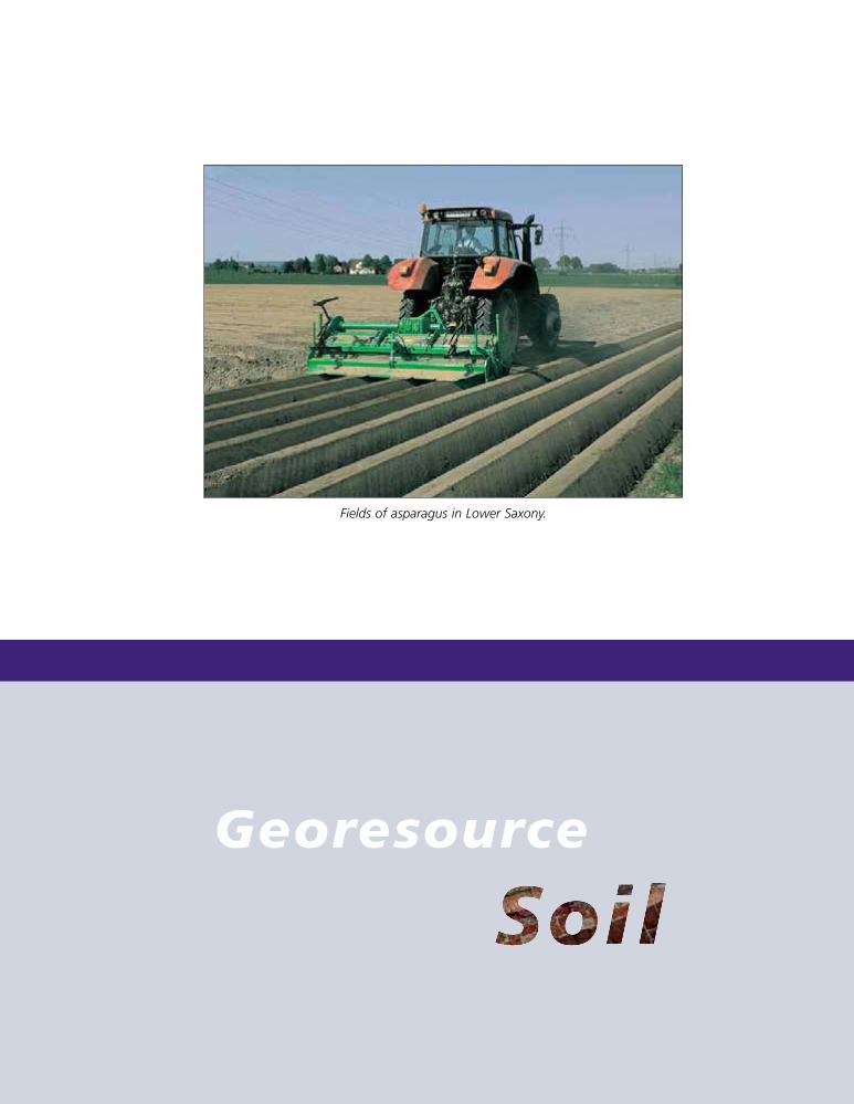
Activity Report BGR 1958 to 2008 63
Georesource
Fields of asparagus in Lower Saxony.
1999so001d_062_074.indd 631999so001d_062_074.indd 63 16.06.2009 09:16:3416.06.2009 09:16:34
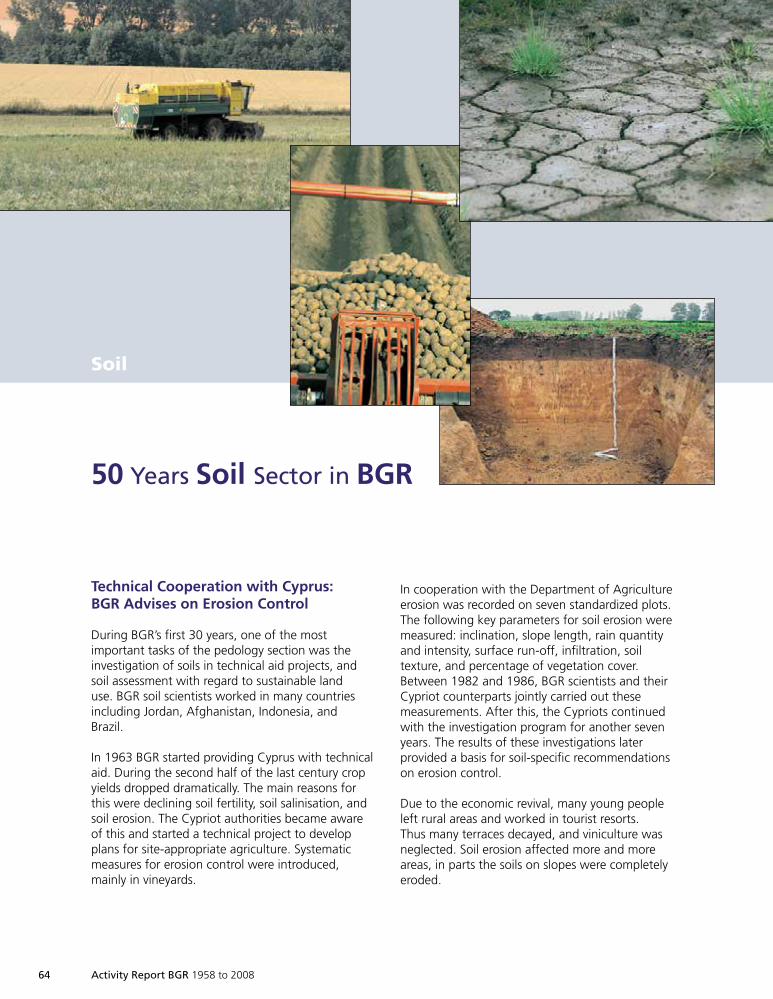
64 Activity Report BGR 1958 to 2008
Soil
Technical Cooperation with Cyprus:BGR Advises on Erosion Control
During BGR’s first 30 years, one of the mostimportant tasks of the pedology section was theinvestigation of soils in technical aid projects, andsoil assessment with regard to sustainable landuse. BGR soil scientists worked in many countriesincluding Jordan, Afghanistan, Indonesia, andBrazil.
In 1963 BGR started providing Cyprus with technicalaid. During the second half of the last century cropyields dropped dramatically. The main reasons forthis were declining soil fertility, soil salinisation, andsoil erosion. The Cypriot authorities became awareof this and started a technical project to developplans for site-appropriate agriculture. Systematicmeasures for erosion control were introduced,mainly in vineyards.
50 Years Soil Sector in BGR
In cooperation with the Department of Agricultureerosion was recorded on seven standardized plots.The following key parameters for soil erosion weremeasured: inclination, slope length, rain quantityand intensity, surface run-off, infiltration, soiltexture, and percentage of vegetation cover.Between 1982 and 1986, BGR scientists and theirCypriot counterparts jointly carried out thesemeasurements. After this, the Cypriots continuedwith the investigation program for another sevenyears. The results of these investigations laterprovided a basis for soil-specific recommendationson erosion control.
Due to the economic revival, many young peopleleft rural areas and worked in tourist resorts.Thus many terraces decayed, and viniculture wasneglected. Soil erosion affected more and moreareas, in parts the soils on slopes were completelyeroded.
1999so001d_062_074.indd Abs2:641999so001d_062_074.indd Abs2:64 16.06.2009 09:16:3516.06.2009 09:16:35
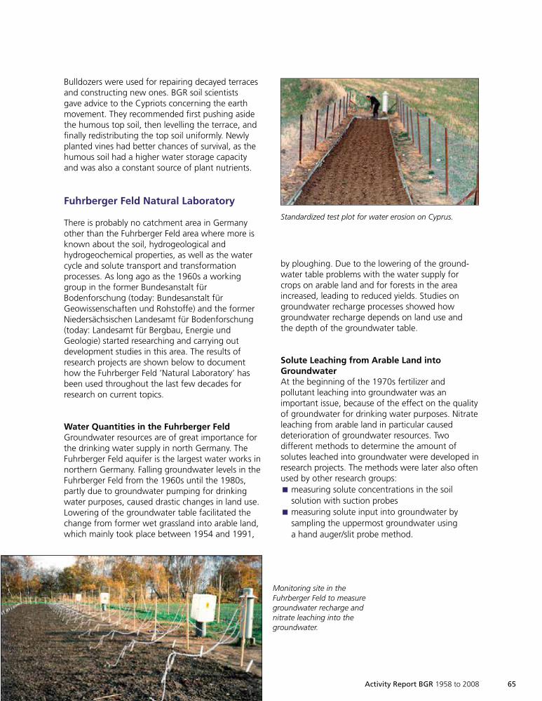
Activity Report BGR 1958 to 2008 65
by ploughing. Due to the lowering of the ground-water table problems with the water supply forcrops on arable land and for forests in the areaincreased, leading to reduced yields. Studies ongroundwater recharge processes showed howgroundwater recharge depends on land use andthe depth of the groundwater table.
Solute Leaching from Arable Land intoGroundwaterAt the beginning of the 1970s fertilizer andpollutant leaching into groundwater was animportant issue, because of the effect on the qualityof groundwater for drinking water purposes. Nitrateleaching from arable land in particular causeddeterioration of groundwater resources. Twodifferent methods to determine the amount ofsolutes leached into groundwater were developed inresearch projects. The methods were later also oftenused by other research groups:
measuring solute concentrations in the soilÈ
solution with suction probesmeasuring solute input into groundwater byÈ
sampling the uppermost groundwater usinga hand auger/slit probe method.
Bulldozers were used for repairing decayed terracesand constructing new ones. BGR soil scientistsgave advice to the Cypriots concerning the earthmovement. They recommended first pushing asidethe humous top soil, then levelling the terrace, andfinally redistributing the top soil uniformly. Newlyplanted vines had better chances of survival, as thehumous soil had a higher water storage capacityand was also a constant source of plant nutrients.
Fuhrberger Feld Natural Laboratory
There is probably no catchment area in Germanyother than the Fuhrberger Feld area where more isknown about the soil, hydrogeological andhydrogeochemical properties, as well as the watercycle and solute transport and transformationprocesses. As long ago as the 1960s a workinggroup in the former Bundesanstalt fürBodenforschung (today: Bundesanstalt fürGeowissenschaften und Rohstoffe) and the formerNiedersächsischen Landesamt für Bodenforschung(today: Landesamt für Bergbau, Energie undGeologie) started researching and carrying outdevelopment studies in this area. The results ofresearch projects are shown below to documenthow the Fuhrberger Feld ’Natural Laboratory’ hasbeen used throughout the last few decades forresearch on current topics.
Water Quantities in the Fuhrberger FeldGroundwater resources are of great importance forthe drinking water supply in north Germany. TheFuhrberger Feld aquifer is the largest water works innorthern Germany. Falling groundwater levels in theFuhrberger Feld from the 1960s until the 1980s,partly due to groundwater pumping for drinkingwater purposes, caused drastic changes in land use.Lowering of the groundwater table facilitated thechange from former wet grassland into arable land,which mainly took place between 1954 and 1991,
Standardized test plot for water erosion on Cyprus.
Monitoring site in theFuhrberger Feld to measuregroundwater recharge andnitrate leaching into thegroundwater.
1999so001d_062_074.indd 651999so001d_062_074.indd 65 16.06.2009 09:16:3916.06.2009 09:16:39
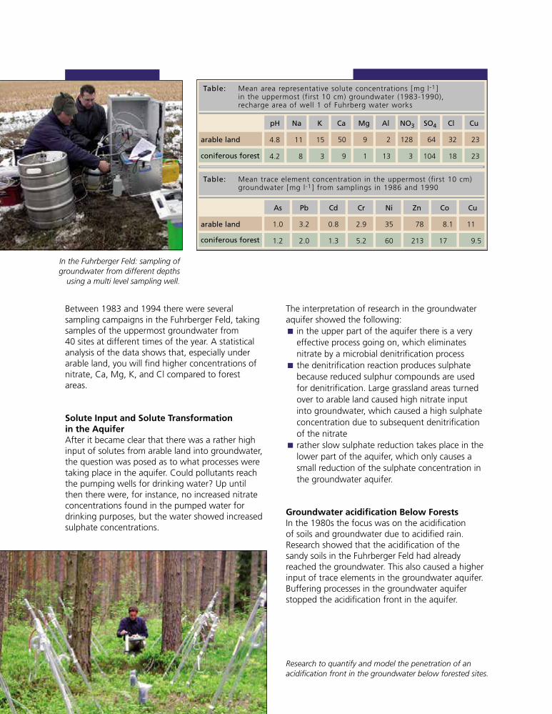
Between 1983 and 1994 there were severalsampling campaigns in the Fuhrberger Feld, takingsamples of the uppermost groundwater from40 sites at different times of the year. A statisticalanalysis of the data shows that, especially underarable land, you will find higher concentrations ofnitrate, Ca, Mg, K, and Cl compared to forestareas.
Solute Input and Solute Transformationin the AquiferAfter it became clear that there was a rather highinput of solutes from arable land into groundwater,the question was posed as to what processes weretaking place in the aquifer. Could pollutants reachthe pumping wells for drinking water? Up untilthen there were, for instance, no increased nitrateconcentrations found in the pumped water fordrinking purposes, but the water showed increasedsulphate concentrations.
The interpretation of research in the groundwateraquifer showed the following:
in the upper part of the aquifer there is a veryÈ
effective process going on, which eliminatesnitrate by a microbial denitrification processthe denitrification reaction produces sulphateÈ
because reduced sulphur compounds are usedfor denitrification. Large grassland areas turnedover to arable land caused high nitrate inputinto groundwater, which caused a high sulphateconcentration due to subsequent denitrificationof the nitraterather slow sulphate reduction takes place in theÈ
lower part of the aquifer, which only causes asmall reduction of the sulphate concentration inthe groundwater aquifer.
Groundwater acidification Below ForestsIn the 1980s the focus was on the acidificationof soils and groundwater due to acidified rain.Research showed that the acidification of thesandy soils in the Fuhrberger Feld had alreadyreached the groundwater. This also caused a higherinput of trace elements in the groundwater aquifer.Buffering processes in the groundwater aquiferstopped the acidification front in the aquifer.
Research to quantify and model the penetration of anacidification front in the groundwater below forested sites.
In the Fuhrberger Feld: sampling ofgroundwater from different depths
using a multi level sampling well.
Table: Mean area representative solute concentrations [mg l-1 ]in the uppermost (first 10 cm) groundwater (1983-1990),recharge area of well 1 of Fuhrberg water works
arable land
coniferous forest
pH
4.8
4.2
Na
11
8
K
15
3
50
9
128
3
64
104
32
18
23
23
9
1
2
13
Ca Mg Al
1.0
1.2
3.2
2.0
0.8
1.3
2.9
5.2
35
60
11
9.5
8.1
17
78
213
Ni Zn Co CuAs Pb Cd Cr
NO3 SO4 Cl Cu
arable land
coniferous forest
Table: Mean trace element concentration in the uppermost (first 10 cm)groundwater [mg l-1 ] from samplings in 1986 and 1990
1999so001d_062_074.indd 661999so001d_062_074.indd 66 16.06.2009 09:16:4116.06.2009 09:16:41
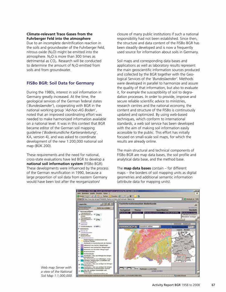
Activity Report BGR 1958 to 2008 67
Climate-relevant Trace Gases from theFuhrberger Feld into the atmosphereDue to an incomplete denitrification reaction inthe soils and groundwater of the Fuhrberger Feld,nitrous oxide (N2O) might be emitted into theatmosphere. N2O is more than 300 times asdetrimental as CO2. Research will be conductedto determine the amount of N2O emitted fromsoils and from groundwater.
FISBo BGR: Soil Data for Germany
During the 1980s, interest in soil information inGermany greatly increased. At the time, thegeological services of the German federal states(‘Bundeslaender’), cooperating with BGR in thenational working group ‘Ad-hoc-AG Boden’,noted that an improved coordinating effort wasneeded to make harmonized information availableon a national level. It was in this context that BGRbecame editor of the German soil mappingguideline (‘Bodenkundliche Kartieranleitung’,KA, version 4), and was asked to coordinatedevelopment of the new 1:200,000 national soilmap (BÜK 200).
These requirements and the need for national,cross-state evaluations have led BGR to develop anational soil information system (FISBo BGR).These developments were influenced by the processof the German reunification in 1990, because alarge proportion of soil data from eastern Germanywould have been lost after the reorganization/
closure of many public institutions if such a nationalresponsibility had not been established. Since then,the structure and data content of the FISBo BGR hasbeen steadily developed and is now a frequentlyused source for information about soils in Germany.
Soil maps and corresponding data bases andapplications as well as laboratory results representthe main geoscientific information sources producedand collected by the BGR together with the Geo-logical Services of the ‘Bundeslaender’. Methodswere developed in parallel to harmonize and assurethe quality of that information, but also to evaluateit, for example the susceptibility of soil to degra-dation processes. In order to provide, improve andsecure reliable scientific advice to ministries,research centres and the national economy, thecontent and structure of the FISBo is continuouslyupdated and optimized. By using web-basedtechniques, which conform to internationalstandards, a web soil service has been developedwith the aim of making soil information easilyaccessible to the public. This effort has initiallyfocused on small-scale soil maps, for which theresults are already online.
The main structural and technical components ofFISBo BGR are map data bases, the soil profile andanalytical data base, and the method base.
The map data bases contain – for differentmaps – the borders of soil mapping units as digitalgeometries and additional semantic information(attribute data for mapping units).
Web map Server witha view of the NationalSoil Map 1:1,000,000.
1999so001d_062_074.indd 671999so001d_062_074.indd 67 16.06.2009 09:16:4316.06.2009 09:16:43
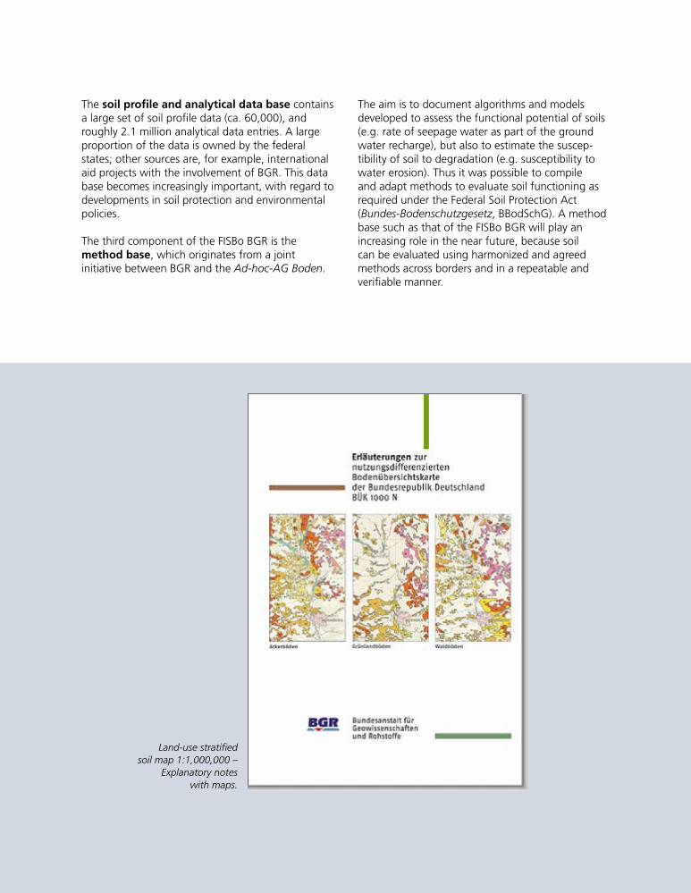
68 Activity Report BGR 1958 to 2008
The soil profile and analytical data base containsa large set of soil profile data (ca. 60,000), androughly 2.1 million analytical data entries. A largeproportion of the data is owned by the federalstates; other sources are, for example, internationalaid projects with the involvement of BGR. This database becomes increasingly important, with regard todevelopments in soil protection and environmentalpolicies.
The third component of the FISBo BGR is themethod base, which originates from a jointinitiative between BGR and the Ad-hoc-AG Boden.
The aim is to document algorithms and modelsdeveloped to assess the functional potential of soils(e.g. rate of seepage water as part of the groundwater recharge), but also to estimate the suscep-tibility of soil to degradation (e.g. susceptibility towater erosion). Thus it was possible to compileand adapt methods to evaluate soil functioning asrequired under the Federal Soil Protection Act(Bundes-Bodenschutzgesetz, BBodSchG). A methodbase such as that of the FISBo BGR will play anincreasing role in the near future, because soilcan be evaluated using harmonized and agreedmethods across borders and in a repeatable andverifiable manner.
Land-use stratifiedsoil map 1:1,000,000 –
Explanatory noteswith maps.
1999so001d_062_074.indd 681999so001d_062_074.indd 68 16.06.2009 09:16:4816.06.2009 09:16:48
Activity Report BGR 1958 to 2008 69
Organic Matter Contentin Top Soils in Germany
What does the organic matter affect inthe soil?
In the last few years, legislators have recognized thesignificance of organic matter, which is reflected ina set of laws and regulations both on a national andEuropean level. However, precise data on the actualcontent of organic matter required for the imple-mentation of these laws does not exist.
Besides the oceans, soils store the most CO2. Theyaccumulate carbon in dead vegetable and animalremains. Microorganisms convert these materialsinto the final humus product, which is why theprotection of soils has been receiving more attentionduring the last few years with regard to climatechange and CO2 emissions.
In addition to the significance for climatic evolution,humus content in soils plays a decisive role inenvironmental protection, because humus adsorbsplant nutrients and hazardous substances in the soil,thus preventing leaching into groundwater. In soilswith a high organic matter content, both organicsubstances such as pesticides, and inorganic pollu-tants such as arsenic, cadmium, chromium andothers are adsorbed to the organic matter and arenot leached into groundwater by seepage, or onlyto a minor degree. Organic matter thus forms anefficient filter and protects groundwater againstcontamination.
Furthermore, humus is essential for plants, as it is aslow-running source of nutrients, and increases thewater-retaining capacity of the soil. Soils with highhumus contents have a fine stable structure (crumbstructure). The topsoil is well aerated nevertehelesshas sufficient water for plants to survive normal dry
spells without harm. Heavy rainfall can infiltraterapidly without eroding the topsoil. This is whyhumus content is extremely important for agri-cultural production as well as for groundwaterprotection.
How Can Humus Content be Compared?
To compare the content of organic carbon inGermany’s topsoils and determine its distribution,existing data must be collected, evaluated andharmonized.
In a BGR project all the information available on thecontent of organic matter in German topsoils wascompiled and evaluated. Topsoils were consideredto be the upper 10 cm below forest and grassland,and the upper 30 cm below arable land.
Site information was stored in BGR’s Soil Infor-mation System (FISBo BGR). Data for some 14,000soil profiles were available for analysis. Most ofthese data were provided by the state geologicalsurveys. Minimum requirements, such as geogra-phical coordinates, name of soil type, organicmatter content or depth of sampling were definedfor data evaluation. Since these data were missingfor several profiles, the amount of spot data to beused decreased to approximately 9,000.
In the evaluation, soil properties, climate and landuse were considered to be the decisive factors for thehumus content in soils. In the land-use stratified soilmap information on a scale of 1 : 1 000 000 is shownon the extension of soils and the main types of land-use (arable farming, forest, grassland). Climate isdivided into the four zones described on next page:
1999so001d_062_074.indd 691999so001d_062_074.indd 69 16.06.2009 09:16:5216.06.2009 09:16:52
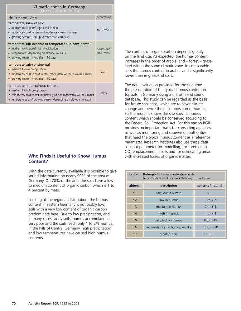
70 Activity Report BGR 1958 to 2008
Who Finds it Useful to Know HumusContent?
With the data currently available it is possible to givesound information on nearly 90% of the area ofGermany. On 70% of the area the soils have a lowto medium content of organic carbon which is 1 to4 percent by mass.
Looking at the regional distribution, the humuscontent in Eastern Germany is noticeably low;soils with a very low content of organic carbonpredominate here. Due to low precipitation, andin many cases sandy soils, humus accumulation isvery poor and the soils reach only 1 to 2% humus.In the hills of Central Germany, high precipitationand low temperatures have caused high humuscontents.
The content of organic carbon depends greatlyon the land use. As expected, the humus contentincreases in the order of arable land – forest – grass-land within the same climatic zone. In comparablesoils the humus content in arable land is significantlylower than in grassland soils.
The data evaluation provided for the first timethe presentation of the typical humus content intopsoils in Germany using a uniform and sounddatabase. This study can be regarded as the basisfor future scenarios, which are to cover climatechange and hence the decomposition of humus.Furthermore, it shows the site-specific humuscontent which should be conserved according tothe Federal Soil Protection Act. For this reason BGRprovides an important basis for consulting agenciesas well as monitoring and supervision authoritiesthat need the typical humus content as a referenceparameter. Research institutes also use these dataas input parameter for modelling, for forecastingCO2 emplacement in soils and for delineating areaswith increased losses of organic matter.
occurrence
northwest
south andsouthwest
east
Alps
Name – description
temperate sub-oceanicmedium to (in parts) high precipitation
moderately cold winter and moderately warm summer
growing season: 180 up to more than 210 days
temperate sub-oceanic to temperate sub-continentalmedium to (in parts) high precipitation
temperatures depending on altitude (m a.s.l.)
growing season: more than 150 days
temperate sub-continentalmedium to low precipitation
moderately cold to cold winter, moderately warm to warm summer
growing season: more than 150 days
temperate mountainous climatemedium to high precipitation
cold to very cold winter, moderately cold to moderately warm summer
temperatures and growing season depending on altitude (m a.s.l.)
Climatic zones in Germany(after F INKE et al. 1998)
Table: Ratings of humus contents in soils(after Bodenkundl. Kartieranleitung, 5th edition)
abbrev.
h 1
h 2
h 3
h 4
h 5
h 6
h 7
< 1
1 to < 2
2 to < 4
4 to < 8
8 to < 15
15 to < 30
30
very low in humus
low in humus
medium in humus
high in humus
very high in humus
extremely high in humus, mucky
organic, peat
content [ mass-%]description
>
1999so001d_062_074.indd 701999so001d_062_074.indd 70 17.06.2009 12:52:1917.06.2009 12:52:19
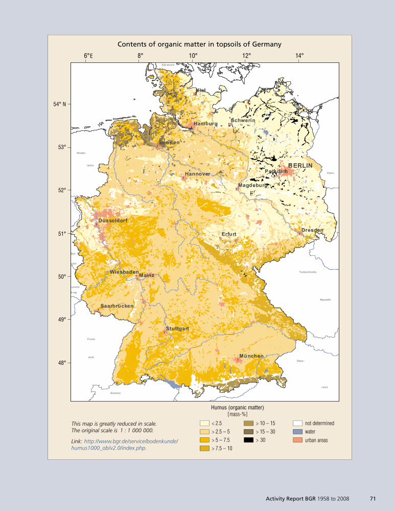
!
!
!
!
!
!
!
!
!!
!
!
!
!
!
!
Nieder-
Frank-
Polen
Tschechische
Republik
Öster-
Schweiz
land e
Bel-
g ien
Luxem-
b urg
Dän emark
reich
reich
BERLIN
Kiel
Mainz
Bremen
Erfurt
Hamburg
München
Dresden
Potsdam
Schwerin
Hannover
Stuttgart
Wiesbaden
Magdeburg
Düsseldorf
Saarbrücken
!
!
!
!
!
!
!
!
!!
!
!
!
!
!
!
Nieder-
Frank-
Polen
Tschechische
Republik
Öster-
Schweiz
land e
Bel-
g ien
Luxem-
b urg
Dän emark
reich
reich
BERLIN
Kiel
Mainz
Bremen
Erfurt
Hamburg
München
Dresden
Potsdam
Schwerin
Hannover
Stuttgart
Wiesbaden
Magdeburg
Düsseldorf
Saarbrücken
This map is greatly reduced in scale.The original scale is 1 : 1 000 000.
Link: http://www.bgr.de/service/bodenkunde/humus1000_ob/v2.0/index.php.
54° N
53°
52°
51°
50°
49°
48°
6°E 8° 10° 12° 14°
Contents of organic matter in topsoils of Germany
Humus (organic matter)[mass-%]
< 2.5> 2.5 – 5> 5 – 7.5> 7.5 – 10
> 10 – 15> 15 – 30> 30
not determinedwater
urban areas
Activity Report BGR 1958 to 2008 71
1999so001d_062_074.indd 711999so001d_062_074.indd 71 16.06.2009 09:16:5316.06.2009 09:16:53
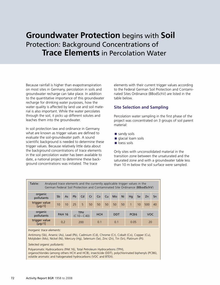
72 Activity Report BGR 1958 to 2008
Groundwater Protection begins with SoilProtection: Background Concentrations of
Trace Elements in Percolation Water
Because rainfall is higher than evapotranspirationon most sites in Germany, percolation in soils andgroundwater recharge can take place. In additionto the quantitative importance of this groundwaterrecharge for drinking water purposes, how thewater quality is affected by land use and soil mate-rial is also important. While the water percolatesthrough the soil, it picks up different solutes andleaches them into the groundwater.
In soil protection law and ordinance in Germanywhat are known as trigger values are defined toevaluate the soil-groundwater path. A soundscientific background is needed to determine thesetrigger values. Because relatively little data aboutthe background concentrations of trace elementsin the soil percolation water has been available todate, a national project to determine these back-ground concentrations was initiated. The trace
elements with their current trigger values accordingto the Federal German Soil Protection and Contami-nated Sites Ordinance (BBodSchV) are listed in thetable below.
Site Selection and Sampling
Percolation water sampling in the first phase of theproject was concentrated on 3 groups of soil parentmaterial:
sandy soilsÈ
glacial loam soilsÈ
loess soilsÈ
Only sites with unconsolidated material in thetransition zone between the unsaturated and thesaturated zone and with a groundwater table lessthan 10 m below the soil surface were sampled.
Table: Analysed trace elements and the currently applicable trigger values in theGerman Federal Soil Protection and Contaminated Site Ordinance (BBodSchV)
organicpollutants
trigger value[µg / l]
Sb
10
As
10
Pb
25
Cd
5
Cr
50
Co
50
Cu
50
Mo
50
Ni
50
Hg
1
Se
10
Zn
500
Sn
40
PAH 16
0,2
HCH
0.1
DDT
0.1
PCB6
0.05
VOC
20
TPH(C10 – C40)
200
Inorganic trace elements:
Antimony (Sb), Arsenic (As), Lead (Pb), Cadmium (Cd), Chrome (Cr), Cobalt (Co), Copper (Cu),Molybden (Mo), Nickel (Ni), Mercury (Hg), Selenium (Se), Zinc (Zn), Tin (Sn), Platinum (Pt).
Selected organic pollutants:
Polyaromatic Hydrocarbons (PAK 16), Total Petroleum Hydrocarbons (TPH),organochlorides (among others HCH and HCB), insecticide (DDT), polychlorinated biphenyls (PCB6),volatile aromatic and halogenated hydrocarbons (VOC and BTEX).
organicpollutants
trigger value[µg / l]
1999so001d_062_074.indd 721999so001d_062_074.indd 72 16.06.2009 09:17:0616.06.2009 09:17:06
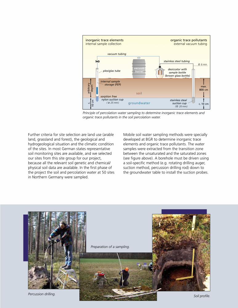
Activity Report BGR 1958 to 2008 73
Further criteria for site selection are land use (arableland, grassland and forest), the geological andhydrogeological situation and the climatic conditionof the sites. In most German states representativesoil monitoring sites are available, and we selectedour sites from this site group for our project,because all the relevant soil genetic and chemical/physical soil data are available. In the first phase ofthe project the soil and percolation water at 50 sitesin Northern Germany were sampled.
plexiglas tube
internal samplestorage (FEP)
sorption freenylon suction cup
( 25 mm)
soilsoil
grgroundwateroundwater
arb
itra
ryd
epth
c.
10cm
inorganic trace elementsinternal sample collection
organic trace pollutantsexternal vacuum tubing
vacuumvacuumbarbarrrelel
desiccator withsample bottle
(brown glass bottle)
stainless stealsuction cup
( 20 mm)
vacuum tubing
stainless steel tubing
max.800 cm
c. 10 cm
6 mm
Mobile soil water sampling methods were speciallydeveloped at BGR to determine inorganic traceelements and organic trace pollutants. The watersamples were extracted from the transition zonebetween the unsaturated and the saturated zones(see figure above). A borehole must be driven usinga soil-specific method (e.g. rotating drilling auger,suction method, percussion drilling rod) down tothe groundwater table to install the suction probes.
Principle of percolation water sampling to determine inorganic trace elements andorganic trace pollutants in the soil percolation water.
Preparation of a sampling.
Soil profile.Percussion drilling.
1999so001d_062_074.indd 731999so001d_062_074.indd 73 16.06.2009 09:17:0616.06.2009 09:17:06
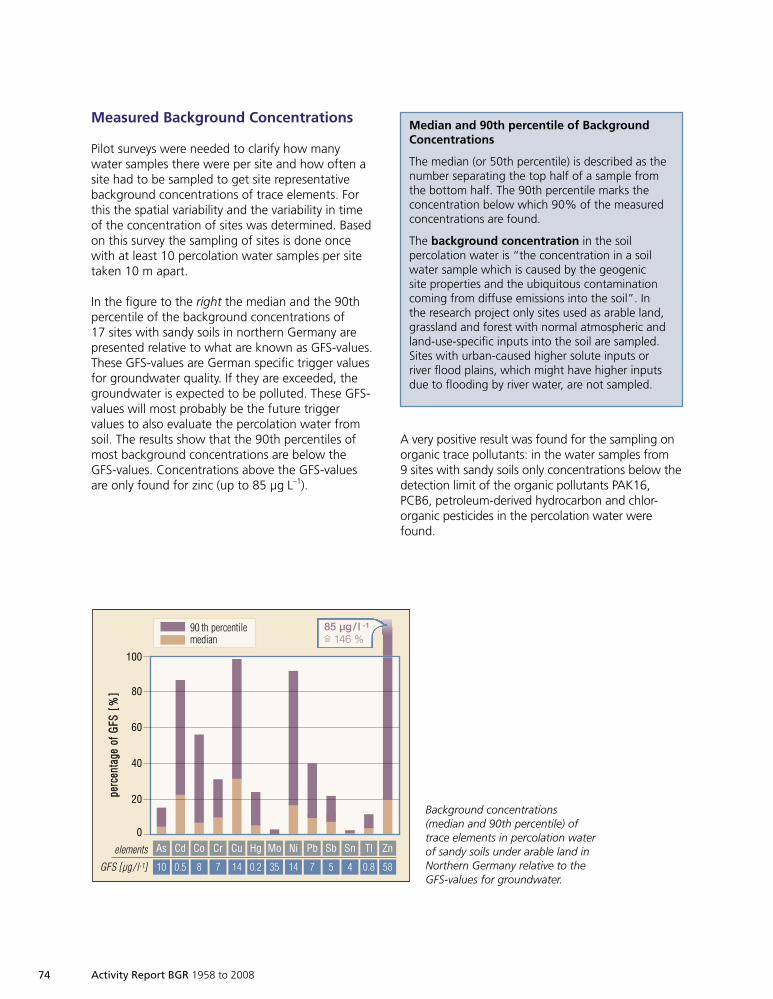
74 Activity Report BGR 1958 to 2008
Measured Background Concentrations
Pilot surveys were needed to clarify how manywater samples there were per site and how often asite had to be sampled to get site representativebackground concentrations of trace elements. Forthis the spatial variability and the variability in timeof the concentration of sites was determined. Basedon this survey the sampling of sites is done oncewith at least 10 percolation water samples per sitetaken 10 m apart.
In the figure to the right the median and the 90thpercentile of the background concentrations of17 sites with sandy soils in northern Germany arepresented relative to what are known as GFS-values.These GFS-values are German specific trigger valuesfor groundwater quality. If they are exceeded, thegroundwater is expected to be polluted. These GFS-values will most probably be the future triggervalues to also evaluate the percolation water fromsoil. The results show that the 90th percentiles ofmost background concentrations are below theGFS-values. Concentrations above the GFS-valuesare only found for zinc (up to 85 µg L–1).
100
80
60
40
20
0
elements
GFS [µg/ l-1]
ppeerrcc
eennttaa
ggeeooff
GGFFSS
[[%%]]
90 th percentilemedian
As Cd Co Cr Cu Hg Mo Ni Pb Sb Sn ZnTl
10 0.5 8 7 14 0.2 35 14 7 5 4 0.8 58
85 µg/ l -1
= 146 %
Background concentrations(median and 90th percentile) oftrace elements in percolation waterof sandy soils under arable land inNorthern Germany relative to theGFS-values for groundwater.
Median and 90th percentile of BackgroundConcentrations
The median (or 50th percentile) is described as thenumber separating the top half of a sample fromthe bottom half. The 90th percentile marks theconcentration below which 90% of the measuredconcentrations are found.
The background concentration in the soilpercolation water is “the concentration in a soilwater sample which is caused by the geogenicsite properties and the ubiquitous contaminationcoming from diffuse emissions into the soil”. Inthe research project only sites used as arable land,grassland and forest with normal atmospheric andland-use-specific inputs into the soil are sampled.Sites with urban-caused higher solute inputs orriver flood plains, which might have higher inputsdue to flooding by river water, are not sampled.
A very positive result was found for the sampling onorganic trace pollutants: in the water samples from9 sites with sandy soils only concentrations below thedetection limit of the organic pollutants PAK16,PCB6, petroleum-derived hydrocarbon and chlor-organic pesticides in the percolation water werefound.
1999so001d_062_074.indd 741999so001d_062_074.indd 74 16.06.2009 09:17:0916.06.2009 09:17:09
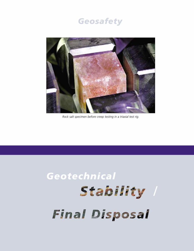
Activity Report BGR 1958 to 2008 75
Geotechnical
/Endlager
Rock salt specimen before creep testing in a triaxial test rig.
Geosafety
1999so001d_075_088.indd 751999so001d_075_088.indd 75 16.06.2009 09:17:4316.06.2009 09:17:43
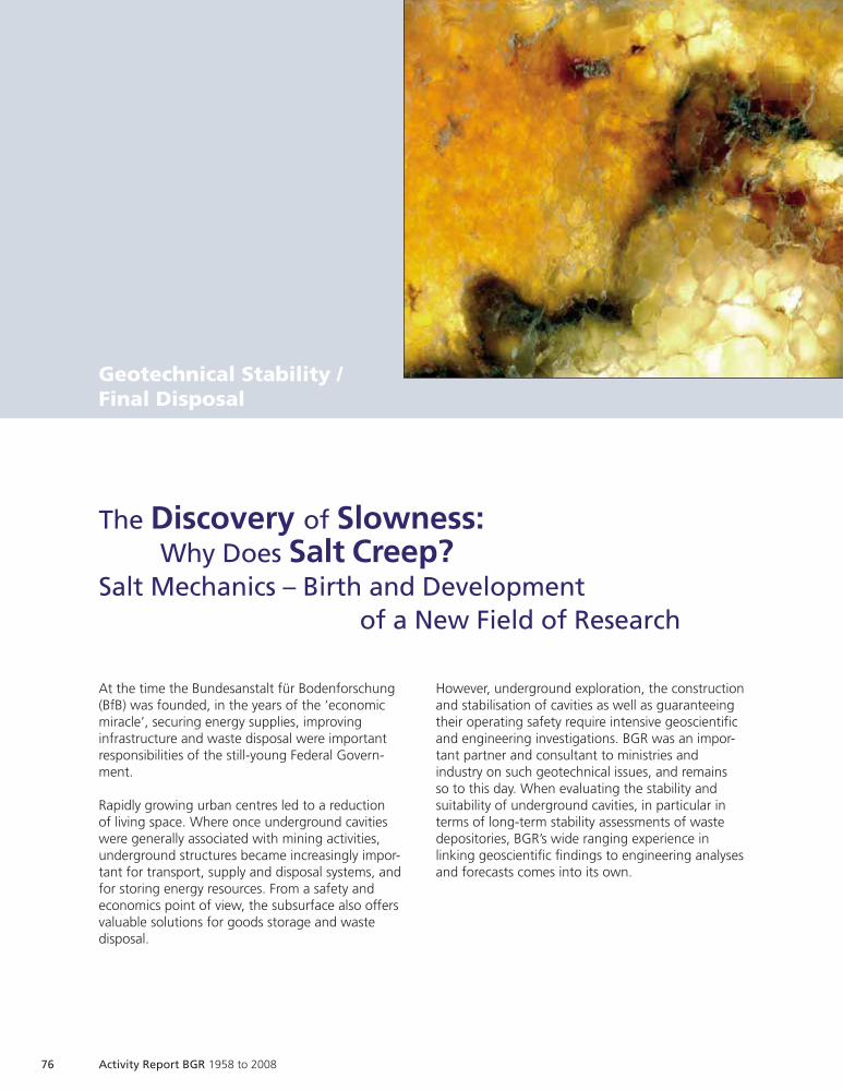
76 Activity Report BGR 1958 to 2008
Geotechnical Stability /Final Disposal
At the time the Bundesanstalt für Bodenforschung(BfB) was founded, in the years of the ‘economicmiracle’, securing energy supplies, improvinginfrastructure and waste disposal were importantresponsibilities of the still-young Federal Govern-ment.
Rapidly growing urban centres led to a reductionof living space. Where once underground cavitieswere generally associated with mining activities,underground structures became increasingly impor-tant for transport, supply and disposal systems, andfor storing energy resources. From a safety andeconomics point of view, the subsurface also offersvaluable solutions for goods storage and wastedisposal.
The Discovery of Slowness:Why Does Salt Creep?
Salt Mechanics – Birth and Developmentof a New Field of Research
However, underground exploration, the constructionand stabilisation of cavities as well as guaranteeingtheir operating safety require intensive geoscientificand engineering investigations. BGR was an impor-tant partner and consultant to ministries andindustry on such geotechnical issues, and remainsso to this day. When evaluating the stability andsuitability of underground cavities, in particular interms of long-term stability assessments of wastedepositories, BGR’s wide ranging experience inlinking geoscientific findings to engineering analysesand forecasts comes into its own.
Activity Report BGR 1958 to 2008 77
Underground structures are permanently subject tonumerous and various impacts. The mechanicalbehaviour of the rock is largely determined by itsmaterial properties and the stress condition in therock mass. Additional impacts such as temperature,loading duration or the chemical environment alsoplay a role. Constitutive models are required topredict the material behaviour – for example forestimating the deformation and stability of load-bearing elements in a mine. They consist of mathe-matical equations which should describe the effec-tive processes acting on the rock. In addition totheoretical models, the results of experimentalinvestigations and on-site findings form the basis ofthese constitutive models and their parameters.
The use of rheological models was well accepted inrock engineering by the mid-1960s. They providethe mathematically formulated correlation betweenthe stress state and the resultant deformation whichis required for post-processing of investigationresults and thus also for predicting the anticipatedrock behaviour. LANGER (postdoctoral thesis 1967)extensively discussed the complex combination ofrelevant rheological models, e. g. a Hooke elementfor elastic material behaviour with the modelelements for viscous creep and plastic behaviourafter passing a yield point.
Images of rock salt cores, left in detail.
1999so001d_075_088.indd 771999so001d_075_088.indd 77 16.06.2009 09:17:4616.06.2009 09:17:46
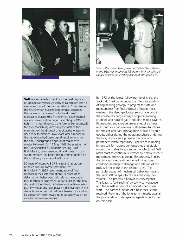
78 Activity Report BGR 1958 to 2008
By 1973 at the latest, following the oil crisis, the‘rock salt’ host came under the intensive scrutinyof engineering geology in projects for safe andmaintenance free final disposal of (radio-)toxicwastes in the deep geological subsurface, and inthe course of energy storage projects involvingcrude oil and natural gas in solution mined caverns.Repositories and storage projects require a hostrock that does not lose any of its barrier functionsin terms of pollutant propagation or loss of storedgoods, either during the operating phase or duringthe long post-closure phase in the case of apermanent waste repository. Experience in miningin rock salt formations demonstrates that stableunderground structures can be manufactured. Saltrocks react to continuous stresses by a slow, viscousmovement, known as creep. This property impliesthat in a sufficiently dimensioned mine, stressconditions leading to damage and dilation of therock will not occur in the disposal area. Thisparticular aspect of mechanical behaviour meansthat rock salt creeps into cavities reducing theirvolume. This process is known as convergence.This leads to ‘self-sealing’ by cavity convergence,and the reinstatement of an undisturbed stressstate. The barrier function of a host rock is thusretained. Proving of the long-term integrity againstthe propagation of dangerous agents is performedon this basis.
Visit of the Lower Saxony minister Wilfried Hasselmannin the BGR rock mechanics laboratory. Prof. Dr. MichaelLanger describes interesting details of salt specimens.
Salt is a suitable host rock for the final disposalof radioactive wastes. As early as December 1957 amemorandum of the German Atomic Commission,the first German nuclear programme, describedthe necessity for research into the disposal ofradioactive wastes (the first German experimentalnuclear power station began operating in 1960 inKahl). In its founding year, the former Bundesanstaltfür Bodenforschung drew up proposals to theministries on the disposal of radioactive wastes indeep rock formations. Two years later a report onthe geological-hydrogeological requirements forthe final underground disposal of radioactivewastes followed. On 15 May 1963 the president ofthe Bundesanstalt für Bodenforschung, Prof.H.-J. Martini, recommended final disposal in rocksalt formations. He based this recommendation onthe excellent properties of salt rocks.
50 years of intensive BGR in-situ and laboratoryresearch confirm former president Prof.H.-J. Martini’s 1963 recommendation of finaldisposal in rock salt formations. Because of itsdeformation behaviour, rock salt has favourablerock mechanics properties, in particular for the finaldisposal of long-lived, high-level radioactive wastes.BGR investigations have played a decisive role in thecharacterisation of rock salt as a barrier rock and inits assessment with regard to its suitability as a hostrock for radioactive wastes.
1999so001d_075_088.indd 781999so001d_075_088.indd 78 16.06.2009 09:17:5516.06.2009 09:17:55
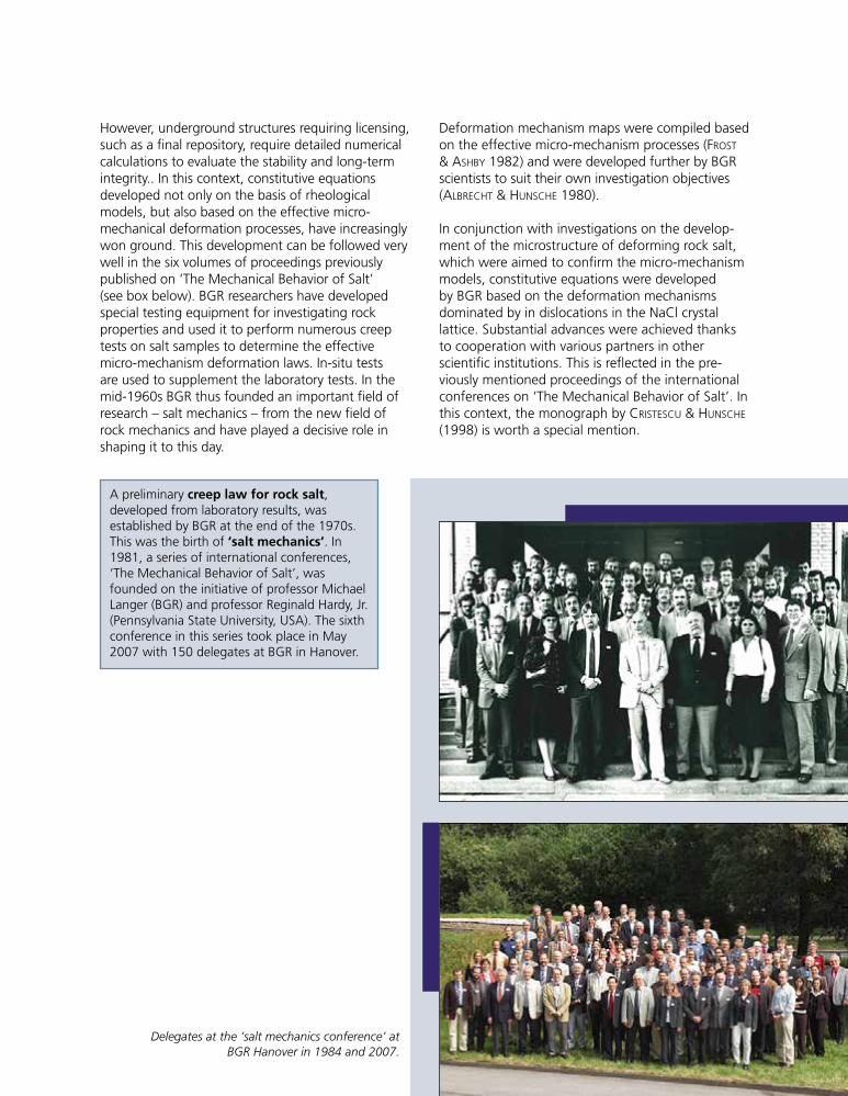
However, underground structures requiring licensing,such as a final repository, require detailed numericalcalculations to evaluate the stability and long-termintegrity.. In this context, constitutive equationsdeveloped not only on the basis of rheologicalmodels, but also based on the effective micro-mechanical deformation processes, have increasinglywon ground. This development can be followed verywell in the six volumes of proceedings previouslypublished on ‘The Mechanical Behavior of Salt’(see box below). BGR researchers have developedspecial testing equipment for investigating rockproperties and used it to perform numerous creeptests on salt samples to determine the effectivemicro-mechanism deformation laws. In-situ testsare used to supplement the laboratory tests. In themid-1960s BGR thus founded an important field ofresearch – salt mechanics – from the new field ofrock mechanics and have played a decisive role inshaping it to this day.
Deformation mechanism maps were compiled basedon the effective micro-mechanism processes (FROST
& ASHBY 1982) and were developed further by BGRscientists to suit their own investigation objectives(ALBRECHT & HUNSCHE 1980).
In conjunction with investigations on the develop-ment of the microstructure of deforming rock salt,which were aimed to confirm the micro-mechanismmodels, constitutive equations were developedby BGR based on the deformation mechanismsdominated by in dislocations in the NaCl crystallattice. Substantial advances were achieved thanksto cooperation with various partners in otherscientific institutions. This is reflected in the pre-viously mentioned proceedings of the internationalconferences on ‘The Mechanical Behavior of Salt’. Inthis context, the monograph by CRISTESCU & HUNSCHE
(1998) is worth a special mention.
Delegates at the ‘salt mechanics conference’ atBGR Hanover in 1984 and 2007.
A preliminary creep law for rock salt,developed from laboratory results, wasestablished by BGR at the end of the 1970s.This was the birth of ‘salt mechanics’. In1981, a series of international conferences,‘The Mechanical Behavior of Salt’, wasfounded on the initiative of professor MichaelLanger (BGR) and professor Reginald Hardy, Jr.(Pennsylvania State University, USA). The sixthconference in this series took place in May2007 with 150 delegates at BGR in Hanover.
1999so001d_075_088.indd 791999so001d_075_088.indd 79 16.06.2009 09:18:0216.06.2009 09:18:02
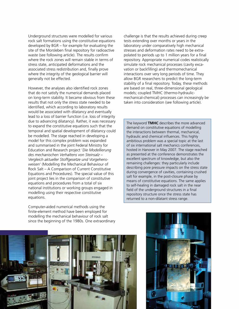
Underground structures were modelled for variousrock salt formations using the constitutive equationsdeveloped by BGR – for example for evaluating thesite of the Morsleben final repository for radioactivewaste (see following article). The results confirmwhere the rock zones will remain stable in terms ofstress state, anticipated deformations and theassociated stress redistribution and, finally provewhere the integrity of the geological barrier willgenerally not be effected.
However, the analyses also identified rock zonesthat do not satisfy the numerical demands placedon long-term stability. It became obvious from theseresults that not only the stress state needed to beidentified, which according to laboratory resultswould be associated with dilatancy and eventuallylead to a loss of barrier function (i.e. loss of integritydue to advancing dilatancy). Rather, it was necessaryto expand the constitutive equations such that thetemporal and spatial development of dilatancy couldbe modelled. The stage reached in developing amodel for this complex problem was expandedand summarised in the joint Federal Ministry forEducation and Research project ‘Die Modellierungdes mechanischen Verhaltens von Steinsalz –Vergleich aktueller Stoffgesetze und Vorgehens-weisen‘ (Modelling the Mechanical Behaviour ofRock Salt – A Comparison of Current ConstitutiveEquations and Procedures). The special value of thisjoint project lies in the comparison of constitutiveequations and procedures from a total of sixnational institutions or working groups engaged inmodelling using their respective constitutiveequations.
Computer-aided numerical methods using thefinite-element method have been employed formodelling the mechanical behaviour of rock saltsince the beginning of the 1980s. One extraordinary
challenge is that the results achieved during creeptests extending over months or years in thelaboratory under comparatively high mechanicalstresses and deformation rates need to be extra-polated to periods up to 1 million years for a finalrepository. Appropriate numerical codes realisticallysimulate rock mechanical processes (cavity exca-vation or backfilling) and thermomechanicalinteractions over very long periods of time. Theyallow BGR researchers to predict the long-termstability of a final repository. Today, these methodsare based on real, three-dimensional geologicalmodels; coupled TMHC (thermo-hydraulic-mechanical-chemical) processes can increasingly betaken into consideration (see following article).
The keyword TMHC describes the more advanceddemand on constitutive equations of modellingthe interactions between thermal, mechanical,hydraulic and chemical influences. This highlyambitious problem was a special topic at the lastof six international salt mechanics conferences,hosted in Hanover in May 2007. The stage reachedas presented at the conference demonstrates theexcellent spectrum of knowledge, but also theremaining challenges: they particularly includedescribing pore pressure impacts on the stress stateduring convergence of cavities, containing crushedsalt for example, in the post-closure phase bymeans of constitutive equations. The same appliesto self-healing in damaged rock salt in the nearfield of the underground structures in a finalrepository structure once the stress state hasreturned to a non-dilatant stress range.
1999so001d_075_088.indd 801999so001d_075_088.indd 80 23.06.2009 07:31:5123.06.2009 07:31:51
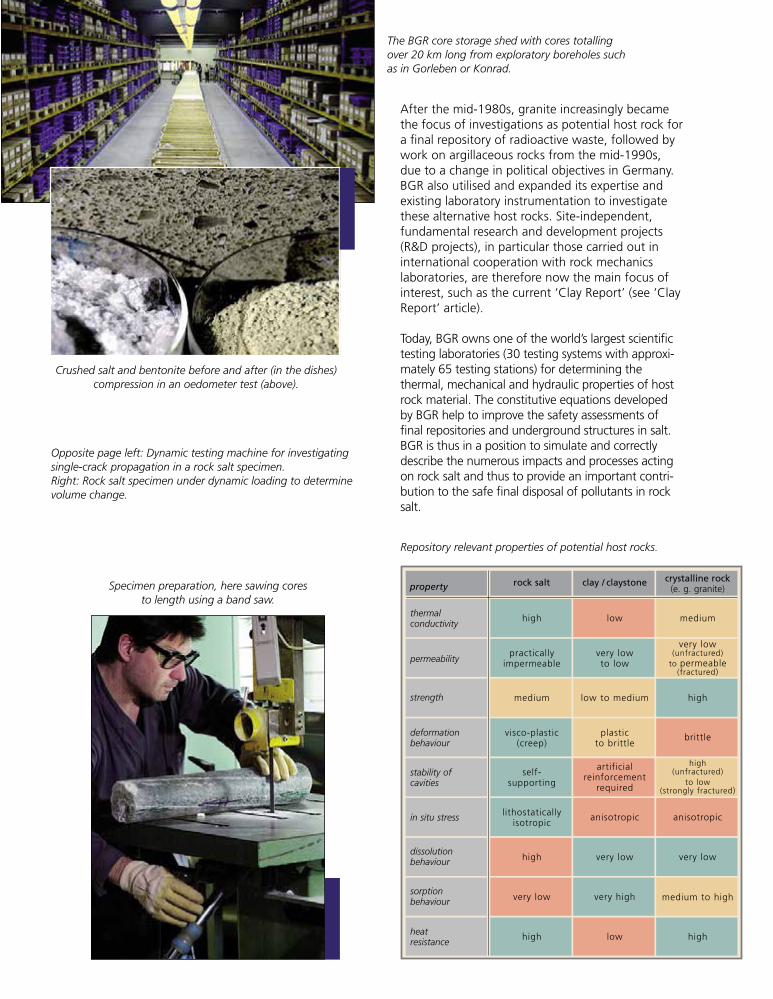
After the mid-1980s, granite increasingly becamethe focus of investigations as potential host rock fora final repository of radioactive waste, followed bywork on argillaceous rocks from the mid-1990s,due to a change in political objectives in Germany.BGR also utilised and expanded its expertise andexisting laboratory instrumentation to investigatethese alternative host rocks. Site-independent,fundamental research and development projects(R&D projects), in particular those carried out ininternational cooperation with rock mechanicslaboratories, are therefore now the main focus ofinterest, such as the current ‘Clay Report’ (see ‘ClayReport’ article).
Today, BGR owns one of the world’s largest scientifictesting laboratories (30 testing systems with approxi-mately 65 testing stations) for determining thethermal, mechanical and hydraulic properties of hostrock material. The constitutive equations developedby BGR help to improve the safety assessments offinal repositories and underground structures in salt.BGR is thus in a position to simulate and correctlydescribe the numerous impacts and processes actingon rock salt and thus to provide an important contri-bution to the safe final disposal of pollutants in rocksalt.
thermalconductivity
permeability
strength
deformationbehaviour
stability ofcavities
in situ stress
dissolutionbehaviour
sorptionbehaviour
heatresistance
property rock salt
high
high
high high
low
very low
low
very highvery low
very low
medium to high
medium
medium
self-supporting
low to medium high
anisotropic anisotropic
plasticto brittle
artificialreinforcement
required
visco-plastic(creep)
lithostaticallyisotropic
practicallyimpermeable
very lowto low
very low(unfractured)
to permeable(fractured)
high(unfractured)
to low(strongly fractured)
brittle
clay / claystone crystalline rock(e. g. granite)
Crushed salt and bentonite before and after (in the dishes)compression in an oedometer test (above).
The BGR core storage shed with cores totallingover 20 km long from exploratory boreholes suchas in Gorleben or Konrad.
Specimen preparation, here sawing coresto length using a band saw.
Opposite page left: Dynamic testing machine for investigatingsingle-crack propagation in a rock salt specimen.Right: Rock salt specimen under dynamic loading to determinevolume change.
Repository relevant properties of potential host rocks.
1999so001d_075_088.indd 811999so001d_075_088.indd 81 16.06.2009 09:18:1716.06.2009 09:18:17
82 Activity Report BGR 1958 to 2008
It is aimed to utilise deep geological formations forthe final disposal of radioactive wastes in Germany.Extensive geoscientific investigations, carried out byBGR with the aid of computer simulations, amongstother things, are required to guarantee the long-term stability of a final repository. Extensivegeological and geomechanical investigations havebeen carried out in salt rock during the last threedecades to prove the suitability of the host rocksalt for the final disposal of radioactive wastes, forsolution mining and for gas and oil storage incaverns. The geological barrier, as a componentof the multi-barrier system, plays a particularlyimportant role in the final disposal of radioactivewastes: the bearing capacity and geomechanicalintegrity of the salt rock, its geological and tectonicstability, and geochemical and hydrogeologicalprocesses must be analysed and evaluated toprovide the necessary verifications for the finalrepository. Analysis requires a variety of steps, forexample:
Geological investigations to identify baselineÈdata for two- and three-dimensional structuralgeologic models.Mine observations.ÈGeotechnical in-situ measurements to identifyÈthe required host rock and overburdenparameters.Geomechanical laboratory testing to determineÈthe necessary material parameters and to developsuitable constitutive equations.Two- and three-dimensional geomechanical and,Èif necessary, thermomechanical or hydromecha-nical model calulations to investigate the stabilityof the final repository and the integrity of the saltbarrier.
Finally, these are followed by the safety assessment,which takes all experimental and theoreticalgeoscientific investigation results into consideration.
Selected results of the geological and geomech-anical investigations for the Morsleben finalrepository for radioactive wastes (ERAM) arepresented below. Based on the development of athree-dimensional structural geologic model,three-dimensional geomechanical modelling isperformed to numerically analyse the stability of oldmining rooms and the integrity of the salt barrier.
ERAM was established in the former Bartenslebenpotash and salt mine. The mine is divided intoseveral parts, such as the southern, western andeastern part, where non-heat generating wastes arestored. The central part has a complex geologicalstructure, represents the part with the highestdegree of excavation, with numerous rooms onseveral levels, and is thus subject to high mechanicalstresses.
A digital, 3-D structural geologic model for thenorthern central part of the Bartensleben mine(main trough) was compiled on the basis of theexisting two-dimensional model.
The aim of this work was to improve and expandvisualisation and interpretation options for theexisting mine data and to take into considerationthe additional exposure data collected sincecompiling the 2-D geological-tectonic model(1997 – 2000). The model was developed with aview to geological monitoring of the backfillmeasures in the central part of the Bartenslebenmine. New drifts were manufactured and a variety
Three-dimensional Geological andGeomechanical Modelling of the
Morsleben Final Repository (ERAM)
1999so001d_075_088.indd 821999so001d_075_088.indd 82 16.06.2009 09:18:2116.06.2009 09:18:21
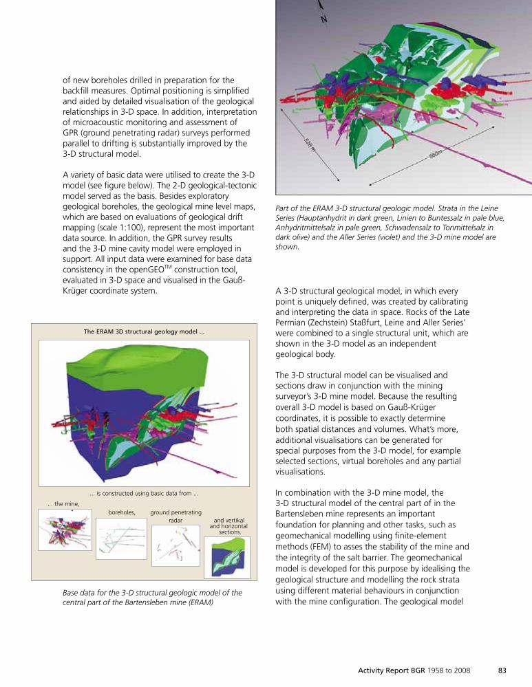
Activity Report BGR 1958 to 2008 83
of new boreholes drilled in preparation for thebackfill measures. Optimal positioning is simplifiedand aided by detailed visualisation of the geologicalrelationships in 3-D space. In addition, interpretationof microacoustic monitoring and assessment ofGPR (ground penetrating radar) surveys performedparallel to drifting is substantially improved by the3-D structural model.
A variety of basic data were utilised to create the 3-Dmodel (see figure below). The 2-D geological-tectonicmodel served as the basis. Besides exploratorygeological boreholes, the geological mine level maps,which are based on evaluations of geological driftmapping (scale 1:100), represent the most importantdata source. In addition, the GPR survey resultsand the 3-D mine cavity model were employed insupport. All input data were examined for base dataconsistency in the openGEOTM construction tool,evaluated in 3-D space and visualised in the Gauß-Krüger coordinate system.
The ERAM 3D structural geology model ...
... is constructed using basic data from ...
... the mine,boreholes, ground penetrating
radar and vertikaland horizontal
sections.
3D Grubengebäude
A 3-D structural geological model, in which everypoint is uniquely defined, was created by calibratingand interpreting the data in space. Rocks of the LatePermian (Zechstein) Staßfurt, Leine and Aller Series’were combined to a single structural unit, which areshown in the 3-D model as an independentgeological body.
The 3-D structural model can be visualised andsections draw in conjunction with the miningsurveyor’s 3-D mine model. Because the resultingoverall 3-D model is based on Gauß-Krügercoordinates, it is possible to exactly determineboth spatial distances and volumes. What’s more,additional visualisations can be generated forspecial purposes from the 3-D model, for exampleselected sections, virtual boreholes and any partialvisualisations.
In combination with the 3-D mine model, the3-D structural model of the central part of in theBartensleben mine represents an importantfoundation for planning and other tasks, such asgeomechanical modelling using finite-elementmethods (FEM) to asses the stability of the mine andthe integrity of the salt barrier. The geomechanicalmodel is developed for this purpose by idealising thegeological structure and modelling the rock stratausing different material behaviours in conjunctionwith the mine configuration. The geological model
Base data for the 3-D structural geologic model of thecentral part of the Bartensleben mine (ERAM)
Part of the ERAM 3-D structural geologic model. Strata in the LeineSeries (Hauptanhydrit in dark green, Linien to Buntessalz in pale blue,Anhydritmittelsalz in pale green, Schwadensalz to Tonmittelsalz indark olive) and the Aller Series (violet) and the 3-D mine model areshown.
1999so001d_075_088.indd 831999so001d_075_088.indd 83 16.06.2009 09:18:2116.06.2009 09:18:21
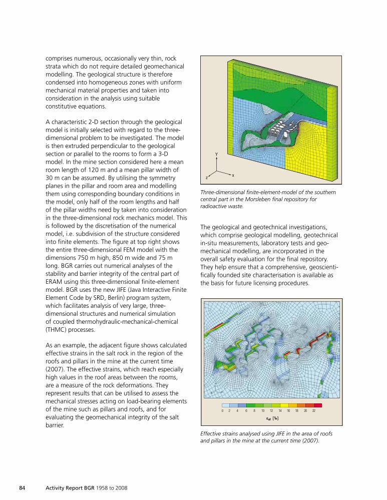
84 Activity Report BGR 1958 to 2008
comprises numerous, occasionally very thin, rockstrata which do not require detailed geomechanicalmodelling. The geological structure is thereforecondensed into homogeneous zones with uniformmechanical material properties and taken intoconsideration in the analysis using suitableconstitutive equations.
A characteristic 2-D section through the geologicalmodel is initially selected with regard to the three-dimensional problem to be investigated. The modelis then extruded perpendicular to the geologicalsection or parallel to the rooms to form a 3-Dmodel. In the mine section considered here a meanroom length of 120 m and a mean pillar width of30 m can be assumed. By utilising the symmetryplanes in the pillar and room area and modellingthem using corresponding boundary conditions inthe model, only half of the room lengths and halfof the pillar widths need by taken into considerationin the three-dimensional rock mechanics model. Thisis followed by the discretisation of the numericalmodel, i.e. subdivision of the structure consideredinto finite elements. The figure at top right showsthe entire three-dimensional FEM model with thedimensions 750 m high, 850 m wide and 75 mlong. BGR carries out numerical analyses of thestability and barrier integrity of the central part ofERAM using this three-dimensional finite-elementmodel. BGR uses the new JIFE (Java Interactive FiniteElement Code by SRD, Berlin) program system,which facilitates analysis of very large, three-dimensional structures and numerical simulationof coupled thermohydraulic-mechanical-chemical(THMC) processes.
As an example, the adjacent figure shows calculatedeffective strains in the salt rock in the region of theroofs and pillars in the mine at the current time(2007). The effective strains, which reach especiallyhigh values in the roof areas between the rooms,are a measure of the rock deformations. Theyrepresent results that can be utilised to assess themechanical stresses acting on load-bearing elementsof the mine such as pillars and roofs, and forevaluating the geomechanical integrity of the saltbarrier.
The geological and geotechnical investigations,which comprise geological modelling, geotechnicalin-situ measurements, laboratory tests and geo-mechanical modelling, are incorporated in theoverall safety evaluation for the final repository.They help ensure that a comprehensive, geoscienti-fically founded site characterisation is available asthe basis for future licensing procedures.
Y
xz
Three-dimensional finite-element-model of the southerncentral part in the Morsleben final repository forradioactive waste.
20 4 6 8 10 12 14 16 18 20 22
εεeeffff [[ ‰‰ ]]
Effective strains analysed using JIFE in the area of roofsand pillars in the mine at the current time (2007).
1999so001d_075_088.indd 841999so001d_075_088.indd 84 16.06.2009 09:18:4716.06.2009 09:18:47
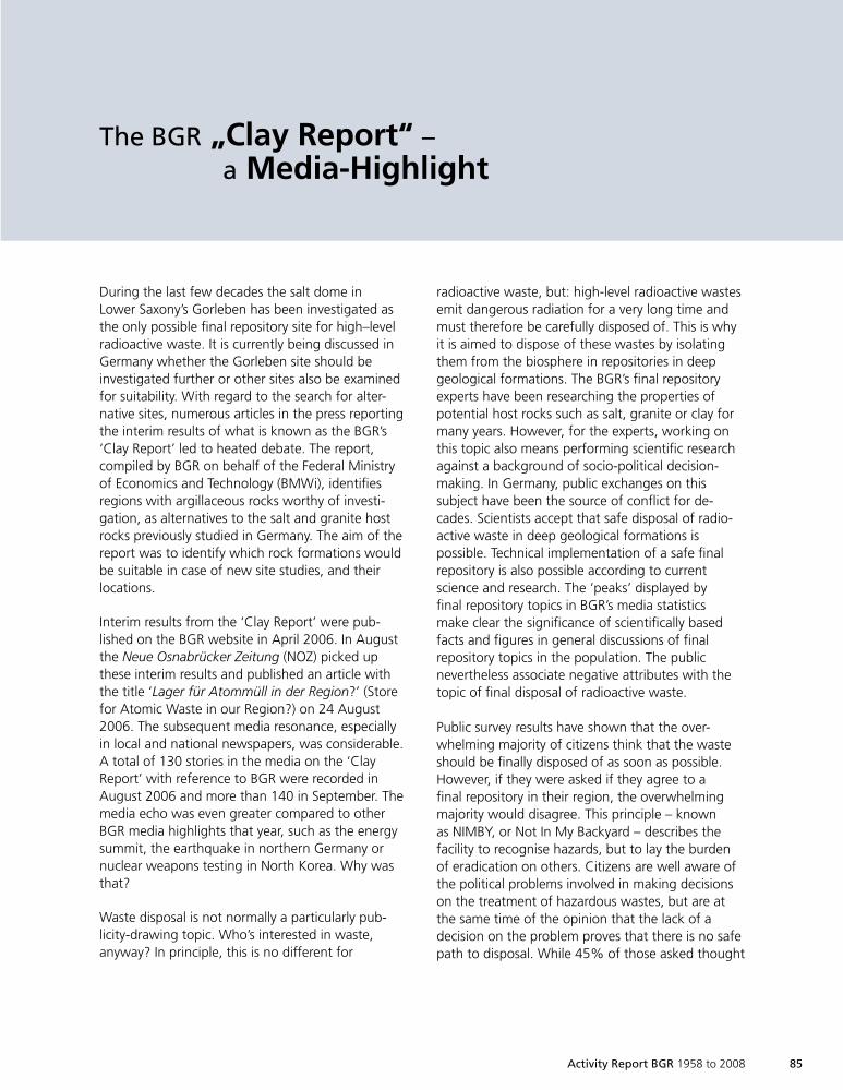
radioactive waste, but: high-level radioactive wastesemit dangerous radiation for a very long time andmust therefore be carefully disposed of. This is whyit is aimed to dispose of these wastes by isolatingthem from the biosphere in repositories in deepgeological formations. The BGR’s final repositoryexperts have been researching the properties ofpotential host rocks such as salt, granite or clay formany years. However, for the experts, working onthis topic also means performing scientific researchagainst a background of socio-political decision-making. In Germany, public exchanges on thissubject have been the source of conflict for de-cades. Scientists accept that safe disposal of radio-active waste in deep geological formations ispossible. Technical implementation of a safe finalrepository is also possible according to currentscience and research. The ‘peaks’ displayed byfinal repository topics in BGR’s media statisticsmake clear the significance of scientifically basedfacts and figures in general discussions of finalrepository topics in the population. The publicnevertheless associate negative attributes with thetopic of final disposal of radioactive waste.
Public survey results have shown that the over-whelming majority of citizens think that the wasteshould be finally disposed of as soon as possible.However, if they were asked if they agree to afinal repository in their region, the overwhelmingmajority would disagree. This principle – knownas NIMBY, or Not In My Backyard – describes thefacility to recognise hazards, but to lay the burdenof eradication on others. Citizens are well aware ofthe political problems involved in making decisionson the treatment of hazardous wastes, but are atthe same time of the opinion that the lack of adecision on the problem proves that there is no safepath to disposal. While 45% of those asked thought
During the last few decades the salt dome inLower Saxony’s Gorleben has been investigated asthe only possible final repository site for high–levelradioactive waste. It is currently being discussed inGermany whether the Gorleben site should beinvestigated further or other sites also be examinedfor suitability. With regard to the search for alter-native sites, numerous articles in the press reportingthe interim results of what is known as the BGR’s‘Clay Report’ led to heated debate. The report,compiled by BGR on behalf of the Federal Ministryof Economics and Technology (BMWi), identifiesregions with argillaceous rocks worthy of investi-gation, as alternatives to the salt and granite hostrocks previously studied in Germany. The aim of thereport was to identify which rock formations wouldbe suitable in case of new site studies, and theirlocations.
Interim results from the ‘Clay Report’ were pub-lished on the BGR website in April 2006. In Augustthe Neue Osnabrücker Zeitung (NOZ) picked upthese interim results and published an article withthe title ‘Lager für Atommüll in der Region?’ (Storefor Atomic Waste in our Region?) on 24 August2006. The subsequent media resonance, especiallyin local and national newspapers, was considerable.A total of 130 stories in the media on the ‘ClayReport’ with reference to BGR were recorded inAugust 2006 and more than 140 in September. Themedia echo was even greater compared to otherBGR media highlights that year, such as the energysummit, the earthquake in northern Germany ornuclear weapons testing in North Korea. Why wasthat?
Waste disposal is not normally a particularly pub-licity-drawing topic. Who’s interested in waste,anyway? In principle, this is no different for
Activity Report BGR 1958 to 2008 85
The BGR „Clay Report“ –a Media-Highlight
1999so001d_075_088.indd 851999so001d_075_088.indd 85 16.06.2009 09:18:5016.06.2009 09:18:50
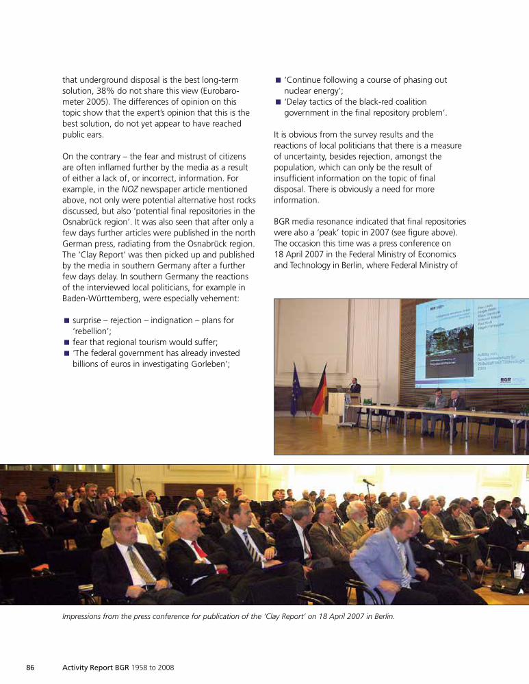
86 Activity Report BGR 1958 to 2008
that underground disposal is the best long-termsolution, 38% do not share this view (Eurobaro-meter 2005). The differences of opinion on thistopic show that the expert’s opinion that this is thebest solution, do not yet appear to have reachedpublic ears.
On the contrary – the fear and mistrust of citizensare often inflamed further by the media as a resultof either a lack of, or incorrect, information. Forexample, in the NOZ newspaper article mentionedabove, not only were potential alternative host rocksdiscussed, but also ‘potential final repositories in theOsnabrück region’. It was also seen that after only afew days further articles were published in the northGerman press, radiating from the Osnabrück region.The ‘Clay Report’ was then picked up and publishedby the media in southern Germany after a furtherfew days delay. In southern Germany the reactionsof the interviewed local politicians, for example inBaden-Württemberg, were especially vehement:
surprise – rejection – indignation – plans forÈ
‘rebellion’;fear that regional tourism would suffer;È
‘The federal government has already investedÈ
billions of euros in investigating Gorleben’;
‘Continue following a course of phasing outÈ
nuclear energy’;‘Delay tactics of the black-red coalitionÈ
government in the final repository problem‘.
It is obvious from the survey results and thereactions of local politicians that there is a measureof uncertainty, besides rejection, amongst thepopulation, which can only be the result ofinsufficient information on the topic of finaldisposal. There is obviously a need for moreinformation.
BGR media resonance indicated that final repositorieswere also a ‘peak’ topic in 2007 (see figure above).The occasion this time was a press conference on18 April 2007 in the Federal Ministry of Economicsand Technology in Berlin, where Federal Ministry of
Impressions from the press conference for publication of the ‘Clay Report’ on 18 April 2007 in Berlin.
1999so001d_075_088.indd 861999so001d_075_088.indd 86 16.06.2009 09:18:5016.06.2009 09:18:50
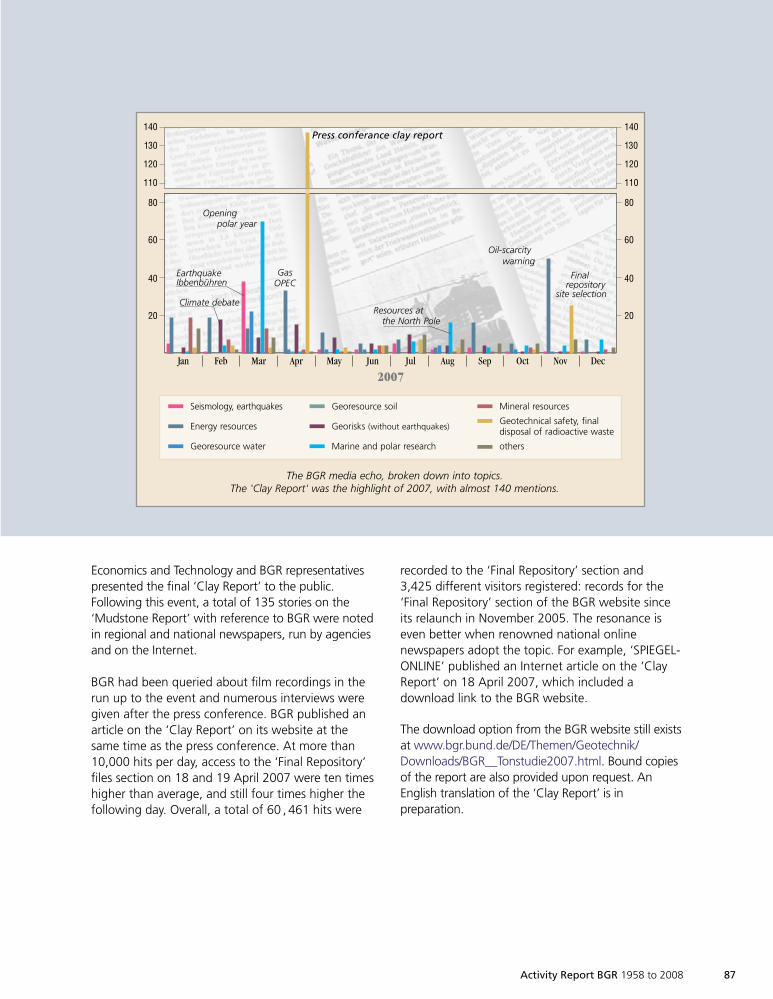
Activity Report BGR 1958 to 2008 87
140
130
120
110
80
60
40
20
140
130
120
110
80
60
40
20
Jan Feb Mar Apr May Jun Jul Aug Sep Oct Nov Dec
2007
Seismology, earthquakes
Energy resources
Georesource water
Georesource soil
Georisks (without earthquakes)
Marine and polar research
Mineral resources
Geotechnical safety, finaldisposal of radioactive waste
others
EarthquakeIbbenbühren
Climate debate
Openingpolar year
GasOPEC
Resources atthe North Pole
Press conferance clay report
Oil-scarcitywarning
Finalrepository
site selection
The BGR media echo, broken down into topics.The 'Clay Report' was the highlight of 2007, with almost 140 mentions.
Economics and Technology and BGR representativespresented the final ‘Clay Report’ to the public.Following this event, a total of 135 stories on the‘Mudstone Report’ with reference to BGR were notedin regional and national newspapers, run by agenciesand on the Internet.
BGR had been queried about film recordings in therun up to the event and numerous interviews weregiven after the press conference. BGR published anarticle on the ‘Clay Report’ on its website at thesame time as the press conference. At more than10,000 hits per day, access to the ‘Final Repository’files section on 18 and 19 April 2007 were ten timeshigher than average, and still four times higher thefollowing day. Overall, a total of 60 , 461 hits were
recorded to the ‘Final Repository’ section and3,425 different visitors registered: records for the‘Final Repository’ section of the BGR website sinceits relaunch in November 2005. The resonance iseven better when renowned national onlinenewspapers adopt the topic. For example, ‘SPIEGEL-ONLINE’ published an Internet article on the ‘ClayReport’ on 18 April 2007, which included adownload link to the BGR website.
The download option from the BGR website still existsat www.bgr.bund.de/DE/Themen/Geotechnik/Downloads/BGR__Tonstudie2007.html. Bound copiesof the report are also provided upon request. AnEnglish translation of the ‘Clay Report’ is inpreparation.
1999so001d_075_088.indd 871999so001d_075_088.indd 87 16.06.2009 09:18:5316.06.2009 09:18:53
88 Activity Report BGR 1958 to 2008
BGR public relations experience over the last fiveyears has demonstrated that exciting, under-standable information and assertive handling of thesubject of final repositories evoke positive reactionsand the interest of those concerned. Media, citizensand scientists increasingly use the Internet as aninformation source, as the Internet statistics for the
BGR website show. BGR will strive to fill in anypublic information deficits with their public relationswork and by carefully monitoring the media, andwill thus contribute to objective discourse on thetopic of final disposal. It provides first-hand, scien-tifically founded and understandable information onfinal disposal, for example for the ‘Clay Report’.
1999so001d_075_088.indd 881999so001d_075_088.indd 88 16.06.2009 09:18:5416.06.2009 09:18:54
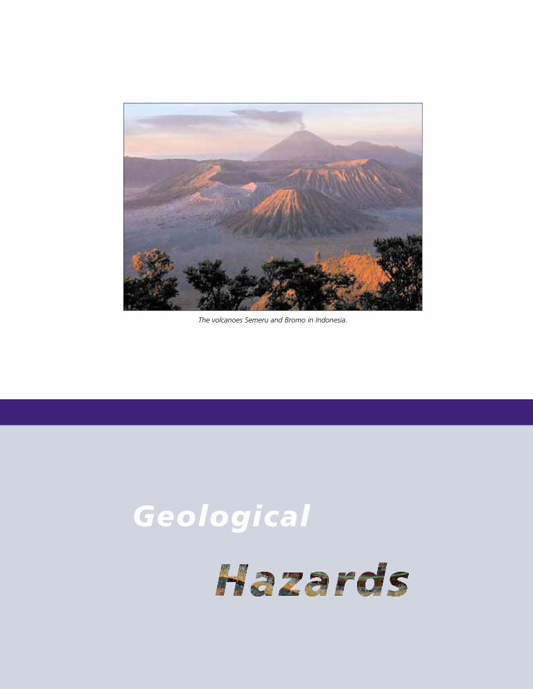
Geological
The volcanoes Semeru and Bromo in Indonesia.
1999so001d_089_108.indd 891999so001d_089_108.indd 89 16.06.2009 09:19:3816.06.2009 09:19:38
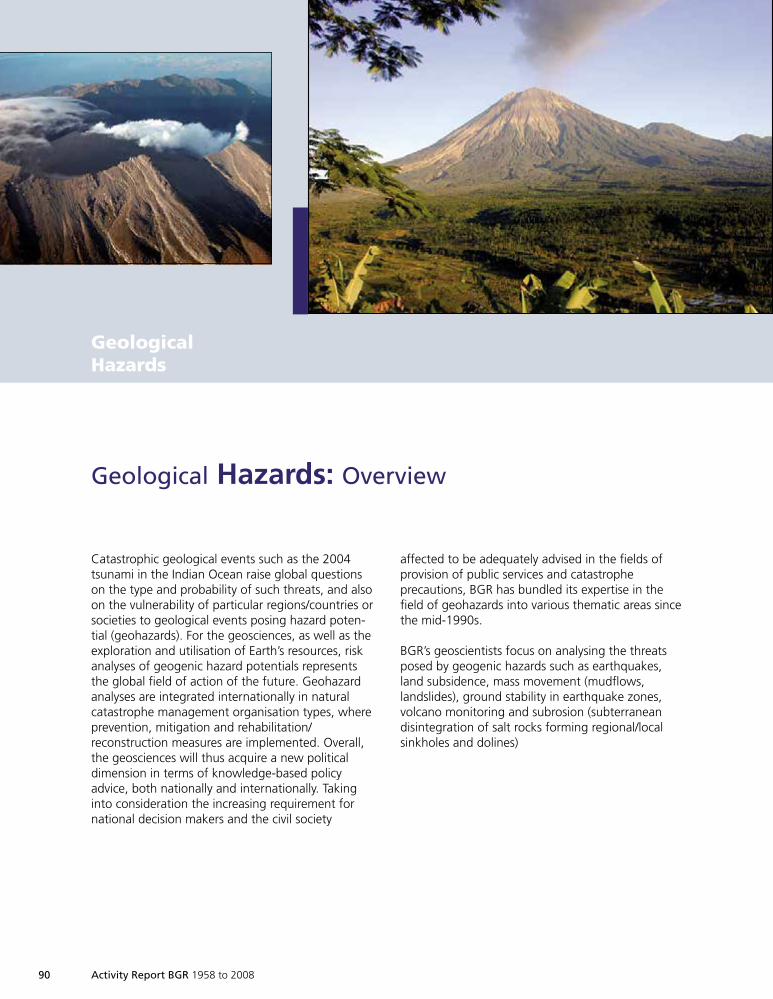
90 Activity Report BGR 1958 to 2008
Catastrophic geological events such as the 2004tsunami in the Indian Ocean raise global questionson the type and probability of such threats, and alsoon the vulnerability of particular regions/countries orsocieties to geological events posing hazard poten-tial (geohazards). For the geosciences, as well as theexploration and utilisation of Earth’s resources, riskanalyses of geogenic hazard potentials representsthe global field of action of the future. Geohazardanalyses are integrated internationally in naturalcatastrophe management organisation types, whereprevention, mitigation and rehabilitation/reconstruction measures are implemented. Overall,the geosciences will thus acquire a new politicaldimension in terms of knowledge-based policyadvice, both nationally and internationally. Takinginto consideration the increasing requirement fornational decision makers and the civil society
Geological Hazards: Overview
affected to be adequately advised in the fields ofprovision of public services and catastropheprecautions, BGR has bundled its expertise in thefield of geohazards into various thematic areas sincethe mid-1990s.
BGR’s geoscientists focus on analysing the threatsposed by geogenic hazards such as earthquakes,land subsidence, mass movement (mudflows,landslides), ground stability in earthquake zones,volcano monitoring and subrosion (subterraneandisintegration of salt rocks forming regional/localsinkholes and dolines)
GeologicalHazards
1999so001d_089_108.indd 901999so001d_089_108.indd 90 16.06.2009 09:19:3916.06.2009 09:19:39
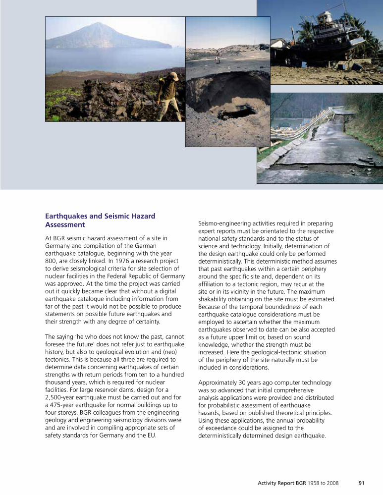
Activity Report BGR 1958 to 2008 91
Earthquakes and Seismic HazardAssessment
At BGR seismic hazard assessment of a site inGermany and compilation of the Germanearthquake catalogue, beginning with the year800, are closely linked. In 1976 a research projectto derive seismological criteria for site selection ofnuclear facilities in the Federal Republic of Germanywas approved. At the time the project was carriedout it quickly became clear that without a digitalearthquake catalogue including information fromfar of the past it would not be possible to producestatements on possible future earthquakes andtheir strength with any degree of certainty.
The saying ‘he who does not know the past, cannotforesee the future’ does not refer just to earthquakehistory, but also to geological evolution and (neo)tectonics. This is because all three are required todetermine data concerning earthquakes of certainstrengths with return periods from ten to a hundredthousand years, which is required for nuclearfacilities. For large reservoir dams, design for a2,500-year earthquake must be carried out and fora 475-year earthquake for normal buildings up tofour storeys. BGR colleagues from the engineeringgeology and engineering seismology divisions wereand are involved in compiling appropriate sets ofsafety standards for Germany and the EU.
Seismo-engineering activities required in preparingexpert reports must be orientated to the respectivenational safety standards and to the status ofscience and technology. Initially, determination ofthe design earthquake could only be performeddeterministically. This deterministic method assumesthat past earthquakes within a certain peripheryaround the specific site and, dependent on itsaffiliation to a tectonic region, may recur at thesite or in its vicinity in the future. The maximumshakability obtaining on the site must be estimated.Because of the temporal boundedness of eachearthquake catalogue considerations must beemployed to ascertain whether the maximumearthquakes observed to date can be also acceptedas a future upper limit or, based on soundknowledge, whether the strength must beincreased. Here the geological-tectonic situationof the periphery of the site naturally must beincluded in considerations.
Approximately 30 years ago computer technologywas so advanced that initial comprehensiveanalysis applications were provided and distributedfor probabilistic assessment of earthquakehazards, based on published theoretical principles.Using these applications, the annual probabilityof exceedance could be assigned to thedeterministically determined design earthquake.
1999so001d_089_108.indd 911999so001d_089_108.indd 91 16.06.2009 09:19:5816.06.2009 09:19:58
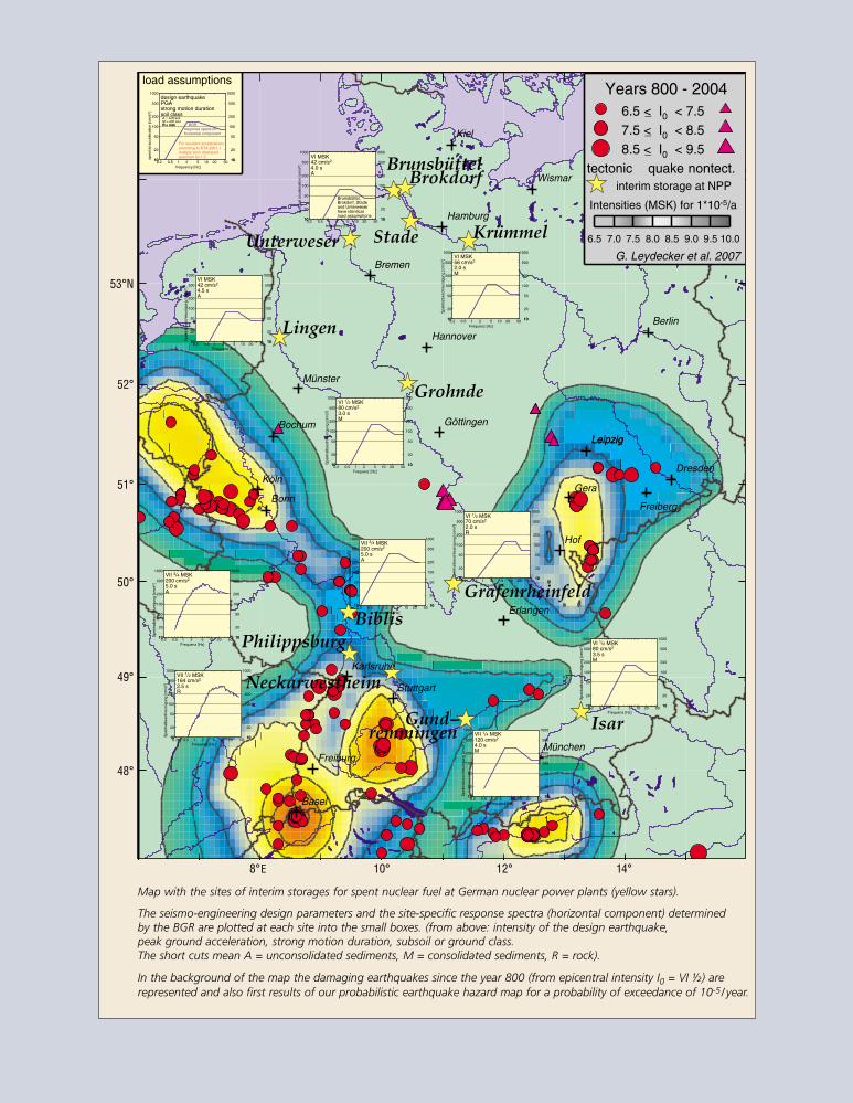
92 Activity Report BGR 1958 to 2008
Kiel
Hamburg
Berlin
Hannover
Münster
Bochum
Köln
Bonn
Göttingen
Frankfurt
Hof
Karlsruhe
Stuttgart
Erlangen
München
Basel
Freiburg
Bremen
Freiberg
GreifswaldGreifswald
Gera
Dresden
LeipzigLeipzig
Wismar
Years 800 - 20046.5 < I0 < 7.57.5 < I0 < 8.58.5 < I0 < 9.5
_
_
_
tectonic quake nontect.
G. Leydecker et al. 2007
Intensities (MSK) for 1*10-5/a
interim storage at NPP
6.5 7.0 7.5 8.0 8.5 9.0 9.5 10.0
load assumptions
1010
20
50
100
200
500
1000
1010
20
50
100
200
500
1000
0.2 0.5 1 2 5 10 20 50
VI MSK42 cm/s2
4.0 sA
frequency [Hz]
spec
tral
acce
lera
tion
[cm
/s2 ]
Brunsbüttel,Brokdorf, Stadeand Unterweserhave identicalload assumptions
1010
20
50
100
200
500
1000
1010
20
50
100
200
500
1000
0.2 0.5 1 2 5 10 20 50
VI 1/2 MSK80 cm/s2
3.0 sM
Frequenz [Hz]
Spe
ktra
lbes
chle
unig
ung
[cm
/s2 ]
1010
20
50
100
200
500
1000
1010
20
50
100
200
500
1000
0.2 0.5 1 2 5 10 20 50
VII 3/4 MSK200 cm/s2
5.0 sA
Frequenz [Hz]
Spe
ktra
lbes
chle
unig
ung
[cm
/s2 ]
1010
20
50
100
200
500
1000
1010
20
50
100
200
500
1000
0.2 0.5 1 2 5 10 20 50
VII 1/2 MSK164 cm/s2
2.5 sR
Frequenz [Hz]
Spe
ktra
lbes
chle
unig
ung
[cm
/s2 ]
1010
20
50
100
200
500
1000
1010
20
50
100
200
500
1000
0.2 0.5 1 2 5 10 20 50
VII 1/4 MSK120 cm/s2
4.0 sM
Frequenz [Hz]
Spe
ktra
lbes
chle
unig
ung
[cm
/s2 ]
1010
20
50
100
200
500
1000
1010
20
50
100
200
500
1000
0.2 0.5 1 2 5 10 20 50
VI MSK42 cm/s2
4.5 sA
Frequenz [Hz]
Spe
ktra
lbes
chle
unig
ung
[cm
/s2 ]
1010
20
50
100
200
500
1000
1010
20
50
100
200
500
1000
0.2 0.5 1 2 5 10 20 50
VI MSK56 cm/s2
2.0 sM
Frequenz [Hz]
Spe
ktra
lbes
chle
unig
ung
[cm
/s2 ]
1010
20
50
100
200
500
1000
1010
20
50
100
200
500
1000
0.2 0.5 1 2 5 10 20 50
VII 3/4 MSK200 cm/s2
5.0 sA
Frequenz [Hz]
Spe
ktra
lbes
chle
unig
ung
[cm
/s2 ]
1010
20
50
100
200
500
1000
1010
20
50
100
200
500
1000
0.2 0.5 1 2 5 10 20 50
VI 1/2 MSK80 cm/s2
3.5 sM
Frequenz [Hz]
Spe
ktra
lbes
chle
unig
ung
[cm
/s2 ]
1010
20
50
100
200
500
1000
1010
20
50
100
200
500
1000
0.2 0.5 1 2 5 10 20 50
VI 1/2 MSK70 cm/s2
2.0 sR
Frequenz [Hz]
Spe
ktra
lbes
chle
unig
ung
[cm
/s2 ]
1010
20
50
100
200
500
1000
1010
20
50
100
200
500
1000
0.2 0.5 1 2 5 10 20 50
design earthquakePGAstrong motion durationsoil classA = soft soilM = stiff soilR = rockR = rock
frequency [Hz]
spec
tral
acce
lera
tion
[cm
/s2 ]
For resultant accelerationsaccording to KTA 2201.1multiply each displayedspectrum by 1.3
horizontal componentresponse spectrum
BGR
Grafenrheinfeld
Brokdorf
Grohnde
Isar
Brunsbüttel
Philippsburg
Lingen
Unterweser Stade Krümmel
Gund−remmingen
Biblis
Neckarwestheim
Map with the sites of interim storages for spent nuclear fuel at German nuclear power plants (yellow stars).
The seismo-engineering design parameters and the site-specific response spectra (horizontal component) determinedby the BGR are plotted at each site into the small boxes. (from above: intensity of the design earthquake,peak ground acceleration, strong motion duration, subsoil or ground class.The short cuts mean A = unconsolidated sediments, M = consolidated sediments, R = rock).
In the background of the map the damaging earthquakes since the year 800 (from epicentral intensity I0 = VI ½) arerepresented and also first results of our probabilistic earthquake hazard map for a probability of exceedance of 10-5/ year.
53°N
52°
51°
50°
49°
48°
8°E 10° 12° 14°
1999so001d_089_108.indd 921999so001d_089_108.indd 92 16.06.2009 09:20:0616.06.2009 09:20:06
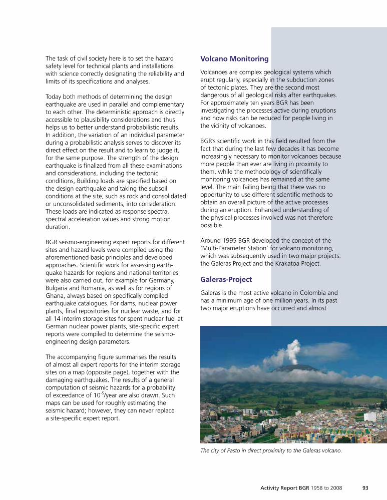
Activity Report BGR 1958 to 2008 93
The task of civil society here is to set the hazardsafety level for technical plants and installationswith science correctly designating the reliability andlimits of its specifications and analyses.
Today both methods of determining the designearthquake are used in parallel and complementaryto each other. The deterministic approach is directlyaccessible to plausibility considerations and thushelps us to better understand probabilistic results.In addition, the variation of an individual parameterduring a probabilistic analysis serves to discover itsdirect effect on the result and to learn to judge it,for the same purpose. The strength of the designearthquake is finalized from all these examinationsand considerations, including the tectonicconditions, Building loads are specified based onthe design earthquake and taking the subsoilconditions at the site, such as rock and consolidatedor unconsolidated sediments, into consideration.These loads are indicated as response spectra,spectral acceleration values and strong motionduration.
BGR seismo-engineering expert reports for differentsites and hazard levels were compiled using theaforementioned basic principles and developedapproaches. Scientific work for assessing earth-quake hazards for regions and national territorieswere also carried out, for example for Germany,Bulgaria and Romania, as well as for regions ofGhana, always based on specifically compiledearthquake catalogues. For dams, nuclear powerplants, final repositories for nuclear waste, and forall 14 interim storage sites for spent nuclear fuel atGerman nuclear power plants, site-specific expertreports were compiled to determine the seismo-engineering design parameters.
The accompanying figure summarises the resultsof almost all expert reports for the interim storagesites on a map (opposite page), together with thedamaging earthquakes. The results of a generalcomputation of seismic hazards for a probabilityof exceedance of 10-5/year are also drawn. Suchmaps can be used for roughly estimating theseismic hazard; however, they can never replacea site-specific expert report.
Volcano Monitoring
Volcanoes are complex geological systems whicherupt regularly, especially in the subduction zonesof tectonic plates. They are the second mostdangerous of all geological risks after earthquakes.For approximately ten years BGR has beeninvestigating the processes active during eruptionsand how risks can be reduced for people living inthe vicinity of volcanoes.
BGR’s scientific work in this field resulted from thefact that during the last few decades it has becomeincreasingly necessary to monitor volcanoes becausemore people than ever are living in proximity tothem, while the methodology of scientificallymonitoring volcanoes has remained at the samelevel. The main failing being that there was noopportunity to use different scientific methods toobtain an overall picture of the active processesduring an eruption. Enhanced understanding ofthe physical processes involved was not thereforepossible.
Around 1995 BGR developed the concept of the‘Multi-Parameter Station’ for volcano monitoring,which was subsequently used in two major projects:the Galeras Project and the Krakatoa Project.
Galeras-Project
Galeras is the most active volcano in Colombia andhas a minimum age of one million years. In its pasttwo major eruptions have occurred and almost
The city of Pasto in direct proximity to the Galeras volcano.
1999so001d_089_108.indd 931999so001d_089_108.indd 93 16.06.2009 09:20:1016.06.2009 09:20:10
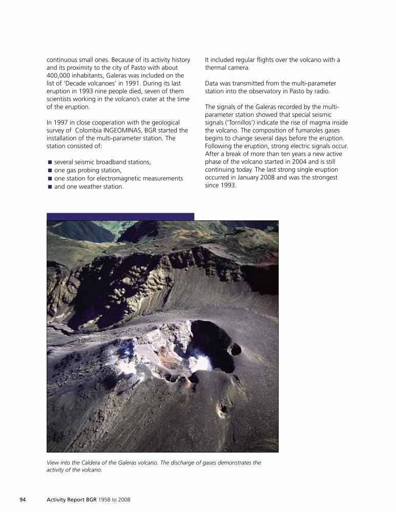
94 Activity Report BGR 1958 to 2008
continuous small ones. Because of its activity historyand its proximity to the city of Pasto with about400,000 inhabitants, Galeras was included on thelist of ‘Decade volcanoes’ in 1991. During its lasteruption in 1993 nine people died, seven of themscientists working in the volcano’s crater at the timeof the eruption.
In 1997 in close cooperation with the geologicalsurvey of Colombia INGEOMINAS, BGR started theinstallation of the multi-parameter station. Thestation consisted of:
several seismic broadband stations,È
one gas probing station,È
one station for electromagnetic measurementsÈ
and one weather station.È
View into the Caldera of the Galeras volcano. The discharge of gases demonstrates theactivity of the volcano.
It included regular flights over the volcano with athermal camera.
Data was transmitted from the multi-parameterstation into the observatory in Pasto by radio.
The signals of the Galeras recorded by the multi-parameter station showed that special seismicsignals (‘Tornillos’) indicate the rise of magma insidethe volcano. The composition of fumaroles gasesbegins to change several days before the eruption.Following the eruption, strong electric signals occur.After a break of more than ten years a new activephase of the volcano started in 2004 and is stillcontinuing today. The last strong single eruptionoccurred in January 2008 and was the strongestsince 1993.
1999so001d_089_108.indd 941999so001d_089_108.indd 94 16.06.2009 09:20:1216.06.2009 09:20:12
Krakatoa-Project
Krakatoa exploded in 1883 with an eruption whichthrew huge amounts of matter into the atmosphere.The eruption, including the effects of the tsunami,caused the deaths of more than 35,000 people. Thevolcano is still very active today, and is growing inheight by four metres every year.
Within the geotechnologies project, funded by theBMBF, the Krakatoa volcano was selected by BGR incooperation with the Geological Survey of Indonesiaas a location for the installation of a multi-parameterstation. The installation included broadbandseismometers, measurements of deformation usingGPS, a weather station, measurements of groundtemperature, determination of the chemicalcomposition of fumaroles gases, an electromagneticstation and observations of the volcano by videocamera.
All the data are transferred via radio link fromKrakatoa to an observatory at the mainland andfrom there to the main office in Bandung and toBGR in Germany. This is done via the satellite linksystem planned for tsunami monitoring and via theInternet.
Important features of the monitoring system are:
worldwide data accessibility via radio link –È
satellite – Internet,automated data processing,È
analysis of the data using expert systems,È
standardized data access via web interface.È
91
90
89
88
87
86
310
300
290
1,8
1,4
1,0
22..66.. 1122..66.. 2222..66.. 22..77.. 1122..77.. 2222..77.. 11..88..
2004
TT D De ef f
..[[°° CC
]]TT CC
hh ..[[ °°
CC]]
CC OO2 2
LL JJ[[ VV
]]
Changes of gas temperatures of the fumaroles Deformes(upper) and Chaves (centre), and change of carbon dioxidecontent of the fumarole LJ (lower) during June and July of2004. Eruptions with ejection of ash occurred on 16 and21 July 2004.
The system enables real time determination of theactivity of the volcano at any time and thereforerepresents an important tool within the monitoringof Krakatoa for decision-makers in Indonesia. Itmakes an important contribution to the protectionof the people of Indonesia against a foreseeableeruption of Krakatoa.
Installation of equipment at Krakatoa.
1999so001d_089_108.indd 951999so001d_089_108.indd 95 16.06.2009 09:20:2216.06.2009 09:20:22
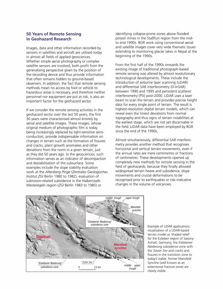
50 Years of Remote Sensingin Geohazard Research
Images, data and other information recorded bysensors in satellites and aircraft are utilised todayin almost all fields of applied geosciences.Whether simple aerial photography or complexsatellite sensors are involved, both profit from thegeneralising perspective given by the position ofthe recording device and thus provide informationthat often remains hidden to ground-basedobservers. In addition, the fact that remote sensingmethods mean no access by foot or vehicle tohazardous areas is necessary, and therefore neitherpersonnel nor equipment are put at risk, is also animportant factor for the geohazard sector.
If we consider the remote sensing activities in thegeohazard sector over the last 50 years, the first30 years were characterised almost entirely byaerial and satellite images. These images, whoseoriginal medium of photographic film is todaybeing increasingly replaced by light-sensitive semi-conductors, provide indispensable information onchanges in terrain such as the formation of fissuresand cracks, plant growth anomalies and otherdeviations from the norm in a given terrain, justas they did 50 years ago. In the geosciences, suchinformation serves as an indicator of decompactionand destabilisation of the subsurface. Someexamples include the slope stability evaluationwork at the Altenberg Pinge (Zentrales GeologischesInstitut ZGI Berlin 1980 to 1982), evaluation ofsubrosion-related subsidence in the Halberstadt-Westeregeln region (ZGI Berlin 1983 to 1985) or
identifying collapse-prone zones above floodedpotash mines in the Staßfurt region from the mid-to end 1990s. BGR work using conventional aerialand satellite images cover very wide thematic issuesextending to monitoring glacier lakes in Nepal at thebeginning of the 1990s.
From the first half of the 1990s onwards theexisting image of traditional photograph-basedremote sensing was altered by almost revolutionarytechnological developments. These include theintroduction of airborne laser scanning (LiDAR)and differential SAR interferometry (D-InSAR)between 1990 and 1995 and persistent scattererinterferometry (PSI) post-2000. LiDAR uses a laserbeam to scan the terrain and provides precise heightdata for every single point of terrain. The result ishighest-resolution digital terrain models, which canreveal even the tiniest deviations from normaltopography and thus signs of terrain nstabilities atthe earliest stage, which are not yet discernable inthe field. LiDAR data have been employed by BGRsince the end of the 1990s.
Almost simultaneously, differential SAR interfero-metry provides another method that recogniseshorizontal and vertical terrain movements, even ifthe annual rates are mere centimetres or fractionsof centimetres. These developments opened upcompletely new methods for remote sensing in thefield of geohazards, because they finally allowedwidespread terrain heave and subsidence, slopemovements and crustal deformations to berecognised prior to earthquakes or risk-indicativechanges in the volume of volcanoes.
Mansfeldsyncline
Eisleben
“Eislebener Niederung“subsidence zone
“ Süßer See “
0 2,5 kmmiddle upper
trough
middle trough upper trough
Mansfeldsyncline
“Eislebener Niederung“subsidence zone Example of LiDAR applications:
visualisation of a LiDAR-basedterrain model as ’shaded relief’for the Eisleben region of Saxony-Anhalt, Germany; the EislebenerNiederung subsidence zone withthe Süsser See and cracks andfissures in the transition zone totoday’s stable, former MansfeldSyncline (well known as anextensional fracture zone) areclearly visible.
1999so001d_089_108.indd 961999so001d_089_108.indd 96 16.06.2009 09:20:2616.06.2009 09:20:26
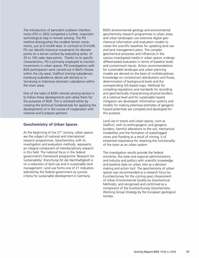
Activity Report BGR 1958 to 2008 97
The introduction of persistent scatterer interfero-metry (PSI) in 2002 completed a further, importanttechnological step in remote sensing. The PSImethod distinguishes the smallest terrain move-ments, just as D-InSAR does. In contrast to D-InSAR,PSI can identify historical movements for discretepoints on a terrain surface by evaluating series’ of20 to 100 radar data points. Thanks to its specificcharacteristics, PSI is primarily employed to monitormovements in urban spaces. PSI investigations withBGR participation were carried out in Berlin (heavewithin the city area), Staßfurt (mining subsidence),Hamburg (subsidence above salt domes) or inSemarang in Indonesia (dramatic subsidence withinthe town area).
One of the tasks of BGR’s remote sensing section isto follow these developments and utilise them forthe purposes of BGR. This is achieved either bycreating the technical fundamentals for applying thedevelopments or in the course of cooperation withnational and European partners.
Geochemistry of Urban Spaces
At the beginning of the 21st century, urban spacesare the subject of national and internationalresearch programmes. Geochemistry, with itsinvestigation and evaluation methods, representsan integral component of interdisciplinary researchin this field. The national focus in the federalgovernment’s framework programme ‘Research forSustainability’ (Forschung für die Nachhaltigkeit) ison a reduction of land use and in sustainable landmanagement. Land use forms one of 21 indicatorsselected by the federal government as successcriteria for sustainable development in Germany.
BGR’s environmental geology and environmentalgeochemistry research programmes in urban areasand urban landscapes use extensive digital geo-chemical information and evaluation models tocreate the scientific baselines for updating land useand land management plans. The complexgeochemical processes and influences in thevarious investigated media in urban spaces undergodifferentiated evaluation in terms of baseline levelsand contaminant inputs. Action recommendationsfor sustainable landscape and urban planningmodels are derived on the basis of multidisciplinaryknowledge on contaminant distributions and fluxes,determination of background levels and thecorresponding GIS-based maps. Methods forcompiling regulations and standards for recordingand geochemically characterising physical burdensat a national level and for sustainable hazardmitigation are developed. Information systems andmodels for making extensive estimates of geogenichazard potentials are compiled and developed forthis purpose.
Land use in towns and urban spaces, such asStaßfurt, with its anthropogenic and geogenicburdens, harmful alterations to the soil, mechanicalinstabilities and the formation of waterloggedzones and flooding as a result of mining, is ofexistential importance for retaining the functionalityof the town as an urban system.
The investigation results provide the federalministries, the state and regional administrations,and industry and politics with scientific knowledgeand baseline data on urban sites as a decisionmaking and action tool. The geochemistry of urbanspaces was recommended as a research focus byEuroGeoSurvey for the coming years (Assessmentof Urban Environmental Quality by GeochemicalMethods), and recognised and confirmed as acomponent of the EuroGeoSurvey GeochemistryWorking Group Strategy by the European geologicalsurveys.
1999so001d_089_108.indd 971999so001d_089_108.indd 97 16.06.2009 09:20:2616.06.2009 09:20:26
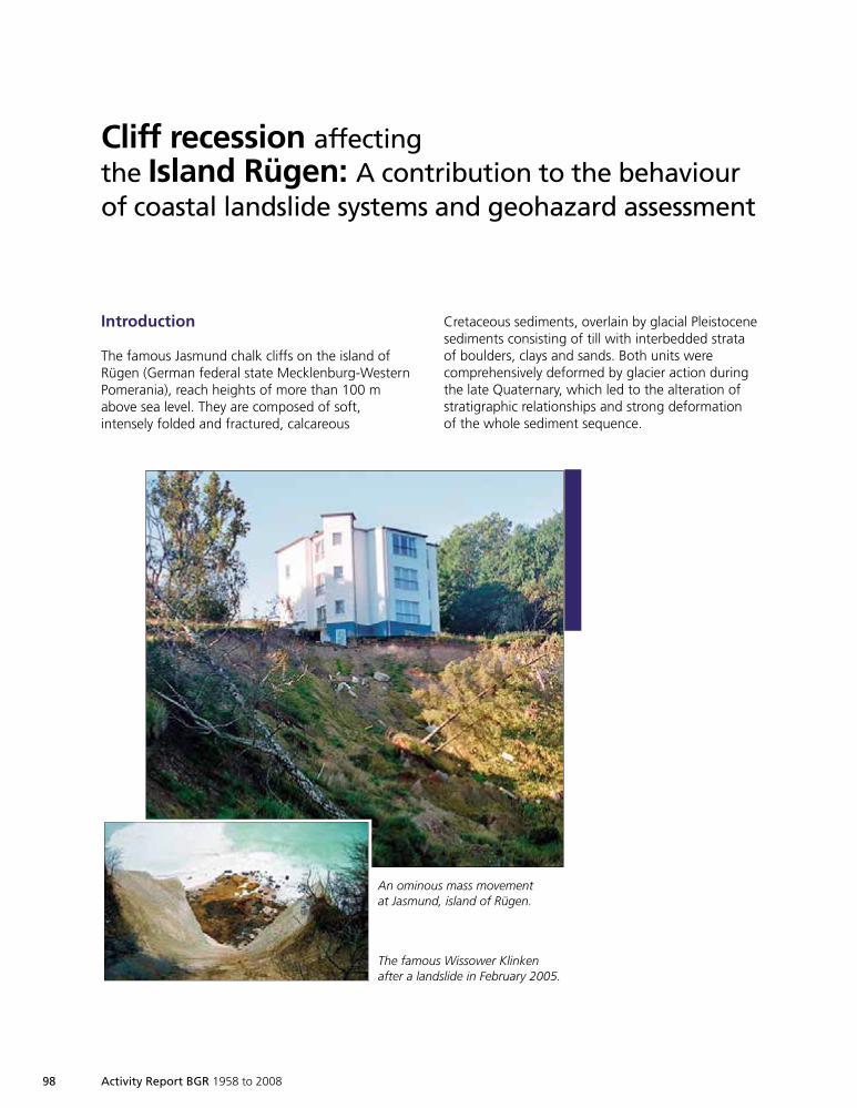
98 Activity Report BGR 1958 to 2008
Cliff recession affectingthe Island Rügen: A contribution to the behaviourof coastal landslide systems and geohazard assessment
Introduction
The famous Jasmund chalk cliffs on the island ofRügen (German federal state Mecklenburg-WesternPomerania), reach heights of more than 100 mabove sea level. They are composed of soft,intensely folded and fractured, calcareous
Bedrohlich anmutendeMassenbewegungen aufJasmund, Insel Rügen.
Links eine künstlerischnachempfundene Ansicht derberühmten Kreidefelsen.
Cretaceous sediments, overlain by glacial Pleistocenesediments consisting of till with interbedded strataof boulders, clays and sands. Both units werecomprehensively deformed by glacier action duringthe late Quaternary, which led to the alteration ofstratigraphic relationships and strong deformationof the whole sediment sequence.
An ominous mass movementat Jasmund, island of Rügen.
The famous Wissower Klinkenafter a landslide in February 2005.
1999so001d_089_108.indd 981999so001d_089_108.indd 98 16.06.2009 09:20:2616.06.2009 09:20:26
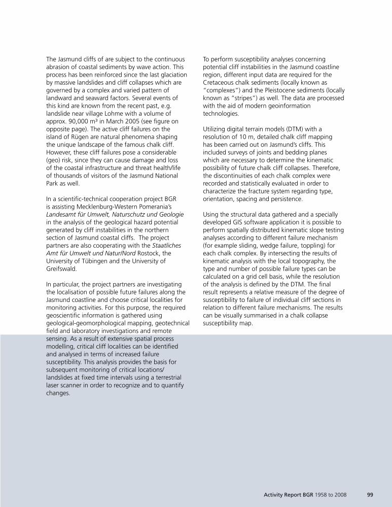
The Jasmund cliffs of are subject to the continuousabrasion of coastal sediments by wave action. Thisprocess has been reinforced since the last glaciationby massive landslides and cliff collapses which aregoverned by a complex and varied pattern oflandward and seaward factors. Several events ofthis kind are known from the recent past, e.g.landslide near village Lohme with a volume ofapprox. 90,000 m³ in March 2005 (see figure onopposite page). The active cliff failures on theisland of Rügen are natural phenomena shapingthe unique landscape of the famous chalk cliff.However, these cliff failures pose a considerable(geo) risk, since they can cause damage and lossof the coastal infrastructure and threat health/lifeof thousands of visitors of the Jasmund NationalPark as well.
In a scientific-technical cooperation project BGRis assisting Mecklenburg-Western Pomerania’sLandesamt für Umwelt, Naturschutz und Geologiein the analysis of the geological hazard potentialgenerated by cliff instabilities in the northernsection of Jasmund coastal cliffs. The projectpartners are also cooperating with the StaatlichesAmt für Umwelt und Natur/Nord Rostock, theUniversity of Tübingen and the University ofGreifswald.
In particular, the project partners are investigatingthe localisation of possible future failures along theJasmund coastline and choose critical localities formonitoring activities. For this purpose, the requiredgeoscientific information is gathered usinggeological-geomorphological mapping, geotechnicalfield and laboratory investigations and remotesensing. As a result of extensive spatial processmodelling, critical cliff localities can be identifiedand analysed in terms of increased failuresusceptibility. This analysis provides the basis forsubsequent monitoring of critical locations/landslides at fixed time intervals using a terrestriallaser scanner in order to recognize and to quantifychanges.
Activity Report BGR 1958 to 2008 99
To perform susceptibility analyses concerningpotential cliff instabilities in the Jasmund coastlineregion, different input data are required for theCretaceous chalk sediments (locally known as“complexes”) and the Pleistocene sediments (locallyknown as “stripes”) as well. The data are processedwith the aid of modern geoinformationtechnologies.
Utilizing digital terrain models (DTM) with aresolution of 10 m, detailed chalk cliff mappinghas been carried out on Jasmund’s cliffs. Thisincluded surveys of joints and bedding planeswhich are necessary to determine the kinematicpossibility of future chalk cliff collapses. Therefore,the discontinuities of each chalk complex wererecorded and statistically evaluated in order tocharacterize the fracture system regarding type,orientation, spacing and persistence.
Using the structural data gathered and a speciallydeveloped GIS software application it is possible toperform spatially distributed kinematic slope testinganalyses according to different failure mechanism(for example sliding, wedge failure, toppling) foreach chalk complex. By intersecting the results ofkinematic analysis with the local topography, thetype and number of possible failure types can becalculated on a grid cell basis, while the resolutionof the analysis is defined by the DTM. The finalresult represents a relative measure of the degree ofsusceptibility to failure of individual cliff sections inrelation to different failure mechanisms. The resultscan be visually summarised in a chalk collapsesusceptibility map.
1999so001d_089_108.indd 991999so001d_089_108.indd 99 16.06.2009 09:20:2716.06.2009 09:20:27
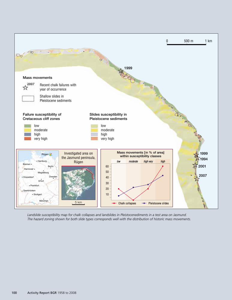
100 Activity Report BGR 1958 to 2008
CChhaallkk ccoollllaappsseess PPlleeiissttoocceennee sslliiddeess
1999
1999
1994
2001
2007
Rügen
HamburgBremen
BerlinHannover
Magdeburg
DresdenDüsseldorf
Erfurt
Frankfurt
Saarbrücken
Stuttgart
München
Investigated area onthe Jasmund peninsula,
Rügen
5 km
0 500 m 1 km
Mass movements
Recent chalk failures withyear of occurrence
Shallow slides inPleistocene sediments
Failure susceptibility ofCretaceous cliff zones
lowmoderatehighvery high
Slides susceptibility inPleistocene sediments
lowmoderatehighvery high
llooww mmooddeerraattee hhiigghh vveerryy hhiigghh
Mass movements [ in % of area]within susceptibility classes
60
50
40
30
20
10
Landslide susceptibility map for chalk collapses and landslides in Pleistocenediments in a test area on Jasmund.The hazard zoning shown for both slide types corresponds well with the distribution of historic mass movements.
1999so001d_089_108.indd 1001999so001d_089_108.indd 100 16.06.2009 09:20:2716.06.2009 09:20:27
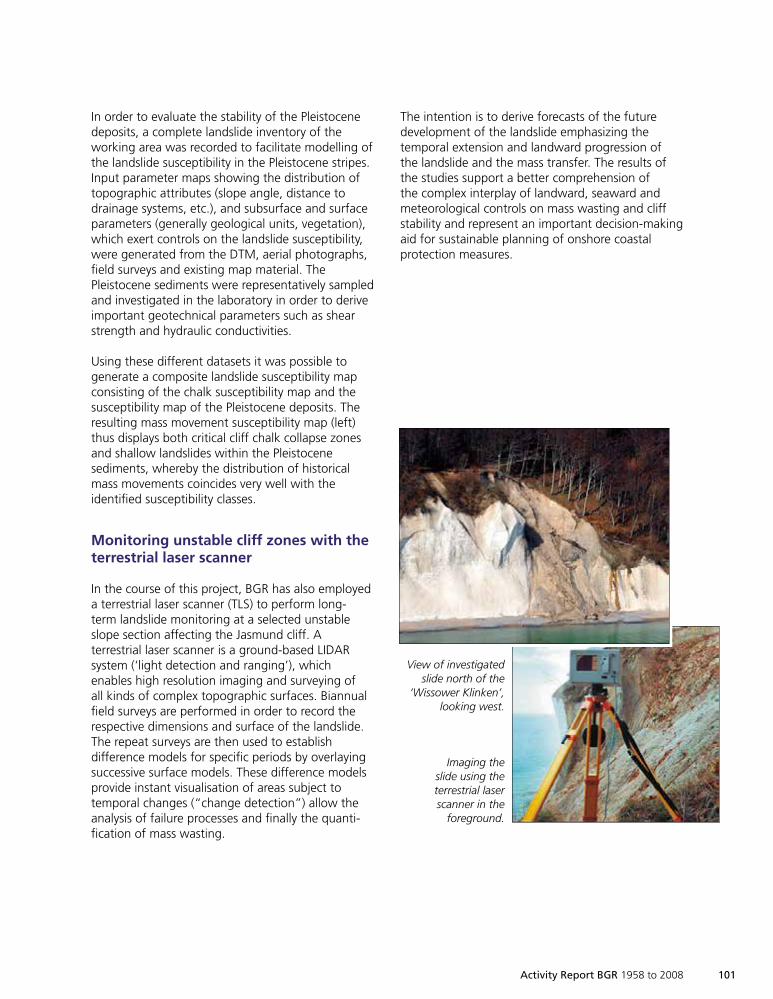
Activity Report BGR 1958 to 2008 101
In order to evaluate the stability of the Pleistocenedeposits, a complete landslide inventory of theworking area was recorded to facilitate modelling ofthe landslide susceptibility in the Pleistocene stripes.Input parameter maps showing the distribution oftopographic attributes (slope angle, distance todrainage systems, etc.), and subsurface and surfaceparameters (generally geological units, vegetation),which exert controls on the landslide susceptibility,were generated from the DTM, aerial photographs,field surveys and existing map material. ThePleistocene sediments were representatively sampledand investigated in the laboratory in order to deriveimportant geotechnical parameters such as shearstrength and hydraulic conductivities.
Using these different datasets it was possible togenerate a composite landslide susceptibility mapconsisting of the chalk susceptibility map and thesusceptibility map of the Pleistocene deposits. Theresulting mass movement susceptibility map (left)thus displays both critical cliff chalk collapse zonesand shallow landslides within the Pleistocenesediments, whereby the distribution of historicalmass movements coincides very well with theidentified susceptibility classes.
Monitoring unstable cliff zones with theterrestrial laser scanner
In the course of this project, BGR has also employeda terrestrial laser scanner (TLS) to perform long-term landslide monitoring at a selected unstableslope section affecting the Jasmund cliff. Aterrestrial laser scanner is a ground-based LIDARsystem (‘light detection and ranging’), whichenables high resolution imaging and surveying ofall kinds of complex topographic surfaces. Biannualfield surveys are performed in order to record therespective dimensions and surface of the landslide.The repeat surveys are then used to establishdifference models for specific periods by overlayingsuccessive surface models. These difference modelsprovide instant visualisation of areas subject totemporal changes (“change detection”) allow theanalysis of failure processes and finally the quanti-fication of mass wasting.
Ansicht der unter-suchten Rutschung
nördlich der„Wissower Klinken“,
Blick nach Westen.
Aufnahme derRutschung mit
dem terrestrischenLaserscanner im
Vordergrund.
The intention is to derive forecasts of the futuredevelopment of the landslide emphasizing thetemporal extension and landward progression ofthe landslide and the mass transfer. The results ofthe studies support a better comprehension ofthe complex interplay of landward, seaward andmeteorological controls on mass wasting and cliffstability and represent an important decision-makingaid for sustainable planning of onshore coastalprotection measures.
View of investigatedslide north of the
‘Wissower Klinken’,looking west.
Imaging theslide using theterrestrial laserscanner in the
foreground.
1999so001d_089_108.indd 1011999so001d_089_108.indd 101 16.06.2009 09:20:2816.06.2009 09:20:28
102 Activity Report BGR 1958 to 2008
The differential model of two repeat surveysperformed in May and September 2006 (above,left image) gives a visualisation of the surfacechanges of the monitored landslide in the specifiedperiod. It shows deep incision and channel erosionin the centre of the landslide due to superficialwater runoff (blue colours) and in contrast deposi-tional zones in green to orange colours.On the other hand, a second differential modelof the time interval between September 2006 andMay 2007 (right image), displays upslope extensionof pronounced channel erosion, leading to under-cutting and failure of a 16 m x 7 m long section ofthe cliff edge. During the monitoring periodbetween Mai 2006 and October 2008 an overall
volume of approx. 6730 m³ was mobilised, and thelandslide extension increased from an initial area of2,111 m² to 2,289 m², therefore increasing about178 m² in 2.5 years.
The results to date confirm pronounced masswasting of the Pleistocene sediments in conjunctionwith landward slide propagation of the cliff edge.Given the prevailing velocity of landslide extensionand assuming no change of the controlling factorsin the future, the frequently used hiking trail at thetop of the landslide has to be replaced in about2 years time, in order to guarantee a safe passageof the tourists.
deposition difference [ m] erosion
S N S N
Comparison between May and September 2006 Comparison between May and September 2007
4 3 2 1 0 -1 -2 -3 -4 -5
A landslide can be investigated using differential models compiled from satellite images taken at different timesover an area north of the 'Wissower Klinken'. An idea of the scale is given at the top of the right image.
1999so001d_089_108.indd 1021999so001d_089_108.indd 102 16.06.2009 09:20:2916.06.2009 09:20:29

Activity Report BGR 1958 to 2008 103
Summary and outlook
In the course of the project a methodology wasdeveloped to derive susceptibility zones forlandslides on the Jasmund peninsula, island ofRügen in order to make spatial forecasts of futuremass movements. The resulting maps serve as thebasis for identifying unstable cliff sections and thedetermination of monitoring measures (visualsurveillance, terrestrial and airborne laser scanning,field work).
During the course of the project the southernsection of Jasmund cliff will be analysed regardingits landslide hazard potential, analogous to thenorthern section. Additional geotechnical,hydrogeological and remote-sensing informationwill be integrated to improve the existing models.
The data compiled during this project provide theagencies concerned with tangible information interms of landslide hazard as a component of theonshore controls of cliff dynamics. This aspect waspreviously not or only insufficiently taken intoaccount during the planning of coastal protectionmeasures, which are generally implementedoffshore.
1999so001d_089_108.indd 1031999so001d_089_108.indd 103 16.06.2009 09:20:3016.06.2009 09:20:30

104 Activity Report BGR 1958 to 2008
“Mitigation of Geo Risksin Central America” Project
Due to their position close to an active continentalmargin, the population and infrastructure ofCentral American countries are exposed to hazardsrelated to earthquakes, volcanism and tsunamis.Additionally, they are affected by annually recurringhurricane periods, which in most cases cross thecontinent from the Atlantic coast towards the west,achieving enormous precipitation volumes and windvelocities of more than 150 km/h, causing extensivewindslashes and inundations.
The generally steep slopes mostly consist of porous,unstable volcanic rock, composed of poorly consoli-dated tuffs and ignimbrites, which tend to weatherquickly. Many of them are in danger of failing under
San Pedro Volcano, Guatemala.
conditions of elevated pore water pressure due tointensive precipitation. Heavy rainfall or a lowintensity earthquake can trigger slumps or mudflows with run-out distances of several kilometres.
Between 1960 and 2001 a total of 10 millionpeople were affected by natural disasters inCentral America, with 60,000 casualties anddamage amounting to 17 billion US dollars.
Land use planning and disaster prevention must beadapted to mitigate the risk of lethal and expensivedamage related to natural events. The authoritiesof some Central American countries – Nicaragua,Honduras, Guatemala and El Salvador – have
1999so001d_089_108.indd 1041999so001d_089_108.indd 104 16.06.2009 09:20:3516.06.2009 09:20:35
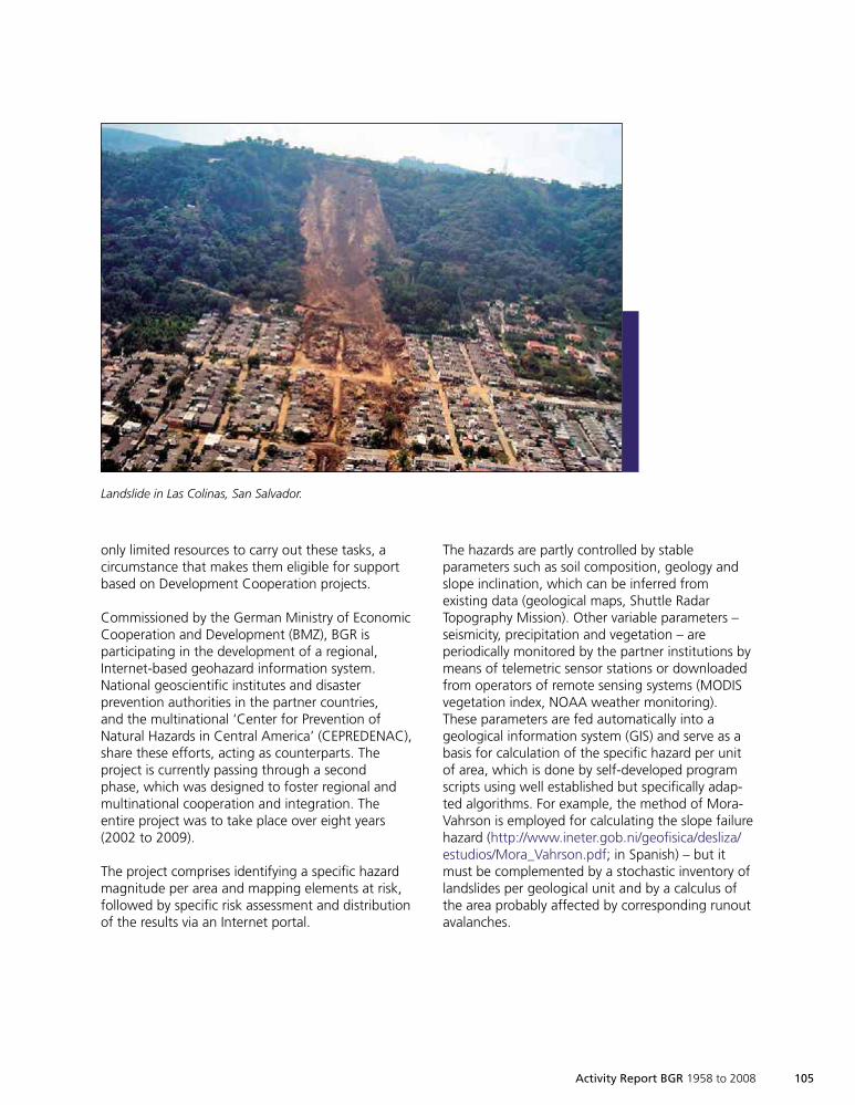
Activity Report BGR 1958 to 2008 105
only limited resources to carry out these tasks, acircumstance that makes them eligible for supportbased on Development Cooperation projects.
Commissioned by the German Ministry of EconomicCooperation and Development (BMZ), BGR isparticipating in the development of a regional,Internet-based geohazard information system.National geoscientific institutes and disasterprevention authorities in the partner countries,and the multinational ‘Center for Prevention ofNatural Hazards in Central America’ (CEPREDENAC),share these efforts, acting as counterparts. Theproject is currently passing through a secondphase, which was designed to foster regional andmultinational cooperation and integration. Theentire project was to take place over eight years(2002 to 2009).
The project comprises identifying a specific hazardmagnitude per area and mapping elements at risk,followed by specific risk assessment and distributionof the results via an Internet portal.
The hazards are partly controlled by stableparameters such as soil composition, geology andslope inclination, which can be inferred fromexisting data (geological maps, Shuttle RadarTopography Mission). Other variable parameters –seismicity, precipitation and vegetation – areperiodically monitored by the partner institutions bymeans of telemetric sensor stations or downloadedfrom operators of remote sensing systems (MODISvegetation index, NOAA weather monitoring).These parameters are fed automatically into ageological information system (GIS) and serve as abasis for calculation of the specific hazard per unitof area, which is done by self-developed programscripts using well established but specifically adap-ted algorithms. For example, the method of Mora-Vahrson is employed for calculating the slope failurehazard (http://www.ineter.gob.ni/geofisica/desliza/estudios/Mora_Vahrson.pdf; in Spanish) – but itmust be complemented by a stochastic inventory oflandslides per geological unit and by a calculus ofthe area probably affected by corresponding runoutavalanches.
Landslide in Las Colinas, San Salvador.
1999so001d_089_108.indd 1051999so001d_089_108.indd 105 16.06.2009 09:20:3716.06.2009 09:20:37
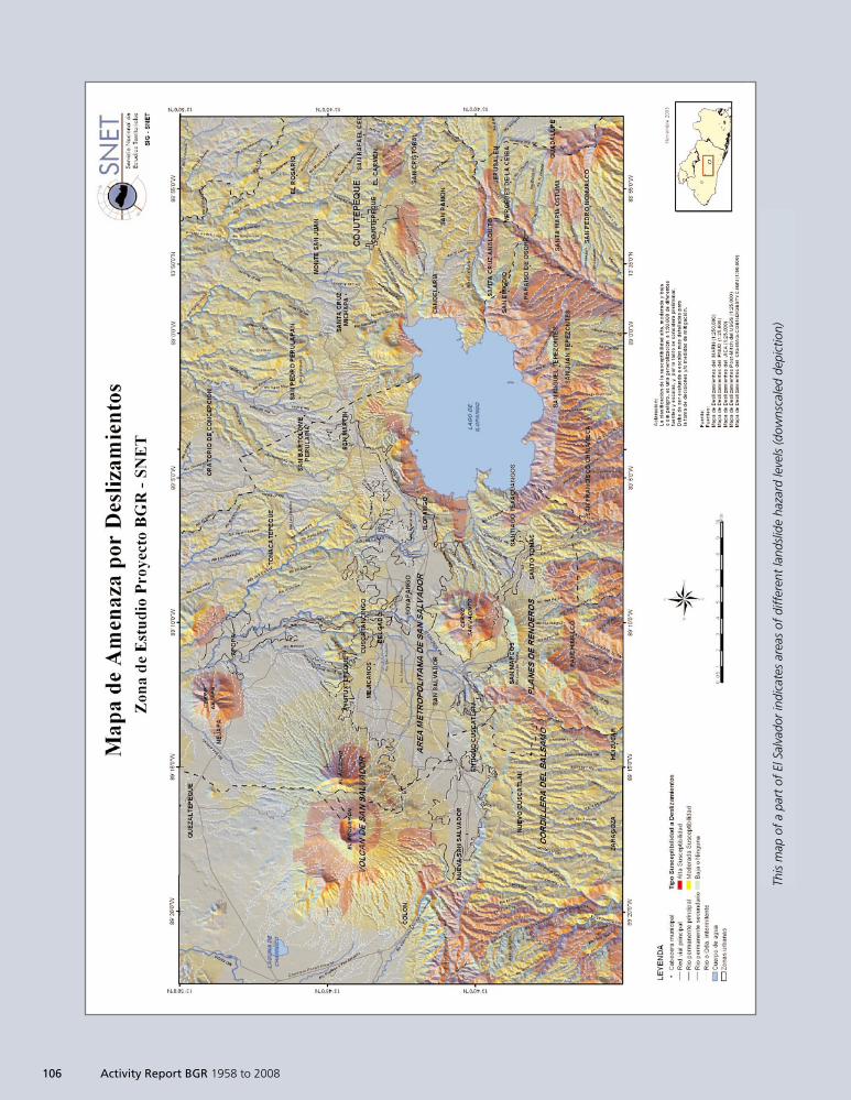
This
map
ofa
part
ofEl
Salv
ador
indi
cate
sar
eas
ofdi
ffer
ent
land
slid
eha
zard
leve
ls(d
owns
cale
dde
pict
ion)
This
map
ofa
part
ofEl
Salv
ador
indi
cate
sar
eas
ofdi
ffer
ent
land
slid
eha
zard
leve
ls(d
owns
cale
dde
pict
ion)
106 Activity Report BGR 1958 to 2008
1999so001d_089_108.indd 1061999so001d_089_108.indd 106 16.06.2009 09:20:3816.06.2009 09:20:38
Activity Report BGR 1958 to 2008 107
During the further course of the project thepopulation density per unit of area and the valuesof elements at risk will be derived from existingdata in the partner countries and represented asvulnerability maps that allow risk estimates. Theresulting spatial information (specific hazards andrisk) shall serve as a basis for:
Planning authorities who will be able to calculateÈ
potential risks for several land use alternativesand select the optimum variant.Delimiting areas of high hazard levels to keepÈ
them free from vulnerable infrastructure andstructures.Facilitating the risk-based elaboration of alertÈ
and rescue procedures by disaster preventionorganizations.
Comprehensive citizen and investor informationÈ
will enable them to modify their plans andactions taking into consideration existing andpotential hazards to their lives, health andproperties.
To assure widespread distribution of the results,they are presented online as processed GIS datawith user manuals and downloadable mapsthrough a publicly accessible web interface(http://www.georiesgos-ca.info/).
1999so001d_089_108.indd 1071999so001d_089_108.indd 107 16.06.2009 09:20:4016.06.2009 09:20:40

1999so001d_089_108.indd 1081999so001d_089_108.indd 108 16.06.2009 09:20:4216.06.2009 09:20:42
Activity Report BGR 1958 to 2008 109
logicalResearch /
ComprehensiveTreaty
Seismometer.
1999so001d_109_118.indd 1091999so001d_109_118.indd 109 16.06.2009 09:21:5716.06.2009 09:21:57
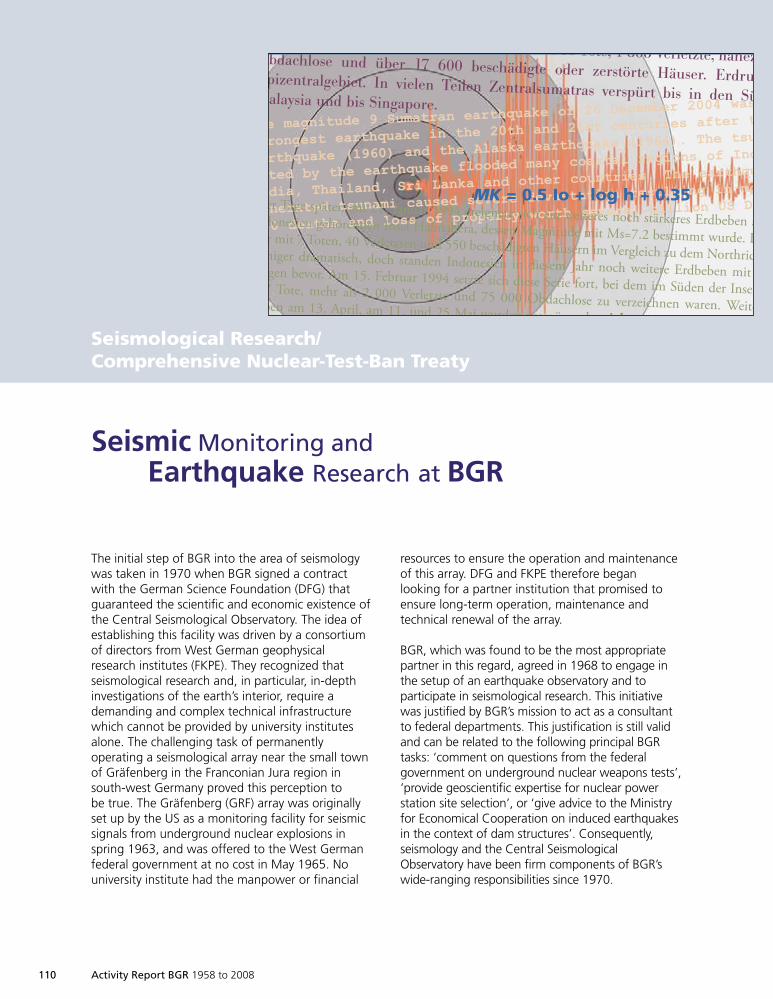
110 Activity Report BGR 1958 to 2008
Seismological Research/Comprehensive Nuclear-Test-Ban Treaty
The initial step of BGR into the area of seismologywas taken in 1970 when BGR signed a contractwith the German Science Foundation (DFG) thatguaranteed the scientific and economic existence ofthe Central Seismological Observatory. The idea ofestablishing this facility was driven by a consortiumof directors from West German geophysicalresearch institutes (FKPE). They recognized thatseismological research and, in particular, in-depthinvestigations of the earth’s interior, require ademanding and complex technical infrastructurewhich cannot be provided by university institutesalone. The challenging task of permanentlyoperating a seismological array near the small townof Gräfenberg in the Franconian Jura region insouth-west Germany proved this perception tobe true. The Gräfenberg (GRF) array was originallyset up by the US as a monitoring facility for seismicsignals from underground nuclear explosions inspring 1963, and was offered to the West Germanfederal government at no cost in May 1965. Nouniversity institute had the manpower or financial
Seismic Monitoring andEarthquake Research at BGR
resources to ensure the operation and maintenanceof this array. DFG and FKPE therefore beganlooking for a partner institution that promised toensure long-term operation, maintenance andtechnical renewal of the array.
BGR, which was found to be the most appropriatepartner in this regard, agreed in 1968 to engage inthe setup of an earthquake observatory and toparticipate in seismological research. This initiativewas justified by BGR’s mission to act as a consultantto federal departments. This justification is still validand can be related to the following principal BGRtasks: ‘comment on questions from the federalgovernment on underground nuclear weapons tests’,‘provide geoscientific expertise for nuclear powerstation site selection’, or ‘give advice to the Ministryfor Economical Cooperation on induced earthquakesin the context of dam structures’. Consequently,seismology and the Central SeismologicalObservatory have been firm components of BGR’swide-ranging responsibilities since 1970.
The magnitude 9 Sumatran earthquake of 26 December 2004 was
strongest earthquake in the 20th and 21st centuries after the
earthquake (1960) and the Alaska earthquake (1964). The tsunami
rated by the earthquake flooded many coastal regions of Indonesia,
India, Thailand, Sri Lanka and other countries. The earthquake
generated tsunami caused severe devastation resulting in more
000 deaths and loss of property worth several billion US Dollars.
Indonesien; der Provinz Jambi 48 Tote, 1 868 Verletzte, nahezuObdachlose und über 17 600 beschädigte oder zerstörte Häuser. ErdrutscheEpizentralgebiet. In vielen Teilen Zentralsumatras verspürt bis in den SüdenMalaysia und bis Singapore.
er Tage später, am 21. Januar 1994 ereignete sich ein weiteres noch stärkeres Erdbeben aufdonesien gehörenden Insel Halmahera, dessen Magnitude mit Ms=7.2 bestimmt wurde. Diwar mit 7 Toten, 40 Verletzten und 550 beschädigten Häusern im Vergleich zu dem Northridge-Bniger dramatisch, doch standen Indonesien in diesem Jahr noch weitere Erdbeben mitlgen bevor. Am 15. Februar 1994 setzte sich diese Serie fort, bei dem im Süden der Insel207 Tote, mehr als 2 000 Verletzte und 75 000 Obdachlose zu verzeichnen waren. Weiterben am 13. April, am 11. und 25 Mai wurden verspürt oder richteten Sachschaden
MK = 0.5 Io + log h + 0.35
1999so001d_109_118.indd 1101999so001d_109_118.indd 110 16.06.2009 09:21:5916.06.2009 09:21:59
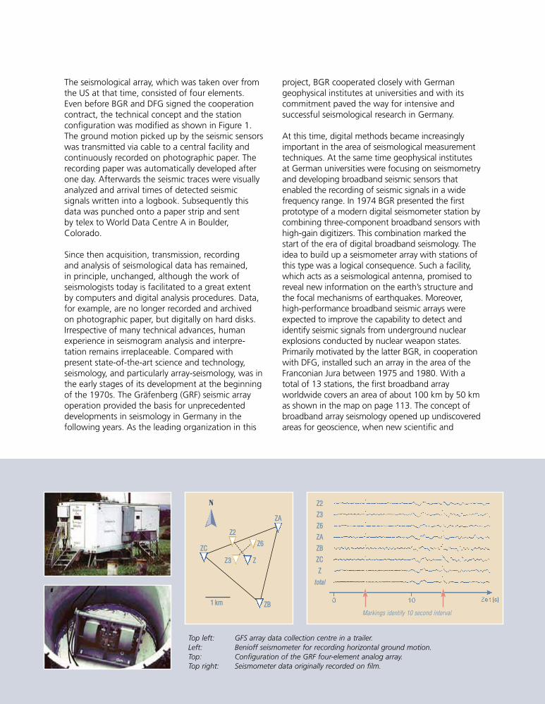
Activity Report BGR 1958 to 2008 111
The seismological array, which was taken over fromthe US at that time, consisted of four elements.Even before BGR and DFG signed the cooperationcontract, the technical concept and the stationconfiguration was modified as shown in Figure 1.The ground motion picked up by the seismic sensorswas transmitted via cable to a central facility andcontinuously recorded on photographic paper. Therecording paper was automatically developed afterone day. Afterwards the seismic traces were visuallyanalyzed and arrival times of detected seismicsignals written into a logbook. Subsequently thisdata was punched onto a paper strip and sentby telex to World Data Centre A in Boulder,Colorado.
Since then acquisition, transmission, recordingand analysis of seismological data has remained,in principle, unchanged, although the work ofseismologists today is facilitated to a great extentby computers and digital analysis procedures. Data,for example, are no longer recorded and archivedon photographic paper, but digitally on hard disks.Irrespective of many technical advances, humanexperience in seismogram analysis and interpre-tation remains irreplaceable. Compared withpresent state-of-the-art science and technology,seismology, and particularly array-seismology, was inthe early stages of its development at the beginningof the 1970s. The Gräfenberg (GRF) seismic arrayoperation provided the basis for unprecedenteddevelopments in seismology in Germany in thefollowing years. As the leading organization in this
project, BGR cooperated closely with Germangeophysical institutes at universities and with itscommitment paved the way for intensive andsuccessful seismological research in Germany.
At this time, digital methods became increasinglyimportant in the area of seismological measurementtechniques. At the same time geophysical institutesat German universities were focusing on seismometryand developing broadband seismic sensors thatenabled the recording of seismic signals in a widefrequency range. In 1974 BGR presented the firstprototype of a modern digital seismometer station bycombining three-component broadband sensors withhigh-gain digitizers. This combination marked thestart of the era of digital broadband seismology. Theidea to build up a seismometer array with stations ofthis type was a logical consequence. Such a facility,which acts as a seismological antenna, promised toreveal new information on the earth’s structure andthe focal mechanisms of earthquakes. Moreover,high-performance broadband seismic arrays wereexpected to improve the capability to detect andidentify seismic signals from underground nuclearexplosions conducted by nuclear weapon states.Primarily motivated by the latter BGR, in cooperationwith DFG, installed such an array in the area of theFranconian Jura between 1975 and 1980. With atotal of 13 stations, the first broadband arrayworldwide covers an area of about 100 km by 50 kmas shown in the map on page 113. The concept ofbroadband array seismology opened up undiscoveredareas for geoscience, when new scientific and
ZZ22
ZZ33
ZZ66
ZZAA
ZZBB
ZZCC
ZZ
ttoottaall
Markings identify 10 second interval
N
ZZAA
ZZ22
ZZ66ZZCC
ZZ33 ZZ
11 kkmm ZZBB
Top left: GFS array data collection centre in a trailer.Left: Benioff seismometer for recording horizontal ground motion.Top: Configuration of the GRF four-element analog array.Top right: Seismometer data originally recorded on film.
1999so001d_109_118.indd 1111999so001d_109_118.indd 111 16.06.2009 09:21:5916.06.2009 09:21:59
112 Activity Report BGR 1958 to 2008
technical procedures became available providingnew knowledge on earthquake sources, wave pathsand the earth’s structure.
The information gained from data provided by theGRF array initiated the wish to extend the array andto use high-quality broadband data from manybroadband stations distributed across Germany toexplore the earth’s interior. Scientific expectationsfinally led to the establishment of the GermanRegional Seismic Network (GRSN). Under theleadership of BGR, which was responsible for thetechnical concept, the first of eight GRSN stationsbecame operational in the Black Forest in January1991. After Germany’s unification, another fourstations were installed in eastern Germany by 1994.Thanks to aspects of their technical design, alltwelve GRSN stations made it possible for theproject participants to directly access the stations fordata retrieval. The principle of ‘open seismometerstations’ considerably aided the use of seismicwaveform data and as a consequence this stationconcept was accepted by all users. In the follow-upto the initial GRSN setup phase, additional stationsof this type have been installed by geophysicalinstitutes at universities and by regional geologicalsurveys in Germany. Today about 40 GRSN-typebroadband seismometer stations are operationalas shown in the map on the opposite page. Theyare intensively used for monitoring seismicity bothin Germany and worldwide, as well as for a widevariety of scientific investigations.
A special role in this phase is played by a seismo-meter array in the Bavarian Forest near the Czechand Austrian borders, which consists of 25 arrayelements equipped with short period sensorsdistributed on five concentric rings with a maximumaperture of 4 km. With support from the US, thisfacility was installed during the cold war towardsthe end of the 1980s. Originally its aim was todetect, locate and identify underground nuclearweapons tests by Eastern block states. The arraynamed GERESS (GERman Experimental SeismicSystem) became operational in 1991. Germanyand the US agreed to transfer this highly sensitiveseismic array to BGR at no cost after both countrieshad signed the Comprehensive Nuclear-Test-BanTreaty (CTBT). This happened in spring 1997 afterCTBT had been signed by both countries inSeptember 1996. Due to its capability to detect
and locate weak seismic signals from distant events,GERESS was chosen to become one of a total of50 primary seismometer stations for monitoringcompliance with the CTBT. Due to the fact that BGRstaff members had provided advice to the GermanForeign Office during CTBT negotiations at theConference on Disarmament in Geneva, BGR wasconsequently assigned to take over the functions ofan NDC (National Data Centre) for Germany.
Its experience with arrays and related processingtechniques turned out to be useful in an area inwhich BGR had so far no experience: infrasound.Because the CTBT not only bans nuclear testsunderground and underwater, but also in theatmosphere, a worldwide distributed network of60 infrasound arrays is currently being installed.BGR has been commissioned to take responsibilityfor the technical design, installation and operationof two infrasound arrays. IS26 in the Bavarian Forestwas the first certified installation in the infrasoundmonitoring network. It became operational in 1999.IS27, the second German infrasound array, wentinto operation in 2003. This array is located inAntarctica, close to the German Neumayer researchbase. The array design is completely different fromIS26 and takes the harsh environmental conditionsin Antarctica into consideration. In particular, thecharacteristic response of this array was optimizedwith respect to recording infrasound signals understrong wind conditions. With both the infrasoundarrays IS26 and IS27, and the GERESS seismic array,BGR contributes significantly to Germany’scontractual CTBT obligations and is also breakingnew ground for scientific research in the area ofinfrasound by making data from all these arraysfreely available to the scientific community.
After setting up the GRF array and the GRSN,the next step to further developing seismology inGermany has not yet been made. As a generaltrend, arrays and multi-array technologies arebecoming increasingly important in conjunctionwith early-warning systems. Exciting results in thiscontext can be expected in the future from a newentity in BGR that was formed in May 2008 whenthe Central Seismological Observatory and theGerman National Data Centre were merged. Thefunctions of this unit are best described by theacronym CESAM (CESAM – Centre for Seismo-Acoustic Monitoring)
1999so001d_109_118.indd 1121999so001d_109_118.indd 112 16.06.2009 09:22:0016.06.2009 09:22:00
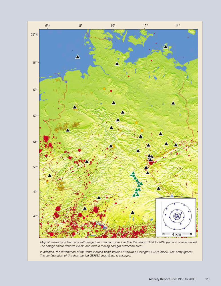
Map of seismicity in Germany with magnitudes ranging from 2 to 6 in the period 1958 to 2008 (red and orange circles).The orange colour denotes events occurred in mining and gas extraction areas.
In addition, the distribution of the seismic broad-band stations is shown as triangles: GRSN (black), GRF array (green).The configuration of the short-period GERESS array (blue) is enlarged.
55°N
54°
53°
52°
51°
50°
49°
48°
6°E 8° 10° 12° 14°
Activity Report BGR 1958 to 2008 113
1999so001d_109_118.indd 1131999so001d_109_118.indd 113 16.06.2009 09:22:0016.06.2009 09:22:00
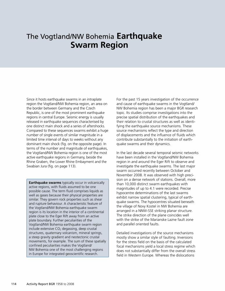
114 Activity Report BGR 1958 to 2008
The Vogtland/NW Bohemia EarthquakeSwarm Region
Since it hosts earthquake swarms in an intraplateregion the Vogtland/NW Bohemia region, an area onthe border between Germany and the CzechRepublic, is one of the most prominent earthquakeregions in central Europe. Seismic energy is usuallyreleased in earthquake sequences characterised byone distinct main shock and a series of aftershocks.Compared to these sequences swarms exhibit a hugenumber of single events of similar magnitude in alimited time interval of days to weeks without anydominant main shock (fig. on the opposite page). Interms of the number and magnitude of earthquakes,the Vogtland/NW Bohemia region is one of the mostactive earthquake regions in Germany, beside theRhine Graben, the Lower Rhine Embayment and theSwabian Jura (fig. on page 113).
Earthquake swarms typically occur in volcanicallyactive regions, with fluids assumed to be onepossible cause. The term fluid comprises liquids aswell as gases because their physical properties aresimilar. They govern rock properties such as shearand rupture behaviour. A characteristic feature ofthe Vogtland/NW Bohemia earthquake swarmregion is its location in the interior of a continentalplate close to the Eger Rift away from an activeplate boundary. Further peculiarities of theVogtland/NW Bohemia earthquake swarm regioninclude extensive CO2 degassing, deep crustalstructures, quaternary volcanism, mineral springs,a steep gravity gradient and neotectonic crustalmovements, for example. The sum of these spatiallyconfined peculiarities makes the Vogtland/NW Bohemia one of the most challenging regionsin Europe for integrated geoscientific research.
For the past 15 years investigation of the occurrenceand cause of earthquake swarms in the Vogtland/NW Bohemia region has been a major BGR researchtopic. Its studies comprise investigations into theprecise spatial distribution of the earthquakes andtheir relation to crustal structures as well as identi-fying the earthquake source mechanisms. Thesesource mechanisms reflect the type and directionof displacements and the influence of fluids whichcontribute substantially to the initiation of earth-quake swarms and their dynamics.
In the last decade several temporal seismic networkshave been installed in the Vogtland/NW Bohemiaregion in and around the Eger Rift to observe andinvestigate the earthquake swarms. The last majorswarm occurred recently between October andNovember 2008. It was observed with high preci-sion on a dense network of stations. Overall, morethan 10,000 distinct swarm earthquakes withmagnitudes of up to 4.1 were recorded. Precisehypocentre determinations of the last swarmsexhibit narrow spatial clustering, typical of earth-quake swarms. The hypocentres situated beneaththe village of Novy Kostel in NW Bohemia arearranged in a NNW-SSE striking planar structure.The strike direction of the plane coincides wellwith the strike of the Marianske Lazne fault zoneand parallel oriented faults.
Detailed investigations of the source mechanismsmostly show a similar style of faulting. Inversionsfor the stress field on the basis of the calculatedfocal mechanisms yield a local stress regime whichdoes not substantially differ from the overall stressfield in Western Europe. Whereas the dislocations
1999so001d_109_118.indd 1141999so001d_109_118.indd 114 16.06.2009 09:22:0116.06.2009 09:22:01
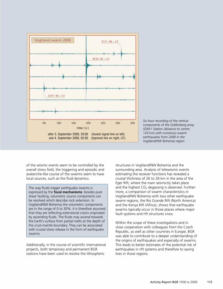
Activity Report BGR 1958 to 2008 115
of the seismic events seem to be controlled by theoverall stress field, the triggering and episodic andavalanche-like course of the swarms seem to havelocal sources, such as the fluid dynamics.
The way fluids trigger earthquake swarms isexpressed by the focal mechanisms: besides pureshear faulting, volumetric source components canbe resolved which describe rock extension. InVogtland/NW Bohemia the volumetric componentsare in the range of 0 to 30%. It is therefore assumedthat they are reflecting extensional cracks originatedby ascending fluids. The fluids may ascend towardsthe Earth’s surface from partial melts at the depth ofthe crust-mantle boundary. They can be associatedwith crustal stress release in the form of earthquakeswarms.
Additionally, in the course of scientific internationalprojects, both temporary and permanent BGRstations have been used to resolve the lithospheric
structures in Vogtland/NW Bohemia and thesurrounding area. Analysis of teleseismic eventsestimating the receiver functions has revealed acrustal thickness of 26 to 28 km in the area of theEger Rift, where the main seismicity takes placeand the highest CO2 degassing is observed. Further-more, a comparison of swarm characteristics inVogtland/NW Bohemia with two other earthquakeswarm regions, the Rio Grande Rift (North America)and the Kenya Rift (Africa), shows that earthquakeswarms typically occur in those places where majorfault systems and rift structures cross.
Within the scope of these investigations and inclose cooperation with colleagues from the CzechRepublic, as well as other countries in Europe, BGRwas able to contribute to a deeper understanding ofthe origins of earthquakes and especially of swarms.This leads to better estimates of the potential risk ofearthquakes in rift systems and therefore to savinglives in those regions.
Vogtland swarm 2000 0011::5511 // MMLL == 22..55
0000::3333 // MMLL == 33..33
2222::0077 // MMLL == 22..55
tt ii mm ee [[ ss ]]
after 3. September 2000, 20:00 (lowest signal line on left)and 4. September 2000, 02:00 (topmost line on right, UT)
500 1000 1500 2000 2500 3000 3500Six hour recording of the verticalcomponents of the Gräfenberg array(GRA1 Station (distance to centre:120 km) with numerous swarmearthquakes from 2000 in theVogtland/NW Bohemia region
1999so001d_109_118.indd 1151999so001d_109_118.indd 115 16.06.2009 09:22:0116.06.2009 09:22:01
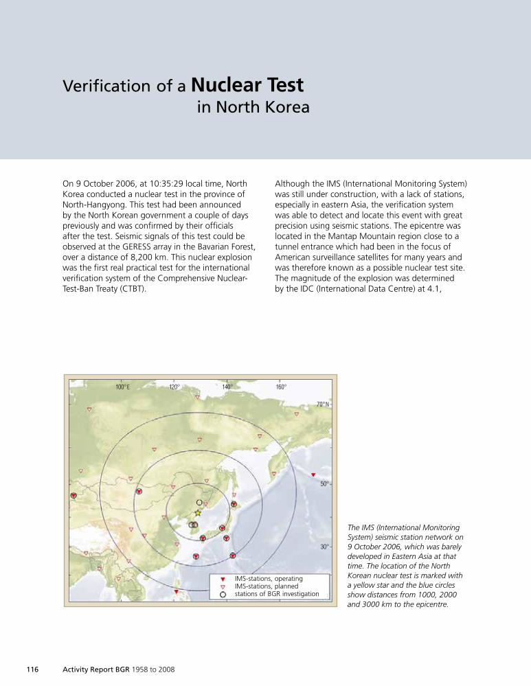
116 Activity Report BGR 1958 to 2008
Verification of a Nuclear Testin North Korea
On 9 October 2006, at 10:35:29 local time, NorthKorea conducted a nuclear test in the province ofNorth-Hangyong. This test had been announcedby the North Korean government a couple of dayspreviously and was confirmed by their officialsafter the test. Seismic signals of this test could beobserved at the GERESS array in the Bavarian Forest,over a distance of 8,200 km. This nuclear explosionwas the first real practical test for the internationalverification system of the Comprehensive Nuclear-Test-Ban Treaty (CTBT).
70°N
50°
30°
100°E 120° 140° 160°
IMS-stations, operatingIMS-stations, plannedstations of BGR investigation
Although the IMS (International Monitoring System)was still under construction, with a lack of stations,especially in eastern Asia, the verification systemwas able to detect and locate this event with greatprecision using seismic stations. The epicentre waslocated in the Mantap Mountain region close to atunnel entrance which had been in the focus ofAmerican surveillance satellites for many years andwas therefore known as a possible nuclear test site.The magnitude of the explosion was determinedby the IDC (International Data Centre) at 4.1,
The IMS (International MonitoringSystem) seismic station network on9 October 2006, which was barelydeveloped in Eastern Asia at thattime. The location of the NorthKorean nuclear test is marked witha yellow star and the blue circlesshow distances from 1000, 2000and 3000 km to the epicentre.
1999so001d_109_118.indd 1161999so001d_109_118.indd 116 16.06.2009 09:22:0116.06.2009 09:22:01
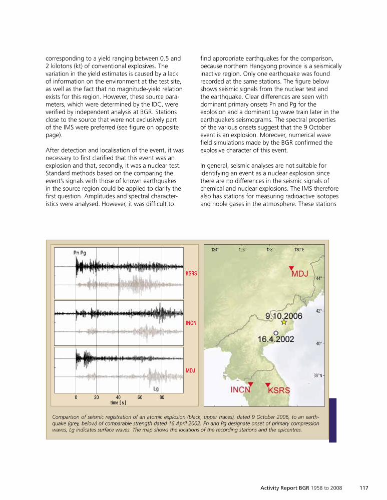
Activity Report BGR 1958 to 2008 117
corresponding to a yield ranging between 0.5 and2 kilotons (kt) of conventional explosives. Thevariation in the yield estimates is caused by a lackof information on the environment at the test site,as well as the fact that no magnitude-yield relationexists for this region. However, these source para-meters, which were determined by the IDC, wereverified by independent analysis at BGR. Stationsclose to the source that were not exclusively partof the IMS were preferred (see figure on oppositepage).
After detection and localisation of the event, it wasnecessary to first clarified that this event was anexplosion and that, secondly, it was a nuclear test.Standard methods based on the comparing theevent’s signals with those of known earthquakesin the source region could be applied to clarify thefirst question. Amplitudes and spectral character-istics were analysed. However, it was difficult to
find appropriate earthquakes for the comparison,because northern Hangyong province is a seismicallyinactive region. Only one earthquake was foundrecorded at the same stations. The figure belowshows seismic signals from the nuclear test andthe earthquake. Clear differences are seen withdominant primary onsets Pn and Pg for theexplosion and a dominant Lg wave train later in theearthquake’s seismograms. The spectral propertiesof the various onsets suggest that the 9 Octoberevent is an explosion. Moreover, numerical wavefield simulations made by the BGR confirmed theexplosive character of this event.
In general, seismic analyses are not suitable foridentifying an event as a nuclear explosion sincethere are no differences in the seismic signals ofchemical and nuclear explosions. The IMS thereforealso has stations for measuring radioactive isotopesand noble gases in the atmosphere. These stations
Comparison of seismic registration of an atomic explosion (black, upper traces), dated 9 October 2006, to an earth-quake (grey, below) of comparable strength dated 16 April 2002. Pn and Pg designate onset of primary compressionwaves, Lg indicates surface waves. The map shows the locations of the recording stations and the epicentres.
KKSSRRSS
IINNCCNN
MMDDJJ
44°
42°
40°
38°N
130°E128°126°124°
0 20 40 60 80ttiimmee [[ ss ]]
1999so001d_109_118.indd 1171999so001d_109_118.indd 117 16.06.2009 09:22:0216.06.2009 09:22:02
118 Activity Report BGR 1958 to 2008
complete the monitoring network, identifying the‘smoking gun’’, whereas waveform techniquestations detect, localise and characterise an eventas an explosion. It was possible to identify the NorthKorean test as nuclear even though the stationnearest to the test area was not in operation at thattime. A station in Canada detected weak but well-defined indicators for radioactive Xenon isotopescaused by an underground nuclear explosion.Moreover, identification as a nuclear test wasconfirmed by mobile measurements in South Korea,carried out by the Swedish Defence ResearchAgency (FOI).
Overall, the 9 October nuclear test demonstratedthat such events do not remain undetected by theCTBT verification system, and can be detected,localised and identified independently with a highdegree of reliability whether they are announcedor not. Difficulties during analyses of this nucleartest should be considered a warning to completethe monitoring network as a top priority, andto improve analysis methods for identifyingexplosions.
1999so001d_109_118.indd 1181999so001d_109_118.indd 118 16.06.2009 09:22:0316.06.2009 09:22:03
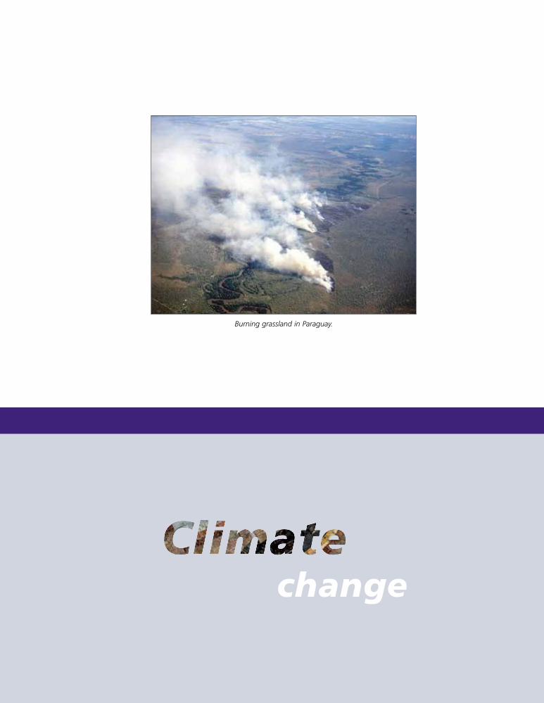
Activity Report BGR 1958 to 2008 119
change
Burning grassland in Paraguay.
1999so001d_119_124.indd 1191999so001d_119_124.indd 119 16.06.2009 09:23:1916.06.2009 09:23:19
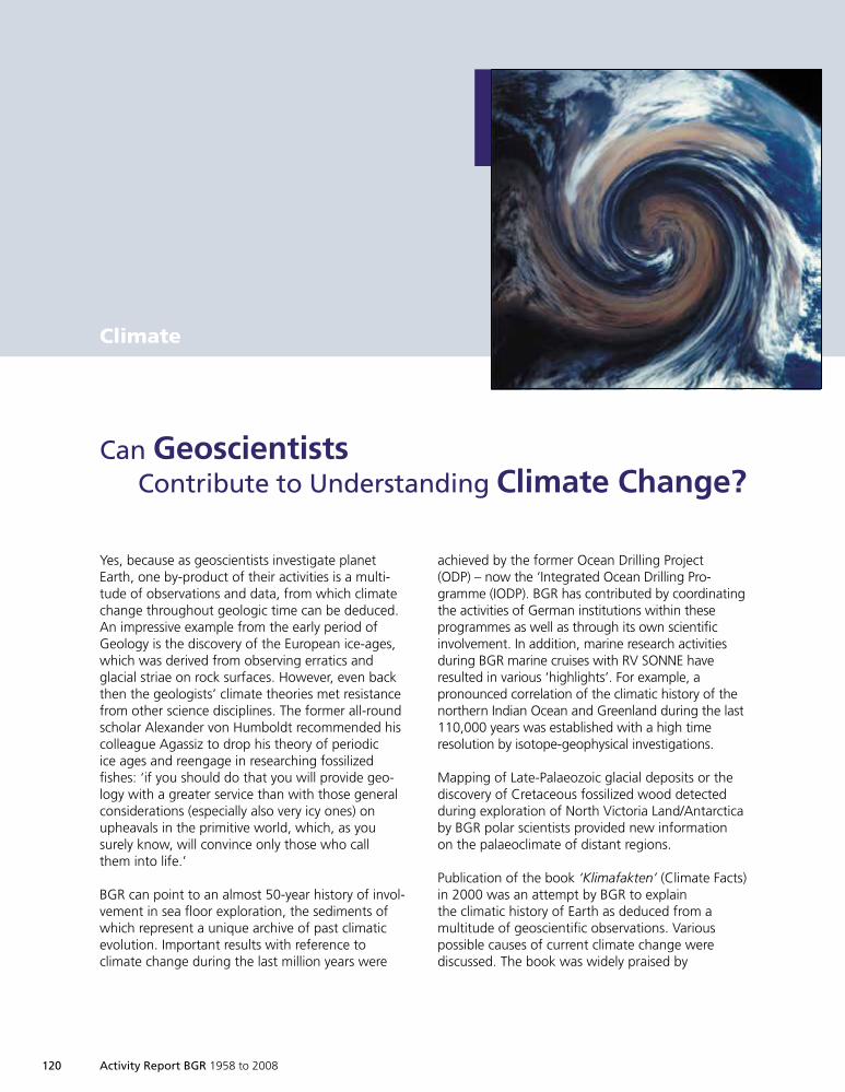
120 Activity Report BGR 1958 to 2008
Can GeoscientistsContribute to Understanding Climate Change?
Climate
Yes, because as geoscientists investigate planetEarth, one by-product of their activities is a multi-tude of observations and data, from which climatechange throughout geologic time can be deduced.An impressive example from the early period ofGeology is the discovery of the European ice-ages,which was derived from observing erratics andglacial striae on rock surfaces. However, even backthen the geologists’ climate theories met resistancefrom other science disciplines. The former all-roundscholar Alexander von Humboldt recommended hiscolleague Agassiz to drop his theory of periodicice ages and reengage in researching fossilizedfishes: ‘if you should do that you will provide geo-logy with a greater service than with those generalconsiderations (especially also very icy ones) onupheavals in the primitive world, which, as yousurely know, will convince only those who callthem into life.’
BGR can point to an almost 50-year history of invol-vement in sea floor exploration, the sediments ofwhich represent a unique archive of past climaticevolution. Important results with reference toclimate change during the last million years were
achieved by the former Ocean Drilling Project(ODP) – now the ‘Integrated Ocean Drilling Pro-gramme (IODP). BGR has contributed by coordinatingthe activities of German institutions within theseprogrammes as well as through its own scientificinvolvement. In addition, marine research activitiesduring BGR marine cruises with RV SONNE haveresulted in various ‘highlights’. For example, apronounced correlation of the climatic history of thenorthern Indian Ocean and Greenland during the last110,000 years was established with a high timeresolution by isotope-geophysical investigations.
Mapping of Late-Palaeozoic glacial deposits or thediscovery of Cretaceous fossilized wood detectedduring exploration of North Victoria Land/Antarcticaby BGR polar scientists provided new informationon the palaeoclimate of distant regions.
Publication of the book ‘Klimafakten’ (Climate Facts)in 2000 was an attempt by BGR to explainthe climatic history of Earth as deduced from amultitude of geoscientific observations. Variouspossible causes of current climate change werediscussed. The book was widely praised by
1999so001d_119_124.indd 1201999so001d_119_124.indd 120 16.06.2009 09:23:2016.06.2009 09:23:20
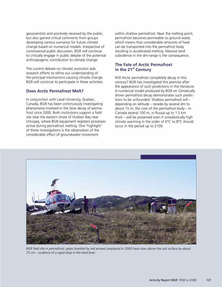
Activity Report BGR 1958 to 2008 121
geoscientists and positively received by the public,but also gained critical comments from groupsdeveloping various scenarios for future climatechange based on numerical models. Irrespective ofcontroversial public discussion, BGR will continueto critically engage in public debate of the potentialanthropogenic contribution to climate change.
The current debate on climatic evolution aidsresearch efforts to refine our understanding ofthe principal mechanisms causing climate change.BGR will continue to participate in these activities.
Does Arctic Permafrost Melt?
In conjunction with Laval University, Quebec,Canada, BGR has been continuously investigatingphenomena involved in the slow decay of perma-frost since 2000. Both institutions support a fieldsite near the eastern shore of Hudson Bay nearUmiujaq, where BGR equipment registers processesactive during permafrost melting. One ‘highlight’of these investigations is the observation of theconsiderable effect of groundwater movement
within shallow permafrost. Near the melting point,permafrost becomes permeable to ground water,which means that considerable amounts of heatcan be transported into the permafrost bodyresulting in accelerated melting. Massive landsubsidence in the dm-range is the consequence.
The Fate of Arctic Permafrostin the 21st Century
Will Arctic permafrost completely decay in thiscentury? BGR has investigated this premise afterthe appearance of such predictions in the literature.A numerical model produced by BGR on climaticallydriven permafrost decay demonstrates such predic-tions to be unfounded. Shallow permafrost will –depending on latitude – recede by several dm toabout 15 m, the core of the permafrost body – inCanada several 100 m, in Russia up to 1.5 kmthick – will be preserved even if unrealistically highclimate warming in the order of 6°C to 8°C shouldoccur in the period up to 2100.
BGR field site in permafrost: pipes (marked by red arrows) emplaced in 2000 have risen above the soil surface by about75 cm – evidence of a rapid drop in the land level.
1999so001d_119_124.indd 1211999so001d_119_124.indd 121 16.06.2009 09:23:2116.06.2009 09:23:21
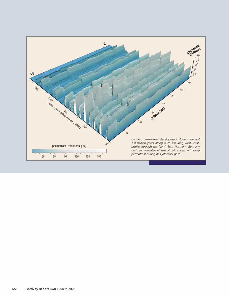
122 Activity Report BGR 1958 to 2008
permafrost- thickness [m]
200
150
100
50
0 m
permafrost-
thickness
70
60
50
40
30
20
10
180150120906030
Episodic permafrost development during the last1.8 million years along a 75 km long west– east-profile through the North Sea. Northern Germanyhad seen repeated phases of cold stages with deeppermafrost during its Qaternary past.
ddiissttaannccee
[[ kkmm]]
W
E
1600
1200
800
400
0
ttiimmee[[ yyeeaarrss bbeeffoorree pprreesseenntt xx 11000000 ]]
1999so001d_119_124.indd 1221999so001d_119_124.indd 122 16.06.2009 09:23:2116.06.2009 09:23:21
Activity Report BGR 1958 to 2008 123
Palaeo-Permafrost in NorthernGermany?
Permafrost clearly existed during the last coldstages in Germany. Remnants of polygon patternsin topsoil have been discovered and linked tothe former occurrence of permafrost. BGR haspresented a first approach to reconstructingthe thickness of former permafrost in northernGermany. Climate change during the last120,000 years had previously been establishedbased on palaeobotanic investigations of sediments.By parallelisation of this trend with the climatecourse derived from data from ODP borehole 659,which covers not only the last cold stage but thewhole Quaternary period, the climate course ofnorthern Germany was ‘post-dicted’. These valueswere then used to reconstruct phases of permafrostdevelopment in northern Germany during the last2.5 million years. The first episode of permafrostdevelopment occurred about 1.8 million years ago,followed at a later period by a multitude ofpermafrost phases with permafrost thickness ofsometimes more than 150 m, interrupted by shortwarm phases such as the one in which we arecurrently living.
Monsoon Intensity and aBiological Pump in Offshore Sumatra
Algae grow and reproduce in the uppermost waterlayers and cause a reduction in CO2 content in theuppermost water layers of up to 30%. Oceans andthe atmosphere tend to establish a CO2 equilibrium.Ocean water therefore tends to draw CO2 out ofthe atmosphere. The organic material producedby photosynthesis will eventually sink to theocean floor, together with the CO2 fixed in it.This downward flux is called a ‘biological pump’.Since investigations into sediment cores from theabyssal plains began 60 years ago, scientists haveattempted to clarify the relationship between
glacial cycles and bio-productivity in tropical oceans.Most research results point to increased marineproduction during glacial stages, controlled by thegrowth of ice shields in the northern hemisphereand a resultant increase in the strength of the tradewinds.
Analysis of deep sea sediments, collected from1,700 m water depth offshore of Sumatra, showthat algae growth in these highly productivezones, as apparently in all equatorial waters, iscontrolled by the increase or decrease of monsoonintensity governed by the 23,000 year cycle ofsolar irradiance. Strong south-west monsoonshave caused increased upwelling of nutrient-richdeep water in periods of enhanced solar irradiance,leading to a massive increase in algae production.
These examples taken from the geoscientificresearch of BGR illustrate the methodology onwhich BGR assessments are based, with regard toboth the climatic past and also the probable futurecourse of climate in the current century. BGR staffcollect expert knowledge in this way, enablingthem to actively participate in the ongoing climatedebate. Advice for politicians and economists alikeis presented on this basis, showing how optimalprotection of both resources and climate can beachieved – since both aims represent the sameside of the coin.
1999so001d_119_124.indd 1231999so001d_119_124.indd 123 16.06.2009 09:23:2216.06.2009 09:23:22

1999so001d_119_124.indd 1241999so001d_119_124.indd 124 16.06.2009 09:23:2216.06.2009 09:23:22
HamburgGüstrow
Bremen
HannoverBERLIN
Potsdam
Magdeburg
Halle
Geological
Interdisciplinary tasks
1999so001d_125_138.indd 1251999so001d_125_138.indd 125 16.06.2009 09:24:0016.06.2009 09:24:00
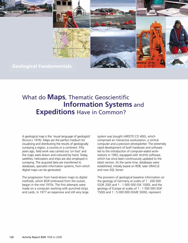
126 Activity Report BGR 1958 to 2008
A geological map is the ‘visual language of geologists’(RUDWICK 1976). Maps are the perfect medium forvisualising and distributing the results of geologicallysurveying a region, a country or a continent. Fiftyyears ago, field work was carried out ‘on foot’ andthe maps were drawn and coloured by hand. Today,satellites, helicopters and ships are also employed insurveying. The acquired data are transferred todatabases, specialist information systems, from whichdigital maps can be generated.
The progression from hand-drawn maps to digitalmethods, which BGR embraced from the outset,began in the mid 1970s. The first attempts weremade on a computer working with punched stripsand cards. In 1977 an expensive and still very large
What do Maps, Thematic GeoscientificInformation Systems and
Expeditions Have in Common?
system was bought (ARISTO CD 400), whichcomprised an interactive workstation, a centralcomputer and a precision photoplotter. The extremelyrapid development of both hardware and softwareled to the introduction of computer-aided work-stations in 1992, equipped with ArcInfo software,which has since been continuously updated to thelatest version. At the same time, databases wereestablished, initially based on RDB, later ORACLEand now SQL Server.
The provision of geological baseline information onthe geology of Germany at scales of 1 : 200 000(GÜK 200) and 1 : 1 000 000 (GK 1000), and thegeology of Europe at scales of 1 : 1 500 000 (IGK1500) and 1 : 5 000 000 (IGME 5000), represent
Geologische GrundlagenGeological Fundamentals
1999so001d_125_138.indd 1261999so001d_125_138.indd 126 16.06.2009 09:24:0116.06.2009 09:24:01
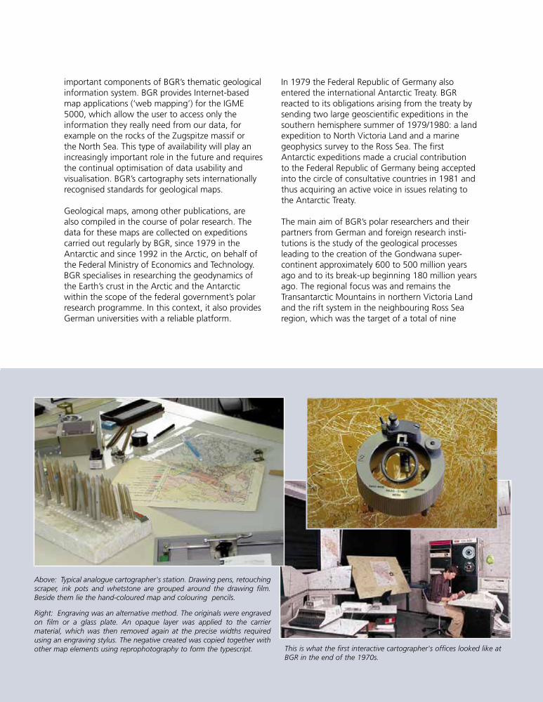
Above: Typical analogue cartographer's station. Drawing pens, retouchingscraper, ink pots and whetstone are grouped around the drawing film.Beside them lie the hand-coloured map and colouring pencils.
Right: Engraving was an alternative method. The originals were engravedon film or a glass plate. An opaque layer was applied to the carriermaterial, which was then removed again at the precise widths requiredusing an engraving stylus. The negative created was copied together withother map elements using reprophotography to form the typescript. This is what the first interactive cartographer's offices looked like at
BGR in the end of the 1970s.
important components of BGR’s thematic geologicalinformation system. BGR provides Internet-basedmap applications (‘web mapping’) for the IGME5000, which allow the user to access only theinformation they really need from our data, forexample on the rocks of the Zugspitze massif orthe North Sea. This type of availability will play anincreasingly important role in the future and requiresthe continual optimisation of data usability andvisualisation. BGR’s cartography sets internationallyrecognised standards for geological maps.
Geological maps, among other publications, arealso compiled in the course of polar research. Thedata for these maps are collected on expeditionscarried out regularly by BGR, since 1979 in theAntarctic and since 1992 in the Arctic, on behalf ofthe Federal Ministry of Economics and Technology.BGR specialises in researching the geodynamics ofthe Earth’s crust in the Arctic and the Antarcticwithin the scope of the federal government’s polarresearch programme. In this context, it also providesGerman universities with a reliable platform.
In 1979 the Federal Republic of Germany alsoentered the international Antarctic Treaty. BGRreacted to its obligations arising from the treaty bysending two large geoscientific expeditions in thesouthern hemisphere summer of 1979/1980: a landexpedition to North Victoria Land and a marinegeophysics survey to the Ross Sea. The firstAntarctic expeditions made a crucial contributionto the Federal Republic of Germany being acceptedinto the circle of consultative countries in 1981 andthus acquiring an active voice in issues relating tothe Antarctic Treaty.
The main aim of BGR’s polar researchers and theirpartners from German and foreign research insti-tutions is the study of the geological processesleading to the creation of the Gondwana super-continent approximately 600 to 500 million yearsago and to its break-up beginning 180 million yearsago. The regional focus was and remains theTransantarctic Mountains in northern Victoria Landand the rift system in the neighbouring Ross Searegion, which was the target of a total of nine
1999so001d_125_138.indd 1271999so001d_125_138.indd 127 16.06.2009 09:24:0216.06.2009 09:24:02
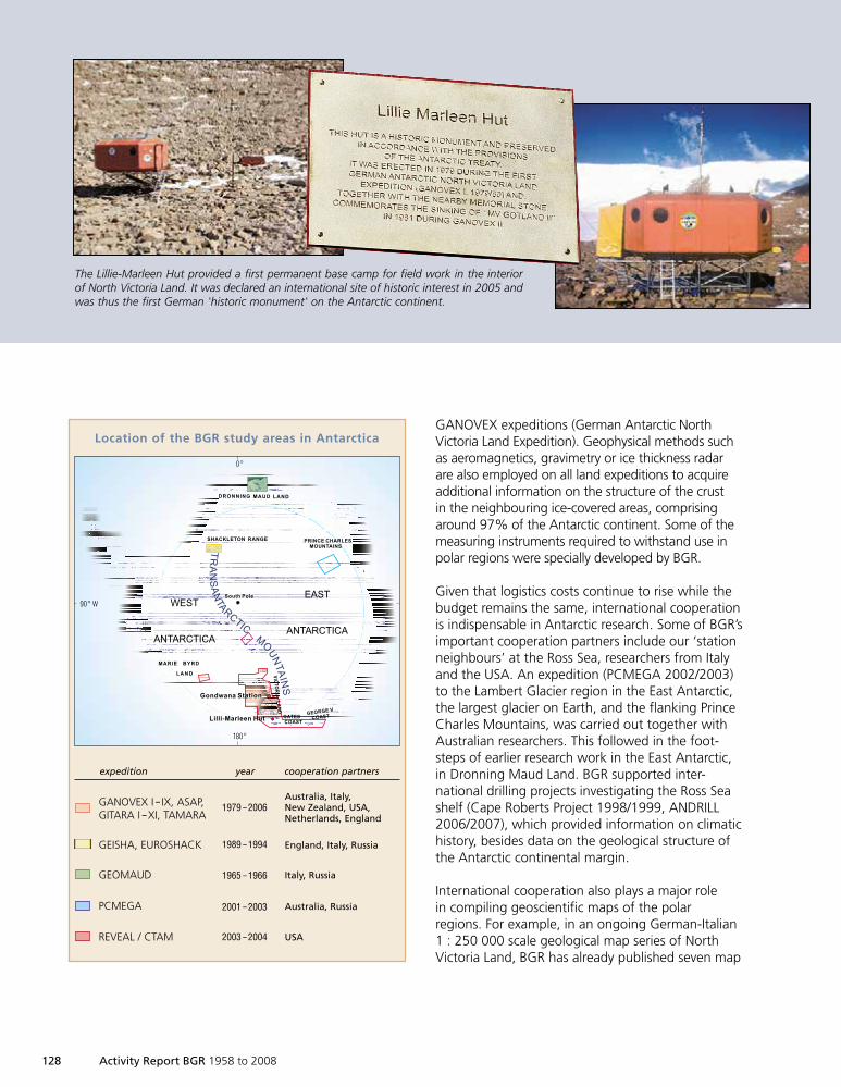
128 Activity Report BGR 1958 to 2008
GANOVEX expeditions (German Antarctic NorthVictoria Land Expedition). Geophysical methods suchas aeromagnetics, gravimetry or ice thickness radarare also employed on all land expeditions to acquireadditional information on the structure of the crustin the neighbouring ice-covered areas, comprisingaround 97% of the Antarctic continent. Some of themeasuring instruments required to withstand use inpolar regions were specially developed by BGR.
Given that logistics costs continue to rise while thebudget remains the same, international cooperationis indispensable in Antarctic research. Some of BGR’simportant cooperation partners include our ‘stationneighbours’ at the Ross Sea, researchers from Italyand the USA. An expedition (PCMEGA 2002/2003)to the Lambert Glacier region in the East Antarctic,the largest glacier on Earth, and the flanking PrinceCharles Mountains, was carried out together withAustralian researchers. This followed in the foot-steps of earlier research work in the East Antarctic,in Dronning Maud Land. BGR supported inter-national drilling projects investigating the Ross Seashelf (Cape Roberts Project 1998/1999, ANDRILL2006/2007), which provided information on climatichistory, besides data on the geological structure ofthe Antarctic continental margin.
International cooperation also plays a major rolein compiling geoscientific maps of the polarregions. For example, in an ongoing German-Italian1 : 250 000 scale geological map series of NorthVictoria Land, BGR has already published seven map
DRONNING MAUD LAND
MARIE BYRD
LAND VIC
TO
RIA
LA
ND
South Pole
OATES
COAST
SHACKLETON RANGE PRINCE CHARLES
MOUNTAINS
GEORGE V
COAST
Gondwana Station
Lilli-Marleen Hut
WEST
ANTARCTICA
EAST
ANTARCTICA
0°
180°
90° W
TRANSANTA
RCTIC
MO
UNTAINS
GANOVEX I – IX, ASAP,GITARA I – XI, TAMARA
Australia, Italy,New Zealand, USA,Netherlands, England
1979 – 2006
Location of the BGR study areas in Antarctica
GEISHA, EUROSHACK England, Italy, Russia1989 – 1994
GEOMAUD Italy, Russia1965 – 1966
PCMEGA Australia, Russia2001 – 2003
REVEAL / CTAM USA2003 – 2004
expedition year cooperation partners
The Lillie-Marleen Hut provided a first permanent base camp for field work in the interiorof North Victoria Land. It was declared an international site of historic interest in 2005 andwas thus the first German 'historic monument' on the Antarctic continent.
1999so001d_125_138.indd 1281999so001d_125_138.indd 128 16.06.2009 09:24:0316.06.2009 09:24:03
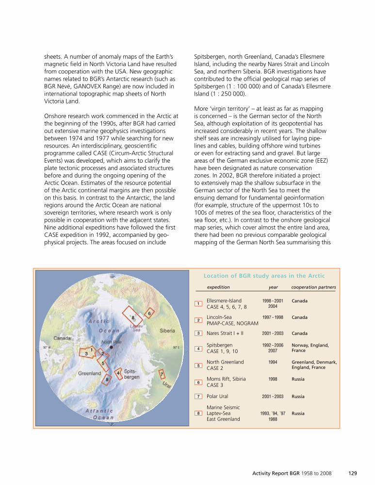
Activity Report BGR 1958 to 2008 129
sheets. A number of anomaly maps of the Earth’smagnetic field in North Victoria Land have resultedfrom cooperation with the USA. New geographicnames related to BGR’s Antarctic research (such asBGR Névé, GANOVEX Range) are now included ininternational topographic map sheets of NorthVictoria Land.
Onshore research work commenced in the Arctic atthe beginning of the 1990s, after BGR had carriedout extensive marine geophysics investigationsbetween 1974 and 1977 while searching for newresources. An interdisciplinary, geoscientificprogramme called CASE (Circum-Arctic StructuralEvents) was developed, which aims to clarify theplate tectonic processes and associated structuresbefore and during the ongoing opening of theArctic Ocean. Estimates of the resource potentialof the Arctic continental margins are then possibleon this basis. In contrast to the Antarctic, the landregions around the Arctic Ocean are nationalsovereign territories, where research work is onlypossible in cooperation with the adjacent states.Nine additional expeditions have followed the firstCASE expedition in 1992, accompanied by geo-physical projects. The areas focused on include
Ellesmere-IslandCASE 4, 5, 6, 7, 8
Canada1998 – 20012004
Location of BGR study areas in the Arctic
expedition year cooperation partners
Lincoln-SeaPMAP-CASE, NOGRAM
Canada1997 – 1998
Nares Strait I + II Canada2001 – 2003
SpitsbergenCASE 1, 9, 10
Norway, England,France
1992 – 20062007
North GreenlandCASE 2
Greenland, Denmark,England, France
1994
Moms Rift, SibiriaCASE 3
Russia1998
Polar Ural Russia2001 – 2003
Marine SeismicLaptev-SeaEast Greenland
Russia1993, `94, `971988
1
2
3
4
5
6
7
8
68
13 2
5
4 78
180°
0°
90° W 90° E
Spitsbergen, north Greenland, Canada’s EllesmereIsland, including the nearby Nares Strait and LincolnSea, and northern Siberia. BGR investigations havecontributed to the official geological map series ofSpitsbergen (1 : 100 000) and of Canada’s EllesmereIsland (1 : 250 000).
More ‘virgin territory’ – at least as far as mappingis concerned – is the German sector of the NorthSea, although exploitation of its geopotential hasincreased considerably in recent years. The shallowshelf seas are increasingly utilised for laying pipe-lines and cables, building offshore wind turbinesor even for extracting sand and gravel. But largeareas of the German exclusive economic zone (EEZ)have been designated as nature conservationzones. In 2002, BGR therefore initiated a projectto extensively map the shallow subsurface in theGerman sector of the North Sea to meet theensuing demand for fundamental geoinformation(for example, structure of the uppermost 10s to100s of metres of the sea floor, characteristics of thesea floor, etc.). In contrast to the onshore geologicalmap series, which cover almost the entire land area,there had been no previous comparable geologicalmapping of the German North Sea summarising this
1999so001d_125_138.indd 1291999so001d_125_138.indd 129 16.06.2009 09:24:2116.06.2009 09:24:21
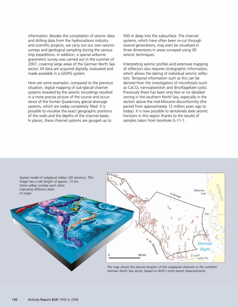
information. Besides the compilation of seismic dataand drilling data from the hydrocarbons industryand scientific projects, we carry out our own seismicsurveys and geological sampling during the variousship expeditions. In addition, a special airbornegravimetric survey was carried out in the summer of2007, covering large areas of the German North Seasector. All data are acquired digitally, evaluated andmade available in a GIS/FIS system.
Here are some examples: compared to the previoussituation, digital mapping of sub-glacial channelsystems revealed by the seismic recordings resultedin a more precise picture of the course and occur-rence of the former Quaternary glacial drainagesystems, which are today completely filled. It ispossible to visualise the exact geographic positionsof the walls and the depths of the channel bases.In places, these channel systems are gouged up to
Spatial model of subglacial valleys (3D seismics). Thisimage has a side length of approx. 15 km.Some valleys overlap each other,indicating different datesof origin.
0 100 km
BlåvandsHuk
Sylt
GermanBight
DDEE NN
MMAA
RRKK
Fr is ianIs lands
to Denmark
to the
Netherlands
The map shows the precise location of the subglacial channels in the northernGerman North Sea sector, based on BGR's most recent measurements.
500 m deep into the subsurface. The channelsystems, which have often been re-cut throughseveral generations, may even be visualised inthree dimensions in areas surveyed using 3Dseismic techniques.
Interpreting seismic profiles and extensive mappingof reflectors also requires stratigraphic information,which allows the dating of individual seismic reflec-tors. Temporal information such as this can bederived from the investigation of microfossils (suchas CaCO3 nannoplankton and dinoflagellate cysts).Previously there has been only few or no detailedzoning in the southern North Sea, especially in thesection above the mid-Miocene disconformity (theperiod from approximately 12 million years ago totoday). It is now possible to tentatively date seismichorizons in this region thanks to the results ofsamples taken from borehole G-11-1.
130 Activity Report BGR 1958 to 2008
1999so001d_125_138.indd 1301999so001d_125_138.indd 130 16.06.2009 09:24:2216.06.2009 09:24:22
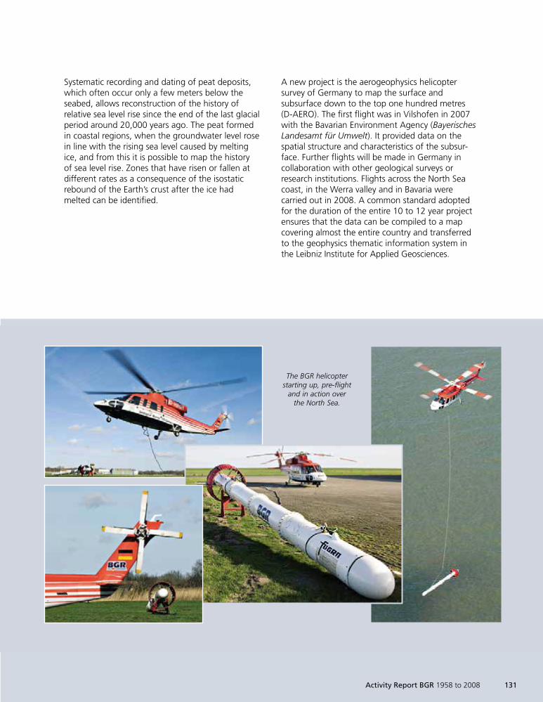
Systematic recording and dating of peat deposits,which often occur only a few meters below theseabed, allows reconstruction of the history ofrelative sea level rise since the end of the last glacialperiod around 20,000 years ago. The peat formedin coastal regions, when the groundwater level rosein line with the rising sea level caused by meltingice, and from this it is possible to map the historyof sea level rise. Zones that have risen or fallen atdifferent rates as a consequence of the isostaticrebound of the Earth’s crust after the ice hadmelted can be identified.
The BGR helicopterstarting up, pre-flight
and in action overthe North Sea.
A new project is the aerogeophysics helicoptersurvey of Germany to map the surface andsubsurface down to the top one hundred metres(D-AERO). The first flight was in Vilshofen in 2007with the Bavarian Environment Agency (BayerischesLandesamt für Umwelt). It provided data on thespatial structure and characteristics of the subsur-face. Further flights will be made in Germany incollaboration with other geological surveys orresearch institutions. Flights across the North Seacoast, in the Werra valley and in Bavaria werecarried out in 2008. A common standard adoptedfor the duration of the entire 10 to 12 year projectensures that the data can be compiled to a mapcovering almost the entire country and transferredto the geophysics thematic information system inthe Leibniz Institute for Applied Geosciences.
Activity Report BGR 1958 to 2008 131
1999so001d_125_138.indd 1311999so001d_125_138.indd 131 16.06.2009 09:24:2216.06.2009 09:24:22
132 Activity Report BGR 1958 to 2008
Environmental Geodata –the New EU INSPIRE Directive
On 15 May 2007 the new EU directive on theestablishment of a European geodata infrastructure‘INSPIRE’ (INfrastructure for SPatial InfoRmation inEurope) came into force. The aim of the directive isto simplify the international utilisation of environ-mentally relevant geodata in Europe. Standardised,internationally compatible and comparable spatialinformation shall be made available to EU policymakers, the economy and the public of the Euro-pean Union. This processed information will bemade available by Internet-based online services.
By geodata we mean data that can be allocatedto a given spatial position (e.g. by geographiccoordinates or eastings and northings) on theEarth’s surface. Geodata are divided into spatialbase data and spatial thematic data and areavailable digitally in area, line and point dataformats.
Spatial base data are official baseline data thatdescribe the landscape (topography), propertyboundaries and buildings, and are application-independent. Spatial thematic data includehematic data such as geology or soil data. Theycannot be interpreted, or only with difficulty,without the spatial base data, because they arenot oriented. One example of the combination ofspatial base data with spatial thematic data is thegeological map.
BGR deals exclusively with spatial thematic data.Because of the federal system of state respon-sibilities, BGR is responsible for generalised inter-state maps (geology, hydrogeology, pedology andshallow resources).
The EU INSPIRE directive aims to make obligatoryaccess to environmental information that is collec-ted and processed in national institutions in EUcountries, but which is often relatively unknownand inaccessible. Numerous technical details are notregulated in the INSPIRE directive itself, so complexprocedures must be developed, in particular thecompilation of standards for implementing thedirective, in what are known as implementingrules.
In all, 34 topic groups must be coordinated andstandardised in accordance with the implementingrules (these include data formats, definitions, classi-fications, hierarchies, thesauri and attributes ofspatial data). The topic groups comprise informationfrom numerous, very differing fields such as cadas-tral data, data on biotopes, land use, meteorology,and all kinds of conservation areas, but also includegeoscientific topics such as geology, soil, naturalhazard zones, energy and mineral resources.
BGR actively participates in writing the implement-ing rules within the data specifications draftingteam, and also acts as a legally mandated organi-sation in reviewing, commenting on and modifyingall draft directives. In this role, it actively includesand coordinates the German federal states via thesoil information system steering group. Togetherwith the state geological surveys, BGR thuscontributes to legislation concerning spatialgeoscientific data.
1999so001d_125_138.indd 1321999so001d_125_138.indd 132 16.06.2009 09:24:2316.06.2009 09:24:23
A parallel network of services must also be establishedto make the decentralised data available. In Germanythe GDI-DE is responsible for this, with BGR merelyacting as a consultant.
GDI – Geodata Infrastructure: complex net-È
work for exchanging geodata, where geodataproducers, service providers in the geo fieldand geodata users are linked by a physicaldata network, generally the Internet.
GDI-DE – Geodata Infrastructure at the levelÈ
of the Federal Republic of Germany: the federalgovernment, state governments and localauthorities participate under the auspices ofthe Federal Ministry of the Interior..
whereby a federal law and 16 identical state laws arecompiled by a joint federal-state working group. Thegeneral management of the INSPIRE process andimplementation within the federal government lieswith the Federal Ministry for the Environment, NatureConservation and Nuclear Safety.
BGR, and in all likelihood the state geologicalsurveys, will be faced with new tasks when thedirective is implemented as national law (probablyend of 1st quarter, 2009): it is first necessary tomake the metadata (data about data, i.e. datadescriptions) available according to INSPIRE rules.In a further step, the thematic geoscientific dataare processed and made available via special INSPIREInternet geoportals.
According to the INSPIRE schedule, all INSPIREgeodata must be available to the public by 2019at the latest. The data will permanently alter thegeodata landscape in Germany and Europe:geodata will then be more transparent andaccessible to the public, politics and the economy.
Tätigkeitsbericht BGR 1958 bis 2008 133
The directive must be implemented in nationallegislation by the respective EU member countrieswithin two years. In Germany, this is carried out inline with the Federal Administrative Procedures Act,
1999so001d_125_138.indd 1331999so001d_125_138.indd 133 16.06.2009 09:24:2316.06.2009 09:24:23
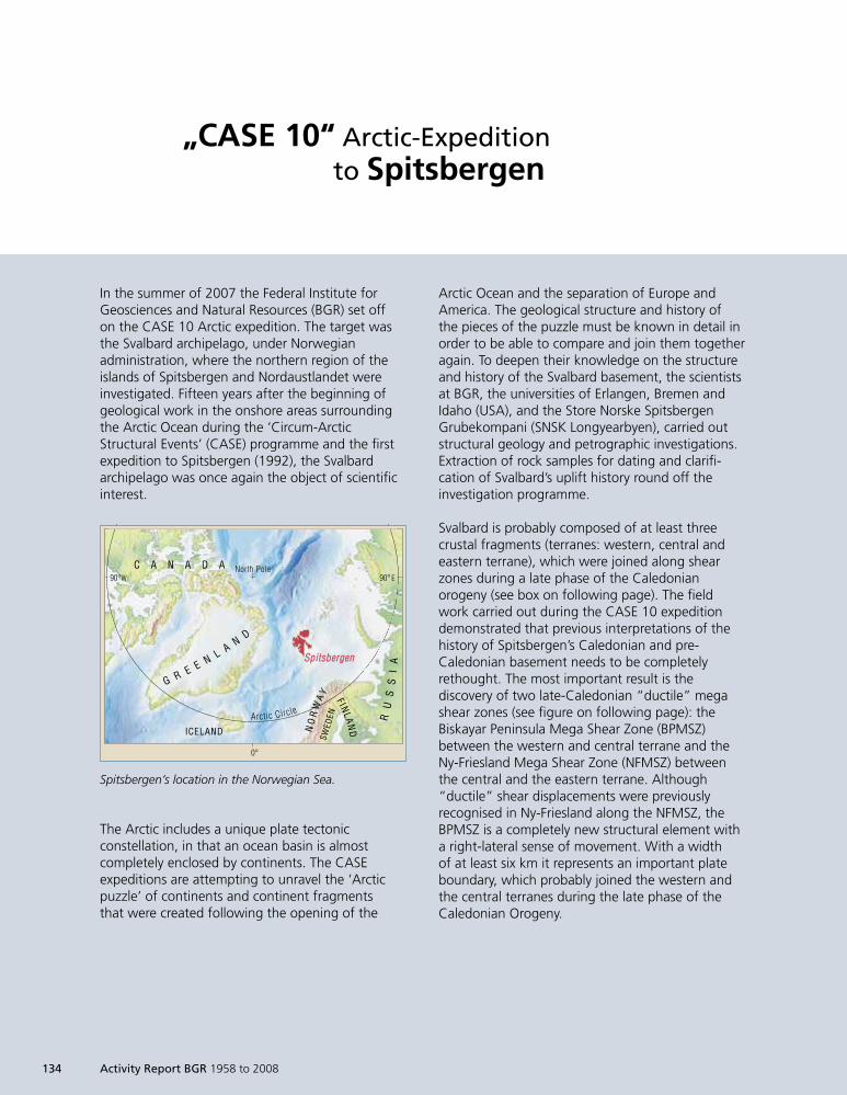
„CASE 10“ Arctic-Expeditionto Spitsbergen
In the summer of 2007 the Federal Institute forGeosciences and Natural Resources (BGR) set offon the CASE 10 Arctic expedition. The target wasthe Svalbard archipelago, under Norwegianadministration, where the northern region of theislands of Spitsbergen and Nordaustlandet wereinvestigated. Fifteen years after the beginning ofgeological work in the onshore areas surroundingthe Arctic Ocean during the ‘Circum-ArcticStructural Events’ (CASE) programme and the firstexpedition to Spitsbergen (1992), the Svalbardarchipelago was once again the object of scientificinterest.
Arctic Ocean and the separation of Europe andAmerica. The geological structure and history ofthe pieces of the puzzle must be known in detail inorder to be able to compare and join them togetheragain. To deepen their knowledge on the structureand history of the Svalbard basement, the scientistsat BGR, the universities of Erlangen, Bremen andIdaho (USA), and the Store Norske SpitsbergenGrubekompani (SNSK Longyearbyen), carried outstructural geology and petrographic investigations.Extraction of rock samples for dating and clarifi-cation of Svalbard’s uplift history round off theinvestigation programme.
Svalbard is probably composed of at least threecrustal fragments (terranes: western, central andeastern terrane), which were joined along shearzones during a late phase of the Caledonianorogeny (see box on following page). The fieldwork carried out during the CASE 10 expeditiondemonstrated that previous interpretations of thehistory of Spitsbergen’s Caledonian and pre-Caledonian basement needs to be completelyrethought. The most important result is thediscovery of two late-Caledonian “ductile” megashear zones (see figure on following page): theBiskayar Peninsula Mega Shear Zone (BPMSZ)between the western and central terrane and theNy-Friesland Mega Shear Zone (NFMSZ) betweenthe central and the eastern terrane. Although“ductile” shear displacements were previouslyrecognised in Ny-Friesland along the NFMSZ, theBPMSZ is a completely new structural element witha right-lateral sense of movement. With a widthof at least six km it represents an important plateboundary, which probably joined the western andthe central terranes during the late phase of theCaledonian Orogeny.
134 Activity Report BGR 1958 to 2008
The Arctic includes a unique plate tectonicconstellation, in that an ocean basin is almostcompletely enclosed by continents. The CASEexpeditions are attempting to unravel the ‘Arcticpuzzle’ of continents and continent fragmentsthat were created following the opening of the
0°
90° E90°W
NO
RW
AY
SWED
EN
F INLA
ND
North Pole
Arctic Circle
SSppiittssbbeerrggeenn
RU
SS
IA
G R E E N L A ND
C A N A D A
ICELAND
Spitsbergen’s location in the Norwegian Sea.
1999so001d_125_138.indd 1341999so001d_125_138.indd 134 16.06.2009 09:24:2816.06.2009 09:24:28
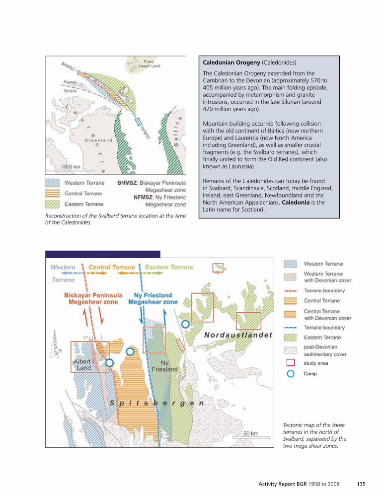
Activity Report BGR 1958 to 2008 135
Camp
study area
50 km
Caledonian Orogeny (Caledonides)
The Caledonian Orogeny extended from theCambrian to the Devonian (approximately 570 to405 million years ago). The main folding episode,accompanied by metamorphism and graniteintrusions, occurred in the late Silurian (around420 million years ago).
Mountain building occurred following collisionwith the old continent of Baltica (now northernEurope) and Laurentia (now North Americaincluding Greenland), as well as smaller crustalfragments (e.g. the Svalbard terranes), whichfinally united to form the Old Red continent (alsoknown as Laurussia).
Remains of the Caledonides can today be foundin Svalbard, Scandinavia, Scotland, middle England,Ireland, east Greenland, Newfoundland and theNorth American Appalachians. Caledonia is theLatin name for Scotland.
Reconstruction of the Svalbard terrane location at the timeof the Caledonides.
Tectonic map of the threeterranes in the north ofSvalbard, separated by thetwo mega shear zones.
1999so001d_125_138.indd 1351999so001d_125_138.indd 135 16.06.2009 09:24:2916.06.2009 09:24:29
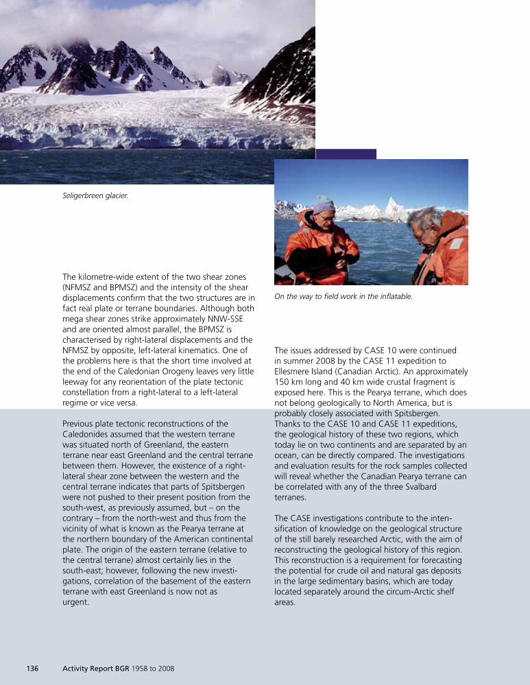
The kilometre-wide extent of the two shear zones(NFMSZ and BPMSZ) and the intensity of the sheardisplacements confirm that the two structures are infact real plate or terrane boundaries. Although bothmega shear zones strike approximately NNW-SSEand are oriented almost parallel, the BPMSZ ischaracterised by right-lateral displacements and theNFMSZ by opposite, left-lateral kinematics. One ofthe problems here is that the short time involved atthe end of the Caledonian Orogeny leaves very littleleeway for any reorientation of the plate tectonicconstellation from a right-lateral to a left-lateralregime or vice versa.
Previous plate tectonic reconstructions of theCaledonides assumed that the western terranewas situated north of Greenland, the easternterrane near east Greenland and the central terranebetween them. However, the existence of a right-lateral shear zone between the western and thecentral terrane indicates that parts of Spitsbergenwere not pushed to their present position from thesouth-west, as previously assumed, but – on thecontrary – from the north-west and thus from thevicinity of what is known as the Pearya terrane atthe northern boundary of the American continentalplate. The origin of the eastern terrane (relative tothe central terrane) almost certainly lies in thesouth-east; however, following the new investi-gations, correlation of the basement of the easternterrane with east Greenland is now not asurgent.
The issues addressed by CASE 10 were continuedin summer 2008 by the CASE 11 expedition toEllesmere Island (Canadian Arctic). An approximately150 km long and 40 km wide crustal fragment isexposed here. This is the Pearya terrane, which doesnot belong geologically to North America, but isprobably closely associated with Spitsbergen.Thanks to the CASE 10 and CASE 11 expeditions,the geological history of these two regions, whichtoday lie on two continents and are separated by anocean, can be directly compared. The investigationsand evaluation results for the rock samples collectedwill reveal whether the Canadian Pearya terrane canbe correlated with any of the three Svalbardterranes.
The CASE investigations contribute to the inten-sification of knowledge on the geological structureof the still barely researched Arctic, with the aim ofreconstructing the geological history of this region.This reconstruction is a requirement for forecastingthe potential for crude oil and natural gas depositsin the large sedimentary basins, which are todaylocated separately around the circum-Arctic shelfareas.
Seligerbreen glacier.
On the way to field work in the inflatable.
136 Activity Report BGR 1958 to 2008
1999so001d_125_138.indd 1361999so001d_125_138.indd 136 16.06.2009 09:24:3016.06.2009 09:24:30
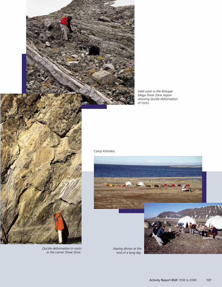
Ductile deformation in rocksin the Lerner Shear Zone.
Field work in the BiskayarMega Shear Zone regionshowing ductile deformationof rocks.
Camp Kinnvika.
Having dinner at theend of a long day.
Activity Report BGR 1958 to 2008 137
1999so001d_125_138.indd 1371999so001d_125_138.indd 137 16.06.2009 09:24:3416.06.2009 09:24:34

1999so001d_125_138.indd 1381999so001d_125_138.indd 138 16.06.2009 09:24:4216.06.2009 09:24:42
Geoscientific
Zusammenarbeit
1999so001d_139_146.indd 1391999so001d_139_146.indd 139 16.06.2009 09:25:1316.06.2009 09:25:13
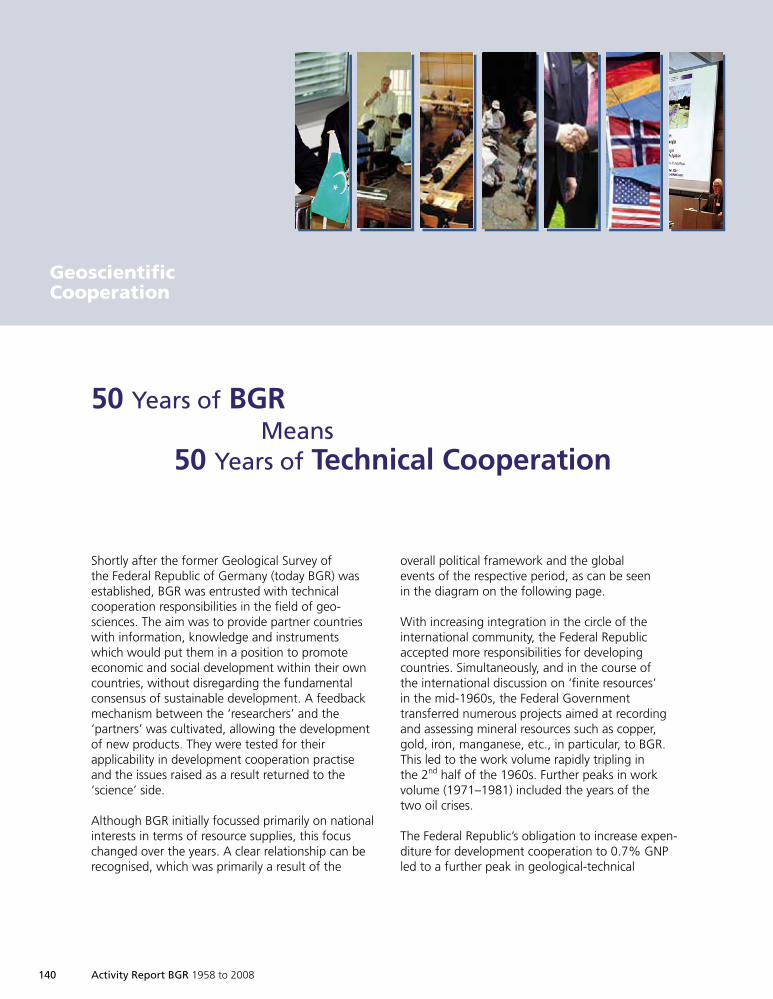
140 Activity Report BGR 1958 to 2008
Shortly after the former Geological Survey ofthe Federal Republic of Germany (today BGR) wasestablished, BGR was entrusted with technicalcooperation responsibilities in the field of geo-sciences. The aim was to provide partner countrieswith information, knowledge and instrumentswhich would put them in a position to promoteeconomic and social development within their owncountries, without disregarding the fundamentalconsensus of sustainable development. A feedbackmechanism between the ‘researchers’ and the‘partners’ was cultivated, allowing the developmentof new products. They were tested for theirapplicability in development cooperation practiseand the issues raised as a result returned to the‘science’ side.
Although BGR initially focussed primarily on nationalinterests in terms of resource supplies, this focuschanged over the years. A clear relationship can berecognised, which was primarily a result of the
50 Years of BGRMeans
50 Years of Technical Cooperation
overall political framework and the globalevents of the respective period, as can be seenin the diagram on the following page.
With increasing integration in the circle of theinternational community, the Federal Republicaccepted more responsibilities for developingcountries. Simultaneously, and in the course ofthe international discussion on ‘finite resources’in the mid-1960s, the Federal Governmenttransferred numerous projects aimed at recordingand assessing mineral resources such as copper,gold, iron, manganese, etc., in particular, to BGR.This led to the work volume rapidly tripling inthe 2nd half of the 1960s. Further peaks in workvolume (1971–1981) included the years of thetwo oil crises.
The Federal Republic’s obligation to increase expen-diture for development cooperation to 0.7% GNPled to a further peak in geological-technical
GeoscientificCooperation
1999so001d_139_146.indd 1401999so001d_139_146.indd 140 16.06.2009 09:25:1416.06.2009 09:25:14
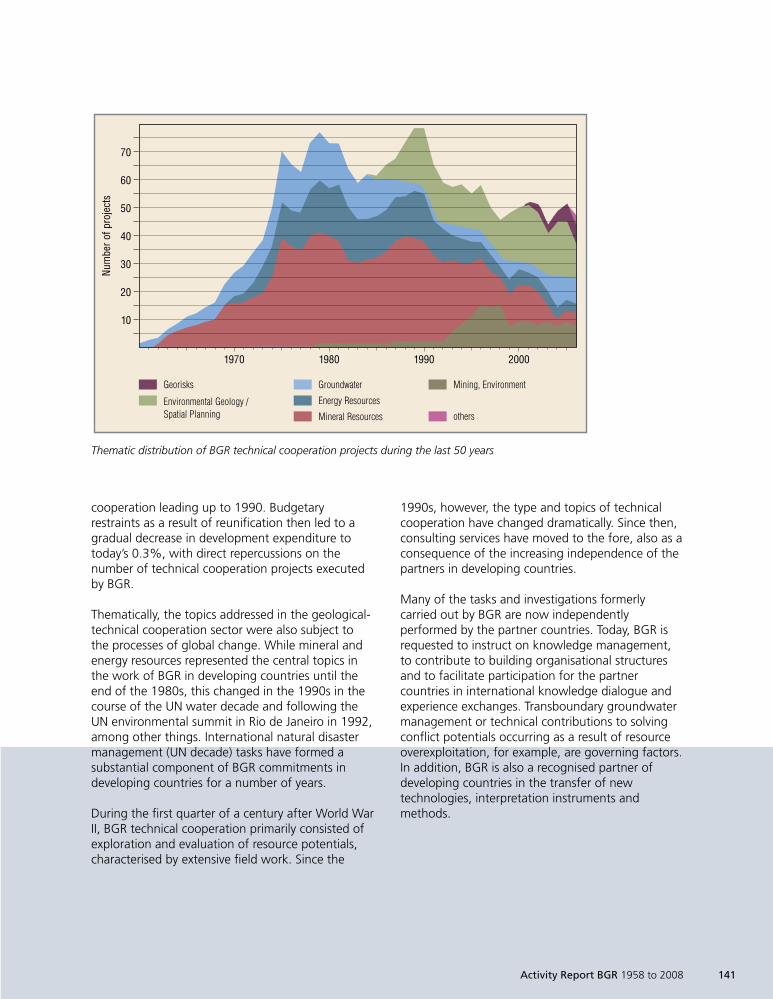
Activity Report BGR 1958 to 2008 141
cooperation leading up to 1990. Budgetaryrestraints as a result of reunification then led to agradual decrease in development expenditure totoday’s 0.3%, with direct repercussions on thenumber of technical cooperation projects executedby BGR.
Thematically, the topics addressed in the geological-technical cooperation sector were also subject tothe processes of global change. While mineral andenergy resources represented the central topics inthe work of BGR in developing countries until theend of the 1980s, this changed in the 1990s in thecourse of the UN water decade and following theUN environmental summit in Rio de Janeiro in 1992,among other things. International natural disastermanagement (UN decade) tasks have formed asubstantial component of BGR commitments indeveloping countries for a number of years.
During the first quarter of a century after World WarII, BGR technical cooperation primarily consisted ofexploration and evaluation of resource potentials,characterised by extensive field work. Since the
1990s, however, the type and topics of technicalcooperation have changed dramatically. Since then,consulting services have moved to the fore, also as aconsequence of the increasing independence of thepartners in developing countries.
Many of the tasks and investigations formerlycarried out by BGR are now independentlyperformed by the partner countries. Today, BGR isrequested to instruct on knowledge management,to contribute to building organisational structuresand to facilitate participation for the partnercountries in international knowledge dialogue andexperience exchanges. Transboundary groundwatermanagement or technical contributions to solvingconflict potentials occurring as a result of resourceoverexploitation, for example, are governing factors.In addition, BGR is also a recognised partner ofdeveloping countries in the transfer of newtechnologies, interpretation instruments andmethods.
1970 1980 1990 2000
70
60
50
40
30
20
10
Num
bero
fpro
ject
s
Georisks
Environmental Geology /Spatial Planning
Groundwater
Energy Resources
Mineral Resources
Mining, Environment
others
Thematic distribution of BGR technical cooperation projects during the last 50 years
1999so001d_139_146.indd 1411999so001d_139_146.indd 141 16.06.2009 09:25:1716.06.2009 09:25:17
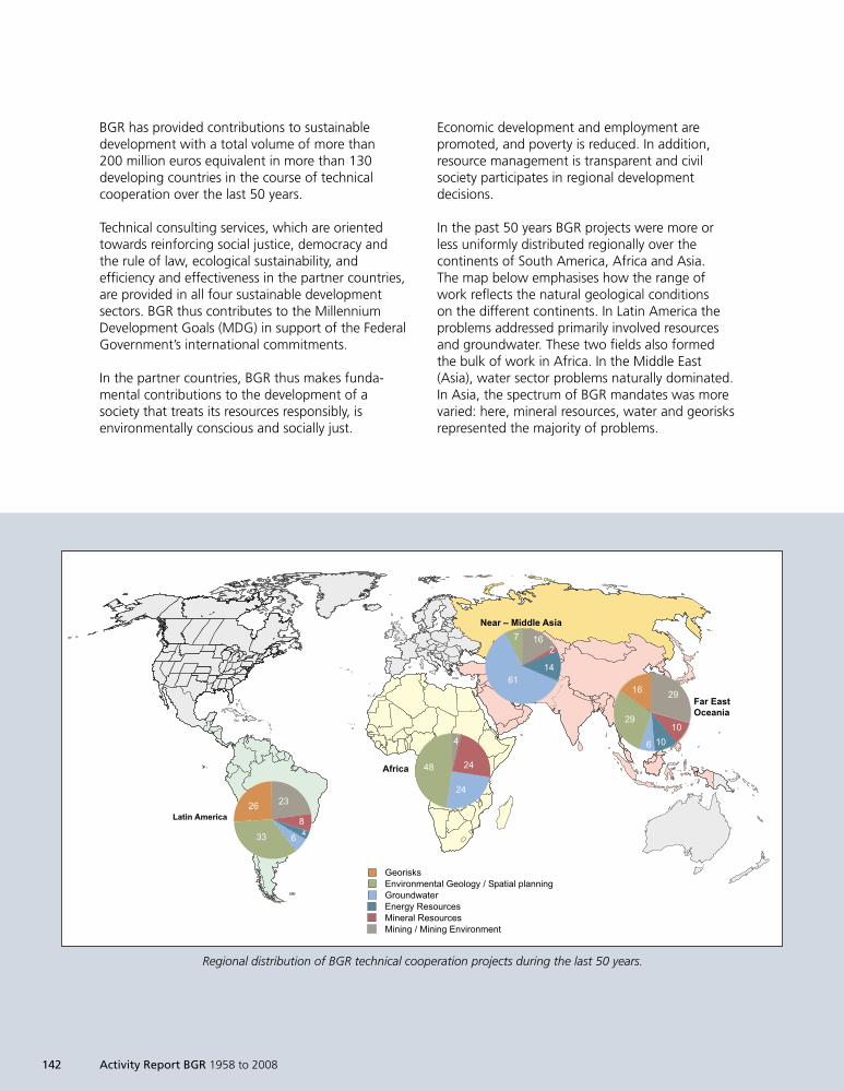
142 Activity Report BGR 1958 to 2008
BGR has provided contributions to sustainabledevelopment with a total volume of more than200 million euros equivalent in more than 130developing countries in the course of technicalcooperation over the last 50 years.
Technical consulting services, which are orientedtowards reinforcing social justice, democracy andthe rule of law, ecological sustainability, andefficiency and effectiveness in the partner countries,are provided in all four sustainable developmentsectors. BGR thus contributes to the MillenniumDevelopment Goals (MDG) in support of the FederalGovernment’s international commitments.
In the partner countries, BGR thus makes funda-mental contributions to the development of asociety that treats its resources responsibly, isenvironmentally conscious and socially just.
Economic development and employment arepromoted, and poverty is reduced. In addition,resource management is transparent and civilsociety participates in regional developmentdecisions.
In the past 50 years BGR projects were more orless uniformly distributed regionally over thecontinents of South America, Africa and Asia.The map below emphasises how the range ofwork reflects the natural geological conditionson the different continents. In Latin America theproblems addressed primarily involved resourcesand groundwater. These two fields also formedthe bulk of work in Africa. In the Middle East(Asia), water sector problems naturally dominated.In Asia, the spectrum of BGR mandates was morevaried: here, mineral resources, water and georisksrepresented the majority of problems.
4.(!- +0#*!,.
$.* &.)(/,#.-!.
!) 4%
4%
) !"
!"
)!
!)'
1#.* ' 3!%%2# +)!.
.&
.
4.
4.
+"*!,.
;<@937-7$A/39@A(<A56* ;<@*@8B # :>6536* >*6AA3A8;9@2A?,65<9$A<98B =<7@290<7+3A<96* =<7@290<7+3A3A8 # +3A3A8 $A/39@A(<A5
4) 41
11
&
).
4
!.
Regional distribution of BGR technical cooperation projects during the last 50 years.
1999so001d_139_146.indd 1421999so001d_139_146.indd 142 16.06.2009 09:25:1716.06.2009 09:25:17
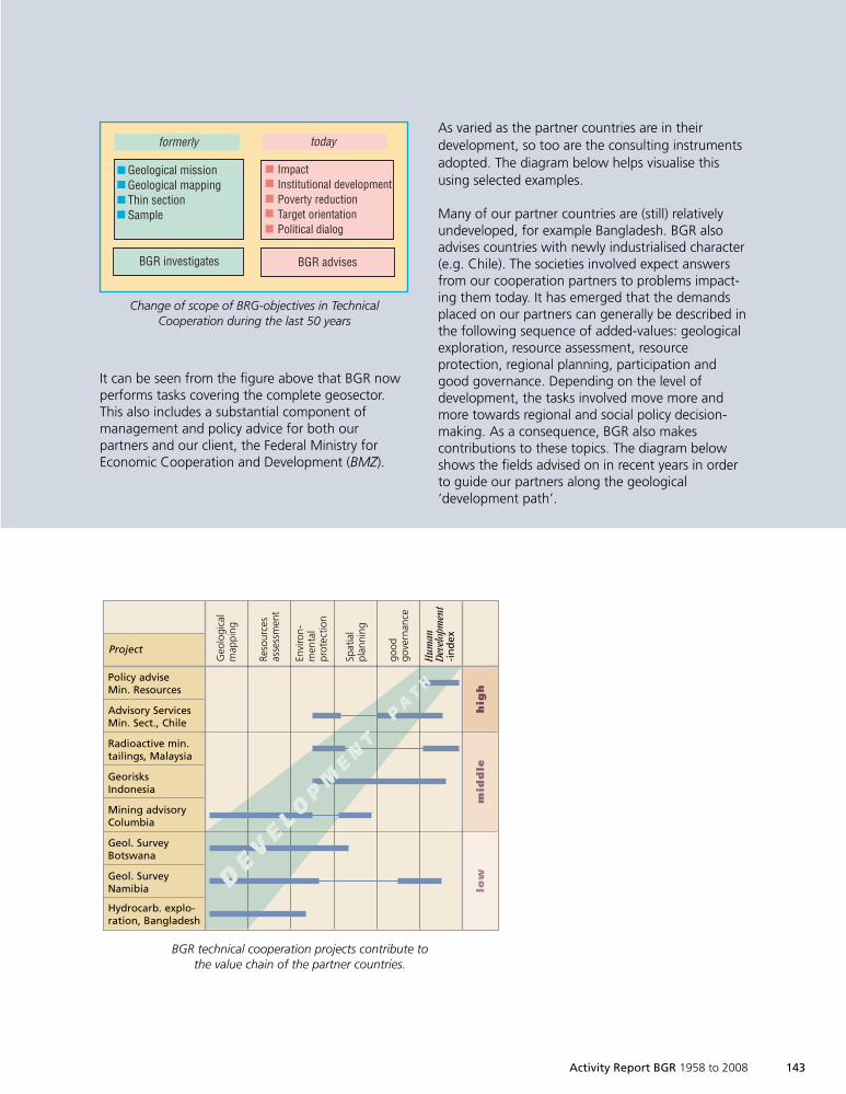
Activity Report BGR 1958 to 2008 143
It can be seen from the figure above that BGR nowperforms tasks covering the complete geosector.This also includes a substantial component ofmanagement and policy advice for both ourpartners and our client, the Federal Ministry forEconomic Cooperation and Development (BMZ).
As varied as the partner countries are in theirdevelopment, so too are the consulting instrumentsadopted. The diagram below helps visualise thisusing selected examples.
Many of our partner countries are (still) relativelyundeveloped, for example Bangladesh. BGR alsoadvises countries with newly industrialised character(e.g. Chile). The societies involved expect answersfrom our cooperation partners to problems impact-ing them today. It has emerged that the demandsplaced on our partners can generally be described inthe following sequence of added-values: geologicalexploration, resource assessment, resourceprotection, regional planning, participation andgood governance. Depending on the level ofdevelopment, the tasks involved move more andmore towards regional and social policy decision-making. As a consequence, BGR also makescontributions to these topics. The diagram belowshows the fields advised on in recent years in orderto guide our partners along the geological‘development path’.
Geological missionGeological mappingThin sectionSample
ImpactInstitutional developmentPoverty reductionTarget orientationPolitical dialog
BGR investigates BGR advises
formerly today
Change of scope of BGR-objetives in TechnicalCooperation during the last 50 years
Policy adviseMin. Resources
Advisory ServicesMin. Sect., Chile
Radioactive min.tailings, Malaysia
GeorisksIndonesia
Mining advisoryColumbia
Geol. SurveyBotswana
Geol. SurveyNamibia
Hydrocarb. explo-ration, Bangladesh
Project
Geo
logi
cal
map
ping
Reso
urce
sas
sess
men
t
Envi
ron-
men
tal
prot
ectio
n
Spat
ial
plan
ning
good
gove
rnan
ce
Hum
anD
evel
opm
ent
-in
dex
DE V
E L OP
ME N
TP
AT
H
hig
hm
idd
lelo
w
BGR technical cooperation projects contribute tothe value chain of the partner countries.
Change of scope of BRG-objectives in TechnicalCooperation during the last 50 years
1999so001d_139_146.indd 1431999so001d_139_146.indd 143 16.06.2009 09:25:1916.06.2009 09:25:19
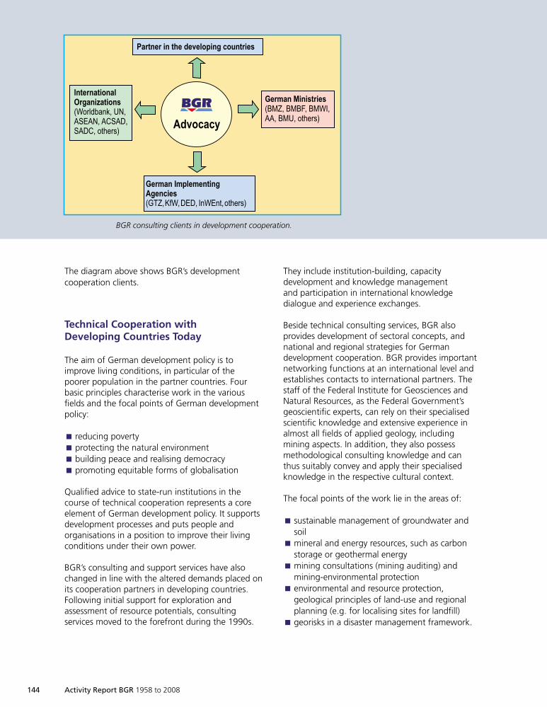
144 Activity Report BGR 1958 to 2008
The diagram above shows BGR’s developmentcooperation clients.
Technical Cooperation withDeveloping Countries Today
The aim of German development policy is toimprove living conditions, in particular of thepoorer population in the partner countries. Fourbasic principles characterise work in the variousfields and the focal points of German developmentpolicy:
reducing povertyÈ
protecting the natural environmentÈ
building peace and realising democracyÈ
promoting equitable forms of globalisationÈ
Qualified advice to state-run institutions in thecourse of technical cooperation represents a coreelement of German development policy. It supportsdevelopment processes and puts people andorganisations in a position to improve their livingconditions under their own power.
BGR’s consulting and support services have alsochanged in line with the altered demands placed onits cooperation partners in developing countries.Following initial support for exploration andassessment of resource potentials, consultingservices moved to the forefront during the 1990s.
They include institution-building, capacitydevelopment and knowledge managementand participation in international knowledgedialogue and experience exchanges.
Beside technical consulting services, BGR alsoprovides development of sectoral concepts, andnational and regional strategies for Germandevelopment cooperation. BGR provides importantnetworking functions at an international level andestablishes contacts to international partners. Thestaff of the Federal Institute for Geosciences andNatural Resources, as the Federal Government’sgeoscientific experts, can rely on their specialisedscientific knowledge and extensive experience inalmost all fields of applied geology, includingmining aspects. In addition, they also possessmethodological consulting knowledge and canthus suitably convey and apply their specialisedknowledge in the respective cultural context.
The focal points of the work lie in the areas of:
sustainable management of groundwater andÈ
soilmineral and energy resources, such as carbonÈ
storage or geothermal energymining consultations (mining auditing) andÈ
mining-environmental protectionenvironmental and resource protection,È
geological principles of land-use and regionalplanning (e.g. for localising sites for landfill)georisks in a disaster management framework.È
/)*1252#
'(.754 %708(7(4,"4&/&(42"(-,:6@#.8-#"!"# 4?-!?0#>01;75*
%4,(.45,"14586.&54"!5,"14-,->7'=/2?+# 3%#)9!)%# )$9)"#9)"$# >01;75*
'(.754 9"4"-,."(-,&(@# &(&<# &(-4#))# &(3# >01;75*
35.,4(. "4 ,$( )(*(810"4& 21+4,."(-
BGR consulting clients in development cooperation.
1999so001d_139_146.indd 1441999so001d_139_146.indd 144 16.06.2009 09:25:1916.06.2009 09:25:19
Activity Report BGR 1958 to 2008 145
Conference on Transparencyin the Resources Sector,
World Water Week in Stockholm,United Nations Convention on the Law of the Sea
A Selection of BGR Sectoral Projects
Because many technical cooperation projectsimplemented in 2006/2007 are presented in therespective specialised chapters, three sectoralprojects shall be described in more detail here.Two of the projects involve policy advice and areaimed at:
resource andÈ
groundwater-/water-based dialogue both withinÈ
German development cooperation circles and ininternational dialogue.The third project serves to implement the Law ofÈ
the Sea Convention in selected developingcountries.
(This relatively new approaches (for BGR)guarante(es) that policy concepts are compiledfrom the outset in harmony with geoscientificguidelines and that BGR’s technical cooperationis embedded in international political processes.This is also clear from the following examples).
Internat ional Conference on Transparencyin the Resources Sector : BGR supportedthe BMZ in its conceptualisation of the 2008 G8conference on transparency in the resources sector.In this context, BGR ran a number of workshopson certification and transparency in the field ofmineral resources trade chains. Here, BGR is closelyintegrated in a network including relevant nationaland international organisations (United Nations,World Bank, etc.).
Seminars at the World Water Week inStockholm: BGR ran a number of events atthe most important international forums fordecision-makers in the water sector, whichfocussed attention on the relevance of the topicof transboundary groundwater. BGR cooperateswith partners such as the African MinisterialCouncil on Water and various UN organisationson improving international cooperation in termsof mutual groundwater reserves.
1999so001d_139_146.indd 1451999so001d_139_146.indd 145 16.06.2009 09:25:1916.06.2009 09:25:19
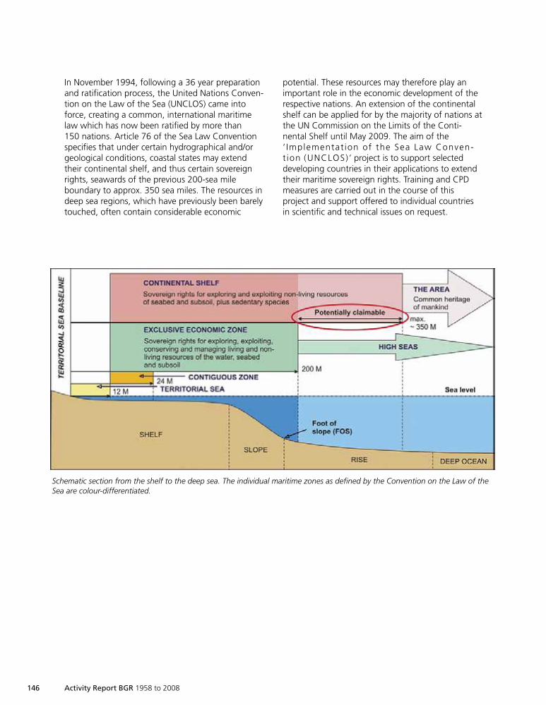
146 Activity Report BGR 1958 to 2008
In November 1994, following a 36 year preparationand ratification process, the United Nations Conven-tion on the Law of the Sea (UNCLOS) came intoforce, creating a common, international maritimelaw which has now been ratified by more than150 nations. Article 76 of the Sea Law Conventionspecifies that under certain hydrographical and/orgeological conditions, coastal states may extendtheir continental shelf, and thus certain sovereignrights, seawards of the previous 200-sea mileboundary to approx. 350 sea miles. The resources indeep sea regions, which have previously been barelytouched, often contain considerable economic
potential. These resources may therefore play animportant role in the economic development of therespective nations. An extension of the continentalshelf can be applied for by the majority of nations atthe UN Commission on the Limits of the Conti-nental Shelf until May 2009. The aim of the‘ Implementat ion of the Sea Law Conven-t ion (UNCLOS) ’ project is to support selecteddeveloping countries in their applications to extendtheir maritime sovereign rights. Training and CPDmeasures are carried out in the course of thisproject and support offered to individual countriesin scientific and technical issues on request.
Schematic section from the shelf to the deep sea. The individual maritime zones as defined by the Convention on the Law of theSea are colour-differentiated.
1999so001d_139_146.indd 1461999so001d_139_146.indd 146 16.06.2009 09:25:1916.06.2009 09:25:19
"89 (8896<3076 3E&D<C,@96C@26907'8EC
BD993'3@E 829 C@<>07<@34-<@3C@ /DE
;@%%DD< 2EC1<DE9%DD<
?@D'D:3907@9 587<4207 A@37@ )# ;@=6 !*$
)!*
$
B<3@C<307 >07%3C .1DD<C3E86D<+
BD99
3'3@E
829C@
<>0
7<@34-
<@3C
@/D
E;@%
%DD
<
Infrastructure
1999so001d_147_164.indd 1471999so001d_147_164.indd 147 16.06.2009 09:26:1816.06.2009 09:26:18
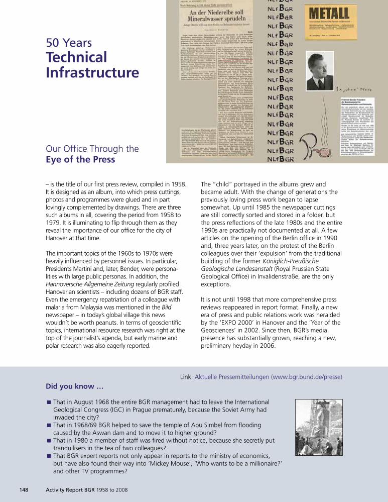
148 Activity Report BGR 1958 to 2008
– is the title of our first press review, compiled in 1958.It is designed as an album, into which press cuttings,photos and programmes were glued and in partlovingly complemented by drawings. There are threesuch albums in all, covering the period from 1958 to1979. It is illuminating to flip through them as theyreveal the importance of our office for the city ofHanover at that time.
The important topics of the 1960s to 1970s wereheavily influenced by personnel issues. In particular,Presidents Martini and, later, Bender, were persona-lities with large public personas. In addition, theHannoversche Allgemeine Zeitung regularly profiledHanoverian scientists – including dozens of BGR staff.Even the emergency repatriation of a colleague withmalaria from Malaysia was mentioned in the Bildnewspaper – in today’s global village this newswouldn’t be worth peanuts. In terms of geoscientifictopics, international resource research was right at thetop of the journalist’s agenda, but early marine andpolar research was also eagerly reported.
50 YearsTechnicalInfrastructure
The “child” portrayed in the albums grew andbecame adult. With the change of generations thepreviously loving press work began to lapsesomewhat. Up until 1985 the newspaper cuttingsare still correctly sorted and stored in a folder, butthe press reflections of the late 1980s and the entire1990s are practically not documented at all. A fewarticles on the opening of the Berlin office in 1990and, three years later, on the protest of the Berlincolleagues over their ‘expulsion’ from the traditionalbuilding of the former Königlich-PreußischeGeologische Landesanstalt (Royal Prussian StateGeological Office) in Invalidenstraße, are the onlyexceptions.
It is not until 1998 that more comprehensive pressreviews reappeared in report format. Finally, a newera of press and public relations work was heraldedby the ‘EXPO 2000’ in Hanover and the ‘Year of theGeosciences’ in 2002. Since then, BGR’s mediapresence has substantially grown, reaching a new,preliminary heyday in 2006.
Our Office Through theEye of the Press
Did you know …
That in August 1968 the entire BGR management had to leave the InternationalÈGeological Congress (IGC) in Prague prematurely, because the Soviet Army hadinvaded the city?That in 1968/69 BGR helped to save the temple of Abu Simbel from floodingÈcaused by the Aswan dam and to move it to higher ground?That in 1980 a member of staff was fired without notice, because she secretly putÈtranquilisers in the tea of two colleagues?That BGR expert reports not only appear in reports to the ministry of economics,Èbut have also found their way into ‘Mickey Mouse’, ‘Who wants to be a millionaire?’and other TV programmes?
Link: Aktuelle Pressemitteilungen (www.bgr.bund.de/presse)
1999so001d_147_164.indd 1481999so001d_147_164.indd 148 16.06.2009 09:26:1916.06.2009 09:26:19
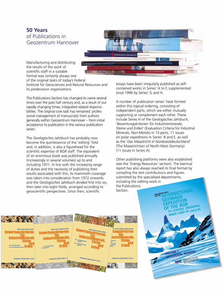
Manufacturing and distributingthe results of the work ofscientific staff in a suitableformat was certainly always oneof the original tasks of today’s FederalInstitute for Geosciences and Natural Resources andits predecessor organisations.
The Publications Section has changed its name severaltimes over the past half century and, as a result of ourrapidly changing times, integrated related responsi-bilities. The original core task has remained: profes-sional management of manuscripts from authorsgenerally within Geozentrum Hannover – from initialacceptance to publication in the various publicationseries’.
The Geologisches Jahrbuch has probably nowbecome the quintessence of the ‘editing’ fieldand, in addition, is also a figurehead for thescientific expertise of BGR staff. The equivalentof an enormous book was published annually(increasingly in several volumes) up to andincluding 1971. In line with the increasing rangeof duties and the necessity of publishing theirresults associated with this, its mammoth coveragewas taken into consideration from 1972 onwardsand the Geologisches Jahrbuch divided first into six,then later into eight fields, arranged according togeoscientific perspectives. Since then, scientific
essays have been irregularly published as self-contained works in Series’ A to F, supplementedsince 1996 by Series’ G and H.
A number of publication series’ have formedwithin this topical ordering, consisting ofindependent parts, which are either mutuallysupporting or complement each other. Theseinclude Series H of the Geologisches Jahrbuch,‘Bewertungskriterien für Industrieminerale,Steine und Erden’ (Evaluation Criteria for IndustrialMinerals, Non-Metals) in 13 parts, 11 issueson polar expeditions in Series’ B and E, as wellas the ‘Das Maastricht in Nordwestdeutschland’(The Maastrichtian of North-West Germany)(11 issues in Series A).
Other publishing platforms were also established(see the ‘Energy Resources’ section). The biennialreport has also always reached its final format bycompiling the text contributions and figuressubmitted by the specialised departments,including the editing work inthe PublicationsSection.
t�cHÐo¥Kv�c P���t
Ü��rD`KÚ rcD�Kc�Dr`c�i
v�`f�@�
�4P��rDr`c
`x Dt� �vK
rcD�
Kc�D
r`c�i
v�`f
�@�
�4P�
�rDr
`c
`x
Dt�
�vK
v�`i`
vrH�
t�H
o�tK�
@�t
®µ
D` ��cDK�i �K`ccrcv
f�@� i�c� rc È®®¸Ì®µ
�@c��H�cHD�iD x¥K
v�`8rHH�cH�t�xD�c
@c� K`tHD`xx�
<`i@f� r
v�`i`vr��i K�H@iDH
Bewertungskriterienfür
Industrieminerale,Steine
undErden
Geologisches Jahrbuch Reihe H, Heft 8
Teil 5: Gesteinskörnungen
Walter Lorenz & Werner Gwosdz
Kies, Sand, gebrochener Naturstein
Bew
ertu
ngsk
rite
rien
für
Indu
stri
emin
eral
e,St
eine
und
Erde
n Bewertungskriterienfür
Industrieminerale,Steine
undErden
Geologisches Jahrbuch Reihe H, Heft 14
13
Teil 13: Beryllium-Minerale,Brom, Jod,Graphit, Farberden,Mangan-Mineraleund Zeolithe
Walter Lorenz, Simone Röhling & Werner Gwosdz
Bew
ertu
ngsk
rite
rien
für
Indu
stri
emin
eral
e,St
eine
und
Erde
n Bewertungskriterienfür
Industrieminerale,Steine
undErden
Geologisches Jahrbuch Reihe H, Heft 8
6
Teil 6: Naturwerksteine
Walter Lorenz & Werner Gwosdz
und Dachschiefer
Bew
ertu
ngsk
rite
rien
für
Indu
stri
emin
eral
e,St
eine
und
Erde
n
BewertungskriterienfürIndustrieminerale,SteineundErden
Geologisches Jahrbuch Reihe H, Heft 11
8un
d9
Teil 8: AluminiumoxidreicheRohstoffeTeil 9: MagnesiumoxidreicheRohstoffe
Walter Lorenz & Werner Gwosdz Welbei dvones kekeineheuteErnährwie GlaTausenErzeugn
Immer hkonfrontiVerwendbten. Um igeben, wegeologen weines Leitdes GeologPublikatione
Der vorliegeoxidreiche RoSchmirgel, dAndalusit undAlunit wird hAlaun (ein wicwendet.90 -- 95 % der Basche Zwecke, zudet; nur 5 -- 10 %in nicht-metallurFeuerfest- und Kerund Poliermittel).Naturkorund und Scseit mehr als 2000mittel bekannt.Disthen, Andalusitausschließlich in dHochtemperatur beaSteine als auch für MasVon den zahlreichen V
von Pyrophyllit sindmaterialien in der Feuerverfahren für WandfliesReaktionskammer für H(Diamantsynthese).
Teil 9 behandelt Magnesiwie Talk, Olivin/Dunit, AsbTalk wird in allen Bereich
Füllstoffe mit Adsorptionseigund besondere Qualitätsanbzw. Toxizität, wie in de Fvor allem i
50 Yearsof Publications inGeozentrum Hannover
1999so001d_147_164.indd 1491999so001d_147_164.indd 149 16.06.2009 09:26:2116.06.2009 09:26:21
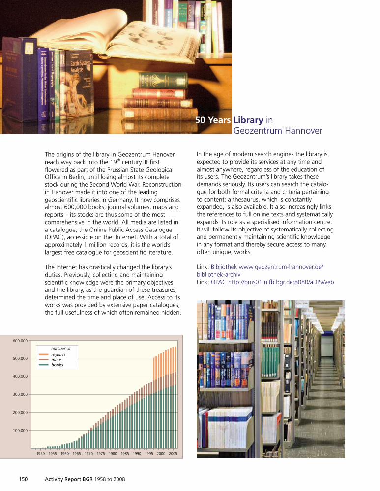
150 Activity Report BGR 1958 to 2008
The origins of the library in Geozentrum Hanoverreach way back into the 19th century. It firstflowered as part of the Prussian State GeologicalOffice in Berlin, until losing almost its completestock during the Second World War. Reconstructionin Hanover made it into one of the leadinggeoscientific libraries in Germany. It now comprisesalmost 600,000 books, journal volumes, maps andreports – its stocks are thus some of the mostcomprehensive in the world. All media are listed ina catalogue, the Online Public Access Catalogue(OPAC), accessible on the Internet. With a total ofapproximately 1 million records, it is the world’slargest free catalogue for geoscientific literature.
The Internet has drastically changed the library’sduties. Previously, collecting and maintainingscientific knowledge were the primary objectivesand the library, as the guardian of these treasures,determined the time and place of use. Access to itsworks was provided by extensive paper catalogues,the full usefulness of which often remained hidden.
In the age of modern search engines the library isexpected to provide its services at any time andalmost anywhere, regardless of the education ofits users. The Geozentrum’s library takes thesedemands seriously. Its users can search the catalo-gue for both formal criteria and criteria pertainingto content; a thesaurus, which is constantlyexpanded, is also available. It also increasingly linksthe references to full online texts and systematicallyexpands its role as a specialised information centre.It will follow its objective of systematically collectingand permanently maintaining scientific knowledgein any format and thereby secure access to many,often unique, works
Link: Bibliothek www.geozentrum-hannover.de/bibliothek-archivLink: OPAC http://bms01.nlfb.bgr.de:8080/aDISWeb
50 Years Library inGeozentrum Hannover
1950 1955 1960 1965 1970 1975 1980 1985 1990 1995 20052000
600.000
500.000
400.000
300.000
200.000
100.000
number ofreportsmapsbooks
1999so001d_147_164.indd 1501999so001d_147_164.indd 150 16.06.2009 09:26:4216.06.2009 09:26:42
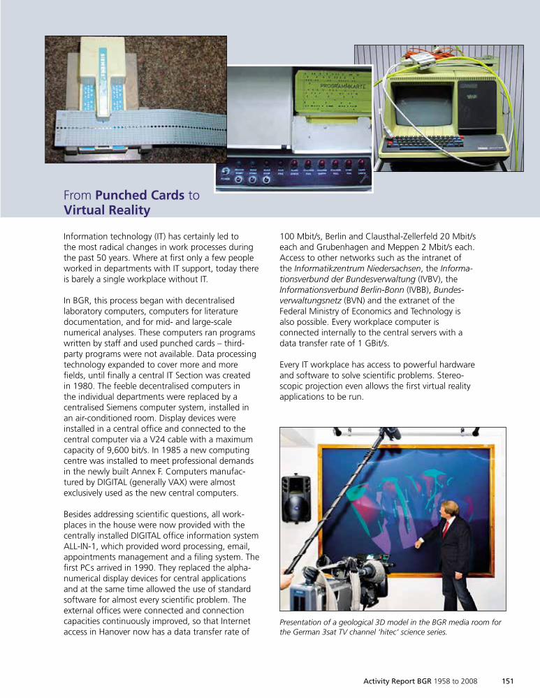
Activity Report BGR 1958 to 2008 151
Information technology (IT) has certainly led tothe most radical changes in work processes duringthe past 50 years. Where at first only a few peopleworked in departments with IT support, today thereis barely a single workplace without IT.
In BGR, this process began with decentralisedlaboratory computers, computers for literaturedocumentation, and for mid- and large-scalenumerical analyses. These computers ran programswritten by staff and used punched cards – third-party programs were not available. Data processingtechnology expanded to cover more and morefields, until finally a central IT Section was createdin 1980. The feeble decentralised computers inthe individual departments were replaced by acentralised Siemens computer system, installed inan air-conditioned room. Display devices wereinstalled in a central office and connected to thecentral computer via a V24 cable with a maximumcapacity of 9,600 bit/s. In 1985 a new computingcentre was installed to meet professional demandsin the newly built Annex F. Computers manufac-tured by DIGITAL (generally VAX) were almostexclusively used as the new central computers.
Besides addressing scientific questions, all work-places in the house were now provided with thecentrally installed DIGITAL office information systemALL-IN-1, which provided word processing, email,appointments management and a filing system. Thefirst PCs arrived in 1990. They replaced the alpha-numerical display devices for central applicationsand at the same time allowed the use of standardsoftware for almost every scientific problem. Theexternal offices were connected and connectioncapacities continuously improved, so that Internetaccess in Hanover now has a data transfer rate of
100 Mbit/s, Berlin and Clausthal-Zellerfeld 20 Mbit/seach and Grubenhagen and Meppen 2 Mbit/s each.Access to other networks such as the intranet ofthe Informatikzentrum Niedersachsen, the Informa-tionsverbund der Bundesverwaltung (IVBV), theInformationsverbund Berlin-Bonn (IVBB), Bundes-verwaltungsnetz (BVN) and the extranet of theFederal Ministry of Economics and Technology isalso possible. Every workplace computer isconnected internally to the central servers with adata transfer rate of 1 GBit/s.
Every IT workplace has access to powerful hardwareand software to solve scientific problems. Stereo-scopic projection even allows the first virtual realityapplications to be run.
From Punched Cards toVirtual Reality
Presentation of a geological 3D model in the BGR media room forthe German 3sat TV channel ‘hitec’ science series.
1999so001d_147_164.indd 1511999so001d_147_164.indd 151 16.06.2009 09:26:4316.06.2009 09:26:43
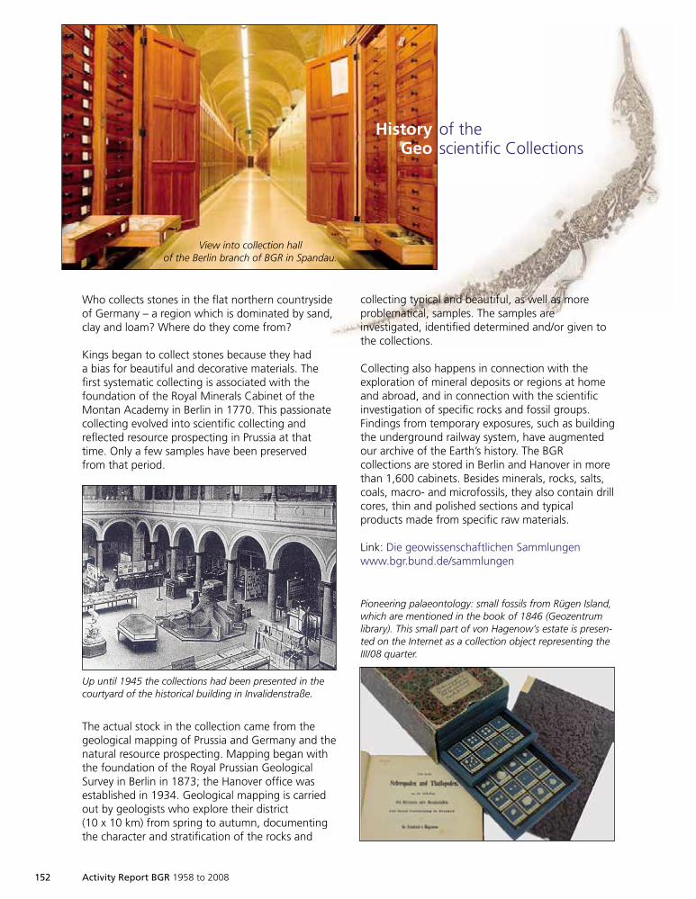
152 Activity Report BGR 1958 to 2008
Who collects stones in the flat northern countrysideof Germany – a region which is dominated by sand,clay and loam? Where do they come from?
Kings began to collect stones because they hada bias for beautiful and decorative materials. Thefirst systematic collecting is associated with thefoundation of the Royal Minerals Cabinet of theMontan Academy in Berlin in 1770. This passionatecollecting evolved into scientific collecting andreflected resource prospecting in Prussia at thattime. Only a few samples have been preservedfrom that period.
The actual stock in the collection came from thegeological mapping of Prussia and Germany and thenatural resource prospecting. Mapping began withthe foundation of the Royal Prussian GeologicalSurvey in Berlin in 1873; the Hanover office wasestablished in 1934. Geological mapping is carriedout by geologists who explore their district(10 x 10 km) from spring to autumn, documentingthe character and stratification of the rocks and
collecting typical and beautiful, as well as moreproblematical, samples. The samples areinvestigated, identified determined and/or given tothe collections.
Collecting also happens in connection with theexploration of mineral deposits or regions at homeand abroad, and in connection with the scientificinvestigation of specific rocks and fossil groups.Findings from temporary exposures, such as buildingthe underground railway system, have augmentedour archive of the Earth’s history. The BGRcollections are stored in Berlin and Hanover in morethan 1,600 cabinets. Besides minerals, rocks, salts,coals, macro- and microfossils, they also contain drillcores, thin and polished sections and typicalproducts made from specific raw materials.
Link: Die geowissenschaftlichen Sammlungenwww.bgr.bund.de/sammlungen
History of theGeo scientific Collections
View into collection hallof the Berlin branch of BGR in Spandau.
Up until 1945 the collections had been presented in thecourtyard of the historical building in Invalidenstraße.
Pioneering palaeontology: small fossils from Rügen Island,which are mentioned in the book of 1846 (Geozentrumlibrary). This small part of von Hagenow’s estate is presen-ted on the Internet as a collection object representing theIII/08 quarter.
1999so001d_147_164.indd 1521999so001d_147_164.indd 152 16.06.2009 09:26:4716.06.2009 09:26:47
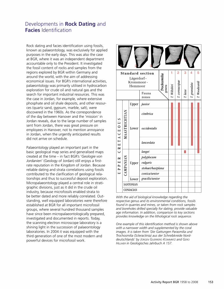
Activity Report BGR 1958 to 2008 153
Rock dating and facies identification using fossils,known as palaeontology, was exclusively for appliedpurposes in the early days. This was also the caseat BGR, where it was an independent departmentaccountable only to the President. It investigatedthe fossil content of rocks and samples from theregions explored by BGR within Germany andaround the world, with the aim of addressingeconomical issues. For BGR’s international activities,palaeontology was primarily utilised in hydrocarbonexploration for crude oil and natural gas and thesearch for important industrial resources. This wasthe case in Jordan, for example, where extensivephosphate and oil shale deposits, and other resour-ces (quartz sand, gypsum, marble, salt), werediscovered in the 1960s. As the correspondenceof the day between Hanover and the ‘mission’ inJordan reveals, due to the large number of samplessent from Jordan, there was great pressure onemployees in Hanover, not to mention annoyancein Jordan, when the urgently anticipated resultsdid not arrive on schedule.
Palaeontology played an important part in thebasic geological map series and generalised mapscreated at the time – in fact BGR’s ‘Geologie vonJordanien’ (Geology of Jordan) still enjoys a first-rate reputation in the Kingdom of Jordan. Becausereliable dating and strata correlations using fossilscontributed to the clarification of geological rela-tionships and thus to successful deposit exploration.Micropalaeontology played a central role in strati-graphic divisions, just as it did in the crude oilindustry, because microfossils enabled strata tobe better dated and more reliably correlated. Out-standing, well equipped laboratories were thereforeestablished at BGR for all important microfossilgroups, where several hundred thousand sampleshave since been micropalaeontologically prepared,investigated and documented in reports. Today,the scanning electron microscope laboratory is ashining light in the succession of palaeontologylaboratories. In 2004 it was equipped with thethird generation of one of the most modern andpowerful devices for microfossil work.
Developments in Rock Dating andFacies Identification
junior
cimbrica
occidentalis
lanceolata
langei
polyplocum
vulgaris
stobaei/basiplana
conica/senior
gracilis/senior
T.W
iltsh
iri
T.co
rnuc
opae
T.la
xa
T.gr
anul
ata
T.W
oodw
ardi
Upper
Lower
Upper
Lower
CAM
PAN
IAN
MAA
STR
ICH
TIAN
UP
PE
RC
RE
TA
CE
OU
S
Faunazones
TTrroocc
hhoossmm
iilliiaa
gene
ra
Standard sectionLägerdorf -
Kronsmoor -Hemmoor
SANTONIAN
CONIACIAN
1 2 3 4 5
1 2 3
4 5
2 cm
With the aid of biological knowledge regarding therespective genus and its environmental conditions, fossilsfound in quarries and mines, or taken from rock samplesand boreholes drilled specially for dating, provide valuableage information. In addition, comparison to key sectionsprovides knowledge on the lithological rock sequence.
One example of this identification method is shown abovewith a narrower width and supplemented by the coralimages. It is taken from ‘Die Gattungen Parasmilia undTrochosmilia (Scleractinia) aus der Schreibkreide Nord-deutschlands’ by JÜRGEN GUERRERO KOMMRITZ and GERO
HILLMER in Geologisches Jahrbuch A 157.
1999so001d_147_164.indd 1531999so001d_147_164.indd 153 16.06.2009 09:26:5416.06.2009 09:26:54
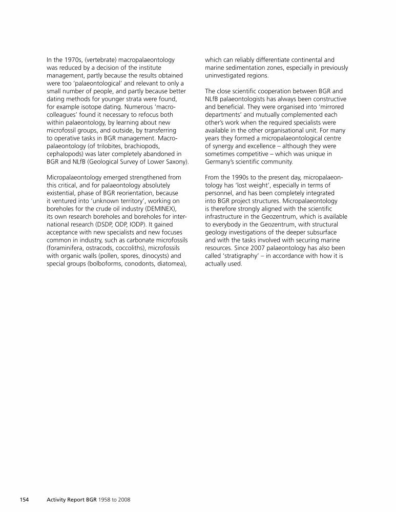
154 Activity Report BGR 1958 to 2008
In the 1970s, (vertebrate) macropalaeontologywas reduced by a decision of the institutemanagement, partly because the results obtainedwere too ‘palaeontological’ and relevant to only asmall number of people, and partly because betterdating methods for younger strata were found,for example isotope dating. Numerous ‘macro-colleagues’ found it necessary to refocus bothwithin palaeontology, by learning about newmicrofossil groups, and outside, by transferringto operative tasks in BGR management. Macro-palaeontology (of trilobites, brachiopods,cephalopods) was later completely abandoned inBGR and NLfB (Geological Survey of Lower Saxony).
Micropalaeontology emerged strengthened fromthis critical, and for palaeontology absolutelyexistential, phase of BGR reorientation, becauseit ventured into ‘unknown territory’, working onboreholes for the crude oil industry (DEMINEX),its own research boreholes and boreholes for inter-national research (DSDP, ODP, IODP). It gainedacceptance with new specialists and new focusescommon in industry, such as carbonate microfossils(foraminifera, ostracods, coccoliths), microfossilswith organic walls (pollen, spores, dinocysts) andspecial groups (bolboforms, conodonts, diatomea),
which can reliably differentiate continental andmarine sedimentation zones, especially in previouslyuninvestigated regions.
The close scientific cooperation between BGR andNLfB palaeontologists has always been constructiveand beneficial. They were organised into ‘mirroreddepartments’ and mutually complemented eachother’s work when the required specialists wereavailable in the other organisational unit. For manyyears they formed a micropalaeontological centreof synergy and excellence – although they weresometimes competitive – which was unique inGermany’s scientific community.
From the 1990s to the present day, micropalaeon-tology has ‘lost weight’, especially in terms ofpersonnel, and has been completely integratedinto BGR project structures. Micropalaeontologyis therefore strongly aligned with the scientificinfrastructure in the Geozentrum, which is availableto everybody in the Geozentrum, with structuralgeology investigations of the deeper subsurfaceand with the tasks involved with securing marineresources. Since 2007 palaeontology has also beencalled ‘stratigraphy’ – in accordance with how it isactually used.
1999so001d_147_164.indd 1541999so001d_147_164.indd 154 16.06.2009 09:26:5516.06.2009 09:26:55
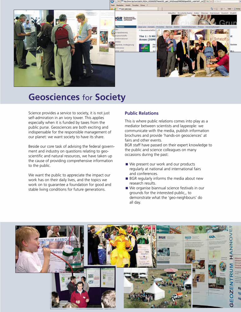
Activity Report BGR 1958 to 2008 155
Science provides a service to society, it is not justself-admiration in an ivory tower. This appliesespecially when it is funded by taxes from thepublic purse. Geosciences are both exciting andindispensable for the responsible management ofour planet: we want society to have its share.
Beside our core task of advising the federal govern-ment and industry on questions relating to geo-scientific and natural resources, we have taken upthe cause of providing comprehensive informationto the public.
We want the public to appreciate the impact ourwork has on their daily lives, and the topics wework on to guarantee a foundation for good andstable living conditions for future generations.
Geosciences for Society
Public Relations
This is where public relations comes into play as amediator between scientists and laypeople: wecommunicate with the media, publish informationbrochures and provide ‘hands-on geosciences’ atfairs and other events.BGR staff have passed on their expert knowledge tothe public and science colleagues on manyoccasions during the past:
We present our work and our productsÈregularly at national and international fairsand conferences.BGR regularly informs the media about newÈresearch results.We organise biannual science festivals in ourÈgrounds for the interested public,, todemonstrate what the ‘geo-neighbours’ doall day.
1999so001d_147_164.indd 1551999so001d_147_164.indd 155 16.06.2009 09:26:5516.06.2009 09:26:55
Every year on Pupil’s Future Day we invite pupilsÈto visit the Geozentrum and take them on ajourney into the fascinating world of geosciences.We send ‘geo-ambassadors’ to schools and toÈpresentation events, where they talk about theirwork, both at home in Germany and on all theworld’s continents.
We regularly participate in ‘Geoday Hanover’,Èan ongoing professional development eventfor teaching staff.And, of course, we utilise modern media suchÈas the Internet.
156 Activity Report BGR 1958 to 2008
Internet
In October 1995, BGR, NLfB (now LBEG) and GGAintroduced their first joint website, which representedthe Geozentrum on the Internet until its completereorganisation in May 1998. In 2002 the websites ofthe three institutions separated and ‘www.bgr.de’became independent: since October 2005 BGR’saddress has been http://www.bgr.bund.de.
The aim is to present the scientific results of thework we carry out to the general public. Staffuse the medium of the Internet, with more than2,000 pages of text and illustrated with morethan 5,000 illustrations and figures, both topresent their work and responsibilities, and toinform the public about new products, services,publications or events. A total of 44 BGR editorsand Internet coordinators work on informationfrom 22 departmental topic editors, quickly,efficiently and targeted to specific groups.
Comprehensive and topical presentation of theproject work carried out by BGR is particularlyimportant. An international event calendarincluding in-house presentations, as well assituations vacant and invitations to tender, roundoff the website. More than 600 downloadablefiles provide the user with facts and figures, forexample in the Annual Report on Reserves,Resources and Availability of Energy Resources.Reference is often made to the products availablein our eShop. Applications used by the differentdepartments to present their work interactively tooutside users are integrated in the website.
At the upper navigation levels the website isavailable bilingually in both German and English;at the lower levels, project results are presented ina further language such as Spanish or French, etc.,depending on the region involved. Subsites withtheir own domains may be established for large,autonomous projects with a variety of cooperationpartners, (for example: http://www.whymap.org).
The BGR website has been compiled and managedsince October 2005 using the Government SiteBuilder (GSB) content management system. GSBwas developed as the basic CMS component forwebsites under federal administration as a resultof the E-Government initiative BundOnline 2005.Using a standard solution adapted by BGR to theirrequirements, it takes standards and architecturesfor E-Government applications (SAGA), designspecifications of the federal government’s onlinestyle guide and the requirements of barrier-freeinformation technology in accordance with theBITV regulations into consideration. Externalhosting is provided by the Bundesstelle für Infor-mationstechnik (BIT) (Federal Office for InformationTechnology) in the Bundesverwaltungsamt (FederalAdministration Agency) in Cologne.
The figure of 30,000 average monthly visitors (in1995 there were 200!) and 1,500,000 file accessesdemonstrates that the information made availableis welcomed by users worldwide.
1999so001d_147_164.indd 1561999so001d_147_164.indd 156 16.06.2009 09:27:0216.06.2009 09:27:02
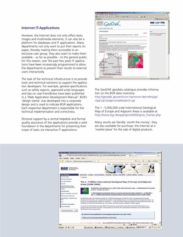
Internet IT-Applications
However, the Internet does not only offers texts,images and multimedia elements, it can also be aplatform for databases and IT applications. Manydepartments not only want to put their reports onpaper, thereby making them accessible to anexclusive user group, they also want to make themavailable – as far as possible – to the general public.For this reason, over the past few years IT applica-tions have been increasingly programmed to allowthe departments to present their results to externalusers interactively.
The task of the technical infrastructure is to providetools and technical solutions to support the applica-tion developers. For example, general specificationssuch as safety aspects, approved script languagesand tips on user-friendliness have been publishedin a ‘Web Application Development Manual’. BGR’s‘design stamp’ was developed into a corporatedesign and is used to indicate BGR applications.Each respective department is responsible for thetechnical implementation and correctness.
Personal support by a central helpdesk and formalquality assurance of the applications provide a solidfoundation in the departments for presenting theirscope of tasks via interactive IT applications.
The GeoDAK geodata catalogue provides informa-tion on the BGR data inventory:http://geodak.geozentrum-hannover.de/mdm/jsp/cigal.jsp?page=simplesearch.jsp
The 1 : 5,000,000 scale International GeologicalMap of Europe and Adjacent Areas is available athttp://www.bgr.de/app/igme5000/igme_frames.php
Many results are literally ‘worth the money’; theyare also available for purchase: the Internet as a‘market place’ for the sale of digital products.
1999so001d_147_164.indd 1571999so001d_147_164.indd 157 16.06.2009 09:27:0216.06.2009 09:27:02
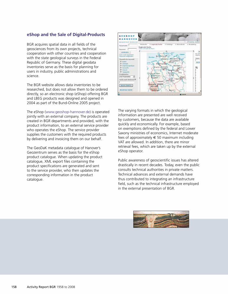
158 Activity Report BGR 1958 to 2008
eShop and the Sale of Digital-Products
BGR acquires spatial data in all fields of thegeosciences from its own projects, technicalcooperation with other countries and cooperationwith the state geological surveys in the FederalRepublic of Germany. These digital geodatainventories serve as the basis for planning forusers in industry, public administrations andscience.
The BGR website allows data inventories to beresearched, but does not allow them to be ordereddirectly, so an electronic shop (eShop) offering BGRand LBEG products was designed and opened in2004 as part of the Bund-Online 2005 project.
The eShop (www.geoshop-hannover.de) is operatedjointly with an external company. The products arecreated in BGR departments and provided, with theproduct information, to an external service providerwho operates the eShop. The service providersupplies the customers with the required productsby delivering and invoicing them on our behalf.
The GeoDaK metadata catalogue of Hanover’sGeozentrum serves as the basis for the eShopproduct catalogue. When updating the productcatalogue, XML export files containing theproduct specifications are generated and sentto the service provider, who then updates thecorresponding information in the productcatalogue.
The varying formats in which the geologicalinformation are presented are well receivedby customers, because the data are availablequickly and economically. For example, basedon exemptions defined by the federal and LowerSaxony ministries of economics, Internet moderatefees of approximately € 50 maximum includingVAT are allowed. In addition, there are minorretrieval fees, which are taken up by the externaleShop operator.
Public awareness of geoscientific issues has altereddrastically in recent decades. Today, even the publicconsults technical authorities in private matters.Technical advances and external demands havethus contributed to integrating an infrastructurefield, such as the technical infrastructure employedin the external presentation of BGR.
1999so001d_147_164.indd 1581999so001d_147_164.indd 158 16.06.2009 09:27:0416.06.2009 09:27:04
Activity Report BGR 1958 to 2008 159
Use of New Satellite Methodsfor Monitoring Land Subsidence
on Java, Indonesia
Testing new methods, the results of which areused by BGR in many ways represents one elementof technical infrastructure. A topical example ispresented here, executed jointly with Indonesianand European partners.
Background
If the term ‘georisk’ is mentioned in connectionwith Indonesia, it is mostly in conjunction withnatural disasters such as earthquakes, landslides,volcanic eruptions, flooding or tsunamis. Another,often underestimated and chiefly man-made,hazard potential is widespread land subsidence.Land subsidence, sometimes dramatic in extent,impacts the environment of millions of people,especially in coastal megacities of south-east Asia.The causes of land subsidence are manifold.
In south-east Asia’s coastal regions, uncontrolledexploitation of groundwater generally leads todrying of the clay layers separating the aquiferlevels, primarily consisting of sands and gravels.The clays shrink as a result of dewatering, leadingto subsidence of the overlying sediments. Annualsubsidence rates of 10 cm and more are notuncommon in some of Indonesia’s coastal regions.
The consequences for the regions impacted byland subsidence are often disastrous. Residentialareas and industrial installations suffer widespreaddestruction. Maintaining community infrastructuresuch as railways, streets, utilities and buildingsdemands enormous and continous remediationefforts, binding substantial sums from the publicbudget.
Large-scale detection and assessement of landsubsidence in Semarang in the north of Java,with a population of 2 million, forms a componentof the project ‘Good Local Governance – Manage-ment of Georisks’. The project is part of thetechnical cooperation between Germany andIndonesia and supports national authorities inevaluating and assessing geological hazards, andaims at developing political and social conscience.Geological advice on risk reduction allows recom-mendations for the authorities in towns andvillages to be derived, aimed at protecting thelocal population. The BGR project partner is theGeological Agency in Bandung.
Due to its lowland character, flooding occursseasonally in the city of Semarang. As a conse-quence of the land subsidence, several parts ofSemarang are permanently submerged by the searesulting in an additional vulnerability to tidalinundations. The disastrous floods in northernJava in February 2007 come to mind in this context.In an attempt to prevent at least residential areasfrom sinking below the groundwater table, pathsand roads are regularly filled using earth and waste.This is also done in the interiors of dwellings tokeep them dry. Enormous economic losses arecaused by the widespread sinking of industrialinstallations and traffic infrastructure.
A simplified geological section, derived from thehydrogeological map of the Indonesian Directorateof Geology (1988 issue), demonstrates the generalsituation. The land subsidence is concentrated inin the north where alluvial and marine depositsincluding sands, gravels and silt are distributed.In contrast, the volcanic breccias and tuffs of the
1999so001d_147_164.indd 1591999so001d_147_164.indd 159 16.06.2009 09:27:1016.06.2009 09:27:10
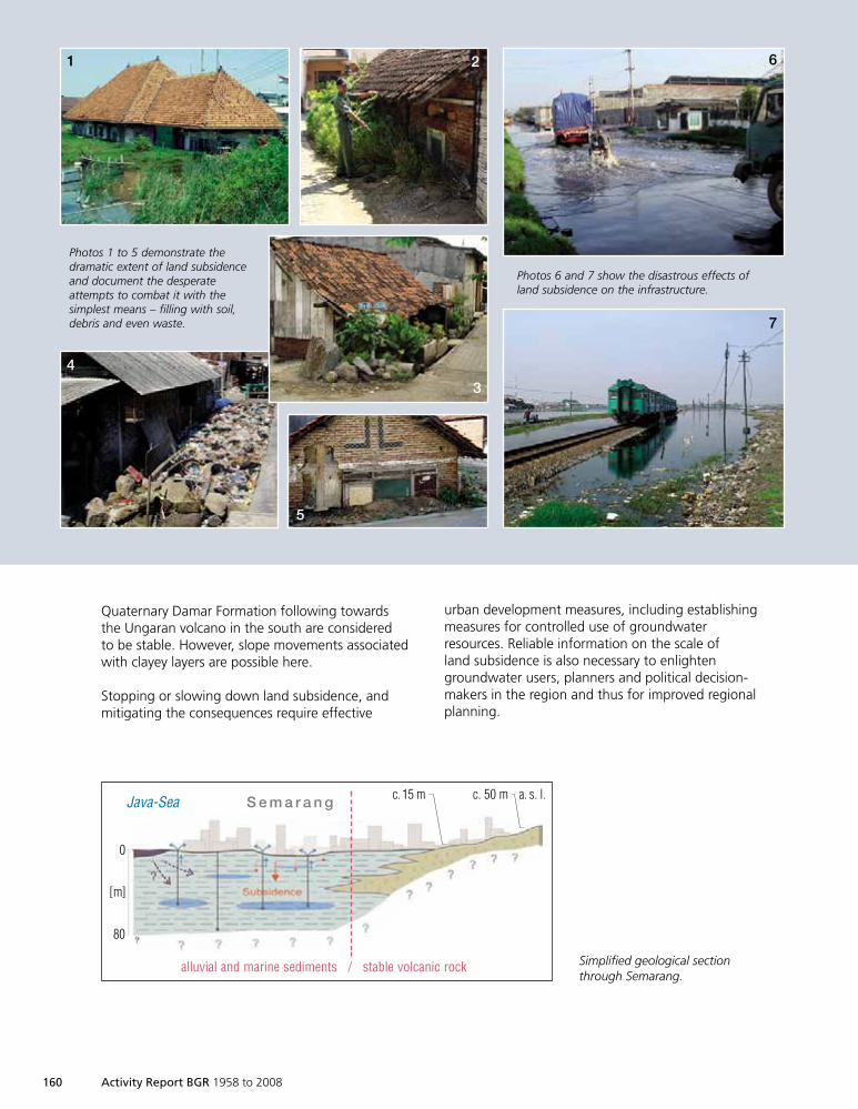
160 Activity Report BGR 1958 to 2008
Quaternary Damar Formation following towardsthe Ungaran volcano in the south are consideredto be stable. However, slope movements associatedwith clayey layers are possible here.
Stopping or slowing down land subsidence, andmitigating the consequences require effective
urban development measures, including establishingmeasures for controlled use of groundwaterresources. Reliable information on the scale ofland subsidence is also necessary to enlightengroundwater users, planners and political decision-makers in the region and thus for improved regionalplanning.
Photos 1 to 5 demonstrate thedramatic extent of land subsidenceand document the desperateattempts to combat it with thesimplest means – filling with soil,debris and even waste.
Photos 6 and 7 show the disastrous effects ofland subsidence on the infrastructure.
1 2
3
4
5
6
7
0
[m]
80
Java-Sea S e m a r a n g c.15 m c. 50 m a. s. l.
alluvial and marine sediments / stable volcanic rock Simplified geological sectionthrough Semarang.
1999so001d_147_164.indd 1601999so001d_147_164.indd 160 16.06.2009 09:27:1016.06.2009 09:27:10
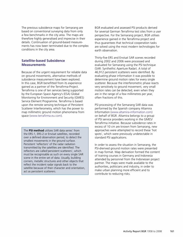
Activity Report BGR 1958 to 2008 161
The previous subsidence maps for Semarang arebased on conventional surveying data from onlya few benchmarks in the city area. The maps aretherefore highly generalised and imprecise in theirdetails. Continuation of ground-based measure-ments has now been terminated due to the complexconditions in the city area.
Satellite-based SubsidenceMeasurements
Because of the urgent requirement for reliable dataon ground movements, alternative methods ofsubsidence measurement have been explored.In this case, BGR benefitted from its experiencegained as a partner of the Terrafirma-Project.Terrafirma is one of ten services being supportedby the European Space Agency’s (ESA) GlobalMonitoring for Environment and Security (GMES)Service Element Programme. Terrafirma is basedupon the remote sensing technique of PersistentScatterer Interferometry, which has the power tomap millimetric ground motion phenomena fromspace (www.terrafirma.eu.com).
BGR evaluated and assessed PSI products derivedfor seversal German Terrafirma test sites from a userperspective. For the Semarang project, BGR utilisesexperience gained in the Terrafirma project andthus guarantees that technical cooperation tasksare solved using the most modern technologies forearth observation.
Thirty-five ERS and Envisat SAR scenes recordedduring 2002 and 2006 were processed andevaluated for Semarang using the PSI technique(SAR: Synthethic Aperture Radar). A total of46,912 persistent scatterers were identified. Byevaluating phase information it was possible todetermine ground motion rates for every singlescatterer. Because the interferometric phase reactsvery sensitively to ground movement, very smallmotion rates can be detected, even when theyare in the range of a few millimetres per year,often fractions of this.
PSI processing of the Semarang SAR data wasperformed by the Spanish company AltamiraInformation (www.altamira-information.com)on behalf of BGR. Altamira belongs to a groupof PSI service providers working in the GMES/Terrafirma initiative. Because subsidence rates inexcess of 10 cm are known from Semarang, newapproaches were attempted to record these ‘hotspots’, which were previously undetectable instandard PSI applications.
In order to assess the situation in Semarang, thePSI-drerived ground motion rates were presentedin map format. Map derivation formed the contentof training courses in Germany and Indonesiaattended by personnel from the Indonesian projectpartner. The maps were made available to theauthorities, politicians and industry, in order tomake urban planning more efficient and tocontribute to reducing risks.
The PSI method utilizes SAR data series’ fromthe ERS-1, ERS-2 or Envisat satellites, recordedover a defined observation period, to detect thesmallest movements in the ground surface.Persistent ‘reflectors’ of the radar radiationtransmitted by the satellites are identified. Thereflectors are called‘persistent scatterers’, whichmust be recognisable as such on every single SARscene in the entire set of data. Usually, buildingcorners, metallic structures and other objects thatreflect the incident radar signals back to thesatellite because of their character and orientation,act as persistent scatterers.
1999so001d_147_164.indd 1611999so001d_147_164.indd 161 16.06.2009 09:27:1116.06.2009 09:27:11
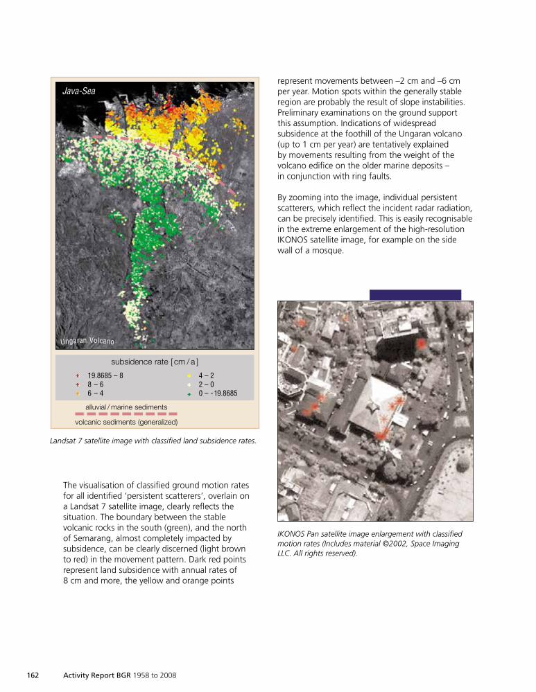
162 Activity Report BGR 1958 to 2008
The visualisation of classified ground motion ratesfor all identified ‘persistent scatterers’, overlain ona Landsat 7 satellite image, clearly reflects thesituation. The boundary between the stablevolcanic rocks in the south (green), and the northof Semarang, almost completely impacted bysubsidence, can be clearly discerned (light brownto red) in the movement pattern. Dark red pointsrepresent land subsidence with annual rates of8 cm and more, the yellow and orange points
represent movements between –2 cm and –6 cmper year. Motion spots within the generally stableregion are probably the result of slope instabilities.Preliminary examinations on the ground supportthis assumption. Indications of widespreadsubsidence at the foothill of the Ungaran volcano(up to 1 cm per year) are tentatively explainedby movements resulting from the weight of thevolcano edifice on the older marine deposits –in conjunction with ring faults.
By zooming into the image, individual persistentscatterers, which reflect the incident radar radiation,can be precisely identified. This is easily recognisablein the extreme enlargement of the high-resolutionIKONOS satellite image, for example on the sidewall of a mosque.
subsidence rate [ cm /a ]
19.8685 – 8 4 – 28 – 6 2 – 06 – 4 0 – -19.8685
alluvial / marine sediments
volcanic sediments (generalized)
Java-Sea
Ungaran Volcano
Landsat 7 satellite image with classified land subsidence rates.
IKONOS Pan satellite image enlargement with classifiedmotion rates (Includes material ©2002, Space ImagingLLC. All rights reserved).
1999so001d_147_164.indd 1621999so001d_147_164.indd 162 16.06.2009 09:27:1216.06.2009 09:27:12
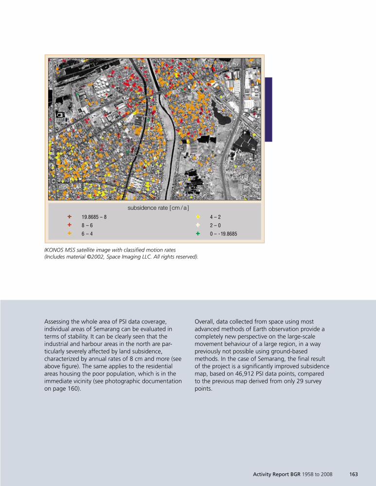
Activity Report BGR 1958 to 2008 163
Assessing the whole area of PSI data coverage,individual areas of Semarang can be evaluated interms of stability. It can be clearly seen that theindustrial and harbour areas in the north are par-ticularly severely affected by land subsidence,characterized by annual rates of 8 cm and more (seeabove figure). The same applies to the residentialareas housing the poor population, which is in theimmediate vicinity (see photographic documentationon page 160).
Overall, data collected from space using mostadvanced methods of Earth observation provide acompletely new perspective on the large-scalemovement behaviour of a large region, in a waypreviously not possible using ground-basedmethods. In the case of Semarang, the final resultof the project is a significantly improved subsidencemap, based on 46,912 PSI data points, comparedto the previous map derived from only 29 surveypoints.
subsidence rate [ cm /a ]
19.8685 – 8 4 – 2
8 – 6 2 – 0
6 – 4 0 – -19.8685
IKONOS MSS satellite image with classified motion rates(Includes material ©2002, Space Imaging LLC. All rights reserved).
1999so001d_147_164.indd 1631999so001d_147_164.indd 163 16.06.2009 09:27:1216.06.2009 09:27:12
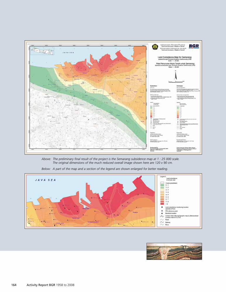
164 Activity Report BGR 1958 to 2008
Above: The preliminary final result of the project is the Semarang subsidence map at 1 : 25 000 scale.The original dimensions of the much reduced overall image shown here are 120 x 90 cm.
Below: A part of the map and a section of the legend are shown enlarged for better reading.
1999so001d_147_164.indd 1641999so001d_147_164.indd 164 16.06.2009 09:27:1316.06.2009 09:27:13
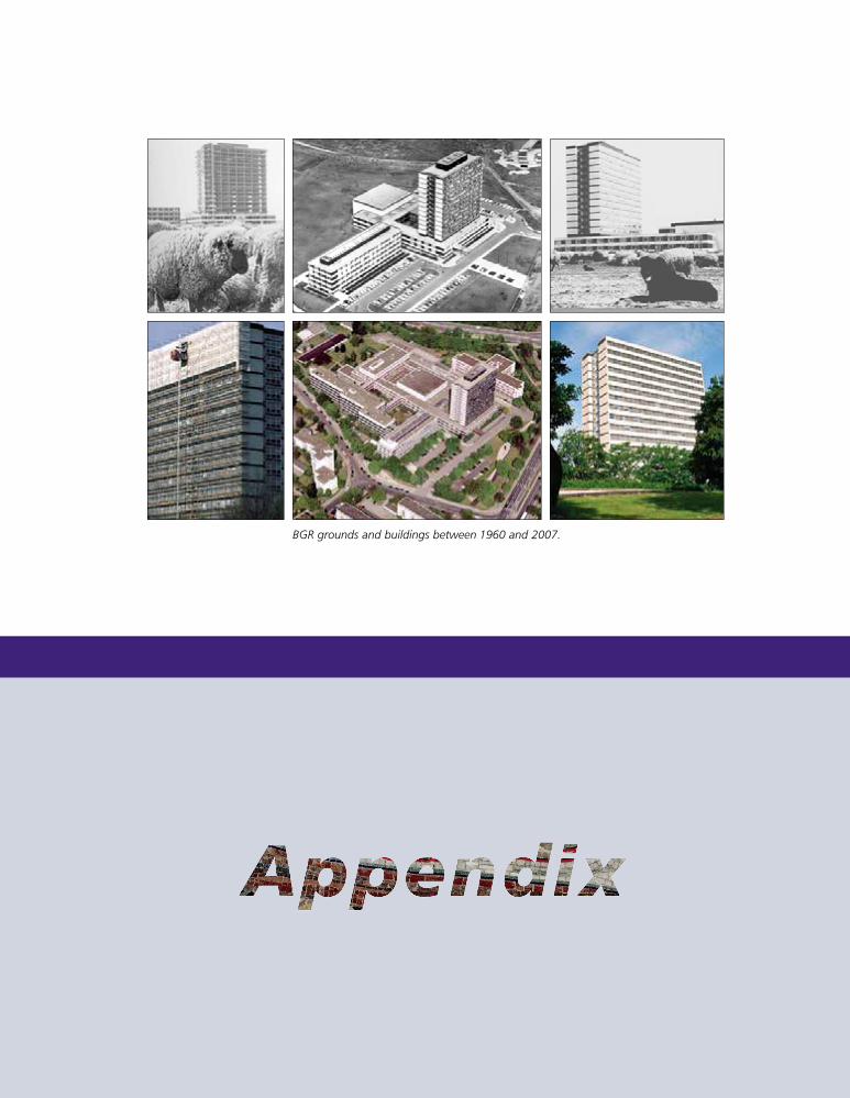
BGR grounds and buildings between 1960 and 2007.
1999so001d_165_178.indd 1651999so001d_165_178.indd 165 16.06.2009 09:31:4516.06.2009 09:31:45
166 Activity Report BGR 1958 to 2008
HANS-JOACHIM MARTINI
✸ 5. 1. 1908✙ 22. 10. 1969
GERHARD
RICHTER-BERNBURG
✸ 22. 2. 1907✙ 8. 3. 1990
ALFRED BENTZ
✸ 1897✙ 1964
1960
1965
1970
1975
1980MACHENS, as the
brother - in - law of theeconomics minister, was
appointed president in 1972 tothe accompaniment of staff protests.
After only a few days in office he offeredhis resignation, which was accepted.
ULRICH ENGELMANN was then appointed as astate commissioner by the Ministry for Economic Affairs
to deal with the interests of the BfB (now BGR) fromJanuary 1973 until February 1974.
EBERHARDMACHENS
✸ 1929
BGR from1958 until 2008,
its precursororganisations ...
Reich
sam
t für
Bode
nfor
schu
ng
Bund
esan
stal
t für
Bode
nfor
schu
ng
17.1.1975
Bundesanstalt für Geowissenschaften und Rohstoffe
... and
presidents
1999so001d_165_178.indd 1661999so001d_165_178.indd 166 16.06.2009 09:31:4716.06.2009 09:31:47

MARTIN KÜRSTEN
✸ 12. 10. 1931
BERNHARD STRIBRNY✸ 1952
ALFRED HOLLERBACH✸ 1942
temporarypresident from2006 until 2007
HANS -JOACHIMKÜMPEL
✸ 1950
FRIEDRICH BENDER
✸ 1924✙ 2008
FRIEDRICH-WILHELM
WELLMER
✸ 23. 6. 1940
1985
1990
1995
2000
2005
1999so001d_165_178.indd 1671999so001d_165_178.indd 167 16.06.2009 09:31:4916.06.2009 09:31:49
168 Activity Report BGR 1958 to 2008
Energy Resources
BUNDESANSTALT FÜR GEOWISSENSCHAFTEN UND ROHSTOFFE (2007): Reserven, Ressourcen und Verfügbarkeit von Energieroh-stoffen 2006 – Jahresbericht: 86 S., zahlr. graph. Darst.; Hannover.
CRAMER, B. & FRANKE, D. (2005): Indications for an active petroleum system in the Laptev Sea, NE Siberia. – Journal ofPetroleum Geology, 28, 4: 369–384; Oxford (Wiley-Blackwell).
FRANKE, D., HINZ, K. & REICHERT, C. (2004): Geology of the East Siberian Sea, Russian Arctic from seismic images:Structures, evolution and implications for the evolution of the Arctic Ocean Basin. – Journal of GeophysicalResearch, 109, 7: 1–19, Abb.; Washington – (No. B7, B07106, DOI: 10.1029/2003JB002687).
OBAJE, N. G., WEHNER, H., SCHEEDER, G., ABUBAKAR, M. B. & JAURO, A. (2004): Hydrocarbon prospectivity of Nigeria’sinland basins: From the viewpoint of organic geochemistry and organic petrology. – American Association ofPetroleum Geologists Bulletin, 88: 325–353, 3 Abb., 2 Tab.; Tulsa.
THIELEMANN, T., CRAMER, B., & SCHIPPERS, A. (2004): Coalbed methane in the Ruhr basin, Germany: A renewableenergy resource? – Organic Geochemistry, 35: 1537–1549, 5 Abb., 5 Tab; Oxford (Elsevier).
VANDRE, C., CRAMER, C., GERLING, P. & WINSEMANN, J. (2007): Natural gas formation in the western Nile delta (EasternMediterranean): Thermogenic versus microbial. – Organic Geochemistry, 38: 523–539; Oxford (Elsevier).
Mineral Resources
KOCKS, H., MELCHER, F., MEISEL, T. & BURGATH, H.-P. (2007): Diverse contributing sources to chromitite petrogenesis inthe Shebenik Ophiolitic Complex, Albania: Evidence from new PGE- and Os-isotope data. – Mineralogy andPetrology, 91: 139–170, 8 Abb., 2 Tab.; Wien.
GRAUPNER, T., KASSAHUN, A., RAMMLMAIR, D., MEIMA, J. A., KOCK, D., FURCHE, M., FIEGE, A., SCHIPPERS, A. & MELCHER, F.(2007): Formation of sequences of cemented layers and hardpans within sulfide-bearing mine tailings (minedistrict Freiberg, Germany). – Applied Geochemistry, 22: 2486–2508; Oxford.
KAUFHOLD, S., DOHRMANN, R. & ULRICHS, C. (2007): Shelf life stability of diatomites. – Applied Clay Science; Amsterdam– DOI: 10.1016/j.clay.2007.10.007.
BUNDESANSTALT FÜR GEOWISSENSCHAFTEN UND ROHSTOFFE in Zusammenarbeit mit den STAATLICHEN GEOLOGISCHEN DIENSTEN
(Hrsg.) (2007): Bodenschätze der Bundesrepublik Deutschland 1 : 1 000 000 (BSK 1000): 1 Kt. m. Erl.;Hannover.
Wellmer, F.-W., DALHEIMER, M. & WAGNER, M. (2008): Economic Evaluations in Exploration: 250 S., 54 Abb., 35 Tab.;Berlin (Springer).
References
1999so001d_165_178.indd 1681999so001d_165_178.indd 168 16.06.2009 09:31:4916.06.2009 09:31:49
Activity Report BGR 1958 to 2008 169
SCHIPERS, A., SAND, W., GLOMBITZA, F. & WILLSCHER, S. (Hrsg.) (2007): Biohydrometallurgy: From the single cell to theenvironment. – Advanced Materials Research, 20/21: 667 S.; Zürich (Trans Tech Publications).
Groundwater
HOUBEN, G. & WAGNER, F. (2007): Hyperfiltration of nickel sulphate solutions through silty sandstone and its effect onhydraulic conductivity. – Applied Geochemistry, 22, 9: 2029–2044, 14 Abb., 3 Tab., 2 Anl.; Oxford.
KLINGE, H., BOEHME, J., GRISSEMANN, C., HOUBEN, G., LUDWIG, R.-L., RÜBEL, A., SCHELKES, K., SCHILDKNECHT, F. & SUCKOW, A.(2007): Standortbeschreibung Gorleben – Teil 1: Die Hydrogeologie des Deckgebirges des Salzstocks Gorleben.– Geologisches Jahrbuch, C 71: 147 S., 59 Abb., 4 Tab., 1 Anl.; Stuttgart (Schweizerbart).
STRUCKMEIER, W. F., RICHTS, A., ACWORTH, I., ARDUINO, G., BOCANEGRA, E., CUNNINGHAM, W., DROUBI, A., DA FRANCA, N.,GILBRICH, W., GIRMAN, J., VAN DER GUN, J., KLINGBEIL, R., MARGAT, J., POITRINAL, D., PURI, S., RIVERA, A., SAFAR-ZITOUN,M., TUJCHNEIDER, O., VASAK, S., VRBA, J., WINTER, P., ZAEPKE, M., ZAISHENG, H.& ZEKSTER, I. (2006): GroundwaterResources of the World – Transboundary Aquifer Systems < 1 : 50 000 000 >: Special edition for the 4th WorldWater Forum, Mexico City, March 2006: 1 Kt., Erl.; Hannover (BGR).
TÜNNERMEIER, T., HOUBEN, G., TEUTEBERG, I. & HIMMELSBACH, T. (2006): Hydrogeologie des Kabul-Beckens (Afghanistan) –Teil I: Grundwasserleiter und Hydrologie. – Grundwasser, 11, 2: 65–75, 17 Abb.; Berlin (Springer).
MARGANE, A., HOBLER, M., ALMOMANI, M. & SUBAH, A. (2002): Contributions to the Hydrogeology of Northern andCentral Jordan. – Geologisches Jahrbuch, C 68: 52 S., 18 Abb., 11 Tab.; Stuttgart (Schweizerbart).
Soil
UTERMANN, J., MEYENBURG, G., ALTFELDER, S., GÄBLER, H.-E., DUIJNISVELD, W., BAHR, A. & STRECK, T. (2005): Entwicklungeines Verfahrens zur Quantifizierung von Stoffkonzentrationen im Sickerwasser auf der Grundlage chemischerund physikalischer Pedotransferfunktionen. – Endbericht BMBF-Forschungsvorhaben 02WP0206: 169 S.,65 Abb., 46 Tab.; Hannover (BGR).
MÖLLER, A., MÜLLER, H. W., ABDULLA, G., ABDELGAWAD, G. & UTERMANN, J. (2005): Urban soil pollution in Damascus,Syria: Contents and patterns of heavy metals in the soils of the Damascus Ghouta. – Geoderma 124: 63–71;Amsterdam.
ECKELMANN, W., BARITZ, R., BIALOUSZ, S., BIELEK, P., CARRÉ, F., HOUŠCOVÁ, B., JONES, R. J. A., KIBBLEWHITE, M., KOZAK, J.,LE BAS, C., TÓTH, G., TÓTH, T., VÁRALLYAY, G., YLI HALLA, M. & ZUPAN, M. (2006): Common Criteria for Risk AreaIdentification according to Soil Threats. – Research Report / European Soil Bureau, 20: 94 S., 18 Abb., 15 Tab.;Luxemburg (European Communities).
UTERMANN, J., DÜWEL, O. & NAGEL, I. (2006): Contents of trace elements and organic matter in European soils – Part II.– In: GAWLIK, B. M. & BIDOGLIO, G. (Hrsg.): Background values in European soils and sewage sludges – Results ofa JRC-coordinated study on background values: 45 S., 9 Abb., 15 Tab., 8 Anh.; Luxemburg (European Commu-nities).
ALTFELDER, S., DUIJNISVELD, W., STRECK, T., MEYENBURG, G. & UTERMANN, J. (2007): Quantifying the influence of uncer-tainty and variability on groundwater risk assessment for trace elements. – Vadose Zone Journal, 6, 3: 668–678,5 Abb., 4 Tab.; Madison/Wisconsin.
1999so001d_165_178.indd 1691999so001d_165_178.indd 169 16.06.2009 09:31:5016.06.2009 09:31:50
170 Activity Report BGR 1958 to 2008
RICHTER, A., ADLER, G. H., FAHRAK, M. & ECKELMANN, W. (2007): Erläuterungen zur nutzungsdifferenzierten Boden-übersichtskarte der Bundesrepublik Deutschland im Maßstab 1 : 1 000 000 (BÜK 1000 N, Version 2.3): 46 S.,4 Abb., 5 Tab., 3 Kt.; Hannover (BGR).
Geotechnical Stability
LANGER, M. (1967): Rheologie der Gesteine. Theoretische und experimentelle Untersuchungen über das rheologischeVerhalten von Gesteinsstücken und Gebirgskörpern als Grundlage für den Ansatz und die Auswertung felsme-chanischer und tektonischer Experimente. – In: LANGER, M. (1969): Rheologie der Gesteine und Gebirgskörperin Theorie und Praxis. – Zeitschrift der Deutschen Geologischen Gesellschaft, Jg. 1967, 119: 313–425, 48 Abb.,9 Tab.; Hannover.
FROST, H. J. & ASHBY, M. F. (1982): Deformation-mechanism Maps: 166 S.; Oxford (Pergamon).
ALBRECHT, H. & HUNSCHE, U. (1980): Gebirgsmechanische Aspekte bei der Endlagerung radioaktiver Abfälle in Salzdia-piren unter besonderer Berücksichtigung des Fließverhaltens von Steinsalz. – Fortschritte der Mineralogie, 58, 2:212–247; Stuttgart (Schweizerbart).
CRISTESCU, N. D. & HUNSCHE, U. (1998): Time effects in rock mechanics: 342 S., zahlr. graph. Darst.; Chichester (Wiley).
SCHULZE, O., HEEMANN, U., ZETSCHE, F., HAMPEL, A., PUDEWILLS, A., GÜNTHER, R.-M., MINKLEY, W., SALZER, K., HOU, Z., WOL-TERS, R., ROKAHR R. & ZAPF, D. (2007): Comparison of advanced constitutive models for the mechanical behaviorof rock salt – results from a joint research project. I. Modeling of deformation processes and benchmark calcu-lations. – In: WALLNER, M., LUX, K.-H., MINKLEY, W. & HARDY, JR., H. R. (Hrsg.): The Mechanical Behavior of Salt –Understanding of THMC Processes in Salt. Proceedings of the 6th Conference on the Mechanical Behaviour ofSalt ‘Saltmech6’, Hannover, May 2007: 77–88; London (Taylor & Francis).
Final Disposal
KLINGE, H., BOEHME, J., GRISSEMANN, CHR., HOUBEN, G., LUDWIG, R.-R., RÜBEL, A., SCHELKES, K., SCHILDKNECHT, F. & SUCKOW,A. (2007): Standortbeschreibung Gorleben – Teil 1: Die Hydrogeologie des Deckgebirges des Salzstocks Gorle-ben. – Geologisches Jahrbuch, C 71: 147 S., 59 Abb., 4 Tab., 1 Anl.; Stuttgart (Schweizerbart).
KÖTHE, A., HOFFMANN, N., KRULL, P., ZIRNGAST, M. & ZWIRNER, R. (2007): Standortbeschreibung Gorleben – Teil 2: DieGeologie des Deck- und Nebengebirges des Salzstocks Gorleben. – Geologisches Jahrbuch, C 72: 201 S.,42 Abb., 19 Tab.; Stuttgart (Schweizerbart).
HOTH, P., WIRTH, H., REINHOLD, K., BRÄUER, V., KRULL, P. & FELDRAPPE, H. (2007): Untersuchung und Bewertung vonTongesteinsformationen: Endlagerung radioaktiver Abfälle in tiefen geologischen Formationen Deutschlands:118 S.; Hannover (BGR).
FAHLAND, S., HEUSERMANN, S., EICKEMEIER, R., NIPP, H.-K. & PREUSS, J. (2007): Three-dimensional geomechanical model-ling of old mining rooms in the central part of the Bartensleben salt mine. – In: WALLNER, M., LUX, K.-H., MINK-LEY, W. & HARDY, JR., H. R. (Hrsg.): The Mechanical Behavior of Salt – Understanding of THMC Processes in Salt.Proceedings of the 6th Conference on the Mechanical Behaviour of Salt ‘Saltmech6’, Hannover, May 2007:337–344; London (Taylor & Francis).
GÖBEL, I., ALHEID, H.-J., ALONSO, E., AMMON, CH., BOSSART, P., BÜHLER, CH., EMMERICH, K., FERNANDEZ, A. M., GARCÍA-SINERIZ, J. L., GRAF, A., JOCKWER, N., KAUFHOLD, ST., KECH, M., KLUBERTANZ, G., LLORET, A., MAYOR, J. C., MEYER, T.,MIEHE, R., MUNOZ, J. J., NAUMANN, M., NUSSBAUM, C., PLETSCH, TH., PLISCHKE, I., PLOETZE, M., REY, M., SCHNIER, H.,
1999so001d_165_178.indd 1701999so001d_165_178.indd 170 16.06.2009 09:31:5016.06.2009 09:31:50
Activity Report BGR 1958 to 2008 171
SCHUSTER, K., SPRADO, K., TRICK, TH., WEBER, H., WIECZOREK, K. & ZINGG, A. (2007): Heater Experiment: Rock andbentonite thermo-hydro-mechanical (THM) processes in the near field of a thermal source for development ofdeep underground high level radioactive waste repositories. – In: BOSSART, P. & NUSSBAUM, C. (Hrsg.): Mont TerriProject – Heater Experiment, Engineered Barriers Emplacement and Ventilation Tests. – Reports of the SwissGeological Survey, 1: 7–114; Wabern/Schweiz.
SPIES, T. & EISENBLÄTTER, J. (2001): Acoustic emission investigation of microcrack generation at geological boundaries.– Engineering Geology, 61: 181–188; Amsterdam (Elsevier).
Geological Hazards
BUNDESANSTALT FÜR GEOWISSENSCHAFTEN UND ROHSTOFFE (Hrsg.) (1995–2005): Handbuch zur Erkundung des Untergrundesvon Deponien – Band 1: Geofernerkundung, Band 2: Strömungs- und Transportmodellierung, Band 3: Geophy-sik, Band 4: Geotechnik – Hydrogeologie, Band 5: Tonmineralogie und Bodenphysik, Band 6: Geochemie, Band7: Handlungsempfehlungen für die Erkundung der geologischen Barriere bei Deponien und Altlasten, Band 8:Erkundungspraxis; Berlin (Springer).
HOFFMANN-ROTHE, A., IBS-VON SEHT, M., KNIESS, R., FABER, E., KLINGE, K., REICHERT, C., PURBAWINATA, M. A. & PATRIA, C.(2006): Monitoring Anak Krakatau Volcano in Indonesia. – EOS, Transactions of American Geophysical Union,87, 51: 585–586, 2 Abb., 1 Tab.; Washington.
LADAGE, S., WEINREBE, W., GAEDICKE, C., BARCKHAUSEN, U., FLÜH, E., HEYDE, I., KRABBENHÖFT, A., KOPP, H., FAJAR, S. &DJAJADIHARDJA, Y. (2006): Bathymetric Survey Images Structure off Sumatra. – EOS, Transactions of AmericanGeophysical Union, 87, 17: 165–172, 2 Abb.; Washington.
LEYDECKER, G., SCHMITT, T. & BUSCHE, H. (2006): Erstellung ingenieurseismologischer Gutachten für Standorte miterhöhtem Sekundärrisiko auf der Basis des Regelwerks KTA 2201.1 – Leitfaden: 58 S., 16 Abb., 4 Tab., 2 Anh.;Hannover (BGR).
LEYDECKER, G., SCHMITT, T. & BUSCHE, H. & SCHAEFER, TH. (2008): Seismo-engineering parameters for sites of interimstorages for spent nuclear fuel at German nuclear power plants. – Soil Dynamics and Earthquake Engineering28/9, pp. 754–762, 4 fig., 3 tab.; (Elsevier) – DOI 10.1016/j.soildyn.2007.10.007.
SIMEONOVA, S., SOLAKOV, D., LEYDECKER, G., BUSCHE, H., SCHMITT, T. & KAISER, D. (2006): Probabilistic seismic hazard mapfor Bulgaria as a basis for a new building code. – Natural Hazards and Earth System Sciences, 6: 881–887,7 Abb., 1 Tab.; Katlenburg-Lindau (Copernikus).
WEINLICH, F., FABER, E., BOUŠKOVÁ, A., HORÁLEK, J., TESCHNER, M. & POGGENBURG, J. (2006): Seismically induced variationsin Mariánské Lázne fault gas composition in the NW Bohemian swarm quake region, Czech Republic – A conti-nous gas monitoring. – Tectonophysics, 421: 89–110, 14 Abb.; Amsterdam (Elsevier).
Seismological Research/Comprehensive Nuclear Test Ban Treaty
DAHM, T., KRUEGER, F., STAMMLER, K., KLINGE, K., KIND, R., WYLEGALLA, K. & GRASSO, J.-R. (2007): The 2004 Mw 4.4Rotenburg, Northern Germany, Earthquake and Its Possible Relationship with Gas Recovery. – Bulletin of theSeismological Society of America, 97, 3: 691–704, 13 Abb., 4 Tab.; El Cerrito/Kalifornien.
EVERS, L. G., CERANNA, L., HAAK, H. W., LE PICHON, A. & WHITAKER, R. W. (2007): A seismoacoustic analysis of thegas-pipeline explosion near Ghislenghien in Belgium. – Bulletin of the Seismological Society of America, 97,2: 417–425, 9 Abb., 2 Tab.; El Cerrito/Kalifornien.
1999so001d_165_178.indd 1711999so001d_165_178.indd 171 16.06.2009 09:31:5016.06.2009 09:31:50
172 Activity Report BGR 1958 to 2008
THORNE, M. S., LAY, T., GARNERO, E. J., JAHNKE, G. & IGEL, H. (2007): Seismic imaging of the laterally varying D” regionbeneath the Cocos Plate. – Geophysical Journal International, 170, 2: 635–648, 9 Abb., 2 Tab.; Oxford (Blackwell).
WEGLER, U. & SENS-SCHOENFELDER, C. (2007): Fault zone monitoring with passive image interferometry. – GeophysicalJournal International, 168, 3: 1029–1034, 4 Abb.; Oxford (Blackwell).
LE PICHON, A., VERGOZ, J., HERRY, P. & CERANNA, L. (2008): Analyzing the detection capability of infrasoundarrays in Central Europe. – Journal of Geophysical Research, 113: 8 S., 4 Abb.; Washington – DOI:10.1029/2007JD009509.
Climate Change
BERNER, U. & STREIF, H.-J. (2004): Klimafakten: 259 S., 286 Farbabb.; Stuttgart (Schweizerbart).
DELISLE, G. (2007): Near-surface permafrost degradation: How severe during the 21st century? – GeophysicalResearch Letters, 34; Washington – DOI: 10.1029/2007GL029323.
DELISLE, G., GRASSMANN, ST., CRAMER, B., MESSNER, J. & WINSEMANN, J. (2007): Estimating episodic permafrost develop-ment in northern Germany during the Pleistocene. – In: HAMBREY, M. et al. (Hrsg.): Glacial Sedimentary Proces-ses and Products, Special Publication, 39: 109–119; Oxford (Blackwell).
JAESCHKE, A., RÜHLEMANN, C., ARZ, H., HEIL, G. & LOHMANN, G. (2007): Coupling of millennial-scale changes in seasurface temperature and precipitation off northeastern Brazil with high-latitude climate shifts during the lastglacial period. – Paleoceanography, 22; Washington – (PA4206, DOI: 10.1029/2006PA001391).
CALMELS, F., DELISLE, G. & ALLARD, M. (2008): Internal structure and the thermal and hydrological regime of a lithalsa:Significance for permafrost growth and decay. – Canadian Journal of Earth Sciences, 45: 31–43; Ottawa.
Geological Fundamentals
ASCH, K. (2003): The 1 : 5 Million International Geological Map of Europe and Adjacent Areas: Development andImplementation of a GIS-enabled Concept. – Geologisches Jahrbuch Sonderhefte, SA 3: 190 S., 45 Abb., 46Tab., 1 Kt.; Stuttgart (Schweizerbart).
BALDSCHUHN, R., BINOT, F., FLEIG, S. & KOCKEL, F. (2001): Geotektonischer Atlas von Nordwest-Deutschland und demdeutschen Nordsee-Sektor. – Geologisches Jahrbuch, A 153: 88 S., 3 CD; Stuttgart (Schweizerbart).
DAMASKE, D. & DÜRBAUM, H.-J. (Hrsg.) (1989): German Antarctic North Victoria Land Expedition 1984/85. – Geologi-sches Jahrbuch, E 38: 522 S., 4 Kt.; Stuttgart (Schweizerbart).
JORDAN, H. & SIEMON, B. (2002): Die Tektonik des nordwestlichen Harzrandes – Ergebnisse der Hubschrauber-Elektro-magnetik. – Zeitschrift der deutschen geologischen Gesellschaft, 153, 1: 31–50, 9 Abb., 2 Tab.; Stuttgart.
TESSENSOHN, F. (Hrsg.) (2001): Intra-Continental Fold Belts – CASE 1: West Spitsbergen. Polar Issue No. 7. – Geologi-sches Jahrbuch, B 91: 773 S., 237 Abb., 28 Tab., 37 Taf., 1 Kt.; Stuttgart (Schweizerbart).
1999so001d_165_178.indd 1721999so001d_165_178.indd 172 16.06.2009 09:31:5016.06.2009 09:31:50
Activity Report BGR 1958 to 2008 173
Geoscientific Cooperation
KOCKEL, F. (1974): Final Report of the German Geological Mission in Uganda 1970–1973; Hannover (BGR – unveröff.Archivber. 0067325).
BENDER, F. (1974): Geology of Jordan: 196 S., zahlr. graph. Darst.; Berlin (Borntraeger).
MARGANE, A., HOBLER, M., ALMOMANI, M., & SUBAH, A. (2002): Contributions to the hydrogeology of Northern andCentral Jordan. – Geologisches Jahrbuch, C 68: 3–51; Stuttgart (Schweizerbart).
RANKE, U. (1998): Die Geologie in der Entwicklungszusammenarbeit, Ziele und Schwerpunkte – und die Praxis ausSicht der Durchführungsorganisation BGR. – Zeitschrift für Angewandte Geologie, 44, 2: 67–72, 4 Abb.;Stuttgart (Schweizerbart).
RANKE, U. (1998): ZOPP: A reliable instrument for planning of geoscientific cooperation projects. – Zeitschrift fürAngewandte Geologie, 44, 2: 73–77, 3 Abb., 5 Tab.; Stuttgart (Schweizerbart).
WIRAKUSUMAH, A. D., HARDOYO, RANKE, U. & TRIUTOMO, S. (Hrsg.) (2004): Mitigation of geohazards in Indonesia: A sta-tus report on the project „Civil-society and inter-municipal cooperation for better urban services – Mitigation ofGeohazards: A contribution to the World Conference on disaster reduction, Kobe/Japan, January 2005: 59 S.,39 Abb., 13 Tab.; Hannover (BGR).
KNÖDEL, K., LANGE, G. & VOIGT, H.-J. (2007): Environmental Geology – Handbook of Field Methods and Case Studies:1357 S., 501 Abb., 204 Tab.; Berlin (Springer).
KÜHN, F., MARGANE, A., TATONG, T. & WEVER, T. (2004): InSAR-based land subsidence map for Bangkok, Thailand. –Zeitschrift für angewandte Geologie, 50, 1: 74–81; Stuttgart (Schweizerbart).
Technical Infrastructure
EHLING, A. (2007): Eigenschaften, Abbau und Verwendung schlesischer Bausandsteine – Ein aktueller Vergleich mitder Historie. – Zeitschrift der Deutschen Gesellschaft für Geowissenschaften, 158, 3: 351–360, 3 Tab., 2 Taf.;Stuttgart.
HORATSCHEK, S., SCHUBERT, TH. (1998): Richtlinie für die Verfasser geowissenschaftlicher Veröffentlichungen: Emp-fehlungen zur Manuskripterstellung von Text, Abbildungen, Tabellen, Tafeln, Karten: 51 S., 17 Tab.; Stuttgart(Schweizerbart).
KÖTHE, A. & PIESKER, B. (2007): Stratigraphic distribution of Paleogene and Miocene dinocysts in Germany. – RevuePaléobiologie, 26, 1: 1–39, 2 Abb., 15 Tab.; Genf.
KÜHN, F., SCHÄFFER, U., HOFFMANN-ROTHE, A. & COOKSLEY, G. (2007): Remote Sensing to Support Management ofGeorisks in Indonesia. – ESA: 2007 International Geohazards Week, Frascati, November 2007: – (http://earth.esa.int/workshops/2007Geohazards/programme.html).
KÜHN, F., KING, T., HOERIG, B., & PETERS, D. (2000): Remote Sensing for Site Characterization: 211 S., 117 Abb.,11 Tab.; Berlin (Springer).
ANDRULEIT, H., GEISEN, M. & STÄGER, S. (2006): Stereomicroscopy of coccolithophores – modern applications forimaging and morphological analysis. – Journal of Nannoplankton Research, 28, 1: 1–16, 2 Abb., 12 Taf.;Cambridge.
1999so001d_165_178.indd 1731999so001d_165_178.indd 173 16.06.2009 09:31:5016.06.2009 09:31:50
174 Activity Report BGR 1958 to 2008
Dr. Gert Adler, Dr. Kristine Asch, Dr. Roland Bäumle, Dr. Dirk Balzer, Dr. Volkmar Bräuer,Dr. Manfred Birke, Dimitry Chizhov, Dr. Bernhard Cramer, Dr. Volkmar Damm, Georg Delisle,Dr. Olaf Düwel, Dr. Wilhelmus Duijnisveld, Dr. Wolf Eckelmann, Dr. Angela Ehling,Dr. Solveig Estrada, Dr. Sandra Fahland, Dr. Dieter Franke, Dr. Joachim Gersemann,Dr. Nicolai Gestermann, Dr. Siegfried Greinwald, Dr. Christoph Grissemann, Bettina Grabsch,Fabian Helms, Dr. Andreas Günther, Manfred Henger, Dr. Carmen Heunisch,Prof. Dr.-Ing. Stefan Heusermann, Dr. Karl Hinz, Michael Hofmann, Marion Iranee,Dr. Stefan Kaufhold, Dr. Klaus-Dieter Klinge, Klaus Krause, Dr. Martin Krüger, Dr. Friedrich Kühn,Dr. Dirk Kuhn, Bettina Landsmann, Dr. Günter Leydecker, Dr. Armin Margane,Dr. Andreas-Alexander Maul, Dr. Frank Melcher, Dr. Uwe Meyer, Sabine Mrugalla, Dr. Sönke Neben,Dr. Karsten Piepjohn, Dr. Thomas Plenefisch, Dr. Dieter Rammlmair, Dr. Christian Reichert,Dr. Lutz Reinhardt, Hilmar Rempel, Dr. Frauke Schäfer, Dr. Axel Schippers, Gerhard Schmidt,Kerstin Schmitz, Thomas Schröder, Dr. Otto Schulze, Hans-Joachim Sturm,Dr. Thomas Thielemann, Dr. Jens Utermann, Dr. Jürgen Vasters, Dr. Markus Wagner,Dr. Wolfgang Weiss, Dr. Anja Wittenberg.
Authors
1999so001d_165_178.indd 1741999so001d_165_178.indd 174 16.06.2009 09:31:5016.06.2009 09:31:50
Activity Report BGR 1958 to 2008 175
Roland BäumleRoland Bäumle (p. 60), Dirk BalzerDirk Balzer (p. 98, 101), FFranz Bökerranz Böker (p. 94), Marc BrockmannMarc Brockmann (p. 73),L. ChinjengeL. Chinjenge (p. 61), Georg DelisleGeorg Delisle (p. 121), Wilhelmus DuijnisveldWilhelmus Duijnisveld (p. 66, 67), Jürgen FritschJürgen Fritsch (p. 49),Werner von GosenWerner von Gosen (p. 139), Lothar HahnLothar Hahn (p. 44), Wolfgang HeimbachWolfgang Heimbach (p. 52),Fabian HelmsFabian Helms (p. 104, 105), Manfred HengerManfred Henger (p. 111), Malte Ibs-von SehtMalte Ibs-von Seht (p. 93),Hans KlingeHans Klinge (p. 58/59), Dagmar KockDagmar Kock (p. 44), Friedrich KroneFriedrich Krone (p. 65),Bettina LandsmannBettina Landsmann (p. 86), Armin MarganeArmin Margane (p. 51), Frank MelcherFrank Melcher (p. 44),Christoph NeukumChristoph Neukum (p. 58/59, 61), Thomas OberthürThomas Oberthür (p. 32), Karsten PiepjohnKarsten Piepjohn (p. 136, 137),Dieter PlöthnerDieter Plöthner (p. 52), Simone RöhlingSimone Röhling (p. 31, 32), Norbert W. RolandNorbert W. Roland (p. 128),Axel SchippersAxel Schippers (p. 45), Gerhard SchmidtGerhard Schmidt (p. 49, 54, 56), Ulrich Schwarz-SchamperaUlrich Schwarz-Schampera (p. 33),Maria Alexandrovna SitnikovaMaria Alexandrovna Sitnikova (p. 39), Sylvia SörgelSylvia Sörgel (p. 47, 48), Sara Ines VassoloSara Ines Vassolo (p. 56),NWASCONWASCO (p. 61), Antje WolffAntje Wolff (p. 89, 90), Friedrich WolffFriedrich Wolff (p. 36).
The majority of the photographs were taken by WOLFGANG HAKE, photographer in B/LZ.8. Other photographswithout references were taken by members of staff and former GEOZENTRUM HANNOVER photographers.
The editorial committee thanks the photographers and staff for their support.
Picture references
1999so001d_165_178.indd 1751999so001d_165_178.indd 175 17.06.2009 12:53:5117.06.2009 12:53:51

1999so001d_165_178.indd 1761999so001d_165_178.indd 176 16.06.2009 09:31:5116.06.2009 09:31:51
© Bundesanstalt für Geowissenschaften und Rohstoffe (2008)
Editorial committee (and authors)
DR. HARALD ANDRULEIT (B1.23), DR. LARS CERANNA (B3.11),DR. INGO HEYDE (B3.15), DR. RAINER HOFFMANN (B4.25),DR. ANGELIKA KÖTHE (B3.25), BETTINA LANDSMANN (B2.3),FRANZ PLATTETSCHLÄGER (BZ.6), DR. ULRICH RANKE (B1.11),DR. SIMONE RÖHLING (B1.22), DR. THOMAS SCHUBERT (BZ.8),DR. FRANK WAGNER (B1.17), MARKUS ZAEPKE (B1.16).
Editorial office
DR. THOMAS SCHUBERT, REINHARD DÖRGE, RUTH HEISE,SIEGFRIED PIETRZOK und HANS-JOACHIM STURM.
Print and production
Druckhaus Thomas Müntzer GmbHNeustädter Str. 1–499947 Bad Langensalza
Imprint
www.bgr.bund.de
1999so001d_165_178.indd 1771999so001d_165_178.indd 177 16.06.2009 09:31:5116.06.2009 09:31:51
$("!%(*")&(*' #!*%
On 20 February 2006 the UN General Assembly decla-red 2008 to the International Year of Planet Earth(IYPE). Numerous events and interdisciplinary projects
at both national and international levels are planned to emphasise theimportance and benefits of modern geosciences for society and sustai-nable development.
IYPE is supported worldwide by numerous partners and sponsors,including all professional, international scientific associations. Thisto-date largest and globally unique geoscientific initiative incorporatesall geoscientific communities. The events and projects extend over atotal period of three years (2007–2009).
1999so001d_165_178.indd 1781999so001d_165_178.indd 178 16.06.2009 09:31:5116.06.2009 09:31:51
50 Years BGRan Activity Report
50
Years
BG
R
Bundesanstalt für Geowissenschaften und RohstoffFederal Institute for Geosciences and Natural Resouces
bgr.bund.de
19582008
Bund
esan
stal
tfü
rG
eow
isse
nsch
afte
nun
dRo
hsto
ffe
ISSN 0343-8147
FI (J6>7IJ$A$?) <7J.7IJ$AV#A#+ 80=#G$76A' +)5,7<&3F.6>EI#9 !J$+O E69V#A#+ H2/?.+; H11 I#9 (JV7+97+VV+C7AA>),2>9>"=>BD>E5<1&
<7J.7IJ$AN 6A. E69$JV7+97+VV+ K:;JT JA. I69 97?> !J$+
!
<7J.7IJ$AV#A#+ K :;JT V#A+ 80
D+VV+
"J99+V
E+;V#A
@+#A+
1$
<67+V97;J&+
%T(+#.XJT
>+B6V+AXJT>
5+#.+7?;NX;+#9+V
F" (JAALNE6G$$?VP
F< (JAALN!J$+
F< FV73J;TNI0G$+A
F<E6;'.)L
F"(JAA?4+;NS97
+-:/+?*$(@%;#'
<7#VV+3+'
<LN(+.#AN<7;J&+
*=S<<NE8D((S!R
W%<E8=*
F!:5F=WE-D(BU
!F(B
CM$;+A
-76>
H2/
,V6'$J)+A(JAA?4+;N!JA'+A$J'+A
1+
1*$
0*
(JTI6;'C?;7T6A.
(JAAL W#77+6A. (I)L
<7;J&+
@?.I#+
V9X#N
97;J&+
(JAA?4+;
0%'
*;?&NE6G$$?VP+
; <7;J&+"
V#A'+;97;L
<G$#+;$
?VPN
97;J&+
=?.+;I;6G$97;J&+
E6;'.?;)
F"(JAALN"#;G$$?;97
F< (JAALNFA.+;7+A
W((
FUCB=:BU
U(J
AAL
E6G$$?VP+; <7;L
(M4+;9G$+
<7;L
7!,,&64
653)4
85356
!
4
/-).2"3&66(&#
7&..&4 .2"3
&664
(&#
@J97+
6 ; N
JV V++
*;?&NE
6G$$L "#;G$3+'
C7AA>),2>9>"C7AA>),2>9>"C7AA>),2>9>"=>BD>E5<1&=>BD>E5<1&=>BD>E5<1&
80
80
FV);+.NFV);+.NFV);+.NE+A7PN(J69E+A7PN(J69E+A7PN(J69
H11
H11
F< (JAALNF< (JAALNF< (JAALNW#9I6;'W#9I6;'W#9I6;'
$#!
%$%
"%
H2/
H2/ H11
,;?T TJ#A ;J#V3JQ 97J7#?AO 7JX+ 7;JT A?L 80.#;+G7#?A +)5,7<&3F.6>E7? !J$+O JA. 7$+A I69 H2/ ?; H11OI69 97?>C7AA>),2>9>"=>BD>E5<1&
E69$JV7+97+VV+ K E69 97?>@J>>+V3#+9+K*+?P+A7;6T
4
E69V#A#+ K E69 V#A+
… you canfind us here