2017 capacity building calendar year summary contents
TRANSCRIPT
NASA Earth Science • Applied Sciences Program: Capacity Building 2017 Annual Summary
2017 Capacity Building Calendar Year Summary
Contents I. Introduction ................................................................................................................................ 1
Element & Initiative Descriptions ............................................................................................. 1
II. 2017 Overview ........................................................................................................................... 2
III. Accomplishments & Highlights ............................................................................................... 3
Programmatic Accomplishments ........................................................................................... 3
Highlight Events & Activities ..................................................................................................... 4
IV. Community Engagement ...................................................................................................... 8
Community Leadership ............................................................................................................ 8
Enhancing Data Accessibility.................................................................................................. 9
Relationship Brokering ............................................................................................................ 10
V. 2017 CBP Portfolio .................................................................................................................. 11
VI. Geographic Reach .............................................................................................................. 12
Geographic Coverage of Activities .................................................................................... 12
Americas............................................................................................................................... 14
Asia and Oceania ............................................................................................................... 14
Africa ..................................................................................................................................... 17
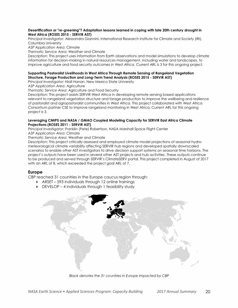
Europe ................................................................................................................................... 20
Commonwealth of Independent States (CIS) ................................................................ 21
VII. Program Management ....................................................................................................... 21
Management Team ............................................................................................................... 21
Strategic Planning ................................................................................................................... 21
Program Assessment ............................................................................................................... 23
Indicator Tracking ............................................................................................................... 23
Strategic Targets .................................................................................................................. 24
Project Progress Tracking ................................................................................................... 25
Internal Collaborative Activities ............................................................................................ 26
VIII. Looking Ahead .................................................................................................................... 26
IX. Appendix ................................................................................................................................ 28
NASA Earth Science • Applied Sciences Program: Capacity Building 2017 Annual Summary 1
I. Introduction The Earth Science Division’s (ESD) Applied Sciences Program (ASP) promotes efforts to discover
and demonstrate innovative and practical applications of Earth observations. ASP activities
partner with organizations from the public and private sectors to apply scientific findings and
satellite data in their decision-making activities. The Program has three primary lines of business:
Applications, Capacity Building, and Mission Planning. All Program activities support goals to
deliver near-term uses of Earth observations, build capabilities to apply Earth science data, and
contribute to satellite mission planning.
The Applied Sciences’ Capacity Building Program (CBP) builds capacity within the United States
and the developing world to expand the Earth-observations user base, and increase the
awareness within non-traditional audiences of NASA Earth observations data and products. CBP
engages across the ASP Application Areas portfolios of Water Resources, Disasters, Ecological
Forecasting, and Health & Air Quality, as well as other application areas including Agriculture &
Food Security, Energy, Urban Development, and Transportation & Infrastructure.
The Capacity Building Program works through both program and element activities. Program
activities include participating in both domestic and international capacity building groups,
such as the Group on Earth Observations (GEO) and the Committee on Earth Observation
Satellites (CEOS), as well as identifying partnership opportunities to reach new end-users like the
Indigenous Peoples Initiative and the creation of an interactive mapper. The program supports
three Elements, including Applied Remote Sensing Training (ARSET), DEVELOP, and SERVIR, along
with initiatives focused on building capacity to use Earth observations of indigenous peoples in
North America and the creation of an interactive mapper for tracking and outreach activities.
Element & Initiative Descriptions ARSET empowers the global community through remote-sensing trainings. Through online and in-
person trainings, participants learn how to use NASA Earth data, applications, and models.
Participants can then apply these free resources to environmental management and decision
support. Trainings are intended for policymakers, non-governmental organizations (NGOs), and
other applied science professionals. To access the training materials, join the listserv, and learn
about upcoming activities, please visit http://arset.gsfc.nasa.gov/.
DEVELOP addresses environmental and public policy issues by conducting interdisciplinary
feasibility projects that apply the lens of NASA Earth observations to community concerns
around the globe. Bridging the gap between NASA Earth Science and society, DEVELOP
provides workforce development opportunities for both participants and partner organizations
to better prepare them to address the challenges that face our society and future generations.
With the competitive nature and growing societal role of science and technology in today’s
global workplace, DEVELOP is fostering an adept corps of tomorrow’s applied scientists and
leaders. To learn more about DEVELOP, view previous projects, and propose a project idea,
please visit http://develop.larc.nasa.gov/.
SERVIR, a joint development initiative of NASA and USAID, works in partnership with leading
regional organizations around the globe to help developing countries use information provided
by Earth-observing satellites and geospatial technologies for managing environmental risks and
land use. SERVIR empowers decision makers with tools, products, and services to improve
awareness and increase access to Earth observations and geospatial data in Eastern & Southern
NASA Earth Science • Applied Sciences Program: Capacity Building 2017 Annual Summary 2
Africa, West Africa, Hindu Kush-Himalaya, and Lower Mekong. For more information about
SERVIR and its network of regional hubs, visit www.servirglobal.net/.
The Indigenous Peoples Initiative aims to provide remote sensing training, mentoring, and
research opportunities to the indigenous community. A key programmatic goal is the co-
production of place-based trainings where participants have the opportunity to address specific
natural resource research and management issues facing their tribal lands. As the program
continues to grow, we aim to increase our incorporation of Traditional Ecological Knowledge
(TEK) into technical methods and to develop trainings tailored to thematic areas of interest to
specific tribes. Engagement and feedback are encouraged to refine our approaches to
increase capacity within the indigenous community to utilize NASA Earth Observations.
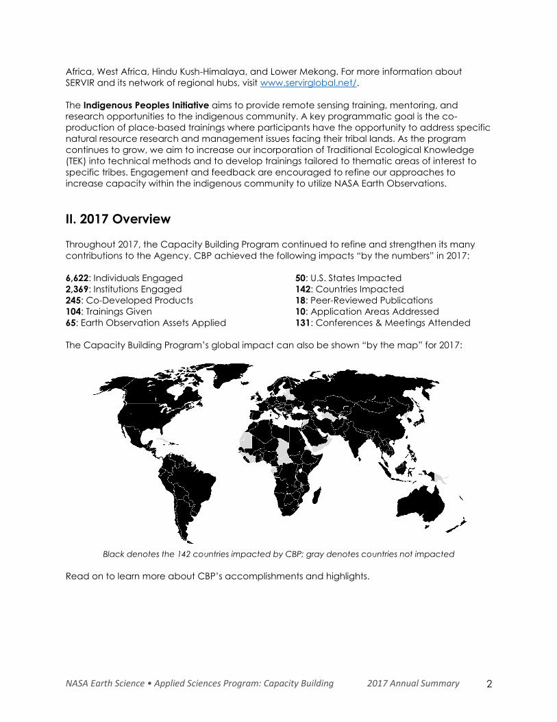
II. 2017 Overview Throughout 2017, the Capacity Building Program continued to refine and strengthen its many
contributions to the Agency. CBP achieved the following impacts “by the numbers” in 2017:
6,622: Individuals Engaged
2,369: Institutions Engaged
245: Co-Developed Products
104: Trainings Given
65: Earth Observation Assets Applied
50: U.S. States Impacted
142: Countries Impacted
18: Peer-Reviewed Publications
10: Application Areas Addressed
131: Conferences & Meetings Attended
The Capacity Building Program’s global impact can also be shown “by the map” for 2017:
Black denotes the 142 countries impacted by CBP; gray denotes countries not impacted
Read on to learn more about CBP’s accomplishments and highlights.
NASA Earth Science • Applied Sciences Program: Capacity Building 2017 Annual Summary 3
III. Accomplishments & Highlights
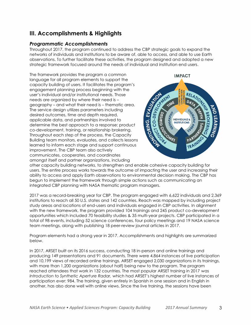
Programmatic Accomplishments Throughout 2017, the program continued to address the CBP strategic goals to expand the
networks of individuals and institutions to be aware of, able to access, and able to use Earth
observations. To further facilitate these activities, the program designed and adopted a new
strategic framework focused around the needs of individual and institution end users.
The framework provides the program a common
language for all program elements to support the
capacity building of users. It facilitates the program’s
engagement planning process beginning with the
user’s individual and/or institutional needs. Those
needs are organized by where their need is –
geography – and what their need is – thematic area.
The service design utilizes parameters including
desired outcomes, time and depth required,
applicable data, and partnerships involved to
determine the best approach to a response: product
co-development, training, or relationship brokering.
Throughout each step of the process, the Capacity
Building team monitors, evaluates, and collects lessons
learned to inform each stage and support continuous
improvement. The CBP team also actively
communicates, cooperates, and coordinates
amongst itself and partner organizations, including
other capacity building networks, to strengthen and enable cohesive capacity building for
users. The entire process works towards the outcome of impacting the user and increasing their
ability to access and apply Earth observations to environmental decision making. The CBP has
begun to implement the framework through simple actions such as communicating an
integrated CBP planning with NASA thematic program managers.
2017 was a record-breaking year for CBP. The program engaged with 6,622 individuals and 2,369
institutions to reach all 50 U.S. states and 142 countries. Reach was mapped by including project
study areas and locations of end-users and individuals engaged in CBP activities. In alignment
with the new framework, the program provided 104 trainings and 245 product co-development
opportunities which included 70 feasibility studies & 35 multi-year projects. CBP participated in a
total of 98 events, including 52 science conferences, four policy meetings and 19 NASA science
team meetings, along with publishing 18 peer-review journal articles in 2017.
Program elements had a strong year in 2017. Accomplishments and highlights are summarized
below.
In 2017, ARSET built on its 2016 success, conducting 18 in-person and online trainings and
producing 149 presentations and 91 documents. There were 4,864 instances of live participation
and 10,199 views of recorded online trainings. ARSET engaged 2,030 organizations in its trainings,
with more than 1,200 organizations (about half) being new to the program. The program
reached attendees that work in 132 countries. The most popular ARSET training in 2017 was
Introduction to Synthetic Aperture Radar, which had ARSET’s highest number of live instances of
participation ever: 984. The training, given entirely in Spanish in one session and in English in
another, has also done well with online views. Since the live training, the sessions have been
NASA Earth Science • Applied Sciences Program: Capacity Building 2017 Annual Summary 4
viewed more than 3,800 times, with nearly 2,500 of them being viewings of the Spanish
recordings.
DEVELOP had a dynamic year, engaging 342 participants and 128 partner organizations through
70 projects that took place at 12 nodes. These projects, and the participants that conducted
them, impacted 50 U.S. states and 23 countries. The program launched its interactive mapper on
the DEVELOP website that allows viewers the opportunity to visualize and locate the program’s
extensive portfolio of feasibility studies from 2016 to the present. The program presented project
results and participated in 48 science and policy conferences and meetings, co-chaired sessions
at four conferences (American Geophysical Union (AGU) Fall Meeting, 14th Biennial Conference
of Science & Management on the Colorado Plateau & Southwest Region, American Association
of Geographer’s Annual Meeting, and the 19th George Wright Society Conference), and
supported eight NASA review panels. The program also had six peer-reviewed journal
publications and continued its video series highlighting the use of Earth observations in decision
making, with a record 34,286 YouTube views from more than 170 countries in 2017.
In 2017, SERVIR was active in more than 45 countries, with four regional hubs located at the
Regional Center for Mapping of Resources for Development (RCMRD) in Nairobi, Kenya; the
International Centre for Integrated Mountain Development (ICIMOD) in Kathmandu, Nepal; the
Asian Disaster Preparedness Center (ADPC) in Bangkok, Thailand; and through a consortium led
by Agriculture, Hydrology and Meteorology Regional Center (AGRHYMET), based in Niamey,
Niger. The program conducted 61 projects and 59 trainings in 2017. In 2017, SERVIR developed,
provided oversight for, enhanced, or launched 26 applications and tools, including geoportals
to improve data availability and sharing, online agricultural atlases to support food security, and
vulnerability assessment tools to inform disaster-related decisions. These products and tools
operate based on data from 27 different satellite instruments. A total of 1,202 people were
trained in the use of SERVIR tools, technologies, data, and methodologies, with a total of 241
institutions engaged. With SERVIR’s help, an estimated 150 institutions saw improvements in their
capacity to address issues relating to changing environments.
In 2017, the indigenous people initiative (IP) team conducted three in-person trainings and also
started to investigate working with international indigenous groups. These trainings focused on
an introduction to remote sensing for land management, water resources, and climate change.
The team trained 39 participants, from 19 different tribal groups and one federal agency (the
Bureau of Indian Affairs (BIA)), and 9 U.S. states. The team successfully trained BIA trainers so that
they can continue to provide the training in the future.
Highlight Events & Activities The Capacity Building Program’s activities are best illustrated by highlighting events and
activities that brought Earth observations to decision makers. The following are some of the top
highlights for 2017:
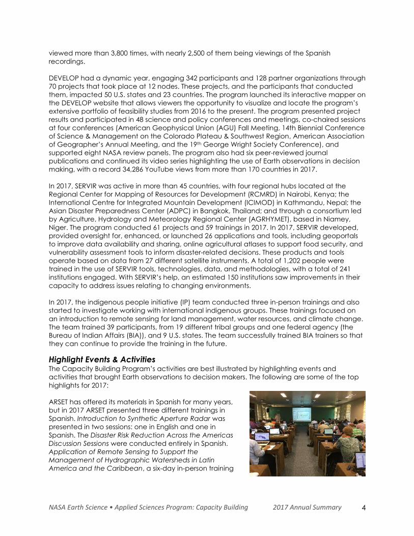
ARSET has offered its materials in Spanish for many years,
but in 2017 ARSET presented three different trainings in
Spanish. Introduction to Synthetic Aperture Radar was
presented in two sessions: one in English and one in
Spanish. The Disaster Risk Reduction Across the Americas
Discussion Sessions were conducted entirely in Spanish.
Application of Remote Sensing to Support the
Management of Hydrographic Watersheds in Latin
America and the Caribbean, a six-day in-person training
NASA Earth Science • Applied Sciences Program: Capacity Building 2017 Annual Summary 5
held in Brazil in partnership with UNESCO, was conducted in English and Spanish with live-
translation available for attendees.
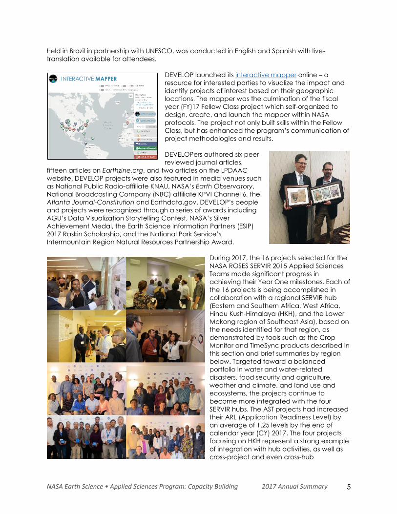
DEVELOP launched its interactive mapper online – a
resource for interested parties to visualize the impact and
identify projects of interest based on their geographic
locations. The mapper was the culmination of the fiscal
year (FY)17 Fellow Class project which self-organized to
design, create, and launch the mapper within NASA
protocols. The project not only built skills within the Fellow
Class, but has enhanced the program’s communication of
project methodologies and results.
DEVELOPers authored six peer-
reviewed journal articles,
fifteen articles on Earthzine.org, and two articles on the LPDAAC
website. DEVELOP projects were also featured in media venues such
as National Public Radio-affiliate KNAU, NASA’s Earth Observatory,
National Broadcasting Company (NBC) affiliate KPVI Channel 6, the
Atlanta Journal-Constitution and Earthdata.gov. DEVELOP’s people
and projects were recognized through a series of awards including
AGU’s Data Visualization Storytelling Contest, NASA’s Silver
Achievement Medal, the Earth Science Information Partners (ESIP)
2017 Raskin Scholarship, and the National Park Service’s
Intermountain Region Natural Resources Partnership Award.
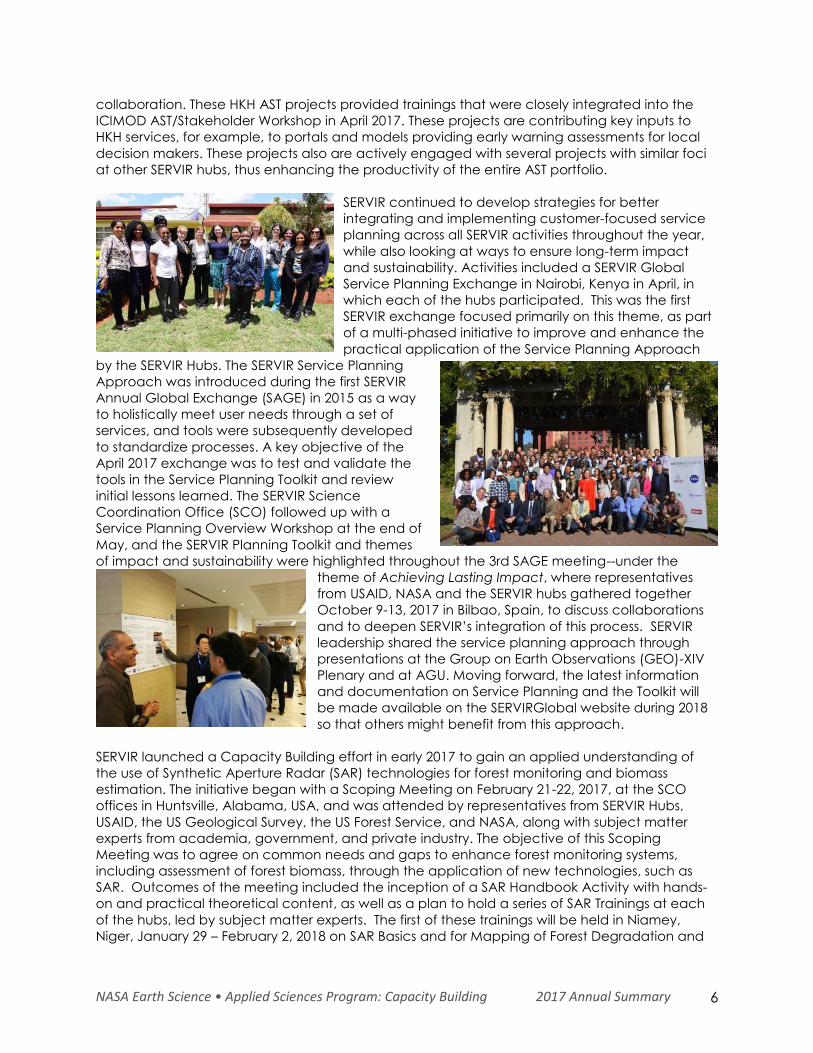
During 2017, the 16 projects selected for the
NASA ROSES SERVIR 2015 Applied Sciences
Teams made significant progress in
achieving their Year One milestones. Each of
the 16 projects is being accomplished in
collaboration with a regional SERVIR hub
(Eastern and Southern Africa, West Africa,
Hindu Kush-Himalaya (HKH), and the Lower
Mekong region of Southeast Asia), based on
the needs identified for that region, as
demonstrated by tools such as the Crop
Monitor and TimeSync products described in
this section and brief summaries by region
below. Targeted toward a balanced
portfolio in water and water-related
disasters, food security and agriculture,
weather and climate, and land use and
ecosystems, the projects continue to
become more integrated with the four
SERVIR hubs. The AST projects had increased
their ARL (Application Readiness Level) by
an average of 1.25 levels by the end of
calendar year (CY) 2017. The four projects
focusing on HKH represent a strong example
of integration with hub activities, as well as
cross-project and even cross-hub
NASA Earth Science • Applied Sciences Program: Capacity Building 2017 Annual Summary 6
collaboration. These HKH AST projects provided trainings that were closely integrated into the
ICIMOD AST/Stakeholder Workshop in April 2017. These projects are contributing key inputs to
HKH services, for example, to portals and models providing early warning assessments for local
decision makers. These projects also are actively engaged with several projects with similar foci
at other SERVIR hubs, thus enhancing the productivity of the entire AST portfolio.
SERVIR continued to develop strategies for better
integrating and implementing customer-focused service
planning across all SERVIR activities throughout the year,
while also looking at ways to ensure long-term impact
and sustainability. Activities included a SERVIR Global
Service Planning Exchange in Nairobi, Kenya in April, in
which each of the hubs participated. This was the first
SERVIR exchange focused primarily on this theme, as part
of a multi-phased initiative to improve and enhance the
practical application of the Service Planning Approach
by the SERVIR Hubs. The SERVIR Service Planning
Approach was introduced during the first SERVIR
Annual Global Exchange (SAGE) in 2015 as a way
to holistically meet user needs through a set of
services, and tools were subsequently developed
to standardize processes. A key objective of the
April 2017 exchange was to test and validate the
tools in the Service Planning Toolkit and review
initial lessons learned. The SERVIR Science
Coordination Office (SCO) followed up with a
Service Planning Overview Workshop at the end of
May, and the SERVIR Planning Toolkit and themes
of impact and sustainability were highlighted throughout the 3rd SAGE meeting--under the
theme of Achieving Lasting Impact, where representatives
from USAID, NASA and the SERVIR hubs gathered together
October 9-13, 2017 in Bilbao, Spain, to discuss collaborations
and to deepen SERVIR’s integration of this process. SERVIR
leadership shared the service planning approach through
presentations at the Group on Earth Observations (GEO)-XIV
Plenary and at AGU. Moving forward, the latest information
and documentation on Service Planning and the Toolkit will
be made available on the SERVIRGlobal website during 2018
so that others might benefit from this approach.
SERVIR launched a Capacity Building effort in early 2017 to gain an applied understanding of
the use of Synthetic Aperture Radar (SAR) technologies for forest monitoring and biomass
estimation. The initiative began with a Scoping Meeting on February 21-22, 2017, at the SCO
offices in Huntsville, Alabama, USA, and was attended by representatives from SERVIR Hubs,
USAID, the US Geological Survey, the US Forest Service, and NASA, along with subject matter
experts from academia, government, and private industry. The objective of this Scoping
Meeting was to agree on common needs and gaps to enhance forest monitoring systems,
including assessment of forest biomass, through the application of new technologies, such as
SAR. Outcomes of the meeting included the inception of a SAR Handbook Activity with hands-
on and practical theoretical content, as well as a plan to hold a series of SAR Trainings at each
of the hubs, led by subject matter experts. The first of these trainings will be held in Niamey,
Niger, January 29 – February 2, 2018 on SAR Basics and for Mapping of Forest Degradation and
NASA Earth Science • Applied Sciences Program: Capacity Building 2017 Annual Summary 7
Deforestation. The next training will be in Kathmandu, Nepal on February 12-16, 2018 on the
same topics. The purpose is for all SERVIR network and appropriate in-country partners to receive
the initial basic training in preparation for additional advanced SAR trainings that are being
planned.
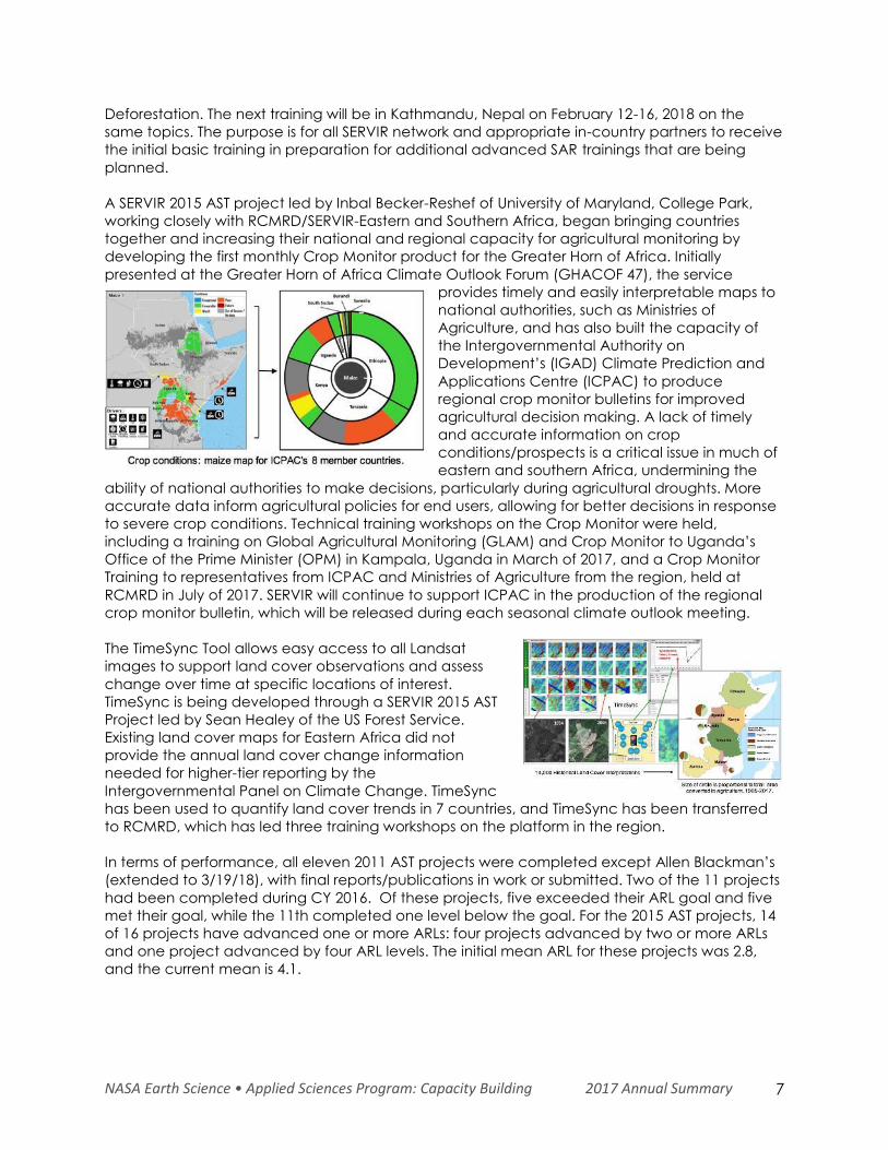
A SERVIR 2015 AST project led by Inbal Becker-Reshef of University of Maryland, College Park,
working closely with RCMRD/SERVIR-Eastern and Southern Africa, began bringing countries
together and increasing their national and regional capacity for agricultural monitoring by
developing the first monthly Crop Monitor product for the Greater Horn of Africa. Initially
presented at the Greater Horn of Africa Climate Outlook Forum (GHACOF 47), the service
provides timely and easily interpretable maps to
national authorities, such as Ministries of
Agriculture, and has also built the capacity of
the Intergovernmental Authority on
Development’s (IGAD) Climate Prediction and
Applications Centre (ICPAC) to produce
regional crop monitor bulletins for improved
agricultural decision making. A lack of timely
and accurate information on crop
conditions/prospects is a critical issue in much of
eastern and southern Africa, undermining the
ability of national authorities to make decisions, particularly during agricultural droughts. More
accurate data inform agricultural policies for end users, allowing for better decisions in response
to severe crop conditions. Technical training workshops on the Crop Monitor were held,
including a training on Global Agricultural Monitoring (GLAM) and Crop Monitor to Uganda’s
Office of the Prime Minister (OPM) in Kampala, Uganda in March of 2017, and a Crop Monitor
Training to representatives from ICPAC and Ministries of Agriculture from the region, held at
RCMRD in July of 2017. SERVIR will continue to support ICPAC in the production of the regional
crop monitor bulletin, which will be released during each seasonal climate outlook meeting.
The TimeSync Tool allows easy access to all Landsat
images to support land cover observations and assess
change over time at specific locations of interest.
TimeSync is being developed through a SERVIR 2015 AST
Project led by Sean Healey of the US Forest Service.
Existing land cover maps for Eastern Africa did not
provide the annual land cover change information
needed for higher-tier reporting by the
Intergovernmental Panel on Climate Change. TimeSync
has been used to quantify land cover trends in 7 countries, and TimeSync has been transferred
to RCMRD, which has led three training workshops on the platform in the region.
In terms of performance, all eleven 2011 AST projects were completed except Allen Blackman’s
(extended to 3/19/18), with final reports/publications in work or submitted. Two of the 11 projects
had been completed during CY 2016. Of these projects, five exceeded their ARL goal and five
met their goal, while the 11th completed one level below the goal. For the 2015 AST projects, 14
of 16 projects have advanced one or more ARLs: four projects advanced by two or more ARLs
and one project advanced by four ARL levels. The initial mean ARL for these projects was 2.8,
and the current mean is 4.1.
NASA Earth Science • Applied Sciences Program: Capacity Building 2017 Annual Summary 8
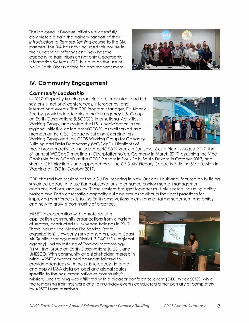
The Indigenous Peoples Initiative successfully
completed a train-the-trainers handoff of their
Introduction to Remote Sensing course to the BIA
partners. The BIA has now included this course in
their upcoming offerings and now has the
capacity to train tribes on not only Geographic
Information Systems (GIS) but also on the use of
NASA Earth Observations for land management.
IV. Community Engagement
Community Leadership In 2017, Capacity Building participated, presented, and led
sessions in national conferences, interagency, and
international events. The CBP Program Manager, Dr. Nancy
Searby, provides leadership in the interagency U.S. Group
on Earth Observations (USGEO)’s International Activities
Working Group, and co-led the U.S.’s participation in the
regional initiative called AmeriGEOSS, as well served as a
member of the GEO Capacity Building Coordination
Working Group and the CEOS Working Group for Capacity
Building and Data Democracy (WGCapD). Highlights of
these broader activities include AmeriGEOSS Week in San Jose, Costa Rica in August 2017, the
6th annual WGCapD meeting in Oberpfaffenhofen, Germany in March 2017, assuming the Vice
Chair role for WGCapD at the CEOS Plenary in Sioux Falls, South Dakota in October 2017, and
sharing CBP highlights and approaches at the GEO-XIV Plenary Capacity Building Side Session in
Washington, DC in October 2017.
CBP chaired two sessions at the AGU Fall Meeting in New Orleans, Louisiana, focused on building
sustained capacity to use Earth observations to enhance environmental management
decisions, actions, and policy. These sessions brought together multiple sectors including policy
makers and Earth observation capacity-building groups to discuss their best practices for
improving workforce skills to use Earth observations in environmental management and policy
and how to grow a community of practice.
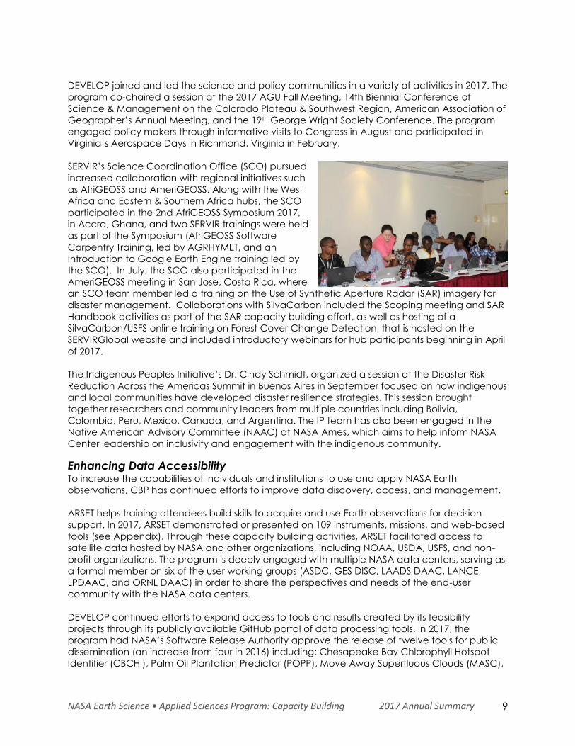
ARSET, in cooperation with remote sensing
application community organizations from a variety
of sectors, conducted six in-person trainings in 2017.
These include the Alaska Fire Service (state
organization), Dewberry (private sector), South Coast
Air Quality Management District (SCAQMD) (regional
agency), Indian Institute of Tropical Meteorology
(IITM), the Group on Earth Observations (GEO), and
UNESCO. With community and stakeholder interests in
mind, ARSET co-produced agendas tailored to
provide attendees with the skills to access, interpret,
and apply NASA data on local and global scales
specific to the host organization or community’s
mission. One training was affiliated with a broader conference event (GEO Week 2017), while
the remaining trainings were one to multi-day events conducted either partially or completely
by ARSET team members.
NASA Earth Science • Applied Sciences Program: Capacity Building 2017 Annual Summary 9
DEVELOP joined and led the science and policy communities in a variety of activities in 2017. The
program co-chaired a session at the 2017 AGU Fall Meeting, 14th Biennial Conference of
Science & Management on the Colorado Plateau & Southwest Region, American Association of
Geographer’s Annual Meeting, and the 19th George Wright Society Conference. The program
engaged policy makers through informative visits to Congress in August and participated in
Virginia’s Aerospace Days in Richmond, Virginia in February.
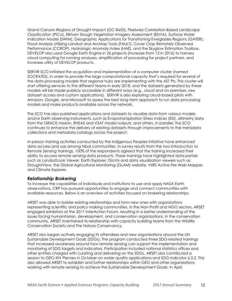
SERVIR’s Science Coordination Office (SCO) pursued
increased collaboration with regional initiatives such
as AfriGEOSS and AmeriGEOSS. Along with the West
Africa and Eastern & Southern Africa hubs, the SCO
participated in the 2nd AfriGEOSS Symposium 2017,
in Accra, Ghana, and two SERVIR trainings were held
as part of the Symposium (AfriGEOSS Software
Carpentry Training, led by AGRHYMET, and an
Introduction to Google Earth Engine training led by
the SCO). In July, the SCO also participated in the
AmeriGEOSS meeting in San Jose, Costa Rica, where
an SCO team member led a training on the Use of Synthetic Aperture Radar (SAR) imagery for
disaster management. Collaborations with SilvaCarbon included the Scoping meeting and SAR
Handbook activities as part of the SAR capacity building effort, as well as hosting of a
SilvaCarbon/USFS online training on Forest Cover Change Detection, that is hosted on the
SERVIRGlobal website and included introductory webinars for hub participants beginning in April
of 2017.
The Indigenous Peoples Initiative’s Dr. Cindy Schmidt, organized a session at the Disaster Risk
Reduction Across the Americas Summit in Buenos Aires in September focused on how indigenous
and local communities have developed disaster resilience strategies. This session brought
together researchers and community leaders from multiple countries including Bolivia,
Colombia, Peru, Mexico, Canada, and Argentina. The IP team has also been engaged in the
Native American Advisory Committee (NAAC) at NASA Ames, which aims to help inform NASA
Center leadership on inclusivity and engagement with the indigenous community.
Enhancing Data Accessibility To increase the capabilities of individuals and institutions to use and apply NASA Earth
observations, CBP has continued efforts to improve data discovery, access, and management.
ARSET helps training attendees build skills to acquire and use Earth observations for decision
support. In 2017, ARSET demonstrated or presented on 109 instruments, missions, and web-based
tools (see Appendix). Through these capacity building activities, ARSET facilitated access to
satellite data hosted by NASA and other organizations, including NOAA, USDA, USFS, and non-
profit organizations. The program is deeply engaged with multiple NASA data centers, serving as
a formal member on six of the user working groups (ASDC, GES DISC, LAADS DAAC, LANCE,
LPDAAC, and ORNL DAAC) in order to share the perspectives and needs of the end-user
community with the NASA data centers.
DEVELOP continued efforts to expand access to tools and results created by its feasibility
projects through its publicly available GitHub portal of data processing tools. In 2017, the
program had NASA’s Software Release Authority approve the release of twelve tools for public
dissemination (an increase from four in 2016) including: Chesapeake Bay Chlorophyll Hotspot
Identifier (CBCHI), Palm Oil Plantation Predictor (POPP), Move Away Superfluous Clouds (MASC),
NASA Earth Science • Applied Sciences Program: Capacity Building 2017 Annual Summary 10
Grand Canyon Regions of Drought Impact (GC-ReDI), Pixelwise Correlation-Based Landscape
Classification (PICo), Elkhorn Slough Vegetation Imagery Assessment (ESVIA), Surface Water
Indication Model (SWIM), Geographic Applications for Transitioning Everglades Regions (GATER),
Flood Analysis Utilizing Landsat and ArcMap Tools (FAULT), Cover Crop Remotely Observed
Performance (CCROP), Hydrologic Anomaly Index (HAE), and the Skyglow Estimation Toolbox.
DEVELOP also used Google Earth Engine in 26 projects (increase from 13 in 2016) to harness
cloud computing for running analyses, simplification of processing for project partners, and
increase utility of DEVELOP products.
SERVIR SCO initiated the acquisition and implementation of a computer cluster (named
SOCRATES), in order to provide the large computational capacity that’s required for several of
the data processing models that regional hubs are implementing with the AST PIs. This cluster will
start offering services to the different teams in early 2018, and the datasets generated by these
models will be made publicly accessible in different ways (e.g., cloud and on-premises, raw
dataset access and custom applications). SERVIR is also exploring cloud-based pilots with
Amazon, Google, and Microsoft to assess the best long-term approach to run data processing
models and make products available across the network.
The SCO has also published applications and datasets to visualize data from various models
and/or Earth observing instruments, such as Evapotranspiration Stress Indices (ESI), altimetry data
from the GRACE mission, RHEAS and VSAT model outputs, and others. In parallel, the SCO
continues to enhance the delivery of existing datasets through improvements to the metadata
collections and metadata catalogs across the project.
In-person training activities conducted by the Indigenous Peoples Initiative have enhanced
data access and use among tribal communities. In survey results from the two Introduction to
Remote Sensing trainings, 100% of the respondents agreed that the training increased their
ability to access remote sensing data products. These trainings have highlighted data portals
such as LandsatLook Viewer, Earth Explorer, GloVis and data visualization viewers such as
DroughtView, the Global Agricultural Monitoring (GLAM) website, VIIRS Active Fire Web Mapper,
and Climate Explorer.
Relationship Brokering To increase the capabilities of individuals and institutions to use and apply NASA Earth
observations, CBP has pursued opportunities to engage and connect communities with
available resources. Below is an overview of activities focused on brokering relationships.
ARSET was able to bolster existing relationships and form new ones with organizations
representing scientific and policy making communities. In the Non-Profit and NGO sectors, ARSET
engaged exhibitors at the 2017 InterAction Forum, resulting in a better understanding of the
issues facing humanitarian, development, and conservation organizations. In the conservation
community, ARSET maintained its relationship with capacity building teams from the Wildlife
Conservation Society and The Nature Conservancy.
ARSET also began actively engaging its attendees and new organizations around the UN
Sustainable Development Goals (SDGs). The program conducted three SDG-related trainings
that increased awareness around how remote sensing can support the implementation and
monitoring of SDG targets and indicators. Participation included national statistics offices and
other entities charged with curating and delivering on the SDGs. ARSET also contributed a
session to GEO-XIV Plenary in October on water quality applications and SDG indicator 6.3.2. This
also allowed ARSET to establish and further relationships within GEO and other organizations
working with remote sensing to achieve the Sustainable Development Goals. In April,
NASA Earth Science • Applied Sciences Program: Capacity Building 2017 Annual Summary 11
International Institute for Sustainable Development (IISD) featured an article on ARSET’s PM2.5
SDG training, published in its communications and knowledge portal.
For the second year, ARSET continued its partnership with UNESCO to host an in-person training in
Brazil. ARSET also partnered with UNOSAT for an online training on the Global Disaster Alert and
Coordination System (GDACS).
SERVIR began pursuing partnership agreements with three major cloud infrastructure providers --
Microsoft Azure, Amazon Web Services, and Google Cloud – to enable three of the hubs to
engage with these companies in cloud pilot activities. The SCO will provide assistance in
establishing and operating these pilot activities at ICIMOD, RCMRD and ADPC to advance their
cloud management knowledge and increase their expertise to run dynamic, on-demand
infrastructure using commercial clouds. While AGRHYMET will not be leading a cloud pilot, they
will benefit from these findings to strengthen their capacity. This will also inform us whether a
future cloud pilot should be initiated at AGRHYMET. Progress continues into 2018 in establishing
these agreements, and contractual activities continue with organizations such as Digital Globe
and Esri.
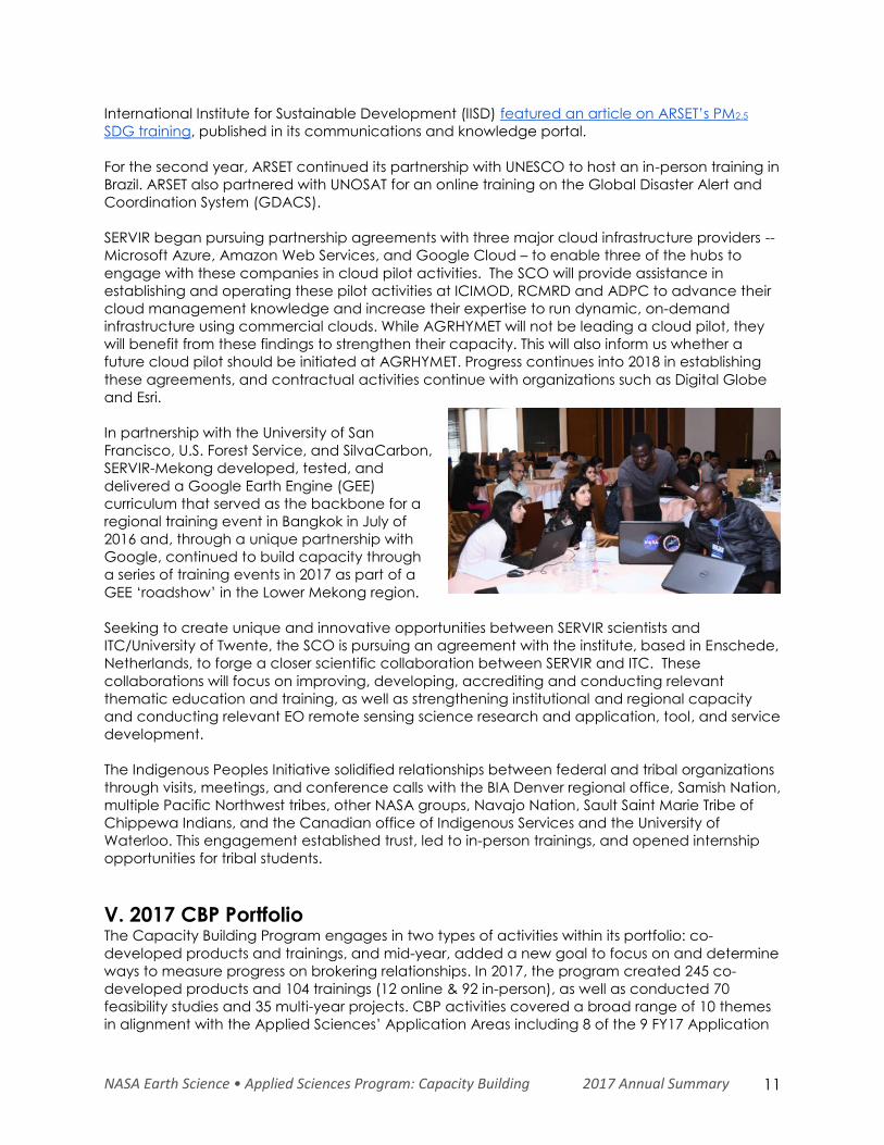
In partnership with the University of San
Francisco, U.S. Forest Service, and SilvaCarbon,
SERVIR-Mekong developed, tested, and
delivered a Google Earth Engine (GEE)
curriculum that served as the backbone for a
regional training event in Bangkok in July of
2016 and, through a unique partnership with
Google, continued to build capacity through
a series of training events in 2017 as part of a
GEE ‘roadshow’ in the Lower Mekong region.
Seeking to create unique and innovative opportunities between SERVIR scientists and
ITC/University of Twente, the SCO is pursuing an agreement with the institute, based in Enschede,
Netherlands, to forge a closer scientific collaboration between SERVIR and ITC. These
collaborations will focus on improving, developing, accrediting and conducting relevant
thematic education and training, as well as strengthening institutional and regional capacity
and conducting relevant EO remote sensing science research and application, tool, and service
development.
The Indigenous Peoples Initiative solidified relationships between federal and tribal organizations
through visits, meetings, and conference calls with the BIA Denver regional office, Samish Nation,
multiple Pacific Northwest tribes, other NASA groups, Navajo Nation, Sault Saint Marie Tribe of
Chippewa Indians, and the Canadian office of Indigenous Services and the University of
Waterloo. This engagement established trust, led to in-person trainings, and opened internship
opportunities for tribal students.
V. 2017 CBP Portfolio The Capacity Building Program engages in two types of activities within its portfolio: co-
developed products and trainings, and mid-year, added a new goal to focus on and determine
ways to measure progress on brokering relationships. In 2017, the program created 245 co-
developed products and 104 trainings (12 online & 92 in-person), as well as conducted 70
feasibility studies and 35 multi-year projects. CBP activities covered a broad range of 10 themes
in alignment with the Applied Sciences’ Application Areas including 8 of the 9 FY17 Application
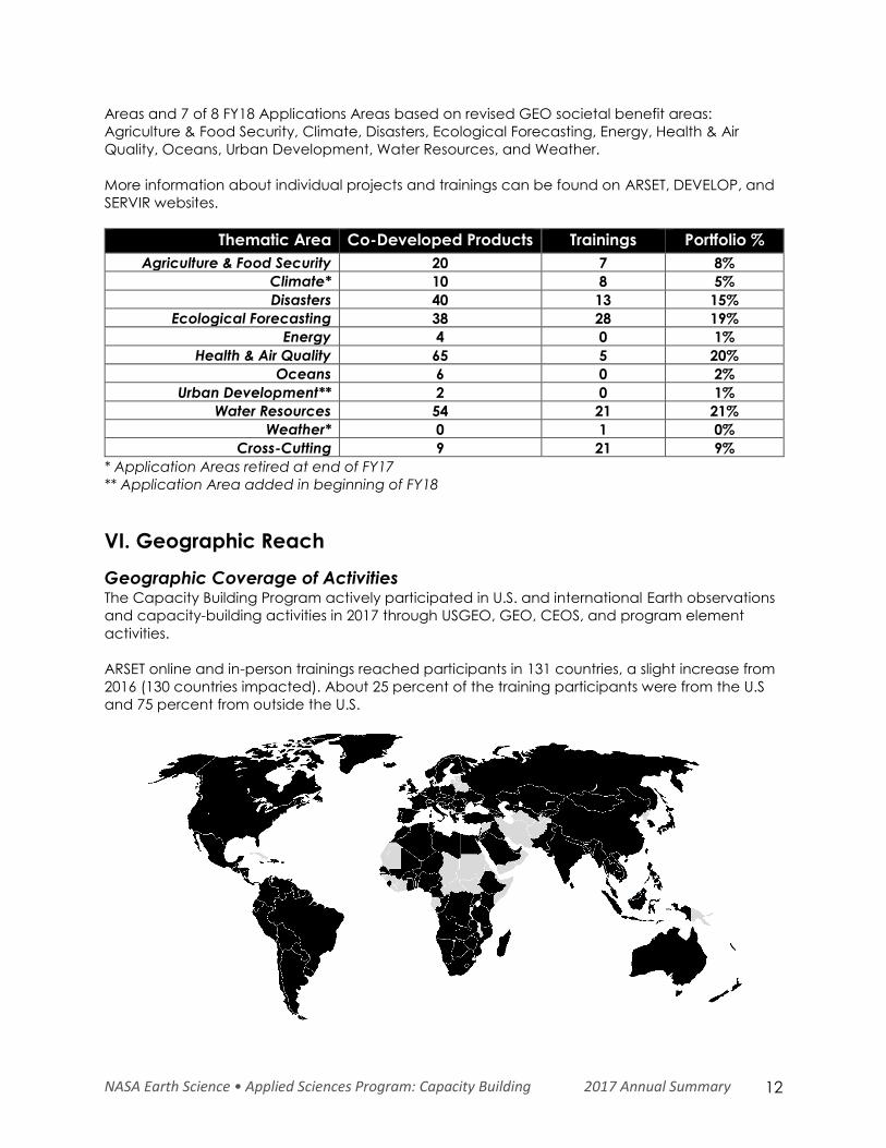
NASA Earth Science • Applied Sciences Program: Capacity Building 2017 Annual Summary 12
Areas and 7 of 8 FY18 Applications Areas based on revised GEO societal benefit areas:
Agriculture & Food Security, Climate, Disasters, Ecological Forecasting, Energy, Health & Air
Quality, Oceans, Urban Development, Water Resources, and Weather.
More information about individual projects and trainings can be found on ARSET, DEVELOP, and
SERVIR websites.
Thematic Area Co-Developed Products Trainings Portfolio %
Agriculture & Food Security 20 7 8%
Climate* 10 8 5%
Disasters 40 13 15%
Ecological Forecasting 38 28 19%
Energy 4 0 1%
Health & Air Quality 65 5 20%
Oceans 6 0 2%
Urban Development** 2 0 1%
Water Resources 54 21 21%
Weather* 0 1 0%
Cross-Cutting 9 21 9%
* Application Areas retired at end of FY17
** Application Area added in beginning of FY18
VI. Geographic Reach
Geographic Coverage of Activities The Capacity Building Program actively participated in U.S. and international Earth observations
and capacity-building activities in 2017 through USGEO, GEO, CEOS, and program element
activities.
ARSET online and in-person trainings reached participants in 131 countries, a slight increase from
2016 (130 countries impacted). About 25 percent of the training participants were from the U.S
and 75 percent from outside the U.S.
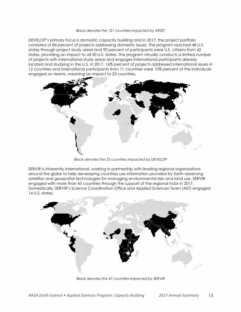
NASA Earth Science • Applied Sciences Program: Capacity Building 2017 Annual Summary 13
Black denotes the 131 countries impacted by ARSET
DEVELOP’s primary focus is domestic capacity building and in 2017, the project portfolio
consisted of 84 percent of projects addressing domestic issues. The program reached 48 U.S.
states through project study areas and 90 percent of participants were U.S. citizens from 42
states, providing an impact to all 50 U.S. states. The program virtually conducts a limited number
of projects with international study areas and engages international participants already
located and studying in the U.S. In 2017, 16% percent of projects addressed international issues in
12 countries and international participants from 11 countries were 10% percent of the individuals
engaged on teams, meaning an impact to 23 countries.
Black denotes the 23 countries impacted by DEVELOP
SERVIR is inherently international, working in partnership with leading regional organizations
around the globe to help developing countries use information provided by Earth observing
satellites and geospatial technologies for managing environmental risks and land use. SERVIR
engaged with more than 45 countries through the support of the regional hubs in 2017.
Domestically, SERVIR’s Science Coordination Office and Applied Sciences Team (AST) engaged
14 U.S. states.
Black denotes the 47 countries impacted by SERVIR
NASA Earth Science • Applied Sciences Program: Capacity Building 2017 Annual Summary 14
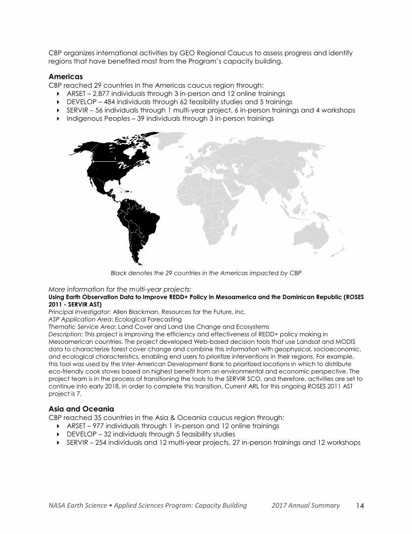
CBP organizes international activities by GEO Regional Caucus to assess progress and identify
regions that have benefited most from the Program’s capacity building.
Americas CBP reached 29 countries in the Americas caucus region through:
ARSET – 2,877 individuals through 3 in-person and 12 online trainings
DEVELOP – 484 individuals through 62 feasibility studies and 5 trainings
SERVIR – 56 individuals through 1 multi-year project, 6 in-person trainings and 4 workshops
Indigenous Peoples – 39 individuals through 3 in-person trainings
Black denotes the 29 countries in the Americas impacted by CBP
More information for the multi-year projects: Using Earth Observation Data to Improve REDD+ Policy in Mesoamerica and the Dominican Republic (ROSES
2011 - SERVIR AST)
Principal Investigator: Allen Blackman, Resources for the Future, Inc.
ASP Application Area: Ecological Forecasting
Thematic Service Area: Land Cover and Land Use Change and Ecosystems
Description: This project is improving the efficiency and effectiveness of REDD+ policy making in
Mesoamerican countries. The project developed Web-based decision tools that use Landsat and MODIS
data to characterize forest cover change and combine this information with geophysical, socioeconomic,
and ecological characteristics, enabling end users to prioritize interventions in their regions. For example,
this tool was used by the Inter-American Development Bank to prioritized locations in which to distribute
eco-friendly cook stoves based on highest benefit from an environmental and economic perspective. The
project team is in the process of transitioning the tools to the SERVIR SCO, and therefore, activities are set to
continue into early 2018, in order to complete this transition. Current ARL for this ongoing ROSES 2011 AST
project is 7.
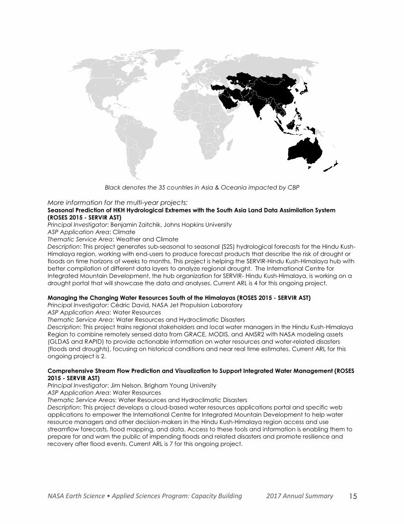
Asia and Oceania CBP reached 35 countries in the Asia & Oceania caucus region through:
ARSET – 977 individuals through 1 in-person and 12 online trainings
DEVELOP – 32 individuals through 5 feasibility studies
SERVIR – 254 individuals and 12 multi-year projects, 27 in-person trainings and 12 workshops
NASA Earth Science • Applied Sciences Program: Capacity Building 2017 Annual Summary 15
Black denotes the 35 countries in Asia & Oceania impacted by CBP
More information for the multi-year projects: Seasonal Prediction of HKH Hydrological Extremes with the South Asia Land Data Assimilation System
(ROSES 2015 - SERVIR AST)
Principal Investigator: Benjamin Zaitchik, Johns Hopkins University
ASP Application Area: Climate
Thematic Service Area: Weather and Climate
Description: This project generates sub-seasonal to seasonal (S2S) hydrological forecasts for the Hindu Kush-
Himalaya region, working with end-users to produce forecast products that describe the risk of drought or
floods on time horizons of weeks to months. This project is helping the SERVIR-Hindu Kush-Himalaya hub with
better compilation of different data layers to analyze regional drought. The International Centre for
Integrated Mountain Development, the hub organization for SERVIR- Hindu Kush-Himalaya, is working on a
drought portal that will showcase the data and analyses. Current ARL is 4 for this ongoing project.
Managing the Changing Water Resources South of the Himalayas (ROSES 2015 - SERVIR AST)
Principal Investigator: Cédric David, NASA Jet Propulsion Laboratory
ASP Application Area: Water Resources
Thematic Service Area: Water Resources and Hydroclimatic Disasters
Description: This project trains regional stakeholders and local water managers in the Hindu Kush-Himalaya
Region to combine remotely sensed data from GRACE, MODIS, and AMSR2 with NASA modeling assets
(GLDAS and RAPID) to provide actionable information on water resources and water-related disasters
(floods and droughts), focusing on historical conditions and near real time estimates. Current ARL for this
ongoing project is 2.
Comprehensive Stream Flow Prediction and Visualization to Support Integrated Water Management (ROSES
2015 - SERVIR AST)
Principal Investigator: Jim Nelson, Brigham Young University
ASP Application Area: Water Resources
Thematic Service Areas: Water Resources and Hydroclimatic Disasters
Description: This project develops a cloud-based water resources applications portal and specific web
applications to empower the International Centre for Integrated Mountain Development to help water
resource managers and other decision-makers in the Hindu Kush-Himalaya region access and use
streamflow forecasts, flood mapping, and data. Access to these tools and information is enabling them to
prepare for and warn the public of impending floods and related disasters and promote resilience and
recovery after flood events. Current ARL is 7 for this ongoing project.
NASA Earth Science • Applied Sciences Program: Capacity Building 2017 Annual Summary 16
Monitoring Intense Thunderstorms in the Hindu Kush-Himalayan Region (ROSES 2015 - SERVIR AST)
Principal Investigator: Patrick Gatlin, NASA Marshall Space Flight Center
ASP Application Area: Weather
Thematic Service Area: Weather and Climate
Description: This project integrates NASA Earth Observing System information to facilitate daily assessments
of the hazards posed by thunderstorms in the Hindu-Kush Himalayan region. As showcased by the intensive
thunderstorm events of April 2017 in Bangladesh, the ensemble thunderstorm prediction system is adding
significant value to on-going activities in the region. Current ARL is 4 for this ongoing project.
A Satellite-based Early Warning, Mapping and Post-Disaster Visualization System for Water Resources of
Low-lying Deltas of the Hindu Kush-Himalayan Region (ROSES 2011 - SERVIR AST)
Principal Investigator: Faisal Hossain, University of Washington
ASP Application Area: Water Resources, Disasters
Thematic Service Area: Water Resources and Hydroclimatic Disasters
Description: This effort focused on developing modular satellite-based water resources and water hazard
mapping, early warning and post-disaster assessment visualization system for use by stakeholders in the
Ganges-Brahmaputra-Meghna and Indus River basins. The satellite altimetry based datasets are in routine
use by the Flood Forecast and Warning Center, an operational agency of Bangladesh government. This
project ended in July of 2017, with an ARL of 9.
Interdisciplinary Science Applications to Glacier and Alpine Hazards in Relation to Development and
Habitation in the Hindu Kush-Himalaya: SERVIR Science Team Project (ROSES 2011 - SERVIR AST)
Principal Investigator: Jeff Kargel, University of Arizona
ASP Application Area: Disasters
Thematic Service Area: Water Resources and Hydroclimatic Disasters
Description: This project created a satellite image time series of glacier lakes, conducted topographic and
hydrological analysis, and performed field studies of glacier lakes for designing a warning system on glacial
lake outburst flood. Kargel and his team provided analysis to the UN Development Programme (UNDP) on
the dangerous rise of Lake Imja in Nepal. Based on this analysis, UNDP provided assistance to the Nepal
Army to lower the lake level by by lowering the dam by more than 10 feet, substantially reducing the risk
from a lake outburst flood. This project ended in August of 2017, with an ARL of 7.
Building Lasting Capacity for Water Management in Vulnerable Deltas of Indochina (ROSES 2015 - SERVIR
AST)
Principal Investigator: Hyongki Lee, University of Houston
ASP Application Area: Water Resources
Thematic Service Area: Water Resources and Hydroclimatic Disasters
Description: This project develops a comprehensive, satellite data-based system that can routinely map,
provide early warning of, and enable decision-making on water-related vulnerability issues in low-lying
deltas of Indochina. There have been several trainings on the hydrological modeling system offered at
SERVIR-Mekong and to other partners in the region to increase capacity during CY 2017. Current ARL for this
ongoing project is 4.
Supporting satellite-based national land-cover and land-use change monitoring systems in South-East
Asian countries (Burma, Cambodia, Laos, Thailand, and Vietnam) (ROSES 2015 - SERVIR AST)
Principal Investigator: Peter Potapov, University of Maryland, College Park
ASP Application Area: Ecological Forecasting
Thematic Service Area: Land Cover and Land Use Change and Ecosystems
Description: This tool employs annual Landsat time-series data to create regionally consistent annual tree
canopy cover and height layers at 30m spatial resolution for Southeast Asian Countries. The provided data
and data analysis tools are designed to help develop regionally consistent annual forest extent and
change maps and implement monitoring results in national and regional planning and management. The
data layers are key contributors to SERVIR-Mekong’s Regional Land Cover Monitoring System. Current ARL is
4 for this ongoing project.
Improved Hydrologic Decision Support for the Lower Mekong River Basin through Integrated Remote
Sensing and Modeling (ROSES 2015 - SERVIR AST)
Principal Investigator: John Bolten, NASA Goddard Space Flight Center
NASA Earth Science • Applied Sciences Program: Capacity Building 2017 Annual Summary 17
ASP Application Area: Water Resources
Thematic Service Area: Water Resources and Hydroclimatic Disasters
Description: This project complements and improves ADPC/SERVIR-Mekong hydrological modeling
capabilities and access to state-of-the-art Earth observation satellite data to enhance their water resource
management decision-making and agricultural monitoring and forecasting capabilities. There have been
several trainings on the hydrological modeling system offered at ADPC, to Vietnam’s Ministry of Natural
Resources and Environment (MoNRE), and to other partners in the region to increase capacity during CY
2017. Current ARL is 3 for this ongoing project.
Monitoring and Forecasting Drought and Crop Yield for the Lower Mekong Basin (ROSES 2015 - SERVIR AST)
Principal Investigator: Konstantinos Andreadis, NASA Jet Propulsion Laboratory (former PI was Stephanie
Granger)
ASP Application Area: Agriculture
Thematic Service Area: Agriculture and Food Security
Description: This project uses NASA data, local ground observations, and forecasts in a modeling system to
provide hydrologic data and drought assessments with associated agricultural yield for the Lower Mekong
Basin. The drought-monitoring component of this project is contributing significantly towards hub services
related to the Agriculture Service Area. Current ARL for this ongoing project is 7.
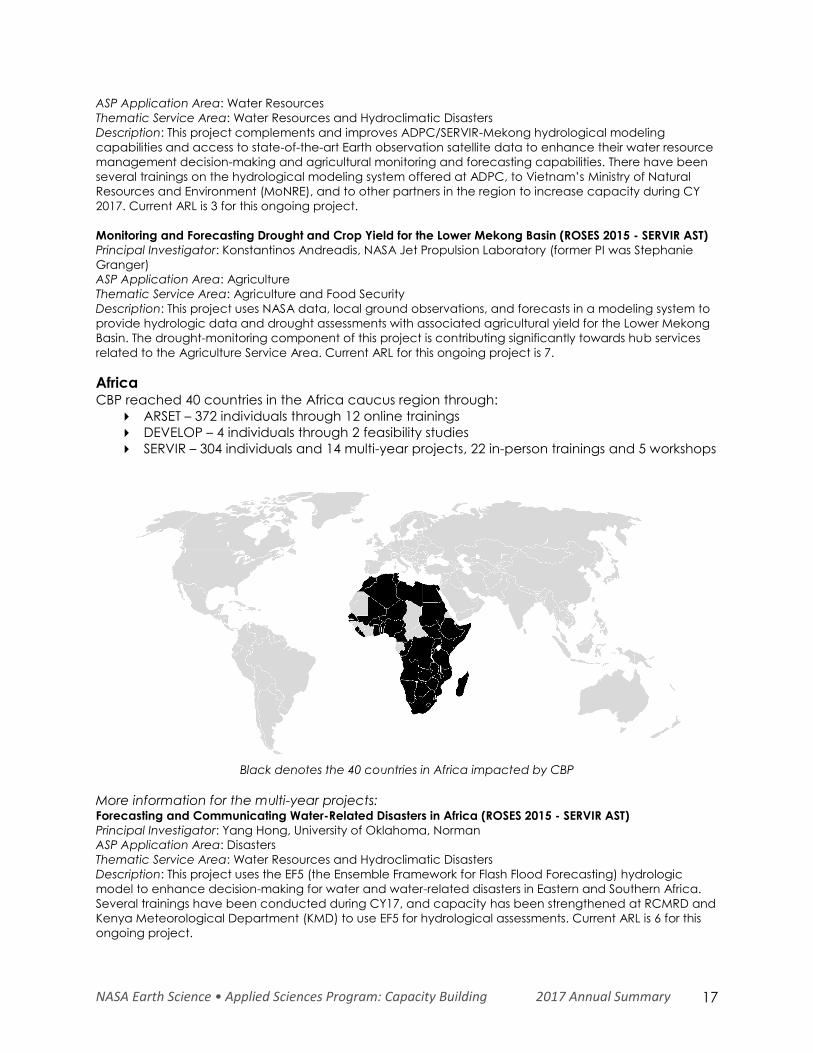
Africa CBP reached 40 countries in the Africa caucus region through:
ARSET – 372 individuals through 12 online trainings
DEVELOP – 4 individuals through 2 feasibility studies
SERVIR – 304 individuals and 14 multi-year projects, 22 in-person trainings and 5 workshops
Black denotes the 40 countries in Africa impacted by CBP
More information for the multi-year projects: Forecasting and Communicating Water-Related Disasters in Africa (ROSES 2015 - SERVIR AST)
Principal Investigator: Yang Hong, University of Oklahoma, Norman
ASP Application Area: Disasters
Thematic Service Area: Water Resources and Hydroclimatic Disasters
Description: This project uses the EF5 (the Ensemble Framework for Flash Flood Forecasting) hydrologic
model to enhance decision-making for water and water-related disasters in Eastern and Southern Africa.
Several trainings have been conducted during CY17, and capacity has been strengthened at RCMRD and
Kenya Meteorological Department (KMD) to use EF5 for hydrological assessments. Current ARL is 6 for this
ongoing project.
NASA Earth Science • Applied Sciences Program: Capacity Building 2017 Annual Summary 18
Supporting National Agricultural Monitoring for Food Security (ROSES 2015 - SERVIR AST)
Principal Investigator: Inbal Becker-Reshef, University of Maryland, College Park
ASP Application Area: Agriculture
Thematic Service Area: Agriculture and Food Security
Description: This project builds capacity and develops remote sensing, smart phone, and collaborative
internet technologies for the collection, analysis, and dissemination of data on the status of agriculture and
crop condition as a basis for decision-making, policy design, and agricultural development interventions in
Eastern and Southern Africa. Data and methodology from this project are already serving as key inputs to
Intergovernmental Authority on Development (IGAD) Climate Prediction and Application Centre’s
(ICPAC’s) Regional Crop Monitoring efforts, as part of Greater Horn of Africa Climate Outlook Forum
(GHACOF). Current ARL for this ongoing project is 4.
Enhancing Eastern and Southern Africa Climate Services by Increasing Access to Remote Sensing and
Model Datasets (ROSES 2015 - SERVIR AST)
Principal investigator: Shraddhanand Shukla, University of California, Santa Barbara
ASP Application Area: Agriculture, Climate
Thematic Service Area: Agriculture and Food Security
Description: This project enhances SERVIR-Eastern and Southern Africa/RCMRD’s access to NASA and
Famine Early Warning System Network (FEWS NET) Earth observations, datasets, models, forecasts, and web-
services to support agricultural and water resources decision making by ministries and organizations in the
region. The EWX products, created as part of this project, are being used in several hub services, such as
climate vulnerability assessments. Current ARL is 5 for this ongoing project.
Enabling Local Monitoring of Landscape Change Across Eastern Africa (ROSES 2015 - SERVIR AST)
Principal Investigator: Sean Healey, U.S. Forest Service, Rocky Mountain Research Station
ASP Application Area: Ecological Forecasting
Thematic Service Area: Land Cover and Land Use Change and Ecosystems
Description: This project enables SERVIR-Eastern and Southern Africa/RCMRD to use cloud computing and
the Landsat archive to deliver historical and continuously updated 30-meter maps of land cover across
Kenya, Malawi, Ethiopia, Zambia, Tanzania, Rwanda, and Uganda. This project has built the capacity of
the SERVIR hub to become the regional leader in Land Cover Monitoring, and is providing key annual
updates to member countries. Current ARL for this ongoing project is 3.
Development and Implementation of Flood Risk Mapping, Water Bodies Monitoring and Climate Information
for Disaster Management and Human Health (ROSES 2011 - SERVIR AST)
Principal Investigator: Pietro Ceccato, International Research Institute for Climate and Society (IRI),
Columbia University
ASP Application Area: Health and Air Quality
Thematic Service Area: Water Resources and Hydroclimatic Disasters
Description: This project has developed the capacity to integrate NASA remotely-sensed products for
establishing an improved vector-borne disease risk assessment tool for use by targeted stakeholders. The
project team has developed water bodies mapping techniques and held several successful trainings with
end users and ministries in East Africa. SERVIR-Eastern and Southern Africa is also looking at operationalizing
the water body mapping for uses in rangeland pastureland management. This project was completed in
August of 2017, with an ARL of 7, exceeding the project’s goal ARL of 6.
East Africa Drought and Agricultural Productivity Assessment and Prediction System (ROSES 2011 - SERVIR
AST)
Principal Investigator: Stephanie Granger, NASA Jet Propulsion Laboratory
ASP Application Area: Agriculture, Water Resources
Thematic Service Area: Agriculture and Food Security
Description: This project developed a system to support farming practices in East Africa by helping farmers
assess potential end of the season crop yields using crop and hydrologic models, Earth observations, and
seasonal forecasts and outlooks. Since its inception, the project has coupled the Variable Infiltration
Capacity (VIC) and Decision Support System for Agrotechnology Transfer (DSSAT) models for several crop
type modules. The system is installed at the SERVIR-Eastern and Southern Africa hub, and several end users
in Kenya, Ethiopia, and Zambia are trained on the use of the derived products. The SERVIR hub is
NASA Earth Science • Applied Sciences Program: Capacity Building 2017 Annual Summary 19
developing effective ways to disseminate these useful products. This project was completed in September
of 2017, with an ARL of 8.
Forest Carbon Assessment for REDD in the East Africa SERVIR Region (ROSES 2011 - SERVIR AST)
Principal Investigator: Scott Goetz, Woods Hole Research Center
ASP Application Area: Ecological Forecasting
Thematic Service Area: Land Cover and Land Use Change and Ecosystems
Description: This project demonstrated that NASA Earth science products and derived models can assist
stakeholders and decision makers with their terrestrial carbon assessment and forest conservation
strategies. This project has built significant capacity in carbon accounting at the SERVIR-Eastern and
Southern Africa hub. This project finished in June of 2017, with an ARL of 9.
SERVIR Water Africa-Arizona Team (SWAAT) (ROSES 2011 - SERVIR AST)
Principal Investigator: Juan Valdes, University of Arizona
ASP Application Area: Water Resources
Thematic Service Area: Water Resources and Hydroclimatic Disasters
Description: This project developed hydrologic modeling capabilities to monitor water resources in Africa.
The outcome of this effort is provision of near-term streamflow forecasts in three key pilot basins (Mara,
Tekeze, and Zambezi) and a quantitative assessment of seasonal outlook on water resources in these
basins. Kenyan and Namibian water resources departments have used the derived datasets in making
water allocation decisions. This project has enabled the capacity of SERVIR to transform real-time data
streams into a Climate Hazards Group InfraRed Precipitation with Station data (CHIRPS)-based data
product, to ensure data consistency and continuity. The project achieved an end ARL of 7, and was
completed in August of 2017.
A Long Time-Series Indicator of Agricultural Drought for the Greater Horn of Africa (ROSES 2011 - SERVIR AST)
Principal Investigator: James Verdin, U.S. Geological Survey Sioux Falls/FEWS NET
ASP Application Area: Agriculture
Thematic Service Area: Water Resources and Hydroclimatic Disasters
Description: This project created a long time-series indicator of agricultural drought in the Greater Horn of
Africa using remotely sensed observations. Since its inception, this project has generated a 30-year rainfall
and drought indicator data set (1981 to present) using a variety of available satellite data and model
products. The SERVIR-Eastern and Southern Africa hub is using the data to help countries in their region with
water resources and agriculture analysis. Outcomes of this project contributed to initial successes of the
EWX system (ROSES 2015). Completed in July of 2017, it exceeded the project goal ARL of 7 to achieve a
final ARL of 9.
A West Africa LDAS for Forecasting Extreme Hydrological Events (WALFEHE) (ROSES 2015 - SERVIR AST)
Principal Investigator: Augusto Getirana, NASA Goddard Space Flight Center
ASP Application Area: Climate
Thematic Service Area: Water Resources and Hydroclimatic Disasters
Description: This project provides an improved land data assimilation system (LDAS) for integrated water
management by Agriculture, Hydrology and Meteorology (AGRHYMET) Regional Center member nations,
with a focus on hydrological modeling to provide meteorological, hydrological, and agricultural drought
characterizations and forecasts, as well as flood modeling and forecasting. Current ARL is 3 for this ongoing
project.
Monitoring and Projecting Environmental Change in Fragmented Tropical Forest Landscapes (ROSES 2015 -
SERVIR AST)
Principal Investigator: Michael Wimberly, GISc Center of Excellence, South Dakota State University
ASP Application Area: Ecological Forecasting
Thematic Service Area: Land Cover and Land Use Change and Ecosystems
Description: This project integrates Landsat data and landscape simulation models to map historical forest
degradation and project future impacts of climate and land use change on West African forests. The
project PI, in collaboration with SERVIR-West Africa, conducted a successful field campaign during CY17,
which led to improved methodology and enhanced capacity in the region. Current ARL is 3 for this
ongoing project.
NASA Earth Science • Applied Sciences Program: Capacity Building 2017 Annual Summary 20
Desertification or "re-greening"? Adaptation lessons learned in coping with late 20th century drought in
West Africa (ROSES 2015 - SERVIR AST)
Principal Investigator: Alessandra Giannini, International Research Institute for Climate and Society (IRI),
Columbia University
ASP Application Area: Climate
Thematic Service Area: Weather and Climate
Description: This project uses information from Earth observations and model simulations to develop climate
information for decision-making in natural resources management, including water and landscapes, to
improve agriculture and food security outcomes in West Africa. Current ARL is 3 for this ongoing project.
Supporting Pastoralist Livelihoods in West Africa Through Remote Sensing of Rangeland Vegetation
Structure, Forage Production and Long-Term Trend Analysis (ROSES 2015 - SERVIR AST)
Principal Investigator: Niall Hanan, New Mexico State University
ASP Application Area: Agriculture
Thematic Service Area: Agriculture and Food Security
Description: This project assists SERVIR-West Africa in developing remote sensing based applications
relevant to rangeland vegetation structure and forage production to improve the wellbeing and resilience
of pastoralist and agropastoralist communities in West Africa. This project collaborated with West Africa
Consortium partner CSE to improve rangeland monitoring in West Africa. Current ARL for this ongoing
project is 3.
Leveraging CMIP5 and NASA / GMAO Coupled Modeling Capacity for SERVIR East Africa Climate
Projections (ROSES 2011 - SERVIR AST)
Principal Investigator: Franklin (Pete) Robertson, NASA Marshall Space Flight Center
ASP Application Area: Climate
Thematic Service Area: Weather and Climate
Description: This project critically assessed and employed climate model projections of seasonal hydro-
meteorological climate variability affecting SERVIR hub regions and developed spatially downscaled
scenarios to enable other AST investigators to drive decision support systems on seasonal time horizons. The
project’s outputs have been used in several other AST projects and hub activities. These outputs continue
to be produced and served through SERVIR’s ClimateSERV portal. This project completed in August of 2017
with an ARL of 8, which exceeded the project goal ARL of 7.
Europe CBP reached 31 countries in the Europe caucus region through:
ARSET – 593 individuals through 12 online trainings
DEVELOP – 4 individuals through 1 feasibility study
Black denotes the 31 countries in Europe impacted by CBP
NASA Earth Science • Applied Sciences Program: Capacity Building 2017 Annual Summary 21
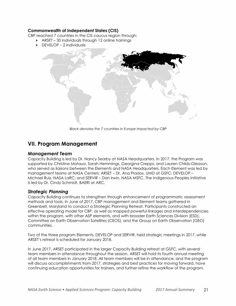
Commonwealth of Independent States (CIS) CBP reached 7 countries in the CIS caucus region through:
ARSET – 30 individuals through 12 online trainings
DEVELOP – 2 individuals
Black denotes the 7 countries in Europe impacted by CBP
VII. Program Management
Management Team Capacity Building is led by Dr. Nancy Searby at NASA Headquarters. In 2017, the Program was
supported by Christine Mataya, Sarah Hemmings, Georgina Crepps, and Lauren Childs-Gleason,
who served as liaisons between the Elements and NASA Headquarters. Each Element was led by
management teams at NASA Centers: ARSET – Dr. Ana Prados, UMD at GSFC; DEVELOP –
Michael Ruiz, NASA LaRC; and SERVIR – Dan Irwin, NASA MSFC. The Indigenous Peoples Initiative
is led by Dr. Cindy Schmidt, BAERI at ARC.
Strategic Planning Capacity Building continues to strengthen through enhancement of programmatic assessment
methods and tools. In June of 2017, CBP management and Element teams gathered in
Greenbelt, Maryland to conduct a Strategic Planning Retreat. Participants constructed an
effective operating model for CBP, as well as mapped powerful linkages and interdependencies
within the program, with other ASP elements, and with broader Earth Sciences Division (ESD),
Committee on Earth Observation Satellites (CEOS), and the Group on Earth Observation (GEO)
communities.
Two of the three program Elements, DEVELOP and SERVIR, held strategic meetings in 2017, while
ARSET’s retreat is scheduled for January 2018.
In June 2017, ARSET participated in the larger Capacity Building retreat at GSFC, with several
team members in attendance throughout the session. ARSET will hold its fourth annual meeting
of all team members in January 2018. All team members will be in attendance, and the program
will discuss accomplishments from 2017, strategies and best practices for moving forward, have
continuing education opportunities for trainers, and further refine the workflow of the program.
NASA Earth Science • Applied Sciences Program: Capacity Building 2017 Annual Summary 22
ARSET will continue looking at new training approaches and topics, and will begin implementing
a new learning management system for asynchronous trainings.
DEVELOP held three strategic meetings throughout 2017. In January, the program held its FY17
Fellow Class Strategic Planning & Leadership Retreat focused on organizing the Fellow Class
project and identifying opportunities for improvements to the program which culminated in the
creation of the DEVELOP Earth Science Collaborative (DESC) forum for improved Geoinformatics
support and the program’s interactive mapper. In May, the program held its 2018 Center Lead
Strategic Planning & Leadership Retreat which focused on programmatic process improvements
and professional development of leadership skills. In December, DEVELOP held its FY18 Strategic
Planning & Leadership Retreat which brought both Center Leads, Fellows, and the National
Program Office together to identify process improvements and participate in “soft skill”
development.
The 4th Annual SERVIR Joint Working Group (JWG) meeting took place in Washington D.C., in
May 2017, with participation from USAID and NASA HQ Earth Science Division leadership and
SERVIR SCO leadership. The JWG reviewed progress since the last meeting, highlighting activities
and accomplishments – particularly those supporting SERVIR’s Strategic Goals, such as
connecting more innovative and appropriate science through the ASTs and Technical
Assessment Groups, and expanding the SERVIR network through strategic global partnerships
and collaborations. Additional discussion topics included SERVIR hub expansion and how to best
be responsive to changes in priorities of the current administration.
The SERVIR program also hosted the SERVIR Annual Global Exchange (SAGE) from October 9-13
in Bilbao, Spain. During the meeting, participants shared lessons learned and discussed strategies
for better integrating the service planning process, which efficiently links needs from regional
end users to SERVIR service planning, development and evaluation, to ensure services across the
network are relevant and sustainable. In preliminary sessions on the first day, participants
including AST, SCO and hub scientists shared regional activities and progress and exchanged
views on past, current and upcoming initiatives.
For the IP initiative, a primary focus for future strategic planning activities in 2018 is the
organization of a workshop of experts to explore lessons learned in the IP activities to date, user
needs, gaps in addressing them, and how IP activities might proceed within the Capacity
Building Program. The workshop aims to include Native American and First Nations members
from academia and federal agencies that understand both traditional ecological knowledge
and western science. Members could also include non-indigenous individuals that work closely
with tribes.
CBP continues its programmatic goal to enhance activities that promote and improve
engagement, entrepreneurism, and evaluation.
Engagement. CBP pursues approaches that increase connectivity with current partners,
reach out to potential end users, and engage Earth scientists who may be interested and
skilled in applications. By improving programmatic understanding of key needs and user
preferences, new communities are targeted and engaged.
Entrepreneurism. Through experimentation and adoption of innovative methods for
building capacity, CBP implements the Program’s strategy to include creative
approaches to data access, idea generation, brokering connections, funding of
projects, use of social media and community challenges, and reporting of outcomes. This
focuses on creative solutions that increase effectiveness and expand the reach of the
program.
NASA Earth Science • Applied Sciences Program: Capacity Building 2017 Annual Summary 23
Evaluation. Monitoring and evaluation through the tracking of indicators across all
Elements is performed. This activity includes the refinement of results frameworks for each
Element and the program as a whole, as well as the identification and collection of
shared indicators across all elements. Improved monitoring increases efficiency and
assists with identification of highlights and successes.
Program Assessment At the program level, CBP continues to work towards its five strategic goals, while building a
robust network of engagement with other capacity building programs and initiatives. The
program collects outcomes through success stories, highlights, ARSET surveys, and DEVELOP
participant surveys. Indicators are used to track intermediate results. Strategic targets are
annually assessed, along with ARL and PSI scores to track yearly progress.
Indicator Tracking Programmatic performance tracking system was initiated in 2016 through results frameworks that
identify unique indicators for each Element, with a refined number of program-wide indicators
collected across all Elements.
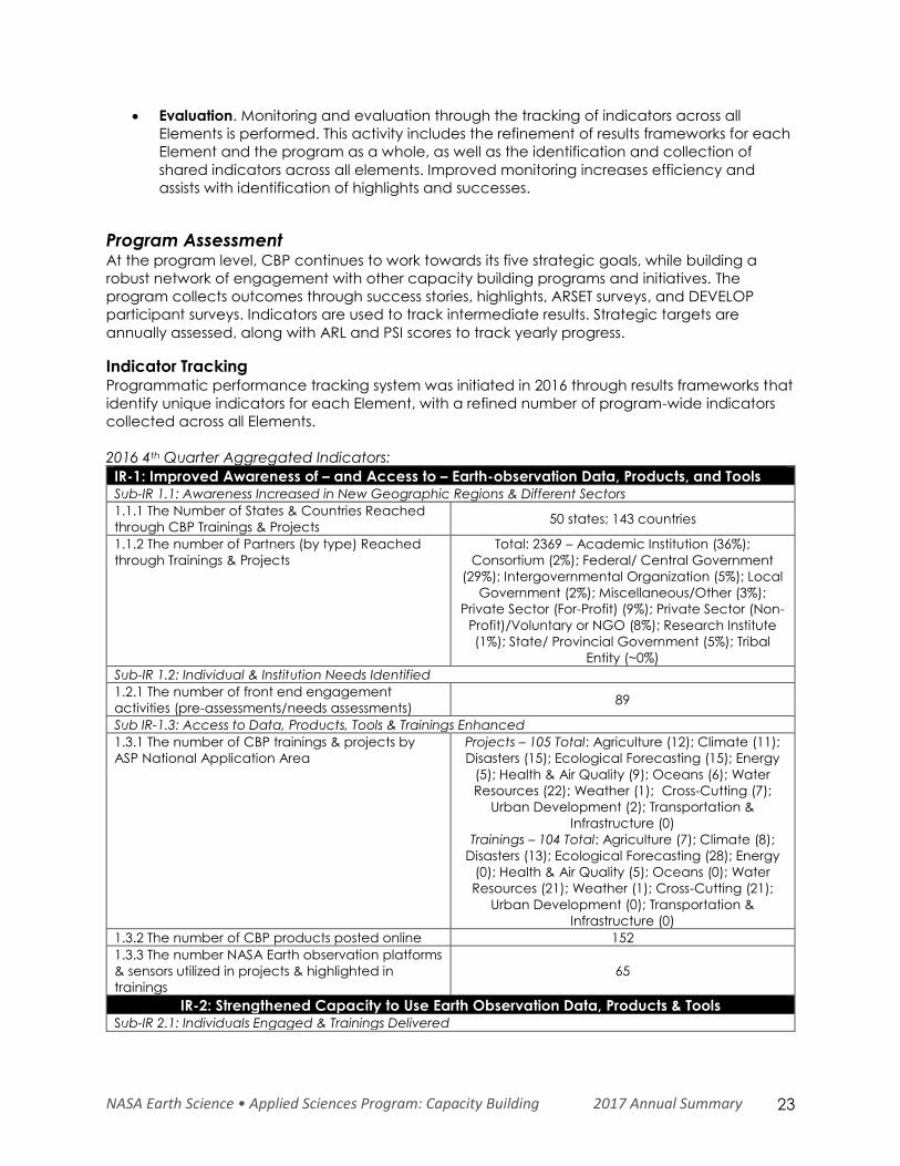
2016 4th Quarter Aggregated Indicators:
IR-1: Improved Awareness of – and Access to – Earth-observation Data, Products, and Tools Sub-IR 1.1: Awareness Increased in New Geographic Regions & Different Sectors
1.1.1 The Number of States & Countries Reached
through CBP Trainings & Projects 50 states; 143 countries
1.1.2 The number of Partners (by type) Reached
through Trainings & Projects
Total: 2369 – Academic Institution (36%);
Consortium (2%); Federal/ Central Government
(29%); Intergovernmental Organization (5%); Local
Government (2%); Miscellaneous/Other (3%);
Private Sector (For-Profit) (9%); Private Sector (Non-
Profit)/Voluntary or NGO (8%); Research Institute
(1%); State/ Provincial Government (5%); Tribal
Entity (~0%)
Sub-IR 1.2: Individual & Institution Needs Identified
1.2.1 The number of front end engagement
activities (pre-assessments/needs assessments) 89
Sub IR-1.3: Access to Data, Products, Tools & Trainings Enhanced
1.3.1 The number of CBP trainings & projects by
ASP National Application Area
Projects – 105 Total: Agriculture (12); Climate (11);
Disasters (15); Ecological Forecasting (15); Energy
(5); Health & Air Quality (9); Oceans (6); Water
Resources (22); Weather (1); Cross-Cutting (7);
Urban Development (2); Transportation &
Infrastructure (0)
Trainings – 104 Total: Agriculture (7); Climate (8);
Disasters (13); Ecological Forecasting (28); Energy
(0); Health & Air Quality (5); Oceans (0); Water
Resources (21); Weather (1); Cross-Cutting (21);
Urban Development (0); Transportation &
Infrastructure (0)
1.3.2 The number of CBP products posted online 152
1.3.3 The number NASA Earth observation platforms
& sensors utilized in projects & highlighted in
trainings
65
IR-2: Strengthened Capacity to Use Earth Observation Data, Products & Tools Sub-IR 2.1: Individuals Engaged & Trainings Delivered
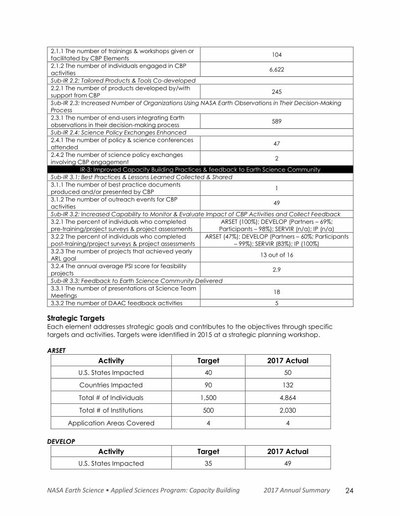
NASA Earth Science • Applied Sciences Program: Capacity Building 2017 Annual Summary 24
2.1.1 The number of trainings & workshops given or
facilitated by CBP Elements 104
2.1.2 The number of individuals engaged in CBP
activities 6,622
Sub-IR 2.2: Tailored Products & Tools Co-developed
2.2.1 The number of products developed by/with
support from CBP 245
Sub-IR 2.3: Increased Number of Organizations Using NASA Earth Observations in Their Decision-Making
Process
2.3.1 The number of end-users integrating Earth
observations in their decision-making process 589
Sub-IR 2.4: Science Policy Exchanges Enhanced
2.4.1 The number of policy & science conferences
attended 47
2.4.2 The number of science policy exchanges
involving CBP engagement 2
IR-3: Improved Capacity Building Practices & feedback to Earth Science Community
Sub-IR 3.1: Best Practices & Lessons Learned Collected & Shared
3.1.1 The number of best practice documents
produced and/or presented by CBP 1
3.1.2 The number of outreach events for CBP
activities 49
Sub-IR 3.2: Increased Capability to Monitor & Evaluate Impact of CBP Activities and Collect Feedback
3.2.1 The percent of individuals who completed
pre-training/project surveys & project assessments
ARSET (100%); DEVELOP (Partners – 69%;
Participants – 98%); SERVIR (n/a); IP (n/a)
3.2.2 The percent of individuals who completed
post-training/project surveys & project assessments
ARSET (47%); DEVELOP (Partners – 60%; Participants
– 99%); SERVIR (83%); IP (100%)
3.2.3 The number of projects that achieved yearly
ARL goal 13 out of 16
3.2.4 The annual average PSI score for feasibility
projects 2.9
Sub-IR 3.3: Feedback to Earth Science Community Delivered
3.3.1 The number of presentations at Science Team
Meetings 18
3.3.2 The number of DAAC feedback activities 5
Strategic Targets Each element addresses strategic goals and contributes to the objectives through specific
targets and activities. Targets were identified in 2015 at a strategic planning workshop.
ARSET
Activity Target 2017 Actual
U.S. States Impacted 40 50
Countries Impacted 90 132
Total # of Individuals 1,500 4,864
Total # of Institutions 500 2,030
Application Areas Covered 4 4
DEVELOP
Activity Target 2017 Actual
U.S. States Impacted 35 49
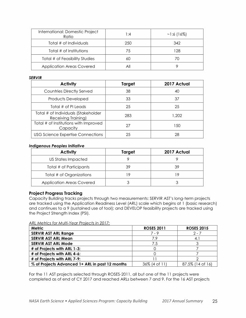
NASA Earth Science • Applied Sciences Program: Capacity Building 2017 Annual Summary 25
International: Domestic Project
Ratio 1:4 ~1:6 (16%)
Total # of Individuals 250 342
Total # of Institutions 75 128
Total # of Feasibility Studies 60 70
Application Areas Covered All 9
SERVIR
Activity Target 2017 Actual
Countries Directly Served 38 40
Products Developed 33 37
Total # of PI Leads 25 25
Total # of Individuals (Stakeholder
Receiving Training) 283 1,202
Total # of Institutions with Improved
Capacity 27 150
USG Science Expertise Connections 25 28
Indigenous Peoples Initiative
Activity Target 2017 Actual
US States Impacted 9 9
Total # of Participants 39 39
Total # of Organizations 19 19
Application Areas Covered 3 3
Project Progress Tracking Capacity Building tracks projects through two measurements: SERVIR AST’s long-term projects
are tracked using the Application Readiness Level (ARL) scale which begins at 1 (basic research)
and continues to a 9 (sustained use of tool); and DEVELOP feasibility projects are tracked using
the Project Strength Index (PSI).
ARL Metrics for Multi-Year Projects in 2017:
Metric ROSES 2011 ROSES 2015
SERVIR AST ARL Range 7 - 9 2 - 7
SERVIR AST ARL Mean 7.9 4.1
SERVIR AST ARL Mode 7.5 3
# of Projects with ARL 1-3: 0 7
# of Projects with ARL 4-6: 0 7
# of Projects with ARL 7-9: 11 2
% of Projects Advanced 1+ ARL in past 12 months 36% (4 of 11) 87.5% (14 of 16)
For the 11 AST projects selected through ROSES-2011, all but one of the 11 projects were
completed as of end of CY 2017 and reached ARLs between 7 and 9. For the 16 AST projects
NASA Earth Science • Applied Sciences Program: Capacity Building 2017 Annual Summary 26
selected through ROSES-2015, 7 have reached an ARL between 4 and 6, and 2 have reached
an ARL between 7 and 9.
DEVELOP continued to track and assess its feasibility projects by means of its PSI. This scale takes
into consideration both the scientific merit of the work, as well as the project’s applicability to
decision making and partner capacity building. In 2017, DEVELOP began a reformulation of the
PSI, which measures a project on two spectra: scientific merit and the applicability to decision
making and capacity building of the project partners. The PSI tracks the progress of projects
across a 5-point scale of 1) Basic Research, 2) Application Concept Complete, 3) Application
Demonstration Successful, 4) Application Verified/End User Engaged, and 5) Transition to End
User/Decision Enhanced. The new PSI is split into two parts, with one assessment being done after
each project term, and a follow-up roughly 4-6 months after the completion of the project. The
new system was implemented beginning in the summer 2016 term. For the 52 projects
conducting during DEVELOP’s 2017 spring and summer terms, 0 percent of projects ended in
Stage 1, 6 percent in Stage 2, 36 percent in Stage 3, and 45 percent in Stage 4 and 12 percent
in Stage 5 for final PSI scores. For the fall projects, which have only PSI part I calculated scores at
this time, 0 percent of projects ended in Stage 1, 11 percent were in Stage 2, 89 percent in Stage
3, and 0 percent in Stage 4, and 0 percent in Stage 5. The PSI Part II assessments will be
conducted in the upcoming months.
Internal Collaborative Activities The Capacity Building Program integrates and efficiently leverages activities between program
Elements. In 2017, the program continued collaboration between the elements in the following
ways:
ARSET team members served as mentors to multiple DEVELOP projects.
25 DEVELOPers participated in ARSET trainings, with DEVELOPers attending all online
trainings offered by ARSET.
ARSET and DEVELOP collaborated to represent CBP at the 2017 InterAction Forum to
increase engagement of NGOs.
DEVELOP participated in SERVIR SCO’s training session on the service planning toolkit.
DEVELOP and SERVIR continued their collaboration on an international project that
applied NASA Earth observations to aid in wetland identification using Google Earth
Engine in Rwanda.
DEVELOP and SERVIR continue to collaborate on DEVELOP summer projects with Thai
scholars.
SERVIR and ARSET collaborated to design and provide a webinar training focusing on the
Variable Infiltration Capacity (VIC) hydrologic model and NASA Earth observation data
inputs used for hydrologic modeling in early 2018.
VIII. Looking Ahead
In 2018, the Capacity Building Program will continue to address the CBP strategic goals to
expand the networks of individuals and institutions to be aware of, able to access, and able to
use Earth observations in their decision making. Through its elements and initiatives, the program
will engage with interagency and international consortiums, boundary organizations, and the
broader NASA Earth Sciences community to further increase the number of individuals and
institutions benefiting from NASA’s investment in Earth science.
The CBP will continue to implement the CBP strategic framework with a focus on solidifying the
use of common language and the operational model; synchronizing planning calendars and
NASA Earth Science • Applied Sciences Program: Capacity Building 2017 Annual Summary 27
creating longer-range training plans; integrating our understanding of user needs and
approaches to gather them; connecting CBP to broader NASA Earth Sciences and other
capacity building networks; and considering improved outcome monitoring and evaluation.
ARSET will begin implementing its asynchronous learning platform, allowing attendees to take
self-guided trainings; introducing new disasters management-related topics; offer change
detection trainings with applications for disasters and ecosystems; and, dedicate a training to
geostationary satellite data. DEVELOP will be recognizing its 20th anniversary throughout 2018
with both regional and national events, expanding its network through the establishment of a
new node in Boston, Massachusetts in January of 2018, and continue to increase its projects’ use
of socioeconomic data. SERVIR will increase capacity of the hubs to maximize use of high-
performance computing for service development and delivery, continue to increase hub and
SCO capacity to process and use SAR imagery and LIDAR, and select the newest SERVIR hub,
SERVIR-Amazonia. The Indigenous Peoples Initiative will conduct trainings with the Samish and
Sault tribes, organize a workshop with experts to suggest options for future IP activities, and
continue to build relationships with federal agencies and the tribal community.
All CBP elements will contribute to the CBP goal to build Earth sciences community capacity to
define end-user needs, collect and share robust feedback, build capacity, and assess impact of
capacity building activities. CBP’s training best practices have been incorporated in the CEOS
training best practices that will be released in 2018. CBP will continue to add chapters or publish
subsequent methods and guidance documents to increase sharing of best practices in short
and longer co-development projects. CBP will continue to learn and incorporate best practices
from other capacity building contributors to CEOS WGCapD, CGMS, and GEO to continue to
build the practice of building capacity to use Earth observations for societal benefit, thereby
improving our ability to achieve our mission that everyone who wants to make a decision with
Earth observations information has the skills to do so.
To improve feedback of lessons learned through capacity building to the broader Earth science
community, CBP will continue to grow a community of practice of Earth observation use
capacity building practitioners through science conferences like the American Geophysical
Union fall meeting, through relationships with other program managers in Applied Sciences and
in Research and Analysis, through participation in DAAC User Working Groups and Science Team
meetings, and through broader engagement with the community.
Focused on its five strategic goals and in implementing the CBP strategic framework, CBP will
continue to evolve and strengthen as it further refines methods for tracking progress and impact.
Capacity Building management will continue to work with the program element teams to ensure
that they have the resources to address user needs for Earth observations skills and to integrate
and benefit from each other’s work as well as the work of the capacity building networks acting
through CEOS, GEO, and CGMS.
NASA Earth Science • Applied Sciences Program: Capacity Building 2017 Annual Summary 28
IX. Appendix
A. Abbreviations and Acronyms ADPC: Asian Disaster Preparedness Center
AGRHYMET: Agrometeorology, Hydrology and
Meteorology (Regional Center)
AGU: American Geophysical Union
ARL: Application Readiness Level
ARSET: Applied Remote Sensing Training
ASDC: Atmospheric Science Data Center
ASP: Applied Sciences Program
AST: Applied Sciences Team
BIA: Bureau of Indian Affairs
CHIRPS: Climate Hazard Group InfraRed
Precipitation with Stations
CI: Conservation International’s
CMIP5: Coupled Model Intercomparison Project
Phase 5
CY: Calendar Year
DAAC: Distributed Active Archive Centers
DSSAT: Decision Support System for Agro-
technology Transfer
EF5: Ensemble Framework for Flash Flood
Forecasting
EO: Earth Observations
ESI: Evapotranspiration Stress Indices
EWX: Early Warning eXplorer
FEWS NET: Famine Early Warning System Network
FY: Fiscal Year
GEE: Google Earth Engine
GEO: Group on Earth Observations
GEOSS: Global Earth Observation System of
Systems
GES DISC: Goddard Earth Sciences (GES) Data
and Information Services Center (DISC)
GHACOF: Greater Horn of Africa Climate Outlook
Forum
GIS: Geographic Information Systems
GLAM: Global Agricultural Monitoring
GLDAS: Global Land Data Assimilation Systems
GMAO: Global Modeling and Assimilation Office
GRACE: Gravity Recovery and Climate
Experiment
HKH: Hindu Kush Himalaya
ICIMOD: International Centre for Integrated
Mountain Development
ICPAC: IGAD’s Climate Prediction and
Applications Centre
IGAD: Intergovernmental Authority on
Development
IISD: International Institute for Sustainable
Development
IITM: Indian Institute of Tropical Meteorology
IP: Indigenous Peoples
IRI: International Research Institute for Climate
and Society
ITC: Faculty of Geo-Information Science and
Earth Observation
JWG: Joint Working Group
KMD: Kenya Meteorological Department
LAADS DAAC: Level-1 and Atmosphere Archive
and Distribution System Distributed Active Archive
Center
LANCE: Land, Atmosphere Near real-time
Capability for EOS
LDAS: Land Data Assimilation System
LIDAR: Light Detection and Ranging
LPDAAC: Land Processes Distributed Active
Archive Center
MODIS: Moderate-resolution Imaging
Spectroradiometer
MoNRE: Ministry of Natural Resources and
Environment
NASA: National Aeronautics and Space
Administration
NGO: Non-Governmental Organization
NOAA: National Oceanic and Atmospheric
Administration
OPM: Office of the Prime Minister
ORNL DAAC: Oak Ridge National Laboratory
Distributed Active Archive Center
PI: Principal Investigator
RAPID: Routing Application for Parallel
computation of Discharge
RCMRD: Regional Centre for Mapping of
Resources for Development
REDD: Reduced Emissions from Deforestation and
Forest Degradation
RHEAS: Regional Hydrologic Extremes and
Assessment System
ROSES: Research Opportunities in Space and
Earth Sciences
S2S: Sub-seasonal to Seasonal
SAGE: SERVIR Annual Global Exchange
SAR: Synthetic Aperture Radar
SCAQMD: South Coast Air Quality Monitoring
District
SCO: Science Coordination Office
SOCRATES: SERVIR Operational Cluster Resource
for Applications – Terabytes for Earth Science
TEK: Traditional Ecological Knowledge
UNDP: UN Development Programme
UNDP: United Nations Development Program’s
UNESCO: United Nations Educational, Scientific
and Cultural Organization
USAID: United States Agency for International
Development
USDA: United States Department of Agriculture
USFS: United States Forest Service
NASA Earth Science • Applied Sciences Program: Capacity Building 2017 Annual Summary
VIC: Variable Infiltration Capacity
WA: West Africa
WALFEHE: West Africa LDAS for Forecasting Extreme Hydrological Events
B. Publications 1. Allain, Marco, Andrew Nguyen, Evan Johnson, Emily Williams, Stephanie Tsai, Susan Prichard, J. W.
Skiles Mar 2017. A Geospatial Analysis of Bark Beetle-Induced Wildfire Risk Zones in the Okanogan
Wenatchee National Forest. Agriculture, Forestry and Fisheries. Vol. 6, No. 1, pp. 34-44. [DEVELOP]
2. Andreadis K.M., Das N., Stampoulis D., Ines A., Fisher, J.B., Granger S., et al. (2017) The Regional
Hydrologic Extremes Assessment System: A software framework for hydrologic modeling and data
assimilation. PLoS ONE. May 2017, https://doi.org/10.1371/journal.pone.0176506. [SERVIR]
3. Geirach, Michelle, Benjamin Holt, Rebecca Trinh, Jack Pan, Christine Rains. Feb 2017. Satellite
Detection of Wastewater Diversion Plumes in Southern California. Estuarine, Coastal and Shelf Science.
Vol 186, pp. 171-182. [DEVELOP]
4. Ghatak, D., Zaitchik, B., Hain, C., Anderson, M. (2017) The role of local heating in the 2015 Indian Heat
Wave. Nature Scientific Reports. August, 2017, 7:7707, DOI:10.1038/s41598-017-07956-5. [SERVIR]
5. Han, E. and Ines, A. V. M. (2017) Downscaling probabilistic seasonal climate forecasts for decision
support in agriculture: A comparison of parametric and non-parametric approach. Climate Risk
Management. September 2017, https://doi.org/10.1016/j.crm.2017.09.003. [SERVIR]
6. Han, E., Ines, A., Baethgen, W. (2017) Climate-Agriculture-Modeling and Decision Tool (CAMDT): A
software framework for climate risk management in agriculture. Environmental Modelling & Software
September 2017, https://doi.org/10.1016/j.envsoft.2017.06.024. [SERVIR]
7. Holt, Benjamin, Rebecca Trinh, Michelle Gierach. May 2017. Stormwater Runoff Plumes in the Southern
California Bight: A Comparison Study with SAR and MODIS Imagery. Marine Pollution Bulletin. Vol. 118,
pp. 141-154. [DEVELOP]
8. Hossain, F., Sikder, S., Biswas, N., Bonnema, M., Lee, H., Luong, N.D., Hiep, N.H., Duong, B.D., Long, N. D.
(2017) Predicting Water Availability of the Regulated Mekong River Basin Using Satellite Observations
and a Physical Model. Asian Journal of Water, Environment and Pollution. July 2017, DOI: 10.3233/AJW-
170024, 2017. [SERVIR]
9. Iqbal, N., Hossain, F., Lee, H., and M.G. Akhtar. (2017) Integrated groundwater resource management
in Indus Basin using satellite gravimetry and physical modeling tools. Environ Monit Assess. February
2017, doi:10.1007/s10661-017-5846-1. [SERVIR]
10. Kim, D., Lee, H., Okeowo, M.A., Basnayake, S., Jayasinghe, S. (2017) Cost-effective monitoring of land
subsidence in developing countries using semi-permanent GPS stations: a test study over Houston,
Texas. Journal of Applied Remote Sensing. June 2017, doi:10.1117/1.JRS.11.026033. [SERVIR]
11. Kumar, Abhishek, Patricia Stupp, Subash Dahal, Caren Remillard, Roger Bledsoe, Austin Stone,
Christopher Cameron, Gurdeep Rastogi, Rabindro Samal, Deepak R. Mishra. Nov 22, 2017. A Multi-
Sensor Approach for Assessing Mangrove Biophysical Characteristics in Coastal Odisha, India.
Proceedings of the National Academy of Sciences, India Section A: Physical Sciences. pp 1-22.
[DEVELOP]
12. Lyon, B., and Vigaud, N. (2017) Unraveling East Africa's Climate Paradox. Wang, S., Yoon, J., Funk, C.,
and R. Gillies (Eds.), Patterns of Climate Extremes: Trends and Mechanisms. June 2017, ISBN: 978-1-119-
06784-9 http://www.wiley.com/WileyCDA/WileyTitle/productCd-1119067847.html. [SERVIR]
13. Muthoni, F K., Baijukya, F., Sseguya, H., Bekunda, M., Hoeschle-Zeledon, I., Ouko, E., Mubea, K., 2017.
Geospatial Approach for Delineating Extrapolation Domains for Sustainable Agricultural Intensification
Technologies. International Archives of the Photogrammetry, Remote Sensing and Spatial Information
Sciences, XLII-3/W2, 145-149, https://doi.org/10.5194/isprs-archives-XLII-3-W2-145-2017 [SERVIR]
14. Okeowo, M. A., Lee, H., Hossain, F., Getirana, A., (2017) Automated Generation of Lakes and
Reservoirs Water Elevation Changes From Satellite Radar Altimetry. IEEE Journal of Selected Topics in
Applied Earth Observations and Remote Sensing. March 2017, Print ISSN: 1939-1404, DOI:
10.1109/JSTARS.2017.2684081. http://ieeexplore.ieee.org/document/7890429/. [SERVIR]
15. Osunga, M., Mutua, F. and Mugo, R. (2017) Spatial Modelling of Maize Lethal Necrosis Disease in
Bomet County, Kenya. Journal of Geosciences and Geomatics. October 2017, doi: 10.12691/jgg-5-5-4.
[SERVIR]
16. Roy, T., Gupta, H. V., Serrat-Capdevila, A., and Valdes, J. B. (2017) Using satellite-based
evapotranspiration estimates to improve the structure of a simple conceptual rainfall–runoff model.
Hydrol. Earth Syst. Sci. February 2017, doi:10.5194/hess-21-879-2017. [SERVIR]
NASA Earth Science • Applied Sciences Program: Capacity Building 2017 Annual Summary
17. Trinh RC, Fichot CG, Gierach MM, Holt B, Malakar NK, Hulley G, Smith J. October 2017. Application of
Landsat 8 for Monitoring Impacts of Wastewater Discharge on Coastal Water Quality. Frontiers in
Marine Science. Vol. 4, Art. 329, 26. [DEVELOP]
18. Woodward, B.; Engelsta, P.; Vorster, A.; Beddow, C.; Krail, S.; Vashisht, A.; Evangelista, P. Dec 2017.
Forest harvest dataset for northern Colorado Rocky Mountains (1984–2015) Generated from a Landsat
Time Series and Existing Forest Harvest Records. Data in Brief. Vol. 15, pp 724-727. [DEVELOP]
C. Earth Observation Assets Employed by CBP ALOS PALSAR
Aqua AIRS
Aqua AMSR-E
Aqua CERES
Aqua MODIS
Aura OMI
CALIPSO CALIOP
CryoSat-2 SIRAL
DHC6 AVIRIS-NG
Digital Globe constellation
DMSP SSMI
Envisat MERIS
EO-1
ER-2 AVIRIS
GCOM-W1 AMSR2
Glenn Hyperspectral Imager II
G-LiHT
GOES-16
GPM Dual Precipitation Radar
GPM IMERG
GRACE
HURSAT-B1
HyTES
ICESat GLAS
Terra MODIS
Jason-1 JMR
Jason-1 Poseidon 2
Jason-3 Poseidon 3B
Landsat 4 TM
Landsat 5 TM
Landsat 7 ETM+
Landsat 8 OLI
Landsat 8 TIRS
MASTER
Meteosat
OSTM/Jason-2 Poseidon 3
OSTM/Jason-2 AMR
PERSIANN
PlanetScope 4-Band
POES AVHRR
QuikSCAT
Radarsat-2
Rapid
Saral AltiKa
Sentinel-1 C-SAR
Sentinel-2 MSI
Sentinel-3 SRAL
SMAP Radiometer
SMOS
SRTM
Suomi-NPP VIIRS
TEMPO
Terra ASTER
Terra CERES
Terra MISR
Terra MODIS
Terra MOPITT
TOPEX/Poseidon TMR
TRMM PR
TRMM TMI
TRMM VIRS
UAVSAR
Worldview
Worldview-2
Worldview-3
D. ARSET 2016 Trainings: Instruments, Web Tools, Missions, and Satellites Covered Aeronet
Aerostat/MAPPS
AIRS
Alaska Satellite Facility (ASF) Sentinel Data Portal
AMSR-E
AMSU-A
Apex State and Transition Simulation Models
Application for Extracting and Exploring Analysis Ready
Samples (AppEEARS)
Aqua
ASTER
Atmospheric Land Exchange (ALEXI)
Aura
California Harmful Algae Risk Mapping System (C-HARM)
CALIOP
CALIPSO
CDC National Environmental Public Health Tracking
Network
CERES
ESA Climate Change Initiative (CCI)
Climate Engine
Cloud-Aerosol Transport System (CATS)
Consultative Group for International Agricultural
Research (CGIAR)
Cyanobacteria Assessment Network (CyAN)
Dartmouth Flood
Dual Precipitation Radar (DPR)
Earth Explorer
Earth Observatory
Earthdata Search
EO-1
ERDS
ESA PolSARpro
ETM+
FIRMS
ForWarn
GEOS-5
Global Fire Emissions Database (GFED)
GIMMS MODIS
Giovanni(-4)
GLDAS
Global Data Explorer (GDEx)
Global Disasters Alert and Coordination System (GDACS)
Global Flood Mapping System (GFMS)
Global Forest Watch
Global Land Cover Facility (GLCF)
Global Learning and Observations to Benefit the
Environment (GLOBE)
GloVIS
GMI
GOES
Google Earth Engine EEFlux
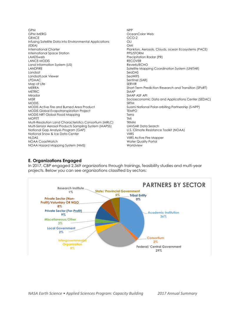
NASA Earth Science • Applied Sciences Program: Capacity Building 2017 Annual Summary
GPM
GPM IMERG
GRACE
Infusing Satellite Data into Environmental Applications
(IDEA)
International Charter
International Space Station
LAADSweb
LANCE-MODIS
Land Information System (LIS)
LANDFIRE
Landsat
LandsatLook Viewer
LPDAAC
Map of Life
MERRA
METRIC
Mirador
MISR
MODIS
MODIS Active Fire and Burned Area Product
MODIS Global Evapotranspiration Project
MODIS NRT Global Flood Mapping
MOPITT
Multi-Resolution Land Characteristics Consortium (MRLC)
Multi-Sensor Aerosol Products Sampling System (MAPSS)
National Gap Analysis Program (GAP)
National Snow & Ice Data Center
NLDAS
NOAA CoastWatch
NOAA Hazard Mapping System (HMS)
NPP
OceanColor Web
OCO-2
OLI
OMI
Plankton, Aerosols, Clouds, ocean Ecosystems (PACE)
PPS/STORM
Precipitation Radar (PR)
RECOVER
Reverb/ECHO
Satellite Mapping Coordination System (UNITAR)
SeaDAS
SeaWiFS
Sentinel (SAR)
SERVIR
Short-Term Prediction Research and Transition (SPoRT)
SMAP
SMAP ASF API
Socioeconomic Data and Applications Center (SEDAC)
SRTM
Suomi National Polar-orbiting Partnership (S-NPP)
TEMPO
Terra
TMi
TRMM
UAVSAR Data Search
U.S. Climate Resistance Toolkit (NOAA)
VIIRS
VIIRS Active Fire Mapper
Water Quality Portal
Worldview
E. Organizations Engaged In 2017, CBP engaged 2,369 organizations through trainings, feasibility studies and multi-year
projects. Below you can see organizations classified by sectors:
Academic Institution
36%
Consortium
2%
Federal/ Central Government
29%
Intergovernmental
Organization
5%
Local Government
2%
Miscellaneous/Other
3%
Private Sector (For-Profit)
9%
Private Sector (Non-
Profit)/Voluntary OR NGO
8%
Research Institute
1% State/ Provincial Government
5% Tribal Entity
0%
PARTNERS BY SECTOR