17 chapter two: angkor and cambodia in history
TRANSCRIPT
17
CHAPTER TWO: ANGKOR AND CAMBODIA IN HISTORY
The word “Angkor” refers to several different, but related, locations at once.
Today Angkor most often refers to the collection of temples that is located in
northwestern Cambodia, close to the provincial capital of Siem Reap. This
designation closely coincides with the area the French designated as the Angkor
Historical Park during Cambodia’s colonial period. The park still exists today in
nearly the same form, although it is now administrated by the Cambodian
government agency, APSARA Authority.1 The word itself is thought to have its
roots in the Sanskrit word nagara, meaning “city,” and is thus thought at one time
to have referred to the city that surrounded the central temples.2 Angkor is also used
to refer to the largest temple in the area, Angkor Wat, built in the 12th century by
King Suryavarman II. Finally, Angkor is as often used to refer to a place in time as
it is to refer to a location in space. When writers and researchers refer to
occurrences, events, and practices which took place “at Angkor,” the reference not
only applies to the place, but also denotes the period when the Khmer Empire was
in its ascendancy, roughly from the 10th to the 13th centuries.
Monuments are often imbued with great cultural importance. The meanings
that are ascribed to structures, whether they were built by a society’s predecessors
or by themselves in commemoration of an event, nearly always appear in the form
of a narrative, as the story of the monument. Angkor, like most monuments, has a
story. And, like most monuments, it has more than one story. In
1 APSARA, or the Authority for Protection and Management of Angkor and the Region of Siem Reap, is a government agency “in charge of research, protection and conservation of cultural heritage, as well as urban and tourist development” in the area. Quoted from the APSARA web site, http://www.autoriteapsara.org/en/apsara.html, February 5, 2005. 2 This city is discussed at length in the writings of Chou Da-Kuan, a member of the Chinese mission to Cambodia who visited the city in the 13th century. Chou Ta-Kuan, Trans. Paul Pelliot and J. Gilman d’Arcy Paul, The Customs of Cambodia (Bangkok: The Siam Society, 1992)
18
this dissertation I will be investigating one of these stories. It is not the first
narrative of the monuments, although it was often claimed to have uncovered the
“original” story of the temples and the civilization that built them. In subsequent
decades it is the narrative that has exerted the heaviest influence on the world’s
understanding and knowledge of the temples—particularly in the West. Many
facets of that narrative continue to echo through descriptions of Angkor today,
despite evidence that contradicts the validity of some of the details. In order to
better understand the origins of these aspects of Angkor’s story, this dissertation
will focus on the narrative of Angkor as it was told by the French during the
colonial period in Cambodia, which lasted ninety years, from 1863 until 1953.
The area known as Angkor is located in what is today northwestern
Cambodia. It is estimated that there may be as many as one thousand temples,
salas,3 and shrines that date from the Angkor period across present-day Cambodia,
southern Laos, and northeastern Thailand. Less than one hundred have been cleared
and stabilized, including temples such as Phimai in Thailand and Wat Phu in Laos.
The highest concentration of temples from this period can be found in Cambodia’s
Siem Reap province. In this dissertation I will be focusing on the most visited sites
within the Angkor Historical Park: Angkor Wat, the Bayon, and Ta Prohm.
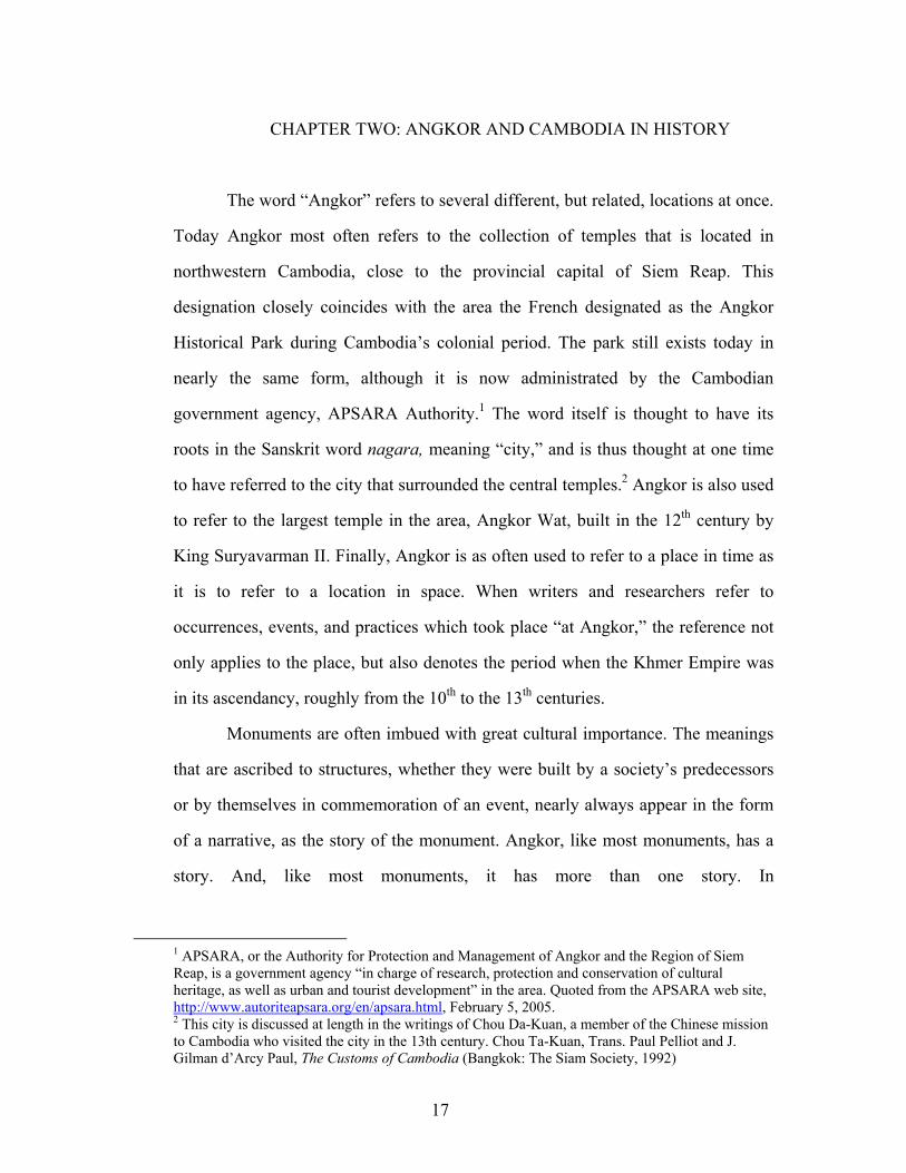
Angkor Wat is the largest structure amongst this cluster of temples and is
located approximately six kilometers north of the provincial capital of Siem Reap.
The structure was built in the twelfth century by King Suryavarman II and was
originally dedicated to the Hindu god, Vishnu. The main temple has a rectangular
floor plan topped with a succession of progressively elevated and receded levels,
giving the structure a somewhat pyramidical outline. (Figure 1)4
3 Meaning “hall,” this term covers structures meant to shelter pilgrims as well as halls where events took place. 4 Photograph taken by the author.
19
The exterior walls of lowest level, which is raised more than a meter from
the ground, are enclosed by a sheltered gallery whose inner walls are covered with
bas-relief murals. These murals depict episodes from the great Indian epics (such as
The Battle of the Kurukeshetra Plain from the Mahabharata and the Battle of Lanka
from the Ramayana), events found in religious texts (such as the Churning of the
Milk Ocean from the Vishnu Purana), and historical events (including an Historical
Procession in which Suryavarman II is thought to be depicted). Each corner of this
gallery was once topped with a conical tower, however the towers
Figure 1 Angkor Wat
have toppled over time.
Behind the exterior wall lies an inner courtyard at the center of which rises
the next level of the temple attainable by means of a steep staircase. This level has a
square floor plan and is enclosed by another gallery whose walls are unadorned.
Each of the four corners of this level is topped by a conical tower which overlooks a
second interior courtyard. At the center of this level rises a staircase leading to the
inner sanctuary. The sanctuary likely once held a statue of Vishnu, although today

20
is contains an image of the Buddha. It is topped by a fifth, centrally placed conical
tower.
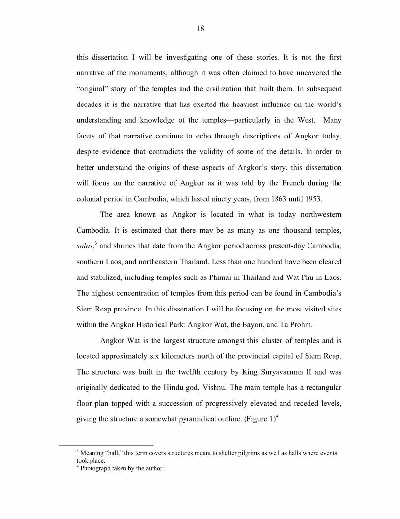
The temple is reached by crossing a long causeway edged with balustrades
in the shape of giant nagas, or mystical water serpents. The causeway crosses a
large moat leading to an exterior wall which encircles the island at the center of the
moat. At the point where the causeway meets the exterior wall one crosses
Figure 2 Colonial era photograph of Angkor Wat
through an enclosed gallery whose walls are decorated with bas-relief patterns
resembling floral patterned brocade and the likenesses of numerous devata and
apsaras—the demi-goddeses and semi-divine dancers of the court. In the main
gallery located at the crossing of the gallery and the causeway there is a large statue
that was originally an image of Vishnu. Pilgrims now leave offerings at the base of
the statue and dress it in saffron cloth as an image of the Buddha.
The causeway continues beyond the gallery across the expanse of a large
grassy field. In colonial era photographs this field often appears filled with creeper
21
vines, palm, and coconut trees. (Figure 2)5 Today it is often used as a picnic area,
especially for visiting domestic tourists, and as a football pitch for local children.
Walking along the causeway one passes a pair of small buildings with architectural
design that mirrors each other, which were dubbed “libraries” by French scholars,
but whose purpose has not been entirely illuminated. Beyond the libraries is a pair
of small, rectangular pools which reflect the façade of the temple during the wet
season when the water level is high. Just beyond the northern pool rises the roof of
the Buddhist monastery which houses several dozen monks. The building is of
relatively recent construction, however, a monastery has existed in that spot for at
least one hundred and fifty years, and most likely has a history that goes back much
further.
The layout of the temple and its grounds is thought to have been designed to
resemble the cosmological map of Mt. Meru, the sacred mountain of Hindu
cosmology. It is believed that the successive bodies of water (moat, reflecting
pools) and rings of walls and covered galleries surrounding courtyards were meant
to mimic the rings of successive mountain ranges and seas which encompass the
five peaks of Meru. The five towers topping the square galleries at the center of the
structure were meant to represent the peaks of the holy mountain. The centrality of
Mt. Meru is echoed in the bas-relief found on the southeastern wall depicting the
Churning of the Milk Ocean. In this scene from the Vishnu Purana the devas (gods)
and the raksas (demons) are using the king of the nagas as a rope to churn the milk
ocean in order to release amrita, the elixir of life. Mt. Meru is the pivot of the
churn, and is thus the pivot upon which the universe turns.
5 Martin Hürlimann, Photographic Impressions: Burma, Siam, Cambodia, Yunna, Champa, and Vietnam (Bangkok: White Lotus, 2001) p. 199.
22
Angkor Wat is considered the masterpiece of ancient Khmer art and
architecture. It is the largest structure from the Angkorian period and contains more
than a kilometer of exquisitely carved bas-relief murals. While significant clearing
and reconstruction efforts have been implemented at Angkor Wat since
Figure 3 The Bayon
1907 when they came into French colonial possession, of the numerous temples in
the area Angkor Wat was the best preserved at the time of the arrival of Europeans
in the area. Initially, much of the French focus on the temples was trained on
Angkor Wat, and it has continued to be the most well known and often-visited
structure at Angkor. Angkor Wat also has the distinction of being an important
pilgrimage place for Buddhists in Cambodia, which has a population that is more
than ninety percent Buddhist.
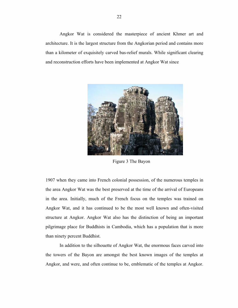
In addition to the silhouette of Angkor Wat, the enormous faces carved into
the towers of the Bayon are amongst the best known images of the temples at
Angkor, and were, and often continue to be, emblematic of the temples at Angkor.
23
(Figure 3)6 The temple has a distinctive layout which is not duplicated elsewhere
amongst the Angkorian period temples, while at the same time echoing some of the
more integral components of the floor plans of other temples which predate it, such
as Angkor Wat. This notably includes the successive elevated and receding levels.
The lowest level of the structure is laid out in the shape of a square, and like
Angkor Wat, this entry level is ringed with galleries. These galleries were once
covered by a corbelled, stone roof, and the walls are covered with bas-reliefs. The
second level stands elevated and recedes in size from the first. The second level also
presents a series of covered galleries decorated with bas-reliefs.
From the second level one ascends to a square, stone courtyard. Each of the
corners of the crenalated courtyard is topped by a conical tower which bears a
smiling, male face pointed in each of the cardinal directions. At the center of this
courtyard stands a circular tower that is surmounted by conical towers which again
bear the smiling, male faces looking out at the four directions. This circular tower
has a small staircase that leads to an interior chamber, and the chamber is topped by
another conical, four-faced tower.
The smiling faces are thought to be that of Lokesvara, the Mahayana
Buddhist bodhisattva of mercy, to whom the temple is dedicated. Built in the 13th
century by the last great king of Angkor, King Jayavarman VII, the Bayon is the
centerpiece of the building frenzy that characterized his reign. While previous kings
often built one major temple, and others were only able to carry out renovations of
structures built by others, Jayavarman VII appears, according to inscriptions, to
have been responsible for the construction of numerous major stone temples, as
well as smaller stone structures, wooden salas and hospitals, and schools. In
addition to the Bayon, major temples such as Banteay K’dei, Beng Mealea, Preah
6 Photograph by author.
24
Khan, and Banteay Samre are thought to have been constructed during his reign,
although each of these additional temples was constructed on a single level, or with
only a partial second level, rather than as a “temple mountain,” as structures like
Angkor Wat, the Bayon, and earlier temples such as Ta Keo, have been called.
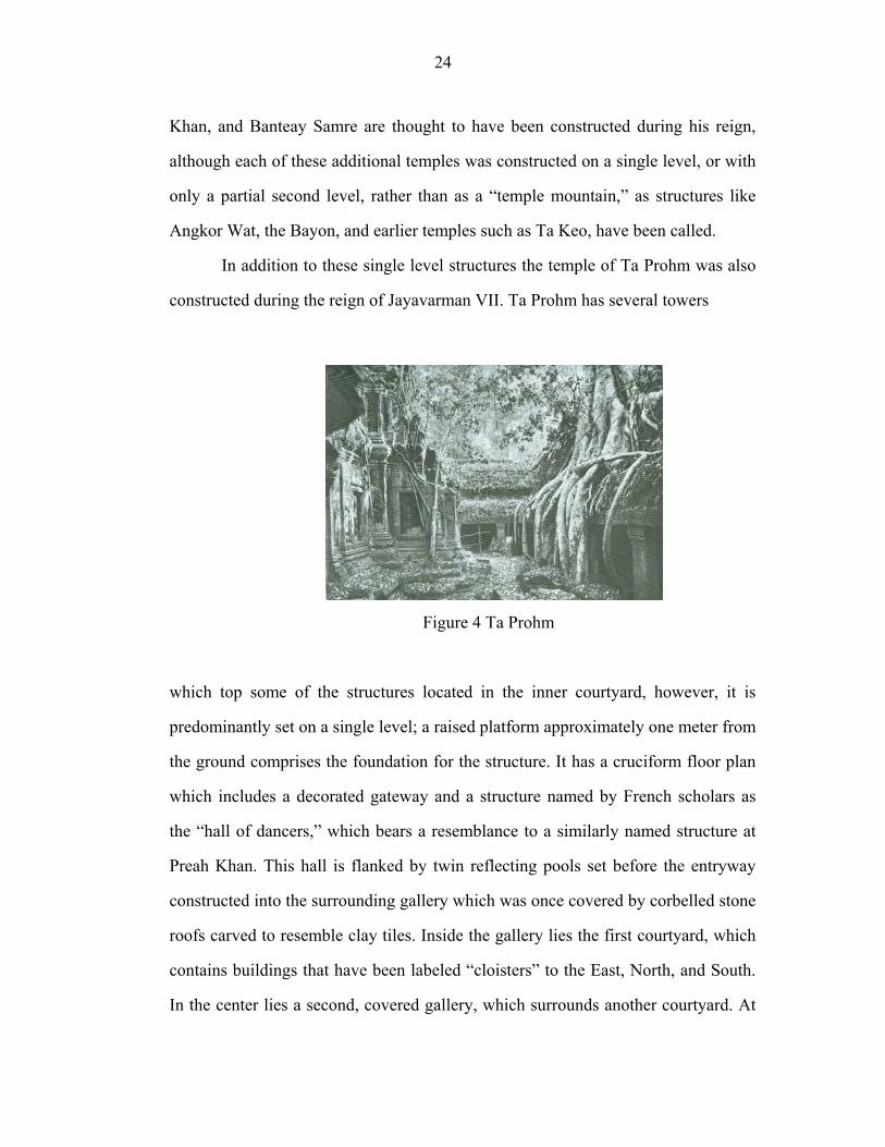
In addition to these single level structures the temple of Ta Prohm was also
constructed during the reign of Jayavarman VII. Ta Prohm has several towers
Figure 4 Ta Prohm
which top some of the structures located in the inner courtyard, however, it is
predominantly set on a single level; a raised platform approximately one meter from
the ground comprises the foundation for the structure. It has a cruciform floor plan
which includes a decorated gateway and a structure named by French scholars as
the “hall of dancers,” which bears a resemblance to a similarly named structure at
Preah Khan. This hall is flanked by twin reflecting pools set before the entryway
constructed into the surrounding gallery which was once covered by corbelled stone
roofs carved to resemble clay tiles. Inside the gallery lies the first courtyard, which
contains buildings that have been labeled “cloisters” to the East, North, and South.
In the center lies a second, covered gallery, which surrounds another courtyard. At
25
the center of the second courtyard stands yet another square gallery surrounding a
courtyard. At the center of the courtyard is a small stone enclosure where a statue of
the Buddha likely once stood. Fragments of Buddhist statues, mostly of the Buddha
beneath the hood of a seven-headed naga, are today piled inside this structure with
incense and other offerings set before them.
Ta Prohm’s floor plan bears a strong resemblance to that of Banteay K’dei,
which is located less than two kilometers away. In fact, a visit to Banteay K’dei or
to Preah Khan, which has a similar floor plan as well as some unique features,
might give the visitor a clearer conception of how the temples were constructed and
decorated, and how they might have originally been presented. While this may be
the case, Preah Khan is less often visited, and Banteay K’dei lesser still.
This is due mainly to the decision by the French colonial Conservation
d’Angkor to not clear the site of Ta Prohm completely, but rather to leave it in its
“natural state.”7 Instead of visiting Angkor for its statuary or its architecture most
visitors come to view the banyan trees which have taken root in between the stones
of the temple, and which sprout from its roof and walls. (Figure 4)8
While there are tens of temples in the vicinity of Angkor Wat, it is these
three temples—Angkor Wat, the Bayon, and Ta Prohm—which have consistently
been the focus of the most public discussions about Angkor, particularly in print.
Scholars debated the meaning of the inscriptions that were found in the area and
attempted to piece together a chronology of the temples through in-depth studies of
the style of bas-reliefs and statuary, however, only a small portion of this discussion
made its way into more widely read descriptions of Angkor. The learned
discussions of Angkor continue amongst scholars who still debate Angkor’s
7 Maurice Glaize, Les Monuments Du Groupe D'angkor, 2nd ed. (Saigon: Portail, 1948), p. 72. 8 Hürlimann, 2001, p. 173.
26
history,9 however, it was and continues to be the more popular impressions of the
temples which has made the greatest impact on the broad understanding in the West
of Cambodia and of the monuments.
Historical Background
The Khmer Empire, whose capital was based at Angkor, was at its height
between the 10th and the 13th centuries. The history of the area prior to the
Angkorian period is somewhat unclear, as what is known has come about through
piecing together mostly Chinese and Arabic sources and matching them with the
archaeological evidence that has been excavated. There have been a number of pre-
Angkorian stone statues that have been found which exhibit a style that differs
distinctly from the style of later stonework.
From the 10th to the 13th century the Khmer Empire grew and expanded,
despite various power struggles within the ruling class of the kingdom. The reach of
the kingdom at its height was certainly felt in what is today northeastern Thailand,
southern Laos, and southern Vietnam, in addition to what is today Cambodia, as
physical remains of the Khmer Empire have been found in each of these places.10
The Khmer conducted a number of wars with neighboring kingdoms, particularly
with the Cham in present-day central Vietnam during the 11th and 12th centuries.
Until the end of the 12th century the Khmer had the upper hand over the Cham, but
9 For example, two such debates which have captured the attention of scholars are the purpose and uses for the canals which consumed so much of ancient Angkor’s resources, and the devaraja cult. French scholars such as Bernard-Philippe Groslier wrote in the 1960s that the canals were the key to Angkor’s success as a capital and as an empire, theorizing that the canals were for irrigation. He proposed that as irrigation canals they would have doubled the rice growing capacity of the empire, making it possible to invade neighboring kingdoms. In recent years hydrologists have shown that this was a improbable scenario. See Bernard-Philippe Groslier, The Art of Indochina (New York: Crown Publishers, Inc., 1962) p. 70. The devaraja cult has also proved to be a point of debate. The term appears in numerous inscriptions, and was surmised by French scholars to be indicative of a practice of belief in which the king and one of the Hindu gods- usually Siva- were seen as conflated. How far this can be taken as a belief system has recently come under question. 10 It has been speculated that the influence may have extended beyond the reach of the physical remains, but it is hard to assess where the boundaries of this influence might have been.
27
in 1177 the Cham mounted a successful attack on Angkor, leading the charge up the
Mekong and Tonle Sap rivers, and eventually ransacking the Khmer capital.
Jayavarman VII would exact revenge a number of years later as the Cham kingdom
was losing its centuries-long resistance to the push south from the Vietnamese.
By the 13th century the influence of the Khmer Empire was also waning.
Angkor would be attacked several times over the course of the 13th century by the
neighboring Siamese, who appear to have occupied the capital for a number of
years in the mid-13th century. It may have been an attack by the Siamese in the 14th
century which caused the Khmer kings to finally move their capital south to
Oudong. While the Khmer Empire was no longer in its ascendancy during the year
the Chinese official Zhou Da Guan spent in the Cambodian capital, he still depicted
a powerful and wealthy city. Zhou visited Angkor in the last years of the 13th
century as part of the mission from the Mongol court, and his notes on his time at
Angkor include descriptions of the city as one whose towers were topped with gold
and whose walls were constructed of stones set so perfectly that they have “no
crevices for weeds to grow in.”11
Half a century after Zhou’s departure from Angkor the Khmer kings would
move south. They would return to the city briefly in the 15th century, but would
leave soon afterwards, moving their capital between the hills of Oudong and the site
where the present capital, Phnom Penh, sits at the meeting of the Tonle Sap and
Mekong Rivers. Beginning in the late 18th century Cambodia would gradually lose
more and more of its territory, one piece at a time, as its two neighbors—Siam to
the west and Vietnam to the east—fought wars with each other and took advantage
of Cambodia’s relative weakness.
11 Chou, 1996, p. 2
28
At the opening of the 1800s, Cambodia was a “protégé” of the Siamese
court, and the period, from its start to establishment of the French protectorate in
1863, begins and ends with a Siamese sponsored Cambodian coronation.12 The
establishment of the Nguyễn dynasty in Việtnam brought a level of stability to the
country after many years of internal fighting, making it possible for the Vietnamese
kingdom to begin looking beyond its borders toward territorial expansion. The
lower Mekong Delta—the area that has been called Kampuchea Krom (Lower
Cambodia)—was being settled and colonized by the Vietnamese, a process that
began with the marriage of a Cambodian king to a Vietnamese princess in the
seventeenth century. Although the Cambodian kingdom had been under the sway of
the Siamese court, by 1811 the balance of power was shifting eastward to
Việtnam.13 The seeds of discontent in Thai-Cambodian relations were sown in a
land exchange that placed the then seven year old King Eng on the Cambodian
throne under Siamese tutelage and regent at the loss of the provinces of Battambang
and Angkor. However, influence shifted when a Siamese-backed attempted coup
against Eng’s son, King Chan, led by Chan’s brother. Clashes between Siamese and
Vietnamese forces followed, both inside Cambodia, and ultimately the Cambodian
king escaped to Sài gòn. When King Chan (r. 1797-1835) was re-installed on the
throne by the Vietnamese in 1813, he was much indebted to, and heavily influenced
by, the Vietnamese court. The Cambodian court, in an attempt to hedge its bets,
continued to send tributes to the Siamese as well as the Vietnamese. The situation
was described succinctly by the Vietnamese emperor, who called Cambodia “an
independent country that is the slave of two.”14
12 David Chandler, “An Anti-Vietnamese Rebellion in Early Nineteenth Century Cambodia”, in Facing the Cambodian Past, 1996b, p. 117. 13 Chandler, 1996a, p. 63. Chandler further notes that after 1810 “King Chan and his advisers were swept up into a fame of power politics that they had little change to change and no opportunity to win. They had no choice.” Chandler, 1996a, p. 115. 14 From Chotmai Het (Thai archival documents) 2/1173/19ko, quoted in Chandler, 1998, p. 119.
29
The Vietnamese and the Siamese saw themselves in a parental role with
Cambodia positioned as their “child,” if not by birth, than by adoption. According
to David Chandler, Siam saw itself as the “father,” while Việtnam saw itself as the
“mother” to the Cambodian king’s “unruly child.”15 King Chan, for his part as the
rebellious offspring, played a dangerous game of pitting his symbolic parents
against each other—a game that often ended with one or the other sending an
expeditionary force. These forces, and their movement back and forth across the
Cambodian countryside over half a decade created an atmosphere of terror,
instability, and persistent danger, and its imprint is marked in historical sources of
this period.16
The Vietnamese continued to hold sway over Cambodia until the 1840’s,
despite Siamese invasions in 1833 and 1841. During the second of these invasions
in 1841 Cambodia revolted against its Vietnamese “mother,” but the rebellion soon
lost steam, as well as supplies, and petered out in a matter of months. In the midst
of this rebellion, however, the Vietnamese emperor, Minh Mạng died, and his son,
Thiêu Tri, took the throne. Unlike his father, he didn’t have a clear plan, or desire,
to prolong the efforts being exerted to hold on to the Cambodian buffer state that
kept the Siamese at bay.
In the same year, the Siamese, led by Chaophraya Bodin attacked and
overcame the Vietnamese at Pursat. Bodin wrote to Bangkok that Prince Duang,
one of Chan’s surviving brothers, should be released from Siamese custody in
preparation to take the Cambodian throne.17 The Vietnamese attempted to put
Chan’s other surviving brother, Prince Im, who had by this time defected to the
15 Chandler, 1996a, pp. 114-5. 16 “It would be difficult to overstress the atmosphere of threat, physical danger, and random violence that pervades primary sources… and perhaps much of everyday life in nineteenth-century Cambodia. The sources are filled with references to torture, executions, ambushes, massacres, village burnings, and the forced movement of populations.” Chandler, 1996a, pp. 121-2. 17 Ibid., p. 133.
30
Vietnamese side, on the throne. This move had virtually no support, so instead
Vietnamese forces took the Prince, other royal family members, and much of the
capital’s population as they withdrew to Việtnam. Cambodia’s fortunes shifted once
again between the Vietnamese and Siamese: the Vietnamese re-installed Queen Mei
in Phnom Penh in 1844, but were unable to move the Siamese from Oudong in
1845. Eventually, the stalemate was ended with a Vietnamese demand for a tribute
to the court at Huế, and when the embassy returned to Phnom Penh in 1847, the
Vietnamese returned a number of royal family members, as well as the regalia that
would serve to legitimate Duang as sovereign of Cambodia. He was crowned by the
Siamese at Oudong in April of 1848.
The rule of King Duang is often seen as a time of calm and stability,
particularly in comparison with the nearly continuous war that characterized the
period immediately preceding it. Duang continued to be caught between the
influence of Việtnam and Siam, although this tension less often resulted in armed
conflict during his reign. The relative peace did not prevent Duang from seeking
remedies that would release Cambodia from the pressures placed upon the country
by its two neighbors. In the early 1850s King Duang appears to have made
overtures toward France. In assessing the situation, Duang is reported as having
asked a French missionary, “What would you have me do? I have two masters who
always have an eye fixed on me. They are my neighbors, and France is far away.”18
This appears to also have informed the thinking of Duang’s successor in his own
dealings with the Siamese, Vietnamese, and French. Eventually the court
discovered that even though France was far, it did not preclude their installing the
French administrative and military structure in the territory once the door had been
opened.
18 Ibid, quoting Charles Meyniard, Le second empire en Indochine (Paris: Société d’éditions scientifique, 1891) p. 461.
31
In 1860 King Ang Duang died, and Norodom, his designated successor,
appears to have had little support.19 He was only able to take control of the kingdom
with the assistance of the Siamese, who retained the royal regalia in Bangkok.
Unable to truly take the helm of Cambodia without the regalia, and angered by the
interference of the Siamese, Norodom began to once again court the French, who
had recently installed themselves downriver in Cochinchina. Norodom signed
treaties with the French in 1863, while continuing to proclaim fidelity to the
Siamese court. Norodom’s multiple allegiances would be the cause of confusion
and tension at his coronation in 1864. The event was officiated jointly by the French
and Siamese, and included a storm of procedural bickering. In the end, the king’s
titles were chosen and bestowed by the Siamese, while it was the French who
placed the crown on his head. In 1867, the French and the Siamese signed a treaty
that settled the matter, with the coronation marking the close of real Siamese
influence over the Khmer court, and the commencement of the French colonial
period.
The French military officers, troops, and administrators who arrived in
Phnom Penh, where the country’s seat had been moved from Oudong once again in
1866, were not the first Europeans to have a presence in Cambodia. Written
descriptions of Cambodia by Europeans go as far back as Tome Pieres in the early
sixteenth century. Portuguese missionaries made numerous concerted efforts in the
sixteenth century to find converts among the Khmer, and were joined in this
endeavor by Spanish missionaries. Despite imperialist designs by the Spanish,20 the
19 Meyer says of this period that both Norodom and his half-brother Siwotha were in Bangkok, awaiting the Siamese decision regarding which of the princes would be placed on the throne. [“Pendant huit mois, Norodom et Siwotha attendirent au Siam qu’à Bangkok on daignât se pronouncer en faveur de l’un ou de l’autre. Finalement, le premier fut choisi et put regagner sa capitale en mars 1862…”] Charles Meyer, La Vie Quotidienne Des Français En Indochine, 1860-1910 (Paris: Hachette, 1985). p.107. 20 Gabriel Quiroga de San Antonio, a Dominican friar wrote in his 1604 publication Breve y verdadera relacion de los successis del Reyno de Camboxa about two failed attempts by the Spanish at taking the kingdom, the first of which ended in the murder of the Cambodian king, as well as
32
kingdom did not fall into European hands at that time, nor did the missionaries
encounter much success in their pursuit of converts. And at the end of the century,
Lovek fell to the Siamese. By the time this happened, however, both Lovek and
Phnom Penh were brimming with foreign traders: Not just Spanish and Portuguese,
but also Chinese, Arab, Japanese, English, and Dutch. The cities had designated and
segregated areas for various foreign nationals.
The colonial presence of the French in Cambodia during the nineteenth
century was not felt deeply outside of the capital. Provincial capitals eventually
received French Résidents and other fonctionaires, who, in the lower ranking
positions and in later years, were often Vietnamese rather than French nationals.
However, these administrative placements often weren’t a reality until after 1884.
The Cambodian administration, the okya,21 would have felt their presence first, as
the French administrators put it upon them to implement new administrative
procedures.22 In the capital city, and for the king, the French presence infiltrated
many aspects of life, particularly in the administration. But even in Phnom Penh,
which had the highest concentration of French in the country, the interactions that
occurred between Europeans and the “indigènes” they ruled were limited.
This was, in part, because during the period from 1863 until 1884, the
French role in Cambodia, as defined in the 1863 treaty, was rather vague. It more or
attempts at gaining political and financial backing for a third try. None of these attempts resulted in the Spanish actually taking the territory, though as an interesting pre-cursor to the events of the 19th century, it seems that when the Cambodian court felt it was being crushed under the weight of Siamese control, or when the internal squabblings among royal family members became too destabilizing, the Spanish were courted to intervene. Much like the French two and a half centuries later, the Spanish seem to have ignored these pleas at the time when they were given, and to have acted on them only much later, when it was often no longer desired.Gabriel Quiroga de San Antonio and Antoine Cabaton, A Brief and Truthful Relation of Events in the Kingdom of Cambodia (Bangkok, Thailand: White Lotus Press, 1998). 21 The okya were high ranking officials, and the system carried numerous titles and distinctions of rank. Some of the okya were attached to the palace, while others were stationed at locations in the province where they administered the territory, including such duties as tax collection. Chandler, 1996a, p. 108. 22 In these early stages these directives might have been given to the okya by the king rather than directly from the French.
33
less inserted the French into a system that already existed, with the okya acting as
agents of the king, governing their territories, collecting taxes, and dispensing
justice. This system was left largely in place. Furthermore, in the early decades of
the protectorate, there simply weren’t that many French citizens residing in
Cambodia in an official capacity. Estimates for the first two decades of French rule
put the total number of military officers, soldiers and functionaries at between one
hundred and one hundred and fifty.23
The Convention of June 17, 1884 would change this situation significantly.
With the signing of this treaty, France now had power over important branches of
the government that it had not previously had. Among the areas that were placed in
the hands of the French were the protectorate’s economy, financial affairs, police,
and judicial affairs.24 As a result, Cambodia was soon host to an exploding
population of new functionaries, military officers, and soldiers who would fill new
positions created by the new responsibilities of the government. It is from this point
that the French truly began to have an impact on the country, and its inhabitants as
the French population began to grow.25 Compared with the European population of
one hundred to one hundred and fifty residents in the years between 1863 and 1884,
the European population of Cambodia in 1904 was 825, eighty percent of whom
were either in the military or part of the colonial government.26
Although the presence of the French was during this period being
increasingly felt in Cambodia, 825 Europeans residing throughout the country is not
many, particularly when one keeps in mind that the estimation of the general
23 Meyer, 1985, p. 115. 24 Ibid. 25 Ibid, p. 116 26 Ibid. The breakdown of numbers was 530 Europeans in Phnom Penh, 295 in the provinces. Of this population 101 were part of the tax bureau, 76 were administrators and civil servants, 88 were public works technicians, 25 were agents of the P.T.T. (post and telegraph), 12 teachers, 12 police officers, 7 magistrates, the remainder fall into a smattering of other categories. There were also Europeans at this time working in commercial areas not connected to the government, and by 1904 it was becoming more common for colons to bring their spouse with them from Europe.
34
population in 1904 was 1,250,000. The number of Europeans in the protectorate
would never reach the numbers that it did in Tonkin, Annam, or Cochinchina, the
three separately administered sections of Việtnam.27 While there had been early
supporters of the idea of taking control of Cambodia and its perceived or hinted-at
riches,28 Cambodia fell under French protection as much because of the court’s
desire to extricate itself from Siamese control, perhaps by King Norodom’s
misreading of French power, as from France’s desire for colonial expansion. The
taking of Cambodia had been completed without bloodshed or struggle. However,
few of the projected resources manifested, and Cambodia’s role in the French
colonial empire was considered less than crucial, particularly in comparison to
Việtnam’s economic strength.
Nevertheless, the French administrators who established themselves in
Cambodia in the 1860s did begin work on building a capital city. While Phnom
Penh would never be declared the “Paris of the East,” as its downriver neighbor Sài
gòn, was, it would come to be known as a pleasant, if somewhat isolated, town.
Wide boulevards lined with trees were built, and like many French colonial cities,
Phnom Penh was divided into segregated quartièrs: an European quarter, a Chinese
quarter, a Vietnamese quarter, a “native” quarter. Despite these efforts, by 1891
Phnom Penh was not considered a choice assignment for colonial officials, as
evidenced in one official’s description of the capital as “a miserable conglomeration
27 Of the three, only Cochinchina was technically administered as a colony. The other two, Tonkin and Annam, like Cambodia, were protectorates. Laos would later be added, also as a protectorate, with the five administrations together being labeled Indochine, or the Federation Indochinois. 28 For example, the naturalist Henri Mouhot seems to have believed that Cambodia held untapped resources that should be exploited by a colonial power. His beliefs were repeated loudly by other French explorers in the area, including Francis Garnier, Louis de Carné and Auguste Pavie, though all of these men came to Cambodia - with the exception of Garnier, who arrived before, and stayed on- after it had effectively become part of Greater France. Even so, all of them echoed the perceived and imagined riches that Gabriel Quiroga de San Antonio described in his early seventeenth century publication. The assumption that the unknown jungles of Cambodia were hiding nearly limitless untapped resources, and that the Mekong river was a “river road” that would lead into the much sought-after interior of China, are a common theme running from the earliest European accounts into the twentieth century.
35
of straw huts or brick hovels planted around infected swamps whose emanations in
the dry season decimate the population.”29 This began to change in 1889 when the
king traded his property rights on much of the land that became Phnom Penh in
exchange for an influx of piastres by the French administration.30
King Norodom, crowned by the French, remained on the throne until his
death in 1904. He appears not to have been pleased with the situation he found
himself in vis-à-vis his European masters, and to have made his displeasure known.
For their part, the French often seemed to have an equal distaste for King Norodom,
and the possibility of replacing him with his Francophile half-brother, Prince
Sisowath, was always kept as a possibility.31 Ultimately, the French realized that
deposing the king in favor of his half-brother, while it might make particularly
French interests more easily attainable, might also carry the possibility of
instigating a revolt among the population at large.
Sisowath became king in 1904 after the death of Norodom. He would rule
throughout much of the remainder of the colonial period until his own death in
1927, when he was succeeded by his son, Monivong. King Monivong was believed
to have been a life-long Francophile until the beginning of World War II when the
French lost Siem Reap and Battambang provinces to Thailand after a disastrous
defeat. He reportedly refused from that moment to meet with French officials or to
speak French until his death in 1941.32 He was succeeded by Prince Sihanouk, who
29 J. Agostini, “Pnom Penh (Voyage au Cambodge en 1893-1894”, Le Tour du Monde, 1898, as quoted in Meyer, 1985, p. 136. 30 Ibid, p. 137. 31 Ibid, p. 117. “Norodom est et demeure un monarque oriental, despotique, irascible, maître absolu de la vie de ses subjets, ne tolerant aucun manquement à la tradition qui fait de lui une personne “sacrée et inviolable”.” Whether or not this observation of the king is an exaggeration, it does give an idea of the way in which he was perceived by the French, and are sentiments that are echoed by contemporary observers, such as Louis de Carné who, when discussing Norodom’s opinion of the king of Bassac as a “man of the woods”, declares that the Cambodian king had come to this opinion “with his accustomed stupidity.” Louis De Carné, Travels on the Mekong : Cambodia, Laos and Yunnan, the Political and Trade Report of the Mekong Exploration Commission (June 1866-June 1868) (Bangkok: White Lotus, 2000) p. 66. 32 Chandler, 1996a, p. 166.
36
was barely eighteen years old at the time of his ascendance to the throne. Sihanouk
was perceived by the French to be young and easy to manipulate, an impression that
would prove to be inaccurate. Sihanouk would ultimately leave the throne to enter
politics after Cambodia won its independence in 1953, and would become the
country’s first prime minister in 1955. He played an active role in politics until his
overthrow by General Lon Nol in 1970, and returned to the forefront of Cambodian
politics as the public face of the Khmer Rouge for the early years of the Democratic
Kampuchea regime. He would re-ascend the throne as Cambodia’s king in 1993,
reigning until his abdication in late 2004 due to health concerns.
The temples at Angkor and wars that ravaged Cambodia in the 1960s and
1970s are perhaps the two things for which the country is best known outside of
Southeast Asia. The war that raged in Việtnam in the 1960s and early 1970s bled
over the border into Cambodia, and the American military began bombing the
Cambodian countryside in an attempt to cut off the supply line that ran along trails
from North Việtnam to South Vitệnam. The Khmer Rouge, the Cambodian
Communists, began waging their own war against the U.S.-backed Lon Nol
government in Phnom Penh with growing success throughout the early 1970s.
Eventually the city of Phnom Penh, overflowing with refugees trying to escape the
American bombings and Khmer Rouge fighting in the countryside, were cut off.
The airlifts supplying the city could not hold back the invasion, and on April 17,
1975 Khmer Rouge troops entered the capital. Phnom Penh was evacuated within
days. The genocidal Democratic Kampuchea regime held power in Cambodia for
nearly four years, during which time an estimated 1.7 million people died from
starvation, overwork, exhaustion, and execution. The Khmer Rouge only fled the
capital after Vietnamese forces invaded in early 1980. The Vietnamese stayed until
1989; the civil war spearheaded by remnants of the Khmer Rouge continued
throughout much of the 1990s, ending only as the century came to a close.
37
With the fighting finally over, Cambodia is turning to rebuilding and to
development. Phnom Penh is once again bustling with traffic, trade, and tourists.
The textile industry comprises a major component of the country’s nascent industry
and entrance into the global economy.33 In addition to the garment industry the
Cambodian government is setting its sights on capturing an important slice of the
global tourism industry, particularly in the growing market for tourists visiting
Southeast Asia. The success of the Thai tourist industry has spurred other countries
on the Southeast Asian mainland to turn their sights towards capturing a portion of
the market, or at least linking industries such as Cambodia’s to their neighbor’s
success.
The legacy of Cambodia’s late twentieth century wars provides an important
element of the country’s 21st century tourist industry. Visitors to the country can
tour Tuol Sleng, the high school that was turned into a prison and torture and
interrogation center by the Khmer Rouge, as well as the “Killing Fields,” a mass
grave containing the skeletal remains of hundreds of the regime’s victims.34 Despite
the availability of genocide tours, the majority of tourists do not visit Cambodia in
order to see Tuol Sleng, and many of the more than 330,000 travelers who were
issued tourist visas in 2000 never even made it to Phnom Penh.35 The focus of the
Cambodian tourism industry has been trained predominantly on the temples at
Angkor.
33 Major companies which have some of their lines produced in Cambodia include The Gap, Columbia, and Old Navy. It is unclear at this point how the change in quota regulations in the textile trade- many of which ended at the start of 2005- will change the industry in Cambodia and other developing countries. 34 The Cambodian government has also completed some preliminary work towards making the small village of Anlong Veng along the Thai border into a major destination for genocide tours. The village was the last holdout of the Khmer Rouge, and houses once belonging to much of the most senior Khmer Rouge leadership can be found within its boundaries. It is also the place where Pol Pot finally died. Personal communication with Timothy Dylan Wood, June 2002. 35 “Open Skies Bring Flocks of Tourists to Cambodia,” The Nation, Bangkok, Thailand, December 13, 2000.
38
The Cambodian government sees “a protected and prospering cultural
heritage” as one that “will make an essential contribution to permanent economic
stabilization” in the country.36 With so much of Cambodia’s economic future being
laid upon the tourism prospects the presentation and publicity of the country’s
principal site is of great importance. Yet, even as King Sihanouk urges the placing
of “the management, the promotion and the exploration of the Khmer cultural
heritage into Khmer hands…into the same hands that sculpted it, that caressed it
and protected it for so many centuries,”37 much of the information most accessible
to the international tourists that are being courted is not written by Cambodian
hands. Furthermore, much of this material, from guidebooks to coffee table
photography books, relies on the narrative of Angkor written, embellished, and
cultivated during the colonial period. In the following chapters I will be
investigating that narrative, and following its continued prevalence in the
discussions of Angkor published for general audiences through to today.
36 From the website of the APSARA Authority, http://www.autoriteapsara.org/en/apsara.html, viewed February 7, 2005. In addition, the website states: “In Angkor - a geographical region, an archaeological site and a cultural concept - lies much of Cambodia's future. The Angkorian heritage offers incomparable potential for economic prosperity, which can in turn provide a favorable climate and the means necessary for true protection of the Khmer heritage for the generations to come.” 37 King Sihanouk quoted on the website of the APSARA Authority, http://www.autoriteapsara.org/en/apsara.html, viewed February 7, 2005.