document (spd) on the south pennine moors special … · document (spd) on the south pennine moors...
TRANSCRIPT

Screening opinion on the Impact of the Residential Design Supplementary Planning Document (SPD) on the South Pennine Moors Special Area of Conservation (SAC), the South Pennine Moors Special Protection Area (SPA) and the Rochdale Canal SAC. Contents:
1. Introduction 2. Brief Description of the SPD 3. Relationship to Other Plans and Strategies 4. Description of the South Pennine Moors SAC / SPA 5. Primary Reason for the Designation of the South Pennine Moors SAC 6. Primary Reason for the Designation of the South Pennine Moors SPA 7. Impact of the Residential Design SPD on the Special Features of the South Pennine Moors
SAC / SPA 8. Description of the Rochdale Canal SAC 9. Primary Reason for Designation of the Rochdale Canal SAC 10. Impact of the Residential Design SPD on the Special Features of the Rochdale Canal SAC 11. Conclusion 12. Appendix 1: Favourable Condition Table for Dark Peak SSSI 13. Appendix 2: Favourable Condition Table for Rochdale Canal SSSI 14. Appendix 3: Map showing European Sites in relation to Tameside
Page 68

1. Introduction 1.1 Article 6(3) of the European Habitats Directive dealing with the conservation of European
protected sites states that: ‘Any plan or project not directly connected with or necessary to the management of the site but likely to have a significant effect thereon, either individually or in combination with other plans and projects, shall be subject to appropriate assessment of its implications for the site in view of the site’s conservation objectives. In light of the conclusions of the assessment of the implications for the site and subject to the provisions of paragraph 4, the competent national authorities shall agree to the plan or project only after ascertained that it will not adversely affect the integrity of the site concerned and, if appropriate, after having obtained the opinion of the general public.’
1.2 The purpose of Habitats Regulations Assessment of land use plans is to ensure that
protection of the integrity of European sites is a part of the planning process at a regional and local level. Habitats Regulations Assessment can be seen as having a number of discrete stages:
Stage 1 – Screening Stage 2 – Appropriate Assessment Stage 3 – Assessment of Alternatives Stage 4 – Assessment where no alternatives are available 1.3 This document comprises Stage 1 of the Habitats Regulations Assessment process and
contributes to the fulfilment of the Councils statutory duty as regards Article 6(3); that is, it is a Screening Opinion on whether or not the Residential Design Supplementary Planning Document (hereafter referred to as ‘the SPD’) will have an impact on the special interest of any European site and therefore needs to undergo further Screening Opinions or a full Habitats Regulations Assessment as the SPD develops.
1.4 A small part of the South Pennine Moors SAC / SPA falls within the borough boundary and
has therefore been covered in this screening opinion. Although it is considered that the SPD will not have effects outside of the borough’s boundaries, the Rochdale Canal SAC is approximately 1.5km from the borough boundary and has also been covered in this screening opinion to ensure that the SPD will not adversely affect this SAC. The locations of these European sites are indicated on the map shown in Appendix 3. There are no other European sites within 15km of the borough boundaries and therefore all sites that may be affected have been covered in this report.
2 Brief Description of the SPD 2.1 The Residential Design SPD role is to ensure new residential developments and extensions
are of the highest possible design quality. It highlights the importance of adopting a design led approach to create imaginative, safe, attractive and functional schemes that respond appropriately with their surroundings.
2.2 The SPD provides a clear indication of the Council’s expectations through residential
design policies to assist homeowners and developers when designing schemes; and help the Council make consistent decisions when assessing planning applications.
2.3 The document provides general advice on the planning process and its requirements,
together with information on what developments are permitted without needing planning permission. The main body is then broken in to two elements. One focusing on residential developments and the other focused on residential extensions.
Page 69

2.4 The use it is anticipated the document and its policies, allied with regional and national policies and guidance, will create high quality sustainable residential developments that will meet the needs of current and future occupiers.
2.5 The document sets out policies for developments across the borough, and this together
with the physical location of European sites and other, overriding planning policies, (such as greenbelt policy) means that development affected by the document will be at least 2 km from any European site. The document influences residential developments but does not give details of all operations and developments that may be controlled by the SPD, and therefore it is not possible to address specific potential impacts of developments on European sites. Instead, a general assessment has been made about possible impacts of the document as a whole on European sites.
3 Relationships to Other Plans and Strategies 3.1 The SPD conforms to the Regional Spatial Strategy (RSS) for the North West and is
consistent with its aims, objectives and policies. The RSS sets out the overall types, levels, and locations for growth within the region and these are not within the control of Tameside MBC, or the SPD. The RSS itself has been subject to screening for Habitats Regulations Assessment.
3.2 As the SPD will form part of the Tameside Local Development Framework, Habitats
Regulations Assessments of future LDF documents, plans and strategies will keep this SPD in mind.
3.3 The SPD builds upon specific policies contained within the Unitary Development Plan. It is
not necessary to carry out a separate screening opinion on these policies as they are inherently incorporated into the SPD and have therefore already been included in this screening opinion.
3.4 The Unitary Development Plan also contains a number of policies aimed at protecting
European sites, and these are unaffected by this SPD. 4 Description of the South Pennine Moors 4.1 Special Area of Conservation (SAC): 4.2 The SAC covers the Southern Pennines between Ilkley and the Peak District. Mostly in
West Yorkshire, it also covers parts of Lancashire, Greater Manchester and North Yorkshire. The largest moorland blocks are Ilkley Moor, the Haworth Moors, Rishworth Moor and Moss Moor. The underlying rock is Millstone Grit which outcrops at Boulsworth Hill and on the northern boundary of Ilkley Moor. The moorlands are on a rolling dissected plateau between 300m and 450m AOD with a high point of 517m at Boulsworth Hill.
4.3 The gritstone is mostly overlain by peat with coarse gravely mineral soils occurring on lower
slopes. The site is unenclosed moorland in West Yorkshire containing the most diverse and extensive upland plant communities in the county. Extensive areas of blanket bog occur on the upland plateau and are punctuated by species rich acidic flushes and mires. There are also wet and dry heaths and acid grasslands.
4.4 Three habitat types which occur on the site are rare enough within Europe to be listed on
Annex 1 of the EC habitats and Species Directive (92/43) EEC. These communities are typical of and represent the full range of upland vegetation classes found in the South Pennines. This mosaic of habitats supports a moorland breeding bird assemblage which, because of the range of species and number of breeding birds it contains, is of regional and national importance. The large numbers of breeding merlin Falco columbarius, golden plover Pluvialis apricaria and twite Carduelis flavirostris are of international importance.
Page 70

4.5 Special Protection Area (SPA): 4.6 Special Protection Areas (SPAs) are strictly protected sites classified in accordance with
Article 4 of the EC Directive on the conservation of wild birds (79/409/EEC), also known as the Birds Directive, which came into force in April 1979. They are classified for rare and vulnerable birds, listed in Annex I to the Birds Directive, and for regularly occurring migratory species. The South Pennine Moors SPA includes the major moorland blocks of the South Pennines from Ilkley in the north to Leek and Matlock in the south. It covers extensive tracts of semi-natural moorland habitats including upland heath and blanket mire. The site is of European importance for several upland breeding bird species including birds of prey and waders.
4.7 Conservation Objectives: 4.8 The conservation objectives for the European interests are:
• to maintain, in favourable condition, the habitats for the populations of Golden Plover, Merlin and Short Eared Owl of European importance, with particular reference to: o blanket mire; o dwarf shrub heath; o acid grassland; o gritstone edges
• to maintain, in favourable condition, the:
o blanket bog (active only); o dry heaths; o northern Atlantic wet heaths with Erica tetralix; o transition mires and quaking bogs; o old oak woods with Ilex and Blechnum in the British Isles.
4.9 Maintenance implies restoration if the feature is not currently in favourable condition. The
favourable condition table will be used by Natural England and other relevant authorities to determine if a site is in favourable condition and is reproduced in Appendix 1.
4.10 The description and information provided on the South Pennine Moors SAC / SPA has
been produced in consultation with the Greater Manchester Ecology Unit and Natural England.
4.11 Only a small part of the South Pennine Moors SAC / SPA falls within the boundaries of
Tameside (see map shown in Appendix 3). 5 Primary Reason for Designation of the South Pennine Moors SAC 5.1 The site supports the following habitats: 5.2 European Dry Heaths: The site is representative of upland dry heath at the southern end
of the Pennine range, the habitat’s most south-easterly upland location in the UK. Dry heath covers extensive areas, occupies the lower slopes of the moors on mineral soils or where peat is thin, and occurs in transitions to acid grassland, wet heath and 7130 blanket bogs. The upland heath of the South Pennines is strongly dominated by heather Calluna vulgaris. Its main NVC types are H9 Calluna vulgaris – Deschampsia flexuosa heath and H12 Calluna vulgaris – Vaccinium myrtillus heath. More rarely H8 Calluna vulgaris – Ulex gallii heath and H10 Calluna vulgaris – Erica cinerea heath are found. On the higher, more exposed ground H18 Vaccinium myrtillus – Deschampsia flexuosa heath becomes more prominent. In the cloughs, or valleys, which extend into the heather moorlands, a greater
Page 71
mix of dwarf shrubs can be found together with more lichens and mosses. The moors support a rich invertebrate fauna, especially moths, and important bird assemblages.
5.3 Blanket Bogs: This site represents blanket bog in the south Pennines, the most south-
easterly occurrence of the habitat in Europe. The bog vegetation communities are botanically poor. Hare’s-tail cottongrass Eriophorum vaginatum is often overwhelmingly dominant and the usual bog-building Sphagnum mosses are scarce. Where the blanket peats are slightly drier, heather Calluna vulgaris, crowberry Empetrum nigrum and bilberry Vaccinium myrtillus become more prominent. The uncommon cloudberry Rubus chamaemorus is locally abundant in bog vegetation. Bog pools provide diversity and are often characterised by common cottongrass E. angustifolium. Substantial areas of the bog surface are eroding, and there are extensive areas of bare peat. In some areas erosion may be a natural process reflecting the great age (9000 years) of the south Pennine peats.
5.4 Old sessile oak woods with Ilex and Blechnum in the British Isles: Around the fringes
of the upland heath and bog of the south Pennines are blocks of old sessile oak woods, usually on slopes. These tend to be dryer than those further north and west, such that the bryophyte communities are less developed (although this lowered diversity may in some instances have been exaggerated by the effects of 19th century air pollution). Other components of the ground flora such as grasses, dwarf shrubs and ferns are common. Small areas of alder woodland along stream-sides add to the overall richness of the woods.
6 Primary Reason for Designation of the South Pennine Moors SPA 6.1 The site qualifies for the designation by supporting populations of European importance of
the following species listed on Annex I of the Directive: 6.2 During the breeding season:
- Golden plover Pluvialis apricaria, at least 3.3% of the breeding population in Great Britain - Merlin Falco columbarius, at least 5.9% of the breeding population in Great Britain - Peregrine Falco peregrinus, at least 1.4% of the breeding population in Great Britain - Short-eared owl Asio flammeus, at least 2.5% of the breeding population in Great Britain
6.3 The SPA supports an internationally important assemblage of birds. During the breeding
season the area regularly supports Actitis hypoleucos, Calidris alpina schinzii, Carduelis flavirostris, Gallinage gallinago, Numenius arquata, Oenanthe oenanthe, Saxicola rubetra, Tringa tetanus, Turdus torquatus, Vanellus vanellus
7 Impact of the Residential Design SPD on the special features of the South Pennine
Moors SAC / SPA 7.1 The following operations would have an effect on the SAC / SPA and their impact in relation
to the SPD is assessed as follows: Potentially Damaging Operation
Impact of SPD
Cultivation None
Grazing None Mowing or cutting None Application of manure, fertilisers or lime
None
Application of pesticides None
Burning None
Page 72

Drainage None Extraction of minerals None Construction or removal of roads, tracks, walls, fences, hardstands, banks, ditches or other earthworks or the laying or removal of pipelines and cables
None: Other planning policies (i.e. greenbelt) and the relative isolation from the urban area would prevent these operations arising from the SPD from occurring in the vicinity of the SPA / SAC.
Erection of permanent structures
None: Other planning policies (i.e. greenbelt) and the relative isolation from the urban area would prevent these operations arising from the SPD from occurring in the vicinity of the SPA / SAC.
Use of vehicles likely to damage the vegetation
None
Pollution None: Airborne pollution likely to be significant to the SAC / SPA is unlikely to be generated by any proposals within the jurisdiction of this SPD. Control of airborne pollution is outside of the scope of this SPD and is covered by other UDP policies (specifically policies MW12 and MW14).
Recreational activities None Agricultural intensification None
8 Description of the Rochdale Canal SAC 8.1 The Rochdale Canal extends approximately 20km from Littleborough to Failsworth, passing
through urban and industrialised parts of Rochdale and Oldham and the intervening areas of agricultural land (mostly pasture). No part of the Canal is within Tameside but at its southernmost tip in Failsworth, it is approximately 1.5km from the Tameside boundary. Water supplied to the Rochdale Canal in part arises from the Pennines. This water is acidic and relatively low in nutrients. The aquatic flora of the canal is thus indicative of a mesotrophic water quality (i.e. is moderately nutrient-rich) although there is evidence of some local enrichment.
9 Primary Reason for Designation of the Rochdale Canal SAC 9.1 The Rochdale Canal supports a significant population of floating water-plantain Luronium
natans in a botanically diverse waterplant community which also holds a wide variety of pondweeds Potamogeton spp. The canal has predominantly mesotrophic water. This population of Luronium natans is representative of the formerly more widespread canal populations of north-west England, although the Rochdale Canal supports unusually dense populations of the plant.
9.2 Floating water-plantain Luronium natans: this occurs in a range of freshwater situations,
including nutrient-poor lakes in the uplands (mainly referable to 3130 Oligotrophic to mesotrophic standing waters with vegetations of the Littorelletea uniflorae and / or of the Isoëto-Nanojuncetea) and slowly-flowing lowland rivers, pools, ditches and canals that are moderately nutrient-rich.
9.3 Luronium natans occurs as two forms: in shallow water with floating oval leaves, and in
deep water with submerged rosettes of narrow leaves. The plant thrives best in open situations with a moderate degree of disturbance, where the growth of emergent vegetation is held in check. Populations fluctuate greatly in size, often increasing when water levels drop to expose the bottom of the water body. Populations fluctuate from year to year, and at many sites records of Luronium natans have been infrequent, suggesting that only small populations occur, in some cases as transitory colonists of the habitat. Populations tend to be more stable at natural sites than artificial ones, but approximately half of recent (post
Page 73

1980) records are from canals and similar artificial habitats. Its habitat in rivers has been greatly reduced by channel-straightening, dredging and pollution, especially in lowland situations.
9.4 The conservation objective for the European interest of the SAC is to maintain, in
favourable condition, the habitats for the population of floating water plantain (Luronium natans). Maintenance implies restoration if the feature is not currently in favourable condition. The favourable condition table will be used by Natural England and other relevant authorities to determine if a site is in favourable condition and is reproduced in Appendix 2.
10 Impact of the SPD on the special features of the Rochdale Canal SAC 10.1 The following operations would have an effect on the SAC / SPA and their impact in relation
to the SPD is assessed as follows: Potentially Damaging Operation
Impact on SPD
Dredging of the Canal None Draining of the Canal None Pollution of the Canal None: Airborne pollution likely to be significant to the SAC /
SPA is unlikely to be generated by any proposals within the jurisdiction of this SPD. Control of airborne pollution is outside of the scope of this SPD and is covered by other UDP policies (specifically policies MW12 and MW14).
Shading of the Canal None Increased boat traffic using the Canal
None
Use of herbicides in or adjacent to the Canal
None
11 Conclusion 11.1 I would conclude that, first, it is not possible to carry out a fully comprehensive Habitats
Regulations Assessment for this SPD because the document does not refer to details of the type of operation or development that will be controlled and, second, the document is purely focused on residential development on appropriate sites across the Borough. Housing sites are controlled through land use designations and the land within and surrounding the South Pennine Moors SAC / SPA is protected by their nature conservation status and greenbelt policy. As such housing development cannot take place within or surrounding the SAC / SPA areas. As such will have no foreseen impact on the protected sites.
11.2 The overall conclusion is that there will be no significant damaging effects arising from
the implementation of the document on the special interests of the South Pennine Moors SAC/SPA and the Rochdale Canal SAC.
Page 74

12 Appendix 1: Favourable Condition Table for Dark Peak SSSI Operational feature
Criteria feature
Attribute
Measure
Target
Comments
1. Annex 1 bird species Disturbance Reduction or displacement of
birds, measured periodically(frequency to be determined).
No significant displacementof birds attributable tohuman disturbance inrelation to reference level.
Potential sources of disturbance include heather burning, vehicles, stock, dogs and walkers, especially from April to mid-July. Disturbance caused by predation and the effects on the qualifying bird species is an area that requires further assessment. Reference level to be determined. Methodology for assessing target to be determined.
Annex 1 and migratory populations of European Importance: Golden Plover Merlin Short-eared owl
Extent and distribution of habitat
Area (ha), measured periodically (frequency to bedetermined).
No significant decreasefrom reference level.
Reference level to be determined. Methodology for assessing target to be determined.
Annex 1 andmigratory
populations of European Importance: Golden Plover Short-eared owl
Landscape Open terrain relatively free of obstructions (feeding, anti-predator, roosting), measured periodically (frequency to be determined).
No significant reduction inview-lines in feeding androosting areas.
Golden Plover require views over >200m. Short-eared owl require views over >1km. At least 80% of current moorland area (and all flatter plateaux) open, e.g. without new wall s or trees. New fences only where essential for conservation land management. Some loss of view, to trees and shrubs, acceptable in low density breeding areas to benefit other bird and habitat interests. Methodology for assessing target to be determined.
Blanket bog, heathland
Annex 1 populations of European Importance: Merlin Short-eared owl
Food Availability
Abundance of birds, day flyingmoths and mammals, measured
periodically (frequency to bedetermined).
No significant reduction in presence and abundance of prey species in relation toreference level.
Mice, shrews, voles and birds - pipits to waders are important for Short-eared owl.
Small birds - pipits to waders and moths are important for Merlin.
Reference level to be determined. Methodology for assessing target to be determined.
Annex 1 andmigratory
populations of European Importance: Golden plover
Food Availability
Abundance of soil and groundsurface invertebrates, measured
periodically (frequency to bedetermined).
No significant reduction in presence and abundance of food species in relation toreference level.
Earthworm, leatherjackets, beetles, spiders are important for Golden plover.
Although important to the condition of the site, it may not prove possible to obtain a meaningful measure of prey availability by directly sampling invertebrate prey populations. Maintain or increase existing areas of grassland (within 10-15km) without pesticide use. Reference level to be determined. Methodology for assessing target to be determined.
Annex 1 andmigratory
populations of European Importance: Golden Plover Merlin Short-eared owl
Vegetation Characteristics
Extent and proportions of short,medium and tall vegetation,measured periodically(frequency to be determined).
xxx% of moorland withshort vegetation with
patches of taller vegetationfor nesting (short grassland,grasslands with bracken,
burnt heather) for golden plover. xxx% of moorland with medium to tall ground vegetation plus scatterd(tall heather, lowtrees/scrub) for Merlin.
xxx% of moorland with predominantly short tomedium ground vegetation,
Using SAC targets, at least 75% of the shorter vegetation currently used by Golden Plovers can be retained. The requirement for 25% taller vegetation could be met away from high density breeding areas. Scattered tree/shrub is acceptable to meet other SPA and SAC objectives. Ideally a 3:1 ratio of <5cm vegetation for feeding to 15cm vegetation for golden plover nesting areas Burning management on grouse moors produces much of the short vegetation providing suitable habitat for golden plover. Reduced burning levels are
Page 75

Operational feature
Criteria feature
Attribute
Measure
Target
Comments
scrub or trees (nesting) for Short-eared owl. Once a reference level hasbeen established then thereshould be no significan
t reduction in extent fromthat level.
required to be compatible with achieving favourable condition on blanket bog, which forms the majority of the moorland area on this site. In addition, the SAC objectives include restoration of degraded heathland/ blanket bog (often short, grassy vegetation). Retention of areas of acidic grassland can provide valuable nesting habitat, compatible with SAC targets (eg 5% of area) as currently defined. A ground layer of 30-70cm plus trees 4-5m in 0.5-2ha clumps with <30% trees overall is required for nesting Merlin. Desirable to see all gills with some trees and shrub (variable densities); increased patches of trees at moor boundary. These changes would also benefit other species, like black grouse. Aim to increase areas of tall heather in locations for merlin nesting (eg tops of slopes). A ground layer of 0.3-1m over ideally >75% of the area, or scrub/trees of <2m for Short-eared owl. Methodology for assessing target to be determined. Reference levels (ie proportion of moorland with appropriate vegetation heights) to be determined.
2. Blanket bog (active only) Upland bog Blanket and
upland raised mire
Extent Total area in hectares mapped inrelation to baseline figure
No reduction in area andany consequen
t
fragmentation
Recoverable reduction = unfavourable; non-recoverable reduction = partially destroyed
Bryophyte abundance
Bryophyte cover especiallySphagnum spp
Bryophytes (excluding Polytrichum spp,Campylopus spp and Racomitrium lanuginosumon bare ground) should beabundant and must includeSphagnum spp.
Sphagnum spp must be both frequent and widespread in the stand and not restricted to hollows, forming at least occasional lawns or hummocks. In many Pennine blanket mires, pleurocarpous mosses can make up a significant proportion of the bryophyte layer
Dwarf-shrub cover
% age cover of dwarf-shrubs Cover of dwarf-shrubs must be greater than 33%
Less than 33% cover is acceptable in wetter areas where Sphagnum spp. are abundant and forming lawns
Dwarf-shrub diversity
Number of different species of dwarf shrubs and frequencywithin the sward
At least two species of dwarf-shrub species should be widespread and frequent in the sward
Where three or more species are present, but only one is frequent and widespread, the abundance of the less abundant species may be combined and treated as if they are a single species
Graminoid cover
% age cover of grasses andrelated species
Total cover of graminoidsshould not exceed 50%,unless Sphagnum spp. areabundant/co-dominant andforming lawns below thegrasslands ie inwaterlogged conditions
Include true grasses, sedges and rushes in assessment. Hare’s-tail cotton-grass
Eriophorum vaginatum, purple moor-grass Molinia caerulea, deer grass Scirpus cespitosus, wavy hair-grass Deschampsia flexuosa, heath rush Juncus squarrosus or other graminoids should not dominate over other species
Extent of bareground o
r
ground covered by algal mats
Amount of bare ground or ground covered by algal mats
Little or no bare ground, or bare ground carpeted by Racomitrium lanuginosum, Polytrichum spp, Campylopus spp, crust forming lichens or algal mats
Bare ground present rather than eroded surfaces
Erosion features associated with human impacts
Presence of erosion features No erosion, other than verylocalised instances,associated with humanimpacts (eg drainage,fires,
peat extraction, livestock grazing, recreationalactivities or military
Erosion is a natural feature of blanket mires, particularly marginal fretting on breaks of slope. However where natural erosion is exacerbated by eg heavy livestock grazing or hot fires or use of vehicles, the mire will not be in favourable condition, except where such
Page 76
Operational feature
Criteria feature
Attribute
Measure
Target
Comments
training) erosion is very localised in nature
Active peat extraction
Presence of active peatextraction
Peat abstraction absent Areas of cut peat which have revegetated with good mire vegetation which meets the other attributes for favourable vegetation condition may be acceptable
Grazing impact
Indicators of light grazing A maximum of 5% of thegrazing unit may showsigns of current moderate or heavy grazing
See guidance notes for indicators of light grazing
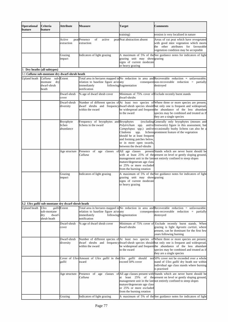
3. Dry heaths (all subtypes) 3.1 Calluna sub-montane dry dwarf-shrub heath Upland heath Calluna sub-
montane dry dwarf-shrub heath
Extent Total area in hectares mapped inrelation to baseline figure at/o
r
immediately followingnotification
No reduction in area andany consequen
t
fragmentation
Recoverable reduction = unfavourable; non-recoverable reduction = partially destroyed
Dwarf-shrub cover
% age of dwarf shrub cover Minimum of 75% cover of dwarf-shrubs
Exclude recently burnt stands
Dwarf-shrub diversity
Number of different species of dwarf shrubs and frequencywithin the sward
At least two species of dwarf-shrub species should be widespread and frequent in the sward
Where three or more species are present, but only one is frequent and widespread, the abundance of the less abundant species may be combined and treated as if they are a single species
Bryophyte /lichen abundance
Frequency of bryophytes andlichens in the sward
Bryophytes (excluding Polytrichum spp. and/or Campylopus spp.) and/or Cladonia spp. lichensshould be at least frequen
t
and forming patches below, or in more open swards, between the dwarf-shrubs
Generally only bryophytes (mosses and liverworts) figure in this assessment, but occasionally bushy lichens can also be a prominent feature of the vegetation
Age structure Presence of age classes of Calluna
All age classes presentwith at least 25% of themanagement unit in the latemature/degenerate age class or 25% or more excluded from the burning rotation
Stands which are never burnt should be present on level or gently sloping ground, not entirely confined to steep slopes
Grazing impact
Indicators of light grazing A maximum of 5% of thegrazing unit may showsigns of current moderateor heavy grazing
See guidance notes for indicators of ligh
t grazing
3.2 Ulex gallii sub-montane dry dwarf-shrub heath Upland heath Ulex gallii
sub-montane dry dwarf-shrub heath
Extent Total area in hectares mapped inrelation to baseline figure at/o
r
immediately followingnotification
No reduction in area andany consequen
t
fragmentation
Recoverable reduction = unfavourable; non-recoverable reduction = partially destroyed
Dwarf-shrub cover
% age of dwarf shrub cover Minimum of 75% cover of dwarf-shrubs
Exclude recently burnt stands. When grazing is light Agrostis curtisii, where present, can be dominant for the first few years following burning
Dwarf-shrub diversity
Number of different species of dwarf shrubs and frequencywithin the sward
At least two species of dwarf-shrub species should be widespread and frequent in the sward
Where three or more species are present, but only one is frequent and widespread, the abundance of the less abundant species may be combined and treated as if they are a single species
Cover of Ulex gallii
Amount of Ulex gallii in thesward
Ulex gallii should not exceed 50% cover
50% cover not be exceeded over a whole stand of Ulex gallii dry heath nor within individual age class stands where burning is practised
Age structure Presence of age classes of Calluna
All age classes present with at least 25% of themanagement unit in the latemature/degenerate age class or 25% or more excluded from the burning rotation
Stands which are never burnt should be present on level or gently sloping ground, not entirely confined to steep slopes
Grazing Indicators of light grazing A maximum of 5% of the See guidance notes for indicators of light
Page 77

Operational feature
Criteria feature
Attribute
Measure
Target
Comments
impact grazing unit may showsigns of current moderate or heavy grazing
grazing
4. Northern Atlantic wet heaths with Erica tetralix Upland heath Wet dwarf-
shrub heath Extent Total area in hectares mapped in
relation to baseline figure at/o
r immediately followingnotification
No reduction in area andany consequen
t
fragmentation
Recoverable reduction = unfavourable; non-recoverable reduction = partially destroyed
Dwarf-shrub cover
% age of dwarf shrub cover Minimum of 25% cover of species other than dwarf-shrubs
Sward composed of a variety of higher plants and bryophytes. Dwarf shrubs should not dominate the sward.
Dwarf-shrub diversity
Number of different species of dwarf shrubs and frequencywithin the sward
At least two species of dwarf-shrub species should be widespread and frequent in the sward
Where three or more species are present, but only one is frequent and widespread, the abundance of the less abundant species may be combined and treated as if a single species
Bryophyte abundance
Frequency of bryophytes in thesward
Bryophytes (excluding Polytrichum spp and/or Campylopus spp) should beat least frequent and forming patches below or, in more open swards, between the dwarf-shrubs
Positive bryophytes include Sphagnum spp as well as pleurocarpous or “ feather mosses”
Age structure Presence of age classes of Calluna
All age classes presentwith at least 33% of themanagement unit in the latemature/degenerate age class or 33% or more excluded from the burning rotation
Stands which are never burnt should be present on level or gently sloping ground, not entirely confined to steep slopes
Graminoid cover
% age cover of grasses andrelated species
Total cover of graminoidsshould not exceed 50%
Include true grasses, sedges and rushes in assessment. Purple moor-grass Molinia caerulea, deer grass Scirpus cespitosus, wavy hair-grass Deschampsia flexuosa, heath rush Juncus squarrosus or other graminoids should not dominate over other species.
Grazing impact
Indicators of light grazing A maximum of 5% of thegrazing unit may showsigns of current moderate or heavy grazing
See guidance notes for indicators of light grazing
5. Transition mires and quaking bogs 5.1 Base-rich flushes Base-rich flush (E2 / E22)
NVC typesM9, M10,M11
Total areamapped in relation to baseline
Area (ha) No loss without prior consent
* Tufa deposists, where present
Presence of damage /disturbance of tufa deposits
No more than 10% E.g. by human or livestock trampling, or removal for garden ornamentation
Combined cover of Carex spp., Eleocharis spp., Eriophorumspp., Kobresia, Schoenus and brown / pleurocarpus mosses
At least 75% Exclude stony M10 and M11 flushes
* Sward composition
Frequency of brown / pleurocarpus mosses (DAFORscale)
At least frequent andwidespread throughout theflush
Page 78

Operational feature
Criteria feature
Attribute
Measure
Target
Comments
Frequency of positive indicatorsfor M10 communities (DAFORscale): Bartsia alpina, Caltha
palustris, Euphrasia spp., Orchidacea spp., Parnassia palustris, Pedicularis spp., Pinguicula vulgaris, Plantagomaritima, Polygonum viviparum, Primula farinosa, Saxifraga aizoides, Selaginella selaginoides, Succisa pratensis, Thalictrum alpinum, Thymus
polytrichus, Tofieldia pusilla, Triglochin palustris, Valeriana dioica Additional species for M10aonly: Drosera rotundifolia, Erica tetralix, Polygala serpyllifolia
M10a: At least threespecies frequentthroughout the flush. M10b & c: At least fourspecies frequentthroughout the flush
Frequency of positive indicatorsfor M9 communities: specieslisted for M10b and M10c andadditional species
Mentha aquatica, Menyanthes trifoliata, Potentilla palustris, Utriculariaspp.
At least two species frequent throughout theflush
Frequency of negativeindicators for M10 and M11only (DAFOR scale):
Holcus lanatus, Juncus acutiflorus, J. effusus, J. squarrosus
No more than one speciesfrequent, no speciesabundant
Frequency of negativeindicators for M9 only(DAFOR scale):
Juncus acutiflorus, J. effusus
Neither species more thanoccasional
Frequency of negativeindicators (DAFOR scale): Cirsium arvense, Cirsium vulgare, Urtica dioica
No more than rare
Frequency or cover of saplingsand small trees / shrubs
No more than 5% cover or more than occasionalthroughout the sward
* Swardstructure
Extent of bare mud or peatvisible without disturbing vegetation
No more than 10% Exclude stony water-scoured M10 and M11 flushes
Frequency of Molinia caeruleatussocks
No more than occasional
Cover of litter in a more or lesscontinuous layer
Total extent no more than10% of the flush area
Litter may be distributed in patches or in one larger area
Average vegetation height At least 10cm Does not apply at altitudes above about 600m
Frequency of hoof prints No more than occasionalover the mire as a whole
Sward structure
Presence/extent of vehicletracks across the mire surface
No more than rare
5.2 Upland valley and basin mires Upland valleyand basinmires (E31 /E32)
NVC typesM4, M5, M6, M21
* Extent Total area mapped in relation tobaseline
No loss without prior consent
Abundance of Sphagnum spp.(DAFOR scale)
Abundant and widespreadthroughout the mire
Exclude areas of swamp, brown / pleurocarpus moss flushes and open water runnels from assessment
* Sward composition
Frequency of Juncus effusus and Juncus acutiflorus (DAFOR scale)
Locally frequent but never abundant throughout themire
Page 79

Operational feature
Criteria feature
Attribute
Measure
Target
Comments
Frequency or cover of tree /scrub spp.
No more than 5% cover or more than occasionalthroughout the sward
ExcludeMyrica gale from assessment
Frequency of Myrica gale No more than locally frequent
Cover of grasses other than Molinia caerulea
No more than 5%
Frequency of negativeindicators using DAFOR scale: Cirsium arvense, Cirsium vulgare, Epilobium hirsutum, Urtica dioica
No more than rare
Frequency or negativeindicators (DAFOR scale):
Juncus squarrosus
No more than occasional
Frequency of Juncus effususand/or Molinia caeruleatussocks
No more than occasional
Average vegetation height At least 15cm Does not apply at altitudes above about 600m
Frequency of hoof prints No more than occasionalover the mire as a whole
Sward structure
Presence / extent of vehicletracks across the mire surface
No more than rare
6. Old oak woods with Ilex and Blechnum in the British Isles Semi-natural woodland
Old Oakwoodswith Ilex and
Blechnum
1. Area Extent/location of stands * No loss of ancient semi-natural stands * At least current area of recent semi-natural standsmaintained, although thei
r
location may alter. *At least the area of ancient woodland retained
* Stand loss due to natural processes eg in minimum intervention stands may be acceptable. * Stand destruction may occur if the understorey and ground flora are irretrievably damaged even if the canopy remains intact. * Loss = 0.5 ha or 0.5% of the stand area, whichever is the smaller. * 20% canopy cover is conventionally taken as the lower limit for an area to be considered as woodland. * Area and location of stands may be assessed remotely or by site visit.
2. Natural processes and structural development
Age/size class variation withinand between stands; presence o
f
open space and old trees; deadwood lying on the ground; standing dead trees
* At least the current levelof structural diversitymaintained.
* Understorey (2-5m) present over at least 10% of total stand area (except in parkland). * Ground flora present over at least 50% of area * Canopy cover presentover 30-90 % of stand area(except in parkland stands).
* Age class structureappropriate to the site, itshistory and management.
** Mature trees allowed todie standing at end of life cycle. All fallen timbe
r retained, especially over 20 cm diameter.
* Any changes leading to exceedance of these limits due to natural processes are likely to be acceptable. * Oak stands tend to have low structural variety at present due to past coppice treatment and extensive grazing, but may be more varied under more natural conditions. * High cover in the understorey is generally rare. * The ground flora may be variable ( see attribute 5). * In coppiced stands a lower canopy cover (of standards) can be accepted, as will also be the case in parkland. * See JNCC guidance note for the sorts of age structure likely to be appropriate for different types of management regime. * Assess this attribute by field survey.
3.Regeneration potential
Successful establishment of young stems in gaps or on theedge of a stand
* Signs of seedlingsgrowing through tosaplings to young trees atsufficient density tomaintain canopy density
* A proportion of gaps at any one time may develop into permanent open space; equally some current permanent open space/glades may in time regenerate to closed canopy.
Page 80

Operational feature
Criteria feature
Attribute
Measure
Target
Comments
over a 10 yr period (or equivalent regrowth fromcoppice stumps).
* No more than 20% of areas regenerated by planting. * All planting material of locally native stock * No planting in siteswhere it has not occurred in the last 15 years.
* The minimum level of regeneration to
* Regeneration may often occur on the edges of woods rather then in gaps within it. * The density of regeneration considered sufficient is clearly less in parkland sites than in high forest; in coppice most of the regeneration will be as stump regrowth. See JNCC Guidance Note on likely desirable levels of regeneration.
be acceptable from a nature conservation viewpoint is likely to be much less than that needed where wood production is also an objective. * Assess this attribute by walking through the wood in spring/summer. * Last target may be overridden in stands where populations of distinctive or desirable species eg lime are failing to regenerate naturally.
4. Composition
Cover of native versus non-native species (all layers) Death, destruction or replacement of native woodlandspecies through effects of non-native fauna or externalunnatural factors
* Oak present and
* At least the current levelof site-native speciesmaintained.
* At least 90% of cover inany one layer of site-nativeor acceptable naturalisedspecies.
providing at least 30%cover in the canopy o
f
mature stands over featureas a whole
* Death, destruction or replacement of nativewoodland species througheffects of introduced faunaor other external unnaturalfactors not more than 10%
by number or area in a fiveyear period.
* In sites where there might be uncertainty as to what counts as site-native or as an acceptable naturalised species this must be made clear (eg the position of beech outside its presumed native range). * Where cover in any one layer is less than 100% then the 90% target applies to the area actually covered by that layer. * Factors leading to the death or replacement of woodland species could include pollution, including eutrophication from adjacent farmland; new diseases eg oak dieback. * Damage to species by non-native species that does not lead to their death or replacement by non woodland species (eg damage from squirrels to trees that non-the -less survive) is not necessarily unacceptable in nature conservation terms. * Excessive browsing/grazing by even native ungulates may be considered an unnatural external factor where it leads to undesirable shifts in the composition/structure of the stand, although this may be picked up by attributes 2 or 5 anyway. * Assess this attribute by a walk through the site.
5. Species,habitats, structures characteristic of the site.
Ground flora type Distinctive and desirable elements for a given site eg.Extensive moss-mats, tallVaccinium stands; grazed andungrazed mosaics; aspengroves; veteran trees or richlichen, invertebrate assemblages.
Patches of associated habitatsand transitions eg to alder wood, ash stand or open bog
* 80% of ground floracover referable to relevan
t
NVC community (usuallyW10, W11, W16, W17)
* Changes leading to these targets no
* Distinctive elementsmaintained at current levels and in current locations(where appropriate).
* Patches and transitions maintained in extent and where appropriate location.
t being met may be acceptable where this is due to natural processes. * Distinctive elements and patches should be marked on maps for ease of checking in the field wherever possible. * If there are species groups/assemblages that cannot be assessed directly on a general site visit then surrogate features should be given where possible, eg dead wood concentrations for associated invertebrates.
Page 81

13 Appendix 2: Favourable Condition Table for Rochdale Canal SSSI Operational Feature
Criteria Feature
Attribute Measure Target Comments
Canal
Luronium natans (aquatic plant assemblage)
1. Extent of open water
Total area (ha), mapped in relation to baseline (i.e. first available map of interest feature when/after notified), in period May-July, measured annually if possible
No reduction in extent of water Recoverable reduction = unfavourable; non-recoverable reduction = partially destroyed
2. Water level Level of water, taken from at least one sampling point in each unit
Maintenance of water level (baseline to be agreed), allowing for seasonal fluctuation within limits (to be established)
3. Water quality
Absence of pollution and enrichment
Lack of pollution and enrichment (likely to be obvious by affects on vegetation e.g. algal blooms, or colour e.g. water surface discolouration
4. Trophic status of water areas
Mesotrophic conditions pH between 6 and 8
5. Species composition: positive indicator species
Frequency of positive indicator species in period May – July, measured annually if possible Frequency of freshwater sponge in period June – September, measured annually if possible
At least two species/taxa frequent and four occasional throughout the length of the SSSI: submerged macrophytes floating leaved species marginal species No decrease in distribution of freshwater sponge from baseline data
Among possible species that could be used, choice is further restricted by ease of identification and visibility in recording period
6. Species composition: negative indicator species
Frequency and % cover of negative indicator species. Record in period May-July, measured annually if possible
No species/taxa more than occasional throughout the SSSI: filamentous algae algal blooms Azolla Distribution of invasive species (e.g. Glyceria maxima, Elodea canadensis/nuttalli, Crassula helmsii) to be maintained within acceptable limits (limits to be set)
Invasive species chosen to indicate problems of eutrophication and disturbance from various sources e.g. excessive recreational pressure Invasive species chosen to indicate absence of management or disturbance which could lead to choking or the canal and subsequent loss of notable species
7. Presence of nationally scarce and threatened species
Presence of: Luronium natans
Potamogeton species are difficult to identify and therefore not easily monitored. However, these generally require similar conditions to Luronium
8. Lack of disturbance
Evidence of habitat being affected by human disturbance e.g. litter deposition, tipping of rubble and dredging (except by planned management) rare or absent
Page 82

14 Appendix 3: South Pennine Moors SPA / SAC and Tameside Boundary
Page 83