divided rights, expanded conflict: the impact of split...
TRANSCRIPT
Divided Rights, Expanded Conflict:
The Impact of Split Estates in Natural Gas Production
Alan R Collins, Professor
Agricultural and Resource Economics Program P.O. 6108
West Virginia University Morgantown, WV 26506
[email protected] 304.293.5486
Kofi Nkansah, PhD Candidate Natural Resource Economics
West Virginia University P.O. 6108
West Virginia University Morgantown, WV 26506
[email protected] 304.293.5671
Selected Paper prepared for presentation at the Agricultural & Applied Economics
Association’s 2013 AAEA & CAES Joint Annual Meeting, Washington, DC, August 4-6, 2013.
Abstract: A survey was conducted of West Virginian land owners with completed, shale gas
wells located on their property. The research objective was to determine if the separation of
mineral from surface rights impacted satisfaction and problems with natural gas drilling. Split
estate owners were found to have a statistically greater probability of reporting problems with
drilling. Complaints by a neighbor and a residence located on the property were the only
variables that consistently impacted satisfaction and reported problems throughout all three
econometric models. Our results provide motivation for policies to strengthen surface owner
rights.
Copyright 2013 by Alan R. Collins and Kofi Nkansah. All rights reserved. Readers may make verbatim
copies of this document for non-commercial purposes by any means, provided that this copyright notice
appears on all such copies.
1
Introduction
Property is defined by Black’s Law Dictionary as anything that can be owned and
consists of a bundle of rights. Under the common law developed in England, fee simple title to
land conferred ownership “from the center of the earth to an altitude above the land which is
necessary for the enjoyment of the land” (Huffman 1982). The assignment of property rights
have been touted for its ability to reduce conflict by internalization of externalities associated
with common or open access resources (Ellickson 1993, Demsetz 1967). However, property
ownership also confers to the owner the ability to sever one right from the bundle of other
rights. In the U.S. and a few other countries, land ownership included mineral rights which can
be transferred to another owner separately from the rest of bundle of land rights. This
separation of mineral from surface ownership of land is called split estates.
Under common law, mineral right ownership is recognized as the dominant estate, such
that it is assumed that both the original surface and mineral right owners at the time of
severance intended for the minerals to be developed. Thus, mineral right holders have the
right to perform activities that are “fairly necessary” on the land surface such as these activities
that would have been contemplated by the original parties of the severance agreement in order
to extract minerals, even over the objections of the current surface owner.
Nationwide, the federal government has retained mineral right ownership on about 58
million acres across the western U.S. when surface rights were sold or exchanged under the
Carey Act, the Stock Raising Homestead Act of 1916 and the Taylor Grazing Act of 1934. One
example is the Powder River Basin in Wyoming (Straube and Holland 2003). Separation of
surface and mineral rights also is fairly common in the Appalachian region (Appalachian Land
2
Ownership Task Force 1983). Mineral right severance has emerged as an issue in West Virginia
due to the expanded interest in drilling created by a rapid increase in natural gas prices during
the first decade of 2000 along with the implementation of horizontal drilling and fracturing
technology to extract natural gas and hydrocarbon liquids from shale formations deep
underground.
The literature on split estates and surface owner problems with drilling for fossil fuels is
very scarce. There is literature that examines impacts of community residents and shale gas
drilling. Examples include Brasier et al. (2011) and Anderson and Theodori (2009). The only
split estate literature related to natural gas drilling is from the western U.S. Straube and
Holland (2003) identify the sources of conflict in split estate ownership and proposed a
resolution conflict model. Their application was for coalbed methane in Wyoming. Also in
Wyoming, Fitzgerald (2010) found that divided ownership leases have lower bids in federal
auctions than leases with only one owner due to expectations of higher transaction costs.
Huffman (1982) argues using Coasian-like hypothetical examples that split estates are efficient
in allocation of resources based on the dominate estate rule and relates this concept to surface
mining of coal.
This research utilized a survey of West Virginia surface right owners to examine
problems or issues with shale gas drilling. Owners were divided into two groups: (1) those
landowners who own both surface and mineral rights (fee simple estates); and (2) those
landowners who own only the surface rights (split estates). The objective of this research was
to test whether split estate ownership of property rights leads to a greater perception of
problems or issues with shale gas drilling by surface owners and therefore a higher level of
3
dissatisfaction with the outcome of natural gas extraction. The research hypothesis is that split
estate ownership of property rights leads to a greater perception of problems or issues with
shale gas drilling by surface owners.
Study Area
Extraction of unconventional natural gas, such as from shale formations, has resulted in
a “golden age of gas” (International Energy Agency 2012). One such formation, Marcellus
Shale, covers around a 50,000 square mile region of West Virginia, Pennsylvania, Maryland,
Ohio and New York. This shale is a layer of sedimentary rock 4,000 to 8,000 feet underground
which contains organic-rich deposits formed in an oxygen-deficient environment over 300
million years ago during the Devonian Era. There is as an estimated 141 trillion cubic feet of
recoverable shale gas (U.S. Energy Information Administration (EIA) 2012).
In order to efficiently extract these energy resources, a process called horizontal
fracturing is performed. A vertical well is drilled to the shale formation then drilled horizontally
at a 90 degree angle through this formation up to one mile. After the drilling is completed,
millions of gallons of fluids are pumped down the well under high pressure in order to fracture
the shale formation so that natural gas and hydrocarbon liquids can be released to the surface.
Through this process, multiple wells can be located on one drill pad with the ability to extract
energy resources from nearly one square mile of land. The downside is that horizontal
fracturing involves more drilling machinery, trucks traffic, water and chemical use, and
disturbed land area than conventional vertical drilling.
The exploitation of shale gas in the U.S. has expanded both natural gas production and
reserves. Overall, production of natural gas in U.S. has increased 17% between 2009 and 2011,
4
while proven reserves increased 12% (2009 to 2010). The number of producing gas wells in the
U.S. also increased 4.3% from 2009 to 2011 (U.S. EIA 2013c). A similar trend has been evident
in the Marcellus shale play. Between 2009 and 2011, natural gas production in Pennsylvania
quadrupled (with 5% decrease in the number of wells), while West Virginia production
increased 49% (with a 12% increase in the number of wells) (U.S. EIA 2013c).
The disproportional relationship between the number of production gas wells and
natural gas production within the Marcellus shale, especially in Pennsylvania, has been
attributed to the expansion of horizontal drilling technology, hydraulic fracturing, and
improved well completion techniques which improves the efficiency of drilling activities (drilling
time) as well as increase in gas production (U.S. EIA 2013a). Between 2011 and 2012, average
daily natural gas production in Pennsylvania increased by 69% with about a third of increase
stemming from horizontally drilled wells (U.S. EIA 2013b).
The economic benefits from exploiting Marcellus shale have been enormous. In
Pennsylvania, Kelsey et al. (2011) estimated that over 23,000 jobs and $3.1 billion in economic
activity were generated in 2009 from Marcellus Shale development. In West Virginia,
Higginbotham et al. (2010) report that the Marcellus shale development had provided 2009
economic impacts of $2.35 billion of output and accounted for the generation of 7,600 jobs. In
2009, the natural gas industry paid $65.9 million in West Virginia severance taxes and
approximately $88.4 million in property taxes (Higginbotham et al. 2010).
While the economic gains from Marcellus shale may be enormous, surface owners are
often excluded. In West Virginia, mineral rights were frequently severed from surface rights
decades to hundreds of years ago. These rights may include all minerals, just coal, or only oil
5
and gas. They can even be limited to specific formations. Many of these rights were sold or
traded by landowners or left to separate heirs (Appalachian Land Ownership Task Force 1983).
However, speculators, known as “Robber Barons”, would separate rights by filing broad form
deeds to sever ownership of land from the current occupants on wide swaths of land. Once
filed, they would persuade the occupant farmers to give up mineral and/or timber rights in
order to settle the property ownership dispute that they created (Hufford 1999, Rasmussen
1994).
While surface owner rights vary by state, legislation has established some rights in West
Virginia. Surface owner rights include (for horizontal wells): a 30 day comment period on the
drilling permit application; notification periods for seismic testing, surveying, and drilling; drill
cuttings and pit waste cannot be buried on-site without owner consent; compensation for
surface damages; $2,500 to compensate for property taxes on surface lands disturbed by
construction and operation of the well pad; and set back limitations for wells from occupied
structures (600 ft.), existing water wells (250 ft.), and surface waters (100 ft.).
Survey Data Collection
An initial list of over 1400 completed shale gas well permits was obtained from the West
Virginia Geologic and Economic Survey in June 2012 (http://www.wvgs.wvnet.edu/). This list
contained the names of the drilling company, the surface owner(s), and mineral right owner(s).
Using this list, split estates were identified along with owners of both surface and mineral
rights. Eliminated from consideration were drilling operator owned surface right wells and
institutional surface owners (governments, corporations, or non-profit organizations (churches,
Boy Scouts, etc.). This left a population list of 935 wells with surface owners that were
6
primarily sole or jointly owned by individuals or families. 650 wells were split estates and 285
wells were fee simple ownership (including all or a portion of both surface and mineral rights).
From this list of 935 wells, a sample of 481 surface owners each of who own property
with at least one completed well was obtained from the Office of Oil and Gas in the West
Virginia Department of Environmental Protection. This list represented 680 wells. 72% of each
category (split estate and fee simple ownership) were obtained in the sample. Names and
mailing addresses were obtained from completed shale gas well permits application forms.
A survey instrument was developed based upon a review of popular literature on
reported problems or issues by landowners with shale gas drilling, particularly horizontal
hydraulic fracturing into Marcellus Shale. Questions included type of drilling conducted;
drilling related developments on the property; type of agreement signed; how the land was
utilized prior to drilling; identified problems resulting from drilling divided up into
environmental, financial, and health, safety & quality of life; level of satisfaction with the
overall outcome of the drilling process; quality of life questions; and respondent demographics.
This survey was reviewed and commented on by David McMahon and Julie Archer of the West
Virginia Surface Owners’ Rights Organization and by Jill Kriesky at the University of Pittsburgh,
Graduate School of Public Health. Four individuals with gas wells on their properties also
reviewed the survey as a pre-test.
The survey sample was sent invitations to participate in the survey in December 2012.
Respondents could then mail back a request for a paper survey or go on-line to complete the
survey. A reminder postcard was sent out in January. Then in February, a paper survey was
sent out to all non-respondents. In total, 33 surveys were completed on-line, 101 paper
7
surveys were returned, and 20 respondent refusals and/or indicated no well was drilled on their
property. The survey response rate was 43.1% after subtraction of 125 non-deliverable
addresses and deceased surface owners. 61.5% of sample respondents were split estates with
90% reporting to be the sole owner of surface rights. The remaining 38.5% were fee simple
estates, of which about 1/3 were sole owners of both, about 1/3 were sole owners of the
surface and one of many mineral right holders, and the remainder were either owners of gas
rights only, owned both but the mineral rights were alright leased by a prior owner, or one of
many surface and mineral right owners.
Models and Methods
Our goal was to examine the impact of split estates on surface owner perceptions of
drilling outcomes and their level of satisfaction with the outcome of drilling. Ideally, who owns
the surface versus the mineral rights should not change the drilling process or the manner upon
which this process is completed by the drilling company. However, there are unique features of
each individual land owner and drilling situation which must be accounted for when
determining the potential impacts on a surface owner’s perceptions. These features include:
the size of the property relative to the number of wells drilled, the type of well drilled, how the
land was used prior to drilling, what other types of development for extraction occurred on the
property (gas lines, ponds, compressor stations, etc.), the types of regulations in place for the
drilling, the level of compensation received by the land owner (both monetary and non-
monetary), whether or not an agreement1 was signed with the driller, and what complaints the
1 Agreements were mainly leasing of mineral rights for fee simple estates. For split estates, examples of
agreements included surface use, right of way access, and/or a statement of no objection to drilling.
8
neighbors had about the drilling. All of these features were viewed as potential explanatory
variables for surface owners’ perceptions of drilling.
Three models were developed to assess the impact of split estates on: (I) whether a
surface owner identified a non-zero number of problems or issues associated with drilling, (II)
the number of problems or issues among the non-zero respondents; and (III) dissatisfaction
versus satisfaction of a surface owner with the outcome of drilling.
For Models I and II, respondents were given a series of questions where they could
check off boxes to identify problems or issues dealing with environmental, financial, health,
safety, and quality of life concerns associated with drilling or fracturing processes. These data
were examined as two separate models since a substantial portion of respondents (42.6%)
indicated there were no problems or issues. The dependent variable in Model I was a zero/one
variable. Zero indicated no problems were identified and one was a non-zero number of
problems were identified. The dependent variable for Model II consisted of a count of checked
responses across 24 categories of possible problems or issues, including three other categories
where respondents were given the opportunity to list other problems.
For Model III, the dependent variable was based on respondents’ answers to the
question below:
“There are many impacts that occur as result of leasing and drilling – environmental, financial, health, safety, quality of life, etc. Overall, in thinking about all of these impacts (both good and bad), how would you rate your level of satisfaction with all the outcomes from the drilling and fracturing processes that were conducted on your property? (Please check only one)”.
Responses were confined to five categories ranging from very satisfied to very dissatisfied. A
zero/one variable was created where zero included very satisfied, somewhat satisfied, and
9
neutral responses. Respondents who gave a somewhat or very dissatisfied response were
coded as one. Neutral responses were placed into the zero classification based on a
discriminant analysis where neutral responses were twice as likely to be classified as satisfied
compared to dissatisfied.
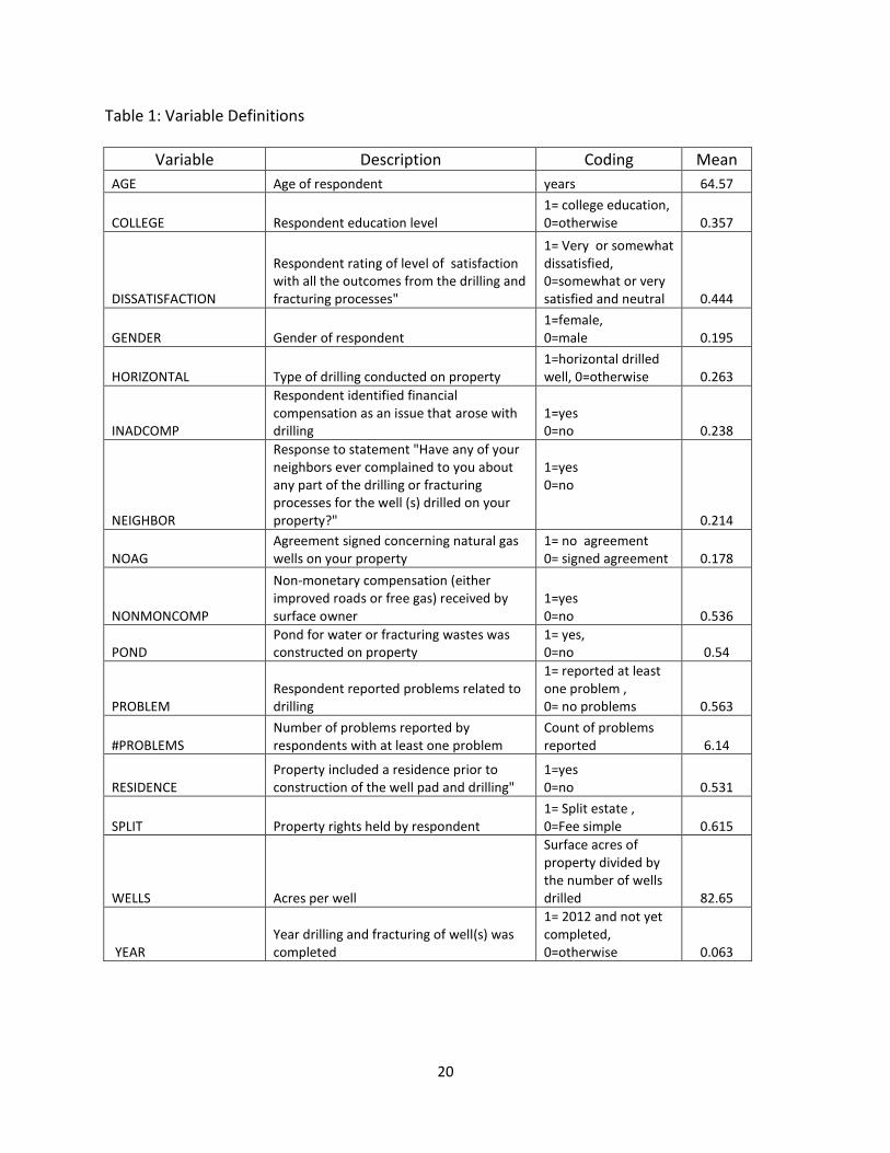
The independent variables included in both models are presented in Table 1. They
included categorization of the many unique features of each property owner and their drilling
situation which could potentially impact landowner satisfaction and perceptions of problems or
issues with drilling. The variable YEAR was included to reflect the impact of regulations
stemming from December 2011 legislation on Natural Gas Horizontal Well Control Act. We also
included demographic variables of respondent age, education level, and gender in all three
models in order to assess their impacts on satisfaction and perceptions.
With limited dependent variables, regression coefficients in Models I and III were
estimated with a logistic regression. For Model II, the dependent variable was a non-zero count
of the number of surface owner identified problems. A Poisson regression was considered, but
the dependent variable suffered from over-dispersion even after separating out observations
with zero problems from those where at least one problem was identified (a non-zero count).
Over-dispersion occurs in a count data when the conditional variance exceeds the conditional
mean, thereby violating a Poisson regression assumption (UCLA Statistical Consulting Group
2013). When count data suffers from over-dispersion, two alternatives for correction are
available: quasi-maximum likelihood estimation and negative binomial regression (Wooldridge
2011, Cameron and Travedi 2010, Long and Freese 2006,). A negative binomial regression was
selected to estimate coefficients for Model III.

10
The negative binomial regression, a generalized Poisson regression model allowed for
observed heterogeneity by adding an extra parameter (α) to the Poisson regression model
(Long and Freese 2006, UCLA Statistical Consulting Group 2013). The parameter α
represented the unobserved heterogeneity among observations in the data (Long and Freese
2006). With a Poisson regression, α is assumed to be equal to zero. To test this assumption in
the negative binomial regression model, a likelihood test ratio was performed. All estimations
were conducted with STATA econometric software (StataCorp 2011).
Results
Survey
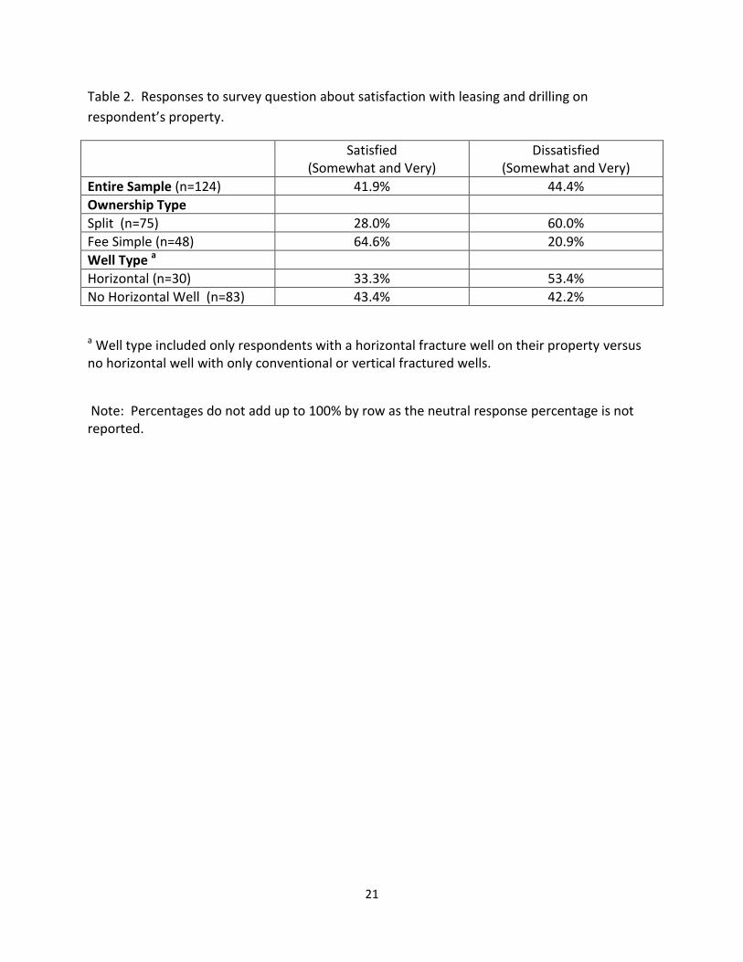
As described above, most of sample population and survey respondents were split
estate owners. Among the entire sample, there were slightly more dissatisfied land owners
than satisfied ones (Table 2). When satisfaction responses were broken down by both
ownership and well type, ownership showed dramatic differences between split and fee simple
properties, with split estate owners overwhelming dissatisfied whereas fee simple owners were
overwhelming satisfied (Table 2). Responses based on well type showed satisfaction levels
were higher for vertical wells than for horizontal wells. A slightly higher percentage of surface
owners with non-horizontal wells were satisfied compared to dissatisfied.
In the survey, respondents were asked to report from their own experiences with
drilling and fracturing any problems or issues that arose. Problems and issues were categorized
based upon environmental, financial, and health, safety plus quality of life. Here, split estates
and horizontal fracture wells averaged over twice as many problems as fee simple and vertical
wells (Table 3). Land surface damages were generally the most common problem reported,

11
although fee simple owners most commonly reported inadequate compensation as a problem.
About ¾ of surface owners with horizontal wells reported at least one problem/issue and over
half of these respondents noted a problem with truck traffic. Other commonly noted problems
with horizontal wells included: land surface damages (46.7%), property value declined (43.3%),
lack of cooperation by drilling company (41.4%), road damages (37.9%), and not enough money
was included in the lease for compensation (36.7%).
Ample opportunities in the survey were provided for respondents to explain their
situation and reasons why they were satisfied or dissatisfied with natural gas drilling. Those
respondents who reported good experiences with drilling were commonly informed about the
process by the drilling company, company representatives communicated well with the
landowner, and were “polite and nice”. Other positive comments included those such as:
“built decent roads through my property”, “they were very professional & prompt in
completion”, “the company was very easy to work with and respected my position as a surface
owner’, “I feel they did all that we agreed to, put well site back with lime and fert. and seeded,
kept roads in good shape”, and “informed us when drilling occurred, gave us tours of the
process”. Most of these positive comments came from fee simple owners.
Respondents who reported problems or issues typically provided much more detailed
descriptions than those without problems or issues. For example, one respondent provided
two additional pages of detailed descriptions of problems that drilling had caused on the
property. Split estate owners often noted their lack of rights in dealing with drilling companies
and how they were treated with disrespect by drilling company representatives. As one
respondent noted, “No matter how much money you receive it is not enough. We love the

12
country because of the peace and quiet that we have here but when the drilling company was
here we had everything but peace and quiet. As a surface owner we really have no rights.”.
Typical of the comments was: “we were not consulted about location of pad or road, surveyed
well site without notice, unsafe work site during drilling, poor topsoil preservation, pollution to
streams, excessive acreage damaged, poor reclamation (slope spillage), ridiculously low offer of
damage compensation. ($1500 for 8 acres of destruction)”
Econometric
All three models were statistically significant (Table 4). Models I and III were re-
estimated dropping demographic variables with statistically insignificant coefficients. Each of
these four logistic regression models could not reject a Hosmer-Lemeshow 2 statistic for
model goodness-of-fit. Due to a much lower number of observations, variables with z statistics
greater than 1.0 were retained in a re-estimated Model II. For Model II, the null hypothesis that
α is equal to zero was rejected at 1% significance level, thus a negative binomial regression was
appropriate compared to a Poisson regression.
The main independent variables of interest, SPLIT and HORIZONTAL, did have
statistically significant, positive coefficients explaining both PROBLEM and #PROBLEMS (Table
4). SPLIT impacted PROBLEM while HORIZONTAL did not. HORIZONTAL impacted #PROBLEMS
while SPLIT had a low level of statistically significant influence. Neither variable had a
statistically significant impact on DISSATISFACTION.
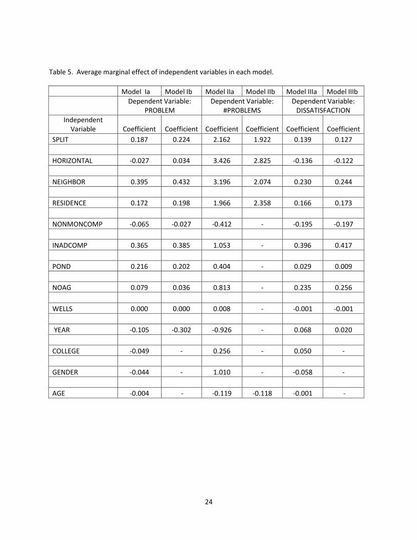
Average marginal effects were computed across the number of observations utilized in
each model (Table 5). For zero/one variables like SPLIT, the average of SPLIT=1 was 0.224
higher than SPLIT=0 in Model Ib. Thus, split estate ownership increased the probability of a
13
respondent reporting a problem with drilling by 22.4% - the third largest impact behind
NEIGHBOR and INADCOMP (Table 5). The HORIZONTAL variable had the largest average
marginal effect of any independent variable on #PROBLEMS, increasing reported problems by
2.8 in Model IIb (Table 5).
NEIGHBOR and RESIDENCE were the only variables with statistically significant, positive
coefficients throughout all three models (Table 4). When a respondent reported that a
neighbor complained about the drilling, there was a 43.2% greater probability of a reported
problem by the surface owner and a 24.4% greater probability of surface owner dissatisfaction
with drilling (Table 5). The impact of a residence on the property had the second largest impact
on the number of reported problems, increasing it on average by 2.4 in Model IIb.
Model III on DISSATISFACTION was mainly explained by NEIGHBOR, RESIDENCE, and
variables reflecting surface owner compensation. When a respondent reported inadequate
compensation (INADCOMP), the probability of dissatisfaction increased by an average of 41.7%,
by far the largest impact of any variable (Table 5). Conversely, respondents who received non-
monetary compensation had, on average, a 19.7% lower probability of being dissatisfied. The
INADCOMP variable also increased the probability of a surface owner reporting a problem with
drilling by 38.5%, the second largest variable impact in Model Ib.
Surface owner compensation impacts dissatisfaction and problem reporting. It was
difficult to completely separate the issue of compensation from split estates given the weak
negotiating position of surface owners in West Virginia. In the survey, split estate owner
respondents had a slightly higher percentage that checked inadequate compensation as a
problem than fee simple owners (27% to 18%). The largest difference was in a survey question
14
on what benefits the surface owner perceived from drilling. A total of 45% of split estate
owners had a “none” response compared to only 2% of fee simple owners. Thus, the
perception of inadequate compensation was more common among split estate owners.
Variables of lesser importance in explaining reported problems and dissatisfaction
included NOAG, POND, WELLS, and YEAR. The variable YEAR did not have a statistically
significant coefficient in any model whereas NOAG and WELLS were only significant at 10%
levels in Model III. The POND variable had a positive, statistically significant impact in Model I.
The storage of water in ponds led to a 20.2% greater probability of problems reported by
surface owners in Model Ib than other methods utilized to store water storage (storage tanks,
trucks, etc.). With the exception of AGE in Model II, demographic variables of AGE, GENDER,
and COLLEGE were not influential in explaining reported problems and dissatisfaction.
Conclusions and Policy Implications
This research examined whether spilt estates impacted surface owner perceptions of
problems or issues with shale gas drilling along with their satisfaction from the drilling
outcome. A summary of survey results provided evidence that split estates led to more
reported problems and lead to higher level of dissatisfaction with drilling than fee simple
estates. The presence of a horizontally drilled well on the property showed similar impacts.
Regression analyses were conducted for three models: surface owner reported at least
one problem (yes or no), the number of problems reported, and dissatisfaction versus
satisfaction. The econometric results showed that a split estate owner was more likely to
report a problem while a horizontal well increased the number of problems reported. Surface
owner dissatisfaction was not impacted significantly by either split estates or horizontal wells.

15
It was mainly explained by neighbor complaints, residence on the property, and surface owner
compensation.
The combination of survey and econometric results does indicate a need to expand
surface owner rights in West Virginia, particularly when there is a residence on the property
where wells are drilled. Quite often the separation of mineral from surface rights occurred
decades to generations ago. With changing technology making shale gas resources available
that previously were not accessible, split estate owners are faced with an unfortunate situation
where their property basically “enslaved” by an industrial process of drilling and fracturing for
the sole benefit of mineral right holders. The wealth created in society by shale gas extraction
should not exploited by imposing excessive extraction burdens on surface owners without
mineral rights.
Other states (Colorado and New Mexico) have responded to split estate issues with
legislation to expand surface owner rights, termed “surface owners’ bill of rights”. For example
in New Mexico, the Surface Owners Protection Act of 2007 includes provisions of: a 30 day
notice prior to drilling, a written agreement must exist between the surface owner and driller
or drillers must pay for the use of the land surface, and drillers must provide a description of
the proposed operations such that the owner can evaluate the effects on the property.
A current policy proposal by the West Virginia Surface Owner Rights Organization
(http://www.wvsoro.org/index.html) advocates a process to reunify surface and mineral rights
by notification and creation of an opportunity for surface owners to purchase back mineral
rights upon non-payment of property taxes. In addition, there is a legal case currently before
the West Virginia Supreme Court that would expand surface owner rights. This case addresses

16
whether or not a surface owner in Marion County, WV can be burdened with the production of
oil and/or gas not underlying the surface owner, i.e. can the mineral right holder extract gas
from neighboring property without a surface owner’s permission? The outcome of this case
could impact surface owner rights in the case of horizontal well drilling.
Overall, the survey response rate was acceptable at over 40%. Respondents included a
higher proportion of fee simple estates than the survey sample, so that group was not under-
represented in responses. Plus, feedback from non-respondents indicated that split estate
owners may have been less likely to respond for a variety of factors – pending litigation, the
survey caused the respondent to re-live the stress caused by the drilling, or they were very
discouraged by the entire situation. Also, the survey responses contained shale gas drilled wells
between 2004 and 2012. There were an ample number of both vertical and horizontal drilled
wells represented in the sample. However, as a research limitation, only 6.2% of wells were
either completed in 2012 or drilling was still on-going. Thus, relatively few wells in our data set
were covered by horizontal drilling regulations put in place by the December 2011 legislation.
The primary impact on surface owners from this legislation was to increase setback
requirements for horizontal drilling wells. How these increased setbacks have impacted surface
owner perceptions and satisfaction with drilling is unknown.
Future research could extend this survey to cover horizontal well permits where the
increased setback standards apply. Also, survey coverage could be increased to those states
with surface owners’ bill of rights. Both of these strategies would enable researchers to
examine whether or not perceptions and dissatisfaction with drilling outcomes differ when
surface owner rights are expanded.
17
References
Anderson, B. J., and Theodori, G. L. 2009. Local leaders' perceptions of energy development in
the Barnett Shale. Southern Rural Sociology, 24(1): 113-.
Appalachian Land Ownership Task Force. 1983. Who Owns Appalachia? Lexington, KY: The
University Press of Kentucky.
Brasier, K. J., Filteau, M. R., Jacquet, J., Stedman, R. C., Kelsey, T. W., and Goetz, S. J. 2011.
Residents' perceptions of community and environmental impacts from development of
natural gas in the Marcellus Shale: A comparison of Pennsylvania and New York cases.
Journal of Rural Social Sciences, 26(1): 32-61.
Cameron, A .C., and P. K. Trivedi. 2010. Microeconometrics using Stata. College Station, TX:
Stata Press.
Demsetz, H. 1967. Toward a Theory of property rights. American Economic Review, 57: 347-
359.
Ellickson, R.C. 1993. Property in land. Yale Law Journal, 102:1315-1400.
Fitzgerald, T. 2010. Evaluating split estates in oil and gas leasing. Land Economics, 86(2): 294-
312.
Greene, W.H. 2011. Econometric Analysis 7th Edition. New Jersey: Prentice-Hall.
Higginbotham, A., A. Pedillo, T. Gurley-Calvez, and T. Witt (2010). The economic impact of the
natural gas industry and the Marcellus shale development in West Virginia in 2009.
Technical Report, Bureau of Business and Economic Research, West Virginia University.
Obtained online: http://www.be.wvu.edu/bber/pdfs/BBER-2010-22.pdf.

18
Huffman, J. L. 1982. The allocative impacts of mineral severance: Implications for the regulation
of surface mining. Natural Resources Journal, 22(1): 201-37.
Hufford, M. 1999. Landscape and history at the headwaters of the Big Coal River Valley. Essay
included in: “Tending the Commons: Folklife and Landscape in Southern West Virginia”,
The Library of Congress, American Memory, at
http://memory.loc.gov/ammem/collections/tending/essay5.pdf.
International Energy Agency. 2012. Golden rules for a golden age of gas.
http://www.worldenergyoutlook.org/goldenrules/
Kargbo, D.M., R.G. Wilhelm, and D.J. Campbell. 2010. "Natural gas plays in the Marcellus Shale:
challenges and potential opportunities." Environmental Science & Technology,
44(15):5679-5684.
Kelsey, T.W., M. Shields, J.R. Ladless, and M. Ward. 2011. Economic impacts of Marcellus Shale
in Pennsylvania: Employment and income in 2009. Marcellus Shale Education & Training
Center, Penn State University, State College, PA.
Long, J. S., and Freese, J. 2006. Regression models for categorical dependent variables using
Stata. College Station, TX: StataCorp LP
Rasmussen, B. 1994. Absentee Landowning and Exploitation in West Virginia 1760-1920.
Lexington, KY: The University Press of Kentucky.
StataCorp. 2011. Stata Statistical Software: Release 12. College Station, TX: StataCorp LP.
Straube, M. and Holland, M. 2003. A conflict assessment of split estate issues and a model
agreement approach to resolving conflicts over coalbed methane development in the

19
Powder River Basin. Report prepared for the U.S. Institute for Environmental Conflict
Resolution.
U.S. Energy Information Administration. 2012. Annual energy outlook 2012 with projections to
2035. http://www.eia.gov/
Wooldridge, Jeffrey. 2011. Introductory econometrics. [S.l.]: South-Western.
U.S. Energy Information Administration. 2013a. Today in Energy: Horizontal drilling boosts
Pennsylvania’s natural gas production.
http://www.eia.gov/todayinenergy/detail.cfm?id=6390.
U.S. Energy Information Administration. 2013b. Today in Energy: Pennsylvania natural gas
production rose 69% in 2012 despite reduced drilling activity.
http://www.eia.gov/todayinenergy/detail.cfm?id=10471.
U.S. Energy Information Administration. 2013c. Natural gas: Natural gas summary.
http://www.eia.gov/dnav/ng/ng_sum_lsum_a_EPG0_xdg_count_a.htm.
UCLA, Statistical Consulting Group. 2013. Stata data analysis examples: Negative binomial
regression. http://www.ats.ucla.edu/stat/stata/dae/nbreg.htm.
Williams, S. 2012. Discovering shale gas: An investor guide to hydraulic fracturing. Sustainable
Investments Institute/ IRRC Institute.
http://www.irrcinstitute.org/projects.php?project=56.
20
Table 1: Variable Definitions
Variable Description Coding Mean
AGE Age of respondent years 64.57
COLLEGE Respondent education level 1= college education, 0=otherwise 0.357
DISSATISFACTION
Respondent rating of level of satisfaction with all the outcomes from the drilling and fracturing processes"
1= Very or somewhat dissatisfied, 0=somewhat or very satisfied and neutral 0.444
GENDER Gender of respondent 1=female, 0=male 0.195
HORIZONTAL Type of drilling conducted on property 1=horizontal drilled well, 0=otherwise 0.263
INADCOMP
Respondent identified financial compensation as an issue that arose with drilling
1=yes 0=no 0.238
NEIGHBOR
Response to statement "Have any of your neighbors ever complained to you about any part of the drilling or fracturing processes for the well (s) drilled on your property?"
1=yes 0=no 0.214
NOAG Agreement signed concerning natural gas wells on your property
1= no agreement 0= signed agreement 0.178
NONMONCOMP
Non-monetary compensation (either improved roads or free gas) received by surface owner
1=yes 0=no 0.536
POND Pond for water or fracturing wastes was constructed on property
1= yes, 0=no 0.54
PROBLEM Respondent reported problems related to drilling
1= reported at least one problem , 0= no problems 0.563
#PROBLEMS Number of problems reported by respondents with at least one problem
Count of problems reported 6.14
RESIDENCE Property included a residence prior to construction of the well pad and drilling"
1=yes 0=no 0.531
SPLIT Property rights held by respondent 1= Split estate , 0=Fee simple 0.615
WELLS Acres per well
Surface acres of property divided by the number of wells drilled 82.65
YEAR Year drilling and fracturing of well(s) was completed
1= 2012 and not yet completed, 0=otherwise 0.063
21
Table 2. Responses to survey question about satisfaction with leasing and drilling on
respondent’s property.
Satisfied (Somewhat and Very)
Dissatisfied (Somewhat and Very)
Entire Sample (n=124) 41.9% 44.4%
Ownership Type
Split (n=75) 28.0% 60.0%
Fee Simple (n=48) 64.6% 20.9%
Well Type a
Horizontal (n=30) 33.3% 53.4%
No Horizontal Well (n=83) 43.4% 42.2%
a Well type included only respondents with a horizontal fracture well on their property versus no horizontal well with only conventional or vertical fractured wells.
Note: Percentages do not add up to 100% by row as the neutral response percentage is not reported.

22
Table 3. Responses to questions about problems or issues with drilling and fracturing on
respondent’s property.
Respondents who Reported at Least
One Problem/Issue
Average Number of Reported
Problems/Issues
Most Common Problem/Issue Reported
(% of Respondents)
Entire Sample (n=129) 57.4% 4 Land surface damages (34.9%)
Ownership Type
Split (n=78) 69.2% 5 Land surface damages (52.0%)
Fee Simple (n=49) 38.8% 2 Not enough money was included in the lease
(18.0%)
Well Type a
Horizontal (n=30) 73.3% 7 Truck traffic (51.7%)
No Horizontal Well (n=88)
46.5% 3 Land surface damages (30.6%)
a Well type included only respondents with a horizontal fracture well on their property versus no horizontal well with only conventional or vertical fractured wells.

23
Table 4. Regression results for logistic regression (Models I and III) and negative binomial regression (Model II).
Model Ia Model Ib Model IIa Model IIb Model IIIa Model IIIb
Dependent Variable: PROBLEM
Dependent Variable: #PROBLEMS
Dependent Variable: DISSATISFACTION
Independent Variables
Coefficient (Std. Error)
Coefficient (Std. Error)
Coefficient (Std. Error)
Coefficient (Std. Error)
Coefficient (Std. Error)
Coefficient (Std. Error)
CONSTANT -0.157 -4.209b 1.814b 2.147a -0.369 -1.166
(2.631) (1.656) (0.726) (0.533) (2.073) (0.986)
SPLIT 1.944b 2.193b 0.366 0.326c 1.047 0.956
(0.927) (0.896) (0.260) (0.194) (0.749) (0.687)
HORIZONTAL -0.294 0.331 0.505b 0.421b -1.236 -1.065
(1.023) (0.843) (0.228) (0.173) (0.924) (0.858)
NEIGHBOR 4.308a 4.621b 0.477b 0.317c 1.635c 1.708b
(1.573) (1.566) (0.217) (0.174) (0.872) (0.842)
RESIDENCE 1.869b 1.976b 0.325 0.401b 1.300b 1.336b
(0.894) (0.831) (0.206) (0.185) (0.653) (0.629)
NONMONCOMP -0.674 -0.260 -0.064 -1.349c -1.354b
(0.960) (0.798) (0.228) (0.726) (0.681)
INADCOMP 3.803a 3.848a 0.159 2.738a 2.858a
(1.306) (1.261) (0.220) (0.888) (0.843)
POND 2.288b 2.018b 0.063 0.232 0.071
(0.927) (0.814) (0.216) (0.704) (0.660)
NOAG 0.843 0.349 0.122 1.750 1.885c
(1.361) (1.216) (0.274) (1.126) (1.057)
WELLS -0.003 0.0002 0.001 -0.010c -0.008
(0.006) (0.004) (0.002) (0.006) (0.005)
YEAR -1.172 -3.453 -0.151 0.542 0.157
(2.912) (2.202) (0.393) (1.672) (1.579)
COLLEGE -0.542 0.039 0.409
(0.863) (0.211) (0.694)
GENDER -0.489 0.148 -0.478
(1.112) (0.270) (0.853)
AGE -0.047 -0.018b -0.019b -0.011
(0.031) (0.008) (0.007) (0.025)
# obs.
LR 2 Pseudo R2
α LR ̅ ( null: α=0 )
91 71.33a 0.574
94 68.90a 0.537
52 24.10b 0.082 0.189
(0.071) 20.43a
58 23.35a 0.0721 0.199
(0.685) 26.03a
91 54.68a 0.437
93 54.53a 0.427
a,b,c Statistically significant at 1%, 5%, and 10% levels, respectively.
24
Table 5. Average marginal effect of independent variables in each model.
Model Ia Model Ib Model IIa Model IIb Model IIIa Model IIIb
Dependent Variable:
PROBLEM Dependent Variable:
#PROBLEMS Dependent Variable:
DISSATISFACTION
Independent Variable Coefficient Coefficient Coefficient Coefficient Coefficient Coefficient
SPLIT 0.187 0.224 2.162 1.922 0.139 0.127
HORIZONTAL -0.027 0.034 3.426 2.825 -0.136 -0.122
NEIGHBOR 0.395 0.432 3.196 2.074 0.230 0.244
RESIDENCE 0.172 0.198 1.966 2.358 0.166 0.173
NONMONCOMP -0.065 -0.027 -0.412 - -0.195 -0.197
INADCOMP 0.365 0.385 1.053 - 0.396 0.417
POND 0.216 0.202 0.404 - 0.029 0.009
NOAG 0.079 0.036 0.813 - 0.235 0.256
WELLS 0.000 0.000 0.008 - -0.001 -0.001
YEAR -0.105 -0.302 -0.926 - 0.068 0.020
COLLEGE -0.049 - 0.256 - 0.050 -
GENDER -0.044 - 1.010 - -0.058 -
AGE -0.004 - -0.119 -0.118 -0.001 -