district survey report bemetara...
TRANSCRIPT
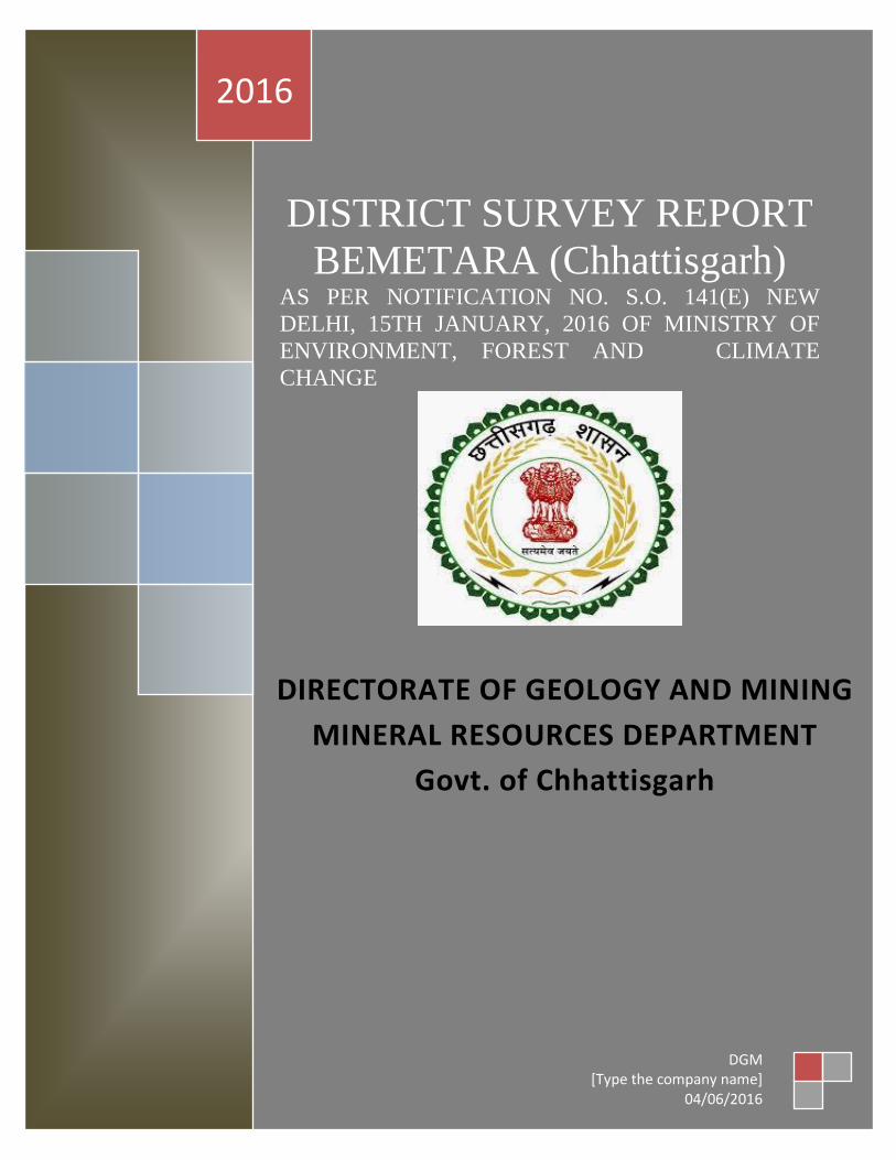
DISTRICT SURVEY REPORT
BEMETARA (Chhattisgarh) AS PER NOTIFICATION NO SO 141(E) NEW
DELHI 15TH JANUARY 2016 OF MINISTRY OF
ENVIRONMENT FOREST AND CLIMATE
CHANGE
2016
DGM [Type the company name]
04062016
DIRECTORATE OF GEOLOGY AND MINING
MINERAL RESOURCES DEPARTMENT
Govt of Chhattisgarh
1
Note
The information provided in this report has been prepared from the existing and
latest data collected from the concerned authorities Although utmost care has been
taken during editing and printing still there may be some minor corrections for
which the Directorate of Geology amp Mining Regional office Raipur
SonakhanBhawan cannot be held responsible The queries in this regard are most
welcome by the concerned office
2
3
LOCATION MAP
4
1- INTRODUCTION
The Bemetara district is one of thenewely formed district of Chhattisgarh states
which formed on 1st January 2012 from the separation of Durg District The
District is moderately populated and situated in the central part of the Chhattisgarh
State covers an area of 285481sq km It falls in Survey of India Degree Sheet Nos
64F and 64G bounded by latitude 21deg22 to 22deg03 N and longitude 81deg07 to 81deg55
E It is surrounded by Durg districts in the south RajnandgaonampKabirdham
District in the west Mungeli districts in the north and Baloda-bazar amp Raipur
district in the East
Bemetara is the district headquarters and is well connected by road and railway
National Highway No 12A and connects Bemetara with Kabirdham Bemetara is
also connected by road with Raipur Baloda-Bazar Kabirdham and Durg with the
other important towns in the district
Acording to NotificationofEnvironment Forest and Climate Change
MinistryGoverment of India dated15 January 2016 as prescribed in Para 7(iii) and
Annexure (x)District Survey Report has been prepared
District Survey report will be prepared in every district for Sand mining or River
bed mining and other small minerals mining The main purpose of preparation of
district survey report is to identify the land increase or depositional areas and its
infrastructure Structure and installation distance from where the mining is
prohibited and recalculation of annual replenishment and time required for
replenishment after mining
5
This District Survey report contains mainly Geology Mineral wealth details of
rivers Details of Lease and Mining activity in the District along with Sand mining
and revenue of minerals
This report also contains details of Forest Rivers Soil Agriculture Road
Transportation climate etc
The district survey report will be based for evaluation of the application for project
and environment clearance of mining activity in the district
6
2 Overview of Mining Activity in the District
BemetaraDistrict is important district for Limestone depositinChhattisgarhThe
Minor Mineral is Low grade Limestons Sandstone Quartzite Soil Riversandare
also found inhuge quantity
Cement Grade LimestoneDolomite occur in thewhole district
Total 4 Quarry Leases are given in the district for limestone
Total 34 Quarry Leases are given in the district for soil for making bricks in kiln at
different villages
Out of 31 newelydeclated minor minerals lease for 1 have been granted for
limestone and 27 for dolomite
33 Ret Ghatfor sand mining on the bank of Shivnath Kharun and Tandula rivers
have been leased out at different villages for sand mining 2 Mining Leases for
runner mounding sand have also been granted at Amti and Thanaud and
Karhidihvillage
Approximately 43026033 lakh Rupees royalty is earned all minerals in the district
out of which 900 lakh from major and 42126033 from minor minerals during the
year 2015-16
7
State Government is carrying on various Infrastructure development projects in all
district like PachriNirman Dams Over bridge Anicuton riversnala approach
roads etc all above civil works require Sand in different site which is in huge
quantity in the district
8
3 List of Mining Leases and Sand in the District with location area
and period of validity
9
10
11
12
13
14
15
16
ftyss dh jsr [knkuksa dh lwph amp
17
18
4 Details of Royalty or Revenue Received in Last Three Year
Major Minerals
Details of Royalty or Revenue Received in Last Three Year Major Minerals
SNo Mineral Royalty or Revenue Received
2013-14 2014-15 2015-16
1 Limestone 115556982 154624130 259409159
2 Quartzite 694597 240000 NA
3 Moulding Sand 80000 127000 606620
Total - 116331579 154991130 260015779
Note - Quartzite Mineral is decleared Minor Mineral wef notification dated 10022015
Details of Royalty or Revenue Received in Last Three Year
Minor Minerals
Minor Minerals
SNo Mineral Royalty or Revenue Received
2013-14 2014-15 2015-16
1 Limestone 1334700 2333000 2385614
2 Flagstone 2021150 2497800 3584557
3 Ordinary Stone 745887 83000 135100
4 Murum 108000 1518692 3277000
5 Soil 572360 538720 354280
Total - 4782097 6971212 9736551
19
5 Details of Production of Sand or Bajari in last three years
frac14vfrac12Details of Production amp Royalty of Sand in in Last Three Year
Ordinary Sand SNo Financial year Royalty Received in Rs
1 2013-14 11504
2 2014-15 12539
3 2015-16 7356
5- fiNysrhuokksZ ds nkSjkujsrlsizkIrLokfeLo k jktLo ds CkSjsamp
frac14cfrac12Details of Production amp Royalty of Sand in in Last Three Year
Ordinary Sand
SNo Financial year Production of Sand (in Cm)
1 2013-14 230085
2 2014-15 250773
3 2015-16 147125
20
6 PROCESS OF DEPOSITION OF SEDIMENTS IN THE RIVERS
Sendimentation of rivers of District
6- Process of river sedimentation-
What is erosion
Erosion is natural process wathering corrosion or abrasion can reduce a material
into smaller particles Normally these smaller units are relocated by water wing
ice or man Erosion removes tosoil organic material and other valuable resources
What is sedimentation
Once a material is broken free of the larger mass it can be carried away and
deposited elsewhere This process of depositing eroded material is known as
sedimentation Some indications of sedimentation are sand dunes mud in the street
around drains and decreased water holding capacity of stream reservoir or pond
Why should we be concerned about erosion and sedimentation
Sediment is responsible for more stream and river degardation than any other
pollutant Deposits of sediments in ditches streams and rivers reduce their
capacity to store water resulting in more frequent and severe flooding and
increased property damage Accumulations of sediment may result in severe
damage to storm drain systers Many millions of dollars are spent each year to
dredge our state waterways to remove sediments from storm drain systerms
reseroirs and water treatment plants and to repair flood damage
Sediment in streams and rivers causes the most damage to aduatic life by severely
impacting aquatic animal habitats and degrading water quality Areas needed for
21
reproduction and food sources are destroyed when fine silts cover the sand and
gravel streambed Decreased clarity of the water prevents sunlight from reaching
plants resulting in loss of aquatic plant communities The result is a reduction in
the number and variety of fish and other aquatic life This impact ofter can see for
many miles downstream
Process-
Rivers have a lot of energy and because they have energy they do stuff The
obvious things rivers do with their energy is flow but besides this they also
transport load erode load and erode the channel through which they flow Erosion
Erosion is the breaking down of material by an agent In the case of a river the
agent is water The water can erode the riverrsquos channel and the riverrsquos load A
riverrsquos load is bits of eroded material generally rocks which the river transports
until it deposits its load A riverrsquos channel is eroded laterally and vertically making
the channel wider and deeper The intensity of lateral and vertical erosion is
dictated by the stage in the riverrsquos course discussed in more detail here but
essentially in the upper stage of the riverrsquos course (close to the source of the river)
there is little horizontal erosion and lots of vertical erosion In the middle and
lower stages vertical erosion is reduced and more horizontal erosion takes place
There are several different ways that a river erodes its bed and banks The first is
hydraulic action where the force of the water removes rock particles from the bed
and banks This type of erosion is strongest at rapids and waterfalls where the
water has a high velocity The next type of erosion is corrasion This is where the
riverrsquos load acts almost like sandpaper removing pieces of rock as the load rubs
against the bed amp banks This sort of erosion is strongest when the river is
transporting large chunks of rock or after heavy rainfall when the riverrsquos flow is
22
turbulent Corrosion is a special type of erosion that only affects certain types of
rocks Water being ever so slightly acidic will react with certain rocks and
dissolve them Corrosion is highly effective if the rock type of the channel is chalk
or limestone (anything containing calcium carbonate) otherwise it doesnrsquot have
much of an effect Cavitation is an interesting method of erosion Air bubbles
trapped in the water get compressed into small spaces like cracks in the riverrsquos
banks These bubbles eventually implode creating a small shockwave that weakens
the rocks The shockwaves are very weak but over time the rock will be weakened
to the point at which it falls apart The final type of erosion is attrition Attrition is
a way of eroding the riverrsquos load not the bed and banks Attrition is where pieces
of rock in the riverrsquos load knock together breaking chunks of rock off of one
another and gradually rounding and shrinking the load Transportation when a river
erodes the eroded material becomes the riverrsquos load and the river will then
transport this load through its course until it deposits the load There are a few
different ways that a river will transport load depending on how much energy the
river has and how big the load is The largest of particles such as boulders are
transported by traction These particles are rolled along the bed of the river
eroding the bed and the particles in the process because the river doesnrsquot have
enough energy to move these large particles in any other way Slightly smaller
particles such as pebbles and gravel are transported by saltation This is where the
load bounces along the bed of the river because the river has enough energy to lift
the particles off the bed but the particles are too heavy to travel by suspension
Fine particles like clay and silt are transported in suspension they are suspended in
the water Most of a riverrsquos load is transported by suspension Solution is a special
method of transportation This is where particles are dissolved into the water so
only rocks that are soluble such as limestone or chalk can be transported in
23
solution Capacity amp Competence Rivers can only carry so much load depending
on their energy The maximum volume of load that a river can carry at a specific
point in its course is called the riverrsquos capacity The biggest sized particle that a
river could carry at a specific point is called the riverrsquos competence Deposition to
transport load a river needs to have energy so when a river loses energy it is forced
to deposit its load There are several reasons why a river could lose energy If the
riverrsquos discharge is reduced then the river will lose energy because it isnrsquot flowing
as quickly anymore This could happen because of a lack of precipitation or an
increase in evaporation Increased human use (abstraction) of a river could also
reduce its discharge forcing it deposit its load If the gradient of the riverrsquos course
flattens out the river will deposit its load because it will be travelling a lot slower
When a river meets the sea a river will deposit its load because the gradient is
generally reduced at sea level and the sea will absorb a lot of energy As rivers get
nearer to their mouths they flow in increasingly wide gentle sided valleys The
channel increases in size to hold the extra water which the river has to receive from
its tributaries As the river gets bigger it can carry larger amounts of material This
material will be small in size as larger rocks will have broken up on their way
from the mountains Much of the material will be carried in suspension and will
erode the river banks by abrasion When rivers flow over flatter land they develop
large bends called meanders As a river goes around a bend most of the water is
pushed towards the outside causing increased erosion The river is now eroding
sideways into its banks rather than downwards into its bed a process called lateral
erosion On the inside of the bend in contrast there is much less water The river
will therefore be shallow and slow-flowing It cannot carry as much material and
so sand and shingle will be deposited This is called a point bar or slip off slope
Due to erosion on the outside of a bend and deposition on the inside the shape of a
24
meander will change over a period of time Notice how erosion narrows the neck
of the land within the meander In time and usually during a flood the river will
cut right through the neck The river will then take the new shorter route The
fastest current called the thalweg will now tend to be in the centre of the river
and so deposition is likely to occur in gentler water next to the banks Eventually
deposition will block off the old meander to leave an oxbow lake The oxbow lake
will slowly dry up only refilling after heavy rain or during a flood Streams lose
velocity and make deposits when their gradient decreases when the volume of
water decreases when there is an increase in cross section when they encounter
obstructions or when they enter still water They deposit alluvial fans alluvial
cones piedmont alluvial plains channel fill bars flood plains and deltas
25
7 General Profile of the District
Bemetara city is well connected to Raipur Jabalpur Bilaspur Durg and
Kawardha by roadwaysNH-30 passes through the heart of city which is one of the
buissiest road in the stateThis highway connects state capital Raipur to one of the
major city of Madhya Pradesh JabalpurThere are two state highway passing
through Bemetara that are Durg to Bemetara and Kumhari - Bemetara ndash Mungeli
History
Comparatively a new district in Chhattisgarh India Bemetara district was
established as tahsil in the year 1907 along with the Mungeli (Bilaspur region)
This region is coloured by ever-widening importance in history since the time it
had been established However it is largest town amongst other town in the
scenario of land and population Owing to its suitability to being a district of
Chhattisgarh it had to wait to call upon since Kawardha has integrated
Conversely the Chhattisgarh government has realised its importance in central
CG Bemetara is an attractive tourist destination as villages like Bataar Mohbhatta
and Khamhariya are famous for their temples and lakes
dzekad
1 ftysdkdqyHkkSxksfy
d ks=Qy
2854-81 oxZfd-eh
2 vkkak oanskkak mRrjesa 21 22΄ ls 22003΄ mRrjhvkkaklsiwoZesa 81 07΄ ls81
055΄iwohZ nskakrj
3 leqnzrylsAringpkbZ 317 eh- vkSlr
4 vkSlrokkZ 2013-14 1234fe-eh- okfkZd
2014-15 1121-40fe-eh- okfkZd
2015-16 957-82fe-eh- okfkZd
5 rkieku vfkdreamp 48lsUVhxzsM
Uqureamp10lsUVhxzsM
26
6 ou ks=Qy
ljafkrou ks=gsDV- vkjfkrou ks= gsDV- voxhZd`rou
ks=gsDV-
dqyouks=
fujad fujad fujad fujad
7 unh rFkkukys River Shivnath Kharun Hanf Sakari SurahiampPhonk river
8 ioZr fujad
9 tula[k 795759 frac14tuxkuk 2011 ds vuqlkjfrac12Male Papulation 397650 amp Female Population
398109 11 lkkjrk frac1469-87frac12
12 rglhy
frac14fodkl[kMfrac12
05 - Nawagarh Bemetara Saja Than KhamhariaampBerla
13 uxjikfydk
uxjfuxe
02 ndash BemetaraampSaja
14 uxjiapkr 06 - Nawagarh Maro Bemetara Devkar Parpodi SajaThanKhamhariaampBerla
15 xzkeiapkr 387
Means of Transport
Bus Transport
Bemetara city is well connected to Raipur Jabalpur Bilaspur Durg and Kawardha
by roadwaysNH-30 A passes through the heart of city which is one of the busiest
road in the stateThis highway connects state capital Raipur to one of the major city
of Madhya Pradesh JabalpurThere are two state highway passing through
Bemetara that are Durg to Bemetara and Kumhari - Bemetara - Mungeli
Railway Transport
Bemetara is not connected by railway the nearest Railway station is tilde (35 km)
and major station is Raipur (66 km) and Durg is about 72 km
A new railway line is proposed in Bemetarawhich isDurg-Bemetara-Mungeli-
Bilaspur line
27
Air Transport
Nearest airport to the town is Swami Vivekananda International Airport
Raipur(IATA RPR ICAO VERP) which was formerly known as Mana Airport
which is 66 km from the city
28
8 Land Utilition Pattern in the district Forest Agriculture
Horticulture Mining etc
(i)Types of Soil-
Different type of soils are found in the District which is as follows-
i Red Soil (Bhata) Entisols
ii Sandy loams (Matasi) Inceptisols
iii Dorsa (Alfisols)
iv Black (Kanhar) vertisols
v Alluvial Soil (Kachhar)
(ii)Types of Forest-
oueMy
ljafkrou ks=gsDV- vkjfkrou ks= gsDV- voxhZd`rou ks=gsDV-
dqyouks=
ou
ks=Qy
fujad fujad fujad fujad
(iii)Details of Horticulture-
S No Particular Details Area in Hectare
1 Geographical Area of the District 285481Hect
2 Forest Area Nil
3 Total Kast Land Area 239566Hect
4 Land Covered by Gardening Crops 15373 Hect
5 Land Covered by Fruit Plants 2934 Hect
6 Land Covered by Vegetables Crop 10602 Hect
7 Land Covered by Masala 1535Hect
29
8 Land Covered by Flowers 185 Hect
9 Land Covered by Medicinal ampSented Plants 117 Hect
10 Percentage of Gardening Crops 872
(iv)Details of Agriculture-
S No Particular Details Area in Hectare
1 Geographical Area of the District 285481Hect
2 Forest Area Nil
3 Non-Agricultural Land 52770Hect
4 Duel Crop Area 94150 Hect
5 Total Kast Land Area 281523Hect
6 Kharif Crop Area 205270Hect
7 Ravi Crop Area 138560Hect
8 Area of Jayad 1200 Hect
9 Total Crop Area 232710Hect
Irrigation
The main source of irrigation in the district is River Shivnath Kharun Haff
SakariampSurahi etc There is no any big dam in the district
30
(v) Details of Ground Water Survey-
31
Climate-
Bemetara has a tropical wet and dry climate temperature remains moderate
throughout the year except from March to June which can be extremely hot The
temperature in AprilndashMay sometimes rises above 45 degCThese summer months
also have dry and hot winds In summers the temperature can also go up to 50 degC
The city receives about 1300 millimetres (51 in) of rain mostly in the monsoon
season from late June to early October Winters last from November to January
and are mild although lows can fall to 5 degC (41 degF)
Climate data for Bemetara City
Month Jan Feb Mar Apr May Jun Jul Aug Sep Oct Nov Dec Year
Average
high degC
(degF)
27
(81)
30
(86)
35
(95)
39
(102)
45
(113)
36
(97)
30
(86)
30
(86)
31
(88)
31
(88)
28
(82)
26
(79)
32
(90)
Average
low degC
(degF)
13
(55)
15
(59)
20
(68)
24
(75)
27
(81)
26
(79)
23
(73)
23
(73)
22
(72)
21
(70)
16
(61)
14
(57)
20
(68)
Average
precipita
tion mm
(inches)
10
(039)
17
(067)
14
(055)
13
(051)
18
(071)
239
(941)
383
(1508)
364
(1433)
197
(776)
50
(197)
11
(043)
16
(063)
1330
(5236)
32
9 Physiography of the District
Physiographically the area in Bemetara District having almost flat topographyThe
general slope of the district is towards the north - east in which direction the major
streams of the district flow
BEMETARA is located near the centre of a large plain sometimes referred as the
rice bowl of India where hundreds of varieties of rice are
grown The ShivnathRiverflows to the east of the city of bemetara and the
southern side has dense forests The Maikal Hills rise on the north-west of
Bemetara on the north the land rises and merges with the Chota Nagpur Plateau
which extends north-east across Jharkhand state On the south of Bemetara lies
the Deccan Plateau
33
34
10 Rainfall of District BemetaraYear wise
S No Year Average Rainfall (mm)
1 2012 99440
2 2013 123400
3 2014 112140
4 2015 95782
Rainfall of District Bemetara Month wise
Rainfall data for Bemetara City
Month Jan Feb Mar Apr May Jun Jul Aug Sep Oct Nov Dec Year
Average
precipita
tion mm
(inches)
10
(039)
17
(067)
14
(055)
13
(051)
18
(071)
239
(941)
383
(1508)
364
(1433)
197
(776)
50
(197)
11
(043)
16
(063)
1330
(5236)
35
36
11 Geology and Mineral Wealth
Geology-
Geologically the district comprises of rocks of the Meso-to Neo- Proterozoic
sequence is represented by the Chhattisgarh Supergroup Raipur Group comprises
Chandi formation Tarenga formation Hirri formation and Maniari formation
Chandi Formation of grey and purple stromatolitic limestone with
areniteferruginous sandstone intercalations (Deodongar member) Tarenga
Formation of greenish grey and reddish brown shale with chert porcellanite and
green clay interbands Hirri Formation by grey thinly to thickly bedded dolomite
and argillancous dolomite and ManairiFormationn comprises reddish brown and
purple non - calcareous shale with gypsum interbandsQuatrenary is represented
by pebble beds (Khamaria pebble bed)
37
38
Stratigraphic succession-
39
Mineral-
Mineral deposite of Bemetaradistrict include Dolomite Limestone Ordinary stone
Sand and Soil etc
Dolomite Mines
Total 27 Dolomite mines in which at present 3 dolomite is operational 13 dolomite
mine is under renewal and 11 dolomite mines is under lapse category
Limestone Mine
Total 03limestone mines in which at present 1limestone mine is operational and
rest 2 limestone mine is under renewal in the district
Ordinary Stone Mine
Total 01 ordinary stone mines is operational in the district
Soil Mine for Making Bricks
Total 34 soil mines in which at present 13 soil mine is operational and 21 soil mine
is under renewal varies part of the district
Sand Mine
Total 33 sand mines in which at present after Environmental NOC 12 sand mine is
operational 14 sand mine is under process to getting Environmental NOC from
SEIAA and 07sand mines has not submitted required documents for
Environmental Clearence till date
Sands are mostly available in Bank of River Shivnath Kharun Hanf
SakariSurahiampPhonkriver Quarry leases for sand mining are given in different
village of Bemetara district
40
Additional information of the district
Drainage System-
Shivnath
Sheonath is main river of District Bemetara Shivnathriver is tributary of Mahanadi
river Shivnathriver originates from Mountain at height of 625 meter at Panabaras
situated in south western parts of Rajnandgaon and flows towards north east
direction Shivnath River measures length about 345 KM City Durg is situated on
east bank of Shivnath River It flows towards north east passing through Khujji
Rajnandgaon Durg Dhamdha and Nandghat and joins (meet) Mahanadi near
Shivari Narayan of Bilaspur District
Kharun
Kharunriver flows in eastern parts of the district starting from Petechua in Balod
District This river flows towards north and joins (meet) ShivnathRiver at Somnath
near Simga This river determines the boundary of Raipur and Durg district The
length of this river is about 120 KM
41
42
Survey Report for Sand Mining of District Bemetara
This survey report is prepared for District Bemetara to identify the sustainable
mining area In District Bemetarathere are six rivers namely Shivnath Kharun
Haff Sakari SurahiampPhonkriver
All possible sand mining area has been surveyed The riverwise area surveyed and
identified for sand mining is given in the annexure
The thickness of sand load is considered average 4 meters in depth by observation
as well as local enquiry out of which up to depth of 3 meter is considered for
calculation of mineral potential
The mining area will be 10m away from the river bank and about 10m Influence
as safity barrier from the main streem will be left where mining operation will be
restricted Hence 10 m influence area from the main stream has been considered as
safity zone or non mining zone
It is considered that replenishment of sand in every monsoon season is a regular
process Based on the last five year observation it is experienced that average of
3m sand is replenished every year
Area Prohibited for Mining-
The following area will be prohibited for minng
i No mining activity will be executed 10 m from the river bank
ii Mining is prohibited within 10 m from the flow of the main stream
iii During mining measures should be taken to guide the flow to the centre
of the river to avoide erosion of banks
iv Mining area is restricted up to 500 mtsdown stream of any structure like
bridge diversion head work anicut etc
43
v Measures should be kept in consideration that the flow of river should not
be diverted or obstructed
vi The distance between two sand mining locations should be minimum 500
meters
vii Before permission of mining a suitable test of sand for construction
purpose like silt percentage fineness modulus etc must be obtained from
competent laboratory authority
viii Provision for plantation must be assured on the river bank of concerened
sand mining zone to protect erosion of banks and to
maintainesecobalance
Details are given bellow-
S No Name of River Ara Drained Sq KM Area
Drained in the
District in BemetaraDist Total
1 2 3 4 5
1 Shivnath River Sq km Sq km
2 Kharun River Sq km Sq km
3 Haff River Sq km Sq km
4 Sakari River
5 Surahi River
6 Phonk
Features of Important Rivers and Streams-
S No Name of the
River or Stream
Total Length in the
District (in km)
Place of origin Height of
origin
1 2 3 4 5
1 Shivnath River km Panabaras (Dist-
Rajnandgaon)
642 m
2 Kharun River km Kankalin (Petachuwa)
(Dist-Balod)
1 m
3 Haff River km Hils of Dallirajhara
(Banjaridih) (Dist- Balod
3 m
44
4 Sakari River
5 Surahi River
6 Phonk
Shivnath River
SNo Portion of the
River of
Stream
Recommended
for Mineral
Concession
Length of
area
recommended
for mineral
concession (in
kilometer)
Average
Width of area
Recommended
for mineral
concession (in
meters)
Area
recommended
for mineral
concession (in
meter)
Mineable
mineral
potential
(in metric
tonne) 60
of total
mineral
potential)
1 2 jsrtekoughagSA 3 jsrmiyCk ughagSA 4 jsrmiyCk ughagSA 5 jsrmiyCk ughagSA 6 orZekuesaikuhHkjkogSArhuokZiwoZjsr
[kuugksrkFkkjsrughagSA
ksxamp
Kharun River
SNo Portion of the
River of
Stream
Recommended
for Mineral
Concession
Length of
area
recommended
for mineral
concession (in
kilometer)
Average
Width of area
Recommended
for mineral
concession (in
meters)
Area
recommended
for mineral
concession (in
meter)
Mineable
mineral
potential
(in metric
tonne) 60
of total
mineral
potential)
1 ikuhHkjkogSA 2 ikuhHkjkogSA 3 ikuhHkjkogSA 4 ikuhHkjkogSA 5 ikuhHkjkogSA 6 ikuhHkjkogSA
45
ksxamp 0
Haff River
SNo Portion of the
River of
Stream
Recommended
for Mineral
Concession
Length of
area
recommended
for mineral
concession (in
kilometer)
Average
Width of area
Recommended
for mineral
concession (in
meters)
Area
recommended
for mineral
concession (in
meter)
Mineable
mineral
potential
(in metric
tonne) 60
of total
mineral
potential)
1 ikuhHkjkogSA 2 ikuhHkjkogSA 3 ikuhHkjkogSA 4 ikuhHkjkogSA 5 ikuhHkjkogSA 6 ikuhHkjkogSA ksxamp 0
Sakari River
SNo Portion of the
River of
Stream
Recommended
for Mineral
Concession
Length of
area
recommended
for mineral
concession (in
kilometer)
Average
Width of area
Recommended
for mineral
concession (in
meters)
Area
recommended
for mineral
concession (in
meter)
Mineable
mineral
potential
(in metric
tonne) 60
of total
mineral
potential)
1 ikuhHkjkogSA 2 ikuhHkjkogSA 3 ikuhHkjkogSA 4 ikuhHkjkogSA 5 ikuhHkjkogSA 6 ikuhHkjkogSA ksxamp 0
46
Surahi River
SNo Portion of the
River of
Stream
Recommended
for Mineral
Concession
Length of
area
recommended
for mineral
concession (in
kilometer)
Average
Width of area
Recommended
for mineral
concession (in
meters)
Area
recommended
for mineral
concession (in
meter)
Mineable
mineral
potential
(in metric
tonne) 60
of total
mineral
potential)
1 ikuhHkjkogSA 2 ikuhHkjkogSA 3 ikuhHkjkogSA 4 ikuhHkjkogSA 5 ikuhHkjkogSA 6 ikuhHkjkogSA ksxamp 0
Phonk River
SNo Portion of the
River of
Stream
Recommended
for Mineral
Concession
Length of
area
recommended
for mineral
concession (in
kilometer)
Average
Width of area
Recommended
for mineral
concession (in
meters)
Area
recommended
for mineral
concession (in
meter)
Mineable
mineral
potential
(in metric
tonne) 60
of total
mineral
potential)
1 ikuhHkjkogSA 2 ikuhHkjkogSA 3 ikuhHkjkogSA 4 ikuhHkjkogSA 5 ikuhHkjkogSA 6 ikuhHkjkogSA ksxamp 0
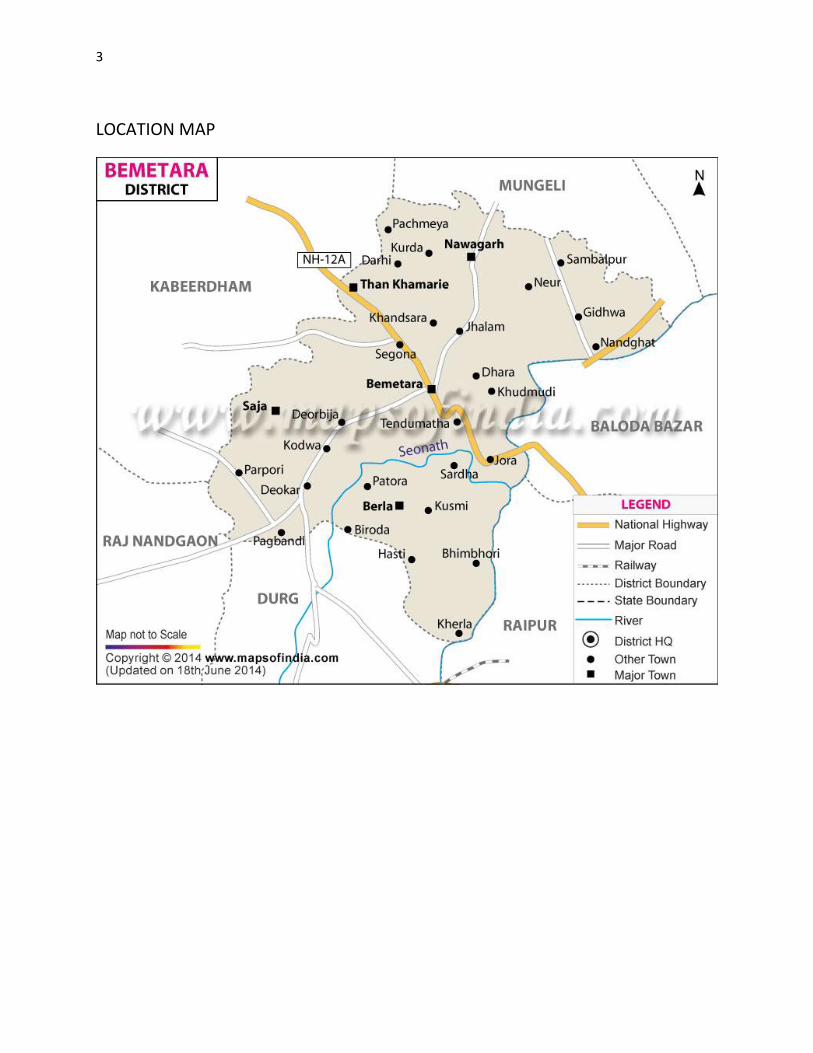
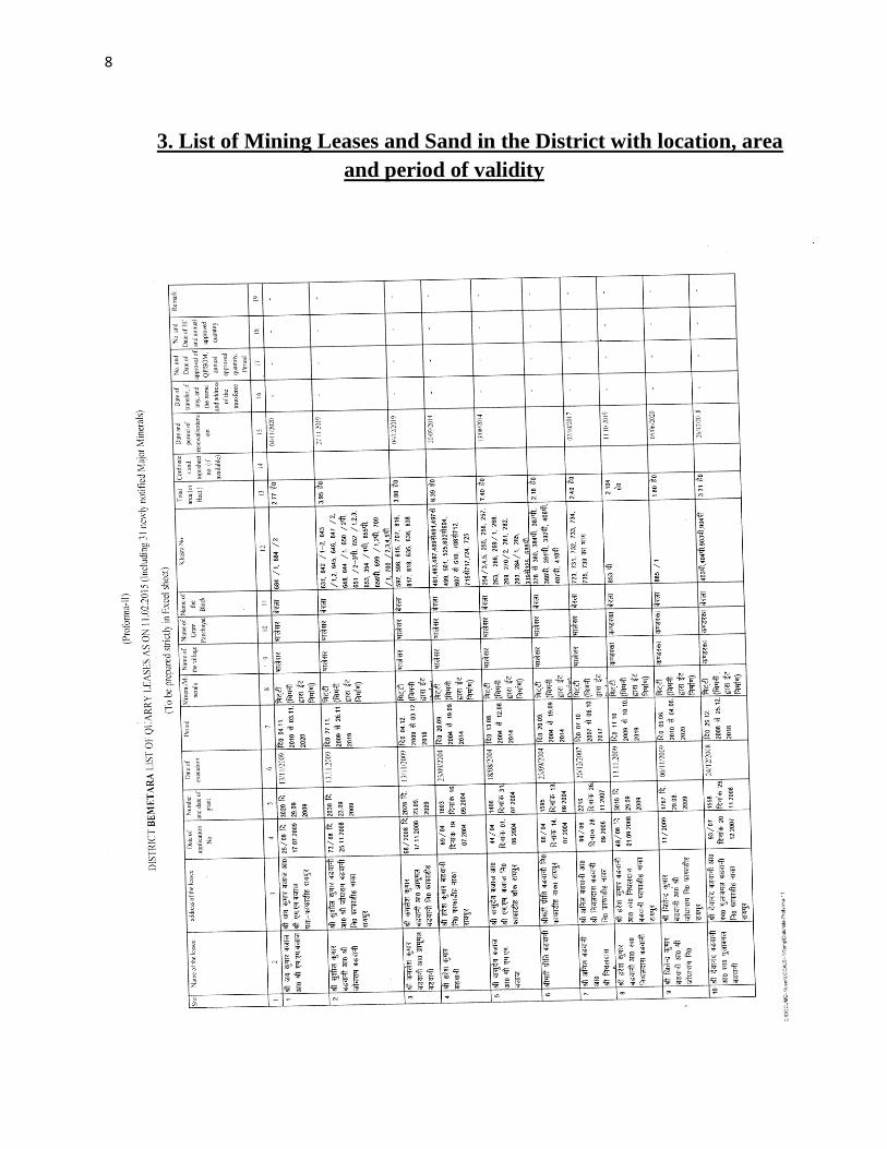
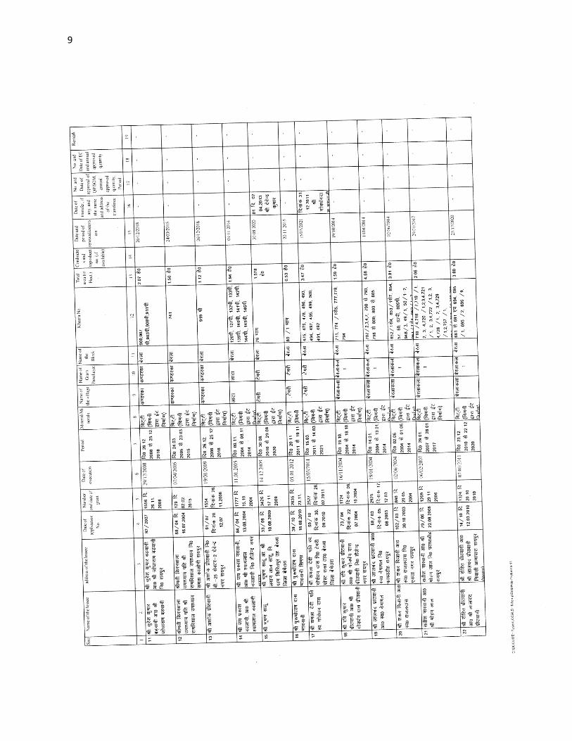
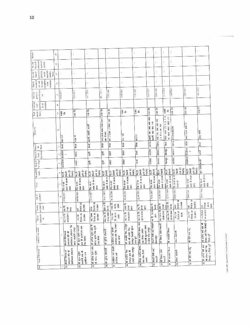
10
11
12
13
14
15
16
ftyss dh jsr [knkuksa dh lwph amp
17
18
4 Details of Royalty or Revenue Received in Last Three Year
Major Minerals
Details of Royalty or Revenue Received in Last Three Year Major Minerals
SNo Mineral Royalty or Revenue Received
2013-14 2014-15 2015-16
1 Limestone 115556982 154624130 259409159
2 Quartzite 694597 240000 NA
3 Moulding Sand 80000 127000 606620
Total - 116331579 154991130 260015779
Note - Quartzite Mineral is decleared Minor Mineral wef notification dated 10022015
Details of Royalty or Revenue Received in Last Three Year
Minor Minerals
Minor Minerals
SNo Mineral Royalty or Revenue Received
2013-14 2014-15 2015-16
1 Limestone 1334700 2333000 2385614
2 Flagstone 2021150 2497800 3584557
3 Ordinary Stone 745887 83000 135100
4 Murum 108000 1518692 3277000
5 Soil 572360 538720 354280
Total - 4782097 6971212 9736551
19
5 Details of Production of Sand or Bajari in last three years
frac14vfrac12Details of Production amp Royalty of Sand in in Last Three Year
Ordinary Sand SNo Financial year Royalty Received in Rs
1 2013-14 11504
2 2014-15 12539
3 2015-16 7356
5- fiNysrhuokksZ ds nkSjkujsrlsizkIrLokfeLo k jktLo ds CkSjsamp
frac14cfrac12Details of Production amp Royalty of Sand in in Last Three Year
Ordinary Sand
SNo Financial year Production of Sand (in Cm)
1 2013-14 230085
2 2014-15 250773
3 2015-16 147125
20
6 PROCESS OF DEPOSITION OF SEDIMENTS IN THE RIVERS
Sendimentation of rivers of District
6- Process of river sedimentation-
What is erosion
Erosion is natural process wathering corrosion or abrasion can reduce a material
into smaller particles Normally these smaller units are relocated by water wing
ice or man Erosion removes tosoil organic material and other valuable resources
What is sedimentation
Once a material is broken free of the larger mass it can be carried away and
deposited elsewhere This process of depositing eroded material is known as
sedimentation Some indications of sedimentation are sand dunes mud in the street
around drains and decreased water holding capacity of stream reservoir or pond
Why should we be concerned about erosion and sedimentation
Sediment is responsible for more stream and river degardation than any other
pollutant Deposits of sediments in ditches streams and rivers reduce their
capacity to store water resulting in more frequent and severe flooding and
increased property damage Accumulations of sediment may result in severe
damage to storm drain systers Many millions of dollars are spent each year to
dredge our state waterways to remove sediments from storm drain systerms
reseroirs and water treatment plants and to repair flood damage
Sediment in streams and rivers causes the most damage to aduatic life by severely
impacting aquatic animal habitats and degrading water quality Areas needed for
21
reproduction and food sources are destroyed when fine silts cover the sand and
gravel streambed Decreased clarity of the water prevents sunlight from reaching
plants resulting in loss of aquatic plant communities The result is a reduction in
the number and variety of fish and other aquatic life This impact ofter can see for
many miles downstream
Process-
Rivers have a lot of energy and because they have energy they do stuff The
obvious things rivers do with their energy is flow but besides this they also
transport load erode load and erode the channel through which they flow Erosion
Erosion is the breaking down of material by an agent In the case of a river the
agent is water The water can erode the riverrsquos channel and the riverrsquos load A
riverrsquos load is bits of eroded material generally rocks which the river transports
until it deposits its load A riverrsquos channel is eroded laterally and vertically making
the channel wider and deeper The intensity of lateral and vertical erosion is
dictated by the stage in the riverrsquos course discussed in more detail here but
essentially in the upper stage of the riverrsquos course (close to the source of the river)
there is little horizontal erosion and lots of vertical erosion In the middle and
lower stages vertical erosion is reduced and more horizontal erosion takes place
There are several different ways that a river erodes its bed and banks The first is
hydraulic action where the force of the water removes rock particles from the bed
and banks This type of erosion is strongest at rapids and waterfalls where the
water has a high velocity The next type of erosion is corrasion This is where the
riverrsquos load acts almost like sandpaper removing pieces of rock as the load rubs
against the bed amp banks This sort of erosion is strongest when the river is
transporting large chunks of rock or after heavy rainfall when the riverrsquos flow is
22
turbulent Corrosion is a special type of erosion that only affects certain types of
rocks Water being ever so slightly acidic will react with certain rocks and
dissolve them Corrosion is highly effective if the rock type of the channel is chalk
or limestone (anything containing calcium carbonate) otherwise it doesnrsquot have
much of an effect Cavitation is an interesting method of erosion Air bubbles
trapped in the water get compressed into small spaces like cracks in the riverrsquos
banks These bubbles eventually implode creating a small shockwave that weakens
the rocks The shockwaves are very weak but over time the rock will be weakened
to the point at which it falls apart The final type of erosion is attrition Attrition is
a way of eroding the riverrsquos load not the bed and banks Attrition is where pieces
of rock in the riverrsquos load knock together breaking chunks of rock off of one
another and gradually rounding and shrinking the load Transportation when a river
erodes the eroded material becomes the riverrsquos load and the river will then
transport this load through its course until it deposits the load There are a few
different ways that a river will transport load depending on how much energy the
river has and how big the load is The largest of particles such as boulders are
transported by traction These particles are rolled along the bed of the river
eroding the bed and the particles in the process because the river doesnrsquot have
enough energy to move these large particles in any other way Slightly smaller
particles such as pebbles and gravel are transported by saltation This is where the
load bounces along the bed of the river because the river has enough energy to lift
the particles off the bed but the particles are too heavy to travel by suspension
Fine particles like clay and silt are transported in suspension they are suspended in
the water Most of a riverrsquos load is transported by suspension Solution is a special
method of transportation This is where particles are dissolved into the water so
only rocks that are soluble such as limestone or chalk can be transported in
23
solution Capacity amp Competence Rivers can only carry so much load depending
on their energy The maximum volume of load that a river can carry at a specific
point in its course is called the riverrsquos capacity The biggest sized particle that a
river could carry at a specific point is called the riverrsquos competence Deposition to
transport load a river needs to have energy so when a river loses energy it is forced
to deposit its load There are several reasons why a river could lose energy If the
riverrsquos discharge is reduced then the river will lose energy because it isnrsquot flowing
as quickly anymore This could happen because of a lack of precipitation or an
increase in evaporation Increased human use (abstraction) of a river could also
reduce its discharge forcing it deposit its load If the gradient of the riverrsquos course
flattens out the river will deposit its load because it will be travelling a lot slower
When a river meets the sea a river will deposit its load because the gradient is
generally reduced at sea level and the sea will absorb a lot of energy As rivers get
nearer to their mouths they flow in increasingly wide gentle sided valleys The
channel increases in size to hold the extra water which the river has to receive from
its tributaries As the river gets bigger it can carry larger amounts of material This
material will be small in size as larger rocks will have broken up on their way
from the mountains Much of the material will be carried in suspension and will
erode the river banks by abrasion When rivers flow over flatter land they develop
large bends called meanders As a river goes around a bend most of the water is
pushed towards the outside causing increased erosion The river is now eroding
sideways into its banks rather than downwards into its bed a process called lateral
erosion On the inside of the bend in contrast there is much less water The river
will therefore be shallow and slow-flowing It cannot carry as much material and
so sand and shingle will be deposited This is called a point bar or slip off slope
Due to erosion on the outside of a bend and deposition on the inside the shape of a
24
meander will change over a period of time Notice how erosion narrows the neck
of the land within the meander In time and usually during a flood the river will
cut right through the neck The river will then take the new shorter route The
fastest current called the thalweg will now tend to be in the centre of the river
and so deposition is likely to occur in gentler water next to the banks Eventually
deposition will block off the old meander to leave an oxbow lake The oxbow lake
will slowly dry up only refilling after heavy rain or during a flood Streams lose
velocity and make deposits when their gradient decreases when the volume of
water decreases when there is an increase in cross section when they encounter
obstructions or when they enter still water They deposit alluvial fans alluvial
cones piedmont alluvial plains channel fill bars flood plains and deltas
25
7 General Profile of the District
Bemetara city is well connected to Raipur Jabalpur Bilaspur Durg and
Kawardha by roadwaysNH-30 passes through the heart of city which is one of the
buissiest road in the stateThis highway connects state capital Raipur to one of the
major city of Madhya Pradesh JabalpurThere are two state highway passing
through Bemetara that are Durg to Bemetara and Kumhari - Bemetara ndash Mungeli
History
Comparatively a new district in Chhattisgarh India Bemetara district was
established as tahsil in the year 1907 along with the Mungeli (Bilaspur region)
This region is coloured by ever-widening importance in history since the time it
had been established However it is largest town amongst other town in the
scenario of land and population Owing to its suitability to being a district of
Chhattisgarh it had to wait to call upon since Kawardha has integrated
Conversely the Chhattisgarh government has realised its importance in central
CG Bemetara is an attractive tourist destination as villages like Bataar Mohbhatta
and Khamhariya are famous for their temples and lakes
dzekad
1 ftysdkdqyHkkSxksfy
d ks=Qy
2854-81 oxZfd-eh
2 vkkak oanskkak mRrjesa 21 22΄ ls 22003΄ mRrjhvkkaklsiwoZesa 81 07΄ ls81
055΄iwohZ nskakrj
3 leqnzrylsAringpkbZ 317 eh- vkSlr
4 vkSlrokkZ 2013-14 1234fe-eh- okfkZd
2014-15 1121-40fe-eh- okfkZd
2015-16 957-82fe-eh- okfkZd
5 rkieku vfkdreamp 48lsUVhxzsM
Uqureamp10lsUVhxzsM
26
6 ou ks=Qy
ljafkrou ks=gsDV- vkjfkrou ks= gsDV- voxhZd`rou
ks=gsDV-
dqyouks=
fujad fujad fujad fujad
7 unh rFkkukys River Shivnath Kharun Hanf Sakari SurahiampPhonk river
8 ioZr fujad
9 tula[k 795759 frac14tuxkuk 2011 ds vuqlkjfrac12Male Papulation 397650 amp Female Population
398109 11 lkkjrk frac1469-87frac12
12 rglhy
frac14fodkl[kMfrac12
05 - Nawagarh Bemetara Saja Than KhamhariaampBerla
13 uxjikfydk
uxjfuxe
02 ndash BemetaraampSaja
14 uxjiapkr 06 - Nawagarh Maro Bemetara Devkar Parpodi SajaThanKhamhariaampBerla
15 xzkeiapkr 387
Means of Transport
Bus Transport
Bemetara city is well connected to Raipur Jabalpur Bilaspur Durg and Kawardha
by roadwaysNH-30 A passes through the heart of city which is one of the busiest
road in the stateThis highway connects state capital Raipur to one of the major city
of Madhya Pradesh JabalpurThere are two state highway passing through
Bemetara that are Durg to Bemetara and Kumhari - Bemetara - Mungeli
Railway Transport
Bemetara is not connected by railway the nearest Railway station is tilde (35 km)
and major station is Raipur (66 km) and Durg is about 72 km
A new railway line is proposed in Bemetarawhich isDurg-Bemetara-Mungeli-
Bilaspur line
27
Air Transport
Nearest airport to the town is Swami Vivekananda International Airport
Raipur(IATA RPR ICAO VERP) which was formerly known as Mana Airport
which is 66 km from the city
28
8 Land Utilition Pattern in the district Forest Agriculture
Horticulture Mining etc
(i)Types of Soil-
Different type of soils are found in the District which is as follows-
i Red Soil (Bhata) Entisols
ii Sandy loams (Matasi) Inceptisols
iii Dorsa (Alfisols)
iv Black (Kanhar) vertisols
v Alluvial Soil (Kachhar)
(ii)Types of Forest-
oueMy
ljafkrou ks=gsDV- vkjfkrou ks= gsDV- voxhZd`rou ks=gsDV-
dqyouks=
ou
ks=Qy
fujad fujad fujad fujad
(iii)Details of Horticulture-
S No Particular Details Area in Hectare
1 Geographical Area of the District 285481Hect
2 Forest Area Nil
3 Total Kast Land Area 239566Hect
4 Land Covered by Gardening Crops 15373 Hect
5 Land Covered by Fruit Plants 2934 Hect
6 Land Covered by Vegetables Crop 10602 Hect
7 Land Covered by Masala 1535Hect
29
8 Land Covered by Flowers 185 Hect
9 Land Covered by Medicinal ampSented Plants 117 Hect
10 Percentage of Gardening Crops 872
(iv)Details of Agriculture-
S No Particular Details Area in Hectare
1 Geographical Area of the District 285481Hect
2 Forest Area Nil
3 Non-Agricultural Land 52770Hect
4 Duel Crop Area 94150 Hect
5 Total Kast Land Area 281523Hect
6 Kharif Crop Area 205270Hect
7 Ravi Crop Area 138560Hect
8 Area of Jayad 1200 Hect
9 Total Crop Area 232710Hect
Irrigation
The main source of irrigation in the district is River Shivnath Kharun Haff
SakariampSurahi etc There is no any big dam in the district
30
(v) Details of Ground Water Survey-
31
Climate-
Bemetara has a tropical wet and dry climate temperature remains moderate
throughout the year except from March to June which can be extremely hot The
temperature in AprilndashMay sometimes rises above 45 degCThese summer months
also have dry and hot winds In summers the temperature can also go up to 50 degC
The city receives about 1300 millimetres (51 in) of rain mostly in the monsoon
season from late June to early October Winters last from November to January
and are mild although lows can fall to 5 degC (41 degF)
Climate data for Bemetara City
Month Jan Feb Mar Apr May Jun Jul Aug Sep Oct Nov Dec Year
Average
high degC
(degF)
27
(81)
30
(86)
35
(95)
39
(102)
45
(113)
36
(97)
30
(86)
30
(86)
31
(88)
31
(88)
28
(82)
26
(79)
32
(90)
Average
low degC
(degF)
13
(55)
15
(59)
20
(68)
24
(75)
27
(81)
26
(79)
23
(73)
23
(73)
22
(72)
21
(70)
16
(61)
14
(57)
20
(68)
Average
precipita
tion mm
(inches)
10
(039)
17
(067)
14
(055)
13
(051)
18
(071)
239
(941)
383
(1508)
364
(1433)
197
(776)
50
(197)
11
(043)
16
(063)
1330
(5236)
32
9 Physiography of the District
Physiographically the area in Bemetara District having almost flat topographyThe
general slope of the district is towards the north - east in which direction the major
streams of the district flow
BEMETARA is located near the centre of a large plain sometimes referred as the
rice bowl of India where hundreds of varieties of rice are
grown The ShivnathRiverflows to the east of the city of bemetara and the
southern side has dense forests The Maikal Hills rise on the north-west of
Bemetara on the north the land rises and merges with the Chota Nagpur Plateau
which extends north-east across Jharkhand state On the south of Bemetara lies
the Deccan Plateau
33
34
10 Rainfall of District BemetaraYear wise
S No Year Average Rainfall (mm)
1 2012 99440
2 2013 123400
3 2014 112140
4 2015 95782
Rainfall of District Bemetara Month wise
Rainfall data for Bemetara City
Month Jan Feb Mar Apr May Jun Jul Aug Sep Oct Nov Dec Year
Average
precipita
tion mm
(inches)
10
(039)
17
(067)
14
(055)
13
(051)
18
(071)
239
(941)
383
(1508)
364
(1433)
197
(776)
50
(197)
11
(043)
16
(063)
1330
(5236)
35
36
11 Geology and Mineral Wealth
Geology-
Geologically the district comprises of rocks of the Meso-to Neo- Proterozoic
sequence is represented by the Chhattisgarh Supergroup Raipur Group comprises
Chandi formation Tarenga formation Hirri formation and Maniari formation
Chandi Formation of grey and purple stromatolitic limestone with
areniteferruginous sandstone intercalations (Deodongar member) Tarenga
Formation of greenish grey and reddish brown shale with chert porcellanite and
green clay interbands Hirri Formation by grey thinly to thickly bedded dolomite
and argillancous dolomite and ManairiFormationn comprises reddish brown and
purple non - calcareous shale with gypsum interbandsQuatrenary is represented
by pebble beds (Khamaria pebble bed)
37
38
Stratigraphic succession-
39
Mineral-
Mineral deposite of Bemetaradistrict include Dolomite Limestone Ordinary stone
Sand and Soil etc
Dolomite Mines
Total 27 Dolomite mines in which at present 3 dolomite is operational 13 dolomite
mine is under renewal and 11 dolomite mines is under lapse category
Limestone Mine
Total 03limestone mines in which at present 1limestone mine is operational and
rest 2 limestone mine is under renewal in the district
Ordinary Stone Mine
Total 01 ordinary stone mines is operational in the district
Soil Mine for Making Bricks
Total 34 soil mines in which at present 13 soil mine is operational and 21 soil mine
is under renewal varies part of the district
Sand Mine
Total 33 sand mines in which at present after Environmental NOC 12 sand mine is
operational 14 sand mine is under process to getting Environmental NOC from
SEIAA and 07sand mines has not submitted required documents for
Environmental Clearence till date
Sands are mostly available in Bank of River Shivnath Kharun Hanf
SakariSurahiampPhonkriver Quarry leases for sand mining are given in different
village of Bemetara district
40
Additional information of the district
Drainage System-
Shivnath
Sheonath is main river of District Bemetara Shivnathriver is tributary of Mahanadi
river Shivnathriver originates from Mountain at height of 625 meter at Panabaras
situated in south western parts of Rajnandgaon and flows towards north east
direction Shivnath River measures length about 345 KM City Durg is situated on
east bank of Shivnath River It flows towards north east passing through Khujji
Rajnandgaon Durg Dhamdha and Nandghat and joins (meet) Mahanadi near
Shivari Narayan of Bilaspur District
Kharun
Kharunriver flows in eastern parts of the district starting from Petechua in Balod
District This river flows towards north and joins (meet) ShivnathRiver at Somnath
near Simga This river determines the boundary of Raipur and Durg district The
length of this river is about 120 KM
41
42
Survey Report for Sand Mining of District Bemetara
This survey report is prepared for District Bemetara to identify the sustainable
mining area In District Bemetarathere are six rivers namely Shivnath Kharun
Haff Sakari SurahiampPhonkriver
All possible sand mining area has been surveyed The riverwise area surveyed and
identified for sand mining is given in the annexure
The thickness of sand load is considered average 4 meters in depth by observation
as well as local enquiry out of which up to depth of 3 meter is considered for
calculation of mineral potential
The mining area will be 10m away from the river bank and about 10m Influence
as safity barrier from the main streem will be left where mining operation will be
restricted Hence 10 m influence area from the main stream has been considered as
safity zone or non mining zone
It is considered that replenishment of sand in every monsoon season is a regular
process Based on the last five year observation it is experienced that average of
3m sand is replenished every year
Area Prohibited for Mining-
The following area will be prohibited for minng
i No mining activity will be executed 10 m from the river bank
ii Mining is prohibited within 10 m from the flow of the main stream
iii During mining measures should be taken to guide the flow to the centre
of the river to avoide erosion of banks
iv Mining area is restricted up to 500 mtsdown stream of any structure like
bridge diversion head work anicut etc
43
v Measures should be kept in consideration that the flow of river should not
be diverted or obstructed
vi The distance between two sand mining locations should be minimum 500
meters
vii Before permission of mining a suitable test of sand for construction
purpose like silt percentage fineness modulus etc must be obtained from
competent laboratory authority
viii Provision for plantation must be assured on the river bank of concerened
sand mining zone to protect erosion of banks and to
maintainesecobalance
Details are given bellow-
S No Name of River Ara Drained Sq KM Area
Drained in the
District in BemetaraDist Total
1 2 3 4 5
1 Shivnath River Sq km Sq km
2 Kharun River Sq km Sq km
3 Haff River Sq km Sq km
4 Sakari River
5 Surahi River
6 Phonk
Features of Important Rivers and Streams-
S No Name of the
River or Stream
Total Length in the
District (in km)
Place of origin Height of
origin
1 2 3 4 5
1 Shivnath River km Panabaras (Dist-
Rajnandgaon)
642 m
2 Kharun River km Kankalin (Petachuwa)
(Dist-Balod)
1 m
3 Haff River km Hils of Dallirajhara
(Banjaridih) (Dist- Balod
3 m
44
4 Sakari River
5 Surahi River
6 Phonk
Shivnath River
SNo Portion of the
River of
Stream
Recommended
for Mineral
Concession
Length of
area
recommended
for mineral
concession (in
kilometer)
Average
Width of area
Recommended
for mineral
concession (in
meters)
Area
recommended
for mineral
concession (in
meter)
Mineable
mineral
potential
(in metric
tonne) 60
of total
mineral
potential)
1 2 jsrtekoughagSA 3 jsrmiyCk ughagSA 4 jsrmiyCk ughagSA 5 jsrmiyCk ughagSA 6 orZekuesaikuhHkjkogSArhuokZiwoZjsr
[kuugksrkFkkjsrughagSA
ksxamp
Kharun River
SNo Portion of the
River of
Stream
Recommended
for Mineral
Concession
Length of
area
recommended
for mineral
concession (in
kilometer)
Average
Width of area
Recommended
for mineral
concession (in
meters)
Area
recommended
for mineral
concession (in
meter)
Mineable
mineral
potential
(in metric
tonne) 60
of total
mineral
potential)
1 ikuhHkjkogSA 2 ikuhHkjkogSA 3 ikuhHkjkogSA 4 ikuhHkjkogSA 5 ikuhHkjkogSA 6 ikuhHkjkogSA
45
ksxamp 0
Haff River
SNo Portion of the
River of
Stream
Recommended
for Mineral
Concession
Length of
area
recommended
for mineral
concession (in
kilometer)
Average
Width of area
Recommended
for mineral
concession (in
meters)
Area
recommended
for mineral
concession (in
meter)
Mineable
mineral
potential
(in metric
tonne) 60
of total
mineral
potential)
1 ikuhHkjkogSA 2 ikuhHkjkogSA 3 ikuhHkjkogSA 4 ikuhHkjkogSA 5 ikuhHkjkogSA 6 ikuhHkjkogSA ksxamp 0
Sakari River
SNo Portion of the
River of
Stream
Recommended
for Mineral
Concession
Length of
area
recommended
for mineral
concession (in
kilometer)
Average
Width of area
Recommended
for mineral
concession (in
meters)
Area
recommended
for mineral
concession (in
meter)
Mineable
mineral
potential
(in metric
tonne) 60
of total
mineral
potential)
1 ikuhHkjkogSA 2 ikuhHkjkogSA 3 ikuhHkjkogSA 4 ikuhHkjkogSA 5 ikuhHkjkogSA 6 ikuhHkjkogSA ksxamp 0
46
Surahi River
SNo Portion of the
River of
Stream
Recommended
for Mineral
Concession
Length of
area
recommended
for mineral
concession (in
kilometer)
Average
Width of area
Recommended
for mineral
concession (in
meters)
Area
recommended
for mineral
concession (in
meter)
Mineable
mineral
potential
(in metric
tonne) 60
of total
mineral
potential)
1 ikuhHkjkogSA 2 ikuhHkjkogSA 3 ikuhHkjkogSA 4 ikuhHkjkogSA 5 ikuhHkjkogSA 6 ikuhHkjkogSA ksxamp 0
Phonk River
SNo Portion of the
River of
Stream
Recommended
for Mineral
Concession
Length of
area
recommended
for mineral
concession (in
kilometer)
Average
Width of area
Recommended
for mineral
concession (in
meters)
Area
recommended
for mineral
concession (in
meter)
Mineable
mineral
potential
(in metric
tonne) 60
of total
mineral
potential)
1 ikuhHkjkogSA 2 ikuhHkjkogSA 3 ikuhHkjkogSA 4 ikuhHkjkogSA 5 ikuhHkjkogSA 6 ikuhHkjkogSA ksxamp 0
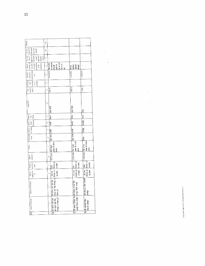
11
12
13
14
15
16
ftyss dh jsr [knkuksa dh lwph amp
17
18
4 Details of Royalty or Revenue Received in Last Three Year
Major Minerals
Details of Royalty or Revenue Received in Last Three Year Major Minerals
SNo Mineral Royalty or Revenue Received
2013-14 2014-15 2015-16
1 Limestone 115556982 154624130 259409159
2 Quartzite 694597 240000 NA
3 Moulding Sand 80000 127000 606620
Total - 116331579 154991130 260015779
Note - Quartzite Mineral is decleared Minor Mineral wef notification dated 10022015
Details of Royalty or Revenue Received in Last Three Year
Minor Minerals
Minor Minerals
SNo Mineral Royalty or Revenue Received
2013-14 2014-15 2015-16
1 Limestone 1334700 2333000 2385614
2 Flagstone 2021150 2497800 3584557
3 Ordinary Stone 745887 83000 135100
4 Murum 108000 1518692 3277000
5 Soil 572360 538720 354280
Total - 4782097 6971212 9736551
19
5 Details of Production of Sand or Bajari in last three years
frac14vfrac12Details of Production amp Royalty of Sand in in Last Three Year
Ordinary Sand SNo Financial year Royalty Received in Rs
1 2013-14 11504
2 2014-15 12539
3 2015-16 7356
5- fiNysrhuokksZ ds nkSjkujsrlsizkIrLokfeLo k jktLo ds CkSjsamp
frac14cfrac12Details of Production amp Royalty of Sand in in Last Three Year
Ordinary Sand
SNo Financial year Production of Sand (in Cm)
1 2013-14 230085
2 2014-15 250773
3 2015-16 147125
20
6 PROCESS OF DEPOSITION OF SEDIMENTS IN THE RIVERS
Sendimentation of rivers of District
6- Process of river sedimentation-
What is erosion
Erosion is natural process wathering corrosion or abrasion can reduce a material
into smaller particles Normally these smaller units are relocated by water wing
ice or man Erosion removes tosoil organic material and other valuable resources
What is sedimentation
Once a material is broken free of the larger mass it can be carried away and
deposited elsewhere This process of depositing eroded material is known as
sedimentation Some indications of sedimentation are sand dunes mud in the street
around drains and decreased water holding capacity of stream reservoir or pond
Why should we be concerned about erosion and sedimentation
Sediment is responsible for more stream and river degardation than any other
pollutant Deposits of sediments in ditches streams and rivers reduce their
capacity to store water resulting in more frequent and severe flooding and
increased property damage Accumulations of sediment may result in severe
damage to storm drain systers Many millions of dollars are spent each year to
dredge our state waterways to remove sediments from storm drain systerms
reseroirs and water treatment plants and to repair flood damage
Sediment in streams and rivers causes the most damage to aduatic life by severely
impacting aquatic animal habitats and degrading water quality Areas needed for
21
reproduction and food sources are destroyed when fine silts cover the sand and
gravel streambed Decreased clarity of the water prevents sunlight from reaching
plants resulting in loss of aquatic plant communities The result is a reduction in
the number and variety of fish and other aquatic life This impact ofter can see for
many miles downstream
Process-
Rivers have a lot of energy and because they have energy they do stuff The
obvious things rivers do with their energy is flow but besides this they also
transport load erode load and erode the channel through which they flow Erosion
Erosion is the breaking down of material by an agent In the case of a river the
agent is water The water can erode the riverrsquos channel and the riverrsquos load A
riverrsquos load is bits of eroded material generally rocks which the river transports
until it deposits its load A riverrsquos channel is eroded laterally and vertically making
the channel wider and deeper The intensity of lateral and vertical erosion is
dictated by the stage in the riverrsquos course discussed in more detail here but
essentially in the upper stage of the riverrsquos course (close to the source of the river)
there is little horizontal erosion and lots of vertical erosion In the middle and
lower stages vertical erosion is reduced and more horizontal erosion takes place
There are several different ways that a river erodes its bed and banks The first is
hydraulic action where the force of the water removes rock particles from the bed
and banks This type of erosion is strongest at rapids and waterfalls where the
water has a high velocity The next type of erosion is corrasion This is where the
riverrsquos load acts almost like sandpaper removing pieces of rock as the load rubs
against the bed amp banks This sort of erosion is strongest when the river is
transporting large chunks of rock or after heavy rainfall when the riverrsquos flow is
22
turbulent Corrosion is a special type of erosion that only affects certain types of
rocks Water being ever so slightly acidic will react with certain rocks and
dissolve them Corrosion is highly effective if the rock type of the channel is chalk
or limestone (anything containing calcium carbonate) otherwise it doesnrsquot have
much of an effect Cavitation is an interesting method of erosion Air bubbles
trapped in the water get compressed into small spaces like cracks in the riverrsquos
banks These bubbles eventually implode creating a small shockwave that weakens
the rocks The shockwaves are very weak but over time the rock will be weakened
to the point at which it falls apart The final type of erosion is attrition Attrition is
a way of eroding the riverrsquos load not the bed and banks Attrition is where pieces
of rock in the riverrsquos load knock together breaking chunks of rock off of one
another and gradually rounding and shrinking the load Transportation when a river
erodes the eroded material becomes the riverrsquos load and the river will then
transport this load through its course until it deposits the load There are a few
different ways that a river will transport load depending on how much energy the
river has and how big the load is The largest of particles such as boulders are
transported by traction These particles are rolled along the bed of the river
eroding the bed and the particles in the process because the river doesnrsquot have
enough energy to move these large particles in any other way Slightly smaller
particles such as pebbles and gravel are transported by saltation This is where the
load bounces along the bed of the river because the river has enough energy to lift
the particles off the bed but the particles are too heavy to travel by suspension
Fine particles like clay and silt are transported in suspension they are suspended in
the water Most of a riverrsquos load is transported by suspension Solution is a special
method of transportation This is where particles are dissolved into the water so
only rocks that are soluble such as limestone or chalk can be transported in
23
solution Capacity amp Competence Rivers can only carry so much load depending
on their energy The maximum volume of load that a river can carry at a specific
point in its course is called the riverrsquos capacity The biggest sized particle that a
river could carry at a specific point is called the riverrsquos competence Deposition to
transport load a river needs to have energy so when a river loses energy it is forced
to deposit its load There are several reasons why a river could lose energy If the
riverrsquos discharge is reduced then the river will lose energy because it isnrsquot flowing
as quickly anymore This could happen because of a lack of precipitation or an
increase in evaporation Increased human use (abstraction) of a river could also
reduce its discharge forcing it deposit its load If the gradient of the riverrsquos course
flattens out the river will deposit its load because it will be travelling a lot slower
When a river meets the sea a river will deposit its load because the gradient is
generally reduced at sea level and the sea will absorb a lot of energy As rivers get
nearer to their mouths they flow in increasingly wide gentle sided valleys The
channel increases in size to hold the extra water which the river has to receive from
its tributaries As the river gets bigger it can carry larger amounts of material This
material will be small in size as larger rocks will have broken up on their way
from the mountains Much of the material will be carried in suspension and will
erode the river banks by abrasion When rivers flow over flatter land they develop
large bends called meanders As a river goes around a bend most of the water is
pushed towards the outside causing increased erosion The river is now eroding
sideways into its banks rather than downwards into its bed a process called lateral
erosion On the inside of the bend in contrast there is much less water The river
will therefore be shallow and slow-flowing It cannot carry as much material and
so sand and shingle will be deposited This is called a point bar or slip off slope
Due to erosion on the outside of a bend and deposition on the inside the shape of a
24
meander will change over a period of time Notice how erosion narrows the neck
of the land within the meander In time and usually during a flood the river will
cut right through the neck The river will then take the new shorter route The
fastest current called the thalweg will now tend to be in the centre of the river
and so deposition is likely to occur in gentler water next to the banks Eventually
deposition will block off the old meander to leave an oxbow lake The oxbow lake
will slowly dry up only refilling after heavy rain or during a flood Streams lose
velocity and make deposits when their gradient decreases when the volume of
water decreases when there is an increase in cross section when they encounter
obstructions or when they enter still water They deposit alluvial fans alluvial
cones piedmont alluvial plains channel fill bars flood plains and deltas
25
7 General Profile of the District
Bemetara city is well connected to Raipur Jabalpur Bilaspur Durg and
Kawardha by roadwaysNH-30 passes through the heart of city which is one of the
buissiest road in the stateThis highway connects state capital Raipur to one of the
major city of Madhya Pradesh JabalpurThere are two state highway passing
through Bemetara that are Durg to Bemetara and Kumhari - Bemetara ndash Mungeli
History
Comparatively a new district in Chhattisgarh India Bemetara district was
established as tahsil in the year 1907 along with the Mungeli (Bilaspur region)
This region is coloured by ever-widening importance in history since the time it
had been established However it is largest town amongst other town in the
scenario of land and population Owing to its suitability to being a district of
Chhattisgarh it had to wait to call upon since Kawardha has integrated
Conversely the Chhattisgarh government has realised its importance in central
CG Bemetara is an attractive tourist destination as villages like Bataar Mohbhatta
and Khamhariya are famous for their temples and lakes
dzekad
1 ftysdkdqyHkkSxksfy
d ks=Qy
2854-81 oxZfd-eh
2 vkkak oanskkak mRrjesa 21 22΄ ls 22003΄ mRrjhvkkaklsiwoZesa 81 07΄ ls81
055΄iwohZ nskakrj
3 leqnzrylsAringpkbZ 317 eh- vkSlr
4 vkSlrokkZ 2013-14 1234fe-eh- okfkZd
2014-15 1121-40fe-eh- okfkZd
2015-16 957-82fe-eh- okfkZd
5 rkieku vfkdreamp 48lsUVhxzsM
Uqureamp10lsUVhxzsM
26
6 ou ks=Qy
ljafkrou ks=gsDV- vkjfkrou ks= gsDV- voxhZd`rou
ks=gsDV-
dqyouks=
fujad fujad fujad fujad
7 unh rFkkukys River Shivnath Kharun Hanf Sakari SurahiampPhonk river
8 ioZr fujad
9 tula[k 795759 frac14tuxkuk 2011 ds vuqlkjfrac12Male Papulation 397650 amp Female Population
398109 11 lkkjrk frac1469-87frac12
12 rglhy
frac14fodkl[kMfrac12
05 - Nawagarh Bemetara Saja Than KhamhariaampBerla
13 uxjikfydk
uxjfuxe
02 ndash BemetaraampSaja
14 uxjiapkr 06 - Nawagarh Maro Bemetara Devkar Parpodi SajaThanKhamhariaampBerla
15 xzkeiapkr 387
Means of Transport
Bus Transport
Bemetara city is well connected to Raipur Jabalpur Bilaspur Durg and Kawardha
by roadwaysNH-30 A passes through the heart of city which is one of the busiest
road in the stateThis highway connects state capital Raipur to one of the major city
of Madhya Pradesh JabalpurThere are two state highway passing through
Bemetara that are Durg to Bemetara and Kumhari - Bemetara - Mungeli
Railway Transport
Bemetara is not connected by railway the nearest Railway station is tilde (35 km)
and major station is Raipur (66 km) and Durg is about 72 km
A new railway line is proposed in Bemetarawhich isDurg-Bemetara-Mungeli-
Bilaspur line
27
Air Transport
Nearest airport to the town is Swami Vivekananda International Airport
Raipur(IATA RPR ICAO VERP) which was formerly known as Mana Airport
which is 66 km from the city
28
8 Land Utilition Pattern in the district Forest Agriculture
Horticulture Mining etc
(i)Types of Soil-
Different type of soils are found in the District which is as follows-
i Red Soil (Bhata) Entisols
ii Sandy loams (Matasi) Inceptisols
iii Dorsa (Alfisols)
iv Black (Kanhar) vertisols
v Alluvial Soil (Kachhar)
(ii)Types of Forest-
oueMy
ljafkrou ks=gsDV- vkjfkrou ks= gsDV- voxhZd`rou ks=gsDV-
dqyouks=
ou
ks=Qy
fujad fujad fujad fujad
(iii)Details of Horticulture-
S No Particular Details Area in Hectare
1 Geographical Area of the District 285481Hect
2 Forest Area Nil
3 Total Kast Land Area 239566Hect
4 Land Covered by Gardening Crops 15373 Hect
5 Land Covered by Fruit Plants 2934 Hect
6 Land Covered by Vegetables Crop 10602 Hect
7 Land Covered by Masala 1535Hect
29
8 Land Covered by Flowers 185 Hect
9 Land Covered by Medicinal ampSented Plants 117 Hect
10 Percentage of Gardening Crops 872
(iv)Details of Agriculture-
S No Particular Details Area in Hectare
1 Geographical Area of the District 285481Hect
2 Forest Area Nil
3 Non-Agricultural Land 52770Hect
4 Duel Crop Area 94150 Hect
5 Total Kast Land Area 281523Hect
6 Kharif Crop Area 205270Hect
7 Ravi Crop Area 138560Hect
8 Area of Jayad 1200 Hect
9 Total Crop Area 232710Hect
Irrigation
The main source of irrigation in the district is River Shivnath Kharun Haff
SakariampSurahi etc There is no any big dam in the district
30
(v) Details of Ground Water Survey-
31
Climate-
Bemetara has a tropical wet and dry climate temperature remains moderate
throughout the year except from March to June which can be extremely hot The
temperature in AprilndashMay sometimes rises above 45 degCThese summer months
also have dry and hot winds In summers the temperature can also go up to 50 degC
The city receives about 1300 millimetres (51 in) of rain mostly in the monsoon
season from late June to early October Winters last from November to January
and are mild although lows can fall to 5 degC (41 degF)
Climate data for Bemetara City
Month Jan Feb Mar Apr May Jun Jul Aug Sep Oct Nov Dec Year
Average
high degC
(degF)
27
(81)
30
(86)
35
(95)
39
(102)
45
(113)
36
(97)
30
(86)
30
(86)
31
(88)
31
(88)
28
(82)
26
(79)
32
(90)
Average
low degC
(degF)
13
(55)
15
(59)
20
(68)
24
(75)
27
(81)
26
(79)
23
(73)
23
(73)
22
(72)
21
(70)
16
(61)
14
(57)
20
(68)
Average
precipita
tion mm
(inches)
10
(039)
17
(067)
14
(055)
13
(051)
18
(071)
239
(941)
383
(1508)
364
(1433)
197
(776)
50
(197)
11
(043)
16
(063)
1330
(5236)
32
9 Physiography of the District
Physiographically the area in Bemetara District having almost flat topographyThe
general slope of the district is towards the north - east in which direction the major
streams of the district flow
BEMETARA is located near the centre of a large plain sometimes referred as the
rice bowl of India where hundreds of varieties of rice are
grown The ShivnathRiverflows to the east of the city of bemetara and the
southern side has dense forests The Maikal Hills rise on the north-west of
Bemetara on the north the land rises and merges with the Chota Nagpur Plateau
which extends north-east across Jharkhand state On the south of Bemetara lies
the Deccan Plateau
33
34
10 Rainfall of District BemetaraYear wise
S No Year Average Rainfall (mm)
1 2012 99440
2 2013 123400
3 2014 112140
4 2015 95782
Rainfall of District Bemetara Month wise
Rainfall data for Bemetara City
Month Jan Feb Mar Apr May Jun Jul Aug Sep Oct Nov Dec Year
Average
precipita
tion mm
(inches)
10
(039)
17
(067)
14
(055)
13
(051)
18
(071)
239
(941)
383
(1508)
364
(1433)
197
(776)
50
(197)
11
(043)
16
(063)
1330
(5236)
35
36
11 Geology and Mineral Wealth
Geology-
Geologically the district comprises of rocks of the Meso-to Neo- Proterozoic
sequence is represented by the Chhattisgarh Supergroup Raipur Group comprises
Chandi formation Tarenga formation Hirri formation and Maniari formation
Chandi Formation of grey and purple stromatolitic limestone with
areniteferruginous sandstone intercalations (Deodongar member) Tarenga
Formation of greenish grey and reddish brown shale with chert porcellanite and
green clay interbands Hirri Formation by grey thinly to thickly bedded dolomite
and argillancous dolomite and ManairiFormationn comprises reddish brown and
purple non - calcareous shale with gypsum interbandsQuatrenary is represented
by pebble beds (Khamaria pebble bed)
37
38
Stratigraphic succession-
39
Mineral-
Mineral deposite of Bemetaradistrict include Dolomite Limestone Ordinary stone
Sand and Soil etc
Dolomite Mines
Total 27 Dolomite mines in which at present 3 dolomite is operational 13 dolomite
mine is under renewal and 11 dolomite mines is under lapse category
Limestone Mine
Total 03limestone mines in which at present 1limestone mine is operational and
rest 2 limestone mine is under renewal in the district
Ordinary Stone Mine
Total 01 ordinary stone mines is operational in the district
Soil Mine for Making Bricks
Total 34 soil mines in which at present 13 soil mine is operational and 21 soil mine
is under renewal varies part of the district
Sand Mine
Total 33 sand mines in which at present after Environmental NOC 12 sand mine is
operational 14 sand mine is under process to getting Environmental NOC from
SEIAA and 07sand mines has not submitted required documents for
Environmental Clearence till date
Sands are mostly available in Bank of River Shivnath Kharun Hanf
SakariSurahiampPhonkriver Quarry leases for sand mining are given in different
village of Bemetara district
40
Additional information of the district
Drainage System-
Shivnath
Sheonath is main river of District Bemetara Shivnathriver is tributary of Mahanadi
river Shivnathriver originates from Mountain at height of 625 meter at Panabaras
situated in south western parts of Rajnandgaon and flows towards north east
direction Shivnath River measures length about 345 KM City Durg is situated on
east bank of Shivnath River It flows towards north east passing through Khujji
Rajnandgaon Durg Dhamdha and Nandghat and joins (meet) Mahanadi near
Shivari Narayan of Bilaspur District
Kharun
Kharunriver flows in eastern parts of the district starting from Petechua in Balod
District This river flows towards north and joins (meet) ShivnathRiver at Somnath
near Simga This river determines the boundary of Raipur and Durg district The
length of this river is about 120 KM
41
42
Survey Report for Sand Mining of District Bemetara
This survey report is prepared for District Bemetara to identify the sustainable
mining area In District Bemetarathere are six rivers namely Shivnath Kharun
Haff Sakari SurahiampPhonkriver
All possible sand mining area has been surveyed The riverwise area surveyed and
identified for sand mining is given in the annexure
The thickness of sand load is considered average 4 meters in depth by observation
as well as local enquiry out of which up to depth of 3 meter is considered for
calculation of mineral potential
The mining area will be 10m away from the river bank and about 10m Influence
as safity barrier from the main streem will be left where mining operation will be
restricted Hence 10 m influence area from the main stream has been considered as
safity zone or non mining zone
It is considered that replenishment of sand in every monsoon season is a regular
process Based on the last five year observation it is experienced that average of
3m sand is replenished every year
Area Prohibited for Mining-
The following area will be prohibited for minng
i No mining activity will be executed 10 m from the river bank
ii Mining is prohibited within 10 m from the flow of the main stream
iii During mining measures should be taken to guide the flow to the centre
of the river to avoide erosion of banks
iv Mining area is restricted up to 500 mtsdown stream of any structure like
bridge diversion head work anicut etc
43
v Measures should be kept in consideration that the flow of river should not
be diverted or obstructed
vi The distance between two sand mining locations should be minimum 500
meters
vii Before permission of mining a suitable test of sand for construction
purpose like silt percentage fineness modulus etc must be obtained from
competent laboratory authority
viii Provision for plantation must be assured on the river bank of concerened
sand mining zone to protect erosion of banks and to
maintainesecobalance
Details are given bellow-
S No Name of River Ara Drained Sq KM Area
Drained in the
District in BemetaraDist Total
1 2 3 4 5
1 Shivnath River Sq km Sq km
2 Kharun River Sq km Sq km
3 Haff River Sq km Sq km
4 Sakari River
5 Surahi River
6 Phonk
Features of Important Rivers and Streams-
S No Name of the
River or Stream
Total Length in the
District (in km)
Place of origin Height of
origin
1 2 3 4 5
1 Shivnath River km Panabaras (Dist-
Rajnandgaon)
642 m
2 Kharun River km Kankalin (Petachuwa)
(Dist-Balod)
1 m
3 Haff River km Hils of Dallirajhara
(Banjaridih) (Dist- Balod
3 m
44
4 Sakari River
5 Surahi River
6 Phonk
Shivnath River
SNo Portion of the
River of
Stream
Recommended
for Mineral
Concession
Length of
area
recommended
for mineral
concession (in
kilometer)
Average
Width of area
Recommended
for mineral
concession (in
meters)
Area
recommended
for mineral
concession (in
meter)
Mineable
mineral
potential
(in metric
tonne) 60
of total
mineral
potential)
1 2 jsrtekoughagSA 3 jsrmiyCk ughagSA 4 jsrmiyCk ughagSA 5 jsrmiyCk ughagSA 6 orZekuesaikuhHkjkogSArhuokZiwoZjsr
[kuugksrkFkkjsrughagSA
ksxamp
Kharun River
SNo Portion of the
River of
Stream
Recommended
for Mineral
Concession
Length of
area
recommended
for mineral
concession (in
kilometer)
Average
Width of area
Recommended
for mineral
concession (in
meters)
Area
recommended
for mineral
concession (in
meter)
Mineable
mineral
potential
(in metric
tonne) 60
of total
mineral
potential)
1 ikuhHkjkogSA 2 ikuhHkjkogSA 3 ikuhHkjkogSA 4 ikuhHkjkogSA 5 ikuhHkjkogSA 6 ikuhHkjkogSA
45
ksxamp 0
Haff River
SNo Portion of the
River of
Stream
Recommended
for Mineral
Concession
Length of
area
recommended
for mineral
concession (in
kilometer)
Average
Width of area
Recommended
for mineral
concession (in
meters)
Area
recommended
for mineral
concession (in
meter)
Mineable
mineral
potential
(in metric
tonne) 60
of total
mineral
potential)
1 ikuhHkjkogSA 2 ikuhHkjkogSA 3 ikuhHkjkogSA 4 ikuhHkjkogSA 5 ikuhHkjkogSA 6 ikuhHkjkogSA ksxamp 0
Sakari River
SNo Portion of the
River of
Stream
Recommended
for Mineral
Concession
Length of
area
recommended
for mineral
concession (in
kilometer)
Average
Width of area
Recommended
for mineral
concession (in
meters)
Area
recommended
for mineral
concession (in
meter)
Mineable
mineral
potential
(in metric
tonne) 60
of total
mineral
potential)
1 ikuhHkjkogSA 2 ikuhHkjkogSA 3 ikuhHkjkogSA 4 ikuhHkjkogSA 5 ikuhHkjkogSA 6 ikuhHkjkogSA ksxamp 0
46
Surahi River
SNo Portion of the
River of
Stream
Recommended
for Mineral
Concession
Length of
area
recommended
for mineral
concession (in
kilometer)
Average
Width of area
Recommended
for mineral
concession (in
meters)
Area
recommended
for mineral
concession (in
meter)
Mineable
mineral
potential
(in metric
tonne) 60
of total
mineral
potential)
1 ikuhHkjkogSA 2 ikuhHkjkogSA 3 ikuhHkjkogSA 4 ikuhHkjkogSA 5 ikuhHkjkogSA 6 ikuhHkjkogSA ksxamp 0
Phonk River
SNo Portion of the
River of
Stream
Recommended
for Mineral
Concession
Length of
area
recommended
for mineral
concession (in
kilometer)
Average
Width of area
Recommended
for mineral
concession (in
meters)
Area
recommended
for mineral
concession (in
meter)
Mineable
mineral
potential
(in metric
tonne) 60
of total
mineral
potential)
1 ikuhHkjkogSA 2 ikuhHkjkogSA 3 ikuhHkjkogSA 4 ikuhHkjkogSA 5 ikuhHkjkogSA 6 ikuhHkjkogSA ksxamp 0
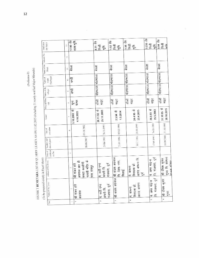
13
14
15
16
ftyss dh jsr [knkuksa dh lwph amp
17
18
4 Details of Royalty or Revenue Received in Last Three Year
Major Minerals
Details of Royalty or Revenue Received in Last Three Year Major Minerals
SNo Mineral Royalty or Revenue Received
2013-14 2014-15 2015-16
1 Limestone 115556982 154624130 259409159
2 Quartzite 694597 240000 NA
3 Moulding Sand 80000 127000 606620
Total - 116331579 154991130 260015779
Note - Quartzite Mineral is decleared Minor Mineral wef notification dated 10022015
Details of Royalty or Revenue Received in Last Three Year
Minor Minerals
Minor Minerals
SNo Mineral Royalty or Revenue Received
2013-14 2014-15 2015-16
1 Limestone 1334700 2333000 2385614
2 Flagstone 2021150 2497800 3584557
3 Ordinary Stone 745887 83000 135100
4 Murum 108000 1518692 3277000
5 Soil 572360 538720 354280
Total - 4782097 6971212 9736551
19
5 Details of Production of Sand or Bajari in last three years
frac14vfrac12Details of Production amp Royalty of Sand in in Last Three Year
Ordinary Sand SNo Financial year Royalty Received in Rs
1 2013-14 11504
2 2014-15 12539
3 2015-16 7356
5- fiNysrhuokksZ ds nkSjkujsrlsizkIrLokfeLo k jktLo ds CkSjsamp
frac14cfrac12Details of Production amp Royalty of Sand in in Last Three Year
Ordinary Sand
SNo Financial year Production of Sand (in Cm)
1 2013-14 230085
2 2014-15 250773
3 2015-16 147125
20
6 PROCESS OF DEPOSITION OF SEDIMENTS IN THE RIVERS
Sendimentation of rivers of District
6- Process of river sedimentation-
What is erosion
Erosion is natural process wathering corrosion or abrasion can reduce a material
into smaller particles Normally these smaller units are relocated by water wing
ice or man Erosion removes tosoil organic material and other valuable resources
What is sedimentation
Once a material is broken free of the larger mass it can be carried away and
deposited elsewhere This process of depositing eroded material is known as
sedimentation Some indications of sedimentation are sand dunes mud in the street
around drains and decreased water holding capacity of stream reservoir or pond
Why should we be concerned about erosion and sedimentation
Sediment is responsible for more stream and river degardation than any other
pollutant Deposits of sediments in ditches streams and rivers reduce their
capacity to store water resulting in more frequent and severe flooding and
increased property damage Accumulations of sediment may result in severe
damage to storm drain systers Many millions of dollars are spent each year to
dredge our state waterways to remove sediments from storm drain systerms
reseroirs and water treatment plants and to repair flood damage
Sediment in streams and rivers causes the most damage to aduatic life by severely
impacting aquatic animal habitats and degrading water quality Areas needed for
21
reproduction and food sources are destroyed when fine silts cover the sand and
gravel streambed Decreased clarity of the water prevents sunlight from reaching
plants resulting in loss of aquatic plant communities The result is a reduction in
the number and variety of fish and other aquatic life This impact ofter can see for
many miles downstream
Process-
Rivers have a lot of energy and because they have energy they do stuff The
obvious things rivers do with their energy is flow but besides this they also
transport load erode load and erode the channel through which they flow Erosion
Erosion is the breaking down of material by an agent In the case of a river the
agent is water The water can erode the riverrsquos channel and the riverrsquos load A
riverrsquos load is bits of eroded material generally rocks which the river transports
until it deposits its load A riverrsquos channel is eroded laterally and vertically making
the channel wider and deeper The intensity of lateral and vertical erosion is
dictated by the stage in the riverrsquos course discussed in more detail here but
essentially in the upper stage of the riverrsquos course (close to the source of the river)
there is little horizontal erosion and lots of vertical erosion In the middle and
lower stages vertical erosion is reduced and more horizontal erosion takes place
There are several different ways that a river erodes its bed and banks The first is
hydraulic action where the force of the water removes rock particles from the bed
and banks This type of erosion is strongest at rapids and waterfalls where the
water has a high velocity The next type of erosion is corrasion This is where the
riverrsquos load acts almost like sandpaper removing pieces of rock as the load rubs
against the bed amp banks This sort of erosion is strongest when the river is
transporting large chunks of rock or after heavy rainfall when the riverrsquos flow is
22
turbulent Corrosion is a special type of erosion that only affects certain types of
rocks Water being ever so slightly acidic will react with certain rocks and
dissolve them Corrosion is highly effective if the rock type of the channel is chalk
or limestone (anything containing calcium carbonate) otherwise it doesnrsquot have
much of an effect Cavitation is an interesting method of erosion Air bubbles
trapped in the water get compressed into small spaces like cracks in the riverrsquos
banks These bubbles eventually implode creating a small shockwave that weakens
the rocks The shockwaves are very weak but over time the rock will be weakened
to the point at which it falls apart The final type of erosion is attrition Attrition is
a way of eroding the riverrsquos load not the bed and banks Attrition is where pieces
of rock in the riverrsquos load knock together breaking chunks of rock off of one
another and gradually rounding and shrinking the load Transportation when a river
erodes the eroded material becomes the riverrsquos load and the river will then
transport this load through its course until it deposits the load There are a few
different ways that a river will transport load depending on how much energy the
river has and how big the load is The largest of particles such as boulders are
transported by traction These particles are rolled along the bed of the river
eroding the bed and the particles in the process because the river doesnrsquot have
enough energy to move these large particles in any other way Slightly smaller
particles such as pebbles and gravel are transported by saltation This is where the
load bounces along the bed of the river because the river has enough energy to lift
the particles off the bed but the particles are too heavy to travel by suspension
Fine particles like clay and silt are transported in suspension they are suspended in
the water Most of a riverrsquos load is transported by suspension Solution is a special
method of transportation This is where particles are dissolved into the water so
only rocks that are soluble such as limestone or chalk can be transported in
23
solution Capacity amp Competence Rivers can only carry so much load depending
on their energy The maximum volume of load that a river can carry at a specific
point in its course is called the riverrsquos capacity The biggest sized particle that a
river could carry at a specific point is called the riverrsquos competence Deposition to
transport load a river needs to have energy so when a river loses energy it is forced
to deposit its load There are several reasons why a river could lose energy If the
riverrsquos discharge is reduced then the river will lose energy because it isnrsquot flowing
as quickly anymore This could happen because of a lack of precipitation or an
increase in evaporation Increased human use (abstraction) of a river could also
reduce its discharge forcing it deposit its load If the gradient of the riverrsquos course
flattens out the river will deposit its load because it will be travelling a lot slower
When a river meets the sea a river will deposit its load because the gradient is
generally reduced at sea level and the sea will absorb a lot of energy As rivers get
nearer to their mouths they flow in increasingly wide gentle sided valleys The
channel increases in size to hold the extra water which the river has to receive from
its tributaries As the river gets bigger it can carry larger amounts of material This
material will be small in size as larger rocks will have broken up on their way
from the mountains Much of the material will be carried in suspension and will
erode the river banks by abrasion When rivers flow over flatter land they develop
large bends called meanders As a river goes around a bend most of the water is
pushed towards the outside causing increased erosion The river is now eroding
sideways into its banks rather than downwards into its bed a process called lateral
erosion On the inside of the bend in contrast there is much less water The river
will therefore be shallow and slow-flowing It cannot carry as much material and
so sand and shingle will be deposited This is called a point bar or slip off slope
Due to erosion on the outside of a bend and deposition on the inside the shape of a
24
meander will change over a period of time Notice how erosion narrows the neck
of the land within the meander In time and usually during a flood the river will
cut right through the neck The river will then take the new shorter route The
fastest current called the thalweg will now tend to be in the centre of the river
and so deposition is likely to occur in gentler water next to the banks Eventually
deposition will block off the old meander to leave an oxbow lake The oxbow lake
will slowly dry up only refilling after heavy rain or during a flood Streams lose
velocity and make deposits when their gradient decreases when the volume of
water decreases when there is an increase in cross section when they encounter
obstructions or when they enter still water They deposit alluvial fans alluvial
cones piedmont alluvial plains channel fill bars flood plains and deltas
25
7 General Profile of the District
Bemetara city is well connected to Raipur Jabalpur Bilaspur Durg and
Kawardha by roadwaysNH-30 passes through the heart of city which is one of the
buissiest road in the stateThis highway connects state capital Raipur to one of the
major city of Madhya Pradesh JabalpurThere are two state highway passing
through Bemetara that are Durg to Bemetara and Kumhari - Bemetara ndash Mungeli
History
Comparatively a new district in Chhattisgarh India Bemetara district was
established as tahsil in the year 1907 along with the Mungeli (Bilaspur region)
This region is coloured by ever-widening importance in history since the time it
had been established However it is largest town amongst other town in the
scenario of land and population Owing to its suitability to being a district of
Chhattisgarh it had to wait to call upon since Kawardha has integrated
Conversely the Chhattisgarh government has realised its importance in central
CG Bemetara is an attractive tourist destination as villages like Bataar Mohbhatta
and Khamhariya are famous for their temples and lakes
dzekad
1 ftysdkdqyHkkSxksfy
d ks=Qy
2854-81 oxZfd-eh
2 vkkak oanskkak mRrjesa 21 22΄ ls 22003΄ mRrjhvkkaklsiwoZesa 81 07΄ ls81
055΄iwohZ nskakrj
3 leqnzrylsAringpkbZ 317 eh- vkSlr
4 vkSlrokkZ 2013-14 1234fe-eh- okfkZd
2014-15 1121-40fe-eh- okfkZd
2015-16 957-82fe-eh- okfkZd
5 rkieku vfkdreamp 48lsUVhxzsM
Uqureamp10lsUVhxzsM
26
6 ou ks=Qy
ljafkrou ks=gsDV- vkjfkrou ks= gsDV- voxhZd`rou
ks=gsDV-
dqyouks=
fujad fujad fujad fujad
7 unh rFkkukys River Shivnath Kharun Hanf Sakari SurahiampPhonk river
8 ioZr fujad
9 tula[k 795759 frac14tuxkuk 2011 ds vuqlkjfrac12Male Papulation 397650 amp Female Population
398109 11 lkkjrk frac1469-87frac12
12 rglhy
frac14fodkl[kMfrac12
05 - Nawagarh Bemetara Saja Than KhamhariaampBerla
13 uxjikfydk
uxjfuxe
02 ndash BemetaraampSaja
14 uxjiapkr 06 - Nawagarh Maro Bemetara Devkar Parpodi SajaThanKhamhariaampBerla
15 xzkeiapkr 387
Means of Transport
Bus Transport
Bemetara city is well connected to Raipur Jabalpur Bilaspur Durg and Kawardha
by roadwaysNH-30 A passes through the heart of city which is one of the busiest
road in the stateThis highway connects state capital Raipur to one of the major city
of Madhya Pradesh JabalpurThere are two state highway passing through
Bemetara that are Durg to Bemetara and Kumhari - Bemetara - Mungeli
Railway Transport
Bemetara is not connected by railway the nearest Railway station is tilde (35 km)
and major station is Raipur (66 km) and Durg is about 72 km
A new railway line is proposed in Bemetarawhich isDurg-Bemetara-Mungeli-
Bilaspur line
27
Air Transport
Nearest airport to the town is Swami Vivekananda International Airport
Raipur(IATA RPR ICAO VERP) which was formerly known as Mana Airport
which is 66 km from the city
28
8 Land Utilition Pattern in the district Forest Agriculture
Horticulture Mining etc
(i)Types of Soil-
Different type of soils are found in the District which is as follows-
i Red Soil (Bhata) Entisols
ii Sandy loams (Matasi) Inceptisols
iii Dorsa (Alfisols)
iv Black (Kanhar) vertisols
v Alluvial Soil (Kachhar)
(ii)Types of Forest-
oueMy
ljafkrou ks=gsDV- vkjfkrou ks= gsDV- voxhZd`rou ks=gsDV-
dqyouks=
ou
ks=Qy
fujad fujad fujad fujad
(iii)Details of Horticulture-
S No Particular Details Area in Hectare
1 Geographical Area of the District 285481Hect
2 Forest Area Nil
3 Total Kast Land Area 239566Hect
4 Land Covered by Gardening Crops 15373 Hect
5 Land Covered by Fruit Plants 2934 Hect
6 Land Covered by Vegetables Crop 10602 Hect
7 Land Covered by Masala 1535Hect
29
8 Land Covered by Flowers 185 Hect
9 Land Covered by Medicinal ampSented Plants 117 Hect
10 Percentage of Gardening Crops 872
(iv)Details of Agriculture-
S No Particular Details Area in Hectare
1 Geographical Area of the District 285481Hect
2 Forest Area Nil
3 Non-Agricultural Land 52770Hect
4 Duel Crop Area 94150 Hect
5 Total Kast Land Area 281523Hect
6 Kharif Crop Area 205270Hect
7 Ravi Crop Area 138560Hect
8 Area of Jayad 1200 Hect
9 Total Crop Area 232710Hect
Irrigation
The main source of irrigation in the district is River Shivnath Kharun Haff
SakariampSurahi etc There is no any big dam in the district
30
(v) Details of Ground Water Survey-
31
Climate-
Bemetara has a tropical wet and dry climate temperature remains moderate
throughout the year except from March to June which can be extremely hot The
temperature in AprilndashMay sometimes rises above 45 degCThese summer months
also have dry and hot winds In summers the temperature can also go up to 50 degC
The city receives about 1300 millimetres (51 in) of rain mostly in the monsoon
season from late June to early October Winters last from November to January
and are mild although lows can fall to 5 degC (41 degF)
Climate data for Bemetara City
Month Jan Feb Mar Apr May Jun Jul Aug Sep Oct Nov Dec Year
Average
high degC
(degF)
27
(81)
30
(86)
35
(95)
39
(102)
45
(113)
36
(97)
30
(86)
30
(86)
31
(88)
31
(88)
28
(82)
26
(79)
32
(90)
Average
low degC
(degF)
13
(55)
15
(59)
20
(68)
24
(75)
27
(81)
26
(79)
23
(73)
23
(73)
22
(72)
21
(70)
16
(61)
14
(57)
20
(68)
Average
precipita
tion mm
(inches)
10
(039)
17
(067)
14
(055)
13
(051)
18
(071)
239
(941)
383
(1508)
364
(1433)
197
(776)
50
(197)
11
(043)
16
(063)
1330
(5236)
32
9 Physiography of the District
Physiographically the area in Bemetara District having almost flat topographyThe
general slope of the district is towards the north - east in which direction the major
streams of the district flow
BEMETARA is located near the centre of a large plain sometimes referred as the
rice bowl of India where hundreds of varieties of rice are
grown The ShivnathRiverflows to the east of the city of bemetara and the
southern side has dense forests The Maikal Hills rise on the north-west of
Bemetara on the north the land rises and merges with the Chota Nagpur Plateau
which extends north-east across Jharkhand state On the south of Bemetara lies
the Deccan Plateau
33
34
10 Rainfall of District BemetaraYear wise
S No Year Average Rainfall (mm)
1 2012 99440
2 2013 123400
3 2014 112140
4 2015 95782
Rainfall of District Bemetara Month wise
Rainfall data for Bemetara City
Month Jan Feb Mar Apr May Jun Jul Aug Sep Oct Nov Dec Year
Average
precipita
tion mm
(inches)
10
(039)
17
(067)
14
(055)
13
(051)
18
(071)
239
(941)
383
(1508)
364
(1433)
197
(776)
50
(197)
11
(043)
16
(063)
1330
(5236)
35
36
11 Geology and Mineral Wealth
Geology-
Geologically the district comprises of rocks of the Meso-to Neo- Proterozoic
sequence is represented by the Chhattisgarh Supergroup Raipur Group comprises
Chandi formation Tarenga formation Hirri formation and Maniari formation
Chandi Formation of grey and purple stromatolitic limestone with
areniteferruginous sandstone intercalations (Deodongar member) Tarenga
Formation of greenish grey and reddish brown shale with chert porcellanite and
green clay interbands Hirri Formation by grey thinly to thickly bedded dolomite
and argillancous dolomite and ManairiFormationn comprises reddish brown and
purple non - calcareous shale with gypsum interbandsQuatrenary is represented
by pebble beds (Khamaria pebble bed)
37
38
Stratigraphic succession-
39
Mineral-
Mineral deposite of Bemetaradistrict include Dolomite Limestone Ordinary stone
Sand and Soil etc
Dolomite Mines
Total 27 Dolomite mines in which at present 3 dolomite is operational 13 dolomite
mine is under renewal and 11 dolomite mines is under lapse category
Limestone Mine
Total 03limestone mines in which at present 1limestone mine is operational and
rest 2 limestone mine is under renewal in the district
Ordinary Stone Mine
Total 01 ordinary stone mines is operational in the district
Soil Mine for Making Bricks
Total 34 soil mines in which at present 13 soil mine is operational and 21 soil mine
is under renewal varies part of the district
Sand Mine
Total 33 sand mines in which at present after Environmental NOC 12 sand mine is
operational 14 sand mine is under process to getting Environmental NOC from
SEIAA and 07sand mines has not submitted required documents for
Environmental Clearence till date
Sands are mostly available in Bank of River Shivnath Kharun Hanf
SakariSurahiampPhonkriver Quarry leases for sand mining are given in different
village of Bemetara district
40
Additional information of the district
Drainage System-
Shivnath
Sheonath is main river of District Bemetara Shivnathriver is tributary of Mahanadi
river Shivnathriver originates from Mountain at height of 625 meter at Panabaras
situated in south western parts of Rajnandgaon and flows towards north east
direction Shivnath River measures length about 345 KM City Durg is situated on
east bank of Shivnath River It flows towards north east passing through Khujji
Rajnandgaon Durg Dhamdha and Nandghat and joins (meet) Mahanadi near
Shivari Narayan of Bilaspur District
Kharun
Kharunriver flows in eastern parts of the district starting from Petechua in Balod
District This river flows towards north and joins (meet) ShivnathRiver at Somnath
near Simga This river determines the boundary of Raipur and Durg district The
length of this river is about 120 KM
41
42
Survey Report for Sand Mining of District Bemetara
This survey report is prepared for District Bemetara to identify the sustainable
mining area In District Bemetarathere are six rivers namely Shivnath Kharun
Haff Sakari SurahiampPhonkriver
All possible sand mining area has been surveyed The riverwise area surveyed and
identified for sand mining is given in the annexure
The thickness of sand load is considered average 4 meters in depth by observation
as well as local enquiry out of which up to depth of 3 meter is considered for
calculation of mineral potential
The mining area will be 10m away from the river bank and about 10m Influence
as safity barrier from the main streem will be left where mining operation will be
restricted Hence 10 m influence area from the main stream has been considered as
safity zone or non mining zone
It is considered that replenishment of sand in every monsoon season is a regular
process Based on the last five year observation it is experienced that average of
3m sand is replenished every year
Area Prohibited for Mining-
The following area will be prohibited for minng
i No mining activity will be executed 10 m from the river bank
ii Mining is prohibited within 10 m from the flow of the main stream
iii During mining measures should be taken to guide the flow to the centre
of the river to avoide erosion of banks
iv Mining area is restricted up to 500 mtsdown stream of any structure like
bridge diversion head work anicut etc
43
v Measures should be kept in consideration that the flow of river should not
be diverted or obstructed
vi The distance between two sand mining locations should be minimum 500
meters
vii Before permission of mining a suitable test of sand for construction
purpose like silt percentage fineness modulus etc must be obtained from
competent laboratory authority
viii Provision for plantation must be assured on the river bank of concerened
sand mining zone to protect erosion of banks and to
maintainesecobalance
Details are given bellow-
S No Name of River Ara Drained Sq KM Area
Drained in the
District in BemetaraDist Total
1 2 3 4 5
1 Shivnath River Sq km Sq km
2 Kharun River Sq km Sq km
3 Haff River Sq km Sq km
4 Sakari River
5 Surahi River
6 Phonk
Features of Important Rivers and Streams-
S No Name of the
River or Stream
Total Length in the
District (in km)
Place of origin Height of
origin
1 2 3 4 5
1 Shivnath River km Panabaras (Dist-
Rajnandgaon)
642 m
2 Kharun River km Kankalin (Petachuwa)
(Dist-Balod)
1 m
3 Haff River km Hils of Dallirajhara
(Banjaridih) (Dist- Balod
3 m
44
4 Sakari River
5 Surahi River
6 Phonk
Shivnath River
SNo Portion of the
River of
Stream
Recommended
for Mineral
Concession
Length of
area
recommended
for mineral
concession (in
kilometer)
Average
Width of area
Recommended
for mineral
concession (in
meters)
Area
recommended
for mineral
concession (in
meter)
Mineable
mineral
potential
(in metric
tonne) 60
of total
mineral
potential)
1 2 jsrtekoughagSA 3 jsrmiyCk ughagSA 4 jsrmiyCk ughagSA 5 jsrmiyCk ughagSA 6 orZekuesaikuhHkjkogSArhuokZiwoZjsr
[kuugksrkFkkjsrughagSA
ksxamp
Kharun River
SNo Portion of the
River of
Stream
Recommended
for Mineral
Concession
Length of
area
recommended
for mineral
concession (in
kilometer)
Average
Width of area
Recommended
for mineral
concession (in
meters)
Area
recommended
for mineral
concession (in
meter)
Mineable
mineral
potential
(in metric
tonne) 60
of total
mineral
potential)
1 ikuhHkjkogSA 2 ikuhHkjkogSA 3 ikuhHkjkogSA 4 ikuhHkjkogSA 5 ikuhHkjkogSA 6 ikuhHkjkogSA
45
ksxamp 0
Haff River
SNo Portion of the
River of
Stream
Recommended
for Mineral
Concession
Length of
area
recommended
for mineral
concession (in
kilometer)
Average
Width of area
Recommended
for mineral
concession (in
meters)
Area
recommended
for mineral
concession (in
meter)
Mineable
mineral
potential
(in metric
tonne) 60
of total
mineral
potential)
1 ikuhHkjkogSA 2 ikuhHkjkogSA 3 ikuhHkjkogSA 4 ikuhHkjkogSA 5 ikuhHkjkogSA 6 ikuhHkjkogSA ksxamp 0
Sakari River
SNo Portion of the
River of
Stream
Recommended
for Mineral
Concession
Length of
area
recommended
for mineral
concession (in
kilometer)
Average
Width of area
Recommended
for mineral
concession (in
meters)
Area
recommended
for mineral
concession (in
meter)
Mineable
mineral
potential
(in metric
tonne) 60
of total
mineral
potential)
1 ikuhHkjkogSA 2 ikuhHkjkogSA 3 ikuhHkjkogSA 4 ikuhHkjkogSA 5 ikuhHkjkogSA 6 ikuhHkjkogSA ksxamp 0
46
Surahi River
SNo Portion of the
River of
Stream
Recommended
for Mineral
Concession
Length of
area
recommended
for mineral
concession (in
kilometer)
Average
Width of area
Recommended
for mineral
concession (in
meters)
Area
recommended
for mineral
concession (in
meter)
Mineable
mineral
potential
(in metric
tonne) 60
of total
mineral
potential)
1 ikuhHkjkogSA 2 ikuhHkjkogSA 3 ikuhHkjkogSA 4 ikuhHkjkogSA 5 ikuhHkjkogSA 6 ikuhHkjkogSA ksxamp 0
Phonk River
SNo Portion of the
River of
Stream
Recommended
for Mineral
Concession
Length of
area
recommended
for mineral
concession (in
kilometer)
Average
Width of area
Recommended
for mineral
concession (in
meters)
Area
recommended
for mineral
concession (in
meter)
Mineable
mineral
potential
(in metric
tonne) 60
of total
mineral
potential)
1 ikuhHkjkogSA 2 ikuhHkjkogSA 3 ikuhHkjkogSA 4 ikuhHkjkogSA 5 ikuhHkjkogSA 6 ikuhHkjkogSA ksxamp 0
14
15
16
ftyss dh jsr [knkuksa dh lwph amp
17
18
4 Details of Royalty or Revenue Received in Last Three Year
Major Minerals
Details of Royalty or Revenue Received in Last Three Year Major Minerals
SNo Mineral Royalty or Revenue Received
2013-14 2014-15 2015-16
1 Limestone 115556982 154624130 259409159
2 Quartzite 694597 240000 NA
3 Moulding Sand 80000 127000 606620
Total - 116331579 154991130 260015779
Note - Quartzite Mineral is decleared Minor Mineral wef notification dated 10022015
Details of Royalty or Revenue Received in Last Three Year
Minor Minerals
Minor Minerals
SNo Mineral Royalty or Revenue Received
2013-14 2014-15 2015-16
1 Limestone 1334700 2333000 2385614
2 Flagstone 2021150 2497800 3584557
3 Ordinary Stone 745887 83000 135100
4 Murum 108000 1518692 3277000
5 Soil 572360 538720 354280
Total - 4782097 6971212 9736551
19
5 Details of Production of Sand or Bajari in last three years
frac14vfrac12Details of Production amp Royalty of Sand in in Last Three Year
Ordinary Sand SNo Financial year Royalty Received in Rs
1 2013-14 11504
2 2014-15 12539
3 2015-16 7356
5- fiNysrhuokksZ ds nkSjkujsrlsizkIrLokfeLo k jktLo ds CkSjsamp
frac14cfrac12Details of Production amp Royalty of Sand in in Last Three Year
Ordinary Sand
SNo Financial year Production of Sand (in Cm)
1 2013-14 230085
2 2014-15 250773
3 2015-16 147125
20
6 PROCESS OF DEPOSITION OF SEDIMENTS IN THE RIVERS
Sendimentation of rivers of District
6- Process of river sedimentation-
What is erosion
Erosion is natural process wathering corrosion or abrasion can reduce a material
into smaller particles Normally these smaller units are relocated by water wing
ice or man Erosion removes tosoil organic material and other valuable resources
What is sedimentation
Once a material is broken free of the larger mass it can be carried away and
deposited elsewhere This process of depositing eroded material is known as
sedimentation Some indications of sedimentation are sand dunes mud in the street
around drains and decreased water holding capacity of stream reservoir or pond
Why should we be concerned about erosion and sedimentation
Sediment is responsible for more stream and river degardation than any other
pollutant Deposits of sediments in ditches streams and rivers reduce their
capacity to store water resulting in more frequent and severe flooding and
increased property damage Accumulations of sediment may result in severe
damage to storm drain systers Many millions of dollars are spent each year to
dredge our state waterways to remove sediments from storm drain systerms
reseroirs and water treatment plants and to repair flood damage
Sediment in streams and rivers causes the most damage to aduatic life by severely
impacting aquatic animal habitats and degrading water quality Areas needed for
21
reproduction and food sources are destroyed when fine silts cover the sand and
gravel streambed Decreased clarity of the water prevents sunlight from reaching
plants resulting in loss of aquatic plant communities The result is a reduction in
the number and variety of fish and other aquatic life This impact ofter can see for
many miles downstream
Process-
Rivers have a lot of energy and because they have energy they do stuff The
obvious things rivers do with their energy is flow but besides this they also
transport load erode load and erode the channel through which they flow Erosion
Erosion is the breaking down of material by an agent In the case of a river the
agent is water The water can erode the riverrsquos channel and the riverrsquos load A
riverrsquos load is bits of eroded material generally rocks which the river transports
until it deposits its load A riverrsquos channel is eroded laterally and vertically making
the channel wider and deeper The intensity of lateral and vertical erosion is
dictated by the stage in the riverrsquos course discussed in more detail here but
essentially in the upper stage of the riverrsquos course (close to the source of the river)
there is little horizontal erosion and lots of vertical erosion In the middle and
lower stages vertical erosion is reduced and more horizontal erosion takes place
There are several different ways that a river erodes its bed and banks The first is
hydraulic action where the force of the water removes rock particles from the bed
and banks This type of erosion is strongest at rapids and waterfalls where the
water has a high velocity The next type of erosion is corrasion This is where the
riverrsquos load acts almost like sandpaper removing pieces of rock as the load rubs
against the bed amp banks This sort of erosion is strongest when the river is
transporting large chunks of rock or after heavy rainfall when the riverrsquos flow is
22
turbulent Corrosion is a special type of erosion that only affects certain types of
rocks Water being ever so slightly acidic will react with certain rocks and
dissolve them Corrosion is highly effective if the rock type of the channel is chalk
or limestone (anything containing calcium carbonate) otherwise it doesnrsquot have
much of an effect Cavitation is an interesting method of erosion Air bubbles
trapped in the water get compressed into small spaces like cracks in the riverrsquos
banks These bubbles eventually implode creating a small shockwave that weakens
the rocks The shockwaves are very weak but over time the rock will be weakened
to the point at which it falls apart The final type of erosion is attrition Attrition is
a way of eroding the riverrsquos load not the bed and banks Attrition is where pieces
of rock in the riverrsquos load knock together breaking chunks of rock off of one
another and gradually rounding and shrinking the load Transportation when a river
erodes the eroded material becomes the riverrsquos load and the river will then
transport this load through its course until it deposits the load There are a few
different ways that a river will transport load depending on how much energy the
river has and how big the load is The largest of particles such as boulders are
transported by traction These particles are rolled along the bed of the river
eroding the bed and the particles in the process because the river doesnrsquot have
enough energy to move these large particles in any other way Slightly smaller
particles such as pebbles and gravel are transported by saltation This is where the
load bounces along the bed of the river because the river has enough energy to lift
the particles off the bed but the particles are too heavy to travel by suspension
Fine particles like clay and silt are transported in suspension they are suspended in
the water Most of a riverrsquos load is transported by suspension Solution is a special
method of transportation This is where particles are dissolved into the water so
only rocks that are soluble such as limestone or chalk can be transported in
23
solution Capacity amp Competence Rivers can only carry so much load depending
on their energy The maximum volume of load that a river can carry at a specific
point in its course is called the riverrsquos capacity The biggest sized particle that a
river could carry at a specific point is called the riverrsquos competence Deposition to
transport load a river needs to have energy so when a river loses energy it is forced
to deposit its load There are several reasons why a river could lose energy If the
riverrsquos discharge is reduced then the river will lose energy because it isnrsquot flowing
as quickly anymore This could happen because of a lack of precipitation or an
increase in evaporation Increased human use (abstraction) of a river could also
reduce its discharge forcing it deposit its load If the gradient of the riverrsquos course
flattens out the river will deposit its load because it will be travelling a lot slower
When a river meets the sea a river will deposit its load because the gradient is
generally reduced at sea level and the sea will absorb a lot of energy As rivers get
nearer to their mouths they flow in increasingly wide gentle sided valleys The
channel increases in size to hold the extra water which the river has to receive from
its tributaries As the river gets bigger it can carry larger amounts of material This
material will be small in size as larger rocks will have broken up on their way
from the mountains Much of the material will be carried in suspension and will
erode the river banks by abrasion When rivers flow over flatter land they develop
large bends called meanders As a river goes around a bend most of the water is
pushed towards the outside causing increased erosion The river is now eroding
sideways into its banks rather than downwards into its bed a process called lateral
erosion On the inside of the bend in contrast there is much less water The river
will therefore be shallow and slow-flowing It cannot carry as much material and
so sand and shingle will be deposited This is called a point bar or slip off slope
Due to erosion on the outside of a bend and deposition on the inside the shape of a
24
meander will change over a period of time Notice how erosion narrows the neck
of the land within the meander In time and usually during a flood the river will
cut right through the neck The river will then take the new shorter route The
fastest current called the thalweg will now tend to be in the centre of the river
and so deposition is likely to occur in gentler water next to the banks Eventually
deposition will block off the old meander to leave an oxbow lake The oxbow lake
will slowly dry up only refilling after heavy rain or during a flood Streams lose
velocity and make deposits when their gradient decreases when the volume of
water decreases when there is an increase in cross section when they encounter
obstructions or when they enter still water They deposit alluvial fans alluvial
cones piedmont alluvial plains channel fill bars flood plains and deltas
25
7 General Profile of the District
Bemetara city is well connected to Raipur Jabalpur Bilaspur Durg and
Kawardha by roadwaysNH-30 passes through the heart of city which is one of the
buissiest road in the stateThis highway connects state capital Raipur to one of the
major city of Madhya Pradesh JabalpurThere are two state highway passing
through Bemetara that are Durg to Bemetara and Kumhari - Bemetara ndash Mungeli
History
Comparatively a new district in Chhattisgarh India Bemetara district was
established as tahsil in the year 1907 along with the Mungeli (Bilaspur region)
This region is coloured by ever-widening importance in history since the time it
had been established However it is largest town amongst other town in the
scenario of land and population Owing to its suitability to being a district of
Chhattisgarh it had to wait to call upon since Kawardha has integrated
Conversely the Chhattisgarh government has realised its importance in central
CG Bemetara is an attractive tourist destination as villages like Bataar Mohbhatta
and Khamhariya are famous for their temples and lakes
dzekad
1 ftysdkdqyHkkSxksfy
d ks=Qy
2854-81 oxZfd-eh
2 vkkak oanskkak mRrjesa 21 22΄ ls 22003΄ mRrjhvkkaklsiwoZesa 81 07΄ ls81
055΄iwohZ nskakrj
3 leqnzrylsAringpkbZ 317 eh- vkSlr
4 vkSlrokkZ 2013-14 1234fe-eh- okfkZd
2014-15 1121-40fe-eh- okfkZd
2015-16 957-82fe-eh- okfkZd
5 rkieku vfkdreamp 48lsUVhxzsM
Uqureamp10lsUVhxzsM
26
6 ou ks=Qy
ljafkrou ks=gsDV- vkjfkrou ks= gsDV- voxhZd`rou
ks=gsDV-
dqyouks=
fujad fujad fujad fujad
7 unh rFkkukys River Shivnath Kharun Hanf Sakari SurahiampPhonk river
8 ioZr fujad
9 tula[k 795759 frac14tuxkuk 2011 ds vuqlkjfrac12Male Papulation 397650 amp Female Population
398109 11 lkkjrk frac1469-87frac12
12 rglhy
frac14fodkl[kMfrac12
05 - Nawagarh Bemetara Saja Than KhamhariaampBerla
13 uxjikfydk
uxjfuxe
02 ndash BemetaraampSaja
14 uxjiapkr 06 - Nawagarh Maro Bemetara Devkar Parpodi SajaThanKhamhariaampBerla
15 xzkeiapkr 387
Means of Transport
Bus Transport
Bemetara city is well connected to Raipur Jabalpur Bilaspur Durg and Kawardha
by roadwaysNH-30 A passes through the heart of city which is one of the busiest
road in the stateThis highway connects state capital Raipur to one of the major city
of Madhya Pradesh JabalpurThere are two state highway passing through
Bemetara that are Durg to Bemetara and Kumhari - Bemetara - Mungeli
Railway Transport
Bemetara is not connected by railway the nearest Railway station is tilde (35 km)
and major station is Raipur (66 km) and Durg is about 72 km
A new railway line is proposed in Bemetarawhich isDurg-Bemetara-Mungeli-
Bilaspur line
27
Air Transport
Nearest airport to the town is Swami Vivekananda International Airport
Raipur(IATA RPR ICAO VERP) which was formerly known as Mana Airport
which is 66 km from the city
28
8 Land Utilition Pattern in the district Forest Agriculture
Horticulture Mining etc
(i)Types of Soil-
Different type of soils are found in the District which is as follows-
i Red Soil (Bhata) Entisols
ii Sandy loams (Matasi) Inceptisols
iii Dorsa (Alfisols)
iv Black (Kanhar) vertisols
v Alluvial Soil (Kachhar)
(ii)Types of Forest-
oueMy
ljafkrou ks=gsDV- vkjfkrou ks= gsDV- voxhZd`rou ks=gsDV-
dqyouks=
ou
ks=Qy
fujad fujad fujad fujad
(iii)Details of Horticulture-
S No Particular Details Area in Hectare
1 Geographical Area of the District 285481Hect
2 Forest Area Nil
3 Total Kast Land Area 239566Hect
4 Land Covered by Gardening Crops 15373 Hect
5 Land Covered by Fruit Plants 2934 Hect
6 Land Covered by Vegetables Crop 10602 Hect
7 Land Covered by Masala 1535Hect
29
8 Land Covered by Flowers 185 Hect
9 Land Covered by Medicinal ampSented Plants 117 Hect
10 Percentage of Gardening Crops 872
(iv)Details of Agriculture-
S No Particular Details Area in Hectare
1 Geographical Area of the District 285481Hect
2 Forest Area Nil
3 Non-Agricultural Land 52770Hect
4 Duel Crop Area 94150 Hect
5 Total Kast Land Area 281523Hect
6 Kharif Crop Area 205270Hect
7 Ravi Crop Area 138560Hect
8 Area of Jayad 1200 Hect
9 Total Crop Area 232710Hect
Irrigation
The main source of irrigation in the district is River Shivnath Kharun Haff
SakariampSurahi etc There is no any big dam in the district
30
(v) Details of Ground Water Survey-
31
Climate-
Bemetara has a tropical wet and dry climate temperature remains moderate
throughout the year except from March to June which can be extremely hot The
temperature in AprilndashMay sometimes rises above 45 degCThese summer months
also have dry and hot winds In summers the temperature can also go up to 50 degC
The city receives about 1300 millimetres (51 in) of rain mostly in the monsoon
season from late June to early October Winters last from November to January
and are mild although lows can fall to 5 degC (41 degF)
Climate data for Bemetara City
Month Jan Feb Mar Apr May Jun Jul Aug Sep Oct Nov Dec Year
Average
high degC
(degF)
27
(81)
30
(86)
35
(95)
39
(102)
45
(113)
36
(97)
30
(86)
30
(86)
31
(88)
31
(88)
28
(82)
26
(79)
32
(90)
Average
low degC
(degF)
13
(55)
15
(59)
20
(68)
24
(75)
27
(81)
26
(79)
23
(73)
23
(73)
22
(72)
21
(70)
16
(61)
14
(57)
20
(68)
Average
precipita
tion mm
(inches)
10
(039)
17
(067)
14
(055)
13
(051)
18
(071)
239
(941)
383
(1508)
364
(1433)
197
(776)
50
(197)
11
(043)
16
(063)
1330
(5236)
32
9 Physiography of the District
Physiographically the area in Bemetara District having almost flat topographyThe
general slope of the district is towards the north - east in which direction the major
streams of the district flow
BEMETARA is located near the centre of a large plain sometimes referred as the
rice bowl of India where hundreds of varieties of rice are
grown The ShivnathRiverflows to the east of the city of bemetara and the
southern side has dense forests The Maikal Hills rise on the north-west of
Bemetara on the north the land rises and merges with the Chota Nagpur Plateau
which extends north-east across Jharkhand state On the south of Bemetara lies
the Deccan Plateau
33
34
10 Rainfall of District BemetaraYear wise
S No Year Average Rainfall (mm)
1 2012 99440
2 2013 123400
3 2014 112140
4 2015 95782
Rainfall of District Bemetara Month wise
Rainfall data for Bemetara City
Month Jan Feb Mar Apr May Jun Jul Aug Sep Oct Nov Dec Year
Average
precipita
tion mm
(inches)
10
(039)
17
(067)
14
(055)
13
(051)
18
(071)
239
(941)
383
(1508)
364
(1433)
197
(776)
50
(197)
11
(043)
16
(063)
1330
(5236)
35
36
11 Geology and Mineral Wealth
Geology-
Geologically the district comprises of rocks of the Meso-to Neo- Proterozoic
sequence is represented by the Chhattisgarh Supergroup Raipur Group comprises
Chandi formation Tarenga formation Hirri formation and Maniari formation
Chandi Formation of grey and purple stromatolitic limestone with
areniteferruginous sandstone intercalations (Deodongar member) Tarenga
Formation of greenish grey and reddish brown shale with chert porcellanite and
green clay interbands Hirri Formation by grey thinly to thickly bedded dolomite
and argillancous dolomite and ManairiFormationn comprises reddish brown and
purple non - calcareous shale with gypsum interbandsQuatrenary is represented
by pebble beds (Khamaria pebble bed)
37
38
Stratigraphic succession-
39
Mineral-
Mineral deposite of Bemetaradistrict include Dolomite Limestone Ordinary stone
Sand and Soil etc
Dolomite Mines
Total 27 Dolomite mines in which at present 3 dolomite is operational 13 dolomite
mine is under renewal and 11 dolomite mines is under lapse category
Limestone Mine
Total 03limestone mines in which at present 1limestone mine is operational and
rest 2 limestone mine is under renewal in the district
Ordinary Stone Mine
Total 01 ordinary stone mines is operational in the district
Soil Mine for Making Bricks
Total 34 soil mines in which at present 13 soil mine is operational and 21 soil mine
is under renewal varies part of the district
Sand Mine
Total 33 sand mines in which at present after Environmental NOC 12 sand mine is
operational 14 sand mine is under process to getting Environmental NOC from
SEIAA and 07sand mines has not submitted required documents for
Environmental Clearence till date
Sands are mostly available in Bank of River Shivnath Kharun Hanf
SakariSurahiampPhonkriver Quarry leases for sand mining are given in different
village of Bemetara district
40
Additional information of the district
Drainage System-
Shivnath
Sheonath is main river of District Bemetara Shivnathriver is tributary of Mahanadi
river Shivnathriver originates from Mountain at height of 625 meter at Panabaras
situated in south western parts of Rajnandgaon and flows towards north east
direction Shivnath River measures length about 345 KM City Durg is situated on
east bank of Shivnath River It flows towards north east passing through Khujji
Rajnandgaon Durg Dhamdha and Nandghat and joins (meet) Mahanadi near
Shivari Narayan of Bilaspur District
Kharun
Kharunriver flows in eastern parts of the district starting from Petechua in Balod
District This river flows towards north and joins (meet) ShivnathRiver at Somnath
near Simga This river determines the boundary of Raipur and Durg district The
length of this river is about 120 KM
41
42
Survey Report for Sand Mining of District Bemetara
This survey report is prepared for District Bemetara to identify the sustainable
mining area In District Bemetarathere are six rivers namely Shivnath Kharun
Haff Sakari SurahiampPhonkriver
All possible sand mining area has been surveyed The riverwise area surveyed and
identified for sand mining is given in the annexure
The thickness of sand load is considered average 4 meters in depth by observation
as well as local enquiry out of which up to depth of 3 meter is considered for
calculation of mineral potential
The mining area will be 10m away from the river bank and about 10m Influence
as safity barrier from the main streem will be left where mining operation will be
restricted Hence 10 m influence area from the main stream has been considered as
safity zone or non mining zone
It is considered that replenishment of sand in every monsoon season is a regular
process Based on the last five year observation it is experienced that average of
3m sand is replenished every year
Area Prohibited for Mining-
The following area will be prohibited for minng
i No mining activity will be executed 10 m from the river bank
ii Mining is prohibited within 10 m from the flow of the main stream
iii During mining measures should be taken to guide the flow to the centre
of the river to avoide erosion of banks
iv Mining area is restricted up to 500 mtsdown stream of any structure like
bridge diversion head work anicut etc
43
v Measures should be kept in consideration that the flow of river should not
be diverted or obstructed
vi The distance between two sand mining locations should be minimum 500
meters
vii Before permission of mining a suitable test of sand for construction
purpose like silt percentage fineness modulus etc must be obtained from
competent laboratory authority
viii Provision for plantation must be assured on the river bank of concerened
sand mining zone to protect erosion of banks and to
maintainesecobalance
Details are given bellow-
S No Name of River Ara Drained Sq KM Area
Drained in the
District in BemetaraDist Total
1 2 3 4 5
1 Shivnath River Sq km Sq km
2 Kharun River Sq km Sq km
3 Haff River Sq km Sq km
4 Sakari River
5 Surahi River
6 Phonk
Features of Important Rivers and Streams-
S No Name of the
River or Stream
Total Length in the
District (in km)
Place of origin Height of
origin
1 2 3 4 5
1 Shivnath River km Panabaras (Dist-
Rajnandgaon)
642 m
2 Kharun River km Kankalin (Petachuwa)
(Dist-Balod)
1 m
3 Haff River km Hils of Dallirajhara
(Banjaridih) (Dist- Balod
3 m
44
4 Sakari River
5 Surahi River
6 Phonk
Shivnath River
SNo Portion of the
River of
Stream
Recommended
for Mineral
Concession
Length of
area
recommended
for mineral
concession (in
kilometer)
Average
Width of area
Recommended
for mineral
concession (in
meters)
Area
recommended
for mineral
concession (in
meter)
Mineable
mineral
potential
(in metric
tonne) 60
of total
mineral
potential)
1 2 jsrtekoughagSA 3 jsrmiyCk ughagSA 4 jsrmiyCk ughagSA 5 jsrmiyCk ughagSA 6 orZekuesaikuhHkjkogSArhuokZiwoZjsr
[kuugksrkFkkjsrughagSA
ksxamp
Kharun River
SNo Portion of the
River of
Stream
Recommended
for Mineral
Concession
Length of
area
recommended
for mineral
concession (in
kilometer)
Average
Width of area
Recommended
for mineral
concession (in
meters)
Area
recommended
for mineral
concession (in
meter)
Mineable
mineral
potential
(in metric
tonne) 60
of total
mineral
potential)
1 ikuhHkjkogSA 2 ikuhHkjkogSA 3 ikuhHkjkogSA 4 ikuhHkjkogSA 5 ikuhHkjkogSA 6 ikuhHkjkogSA
45
ksxamp 0
Haff River
SNo Portion of the
River of
Stream
Recommended
for Mineral
Concession
Length of
area
recommended
for mineral
concession (in
kilometer)
Average
Width of area
Recommended
for mineral
concession (in
meters)
Area
recommended
for mineral
concession (in
meter)
Mineable
mineral
potential
(in metric
tonne) 60
of total
mineral
potential)
1 ikuhHkjkogSA 2 ikuhHkjkogSA 3 ikuhHkjkogSA 4 ikuhHkjkogSA 5 ikuhHkjkogSA 6 ikuhHkjkogSA ksxamp 0
Sakari River
SNo Portion of the
River of
Stream
Recommended
for Mineral
Concession
Length of
area
recommended
for mineral
concession (in
kilometer)
Average
Width of area
Recommended
for mineral
concession (in
meters)
Area
recommended
for mineral
concession (in
meter)
Mineable
mineral
potential
(in metric
tonne) 60
of total
mineral
potential)
1 ikuhHkjkogSA 2 ikuhHkjkogSA 3 ikuhHkjkogSA 4 ikuhHkjkogSA 5 ikuhHkjkogSA 6 ikuhHkjkogSA ksxamp 0
46
Surahi River
SNo Portion of the
River of
Stream
Recommended
for Mineral
Concession
Length of
area
recommended
for mineral
concession (in
kilometer)
Average
Width of area
Recommended
for mineral
concession (in
meters)
Area
recommended
for mineral
concession (in
meter)
Mineable
mineral
potential
(in metric
tonne) 60
of total
mineral
potential)
1 ikuhHkjkogSA 2 ikuhHkjkogSA 3 ikuhHkjkogSA 4 ikuhHkjkogSA 5 ikuhHkjkogSA 6 ikuhHkjkogSA ksxamp 0
Phonk River
SNo Portion of the
River of
Stream
Recommended
for Mineral
Concession
Length of
area
recommended
for mineral
concession (in
kilometer)
Average
Width of area
Recommended
for mineral
concession (in
meters)
Area
recommended
for mineral
concession (in
meter)
Mineable
mineral
potential
(in metric
tonne) 60
of total
mineral
potential)
1 ikuhHkjkogSA 2 ikuhHkjkogSA 3 ikuhHkjkogSA 4 ikuhHkjkogSA 5 ikuhHkjkogSA 6 ikuhHkjkogSA ksxamp 0
15
16
ftyss dh jsr [knkuksa dh lwph amp
17
18
4 Details of Royalty or Revenue Received in Last Three Year
Major Minerals
Details of Royalty or Revenue Received in Last Three Year Major Minerals
SNo Mineral Royalty or Revenue Received
2013-14 2014-15 2015-16
1 Limestone 115556982 154624130 259409159
2 Quartzite 694597 240000 NA
3 Moulding Sand 80000 127000 606620
Total - 116331579 154991130 260015779
Note - Quartzite Mineral is decleared Minor Mineral wef notification dated 10022015
Details of Royalty or Revenue Received in Last Three Year
Minor Minerals
Minor Minerals
SNo Mineral Royalty or Revenue Received
2013-14 2014-15 2015-16
1 Limestone 1334700 2333000 2385614
2 Flagstone 2021150 2497800 3584557
3 Ordinary Stone 745887 83000 135100
4 Murum 108000 1518692 3277000
5 Soil 572360 538720 354280
Total - 4782097 6971212 9736551
19
5 Details of Production of Sand or Bajari in last three years
frac14vfrac12Details of Production amp Royalty of Sand in in Last Three Year
Ordinary Sand SNo Financial year Royalty Received in Rs
1 2013-14 11504
2 2014-15 12539
3 2015-16 7356
5- fiNysrhuokksZ ds nkSjkujsrlsizkIrLokfeLo k jktLo ds CkSjsamp
frac14cfrac12Details of Production amp Royalty of Sand in in Last Three Year
Ordinary Sand
SNo Financial year Production of Sand (in Cm)
1 2013-14 230085
2 2014-15 250773
3 2015-16 147125
20
6 PROCESS OF DEPOSITION OF SEDIMENTS IN THE RIVERS
Sendimentation of rivers of District
6- Process of river sedimentation-
What is erosion
Erosion is natural process wathering corrosion or abrasion can reduce a material
into smaller particles Normally these smaller units are relocated by water wing
ice or man Erosion removes tosoil organic material and other valuable resources
What is sedimentation
Once a material is broken free of the larger mass it can be carried away and
deposited elsewhere This process of depositing eroded material is known as
sedimentation Some indications of sedimentation are sand dunes mud in the street
around drains and decreased water holding capacity of stream reservoir or pond
Why should we be concerned about erosion and sedimentation
Sediment is responsible for more stream and river degardation than any other
pollutant Deposits of sediments in ditches streams and rivers reduce their
capacity to store water resulting in more frequent and severe flooding and
increased property damage Accumulations of sediment may result in severe
damage to storm drain systers Many millions of dollars are spent each year to
dredge our state waterways to remove sediments from storm drain systerms
reseroirs and water treatment plants and to repair flood damage
Sediment in streams and rivers causes the most damage to aduatic life by severely
impacting aquatic animal habitats and degrading water quality Areas needed for
21
reproduction and food sources are destroyed when fine silts cover the sand and
gravel streambed Decreased clarity of the water prevents sunlight from reaching
plants resulting in loss of aquatic plant communities The result is a reduction in
the number and variety of fish and other aquatic life This impact ofter can see for
many miles downstream
Process-
Rivers have a lot of energy and because they have energy they do stuff The
obvious things rivers do with their energy is flow but besides this they also
transport load erode load and erode the channel through which they flow Erosion
Erosion is the breaking down of material by an agent In the case of a river the
agent is water The water can erode the riverrsquos channel and the riverrsquos load A
riverrsquos load is bits of eroded material generally rocks which the river transports
until it deposits its load A riverrsquos channel is eroded laterally and vertically making
the channel wider and deeper The intensity of lateral and vertical erosion is
dictated by the stage in the riverrsquos course discussed in more detail here but
essentially in the upper stage of the riverrsquos course (close to the source of the river)
there is little horizontal erosion and lots of vertical erosion In the middle and
lower stages vertical erosion is reduced and more horizontal erosion takes place
There are several different ways that a river erodes its bed and banks The first is
hydraulic action where the force of the water removes rock particles from the bed
and banks This type of erosion is strongest at rapids and waterfalls where the
water has a high velocity The next type of erosion is corrasion This is where the
riverrsquos load acts almost like sandpaper removing pieces of rock as the load rubs
against the bed amp banks This sort of erosion is strongest when the river is
transporting large chunks of rock or after heavy rainfall when the riverrsquos flow is
22
turbulent Corrosion is a special type of erosion that only affects certain types of
rocks Water being ever so slightly acidic will react with certain rocks and
dissolve them Corrosion is highly effective if the rock type of the channel is chalk
or limestone (anything containing calcium carbonate) otherwise it doesnrsquot have
much of an effect Cavitation is an interesting method of erosion Air bubbles
trapped in the water get compressed into small spaces like cracks in the riverrsquos
banks These bubbles eventually implode creating a small shockwave that weakens
the rocks The shockwaves are very weak but over time the rock will be weakened
to the point at which it falls apart The final type of erosion is attrition Attrition is
a way of eroding the riverrsquos load not the bed and banks Attrition is where pieces
of rock in the riverrsquos load knock together breaking chunks of rock off of one
another and gradually rounding and shrinking the load Transportation when a river
erodes the eroded material becomes the riverrsquos load and the river will then
transport this load through its course until it deposits the load There are a few
different ways that a river will transport load depending on how much energy the
river has and how big the load is The largest of particles such as boulders are
transported by traction These particles are rolled along the bed of the river
eroding the bed and the particles in the process because the river doesnrsquot have
enough energy to move these large particles in any other way Slightly smaller
particles such as pebbles and gravel are transported by saltation This is where the
load bounces along the bed of the river because the river has enough energy to lift
the particles off the bed but the particles are too heavy to travel by suspension
Fine particles like clay and silt are transported in suspension they are suspended in
the water Most of a riverrsquos load is transported by suspension Solution is a special
method of transportation This is where particles are dissolved into the water so
only rocks that are soluble such as limestone or chalk can be transported in
23
solution Capacity amp Competence Rivers can only carry so much load depending
on their energy The maximum volume of load that a river can carry at a specific
point in its course is called the riverrsquos capacity The biggest sized particle that a
river could carry at a specific point is called the riverrsquos competence Deposition to
transport load a river needs to have energy so when a river loses energy it is forced
to deposit its load There are several reasons why a river could lose energy If the
riverrsquos discharge is reduced then the river will lose energy because it isnrsquot flowing
as quickly anymore This could happen because of a lack of precipitation or an
increase in evaporation Increased human use (abstraction) of a river could also
reduce its discharge forcing it deposit its load If the gradient of the riverrsquos course
flattens out the river will deposit its load because it will be travelling a lot slower
When a river meets the sea a river will deposit its load because the gradient is
generally reduced at sea level and the sea will absorb a lot of energy As rivers get
nearer to their mouths they flow in increasingly wide gentle sided valleys The
channel increases in size to hold the extra water which the river has to receive from
its tributaries As the river gets bigger it can carry larger amounts of material This
material will be small in size as larger rocks will have broken up on their way
from the mountains Much of the material will be carried in suspension and will
erode the river banks by abrasion When rivers flow over flatter land they develop
large bends called meanders As a river goes around a bend most of the water is
pushed towards the outside causing increased erosion The river is now eroding
sideways into its banks rather than downwards into its bed a process called lateral
erosion On the inside of the bend in contrast there is much less water The river
will therefore be shallow and slow-flowing It cannot carry as much material and
so sand and shingle will be deposited This is called a point bar or slip off slope
Due to erosion on the outside of a bend and deposition on the inside the shape of a
24
meander will change over a period of time Notice how erosion narrows the neck
of the land within the meander In time and usually during a flood the river will
cut right through the neck The river will then take the new shorter route The
fastest current called the thalweg will now tend to be in the centre of the river
and so deposition is likely to occur in gentler water next to the banks Eventually
deposition will block off the old meander to leave an oxbow lake The oxbow lake
will slowly dry up only refilling after heavy rain or during a flood Streams lose
velocity and make deposits when their gradient decreases when the volume of
water decreases when there is an increase in cross section when they encounter
obstructions or when they enter still water They deposit alluvial fans alluvial
cones piedmont alluvial plains channel fill bars flood plains and deltas
25
7 General Profile of the District
Bemetara city is well connected to Raipur Jabalpur Bilaspur Durg and
Kawardha by roadwaysNH-30 passes through the heart of city which is one of the
buissiest road in the stateThis highway connects state capital Raipur to one of the
major city of Madhya Pradesh JabalpurThere are two state highway passing
through Bemetara that are Durg to Bemetara and Kumhari - Bemetara ndash Mungeli
History
Comparatively a new district in Chhattisgarh India Bemetara district was
established as tahsil in the year 1907 along with the Mungeli (Bilaspur region)
This region is coloured by ever-widening importance in history since the time it
had been established However it is largest town amongst other town in the
scenario of land and population Owing to its suitability to being a district of
Chhattisgarh it had to wait to call upon since Kawardha has integrated
Conversely the Chhattisgarh government has realised its importance in central
CG Bemetara is an attractive tourist destination as villages like Bataar Mohbhatta
and Khamhariya are famous for their temples and lakes
dzekad
1 ftysdkdqyHkkSxksfy
d ks=Qy
2854-81 oxZfd-eh
2 vkkak oanskkak mRrjesa 21 22΄ ls 22003΄ mRrjhvkkaklsiwoZesa 81 07΄ ls81
055΄iwohZ nskakrj
3 leqnzrylsAringpkbZ 317 eh- vkSlr
4 vkSlrokkZ 2013-14 1234fe-eh- okfkZd
2014-15 1121-40fe-eh- okfkZd
2015-16 957-82fe-eh- okfkZd
5 rkieku vfkdreamp 48lsUVhxzsM
Uqureamp10lsUVhxzsM
26
6 ou ks=Qy
ljafkrou ks=gsDV- vkjfkrou ks= gsDV- voxhZd`rou
ks=gsDV-
dqyouks=
fujad fujad fujad fujad
7 unh rFkkukys River Shivnath Kharun Hanf Sakari SurahiampPhonk river
8 ioZr fujad
9 tula[k 795759 frac14tuxkuk 2011 ds vuqlkjfrac12Male Papulation 397650 amp Female Population
398109 11 lkkjrk frac1469-87frac12
12 rglhy
frac14fodkl[kMfrac12
05 - Nawagarh Bemetara Saja Than KhamhariaampBerla
13 uxjikfydk
uxjfuxe
02 ndash BemetaraampSaja
14 uxjiapkr 06 - Nawagarh Maro Bemetara Devkar Parpodi SajaThanKhamhariaampBerla
15 xzkeiapkr 387
Means of Transport
Bus Transport
Bemetara city is well connected to Raipur Jabalpur Bilaspur Durg and Kawardha
by roadwaysNH-30 A passes through the heart of city which is one of the busiest
road in the stateThis highway connects state capital Raipur to one of the major city
of Madhya Pradesh JabalpurThere are two state highway passing through
Bemetara that are Durg to Bemetara and Kumhari - Bemetara - Mungeli
Railway Transport
Bemetara is not connected by railway the nearest Railway station is tilde (35 km)
and major station is Raipur (66 km) and Durg is about 72 km
A new railway line is proposed in Bemetarawhich isDurg-Bemetara-Mungeli-
Bilaspur line
27
Air Transport
Nearest airport to the town is Swami Vivekananda International Airport
Raipur(IATA RPR ICAO VERP) which was formerly known as Mana Airport
which is 66 km from the city
28
8 Land Utilition Pattern in the district Forest Agriculture
Horticulture Mining etc
(i)Types of Soil-
Different type of soils are found in the District which is as follows-
i Red Soil (Bhata) Entisols
ii Sandy loams (Matasi) Inceptisols
iii Dorsa (Alfisols)
iv Black (Kanhar) vertisols
v Alluvial Soil (Kachhar)
(ii)Types of Forest-
oueMy
ljafkrou ks=gsDV- vkjfkrou ks= gsDV- voxhZd`rou ks=gsDV-
dqyouks=
ou
ks=Qy
fujad fujad fujad fujad
(iii)Details of Horticulture-
S No Particular Details Area in Hectare
1 Geographical Area of the District 285481Hect
2 Forest Area Nil
3 Total Kast Land Area 239566Hect
4 Land Covered by Gardening Crops 15373 Hect
5 Land Covered by Fruit Plants 2934 Hect
6 Land Covered by Vegetables Crop 10602 Hect
7 Land Covered by Masala 1535Hect
29
8 Land Covered by Flowers 185 Hect
9 Land Covered by Medicinal ampSented Plants 117 Hect
10 Percentage of Gardening Crops 872
(iv)Details of Agriculture-
S No Particular Details Area in Hectare
1 Geographical Area of the District 285481Hect
2 Forest Area Nil
3 Non-Agricultural Land 52770Hect
4 Duel Crop Area 94150 Hect
5 Total Kast Land Area 281523Hect
6 Kharif Crop Area 205270Hect
7 Ravi Crop Area 138560Hect
8 Area of Jayad 1200 Hect
9 Total Crop Area 232710Hect
Irrigation
The main source of irrigation in the district is River Shivnath Kharun Haff
SakariampSurahi etc There is no any big dam in the district
30
(v) Details of Ground Water Survey-
31
Climate-
Bemetara has a tropical wet and dry climate temperature remains moderate
throughout the year except from March to June which can be extremely hot The
temperature in AprilndashMay sometimes rises above 45 degCThese summer months
also have dry and hot winds In summers the temperature can also go up to 50 degC
The city receives about 1300 millimetres (51 in) of rain mostly in the monsoon
season from late June to early October Winters last from November to January
and are mild although lows can fall to 5 degC (41 degF)
Climate data for Bemetara City
Month Jan Feb Mar Apr May Jun Jul Aug Sep Oct Nov Dec Year
Average
high degC
(degF)
27
(81)
30
(86)
35
(95)
39
(102)
45
(113)
36
(97)
30
(86)
30
(86)
31
(88)
31
(88)
28
(82)
26
(79)
32
(90)
Average
low degC
(degF)
13
(55)
15
(59)
20
(68)
24
(75)
27
(81)
26
(79)
23
(73)
23
(73)
22
(72)
21
(70)
16
(61)
14
(57)
20
(68)
Average
precipita
tion mm
(inches)
10
(039)
17
(067)
14
(055)
13
(051)
18
(071)
239
(941)
383
(1508)
364
(1433)
197
(776)
50
(197)
11
(043)
16
(063)
1330
(5236)
32
9 Physiography of the District
Physiographically the area in Bemetara District having almost flat topographyThe
general slope of the district is towards the north - east in which direction the major
streams of the district flow
BEMETARA is located near the centre of a large plain sometimes referred as the
rice bowl of India where hundreds of varieties of rice are
grown The ShivnathRiverflows to the east of the city of bemetara and the
southern side has dense forests The Maikal Hills rise on the north-west of
Bemetara on the north the land rises and merges with the Chota Nagpur Plateau
which extends north-east across Jharkhand state On the south of Bemetara lies
the Deccan Plateau
33
34
10 Rainfall of District BemetaraYear wise
S No Year Average Rainfall (mm)
1 2012 99440
2 2013 123400
3 2014 112140
4 2015 95782
Rainfall of District Bemetara Month wise
Rainfall data for Bemetara City
Month Jan Feb Mar Apr May Jun Jul Aug Sep Oct Nov Dec Year
Average
precipita
tion mm
(inches)
10
(039)
17
(067)
14
(055)
13
(051)
18
(071)
239
(941)
383
(1508)
364
(1433)
197
(776)
50
(197)
11
(043)
16
(063)
1330
(5236)
35
36
11 Geology and Mineral Wealth
Geology-
Geologically the district comprises of rocks of the Meso-to Neo- Proterozoic
sequence is represented by the Chhattisgarh Supergroup Raipur Group comprises
Chandi formation Tarenga formation Hirri formation and Maniari formation
Chandi Formation of grey and purple stromatolitic limestone with
areniteferruginous sandstone intercalations (Deodongar member) Tarenga
Formation of greenish grey and reddish brown shale with chert porcellanite and
green clay interbands Hirri Formation by grey thinly to thickly bedded dolomite
and argillancous dolomite and ManairiFormationn comprises reddish brown and
purple non - calcareous shale with gypsum interbandsQuatrenary is represented
by pebble beds (Khamaria pebble bed)
37
38
Stratigraphic succession-
39
Mineral-
Mineral deposite of Bemetaradistrict include Dolomite Limestone Ordinary stone
Sand and Soil etc
Dolomite Mines
Total 27 Dolomite mines in which at present 3 dolomite is operational 13 dolomite
mine is under renewal and 11 dolomite mines is under lapse category
Limestone Mine
Total 03limestone mines in which at present 1limestone mine is operational and
rest 2 limestone mine is under renewal in the district
Ordinary Stone Mine
Total 01 ordinary stone mines is operational in the district
Soil Mine for Making Bricks
Total 34 soil mines in which at present 13 soil mine is operational and 21 soil mine
is under renewal varies part of the district
Sand Mine
Total 33 sand mines in which at present after Environmental NOC 12 sand mine is
operational 14 sand mine is under process to getting Environmental NOC from
SEIAA and 07sand mines has not submitted required documents for
Environmental Clearence till date
Sands are mostly available in Bank of River Shivnath Kharun Hanf
SakariSurahiampPhonkriver Quarry leases for sand mining are given in different
village of Bemetara district
40
Additional information of the district
Drainage System-
Shivnath
Sheonath is main river of District Bemetara Shivnathriver is tributary of Mahanadi
river Shivnathriver originates from Mountain at height of 625 meter at Panabaras
situated in south western parts of Rajnandgaon and flows towards north east
direction Shivnath River measures length about 345 KM City Durg is situated on
east bank of Shivnath River It flows towards north east passing through Khujji
Rajnandgaon Durg Dhamdha and Nandghat and joins (meet) Mahanadi near
Shivari Narayan of Bilaspur District
Kharun
Kharunriver flows in eastern parts of the district starting from Petechua in Balod
District This river flows towards north and joins (meet) ShivnathRiver at Somnath
near Simga This river determines the boundary of Raipur and Durg district The
length of this river is about 120 KM
41
42
Survey Report for Sand Mining of District Bemetara
This survey report is prepared for District Bemetara to identify the sustainable
mining area In District Bemetarathere are six rivers namely Shivnath Kharun
Haff Sakari SurahiampPhonkriver
All possible sand mining area has been surveyed The riverwise area surveyed and
identified for sand mining is given in the annexure
The thickness of sand load is considered average 4 meters in depth by observation
as well as local enquiry out of which up to depth of 3 meter is considered for
calculation of mineral potential
The mining area will be 10m away from the river bank and about 10m Influence
as safity barrier from the main streem will be left where mining operation will be
restricted Hence 10 m influence area from the main stream has been considered as
safity zone or non mining zone
It is considered that replenishment of sand in every monsoon season is a regular
process Based on the last five year observation it is experienced that average of
3m sand is replenished every year
Area Prohibited for Mining-
The following area will be prohibited for minng
i No mining activity will be executed 10 m from the river bank
ii Mining is prohibited within 10 m from the flow of the main stream
iii During mining measures should be taken to guide the flow to the centre
of the river to avoide erosion of banks
iv Mining area is restricted up to 500 mtsdown stream of any structure like
bridge diversion head work anicut etc
43
v Measures should be kept in consideration that the flow of river should not
be diverted or obstructed
vi The distance between two sand mining locations should be minimum 500
meters
vii Before permission of mining a suitable test of sand for construction
purpose like silt percentage fineness modulus etc must be obtained from
competent laboratory authority
viii Provision for plantation must be assured on the river bank of concerened
sand mining zone to protect erosion of banks and to
maintainesecobalance
Details are given bellow-
S No Name of River Ara Drained Sq KM Area
Drained in the
District in BemetaraDist Total
1 2 3 4 5
1 Shivnath River Sq km Sq km
2 Kharun River Sq km Sq km
3 Haff River Sq km Sq km
4 Sakari River
5 Surahi River
6 Phonk
Features of Important Rivers and Streams-
S No Name of the
River or Stream
Total Length in the
District (in km)
Place of origin Height of
origin
1 2 3 4 5
1 Shivnath River km Panabaras (Dist-
Rajnandgaon)
642 m
2 Kharun River km Kankalin (Petachuwa)
(Dist-Balod)
1 m
3 Haff River km Hils of Dallirajhara
(Banjaridih) (Dist- Balod
3 m
44
4 Sakari River
5 Surahi River
6 Phonk
Shivnath River
SNo Portion of the
River of
Stream
Recommended
for Mineral
Concession
Length of
area
recommended
for mineral
concession (in
kilometer)
Average
Width of area
Recommended
for mineral
concession (in
meters)
Area
recommended
for mineral
concession (in
meter)
Mineable
mineral
potential
(in metric
tonne) 60
of total
mineral
potential)
1 2 jsrtekoughagSA 3 jsrmiyCk ughagSA 4 jsrmiyCk ughagSA 5 jsrmiyCk ughagSA 6 orZekuesaikuhHkjkogSArhuokZiwoZjsr
[kuugksrkFkkjsrughagSA
ksxamp
Kharun River
SNo Portion of the
River of
Stream
Recommended
for Mineral
Concession
Length of
area
recommended
for mineral
concession (in
kilometer)
Average
Width of area
Recommended
for mineral
concession (in
meters)
Area
recommended
for mineral
concession (in
meter)
Mineable
mineral
potential
(in metric
tonne) 60
of total
mineral
potential)
1 ikuhHkjkogSA 2 ikuhHkjkogSA 3 ikuhHkjkogSA 4 ikuhHkjkogSA 5 ikuhHkjkogSA 6 ikuhHkjkogSA
45
ksxamp 0
Haff River
SNo Portion of the
River of
Stream
Recommended
for Mineral
Concession
Length of
area
recommended
for mineral
concession (in
kilometer)
Average
Width of area
Recommended
for mineral
concession (in
meters)
Area
recommended
for mineral
concession (in
meter)
Mineable
mineral
potential
(in metric
tonne) 60
of total
mineral
potential)
1 ikuhHkjkogSA 2 ikuhHkjkogSA 3 ikuhHkjkogSA 4 ikuhHkjkogSA 5 ikuhHkjkogSA 6 ikuhHkjkogSA ksxamp 0
Sakari River
SNo Portion of the
River of
Stream
Recommended
for Mineral
Concession
Length of
area
recommended
for mineral
concession (in
kilometer)
Average
Width of area
Recommended
for mineral
concession (in
meters)
Area
recommended
for mineral
concession (in
meter)
Mineable
mineral
potential
(in metric
tonne) 60
of total
mineral
potential)
1 ikuhHkjkogSA 2 ikuhHkjkogSA 3 ikuhHkjkogSA 4 ikuhHkjkogSA 5 ikuhHkjkogSA 6 ikuhHkjkogSA ksxamp 0
46
Surahi River
SNo Portion of the
River of
Stream
Recommended
for Mineral
Concession
Length of
area
recommended
for mineral
concession (in
kilometer)
Average
Width of area
Recommended
for mineral
concession (in
meters)
Area
recommended
for mineral
concession (in
meter)
Mineable
mineral
potential
(in metric
tonne) 60
of total
mineral
potential)
1 ikuhHkjkogSA 2 ikuhHkjkogSA 3 ikuhHkjkogSA 4 ikuhHkjkogSA 5 ikuhHkjkogSA 6 ikuhHkjkogSA ksxamp 0
Phonk River
SNo Portion of the
River of
Stream
Recommended
for Mineral
Concession
Length of
area
recommended
for mineral
concession (in
kilometer)
Average
Width of area
Recommended
for mineral
concession (in
meters)
Area
recommended
for mineral
concession (in
meter)
Mineable
mineral
potential
(in metric
tonne) 60
of total
mineral
potential)
1 ikuhHkjkogSA 2 ikuhHkjkogSA 3 ikuhHkjkogSA 4 ikuhHkjkogSA 5 ikuhHkjkogSA 6 ikuhHkjkogSA ksxamp 0
16
ftyss dh jsr [knkuksa dh lwph amp
17
18
4 Details of Royalty or Revenue Received in Last Three Year
Major Minerals
Details of Royalty or Revenue Received in Last Three Year Major Minerals
SNo Mineral Royalty or Revenue Received
2013-14 2014-15 2015-16
1 Limestone 115556982 154624130 259409159
2 Quartzite 694597 240000 NA
3 Moulding Sand 80000 127000 606620
Total - 116331579 154991130 260015779
Note - Quartzite Mineral is decleared Minor Mineral wef notification dated 10022015
Details of Royalty or Revenue Received in Last Three Year
Minor Minerals
Minor Minerals
SNo Mineral Royalty or Revenue Received
2013-14 2014-15 2015-16
1 Limestone 1334700 2333000 2385614
2 Flagstone 2021150 2497800 3584557
3 Ordinary Stone 745887 83000 135100
4 Murum 108000 1518692 3277000
5 Soil 572360 538720 354280
Total - 4782097 6971212 9736551
19
5 Details of Production of Sand or Bajari in last three years
frac14vfrac12Details of Production amp Royalty of Sand in in Last Three Year
Ordinary Sand SNo Financial year Royalty Received in Rs
1 2013-14 11504
2 2014-15 12539
3 2015-16 7356
5- fiNysrhuokksZ ds nkSjkujsrlsizkIrLokfeLo k jktLo ds CkSjsamp
frac14cfrac12Details of Production amp Royalty of Sand in in Last Three Year
Ordinary Sand
SNo Financial year Production of Sand (in Cm)
1 2013-14 230085
2 2014-15 250773
3 2015-16 147125
20
6 PROCESS OF DEPOSITION OF SEDIMENTS IN THE RIVERS
Sendimentation of rivers of District
6- Process of river sedimentation-
What is erosion
Erosion is natural process wathering corrosion or abrasion can reduce a material
into smaller particles Normally these smaller units are relocated by water wing
ice or man Erosion removes tosoil organic material and other valuable resources
What is sedimentation
Once a material is broken free of the larger mass it can be carried away and
deposited elsewhere This process of depositing eroded material is known as
sedimentation Some indications of sedimentation are sand dunes mud in the street
around drains and decreased water holding capacity of stream reservoir or pond
Why should we be concerned about erosion and sedimentation
Sediment is responsible for more stream and river degardation than any other
pollutant Deposits of sediments in ditches streams and rivers reduce their
capacity to store water resulting in more frequent and severe flooding and
increased property damage Accumulations of sediment may result in severe
damage to storm drain systers Many millions of dollars are spent each year to
dredge our state waterways to remove sediments from storm drain systerms
reseroirs and water treatment plants and to repair flood damage
Sediment in streams and rivers causes the most damage to aduatic life by severely
impacting aquatic animal habitats and degrading water quality Areas needed for
21
reproduction and food sources are destroyed when fine silts cover the sand and
gravel streambed Decreased clarity of the water prevents sunlight from reaching
plants resulting in loss of aquatic plant communities The result is a reduction in
the number and variety of fish and other aquatic life This impact ofter can see for
many miles downstream
Process-
Rivers have a lot of energy and because they have energy they do stuff The
obvious things rivers do with their energy is flow but besides this they also
transport load erode load and erode the channel through which they flow Erosion
Erosion is the breaking down of material by an agent In the case of a river the
agent is water The water can erode the riverrsquos channel and the riverrsquos load A
riverrsquos load is bits of eroded material generally rocks which the river transports
until it deposits its load A riverrsquos channel is eroded laterally and vertically making
the channel wider and deeper The intensity of lateral and vertical erosion is
dictated by the stage in the riverrsquos course discussed in more detail here but
essentially in the upper stage of the riverrsquos course (close to the source of the river)
there is little horizontal erosion and lots of vertical erosion In the middle and
lower stages vertical erosion is reduced and more horizontal erosion takes place
There are several different ways that a river erodes its bed and banks The first is
hydraulic action where the force of the water removes rock particles from the bed
and banks This type of erosion is strongest at rapids and waterfalls where the
water has a high velocity The next type of erosion is corrasion This is where the
riverrsquos load acts almost like sandpaper removing pieces of rock as the load rubs
against the bed amp banks This sort of erosion is strongest when the river is
transporting large chunks of rock or after heavy rainfall when the riverrsquos flow is
22
turbulent Corrosion is a special type of erosion that only affects certain types of
rocks Water being ever so slightly acidic will react with certain rocks and
dissolve them Corrosion is highly effective if the rock type of the channel is chalk
or limestone (anything containing calcium carbonate) otherwise it doesnrsquot have
much of an effect Cavitation is an interesting method of erosion Air bubbles
trapped in the water get compressed into small spaces like cracks in the riverrsquos
banks These bubbles eventually implode creating a small shockwave that weakens
the rocks The shockwaves are very weak but over time the rock will be weakened
to the point at which it falls apart The final type of erosion is attrition Attrition is
a way of eroding the riverrsquos load not the bed and banks Attrition is where pieces
of rock in the riverrsquos load knock together breaking chunks of rock off of one
another and gradually rounding and shrinking the load Transportation when a river
erodes the eroded material becomes the riverrsquos load and the river will then
transport this load through its course until it deposits the load There are a few
different ways that a river will transport load depending on how much energy the
river has and how big the load is The largest of particles such as boulders are
transported by traction These particles are rolled along the bed of the river
eroding the bed and the particles in the process because the river doesnrsquot have
enough energy to move these large particles in any other way Slightly smaller
particles such as pebbles and gravel are transported by saltation This is where the
load bounces along the bed of the river because the river has enough energy to lift
the particles off the bed but the particles are too heavy to travel by suspension
Fine particles like clay and silt are transported in suspension they are suspended in
the water Most of a riverrsquos load is transported by suspension Solution is a special
method of transportation This is where particles are dissolved into the water so
only rocks that are soluble such as limestone or chalk can be transported in
23
solution Capacity amp Competence Rivers can only carry so much load depending
on their energy The maximum volume of load that a river can carry at a specific
point in its course is called the riverrsquos capacity The biggest sized particle that a
river could carry at a specific point is called the riverrsquos competence Deposition to
transport load a river needs to have energy so when a river loses energy it is forced
to deposit its load There are several reasons why a river could lose energy If the
riverrsquos discharge is reduced then the river will lose energy because it isnrsquot flowing
as quickly anymore This could happen because of a lack of precipitation or an
increase in evaporation Increased human use (abstraction) of a river could also
reduce its discharge forcing it deposit its load If the gradient of the riverrsquos course
flattens out the river will deposit its load because it will be travelling a lot slower
When a river meets the sea a river will deposit its load because the gradient is
generally reduced at sea level and the sea will absorb a lot of energy As rivers get
nearer to their mouths they flow in increasingly wide gentle sided valleys The
channel increases in size to hold the extra water which the river has to receive from
its tributaries As the river gets bigger it can carry larger amounts of material This
material will be small in size as larger rocks will have broken up on their way
from the mountains Much of the material will be carried in suspension and will
erode the river banks by abrasion When rivers flow over flatter land they develop
large bends called meanders As a river goes around a bend most of the water is
pushed towards the outside causing increased erosion The river is now eroding
sideways into its banks rather than downwards into its bed a process called lateral
erosion On the inside of the bend in contrast there is much less water The river
will therefore be shallow and slow-flowing It cannot carry as much material and
so sand and shingle will be deposited This is called a point bar or slip off slope
Due to erosion on the outside of a bend and deposition on the inside the shape of a
24
meander will change over a period of time Notice how erosion narrows the neck
of the land within the meander In time and usually during a flood the river will
cut right through the neck The river will then take the new shorter route The
fastest current called the thalweg will now tend to be in the centre of the river
and so deposition is likely to occur in gentler water next to the banks Eventually
deposition will block off the old meander to leave an oxbow lake The oxbow lake
will slowly dry up only refilling after heavy rain or during a flood Streams lose
velocity and make deposits when their gradient decreases when the volume of
water decreases when there is an increase in cross section when they encounter
obstructions or when they enter still water They deposit alluvial fans alluvial
cones piedmont alluvial plains channel fill bars flood plains and deltas
25
7 General Profile of the District
Bemetara city is well connected to Raipur Jabalpur Bilaspur Durg and
Kawardha by roadwaysNH-30 passes through the heart of city which is one of the
buissiest road in the stateThis highway connects state capital Raipur to one of the
major city of Madhya Pradesh JabalpurThere are two state highway passing
through Bemetara that are Durg to Bemetara and Kumhari - Bemetara ndash Mungeli
History
Comparatively a new district in Chhattisgarh India Bemetara district was
established as tahsil in the year 1907 along with the Mungeli (Bilaspur region)
This region is coloured by ever-widening importance in history since the time it
had been established However it is largest town amongst other town in the
scenario of land and population Owing to its suitability to being a district of
Chhattisgarh it had to wait to call upon since Kawardha has integrated
Conversely the Chhattisgarh government has realised its importance in central
CG Bemetara is an attractive tourist destination as villages like Bataar Mohbhatta
and Khamhariya are famous for their temples and lakes
dzekad
1 ftysdkdqyHkkSxksfy
d ks=Qy
2854-81 oxZfd-eh
2 vkkak oanskkak mRrjesa 21 22΄ ls 22003΄ mRrjhvkkaklsiwoZesa 81 07΄ ls81
055΄iwohZ nskakrj
3 leqnzrylsAringpkbZ 317 eh- vkSlr
4 vkSlrokkZ 2013-14 1234fe-eh- okfkZd
2014-15 1121-40fe-eh- okfkZd
2015-16 957-82fe-eh- okfkZd
5 rkieku vfkdreamp 48lsUVhxzsM
Uqureamp10lsUVhxzsM
26
6 ou ks=Qy
ljafkrou ks=gsDV- vkjfkrou ks= gsDV- voxhZd`rou
ks=gsDV-
dqyouks=
fujad fujad fujad fujad
7 unh rFkkukys River Shivnath Kharun Hanf Sakari SurahiampPhonk river
8 ioZr fujad
9 tula[k 795759 frac14tuxkuk 2011 ds vuqlkjfrac12Male Papulation 397650 amp Female Population
398109 11 lkkjrk frac1469-87frac12
12 rglhy
frac14fodkl[kMfrac12
05 - Nawagarh Bemetara Saja Than KhamhariaampBerla
13 uxjikfydk
uxjfuxe
02 ndash BemetaraampSaja
14 uxjiapkr 06 - Nawagarh Maro Bemetara Devkar Parpodi SajaThanKhamhariaampBerla
15 xzkeiapkr 387
Means of Transport
Bus Transport
Bemetara city is well connected to Raipur Jabalpur Bilaspur Durg and Kawardha
by roadwaysNH-30 A passes through the heart of city which is one of the busiest
road in the stateThis highway connects state capital Raipur to one of the major city
of Madhya Pradesh JabalpurThere are two state highway passing through
Bemetara that are Durg to Bemetara and Kumhari - Bemetara - Mungeli
Railway Transport
Bemetara is not connected by railway the nearest Railway station is tilde (35 km)
and major station is Raipur (66 km) and Durg is about 72 km
A new railway line is proposed in Bemetarawhich isDurg-Bemetara-Mungeli-
Bilaspur line
27
Air Transport
Nearest airport to the town is Swami Vivekananda International Airport
Raipur(IATA RPR ICAO VERP) which was formerly known as Mana Airport
which is 66 km from the city
28
8 Land Utilition Pattern in the district Forest Agriculture
Horticulture Mining etc
(i)Types of Soil-
Different type of soils are found in the District which is as follows-
i Red Soil (Bhata) Entisols
ii Sandy loams (Matasi) Inceptisols
iii Dorsa (Alfisols)
iv Black (Kanhar) vertisols
v Alluvial Soil (Kachhar)
(ii)Types of Forest-
oueMy
ljafkrou ks=gsDV- vkjfkrou ks= gsDV- voxhZd`rou ks=gsDV-
dqyouks=
ou
ks=Qy
fujad fujad fujad fujad
(iii)Details of Horticulture-
S No Particular Details Area in Hectare
1 Geographical Area of the District 285481Hect
2 Forest Area Nil
3 Total Kast Land Area 239566Hect
4 Land Covered by Gardening Crops 15373 Hect
5 Land Covered by Fruit Plants 2934 Hect
6 Land Covered by Vegetables Crop 10602 Hect
7 Land Covered by Masala 1535Hect
29
8 Land Covered by Flowers 185 Hect
9 Land Covered by Medicinal ampSented Plants 117 Hect
10 Percentage of Gardening Crops 872
(iv)Details of Agriculture-
S No Particular Details Area in Hectare
1 Geographical Area of the District 285481Hect
2 Forest Area Nil
3 Non-Agricultural Land 52770Hect
4 Duel Crop Area 94150 Hect
5 Total Kast Land Area 281523Hect
6 Kharif Crop Area 205270Hect
7 Ravi Crop Area 138560Hect
8 Area of Jayad 1200 Hect
9 Total Crop Area 232710Hect
Irrigation
The main source of irrigation in the district is River Shivnath Kharun Haff
SakariampSurahi etc There is no any big dam in the district
30
(v) Details of Ground Water Survey-
31
Climate-
Bemetara has a tropical wet and dry climate temperature remains moderate
throughout the year except from March to June which can be extremely hot The
temperature in AprilndashMay sometimes rises above 45 degCThese summer months
also have dry and hot winds In summers the temperature can also go up to 50 degC
The city receives about 1300 millimetres (51 in) of rain mostly in the monsoon
season from late June to early October Winters last from November to January
and are mild although lows can fall to 5 degC (41 degF)
Climate data for Bemetara City
Month Jan Feb Mar Apr May Jun Jul Aug Sep Oct Nov Dec Year
Average
high degC
(degF)
27
(81)
30
(86)
35
(95)
39
(102)
45
(113)
36
(97)
30
(86)
30
(86)
31
(88)
31
(88)
28
(82)
26
(79)
32
(90)
Average
low degC
(degF)
13
(55)
15
(59)
20
(68)
24
(75)
27
(81)
26
(79)
23
(73)
23
(73)
22
(72)
21
(70)
16
(61)
14
(57)
20
(68)
Average
precipita
tion mm
(inches)
10
(039)
17
(067)
14
(055)
13
(051)
18
(071)
239
(941)
383
(1508)
364
(1433)
197
(776)
50
(197)
11
(043)
16
(063)
1330
(5236)
32
9 Physiography of the District
Physiographically the area in Bemetara District having almost flat topographyThe
general slope of the district is towards the north - east in which direction the major
streams of the district flow
BEMETARA is located near the centre of a large plain sometimes referred as the
rice bowl of India where hundreds of varieties of rice are
grown The ShivnathRiverflows to the east of the city of bemetara and the
southern side has dense forests The Maikal Hills rise on the north-west of
Bemetara on the north the land rises and merges with the Chota Nagpur Plateau
which extends north-east across Jharkhand state On the south of Bemetara lies
the Deccan Plateau
33
34
10 Rainfall of District BemetaraYear wise
S No Year Average Rainfall (mm)
1 2012 99440
2 2013 123400
3 2014 112140
4 2015 95782
Rainfall of District Bemetara Month wise
Rainfall data for Bemetara City
Month Jan Feb Mar Apr May Jun Jul Aug Sep Oct Nov Dec Year
Average
precipita
tion mm
(inches)
10
(039)
17
(067)
14
(055)
13
(051)
18
(071)
239
(941)
383
(1508)
364
(1433)
197
(776)
50
(197)
11
(043)
16
(063)
1330
(5236)
35
36
11 Geology and Mineral Wealth
Geology-
Geologically the district comprises of rocks of the Meso-to Neo- Proterozoic
sequence is represented by the Chhattisgarh Supergroup Raipur Group comprises
Chandi formation Tarenga formation Hirri formation and Maniari formation
Chandi Formation of grey and purple stromatolitic limestone with
areniteferruginous sandstone intercalations (Deodongar member) Tarenga
Formation of greenish grey and reddish brown shale with chert porcellanite and
green clay interbands Hirri Formation by grey thinly to thickly bedded dolomite
and argillancous dolomite and ManairiFormationn comprises reddish brown and
purple non - calcareous shale with gypsum interbandsQuatrenary is represented
by pebble beds (Khamaria pebble bed)
37
38
Stratigraphic succession-
39
Mineral-
Mineral deposite of Bemetaradistrict include Dolomite Limestone Ordinary stone
Sand and Soil etc
Dolomite Mines
Total 27 Dolomite mines in which at present 3 dolomite is operational 13 dolomite
mine is under renewal and 11 dolomite mines is under lapse category
Limestone Mine
Total 03limestone mines in which at present 1limestone mine is operational and
rest 2 limestone mine is under renewal in the district
Ordinary Stone Mine
Total 01 ordinary stone mines is operational in the district
Soil Mine for Making Bricks
Total 34 soil mines in which at present 13 soil mine is operational and 21 soil mine
is under renewal varies part of the district
Sand Mine
Total 33 sand mines in which at present after Environmental NOC 12 sand mine is
operational 14 sand mine is under process to getting Environmental NOC from
SEIAA and 07sand mines has not submitted required documents for
Environmental Clearence till date
Sands are mostly available in Bank of River Shivnath Kharun Hanf
SakariSurahiampPhonkriver Quarry leases for sand mining are given in different
village of Bemetara district
40
Additional information of the district
Drainage System-
Shivnath
Sheonath is main river of District Bemetara Shivnathriver is tributary of Mahanadi
river Shivnathriver originates from Mountain at height of 625 meter at Panabaras
situated in south western parts of Rajnandgaon and flows towards north east
direction Shivnath River measures length about 345 KM City Durg is situated on
east bank of Shivnath River It flows towards north east passing through Khujji
Rajnandgaon Durg Dhamdha and Nandghat and joins (meet) Mahanadi near
Shivari Narayan of Bilaspur District
Kharun
Kharunriver flows in eastern parts of the district starting from Petechua in Balod
District This river flows towards north and joins (meet) ShivnathRiver at Somnath
near Simga This river determines the boundary of Raipur and Durg district The
length of this river is about 120 KM
41
42
Survey Report for Sand Mining of District Bemetara
This survey report is prepared for District Bemetara to identify the sustainable
mining area In District Bemetarathere are six rivers namely Shivnath Kharun
Haff Sakari SurahiampPhonkriver
All possible sand mining area has been surveyed The riverwise area surveyed and
identified for sand mining is given in the annexure
The thickness of sand load is considered average 4 meters in depth by observation
as well as local enquiry out of which up to depth of 3 meter is considered for
calculation of mineral potential
The mining area will be 10m away from the river bank and about 10m Influence
as safity barrier from the main streem will be left where mining operation will be
restricted Hence 10 m influence area from the main stream has been considered as
safity zone or non mining zone
It is considered that replenishment of sand in every monsoon season is a regular
process Based on the last five year observation it is experienced that average of
3m sand is replenished every year
Area Prohibited for Mining-
The following area will be prohibited for minng
i No mining activity will be executed 10 m from the river bank
ii Mining is prohibited within 10 m from the flow of the main stream
iii During mining measures should be taken to guide the flow to the centre
of the river to avoide erosion of banks
iv Mining area is restricted up to 500 mtsdown stream of any structure like
bridge diversion head work anicut etc
43
v Measures should be kept in consideration that the flow of river should not
be diverted or obstructed
vi The distance between two sand mining locations should be minimum 500
meters
vii Before permission of mining a suitable test of sand for construction
purpose like silt percentage fineness modulus etc must be obtained from
competent laboratory authority
viii Provision for plantation must be assured on the river bank of concerened
sand mining zone to protect erosion of banks and to
maintainesecobalance
Details are given bellow-
S No Name of River Ara Drained Sq KM Area
Drained in the
District in BemetaraDist Total
1 2 3 4 5
1 Shivnath River Sq km Sq km
2 Kharun River Sq km Sq km
3 Haff River Sq km Sq km
4 Sakari River
5 Surahi River
6 Phonk
Features of Important Rivers and Streams-
S No Name of the
River or Stream
Total Length in the
District (in km)
Place of origin Height of
origin
1 2 3 4 5
1 Shivnath River km Panabaras (Dist-
Rajnandgaon)
642 m
2 Kharun River km Kankalin (Petachuwa)
(Dist-Balod)
1 m
3 Haff River km Hils of Dallirajhara
(Banjaridih) (Dist- Balod
3 m
44
4 Sakari River
5 Surahi River
6 Phonk
Shivnath River
SNo Portion of the
River of
Stream
Recommended
for Mineral
Concession
Length of
area
recommended
for mineral
concession (in
kilometer)
Average
Width of area
Recommended
for mineral
concession (in
meters)
Area
recommended
for mineral
concession (in
meter)
Mineable
mineral
potential
(in metric
tonne) 60
of total
mineral
potential)
1 2 jsrtekoughagSA 3 jsrmiyCk ughagSA 4 jsrmiyCk ughagSA 5 jsrmiyCk ughagSA 6 orZekuesaikuhHkjkogSArhuokZiwoZjsr
[kuugksrkFkkjsrughagSA
ksxamp
Kharun River
SNo Portion of the
River of
Stream
Recommended
for Mineral
Concession
Length of
area
recommended
for mineral
concession (in
kilometer)
Average
Width of area
Recommended
for mineral
concession (in
meters)
Area
recommended
for mineral
concession (in
meter)
Mineable
mineral
potential
(in metric
tonne) 60
of total
mineral
potential)
1 ikuhHkjkogSA 2 ikuhHkjkogSA 3 ikuhHkjkogSA 4 ikuhHkjkogSA 5 ikuhHkjkogSA 6 ikuhHkjkogSA
45
ksxamp 0
Haff River
SNo Portion of the
River of
Stream
Recommended
for Mineral
Concession
Length of
area
recommended
for mineral
concession (in
kilometer)
Average
Width of area
Recommended
for mineral
concession (in
meters)
Area
recommended
for mineral
concession (in
meter)
Mineable
mineral
potential
(in metric
tonne) 60
of total
mineral
potential)
1 ikuhHkjkogSA 2 ikuhHkjkogSA 3 ikuhHkjkogSA 4 ikuhHkjkogSA 5 ikuhHkjkogSA 6 ikuhHkjkogSA ksxamp 0
Sakari River
SNo Portion of the
River of
Stream
Recommended
for Mineral
Concession
Length of
area
recommended
for mineral
concession (in
kilometer)
Average
Width of area
Recommended
for mineral
concession (in
meters)
Area
recommended
for mineral
concession (in
meter)
Mineable
mineral
potential
(in metric
tonne) 60
of total
mineral
potential)
1 ikuhHkjkogSA 2 ikuhHkjkogSA 3 ikuhHkjkogSA 4 ikuhHkjkogSA 5 ikuhHkjkogSA 6 ikuhHkjkogSA ksxamp 0
46
Surahi River
SNo Portion of the
River of
Stream
Recommended
for Mineral
Concession
Length of
area
recommended
for mineral
concession (in
kilometer)
Average
Width of area
Recommended
for mineral
concession (in
meters)
Area
recommended
for mineral
concession (in
meter)
Mineable
mineral
potential
(in metric
tonne) 60
of total
mineral
potential)
1 ikuhHkjkogSA 2 ikuhHkjkogSA 3 ikuhHkjkogSA 4 ikuhHkjkogSA 5 ikuhHkjkogSA 6 ikuhHkjkogSA ksxamp 0
Phonk River
SNo Portion of the
River of
Stream
Recommended
for Mineral
Concession
Length of
area
recommended
for mineral
concession (in
kilometer)
Average
Width of area
Recommended
for mineral
concession (in
meters)
Area
recommended
for mineral
concession (in
meter)
Mineable
mineral
potential
(in metric
tonne) 60
of total
mineral
potential)
1 ikuhHkjkogSA 2 ikuhHkjkogSA 3 ikuhHkjkogSA 4 ikuhHkjkogSA 5 ikuhHkjkogSA 6 ikuhHkjkogSA ksxamp 0
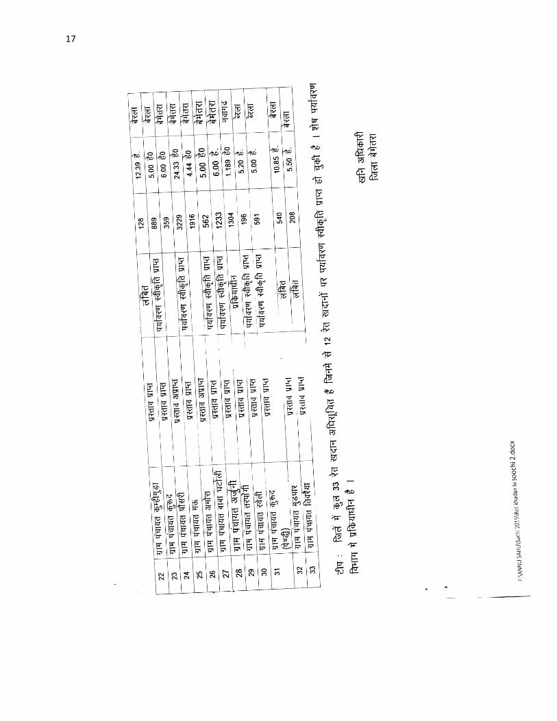
17
18
4 Details of Royalty or Revenue Received in Last Three Year
Major Minerals
Details of Royalty or Revenue Received in Last Three Year Major Minerals
SNo Mineral Royalty or Revenue Received
2013-14 2014-15 2015-16
1 Limestone 115556982 154624130 259409159
2 Quartzite 694597 240000 NA
3 Moulding Sand 80000 127000 606620
Total - 116331579 154991130 260015779
Note - Quartzite Mineral is decleared Minor Mineral wef notification dated 10022015
Details of Royalty or Revenue Received in Last Three Year
Minor Minerals
Minor Minerals
SNo Mineral Royalty or Revenue Received
2013-14 2014-15 2015-16
1 Limestone 1334700 2333000 2385614
2 Flagstone 2021150 2497800 3584557
3 Ordinary Stone 745887 83000 135100
4 Murum 108000 1518692 3277000
5 Soil 572360 538720 354280
Total - 4782097 6971212 9736551
19
5 Details of Production of Sand or Bajari in last three years
frac14vfrac12Details of Production amp Royalty of Sand in in Last Three Year
Ordinary Sand SNo Financial year Royalty Received in Rs
1 2013-14 11504
2 2014-15 12539
3 2015-16 7356
5- fiNysrhuokksZ ds nkSjkujsrlsizkIrLokfeLo k jktLo ds CkSjsamp
frac14cfrac12Details of Production amp Royalty of Sand in in Last Three Year
Ordinary Sand
SNo Financial year Production of Sand (in Cm)
1 2013-14 230085
2 2014-15 250773
3 2015-16 147125
20
6 PROCESS OF DEPOSITION OF SEDIMENTS IN THE RIVERS
Sendimentation of rivers of District
6- Process of river sedimentation-
What is erosion
Erosion is natural process wathering corrosion or abrasion can reduce a material
into smaller particles Normally these smaller units are relocated by water wing
ice or man Erosion removes tosoil organic material and other valuable resources
What is sedimentation
Once a material is broken free of the larger mass it can be carried away and
deposited elsewhere This process of depositing eroded material is known as
sedimentation Some indications of sedimentation are sand dunes mud in the street
around drains and decreased water holding capacity of stream reservoir or pond
Why should we be concerned about erosion and sedimentation
Sediment is responsible for more stream and river degardation than any other
pollutant Deposits of sediments in ditches streams and rivers reduce their
capacity to store water resulting in more frequent and severe flooding and
increased property damage Accumulations of sediment may result in severe
damage to storm drain systers Many millions of dollars are spent each year to
dredge our state waterways to remove sediments from storm drain systerms
reseroirs and water treatment plants and to repair flood damage
Sediment in streams and rivers causes the most damage to aduatic life by severely
impacting aquatic animal habitats and degrading water quality Areas needed for
21
reproduction and food sources are destroyed when fine silts cover the sand and
gravel streambed Decreased clarity of the water prevents sunlight from reaching
plants resulting in loss of aquatic plant communities The result is a reduction in
the number and variety of fish and other aquatic life This impact ofter can see for
many miles downstream
Process-
Rivers have a lot of energy and because they have energy they do stuff The
obvious things rivers do with their energy is flow but besides this they also
transport load erode load and erode the channel through which they flow Erosion
Erosion is the breaking down of material by an agent In the case of a river the
agent is water The water can erode the riverrsquos channel and the riverrsquos load A
riverrsquos load is bits of eroded material generally rocks which the river transports
until it deposits its load A riverrsquos channel is eroded laterally and vertically making
the channel wider and deeper The intensity of lateral and vertical erosion is
dictated by the stage in the riverrsquos course discussed in more detail here but
essentially in the upper stage of the riverrsquos course (close to the source of the river)
there is little horizontal erosion and lots of vertical erosion In the middle and
lower stages vertical erosion is reduced and more horizontal erosion takes place
There are several different ways that a river erodes its bed and banks The first is
hydraulic action where the force of the water removes rock particles from the bed
and banks This type of erosion is strongest at rapids and waterfalls where the
water has a high velocity The next type of erosion is corrasion This is where the
riverrsquos load acts almost like sandpaper removing pieces of rock as the load rubs
against the bed amp banks This sort of erosion is strongest when the river is
transporting large chunks of rock or after heavy rainfall when the riverrsquos flow is
22
turbulent Corrosion is a special type of erosion that only affects certain types of
rocks Water being ever so slightly acidic will react with certain rocks and
dissolve them Corrosion is highly effective if the rock type of the channel is chalk
or limestone (anything containing calcium carbonate) otherwise it doesnrsquot have
much of an effect Cavitation is an interesting method of erosion Air bubbles
trapped in the water get compressed into small spaces like cracks in the riverrsquos
banks These bubbles eventually implode creating a small shockwave that weakens
the rocks The shockwaves are very weak but over time the rock will be weakened
to the point at which it falls apart The final type of erosion is attrition Attrition is
a way of eroding the riverrsquos load not the bed and banks Attrition is where pieces
of rock in the riverrsquos load knock together breaking chunks of rock off of one
another and gradually rounding and shrinking the load Transportation when a river
erodes the eroded material becomes the riverrsquos load and the river will then
transport this load through its course until it deposits the load There are a few
different ways that a river will transport load depending on how much energy the
river has and how big the load is The largest of particles such as boulders are
transported by traction These particles are rolled along the bed of the river
eroding the bed and the particles in the process because the river doesnrsquot have
enough energy to move these large particles in any other way Slightly smaller
particles such as pebbles and gravel are transported by saltation This is where the
load bounces along the bed of the river because the river has enough energy to lift
the particles off the bed but the particles are too heavy to travel by suspension
Fine particles like clay and silt are transported in suspension they are suspended in
the water Most of a riverrsquos load is transported by suspension Solution is a special
method of transportation This is where particles are dissolved into the water so
only rocks that are soluble such as limestone or chalk can be transported in
23
solution Capacity amp Competence Rivers can only carry so much load depending
on their energy The maximum volume of load that a river can carry at a specific
point in its course is called the riverrsquos capacity The biggest sized particle that a
river could carry at a specific point is called the riverrsquos competence Deposition to
transport load a river needs to have energy so when a river loses energy it is forced
to deposit its load There are several reasons why a river could lose energy If the
riverrsquos discharge is reduced then the river will lose energy because it isnrsquot flowing
as quickly anymore This could happen because of a lack of precipitation or an
increase in evaporation Increased human use (abstraction) of a river could also
reduce its discharge forcing it deposit its load If the gradient of the riverrsquos course
flattens out the river will deposit its load because it will be travelling a lot slower
When a river meets the sea a river will deposit its load because the gradient is
generally reduced at sea level and the sea will absorb a lot of energy As rivers get
nearer to their mouths they flow in increasingly wide gentle sided valleys The
channel increases in size to hold the extra water which the river has to receive from
its tributaries As the river gets bigger it can carry larger amounts of material This
material will be small in size as larger rocks will have broken up on their way
from the mountains Much of the material will be carried in suspension and will
erode the river banks by abrasion When rivers flow over flatter land they develop
large bends called meanders As a river goes around a bend most of the water is
pushed towards the outside causing increased erosion The river is now eroding
sideways into its banks rather than downwards into its bed a process called lateral
erosion On the inside of the bend in contrast there is much less water The river
will therefore be shallow and slow-flowing It cannot carry as much material and
so sand and shingle will be deposited This is called a point bar or slip off slope
Due to erosion on the outside of a bend and deposition on the inside the shape of a
24
meander will change over a period of time Notice how erosion narrows the neck
of the land within the meander In time and usually during a flood the river will
cut right through the neck The river will then take the new shorter route The
fastest current called the thalweg will now tend to be in the centre of the river
and so deposition is likely to occur in gentler water next to the banks Eventually
deposition will block off the old meander to leave an oxbow lake The oxbow lake
will slowly dry up only refilling after heavy rain or during a flood Streams lose
velocity and make deposits when their gradient decreases when the volume of
water decreases when there is an increase in cross section when they encounter
obstructions or when they enter still water They deposit alluvial fans alluvial
cones piedmont alluvial plains channel fill bars flood plains and deltas
25
7 General Profile of the District
Bemetara city is well connected to Raipur Jabalpur Bilaspur Durg and
Kawardha by roadwaysNH-30 passes through the heart of city which is one of the
buissiest road in the stateThis highway connects state capital Raipur to one of the
major city of Madhya Pradesh JabalpurThere are two state highway passing
through Bemetara that are Durg to Bemetara and Kumhari - Bemetara ndash Mungeli
History
Comparatively a new district in Chhattisgarh India Bemetara district was
established as tahsil in the year 1907 along with the Mungeli (Bilaspur region)
This region is coloured by ever-widening importance in history since the time it
had been established However it is largest town amongst other town in the
scenario of land and population Owing to its suitability to being a district of
Chhattisgarh it had to wait to call upon since Kawardha has integrated
Conversely the Chhattisgarh government has realised its importance in central
CG Bemetara is an attractive tourist destination as villages like Bataar Mohbhatta
and Khamhariya are famous for their temples and lakes
dzekad
1 ftysdkdqyHkkSxksfy
d ks=Qy
2854-81 oxZfd-eh
2 vkkak oanskkak mRrjesa 21 22΄ ls 22003΄ mRrjhvkkaklsiwoZesa 81 07΄ ls81
055΄iwohZ nskakrj
3 leqnzrylsAringpkbZ 317 eh- vkSlr
4 vkSlrokkZ 2013-14 1234fe-eh- okfkZd
2014-15 1121-40fe-eh- okfkZd
2015-16 957-82fe-eh- okfkZd
5 rkieku vfkdreamp 48lsUVhxzsM
Uqureamp10lsUVhxzsM
26
6 ou ks=Qy
ljafkrou ks=gsDV- vkjfkrou ks= gsDV- voxhZd`rou
ks=gsDV-
dqyouks=
fujad fujad fujad fujad
7 unh rFkkukys River Shivnath Kharun Hanf Sakari SurahiampPhonk river
8 ioZr fujad
9 tula[k 795759 frac14tuxkuk 2011 ds vuqlkjfrac12Male Papulation 397650 amp Female Population
398109 11 lkkjrk frac1469-87frac12
12 rglhy
frac14fodkl[kMfrac12
05 - Nawagarh Bemetara Saja Than KhamhariaampBerla
13 uxjikfydk
uxjfuxe
02 ndash BemetaraampSaja
14 uxjiapkr 06 - Nawagarh Maro Bemetara Devkar Parpodi SajaThanKhamhariaampBerla
15 xzkeiapkr 387
Means of Transport
Bus Transport
Bemetara city is well connected to Raipur Jabalpur Bilaspur Durg and Kawardha
by roadwaysNH-30 A passes through the heart of city which is one of the busiest
road in the stateThis highway connects state capital Raipur to one of the major city
of Madhya Pradesh JabalpurThere are two state highway passing through
Bemetara that are Durg to Bemetara and Kumhari - Bemetara - Mungeli
Railway Transport
Bemetara is not connected by railway the nearest Railway station is tilde (35 km)
and major station is Raipur (66 km) and Durg is about 72 km
A new railway line is proposed in Bemetarawhich isDurg-Bemetara-Mungeli-
Bilaspur line
27
Air Transport
Nearest airport to the town is Swami Vivekananda International Airport
Raipur(IATA RPR ICAO VERP) which was formerly known as Mana Airport
which is 66 km from the city
28
8 Land Utilition Pattern in the district Forest Agriculture
Horticulture Mining etc
(i)Types of Soil-
Different type of soils are found in the District which is as follows-
i Red Soil (Bhata) Entisols
ii Sandy loams (Matasi) Inceptisols
iii Dorsa (Alfisols)
iv Black (Kanhar) vertisols
v Alluvial Soil (Kachhar)
(ii)Types of Forest-
oueMy
ljafkrou ks=gsDV- vkjfkrou ks= gsDV- voxhZd`rou ks=gsDV-
dqyouks=
ou
ks=Qy
fujad fujad fujad fujad
(iii)Details of Horticulture-
S No Particular Details Area in Hectare
1 Geographical Area of the District 285481Hect
2 Forest Area Nil
3 Total Kast Land Area 239566Hect
4 Land Covered by Gardening Crops 15373 Hect
5 Land Covered by Fruit Plants 2934 Hect
6 Land Covered by Vegetables Crop 10602 Hect
7 Land Covered by Masala 1535Hect
29
8 Land Covered by Flowers 185 Hect
9 Land Covered by Medicinal ampSented Plants 117 Hect
10 Percentage of Gardening Crops 872
(iv)Details of Agriculture-
S No Particular Details Area in Hectare
1 Geographical Area of the District 285481Hect
2 Forest Area Nil
3 Non-Agricultural Land 52770Hect
4 Duel Crop Area 94150 Hect
5 Total Kast Land Area 281523Hect
6 Kharif Crop Area 205270Hect
7 Ravi Crop Area 138560Hect
8 Area of Jayad 1200 Hect
9 Total Crop Area 232710Hect
Irrigation
The main source of irrigation in the district is River Shivnath Kharun Haff
SakariampSurahi etc There is no any big dam in the district
30
(v) Details of Ground Water Survey-
31
Climate-
Bemetara has a tropical wet and dry climate temperature remains moderate
throughout the year except from March to June which can be extremely hot The
temperature in AprilndashMay sometimes rises above 45 degCThese summer months
also have dry and hot winds In summers the temperature can also go up to 50 degC
The city receives about 1300 millimetres (51 in) of rain mostly in the monsoon
season from late June to early October Winters last from November to January
and are mild although lows can fall to 5 degC (41 degF)
Climate data for Bemetara City
Month Jan Feb Mar Apr May Jun Jul Aug Sep Oct Nov Dec Year
Average
high degC
(degF)
27
(81)
30
(86)
35
(95)
39
(102)
45
(113)
36
(97)
30
(86)
30
(86)
31
(88)
31
(88)
28
(82)
26
(79)
32
(90)
Average
low degC
(degF)
13
(55)
15
(59)
20
(68)
24
(75)
27
(81)
26
(79)
23
(73)
23
(73)
22
(72)
21
(70)
16
(61)
14
(57)
20
(68)
Average
precipita
tion mm
(inches)
10
(039)
17
(067)
14
(055)
13
(051)
18
(071)
239
(941)
383
(1508)
364
(1433)
197
(776)
50
(197)
11
(043)
16
(063)
1330
(5236)
32
9 Physiography of the District
Physiographically the area in Bemetara District having almost flat topographyThe
general slope of the district is towards the north - east in which direction the major
streams of the district flow
BEMETARA is located near the centre of a large plain sometimes referred as the
rice bowl of India where hundreds of varieties of rice are
grown The ShivnathRiverflows to the east of the city of bemetara and the
southern side has dense forests The Maikal Hills rise on the north-west of
Bemetara on the north the land rises and merges with the Chota Nagpur Plateau
which extends north-east across Jharkhand state On the south of Bemetara lies
the Deccan Plateau
33
34
10 Rainfall of District BemetaraYear wise
S No Year Average Rainfall (mm)
1 2012 99440
2 2013 123400
3 2014 112140
4 2015 95782
Rainfall of District Bemetara Month wise
Rainfall data for Bemetara City
Month Jan Feb Mar Apr May Jun Jul Aug Sep Oct Nov Dec Year
Average
precipita
tion mm
(inches)
10
(039)
17
(067)
14
(055)
13
(051)
18
(071)
239
(941)
383
(1508)
364
(1433)
197
(776)
50
(197)
11
(043)
16
(063)
1330
(5236)
35
36
11 Geology and Mineral Wealth
Geology-
Geologically the district comprises of rocks of the Meso-to Neo- Proterozoic
sequence is represented by the Chhattisgarh Supergroup Raipur Group comprises
Chandi formation Tarenga formation Hirri formation and Maniari formation
Chandi Formation of grey and purple stromatolitic limestone with
areniteferruginous sandstone intercalations (Deodongar member) Tarenga
Formation of greenish grey and reddish brown shale with chert porcellanite and
green clay interbands Hirri Formation by grey thinly to thickly bedded dolomite
and argillancous dolomite and ManairiFormationn comprises reddish brown and
purple non - calcareous shale with gypsum interbandsQuatrenary is represented
by pebble beds (Khamaria pebble bed)
37
38
Stratigraphic succession-
39
Mineral-
Mineral deposite of Bemetaradistrict include Dolomite Limestone Ordinary stone
Sand and Soil etc
Dolomite Mines
Total 27 Dolomite mines in which at present 3 dolomite is operational 13 dolomite
mine is under renewal and 11 dolomite mines is under lapse category
Limestone Mine
Total 03limestone mines in which at present 1limestone mine is operational and
rest 2 limestone mine is under renewal in the district
Ordinary Stone Mine
Total 01 ordinary stone mines is operational in the district
Soil Mine for Making Bricks
Total 34 soil mines in which at present 13 soil mine is operational and 21 soil mine
is under renewal varies part of the district
Sand Mine
Total 33 sand mines in which at present after Environmental NOC 12 sand mine is
operational 14 sand mine is under process to getting Environmental NOC from
SEIAA and 07sand mines has not submitted required documents for
Environmental Clearence till date
Sands are mostly available in Bank of River Shivnath Kharun Hanf
SakariSurahiampPhonkriver Quarry leases for sand mining are given in different
village of Bemetara district
40
Additional information of the district
Drainage System-
Shivnath
Sheonath is main river of District Bemetara Shivnathriver is tributary of Mahanadi
river Shivnathriver originates from Mountain at height of 625 meter at Panabaras
situated in south western parts of Rajnandgaon and flows towards north east
direction Shivnath River measures length about 345 KM City Durg is situated on
east bank of Shivnath River It flows towards north east passing through Khujji
Rajnandgaon Durg Dhamdha and Nandghat and joins (meet) Mahanadi near
Shivari Narayan of Bilaspur District
Kharun
Kharunriver flows in eastern parts of the district starting from Petechua in Balod
District This river flows towards north and joins (meet) ShivnathRiver at Somnath
near Simga This river determines the boundary of Raipur and Durg district The
length of this river is about 120 KM
41
42
Survey Report for Sand Mining of District Bemetara
This survey report is prepared for District Bemetara to identify the sustainable
mining area In District Bemetarathere are six rivers namely Shivnath Kharun
Haff Sakari SurahiampPhonkriver
All possible sand mining area has been surveyed The riverwise area surveyed and
identified for sand mining is given in the annexure
The thickness of sand load is considered average 4 meters in depth by observation
as well as local enquiry out of which up to depth of 3 meter is considered for
calculation of mineral potential
The mining area will be 10m away from the river bank and about 10m Influence
as safity barrier from the main streem will be left where mining operation will be
restricted Hence 10 m influence area from the main stream has been considered as
safity zone or non mining zone
It is considered that replenishment of sand in every monsoon season is a regular
process Based on the last five year observation it is experienced that average of
3m sand is replenished every year
Area Prohibited for Mining-
The following area will be prohibited for minng
i No mining activity will be executed 10 m from the river bank
ii Mining is prohibited within 10 m from the flow of the main stream
iii During mining measures should be taken to guide the flow to the centre
of the river to avoide erosion of banks
iv Mining area is restricted up to 500 mtsdown stream of any structure like
bridge diversion head work anicut etc
43
v Measures should be kept in consideration that the flow of river should not
be diverted or obstructed
vi The distance between two sand mining locations should be minimum 500
meters
vii Before permission of mining a suitable test of sand for construction
purpose like silt percentage fineness modulus etc must be obtained from
competent laboratory authority
viii Provision for plantation must be assured on the river bank of concerened
sand mining zone to protect erosion of banks and to
maintainesecobalance
Details are given bellow-
S No Name of River Ara Drained Sq KM Area
Drained in the
District in BemetaraDist Total
1 2 3 4 5
1 Shivnath River Sq km Sq km
2 Kharun River Sq km Sq km
3 Haff River Sq km Sq km
4 Sakari River
5 Surahi River
6 Phonk
Features of Important Rivers and Streams-
S No Name of the
River or Stream
Total Length in the
District (in km)
Place of origin Height of
origin
1 2 3 4 5
1 Shivnath River km Panabaras (Dist-
Rajnandgaon)
642 m
2 Kharun River km Kankalin (Petachuwa)
(Dist-Balod)
1 m
3 Haff River km Hils of Dallirajhara
(Banjaridih) (Dist- Balod
3 m
44
4 Sakari River
5 Surahi River
6 Phonk
Shivnath River
SNo Portion of the
River of
Stream
Recommended
for Mineral
Concession
Length of
area
recommended
for mineral
concession (in
kilometer)
Average
Width of area
Recommended
for mineral
concession (in
meters)
Area
recommended
for mineral
concession (in
meter)
Mineable
mineral
potential
(in metric
tonne) 60
of total
mineral
potential)
1 2 jsrtekoughagSA 3 jsrmiyCk ughagSA 4 jsrmiyCk ughagSA 5 jsrmiyCk ughagSA 6 orZekuesaikuhHkjkogSArhuokZiwoZjsr
[kuugksrkFkkjsrughagSA
ksxamp
Kharun River
SNo Portion of the
River of
Stream
Recommended
for Mineral
Concession
Length of
area
recommended
for mineral
concession (in
kilometer)
Average
Width of area
Recommended
for mineral
concession (in
meters)
Area
recommended
for mineral
concession (in
meter)
Mineable
mineral
potential
(in metric
tonne) 60
of total
mineral
potential)
1 ikuhHkjkogSA 2 ikuhHkjkogSA 3 ikuhHkjkogSA 4 ikuhHkjkogSA 5 ikuhHkjkogSA 6 ikuhHkjkogSA
45
ksxamp 0
Haff River
SNo Portion of the
River of
Stream
Recommended
for Mineral
Concession
Length of
area
recommended
for mineral
concession (in
kilometer)
Average
Width of area
Recommended
for mineral
concession (in
meters)
Area
recommended
for mineral
concession (in
meter)
Mineable
mineral
potential
(in metric
tonne) 60
of total
mineral
potential)
1 ikuhHkjkogSA 2 ikuhHkjkogSA 3 ikuhHkjkogSA 4 ikuhHkjkogSA 5 ikuhHkjkogSA 6 ikuhHkjkogSA ksxamp 0
Sakari River
SNo Portion of the
River of
Stream
Recommended
for Mineral
Concession
Length of
area
recommended
for mineral
concession (in
kilometer)
Average
Width of area
Recommended
for mineral
concession (in
meters)
Area
recommended
for mineral
concession (in
meter)
Mineable
mineral
potential
(in metric
tonne) 60
of total
mineral
potential)
1 ikuhHkjkogSA 2 ikuhHkjkogSA 3 ikuhHkjkogSA 4 ikuhHkjkogSA 5 ikuhHkjkogSA 6 ikuhHkjkogSA ksxamp 0
46
Surahi River
SNo Portion of the
River of
Stream
Recommended
for Mineral
Concession
Length of
area
recommended
for mineral
concession (in
kilometer)
Average
Width of area
Recommended
for mineral
concession (in
meters)
Area
recommended
for mineral
concession (in
meter)
Mineable
mineral
potential
(in metric
tonne) 60
of total
mineral
potential)
1 ikuhHkjkogSA 2 ikuhHkjkogSA 3 ikuhHkjkogSA 4 ikuhHkjkogSA 5 ikuhHkjkogSA 6 ikuhHkjkogSA ksxamp 0
Phonk River
SNo Portion of the
River of
Stream
Recommended
for Mineral
Concession
Length of
area
recommended
for mineral
concession (in
kilometer)
Average
Width of area
Recommended
for mineral
concession (in
meters)
Area
recommended
for mineral
concession (in
meter)
Mineable
mineral
potential
(in metric
tonne) 60
of total
mineral
potential)
1 ikuhHkjkogSA 2 ikuhHkjkogSA 3 ikuhHkjkogSA 4 ikuhHkjkogSA 5 ikuhHkjkogSA 6 ikuhHkjkogSA ksxamp 0
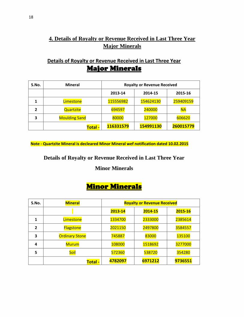
18
4 Details of Royalty or Revenue Received in Last Three Year
Major Minerals
Details of Royalty or Revenue Received in Last Three Year Major Minerals
SNo Mineral Royalty or Revenue Received
2013-14 2014-15 2015-16
1 Limestone 115556982 154624130 259409159
2 Quartzite 694597 240000 NA
3 Moulding Sand 80000 127000 606620
Total - 116331579 154991130 260015779
Note - Quartzite Mineral is decleared Minor Mineral wef notification dated 10022015
Details of Royalty or Revenue Received in Last Three Year
Minor Minerals
Minor Minerals
SNo Mineral Royalty or Revenue Received
2013-14 2014-15 2015-16
1 Limestone 1334700 2333000 2385614
2 Flagstone 2021150 2497800 3584557
3 Ordinary Stone 745887 83000 135100
4 Murum 108000 1518692 3277000
5 Soil 572360 538720 354280
Total - 4782097 6971212 9736551
19
5 Details of Production of Sand or Bajari in last three years
frac14vfrac12Details of Production amp Royalty of Sand in in Last Three Year
Ordinary Sand SNo Financial year Royalty Received in Rs
1 2013-14 11504
2 2014-15 12539
3 2015-16 7356
5- fiNysrhuokksZ ds nkSjkujsrlsizkIrLokfeLo k jktLo ds CkSjsamp
frac14cfrac12Details of Production amp Royalty of Sand in in Last Three Year
Ordinary Sand
SNo Financial year Production of Sand (in Cm)
1 2013-14 230085
2 2014-15 250773
3 2015-16 147125
20
6 PROCESS OF DEPOSITION OF SEDIMENTS IN THE RIVERS
Sendimentation of rivers of District
6- Process of river sedimentation-
What is erosion
Erosion is natural process wathering corrosion or abrasion can reduce a material
into smaller particles Normally these smaller units are relocated by water wing
ice or man Erosion removes tosoil organic material and other valuable resources
What is sedimentation
Once a material is broken free of the larger mass it can be carried away and
deposited elsewhere This process of depositing eroded material is known as
sedimentation Some indications of sedimentation are sand dunes mud in the street
around drains and decreased water holding capacity of stream reservoir or pond
Why should we be concerned about erosion and sedimentation
Sediment is responsible for more stream and river degardation than any other
pollutant Deposits of sediments in ditches streams and rivers reduce their
capacity to store water resulting in more frequent and severe flooding and
increased property damage Accumulations of sediment may result in severe
damage to storm drain systers Many millions of dollars are spent each year to
dredge our state waterways to remove sediments from storm drain systerms
reseroirs and water treatment plants and to repair flood damage
Sediment in streams and rivers causes the most damage to aduatic life by severely
impacting aquatic animal habitats and degrading water quality Areas needed for
21
reproduction and food sources are destroyed when fine silts cover the sand and
gravel streambed Decreased clarity of the water prevents sunlight from reaching
plants resulting in loss of aquatic plant communities The result is a reduction in
the number and variety of fish and other aquatic life This impact ofter can see for
many miles downstream
Process-
Rivers have a lot of energy and because they have energy they do stuff The
obvious things rivers do with their energy is flow but besides this they also
transport load erode load and erode the channel through which they flow Erosion
Erosion is the breaking down of material by an agent In the case of a river the
agent is water The water can erode the riverrsquos channel and the riverrsquos load A
riverrsquos load is bits of eroded material generally rocks which the river transports
until it deposits its load A riverrsquos channel is eroded laterally and vertically making
the channel wider and deeper The intensity of lateral and vertical erosion is
dictated by the stage in the riverrsquos course discussed in more detail here but
essentially in the upper stage of the riverrsquos course (close to the source of the river)
there is little horizontal erosion and lots of vertical erosion In the middle and
lower stages vertical erosion is reduced and more horizontal erosion takes place
There are several different ways that a river erodes its bed and banks The first is
hydraulic action where the force of the water removes rock particles from the bed
and banks This type of erosion is strongest at rapids and waterfalls where the
water has a high velocity The next type of erosion is corrasion This is where the
riverrsquos load acts almost like sandpaper removing pieces of rock as the load rubs
against the bed amp banks This sort of erosion is strongest when the river is
transporting large chunks of rock or after heavy rainfall when the riverrsquos flow is
22
turbulent Corrosion is a special type of erosion that only affects certain types of
rocks Water being ever so slightly acidic will react with certain rocks and
dissolve them Corrosion is highly effective if the rock type of the channel is chalk
or limestone (anything containing calcium carbonate) otherwise it doesnrsquot have
much of an effect Cavitation is an interesting method of erosion Air bubbles
trapped in the water get compressed into small spaces like cracks in the riverrsquos
banks These bubbles eventually implode creating a small shockwave that weakens
the rocks The shockwaves are very weak but over time the rock will be weakened
to the point at which it falls apart The final type of erosion is attrition Attrition is
a way of eroding the riverrsquos load not the bed and banks Attrition is where pieces
of rock in the riverrsquos load knock together breaking chunks of rock off of one
another and gradually rounding and shrinking the load Transportation when a river
erodes the eroded material becomes the riverrsquos load and the river will then
transport this load through its course until it deposits the load There are a few
different ways that a river will transport load depending on how much energy the
river has and how big the load is The largest of particles such as boulders are
transported by traction These particles are rolled along the bed of the river
eroding the bed and the particles in the process because the river doesnrsquot have
enough energy to move these large particles in any other way Slightly smaller
particles such as pebbles and gravel are transported by saltation This is where the
load bounces along the bed of the river because the river has enough energy to lift
the particles off the bed but the particles are too heavy to travel by suspension
Fine particles like clay and silt are transported in suspension they are suspended in
the water Most of a riverrsquos load is transported by suspension Solution is a special
method of transportation This is where particles are dissolved into the water so
only rocks that are soluble such as limestone or chalk can be transported in
23
solution Capacity amp Competence Rivers can only carry so much load depending
on their energy The maximum volume of load that a river can carry at a specific
point in its course is called the riverrsquos capacity The biggest sized particle that a
river could carry at a specific point is called the riverrsquos competence Deposition to
transport load a river needs to have energy so when a river loses energy it is forced
to deposit its load There are several reasons why a river could lose energy If the
riverrsquos discharge is reduced then the river will lose energy because it isnrsquot flowing
as quickly anymore This could happen because of a lack of precipitation or an
increase in evaporation Increased human use (abstraction) of a river could also
reduce its discharge forcing it deposit its load If the gradient of the riverrsquos course
flattens out the river will deposit its load because it will be travelling a lot slower
When a river meets the sea a river will deposit its load because the gradient is
generally reduced at sea level and the sea will absorb a lot of energy As rivers get
nearer to their mouths they flow in increasingly wide gentle sided valleys The
channel increases in size to hold the extra water which the river has to receive from
its tributaries As the river gets bigger it can carry larger amounts of material This
material will be small in size as larger rocks will have broken up on their way
from the mountains Much of the material will be carried in suspension and will
erode the river banks by abrasion When rivers flow over flatter land they develop
large bends called meanders As a river goes around a bend most of the water is
pushed towards the outside causing increased erosion The river is now eroding
sideways into its banks rather than downwards into its bed a process called lateral
erosion On the inside of the bend in contrast there is much less water The river
will therefore be shallow and slow-flowing It cannot carry as much material and
so sand and shingle will be deposited This is called a point bar or slip off slope
Due to erosion on the outside of a bend and deposition on the inside the shape of a
24
meander will change over a period of time Notice how erosion narrows the neck
of the land within the meander In time and usually during a flood the river will
cut right through the neck The river will then take the new shorter route The
fastest current called the thalweg will now tend to be in the centre of the river
and so deposition is likely to occur in gentler water next to the banks Eventually
deposition will block off the old meander to leave an oxbow lake The oxbow lake
will slowly dry up only refilling after heavy rain or during a flood Streams lose
velocity and make deposits when their gradient decreases when the volume of
water decreases when there is an increase in cross section when they encounter
obstructions or when they enter still water They deposit alluvial fans alluvial
cones piedmont alluvial plains channel fill bars flood plains and deltas
25
7 General Profile of the District
Bemetara city is well connected to Raipur Jabalpur Bilaspur Durg and
Kawardha by roadwaysNH-30 passes through the heart of city which is one of the
buissiest road in the stateThis highway connects state capital Raipur to one of the
major city of Madhya Pradesh JabalpurThere are two state highway passing
through Bemetara that are Durg to Bemetara and Kumhari - Bemetara ndash Mungeli
History
Comparatively a new district in Chhattisgarh India Bemetara district was
established as tahsil in the year 1907 along with the Mungeli (Bilaspur region)
This region is coloured by ever-widening importance in history since the time it
had been established However it is largest town amongst other town in the
scenario of land and population Owing to its suitability to being a district of
Chhattisgarh it had to wait to call upon since Kawardha has integrated
Conversely the Chhattisgarh government has realised its importance in central
CG Bemetara is an attractive tourist destination as villages like Bataar Mohbhatta
and Khamhariya are famous for their temples and lakes
dzekad
1 ftysdkdqyHkkSxksfy
d ks=Qy
2854-81 oxZfd-eh
2 vkkak oanskkak mRrjesa 21 22΄ ls 22003΄ mRrjhvkkaklsiwoZesa 81 07΄ ls81
055΄iwohZ nskakrj
3 leqnzrylsAringpkbZ 317 eh- vkSlr
4 vkSlrokkZ 2013-14 1234fe-eh- okfkZd
2014-15 1121-40fe-eh- okfkZd
2015-16 957-82fe-eh- okfkZd
5 rkieku vfkdreamp 48lsUVhxzsM
Uqureamp10lsUVhxzsM
26
6 ou ks=Qy
ljafkrou ks=gsDV- vkjfkrou ks= gsDV- voxhZd`rou
ks=gsDV-
dqyouks=
fujad fujad fujad fujad
7 unh rFkkukys River Shivnath Kharun Hanf Sakari SurahiampPhonk river
8 ioZr fujad
9 tula[k 795759 frac14tuxkuk 2011 ds vuqlkjfrac12Male Papulation 397650 amp Female Population
398109 11 lkkjrk frac1469-87frac12
12 rglhy
frac14fodkl[kMfrac12
05 - Nawagarh Bemetara Saja Than KhamhariaampBerla
13 uxjikfydk
uxjfuxe
02 ndash BemetaraampSaja
14 uxjiapkr 06 - Nawagarh Maro Bemetara Devkar Parpodi SajaThanKhamhariaampBerla
15 xzkeiapkr 387
Means of Transport
Bus Transport
Bemetara city is well connected to Raipur Jabalpur Bilaspur Durg and Kawardha
by roadwaysNH-30 A passes through the heart of city which is one of the busiest
road in the stateThis highway connects state capital Raipur to one of the major city
of Madhya Pradesh JabalpurThere are two state highway passing through
Bemetara that are Durg to Bemetara and Kumhari - Bemetara - Mungeli
Railway Transport
Bemetara is not connected by railway the nearest Railway station is tilde (35 km)
and major station is Raipur (66 km) and Durg is about 72 km
A new railway line is proposed in Bemetarawhich isDurg-Bemetara-Mungeli-
Bilaspur line
27
Air Transport
Nearest airport to the town is Swami Vivekananda International Airport
Raipur(IATA RPR ICAO VERP) which was formerly known as Mana Airport
which is 66 km from the city
28
8 Land Utilition Pattern in the district Forest Agriculture
Horticulture Mining etc
(i)Types of Soil-
Different type of soils are found in the District which is as follows-
i Red Soil (Bhata) Entisols
ii Sandy loams (Matasi) Inceptisols
iii Dorsa (Alfisols)
iv Black (Kanhar) vertisols
v Alluvial Soil (Kachhar)
(ii)Types of Forest-
oueMy
ljafkrou ks=gsDV- vkjfkrou ks= gsDV- voxhZd`rou ks=gsDV-
dqyouks=
ou
ks=Qy
fujad fujad fujad fujad
(iii)Details of Horticulture-
S No Particular Details Area in Hectare
1 Geographical Area of the District 285481Hect
2 Forest Area Nil
3 Total Kast Land Area 239566Hect
4 Land Covered by Gardening Crops 15373 Hect
5 Land Covered by Fruit Plants 2934 Hect
6 Land Covered by Vegetables Crop 10602 Hect
7 Land Covered by Masala 1535Hect
29
8 Land Covered by Flowers 185 Hect
9 Land Covered by Medicinal ampSented Plants 117 Hect
10 Percentage of Gardening Crops 872
(iv)Details of Agriculture-
S No Particular Details Area in Hectare
1 Geographical Area of the District 285481Hect
2 Forest Area Nil
3 Non-Agricultural Land 52770Hect
4 Duel Crop Area 94150 Hect
5 Total Kast Land Area 281523Hect
6 Kharif Crop Area 205270Hect
7 Ravi Crop Area 138560Hect
8 Area of Jayad 1200 Hect
9 Total Crop Area 232710Hect
Irrigation
The main source of irrigation in the district is River Shivnath Kharun Haff
SakariampSurahi etc There is no any big dam in the district
30
(v) Details of Ground Water Survey-
31
Climate-
Bemetara has a tropical wet and dry climate temperature remains moderate
throughout the year except from March to June which can be extremely hot The
temperature in AprilndashMay sometimes rises above 45 degCThese summer months
also have dry and hot winds In summers the temperature can also go up to 50 degC
The city receives about 1300 millimetres (51 in) of rain mostly in the monsoon
season from late June to early October Winters last from November to January
and are mild although lows can fall to 5 degC (41 degF)
Climate data for Bemetara City
Month Jan Feb Mar Apr May Jun Jul Aug Sep Oct Nov Dec Year
Average
high degC
(degF)
27
(81)
30
(86)
35
(95)
39
(102)
45
(113)
36
(97)
30
(86)
30
(86)
31
(88)
31
(88)
28
(82)
26
(79)
32
(90)
Average
low degC
(degF)
13
(55)
15
(59)
20
(68)
24
(75)
27
(81)
26
(79)
23
(73)
23
(73)
22
(72)
21
(70)
16
(61)
14
(57)
20
(68)
Average
precipita
tion mm
(inches)
10
(039)
17
(067)
14
(055)
13
(051)
18
(071)
239
(941)
383
(1508)
364
(1433)
197
(776)
50
(197)
11
(043)
16
(063)
1330
(5236)
32
9 Physiography of the District
Physiographically the area in Bemetara District having almost flat topographyThe
general slope of the district is towards the north - east in which direction the major
streams of the district flow
BEMETARA is located near the centre of a large plain sometimes referred as the
rice bowl of India where hundreds of varieties of rice are
grown The ShivnathRiverflows to the east of the city of bemetara and the
southern side has dense forests The Maikal Hills rise on the north-west of
Bemetara on the north the land rises and merges with the Chota Nagpur Plateau
which extends north-east across Jharkhand state On the south of Bemetara lies
the Deccan Plateau
33
34
10 Rainfall of District BemetaraYear wise
S No Year Average Rainfall (mm)
1 2012 99440
2 2013 123400
3 2014 112140
4 2015 95782
Rainfall of District Bemetara Month wise
Rainfall data for Bemetara City
Month Jan Feb Mar Apr May Jun Jul Aug Sep Oct Nov Dec Year
Average
precipita
tion mm
(inches)
10
(039)
17
(067)
14
(055)
13
(051)
18
(071)
239
(941)
383
(1508)
364
(1433)
197
(776)
50
(197)
11
(043)
16
(063)
1330
(5236)
35
36
11 Geology and Mineral Wealth
Geology-
Geologically the district comprises of rocks of the Meso-to Neo- Proterozoic
sequence is represented by the Chhattisgarh Supergroup Raipur Group comprises
Chandi formation Tarenga formation Hirri formation and Maniari formation
Chandi Formation of grey and purple stromatolitic limestone with
areniteferruginous sandstone intercalations (Deodongar member) Tarenga
Formation of greenish grey and reddish brown shale with chert porcellanite and
green clay interbands Hirri Formation by grey thinly to thickly bedded dolomite
and argillancous dolomite and ManairiFormationn comprises reddish brown and
purple non - calcareous shale with gypsum interbandsQuatrenary is represented
by pebble beds (Khamaria pebble bed)
37
38
Stratigraphic succession-
39
Mineral-
Mineral deposite of Bemetaradistrict include Dolomite Limestone Ordinary stone
Sand and Soil etc
Dolomite Mines
Total 27 Dolomite mines in which at present 3 dolomite is operational 13 dolomite
mine is under renewal and 11 dolomite mines is under lapse category
Limestone Mine
Total 03limestone mines in which at present 1limestone mine is operational and
rest 2 limestone mine is under renewal in the district
Ordinary Stone Mine
Total 01 ordinary stone mines is operational in the district
Soil Mine for Making Bricks
Total 34 soil mines in which at present 13 soil mine is operational and 21 soil mine
is under renewal varies part of the district
Sand Mine
Total 33 sand mines in which at present after Environmental NOC 12 sand mine is
operational 14 sand mine is under process to getting Environmental NOC from
SEIAA and 07sand mines has not submitted required documents for
Environmental Clearence till date
Sands are mostly available in Bank of River Shivnath Kharun Hanf
SakariSurahiampPhonkriver Quarry leases for sand mining are given in different
village of Bemetara district
40
Additional information of the district
Drainage System-
Shivnath
Sheonath is main river of District Bemetara Shivnathriver is tributary of Mahanadi
river Shivnathriver originates from Mountain at height of 625 meter at Panabaras
situated in south western parts of Rajnandgaon and flows towards north east
direction Shivnath River measures length about 345 KM City Durg is situated on
east bank of Shivnath River It flows towards north east passing through Khujji
Rajnandgaon Durg Dhamdha and Nandghat and joins (meet) Mahanadi near
Shivari Narayan of Bilaspur District
Kharun
Kharunriver flows in eastern parts of the district starting from Petechua in Balod
District This river flows towards north and joins (meet) ShivnathRiver at Somnath
near Simga This river determines the boundary of Raipur and Durg district The
length of this river is about 120 KM
41
42
Survey Report for Sand Mining of District Bemetara
This survey report is prepared for District Bemetara to identify the sustainable
mining area In District Bemetarathere are six rivers namely Shivnath Kharun
Haff Sakari SurahiampPhonkriver
All possible sand mining area has been surveyed The riverwise area surveyed and
identified for sand mining is given in the annexure
The thickness of sand load is considered average 4 meters in depth by observation
as well as local enquiry out of which up to depth of 3 meter is considered for
calculation of mineral potential
The mining area will be 10m away from the river bank and about 10m Influence
as safity barrier from the main streem will be left where mining operation will be
restricted Hence 10 m influence area from the main stream has been considered as
safity zone or non mining zone
It is considered that replenishment of sand in every monsoon season is a regular
process Based on the last five year observation it is experienced that average of
3m sand is replenished every year
Area Prohibited for Mining-
The following area will be prohibited for minng
i No mining activity will be executed 10 m from the river bank
ii Mining is prohibited within 10 m from the flow of the main stream
iii During mining measures should be taken to guide the flow to the centre
of the river to avoide erosion of banks
iv Mining area is restricted up to 500 mtsdown stream of any structure like
bridge diversion head work anicut etc
43
v Measures should be kept in consideration that the flow of river should not
be diverted or obstructed
vi The distance between two sand mining locations should be minimum 500
meters
vii Before permission of mining a suitable test of sand for construction
purpose like silt percentage fineness modulus etc must be obtained from
competent laboratory authority
viii Provision for plantation must be assured on the river bank of concerened
sand mining zone to protect erosion of banks and to
maintainesecobalance
Details are given bellow-
S No Name of River Ara Drained Sq KM Area
Drained in the
District in BemetaraDist Total
1 2 3 4 5
1 Shivnath River Sq km Sq km
2 Kharun River Sq km Sq km
3 Haff River Sq km Sq km
4 Sakari River
5 Surahi River
6 Phonk
Features of Important Rivers and Streams-
S No Name of the
River or Stream
Total Length in the
District (in km)
Place of origin Height of
origin
1 2 3 4 5
1 Shivnath River km Panabaras (Dist-
Rajnandgaon)
642 m
2 Kharun River km Kankalin (Petachuwa)
(Dist-Balod)
1 m
3 Haff River km Hils of Dallirajhara
(Banjaridih) (Dist- Balod
3 m
44
4 Sakari River
5 Surahi River
6 Phonk
Shivnath River
SNo Portion of the
River of
Stream
Recommended
for Mineral
Concession
Length of
area
recommended
for mineral
concession (in
kilometer)
Average
Width of area
Recommended
for mineral
concession (in
meters)
Area
recommended
for mineral
concession (in
meter)
Mineable
mineral
potential
(in metric
tonne) 60
of total
mineral
potential)
1 2 jsrtekoughagSA 3 jsrmiyCk ughagSA 4 jsrmiyCk ughagSA 5 jsrmiyCk ughagSA 6 orZekuesaikuhHkjkogSArhuokZiwoZjsr
[kuugksrkFkkjsrughagSA
ksxamp
Kharun River
SNo Portion of the
River of
Stream
Recommended
for Mineral
Concession
Length of
area
recommended
for mineral
concession (in
kilometer)
Average
Width of area
Recommended
for mineral
concession (in
meters)
Area
recommended
for mineral
concession (in
meter)
Mineable
mineral
potential
(in metric
tonne) 60
of total
mineral
potential)
1 ikuhHkjkogSA 2 ikuhHkjkogSA 3 ikuhHkjkogSA 4 ikuhHkjkogSA 5 ikuhHkjkogSA 6 ikuhHkjkogSA
45
ksxamp 0
Haff River
SNo Portion of the
River of
Stream
Recommended
for Mineral
Concession
Length of
area
recommended
for mineral
concession (in
kilometer)
Average
Width of area
Recommended
for mineral
concession (in
meters)
Area
recommended
for mineral
concession (in
meter)
Mineable
mineral
potential
(in metric
tonne) 60
of total
mineral
potential)
1 ikuhHkjkogSA 2 ikuhHkjkogSA 3 ikuhHkjkogSA 4 ikuhHkjkogSA 5 ikuhHkjkogSA 6 ikuhHkjkogSA ksxamp 0
Sakari River
SNo Portion of the
River of
Stream
Recommended
for Mineral
Concession
Length of
area
recommended
for mineral
concession (in
kilometer)
Average
Width of area
Recommended
for mineral
concession (in
meters)
Area
recommended
for mineral
concession (in
meter)
Mineable
mineral
potential
(in metric
tonne) 60
of total
mineral
potential)
1 ikuhHkjkogSA 2 ikuhHkjkogSA 3 ikuhHkjkogSA 4 ikuhHkjkogSA 5 ikuhHkjkogSA 6 ikuhHkjkogSA ksxamp 0
46
Surahi River
SNo Portion of the
River of
Stream
Recommended
for Mineral
Concession
Length of
area
recommended
for mineral
concession (in
kilometer)
Average
Width of area
Recommended
for mineral
concession (in
meters)
Area
recommended
for mineral
concession (in
meter)
Mineable
mineral
potential
(in metric
tonne) 60
of total
mineral
potential)
1 ikuhHkjkogSA 2 ikuhHkjkogSA 3 ikuhHkjkogSA 4 ikuhHkjkogSA 5 ikuhHkjkogSA 6 ikuhHkjkogSA ksxamp 0
Phonk River
SNo Portion of the
River of
Stream
Recommended
for Mineral
Concession
Length of
area
recommended
for mineral
concession (in
kilometer)
Average
Width of area
Recommended
for mineral
concession (in
meters)
Area
recommended
for mineral
concession (in
meter)
Mineable
mineral
potential
(in metric
tonne) 60
of total
mineral
potential)
1 ikuhHkjkogSA 2 ikuhHkjkogSA 3 ikuhHkjkogSA 4 ikuhHkjkogSA 5 ikuhHkjkogSA 6 ikuhHkjkogSA ksxamp 0
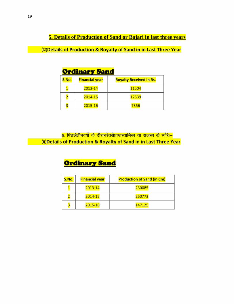
20
6 PROCESS OF DEPOSITION OF SEDIMENTS IN THE RIVERS
Sendimentation of rivers of District
6- Process of river sedimentation-
What is erosion
Erosion is natural process wathering corrosion or abrasion can reduce a material
into smaller particles Normally these smaller units are relocated by water wing
ice or man Erosion removes tosoil organic material and other valuable resources
What is sedimentation
Once a material is broken free of the larger mass it can be carried away and
deposited elsewhere This process of depositing eroded material is known as
sedimentation Some indications of sedimentation are sand dunes mud in the street
around drains and decreased water holding capacity of stream reservoir or pond
Why should we be concerned about erosion and sedimentation
Sediment is responsible for more stream and river degardation than any other
pollutant Deposits of sediments in ditches streams and rivers reduce their
capacity to store water resulting in more frequent and severe flooding and
increased property damage Accumulations of sediment may result in severe
damage to storm drain systers Many millions of dollars are spent each year to
dredge our state waterways to remove sediments from storm drain systerms
reseroirs and water treatment plants and to repair flood damage
Sediment in streams and rivers causes the most damage to aduatic life by severely
impacting aquatic animal habitats and degrading water quality Areas needed for
21
reproduction and food sources are destroyed when fine silts cover the sand and
gravel streambed Decreased clarity of the water prevents sunlight from reaching
plants resulting in loss of aquatic plant communities The result is a reduction in
the number and variety of fish and other aquatic life This impact ofter can see for
many miles downstream
Process-
Rivers have a lot of energy and because they have energy they do stuff The
obvious things rivers do with their energy is flow but besides this they also
transport load erode load and erode the channel through which they flow Erosion
Erosion is the breaking down of material by an agent In the case of a river the
agent is water The water can erode the riverrsquos channel and the riverrsquos load A
riverrsquos load is bits of eroded material generally rocks which the river transports
until it deposits its load A riverrsquos channel is eroded laterally and vertically making
the channel wider and deeper The intensity of lateral and vertical erosion is
dictated by the stage in the riverrsquos course discussed in more detail here but
essentially in the upper stage of the riverrsquos course (close to the source of the river)
there is little horizontal erosion and lots of vertical erosion In the middle and
lower stages vertical erosion is reduced and more horizontal erosion takes place
There are several different ways that a river erodes its bed and banks The first is
hydraulic action where the force of the water removes rock particles from the bed
and banks This type of erosion is strongest at rapids and waterfalls where the
water has a high velocity The next type of erosion is corrasion This is where the
riverrsquos load acts almost like sandpaper removing pieces of rock as the load rubs
against the bed amp banks This sort of erosion is strongest when the river is
transporting large chunks of rock or after heavy rainfall when the riverrsquos flow is
22
turbulent Corrosion is a special type of erosion that only affects certain types of
rocks Water being ever so slightly acidic will react with certain rocks and
dissolve them Corrosion is highly effective if the rock type of the channel is chalk
or limestone (anything containing calcium carbonate) otherwise it doesnrsquot have
much of an effect Cavitation is an interesting method of erosion Air bubbles
trapped in the water get compressed into small spaces like cracks in the riverrsquos
banks These bubbles eventually implode creating a small shockwave that weakens
the rocks The shockwaves are very weak but over time the rock will be weakened
to the point at which it falls apart The final type of erosion is attrition Attrition is
a way of eroding the riverrsquos load not the bed and banks Attrition is where pieces
of rock in the riverrsquos load knock together breaking chunks of rock off of one
another and gradually rounding and shrinking the load Transportation when a river
erodes the eroded material becomes the riverrsquos load and the river will then
transport this load through its course until it deposits the load There are a few
different ways that a river will transport load depending on how much energy the
river has and how big the load is The largest of particles such as boulders are
transported by traction These particles are rolled along the bed of the river
eroding the bed and the particles in the process because the river doesnrsquot have
enough energy to move these large particles in any other way Slightly smaller
particles such as pebbles and gravel are transported by saltation This is where the
load bounces along the bed of the river because the river has enough energy to lift
the particles off the bed but the particles are too heavy to travel by suspension
Fine particles like clay and silt are transported in suspension they are suspended in
the water Most of a riverrsquos load is transported by suspension Solution is a special
method of transportation This is where particles are dissolved into the water so
only rocks that are soluble such as limestone or chalk can be transported in
23
solution Capacity amp Competence Rivers can only carry so much load depending
on their energy The maximum volume of load that a river can carry at a specific
point in its course is called the riverrsquos capacity The biggest sized particle that a
river could carry at a specific point is called the riverrsquos competence Deposition to
transport load a river needs to have energy so when a river loses energy it is forced
to deposit its load There are several reasons why a river could lose energy If the
riverrsquos discharge is reduced then the river will lose energy because it isnrsquot flowing
as quickly anymore This could happen because of a lack of precipitation or an
increase in evaporation Increased human use (abstraction) of a river could also
reduce its discharge forcing it deposit its load If the gradient of the riverrsquos course
flattens out the river will deposit its load because it will be travelling a lot slower
When a river meets the sea a river will deposit its load because the gradient is
generally reduced at sea level and the sea will absorb a lot of energy As rivers get
nearer to their mouths they flow in increasingly wide gentle sided valleys The
channel increases in size to hold the extra water which the river has to receive from
its tributaries As the river gets bigger it can carry larger amounts of material This
material will be small in size as larger rocks will have broken up on their way
from the mountains Much of the material will be carried in suspension and will
erode the river banks by abrasion When rivers flow over flatter land they develop
large bends called meanders As a river goes around a bend most of the water is
pushed towards the outside causing increased erosion The river is now eroding
sideways into its banks rather than downwards into its bed a process called lateral
erosion On the inside of the bend in contrast there is much less water The river
will therefore be shallow and slow-flowing It cannot carry as much material and
so sand and shingle will be deposited This is called a point bar or slip off slope
Due to erosion on the outside of a bend and deposition on the inside the shape of a
24
meander will change over a period of time Notice how erosion narrows the neck
of the land within the meander In time and usually during a flood the river will
cut right through the neck The river will then take the new shorter route The
fastest current called the thalweg will now tend to be in the centre of the river
and so deposition is likely to occur in gentler water next to the banks Eventually
deposition will block off the old meander to leave an oxbow lake The oxbow lake
will slowly dry up only refilling after heavy rain or during a flood Streams lose
velocity and make deposits when their gradient decreases when the volume of
water decreases when there is an increase in cross section when they encounter
obstructions or when they enter still water They deposit alluvial fans alluvial
cones piedmont alluvial plains channel fill bars flood plains and deltas
25
7 General Profile of the District
Bemetara city is well connected to Raipur Jabalpur Bilaspur Durg and
Kawardha by roadwaysNH-30 passes through the heart of city which is one of the
buissiest road in the stateThis highway connects state capital Raipur to one of the
major city of Madhya Pradesh JabalpurThere are two state highway passing
through Bemetara that are Durg to Bemetara and Kumhari - Bemetara ndash Mungeli
History
Comparatively a new district in Chhattisgarh India Bemetara district was
established as tahsil in the year 1907 along with the Mungeli (Bilaspur region)
This region is coloured by ever-widening importance in history since the time it
had been established However it is largest town amongst other town in the
scenario of land and population Owing to its suitability to being a district of
Chhattisgarh it had to wait to call upon since Kawardha has integrated
Conversely the Chhattisgarh government has realised its importance in central
CG Bemetara is an attractive tourist destination as villages like Bataar Mohbhatta
and Khamhariya are famous for their temples and lakes
dzekad
1 ftysdkdqyHkkSxksfy
d ks=Qy
2854-81 oxZfd-eh
2 vkkak oanskkak mRrjesa 21 22΄ ls 22003΄ mRrjhvkkaklsiwoZesa 81 07΄ ls81
055΄iwohZ nskakrj
3 leqnzrylsAringpkbZ 317 eh- vkSlr
4 vkSlrokkZ 2013-14 1234fe-eh- okfkZd
2014-15 1121-40fe-eh- okfkZd
2015-16 957-82fe-eh- okfkZd
5 rkieku vfkdreamp 48lsUVhxzsM
Uqureamp10lsUVhxzsM
26
6 ou ks=Qy
ljafkrou ks=gsDV- vkjfkrou ks= gsDV- voxhZd`rou
ks=gsDV-
dqyouks=
fujad fujad fujad fujad
7 unh rFkkukys River Shivnath Kharun Hanf Sakari SurahiampPhonk river
8 ioZr fujad
9 tula[k 795759 frac14tuxkuk 2011 ds vuqlkjfrac12Male Papulation 397650 amp Female Population
398109 11 lkkjrk frac1469-87frac12
12 rglhy
frac14fodkl[kMfrac12
05 - Nawagarh Bemetara Saja Than KhamhariaampBerla
13 uxjikfydk
uxjfuxe
02 ndash BemetaraampSaja
14 uxjiapkr 06 - Nawagarh Maro Bemetara Devkar Parpodi SajaThanKhamhariaampBerla
15 xzkeiapkr 387
Means of Transport
Bus Transport
Bemetara city is well connected to Raipur Jabalpur Bilaspur Durg and Kawardha
by roadwaysNH-30 A passes through the heart of city which is one of the busiest
road in the stateThis highway connects state capital Raipur to one of the major city
of Madhya Pradesh JabalpurThere are two state highway passing through
Bemetara that are Durg to Bemetara and Kumhari - Bemetara - Mungeli
Railway Transport
Bemetara is not connected by railway the nearest Railway station is tilde (35 km)
and major station is Raipur (66 km) and Durg is about 72 km
A new railway line is proposed in Bemetarawhich isDurg-Bemetara-Mungeli-
Bilaspur line
27
Air Transport
Nearest airport to the town is Swami Vivekananda International Airport
Raipur(IATA RPR ICAO VERP) which was formerly known as Mana Airport
which is 66 km from the city
28
8 Land Utilition Pattern in the district Forest Agriculture
Horticulture Mining etc
(i)Types of Soil-
Different type of soils are found in the District which is as follows-
i Red Soil (Bhata) Entisols
ii Sandy loams (Matasi) Inceptisols
iii Dorsa (Alfisols)
iv Black (Kanhar) vertisols
v Alluvial Soil (Kachhar)
(ii)Types of Forest-
oueMy
ljafkrou ks=gsDV- vkjfkrou ks= gsDV- voxhZd`rou ks=gsDV-
dqyouks=
ou
ks=Qy
fujad fujad fujad fujad
(iii)Details of Horticulture-
S No Particular Details Area in Hectare
1 Geographical Area of the District 285481Hect
2 Forest Area Nil
3 Total Kast Land Area 239566Hect
4 Land Covered by Gardening Crops 15373 Hect
5 Land Covered by Fruit Plants 2934 Hect
6 Land Covered by Vegetables Crop 10602 Hect
7 Land Covered by Masala 1535Hect
29
8 Land Covered by Flowers 185 Hect
9 Land Covered by Medicinal ampSented Plants 117 Hect
10 Percentage of Gardening Crops 872
(iv)Details of Agriculture-
S No Particular Details Area in Hectare
1 Geographical Area of the District 285481Hect
2 Forest Area Nil
3 Non-Agricultural Land 52770Hect
4 Duel Crop Area 94150 Hect
5 Total Kast Land Area 281523Hect
6 Kharif Crop Area 205270Hect
7 Ravi Crop Area 138560Hect
8 Area of Jayad 1200 Hect
9 Total Crop Area 232710Hect
Irrigation
The main source of irrigation in the district is River Shivnath Kharun Haff
SakariampSurahi etc There is no any big dam in the district
30
(v) Details of Ground Water Survey-
31
Climate-
Bemetara has a tropical wet and dry climate temperature remains moderate
throughout the year except from March to June which can be extremely hot The
temperature in AprilndashMay sometimes rises above 45 degCThese summer months
also have dry and hot winds In summers the temperature can also go up to 50 degC
The city receives about 1300 millimetres (51 in) of rain mostly in the monsoon
season from late June to early October Winters last from November to January
and are mild although lows can fall to 5 degC (41 degF)
Climate data for Bemetara City
Month Jan Feb Mar Apr May Jun Jul Aug Sep Oct Nov Dec Year
Average
high degC
(degF)
27
(81)
30
(86)
35
(95)
39
(102)
45
(113)
36
(97)
30
(86)
30
(86)
31
(88)
31
(88)
28
(82)
26
(79)
32
(90)
Average
low degC
(degF)
13
(55)
15
(59)
20
(68)
24
(75)
27
(81)
26
(79)
23
(73)
23
(73)
22
(72)
21
(70)
16
(61)
14
(57)
20
(68)
Average
precipita
tion mm
(inches)
10
(039)
17
(067)
14
(055)
13
(051)
18
(071)
239
(941)
383
(1508)
364
(1433)
197
(776)
50
(197)
11
(043)
16
(063)
1330
(5236)
32
9 Physiography of the District
Physiographically the area in Bemetara District having almost flat topographyThe
general slope of the district is towards the north - east in which direction the major
streams of the district flow
BEMETARA is located near the centre of a large plain sometimes referred as the
rice bowl of India where hundreds of varieties of rice are
grown The ShivnathRiverflows to the east of the city of bemetara and the
southern side has dense forests The Maikal Hills rise on the north-west of
Bemetara on the north the land rises and merges with the Chota Nagpur Plateau
which extends north-east across Jharkhand state On the south of Bemetara lies
the Deccan Plateau
33
34
10 Rainfall of District BemetaraYear wise
S No Year Average Rainfall (mm)
1 2012 99440
2 2013 123400
3 2014 112140
4 2015 95782
Rainfall of District Bemetara Month wise
Rainfall data for Bemetara City
Month Jan Feb Mar Apr May Jun Jul Aug Sep Oct Nov Dec Year
Average
precipita
tion mm
(inches)
10
(039)
17
(067)
14
(055)
13
(051)
18
(071)
239
(941)
383
(1508)
364
(1433)
197
(776)
50
(197)
11
(043)
16
(063)
1330
(5236)
35
36
11 Geology and Mineral Wealth
Geology-
Geologically the district comprises of rocks of the Meso-to Neo- Proterozoic
sequence is represented by the Chhattisgarh Supergroup Raipur Group comprises
Chandi formation Tarenga formation Hirri formation and Maniari formation
Chandi Formation of grey and purple stromatolitic limestone with
areniteferruginous sandstone intercalations (Deodongar member) Tarenga
Formation of greenish grey and reddish brown shale with chert porcellanite and
green clay interbands Hirri Formation by grey thinly to thickly bedded dolomite
and argillancous dolomite and ManairiFormationn comprises reddish brown and
purple non - calcareous shale with gypsum interbandsQuatrenary is represented
by pebble beds (Khamaria pebble bed)
37
38
Stratigraphic succession-
39
Mineral-
Mineral deposite of Bemetaradistrict include Dolomite Limestone Ordinary stone
Sand and Soil etc
Dolomite Mines
Total 27 Dolomite mines in which at present 3 dolomite is operational 13 dolomite
mine is under renewal and 11 dolomite mines is under lapse category
Limestone Mine
Total 03limestone mines in which at present 1limestone mine is operational and
rest 2 limestone mine is under renewal in the district
Ordinary Stone Mine
Total 01 ordinary stone mines is operational in the district
Soil Mine for Making Bricks
Total 34 soil mines in which at present 13 soil mine is operational and 21 soil mine
is under renewal varies part of the district
Sand Mine
Total 33 sand mines in which at present after Environmental NOC 12 sand mine is
operational 14 sand mine is under process to getting Environmental NOC from
SEIAA and 07sand mines has not submitted required documents for
Environmental Clearence till date
Sands are mostly available in Bank of River Shivnath Kharun Hanf
SakariSurahiampPhonkriver Quarry leases for sand mining are given in different
village of Bemetara district
40
Additional information of the district
Drainage System-
Shivnath
Sheonath is main river of District Bemetara Shivnathriver is tributary of Mahanadi
river Shivnathriver originates from Mountain at height of 625 meter at Panabaras
situated in south western parts of Rajnandgaon and flows towards north east
direction Shivnath River measures length about 345 KM City Durg is situated on
east bank of Shivnath River It flows towards north east passing through Khujji
Rajnandgaon Durg Dhamdha and Nandghat and joins (meet) Mahanadi near
Shivari Narayan of Bilaspur District
Kharun
Kharunriver flows in eastern parts of the district starting from Petechua in Balod
District This river flows towards north and joins (meet) ShivnathRiver at Somnath
near Simga This river determines the boundary of Raipur and Durg district The
length of this river is about 120 KM
41
42
Survey Report for Sand Mining of District Bemetara
This survey report is prepared for District Bemetara to identify the sustainable
mining area In District Bemetarathere are six rivers namely Shivnath Kharun
Haff Sakari SurahiampPhonkriver
All possible sand mining area has been surveyed The riverwise area surveyed and
identified for sand mining is given in the annexure
The thickness of sand load is considered average 4 meters in depth by observation
as well as local enquiry out of which up to depth of 3 meter is considered for
calculation of mineral potential
The mining area will be 10m away from the river bank and about 10m Influence
as safity barrier from the main streem will be left where mining operation will be
restricted Hence 10 m influence area from the main stream has been considered as
safity zone or non mining zone
It is considered that replenishment of sand in every monsoon season is a regular
process Based on the last five year observation it is experienced that average of
3m sand is replenished every year
Area Prohibited for Mining-
The following area will be prohibited for minng
i No mining activity will be executed 10 m from the river bank
ii Mining is prohibited within 10 m from the flow of the main stream
iii During mining measures should be taken to guide the flow to the centre
of the river to avoide erosion of banks
iv Mining area is restricted up to 500 mtsdown stream of any structure like
bridge diversion head work anicut etc
43
v Measures should be kept in consideration that the flow of river should not
be diverted or obstructed
vi The distance between two sand mining locations should be minimum 500
meters
vii Before permission of mining a suitable test of sand for construction
purpose like silt percentage fineness modulus etc must be obtained from
competent laboratory authority
viii Provision for plantation must be assured on the river bank of concerened
sand mining zone to protect erosion of banks and to
maintainesecobalance
Details are given bellow-
S No Name of River Ara Drained Sq KM Area
Drained in the
District in BemetaraDist Total
1 2 3 4 5
1 Shivnath River Sq km Sq km
2 Kharun River Sq km Sq km
3 Haff River Sq km Sq km
4 Sakari River
5 Surahi River
6 Phonk
Features of Important Rivers and Streams-
S No Name of the
River or Stream
Total Length in the
District (in km)
Place of origin Height of
origin
1 2 3 4 5
1 Shivnath River km Panabaras (Dist-
Rajnandgaon)
642 m
2 Kharun River km Kankalin (Petachuwa)
(Dist-Balod)
1 m
3 Haff River km Hils of Dallirajhara
(Banjaridih) (Dist- Balod
3 m
44
4 Sakari River
5 Surahi River
6 Phonk
Shivnath River
SNo Portion of the
River of
Stream
Recommended
for Mineral
Concession
Length of
area
recommended
for mineral
concession (in
kilometer)
Average
Width of area
Recommended
for mineral
concession (in
meters)
Area
recommended
for mineral
concession (in
meter)
Mineable
mineral
potential
(in metric
tonne) 60
of total
mineral
potential)
1 2 jsrtekoughagSA 3 jsrmiyCk ughagSA 4 jsrmiyCk ughagSA 5 jsrmiyCk ughagSA 6 orZekuesaikuhHkjkogSArhuokZiwoZjsr
[kuugksrkFkkjsrughagSA
ksxamp
Kharun River
SNo Portion of the
River of
Stream
Recommended
for Mineral
Concession
Length of
area
recommended
for mineral
concession (in
kilometer)
Average
Width of area
Recommended
for mineral
concession (in
meters)
Area
recommended
for mineral
concession (in
meter)
Mineable
mineral
potential
(in metric
tonne) 60
of total
mineral
potential)
1 ikuhHkjkogSA 2 ikuhHkjkogSA 3 ikuhHkjkogSA 4 ikuhHkjkogSA 5 ikuhHkjkogSA 6 ikuhHkjkogSA
45
ksxamp 0
Haff River
SNo Portion of the
River of
Stream
Recommended
for Mineral
Concession
Length of
area
recommended
for mineral
concession (in
kilometer)
Average
Width of area
Recommended
for mineral
concession (in
meters)
Area
recommended
for mineral
concession (in
meter)
Mineable
mineral
potential
(in metric
tonne) 60
of total
mineral
potential)
1 ikuhHkjkogSA 2 ikuhHkjkogSA 3 ikuhHkjkogSA 4 ikuhHkjkogSA 5 ikuhHkjkogSA 6 ikuhHkjkogSA ksxamp 0
Sakari River
SNo Portion of the
River of
Stream
Recommended
for Mineral
Concession
Length of
area
recommended
for mineral
concession (in
kilometer)
Average
Width of area
Recommended
for mineral
concession (in
meters)
Area
recommended
for mineral
concession (in
meter)
Mineable
mineral
potential
(in metric
tonne) 60
of total
mineral
potential)
1 ikuhHkjkogSA 2 ikuhHkjkogSA 3 ikuhHkjkogSA 4 ikuhHkjkogSA 5 ikuhHkjkogSA 6 ikuhHkjkogSA ksxamp 0
46
Surahi River
SNo Portion of the
River of
Stream
Recommended
for Mineral
Concession
Length of
area
recommended
for mineral
concession (in
kilometer)
Average
Width of area
Recommended
for mineral
concession (in
meters)
Area
recommended
for mineral
concession (in
meter)
Mineable
mineral
potential
(in metric
tonne) 60
of total
mineral
potential)
1 ikuhHkjkogSA 2 ikuhHkjkogSA 3 ikuhHkjkogSA 4 ikuhHkjkogSA 5 ikuhHkjkogSA 6 ikuhHkjkogSA ksxamp 0
Phonk River
SNo Portion of the
River of
Stream
Recommended
for Mineral
Concession
Length of
area
recommended
for mineral
concession (in
kilometer)
Average
Width of area
Recommended
for mineral
concession (in
meters)
Area
recommended
for mineral
concession (in
meter)
Mineable
mineral
potential
(in metric
tonne) 60
of total
mineral
potential)
1 ikuhHkjkogSA 2 ikuhHkjkogSA 3 ikuhHkjkogSA 4 ikuhHkjkogSA 5 ikuhHkjkogSA 6 ikuhHkjkogSA ksxamp 0
21
reproduction and food sources are destroyed when fine silts cover the sand and
gravel streambed Decreased clarity of the water prevents sunlight from reaching
plants resulting in loss of aquatic plant communities The result is a reduction in
the number and variety of fish and other aquatic life This impact ofter can see for
many miles downstream
Process-
Rivers have a lot of energy and because they have energy they do stuff The
obvious things rivers do with their energy is flow but besides this they also
transport load erode load and erode the channel through which they flow Erosion
Erosion is the breaking down of material by an agent In the case of a river the
agent is water The water can erode the riverrsquos channel and the riverrsquos load A
riverrsquos load is bits of eroded material generally rocks which the river transports
until it deposits its load A riverrsquos channel is eroded laterally and vertically making
the channel wider and deeper The intensity of lateral and vertical erosion is
dictated by the stage in the riverrsquos course discussed in more detail here but
essentially in the upper stage of the riverrsquos course (close to the source of the river)
there is little horizontal erosion and lots of vertical erosion In the middle and
lower stages vertical erosion is reduced and more horizontal erosion takes place
There are several different ways that a river erodes its bed and banks The first is
hydraulic action where the force of the water removes rock particles from the bed
and banks This type of erosion is strongest at rapids and waterfalls where the
water has a high velocity The next type of erosion is corrasion This is where the
riverrsquos load acts almost like sandpaper removing pieces of rock as the load rubs
against the bed amp banks This sort of erosion is strongest when the river is
transporting large chunks of rock or after heavy rainfall when the riverrsquos flow is
22
turbulent Corrosion is a special type of erosion that only affects certain types of
rocks Water being ever so slightly acidic will react with certain rocks and
dissolve them Corrosion is highly effective if the rock type of the channel is chalk
or limestone (anything containing calcium carbonate) otherwise it doesnrsquot have
much of an effect Cavitation is an interesting method of erosion Air bubbles
trapped in the water get compressed into small spaces like cracks in the riverrsquos
banks These bubbles eventually implode creating a small shockwave that weakens
the rocks The shockwaves are very weak but over time the rock will be weakened
to the point at which it falls apart The final type of erosion is attrition Attrition is
a way of eroding the riverrsquos load not the bed and banks Attrition is where pieces
of rock in the riverrsquos load knock together breaking chunks of rock off of one
another and gradually rounding and shrinking the load Transportation when a river
erodes the eroded material becomes the riverrsquos load and the river will then
transport this load through its course until it deposits the load There are a few
different ways that a river will transport load depending on how much energy the
river has and how big the load is The largest of particles such as boulders are
transported by traction These particles are rolled along the bed of the river
eroding the bed and the particles in the process because the river doesnrsquot have
enough energy to move these large particles in any other way Slightly smaller
particles such as pebbles and gravel are transported by saltation This is where the
load bounces along the bed of the river because the river has enough energy to lift
the particles off the bed but the particles are too heavy to travel by suspension
Fine particles like clay and silt are transported in suspension they are suspended in
the water Most of a riverrsquos load is transported by suspension Solution is a special
method of transportation This is where particles are dissolved into the water so
only rocks that are soluble such as limestone or chalk can be transported in
23
solution Capacity amp Competence Rivers can only carry so much load depending
on their energy The maximum volume of load that a river can carry at a specific
point in its course is called the riverrsquos capacity The biggest sized particle that a
river could carry at a specific point is called the riverrsquos competence Deposition to
transport load a river needs to have energy so when a river loses energy it is forced
to deposit its load There are several reasons why a river could lose energy If the
riverrsquos discharge is reduced then the river will lose energy because it isnrsquot flowing
as quickly anymore This could happen because of a lack of precipitation or an
increase in evaporation Increased human use (abstraction) of a river could also
reduce its discharge forcing it deposit its load If the gradient of the riverrsquos course
flattens out the river will deposit its load because it will be travelling a lot slower
When a river meets the sea a river will deposit its load because the gradient is
generally reduced at sea level and the sea will absorb a lot of energy As rivers get
nearer to their mouths they flow in increasingly wide gentle sided valleys The
channel increases in size to hold the extra water which the river has to receive from
its tributaries As the river gets bigger it can carry larger amounts of material This
material will be small in size as larger rocks will have broken up on their way
from the mountains Much of the material will be carried in suspension and will
erode the river banks by abrasion When rivers flow over flatter land they develop
large bends called meanders As a river goes around a bend most of the water is
pushed towards the outside causing increased erosion The river is now eroding
sideways into its banks rather than downwards into its bed a process called lateral
erosion On the inside of the bend in contrast there is much less water The river
will therefore be shallow and slow-flowing It cannot carry as much material and
so sand and shingle will be deposited This is called a point bar or slip off slope
Due to erosion on the outside of a bend and deposition on the inside the shape of a
24
meander will change over a period of time Notice how erosion narrows the neck
of the land within the meander In time and usually during a flood the river will
cut right through the neck The river will then take the new shorter route The
fastest current called the thalweg will now tend to be in the centre of the river
and so deposition is likely to occur in gentler water next to the banks Eventually
deposition will block off the old meander to leave an oxbow lake The oxbow lake
will slowly dry up only refilling after heavy rain or during a flood Streams lose
velocity and make deposits when their gradient decreases when the volume of
water decreases when there is an increase in cross section when they encounter
obstructions or when they enter still water They deposit alluvial fans alluvial
cones piedmont alluvial plains channel fill bars flood plains and deltas
25
7 General Profile of the District
Bemetara city is well connected to Raipur Jabalpur Bilaspur Durg and
Kawardha by roadwaysNH-30 passes through the heart of city which is one of the
buissiest road in the stateThis highway connects state capital Raipur to one of the
major city of Madhya Pradesh JabalpurThere are two state highway passing
through Bemetara that are Durg to Bemetara and Kumhari - Bemetara ndash Mungeli
History
Comparatively a new district in Chhattisgarh India Bemetara district was
established as tahsil in the year 1907 along with the Mungeli (Bilaspur region)
This region is coloured by ever-widening importance in history since the time it
had been established However it is largest town amongst other town in the
scenario of land and population Owing to its suitability to being a district of
Chhattisgarh it had to wait to call upon since Kawardha has integrated
Conversely the Chhattisgarh government has realised its importance in central
CG Bemetara is an attractive tourist destination as villages like Bataar Mohbhatta
and Khamhariya are famous for their temples and lakes
dzekad
1 ftysdkdqyHkkSxksfy
d ks=Qy
2854-81 oxZfd-eh
2 vkkak oanskkak mRrjesa 21 22΄ ls 22003΄ mRrjhvkkaklsiwoZesa 81 07΄ ls81
055΄iwohZ nskakrj
3 leqnzrylsAringpkbZ 317 eh- vkSlr
4 vkSlrokkZ 2013-14 1234fe-eh- okfkZd
2014-15 1121-40fe-eh- okfkZd
2015-16 957-82fe-eh- okfkZd
5 rkieku vfkdreamp 48lsUVhxzsM
Uqureamp10lsUVhxzsM
26
6 ou ks=Qy
ljafkrou ks=gsDV- vkjfkrou ks= gsDV- voxhZd`rou
ks=gsDV-
dqyouks=
fujad fujad fujad fujad
7 unh rFkkukys River Shivnath Kharun Hanf Sakari SurahiampPhonk river
8 ioZr fujad
9 tula[k 795759 frac14tuxkuk 2011 ds vuqlkjfrac12Male Papulation 397650 amp Female Population
398109 11 lkkjrk frac1469-87frac12
12 rglhy
frac14fodkl[kMfrac12
05 - Nawagarh Bemetara Saja Than KhamhariaampBerla
13 uxjikfydk
uxjfuxe
02 ndash BemetaraampSaja
14 uxjiapkr 06 - Nawagarh Maro Bemetara Devkar Parpodi SajaThanKhamhariaampBerla
15 xzkeiapkr 387
Means of Transport
Bus Transport
Bemetara city is well connected to Raipur Jabalpur Bilaspur Durg and Kawardha
by roadwaysNH-30 A passes through the heart of city which is one of the busiest
road in the stateThis highway connects state capital Raipur to one of the major city
of Madhya Pradesh JabalpurThere are two state highway passing through
Bemetara that are Durg to Bemetara and Kumhari - Bemetara - Mungeli
Railway Transport
Bemetara is not connected by railway the nearest Railway station is tilde (35 km)
and major station is Raipur (66 km) and Durg is about 72 km
A new railway line is proposed in Bemetarawhich isDurg-Bemetara-Mungeli-
Bilaspur line
27
Air Transport
Nearest airport to the town is Swami Vivekananda International Airport
Raipur(IATA RPR ICAO VERP) which was formerly known as Mana Airport
which is 66 km from the city
28
8 Land Utilition Pattern in the district Forest Agriculture
Horticulture Mining etc
(i)Types of Soil-
Different type of soils are found in the District which is as follows-
i Red Soil (Bhata) Entisols
ii Sandy loams (Matasi) Inceptisols
iii Dorsa (Alfisols)
iv Black (Kanhar) vertisols
v Alluvial Soil (Kachhar)
(ii)Types of Forest-
oueMy
ljafkrou ks=gsDV- vkjfkrou ks= gsDV- voxhZd`rou ks=gsDV-
dqyouks=
ou
ks=Qy
fujad fujad fujad fujad
(iii)Details of Horticulture-
S No Particular Details Area in Hectare
1 Geographical Area of the District 285481Hect
2 Forest Area Nil
3 Total Kast Land Area 239566Hect
4 Land Covered by Gardening Crops 15373 Hect
5 Land Covered by Fruit Plants 2934 Hect
6 Land Covered by Vegetables Crop 10602 Hect
7 Land Covered by Masala 1535Hect
29
8 Land Covered by Flowers 185 Hect
9 Land Covered by Medicinal ampSented Plants 117 Hect
10 Percentage of Gardening Crops 872
(iv)Details of Agriculture-
S No Particular Details Area in Hectare
1 Geographical Area of the District 285481Hect
2 Forest Area Nil
3 Non-Agricultural Land 52770Hect
4 Duel Crop Area 94150 Hect
5 Total Kast Land Area 281523Hect
6 Kharif Crop Area 205270Hect
7 Ravi Crop Area 138560Hect
8 Area of Jayad 1200 Hect
9 Total Crop Area 232710Hect
Irrigation
The main source of irrigation in the district is River Shivnath Kharun Haff
SakariampSurahi etc There is no any big dam in the district
30
(v) Details of Ground Water Survey-
31
Climate-
Bemetara has a tropical wet and dry climate temperature remains moderate
throughout the year except from March to June which can be extremely hot The
temperature in AprilndashMay sometimes rises above 45 degCThese summer months
also have dry and hot winds In summers the temperature can also go up to 50 degC
The city receives about 1300 millimetres (51 in) of rain mostly in the monsoon
season from late June to early October Winters last from November to January
and are mild although lows can fall to 5 degC (41 degF)
Climate data for Bemetara City
Month Jan Feb Mar Apr May Jun Jul Aug Sep Oct Nov Dec Year
Average
high degC
(degF)
27
(81)
30
(86)
35
(95)
39
(102)
45
(113)
36
(97)
30
(86)
30
(86)
31
(88)
31
(88)
28
(82)
26
(79)
32
(90)
Average
low degC
(degF)
13
(55)
15
(59)
20
(68)
24
(75)
27
(81)
26
(79)
23
(73)
23
(73)
22
(72)
21
(70)
16
(61)
14
(57)
20
(68)
Average
precipita
tion mm
(inches)
10
(039)
17
(067)
14
(055)
13
(051)
18
(071)
239
(941)
383
(1508)
364
(1433)
197
(776)
50
(197)
11
(043)
16
(063)
1330
(5236)
32
9 Physiography of the District
Physiographically the area in Bemetara District having almost flat topographyThe
general slope of the district is towards the north - east in which direction the major
streams of the district flow
BEMETARA is located near the centre of a large plain sometimes referred as the
rice bowl of India where hundreds of varieties of rice are
grown The ShivnathRiverflows to the east of the city of bemetara and the
southern side has dense forests The Maikal Hills rise on the north-west of
Bemetara on the north the land rises and merges with the Chota Nagpur Plateau
which extends north-east across Jharkhand state On the south of Bemetara lies
the Deccan Plateau
33
34
10 Rainfall of District BemetaraYear wise
S No Year Average Rainfall (mm)
1 2012 99440
2 2013 123400
3 2014 112140
4 2015 95782
Rainfall of District Bemetara Month wise
Rainfall data for Bemetara City
Month Jan Feb Mar Apr May Jun Jul Aug Sep Oct Nov Dec Year
Average
precipita
tion mm
(inches)
10
(039)
17
(067)
14
(055)
13
(051)
18
(071)
239
(941)
383
(1508)
364
(1433)
197
(776)
50
(197)
11
(043)
16
(063)
1330
(5236)
35
36
11 Geology and Mineral Wealth
Geology-
Geologically the district comprises of rocks of the Meso-to Neo- Proterozoic
sequence is represented by the Chhattisgarh Supergroup Raipur Group comprises
Chandi formation Tarenga formation Hirri formation and Maniari formation
Chandi Formation of grey and purple stromatolitic limestone with
areniteferruginous sandstone intercalations (Deodongar member) Tarenga
Formation of greenish grey and reddish brown shale with chert porcellanite and
green clay interbands Hirri Formation by grey thinly to thickly bedded dolomite
and argillancous dolomite and ManairiFormationn comprises reddish brown and
purple non - calcareous shale with gypsum interbandsQuatrenary is represented
by pebble beds (Khamaria pebble bed)
37
38
Stratigraphic succession-
39
Mineral-
Mineral deposite of Bemetaradistrict include Dolomite Limestone Ordinary stone
Sand and Soil etc
Dolomite Mines
Total 27 Dolomite mines in which at present 3 dolomite is operational 13 dolomite
mine is under renewal and 11 dolomite mines is under lapse category
Limestone Mine
Total 03limestone mines in which at present 1limestone mine is operational and
rest 2 limestone mine is under renewal in the district
Ordinary Stone Mine
Total 01 ordinary stone mines is operational in the district
Soil Mine for Making Bricks
Total 34 soil mines in which at present 13 soil mine is operational and 21 soil mine
is under renewal varies part of the district
Sand Mine
Total 33 sand mines in which at present after Environmental NOC 12 sand mine is
operational 14 sand mine is under process to getting Environmental NOC from
SEIAA and 07sand mines has not submitted required documents for
Environmental Clearence till date
Sands are mostly available in Bank of River Shivnath Kharun Hanf
SakariSurahiampPhonkriver Quarry leases for sand mining are given in different
village of Bemetara district
40
Additional information of the district
Drainage System-
Shivnath
Sheonath is main river of District Bemetara Shivnathriver is tributary of Mahanadi
river Shivnathriver originates from Mountain at height of 625 meter at Panabaras
situated in south western parts of Rajnandgaon and flows towards north east
direction Shivnath River measures length about 345 KM City Durg is situated on
east bank of Shivnath River It flows towards north east passing through Khujji
Rajnandgaon Durg Dhamdha and Nandghat and joins (meet) Mahanadi near
Shivari Narayan of Bilaspur District
Kharun
Kharunriver flows in eastern parts of the district starting from Petechua in Balod
District This river flows towards north and joins (meet) ShivnathRiver at Somnath
near Simga This river determines the boundary of Raipur and Durg district The
length of this river is about 120 KM
41
42
Survey Report for Sand Mining of District Bemetara
This survey report is prepared for District Bemetara to identify the sustainable
mining area In District Bemetarathere are six rivers namely Shivnath Kharun
Haff Sakari SurahiampPhonkriver
All possible sand mining area has been surveyed The riverwise area surveyed and
identified for sand mining is given in the annexure
The thickness of sand load is considered average 4 meters in depth by observation
as well as local enquiry out of which up to depth of 3 meter is considered for
calculation of mineral potential
The mining area will be 10m away from the river bank and about 10m Influence
as safity barrier from the main streem will be left where mining operation will be
restricted Hence 10 m influence area from the main stream has been considered as
safity zone or non mining zone
It is considered that replenishment of sand in every monsoon season is a regular
process Based on the last five year observation it is experienced that average of
3m sand is replenished every year
Area Prohibited for Mining-
The following area will be prohibited for minng
i No mining activity will be executed 10 m from the river bank
ii Mining is prohibited within 10 m from the flow of the main stream
iii During mining measures should be taken to guide the flow to the centre
of the river to avoide erosion of banks
iv Mining area is restricted up to 500 mtsdown stream of any structure like
bridge diversion head work anicut etc
43
v Measures should be kept in consideration that the flow of river should not
be diverted or obstructed
vi The distance between two sand mining locations should be minimum 500
meters
vii Before permission of mining a suitable test of sand for construction
purpose like silt percentage fineness modulus etc must be obtained from
competent laboratory authority
viii Provision for plantation must be assured on the river bank of concerened
sand mining zone to protect erosion of banks and to
maintainesecobalance
Details are given bellow-
S No Name of River Ara Drained Sq KM Area
Drained in the
District in BemetaraDist Total
1 2 3 4 5
1 Shivnath River Sq km Sq km
2 Kharun River Sq km Sq km
3 Haff River Sq km Sq km
4 Sakari River
5 Surahi River
6 Phonk
Features of Important Rivers and Streams-
S No Name of the
River or Stream
Total Length in the
District (in km)
Place of origin Height of
origin
1 2 3 4 5
1 Shivnath River km Panabaras (Dist-
Rajnandgaon)
642 m
2 Kharun River km Kankalin (Petachuwa)
(Dist-Balod)
1 m
3 Haff River km Hils of Dallirajhara
(Banjaridih) (Dist- Balod
3 m
44
4 Sakari River
5 Surahi River
6 Phonk
Shivnath River
SNo Portion of the
River of
Stream
Recommended
for Mineral
Concession
Length of
area
recommended
for mineral
concession (in
kilometer)
Average
Width of area
Recommended
for mineral
concession (in
meters)
Area
recommended
for mineral
concession (in
meter)
Mineable
mineral
potential
(in metric
tonne) 60
of total
mineral
potential)
1 2 jsrtekoughagSA 3 jsrmiyCk ughagSA 4 jsrmiyCk ughagSA 5 jsrmiyCk ughagSA 6 orZekuesaikuhHkjkogSArhuokZiwoZjsr
[kuugksrkFkkjsrughagSA
ksxamp
Kharun River
SNo Portion of the
River of
Stream
Recommended
for Mineral
Concession
Length of
area
recommended
for mineral
concession (in
kilometer)
Average
Width of area
Recommended
for mineral
concession (in
meters)
Area
recommended
for mineral
concession (in
meter)
Mineable
mineral
potential
(in metric
tonne) 60
of total
mineral
potential)
1 ikuhHkjkogSA 2 ikuhHkjkogSA 3 ikuhHkjkogSA 4 ikuhHkjkogSA 5 ikuhHkjkogSA 6 ikuhHkjkogSA
45
ksxamp 0
Haff River
SNo Portion of the
River of
Stream
Recommended
for Mineral
Concession
Length of
area
recommended
for mineral
concession (in
kilometer)
Average
Width of area
Recommended
for mineral
concession (in
meters)
Area
recommended
for mineral
concession (in
meter)
Mineable
mineral
potential
(in metric
tonne) 60
of total
mineral
potential)
1 ikuhHkjkogSA 2 ikuhHkjkogSA 3 ikuhHkjkogSA 4 ikuhHkjkogSA 5 ikuhHkjkogSA 6 ikuhHkjkogSA ksxamp 0
Sakari River
SNo Portion of the
River of
Stream
Recommended
for Mineral
Concession
Length of
area
recommended
for mineral
concession (in
kilometer)
Average
Width of area
Recommended
for mineral
concession (in
meters)
Area
recommended
for mineral
concession (in
meter)
Mineable
mineral
potential
(in metric
tonne) 60
of total
mineral
potential)
1 ikuhHkjkogSA 2 ikuhHkjkogSA 3 ikuhHkjkogSA 4 ikuhHkjkogSA 5 ikuhHkjkogSA 6 ikuhHkjkogSA ksxamp 0
46
Surahi River
SNo Portion of the
River of
Stream
Recommended
for Mineral
Concession
Length of
area
recommended
for mineral
concession (in
kilometer)
Average
Width of area
Recommended
for mineral
concession (in
meters)
Area
recommended
for mineral
concession (in
meter)
Mineable
mineral
potential
(in metric
tonne) 60
of total
mineral
potential)
1 ikuhHkjkogSA 2 ikuhHkjkogSA 3 ikuhHkjkogSA 4 ikuhHkjkogSA 5 ikuhHkjkogSA 6 ikuhHkjkogSA ksxamp 0
Phonk River
SNo Portion of the
River of
Stream
Recommended
for Mineral
Concession
Length of
area
recommended
for mineral
concession (in
kilometer)
Average
Width of area
Recommended
for mineral
concession (in
meters)
Area
recommended
for mineral
concession (in
meter)
Mineable
mineral
potential
(in metric
tonne) 60
of total
mineral
potential)
1 ikuhHkjkogSA 2 ikuhHkjkogSA 3 ikuhHkjkogSA 4 ikuhHkjkogSA 5 ikuhHkjkogSA 6 ikuhHkjkogSA ksxamp 0
22
turbulent Corrosion is a special type of erosion that only affects certain types of
rocks Water being ever so slightly acidic will react with certain rocks and
dissolve them Corrosion is highly effective if the rock type of the channel is chalk
or limestone (anything containing calcium carbonate) otherwise it doesnrsquot have
much of an effect Cavitation is an interesting method of erosion Air bubbles
trapped in the water get compressed into small spaces like cracks in the riverrsquos
banks These bubbles eventually implode creating a small shockwave that weakens
the rocks The shockwaves are very weak but over time the rock will be weakened
to the point at which it falls apart The final type of erosion is attrition Attrition is
a way of eroding the riverrsquos load not the bed and banks Attrition is where pieces
of rock in the riverrsquos load knock together breaking chunks of rock off of one
another and gradually rounding and shrinking the load Transportation when a river
erodes the eroded material becomes the riverrsquos load and the river will then
transport this load through its course until it deposits the load There are a few
different ways that a river will transport load depending on how much energy the
river has and how big the load is The largest of particles such as boulders are
transported by traction These particles are rolled along the bed of the river
eroding the bed and the particles in the process because the river doesnrsquot have
enough energy to move these large particles in any other way Slightly smaller
particles such as pebbles and gravel are transported by saltation This is where the
load bounces along the bed of the river because the river has enough energy to lift
the particles off the bed but the particles are too heavy to travel by suspension
Fine particles like clay and silt are transported in suspension they are suspended in
the water Most of a riverrsquos load is transported by suspension Solution is a special
method of transportation This is where particles are dissolved into the water so
only rocks that are soluble such as limestone or chalk can be transported in
23
solution Capacity amp Competence Rivers can only carry so much load depending
on their energy The maximum volume of load that a river can carry at a specific
point in its course is called the riverrsquos capacity The biggest sized particle that a
river could carry at a specific point is called the riverrsquos competence Deposition to
transport load a river needs to have energy so when a river loses energy it is forced
to deposit its load There are several reasons why a river could lose energy If the
riverrsquos discharge is reduced then the river will lose energy because it isnrsquot flowing
as quickly anymore This could happen because of a lack of precipitation or an
increase in evaporation Increased human use (abstraction) of a river could also
reduce its discharge forcing it deposit its load If the gradient of the riverrsquos course
flattens out the river will deposit its load because it will be travelling a lot slower
When a river meets the sea a river will deposit its load because the gradient is
generally reduced at sea level and the sea will absorb a lot of energy As rivers get
nearer to their mouths they flow in increasingly wide gentle sided valleys The
channel increases in size to hold the extra water which the river has to receive from
its tributaries As the river gets bigger it can carry larger amounts of material This
material will be small in size as larger rocks will have broken up on their way
from the mountains Much of the material will be carried in suspension and will
erode the river banks by abrasion When rivers flow over flatter land they develop
large bends called meanders As a river goes around a bend most of the water is
pushed towards the outside causing increased erosion The river is now eroding
sideways into its banks rather than downwards into its bed a process called lateral
erosion On the inside of the bend in contrast there is much less water The river
will therefore be shallow and slow-flowing It cannot carry as much material and
so sand and shingle will be deposited This is called a point bar or slip off slope
Due to erosion on the outside of a bend and deposition on the inside the shape of a
24
meander will change over a period of time Notice how erosion narrows the neck
of the land within the meander In time and usually during a flood the river will
cut right through the neck The river will then take the new shorter route The
fastest current called the thalweg will now tend to be in the centre of the river
and so deposition is likely to occur in gentler water next to the banks Eventually
deposition will block off the old meander to leave an oxbow lake The oxbow lake
will slowly dry up only refilling after heavy rain or during a flood Streams lose
velocity and make deposits when their gradient decreases when the volume of
water decreases when there is an increase in cross section when they encounter
obstructions or when they enter still water They deposit alluvial fans alluvial
cones piedmont alluvial plains channel fill bars flood plains and deltas
25
7 General Profile of the District
Bemetara city is well connected to Raipur Jabalpur Bilaspur Durg and
Kawardha by roadwaysNH-30 passes through the heart of city which is one of the
buissiest road in the stateThis highway connects state capital Raipur to one of the
major city of Madhya Pradesh JabalpurThere are two state highway passing
through Bemetara that are Durg to Bemetara and Kumhari - Bemetara ndash Mungeli
History
Comparatively a new district in Chhattisgarh India Bemetara district was
established as tahsil in the year 1907 along with the Mungeli (Bilaspur region)
This region is coloured by ever-widening importance in history since the time it
had been established However it is largest town amongst other town in the
scenario of land and population Owing to its suitability to being a district of
Chhattisgarh it had to wait to call upon since Kawardha has integrated
Conversely the Chhattisgarh government has realised its importance in central
CG Bemetara is an attractive tourist destination as villages like Bataar Mohbhatta
and Khamhariya are famous for their temples and lakes
dzekad
1 ftysdkdqyHkkSxksfy
d ks=Qy
2854-81 oxZfd-eh
2 vkkak oanskkak mRrjesa 21 22΄ ls 22003΄ mRrjhvkkaklsiwoZesa 81 07΄ ls81
055΄iwohZ nskakrj
3 leqnzrylsAringpkbZ 317 eh- vkSlr
4 vkSlrokkZ 2013-14 1234fe-eh- okfkZd
2014-15 1121-40fe-eh- okfkZd
2015-16 957-82fe-eh- okfkZd
5 rkieku vfkdreamp 48lsUVhxzsM
Uqureamp10lsUVhxzsM
26
6 ou ks=Qy
ljafkrou ks=gsDV- vkjfkrou ks= gsDV- voxhZd`rou
ks=gsDV-
dqyouks=
fujad fujad fujad fujad
7 unh rFkkukys River Shivnath Kharun Hanf Sakari SurahiampPhonk river
8 ioZr fujad
9 tula[k 795759 frac14tuxkuk 2011 ds vuqlkjfrac12Male Papulation 397650 amp Female Population
398109 11 lkkjrk frac1469-87frac12
12 rglhy
frac14fodkl[kMfrac12
05 - Nawagarh Bemetara Saja Than KhamhariaampBerla
13 uxjikfydk
uxjfuxe
02 ndash BemetaraampSaja
14 uxjiapkr 06 - Nawagarh Maro Bemetara Devkar Parpodi SajaThanKhamhariaampBerla
15 xzkeiapkr 387
Means of Transport
Bus Transport
Bemetara city is well connected to Raipur Jabalpur Bilaspur Durg and Kawardha
by roadwaysNH-30 A passes through the heart of city which is one of the busiest
road in the stateThis highway connects state capital Raipur to one of the major city
of Madhya Pradesh JabalpurThere are two state highway passing through
Bemetara that are Durg to Bemetara and Kumhari - Bemetara - Mungeli
Railway Transport
Bemetara is not connected by railway the nearest Railway station is tilde (35 km)
and major station is Raipur (66 km) and Durg is about 72 km
A new railway line is proposed in Bemetarawhich isDurg-Bemetara-Mungeli-
Bilaspur line
27
Air Transport
Nearest airport to the town is Swami Vivekananda International Airport
Raipur(IATA RPR ICAO VERP) which was formerly known as Mana Airport
which is 66 km from the city
28
8 Land Utilition Pattern in the district Forest Agriculture
Horticulture Mining etc
(i)Types of Soil-
Different type of soils are found in the District which is as follows-
i Red Soil (Bhata) Entisols
ii Sandy loams (Matasi) Inceptisols
iii Dorsa (Alfisols)
iv Black (Kanhar) vertisols
v Alluvial Soil (Kachhar)
(ii)Types of Forest-
oueMy
ljafkrou ks=gsDV- vkjfkrou ks= gsDV- voxhZd`rou ks=gsDV-
dqyouks=
ou
ks=Qy
fujad fujad fujad fujad
(iii)Details of Horticulture-
S No Particular Details Area in Hectare
1 Geographical Area of the District 285481Hect
2 Forest Area Nil
3 Total Kast Land Area 239566Hect
4 Land Covered by Gardening Crops 15373 Hect
5 Land Covered by Fruit Plants 2934 Hect
6 Land Covered by Vegetables Crop 10602 Hect
7 Land Covered by Masala 1535Hect
29
8 Land Covered by Flowers 185 Hect
9 Land Covered by Medicinal ampSented Plants 117 Hect
10 Percentage of Gardening Crops 872
(iv)Details of Agriculture-
S No Particular Details Area in Hectare
1 Geographical Area of the District 285481Hect
2 Forest Area Nil
3 Non-Agricultural Land 52770Hect
4 Duel Crop Area 94150 Hect
5 Total Kast Land Area 281523Hect
6 Kharif Crop Area 205270Hect
7 Ravi Crop Area 138560Hect
8 Area of Jayad 1200 Hect
9 Total Crop Area 232710Hect
Irrigation
The main source of irrigation in the district is River Shivnath Kharun Haff
SakariampSurahi etc There is no any big dam in the district
30
(v) Details of Ground Water Survey-
31
Climate-
Bemetara has a tropical wet and dry climate temperature remains moderate
throughout the year except from March to June which can be extremely hot The
temperature in AprilndashMay sometimes rises above 45 degCThese summer months
also have dry and hot winds In summers the temperature can also go up to 50 degC
The city receives about 1300 millimetres (51 in) of rain mostly in the monsoon
season from late June to early October Winters last from November to January
and are mild although lows can fall to 5 degC (41 degF)
Climate data for Bemetara City
Month Jan Feb Mar Apr May Jun Jul Aug Sep Oct Nov Dec Year
Average
high degC
(degF)
27
(81)
30
(86)
35
(95)
39
(102)
45
(113)
36
(97)
30
(86)
30
(86)
31
(88)
31
(88)
28
(82)
26
(79)
32
(90)
Average
low degC
(degF)
13
(55)
15
(59)
20
(68)
24
(75)
27
(81)
26
(79)
23
(73)
23
(73)
22
(72)
21
(70)
16
(61)
14
(57)
20
(68)
Average
precipita
tion mm
(inches)
10
(039)
17
(067)
14
(055)
13
(051)
18
(071)
239
(941)
383
(1508)
364
(1433)
197
(776)
50
(197)
11
(043)
16
(063)
1330
(5236)
32
9 Physiography of the District
Physiographically the area in Bemetara District having almost flat topographyThe
general slope of the district is towards the north - east in which direction the major
streams of the district flow
BEMETARA is located near the centre of a large plain sometimes referred as the
rice bowl of India where hundreds of varieties of rice are
grown The ShivnathRiverflows to the east of the city of bemetara and the
southern side has dense forests The Maikal Hills rise on the north-west of
Bemetara on the north the land rises and merges with the Chota Nagpur Plateau
which extends north-east across Jharkhand state On the south of Bemetara lies
the Deccan Plateau
33
34
10 Rainfall of District BemetaraYear wise
S No Year Average Rainfall (mm)
1 2012 99440
2 2013 123400
3 2014 112140
4 2015 95782
Rainfall of District Bemetara Month wise
Rainfall data for Bemetara City
Month Jan Feb Mar Apr May Jun Jul Aug Sep Oct Nov Dec Year
Average
precipita
tion mm
(inches)
10
(039)
17
(067)
14
(055)
13
(051)
18
(071)
239
(941)
383
(1508)
364
(1433)
197
(776)
50
(197)
11
(043)
16
(063)
1330
(5236)
35
36
11 Geology and Mineral Wealth
Geology-
Geologically the district comprises of rocks of the Meso-to Neo- Proterozoic
sequence is represented by the Chhattisgarh Supergroup Raipur Group comprises
Chandi formation Tarenga formation Hirri formation and Maniari formation
Chandi Formation of grey and purple stromatolitic limestone with
areniteferruginous sandstone intercalations (Deodongar member) Tarenga
Formation of greenish grey and reddish brown shale with chert porcellanite and
green clay interbands Hirri Formation by grey thinly to thickly bedded dolomite
and argillancous dolomite and ManairiFormationn comprises reddish brown and
purple non - calcareous shale with gypsum interbandsQuatrenary is represented
by pebble beds (Khamaria pebble bed)
37
38
Stratigraphic succession-
39
Mineral-
Mineral deposite of Bemetaradistrict include Dolomite Limestone Ordinary stone
Sand and Soil etc
Dolomite Mines
Total 27 Dolomite mines in which at present 3 dolomite is operational 13 dolomite
mine is under renewal and 11 dolomite mines is under lapse category
Limestone Mine
Total 03limestone mines in which at present 1limestone mine is operational and
rest 2 limestone mine is under renewal in the district
Ordinary Stone Mine
Total 01 ordinary stone mines is operational in the district
Soil Mine for Making Bricks
Total 34 soil mines in which at present 13 soil mine is operational and 21 soil mine
is under renewal varies part of the district
Sand Mine
Total 33 sand mines in which at present after Environmental NOC 12 sand mine is
operational 14 sand mine is under process to getting Environmental NOC from
SEIAA and 07sand mines has not submitted required documents for
Environmental Clearence till date
Sands are mostly available in Bank of River Shivnath Kharun Hanf
SakariSurahiampPhonkriver Quarry leases for sand mining are given in different
village of Bemetara district
40
Additional information of the district
Drainage System-
Shivnath
Sheonath is main river of District Bemetara Shivnathriver is tributary of Mahanadi
river Shivnathriver originates from Mountain at height of 625 meter at Panabaras
situated in south western parts of Rajnandgaon and flows towards north east
direction Shivnath River measures length about 345 KM City Durg is situated on
east bank of Shivnath River It flows towards north east passing through Khujji
Rajnandgaon Durg Dhamdha and Nandghat and joins (meet) Mahanadi near
Shivari Narayan of Bilaspur District
Kharun
Kharunriver flows in eastern parts of the district starting from Petechua in Balod
District This river flows towards north and joins (meet) ShivnathRiver at Somnath
near Simga This river determines the boundary of Raipur and Durg district The
length of this river is about 120 KM
41
42
Survey Report for Sand Mining of District Bemetara
This survey report is prepared for District Bemetara to identify the sustainable
mining area In District Bemetarathere are six rivers namely Shivnath Kharun
Haff Sakari SurahiampPhonkriver
All possible sand mining area has been surveyed The riverwise area surveyed and
identified for sand mining is given in the annexure
The thickness of sand load is considered average 4 meters in depth by observation
as well as local enquiry out of which up to depth of 3 meter is considered for
calculation of mineral potential
The mining area will be 10m away from the river bank and about 10m Influence
as safity barrier from the main streem will be left where mining operation will be
restricted Hence 10 m influence area from the main stream has been considered as
safity zone or non mining zone
It is considered that replenishment of sand in every monsoon season is a regular
process Based on the last five year observation it is experienced that average of
3m sand is replenished every year
Area Prohibited for Mining-
The following area will be prohibited for minng
i No mining activity will be executed 10 m from the river bank
ii Mining is prohibited within 10 m from the flow of the main stream
iii During mining measures should be taken to guide the flow to the centre
of the river to avoide erosion of banks
iv Mining area is restricted up to 500 mtsdown stream of any structure like
bridge diversion head work anicut etc
43
v Measures should be kept in consideration that the flow of river should not
be diverted or obstructed
vi The distance between two sand mining locations should be minimum 500
meters
vii Before permission of mining a suitable test of sand for construction
purpose like silt percentage fineness modulus etc must be obtained from
competent laboratory authority
viii Provision for plantation must be assured on the river bank of concerened
sand mining zone to protect erosion of banks and to
maintainesecobalance
Details are given bellow-
S No Name of River Ara Drained Sq KM Area
Drained in the
District in BemetaraDist Total
1 2 3 4 5
1 Shivnath River Sq km Sq km
2 Kharun River Sq km Sq km
3 Haff River Sq km Sq km
4 Sakari River
5 Surahi River
6 Phonk
Features of Important Rivers and Streams-
S No Name of the
River or Stream
Total Length in the
District (in km)
Place of origin Height of
origin
1 2 3 4 5
1 Shivnath River km Panabaras (Dist-
Rajnandgaon)
642 m
2 Kharun River km Kankalin (Petachuwa)
(Dist-Balod)
1 m
3 Haff River km Hils of Dallirajhara
(Banjaridih) (Dist- Balod
3 m
44
4 Sakari River
5 Surahi River
6 Phonk
Shivnath River
SNo Portion of the
River of
Stream
Recommended
for Mineral
Concession
Length of
area
recommended
for mineral
concession (in
kilometer)
Average
Width of area
Recommended
for mineral
concession (in
meters)
Area
recommended
for mineral
concession (in
meter)
Mineable
mineral
potential
(in metric
tonne) 60
of total
mineral
potential)
1 2 jsrtekoughagSA 3 jsrmiyCk ughagSA 4 jsrmiyCk ughagSA 5 jsrmiyCk ughagSA 6 orZekuesaikuhHkjkogSArhuokZiwoZjsr
[kuugksrkFkkjsrughagSA
ksxamp
Kharun River
SNo Portion of the
River of
Stream
Recommended
for Mineral
Concession
Length of
area
recommended
for mineral
concession (in
kilometer)
Average
Width of area
Recommended
for mineral
concession (in
meters)
Area
recommended
for mineral
concession (in
meter)
Mineable
mineral
potential
(in metric
tonne) 60
of total
mineral
potential)
1 ikuhHkjkogSA 2 ikuhHkjkogSA 3 ikuhHkjkogSA 4 ikuhHkjkogSA 5 ikuhHkjkogSA 6 ikuhHkjkogSA
45
ksxamp 0
Haff River
SNo Portion of the
River of
Stream
Recommended
for Mineral
Concession
Length of
area
recommended
for mineral
concession (in
kilometer)
Average
Width of area
Recommended
for mineral
concession (in
meters)
Area
recommended
for mineral
concession (in
meter)
Mineable
mineral
potential
(in metric
tonne) 60
of total
mineral
potential)
1 ikuhHkjkogSA 2 ikuhHkjkogSA 3 ikuhHkjkogSA 4 ikuhHkjkogSA 5 ikuhHkjkogSA 6 ikuhHkjkogSA ksxamp 0
Sakari River
SNo Portion of the
River of
Stream
Recommended
for Mineral
Concession
Length of
area
recommended
for mineral
concession (in
kilometer)
Average
Width of area
Recommended
for mineral
concession (in
meters)
Area
recommended
for mineral
concession (in
meter)
Mineable
mineral
potential
(in metric
tonne) 60
of total
mineral
potential)
1 ikuhHkjkogSA 2 ikuhHkjkogSA 3 ikuhHkjkogSA 4 ikuhHkjkogSA 5 ikuhHkjkogSA 6 ikuhHkjkogSA ksxamp 0
46
Surahi River
SNo Portion of the
River of
Stream
Recommended
for Mineral
Concession
Length of
area
recommended
for mineral
concession (in
kilometer)
Average
Width of area
Recommended
for mineral
concession (in
meters)
Area
recommended
for mineral
concession (in
meter)
Mineable
mineral
potential
(in metric
tonne) 60
of total
mineral
potential)
1 ikuhHkjkogSA 2 ikuhHkjkogSA 3 ikuhHkjkogSA 4 ikuhHkjkogSA 5 ikuhHkjkogSA 6 ikuhHkjkogSA ksxamp 0
Phonk River
SNo Portion of the
River of
Stream
Recommended
for Mineral
Concession
Length of
area
recommended
for mineral
concession (in
kilometer)
Average
Width of area
Recommended
for mineral
concession (in
meters)
Area
recommended
for mineral
concession (in
meter)
Mineable
mineral
potential
(in metric
tonne) 60
of total
mineral
potential)
1 ikuhHkjkogSA 2 ikuhHkjkogSA 3 ikuhHkjkogSA 4 ikuhHkjkogSA 5 ikuhHkjkogSA 6 ikuhHkjkogSA ksxamp 0

23
solution Capacity amp Competence Rivers can only carry so much load depending
on their energy The maximum volume of load that a river can carry at a specific
point in its course is called the riverrsquos capacity The biggest sized particle that a
river could carry at a specific point is called the riverrsquos competence Deposition to
transport load a river needs to have energy so when a river loses energy it is forced
to deposit its load There are several reasons why a river could lose energy If the
riverrsquos discharge is reduced then the river will lose energy because it isnrsquot flowing
as quickly anymore This could happen because of a lack of precipitation or an
increase in evaporation Increased human use (abstraction) of a river could also
reduce its discharge forcing it deposit its load If the gradient of the riverrsquos course
flattens out the river will deposit its load because it will be travelling a lot slower
When a river meets the sea a river will deposit its load because the gradient is
generally reduced at sea level and the sea will absorb a lot of energy As rivers get
nearer to their mouths they flow in increasingly wide gentle sided valleys The
channel increases in size to hold the extra water which the river has to receive from
its tributaries As the river gets bigger it can carry larger amounts of material This
material will be small in size as larger rocks will have broken up on their way
from the mountains Much of the material will be carried in suspension and will
erode the river banks by abrasion When rivers flow over flatter land they develop
large bends called meanders As a river goes around a bend most of the water is
pushed towards the outside causing increased erosion The river is now eroding
sideways into its banks rather than downwards into its bed a process called lateral
erosion On the inside of the bend in contrast there is much less water The river
will therefore be shallow and slow-flowing It cannot carry as much material and
so sand and shingle will be deposited This is called a point bar or slip off slope
Due to erosion on the outside of a bend and deposition on the inside the shape of a
24
meander will change over a period of time Notice how erosion narrows the neck
of the land within the meander In time and usually during a flood the river will
cut right through the neck The river will then take the new shorter route The
fastest current called the thalweg will now tend to be in the centre of the river
and so deposition is likely to occur in gentler water next to the banks Eventually
deposition will block off the old meander to leave an oxbow lake The oxbow lake
will slowly dry up only refilling after heavy rain or during a flood Streams lose
velocity and make deposits when their gradient decreases when the volume of
water decreases when there is an increase in cross section when they encounter
obstructions or when they enter still water They deposit alluvial fans alluvial
cones piedmont alluvial plains channel fill bars flood plains and deltas
25
7 General Profile of the District
Bemetara city is well connected to Raipur Jabalpur Bilaspur Durg and
Kawardha by roadwaysNH-30 passes through the heart of city which is one of the
buissiest road in the stateThis highway connects state capital Raipur to one of the
major city of Madhya Pradesh JabalpurThere are two state highway passing
through Bemetara that are Durg to Bemetara and Kumhari - Bemetara ndash Mungeli
History
Comparatively a new district in Chhattisgarh India Bemetara district was
established as tahsil in the year 1907 along with the Mungeli (Bilaspur region)
This region is coloured by ever-widening importance in history since the time it
had been established However it is largest town amongst other town in the
scenario of land and population Owing to its suitability to being a district of
Chhattisgarh it had to wait to call upon since Kawardha has integrated
Conversely the Chhattisgarh government has realised its importance in central
CG Bemetara is an attractive tourist destination as villages like Bataar Mohbhatta
and Khamhariya are famous for their temples and lakes
dzekad
1 ftysdkdqyHkkSxksfy
d ks=Qy
2854-81 oxZfd-eh
2 vkkak oanskkak mRrjesa 21 22΄ ls 22003΄ mRrjhvkkaklsiwoZesa 81 07΄ ls81
055΄iwohZ nskakrj
3 leqnzrylsAringpkbZ 317 eh- vkSlr
4 vkSlrokkZ 2013-14 1234fe-eh- okfkZd
2014-15 1121-40fe-eh- okfkZd
2015-16 957-82fe-eh- okfkZd
5 rkieku vfkdreamp 48lsUVhxzsM
Uqureamp10lsUVhxzsM
26
6 ou ks=Qy
ljafkrou ks=gsDV- vkjfkrou ks= gsDV- voxhZd`rou
ks=gsDV-
dqyouks=
fujad fujad fujad fujad
7 unh rFkkukys River Shivnath Kharun Hanf Sakari SurahiampPhonk river
8 ioZr fujad
9 tula[k 795759 frac14tuxkuk 2011 ds vuqlkjfrac12Male Papulation 397650 amp Female Population
398109 11 lkkjrk frac1469-87frac12
12 rglhy
frac14fodkl[kMfrac12
05 - Nawagarh Bemetara Saja Than KhamhariaampBerla
13 uxjikfydk
uxjfuxe
02 ndash BemetaraampSaja
14 uxjiapkr 06 - Nawagarh Maro Bemetara Devkar Parpodi SajaThanKhamhariaampBerla
15 xzkeiapkr 387
Means of Transport
Bus Transport
Bemetara city is well connected to Raipur Jabalpur Bilaspur Durg and Kawardha
by roadwaysNH-30 A passes through the heart of city which is one of the busiest
road in the stateThis highway connects state capital Raipur to one of the major city
of Madhya Pradesh JabalpurThere are two state highway passing through
Bemetara that are Durg to Bemetara and Kumhari - Bemetara - Mungeli
Railway Transport
Bemetara is not connected by railway the nearest Railway station is tilde (35 km)
and major station is Raipur (66 km) and Durg is about 72 km
A new railway line is proposed in Bemetarawhich isDurg-Bemetara-Mungeli-
Bilaspur line
27
Air Transport
Nearest airport to the town is Swami Vivekananda International Airport
Raipur(IATA RPR ICAO VERP) which was formerly known as Mana Airport
which is 66 km from the city
28
8 Land Utilition Pattern in the district Forest Agriculture
Horticulture Mining etc
(i)Types of Soil-
Different type of soils are found in the District which is as follows-
i Red Soil (Bhata) Entisols
ii Sandy loams (Matasi) Inceptisols
iii Dorsa (Alfisols)
iv Black (Kanhar) vertisols
v Alluvial Soil (Kachhar)
(ii)Types of Forest-
oueMy
ljafkrou ks=gsDV- vkjfkrou ks= gsDV- voxhZd`rou ks=gsDV-
dqyouks=
ou
ks=Qy
fujad fujad fujad fujad
(iii)Details of Horticulture-
S No Particular Details Area in Hectare
1 Geographical Area of the District 285481Hect
2 Forest Area Nil
3 Total Kast Land Area 239566Hect
4 Land Covered by Gardening Crops 15373 Hect
5 Land Covered by Fruit Plants 2934 Hect
6 Land Covered by Vegetables Crop 10602 Hect
7 Land Covered by Masala 1535Hect
29
8 Land Covered by Flowers 185 Hect
9 Land Covered by Medicinal ampSented Plants 117 Hect
10 Percentage of Gardening Crops 872
(iv)Details of Agriculture-
S No Particular Details Area in Hectare
1 Geographical Area of the District 285481Hect
2 Forest Area Nil
3 Non-Agricultural Land 52770Hect
4 Duel Crop Area 94150 Hect
5 Total Kast Land Area 281523Hect
6 Kharif Crop Area 205270Hect
7 Ravi Crop Area 138560Hect
8 Area of Jayad 1200 Hect
9 Total Crop Area 232710Hect
Irrigation
The main source of irrigation in the district is River Shivnath Kharun Haff
SakariampSurahi etc There is no any big dam in the district
30
(v) Details of Ground Water Survey-
31
Climate-
Bemetara has a tropical wet and dry climate temperature remains moderate
throughout the year except from March to June which can be extremely hot The
temperature in AprilndashMay sometimes rises above 45 degCThese summer months
also have dry and hot winds In summers the temperature can also go up to 50 degC
The city receives about 1300 millimetres (51 in) of rain mostly in the monsoon
season from late June to early October Winters last from November to January
and are mild although lows can fall to 5 degC (41 degF)
Climate data for Bemetara City
Month Jan Feb Mar Apr May Jun Jul Aug Sep Oct Nov Dec Year
Average
high degC
(degF)
27
(81)
30
(86)
35
(95)
39
(102)
45
(113)
36
(97)
30
(86)
30
(86)
31
(88)
31
(88)
28
(82)
26
(79)
32
(90)
Average
low degC
(degF)
13
(55)
15
(59)
20
(68)
24
(75)
27
(81)
26
(79)
23
(73)
23
(73)
22
(72)
21
(70)
16
(61)
14
(57)
20
(68)
Average
precipita
tion mm
(inches)
10
(039)
17
(067)
14
(055)
13
(051)
18
(071)
239
(941)
383
(1508)
364
(1433)
197
(776)
50
(197)
11
(043)
16
(063)
1330
(5236)
32
9 Physiography of the District
Physiographically the area in Bemetara District having almost flat topographyThe
general slope of the district is towards the north - east in which direction the major
streams of the district flow
BEMETARA is located near the centre of a large plain sometimes referred as the
rice bowl of India where hundreds of varieties of rice are
grown The ShivnathRiverflows to the east of the city of bemetara and the
southern side has dense forests The Maikal Hills rise on the north-west of
Bemetara on the north the land rises and merges with the Chota Nagpur Plateau
which extends north-east across Jharkhand state On the south of Bemetara lies
the Deccan Plateau
33
34
10 Rainfall of District BemetaraYear wise
S No Year Average Rainfall (mm)
1 2012 99440
2 2013 123400
3 2014 112140
4 2015 95782
Rainfall of District Bemetara Month wise
Rainfall data for Bemetara City
Month Jan Feb Mar Apr May Jun Jul Aug Sep Oct Nov Dec Year
Average
precipita
tion mm
(inches)
10
(039)
17
(067)
14
(055)
13
(051)
18
(071)
239
(941)
383
(1508)
364
(1433)
197
(776)
50
(197)
11
(043)
16
(063)
1330
(5236)
35
36
11 Geology and Mineral Wealth
Geology-
Geologically the district comprises of rocks of the Meso-to Neo- Proterozoic
sequence is represented by the Chhattisgarh Supergroup Raipur Group comprises
Chandi formation Tarenga formation Hirri formation and Maniari formation
Chandi Formation of grey and purple stromatolitic limestone with
areniteferruginous sandstone intercalations (Deodongar member) Tarenga
Formation of greenish grey and reddish brown shale with chert porcellanite and
green clay interbands Hirri Formation by grey thinly to thickly bedded dolomite
and argillancous dolomite and ManairiFormationn comprises reddish brown and
purple non - calcareous shale with gypsum interbandsQuatrenary is represented
by pebble beds (Khamaria pebble bed)
37
38
Stratigraphic succession-
39
Mineral-
Mineral deposite of Bemetaradistrict include Dolomite Limestone Ordinary stone
Sand and Soil etc
Dolomite Mines
Total 27 Dolomite mines in which at present 3 dolomite is operational 13 dolomite
mine is under renewal and 11 dolomite mines is under lapse category
Limestone Mine
Total 03limestone mines in which at present 1limestone mine is operational and
rest 2 limestone mine is under renewal in the district
Ordinary Stone Mine
Total 01 ordinary stone mines is operational in the district
Soil Mine for Making Bricks
Total 34 soil mines in which at present 13 soil mine is operational and 21 soil mine
is under renewal varies part of the district
Sand Mine
Total 33 sand mines in which at present after Environmental NOC 12 sand mine is
operational 14 sand mine is under process to getting Environmental NOC from
SEIAA and 07sand mines has not submitted required documents for
Environmental Clearence till date
Sands are mostly available in Bank of River Shivnath Kharun Hanf
SakariSurahiampPhonkriver Quarry leases for sand mining are given in different
village of Bemetara district
40
Additional information of the district
Drainage System-
Shivnath
Sheonath is main river of District Bemetara Shivnathriver is tributary of Mahanadi
river Shivnathriver originates from Mountain at height of 625 meter at Panabaras
situated in south western parts of Rajnandgaon and flows towards north east
direction Shivnath River measures length about 345 KM City Durg is situated on
east bank of Shivnath River It flows towards north east passing through Khujji
Rajnandgaon Durg Dhamdha and Nandghat and joins (meet) Mahanadi near
Shivari Narayan of Bilaspur District
Kharun
Kharunriver flows in eastern parts of the district starting from Petechua in Balod
District This river flows towards north and joins (meet) ShivnathRiver at Somnath
near Simga This river determines the boundary of Raipur and Durg district The
length of this river is about 120 KM
41
42
Survey Report for Sand Mining of District Bemetara
This survey report is prepared for District Bemetara to identify the sustainable
mining area In District Bemetarathere are six rivers namely Shivnath Kharun
Haff Sakari SurahiampPhonkriver
All possible sand mining area has been surveyed The riverwise area surveyed and
identified for sand mining is given in the annexure
The thickness of sand load is considered average 4 meters in depth by observation
as well as local enquiry out of which up to depth of 3 meter is considered for
calculation of mineral potential
The mining area will be 10m away from the river bank and about 10m Influence
as safity barrier from the main streem will be left where mining operation will be
restricted Hence 10 m influence area from the main stream has been considered as
safity zone or non mining zone
It is considered that replenishment of sand in every monsoon season is a regular
process Based on the last five year observation it is experienced that average of
3m sand is replenished every year
Area Prohibited for Mining-
The following area will be prohibited for minng
i No mining activity will be executed 10 m from the river bank
ii Mining is prohibited within 10 m from the flow of the main stream
iii During mining measures should be taken to guide the flow to the centre
of the river to avoide erosion of banks
iv Mining area is restricted up to 500 mtsdown stream of any structure like
bridge diversion head work anicut etc
43
v Measures should be kept in consideration that the flow of river should not
be diverted or obstructed
vi The distance between two sand mining locations should be minimum 500
meters
vii Before permission of mining a suitable test of sand for construction
purpose like silt percentage fineness modulus etc must be obtained from
competent laboratory authority
viii Provision for plantation must be assured on the river bank of concerened
sand mining zone to protect erosion of banks and to
maintainesecobalance
Details are given bellow-
S No Name of River Ara Drained Sq KM Area
Drained in the
District in BemetaraDist Total
1 2 3 4 5
1 Shivnath River Sq km Sq km
2 Kharun River Sq km Sq km
3 Haff River Sq km Sq km
4 Sakari River
5 Surahi River
6 Phonk
Features of Important Rivers and Streams-
S No Name of the
River or Stream
Total Length in the
District (in km)
Place of origin Height of
origin
1 2 3 4 5
1 Shivnath River km Panabaras (Dist-
Rajnandgaon)
642 m
2 Kharun River km Kankalin (Petachuwa)
(Dist-Balod)
1 m
3 Haff River km Hils of Dallirajhara
(Banjaridih) (Dist- Balod
3 m
44
4 Sakari River
5 Surahi River
6 Phonk
Shivnath River
SNo Portion of the
River of
Stream
Recommended
for Mineral
Concession
Length of
area
recommended
for mineral
concession (in
kilometer)
Average
Width of area
Recommended
for mineral
concession (in
meters)
Area
recommended
for mineral
concession (in
meter)
Mineable
mineral
potential
(in metric
tonne) 60
of total
mineral
potential)
1 2 jsrtekoughagSA 3 jsrmiyCk ughagSA 4 jsrmiyCk ughagSA 5 jsrmiyCk ughagSA 6 orZekuesaikuhHkjkogSArhuokZiwoZjsr
[kuugksrkFkkjsrughagSA
ksxamp
Kharun River
SNo Portion of the
River of
Stream
Recommended
for Mineral
Concession
Length of
area
recommended
for mineral
concession (in
kilometer)
Average
Width of area
Recommended
for mineral
concession (in
meters)
Area
recommended
for mineral
concession (in
meter)
Mineable
mineral
potential
(in metric
tonne) 60
of total
mineral
potential)
1 ikuhHkjkogSA 2 ikuhHkjkogSA 3 ikuhHkjkogSA 4 ikuhHkjkogSA 5 ikuhHkjkogSA 6 ikuhHkjkogSA
45
ksxamp 0
Haff River
SNo Portion of the
River of
Stream
Recommended
for Mineral
Concession
Length of
area
recommended
for mineral
concession (in
kilometer)
Average
Width of area
Recommended
for mineral
concession (in
meters)
Area
recommended
for mineral
concession (in
meter)
Mineable
mineral
potential
(in metric
tonne) 60
of total
mineral
potential)
1 ikuhHkjkogSA 2 ikuhHkjkogSA 3 ikuhHkjkogSA 4 ikuhHkjkogSA 5 ikuhHkjkogSA 6 ikuhHkjkogSA ksxamp 0
Sakari River
SNo Portion of the
River of
Stream
Recommended
for Mineral
Concession
Length of
area
recommended
for mineral
concession (in
kilometer)
Average
Width of area
Recommended
for mineral
concession (in
meters)
Area
recommended
for mineral
concession (in
meter)
Mineable
mineral
potential
(in metric
tonne) 60
of total
mineral
potential)
1 ikuhHkjkogSA 2 ikuhHkjkogSA 3 ikuhHkjkogSA 4 ikuhHkjkogSA 5 ikuhHkjkogSA 6 ikuhHkjkogSA ksxamp 0
46
Surahi River
SNo Portion of the
River of
Stream
Recommended
for Mineral
Concession
Length of
area
recommended
for mineral
concession (in
kilometer)
Average
Width of area
Recommended
for mineral
concession (in
meters)
Area
recommended
for mineral
concession (in
meter)
Mineable
mineral
potential
(in metric
tonne) 60
of total
mineral
potential)
1 ikuhHkjkogSA 2 ikuhHkjkogSA 3 ikuhHkjkogSA 4 ikuhHkjkogSA 5 ikuhHkjkogSA 6 ikuhHkjkogSA ksxamp 0
Phonk River
SNo Portion of the
River of
Stream
Recommended
for Mineral
Concession
Length of
area
recommended
for mineral
concession (in
kilometer)
Average
Width of area
Recommended
for mineral
concession (in
meters)
Area
recommended
for mineral
concession (in
meter)
Mineable
mineral
potential
(in metric
tonne) 60
of total
mineral
potential)
1 ikuhHkjkogSA 2 ikuhHkjkogSA 3 ikuhHkjkogSA 4 ikuhHkjkogSA 5 ikuhHkjkogSA 6 ikuhHkjkogSA ksxamp 0
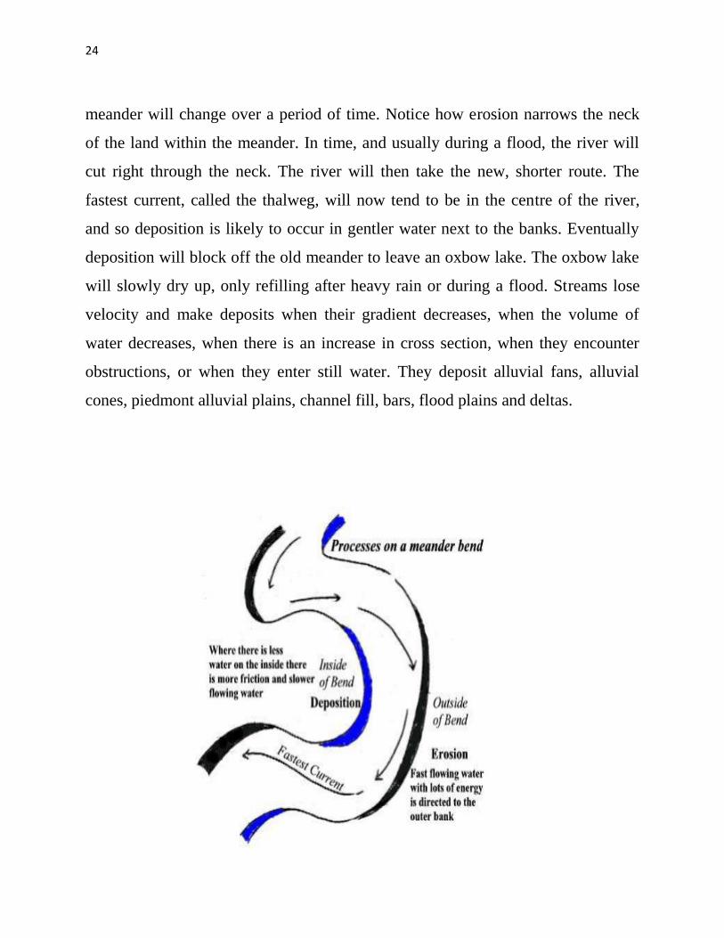
24
meander will change over a period of time Notice how erosion narrows the neck
of the land within the meander In time and usually during a flood the river will
cut right through the neck The river will then take the new shorter route The
fastest current called the thalweg will now tend to be in the centre of the river
and so deposition is likely to occur in gentler water next to the banks Eventually
deposition will block off the old meander to leave an oxbow lake The oxbow lake
will slowly dry up only refilling after heavy rain or during a flood Streams lose
velocity and make deposits when their gradient decreases when the volume of
water decreases when there is an increase in cross section when they encounter
obstructions or when they enter still water They deposit alluvial fans alluvial
cones piedmont alluvial plains channel fill bars flood plains and deltas
25
7 General Profile of the District
Bemetara city is well connected to Raipur Jabalpur Bilaspur Durg and
Kawardha by roadwaysNH-30 passes through the heart of city which is one of the
buissiest road in the stateThis highway connects state capital Raipur to one of the
major city of Madhya Pradesh JabalpurThere are two state highway passing
through Bemetara that are Durg to Bemetara and Kumhari - Bemetara ndash Mungeli
History
Comparatively a new district in Chhattisgarh India Bemetara district was
established as tahsil in the year 1907 along with the Mungeli (Bilaspur region)
This region is coloured by ever-widening importance in history since the time it
had been established However it is largest town amongst other town in the
scenario of land and population Owing to its suitability to being a district of
Chhattisgarh it had to wait to call upon since Kawardha has integrated
Conversely the Chhattisgarh government has realised its importance in central
CG Bemetara is an attractive tourist destination as villages like Bataar Mohbhatta
and Khamhariya are famous for their temples and lakes
dzekad
1 ftysdkdqyHkkSxksfy
d ks=Qy
2854-81 oxZfd-eh
2 vkkak oanskkak mRrjesa 21 22΄ ls 22003΄ mRrjhvkkaklsiwoZesa 81 07΄ ls81
055΄iwohZ nskakrj
3 leqnzrylsAringpkbZ 317 eh- vkSlr
4 vkSlrokkZ 2013-14 1234fe-eh- okfkZd
2014-15 1121-40fe-eh- okfkZd
2015-16 957-82fe-eh- okfkZd
5 rkieku vfkdreamp 48lsUVhxzsM
Uqureamp10lsUVhxzsM
26
6 ou ks=Qy
ljafkrou ks=gsDV- vkjfkrou ks= gsDV- voxhZd`rou
ks=gsDV-
dqyouks=
fujad fujad fujad fujad
7 unh rFkkukys River Shivnath Kharun Hanf Sakari SurahiampPhonk river
8 ioZr fujad
9 tula[k 795759 frac14tuxkuk 2011 ds vuqlkjfrac12Male Papulation 397650 amp Female Population
398109 11 lkkjrk frac1469-87frac12
12 rglhy
frac14fodkl[kMfrac12
05 - Nawagarh Bemetara Saja Than KhamhariaampBerla
13 uxjikfydk
uxjfuxe
02 ndash BemetaraampSaja
14 uxjiapkr 06 - Nawagarh Maro Bemetara Devkar Parpodi SajaThanKhamhariaampBerla
15 xzkeiapkr 387
Means of Transport
Bus Transport
Bemetara city is well connected to Raipur Jabalpur Bilaspur Durg and Kawardha
by roadwaysNH-30 A passes through the heart of city which is one of the busiest
road in the stateThis highway connects state capital Raipur to one of the major city
of Madhya Pradesh JabalpurThere are two state highway passing through
Bemetara that are Durg to Bemetara and Kumhari - Bemetara - Mungeli
Railway Transport
Bemetara is not connected by railway the nearest Railway station is tilde (35 km)
and major station is Raipur (66 km) and Durg is about 72 km
A new railway line is proposed in Bemetarawhich isDurg-Bemetara-Mungeli-
Bilaspur line
27
Air Transport
Nearest airport to the town is Swami Vivekananda International Airport
Raipur(IATA RPR ICAO VERP) which was formerly known as Mana Airport
which is 66 km from the city
28
8 Land Utilition Pattern in the district Forest Agriculture
Horticulture Mining etc
(i)Types of Soil-
Different type of soils are found in the District which is as follows-
i Red Soil (Bhata) Entisols
ii Sandy loams (Matasi) Inceptisols
iii Dorsa (Alfisols)
iv Black (Kanhar) vertisols
v Alluvial Soil (Kachhar)
(ii)Types of Forest-
oueMy
ljafkrou ks=gsDV- vkjfkrou ks= gsDV- voxhZd`rou ks=gsDV-
dqyouks=
ou
ks=Qy
fujad fujad fujad fujad
(iii)Details of Horticulture-
S No Particular Details Area in Hectare
1 Geographical Area of the District 285481Hect
2 Forest Area Nil
3 Total Kast Land Area 239566Hect
4 Land Covered by Gardening Crops 15373 Hect
5 Land Covered by Fruit Plants 2934 Hect
6 Land Covered by Vegetables Crop 10602 Hect
7 Land Covered by Masala 1535Hect
29
8 Land Covered by Flowers 185 Hect
9 Land Covered by Medicinal ampSented Plants 117 Hect
10 Percentage of Gardening Crops 872
(iv)Details of Agriculture-
S No Particular Details Area in Hectare
1 Geographical Area of the District 285481Hect
2 Forest Area Nil
3 Non-Agricultural Land 52770Hect
4 Duel Crop Area 94150 Hect
5 Total Kast Land Area 281523Hect
6 Kharif Crop Area 205270Hect
7 Ravi Crop Area 138560Hect
8 Area of Jayad 1200 Hect
9 Total Crop Area 232710Hect
Irrigation
The main source of irrigation in the district is River Shivnath Kharun Haff
SakariampSurahi etc There is no any big dam in the district
30
(v) Details of Ground Water Survey-
31
Climate-
Bemetara has a tropical wet and dry climate temperature remains moderate
throughout the year except from March to June which can be extremely hot The
temperature in AprilndashMay sometimes rises above 45 degCThese summer months
also have dry and hot winds In summers the temperature can also go up to 50 degC
The city receives about 1300 millimetres (51 in) of rain mostly in the monsoon
season from late June to early October Winters last from November to January
and are mild although lows can fall to 5 degC (41 degF)
Climate data for Bemetara City
Month Jan Feb Mar Apr May Jun Jul Aug Sep Oct Nov Dec Year
Average
high degC
(degF)
27
(81)
30
(86)
35
(95)
39
(102)
45
(113)
36
(97)
30
(86)
30
(86)
31
(88)
31
(88)
28
(82)
26
(79)
32
(90)
Average
low degC
(degF)
13
(55)
15
(59)
20
(68)
24
(75)
27
(81)
26
(79)
23
(73)
23
(73)
22
(72)
21
(70)
16
(61)
14
(57)
20
(68)
Average
precipita
tion mm
(inches)
10
(039)
17
(067)
14
(055)
13
(051)
18
(071)
239
(941)
383
(1508)
364
(1433)
197
(776)
50
(197)
11
(043)
16
(063)
1330
(5236)
32
9 Physiography of the District
Physiographically the area in Bemetara District having almost flat topographyThe
general slope of the district is towards the north - east in which direction the major
streams of the district flow
BEMETARA is located near the centre of a large plain sometimes referred as the
rice bowl of India where hundreds of varieties of rice are
grown The ShivnathRiverflows to the east of the city of bemetara and the
southern side has dense forests The Maikal Hills rise on the north-west of
Bemetara on the north the land rises and merges with the Chota Nagpur Plateau
which extends north-east across Jharkhand state On the south of Bemetara lies
the Deccan Plateau
33
34
10 Rainfall of District BemetaraYear wise
S No Year Average Rainfall (mm)
1 2012 99440
2 2013 123400
3 2014 112140
4 2015 95782
Rainfall of District Bemetara Month wise
Rainfall data for Bemetara City
Month Jan Feb Mar Apr May Jun Jul Aug Sep Oct Nov Dec Year
Average
precipita
tion mm
(inches)
10
(039)
17
(067)
14
(055)
13
(051)
18
(071)
239
(941)
383
(1508)
364
(1433)
197
(776)
50
(197)
11
(043)
16
(063)
1330
(5236)
35
36
11 Geology and Mineral Wealth
Geology-
Geologically the district comprises of rocks of the Meso-to Neo- Proterozoic
sequence is represented by the Chhattisgarh Supergroup Raipur Group comprises
Chandi formation Tarenga formation Hirri formation and Maniari formation
Chandi Formation of grey and purple stromatolitic limestone with
areniteferruginous sandstone intercalations (Deodongar member) Tarenga
Formation of greenish grey and reddish brown shale with chert porcellanite and
green clay interbands Hirri Formation by grey thinly to thickly bedded dolomite
and argillancous dolomite and ManairiFormationn comprises reddish brown and
purple non - calcareous shale with gypsum interbandsQuatrenary is represented
by pebble beds (Khamaria pebble bed)
37
38
Stratigraphic succession-
39
Mineral-
Mineral deposite of Bemetaradistrict include Dolomite Limestone Ordinary stone
Sand and Soil etc
Dolomite Mines
Total 27 Dolomite mines in which at present 3 dolomite is operational 13 dolomite
mine is under renewal and 11 dolomite mines is under lapse category
Limestone Mine
Total 03limestone mines in which at present 1limestone mine is operational and
rest 2 limestone mine is under renewal in the district
Ordinary Stone Mine
Total 01 ordinary stone mines is operational in the district
Soil Mine for Making Bricks
Total 34 soil mines in which at present 13 soil mine is operational and 21 soil mine
is under renewal varies part of the district
Sand Mine
Total 33 sand mines in which at present after Environmental NOC 12 sand mine is
operational 14 sand mine is under process to getting Environmental NOC from
SEIAA and 07sand mines has not submitted required documents for
Environmental Clearence till date
Sands are mostly available in Bank of River Shivnath Kharun Hanf
SakariSurahiampPhonkriver Quarry leases for sand mining are given in different
village of Bemetara district
40
Additional information of the district
Drainage System-
Shivnath
Sheonath is main river of District Bemetara Shivnathriver is tributary of Mahanadi
river Shivnathriver originates from Mountain at height of 625 meter at Panabaras
situated in south western parts of Rajnandgaon and flows towards north east
direction Shivnath River measures length about 345 KM City Durg is situated on
east bank of Shivnath River It flows towards north east passing through Khujji
Rajnandgaon Durg Dhamdha and Nandghat and joins (meet) Mahanadi near
Shivari Narayan of Bilaspur District
Kharun
Kharunriver flows in eastern parts of the district starting from Petechua in Balod
District This river flows towards north and joins (meet) ShivnathRiver at Somnath
near Simga This river determines the boundary of Raipur and Durg district The
length of this river is about 120 KM
41
42
Survey Report for Sand Mining of District Bemetara
This survey report is prepared for District Bemetara to identify the sustainable
mining area In District Bemetarathere are six rivers namely Shivnath Kharun
Haff Sakari SurahiampPhonkriver
All possible sand mining area has been surveyed The riverwise area surveyed and
identified for sand mining is given in the annexure
The thickness of sand load is considered average 4 meters in depth by observation
as well as local enquiry out of which up to depth of 3 meter is considered for
calculation of mineral potential
The mining area will be 10m away from the river bank and about 10m Influence
as safity barrier from the main streem will be left where mining operation will be
restricted Hence 10 m influence area from the main stream has been considered as
safity zone or non mining zone
It is considered that replenishment of sand in every monsoon season is a regular
process Based on the last five year observation it is experienced that average of
3m sand is replenished every year
Area Prohibited for Mining-
The following area will be prohibited for minng
i No mining activity will be executed 10 m from the river bank
ii Mining is prohibited within 10 m from the flow of the main stream
iii During mining measures should be taken to guide the flow to the centre
of the river to avoide erosion of banks
iv Mining area is restricted up to 500 mtsdown stream of any structure like
bridge diversion head work anicut etc
43
v Measures should be kept in consideration that the flow of river should not
be diverted or obstructed
vi The distance between two sand mining locations should be minimum 500
meters
vii Before permission of mining a suitable test of sand for construction
purpose like silt percentage fineness modulus etc must be obtained from
competent laboratory authority
viii Provision for plantation must be assured on the river bank of concerened
sand mining zone to protect erosion of banks and to
maintainesecobalance
Details are given bellow-
S No Name of River Ara Drained Sq KM Area
Drained in the
District in BemetaraDist Total
1 2 3 4 5
1 Shivnath River Sq km Sq km
2 Kharun River Sq km Sq km
3 Haff River Sq km Sq km
4 Sakari River
5 Surahi River
6 Phonk
Features of Important Rivers and Streams-
S No Name of the
River or Stream
Total Length in the
District (in km)
Place of origin Height of
origin
1 2 3 4 5
1 Shivnath River km Panabaras (Dist-
Rajnandgaon)
642 m
2 Kharun River km Kankalin (Petachuwa)
(Dist-Balod)
1 m
3 Haff River km Hils of Dallirajhara
(Banjaridih) (Dist- Balod
3 m
44
4 Sakari River
5 Surahi River
6 Phonk
Shivnath River
SNo Portion of the
River of
Stream
Recommended
for Mineral
Concession
Length of
area
recommended
for mineral
concession (in
kilometer)
Average
Width of area
Recommended
for mineral
concession (in
meters)
Area
recommended
for mineral
concession (in
meter)
Mineable
mineral
potential
(in metric
tonne) 60
of total
mineral
potential)
1 2 jsrtekoughagSA 3 jsrmiyCk ughagSA 4 jsrmiyCk ughagSA 5 jsrmiyCk ughagSA 6 orZekuesaikuhHkjkogSArhuokZiwoZjsr
[kuugksrkFkkjsrughagSA
ksxamp
Kharun River
SNo Portion of the
River of
Stream
Recommended
for Mineral
Concession
Length of
area
recommended
for mineral
concession (in
kilometer)
Average
Width of area
Recommended
for mineral
concession (in
meters)
Area
recommended
for mineral
concession (in
meter)
Mineable
mineral
potential
(in metric
tonne) 60
of total
mineral
potential)
1 ikuhHkjkogSA 2 ikuhHkjkogSA 3 ikuhHkjkogSA 4 ikuhHkjkogSA 5 ikuhHkjkogSA 6 ikuhHkjkogSA
45
ksxamp 0
Haff River
SNo Portion of the
River of
Stream
Recommended
for Mineral
Concession
Length of
area
recommended
for mineral
concession (in
kilometer)
Average
Width of area
Recommended
for mineral
concession (in
meters)
Area
recommended
for mineral
concession (in
meter)
Mineable
mineral
potential
(in metric
tonne) 60
of total
mineral
potential)
1 ikuhHkjkogSA 2 ikuhHkjkogSA 3 ikuhHkjkogSA 4 ikuhHkjkogSA 5 ikuhHkjkogSA 6 ikuhHkjkogSA ksxamp 0
Sakari River
SNo Portion of the
River of
Stream
Recommended
for Mineral
Concession
Length of
area
recommended
for mineral
concession (in
kilometer)
Average
Width of area
Recommended
for mineral
concession (in
meters)
Area
recommended
for mineral
concession (in
meter)
Mineable
mineral
potential
(in metric
tonne) 60
of total
mineral
potential)
1 ikuhHkjkogSA 2 ikuhHkjkogSA 3 ikuhHkjkogSA 4 ikuhHkjkogSA 5 ikuhHkjkogSA 6 ikuhHkjkogSA ksxamp 0
46
Surahi River
SNo Portion of the
River of
Stream
Recommended
for Mineral
Concession
Length of
area
recommended
for mineral
concession (in
kilometer)
Average
Width of area
Recommended
for mineral
concession (in
meters)
Area
recommended
for mineral
concession (in
meter)
Mineable
mineral
potential
(in metric
tonne) 60
of total
mineral
potential)
1 ikuhHkjkogSA 2 ikuhHkjkogSA 3 ikuhHkjkogSA 4 ikuhHkjkogSA 5 ikuhHkjkogSA 6 ikuhHkjkogSA ksxamp 0
Phonk River
SNo Portion of the
River of
Stream
Recommended
for Mineral
Concession
Length of
area
recommended
for mineral
concession (in
kilometer)
Average
Width of area
Recommended
for mineral
concession (in
meters)
Area
recommended
for mineral
concession (in
meter)
Mineable
mineral
potential
(in metric
tonne) 60
of total
mineral
potential)
1 ikuhHkjkogSA 2 ikuhHkjkogSA 3 ikuhHkjkogSA 4 ikuhHkjkogSA 5 ikuhHkjkogSA 6 ikuhHkjkogSA ksxamp 0
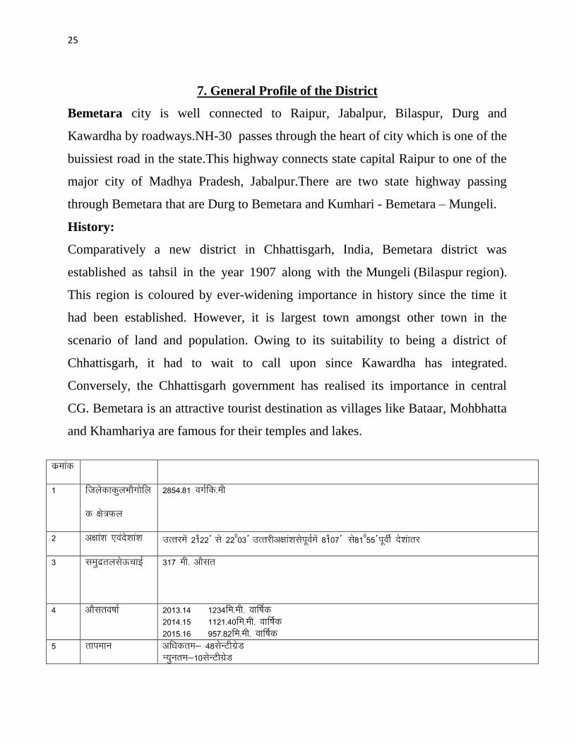

26
6 ou ks=Qy
ljafkrou ks=gsDV- vkjfkrou ks= gsDV- voxhZd`rou
ks=gsDV-
dqyouks=
fujad fujad fujad fujad
7 unh rFkkukys River Shivnath Kharun Hanf Sakari SurahiampPhonk river
8 ioZr fujad
9 tula[k 795759 frac14tuxkuk 2011 ds vuqlkjfrac12Male Papulation 397650 amp Female Population
398109 11 lkkjrk frac1469-87frac12
12 rglhy
frac14fodkl[kMfrac12
05 - Nawagarh Bemetara Saja Than KhamhariaampBerla
13 uxjikfydk
uxjfuxe
02 ndash BemetaraampSaja
14 uxjiapkr 06 - Nawagarh Maro Bemetara Devkar Parpodi SajaThanKhamhariaampBerla
15 xzkeiapkr 387
Means of Transport
Bus Transport
Bemetara city is well connected to Raipur Jabalpur Bilaspur Durg and Kawardha
by roadwaysNH-30 A passes through the heart of city which is one of the busiest
road in the stateThis highway connects state capital Raipur to one of the major city
of Madhya Pradesh JabalpurThere are two state highway passing through
Bemetara that are Durg to Bemetara and Kumhari - Bemetara - Mungeli
Railway Transport
Bemetara is not connected by railway the nearest Railway station is tilde (35 km)
and major station is Raipur (66 km) and Durg is about 72 km
A new railway line is proposed in Bemetarawhich isDurg-Bemetara-Mungeli-
Bilaspur line
27
Air Transport
Nearest airport to the town is Swami Vivekananda International Airport
Raipur(IATA RPR ICAO VERP) which was formerly known as Mana Airport
which is 66 km from the city
28
8 Land Utilition Pattern in the district Forest Agriculture
Horticulture Mining etc
(i)Types of Soil-
Different type of soils are found in the District which is as follows-
i Red Soil (Bhata) Entisols
ii Sandy loams (Matasi) Inceptisols
iii Dorsa (Alfisols)
iv Black (Kanhar) vertisols
v Alluvial Soil (Kachhar)
(ii)Types of Forest-
oueMy
ljafkrou ks=gsDV- vkjfkrou ks= gsDV- voxhZd`rou ks=gsDV-
dqyouks=
ou
ks=Qy
fujad fujad fujad fujad
(iii)Details of Horticulture-
S No Particular Details Area in Hectare
1 Geographical Area of the District 285481Hect
2 Forest Area Nil
3 Total Kast Land Area 239566Hect
4 Land Covered by Gardening Crops 15373 Hect
5 Land Covered by Fruit Plants 2934 Hect
6 Land Covered by Vegetables Crop 10602 Hect
7 Land Covered by Masala 1535Hect
29
8 Land Covered by Flowers 185 Hect
9 Land Covered by Medicinal ampSented Plants 117 Hect
10 Percentage of Gardening Crops 872
(iv)Details of Agriculture-
S No Particular Details Area in Hectare
1 Geographical Area of the District 285481Hect
2 Forest Area Nil
3 Non-Agricultural Land 52770Hect
4 Duel Crop Area 94150 Hect
5 Total Kast Land Area 281523Hect
6 Kharif Crop Area 205270Hect
7 Ravi Crop Area 138560Hect
8 Area of Jayad 1200 Hect
9 Total Crop Area 232710Hect
Irrigation
The main source of irrigation in the district is River Shivnath Kharun Haff
SakariampSurahi etc There is no any big dam in the district
30
(v) Details of Ground Water Survey-
31
Climate-
Bemetara has a tropical wet and dry climate temperature remains moderate
throughout the year except from March to June which can be extremely hot The
temperature in AprilndashMay sometimes rises above 45 degCThese summer months
also have dry and hot winds In summers the temperature can also go up to 50 degC
The city receives about 1300 millimetres (51 in) of rain mostly in the monsoon
season from late June to early October Winters last from November to January
and are mild although lows can fall to 5 degC (41 degF)
Climate data for Bemetara City
Month Jan Feb Mar Apr May Jun Jul Aug Sep Oct Nov Dec Year
Average
high degC
(degF)
27
(81)
30
(86)
35
(95)
39
(102)
45
(113)
36
(97)
30
(86)
30
(86)
31
(88)
31
(88)
28
(82)
26
(79)
32
(90)
Average
low degC
(degF)
13
(55)
15
(59)
20
(68)
24
(75)
27
(81)
26
(79)
23
(73)
23
(73)
22
(72)
21
(70)
16
(61)
14
(57)
20
(68)
Average
precipita
tion mm
(inches)
10
(039)
17
(067)
14
(055)
13
(051)
18
(071)
239
(941)
383
(1508)
364
(1433)
197
(776)
50
(197)
11
(043)
16
(063)
1330
(5236)
32
9 Physiography of the District
Physiographically the area in Bemetara District having almost flat topographyThe
general slope of the district is towards the north - east in which direction the major
streams of the district flow
BEMETARA is located near the centre of a large plain sometimes referred as the
rice bowl of India where hundreds of varieties of rice are
grown The ShivnathRiverflows to the east of the city of bemetara and the
southern side has dense forests The Maikal Hills rise on the north-west of
Bemetara on the north the land rises and merges with the Chota Nagpur Plateau
which extends north-east across Jharkhand state On the south of Bemetara lies
the Deccan Plateau
33
34
10 Rainfall of District BemetaraYear wise
S No Year Average Rainfall (mm)
1 2012 99440
2 2013 123400
3 2014 112140
4 2015 95782
Rainfall of District Bemetara Month wise
Rainfall data for Bemetara City
Month Jan Feb Mar Apr May Jun Jul Aug Sep Oct Nov Dec Year
Average
precipita
tion mm
(inches)
10
(039)
17
(067)
14
(055)
13
(051)
18
(071)
239
(941)
383
(1508)
364
(1433)
197
(776)
50
(197)
11
(043)
16
(063)
1330
(5236)
35
36
11 Geology and Mineral Wealth
Geology-
Geologically the district comprises of rocks of the Meso-to Neo- Proterozoic
sequence is represented by the Chhattisgarh Supergroup Raipur Group comprises
Chandi formation Tarenga formation Hirri formation and Maniari formation
Chandi Formation of grey and purple stromatolitic limestone with
areniteferruginous sandstone intercalations (Deodongar member) Tarenga
Formation of greenish grey and reddish brown shale with chert porcellanite and
green clay interbands Hirri Formation by grey thinly to thickly bedded dolomite
and argillancous dolomite and ManairiFormationn comprises reddish brown and
purple non - calcareous shale with gypsum interbandsQuatrenary is represented
by pebble beds (Khamaria pebble bed)
37
38
Stratigraphic succession-
39
Mineral-
Mineral deposite of Bemetaradistrict include Dolomite Limestone Ordinary stone
Sand and Soil etc
Dolomite Mines
Total 27 Dolomite mines in which at present 3 dolomite is operational 13 dolomite
mine is under renewal and 11 dolomite mines is under lapse category
Limestone Mine
Total 03limestone mines in which at present 1limestone mine is operational and
rest 2 limestone mine is under renewal in the district
Ordinary Stone Mine
Total 01 ordinary stone mines is operational in the district
Soil Mine for Making Bricks
Total 34 soil mines in which at present 13 soil mine is operational and 21 soil mine
is under renewal varies part of the district
Sand Mine
Total 33 sand mines in which at present after Environmental NOC 12 sand mine is
operational 14 sand mine is under process to getting Environmental NOC from
SEIAA and 07sand mines has not submitted required documents for
Environmental Clearence till date
Sands are mostly available in Bank of River Shivnath Kharun Hanf
SakariSurahiampPhonkriver Quarry leases for sand mining are given in different
village of Bemetara district
40
Additional information of the district
Drainage System-
Shivnath
Sheonath is main river of District Bemetara Shivnathriver is tributary of Mahanadi
river Shivnathriver originates from Mountain at height of 625 meter at Panabaras
situated in south western parts of Rajnandgaon and flows towards north east
direction Shivnath River measures length about 345 KM City Durg is situated on
east bank of Shivnath River It flows towards north east passing through Khujji
Rajnandgaon Durg Dhamdha and Nandghat and joins (meet) Mahanadi near
Shivari Narayan of Bilaspur District
Kharun
Kharunriver flows in eastern parts of the district starting from Petechua in Balod
District This river flows towards north and joins (meet) ShivnathRiver at Somnath
near Simga This river determines the boundary of Raipur and Durg district The
length of this river is about 120 KM
41
42
Survey Report for Sand Mining of District Bemetara
This survey report is prepared for District Bemetara to identify the sustainable
mining area In District Bemetarathere are six rivers namely Shivnath Kharun
Haff Sakari SurahiampPhonkriver
All possible sand mining area has been surveyed The riverwise area surveyed and
identified for sand mining is given in the annexure
The thickness of sand load is considered average 4 meters in depth by observation
as well as local enquiry out of which up to depth of 3 meter is considered for
calculation of mineral potential
The mining area will be 10m away from the river bank and about 10m Influence
as safity barrier from the main streem will be left where mining operation will be
restricted Hence 10 m influence area from the main stream has been considered as
safity zone or non mining zone
It is considered that replenishment of sand in every monsoon season is a regular
process Based on the last five year observation it is experienced that average of
3m sand is replenished every year
Area Prohibited for Mining-
The following area will be prohibited for minng
i No mining activity will be executed 10 m from the river bank
ii Mining is prohibited within 10 m from the flow of the main stream
iii During mining measures should be taken to guide the flow to the centre
of the river to avoide erosion of banks
iv Mining area is restricted up to 500 mtsdown stream of any structure like
bridge diversion head work anicut etc
43
v Measures should be kept in consideration that the flow of river should not
be diverted or obstructed
vi The distance between two sand mining locations should be minimum 500
meters
vii Before permission of mining a suitable test of sand for construction
purpose like silt percentage fineness modulus etc must be obtained from
competent laboratory authority
viii Provision for plantation must be assured on the river bank of concerened
sand mining zone to protect erosion of banks and to
maintainesecobalance
Details are given bellow-
S No Name of River Ara Drained Sq KM Area
Drained in the
District in BemetaraDist Total
1 2 3 4 5
1 Shivnath River Sq km Sq km
2 Kharun River Sq km Sq km
3 Haff River Sq km Sq km
4 Sakari River
5 Surahi River
6 Phonk
Features of Important Rivers and Streams-
S No Name of the
River or Stream
Total Length in the
District (in km)
Place of origin Height of
origin
1 2 3 4 5
1 Shivnath River km Panabaras (Dist-
Rajnandgaon)
642 m
2 Kharun River km Kankalin (Petachuwa)
(Dist-Balod)
1 m
3 Haff River km Hils of Dallirajhara
(Banjaridih) (Dist- Balod
3 m
44
4 Sakari River
5 Surahi River
6 Phonk
Shivnath River
SNo Portion of the
River of
Stream
Recommended
for Mineral
Concession
Length of
area
recommended
for mineral
concession (in
kilometer)
Average
Width of area
Recommended
for mineral
concession (in
meters)
Area
recommended
for mineral
concession (in
meter)
Mineable
mineral
potential
(in metric
tonne) 60
of total
mineral
potential)
1 2 jsrtekoughagSA 3 jsrmiyCk ughagSA 4 jsrmiyCk ughagSA 5 jsrmiyCk ughagSA 6 orZekuesaikuhHkjkogSArhuokZiwoZjsr
[kuugksrkFkkjsrughagSA
ksxamp
Kharun River
SNo Portion of the
River of
Stream
Recommended
for Mineral
Concession
Length of
area
recommended
for mineral
concession (in
kilometer)
Average
Width of area
Recommended
for mineral
concession (in
meters)
Area
recommended
for mineral
concession (in
meter)
Mineable
mineral
potential
(in metric
tonne) 60
of total
mineral
potential)
1 ikuhHkjkogSA 2 ikuhHkjkogSA 3 ikuhHkjkogSA 4 ikuhHkjkogSA 5 ikuhHkjkogSA 6 ikuhHkjkogSA
45
ksxamp 0
Haff River
SNo Portion of the
River of
Stream
Recommended
for Mineral
Concession
Length of
area
recommended
for mineral
concession (in
kilometer)
Average
Width of area
Recommended
for mineral
concession (in
meters)
Area
recommended
for mineral
concession (in
meter)
Mineable
mineral
potential
(in metric
tonne) 60
of total
mineral
potential)
1 ikuhHkjkogSA 2 ikuhHkjkogSA 3 ikuhHkjkogSA 4 ikuhHkjkogSA 5 ikuhHkjkogSA 6 ikuhHkjkogSA ksxamp 0
Sakari River
SNo Portion of the
River of
Stream
Recommended
for Mineral
Concession
Length of
area
recommended
for mineral
concession (in
kilometer)
Average
Width of area
Recommended
for mineral
concession (in
meters)
Area
recommended
for mineral
concession (in
meter)
Mineable
mineral
potential
(in metric
tonne) 60
of total
mineral
potential)
1 ikuhHkjkogSA 2 ikuhHkjkogSA 3 ikuhHkjkogSA 4 ikuhHkjkogSA 5 ikuhHkjkogSA 6 ikuhHkjkogSA ksxamp 0
46
Surahi River
SNo Portion of the
River of
Stream
Recommended
for Mineral
Concession
Length of
area
recommended
for mineral
concession (in
kilometer)
Average
Width of area
Recommended
for mineral
concession (in
meters)
Area
recommended
for mineral
concession (in
meter)
Mineable
mineral
potential
(in metric
tonne) 60
of total
mineral
potential)
1 ikuhHkjkogSA 2 ikuhHkjkogSA 3 ikuhHkjkogSA 4 ikuhHkjkogSA 5 ikuhHkjkogSA 6 ikuhHkjkogSA ksxamp 0
Phonk River
SNo Portion of the
River of
Stream
Recommended
for Mineral
Concession
Length of
area
recommended
for mineral
concession (in
kilometer)
Average
Width of area
Recommended
for mineral
concession (in
meters)
Area
recommended
for mineral
concession (in
meter)
Mineable
mineral
potential
(in metric
tonne) 60
of total
mineral
potential)
1 ikuhHkjkogSA 2 ikuhHkjkogSA 3 ikuhHkjkogSA 4 ikuhHkjkogSA 5 ikuhHkjkogSA 6 ikuhHkjkogSA ksxamp 0

27
Air Transport
Nearest airport to the town is Swami Vivekananda International Airport
Raipur(IATA RPR ICAO VERP) which was formerly known as Mana Airport
which is 66 km from the city
28
8 Land Utilition Pattern in the district Forest Agriculture
Horticulture Mining etc
(i)Types of Soil-
Different type of soils are found in the District which is as follows-
i Red Soil (Bhata) Entisols
ii Sandy loams (Matasi) Inceptisols
iii Dorsa (Alfisols)
iv Black (Kanhar) vertisols
v Alluvial Soil (Kachhar)
(ii)Types of Forest-
oueMy
ljafkrou ks=gsDV- vkjfkrou ks= gsDV- voxhZd`rou ks=gsDV-
dqyouks=
ou
ks=Qy
fujad fujad fujad fujad
(iii)Details of Horticulture-
S No Particular Details Area in Hectare
1 Geographical Area of the District 285481Hect
2 Forest Area Nil
3 Total Kast Land Area 239566Hect
4 Land Covered by Gardening Crops 15373 Hect
5 Land Covered by Fruit Plants 2934 Hect
6 Land Covered by Vegetables Crop 10602 Hect
7 Land Covered by Masala 1535Hect
29
8 Land Covered by Flowers 185 Hect
9 Land Covered by Medicinal ampSented Plants 117 Hect
10 Percentage of Gardening Crops 872
(iv)Details of Agriculture-
S No Particular Details Area in Hectare
1 Geographical Area of the District 285481Hect
2 Forest Area Nil
3 Non-Agricultural Land 52770Hect
4 Duel Crop Area 94150 Hect
5 Total Kast Land Area 281523Hect
6 Kharif Crop Area 205270Hect
7 Ravi Crop Area 138560Hect
8 Area of Jayad 1200 Hect
9 Total Crop Area 232710Hect
Irrigation
The main source of irrigation in the district is River Shivnath Kharun Haff
SakariampSurahi etc There is no any big dam in the district
30
(v) Details of Ground Water Survey-
31
Climate-
Bemetara has a tropical wet and dry climate temperature remains moderate
throughout the year except from March to June which can be extremely hot The
temperature in AprilndashMay sometimes rises above 45 degCThese summer months
also have dry and hot winds In summers the temperature can also go up to 50 degC
The city receives about 1300 millimetres (51 in) of rain mostly in the monsoon
season from late June to early October Winters last from November to January
and are mild although lows can fall to 5 degC (41 degF)
Climate data for Bemetara City
Month Jan Feb Mar Apr May Jun Jul Aug Sep Oct Nov Dec Year
Average
high degC
(degF)
27
(81)
30
(86)
35
(95)
39
(102)
45
(113)
36
(97)
30
(86)
30
(86)
31
(88)
31
(88)
28
(82)
26
(79)
32
(90)
Average
low degC
(degF)
13
(55)
15
(59)
20
(68)
24
(75)
27
(81)
26
(79)
23
(73)
23
(73)
22
(72)
21
(70)
16
(61)
14
(57)
20
(68)
Average
precipita
tion mm
(inches)
10
(039)
17
(067)
14
(055)
13
(051)
18
(071)
239
(941)
383
(1508)
364
(1433)
197
(776)
50
(197)
11
(043)
16
(063)
1330
(5236)
32
9 Physiography of the District
Physiographically the area in Bemetara District having almost flat topographyThe
general slope of the district is towards the north - east in which direction the major
streams of the district flow
BEMETARA is located near the centre of a large plain sometimes referred as the
rice bowl of India where hundreds of varieties of rice are
grown The ShivnathRiverflows to the east of the city of bemetara and the
southern side has dense forests The Maikal Hills rise on the north-west of
Bemetara on the north the land rises and merges with the Chota Nagpur Plateau
which extends north-east across Jharkhand state On the south of Bemetara lies
the Deccan Plateau
33
34
10 Rainfall of District BemetaraYear wise
S No Year Average Rainfall (mm)
1 2012 99440
2 2013 123400
3 2014 112140
4 2015 95782
Rainfall of District Bemetara Month wise
Rainfall data for Bemetara City
Month Jan Feb Mar Apr May Jun Jul Aug Sep Oct Nov Dec Year
Average
precipita
tion mm
(inches)
10
(039)
17
(067)
14
(055)
13
(051)
18
(071)
239
(941)
383
(1508)
364
(1433)
197
(776)
50
(197)
11
(043)
16
(063)
1330
(5236)
35
36
11 Geology and Mineral Wealth
Geology-
Geologically the district comprises of rocks of the Meso-to Neo- Proterozoic
sequence is represented by the Chhattisgarh Supergroup Raipur Group comprises
Chandi formation Tarenga formation Hirri formation and Maniari formation
Chandi Formation of grey and purple stromatolitic limestone with
areniteferruginous sandstone intercalations (Deodongar member) Tarenga
Formation of greenish grey and reddish brown shale with chert porcellanite and
green clay interbands Hirri Formation by grey thinly to thickly bedded dolomite
and argillancous dolomite and ManairiFormationn comprises reddish brown and
purple non - calcareous shale with gypsum interbandsQuatrenary is represented
by pebble beds (Khamaria pebble bed)
37
38
Stratigraphic succession-
39
Mineral-
Mineral deposite of Bemetaradistrict include Dolomite Limestone Ordinary stone
Sand and Soil etc
Dolomite Mines
Total 27 Dolomite mines in which at present 3 dolomite is operational 13 dolomite
mine is under renewal and 11 dolomite mines is under lapse category
Limestone Mine
Total 03limestone mines in which at present 1limestone mine is operational and
rest 2 limestone mine is under renewal in the district
Ordinary Stone Mine
Total 01 ordinary stone mines is operational in the district
Soil Mine for Making Bricks
Total 34 soil mines in which at present 13 soil mine is operational and 21 soil mine
is under renewal varies part of the district
Sand Mine
Total 33 sand mines in which at present after Environmental NOC 12 sand mine is
operational 14 sand mine is under process to getting Environmental NOC from
SEIAA and 07sand mines has not submitted required documents for
Environmental Clearence till date
Sands are mostly available in Bank of River Shivnath Kharun Hanf
SakariSurahiampPhonkriver Quarry leases for sand mining are given in different
village of Bemetara district
40
Additional information of the district
Drainage System-
Shivnath
Sheonath is main river of District Bemetara Shivnathriver is tributary of Mahanadi
river Shivnathriver originates from Mountain at height of 625 meter at Panabaras
situated in south western parts of Rajnandgaon and flows towards north east
direction Shivnath River measures length about 345 KM City Durg is situated on
east bank of Shivnath River It flows towards north east passing through Khujji
Rajnandgaon Durg Dhamdha and Nandghat and joins (meet) Mahanadi near
Shivari Narayan of Bilaspur District
Kharun
Kharunriver flows in eastern parts of the district starting from Petechua in Balod
District This river flows towards north and joins (meet) ShivnathRiver at Somnath
near Simga This river determines the boundary of Raipur and Durg district The
length of this river is about 120 KM
41
42
Survey Report for Sand Mining of District Bemetara
This survey report is prepared for District Bemetara to identify the sustainable
mining area In District Bemetarathere are six rivers namely Shivnath Kharun
Haff Sakari SurahiampPhonkriver
All possible sand mining area has been surveyed The riverwise area surveyed and
identified for sand mining is given in the annexure
The thickness of sand load is considered average 4 meters in depth by observation
as well as local enquiry out of which up to depth of 3 meter is considered for
calculation of mineral potential
The mining area will be 10m away from the river bank and about 10m Influence
as safity barrier from the main streem will be left where mining operation will be
restricted Hence 10 m influence area from the main stream has been considered as
safity zone or non mining zone
It is considered that replenishment of sand in every monsoon season is a regular
process Based on the last five year observation it is experienced that average of
3m sand is replenished every year
Area Prohibited for Mining-
The following area will be prohibited for minng
i No mining activity will be executed 10 m from the river bank
ii Mining is prohibited within 10 m from the flow of the main stream
iii During mining measures should be taken to guide the flow to the centre
of the river to avoide erosion of banks
iv Mining area is restricted up to 500 mtsdown stream of any structure like
bridge diversion head work anicut etc
43
v Measures should be kept in consideration that the flow of river should not
be diverted or obstructed
vi The distance between two sand mining locations should be minimum 500
meters
vii Before permission of mining a suitable test of sand for construction
purpose like silt percentage fineness modulus etc must be obtained from
competent laboratory authority
viii Provision for plantation must be assured on the river bank of concerened
sand mining zone to protect erosion of banks and to
maintainesecobalance
Details are given bellow-
S No Name of River Ara Drained Sq KM Area
Drained in the
District in BemetaraDist Total
1 2 3 4 5
1 Shivnath River Sq km Sq km
2 Kharun River Sq km Sq km
3 Haff River Sq km Sq km
4 Sakari River
5 Surahi River
6 Phonk
Features of Important Rivers and Streams-
S No Name of the
River or Stream
Total Length in the
District (in km)
Place of origin Height of
origin
1 2 3 4 5
1 Shivnath River km Panabaras (Dist-
Rajnandgaon)
642 m
2 Kharun River km Kankalin (Petachuwa)
(Dist-Balod)
1 m
3 Haff River km Hils of Dallirajhara
(Banjaridih) (Dist- Balod
3 m
44
4 Sakari River
5 Surahi River
6 Phonk
Shivnath River
SNo Portion of the
River of
Stream
Recommended
for Mineral
Concession
Length of
area
recommended
for mineral
concession (in
kilometer)
Average
Width of area
Recommended
for mineral
concession (in
meters)
Area
recommended
for mineral
concession (in
meter)
Mineable
mineral
potential
(in metric
tonne) 60
of total
mineral
potential)
1 2 jsrtekoughagSA 3 jsrmiyCk ughagSA 4 jsrmiyCk ughagSA 5 jsrmiyCk ughagSA 6 orZekuesaikuhHkjkogSArhuokZiwoZjsr
[kuugksrkFkkjsrughagSA
ksxamp
Kharun River
SNo Portion of the
River of
Stream
Recommended
for Mineral
Concession
Length of
area
recommended
for mineral
concession (in
kilometer)
Average
Width of area
Recommended
for mineral
concession (in
meters)
Area
recommended
for mineral
concession (in
meter)
Mineable
mineral
potential
(in metric
tonne) 60
of total
mineral
potential)
1 ikuhHkjkogSA 2 ikuhHkjkogSA 3 ikuhHkjkogSA 4 ikuhHkjkogSA 5 ikuhHkjkogSA 6 ikuhHkjkogSA
45
ksxamp 0
Haff River
SNo Portion of the
River of
Stream
Recommended
for Mineral
Concession
Length of
area
recommended
for mineral
concession (in
kilometer)
Average
Width of area
Recommended
for mineral
concession (in
meters)
Area
recommended
for mineral
concession (in
meter)
Mineable
mineral
potential
(in metric
tonne) 60
of total
mineral
potential)
1 ikuhHkjkogSA 2 ikuhHkjkogSA 3 ikuhHkjkogSA 4 ikuhHkjkogSA 5 ikuhHkjkogSA 6 ikuhHkjkogSA ksxamp 0
Sakari River
SNo Portion of the
River of
Stream
Recommended
for Mineral
Concession
Length of
area
recommended
for mineral
concession (in
kilometer)
Average
Width of area
Recommended
for mineral
concession (in
meters)
Area
recommended
for mineral
concession (in
meter)
Mineable
mineral
potential
(in metric
tonne) 60
of total
mineral
potential)
1 ikuhHkjkogSA 2 ikuhHkjkogSA 3 ikuhHkjkogSA 4 ikuhHkjkogSA 5 ikuhHkjkogSA 6 ikuhHkjkogSA ksxamp 0
46
Surahi River
SNo Portion of the
River of
Stream
Recommended
for Mineral
Concession
Length of
area
recommended
for mineral
concession (in
kilometer)
Average
Width of area
Recommended
for mineral
concession (in
meters)
Area
recommended
for mineral
concession (in
meter)
Mineable
mineral
potential
(in metric
tonne) 60
of total
mineral
potential)
1 ikuhHkjkogSA 2 ikuhHkjkogSA 3 ikuhHkjkogSA 4 ikuhHkjkogSA 5 ikuhHkjkogSA 6 ikuhHkjkogSA ksxamp 0
Phonk River
SNo Portion of the
River of
Stream
Recommended
for Mineral
Concession
Length of
area
recommended
for mineral
concession (in
kilometer)
Average
Width of area
Recommended
for mineral
concession (in
meters)
Area
recommended
for mineral
concession (in
meter)
Mineable
mineral
potential
(in metric
tonne) 60
of total
mineral
potential)
1 ikuhHkjkogSA 2 ikuhHkjkogSA 3 ikuhHkjkogSA 4 ikuhHkjkogSA 5 ikuhHkjkogSA 6 ikuhHkjkogSA ksxamp 0
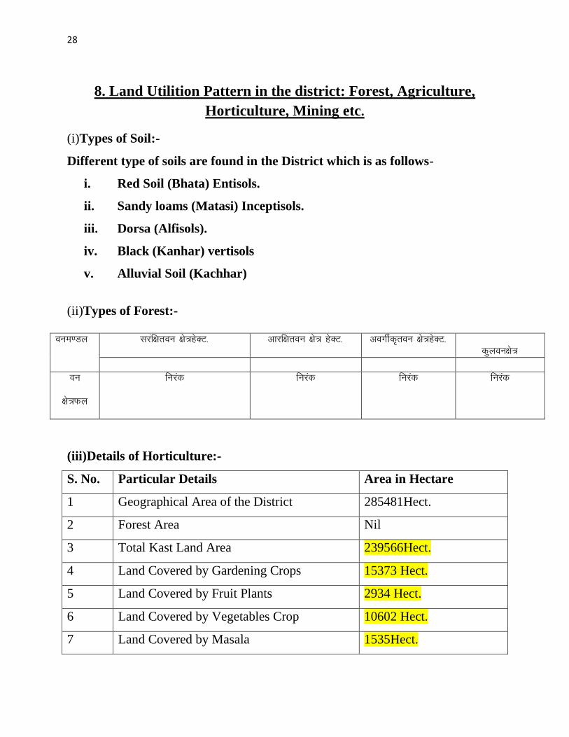
28
8 Land Utilition Pattern in the district Forest Agriculture
Horticulture Mining etc
(i)Types of Soil-
Different type of soils are found in the District which is as follows-
i Red Soil (Bhata) Entisols
ii Sandy loams (Matasi) Inceptisols
iii Dorsa (Alfisols)
iv Black (Kanhar) vertisols
v Alluvial Soil (Kachhar)
(ii)Types of Forest-
oueMy
ljafkrou ks=gsDV- vkjfkrou ks= gsDV- voxhZd`rou ks=gsDV-
dqyouks=
ou
ks=Qy
fujad fujad fujad fujad
(iii)Details of Horticulture-
S No Particular Details Area in Hectare
1 Geographical Area of the District 285481Hect
2 Forest Area Nil
3 Total Kast Land Area 239566Hect
4 Land Covered by Gardening Crops 15373 Hect
5 Land Covered by Fruit Plants 2934 Hect
6 Land Covered by Vegetables Crop 10602 Hect
7 Land Covered by Masala 1535Hect
29
8 Land Covered by Flowers 185 Hect
9 Land Covered by Medicinal ampSented Plants 117 Hect
10 Percentage of Gardening Crops 872
(iv)Details of Agriculture-
S No Particular Details Area in Hectare
1 Geographical Area of the District 285481Hect
2 Forest Area Nil
3 Non-Agricultural Land 52770Hect
4 Duel Crop Area 94150 Hect
5 Total Kast Land Area 281523Hect
6 Kharif Crop Area 205270Hect
7 Ravi Crop Area 138560Hect
8 Area of Jayad 1200 Hect
9 Total Crop Area 232710Hect
Irrigation
The main source of irrigation in the district is River Shivnath Kharun Haff
SakariampSurahi etc There is no any big dam in the district
30
(v) Details of Ground Water Survey-
31
Climate-
Bemetara has a tropical wet and dry climate temperature remains moderate
throughout the year except from March to June which can be extremely hot The
temperature in AprilndashMay sometimes rises above 45 degCThese summer months
also have dry and hot winds In summers the temperature can also go up to 50 degC
The city receives about 1300 millimetres (51 in) of rain mostly in the monsoon
season from late June to early October Winters last from November to January
and are mild although lows can fall to 5 degC (41 degF)
Climate data for Bemetara City
Month Jan Feb Mar Apr May Jun Jul Aug Sep Oct Nov Dec Year
Average
high degC
(degF)
27
(81)
30
(86)
35
(95)
39
(102)
45
(113)
36
(97)
30
(86)
30
(86)
31
(88)
31
(88)
28
(82)
26
(79)
32
(90)
Average
low degC
(degF)
13
(55)
15
(59)
20
(68)
24
(75)
27
(81)
26
(79)
23
(73)
23
(73)
22
(72)
21
(70)
16
(61)
14
(57)
20
(68)
Average
precipita
tion mm
(inches)
10
(039)
17
(067)
14
(055)
13
(051)
18
(071)
239
(941)
383
(1508)
364
(1433)
197
(776)
50
(197)
11
(043)
16
(063)
1330
(5236)
32
9 Physiography of the District
Physiographically the area in Bemetara District having almost flat topographyThe
general slope of the district is towards the north - east in which direction the major
streams of the district flow
BEMETARA is located near the centre of a large plain sometimes referred as the
rice bowl of India where hundreds of varieties of rice are
grown The ShivnathRiverflows to the east of the city of bemetara and the
southern side has dense forests The Maikal Hills rise on the north-west of
Bemetara on the north the land rises and merges with the Chota Nagpur Plateau
which extends north-east across Jharkhand state On the south of Bemetara lies
the Deccan Plateau
33
34
10 Rainfall of District BemetaraYear wise
S No Year Average Rainfall (mm)
1 2012 99440
2 2013 123400
3 2014 112140
4 2015 95782
Rainfall of District Bemetara Month wise
Rainfall data for Bemetara City
Month Jan Feb Mar Apr May Jun Jul Aug Sep Oct Nov Dec Year
Average
precipita
tion mm
(inches)
10
(039)
17
(067)
14
(055)
13
(051)
18
(071)
239
(941)
383
(1508)
364
(1433)
197
(776)
50
(197)
11
(043)
16
(063)
1330
(5236)
35
36
11 Geology and Mineral Wealth
Geology-
Geologically the district comprises of rocks of the Meso-to Neo- Proterozoic
sequence is represented by the Chhattisgarh Supergroup Raipur Group comprises
Chandi formation Tarenga formation Hirri formation and Maniari formation
Chandi Formation of grey and purple stromatolitic limestone with
areniteferruginous sandstone intercalations (Deodongar member) Tarenga
Formation of greenish grey and reddish brown shale with chert porcellanite and
green clay interbands Hirri Formation by grey thinly to thickly bedded dolomite
and argillancous dolomite and ManairiFormationn comprises reddish brown and
purple non - calcareous shale with gypsum interbandsQuatrenary is represented
by pebble beds (Khamaria pebble bed)
37
38
Stratigraphic succession-
39
Mineral-
Mineral deposite of Bemetaradistrict include Dolomite Limestone Ordinary stone
Sand and Soil etc
Dolomite Mines
Total 27 Dolomite mines in which at present 3 dolomite is operational 13 dolomite
mine is under renewal and 11 dolomite mines is under lapse category
Limestone Mine
Total 03limestone mines in which at present 1limestone mine is operational and
rest 2 limestone mine is under renewal in the district
Ordinary Stone Mine
Total 01 ordinary stone mines is operational in the district
Soil Mine for Making Bricks
Total 34 soil mines in which at present 13 soil mine is operational and 21 soil mine
is under renewal varies part of the district
Sand Mine
Total 33 sand mines in which at present after Environmental NOC 12 sand mine is
operational 14 sand mine is under process to getting Environmental NOC from
SEIAA and 07sand mines has not submitted required documents for
Environmental Clearence till date
Sands are mostly available in Bank of River Shivnath Kharun Hanf
SakariSurahiampPhonkriver Quarry leases for sand mining are given in different
village of Bemetara district
40
Additional information of the district
Drainage System-
Shivnath
Sheonath is main river of District Bemetara Shivnathriver is tributary of Mahanadi
river Shivnathriver originates from Mountain at height of 625 meter at Panabaras
situated in south western parts of Rajnandgaon and flows towards north east
direction Shivnath River measures length about 345 KM City Durg is situated on
east bank of Shivnath River It flows towards north east passing through Khujji
Rajnandgaon Durg Dhamdha and Nandghat and joins (meet) Mahanadi near
Shivari Narayan of Bilaspur District
Kharun
Kharunriver flows in eastern parts of the district starting from Petechua in Balod
District This river flows towards north and joins (meet) ShivnathRiver at Somnath
near Simga This river determines the boundary of Raipur and Durg district The
length of this river is about 120 KM
41
42
Survey Report for Sand Mining of District Bemetara
This survey report is prepared for District Bemetara to identify the sustainable
mining area In District Bemetarathere are six rivers namely Shivnath Kharun
Haff Sakari SurahiampPhonkriver
All possible sand mining area has been surveyed The riverwise area surveyed and
identified for sand mining is given in the annexure
The thickness of sand load is considered average 4 meters in depth by observation
as well as local enquiry out of which up to depth of 3 meter is considered for
calculation of mineral potential
The mining area will be 10m away from the river bank and about 10m Influence
as safity barrier from the main streem will be left where mining operation will be
restricted Hence 10 m influence area from the main stream has been considered as
safity zone or non mining zone
It is considered that replenishment of sand in every monsoon season is a regular
process Based on the last five year observation it is experienced that average of
3m sand is replenished every year
Area Prohibited for Mining-
The following area will be prohibited for minng
i No mining activity will be executed 10 m from the river bank
ii Mining is prohibited within 10 m from the flow of the main stream
iii During mining measures should be taken to guide the flow to the centre
of the river to avoide erosion of banks
iv Mining area is restricted up to 500 mtsdown stream of any structure like
bridge diversion head work anicut etc
43
v Measures should be kept in consideration that the flow of river should not
be diverted or obstructed
vi The distance between two sand mining locations should be minimum 500
meters
vii Before permission of mining a suitable test of sand for construction
purpose like silt percentage fineness modulus etc must be obtained from
competent laboratory authority
viii Provision for plantation must be assured on the river bank of concerened
sand mining zone to protect erosion of banks and to
maintainesecobalance
Details are given bellow-
S No Name of River Ara Drained Sq KM Area
Drained in the
District in BemetaraDist Total
1 2 3 4 5
1 Shivnath River Sq km Sq km
2 Kharun River Sq km Sq km
3 Haff River Sq km Sq km
4 Sakari River
5 Surahi River
6 Phonk
Features of Important Rivers and Streams-
S No Name of the
River or Stream
Total Length in the
District (in km)
Place of origin Height of
origin
1 2 3 4 5
1 Shivnath River km Panabaras (Dist-
Rajnandgaon)
642 m
2 Kharun River km Kankalin (Petachuwa)
(Dist-Balod)
1 m
3 Haff River km Hils of Dallirajhara
(Banjaridih) (Dist- Balod
3 m
44
4 Sakari River
5 Surahi River
6 Phonk
Shivnath River
SNo Portion of the
River of
Stream
Recommended
for Mineral
Concession
Length of
area
recommended
for mineral
concession (in
kilometer)
Average
Width of area
Recommended
for mineral
concession (in
meters)
Area
recommended
for mineral
concession (in
meter)
Mineable
mineral
potential
(in metric
tonne) 60
of total
mineral
potential)
1 2 jsrtekoughagSA 3 jsrmiyCk ughagSA 4 jsrmiyCk ughagSA 5 jsrmiyCk ughagSA 6 orZekuesaikuhHkjkogSArhuokZiwoZjsr
[kuugksrkFkkjsrughagSA
ksxamp
Kharun River
SNo Portion of the
River of
Stream
Recommended
for Mineral
Concession
Length of
area
recommended
for mineral
concession (in
kilometer)
Average
Width of area
Recommended
for mineral
concession (in
meters)
Area
recommended
for mineral
concession (in
meter)
Mineable
mineral
potential
(in metric
tonne) 60
of total
mineral
potential)
1 ikuhHkjkogSA 2 ikuhHkjkogSA 3 ikuhHkjkogSA 4 ikuhHkjkogSA 5 ikuhHkjkogSA 6 ikuhHkjkogSA
45
ksxamp 0
Haff River
SNo Portion of the
River of
Stream
Recommended
for Mineral
Concession
Length of
area
recommended
for mineral
concession (in
kilometer)
Average
Width of area
Recommended
for mineral
concession (in
meters)
Area
recommended
for mineral
concession (in
meter)
Mineable
mineral
potential
(in metric
tonne) 60
of total
mineral
potential)
1 ikuhHkjkogSA 2 ikuhHkjkogSA 3 ikuhHkjkogSA 4 ikuhHkjkogSA 5 ikuhHkjkogSA 6 ikuhHkjkogSA ksxamp 0
Sakari River
SNo Portion of the
River of
Stream
Recommended
for Mineral
Concession
Length of
area
recommended
for mineral
concession (in
kilometer)
Average
Width of area
Recommended
for mineral
concession (in
meters)
Area
recommended
for mineral
concession (in
meter)
Mineable
mineral
potential
(in metric
tonne) 60
of total
mineral
potential)
1 ikuhHkjkogSA 2 ikuhHkjkogSA 3 ikuhHkjkogSA 4 ikuhHkjkogSA 5 ikuhHkjkogSA 6 ikuhHkjkogSA ksxamp 0
46
Surahi River
SNo Portion of the
River of
Stream
Recommended
for Mineral
Concession
Length of
area
recommended
for mineral
concession (in
kilometer)
Average
Width of area
Recommended
for mineral
concession (in
meters)
Area
recommended
for mineral
concession (in
meter)
Mineable
mineral
potential
(in metric
tonne) 60
of total
mineral
potential)
1 ikuhHkjkogSA 2 ikuhHkjkogSA 3 ikuhHkjkogSA 4 ikuhHkjkogSA 5 ikuhHkjkogSA 6 ikuhHkjkogSA ksxamp 0
Phonk River
SNo Portion of the
River of
Stream
Recommended
for Mineral
Concession
Length of
area
recommended
for mineral
concession (in
kilometer)
Average
Width of area
Recommended
for mineral
concession (in
meters)
Area
recommended
for mineral
concession (in
meter)
Mineable
mineral
potential
(in metric
tonne) 60
of total
mineral
potential)
1 ikuhHkjkogSA 2 ikuhHkjkogSA 3 ikuhHkjkogSA 4 ikuhHkjkogSA 5 ikuhHkjkogSA 6 ikuhHkjkogSA ksxamp 0
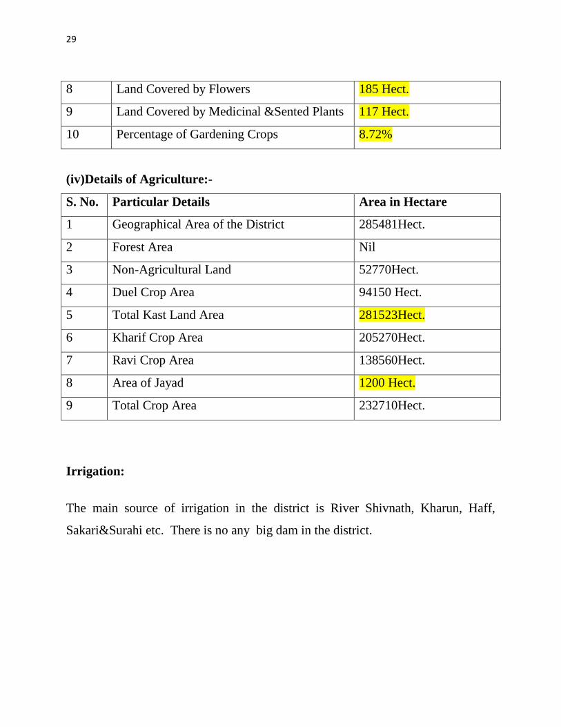
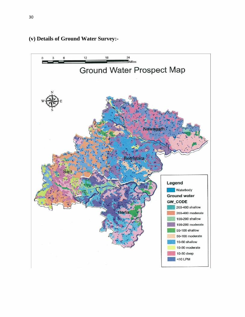
30
(v) Details of Ground Water Survey-
31
Climate-
Bemetara has a tropical wet and dry climate temperature remains moderate
throughout the year except from March to June which can be extremely hot The
temperature in AprilndashMay sometimes rises above 45 degCThese summer months
also have dry and hot winds In summers the temperature can also go up to 50 degC
The city receives about 1300 millimetres (51 in) of rain mostly in the monsoon
season from late June to early October Winters last from November to January
and are mild although lows can fall to 5 degC (41 degF)
Climate data for Bemetara City
Month Jan Feb Mar Apr May Jun Jul Aug Sep Oct Nov Dec Year
Average
high degC
(degF)
27
(81)
30
(86)
35
(95)
39
(102)
45
(113)
36
(97)
30
(86)
30
(86)
31
(88)
31
(88)
28
(82)
26
(79)
32
(90)
Average
low degC
(degF)
13
(55)
15
(59)
20
(68)
24
(75)
27
(81)
26
(79)
23
(73)
23
(73)
22
(72)
21
(70)
16
(61)
14
(57)
20
(68)
Average
precipita
tion mm
(inches)
10
(039)
17
(067)
14
(055)
13
(051)
18
(071)
239
(941)
383
(1508)
364
(1433)
197
(776)
50
(197)
11
(043)
16
(063)
1330
(5236)
32
9 Physiography of the District
Physiographically the area in Bemetara District having almost flat topographyThe
general slope of the district is towards the north - east in which direction the major
streams of the district flow
BEMETARA is located near the centre of a large plain sometimes referred as the
rice bowl of India where hundreds of varieties of rice are
grown The ShivnathRiverflows to the east of the city of bemetara and the
southern side has dense forests The Maikal Hills rise on the north-west of
Bemetara on the north the land rises and merges with the Chota Nagpur Plateau
which extends north-east across Jharkhand state On the south of Bemetara lies
the Deccan Plateau
33
34
10 Rainfall of District BemetaraYear wise
S No Year Average Rainfall (mm)
1 2012 99440
2 2013 123400
3 2014 112140
4 2015 95782
Rainfall of District Bemetara Month wise
Rainfall data for Bemetara City
Month Jan Feb Mar Apr May Jun Jul Aug Sep Oct Nov Dec Year
Average
precipita
tion mm
(inches)
10
(039)
17
(067)
14
(055)
13
(051)
18
(071)
239
(941)
383
(1508)
364
(1433)
197
(776)
50
(197)
11
(043)
16
(063)
1330
(5236)
35
36
11 Geology and Mineral Wealth
Geology-
Geologically the district comprises of rocks of the Meso-to Neo- Proterozoic
sequence is represented by the Chhattisgarh Supergroup Raipur Group comprises
Chandi formation Tarenga formation Hirri formation and Maniari formation
Chandi Formation of grey and purple stromatolitic limestone with
areniteferruginous sandstone intercalations (Deodongar member) Tarenga
Formation of greenish grey and reddish brown shale with chert porcellanite and
green clay interbands Hirri Formation by grey thinly to thickly bedded dolomite
and argillancous dolomite and ManairiFormationn comprises reddish brown and
purple non - calcareous shale with gypsum interbandsQuatrenary is represented
by pebble beds (Khamaria pebble bed)
37
38
Stratigraphic succession-
39
Mineral-
Mineral deposite of Bemetaradistrict include Dolomite Limestone Ordinary stone
Sand and Soil etc
Dolomite Mines
Total 27 Dolomite mines in which at present 3 dolomite is operational 13 dolomite
mine is under renewal and 11 dolomite mines is under lapse category
Limestone Mine
Total 03limestone mines in which at present 1limestone mine is operational and
rest 2 limestone mine is under renewal in the district
Ordinary Stone Mine
Total 01 ordinary stone mines is operational in the district
Soil Mine for Making Bricks
Total 34 soil mines in which at present 13 soil mine is operational and 21 soil mine
is under renewal varies part of the district
Sand Mine
Total 33 sand mines in which at present after Environmental NOC 12 sand mine is
operational 14 sand mine is under process to getting Environmental NOC from
SEIAA and 07sand mines has not submitted required documents for
Environmental Clearence till date
Sands are mostly available in Bank of River Shivnath Kharun Hanf
SakariSurahiampPhonkriver Quarry leases for sand mining are given in different
village of Bemetara district
40
Additional information of the district
Drainage System-
Shivnath
Sheonath is main river of District Bemetara Shivnathriver is tributary of Mahanadi
river Shivnathriver originates from Mountain at height of 625 meter at Panabaras
situated in south western parts of Rajnandgaon and flows towards north east
direction Shivnath River measures length about 345 KM City Durg is situated on
east bank of Shivnath River It flows towards north east passing through Khujji
Rajnandgaon Durg Dhamdha and Nandghat and joins (meet) Mahanadi near
Shivari Narayan of Bilaspur District
Kharun
Kharunriver flows in eastern parts of the district starting from Petechua in Balod
District This river flows towards north and joins (meet) ShivnathRiver at Somnath
near Simga This river determines the boundary of Raipur and Durg district The
length of this river is about 120 KM
41
42
Survey Report for Sand Mining of District Bemetara
This survey report is prepared for District Bemetara to identify the sustainable
mining area In District Bemetarathere are six rivers namely Shivnath Kharun
Haff Sakari SurahiampPhonkriver
All possible sand mining area has been surveyed The riverwise area surveyed and
identified for sand mining is given in the annexure
The thickness of sand load is considered average 4 meters in depth by observation
as well as local enquiry out of which up to depth of 3 meter is considered for
calculation of mineral potential
The mining area will be 10m away from the river bank and about 10m Influence
as safity barrier from the main streem will be left where mining operation will be
restricted Hence 10 m influence area from the main stream has been considered as
safity zone or non mining zone
It is considered that replenishment of sand in every monsoon season is a regular
process Based on the last five year observation it is experienced that average of
3m sand is replenished every year
Area Prohibited for Mining-
The following area will be prohibited for minng
i No mining activity will be executed 10 m from the river bank
ii Mining is prohibited within 10 m from the flow of the main stream
iii During mining measures should be taken to guide the flow to the centre
of the river to avoide erosion of banks
iv Mining area is restricted up to 500 mtsdown stream of any structure like
bridge diversion head work anicut etc
43
v Measures should be kept in consideration that the flow of river should not
be diverted or obstructed
vi The distance between two sand mining locations should be minimum 500
meters
vii Before permission of mining a suitable test of sand for construction
purpose like silt percentage fineness modulus etc must be obtained from
competent laboratory authority
viii Provision for plantation must be assured on the river bank of concerened
sand mining zone to protect erosion of banks and to
maintainesecobalance
Details are given bellow-
S No Name of River Ara Drained Sq KM Area
Drained in the
District in BemetaraDist Total
1 2 3 4 5
1 Shivnath River Sq km Sq km
2 Kharun River Sq km Sq km
3 Haff River Sq km Sq km
4 Sakari River
5 Surahi River
6 Phonk
Features of Important Rivers and Streams-
S No Name of the
River or Stream
Total Length in the
District (in km)
Place of origin Height of
origin
1 2 3 4 5
1 Shivnath River km Panabaras (Dist-
Rajnandgaon)
642 m
2 Kharun River km Kankalin (Petachuwa)
(Dist-Balod)
1 m
3 Haff River km Hils of Dallirajhara
(Banjaridih) (Dist- Balod
3 m
44
4 Sakari River
5 Surahi River
6 Phonk
Shivnath River
SNo Portion of the
River of
Stream
Recommended
for Mineral
Concession
Length of
area
recommended
for mineral
concession (in
kilometer)
Average
Width of area
Recommended
for mineral
concession (in
meters)
Area
recommended
for mineral
concession (in
meter)
Mineable
mineral
potential
(in metric
tonne) 60
of total
mineral
potential)
1 2 jsrtekoughagSA 3 jsrmiyCk ughagSA 4 jsrmiyCk ughagSA 5 jsrmiyCk ughagSA 6 orZekuesaikuhHkjkogSArhuokZiwoZjsr
[kuugksrkFkkjsrughagSA
ksxamp
Kharun River
SNo Portion of the
River of
Stream
Recommended
for Mineral
Concession
Length of
area
recommended
for mineral
concession (in
kilometer)
Average
Width of area
Recommended
for mineral
concession (in
meters)
Area
recommended
for mineral
concession (in
meter)
Mineable
mineral
potential
(in metric
tonne) 60
of total
mineral
potential)
1 ikuhHkjkogSA 2 ikuhHkjkogSA 3 ikuhHkjkogSA 4 ikuhHkjkogSA 5 ikuhHkjkogSA 6 ikuhHkjkogSA
45
ksxamp 0
Haff River
SNo Portion of the
River of
Stream
Recommended
for Mineral
Concession
Length of
area
recommended
for mineral
concession (in
kilometer)
Average
Width of area
Recommended
for mineral
concession (in
meters)
Area
recommended
for mineral
concession (in
meter)
Mineable
mineral
potential
(in metric
tonne) 60
of total
mineral
potential)
1 ikuhHkjkogSA 2 ikuhHkjkogSA 3 ikuhHkjkogSA 4 ikuhHkjkogSA 5 ikuhHkjkogSA 6 ikuhHkjkogSA ksxamp 0
Sakari River
SNo Portion of the
River of
Stream
Recommended
for Mineral
Concession
Length of
area
recommended
for mineral
concession (in
kilometer)
Average
Width of area
Recommended
for mineral
concession (in
meters)
Area
recommended
for mineral
concession (in
meter)
Mineable
mineral
potential
(in metric
tonne) 60
of total
mineral
potential)
1 ikuhHkjkogSA 2 ikuhHkjkogSA 3 ikuhHkjkogSA 4 ikuhHkjkogSA 5 ikuhHkjkogSA 6 ikuhHkjkogSA ksxamp 0
46
Surahi River
SNo Portion of the
River of
Stream
Recommended
for Mineral
Concession
Length of
area
recommended
for mineral
concession (in
kilometer)
Average
Width of area
Recommended
for mineral
concession (in
meters)
Area
recommended
for mineral
concession (in
meter)
Mineable
mineral
potential
(in metric
tonne) 60
of total
mineral
potential)
1 ikuhHkjkogSA 2 ikuhHkjkogSA 3 ikuhHkjkogSA 4 ikuhHkjkogSA 5 ikuhHkjkogSA 6 ikuhHkjkogSA ksxamp 0
Phonk River
SNo Portion of the
River of
Stream
Recommended
for Mineral
Concession
Length of
area
recommended
for mineral
concession (in
kilometer)
Average
Width of area
Recommended
for mineral
concession (in
meters)
Area
recommended
for mineral
concession (in
meter)
Mineable
mineral
potential
(in metric
tonne) 60
of total
mineral
potential)
1 ikuhHkjkogSA 2 ikuhHkjkogSA 3 ikuhHkjkogSA 4 ikuhHkjkogSA 5 ikuhHkjkogSA 6 ikuhHkjkogSA ksxamp 0
31
Climate-
Bemetara has a tropical wet and dry climate temperature remains moderate
throughout the year except from March to June which can be extremely hot The
temperature in AprilndashMay sometimes rises above 45 degCThese summer months
also have dry and hot winds In summers the temperature can also go up to 50 degC
The city receives about 1300 millimetres (51 in) of rain mostly in the monsoon
season from late June to early October Winters last from November to January
and are mild although lows can fall to 5 degC (41 degF)
Climate data for Bemetara City
Month Jan Feb Mar Apr May Jun Jul Aug Sep Oct Nov Dec Year
Average
high degC
(degF)
27
(81)
30
(86)
35
(95)
39
(102)
45
(113)
36
(97)
30
(86)
30
(86)
31
(88)
31
(88)
28
(82)
26
(79)
32
(90)
Average
low degC
(degF)
13
(55)
15
(59)
20
(68)
24
(75)
27
(81)
26
(79)
23
(73)
23
(73)
22
(72)
21
(70)
16
(61)
14
(57)
20
(68)
Average
precipita
tion mm
(inches)
10
(039)
17
(067)
14
(055)
13
(051)
18
(071)
239
(941)
383
(1508)
364
(1433)
197
(776)
50
(197)
11
(043)
16
(063)
1330
(5236)
32
9 Physiography of the District
Physiographically the area in Bemetara District having almost flat topographyThe
general slope of the district is towards the north - east in which direction the major
streams of the district flow
BEMETARA is located near the centre of a large plain sometimes referred as the
rice bowl of India where hundreds of varieties of rice are
grown The ShivnathRiverflows to the east of the city of bemetara and the
southern side has dense forests The Maikal Hills rise on the north-west of
Bemetara on the north the land rises and merges with the Chota Nagpur Plateau
which extends north-east across Jharkhand state On the south of Bemetara lies
the Deccan Plateau
33
34
10 Rainfall of District BemetaraYear wise
S No Year Average Rainfall (mm)
1 2012 99440
2 2013 123400
3 2014 112140
4 2015 95782
Rainfall of District Bemetara Month wise
Rainfall data for Bemetara City
Month Jan Feb Mar Apr May Jun Jul Aug Sep Oct Nov Dec Year
Average
precipita
tion mm
(inches)
10
(039)
17
(067)
14
(055)
13
(051)
18
(071)
239
(941)
383
(1508)
364
(1433)
197
(776)
50
(197)
11
(043)
16
(063)
1330
(5236)
35
36
11 Geology and Mineral Wealth
Geology-
Geologically the district comprises of rocks of the Meso-to Neo- Proterozoic
sequence is represented by the Chhattisgarh Supergroup Raipur Group comprises
Chandi formation Tarenga formation Hirri formation and Maniari formation
Chandi Formation of grey and purple stromatolitic limestone with
areniteferruginous sandstone intercalations (Deodongar member) Tarenga
Formation of greenish grey and reddish brown shale with chert porcellanite and
green clay interbands Hirri Formation by grey thinly to thickly bedded dolomite
and argillancous dolomite and ManairiFormationn comprises reddish brown and
purple non - calcareous shale with gypsum interbandsQuatrenary is represented
by pebble beds (Khamaria pebble bed)
37
38
Stratigraphic succession-
39
Mineral-
Mineral deposite of Bemetaradistrict include Dolomite Limestone Ordinary stone
Sand and Soil etc
Dolomite Mines
Total 27 Dolomite mines in which at present 3 dolomite is operational 13 dolomite
mine is under renewal and 11 dolomite mines is under lapse category
Limestone Mine
Total 03limestone mines in which at present 1limestone mine is operational and
rest 2 limestone mine is under renewal in the district
Ordinary Stone Mine
Total 01 ordinary stone mines is operational in the district
Soil Mine for Making Bricks
Total 34 soil mines in which at present 13 soil mine is operational and 21 soil mine
is under renewal varies part of the district
Sand Mine
Total 33 sand mines in which at present after Environmental NOC 12 sand mine is
operational 14 sand mine is under process to getting Environmental NOC from
SEIAA and 07sand mines has not submitted required documents for
Environmental Clearence till date
Sands are mostly available in Bank of River Shivnath Kharun Hanf
SakariSurahiampPhonkriver Quarry leases for sand mining are given in different
village of Bemetara district
40
Additional information of the district
Drainage System-
Shivnath
Sheonath is main river of District Bemetara Shivnathriver is tributary of Mahanadi
river Shivnathriver originates from Mountain at height of 625 meter at Panabaras
situated in south western parts of Rajnandgaon and flows towards north east
direction Shivnath River measures length about 345 KM City Durg is situated on
east bank of Shivnath River It flows towards north east passing through Khujji
Rajnandgaon Durg Dhamdha and Nandghat and joins (meet) Mahanadi near
Shivari Narayan of Bilaspur District
Kharun
Kharunriver flows in eastern parts of the district starting from Petechua in Balod
District This river flows towards north and joins (meet) ShivnathRiver at Somnath
near Simga This river determines the boundary of Raipur and Durg district The
length of this river is about 120 KM
41
42
Survey Report for Sand Mining of District Bemetara
This survey report is prepared for District Bemetara to identify the sustainable
mining area In District Bemetarathere are six rivers namely Shivnath Kharun
Haff Sakari SurahiampPhonkriver
All possible sand mining area has been surveyed The riverwise area surveyed and
identified for sand mining is given in the annexure
The thickness of sand load is considered average 4 meters in depth by observation
as well as local enquiry out of which up to depth of 3 meter is considered for
calculation of mineral potential
The mining area will be 10m away from the river bank and about 10m Influence
as safity barrier from the main streem will be left where mining operation will be
restricted Hence 10 m influence area from the main stream has been considered as
safity zone or non mining zone
It is considered that replenishment of sand in every monsoon season is a regular
process Based on the last five year observation it is experienced that average of
3m sand is replenished every year
Area Prohibited for Mining-
The following area will be prohibited for minng
i No mining activity will be executed 10 m from the river bank
ii Mining is prohibited within 10 m from the flow of the main stream
iii During mining measures should be taken to guide the flow to the centre
of the river to avoide erosion of banks
iv Mining area is restricted up to 500 mtsdown stream of any structure like
bridge diversion head work anicut etc
43
v Measures should be kept in consideration that the flow of river should not
be diverted or obstructed
vi The distance between two sand mining locations should be minimum 500
meters
vii Before permission of mining a suitable test of sand for construction
purpose like silt percentage fineness modulus etc must be obtained from
competent laboratory authority
viii Provision for plantation must be assured on the river bank of concerened
sand mining zone to protect erosion of banks and to
maintainesecobalance
Details are given bellow-
S No Name of River Ara Drained Sq KM Area
Drained in the
District in BemetaraDist Total
1 2 3 4 5
1 Shivnath River Sq km Sq km
2 Kharun River Sq km Sq km
3 Haff River Sq km Sq km
4 Sakari River
5 Surahi River
6 Phonk
Features of Important Rivers and Streams-
S No Name of the
River or Stream
Total Length in the
District (in km)
Place of origin Height of
origin
1 2 3 4 5
1 Shivnath River km Panabaras (Dist-
Rajnandgaon)
642 m
2 Kharun River km Kankalin (Petachuwa)
(Dist-Balod)
1 m
3 Haff River km Hils of Dallirajhara
(Banjaridih) (Dist- Balod
3 m
44
4 Sakari River
5 Surahi River
6 Phonk
Shivnath River
SNo Portion of the
River of
Stream
Recommended
for Mineral
Concession
Length of
area
recommended
for mineral
concession (in
kilometer)
Average
Width of area
Recommended
for mineral
concession (in
meters)
Area
recommended
for mineral
concession (in
meter)
Mineable
mineral
potential
(in metric
tonne) 60
of total
mineral
potential)
1 2 jsrtekoughagSA 3 jsrmiyCk ughagSA 4 jsrmiyCk ughagSA 5 jsrmiyCk ughagSA 6 orZekuesaikuhHkjkogSArhuokZiwoZjsr
[kuugksrkFkkjsrughagSA
ksxamp
Kharun River
SNo Portion of the
River of
Stream
Recommended
for Mineral
Concession
Length of
area
recommended
for mineral
concession (in
kilometer)
Average
Width of area
Recommended
for mineral
concession (in
meters)
Area
recommended
for mineral
concession (in
meter)
Mineable
mineral
potential
(in metric
tonne) 60
of total
mineral
potential)
1 ikuhHkjkogSA 2 ikuhHkjkogSA 3 ikuhHkjkogSA 4 ikuhHkjkogSA 5 ikuhHkjkogSA 6 ikuhHkjkogSA
45
ksxamp 0
Haff River
SNo Portion of the
River of
Stream
Recommended
for Mineral
Concession
Length of
area
recommended
for mineral
concession (in
kilometer)
Average
Width of area
Recommended
for mineral
concession (in
meters)
Area
recommended
for mineral
concession (in
meter)
Mineable
mineral
potential
(in metric
tonne) 60
of total
mineral
potential)
1 ikuhHkjkogSA 2 ikuhHkjkogSA 3 ikuhHkjkogSA 4 ikuhHkjkogSA 5 ikuhHkjkogSA 6 ikuhHkjkogSA ksxamp 0
Sakari River
SNo Portion of the
River of
Stream
Recommended
for Mineral
Concession
Length of
area
recommended
for mineral
concession (in
kilometer)
Average
Width of area
Recommended
for mineral
concession (in
meters)
Area
recommended
for mineral
concession (in
meter)
Mineable
mineral
potential
(in metric
tonne) 60
of total
mineral
potential)
1 ikuhHkjkogSA 2 ikuhHkjkogSA 3 ikuhHkjkogSA 4 ikuhHkjkogSA 5 ikuhHkjkogSA 6 ikuhHkjkogSA ksxamp 0
46
Surahi River
SNo Portion of the
River of
Stream
Recommended
for Mineral
Concession
Length of
area
recommended
for mineral
concession (in
kilometer)
Average
Width of area
Recommended
for mineral
concession (in
meters)
Area
recommended
for mineral
concession (in
meter)
Mineable
mineral
potential
(in metric
tonne) 60
of total
mineral
potential)
1 ikuhHkjkogSA 2 ikuhHkjkogSA 3 ikuhHkjkogSA 4 ikuhHkjkogSA 5 ikuhHkjkogSA 6 ikuhHkjkogSA ksxamp 0
Phonk River
SNo Portion of the
River of
Stream
Recommended
for Mineral
Concession
Length of
area
recommended
for mineral
concession (in
kilometer)
Average
Width of area
Recommended
for mineral
concession (in
meters)
Area
recommended
for mineral
concession (in
meter)
Mineable
mineral
potential
(in metric
tonne) 60
of total
mineral
potential)
1 ikuhHkjkogSA 2 ikuhHkjkogSA 3 ikuhHkjkogSA 4 ikuhHkjkogSA 5 ikuhHkjkogSA 6 ikuhHkjkogSA ksxamp 0
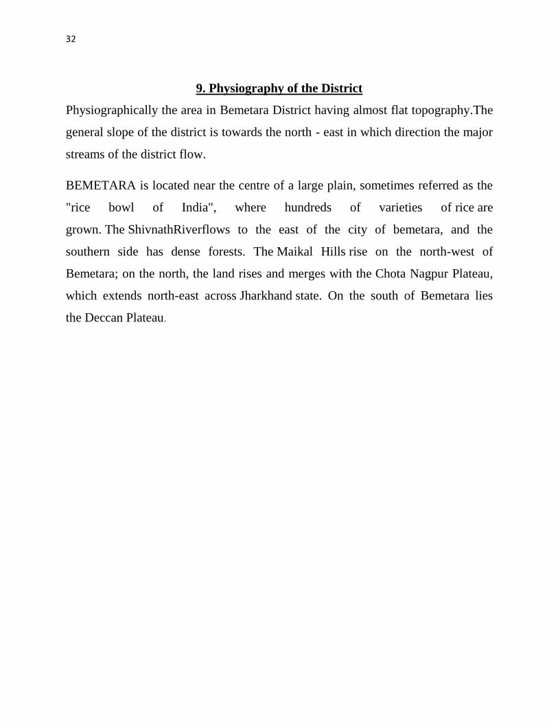
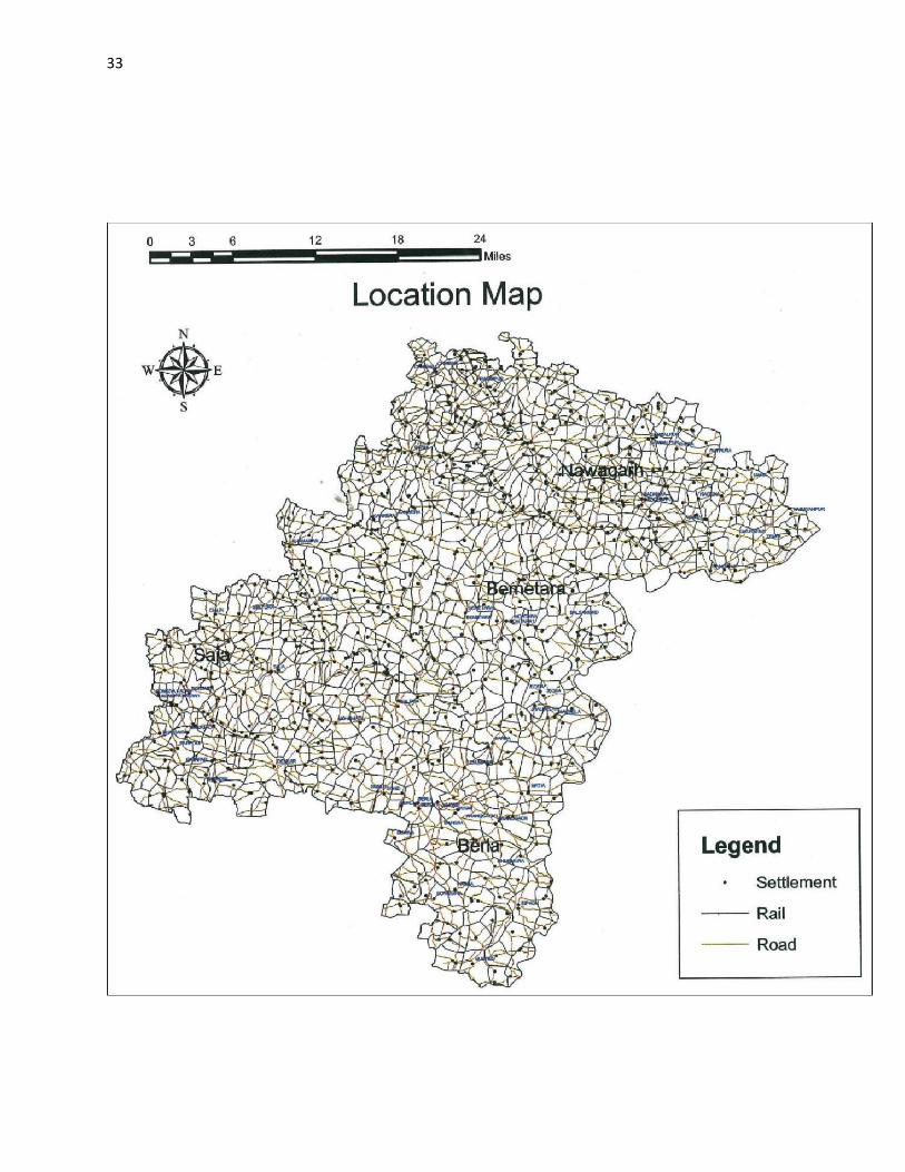
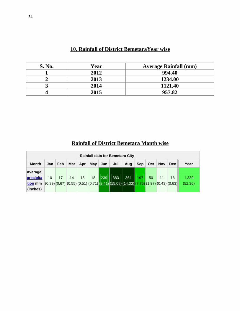
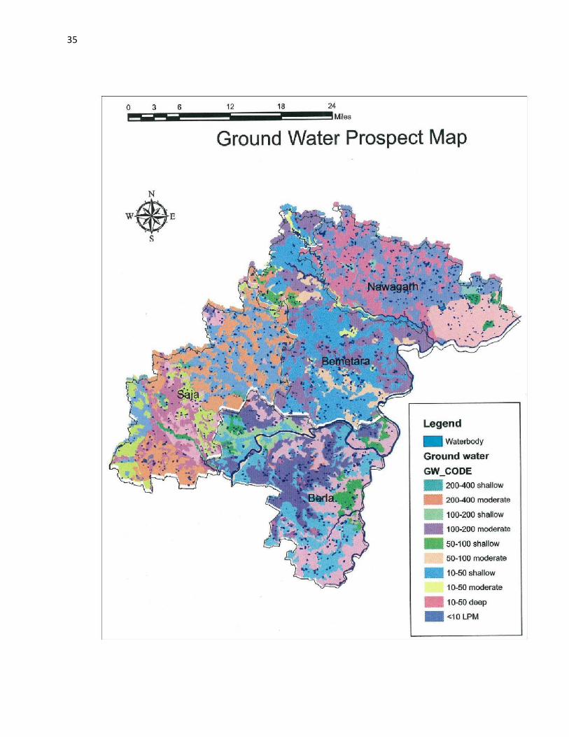
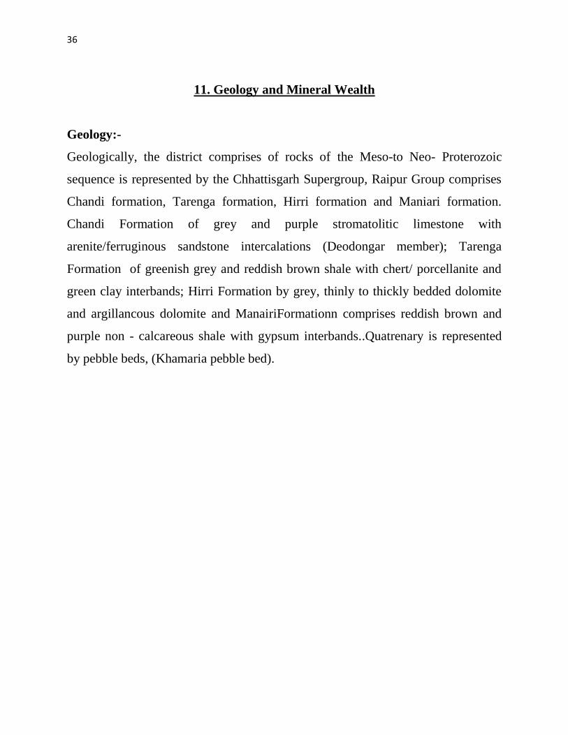
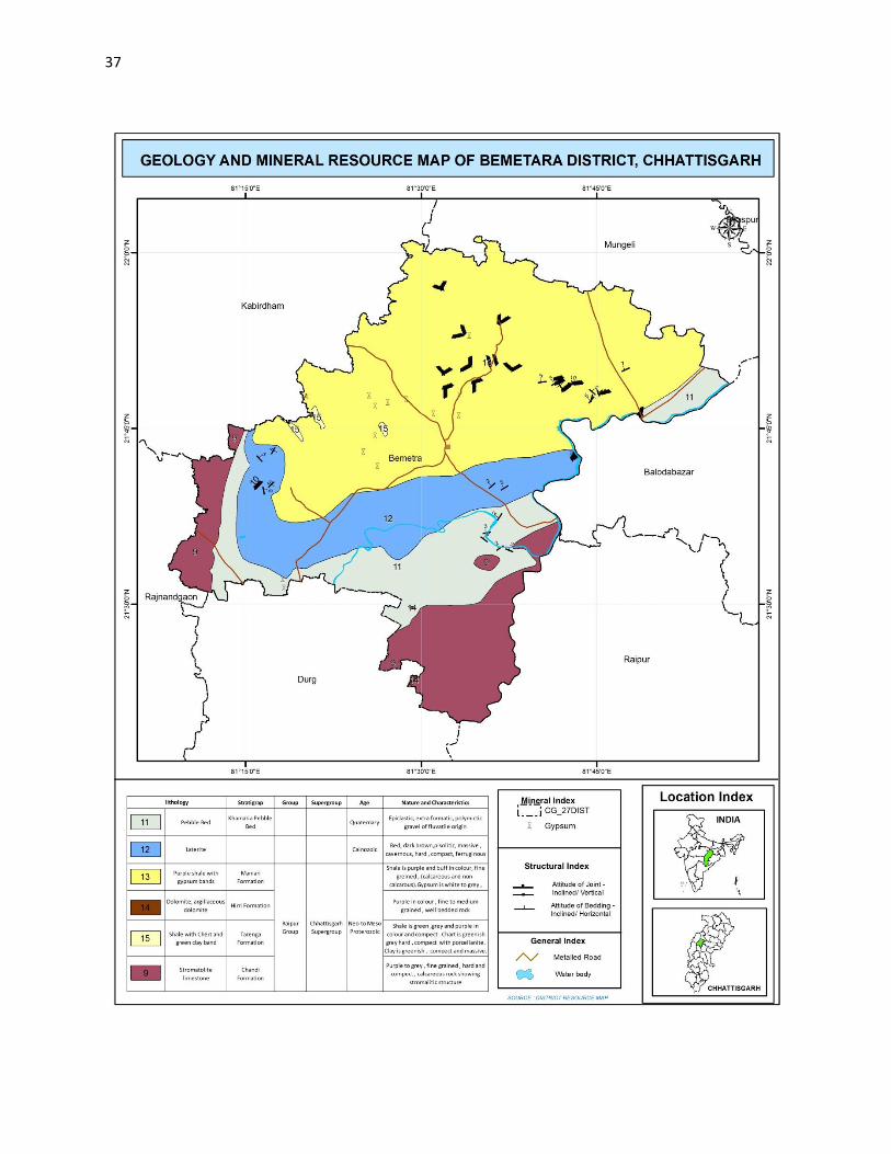
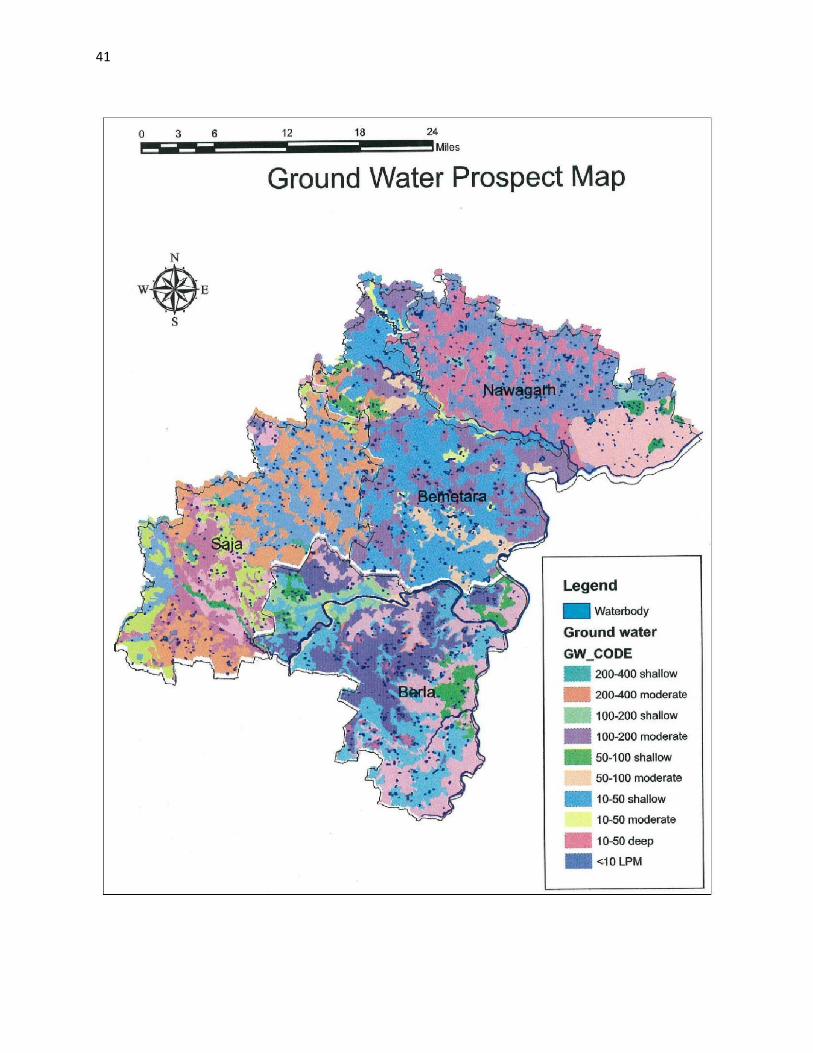
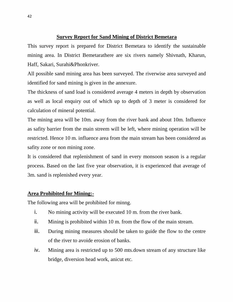
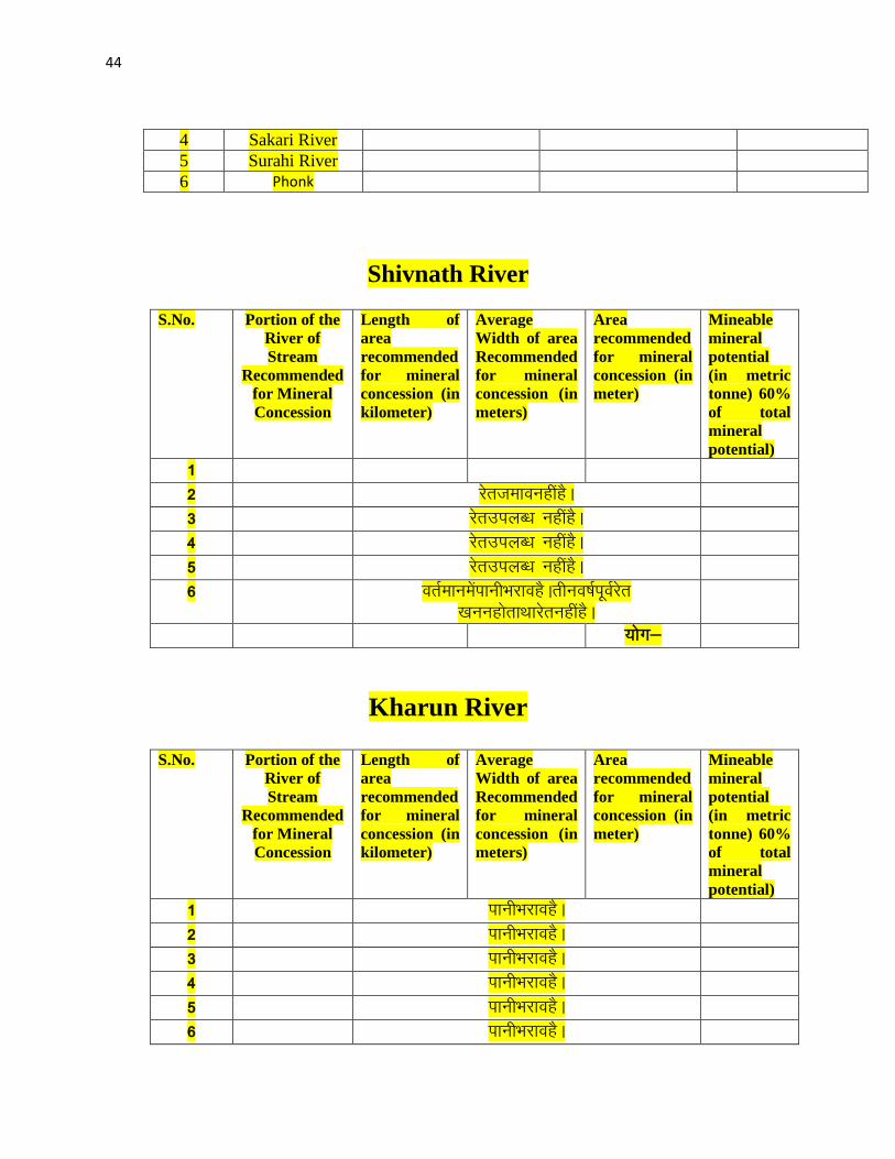
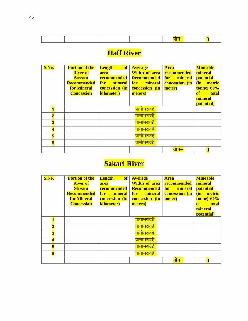
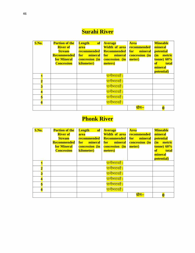