district of southwestern virginia
TRANSCRIPT
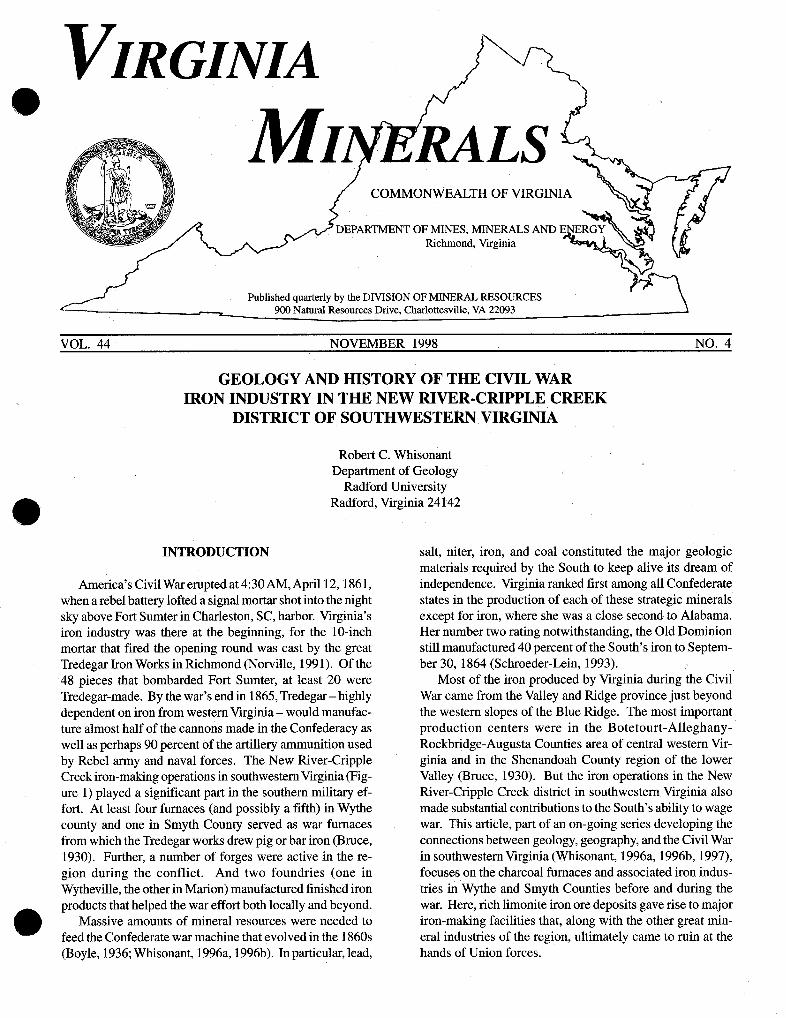
COMMONWEALTH OF VIRGINIA
EPARTMENT OF MINES, MINERALS AND Richmond, Virginia
Published quarterly by the DIVISION OF MINERAL RESOURCES
GEOLOGY AND HISTORY OF THE CIVIL WAR IRON INDUSTRY IN THE NEW RIVER-CRIPPLE CREEK
DISTRICT OF SOUTHWESTERN VIRGINIA
Robert C. Whisonant Department of Geology
Radford University Radford, Virginia 24142
INTRODUCTION
America's Civil War erupted at 4:30 AM, April 12,186 1, when a rebel battery lofted a signal mortar shot into the night sky above Fort Sumter in Charleston, SC, harbor. Virginia's iron industry was there at the beginning, for the 10-inch mortar that fired the opening round was cast by the great Tredegar Iron Works in Richmond (Norville, 1991). Of the 48 pieces that bombarded Fort Sumter, at least 20 were Tredegar-made. By the war's end in 1865, Tredegar - highly dependent on iron from western Virginia - would manufac- ture almost half of the cannons made in the Confederacy as well as perhaps 90 percent of the artillery ammunition used by Rebel army and naval forces. The New River-Cripple Creek iron-making operations in southwestern Virginia (Fig- ure 1) played a significant part in the southern military ef- fort. At least four furnaces (and possibly a fifth) in Wythe county and one in Smyth County served as war furnaces from which the Tredegar works drew pig or bar iron (Bruce, 1930). Further, a number of forges were active in the re- gion during the conflict. And two foundries (one in Wytheville, the other in Marion) manufactured finished iron products that helped the war effort both locally and beyond.
Massive amounts of mineral resources were needed to @ feed the Confederate war machine that evolved in the 1860s (Boyle, 1936; Whisonant, 1996a, 1996b). In particular, lead,
salt, niter, iron, and coal constituted the major geologic materials required by the South to keep alive its dream of independence. Virginia ranked first among all Confederate states in the production of each of these strategic minerals except for iron, where she was a close second to Alabama. Her number two rating notwithstanding, the Old Dominion still manufactured 40 percent of the South's iron to Septem- ber 30, 1864 (Schroeder-Lein, 1993).
Most of the iron produced by Virginia during the Civil War came from the Valley and Ridge province just beyond the western slopes of the Blue Ridge. The most important production centers were in the Botetourt-Alleghany- Rockbridge-Augusta Counties area of central western Vir- ginia and in the Shenandoah County region of the lower Valley (Bruce, 1930). But the iron operations in the New River-Cripple Creek district in southwestern Virginia also made substantial contributions to the South's ability to wage war. This article, part of an on-going series developing the connections between geology, geography, and the Civil War in southwesternVirginia (Whisonant, 1996a, 1996b, 1997), focuses on the charcoal furnaces and associated iron indus- tries in Wythe and Smyth Counties before and during the war. Here, rich limonite iron ore deposits gave rise to major iron-making facilities that, along with the other great min- eral industries of the region, ultimately came to ruin at the hands of Union forces.
VIRGINIA DIVISION OF MINERAL RESOURCES VOL. 44
GEOLOGY OF THE IRON DEPOSITS IN THE NEW RIVER-CRIPPLE CREEK DISTRICT
Virginia's iron resources have been of economic impor- tance since the days of earliest European settlement in Jamestown. Because of this centuries-long tradition of iron mining and production, much is known about the geology of the iron occurrences. Two of the best sources are Holden (1907) and Gooch (1954). The following overview of the Old Dominion's iron resources is taken largely from these works.
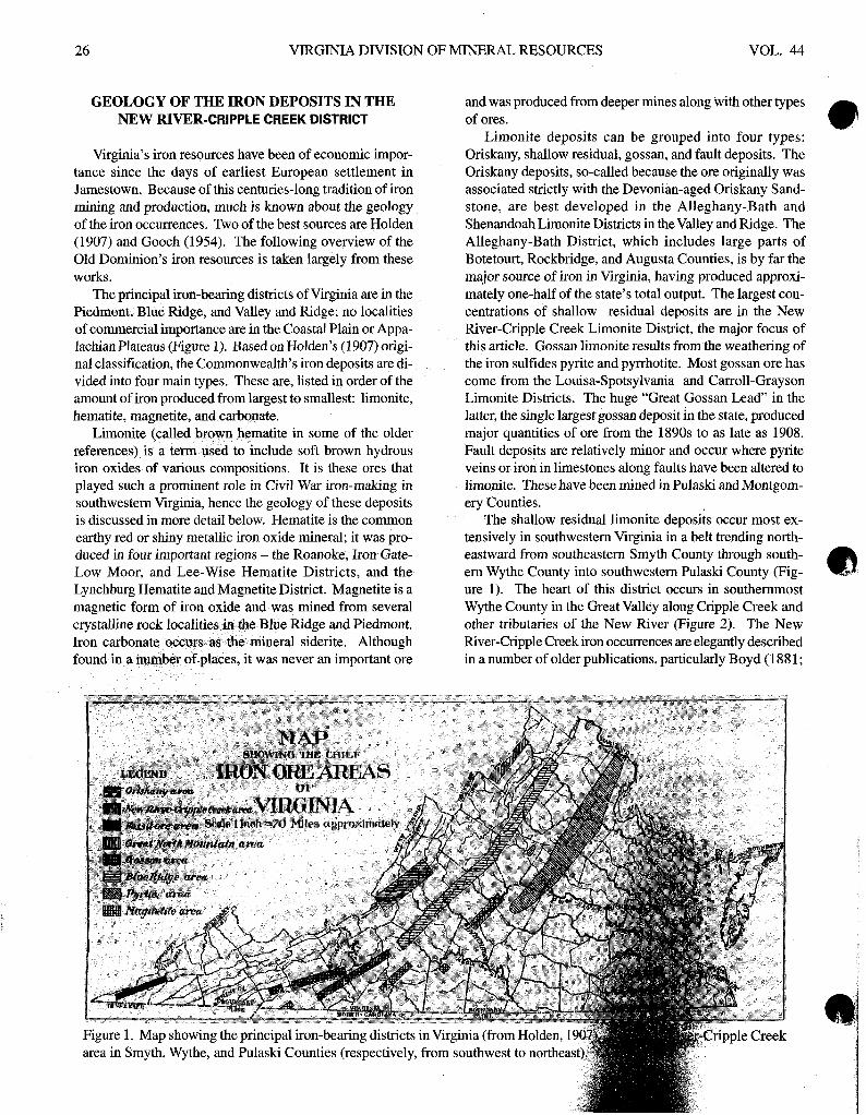
The principal iron-bearing districts of Virginia are in the Piedmont, Blue Ridge, and Valley and Ridge; no localities of commercial importance are in the Coastal Plain or Appa- lachian Plateaus (Figure 1). Based on Holden's (1907) origi- nal classification, the Commonwealth's iron deposits are di- vided into four main types. These are, listed in order of the amount of iron produced from largest to smallest: limonite, hematite, magnetite, and carbonate.
Limonite (called brown hematite in some of the older references) is a term used to include soft brown hydrous iron oxides of various compositions. It is these ores that played such a prominent role in Civil War iron-making in southwestern Virginia, hence the geology of these deposits is discussed in more detail below. Hematite is the common earthy red or shiny metallic iron oxide mineral; it was pro- duced in four important regions - the Roanoke, Iron Gate- Low Moor, and Lee-Wise Hematite Districts, and the Lynchburg Hematite and Magnetite District. Magnetite is a magnetic form of iron oxide and was mined from several crystalline rock localities imr the Blue Ridge and Piedmont. Iron carbonate occurs as the mineral siderite. Although found in a number of places, it was never an important ore
and was produced from deeper mines along with other types of ores.
Limonite deposits can be grouped into four types: Oriskany, shallow residual, gossan, and fault deposits. The Oriskany deposits, so-called because the ore originally was associated strictly with the Devonian-aged Oriskany Sand- stone, are best developed in the Alleghany-Bath and Shenandoah Limonite Districts in the Valley and Ridge. The Alleghany-Bath District, which includes large parts of Botetourt, Rockbridge, and Augusta Counties, is by far the major source of iron in Virginia, having produced approxi- mately one-half of the state's total output. The largest con- centrations of shallow residual deposits are in the New River-Cripple Creek Limonite District, the major focus of this article. Gossan limonite results from the weathering of the iron sulfides pyrite and pyrrhotite. Most gossan ore has come from the Louisa-Spotsylvania and Carroll-Grayson Limonite Districts. The huge "Great Gossan Lead" in the latter, the single largest gossan deposit in the state, produced major quantities of ore from the 1890s to as late as 1908. Fault deposits are relatively minor and occur where pyrite veins or iron in limestones along faults have been altered to limonite. These have been mined in Pulaski and Montgom- ery Counties.
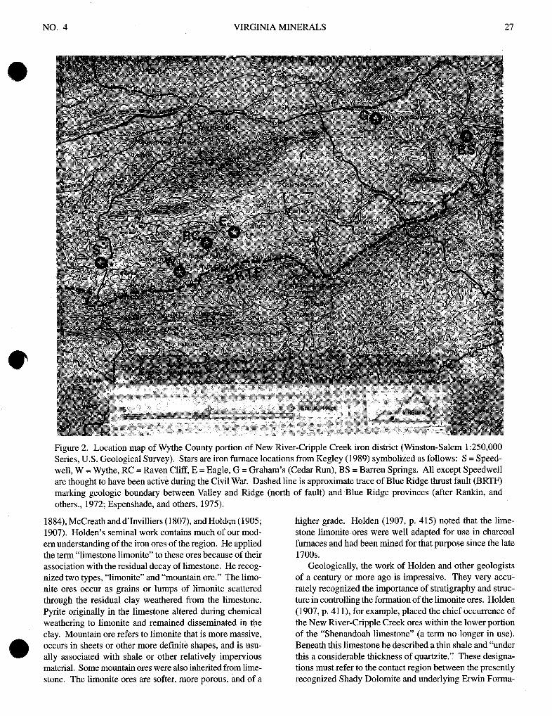
The shallow residual limonite deposits occur most ex- tensively in southwestern Virginia in a belt trending north- eastward from southeastern Smyth County through south- ern Wythe County into southwestern Pulaski County (Fig- ure 1). The heart of this district occurs in southernmost Wythe County in the Great Valley along Cripple Creek and other tributaries of the New River (Figure 2). The New River-Cripple Creek iron occurrences are elegantly described in a number of older publications, particularly Boyd (1881;
NO. 4 VIRGINIA MINERALS 27
Figure 2. Location map of Wythe County portion of New River-Cripple Creek iron district (Winston-Salem 1:250,000 Series, U.S. Geological Survey). Stars are iron furnace locations from Kegley (1989) symbolized as follows: S = Speed- well, W = Wythe, RC = Raven Cliff, E = Eagle, G = Graham's (Cedar Run), BS = Barren Springs. All except Speedwell are thought to have been active during the Civil War. Dashed line is approximate trace of Blue Ridge thrust fault (BRTF) marking geologic boundary between Valley and Ridge (north of fault) and Blue Ridge provinces (after Rankin, and others., 1972; Espenshade, and others, 1975).
1884), McCreath and d'Invilliers (1807), and Holden (1905; 1907). Holden's seminal work contains much of our mod- em understanding of the iron ores of the region. He applied the term "limestone limonite" to these ores because of their association with the residual decay of limestone. He recog- nized two types, "limonite" and "mountain ore." The limo- nite ores occur as grains or lumps of limonite scattered through the residual clay weathered from the limestone. Pyrite originally in the limestone altered during chemical weathering to limonite and remained disseminated in the clay. Mountain ore refers to limonite that is more massive, occurs in sheets or other more definite shapes, and is usu- @ ally associated with shale or other relatively impervious material. Some mountain ores were also inherited from lime- stone. The limonite ores are softer, more porous, and of a
higher grade. Holden (1907, p. 415) noted that the lime- stone limonite ores were well adapted for use in charcoal furnaces and had been mined for that purpose since the late 1700s.
Geologically, the work of Holden and other geologists of a century or more ago is impressive. They very accu- rately recognized the importance of stratigraphy and struc- ture in controlling the formation of the limonite ores. Holden (1907, p. 41 I), for example, placed the chief occurrence of the New River-Cripple Creek ores within the lower portion of the "Shenandoah limestone" (a term no longer in use). Beneath this limestone he described a thin shale and "under this a considerable thickness of quartzite." These designa- tions must refer to the contact region between the presently recognized Shady Dolomite and underlying Erwin Forma-
VIRGINIA DIVISION OF MINERAL RESOURCES VOL. 44
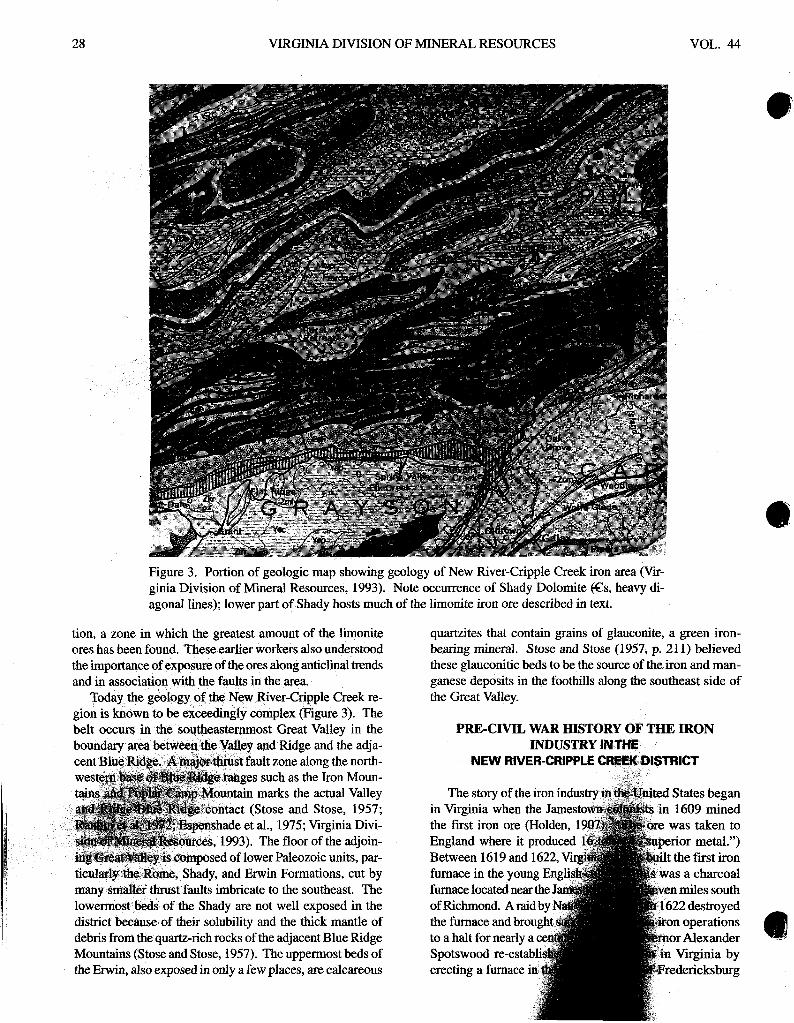
Figure 3. Portion of geologic map showing geology of New River-Cripple Creek iron area (Vir- ginia Division of Mineral Resources, 1993). Note occurrence of Shady Dolomite g s , heavy di- agonal lines); lower part of Shady hosts much of the limonite iron ore described in text.
tion, a zone in which the greatest amount of the limonite ores has been found. These earlier workers also understood the importance of exposure of the ores along anticlinal trends and in association with the faults in the area.
Today the geology of the New River-Cripple Creek re- gion is known to be exceedingly complex Figure 3). The belt occurs in the southeasternmost Great Valley in the boundary area between& Valley and Ridge and the adja- cent Blue Ridge. A f x r . a j l ~ ~ s t fault zone along the north-
ranges such as the Iron Moun- n marks the actual Valley
%ontact (Stose and Stose, 1957; shade et al., 1975; Virginia Divi- es, 1993). The floor of the adjoin-
lower Paleozoic units, par- Erwin Formations, cut by
many smaller thrust faults imbricate to the southeast. The lowermost beds of the Shady are not well exposed in the district because of their solubility and the thick mantle of debris from the quartz-rich rocks of the adjacent Blue Ridge Mountains (Stose and Stose, 1957). The uppermost beds of the Erwin, also exposed in only a few places, are calcareous
quartzites that contain grains of glauconite, a green iron- bearing mineral. Stose and Stose (1957, p. 21 1) believed these glauconitic beds to be the source of the iron and man- ganese deposits in the foothills along the southeast side of the Great Valley.
PRE-CIVIL WAR HISTORY OF THE IRON INDUSTRY IN THE
NEW RIVER-CRIPPLE CRE6KSISTRICT
in Virginia when the the first iron ore (Ho
furnace in the young
of Richmond. A raid
NO. 4 VIRGINIA MINERALS 29
near the Rappahannock River. Succeeding iron-making activities spread westward and, during the second half of the eighteenth century, a number of furnaces and forges started operating west of the Blue Ridge. This trend contin- ued into the first half of the nineteenth century as Virginia's thriving iron industry became located primarily in the Val- ley and Ridge. Brady (1991, p. 27) reported that 45 fur- naces and forges were erected in this region in the 1826- 1850 period.
During these pre-Civil War years, southwesternVirginia also had flourishing iron-making operations, centered in Wythe County in the New River-Cripple Creek region (Fig- ure 2). No one knows exactly when iron manufacture be- gan in this district. The earliest operation reported is a "tra- dition" (Wilson, 1932) that a forge at Sugar Grove in Smyth County made cannons during the American Revolution, al- Figure 4. Speedwell furnace. Established in 1799, this is though the actual product may have been musket barrels. the oldest surviving iron furnace in Wythe County. Speed- Southern Wythe county, which rose quickly to dominate the well was inactive during the 1860s, but was rebuilt in the region's industry, had iron works established by the late 1870s and participated in the iron boom of the late 1800s. 1700s (Whitman, 1942; Chitwood, 1976; Kegley, 1989). The Note Cripple Creek and exposures of Shady Dolomite left first documented iron production in this county occurred of furnace in background. when a bloomew, whose precise location is unknown, was erected along Cripple Creek (Kegley, 1989). A bloomery was a type of forge where "blooms," i.e., large blocks of smelted iron received from a furnace, were hammered into shape using large trip hammers. By 1798, a furnace oper- ated at Poplar Camp; a forge was built in this location about the same time (Whitman, 1942). Sometime between 1817 and 1827 the last blast of the Poplar Camp Furnace took place and it was in ruins by the Civil War (Kegley, 1989). Another early Wythe County ironworks was in operation in the Graham's Forge (a later name) area by 1796 and a forge was added in 1805. Some of the iron-making facilities at Graham's Forge were rebuilt in the pre-Civil War years and saw service during the conflict.
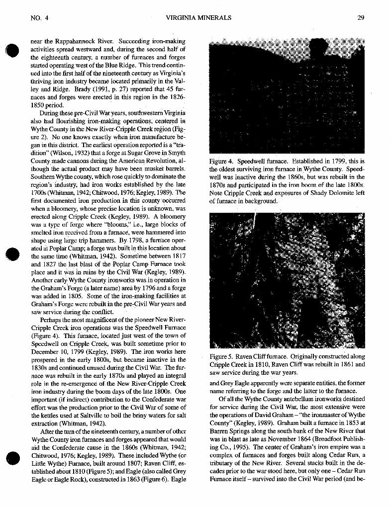
Perhaps the most magnificent of the pioneer New River- Cripple Creek iron operations was the Speedwell Furnace (Figure 4). This furnace, located just west of the town of Speedwell on Cripple Creek, was built sometime prior to December 10, 1799 (Kegley, 1989). The iron works here prospered in the early 1800s, but became inactive in the 1830s and continued unused during the Civil War. The fur- nace was rebuilt in the early 1870s and played an integral role in the re-emergence of the New River-Cripple Creek iron industry during the boom days of the late 1800s. One important (if indirect) contribution to the Confederate war effort was the production prior to the Civil War of some of the kettles used at Saltville to boil the briny waters for salt extraction (Whitrnan, 1942).
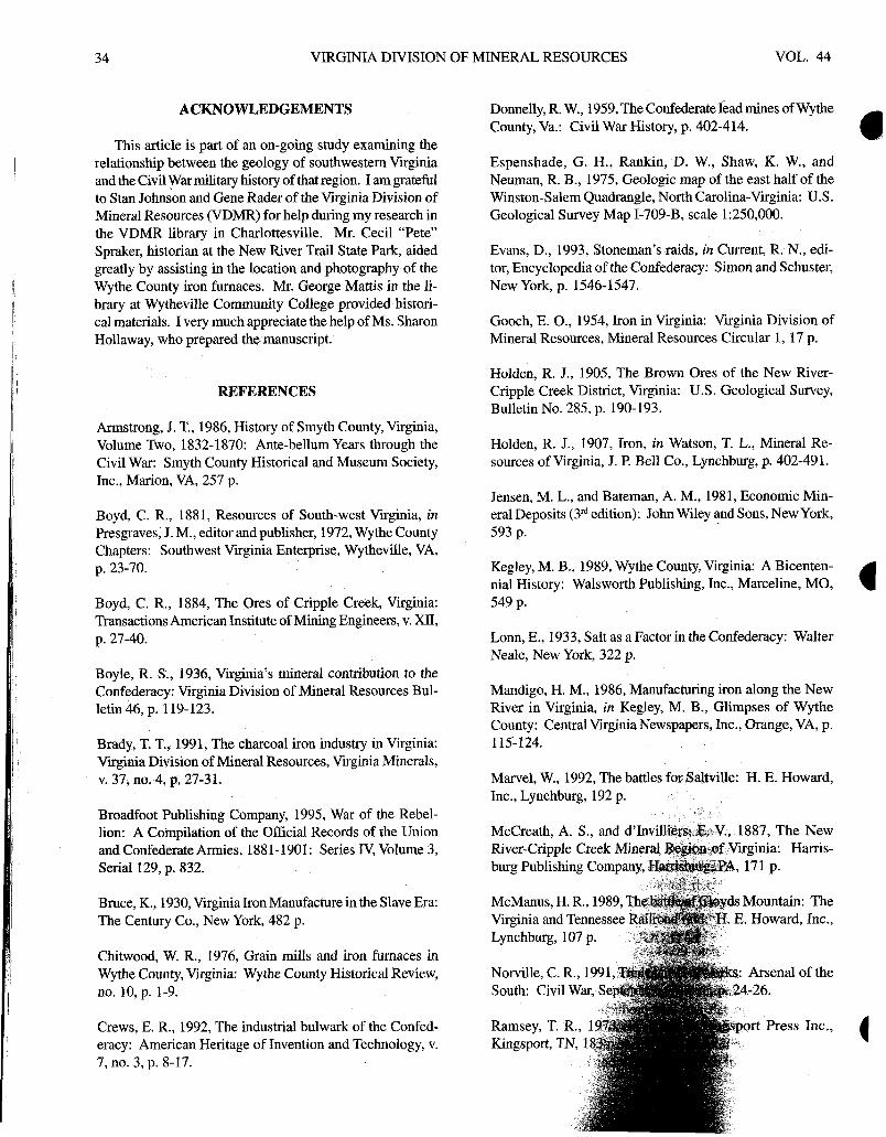
After the turn of the nineteenth century, a number of other Wythe County iron furnaces and forges appeared that would aid the Confederate cause in the 1860s (Whitman, 1942; Chitwood, 1976; Kegley, 1989). These included Wythe (or Little Wythe) Furnace, built around 1807; Raven Cliff, es- tablished about 1810 (Figure 5); and Eagle (also called Grey Eagle or Eagle Rock), constructed in 1863 (Figure 6). Eagle
Figure 5. Raven Cliff furnace. Originally constructed along Cripple Creek in 18 10, Raven Cliff was rebuilt in 186 1 and saw service during the war years.
and Grey Eagle apparently were separate entities, the former name referring to the forge and the latter to the furnace.
Of all the Wythe County antebellum ironworks destined for service during the Civil War, the most extensive were the operations of David Graham - "the ironmaster of Wythe County" (Kegley, 1989). Graham built a furnace in 1853 at Barren Springs along the south bank of the New River that was in blast as late as November 1864 (Broadfoot Publish- ing Co., 1995). The center of Graham's iron empire was a complex of furnaces and forges built along Cedar Run, a tributary of the New River. Several stacks built in the de- cades prior to the war stood here, but only one - Cedar Run Furnace itself - survived into the Civil War period (and be-

30 VIRGINIA DIVISION OF MINERAL RESOURCES VOL. 44
Figure 6. Eagle furnace. Built in 1863 about one mile down- stream from Raven Cliff on Cripple Creek, this farma and forge complex employed 46 workmen in 1864. Note high ground adjoining back of furnace to right and level low
wartime production in 1861 as the need for iron products domestically produced by the South soared.
ground along Cripple Creek in background on left of phojo- graph.
yond) as a iarge operation (Figure 7). During the 1860s, Graham's Cedar Run Furnace was one of several Wythe County furnaces providing iron to the Tredegar Works. Graham's metal proved unreliable, however, when made into cannon. Tredegar informed Graham that several of the guns had misfired and the cannons had burst!
Although Wythe County had the most iron works in pre- Civil War southwestern Virginia, adjacent Smyth County had a number of iron operations also. The most important of these, and the only Smyth County furnace known to have been in blast during the war, were the large iron works es- tablished by Abijah Thomas on the very eve of hostilities (Sturgill, 1990). Thomas owned thousands of acres of moun- tain land that contained abundant iron ore, timber, limestone, and water power. On his land, he determined to build an iron furnace along Staley's Creek, just south of Marion. This he did with two partners and the first blast occurred about April 1, 1861. Thomas' works lasted only three and a half years; they were utterly destroyed by Yankee raiders in late 1864.
Finally, two pre-war iron foundries in southwestern Vir- ginia - Barrett's Foundry in Wytheville and the Goodell and Quaife Foundry and Machine Shop in Marion - achieved industrial prominence during the conflict. Barrett's was es- tablished in 1858 and manufactured stationary engines, grist and sawmill gearings, circular sawmills, tobacco fixtures, Figure 7. Graham's (Cedar Run) Furnace. Built in 1832, plows, railings, stoves, columns, and "ironfront and cash Cedar Run provided iron for the Tredegar Works in Rich- windows" (Kegley, 1989). The Marion foundry was estab- mond. Upper photograph shows typical architecture and lished in 1859 by two northern businessmen; it was located main (casting) arch in front; lower photograph shows de- on Staley's Creek not far from the Thomas Furnace (Wil- tails of casting arch construction. son, 1932). Both of these foundries switched iapidly to

NO. 4 VIRGINIA MINERALS 3 1
TECHNOLOGY OF CHARCOAL IRON PRODUCTION
All of the iron furnaces in Virginia before and during the Civil War were charcoal furnaces. This surprisingly old technology traces its lineage back to the appearance of the first blast furnace in the fourteenth century (Jensen and Bateman, 1981). During the sixteenth century the forests of Great Britain (including Robin Hood's Sherwood For- est) were denuded to supply charcoal to smelt iron ore. The story of the charcoal era of iron production in Virginia is especially well told in Brady (1991); Mandigo (1986) and Kegley (1989) provide much specific information on the New River-Cripple Creek operations. Most of the material in this section is taken from these sources.
Choosing a proper site was extremely important to en- sure the success of the furnace. Of course, the four essen- tials of operation - wood, water, limestone, and iron ore - had to be plentiful and nearby, but topography was an im- portant consideration also. The furnace had to be positioned on relatively flat ground at the base of a hill or ridge so that a bridge (wooden walkway) could be built to the top of the furnace. This was because workmen called "fillers" filled the furnace from the top with a "charge" of charcoal, lime- stone, and iron ore. Space had to be provided in the high ground area fdr the charcoal house and the storage of lime- stone and ore. Around the base of the furnace, a reasonably level area was needed to accommodate the casting floor.
The basic architecture of nineteenth century charcoal fur- naces was that of a truncated stone pyramid (Figures 4,5,6, 7). The square bases were typically 25 to 30 feet on a side and 25 to 35 feet high. Stack heights exceeding these val- ues led to excessively heavy charges that crushed the char- coal at the bottom, thus sealing off the air blast to the fire. Most furnaces had two arch openings and sometimes three. The main arch was the casting arch and the other one or two were for the injection of forced air to increase the fire tem- perature. The outside of the stack was commonly made of large blocks of precisely-cut limestone; the interior was lined with fire brick. Between these two walls was an open space several inches wide filled with clay, coarse mortar, or rubble to protect the limestone exterior from the decomposing ef- fects of the high temperatures within. Most of the stacks were strengthened with reinforcing iron girders, rods, or plates embedded in the walls. Inside the stack, the various levels decreased in size downward toward the "hearth" or reservoir at the bottom of the furnace into which the molten iron flowed. The hearth was small (only a few feet in diam- eter) to concentrate the molten iron to prevent solidifica- tion. The narrowing downward of chambers inside the stack supported the major weight of the charge.
Charcoal iron furnaces used a technology called "cold blast." This term denotes the fact that a blast of outside air at normal atmospheric temperature was forced or blown into the fire chamber of the furnace. This was done through one or more openings in the sides of the furnace where nozzle-
like fixtures connected by iron pipes to blowing devices were inserted. Flowing water in streams such as Cripple Creek commonly provided the power to drive the bellows or other blowing devices. The creeks were typically dammed and the water diverted to the furnace area to turn the water wheel. Some of the wheels were quite large, measuring up to 24 feet in diameter.
Blasting operations began at the charcoal furnaces by first filling the stack completely with charcoal and lighting it from the top. After several days, the fire burned down to the air induction openings, at which point workmen refilled the furnace with charcoal. The fire burned back up to the top; the first blast was then applied to bring the temperature up to the 2300°F to 2500°F needed to smelt the ore. As the charge settled, the furnace was continuously refilled with alternating layers of charcoal, ore, and limestone. In the smelting process, the limestone served to produce a slag containing impurities which, being less dense, collected on the surface of the molten iron.
During a period of blast, the iron and slag were tapped off on the average of twice a day. The "Furnace Man" would use a long iron rod to break open the clay door in the hearth, thus allowing the molten iron to flow out onto the casting floor. (The slag was extracted by a similar process but through a clay door above the level of the molten iron.) True pig iron formed when molten iron flowed from the furnace into a casting bed made of sand sculpted to allow the liquid to follow a main trench (the "sow") and then feed into nu- merous side gutters (the "pigs"). The casting of other items such as pots, pans, skillets, kettles, and stove parts was done using sand molds in the casting shed. Many furnaces also included a forge at which the pig iron was further refined through heating and hammering into bar iron. This bar iron became the source metal from which a blacksmith might fashion wagon tires, horseshoes, hinges, nails, and tools. All told, over a dozen skilled and unskilled laborers, includ- ing fillers, furnace men, casting men, a wheelwright, a black- smith, and sundry other workers, were required to operate a single furnace.
Once placed into operation, the furnaces were worked night and day in two twelve-hour shifts. This went on for three to four months at a time, stopping only for mainte- nance and repairs. Many furnaces operated for up to nine or 10 months out of the year. According to Mandigo (1986, p. 123), each of the Wythe County furnaces consumed an average of approximately 750 bushels of charcoal, 12 tons of ore, and unknown quantities of limestone to produce about five tons of iron every 24 hours. Nineteen cords of wood were required for the 750 bushels of charcoal, therefore, about an acre of forest was cleared daily for each furnace.

32 VIRGINIA DIVISION OF MINERAL RESOURCES VOL. 44
THE WAR YEARS: IRON MANUFACTURE AND MILITARY ACTIVITIES
The actual number, kinds, and locations of the iron op- erations active in southwestern Virginia during 1861 - 1865 is very difficult to determine. Record keeping by both the iron businesses and the Confederate government was poor in many cases; much information was later lost or destroyed. According to Bruce (1930, p. 454) and Kegley (1989, p. 35 I), the furnaces at Barren Springs, Cedar Run (Graham's), Raven Cliff, and Wythe in Wythe County and the Thomas Furnace at Marion in Smyth County were in operation at one time or another during the war. Confederate correspon- dence dated November 20, 1864, lists four southwestern Virginia furnaces - Beauregard (probably Wythe Furnace), Grey Eagle, Barren Springs, and Marion Magnetic (Tho- mas Furnace) - in blast as of that date (out of 18 statewide) (Broadfoot Publishing Co., 1995). The same document notes that Mount Hope (probably Raven Cliff) and Graham's fur- naces were out of blast at that time. (This revealing letter explains that the inactive furnaces in Wythe County were rendered so because of "want of labor and supplies," prob- lems that plagued Virginia iron operations throughout the war.)
One of the sharpest portraits of the wartime activities of a Wythe-Smyth Counties iron furnace emerges from the documents concerning Abijah Thomas' extensive operations at Marion (Sturgill, 1990). Tredegar records show that Tho- mas and his partner W. F. Hurst agreed on November 2, 1861, to sell to J. R. Anderson and Company (operators of the Tredegar works) all of the pig iron made at the Marion furnace in the years 1862 and 1863. Further, the metal was to be equal in quality to any made in Wythe County. Ander- son and Company agreed to pay 45 dollars per ton of 2250 lbs. when the said iron was delivered in Richmond. In an interesting letter dated June 10,1863, cited in Sturgill(1990, p. 15 I), C. B. Thomas, an agent of the furnace, wrote a con- tact in Salem, N.C., asking the North Carolina man if he would
"...do me the favor to get for us 40 or 50 pairs of woolen soles such as you showed me when I was in Salem? . . .We want them for our hands working about the Furnace and Coaling. They soon bum out leather bottoms."
Again, on August 10,1863, Thomas wrote the same corre- spondent with these comments (Sturgill, 1990):
"The Yanks did not extend their visit to our place during their late raid upon Wytheville. [This re- fers to Union Colonel John Toland's attack on July 18 with about lo00 mounted men.] I think we could have given them a warmer reception at Marion if they had come on than what they got at Wytheville. We had about 500 men well posted waiting for them."
As the war wore on, troubles mounted for the Marion furnace. Workers became so difficult to obtain that Abijah Thomas and his son applied to the court on March 22,1864, for the assignment of workmen, if not over 50 years old, to labor at their furnace. Twenty-seven men were so assigned. On June 22, 1864, and again on November 22, 1864, the Court ordered patrols to be active in the section of Smyth County where the Thomas Iron Furnace was located. Clearly, manpower shortages and increasing Union mili* pressure greatly affected the operation of the iron furnaces at Marion and throughout the New River-Cripple Creek dis- trict at this point in the conflict.
Besides the furnaces in Wythe and Smyth Counties pro- ducing raw iron for the South, two foundries contributed substantially to the war effort. Barrett's Foundry in Wytheville contracted with the Confederate government in 1861 to furnish war materials (Whitman, 1942). Soon the foundry was turning out small cannons, cannon balls, and rifles for the Confederateby. According to Kegley (1989, p. 360), "in the summer of 1861, Barrett advertised for thirty gunsmiths to assist him. He was manufacturing 10 rifles a day and hoped soon to be able to make 20. In 1862, he advertised for 50 gunsmiths and mechanics. In that year, he obtained 427 Hall rifles and bayonets and was making muzzle-loading rifles from the U.S. breech-loading rifle model of 1819." In this procedure, the foundry cut fine rifling into the old smoothbore muskets and replaced the ignition flints with percussion cap nipples (Walker, 1985). @) Evidently, Barrett's operation was one of the few places in the entire South that produced percussion caps. This foundry also performed other armaments work on occasion for the Confederate government, including repairing muskets, locks, stocks, and ramrods. Barrett even patented a kind of "Gatling gun" (Whitman, 1942); this weapon had a seven chamber cylinder and was operated by a crank.
A second foundry providing important war materials was the Goodell and Quaife operation in Smyth County near Marion. Armstrong (1986, p. 113) records some notewor- thy writings of G. G. Goodell, one of the owners of the foundry. In July 1861, Goodell wrote:
"We have to melt 50 tons of iron during the next four months. We have a job of 50 salt kettles that will weigh 1 100 lbs. each.. ."
A month later, as demand for salt from the Salt Works at nearby Saltville continued to create a need for the kettles and related items, Goodell noted:
"We have plenty of business now, working 21 men and 2 chattels.. . We are making 5 or 6 salt kettles a week for which we get 44.00 each.. .We can not do all the work ordered for want of help. If we had room and machinery we could get work for more than a hundred men."
But vigorous Federal prosecution of the war never permit- ted the war industries in southwestern Virginia (or anywhere else) to reach their full potential. (Even the supremely im-

NO. 4 VIRGINIA MINERALS 33
portant Tredegar works generally operated at about one-third capacity, principally because of manpower and materials shortages (Crews, 1992; Schult, 1993).) Beginning in mid- summer, 1863, Union attacks, directed mainly at the lead mines at Austinville, the salt works at Saltville, and the Vir- ginia and Tennessee Railroad, sharply increased in both fre- quency and intensity. Eventually, the Federal campaign against the region's mineral industries and railroad culmi- nated in General George Stoneman's devastating raid in late 1864.
Stoneman left Knoxville, TN, on December 10,1864, with 5,500 men and four artillery pieces. Sweeping north- eastward through eastern Tennessee, he entered Virginia at Bristol. Following the railroad up the Great Valley, the Federals drove the weakened Confederate forces before them. Railroad trestles, rolling stock, and depots were eventually burned from Bristol to 10 miles north of Wytheville (Evans, 1993). On December 17, the lead works at Austinville were demolished. Three days later, Stoneman's forces entered Saltville and began a two- day "orgy of destruction" (Marvel, 1992).
Although not a major target of Stoneman's raid, some iron operations came under attack in the course of the cam- paign. During pursuit of Confederate troops near Marion, about 300 mounted Federal soldiers under a Major Harrison came unexpectedly upon Thomas' iron works which they destroyed on December 16 (Sturgill, 1990). The Yankees set f i e to the furnace building and wrecked the dam on Staley's Creek. A local account of this action noted that the raiders discovered 75 "beeves" (beefs) salted down in a large wooden tank onsite at the furnace (Ramsey, 1973). The Union soldiers took what they could and burned the rest. Persons for miles around could smell the burning meat. On the same day, Federal forces reached Wytheville and burned Barrett's Foundry, along with other parts of the town. Ulti- mately, on December 29, 1864, Stoneman's raiders with- drew to Knoxville, leaving behind ravaged mineral indus- tries and railroads in Virginia.
Stoneman's raid in December 1864 and another in late March and early April of 1865 were the last major military actions in southwestern =rginia. The wartime operations of the great mineral industries of this region passed into his- tory with Lee's surrender at Appomattox on April 9. At last, the Confederate war machine, girded in part by iron produced from the rich limonite ores of the New River- Cripple Creek District, lay crushed.
EPILOGUE
The salt, lead, and iron industries of southwestern Vir- ginia were in shambles when the Civil War ended in April 1865. Although salt and lead production continued after the war, the best days of these operations had passed. At Austinville, zinc manufacture eventually outstripped lead in the latter part of the 1800s, a condition that helduntil all
operations ceased in 198 1. At Saltville, the enormous Civil War output of 10,000 bushels a day of salt was never reached again. In 1906, all salt production ended, although manu- facturing of salt byproducts continued until 1972. But iron was another story. Rising from the ashes of wartime devas- tation, production of this metal entered a boom period that extended from the late 1800s into the early 1900s.
One factor profoundly influencing the ascension of Virginia's iron industry was improved technology in the form of coke (or "hot blast") furnaces. Coke was first used as a fuel in this state about 1870 and this increased the capacity of the iron furnaces considerably (Gooch, 1954). The older charcoal furnaces had heated from a few hundred to 2,000 tons of ore per year, whereas the coke furnaces handled as much as 90,000 tons a year. The new technology, together with the size of the western Virginia iron deposits, lower ore, labor, and production costs, and proximity to the high- demand Eastern markets, propelled the industry into its "golden age" when Virginia iron was prominent on the na- tional scene.
The limonite deposits of Virginia's Valley and Ridge, particularly those in the Clifton Forge area of the Alleghany- Bath District, were the mainstay of the post-Civil War boom in iron production (Gooch, 1954). Virginia led all states in production of this type of ore from 1890 to 1901. Fueled by this output, the Old Dominion rose as high as number four among all iron-producing states in 1896, 1900, and 1902; she was consistently in the top 10 from 1889 to 1921. South- western Virginia contributed substantially to the late 1800s- early 1900s boom also. In the resurgent New River-Cripple Creek District, 12 charcoal furnaces and forges operated in 1880 (Gooch, 1954). Later, six or seven large coke fur- naces appeared, and in 1905 two trainloads of ore were be- ing mined and shipped every day from the Cripple Creek area.
Virginia's iron industry declined considerably in the 1920s due to competition from Great Lakes ore, unfavor- able freight rates, and inefficient furnace practices (Gooch, 1954). Production finally ceased around 1930 because of these economic problems rather than exhaustion of the ore reserves. The only "iron" production anywhere in Virginia today is still from the old Cripple Creek-New River Limo- nite District. Here, in southern Pulaski County, Hoover Color Corporation mines iron oxides along the Shady-Erwin con- tact in large open pits and uses them to produce ocher, um- ber, and sienna coloring pigments (Sweet and Nolde, 1995). The company is the only operation in the United States that produces sienna. Virginia Earth Pigments Company mines a small quantity of iron oxide from a location in southeast- ern Wythe County, most of which is sold to Hoover. Ironi- cally, then, the last vestige of Virginia's historic iron-mak- ing operations, which contributed so importantly to the Con- federate war effort, today produces coloring agents for paints, building materials, and art supplies, including children's crayons.
VIRGINIA DIVISION OF MINERAL RESOURCES VOL. 44
ACKNOWLEDGEMENTS
This article is part of an on-going study examining the relationship between the geology of southwestern Virginia and the Civil War military history of that region. I am grateful to Stan Johnson and Gene Rader of the Virginia Division of Mineral Resources (VDMR) for help during my research in the VDMR library in Charlottesville. Mr. Cecil "Pete" Spraker, historian at the New River Trail State Park, aided greatly by assisting in the location and photography of the Wythe County iron furnaces. Mr. George Mattis in the li- brary at Wytheville Community College provided histori- cal materials. I very much appreciate the help of Ms. Sharon Hollaway, who prepared the manuscript.
REFERENCES
Armstrong, 5. T., 1986, History of Smyth County, Virginia, Volume Two, 1832- 1870: Ante-bellum Years through the Civil War: Smyth County Historical and Museum Society, Inc., Marion, VA, 257 p.
Boyd, C. R., 1881, Resources of South-west Virginia, in Presgraves, J. M., editor and publisher, 1972, Wythe County Chapters: Southwest Virginia Enterprise, Wytheville, VA, p. 23-70.
Boyd, C. R., 1884, The Ores of Cripple Creek, Virginia: Transactions American Institute of Mining Engineers, v. XII, p. 27-40.
Boyle, R. S., 1936, Virginia's mineral contribution to the Confederacy: Virginia Division of Mineral Resources Bul- letin 46, p. 119-123.
Brady, T. T., 1991, The charcoal iron industry in Virginia: Virginia Division of Mineral Resources, Virginia Minerals, v. 37, no. 4, p. 27-31.
Broadfoot Publishing Company, 1995, War of the Rebel- lion: A Compilation of the Official Records of the Union and Confederate Armies, 188 1 - 190 1 : Series IV, Volume 3, Serial 129, p. 832.
Bruce, K., 1930, Virginia Iron Manufacture in the Slave Era: The Century Co., New York, 482 p.
Chitwood, W. R., 1976, Grain mills and iron furnaces in Wythe County, Virginia: Wythe County Historical Review, no. 10, p. 1-9.
Crews, E. R., 1992, The industrial bulwark of the Confed- eracy: American Heritage of Invention and Technology, v. 7, no. 3, p. 8-17.
Donnelly, R. W., 1959, The Confederate lead mines of Wythe County, Va.: Civil War History, p. 402-414.
Espenshade, G. H., Rankin, D. W., Shaw, K. W., and Neuman, R. B., 1975, Geologic map of the east half of the Winston-Salem Quadrangle, North Carolina-Virginia: U.S. Geological Survey Map I-709-B, scale 1:250,000.
Evans, D., 1993, Stoneman's raids, in Current, R. N., edi- tor, Encyclopedia of the Confederacy: Simon and Schuster, New York, p. 1546-1547.
Gooch, E. O., 1954, Iron in Virginia: Virginia Division of Mineral Resources, Mineral Resources Circular 1, 17 p.
Holden, R. J., 1905, The Brown Ores of the New River- Cripple Creek District, Virginia: U.S. Geological Survey, Bulletin No. 285, p. 190-193.
Holden, R. J., 1907, Iron, in Watson, T. L., Mineral Re- sources of Virginia, J. P. Bell Co., Lynchburg, p. 402-491.
Jensen, M. L., and Bateman, A. M., 1981, Economic Min- eral Deposits (31d edition): John Wiley and Sons, New York, 593 p.
Kegley, M. B., 1989, Wythe County, Virginia: A Bicenten- nial History: Walsworth Publishing, Inc., Marceline, MO, 549 p.
Lonn, E., 1933, Salt as a Factor in the Confederacy: Walter Neale, New York, 322 p.
Mandigo, H. M., 1986, Manufacturing iron along the New River in Virginia, in Kegley, M. B., Glimpses of Wythe County: Central Virginia Newspapers, Inc., Orange, VA, p. 115-124.
Marvel, W., 1992, The battles Inc., Lynchburg, 192 p.
McCreath, A. S., and d'
McManus, H. R., 198 Virginia and Tenness Lynchburg, 107 p.

NO. 4 VIRGINIA MINERALS 35
Rankin, D. W., Espenshade, G. H., and Neuman, R. B., 1972, Wilson, G., 1932, Smyth County History and Traditions: Kingsport Geologic map of the west half of the Winston-Salem Quad- Press, Inc., Kingsport, TN, 397 p.
rangle, North Carolina-Virginia-Tennessee: U.S. Geologi- cal Survey Map I-709-A, scale 1 :250,000.
Robertson, J. I., Jr., 1993, Lead, in Current, R. N., editor, Encyclopedia of the Confederacy: Simon and Schuster, New York, p. 913.
Schult, F., 1993, Tredegar Iron Works, in Current, R. N., editor, Encyclopedia of the Confederacy: Simon and Schuster, New York, p. 1616-1617.
Schroeder-Lein, G. R., 1993, Niter and Mining Bureau, in Current, R. N., editor, Encyclopedia of the Confederacy: Simon and Schuster, New York, p. 1146-1 148.
Smith, C. H., 1981, The Land that is Pulaski County: Pulaski County Library Board, Pulaski, VA, 512 p.
Stose, A. J., and Stose, G. W., 1957, Geology and Mineral resources of the Gossan Lead District and adjacent areas in Virginia: Virginia Division of Mineral Resources Bulletin 72, 233 p.
Sturgill, M. H., 1990, Abijah Thomas and his Octagonal House: Tucker Printing, Marion, VA, 249 p.
Sweet, I? C., and Nolde, J. E., 1995, Coal, oil and gas, and indus- trial and metallic mineral industries in Viginia, 1993: V i a Division of Mineral Resources, Publication 139,27 p.
Virginia Division of Mineral Resources, 1993, Geologic Map of Virginia: Virginia Division of Mineral Resources, scale 1:500,000.
Walker, G. C., 1985, The war in southwest Virginia 1861- 1865: Gurtner Graphics and Printing Co., Roanoke, 182 p.
RECENT PUBLICATION RELEASES
Publication 149. Virginia's coal ages, by S. 0 . Bird, 24 pages, 6 plates, 16 figures, 2 tables, 1997. Price: $4.00
Publication 150. Coal, oil and gas, and industrial and me- tallic minerals industries in Virginia, 1996, by P. C . Sweet and J. E. Nolde, 27 pages, 14 figures, 12 tables, 1997.
Price: $7.00
MAPS-ON-DEMAND
The Division of Mineral Resources has recently added a new series of maps - Maps-on-demand (MOD). These are color maps printed in-house from digital files. Because the data files are constantly being revised and expanded, the maps will have the date of original creation and the month, day, and year of any revisions.
The following maps are available for purchase:
MOD-1. Mined portion and extent of Pocahontas No. 3 coalbed in Southwest Virginia, by D. B. Spears, J. E. Nolde, and R. S. Sites, scale 1:100,000, 1997. Price: $18.00
MOD-6. Mined portion and extent of the Phillips (Fire- clayMazard #4) coalbed in Southwest Virginia, by R. S. Sites, D. B. Spears, and R. S. Hope, scale 1:50,000, 1998.
Price: $18.00
MOD-14. Mined portion and extent of the Morris (No. 111 Hazard No. 5A) coalbed in Southwest Virginia, by R. S. Sites, R. S. Hope, and D. B. Spears, scale 1:50,000, 1998.
Price: $18.00
Whisonant, R. C., 1996a, Geology and the Civil War in south- western Virginia: The Wythe County lead mines: Virginia Divi-
MOD-15. Mined portion and estent of the High Splint (No.
sion of Mineral Resources, Virginia Minerals, Charlottesville, v. 12) coalbed in Southwest Virginia, by R. S. Sites, R. S. Hope,
42, n. 2, p. 13-19. and D. B. Spears, scale 1:50,000, 1998. Price: $18.00
Whisonant, R. C., 1996b, Geology and the Civil War in south- MOD- 16. Mined portion and extent of the Pardee (No. 101 western Virginia: The Smyth County salt works: Virginia Miner- upper coal of the Hamlin coal zone) coalbed in Southwest als, Virginia Division of Mineral Resources, Charlottesville, v. 42, Virginia, by R. S. Sites, R. S. Hope, and D. B. Spears, scale n. 3, p. 21-30. 1:50,000, 1998. Price: $18.00
Whisonant, R. C., 1997, Geology and the Civil War in southwest- ern Virginia: Union raiders in the New River Valley, May 1864:
MOD-17. Mined portion and extent of the Low Splint (No.
Virginia Minerals, Virginia Division of Mineral Resources, 61 A coal in Creech and Amburgy coal zone) coalbed in
Charlottesville, v. 43, n. 4, p. 29-40. Southwest Virginia, by R. S. Sites, R. S. Hope, and D. B. Spears, scale 1:50,000, 1998. Price: $18.00 @ Whitman, J. A,, 1942, The Iron Industry of Wythe County, in
Presgraves, J. M., editor and publisher, 1972, Wythe County Chap- ters: Southwest Virginia Enterprise, Wytheville, VA, p. -79- 115.
Postmaster: Send address corrections to: Virginia Division of Mineral Resources P.O. Box 3667 Charlottesville, VA 22903
Virginia Minerals Second-Class postage paid at @ Charlottesville, VA ISSN0042-6652
A HYDROGEOLOGIC DATABASE FOR FLUVANNA COUNTY: HOW MUCH WATER IS IN THE GROUND?
IS IT ANY GOOD TO DRINK?
In virtualljr all of Fluvanna County, groundwater is the cheapest and most accessible source of fresh water. Unfor- tunately, groundwater is scarce in many parts of the county, and in some places the water that is pumped from the ground is unfit for domestic consumption. In order to evaluate how much groundwater is available in a particular area, and how good the water will be, one needs to have accurate informa- tion having to do with groundwater, geology, and soils.
Since the Spring of 1996, geologists at the Virginia Di- vision of Mineral Resources (VDMR) have been develop- ing a digital hydrogeologic database management system as a tool for studying problems related to groundwater. The hydrogeologic database incorporates hydrologic data from water well completion reports and from hydrologic tests con- ducted by drillers and consulting engineers. These data are interfaced with digital geologic maps, topographic and soils data, and with water-chemistry data from private and pub- lic wells. The goal is to build an efficient framework in or- der to be able to study groundwater resources on a desktop computer. The hydrogeologic database is a powerful tool for helping a landowner decide where to drill a well, and for helping county planners locate important groundwater re- sources to be developed or protected.
Over the past two years, funding from the US Environ- mental Protection Agency (EPA), and the Virginia Depart- ment of Environmental Quality (DEQ) to the Thomas Jefferson Planning District Commission (TJPDC) has en- abled VDMR, working in cooperation with TJPDC, to sub- stantially assemble hydrologic databases for Albemarle and Louisa Counties. Additional funding is needed to complete data entry of historical records in both Albemarle and Louisa. In the Spring of 1998, Federal funds were made available to TJPDC through EPA and DEQ to assemble a watershed management plan for Fluvanna County. A portion of this funding is being used to pay for development of a hydrogeologic database for Fluvanna.
At the present time, staff at VDMR and TJPDC are in the process of assembling water well data, geologic maps, and soils data for the Fluvanna County database. Concurrently we are developing facilities to make hydrogeologic databases for Albemarle, Louisa, as well as Fluvanna County accessible through an Internet server. We are working closely with the Virginia Department of Health, Thomas Jefferson Health Dis- trict to develop protocol for updating the water well database directly over the Internet as new water well completion re- ports are submitted. We anticipate having a prototype hydrogeologic database accessible over the Internet in early 1999.
For additional information contact: Nick H. Evans Virginia Division of Mineral Resources P. 0 . Box 3667 Charlottesville, VA 22903 (804) 963-23 17 e-mail: [email protected]
Virginia Minerals, Vol. 44, No. 4, November 1998