district court, water division no. 2, colorado€¦ · 1 district court, water division no. 2,...
TRANSCRIPT

1
DISTRICT COURT, WATER DIVISION NO. 2, COLORADO --------------------------------------------------------------------------------------------------------------------- RESUME OF CASES FILED AND/OR ORDERED PUBLISHED DURING MARCH 2020 --------------------------------------------------------------------------------------------------------------------- TO: ALL INTERESTED PARTIES Pursuant to C.R.S. 37-92-302, you are hereby notified that the following is a resume of applications and certain amendments filed and/or ordered published during March 2020, in Water Division No. 2. The names and addresses of applicants, description of water rights or conditional water rights involved, and description of ruling sought as reflected by said applications, or amendments, are as follows: --------------------------------------------------------------------------------------------------------------------- CASE NO. 2016CW3010, TRIVIEW METROPOLITAN DISTRICT, 16055 Old Forest Point, Suite 300, Monument, Colorado 80132. (Please address all pleadings and inquiries regarding this matter to Applicant’s attorneys: Steven O. Sims, #9961; Michael P. Smith, #48730, Brownstein Hyatt Farber Schreck, LLP, 410 17th Street, Suite 2200, Denver, Colorado 80202; Phone Number: (303) 223-1100 Third Amended Application to Amend Plans for Augmentation EL PASO COUNTY This Amendment supersedes and replaces all previous applications. 3. Amended Decrees (collectively referred to as “Existing Augmentation Plans.”) A. Case No. 99CW146, District Court, Water Division 2 B. Case No. 00CW152, District Court, Water Division 2 C. Case No. 02CW112, District Court, Water Division 2 4. Nature of Amendment A. The Applicant for all three plans will now be Triview Metropolitan District. The Wigwam Mutual Water Company (“Wigwam”) will continue to be the operator of the amended augmentation plans within the Service Areas described in the Existing Augmentation Plans. B. Maximum Service Area Demand. The Service Areas will have the same geographic boundaries described in the Existing Augmentation Plans, however this amended augmentation plan limits the maximum service area demand to 100 AF for the uses not part of the Fountain Valley Power LLC (“FVP”) uses described in 2000CW152. C. Reduction of Fountain Mutual Irrigation Company (“FMIC”) shares used in augmentation plans. Currently, there are 562 FMIC shares committed to the Existing Augmentation Plans. The amendment seeks water court permission to reduce the number of FMIC shares to 396 and allow 166 FMIC shares to be withdrawn from the Existing Augmentation Plans. The remaining 396 shares consist of 152 FMIC shares used in the Wigwam plan (“Wigwam FMIC Shares”) and 244 FMIC shares used in the FVP plan described in 2000CW152 (“FVP FMIC Shares”). D. Addition of Augmentation Supplies. The amendment will add additional augmentation supplies including fully consumable reusable effluent, 500 FMIC shares approved for augmentation use in 18CW3016, excess augmentation sources approved in 18CW3016, procedures to allow additional or alternative sources of replacement water as provided in § 37-92-305(8) C.R.S. These sources will add additional protection from injury caused by removing the 166 FMIC shares from the Existing Augmentation Plans. 5. Structures Augmented. The augmented wells in this section are collectively referred to as the “Subject Wells.” a. Midway Ranches POA Well No.1: i) Decree: 99CW146, Division 2 ii) Well Permit Number: 64948-F iii) Legal Description: (1) UTM format: 528721.1 N 4270572.5 E Zone 13 (2) PLSS format: NW 1/4 SE 1/4, Section 9, Township 17 South, Range 65 West, 6th P.M.,

2
at approximately 2,000 feet from the south line of said Section 9 and approximately 2,000 feet from the cast line of said Section 9. iv) Depth of well: 30 feet. v) Source: The alluvium of Fountain Creek, tributary to the Arkansas River. vi) Diversion Amount: 300 gpm (150 gpm approved in 99CW146 and 150 gpm approved in 02CW112). vii) Date of appropriation: April 28, 1999 viii) Uses: provides a central water supply system and includes use for domestic, livestock, commercial, industrial, irrigation, fire protection, and for use, reuse and successive use to extinction. b. FVP Well No. 1: i) Decree: 2000CW152, Division 2 ii) Permit Number: 55541-F iii) Legal Description: (1) UTM format: 532087.2 N 4267959.5 E Zone 13 (2) PLSS format: SW 1/4 NE 1/4, Section 23, Township 17 South, Range 65 West, 6th P.M., at approximately 3,885 feet from the south line of said Section 23 and approximately 1,520 feet from the east line of said Section 23. iv) Depth of well: 35 feet. v) Source: The alluvium of Fountain Creek, tributary to the Arkansas River. vi) Diversion Amount: 430 gpm (combined rate of 1,300 with FVP Well No. 2 and 3) vii) Date of appropriation: December 11, 2000 viii) Uses: provides a water supply to Fountain Valley Power’s power plant, which may include industrial, commercial, irrigation, fire protection and cooling purposes, and may involve use, reuse, successive use and disposition of this water within the decreed service area to extinction. The power plant is located within Section 20, Township 17 South, Range 65 West, 6th P.M., El Paso County, Colorado. c. FVP Well No. 2: i) Decree: 2000CW152, Division 2 ii) Permit Number: 55540-F iii) Legal Description: (1) UTM format: 532095.4 N 4266431.1 E Zone 13 (2) PLSS format: NW 1/4 NE 1/4, Section 26, Township 17 South, Range 65 West, 6th P.M., at approximately 1,130 feet from the north line of said Section 26 and approximately 1,540 feet from the cast line of said Section 26. iv) Depth of well: 39 feet. v) Source: The alluvium of Fountain Creek, tributary to the Arkansas River. vi) Diversion Amount: 430 gpm (combined rate of 1,300 with FVP Well No. 2 and 3) vii) Date of appropriation: December 11, 2000 viii) Uses: provides a water supply to Fountain Valley Power’s power plant, which may include industrial, commercial, irrigation, fire protection and cooling purposes, and may involve use, reuse, successive use and disposition of this water within the decreed service area to extinction. The power plant is located within Section 20, Township 17 South, Range 65 West, 6th P.M., El Paso County, Colorado. d. FVP Well No 3: i) Decree: 2000CW152, Division 2 ii) Permit Number: 55539-F iii) Legal Description: (1) UTM format: 531932.2 N 4266995.1 E Zone 13 (2) PLSS format: SW 1/4 SE 1/4, Section 23, Township 17 South, Range 65 West, 6th P.M., at approximately 730 feet from the south lint of said Section 23 and approximately 2,070 feet from the east lint of said Section 23. iv) Depth of well: 37 feet. v) Source: The alluvium of Fountain Creek, tributary to the Arkansas River. vi) Diversion Amount: 430 gpm (combined rate of 1,300 with FVP Well No. 2 and 3) vii) Date of appropriation: December 11, 2000 viii) Uses: provides a water supply to Fountain Valley Power’s power plant, which may include industrial, commercial, irrigation, fire protection and cooling purposes, and may involve use, reuse, successive use and disposition of this water within the decreed service area to extinction. The power plant is located within Section 20, Township 17 South, Range 65 West, 6th P.M., El Paso County, Colorado. e. CR Well No.1: i) Decree: 2000CW152, Division 2 ii) Permit Number: 64950-F iii) Legal Description: (1) UTM format: 531312.8 N 4265995.0 E Zone 13. (2) PLSS format: SW 1/4 NW 1/4, Section 26, Township 17 South, Range 65 West, 6th P.M., at approximately 2,513 feet from the north line of said Section 26 and approximately 1,192 feet from the west line of said Section 26. iv) Depth of well: 50 feet.

3
v) Source: The alluvium of Fountain Creek, tributary to the Arkansas River. vi) Diversion Amount: 400 gpm (300 gpm approved in 00CW152 and 100 gpm approved in 02CW112) vii) Date of appropriation: December 11, 2000 viii) Uses: to provide a central water supply to the decreed service area in addition to the POA Well No. 1 and the FVP Well Nos. 1, 2 and 3, which uses will include domestic, livestock, commercial, industrial, irrigation, fire protection and for use, reuse and successive use to extinction. 6. Augmentation Sources a. Fountain Mutual Irrigation Company, (“FMIC”). Applicant will use the 396 FMIC shares remaining after removing the 166 FMIC shares in the amended plan. 152 FMIC shares will be used in the Wigwam part of the plan and 244 shares in the FVP part of the plan. FMIC diverts its water into the Fountain Mutual Ditch from Fountain Creek, tributary to the Arkansas River, at its headgate located in the SW 1/4 of Section 20, Township 14 South, Range 66 West, 6th P.M. FMIC's water rights were originally decreed for irrigation purposes. Those water rights have been the subject of numerous change of water rights and plans of augmentation. No change of the FMIC water rights is sought in this application. FMIC water rights are valid existing water rights and are decreed as follows:
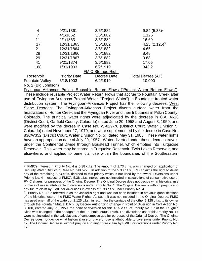
DIRECT FLOW Fountain Creek Priority No.(cfs)
Priority Date Decree Date Total Decree
4 9/21/1861 3/6/1882 9.84 (5.38) 7 4/1/1862 3/6/1882 1.125 11 2/1/1863 3/6/1882 16.69 17 12/31/1863 3/6/1882 4.25 (2.125) 21 12/31/1864 3/6/1882 4.65 28 12/31/1866 3/6/1882 8.48 29 12/31/1867 3/6/1882 9.68 41 9/21/1874 3/6/1882 17.05 168 1/31/1903 6/2/1919 343.2
STORAGE 3/18/1903 6/2/1919 10,000 AF
b. Triview Reusable Effluent. Triview will add up to 240 AF of reusable effluent as additional protection from injury caused by removing the 166 FMIC shares from the Existing Augmentation Plans. The reusable effluent derives from Triview’s Denver Basin ground water supplies that were quantified and decreed in Case Nos. 88CW23(A), 88CW23(B), 95CW153, 98CW134, 14CW3053 and 15CW3076. A list of the Denver Basin ground water supplies is attached to application as Exhibit A. (All exhibits mentioned herein are incorporated by reference and may be inspected at the office of the clerk of this Court.) c. Triview Excess Augmentation Supplies from 18CW3016. d. Triview’s 500 FMIC shares changed for augmentation use in 18CW3016, either as first use or fully reusable effluent following municipal use. e. Triview will also add procedures to the decree to allow use of additional or alternative sources of replacement water as provided in § 37-92-305(8) C.R.S. 7. Statement of Plan of Augmentation Plans. In order to prevent injury to vested water right users and owners of conditional water rights, Triview will release augmentation sources and will subtract transit losses from the amounts released at the place of release based on the stream distance from the replacement location to replace out of priority depletions caused by diversions from the Subject Wells. The Wigwam FMIC Shares will be the first augmentation source to replace out of priority depletions caused by diversions from the Wigwam Wells and Triview’s

4
reusable effluent and/or the Triview FMIC Shares will be used to replace any out of priority depletions from the Wigwam Wells that cannot be replaced by the Wigwam FMIC Shares. The FVP FMIC Shares and the FVP Return Flows will be used to replace out of priority depletions caused by diversion from the FVP Wells. a. The Wigwam Wells and the FVP Wells shall only divert water when the projection tool contained in the decree demonstrates that sufficient replacement supplies are available to replace all out of priority depletions caused by such diversions and all ongoing depletions from past diversions. b. Points of Depletion for Replacement Purposes: For purposes of replacement of depletions, the location of depletions from the Wigwam Wells will be deemed to be Section 10, Township 17 South, Range 65 West, 6th P.M., at a point approximately 2,169 feet north of the south line of said Section 10 and approximately 560 feet east of the west line of said Section 10, and the location of depletions from the FVP Wells will be deemed to be in Section 23, Township 17 South, Range 65 West, 6th P.M., at a point approximately 407 feet south of the north line of said Section 23 and approximately 578 feet west of the east line of said Section 23. The Division Engineer shall assess appropriate transit losses, if any, from the point(s) of release of replacement sources to the depletion replacement locations described above in accordance with the terms of this Decree. c. Triview will release the FMIC augmentation water to Fountain Creek through the following augmentation stations: i. Spring Creek Augmentation Station which is located in the NE ¼ NE ¼ , Sect 29, T 14 S, R 66W. UTM: 517717.0, 4295540.0 Zone 13 ii. McRae Augmentation Station which is located in the SW1/4 SW1/4 Sect 20, T 14 S, R 66 W UTM: 516466.0, 4296006.0 Zone 1 iii. Crews Gulch Augmentation Station which is located in the NE1/4 , NE ¼ Sect 19, T 15 S, R 65 W UTM: 525784.0, 4287528.0 Zone 13, provided it has an agreement with the owners of this augmentation statio iv. FMIC’s Big Johnson Reservoir located in Sections 8, 17, and 18, Township 15 South, Range 65 West of the 6th P.M to the FMIC Spring Creek augmentation station by interditch exchange. v. Triview may contract for the use of, construct, or participate in the construction of additional or alternate augmentation stations approved in accordance with Paragraph 8.8.1 of the 18CW3016 Decree. d. All reusable effluent is released from the Triview Waste Water Treatment Facility which is located in the Southeast Quarter of the Southeast Quarter of Section 35, Township 11 South, Range 67 West of the 6th P.M., at a point approximately 500 feet west of the East section line and on the South section line, in El Paso County Colorado. e. The Division Engineer shall assess appropriate transit losses, if any, on the water delivered under this Decree, between the point of release of such water to Monument Creek and Fountain Creek and the depletion replacement locations under this Decree. 8. Owners of Structures Associated with the Amended Augmentation Plans a. Comanche Resources, LLC c/o Gary Smith, Manager P.O. Box 25068 Colorado Springs, Colorado 80936 b. Wigwam Mutual Water Company P.O. Box 569 Fountain, Colorado 80817 c. Fountain Mutual Irrigation Company c/o Gary Steen 487 Anaconda Drive Colorado Springs, Colorado 80919 d. South 750, LLC 16650 Midway Ranch Road Fountain, Colorado 80817. e. Owners of Crews Gulch Augmentation Station: i. Widefield Water and Sanitation District (“Widefield”) c/o Steve Wilson, District Manager 37 Widefield Blvd. Colorado Springs, CO 80911 ii. City of Fountain, Colorado c/o Curtis Mitchell, Utilities Director 116 South Main Street Fountain, CO 80817WHEREFORE, the Applicant requests that the Third Amended Application for

5
Amendment of the Plan for Augmentation be approved as requested herein and for such other relief and conditions that the Court deems appropriate. --------------------------------------------------------------------------------------------------------------------- CASE NO. 2020CW3, MR. BILL PHILLIPS, P.O. Box 364, Florence, CO 81226: (719) 368-2868. Application for Simple Change in Surface Point of Diversion FREMONT COUNTY Name of Structure: Trottier Ditch. Date of Original Decree: April 13, 1903, Case No.: CA-2351, Court: Fremont County District Court. Legal description: From CA-2351; at a point within the south-east quarter of the south-west quarter of Section 19, Township 19 South, Range 68 West of the 6th P.M. from which point the south-west corner of said section bears S. 88˚, 19’ W. 3672 feet. Source of water: Hardscrabble Creek. Appropriation Date: December 1, 1884, (priority no. 48 ½ & 312 ½). Amount: 2.3 cfs absolute. Use: Irrigation. Detailed Description: The applicant seeks to change the decreed point of diversion of the Trottier Ditch water right from that location decreed in CA-2351 as quoted above to the point of diversion of the Tenazzi Ditch. This intervening distance is approximately one mile. The applicant owns all existing water rights decreed to the Trottier Ditch and to the Tenazzi Ditch. The applicant owns all intervening property. Intervening between the Trottier Ditch and the Tenazzi Ditch points of diversion, there are no other decreed water rights, there are no flowing tributary stream inflows, there are no known exchange termini and there are no decreed in-stream flow water rights. Location of new surface point of diversion: Tenazzi Ditch (SEO ID No. 1200624) UTM Coordinates: Easting 495515, Northing 4246020, Zone 13. Source of UTM’s: State Engineer’s Office records (https://dwr.state.co.us/Tools/Structures). Coordinates confirmed by applicant’s engineer GPS device during field inspection. Accuracy within 20 feet. See map on file with the Application and available for inspection at the office of the Clerk of this Court. Name(s) and address(es) of owner(s) or reputed owners of the land upon which any new diversion or storage structure, or modification to any existing diversion or storage structure is or will be constructed or upon which water is or will be stored, including any modification to the existing storage pool: Applicants. --------------------------------------------------------------------------------------------------------------------- CASE NO. 2020CW4, R. MATTHEW MILES JR., 1621 Ridgewood Avenue, Holly Hill, FL 32117, (386)451-1000: The Water Referee ordered that this Application not be published until Applicant responds to show cause order or application will be denied. --------------------------------------------------------------------------------------------------------------------- CASE NO. 2020CW5, R. MATTHEW MILES JR., 1621 Ridgewood Avenue, Holly Hill, FL 32117, (386)451-1000 Application for Simple Change in Surface Point of Diversion Pursuant to § 37-92-305(3.5),
C.R.S. or in the Alternative, Application for a Change of Water Right Pursuant to § 37-92-
305, C.R.S. CUSTER COUNTY Name of Structure: John Knuth Ditch. Date of Original Decree: 3/12/1896; Court: Fremont District Court (Custer County). Legal Description: The head of the ditch is located “at a point whence the S.E. Corner Sec. 17 Twp. 23 S. R. 72 W., bears S. 7˚ E. 899 feet and in the S.E. 4 S.E. 4 Sec. 17.” Source of water: Piroth Creek. Appropriation Date: 06-

6
15-1880 (Priority No. 266); Amount decreed to structure: 0.59 cfs (absolute). Use: Irrigation. Amount applicant intends to change: 0.59 cfs. Detailed description of proposed change in a surface point of diversion: The applicant seeks to change the point of diversion of the John Knuth Ditch water right from the stated above to the actual location of the Werhan Ditch as described below. The Werhan Ditch is located approximately 230 feet downstream of the decreed point of diversion of the John Knuth Ditch. The Werhan Ditch serves to irrigate the decreed lands of both the Werhan and the John Knuth Ditches. There are no intervening physical points of diversion nor points of inflow from a tributary surface stream no decreed in-stream flow water right within this 230 foot stream reach. The Werhan Ditch decreed point of diversion is located within this 230 foot stream reach. The decreed point of diversion for the Werhan Ditch is however being sought to be changed from its decreed location to the actual location of the Werhan Ditch by simultaneous application. The Werhan Ditch and John Knuth Ditch water rights are both entirely owned by the applicant. Location of the new surface point of diversion: (Werhan Ditch) UTM Coordinates: Northing: 4211063 Easting 460311 Zone 13. Source of UTMs: Hand-held GPS. Accuracy of location displayed on GPS device: 20 feet+/-. See map on file with the Application and available for inspection at the office of the Clerk of this Court. Name(s) and address(es) of owner(s) or reputed owners of the land upon which any new diversion or storage structure, or modification to any existing diversion or storage structure is or will be constructed or upon which water is or will be stored, including any modification to the existing storage pool: Hood Family Ranch LLC, 3258 County Road 125, Westcliffe, CO 81252. --------------------------------------------------------------------------------------------------------------------- CASE NO. 2020CW3006, LOWER ARKANSAS WATER MANAGEMENT ASSOCIATION (“LAWMA”) c/o Donald F. Higbee, Manager, 310 South 6th Street, P.O. Box 1161, Lamar, CO 81052 (Please address all pleadings and inquiries regarding this matter to Applicant’s attorneys: Richard J. Mehren, Jennifer M. DiLalla, John E. Peckler, Moses, Wittemyer, Harrison and Woodruff, P.C., 2595 Canyon Blvd., Suite 300, Boulder, Colorado 80302, (303)443-8782) Application for Plan for Augmentation PROWERS COUNTY 2. Background and purposes of Application: By the decree entered on August 1, 2017, in Division 2 Case No. 14CW3004 (“14CW3004 Decree”), LAWMA added a number of wells to its plan for augmentation (“Augmentation Plan”), which was decreed on March 8, 2007 in Division 2 Case No. 02CW181 (“02CW181 Decree”). Consistent with paragraph 44 of the 02CW181 Decree and paragraph 15 of the 14CW3004 Decree, the purposes of this Application are to add the new uses of dairy farm and cattle feedlot operations to one of the wells included in the Augmentation Plan by the 14CW3004 Decree, and to adjudicate the consumptive use factor for dairy farm operations. 3. Name of augmented structure: The well described in Exhibit A (“Augmented Structure”) to the application. A map showing the location of the Augmented Structure is attached to the application as Exhibit B. (All exhibits mentioned herein are incorporated by reference and may be inspected at the office of the clerk of this Court.) The Augmented Structure is located southeast of the Town of Holly in Prowers County. 4. Water rights and other sources of water to be used for augmentation: Those water rights and other sources of water identified in paragraph 40 of the 02CW181 Decree and in the decrees entered in

7
Case Nos. 05CW52, 10CW85, and 15CW3067 (“Existing Augmentation Supplies”); and those water rights and other sources of water that are added to the Augmentation Plan consistent with paragraph 41 of the 02CW181 Decree. A table identifying the Existing Augmentation Supplies by name, decree(s), location, source, appropriation date, amount, and decreed use(s) is attached to the application as Exhibit C, and a map showing the decreed locations of the Existing Augmentation Supplies is attached to the application as Exhibit D. 4.1 No use of Fryingpan-Arkansas Project water and return flows as augmentation source: The Augmented Structure is not located within the boundaries of the Southeastern Colorado Water Conservancy District, and water pumped from the Augmented Structure will not be used within such boundaries. Thus, LAWMA will not use Fryingpan-Arkansas Project water, including return flows, to replace depletions caused by the Augmented Structure. 5. Additional use for the Augmented Structure: The Augmented Structure will be used to provide an emergency, back-up water supply to a commercial dairy and cattle feedlot operation (“New Use”) that will be primarily supplied water by wells that are or will be completed in the Southern High Plains Designated Groundwater Basin. The New Use of the Augmented Structure is in addition to the irrigation use of the structure authorized by the 14CW3004 Decree. 6. Statement of plan for augmentation: LAWMA will apply the methodologies approved in the 14CW3004 Decree to determine the timing and location of depletions caused by pumping of the Augmented Structure for the New Use. LAWMA will determine the amount of depletions caused by pumping of the Augmented Structure for the New Use by separately metering all water delivered to the New Use. All water delivered to the New Use will be accounted for as fully consumed. Under the Augmentation Plan, LAWMA shall account for and fully replace all out-of-priority depletions attributable to pumping of the Augmented Structure for the New Use. LAWMA shall replace such depletions with fully consumable water in accordance with the terms and conditions of the 02CW181 Decree, the 14CW3004 Decree, and the decree to be entered in this case, in a manner that protects Colorado senior surface water rights from injury and ensures compliance with the Arkansas River Compact. 6.1 Integration into Case No. 02CW181 accounting and projection: The accounting for operation of the Augmented Structure will be incorporated into the accounting and projection required by paragraphs 47.E and 47.I of the 02CW181 Decree. Such accounting will include, without limitation, monthly diversions, monthly unlagged depletions, and monthly lagged depletions, as well as the fully consumable water sources available for replacement of such depletions. Additionally, in accounting for operation of the Augmented Structure, LAWMA shall use the integrated accounting forms approved in the 14CW3004 Decree. 7. Adjudication of consumptive use factor for dairy farm operations: LAWMA seeks to adjudicate a consumptive use factor of 100% for dairy farm operations under the Augmentation Plan. 8. No modification of prior decrees: This Application does not seek to change any provision of the 02CW181 Decree or the 14CW3004 Decree except to add the New Use to the Augmented Structure and to adjudicate a consumptive use factor of 100% for that use. This Application does not seek a change of water right for any of the Existing Augmentation Supplies, nor any change to decreed terms and conditions applicable to augmented structures previously included in the Augmentation Plan. 9. Names and addresses of owners or reputed owners of land upon which any new diversion or storage structure, or modification to any existing diversion or storage structure, is or will be constructed or upon which water is or will be

8
stored, including any modification to the existing storage pool: 9.1 GP Irrigated Farms, LLC, 751 SE CR 36, Syracuse, Kansas 67878. WHEREFORE, LAWMA respectfully requests that this Court enter a decree (i) approving the addition of the New Use to the Augmented Structure under the Augmentation Plan; (ii) finding and concluding that LAWMA will fully replace, so as to prevent injury to Colorado senior surface water rights and ensure compliance with the Arkansas River Compact, all out-of-priority depletions caused by pumping of the Augmented Structure for the New Use under the Augmentation Plan; and (iii) finding and concluding that use of a 100% consumptive use factor for dairy farm operations will prevent injury to Colorado vested water rights and ensure compliance with the Arkansas River Compact. --------------------------------------------------------------------------------------------------------------------- CASE NO. 2020CW3007, CITY OF FOUNTAIN, COLORADO, c/o Utilities Director, 101 N. Main Street, Fountain, CO 80817. (Please address all pleadings and inquiries regarding this matter to Applicant’s attorneys: Cynthia F. Covell, Andrea L. Benson, and Gilbert Y. Marchand, Jr., Alperstein & Covell P.C., 1600 Broadway, Suite 1070, Denver, CO 80202, (303)894-8191) Application to Make Partially Absolute and for Finding of Reasonable Diligence EL PASO AND PUEBLO COUNTIES. Name of Water Right: Fountain Pueblo Reservoir Exchange. Description of conditional water right: Case No: 2001CW108 (“Original Decree”), Water Division No. 2, decreed March 4, 2014. Subsequent decrees awarding diligence: This is the first diligence proceeding. Decreed exchange reach. The decreed downstream terminus of the exchange reach decreed in the Original Decree is the confluence of Fountain Creek and the Arkansas River, in the NE 1/4 of Section 6, Township 21 South, Range 64 West of the 6th P.M. in Pueblo County, Colorado, the location at which the water released to Fountain Creek as provided in the application reaches the Arkansas River. The decreed upstream terminus of the exchange reach is located on the Arkansas River at Pueblo Reservoir, which is located at the intersection of Pueblo Dam axis and the Arkansas River, whence the NE corner of Section 36, Township 20 South, Range 66 West of the 6th P.M. bears North 61 degrees 21' 20" East a distance of 2,511.05 feet. Said reservoir inundates all or portions of Sections 7, 18, 19, 20, 21, 22, 25, 26, 27, 28, 29, 30, 31, 32, 33, 34, 35 and 36, Township 20 South, Range 66 West of the 6th P.M., Sections 1, 2, 3, 4, 5, 9, 10 and 11, Township 21 South, Range 66 West of the 6th P.M., and Sections 5, 8, 9, 13, 14, 15, 16, 22, 23, 24 and 25, Township 20 South, Range 67 West of the 6th P.M., and has an existing capacity of approximately 357,678 acre-feet. ”). See Figure 1 attached to the application for a general location map. (All exhibits mentioned herein are incorporated by reference and may be inspected at the office of the clerk of this Court.). Source of Water: (1) Fountain Mutual Irrigation Company shares. The Original Decree authorizes exchange of fully-consumable water available from 358 shares of Fountain Mutual Irrigation Company (“FMIC”) which were quantified and changed in Case Nos. W-4396 and W-4559 (consolidated) (“Augmentation Plan I”), Case No. 85CW110 (“Augmentation Plan II”), and Case No. 91CW21 (included in references to Augmentation Plan II.) FMIC water rights are decreed as follows:
FMIC Direct Flow Rights Fountain Creek Priority No. Priority Date Decree Date Total Decree (cfs)
9
4 9/21/1861 3/6/1882 9.84 (5.38)2 7 4/1/1862 3/6/1882 1.125 11 2/1/1863 3/6/1882 16.69
17 12/31/1863 3/6/1882 4.25 (2.125)3 21 12/31/1864 3/6/1882 4.65 28 12/31/1866 3/6/1882 8.48 29 12/31/1867 3/6/1882 9.68 41 9/21/1874 3/6/1882 17.05 168 1/31/1903 6/2/1919 343.2
FMIC Storage Right Reservoir Priority Date Decree Date Total Decree (AF) Fountain Valley 3/18/1903 6/2/1919 10,000 No. 2 (Big Johnson) Fryingpan-Arkansas Project Reusable Return Flows (“Project Water Return Flows”). These include reusable Project Water Return Flows that accrue to Fountain Creek after use of Fryingpan-Arkansas Project Water (“Project Water”) in Fountain’s treated water distribution system. The Fryingpan-Arkansas Project has the following decrees: West Slope Decrees: The Fryingpan-Arkansas Project diverts surface water from the headwaters of Hunter Creek and the Fryingpan River and their tributaries in Pitkin County, Colorado. The principal water rights were adjudicated by the decrees in C.A. 4613 (District Court, Garfield County, Colorado) dated June 20, 1958 and August 3, 1959, and were modified by the decree in Case No. W-829-76 (District Court, Water Division 5, Colorado) dated November 27, 1979, and were supplemented by the decree in Case No. 83CW352 (District Court, Water Division No. 5), dated May 31, 1985. These water rights have an appropriation date of July 29, 1957. Water diverted under these decrees travels under the Continental Divide through Boustead Tunnel, which empties into Turquoise Reservoir. This water may be stored in Turquoise Reservoir, Twin Lakes Reservoir, and elsewhere, and applied to beneficial use within the boundaries of the Southeastern
2 FMIC's interest in Priority No. 4 is 5.38 c.f.s. The amount of 1.73 c.f.s. was changed on application of Security Water District in Case No. 90CW28. In addition to the 5.38 c.f.s., FMIC claims the right to divert any of the remaining 2.73 c.f.s. decreed to this priority which is not used by the owner. Diversions under Priority No. 4 in excess of FMIC's 5.38 c.f.s. interest are not included in calculations of consumptive use of FMIC shares for purposes of the Original Decree. The Original Decree does not decide what historical use or place of use is attributable to diversions under Priority No. 4. The Original Decree is without prejudice to any future claim by FMIC for diversions in excess of 5.38 c.f.s. under Priority No. 4. 3 Priority No. 17 is referred to as the Janitell's right and was not been included in previous quantifications of the historical use of the FMIC Water Rights. As such, it was not included in the Original Decree. FMIC has used one-half of the water, or 2.125 c.f.s., in return for the carriage of the other 2.125 c.f.s. to its owner through the Fountain Mutual Ditch. By Decree Authorizing Change in Point of Diversion in Civil Action No. 38180, entered July 29, 1959, the point of diversion for this 4.25 c.f.s. of Priority No. 17 of the Laughlin Ditch was changed to the headgate of the Fountain Mutual Ditch. The diversions under this Priority No. 17 were not included in the calculations of consumptive use for purposes of the Original Decree. The Original Decree does not decide what historical use or place of use is attributable to diversions under Priority No. 17. The Original Decree is without prejudice to any future claim by FMIC for diversions under Priority No. 17.

10
Colorado Water Conservancy District. Because the water is imported from another river basin, it is fully consumable in Water Division No. 2. East Slope Decrees: The Fryingpan-Arkansas Project also diverts and stores surface water from the Arkansas River and its tributaries in Lake, Chaffee, Fremont and Pueblo Counties. The principal water rights were adjudicated by the decrees in Civil Action No. 5141 (District Court, Chaffee County, Colorado) dated July 9, 1969, and Civil Action No. B-42135 (District Court, Pueblo County), dated June 25, 1962, and were modified and supplemented by the judgment and decree in Case No. 80CW6 (District Court, Water Division No. 2), dated October 23, 1980. These water rights include storage in Turquoise Reservoir, Twin Lakes Reservoir and elsewhere, with an appropriation date of February 10, 1939, and are expressly decreed for reuse and exchange for beneficial use within Southeastern’s district boundaries. Under these decrees, Turquoise Reservoir and Twin Lakes Reservoir may store native or imported water, directly or by exchange with each other or with Pueblo Reservoir. Appropriation dates and amount: FMIC Water: March 27, 2001. Project Water Return Flows: February 10, 1939 (measured municipal reusable Project Water return flows) and January 12, 1989 (unmeasured lawn irrigation return flows attributable to Project Water). The decreed rate of exchange is 19 cfs, with a maximum annual volume of 4,800 acre-feet. Uses. All municipal purposes, including augmentation and exchange. Detailed outline of what has been done toward completion or for completion of the appropriation and application of water to beneficial use as conditionally decreed, including expenditures. The Pueblo Reservoir Exchange is part of applicant’s integrated water supply system. A detailed outline of what has been done towards completion of the appropriation is set forth in the application filed with the water court in this case, and includes continued purchase and use of Project Water return flows, operation of this Pueblo Reservoir Exchange, participation in Case No. 06CW120 to provide greater opportunity to realize the benefit of the Pueblo Reservoir Exchange, capital investment in excess of $42,000,000 for water system infrastructure; and expenditure of approximately $285,000 in legal and engineering fees to protect and defend its water rights, including the Pueblo Reservoir Exchange. Claim to Make Absolute a Portion of the Conditional Exchange. During Water Year 2014 (November 1, 2013 – October 31, 2014), Fountain operated the Pueblo Reservoir Exchange in priority during the months of April through October. During April through June, Fountain exchanged a total of 250.06 acre-feet of Project Water Return Flows and FMIC Water attributable to the 358 shares to Pueblo Reservoir. Fountain exchanged this water into Pueblo Reservoir at a maximum rate of 3.09 cfs on June 6, 2014. When the exchange was operated, there was no call on the Arkansas River that would prevent operation of the exchange. Letter report from W.W. Wheeler & Associates Inc. is on file in the water court with this application. Use: The water exchanged to Pueblo Reservoir has been or will be used in Fountain’s municipal water distribution system following delivery to Fountain by pipeline from Pueblo Reservoir and treatment, to provide municipal water service to Fountain’s customers. Names and addresses of owners of the land upon which any new diversion structure or storage structure, or modification to any existing diversion or storage structure is or will be constructed or upon which water is or will be stored. Fountain has not constructed and does not intend to construct any new diversion structure or storage structure, or modification to any existing diversion or storage structure in connection with its operation of the Pueblo Reservoir Exchange. The land on which Pueblo Reservoir is located is

11
located on land or easements owned by the United States Department of Interior, Bureau of Reclamation, Eastern Colorado Area Office, 11056 West County Road 18-E, Loveland CO 80537-9711. --------------------------------------------------------------------------------------------------------------------- CASE NO. 2020CW3008, Previous Case Nos; 2003CW13 and 2013CW3047 – GUS J. SLANOVICH, 7340 S. Xanthia Way, Centennial, CO 80112, (Please address all pleadings and inquiries regarding this matter to Applicant’s attorney: Andrea L. Benson, Alperstein & Covell P.C., 1600 Broadway, Suite 1070, Denver, CO 80202, (303)894-8191). Application for Finding of Reasonable Diligence, in the Arkansas River or its Tributaries FREMONT COUNTY Name of structure: Mill Creek Spring; Type: spring. Describe conditional water right including the following information from previous decree: Original Decree: October 18, 2007, Case No. 2003CW13, Water Court, Division 2, State of Colorado; Findings of Fact, Conclusions of Law, Ruling of Referee and Decree of Court Finding Reasonable Diligence: March 10, 2014, Case No. 2013CW3047, Water Court, Division 2, State of Colorado. Legal description: SW ¼ SE ¼ Section 20, Township 19 South, Range 70 West, 6th P.M., Fremont County, Colorado, 200 feet from the South line and 1800 feet from the East line of Section 20. See Exhibit A attached to the application an 8 ½ x 11 inch map illustrating location of the structure (All exhibits mentioned herein are incorporated by reference and may be inspected at the office of the clerk of this Court.) Source of water: Natural spring tributary to Mill Creek, tributary to Arkansas River. Appropriation Date: July 24, 2002. Amount: .0334 cfs (15 gpm, conditional). Use: Stock water. Provide a detailed outline of what has been done toward completion or for completion of the appropriation and application of water to a beneficial use as conditionally decreed, including expenditures, during the previous diligence period: During the diligence period, the Applicant has conducted several site visits to investigate the possibility of improving the spring to more efficiently divert this water right to apply it to beneficial use on his property. No improvements have been made to date, since the Mill Creek Spring water right can be used in its undeveloped state. Nevertheless, in order to improve efficiency Applicant is in the process of engaging an engineer to conduct further research into spring improvements. The Mill Creek Spring is an integral part of Applicant’s integrated stock watering and irrigation water supply system for his property. Pursuant to C.R.S. § 37-92-301(4)(b), when an integrated system is composed of several features, as is the case here, work on one feature of the system is considered in finding that reasonable diligence has been shown in the development of water rights for all features of the entire system. The Applicant has been engaged in an ongoing effort to develop all known sources of water on his land, including purchasing additional water rights for use on and around his property. Thus, Applicant has made substantial effort in developing the integrated water supply system on his property, including the Mill Creek Spring. Applicant has defended his water rights against applications filed by others in cases where Applicant has determined that injury to his water rights could occur in the absence of appropriate terms and conditions, including opposition to Upper Arkansas Water Conservancy District’s water court application in Case No. 18CW3076, pending in Division 2, Water Court. During this diligence period, Applicant expended approximately $8,000.00 in attorney fees defending his water rights

12
and developing his water supply system. Names and addresses of owners or reputed owners of the land upon which any new diversion or storage structure, or modification to any existing diversion or storage structure is or will be constructed or upon which water is or will be stored, including any modification to the existing storage pool. Applicant. --------------------------------------------------------------------------------------------------------------------- CASE NO. 2020CW3009, Previous Case No; 12CW39 – PUEBLO, A MUNICIPAL CORPORATION, Attn: Mr. Scott Hobson, Acting Director of Planning & Community Development, 211 E. D Street, Pueblo, CO 81003. (Please address all pleadings and inquiries regarding this matter to Applicant’s attorneys: Christopher L. Thorne and Matthew K. Tieslau, Greenberg Traurig LLP, 1144 15th Street, Suite 3300, Denver, CO 80202, (303) 572-6500; Daniel Kogovsek, 1 City Hall Place, Third Floor, Pueblo, Colorado 81003, (719) 562-3889). Application for Finding of Reasonable Diligence with Respect to Recreational In-Channel Diversion Water Right PUEBLO COUNTY Background: In Case No. 01CW160, Applicant obtained a conditional water right decree for the recreational in-channel diversion water right (“RICD Water Right”) associated with the Arkansas River Legacy Whitewater Park (the “Whitewater Park”) in Pueblo, Colorado. In Case No. 12CW29, the Water Court issued a decree making the RICD Water Right associated with Structures 1 through 8 of the Whitewater Park, absolute, and continuing the conditional status of the RICD Water Right associated with Structure 9. In this case, Applicant seeks a finding of reasonable diligence continuing the conditional status for Structure 9 of the Whitewater Park. Description of Water Right: The RICD Water Right is described as follows: Original Decree: Case No. 01CW160 (Water Div. 2), decree dated April 5, 2006. Name of Structures: The nine control structures comprising the Whitewater Park are numbered consecutively from the upstream structure (Structure 1) to the furthest downstream structure (Structure 9). Construction of Structures 1 through 8 was completed in 2005. Structure 9 will be constructed in the future. These nine structures comprise a whitewater and recreational boating course, which enjoys regular and frequent use by local boaters and boaters who travel to Pueblo from many other locations. Structure 1 of the Whitewater Park includes a permanent boat chute/fish ladder to allow kayaks, boats, and other recreational water craft, as well as native and sport fish, to pass over an existing 13-foot high diversion structure in the river known as the Southern Colorado Power Plant or Aquila Energy diversion dam (the "Power Plant Diversion"). A series of seven smaller, permanent control structures (Structures 2-8) have been constructed in the river between the Power Plant Diversion and the Union Street bridge to create self-scouring pools and to divert and control the flow of the river at specific points to create various wave forms desirable for whitewater kayaking and recreational boating. The Whitewater Park will extend downstream to Structure 9, a permanent boat chute or chutes in the Arkansas River at the location of the existing St. Charles Mesa Water District diversion structure, located just downstream from the Santa Fe Street bridge in Pueblo, near Moffat Street (the "Moffat Street Chute") to allow passage over the existing diversion structure. The Whitewater Park structures were designed to control, concentrate, and direct the flow of the Arkansas River for use by kayaks, canoes, rafts and other types of recreational water crafts, and to establish and maintain fish habitat for piscatorial and

13
other purposes. The structures are of the type and nature described in the letter report dated December 24, 2001 by Gary M. Lacy, submitted as Pueblo's Exhibit D in the hearing before the Colorado Water Conservation Board on July 22-23, 2002, and have been constructed generally in conformity therewith. Legal Description of Structures: The Whitewater Park was constructed in the Arkansas River channel, beginning with the boat chute/fish ladder (Structure 1) over and through the Power Plant Diversion. Seven other control structures (Structures 2 through 8) are located in the river between Structure 1 and the Union Street Bridge. Structures 2 through 8 are constructed in a reach of the river that is approximately 2,000 feet in length. The Moffat Street Chute (Structure 9) will be constructed consistent with the decree in Case No. 01CW160 at the location described below. The Power Plant Diversion, the Union Street bridge, and the Moffat Street Chute (Structure 9) are generally located as follows: Power Plant Diversion (Structure 1): A water control structure located in the Arkansas River channel in the SWl/4 of the NWl/ 4, Section 36, T. 20 S., R. 65 W., of the 6th P.M., at a point approximately 2,326 feet South of the North Section line and 810 feet East of the West Section line of said Section 36. Union Street Bridge: The Union Street bridge crosses the Arkansas River in Pueblo in the SEl/4 of the SWl/4, Section 36, T. 20 S., R. 65 W., of the 6th P.M., at points approximately 968 feet North of the South Section line and 2,320 feet East of the West Section line of said Section 36. Moffat Street Chute (Structure 9): The Moffat Street Chute is a structure in the Arkansas River channel located in the SWl/4 of the NWl /4, Section 6, T. 21. S., R. 64 W., of the 6th P.M., at a point approximately 1,684 feet South of the North Section line and 287 feet East of the West Section line of said Section 6. The U.S. Geological Survey topographic map attached to and incorporated in this Application as Exhibit 1 identifies the general location of the Whitewater Park and the control structures as described above in the decree in Case No. 01CWl6. (All exhibits mentioned herein are incorporated by reference and may be inspected at the office of the clerk of this Court.). Structures 1 through 8 were constructed consistent with the decree. Source. The source of the RICD Water Right for the Whitewater Park is the Arkansas River and its tributaries. Appropriation Date: May 15, 2000. Amount Claimed: The following amounts, in cubic feet of water per second of time ("cfs") were decreed in Case No. 01CW160 as a conditional RICD water right for each of the specified time periods for each of the structures that comprise the Whitewater Park:
Period Average Year Drier Year
Oct. 1- Oct. 15 250 150
Oct. 16-Nov. 14 200 150
Nov. 15-Mar. 15 100 100
Mar. 16-Mar. 31 250 200
Apr. 1 - Apr. 15 350 250
Apr. 16- Apr. 30 400 300
May l -May 22 450 350
May 23 - Jul. 31 500 500

14
Aug. 1-Aug. 15 450 350
Aug. 16- Sep. 7 300 300
Sep. 8 - Sep. 30 250 150
The U.S. Natural Resources Conservation Service regularly releases a "Water Supply Outlook Report” for Colorado. This report includes a "most probable" forecast (50% chance of exceedance) for flows on the Arkansas River at Salida (the "Forecast"). The "Average Year" flows in the table above shall apply when the most recently released Forecast is 100% or more. The "Drier Year" flows shall apply when the most recently released Forecast is less than 100% and greater than or equal to 70%. If the Forecast ceases to be provided by the Natural Resources Conservation Service, the Applicant shall notify the Court and all parties to the case in writing of a proposed alternative measure for fair implementation of this paragraph. The other parties shall have 30 days in which to provide comments to the Court concerning Applicant’s proposal, after which the Court shall decide upon the alternative measure to be used. Uses: Boating, including but not limited to kayaking, rafting, and canoeing. The RICD Water Right is also used for incidental fishing, wildlife habitat, and piscatorial uses. However, no water right for fishing, wildlife habitat, or piscatorial uses was confirmed by the decree in Case No. 01CWl 60. Evidence in Support of Claim for Finding of Reasonable Diligence: The activities described below, which occurred during the most recent diligence period, support Applicant's claim to continue the conditional RICD Water Right for Structure 9 in full force and effect for another six-year diligence period. This list is not intended to be exclusive and may be supplemented by additional, and more detailed evidence. Applicant’s flood levee reconstruction program/project involves many improvements to the Whitewater Park and along the Arkansas River in the RICD reach. Significant planning, design, contracting, and funding activities relating to these improvements, were completed by Applicant during the diligence period. The improvements, many of which are scheduled for completion during the 2020/2021 timeframe, include, but are not limited to: (i) new boater parking and access road (est. $700,000); (ii) two new boater/pedestrian access bridges (est. $2 million); and (iii) the Arkansas River Levee Reconstruction Boater Access and Safety Improvements project, which will include improved access to Structure 9, among many other features (est. $3.2 million). These safety, water feature and spectator improvements will collectively add to increased usage of the Whitewater Park, and the need/demand for completion of Structure 9, which among other things, will facilitate safe water craft passage. Funding secured by Applicant for the improvements described above, includes the following: Great Outdoors Colorado (contract date – 12/9/2019 $1.3 million; Colorado Dept. of Local Affairs (contract date - 3/9/2020) $1.0 million; Colorado Dept. of Transportation (contract date – 7/25/2016 $1.1 million; Pueblo Conservancy District (IGA date – 12/9/2019) $2.0 million. In 2018, Applicant and the Pueblo Conservancy District completed the Arkansas River Levee Park Master Plan which guides future improvements along a 2.75-mile section of the Arkansas River from Wildhorse Creek to Runyon Lake, including the Whitewater Park. The plan identifies significant access improvements, in-stream improvements to the Whitewater Park, and many other planned improvements, including at the location of Structure 9. Funds expended for the completion of the master plan and related preliminary design work, have

15
exceeded $250,000. In addition, during the diligence period Applicant expended in excess of $120,000 for legal fees and water rights consulting work to assist Applicant's efforts to protect the RICD Water Right and flows for the Whitewater Park, through participation as an opposer in numerous Water Court applications, and as a member of the Arkansas River Flow Management Committee. Terms and Conditions to Prevent Injury: The terms and conditions set forth in Paragraph 7 of the final decree in Case No. 01CWl 60 will continue to apply to the RICD Water Right. Name and Address of Owner of Land on Which Points of Diversion and Places of Use are Located: Applicant, at the above address. The Pueblo Conservancy District, P.O. Box 234, Pueblo, CO 81002. ---------------------------------------------------------------------------------------------------------------------
CASE NO 2020CW3010, Previous Case Nos: 13CW3012 and 04CW124 – SALIDA SCHOOL DISTRICT R-32J, 349 E. 9th St., Salida, Colorado 81201; and CITY OF SALIDA, 8475 C.R. 120, Salida, Colorado 81201 (Please address all pleadings and inquiries regarding this matter to Applicant’s attorneys: Jennifer M. DiLalla, Gregor A. MacGregor, Moses, Wittemyer, Harrison and Woodruff, P.C., 2595 Canyon Boulevard, Suite 300, Boulder, Colorado 80302, (303)443-8782). Application for Findings of Reasonable Diligence CHAFFEE, FREMONT, PUEBLO, AND LAKE COUNTIES 2. Description of conditional appropriative right of exchange: The School District irrigates up to 10 acres of turf grass used as athletic fields in the El/2, NE1/4 of Section 6, T49N, R9E of the N.M.P.M., south of the Denver and Rio Grande Western right-of-way ("Athletic Fields"). See Exhibit A attached to the application for a general location map. (All exhibits mentioned herein are incorporated by reference and may be inspected at the office of the clerk of this Court.) The subject conditional appropriative right of exchange (“School District Exchange”) will enable Applicants to use augmentation credits generated in Salida’s plan for augmentation decreed on Nov. 5, 1987, in Case No. 84CW158 and amended on June 30, 2009, in Case No. 04CW125 and on Mar. 14, 2019, in Case No. 18CW3008 (collectively, “Augmentation Plan”) to augment out-of-priority depletions associated with use of two surface water rights, the Town Ditch and the Lippard Seepage Ditch, for future irrigation of the Athletic Fields. 2.1 Original Decree: Case No. 04CW124, entered May 22, 2007, District Court, Water Division No. 2. 2.2 Subsequent decree granting finding of reasonable diligence: Case No. 13CW3012, entered Mar. 21, 2014, District Court, Water Division No. 2. 2.3 Appropriation date: Dec. 17, 2004. 2.4 Amount: 0.5 cfs (23.9 acre-feet per year), CONDITIONAL. 2.5 Use: Augmentation of out-of-priority depletions attributable to use of the Town Ditch and Lippard Seepage Ditch for irrigation of the Athletic Fields, the location of which is given in par. 2 above and shown on Ex. A. 2.6 Exchange reaches and source of water: The School District Exchange will operate between the exchange-from point and the exchange-to points described below, and will deplete the Arkansas River in those reaches. The exchange-from point, the exchange-to points, and the exchange reaches are shown on the map attached as Ex. A. 2.6.1 Exchange-from point: A point immediately below the Salida Sewage Treatment Outflow where the Arkansas River is intersected by the east-west centerline of Section 9, T49N, R9E of the N.M.P.M. 2.6.2 Exchange-to points: 2.6.2.1 The point where the Town Ditch terminates into the Arkansas River in the SE1/4, SE1/4 of Section 32, T50N, R9E of the N.M.P.M., approximately 1,250 feet north of the south section line and 920 feet west of the east section line of said Section 32. 2.6.2.2 The northeast corner of the Athletic Fields,

16
in the E1/2, NE1/4 of Section 6, T49N, R9E of the N.M.P.M., along the drainage channel connecting the Athletic Fields to the Arkansas River. 2.7 Source of substitute supply: Excess augmentation credits available under Salida’s Augmentation Plan. The water rights that generate the excess augmentation credits are summarized in the table attached as Ex. B. 3. Outline of work and expenditures during the diligence period towards completion of appropriation and application of water to beneficial use: The diligence period for the School District Exchange is March 2014 through March 2020 (“Diligence Period”). During the Diligence Period, the School District and Salida worked diligently to develop the School District Exchange, complete the appropriation, and place the water to beneficial use, as demonstrated by the following activities and expenditures: 3.1 The School District operates an integrated water supply system with both surface water (to be augmented by the School District Exchange) and groundwater (from a horizontal well) used for irrigation at the Athletic Fields. The School District continues to evaluate construction of the infrastructure required to divert Town Ditch and Lippard Seepage Ditch water rights for irrigation of the Athletic Fields, with augmentation of associated out-of-priority depletions to be accomplished through the School District Exchange. 3.2 The Athletic Fields currently are irrigated with groundwater from the horizontal well with Permit No. 63975. The well is augmented under the Upper Arkansas Water Conservancy District’s Umbrella Augmentation Plan originally decreed in Case No. 92CW84, with Augmentation Certificate No. 1506. Until infrastructure is completed to divert the two surface water rights, the School District will use the horizontal well as its primary source of irrigation water. 3.3 The School District has maintained the culvert under Holman Avenue to facilitate delivery of Lippard Seepage Ditch water to the vault at the Athletic Fields for subsequent irrigation use, and has conferred with the Water Commissioner about that operation. The School District also has maintained all infrastructure on the School District’s property to move water to the vault from the culvert. 3.4 The School District incurred costs of approximately $70,000 to operate, maintain, and repair the Athletic Fields and all components of the irrigation system used to water those fields. 3.5 The School District paid $500.38 each year to the Upper Arkansas Water Conservancy District Water Activity Enterprise for augmentation of the well with Permit No. 63975, which the School District uses for irrigation of the Athletic Fields while it continues to develop plans for the infrastructure needed to deliver water from the Town Ditch and the Lippard Seepage Ditch to the irrigation vault at the Athletic Fields. 3.6 The School District incurred costs of approximately $3,300 for electrical service to operate the well with Permit No. 63975. 3.7 Salida incurred costs of approximately $63,000 to operate, maintain, and repair the ditches associated with the water rights from which Salida derives its augmentation supply. Those ditches are identified in Ex. B. 3.8 Salida’s Water Plant Operator devoted and continues to devote approximately eight hours per month to completing the accounting for operation of Salida’s Augmentation Plan. 3.9 Salida expended approximately $68,000 in legal fees related to filing and prosecuting statements of opposition in Water Court to protect Salida’s water rights, including the School District Exchange, from injury. 3.10 Salida expended approximately $3,200 in legal fees related to the School District’s and Salida’s diligent development of the School District Exchange. 3.11 Salida expended approximately $105,000 in consulting fees for engineering in support of the City’s Water Court activity, including without limitation the activity described in paragraph 3.9 above; for work on updates to Salida’s Raw Water Master Plan; for work

17
on the City’s water infrastructure planning; and for accounting under and other compliance with the decrees under which Salida generates the excess augmentation credits that provide the source of substitute supply for the School District Exchange. 4. No claim to make absolute: Applicants do not seek to make any portion of the School District Exchange absolute herein. 5. Names and addresses of owner(s) of the land upon which any new diversion or storage structure, or modification to any existing diversion or storage structure is or will be constructed or upon which water is or will be stored: Co-Applicant Salida School District R-32J. WHEREFORE, the School District and Salida respectfully request that the Court enter a decree (i) finding that the School District and Salida have exercised reasonable diligence in working to develop the School District Exchange, complete the appropriation, and place the water to beneficial use; and (ii) continuing the School District Exchange in full force and effect for an additional diligence period. --------------------------------------------------------------------------------------------------------------------- CASE NO. 2020CW3011, BOARD OF WATER WORKS OF PUEBLO, COLORADO c/o Seth Clayton, Executive Director, P.O. Box 400, Pueblo, Colorado 81002-0400 (Please address all pleadings and inquiries regarding this matter to Applicant’s attorneys: Karl D. Ohlsen and Katrina Fiscella, Carlson, Hammond & Paddock, LLC, 1900 Grant Street, Suite 1200, Denver, Colorado 80203-4312, (303)861-9000). Application for Water Right and Change of Water Right PUEBLO COUNTY I. BACKGROUND. 1. The Historical Arkansas Riverwalk Project (“HARP”) is a development of a portion of the historical Arkansas River channel as a scenic, aesthetic, recreational, economic development and park amenity in downtown Pueblo. Water rights for HARP were decreed in Case No. 93CW86. These water rights consist of the HARP Water Right in the amount of 30 c.f.s., the HARP Tailwater Right in the amount of 200 c.f.s., and a plan of augmentation to replace any out-of-priority depletions resulting from the operation of HARP. The HARP Tailwater Right is dependent on discharges from the power plant located in downtown Pueblo currently owned by Black Hills/Colorado Electric Utility Company, LP. That power plant is not currently operating, and so the 30 c.f.s. HARP Water Right is the only decreed source currently available for HARP. At times the demand for water flow through HARP is greater than 30 c.f.s. Accordingly, the purpose of this application is to add water rights to supplement the HARP Water Right at times when the demand for flow is greater than 30 c.f.s. and the HARP Tailwater Right is not available. Any out-of-priority depletions resulting from the changed and new water rights in this application will be replaced under the existing plan for augmentation decreed in Case No. 93CW86, but otherwise this application does not seek to replace or change the water rights granted or the terms and conditions decreed in Case No. 93CW86. II. CHANGE OF WATER RIGHT. 2. Decreed water rights for which a change is requested: A. Name of water right and related structures: 1) Southern Colorado Power Company’s Cooling Basin (“SOCO water storage right”) for 104.5 acre-feet. B. Date of original and all relevant subsequent decrees: 1) Original Decree: In the Matter of the Adjudication of Rights to the Use of Water for Beneficial Uses other than Irrigation in Water District No. 14, entered on October 13, 1932, in Case No. 19693 by the Pueblo County District Court. C. Legal description of structures: 1) Decreed Point of Diversion for Intake Conduits to Southern Colorado Power Company’s Cooling and Condensing

18
System: located at a point on the Northerly bank of said new channel of the Arkansas River as constructed by The Pueblo Conservancy District, whence the West quarter corner of Section 36, Township 20 South, Range 65 West of the Sixth Principal Meridian bears South 65° 30’ West, 1,090 feet, and is thence carried through said conduits…into the old channel of the Arkansas River…. 2) Decreed location of the Southern Colorado Power Company’s Cooling Basin: in said old channel of said Arkansas River immediately west of Victoria Avenue in said City of Pueblo, and the dam of said Cooling Basin is located across the bed of said old channel of said Arkansas River in the Southeast quarter of Section 36, Township 20 South, Range 65 West, 6th P.M. and the Southerly end of said dam is located at a point whence the East quarter corner of said Section 36, bears South 86° 16' East, 1,694 feet. The Cooling Basin takes its supply of water from the new channel of said Arkansas River through and by means of the intake conduits to Southern Colorado Power Company’s Cooling and Condensing System. 3) Maps depicting the location of the decreed point of diversion from the Arkansas River and the ponds now comprising the SOCO cooling basin are attached to the application as Exhibits 1 and 2. (All exhibits mentioned herein are incorporated by reference and may be inspected at the office of the clerk of this Court.) D. Decreed source of water: Arkansas River. E. Appropriation Date: April 14, 1926, Non-Irrigation Reservoir Priority No. 5. F. Decreed use or uses: storage of 104.5 acre-feet for cooling and condensing purposes at electrical power plants with the right to fill, refill and replenish whenever water is needed for the decreed purposes and is available in priority. G. Amount of water that Applicant intends to change: Pueblo Water owns and seeks to change all 104.5 acre-feet of the SOCO water storage right. 3. Detailed description of proposed change: A. Black Hills Energy has permanently ceased operation of the electrical energy power plant supplied by the Southern Colorado Power Company’s Cooling and Condensing System water rights decreed in Case 19693. Pueblo Water has acquired those water rights. By this application Pueblo Water seeks to change the type of use of the 104.5 acre-feet SOCO water storage right to add the use of supplying water for the operation of the Historical Arkansas Riverwalk Project (“HARP”) within the City of Pueblo for maintenance of lakes, ponds, public parks and amenities, recreation, piscatorial, and wildlife use. The change of use is in addition to the existing use for cooling and condensing in connection with electrical power generation. The water will be stored and used at or upstream of Victoria Street in the City of Pueblo in the area where the SOCO cooling basin was historically located. This includes the current Lake Elizabeth and the SOCO Cooling Basin ponds shown on Exhibit 1 and 2 hereto. The total amount of water stored and the provisions for filling, refilling, and replenishing such storage will remain the same as originally decreed for this water storage right in Case No. 19693, described above. B. Description of the HARP Area: The upper terminus of the HARP Area is located at a point approximately whence the West quarter corner of Section 36, Township 20 South, Range 65 West of the Sixth Principal Meridian bears South 65 degrees, 30 minutes West, a distance of 1,090 feet. The upper terminus is the same as or near to the present point in the flood control levee of the Arkansas River where the Intake Conduits to the Southern Colorado Power Company’s Cooling and Condensing System described above, divert water through the levee into the historical Arkansas River channel. The lower terminus of the HARP Project Area is located at a point near where the historical Arkansas River channel passes under Santa Fe Avenue in the NW¼, SW¼ of Section 31, Township 20 South, Range 64 West of the Sixth Principal Meridian. Pueblo

19
Water anticipates that the SOCO Cooling Basin ponds will in the future be improved and integrated fully into the HARP. C. In accordance with the March 1, 2004 and May 27, 2004 Intergovernmental Agreements that establish the Arkansas River Flow Management Program, the changes of the SOCO water storage right requested herein will be operated so as to not increase unaugmented out-of-priority depletions to the Arkansas River where the outlet from Runyon Lake currently joins the Arkansas River in the NE1/4 of section 6, Township 21 South, Range 64 West of the 6th P.M. All out-of-priority depletions from exposed water surface area from the SOCO Cooling Basin ponds will be replaced in accordance with the HARP Augmentation Plan Decree in this Court’s Case No. 93CW86. The out-of-priority depletions from the SOCO Cooling ponds have been replaced by Pueblo Water since 2015 pursuant to annual Substitute Water Supply Plans. D. The inclusion of the SOCO cooling basin ponds into the HARP will not result in more than 90 acre-feet of depletions annually. The inclusion of the SOCO cooling basin ponds into the HARP will reduce the unaugmented depletions under the SOCO water rights. E. Neither the Southern Colorado Power Company and its successors in interest nor the Colorado Division of Water Resources historically recorded the diversions made at the point of diversion for the Intake Conduits of the Southern Colorado Power Company’s Cooling and Condensing System. Beginning in 2004, diversion records have been maintained for the outflows from the HARP Project Area. These flows are substantially the same as diversions at the intake conduits for SOCO water rights on the Arkansas River. A summary of those diversions is attached as Exhibit 3 hereto. 4. Name and address of owner or reputed owner of the land upon which any new diversion or storage structure, or modification to any existing diversion or storage structure is or will be constructed or upon which water is or will be stored, including any modification to the existing storage pool. According to the Pueblo County Assessor’s online records, the land parcels on which the SOCO Cooling Basins are located are owned by the Atchison, Topeka & Santa Fe Railway and Western Power & Gas Co. Pueblo Water believes that the Burlington Northern and Santa Fe Railway is the successor in interest to the Atchison, Topeka & Santa Fe Railway and Black Hills/Colorado Electric Utility Company, LP is the successor in interest to Western Power & Gas Co. III. APPLICATION FOR WATER RIGHT. 5. Name of water right: HARP Supplemental Right. 6. Name of structure: HARP water rights point of diversion. 7. Legal description of the point of diversion: The location is described in paragraph 2.C.1. above, See Exhibit A attached to the application for a general location map and is further described below. (All exhibits mentioned herein are incorporated by reference and may be inspected at the office of the clerk of this Court.) Location information in UTM format: UTM coordinates: Easting 533029.98641099 Northing 4235517.94993944 Zone 13N. Street Address: None. Source of UTMs: Google Earth. Legal Description Using the Public Land Survey System (PLSS): Legal Description: Pueblo County, SW ¼ of the NW ¼ of Section 36, Township 20 S, Range 65 W of the 6th Principal Meridian. Distance from section lines: At a point whence the West quarter corner of Section 36, Township 20 South, Range 65 West bears South 65º 30’ West, 1090 feet. Source of PLSS information: Original Decree for the Southern Colorado Power Company’s Cooling and Condensing System, Case No. CA 19693, Pueblo County District Court. Street Address: None. 8. Source: Arkansas River. 9. A. Date of appropriation: April 30, 2013. This is the date that Black Hills/Colorado Electric Utility Company, LP filed an application
20
to decommission the power plants formerly served by the Southern Colorado Power Company’s Cooling and Condensing System water rights decreed in Case 19693 that were previously a source of water for HARP. B. How appropriation was initiated: formation of intent to appropriate water, filing of substitute water supply plan, diversion and use of water for HARP purposes under the approved substitute water supply plan. A total of 101 c.f.s. was diverted at the HARP water rights point of diversion on September 15, 2013 and used in the HARP. C. Date water applied to beneficial use: not applicable to conditional water right. 10. Amount claimed in cubic feet per second (c.f.s.): 71 c.f.s. conditional. 11. List All Uses or Proposed Uses: To supply water for the operation of the HARP within the City of Pueblo for maintenance of lakes, ponds, public parks and amenities, recreation, piscatorial, and wildlife use. This water right will supplement the 30 c.f.s. HARP Water Right also decreed in Case No. 93CW86 when the HARP Tailwater Right is not available. 12. Any depletions resulting from out-of-priority diversions by this water right will be replaced in accordance with the decree in Case No. 93CW86. In the administration of this water right Applicant requests that the Division Engineer be required to recognize that the exchange potential of the Arkansas River is not reduced by the diversion of water into the HARP channel so long as (1) water diverted into the HARP Project Area re-enters the Arkansas River at the point of return described in paragraph 3.C above, and (2) all depletions attributable to HARP are replaced pursuant to the Plan for Augmentation decreed in Case No. 93CW86. 13. Pueblo Water proposes the following terms and conditions to prevent injury to water rights located between Southern Colorado Power Company’s Intake Structure and the Runyon Lake Return. St. Charles Mesa Water Districts’ (“SCMWD”) Pumping Plant No. 1 (“Pump Station”) and the City of Pueblo’s Recreational In-Channel Diversion (“RICD”) are located in the reach of the Arkansas River below where the diversions under this Application will occur and above where the return flows are discharged from Runyon Lake. The following conditions will prevent injury to those water rights: A. At times when SCMWD is diverting water at the Pump Station, if diversions by Pueblo Water pursuant to the water rights sought herein would cause the flow at the Moffat Street Gauge to fall below 50 c.f.s. or the specific conductance at the gauge to exceed 800 (µS/cm), then upon a request by SCMWD, Pueblo Water will reduce diversions from the Arkansas River under the HARP Supplemental Water Right sought herein and the SOCO Water Storage Right changed herein to the extent necessary to maintain 50 c.f.s at the Arkansas River at Moffat Street or to prevent the specific conductance from exceeding 800 (µS /cm). Operation of the HARP Water Right and HARP Tailwater Right will continue to be governed by the terms and conditions of the decree in Case No. 93CW86. B. If the RICD water right is unsatisfied, then Pueblo Water will reduce diversions from the Arkansas River under the water rights sought herein to the extent necessary to satisfy the RICD water right call. Moreover, even though the RICD water right is not in effect from 10:00 p.m. to 6:00 a.m., Pueblo Water will operate the water rights sought herein as if the RICD water right is in effect 24 hours per day to the extent there are no water rights junior to the conditional water right claimed in this application depleting the flow through the RICD reach. Operation of the HARP Water Right and HARP Tailwater Right will continue to be governed by the terms and conditions of the decree in Case No. 93CW86. C. No water diverted pursuant to the water rights sought herein may be diverted and used by others between the point of diversion for the SCPC Water Right on the Arkansas River, from the HARP, or below the HARP and above

21
the waters point of return to the Arkansas River at Runyon Lake. 14. Name(s) and address(es) of owner(s) or reputed owner(s) of the land upon which any new or existing diversion or storage structure, or modification to any existing diversion or storage structure is or will be constructed or upon which water is or will be stored, including any modification to the existing storage pool: According to the real property records available to Applicant, the diversion structure is located on lands owned by the Pueblo Conservancy District, 111 East 5th St., Pueblo, CO 81003.The conduit is located on lands owned by the Atchison, Topeka & Santa Fe Railway, as are the two westernmost ponds c/o Burlington Northern and Santa Fe Railway, 2301 Lou Menk Drive, GOB-3W, Fort Worth, TX 76131-2830. the two easternmost ponds are located on land owned by Western Power & Gas Co., c/o Black Hills/Colorado Electric Utility Company, LP 1515 Wynkoop St # 500, Denver, CO 80202. See Exhibit 2 for an approximation of the land ownership interests. --------------------------------------------------------------------------------------------------------------------- CASE NO. 2020CW3012, PUEBLO EAST PHASE III, LLC, In the Arkansas River or its Tributaries, c/o Jodi Schreiber, 839 Mackenzie Avenue, Canon City, CO 81212. (Please address all pleadings and inquiries regarding this matter to Applicant’s attorneys: Mark D. Detsky, Atty. Reg. No. 35276. K.C. Cunilio, Atty. Reg. No. 51378. Dietze and Davis, P.C. 2060 Broadway, Suite 400, Boulder, CO 80302, Phone: (303) 447-1375.) Application for Approval of Conditional Water Storage Right PUEBLO COUNTY 2. Background. This application concerns property that the Applicant owns as set forth in that certain deed dated November 26, 2018 and recorded in the real property records of Pueblo County at Reception No. 2123672. Applicant’s land totals 403.4 acres and is located in portions of Sections 35 and 36, Township 20 South, Range 63 West; Sections 1 and 2, Township 21 South, Range 63 West, all in the 6th P.M., which is depicted on Exhibit A attached to the application, (showing wells and irrigated acreage), and Exhibit B (water storage). (All exhibits mentioned herein are incorporated by reference and may be inspected at the office of the clerk of this Court.) This application will adjudicate a new conditional water storage right to be constructed on the Applicant’s property to be constructed based on planned gravel mining activity. CLAIM FOR CONDITIONAL WATER STORAGE RIGHT. 3. Name of Reservoir: PEPIII Reservoir. The PEPIII Reservoir may consist of a single large cell or multiple connected, smaller cells. A. Location: The conditional water storage right is located in Sections 35 and 36, Township 20 South, Range 63 West; Section 2, Township 21 South, Range 63 West, all in the 6th P.M., as depicted on attached Exhibit B. (All exhibits mentioned herein are incorporated by reference and may be inspected at the office of the clerk of this Court.). The centroid of the PEPIII Reservoir is approximately located at UTM coordinates (NAD83 datum, Zone 13S, meters) 551890.0 Easting and 4235380 Northing. B. Source: Water diverted in priority from the Arkansas River, or otherwise legally available for diversion at the headgate of the Excelsior Ditch, inflows from precipitation or seepage, or diversion from PEPIII Well Nos. 1 – 3. C. Point of diversion: 1. Name of ditch used to fill reservoir: Excelsior Ditch. a. Capacity in cubic feet of water per second (cfs): 200 cfs, CONDITIONAL. The Excelsior Ditch has a decreed capacity of 60 cfs. The rate of diversion may occur at the maximum capacity of the Excelsior Ditch structure, as extended or modified, currently 60 cfs, with the rate of fill not to exceed 200 cfs. b. Legal

22
description of point of diversion: The headgate of the Excelsior Ditch is located on the north bank of the Arkansas River in SE ¼ SE ¼ Section 36, Township 20 South, Range 64 West of the 6th P.M., Pueblo County, Colorado. UTM coordinates (NAD83datum, Zone 13 S) Easting 543851, Northing 4234780. 2. PEPIII Well Nos. 1-3. a. PEPIII Well No. 1, WDID 1405136 (a/k/a Phelps Well No. 1). i. Location: SW/4 NW/4, Section 35, T20S, R63W, 6th PM, Pueblo County; UTM coordinates (NAD83 datum, Zone 13) 551104.0 Easting, 4235867.0 Northing; ii. Pumping rate: 2.34 cfs or 1050 gpm. b. PEPIII Well No. 2, WDID 1305139 (a/k/a Beamon/MPH No. 5). i. Location: NE/4 SE/4, Section 35, T20S, R63W, 6th PM, Pueblo County; UTM coordinates (NAD83 datum, Zone 13) 551821.0 Easting, 4235284.0 Northing; ii. Pumping rate: 3.34 cfs or 1500 gpm. c. PEPIII Well No. 3. i. Location: NW/4 NW/4, Section 1, T21S, R63W, 6th PM, Pueblo County; UTM coordinates (NAD83 datum, Zone 13) 552228.0 Easting, 4234736.0 Northing; ii. Pumping Rate: 3.34 cfs or 1500 gpm. 3. Date of appropriation: March 31, 2020. 4. How appropriation was initiated: By formation of the intent to appropriate and the filing of the application indicating storage as a potential use of water associated with this application and appropriate notice. 5. Date water applied to beneficial use: N/A. 6. Amount claimed in acre feet: 6,400 AF, CONDITIONAL, total for either a single reservoir or total combined if multiple reservoir cells, with right to fill and refill as available. 7. Uses: augmentation, commercial, domestic, fire protection, industrial (including gravel mining), irrigation, recreational, piscatorial, and stock watering, including storage before use. 8. Number of acres historically irrigated: Approximately 403.4 acres have been previously decreed for irrigation under existing decrees applicable to the property. a. Acres proposed to be irrigated under this application: The property consists of 340 irrigable acres. As gravel mining is conducted on the property, irrigable acreage will be reduced. The PEPIII Reservoir may be conducted in stages in smaller cells or as one large reservoir based on gravel mining operations and used on remaining irrigable acreage. b. Description of irrigated acreage. The acreage is owned by the Applicant and located in Sections 35 and 36, Township 20 South, Range 63 West; Sections 1 and 2, Township 21 South, Range 63 West, in the 6th P.M., as shown on Exhibit A. c. Description of non-irrigation purposes: Applicant intends to use water for augmentation, commercial, domestic, fire protection, industrial (including gravel mining), piscatorial, recreational, and stock watering purposes. d. Description of place of use for non-irrigated uses: Over time the Applicant will supplant portions of the originally irrigated acreage with non-irrigation uses (i.e., aggregate mining). With the final reclamation of the aggregate mining consisting of a single or multiple lined reservoir cells. Please see the map attached as EXHIBIT B. 9. Surface area of high-water line: 232 acres. a. Vertical height of dam in feet: 30 feet. The reservoir will consist of a below grade volume and a volume stored behind an above grade dam. It is estimated that there will be 30 feet below grade and 25 feet above grade when filled to the high-water line. b. Length of dam: approximately 9,000 feet. 10. Total capacity of reservoir in acre feet: 6,400 AF. a. Active capacity: 6,400 AF. b. Dead storage: 0 AF. 11. Remarks. a. The Applicant will require a written agreement with the owner of the Excelsior Ditch in order to divert from the Arkansas River. b. The Applicant may cause to be stored in the Reservoir other water rights legally available to be stored at the Reservoir by direct flow, substitution, or exchange. 4. Terms and Conditions. Applicant proposes the following terms and conditions to its plan for augmentation. A. The decree will include the term and condition that Applicant may only be able to divert in priority for

23
limited periods for each of the new uses and structures to be decreed in this application. Applicant may only divert out-of-priority if the depletions from any out-of-priority diversions are replaced in time, location, and amount by a decreed plan for augmentation or an approved substitute water supply plan (SWSP). B. Accounting acceptable to the Court shall be recorded daily and provided monthly to the Division of Water Resources (DWR); C. All wells shall be metered and shall be installed, constructed, operated, maintained, tested, and verified in accordance with the Amended Rules Governing the Measurement of Ground Water Diversions Located in the Arkansas River Basin, Case No. 05CW88, or a successor rule adopted by the DWR; D. Maximum pumping from the PEPIII Wells (individually or in combination) will not exceed 1,600 acre-feet/year, as adjusted so as not to exceed the volumes for which all resulting out-of-priority depletions, including lagged depletions, can be replaced pursuant to an approved plan for augmentation or SWSP. 5. Name(s) and address(es) of owner(s) or reputed owner(s) of the land upon which any new diversion or storage structure, or modification to any existing diversion or storage structure is or will be constructed or upon which water is or will be stored, including any modification to the existing storage pool. The structure is to be located on property owned by Applicant. The Excelsior Ditch is owned by the Excelsior Irrigating Company, whose two shareholders are the Arkansas Groundwater Users Association (AGUA) and Stonewall Water, LLC, whose addresses are as follows: Stonewall Water, LLC, c/o Joy Focht, Manager, 3707 Parkmore Village Drive, Ste. 103, Colorado Springs, CO 80917. AGUA, c/o Kevin Niles, Manager, 27050 East Highway 50, Unit B-2, Pueblo, CO 81006. WHEREFORE, the Applicant requests that the Court enter an order confirming and adjudicating the water rights claimed herein, and for any other relief which the Court deems proper. --------------------------------------------------------------------------------------------------------------------- CASE NO. 2020CW3013, PUEBLO EAST PHASE III, LLC, In the Arkansas River or its Tributaries, c/o Jodi Schreiber, 839 Mackenzie Avenue, Canon City, CO 81212, (Please address all pleadings and inquiries regarding this matter to Applicant’s attorneys: Mark D. Detsky, Atty. Reg. No. 35276. K.C. Cunilio, Atty. Reg. No. 51378. Dietze and Davis, P.C., 2060 Broadway, Suite 400, Boulder, CO 80302, Phone: (303) 447-1375.) Application for Approval of Plan for Augmentation PUEBLO COUNTY 2. Background. This application concerns lands, wells, and water storage rights that were formerly part of the plan of augmentation decreed in Case No. 16CW3094. The Applicant, Pueblo East Phase III, LLC (“PEPIII”), purchased property described below from the applicant in Case No. 16CW3094 as set forth in that certain deed dated November 26, 2018 and recorded in the real property records of Pueblo County at Reception No. 2123672. Applicant owns 403.4 acres located in portions of Sections 35 and 36, Township 20 South, and Sections 1 and 2, Township 21 South, Range 63 West of the 6th P.M. See Exhibit A attached to the application for a general location map. (All exhibits mentioned herein are incorporated by reference and may be inspected at the office of the clerk of this Court.) As a result of the purchase by PEPIII, two wells and the “North Reservoir” (here renamed as “PEPIII Reservoir”) were removed from Case No. 16CW3094 during its pendency. The instant application was required by the Division of Water Resources (DWR) to develop a plan for augmentation for those wells and reservoir. In addition, the Applicant is adding a third well to irrigate a third crop circle as shown in

24
Exhibit A. The PEPIII Wells are part of an interconnected irrigation system serving the property. This Application does not seek to confirm new water rights or establish new priority dates for the PEPIII Wells. Each of the PEPIII Wells shall be permitted consistent with the terms and conditions of this plan for augmentation upon entry of a Decree in this matter. Applicant does not claim pre-compact diversions regardless of the original priority dates of any of the PEPIII Wells described below, and all diversions and uses of water from the PEPIII Wells following entry of this Decree shall be pursuant to the augmentation plan decreed herein, without regard to the decreed priority dates for the augmented structures. Concurrently, a companion application to this plan for augmentation is being filed to adjudicate a 2020 priority conditional water storage right for the PEPIII Reservoir. 3. Prior Depletions Replaced in Case No. 16CW3094. The decree in Case No. 16CW3094 includes a term and condition that the two existing wells subject to the instant plan for augmentation will have their depletions prior to approval of this application or an interim Substitute Water Supply Plan (SWSP) replaced in time, location, and amount by the plan for augmentation decreed in that case. As a result, this application is limited to augmenting, on a going forward basis, the lagged wellhead depletions from the two existing wells and a proposed new well described in Paragraph 4, below, both during and post pumping, in time, location, and amount. Further, this plan for augmentation is intended to replace depletions related to a proposed lined reservoir, called the “PEPIII Reservoir”, to be constructed based on gravel mining operations on the Applicant’s property, either after mining has ceased or in smaller cells constructed in phases. Depletions related to the reservoir will be replaced as necessary to prevent injury to vested absolute or decreed conditional water rights. 4. Structure(s) to be Augmented. The location of each structure to be augmented is shown on a USGS topographic map on a legible 8 ½ x 11 inch copy of the applicable portion of the map, attached to this application as Exhibit A. A. Existing Pueblo East Phase III Wells: The following wells are decreed and permitted irrigation wells located on the Applicant’s property. 1. PEPIII Well No.1: a. Permit and Decree information: Well Permit Number 11367-R, WDID 1405136 (a/k/a Phelps Well No. 1), originally decreed in Case No. W-244 (1972), District Court, Water Division 2; b. Location: SE/4 NW/4, Section 35, T20S, R63W, 6th PM, Pueblo County; UTM coordinates (NAD83 datum, Zone 13) 551104.0 Easting, 4235867.0 Northing; c. Uses: Irrigation, domestic, commercial, industrial, fire protection, stock watering, and fill of PEPIII Reservoir. d. Priority Date: January 1948; e. Amount: 2.33 cfs or 1050 gpm, but not to exceed more than 1,600 acre feet (AF) in combination with the other wells included herein in any calendar year; f. Source: alluvial groundwater tributary to the Arkansas River. 2. PEPIII Well No. 2: a. Permit and Decree information: Well Permit Number 5234-F, WDID 1405139, originally decreed in Case No. W-743 (1971), District Court, Water Division 2; b. Location: NE/4 SE/4, Section 35, T20S, R63W, 6th PM, Pueblo County; UTM coordinates (NAD83 datum, Zone 13) 551821.0 Easting, 4235284.0 Northing; c. Uses: Irrigation, domestic, commercial, industrial, fire protection, stock watering, and fill of PEPIII Reservoir; d. Priority Date: March 5, 1964; e. Amount: 3.34 cfs or 1500 gpm, but not to exceed more than 1,600 AF in combination with the other wells included herein in any calendar year; f. Source: alluvial groundwater tributary to the Arkansas River. B. PEPIII Well No. 3: 1. Permit and Decree Information: N/A; 2. Location: NW/4 NW/4, Section 1, T21S, R63W, 6th PM, Pueblo County; UTM coordinates (NAD83 datum, Zone 13) 552228.0 Easting, 4234736.0 Northing. 3. Uses: irrigation, domestic,

25
commercial, industrial, fire protection, stock watering, and fill of PEPIII Reservoir; 4. Appropriation date: March 31, 2020. 5. Amount: 3.34 cfs or 1500 gpm, but not to exceed more than 1,600 AF in combination with the other wells included herein in any calendar year, CONDITIONAL; 6. Source: alluvial groundwater tributary to the Arkansas River. C. PEPIII Reservoir. This reservoir is the subject of the application in pending Case No. 20CW3012, Water Division No. 2 and may consist of one single or multiple cells. The PEPIII Reservoir is a conditional water storage right located in Sections 35 and 36, Township 20 South, Range 63 West; Section 2, Township 21 South, Range 63 West, all in the 6th P.M., as depicted in the attached Exhibit B. The PEPIII Reservoir will have a maximum storage capacity of 6,400 acre feet, and maximum surface acreage of 230 acres. Water stored in PEPIII Reservoir may be used for augmentation, commercial, domestic, fire protection, industrial (including gravel mining), irrigation, recreational, piscatorial, and stock watering. 5. Water Rights to Be Used for Augmentation: A. Arkansas Groundwater Users Association Sources: Any and all water, water rights, and water supplies owned, leased or otherwise available to AGUA for provision of augmentation supplies to its members and leases, pursuant to the Applicant’s shareholder membership in AGUA. i. AGUA owns water rights and leases water rights, including temporary fully consumable supplies that are available to AGUA, from time to time, including leases from the Pueblo Board of Water Works, Triview Metropolitan District, and Colorado Springs Utilities. ii. AGUA owns consumptive use credits from AGUA’s Excelsior Ditch water rights changed in Case No. 04CW62, which credits may be delivered through AGUA’s augmentation facilities or recharge ponds, as they now exist or may exist in the future. AGUA’s credits may also be stored in Pueblo Reservoir prior to release pursuant to the decree in Case No. 03CW119. AGUA’s augmentation station returns water to the Arkansas River at the following location: SW ¼ Section 34, Township 20 South, Range 63 West of the 6th P.M. The recharge ponds are located at the following location: NE ¼ Section 6, Township 21 South, Range 63 West of the 6th P.M. AGUA owns 1,782 and Stonewall Water, LLC owns 1,541 of the 3,333 shares in the Excelsior Irrigating Company. AGUA may lease shares owned by Stonewall Water, LLC. B. PEPIII Reservoir (Pending Case No. 20CW3012) Applicant has applied for junior conditional water storage rights for augmentation uses in the PEPIII Reservoir, a storage facility being developed on land owned by the Applicant as shown in Exhibit B. C. Additional Augmentation Supply. Applicant may in the future also use as substitute supplies for the plan for augmentation and exchanges claimed herein any sources of water not described in this application that Applicant then owns or controls, provided that they are decreed for augmentation use and can be made legally and physically available at the replacement points decreed herein by direct flow, by substitution, or by exchange. Procedures to allow use of these additional sources of substitute supply shall be included in the decree that provide for notice, appropriate evidence, opportunities for comment and objection. 6. Statement of plan for augmentation. Applicant’s plan for augmentation will replace out-of-priority depletions caused by the combined pumping of the PEPIII Wells and depletions caused by the PEPIII Reservoir with out-of-priority storage of precipitation and other out-of-priority inflows into the Reservoir. Applicant will replace all out-of-priority depletions at or above the location of the calling water right. Applicant will utilize augmentation supplies available to it as a shareholder in AGUA and any additional leases it enters into with AGUA, water decreed for augmentation to be stored in PEPIII Reservoir pursuant to

26
pending Case 20CW3012, or contracted/leased augmentation water available to Applicant and lawfully added to this application by a notice, comment, and objection process to be set forth in the decree in this matter as a term and condition. No changes of water rights or appropriative rights of exchange are requested for this plan for augmentation. A. Wells: PEPIII Well No. 1 and PEPIII Well No. 2, Applicant's two existing wells described in Paragraph 4(A), above, have continuously operated since appropriation and will continue to operate during this adjudicatory process. The two existing wells formerly operated under AGUA 's Rule 14 plan, and since 2016, operated under a SWSP approved under C.R.S. §37-92-308. Applicant’s wells operated via an approved SWSP through 2019, and going forward will divert under the authority sought herein. Applicant intends to operate pursuant to annual SWSPs approved under C.R.S. §37-92-308(4). PEPIII Well No. 3 has not yet been constructed, but if constructed may be added to Applicant’s SWSP. B. Property. Applicant owns approximately 403.4 acres, located in portions of Sections 35 and 36, Township 20 South, Range 63 West of the 6th P.M., and Sections 1 and 2, Township 21 South, Range 63 West of the 6th P.M. as depicted on the attached Exhibit A. 1. The total maximum potentially irrigated acreage on PEPIII’s property is approximately 340 acres of which, approximately 285 acres of land was formerly irrigated by the Excelsior Ditch, and subject to dry-up under the change of water rights for the Excelsior Ditch as described in the Case No. 04CW62 decree. Of the balance of the irrigable lands, eighteen (18) acres are located on the north side of the Excelsior Ditch, above the ditch, and won’t be irrigated, and forty-five and 4/10 (45.4) acres is an existing gravel pit on the southwest side of the property. See, Exhibit A. C. Depletions: The PEPIII Wells will be primarily used for irrigation of fields on the PEPIII Property by varying irrigation methods, including sprinkler, flood/furrow and drip irrigation, as well as for non-irrigation purposes including domestic, commercial, industrial, fire protection and stock watering. The PEPIII Wells may be used to fill the PEPIII Reservoir for its decreed uses, which are the same as those of the PEPIII Wells with the addition of piscatorial and recreational uses. 1. Standard sprinkler irrigation is considered 85% consumptive, LEPA sprinkler irrigation is considered 95% consumptive, and flood/furrow irrigation 65% consumptive. Drip irrigation shall be considered 100% consumptive, as shall domestic, commercial, industrial, fire protection and stockwater, excepting indoor domestic and sanitation uses, which shall be considered 10% consumptive provided wastewater is treated through on-site septic leach field systems. Wellhead depletions will be determined by multiplying well use times the consumptive use percentages described above. 2. Stream depletions resulting from pumping of the Stonewall Wells will occur within Reach 1 of the Arkansas River, defined as the reach between the confluence of the Arkansas River and Fountain Creek and the Avondale Gage, and will be determined by applying a monthly unit response function (URF) to Applicant's wellhead depletions. The URF is derived from the H-I Model groundwater response function for the Excelsior Ditch user group, as shown in the following table:

27
Month 1 2 3 4 5 6 7 8 9 10 11 12
Fraction of Stream
Depletion from
Pumping in Month
1
0.03
0.08
0.11
0.11
0.10
0.08
0.07
0.06
0.05
0.05
0.04
0.03
Month 13 14 15 16 17 18 19 20 21 22 23 24.
Fraction of
Stream Depletion
from Pumping in
Month 1
0.03
0.03
0.02
0.02
0.02
0.01
0.01
0.01
0.01
0.01
0.01
0.01
D. Replacements: Replacement of stream depletions resulting from the pumping of the PEPIII Wells will utilize such water rights as physically and legally available to AGUA including the sources described in Paragraph 5, above, and/or through Applicant's water rights as may be stored for timed release in the PEPIII Reservoir, as described in the application in the as described in the application in Case No. 20CW3012, and additional augmentation and replacement rights made available to Applicant and added to this plan pursuant to decreed due process, including notice, comment, and objection procedures. E. AGUA Membership: Applicant is a shareholder member of AGUA. Applicant may enter additional leases with AGUA. AGUA allocates augmentation water to its members and lessees each year based on available supplies, members’ usage, usage of water by its approved Rule 14 plan, ongoing obligations from pumping in prior years, and other factors determined by AGUA. F. Terms and Conditions. Applicant proposes the following terms and conditions to its plan for augmentation: 1. All wells shall be metered and shall be installed, constructed, operated, maintained, tested, and verified in accordance with the Amended Rules Governing the Measurement of Ground Water Diversions Located in the Arkansas River Basin, Case No. 05CW88, or a successor rule adopted by the State Engineer; 2. Accounting acceptable to the Court shall be recorded daily and provided monthly to DWR; 3. An annual maximum volumetric limit on pumping from the existing PEPIII Well No. 1 and PEPIII Well No. 2, and new PEPIII Well No. 3 described in Paragraph 4, above, of 1,600 annual acre feet individually or in combination; 4. Applicant’s pumping from the PEPIII Wells will be adjusted so as not to exceed such volumes for which all resulting out-of-priority depletions can be replaced by AGUA or Applicant’s other available augmentation supply. 7. Name(s) and address(es) of owner(s) or reputed owner(s) of the land upon which any new diversion or storage structure, or modification to any existing diversion or storage structure is or will be constructed or upon which water is or will be stored, including any modification to the existing storage pool. The PEPIII Property includes all land upon which well structures to be augmented are or will be located, and the PEPIII Reservoir, and is owned by Applicant. --------------------------------------------------------------------------------------------------------------------- THE WATER RIGHTS CLAIMED BY THE FOREGOING APPLICATION(S) MAY AFFECT IN PRIORITY ANY WATER RIGHTS CLAIMED OR HERETOFORE ADJUDICATED WITHIN THIS DIVISION AND OWNERS OF AFFECTED RIGHTS MUST

28
APPEAR TO OBJECT AND PROTEST WITHIN THE TIME PROVIDED BY STATUTE, OR BE FOREVER BARRED. YOU ARE HEREBY NOTIFIED that any party who wishes to oppose an application, or application as amended, may file with the Water Clerk a verified statement of opposition setting forth facts as to why the application should not be granted, or why it should be granted only in part or on certain conditions, such statement of opposition must be filed by the last day of May 2020, (forms available at Clerk’s office or at www.courts.state.co.us, after serving parties and attaching a certificate of mailing, filing fee $192.00). The foregoing are resumes and the entire application, amendments, exhibits, maps and any other attachments filed in each case may be examined in the office of the Clerk for Water Division No. 2, at the address shown below. --------------------------------------------------------------------------------------------------------- Witness my hand and the seal of this Court this 8th day of April 2020. ________________________________ Michele M. Santistevan, Clerk District Court, Water Div. 2 Pueblo Judicial Building 501 N. Elizabeth Street, Suite 116 Pueblo, CO 81003; (719) 404-8832 (Court seal) Published: