dissonances in development: effects on land tenure...
TRANSCRIPT

ILUNRM REPORT
Dissonances in development: Effects on land
tenure security in rural Sarawak
David Escudero King
Janne G. K. Jensen
Marta García Pallarés
Supervised by Torben Birch-Thomsen & Quentin Gausset
Submitted the 31st of April 2017
Picture from David Escudero, 2017
ILUNRM REPORT 2017 31st March 2017
Abstract
The influence of development policies on land tenure and land security in an Iban village
in Sarawak, Malaysia is studied. Significant development in terms of infrastructure and
commercialization in the area has been a cornerstone of the government’s efforts to
expand business and lift rural farmers out of poverty. The effects of this policy on a village
in Malaysia have been an institutionalization of NCR lands, an increased dependence on
market forces, and increased incomes for the villagers. A court case regarding a land
tenure dispute is analyzed and the roles of various actors are analyzed and mapped,
revealing dissonances in discourse between government and village, as well as a struggle
for control of access to land. NCR land is found to be significantly less secure than titled
land due to ambiguities in the legal framework. The influences on land tenure in Sarawak
are found to be comprised of a complex web of customs, economy, access and rights.
Governmental power in this matter can influence all these factors, and communities
holding customary land are especially vulnerable in terms of land tenure security.
Keywords: Land tenure, infrastructure, development, institutionalization, Sarawak
ILUNRM REPORT 2017 31st March 2017
Table of authors
Author Co-author
Abstract David, Janne
1. Introduction
1.1. Historical context of Sarawak, Malaysia Marta All
1.2. Description of study site Janne All
1.3. Research Objective and RQ All
2. Theory of Access David All
3. Methodology
3.1. Social science methods
Common questionnaire Marta Janne
Semi-structured Interviews Marta All
GPS-walk Marta Janne
Participatory Rural Appraisal methods, PRA All
Participatory mapping and transect walk Marta, Janne All
Focus Group Marta All
Seasonal calendar Janne All
Venn Diagram Janne All
Observations and informal talk Janne All
3.2. Natural science methods
Soil sampling Janne Marta
3.3. What we learnt
Reflections on methods Janne All
Working with a translator Janne All
4. Results
4.1. Description of Hilir Janne All
4.2. Reconstructing the history of Tungkah area Marta All
4.3. Livelihood strategies in Hilir Janne David, Marta
4.4. Land tenure system in Hilir Marta David
4.5. Decision making and community David All
4.6. Implications of development of
infrastructure
Marta, Janne All
5. Case Study David All
6. Discussion
6.1 The effect of increased access Marta Janne, David
6.2 Commercialization Marta All
6.3 The power in development David All
6.4 Land, Conflict and Discourse David All
6.5 From insecurity to institutional endorsement David All
7. Conclusion David All
8. Reflections on group work Janne All
9. Reference list David All
Appendices Marta All
ILUNRM REPORT 2017 31st March 2017
List of abbreviations
SLC Sarawak Land Code 1958
NCL Native Customary Land
NCR Native customary rights
IAL Interior Area Land
Hilir Tungkah Manta Hilir
SSI Semi-structured interview
PRA Participatory Rural Appraisal
JBL Jalan Batang Lupar – Sadong road
FA Flooded area
NFA Non-flooded area
PTA Parent Teacher Association
BR1M Bantuan Rakyat 1Malaysia Government Aid
RM Ringit
JKKK Village Committee
PPWS Persatuan Perkumpulan Wanita Sarawak
(Women group)
YB Local representative of Sebauyau
DID Department of Irrigation and Drainage

ILUNRM REPORT 2017 31st March 2017
List of tables
Table 1. General and Key informants for SSI´s
Table 2. Soil sampling analysis
Table 3. Timeline of the main events in relation to the 2009 court case, constructed using data
from SSIs with key informants and villagers and triangulated using newspaper articles and court
documents. Data from court documents appended with an *
Table 4. Stakeholders affected by the court case
List of figures
Figure 1. Map of the Malaysian state, Sarawak with the capital, Kuching. Location of Tungkah
area is pointed at the South-east end of Sarawak.
Figure 2. Descriptive map of land uses in Tungkah Manta Hilir. Edited map from google.earth
Figure 3. The map shows the NCR-land in Selabu shared by several communities, amongst
them the Tungkah villages. Old land uses, symbols and logging base camp located with GPS are
pointed on the map. Edited map from google.earth
Figure 4. A timeline representing the main migration episodes was created based on elders’
statements and life experiences
Figure 5. Income sources as sums (RM) for the five villages surveyed in the questionnaire.
Figure 6. Incomes as sums (RM) from cash crops in Hilir
Figure 7. Land types for all of the surveyed villages.
Figure 8. Map showing demarcation of plots in Hilir after arrival of infrastructure provided by
one villager
Figure 9. Photo of Hilir land titles applied to google.earth showing the fit between the two
maps.
List of boxes
Box 1. Land Classification Ordinance 1948
Box 2. Section 5 (2), Sarawak Land Code
Box 3. Main amendments in the 1958 SLC
Box 4. Beliefs and the curse in Selabu
ILUNRM REPORT 2017 31st March 2017
Table of content
Acknowledgments
1. Introduction .................................................................................................................... 1
1.1. History of politic and economic context in Sarawak, Malaysia ................................ 1
1.2. Description of Study site ........................................................................................... 5
1.3. Research objective and research questions ................................................................ 5
2. Theory of Access ............................................................................................................. 6
3. Methodology ................................................................................................................... 7
3.1. Social science methods .............................................................................................. 7
3.1.1. Common questionnaire ................................................................................. 7
3.1.2. Semi-structured interviews ........................................................................... 7
3.1.3. GPS-mapping ............................................................................................... 9
3.1.4. Participatory Rural Appraisal methods ...................................................... 10
3.1.4.1. Participatory mapping and transect walk ............................................. 10
3.1.4.2. Focus group .......................................................................................... 10
3.1.4.3. Seasonal calendar ................................................................................. 10
3.1.4.4. Venn diagram ....................................................................................... 11
3.1.4.5. Informal talks and participatory observation ....................................... 11
3.2. Natural science methods .......................................................................................... 11
3.2.1. Soil sampling .............................................................................................. 11
3.3. What we learnt ......................................................................................................... 12
3.3.1. Reflections on methods .............................................................................. 12
3.3.2. Working with a translator ........................................................................... 12
4. Results ........................................................................................................................... 13
4.1. Description of Hilir .................................................................................................. 13
4.2. Reconstructing the history of Tungkah area ............................................................ 13
4.3. Livelihood strategies in Hilir ................................................................................... 14
4.4. Land tenure system in Hilir ..................................................................................... 15
4.5. Decision making and community ............................................................................ 18
4.6. Effect of development of infrastructure ................................................................... 18
4.6.1. Effect of infrastructure development on livelihoods strategies .................. 18
4.6.2. Effect of infrastructure development on access to market ...................... ..19
4.6.3. Effect of infrastructure development on value of land ............................... 19
4.6.4. Effect of infrastructure development on NCR land ................................... 20
5. Case Study .................................................................................................................... 21
6. Discussion ...................................................................................................................... 24
6.1. The effect of increased access .............................................................................. 24
6.2. Commercialization ................................................................................................. 24
6.3. The power in development ...................................................................................... 25
6.4. Land, conflict, and discourse................................................................................... 25
6.5. From insecurity to institutional endorsement .......................................................... 26
7. Conclusion ..................................................................................................................... 27
8. Reflections on group work ........................................................................................... 27
ILUNRM REPORT 2017 31st March 2017
9. References ..................................................................................................................... 28
10. Appendices
Appendix 1. Table of applied methods
Appendix 2. Questionnaire form
Appendix 3. SSI Salat
Appendix 4. SSI Headman of Hilir
Appendix 5. SSI PPWS
Appendix 6. SSI
Appendix 7. SSI
Appendix 8. Code of informants for SSI´s
Appendix 9. PRA Mapping
Appendix 10. Transect walk
Appendix 11. Focus group
Appendix 12. Seasonal calendar
Appendix 13. Venn diagram
Appendix 14. Family tree
Appendix 15. Land title documents
Appendix 16. Soil sampling results
Appendix 17. Synopsis
ILUNRM REPORT 2017 31st March 2017
Acknowledgements
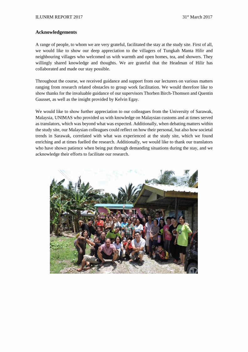
A range of people, to whom we are very grateful, facilitated the stay at the study site. First of all,
we would like to show our deep appreciation to the villagers of Tungkah Manta Hilir and
neighbouring villages who welcomed us with warmth and open homes, tea, and showers. They
willingly shared knowledge and thoughts. We are grateful that the Headman of Hilir has
collaborated and made our stay possible.
Throughout the course, we received guidance and support from our lecturers on various matters
ranging from research related obstacles to group work facilitation. We would therefore like to
show thanks for the invaluable guidance of our supervisors Thorben Birch-Thomsen and Quentin
Gausset, as well as the insight provided by Kelvin Egay.
We would like to show further appreciation to our colleagues from the University of Sarawak,
Malaysia, UNIMAS who provided us with knowledge on Malaysian customs and at times served
as translators, which was beyond what was expected. Additionally, when debating matters within
the study site, our Malaysian colleagues could reflect on how their personal, but also how societal
trends in Sarawak, correlated with what was experienced at the study site, which we found
enriching and at times fuelled the research. Additionally, we would like to thank our translators
who have shown patience when being put through demanding situations during the stay, and we
acknowledge their efforts to facilitate our research.

ILUNRM report 2017 31st March 2017
1
1. Introduction
1.1. History of politic and economic context of Sarawak, Malaysia
Malaysia is considered to be a classic “plural society”, one comprised of two or more ethnic
groups which “live side by side, yet without mingling, in one political unit” (Christian & Furnivall,
1940). The main ethnic divisions in the Bornean state of Sarawak, are comprised of Malay,
Chinese and “Dayaks”, the native peoples of Borneo. This diversity plays an important role in the
dynamics of the state as one of the cornerstones of political conflicts in relation to indigenous
control and access to land and natural resources (Aiken and Leigh, 2003).
In Sarawak, Iban peoples represent 30% of the Dayaks (Ichikawa 2007). Indigenous Iban
communities are historically recognized for their mobility as they rely on extensive shifting
cultivation for subsistence, fishing, hunting, collection of forest products for consumption, trade,
and cash crop cultivation (Wills, 1990). However, as a consequence of commercial development
of agricultural land promoted by the Sarawak´s government, traditional agricultural practices in
many areas have been shaped towards more intense production systems with the dominance of
perennial cash crops (e.g. oil palm, coconut, banana) and the practice of non-farming activities
(Cramb and Sujang, 2011).
The Iban peoples recognize a special connection to their ancestral territories and lands (Aiken and
Leigh, 2011). However, tensions arise between communities, the state, and private market actors;
with the former seeking to protect their lands, and the latter seeking to promote extensive
commercial logging and large-scale plantations (Cramb, 2007).
Traditional Iban land tenure and statutory land tenure laws and policies
Traditional Iban land tenure is based on adat or native customary rights (NCR). According to
native beliefs “the clearing and cultivation of virgin land confers permanent rights on the original
clearer” (Bulan, 2006). The household is the primary right-holding unit, while the “longhouse
community" serves as the primary land administration unit within the community boundaries. The
Iban governance and land tenure system consist on a community-based system in which
individuals rarely follow a free-riding behavior: they cooperate for the long-term sustainability of
the entire community. Membership in the longhouse community grants individual household´s
rights of general access to community land and resources (Aiken and Leigh, 2011).
Land tenure dissonances exist between community and state due to a poor understanding and
incorporation of the Iban community-based arrangements at the state level. Continuous
institutional changes during the Brooke and colonial administrations, and postcolonial
governments have shaped Iban territories, sovereignty and rights to land resources (Ngidang,
2005). During the Brooke era, legal pluralism was established by the creation of a land
codification system of two different land tenure types, allowing customary tenure to co-exist with
the formal system. Private land ownership, strictly referring to the registered land with a document
of title, was introduced by leasing “State” land for a period of 999 years with the payment of fees,
or by providing grants in perpetuity (Ngidang, 2005).
ILUNRM report 2017 31st March 2017
2
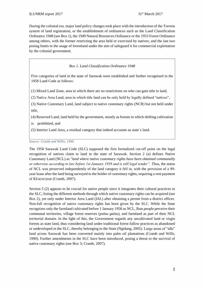
During the colonial era, major land policy changes took place with the introduction of the Torrens
system of land registration, or the establishment of ordinances such us the Land Classification
Ordinance 1948 (see Box 1), the 1949 Natural Resources Ordinance or the 1953 Forest Ordinance
among others, with the former restricting the area held or exercised by natives; and the last two
posing limits to the usage of forestland under the aim of safeguard it for commercial exploitation
by the colonial government.
Box 1. Land Classification Ordinance 1948
Five categories of land in the state of Sarawak were established and further recognised in the
1958 Land Code as follows:
(1) Mixed Land Zone, area in which there are no restrictions on who can gain title to land,
(2) Native Area Land, area in which title land can be only held by legally defined “natives”,
(3) Native Customary Land, land subject to native customary rights (NCR) but not held under
title,
(4) Reserved Land, land held by the government, mostly as forests in which shifting cultivation
is prohibited, and
(5) Interior Land Area, a residual category that indeed accounts as state´s land.
Source: Cramb and Willis, 1990.
The 1958 Sarawak Land Code (SLC) supposed the first formalized cut-off point on the legal
recognition of natives claim to land in the state of Sarawak. Section 2 (a) defines Native
Customary Land (NCL) as "land where native customary rights have been obtained communally
or otherwise according to law before 1st January 1958 and is still legal tender”. Thus, the status
of NCL was preserved independently of the land category it fell in, with the provision of a 99-
year lease after the land being surveyed to the holder of customary rights, requiring a rent payment
of $3/acre/year (Cramb, 2007).
Section 5 (2) appears to be crucial for native people since it integrates their cultural practices in
the SLC, listing the different methods through which native customary rights can be acquired (see
Box 2), yet only under Interior Area Land (IAL) after obtaining a permit from a district officer.
Non-full recognition of native customary rights has been given by the SLC. While the State
recognizes only the farmland cultivated before 1 January 1958 as NCL, Iban people perceive their
communal territories, village forest reserves (pulau galau), and farmland as part of their NCL
territorial domain. In the light of this, the Government regards any uncultivated land or virgin
forests as state land, thus considering land under traditional forest-fallow practices as abandoned
or undeveloped in the SLC, thereby belonging to the State (Ngidang, 2005). Large areas of “idle”
land across Sarawak has been converted mainly into palm oil plantations (Cramb and Wills,
1990). Further amendments in the SLC have been introduced, posing a threat to the survival of
native customary rights (see Box 3; Cramb, 2007).
ILUNRM report 2017 31st March 2017
3
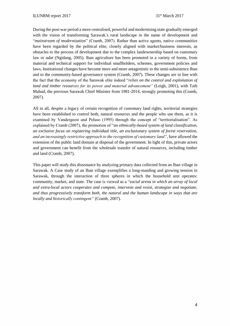
Box 3. Main amendments in the 1958 SLC
▪ 1996 and 1998 amendments to Section 5 (3) of the SLC allows any NCR to be
extinguished at the direction of the Minister by making other land available for the
exercise of such rights or by the payment of compensation, “weather the land over which
the customary rights are exercised is required for a public purpose or the extinction of
such rights is expedient for the purpose of facilitating alienation”. The direction is then
issued in the Government Gazette and one newspaper, with claimants having 60 days for
submitting compensation.
▪ 1998 amendments to Section 5 (6) allows to “make rules for the assessment of
compensation playable for extinguishment of native customary rights”, meaning that
compensation rates can be reduced at government disposal, as it is reflected in the
following statement form the Minister of Land Development: “the government is
concerned that increasing land value and increasing rate for land compensation will
hamper development because the government will not be able to pay huge sums in
compensation for land needed for the implementation of its development projects”
(Adenan Satem, quoted in IDEAL 1999:31, from Cramb, 2007)
▪ 1996 and 1998 amendments to Section 5 (7) of SLC states that “whenever any disputes
shall arise as to whether any native customary rights exist or subsists over any State
land, it shall be presumed until the contrary is proved, that such State land is free of and
not encumbered by any such rights”
▪ 2000 amendment to Section 5 (2) of SLC, removed one of the listed methods for
acquiring NCR, namely “(f) any other lawful method”, implying the no legal recognition
of some of the traditional native practices as a lawful method to claim NCL land, as it is
the case of using reserve forest land for community purposes within a longhouse territory.
Source: Cramb, 2007.
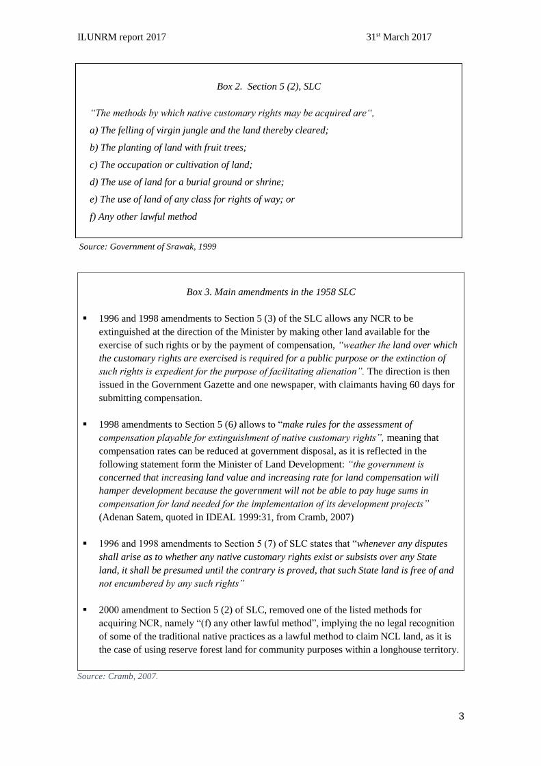
Box 2. Section 5 (2), SLC
“The methods by which native customary rights may be acquired are“,
a) The felling of virgin jungle and the land thereby cleared;
b) The planting of land with fruit trees;
c) The occupation or cultivation of land;
d) The use of land for a burial ground or shrine;
e) The use of land of any class for rights of way; or
f) Any other lawful method
Source: Government of Srawak, 1999
ILUNRM report 2017 31st March 2017
4
During the post-war period a more centralised, powerful and modernising state gradually emerged
with the vision of transforming Sarawak´s rural landscape in the name of development and
“mainstream of modernisation” (Cramb, 2007). Rather than active agents, native communities
have been regarded by the political elite, closely aligned with market/business interests, as
obstacles to the process of development due to the complex landownership based on customary
law or adat (Ngidang, 2005). Iban agriculture has been promoted in a variety of forms, from
material and technical support for individual smallholders, schemes, government policies and
laws. Institutional changes have become more and more antagonistic to the semi-subsistence Iban
and to the community-based governance system (Cramb, 2007). These changes are in line with
the fact that the economy of the Sarawak elite indeed “relies on the control and exploitation of
land and timber resources for its power and material advancement” (Leigh, 2001), with Taib
Mahud, the previous Sarawak Chief Minister from 1981-2014, strongly promoting this (Cramb,
2007).
All in all, despite a legacy of certain recognition of customary land rights, territorial strategies
have been established to control both, natural resources and the people who use them, as it is
examined by Vandergeest and Peluso (1995) through the concept of “territorialisation”. As
explained by Cramb (2007), the promotion of “an ethnically-based system of land classification,
an exclusive focus on registering individual title, an exclusionary system of forest reservation,
and an increasingly restrictive approach to the recognition of customary land”, have allowed the
extension of the public land domain at disposal of the government. In light of this, private actors
and government can benefit from the wholesale transfer of natural resources, including timber
and land (Cramb, 2007).
This paper will study this dissonance by analyzing primary data collected from an Iban village in
Sarawak. A Case study of an Iban village exemplifies a long-standing and growing tension in
Sarawak, through the interaction of three spheres in which the household unit operates:
community, market, and state. The case is viewed as a “social arena in which an array of local
and extra-local actors cooperates and compete, intervene and resist, strategize and negotiate,
and thus progressively transform both, the natural and the human landscape in ways that are
locally and historically contingent” (Cramb, 2007).
ILUNRM report 2017 31st March 2017
5
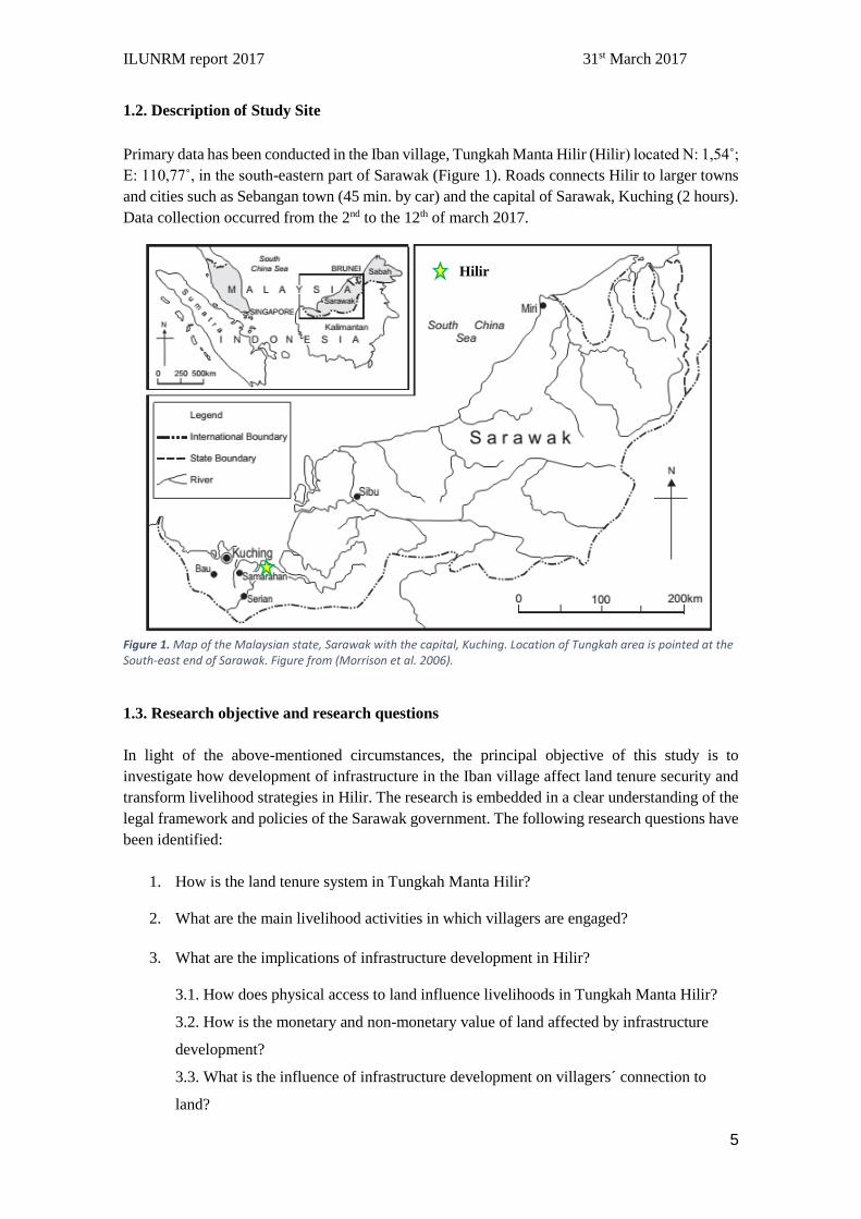
1.2. Description of Study Site
Primary data has been conducted in the Iban village, Tungkah Manta Hilir (Hilir) located N: 1,54˚;
E: 110,77˚, in the south-eastern part of Sarawak (Figure 1). Roads connects Hilir to larger towns
and cities such as Sebangan town (45 min. by car) and the capital of Sarawak, Kuching (2 hours).
Data collection occurred from the 2nd to the 12th of march 2017.
Figure 1. Map of the Malaysian state, Sarawak with the capital, Kuching. Location of Tungkah area is pointed at the South-east end of Sarawak. Figure from (Morrison et al. 2006).
1.3. Research objective and research questions
In light of the above-mentioned circumstances, the principal objective of this study is to
investigate how development of infrastructure in the Iban village affect land tenure security and
transform livelihood strategies in Hilir. The research is embedded in a clear understanding of the
legal framework and policies of the Sarawak government. The following research questions have
been identified:
1. How is the land tenure system in Tungkah Manta Hilir?
2. What are the main livelihood activities in which villagers are engaged?
3. What are the implications of infrastructure development in Hilir?
3.1. How does physical access to land influence livelihoods in Tungkah Manta Hilir?
3.2. How is the monetary and non-monetary value of land affected by infrastructure
development?
3.3. What is the influence of infrastructure development on villagers´ connection to
land?
Hilir
ILUNRM report 2017 31st March 2017
6
2. Theory of Access
The framework designed by Ribot & Peluso (2003) is used to analyse the "ability to derive
benefits from things" and to map the relationships that determine this in the study site. Using this
theory allows us to understand different power relations that affect the village. The main actors
involved are identified and their power relations analysed by mapping the flow of access to land
as well as the political conditions that fostered this. We distinguish between:
- Ability, which Ribot and Peluso describe as "akin to power"
- Right, as benefits from a legalised framework.
Additionally, the interaction between actors who control access and those who maintain access,
requiring expending resources to keep an asset available, is analysed and mapped. Actors who
gain access do so via those who control it. Finally, the identification of mechanisms of access,
which can be rights based or illicit is used to elucidate on the relationship between actor who
control, and those who maintain access to land.
ILUNRM report 2017 31st March 2017
7
3. Methodology
This chapter gives an overview of the different methods applied during the data collection in Hilir
and reflects on how the methodological approach has influenced data generation and analyses. As
one of the pillars of the ILUNRM course, an interdisciplinary mixed method approach was
selected for the conduction of the research. Hence, a combination of social and natural science
methods has been applied, with the collection of qualitative and quantitative data to answer the
above research questions. The aim was to develop different methods to allow data triangulation,
reliability and validity. An overview of the applied methods can be seen in Appendix 1.
3.1. Social science methods
3.1.1. Common questionnaire
A questionnaire was used to collect rapid quantitative data (Casley & Kumar, 1988). A common
questionnaire was developed, allowing comparison across five villages in Sarawak. The unit of
analysis was on the household level and data was obtained for 19 out of 24 households.
Questionnaires were conducted verbally rather than self-administered, which influences the
responds. Nonetheless, the research team did not have fully control of the questionnaire design,
and accounted its limitations as a fixed-tool. It served as a way to introduce the student-research
team in the village and to identify key informants for SSI´s and focus groups. In hindsight, a pilot-
test could have helped on identifying important drawbacks as it is shown in Appendix 1. (See
Appendix 2 for questionnaire form).
3.1.2. Semi-structured interviews
Semi-structured interviews constituted one of the core methods for in-depth investigation and data
collection in relation to the main objective and research questions of the study. A variety of themes
have been explored (Box. 2.).
Box. 4. Themes for Semi-Structured Interviews
- Land tenure system in Hilir
- Social and political structures within Hilir and outside relationships
- Decision-making processes in Hilir
- Livelihood strategies – Main activities within households
- Impact of physical access on livelihoods and land value through development of
infrastructure
- Villagers´ connections to NCR land and land security perceptions
- 2009 court case
The open framework of the method permitted us to elaborate on issues raised during the
development of the SSI sessions, allowing informants to fully express themselves, hence
gathering useful information not always considered while preparing the interview guidelines
(Casley & Kumar, 1988). Based on the knowledge obtained during the questionnaires, informal
talks and observations, general informants and key informants were selected based on their

ILUNRM report 2017 31st March 2017
8
knowledge, and unique insight in relevant matters (see Table 2). It is relevant to note that the
yields from SSI´s, are interviewees´ subjectivity, thus being personally biased hence data
triangulation appears to be crucial. See Appendix 3 to 7 for SSI guidelines. See appendix 8 for
code of informants.
Table 1. General and Key informants for SSI´s
General/Key
informant
Role in the community Reason for selection
General informant
1
Elder villager from Tungkah
Manta Hilir
Knowledge in traditional Iban customs and
laws. Family history and connection to
ancestral lands. Knowledge in land use and
livelihood changes in Hilir.
General informant
2
Young man from Tungkah
Dayak. Met´s son, oldest
villager from Tungkah Manta
Knowledge on the migration history of
Tungkah Manta, relations between
villages, and 2009 court case.
Key informant 1 Elder villager from Tungkah
Manta Hilir and headman´s
brother
Knowledge on NCR land and 2009 court
case
Key informant 2
Headman of Tungkah Manta
Hilir during the last seven years
Knowledge on land configuration in Hilir,
decision-making processes and
organization, relationships outside Hilir.
Soil sampling carried out in one of his plot.
Key informant 3
Headman of Hulu Involvement in the 2009 court case and
relation to NCR land
Key informant 4
Headman of Atas
Involvement in the 2009 court case and
relation to NCR land
Key informant 5
Headman of Dayak Involvement in the 2009 court case and
relation to NCR land
Key informant 6
Chairman of PPWS
Knowledge on activities, structure and
organization of PPWS. Knowledge on
power structures and organization in Hilir.
Key informant 7
JKKK member
Knowledge on power structures,
organization and decision-making
processes in Hilir
Key informant 8 Teacher at School
Knowledge on aspirations of children
attending the school.
ILUNRM report 2017 31st March 2017
9
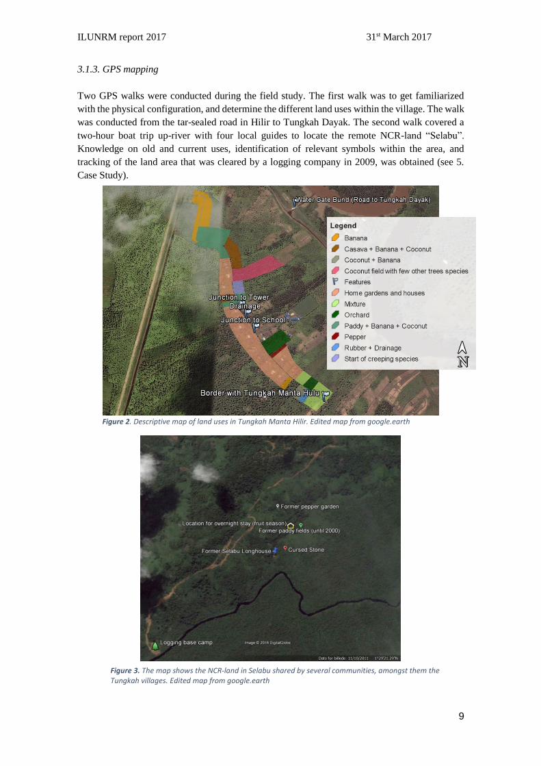
3.1.3. GPS mapping
Two GPS walks were conducted during the field study. The first walk was to get familiarized
with the physical configuration, and determine the different land uses within the village. The walk
was conducted from the tar-sealed road in Hilir to Tungkah Dayak. The second walk covered a
two-hour boat trip up-river with four local guides to locate the remote NCR-land “Selabu”.
Knowledge on old and current uses, identification of relevant symbols within the area, and
tracking of the land area that was cleared by a logging company in 2009, was obtained (see 5.
Case Study).
Figure 2. Descriptive map of land uses in Tungkah Manta Hilir. Edited map from google.earth
Figure 3. The map shows the NCR-land in Selabu shared by several communities, amongst them the Tungkah villages. Edited map from google.earth
ILUNRM report 2017 31st March 2017
10
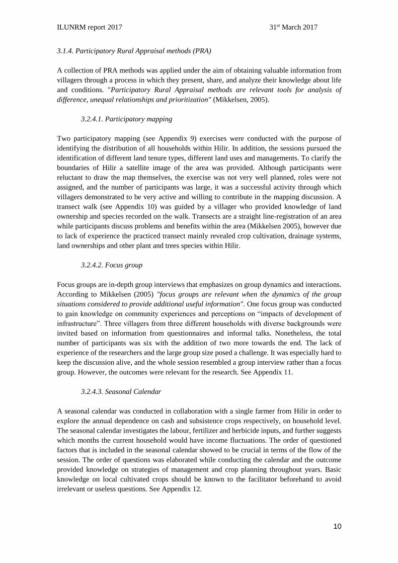
3.1.4. Participatory Rural Appraisal methods (PRA)
A collection of PRA methods was applied under the aim of obtaining valuable information from
villagers through a process in which they present, share, and analyze their knowledge about life
and conditions. "Participatory Rural Appraisal methods are relevant tools for analysis of
difference, unequal relationships and prioritization" (Mikkelsen, 2005).
3.2.4.1. Participatory mapping
Two participatory mapping (see Appendix 9) exercises were conducted with the purpose of
identifying the distribution of all households within Hilir. In addition, the sessions pursued the
identification of different land tenure types, different land uses and managements. To clarify the
boundaries of Hilir a satellite image of the area was provided. Although participants were
reluctant to draw the map themselves, the exercise was not very well planned, roles were not
assigned, and the number of participants was large, it was a successful activity through which
villagers demonstrated to be very active and willing to contribute in the mapping discussion. A
transect walk (see Appendix 10) was guided by a villager who provided knowledge of land
ownership and species recorded on the walk. Transects are a straight line-registration of an area
while participants discuss problems and benefits within the area (Mikkelsen 2005), however due
to lack of experience the practiced transect mainly revealed crop cultivation, drainage systems,
land ownerships and other plant and trees species within Hilir.
3.2.4.2. Focus group
Focus groups are in-depth group interviews that emphasizes on group dynamics and interactions.
According to Mikkelsen (2005) "focus groups are relevant when the dynamics of the group
situations considered to provide additional useful information". One focus group was conducted
to gain knowledge on community experiences and perceptions on “impacts of development of
infrastructure”. Three villagers from three different households with diverse backgrounds were
invited based on information from questionnaires and informal talks. Nonetheless, the total
number of participants was six with the addition of two more towards the end. The lack of
experience of the researchers and the large group size posed a challenge. It was especially hard to
keep the discussion alive, and the whole session resembled a group interview rather than a focus
group. However, the outcomes were relevant for the research. See Appendix 11.
3.2.4.3. Seasonal Calendar
A seasonal calendar was conducted in collaboration with a single farmer from Hilir in order to
explore the annual dependence on cash and subsistence crops respectively, on household level.
The seasonal calendar investigates the labour, fertilizer and herbicide inputs, and further suggests
which months the current household would have income fluctuations. The order of questioned
factors that is included in the seasonal calendar showed to be crucial in terms of the flow of the
session. The order of questions was elaborated while conducting the calendar and the outcome
provided knowledge on strategies of management and crop planning throughout years. Basic
knowledge on local cultivated crops should be known to the facilitator beforehand to avoid
irrelevant or useless questions. See Appendix 12.
ILUNRM report 2017 31st March 2017
11
3.2.4.4. Venn Diagram
For exploring the organizational and institutional structure of Hilir, a Venn diagram was
considered the most suitable method (Mikkelsen 2005). A teacher at the local school was selected
as informant, on the expectation that a teacher may know structures, institutions, and villagers
while remaining "neutral". The session was initiated by having the informant listing all
institutions in Hilir. After this we would ask the informant to size the different institutions in
circles, corresponding to their influence. Overlap of circles reveal interactions amongst
institutions. The teacher could not be encouraged to draw the circles himself, but was engaged in
the formation of the diagram and content with the outcome. However, lack of experience,
challenged the exercise and it became clear that preparation is crucial e.g. researchers can list
expected institutions prior to the exercise, to prevent missing some during the session. See
Appendix 13.
3.2.4.5. Informal talks and Observations
Observations made while conducting data can support and sharpen data synthesis. Informal talks
can prove very informative and reveal data that might not be captured during formal data
collection. Informal talks can help identify key-informants or gain the trust of informants and
enable more in-depth research during the stay at the study site. Additionally, participating in
villagers´ daily routines can provide knowledge on livelihood matters that would otherwise be
unknown.
3.2. Natural Science methods
3.2.1. Soil sampling
The hypothesis for the sampling is that Jalan Batang Lupar – Sadong (JBL), the road functioning
as a bund, has increased the agricultural value of soils located east of the road. Changes in the soil
factors may induce changes in agricultural practice and price of land. A simple soil sampling
based on two composite samples, one from each side of JBL, corresponding to a permanent
flooded area (FA) and a non-flooded area (NFA), are analyzed for salinity, pH, %C and %N. In
order to allow the comparability of the samples, two fallow plots were selected.
The small number of samples pose a major limitation to the validity and representativeness of the
data. However, the analysis is included only to get a notion on whether the natural science based
determination of soil fertility can be linked to infrastructure development and villagers´
perceptions of soil fertility. In addition, the soil sampling was seen in the overall research
objective as an enriching opportunity to learn how to apply different methods in the field.
ILUNRM report 2017 31st March 2017
12
3.3. What we learnt
3.3.1. Reflections on methodology
With little experience on almost the entire selection of methods, the execution of these in the field,
was as much a learning process as it was data collection. Evaluations of the different methods has
been made at evening meetings during the stay, in order to sharpen the application of them for
following sessions. The researchers have discovered how important experience is, in order to do
social science in a specific social context e.g. a village like Hilir. The balance between data
collection and socializing can be very difficult to maneuver, and can leave the researcher at times
very disorientated. Additionally, research on the rather sensitive subject land tenure further
impose careful data collection in order not to initiate conflicts in the local settings. But also
sensitive subjects can be difficult to cover because of interviewees unwillingness to share and
because gaining trust can take longer than two weeks. There is also a fine line between when to
inform the interviewee on the objectives of the research, and when not to, for obtaining of
unbiased data. Respect and understanding for the context that you as a researcher is “visiting”
during two weeks, is important and researchers should not forget the study objective of the
research.
3.3.2. Working with a translator
Lack of experience for researchers working through a translator challenged the research in ways
of utilizing the scares time for data collection in a profitable way. The good collaboration with a
translator will establish through mutual understanding, and the translator actually becoming a full
member of the research team. The research team discovered that inviting the translators to
discussions on findings would increase outcome in later data collection because the translators
would be more aware of the scope of the research. Translators should not only be translating
between two languages, but as well understand what is being asked, with what intentions, and
have to maneuver in the customs of the interviewee which is alone a great task. Additionally, the
translators were new to the field and also developed their skills throughout the study, so that closer
to the end of the stay at the study site, more valuable data could be obtained more efficiently

ILUNRM report 2017 31st March 2017
13
4. Results
4.1. General description of Hilir
19 out of 24 households were captured in the questionnaire. The average age of the respondents
in the questionnaire is 54 and a generational gap was observed, with hardly any people in the mid-
twenties-thirties. On average three people are dependents in each household and 14 households
have a member who have migrated. Farming of coconuts and banana is the main activity and a
number of rather new concrete houses in the village establish a sense of "economic" growth. The
village is supplied with 24-hours electricity and is dependent on rain water. From May 2017, it is
anticipated that running water will be supplied via pipes from Sebangan town.
4.2. Reconstructing the history of Tungkah area
The history of the Iban settlement can be traced back to the 1700´s (figure 4). Maringkong, a
forested area located up Sebangan river appears to be the original ancestral area of all Tungkah
villages. Most likely due to war, Iban people migrated and resettled in Selabu, the current NCR
land belonging to all Tungkah villages. Supposedly in the 1920's, resettlement happened again
further down steam at what is now, Tungkah Dayak. Several reasons for this resettlement have
been revealed ranging from expansion of agricultural area for rubber-cultivation, attack of
headhunters to a curse in Selabu that forced villagers to migrate. After few years, Tungkah Dayak
peacefully divided into three other villages corresponding to the four current related Tungkah
villages: Dayak, Hulu, Atas and Hilir. Initially all villages were under the Dayak headman's
administration, however, now formally recognized as independent and separated kampongs, each
village has its own headman. On Appendix 14, a family tree is shown.
Figure 4. A timeline representing the main migration episodes was created based on elders’ statements
and life experiences
Iban settlement in Maringkong
Migration from Maringkong to
Selabu
Migration from Selabu to first
Tungkah village
Split of Tungkah into three other
Tungkah villages
Tungkah area: Tungkah Dayak,
Hulu, Atas, Manta Hilir
1700´s ~ 1926 ~ 1938 2017 No identified dates

ILUNRM report 2017 31st March 2017
14
Box 4. Beliefs and the curse in Selabu
Animism constitutes an important component of traditional Iban culture and religion. The
practice of rituals, use of talismans, beliefs on taboos and curses used to be common in the past.
Although most Iban people have converted to Christianity, traditional beliefs remain an
important part of the community ideology and identity. The migration from Selabu to Tungkah
Dayak, explained by elders in Hilir on the basis of family stories, was motivated due to the
existence of a curse in Selabu initiated by the breakage of a taboo. According to local legend,
a grandmother and her grandchild used to live far from the longhouse in Selabu so that villagers
did not take care of them, remaining isolated and excluded. One night, the woman took a frog
and put clothes on it. The frog was sent to the longhouse causing a burst of laughter among
villagers. Consequently, Iban spirits punished the villagers by throwing a heavy storm through
which the entire longhouse turned into stone. Survivals migrated down river and resettled in
Tungkah Dayak. The curse launched by the spirits did not affect land and crops, so villagers
could still visit Selabu for cultivation purposes, as it is the common practice today during the
fruit season.
4.3. Livelihood strategies in Hilir
Income generating activities in Hilir involve farming, off-farm work and to the lesser extent,
collection of NTFP (Figure 5). Hilir villagers depend heavily governmental subsidies, both for
being "ekasik" (rural poor, for which villagers obtain BR1M), and to support farming via crop
schemes. Subsistence activities include hunting in NCR land, fishing and the cultivation of
homegardens.
Figure 5. Income sources as sums (in RM) for the five villages surveyed in the questionnaire. The "other
sources" category is dominated by welfare programmes such as BR1M in the case of Tungkah Manta Hilir
Income generating activities
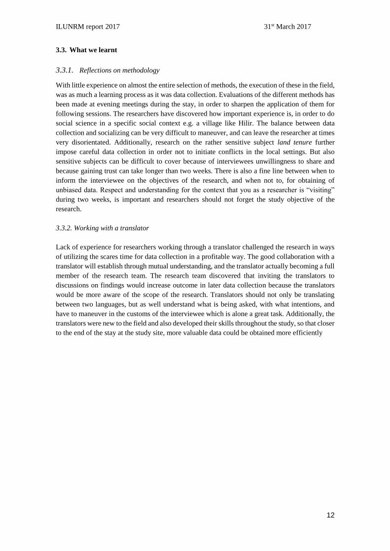
Farming is the main activity in Hilir and constitutes an important source of income (figure 6). 19
households cultivate banana and 17 households cultivate coconut which are the two main cash
crops. Bananas are collected every second week and exported to Kuching by a villager, member
of PTA functioning as a middleman, since the former banana-middleman underpriced the
product.
ILUNRM report 2017 31st March 2017
15
Access to seeds, fertilizer and herbicides cannot be described generally for the villages, as
different strategies are applied. Cultivated crops are either on a scheme, typically banana or
introduced independently by each household e.g. coconut. Historically pepper has not been
productive in the area. However, it has been reintroduced in several households and seems to
thrive now. A cocoa scheme has been introduced in six households and one household already
harvests ~20-30 kg.
Figure 6. Incomes as sums (RM) from cash crops in Hilir
Additionally, education, work, or search for new land can induce migration of household
members in Hilir, with 14 households having a member who have migrated. Education seems to
be significant. Young people with low level of studies generally stay in Hilir. Villagers seemed
positive towards the young generation out-migrating to cities and encouraged youngsters to learn
English, due to a perception of a better life with a university degree, than a rural farmer life.
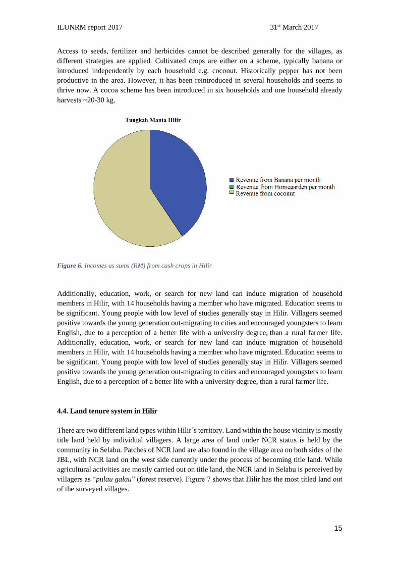
4.4. Land tenure system in Hilir
There are two different land types within Hilir´s territory. Land within the house vicinity is mostly
title land held by individual villagers. A large area of land under NCR status is held by the
community in Selabu. Patches of NCR land are also found in the village area on both sides of the
JBL, with NCR land on the west side currently under the process of becoming title land. While
agricultural activities are mostly carried out on title land, the NCR land in Selabu is perceived by
villagers as “pulau galau” (forest reserve). Figure 7 shows that Hilir has the most titled land out
of the surveyed villages.
ILUNRM report 2017 31st March 2017
16
Land ownership is well understood within Hilir, with no conflicts in this matter. Iron pecks,
drainage channels, and communication are common strategies used to demarcate plots among
landowners. Trees such as rubber and durian are used to demarcate plots within NCR land (SSI´s,
focus group, informal talks, transect walk), as well as between villages, with a rubber tree
demarcating the boundary between Hilir and neighbouring Hulu.
Figure 7. Land types for all surveyed villages. From SPSS analysis
Access to land in Hilir is mainly by inheritance from parents to their sons/daughters, with more
land usually given to the one taking care of them. However, the inheritance of land can be a long
process if there are disputes between siblings. Despite the purchase of land being limited to Dayak
ethnic groups and Malays, private agreements for the lease of lands are sometimes agreed
illegally, as is the case between a Hilir villager and an unidentified Chinese buyer.
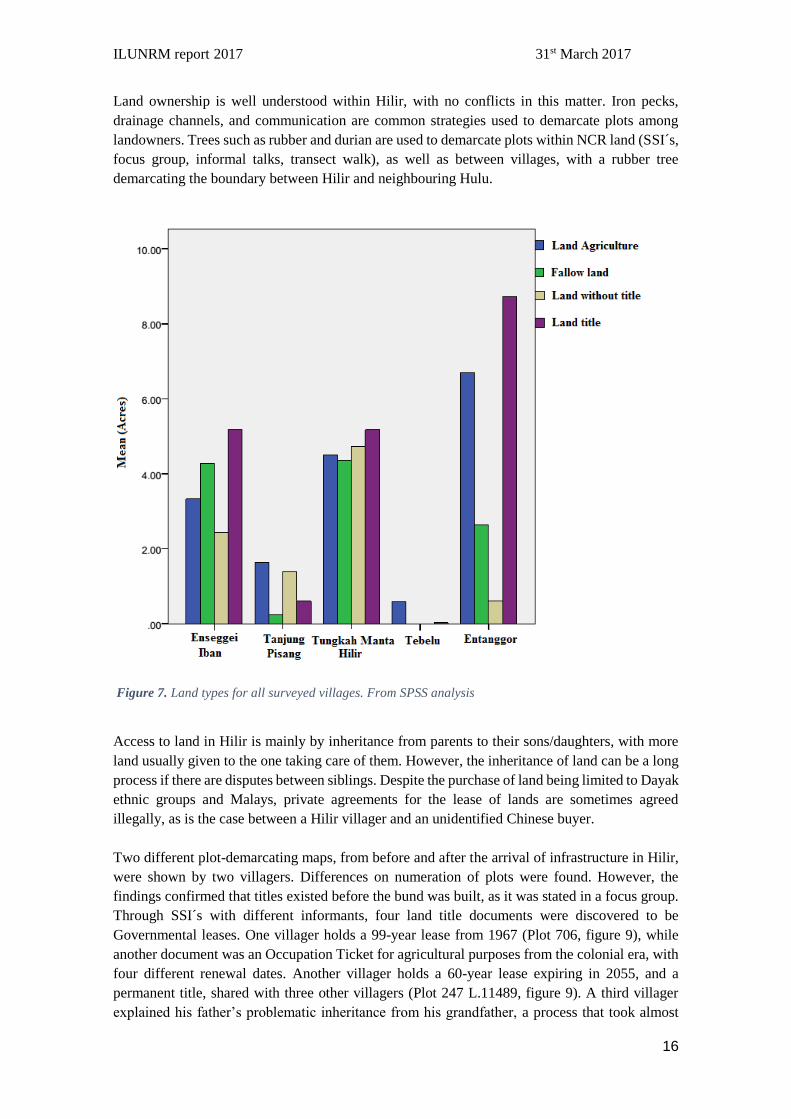
Two different plot-demarcating maps, from before and after the arrival of infrastructure in Hilir,
were shown by two villagers. Differences on numeration of plots were found. However, the
findings confirmed that titles existed before the bund was built, as it was stated in a focus group.
Through SSI´s with different informants, four land title documents were discovered to be
Governmental leases. One villager holds a 99-year lease from 1967 (Plot 706, figure 9), while
another document was an Occupation Ticket for agricultural purposes from the colonial era, with
four different renewal dates. Another villager holds a 60-year lease expiring in 2055, and a
permanent title, shared with three other villagers (Plot 247 L.11489, figure 9). A third villager
explained his father’s problematic inheritance from his grandfather, a process that took almost
ILUNRM report 2017 31st March 2017
17
three years with payment of fees, yet he is still not in possession of the document. However,
villagers perceive land titles to be life-lasting, since leases always have been renewed through the
past three generations by the Land and Survey Department. Appendix 15 shows different title
documents.
Figure 8. Map showing demarcation of plots in Hilir after arrival of infrastructure provided by one villager
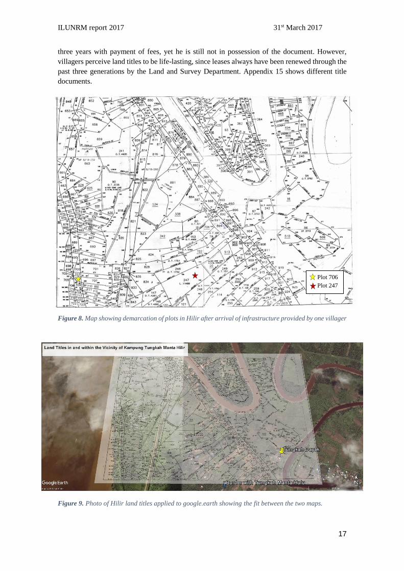
Figure 9. Photo of Hilir land titles applied to google.earth showing the fit between the two maps.
Plot 706
Plot 247
ILUNRM report 2017 31st March 2017
18
4.5. Decision making and community in Hilir
The overriding spirit observed in Hilir is one of unity and cohesiveness, with the headman playing
an important role. Despite not being official, he is treated as official by the government in practice
and being unrecognized is not regarded as out of the ordinary by the villagers. Relations with the
District Officer are accordingly non-problematic. Proposals from the government such as schemes
and more generally from outside the village are transmitted through him and are discussed with
the village committee (JKKK), before being shared with the village. The primary roles of the
JKKK, which is unofficial due to their contingency on the recognition of the headman, are to
discuss the afore mentioned proposals and to oversee social matters such as helping to apply for
government welfare (BR1M). Other organizations such as the PPWS bring women together
around activities in order to increase incomes. Members of the PPWS apply for funding and
propose activities directly to the YB, although they usually consult the headman beforehand.
Additionally, the PPWS helps to solidify relationships in the village, with at least one woman per
household being a member, and the chairwoman claiming that it has helped increase the sense of
community amongst the members. Despite this, the PPWS has no decision-making capabilities in
theory, although the individuals have significant sway in practice. Thus, two groups emerge in
decision making processes, the headman along with the JKKK, and the rest of the village.
4.6. Implications of development of infrastructure
The infrastructure in Hilir and the vicinity has remarkably changed during the past 17 years. The
DID has been responsible for providing infrastructure within the Sebuyau area. Due to its
proximity and enclosure between Sadong and Sebangan river, flooding was one of the main
problems in Hilir during a long period. Physical access to Hilir was constrained by the absence of
roads, and villagers were limited to walk or transport by boat through the adjacent rivers. Access
and water management improvements have been created with the construction of the main road
JBL finished in 1999-2000 which also incorporates a bund supported by watergates that allow
collection and discharge of water during rain episodes.
4.6.1 Effect of infrastructure development on livelihoods strategies
Prior to the construction of the bunds, livelihood strategies among Tungkah villagers were very
limited. The soils were poor, muddy and proper cultivation of crops was challenging. Villagers
who stayed in Hilir were forced to cultivate land in Selabu as well as make the most of their poor
soils, which provided low yields of banana and coconut. One villager stated, "I was crying while
collecting small coconuts, in mud up to my knees". A common practice among those who stayed
was to catch crabs, as one farmer stated “crabs were found everywhere in the village, even close
to the houses, and sometimes it was possible to trap 5 Kg per day”. Cultivation of paddy rice
could be on land located in a distance from Hilir, where soils were not waterlogged. Families who
had inherited land outside Hilir or who had relatives living in other villages could take advantage
of cultivating land somewhere else while staying in Hilir. However, this was a time-consuming
strategy due to lack of road access. Most villagers travelled by boat to Selabu with the travel
frequency depending on the season (planting, maturity, or harvesting). The good quality of the
Selabu soil permitted cultivation of pepper in the hills, paddy on the lowlands, rubber trees, and
ILUNRM report 2017 31st March 2017
19
fruit trees. The farming practice was more subsistence-oriented than market-oriented. In contrast
to the above-mentioned, other villagers migrated. According to six women, the village was
notably more empty and quiet, less than 20 households remained in Hilir at that time. A young
woman emphasized that “it was difficult to grow up in Hilir”.
4.6.2. Effect of infrastructure development on access to market
Road access to Hilir has had a major impact on farmers´ abilities to access markets. Before the
road, export to Kuching by boat could be almost an entire day from Sebangan village, hence
hindering the marketing of products. However, as stated by one farmer (seasonal calendar),
stability of income in the present day highly depends on middle men and market forces, e.g. there
is no income for bananas during Ramadan, as Sebuyau is mostly Muslim.
4.6.3. Effect of infrastructure development on value of land
Improvements of infrastructure have triggered significant changes on the actual value of land in
Hilir. In regard to the monetary value of land, although most of the interviewed landowners were
not aware of the current price of their plots, it was largely expressed that certainly “has the value
of land increased with the construction of the bund and road”. Only one farmer could give a
monetary value, clearly stating that land-price changes are due development of infrastructure. “A
land plot of 10 to 12 feet costs 5000 RM today, while its price before the bund and road was
around 600 RM”. One farmer provided information on the compensation received for affected
land due to the construction of the road. Based on size of the area and tree species affected, 11.000
RM were given for two acres.
Farmers have also expressed that the value of land for agricultural purposes has increased,
allowing cultivation of the current crops, and salt intolerant species such as cocoa. Villagers
believe there is potential in the NCR land west to JBL, since they expect the construction of an
additional bund which may increase the agricultural value. E.g. the Headman has received an
offer on his land, but he declined and expressed good faith in the future.
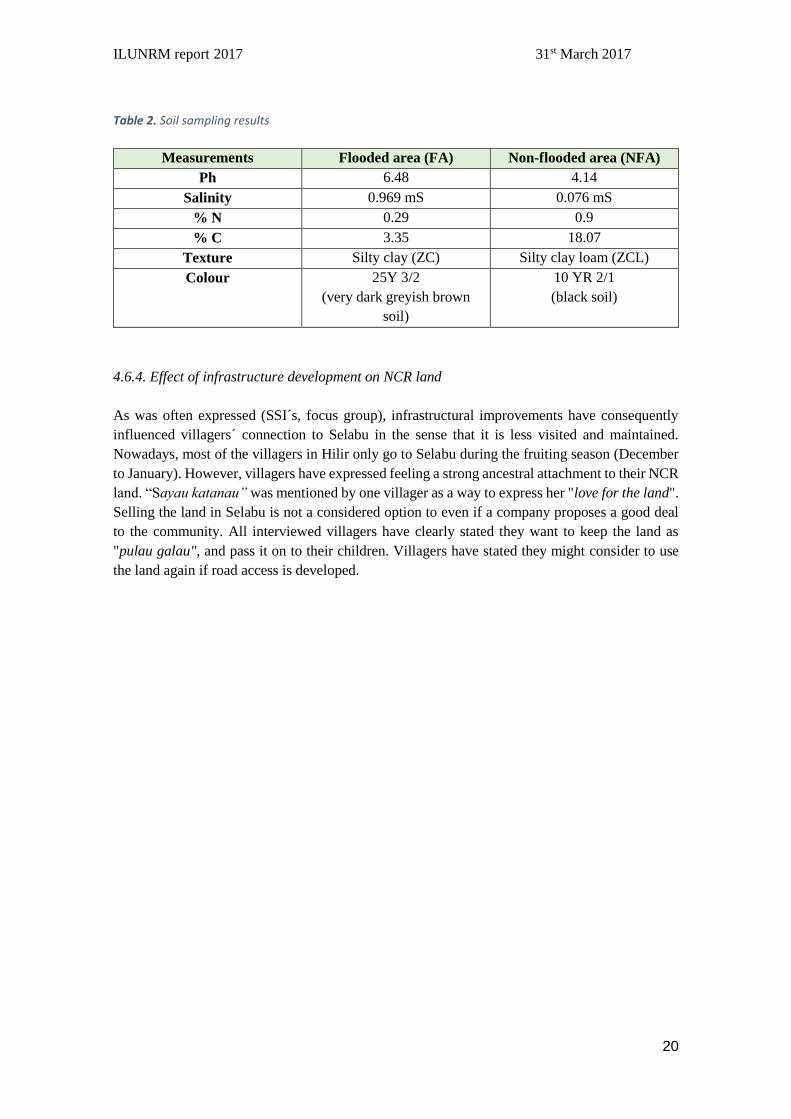
Soil sampling analysis (see table 2) support these statements. In terms of the effect of JBL on soil
quality, soil sampling reveals that salinity is much lower in the NFA compared to the FA (Table
2). However slightly saline soils are characterized by an electrical conductivity of 2-4 mS, so
salinity may not be a severe stress factor (Schjørring, 2016). A low pH level in the NFA could be
explained by the production of humic acids in the A-horizon. The NFA has a higher soil %N than
the FA, however both soils have a good level of %N which is >0.1% (Doran & Jones 1996). In
terms of %C the NFA has a very high content which could be due high litter input and low pH
preventing decomposition (JVP Kompendium 2014). Both NFA and FA could be characterized
as "good soils" by this simple analysis. FA was completely waterlogged, and by the mere eyes
the agricultural value of FA is poor, regardless of the values obtained. See appendix 16 for more
in detailed information.
ILUNRM report 2017 31st March 2017
20
Table 2. Soil sampling results
Measurements Flooded area (FA) Non-flooded area (NFA)
Ph 6.48 4.14
Salinity 0.969 mS 0.076 mS
% N 0.29 0.9
% C 3.35 18.07
Texture Silty clay (ZC) Silty clay loam (ZCL)
Colour 25Y 3/2
(very dark greyish brown
soil)
10 YR 2/1
(black soil)
4.6.4. Effect of infrastructure development on NCR land
As was often expressed (SSI´s, focus group), infrastructural improvements have consequently
influenced villagers´ connection to Selabu in the sense that it is less visited and maintained.
Nowadays, most of the villagers in Hilir only go to Selabu during the fruiting season (December
to January). However, villagers have expressed feeling a strong ancestral attachment to their NCR
land. “Sayau katanau” was mentioned by one villager as a way to express her "love for the land".
Selling the land in Selabu is not a considered option to even if a company proposes a good deal
to the community. All interviewed villagers have clearly stated they want to keep the land as
"pulau galau", and pass it on to their children. Villagers have stated they might consider to use
the land again if road access is developed.
ILUNRM report 2017 31st March 2017
21
5. Case Study: The right to land
“Most people think that all land is NCR land, but it is not like that.”
(District Officer for Sebuyau)
Ten years after the bund was built, a logging company was granted a license to start extracting
timber from Selabu, inflicting a shock on the community’s land assets. The extent of the
company's operations into Selabu can be seen in figure 2. A timeline of the events that followed
is detailed in Table 3. All quotes included in this section were obtained via SSI´s.
Table 3. Timeline of the main events in relation to the 2009 court case, constructed using data from SSIs
with key informants and villagers and triangulated using newspaper articles (Tawie 2011a; Tawie 2011b;
Tawie 2011c; Tawie 2011d; Tawie 2011e; Sarawak Report 2010; Sarawak Report 2012) and court
documents. Data from court documents appended with an * (Rhodzariah 2011)
Date Event
30.09.2009 Quality Concrete Holdings (QC) get issued a conditional year-long
Occupation Certificate to log timber, under section B of the Forest
Ordinance. Licence to take forest produce under sections 49 and 51
of the Forest Ordinance*
11.07.2010 Headman of Kampong Ensika discovers encroachment and relays
information to surrounding villages
13.08.2010 Forestry Department directs QC to “suspend activities”
25.09.2010 (estimate
based on newspaper
articles)
Attempt at compensation to affected families for 250RM through
Deed of Settlement, with Penghulu Merum Ak Babu as witness*
14.10.2010 Blockade against companies by villagers begins*
18.10.2010 Fire damages QC property in logging camp
22.10.2010 Numpang, Nicholas Mujah and several headmen of villages
involved in blockade arrested by police*
25.10.2010 Numpang and co. released on police bail of RM100
1.11.2010 Numpang and others file suit against QC, Loyal Billion SDN BHD
(LB), Penghulu Merum Ak Babu. Suit number: 22-218-2010-II*
30.11.2010 QC timber licence expires*
Late December 2010 QC timber licence renewed*
18.01.2011 Ex-parte interim injunction ordered against Quality Concrete
Holdings*
07.03.2011 Further interim injunction against timber companies ordered by
Kuching High Court Judicial Commissioner Puan Rhodzariah bt.
Bujang*
ILUNRM report 2017 31st March 2017
22
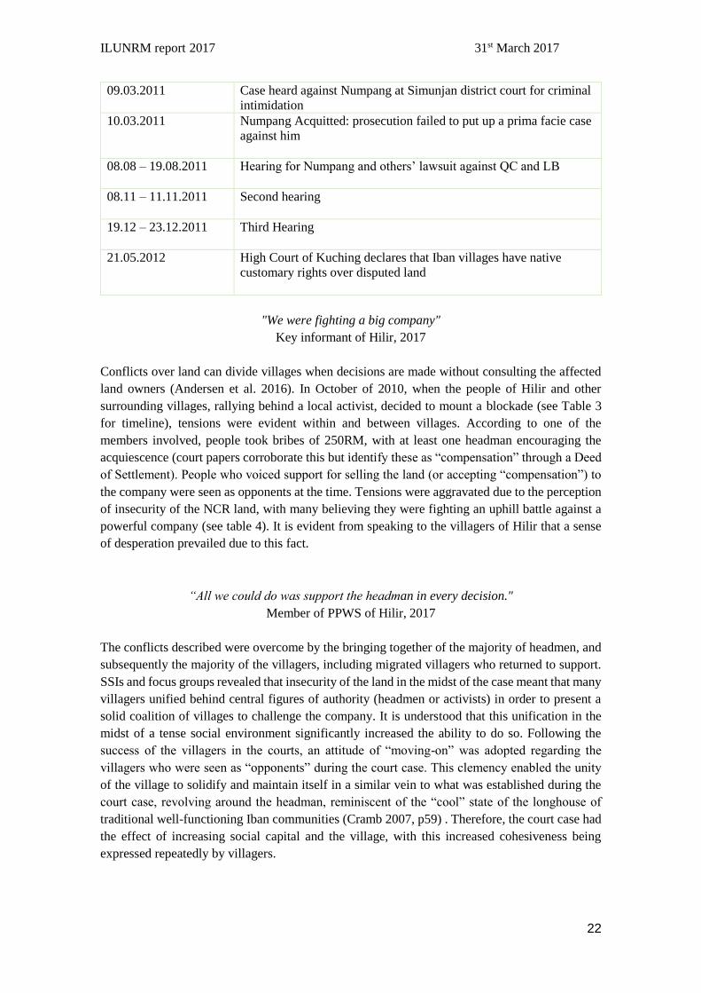
09.03.2011 Case heard against Numpang at Simunjan district court for criminal
intimidation
10.03.2011 Numpang Acquitted: prosecution failed to put up a prima facie case
against him
08.08 – 19.08.2011 Hearing for Numpang and others’ lawsuit against QC and LB
08.11 – 11.11.2011 Second hearing
19.12 – 23.12.2011 Third Hearing
21.05.2012 High Court of Kuching declares that Iban villages have native
customary rights over disputed land
"We were fighting a big company"
Key informant of Hilir, 2017
Conflicts over land can divide villages when decisions are made without consulting the affected
land owners (Andersen et al. 2016). In October of 2010, when the people of Hilir and other
surrounding villages, rallying behind a local activist, decided to mount a blockade (see Table 3
for timeline), tensions were evident within and between villages. According to one of the
members involved, people took bribes of 250RM, with at least one headman encouraging the
acquiescence (court papers corroborate this but identify these as “compensation” through a Deed
of Settlement). People who voiced support for selling the land (or accepting “compensation”) to
the company were seen as opponents at the time. Tensions were aggravated due to the perception
of insecurity of the NCR land, with many believing they were fighting an uphill battle against a
powerful company (see table 4). It is evident from speaking to the villagers of Hilir that a sense
of desperation prevailed due to this fact.
“All we could do was support the headman in every decision."
Member of PPWS of Hilir, 2017
The conflicts described were overcome by the bringing together of the majority of headmen, and
subsequently the majority of the villagers, including migrated villagers who returned to support.
SSIs and focus groups revealed that insecurity of the land in the midst of the case meant that many
villagers unified behind central figures of authority (headmen or activists) in order to present a
solid coalition of villages to challenge the company. It is understood that this unification in the
midst of a tense social environment significantly increased the ability to do so. Following the
success of the villagers in the courts, an attitude of “moving-on” was adopted regarding the
villagers who were seen as “opponents” during the court case. This clemency enabled the unity
of the village to solidify and maintain itself in a similar vein to what was established during the
court case, revolving around the headman, reminiscent of the “cool” state of the longhouse of
traditional well-functioning Iban communities (Cramb 2007, p59) . Therefore, the court case had
the effect of increasing social capital and the village, with this increased cohesiveness being
expressed repeatedly by villagers.

ILUNRM report 2017 31st March 2017
23
Table 4. Stakeholders affected by the court case
Stakeholder Stake Role(s) Description
Villages (inc. Tungkah
Manta Hilir)
Access to land,
livelihood Victims of encroachment, Plaintiffs in second case
Selabu
Loyal Billion Sdn Bhd Timber goods
acquisition. Original plaintiff,
contractor to Quality
Concrete, Defendant in
lawsuit
Logging company
Quality Concrete
Holdings Bhd Contract
affected Original plaintiff,
Contracted by Loyal
Billion, Defendant in
lawsuit
Contractor to logging
company
Director of Forestry
Department of
Sarawak
Outcome of
case, granted
lease,
Development
ambitions
Approved licence for
Quality Concrete
Holdings Bhd, Defendant in lawsuit
Penghulu Merum ak
Babu Development
ambitions Defendant in second case,
witness to Deed of
Settlement.
High ranking official
for the region.
Activist Access to land Organised resistance,
unified villages in the
area, Charged with
criminal intimidation
Activist, victim of
encroachment
Raziah Share value Applied for Logging
licence. Sister to Chief Minister
of Sarawak, Shareholder
State government Development
ambitions Defendant in lawsuit State government of the
Malaysian federation.
SADIA (Sarawak
Dayak Iban
Association)
No direct stake. Raised funds for case
against encroachers,
lodged village members at
HQ during case.
Non-Governmental
organisation,
In 2012, by the end of the court case which pitted governmental departments, private companies
and the Penghulu against the villagers affected by the encroachment (see Table 3 and Table 4 for
case timeline and stakeholders respectively), there were 200 court cases pending for similar
disputes (SACCESS 2012). Understood from the vantage point of the villagers of Hilir during the
court case, this demonstrates a climate of government sponsored marketization which has little
regard for native rights. Awareness of these motivations since the court case has increased the
security of Selabu, as the village holds increased financial capital from compensation from the
companies, which has been set aside to fight any future encroachments and the court case outcome
istelf serves to legalize control over the land. Additionally, people from other affected villages
have started to apply for this land to be recognized as titled land. Villagers from Hilir were of the
almost unanimous opinion that they would not relinquish their land under any circumstances,
preferring it to stay as “Pulau Galau”. Their stance came mostly from a feeling of ancestral
connection and a discourse of rights. Despite this, some people in other villages seemed more
willing to consider potential government development schemes, although mentioning that this
should be contingent upon a common consensus between the villages involved. The main
outcomes on the community of the court case has been to increase access to knowledge through
experience and increase solidarity or social capital (Ellis 2000).

ILUNRM report 2017 31st March 2017
24
6. Discussion
As mentioned in the introduction, the State Government during the last decades has been driven
by the desire to promote modernisation with “well intention concerns to eradicate rural poverty”
(Cramb, 2007). Thus, the development ambitions of the government have had significant
implications for villagers.
6.1. The effect of increased access
Improvements of infrastructure have notably increased the ability of villagers to benefit from their
land, mostly from title land close to their residential area. Prior to the arrival of the road and bund,
villagers´ mechanisms of access did not operate in a sequential manner, namely the right to land
was not complemented by the ability to benefit from it. However, development in the Tungkah
area has brought a new alignment in this matter by increasing physical access to land and better
usage, which in turn have generated a shift of attention from Selabu to the surrounding Hilir area
among villagers, with the former being disregarded for cultivation purposes. With this shift, due
to increased access to titled land, came a concurrent move from more subsistence agriculture
towards high value and lower labor-demanding crops such as banana, coconut, pepper, or cocoa
indicating an increased focus on marketable goods with increased access to market. With the bund
having a clear positive effect on the area of land that is protected, not only in terms of reduced
flooding and salinity, but in better soil properties for crop cultivation (4.5.4. Soil sampling), the
agricultural value of land has augmented, allowing farmers to improve their ability to maintain
livelihoods. Regarding, these agricultural achievements in Hilir, the State Government has
increased its “development capacity”, meaning its ability to introduce schemes and marketize
villages, thus “controlling” the selection of cash crops among farmers by their enrollment in
schemes, as is the case of banana or the new cocoa scheme introduced recently in Hilir. Whereas
villages can certainly gain access to capital and knowledge, this poses a risk on the level of
dependency on a market-oriented economy which is highly subsidized. This dependency is not
only market based, as as mentioned in section 4.2, with government welfare having a major role
in livelihoods.
6.2. Commercialization
As mentioned in section 4.5.3, increased access in terms of ability to benefit, increases the
monetary value of land, notably the title land adjacent to Hilir. Taking into account the agricultural
achievements in lands previously being poor and flooded, expected future drainage of the flooded
land west of JBL could be enacted, as is the case in other nearby villages such as Enseggei Iban,
where former flooded land is now drained and highly agriculturally valued due to mineral
deposition from the Sadong river. The uncertainty over these flooded lands brings different actors
together, with outsiders bringing offers to purchase land, insiders applying for issuing NCR
flooded land to title lands, and ultimately, the government playing an essential role in the control
of access to this resource, from which current landowners cannot benefit.
The expansion of market opportunities in Hilir through better connections to cities, relations with
middle men, and better produces, have induced a rapid commercialization of the farming system.
In relation to the analyses of Hla Mynt (1958; 1973) on transitions to the money economy,
farmers´ economy in Hilir appear to correspond with the second stage of commercialization; with
greater development of market infrastructure and the surplus capacity (in terms of land and labor-
ILUNRM report 2017 31st March 2017
25
time) being utilized, households start specializing and expanding their commercial production by
compromising the subsistence output. Despite higher incomes, risks due to dependency on market
forces are also higher.
6.3. The power in development
This increased commercialization results in government essentially determining market values of
land as access to that land is increased. This is also noticeable in relation to NCR lands, the price
of which is illuminating to compare with that of titled land. The court case shows how the
government put a price on the NCR land at 250 RM per person in practice, a pitiful valuation
compared to that seen for titled land (section 4.5.3). Although this was eventually nullified, the
combined facts that many people accepted this price and that the villagers won the case in great
part because of a not guaranteed unification of the villagers mean that this price could be applied.
This shows how the substantial access to market and authority of government influences the
extent to which all actors benefit from land.
Despite the government not having direct control over the lands now relieved of flooding, it does
have control over which lands receive that benefit. This is manifested in the control of access to
technology such as infrastructure, which behaves as a mediator to other kinds of access. Villagers
maintain access to technology, and one effect of this is increasing migration due to the increased
ease of travel. Development thus makes migration more desirable, not only for increased income
of the migrant, but also in the sense that roads allow migrants to return with more ease, meaning
the older generation in the village are more accepting. Therefore, through access to authority and
technology, government can also influence the flow of human capital.
The power of government allows it to influence behavior without using coercive institutions
(Foucault 1978). In Ribot and Peluso (2003), power is defined as “the capacity of some actors to
affect the practices and ideas of others.” As described above, access and improved livelihoods
were achieved for the villagers, however, this was at the discretion of the government: ultimately
the ability to develop infrastructure lies with them and while in this case it had a mostly positive
impact in terms of livelihoods, this is not necessarily always so (Sayer et al. 2012). The
development policy influenced practices in Hilir by allowing the villagers to cultivate on newly
accessible lands, as government sponsored banana schemes were introduced. The subsequently
reduced attention to Selabu changed the significance of this land to a more cultural and historical
one for the villagers of Hilir, although the development narrative of the government did influence
people in other villages (see section 5). This accepting of the narrative by some villagers is the
result of the government's capacity to affect ideas or discourse.
6.4. Land, conflict, and discourse.
The case study demonstrates two angles of the impacts of development goals on land tenure in
the village. On the one hand, infrastructure made land significantly more valuable. On the other
hand, development policies justify the granting of leases to companies which threaten access to
NCR lands, the insecurity of which is compounded by it is gross devaluation following a reduction
in farming activity, as detailed above and in the introduction. These kinds of cases can often
induce conflict within the village, which at times become a permanent schism, with the headman
exploiting his position to control access (Andersen et al. 2016). In Hilir, this conflict did not
ILUNRM report 2017 31st March 2017
26
negatively affect the community in the long run, access by the villagers is even strengthened
through increased social capital and the legal process.
The case illustrated how development priorities can induce conflict based on different
interpretations of the right to access, which is essentially a battle of discourse. Villagers assumed
the land to be rightfully theirs, as they had maintained access for as long as the history of the
village. However, the access to authority gave the government the ability to lease out the land,
regardless of ultimate right. The Land Code enables the implementation of this power by placing
the burden of proof on the NCR claimants (Government of Sarawak, 1999) and, with the removal
of section 5.2 (f) (see Box 2.) the difficulty in proving NCR land increases. Amendments such as
this one have been seen as benefiting the government at the expense of native peoples (SACCESS,
2012).
This dispute of discourse was fought by establishing rights (i.e. property). Who had rights to this
land required determining legality of access, and through the courts, right was eventually
translated into ability when the villagers won the case (see table 3) and the companies lost access.
This case exemplifies the “institutional dissonance” which occurs when goals of land use diverge,
with government narratives viewing lands as “idle” if they are not used to create financial capital
on the one hand and Iban customary “Pulau Galau” (Cramb and Wills, 1990; Andersen et al.
2016). Additionally, knowledge about land was also subjected to this institutional dissonance,
where the villagers cannot recognize their land on government maps, but can demarcate their plots
clearly between themselves using rubber and durian trees. This is the case in both Selabu and
titled land, showing how traditional and institutionalized knowledge, especially regarding Selabu,
clash in the arena of discourse.
The ambiguous legal status of the land, whether it was NCR or State land, allowed the government
to allocate access as it pleased, confirming that government controlled access. Access of the
company was secured via structural and relational mechanisms which were much more readily
available to the company than to the villagers, especially access to authority, access to capital,
and access to technology. Villagers had better access to knowledge (demarcation of plots in NCR
land), history and social identity.
6.5. From insecurity to institutional endorsement
The case study illustrates the significant insecurity of NCR land compared to titled land, the
holders of which benefit from right as opposed to solely ability. As we have seen, a maintained
access can be lost when the power to control access is exercised (the government). With titled
land, this lack of divergence between right and ability makes it more secure, putting control in the
hands of the landowner. In practice, access to NCR land is simply maintained by the villagers,
whereas access to titled land is controlled.
This leads villagers to apply for their NCR land to be titled. Efforts to convert NCR land into
titled land have been important to the development goals of government since the Land Code was
published, as this removes implications of community authority in favor of individualization, a
policy which has been institutionally supported since the Brooke period (Cramb and Wills 1990).
Encroachments such as the case unconsciously bring villagers to accept governmental
institutional structures of land organization, to the detriment of more traditional land tenure
arrangements and land practices of the Iban (Cramb 2007, 57).
ILUNRM report 2017 31st March 2017
27
7. Conclusions
The development policy of the Government of Sarawak has played a major role in people's lives
by increasing their access to market and consequently, their incomes. Infrastructure allowed the
villagers of Hilir the ability to benefit from their titled land, as well as allowing the government
to introduce schemes. It has led to a shift from subsistent farming to the cultivation of market
oriented crops. This increased commercialization is part of a growing trend which institutionalizes
land tenure, increasing the dependency of villagers on markets. This push towards development
and institutionalization causes dissonances in land tenure as conflicts over rights based access
emerge. The conflict between accepting commercialization/institutionalization and resisting it in
favour of traditional tenure systems is replicated in the village. In the court case detailed in this
report, it led to a resolution based on legality which established rights based access for the
villagers. It is clear that this community victory would not have been possible without the
strengthening of social capital, demonstrating that increased social capital increases the security
of land that doesn't benefit explicitly from rights based access. Despite this, the court case
demonstrated that NCR land is significantly more insecure than titled land in a system which
prioritizes institutionalized land tenure systems. It should be noted that villagers only gained
rights based access through the legal framework, pushing them to this framework to maintain
their access and formalize their control. Ultimately, conflicts like these make villagers find
solutions through modern institutions such as applying for titles on NCR land, leading effectively
to legitimize institutional systems of land tenure to the detriment of traditional tenure systems.
Development effectively increases the participation of people in modern institutions such as the
market and the legal system. This leads to increasing incomes, but also to increased reliance on
these institutions.
8. Reflections on group work
Planning and collection of data was challenged by the fact that the research objectives of the
Malaysian counterpart were developed unaligned with ours. It is vital for collaboration that
knowledge, expectations and ambitions are shared amongst all participants in order to be efficient.
As well, when doing social science in a community, dynamics within the research team should
not disturb informants and cause tensions. It is good for data collection that intra-research team
matters are discussed when informants (villagers) are not present. Cultural differences between
the two research teams demanded some effort in communication. Differences in customs at
university level may be so severe, that research may be planned, executed and evaluated at times
so different that collaboration cannot occur. Hence, we invested in good communication and
armed ourselves with patience in order to facilitate the data collection.

ILUNRM report 2017 31st March 2017
28
9. References
Aiken, S.R. & Leigh, C.H., 2011. In the way of development: Indigenous land-rights issues in
Malaysia. Geographical Review, 101(4), pp.471–496.
Andersen, A.O. et al., 2016. Negotiating development narratives within large-scale oil palm
projects on village lands in Sarawak, Malaysia. Geographical Journal, 182(4), pp.364–374.
Anon, 2010. Raziah Grabs Multi-Million Dollar Forest for just RM 250! Sarawak Report.
Available at:
http://www.sarawakreport.org/2010/09/raziah?grabs?multi?million?dollar?forest?for?just?
rm?250/.
Anon, 2012. Stand Up For Your Rights A Win For Sebangan! Sarawak Report. Available at:
http://www.sarawakreport.org/2012/05/stand?up?for?your?rights?a?win?for?sebangan/.
Casley, D. & Kumar, K., 1988. Qualitative Interviewing of individual informants. In The
collection, analysis and use of monitoring and evaluation data. John Hopkins University
Press.
Chambers, R. & Conway, G., 1992. Sustainable rural livelihoods: practical concepts for the 21st
century. Institute of Development Studies.
Cooke, F.M., 2002. Vulnerability, Control and Oil Palm in Sarawak: Globalization and a New
Era? Development and Change, 33(December 2000), pp.189–211.
Cramb, R.A., 2007. Land and Longhouse: Agrarian Transformation in the Uplands of Sarawak,
Copenhagen: Nordic Institute of Asian Studies.
Cramb, R.A., 2013. Palmed Off: Incentive Problems with Joint-Venture Schemes for Oil Palm
Development on Customary Land. World Development, 43, pp.84–99. Available at:
http://dx.doi.org/10.1016/j.worlddev.2012.10.015.
Cramb, R.A. & Wills, I.R., 1990. The Role of Traditional Institutions in Rural-Development -
Community-Based Land-Tenure and Government Land Policy in Sarawak, Malaysia. World
Development, 18(3), pp.347–360.
Cramb, R. & Sujang, P.S., 2011. “Shifting ground”: Renegotiating land rights and rural
livelihoods in Sarawak, Malaysia. Asia Pacific Viewpoint, 52(2), pp.136–147.
Ellis, F., 2000. A Framework for Livelihoods Analysis. In Rural Livelihoods and Diversity in
Developing Countries. Oxford University Press, pp. 28–51.
Foucault, M., 1978. Foucault on Governmentality and Liberalism, Lecture at the College de
France. In G. Burchell, ed. p. 505–533+xi.
Government of Sarawak, 1999. Sarawak Land Code 1958. Percetakan Nasional Malaysia
Berhad, 81. Available at: http://faolex.fao.org/docs/pdf/mal134804.pdf.
Ichikawa, M., 2007. Degradation and loss of forest land and land-use changes in Sarawak, East
Malaysia: A study of native land use by the Iban. Ecological Research, 22(3), pp.403–413.
Mikkelsen, B., 2005. Methods for development work and research: a new guide for practitioners.
In Economic development Research and methodology. Sage Publication Inc.
Myint, H., 1973. The economics of the developing countries. The economics of the developing
countries., (Edn 4). Available at:
https://www.cabdirect.org/cabdirect/abstract/19746703104 [Accessed March 31, 2017].
Ngidang, D., 2005. Deconstruction and reconstruction of native customary land tenure in
Sarawak. Southeast Asian Studies, 43(1), pp.47–75.
Rhodzariah, T. honourable judicial commissioner Y.A.P., 2011. Numpang Suntai & Odr vs
Quality Concrete & Odr, Suit No. 22-218-2010-II,
ILUNRM report 2017 31st March 2017
29
Ribot, J.C. & Peluso, N.L., 2003. A Theory of Access. Rural Sociology, 68(2), pp.153–181.
Available at: http://doi.wiley.com/10.1111/j.1549-0831.2003.tb00133.x.
Saarawak, L. of, 2015. Forest Ordinance,
SACCESS, 2012. Guidebook on Reclaiming Sarawak NCR Lands in Courts., Sarawak, Malaysia.
Sayer, J. et al., 2012. Oil palm expansion transforms tropical landscapes and livelihoods. Global
Food Security, 1(2), pp.114–119. Available at: http://dx.doi.org/10.1016/j.gfs.2012.10.003.
Tawie, J., 2011a. Battle starts for natives suing Taib ’ s sister. Free Malaysia Today, pp.1–7.
Available at:
http://www.freemalaysiatoday.com/category/nation/2011/08/09/battle?starts?for?natives?s
uing?taibs?sister/.
Tawie, J., 2011b. Court orders Taib linked firm to Search stop logging. Free Malaysia Today.
Available at:
http://www.freemalaysiatoday.com/category/nation/2011/03/07/court?orders?taib?linked?f
irm?to?stop?logging/.
Tawie, J., 2011c. Native wins court fight against logging company. Free Malaysia Today.
Available at:
http://www.freemalaysiatoday.com/category/nation/2011/03/10/native?wins?court?fight?a
gainst?logging?company/.
Tawie, J., 2011d. NCR activist ’ s case postponed again as police not ready. Free Malaysia Today.
Available at:
http://www.freemalaysiatoday.com/category/nation/2011/05/24/ncr?activists?case?postpo
ned?again?as?police?not?ready/.
Tawie, J., 2011e. Taib ’ s sister ordered to pay natives. Free Malaysia Today. Available at:
http://www.freemalaysiatoday.com/category/nation/2011/12/16/taibs?sister?ordered?to?pa
y?natives/.
Vandergeest, P. & Peluso, N.L., 1995. Territorialization and State Power in Thailand. Springer,
24(3), pp.385–426.