direct readout at the meteorological service of canada...– receiver, bit-synch, framesync and...
TRANSCRIPT
Direct Readout at the Meteorological Service of Canada
CSPP Users Meeting 2015
Darmstadt, Germany April 14-16, 2015
David Bradley Manager, Earth Observation and Geomatics Meteorological Service of Canada Environment Canada

Outline
• Meteorological Service of Canada (MSC) Overview • Direct Readout at MSC • Data Processing Activities • GOES-R • Summary

MSC Space Activities
• Weather Forecasts and Warnings – 1.5M forecasts, 10k weather warnings – Public, aviation, marine,defense, and ice
• Numerical Weather Prediction (NWP) – near-real time global data – 15-20 satellites, 11M+ obs/day assimilated – 80% of obs are space-based
• Sea Ice Monitoring and Forecasts – 2000+ ice charts, 400-500 warnings/yr – RADARSAT and other SAR satellites,
meteorological missions – in partnership with Canadian Coast
Guard

MSC Space Activities
• SAR Winds – surface wind speed retrieval over water – 2013 - operational for marine forecasts and
warnings – RADARSAT and other SAR
• Pollution Detection and Deterrence – ISTOP - Integrated Satellite Tracking of Ocean
Pollution – aircraft, RADARSAT and other SAR
• Environmental Emergency
– Volcanic Ash Advisory Centre – Dorval – plume analysis and reverse modeling (CBRN) – oil spill detection and response – met, optical, RADARSAT and other SAR

EC Satellite Reception Network
• Geostationary: GOES-E,GOES-W • Polar Orbiting: POES, METOP, EOS, JPSS (NPP)
Dartmouth
Toronto
Vancouver
CMC + Montreal
Edmonton
Trenton
Gander
Resolute
GOES
HRPT

GOES Network
• Receives data broadcast from NOAA’s Geostationary Operational Environmental Satellites (GOES)
– Downlink data rate 2.11 Mbps – Downlink frequency 1685.7 MHz
• 6 GOES-E, 4 GOES-W stations – CMC provides national products – Regional provides products
• Ground Station Infrastructure – 5.0 m fixed-direction antennas – Receiver, bit-synch, frame-sync and processing
workstation provided by Global Image / Info-Electronics Systems
• Coming Up: Transition to GOES-R

HRPT Network • Stations located in:
– Gander, Nfld (installed 2007) – Edmonton & Stony Plain, Alberta (installed 2009) – Resolute Bay, Nunavut (installed 2010)
• Satellites Tracked – L-Band: NOAA-15, 18, 19, METOP-A, B – X-Band (Gander, Edmonton): Terra, Aqua, S-NPP
• Ground Station Infrastructure – SeaSpace Corp Systems
– 2.4 m X/L antennas, – Quorum receivers – Terascan software for acquisition &
processing – REPS (T-REX) processing server

EC National HRPT Coverage
Blue: 50-100% of observations are collected Grey: 0-50% of observations are collected

HRPT - Gander
• Located at Gander Int’l Airport (Newfoundland) • Installed January 2007 • Receiving L-Band: N15, N18, N19, Metop-A, B • Receiving X-Band: Aqua, Terra, S-NPP

• Located on Eastgate building in Edmonton, Alberta – Co-located with Storm Prediction Centre
• Installed August 2009 • Receiving L-Band: N15, N18, N19, Metop-B • Receiving X-Band: Aqua, Terra, S-NPP
HRPT – Edmonton
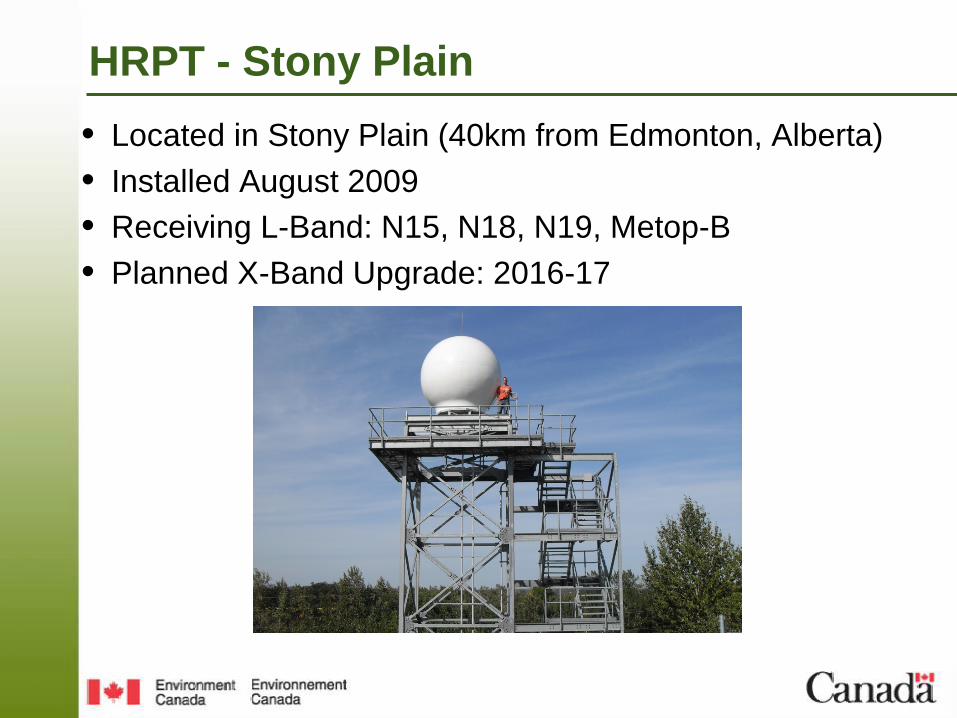
• Located in Stony Plain (40km from Edmonton, Alberta) • Installed August 2009 • Receiving L-Band: N15, N18, N19, Metop-B • Planned X-Band Upgrade: 2016-17
HRPT - Stony Plain

HRPT - Resolute Bay • Located in Resolute Bay, Nunavut (75N) • Installed July 2010 • Receiving L-Band: N15, N18, N19 • Satellite (1.5Mbps) backhaul to Edmonton in real-time • Planned addition of Metop-B in 2015

Data Processing Activities
• Current operational process uses Terascan to generate NOAA AVHRR, Metop-B AVHRR, and MODIS imagery for Ninjo (forecaster production & visualization tool)
• How best to optimize processing all of data acquired?
• Development activities include: – Combining Passes – Integrated Processing – Generating Examples – Sounder Processing

Combining Passes
• CMC receives duplicate information from a single pass from multiple receiving sites
• Uses some basic logic to make satellite products from
just one of the passes
• Better solution is to combine the data from the receiving sites into a single data file
• Process all imagery from the combined data file • Archive the combined file

NOAA-19 AVHRR received at Resolute for September 1, 2011

NOAA-19 AVHRR received at Gander for September 1, 2011

NOAA-19 AVHRR received at Edmonton for September 1, 2011

Pytroll/Trollcast
Edmonton
• Prototype system for
NOAA/AVHRR demonstrated
• Not yet possible for other satellites using method adopted for prototype
• Other options are available but not yet explored
Resolute
Combined

Prototype Processing System
Goal – Investigate new tools and software (free) Goal – Improve current suite of output imagery and products
Developed prototype system for all data types using following tools:
• NPP: RT-STPS -> CSPP/SDR_2.0 -> Pytroll • MODIS: RT-STPS -> MODISL1DB -> Pytroll • METOP: METOPIZER -> AAPP -> Pytroll • AVHRR: RAW -> AAPP -> Pytroll
Also looked at Polar2Grid

Metop Example
Raw -> Metopizer -> AAPP -> Pytroll -> Geotiff Imagery

Pytroll – Terra Modis example • Ninjo Compatible Geotiff (ninjotiff.py) – yes • Automatic Minimum Bounding Box – yes • Thumbnail jpgs with coast (pycoast) - yes
• Advantage – leverage existing python modules already developed

CSPP Single Channel
• Can produce “rotated” imagery with proper geographic tags
• SeaSpace and GI both
produce incorrect tags
• MSC Ingester does not use conventional tags
• Based on knowledge
gained investigating CSPP, it is now possible to correct SeaSpace and GI tags.
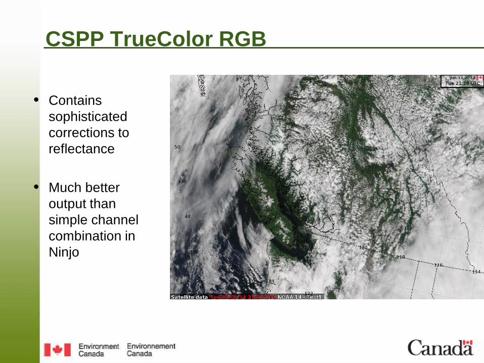
CSPP TrueColor RGB
• Contains sophisticated corrections to reflectance
• Much better
output than simple channel combination in Ninjo

VIIRS Day Night Band in Ninjo

Stratus / Fog Case Study

Stratus / Fog Case Study (con’t)

Sounder Products
• Image or derived products available – Low resolution water vapour channels (imagery) – Precipitable Water – Cloud Top Pressure – Stability Indicies – Many, many more
• Have tested creating EDRs (HDF files) and viewing using
CSPP tools • Have tested creating graphical output as GeoTiff (using
GDAL) and importing to NinJo

• Locally-received Data Processed Using CSPP tools
TPW from ATMS exported as GeoTiff file using GDAL and viewed in ArcGIS Desktop Explorer
Temperature sounding from CrIS
Cloud Top Pressure from CrIS
Products created as “proof – of – concept”
Sounder Products

Preparing for GOES-R Component 1: USER NEEDS
Component 4: USER READINESS
Project Management
“MSC understands and analyses GOES-R
capabilities and prepares a set of user requirements”
:
“MSC meteorologists have skills, competencies, and ability to use
GOES-R data in the forecast process once the data is available in NinJo”
Component 2: RECEPTION & PROCESSING
Component 3: FORECAST WORKSTATION
“MSC is able to receive, process and generate GOES-R
products to meet user requirements and data
management”
“NinJo is able to manage, ingest, display and
manipulate GOES-R data to meet user requirements”
Data Management

EC GOES-R User Requirements

EC GOES-R User Requirements

Summary
• Direct Readout infrastructure is stable, lots of data • Working on data processing with goal of improved
architecture to deliver better suite of products for Ninjo – Evaluating existing software, tools – Addressing challenges related to formats, standards (for both
inputs and outputs) – Generating new evaluation products
• Preparing for GOES-R – Evaluating CSPP GOES-GRB software
• Thanks for support, quick responses, feedback!