dinder center for environmental research khartoum sudan ... · dinder center for environmental...
TRANSCRIPT
Modathir Zarong
Elfatih Eltahir
DEWFORA meeting,
ECMWF, 4 – 5 October
Dinder Center for Environmental Research
Khartoum
Sudan

Introduction
There have been notable droughts in Ethiopia
throughout human history (Haile 1988; Degefu 1987;
Pankhurst 1966; Nicholls 1993; Webb and Braun
1994).
Previous droughts and the frequency of rainfall
deviation from the average suggest that droughts occur
every 3-5 and 6-8 years in northern Ethiopia and every
8-10 years for the whole country (Haile 1988, 90).

A statistical analysis by Eltahir (1996) shows that "ENSO episodes are
negatively tele connected with the floods of the Blue Nile and Atbara" rivers
that originate in Ethiopia.
Eltahir (1996) also concluded that ENSO events affect flows of the Nile River
(indicating drought in highland Ethiopia, which is a source of 85 percent of
Nile water) and that knowledge of these events could be used to improve the
predictability of its annual flow.
Eltahir (1998) the ENSO prediction is good enough to be used in Medium to
long range forecasting of the Nile flood.
Introduction Cont’

Previous studies
Scatter plot of the data showing the relation between the annual
flow of the Nile and the index of ENSO for the months of
September, October, and November, for the years 1872-1972. The
coefficient of correlation is -0.5. The straight line is the regression
line (Eltahir, 1996).
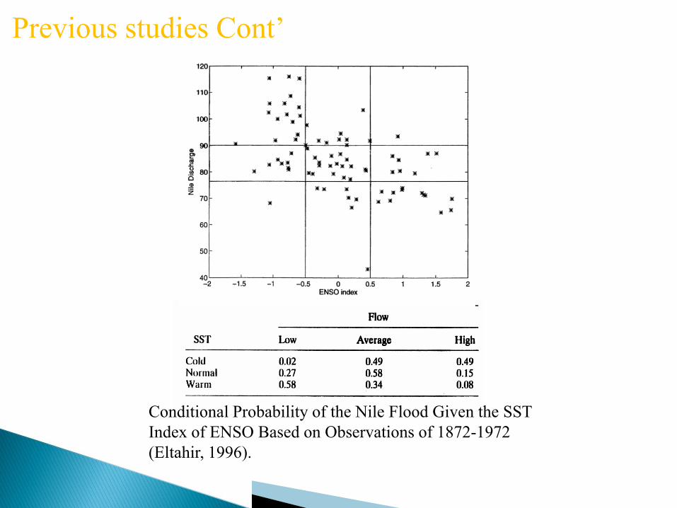
Conditional Probability of the Nile Flood Given the SST
Index of ENSO Based on Observations of 1872-1972
(Eltahir, 1996).
Previous studies Cont’

• Drought is one of the major environmental hazards in in Africa.
• Recent predictions on climate change suggest this situation may
worsen, projecting an increased frequency and severity of drought in
these regions, though these predictions are quite uncertain.
• Effective disaster risk management, including the provision of advance
warning to drought, and the implementation of effective drought
management, offers the potential to reduce adverse impacts.
• Drought preparedness and education can additionally increase
resilience of affected societies, allowing them to cope better with
drought and its impacts.
Problem statement

The main objective is to develop models and methods to map
drought hazard at the local, regional scales and to explore the
mechanisms of these droughts, and in particular their connection
to ENSO.
Objective

Data used (monthly)Precipitation
from GPCP from 1981 2008
• SST from Hadley
Methodology • Compute the anomaly of SST during
(JFM, FMA, MAM, AMJ) in the Pacific
Ocean
70W 120W 5S 5N (Elnino 3.4)
• Compute the anomaly of precipitation
over Ethiopian Highland 35E 41E 6N
14N for summer season (JJAS)
• Correlation between precipitation and
each SST
Preliminary test and correlation with
observational dataset

Results

r= -0.467 r= -0.46
r= -0.4 r= -0.3
JFM_sst
JJAS_pptJFMA_sst
JJAS_ppt
MAM_sst
JJAS_ppt AMJ_ss
JJAS_ppt
Results Cont’

SST over Nino 3.4
Rainfall over Ethiopian Highland from GPCP
correlation
JFM JJAS - 0.47
FMA JJAS - 0.46
MAM JJAS - 0.4
AMJ JJAS - 0.3
From the above table the correlation is higher in JFM, and
it decrease gradually for the next months
Results Cont’

Examples of El Nino and La Nina
years and their effect in the discharge
of the Blue Nile

The difference between
Elnino and Lanina years for
GPCP and CRU.

Model description
RegCM4.1.1 (ICTP model) This is a primitive equation, sigma
vertical coordinate
• Band Model
• The convection scheme is Emanuel in the ocean and Grell in land.
• The closure assumption of Fritsch and Chappell.
• Resolvable scale precipitation processes are treated using the sub-
grid explicit moisture scheme (SUBEX).
• The scheme of Zeng is used to represent fluxes from ocean
surfaces.
• Interactions between the land surface and the atmosphere are
described using the Biosphere Atmosphere Transfer Scheme
(BATS).
• Radiation is represented by the parameterization of Kiehl et al.,
(1996).
• the description of planetary boundary layer processes is based on
the scheme by Holtslag et al., (1990).

The ensemble made for 27/12/1983, 28, 29, 30, 31 and 1/1/1984 and also for 1988 , the
ensemble gives better result


Conclusion
• The highest correlation between the rainfall in Ethiopian highland for the rainy
season (JJAS) and the SST in the Pacific Ocean for (JFM).
• This correlation decreases gradually for the next three consecutive months.
• There is an evidence from the observations that the El Nino year is associated
with drought in the Nile and La Nina year is associated with flooding in the
Nile.
• The tropical band model capture this correlation also and the ensemble year
gives a better results.
