dillon consulting limited - windsor · pdf filewalker road corridor improvements riverside...
TRANSCRIPT

Walker Road Corridor ImprovementsRiverside Drive to Provincial Road (City Limits)Grand Marais Road East ImprovementsWalker Road to Central Avenue
REPORT
March 2001
The Corporation of the City of Windsor
99-6401
Submitted by
Dillon ConsultingLimited

Walker Road Corridor ImprovementsRiverside Drive to Provincial Road (City Limits)Grand Marais Road East ImprovementsWalker Road to Central Avenue
Dillon Consulting LimitedMarch 2001
EXECUTIVE SUMMARY
The Walker Road Corridor and Grand Marais Road East Class Environmental Assessment undertooka comprehensive review of the improvements required on Walker Road extending from RiversideDrive south to the City limit and on Grand Marais Road East from Walker Road to east of CentralAvenue. This comprehensive review serves to ensure that improvements recommended at anylocation within the subject area are compatible with those recommended (if any) of adjacentlocations. In this way, the safe movement of vehicles, cyclists and pedestrians is ensured throughthe entire corridor of both Walker Road and Grand Marais Road East.
The improvements identified in this Study Report were developed in consultation with localresidents, affected business and property owners, interest groups such as the local cyclingcommunity and municipal and provincial review agencies. This document represents theculmination of the many discussions undertaken with each of these groups.
Owing to the considerable length of the two road corridors assessed, improvements have beensummarized as “Near Term” (5 year program) and “Long Term” (to be reviewed annually beyondthe 5 year program). Figure E.1 identifies the location of the improvements noted. Near Termimprovements identified include:
• complete the reconstruction of Walker Road from Division Road to the City limits includingcompletion of the Walker/Provincial intersection ($8,700,000)
• construction of Foster Street extension to service the airport lands and Walker IndustrialPark ($2,700,000)
• continue discussions with DaimlerChrysler to determine the need for the reconstruction ofthe Walker/Grand Marais intersection (including possible grade separation) ($13,900,000).
• continue discussions with DaimlerChrysler to determine the need for the reconstruction ofGrand Marais Road East from Walker Road to east of Central Avenue ($6,700,000).
Walker Road Corridor ImprovementsRiverside Drive to Provincial Road (City Limits)Grand Marais Road East ImprovementsWalker Road to Central Avenue
Dillon Consulting LimitedMarch 2001
• construction of the Digby Street extension to Temple Drive ($950,000).
• installation of traffic signals at Richmond Street (north leg), at Parkdale Place and at AirportRoad.
Beyond the five year time frame, projects should be reviewed on an annual basis. Furtherreconstruction of Walker Road should proceed northerly from Division Road.
In addition to the road improvements identified, cycling, pedestrian and streetscape opportunitiesare also noted in the report and should be included as improvements are undertaken.

Walker Road Corridor ImprovementsRiverside Drive to Provincial Road (City Limits)Grand Marais Road East ImprovementsWalker Road to Central Avenue
Dillon Consulting Limited i
TABLE OF CONTENTS
EXECUTIVE SUMMARY
1.0 INTRODUCTION AND BACKGROUND . . . . . . . . . . . . . . . . . . . . . . . . . . . . . . . . . . 11.1 The Environmental Study Report . . . . . . . . . . . . . . . . . . . . . . . . . . . . . . . . . . . . . 11.2 Purpose . . . . . . . . . . . . . . . . . . . . . . . . . . . . . . . . . . . . . . . . . . . . . . . . . . . . . . . . . . 21.3 Background . . . . . . . . . . . . . . . . . . . . . . . . . . . . . . . . . . . . . . . . . . . . . . . . . . . . . . 31.4 Study Area Boundary and Precincts . . . . . . . . . . . . . . . . . . . . . . . . . . . . . . . . . . . 5
1.4.1 Primary Study Areas . . . . . . . . . . . . . . . . . . . . . . . . . . . . . . . . . . . . . . . . . 51.4.1.1 Walker Road Corridor -
Riverside Drive East to Division Road . . . . . . . . . . . . . . . . . . . . . 51.4.1.2 Walker Road Corridor - Walker Road Improvements
1995 ESR Addendum - Division Road to Provincial Road (City Limits) . . . . . . . . . . . . . . . . . . . . . . . . . . . . . . . . . . . . . 6
1.4.1.3 Grand Marais Road East Corridor -Walker Road to Central Avenue . . . . . . . . . . . . . . . . . . . . . . . . . . 6
1.4.2 Secondary Study Area . . . . . . . . . . . . . . . . . . . . . . . . . . . . . . . . . . . . . . . . 61.5 Related Studies . . . . . . . . . . . . . . . . . . . . . . . . . . . . . . . . . . . . . . . . . . . . . . . . . . . 7
2.0 PROJECT APPROACH . . . . . . . . . . . . . . . . . . . . . . . . . . . . . . . . . . . . . . . . . . . . . . . . . 82.1 Class Environmental Assessment Process &
Windsor Area Long Range Transportation Study (WALTS) . . . . . . . . . . . . . . . . 82.1.1 Class Environmental Assessment Process . . . . . . . . . . . . . . . . . . . . . . . . . 82.1.2 Windsor Area Long Range Transportation Study (WALTS) . . . . . . . . . . 92.1.3 Starting Point for this Project . . . . . . . . . . . . . . . . . . . . . . . . . . . . . . . . . . . 9
2.2 Problem Statement . . . . . . . . . . . . . . . . . . . . . . . . . . . . . . . . . . . . . . . . . . . . . . . . 102.3 Study Team Organization . . . . . . . . . . . . . . . . . . . . . . . . . . . . . . . . . . . . . . . . . . 102.4 Public Consultation Program . . . . . . . . . . . . . . . . . . . . . . . . . . . . . . . . . . . . . . . . 11
3.0 THE ENVIRONMENT . . . . . . . . . . . . . . . . . . . . . . . . . . . . . . . . . . . . . . . . . . . . . . . . . 123.1 Introduction . . . . . . . . . . . . . . . . . . . . . . . . . . . . . . . . . . . . . . . . . . . . . . . . . . . . . 123.2 Natural Environment . . . . . . . . . . . . . . . . . . . . . . . . . . . . . . . . . . . . . . . . . . . . . . 143.3 Residential Land Uses . . . . . . . . . . . . . . . . . . . . . . . . . . . . . . . . . . . . . . . . . . . . . 143.4 Industrial Land Uses . . . . . . . . . . . . . . . . . . . . . . . . . . . . . . . . . . . . . . . . . . . . . . 153.5 Commercial Land Uses . . . . . . . . . . . . . . . . . . . . . . . . . . . . . . . . . . . . . . . . . . . . 163.6 Utility Land Uses . . . . . . . . . . . . . . . . . . . . . . . . . . . . . . . . . . . . . . . . . . . . . . . . . 163.7 Open Space Land Uses . . . . . . . . . . . . . . . . . . . . . . . . . . . . . . . . . . . . . . . . . . . . 173.8 Transportation . . . . . . . . . . . . . . . . . . . . . . . . . . . . . . . . . . . . . . . . . . . . . . . . . . . 173.9 Heritage Resources . . . . . . . . . . . . . . . . . . . . . . . . . . . . . . . . . . . . . . . . . . . . . . . 183.10 Potential Archaeological Impacts . . . . . . . . . . . . . . . . . . . . . . . . . . . . . . . . . . . . 183.11 Noise and Vibration . . . . . . . . . . . . . . . . . . . . . . . . . . . . . . . . . . . . . . . . . . . . . . . 18
Walker Road Corridor ImprovementsRiverside Drive to Provincial Road (City Limits)Grand Marais Road East ImprovementsWalker Road to Central Avenue
Dillon Consulting Limited ii
3.12 Land Use Designation . . . . . . . . . . . . . . . . . . . . . . . . . . . . . . . . . . . . . . . . . . . . . 193.12.1 City of Windsor - Official Plan . . . . . . . . . . . . . . . . . . . . . . . . . . . . . . . . 19
3.12.1.1 Walker Road - Division Road to Provincial Road . . . . . . 193.12.1.2 Walkerville Industrial Area . . . . . . . . . . . . . . . . . . . . . . . 203.12.1.3 City of Windsor - Airport Lands . . . . . . . . . . . . . . . . . . . 20
3.12.2 Town of Tecumseh - Airport Lands . . . . . . . . . . . . . . . . . . . . . . . . . . . . . 213.12.3 Windsor International Airport . . . . . . . . . . . . . . . . . . . . . . . . . . . . . . . . . 21
3.13 Transportation . . . . . . . . . . . . . . . . . . . . . . . . . . . . . . . . . . . . . . . . . . . . . . . . . . . 213.13.1 Existing Roadway Conditions . . . . . . . . . . . . . . . . . . . . . . . . . . . . . . . . . 223.13.2 Traffic Volumes . . . . . . . . . . . . . . . . . . . . . . . . . . . . . . . . . . . . . . . . . . . . 233.13.3 Level of Service . . . . . . . . . . . . . . . . . . . . . . . . . . . . . . . . . . . . . . . . . . . . 243.13.4 Public Transit . . . . . . . . . . . . . . . . . . . . . . . . . . . . . . . . . . . . . . . . . . . . . . 243.13.5 Railways . . . . . . . . . . . . . . . . . . . . . . . . . . . . . . . . . . . . . . . . . . . . . . . . . . 263.13.6 Pedestrians . . . . . . . . . . . . . . . . . . . . . . . . . . . . . . . . . . . . . . . . . . . . . . . . 273.13.7 Cycling . . . . . . . . . . . . . . . . . . . . . . . . . . . . . . . . . . . . . . . . . . . . . . . . . . . 273.13.8 Accidents . . . . . . . . . . . . . . . . . . . . . . . . . . . . . . . . . . . . . . . . . . . . . . . . . 28
3.14 Existing Infrastructure . . . . . . . . . . . . . . . . . . . . . . . . . . . . . . . . . . . . . . . . . . . . . 283.15 Geotechnical Investigation . . . . . . . . . . . . . . . . . . . . . . . . . . . . . . . . . . . . . . . . . 283.16 Environmental Site Assessment . . . . . . . . . . . . . . . . . . . . . . . . . . . . . . . . . . . . . . 29
4.0 IDENTIFICATION AND EVALUATION OF ALTERNATIVE DESIGN CONCEPTS . . . . . . . . . . . . . . . . . . . . . . . . . . . . . . . . . . . 294.1 Alternative Road Designs and Intersection Improvements . . . . . . . . . . . . . . . . . 304.2 Identification of Alternative Designs . . . . . . . . . . . . . . . . . . . . . . . . . . . . . . . . . . 304.3 Evaluation of Alternative Designs . . . . . . . . . . . . . . . . . . . . . . . . . . . . . . . . . . . . 304.4 Selection of Recommended Design . . . . . . . . . . . . . . . . . . . . . . . . . . . . . . . . . . . 324.5 Storm Water Drainage Considerations . . . . . . . . . . . . . . . . . . . . . . . . . . . . . . . . 334.6 Public and Agency Consultation for Alternative Designs . . . . . . . . . . . . . . . . . . 34
5.0 PREFERRED DESIGN . . . . . . . . . . . . . . . . . . . . . . . . . . . . . . . . . . . . . . . . . . . . . . . . . 355.1 Description of the Preferred Design . . . . . . . . . . . . . . . . . . . . . . . . . . . . . . . . . . 35
5.1.1 Preferred Road Design . . . . . . . . . . . . . . . . . . . . . . . . . . . . . . . . . . . . . . . 365.1.2 Railway Grade Separation . . . . . . . . . . . . . . . . . . . . . . . . . . . . . . . . . . . . 385.1.3 Storm Water Drainage . . . . . . . . . . . . . . . . . . . . . . . . . . . . . . . . . . . . . . . 405.1.4 Utilities . . . . . . . . . . . . . . . . . . . . . . . . . . . . . . . . . . . . . . . . . . . . . . . . . . . 405.1.5 Cycling Opportunities . . . . . . . . . . . . . . . . . . . . . . . . . . . . . . . . . . . . . . . 405.1.6 Streetscape Opportunities . . . . . . . . . . . . . . . . . . . . . . . . . . . . . . . . . . . . 41
5.2 Construction Phasing . . . . . . . . . . . . . . . . . . . . . . . . . . . . . . . . . . . . . . . . . . . . . . 425.3 Preliminary Cost Estimates . . . . . . . . . . . . . . . . . . . . . . . . . . . . . . . . . . . . . . . . . 445.4 Potential Environmental Conditions and Mitigating Measures . . . . . . . . . . . . . . 44
5.4.1 Short-Term Environmental Impacts . . . . . . . . . . . . . . . . . . . . . . . . . . . . 45
Walker Road Corridor ImprovementsRiverside Drive to Provincial Road (City Limits)Grand Marais Road East ImprovementsWalker Road to Central Avenue
Dillon Consulting Limited iii
5.4.2 Long-Term Environmental Impacts . . . . . . . . . . . . . . . . . . . . . . . . . . . . . 455.4.3 Property Requirements . . . . . . . . . . . . . . . . . . . . . . . . . . . . . . . . . . . . . . 45
5.5 Public and Agency Consultation for Preferred Design . . . . . . . . . . . . . . . . . . . . 47
6.0 COMMITMENTS TO FURTHER WORK AND MONITORING . . . . . . . . . . . . . 48
LIST OF FIGURES
Figure E1.0 Summary of ImprovementsFigure 1.0 Class Environmental Assessment Process for Municipal Roads ProjectsFigure 2.0 Primary & Secondary Study AreasFigure 3.0 PrecinctsFigure 4.0 Planning Districts, City of Windsor Official PlanFigure 5a North Precinct, Existing Land UseFigure 5b Central Precinct, Existing Land UseFigure 5c South Precinct, Existing Land UseFigure 5d Previous ESR Precinct, Existing Land UseFigure 5e Grand Marais Precinct, Existing Land UseFigure 6.0 Heritage Resources, City of Windsor Official PlanFigure 7.0 Planned Land Use, City of Windsor Official PlanFigure 8.0 Planned Land Use, The Town of Tecumseh Official PlanFigure 9.0 Walkerville Industrial AreaFigure 10.0 City of Windsor, Airport LandsFigure 11.0 Summary of Traffic Accidents from 1996 to 1999Figure 12.0 Cycling OpportunitiesFigure 13.0 Conceptual Landscape Cross Sections

Walker Road Corridor ImprovementsRiverside Drive to Provincial Road (City Limits)Grand Marais Road East ImprovementsWalker Road to Central Avenue
Dillon Consulting Limited iv
LIST OF TABLES
Table 1.0 Study Team Members . . . . . . . . . . . . . . . . . . . . . . . . . . . . . . . . . . . . . . . . . . . . . 11Table 2.0 Identification of Alternative Designs . . . . . . . . . . . . . . . . . . . . . . . . follows page 30Table 3.0 Evaluation of Alternative Designs . . . . . . . . . . . . . . . . . . . . . . . . . . follows page 31Table 4.0 Preliminary Cost Estimates . . . . . . . . . . . . . . . . . . . . . . . . . . . . . . . . . . . . . . . . . 44Table 5.0 Property Requirements . . . . . . . . . . . . . . . . . . . . . . . . . . . . . . . . . . . . . . . . . . . . 46
APPENDICES
Appendix A Preferred Design Volume 1
Appendix B $Recommended Design $Optional Design
Appendix C Public NotificationAppendix D Candidate Natural Heritage Site Biological InventoryAppendix E Heritage Record FormsAppendix F Noise AnalysisAppendix G Transportation AssessmentAppendix H Existing InfrastructureAppendix I Public ConsultationAppendix J Cycling Opportunities
Appendix K Environmental Site Assessment
Volume 2
Walker Road Corridor ImprovementsRiverside Drive to Provincial Road (City Limits)Grand Marais Road East ImprovementsWalker Road to Central Avenue
Dillon Consulting Limited 1
1.0 INTRODUCTION AND BACKGROUND
1.1 The Environmental Study Report
The City of Windsor has completed an Environmental Study Report (ESR) for improvements toWalker Road between Riverside Drive East and Provincial Road (City Limits). The total lengthof the Walker Road Corridor under study is approximately 10 km. The study area also includesthat section of Walker Road located between Division Road and Provincial Road (City Limits).This section of Walker Road was included in the Walker Road Corridor ESR completed byDillon in 1995 and has been re-evaluated to confirm the recommendation and findings of thatESR. The findings of the re-evaluation should be considered as an Addendum to the originalreport. In addition, this Study will also address Grand Marais Road East from Walker Road toCentral Avenue (Grand Marais Road East Corridor) as an integral part of this project. The totallength of the Grand Marais Road East Corridor is approximately 3 km.
The Walker Road Corridor and Grand Marais Road Corridor have experienced significantgrowth in recent years, resulting in deteriorating traffic safety and operating conditions. Inaddition, the potential for future development along the Walker Road Corridor has given rise tothe need to undertake this Study to identify and address these needs. The Walker Road Corridorand Grand Marais Road East Corridor Improvements are subject to the Class EnvironmentalAssessment for Municipal Roads Projects process (June 1993).
The Windsor Area Long Range Transportation Study Master Plan (WALTS) has identified theWalker Road Corridor and Grand Marais Road East Corridor as being in need of capacityimprovements. The WALTS has been completed in accordance with the Class EnvironmentalAssessment Master Plan process, thereby satisfying Phase 1 and Phase 2 of the Class EArequirements for this current Study.
The Class EA process, which has been approved by the Province of Ontario, describes theprocess which municipalities must follow to comply with the requirements of the EnvironmentalAssessment Act. The process (refer to Figure 1.0), applies to municipal road projects which
Walker Road Corridor ImprovementsRiverside Drive to Provincial Road (City Limits)Grand Marais Road East ImprovementsWalker Road to Central Avenue
Dillon Consulting Limited 2
occur frequently and have a predictable range of environmental impacts. Provided that the ClassEA process is followed, projects are classified into three types:
$ Schedule A Projects - usually have minor environmental impacts and mayproceed without following the Class EA process;
$ Schedule B Projects - have more significant impacts and are approved under theClass EA process provided that the potentialenvironmental concerns of the public and affectedagencies are Ascreened@and incorporated into the projectsdesign;
$ Schedule C Projects - are subject to the full Class EA process and require thepreparation of a Environmental Study Report (ESR). TheWalker Road Corridor and Grand Marais Road CorridorImprovements are a Schedule C project. The ESR followsthe documentation of the Class EA process whichincludes:
$ Identification of the problems/issues and projectpurpose;
$ The problem solving decision making process;$ Description of the existing social, economic and
natural environment in the Study Area;$ Identification of the Alternative Solutions that were
cons idered to reso lve the iden t i f i edproblems/issues;
$ Selection of the most desirable design alternative,including the identification of potentialenvironmental impacts associated with the selecteddesign, and mitigating measures and designrequirements associated with the implementation ofthe project.
1.2 Purpose
The purpose of this project is to establish the preferred solution to resolving roadway
operational deficiencies based on an anticipated level of traffic growth, with particular
consideration to pedestrian and vehicular safety.

Walker Road Corridor ImprovementsRiverside Drive to Provincial Road (City Limits)Grand Marais Road East ImprovementsWalker Road to Central Avenue
Dillon Consulting Limited 3
As a result of continuing growth in traffic, including the impact of area developments, trafficsafety and operating conditions along the Walker Road and Grand Marais Road corridors havedeteriorated. The City of Windsor has established the need for roadway improvements withinthese corridors through the completion of the Windsor Area Long Range Transportation Study(WALTS). As noted, WALTS formed the basis for this undertaking, having satisfied Phases 1and 2 of the Class Environmental Assessment (Class EA) for Municipal Road Projects. Bycompleting the Class EA process, the City of Windsor will be in a position to beginimplementing the preferred designs identified herein.
1.3 Background
As a major north-south arterial roadway connecting the City of Windsor to the Town ofTecumseh, and to County and Provincial highway systems, Walker Road serves the followingkey functions:
$ arterial roadway for commuting traffic;$ gateway to Windsor for both air and rail travelers;$ major roadway to service industrial and commercial land uses;$ a major service corridor for municipal infrastructure.
The importance of this link has increased with the growth in industrial and commercialdevelopment serviced from the Walker Road Corridor. Walker Road also carries commuter andcommercial traffic to and from the King’s Highway No. 401 via Provincial Road. Walker Roadis also intersected by other major east-west routes in the City including Riverside Drive,Wyandotte Street, Tecumseh Road, E.C. Row Expressway, Division Road and Provincial Road.
From Riverside Drive to Ottawa Street, Walker Road operates as a two-lane roadway with somewidening at intersections. The area is older in character with some redevelopment nowoccurring. For purposes of this study, we have defined this area as the North Precinct.
Walker Road Corridor ImprovementsRiverside Drive to Provincial Road (City Limits)Grand Marais Road East ImprovementsWalker Road to Central Avenue
Dillon Consulting Limited 4
From Ottawa Street to Grand Marais Road, Walker Road has previously been improved tooperate as a five-lane roadway with widening at some intersections to provide auxiliary turninglanes.
Access to abutting properties along this length of Walker Road is considered to be well definedand appropriately spaced.
Intersection spacing is acceptable. For purposes of this study, we have defined this area as theCentral Precinct.
From Grand Marais Road to Division Road, Walker Road operates as a four-lane roadway withnumerous unrestricted access points. Auxiliary turning lanes, except at the E.C. RowExpressway have not been constructed. The area is heavily developed with numerouscommercial establishments fronting Walker Road. Several minor roadways intersect withWalker Road in this section. For purposes of this study, we have defined this area as the SouthPrecinct.
This report also considers Walker Road from Division Road to Provincial Road (City Limits).This section of Walker Road was the subject of a Class Environmental Assessment completed in1995. Since the completion of that Study, some improvement of the intersection at ProvincialRoad has been completed and the reconstruction of the Division Road intersection hascommenced. Large scale commercial development has recently been constructed, with furtherdevelopment plans being proposed.
This report also addresses Grand Marais Road East from Walker Road to east of Central Avenue.In this section, Grand Marais Road operates as a two-lane roadway with auxiliary turning lanesprovided at Walker Road, Chrysler Centre and Central Avenue. Both urban and rural cross-sections characterize the roadway. Many of the access points are uncontrolled and through muchof its length the roadway is deficient both structurally and with respect to its alignment.

Walker Road Corridor ImprovementsRiverside Drive to Provincial Road (City Limits)Grand Marais Road East ImprovementsWalker Road to Central Avenue
Dillon Consulting Limited 5
1.4 Study Area Boundary and Precincts
For the purpose of the Report, the Study Area associated with this project has been divided intothe following categories;
• Primary Study Area (Walker Road and Grand Marais Road Corridors)• Secondary Study Area (Peripheral lands surrounding the corridors)
Refer to Figure 2.0.
1.4.1 Primary Study Areas
1.4.1.1 Walker Road Corridor - Riverside Drive East to Division Road
In order to effectively investigate, disseminate and report the various aspects associated with theClass EA process it was determined that the Walker Road Corridor be divided into four distinctsections called APrecincts@. The advantages of establishing the precincts are as follows:
• divides a very long study area into manageable sections;• site specific information and recommendations can be effectively presented within the
context of the entire project. This will discourage potential concerns regardingpiecemealing the project;
• information can be documented and presented at a scale which is in keeping with thecharacter and needs of affected businesses, industries and residents of each area. Thismay encourage a greater sense of Aownership@ and Aparticipation@ by the stakeholders;
• public information centres can be Acustomized@ to reflect the needs and issues specific tothe precinct. This will assist in reducing the potential for Ainformation overload@; and
• provides clear separation of the study area which forms part of the 1995 Walker RoadImprovements ESR.
The Precinct boundaries were selected on the basis of the roadway and land use characteristics

Walker Road Corridor ImprovementsRiverside Drive to Provincial Road (City Limits)Grand Marais Road East ImprovementsWalker Road to Central Avenue
Dillon Consulting Limited 6
and issues that are common to each area. Between Riverside Drive East and Division Road,three APrecincts@ were developed. They are described as follows:• North Precinct - Riverside Drive East to Ottawa Street;• Central Precinct - Ottawa Street to Grand Marais Road; and• South Precinct - Grand Marais Road East to Division Road.
Refer to Figure 3.0.
1.4.1.2 Walker Road Corridor - Walker Road Improvements 1995 ESR Addendum -Division Road to Provincial Road (City Limits)
As previously noted, the City of Windsor undertook the Walker Road Improvements ESR(Division Road to Provincial Road (City Limits) in 1995. The recommendations in the 1995 ESRwere re-evaluated to determine whether any additional improvements were needed to addressfurther changes within this section of the Walker Road Corridor. Refer to Figure 3.0.
1.4.1.3 Grand Marais Road East Corridor - Walker Road to Central Avenue
Based on discussions with affected agencies, administration from the City of Windsor and majorcorporations operating in the vicinity, it was determined that the Primary Study Area should beenlarged to also include Grand Marais Road East from Walker Road to Central Avenue. Basedon proposed expansions to existing manufacturing facilities in the area, increased traffic,increased railway demands and potential improvements required to the Walker Road / GrandMarais Road East intersection, it was agreed to include this corridor in the Class EA process.Refer to Figure 3.0.
1.4.2 Secondary Study Area
In order to access the potential environmental impacts associated with the range of solutions tothe problem, it is necessary to consider a broader secondary study area beyond the Walker Road

Walker Road Corridor ImprovementsRiverside Drive to Provincial Road (City Limits)Grand Marais Road East ImprovementsWalker Road to Central Avenue
Dillon Consulting Limited 7
and Grand Marais Road East Corridors. The Secondary Study Area boundaries are as follows(refer to Figure 2.0):
• North: Detroit River;• East: Central Avenue (City of Windsor);
Windsor Airport property (Town of Tecumseh);• South: Oldcastle Industrial Park (Town of Tecumseh) and• West: Howard Avenue (City of Windsor)
1.5 Related Studies
A number of related studies were reviewed to provide additional background information on theWalker Road and Grand Marais Road East Corridors. Those studies included:
• City of Windsor Official Plan Volume I and II (2000);• Township of Sandwich South (now Town of Tecumseh) Official Plan 1997;• Walker Road Improvements ESR, Dillon Consulting, 1995;• Grand Marais Road - Howard Avenue to Walker Road ESR, City of Windsor,
(2000);• Bicycle Use Development Study (BUDS), Victor Ford & Associates (1990);• Bicycle Use Master Plan (BUMP), Marshall Macklan Monahan (Draft) (2000);• Electrical Supply to General Motors & Ford - Walker Road, Ontario Hydro (1997);• Report on Storm Drainage, Part 3, Ward 7 & 8, M.M. Dillon Ltd. (1970);• Transportation Planning Model, City of Windsor - Model Documentation and User’s
Guide, Paradigm Transportation Solutions Limited (1998);• Devonshire Estate Traffic Assessment, RGP Transtech Inc. (1995);• Walker Road/Provincial Road Commercial Centre Traffic Study, iTRANS
Consulting Inc. (1999);• Windsor Area Long Range Transportation Study and Master Plan, Stantec
Consulting Ltd. (1999);• Windsor Area Long Range Transportation Study, Final Report, Stantec (1999)

Walker Road Corridor ImprovementsRiverside Drive to Provincial Road (City Limits)Grand Marais Road East ImprovementsWalker Road to Central Avenue
Dillon Consulting Limited 8
• Woodlawn/Ypres/Memorial Storm Relief Study, CH2M Gore & Storrie Limited andHanna, Ghobrial & Spencer Ltd. (2000);
• Storm Drainage Study, Bliss/Riberdy/E.C. Row/Division, City of Windsor, A.A.Boscariol & Associates (2000); and
• Walker Road Corridor Improvements Transportation Needs Study, DillonConsulting Limited (1994).
2.0 PROJECT APPROACH
2.1 Class Environmental Assessment Process & Windsor Area Long RangeTransportation Study (WALTS)
2.1.1 Class Environmental Assessment Process
The Walker Road and Grand Marais Road East Corridor project follows the planningrequirements of the Class EA for Municipal Roads Projects, dated June 1993.
The Class EA approach incorporates five key principles under the EA Act. They are:
• Consultation with affected parties early in the planning process to ensure the processis cooperative;
• Consideration of a wide range of alternatives;• Identification and consideration of the effects of each alternative on all aspects of the
environment;• Systematic evaluation of alternatives in terms of their advantages and disadvantages,
including their net environmental effects; and• Provision of a clear and complete documentation of the planning process to allow for
Atraceability@in the decision making process.
As previously noted, this project proceeded as a Schedule C activity. Schedule C projects have apotential for significant environmental effects and must proceed under full planning anddocumentation procedures specified in the Class EA document. The Class EA Planning andDesign Process Chart is included for reference (refer to Figure 1.0).

Walker Road Corridor ImprovementsRiverside Drive to Provincial Road (City Limits)Grand Marais Road East ImprovementsWalker Road to Central Avenue
Dillon Consulting Limited 9
It should be noted that during the course of this project, the Class EA process in the Province ofOntario was updated. The new Class EA for Municipal Roads and Waste Water Projects datedJune 2000 received Ministerial Approval on October 4, 2000. However, because this projectwas initiated under the former process, this project was completed under the requirements of theClass EA for Municipal Roads Projects, June 1993.
2.1.2 Windsor Area Long Range Transportation Study (WALTS)
As previously noted, the Class EA process prescribes that public and agency consultation takeplace through each phase of the process to ensure that concerns, comments and input are factoredinto the design of alternative solutions to the problem. In some instances, the preparation ofparallel studies can meet the initial requirements of the Class EA process for associated studies.
The preparation of WALTS, a Transportation Master Plan for the City of Windsor, wascompleted to satisfy Phases 1 and 2 of the Class EA process.
As part of Phase 1 of the Class EA process, WALTS identified the problems and deficienciesfound in the Windsor transportation system, established the Aneed and justification @for systemimprovements (including the Walker Road and Grand Marais Road East Corridors) and beganthe public participation process. With the completion of Phase 2 of the Class EA process,alternative planning solutions were identified in consideration of the economic, socio-culturaland natural environment, as well as public and agency input.
2.1.3 Starting Point for this Project
As a result of completing WALTS, the Class EA process for this project may begin at Phase 3with the identification of alternative design concepts. It should be noted that during the courseof this Study, it became evident that several site-specific issues were not directly considered inWALTS. As such, additional research, comment, input and evaluation was completed asrequired to ensure that there was a complete understanding of the problems which needed to beaddressed.
2.2 Problem Statement

Walker Road Corridor ImprovementsRiverside Drive to Provincial Road (City Limits)Grand Marais Road East ImprovementsWalker Road to Central Avenue
Dillon Consulting Limited 10
Throughout the study, staff from both the City of Windsor and the consultant met with the publicand affected agencies to discuss comments and/or concerns with regards to the study.
The problem statement from which this project is being developed has been identified asfollows: Walker Road is one of the major north/south arterial roadways in the City of Windsor’stransportation network, providing direct access to rail facilities (Via Rail), airline facilities(Windsor Airport), and Provincial Highways (Highway 401/Highway 3). Continuedgrowth and development in the City of Windsor requires the review, analysis andevaluation of the capacity and operational characteristics of the Walker Road Corridorfrom Riverside Drive East to Provincial Road (City Limits) and Grand Marais Road Eastfrom Walker Road to Central Avenue. By building on the previous work completed aspart of the Windsor Area Long Range Transportation Study (WALTS) (1999) and theWalker Road Improvements Environmental Assessment (Division Road to Provincial Road(City Limits) (1995), specific operational and capacity issues will now be addressed and/orupdated in this Environmental Study Report.
The problem statement addresses the entire length of Walker Road within the City, as well as asection of Grand Marais Road, east of Walker Road as forming the single project underconsideration. Due to the length of this corridor and the varying conditions which exist, thisproject has been separated into precincts, as described previously in this report.
2.3 Study Team Organization
A Study Team was organized by the City of Windsor prior to the initiation of the Class EAprocess. The Study Team consisted of senior administration from a number of City Departmentsand the consultant. The role of the Study Team was to provide guidance and assistance to theconsultant, as required to ensure that lines of communication remained open and reportingmechanisms were maintained throughout the process.
Study Team meetings were scheduled at important decision making points in the planning anddesign process. In addition, the consultant communicated directly with a number of the StudyTeam members when further specific information was required. The Study Team members are

Walker Road Corridor ImprovementsRiverside Drive to Provincial Road (City Limits)Grand Marais Road East ImprovementsWalker Road to Central Avenue
Dillon Consulting Limited 11
listed below:
TABLE 1.0STUDY TEAM MEMBERS
Public Works T.W. Szalay, P. Eng.M. Winterton, P. Eng.
Planning D. Caruso, MCIP, RPP
Parks & Recreation F. Langmaid, MCIP, RPP
Traffic Engineering J. Tofflemire, P. Eng.
Legal & Human Resources M. Stamp
Additional staff from various departments were contacted throughout the study and providedinvaluable assistance to the project.
2.4 Public Consultation Program
A proactive and flexible approach to public consultation was adopted in keeping with the needsand interests of the public and affected agencies. The public consultation program included thefollowing:
• Two Public Information and Consultation Centres;• Public Notices placed in the Windsor Star;• Correspondence to potentially affected property owners, tenants, government
agencies and interest groups;• On-site meetings and telephone discussions with owners, tenants, government
agencies and interest groups; and• Internet web site.
At the initiation of the project, an invitation for public comment was placed in the Windsor Star(November 6, 1999). As part of the Notice, the public were also invited to visit the project website to view information about the project. Letters were also mailed to agencies, interest groupsand property owners in the Walker Road Corridor on November 8, 1999. Copies of the Notice,letter and mailing list are included in Appendix C. The letter also described:

Walker Road Corridor ImprovementsRiverside Drive to Provincial Road (City Limits)Grand Marais Road East ImprovementsWalker Road to Central Avenue
Dillon Consulting Limited 12
• Purpose of the Study;• Additional opportunities for public input;• Contact people from the City of Windsor and the consultant;• The Study Area;• Project Web Site; and• Ability to be added to the project mailing list.
Two Public Information and Consultation Sessions (PICS) were held during the course of thestudy. The first PICS was held on January 26, 2000 at the Fogular Furlan Club. The secondPICS was held on May 24, 2000 at the Fogular Furlan Club. The mailing list associated withthis project was also updated as requests were made for additional information (refer toAppendix C).
By March 2001, the project web site had attracted 1077 visitors. Of the 1077 visitors,approximately 73% visited the site more than once during the course of the project and obtainedinformation which included general information, project notices and detailed drawings of theWalker Road and Grand Marais Road East Corridors.
3.0 THE ENVIRONMENT
3.1 Introduction
The Walker Road and Grand Marais Road East Corridors can be described as being a highlyurbanized, well established and developed environment. According to the City of WindsorOfficial Plan, the Walker Road and Grand Marais Road East Corridors form part of eightPlanning Districts and one Special Policy Area. They are (refer to Figure 4.0):
Walker Road Corridor• East Windsor Planning Area;• Walkerville Planning Area;• South Walkerville Planning Area;• Remington Park Planning Area;• Walker Farm Planning Area;

Walker Road Corridor ImprovementsRiverside Drive to Provincial Road (City Limits)Grand Marais Road East ImprovementsWalker Road to Central Avenue
Dillon Consulting Limited 13
• Devonshire Planning Area;• Roseland Planning Area and• Hiram Walker Facilities (Special Policy Area)
Grand Marais Road East Corridor• South Walkerville Planning Area and• Fontainbleau Planning Area.
These Planning Districts facilitate the development of more detailed planning policies within thecontext of the City of Windsor’s Official Plan and allow for the preparation of Secondary Planswhere appropriate, to guide development and re-development of existing neighbourhoods. TheHiram Walker Facilities Special Policy Area acknowledges that the existing development hascontributed to the identity and experience of the Windsor Waterfront. Therefore, anyredevelopment of these lands should take into account the policies associated with theWaterfront Port Section of the Official Plan.
The Walker Road and Grand Marais Road East Corridors are characterised by a mix of land usesand activities which include:
• Residential;• Commercial;• Industrial;• Utilities;• Open Space and• Transportation.
Walker Road Corridor ImprovementsRiverside Drive to Provincial Road (City Limits)Grand Marais Road East ImprovementsWalker Road to Central Avenue
Dillon Consulting Limited 14
The following sections provide a general description of the existing natural, social and economicenvironment.
3.2 Natural Environment
As previously noted, the Walker Road and Grand Marais Road East Corridors are highlyurbanized and virtually fully developed. Presently, there is only one remaining natural arealocated along the Walker Road Corridor. Located to the east of the Digby / Walker Roadintersection, former Candidate Natural Heritage Site (CNHS) 18 is approximately 4.4 ha in sizeand is in good condition (Refer to Appendix D). It should be noted that the lands are privatelyowned and planned for industrial development. The site has been deleted from the list as aCNHS, or Environmental Protection Area.
There are no natural areas located within the Grand Marais Road East Corridor.
3.3 Residential Land Uses
Residential land uses are subordinate to commercial and industrial land uses in the Walker Roadand Grand Marais Road East Corridors. As a result, in the Walker Road Corridor there arepockets of remnant, primarily single detached dwellings developed in the late 19th and early 20th
centuries. The majority of dwellings can be found in the North Precinct between WyandotteStreet East and Ontario Street (refer to Figure 5a). Additional existing residential land use canbe found in the Central and South Precincts (refer to Figure 5b and 5c respectively). Themajority of dwellings have been redeveloped into commercial or industrial land uses.
The lands included in the Secondary Study Area adjacent to the above noted corridors areprimarily well established, residential neighbourhoods. The Walkerville, South Walkerville,Remington Park, Devonshire and Roseland Planning Areas form a significant portion of the Cityof Windsor’s low density residential development. These neighbourhoods have developed overthe past 150 years, primarily relying on the Walker Road Corridor as the main north-southarterial roadway.
3.4 Industrial Land Uses
Walker Road Corridor ImprovementsRiverside Drive to Provincial Road (City Limits)Grand Marais Road East ImprovementsWalker Road to Central Avenue
Dillon Consulting Limited 15
The majority of the lands in the Walker Road and Grand Marais Road East Corridors are eitherdeveloped, or designated for industrial development. The following is a list of industrial uses inthe area by Precinct (refer to Figure 5a, 5b, 5c, 5d and 5e):
North Precinct• Hiram Walker Distillery;• McDonald & White Paints and• Variety of smaller light industrial uses.
Central Precinct• Hearn Warehousing;• General Motors Windsor Transmission Plant and• DaimlerChrysler Windsor Assembly Plant.
South Precinct• HD Ryder Machinery;• Parkwood / Temple Industrial Park;• Gateway Intermodal Freightlines (Valihora);• Walker Industrial Park (including Windsor Airport lands);• Narmco; and• Variety of smaller light industrial uses.
Addendum to Walker Road Corridor 1995 ESR• Variety of small light industrial uses.
Grand Marais Road East Corridor• DaimlerChrysler Windsor Assembly Plant;• Red-D-Mix Cement;• DaimlerChrysler Pillette Road Truck Assembly Plant (east of Central Avenue); and• Variety of smaller light industrial uses.3.5 Commercial Land Uses

Walker Road Corridor ImprovementsRiverside Drive to Provincial Road (City Limits)Grand Marais Road East ImprovementsWalker Road to Central Avenue
Dillon Consulting Limited 16
Commercial establishments in the Walker Road Corridor consist of mostly retail land uses. Inall Precincts, there are numerous commercial operations which primarily service the travellingpublic as well as employees and residents of the general area. Each of the Precincts have wellestablished commercial areas, however, the South Precinct from E.C. Row Expressway toDivision Road has the greatest concentration of commercial land uses (refer to Figure 5c).
The existing roadway cross-section in this segment of the corridor has facilitated thedevelopment of highway commercial uses on relatively small parcels of land. In many instances,these commercial uses have encroached into the public right-of-way (gravel boulevard) asparking areas. These establishments are highly dependent upon vehicular traffic and anyimprovements in this section of the South Precinct must take into account needs for parking andaccess to existing operations.
The section of Walker Road from Division Road to Provincial Road has experienced a great dealof commercial development activity in the past decade. The Legacy Park Power Centre andCostco developments have acted as the impetus for the expansion of commercial land uses in thearea. At this time there are plans to develop two new large commercial developments in thissection of Walker Road. It is our understanding that these two developments are scheduled tobegin construction in 2001.
3.6 Utility Land Uses
There are several major utility facilities located in the Walker Road Corridor. The first is theHydro One (formerly Ontario Hydro) underground hydro plant to service DaimlerChrysler,General Motors and Ford plants in the area. These hydro facilities are located under WalkerRoad from approximately Ypres Boulevard to Seminole Street. ENWIN also have a major hydrosub-station located south of the St. Lawrence & Hudson Railway east, of Walker Road. Uniongas also have several properties for natural gas distribution located west of Walker Road atGrand Marais Road East, and east of Walker Road on Provincial Road (refer to Figure 5a, 5b, 5c,5d and 5e).3.7 Open Space Land Uses
There are two bikeways which cross Walker Road. They are:

Walker Road Corridor ImprovementsRiverside Drive to Provincial Road (City Limits)Grand Marais Road East ImprovementsWalker Road to Central Avenue
Dillon Consulting Limited 17
• Walker Road from Seminole Street northerly on Walker Road to Ottawa Street and• Memorial Avenue Bikeway located at the Walker Road and Grand Marais Road East
intersection.
There are no other public parks or open space which abut the Walker Road or Grand MaraisRoad East Corridors.
3.8 Transportation
There are several railways which intersect with Walker Road. They are:
North Precinct• Via Rail (Windsor Train Station)• CN Rail
Central Precinct• Essex Terminal Railway
South Precinct• St. Lawrence & Hudson Railway
Addendum to Walker Road Corridor 1995 ESR• CN Rail
Any connection to Temple Drive and Walker Industrial Parks will also require the crossing ofthe Chesapeake & Ohio © & O) Railway which is located to the east of, and parallel to WalkerRoad.
3.9 Heritage Resources
The City of Windsor’s Windsor Heritage Properties Inventory (WHPI) lists 19 properties whichare within the Walker Road Corridor. Six of these properties are designated as heritage

Walker Road Corridor ImprovementsRiverside Drive to Provincial Road (City Limits)Grand Marais Road East ImprovementsWalker Road to Central Avenue
Dillon Consulting Limited 18
properties under the Ontario Heritage Act. A complete list of all properties is located inAppendix E.
According to the City of Windsor Official Plan a significant portion of the west side of the NorthPrecinct is designated as Heritage Area 3 - Walkerville (refer to Figure 6.0). As a policy, theCity of Windsor will ensure that any redevelopment or improvements to infrastructure wherepossible enhance the historic character of the area. Opportunities exist in Heritage Area 3 todevelop appropriate gateway features and/or streetscape improvements to recognize theimportance of the former Town of Walkerville to Windsor’s growth and history.
3.10 Potential Archaeological Impacts
In its passage from the Detroit River south to Highway 401, the Walker Road corridor passesthrough a variety of environmental and cultural zones which reflect varying degrees ofarchaeological potential. Development activities in areas of high archaeological potential such asthe Detroit shoreline, historic Walkerville and the Grand Marais Drain poses a threat to as yetunidentified archaeological resources. To more accurately identify areas of archaeologicalsensitivity within the municipality, the City has commissioned the preparation of anArchaeological Master Plan. The results of the study are to be presented in mid 2001. It isrecommended that the results of the Archaeological Master Plan be utilized to review proposedconstruction activities throughout the Walker Road Corridor and Grand Marais Road Corridorand identify any specific archaeological conditions such as predevelopment assessment orconstruction monitoring that should be applied to the project.
3.11 Noise and Impacts
An environmental Noise Impact Assessment was undertaken for the Walker Road and GrandMarais Road East Corridors by Valcoustics dated January, 2001 (refer to Appendix F). The

Walker Road Corridor ImprovementsRiverside Drive to Provincial Road (City Limits)Grand Marais Road East ImprovementsWalker Road to Central Avenue
Dillon Consulting Limited 19
Valcoustics report concludes that proposed improvements to the roadway will have minimalimpact upon the existing conditions along the Walker Road and Grand Marais Road EastCorridors. However, extension of the Walker Industrial Park access through Foster Avenue toWalker Road may have a negative impact on the dwellings adjacent to the Foster Avenue right-of-way. As a result, mitigation measures will be required, which may include:
• reduction in posted speed;• limit traffic to automobile only; • purchase of adjacent dwellings; and/or• construction of berms and noise barriers where feasible and appropriate.
3.12 Land Use Designation
Planned land use designations are shown as part of the City of Windsor and Town of Tecumsehland use maps (refer to Figures 7.0 and 8.0 respectively).
3.12.1 City of Windsor - Official Plan
3.12.1.1 Walker Road - Division Road to Provincial Road
As previously mentioned, the Walker Road and Grand Marais Road East Corridors are welldeveloped. The City of Windsor Official Plan designates a range of land uses within these twocorridors, however, the primary focus is on commercial and industrial land uses. However, thesection of Walker Road from Division Road southerly to Provincial Road has been the subject ofnumber of rezoning applications within the past two years. At this time, there is considerablepressure to develop a majority of the lands in this area for large scale Abig box@ commercial usesdespite an industrial designation in the Official Plan. With the exception of this section of thecorridor, little change in the designation of the remaining lands is expected.
Walker Road Corridor ImprovementsRiverside Drive to Provincial Road (City Limits)Grand Marais Road East ImprovementsWalker Road to Central Avenue
Dillon Consulting Limited 20
3.12.1.2 Walkerville Industrial Area
For purposes of this report, the Walkerville Industrial Area is located east of Walker Road fromRiverside Drive East to Richmond Street. These lands are occupied by a number of industrialland uses, as well as interim uses (ie., parking areas) and vacant lands (refer to Figure 9.0).
At this time, access to lands north of Wyandotte Street East is from Walker Road and access tolands south of Wyandotte Street East is from Edna Street (unacquired right-of-way), RichmondStreet, Montreuil and St. Luke Road.
As noted in Section 4.4, the grade separation on Wyandotte Street East, east of Walker Road isrecommended for removal. As a result, this section of Wyandotte Street East will reclaimdesirable frontage for potential industrial and/or commercial land uses. Consideration should begiven to ensuring that at such time that the grade separation is removed, driveway access alongWyandotte Street East be permitted. Where possible, driveway access should be consolidatedand reciprocal access encouraged between uses/owners.
It should be noted that an abandoned railway right-of-way is located parallel to, and east ofWalker Road (refer to Figure 9.0). Sections of the railway right-of-way have been sold toabutting land owners, however, remaining property may be available to create a service drive orright-of-way to provide future access to Wyandotte Street East for the lands to the south.
3.12.1.3 City of Windsor - Airport Lands
The lands at the northern limit of the Windsor Airport property are located within the City ofWindsor boundaries (refer to Figure 10.0). During the course of this study, a significant portionof the lands were provided to DaimlerChrysler for the expansion to their research anddevelopment facility. In addition to providing access to these lands from Walker Road, therewas an apparent opportunity to provide an alternate access to/from the Walker Industrial Park.An alternate access to this area has long been desired by the City due to the growing congestionon Central Avenue.
As part of the analysis, existing operations at Windsor Airport were reviewed including the

Walker Road Corridor ImprovementsRiverside Drive to Provincial Road (City Limits)Grand Marais Road East ImprovementsWalker Road to Central Avenue
Dillon Consulting Limited 21
Approach and Transition Surfaces required for aircraft approaches and take-offs to the mainrunway (07-25). It was determined that due to existing regulations regarding airport operations,an access from the Walker Industrial Park to Walker Road via Calderwood was not practical.Accordingly, Foster Street became the recommended access point from Walker Road to theIndustrial Park. A possible roadway alignment to Kautex Drive has been illustrated on thepreferred design.
3.12.2 Town of Tecumseh - Airport Lands
The Windsor Airport is primarily located in the Town of Tecumseh. Currently, the lands aredesignated as Agricultural and Natural Area in the Town’s Official Plan (refer to Figure 8.0).
3.12.3 Windsor International Airport
The City of Windsor in partnership with SERCO Aviation Services operate the Windsor Airport.As part of the future plans for the sustainability and development of the airport lands, a numberof development scenarios have been entertained. For purposes of this study, our analysisincluded the development of the Windsor Airport lands for a range of aviation, business park andindustrial uses, which are anticipated to be developed over the next 15 years.
3.13 Transportation
The Walker Road corridor serves as a major north-south arterial roadway in the City’stransportation network, providing a vital connection to rail facilities (Via Rail), airline facilities(Windsor Airport and Provincial Highways (Highway 401/Highway 3), as well as local access toabutting properties, including major commercial and industrial land uses. A TransportationAssessment Study was completed by Dillon Consulting Limited to address various transportationissues related to this project, a copy of which has been included in Appendix G for furtherreference.

Walker Road Corridor ImprovementsRiverside Drive to Provincial Road (City Limits)Grand Marais Road East ImprovementsWalker Road to Central Avenue
Dillon Consulting Limited 22
3.13.1 Existing Roadway Conditions
Within the study limits, the existing roadway conditions are outlined by Precinct, as follows:
North PrecinctWalker Road has a basic two-lane urban cross section with lane widening at some intersectionsto provide auxiliary turn lanes. Three of ten intersections are signalized, in addition to a railwaycrossing north of Wyandotte Street.
The majority of abutting properties have direct access to Walker Road, with mixed residential,commercial, industrial and office uses. Some on-street parking is permitted, however, themajority of parking is accommodated on private properties.
Central PrecinctWalker Road is a basic five-lane urban cross section with lane widening at some intersections toprovide auxiliary turn lanes. Seven of twelve intersections are signalized, in addition to railwaycrossings north of Seminole Avenue and at Grand Marais Road.
The majority of abutting properties have direct access to Walker Road, with mixed commercialand industrial land uses. Major local area facilities include Market Square, Hearn Warehousing,Ford Motor Company (east of Walker on Seminole), General Motors, Windsor RegionalHospital (west of Walker on Lens) and DaimlerChrysler Canada. All parking requirements areaccommodated on private properties, with generally well defined driveway access.
South Precinct Walker Road has a basic four lane, mixed urban and semi-urban (mountable curbs withshoulders) cross section with lane widening at some intersections to provide auxiliary turn lanes.Five of fourteen intersections are signalized.
The majority of abutting properties have direct access to Walker Road, with mixed residential,commercial and industrial land uses. For the majority of properties, particularly those locatedsouth of the E.C. Row Expressway, there is limited width available to accommodate off-street

Walker Road Corridor ImprovementsRiverside Drive to Provincial Road (City Limits)Grand Marais Road East ImprovementsWalker Road to Central Avenue
Dillon Consulting Limited 23
parking, resulting in some parking encroachment within the public right-of-way (boulevardareas). In addition, access to this parking is generally poorly defined due to the presence of themountable curbs.
Addendum to Walker Road Corridor 1995 ESR Walker Road has a basic two lane rural cross section with lane widening at some intersections toprovide auxiliary turn lanes. The three intersections present are all signalized, in addition to arailway crossing south of Provincial Road.
The majority of abutting properties within this precinct are undergoing development. Wherethere are opportunities, access locations are being consolidated and interparcel access is beingencouraged.Grand Marais Road East CorridorGrand Marais Road has a basic two lane, mixed rural and urban cross section with lane wideningat some intersections to provide auxiliary turn lanes. Two of six intersections are signalized.
Accesses to abutting properties are consolidated and generally well defined despite the ruralnature of the roadway. Land uses are primarily industrial with some commercial andrecreational uses.
3.13.2 Traffic Volumes
a) Existing Traffic
Based on our review of turning movement counts collected from the City of Windsor, it isapparent that morning peak traffic occurs between 8:00 to 9:00 a.m. Afternoon peak trafficvolumes were characterized as having two distinct peaks, the first corresponding to the shiftchange at the auto plants (between 2:30 and 4:00 p.m.), and the second corresponding to themore typical commuter peak (5:00 to 6:00 p.m.).
Average daily traffic volumes vary through the project corridor, with average volumes ofapproximately 11,000 vehicles per day (vpd) in the North Precinct, 28,000 vpd in the Central
Walker Road Corridor ImprovementsRiverside Drive to Provincial Road (City Limits)Grand Marais Road East ImprovementsWalker Road to Central Avenue
Dillon Consulting Limited 24
Precinct, 22,000 vpd in the South Precinct, 18,000 vpd in the 1995 Class EA Precinct, and
18,000 vpd in the Grand Marais Precinct.
b) Traffic Forecasts
Existing traffic volumes were forecast to 2016 by applying a rate of growth in background trafficvolumes, as well as increased traffic from new developments within the Study Area.
Background traffic growth rates were taken from the City’s transportation model in the recentWALTS study, including manual manipulation to achieve a normal continuous flow of trafficbetween intersections. In addition, adjustments to the traffic volumes were made to account forchanges in travel patterns resulting from the recommended extension of Temple Drive to WalkerRoad, the extension of Foster Avenue to serve the lands west of the C & O railway and adjacentaccess to the Walker Industrial Park, and the increased volumes at Parkdale Place resulting fromthe discontinuation of Grand Marais Road, west of Walker Road.
Increased traffic volumes resulting from the development of the Devonshire HeightsSubdivision, the Windsor Airport developable surplus lands and the commercial development oflands south of Division Road, were also included in the traffic forecasts.
3.13.3 Level of Service
An analysis of the level of service was completed for both the existing and future trafficconditions, as outlined in the Transportation Assessment, included in Appendix G.
Based on this analysis, several intersection improvements have been recommended, as outlinedin the traffic impact study illustrated in the preferred design drawings for this project.
3.13.4 Public Transit
There are several Transit Windsor bus routes which are located along, and which cross theWalker Road and Grand Marais Road corridors, including:• Crosstown 2 Express Crossing Walker Road at Riverside Drive
Walker Road Corridor ImprovementsRiverside Drive to Provincial Road (City Limits)Grand Marais Road East ImprovementsWalker Road to Central Avenue
Dillon Consulting Limited 25
• Crosstown 2 Crossing Walker Road at Wyandotte Street• Central 3 Crossing Walker Road at Richmond Street and on
Grand Marais Road, east of Central• Ottawa 4 (intermittent service) Walker Road from Richmond to Ottawa• Ottawa 4 Walker Road from Ottawa to Seminole• Transway 1C Crossing Walker Road at Tecumseh Road• Walkerville 8 Walker Road from Ypres to Legacy Park Drive and
crossing Walker Road at Division• Transway 1C Express Crossing over Walker Road on E.C. Row
Expressway
Based on discussions with Transit Windsor, several improvements to existing bus stop facilitiesare being considered, and may be implemented in conjunction with the construction of thepreferred roadway improvements. The following summarizes the bus stop improvements being recommended by Transit Windsor:
• Wyandotte Street Bus shelter and pad at the northwest and southeastcorners.
• Richmond Street If Edna Street is acquired and upgraded, the busroute would be changed from its current location onRichmond due to difficulties in making left turnsacross this offset intersection alignment.
• Ottawa Street Bus shelter and pad on the northeast corner atMonmouth (additional property is required toaccommodate this).
• Tecumseh Road A bus bay is required on the northwest corner atWalker. Also, an extended auxiliary eastboundright turn lane could also serve as a bus bay facilityat the southwest corner at Walker.
• Parkdale Place Bus shelter and pad at the southwest and northeastcorners.
• Digby Avenue/Temple Drive Bus shelter and pad at the northeast and southwestcorners.

Walker Road Corridor ImprovementsRiverside Drive to Provincial Road (City Limits)Grand Marais Road East ImprovementsWalker Road to Central Avenue
Dillon Consulting Limited 26
• Division Road A bus bay is required on the east side of Walker,north of Division Road (north of Tim Horton’sdriveway).
• Canada Post A bus bay is required on the west side of Walker, infront of the existing Canada Post facility.
• Legacy Park Drive A bus bay is required on the north side of LegacyPark, west of the driveway entrance to Staples.
The need for the above transit facility improvements should be reconfirmed at the time ofimplementing the preferred roadway improvements.
3.13.5 Railways
Four railway crossings of Walker Road exist within the limits of this study. VIA Rail’sfacilities, CN Rail tracks and several abandoned tracks cross Walker Road south of RiversideDrive. Essex Terminal Railway crosses Walker Road immediately north of Seminole Road. Themainline track of the St. Lawrence & Hudson Railway crosses Walker Road at Grand MaraisRoad. CN Rail crosses Walker Road south of Provincial Road.
Via’s facilities cause very limited disruption to traffic flow on Walker Road and, in any case,exist because of the operation of the Windsor Train Station at this location. CN Rail’s use of thiscrossing is also very limited, primarily to serve Allied Domecq’s (formerly Hiram Walker)operation on the waterfront. A number of track crossings in this area are now abandoned or nolonger in use and likely can be removed.
The Essex Terminal Railway’s crossing of Walker Road is limited to 2 to 3 trains per day ofapproximately 12 to 14 cars per train. Very little disruption to traffic results.
The St. Lawrence & Hudson Railway crossing of Walker Road is that railway’s mainline trackleading to the Windsor-Detroit rail tunnel. Up to 26 long trains a day cross here, causing

Walker Road Corridor ImprovementsRiverside Drive to Provincial Road (City Limits)Grand Marais Road East ImprovementsWalker Road to Central Avenue
Dillon Consulting Limited 27
considerable traffic disruption. This disruption is complicated by the proximity of the crossingto the Grand Marais Road intersection. Also, trucks providing adjust in time deliveries to theindustrial plants in the area, particularly DaimlerChrysler, are often delayed at this crossing.Railway crossing gate replacement is a regular occurrence for railway maintenance staff.
A considerable amount of information relating to the CN Rail crossing of Walker Road atProvincial Road was identified in the 1995 Class Environmental Assessment document. CNRail’s use of this crossing continues to be limited. However, because these tracks lead to theWindsor-Detroit rail tunnel, they are of strategic interest to the railways and their use can changeat any time. With the increasing volume of vehicular traffic on Walker Road it is important thatthe City of Windsor regularly review the use of this crossing with CN Rail staff.
3.13.6 Pedestrians
Presently, sidewalk locations and widths vary throughout the corridor. At some locations,sidewalks are non-exist and/or discontinuous. The existing conditions are not friendly topedestrians and the physically disabled.
3.13.7 Cycling
Presently, cyclists in the Walker Road and Grand Marais Road Corridors are required to use theroadway for cycling activities. There are only two sections of the Walker Road Corridor whichform part of the City of Windsor’s existing cycling route.
The first is a section of Walker Road from Seminole Street to Ottawa Street. This route extendseasterly on Seminole Street to Central Avenue and westerly on Ottawa Street to Kildare Street.
The second is a planned route easterly along Grand Marais Road East from the WalkerRoad/Grand Marais Road intersection. The planned route also extends to the west alongMemorial Drive.

Walker Road Corridor ImprovementsRiverside Drive to Provincial Road (City Limits)Grand Marais Road East ImprovementsWalker Road to Central Avenue
Dillon Consulting Limited 28
It should be noted that the City of Windsor is currently preparing a Bicycle Use Master Plan(BUMP) to update the Bicycle Use Development Study (BUDS) completed in 1990. Proposedchanges to bicycle routes are discussed in Section 5.1.5.
3.13.8 Accidents
Based on accident reports for the years 1996 through 1999, a summary of accident totals wasdeveloped for intersections and mid-block locations along the Walker Road corridor, as shown inFigure 11.0.
The highest total intersection accidents along Walker Road occurred at the Tecumseh Road andthe Ottawa Street intersections, with the intersections at the E.C. Row Expressway ramps not farbehind. The highest total mid-block accidents along Walker Road occurred between Division Road andMoxlay Avenue. The section of Walker Road from Grand Marais Road to the E.C. RowExpressway also had a relatively high accident total.
3.14 Existing Infrastructure
The existing infrastructure in the Walker Road Corridor for the north, central and south precinctsis summarized in Appendix H. The existing infrastructure on Walker Road, south of DivisionRoad has not changed significantly from that which was identified in the 1995 ESR.
A detailed account of existing infrastructure should be completed prior to implementing eachphase of the roadway improvements.
3.15 Geotechnical Investigation
A geotechnical investigation was not completed as part of this undertaking. A geotechnicalinvestigation was recently completed for the reconstruction of the Walker/Division intersection.A detailed geotechnical investigation should be completed prior to implementing each phase ofthe roadway improvements.

Walker Road Corridor ImprovementsRiverside Drive to Provincial Road (City Limits)Grand Marais Road East ImprovementsWalker Road to Central Avenue
Dillon Consulting Limited 29
3.16 Environmental Site Assessment
An environmental site assessment for the Walker Road and Grand Marais Road East Corridorswas completed as part of this Study (refer to Appendix K). The site assessment reviewed thepast and present land uses associated with the corridors and inferred potential environmentalliabilities that may be present adjacent to municipal right-of-way.
The preliminary analysis rated the risk associated with the historical land uses at specific sitesand should be considered where property is required to be purchased for roadway improvements.
4.0 IDENTIFICATION AND EVALUATION OF ALTERNATIVE DESIGNCONCEPTS
As noted in prior sections of this report, Phases 1 and 2 of the Class EA process have beenpreviously completed. Phase 3 of the Class EA process entails the evaluation of alternativedesign concepts which satisfy the preferred planning solution identified in Phase 2. Thisevaluation concludes with the selection of a preferred design for each of the three definedPrecincts.
Owing to the diversity of the precincts and to the level of detail required for meaningful publicinput, it was decided to present the evaluation of alternative design concepts and the details ofthe preferred design at two separate Public Information and Consultation sessions.
In addition to the evaluation of design concepts for each of the three precincts, modificationsand/or improvements to that section of Walker Road from Division Road to Provincial Road(City Limits) and for Grand Marais Road East from Walker Road to Central Avenue are alsoaddressed.
Alternative design concepts identified for the first Public Information and Consultation sessionincluded consideration of the following:
Walker Road Corridor ImprovementsRiverside Drive to Provincial Road (City Limits)Grand Marais Road East ImprovementsWalker Road to Central Avenue
Dillon Consulting Limited 30
• Number of traffic lanes (road design)• Intersection improvements• Grade separation of railway crossings• Road closures
4.1 Alternative Road Designs and Intersection Improvements
Alternative road designs and intersection improvements are based on the TransportationAssessment Study included in Appendix G of this report. The alternatives describing therequired number of traffic lanes were determined based on the capacity required for the projectedtraffic volumes to the year 2016, as well as, traffic and pedestrian safety considerations.
To identify alternative intersection improvements, Level of Service calculations were completedat all existing signalized intersections (refer to Appendix G).
4.2 Identification of Alternative Designs
For purposes of evaluating alternative designs for each of the three precincts, general levelalternatives were identified.
Table 2.0 identifies the Recommended Design and Optional Designs available at select locations.Also identified is the Recommended Design for Walker Road from Division Road to ProvincialRoad (City Limits) and for Grand Marais Road from Walker Road to Central Avenue.
Reference should be made to the Recommended Design and Optional Design figures provided inVolume 2, Appendix B.
4.3 Evaluation of Alternative Designs
The evaluation of alternative designs was based on a set of factor groups and evaluation factorsfor each of the following:

TABLE 2.0IDENTIFICATION OF ALTERNATIVE DESIGNS
Location Recommended Design Optional Design
a) North Precinct
• Riverside Drive Intersection • Addition of westbound left turn lane onRiverside Drive
• No intersection improvements
• Wyandotte Street Intersection • Intersection improvements with removal ofrailway structure located to the east.
• Intersection improvements without removal ofrailway structure located to the east .
• Wyandotte to Richmond • Pavement improvements with lanedelineation.
• Lane delineation.
• Richmond Street Intersection • Intersection improvements.
• Richmond to Ottawa • Pavement improvements with lanedelineation.
• Lane delineation.
• Ottawa Street Intersection • Intersection improvements. • No intersection improvements.
• Central Precinct
• Ottawa to Seminole • Modify lane delineation and incorporatemedian barrier.
• No modification to lane delineation and nomedian barrier.
• Seminole to Tecumseh • No change to existing.
• Tecumseh Road Intersection • Intersection improvements.
• Tecumseh to Ypres • Pavement repair as required.
• Ypres Boulevard Intersection • Intersection improvements.
• Ypres to Grand Marais • Pavement repair as required.• Incorporate median barrier.
• Grand Marais Road Intersection • Intersection improvements with gradeseparation including improvements to GrandMarais leg of intersection.
• Intersection improvements without gradeseparation and excluding improvements toGrand Marais leg of intersection.
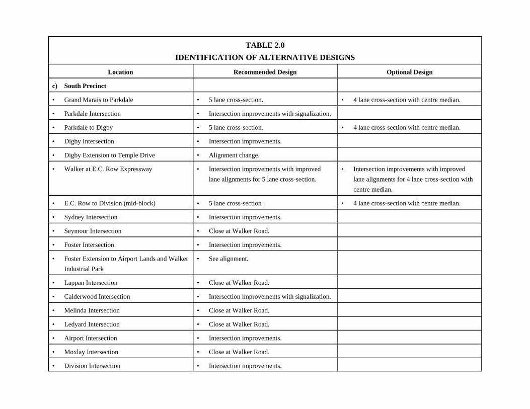
TABLE 2.0IDENTIFICATION OF ALTERNATIVE DESIGNS
Location Recommended Design Optional Design
c) South Precinct
• Grand Marais to Parkdale • 5 lane cross-section. • 4 lane cross-section with centre median.
• Parkdale Intersection • Intersection improvements with signalization.
• Parkdale to Digby • 5 lane cross-section. • 4 lane cross-section with centre median.
• Digby Intersection • Intersection improvements.
• Digby Extension to Temple Drive • Alignment change.
• Walker at E.C. Row Expressway • Intersection improvements with improvedlane alignments for 5 lane cross-section.
• Intersection improvements with improvedlane alignments for 4 lane cross-section withcentre median.
• E.C. Row to Division (mid-block) • 5 lane cross-section . • 4 lane cross-section with centre median.
• Sydney Intersection • Intersection improvements.
• Seymour Intersection • Close at Walker Road.
• Foster Intersection • Intersection improvements.
• Foster Extension to Airport Lands and WalkerIndustrial Park
• See alignment.
• Lappan Intersection • Close at Walker Road.
• Calderwood Intersection • Intersection improvements with signalization.
• Melinda Intersection • Close at Walker Road.
• Ledyard Intersection • Close at Walker Road.
• Airport Intersection • Intersection improvements.
• Moxlay Intersection • Close at Walker Road.
• Division Intersection • Intersection improvements.

Walker Road Corridor ImprovementsRiverside Drive to Provincial Road (City Limits)Grand Marais Road East ImprovementsWalker Road to Central Avenue
Dillon Consulting Limited 31
• Traffic Service Impacts• Cycling Service Impacts• Land Use Impacts• Social Impacts• Economic Impacts• Cultural Resource Impacts• Natural Environment Impact • Project Cost (refer to Table 3.0)
An Evaluation Summary was then prepared based on the evaluation factors noted for each FactorGroup. Recommended solutions for each of the three precincts were determined on the basis ofthis evaluation.
For the North Precinct, alternative designs evaluated included the Do Nothing Alternative, andintersection improvements at select intersections.
For the Central Precinct, alternative designs evaluated included the Do Nothing Alternative,Intersection Improvements at select intersections and a combination of IntersectionImprovements at select intersections with a grade separation at the St. Lawrence & HudsonRailway crossing.
For the South precinct, alternative designs evaluated included the Do Nothing Alternative,Intersection Improvements at select intersections, Intersection Improvements at selectintersections in combination with a 4-lane cross section with centre median, and IntersectionImprovements at select intersections in combination with a 5-lane cross section with mediansonly at the intersections.
Table 3.0 provides details of the evaluation.
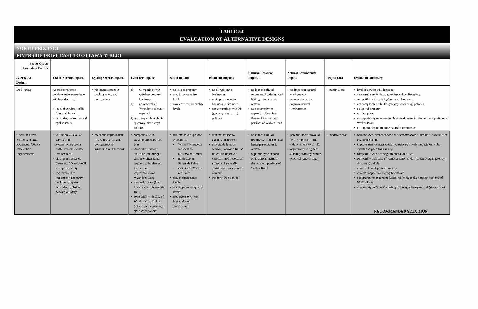
TABLE 3.0EVALUATION OF ALTERNATIVE DESIGNS
NORTH PRECINCT RIVERSIDE DRIVE EAST TO OTTAWA STREET
Factor GroupEvaluation Factors
AlternativeDesigns
Traffic Service Impacts Cycling Service Impacts Land Use Impacts Social Impacts Economic ImpactsCultural ResourceImpacts
Natural EnvironmentImpact Project Cost Evaluation Summary
Do Nothing As traffic volumescontinue to increase therewill be a decrease in:
• level of service (trafficflow and delays)
• vehicular, pedestrian andcyclist safety
• No improvement incycling safety andconvenience
d) Compatible withexisting/ proposedland uses
e) no removal ofWyandotte subwayrequired
f) not compatible with OP (gateway, civic way)policies
• no loss of property• may increase noise
levels • may decrease air quality
levels
• no disruption tobusinesses
• no improvement tobusiness environment
• not compatible with OP (gateway, civic way)policies
• no loss of culturalresources. All designatedheritage structures toremain
• no opportunity toexpand on historicaltheme of the northernportions of Walker Road
• no impact on naturalenvironment
• no opportunity toimprove naturalenvironment
• minimal cost • level of service will decrease• decrease in vehicular, pedestrian and cyclist safety• compatible with existing/proposed land uses• not compatible with OP (gateway, civic way) policies• no loss of property• no disruption• no opportunity to expand on historical theme in the northern portions of
Walker Road• no opportunity to improve natural environment
Riverside DriveEast/Wyandotte/Richmond/ OttawaIntersectionImprovements
• will improve level ofservice andaccommodate futuretraffic volumes at keyintersections
• closing of TuscaroraStreet and Wyandotte Pl.to improve safety
• improvement tointersection geometrypositively impactsvehicular, cyclist andpedestrian safety
• moderate improvementin cycling safety andconvenience atsignalized intersections
• compatible withexisting/proposed landuses
• removal of subwaystructure (rail bridge)east of Walker Roadrequired to implementintersectionimprovements atWyandotte East
• removal of five (5) raillines, south of RiversideDr. E.
• compatible with City ofWindsor Official Plan(urban design, gateway,civic way) policies
• minimal loss of privateproperty at:• Walker/Wyandotte
intersection(southwest corner)
• north side ofRiverside Drive
• east side of Walkerat Ottawa
• may increase noiselevels
• may improve air qualitylevels
• moderate short-termimpact duringconstruction
• minimal impact toexisting businesses
• acceptable level ofservice, improved trafficflows and improvedvehicular and pedestriansafety will generallyassist businesses (limitednumber)
• supports OP policies
• no loss of culturalresources. All designatedheritage structures toremain
• opportunity to expandon historical theme inthe northern portions ofWalker Road
• potential for removal offive (5) trees on northside of Riverside Dr. E.
• opportunity to “green”existing roadway, wherepractical (street scape)
• moderate cost • will improve level of service and accommodate future traffic volumes atkey intersections
• improvement to intersection geometry positively impacts vehicular,cyclist and pedestrian safety
• compatible with existing/ proposed land uses• compatible with City of Windsor Official Plan (urban design, gateway,
civic way) policies• minimal loss of private property• minimal impact to existing businesses• opportunity to expand on historical theme in the northern portions of
Walker Road• opportunity to “green” existing roadway, where practical (streetscape)
RECOMMENDED SOLUTION

CENTRAL PRECINCT OTTAWA STREET TO GRAND MARAIS ROAD EAST
Factor GroupEvaluation Factors
AlternativeDesigns
Traffic Service Impacts Cycling Service Impacts Land Use Impacts Social Impacts Economic ImpactsCultural ResourceImpacts
Natural EnvironmentImpact Project Cost Evaluation Summary
Do Nothing • will decrease level ofservice (traffic flow anddelays)
• decrease in vehicular,pedestrian and cyclistsafety
• no improvement incycling safety andconvenience
• compatible withexisting/proposed landuses
• not compatible with OP(gateway, civic way)policies
• no loss of property• may increase noise
levels• may decrease air quality
• no improvement tobusiness environment
• does not support OPpolicies
• no impact on culturalresources
• no impact on naturalenvironment
• minimal cost • level of service will decrease• decrease in vehicular, pedestrian and cyclist safety• compatible with existing/proposed land uses• not compatible with OP (gateway, civic way) policies• no loss of property
Intersection ImprovementsTecumseh Road East/Ypres and Grand MaraisEast (Interim Solution atGrand Marais East)
• will improve level ofservice at keyintersections
• improvement inintersection geometrypositively impactsvehicular, cyclist andpedestrian safety
• moderate improvementin cycling safety andconvenience atsignalized intersections
• will improve off-roadcyclist convenience byconnection of MemorialDrive bikeway to GrandMarais East
• compatible with existingproposed land uses
• compatible with OP(civic way, urbandesign) policies
• minimal loss of property• may increase noise
levels• may improve air quality• moderate impact during
construction
• minimal impact toexisting businesses
• acceptable level ofservice, improved trafficflows and improvedvehicular and pedestriansafety will generallyassist businesses
• moderate improvementin level of service toexisting businesses (ie.,deliveries to Daimler-Chrysler, and other areabusinesses)
• supports OP (gateway,civic way) policies
• no impact on culturalresources
• no impact on naturalenvironment
• moderate cost • will improve level of service at key intersections• improvement in intersection geometry positively impacts vehicular,
cyclist, pedestrian safety• compatible with existing/proposed land uses• compatible with OP (civic way, urban design) policies• minimal loss of property• minimal impact to existing businesses
RECOMMENDED SOLUTION(Interim Solution at Grand Marais Road East)
Intersection ImprovementsGrade Separation at St.Lawrence & HudsonTracks, includingIntersection Improvementsand Long Term Solution
• improved level ofservice by elimination ofdelays due to train traffic
• intersectionimprovement/ gradeseparation positivelyimproves vehicle/cyclist/pedestrian safety
• will improve off-roadcyclist convenience byconnection of MemorialDrive bikeway to GrandMarais East
• moderate improvementin cyclist safety andconvenience
cv) compatible withexisting land uses
cw) negative impact onproperties at:
• 2691 Walker -residence
• Windsor Metal andBattery
• minimal loss of privateproperty- 2691 Walker -
residence• Windsor Metal and
Battery• decrease noise levels• improve air quality
levels• negative impact on
properties at:• #2691 Walker -
residence• Windsor Metal and
Battery
• minimal disruption toexisting businesses
• high improvement inlevel of service toexisting businesses (ie.,deliveries to Daimler-Chrysler, and other areabusinesses)
• high improvement inpublic safety(emergency services)
• no impact on culturalresources
• relocation of theGrand Marais Drainsouth of gradeseparation may berequired
• possible enhancementopportunities to GrandMarais Drain to westof Walker Road
• high cost • moderate level of service to accommodate increased traffic volumes• will improve traffic flow• intersection improvement/grade separation positively improves
vehicle/cyclist/pedestrian safety• will improve cyclist convenience by connection of Memorial Drive
bikeway to Grand Marais East• compatible with existing land uses• compatible with OP policies• minimal loss of private property (2691 Walker Road and Windsor Metal
and Battery)• minimal disruption to existing businesses• moderate improvement in level of service to existing businesses (ie.,
deliveries to Daimler-Chrysler and other area businesses)• possible enhancement opportunities to Grand Marais Drain to west of
Walker Road
RECOMMENDED SOLUTION

SOUTH PRECINCT GRAND MARAIS ROAD EAST TO DIVISION ROAD
Factor GroupEvaluation Factors
AlternativeDesigns
Traffic Service Impacts Cycling Service Impacts Land Use Impacts Social Impacts Economic ImpactsCultural ResourceImpacts
Natural EnvironmentImpact Project Cost Evaluation Summary
Do Nothing • will result in decreasedlevel of service
• will result in decreasedvehicular/cyclist/pedest-rian safety
• no improvement tocycling safety andconvenience
• compatible with existing land uses
• doesn’t allow forconnection into airportlands, Parkwood orWalker Farms BusinessParks
• not compatible with OP (gateway, civic way)policies
• no loss of privateproperty
• may increase noiseimpacts
• may decrease air quality
• minimal disruption toexisting businesses
• no improvements tobusiness environment
• no impact on culturalresources
• no impact on naturalenvironment
• minimal cost • will result in decreased level of service• will decrease vehicular/cyclist/pedestrian safety• compatible with existing and proposed land uses• doesn’t allow for connection into airport lands or Walker Farms
Business Park• not compatible with OP (gateway, civic way) policies• no improvements to business environment• minimal cost
Intersection ImprovementsOnly at Parkdale/Digby/EC Row Expressway/Sydney/Foster/Calderwood/Airport/Division
• moderate improvementin level of service
• allows for connectioninto Parkwood (Temple)Industrial Park andWalker Industrial Park
• intersectionimprovements positivelyimpacts vehicular/cyclist/pedestrian safety
• minimal improvementsin cyclist convenienceand safety at signalizedintersections
• compatible with existingland uses
• moderate impact onexisting land uses atintersections
• moderate impact onexisting land uses atFoster/ Riberdy (WalkerFarm Extension)
• not compatible with OP(gateway, civic way)policies
• allows for connectioninto airport lands,Parkwood and WalkerFarms Business Parks
• moderate loss ofproperty at Digby toaccommodate TempleDrive extension as wellas realignment west ofWalker (North ServiceRoad) and Foster
• minimal loss of propertyat intersections toaccommodate left turnlanes
• minimal increase innoise levels
• minimal improvement inair quality levels
• moderate impact duringconstruction
• minimal improvement tobusiness environment(Walker Road Corridor)
• moderate improvementto Parkwood and WalkerFarms Industrial Parksand potentialdevelopment of northernairport lands
• no impact on culturalresources
• no impact of CandidateNatural Heritage Site(Digby/Temple atWalker Road)
• no opportunity toimprove naturalenvironment throughboulevard tree planting
• moderate cost • moderate improvement in level of service • allows for connection into Parkwood (Temple) and Walker Business
Parks• intersection improvements positively impacts vehicular/
cyclist/pedestrian safety• compatible with existing land uses• not compatible with OP (gateway, civic way) policies• moderate loss of property at Digby• no opportunity to improve natural environment through boulevard tree
planting• moderate cost

SOUTH PRECINCT GRAND MARAIS ROAD EAST TO DIVISION ROAD
Factor GroupEvaluation Factors
AlternativeDesigns
Traffic Service Impacts Cycling Service Impacts Land Use Impacts Social Impacts Economic ImpactsCultural ResourceImpacts
Natural EnvironmentImpact Project Cost Evaluation Summary
IntersectionImprovements, including 4Lane Cross Section withMedians at Mid-BlockLocations
• higher improvement inlevel of service
• will improve vehicularsafety by restricting leftturns at intersectionsonly
• potential for trafficinfiltration into existingresidential areas
• minimal improvementsin cyclist convenienceand safety at signalizedintersections
• not compatible withexisting land uses
• moderate impact onexisting land uses atintersections
• high impact on existingland use due toelimination of direct leftturn access/egress
• allows for connectioninto airport lands,Parkwood and WalkerFarms Business Parks
• compatible with OP(gateway, civic way)policies
• moderate impact onexisting land uses atFoster/Riberdy (WalkerFarms Extension)
• moderate loss ofproperty at Digby toaccommodate TempleDrive extension as wellas realignment west ofWalker (North ServiceRoad) and Foster
• minimal loss of propertyat intersections toaccommodate left turnlanes
• minimal increase innoise levels
• minimal improvement inair quality levels
• moderate impact duringconstruction
• moderate impact duringconstruction
• higher level ofdisruption to businessesdue to elimination ofopportunity for directleft turn access/ egress
• replace curb with barrierand restoration of right-of-way
• defined access/egresspoints. Some parking infront of existingbusinesses will be lost/relocated (wherepractical)
• acceptable level ofservice, improvedvehicular and pedestriansafety will generallyassist businesses
• supports OP (gateway,civic way) policies
• moderate improvementto Parkwood, WalkerFarms Business Parksand potentialdevelopment of northernairport lands
• no impact on culturalresources
• no impact on CandidateNatural Heritage Site(Digby/Temple atWalker Road)
• opportunity to improvenatural environmentthrough boulevard treeplanting
• high cost • higher improvement in level of service • will improve vehicular safety by restricting left turns at intersections
only • potential for traffic infiltration into abutting residential areas• minimal improvements in cyclist convenience and safety at signalized
intersections• not compatible with existing land uses• high impact on existing land use due to elimination of direct left turn
access/egress• allows for connection into airport lands, Parkwood and Walker Farms
Business Parks• compatible with OP (gateway, civic way) policies• moderate impact on existing land uses at Foster/Riberdy (Walker Farms
Extension)• moderate loss of property at Digby to accommodate Temple Drive
extension as well as realignment west of Walker (North Service Road)• minimal loss of property at intersections to accommodate left turn lanes• minimal increase in noise levels• minimal improvement in air quality levels• moderate impact during construction• higher level of disruption to businesses due to elimination of opportunity
for direct left turn access/ egress• replace mountable curb with barrier curb and restoration of right-of-way• defined access/egress points. Some parking in front of existing
businesses will be lost/relocated (where practical)• acceptable level of service, improved vehicular and pedestrian safety
will generally assist businesses• supports OP (gateway, civic way) policies• moderate improvement to Parkwood, Walker Farms Business Parks and
potential development of northern airport lands• no cultural resource impacts• no impact on Candidate Natural Heritage Site (Digby/Temple at Walker
Road)• opportunity to improve natural environment through boulevard tree
planting

SOUTH PRECINCT GRAND MARAIS ROAD EAST TO DIVISION ROAD
Factor GroupEvaluation Factors
AlternativeDesigns
Traffic Service Impacts Cycling Service Impacts Land Use Impacts Social Impacts Economic ImpactsCultural ResourceImpacts
Natural EnvironmentImpact Project Cost Evaluation Summary
IntersectionImprovements, including 5 Lane Cross Section atMid-Block Locations
• higher improvement inlevel of service
• recommends closing ofSeymore/Lappan/Melinda/Moxlay
• will improve vehicular/cyclist/pedestrian safetyby allowing safe leftturns within a separate,designated lane
• restricts infiltration intoadjacent neighbour-hoods as a result of roadclosures
• minimal improvementsin cyclist convenienceand safety at signalizedintersections
• compatible with existingland uses
• moderate impact onexisting land uses atintersections
• compatible with OPpolicies
• allows for connectioninto airport lands,Parkwood and WalkerFarms Business Parks
• moderate impact onexisting land uses atFoster/ Riberdy (WalkerFarms Extension)
• moderate loss ofproperty at Digby toaccommodate TempleDrive extension as wellas realignment west ofWalker (North ServiceRoad)
• minimal loss of propertyat intersections toaccommodate left turnlanes
• minimal increase innoise levels
• minimal improvement inair quality levels
• moderate impact duringconstruction
• moderate disruption tobusinesses
• replace mountable curbwith barrier curb andrestoration of right-of-way
• defined access/egresspoints. Some parking infront of existingbusinesses will be lost/relocated (wherepractical)
• opportunity for parkingarea at location of closedstreets
• acceptable level ofservice, improvedvehicular and pedestriansafety will generallyassist businesses
• supports of OP policiesC moderate improvement
to Parkwood, WalkerFarms Business Parksand potentialdevelopment of northernairport lands
• no impact on culturalresources
• no impact on CandidateNatural Heritage Site(Digby/Temple atWalker Road)
• opportunity to improvenatural environmentthrough boulevard treeplanting
• high cost • higher improvement in level of service • recommends closing of Seymore/Lappan/Melinda/Moxlay• will improve vehicular/ cyclist/pedestrian safety by allowing safe left
turns within a separate designated lane• Restricts infiltration into adjacent neighbourhoods as a result of road
closures• minimal improvements in cyclist convenience and safety at signalized
intersections• compatible with existing land uses• moderate impact on existing land uses at intersections• compatible with OP policies• allows for connection into airport lands, Parkwood and Walker Farms
Business Parks• moderate impact on existing land uses Foster/ Riberdy (Walker Farms
Extension)• moderate loss of property at Digby to accommodate Temple Drive
extension as well as realignment west of Walker (North Service Road)• minimal loss of property at intersections to accommodate left turn lanes• minimal increase in noise levels• minimal improvement in air quality levels• moderate impact during construction• moderate disruption to businesses• replace mountable curb with barrier curb and restoration of right-of-way• control of access/egress points. Some parking in front of existing
businesses will be lost/relocated (where practical)• opportunity for parking area at location of closed streets• acceptable level of service, improved vehicular and pedestrian safety
will generally assist businesses• supports of OP policies• moderate improvement to Parkwood, Walker Farms Industrial parks and
potential development of northern airport lands• no cultural resource impact• no impact of Candidate Natural Heritage Site (Digby/Temple at Walker
Road)• opportunity to improve natural environment through boulevard tree
planting• high cost
RECOMMENDED SOLUTION

Walker Road Corridor ImprovementsRiverside Drive to Provincial Road (City Limits)Grand Marais Road East ImprovementsWalker Road to Central Avenue
Dillon Consulting Limited 32
4.4 Selection of Recommended Design
Based on the results of the evaluation noted in Table 3.0, the following designs wererecommended for each precinct:
North PrecinctIntersection improvements at Riverside Drive East, Wyandotte Street East, Richmond Street andOttawa Street.
Central PrecinctIntersection improvements at Tecumseh Road East, Ypres Boulevard, and Grand Marais Road.
It is also recommended that Walker Road and the St. Lawrence & Hudson Railway crossing begrade separated. In the event that funding is not available for the construction of this gradeseparation then the intersection improvements proposed for the Grand Marais Road intersectionshould proceed as an interim solution.
South PrecinctIntersection Improvements at Parkdale, Dibgy, E.C. Row Expressway, Sydney, Foster,Calderwood, Airport and Division Road, in combination with the construction of a 5-lane crosssection on Walker Road from Grand Marais Road to Division Road.
The recommended solution also includes the closing of Walker Road at Seymour, Lappan,Melinda, Ledyard, and Moxlay.
Addendum to Walker Road Corridor 1995 ESRIn addition to the alternative designs identified for the three precincts, review of the preferreddesign for Walker Road from Division Road to Provincial Road (City Limits), as noted in the1995 Class Environmental Assessment, was also undertaken and prepared for public exhibit.

Walker Road Corridor ImprovementsRiverside Drive to Provincial Road (City Limits)Grand Marais Road East ImprovementsWalker Road to Central Avenue
Dillon Consulting Limited 33
Having identified alternative designs, and a recommended design, public and agency input wassolicited. The recommended design is so identified based on the assessment and evaluation ofavailable information and studies completed to this stage of the process.
A preferred solution will subsequently be developed based on the assessment and evaluation ofthe design alternatives outlined previously and including consideration of the input receivedthrough the public and agency consultation, as described in Section 4.6.
4.5 Storm Water Drainage Considerations
A detailed evaluation of existing storm drainage systems is beyond the scope of this Class EA.
Based on early discussions with the City, we understand that records of the existing storm sewersystem within the North Precinct are incomplete. A detailed investigation into the location, sizeand condition of the storm sewers within this area is required before an evaluation of the sewersystem can be completed. The investigation and evaluation of the sewer system should becompleted in advance of any planned roadway improvements in this area.
Within the southern portion of the Central Precinct (Tecumseh Road to Memorial Drive), a stormrelief study for the Woodlawn/Ypres/Memorial area was recently completed (September, 2000).The focus of this study was to identify and recommend sewer system improvements which couldprovide a measure of relief to the basement flooding being experienced within the residentialareas west of Walker Road. A further review of the Walker Road storm sewers should becompleted in advance of any planned roadway improvements in this area.
Within the southern portion of the South Precinct (E.C. Row to Division Road), a storm drainagestudy for the Bliss/Riberdy/E.C. Row/Division area was recently completed (June, 2000). Thefocus of this study was to identify the recommended storm drainage outlet requirements for theexisting storm drainage system, including reassignment of drainage area boundaries. The Dillonstudy on the storm drainage system for Wards 7 and 8 was referenced in the June, 2000 study,however, recommendations on the need for upgrading the Walker Road storm sewers was not
Walker Road Corridor ImprovementsRiverside Drive to Provincial Road (City Limits)Grand Marais Road East ImprovementsWalker Road to Central Avenue
Dillon Consulting Limited 34
included. A further review of the Walker Road storm sewers should be completed in advance ofany planned roadway improvements in this area.
Within the portion of Walker Road from Division Road to Provincial Road (City Limits), thestorm drainage requirements for the Walker Road corridor were identified in the EnvironmentalStudy Report, completed by Dillon in September, 1995. Within the southern portion of thisPrecinct (south of Legacy Park Drive), additional downstream drainage improvements wereidentified as being necessary to accommodate the resulting improvement to the Walker Roaddrainage system. Evaluation of these downstream drainage requirements have not beenidentified, as this work was beyond the scope of that report. The required downstream drainageimprovements must be identified and implemented before any further roadway improvements arecompleted in the southern portion of this Precinct. The 1995 Study confirmed agreement thatflows within the section of Walker Road between Legacy Park Drive and Division Road couldbe discharged to the Sixth Concession Drain.
Within the Grand Marais Road Precinct, a review of the existing storm drainage system and therequired drainage improvements should be completed in advance of any roadway improvementsin this area.
4.6 Public and Agency Consultation for Alternative Designs
Due to the size of the study area, the Public and Agency Consultation program consisted of anumber of methods to solicit public and agency input in to the planning of this project. A noticewas developed requesting public input and advertised in the Windsor Star on January 15, 2000(refer to Appendix C).
A letter dated January 17, 2000 was mailed to all property owners located in the Walker Roadcorridor, including affected agencies. The letter contained the same information in the Noticeadvertised in the Windsor Star (refer to Appendix C).
Walker Road Corridor ImprovementsRiverside Drive to Provincial Road (City Limits)Grand Marais Road East ImprovementsWalker Road to Central Avenue
Dillon Consulting Limited 35
In addition, the Notice was placed on the project web site and a press release was issuedregarding the Public Information and Consultation Session # 1. Interviews were conducted withsenior staff from the City of Windsor and the consultant on local radio stations.
Public Information and Consultation Session #1 was held on January 26, 2000 and was attendedby 119 persons. At that meeting staff from the City of Windsor and the consultant wereavailable to answer questions from the public and affected agencies. A list of attendees andcomments received are included in Appendix I. From 119 attendees, 53 attendees completed ashort questionnaire regarding the proposed improvements and commented on the recommendeddesign (refer to Appendix I). A non-statistical summary of the responses can also be found inAppendix I.
5.0 PREFERRED DESIGN
5.1 Description of the Preferred Design
Selection of a preferred design included consideration of those factors identified previously forthe identification of alternative design concepts as noted in Section 4.0 of this report (refer toAppendix A). Additional considerations for the selected preferred design included:
• Business access• Cycling opportunities• Streetscape opportunities
Comments received through the public and agency consultation were also assessed and, whereappropriate, modifications to the recommended design (or preferred design for that section ofWalker Road south of Division Road) were incorporated to develop a detailed preferred designfor the entire Walker Road Corridor.
At this time, the City of Windsor also requested that the design of improvements to GrandMarais Road from Walker Road to Central Avenue be prepared for public and agency reviewand for inclusion in this report.

Walker Road Corridor ImprovementsRiverside Drive to Provincial Road (City Limits)Grand Marais Road East ImprovementsWalker Road to Central Avenue
Dillon Consulting Limited 36
A detailed description of the components of the preferred design is outlined in the followingsections. In combination with the textural descriptions, reference should be made to thePreferred Design figures provided in Appendix A.
5.1.1 Preferred Road Design
The following generally describes the details of the preferred design for the Walker RoadCorridor and Grand Marais Road East Corridor:
North Precinct (Riverside Drive East to Ottawa Street)• no changes to the Riverside Drive intersection.• removal of all unnecessary tracks crossing Walker Road between Riverside Drive and
Wyandotte Street and reconstruction of rail crossings.• closure of Wyandotte Place (leave driveway entrances only) at Walker Road and at
Wyandotte Street.• removal of the railway structure and infilling of the subway located on Wyandotte Street,
east of Walker Road.• intersection improvements at Wyandotte Street.• closure of Tuscarora Street at Walker Road.• pavement improvements and lane delineation (no road widening) from Wyandotte Street
to Ottawa Street (remove on-street parking).• acquire and improve Edna Street to provide access from Walker Road to St. Luke. This
will provide access to the vacant lands located adjacent to St. Luke and may be preferableto Richmond Street as an east-west route for Transit Windsor.
• intersection improvements at Richmond Street. Signalization to be installed at northintersection and coordinated with south intersection signalization.
• intersection improvements at Ottawa Street.• encourage inter-parcel access of developments fronting Walker Road as redevelopment
occurs.• establish parallel cycling route.• improved sidewalks for pedestrian/physically disabled.
Central Precinct (Ottawa Street to Grand Marais Road East)

Walker Road Corridor ImprovementsRiverside Drive to Provincial Road (City Limits)Grand Marais Road East ImprovementsWalker Road to Central Avenue
Dillon Consulting Limited 37
• construct appropriate centre median and necessary road widening south of Ottawa Streetintersection. Provide appropriate lane delineation.
• repair deteriorated concrete pavement as necessary.• reconstruct Tecumseh Road East intersection.• intersection improvements at Ypres Boulevard.• intersection improvements at Grand Marais Road.
South Precinct (Grand Marais Road East to Division Road)• grade separate Walker Road at the St. Lawrence & Hudson Railway crossing.• provide 5-lane cross section from Grand Marais Road to Division Road.• intersection improvements at Parkdale Place. Signalization to be installed.• intersection improvements at Digby Street.• realignment of Digby Street west of Walker Road.• realign Digby Street east of Walker Road and connect to Temple Drive.• intersection improvements at E.C. Row Expressway.• intersection improvements at Sydney Avenue.• close Seymour Avenue at Walker Road (leave driveway access only).• intersection improvements at Foster Avenue.• widening of Foster Avenue to Turner Road.• widening of Foster Avenue to Riberdy Road.• extension of Foster Avenue to provide access to the Airport lands and to the Walker
Industrial Park.• close Lappan Avenue at Walker Road (leave driveway access only).• intersection improvements at Calderwood Avenue.• close Melinda Street at Walker Road (leave driveway access only).• close Ledyard Avenue at Walker Road (leave driveway access only).• intersection improvements at Airport Road. Signalization to be installed.• close Moxlay Avenue at Walker Road (leave driveway access only).• decisions regarding the use of the rights-of-way of those streets closed at Walker Road
should be made in consultation with adjacent property owners at the time of final design.• establish parallel cycling route.
• improved sidewalks for pedestrian/physically disabled.

Walker Road Corridor ImprovementsRiverside Drive to Provincial Road (City Limits)Grand Marais Road East ImprovementsWalker Road to Central Avenue
Dillon Consulting Limited 38
Addendum to Walker Road Corridor 1995 ESR• intersection improvements at Division Road.• provide 5-lane cross-section from Division Road to Provincial Road.• intersection improvements to accommodate the access locations for proposed
developments on Walker Road. Signalization to be installed.• encourage inter-parcel access of developments fronting Walker Road as redevelopment
occurs.• intersection improvements at Legacy Park Drive.• complete intersection improvements at Provincial Road.• upgrade level crossing at CN Rail crossing of Walker Road.• intersection improvements at Ducharme Street.• establish parallel cycling route.• improved sidewalks for pedestrian/physically disabled.
Grand Marais Road East Corridor• intersection improvements at Walker Road.• provide 3-lane cross-section from Walker Road to Central Avenue.• construct access to DaimlerChrysler truck entrance.• realign Grand Marais Road from Chrysler Centre to Central Avenue.• reconstruct and realign Central Avenue intersection.• establish an off-road bike route within the right-of-way adjacent to Grand Marais Road
East.• improved sidewalks for pedestrian/physically disabled.
5.1.2 Railway Grade Separation
Based on the volume of traffic on Walker Road, the number of trains crossing at this location,and to the fact that much of the truck traffic servicing the DaimlerChrysler facilities in the area(as well as other major industrial facilities further to the north on or adjacent to Walker Road),
Walker Road Corridor ImprovementsRiverside Drive to Provincial Road (City Limits)Grand Marais Road East ImprovementsWalker Road to Central Avenue
Dillon Consulting Limited 39
supports the need for grade separation of Walker Road at the St. Lawrence & Hudson Railwaycrossing.
Based on existing elevation differentials between the railway tracks and Walker Road north andsouth of the crossing, and to the location of the crossing relative to the intersection of WalkerRoad and Grand Marais Road, it is recommended that this grade separation be in the form of asubway.
Minimal land acquisition will be required to accommodate a subway design on the basis thatretaining walls would be constructed in lieu of sloped embankments (see Figure 15.0 inAppendix A).
Construction of a subway will necessitate the southerly relocation of the Grand Marais Drainwhere it crosses Walker Road. A stormwater pumping station will also be required to drain thesubway for discharge to the Drain.
As the crossing location is also the location at which two significant cycling routes cross WalkerRoad, it is proposed that the rail structure be widened to accommodate cyclist and pedestrianneeds. Physical separation between the tracks and the pedestrian/cyclist path will be required.
Construction of this grade separation is contingent on funding availability or agreement and onthe fact that this rail line continues to be used by the number of trains which, when comparedagainst traffic volume, continues to warrant grade separation. It is recommended that the City ofWindsor pursue funding sources, while maintaining regular consultation with the St. Lawrence& Hudson Railway.
If traffic volume growth and/or traffic safety becomes compromised at this location and at theGrand Marais Road intersection, and funding for a grade separation has not been secured, or theneed for a grade separation has diminished due to Railway reconfiguration, then the City ofWindsor may need to reconstruct the Grand Marais Road intersection at-grade in combinationwith the necessary widening and improvements to the at-grade railway crossing.
5.1.3 Storm Water Drainage

Walker Road Corridor ImprovementsRiverside Drive to Provincial Road (City Limits)Grand Marais Road East ImprovementsWalker Road to Central Avenue
Dillon Consulting Limited 40
As indicated previously, investigations into the location, size, capacity and condition of existingstorm sewers within the Walker Road corridor must be completed in advance of theimplementation of each phase of the roadway improvements.
Although the required storm drainage requirements have been identified for that section ofWalker Road from Division Road to Provincial Road, the southern portion of this drainage arearequires the implementation of downstream drainage improvements to accommodate theimproved drainage system in that area of the corridor. These downstream drainageimprovements must be defined and implemented prior to undertaking any further roadimprovements south of Legacy Park Drive.
5.1.4 Utilities
Letters were forwarded to the various utility companies requesting that they identify their futureutility upgrading requirements and/or utility conflicts. No responses were received, as the timeframe for implementation of this size of study may be beyond the planning time frame of theutility companies. As would generally occur in any event, utility coordination meetings shouldbe arranged in the very early stages of the planned implementation of each phase of roadimprovements to identify and incorporate the various utility requirements.
5.1.5 Cycling Opportunities
Cycling opportunities on Walker Road and within the Walker Road Study Area were extensivelyreviewed. Suggestions and recommendations flowing from this Study were also reviewedagainst the plans as proposed in the City of Windsor’s ongoing Bicycle Use Master Plan Study.
Details of the Preferred Cycling Opportunities within the Walker Road Study Area are identifiedon Figure 12.0 and referenced in Appendix J. As detailed, it is not intended to designate any partof Walker Road itself as a cycling route. For most of its length, insufficient property is availableor could be purchased to accommodate the construction of designated cycling lanes. Traffic

Walker Road Corridor ImprovementsRiverside Drive to Provincial Road (City Limits)Grand Marais Road East ImprovementsWalker Road to Central Avenue
Dillon Consulting Limited 41
volumes on Walker Road are such that cycling can be difficult and suitable for very experiencedcyclists only.
Cycling opportunities have therefore been identified, for the most part, on paralleling roadwayswhich offer a much friendlier environment to cyclists. Connections from these paralleling on-road routes are provided to other on-road routes and to off-road multi-use pathways.
Through the Public Consultation process, a request was made by the Windsor CyclingCommittee to consider the use of mountable curbs along Walker Road as compared to the barriercurbs proposed. The problem in using mountable curbs is that their use eliminates the ability tocontrol access points to a significant degree. The inability to control access points is acontributor to the increased potential for both vehicular and pedestrian collisions. Theopportunity to control access points along Walker Road is one of the primary benefits of theproposed reconstruction. A detailed response is provided in Appendix J.
In lieu of the construction of designated cycling facilities on Walker Road, it is appropriate toconsider a level of financial contribution to proposed parallel cycling facilities.
5.1.6 Streetscape Opportunities
As noted in prior sections, Walker Road acts as the gateway to the City of Windsor for manypeople traveling to the city. As part of this study, opportunities for the construction of Agatewayfeatures@ were reviewed and some initial discussions were held with interested parties in thisregard.
The best opportunity for placement of a gateway feature exists at the Walker/Divisionintersection. Property on the northeast corner of this intersection, which may be surplus to theneeds of the Tim Hortons at that location, would provide an ideal location for the construction ofa suitable gateway feature. Limited discussion of this opportunity has taken place to date andshould be pursued by the City.
Walker Road Corridor ImprovementsRiverside Drive to Provincial Road (City Limits)Grand Marais Road East ImprovementsWalker Road to Central Avenue
Dillon Consulting Limited 42
The opportunity for a gateway feature at the north end of Walker Road is currently limited by thelack of a suitable site. However, with the removal of those tracks crossing Walker Road whichare no longer needed, property which is now encumbered by the railways may become availablefor the siting of a gateway feature. This feature should recognize the heritage designation of thearea in which it would be located. As part of their discussion with CN Rail and with VIA Rail,the City should also review opportunities for the siting of a gateway feature.
Along the length of Walker Road, particularly in those sections where significant reconstructionis recommended (Grand Marais Road to Provincial Road), opportunities for streetscapeimprovements (street lighting, pedestrian lighting, benches, waste receptacles, landscaping)should be evaluated as part of the final design process. Figure 13.0, though not intended to bedefinitive with respect to streetscape/landscape opportunities, does provide an indication offeatures which should be considered as design proceeds.
5.2 Construction Phasing
The phasing of the necessary improvements to the Walker Road and Grand Marais Roadcorridors is based on need and/or funding availability. Phasing has been identified for a 5-yearperiod, following which it is recommended that annual evaluations be completed to assess needand funding availability at that time and to agree on priorities.
It is recommended that the following improvements be completed in the five year periodfollowing acceptance of this report. For this five year period, major improvements noted areidentified:
• Complete the reconstruction of Walker Road from Division Road to Provincial Road(north to south).
• Construct the extension of Foster Street to service the airport lands and Walker IndustrialPark. This work should proceed during the same time frame as 1. above.
• A continuation of discussions with DaimlerChrysler staff must be undertaken todetermine timing for completion of the Pillette Road Truck Assembly Plant expansionand to assess operational changes, particularly truck routing plans, for their WindsorAssembly Plant. Plans can then be formulated on the need to reconstruct Grand Marais

Walker Road Corridor ImprovementsRiverside Drive to Provincial Road (City Limits)Grand Marais Road East ImprovementsWalker Road to Central Avenue
Dillon Consulting Limited 43
Road. (Information concerning prior discussions with DaimlerChrysler staff can befound in Volume 2, Appendix I).
• Complete the reconstruction of the Provincial Road intersection to its ultimateconfiguration, including the reconstruction of Walker Road southerly to the municipalboundary.
• Pursue funding availability for the construction of the grade separation at the St.Lawrence & Hudson Railway crossing and reconstruction of the Grand Marais Roadintersection.
• Construct the extension of Digby Street to connect with Temple Drive.
• Consultation should also continue with CN Rail and VIA Rail relative to their crossinglocated south of Provincial Road and to the potential for track removal between RiversideDrive East and Wyandotte Street East.
Minor improvements are as follows:
• Painting of lane delineation between Ottawa Street and Wyandotte Street East.
• Installation of traffic signals at Richmond Street, at Parkdale Place and at Airport Road.
Other long term improvements are required, including:
• The reconstruction of Walker Road should proceed northerly from Division Road to theE.C. Row Expressway.
• The removal and infilling of the subway on Wyandotte Street east of Walker Road andthe reconstruction of the Wyandotte Street intersection should proceed prior to thereconstruction of the Tecumseh Road intersection.
As development and redevelopment occurs along Walker Road, reference should be made to thisdocument to assess the need for roadway improvements and to determine property requirements.

Walker Road Corridor ImprovementsRiverside Drive to Provincial Road (City Limits)Grand Marais Road East ImprovementsWalker Road to Central Avenue
Dillon Consulting Limited 44
5.3 Preliminary Cost Estimates
Preliminary cost estimates have been prepared for the nearer-term construction phases identifiedabove based on averaged total costs of construction for similar projects. The estimates presentedin Table 4.0 include the cost of construction and engineering.
TABLE 4.0PRELIMINARY COST ESTIMATES
NEAR-TERM CONSTRUCTION PHASES
DESCRIPTION ESTIMATED COST1. Walker Road - Division Road to Provincial Road (City Limits) $8,700,0002. Foster Road Extension $2,700,0003. Temple Drive Extension $950,0004. Walker Road/Grand Marais Road Intersection 1) Road work, storm pump station, and Grand Marais Drain relocation 2) Retaining walls, bridge structure and rail relocation Subtotal Walker/Grand Marais
$5,200,000$8,700,000$13,900,000
5. Grand Marais Road - Walker Road to east of Central Avenue $6,700,000
These estimates do not include the cost of property acquisition, utility relocations, above-averagestorm drainage and watermain replacement, geotechnical subconsultants, financing, legal and theGoods and Services Tax.
5.4 Potential Environmental Conditions and Mitigating Measures
As part of the planning and design process which has been followed for the Walker RoadCorridor and Grand Marais Road East Corridor, mitigative measures have been incorporated toaddress potential environmental concerns. Short-term impacts related to construction and long-term impacts related to the completed improvements (if any) are addressed in this section.

Walker Road Corridor ImprovementsRiverside Drive to Provincial Road (City Limits)Grand Marais Road East ImprovementsWalker Road to Central Avenue
Dillon Consulting Limited 45
5.4.1 Short-Term Environmental Impacts
As with all construction projects, a certain amount of traffic disruption, noise and dust can beanticipated. Measures to address these concerns will be identified during the detailed design andcontract preparation phase of the project. These measures will include restrictions on hours ofoperations and lane closures required to minimize traffic disruption and nuisance to arearesidents, as well as the use of water and calcium chloride to control dust. Access to propertieswithin the contract limits will be maintained, wherever possible, throughout the constructionactivities. Adjacent landowners will be consulted to review impacts on their properties and todiscuss temporary access schemes.
Erosion and sediment control measures will be incorporated in the contract to control the releaseof sediment into the storm sewer system and adjacent watercourses.
With respect to noise impacts during construction, the following will be specified during thepreparation of Contract Documents, to be adhered to during construction:
• noise sensitive areas will be identified;
• the Contractor will be required to comply with the appropriate municipal by-laws regardingnoise emission standards and hours of operation for construction equipment; and
• general noise control measures (not sound level criteria) will be referred to, or placed intothe Contract Documents.
5.4.2 Long-Term Environmental Impacts
No long-term environmental impacts have been identified during the course of this study.
5.4.3 Property Requirements
Property requirements are identified in the Preferred Design figures provided in Appendix A.When approval to proceed to final design has been received or at such time as funding for

Walker Road Corridor ImprovementsRiverside Drive to Provincial Road (City Limits)Grand Marais Road East ImprovementsWalker Road to Central Avenue
Dillon Consulting Limited 46
property acquisition is obtained, accurate determination of property requirements should beundertaken and acquisition attained prior to project tendering. A summary of the expectedproperty requirements are shown on Table 5.0 below:
TABLE 5.0REQUIRED PROPERTY ACQUISITION/EASEMENTS
Location FigureWalker Road Corridor
Wyandotte Street East / Walker Road IntersectionWyandotte Street East (Grade Separation Removal)Edna Street right-of-way Walker Road to Street LukeEast side of Walker Road @ Ottawa StreetNorth side of Tecumseh Road East @ Turner Road (Bus Bay)East side of Tecumseh Road / Ypres Avenue IntersectionEast side of Walker Road @ north of Grand Marais (Grade Separation)East west side of Walker Road @ Grand Marais Drain (Grade Separation)Digby / Temple intersection (east/west sides of Walker)Temple right-of-way east of WalkerEast side of Turner @ DigbyNorth side of North Service Road @ Turner RoadEast side of Walker Road (3100 Walker Road)East side of Walker Road @ Sydney Avenue (corner cut-off)East west of Walker Road @ Foster Avenue (corner cut-off)Foster Extension to St. Etienne Blvd. (2715 St. Etienne)West side of Walker Road @ Calderwood (corner cut-off)West side of Walker Road @ Airport (alignment)East side of Walker (3990 Walker Road) Bus BayWalker / Division IntersectionDivision / Turner IntersectionDivision / Riberdy IntersectionWest side of Walker, south of DivisionEast side of Walker, south of DivisionWalker / Provincial IntersectionEast west side of Walker, South of Provincial
2/33_
6/7111214151618171719202125262829303030
31/3232/33/34
3535/36
Grand Marais Road East CorridorNorth south sides, east WalkerGrand Marais Road East / Chrysler Way IntersectionGrand Marais Road East / Meldrum IntersectionGrand Marais Road East / Central Intersection
38394041/42

Walker Road Corridor ImprovementsRiverside Drive to Provincial Road (City Limits)Grand Marais Road East ImprovementsWalker Road to Central Avenue
Dillon Consulting Limited 47
It should be noted that driveway locations identified on the Preferred Design figures arepreliminary only. Final agreement of driveway locations must be made in consultation with theproperty owner and business tenant prior to proceeding to project tendering.
5.5 Public and Agency Consultation for Preferred Design
As previously noted, due to the size of the study area, the Public and Agency Consultationprogram consisted of a number of methods to solicit public and agency input in to the planningof this project. A notice was developed requesting public input and advertised in the WindsorStar on May 10, 2000 (refer to Appendix I).
A letter dated May 8, 2000 was mailed to all property owners located in the Walker Road andGrand Marais Road East Corridors, to those individuals who had contacted the consultant in thepreceding months or attended Public Information and Consultation Session #1, and to affectedagencies. The letter contained the same information in the Notice advertised in the WindsorStar (refer to Appendix C).
In addition, the Notice was placed on the project web site and a press release was issuedregarding the Public Information and Consultation Session #2. Interviews were arranged withsenior staff from the City of Windsor and consultant on local radio stations.
Public Information and Consultation Session #2 was attended by 64 persons. At that meetingstaff from the City of Windsor and the consultant were available to answer questions from thepublic and affected agencies. A list of attendees and comments received are included inAppendix I. Of 64 attendees, 22 completed a short questionnaire regarding the proposedimprovements and commented on the preferred design (refer to Appendix I). A non-statisticalsummary of the responses can also be found in Appendix I.
Walker Road Corridor ImprovementsRiverside Drive to Provincial Road (City Limits)Grand Marais Road East ImprovementsWalker Road to Central Avenue
Dillon Consulting Limited 48
6.0 COMMITMENTS TO FURTHER WORK AND MONITORING
As part of the detailed design for the Walker Road Corridor Improvements, the following workwill be required:
• develop detailed design drawings illustrating the preferred design including mitigatingmeasures identified during the planning stages;
• co-ordinate the required relocation and upgrading of existing utilities with the utilitycompanies;
• assess the requirement for modification/upgrading of storm and sanitary sewers on WalkerRoad;
• negotiate the acquisition of property required to accommodate the preferred roadwayimprovements with both the property owner and business tenant;
• meet with any property owners and business tenants who wish to be consulted during thedesign and construction phases of this project. Of particular importance is the need toagree on driveway locations;
• issue notices of the proposed work to all businesses located within the construction area;and
• submit applications for approval of the works to the appropriate Provincial and localregulatory agencies.
A field inspection and monitoring program will be established both during and followingconstruction of each phase of the Walker Road Corridor improvements, for the followingpurposes:
• to ensure compliance with the various elements of the preferred design, includingmitigative measures, as developed through public and agency review;
• to ensure compliance with the Contract Specifications, Provincial standards and standardconstruction practices during construction of the improvements; and

Walker Road Corridor ImprovementsRiverside Drive to Provincial Road (City Limits)Grand Marais Road East ImprovementsWalker Road to Central Avenue
Dillon Consulting Limited 49
• to assess the overall performance and effectiveness of the mitigative measures which havebeen specified.
The City of Windsor intends to initiate a Class Environmental Assessment of Cabana Road in2001. A decision to close or leave open Moxlay Avenue at Walker Road will be addressed aspart of this study.