did malaysia comply with the terms of the netherlands ... · main findings this study identified a...
TRANSCRIPT

1
Did Malaysia Comply with the Terms of the Netherlands – Malaysia Agreement for Temporary Acceptance of the MTCS-Certificate?
The case of Kedah Forest Management Unit in Peninsular Malaysia
June 2016
Muda Lake, Kedah

Preface
2
This year 2016 represents the 25th anniversary of the public discourse on tropical timber trade between the Netherlands and Malaysia. Back in September 1991, the Netherlands released its Government Policy on Tropical Forests (Regeringsstandpunt Tropisch Regenwoud) by which it committed to to an end as soon as possible the timber trade’s dependence on primary forests, endangered species and other unsustainable sources.
After many attempts to see Malaysia support the RTR-policy, the Dutch government first announced its intention to accept the Malaysian Timber Certification Scheme (MTCS) as a guarantee of sustainability under its Public Purchasing Policy some five years ago. What followed now represents the run up to upcoming Parliamentary debate about the acceptability of the MTCS-label.
In February 2011, The Netherlands and Malaysia agreed that the accredited auditors under the Malaysian Timber Certification System (MTCS) would be required to report specifically on three areas of concern: maps, indigenous peoples’ rights and deforestation. The question at hand is now, whether the agreement was fulfilled.
This study set out to answer this question for the Forest Management Unit of Kedah which has been MTCS-certified by an auditor accredited under the standard, SIRIM QAS . Our findings are both disconcerting and deemed representative for all MTCS-certifications in Peninsular Malaysia.
We made extra effort to visualize our findings, to illustrate how essential good and reliable maps are and how spatial analysis enriches the verification of sustainability claims which, until today are merely based on field visits in very smallportions of the very large Forest Management Units certified under the Malaysian timber label.
Eric WakkerDirector Aidenvironment Asia
MTCS-certified tropical forestry: Bukit Perangin Forest Reserve, compartment 8. 18 May 2013.

Main findings
This study identified a range of inconsistencies in the MTCS public summary reports for Kedah FMU, as well as serious non-compliances with MTCS’ standards:
Deforestation: • Recent new gazettement of forest reserves in Kedah secured compliance with MTCC’s “5%-allowable deforestation cap”
but the auditor’s claim that “there was no conversion of the natural forest to forest plantations” was found untrue; • The area in Kedah planned for conversion into plantations remains unknown because the data presented in the SIRIM
reports were found to be unreliable. There are reasons to believe that more forest is planned for conversion than what the auditor has reported;
• Plantation development targets well-stocked natural forests whilst the new forest reserve gazettements could have accommodated reported plans for plantation development;
• Planned average yields per hectare (82.2m3/ha) demonstrate that logging is highly dependent on primary forest;• Kedah exceeded its Federally approved Annual Allowable Cut by 283% in the 2009-2014 period;• Recent, significant land clearing and logging in forests 1,000 meters above sea-level was documented;• Recent, heavy logging in Water Catchment Forests was identified;• A High Conservation Value Forest (HCVF) of 14,712 ha that was publicly announced in 2007 was quietly cancelled. Kedah
has only one single 2ha HCVF plot today;• Because MTCC excluded “Planted Forests” from the scope of certification, local villagers and other stakeholders resort to
media outreach and street demonstrations instead;• MTCC and its auditors also did not comment on recent national level outrage over large-scale logging in the primary
forests of the Ulu Muda reserves which provide water to two million Malaysians.
Indigenous peoples: • in its latest public summary report, assessor SIRIM claimed the forest compartments adjacent to an Orang Asli reserve
were “classified as Education Forests and thus cannot be logged.” This study found that logging and/or land clearing for plantations commenced inside this forest as recently as the first months of 2016.
Maps: • The maps presented in SIRIM’s audit reports are technically deficient. Out of two maps presented over the years, one
single undated map was replicated in all summary reports from September 2012 onward.
We conclude that the terms under the Netherlands-Malaysia agreement were not met by SIRIM and MTCS. Based on our familiarity with maps and audit reports for other FMUs we believe that this conclusion may be generalized as applying for the whole of Peninsular Malaysia.
3

4
SIRIM QAS is one of just two Certification Bodies accredited to conduct MTCS forest management audits in Malaysia. The other CB is privately-owned SGS Qualifor. Both are responsible for auditing compliance in an area approximately the size of the whole Netherlands.
Both assessors are accredited by the Malaysian government-controlled National Accreditation Board to certify and re-assess under the Malaysian Timber Certification System (MTCS).
“SIRIM and SGS certify and re-assess the same State FMUs year after year. There is no commercial competition between them or any other party.”
In Peninsular Malaysia, SIRIM is exclusively tasked by MTCC to issue MTCS-certificates to the State Forestry Departments of Kedah, Kelantan, Perak and Negeri Sembilan. The audits are solely based on meetings and field visits to very small portions of the certified FMU.
SIRIM-QAS itself is a Malaysian government-owned certification agency whilst MTCC is widely perceived as a “Government Regulated NGO”. The Forestry Departments implement State Executive Council policies and they are also tasked with monitoring forestry law. With regard to land and forest management matters, State governments are autonomous in the Federation of Malaysia. Both SGS and SIRIM are accredited by the Department of Standards Malaysia, a Federal government agency.
SIRIM’s presentation:
“Because of growing environmental awareness, consumers are increasingly demanding timber products which originate from responsibly managed forests. You can provide assurance that your products come from sustainable forests through our PEFC-MTCS forest management and chain-of-custody certification schemes and complying with Forest Stewardship Council (FSC) requirements through SIRIM QAS International’s collaboration with the Scientific Certification Systems (SCS) in the United States.”
Below, we cite and verify SIRIM’s statements from MTCS-audit reports for Kedah FMU, primarily from the auditor’s most recent public summary report (April 2015).
Brief background to the auditor, SIRIM QAS

SIRIM: “Principle guidelines had been strictly followed, in particular the AAC”
MC&I Indicator 5.6.1: Rate of harvest shall not be greater than estimated regrowth of the residual stand based on permanent sample plots within a pre-defined cutting cycle.
The pre-defined cutting cycle is also known as the Annual Allowable Cut (AAC). Its public summary of April 2015, SIRIM cites no less than three different figures for the AAC:
• Page 4: “The AAC for 2014 as stated in the Forest Management Plan (2006-2015) was 2,850 ha”;
• Page 12: “The FMP (2006-2015) for the FMU had been implemented. The annual coupe for the FMU had been approved based on the recommendation of the National Forestry Council amounting to 2,460 ha ha a year”;
• Page 13: “Principle guidelines had been strictly followed, in particular the AAC which prescribes a total harvest areas of 14,250 ha” (i.e. 1,425 ha/year) “over the 10-year period of the FMP, as set by the FDPM in Kuala Lumpur.”
5
According to Peninsular Malaysia Forestry Department Annual Report 2014 (left), Kedah’s AAC is 2,850 ha/year for the 2011-2015 period, 22% higher than in 2006-2010.
The same report also reveals that Kedah exceeded the approved annual cut by 15% in 2014. For 2013, the area logged was 34% larger than the approved AAC.
Such observations, fundamental to timber certification, escaped the attention of the accredited MTCS-assessor, SIRIM.
Furthermore, data cited from the Malaysian Auditor-General by The Star Online on May 16, 2016 (“Ulu Muda No Longer a Paradise”) suggest that the excess is far worse:
Contrary to accredited MTCS-assessors, the A-G has authority to ‘dig-deep’ into State government book keeping. The AG is also known to verify data in the field, record and publish illustrated findings of non-compliance. Unfortunately, the relevant reports on the A-G website could not be opened for verification of the report by The Star Online.
“According to data from the A-G, Kedah exceeded its allowable cut by
283% over the 2009-2014 period”

SIRIM: “The practice of Reduced Impact Logging (RIL) which had continued to be implement had further ensured the forest productive capacity and its ecological integrity.”
6
In its August 2010 public summary report, SIRIM wrote that Kedah “has currently adopted the guideline from the Forestry Department Peninsularr Malaysia Headquarters that all extractions should not exceed 61 m3/ha from regulated forests and 85 m3/ha from virgin forest.”
Kedah’s (extremely concise) Forest Management Plan shows that the average yield expected from logging leases translates in an average of 82.2 m3/hectare (961,875 m3/11,700 ha):
“The Dutch government committed in 1991 to take short term measures that would end the timber trade’s the reliance on primary forest.
Should Dutch Parliament endorse MTCS, then Dutch local governments will be forced to
prescribe and publicly defend the purchasing Kedah’s primary forest timber as “sustainable”.
This implies that timber production in Kedah foremost targets logging primary forests. Indeed, Kedah’s forestry department had in recent years issued numerous logging leases in the virgin forests of Ulu Muda forest reserves. As will be illustrated further below, these logging operations have recently become highly contested in Malaysia.
In 1991, The Netherlands government committed to put an end to primary forest logging as soon as possible.

The primary forests of Ulu MudaForest Reserve have in recent years been subject to an intensive logging spree.
Sentinel 2 imagery (10m resolution) of March 2016 (insets) suggests that there is little “Low Impact” about “selective” logging in Ulu Muda.
At least 10,000 hectares were logged out. The environmental impact of logging recently triggered massive public outcry in national Malaysian media (see pages 9 and 22).
7
Recently logged water catchment forest (comp. 106) in Ulu Muda Tengah
Areas marked yellow depict recently logged forests
SIRIM: “The practice of Reduced Impact Logging (RIL) which had continued to be implement had further ensured the forest productive capacity and its ecological integrity.”

Notes to the table above: Data presented are based on digitized forest reserve boundaries and their individual surfaces were added. The total FMU size therefore slightly differs from figures presented by Sirim and the Kedah Forestry Department.
Forest conversion data were derived from satellite imagery, primarily the Landsat series, Sentinel 2 (for 2016 only) and high-resolution Google Earth imagery. SPOT and imagery collated by the University of Maryland were used to initially detect natural forest clearings, and these sites were then visually verified with higher resolution imagery.
8
Baseline Total (ha or %)
Size of FMU as of mid 2012 305,676
Maximum forest conversion (5% of FMU in 5 years) 15,284
FMU size, minus 5% cap 290,392
Realized and planned natural forest conversion
All natural forest already converted as of Q1-2016 -27,176
All remaining natural forest slated to be converted -7,516
Total natural forest conversion realized and planned (in ha) -34,692
Total natural forest conversion realized and planned (in %) -11.3%
FMU change due to de/gazettements (2012-present)
Net (de) gazettement since mid-2012 33,993
Adjusted FMU size (in ha) 339,669
Change in FMU size (in %) +11.1%
FMU change in the context of MC&I [Natural Forest] and art. 6.10
Natural forest 2012 286,765
Natural forest Q1/2016 293,822
Natural forest (Q1/2016), minus undeveloped Planted Forest projects 286,306
Net natural forest change -0.2%
Whilst SIRIM’s claim above can be proven untrue (not represented in this report), the main issues is whether Kedah FMU complied with MTCS Criterion 6.10: “Forest conversion to plantations or non-forest land uses shall not occur, except in circumstances .” The guidance document to this criterion, launched in June 2014, is also known as the “5%-allowable deforestation cap”.
Irn-depth spatial analysis found that non-natural forest cover and planned conversion in Kedah had reached 11.3% in Kedah’s FMU, which is well in excess of the “5%-cap”. However, Kedah had also gazetted new forest reserves, thereby enlarging the FMU by 11.1%. If all known Planted Forest projects were realized, then net natural forest cover is in the FMU will be reduced by 0.2% which is well within the 5%-cap. There is, however, significant uncertainty about the true extent of “Planted Forest” projects.
The natural forests in the new gazettements should not come to benefit the tropical timber trade for they are located in important water catchment areas (55%) on which 2 million Malaysian farmers and urbanites depend for their water supply.
SIRIM: “With regard to Criterion 6.10, there was no conversion of the natural forest to forest plantations.”

SIRIM: “The FMU has been classified in to forest functional classes which include zoning into protection forest classes such as watershed forests”
9
But… neither MTCS’ standard nor SIRIM’s audit reports clarify how watershed forests are to be managed whilst there is considerable confusion as to whether logging in these forests is allowed. This is significant, because Kedah alone has over 120,00ha of Water Catchment Forest. As mentioned, this forest is or key interest to 2 million Malaysian citizens.
Few would be better qualified to answer to the question about logging in water catchment forest as Mr. H.C. Thang, Deputy Director-General of Forestry of the Forestry Department Headquarters of Peninsular Malaysia who wrote about the MTCS MC&I Soil and Water Criterion.
Thang’s peer reviewed article “Minimising the hydrological impact of forest harvesting in. Malaysia's rain forests” (2004) states: logging is prohibited within Water Catchment Forest.
The logging issue in Ulu Muda FR is currently hotly debated in Malaysia. In response, the Kedah Chief Minister recently stated that logging is only allowed in “approved areas”. Based on a map reproduced by SIRIM, this includes Water Catchment Forest in Ulu Muda since logging trails can easily be seen on Sentinel 2 imagery.
“Recent logging trails encroached some 650ha into Ulu Muda FR as of
March 2016”

SIRIM: “All sensitive areas such as (..) riparian buffers had been demarcated as protection areas.”
10
MTCS Guidance to C6.2: “Buffer strips for permanent streams and rivers in Inland Forest and Peat Swamp Forest of at least 5 m in width on either side of the stream or river, are marked and felling of trees is prohibited.”
12 March 2013
4 March 2014
Whether buffer strips along Mudariver (left) were indeed demarcated is not known but satellite imagery clearly illustrates the pointlessness of the MTCC’s prescribed demarcation of 5-meter buffers.
Consequently, skidder tracks approach as close as 15 meters to the river which feeds into the Tasik Mudawater reservoir downstream.
Whilst SIRIM had issued a Minor Corrective Action Request as it had observed that the bridge across Mudariver had been damaged, its report erroneously refers to an entirely different forest reserve under the section “Verification by Assessor”.
Consequently, CAR cannot be considered Closed out as stated in the public summary report.
Muda River
Point in circle represents 5 meters
Selective logging removed 2/3rd of canopy cover
Muda River
Butterflies on an undisturbed river bank in Muda

SIRIM: “All sensitive areas such as those above 1000 meters (..) had been demarcated as protection areas.”
119
SIRIM’s claim that areas above 1,000m are protected in Kedah FMU is untrue. In Gunung Inas FR, forest clearance above 1,000m continued throughout 2015. In total 342 ha (out of 3,060ha) forest above 1,000m w erecleared, some of which as recently as January – March 2016.
30 March 2016
8 January 2015
1,000m a.s.l. boundary (based on Google Earth)
Highest point 1,200m a.s.l.

SIRIM: “Immediate action was taken by the government” (Gunung Inas)
12
11 February 2013
8 January 2016
30 March 2016
Although SIRIM mostly dismisses stakeholder comments over deforestation for Planted Forest projects, its September 2012 report responded to an unnamed stakeholder whom had commented that logging in Gunung Inas FR affected the water supply of villagers downstream.
SIRIM wrote: “Immediate action was taken by the government. Logging at the Gunung Inas FR near Baling has stopped as reported in The Star 20 July 2012 and reiterated in The Star 22 July 2012 by the Natural Resources and Environment Ministry. Logging would cease until a detailed EIA was submitted.”
The Department of Environment also issued a statement, saying that logging had been halted in August 2012. “Logging can only resume if the DOE approves the reports.”
Whether an EIA was indeed submitted cannot be verified because in Malaysia summaries of EIA studies are no longer made publicly available.
Whether there was (an approved) EIA or not, satellite imagery shows that logging and land clearing recommenced, and that land clearing again encroached into forest 1,000m above sea level, as recently as Q1/2016.
Highest point 1,180m a.s.l.

13
SIRIM: “All sensitive areas such (..) slopes exceeding 40° (..) had been demarcated as protection areas.”
It is extremely likely that many slopes exceeding 40° were logged and partially cleared in Gunung Inas Forest Reserve over the past 3-5 years.
The red line in the images depicts logging tracks along a slope that is estimated to be at least 43°.
11 February 2013
2 January 2016

SIRIM: “Education Forest cannot be logged”
“Heavy logging in an 290 ha area in Q/2016 was recorded, in spite of SIRIM’s audit report claiming
that “Education Forest” cannot be logged.”
14
MTCS Principle 3: “The legal and customary rights of indigenous peoples to own, use and manage their lands, territories, and resources shall be recognized and respected.”
In its public summary report for Kedah of April 2015, SIRIM claimed:
“Forest management practices of KSFD does not threaten or diminish, either directly or indirectly, the resources or tenure rights of the Orang Asli.”
“The Orang Asli Reserve [Kpg. Lubuk Legong] is located outside Ulu Muda Forest Reserve. The compartments adjacent to this reserve have been classified as Education Forests and thus cannot be logged.” (emphasis added)
24 February 2015 30 March 2016
Whether the Orang Asli have given their free, prior and informed consent to the logging operations unknown.
In 2010, SIRIM reported that “Education Forest” in Kedah covered 2,999 ha. Presently, the Kedah Forest Department website states that it only covers 699 ha.
This suggests that forest use zoning within the FMU is subject to regular change. However such highly significant changes are not duly considered in MTCS-audits.
15
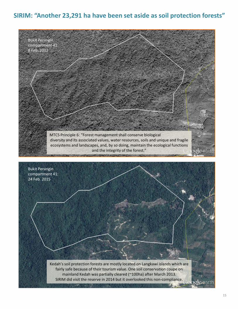
SIRIM: “Another 23,291 ha have been set aside as soil protection forests”
MTCS Principle 6: “Forest management shall conserve biologicaldiversity and its associated values, water resources, soils and unique and fragile ecosystems and landscapes, and, by so doing, maintain the ecological functions
and the integrity of the forest.”
Bukit Perangincompartment 41: 24 Feb. 2015
Bukit Perangincompartment 41: 8 Feb. 2012
Kedah’s soil protection forests are mostly located on Langkawi islands which are fairly safe because of their tourism value. One soil conservation coupe on
mainland Kedah was partially cleared (~100ha) after March 2013. SIRIM did visit the reserve in 2014 but it overlooked this non-compliance.

SIRIM: “A map of the Kedah FMU showing the locations of the PRF is attached”Over the past five years, SIRIM published two different maps of the Kedah Forest Management Unit (FMU). Both maps are undated and low-resolution.
The latest public summary report (April 2015) presented the map left below, which has been reproduced in several reports. The map shows the compartments allocated to Planted Forests (in yellow). Based on this map, the total area planned for conversion into rubber plantations is 16,000 ha, which is significantly larger than the area planned for conversion, as reported by SIRIM in the main text of its reports (7,000ha). However, as will be argued on the next page, there are several other locations where unreported Planted Forests appear to be developed.
The second map (right below) is equally important because it shows the forest use classification (‘zoning’), i.e. production forests, water catchment forests etc. and, as required in the terms of the Netherlands-Malaysia agreement, it even shows an area where an Orang Asli community depends on the forest (no other audit report complies with this requirement). SIRIM stopped replicating this undated map after April 2012. Therefore, critically important changes in forest use zoning remain unreported (see e.g. page 15).
16
“Maps in public summary reports are treated as mere illustrations.”

SIRIM: “The total area of PRF removed from the FMU and the scope of the audit amounted to 7000 ha.”
In its public summary of December 2013, SIRIM stated that the following areas were removed from the scope of assessment:
• HS Gunung Inas - Compartments 4,5,6,7,8,9 & 10• HS Pedu – Compartments 48 & 50• HS Rimba Teloi – Compartment 1• HS Bukit Perangin – Compartments 27 & 28
Said compartments are shown on the same map that SIRIM includes in most summary reports. After digitalization of the boundaries on this map it was found that an area far larger than 7,000 ha - 16,300 ha - is allocated for conversion into plantations.
Furthermore, satellite imagery clearly shows that various other forest compartments are converted to plantations, something left unreported by the accredited auditor.
17
Left: Realized and Planned Conversion of Natural Forest in Bukit Perangin.
Areas in red are or being cleared; areas in yellow are compartments mentioned in the media as being allocated for plantations.
The only Planted Forest project reported by SIRIM is shown in orange.
Below: the relevant section of the map presented in the SIRIM report.

SIRIM: “Following a decision made by Kedah State government issued (..) on 17 September 2012” to exclude compartments 48&50 of Pedu FR.
18
20 February 2011
30 October 2012
As per MTCC’s Guidance to art. 6.10, auditors are required to review the appropriateness of Planted Forest projects. None of these projects were duly reviewed by SIRIM, as they were simply considered ‘outside the purview of the audit’.
In 2012, ~380ha of prime forest inside the Peduwater catchment forest was cleared for a Planted Forest project. The lease is held by a Kedah State owned company, PKNK. Open burning to clear land continued into mid-2014 (image right)
Compartments 48&50
Smoke from active burning (June 2014)

19
14 April 2016
11 December 2015
However, it is now found that land clearing recommenced in Q1/2016, into Chebar Besar FR compartment 1. The forest cleared would most likely qualify as High Conservation Value Forest as it is directly adjacent to a cancelled HCVF area.
The project triggered nation-wide outcry. Before the 2013 elections, the opposition (now leading the current Kedah government) had promised to stop the land clearing.
SIRIM: “Following a decision made by Kedah State government issued (..) on 17 September 2012” to exclude compartments 48&50 of PeduFR...

SIRIM: “The need to establish High Conservation Value Forests (HCVFs) (..) were emphasized.”
In 2007, Kedah’s Department of Forestry publicly announced along the roadside that it had established (not merely planned) 14,712 hectare High Conservation Value Forest (HCVF) area in compartments 61, 62, 1 and 41 of Pedu Forest Reserve. Until April 2012, SIRIM published maps that affirmed this allocation.
In response to stakeholder comments, SIRIM then stated in December 2013: “The HCVF signboard was an old signboard which had been placed in 2007 where the compartment was proposed as a HCVF . However, the area was not established as HCVF by KSFD as the area was found to be encroached.”
The encroachment cited by SIRIM would not likely have been the actual reason why the established HCVF area was retracted, as the encroachment only represents 0.2% of the HCVF area. We speculate that the HCVF area was leased out for logging, which took place in 2009/’10.
As per latest information (2014), Kedah’s HCV Forest extends to a mere two hectares out of the 340,000 ha FMU.
20
MTCS P9: “Management activities in high conservation value forests shall maintain or enhance the attributes which define such forests. Decisions regarding high conservation value forests shall always be considered in the context of a precautionary approach.”
“Only 0,0056% of Kedah’s FMU is
recognized as having High Conservation
Value.”

SIRIM: “There was no comment received from any of the stakeholders.”
21
Closer review of (two) public summary reports that do address stakeholder comments gives a pretty good idea why the assessor does not receive stakeholder input:
Most comments concerned deforestation cases. But, because MTCC and SIRIM exclude planned deforestation from the scope of audits by default, most stakeholder concerns saw their concerns firmly dismissed (screenshots on the right).
“The Malaysian public is denied insight in what really comprises
an MTCS-certified area. Stakeholders experienced that
their appeals to MTCC were fruitless.”
Also note that all of the MTCS-system documents and SIRIM’s audit reports are available only in English language, whilst most Kedahan villagers are not fluent in this language.
Two-thirds of the public summary reports produced by SIRIM state that the assessor organized public consultations, but received no comments :
1. July 2011: “A stakeholder consultation was initiated in October 2010, one month before the conduct of the field audit. There was however no comment received from any stakeholder.”
2. 24 April 2012: “A stakeholder consultation was initiated in October 2011, one month before the conduct of the field audit. There was no comment received from any of the stakeholders.”
3. Dec. 2013: “A one-month stakeholder consultation was conducted on 17 July 2013. However no comments were received from any stakeholder over the consultation period.”
4. April 2015: “A stakeholder consultation was conducted in September 2014 for a period of one month. There was no comment received from any of the stakeholders.”
Does this mean that the people of Kedah and other stakeholders have no interest in forestry and conservation?

SIRIM: “There was no comment received from any of the stakeholders.”
22
Whilst MTCC simply excluded deforestation from its scope, villagers in Kedah face increased risk of landslides, flooding, water pollution and water shortage due to deforestation. Local communities therefore have resorted to street demonstrations whilst others escalate through national media outreach.
“Deforestation and heavy logging in Kedah triggers conflict between Malaysian States. The “Save Ulu Muda-movement” states that the Federal government has yet to fulfill its promise
to pay financial compensation to Kedah for not logging the forest reserves.”

23
Aidenvironment is a values driven consultancy providing services and research in sustainable production and trade. We create social, environmental and economic value seeking a fair distribution across stakeholders. Our combination of strategic capacity, extensive on the ground experience and transparent methods makes us a leader in the field.
More information:
Aidenvironment NetherlandsBarentszplein 7 1013 NJ Amsterdam The Netherlands t +31 (0)20 686 81 11 [email protected]
Aidenvironment Asia Jalan Burangrang 18 Bogor 16153 West Java Indonesia t +62 (0) 251 837 1219
www.aidenvironment.org