dictionary of the english language (1996) defines it as...
TRANSCRIPT
CHAPTER-4
111
Urban Land Use and its Dynamics
Land is surprisingly difficult to define. The Random House
Dictionary of the English Language (1996) defines it as “any part of
the surface which can be owned as property, and everything annexed
to it whether by nature or by hand of man.” Land use has a
connotation that depends upon the objectives of the life of the people
living therein. It represents the interaction of the physical and the
economic factors (Stamp, 1964). Land is used for cultivation, pastoral
activities, afforestation and construction of buildings, roads, railways,
etc. therefore land use is the result of practices, processes,
techniques, customs and traditions adopted and acquired by the
people after inhabiting a part of the earth for developing its natural
resources.
Urban system consists mainly of physical elements, such as
buildings and structured open spaces with the objective to use these
for socio-economic activities. Land use is, therefore, the key element of
urban structure and the changing of land use and the extension of
“urban” based land use forms are indicators of the urban growth. The
land use activities impact the environment directly and change it,
improving the living conditions or worsening them. Often new
environmental risks emerge and an unhealthy urban environment
affects large parts of the urban population.
The natural risks of unregulated urban growth often become life
threatening in ecologically fragile and densely populated high
mountain areas like the Lesser Himalaya. In view of this rapidly
changing urban land use pattern under the increasing pressure of
population and consequent ecological imbalances, thus the best and
proper use of land has become a necessity. In order to do so,
interpretation of land use pattern through proper land use survey,
analysis mapping and monitoring of land use dynamics has become
important.
Estelar

CHAPTER-4
112
4.1 Concept of Urban Land Use The concept of land utilization is basically related to man’s
physical environment superimposed by cultural landscape. The
pertinent notion of the interactions of these two environments,
physical and cultural, in patterning the uses of land has changed the
economic structure of the region. Urban land use structure may be
interpreted from two viewpoints, (i) Geo-ecological theories and (ii)
Economic theories, which are discussed hereunder:
4.1.1 Geo-Ecological Theories
Environmental qualities are also to be considered for land use
arrangement. The classical models for land use studies of an urban
area had been formulated based on the following views:
4.1.1.1 Concentric Zone Model of E.W. Burgess
Fig. 4.1 Different Zones as described in the Concentric Zone
Theory of Burgess (1929)
This theory put forth by Burgess in 1925 related population
mobility and societal organization to the physical expansion of the city
Estelar
CHAPTER-4
113
(Burgess, 1929). According to him land-value decreased with
increasing distance from the city or town’s core irrespective of time
and space. This concept proposed a sequence of land uses: The CBD
(Central Business District), Transition zone of mixed land use,
Working class residential area, Better housing zone, the Fringe zone of
High income residences and satellite communities (Fig. 4.1).
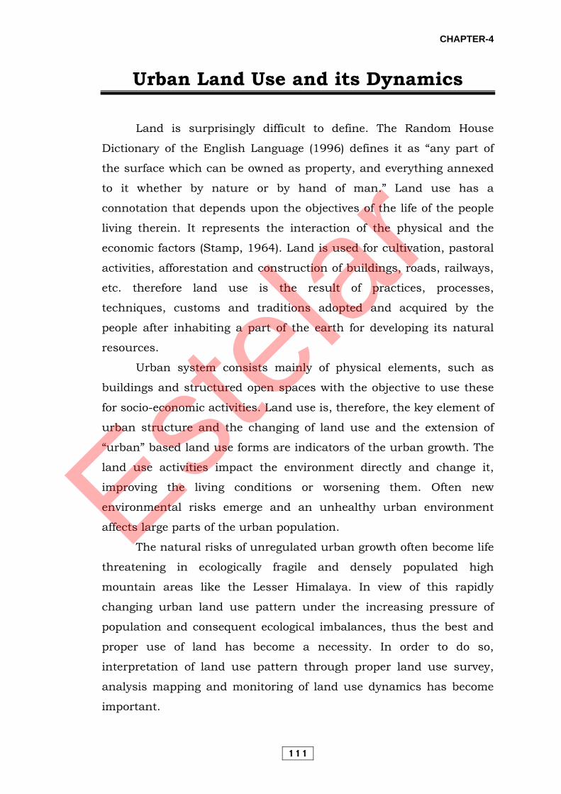
4.1.1.2 Sector Model of Homer Hoyt (1939)
Fig. 4.2 Hoyt’s Sector Model of Urban Landuse (Source: Michael
Pacione, 2001)
Estelar

CHAPTER-4
114
Discrepancies between the concentric model and the reality of
the urban land use patterns have encouraged the formulation of other
theories of urban structure. Notable among these is the Sector Theory
proposed by H. Hoyt and M.R. Davie in 1939 (Fig. 4.2). This concept is
conditioned by the disposition of routes radiating outward from the
city centre. The differences in accessibility among the radial sectors
cause much sectoral variations in the land-value and corresponding
sectoral arrangement of land use. In this sequence the two middle
residential zones of Burgess’s model were absent.
4.1.1.3 Multiple Nuclei Model of Harris and Ullman (1945)
Fig. 4.3 Multiple Nuclei Theory of Harris and Ullman (Source:
Michael Pacione, 2001)
Estelar
CHAPTER-4
115
The assumption here was that urban land use pattern is not
around a single centre (CBD) but is formed by the progressive
integration of a number of separate nuclei into the urban fabric (Fig,
4.3). They demarcated five definite zones within an urban area; these
five zones are the CBD, light manufacturing zone, heavy industrial
district, different residential areas, and the peripheral dormitory
suburbs.
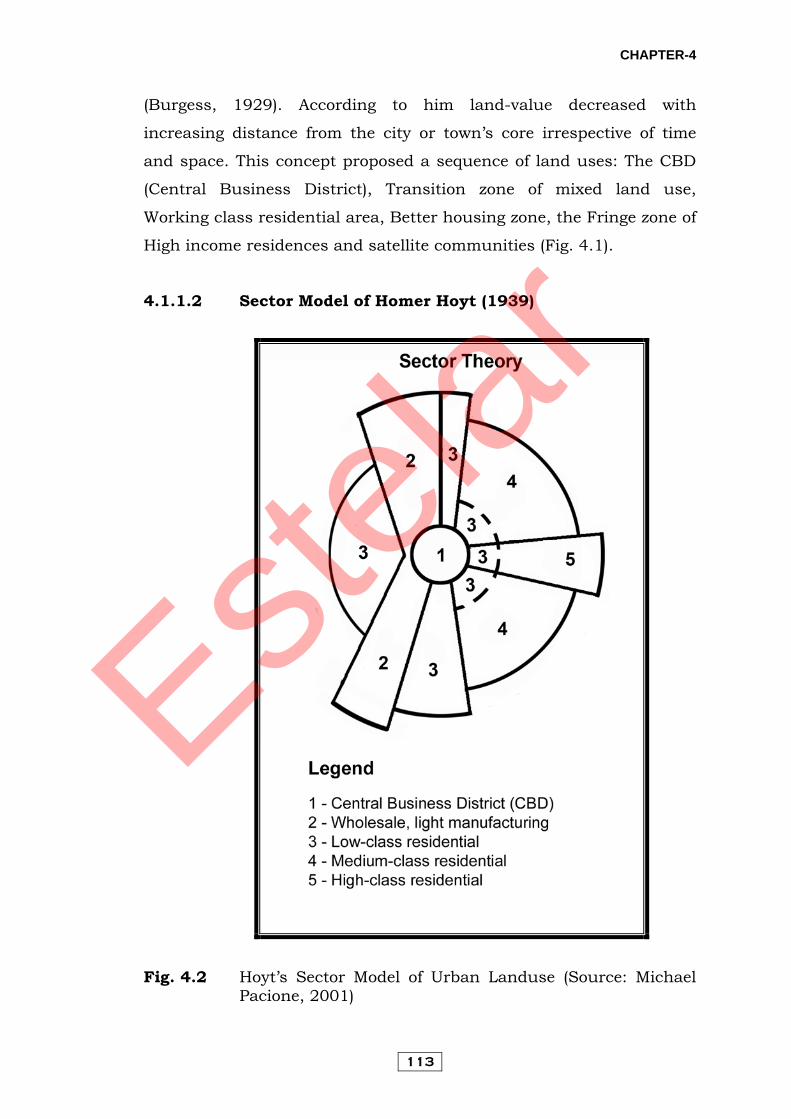
4.1.1.4 Hybrid Models
Hybrid models have tried to include the concentric, sector and
nuclei behaviour of different processes in explaining urban land use.
They are an attempt to integrate the strengths of each approach since
none of them appear to provide a completely satisfactory explanation.
Thus, hybrid models, such as that developed by Izard (1955), consider
the concentric effect of nodes (CBDs and sub-centres) and the radial
effect of transport axis, all overlain to form a land use pattern. 4.1.1.5 Peter Mann’s Model
Fig. 4.4 Mann’s Model of a typical medium-sized British City
(Source: P. Mann, 1965)
Estelar

CHAPTER-4
116
Peter Mann took Hoyt’s and Burgess’ models and combined
them in his model of a typical British City in 1965. He based his
model on studies of Sheffield, Nottingham and Huddersfield. His
model illustrates the structure of a hypothetical British city. The
model also incorporated a climatic consideration relevant to the UK by
assuming a prevailing wind from the west. The features of this model
are (Fig. 4.4):
i. The best residential area (A) is located on the western fringe of
the city, upwind and on the opposite side of town from the
industrial sector (D).
ii. The areas of the working class and the main council estates are
located close to the industrial zone.
iii. The lower middle class housing (B) borders on each side of the
best residential area.
4.1.1.6 Vance’s Urban Realms Model
Fig. 4.5 Urban Realm Model of Vance (Source: J. Vance, 1964)
Estelar
CHAPTER-4
117
By extending the principles of the multiple-nuclei model, Vance
(1964) proposed the Urban Realms Model. The key element is the
emergence of large self-sufficient urban areas, with each focusing on a
downtown and central city. The extent, character and internal
structure of each ‘urban realms’ is shaped by five criteria:
i. Terrain - especially topographical and water barriers;
ii. Overall size of the metropolis;
iii. Amount of economic activity within each realm;
iv. The internal accessibility of each realm in relation to its
dominant economic core; and
v. Inter-accessibility among suburban realms.
Particularly important here are circumferential links and direct
airport connections that no longer require them to interact with the
central realm in order to reach other outlying realms and distant
metropolises (Fig. 4.5). Though conceived on the basis of work on the
San Francisco Bay area, the model has subsequently been applied to
describe the general land use structure of other U.S. cities.
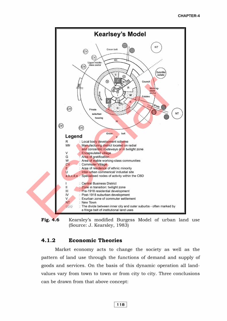
4.1.1.7 Kearsley’s Modified Burgess Model
Kearsley’s model was an attempt to extend Mann’s model of
urban structure by taking into account contemporary dimensions of
urbanization such as the level of governmental involvement in urban
development in Britain, slum clearance, suburbanization,
decentralization of economic activities, gentrification and ghettosiation
(Kearsley, 1983). Manipulation of the model’s various elements, such
as the extension of inner-city blight, minimization of local and central
government housing and expansion of recent low density suburbs
offers a North American variant of the basic model (Fig. 4.6).
Estelar
CHAPTER-4
118
Fig. 4.6 Kearsley’s modified Burgess Model of urban land use
(Source: J. Kearsley, 1983)
4.1.2 Economic Theories Market economy acts to change the society as well as the
pattern of land use through the functions of demand and supply of
goods and services. On the basis of this dynamic operation all land-
values vary from town to town or from city to city. Three conclusions
can be drawn from that above concept:
Estelar

CHAPTER-4
119
i. Land value is highest in and around the centre of dynamic
market operations and decreases outward.
ii. Major arteries of transport and communication supporting
market operation have high land-values.
iii. Traffic intersections which are the points for collection and
redistribution of goods have high land-values.
Hurd (1909) summarized his concept on land-value surface as
“Land-value depends on nearness and industrial and collective taste.”
Ratcliff (1935) on the other hand stated that “Land-value depends on
the efficiencies of various uses, which is determined by the rent
paying ability”. On the basis of these concepts land use models have
been proposed and examined later on.
4.1.2.1 Bid-Rent Theory
Fig. 4.7 Bid-Rent Theory (Source: Singh, O.P., 2009)
Estelar
CHAPTER-4
120
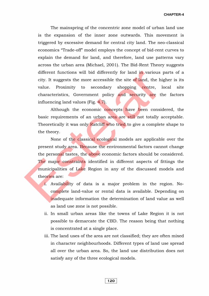
The mainspring of the concentric zone model of urban land use
is the expansion of the inner zone outwards. This movement is
triggered by excessive demand for central city land. The neo-classical
economics “Trade-off” model employs the concept of bid-rent curves to
explain the demand for land, and therefore, land use patterns vary
across the urban area (Michael, 2001). The Bid-Rent Theory suggests
different functions will bid differently for land in various parts of a
city. It suggests the more accessible the site of land, the higher is its
value. Proximity to secondary shopping centre, local site
characteristics, Government policy and security are the factors
influencing land values (Fig. 4.7).
Although the economic concepts have been considered, the
basic requirements of an urban area are still not totally acceptable.
Theoretically it was only Ratcliff who tried to give a complete shape to
the theory.
None of the classical ecological models are applicable over the
present study area. Because the environmental factors cannot change
the personal tastes, the above economic factors should be considered.
The major constraints identified in different aspects of fittings the
municipalities of Lake Region in any of the discussed models and
theories are:
i. Availability of data is a major problem in the region. No-
complete land-value or rental data is available. Depending on
inadequate information the determination of land value as well
as land use zone is not possible.
ii. In small urban areas like the towns of Lake Region it is not
possible to demarcate the CBD. The reason being that nothing
is concentrated at a single place.
iii. The land uses of the area are not classified; they are often mixed
in character neighbourhoods. Different types of land use spread
all over the urban area. So, the land use distribution does not
satisfy any of the three ecological models.
Estelar

CHAPTER-4
121
From the above discussion it can be concluded that none of the
models regarding urban land use is universally accepted. They were
made on the basis of a cast study of a particular city considering the
individual city’s problems only. But the problems of these ecological
models did not formulate concepts for small urban areas.
4.2 Current Urban Land Pattern Land use signifies the classification of land according to the
utilization made of it. Land use studies were commonly carried out for
rural areas, but of late, have also been conducted for urban areas. In
India a nine-fold classification system of land utilization has been in
vogue. Probably this classification has the roots linked to the ancient
revenue classification of land use developed by Sher Shah Suri and
Raja Todarmal around 1550 A.D. Nine-fold classification system of
land utilization is being followed by Ministry of Agriculture and the
figures are published every year. This classification is not suitable for
urban areas because of all the nine classes, only one class – the land
put to non-agriculture use – encompasses the whole of the urban
area. As per the definition, land put to non-agriculture use includes
the built-up areas like roads, railways, settlements etc. and water
bodies like tanks reservoirs, cannels etc. A simple and scientific urban
land use classification is essential for any development planning.
Prof. L.D. Stamp (1931) has given the first elaborate
classification of land use (in First Land Utilization Survey) which was
primarily applied for studies on Great Britain. This classification still
forms the base of many other land use classifications. Anderson et al.
(1976) has proposed another classification of land use which has been
accepted more or less by all.
The land use interpretation and classification in the present
work is based on Lake Development Authority’s general land use
classification. It includes everything which is present over the surface
of the land and occupies space. Detailed land use survey and mapping
were also carried out using field mapping technique on town maps of
Estelar

CHAPTER-4
122
the region and land use dynamics have also been monitored during
1995 and 2007.
The land use patterns that emerged in these towns on the basis
of the analysis and interpretation of data collected from Lake
Development Authority and field survey are as follows:
4.2.1 Land Use of Nainital Town
Proximity to the plains, good and healthy climate, and beauty of
the lake led to the selection of Nainital as a recreation and health
resort by the British. As a result, the town witnessed a phenomenal
growth in settlement along with rise in many new urban functions,
services and facilities. These developments attracted people to
Nainital, who contributed in the rapid increase of population of the
area, as Nainital became increasingly urbanized. Therefore, the
pattern of land use too changed gradually with the increasing
population pressure.
Table 4.1 Land use of Nainital town during 2007 Land use Area (ha) Percent of total
town area Residential Area 278.73 23.76 Commercial Area 23.54 2.01 Administrative Area 34.00 2.90 Community Services 124.00 10.57
Education 76.68 61.84 Medical Area 8.00 6.45
Transportation 15.62 12.60 Religious Area 5.00 4.03
Graveyards 8.00 6.45 Utility Services 0.74 0.60
Other Community Services 3.27 2.64 Recreational Area 6.69 5.39
Rural Area 19.52 1.66 Forest Area 508.76 43.38 Water Bodies 68.90 5.87 Open Undeveloped Area 115.55 9.85 Total 1173.00 100.00
The total Municipal area that was 5 km2 in 1981 increased to
11.23 km2 by the census year 2001. The total number of wards in the
Estelar
CHAPTER-4
123
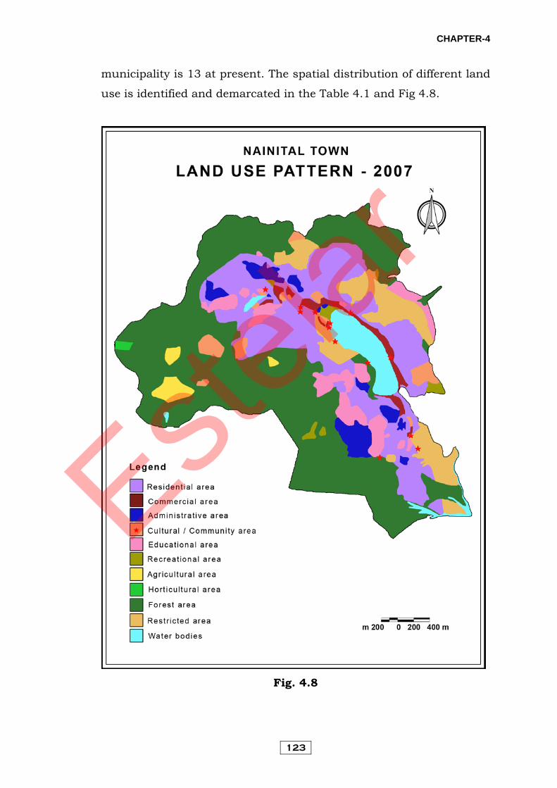
municipality is 13 at present. The spatial distribution of different land
use is identified and demarcated in the Table 4.1 and Fig 4.8.
Fig. 4.8
Estelar
CHAPTER-4
124
4.2.1.1 Residential Area
A large residential population, a common characteristic of all
urban areas, also exists in case of Nainital. This land use cover was
about 278.73 hectares or 23.76 % of the total geographical area. The
development of residential area is not proportional around the lake. It
shows a bi-nodal character with two separate clusters developing
along the southern (lower) and the north- western (upper) end of the
lake (Fig. 4.8). Both of these may be regarded as central areas with
respect to the area these serve, i.e. Tallital and adjoining area and
Mallital and its adjoining area - separated by the expanse of the lake
which is about a kilometre in length. Besides this, settlements tend to
be distributed all along the slopes, the distribution being determined
by a variety of factors.
The distribution of settlements in the town shows a tendency of
dispersal with increasing elevations from the lake. But there are other
several factors that tend to qualify this effect such as the ease to
approach by motorable roads, connecting link roads, availability of
suitable and approved land for constructions purpose, Government
buildings, proximity to important urban services, land developed
through huge investments and geological or topographic constraints
or restrictions due to protected forest area, etc.
4.2.1.2 Commercial Area
Commercial land use includes different types of shops, market
areas and handicraft industries. The areal extent of this as estimated
is about 23.54 hectares or 2.01 % of total geographical area. The town
has developed commercial activities for its own population and also to
take advantage of a large number of tourists visiting the town almost
throughout the year. Thus, in order to meet wide ranging needs of the
tourists, Nainital has developed commercial activities to a good extent.
There are four main commercial areas in the town located at different
parts and deal with products of different kinds.
Estelar
CHAPTER-4
125
Tallital market has developed near the bus station. It is a small
market, generally with shops that have existed since the early times of
the settlement having little scope for further expansion. Mallital
market is situated at the upper end of the lake and is the main market
of the town. Tibetan market was developed for Tibetan refugees after
the Chinese war of 1962 in the flats near Naina Devi temple. Mall
Road is the main thoroughfare of the town with most of the good
hotels, restaurants and showrooms lining its east side and the lake on
the west.
Beside these, commercial areas are also located at Naya Bazaar
on Haldwani road, Cantonment market on Bhowali road, a small
market near Nainital Club and small cluster of daily-needs shops in
most of the wards.
4.2.1.3 Administrative Area
Administration has been one of the oldest functions of the town.
The total area under this type of land use is 34.0 hectares which is
2.90 % of total geographical area.
At present almost all important offices are situated around a
radius of 300 metres of the Collectorate at Tallital. The district office,
supply office, treasury office of district and session judge, police line
commissioner’s officer and office of public work department, irrigation,
forest offices, L.D.A. department and P.W.D. department all are
located around Collectorate.
The growth of the town and limited space and accommodation
available near Collectorate has resulted into establishment of offices at
number of places scattered throughout the town few offices are
located along the Mall Road too. However, most of the government
offices have been shifted to Vikas Bhawan at Bhimtal ever since the
Uttarakhand High Court was set-up here. The High Court and forest
offices are located in Mallital on the slopes of the Cheena Peak hill.
Apart from these, there are a few other offices also such as Municipal
Estelar
CHAPTER-4
126
office, G.M. Roadways, Employment office, etc. which are located in
different parts of the town.
Nainital Club that exists as a Government owned guesthouse
accommodation for officers, VIPs and other dignitaries is located in
Mallital. The Governor’s House is a spacious residence for the Head of
the State located in Tallital. The residential complexes for various
categories of Government officials exist in different parts of the town,
especially close to the High Court and other offices, around the
Collectorate and other offices, within the close to Nainital club
complex, near Sukhatal and near the Administrative Academy.
4.2.1.4 Community Services
i. Education: The areal extent of this category is estimated to
about 76.68 hectares which is 65.36 % of total area under community
services. This type of land use in the town is located in different parts.
With the early growth of the town is also associated the establishment
of a number of residential educational institutions, founded and
established during the British Administration.
The town presently has as many as 5 junior high schools, 2
high schools, 10 intermediates colleges, over 37 schools of nursery
and preparatory type and one polytechnic for providing technical
education. A state level institution known as the Administrative
Academy providing training to the probationers of Provincial Civil
Services (P.C.S.) /I.A.S. and other allied services and a University with
its Campus to cater to the needs of higher education.
ii. Medical Area: The medical land use of Nainital is about 8.0
hectares or 6.82 % of the total area under community services.
These are 7 hospitals in the town. The B.D. Pandey Hospital
located near Mallital Bazaar, G.B. Pant Hospital below Sher-Ka-Danda
area at Tallital, Sitapur Eye Hospital near Mall road and Police
Hospital at Tallital. Beside these other hospitals and private clinics are
located in Mallital Bazaar and Tallital Bazaar.
Estelar

CHAPTER-4
127
iii. Transportation: Transportation land use includes roads,
parking stands and bus and taxi stands. The Arial extent of this
category is about 15.62 hectares or 13.32% of total area under
community services. There are only at Tallital, car parking is located
near Sukhatal and some area of flats area. The main roads of Nainital
are Nainital- Haldwani road, Nainital-Bhowali road and Nainital-
Kaladhungi road. Beside these other local roads, connecting different
parts of the town are Upper Mall, Lower Mall, Middle China, Upper
China, Snow View, South Mall, Ramsay, Middle Ayarpata, Upper
Ayarpata, China Lodge, Tanki road, Sukhatal road etc. many cart
roads are also found throughout the town.
iv. Religious Area: This type of land use extent spread over about
5.0 hectares which is 4.26 % of total area under community services.
The area around the lake is self-contained in as much as it has
temples Naina Devi, Pashan Devi and Golu Devta, a Gurudwara, a
Mosque, Arya Samaj Mandir, and Church. But these are scattered
around the lake and other places throughout the town.
v. Graveyards: This type of land use covers 8.0 hectares or 6.82
%of total area under community services. This area scattered in the
extremities of the town.
vi. Utility Services: The total extent of this category is estimated to
about 0.74 hectares or 0.63 % of total area under community services.
This includes water supply, electric supply and sewage and sewerage
facilities.
vii. Other Community Services: Other community services like
post-offices, telephone exchange, T.V. station, police station, and fire
brigade offices occupied 3.27 hectares or 2.79 % total area under
community services. Police stations are located near Mallital and
Tallital Bazaar, telephone exchange near High-Court, T.V. station is
Estelar

CHAPTER-4
128
located east of Naina Peak, Fire Station is near Pump House and Head
Post Office and 5 other sub-post offices are located in different parts of
the town.
viii. Recreational Area: This category is estimated to be about 6.69
hectares or 5.39 % of total area under community services. It includes
play grounds and other areas, Golf Course, Parks, Zoo, etc.
The main centre of all recreation is the flats where all types of
amusement and recreation is possible. Within a radius of 500 metres
from the flats, there are two cinema halls, a band stand, the famous
Boat House Club, a park, Zoomland and a children’s park are all
located around the flats. Beside these parks are located near High
Court near A.T.I. and at Snow View. A famous Golf Course is located
near Government House, A High Altitude Zoo at Sher-Ka-Danda ridge
and many other facilities scattered throughout the town.
4.2.1.5 Agriculture Area:
This type of area in Nainital is about 19.52 hectares or 1.66 %
of total geographical area. This area is prominently found in Chorkhet
and Babooliya villages that lie within the Municipal limits of Nainital.
4.2.1.6 Forest Area:
Forest land use is the dominant land use occupying 508.76
hectares or 43.38 % of total geographical area. Forest area is identified
all around the Nainital hills.
4.2.1.7 Water Bodies (Lake/ Stream and Rivulets):
The area occupied by this category is 68.9 hectares or 5.87 % of
total geographical area. The study area includes the Naini Lake,
seasonal Sukhatal Lake, with 26 major drains that connect the lake
with its catchment area and a perennial outlet in Balia Nala stream.
4.2.1.8 Open Undeveloped and Restricted Areas:
The area occupied by this category is 115.55 hectares or 9.85 %
of total geographical area. This includes restricted area, i.e. areas
Estelar

CHAPTER-4
129
where development work should be restricted due to geological and
other factors and steep sloped area. The area located on the three
sides of the lakes, first on the northern part of Mall Road and Snow
View area, second on the southern side of lake, the Ayarpata area and
third in Harinagar and Baliya Nala area.
4.2.2 Land Use of Bhowali Town With the purpose of giving a well managed and planned
direction to the physical development of the city of Bhowali, it is
necessary that an extensive study of the existing land use of the town
should be made. On the basis of this conclusion, the allotment of the
available limited land-use should be made in such a way that, along
with imposing restriction on the extension of unplanned and
uncontrolled physical development, planning in land use should be
made in conformity with the planned measures within the city area.
The coordination of time and distance should be ascertained in such a
manner that the spheres like residence, office, community facilities,
commercial centres, recreation, etc. are planned so that the
environment of this region could be conserved in the best possible
manner.
Presently, there is 1.32 hectares of land in Nainital town region
(Table 4.2). In this region, under various town activities the
particulars of physical and land-wise analysis have been made as
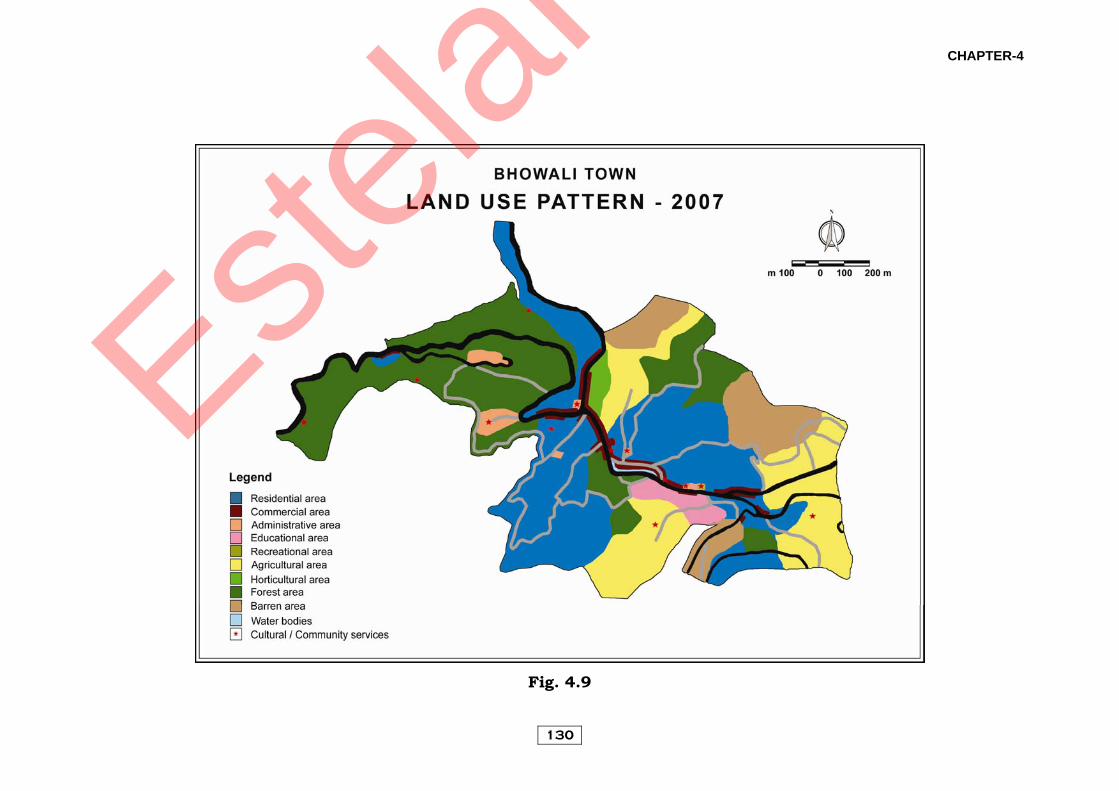
follows (Fig 4.9):
4.2.2.1 Residential Area:
The areal extent of this category in the Bhowali town is about
37.91 ha or 28.72 per cent of total geographical area.
4.2.2.2 Commercial Area:
There is mixed land-use in Bhowali town as there are
commercial activities in the residential areas and the market areas.
Estelar
CHAPTER-4
130
Fig. 4.9
Estelar

CHAPTER-4
131
At present about 4.97 hectares of land is under commercial activities,
which is 3.77 % of total town area. The commercial area is spread in
a ribbon pattern on Nainital-Bhowali road, Bhowali- Ranikhet road,
Bhowali-Bhimtal road and Bhowali-Mukteshwar road. Therefore, the
market area, hotels related to tourism, lodges and relevant activities
may be included under the commercial region.
Table 4.2 Land use of Bhowali town during 2007
Land use Area (ha) Percent of total town
area
Residential 37.91 28.72 Commercial 4.97 3.77
Administrative 3.45 2.61 Community Services 14.62 11.07
Education 2.56 17.49
Utility Services 1.15 7.87
Transportation 8.95 61.23
Cultural Community 1.96 13.41
Agricultural area 23.53 17.83
Horticultural 1.31 0.99 Barren 10.98 8.32
Forest 35.23 26.69
Total 132.00 100.00
4.2.2.3 Administrative Area:
About 3.45 hectares of land comes under offices and
government use which is 2.61 % of the total town area. There are few
offices in Bhowali, which include those of Central Govt. State-Govt.,
Semi-Govt. and autonomous institutions and other offices.
4.2.2.4 Community Facilities:
The community facilities or basic facilities are very essential in
the civic life. The use of these services or facilities is also essential
along with economic, social and cultural development of the town.
Under these services we can include mainly education, medical,
Estelar
CHAPTER-4
132
recreational, public services, etc. In Bhowali town about 14.62
hectares of land comes under these services. At present it is about
8.37% of the total town area. About 2.56 hectares land comes under
education, 8.95 hectares under transportation, about 1.15 hectares
under community services and 1.96 hectares of land comes under
cultural community services.
4.2.2.5 Agriculture Area:
About 23.53 hectares land comes under the agriculture which is
about 17.83% of total geographical area.
4.2.2.6 Horticulture Area:
About 1.31 hectares land comes under the horticulture which is
about 0.99 % of total geographical area. It is includes orchards
mainly.
4.2.2.7 Barren Land:
In the town about 10.9 hectares of land comes under this
category, which is about 8.32 % of the total town area. Barren land is
a steep sloped area which cannot be brought only under
forest/plantation as a land use
4.2.2.8 Forest/Green Area:
The forest plays an important part in environmental
conservation and for this reason forests have occupied a special place
since times immemorial. In the last decades as a result of the process
of rapid expansion the existing dense forests has gradually dwindled.
The ill-effects of decreasing forests and increasing urbanization are
being manifested in the form of landslides and other environmental
challenges in the present times. At present about 35.23 hectares land
comes under the forest/green area, which is about 26.69 % land of
the entire urban area of Bhowali town. It becomes indispensable to
propose the utilization of more land from town planning and
Estelar
CHAPTER-4
133
environmental point of view keeping in mind the geological condition
and nature of environment.
4.2.3 Land Use of Bhimtal Town In comparison to Nainital town Bhimtal has developed recently.
It was only after Independence and few decades following it (1962-63),
that Bhimtal attracted notice for being developed as an industrial area
because of the availability of level land. However, by the mid-1990’s
more than 75% of these industries had shut down. Presently, Bhimtal
is developing as a satellite town of Nainital and as a hub of
government offices housed in the Vikas Bhawan. At present it has
attracted attention due to it being in the hills with a picturesque lake,
proximity to Nainital and road link to Kathgodam (only 22 km), the
nearest railhead. The total area of Nagar Panchayat is 3.95 km2 in the
census year 2001. At present only four wards are in the town.
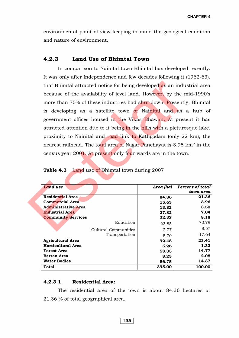
Table 4.3 Land use of Bhimtal town during 2007
Land use Area (ha) Percent of total town area
Residential Area 84.36 21.36 Commercial Area 15.63 3.96 Administrative Area 13.82 3.50 Industrial Area 27.82 7.04 Community Services 32.32 8.18
Education 23.85 73.79
Cultural Communities 2.77 8.57 Transportation 5.70 17.64
Agricultural Area 92.48 23.41 Horticultural Area 5.26 1.33 Forest Area 58.33 14.77 Barren Area 8.23 2.08 Water Bodies 56.75 14.37 Total 395.00 100.00
4.2.3.1 Residential Area:
The residential area of the town is about 84.36 hectares or
21.36 % of total geographical area.
Estelar
CHAPTER-4
134
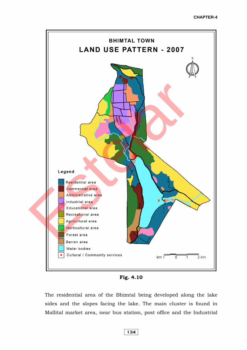
Fig. 4.10
The residential area of the Bhimtal being developed along the lake
sides and the slopes facing the lake. The main cluster is found in
Mallital market area, near bus station, post office and the Industrial
Estelar

CHAPTER-4
135
Estate. Tallital area the southern end of the lake near the Government
Normal School on Kathgodam road. The residential area is also found
along the transport routes towards Bhowali Kathgodam, and Nokuchiy
Tal.
4.2.3.2 Commercial Area:
This type of land use covers 15.63 hectares or 3.96 % of total
geographical area.
The main commercial area of the Bhimtal is the Mallital market,
located at northern part of the lake. Other business area is extending
narrowly along the Nainital Naukuchiatal and Kathgodam road. The
roadside settlement serves as shops, restaurants while the upper
stories are used as residence.
4.2.3.3 Administrative Area:
The areal extent of this category is about 13.82 hectares or 3.50
% of total geographical area.
In Bhimtal town a specific area for administrative use is located
along the Bhimtal-Bhowali road west of the existing industrial areas.
Many offices are shifted from Nainital to Bhimtal in Vikas Bhawan,
along with a separate residential complex to accommodate the staff
associated with these offices. Besides these offices Bhimtal Nagar
Panchayat and irrigation department located near the famous
Bhimeshwar temple.
4.2.3.4 Industrial Area:
The area occupied by this category is about 27.82 hectares or
7.04 % of total geographical area. The industrial area had been
developed along the “Anu Ka Maidan” near Mallital market due to
availability of vast tract of level land. About a decade ago, this
industrial estate was flowing with a good number of industries but of
late, due to policies of the Government financing agencies or due to
Estelar

CHAPTER-4
136
problems of market or profit many industries have gradually been
shifted or closed.
4.2.3.5 Community Services:
i. Educational Area: The Arial extent of this category is estimated
to about 23.85 hectares which is 73.79 % of total area under
community services.
At present Bhimtal is an important centre of education and has
institutions ranging from primary and higher secondary level to
technical education. The Birla Institute of Applied Sciences and Lakes
International are located near Block office and B. Pharma and M.B.A.
are located near Ramleela ground, S.O. S. Village School and District
Institute of Teachers Education are located southern part of lake.
Beside these many schools are located at different part of the town.
ii. Culture Community Services and Others: This category is
estimated to about 2.77 hectares or 8.57 % of total geographical area.
There are two play grounds located at near Tallital and Mallital
market. The main recreational centre of the town is an island in
between the lake.
There is a ladies hospital located at southern part of the lake
near Tallital market. Beside this a Primary Health Centre and a
Veterinary Hospital are also located in the town.
iii. Transportation: Transportation land use is about 5.70 hectares
or 17.64 % of total geographical area. It includes Bus station and
roads.
4.2.3.6 Agriculture Area:
The aerial extent of agriculture land is estimated to about 92.48
hectares which is 23.41 % of total geographical area.
Estelar

CHAPTER-4
137
4.2.3.7 Horticulture Area:
The area under horticulture is about 5.26 hectares which is
1.33 % of total town area.
4.2.3.8 Forest Area:
Forest area covers 58.33 hectares or 14.77 % of total
geographical area.
4.2.3.9 Barren Area:
Barren land use is about 8.23 hectares or 2.08 % of total
geographical area.
4.2.3.10 Water Bodies:
The area occupied by this category is 56.76 hectares or 14.37 %
of total geographical area. The area includes Bhimtal Lake and
gadhera etc.
4.3 Urban Land Use Dynamics The highly dynamic land use system undergoes significant
changes according to the changing socio-economic parameters as well
as natural environmental conditions. With the increasing pressure of
population on the land, the human transformation process of the bio-
physical components has brought about remarkable changes in the
land use pattern of the urban centres. Consequently, the settlements
are now pushed into forested areas, marginal lands and up slopes
without taking into account the suitability of this land for
construction activities, and the vegetal cover is being lopped and
cleared for meeting the increasing demand of population. This land
transformation process has brought about critical environmental
changes through the erosion of soil and reduction of ground water
recharge in this ecologically sensitive and geo-morphologically high-
energy region.
Estelar
CHAPTER-4
138
In order to monitor the process of land use changes and assess
their environmental impact, an experimental study was carried out for
the Nainital, Bhowali and Bhimtal towns of the Lake region. The land
use changes were monitored between 1995 and 2007 (Tables 4.4, 4.5
and Figs 4.11, 4.12, 4.13, 4.14). Field mapping techniques were used
for the monitoring of land use changes.
Estelar

CHAPTER-4
139
Fig. 4.11
Estelar
CHAPTER-4
140
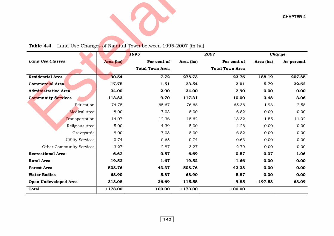
Table 4.4 Land Use Changes of Nainital Town between 1995-2007 (in ha)
1995 2007 Change
Land Use Classes Area (ha) Per cent of Total Town Area
Area (ha) Per cent of Total Town Area
Area (ha) As percent
Residential Area 90.54 7.72 278.73 23.76 188.19 207.85 Commercial Area 17.75 1.51 23.54 2.01 5.79 32.62
Administrative Area 34.00 2.90 34.00 2.90 0.00 0.00 Community Services 113.83 9.70 117.31 10.00 3.48 3.06
Education 74.75 65.67 76.68 65.36 1.93 2.58
Medical Area 8.00 7.03 8.00 6.82 0.00 0.00
Transportation 14.07 12.36 15.62 13.32 1.55 11.02
Religious Area 5.00 4.39 5.00 4.26 0.00 0.00
Graveyards 8.00 7.03 8.00 6.82 0.00 0.00
Utility Services 0.74 0.65 0.74 0.63 0.00 0.00
Other Community Services 3.27 2.87 3.27 2.79 0.00 0.00
Recreational Area 6.62 0.57 6.69 0.57 0.07 1.06 Rural Area 19.52 1.67 19.52 1.66 0.00 0.00
Forest Area 508.76 43.37 508.76 43.38 0.00 0.00 Water Bodies 68.90 5.87 68.90 5.87 0.00 0.00
Open Undeveloped Area 313.08 26.69 115.55 9.85 -197.53 -63.09
Total 1173.00 100.00 1173.00 100.00
Estelar
CHAPTER-4
141
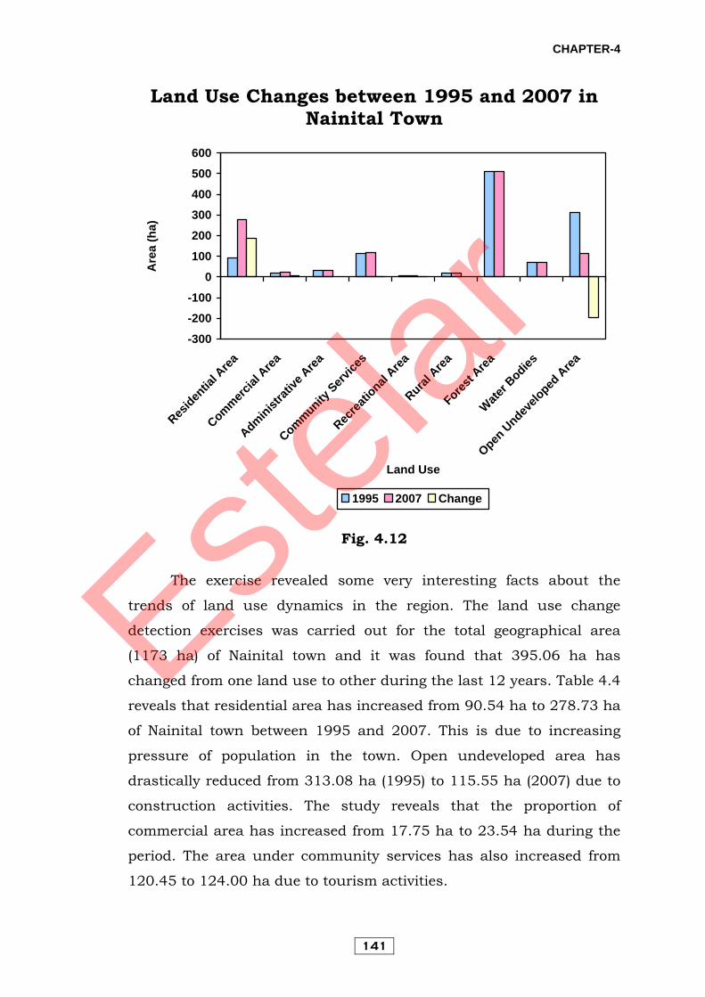
Land Use Changes between 1995 and 2007 in Nainital Town
-300
-200
-100
0
100
200
300
400
500
600
Residen
tial A
rea
Commercial
Area
Administrat
ive A
rea
Community Serv
ices
Recrea
tional
Area
Rural A
rea
Forest A
rea
Water B
odies
Open U
ndevelo
ped A
rea
Land Use
Are
a (h
a)
1995 2007 Change
Fig. 4.12
The exercise revealed some very interesting facts about the
trends of land use dynamics in the region. The land use change
detection exercises was carried out for the total geographical area
(1173 ha) of Nainital town and it was found that 395.06 ha has
changed from one land use to other during the last 12 years. Table 4.4
reveals that residential area has increased from 90.54 ha to 278.73 ha
of Nainital town between 1995 and 2007. This is due to increasing
pressure of population in the town. Open undeveloped area has
drastically reduced from 313.08 ha (1995) to 115.55 ha (2007) due to
construction activities. The study reveals that the proportion of
commercial area has increased from 17.75 ha to 23.54 ha during the
period. The area under community services has also increased from
120.45 to 124.00 ha due to tourism activities.
Estelar
CHAPTER-4
142
Fig. 4.13
Estelar

CHAPTER-4
143
Table 4.5 Land Use Changes of Bhimtal Town between 1995-2007 (in ha)
1995 2007 Change
Land Use Classes Area (ha) Per cent of Total town
Area
Area (ha) Per cent of Total Town
Area
Area (ha) As per cent
Residential Area 11.41 2.89 84.36 21.36 72.95 639.35 Commercial Area 1.11 0.28 15.63 3.96 14.52 1308.11
Administrative Area 0.15 0.04 13.82 3.50 13.67 9113.33 Industrial Area 42.83 10.84 27.82 7.04 -15.01 -35.05
Community Services 24.03 6.08 32.32 8.18 8.29 34.50 Education and Others 17.56 23.85 73.79 6.29 35.82
Cultural Communities 0.77 2.77 8.57 2.00 259.74 Transportation 5.70 5.70 17.64 0.00 0.00
Land Under Non-urban Uses 315.47 79.87 221.05 55.96 -94.42 -29.93 Agricultural Area 92.48 23.41
Horticultural Area 5.26 1.33
Forest Area 58.33 14.77
Barren Area 8.23 2.08
Water Bodies 56.75 14.37
Total 395.00 100.00 395.00 100.00
Estelar
CHAPTER-4
144
Land Use Changes between 1995 and 2007 in Bhimtal Town
-150
-100
-50
0
50
100
150
200
250
300
350
ResidentialArea
Commercial Area
AdministrativeArea
IndustrialArea
CommunityServices
Land UnderNon-urban
Uses
Land Use
Are
a (h
a)
1995 2007 Change
Fig. 4.14
Table 4.5 reveals that in Bhimtal town the residential area has
increased by over 7 times, from 11.41 ha to 84.36 ha in the period
1995-2007. The land under commercial uses, administrative uses and
community services has increased from 1.11 ha to 15.63 ha, 0.15 ha
to 13.82 ha, and 24.03 ha to 32.32 ha during this period due to
tourism related activities. The land under non-urban uses and
industrial area has decreased from 315.47 ha to 22.05 ha and from
42.83 ha to 27.82 ha, respectively. The main reason for this
transformation is that the Nainital town due to its natural beauty and
geographic advantage is popular as a hill resort, and due to proximity
to it, the land use of other towns have also changed.
No relevant land use data was available for Bhowali town from
the authorities. However, from a visual interpretation it was found
Estelar
CHAPTER-4
145
that the forest land and agriculture land has been reduced due to
population pressure, proximity to Nainital and the junction of roads.
4.4 Factors of Urban Land Use Changes Various processes or tendencies operating within the towns for
evolving their specific urban landscape are called ‘forces or principles’.
Colby (1933) described two fundamental forces, centripetal and
centrifugal forces that are made up of a combination of uprooting
impulses in the central zone and attractive qualities of the periphery,
while the centripetal forces focus on the central zone and make that
zone the centre of gravity for the entire urbanized area. Colby (1933)
again subdivided the centripetal forces as (i) site attraction, (ii)
functional convenience, (iii) functional magnetism, (iv) functional
prestige, (v) human equation, and the centrifugal forces as (i) spatial
forces, (ii) site forces, (iii) situational forces, (iv) force of social
equation, (v) status and organization of occupancies, and (vi) human
equation.
Dickinson (1964) explains that the spatial-functional structure
of the towns is the result of three basic forces: centripetal, centrifugal
and forces of spatial differentiation. Dickinson described the seven
forces for the site and distribution of different functions within the
towns. The elements like economic forces, social and government
legislations are the major works behind these forces (i) centralization,
(ii) concentration, (iii) deconcentration, (iv) decentralization, (v)
recentralization, (vi) residential segregation, and (vii) dominance,
invasion and succession.
The history of Nainital town is related to a short span of little
over 160 years, the town as well as its surrounding region referred to
here as the ‘Lake Region’ has witnessed large scale land use changes
over a span of relatively small period of time. In the context of towns of
the lake region, beauty of the lakes, cool and healthy climate,
administrative importance and transport function work as the
centripetal forces and lack of subsequent space for expansion of the
Estelar

CHAPTER-4
146
towns, high land values and some physical and geological factors work
as centrifugal forces. Beside these factors some local factors, i.e.
growth of population, tourism and its increasing demands of
development activities in the form of settlements, roads and other
infrastructural facilities are also responsible for the land use changes.
The main factors or urban land use changes in the region may be
discussed and analysed under the following categories:
4.4.1 Growth of Population
During the recent years the rapidly growing population of the
town has created large land use changes in Nainital itself as well as
Lake Region. The growth of population of the town between 1881 and
1891 was 28.57. This shows that by 1880 the town has already
emerged as a popular summer resort. During 1891-1901 the growth of
population decreased by 10% in 1901. The main cause of this
decrease was said to be the plague by the Census. In 1911, again
urbanization grew to 34.97%. In 1911, there was a decrease of total
rural population due to natural calamities. Later, the town population
and urbanization both increased. From 1921 to 1941 the population
growth rate fluctuated, particularly in the war decades, being 9.35%
in 1921, 3.34% in 1931, and 12.81% in 1941. The causes of the
decrease were the First World War and Second World War. After this,
urban population recorded a very high growth rate between 1941 and
1951. This can partly be attributed to the regained status of Nainital
as the summer capital of the state after Independence. The end of the
Second World War the changes ushered in new opportunities brought
by Independence. They were also responsible for growth of the
urbanization of the hill resort and the population recorded a very high
growth rate particularly in decades 1941-51 (20.40%) and 1951-61
(22.81%). The first major rise in the population of Nainital was
recorded in 1971 when the population was 25,167 showing a decadal
growth of 56.5% the highest ever observed so far. In 1981 and 1991
Estelar

CHAPTER-4
147
the growth had not been very high, the population being 26,093 and
29, 831 respectively. In 2001 the growth is increse 28.97.
The statistics of population usually available from the Census of
India do not give a true picture because it takes only the population
living in the town. This thus omits a large proportion of the town’s
population which returns to the town during second/third week of
March every year, coinciding with the reopening dates of the public
schools after the three months winter break. While a good numbers of
schools reopen after winters in the month of February. Many
residential public schools and preparatory, nurseries, or schools
imparting education up to Vth standard, normally open by mid-
March, which include the following: Sherwood College, All Saints
School, St. Joseph’s College, St. Mary’s Convent, Birla Vidya Mandir,
MLS Bal Vidya Mandir, MLS Balika Vidya Mandir, Bhartiya Shahid
Sainik School, Ashdale School, Sanwal School, St. John’s School,
Shishu Mandir, Amtul Public School, St. Xavier School, Long View
Public School, Holy Angels School, and a host of Preparatory and
Kindergarten Schools.
While many of these schools are residential, their total strength
may range around 7,000 and about 2,000 persons may be added to
this number associated with this school population that include
teachers, school management and other category of persons
depending exclusively on providing various kinds of services to these
schools.
Besides this Nainital is also the seat of Uttarakhand High Court.
As a result of the population of Nainital is continually increasing but
is not included nor reflected in the census data which considers only
the permanent residents.
Similarly tourism, which is a major activity in the town, attracts
a good number of people during different periods of the year. Though
this population has a very short stay but owing to its vast numbers
and its impact on related activities needs to be taken into account.
Estelar

CHAPTER-4
148
At present, the town has grown into a full-fledged tourist resort
with inflow of tourists almost throughout the year. Besides this, it is
also getting popular as an ideal destination for organizing meeting,
seminars and visiting of student groups from schools and colleges.
Many other occasions also attracts tourists, especially from Delhi and
other nearby centres in a fairly good number. It is also an ideal
honeymoon destination for the newly weds due to its serene
atmosphere and scenic beauty.
Due to ever increasing demand and exorbitant rates of
residential accommodation in Nainital, a good number of people now
prefer to live in smaller suburban centres of Bhowali, Bhimtal,
Ghorakhal and Khurpatal etc around Nainital. A large number of
commuters live in such centres, the maximum being in Bhowali and
Bhimtal wherefrom frequent bus services and private taxis operate to
Nainital throughout the day. Such population mostly includes people
engaged in various services, students and small businessmen. In
order to cope with this demand, these small centres have also grown
remarkably during the last few years and a cluster of new residential
accommodation are added each year. It has been estimated that in
Bhowali alone there has been about 42% increase in the number of
houses during the last 5-7 years periods. A similar trend is also
observed in Bhimtal town.
Bhowali and Bhimtal have also been preferred by a large
number of people who have either retired or are willing to settle in the
hills. Since the cost of land and construction in Nainital is very high,
these places seem to provide a much better alternative to the crowded
city and yet are not very far off from the facilities of a big urban centre
being only 11-22 km from Nainital.
4.4.2 Expansion of Tourism The largest land use changes are obviously associated with the
growth of tourist activities, which is now a well established industry in
Nainital town and is gradually expanding to the various centres of the
Estelar

CHAPTER-4
149
Lake Region. During recent years, the infrastructural growth for this
industry has been in the shape of:
(a) A good number of hotels and lodging houses have come up
along with numerous roadside restaurants and shops to cater
to the need of the tourists.
(b) Tourist Rest Houses were built by Kumaun Mandal Vikas
Nigam or U.P. Tourism at Nainital, Bhowali, Bhimtal and
Sattal.
(c) New roads have come up to show view, Laria Kanta, Sattal and
Kilbury and adjoining places.
(d) Restaurants and eating places for tourists in these centres
which are mostly frequented by tourists like Sattal, Bhimtal,
Naukuchiatal and Bhowali.
(e) Growth of travel agencies, tourist guide services and
recreational facilities.
The growth of the kind of infrastructure developed for the
tourist industry has been responsible for large scale changes in the
landscape.
4.4.3 Rise of New Functions The paucity of space in Nainital and the ease of access due to
developed transport have led to the diffusion of many functions to the
outer zone of Nainital town, which largely constitutes the Lake Region.
Nainital being a hill station has its added advantages. Besides being
the headquarters of a Division and a district of the same name, it also
happens to be the seat of High Court of Uttarakhand. Due to its
salubrious climate in summers, it becomes the venue of various high
level meetings, seminars and symposia.
Bhowali is the most notable town in this respect, which is a
focal point in terms of transport and is also a collection and
distribution point for the horticultural produce from the surrounding
region. It is a nodal point in the entire Lake Region, which connects
hills to the plains, through which all transport has to pass, both
Estelar

CHAPTER-4
150
commercial and tourist based. Due to rise of many transport and
commercial functions, its status has now risen to a sub-town or a
satellite town of Nainital providing shelter to hundreds of commuters
who either work or study in Nainital and also a good number of
tourists during peak seasons, when accommodation in Nainital is
either too costly or not available at all. Thus, during recent years it
has emerged as a small township providing facilities of hotels,
restaurants, taxi services and market facilities. Thus, new functions
now tend to be located more and more in and around the town, viz.,
Air Force Colony for Air Force personnel posted in Laria Kanta
complex. Many sites in Nainital and its Lake region have also come up
as those required for purely military use. The vast radar and
telecommunication complex developed at Laria Kanta, a one time
picnic spot, has led to large scale changes even at high elevations.
The region has also been preferred for various kinds of functions
mainly for setting up educational institutions. In Nainital many
training institutions like PGDCA, Department of Biotechnology,
Microsoft Academy, have recently come up. Bhimtal has also shown
growth of Training Institute for MCA, MBA and B.Pharma. with
affiliation for Kumaun University and Birla institute sponsored by the
Birla have recently been started in Bhimtal.
The commercial needs have led to the growth of large scale fruit
collecting and distributing centres in Bhowali, which has a road-side
market that caters to the need of a large surrounding horticultural
belt. Local level administrative units both government and private are
located either at Bhowali or Bhimtal includes Blocks Development
Office, Vikas Bhawan in Bhimtal, branches of a few nationalized
banks and local banks in Nainital, Bhowali and Bhimtal. All such
activities have been responsible for giving rise to new settlements.
4.4.4 Real Estate Business The most recent development has been a phenomenal growth of
real estate business in and around Nainital, particularly in such areas
Estelar
CHAPTER-4
151
of the Lake Region as Naukuchiatal, Sattal and the valley between
Bhowali and Bhimtal. These areas have an ideal location, being hardly
at a distance of 20 kilometres from the nearest railhead Kathgodam
and at the same time are situated in close proximity to Bhowali and
Nainital (15-25 km). There are all-season motorable roads connecting
these places. Builders from outside the region have invested huge amounts in
purchasing lands and have entered into real estate business by
constructing houses and complexes at many sites near Bhowali town
particularly along the Ramgarh road. The most spectacular
development can be witnessed along the Bhowali-Bhimtal road where
a good number of such projects are either complete or under way and
have led to a total transformation of the landscape.
4.5 Urban Landuse: Dimension of Extension and Problems With the growth of population is associated the rise in the
density of urban settlements and its expansion in hitherto unoccupied
areas. Such a growth can, therefore, be precisely reflected in a map of
settlement distribution showing various patterns. The pattern and
distribution is largely conditioned by topographic constraints as well
as the availability of road transport. In a mountainous topography
settlement distribution tends to be scattered and dispersed since
favourable sites are limited and far between. At the same time,
availability of transport is a strong factor and attracts settlement
growth despite unfavourable topography.
The growth of urban settlement and its extension can be
understood by the stage of development achieved by a specific area
which can easily reflect the need of the people as also the cultural
level acquired by them. In order to explain the process, the Lake
Region has been discussed under different zones and sub-zones.
Estelar
CHAPTER-4
152
4.5.1 Nainital Urban Area Nainital and its immediate surrounding zone is a fully
urbanized area showing related characteristics. The pattern of
settlement, however, is largely conditioned by the mountainous
topography of the town. The typical site is provided by the
geographical conditions, where a large lake exists surrounded by
sloping hills on almost all directions except the south. This has
resulted into a characteristic pattern of settlement around the lake
which is the governing natural phenomena in the local geography of
the town. The settlement, thus, initially tends to distribute all around
the lake in different directions and invariable facing the lake.
At some later stage, the growth of main roads and other
approach roads, the pattern of settlement since this cultural feature
exerts a strong influence on the pattern of settlements because these
are the only life lines that make interaction between people possible.
The town, which has acquired almost all urban functions, is
presently also an important tourist resort, attracting a large number
of tourists from different covers of the country and the world. As such,
to meet such demand relevant development has also taken place
during the last two or three decades and such growth have been very
fast.
There are vast areas have been retained by the Municipal Board
as a restricted area due to geological or topographical constraints and
protected forest, thus, the growth of built-up area in a most
haphazard manner. The already congested areas are now getting more
and more congested since residential houses and hotels are coming
up in all vacant space. Because of limited expansion of these areas the
houses are getting three or four storeys.
4.5.2 Semi-Urban Areas
Semi-urban growth is found at Khurpatal, which lies close to
Nainital town and due to the presence of a close by metalled road that
connects Nainital to Ramnagar, Bazpur, Kashipur, etc., it shows
Estelar

CHAPTER-4
153
urban influences in the building material of houses, the pattern of
roofs and other aspects. Since this is not a truly urbanized area we
can simply recognize the urban influences due to its proximity to the
town. As such, the growth is very slow and does not vary much with
those of the adjacent rural areas.
Since the settlement now happens to be within the jurisdiction
of Lake Development Authority and also because of increased tourist
activity, specific type of activities and development has taken place
during recent years particularly in the form of ‘Tourist Reception
Centres’ on residential flats occupied by commuters or other category
of people from outside who wish to retain an alternative
accommodation in the hills. In accordance with the needs of such a
population, facilities of local transport, market, communications etc.
are gradually emerging in the settlement and due to its connectivity
and proximity to the main town; it shows adequate potential of
development into a small suburb.
4.5.3 Nainital Cantonment Area Moving east wards from Nainital urban zone, the adjacent area,
falling within the Nainital Cantonment is also a characteristic area
with regards to the growth and distribution of settlements. The zone
an abrupt change in the density of settlement which also tends to be
sparsely distributed. This is due to the prevailing policies of the
Defense Department under whose control the area falls-where, but for
very specific and urgent nature of activity, expansion of residential
settlement is largely restricted. It is due to this factor alone that there
is a marked change in settlement density along the boundary of the
Cantonment. Thus while the zone very much falls being part of the
Nainital urban zone, the urban spread has been very limited and the
pace of development has also been very slow.
With almost no changes over a large period of time, it represents
a buffer zone between the rapidly changing urbanized area of Nainital
Municipal Board to its west and south-west and the remaining part of
Estelar
CHAPTER-4
154
the Nainital Lake Region falling to east and south-east where the
different parts are in varying stages of development and thus several
characteristics pattern of settlement.
4.5.4 Bhowali and Sub-Urban Areas Towards further east lies yet another semi-urban zone around
Bhowali, a small sub-town of the study area. Bhowali, due to its
locational advantages has grown into a fully developed suburb of
Nainital and in a sense commands a central location within the area
providing transport links to various areas and providing transport
links in different directions.
Bhowali initially shows a linear pattern of development along
the roads that radiate in different directions which tends to be very
dense in certain areas due to growth of population. Such settlement is
mainly used for commercial purposes - the ground floor being used as
a shop and the upper floors serving as residential accommodation
invariably in all cases. Such functions have grown very fast during the
last 10 or 15 years due to the increased frequency of tourist
movements along the transport routes that connect Bhowali.
Beside this, linear cluster of settlements exists along the roads.
Bhowali also shows distribution of settlements along the upper
elevations due to rapid growth of its population, advantages of site,
increased commercial and related functions, and the lack of space for
further urban expansion in the nearby town of Nainital. Close to
Bhowali, we find zones under varying degrees of urban influences or
stages due to the operation of one or many factors.
i) There are three small pockets towards the north-west, west and
south-west of Bhowali, and although these lie close to Nainital town
and Bhowali town, but they reveal a scattered pattern of settlement
distribution with a very slow growth rate. This is also despite the fact
that two main roads pass through these areas - first, the Bhowali-
Nainital road, and second, the Bhowali-Haldwani road. The settlement
Estelar

CHAPTER-4
155
thus tends to develop generally along the roadside and with increased
elevations the distribution gets very sparse.
In fact, much of this region is the eastward extension of the
Nainital Karst zone, and therefore is dominated by limestone or shale,
which is highly prone to erosion. As such, the rock structure does not
provide a stable base and such areas are liable to suffer from
landslide, creep, subsidence and erosion in the event of high intensity
rainfall, which is a characteristic of this area. This factor, thus largely
precludes settlement growth and distribution.
Apart from this, the elevated areas of generally above 2,200
metres elevation are invariably covered with thick forest, and thus
have do not present suitable sites for settlement growth.
Under these conditions, this zone is more or less rural in
character and includes area like Bhowali Sanatorium, Bhumiyadhar,
Kuriagaon and Bhawanipur.
ii) This sub-zone lies east of Bhowali and taking advantage of the
ideal network of roads in all directions, has grown very fast. Due to its
proximity to Bhowali, the settlements show urban influences and
these are presently undergoing fast changes due to the coming up of
new function, viz. real estate business, government colonies, building
owned by private people – both local or from outside the region, small
industrial units and orchard areas with farm house, etc.
In this way the patterns that have emerged reveal well laid-out
and planned settlements with provision of area for gardening or
plantations. There may be multi-storeyed structures also while
sometimes, colonies enclosed with boundary walls or lodging houses
for tourist purpose may also be found. In general, the pattern does not
reveal clustering but sometimes there is a trend towards a linear
growth along or in alignment with a road nearby. This growth is very
recent and has been very fast also.
The sub-zone includes areas in Nagarigon (North) and
Kahalquira rural areas, adjacent to Bhowali Municipal Board, where
Estelar
CHAPTER-4
156
topographical conditions also have a favourable growth of settlement
over widespread areas due to a low gradient over large patches of land
and in general, low gradient and stable slope all-around. These
settlement areas, showing a relatively fast growth, may be grouped
under semi-urbanized category.
iii) With increased distances from the urban centre, the influences
also tend to get reduced. There are two such zones under this category
which include Luvesal and parts of Nagarigaon (south), which are
situated 4 to 5 km from Bhowali. While the road between Bhowali and
Bhimtal passes through one of these, the Nagarigaon (south) has no
such connection which is also topographically fragmented.
These areas still retain a rural character, showing only minimal
urban influences and as per circumstances these are very slow
growing areas, recording negligible changes in the landscape.
4.5.5 Bhimtal-Naukuchiatal Zone The eastern most zone of the Nainital Lake Region has been
termed as the Bhimtal-Naukuchiatal zone and it extends between a
vast area encompassing part lying north-west of Bhimtal, the entire
Bhimtal valley and the Naukuchiatal valley lying further south-
eastwards. In this way, the zone stretches across a spatial distance of
about 10 kilometres and includes two large lake valleys at Bhimtal
and Naukuchiatal. The various sub-regions are at different stages of
the growth, as will be evident from the following description:
The area includes the lower part of the Bhowali-Bhimtal valley
including many rural areas lying north-west, north and north-east of
Bhimtal mainly Bhagturia, Mehragaon, Bohari, Soangaon and
Pandegaon (north). The Bhowali-Bhimtal road passes through the
central parts where a linear pattern along the road is usually found.
The growth is quick and related to such activities as transport,
business, small-scale or household industries, etc. The houses reveal
influences of their proximity to the road mainly in the imported
Estelar

CHAPTER-4
157
building material such as bricks, cement or tin-sheets. Such areas
may appropriately be termed as semi-rural since the road provides an
easy access to nearby towns and sub-towns which exert their
influences in many ways.
A rural landscape predominates on both sides of the valley with
increasing elevations from the road. These areas are obviously related
with slow changes, a minimal urban influence and a scattered pattern
of settlement characteristic of all mountain areas. The crest or the
highest areas are covered with patches of thick forest and such areas
are usually devoid of any settlement mostly to the north east of
Mehragaon, Saungaon, Sangurigaon and Bhimtal.
4.5.6 Bhimtal Urban and Suburban Area This includes the entire urban area falling within Bhimtal and
the surrounding region - basically within revenue villages of different
names but now within the urbanized area in the periphery of Bhimtal.
The revenue villages that fall within this zone include Sangurigaon,
June Estate, Dungsil Rawat, Dungsil Sah, Dungsil Malla and
Pandegaon (south).
The core of this urban growth may be identified with linear
pattern of settlement along the Bhowali road, which tends to get
denser towards the bus station. Likewise, settlements along the
Naukuchiatal road are also found aligned with the road. Besides this,
which forms the earlier settlement lying to the northern and south-
eastern slopes of Bhimtal, the opposite slopes are sporadically
occupied by private estates with small orchard areas owned by
foreigners or rich people belonging to other parts of the country. The
earlier settlement growth was very slow and although a road existed to
connect Bhimtal, the place was never preferred by tourists or visitors
from outside as against the famous lake town of Nainital situated
nearby. For quite sometime the place had a slow growth of population
and retained, more or less a rural character.
Estelar
CHAPTER-4
158
4.5.7 Naukuchiatal and Surrounding Areas To the south-east of Bhimtal there is situated yet another
picturesque valley around a large and beautiful lake, known as
Naukuchiatal. Although, the region is presently connected by a
metalled road of Bhimtal, it still retains a rural character and
development so far has been relatively slow. The landscape is still
characterized by the presence of cultivated patches and horticultural
areas with scattered and dispersed type of settlements in between.
The intrinsically rural zone includes the village Naukuchiyatal,
Siloti pant, Siloti Pande, Skhola, Naula, Thapalia Mehragaon and
Channoti but shows slow growth. The most recent patterns related
with tourist activity constitute lodging houses and restaurants etc.
that cater to the needs of tourists that visit the lake valley for a short
visit. For future growth of tourism, however, this region has the
greatest potential.
Estelar