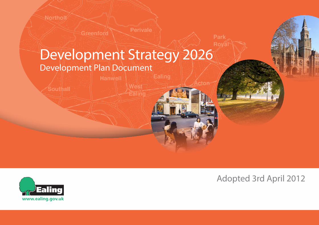
development strategy 2026
TRANSCRIPT
L B Ealing’s Development (Core) Strategy Adopted 3rd April 2012 1
Development Strategy 2026Development Plan Document
Adopted 3rd April 2012

L B Ealing’s Development (Core) Strategy Adopted 3rd April 20122
L B Ealing’s Development (Core) Strategy Adopted 3rd April 2012 3
Executive Summary
By 2026
•Ealing will comprise a range of prosperous, cohesive and sustainable places and diverse communities and the council will harness opportunities for growth that will provide new homes and sustain and create jobs.
•To support this growth the council will develop and maintain a clear infrastructure delivery plan that will ensure the necessary physical, social and green infrastructure and services are provided and enhanced.
•Ealing Council will monitor and review this plan on an annualbasissoastoensurethelevelsofgrowthidentifiedin this plan are sustainable over the plan period.
•Ealing’s housing stock will have grown to provide more affordable homes for local people and to accommodate our projected growth in population through new developments in our town centres, the re-modelling of our housing estates and other places with good transport accessibility.
•Ealing Council will promote business and enterprise by securing the stock of employment land, encouraging regeneration and renewal and being responsive to market demands.
•Crossrail will be built and the council will encourage investment that allows our residents to travel north-south across the borough with greater ease and, where appropriate, feeds directly into Crossrail.
•Ealingasaboroughwillbeasselfsufficientaspossibleinthe management of our own waste.
•Ealing Council will promote sustainable design and construction in all development to play our part in addressing the global challenge of climate change.
•Ealing Council will ensure that the design of all development achieves the highest standards of quality in design and, in the right circumstances, this will include a number of landmark/tall buildings.
•Ealing’s pattern of attractive green and open spaces will not only have been protected but also enhanced.
L B Ealing’s Development (Core) Strategy Adopted 3rd April 20124
PleasenotethatthisdocumentwaspublishedandprintedinJune2014andcontainsformattingchangesandminorgrammaticalmodificationsfromtherougheditversionproduced in April 2012.
Contents Executive Summary 3Preface 5Chapter 1: Vision for Ealing 2026 7Chapter 2: Development in the Uxbridge Road / Crossrail Corridor 20Chapter 3: Development in the A40 Corridor & Park Royal 27Chapter 4: Enhancing Residential Hinterlands & North-South Links 32Chapter 5: Protecting and Enhancing Ealing’s Green and Open Spaces 37Chapter 6: Ensuring Sustainable Delivery 46
List of Maps1
Map 1 – Ealing in the context of West London 6Map 2 – The Key Diagram 9Map 3 – Locations in Ealing with Potential for Employment and Housing Uses 12Map 4 – The Retail Hierarchy in the London Borough of Ealing 13Map 5 – Development Areas in Both Corridors 19Map 6 – Approved, Proposed and Potential Improvements to Transport 36Map 7 – Green & Open Spaces in Ealing 39Map 8 – Existing Education, Health and Leisure Facilities in Ealing 48Map 9 – Proposed New Infrastructure 49Map 10 – Strategic Diagram for London 54Map 11 – Public Transport Accessibility Levels in Ealing 55Map 12 – Neighbourhood Areas in the London Borough of Ealing 56Map 13 – Mapping the Borough: Acton and Park Royal 60Map 14 – Mapping the Borough: Ealing and Hanwell 63Map 15 – Mapping the Borough: Greenford, Northolt and Perivale 67Map 16 – Mapping the Borough: Southall 69
List of Appendices
Appendix One – A Regional Context: The London Plan 52AppendixTwo–ALocalContext:NeighbourhoodProfiles 57Appendix Three – Infrastructure Delivery Schedule (V4 28 Nov 2011) 70Appendix Four – Local Plan Glossary of terms (separate document) 81Appendix Five – Endnotes 83
L B Ealing’s Development (Core) Strategy Adopted 3rd April 2012 5
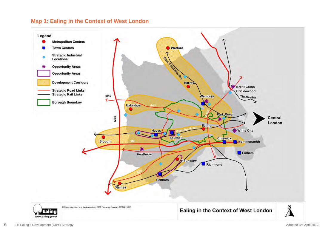
PrefaceEaling is a fantastic place to live and work. It is located where the Thames Valley (the UK’s highest performing sub-region) meets metropolitan London between the West End and Heathrow Airport. Map 1 shows Ealing in the context of West London.
Ealing is the third largest London borough in terms of its population and is one of the most ethnically diverse communities in the country. Local analysis shows that the officialdemographicstatisticsfromtheOfficeofNationalStatisticsunderestimatetheborough’s population and the number of households in Ealing. The GLA estimates Ealing’s population at 322,000 in 2011 (with local estimates showing 127,000 households) and expects it to grow to 349,000 (142,500 households) by 20262.
New homes are needed in Ealing to accommodate the borough’s projected increases in population. There is a shortage of affordable homes for young families to move into, a general problem of high house prices, and there are too many households that have difficultyingettingaccesstodecenthousing.
Ealing has a strong and dynamic economy and is the largest commercial borough in West London3 with over 11,000 businesses and the third highest rate of VAT registrations in London. More than 138,900 people work in the borough4 including 33,204 who commute from outside the borough5. There are few places in London with acomparableemploymentbasesoensuringthereissufficientemploymentlandandpremises to sustain our businesses and encourage new companies to locate and grow here is a high priority. Heathrow Airport provides a total 5,760 jobs for Ealing residents which mean that of the working population in the Borough, 1 in 26 people work at Heathrow6.
Ealing boasts excellent transport links with London and the rest of the UK, including direct connections to Heathrow Airport. Transport accessibility and capacity within and through Ealing are key determinants of the planning of the borough. Radial movement to and from the centre of London is highly developed, and accessibility within the two corridors – the Uxbridge Road / Crossrail corridor and the A40 and Park Royal corridor – is excellent. The challenge within these corridors is the capacity of the transport system.
Five Crossrail stations are planned for opening in 2019: four of which will be refurbished, providing increased transport capacity and faster journey times to London and to Heathrow Airport. Outside these corridors, accessibility reduces and there are problems around the viability of improving public transport and particularly of north – south movement in general. Planning of new homes and places of work is sensitive to these transport matters.
New homes, jobs, transport infrastructure, schools, healthcare facilities, open space, public utilities and other community and recreational facilities are needed to support the new population and to improve what is already in the borough. The key challenge is to ensure that development is in the right place. This means that new development is located so it provides the homes that are needed; improves the quality of an area; does not squeeze out local businesses or community facilities needed in the area; protects what is good about Ealing; and that it is accompanied by an improvement in the‘infrastructure’ intheareaforthebenefitofbothexistingandnewresidentsandusers.
In recent years Ealing has attracted the interest of developers and investors. Recession has resulted in a slowdown in development, however developers believe there are some early signs of economic recovery and some areas will emerge from recession sooner than others. Ealing will be one of those areas that will recover quickly because ofitshistoricstrengthsincludingitsstrongmixedeconomy,location,highlyqualifiedworkforce, excellent transport links and environmental quality7.
This Development (or Core) Strategy 2026 will guide the development of Ealing as an attractive place to live and work at the heart of West London. It sets out Ealing Council’s vision and policies for the future development of the borough. The proposals set out how, where and when the council, working with statutory bodies, the private sector and voluntary sector, will:
• Provide new housing, especially affordable homes for local families;• Sustain and create jobs;• Protect and enhance green and open space and the borough’s heritage; and• Ensure that community facilities, services and transport infrastructure are provided
where and when needed.
The Development Strategy 2026 is part of a portfolio of development plans that make up the council’s Local Plan. These plans must conform generally with the London Plan produced by the Mayor of London. Appendix 1 shows how the London Plan (2011) provides both a context for and helps complement this strategy.
L B Ealing’s Development (Core) Strategy Adopted 3rd April 20126
Map 1: Ealing in the Context of West London
L B Ealing’s Development (Core) Strategy Adopted 3rd April 2012 7
CHAPTER 1: VISION FOR EALING 2026
L B Ealing’s Development (Core) Strategy Adopted 3rd April 2012
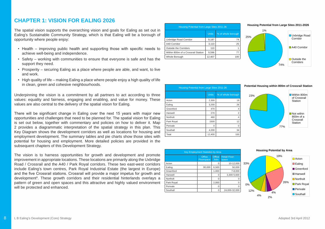
Housing Potential from Large Sites 2011-26
Units % of whole borough
Acton 2,300 19
Ealing 3,200 26
Greenford 470 4
Hanwell 270 2
Northolt 460 4
Park Royal 1500 12
Perivale 0 0
Southall 4,200 34
Total 12,400 100
Housing Potential from Large Sites 2011-2026
74%
25%
1%
Uxbridge RoadCorridor
A40 Corridor
Outside theCorridors
Potential Housing within 800m of Crossrail Station
77%
23% Within 800mof CrossrailStation
Not within800m of aCrossrailStation
Housing Potential by Area
19%
26%
4%2%4%
12%
0%
33%Acton
Ealing
Greenford
Hanwell
Northolt
Park Royal
Perivale
Southall
Housing Potential from Large Sites 2011-26
Units % of whole borough
Uxbridge Road Corridor 9,187 74
A40 Corridor 3,110 25
Outside the Corridors 110 1
Within 800m of a Crossrail Station 9,596 77
Whole Borough 12,407 100
Key Employment Statistics by Area
OfficeFloorspace
OfficeJobs
Retail Floor-space
Acton 0 10-12,000Ealing 90,000 6,500 50,000Greenford 1,000 7-8,000Hanwell 0 3,300-5,600Northolt 0 0Park Royal 2,000 0Perivale 0 0Southall 0 24,000-32,000
8
CHAPTER 1: VISION FOR EALING 2026The spatial vision supports the overarching vision and goals for Ealing as set out in Ealing’s Sustainable Community Strategy, which is that Ealing will be a borough of opportunity where people enjoy:
• Health – improving public health and supporting those with specific needs toachieve well-being and independence.
• Safety – working with communities to ensure that everyone is safe and has the support they need.
• Prosperity – securing Ealing as a place where people are able, and want, to live and work.
• High quality of life – making Ealing a place where people enjoy a high quality of life in clean, green and cohesive neighbourhoods.
Underpinning the vision is a commitment by all partners to act according to three values: equality and fairness, engaging and enabling, and value for money. These values are also central to the delivery of the spatial vision for Ealing.
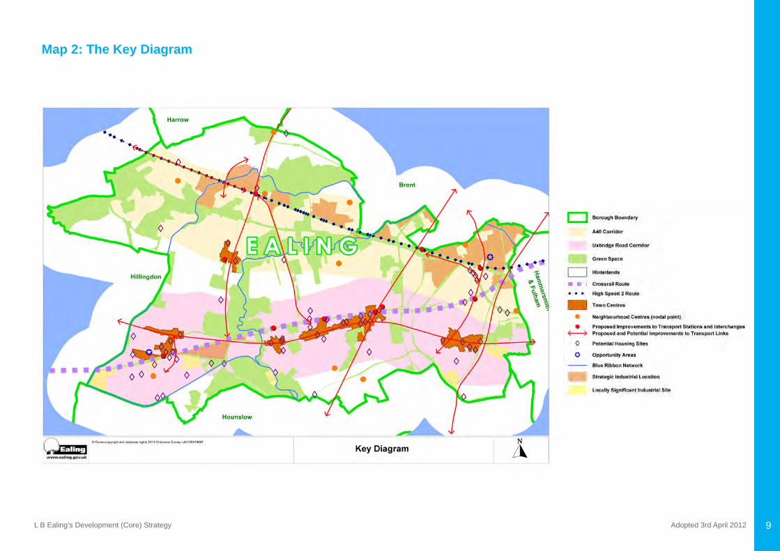
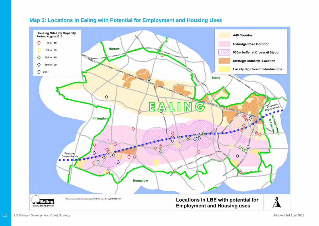
There will be significant change in Ealing over the next 15 years with major newopportunities and challenges that need to be planned for. The spatial vision for Ealing is set out below, together with commentary and policies on how to deliver it. Map 2 provides a diagrammatic interpretation of the spatial strategy in this plan. This Key Diagram shows the development corridors as well as locations for housing and employment development. The summary tables and pie charts show those sites with potential for housing and employment. More detailed policies are provided in the subsequent chapters of this Development Strategy.
The vision is to harness opportunities for growth and development and promote improvement in appropriate locations. These locations are primarily along the Uxbridge Road / Crossrail and the A40 / Park Royal corridors. These two east-west corridors include Ealing’s town centres, Park Royal Industrial Estate (the largest in Europe) andthefiveCrossrailstations.Crossrailwillprovideamajorimpetusforgrowthanddevelopment9. These growth corridors and their residential hinterlands overlays a pattern of green and open spaces and this attractive and highly valued environment will be protected and enhanced.
L B Ealing’s Development (Core) Strategy Adopted 3rd April 2012 9
Map 2: The Key Diagram
L B Ealing’s Development (Core) Strategy Adopted 3rd April 2012
To support this growth Ealing will develop and maintain a clear infrastructure delivery plan that will ensure the necessary physical, social and green infrastructure and services are provided and enhanced. This will make certain that Ealing continues to be a successful borough and that all communities have a high quality place to live and to work. These plans will ensure proper investment in the schools, health centres, transport, public utilities and other facilities needed by Ealing’s growing population. Wherever development is proposed, the council is also committed to excellence in urban design.
Other considerations in planning for the future of the borough include, for example:
• how to create communities that are healthy, safe, cohesive and engaged;• how to provide renewable energy sources; • where to accommodate waste management plants to enable increased recycling andlesslandfill;
• how to encourage greener transport including electric cars; and • how to plan for other technological changes that will affect the way we live, travel,
work and do business. The council initially considered a number of different alternative approaches (or “futures”) that included following established development plan policies or embracing change or protecting the past. Each of these approaches were based on the principle that we must manage growth in a sustainable way so that we are able to meet our present needs and ensure that future generations are also able to meet their needs10.
At the same time consideration was given to the future shape of each local area of the borough if one of these alternative futures were chosen. Each of the borough’s neighbourhoods has its own particular characteristics and issues to address. Map 12 shows theeightneighbourhoods thatmakeup theboroughascurrentlydefinedbythe Council. Appendix 2 provides a summary of some of their chief characteristics and how the Development Strategy 2026 will impact upon their future development. It was always acknowledged that the best future for Ealing is likely to include elements of all three of these alternative approaches futures. It is evident that although the council has embraced change it will affect each of the localities in very different ways.
This Development Strategy 2026 seeks to identify and promote those areas that can accommodate growth and either have good public transport access, the capacity to accommodate growth, are in need of regeneration, or can deliver jobs and infrastructure. It seeks to ensure that future development contributes to making places where people want to live and work.
Policy 1.1 Spatial Vision for Ealing 2026(a)By2026,weaimtoprovide14,000additionalhomes,94,500sqmofnewofficefloorspace,decreaseournetstockofindustrialfloorspaceby57,000sqm(equivalentto 14 hectares) through managed release11 and provide up to 128,400 gross sqm of newretailfloorspace12.
(b) Development of these new homes, business and retail space will be primarily concentrated in:
• The Uxbridge Road / Crossrail corridor - particularly focused in Acton, Ealing and Southall town centres; around key stations at Acton Mail Line, Ealing Broadway and Southall; and, municipal housing estates including Copley Close, Green Man Lane, Havelock and South Acton.
• The A40 / Park Royal corridor – particularly focused in Greenford town centre; Acton Main Line, Greenford and North Acton stations; Park Royal; and, other industrial estates.
(c) To promote business and enterprise by securing the stock of employment land, encouraging regeneration and renewal and being responsive to market demands. For industrial and warehousing businesses, we will protect our position as one of London’s premierlocations.Fortheofficemarketwewillreverseourrelativeunderperformancecomparedtoneighbours;withafocusonprovidinghighqualityofficespaceinEalingtowncentreandcapturingbenefitsaffordedbyCrossrail.
(d) To ensure the viability and vitality of the borough’s town centres in accordance with the established shopping hierarchy13.
(e) To be a healthy and safe place to live and ensure that the necessary physical, social andgreeninfrastructureandservicesasidentifiedintheInfrastructureDeliveryPlanare provided and enhanced in the borough14.
(f) To support sustainable, safe and convenient transport networks to and through Ealing that, in particular, improve north-south transport links between the Uxbridge Road / Crossrail and A40 / Park Royal corridors and to promote healthy travel behaviour and seeks to reduce the need to travel.
(g) To protect and enhance suburban communities, improve public transport, cycle and pedestrian links to the development corridors and neighbourhoods.
10
L B Ealing’s Development (Core) Strategy Adopted 3rd April 2012
(h)Tocarefortheborough’shistoriccharacterandenhancethesignificanceofheritageassets in regeneration proposals, ensure excellence in urban design and design out crime to make Ealing’s environment safe, attractive and accessible for all15.
(i) To protect and enhance the pattern of green spaces and green corridors, identify and safeguard quiet areas and spaces of relative tranquillity and ensure that new development improves and adds to green space.
(j) To reduce the environmental impact of activities within the borough, protecting and improving air quality and ambient noise levels, achieving and maintaining a clean and healthy environment for all communities to enjoy16.
(k) To promote sustainable design and construction in all development to play our part in addressing the global challenge of climate change.
Work has been undertaken to verify the potential demographic changes over the plan period and to identify the future needs and demands of Ealing’s population17 . By 2026, 14,000 new homes are planned to provide more affordable homes for local people and to accommodate the projected increase in population and households. Map 3 (overleaf) shows housing and employment development sites together with the development corridors and the relationship with Crossrail.
Ealing wants to provide modern, upgraded commercial premises in a quality environmentandaimstoprovide94,500sqmetresofnewofficefloorspace(creatingapproximately 5,800 jobs) and decrease the net stock of industrial floorspace by57,000 sq metres (equivalent to 14 hectares) through managed release18. Overall, a net increase in 10,600 jobs over the plan period will be supported from changes in office,industrialandotheremploymentsectors19. This plan aims to ensure that there is sufficientdevelopmentlandcapacitytoaccommodatethisgrowth.
This development strategy is primarily about apportioning the required growth to the right places across the borough, ensuring that it is well related to the provision of infrastructure, that the design is of high quality, and that it tackles social need. Residential and business development will be primarily concentrated in two development corridors – the Uxbridge Road / Crossrail corridor and the A40 / Park Royal corridors – in the following places:
• Town centres within these corridors, in particular those with excellent transport connections and supply of available development sites including Acton, Ealing, Greenford and Southall town centres;
• Park Royal;
• Other places with existing or future good public transport accessibility including the areas around Greenford, North Acton and Acton Mainline stations; and
• Municipal housing estates which need regeneration to improve the quality of life for residents and provide more homes for local families in need of them including Copley Close, Havelock, Green Man Lane and South Acton estates.
11
L B Ealing’s Development (Core) Strategy Adopted 3rd April 201212
Map 3: Locations in Ealing with Potential for Employment and Housing Uses
L B Ealing’s Development (Core) Strategy Adopted 3rd April 2012 13
Map 4: The Retail Hierarchy in the London Borough of Ealing
L B Ealing’s Development (Core) Strategy Adopted 3rd April 201214
Another key borough-wide policy that is crucial to the delivery of the strategy is the coordination of major housing and commercial development with the provision of physical, social and green infrastructure. Further work has been undertaken to identify the infrastructure required to deliver the strategy, as well as in identifying when and where this will be and who will provide it. This is set out in the council’s Infrastructure Delivery Plan.
Put simply, without the necessary infrastructure needed to support development, then the levels of growth that the plan seeks to achieve by 2026 will not be sustainable. The council will therefore monitor the delivery of infrastructure to support development and will update its plans on an annual basis20. Crucially, this will also examine and review whether or not the levels of residential and commercial development proposed can be reasonably sustained over the plan period.
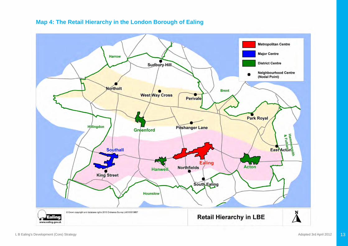
WestLondon isexpected toexperiencesignificantgrowth inconsumerexpenditurewhich could generate demand for up to 227,000 sq metres extra comparison goods floorspaceby2016.Ealingwillbenefitfromthesubstantialgrowthincapacitygainedthrough Crossrail. There is demand for up to 128,400 gross sq metres of new retail floorspace21 in the borough. National and regional guidance directs any new retail floorspacetotowncentresfirst.
The hierarchy of town centres is set out in the London Plan and include Ealing (a Metropolitan Centre), Southall (a Major Centre) and Acton, Greenford and Hanwell (District Centres). There are also a further 11 Neighbourhood Centres which provide an important focal point for the local community. Map 4 shows the distribution of retail provision across the borough (excluding local centres)22. To ensure the future viability and vitality of the centres the boundary of the Southall town centre has been reconfiguredtoincludethemajorretaildevelopmentonSouthallGasWorkssitewhilstat the same time excluding the area south of The Green. King Street has also been re-branded as a neighbourhood shopping centre serving Southall Green23. It is also proposed that designated shopping frontages in Hanwell are reduced, while improving the quality of all frontages in the town centre24. Detailed proposals are contained within the Development Management DPD.
The Development Strategy assumes the development of Crossrail and fiveCrossrail stations25. It also assumes other transport improvements as set out in the Mayor of London’s Transport Strategy which will increase the capacity and quality of east–west (radial) public transport to and from central London, and north–south transport linking the radial corridors and improving orbital movement in West London.
There will need to be further proposals to enhance north-south movement where this will facilitate regeneration. Measures will also be adopted that seek to promote healthy travel behaviour and reducing the need to travel. This includes avoiding unnecessary car trips, shopping locally and providing facilities within a certain distance etc. The council will also seek to widen the range of transport choices including improvements to public transport, cycle and pedestrian links. “Smarter travel” initiatives include for example the promotion of car clubs, car sharing, travel awareness and planning, eco driving and the use of electric vehicles. More details are provided in the council’s Local Implementation Plan.
The Development Strategy takes proper account of the need for environmental protection in appropriate localities both in growth corridors and in surrounding areas. This is related to the heritage value and character of the places in question. The strategy allows for development that will enable the area to be more sustainable (e.g. facilitating mixed tenure communities and accessible community facilities) while protecting and enhancing the character of a place.
It is expected that the design of all development will achieve high standards of sustainability and provide for climate change adaptation and mitigation. In addition new development will be expected to contribute to improving the quality of life in the borough through the reduction of noise pollution, protecting soundscape quality, reducing pollutant emissions and minimising public exposure to pollution. The Development Strategy should sustain busy and prosperous communities in both new and well-established urban localities.
The pattern of growth corridors and residential hinterlands overlays a pattern of green spacesandgreencorridors,and ‘greening’(e.g.addressingopenspacedeficiency)is a vital element of the strategy. Indeed, development is expected to yield resources to enhance and improve the quality of green and open space. Ealing’s reputation as a green borough will be improved as the Development Strategy is implemented and biodiversity will increase during this period. Open spaces also provide an oasis of calm andtranquillityforresidentsfromthebustleofcitylife,beneficialtohealth.Preservingthese quiet areas will protect this vital but overlooked amenity.
To further enhance the development of sustainable communities within the borough, Ealing Council carried out a heat mapping study in collaboration with the GLA and LDA to identify potential opportunities for decentralised energy network(s) within the borough26. It will help to meet the local and regional CO2 reduction targets as well as the Mayor of London’s target for 25% of London’s energy supply to come from

L B Ealing’s Development (Core) Strategy Adopted 3rd April 2012 15
decentralised sources by 2025. The results are available online via the London Heat Map tool27. Developed by the Mayor, this tool will help developers identify decentralised opportunities within Ealing borough and the wider London area.
By 2026, the borough should comprise a range of prosperous and cohesive communities - sustainable communities - developed on the basis of balanced growth, protection and greening. Key localities for growth will have been regenerated, and careful development management will have enhanced the character of all areas and green spaces across the borough.
Policy 1.2: Delivery of the Vision for Ealing 2026
A range of other local development framework documents and procedures will aid the delivery of the Development Strategy 2026. In particular, Ealing’s Development Strategy must also have regard to the Sustainable Community Strategy, produced by local strategic partners in the borough – i.e. the local authority (with its range of service responsibilities) other agencies involved in housing, health, education, employment, and community safety, and representatives of the local community and voluntary sector. The local strategic partners produce Local Area Action Plans to deliver their community priorities. Ealing Council has also produced a Statement of Community Involvement which sets out arrangements for involving the community in all parts of the Local Plan and in development management decisions28.
It is therefore vital for the local authority to work closely with business, local strategic partners, and to ensure that Ealing’s Development Strategy is in tune with the GLA’s evolving London Plan and the investment plans of the agencies that work alongside. It is essential to ensure that development has appropriate transport access and capacity. This may rely on improvements to underground and overground railways, road improvements, better buses, improvements to interchanges, creation and improvement of off-road walking and cycling routes and other measures to promote sustainable travel. In addition, the council’s own Local Implementation Plan is a key document.
Key policies that will help deliver Ealing Council’s spatial vision include:
1.2 (a) At least 50% of the housing developed in the borough up to 2026 will be affordablehousing,asdefinedintheLondonPlan,toachievemixedcommunitieswitha range of housing types across the borough and to meet need.
The Council’s Strategic Housing Market Assessment (SHMA, 2009) identifies asignificantshortfallofaffordablehomes,particularlyfamilyhomes.Contributionsto
affordable housing will be sought on all new developments comprising 10 units or more, with a tenure split of 60 percent provision of social/affordable rented accommodation and40percent intermediateprovision.TheBoroughHousingStrategyidentifiestherequirements for unit sizes across both tenures.
Contributions from private residential and mixed use schemes will be negotiated on the basis of seeking the maximum reasonable amount of affordable housing, taking accountof thespecificcircumstancesof thesite (includingfinancial viability)29. The starting point for negotiations will be a contribution of 50 percent affordable housing provided on-site.
1.2(b)Toapplyasequentialapproachtothelocationofnewofficedevelopmentwiththe primary focus being at Ealing town centre, a secondary focus at Park Royal and with some provision at Greenford. Employment land will be categorised for short, medium or long-term protection.
Anet increase inofficefloorspaceofup to90,000sqmetreswillbeencouraged inEalingtowncentretoensuretheofficemarkettheremaintainsasustainablecriticalmass. Park Royal and, to a lesser extent, Greenford will also see a net increase in officefloorspace.Whilstofficedevelopmentcanstillbesuitableinotherareas,therewill not be an overall net increase in other areas during the plan period30.
Managed release of employment sites will involve categorising employment sites into three broad categories:
• Long-termprotection–StrategicIndustrialLocations(SILs)andLocallySignificantIndustrial Sites (LSISs) comprise the borough’s strategic employment land and are the primary focus for general industrial and warehousing uses. Where appropriate, thesesitesmayalsoaccommodateofficedevelopment.Proactivemanagementof these areas will involve the limited transfer of 14 hectares to mixed use development over the plan period, coordinated through the Development Sites DPD and the Opportunity Area Planning Frameworks for Park Royal and Southall.
• Medium-termprotection–Smallersitesthatmayhaveconflictswithneighbouringuses.Toachievetheefficientuseoflandthesewillbeprotectedbycriteria-baseddevelopment management policies, allowing release to non-employment uses only if a lack of demand is demonstrated31.
• Short-term protection – Smaller sites that have either been lost to residential or so heavily diluted by other uses to no longer function effectively as employment land. Where appropriate, these will be allocated for alternative use through the Development Sites DPD.
L B Ealing’s Development (Core) Strategy Adopted 3rd April 201216
1.2(c)Tomaintainandincreasethesupplyofretailfloorspaceacrosstheboroughtomeetidentifieddemandandtosustainthevitalityandviabilityoftheretailhierarchy,byencouragingupto98,500sqm(gross)floorspaceofcomparisonretailfloorspaceandupto29,900sqm(gross)convenienceretailfloorspaceovertheplanperiod.
This is to be delivered through the area based policies 2.2(b) for Acton, 2.5(a) for Ealing Metropolitan Centre, 2.7(b) for Hanwell, 2.8(b) for Southall and 3.5(a) for Greenford32. ThedeliveryofanddemandforretailfloorspacewillbereviewedthroughtheAMRandupdated retail needs study respectively.
Furthermore, a review of the designated shopping frontages across the borough informs policies in the Development Management DPD, to provide convenient access to local shops from all residential areas.
1.2 (d) To make provision of appropriate physical, social and green infrastructure in the right locations and at the right time to support the levels of housing and employment growth to be delivered in Ealing33, and maintenance of an Infrastructure Delivery Plan and Schedule, indicating the phasing and funding of infrastructure development.
The council has produced an Infrastructure Delivery Plan which will help:
• To engage with infrastructure providers.• To deliver the right levels of infrastructure for growth.• To coordinate the provision of different types of infrastructure.• To direct the right level of employment growth and housing development in the
right place.• To bid for funding from other infrastructure agencies.
Related to this, a clear framework for negotiations on planning obligations is essential, including developers’ contributions towards requirements such as affordable housing, publictransport,schoolsetc,andmorespecificrequirementsthatarenecessaryforapproval of the development. There is more detail on the provision of infrastructure in Chapter Six and a separate supplementary planning document on The Community Infrastructure Levy, Planning Obligations and Legal Agreements.
1.2 (e) To support opportunities from Crossrail and High Speed 2 (HS2) working closely withCrossrailandHS2plannerstoensurethebenefitstotheborougharemaximised.Thesebenefitsincludeimprovedaccessibility,greaterpublictransportcapacityonthekey east/west radial corridor in the borough, and a major potential contribution to the regeneration and economic development in town centres and other sites along routes.
Crossrail34 will boost London’s rail capacity by 10% when it opens in 2019. Accessibility ofCentralLondon forpassengers fromEalingwouldbesignificantly improved,withjourney times from Southall to the West End, for example, being only 19 minutes35. The council are required to collect s106 contributions towards Crossrail on behalf of the GLA for developments of over 500 sq metres and within 1 kilometre of a Crossrail stationforofficesandretaildevelopment36.
Proposals for HS2 may offer a variety of opportunities for Ealing if the project goes ahead37. The route as currently proposed is likely to connect with Crossrail at Old Oak Common before traversing the Borough via the Chiltern Line alongside the Central Line LondonUnderground.HS2willinformlanduseplanswhentheschemeisfinalised.
1.2 (f) To ensure that future development achieves the highest standard of sustainable design and construction, including construction of the public realm, highways and other physical infrastructure. In this regard, the council will seek to reduce energy usage in buildings by requiring all development to demonstrate that it has minimised on-site carbondioxideemissionsbyusinglessenergythroughmaximisingenergyefficiency,supplyingenergyefficientlyusinglowcarbonheatingandcoolingsystemsandusingon-site renewable energy generation. The council will work with partners to promote and develop decentralised energy (DE) networks with a particular focus on those parts of the borough with the greatest potential for such networks.
Sustainable design and construction standards are set out in a separate energy evidence base report38. This sets minimum and advisory targets for reducing carbon dioxide emissions from all development, while setting requirements for establishing potential low carbon heat distribution networks. The council will work with partners to promote and develop decentralised energy (DE) networks with a particular focus on those parts of the borough with the greatest potential for such networks39. More detailed policies will be contained within the Development Management DPD.
L B Ealing’s Development (Core) Strategy Adopted 3rd April 2012 17
1.2 (g) To support the proactive conservation and enjoyment of Ealing’s heritage assets andtheirsignificance.InthisregardtheCouncilwillcontinuetoupdateandreviseitsevidence relating to the Borough’s designated and undesignated heritage assets. In particular, we will regularly review our Conservation Area Appraisals and Management Plans and review and update our Register of Local Heritage Assets to ensure that local assetsare identifiedand their significanceproperlyunderstoodduring theplanningprocess. In addition to promote heritage led regeneration, ensure a balanced approach to climate change measures, encourage greater understanding and access to heritage assets and reduce the number of assets at risk.
Inadditiontotheidentificationandreviewofevidencerelatingtosignificantheritageassets, the primary method for the delivery of Ealing’s heritage strategy will be area specificplanningdocumentssuchasSPDs/AAPs.Thelevelofdetailcontainedinthesedocuments is best suited to achieving a heritage-driven urban design programme of place shaping. Development management policies will ensure that proper consideration will be given to heritage matters when determining planning applications, and applications for listed building consent and conservation area consent.
1.2 (h) To support higher densities in areas of good public transport accessibility. Whilst proper regard shall be made to relevant London Plan policies, the council will take into account primarily the quality of the design, the location of the site and the need to provide a suitable housing mix. Tall buildings are acceptable where they contribute positively to the urban environment and do not cause harm to existing heritage assets. The quality of the design solution proposed, especially in relation to its context, and the accessibility of its location are the overriding considerations in the assessment of any proposeddevelopment.TallbuildingsmaybesuitableinspecifiedsiteswithinActon,EalingandSouthalltowncentres,gatewaystoParkRoyalandidentifieddevelopmentsitesonly.Specificlocationsidentifiedassuitablefortallbuildingswillbedesignatedthrough the Development Sites DPD and also through SPDs/AAPs. In these documents additionalworktorefinesuitablesitesandformationswithparticularregardtoheritageassets and their settings will be undertaken. Policies for the management of tall buildings will be developed in the Development Management DPD.
Whilst proper regard shall be made to relevant London Plan policies40 which support higher densities in areas of good public transport accessibility, the density matrix should not be applied mechanistically and the council will, in particular, take into account primarily the quality of the design, the context of the site and the need to provide a suitable housing mix. It is important to acknowledge that higher density housing does not automatically equate to a requirement for high-rise development. However, tall buildings can be appropriate and enhance townscape providing they are of high quality designandinsuitablelocations.Theidentificationofareassuitablefortallbuildings
will help to promote appropriate sites, deliver housing targets and direct such developments away from less appropriate/more sensitive locations (i.e. those considered vulnerable by virtue of their location, existing use or design. Policies for the management of tall buildings will be developed in the Development Management DPD.
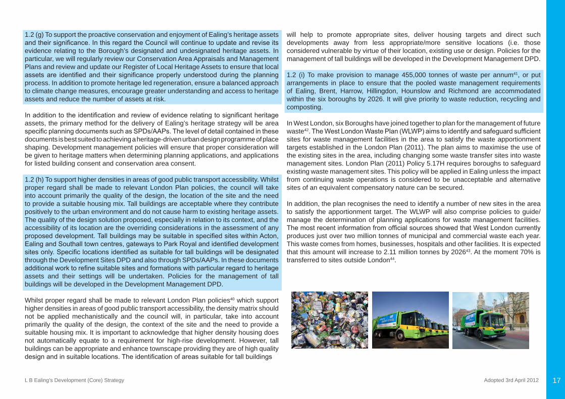
1.2 (i) To make provision to manage 455,000 tonnes of waste per annum41, or put arrangements in place to ensure that the pooled waste management requirements of Ealing, Brent, Harrow, Hillingdon, Hounslow and Richmond are accommodated within the six boroughs by 2026. It will give priority to waste reduction, recycling and composting.
In West London, six Boroughs have joined together to plan for the management of future waste42.TheWestLondonWastePlan(WLWP)aimstoidentifyandsafeguardsufficientsites for waste management facilities in the area to satisfy the waste apportionment targets established in the London Plan (2011). The plan aims to maximise the use of the existing sites in the area, including changing some waste transfer sites into waste management sites. London Plan (2011) Policy 5.17H requires boroughs to safeguard existing waste management sites. This policy will be applied in Ealing unless the impact from continuing waste operations is considered to be unacceptable and alternative sites of an equivalent compensatory nature can be secured.
In addition, the plan recognises the need to identify a number of new sites in the area to satisfy the apportionment target. The WLWP will also comprise policies to guide/manage the determination of planning applications for waste management facilities. ThemostrecentinformationfromofficialsourcesshowedthatWestLondoncurrentlyproduces just over two million tonnes of municipal and commercial waste each year. This waste comes from homes, businesses, hospitals and other facilities. It is expected that this amount will increase to 2.11 million tonnes by 202643. At the moment 70% is transferred to sites outside London44.
L B Ealing’s Development (Core) Strategy Adopted 3rd April 201218
1.2 (j) Note - This policy is intentionally blank.
1.2 (k) To promote and install a network of electric vehicle charging points across the borough.
The Mayor of London also proposes to promote increased and more widespread use of electric vehicles, for example, by securing charging points in car parks through parking standards or in some cases, on-street where appropriate. Ealing’s Electric Vehicle Charging Points (EVCP) Policy supports the Mayor’s plan to deliver a network ofchargingpointsacrossLondonby2015.Workshascommencedtoinstallthefirsttranche of EVCPs which are planned to be ready in 2011 and the Local Implementation Plan will set out the timetable of any future instalments. The council will promote further schemes to broaden this network over the plan period.
1.2 (l) Whilst recognising the need to contribute towards the supply of land won aggregates in West London, the council will resist the extraction of mineral aggregates on sites where this would have an adverse impact on the local environment and amenity. The council will also seek to minimise the movement of aggregates by road, maximise the movement of aggregates via rail or the canal network and will encourage aggregates recycling at depot sites in Ealing – including at Horn Lane and Park Royal.
Although Ealing is identified as a borough with remaining aggregate resources inLondon, the location of these reserves in sensitive localities means that it is highly unlikely that Ealing will be able to contribute to meeting the supply of land won aggregates in West London. A number of sites in the Osterley area of the borough were identifiedashavingun-worked reserves,although it isproposed thatnoneofthese sites be taken forward for mineral workings because of their existing open space status, their heritage value, and their strategic role for sports/recreation. The council will however continue to ensure that the distribution of aggregates throughout the borough is done so through the most sustainable methods, and with minimal impact on the environment and the amenity of its residents.
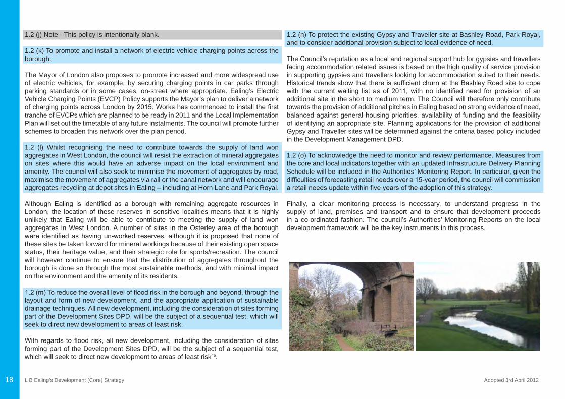
1.2(m)Toreducetheoverallleveloffloodriskintheboroughandbeyond,throughthelayout and form of new development, and the appropriate application of sustainable drainage techniques. All new development, including the consideration of sites forming part of the Development Sites DPD, will be the subject of a sequential test, which will seek to direct new development to areas of least risk.
Withregards tofloodrisk,allnewdevelopment, including theconsiderationofsitesforming part of the Development Sites DPD, will be the subject of a sequential test, which will seek to direct new development to areas of least risk45.
1.2 (n) To protect the existing Gypsy and Traveller site at Bashley Road, Park Royal, and to consider additional provision subject to local evidence of need.
The Council’s reputation as a local and regional support hub for gypsies and travellers facing accommodation related issues is based on the high quality of service provision in supporting gypsies and travellers looking for accommodation suited to their needs. HistoricaltrendsshowthatthereissufficientchurnattheBashleyRoadsitetocopewith the current waiting list as of 2011, with no identified need for provision of anadditional site in the short to medium term. The Council will therefore only contribute towards the provision of additional pitches in Ealing based on strong evidence of need, balanced against general housing priorities, availability of funding and the feasibility of identifying an appropriate site. Planning applications for the provision of additional Gypsy and Traveller sites will be determined against the criteria based policy included in the Development Management DPD.
1.2 (o) To acknowledge the need to monitor and review performance. Measures from the core and local indicators together with an updated Infrastructure Delivery Planning Schedule will be included in the Authorities’ Monitoring Report. In particular, given the difficultiesofforecastingretailneedsovera15-yearperiod,thecouncilwillcommissionaretailneedsupdatewithinfiveyearsoftheadoptionofthisstrategy.
Finally, a clear monitoring process is necessary, to understand progress in the supply of land, premises and transport and to ensure that development proceeds in a co-ordinated fashion. The council’s Authorities’ Monitoring Reports on the local development framework will be the key instruments in this process.
L B Ealing’s Development (Core) Strategy Adopted 3rd April 2012 19
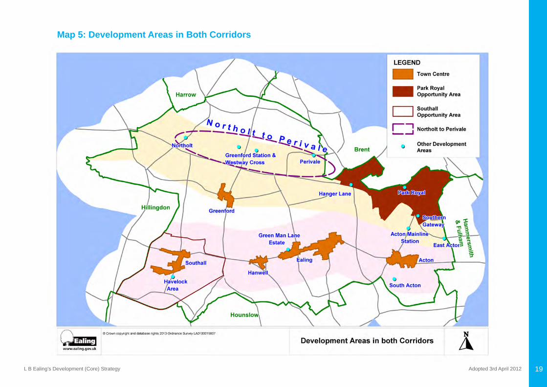
Map 5: Development Areas in Both Corridors
L B Ealing’s Development (Core) Strategy Adopted 3rd April 201220
CHAPTER 2: DEVELOPMENT IN THE UXBRIDGE ROAD / CROSSRAIL CORRIDOR
L B Ealing’s Development (Core) Strategy Adopted 3rd April 2012 21
CHAPTER 2: DEVELOPMENT IN THE UXBRIDGE ROAD / CROSSRAIL CORRIDORThe Uxbridge Road (A4020) is one of West London’s major roads. It passes through four town centres in the borough as well as large residential districts. It is well served with bus routes and provides several transport connections for commuters with London Underground and rail stations situated either on it or within walking distance. It is also the main east-west cycle route in the borough.
The main intercity railway line which traverses the borough, runs parallel to the Uxbridge Road in central Ealing (Ealing Broadway station is effectively adjacent to the Uxbridge Road), and runs north-eastward through Acton to Paddington, and south-westward through Southall to Slough, Heathrow, Reading, the West of England and South Wales. This line currently provides direct and fast services, and is to be upgraded to provide Crossrail services from Heathrow to the West End and the City of London.
Crossrail will be a substantial addition to Ealing’s transport infrastructure. It will not only underpin physical, economic and social change in this corridor but will fundamentally alter the overall demand for new development and its spatial distribution at each of the fiveproposedCrossrailstationsinEaling46.
Policy 2.1 Realising the potential of the Uxbridge Road/Crossrail Corridor(a) By 2026, seek the development of over 9,00047 extra housing units (74 per cent of the borough’s total net increase in housing development).(b) To supplement the introduction of Crossrail, seek improvements in bus services, capacity and servicing arrangements along the Uxbridge Road / Crossrail corridor.(c) To achieve an appropriate balance in localities within the corridor between regeneration objectives and the conservation of the built and natural environment.(d) To improve the conditions for cycling on the corridor, and development of four-cycle hubs in Southall, Hanwell, Ealing and Acton with improved north-south cycle access48. (e) To establish a decentralised energy network(s) within Ealing Town Centre with a potential connection to the Green Man Lane Estate and further explore opportunities for creating a district energy network for other areas with high/medium potential in the corridor.(f) To work with Thames Water and other stakeholders to support the timely implementation of the Thames Tideway Sewer Tunnel project, including connection of thecombinedseweroutflowsintheborough.
Thecorridorisdefinedwithanapproximateboundaryofonekilometreeithersideofthe Uxbridge Road (roughly a 12 minute walk or four minute cycle ride). It includes Acton, Ealing, Hanwell and Southall town centres, several municipal housing estates andfiveCrossrailstationsatActonMainline,EalingBroadway,WestEaling,Hanwelland Southall – with the greatest development potential at Ealing and Southall. The Uxbridge Road / Crossrail Corridor have high accessibility by public transport49 and the whole area is attractive to development. Within the corridor, the Development Strategy differentiates between efforts to promote regeneration and to conserve the built and natural environment.
TheUxbridgeRoad /Crossrailcorridorhasasignificant role toplay inestablishingdecentralised energy network(s)50. Ealing Town Centre, Green Man Lane Estate, South Acton and Southall town centre all have high potential for developing such networks. Further information on each of the areas identified for potentially developing a lowcarbon heat network is provided under the relevant policy section below and more detail is provided in an evidence base background document. The Ealing Hospital Areahasalsobeenidentifiedbytheheatmappingstudytohaveamediumpotentialfor developing a decentralised energy network. The hospital site is adjacent to an extensive number of residential properties with a light industrial estate to the west. Althoughtherearenotcurrentlyanyproposalsforthespecificsite,thehospitalwouldform an ideal anchor load for any development in this area.
The Thames Tunnel project will help to reduce and limit pollution from the sewerage system for the whole of London. The Council will work with Thames Water and other stakeholders to identify any work site needs within the borough and resolve local matters, for example design, construction, traffic management, remediation andmitigation51.
CHAPTER 2: DEVELOPMENT IN THE UXBRIDGE ROAD / CROSSRAIL CORRIDOR
L B Ealing’s Development (Core) Strategy Adopted 3rd April 201222
The following policies relate to different parts of the Uxbridge Road / Crossrail corridor and Map 5 above shows those areas referred to:
Policy 2.2: Revitalise Acton Town Centre(a) To regenerate Acton Town Centre leading to the provision of 55052 additional mixed tenure homes and allow residential and other uses on Uxbridge Road, east of the old town hall.(b)Developmentofupto10-12,000grosssqmofretailfloorspace53, additional food and drink outlets, a new swimming pool and improved cultural and community facilities at prime sites, including Morrisons, The Oaks, Beechworth House and the Town Hall site whilst drawing on the high quality of the historic environment.(c) To improve the public domain, including the market square at The Mount, King Street,HighStreetandChurchfieldRoadandensurethatdesignhasproperregardto the conservation area and listed building designations throughout the town centre.(d) To make provision for improved public transport, pedestrian and cycling and urban realm enhancements including improvement of pedestrian and cycle access to and from South Acton estate and the retention of existing levels of town centre parking in Acton. (e) To improve open spaces and habitats including the provision of new children’s play space in association with new residential development, enhanced links to Acton Park and play facilities in Woodlands Park.
ThesepoliciesreflecttheopportunitiesidentifiedintheActonTownCentreDevelopmentFramework(2008),aswellastherequirementsidentifiedbytransportplanners,healthservices, leisure services and housing officerswithin the council. They also reflectviews expressed in the various Local Plan consultation exercises, the Acton Town Centre consultation in the summer of 2008 and a Supplementary Planning Document for Acton Town Hall and environs that was consulted upon in 2010.
Policy 2.3: Regenerate South Acton(a) To regenerate South Acton to achieve an attractive and popular residential locality, integrating the municipal and owner occupied residential areas and creating easy pedestrian access to Acton town centre. This will lead to the provision of 86254 additional mixed tenure homes.(b) To further explore opportunities for creating a district energy network.
South Acton has been a regeneration priority for the council for some time, due to the poor condition of the housing and blocks, poor layout, lack of cohesion on the estate and disintegration with the surrounding locality, including the High Street, and its status as a largely mono-tenure estate and associated stigma. It also has low levels of resident satisfaction with the estate both as a place to live and with the management of homes, and also performs poorly on socio-economic measures.
The council’s Estates Review Report55 confirmed that SouthActon is in need of aholistic approach to the regeneration of the estate to create a new neighbourhood and tackle to problems above. Regeneration will also integrate the area with Acton town centre and contribute to the economic regeneration of the area, while increasing the supply of private and affordable homes.
TheSouthActonAreaandSouthActonEstatehavebeenidentified,throughtheheatmapping study, as having a high potential for establishing a decentralised energy network.More specifically, the SouthActon Estate can initiate an energy network,which is a substantial development with a total of 2,662 residential dwellings. Other developments in the vicinity which can act as catalysts are the Oaks Shopping Centre, Bollo Lane and Acton Town Hall Complex. Further information on establishing a district-heating network within this area can be found in the evidence base document56.
Policy 2.4: Regenerate the Acton Main Line station area(a)TopermitmodificationstotheActonMainLinestationtocaterforCrossrailservicestoprovide additional capacity at the station and improved passenger facilities. In addition, improved bus links to Park Royal, Acton Town and South Acton will be explored along with enhanced interchange facilities and key access routes to the station. (b) To promote a mixed-use regeneration of the area to the south of the station.(c) To retain the aggregates and cement works to the north of the station, as this is an important railhead for the distribution of construction materials in West London. Opportunities will be sought to reduce further the environmental impact of the industrial activities on the surrounding residential areas.
These policies seek to explore the development opportunities surrounding the station in association with the refurbished Crossrail station at Acton Main Line. In so doing this will create more of a sense of place at or near the station and help maximise the use and attractiveness of Crossrail for Acton residents. The policies also seek to consolidate and maximise existing freight use for aggregates and waste. There is also potential for improved bus interchange facilities57.
L B Ealing’s Development (Core) Strategy Adopted 3rd April 2012
Policy 2.5: Revitalise Ealing Metropolitan Town Centre(a) To regenerate Ealing Town Centre and develop a vibrant and diverse range of newhomes,shops,offices,sportandleisureandotherpublicfacilitiesleadingtotheprovision of 2,58058additionalmixedtenurehomesupto90,000sqmincreasedofficespaceprovidingupto6,500potentialofficejobs59, and up to 50,000 sqm of gross retailfloorspace60.DevelopmentsiteswillbespecifiedintheDevelopmentSitesDPD and will include:
• Dickens Yard; • Arcadia; • Lamertons;• Ealing Broadway Shopping Centre; and, • theofficequarteralongtheUxbridgeRoad(betweenEalingBroadwayandWest
Ealing).
(b)Todefineandreinforcethedistinctivecharacterandrolesofdifferentpartsofthetown centre and assess the best distribution of development to match the needs of the catchment population. The metropolitan centre comprises different quarters with different roles and characteristics including:
• Ealing Broadway – a high quality retail destination; • Ealing Green – a cultural and community quarter with Pitzhanger Manor, the cinema,thefilmstudiosandimportantuniversityfunctions;
• Uxbridge Road between Ealing Broadway and West Ealing – high quality head officesandancillaryfunctions;and
• West Ealing – value and convenience goods and a wide range of eating-places.
(c) To strengthen and extend the retail core of the town centre leading to an increase in the quantum, quality and diversity of the existing retail/leisure offer and sustain the town centre’s position in the retail hierarchy.(d)Toretainandattractnewbusinessdevelopmentbyretainingasufficientsupplyofpremises and encouraging sustainable, commercial development and improvements toaccessandamenity,inparticular,intheofficequarter.(e) To protect and enhance the quality of the existing townscape and historic character including:
• to enhance historic buildings and frontages that contributes to the character and appearance of the town centre including removing/mitigating aspects of the built form that have a negative impact;
• to introduce new town squares and public spaces; • to improve permeability with the introduction of a high quality pedestrian-orientated
retail circuit linking Ealing Broadway and the Haven Green transport interchange with the various retail destinations throughout this part of the town centre;
• to use the form and height of new development to create a coherent townscape across the different quarters of the town centre, but recognise that taller elements that respond to surrounding scales and features are possible in defined keylocations;
• to introduce high quality buildings that are well designed, environmentally sustainable and which meet the needs of modern occupiers, in particular, to provide landmark buildings in gateway locations; and,
• to develop a “boulevard” along the Uxbridge Road with an increase in the number ofstreettrees,otherplantingandactivegroundfloorfrontages.
(f) To modify Ealing Broadway and West Ealing stations to cater for Crossrail services including enhanced bus interchange facilities (at Ealing Broadway) and facilities for cycling and walking to and from the town centre, improvements to the public realm including enhancement of the streetscape, upgrading the quality of existing open spaces in the vicinity of the town centre, improved signage, street furniture, lighting and public art. (g) To provide a comprehensive range of cultural, heritage, social, sport and leisure facilities, including:
• to create a new health centre;• to make improvements to the Questors Theatre (in conjunction with development
of a neighbouring site with an Uxbridge Road frontage);• to refurbish Ealing Town Hall and Pitzhanger Manor to provide a new landmark
focus for civic, community and cultural activities;• to provide for a boutique hotel;• to provide for a cinema; and• to encourage the promotion of additional restaurants and cafés.
(h) To establish a decentralised energy network(s) within Ealing Town Centre with a potential connection to Green Man Lane Estate.
23
L B Ealing’s Development (Core) Strategy Adopted 3rd April 201224
In September 2010, the council published “Ealing Metropolitan Town Centre Spatial Development Framework”. Produced by a team of consultants, led by Tibbalds Planning and Urban Design, it explored the potential of Ealing Town Centre and refreshed the May 2008 version61. The strategy will help guide and inform the development of the town centre over the plan period and the council intends to use it as the basis of a separate supplementary planning document that will be adopted in due course.
In August 2010, a report62 was produced which provides options for enhancing the interchange at EalingBroadway.Thisworkwill help the council put forward a firstphase Major Scheme bid to Transport for London for enhancing the interchange.
The heat mapping study, undertaken through a collaborative project between Ealing CouncilandGLA/LDA,identifiedEalingTownCentreashavingthehighestpotentialfor developing a low carbon distribution network63. A network in this area could be initiated by two new developments: Arcadia and Dickens Yard. Those are large mixed-use development with a proposed community heating schemes. In the future, this network can encompass the Ealing Council building and other premises in the vicinity. Further information can be found in the evidence base background document.
Policy 2.6: Regenerate the Green Man Lane Estate(a) To regenerate the Green Man Lane Estate and achieve an attractive and popular residential locality, stitching together the municipal and owner occupied residential areas and integrating the new development into West Ealing Broadway. This will lead to the provision of 242 additional mixed tenure homes.(b) To further explore opportunities for creating a district energy network.
GreenManLanewasidentifiedasinneedofregenerationin2005.Workwithresidentsidentifiedthattheyfeltunsafeontheestate,manypeoplewereovercrowded,crimeandsecuritywerekeyissues,andthemajorityofresidentsweredissatisfiedwiththequality, condition and management of the homes and the estate generally as a place to live. In addition, there were fundamental design and construction issues with Green Man Lane.
Comprehensive redevelopment was confirmed as the most appropriate solutioninJanuary2008, toaddress the issues identifiedaboveand increase thesupplyofprivate and affordable housing, while contributing to the regeneration of West Ealing Broadway. A Master Plan for the redevelopment was approved in 2010, and in 2011
the Council secured the required Compulsory Purchase Orders and put in place a legalagreementanddeliverypartnership.ThefirstoccupantsareexpectedtomoveinSpring 2012, with full completion of the redevelopment programme completed within fivetosevenyears.
Together with Ealing Metropolitan Town Centre, Green Man Lane is considered is considered to have the second highest potential for developing a district energy network. The energy centre at the Green Man Lane redevelopment has been designed to allow for future connection to any decentralised energy network, and any developments that come forward in close proximity to Green Man lane will also have to demonstrate the same. Further information on how a potential network could be established can be found in the borough’s Heat Map study64.
Policy 2.7: Enhance & Consolidate Hanwell Town Centre(a) To enhance and consolidate Hanwell Town Centre leading to the provision of 10965
additional mixed tenure homes(b) To enhance all heritage assets that contributes to the character and appearance of the town centre. (c) To promote development of up to 3,300-5,600 gross sqm retail66 to meet the retail needs of the Hanwell area and to consolidate designated shopping frontages in the town centre.(d) To make station improvements, including opening southern access for easier pedestrian access to The Broadway and to enable Crossrail, provide improved facilities for cyclists, better bus links to key destinations such as Ealing Hospital and seek improvements in accessibility.(e) To promote improvements in the street scene, to local green space and to private forecourts and parking provision. These policies were identified as part of an extensive consultation process, whichincluded a public meeting, a household survey and a business survey. The consultation processidentifiedanumberofprioritiesforthetowncentreregenerationprogramme.These included the need to improve the retail offer in Hanwell, improvements to local green spaces, improved car parking provision, maintaining the distinct character of the town centre, improvements to the street scene and to develop a vision for Hanwell. The policies will be complemented by improved public transport with the arrival of Crossrail.
L B Ealing’s Development (Core) Strategy Adopted 3rd April 2012 25
Policy 2.8: Revitalise Southall Town Centre(a) To regenerate Southall Town Centre leading to the provision of up to 3,32067 additional mixed tenure homes.(b)Tore-configuretheboundariesofSouthallTownCentretoincorporatethemajorretail development on Southall Gas Works site whilst at the same time excluding the area south of The Green. The centre will provide a high quality mainstream retail offer to complement the Asian offer elsewhere within the centre including the development ofupto24-32,000sqmofgrossretailfloorspace69, provision of town centre parking on the Southall Gas Works site and a package of bus improvement measures so that visitors can visit other parts of the centre. King Street has been re-branded as a neighbourhood shopping centre serving Southall Green.(c) To promote The Broadway, South Road and The Green as an ‘Asian Gateway’ with a strong cultural offer for banqueting, conferencing, festivals and performing arts, along with Asian retailing and restaurants. (d) To modify Southall station to cater for Crossrail services to provide increased capacity, improved facilities, enhanced station integration and interchange, to widen the South Road bridge to facilitate bus movement and a high quality pedestrian environment and to permit high densities appropriate for development in the vicinity subject to improvement of physical infrastructure in the station area. (e) To provide additional community facilities – including a new community hub comprising a library and health centre, extended schools facilities and a new two or three form entry primary school with community access.(f) To build up to 2,620 new homes on the Southall Gas Works site by 2026 (out of a planned total of 3,750) with a balance of market, affordable housing and family housingwithbiggerunitsizestoreflecthouseholdcharacteristicsinSouthallandtheborough’s housing needs, to provide a range of supporting physical, social and green infrastructure and to implement a Low Emission Strategy. (g) To make junction and wider improvements along the South Road corridor to improve capacity and journey time reliability.(h) To further explore opportunities for creating a district energy network.(i) To cater for and enhance Southall’s heritage assets through proposals such as the refurbishment of the Manor House, Southall Town Hall and the Himalaya cinema to accommodate a range of retail and community uses whilst establishing linkages to wider regeneration proposals affecting the town centre.
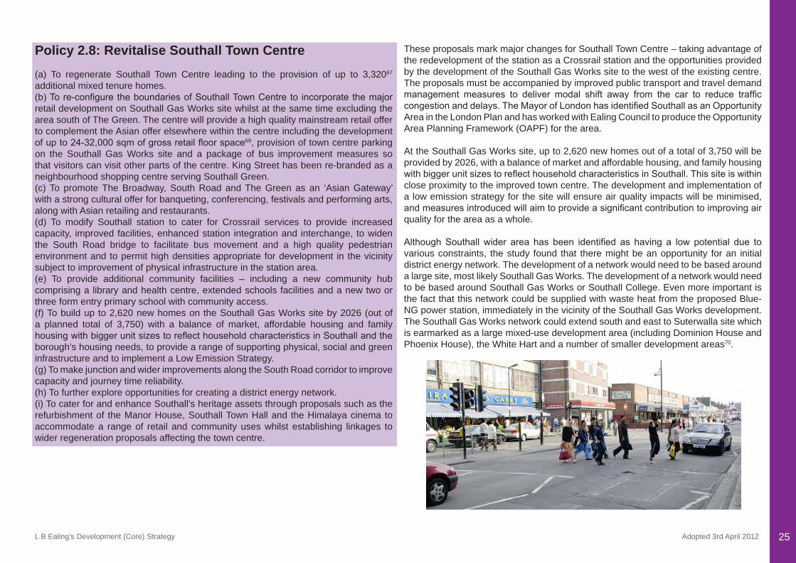
These proposals mark major changes for Southall Town Centre – taking advantage of the redevelopment of the station as a Crossrail station and the opportunities provided by the development of the Southall Gas Works site to the west of the existing centre. The proposals must be accompanied by improved public transport and travel demand management measures to deliver modal shift away from the car to reduce trafficcongestionanddelays.TheMayorofLondonhasidentifiedSouthallasanOpportunityArea in the London Plan and has worked with Ealing Council to produce the Opportunity Area Planning Framework (OAPF) for the area.
At the Southall Gas Works site, up to 2,620 new homes out of a total of 3,750 will be provided by 2026, with a balance of market and affordable housing, and family housing withbiggerunitsizestoreflecthouseholdcharacteristicsinSouthall.Thissiteiswithinclose proximity to the improved town centre. The development and implementation of a low emission strategy for the site will ensure air quality impacts will be minimised, andmeasuresintroducedwillaimtoprovideasignificantcontributiontoimprovingairquality for the area as a whole.
AlthoughSouthall wider area has been identified as having a low potential due tovarious constraints, the study found that there might be an opportunity for an initial district energy network. The development of a network would need to be based around a large site, most likely Southall Gas Works. The development of a network would need to be based around Southall Gas Works or Southall College. Even more important is the fact that this network could be supplied with waste heat from the proposed Blue-NG power station, immediately in the vicinity of the Southall Gas Works development. The Southall Gas Works network could extend south and east to Suterwalla site which is earmarked as a large mixed-use development area (including Dominion House and Phoenix House), the White Hart and a number of smaller development areas70.
L B Ealing’s Development (Core) Strategy Adopted 3rd April 201226
Policy 2.9: Regenerate the Havelock Area(a) To redevelop and refurbish the Havelock Estate to achieve an attractive and popular residential locality, with improved public transport accessibility and easy pedestrian access to Southall Town Centre. This will lead to the provision of 19371 additional mixed tenure homes.(b) To improve the overall quality of Southall’s green space, upgrade the security of the existing park between railway and canal with cycle access at all entrances and introduce new residential and canal development with residential moorings, workshops and facilities. The Metropolitan Open Land and Public Open Space designations at Glade Lane will all be retained.(c) To regenerate the Middlesex Business Centre and environs with a mixed employment and other uses, possibly including housing provision but retaining job potential equivalent to the existing provision.(d) To improve the towpath, including creating a bypass for the steep ramp by the lock for cycles and wheelchairs.
The Havelock area is beyond the catchment area for the railway station and is relatively isolated from public transport and pedestrian routes to the town centre. It is proposed that bus routes to Southall station and Southall Gas Works sites are created and that walking and cycling routes are improved.
Much of the housing stock in the Havelock Estate is poorly maintained and in need of improvement. The estate lacks the facilities that an estate of this size would usually have. There is only one access route into and out of the estate and this contributes to a range of problems for the residents.
The release of Middlesex Business Centre from its SIL designation will be managed through the Southall Opportunity Area Planning Framework (OAPF).
Therewillbeanincreasingpublicopenspacedeficiencyovertheplanperiodwhichwill be addressed through the forthcoming Southall OAPF. Measures will include improvements to quality, quantity and accessibility of provision.
Policy 2.10: Residential NeighbourhoodsTo protect the residential character of much of the wider Uxbridge Road Corridor whilst providing for further residential development, including affordable housing, largely at identifiedlocations,andincludingproposalsfortheregenerationofmunicipalhousingestates.
This policy recognises the existence of distinctive residential neighbourhoods. Some of these have a particular character that is valued by local residents. Others need improvement, and may be areas where residents face deprivation. This policy is to enhance these residential neighbourhoods, protecting their character wherever appropriate, and to encourage development that will ensure that the urban fabric is properlymaintained, that they remainfit forpurpose (withsufficientschools,healthfacilities etc), and that, through the development process, the communities in the Uxbridge Road Corridor all contain a mix of tenures and unit types and sizes by the end of the plan period.
L B Ealing’s Development (Core) Strategy Adopted 3rd April 2012 27
CHAPTER 3:DEVELOPMENT IN THE
A40 CORRIDOR & PARK ROYAL
L B Ealing’s Development (Core) Strategy Adopted 3rd April 201228
CHAPTER 3: DEVELOPMENT IN THE A40 CORRIDOR & PARK ROYALThe landmarks along the A40 indicate the mix of uses that make the Corridor distinctive. These vary from industrial heritage buildings like the Aladdin Tower and the Hoover Building, to the woods of Horsenden Hill, Northolt Church, and the newer Northala Fields landscaped mounds. The A40 and Central Line gave rise to extensive twentieth century industrial and residential development, and there are now problems of ageing industrialstock,peripheralhousingestates,andtrafficcongestion.
In the north-east of the borough is Park Royal, Europe’s largest industrial business park. It covers 650 acres and is well related both to Central London and to Heathrow Airport. Park Royal sustains a substantial proportion of London’s industry and commerce, and businesses based here provide important linkages which support a range of other employment locations across the borough.
The following spatial policies set out the strategic framework for promoting and managing development along the A40 Corridor and Map 5 above shows those areas referred to:
Policy 3.1: Realising the potential of the A40 Corridor & Park Royal(a) By 2026, seek the development of over 3,00072 additional homes (25 per cent of the boroughs’ net gain in housing).(b) To achieve an appropriate balance in localities within the corridor between regeneration objectives and the conservation of the built and natural environment.(c) To enhance greening opportunities along the A40 corridor, develop two cycle hubs in Greenford and Northolt73 and create new cycle/pedestrian routes parallel to the A40 but separated by trees and shrubs where opportunities exist (e.g. Pitshanger, Perivale, Acton).(d) To further explore opportunities for creating a district energy network at Southern Gateway and Greenford town centre.(e) To further explore opportunities to reduce exposure to air and noise pollution for existing residents.
The A40 Corridor straddles the A40 and the Grand Union Canal, and reaches north to the Central Line and south to the Ruislip Road. It includes the Park Royal Industrial Estate and Greenford town centre. The development proposals indicated above are all approximately within one kilometre of either side of the A40 (roughly a 12 minute walk or four minute cycle ride).
The corridor provides employment areas from Park Royal in the east to Northolt in the west. There is an emphasis on maintaining a portfolio of business land74, and modernising business premises, infrastructure and amenities. The corridor interweaves residential and green space with business land, and includes Greenford Town Centre as well as other neighbourhood shopping centres and transport interchanges. It also includes the travellers’ site at Bashley Road, north of Gypsy Corner in Park Royal. The Development Strategy differentiates between efforts to promote development and to conserve the built and natural environment.
The area located within Farrier Road/ Union Road, which falls within the A40 corridor, hasbeenidentifiedintheheatmappingstudyashavingpotentialforadecentralisedenergy network which can be manageable and cost-effective due to its scale. A number ofcouncil-ownedestatesaredenselylocatedinthisareathatbenefitfromcommunalboiler systems. This presents an ideal opportunity to link these together. Properties nearby including the local school could also be drawn into a small network. Further information can be found in the evidence base document75.
The following policies relate to different parts of the A40 Corridor & Park Royal:
Policy 3.2: From Northolt to Perivale, Safeguard Employment Land Along the A40 Corridor(a) To retain and attract new business development along the A40 Corridor by maintaining a sufficient supply of industrial land, and encouraging sustainable,commercial development and improvements to access and amenity.(b) To promote and enhance the use of the Grand Union Canal for freight transport, walking and cycle access to employment, including creation of additional towpath access points.
TheLondonPlanspecifies the retentionof ‘strategic industrial locations’ inNortholt- Greenford – Perivale, comprising industrial areas developed in the inter-war years. These areas continue to meet demands for business premises and employment opportunities in Ealing and outer West London.
L B Ealing’s Development (Core) Strategy Adopted 3rd April 2012 29
More generally, opportunities will be sought to enable goods transport to use the Grand Union Canal, which crosses these strategic industrial locations, as well as to enhance the canal as a conservation area and green corridor (see Chapter 5). Proposals to improve public transport links from the residential hinterlands to these employment opportunities are indicated in Chapters 4 and 6.
Policy 3.3: Promote Business & Industry in Park Royal(a) To retain business and industry throughout the Park Royal industrial estate, encouraging sustainable, economic development and improvements to access and amenity.(b) To promote Park Royal as a centre for green industry in the borough.(c) To improve cycle access to employment, including one-way exemptions, off-road routes and better towpath access.(d) To promote the use of the Grand Union Canal for freight transport.
Park Royal is the closest industrial and warehousing area to central London and the West End and also serves Heathrow. It houses nearly 2,000 businesses – more than any other industrial estate in Europe – providing around 40,000 jobs. Over the years it has maintained its position as a preferred location for businesses through continued private sector investment. Now it is home to the growing economic clusters of food and drink,transportandlogisticsandTVandfilmthatalsocapitaliseonthestronglinkagesto Heathrow Airport.
Park Royal spans Brent, Ealing (which has the largest part) and Hammersmith and Fulham boroughs. It is an ‘opportunity area’ in the London Plan, and the Mayor has produced a planning framework for the area76. These policies are consistent with these wider contextual documents.
Initiatives aimed at facilitating business and employment, while tackling climate change will be encouraged along with projects to establish Park Royal as a centre for high-tech green industries. The borough’s commitment to tackling climate change through new development means that Ealing is well placed to accommodate expansion of the green business sector, with particular opportunities in the manufacture of renewable energy equipment, low carbon technologies, other sustainable solutions, and waste management. In line with the policies of the London Plan (2011), the council will promote a ‘Green Enterprise District’ in Park Royal.
The best standards of design will improve the public realm, protect the residential enclaves in ParkRoyal, and deliver flexible premises thatmeet current and futureneeds. New entrepreneurial activity will be supported by centres of excellence and managed affordable workspace.
The borough will work with stakeholders to further investigate options for an interchange station serving both the Central and Piccadilly Underground Lines at Park Royal, to serve residents, employees and visitors in this area. The borough will also work with stakeholders to investigate options and for a further rail interchange station in the east of Park Royal, linking London Underground and railway lines, and meeting future business demand for more intensive employment uses in Park Royal.
Trafficmovement throughParkRoyal is a key challenge, and it is vital that publictransport serving the area is improved. A potential opportunity is the development of an interchange station linking Park Royal Piccadilly line station with the Central Line, adjacent to the A40. Another potential project is the consideration of a further interchange station in the east of Park Royal. This idea was raised in the Park Royal Opportunity Area-Planning Framework and would open up parts of Park Royal to more intensiveemploymentdevelopment.Therearealsospecificpoliciesbelowinrespectof Southern Gateway (Gypsy Corner), the Park Royal neighbourhood centre (junction of Park Royal Road and Coronation Road), the travellers’ site at Bashley Road, and (in chapter 5) Metropolitan Open Land at Twyford Abbey77.
Policy 3.4: Southern Gateway, Park Royal (a)TocreateanimprovedsoutherngatewaytoParkRoyal,withefficientmovementto and from the strategic industrial location and a clear, safe relationship and routes between the tube, the buses, heavy goods vehicles and the surrounding area and animportantfocalpointforbusinessinitsownright,withupto2,000potentialofficejobs78. This could lead to 1,50079 residential units in a place where residents choose to live, because it is convenient and has good facilities and a decent environment. (b) To redevelop North Acton station and environs with a mix of commercial development and in a setting at Victoria Road with shops, restaurants, cafés and leisure to support the gateway and the wider Park Royal area, and improved bus, cycle and pedestrian facilities and access routes. (c) To create a network of green space, with safe, attractive footpaths and featuring at least two new public open spaces. (d) To further explore opportunities for creating a district energy network.
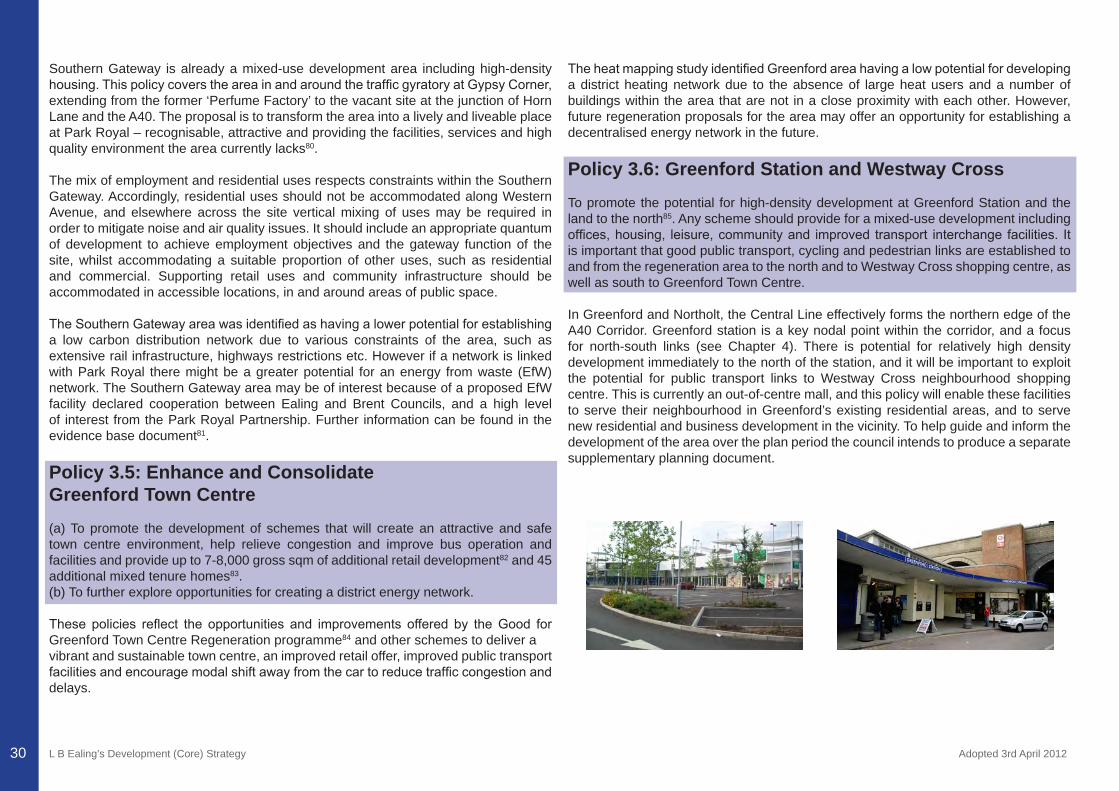
L B Ealing’s Development (Core) Strategy Adopted 3rd April 201230
Southern Gateway is already a mixed-use development area including high-density housing.ThispolicycoverstheareainandaroundthetrafficgyratoryatGypsyCorner,extending from the former ‘Perfume Factory’ to the vacant site at the junction of Horn Lane and the A40. The proposal is to transform the area into a lively and liveable place at Park Royal – recognisable, attractive and providing the facilities, services and high quality environment the area currently lacks80.
The mix of employment and residential uses respects constraints within the Southern Gateway. Accordingly, residential uses should not be accommodated along Western Avenue, and elsewhere across the site vertical mixing of uses may be required in order to mitigate noise and air quality issues. It should include an appropriate quantum of development to achieve employment objectives and the gateway function of the site, whilst accommodating a suitable proportion of other uses, such as residential and commercial. Supporting retail uses and community infrastructure should be accommodated in accessible locations, in and around areas of public space.
TheSouthernGatewayareawasidentifiedashavingalowerpotentialforestablishinga low carbon distribution network due to various constraints of the area, such as extensive rail infrastructure, highways restrictions etc. However if a network is linked with Park Royal there might be a greater potential for an energy from waste (EfW) network. The Southern Gateway area may be of interest because of a proposed EfW facility declared cooperation between Ealing and Brent Councils, and a high level of interest from the Park Royal Partnership. Further information can be found in the evidence base document81.
Policy 3.5: Enhance and Consolidate Greenford Town Centre(a) To promote the development of schemes that will create an attractive and safe town centre environment, help relieve congestion and improve bus operation and facilities and provide up to 7-8,000 gross sqm of additional retail development82 and 45 additional mixed tenure homes83. (b) To further explore opportunities for creating a district energy network.
These policies reflect the opportunities and improvements offered by theGood forGreenford Town Centre Regeneration programme84 and other schemes to deliver avibrant and sustainable town centre, an improved retail offer, improved public transport facilitiesandencouragemodalshiftawayfromthecartoreducetrafficcongestionanddelays.
TheheatmappingstudyidentifiedGreenfordareahavingalowpotentialfordevelopinga district heating network due to the absence of large heat users and a number of buildings within the area that are not in a close proximity with each other. However, future regeneration proposals for the area may offer an opportunity for establishing a decentralised energy network in the future.
Policy 3.6: Greenford Station and Westway CrossTo promote the potential for high-density development at Greenford Station and the land to the north85. Any scheme should provide for a mixed-use development including offices,housing, leisure,communityand improved transport interchange facilities. Itis important that good public transport, cycling and pedestrian links are established to and from the regeneration area to the north and to Westway Cross shopping centre, as well as south to Greenford Town Centre.
In Greenford and Northolt, the Central Line effectively forms the northern edge of the A40 Corridor. Greenford station is a key nodal point within the corridor, and a focus for north-south links (see Chapter 4). There is potential for relatively high density development immediately to the north of the station, and it will be important to exploit the potential for public transport links to Westway Cross neighbourhood shopping centre. This is currently an out-of-centre mall, and this policy will enable these facilities to serve their neighbourhood in Greenford’s existing residential areas, and to serve new residential and business development in the vicinity. To help guide and inform the development of the area over the plan period the council intends to produce a separate supplementary planning document.
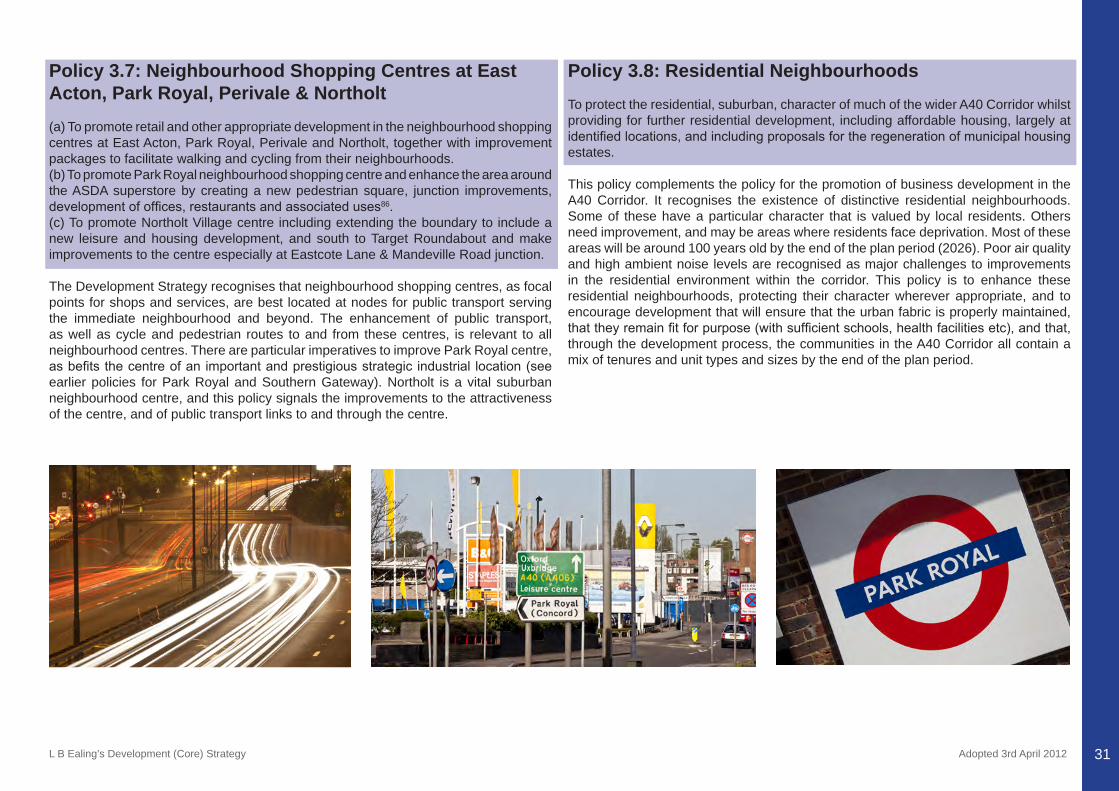
L B Ealing’s Development (Core) Strategy Adopted 3rd April 2012 31
Policy 3.7: Neighbourhood Shopping Centres at East Acton, Park Royal, Perivale & Northolt(a) To promote retail and other appropriate development in the neighbourhood shopping centres at East Acton, Park Royal, Perivale and Northolt, together with improvement packages to facilitate walking and cycling from their neighbourhoods.(b) To promote Park Royal neighbourhood shopping centre and enhance the area around the ASDA superstore by creating a new pedestrian square, junction improvements, developmentofoffices,restaurantsandassociateduses86. (c) To promote Northolt Village centre including extending the boundary to include a new leisure and housing development, and south to Target Roundabout and make improvements to the centre especially at Eastcote Lane & Mandeville Road junction.
The Development Strategy recognises that neighbourhood shopping centres, as focal points for shops and services, are best located at nodes for public transport serving the immediate neighbourhood and beyond. The enhancement of public transport, as well as cycle and pedestrian routes to and from these centres, is relevant to all neighbourhood centres. There are particular imperatives to improve Park Royal centre, asbefitsthecentreofanimportantandprestigiousstrategic industrial location(seeearlier policies for Park Royal and Southern Gateway). Northolt is a vital suburban neighbourhood centre, and this policy signals the improvements to the attractiveness of the centre, and of public transport links to and through the centre.
Policy 3.8: Residential NeighbourhoodsTo protect the residential, suburban, character of much of the wider A40 Corridor whilst providing for further residential development, including affordable housing, largely at identifiedlocations,andincludingproposalsfortheregenerationofmunicipalhousingestates.
This policy complements the policy for the promotion of business development in the A40 Corridor. It recognises the existence of distinctive residential neighbourhoods. Some of these have a particular character that is valued by local residents. Others need improvement, and may be areas where residents face deprivation. Most of these areas will be around 100 years old by the end of the plan period (2026). Poor air quality and high ambient noise levels are recognised as major challenges to improvements in the residential environment within the corridor. This policy is to enhance these residential neighbourhoods, protecting their character wherever appropriate, and to encourage development that will ensure that the urban fabric is properly maintained, thattheyremainfitforpurpose(withsufficientschools,healthfacilitiesetc),andthat,through the development process, the communities in the A40 Corridor all contain a mix of tenures and unit types and sizes by the end of the plan period.
L B Ealing’s Development (Core) Strategy Adopted 3rd April 201232
CHAPTER 4: ENHANCING RESIDENTIAL HINTERLANDS AND NORTH – SOUTH LINKS
L B Ealing’s Development (Core) Strategy Adopted 3rd April 201233
CHAPTER 4: ENHANCING RESIDENTIAL HINTERLANDS AND NORTH – SOUTH LINKSThe residential hinterlands are located between and outside the two broad A40 and Uxbridge Road / Crossrail Corridors. This chapter emphasises the importance of north-south public transport movement and the need to improve it so that there is ultimately a more comprehensive transport network covering the borough and West London. The need for the links is based on the needs of the communities referred to below, many of which are relatively inaccessible by public transport. This is particularly the case inthenorthandwestoftheborough,andlesssignificantinthesouthoftheboroughfromNorthfieldstoSouthfield,wherethereisproximitytoaradialcorridorspanningtheHeathrow branch of the Piccadilly Line and the A4 Great West Road (in Hounslow).
Policies include enhancing the residential hinterlands, renewing employment sites, regenerating the Greenford Green and Greenford Depot sites, promoting quick north-south links to interchanges in the established radial corridors and enhanced links between town centres in West London. Equally important in planning for the future of the hinterland communities is the provision of the full range of local facilities within these neighbourhoods, to minimise the need to travel.
Policy 4.1: Enhance Residential Hinterlands(a) By 2026, development of over 10088 extra homes (one per cent of the boroughs’ net gain in housing).(b) To ensure appropriate infrastructure development, keeping pace with residential and commercial development in the residential hinterlands, as well as on-going investment in service planning to ensure sustainable communities in Ealing.(c) To enhance neighbourhood centres in the hinterlands – Sudbury Hill, Bilton Road, PitshangerLane,Northfields,SouthEaling,sothattheyareattractive,provideforawide range of shopping needs, and are as accessible as possible by public transport, walking and cycling.(d) To protect the character of suburban neighbourhoods in the borough’s residential hinterlands, while providing for further development, including affordable housing, largelyatidentifiedlocations,andincludingproposalsfortheregenerationofmunicipalhousing estates, local shops and business premises.(e) To further explore opportunities for creating a decentralised energy network(s) within the Hanwell suburban area. (f) To promote cycling and walking by retaining and upgrading off-road links, creating new ones, and making the roads safer.
Ealing’s residential hinterlands appear, at first glance on the map, to form threecorridors located between and beyond the corridors referred to above. However, they are not corridors. Movement is generally constrained, particularly at peak hours, to and from these ‘hinterland’ neighbourhoods. They comprise suburban residential localities interspersed with green space with one industrial area at Greenford Green. In the latter case, and at some of the municipal housing estates, there is potential for change and improvement. In most other residential areas, the priority is to protect and enhance their existing character, while improving the sustainability of these communities. Horsenden Hill is a Site of Regional Importance for Geodiversity and is part of the borough’s Metropolitan Open Land.
These hinterlands are traversed by the following north - south links: A406 (North Circular Road), A4000 (Horn Lane), A4127 (Greenford Road), A312 (west of Southall), the North London Line, the Piccadilly (Rayners Lane branch) line, the Ealing – Greenford branch line, and the Grand Union Canal (principally for leisure and amenity). Where development is proposed in the hinterlands, it will need transport improvements - particularly links to transport modes within the A40 and Uxbridge Road corridors. Copley Close Estate (which falls within Hobbayne and Cleveland wards) has been identified by the heat mapping study as having a medium to high potential fordeveloping a low carbon heat distribution network. Although a planning application has not been submitted yet, there are a number of buildings currently connected to community heating schemes. These schemes can be linked to form an initial network that could be expanded to the wider area. Further information can be found in the evidence base document.
Policy 4.2: Regenerate Greenford Green and Renew Employment SitesTo promote regeneration proposals on key sites - including at Butlers Wharf and GSK sites for appropriate mixed use development (including housing and appropriate infrastructure) and at Westway Cross shopping centre – and improve the public transport network with links to the A40 Corridor at Greenford station.
This policy highlights the Greenford Green industrial area, and also refers to smaller employment sites throughout the hinterland area. Greenford Green is bound by the CentralLinetothesouth,OldfieldLaneNorthtothewestandnorth,andGreenfordRoad to the east. Delivery of the regeneration proposals for this area will be facilitated by the Development Sites DPD and a separate supplementary planning document. The latter will provide planning policy and land use guidance for a number of sites in the Greenford Green area and will guide development and sets out the council’s vision
CHAPTER 4: ENHANCING RESIDENTIAL HINTERLANDS AND NORTH – SOUTH LINKS
L B Ealing’s Development (Core) Strategy Adopted 3rd April 201234
for the area and its expectations in regard to land uses, the form and layout of the area, design principles, and guidance regarding planning obligations and the phasing of development. The retention of employment on this site will be strongly encouraged. The role of the canal as a catalyst for development is recognised, and proposals should realise this potential.
Policy 4.3: Regenerate Greenford DepotTo sensitively redevelop Greenford Depot to meet its potential for local services, in the context of its location in a residential area, and adjacent to the Brent River Park.
The policy is to ensure that the Council’s Greenford depot site, which currently hosts a range of Council run waste, environmental and transport services, is developed to its optimum potential during the plan period for those uses. The Council will seek to ensure that any development is sensitive to its setting within a residential area and adjacent to Metropolitan Open Land (see proposals in Chapter 5). The site is currently safeguarded for waste use in the London Plan. Further detail on the future of the site will be considered in the West London Waste Plan and in the council’s Development Sites DPD, both of which complement this Development Strategy.
Policy 4.4: Promote North-South Links89 (a) To seek improvements to the North London Line / London Overground stations and services in the borough.(b) To further explore opportunities for a high frequency bus route between Ealing and Wembley Park via Park Royal, with bus priority measures introduced along the route where appropriate.(c) To further explore opportunities for improving orbital journeys from South-West London through Ealing Broadway to north London.(d) To work with Network Rail to explore the improvement of rail services from Greenford station to West Ealing on the Greenford branch line.(e) To work with Network Rail to explore the extension of rail services from Greenford station, alongside the Central Line to Northolt and on to Ruislip, and interchange with the Chiltern Line.(f) To seek improvement of bus services and cycling facilities along Greenford Road, related to the travel planning requirements of the Greenford Green regeneration, linking Sudbury Hill and Greenford station; further improvements to services from Greenford station – through Greenford Town Centre to Iron Bridge.
(g) To further explore opportunities for a Greenford – A40 road freight link taking heavy lorries off streets with residential frontages.(h) To make public transport improvements north-south from the Yeading Lane / Willow Tree Lane neighbourhoods.
Congestion on orbital (north-south) routes is a feature of Ealing rush hours. The impact of this is heightened whenever there is an accident or blockage on the key radial routes as traffic spills out into orbital roadswith commuters seeking an alternativeroute. These problems disproportionately affect residents of Ealing’s residential hinterlands, particularly since these residents are disproportionately dependent on cars for movement from home to work and to other destinations. Clearly, these factors incombinationconspiretomakeitmoredifficulttoachievesustainablecommunitiesin these hinterland locations. Map 6 shows approved, proposed and potential improvements to transport in Ealing.
Studies have indicated that in general, in West London, public transport journeys originating and ending at points located away from the established radial public transportroutes,takeuptofivetimesaslongascarjourneys90. The improvement of orbital public transport links between interchanges on the radial routes is vital as a means of facilitating the improved sustainability of these hinterland communities.
Initial feasibility work is emerging for proposals for the east of the borough, with improvements to the North London (overground) line, the introduction of a dedicated ‘high frequency’ bus route between Wembley and South Acton, the improvement of public transport movement along the Greenford – West Ealing branch line, and a new ‘West London Orbital’ underground line, promoted by West London Business, which would go through Ealing Broadway station and link north and south west London.
More generally, improved bus services on north-south routes are necessary, as are improved public transport interchange facilities where these intersect with radial routes. Proposals are less well advanced in the north and west of the borough. A ‘high frequency bus route’ approach might receive further consideration as a means of improving public transport accessibility for these suburban hinterlands. Clearly, the success of the proposed mixed-use regeneration of Greenford Green north of the station will depend on achieving sustainable north-south public transport links.
Freight movement by road adds to congestion and pollution and is particularly problematic where freight routes pass residential property. Proposals have been made to improve access from the business areas north of the Central Line in Greenford to the A40.
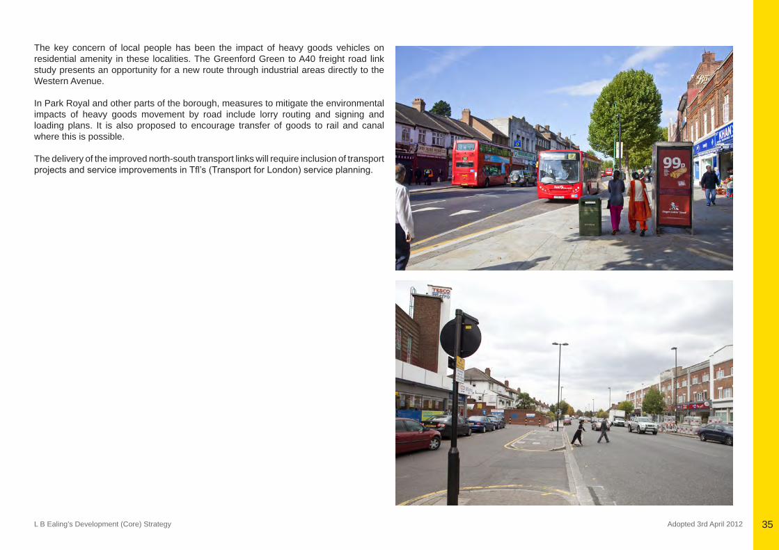
L B Ealing’s Development (Core) Strategy Adopted 3rd April 2012 35
The key concern of local people has been the impact of heavy goods vehicles on residential amenity in these localities. The Greenford Green to A40 freight road link study presents an opportunity for a new route through industrial areas directly to the Western Avenue.
In Park Royal and other parts of the borough, measures to mitigate the environmental impacts of heavy goods movement by road include lorry routing and signing and loading plans. It is also proposed to encourage transfer of goods to rail and canal where this is possible.
The delivery of the improved north-south transport links will require inclusion of transport projectsandserviceimprovementsinTfl’s(TransportforLondon)serviceplanning.
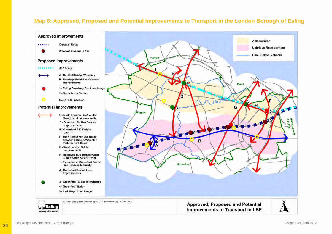
L B Ealing’s Development (Core) Strategy Adopted 3rd April 201236
Map 6: Approved, Proposed and Potential Improvements to Transport in the London Borough of Ealing
L B Ealing’s Development (Core) Strategy Adopted 3rd April 201237
CHAPTER 5: PROTECTING AND ENHANCING
EALING’S GREEN AND OPEN SPACES
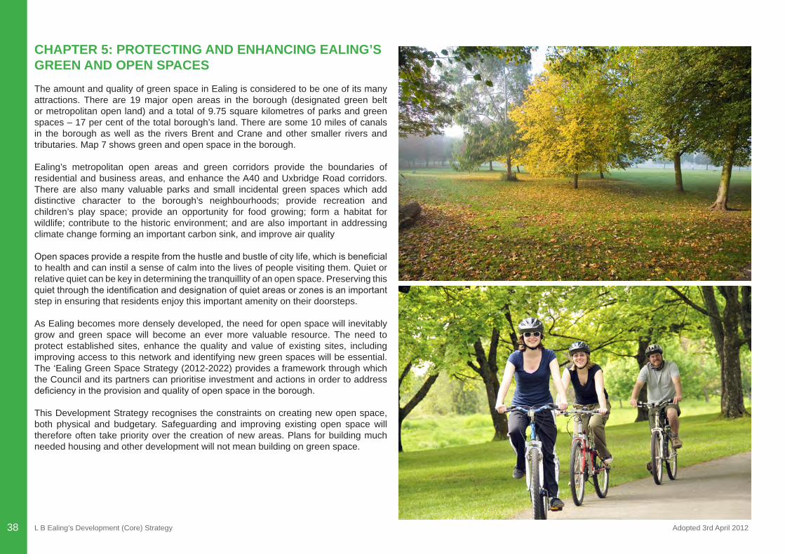
L B Ealing’s Development (Core) Strategy Adopted 3rd April 201238
CHAPTER 5: PROTECTING AND ENHANCING EALING’S GREEN AND OPEN SPACESThe amount and quality of green space in Ealing is considered to be one of its many attractions. There are 19 major open areas in the borough (designated green belt or metropolitan open land) and a total of 9.75 square kilometres of parks and green spaces – 17 per cent of the total borough’s land. There are some 10 miles of canals in the borough as well as the rivers Brent and Crane and other smaller rivers and tributaries. Map 7 shows green and open space in the borough.
Ealing’s metropolitan open areas and green corridors provide the boundaries of residential and business areas, and enhance the A40 and Uxbridge Road corridors. There are also many valuable parks and small incidental green spaces which add distinctive character to the borough’s neighbourhoods; provide recreation and children’s play space; provide an opportunity for food growing; form a habitat for wildlife; contribute to the historic environment; and are also important in addressing climate change forming an important carbon sink, and improve air quality
Openspacesprovidearespitefromthehustleandbustleofcitylife,whichisbeneficialto health and can instil a sense of calm into the lives of people visiting them. Quiet or relative quiet can be key in determining the tranquillity of an open space. Preserving this quietthroughtheidentificationanddesignationofquietareasorzonesisanimportantstep in ensuring that residents enjoy this important amenity on their doorsteps.
As Ealing becomes more densely developed, the need for open space will inevitably grow and green space will become an ever more valuable resource. The need to protect established sites, enhance the quality and value of existing sites, including improving access to this network and identifying new green spaces will be essential. The ‘Ealing Green Space Strategy (2012-2022) provides a framework through which the Council and its partners can prioritise investment and actions in order to address deficiencyintheprovisionandqualityofopenspaceintheborough.
This Development Strategy recognises the constraints on creating new open space, both physical and budgetary. Safeguarding and improving existing open space will therefore often take priority over the creation of new areas. Plans for building much needed housing and other development will not mean building on green space.
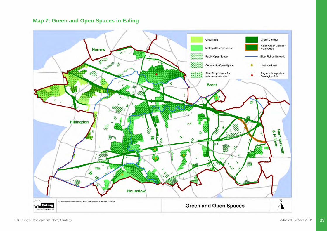
L B Ealing’s Development (Core) Strategy Adopted 3rd April 2012 39
Map 7: Green and Open Spaces in Ealing
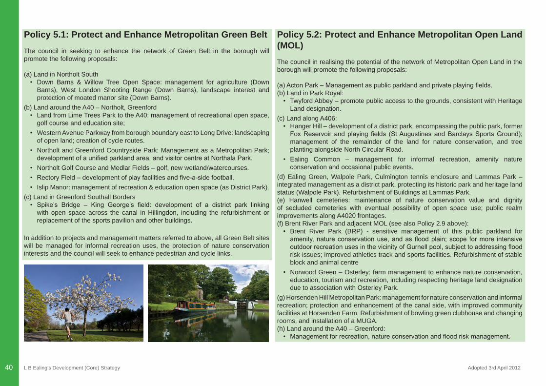
L B Ealing’s Development (Core) Strategy Adopted 3rd April 201240
Policy 5.1: Protect and Enhance Metropolitan Green BeltThe council in seeking to enhance the network of Green Belt in the borough will promote the following proposals:
(a) Land in Northolt South• Down Barns & Willow Tree Open Space: management for agriculture (Down
Barns), West London Shooting Range (Down Barns), landscape interest and protection of moated manor site (Down Barns).
(b) Land around the A40 – Northolt, Greenford• Land from Lime Trees Park to the A40: management of recreational open space,
golf course and education site;• Western Avenue Parkway from borough boundary east to Long Drive: landscaping
of open land; creation of cycle routes.• Northolt and Greenford Countryside Park: Management as a Metropolitan Park; developmentofaunifiedparklandarea,andvisitorcentreatNorthalaPark.
• Northolt Golf Course and Medlar Fields – golf, new wetland/watercourses.• RectoryField–developmentofplayfacilitiesandfive-a-sidefootball.• Islip Manor: management of recreation & education open space (as District Park).
(c) Land in Greenford Southall Borders• Spike’s Bridge – King George’s field: development of a district park linking
with open space across the canal in Hillingdon, including the refurbishment or replacement of the sports pavilion and other buildings.
In addition to projects and management matters referred to above, all Green Belt sites will be managed for informal recreation uses, the protection of nature conservation interests and the council will seek to enhance pedestrian and cycle links.
Policy 5.2: Protect and Enhance Metropolitan Open Land (MOL)The council in realising the potential of the network of Metropolitan Open Land in the borough will promote the following proposals:
(a)ActonPark–Managementaspublicparklandandprivateplayingfields.(b) Land in Park Royal:• Twyford Abbey – promote public access to the grounds, consistent with Heritage
Land designation. (c) Land along A406:• Hanger Hill – development of a district park, encompassing the public park, former FoxReservoir andplaying fields (StAugustinesandBarclaysSportsGround);management of the remainder of the land for nature conservation, and tree planting alongside North Circular Road.
• Ealing Common – management for informal recreation, amenity nature conservation and occasional public events.
(d) Ealing Green, Walpole Park, Culmington tennis enclosure and Lammas Park – integrated management as a district park, protecting its historic park and heritage land status (Walpole Park). Refurbishment of Buildings at Lammas Park.(e) Hanwell cemeteries: maintenance of nature conservation value and dignity of secluded cemeteries with eventual possibility of open space use; public realm improvements along A4020 frontages.(f) Brent River Park and adjacent MOL (see also Policy 2.9 above): • Brent River Park (BRP) - sensitive management of this public parkland for amenity,natureconservationuse,andasfloodplain;scope formore intensiveoutdoorrecreationusesinthevicinityofGurnellpool,subjecttoaddressingfloodrisk issues; improved athletics track and sports facilities. Refurbishment of stable block and animal centre
• Norwood Green – Osterley: farm management to enhance nature conservation, education, tourism and recreation, including respecting heritage land designation due to association with Osterley Park.
(g) Horsenden Hill Metropolitan Park: management for nature conservation and informal recreation; protection and enhancement of the canal side, with improved community facilities at Horsenden Farm. Refurbishment of bowling green clubhouse and changing rooms, and installation of a MUGA.(h) Land around the A40 – Greenford: • Managementforrecreation,natureconservationandfloodriskmanagement.
L B Ealing’s Development (Core) Strategy Adopted 3rd April 2012 41
Ealing comprises a number of strategic areas of open space, comprising Green Belt (whose purpose is set out in paragraph 30 of the NPPF), and Metropolitan Open Land (London Plan (2011) Policy 7.17). The primary function of Green Belt is to checkunrestrictedsprawl.OncedesignatedasGreenBelt, this landcan fulfilotherobjectives, including providing opportunities for recreation and nature conservation. Metropolitan Open Land (MOL) is a London wide concept and is recognised as land which contributes to the physical structure of London, provides opportunities for open-airrecreation,orcontainsfeaturesorlandscapeofmetropolitanornationalsignificance.Whilst the criteria for identifying Green Belt and MOL are distinct, the London Plan confirmsthattheprinciplesofcontroloverdevelopmentintheGreenBeltsetout inNPPF applies equally to MOL.
Policy 5.3: Protect & Enhance Green CorridorsThe council in seeking to protect and enhance the network of Green Corridors and Blue Ribbon Network in the borough will promote the following proposals for enhancement:
(a) Grand Union Canal (including the towpath, associated land and small-related areas): protection as a nature conservation Site of Metropolitan Importance and an urban conservation area, and towpath upgrades and promotion as a cycle route for both leisure and commuting. (b) Railway lines i.e. ‘overground’ lines (main inter-city line, Greenford Branch Line, North London Line, Marylebone Line and Brentford Line) and London Underground lines (Central, District and Piccadilly lines): management of green cuttings, embankments and verges with broadening when adjacent to green space.(c) Road Network: protection and enhancement of landscaped corridors, including additional planting where possible. Where feasible footpaths and cycle paths to be incorporated within the corridor, with landscaping providing a buffer between road edge and paths.(d) River Brent: management of the corridor (including the river itself) from the northern boundary of Brent River Park to the borough boundary particularly for nature conservation and flood management purposes. Where possible, creation of cycleroutes along the river will be considered.
Green Corridors provide important links between networks of strategic open space in the borough. They comprise roads, railways, walking and cycle routes and corridors for the movement of wildlife.
Whilst the vast majority of the Green Corridor network already exists on the ground, and will continue to be safeguarded as such, a section of the corridor just east of Guinness Mounds to East Acton remains unimplemented. This is illustrated on Map 7. The delivery of this section of the Green Corridor, in the form of an enhanced landscape strip, improved cycleway/pedestrian route, and an improved noise environment will most likely be dependent on and enabled by some development on parts of the landdefinedasGreenCorridor.Thedeliveryofthiscorridorshouldcontributetothefollowing key objectives/aims:
• Through enhanced landscaping transform this section of the A40, in order to deliver improvements to the appearance and quality of the experience of the A40 for all users, including residents, drivers, pedestrians, cyclists and wildlife passing along or crossing the A40.
• Reduce the adverse effects arising from the A40, particularly in terms of noise and air quality.
• Improve personal security – actual and perceived.• Enhance biodiversity.• Promoting alternative transport, particularly through an improved walking/cycling
environment.
The delivery of these Green Corridor objectives however also need to be balanced against the need to create quality development, including the need to provide for adequate servicing, private amenity space, and to maintain adequate separation distances in the interests of privacy. In this regard development proposals will also need to be judged against the Development Sites DPD, which provide further detail with regard to the type and scale of development which may be considered acceptable in relation to individual sites along this stretch of the Green Corridor.
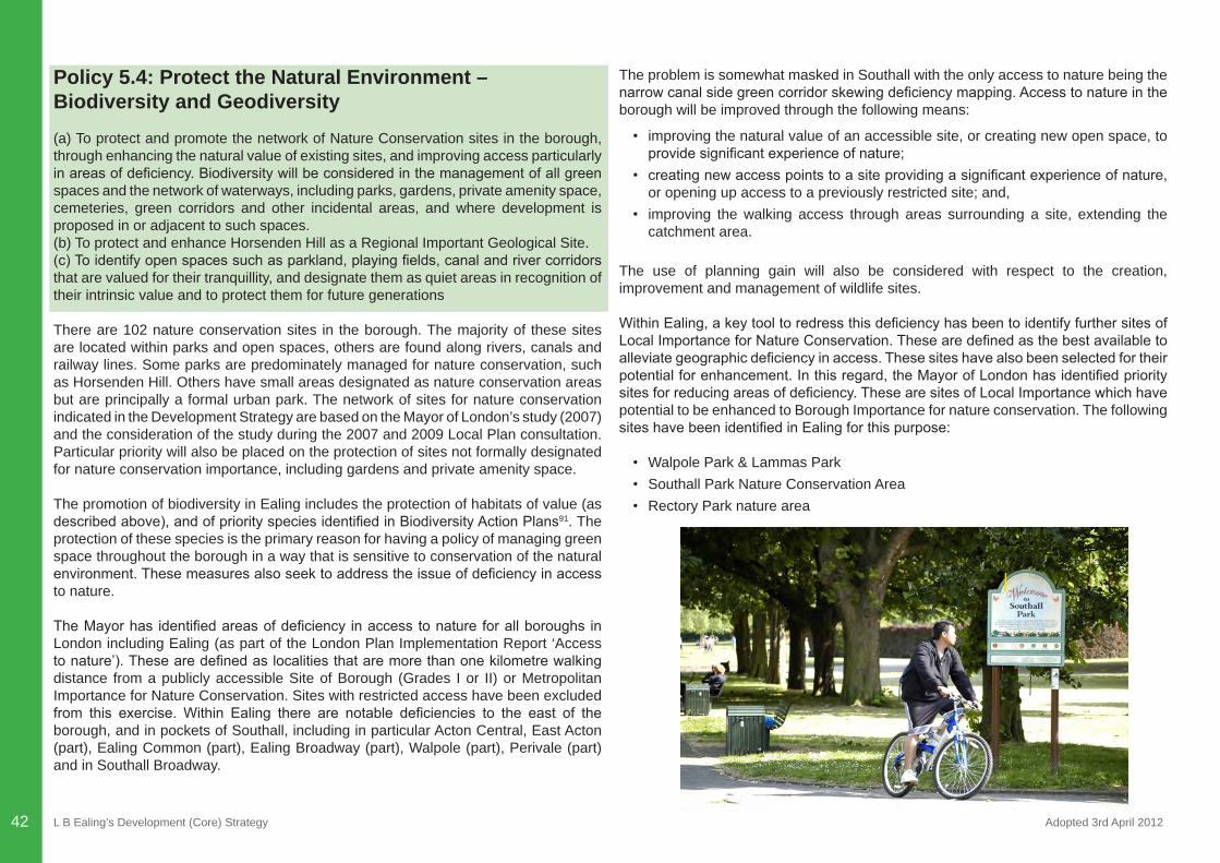
L B Ealing’s Development (Core) Strategy Adopted 3rd April 201242
Policy 5.4: Protect the Natural Environment – Biodiversity and Geodiversity(a) To protect and promote the network of Nature Conservation sites in the borough, through enhancing the natural value of existing sites, and improving access particularly inareasofdeficiency.Biodiversitywillbeconsideredinthemanagementofallgreenspaces and the network of waterways, including parks, gardens, private amenity space, cemeteries, green corridors and other incidental areas, and where development is proposed in or adjacent to such spaces.(b) To protect and enhance Horsenden Hill as a Regional Important Geological Site.(c)Toidentifyopenspacessuchasparkland,playingfields,canalandrivercorridorsthat are valued for their tranquillity, and designate them as quiet areas in recognition of their intrinsic value and to protect them for future generations
There are 102 nature conservation sites in the borough. The majority of these sites are located within parks and open spaces, others are found along rivers, canals and railway lines. Some parks are predominately managed for nature conservation, such as Horsenden Hill. Others have small areas designated as nature conservation areas but are principally a formal urban park. The network of sites for nature conservation indicated in the Development Strategy are based on the Mayor of London’s study (2007) and the consideration of the study during the 2007 and 2009 Local Plan consultation. Particular priority will also be placed on the protection of sites not formally designated for nature conservation importance, including gardens and private amenity space.
The promotion of biodiversity in Ealing includes the protection of habitats of value (as describedabove),andofpriorityspeciesidentifiedinBiodiversityActionPlans91. The protection of these species is the primary reason for having a policy of managing green space throughout the borough in a way that is sensitive to conservation of the natural environment.Thesemeasuresalsoseektoaddresstheissueofdeficiencyinaccessto nature.
TheMayorhas identifiedareasofdeficiency inaccesstonatureforallboroughs inLondon including Ealing (as part of the London Plan Implementation Report ‘Access tonature’).Thesearedefinedaslocalitiesthataremorethanonekilometrewalkingdistance from a publicly accessible Site of Borough (Grades I or II) or Metropolitan Importance for Nature Conservation. Sites with restricted access have been excluded from this exercise. Within Ealing there are notable deficiencies to the east of theborough, and in pockets of Southall, including in particular Acton Central, East Acton (part), Ealing Common (part), Ealing Broadway (part), Walpole (part), Perivale (part) and in Southall Broadway.
The problem is somewhat masked in Southall with the only access to nature being the narrowcanalsidegreencorridorskewingdeficiencymapping.Accesstonatureintheborough will be improved through the following means:
• improving the natural value of an accessible site, or creating new open space, to providesignificantexperienceofnature;
• creatingnewaccesspointstoasiteprovidingasignificantexperienceofnature,or opening up access to a previously restricted site; and,
• improving the walking access through areas surrounding a site, extending the catchment area.
The use of planning gain will also be considered with respect to the creation, improvement and management of wildlife sites.
WithinEaling,akeytooltoredressthisdeficiencyhasbeentoidentifyfurthersitesofLocalImportanceforNatureConservation.Thesearedefinedasthebestavailabletoalleviategeographicdeficiencyinaccess.Thesesiteshavealsobeenselectedfortheirpotentialforenhancement.Inthisregard,theMayorofLondonhasidentifiedprioritysitesforreducingareasofdeficiency.ThesearesitesofLocalImportancewhichhavepotential to be enhanced to Borough Importance for nature conservation. The following siteshavebeenidentifiedinEalingforthispurpose:
• Walpole Park & Lammas Park• Southall Park Nature Conservation Area• Rectory Park nature area
L B Ealing’s Development (Core) Strategy Adopted 3rd April 2012 43
OtherprioritysitesforimprovingaccesstonatureinareasofdeficiencyinEalingareidentifiedasfollows:
• Pitshanger Park• Havelock Cemetery • Acton Park• Trinity Way Nature area• North Acton Cemetery• SouthfieldsRec.NatureArea• Ealing Common• North Acton Playing Fields
The development of opportunity areas92, including in particular Southall, must also demonstrate that they would not cause an adverse impact on any European site of nature conservation importance, located in neighbouring boroughs, notably the South West London Water Bodies.
The planning of new development and regeneration should also have regard to the conservation of geological features, and opportunities should be taken to achieve positive gains for conservation through the form and design of development. Where developmentisproposedwhichwouldaffectanidentifiedgeologicalsite(includinginparticular Horsenden Hill) the approach should be to seek to avoid adverse impact on the geological interest, and if this is not possible, the approach should be to minimise such impact and seek mitigation of any residual impacts. Horsenden Hill is designated asaRegionallyImportantGeologicalSite(RIGS).RIGSsareidentifiedanddesignatedfor their strategic importance for geodiversity (variety of rocks, fossils, minerals, landforms and soils that give character to the natural landscape and environment) across London.
Many people suffer from unwanted noise. Road traffic is a significant source, butaircraft noise and commercial development can also contribute to the ambient noise experienced by many people. Many of the open spaces within the borough provide a refuge from urban noise, and in many cases, it is this absence or the perception of relative quiet that is a key factor in determining whether the area is regarded as tranquil. Identifying and designating quiet areas, in line with the requirements of the Environmental Noise Directive, will provide a level of protection against the encroachment of unwanted noise.
Policy 5.5: Promoting Parks, Local Green Space and Addressing DeficiencyThe council will seek:
(a) To protect open space of local value required for informal recreation, including for walking, jogging, gardening and food growing.(b)Toaddressdeficiencyinaccesstoopenspaceintheborough,andtomeettheopenspace needs arising from new development, including in particular at Southall Gas Works and the Southern Gateway (Park Royal). Key priorities in terms of proposals for addressingdeficiencyareidentifiedthroughtheGreenSpaceStrategy.(c) To secure developer contributions to provide a key funding source for the delivery of the above proposals. (d) To make provision for a network of green ways through parks and open spaces as a means of encouraging walking, cycling and running for recreation and to get to and from local destinations.(e) To promote the use of parks for events and other activities, providing this is managed in a sensitive and compatible manner.
These policies are based on the council’s Green Space Strategy (2012-2022) and their application should also be informed by emerging work on an All London Green Grid. The former comprises a quantitative and qualitative audit of green space, and an assessment of current and future needs over the plan period. This assessment also considered open space outside of the borough boundary, including land jointly managed by Ealing Council, such as Gunnersbury Park, whose catchment extends into Ealing. Whilst falling outside the remit of Ealing’s Core Strategy, the Council recognises the value of space in neighbouring boroughs in satisfying the needs of its residents, and through working jointly with colleagues in neighbouring boroughs will seek to ensure that this value is maximised.
The All London Green Grid will create a network of interlinked, multifunctional and high quality open and green spaces that connect with town centres, public transport nodes, the countryside in the urban fringe, rivers and major employment and residential areas. Ealing is an important part of two ‘area frameworks’ the River Brent Plateau framework and the Colne and Crane framework. The project is being rolled out by Design for London (DfL), and provides the sub regional context in which the green space strategy shall be embedded.
The policies to enhance green space, improve access to this space and where possible tocreatenewgreenspacesrespondtothedeficiencyareasidentifiedinthestrategiesreferred to above, as follows:
L B Ealing’s Development (Core) Strategy Adopted 3rd April 201244
• In quantity terms, as a proportion of public open space per head of population, EalingBroadwayandSouthActonWardsareparticularlydeficient.Overtheplanperiod this position may also worsen in relation to Southall Green and Southall Broadway wards.
• Intermsofdeficiencyinaccess: - Local Park deficiency throughout the borough, but particularly through the
centre of Ealing. - DistrictParkdeficiencyintheeastoftheboroughandacrossmuchofSouthall - DeficiencyinbothlocalanddistrictparkprovisionparticularlyinActon(East
Acton and South Acton) and Southall. - MetropolitanParkdeficiencyparticularlyintheHangerHillward.
• There is a lower density of play opportunities through the centre and east of the borough, in particular the wards of Ealing Common, Ealing Broadway, Hanger Hill and the western side of East Acton.
• There is a notable gap in provision of MUGA’s and play opportunities for older children in the Hanger Hill area.
Provisionstandardstohelpalleviatedeficiency inrelationtoallotmentprovisionaredetailed in the Development Management DPD.
TheGreenSpaceStrategyidentifiespriorityparksforinvestmenttohelpredressthisdeficiency.Policy7.18oftheLondonPlan(2011)alsoseekstoensurethatfutureopenspace needs are considered in planning policies for opportunity Areas (Park Royal and Southall). In this regard, new public open space provision is proposed as part of the Southern Gateway site and Southall Gas Works.
Policy 5.6: Outdoor Sports and Active RecreationThe council will:
(a) Protect and promote a network of sports grounds and other active recreation areas intheborough.Sitesidentifiedasbeingofstrategicandlocalimportanceforoutdoorsports will be protected and promoted primarily for this function.(b) Seek to develop a sports hub as part of this network, with a range of sports provision in the Gurnell area, and the development of several strategic ‘satellite sites’ located strategically to serve communities across the borough.(c) Seek to secure developer contributions to provide a key funding source for the delivery of various priority projects.
The council’s Facilities Strategy (2011) (Incorporating the Playing Pitch and Outdoor Sports Strategy (2007) and updates (2010) provides an analysis of both existing and futureneedsover the lifetimeof theplan, identifyingareasofdeficiency in termsofaccess.Ataboroughwidelevel,thisDevelopmentStrategyidentifiesarequirementof 0.82ha of outdoor sports pitches per 1,000 people in the borough by 2021. This standard has been revised and is superseded by Policy 7.0 of the Development Management DPD.
The council’s emerging Facilities Strategy will also sets out an action plan to promote thisnetwork,andtoaddressdeficiencyintermsofphysicalaccess,quantityofprovision,and in termsof quality of facilities.Asa tool for alleviatingdeficiency, this strategyidentifiesahierarchyofsitesintheboroughforsportsandactiverecreation,definingsites of strategic and local importance and distinguishing between sites of single and multisportsuse,andidentifiesopportunitiesforfuturedevelopment/enhancement. These are sites which comprise a number of pitches, and accommodate a range of sports, often used by a significant number of organisations and clubs.These siteswill be primarily safeguarded and protected for outdoor sports related activities. Some ancillary development on these sites may be necessary and desirable to enhance the primary active recreation function of these sites.
Key priority projects include the promotion of a ‘sports hub’ facility at Perivale Park encompassing the Perivale Athletics Field (a National Throw Centre), a new outdoor gym, a Golf Range and Junior Gold Development Centre, tennis courts, new multi-use games areas (MUGAs) and dedicated pitches for football and rugby. The centre will also link to the Gurnell Swimming Pool. It also proposes developing smaller ‘satellite’ hub facilities at strategic sites in the borough. The following proposals have also been identifiedforkeysportsfieldsintheborough:
• Rectory Park Playing Fields, Northolt – the establishment of a centre of football excellence in the park and the replacement of changing facilities.
• Ealing Central Sports Ground, Perivale – replacement or refurbishment of the pavilion and changing rooms.
• Spikesbridge Park, Southall – the development of a new pavilion incorporating community uses and possibly replacement accommodation for the Cornucopia Centre on the edge of the park.
• Warren Farm – improved changing rooms, outdoor sports areas and social facilities.
All sports grounds in the borough are currently designated and safeguarded as Community Open Space.
L B Ealing’s Development (Core) Strategy Adopted 3rd April 2012 45
Policy 5.7: Provide Additional Burial LandThe Council will seek to protect existing sites, maximise their use (including consideration for reuse), and identify additional burial land located to serve those parts oftheboroughexperiencingsignificantshortage.
Therearefivecemeteriesrunbythecouncilintheboroughatpresent(Acton,GreenfordPark, Havelock, Hortus and South Ealing) and three other cemeteries (Westminster, Kensington & Chelsea and Gunnersbury) either under different management, or located outside the borough. Of the cemeteries located in the borough under the management of the council, only Greenford has remaining capacity. Whilst it is predicted that Greenford will have remaining capacity to cover the plan period for the borough as a whole, and has potential if extended further to provide a further 15 years (i.e. 30 years in total), this would not address the acute local need for burial space in certain parts of the borough. The beliefs of different community groups are an important consideration in planning for cemetery space as religious and cultural traditions and aspirations determine preferred funeral rites. In this regard there is a particular requirement from the Muslim community for additional services and facilities to be provided somewhere in Southall. Work is underway to understand the spatial variation in this demand. Any deficitinneedwillprimarilybemetthroughtheapplicationofCIL,andinthecaseofstrategic planning applications through a requirement to provide for on-site provision. Further detail is provided in the Development Management DPD. Further consideration will also be given to the identification of sites for woodland burials.All cemeterieslocated in the borough are currently designated as Community Open Space.
L B Ealing’s Development (Core) Strategy Adopted 3rd April 201246
CHAPTER 6: ENSURING SUSTAINABLE DELIVERY
L B Ealing’s Development (Core) Strategy Adopted 3rd April 2012 47
CHAPTER 6: ENSURING SUSTAINABLE DELIVERYExisting communities and residents coming into new development in the borough will need additional health facilities, schools, leisure, transport, utility and community facilities. As indicated in Chapter One, the sustainable delivery of the Development Strategy requires good infrastructure planning. This chapter provides more information on infrastructure requirements and delivery.
The Infrastructure Delivery Plan: Delivering Infrastructure for Sustainable Communities To create sustainable communities, providing housing and employment opportunities aloneisnotsufficient.Thereisaneedtoprovidethenecessarysupporting‘infrastructure’of transport, schools, open space, community, health, utilities and leisure services etc to support the local population and those who visit or work in the borough. A range of organisations provide these services but there is currently little or no integration of that provision meeting neither the needs of existing communities nor those of the future93.
Infrastructure planning is the integrated investment and delivery of land and buildings to create places and provide services. In Ealing we are looking at ways to make our existing infrastructure work better for us, as well as identifying the need for and securing delivery of additional provision.
The council will provide appropriate social, physical and green infrastructure in the right locations and at the right time to support the levels of housing and employment growth to be delivered in Ealing. To do this, we have produced an Infrastructure Delivery Plan. This comprises:
• Infrastructure Delivery Plan (IDP) - this sets out how infrastructure planning and delivery is working at the local level, drawing upon the service delivery plans/estates strategies of the council and other infrastructure providers, and an
• Infrastructure Delivery Schedule (IDS) - an evidence-based schedule which summarises the planned infrastructure, phasing, delivery mechanism and contingencies outlined in the IDP.
The IDP covers the same 15-year timescale as the Development Strategy, with most detailprovidedondeliveryof the infrastructureplannedwithin thefirst5years.TheIDP lists the type of infrastructure required by type (e.g. education, health, sports and leisure) and by area of the borough. It also includes sensitivity testing of the provision around high/low population projections, as well as identifying risks to delivery and contingencies (e.g. around delivery of Crossrail).
Key infrastructure projects required to meet the needs of the projected growth are included in the policies for the different areas of the borough in the preceding chapters of the Development Strategy. In addition to identifying these key projects, the IDP sets out the infrastructure required to support existing and new development. It indicates what, when and where this will be provided. It also sets out the amount and potential sources of required funding94.
Before granting planning permission for large-scale residential, commercial and mixed-use development, the council will seek to ensure that the infrastructure requirements arising from the scheme will be met by time of occupation. In addition to increases in efficiencies inuseof thecouncil’sownassets,financialcontributionswillbesoughtfrom developers if their projects give rise to the need for new infrastructure. Alongside developer contributions, the IDP will include details of the anticipated funding for infrastructure from government and other sources, which represent the majority of funding for infrastructure.
Ealing’s targets for housing and employment development are a combination of the physicalcapacityoftheidentifiedsitesandthecapacityoftheinfrastructuretoservethem. Infrastructure provision itself may require land or buildings, which are currently identified as potential development sites for employment or housing (e.g. a roadwidening scheme to improve accessibility). The housing and employment targets within this Strategy will therefore be considered alongside the existing and projected infrastructure provision, as appropriate infrastructure needs to be provided in the right places, at the right time for the anticipated amount of housing and employment growth to be sustainable. Map 8 shows existing education, health and leisure facilities and Map 9 shows proposed new infrastructure in the borough95.
Therangeofmoresmall-scaleservice improvementsandprojects identifiedwillberegularly updated as projects are completed and/or as additional demand arises. Where funding gaps exist to improve existing or provide new infrastructure, and where new residential and commercial development exacerbates a need for it, financialcontributions will be sought from developers towards these projects through s106 legal agreements and/or the Council’s emerging CIL. The scale of contributions sought will be set out in a separate supplementary planning document96. This document will also be regularly updated through the Authorities’ Monitoring Report.
CHAPTER 6: ENSURING SUSTAINABLE DELIVERY
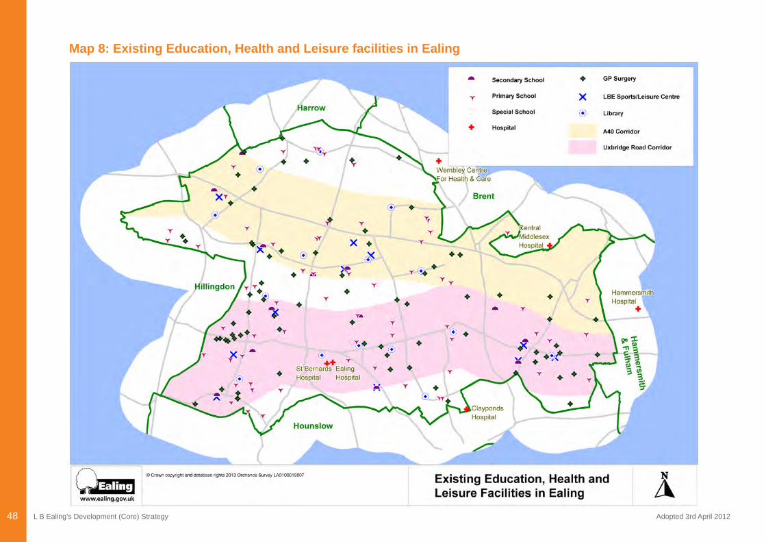
L B Ealing’s Development (Core) Strategy Adopted 3rd April 201248
Map 8: Existing Education, Health and Leisure facilities in Ealing
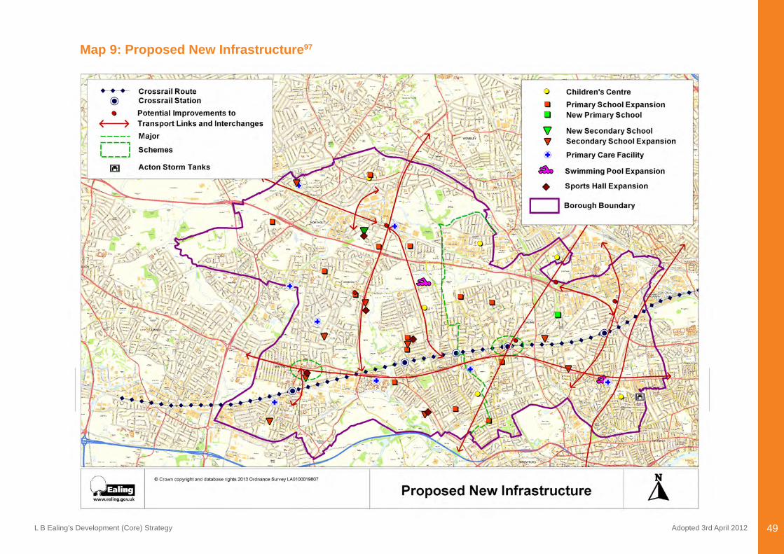
L B Ealing’s Development (Core) Strategy Adopted 3rd April 2012 49
Map 9: Proposed New Infrastructure97
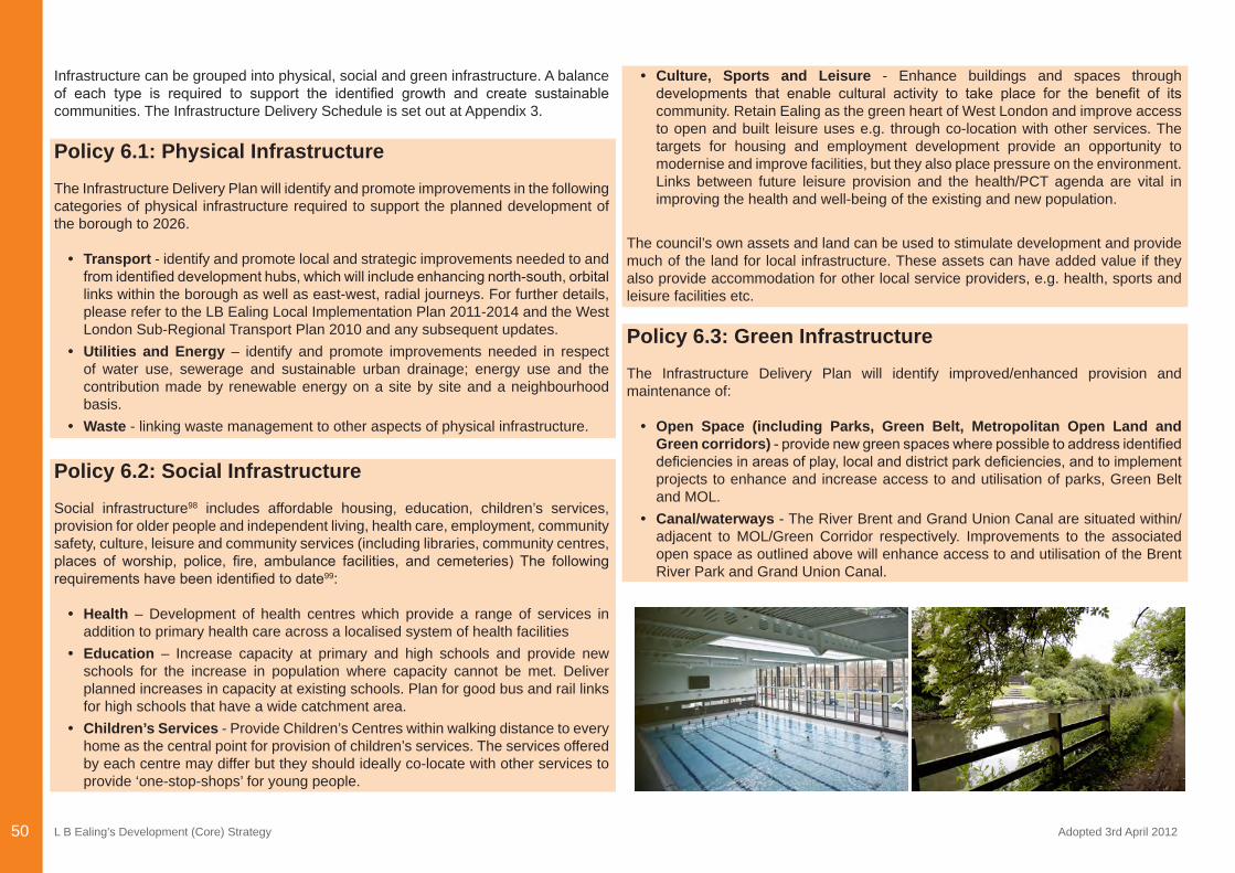
L B Ealing’s Development (Core) Strategy Adopted 3rd April 201250
Infrastructure can be grouped into physical, social and green infrastructure. A balance of each type is required to support the identified growth and create sustainablecommunities. The Infrastructure Delivery Schedule is set out at Appendix 3.
Policy 6.1: Physical InfrastructureThe Infrastructure Delivery Plan will identify and promote improvements in the following categories of physical infrastructure required to support the planned development of the borough to 2026.
• Transport - identify and promote local and strategic improvements needed to and fromidentifieddevelopmenthubs,whichwillincludeenhancingnorth-south,orbitallinks within the borough as well as east-west, radial journeys. For further details, please refer to the LB Ealing Local Implementation Plan 2011-2014 and the West London Sub-Regional Transport Plan 2010 and any subsequent updates.
• Utilities and Energy – identify and promote improvements needed in respect of water use, sewerage and sustainable urban drainage; energy use and the contribution made by renewable energy on a site by site and a neighbourhood basis.
• Waste - linking waste management to other aspects of physical infrastructure.
Policy 6.2: Social InfrastructureSocial infrastructure98 includes affordable housing, education, children’s services, provision for older people and independent living, health care, employment, community safety, culture, leisure and community services (including libraries, community centres, places of worship, police, fire, ambulance facilities, and cemeteries) The followingrequirementshavebeenidentifiedtodate99:
• Health – Development of health centres which provide a range of services in addition to primary health care across a localised system of health facilities
• Education – Increase capacity at primary and high schools and provide new schools for the increase in population where capacity cannot be met. Deliver planned increases in capacity at existing schools. Plan for good bus and rail links for high schools that have a wide catchment area.
• Children’s Services - Provide Children’s Centres within walking distance to every home as the central point for provision of children’s services. The services offered by each centre may differ but they should ideally co-locate with other services to provide ‘one-stop-shops’ for young people.
• Culture, Sports and Leisure - Enhance buildings and spaces through developments that enable cultural activity to take place for the benefit of itscommunity. Retain Ealing as the green heart of West London and improve access to open and built leisure uses e.g. through co-location with other services. The targets for housing and employment development provide an opportunity to modernise and improve facilities, but they also place pressure on the environment. Links between future leisure provision and the health/PCT agenda are vital in improving the health and well-being of the existing and new population.
The council’s own assets and land can be used to stimulate development and provide much of the land for local infrastructure. These assets can have added value if they also provide accommodation for other local service providers, e.g. health, sports and leisure facilities etc.
Policy 6.3: Green InfrastructureThe Infrastructure Delivery Plan will identify improved/enhanced provision and maintenance of:
• Open Space (including Parks, Green Belt, Metropolitan Open Land and Green corridors)-providenewgreenspaceswherepossibletoaddressidentifieddeficienciesinareasofplay,localanddistrictparkdeficiencies,andtoimplementprojects to enhance and increase access to and utilisation of parks, Green Belt and MOL.
• Canal/waterways - The River Brent and Grand Union Canal are situated within/adjacent to MOL/Green Corridor respectively. Improvements to the associated open space as outlined above will enhance access to and utilisation of the Brent River Park and Grand Union Canal.
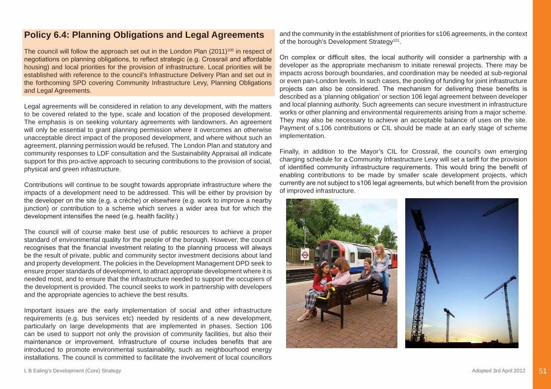
L B Ealing’s Development (Core) Strategy Adopted 3rd April 2012 51
Policy 6.4: Planning Obligations and Legal AgreementsThe council will follow the approach set out in the London Plan (2011)100 in respect of negotiationsonplanningobligations,toreflectstrategic(e.g.Crossrailandaffordablehousing) and local priorities for the provision of infrastructure. Local priorities will be established with reference to the council’s Infrastructure Delivery Plan and set out in the forthcoming SPD covering Community Infrastructure Levy, Planning Obligations and Legal Agreements.
Legal agreements will be considered in relation to any development, with the matters to be covered related to the type, scale and location of the proposed development. The emphasis is on seeking voluntary agreements with landowners. An agreement will only be essential to grant planning permission where it overcomes an otherwise unacceptable direct impact of the proposed development, and where without such an agreement, planning permission would be refused. The London Plan and statutory and community responses to LDF consultation and the Sustainability Appraisal all indicate support for this pro-active approach to securing contributions to the provision of social, physical and green infrastructure.
Contributions will continue to be sought towards appropriate infrastructure where the impacts of a development need to be addressed. This will be either by provision by the developer on the site (e.g. a crèche) or elsewhere (e.g. work to improve a nearby junction) or contribution to a scheme which serves a wider area but for which the developmentintensifiestheneed(e.g.healthfacility.)
The council will of course make best use of public resources to achieve a proper standard of environmental quality for the people of the borough. However, the council recognises that thefinancial investmentrelating to theplanningprocesswillalwaysbe the result of private, public and community sector investment decisions about land and property development. The policies in the Development Management DPD seek to ensure proper standards of development, to attract appropriate development where it is needed most, and to ensure that the infrastructure needed to support the occupiers of the development is provided. The council seeks to work in partnership with developers and the appropriate agencies to achieve the best results.
Important issues are the early implementation of social and other infrastructure requirements (e.g. bus services etc) needed by residents of a new development, particularly on large developments that are implemented in phases. Section 106 can be used to support not only the provision of community facilities, but also their maintenance or improvement. Infrastructure of course includes benefits that areintroduced to promote environmental sustainability, such as neighbourhood energy installations. The council is committed to facilitate the involvement of local councillors
and the community in the establishment of priorities for s106 agreements, in the context of the borough’s Development Strategy101.
On complex or difficult sites, the local authority will consider a partnership with adeveloper as the appropriate mechanism to initiate renewal projects. There may be impacts across borough boundaries, and coordination may be needed at sub-regional or even pan-London levels. In such cases, the pooling of funding for joint infrastructure projects can also be considered. The mechanism for delivering these benefits isdescribed as a ‘planning obligation’ or section 106 legal agreement between developer and local planning authority. Such agreements can secure investment in infrastructure works or other planning and environmental requirements arising from a major scheme. They may also be necessary to achieve an acceptable balance of uses on the site. Payment of s.106 contributions or CIL should be made at an early stage of scheme implementation.
Finally, in addition to the Mayor’s CIL for Crossrail, the council’s own emerging charging schedule for a Community Infrastructure Levy will set a tariff for the provision of identified community infrastructure requirements.Thiswould bring the benefit ofenabling contributions to be made by smaller scale development projects, which currentlyarenotsubjecttos106legalagreements,butwhichbenefitfromtheprovisionof improved infrastructure.
L B Ealing’s Development (Core) Strategy Adopted 3rd April 201252
Appendix One:A Regional Context - The London Plan 2011
L B Ealing’s Development (Core) Strategy Adopted 3rd April 2012 53
Appendix One: A Regional Context - The London Plan 2011The London Plan 2011 sets out the overall spatial framework for development across London up until 2031 and is illustrated diagrammatically at Map 10. It indicates the amounts and types of development required over the next 20 years across London as a whole, and for West London, and in some cases, borough by borough. On this basis, the role of Ealing’s Development Strategy is to relate the amounts and types of development (indicated in the London Plan) to Ealing’s needs, and to indicate where and when development should be provided.
The London Plan requires that the local development framework supports economic development – taking advantage of Ealing’s location between Central London and Heathrow, and promoting Park Royal, in the north east of the borough, which is the biggest industrial estate in Western Europe. The council must plan for a strong portfolio of industrial land, providing for a range of business needs – including the need to accommodate additional waste management facilities.
The Mayor of London supports proposals by Ealing Council to enhance the attractiveness of town centres – Acton, Ealing, Hanwell, Greenford and Southall - and manage their restructuring where necessary. It is also important to facilitate delivery of strategic transport priorities including Crossrail, improved bus services and more sustainable access to Heathrow Airport102.
The London Plan indicates public transport accessibility levels (PTALs) across London and seeks to improve public transport accessibility. Subject to public transport capacity, areas with high PTALs can expect relatively high-density development. Low PTALs and limited public transport capacity can constrain development potential. Development can of course fund improvements. These factors are important in establishing the approach to development in Ealing’s Development Strategy. Map 11 shows PTALs in Ealing.
The Mayor’s plan requires that Ealing’s expanding population be accommodated in sustainable communities, taking into account needs for social and community infrastructure. The London Plan highlights the environment, particularly improving air quality along the A40 and the North Circular Road, and providing open space – not only major green spaces such as Horsenden Hill and the Brent River Park, but the many small sites which add value to Ealing’s environment.
The London Plan – Complementing Ealing’s Development Strategy 2026
The London Plan is more than a context for local planning. Together with Ealing’s development plan, it is the statutory basis for decisions on planning applications in the borough. As indicated above, the Ealing’s Development Strategy will have policies on where and when development should be accommodated. The London Plan will complement these with a range of thematic policies setting standards for the quality of development and the environment (i.e. for all types of development in suburban, urban and central London). The proposals in Ealing’s Development Strategy take account of these thematic ‘quality’ policies in the London Plan, and there is no need for them to be restated in the Ealing Development Strategy.
Strategic policies, whether in the London Plan or in Ealing’s Development Strategy, deal with general principles. There is no local reason for the general principles set out in the London Plan not to apply in Ealing. However, the application of strategic ‘quality’ policies to individual sites and to on-going development management (i.e. the process of dealing with planning applications) does require careful consideration in the light of local circumstances. On this basis, Ealing’s Development Sites and Development Management DPD’s together with the Ealing Policies Map (and on waste matters, theWestLondonWastePlan)willestablishspecificdevelopmentpoliciestailoredtoEaling’s local requirements.
The matters covered by the thematic policies in the existing London Plan are summarised below:
London Plan 2011 – Thematic PoliciesLondon’s Places: Sub-regions, Inner London, Outer London, Opportunity Areas, Town Centres, Strategic Industrial Locations London’s People: Equal Life Chances, Health, Housing, Social InfrastructureLondon’s Economy: Sectors and workplaces, Emerging sectors, Improving opportunities for allLondon’s Response to Climate Change: Mitigation, Adaptation, Waste, Aggregates and contamination London’s Transport: Integrating Transport and Development, Connecting LondonLondon’s Living Spaces and Places: Place shaping, Heritage, Safety and Resilience, Pollution, Open and Natural Environment, Blue Ribbon Network
Visit - http://www.london.gov.uk/publication/londonplan
Appendix One:A Regional Context - The London Plan 2011
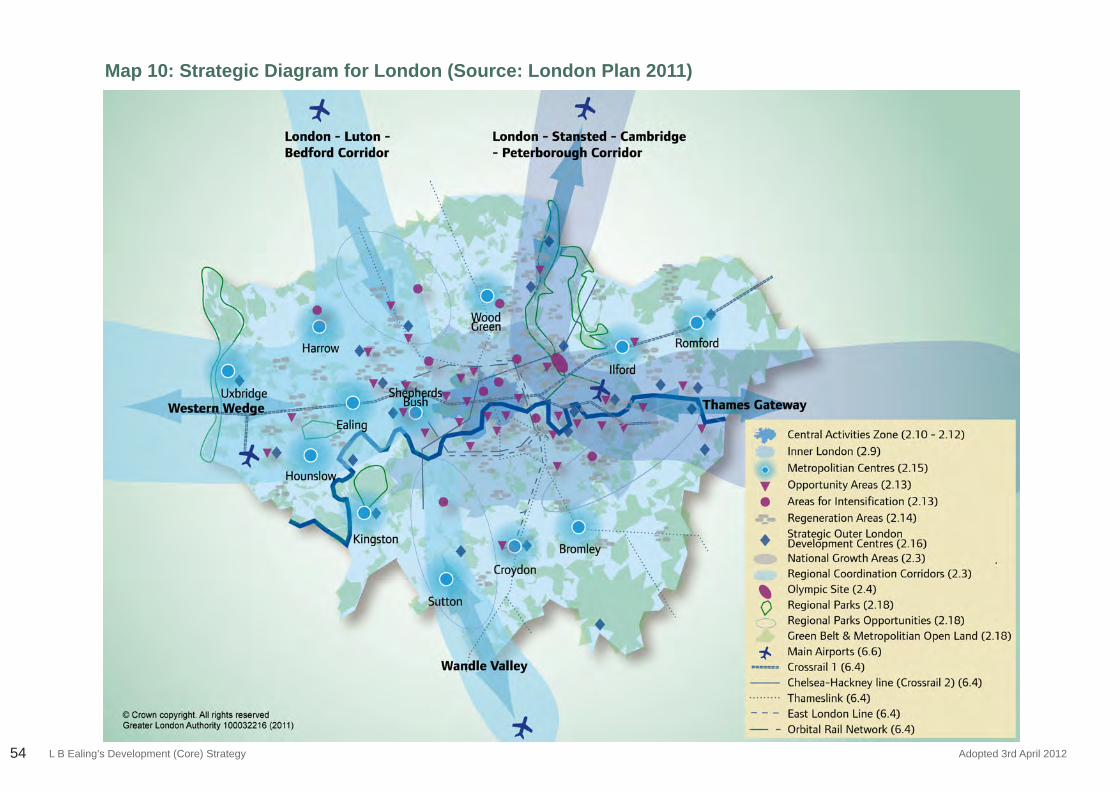
L B Ealing’s Development (Core) Strategy Adopted 3rd April 201254
Map 10: Strategic Diagram for London (Source: London Plan 2011)
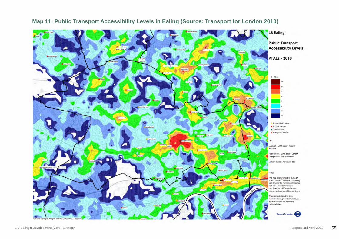
L B Ealing’s Development (Core) Strategy Adopted 3rd April 2012 55
Map 11: Public Transport Accessibility Levels in Ealing (Source: Transport for London 2010)
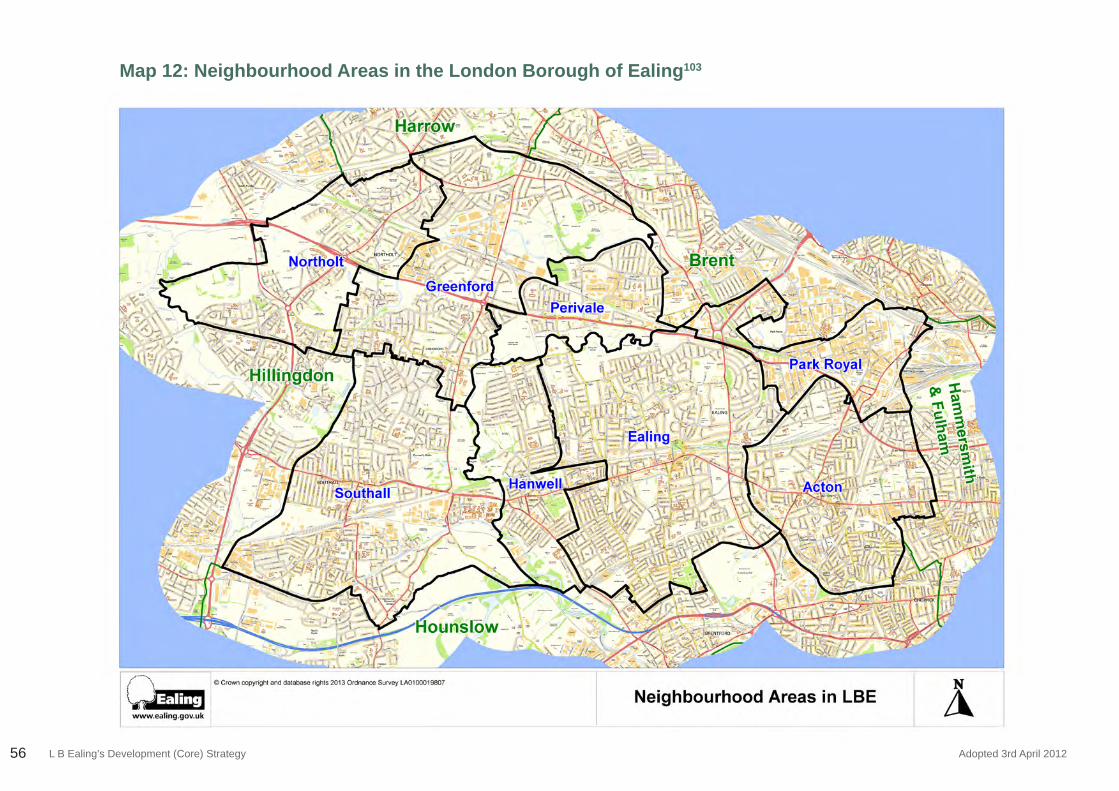
L B Ealing’s Development (Core) Strategy Adopted 3rd April 201256
Map 12: Neighbourhood Areas in the London Borough of Ealing103
L B Ealing’s Development (Core) Strategy Adopted 3rd April 2012 57
Appendix Two:A Local Context -
Neighbourhood Profiles
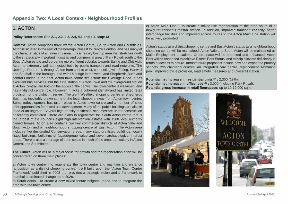
L B Ealing’s Development (Core) Strategy Adopted 3rd April 201258
Appendix Two: A Local Context - Neighbourhood Profiles
1. ACTON
Policy References: See 2.1, 2.2, 2.3, 2.4, 4.1 and 4.4. Map:13
Context:Actoncomprisesthreewards:ActonCentral,SouthActonandSouthfields.Acton is situated in the east of the borough, closest to Central London, and has many of the characteristics of an inner city area. It is a heavily built up area that stretches north to the strategically important industrial and commercial area of Park Royal, south to the SouthActonestateandborderingmoreaffluentsuburbstowardsEalingandChiswick.Acton is extremely well connected both by public transport and road networks. The Uxbridge Road runs through Acton from east to west, connecting with Ealing, Hanwell and Southall in the borough, and with Uxbridge in the west, and Shepherds Bush and central London in the east. Acton town centre sits astride the Uxbridge Road. It has excellent bus services, but the tube station at Acton Town and the overground station at Acton Central, are both on the edges of the centre. The town centre is well-used, and has a ‘district centre’ role. However, it lacks a coherent identity and has limited retail provisionforthedistrictitserves.ThegiantWestfieldshoppingcentreatShepherdsBush has inevitably drawn some of the local shoppers away from Acton town centre. Some redevelopment has taken place in Acton town centre and a number of sites offer opportunities for mixed-use development. Many of the public buildings are also in need of an upgrade. Several high-density residential schemes are under construction or recently completed. There are plans to regenerate the South Acton estate that is the largest of the council’s eight high intervention estates with 1500 local authority owned homes. Acton also contains two key commercial districts at Acton Vale and South Acton and a neighbourhood shopping centre at East Acton. The Acton area includesfivedesignatedConservationareas,manystatutory listedbuildings, locallylisted buildings, buildings of façade/group value and seven archaeological interest areas. There is also a shortage of open space in much of the area, particularly in Acton CentralandSouthfields.
The Future: Acton will be a major focus for growth and the regeneration effort will be concentrated on three main places:
a) Acton town centre - to regenerate the town centre and maintain and enhance its position as a district shopping centre. It will build upon the “Acton Town Centre Framework” published in 2008 that provides a strategic vision and a framework to marshal coordinated change up to 2026.b) South Acton – to create a new mixed tenure neighbourhood and to integrate the area with the town centre.
c) Acton Main Line – to create a mixed-use regeneration of the area south of a newly refurbished Crossrail station. In addition, improved transport capacity, better interchange facilities and improved access routes to the Acton Main Line station will be actively promoted.
Acton’s status as a district shopping centre and East Acton’s status as a neighbourhood shopping centre will be maintained. Acton Vale and South Acton will be maintained as Major Employment Locations. Green space will be protected and enhanced. Acton ParkwillbeenhancedtoachieveDistrictParkStatus,andtohelpalleviatedeficiencyinterms of access to nature. Infrastructure proposals include new and expanded primary schools, two children’s centres, an integrated care centre, replacement swimming pool, improved cycle provision, road safety measures and Crossrail station.
Potential net increase in residential units104 : 2,300 (19%).Potential net increase in office jobs105 : 2,000 (including Park Royal). Potential gross increase in retail floorspace: up to 10-12,000 sqm.
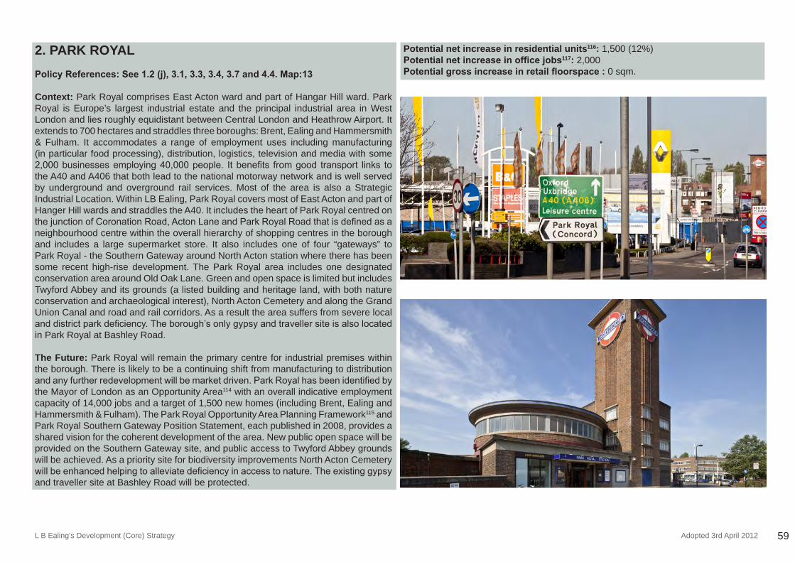
L B Ealing’s Development (Core) Strategy Adopted 3rd April 2012 59
2. PARK ROYAL
Policy References: See 1.2 (j), 3.1, 3.3, 3.4, 3.7 and 4.4. Map:13
Context: Park Royal comprises East Acton ward and part of Hangar Hill ward. Park Royal is Europe’s largest industrial estate and the principal industrial area in West London and lies roughly equidistant between Central London and Heathrow Airport. It extends to 700 hectares and straddles three boroughs: Brent, Ealing and Hammersmith & Fulham. It accommodates a range of employment uses including manufacturing (in particular food processing), distribution, logistics, television and media with some 2,000businessesemploying40,000people. Itbenefits fromgood transport links tothe A40 and A406 that both lead to the national motorway network and is well served by underground and overground rail services. Most of the area is also a Strategic Industrial Location. Within LB Ealing, Park Royal covers most of East Acton and part of Hanger Hill wards and straddles the A40. It includes the heart of Park Royal centred on thejunctionofCoronationRoad,ActonLaneandParkRoyalRoadthatisdefinedasaneighbourhood centre within the overall hierarchy of shopping centres in the borough and includes a large supermarket store. It also includes one of four “gateways” to Park Royal - the Southern Gateway around North Acton station where there has been some recent high-rise development. The Park Royal area includes one designated conservation area around Old Oak Lane. Green and open space is limited but includes Twyford Abbey and its grounds (a listed building and heritage land, with both nature conservation and archaeological interest), North Acton Cemetery and along the Grand Union Canal and road and rail corridors. As a result the area suffers from severe local anddistrictparkdeficiency.Theborough’sonlygypsyandtravellersiteisalsolocatedin Park Royal at Bashley Road.
The Future: Park Royal will remain the primary centre for industrial premises within the borough. There is likely to be a continuing shift from manufacturing to distribution andanyfurtherredevelopmentwillbemarketdriven.ParkRoyalhasbeenidentifiedbythe Mayor of London as an Opportunity Area114 with an overall indicative employment capacity of 14,000 jobs and a target of 1,500 new homes (including Brent, Ealing and Hammersmith & Fulham). The Park Royal Opportunity Area Planning Framework115 and Park Royal Southern Gateway Position Statement, each published in 2008, provides a shared vision for the coherent development of the area. New public open space will be provided on the Southern Gateway site, and public access to Twyford Abbey grounds will be achieved. As a priority site for biodiversity improvements North Acton Cemetery willbeenhancedhelpingtoalleviatedeficiencyinaccesstonature.Theexistinggypsyand traveller site at Bashley Road will be protected.
Potential net increase in residential units116: 1,500 (12%) Potential net increase in office jobs117: 2,000Potential gross increase in retail floorspace : 0 sqm.
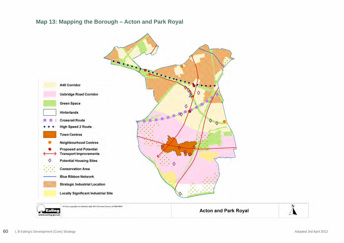
L B Ealing’s Development (Core) Strategy Adopted 3rd April 201260
Map 13: Mapping the Borough – Acton and Park Royal
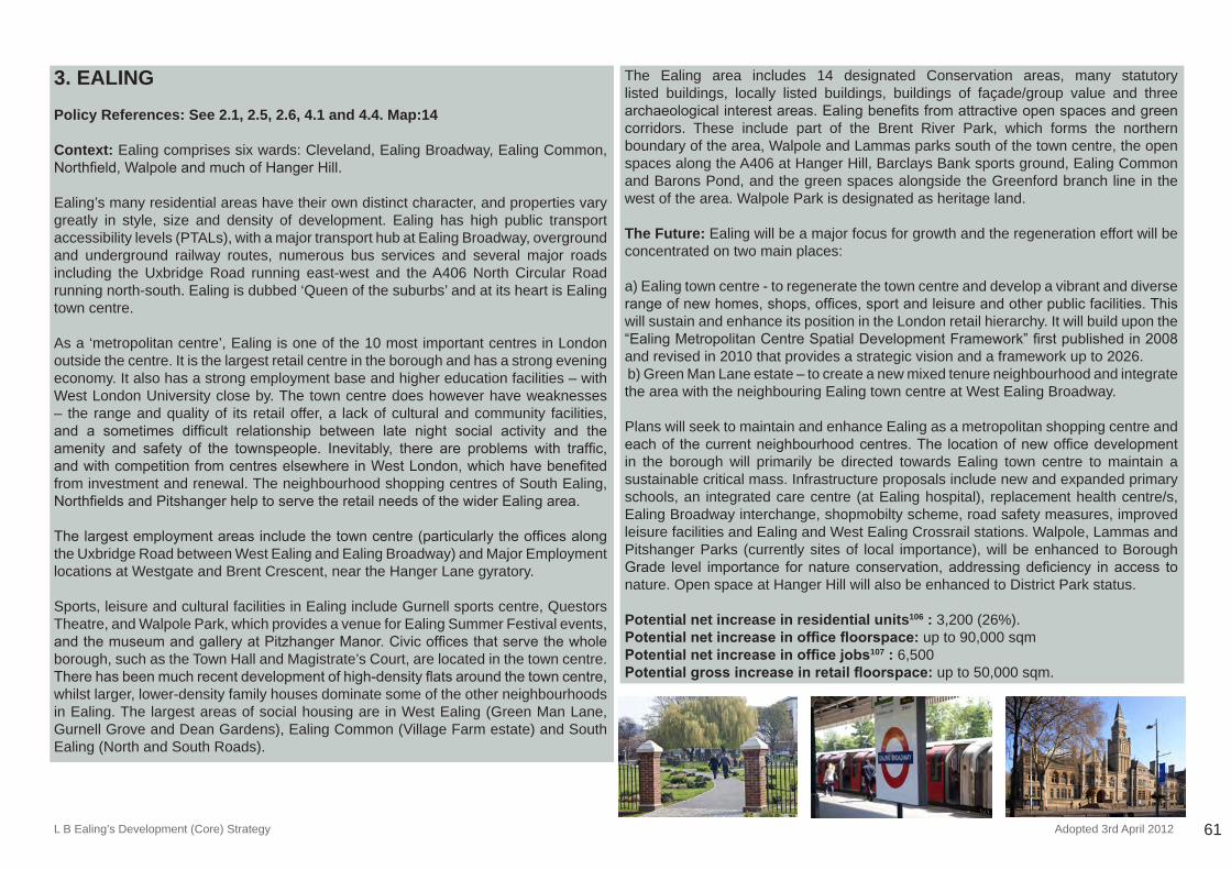
L B Ealing’s Development (Core) Strategy Adopted 3rd April 2012 61
3. EALING Policy References: See 2.1, 2.5, 2.6, 4.1 and 4.4. Map:14
Context: Ealing comprises six wards: Cleveland, Ealing Broadway, Ealing Common, Northfield,WalpoleandmuchofHangerHill.
Ealing’s many residential areas have their own distinct character, and properties vary greatly in style, size and density of development. Ealing has high public transport accessibility levels (PTALs), with a major transport hub at Ealing Broadway, overground and underground railway routes, numerous bus services and several major roads including the Uxbridge Road running east-west and the A406 North Circular Road running north-south. Ealing is dubbed ‘Queen of the suburbs’ and at its heart is Ealing town centre.
As a ‘metropolitan centre’, Ealing is one of the 10 most important centres in London outside the centre. It is the largest retail centre in the borough and has a strong evening economy. It also has a strong employment base and higher education facilities – with West London University close by. The town centre does however have weaknesses – the range and quality of its retail offer, a lack of cultural and community facilities, and a sometimes difficult relationship between late night social activity and theamenity and safety of the townspeople. Inevitably, there are problems with traffic,andwithcompetitionfromcentreselsewhereinWestLondon,whichhavebenefitedfrom investment and renewal. The neighbourhood shopping centres of South Ealing, NorthfieldsandPitshangerhelptoservetheretailneedsofthewiderEalingarea.
Thelargestemploymentareasincludethetowncentre(particularlytheofficesalongthe Uxbridge Road between West Ealing and Ealing Broadway) and Major Employment locations at Westgate and Brent Crescent, near the Hanger Lane gyratory.
Sports, leisure and cultural facilities in Ealing include Gurnell sports centre, Questors Theatre, and Walpole Park, which provides a venue for Ealing Summer Festival events, andthemuseumandgalleryatPitzhangerManor.Civicofficesthatservethewholeborough, such as the Town Hall and Magistrate’s Court, are located in the town centre. Therehasbeenmuchrecentdevelopmentofhigh-densityflatsaroundthetowncentre,whilst larger, lower-density family houses dominate some of the other neighbourhoods in Ealing. The largest areas of social housing are in West Ealing (Green Man Lane, Gurnell Grove and Dean Gardens), Ealing Common (Village Farm estate) and South Ealing (North and South Roads).
The Ealing area includes 14 designated Conservation areas, many statutory listed buildings, locally listed buildings, buildings of façade/group value and three archaeologicalinterestareas.Ealingbenefitsfromattractiveopenspacesandgreencorridors. These include part of the Brent River Park, which forms the northern boundary of the area, Walpole and Lammas parks south of the town centre, the open spaces along the A406 at Hanger Hill, Barclays Bank sports ground, Ealing Common and Barons Pond, and the green spaces alongside the Greenford branch line in the west of the area. Walpole Park is designated as heritage land.
The Future: Ealing will be a major focus for growth and the regeneration effort will be concentrated on two main places:
a) Ealing town centre - to regenerate the town centre and develop a vibrant and diverse rangeofnewhomes,shops,offices,sportandleisureandotherpublicfacilities.Thiswill sustain and enhance its position in the London retail hierarchy. It will build upon the “EalingMetropolitanCentreSpatialDevelopmentFramework”firstpublishedin2008and revised in 2010 that provides a strategic vision and a framework up to 2026. b) Green Man Lane estate – to create a new mixed tenure neighbourhood and integrate the area with the neighbouring Ealing town centre at West Ealing Broadway.
Plans will seek to maintain and enhance Ealing as a metropolitan shopping centre and eachof thecurrentneighbourhoodcentres.The locationofnewofficedevelopmentin the borough will primarily be directed towards Ealing town centre to maintain a sustainable critical mass. Infrastructure proposals include new and expanded primary schools, an integrated care centre (at Ealing hospital), replacement health centre/s, Ealing Broadway interchange, shopmobilty scheme, road safety measures, improved leisure facilities and Ealing and West Ealing Crossrail stations. Walpole, Lammas and Pitshanger Parks (currently sites of local importance), will be enhanced to Borough Grade level importance fornatureconservation,addressingdeficiency inaccess tonature. Open space at Hanger Hill will also be enhanced to District Park status.
Potential net increase in residential units106 : 3,200 (26%).Potential net increase in office floorspace: up to 90,000 sqmPotential net increase in office jobs107 : 6,500Potential gross increase in retail floorspace: up to 50,000 sqm.
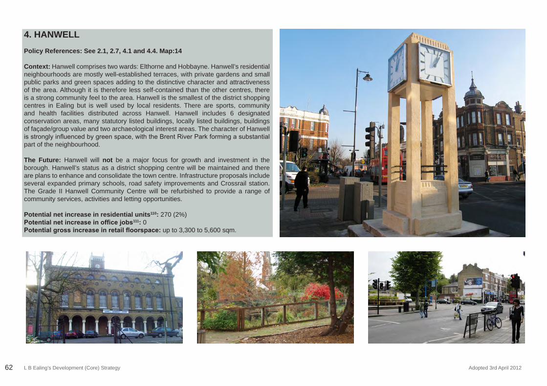
L B Ealing’s Development (Core) Strategy Adopted 3rd April 201262
4. HANWELL Policy References: See 2.1, 2.7, 4.1 and 4.4. Map:14
Context: Hanwell comprises two wards: Elthorne and Hobbayne. Hanwell’s residential neighbourhoods are mostly well-established terraces, with private gardens and small public parks and green spaces adding to the distinctive character and attractiveness of the area. Although it is therefore less self-contained than the other centres, there is a strong community feel to the area. Hanwell is the smallest of the district shopping centres in Ealing but is well used by local residents. There are sports, community and health facilities distributed across Hanwell. Hanwell includes 6 designated conservation areas, many statutory listed buildings, locally listed buildings, buildings of façade/group value and two archaeological interest areas. The character of Hanwell isstronglyinfluencedbygreenspace,withtheBrentRiverParkformingasubstantialpart of the neighbourhood.
The Future: Hanwell will not be a major focus for growth and investment in the borough. Hanwell’s status as a district shopping centre will be maintained and there are plans to enhance and consolidate the town centre. Infrastructure proposals include several expanded primary schools, road safety improvements and Crossrail station. The Grade II Hanwell Community Centre will be refurbished to provide a range of community services, activities and letting opportunities.
Potential net increase in residential units110: 270 (2%) Potential net increase in office jobs111: 0 Potential gross increase in retail floorspace: up to 3,300 to 5,600 sqm.
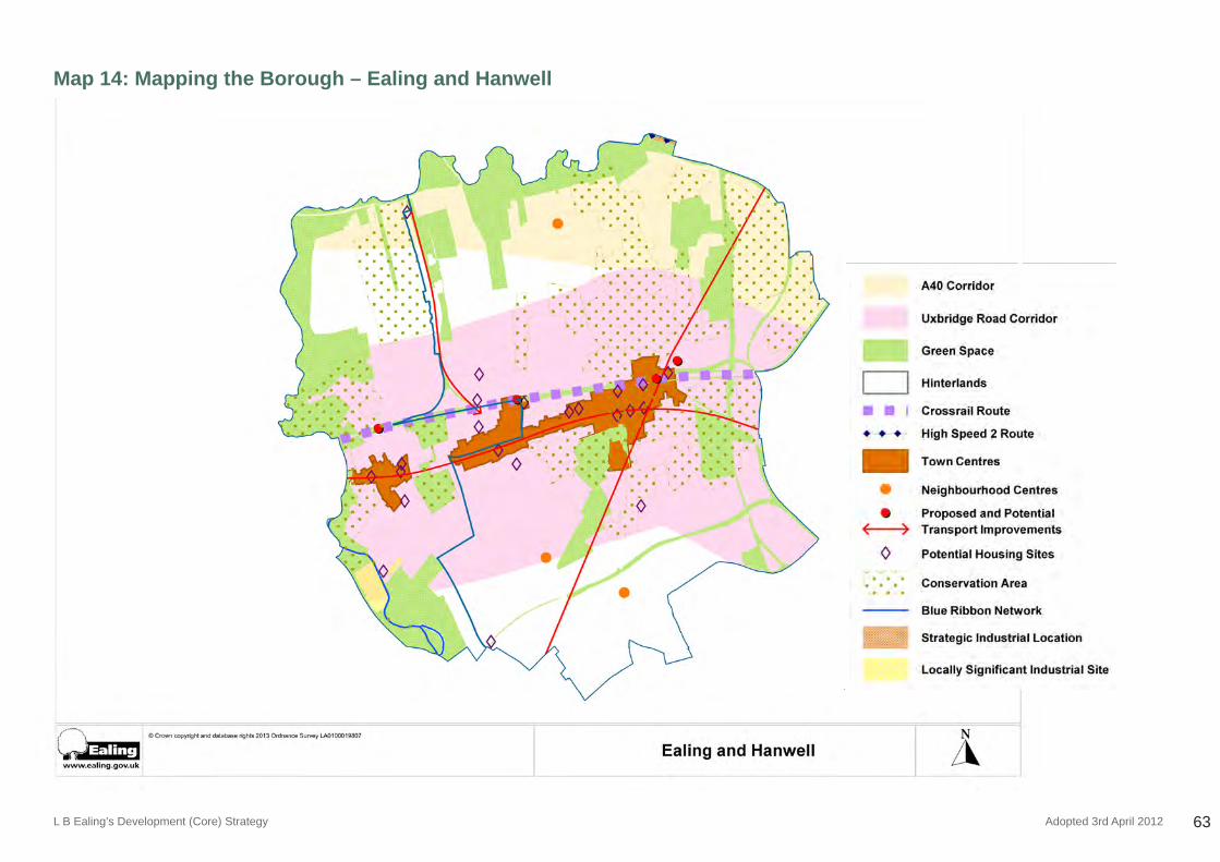
L B Ealing’s Development (Core) Strategy Adopted 3rd April 2012 63
Map 14: Mapping the Borough – Ealing and Hanwell
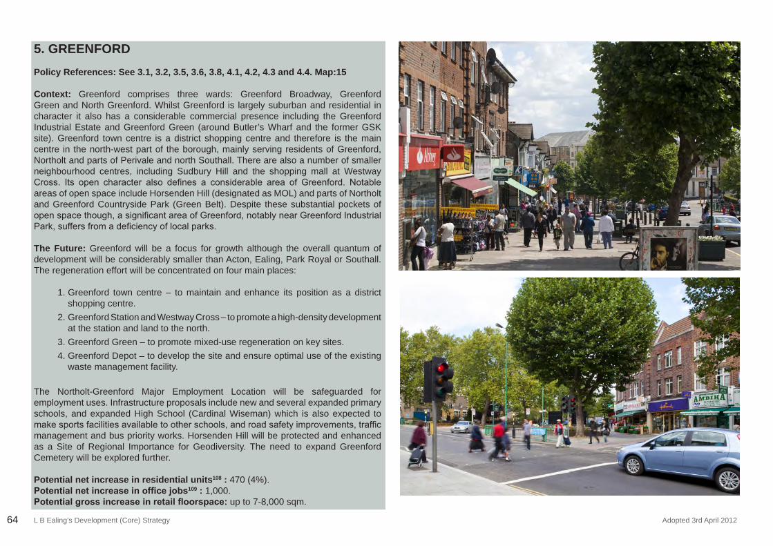
L B Ealing’s Development (Core) Strategy Adopted 3rd April 201264
5. GREENFORDPolicy References: See 3.1, 3.2, 3.5, 3.6, 3.8, 4.1, 4.2, 4.3 and 4.4. Map:15
Context: Greenford comprises three wards: Greenford Broadway, Greenford Green and North Greenford. Whilst Greenford is largely suburban and residential in character it also has a considerable commercial presence including the Greenford Industrial Estate and Greenford Green (around Butler’s Wharf and the former GSK site). Greenford town centre is a district shopping centre and therefore is the main centre in the north-west part of the borough, mainly serving residents of Greenford, Northolt and parts of Perivale and north Southall. There are also a number of smaller neighbourhood centres, including Sudbury Hill and the shopping mall at Westway Cross. Its open character also defines a considerable area of Greenford. Notableareas of open space include Horsenden Hill (designated as MOL) and parts of Northolt and Greenford Countryside Park (Green Belt). Despite these substantial pockets of openspacethough,asignificantareaofGreenford,notablynearGreenfordIndustrialPark,suffersfromadeficiencyoflocalparks.
The Future: Greenford will be a focus for growth although the overall quantum of development will be considerably smaller than Acton, Ealing, Park Royal or Southall. The regeneration effort will be concentrated on four main places:
1. Greenford town centre – to maintain and enhance its position as a district shopping centre.
2. Greenford Station and Westway Cross – to promote a high-density development at the station and land to the north.
3. Greenford Green – to promote mixed-use regeneration on key sites.4. Greenford Depot – to develop the site and ensure optimal use of the existing
waste management facility.
The Northolt-Greenford Major Employment Location will be safeguarded for employment uses. Infrastructure proposals include new and several expanded primary schools, and expanded High School (Cardinal Wiseman) which is also expected to makesportsfacilitiesavailabletootherschools,androadsafetyimprovements,trafficmanagement and bus priority works. Horsenden Hill will be protected and enhanced as a Site of Regional Importance for Geodiversity. The need to expand Greenford Cemetery will be explored further.
Potential net increase in residential units108 : 470 (4%). Potential net increase in office jobs109 : 1,000.Potential gross increase in retail floorspace: up to 7-8,000 sqm.
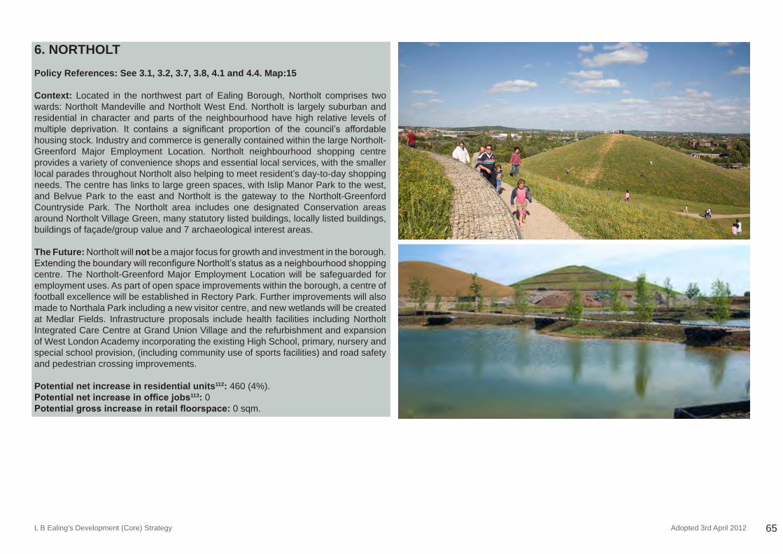
L B Ealing’s Development (Core) Strategy Adopted 3rd April 2012 65
6. NORTHOLT
Policy References: See 3.1, 3.2, 3.7, 3.8, 4.1 and 4.4. Map:15
Context: Located in the northwest part of Ealing Borough, Northolt comprises two wards: Northolt Mandeville and Northolt West End. Northolt is largely suburban and residential in character and parts of the neighbourhood have high relative levels of multiple deprivation. It contains a significant proportion of the council’s affordablehousing stock. Industry and commerce is generally contained within the large Northolt-Greenford Major Employment Location. Northolt neighbourhood shopping centre provides a variety of convenience shops and essential local services, with the smaller local parades throughout Northolt also helping to meet resident’s day-to-day shopping needs. The centre has links to large green spaces, with Islip Manor Park to the west, and Belvue Park to the east and Northolt is the gateway to the Northolt-Greenford Countryside Park. The Northolt area includes one designated Conservation areas around Northolt Village Green, many statutory listed buildings, locally listed buildings, buildings of façade/group value and 7 archaeological interest areas.
The Future: Northolt will not be a major focus for growth and investment in the borough. ExtendingtheboundarywillreconfigureNortholt’sstatusasaneighbourhoodshoppingcentre. The Northolt-Greenford Major Employment Location will be safeguarded for employment uses. As part of open space improvements within the borough, a centre of football excellence will be established in Rectory Park. Further improvements will also made to Northala Park including a new visitor centre, and new wetlands will be created at Medlar Fields. Infrastructure proposals include health facilities including Northolt Integrated Care Centre at Grand Union Village and the refurbishment and expansion of West London Academy incorporating the existing High School, primary, nursery and special school provision, (including community use of sports facilities) and road safety and pedestrian crossing improvements.
Potential net increase in residential units112: 460 (4%). Potential net increase in office jobs113: 0 Potential gross increase in retail floorspace: 0 sqm.
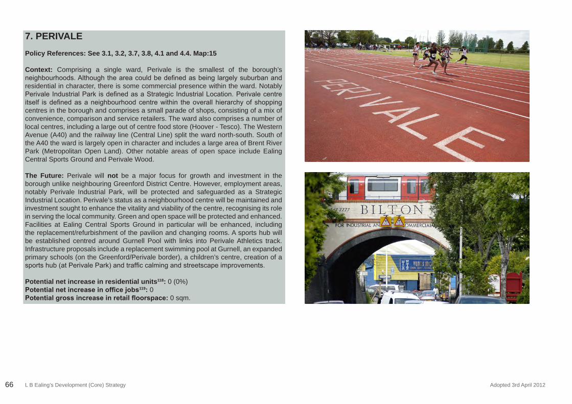
L B Ealing’s Development (Core) Strategy Adopted 3rd April 201266
7. PERIVALE
Policy References: See 3.1, 3.2, 3.7, 3.8, 4.1 and 4.4. Map:15
Context: Comprising a single ward, Perivale is the smallest of the borough’s neighbourhoods.Althoughtheareacouldbedefinedasbeinglargelysuburbanandresidential in character, there is some commercial presence within the ward. Notably PerivaleIndustrialParkisdefinedasaStrategicIndustrialLocation.Perivalecentreitself isdefinedasaneighbourhoodcentrewithin theoverallhierarchyofshoppingcentres in the borough and comprises a small parade of shops, consisting of a mix of convenience, comparison and service retailers. The ward also comprises a number of local centres, including a large out of centre food store (Hoover - Tesco). The Western Avenue (A40) and the railway line (Central Line) split the ward north-south. South of the A40 the ward is largely open in character and includes a large area of Brent River Park (Metropolitan Open Land). Other notable areas of open space include Ealing Central Sports Ground and Perivale Wood.
The Future: Perivale will not be a major focus for growth and investment in the borough unlike neighbouring Greenford District Centre. However, employment areas, notably Perivale Industrial Park, will be protected and safeguarded as a Strategic Industrial Location. Perivale’s status as a neighbourhood centre will be maintained and investment sought to enhance the vitality and viability of the centre, recognising its role in serving the local community. Green and open space will be protected and enhanced. Facilities at Ealing Central Sports Ground in particular will be enhanced, including the replacement/refurbishment of the pavilion and changing rooms. A sports hub will be established centred around Gurnell Pool with links into Perivale Athletics track. Infrastructure proposals include a replacement swimming pool at Gurnell, an expanded primary schools (on the Greenford/Perivale border), a children’s centre, creation of a sportshub(atPerivalePark)andtrafficcalmingandstreetscapeimprovements.
Potential net increase in residential units118: 0 (0%) Potential net increase in office jobs119: 0 Potential gross increase in retail floorspace: 0 sqm.
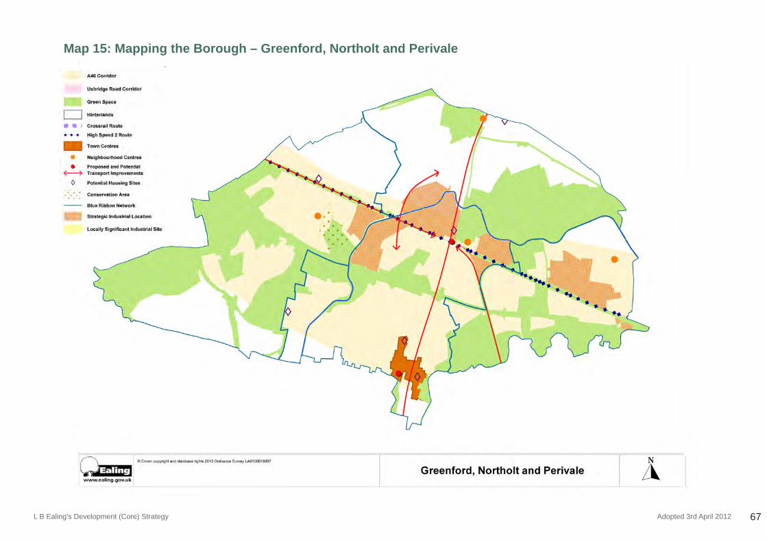
L B Ealing’s Development (Core) Strategy Adopted 3rd April 2012 67
Map 15: Mapping the Borough – Greenford, Northolt and Perivale
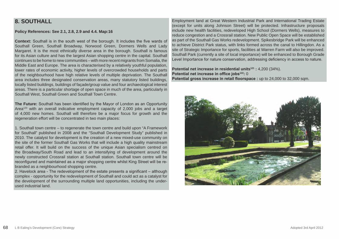
L B Ealing’s Development (Core) Strategy Adopted 3rd April 201268
8. SOUTHALL Policy References: See 2.1, 2.8, 2.9 and 4.4. Map:16
Context:Southall is in thesouthwestof theborough. It includes thefivewardsofSouthall Green, Southall Broadway, Norwood Green, Dormers Wells and Lady Margaret. It is the most ethnically diverse area in the borough. Southall is famous for its Asian culture and has the largest Asian shopping centre in the capital. Southall continues to be home to new communities – with more recent migrants from Somalia, the Middle East and Europe. The area is characterised by a relatively youthful population, lower rates of economic activity, higher levels of overcrowded households and parts of the neighbourhood have high relative levels of multiple deprivation. The Southall area includes three designated conservation areas, many statutory listed buildings, locally listed buildings, buildings of façade/group value and four archaeological interest areas. There is a particular shortage of open space in much of the area, particularly in Southall West, Southall Green and Southall Town Centre.
The Future:SouthallhasbeenidentifiedbytheMayorofLondonasanOpportunityArea120 with an overall indicative employment capacity of 2,000 jobs and a target of 4,000 new homes. Southall will therefore be a major focus for growth and the regeneration effort will be concentrated in two main places:
1. Southall town centre – to regenerate the town centre and build upon “A Framework for Southall” published in 2008 and the “Southall Development Study” published in 2010. The catalyst for development is the creation of a new mixed-use community on the site of the former Southall Gas Works that will include a high quality mainstream retail offer. It will build on the success of the unique Asian specialism centred on the Broadway/South Road and lead to an intensifying of development around the newly constructed Crossrail station at Southall station. Southall town centre will be reconfiguredandmaintainedasamajorshoppingcentrewhilstKingStreetwillbere-branded as a neighbourhood shopping centre. 2.Havelockarea-Theredevelopmentoftheestatepresentsasignificant–althoughcomplex - opportunity for the redevelopment of Southall and could act as a catalyst for the development of the surrounding multiple land opportunities, including the under-used industrial land.
Employment land at Great Western Industrial Park and International Trading Estate (except for units along Johnson Street) will be protected. Infrastructure proposals include new health facilities, redeveloped High School (Dormers Wells), measures to reduce congestion and a Crossrail station. New Public Open Space will be established as part of the Southall Gas Works redevelopment. Spikesbridge Park will be enhanced to achieve District Park status, with links formed across the canal to Hillingdon. As a site of Strategic Importance for sports, facilities at Warren Farm will also be improved. Southall Park (currently a site of local importance) will be enhanced to Borough Grade LevelImportancefornatureconservation,addressingdeficiencyinaccesstonature.
Potential net increase in residential units121 : 4,200 (34%). Potential net increase in office jobs122: 0Potential gross increase in retail floorspace : up to 24,000 to 32,000 sqm.
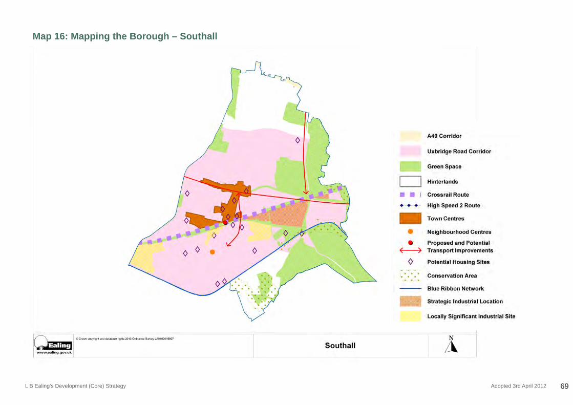
L B Ealing’s Development (Core) Strategy Adopted 3rd April 2012 69
Map 16: Mapping the Borough – Southall
L B Ealing’s Development (Core) Strategy Adopted 3rd April 201270
Appendix Three:Infrastructure Delivery Schedule
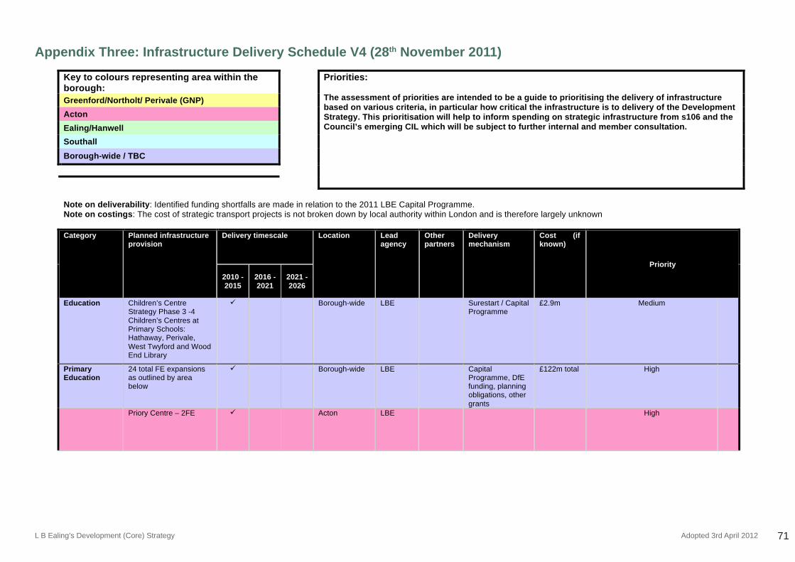
L B Ealing’s Development (Core) Strategy Adopted 3rd April 2012 71
Appendix Three: Infrastructure Delivery Schedule V4 (28th November 2011)
ADOPTED DEVELOPMENT STRATEGY 2026 APRIL 3rd 2012
90
Appendix Three: Infrastructure Delivery Schedule v4 (28 November 2011) Key to colours representing area within the borough:
Priorities: The assessment of priorities are intended to be a guide to prioritising the delivery of infrastructure based on various criteria, in particular how critical the infrastructure is to delivery of the Development Strategy. This prioritisation will help to inform spending on strategic infrastructure from s106 and the Council’s emerging CIL which will be subject to further internal and member consultation.
Greenford/Northolt/ Perivale (GNP)
Acton
Ealing/Hanwell
Southall
Borough-wide / TBC
Note on deliverability: Identified funding shortfalls are made in relation to the 2011 LBE Capital Programme. Note on costings: The cost of strategic transport projects is not broken down by local authority within London and is therefore largely unknown
Category Planned infrastructure
provision Delivery timescale Location Lead
agency Other partners
Delivery mechanism
Cost (if known)
Priority
2010 - 2015
2016 - 2021
2021 - 2026
Education Children’s Centre Strategy Phase 3 -4 Children’s Centres at Primary Schools: Hathaway, Perivale, West Twyford and Wood End Library
Borough-wide LBE Surestart / Capital Programme
£2.9m Medium
Primary Education
24 total FE expansions as outlined by area below
Borough-wide LBE Capital Programme, DfE funding, planning obligations, other grants
£122m total High
Priory Centre – 2FE Acton LBE High
Appendix Three:Infrastructure Delivery Schedule
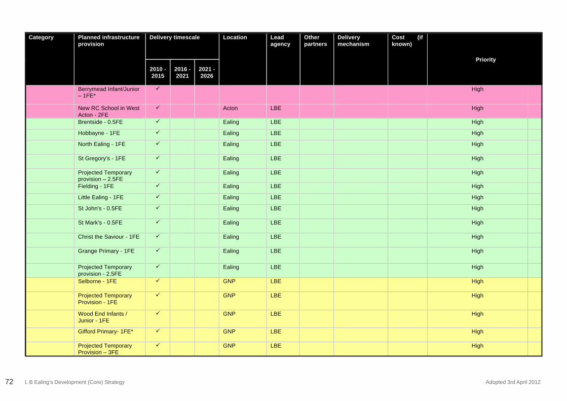
L B Ealing’s Development (Core) Strategy Adopted 3rd April 201272
ADOPTED DEVELOPMENT STRATEGY 2026 APRIL 3rd 2012
91
Category Planned infrastructure provision
Delivery timescale Location Lead agency
Other partners
Delivery mechanism
Cost (if known)
Priority
2010 - 2015
2016 - 2021
2021 - 2026
Berrymead Infant/Junior – 1FE*
High
New RC School in West Acton - 2FE
Acton LBE High
Brentside - 0.5FE Ealing LBE High
Hobbayne - 1FE Ealing LBE High
North Ealing - 1FE Ealing LBE High
St Gregory's - 1FE Ealing LBE High
Projected Temporary provision – 2.5FE
Ealing LBE High
Fielding - 1FE Ealing LBE High
Little Ealing - 1FE Ealing LBE High
St John's - 0.5FE Ealing LBE High
St Mark's - 0.5FE Ealing LBE High
Christ the Saviour - 1FE Ealing LBE High
Grange Primary - 1FE Ealing LBE High
Projected Temporary provision - 2.5FE
Ealing LBE High
Selborne - 1FE GNP LBE High
Projected Temporary Provision - 1FE
GNP LBE High
Wood End Infants / Junior - 1FE
GNP LBE High
Gifford Primary- 1FE* GNP LBE High
Projected Temporary Provision – 3FE
GNP LBE High
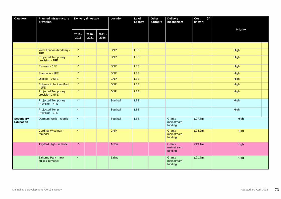
L B Ealing’s Development (Core) Strategy Adopted 3rd April 2012 73
ADOPTED DEVELOPMENT STRATEGY 2026 APRIL 3rd 2012
92
Category Planned infrastructure provision
Delivery timescale Location Lead agency
Other partners
Delivery mechanism
Cost (if known)
Priority
2010 - 2015
2016 - 2021
2021 - 2026
West London Academy - 1FE
GNP LBE High
Projected Temporary provision - 2FE
GNP LBE High
Ravenor - 1FE GNP LBE High
Stanhope - 1FE GNP LBE High
Oldfield - 0.5FE GNP LBE High
Scheme to be identified - 1FE
GNP LBE High
Projected Temporary provision 2.5FE
GNP LBE High
Projected Temporary Provision - 4FE
Southall LBE High
Projected Temp Provision - 1FE
Southall LBE High
Secondary Education
Dormers Wells - rebuild Southall LBE Grant / mainstream funding
£27.3m High
Cardinal Wiseman - remodel
GNP Grant / mainstream funding
£23.9m High
Twyford High - remodel Acton Grant / mainstream funding
£19.1m High
Elthorne Park - new build & remodel
Ealing Grant / mainstream funding
£21.7m High
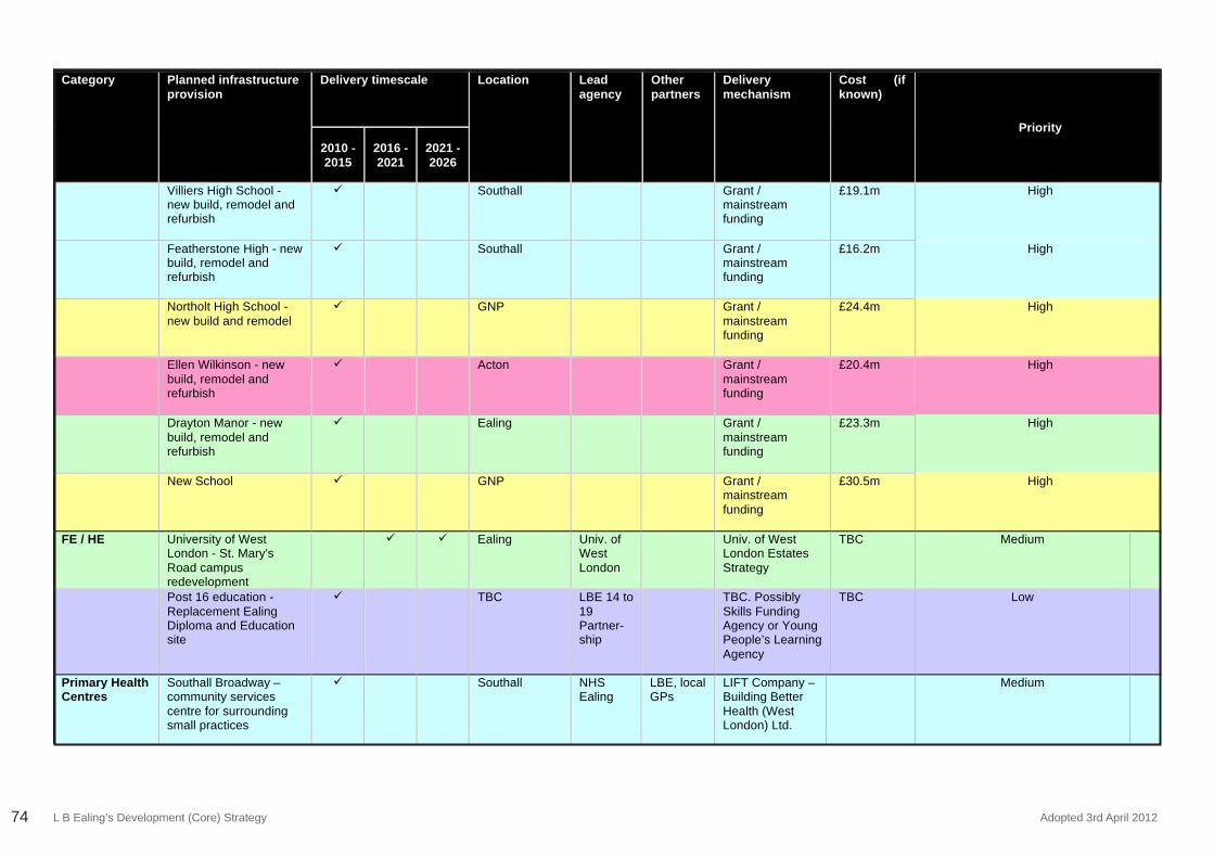
L B Ealing’s Development (Core) Strategy Adopted 3rd April 201274
ADOPTED DEVELOPMENT STRATEGY 2026 APRIL 3rd 2012
93
Category Planned infrastructure provision
Delivery timescale Location Lead agency
Other partners
Delivery mechanism
Cost (if known)
Priority
2010 - 2015
2016 - 2021
2021 - 2026
Villiers High School - new build, remodel and refurbish
Southall Grant / mainstream funding
£19.1m High
Featherstone High - new build, remodel and refurbish
Southall Grant / mainstream funding
£16.2m High
Northolt High School - new build and remodel
GNP Grant / mainstream funding
£24.4m High
Ellen Wilkinson - new build, remodel and refurbish
Acton Grant / mainstream funding
£20.4m High
Drayton Manor - new build, remodel and refurbish
Ealing Grant / mainstream funding
£23.3m High
New School GNP Grant / mainstream funding
£30.5m High
FE / HE University of West London - St. Mary's Road campus redevelopment
Ealing Univ. of West London
Univ. of West London Estates Strategy
TBC Medium
Post 16 education - Replacement Ealing Diploma and Education site
TBC LBE 14 to 19 Partner-ship
TBC. Possibly Skills Funding Agency or Young People’s Learning Agency
TBC Low
Primary Health Centres
Southall Broadway – community services centre for surrounding small practices
Southall NHS Ealing
LBE, local GPs
LIFT Company – Building Better Health (West London) Ltd.
Medium
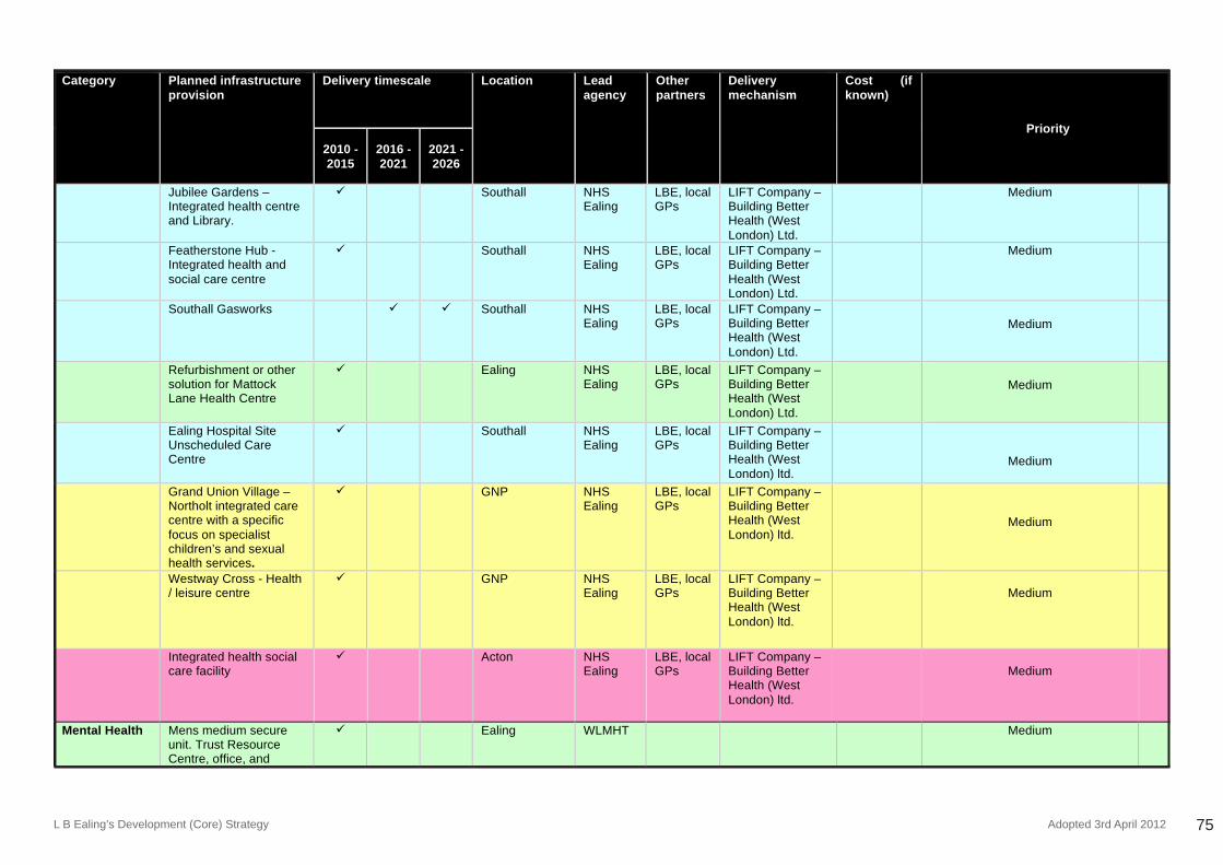
L B Ealing’s Development (Core) Strategy Adopted 3rd April 2012 75
ADOPTED DEVELOPMENT STRATEGY 2026 APRIL 3rd 2012
94
Category Planned infrastructure provision
Delivery timescale Location Lead agency
Other partners
Delivery mechanism
Cost (if known)
Priority
2010 - 2015
2016 - 2021
2021 - 2026
Jubilee Gardens – Integrated health centre and Library.
Southall NHS Ealing
LBE, local GPs
LIFT Company – Building Better Health (West London) Ltd.
Medium
Featherstone Hub - Integrated health and social care centre
Southall NHS Ealing
LBE, local GPs
LIFT Company – Building Better Health (West London) Ltd.
Medium
Southall Gasworks Southall NHS Ealing
LBE, local GPs
LIFT Company – Building Better Health (West London) Ltd.
Medium
Refurbishment or other solution for Mattock Lane Health Centre
Ealing NHS Ealing
LBE, local GPs
LIFT Company – Building Better Health (West London) Ltd.
Medium
Ealing Hospital Site Unscheduled Care Centre
Southall NHS Ealing
LBE, local GPs
LIFT Company – Building Better Health (West London) ltd.
Medium
Grand Union Village – Northolt integrated care centre with a specific focus on specialist children’s and sexual health services.
GNP NHS Ealing
LBE, local GPs
LIFT Company – Building Better Health (West London) ltd.
Medium
Westway Cross - Health / leisure centre
GNP NHS Ealing
LBE, local GPs
LIFT Company – Building Better Health (West London) ltd.
Medium
Integrated health social care facility
Acton NHS Ealing
LBE, local GPs
LIFT Company – Building Better Health (West London) ltd.
Medium
Mental Health Mens medium secure unit. Trust Resource Centre, office, and
Ealing WLMHT Medium
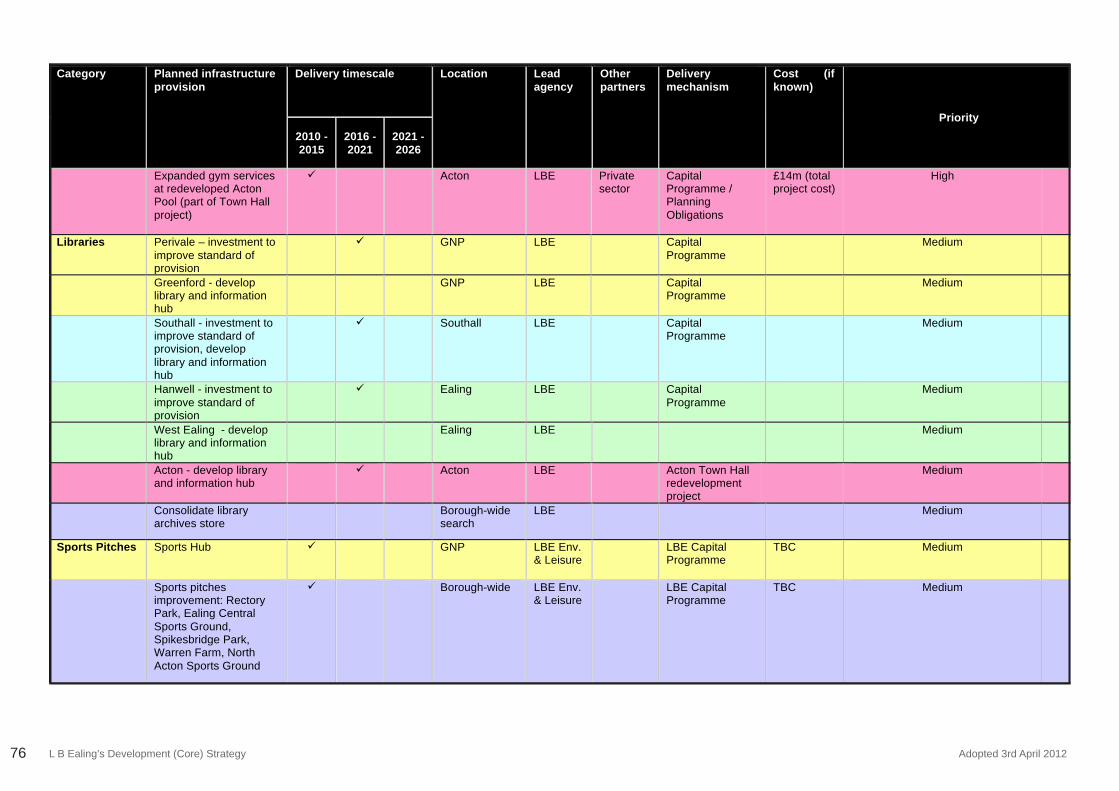
L B Ealing’s Development (Core) Strategy Adopted 3rd April 201276
ADOPTED DEVELOPMENT STRATEGY 2026 APRIL 3rd 2012
96
Category Planned infrastructure provision
Delivery timescale Location Lead agency
Other partners
Delivery mechanism
Cost (if known)
Priority
2010 - 2015
2016 - 2021
2021 - 2026
Expanded gym services at redeveloped Acton Pool (part of Town Hall project)
Acton LBE Private sector
Capital Programme / Planning Obligations
£14m (total project cost)
High
Libraries Perivale – investment to improve standard of provision
GNP LBE Capital Programme
Medium
Greenford - develop library and information hub
GNP LBE Capital Programme
Medium
Southall - investment to improve standard of provision, develop library and information hub
Southall LBE Capital Programme
Medium
Hanwell - investment to improve standard of provision
Ealing LBE Capital Programme
Medium
West Ealing - develop library and information hub
Ealing LBE Medium
Acton - develop library and information hub
Acton LBE Acton Town Hall redevelopment project
Medium
Consolidate library archives store
Borough-wide search
LBE Medium
Sports Pitches Sports Hub GNP LBE Env. & Leisure
LBE Capital Programme
TBC Medium
Sports pitches improvement: Rectory Park, Ealing Central Sports Ground, Spikesbridge Park, Warren Farm, North Acton Sports Ground
Borough-wide LBE Env. & Leisure
LBE Capital Programme
TBC Medium
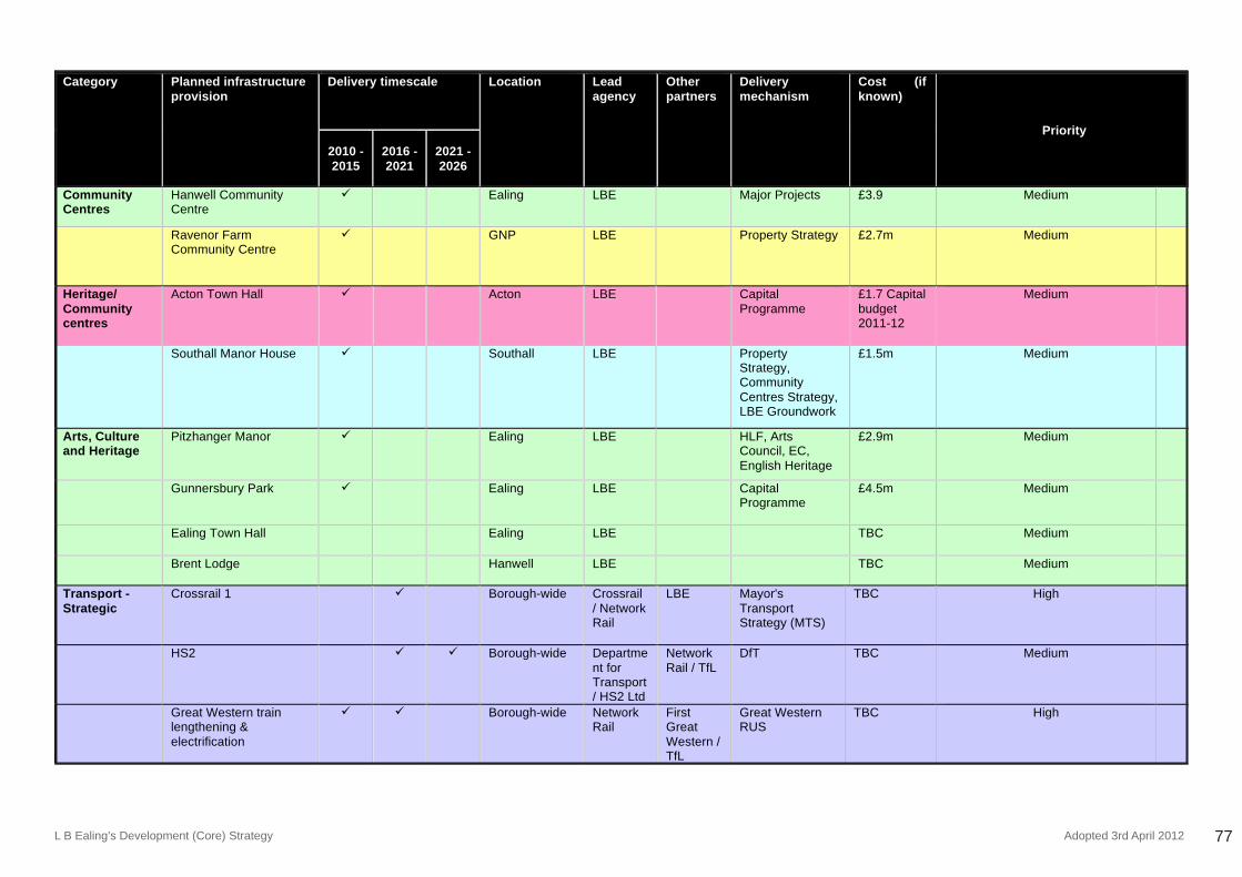
L B Ealing’s Development (Core) Strategy Adopted 3rd April 2012 77
ADOPTED DEVELOPMENT STRATEGY 2026 APRIL 3rd 2012
97
Category Planned infrastructure provision
Delivery timescale Location Lead agency
Other partners
Delivery mechanism
Cost (if known)
Priority
2010 - 2015
2016 - 2021
2021 - 2026
Community Centres
Hanwell Community Centre
Ealing LBE Major Projects £3.9 Medium
Ravenor Farm Community Centre
GNP LBE Property Strategy £2.7m Medium
Heritage/ Community centres
Acton Town Hall Acton LBE Capital Programme
£1.7 Capital budget 2011-12
Medium
Southall Manor House Southall LBE Property Strategy, Community Centres Strategy, LBE Groundwork
£1.5m Medium
Arts, Culture and Heritage
Pitzhanger Manor Ealing LBE HLF, Arts Council, EC, English Heritage
£2.9m Medium
Gunnersbury Park Ealing LBE Capital Programme
£4.5m Medium
Ealing Town Hall Ealing LBE TBC Medium
Brent Lodge
Hanwell LBE TBC Medium
Transport - Strategic
Crossrail 1 Borough-wide Crossrail / Network Rail
LBE Mayor's Transport Strategy (MTS)
TBC High
HS2 Borough-wide Department for Transport/ HS2 Ltd
Network Rail / TfL
DfT TBC Medium
Great Western train lengthening & electrification
Borough-wide Network Rail
First Great Western / TfL
Great Western RUS
TBC High
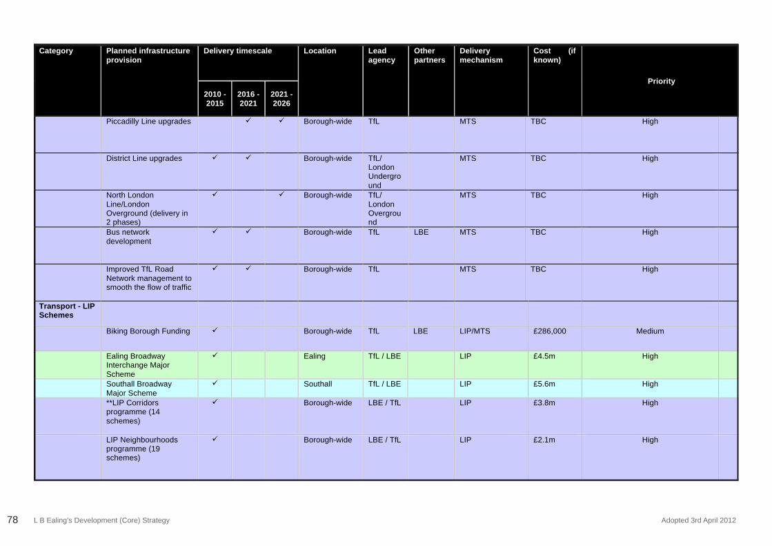
L B Ealing’s Development (Core) Strategy Adopted 3rd April 201278
ADOPTED DEVELOPMENT STRATEGY 2026 APRIL 3rd 2012
98
Category Planned infrastructure provision
Delivery timescale Location Lead agency
Other partners
Delivery mechanism
Cost (if known)
Priority
2010 - 2015
2016 - 2021
2021 - 2026
Piccadilly Line upgrades Borough-wide TfL MTS TBC High
District Line upgrades Borough-wide TfL/ London Underground
MTS TBC High
North London Line/London Overground (delivery in 2 phases)
Borough-wide TfL/ London Overground
MTS TBC High
Bus network development
Borough-wide TfL LBE MTS TBC High
Improved TfL Road Network management to smooth the flow of traffic
Borough-wide TfL MTS TBC High
Transport - LIP Schemes
Biking Borough Funding Borough-wide TfL LBE LIP/MTS £286,000 Medium
Ealing Broadway Interchange Major Scheme
Ealing TfL / LBE LIP £4.5m High
Southall Broadway Major Scheme
Southall TfL / LBE LIP £5.6m High
**LIP Corridors programme (14 schemes)
Borough-wide LBE / TfL LIP £3.8m High
LIP Neighbourhoods programme (19 schemes)
Borough-wide LBE / TfL LIP £2.1m High
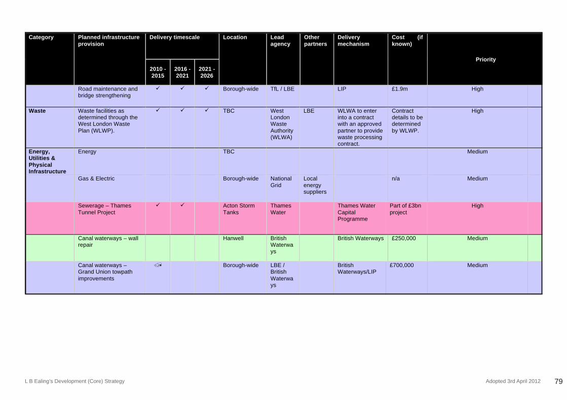
L B Ealing’s Development (Core) Strategy Adopted 3rd April 2012 79
ADOPTED DEVELOPMENT STRATEGY 2026 APRIL 3rd 2012
99
Category Planned infrastructure provision
Delivery timescale Location Lead agency
Other partners
Delivery mechanism
Cost (if known)
Priority
2010 - 2015
2016 - 2021
2021 - 2026
Road maintenance and bridge strengthening
Borough-wide TfL / LBE LIP £1.9m High
Waste Waste facilities as determined through the West London Waste Plan (WLWP).
TBC West London Waste Authority (WLWA)
LBE WLWA to enter into a contract with an approved partner to provide waste processing contract.
Contract details to be determined by WLWP.
High
Energy, Utilities & Physical Infrastructure
Energy TBC Medium
Gas & Electric Borough-wide National Grid
Local energy suppliers
n/a Medium
Sewerage – Thames Tunnel Project
Acton Storm Tanks
Thames Water
Thames Water Capital Programme
Part of £3bn project
High
Canal waterways – wall repair
Hanwell British Waterways
British Waterways £250,000 Medium
Canal waterways – Grand Union towpath improvements
Borough-wide LBE / British Waterways
British Waterways/LIP
£700,000 Medium
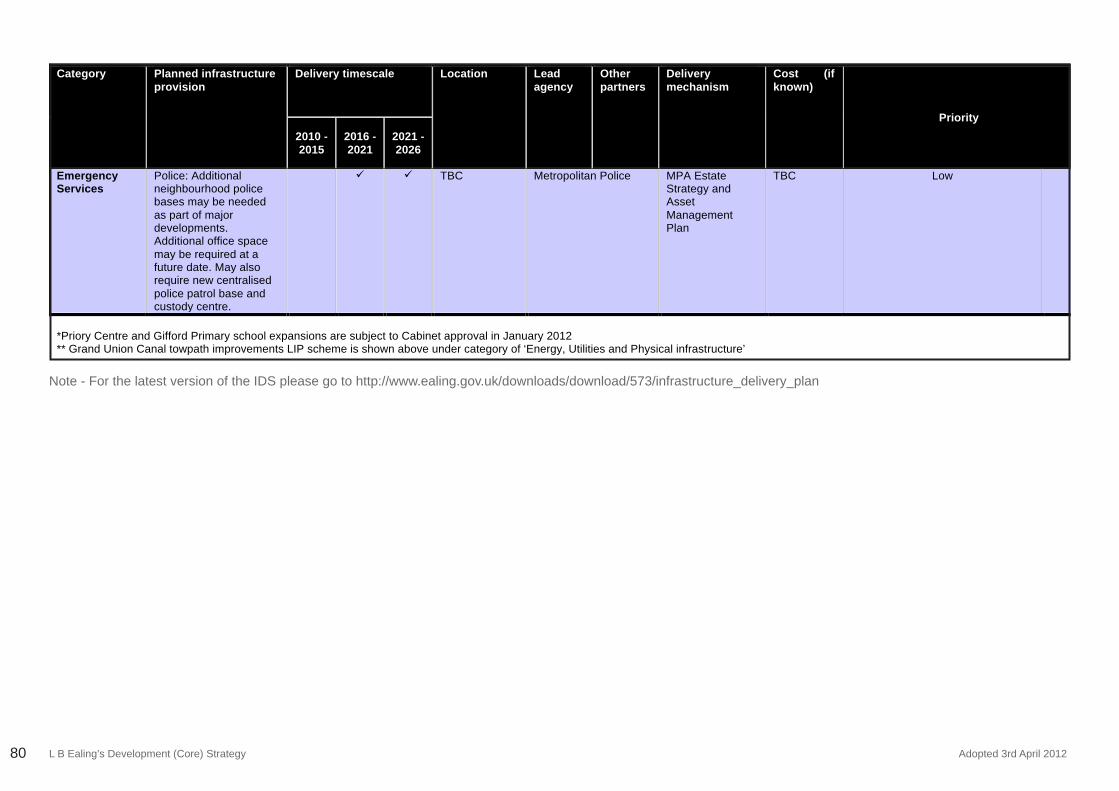
L B Ealing’s Development (Core) Strategy Adopted 3rd April 201280
ADOPTED DEVELOPMENT STRATEGY 2026 APRIL 3rd 2012
100
Category Planned infrastructure provision
Delivery timescale Location Lead agency
Other partners
Delivery mechanism
Cost (if known)
Priority
2010 - 2015
2016 - 2021
2021 - 2026
Emergency Services
Police: Additional neighbourhood police bases may be needed as part of major developments. Additional office space may be required at a future date. May also require new centralised police patrol base and custody centre.
TBC Metropolitan Police MPA Estate Strategy and Asset Management Plan
TBC Low
*Priory Centre and Gifford Primary school expansions are subject to Cabinet approval in January 2012 ** Grand Union Canal towpath improvements LIP scheme is shown above under category of ‘Energy, Utilities and Physical infrastructure’
Note - For the latest version of the IDS please go to http://www.ealing.gov.uk/downloads/download/573/infrastructure_delivery_plan
L B Ealing’s Development (Core) Strategy Adopted 3rd April 2012 81
Appendix Four:Local Plan Glossary of Terms
L B Ealing’s Development (Core) Strategy Adopted 3rd April 201282
Appendix Four: Local Plan Glossary of TermsTo view the glossary please visit the Local Plan page on Ealing Council’s website
http://www.ealing.gov.uk/localplan

L B Ealing’s Development (Core) Strategy Adopted 3rd April 2012 83
Appendix Five:Endnotes
L B Ealing’s Development (Core) Strategy Adopted 3rd April 201284
Appendix Five: Endnotes1 The maps in this plan are included for diagrammatic purposes only.2 According to the Ealing 2010 Preferred Ward projections. See Background Paper 1 on Demography (July 2011).3 The six boroughs that comprise West London contribute £27 billion to the UK econ-omy. See the West London Economic Development Strategy, December 2004.4 According to the GLA Industrial Land Release Benchmarks Survey, 2007.5 According to the Employment Land Review, 2010. See Chapter 3 for an explana-tion.6 Source: Heathrow Employment Survey, 2008/09.7 Ealing LDF Core Strategy Review - Shared Intelligence, March 2009.8 Footnote deleted.9 See report published by Crossrail and prepared by consultants Colin Buchanan on WiderEconomicsBenefitspublished25thFeb2009.ThisconfirmsCrossrailwilldeliversubstantialeconomicbenefits forLondon& theSEafter2017and itcalculates thebenefitsforEalingas£57mpaincludingbothtransportandwidereconomicbenefits.10 See New Issues and Options for Planning Your Borough, Strategy and Sites, Public Participation 7th September – 19th October 2007 available at: http://www.ealing.gov.uk/localplanprevconsult11 See Employment Land Review 2010.12 See Retail Needs Study 2010, Table 6.11 (non food retail) and Table 7.9 (range of foodretail)floorspace.13 This hierarchy is in accordance with London Plan (2011) Policy 2.15 and Annexe 2.14 See Chapter 6 “Ensuring Sustainable Delivery” below and the Infrastructure Delivery Plan, published July 2011.15 See Chapter 7 of the Development Management DPD for more detailed information.16 See Chapters 5 & 7 of the Development Management DPD (which incorporates London Plan policies) for detailed policies.17 According to the Ealing 2010 Preferred Ward projections. See background Paper 1 on Demography (July 2011).18 and19 See Employment Land Review, September 2010.20 A revised Infrastructure Delivery Schedule will be published each year as part of the Authorities’ Monitoring Report.21 See Retail Needs Study 2010, Table 6.11 (non food retail) and Table 7.7 (range of foodretail)floorspace.22 See Retail Needs Study 2010, map at Appendix 6, Figure 2 for the West London hierarchy. 23 See Policy 2.8 (b) below.24 See Policy 2.7 (c) below.25 See Policy 1.2 (d) below.26 This project was carried out in accordance with London Plan (2011) Policies 5.5:
Decentralised Energy Networks and 5.6: Decentralised Energy in Development Pro-posals. 27 See: http://www.londonheatmap.org.uk/28 This was adopted by full council on 20 June 2006 and came into operation on this date. It was reviewed and updated in July 2011. See:http://www.ealing.gov.uk/info/200921/local_plans/615/statement_of_community_involvement_sci29ThisapproachreflectsPolicy3.12oftheLondonPlan(2011).30 See Employment Land Review 2010.31 See Employment Land Review 2010.32 RetailNeedsStudy2010,Appendix8Table60(comparison/non-foodfloorspace)andAppendix9Tables79and80(convenience/foodfloorspace).33 Refer to the London Plan (2011) Policy 3.15 ‘Coordination of Housing Development and Investment’.34 See report published by Crossrail and prepared by consultants Colin Buchanan on WiderEconomicsBenefitspublished25thFeb2009.ThisconfirmsCrossrailwilldeliv-ersubstantialeconomicbenefitsforLondon&theSEafter2017anditcalculatesthebenefitsforEalingas£57mpaincludingbothtransportandwidereconomicbenefits.35 Crossrail and Ealing Council have entered into a Memorandum of Understanding to produce Strategic Urban Realm Plans (SURPs) for each Crossrail station. These stud-iesareduetocommenceinearly2012andwilllookspecificallyatimprovementstothe immediate footprint of the stations and will include a review of bus services serving the stations.36 See London SPG on Crossrail.37 The Government decided to proceed with Phase 1 of the HS2 project on January 10th 2012. This will include more detailed design work and development of an Envi-ronmental Impact Assessment and an Environmental Statement, further ‘engagement work’ with local communities, developing and consulting on a proposed compensation package, safeguarding directions for the route for a hybrid bill to be put before par-liament in late 2013. Phase 2, including a spur to Heathrow will be subject to public consultation in 2012 for a government decision in 2014.38 See Towards Zero Carbon Development – Energy Evidence Base, September 2010.39 See London Heat Map study for LB Ealing, May 2010, prepared by Ramboll, in par-ticular, Appendix 5 that shows district heating focus areas.40 See London Plan (2011) Policy 3.4: Optimising Housing Potential.41 Thefigureof455,000tonnesisderivedfromtable5.3oftheadopted2011LondonPlan.ThisfigureistheamountofwasteapportionedtoEalingbytheyear2026,i.e.theendoftheplanperiod.ThecollectivefigureforallsixWestLondonboroughsforthisperiod is 2,018,719 tonnes.42 The West London Waste Plan (WLWP) is a Joint Waste Development Plan Document. It will form part of each Borough’s Local Development Framework (LDF) and will plan for all waste in the plan area up to 2026. For more information see:
L B Ealing’s Development (Core) Strategy Adopted 3rd April 2012 85
http://www.wlwp.net/index.htmlTheplanaimstoidentifyandsafeguardsufficientsitesfor waste management facilities in the area to deal with West London’s own waste. The Plan will give priority to waste reduction, recycling and composting. However, it will still need to plan for the disposal of waste in other ways. This is likely to include the use of new or emerging technologies such as anaerobic digestion and energy from waste plants.Howevertherewillstillbearequirementforlandfillingsomewastethatcannotbe treated by other ways.43 Table 5.2 of the London Plan, Source: LRS Consultancy for GLA, December 2009.44 ‘West London Waste Plan – Issues and Options Evidence Base Report’ (Jan 2009).45 The Sequential Test is a requirement of national planning policy – . NPPF & NPPGFlood risk in the borough is mapped as part of the Strategic Flood Risk Assessment (March 2008), Preliminary Flood Risk Assessment (2011) and Surface Water Man-agement Plan (2011)46 See report published by Crossrail and prepared by consultants Colin Buchanan on WiderEconomicsBenefitspublished25thFebruary2009.ThisconfirmsCrossrailwilldeliversubstantialeconomicbenefitsforLondon&theSEafter2017anditcalculatesthebenefitsforEalingas£57mpaincludingbothtransportandwidereconomicben-efits.47 BasedonsitesidentifiedintheHousingTrajectoryanticipatedtocomeforwardfordevelopment during the plan period (2011-26).48 See Map 7 below.49 See Appendix 1. Map 11 shows public transport accessibility levels in Ealing.50 See London Heat Map study for LB Ealing, May 2010, prepared by Ramboll, in par-ticular Appendix 5 that shows district heating focus areas.51 See also Policy 6.1 and Appendix 3 (the Infrastructure Delivery Schedule).52 BasedonsitesidentifiedintheHousingTrajectoryfordevelopmentduringtheplanperiod (2011-26). 53 RetailNeedsStudy2010,Appendix8Table60(comparison/non-foodfloorspace)andAppendix9Tables79and80(convenience/foodfloorspace).54 BasedonsitesidentifiedintheHousingTrajectoryduringtheplanperiod(2011-26).55 See report to Ealing Council Cabinet “Estates review report and regeneration strat-egy”, February 26th, 2008. 56 See London Heat Map study for LB Ealing, May 2010, prepared by Ramboll, in particular Appendix 5 that shows district heating focus areas.57 See “The Borough Bus Review” Report to Cabinet, June 7th 2011. In addition, the Corridor 3 Acton North-South project (please see “Local Implementation Plan 2011-2014”) has been the subject of studies previously and is currently being designed at the moment. Enhanced bus interchange facilities, together with walking and cycling improvements for users of Acton Mainline station are included within this project.58 BasedonsitesidentifiedintheHousingTrajectoryfordevelopmentduringtheplanperiod (2011-26).
59 See Employment Land Review 2010.60 RetailNeedsStudy2010,Appendix8Table60(comparison/non-foodfloorspace)andAppendix9Tables79and80(convenience/foodfloorspace).61 See: http://www.ealing.gov.uk/info/200949/town_centre_and_area_regeneration/25/ealing62 See Ealing Broadway Interchange Study, August 2010, prepared by Steer Davies Gleave at http://www.ealing.gov.uk/info/200921/local_plans/614/evidence_base63 See London Heat Map study for LB Ealing, May 2010, prepared by Ramboll, in par-ticular Appendix 5 that shows district heating focus areas.64 See London Heat Map study for LB Ealing, May 2010, prepared by Ramboll, in par-ticular Appendix 5 that shows district heating focus areas.65 BasedonsitesidentifiedintheHousingTrajectoryfordevelopmentduringtheplanperiod (2011-26).66 RetailNeedsStudy2010,Appendix8Table60(comparison/non-foodfloorspace)andAppendix9Tables79and80(convenience/foodfloorspace).67 BasedonsitesidentifiedintheHousingTrajectoryduringtheplanperiod(2011-26).68 Footnote deleted.69 RetailNeedsStudy2010,Appendix8Table60(comparison/non-foodfloorspace)andAppendix9Tables79and80(convenience/foodfloorspace).70 See London Heat Map study for LB Ealing, May 2010, prepared by Ramboll, in particular Appendix 5 that shows district heating focus areas.71 BasedonsitesidentifiedintheHousingTrajectoryfordevelopmentduringtheplanperiod (2011-26).72 BasedonsitesidentifiedintheHousingTrajectoryfordevelopmentduringtheplanperiod (2011-26).73 See Map 7 below.74 See Employment Land Review, 2010.75 See London Heat Map study for LB Ealing, May 2010, prepared by Ramboll, in particular Appendix 5 that shows district heating focus areas.76 Mayor of London Park Royal Opportunity Framework, 2011.77 All development proposals must also be in conformity with the Park Royal Opportu-nity Area Planning Framework, 2011.78 See Employment Land Review 2010.79 BasedonsitesidentifiedintheHousingTrajectoryfordevelopmentduringtheplanperiod (2011-26).80 See the Park Royal Opportunity Area Planning Framework, 2011.81 See London Heat Map study for LB Ealing, May 2010, prepared by Ramboll, in par-ticular Appendix 5 that shows district heating focus areas.82 RetailNeedsStudy2010,Appendix8Table60(comparison/non-foodfloorspace)andAppendix9Tables79and80(convenience/foodfloorspace).83 Basedonsite identified intheHousingTrajectoryanticipatedtocomeforwardfordevelopment during the plan period (2011-26).
L B Ealing’s Development (Core) Strategy Adopted 3rd April 201286
84 See LB Ealing Cabinet reports: “Good for Greenford - Revitalising the Heart of Greenford” July 2007 & “Good for Greenford Update” May 2008 and LB Ealing Area Committee Reports: Greenford Area Committee-Good for Greenford Update Sept 2007, Greenford Area Committee-Good for Greenford Update Nov 2007, Greenford Area Committee-Good for Greenford Update Jan 2008 and “Revitalising the Retail Heart of Greenford” - report by John Lockwood, Town Centres Consultant (Nov 2006). 85 GreenfordGreenisboundbytheCentralLinetothesouth,OldfieldLaneNorthtothe west and north and Greenford Road to the east. See also Policy 4.2.86 See Park Royal Opportunity Area Planning Framework, 2011, Chapter 10.7.87 Footnote deleted. 88 BasedonsitesidentifiedintheHousingTrajectoryfordevelopmentduringtheplanperiod (2011-26).89 For further details of orbital, north-south transport links in Ealing please refer to the LB Ealing Local Implementation Plan 2011-2014 and the West London Sub-Regional Transport Plan 2010 and any subsequent updates.90 Technical Note on Orbital Transport Links, MVA, 29th October 2008.91 See Ealing Biodiversity Action Plan (2001) and London Biodiversity Action Plan.92 BothParkRoyalandSouthallaredefinedasopportunityareasintheLondonPlan.93 See the Infrastructure Delivery Plan, July 2011. Section 2.2 lists the range of infra-structure service providers with whom the Council have engaged to date.94 The scoping of the IDP was also set out in Background Paper 4 to the Initial Propos-als, Development Strategy ‘Infrastructure Planning and Delivery’ published in 2009.95 For any future updates to mapping, please refer to the latest version of the Infrastruc-ture Delivery Plan. 96 The s106 list in draft SPD9 includes additional priorities to be negotiated as part of the planning application process, in addition to the key infrastructure requirements (e.g. on-site affordable housing and support for employment and training). SPD9 will be updated to outline the Council’s proposed CIL charging schedule and priorities for spending and clarify the role of s106 alongside CIL.97 For further details of major schemes please refer to the LB Ealing Local Implemen-tation Plan 2011-014 and any subsequent updates. The council intends to produce a separate Planning for Schools DPD which will identify sites for new and extended primary / secondary schools in the borough.98 SeetheLondonPlan(2011)Policy3.16.Para3.86alsoincludesadefinitionofsocialinfrastructure.99 London Plan (2011) Policies 3.16-3.19 provide further detail and requirements upon local planning authorities with regard to social, healthcare, education and sports facil-ities.100 See London Plan (2011) Policies 8.1 - 8.3.101 See also the Statement of Community Involvement 2011.102 The effect of the Mayor’s projected improvements in public transport are summa-rised in the London Plan 2011, Chapter 6.
103AscurrentlydefinedbyEalingCouncil.104BasedonsitesidentifiedintheHousingTrajectoryfordevelopmentduringtheplanperiod (2011-26)105 See Employment Land review 2010106 BasedonsitesidentifiedintheHousingTrajectoryfordevelopmentduringtheplanperiod (2011-26). 107 See Employment Land Review 2010108 BasedonsitesidentifiedintheHousingTrajectoryfordevelopmentduringtheplan period (2011-26).109 See Employment Land Review 2010110 BasedonsitesidentifiedintheHousingTrajectoryfordevelopmentduringtheplanperiod (2011-26). 111 See Employment Land Review 2010112 BasedonsitesidentifiedintheHousingTrajectoryfordevelopmentduringtheplanperiod (2011-26).113 See Employment Land Review 2010114 London’s principal opportunities for accommodating large scale development to provide substantial numbers of new employment and housing with a mixed and inten-sive use of land and assisted by good transport accessibility.115 Mayor of London Park Royal Opportunity Area Planning Framework 2011.116 BasedonsitesidentifiedintheHousingTrajectoryfordevelopmentduringtheplanperiod (2011-26). 117 See Employment Land Review 2010118 BasedonsitesidentifiedintheHousingTrajectoryfordevelopmentduringtheplanperiod (2011-26). 119 See Employment Land Review 2010.120 London’s principal opportunities for accommodating large scale development to provide substantial numbers of new employment and housing with a mixed and inten-sive use of land and assisted by good transport accessibility.121 BasedonsitesidentifiedintheHousingTrajectoryfordevelopmentduringtheplanperiod (2011-26).122 See Employment Land Review 2010.

L B Ealing’s Development (Core) Strategy Adopted 3rd April 2012 87

L B Ealing’s Development (Core) Strategy Adopted 3rd April 2012 88
accessionaccessions o c i a l e n t e r p r i s e
For further copies of this document please contact:
Planning PolicyEaling CouncilPerceval House14/16 Uxbridge RoadLondon W5 2HL
Tel: 020 8825 5882Email: [email protected]: www.ealinginlondon.com
Designed & produced by Accessionwww.accessionpartnership.com