development permit for residential subdivision &...
TRANSCRIPT

SEPTEMBER 2016 GP0030 FINAL PREPARED FOR RIVERSTONE PASS PTY LTD
DEVELOPMENT PERMIT FOR RESIDENTIAL SUBDIVISION & CHILD CARE CENTRE, AND PRELIMINARY APPROVAL FOR DWELLING HOUSES
This
is a
n au
thor
ised
ver
sion
of t
he o
rigin
al d
ocum
ent
Cou
ncil
of th
e C
ity o
f Gol
d C
oast

© Urbis Pty Ltd ABN 50 105 256 228 All Rights Reserved. No material may be reproduced without prior permission. You must read the important disclaimer appearing within the body of this report. urbis.com.au
URBIS STAFF RESPONSIBLE FOR THIS REPORT WERE:
Director Matthew Schneider
Senior Consultant Liam Campbell
Consultant Rose Dagg
Project Code GP0030
Report Number Final
This
is a
n au
thor
ised
ver
sion
of t
he o
rigin
al d
ocum
ent
Cou
ncil
of th
e C
ity o
f Gol
d C
oast
CONTENTS
URBIS DA REPORT - 160920 - GP0030 - MAUDLANDS MCU - ROL - PA_FINAL
TABLE OF CONTENTS
Executive Summary ............................................................................................................................................. i
Introduction 1
1. Site Characteristics ............................................................................................................................... 2
1.1. Location ................................................................................................................................................ 2
1.2. Site Description, Topography and Vegetation ...................................................................................... 3
1.3. Surrounding Built Form and Land Uses................................................................................................ 4
2. Development History ............................................................................................................................. 6
2.1. Council Pre-lodgement Meeting ........................................................................................................... 6
2.2. SARA/DTMR Pre-lodgement meeting .................................................................................................. 6
3. Proposed Development ........................................................................................................................ 7
3.1. Subdivision ............................................................................................................................................ 7
3.2. Child Care Centre ................................................................................................................................. 8
3.3. Dwelling Houses ................................................................................................................................... 8
4. Specialist Information.......................................................................................................................... 10
4.1. Engineering Services Report .............................................................................................................. 10
4.2. Stormwater Management Plan ........................................................................................................... 10
4.3. Ecological Assessment Report ........................................................................................................... 10
4.4. Traffic Impact Assessment ................................................................................................................. 11
4.5. Noise Impact Assessment .................................................................................................................. 11
4.6. Landscape Concept Plan .................................................................................................................... 11
5. Planning Considerations – State ........................................................................................................ 12
5.1. The Sustainable Planning Act 2009 .................................................................................................... 12
5.2. State Planning Regulatory Provisions ................................................................................................ 12
5.3. State Planning Policy .......................................................................................................................... 13
5.4. State Assessment Referral Agency .................................................................................................... 14
5.5. State Development Assessment Provisions ....................................................................................... 15
5.6. Other Referral Agencies ..................................................................................................................... 17
6. Planning Considerations – Regional ................................................................................................... 18
6.1. South East Queensland Regional Plan .............................................................................................. 18
7. Planning Considerations – Local ........................................................................................................ 19
7.1. Gold Coast City Plan........................................................................................................................... 19
7.2. Zoning ................................................................................................................................................. 19
7.3. Overlays .............................................................................................................................................. 19
7.4. Definition ............................................................................................................................................. 20
7.5. Level of Assessment ........................................................................................................................... 20
7.5.1. Preliminary Approval to Override the Planning Scheme .................................................................... 21
7.6. Applicable Codes ................................................................................................................................ 21
8. Strategic Assessment – Gold Coast City PLan .................................................................................. 22
8.1. Strategic Framework ........................................................................................................................... 22
8.1.1. Settlement Pattern .............................................................................................................................. 22
8.2. Specific Strategic Elements ................................................................................................................ 23
8.3. Emerging Community Zone ................................................................................................................ 33
8.3.1. Conceptual Land Use ......................................................................................................................... 33
9. Conclusion .......................................................................................................................................... 35
Disclaimer 36
This
is a
n au
thor
ised
ver
sion
of t
he o
rigin
al d
ocum
ent
Cou
ncil
of th
e C
ity o
f Gol
d C
oast

URBIS DA REPORT - 160920 - GP0030 - MAUDLANDS MCU - ROL - PA_FINAL
Appendix A City Plan Code Responses
Appendix B SDAP Checklist & Assessment
Appendix C Development Layout Plan
Appendix D Plan of Development
Appendix E Child Care Centre Plans
Appendix F Survey Plan & Subdivision Lot Plan
Appendix G Civil Engineering Services Report
Appendix H Stormwater Management Plan
Appendix I Ecological Assessment Report
Appendix J Traffic Impact Assessment
Appendix K Noise Impact Assessment
Appendix L Landscape Concept Plan
Appendix M Title Documentation
Appendix N Pre-lodgement Minutes
FIGURES:
Figure 1 – Context Map ...................................................................................................................................... 2
Figure 2 – Cadastral Map ................................................................................................................................... 2
Figure 3 – Aerial Photo ....................................................................................................................................... 3
Figure 4 – Photographs of the Site ..................................................................................................................... 4
Figure 5 – Surrounding Land Use ...................................................................................................................... 5
Figure 6 – SPP Mapping................................................................................................................................... 14
Figure 7 – SARA Mapping ................................................................................................................................ 16
Figure 8 – Regional Land Use Pattern ............................................................................................................. 18
Figure 9 – Zoning Map ...................................................................................................................................... 19
Figure 10 – Strategic Framework Map 1 – Designated Urban Area ................................................................ 22
Figure 11 – Strategic framework map 2 – Settlement Pattern ......................................................................... 23
Figure 12 – Conceptual Land Use Map ............................................................................................................ 34
PICTURES:
Picture 1 – View west of the site from Maudsland Road .................................................................................... 4
Picture 2 – View north of Maudsland Road ........................................................................................................ 4
Picture 3 – On site vegetation ............................................................................................................................ 4
Picture 4 – Waterway to the western site boundary ........................................................................................... 4
Picture 5 – On site vegetation ............................................................................................................................ 4
Picture 6 – Existing vehicle access crossover to Riverstone Crossing .............................................................. 4
Picture 7 – View north along Maudsland Road to Maudsland Village ................................................................ 5
Picture 8 – View north-west along the unformed Kleinschmidt Road ................................................................ 5
Picture 9 – View south-east to intersection of Maudsland Road and Riverstone Crossing ............................... 5
Picture 10 – View south to the intersection of Maudsland Road and Riverstone Crossing ............................... 5
Picture 11 – View of waterway to the western boundary .................................................................................... 5
Picture 12 – View west along Riverstone Crossing ............................................................................................ 5
TABLES:
Table 1 – Proposed Details ................................................................................................................................ 7
Table 2 – Plan of Development – Development Controls .................................................................................. 9
Table 3 – State Planning Regulatory Provisions .............................................................................................. 12
This
is a
n au
thor
ised
ver
sion
of t
he o
rigin
al d
ocum
ent
Cou
ncil
of th
e C
ity o
f Gol
d C
oast
CONTENTS
URBIS DA REPORT - 160920 - GP0030 - MAUDLANDS MCU - ROL - PA_FINAL
Table 4 – Applicable SDAP Codes ................................................................................................................... 16
Table 5 – Applicable Codes .............................................................................................................................. 21
Table 6 – Creating Liveable Places Themes - Specific Outcomes .................................................................. 23
This
is a
n au
thor
ised
ver
sion
of t
he o
rigin
al d
ocum
ent
Cou
ncil
of th
e C
ity o
f Gol
d C
oast

This
is a
n au
thor
ised
ver
sion
of t
he o
rigin
al d
ocum
ent
Cou
ncil
of th
e C
ity o
f Gol
d C
oast

URBIS DA REPORT - 160920 - GP0030 - MAUDLANDS MCU - ROL - PA_FINAL
EXECUTIVE SUMMARY i
Site and Proposal Details
Address 182 Maudsland Road, Maudsland QLD 4210
Real Property Description Lot 3 on WD2321
Total Site Area 23,670m2
Local Government City of Gold Coast
Planning Scheme Gold Coast City Plan (Version 3)
Zone Emerging Community Zone
Local Plan N/A
Land Owner Sylvia Amy Bird, Ivor Powell & Isabel Yarrow
Purpose
Development Permit for Reconfiguring a Lot (19-lot subdivision, new road and
balance land); Development Permit for Material Change of Use for a Child Care
Centre; and Preliminary Approval (s242) for Material Change of Use for
Dwelling Houses involving Building Work
General Description of
Use
The proposal is for 19-lot subdivision for residential dwellings and also a Child
Care Centre, as well as balance land for open space and future road
requirements
Type of Development Level of Assessment Approval Sought
Reconfiguring a Lot (19-lot
subdivision, new road and balance
land)
Impact Assessable Development Permit
Material Change of Use for a Child
Care Centre
Impact Assessable Development Permit
Material Change of Use (s242) for
Dwelling Houses involving Building
Work
Code Assessable Preliminary Approval (s241)
Applicant Contact Person Our Reference
Riverstone Pass Pty Ltd c/- Urbis
Pty Ltd
45 Nerang Street, Southport QLD
4215
Liam Campbell
Ph: (07) 3007 3800
GP0030
This
is a
n au
thor
ised
ver
sion
of t
he o
rigin
al d
ocum
ent
Cou
ncil
of th
e C
ity o
f Gol
d C
oast

This
is a
n au
thor
ised
ver
sion
of t
he o
rigin
al d
ocum
ent
Cou
ncil
of th
e C
ity o
f Gol
d C
oast

URBIS DA REPORT - 160920 - GP0030 - MAUDLANDS MCU - ROL - PA_FINAL
INTRODUCTION 1
Urbis has been commissioned by Riverstone Pass Pty Ltd to prepare this application for a Child Care Centre and residential subdivision at 182 Maudsland Road, Maudsland, more formally described as Lot 3 on WD2321. Specifically this application seeks approval for:
Development Permit for Reconfiguring a Lot (19-lot subdivision, new road and balance land)
Development Permit for Material Change of Use for a Child Care Centre; and
Preliminary Approval (s242) for Material Change of Use for Dwelling Houses involving Building Work.
This report addresses the merits of the development with the regard to the provisions of the Gold Coast City Plan (version 3) and relevant sections of the Sustainable Planning Act 2009. For the purpose of this report the Gold Coast City Plan (version 3) will be referred to as the ‘City Plan and the Sustainable Planning Act 2009 will be referred to as the ‘SPA’.
The application involves a residential subdivision, comprising 18 residential lots and another lot for the Child Care Centre development as well as a new road and balance land. The proposed subdivision is intended to accommodate dwelling houses, with a new road to be constructed and balance land to be for open space dedication and for future road requirements for DTMR.
This Development Assessment report should be read in conjunction with other supporting documentation prepared for the submission of the application. These include:
Gold Coast City Plan Code Responses – Appendix A;
State Development Assessment Provisions (SDAP) Checklist and Assessment – Appendix B;
Development Layout Plans prepared by Motus Consulting – Appendix C;
Plan of Development prepared by Urbis– Appendix D;
Child Care Centre Architectural Plans prepared by Vabasis – Appendix E;
Survey Plan & Subdivision Lot Plan prepared by Bennett and Bennett – Appendix F;
Civil Engineering Services Report prepared by Motus Consulting– Appendix G;
Stormwater Management Plan prepared by Motus Consulting – Appendix H;
Ecological Assessment Report prepared by Gaia Environmental Consulting – Appendix I;
Traffic Impact Assessment prepared by Bitzios Consulting – Appendix J;
Noise Impact Assessment prepared by MWA Environmental -– Appendix K;
Landscape Concept Plan prepared by Urbis – Appendix L;
Title Documentation – Appendix M; and
Pre-lodgement Meeting Minutes – Appendix N.
The development is considered appropriate for the location, is generally consistent with the existing planning controls and intent for the area, and will provide a child care facility which will be in high demand in the area. Council’s approval of the application is therefore sought, subject to relevant and reasonable conditions.
This
is a
n au
thor
ised
ver
sion
of t
he o
rigin
al d
ocum
ent
Cou
ncil
of th
e C
ity o
f Gol
d C
oast
2 SITE CHARACTERISTICS URBIS
DA REPORT - 160920 - GP0030 - MAUDLANDS MCU - ROL - PA_FINAL
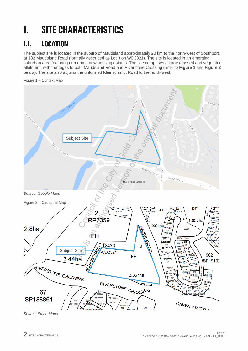
The subject site is located in the suburb of Maudsland approximately 20 km to the north-west of Southport, at 182 Maudsland Road (formally described as Lot 3 on WD2321). The site is located in an emerging suburban area featuring numerous new housing estates. The site comprises a large grassed and vegetated allotment, with frontages to both Maudsland Road and Riverstone Crossing (refer to Figure 1 and Figure 2 below). The site also adjoins the unformed Kleinschmidt Road to the north-west.
Figure 1 – Context Map
Source: Google Maps
Figure 2 – Cadastral Map
Source: Smart Maps
Subject Site
Subject Site
This
is a
n au
thor
ised
ver
sion
of t
he o
rigin
al d
ocum
ent
Cou
ncil
of th
e C
ity o
f Gol
d C
oast

URBIS DA REPORT - 160920 - GP0030 - MAUDLANDS MCU - ROL - PA_FINAL
SITE CHARACTERISTICS 3
The site, being Lot 3 on WD2321, has an area of 23,670m
2 as indicated in Figure 2 above. Current
vehicle access to the site is gained from a crossover from Riverstone Crossing. The site is also bound by Maudsland Road to the east and Kleinschmidt Road to the north-west; however this is an unformed road. The site is currently undeveloped with no built form on the site, it contains vegetation consisting of numerous trees and grassed areas (refer to Figure 3 below).
The highest point of the site is in the south-eastern corner at the intersection of Riverstone Crossing and Maudsland Road. The site has a steep topographic fall of approximately 20m, from 30m AHD in the south-east corner, to less than 10m AHD along the western boundary. A natural watercourse traverses the land adjacent to the lower western boundary.
Figure 3 – Aerial Photo
Source: Nearmap
Figure 4 below shows the site in its current form.
Subject Site
This
is a
n au
thor
ised
ver
sion
of t
he o
rigin
al d
ocum
ent
Cou
ncil
of th
e C
ity o
f Gol
d C
oast
4 SITE CHARACTERISTICS URBIS
DA REPORT - 160920 - GP0030 - MAUDLANDS MCU - ROL - PA_FINAL
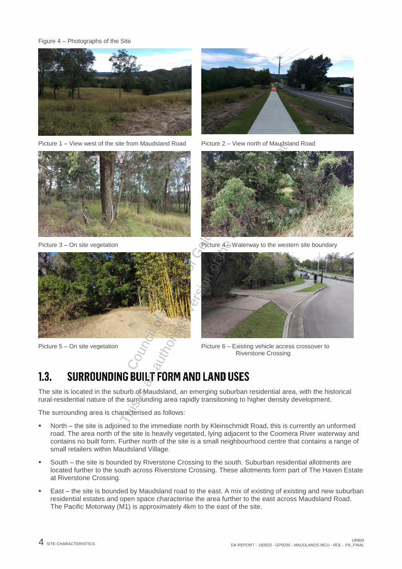
Figure 4 – Photographs of the Site
Picture 1 – View west of the site from Maudsland Road Picture 2 – View north of Maudsland Road
Picture 3 – On site vegetation Picture 4 – Waterway to the western site boundary
Picture 5 – On site vegetation Picture 6 – Existing vehicle access crossover to
Riverstone Crossing
The site is located in the suburb of Maudsland, an emerging suburban residential area, with the historical rural-residential nature of the surrounding area rapidly transitioning to higher density development.
The surrounding area is characterised as follows:
North – the site is adjoined to the immediate north by Kleinschmidt Road, this is currently an unformed road. The area north of the site is heavily vegetated, lying adjacent to the Coomera River waterway and contains no built form. Further north of the site is a small neighbourhood centre that contains a range of small retailers within Maudsland Village.
South – the site is bounded by Riverstone Crossing to the south. Suburban residential allotments are located further to the south across Riverstone Crossing. These allotments form part of The Haven Estate at Riverstone Crossing.
East – the site is bounded by Maudsland road to the east. A mix of existing of existing and new suburban residential estates and open space characterise the area further to the east across Maudsland Road. The Pacific Motorway (M1) is approximately 4km to the east of the site.
This
is a
n au
thor
ised
ver
sion
of t
he o
rigin
al d
ocum
ent
Cou
ncil
of th
e C
ity o
f Gol
d C
oast

URBIS DA REPORT - 160920 - GP0030 - MAUDLANDS MCU - ROL - PA_FINAL
SITE CHARACTERISTICS 5
West – immediately west of the site is the unformed Kleinschmidt Road, this area is currently heavily vegetated and is adjacent to the Coomera River. Further west across Coomera River is Riverstone Crossing, a residential estate.
Refer to Figure 5 which shows surrounding development and immediate land uses.
Figure 5 – Surrounding Land Use
Picture 7 – View north along Maudsland Road to Maudsland Village
Picture 8 – View north-west along the unformed Kleinschmidt Road
Picture 9 – View south-east to intersection of Maudsland Road and Riverstone Crossing
Picture 10 – View south to the intersection of Maudsland Road and Riverstone Crossing
Picture 11 – View of waterway to the western boundary Picture 12 – View west along Riverstone Crossing
This
is a
n au
thor
ised
ver
sion
of t
he o
rigin
al d
ocum
ent
Cou
ncil
of th
e C
ity o
f Gol
d C
oast

6 DEVELOPMENT HISTORY URBIS
DA REPORT - 160920 - GP0030 - MAUDLANDS MCU - ROL - PA_FINAL
A pre-lodgement meeting was held between the City of Gold Coast Council and the applicant on 15 July 2016. Council’s pre-lodgement meeting minutes are attached as part of this report (refer to Appendix N). The meeting discussed a preliminary set of plans, which have since been replaced by the subdivision design proposed in this application. This pre-lodgement meeting discussed a number of issues that were applicable to the site as a whole.
Key items discussed in the meeting included Town Planning, Open Space Planning, Environmental Planning Assessment, Subdivision Engineering and Transport Assessment, as well as the requirements to the Health Department and Gold Coast Water.
As the development proposal is Impact Assessable the meeting discussed which elements of the strategic framework were to be addressed as well as relevant overlay, zone and secondary codes to be addressed. These provisions of the Strategic Framework have been addressed in Section 7.1.2 City Shape and Urban Transformation of this report. An assessment of the relevant codes has been provided in Appendix A –Gold Coast City Plan Code Responses.
The City of Gold Coast suggested that the following information be required for the application:
Acoustic report;
Ecological Assessment;
Open space management statement;
Stormwater quality and quantity management plan;
Plans; and
Traffic impact report and/or car parking analysis.
Section 4 Specialist Information provides a summary of the specialist information provided in support of this application. These specialist reports have also been provided in the Appendices of this report.
A pre-lodgement meeting was held directly between the Department of Transport and Main Roads (DTMR) and the applicant on 27 July 2016. This meeting was to discuss proposed access and future road planning requirements in relation to the State-controlled Maudsland Road.
A further pre-lodgement meeting was held with SARA and DTMR officers on the 2 September 2016. The meeting minutes are provided in Appendix N. In this meeting, the Applicant presented development plans which accommodated the land requirements issued by DTMR for the future upgrade of Maudsland Road. The proposed access design to Maudsland Road for the proposed Child Care Centre was also tabled and discussed.
This
is a
n au
thor
ised
ver
sion
of t
he o
rigin
al d
ocum
ent
Cou
ncil
of th
e C
ity o
f Gol
d C
oast

URBIS DA REPORT - 160920 - GP0030 - MAUDLANDS MCU - ROL - PA_FINAL
PROPOSED DEVELOPMENT 7
The application seeks development approval for a Development Permit for Material Use for Child Care Centre, Development Permit for Reconfiguration of a Lot (19-lot subdivision, new road and balance land) and Preliminary Approval (s242) for Material Change of Use for Dwelling Houses involving Building Work.
It is proposed to develop a residential subdivision with a lot allocated for the use of a Child care centre. The subdivision will comprise 18 residential allotments, ranging from 410m
2 to 648m
2 in area. The area of the
proposed Child care centre lot is 3042m2. The proposal also includes a road reserve dedication to the
Department of Transport and Main Roads of 2960m2 as well as council reserve of 5074m
2.
The following table provides a breakdown of the specific development parameters of the development.
Table 1 – Proposed Details
Parameter Proposal Detail
Site Area 23,670m2 (2.367 hectares)
Developable Area 12,546m2 (less DTMR road widening dedication, council reserve and new road)
Proposed Development Child Care Centre
Dwelling Houses – 18 future residential lots
New road
Balance land for open space reserve and future road requirement
Approvals Sought Development Permit for Reconfiguring a Lot (19-lot subdivision, new road
and balance land);
Development Permit for Material Change of Use for a Child Care Centre; and
Preliminary Approval (under s241 of the SPA) for Material Change of Use for
Dwelling Houses involving Building Work
Internal Roads 1 x 16.5m wide road is proposed (neighbourhood access)
Access The proposed new road will access Riverstone Crossing. Access to the Child
Care Centre will be gained from Maudsland Road.
The proposed subdivision will involve the construction of 18 freehold lots for future residential development and another lot for a Child Care Centre. The development will also include the provision of a new road from Riverstone Crossing to service the development with the associated verge works including landscaping, requisite services and new vehicle crossovers.
The proposed 18 residential lot sizes vary from between 410m2 and 648m
2. The proposed mix of lot sizes
will allow for dwelling diversity. The proposal does not include small lots less than 400m2 and distributes lot
sizes throughout the development.
The proposal also includes as park reserve is to be dedicated to the City of Gold Coast. The western portion of the site includes a drainage channel which conveys flow from a bank of large culverts traversing underneath Riverstone Crossing to the south. The proposed development will maintain the western drainage channel by and provides approximately 5,074m² as park reserve.
As seen in the Landscape Concept Plan prepared by Urbis in Appendix L, the proposed park reserve will include a detention basin with vehicle access, a pedestrian access across the existing waterway, and the conversion of currently poorly vegetated into rehabilitated open space and recreation area.
This
is a
n au
thor
ised
ver
sion
of t
he o
rigin
al d
ocum
ent
Cou
ncil
of th
e C
ity o
f Gol
d C
oast

8 PROPOSED DEVELOPMENT URBIS
DA REPORT - 160920 - GP0030 - MAUDLANDS MCU - ROL - PA_FINAL
The Department of Transport and Main Roads have identified a land dedication requirement of approximately 2,960m
2 adjacent to the eastern boundary for the future widening of Maudsland Road. This
land is provided for and will be maintained until ultimate resumption by DTMR.
The proposed Child Care Centre will provide a new learning facility with recreational and car parking areas on the site. The proposed development will have 112 child place capacity, with the centre offering seven play rooms, outdoor play area and staff/administration amenities including kitchen, office and staff room. The development will also include 38 carparks (including 1 PWD car park) at ground level, with site access provided from Maudsland Road.
The child care centre will be located to the north of the site on land which is currently vacant. The subdivision of the land will result in the child care centre being located on a new lot of 3042m
2. The centre will be a
single level development with a gross floor area of 803m2, with the ‘L’ shaped building positioned around an
external area of 784m2.
The proposed car parking spaces and arrangement will be sufficient for vehicle access and manoeuvring areas onsite. Access to Maudsland Road is proposed following the improvement of the road infrastructure. An acoustic wall will contain the external area of the site to minimise traffic impacts on the child care centre. The positioning of the car park will also provide a buffer between the Child Care Centre outdoor areas and properties to the north-west of the site.
The proposed Child Care Centre is of a bulk and scale that is complimentary to the proposed residential development in the surrounding area and will be within the reasonable expectations for development on the site by the local community. The proposed building will be an articulated and visually interesting form with lightweight materials, varying external finishes and colours to enhance the quality of the built form.
The development has been designed to respond to the topographic constraints of the site. Due to the gradient of the existing site, some filling and excavation will be required to create the Child Care Centre building pad. The development proposal also includes a 45 degree batter wall and retaining wall that will surround the south-east and south-west boundaries of the site. Please refer to the Civil Engineering Services Report in Appendix F for more information.
The application also seeks Preliminary Approval (s242) for Material Change of Use for Dwelling Houses involving Building Work. The development will involve the construction of 18 freehold allotments for future detached dwelling houses.
The Preliminary Approval under s242 will allow for the future Dwelling Houses (involving Building Work) to be Self-Assessable, subject to the provisions of the Plan of Development (as provided in Appendix D) and the relevant Code Outcomes of the City Plan.
The proposed Preliminary Approval under s242 of the SPA for Material Change of Use for Dwelling Houses involving Building Work is sought to ensure that future construction of Dwelling Houses on the proposed 18 residential allotments does not require further development approval.
The Preliminary Approval under s242 of the SPA is sought to override the provisions of the City Plan which would otherwise trigger a Code Assessment development application for Dwelling Houses involving Building Work.
The proposed Preliminary under s242 of the SPA specifically seeks to do the following:
Alter the Level of Assessment for Dwelling Houses involving Building Work on the site from being Code Assessable due to the Dwelling House Overlay Level of Assessment (Table 5.10.5), to being Self-Assessable subject to compliance with the provisions of the proposed Plan of Development.
Introduce the proposed Plan of Development to override the effect of Specific Outcome 1, 2 and 3 of the Emerging Community Zone Code for development for Dwelling Houses involving Building Work.
The Plan of Development contains development controls, including maximum building envelope, location of built to boundary walls and preferred garage location. The Plan of Development also illustrates indicative driveway location and on street visitor car parking locations. The building envelope has been determined following the setbacks, building height and site cover in Table 2 below.
This
is a
n au
thor
ised
ver
sion
of t
he o
rigin
al d
ocum
ent
Cou
ncil
of th
e C
ity o
f Gol
d C
oast

URBIS DA REPORT - 160920 - GP0030 - MAUDLANDS MCU - ROL - PA_FINAL
PROPOSED DEVELOPMENT 9
Table 2 – Plan of Development – Development Controls
ALLOTMENT SETBACKS
FRONT SETBACKS
Front Setback
Primary frontage
To Wall 4.5m
To Garage Door 6.0m
REAR SETBACKS
Rear Setback First Storey 1.5m
Second Storey 2.0m
SIDE SETBACKS
Side Setback
Built to Boundary (Optional)
First Storey 0.0m1
Second Storey 0.0m2
Side Setback
Non-built to boundary wall
First Storey 1.5m
Second Storey 2.0m
Side Setback on Corner Lots
Secondary Frontage
All Storeys 2.0m
GARAGES AND SITE COVER
Maximum Building Height 2 Storeys (9m)
Site Cover 60%
This
is a
n au
thor
ised
ver
sion
of t
he o
rigin
al d
ocum
ent
Cou
ncil
of th
e C
ity o
f Gol
d C
oast

10 SPECIALIST INFORMATION URBIS
DA REPORT - 160920 - GP0030 - MAUDLANDS MCU - ROL - PA_FINAL
The Civil Engineering Services Report has been prepared by Motus Consulting and is included in Appendix G. The report conclusions are outlined as follows:
The proposed subdivision and childcare centre do not pose any unusual challenges form an engineering perspective, and does not present any engineering based issues which would prevent the development from proceeding as proposed.
Service supply points for electricity, telecommunication, water and sewerage are located within close proximity to the proposed development. Providing future water and sewer network analyses confirm adequate capacities of the adjacent systems, the development should not present any major connection issues.
Any cutting, filling and drainage solutions required on site can be performed using common and accepted methods.
Vehicle access and manoeuvring, as well as pedestrian needs and been considered and reflected within the development layout.
A site-based Stormwater Management Plan has been prepared by Motus Consulting and is included in Appendix H. The report describes the design process and specifies the key design elements which manage the potential impact of stormwater runoff to downstream properties and receiving waters. The report determines that the following stormwater management elements are to be incorporated into the development:
A single bio-filtration basin is proposed to treat the Child Care Centre catchment. No detention is required for this catchment.
A single combined bio-detention basin with batters will provide treatment and detention for the residential development catchment.
The report concludes that the correct installation of these key design elements should ensure that the management of stormwater quality and quantity complies with all necessary state and local government policies.
An Ecological Assessment Report has been prepared by Gaia Environmental Consulting and is included in Appendix I of this report. This report has been prepared to ensure that the development meets the requirements of the Environmental Significance Overlay Code, which indicates that an ecological site assessment is to be prepared for the site. The ecological assessment conclusions are outlined as follows:
The subject site currently represents a primarily cleared property with scattered remnant trees and some more dense vegetation towards the south-western portion of the site coinciding with a tributary of the Coomera River.
Field investigation have shown that the subject site offers little value for native vegetation communities and limited habitat for native fauna species. The field investigations did not locate any significant flora or fauna species.
There are two small areas of riparian vegetation along a 2nd order tributary in the west of the subject site that have some ecological value and this area is intended for retention within parkland dedicated to Council.
This parkland also provides an adequate buffer to the minor waterway on site and the locally significant wetland adjoining the site to the west.
This
is a
n au
thor
ised
ver
sion
of t
he o
rigin
al d
ocum
ent
Cou
ncil
of th
e C
ity o
f Gol
d C
oast

URBIS DA REPORT - 160920 - GP0030 - MAUDLANDS MCU - ROL - PA_FINAL
SPECIALIST INFORMATION 11
The report concludes that the development of the subject site reflects the intention of the Gold Coast City Plan, and the development application has been shown to meet the Performance Outcomes of the Environmental Significance Overlay Code.
A Traffic Impact Assessment has been prepared by Bitzios Consulting and is included in Appendix J of this report. The key findings from the report are as follows:
The proposed development is estimated to generate a combined total of 89 trips during the AM peak hour and 69 trips during the PM peak hour.
The SIDRA intersection assessment indicates that both Riverstone Crossing / Lagoon Park Drive intersection and Maudsland Road / Gaven Arterial Road intersection operate within acceptable performance limits with year 2028 design traffic volumes.
Access to the proposed child care centre has been proposed via an all-movements access to Maudsland Road. Sight distance from the access location achieves AS2890.1 requirements. The proposed access includes CHR(s) and AUL(s) treatments. Confirmation from DTMR will be required in order to ensure that the proposed child care centre access is suitable for both current conditions and future road network planning.
A new residential access street is proposed to connect to the Riverstone Crossing / Lagoon Park Drive roundabout. This road will provide access to the 18 proposed detached dwellings. The road has been provided in accordance with a “Residential Access Street” cross-section in accordance with Standard Drawing 02-001 of Council’s Land Development Guidelines. Driveway access locations shall be in accordance with Figure 3.1 of AS2890.1
A Noise Impact Assessment has been prepared by MWA Environmental and is included in Appendix K of this report. The assessment considered the potential noise impact upon the proposed residential allotments and Child Care Centre from nearby road traffic noise from Maudsland Road, a State-controlled road. In addition, potential noise impact from the proposed Child Care Centre impacting upon the existing nearby and proposed residential receptors was considered, with any requirements for noise mitigation measures identified. This detailed Noise Impact assessment conclusions are as follows:
Primary external road traffic noise limits are satisfied at the most exposed facades of any future single storey dwelling on the proposed allotments. The external criterion is exceeded for any proposed double storey dwellings to be constructed on Lots 7 to 9.
In order to achieve acceptable noise level at the private outdoor areas on the proposed allotments, an acoustic barrier of 2.0 metre high along the northern boundary of Lot 7 and 8, with a return along part of the eastern boundary of Lot 8 is required.
The proposed childcare centre outdoor play area boundary is approximately 8 metres from Maudsland Road, an acoustic barrier of 2.0 metres high along the eastern boundary of outdoor play area nearest to Maudsland Road is proposed as part of the noise control measures.
In order to achieve the internal Acceptable Outcome as per the SDAP and Secondary internal limits as per EEP requirements within educational rooms, the proposed child care building will need to be acoustically treated.
The report concludes that the proposed development can operate in accordance with the relevant amenity standards and is recommended for approval with reasonable and relevant conditions.
A Landscape Concept Plan has been prepared by Urbis and is included in Appendix L of this report. The plan includes three key landscaped areas, the Reserve, Child Care Centre and Streetscape. The landscaped areas are designed generally in accordance with Schedule 6.10 City Plan Policy (Landscape Work) of the Gold Coast City Plan.
This
is a
n au
thor
ised
ver
sion
of t
he o
rigin
al d
ocum
ent
Cou
ncil
of th
e C
ity o
f Gol
d C
oast

12 PLANNING CONSIDERATIONS – STATE URBIS
DA REPORT - 160920 - GP0030 - MAUDLANDS MCU - ROL - PA_FINAL
The purpose of the Sustainable Planning Act 2009 (‘SPA’) is to achieve ecological sustainability by coordinating planning at all levels of government and by managing the development process as well as the impacts of development.
The proposed development includes a Material Change of Use for a Child Care Centre and Reconfiguring a Lot (19-lot subdivision) which are assessable development. A Development Permit for the Material Change of Use and a Development Permit for Reconfiguring a Lot are therefore required prior to the commencement of the use.
The application also includes Preliminary Approval for Material Change of Use for Dwelling Houses involving Building Work, which will enable future Dwelling House development involving Building Work to be Self-Assessable development subject to the proposed Plan of Development and relevant Outcomes of the City Plan.
The Preliminary Approval sought is therefore made under Section 242 of the SPA, as it seeks to override the City Plan to:
Establish a new Levels of Assessment for development for Dwelling Houses involving Building Work on the site, being Self-Assessable instead of requiring Code Assessment.
Apply the proposed Plan of Development to development for Dwelling Houses involving Building Work, overriding provisions of the Emerging Community Zone.
The Gold Coast City Plan (‘City Plan’) establishes that the proposed Material Change of Use for a Child Care Centre and Reconfiguring a Lot for subdivision development is subject to Impact Assessment, to be undertaken in accordance with Section 314 of the SPA.
The City Plan also establishes that a Material Change of Use for Dwelling Houses involving Building Work is subject to Code Assessment. The proposed Preliminary Approval for Material Change of Use for Dwelling Houses involving Building Work is therefore subject to Code Assessment, to be undertaken in accordance with Section 313 of the SPA.
State Planning Regulatory Provisions (‘Regulatory Provisions’) are the pre-eminent planning instruments and have the ability to regulate and prohibit development, despite the provision of a local planning instrument. As outlined in Table 2 below, none of the current SPRPs are of relevance to the proposed development.
Table 3 – State Planning Regulatory Provisions
Current Regulatory Provisions Applicability
Yeerongpilly TOD State Planning Regulatory Provision Not Applicable – The site is not located within the area of
the Yeerongpilly TOD.
South East Queensland Regional Plan 2009-2031 State
Planning Regulatory Provisions
Not Applicable – The site is located within the Urban
Footprint.
Guragunbah State Planning Regulatory Provision Not Applicable – The site is not located within the
Guragunbah region.
State Planning Regulatory Provision (Adopted Charges) Applicable – Infrastructure charges applicable to the
proposal will be subject to the current Adopted Charges
Infrastructure Resolution issued by City of Gold Coast.
Off-Road Motorcycling Facility on State-Owned Land at Not Applicable – The site is not located in Wyaralong nor
is the proposed development for a motor sport activity
This
is a
n au
thor
ised
ver
sion
of t
he o
rigin
al d
ocum
ent
Cou
ncil
of th
e C
ity o
f Gol
d C
oast
URBIS DA REPORT - 160920 - GP0030 - MAUDLANDS MCU - ROL - PA_FINAL
PLANNING CONSIDERATIONS – STATE 13
Current Regulatory Provisions Applicability
Wyaralong facility.
State Planning Regulatory Provisions (Adult Stores) Not Applicable – The proposed development does not
involve an Adult Store.
South East Queensland Koala Conservation State
Planning Regulatory Provisions
Not Applicable – The site is not identified within an
Assessable Development Area in the SEQ Koala
Conservation trigger maps.
Queensland Housing Affordability Strategy, Greenfield
land supply in South East Queensland
Applicable – The proposed development is consistent
with the intent of this Strategy to deliver new housing.
Draft Palm Island State Planning Regulatory Provision
2015
Not Applicable – The site is not located on or near Palm
Island.
The single State Planning Policy (‘SPP’), introduced on 2 December 2013, has been developed to replace the multiple SPPs previously in place. The SPP defined the Queensland Government’s policies about matters of state interest in land use planning and development, and provides a guide for the preparation of local planning instruments and assessment of development applications. The SPP will apply for the assessment of some development applications until a planning scheme that appropriately integrated with state interests in the SPP takes effect. Specifically, the SPP sets out specific State interests in the following areas:
Liveable communities and housing;
Economic growth;
Environment and heritage;
Hazards and safety; and
Infrastructure.
The SPP provides supporting mapping to assist in spatially representing policies and requirements contained within the SPP. A comprehensive overlay map of state planning interests is provided in Figure 6. The mapping indicates that the following SPP matters apply to the site:
Biodiversity - MSES Regulated Vegetation (Intersecting a Watercourse)
Water Quality - Climate regions (Stormwater Management Design Objectives)
Natural Hazards and Risk Resilience – Flood Hazard Area (Local government flood mapping area)
This
is a
n au
thor
ised
ver
sion
of t
he o
rigin
al d
ocum
ent
Cou
ncil
of th
e C
ity o
f Gol
d C
oast

14 PLANNING CONSIDERATIONS – STATE URBIS
DA REPORT - 160920 - GP0030 - MAUDLANDS MCU - ROL - PA_FINAL
Figure 6 – SPP Mapping
. Source: DILGP
It is noted that the applicable Planning Scheme, the Gold Coast City Plan, has been prepared to reflect the following aspects of SPP:
Guiding Principles
Liveable communities and housing
o Liveable communities
o Housing supply and diversity
Economic growth
o Agriculture
o Development and construction
o Mining and extractive resources
o Tourism
Environment and heritage
o Biodiversity
o Coastal environment
o Cultural heritage
o Water quality
Safety and resilience to hazards
o Emissions and hazardous activities
o Natural hazards, risk and resilience (Flood, Bushfire, Landslide)
Infrastructure
o Energy and water supply
o State transport infrastructure
o Strategic airports and aviation facilities
An assessment of any proposed development against the City Plan will require assessment of aspects of the SPP not integrated. This includes Natural Hazards, Risk and Resilience (Coastal Hazards). The site of the proposed development is no identified to include these matters; therefore no additional assessment against the SPP is required.
The State Assessment and Referral Agency (SARA) seeks to deliver a coordinated, whole-of-government approach to the state’s assessment of development applications. In short, SARA provides:
Biodiversity MSES – Requlated vegetation
(intersecting a watercourse) Water Quality
Climatic regions - stormwater management design objectives Natural Hazards Risk and Resilience
Flood hazard area* - Local Government flood mapping area
This
is a
n au
thor
ised
ver
sion
of t
he o
rigin
al d
ocum
ent
Cou
ncil
of th
e C
ity o
f Gol
d C
oast

URBIS DA REPORT - 160920 - GP0030 - MAUDLANDS MCU - ROL - PA_FINAL
PLANNING CONSIDERATIONS – STATE 15
A single agency lodgement point for development applications, where the state has a jurisdiction;
A single coordination and contact point; and
A final decision maker to ensure that no ‘unreasonable’ requirements are imposed on applicants.
Unlike the previous arrangements where referral agencies were either advice agencies or concurrence agencies and referrals were made to the relevant state agencies, the chief executive of SPA, being the Director-General of the Department of Infrastructure, Local Government and Planning (DILGP), is now the single referral agency for all development applications where the state has jurisdiction.
It should be noted that all relevant agencies are regarded as key stakeholders and will provide technical advice where they had former jurisdiction in that particular matter, however for the purposes of SPA, these agencies will not be formal advice agencies. Importantly, there is only one state agency decision notice issued from the DILGP.
The State Development Assessment Provisions (SDAP) is an outcome of the SARA and a statutory instrument made under the SPA which sets out matters of interest of the state for development assessment, where the chief executive of administering the SPA is the assessment manager or a referral agency.
Importantly, the SDAP outlines the criteria for assessment by the chief executive and provides applicants with:
1. Clarity on when the state is to be involved in the assessment of development applications; and
2. Increased transparency and clarity on how development can comply with matters of interest of the
state through a set of State Codes.
A comprehensive overlay map of state planning matters is provided in Figure 7. The mapping indicates that the following SARA matters apply to the site:
Regional Plan (Urban Footprint)
Coastal Protection (Coastal Zone)
Fish Habitat Areas (QLD Waterways for waterway barrier works – 2 Moderate)
Water Resources (Water Resources planning area boundaries)
State Controlled Roads (State-controlled roads, area within 25m of a state-controlled road)
An assessment of the proposed development against the State Assessment criteria for the relevant referral agency role is included at Appendix D. This assessment revealed that the proposal for a Material Change of Use for Child Care Centre and Reconfiguring a Lot will require referral to the DILGP for the following matters:
State Controlled Road
Although the site is within 25m of a state controlled road, the proposed development will not require referral of the Preliminary Approval for Dwelling Houses involving Building work as this component of the proposal is an excluded Material Change of Use. Excluded Material Change of Use is defined within the Sustainable Planning Regulation as:
Excluded material change of use, for schedule 7, table 3, item 1, means a material change of use of premises that—
(a) does not involve new or changed access between the premises and a State-controlled road; and
(b) either—
(i) is for 1 or more of the following uses—
This
is a
n au
thor
ised
ver
sion
of t
he o
rigin
al d
ocum
ent
Cou
ncil
of th
e C
ity o
f Gol
d C
oast

16 PLANNING CONSIDERATIONS – STATE URBIS
DA REPORT - 160920 - GP0030 - MAUDLANDS MCU - ROL - PA_FINAL
(A) a dwelling house;
(B) a secondary dwelling associated with a dwelling house on the premises;
(C) a domestic outbuilding associated with a dwelling house on the premises; or
(ii) involves building work for which the GFA is 100m2 or less, unless the building work is for
a service station or fast food outlet.
Given the above, the proposed development will require assessment against the State Codes and more specifically, the relevant provisions of each code in Table 3 below.
Table 4 – Applicable SDAP Codes
Development Aspect Module Relevant Provision of Code
Reconfiguring a Lot and
Material Change of Use for
Child Care Centre
Module 1: Community
amenity
1.1 Managing noise and vibration impacts from
transport corridors state code
1.2 Managing air and lighting impacts from
transport corridors state code
Module 18: State
transport infrastructure
protection
18.1 Filling, excavation and structures state
code
18.2 Stormwater and drainage impacts on state
transport infrastructure state code
Module 19: State
transport network
functionality
19.1 Access to state-controlled road state code
19.2 Transport infrastructure and network
design state code
A comprehensive assessment of the proposed development against the State codes is included at Appendix B of this report. The proposal does not compromise the purpose of the State Codes and is therefore capable of fulfilling all of the Acceptable Outcomes or associated Performance Outcomes.
Figure 7 – SARA Mapping
Source: DILGP
Regional Plan
Urban Footprint Coastal Protection
Coastal Zone Fish Habitat Areas Qld waterways for waterway barrier works
2 - Moderate Water Resources
Water Resources planning area boundaries State Controlled Roads
State-Controlled Roads
Area within 25m of State-controlled roads
This
is a
n au
thor
ised
ver
sion
of t
he o
rigin
al d
ocum
ent
Cou
ncil
of th
e C
ity o
f Gol
d C
oast
URBIS DA REPORT - 160920 - GP0030 - MAUDLANDS MCU - ROL - PA_FINAL
PLANNING CONSIDERATIONS – STATE 17
The application is not required to be referred to any other agencies (such as Energex).
This
is a
n au
thor
ised
ver
sion
of t
he o
rigin
al d
ocum
ent
Cou
ncil
of th
e C
ity o
f Gol
d C
oast

18 PLANNING CONSIDERATIONS – REGIONAL URBIS
DA REPORT - 160920 - GP0030 - MAUDLANDS MCU - ROL - PA_FINAL
The South East Queensland Regional Plan 2009-2031 (‘SEQ Regional Plan’) was released on 28 July 2009. The purpose of the SEQ Regional Plan is ‘… to manage regional growth and change in the most sustainable way to protect and enhance quality of life in the region’.
In order to achieve this purpose the SEQ Regional Plan sets out a land use pattern. The regional land use pattern seeks to set out a blueprint for development of the region through the identification of various land use categories and identifies areas of regional significance. The site is located within the Urban Footprint (refer to Figure 8).
Figure 8 – Regional Land Use Pattern
Source: DILGP
The Urban Footprint identifies land predominantly allocated to provide for the region’s urban development needs to 2031. The Urban Footprint is to accommodate the full range of urban uses such as industry, business, housing, infrastructure and open space projected to be required over the next 20 years.
When considering the nature of the proposal, the intended use of the site accords with and promotes the objectives, principles and overall intent of the SEQ Regional Plan as the proposed development constitutes infill development and offers additional services to the surrounding community.
Regional Plan
Urban Footprint
This
is a
n au
thor
ised
ver
sion
of t
he o
rigin
al d
ocum
ent
Cou
ncil
of th
e C
ity o
f Gol
d C
oast

URBIS DA REPORT - 160920 - GP0030 - MAUDLANDS MCU - ROL - PA_FINAL
PLANNING CONSIDERATIONS – LOCAL 19
The Gold Coast City Plan (Version 3) is the primary planning instrument applicable to the proposed development. The following sections of this Report assess the proposed development against the relevant provisions of the City Plan. As the development is an Impact Assessable development, the proposal is subject to assessment against the applicable codes of the City Plan and the entire City Plan, to the extent relevant.
Under the City Plan, the site is identified in the Emerging Communities Zone (refer to Figure 11 below). The purpose of the Emerging Communities Zone is as follows:
(a) identify land that is suitable for urban purposes and protect land that may be suitable for urban development in the future
(b) manage the timely conversion of non-urban land to urban purposes. (c) prevent or discourage development that is likely to compromise appropriate longer term land use.
The proposed development is consistent with the intent of the Emerging Communities Zone as it proposes development that is suitable for urban purposes. The inclusion of a Child Care Centre on the site will provide a much needed community facility for both present and future residents. The development proposal is considered appropriate for the longer term development of the site, increasing the residential density of the transitioning area. This is further discussed in Section 8 of this Report below.
Figure 9 – Zoning Map
Source: City of Gold Coast
The following overlays affect the site:
Acid Sulfate Soils (Land at or below 20m AHD)
Dwelling House Overlay Area
Environmental Significance – Priority Species (State & Local Significant Species)
Environmental Significance (Vegetation Management – General Priority Vegetation)
Matters of Local Environmental Significance – Wetlands & Watercourse (Major Watercourse)
Flood (Flood Assessment Required)
This
is a
n au
thor
ised
ver
sion
of t
he o
rigin
al d
ocum
ent
Cou
ncil
of th
e C
ity o
f Gol
d C
oast

20 PLANNING CONSIDERATIONS – LOCAL URBIS
DA REPORT - 160920 - GP0030 - MAUDLANDS MCU - ROL - PA_FINAL
Landslide Hazard (Landslide Hazard Moderate)
State Controlled Roads, Rail Corridor And Transport Noise Corridors (Transport Noise Corridors – Category 1-4)
Assessment of the relevant codes in incorporated in Appendix A.
The proposed development includes Development Permit for a Material Change of Use for Child Care Centre and Reconfiguring a Lot.
A Child Care Centre is defined within the City Plan as:
Child Care Centre: Premises used for minding, education and care, but not residence, of children.
The proposed development for Reconfiguring a Lot is defined within the Sustainable Planning Act as:
Reconfiguring a lot means—
(a) creating lots by subdividing another lot; or (b) amalgamating 2 or more lots; or (c) rearranging the boundaries of a lot by registering a plan of subdivision; or (d) dividing land into parts by agreement rendering different parts of a lot immediately available for separate disposition or separate occupation, other than by an agreement that is—
(i) a lease for a term, including renewal options, not exceeding 10 years; or (ii) an agreement for the exclusive use of part of the common property for a community titles scheme under the Body Corporate and Community Management Act 1997; or
(e) creating an easement giving access to a lot from a constructed road.
The proposed development also includes a Preliminary Approval for Dwelling Houses involving Building Work. The use of a Dwelling House is defined within the City Plan as:
Dwelling House: A residential use of premises for one household that contains a single dwelling. The use includes domestic outbuildings and works normally associated with a dwelling and may include a secondary dwelling.
The City Plan determines the level of assessment for the application. Where an Overlay specifies the level of assessment for a use, these levels of assessment prevail over the Zone level of assessment.
Level of Assessment Table 5.5.15 establishes that a Material Change of Use for a Child Care Centre will be subject to Impact Assessment in the Emerging Community Zone, as a ‘listed’ land-use.
Level of Assessment Table 5.6.1 establishes that to be a Code Assessable development, the reconfiguration must not result in an additional lot or result in a lot less than 4 hectares in the Emerging Communities Zone, as such the application is subject to Impact Assessment.
There a number of provisions which effect the level of assessment for Dwelling Houses on the site, outlined as follows:
Level of Assessment Table 5.5.15 establishes outlines that a Material Change of Use for a Dwelling House is classified as Exempt Development in the Emerging Community Zone.
However, Table 5.10.11 establishes that a Material Change of Use for a Dwelling House on land identified in the ‘Flood assessment required’ area on the Flood Overlay Map will be Self-Assessable, if provisionally made Exempt by another table of assessment. This level of assessment is also applicable to the site in accordance with Table 5.10.14 as it is partially encumbered by ‘Landslide hazard’ as identified on the Landslide Hazard Overlay.
Finally, the subject site is also within the Dwelling House Overlay. As per Table under this Overlay a Development Permit for a Material Change of Use for Dwelling Houses involving Building Work would require Code Assessment, if provisionally made exempt or self-assessable by another table of assessment
This
is a
n au
thor
ised
ver
sion
of t
he o
rigin
al d
ocum
ent
Cou
ncil
of th
e C
ity o
f Gol
d C
oast

URBIS DA REPORT - 160920 - GP0030 - MAUDLANDS MCU - ROL - PA_FINAL
PLANNING CONSIDERATIONS – LOCAL 21
As the proposed subdivision will involve the construction of Dwelling Houses in the future, Preliminary Approval is sought for Dwelling Houses involving Building Work, so that future construction of Dwelling Houses on the proposed allotments will not require a further development application (requiring Code Assessment). This application seeks that, with the benefit of the Preliminary Approval, any future development for Dwelling Houses involving Building Work will be Self-Assessable against the provisions of the proposed Plan of Development and the relevant Outcomes of the City Plan. This necessitates a Preliminary Approval to override the Planning Scheme (under s242 of the SPA).
The application for Preliminary Approval (s242) for Dwelling Houses involving Building Work will also require Code Assessment.
7.5.1. Preliminary Approval to Override the Planning Scheme
As noted above, the proposed Preliminary Approval under s242 of the SPA for Material Change of Use for Dwelling Houses involving Building Work is sought to ensure that future construction of Dwelling Houses on the proposed 18 residential allotments does not require further development approval.
The Preliminary Approval under s242 of the SPA is sought to override the provisions of the City Plan which would otherwise trigger a Code Assessment development application for Dwelling Houses involving Building Work.
The proposed Preliminary under s242 of the SPA specifically seeks to do the following:
Alter the Level of Assessment for Dwelling Houses involving Building Work on the site from being Code Assessable due to the Dwelling House Overlay Level of Assessment (Table 5.10.5), to being Self-Assessable subject to compliance with the provisions of the proposed Plan of Development.
Introduce the proposed Plan of Development to override the effect of Specific Outcome 1, 2 and 3 of the Emerging Community Zone Code for development for Dwelling Houses involving Building Work.
The following Codes listed in Table 7 are considered relevant to the proposed development. These Codes are addressed in Appendix A – Gold Coast City Plan Code Responses unless otherwise stated in Table 7 below.
Table 5 – Applicable Codes
Primary Codes Secondary Codes Overlay Codes
Emerging Community Zone
Code
Child Care Centre Code
Reconfiguring a Lot Code
Driveways & Vehicular
Crossings Code
General Development
Provisions Code
Healthy Waterways Code
(Refer Appendix G – Civil
Engineering Services Report)
On-Site Sewerage Facilities
Code
Solid Waste Management Code
Transport Code
Vegetation Management Code
Acid Sulfate Soils Overlay Code
(Refer Appendix G – Civil
Engineering Services Report)
Environmental Significance
Overlay Code (Refer Appendix
I - Ecological Assessment
Report)
Flood Overlay Code (Refer
Appendix G – Civil
Engineering Services Report)
Landslide Hazard Overlay Code
(Refer Appendix G - Civil
Engineering Services Report)
Regional Infrastructure Overlay
Code
This
is a
n au
thor
ised
ver
sion
of t
he o
rigin
al d
ocum
ent
Cou
ncil
of th
e C
ity o
f Gol
d C
oast

22 STRATEGIC ASSESSMENT – GOLD COAST CITY PLAN URBIS
DA REPORT - 160920 - GP0030 - MAUDLANDS MCU - ROL - PA_FINAL
The strategic framework sets the policy direction for the City Plan and forms the basis for ensuring appropriate development occurs in the City Plan are for the life of the City Plan. The strategic framework outlines 6 themes that collectively represent the policy intent of the scheme:
(i) Creating liveable places;
(ii) Making modern centres;
(iii) Strengthening and diversifying the economy;
(iv) Improving transport outcomes;
(v) Living with nature; and
(vi) A safe, well designed city.
The 6 themes express the strategic outcomes, elements, specific outcomes and land use strategies for the City. Although each theme has its own section, the strategic framework in its entirety represents the policy intent for the City Plan.
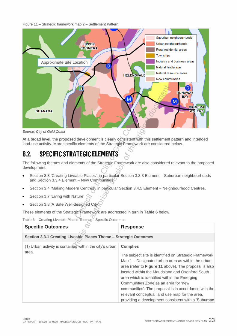
8.1.1. Settlement Pattern
The Gold Coast is a linear city and the settlement pattern has been shaped by physical attributes of the coast, waterways and hinterland. The city shape, or settlement pattern, includes both urban and non-urban areas. The city’s urban and non-urban areas are identified on Strategic Framework Map 1, as seen in Figure 11 the site is within the Urban Area.
Figure 10 – Strategic Framework Map 1 – Designated Urban Area
Source: City of Gold Coast
The city’s settlement pattern is identified on Strategic Framework Map 2. As seen in Figure 10, the site is identified within the Suburban Neighbourhoods area.
Approximate Site Location
This
is a
n au
thor
ised
ver
sion
of t
he o
rigin
al d
ocum
ent
Cou
ncil
of th
e C
ity o
f Gol
d C
oast
URBIS DA REPORT - 160920 - GP0030 - MAUDLANDS MCU - ROL - PA_FINAL
STRATEGIC ASSESSMENT – GOLD COAST CITY PLAN 23
Figure 11 – Strategic framework map 2 – Settlement Pattern
Source: City of Gold Coast
At a broad level, the proposed development is clearly consistent with this settlement pattern and intended land-use activity. More specific elements of the Strategic Framework are considered below.
The following themes and elements of the Strategic Framework are also considered relevant to the proposed development:
Section 3.3 ‘Creating Liveable Places’, in particular Section 3.3.3 Element – Suburban neighbourhoods and Section 3.3.4 Element – New Communities.
Section 3.4 ‘Making Modern Centres’, in particular Section 3.4.5 Element – Neighbourhood Centres.
Section 3.7 ‘Living with Nature’
Section 3.8 ‘A Safe Well-designed City’
These elements of the Strategic Framework are addressed in turn in Table 6 below.
Table 6 – Creating Liveable Places Themes - Specific Outcomes
Specific Outcomes Response
Section 3.3.1 Creating Liveable Places Theme – Strategic Outcomes
(1) Urban activity is contained within the city’s urban
area.
Complies
The subject site is identified on Strategic Framework
Map 1 – Designated urban area as within the urban
area (refer to Figure 11 above). The proposal is also
located within the Maudsland and Oxenford South
area which is identified within the Emerging
Communities Zone as an area for ‘new
communities’. The proposal is in accordance with the
relevant conceptual land use map for the area,
providing a development consistent with a ‘Suburban
Approximate Site Location
This
is a
n au
thor
ised
ver
sion
of t
he o
rigin
al d
ocum
ent
Cou
ncil
of th
e C
ity o
f Gol
d C
oast

24 STRATEGIC ASSESSMENT – GOLD COAST CITY PLAN URBIS
DA REPORT - 160920 - GP0030 - MAUDLANDS MCU - ROL - PA_FINAL
Specific Outcomes Response
neighbourhood accommodation larger lots on
sloping sites’. This is discussed further below.
(2) The Gold Coast’s settlement pattern provides
housing choices and diverse lifestyle opportunities in
mixed use centres and specialist centres,
neighbourhood centres, urban neighbourhoods,
suburban neighbourhoods, new communities, and
rural residential and township areas. Limited
opportunities also exist in the Merrimac/Carrara flood
plain special management area.
Complies
The subject site is identified on Strategic Framework
Map 2 – Settlement Pattern as Suburban
Neighbourhood (refer to Figure 10 below). The
proposed development is consistent with the Gold
Coast’s settlement pattern designation of Suburban
Neighbourhood, providing a development with
opportunities for residential activities and business
activities. The proposal provides a mix of lot sizes to
accommodate housing diversity. The development
proposal is not within the Merrimac/Carrara flood
plan special management area.
(8) Neighbourhood design maximises walking and
cycling and improves access by providing local
community facilities and services, public transport
and jobs close to homes. Socially diverse and
inclusive communities accommodate all ages,
income groups and cultural backgrounds.
Complies
The proposed development is within walking
distance to a neighbourhood centre and community
facilities focussed around the Maudsland
Road/Killarney Court intersection (such as the
Queensland Country Women’s Association Memorial
Hall). There is a bus route that runs adjacent to the
site.
(11) Suburban neighbourhood areas are maintained
as low-intensity, low-rise residential environments
that retain and enhance local character and amenity.
Complies
The proposed subdivision includes 18 residential
allotments intended for detached dwellings. The
development proposal provides residential lots that
are intended to be developed as low-rise residential
environments. The plan of development prepared by
Urbis in Appendix D illustrates the intent for future
built form on the site.
(12) New communities are located in the urban area
to achieve an orderly and efficient use of land and
deliver a mix of housing forms. They are supported
by social and essential infrastructure, an appropriate
range of goods and services and employment
opportunities, and active and public transport.
Complies
The development is located within the urban area in
close proximity to neighbourhood centres and
access to goods. The inclusion of a childcare centre
will provide a commercial opportunity that will benefit
local residents. The proposed development will
provide employment and will support increased
residential densities in the area. It is considered that
the proposal creates a walkable neighbourhood.
Section 3.3.3 Element – Suburban Neighbourhoods
(1) Suburban neighbourhoods are places for low
intensity, low-rise, predominantly detached housing
Complies
The proposed subdivision includes 18 residential
This
is a
n au
thor
ised
ver
sion
of t
he o
rigin
al d
ocum
ent
Cou
ncil
of th
e C
ity o
f Gol
d C
oast

URBIS DA REPORT - 160920 - GP0030 - MAUDLANDS MCU - ROL - PA_FINAL
STRATEGIC ASSESSMENT – GOLD COAST CITY PLAN 25
Specific Outcomes Response
that retains and enhances local character and
amenity by maintaining existing scale, building
height and intensity despite its proximity to public
transport or other services. They are less clustered
and characterised by a feeling of openness, with
buildings positioned in a generous landscaped
setting.
allotments intended for detached dwellings. The
development proposal provides residential lots that
are intended to be developed as low-rise residential
environments. The plan of development prepared by
Urbis in Appendix D illustrates the intent for future
built form on the site. The proposed development will
enhance the local character and amenity of the area
and provide a diversity of lot sizes for future
residential development. The development proposal
is consistent with other residential subdivision
development in the Maudsland area, providing an
amenity rich development. The development
proposal includes a land dedication to council to
maintain the environmental values of the area.
Yet, the proposed Child Care Centre will not
compromise this amenity and character, being a low-
rise building also which is positioned on Maudsland
Road to have a direct nexus with the existing
neighbourhood centre activities immediately to the
north of the site.
(2) Suburban neighbourhood streets are
characterised by trees and a shared use network of
interconnected thoroughfares for pedestrians,
cyclists and slow-moving vehicles.
Complies
The proposed subdivision intended for residential
development will connect to Riverstone Crossing via
a new neighbourhood street. This road will be
characterised by landscaped verge areas that reflect
the amenity of the area.
(3) Suburban neighbourhoods provide opportunities
for smaller and more affordable, predominantly
detached housing options.
Complies
The proposal includes a residential subdivision with
a variety of lot sizes that seeks to provide diverse
opportunities for detached housing options.
(4) Detached houses on larger lots respond to site
constraints or protect local character and amenity.
Complies
The site is identified in the Maudsland and Oxenford
South Conceptual Land Use Map (Figure 12) as
‘suburban neighbourhood accommodating larger lots
on a sloping site’. The development responds to the
intent for the site by responding to the site
constraints. The development proposal will provide a
reconfiguration including a mix of lot sizes. A
preliminary approval for dwelling houses is sought,
detached dwellings will be provided on all lots. Lot
sizes are generally consistent with emerging nearby
development, and are of sufficient size to allow for
reasonable benching and retaining walls to address
the slope of the existing site.
This
is a
n au
thor
ised
ver
sion
of t
he o
rigin
al d
ocum
ent
Cou
ncil
of th
e C
ity o
f Gol
d C
oast

26 STRATEGIC ASSESSMENT – GOLD COAST CITY PLAN URBIS
DA REPORT - 160920 - GP0030 - MAUDLANDS MCU - ROL - PA_FINAL
Specific Outcomes Response
Maudsland is a traditionally rural-residential locality
that is currently transitioning to area with greater
residential densities. The development proposal
includes a council reserve to ensure that the amenity
and ecological values on the site are protected.
(5) Low intensity, low-rise small lot housing, dual
occupancy and multiple dwellings occur in suburban
neighbourhoods in low concentrations where they
achieve a dispersed or gentle-scattering effect.
These dwellings are limited to the following lots
where they do not adjoin existing or approved small
lot housing, dual occupancy or multiple dwellings:
(a) corner lots; or
(b) lots with both street and rear lane access; or
(c) lots within a 400 metre walk of a mixed use
centre or specialist centre.
Not Applicable
The proposed development does not include ‘small
lot’ housings, dual occupancy or multiple dwellings.
(6) Aged care housing is found on lots within a 400
metre walk of high frequency public transport stops,
mixed use activity or neighbourhood centres or
district or regional level community facilities.
Not Applicable
The proposed development does not include aged
care housing.
(7) Shop-top housing occurs when provided as part
of a neighbourhood centre or neighbourhood store.
Not Applicable
The proposed development does not include shop-
top housing.
(8) Housing types and design blends with local
character and amenity.
Complies
The proposal includes preliminary approval for
dwelling houses. The area of Maudsland is a
traditionally rural-residential area that is transitioning
into increased density housing. The proposed lot
sizes and scale of the development will ensure that
housing type will blends with the local character and
amenity.
(9) Uses that compromise the amenity of suburban
neighbourhoods, including service stations, short-
term holiday accommodation, hotels or medium-to-
large-scale places of worship are not established.
Complies
The proposed development does not include a use
that will compromise the amenity of suburban
neighbourhoods. The proposed Child Care Centre
will complement the existing residential environment
and is positioned on Maudsland Road to have a
direct nexus with the existing neighbourhood centre
activities immediately to the north of the site.
This
is a
n au
thor
ised
ver
sion
of t
he o
rigin
al d
ocum
ent
Cou
ncil
of th
e C
ity o
f Gol
d C
oast
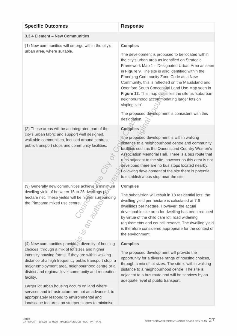
URBIS DA REPORT - 160920 - GP0030 - MAUDLANDS MCU - ROL - PA_FINAL
STRATEGIC ASSESSMENT – GOLD COAST CITY PLAN 27
Specific Outcomes Response
3.3.4 Element – New Communities
(1) New communities will emerge within the city’s
urban area, where suitable.
Complies
The development is proposed to be located within
the city’s urban area as identified on Strategic
Framework Map 1 – Designated Urban Area as seen
in Figure 9. The site is also identified within the
Emerging Community Zone Code as a New
Community, this is reflected on the Maudsland and
Oxenford South Conceptual Land Use Map seen in
Figure 12. This map classifies the site as ‘suburban
neighbourhood accommodating larger lots on
sloping site’.
The proposed development is consistent with this
designation.
(2) These areas will be an integrated part of the
city’s urban fabric and support well designed,
walkable communities, focused around centres,
public transport stops and community facilities.
Complies
The proposed development is within walking
distance to a neighbourhood centre and community
facilities such as the Queensland Country Women’s
Association Memorial Hall. There is a bus route that
runs adjacent to the site, however as this area is not
developed there are no bus stops located nearby.
Following development of the site there is potential
to establish a bus stop near the site.
(3) Generally new communities achieve a minimum
dwelling yield of between 15 to 25 dwellings per
hectare net. These yields will be higher surrounding
the Pimpama mixed use centre.
Complies
The subdivision will result in 18 residential lots; the
dwelling yield per hectare is calculated at 7.6
dwellings per hectare. However, the actual
developable site area for dwelling has been reduced
by virtue of the child care lot, road widening
requirements and council reserve. The dwelling yield
is therefore considered appropriate for the context of
the environment.
(4) New communities provide a diversity of housing
choices, through a mix of lot sizes and higher
intensity housing forms, if they are within walking
distance of a high frequency public transport stop, a
major employment area, neighbourhood centre or a
district and regional level community and recreation
facility.
Larger lot urban housing occurs on land where
services and infrastructure are not as advanced, to
appropriately respond to environmental and
landscape features, on steeper slopes to minimise
Complies
The proposed development will provide the
opportunity for a diverse range of housing choices,
through a mix of lot sizes. The site is within walking
distance to a neighbourhood centre. The site is
adjacent to a bus route and will be services by an
adequate level of public transport.
This
is a
n au
thor
ised
ver
sion
of t
he o
rigin
al d
ocum
ent
Cou
ncil
of th
e C
ity o
f Gol
d C
oast

28 STRATEGIC ASSESSMENT – GOLD COAST CITY PLAN URBIS
DA REPORT - 160920 - GP0030 - MAUDLANDS MCU - ROL - PA_FINAL
Specific Outcomes Response
earthworks and to provide a transition to the city’s
non-urban areas.
(5) Small lot housing, dual occupancy and multiple
dwellings occur in new communities in low
concentrations where they achieve a dispersed or
gentle-scattering effect. These dwellings are limited
to the following lots where they do not adjoin existing
or approved small lot housing, dual occupancy or
multiple dwellings:
(a) corner lots; or
(b) lots with both street and rear lane access; or
(c) lots within a 400 metre walk of a mixed use
centre or specialist centre.
Not Applicable
The proposal does not include ‘small lot’ housing,
dual occupancy or multiple dwellings.
(6) The transition of vacant urban land to new
communities will:
(a) ensure essential infrastructure and services can
be provided in a timely, cost effective and
environmentally responsible manner;
(b) ensure timely and easy access to an appropriate
range of goods and services, and employment
opportunities, public transport and community
and recreational facilities;
(c) avoid natural hazard areas, or ensure these are
sensitively developed; and
(d) protect matters of environmental significance
and landscape character.
Complies
Maudsland and Oxenford South is identified as a
‘new community’ under the Emerging Communities
zone code to involve a stages transition of vacant
urban land to new communities.
(a) The development of this site will ensure that
essential infrastructure is to be provided in a timely,
cost effective and environmentally friendly manner.
(b) The development of a child care centre on the
site will provide a much needed service to the
Maudsland area which is currently experiencing an
increase in housing density and population. The
development is also within close proximity to the
existing neighbourhood centre.
(c) The development proposal has been designed to
account for natural hazard areas such as flooding
areas. To ensure that the proposed reconfiguration
of lots and child care centre are not vulnerable to
natural hazards a substantial part of the site has
been dedicated to council as a reserve to preserve
the ecological values and natural water flows on the
site.
(d) The development proposal maintains the
environmental significance and landscape character
of the area by maintaining parts of the site for local
council reserve and proposing comfortable lot sizes.
(7) The layout and design of new communities:
(a) contribute to safe, healthy and cohesive
Complies
(a) The intent of the proposed development is to
This
is a
n au
thor
ised
ver
sion
of t
he o
rigin
al d
ocum
ent
Cou
ncil
of th
e C
ity o
f Gol
d C
oast

URBIS DA REPORT - 160920 - GP0030 - MAUDLANDS MCU - ROL - PA_FINAL
STRATEGIC ASSESSMENT – GOLD COAST CITY PLAN 29
Specific Outcomes Response
communities that reduce social isolation and
promote community wellbeing;
(b) include an interconnected system of streets and
open spaces that provide pleasant and
comfortable walking and cycling environments
and support public transport;
(c) respond to opportunities and constraints both on
site and from the surrounding locality, including
ecological and hydrological functions and
corridors, topography, scenic amenity and
landscape features, natural hazards and other
factors;
(d) orientate streets and lots to support energy
efficient design;
(e) enable the efficient development of adjoining
land and does not accelerate, place or shift
unreasonable costs of infrastructure to adjoining
properties, such as recreation facilities,
stormwater management facilities, roads and
bridges; and
(f) achieve a high standard of urban design and
safety, with dwellings and other buildings
appropriately addressing all road frontages.
provide the community with community infrastructure
and a diverse range of residential development
opportunities. It is considered that the proposal
creates a walkable neighbourhood and encourages
an active and healthy lifestyle. The inclusion of a
childcare centre in the proposal provides a much
needed community service to the area, promoting
social inclusion and catering to the diverse needs of
the community.
(b) The intent of the proposed development is to
provide the community with connections to
surrounding open space and recreational
opportunities. The proposal creates a walkable
neighbourhood and reduces vehicle-base trips to
local services.
(c) The site is identified in the Maudsland and
Oxenford South Conceptual Land Use Map (Figure
11) as ‘suburban neighbourhood accommodating
larger lots on a sloping site’. The development
responds to the intent for the site by responding to
the site constraints. Maudsland was a rural-
residential locality that is currently transitioning to
area with greater residential densities. The
development proposal includes a council reserve to
ensure that the amenity and ecological values on the
site are protected.
(d) The development proposal will provide a
reconfiguration including a mix of lot sizes and
orientations. The proposed street direction across
the site will also allow for the development of
numerous north-south facing lots.
(e) The development proposal includes a land
dedication to the DTMR to ensure the future
development of the road network.
(f) The proposed layout of the development is
reflective of the development pattern of surrounding
residential areas.
Section 3.4.1 Making Modern Centres – Strategic Outcomes
(3) Centre categories differ in role and function
based on the mix of uses and the specific market
pressures that influence each. This is an important
feature of the Gold Coast’s centres network, where:
- mixed use centres are population-serving centres
and comprise a varied scale and mix of high order
Complies
The proposed Child Care Centre represents a
standalone small-scale non-residential land-use
forming a neighbourhood centre activity. The
proposed Child Care Centre will not undermine the
viability of any existing centre or non-residential
This
is a
n au
thor
ised
ver
sion
of t
he o
rigin
al d
ocum
ent
Cou
ncil
of th
e C
ity o
f Gol
d C
oast

30 STRATEGIC ASSESSMENT – GOLD COAST CITY PLAN URBIS
DA REPORT - 160920 - GP0030 - MAUDLANDS MCU - ROL - PA_FINAL
Specific Outcomes Response
uses and services in response to their broad
catchments;
- specialist centres respond to specific market
pressures other than population driven demand,
including commercial (business or tourism) or
knowledge economy driven demand; and
- neighbourhood centres comprise a mix of small
scale uses and services in response to the specific
needs of their immediate neighbourhood.
activity, being in very high demand for the
surrounding rapidly growing residential catchment.
(7) Neighbourhood centres complement mixed use
centres and specialist centres. They are pedestrian-
orientated areas with smaller scale concentrations of
business, employment, community, cultural, retail
and residential uses. They provide a focal point for
the local community and support neighbourhood
identity and sense of place.
Neighbourhood centres serve an important local role
within the centres network. These centres respond to
specific local needs and provide convenience and
accessibility within neighbourhood areas. They do
not undermine the orderly development of nearby
mixed use centres or specialist centres, or the
viability of existing neighbourhood centres.
Complies
As noted above, the proposed Child Care Centre
represents a standalone small-scale non-residential
land-use forming a neighbourhood centre activity.
The proposed Child Care Centre will not undermine
the viability of any existing centre or non-residential
activity, being in very high demand for the
surrounding rapidly growing residential catchment.
Yet, the Child Care Centre is positioned on the
northern corner of the site, so as to create a nexus
with the existing local neighbourhood services to the
north of the site, and consolidate these activities
around the Maudsland Rd/Killarney Ct intersection,
creating a focal point for local services for the
immediate growing residential community.
Section 3.4.5 Element – Neighbourhood Centres
(1) Neighbourhood centres differ from mixed use
centres and specialist centres as they are smaller
and comprise a mix of smaller-scale uses. While the
potential land use options for neighbourhood centres
vary, the scale of individual centres is limited to the
specific needs of their neighbourhood.
Complies
The proposed Child Care Centre seeks to integrate
with the existing neighbourhood services to the north
of the site, creating a very small-scale
neighbourhood centre which services the needs of
the immediate residential community.
(10) New neighbourhood centres are encouraged in
suburban and urban neighbourhoods (including light
rail urban renewal area), new communities,
Merrimac/Carrara flood plain special management
area, townships, and general (excluding high impact
industry) and marine industry areas, where they:
- do not undermine the orderly development of
nearby mixed use centres and specialist centres, or
the viability of existing neighbourhood centres; and
- do not compromise the long-term use of nearby
land for its intended purposes (e.g. industrial
Complies
The proposed Child Care Centre represents a
neighbourhood centre activity which can be
considered a standalone small-scale use as part of a
new community (being the proposed 18-lot
subdivision development), but also will integrate with
the existing small-scale local services to the north of
the site.
In any event, the Child Care Centre will not
undermine the viability of the existing neighbourhood
services, but will complement it, consolidating non-
This
is a
n au
thor
ised
ver
sion
of t
he o
rigin
al d
ocum
ent
Cou
ncil
of th
e C
ity o
f Gol
d C
oast

URBIS DA REPORT - 160920 - GP0030 - MAUDLANDS MCU - ROL - PA_FINAL
STRATEGIC ASSESSMENT – GOLD COAST CITY PLAN 31
Specific Outcomes Response
activities). residential activity in the area and providing a land-
use which is greatly demanded by the rapidly
growing residential community nearby.
(14) Standalone, small-scale commercial uses (e.g.
neighbourhood store, medical centres) may be
appropriate in suburban and urban neighbourhoods
(including light rail urban renewal area), new
communities, Merrimac/Carrara flood plain special
management area, townships and marine and
general industry areas, where these uses:
- are of a type and size that will not undermine the
viability of existing, or new neighbourhood centres;
- provide a direct service to the immediate
neighbourhood/industry area or a high frequency
public transport stop;
- maintain a compatible form and scale to nearby
development;
- do not unduly detract from local character and
amenity; and
- are not service station, bar, hotel, nightclub or
supermarket uses.
Complies
As noted above, the proposed Child Care Centre is a
standalone small-scale proposal that will have a
nexus to and integrate with existing neighbourhood
activities immediately to the north of the site.
It will not undermine the viability of the existing
neighbourhood services, but will complement it,
consolidating non-residential activity in the area and
providing a land-use which is greatly demanded by
the rapidly growing residential community nearby.
It provides a single-storey built form se amongst
outdoor play areas and landscaping, complementing
the suburban residential character of the area.
It is also positioned to minimise impacts to
neighbouring premises, with outdoor play areas
being located away from residential premises.
Section 3.7.1 Living with Nature – Strategic Outcomes
(1) A comprehensive green space network of natural
landscape areas is enhanced, maintained and
protected for the nature conservation and recreation
needs of the city and enhances the city’s powerful
image of green, gold and blue.
Complies
The proposed development has been configured to
enable high amenity residential living without
significant vegetation clearing or topographic
modification. The proposal seeks to retain the scenic
and natural amenity of the site by dedicating a
substantial part of the land as a Council reserve. The
proposed lot configuration and size will also be
sufficient to enable protection of these assets and
contribute to the protection and enhancement of the
waterway corridor traversing the site.
(2) Land, freshwater, estuarine and marine
ecological processes and other matters of
environmental significance are protected and
supported through a connected green space
network.
Complies
The site is not identified as part of the green space
network identified on Conceptual Land Use Map –
Maudsland and Oxenford South in Figure 12.
However, the proposed lot configuration and size will
be sufficient to enable protection of these assets on
the site and contribute to the protection and
enhancement of the waterway corridor traversing the
site. The proposal also protects part of the existing
This
is a
n au
thor
ised
ver
sion
of t
he o
rigin
al d
ocum
ent
Cou
ncil
of th
e C
ity o
f Gol
d C
oast

32 STRATEGIC ASSESSMENT – GOLD COAST CITY PLAN URBIS
DA REPORT - 160920 - GP0030 - MAUDLANDS MCU - ROL - PA_FINAL
Specific Outcomes Response
vegetation on the site by dedicating a substantial
part of the land as a Council reserve to maintain
established green space connections on the site.
(5) Outside of biodiversity areas high priority
vegetation is protected in situ. Regulated, medium
and general priority vegetation is maintained and
disturbance is minimised.
Complies
The site is not identified within the Environmental
Significance – Biodiversity Areas Overlay. The site
contains general priority vegetation and state/local
significant species. The majority of these priority
vegetation areas identified on the City Plan
interactive mapping overlay map will be maintained
as they are to be included within the proposed
Council reserve. Disturbance to priority areas
outside the reserve will be minimised through
appropriate management of these areas, please
refer to the Ecological Assessment in Appendix I for
further information.
Section 3.8.1 A Safe, Well Designed City – Strategic Outcomes
(2) Important elements of urban character and
community significance are protected and enhanced
to strengthen the sense of identity in local areas and
the city.
Complies
The proposed development is located within
Maudsland, a traditionally rural-residential area that
is transitioning to higher residential densities. The
proposed development aims to maintain the
consistent with the character and environmentally
sensitive nature of the area whilst providing
residential and local service opportunities for the
benefit of new residents.
(3) The design and development of new or renewed
communities foster a strong sense of community
identity and promote community wellbeing.
Complies
The intent of the proposed development is to provide
the community with connections to surrounding open
space and recreational opportunities. It is considered
that the proposal creates a walkable neighbourhood
and encourages an active and healthy lifestyle. The
proposed council reserve will protect the character of
the landscape and vegetated waterway corridor on
the site.
(7) Communities and environments are safe and
attractive places to work, live in and visit.
Complies
The development proposal has been designed to
ensure environmental values of the area are retained
to create an amenity rich development that will be an
attractive place to work, live in and visit.
(13) Residential and other sensitive uses are located
away from areas that could cause environmental
Complies
The reconfiguration of lots and childcare centre has
This
is a
n au
thor
ised
ver
sion
of t
he o
rigin
al d
ocum
ent
Cou
ncil
of th
e C
ity o
f Gol
d C
oast

URBIS DA REPORT - 160920 - GP0030 - MAUDLANDS MCU - ROL - PA_FINAL
STRATEGIC ASSESSMENT – GOLD COAST CITY PLAN 33
Specific Outcomes Response
harm or nuisance from emissions or other impacts. been located on the site to minimise nuisance from
emissions from nearby roads, refer to the Traffic
Impact Assessment in Appendix J. To minimise
environmental harm to the site part of the land has
been dedicated as council reserve, please refer to
Appendix I for the Ecological Assessment Report.
The Purpose of the Emerging Community Zone Code is as follows:
(a) identify land that is suitable for urban purposes and protect land that may be suitable for urban development in the future
(b) manage the timely conversion of non-urban land to urban purposes.
(c) prevent or discourage development that is likely to compromise appropriate longer term land use.
The proposed development achieves the Purpose of the Zone Code, for the following reasons:
The proposed development maximises the function of the areas of the site suitable for urban purposes. This includes suburban residential subdivision and a standalone Child Care Centre which will integrate with existing non-residential local services immediately to the north of the site. The environmentally valuable areas of the site are protected from development.
The proposed development will occur on one of the last land parcels zoned for urban development remaining in the area. The development is appropriately planned, allowing for suburban residential development consistent with the surrounding environment and a Child Care Centre to complement the existing local services precinct, and accommodates future infrastructure requirements that will service the emerging residential population.
The proposed development represent the intended and appropriate long-term use of the land.
The consistency of the proposed development with the Zone is further evidenced in the conceptual land use mapping for the precinct contained within the City Plan.
8.3.1. Conceptual Land Use
Maudsland and Oxenford South is identified as a ‘new community’ under the Emerging Communities Zone Code to involve a staged transition of vacant urban land to new communities. In accordance with the Emerging Communities Zone Code, the new community will be subject to detailed site based investigations, and guided by the development intent identified in within the relevant conceptual land use map.
The City Plan conceptual land use mapping is indicative and provides a guide to the potential development intent of sites. The site is identified within the Maudsland and Oxenford South Conceptual land use map as ‘Suburban neighbourhood accommodation larger lots on sloping sites’ (refer to Figure 12).
The proposed development is consistent with the development intent for the site by providing a residential subdivision on a sloping site, as well as a small-scale stand-alone non-residential land-use (a Child Care Centre) which is consistent with the Strategic Framework on the flatter northern portion of the site to consolidate local services in the area.
This
is a
n au
thor
ised
ver
sion
of t
he o
rigin
al d
ocum
ent
Cou
ncil
of th
e C
ity o
f Gol
d C
oast

34 STRATEGIC ASSESSMENT – GOLD COAST CITY PLAN URBIS
DA REPORT - 160920 - GP0030 - MAUDLANDS MCU - ROL - PA_FINAL
Figure 12 – Conceptual Land Use Map
Source: City of Gold Coast
Subject Site
This
is a
n au
thor
ised
ver
sion
of t
he o
rigin
al d
ocum
ent
Cou
ncil
of th
e C
ity o
f Gol
d C
oast

URBIS DA REPORT - 160920 - GP0030 - MAUDLANDS MCU - ROL - PA_FINAL
CONCLUSION 35
Urbis Pty Ltd has been commissioned by Riverstone Pass Pty Ltd to prepare this development application for the proposed development at 182 Maudsland Road, Maudsland, formally known as Lot 3 on WD2321. This application seeks council approval for a Development Permit for a Material Change of Use for a Child Care Centre, Development Permit for Reconfiguring a Lot (19-lot subdivision) and Preliminary Approval (s242) for a Material Change of Use for Dwelling Houses involving Building Work.
Located within the Emerging Communities Zone, the proposal for a Child Care Centre and 19-lot subdivision is subject to Impact Assessment. The Preliminary Approval for a Material Change of Use for Dwelling Houses involving Building Work will is subject to Code Assessment. This application seeks that future development for Dwelling Houses involving Building Work on the site will be subject to Self-Assessment against the Approval Conditions of the Preliminary Approval, Plan of Development prepared by Urbis and the relevant Outcomes of the City Plan.
The establishment of a residential subdivision and child care centre on the site:
Meets the provisions contained within the relevant City Plan Strategic framework;
Will provide for a greater variety of residential development options; and
Is consistent with the layout of surrounding residential subdivisions.
Within the legislative and physical context, the proposal has been assessed against, and is considered to be able to fulfil the requirements of the relevant planning provisions and provide for the everyday needs of existing and future residents in the area. In this regard it is noted that the proposal:
Maximises the efficient use of the site by providing much needed community facilities and residential development options;
Represents sound planning, will not result in unreasonable impacts on the amenity of the surrounding environment, and is considered appropriate within its locality;
Provides a standalone non-residential activity which will integrate with existing local services to the north of the site and consolidate this precinct as a focal point for local services in the emerging residential area;
The development is consisted with the intent of the Emerging Community Zone; and
The development generally meets the Acceptable Outcomes or associated Performance Outcomes of the relevant Codes.
On the basis of the assessment contained within this report, Council is requested to favourably consider the development proposal, subject to reasonable and relevant conditions.
This
is a
n au
thor
ised
ver
sion
of t
he o
rigin
al d
ocum
ent
Cou
ncil
of th
e C
ity o
f Gol
d C
oast

36 DISCLAIMER URBIS
DA REPORT - 160920 - GP0030 - MAUDLANDS MCU - ROL - PA_FINAL
This report is dated September 2016 and incorporates information and events up to that date only and excludes any information arising, or event occurring, after that date which may affect the validity of Urbis Pty Ltd’s (Urbis) opinion in this report. Urbis prepared this report on the instructions, and for the benefit only, of Riverstone Pass Pty Ltd (Instructing Party) for the purpose of Development Application (Purpose) and not for any other purpose or use. To the extent permitted by applicable law, Urbis expressly disclaims all liability, whether direct or indirect, to the Instructing Party which relies or purports to rely on this report for any purpose other than the Purpose, and to any other person which relies or purports to rely on this report for any purpose whatsoever (including the Purpose).
In preparing this report, Urbis was required to make judgements which may be affected by unforeseen future events, the likelihood and effects of which are not capable of precise assessment.
All surveys, forecasts, projections and recommendations contained in or associated with this report are made in good faith and on the basis of information supplied to Urbis at the date of this report, and upon which Urbis relied. Achievement of the projections and budgets set out in this report will depend, among other things, on the actions of others over which Urbis has no control.
In preparing this report, Urbis may rely on or refer to documents in a language other than English, which Urbis may arrange to be translated. Urbis is not responsible for the accuracy or completeness of such translations and disclaims any liability for any statement or opinion made in this report being inaccurate or incomplete arising from such translations.
Whilst Urbis has made all reasonable inquiries it believes necessary in preparing this report, it is not responsible for determining the completeness or accuracy of information provided to it. Urbis (including its officers and personnel) is not liable for any errors or omissions, including in information provided by the Instructing Party or another person or upon which Urbis relies, provided that such errors or omissions are not made by Urbis recklessly or in bad faith.
This report has been prepared with due care and diligence by Urbis and the statements and opinions given by Urbis in this report are given in good faith and in the reasonable belief that they are correct and not misleading, subject to the limitations above.
This
is a
n au
thor
ised
ver
sion
of t
he o
rigin
al d
ocum
ent
Cou
ncil
of th
e C
ity o
f Gol
d C
oast

URBIS DA REPORT - 160920 - GP0030 - MAUDLANDS MCU - ROL - PA_FINAL
APPENDICES
This
is a
n au
thor
ised
ver
sion
of t
he o
rigin
al d
ocum
ent
Cou
ncil
of th
e C
ity o
f Gol
d C
oast

APPENDICES
URBIS DA REPORT - 160920 - GP0030 - MAUDLANDS MCU - ROL - PA_FINAL
This
is a
n au
thor
ised
ver
sion
of t
he o
rigin
al d
ocum
ent
Cou
ncil
of th
e C
ity o
f Gol
d C
oast

URBIS DA REPORT - 160920 - GP0030 - MAUDLANDS MCU - ROL - PA_FINAL
APPENDICES
Matter Of
Interest
Type Referral
Required
Relevant
Provisions Of
The Regulation
Relevant Module And Codes
Aquaculture MCU No Schedule 7, Table 2,
Item 28
Module 3: Aquaculture
3.1 Aquaculture state code
Environmentally
relevant
activities
MCU No Schedule 7, Table 2,
Item 1
Module 4: Environmentally relevant
activities
4.1 Concurrence environmentally relevant
activity state code
Fish habitat
area – works or
other
development
Build.
Works
N/A Schedule 7, Table 2,
Item 25
Module 5: Fisheries resources
5.1 Development in a declared fish habitat
area state code Op.
Works
N/A Schedule 7, Table 2,
Item 26
Marine plants –
removal,
destruction or
damage
Op.
Works
N/A Schedule 7, Table 2,
Item 30
Module 5: Fisheries resources
5.3 Removal, destruction or damage of
marine plants state code RoL No Schedule 7, Table 2,
Item 31
MCU No Schedule 7, Table 2,
Item 32
No Schedule 7, Table 3,
Item 25
Native
vegetation
clearing
RoL No Schedule 7, Table 2,
Item 4
Module 8: Native vegetation clearing
8.1 Queensland vegetation management
state code Op.
Works
N/A Schedule 7, Table 2,
Item 5
MCU No Schedule 7, Table 3,
Item 10
Queensland
heritage
Build.
Works
N/A Schedule 7, Table 1,
Item 12
Module 9: Queensland heritage
9.1 Queensland heritage place state code
Various
Dev.
No Schedule 7, Table 2,
Item 19
Tidal works or
development in
a coastal
management
Op.
Works
N/A Schedule 7, Table 2,
Item 13
Module 10: Coastal protection
10.1 Tidal works, or development in a
coastal management district state code
This
is a
n au
thor
ised
ver
sion
of t
he o
rigin
al d
ocum
ent
Cou
ncil
of th
e C
ity o
f Gol
d C
oast

APPENDICES
URBIS DA REPORT - 160920 - GP0030 - MAUDLANDS MCU - ROL - PA_FINAL
Matter Of
Interest
Type Referral
Required
Relevant
Provisions Of
The Regulation
Relevant Module And Codes
district Schedule 7, Table 2,
Item 15
Module 14: Maritime safety
14.1 Marine safety state code
RoL No Schedule 7, Table 2,
Item 14
Module 10: Coastal protection
10.1 Tidal works or development in a
coastal management district state code MCU No Schedule 7, Table 3,
Item 5
Build.
Works
N/A Schedule 7, Table 1,
Item 11
Water – taking
or interfering
with
Op.
Works
N/A Schedule 7, Table 2,
Item 9
Module 7: Water resources
7.1 Sustainable management of water
resources state code Schedule 7, Table 2,
Item 10
Watercourse or
lake – removal
of quarry
material
All
aspects
of Dev.
No Schedule 7, Table 2,
Item 12
Module 7: Water resources
7.2 Removal of quarry material state code
Particular
Levees
Op.
Works
N/A Schedule 7, Table 3,
Item 48
Module 7: Water resources
7.3 Particular levees state code
Waterway
barrier works –
constructing or
raising
Op.
Works
N/A Schedule 7, Table 2,
Item 29
Module 5: Fisheries resources
5.2 Constructing or raising waterway barrier
works in fish habitats state code
Wetland – land
in or near
RoL No Schedule 7, Table 2,
Item 43A
Module 11: Wetland protection
11.1 Wetland protection area state code
MCU No Schedule 7, Table 3,
Item 21A
Op.
Works
N/A Schedule 7, Table 2,
Item 43B
Unexploded
ordnance
(UXO)
RoL No Schedule 7, Table 2,
Item 22
Module 12: Unexploded ordnance (UXO)
12.1 Unexploded ordnance state code
MCU No Schedule 7, Table 3,
Item 11
Module 12: Unexploded ordnance (UXO)
12.1 Unexploded ordnance state code
Major hazard MCU No Schedule 7, Table 2, Module 13: Major hazard facilities
This
is a
n au
thor
ised
ver
sion
of t
he o
rigin
al d
ocum
ent
Cou
ncil
of th
e C
ity o
f Gol
d C
oast

URBIS DA REPORT - 160920 - GP0030 - MAUDLANDS MCU - ROL - PA_FINAL
APPENDICES
Matter Of
Interest
Type Referral
Required
Relevant
Provisions Of
The Regulation
Relevant Module And Codes
facilities Item 8 13.1 Major hazard facilities state code
Particular Dams Op.
Works
N/A Schedule 7, Table 2,
Item 11
Module 16: Particular dams
16.1 Referable dams state code
Public
passenger
transport
Build.
Works
N/A Schedule 7, Table 1,
Item 14
Module 18: State transport infrastructure
protection
18.1 Filling, excavation and structures state
code
RoL No Schedule 7, Table 2,
Item 33
Module 1: Community amenity
1.1 Managing noise and vibration impacts
from transport corridors state code
1.2 Managing air and lighting impacts from
transport corridors state code
Module 18: State transport infrastructure
protection
18.1 Filling, excavation and structures state
code
18.2 Stormwater and drainage impacts on
state transport infrastructure state code
Module 19: State transport network
functionality
19.2 Transport infrastructure and network
design state code
MCU or
Op
Works
No Schedule 7, Table 3,
Item 14
Module 1: Community amenity
1.1 Managing noise and vibration impacts
from transport corridors state code
1.2 Managing air and lighting impacts from
transport corridors state code
Module 18: State transport infrastructure
protection
18.1 Filling, excavation and structures state
code
18.2 Stormwater and drainage impacts on
state transport infrastructure state code
Module 19: State transport network
This
is a
n au
thor
ised
ver
sion
of t
he o
rigin
al d
ocum
ent
Cou
ncil
of th
e C
ity o
f Gol
d C
oast

APPENDICES
URBIS DA REPORT - 160920 - GP0030 - MAUDLANDS MCU - ROL - PA_FINAL
Matter Of
Interest
Type Referral
Required
Relevant
Provisions Of
The Regulation
Relevant Module And Codes
functionality
19.2 Transport infrastructure and network
design state code
Railways Build.
Works
N/A Schedule 7, Table 1,
Item 16
Module 1: Community amenity
1.1 Managing noise and vibration impacts
from transport corridors state code
1.2 Managing air and lighting impacts from
transport corridors state code
Module 18: State transport infrastructure
protection
18.1 Filling, excavation and structures state
code
18.2 Stormwater and drainage impacts on
state transport infrastructure state code
MCU No Schedule 7, Table 3,
Item 15A
Module 1: Community amenity
1.1 Managing noise and vibration impacts
from transport corridors state code
1.2 Managing air and lighting impacts from
transport corridors state code
Module 18: State transport infrastructure
protection
18.1 Filling, excavation and structures state
code
18.2 Stormwater and drainage impacts on
state transport infrastructure state code
Module 19: State transport network
functionality
19.2 Transport infrastructure and network
design state code
Op.
Works
N/A Schedule 7, Table 3,
Item 15B
Module 18: State transport infrastructure
protection
18.1 Filling, excavation and structures state
code
18.2 Stormwater and drainage impacts on
state transport infrastructure state code
This
is a
n au
thor
ised
ver
sion
of t
he o
rigin
al d
ocum
ent
Cou
ncil
of th
e C
ity o
f Gol
d C
oast

URBIS DA REPORT - 160920 - GP0030 - MAUDLANDS MCU - ROL - PA_FINAL
APPENDICES
Matter Of
Interest
Type Referral
Required
Relevant
Provisions Of
The Regulation
Relevant Module And Codes
RoL No Schedule 7, Table 2,
Item 34
Module 1: Community amenity
1.1 Managing noise and vibration impacts
from transport corridors state code
1.2 Managing air and lighting impacts from
transport corridors state code
Module 18: State transport infrastructure
protection
18.1 Filling, excavation and structures state
code
18.2 Stormwater and drainage impacts on
state transport infrastructure state code
Module 19: State transport network
functionality
19.2 Transport infrastructure and network
design state code
State-controlled
road
Build.
Works
N/A Schedule 7, Table 1,
Item 8
Module 18: State transport infrastructure
protection
18.1 Filling, excavation and structures state
code
18.2 Stormwater and drainage impacts on
state transport infrastructure state code
RoL YES Schedule 7, Table 2,
Item 2
Module 1: Community amenity
1.1 Managing noise and vibration impacts
from transport corridors state code
1.2 Managing air and lighting impacts from
transport corridors state code
Module 18: State transport infrastructure
protection
18.1 Filling, excavation and structures state
code
18.2 Stormwater and drainage impacts on
state transport infrastructure state code
Module 19: State transport network
functionality
19.1 Access to state-controlled road state
This
is a
n au
thor
ised
ver
sion
of t
he o
rigin
al d
ocum
ent
Cou
ncil
of th
e C
ity o
f Gol
d C
oast

APPENDICES
URBIS DA REPORT - 160920 - GP0030 - MAUDLANDS MCU - ROL - PA_FINAL
Matter Of
Interest
Type Referral
Required
Relevant
Provisions Of
The Regulation
Relevant Module And Codes
code
19.2 Transport infrastructure and network
design state code
Op.
Works
N/A Schedule 7, Table 2,
Item 3
Module 18: State transport infrastructure
protection
18.1 Filling, excavation and structures state
code
18.2 Stormwater and drainage impacts on
state transport infrastructure state code
Module 19: State transport network
functionality
19.1 Access to state-controlled road state
code
Schedule 7, Table 3,
Item 1A
MCU YES Schedule 7, Table 3,
Item 1
Module 1: Community amenity
1.1 Managing noise and vibration impacts
from transport corridors state code
1.2 Managing air and lighting impacts from
transport corridors state code
Module 18: State transport infrastructure
protection
18.1 Filling, excavation and structures state
code
18.2 Stormwater and drainage impacts on
state transport infrastructure state code
Module 19: State transport network
functionality
19.1 Access to state-controlled road state
code
19.2 Transport infrastructure and network
design state code
State transport
infrastructure
(thresholds)
Various
Aspects
of Dev.
No
Schedule 7, Table 3,
Item 2
Module 17: Public passenger transport
17.1 Public passenger transport state code
Module 18: State transport infrastructure
protection
18.1 Filling, excavation and structures state
This
is a
n au
thor
ised
ver
sion
of t
he o
rigin
al d
ocum
ent
Cou
ncil
of th
e C
ity o
f Gol
d C
oast

URBIS DA REPORT - 160920 - GP0030 - MAUDLANDS MCU - ROL - PA_FINAL
APPENDICES
Matter Of
Interest
Type Referral
Required
Relevant
Provisions Of
The Regulation
Relevant Module And Codes
code
18.2 Stormwater and drainage impacts on
state transport infrastructure state code
Module 19: State transport network
functionality
19.2 Transport infrastructure and network
design state code
State-controlled
transport
tunnels
RoL No Schedule 7, Table 2,
Item 34A
Module 1: Community amenity
1.1 Managing noise and vibration impacts
from transport corridors state code
1.2 Managing air and lighting impacts from
transport corridors state code
Module 18: State transport infrastructure
protection
18.1 Filling, excavation and structures state
code
18.2 Stormwater and drainage impacts on
state transport infrastructure state code
Module 19: State transport network
functionality
19.2 Transport infrastructure and network
design state code
MCU No Schedule 7, Table 3,
Item 15C
Module 1: Community amenity
1.1 Managing noise and vibration impacts
from transport corridors state code
1.2 Managing air and lighting impacts from
transport corridors state code
Module 18: State transport infrastructure
protection
18.1 Filling, excavation and structures state
code
18.2 Stormwater and drainage impacts on
state transport infrastructure state code
Module 19: State transport network
functionality
This
is a
n au
thor
ised
ver
sion
of t
he o
rigin
al d
ocum
ent
Cou
ncil
of th
e C
ity o
f Gol
d C
oast

APPENDICES
URBIS DA REPORT - 160920 - GP0030 - MAUDLANDS MCU - ROL - PA_FINAL
Matter Of
Interest
Type Referral
Required
Relevant
Provisions Of
The Regulation
Relevant Module And Codes
19.2 Transport infrastructure and network
design state code
This
is a
n au
thor
ised
ver
sion
of t
he o
rigin
al d
ocum
ent
Cou
ncil
of th
e C
ity o
f Gol
d C
oast

URBIS DA REPORT - 160920 - GP0030 - MAUDLANDS MCU - ROL - PA_FINAL
APPENDICES
This
is a
n au
thor
ised
ver
sion
of t
he o
rigin
al d
ocum
ent
Cou
ncil
of th
e C
ity o
f Gol
d C
oast
APPENDICES
URBIS DA REPORT - 160920 - GP0030 - MAUDLANDS MCU - ROL - PA_FINAL
This
is a
n au
thor
ised
ver
sion
of t
he o
rigin
al d
ocum
ent
Cou
ncil
of th
e C
ity o
f Gol
d C
oast

URBIS DA REPORT - 160920 - GP0030 - MAUDLANDS MCU - ROL - PA_FINAL
APPENDICES
This
is a
n au
thor
ised
ver
sion
of t
he o
rigin
al d
ocum
ent
Cou
ncil
of th
e C
ity o
f Gol
d C
oast

APPENDICES
URBIS DA REPORT - 160920 - GP0030 - MAUDLANDS MCU - ROL - PA_FINAL
This
is a
n au
thor
ised
ver
sion
of t
he o
rigin
al d
ocum
ent
Cou
ncil
of th
e C
ity o
f Gol
d C
oast

URBIS DA REPORT - 160920 - GP0030 - MAUDLANDS MCU - ROL - PA_FINAL
APPENDICES
This
is a
n au
thor
ised
ver
sion
of t
he o
rigin
al d
ocum
ent
Cou
ncil
of th
e C
ity o
f Gol
d C
oast

APPENDICES
URBIS DA REPORT - 160920 - GP0030 - MAUDLANDS MCU - ROL - PA_FINAL
This
is a
n au
thor
ised
ver
sion
of t
he o
rigin
al d
ocum
ent
Cou
ncil
of th
e C
ity o
f Gol
d C
oast

URBIS DA REPORT - 160920 - GP0030 - MAUDLANDS MCU - ROL - PA_FINAL
APPENDICES
This
is a
n au
thor
ised
ver
sion
of t
he o
rigin
al d
ocum
ent
Cou
ncil
of th
e C
ity o
f Gol
d C
oast

APPENDICES
URBIS DA REPORT - 160920 - GP0030 - MAUDLANDS MCU - ROL - PA_FINAL
This
is a
n au
thor
ised
ver
sion
of t
he o
rigin
al d
ocum
ent
Cou
ncil
of th
e C
ity o
f Gol
d C
oast
URBIS DA REPORT - 160920 - GP0030 - MAUDLANDS MCU - ROL - PA_FINAL
APPENDICES
This
is a
n au
thor
ised
ver
sion
of t
he o
rigin
al d
ocum
ent
Cou
ncil
of th
e C
ity o
f Gol
d C
oast

APPENDICES
URBIS DA REPORT - 160920 - GP0030 - MAUDLANDS MCU - ROL - PA_FINAL
This
is a
n au
thor
ised
ver
sion
of t
he o
rigin
al d
ocum
ent
Cou
ncil
of th
e C
ity o
f Gol
d C
oast
URBIS DA REPORT - 160920 - GP0030 - MAUDLANDS MCU - ROL - PA_FINAL
APPENDICES
This
is a
n au
thor
ised
ver
sion
of t
he o
rigin
al d
ocum
ent
Cou
ncil
of th
e C
ity o
f Gol
d C
oast

APPENDICES
URBIS DA REPORT - 160920 - GP0030 - MAUDLANDS MCU - ROL - PA_FINAL
This
is a
n au
thor
ised
ver
sion
of t
he o
rigin
al d
ocum
ent
Cou
ncil
of th
e C
ity o
f Gol
d C
oast

This
is a
n au
thor
ised
ver
sion
of t
he o
rigin
al d
ocum
ent
Cou
ncil
of th
e C
ity o
f Gol
d C
oast