development of wireless link applications for small uas in
TRANSCRIPT

National Institute of Information and Communications Technology
Development of Wireless Link Applications for Small UAS in
JapanMarch 27-28, 2017
Hiroyuki Tsuji
National Institute of Information and Communications Technology (NICT)
FSMP-WG/4 and regional spectrum seminar
This study is carried out under a government-commissioned research project of the Ministry of Internal Affairs and Communications.
National Institute of Information and Communications Technology
Contents
Background of UAV Wireless Communication Systems
Development of UAV-based wireless relaynetwork system in natural disasters
Development of on-board satellite trackingantenna for UAS
Recent UAS radio regulation status in Japan
Conclusions
2

National Institute of Information and Communications Technology
Background-1 Unmanned aircraft systems (UAS) or drones have received a lot of
attention in recent years in the world for several applications
‣ wind and flood damage and fire, monitoring and observation, deliveries of goods
Reliability of communication and the safe operation of UAS is becoming urgent need with the expansion of the needs of the UAS.
The World Radiocommunication Conference (WRC)
‣ WRC 2012 (WRC-12) decided the allocation of the frequency band 5 GHz band (5030 MHz ~ 5091 MHz) for the UAS Control and Non-Payload Communications (CNPC) Link.
‣ WRC (WRC-15) decided to allocate the Ku/Ka frequency bands to establish a communication link between UA and remote pilot through satellite, and the details of its operations have being discussed in ITU-R
➡ Research and development of interference mitigation techniques has become a pressing issue.
3
National Institute of Information and Communications Technology
Background-2 In past disasters such as Great Hansin Earthquake and Great East Japan
Earthquake, some isolated areas appeared in disasters area.
The transportation system and communication system were interrupted byearthquake and tsunami
The demand of wireless relay network using unmanned aircraft system has grown
Various applications using UAS are being studied in Japan
We report the development of a UAV-based wireless relay network systemand the current status of frequency regulations for UAS wireless link inJapan
Isolated school Isolated airport Isolated place
4

National Institute of Information and Communications Technology
Control and Non-Payload Communications (CNPC) Link for UAS
2
13
4
Fix Satellite Station (FSS) Space Station
UAS CNPC Links1+2: Forward link (Remote pilot to UA)
1: Forward uplink (E-s)2: Forward downlink (s-E)3+4: Return link (UA to remote pilot)
3: Return uplink (E-s)4: Return downlink (s-E)
UA Earth Station(UAES)
Unmanned Aircraft Control Station (UACS)Earth Station
Remote Pilot
5 GHz band
Ku/Ka band
Beyond-Line-of-Sight (BLOS)5GHz band (5030-5091MHz) was allocated worldwide (at the WRC-12) Allocations of Ku/Ka bands in the FSS band are being discussed now (toward the WRC-19)
Line-of-Sight (LOS)5GHz band (5030-5091MHz) was allocated worldwide (at the WRC-12)
5 GHz band
5
National Institute of Information and Communications Technology
Candidate Unmanned Aircrafts for the Research
Small type UAs Medium and Large type UAs
Target UAs of this research
Require Beyond-Line-of-Sight (BLOS) operations
6

National Institute of Information and Communications Technology
Frequency Regulations on UAS The frequency band 5 030–5 091 MHz was allocated for the
CNPC link at WRC-12
‣ The definition of internationally standardized system is required under the footnote 5.443C of ITU-R Radio Regulations
‣ NICT is interested in usage of the frequency band 5 030–5 091 MHz for CNPC link which realizes safe operations of small UAs in a short range with small transmission power.
Several discussions on UAS frequency usages including channel plan are carried out in ICAO
‣ ICAO has a policy that calls for enacting a general framework of flight rules by around 2018
‣ The technological and industrial development of the field of unmanned aircraft in Japan has been stared
UAS Traffic Management (UTM) system by NASA
7
National Institute of Information and Communications Technology
2. DEVELOPMENT OF UAS WIRELESS RELAY NETWORK
8

National Institute of Information and Communications Technology
Isolated area Non-isolated area
Relay N/W Link
Control&CommandLink
To Internet
Air-to-air relay for communication between more distant GSs
Wi-Fizone
Wi-Fiaccess point
Hand-launch small UA-1( On-board repeater )
Small portable setGS-A GS-B
Power generator
Hand-launch
Terrestrial N/W damage
Hand-launch small UA-2(On-board repeater)
Relay N/W Link
Safety confirmation, E-mail, and voice are available by Wi-Fi bridge via UAS
NICT started R&D on disaster-resilient wireless communication system using smallunmanned aircraft system (UAS) in order to ensure the communication infrastructurebetween the isolated and the non-isolated areas at the time of disasters.
Advantages: Rapid deployment, Low operation cost, No runways needed
Solution: Unmanned Aircraft-based Wireless Relay Network
9
Femto cell Base staions
Wireless Mesh Network by NerveNet
Femto Cell Zone
Small UA: Puma‐AE
(ASL1000m)
Broadband Internet Satellite (WINDS)
Internet
Optical Fiber Line
NICT Earth Station in Kashima
Isolated rural area in disaster
Mobile Earth Station
Mobile phone Networks
Case-1 Experiment on Mobile Phone Relay System for Isolated Rural Area in Disaster
Mobile Phone Relay by UAS
10

National Institute of Information and Communications Technology
Small Unmanned Aircraft (UA) - PUMA-AE -
Puma AE (All Environment)
Name PUMA-AE (AeroVironment, UAS)Wingspan, Weight 2.8m, 5.9kg
Payload 0.5kgFlight time, range 2-4 hours, 15-20 km
Wind speed 25 knots (13m/s)Max. flight celling 5000 m (200~400m in the demo)Power, operation Electric, hand launch, deep-stole landing,
autonomous flight by GPS and other sensors, water proof
Onboard wireless relay station (OWRS) 11
National Institute of Information and Communications Technology
Payload for relaying the data
Pictures
Frequency 2 GHz, 5 GHz bands (Experimental)Bandwidth 8 MHz
Signal power 2 W for 2 GHz, 1 W for 5 GHz bandModulation MSK/TDMA/TDD
MAC TDMA/TDD, 33 msec/frameAntenna for GS planar patch antenna
Antenna for On-board λ/4 whip antenna Data rate/Throughput 6 Mbps/400 kbpsFrame synchronization 1PPS by GPS
Transceiver of on-board Antenna of GSTransceiver of GS
500g
12

National Institute of Information and Communications Technology
Pacific Ocean
Taiki-cho
90 kbps
98 kbps
21km
12km
5km
97 kbps
GS-b
GS-a
• Transmission rate = 100Kbps• UDP protocol (AGL=400m~700m)
Urban area vs. Rural area
13
National Institute of Information and Communications Technology
97 kbps
33 kbps
49 kbps
84 kbps
• Transmission rate = 100Kbps
GS-b
GS-a
UA 11.6km
3.5km
10.0km
7.4km
Pacific Ocean
Sendai Station
(AGL=300m)
Urban area vs. Rural area

National Institute of Information and Communications Technology
Utilization in agriculture, tracking of wild animal, monitoring of environmental level, and disaster medical by using on-boardvideo camera or on-board transponder
We have conducted on the demonstration and experimental measurement all over JAPAN Total number of flights is over 200 times, total flight time is over 100 hours.
Challenges of Unmanned Aircraft-based Wireless Communication System
※ NICT has submitted an application form for permission of flight or an report form for flight with domestic aviation act.
Taiki HokkaidoDate June 2013, Nov. 2013UA type 2GHz CNPC UAProject Long-distance relay test (rural area)
Sendai Miyagi (Tohoku Univ.)Date March 2013, July 2013, July 2014 UA type 2GHz CNPC UAProject Demonstration, UA based wireless relay test
in disaster, Long-distance relay test (city area)
Ootone airport IbarakiDate Dec. 2013, Dec. 2014UA type 2GHz CNPC UA
Project Interview of TV program “WBS” onTVTOKYO, etc.
Syonan village KanagawaDate March 2013UA type 2GHz CNPC UAProject Flight training
Memuro HokkaidoDate June 2014UA type 2GHz CNPC UAProject Small UA utilization in Agriculture
Shirahama WakayamaDate March 2014UA type 2GHz CNPC UAProject Demonstration experiment of
UA based wireless relay in disaster
Shimanto KochiDate Feb. 2015UA type 5GHz CNPC UAProject Demonstration experiment of
collaboration of UA based wireless relay with the mobile operators network via femto cell
Sakaide KagawaDate May 2014, May 2015UA type 2GHz CNPC UA, 5GHz CNPC UAProject Small UA utilization of Disaster Medical
Assistance Team (DMAT)
EO camera on UA IR camera on UA
Video image of potato field GS-A
UA flight area
GS-B
21km90 kbps (UDP)2GHz, 2W
Tomioka FukushimaDate Oct. 2014UA type 2GHz CNPC UAProject Tracking of wild boars in the restricted
residence area by radioactive materials
DMAT
On-vehicle earth station
Simulated disaster siteCamera on UA
UA
Real-time transmission
NICT has submitted an application form for permission of flight or a reportform for flight with domestic aviation act accordingly to the place and flightaltitude.
Demonstration Examples of Wireless Relay System using UAS
15
National Institute of Information and Communications Technology
Demonstration: Tracking wild boars(2014.10 Fukushima︓difficult-to-return zone)
GCS
430MHz帯
150MHz帯
Small UA(Collection of log data, down load the log data)
Log data (GPS information, radiation levels
Coverage area : 20km
Collar-type transceiver (GPS, 150MHz)
Measurement of radiation levels using wild boars activities
Wild boars move in area of the high radiation levels
On board receiver
Control & Command Link for UA
GS for monitoring
16Restricted area due to the nuclear accident

National Institute of Information and Communications Technology
3. DEVELOPMENT OF ON-BOARDANTENNA FOR UAS
17
National Institute of Information and Communications Technology
ESOMPs to ESIM at ITU-R WRC-15
At WRC-15
‣ Resolution 156[COM5/2] was approved.
‣ ESOMPs(Earth station on mobile platforms) was renamed to ESIM(Earth stations in motion)
‣ 29.5-30.0 GHz and 19.7-20.2 GHz bands are allocated for ESIM as primary, which are already allocated
Control and Non-Payload Communications (CNPC) Link for UAS
‣ Ku and Ka-bands: still being discussed in ITU-R
‣ Off-axis e.i.r.p. satisfies ITU-R Recommendation S.524-9
‣ Misspointing of antenna beam toward satellite must be within 0.2 degrees.
‣ Whenever possible, to reduce the size, weight, power saving
18

National Institute of Information and Communications Technology
Key Points of Tracking Antenna Design
Off-axis antenna gain
Mispointing error
19
National Institute of Information and Communications Technology
Comparison of Specifications of Ku and KaBand Antennas
20
Type HR6400 RF
― ― MODEL 2340
Our antenna Evaluatio
n
Make AeroSat EMS QEST Viasat NICT ―
Picture ―
Equivalentaperture size
― ― 39cm (estimated) 39cm(estimated)
Φ37.5cm ―
Height 22cm 20cm 21cm (estimated) 21cm 26cm △
Diameter rotation
82cm 94cm 82cm (estimated) 81cm 90cm △
Weight 34kg 39kg 41kg (estimated) 34kg 24kg ◎
G/T 12.7dB/K unknown 11.1-12.4 dB/K? 11.3 dB/K 13.4dB/[email protected]
◎
EIRP 42.5dBW unknown 44-46dBW? 43.5dBW [email protected]
◎
Polarization - - fix switchable fix ○
Freq. TX
RX
14.0-14.5GHz
10.7-12.7GHz
unknown 29.0-30.0GHz
19.2-20.2GHz
28.1-30.0GHz
18.3-20.2GHz
27.5-30.0GHz
17.3-20.2GHz
(ESOMPs)
◎

National Institute of Information and Communications Technology
Results of Antenna DesignNo Items Values Comments
1 G/T Over 10.0dB/[email protected]
Informationspeed: 5MbpsMargin: 1.5dB
2 e.i.r.p. Over [email protected]
Informationspeed: 5MbpsMargin: 0.8dB
3 e.i.r.p.density
26.5dBW/[email protected]
Informationspeed: 5MbpsSymbol rate:6.02Msps
4 BUCoutput
10W
No Items Values Comments
1 Tx Frequency 27.5-30.0 GHz
2 Rx Frequency 17.3-20.2 GHz
3 Off-axis e.i.r.p. ITU-R S.524-924.5dBW/40kHz
4 Size Height < 22.2 cm Withoutradome
5 Polarization Tx: right-handedcircularlyRx: left-handedcircularly
6 G/T Over10.0dB/[email protected]
7 e.i.r.p. Over 46.8dBWAs the reference satellite, we assume a broadband communication satellite system ‘WINDS’ developed as an experimental communication broadband satellite
21
National Institute of Information and Communications Technology
Appearance of Radiation and Drive Units of On-board Antenna
Sub reflector
cone
Antenna mount
Horn antenna
Main reflector
22

National Institute of Information and Communications Technology
Measured off-axis radiation patterns
Evaluation Results – Off-Axis Radiation Patterns
ITU-R S.524-9(24.5dBW/40kH
z)
We confirmed the developed radiation unit of the on-board antenna satisfied the antenna requirements
defined in ITU-R S.524-9
Wide Range Near 0-deg. range
23
National Institute of Information and Communications Technology
Evaluations of the Antenna using Actual Airplane in 2015
Earth station of NICTIn Japan
Tx RF
CDM 570L
BUC
Modem
WINDS SatelliteExperiment using airplane in Hawaii,
USA
Rx IF
UAS Earth station
CDM 570LAntenna
Control Unit
On- board tracking antenna for unmanned aircraft system
24

National Institute of Information and Communications Technology
4 RECENT STATUS OF UAS RADIO REGULATION IN JAPAN
Japanʼs new safety rules on Unmanned Aircraft (UA)/Drone from Dec. 10 2015.
26
Definition and Prohibited Airspace for FlightThe term “UA/Drone” means any airplane, rotorcraft, glider or airship which cannot accommodate any person on board and can be remotely or automatically piloted (Excluding those lighter than 200g. The weight of a UA/Drone includes that of its battery.).
*https://www.mlit.go.jp/en/koku/uas.html
Operational Limitations
National Institute of Information and Communications Technology
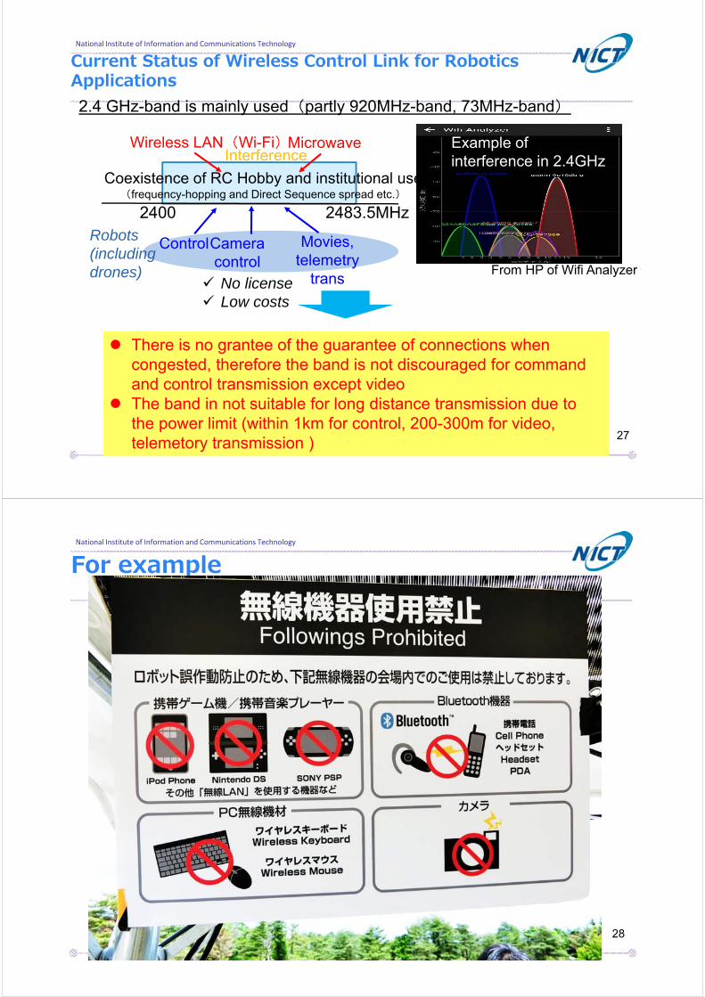
Current Status of Wireless Control Link for Robotics Applications2.4 GHz-band is mainly used(partly 920MHz-band, 73MHz-band)
2400 2483.5MHz
Coexistence of RC Hobby and institutional use(frequency-hopping and Direct Sequence spread etc.)
Wireless LAN(Wi-Fi)MicrowaveInterference
There is no grantee of the guarantee of connections when congested, therefore the band is not discouraged for command and control transmission except video
The band in not suitable for long distance transmission due to the power limit (within 1km for control, 200-300m for video, telemetory transmission )
ControlCamera control
Movies, telemetry
trans
Robots(including drones) From HP of Wifi Analyzer
Example of interference in 2.4GHz
No license Low costs
27
National Institute of Information and Communications Technology
For example
28
National Institute of Information and Communications Technology
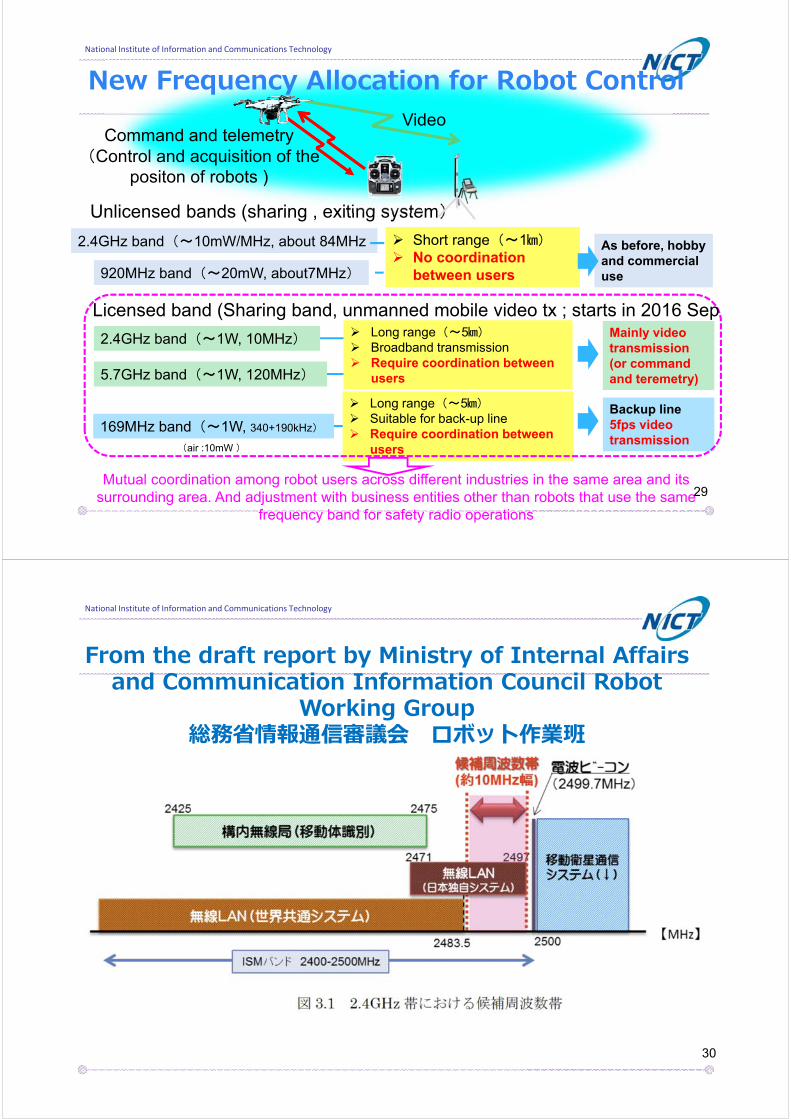
New Frequency Allocation for Robot Control
2.4GHz band(~10mW/MHz, about 84MHz 2.4GHz band(~10mW/MHz, about 84MHz
Unlicensed bands (sharing , exiting system)
920MHz band(~20mW, about7MHz)920MHz band(~20mW, about7MHz)
2.4GHz band(~1W, 10MHz)2.4GHz band(~1W, 10MHz)
5.7GHz band(~1W, 120MHz)5.7GHz band(~1W, 120MHz)
169MHz band(~1W, 340+190kHz)169MHz band(~1W, 340+190kHz)
Short range(~1㎞) No coordination
between users
Short range(~1㎞) No coordination
between users
Command and telemetry(Control and acquisition of the
positon of robots )
Video
As before, hobby and commercial use
As before, hobby and commercial use
Mainly video transmission (or command and teremetry)
Mainly video transmission (or command and teremetry)
Long range(~5㎞) Suitable for back-up line Require coordination between
users
Long range(~5㎞) Suitable for back-up line Require coordination between
users
Backup line5fps video transmission
Backup line5fps video transmission
Long range(~5㎞) Broadband transmission Require coordination between
users
Long range(~5㎞) Broadband transmission Require coordination between
users
Mutual coordination among robot users across different industries in the same area and its surrounding area. And adjustment with business entities other than robots that use the same
frequency band for safety radio operations
Licensed band (Sharing band, unmanned mobile video tx ; starts in 2016 Sep
(air :10mW )
29
National Institute of Information and Communications Technology
From the draft report by Ministry of Internal Affairs and Communication Information Council Robot
Working Group総務省情報通信審議会 ロボット作業班
報告書案よりhttp://www.soumu.go.jp/main_content/000395485.pdf
30

National Institute of Information and Communications Technology
New Frequency Allocation in 5-GHz Bandhttp://soumu.go.jp/main_content/000395485.pdf
31
National Institute of Information and Communications Technology
New Frequency Allocation in 169-MHz Bandhttp://www.soumu.go.jp/main_content/000395485.pdf
32

National Institute of Information and Communications Technology
Conclusions
We developed and tested UAV-based wirelessrelay network systems in natural disasters
On-board Ka band tracking antenna for unmanned aircraft system
‣ Status of current standardization
‣ We evaluated the antenna system using actual airplane and a satellite
Recent Status of UAS radio regulations in Japan
‣ New frequency bands are allocated for robots and UAS
33