development of cabled seafloor seismo- geodetic network and seafloor borehole observatories in the...
TRANSCRIPT

Development of cabled seafloor seismo-geodetic network and seafloor borehole
observatories in the Nankai Trough
Eiichiro Araki and Yoshiyuki KanedaJapan Agency for Marine-Earth Science and
Technology (JAMSTEC)Margins SEIZE-WS 08/09/25

Nankai
Tonankai
Tokai
M8+ class earthquakes every 100-150 years.Sometimes, these areas rupture in a short period of time.
Seismogenic Zone
Earthquakes in the Nankai Trough
2
Philippine Sea Plate
DONET target area

To understand the recurrence patterns in next mega thrust earthquakes
Advanced simulation for the estimation of next mega thrust earthquakes
New research project

FEM model for Southwest Japan
CrustMantlePHS
350℃
150℃
Thermal
1) Evaluation of heterogeneous structure, thermal structure, etc.
2) Combination of GPS andInSAR data for slip inversion
InSAR
1995 Kobe eq.
CFF variation
Mantle PHS:Slab
3) Inland earthquake model during Nankai earthquake cycle
To improve the Simulation Model & Method
New research project

When DONET is completed in 2010Observation site map off Tokai area
TonankaiTokai
DONET observation targets:Large earthquakes of M8+ TsunamisCo-seismic and interseismic ground deformation MicroearthquakesSlow earthquakes
DONET
5

Historical background:Sumatra earthquake in 2004 drove us to build DONET seafloor network in Nankai.
We conducted OBS network observationabove the rupture area ONLY 2 months afterthe earthquake.
But we do not know what happed duringthe 2004 Sumatra earthquake.
We need comprehensive seafloor dataduring the main shock (and interseismic period)to capture behavior seismogenic plate boundary.
After Araki et al., 2006.

Location map of DONET seafloor and borehole observatories
During the phase I implementation, five science node (Node A-E) will be installed.
Five nodes give us connectivity of 40 scientific sensors that are apart from the node up to 10 km (or 20 km optional).
30W (or 50W optional) power can be supplied to each scientific sensor.
Precision timing (to a resolution of micro second), and uplink data capability (~20Mbps/sensor) over fiber optic cable are provided to each sensor.
20 seafloor sensors, and three borehole observatories are currently on the list to connect to the DONET network.
Red line: DONET cablePink points: DONET seafloor observatories
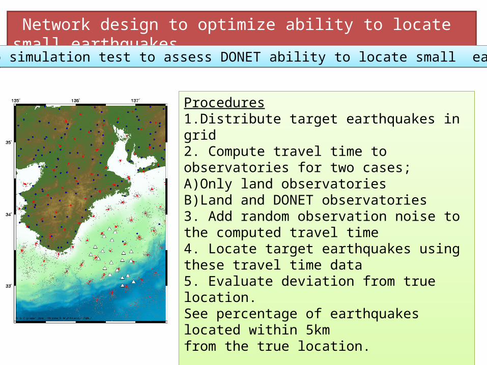
Network design to optimize ability to locate small earthquakes
Montecarlo simulation test to assess DONET ability to locate small earthquakes Montecarlo simulation test to assess DONET ability to locate small earthquakes
Procedures1.Distribute target earthquakes in grid2. Compute travel time to observatories for two cases;A)Only land observatoriesB)Land and DONET observatories3. Add random observation noise to the computed travel time 4. Locate target earthquakes using these travel time data5. Evaluate deviation from true location.See percentage of earthquakes located within 5km from the true location.
Repeat 100 times for each target earthquake.

With DONET, location of earthquakes of M2
can be determined with good accuracy in depth.
With DONET, location of earthquakes of M2
can be determined with good accuracy in depth.
Hypocenter determined < 5km accuracy
Depth determined < 5km accuracy
Depth of Initial hypocenter set to actual depth + 20km. Initial hypocenter is distributed randomly
Only with land data 9
Network design to optimize ability to locate small earthquakes
Land + DONET data

Error assumed in the simulation
GPS 1mm (H)
3mm (V)
Pressure gauges 1cm(V)
Vertical deformation maximum at 3 cm
すべり量 10 cm
Detection of seafloor deformation by DONET pressure gauges
With DONET, we will be able to detect small seafloor deformation. This is not possible with land GPS data only.

Design of DONET seafloor sensor
• Need for wide dynamic range, broad frequency range targeting micro eqs., large eqs., slow slip events, ground deformation.
• Observation parameters: Ground motion (strong motion accerelometer, broadband seismometer) , Pressure (Quartz pressure gauge, differential pressure gauge, hydrophone), Temperature
• Seismic sensor will be buried ( low noise observation, better coupling)
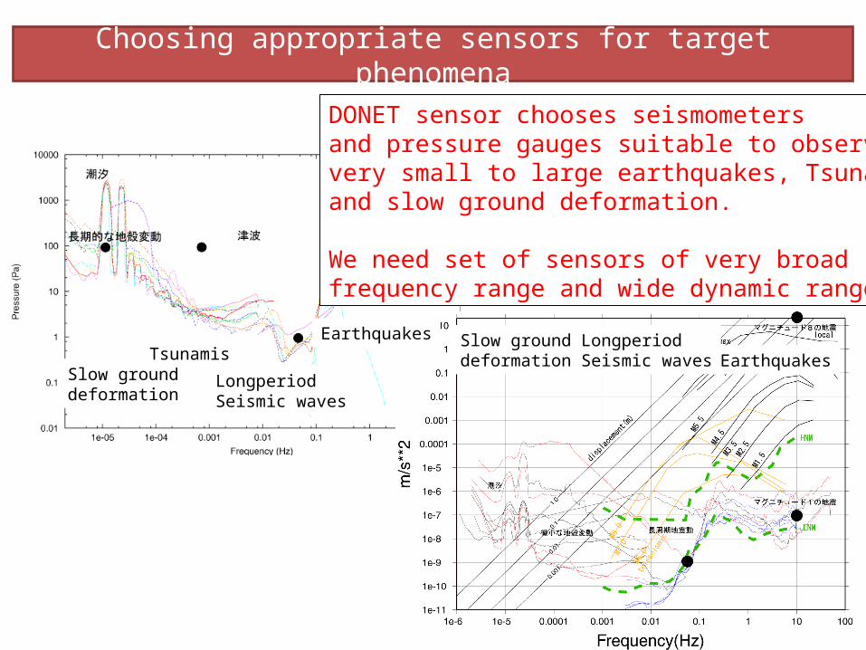
DONET sensor chooses seismometersand pressure gauges suitable to observevery small to large earthquakes, Tsunamis, and slow ground deformation.
We need set of sensors of very broad frequency range and wide dynamic range.
Choosing appropriate sensors for target phenomena
Slow ground deformation
Tsunamis
LongperiodSeismic waves
Earthquakes Slow ground deformation
LongperiodSeismic waves Earthquakes

Concept design of DONET observation sensors.
Quartz pressure gauge,Differential pressure gauge
Hydrophone
Broadband seismometer
Strong motion accerelometer
A/ D conversion and telemetrySeismometer
buried in the seafloor
Seafloor
Fiber optic cable
Seismometers are buried in the seafloor and pressure gauges are installed in the seafloor.Seismometers are buried in the seafloor and pressure gauges are installed in the seafloor.
Mounted on gimbals

Experiments to develop DONET sensor
• Quartz pressure gauge comparison in laboratory
• Seismometer comparison in JMA vault.• Buried seismometer observation in the
seafloor.

Stability test result of quartz pressure gauges
HP
Paroscientific
Drif
t pr
essu
re (ps
i)
Date (2007)
COM
Hewlett Packard 2813E, Paroscientific 46K and 410K, and COM quartz pressure gauges). Test pressure is 4000 psi (applied by dead weight tester) and temperature is 4 ℃ in water bath. Before May 20, experiment has been interrupted several times.
Evaluated long-term stability of quartz pressure gauges less than 0.1 psi drift / 150days

Seismometer evaluation test at Matsushiro vault of JMA.
Sensor noise is evaluated for many type seismometers.Broadband seismometer: Streikeisen STS2, Guralp CMG3T, Kinemetrics CronosStrong motion accerelometer: JAE JA-5typeIII, JA40G, Metrozet TSA-100SGeophones : GS-11D, HS-1, SM-6, L-28
CMG3TSTS2
geophonesGS-11D, SM-6, HS-11, L28
TSA100S
JA5typeIII, JA40G
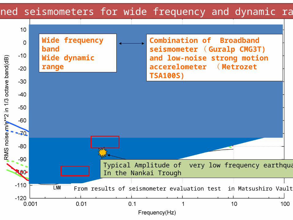
From results of seismometer evaluation test in Matsushiro Vault (JMA)
Wide frequency bandWide dynamic range
Combination of Broadband seismometer( Guralp CMG3T) and low-noise strong motion accerelometer ( Metrozet TSA100S)
Typical Amplitude of very low frequency earthquakesIn the Nankai Trough
Combined seismometers for wide frequency and dynamic range
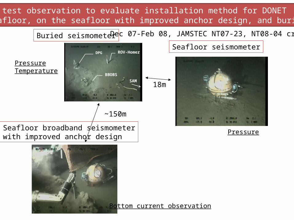
ROV-HomerDPG
BBOBS
SAM
Comparison test observation to evaluate installation method for DONET(on the seafloor, on the seafloor with improved anchor design, and buried sensor)
18m
~150m
Buried seismometer
Seafloor seismometer
Seafloor broadband seismometerwith improved anchor design
PressureTemperature
Bottom current observation
Pressure
Dec 07-Feb 08, JAMSTEC NT07-23, NT08-04 cruise

Pressure #1
Pressure #2
Vertical seafloor #1
Vertical seafloor #2
Vertical Buried
Horizontal Buried
Horizontal seafloor #1
Horizontal seafloor #2
Comparison of buried and seafloor long-period seismic records
2008/1/22 17h 13-50 second period
Vertical noise similar to seafloor seismometer.Horizontal noise is quieter by more than 10 times.
Scale of horizontal component is 8 times of verticalUnit in m/s for seismometer and Pa for pressure.
Teleseismic earthquake

Seafloor experiment of this year (Sept 17, 2008-late Nov, 2008): Test with proto-type DONET sensor to check installation procedure.
Buried sensor (broadband and strong motion sensor inside)

Phase 1.5 : connection of NantroSEIZE borehole observatories
Riserless ~ 1km hole belowsediment layer.
Riserless ~ 500m holepenetrating shallow splay fault
Riser ~ 2.5km hole
All of these observatories will beconnected to DONET Scientific submarine cable networkto assure long-term monitoring.The cables will be laid out in 2009. Installation of the observatories will take place after 2010.
Red line: DONET cablePink points: DONET seafloor observatories
Location of the borehole observatoriesare planned within the reach (10km or 20km)of DONET.
Connection of the borehole observatories willbe funded as a part of JAMSTEC’s boreholeobservatory project (not by DONET).
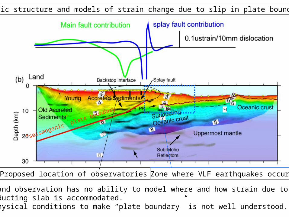
Seismic structure and models of strain change due to slip in plate boundary.
Zone where VLF earthquakes occur.Proposed location of observatories
* Land observation has no ability to model where and how strain due to subducting slab is accommodated. * Physical conditions to make “plate boundary” is not well understood.
“seismogenic” plate boundary

Borehole observation system in the NantroSEIZE
Major target:observation of deformation at the seismogenicplate boundary.
Why borehole? Low noise environment, better connection to the deformation source (direct measurement of the fault itself in the future).
Sensors:Strain (3 + α components)Pore-P (including of splay fault)Tilt, Seismic (broadband, strong motion, geophones)Array of thermometer, electrodes.(Future implementation of continuous active sourceexperiments under consideration).
DONET connectivity : Power, data recovery, andprecision timing.

Summary• DONET network capability: 40 sensors extended 10km (20km) from 5
nodes. 30W power/sensor, precision timing, data communications.• The Network covers area from near the trench to Tonankai co-seismic
rupture area.1) Phase 1 (- 2010) - 20 seafloor sensors (BB + strong motion buried seismic sensors + Quartz
pressure gauge, DPG, hydrophone, and thermometer). - 15 – 30 km spacing between sensors capable of determining precise depth
of micro earthquakes and detecting Mw6 class slow events.2) phase 1.5 (-2011?) - 3 borehole observatories: 2.5km riser hole, 1km, 500m riserless hole with
strain, pore-p, tilt, BB+strong motion seismic, thermometers, and electrodes.
3) Phase 2 to extend network westward. (planning)Extended observation items include electromagnetic, tilt, and real-time GPS-
Acoustic observation.