development and management of disaster-proof ......japan earthquake, we are in a direction based of...
TRANSCRIPT

Ministry of Land, Infrastructure, Transport and Tourism
Development and Managementof Disaster-Proof-Infrastructuresto make Disaster-Resilient-City
Masaki TAKEMURA, Deputy Director,
Disaster Prevention and Relief Division,
Water and Disaster Management Bureau,
Ministry of Land, Infrastructure, Transport and Tourism, Japan
(MLIT)

Class B Rivers
Class A Rivers( Direct Management )Class A Rivers( Designated Section )
Provisional Rank Rivers
General Rivers
Class A River
Class BRiver
Managed byThe National Government
Provisional Rank River
Managed by Prefecture or Ordinance-Designated Cities(Designated Section )
渚滑
川
湧別
川 常呂
川 網走
川
釧路川
十勝川沙流
川鵡川
天塩川
留萌川
石狩川
尻別川
後志利別川
高瀬川
馬淵川
北上川
鳴瀬
川
名取
川阿
武隈
川
岩木川
米代川
雄物川子吉川最上川赤川
信濃
川阿
賀野
川
荒川
関川姫
川黒
部川
常願
寺川
庄川
小矢
部川
神通
川
手取
川梯川
久慈川那珂川
利根川多摩川
荒川
鶴見
川
富士
川
新宮
川
紀の川大和川
淀川
加古
川
揖保
川円
山川
由良
川 北川
九頭
竜川
吉井
川
旭川
高梁
川
太田
川
小瀬
川
佐波
川高
津川
江の
川
斐伊川
日野
川天
神川
千代
川
吉野川
那賀
川
渡川
肱川 物
部川
土器川
遠賀
川
小丸
川大淀川
肝属川
五ヶ瀬川
大野川大分川
番匠川
山国
川
松浦
川
川内川
球磨川
六角川
嘉瀬
川
狩野
川安
倍川大井
川菊
川天
竜川
豊川
矢作
川
庄内川
木曽
川
鈴鹿川雲出川櫛田川宮川
重信川
本明川
芦田川
仁淀
川
相模
川矢部川菊池川白川緑川
筑後川
Class A Rivers in Japan ( 109 rivers ) Division of River Management (As of 30, April, 2015)
First Class River
Class A Rivers and Division of River Management
Managed by Municipalities
10,581.8km ( approx.7% )
7,491.6km ( approx.54% )
Managed by Prefecture or Ordinance-Designated Cities
35,858.9km ( approx.25% )20,099.0km ( approx.14% )
(River Law is not applied )
2

Above : Yodogawa River, flows throw Shiga, Kyoto, and
Nara Prefectures. The river managed by the national government.
Right : Sahogawa River, flows in Nara Prefecture. The river managed by the prefecture.
Examples of MLIT-managed River and Prefecture-managed River
3

Installing structural measures for river facilities in order to extend time to burst.Taking 5 years, Approx.1800 km long zone, where has high flood risk but is unavailable to replace levees due to the balance of rivers, will be improved by 2020.
To reduce infiltration of rain water into levee and to delay the progress of levee edge breaking in the case of overflow
Protecting levee crest with asphalt etc.
To delay the progress of deep excavation in the case of overflow
Blocks to reinforce the foot of landside slopeAsphalt etc. remain for a certain amount of time if the crest of levee is covered with such material
Asphalt, etc
Total Implementation Zone L=Approx1800km
※Zones of each measures are overlapped
Approx. 1,310km
Approx. 630 km
粘性土
Structural Measures for Crisis management
Reinforcing the foot of landside slope with blocks
Cohesive soil
Sandy soil
Cohesive soil
Surface soil Surface soilCohesive soil
Sandy soil
Cohesive soil
Sea
Land
4

○ In order to protect people’s life, we have been constructing Super Levees in the area below sea level in Tokyo and Osaka, which amount approx. 120km long.
○ Super Levee is effective not only for improvement of levee’s safety, but also for provision of good residential environment for residents in the area.
Before
After
Improving urban scape and offering good environment(ex, Shinden, arakawa )
Expected to provide evacuation places and hubs for rescue operation for affected people
◆Multiple Effects of Super Levee◆Almost all the area in East Tokyo is below sea level
If levees burst, the damage will be catastrophic, and also the impact for our socio-economic activity will be enormous.
東京東部低地帯地盤高(出典:江戸川区)
Super Levee
As 30 times wide as its height, the crest of the levee can be used as usual land
Construction of Super Levee
Low Water AP 0m
High Water AP 5.1m
Storm Tide AP 5.1m
Low Land Level Area in East Tokyo(Source:Edo ward)
Construction Zone
River Management
Prevent catastrophic impact by averting levee fall down Overflow
Earthquake Prevent large damage for levee by liquefaction
River Management
Urban Management
Safety
Amenity
Water Disaster Reduce flood damage
Earthquake Prevent large damage for urban area by liquefaction
Disaster Provide evacuation space
Normal Time
Implement urban renewal, fixing overcrowded wooden residential area and narrow roads
Improve town scape and make good urban space
5

〇 Making intensive effort to implement measures to prevent and mitigate impact of disaster in the area, where people’s life were damaged by large water disaster and immersion frequently in the past.
➢Flood by heavy rainfall in 2015 in Kanto and Tohoku region.( 8,800 houses were submerged )
➢Raised levee and dug river deeper intensively in a short period of time
Damage situation( Joso City, Ibaragi )
Kinu River( Ibaragi Pref. )( ex. )
鬼怒川
決壊箇所
Uji River of Niyodogawa River line( Kochi Pref. )( ex. )
Yura River( Kyoto-pref. )( ex. )
Damage Situation( Fukuchiyama City, Kyoto )
由良川
➢Flood by heavy rainfall in August, 2014 in tributary rivers of Yuragawa
( 1,600 houses were submerged in urban district )
➢The national government, Kyoto Prefecture, and Fukuchiyama city implemented measures. Direct project was to extend drainage pumping station.
➢ Inundation by Typhoon No.12 in August, 2014 in Ujigawa.(142 houses flooded above floor level, and 114 houses flooded under floor level)
➢ The national government, Kochi Prefecture, and Ino-cho shared implementation of measures. A subsidized project is a repair of Tenjingatanigawa river.
Measures to Mitigate Reoccurring Disaster
※ “Special emergency projects to prevent from major river disaster” and “Special emergency project to prevent from flood above floor level” are generally held in 5 years.
( Kinugawa special emergency project
to prevent from major river disaster)(Yuragawa, Kobogawa, Norigawa special
emergency project to prevent from flood above floor level)
(Niyodogawa, Ujigawa, special emergency project to prevent from flood above floor level)
Damage Situation( Ino-machi, Kochi )
Kinu
Damaged Area
6

Collapse of Storm-Surge-Levee along Yodogawa River due to Liquefaction
( January, 1995 )
Damages to Levee by the Great Hanshin-Awaji Earthquake
7

■ River levees in wide range from Tohoku to Kanto area were damaged in the Great East Japan Earthquake. Some of them were serious to lose capability to protect against water.
■ The cause of the large-scale damage was liquefaction, including not only liquefaction of foundation ground, but also liquefaction of soil in the levee body.
Eaigawa River
Liquefaction on Levee Body
Liquefaction of Base Soil
Narusegawa ( Right ) near 20k
Narusegawa ( Right ) near 11k
Eaigawa ( Left ) near 27k
Countermeasures against Earthquake and Liquefaction on River Levee
Levee Body
Foundation Ground (Sandy Soil)
Narusegawa River
Liquefaction
LiquefactionLevee Body(Sandy Soil)
Foundation Ground (Cohesive Soil)
NarusegawaRiver
Narusegawa River
Narusegawa ( Right ) near 11k
8

腹付け, 緩勾配化,嵩上げなど
安定材の混合(ラップ施工)
充填材の挿入・拡径,振動締固めなど ドレーン材の挿入
Holding Mound Compaction
Installing steel material
Lowering Crevice Water Pressure
Solidification
Levee side cannot displace due to the load of the mound. Also the mound resist to sliding slope.
Ground strength against liquefactionis increased by raising sand density and pressure
Increased permeability result in containing the rise of crevice water pressure in sand layer, and avoid liquefaction.
Solidify ground and make it anti- liquefying. Remake ground with grid and block is effective to prevent from displacement of mound and ground.
Installing steel materials into ground prevents slide collapse as well as side flowage associated with deterioration of ground strength due to liquefaction.
鋼矢板、鋼管矢板など
Countermeasures to Liquefaction of Foundation Ground
Widen the levee, lower the gradient, rise the height
Insert or widen fillers, compact ground with vibration
Insert drains
Insertsteel sheet pile, steel pipe sheet pile
Mix stabilization material
9

■Lower Groundwater Level( Install drains at the end of slope of landside )
■Stabilize Slope End
Countermeasures to Liquefaction of Levee Body
Range of liquefaction is reduced by lowering water level in levee body.
In order to contain deformation of liquefied levee body, stabilize near the lower end of slope.
・ Drains are installed in the lowerend of slope on land side. Minimize subsidence and deformation
when liquefaction occurs by replacing material into drain material with strong sheer strength.
・ Install holding mold mainly on the lower end of slope on sea side.
Levee side cannot displace due to the load of the mound.
Sea Land
Sea Land
Sea Land10

Level : occur very few, extensive damageestablish comprehensive counter-Tsunami-measures that protect people’s life by mainly securing evacuation ways
BasicIdea
Level 2 : The Maximum TsunamiLevel 2 : The Maximum Tsunami
Level : occur at relatively high frequent intervals, height is low but damage is seriousconstruct coastal protection facilities in terms of protection of people’s property, stability of regional economic
activity, and securing effective manufacturing base.
Basic Idea
Level 1: Relatively High Frequent TsunamiLevel 1: Relatively High Frequent Tsunami
As unpredicted powerful earthquake and Tsunami gave us extensive damage in the Great East Japan Earthquake, we are in a direction based of “disaster mitigation” to minimize damage using multiple defenses including hardware and software measures to the maximum class(L2) Tsunami.
To Tsunami that is occur more often(L1), it is decided to keep construct levee along coast, in terms of protection of people’s property, stability of regional economic activity, and so on.
Supposition of Tsunami for planning Tsunami Countermeasures
: Keep construct coastal protection against Lavel1 Tsunami. And proceed engineering development of structure that is tenacious against Tsunami even if the Tsunami’s height is over supposition.
: It is important to implement measures based on the idea of “disaster mitigation.” Thus, we should construct coastal protection facilities to reduce damages, as well as improve people’s action towards Tsunami by creating hazard map, and so on.
11

Coastal levee before disaster
Coastal levee after disaster
Meiji Sanriku Earthquake in 1896 ( T.P. )
Showa Sanriku Earthquake in 1933 ( T.P. )
Chili Earthquake in 1960 ( T.P. )
Tsunami Height in The Great East Japan Earthquake in 2011 ( T.P. )
< The Maximum Tsunami >・ set in order to establish comprehensive disaster risk management measures
< Relatively High Frequent Tsunami >・ set for construction of coastal levees( occur in several decades ~ one hundred and several years )
Coastal levee to be reconstructed
Setting of the Height of Coastal Levee
L2
L1
※T.P. = Tokyo Peil
Subsidence
12

0 5 10 15 20 25 30
唐桑半島東部
唐桑半島西部①
唐桑半島西部②
気仙沼湾
気仙沼湾奥部
大島東部
大島西部
本吉海岸
志津川湾
追波湾
雄勝湾
雄勝湾奥部
女川湾
牡鹿半島東部
牡鹿半島西部
万石浦
石巻海岸
松島湾
七ヶ浜海岸①
七ヶ浜海岸②
仙台湾南部海岸①
仙台湾南部海岸②
Storm Surge ( Meiji Sanriku in1896 )
Tsunami ( Chili in 1960 )
Tsunami ( Meiji Sanriku in1896 )
Tsunami ( Off Miyagi Prefecture )
Tsunami ( Meiji Sanriku in1896 )
T.P. ( m )
Existing Levee before Disaster
Planned Levee
Legend :
Tsunami Height ofThe Great East Japan Earth Quake( Measured near Existing Levees )
Coastal Levee Height along Miyagi Coast as of Sep.2011
Tsunami ( Chili in 1960 )Tsunami ( Meiji Sanriku in1896 )
Storm Surge ( Meiji Sanriku in1896 )
13

Structure of Coastal Levee(Example)
Water Way Model (1/25) for Structural TestNILIM studied ingenious attempts on structural designs and constructional methods, conducting tests using models and analysis
Experiment conducted by Coastal Disaster Prevention Division Laboratory in the National Institute for Land and Infrastructure Management (NILIM)
Model with glass wall on the side:Landside slope excavation and damage to covering can be observed
Replicate water overflow to check excavation to the bottom of slope and affect to covering blocks
Blocks are locked in a manner that do not receive hydrodynamic force directly
【 land 】【 sea 】
SeaLand
Model ofWater Way
Integrate levee-shoulder-covering and levee-crown-covering
Enlarge base along with improve foundation in order to prevent from excavation by Tsunami
1:22t covering block1:2
t=50cm( holeφ100 : filled with stones )
2t covering block
Landside Slope covering
Concrete cover
Seaside Slope Covering
Levee Base ( Seaside Slope End )
Levee Base ( Landside Slope End )
Soil
Put new thoughts to delay process of building collapse or remove possibility of complete collapse, even if the height of Tsunami exceeds given condition for structural design.
Tenacious Coastal Levee
Water
Water Way Model (1/2) Falling Down Test
14

Implement methods to resist earthquake and liquefaction for levees and water gates, as well as proceed establishing automation and remote operation system of floodgates and so on, in order to protect operators and secure quick and correct operation.
遠隔操作によるゲート開閉
The image of automation and remote operation system of floodgates, etc.
Earthquake and Liquefaction Resistance for Levees
Damaged Levee by an Earthquake
Foundation Ground (Sandy Soil)
(Cohesive Soil)
Earthquake and Liquefaction Resistance for Levees and Watergates, Automation and Remote Operation
Ground Improvement
Close automatically responding to tsunami warning
Floodgate
Shortdam
Lockgate
Switch automatically to auxiliary power during a power failure
Floodgate
基礎地盤(砂質土)
基礎地盤(粘性土)
Steel Sheet
15

Kumamoto Earthquakein 2016 in Kumamoto Prefecture
( Technical Emergency Control FORCE )
←Kinugaw
a River
Investigation by helicopter for disaster managementInvestigation by helicopter for disaster management Send liaison officers to municipalitiesSend liaison officers to municipalities
small satellite image transmission unitsmall satellite image transmission unit
AOZORAHelicopter for disaster management
AOZORAHelicopter for disaster management
Overview of TEC-FORCE○ Established in 2008, TEC-FORCE is aiming to offer timely support to local public organizations in case of
large natural disaster.○ TEC-FORCE take quick actions by experts of infrastructure management, actions such as gathering
status information, prevention of disaster expansion, supports to swift restoration, and others.○ Members are officials from each Regional Development Bureau from the whole country, and they act
under the direction of the general manager of disaster risk management team of MLIT.○ The number of appointed members are 9,408 from each organization in MLIT. (as of Oct. 2017)
Flood by heavy rainfall in 2015 in Kanto and Tohoku region.
Volcanic activity in 2015 in Kagoshima prefecture
Investigation of disaster statusInvestigation of disaster status
Establish monitoring systemBy Ku-SAT
Establish monitoring systemBy Ku-SAT
Damage by heavy rainfall in 2015 in North Kyushu.
Volcanic eruption in 2014 in Nagano Prefecture
Technical advisory support for municipalities
Technical advisory support for municipalities
Kumamoto Earthquakein 2016 in Kumamoto Prefecture
Emergency Draining by drainage pump vehicle
Emergency Draining by drainage pump vehicle
Flood by heavy rainfall in 2015 in Kanto and Tohoku region.
Technical advisory support to investigation activity
Technical advisory support to investigation activity
16

Regional Development Bureau (8,781)
NILIM(173)
MLIT(89)Local
Transportation and Civil Aviation
Bureau(365)
Total 9,408 as of Oct. 2017Members from the Meteorological Bureau and the
Geographical Survey Institute are not included as they are not appointed prior to disaster occurrence
Registered Members of TEC-FORCE
Hokkaido RDB666
沖縄総合事務局 49名
Tohoku RDB927
Kanto RDB1,615
Hokuriku RDB634
Kinki RDB1,118Chugoku RDB
834
Chubu RDB1,405
Kyushu RDB1,004
Number of TEC-FORCE members○ Members of TEC-FORCE officials from each Regional Development Bureau, and gather from whole country
according to the scale of disaster.And special investigation and technical supports are provided by the members from MLIT, Local Transportation Bureaus, the National Institute for Land and Infrastructure Management(NILIM), the Meteorological Bureau, the Geographical Survey Institute.
17

MLIT (Disaster Management
Headquarter)
Mid and Small scale disaster Large scale disasters
Support by TEC-FORCE in the region
Devastated municipality
Devastated RDB(Disaster Management
Headquarter)
Support System of TEC-FORCE
Request
Executive Director of RDB order the dispatch of TEC-FORCE
Request
Support RDB (Support Management Headquarter)
Executive Director of MLIT order the dispatch
of TEC-FORCE
According to the disaster condition, TEC-FORCE can be dispatched without requests.
Support by TEC-FORCE acsross the region
18

cumulative total number of
dispatched members18,115
823 md
2,414md
2,916md
2,629md1,727md
1,438md
1,152md
1,085md
2,704md
1,227md
TEC-FORCE Members : Total 18,115 man-days ( 11,Mar. ~ 21, Nov.,2011 ) Vehicles for disaster management ( drainage pump vehicle, satellite communication vehicle,
etc. ) : Total 5,760 car-days in a month after the Earthquake
Activity of TEC-FORCE for the Great East Japan Earthquake in March,2011
○ Minister of Land, Infrastructure, Transport and Tourism, Japan ordered 400 members of TEC-FORCE from RDBs to the devastated area on the next day of disaster in March, 2011.
○In sow and after quake, up to 500 members /day worked for support activities, such as draining by drainage pump vehicle, making liaison between municipalities, gathering information on damages on roads and levees.
Obtained Information and records by helicopter Obtained Information and records by helicopter Helped to search missing
persons by drainage pump vehicle
Helped to search missing persons by drainage pump vehicle
Hokuriku2,414
Kanto2,916
Tohoku 2,704
Chubu2,619
Kinki 1,727
Kyushu 1,085
Shikoku 1,438
Chugoku 1,152
Hokkaido 823MLIT 227
Sent officials with special knowledge to carry out technical supportSent officials with special knowledge to carry out technical support
Established telecommunication lines by satellite communication vehiclesEstablished telecommunication lines by satellite communication vehicles
Investigated the damages to the roads and leveesInvestigated the damages to the roads and levees19
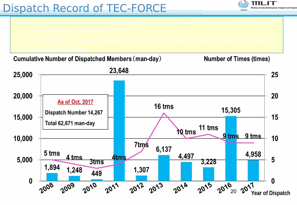
Dispatch Record of TEC-FORCE○ Started in 2008, TEC-FORCE carried out support activities for 78 devastated areas, including the area of
the Great East Japan Earthquake, until Oct. 2017.
○ Cumulative number of dispatched members is total 60,000 man-day, and main members are officials from local development bureaus.
20082009
20102011
20122013
20142015
20162017
Year of Dispatch20

Search for missing persons using a drone
Utilization of ICT for the Activity of TEC-FORCE○ Utilize GPS log (GARMIN, Smart phone) and wearable camera for site investigation.
○ Use drones to investigate damage situation and to support rescue and search for missing persons.
○ Understand the scale of disaster remotely from out of restricted area by measuring distance and height using laser measuring instruments.
○ Understand the situation of damage, combining laser profiler (LP) data and photographic 3 dimensional models.
Damage status by LP data Investigation by Laser measuring instrument
GPS log and wearable camera21