developing an effective monitoring strategy using
TRANSCRIPT
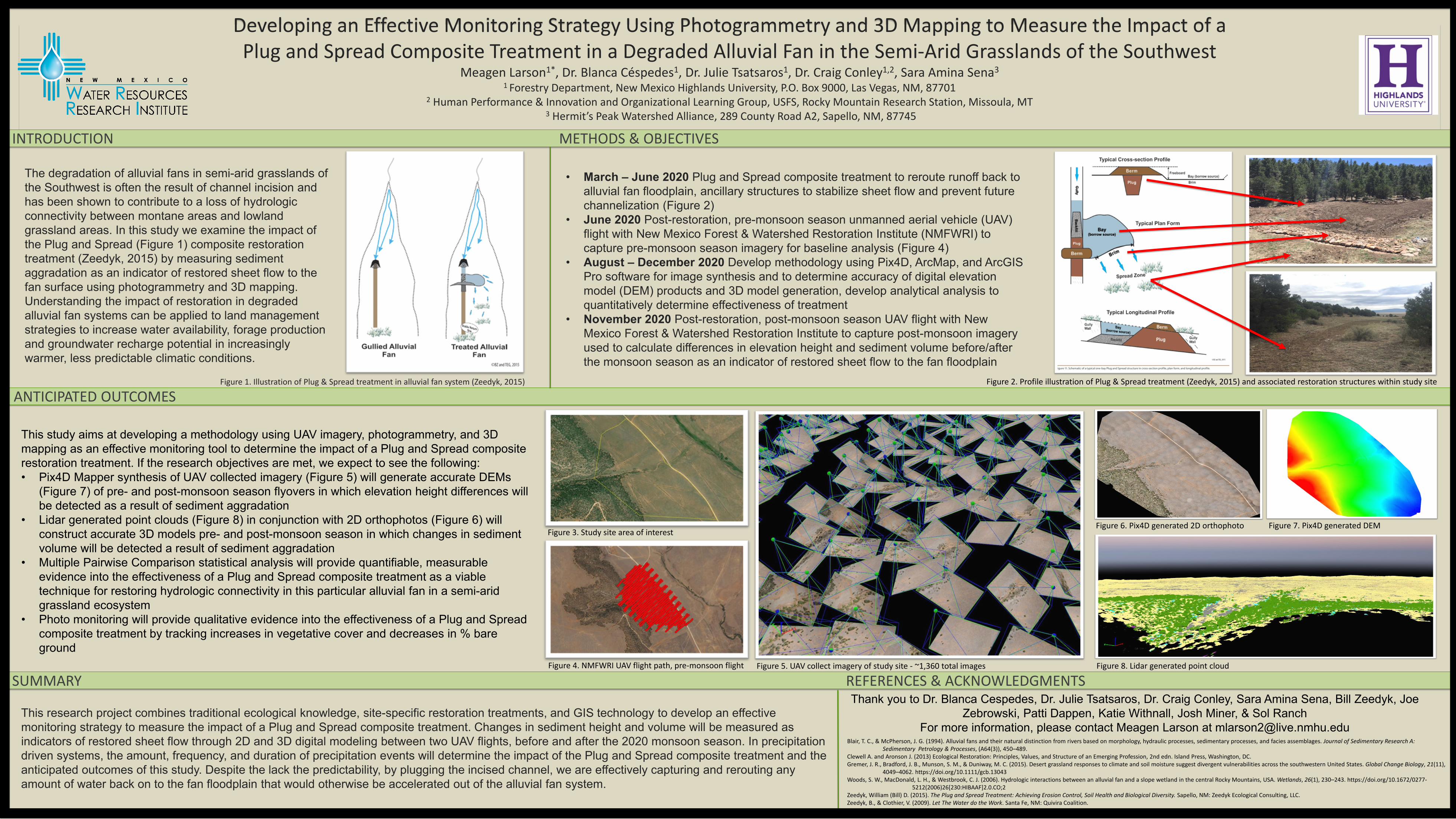
The degradation of alluvial fans in semi-arid grasslands of the Southwest is often the result of channel incision and has been shown to contribute to a loss of hydrologic connectivity between montane areas and lowland grassland areas. In this study we examine the impact of the Plug and Spread (Figure 1) composite restoration treatment (Zeedyk, 2015) by measuring sediment aggradation as an indicator of restored sheet flow to the fan surface using photogrammetry and 3D mapping. Understanding the impact of restoration in degraded alluvial fan systems can be applied to land management strategies to increase water availability, forage production and groundwater recharge potential in increasingly warmer, less predictable climatic conditions.
Developing an Effective Monitoring Strategy Using Photogrammetry and 3D Mapping to Measure the Impact of a Plug and Spread Composite Treatment in a Degraded Alluvial Fan in the Semi-Arid Grasslands of the Southwest
Meagen Larson1*, Dr. Blanca Céspedes1, Dr. Julie Tsatsaros1, Dr. Craig Conley1,2, Sara Amina Sena3
1 Forestry Department, New Mexico Highlands University, P.O. Box 9000, Las Vegas, NM, 87701 2 Human Performance & Innovation and Organizational Learning Group, USFS, Rocky Mountain Research Station, Missoula, MT
3 Hermit’s Peak Watershed Alliance, 289 County Road A2, Sapello, NM, 87745
INTRODUCTION METHODS & OBJECTIVES
This research project combines traditional ecological knowledge, site-specific restoration treatments, and GIS technology to develop an effective monitoring strategy to measure the impact of a Plug and Spread composite treatment. Changes in sediment height and volume will be measured as indicators of restored sheet flow through 2D and 3D digital modeling between two UAV flights, before and after the 2020 monsoon season. In precipitation driven systems, the amount, frequency, and duration of precipitation events will determine the impact of the Plug and Spread composite treatment and the anticipated outcomes of this study. Despite the lack the predictability, by plugging the incised channel, we are effectively capturing and rerouting any amount of water back on to the fan floodplain that would otherwise be accelerated out of the alluvial fan system.
• March – June 2020 Plug and Spread composite treatment to reroute runoff back to alluvial fan floodplain, ancillary structures to stabilize sheet flow and prevent future channelization (Figure 2)
• June 2020 Post-restoration, pre-monsoon season unmanned aerial vehicle (UAV) flight with New Mexico Forest & Watershed Restoration Institute (NMFWRI) to capture pre-monsoon season imagery for baseline analysis (Figure 4)
• August – December 2020 Develop methodology using Pix4D, ArcMap, and ArcGIS Pro software for image synthesis and to determine accuracy of digital elevation model (DEM) products and 3D model generation, develop analytical analysis to quantitatively determine effectiveness of treatment
• November 2020 Post-restoration, post-monsoon season UAV flight with New Mexico Forest & Watershed Restoration Institute to capture post-monsoon imagery used to calculate differences in elevation height and sediment volume before/after the monsoon season as an indicator of restored sheet flow to the fan floodplain
ANTICIPATED OUTCOMES
SUMMARY REFERENCES & ACKNOWLEDGMENTS Thank you to Dr. Blanca Cespedes, Dr. Julie Tsatsaros, Dr. Craig Conley, Sara Amina Sena, Bill Zeedyk, Joe
Zebrowski, Patti Dappen, Katie Withnall, Josh Miner, & Sol RanchFor more information, please contact Meagen Larson at [email protected]
This study aims at developing a methodology using UAV imagery, photogrammetry, and 3D mapping as an effective monitoring tool to determine the impact of a Plug and Spread composite restoration treatment. If the research objectives are met, we expect to see the following: • Pix4D Mapper synthesis of UAV collected imagery (Figure 5) will generate accurate DEMs
(Figure 7) of pre- and post-monsoon season flyovers in which elevation height differences will be detected as a result of sediment aggradation
• Lidar generated point clouds (Figure 8) in conjunction with 2D orthophotos (Figure 6) will construct accurate 3D models pre- and post-monsoon season in which changes in sediment volume will be detected a result of sediment aggradation
• Multiple Pairwise Comparison statistical analysis will provide quantifiable, measurable evidence into the effectiveness of a Plug and Spread composite treatment as a viable technique for restoring hydrologic connectivity in this particular alluvial fan in a semi-arid grassland ecosystem
• Photo monitoring will provide qualitative evidence into the effectiveness of a Plug and Spread composite treatment by tracking increases in vegetative cover and decreases in % bare ground
Blair, T. C., & McPherson, J. G. (1994). Alluvial fans and their natural distinction from rivers based on morphology, hydraulic processes, sedimentary processes, and facies assemblages. Journal of Sedimentary Research A: Sedimentary Petrology & Processes, (A64(3)), 450–489.
Clewell A. and Aronson J. (2013) Ecological Restoration: Principles, Values, and Structure of an Emerging Profession, 2nd edn. Island Press, Washington, DC.Gremer, J. R., Bradford, J. B., Munson, S. M., & Duniway, M. C. (2015). Desert grassland responses to climate and soil moisture suggest divergent vulnerabilities across the southwestern United States. Global Change Biology, 21(11),
4049–4062. https://doi.org/10.1111/gcb.13043Woods, S. W., MacDonald, L. H., & Westbrook, C. J. (2006). Hydrologic interactions between an alluvial fan and a slope wetland in the central Rocky Mountains, USA. Wetlands, 26(1), 230–243. https://doi.org/10.1672/0277-
5212(2006)26[230:HIBAAF]2.0.CO;2Zeedyk, William (Bill) D. (2015). The Plug and Spread Treatment: Achieving Erosion Control, Soil Health and Biological Diversity. Sapello, NM: Zeedyk Ecological Consulting, LLC. Zeedyk, B., & Clothier, V. (2009). Let The Water do the Work. Santa Fe, NM: Quivira Coalition.
Figure 1. Illustration of Plug & Spread treatment in alluvial fan system (Zeedyk, 2015) Figure 2. Profile illustration of Plug & Spread treatment (Zeedyk, 2015) and associated restoration structures within study site
Figure 4. NMFWRI UAV flight path, pre-monsoon flight
Figure 3. Study site area of interest
Figure 5. UAV collect imagery of study site - ~1,360 total images
Figure 6. Pix4D generated 2D orthophoto Figure 7. Pix4D generated DEM
Figure 8. Lidar generated point cloud
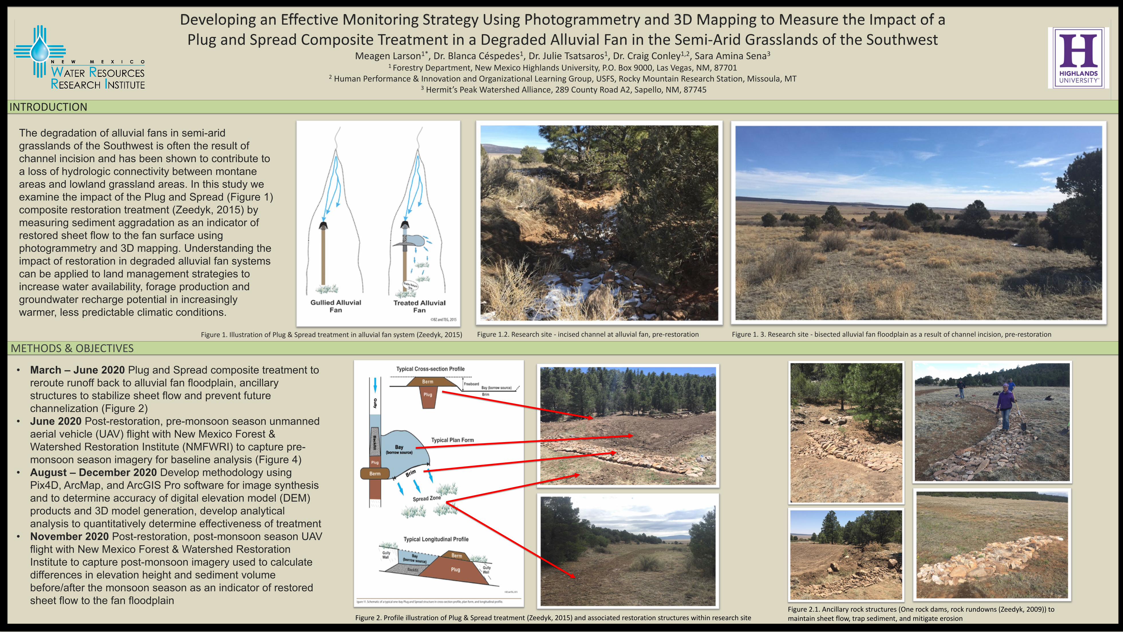
The degradation of alluvial fans in semi-arid grasslands of the Southwest is often the result of channel incision and has been shown to contribute to a loss of hydrologic connectivity between montane areas and lowland grassland areas. In this study we examine the impact of the Plug and Spread (Figure 1) composite restoration treatment (Zeedyk, 2015) by measuring sediment aggradation as an indicator of restored sheet flow to the fan surface using photogrammetry and 3D mapping. Understanding the impact of restoration in degraded alluvial fan systems can be applied to land management strategies to increase water availability, forage production and groundwater recharge potential in increasingly warmer, less predictable climatic conditions.
Developing an Effective Monitoring Strategy Using Photogrammetry and 3D Mapping to Measure the Impact of a Plug and Spread Composite Treatment in a Degraded Alluvial Fan in the Semi-Arid Grasslands of the Southwest
Meagen Larson1*, Dr. Blanca Céspedes1, Dr. Julie Tsatsaros1, Dr. Craig Conley1,2, Sara Amina Sena3
1 Forestry Department, New Mexico Highlands University, P.O. Box 9000, Las Vegas, NM, 87701 2 Human Performance & Innovation and Organizational Learning Group, USFS, Rocky Mountain Research Station, Missoula, MT
3 Hermit’s Peak Watershed Alliance, 289 County Road A2, Sapello, NM, 87745
INTRODUCTION
METHODS & OBJECTIVES Figure 1. Illustration of Plug & Spread treatment in alluvial fan system (Zeedyk, 2015)
Figure 2. Profile illustration of Plug & Spread treatment (Zeedyk, 2015) and associated restoration structures within research site
• March – June 2020 Plug and Spread composite treatment to reroute runoff back to alluvial fan floodplain, ancillary structures to stabilize sheet flow and prevent future channelization (Figure 2)
• June 2020 Post-restoration, pre-monsoon season unmanned aerial vehicle (UAV) flight with New Mexico Forest & Watershed Restoration Institute (NMFWRI) to capture pre-monsoon season imagery for baseline analysis (Figure 4)
• August – December 2020 Develop methodology using Pix4D, ArcMap, and ArcGIS Pro software for image synthesis and to determine accuracy of digital elevation model (DEM) products and 3D model generation, develop analytical analysis to quantitatively determine effectiveness of treatment
• November 2020 Post-restoration, post-monsoon season UAV flight with New Mexico Forest & Watershed Restoration Institute to capture post-monsoon imagery used to calculate differences in elevation height and sediment volume before/after the monsoon season as an indicator of restored sheet flow to the fan floodplain
Figure 1.2. Research site - incised channel at alluvial fan, pre-restoration Figure 1. 3. Research site - bisected alluvial fan floodplain as a result of channel incision, pre-restoration
Figure 2.1. Ancillary rock structures (One rock dams, rock rundowns (Zeedyk, 2009)) to maintain sheet flow, trap sediment, and mitigate erosion

Developing an Effective Monitoring Strategy Using Photogrammetry and 3D Mapping to Measure the Impact of a Plug and Spread Composite Treatment in a Degraded Alluvial Fan in the Semi-Arid Grasslands of the Southwest
Meagen Larson1*, Dr. Blanca Céspedes1, Dr. Julie Tsatsaros1, Dr. Craig Conley1,2, Sara Amina Sena3
1 Forestry Department, New Mexico Highlands University, P.O. Box 9000, Las Vegas, NM, 87701 2 Human Performance & Innovation and Organizational Learning Group, USFS, Rocky Mountain Research Station, Missoula, MT
3 Hermit’s Peak Watershed Alliance, 289 County Road A2, Sapello, NM, 87745
ANTICIPATED OUTCOMES
This research project combines traditional ecological knowledge, site-specific restoration treatments, and GIS technology to develop an effective monitoring strategy to measure the impact of a Plug and Spread composite treatment. Changes in sediment height and volume will be measured as indicators of restored sheet flow through 2D and 3D digital modeling between two UAV flights, before and after the 2020 monsoon season. In precipitation driven systems, the amount, frequency, and duration of precipitation events will determine the impact of the Plug and Spread composite treatment and the anticipated outcomes of this study. Despite the lack thepredictability, by plugging the incised channel, we are effectively capturing and rerouting any amount of water that would otherwise be accelerated and flushed out of the alluvial fan system.
SUMMARY REFERENCES & ACKNOWLEDGMENTS Thank you to Dr. Blanca Cespedes, Dr. Julie Tsatsaros, Dr. Craig Conley, Sara Amina Sena, Bill
Zeedyk, Joe Zebrowski, Patti Dappen, Katie Withnall, Josh Miner, & Sol RanchFor more information, please contact Meagen Larson at [email protected]
This study aims at developing a methodology using UAV imagery, photogrammetry, and 3D mapping as an effective monitoring tool to determine the impact of a Plug and Spread composite restoration treatment. If the research objectives are met, we expect to see the following: • Pix 4D Mapper synthesis of UAV collected imagery
(Figure 5) will generate accurate DEMs (Figure 7) of pre- and post-monsoon season flyovers in which elevation height differences will be detected as a result of sediment aggradation
• Lidar generated point clouds (Figure 8) in conjunction with 2D orthophotos (Figure 6) will construct accurate 3D models pre- and post-monsoon season in which changes in sediment volume will be detected a result of sediment aggradation
• Multiple Pairwise Comparison statistical analysis will provide quantifiable, measurable evidence into the effectiveness of a Plug and Spread composite treatment as a viable technique for restoring hydrologic connectivity in this particular alluvial fan in a semi-arid grassland ecosystem
• Photo monitoring will provide qualitative evidence into the effectiveness of a Plug and Spread composite treatment by tracking increases in vegetative cover and decreases in % bare ground
Blair, T. C., & McPherson, J. G. (1994). Alluvial fans and their natural distinction from rivers based on morphology, hydraulic processes, sedimentary processes, and facies assemblages. Journal of Sedimentary Research A: Sedimentary Petrology & Processes, (A64(3)), 450–489.
Clewell A. and Aronson J. (2013) Ecological Restoration: Principles, Values, and Structure of an Emerging Profession, 2nd edn. Island Press, Washington, DC.Gremer, J. R., Bradford, J. B., Munson, S. M., & Duniway, M. C. (2015). Desert grassland responses to climate and soil moisture suggest divergent vulnerabilities across the southwestern United States. Global Change Biology, 21(11),
4049–4062. https://doi.org/10.1111/gcb.13043Woods, S. W., MacDonald, L. H., & Westbrook, C. J. (2006). Hydrologic interactions between an alluvial fan and a slope wetland in the central Rocky Mountains, USA. Wetlands, 26(1), 230–243. https://doi.org/10.1672/0277-
5212(2006)26[230:HIBAAF]2.0.CO;2Zeedyk, William (Bill) D. (2015). The Plug and Spread Treatment: Achieving Erosion Control, Soil Health and Biological Diversity. Sapello, NM: Zeedyk Ecological Consulting, LLC. Zeedyk, B., & Clothier, V. (2009). Let The Water do the Work. Santa Fe, NM: Quivira Coalition.
Figure 4. NMFWRI UAV flight path, pre-monsoon flight
Figure 3. Study site area of interest
Figure 5. UAV collect imagery of study site - ~1,360 total images
Figure 6. Pix4D generated 2D orthophoto of site
Figure 7. Pix 4D generated DEM of site
Figure 8. Lidar generated point cloud of study site
Figure 9. Pix4D generated orthomosaicFigure 4.1. Pix4D camera points on UAV flight path